environmental-pollution.pdf - BRITANNICA GLOBAL ...
143
BRITANNICA GLOBAL GEOGRAPHY SYS BGGS Overview goglcal aPProacn ro gel phy leaming with interactive multimedia materials enabling students and teachers to immerse themselves in exciting geographic BGGS is theBitannica Gl ob al G e o gr aphy SY stem, a modular electronic learning systemwhich combines the latest Peda- gogical approach to geogra- They use an inquiry approachand are organized around ten world regions: SouthAsia Southeast Asia ]apan Former SovietUnion East Asia Australia / New Zealand / Pacific North Africa/SouthwestAsia Africa-South of the Sahara Latin America Europe Each GIGI module is centered around a particular question,such as "Why are people in the world hungry?" and "Is freedomof movementa basic human right?" The lead question is explored in one regionof the world, then, in most modules,in a second region, before being investigated in North America. The modules can be used in geography classes, or selected modulescanbe usedin other courses, suchas Earth Science, Global Studies, or Econom- ics.Twelve modulesconstitute ample materialfor a full year'sgeography course. Each module is accompanied by sets of laminatedmini-atlases which students can write on with dry-erase markers(providedby the teacher), then wipe clean to be re-used by the next class.This activity works well with cooperative groups of students' investigations. BGGS is made up of the following components: . Geographic Inquiry into Global Issues (GIGI) StudentDataBooks Teacher's Guides with Overhead Trans- parencies in a three-ring binder Laminated Mini-Atlases to accompany eachmodule BGGS CD-ROM with User's Manual 3 BGGS Videodiscs with Barcode Guides 3 thematic posters This section of your Teacher's Guide will exam- ine eachcomponent and demonstrate how the components work together to facilitate somevery exciting geography leaming for you and your students! I. GIGI Geographic Inquiry into Global Issues (GIGI) is the foundation of the BGGS. GIGI is a series of modulesdeveloped at the Centerfor Geographic Education at the University of Coloradoat Boulder. The modules are independent of one another and can be presentedin any order' a a a
-
Upload
khangminh22 -
Category
Documents
-
view
1 -
download
0
Transcript of environmental-pollution.pdf - BRITANNICA GLOBAL ...

BRITANNICAGLOBAL GEOGRAPHY
SYS
BGGS Overview
goglcal aPProacn ro gel
phy leaming with interactive multimediamaterials enabling students and teachers toimmerse themselves in exciting geographic
BGGS is the BitannicaGl ob al G e o gr aphy SY st em,a modular electroniclearning system whichcombines the latest Peda-gogical approach to geogra-
They use an inquiry approach and are organizedaround ten world regions:
South Asia
Southeast Asia
]apanFormer Soviet Union
East Asia
Australia / New Zealand / Pacific
North Africa/Southwest Asia
Africa-South of the Sahara
Latin America
Europe
Each GIGI module is centered around a particularquestion, such as "Why are people in the worldhungry?" and "Is freedom of movement a basichuman right?" The lead question is explored inone region of the world, then, in most modules, in
a second region, before being investigated inNorth America.
The modules can be used in geography classes, orselected modules can be used in other courses,such as Earth Science, Global Studies, or Econom-ics. Twelve modules constitute ample material for
a full year's geography course. Each module is
accompanied by sets of laminated mini-atlaseswhich students can write on with dry-erasemarkers (provided by the teacher), then wipeclean to be re-used by the next class. This activityworks well with cooperative groups of students'
investigations. BGGS is made up of the followingcomponents:
. Geographic Inquiry into Global Issues(GIGI) Student DataBooksTeacher's Guides with Overhead Trans-parencies in a three-ring binderLaminated Mini-Atlases to accompanyeach moduleBGGS CD-ROM with User's Manual3 BGGS Videodiscs with Barcode Guides3 thematic posters
This section of your Teacher's Guide will exam-ine each component and demonstrate how thecomponents work together to facilitate some very
exciting geography leaming for you and yourstudents!
I. GIGIGeographic Inquiry into Global Issues (GIGI)
is the foundation of the BGGS. GIGI is a series ofmodules developed at the Center for GeographicEducation at the University of Colorado atBoulder. The modules are independent of oneanother and can be presented in any order'
a
a
a

Each module comprises a Teacher's Guide in athree-ring binder which includes Handouts andActivity masters for duplication and OverheadTransparencies; twenty-five Student DataBooks(additional Student DataBooks available) and theMini-Atlases all packaged in a sturdy boxsuitable for storage when the class moves on tothe next module. Since the Student DataBooksare soft-covered three-hole punched, non-consumable books, we recommend that eachstudent have a binder to protect them. BGGSbinders are available from Britannica, or youmight ask each student to obtain one at thebeginning of the course to keep the books ingood condition for the next group of studentsthat will use them. As the class completes amodule, you can collect the Student DataBooks,place them in their storage box, and distributethe next module's DataBook to be placed in thestudent's binder.
GIGI print materials are organized in a uniquefashion. The Teacher's Guide explains proce-dures to use in presenting the material found inthe GIGI Student DataBook. Miniature layouts ofstudent pages show the teacher how many pagesof student material correspond with a givenTeacher's Guide page. The Teacher's Guideincludes Activities and Handouts to be copiedand passed out to the class and OverheadTransparencies to enhance each lesson. All of amodule's Activities, Handouts, and Overheadsare located behind the third tab divider in eachTeacher's Guide.
The teacher needs to become familiar in advancewith both Teacher and Student material in orderto effectively engage the class in meaningfulgeographic inquiries. There is a comprehensive"Memo to the Teacher from the GIGI Staff" ineach Teacher's Guide which explains in detail the
goals and principles behind the inquiry approachto geography learning.
The electronic components of the BritannicaGlobal Geography System further empowerstudents and teachers alike to engage in mean-ingful investigations. They are explained in detailin the following section.
II. BGGS CD-ROMThe BGGS CD-ROM is a resource manager andreference tool designed to help both teachers andstudents get maximum impact from theBitannica Global Geography System, This CD-ROM contains the text of the GIGI StudentDataBooks in both Spanish and English, as wellas Britannica's innovative geography referenceprogram GeopediarM all on a single disk. Hereare some of the ways you and your class can usethis software:
r \fhen preparing to teach a module, youcan access the GIGI Student DataBook onthe CD to find which other elements ofthe BGGS are keyed to that lesson. Forexample, if you are teaching Lesson 3in the Population and Resources module(What is overpopulation and how is itdistributed?), accessing that lesson on theCD-ROM will reveal that there is one clipon the Economic Deaelopment videodisccalled "Population/ Wealth Correlation. "With this information, you can plan whento reserve your department's videodiscplayer to preview the clip and show it toyour class.
Furthermore, you will discover that there is oneGIGI mini-atlas activity related to this lesson, fivearticles in the Geopedia database, ten entries in

Geopedia's World Data, five maps in theGeopedia Atlas, and five learning activities in theGeopedia BrainTeasers. You may want to assigneach student or small group of students a re-search project using these extra resources to bedone over the course of the module, or you cancreate a set of questions which the students mustcomplete using the information found inGeopedia.
These activities can serve as a performance-basedassessment of what students have learned instudying each module.
Since many schools have a limited number ofcomputers with CD-ROM drives available, youmay wish to devise a rotating schedule or sign-up system to ensure that each student has achance to get at the BGGS CD-ROM. If it takes 15class periods for a class of twenty-five students todo one module, students working in pairs caneach have one turn at the computer if theyschedule their time at the outset of the module.Using the CD-ROM's resource managing capabil-ity, you will have a very good sense of whatresources you have at your disposal and how tomake the most of them.
All GIGI lessons are indexed by word andby key topic. If your class is studying foodshortages in the Hunger module, you cankey in the word hunger, and immediatelyleam where else in the GIGI modules thisword or key topic appears. You can godirectly to those occurrences in the text. Youwill also be directed to appropriate Geopediareferences and Brain Teaser activities.Figures, Maps and Tables from GIGI printmodules do not appear in the CD-ROM.However, the caption describing each ofthem is part of the online text.
. If Spanish is the primary language of yourstudents, GIGI lessons can be accessedand printed out in Spanish from theBGGS CD-ROM. The BGGS Videodiscshave a Spanish soundtrack as well.
III. BGGS VideodiscsMore than ever before, today's students arevisual leamers. The GIGI modules explore issuesand regions of the world with which manystudents are unfamiliar. With this in mind, wehave produced three videodiscs, one to corre-spond to each of three major strands we haveidentified in GIGI: Earth's Enaironment andS ociety ; Economic D eaelopment ; and GIob al P oliticaland Cultural Change.
These videodiscs, with English and Spanishsoundtracks, can take you and your class to theparts of the world you are investigating with thewave of a barcode wand. Your class will hearhow Amazon native peoples feel about theexploitation of the tropical rain forests wherethey live, witness the erurption of a volcano, andsee first-hand the environmental disasters humanbeings have brought about.
The Barcode Guide which accompanies each discenables you to access with a light pen or barcodereader, segments which pertain to the lessonbeing investigated. The Guide includes barcodesin both English and Spanish. Teachers can usethe segments to enrich lessons, and students canmake use of segments to enhance a report orgroup presentation.
There is a full-color poster to accompany eachvideodisc cluster which engages the students byasking "How do these images connect to you?"The posters can provide a colorful springboardfor classroom discussion.

Britannica Global Geography System Developers
GIGI Staff and Associates
Professor A. David Hill, Director and DeveloperDr. James M. Dunn, DeveloperDr. Phil Klein, DeveloperProfessor Robert W. Richburg, Consultant and
EvaluatorDr. Alan L. Backler, ConsultantProfessor Joseph P. Stoltman, ConsultantDr. H. Michael Hartoonian, ConsultantLynn M. jackson, SecretarySheila B. Tyrrell, Secretary]effrey Jon Miller, AssistantAaron Howell, AssistantMathilde Snel, AssistantBryan Dorsey, Assistant
See individual modules for additionalcontributors.
EBEC Staff and Associates
Emily Clott, Project ManagerMartha Hopkins, Director, Educational
Program DevelopmentProof Positive/Farrowlyne Assoc., Editorial,
Design, and ProductionHazel Janke, Manufacturing ManagerCarol Smith, Senior BuyerRichard Laurent, Logo and Package DesignAlison Witt-Janssen, Electronic Production
ManagerJeffrey Osier, Videodisc EditorDynacom, Inc. Software DevelopmentSharon fohnson, Videodisc Development and
Photo ResearchLaurie Kennard, Videodisc Development and
Photo Research]ean Araujo, Editorial CoordinatorPatrick Hogan, CD-ROM User's Manual EditorKim Bradshaw, Data PreparationCarmen Schwarting, Data PreparationYolanda Vargas, Data PreparationAlejandra Tcachuk, TranslatorDave Alexovich, Video Animation and GraphicsDave Wood, Video Animation and GraphicsScott Shearer, Video Animation and GraphicsBarbra A. Vogel, Manager EB CartographyDione E. Fortin, CartographySteven Bogdan, CartographyAmelia R. Gintautas, CartographyMichael D. Nutter, Cartography

o BRITANUIAI GI,()BAI,GI()GRAffi$Y$I[M
CICIGeographic Inquiry into
Global Issues
EnvironrnentalPollution
Program Developers
A. David Hil l, James M. Dunn, and Phil Klein
TnacrrnRts Gurnn
Regional Case Study
Former Soviet Union
EilrilonnicoENCYCLOPAEDIA BRITANNICAEDUCATIONAL CORPORATION310 Souih Michigon Avenue Chicogo. linois 60604

Geographic Inquiry into Global Issues (GIGI)The Center for Geography EducationDepartment of Geography , Box 260University of Colorado at BoulderBoulder, CO 80309-0260
GIGI Proiect StaffA. David Hill, DirectorJames M, DunnPhil Klein
Proiect ConsultantsAIan BacklerMichael HartoonianRobert RichburgJoseph P. Stoltman
Enuironmental P o lluti onFirst draft written by Mary Jo CostelloReviewed by Kenneth Erickson
EBEC Production Staff and AssociatesProject Manager: Emily ClottDirector, Educational Product Development: Martha HopkinsDesign, Editorial, Production: Proof Positive/Farrowlyne Associates, Inc.Senior Buyer: Hazel JankeLogo and Package Design: Richard Laurent
ISBN 0-7826-0976-7
Copyright @ 1995The Regents of the University of Colorado, a Body Corporate
Copyright @ t995Encyclopedia Britannica Educational Corporation
The contents of this book may not be reproduced by any means, electronic or mechanical,including photocopying, except for classroom sets of Activities.
This material is based upon work supported by the National Science Foundation underGrant No. ESI 9050204. The Government has certain rights in this material. Any opinions,findings, and conclusions or recommendations expressed in this material are those of theauthors, and do not necessarily reflect the views of the National Science Foundation.
ntents
Memo to the Teacher from the GIGI Staff iv
Preparing to Teach This Module:Enuironmental Pollution xvii
5
6
Comparison Case: Madagascar
Lessorr 7
Lrsssorr 8
Why has Madagascar's environment beendegraded? 34
How can we prevent future environmentaldisasters ? 39
Introductory Case: Mono Lake, California
Les:ron 1 How have people influenced the fate ofMono Lake? 1,
Major Case Study: The Aral Sea
Les:sorr 2
Lessorr 3
Lessorr 4
Lessorr
Lessorr
How is the Aral Sea changing? 6
\fhy is the Aral Sea shrinking? 1.1.
\What are the effects of the Aral Seaenvironmentaldisaster? 16
How can the Aral Sea be saved? 25
How has the pollution of the Aral Sea affectedpeople'sperspectives? 32
Extension Activities and Resources 41

ffi Nlemo to the Teacher ffiffi from the GIGI Staff ffi
You haue in yowr hands the GIGI Teacher's Guide. Teaching witbGIGI is a departure from teaching with a conuentional textbook.Bytaking the time to stwdy this memo-about 30 minutes-you willgain a good understanding of the kind of teaching tbat's needed to beswccessful with GIGI. We hope you haue a rewarding and enioyableexperience!
Goals
The three major goals of. Geographic Inqwiry into Global Isswes(GIGI) are to help you teach your students the following:
L. Responsible citizenship2. Geographic knowledge, skills, and perspectives3. Critical and reflective thinking
\We believe you can accomplish these goals as well as others by teach-ing real-world issues. GIGI presents these issues with an inquiryapproach, using the information, concepts, skills, and perspectives ofgeography.
GIGI and the Britannica Global Geography System
GIGI offers you two instructional modules for each of ten worldregions (Figure 1 on pages vi and vii). There is no necessary sequenceof modules; each one is independent, so you can use them in anyorder you wish or put together smaller clusters of modules to fit yourneeds. A leading question frames the issue of each module, and stu-dent inquiry proceeds through a sequence of lessons, each of whichrequires one or more daily periods of class time.
Color photographs at the beginning and end of each StudentDataBook graphically illustrate the topic under inquiry.
Modules typically begin with a broad introduction to the globalissue. Then, a major case study of three to four lessons examines theissue in a real place within the selected world region. Students alsoexplore, usually in a single lesson, a comparative case study in adifferent region, which gives a variant of the issue and a sense of itsglobal nature. Modules also bring the students "back home" to focuson the issue as it may appear in the United States or Canada.
'We do
this because although North America is not one of the 10 GIGI
iv

a
Enuironmental Pollution V
regions, frequent comparisons to North America throughout eachmodule achieve additional instruction on this "home region."
Each GIGI module requires from two to three weeks of teachingtime (10 to 15 class periods of 50 minutes) and contains a StudentDataBook, Teacher's Guide, and Mini-Atlas. These GIGI print mate-rials are at the heart of the Britannica Global Geography System(BGGS), which extends and enhances the inquiry approach to real-world issues with a CD-ROM and three videodiscs.
The BGGS CD-ROM puts the text of the GIGI StudentDataBooks on line in both English and Spanish, then enables bothteacher and students to search the text by lesson, key topic, orword to find the resources in the system that will enhance each.GeopediarM, Britannica's multimedia geography program, is providedin the CD-ROM for follow-up research. It features an atlas withmore than L,000 new maps, an encyclopedia with more than 1,1200geography-related articles, statistical information on every countryfrom Britannica'World Data Annual, a chartmaker for creatingcharts and graphs, a selection of video clips exploring cities andregions, and an electronic notepad allowing teachers and students toclip and edit text right on the screen.
Three videodiscs, designed to electronically transport students tothe regions of the world where GIGI case studies are focused, areanother part of the BGGS. The discs emphasize three major strandsof the GIGI investigations Earth's Enuironment and Society,Economic Deuelopment, and Global Political and Cuhural Change.Each videodisc has two soundtracks, English and Spanish, and isaccompanied by a Barcode Guide that enables teachers and studentsto access the segments that accompany the GIGI lesson with a waveof the barcode reader. A poster accompanies each videodisc to rein-force the connnections between your students and the issue beingstudied.
A full explanation of the Britannica Global Geography Systemcomponents and how they work together is located in the BGGSoverview in the front section of this Teacher's Guide.

vi Geographic Inquiry into Global Issues
Geographic lnquiry into Global lssues (GlGl)lssues, Leading Questions, and Case Study Locations
South Asia Population and Resources Religious Conflict*
How does populotion growth Where do religious differencesaffect resource ovoilability? contribute to conflict?
Bangladesh Kashmir(Haiti) (Northern lreland)
Southeast Asia Sustalnable Agriculture Human Rights
How con the world ochieve How is freedom of movement osustoinable ogriculture? bosic humon right?
Malaysia Cambodia(Cameroon, Western United (Cuba, United States)
States)
fapan Global Economy* Natural Hazards
How does trade shope the Why do the effects of naturalglobal economy? hozords vory from ploce to
f apan ploce?(Colombia, United States) Japan
(Bangladesh, United States)
Former Soviet Diversity andUnion Natlonallsm* Envlronmental Pollutlon
How do nations cope with Whot ore the effects of severecultural diversity? environmentol pollution?
Commonwealth of Aral SeaIndependent States (Madagascar, United States)
(Brazil, Un ited States)
East Asia Population Growth* Political Change
How is population growth How does politicalchonge affectto be monaged? peoples ond ploces?
China Hong Kong(United States) (South Korea, Taiwan,
Singapore, Canada)
* Under development
Figure 1 Matrix showing GlCl modules. Geographic issues are in boldand leading questions are in italics. Major case studylocations are followed by comparison examples inparentheses.

En u i r on m e nt a I P o I I ut i ct n
Geographic Inquiry into Global lssues (GlGl)lssues, Leading Questions, and Case Study Locations
Australia/New Zealand/Pacific Global Climate Change
Whqt could hoppen if globalwarming occurs?
Australia and New Zealand(Developing Countries,
U.S. Gulf Coast)
Interdependence*
What are the couses and effectsof global interdependence?
Australia(Falkland lslands, United States)
North Atrica/Southwest Asia Oil and Society*
How have oil riches chanqednations?
SaudiArabia(Venezuela, Alaska)
Hunger
Why are people hungry?Sudan(lndia, Canada)
Afrlca-southof the Sahara Building New Nations*
How ore notion-states built?Nigeria(South Africa, Canada)
lnfant and Child Mortality
Why do so mony children sufferfrom poor health?
Central Africa(United States)
Latin America Urban Growth
What are the couses andeffects of rapidurbonizotion and urbangrowth?
Mexico(United States)
Development
How does development offectpeoples ond ploces?
Amazonia(Eastern Europe, U.S. Tennessee
Valley)
Europe Regional Integration*
Whot are the advantoges ofand borriers to regionalintegration?
Europe(United States, Mexico,
Canada)
Waste Management
Why is waste monogement botha locol ond globol concern?
Western Europe(Japan, United States)
* Under development
Figure 1 (continued)

viii Geographic Inquiry into Global Issues
The Student DataBook contains the following features:o Memo to the Student from the GIGI Staffo An overview of the key questions and places explored in the
moduleo Lesson objectives. Data presented in a variety of forms, including text, maps,
graphs, tables, photographs, and cartoonso Questionso Glossaryo References
Students are not expected to learn the GIGI curriculum throughthe Student DataBook alone. Rather, they derive meaning from theDataBook when you use the Teacher's Guide to work through thecurriculum with them. You may want to explain this process to stu-dents. Point out that you will be directing them to carry out variousactivities thatare not specified in their text but are important in thesequence of learning.
Prior to teaching the first lesson, be sure students read the"Memo to the Student from the GIGI Staff" and the two-pageoverview, which gives the module's objectives in question form. Pointout the Glossary and encourage its use as you work through themodule, noting that glossary words are listed at the beginning ofeach lesson. So that students will know what they are expected tolearn, they need to read carefuily and understand the objectives listedat the beginning of each lesson.
This Teacher's Guide contains the following sections:o Preparing to Teach This Module, a synopsis of the module's
leading question, themes, and activitieso Module Objectiveso Number of Days Required to Teach the Moduleo Suggestions for Teacher Readingo Extension Activities and Resources
Most lessons include the following sections:o Time Requiredo Materials Neededo Glossary \fordso Getting Started (suggested anticipatory sets). Procedures (for group and individual work). Modifications for older or younger students (in a
different type face, printed in color)o Questions and Answers (shown in tinted boxes)o For Further Inquiry (suggestions for extensions andlor
assessments)

Enuironmental Pollwtion ix
. Masters of Overhead Transparencies and Activity mastersand keys (located at the back of the Teacher's Guide)
Each module has its own accompanying Mini-Atlas, which pro-vides four-color maps designed especially for use with that module.The Teacher's Guide explains how to use these maps. No additionalatlases are required to teach the module, but large wall maps arehighly recommended for your classroom. In addition to the maps inthe Mini-Atlas, you will find numerous maps in the StudentDataBook.
Intended Grade Levels'We
believe GIGI enables you to probe global issues in variousdegrees of depth. This allows for the modules' use both over severalgrade levels (7-t2) and over varying lengths of time at a grade level.The Teacher's Guides suggest alternatives for modifying instructionfor different grade levels where appropriate. The reading level varieswithin each module: The Student DataBooks are approximately atgrade 9 level, but some extracts from other sources are more chal-lenging. These extracts are important because they show studentsthat many people have contributed to the data, but younger studentsmay need more time and help to understand them. The Teacher'sGuides also include extension activities and resources that can maxi-mize the grade-level flexibility of each module. Using the visualsincluded in the BGGS videodiscs and the activities built into theCD-ROM, you can further tailor instruction to your students.Obviouslg you will determine whether particular lessons suit yourstudents' abilities.
'$7hen a range of required teaching time is given
for a module, for example, 10 to L2 days, the greater amount of timeshould be planned for younger students. If you believe a lesson mightbe too difficult for your students, eliminate or simplify it. Rarely willthe elimination of a lesson render a module ineffective. On the otherhand, try to utilize the suggested extensions if the lesson does notadequately challenge your students.
Issues-Based Geographic Inquiry
In order to foster active learning and higher-level thinking, GIGIstresses issues-based geographic inquiry. Inquiry is essentially themethod of science and of good detective work: It poses questions andproposes answers about the real world and it tests its answers withreal data. Students do this with GIGI. Because this approach may bedifferent from what students are familiar with, you may wish to pre-
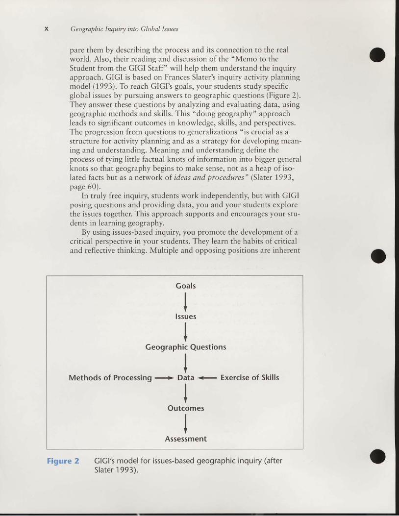
x Geograpbic Inqwiry into Global Issues
pare them by describing the process and its connection to the realworld. Also, their reading and discussion of the "Memo to theStudent from the GIGI Staff" will help them understand the inquiryapproach. GIGI is based on Frances Slater's inquiry activity planningmodel (1,993). To reach GIGI's goals, your students study specificglobal issues by pursuing answers to geographic questions (Figure 2).They answer these questions by analyzing and evaluating data, usinggeographic methods and skills. This "doing geography" approachleads to significant outcomes in knowledge, skills, and perspectives.The progression from questions to generalizations "is crucial as astructure for activity planning and as a strategy for developing mean-ing and understanding. Meaning and understanding define theprocess of tying little factual knots of information into bigger generalknots so that geography begins to make sense, not as a heap of iso-lated facts but as a network of ideas and procedures" (Slater 1993,page 60) .
In truly free inquiry, students work independently but with GIGIposing questions and providing data, you and your students explorethe issues together. This approach supports and encourages your stu-dents in learning geography.
By using issues-based inquirS you promote the development of acritical perspective in your students. They learn the habits of criticaland reflective thinking. Multiple and opposing positions are inherent
ClCl's model for issues-based geographic inquiry (afterSlater 1993).
Goals
IIV
lssuesIIV
Geographic Questions
IV
Methods of Processing + Data + Exercise of Skil lsIIV
Outcomes
IIV
Assessment
Figure 2

Enuironrnental Pollution xi
in these issues. Facts can be used to support different points of view'
This is the conrext in which the habits of the critical perspective can
develop, and interpretation is the key activity. \(lith GIGI you foster
these habits and "tili,i.r
as you help your students interpret data
guided by hypotheses, propositions, arguments' or questions'
A' ers.nt'ial element oi data-b^sed, issues-oriented inquiry is to
challenge your students by giving them opportunities to
o raise new questions'o question the qualitY of the data,. seek more useful or current data,. articulate relationships they perceive,' explain their processes of investigation, and
.de fend the i rpos i t i ons ,dec i s ions ,andso lu t i ons .
Why These Issues Were Chosen
In planning GIGI, we sought timeless issues that are truly global
in scope urrd ihut are of special concern to geographers. In this wag
GIGI fosters what the National Geography standards calls "the geo-
graphicallyinformedperson,'neededbymodernglobalcittzenry[C.ogtuphy Education Standards Project 1?9,4)'
The major case studr chosen to give solid.grounding to lhe issue,
is focused on a region where the issui is clearly expressed-'-The sec-
ondary ."r"r,rrJiEs, based in other regions including the United
StatesandCanada,showtheglobalscopeoftheissue'tt i, i*portunt to stress thit, although GIGI contains a wide selec-
tion of case studies in all major regions (Figure L) as well as frequent
references to the global distribution of many geographic phenomena,
GIGI is not "
truJitional regional geography. It does not attempt to
provide basic geographic information for each region, such as one .finds in,r"ii,["i regional geography textbooks. In teaching a GIGI
module, it is impor,"i to keep ihe emphasis.on the issue and not get
distractedwithextraneousregionalinformation.
Role of QuestionsEach GIGI module is divided into six to eight lessons, each titled
uy u q".rrion; subquestions head individual sections of the lessons.
q".ri'i""t g,.rid. inquiry in order to merge tle grgc.ess of investiga-
tion with the drawing of .orr.l,.rsions. Directly linking questions and
"rrr*.r, helps u.hi.u! an intellectually satisfying understanding of a
pr.Uf.- (Sliter 1.993).\(hen students are asked to learn only conclu-
sions without learning how they are drawn, we perpetuate the tradi-
tion of an answer-cerriered education bereft of higher-level thinking'
Therefore, it is important that students understand they are not

x t l Geographic lnqwiry into Global Issues
always expected to answer the questions when they first appear, butrather to keep them in mind as guides when they are reading ordiscussing.
GIGI asks both convergent and divergent questions, trying toreach a balance between the two. Supplement the questions in GIGIby asking your students many more of the types of questions suggest-ed by Slater (L993). These are questions that encourage
. recall,
. classification and ordering,o the use of data to draw conclusions,. awareness of the limitations of data or of evaluation of
data, ando awareness of the processes of reasoning used.
According to the National Geography Standards, the "geographi-cally informed person applies a comprehensive spatial view of theworld to life situations" (Geography Education Standards Project1994).In order to foster such a view of the world, GIGI asksgeographic questions that ask where things are and why. By askingsuch geographic questions and by having students learn to ask them,you will reinforce GIGI's approach. A good question to begin with is:Where is this issue located? Then proceed to questions such as thefollowing:
. .sfhy does it take place there?
o How and why does this issue affect the people in this place?o In what other places do people confront this issue?o How and why are these places related?o What alternatives do people have to improve their situation,
and which alternatives do you recommend?
Fundamental Themes of Geography
In recent years, many geography teachers have learned that thefive "fundamental themes" (Joint Committee on GeographicEducation 1,984) help them ask geographic questions. The theme ofLocation asks where things are and why things are located wherethey are. Place is the theme that inquires into human and physicalcharacteristics of locations. Human-Environment Interaction exam-ines how and why humans both adapt to and modify their environ-ments as well as the consequences of these actions. Movement inves-tigates not only how and why places are connected but also what isthe significance of those interactions. The theme of Region seeks toidentify and explain similarities and differences among areas andhow and why these form and change. An extended explanation ofthe themes and their concepts, interrelationships, and applications is

Enuironmental P ollution
given in Hill and McCormick (1,989). The themes are useful becausethey encourage the kinds of questions required to help studentsdevelop the geographic perspective.
xil l
Importance of Local Examples
GIGI is a world geography but it shows that issues work at vari-ous geographic scales-personal, local, regional, national, and glob-al. Because it is sometimes difficult for younger students to identifywith faraway places, success with GIGI in part depends upon theability of both you and your students to relate the issues to examplesin your local community.
.We strongly recommend that you refer in
class to local examples of the issue being investigated. Just as impor-tant, we encourage you to have your students conduct local fieldstudies related to this issue whenever possible. Issues having impor-tant geographic dimensions abound in every community (see theExtension Activities and Resources section at the end of thisTeacher's Guide for examples). Peak educational experiences oftencome when students see things in the field that relate to their class-room studies.'We discuss other reasons for local involvement in thenext section.
Familiar people can be as important as familiar places in motivat-ing students. The quality of personal engagement is at the crux ofsuccessful instruction. Using the BGGS videodisc segments thataccompany most GIGI lessons is a powerful way to help your stu-dents find relevance by identifying the GIGI issues with real people.Similarly, you can connect GIGI issues to everyday life at a humanscale, especially at the students' own age levels, by using currentnewspaper accounts or magazines that address the student's perspec-tive.
As you gain familrarity with teaching local examples, as youdevelop field exercises for your students, and as you learn how to puta human face on these materials, you will begin to customize theGIGI modules to fit your particular environment. Our trial teachersreported that the more they taught GIGI modules, the more comfort-able they became in adapting them to fit their needs.
Fostering Optimistic and Constructive Perspectives
The seriousness and complexity of the global issues studied inGIGI can overwhelm students unless you take care to foster opti-mistic and constructive perspectives toward issues. "Gloom anddoom" needs to be balanced with examples of success and prospectsfor positive change. It is important to help your students develop a
xrv Geographic Inquiry into Global Isswes
sense of personal efficacy, an attitude that their actions can make adifference in solving global problems. The maxim, ,,Think Globallv.Act Locally," speaks to the need to help students organize and,.orr--duct constructive actions that address local variants-of the issues theyare studying. As we noted earlier, student involvement in local pro-jects enriches their educational experience. There is also good wi-dence that it acually produces an optimistic feeling-that theiractions can make a difference-ro help them deal with the often diffi-cult and sometimes depressing world issues. GIGI modules ofteninclude lessons and activities to show possibilities for positive action.
certain perspectives foster student optimism and cbnstructivebehavior. Geography students, especiallg should learn to respecrother peoples and lands, and they should come to cherish .n^uiron-mental unity and narural diversity. They should also learn to be skep-tical about_simplistic explanations, such as the theory that attemptsto explain human characteristics and actions in terms of the physicalenvironment alone, which geographers call "environmental determin-ism." Most important, optimistic and constructive perspectivesaccompany the development of empathy, toleranc., urrd open_mindedness. These traits are fostered by avoiding sexist and racistla-nggage, discouraging ethnocentricity, and challenging srereorypes,simplistic solutions, and basic assumptions.
References to Data
unlike most textbooks, GIGI attributes its sources of data within-text citations and full reference lists, which is another way ofencouraging the critical perspective. In the Student DataBook. mate-rial that has been extracted from original sources is indented andprinted in a different typeface. Long extracs are highlighted withbackground color. Use of these sources helps your sludents learn thatreal people construct ideas and data and that their concepts andinformation are not immutable. Instead, they often change throughthe critiques and interpretations of various people. By using these-scholarly conventions, we intend to encourug. yorr studenis toappreciate the tentativeness of knowledge and to value scholarshipand academic integrity.
Updating
_ Real data quickly become obsolete. GIGI addresses this fact bydiscussing historical trends of data and by stressing concepts. youshould reinforce this bias for concepts and also freely acknowledgethe datedness of information by explaining why it is still used (foiexample, the lags between research and writing and publication and

Enu ir onmental P ollution XV
use; the lack of more recent data). -W'henever
possible, guide studentsto update materials. Britannica's Geopedia, on the BGGS CD-ROM,contains data based on Encyclopa,dia Britannica's \forld DataAnnual, which is also available in print form. Have students usethese sources to supplement and update GIGI data.
Assessing Learning
Evaluation of student achievements with GIGI can be focused ontwo broad areas. The first is the developing ability of students toundertake geographic inquiry. The second is the acquisition ofknowledge and perspectives about the module issue.
The ability of students to undertake inquiry in geography can berelated to the primary questions that guide geographical study. Theyare noted earlier in this memo. As students work through the mod-ule, they are likely to become increasingly adept at asking andanswering geographic questions. Seek to extend your students'com-petence in several clusters of skills that facilitate geographic inquiry.These clusters include the following:
. Identifying problems and issues. This may be done throughobservation, asking questions, brainstorming, reading, andin other ways.
. Inquiring into the problems and issues in many ways such asthrough map reading and interpretation, making surveys,and using results of surveys done by others.
o Making decisions and taking action, for example, throughreviewing alternatives, establishing priorities and criteria,and communicating cooperatively with people in other ways.
o Reflecting at all stages of the process of inquiry, especiallythrough careful consideration of diverse sources of evidence.
Students will acquire knowledge of the module issue as theymake their inquiries. This knowledge can be tested and graded.Assessments may be based on the following:
. Knowledge and skills shown by work on Activities includedin this Teacher's Guide and on questions in the StudentDataBook.
o Observations of student participation in groups and in classdiscuss ions.
Specific assessment ideas are given at the end of some lessons inthe section called For Further Inquiry. In addition, the Teacher'sGuide ends with Extension Activities and Resources. Some of theseextension activities can serve as authentic assessments.

Geographic Inqwiry into Global lssues
Potential Uses
In addition to the flexibility offered by the free-standing nature ofthe modules, GIGI has a number of other characteristics that encour-age widespread use. Modules can be extended and enhanced with theBGGS CD-ROM, videodiscs, and posters. Because GIGI's issues-based approach integrates several topics (for example, population,economic, political, physical, and cultural geography) in a singlemodule, the modules are not conducive to using an approach inwhich topics are taught separately. On the other hand, GIGI may beused with a world regional approach because there are modules foreach of 10 world regions. A year-long world geography or globalstudies course will have more than enough material by using 12 mod-ules. Five to seven modules may constitute a one-semester, issues-based geography course covering several regions. You can defineclusters of modules for your own curricular purposes.
'We have iden-
tified three clusters for interdisciplinary studies within the BritannicaGlobal Geography System, each comprising six or seven GIGI mod-ules. They are Earth's Enuironment and Society, EconomicDeuelopment, and Global Political and Cuhural Change. BGGSincludes a videodisc and poster for each cluster. These strand pack-ages could well be used in Social and Environmental Studies, EarthScience, Global Studies, and Area Studies classes. Activities in themodules also support math, language arts, and arts curricula.
GIGI encourages and facilitates the development of a variety ofgeographic skills that transfer widely into the natural and social sci-ences. Among these are skills of asking geographic questions anddeveloping and testing geographic generahzations. These requireother GIGI skills including examining and making a variety of maps;analyzing photographs; constructing and interpreting graphs andtables of spatial data; and collecting, interpreting, and presentinggeographic information.
Finally, GIGI promotes a wide variety of linguistic, numeric, oral,creative, and social skills as well as geographic skills. In particular,GIGI emphasizes cooperative learning. \7e believe that one of thegreat strengths of the GIGI modules is that they give studentspractice in both group and individual problem solving. As studentsbecome more familiar with the global issues, they learn that findingsolutions to world problems requires people to work togethercooperatively.
ReferencesGeography Education Standards Project. 1.994. Geograpby for Life: The National
Geography Standards. Washington, DC: Geography Education StandardsProiect.

Enuironmental Pollwtion XVii
Hill, A. David, and McCormick, Regina. 1989. Geograpby: A Resowrce Book forSecondary Schools. Santa Barbara, CA: ABC-Clio, Inc.
Joint Committee on Geographic Education. 1984. Guidelines for GeographicEdwcation: Elementary and Secondary Schools. \Tashington, DC:Association of American Geographers and National Council forGeographic Education.
Slater, Frances. 1993. Learning throwgh Geography. Revised. Indiana, PA:National Council for Geographic Education.
PnEpeRING To TEACH THIS MoDULE
Environmental Pollution
What are the effects of severe environmental pollution?
Pollution of the global environment is a major issue in our soci-ety. This module investigates this issue by looking at three case stud-ies. The primary focus is on the environmental catastrophe caused byhuman activities in the Aral Sea basin, in Central Asia. Prior to thatcase study, students are introduced to the issue with a brief look atthe effects of water diversion on Mono Lake, California. Comparisonis also made to the degradation of the rain forests on Madagascar.The module builds awareness of these problems and concludes byasking students to make recommendations for future environmentalplanning worldwide.
With respect to the five fundamental themes of geographS thismodule focuses on how the interaction between humans and theirenvironment alters the physical and social characteristics of places. Incases of environmental pollution, such changes are by definition neg-ative. As a result, the information presented in this module can some-times be rather depressing. In order not to leave students feeling pes-simistic and hopeless about the future, activities have also beenincluded that foster optimism about what can be done to reduceenvironmental pollution.
In Lesson 1,, students begin an activity that can be run continu-ously throughout the module. Students conduct a survey of school orcommunity opinion about a local pollution problem. This survey,modeled after one done by citizens concerned about Mono Lake,California, gives students a chance to gather original data andbecome involved in a local environmental issue of concern to them.These are valuable citizenship skills and should help give the remain-der of the module more meaning.
Lesson 2 introduces the Aral Sea environmental disaster, describ-ing the Aral's physical situation and making comparisons to bodiesof water more familiar to students. Lesson 3 asks why the Aral Sea is
xvill Geographic Inqwiry into Global Isswes
shrinking; students link the demands for increased agricultural pro-duction to increased irrigation and the removal of the lake's watersource. In Lesson 4,the disaster is explained in detail, with readingsabout the effects on air, water, and soil pollution. The lesson alsocovers the human dimension of the problem-the economic andhealth problems associated with the pollution. The next lesson askswhat can be done to resolve the Aral crisis. The conflict betweenlocal and central government control of resources provides the back-drop for discussion. In Lesson 6, students look at and design politicalstatements that reflect their opinions about what has occurred in theAral region. Lesson 7 provides the comparison to Madagascar, focus-ing on both why that island once had such high biodiversity and whydeforestation has destroyed that diversity. Lesson 8 closes the moduleby having the class draft an Environmental Bill of Rights, to setguidelines by which such severe environmental pollution cannotrecur.
It is assumed that students involved with these activities will havesome fundamental geographic skills. Map reading and the use of anatlas are particularly important. Many of the lessons are structuredaround small cooperative learning groups. Depending on the stu-dents' skills, it may be necessary to modify lessons to accommodateindividual classes.
Using the BGGS CD-ROM can simplify lesson planning by mak-ing it easy to access the resources the system provides for each lesson.It shows exactly which GeopediarM data and learning activities canbe used in long-range and short-term assignments, and whichvideodisc clips will provide visual reinforcement for each GIGI les-son. The CD-ROM can also show you ways in which a lesson in onemodule relates to a lesson in another module. And it indicates whereto find every reference in GIGI, GeopediarM, the Mini-Atlas maps,and the videodiscs to any key topic-for example, "tsunami" or"Bangladesh." The students will also be able to use the BGGSCD-ROM for further research and short-term or long-term rangeassignments. The BGGS multimedia components and their uses areexplained fully in the tabbed BGGS section in the front of thisTeacher's Guide.
The following are general modifications recommended foryounger students:
. Plan for fifteen days because the activities will require moreteacher explanation and support.
. Provide directions for homework assignments and monitorstudents' understanding and progress.
o Prior to assigning written activities requiring students to drawconclusions and summarize their findings, ask guiding ques-tions and develop a sample outline on the chalkboard.

Enuironmental P ollution xtx
Module Objectives. Explain how intensive human changes to water systems can
dramatically alter the physical characteristics of a place.o Describe how human alterations of physical environments
have had planned and unplanned consequences.o Recognize the connection between the quality of human life
and the quality of the physical environment.o Be aware that individuals and groups in a society can express
their environmental values and effect political change.o Prepare andlor analyze tables, graphs, maps, and remote-
sensing images containing information about environmentalchange.
o Develop and test hypotheses concerning the causes and conse-quences of environmental change.
Number of Days Required to Teach ErusironnxentalPollution
Thirteen to fourteen 50-minute class periods
Suggestions for Teacher ReadingKotlyakov, V. M. 1991,. "The Aral Sea basin: a critical environment zone."
Enuironment, 33 (1.) : 4-9, 3 6-39.
Micklin, Philip. 1988. "Desiccation of the Aral Sea: a water management disasterin the Soviet Union." Science,241.: 1.1.70-1176.
Ellis, William. 1,990. "A Soviet sea lies dying." National Geographic,1 .77(2) :73-93 .

How have people influencedthe fate of Mono Lake?
W Tirne RequiredOne 50-minute class period. The survey proj-ect recommended in this lesson lasts severaldays; it is suggested that this activity be run inconiunction with the remainder of the lessonsin the module.
W Materials NeededCopies of Activity 1 for all students
O Gl .tossaD/ words
ecosystem
environment
Getting Startedo Have students read the Memo to the Student
and the overview on pages 2-3 in the StudentDataBook prior to beginning the module. Alsomake sure students ate aware that there is aGlossary in the back of their DataBooks.
. This lesson explores how people's perspectivescan influence environmental debates. Ask stu-dents what they think the worst or most signif-icant environmental problem is in their owncommunity. Have students consider how theywould go about finding out what other peoplethink about this local controversy. Explain thatthey will see how Californians used a public-opinion survey to marshal support to save onelake's environment.
Procedures
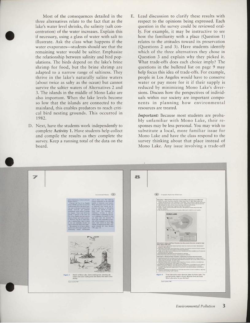
What is the issue at Mono Lake? (pages 4-9)
A. Have students study Figure 1 (page 5). Tel lthem that the drawing, from a cover of a pub-lic-opinion survey, depicts an environmentalcont roversy in Ca l i fo rn ia . Have s tudentsdescribe what the issue appears to be and spec-ulate why it is controversial. The figure cap-t ion poses quest ions about the intent of thesurvey designers: \fhat side of the issue is the
How have people influer-rced
the fate of Mono Lake?
What ir the irsue at Mono Lake?
o n c n , f . o f l e n n E t n c . n L c h o . r , n e , i v i o n m c n k l r c s . t r r . e s h o u l l
be n$l S.nEins, po$ibLc hild uts.ontLi.t btcrus!.de.ho'ccqorkl polLul. i l i . resoufcosomu![ dlrthee.osFcm s d.u]8ed
SuDDosc a.hcnlcal idn$ry lvanrsro bnild x Flxnr nc*!rr nvcr
S";;r."pl"- 'ghr d,r.d b--,sothat nvcr i nsed lorthff n,wd3
wrre' i lpply orn i lrc I hv.ttc f i lhinsln. T6ef might bccoil
c.rned thfdrcm,cxl p,i lutl.n LrotrLl d$toydi.seonrd usos oi
th..drer hand. pooplc n,i8htsuppoilrhcndu{ryr Plrn bccru* r1
wolld Drovide boiicrin\ f.rthe town. ln your.Nnconnnntl
r h e r e m i y b e r i m i l a r d i l r t e s x b o n t l o * h u s . r h i L l . r i a k c , o r .
Enu ir onmental P ollution

ar t i s t on? [The survey concerns a p lan tod i v e r t w a t e r f r o m a l a k e i n N o r t h e r nC a l i f o r n i a t o a l a r g e c i t y i n S o u t h e r nCal i fo rn ia fo r u rban uses , such as water inggardens. The controversy arose because if thelake water was diverted to the city, the lakewould shr ink. This would cause major dam-age to the lake 's ecosys tem. The po l i t i ca lp o s i t i o n o f t h e a r t i s t i s d e b a t a b l e , b u t i tseems he or she is contrast ing the aesthet icva lue o f na tura l scenery w i th the aes the t icvalue of suburban gardens.]
Choose students to read the text aloud, up toand including the extract, "Descript ion ofMono Lake" (pages 6-7). Figure 2 on page 6may be used if your students are unfamiliarwith California geography. If you wish, havestudents use the map scale to estimate the dis-tance of the Mono Lake diversion along theLos Angeles Aqueduct. Ask why Los Angelesmust import its water. Figure 3 on page 7 sim-ply illustrates how diverse the bird life is andhints at the dramatic scenery of Mono Lake,also showing what its unique tufa towers lookl ike. [Mono Lake is approximately 300 milesf rom Los Ange les . Los Ange les impor ts i t s
w a t e r b e c a u s e i t l i e s i n a s e m i a r i d r e g i o n(note the proximity of the Mojave Desert) ,with inadequate fresh water to supply its met-r o p o l i t a n p o p u l a t i o n o f o v e r 1 3 m i l l i o n .Students may no te tha t a l l ma jor r i vers inCalifornia, except the Colorado, flow towardthe northern half of the state, accounting forthe th ree major d ivers ion pro jec ts shown,which br ing water to the southern populat ioncenters.]
\7ith the class, go over Figure 4 on page 8,which describes three alternatives for diver-sion. Note that the present level of diversionby the Los Angeles Department of \7ater andPower (LAD\fP) will result in Alternative 3, ifthis diversion level is maintained. Reducingdiversions somewhat leads to the lake levelsdescribed for Alternative 2, which would leavethe lake at about its 1,982 level, its historiclow, but still above the level of Alternative 3.Alternative 1 represents a rollback in the diver-sions to enable the lake to be restored to pre-1982 levels. Al ternat ive 2 is a compromiseposition between the diversion levels advocat-ed by LADWP and those advocated by envi-ronmental groups, who support Alternative 1.
C.
Fisure r Covsol5uru€yabout Mono Lake. The Unlv€Bityolcaliforniat Divbion of Ef vionmeib Studles surueyd
CaliromianJ opinlons about thevalue of Mono bke, What
me$ager did thk drawing send?Whatvaluesdoyo! think
t h e a d * h a d ?
How can people choosc anonBcompeting land usesi Eow c,n
dection mrken hovwbrivalucpcoplc plac.on r resource? One
way htosufleypeopled opiniod abourhciesoulce, By leamtng
how imponant people believe r esourcc i, Iand-us. plandcs can
In lht le$o!, you wil l see how crliforniail leamcd what p.ople
LL about one envtonnellal iesource. Mono hke (Fi8ue 2 onpaB. 6), At nsue w.s a choice about hov to use ine riveE tbat fc.d
th. lal., The bs AB.ls Dcpartmcnr ol Warer and Power wanred
to dive* norc w.Fr lrom lhesc rivere to supply rie ciq of hs
Anseles.Doingsowouldhavc low.red thc lateSlcvel.Manycalifornians opposed tbt plan. They w.nied to keep the late! water
' r p p \ h i s h e n o r s h b D f t s e , v . r h c f t G y r e n T F e r o l o u l E
"Deciption ofMono Lakc" was the irtbdDction ro, snrey aboui
Mono rake, The covcr ofth. publbhcd suney k slovn in Fisure 1.
rlgure 2 b.auon of Mono Lakeand therhrcemajo.waterdive6on
lyn€msrupplying LosAngees. Howmanymilerdwaieftansfti i .d i iom Mono Laketo LorAng€les?whydoes Los
Angel€s ned b impod ls wat€r?
Geographic Inquiry into Global Issues
aMost of the consequences detailed in the
three alternatives relate to the fact that as thelake's water level shrinks, the salinity (salt con-centration) of the water increases. Explain thisif necessary, using a glass of water with salt toillustrate. Ask the class what happens if thewater evaporates-students should see that theremaining water would be saltier. Emphasizethe relationship between salinity and bird pop-ulations. The birds depend on the lake's brineshrimp for food, but the br ine shr imp areadapted to a narrow range of saltiness. Theythr ive in the lake's natural ly sal ine waters(about twice as salty as the ocean) but cannotsurvive the saltier waters of Alternatives 2 and3. The islands in the middle of Mono Lake arealso important. \fhen the lake levels becomeso low that the islands are connected to themainland, this enables predators to reach criti-cal bird nest ing grounds. This occurred in1982.
D. Next, have the students work independently tocomplete Activity 1. Have students help collectand compile the results as they complete thesurvey. I(eep a running total of the data on theboard.
E. Lead discussion to clarify these results withrespect to the opinions being expressed. Eachquestion in the survey could be reviewed oral-ly. For example, it may be instructive to seehow the familiarity with a place (Question 1)relates to the attitudes toward its preservation(Questions 2 and 3). Have students identifywhich of the three alternatives they chose in
Question 3 and explain why they picked it.What trade-offs does each choice imply? Thequestions in the bulleted list on page 9 mayhelp focus this idea of trade-offs. For example,people in Los Angeles would have to conservewater or pay more for i t i f their supply isreduced by minimizing Mono Lake's diver-sions. Discuss how the perspectives of individ-uals within our society are important compo-n e n t s i n p l a n n i n g h o w e n v i r o n m e n t a lresources are treated.
Importafi: Because most students are proba-b ly un fami l ia r w i th Mono Lake, the i r re -sponses may be less personal. You may wish tosubs t i tu te a loca l , more fami l ia r i ssue fo rMono Lake and have the class respond to thesurvey thinking about that place instead ofMono Lake. Any issue involving a trade-off
rigure 4 Th€e a Lematvd wald diva6 on pLanr lor Mono Lakd. The
€nvnonm.nLr impa.B ofda.h divddon dve ar€ Ined
which aternatve doyou li[c ben?
Flgur€ I Sk€lch ol Mono Lake. View s lookinowesl shownq luia
rowers and some nestns bilds who feed on lhe akes brine
Enuironmental P ollution

F.
between economic convenience and environ-mental conservation would be usable. Anotherpossibi l i ty to connect these themes to yourlocality is to structure the discussion aroundthe environmental impacts involved in yourown community's use of water. Vhere doesyour town's water come from? Are there otheruses for that water source? rWhat trade-offs areinvolved?
Close the lesson with a class project in whichstudents make a public-opinion survey on alocal environmental issue. Ask students if thereis any loca l env i ronmenta l l y un ique areathreatened by human activity and worthy ofprotection. Brainstorm a list of possible places;write these on the chalkboard. Lead discussionof why these resources are worthy of environ-mental concern. Why is the resource beingthreatened? Must an area be environmentallyunique in order to protect it? Or should allenvironments be worthy of some kind of pro-tection? Continue emphasizing the concept oftrade-offs.
At this point you should decide whether tohave students initiate their own survey project.Although it is not integral to the module, it isstrongly recommended that students do thisopinion survey. Besides giving the class practi-cal experience in designing a survey and inter-preting its results, having the class focus onlocal environmental issues should help attracttheir interest to the subsequent case studiesexplored in the module.
The project could proceed along lines similarto the Mono Lake survey, in which studentsconduct a poll of community or school opin-ions about the locally threatened environmen-tal resource. Have students vote to select oneenvironmental issue for the ent ire class toinvestigate.
D iv ide the c lass in to work ing groups .Below is a list of some of the kinds of workgroups that could be formed:
. Background Information Group-Collectsthe basic information about the issue.
o Swruey Deuelopment Group-Writes thesurvey to poll local residents.
c Suruey Administration Group-Polls thetarget audience (other students, local citi-zens, etc.) and compiles the survey results.
Maps, Graphs , and Tab les Growp-Prepares maps, graphs, and tables of the
4
area rn questron to summarlze lmportantinformation in an easy-to-read form.
o PhotoTrapby and Art Group-Takes pic-tures of the area as a form of record keep-ing and for i l lustrat ion and prepares al lpresentar ion mater ials.
o Presentat ion Group-Meets with localb u s i n e s s e s , c h u r c h g r o u p s , o r c i t i z e ngroups to present the environmental issueand survey results as well as learn thesegroups' positions, if any.
Working in groups, students will gatherinformation and data to conduct the survey.This process could take several days to com-plete and could require homework time to col-lect all the needed resources. \7hile the surveyis being prepared, the other groups should bes imi la r ly engaged to p rov ide in fo rmat ion .Class time during the following two to threeweeks can be split between the lessons in thismodule and time for students to work on thisproject.
'When the survey design is complete, the
students conduct the survey. It should be deter-mined beforehand what the target areas for
G.r.___,.,tut hilild tt ))l
M o n o L r [ c ! c c o s y $ c n w i \ t h r c ] t r n c l b y i h o p l i n i o n i v c i tnrort *!rcr tu Los Ingdcr. Thc snrvcy a\[ed p.oplcioihinl abournrc uniqtrdr.solthr lxkc Ii $krd pcoploiochoosc shich olthc
irlrtci l$ivcsshown in Figurr 4 otr prgc 3 thry prcftrcd Tlcru./ry rskrd [ow n'd] NoDct pcopl. wotrLl spcnd or i lrhcy scrcwlLlirgb bc irrorvcrioi.rd tosxvr N!nr)L.kt.Tht rstrfts ofdrt
iDd oil i .rsrvcrr ldhd d(nion DmhL! lctcnninc drc vi[ 'c oithi:
.rvlr.r!r.r. iL 160tr'rd. I l(!rur! $ nDtrf to.tLo rxp'osscJ i prcicr
.i.e!, klcD il l rko l.vcL high.r.rgh ni nr[n][, rht rrosy*dn,
tu ir 'crrd wtcrdlv.snlrs [rvd !.t rcr rrkcn rLic.h ld, r le9:J rqrtrr itr i lr! (rrl lnnLr Vlrcr ltcsNco(..M.1
1 , . , ' , . , f . f , , . . . , \ . ^ ' , . . , . r . . r L . o Li.onr i lrf Nrnr, |, (r bNrn n, th,r i lrc hk( crd.ir ri lc 3 l/2 icct nrorlor ro p,oic.r i lrr hkds s.oric lod urrrnnnotrrL vntrs (Muohl
1993). h rdJnnf, rhr U S lhvtronDrcnti] l 'rurc.non lscncy (U{l
intorJd b doUrr dr! MfnoLikr hisD r viohdon oif.Joml xFq u r l i r y * x t r d r r d r h t r x t r \ r l r n l c r o t r s . L [ x l i J n $ $ o ' N s , L r t o n d r c
d r i d u r r r n s . f d r c h k . 6 ! ! T h i n , u l d a o , . o ( i l i i n n h t o 3 l L o w
nr. hk! r. ns. cvu, trrtr! hwird h D!trr,1 (lzi (Bid AI t Go.d
v 1 . . ' . ' . . , i l . '' \ , ' . , ' 1 , f i l ' i l L [ . ' . . , . r 1 . , l ' r ' L ' L i l o '
nron? Yor nilv h.c hnl usr."oi trN m y.ur in.n, Likdh. oncc i h G n , i n r f . c . l r b o , r M " n o 1 . , r . Q k n r n \ p , m r y h i { t ixsk roracLLnJrlcihr n [,q,n!:
. whLch cnymnn,lnhl rc!,uf.c u r\rrdnnnunny lo you
ihn,l F wonf trcs.rvtriB? whyl
' L n i lro.rs,cJ br viN nntrr oIp,i ltrfoil?
Geographic Inquiry into Global Issues

polling are. For example, students may wantto poll only people in the area) or they maywant to pol l only other students. Studentsshould record and classify the information as itis collected.
In the final phase of this project, studentsshould be asked to ref lect on their or iginalcommitment to the project. Is their commit-ment to the issue more , less , o r about thesame? How have their perspectives changed,having taken part in a project of this kind?Have the results of the survey project beenunexpected?
Use as many outside resource people orspeakers as possible to give students the stimu-lation and information needed to stav involved
with the project. Also, allow students schooltime to visit resources not in the school andprovide them with the materials (or the fundsto get materials) needed for the project.
Assign students to keep a journal record ofthe project. Students should be expected towrite about ideas, impressions, successes, andfa i lu res and use the iourna l as a de ta i ledrecord of their involvement. Al ternat ively,arrange to have the students report on the pro-ject to an appropriate public group, for exam-ple, the Town Planning Commission, CityCouncil, or School Board.
LEnu ironmental P o llution

How is the Aral Sea changing?
W Tirne RequiredTwo to three SO-minute class oeriods
W Materials NeededTracing paperButcher paperMarking pens or colored pencilsTransparency of Overhead 1Mini-Atlas maps 1, 2,3, and 4
Gl atossar)/ Wordsenvironment
exotic river
interior drainage
remote sensrng
salinization
watershed
Getting Started. This major case study deals with environmen-
tal problems in what was Soviet Central Asia.Some of these problems arose from the wayplanning decisions were made in the SovietUnion. It may be helpful to review the natureof the political change from the Soviet Unionto the Commonwealth of Independent States.Use Mini-Atlas map 1 to locate the Aral Seawithin the former Soviet Union.
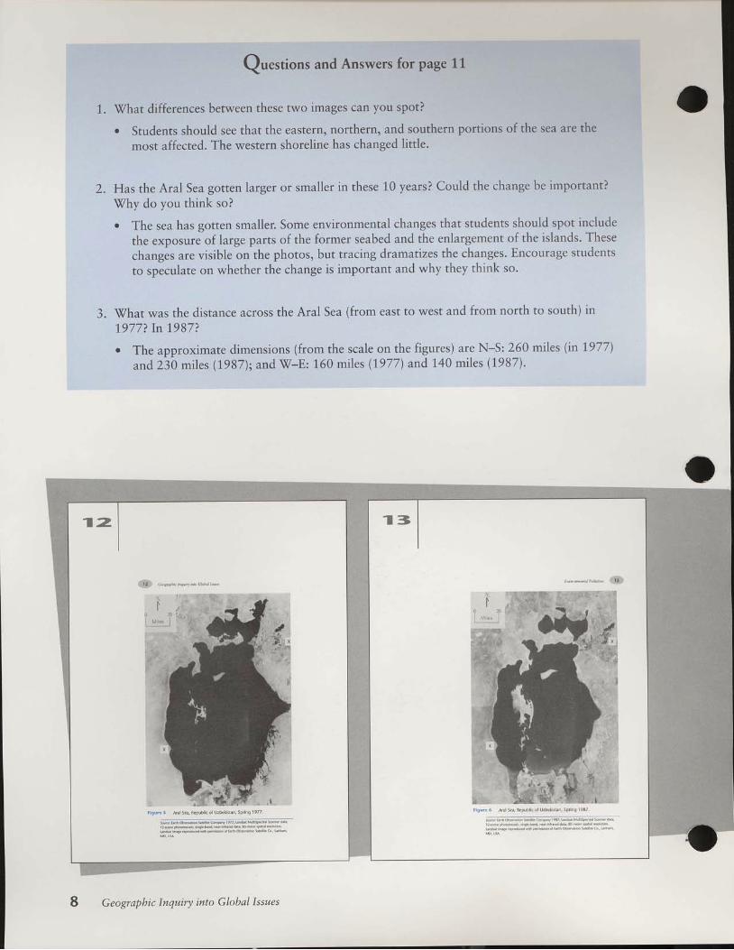
. Have students examine Figures 5 and 6 onpages 1,2-1,3. \Tithout explaining what thesephotographs are, ask students to identify whatkind of feature the figures show. fStudentsmay identify a body of water with islands anda l a k e s h o r e . T h e A r a l i s c a l l e d a s e a , b u temphasize that i t is real ly a lake, for i t has nooutlet to the ocean. Ask students what char-
ac ter is t i cs d is t ingu ish a body o f water as asea. This may help emphasize the point thatit is composed of salt water. Also be sure stu-dents are able to locate the Aral Sea on Mini-A t las map 1 .1
. Ask the class which picture was taken first andhave students observe and describe the differ-ences between the two photos. Make it clear tostudents that both images show exactly thesame total area, that the scale is the same.North is at the top in both. [Figure 5 wastaken in 1977; Figure 6 in 1987. The lake isnot iceably smal ler in 1987, especial ly in theextreme south and north; the is lands are alsomuch larger in 1987. Be sure students graspthe meaning of the increase in is land size. Seetha t they rea l i ze th is means the lake i t se l fmust be gett ing smal ler. Inform the class thatthey will be studying the causes and effects ofthese changes in detai l . l
Procedures
What is the Aral Sea environmental disaster?(pages 10-14)
A. Hav ing es tab l i shed tha t the Ara l Sea hasundergone dramatic changes, read the shortparagraphs defining remote sensing. To helpwith discussion of the three questions follow-ing these paragraphs, pass out a sheet of trac-ing paper to each student. This tracing activityshould be completed individually. Give the fol-lowing instructions to the class:
a. Using a pencil and tracing paper, trace anoutline of the 1987 Aral Sea shoreline andislands from Figure 6. Be sure to mark theposition of the two Xs, which will be usedto align the outline in the next step.
Geographic Inquiry into Global Issues

b. Using the same piece of t racing paper,trace the out l ine of the 1977 Aral Seashore l ine and is lands f rom F igure 5-arownd the first outline. Match the relativepositions of the two outlines by aligningthe two Xs.
c. Use two different colored pencils to showhow the lake has shrunk. Use one color tofill in the lake area as it was in 1987. anduse a different color to show the additionalarea that was present in 1977.
d. Add a title and legend, including the sea-son and the year of each photo, and anarrow to show where north is (at the topo f t h e p a g e i n b o t h i m a g e s ) . I P r o j e c tOverhead 1 for a samole of what a com-pleted version looks l ike. l
A s k w h a t t h e m a p s s t u d e n t s m a d e i nProcedure A show. [The shrinkage of the lakeand exposure of the former lake bed] Havethe class generate a list of the visible changesin the Aral Sea from 1977 to 1,987. Have stu-dents explain which source, the photos or thet r a c i n g , p r o v i d e s t h e m o s t i n f o r m a t i o n .Discuss Questions 1-3 on page 1.1.
Younger students may need a full periodto complete their tracings. lf so, the trac-ings can be used as a way to start the fol-low ing day 's lesson. Have the s tudentsspeculate what their tracings show beforethey answer the questions.
C. Next, have a student read aloud the passage byPerera on page 14. This sets the tone for themodule, describing the extent of the environ-mental pol lut ion. Ask students to speculateabout what might be causing the Aral Sea toshrink.
What is the Aral Sea region l ike?(pages 14-16)
D. I t is important that students have a clearunderstanding of the area's physical geographyto use as a frame of reference while workingwith the module. Break the class into pairs orsmall groups. Distribute Mini-Atlas maps 7,2,3, and 4 to each group. Have students read thetext on pages 14-15. Refer to Figure 7 onpage15, which is a location reference map of theregion. Each group should work to answerQuestions 4-9 on page 16.
l
How is the Aral Sea changing?
What lr the Aral Sea environmental disaster?
MrDs, gilths,rndsxrell i teinrgesrresonrotdietooh geogrr
ther usc ro$udy.lxngs oD il iesutrrce ofEx(h. Phobgilphs ot
Fril[..k.r f io'n s.tl ln$.r eyrn]rb of. kdrnjquec.i led ft 'noks c i l s n r s , l n r s c s . . k c n f t . n s p . c c J i . w r h l n s s d u r c ! 0 n o t L e s e e rI..fr dr s'ound. In cx.nrplcof.hI tth.wc.thcr nr! shosn onrh. ni8hdr tclcvnion navs. Bdrus.tu lmaEcs of.hcdtmosFhcrcdrcukc. Iron spx.c, mctcorologit lan i lcntify wcaihcr ry*cn lonsb d o r c t h c y r c x . h y o n r L g , o n . l l $ h c l p s i h c m p r c d n t w h c n l x r y c$oms,su.L as ludcrnes,*i l l *rikc.
Remote{ensnr! hales rre aho helpnil inspoftin! paftmsnsenn
l o r e x p l a i n i n g e n v i r c n m e n r a l c b r n g s . F i g u r c s 5 a n d 6 o n p a g e s 1 2and 13 arc satcll i tc photolraphs ofthc Amlsca tusion in ccntal
Enu i ron m e nt al P ol I ut i on
1l .
L .
Questions and Answers for page 11
\(ihat differences between these two images can you spot?
. Students should see that the eastern, northern, and southern portions of the sea are the
most affected. The western shoreline has changed little.
Has the Aral Sea gotren larger or smaller in these 10 years? Could the change be important?
Why do you think so?
. The sea has gotten smaller. Some environmental changes that students should spot include
the exposure of large parts of the former seabed and the enlargement of the islands- These
changes are visible on the photos, but tracing dramatizes the changes. Encourage students
to speculate on whether the change is important and why they thilk so.
.il/hat was the distance across the Aral Sea (from east to west and from north to south) in
1.977? In 1987?
. The approximate dimensions (from the scale on the figures) are N*S: 260 miles (in L977)
and230 miles (1987); and W-E: 160 miles (1,977) and 140 miles (1987).
a
w:ff i
A n ! . d , f l e p u b n o f ! / b . k n i i , l p r i r q 1 9 3 /
wm
. !
:.',ra)::
tlllti
, :.iiii:r r l l l , '.lii!,,,1
lrll":'::)::..,,::t''lrrl,,',. .ltlll!]rlrrr:,,: .:::t::,:i:iltltllr ll
tlti.vtll::':ar.,,,i:iia
Geographic Inquiry into Global Issues

E. Conclude the lesson by telling studenrs that inthe next lesson they will learn more about theAral Sea. Save al l of the speculat ions fromQuest ion 9; they can be used to introduceLesson 3.
l,,
)i 'i11|'ttilllllr
..'r'iiiitirllll
ll l ,."ll'rll:.:,..:ti,ti:lL
i'lllllilllrrl
llllf'l'lrrlf,::aa,:\-;i:):
iiruut .lllr' "iiilri!::.|:a.t,)t)...
l):,.,'.;1l
rli!iillllr,,,illlu,, .iilllaa:Ntt:.
;)rrr., l.rlil::::':.titlla,:
:tl:itll:t
.lllllllllllllllllrrrrlrl
,av,l$1
9
' ,1 rare
U Z B E K T S I A T 1 F i r i n i x r
U 3 K [ 1 F N 5 ] A N
, . , . !
- A T C H A N I S r A N " 1 . . . , , . i . .
r igur€ 7 ral Sea rca on in Cenral Ai..
rnen.rdrrmrsc syscns rfcnor ud..i lnnon rhc cftrt Brsil. lrh.rhncn Shrcs (.oveins Ffir.fr ir fu6 inrht ve*. mrii! Ncvrhr.d Urrhl i lsohN ii l ft io. dri i,rsc.
l l i l toricrLlx rh.Dt 91) rrcdn ol dc rvrter goiiB 0!) thc mls c x . r n r c l u n n v o r i r . r \ i l , c I m t r L l . i l ' y i r n J i l i . S y r D i t y x
Uri!trrr 7). Th. r.nrnJ(, !rtrr.([ro(]r ioN dicrh!trphcrcxs prcl i p n f t i o n l K o n v r k . v 1 9 9 I . h d r c I k d s n j t u n l * i r . , w a t u l o $rhronsh c\r!.Andil (qu.l i thr xnronDt.f w,tr.r c!)nr,butcd byp r e . i p i t r t i o t r l i d I r r f c t r v o r v r * 1 \ l i r k L [ i ! 9 3 N l . 1 h c l r ] l S e r !wxtei levJ N,r dirrtr.mcl bvr[r 6iLrN!
Howeve., f...r lunun i.nvrirr h]re uFx rh^ balan.€,le,diis
r l l ' l l \ . - ' \ 1 1 , ' . r 1 q - , i l ?
rxl trnd e.od.r,ic $.bnq olthe rEi.r. lor cximple, dre Arxl Scrwas once knowd itr trscoilrdairl lkhli8 Lodo*ry. Bnrlnrce t960. t - . \ r g n J , . , . l . . 6 " d A 1 y . , t 1 . q r . . - . . - r , l. e r r l . ^ i l , ' n - , J . , , , , " . r t l " a r e q u . t f , , . .Arrl hsd..Liicd $ mnch thxt lt.rn d. bns( suppo(mo* fom\ol l irt (Br.wi 199 l).
Enuironmental P ollution

Questions and Answers for page 16
4. The Aral Sea region covers about 626,000 square miles. Describe an area of the United Statesthat is about this same size.
7.
o Have students use the map scale on Figure 7 to calculate the approximate size of theregion (width and length in miles). Then groups can use the Mini-Atlas map of thecontinental United States to measure off a similar distance using that map's scale. The Aralregion is about the same size as the states of California, Nevada, Utah, Colorado, Arizona,and New Mexico combined. Other regions of the United States could also be used forappropriate comparison. (Skip this question if is too advanced for younger students.)
\fhat are the names of the mountain ranges that are the sources for the Amu Dar'ya and theSyr Dar'ya rivers? Approximately how high are these mountains?
r Using the Mini-Atlas maps, students can identify the ranges as the Tien Shan and thePamirs, with elevations well above 10,000 ft (3,050 m); the highest peaks are near25,000 ft.
The Amu Dar'ya and the Syr Dar'ya rivers are called exotic rivers because they flow mainlythrough desert regions but their water sources are in snowfields in high mountains. Find twoother major rivers in the world that are exotic rivers.
. Using the Mini-Atlas world climate map and world physical map, students can find otherlarge rivers that flow through dry climates but begin in the highlands. The best knownexamples are the Nile, Indus, and Colorado rivers.
How are the exotic rivers you identified in Question 6 different from the rivers of the Aral Searegion? How are they similar?
r The major difference students ought to note is that the Amu and Syr Dar'ya rivers are partof the interior drainage system of the Aral basin. The Nile, Colorado, and Indus all flowinto oceans. (Be sure students don't get hung up on terminology: The Nile flows into theMediterranean Sea, the Indus into the Arabian Sea, and the Colorado into the Gwlf ofCalifornia. All these bodies of water, however, are arms of an ocean.)
\fhat major lake in the United States is similar to the Aral Sea in that it has no outflow and isin a region of interior drainage? Is it a freshwater lake?
. Students should use the Mini-Atlas U.S. map. Many lakes in the southwestern UnitedStates qualify; the best analog to the large, saline Aral Sea is the Great Salt Lake, Utah.
9. \7hat human activities do you suspect are causing the Aral Sea to shrink? \fhy do youthink so?
r Groups can discuss this and make some guesses why the Aral Sea is shrinking. As eachgroup finishes, it should select a recorder to write its speculations on the chalkboard or onbutcher paper hung around the room.
5 .
6.
B.
10 Geographic lnquiry inlo Global lssues

Why is the Aral Sea shrinking?
W Tirne RequiredOne 50-minute class period
W Materials NeededCopies of Activity 2 for aII students
Gl at.,ssa{), wordscentral government
environment
salinization
Getting Started. Have students examine Figure 8 on page 1,8.
Ask students to describe the spatial pattern ofthe shrinkage. Have the class determine whythis is the shrinkage pattern. [The eastern andsouthern shores are recedino more than westand nor th . l
Older students should see that the waterin these areas must be sha l lower , s incel o s s o f w a t e r e x p o s e s l a n d q u i c k e r .Advanced students may realize that theseareas are shallower because that is whereAmu Dar'ya and Syr Dar 'ya r ivers comein, deposit ing sediment. For younger stu-dents , s imp ly ment ion tha t the lake isshal lower in east and south, which is whyit is receding faster.
. Also, have the class review their speculationsfrom Lesson 2 about what is causing the AralSea to shrink. List these on the chalkboard.
ProceduresA. Ask a student to read aloud the short quote
from Kotlyakov in the box on page 17. Thetext that follows mentions that the water lossis caused by "irrigation and cotton." Figure 9on page 19 shows where the i rr igat ion hasbeen.
Ask students to generate some hypothesesabout the relationships among irrigation, cot-ton, and the shrinking of the Aral Sea. Helpthem by giving structure to the hypothesis. Forexample, "As i rr igat ion increases, the AralSea's level (decreases/increases)r" or "As cot-ton production increases, the Aral Sea's level
..**-"q,esr*wlil€rs|st#tuffi i*i#ffi6ffi ffi mmmm
Enuironmental Pollution 1 1
{y
,, - --, - u w * -, lltltt:i::lt'
ffi..@.*,.',lffifi},iWhy is the Aral Sea shrinking?
closraryWordr
3y the €nd of 1939, the Ara sea had receded into two rcpa-ftte pns . . . The rend 5 clear wthout dra{c meilures, theAral sea k de*ined to be.ome a 5mdl brine lake of lunder2,0005qere m ht (Kdry*ov 1eer, paqe 6).

iiiill ril illlil iil ltt'i :t.llrr.rrr:ti,iii;ru.,11rt: i
Questiorrs and Answers for page 19
1. 'V7hy
is irrigation necessary to support agriculture in the Aral Sea region?
. Irrigation is needed because the region is mainly desert (refer to Figures 7 andg). Desertsoils are often fertile (that is, are rich in plant nutrients), but cannot suppofi agriculturewithout having extra water.
2. Vhat benefits would irrigation bring to the Aral region?
. Students might note that irrigation could increase agricultural production and so bringmoney to the region. This rationale emerges in this lesson.
3. \7hy have the irrigation systems shown in Figure 9 caused the Aral Sea to shrink?
r This question is designed for speculation; the answer will emerge later in rhe lesson.
l:
'
I
l
i1i1!,1
:
1 l
. l
iil1111l!lllll,,
lti:ii;li,ll!uurt...:ttI .l:tillirrlltli?truut . .tll::rrriliii,l
uu 'i 111,t,ltrl:,..,,,r11riilll:i't1,,:,iiillc]]l
12 Geograpbic Inquiry into Global Issues

( d e c r e a s e s / i n c r e a s e s ) . " T h e s e h y p o t h e s e sshould be compared to the groups' specula-tions from the previous day. Data in this lessonprovide the means to test the class hypotheses.Discuss Questions 1-3 on page 19.
B. Have students read the text titled "The AralSea Project" on page 20. Have the class con-struct a time line of the key events mentionedin the reading. [The two periods to note arethe I930s, when the area was f i rst exploi tedfor agr icul ture, and the 1 960s, when large-s c a l e i r r i g a t i o n b e g a n w i t h t h e A r a l S e aProject.l
Next students should read the sect ion,"\Vater withdrawals from the region's rivers"on pages 20-21.It is essential that studentsmake the link that water used for irrigationnecessarily removes water from rivers supply-ing the Aral Sea.
For younger students, work through thear i thmet ica l concept o f water ba lance.The mater ial can be discussed as a simpleadd i t ion /subt rac t ion prob lem. The keypoint is that without the rivers' inflow, thelake's water level must decl ine over t ime
due to evaporation. In fact, more water isn o w b e i n g t a k e n f r o m t h e r i v e r s ( 1 0 5cubic ki lometers) than used to f low intothe lake (56 cub ic k i lometers ) , mean ingthat the withdrawals must be also shr ink-ing the size of the r ivers as wel l as thelake.
Table 1 on page 21 shows the changes in theAral Sea's level, area, volume, and sal ini tyresulting from water withdrawals for irriga-tion. Have students use Activity 2 to graphthese data. Be sure students include the labelsfor the vertical axes (giving the units of mea-surement) on their graphs. students can com-plete all four graphs individuallg or to savetime, you can divide the class into quarters orhalves, with each student thus actually com-pleting only one or two graphs each. You mayalso want to assign the graphs for homework,allowing you to move straight to the discus-sion of Questions 4-10 on page 22.
D i s c u s s Q u e s t i o n s 4 - 1 0 w i t h t h e c l a s s .Alternatively, you can assign these questionsfor homework.
C.
D.
h*r-.*,b1 prhh,,:.11t )l
wnl rht s'owth ol ir isi l ioD.ihoAmL\ wxtu hrhncc was
dc*!.yed. s. inuch witr is rumovrn non tho rivcB now thrt th.rc
h !o iJlow i(o irc A'rl Scr i l r l l i , Jry t.r.s. l ivcn in wct rud!,drr. h o.t ctrotrgh i ivo' wilc' f lownr! ito i lro Aml to (plicc tho
loscs fioD cv.pfi.nni. ir r fori lt. drc Ir. l scr\ lovcl h.r druFFcd
N.rc thrD 14 r(!,r sirrd 1e6! 1T16lo\ | rnn 2 Uow). lrr i lrr
l970s,scv.1 $v[onnotrtxl polidnr *rs bo$orirsNnl.nr in th.
A n L S o r c s . f N \ r r ! \ u t . l i t h [ d \ i r i r k r | c i h o w D ] e 9 l ) .
19@ 51.3 At.C
Iff ii: :::
":;i :i:
"::,r trhe 3e.o
:obor*r r.o ?r aWat€r withdrawak from the region! rivert
thousinlsof ims,r,, i lrcrql..trolLcctivctnns Thc
h n l u n l s m g i r n n i i r c . . r k d r t r n u r l l y b m r ( r h c \ c( B r o w n l 9 9 l l . l l y l 9 9 2 . 4 7 r . r 3 t r r o t U r b r k i $ i t r ! h r( B r o w n l 9 9 l ) . l l y l 9 9 2 , 4 7 p . r 3 t r r o t L r b r rrloiion. A! i 16!1., l lzltkkrr 6(rmr dr
loiton Dril,c.r 1l !! l99ll.
EnuironmentalPollution 13

Questions and Answers for page 22
4. \7hy did the Soviet government want to increase agricultural production in the Aral Searegion?
. The Soviet government sought to increase agriculture development in the region to providenational income and to supply food and fiber.
5. How has irrigation caused the Aral Sea to shrink?
. The Aral Sea inflow depended on the rivers, which were diverted for irrigation.
How does the fact that the Aral Sea is a lake with no outflow in a desert region that is fed bvexotic rivers contribute to this problem?
. The problem is exacerbated because of high evaporation rates in the desert and no otherdrainage sources for the sea. Review the material in Lesson 2 on interior drainage ifneeded.
About how many meters has the Aral Sea's level already dropped? How many more meters oflowering are expected by 2000?
r The sea has already dropped over L4 meters, with prospects for losing six more meters bythe end of the century. (It may be helpful to relate this to a more familiar height. Forexample,20 meters is about 65 feet, or the height of a five-story building.) Be surestlldents see the link between water level, area, and volume. As level drops, there is asmaller area; less water means less volume (sea occupies less space of basin).
Did the rate of lowering in the Aral Sea's area increase or decrease during the 1980s? \7hat doyou think is the connection between this changed rate and what was happening in the regionthen?
o Reference to Table 2 highlights the point that the rate of change is increasing. The graphsin Activity 2 visually reinforce the point that there have been rapid increases in lowering ofarea. level. and volume since the mid-1970s. Ask the students whether this trend waseasier to spot in the table or on the graph. This emphasizes the value of pictoriallyrepresenting tabular data to show trends. Students might logically suggest that the rate oflowering increased because of heavier withdrawals from irrigation.
9. Why is the salinity of the Aral Sea increasing?
. Salinity increases because there is less water for the salts to be dissolved in. In other words,given the same weight of dissolved solids (salts) in the solution, the solution must bestronger if there is a lower volume of water. Point out that salinity is measured in gramsper liter (weight per volume) if students do not see this relationship at first.
10. Why might increasing salinity be a problem?
o Have students speculate about the damage excessive salinity can cause; accept anyreasonable guesses. Lesson 4 explores the issue more deeply.
6.
7.
8 .
"l4 Geographic Inquiry into Gktbal Issues

Younger students may have difficulty withthe concept of increasing sal ini ty. Showhow the concent ra t ion o f a so lu t ion isrelated to the volume of water with a sim-ple demonstrat ion. Place the same num-ber of drops of food color ing into twoglasses-one ful l of water, the other onlyhalf ful l . The br ighter color of the lat terglass shows the stronger solut ion of color-ing. Explain to students that sal ini ty worksthe same way: As the amount o f waterdecreases, the amount of sol ids relat ive tothe water increases.
Close by evaluating the hypotheses that theclass came up with in Procedure A. The infor-mation in the lesson supports the hypothesist h a t a s i r r i g a t i o n a n d c o t t o n p r o d u c t i o nincreased, the Aral Sea's level decreased. Thefinal paragraph in the Student DataBook (page22) leads to the "so what" aspect of this. Itmakes clear that the Aral Sea Project has hadsome important, tangible economic benef i tsfor the region and for the former Soviet Unron.The environmental and social costs of theProject are covered in Lesson 4.
E.
l1!lrrr.3l',,flatllU,.:1ry13rri::9r. iirillrr..iililr,,.,iilllrrr,.rirlillr,r.illll
uf n) i l ic c rl .t dle 19Jrs. dlc rtr\n,nuhL {rbil4 ot dleI.rl Sd rt.gnri !r, i i l . i i l irt ' tr,ural l hc l i l Sf , f n) !. i tudr.d.h.firvi. innr od !i [JLn].c l) !rr ' i i trtr 'r iL rqnr!\, h.w.veitholri s.i $ol!d L[ [r$ r.,r rtr.sni. l[! lnl rcgioo no*prrlu.r 9rl p(.onrotrh! aomf sorrd Lrnof\ loiion, 13 potucnr
oln, f i.., Nl 15 perccntolrs lfoJ rLoJu.c 1Btuwn l9e1). whardo yor nnnk sonr! Invionorcnhl rnn s..xl catucts olrhLr p,"r-,hrve lcdi? wht kinds oliJo',mtion wouLd r g&,grxthe .i
Ion nccd h o'd. t. i []d otrt? i1111i!
\q
1ir13
l,l.riS
EnuironmentalPollution 15

What are the effects of the Aral Seaenvironmental disaster?
W Tirne RequiredThree 50-minute class periods
W Materials NeededTransparency of Overhead 2
Gl atossary Wordsdefoliant
ecosystem
environment
interior drainage
salinization
solonchak
transboundary pollution
Getting Started. Refer students to Figure 10 on page 24. Ask
students to ident i fy per iods of growth anddecline in cotton production and to describethe trend in irrigation. Have students specu-late, based on the information in Lesson 3,about what events might have caused thesechanges. Next have students describe what thegraphs in Figure 10 show about the relation-ship between cotton production and irrigationin Central Asia since the 1950s. [Cotton pro-duct ion increased throughout the 1960s and1970s but began to decl ine in the late 1980s.The area of land under i rr igat ion has consis-tent ly increased, especial ly s ince 1980.]
"16 Geographic Inquiry into Global lssues
Use the time line from Lesson 3 to review thereasons for growth in the 1960s and 1.970s;the key event i s the s ta r t o f the Ara l SeaProject. [The increase in production matchesthe increase in i rr igat ion, as might be expect-ed, unt i l the late 1980s.1 Al low speculat ionabout why production has started to decline,despite the continued increase in irrigation.Explain that after studying this lesson, stu-dents wi l l understand why product ion hasdeclined recently.
2*
,'',,,.''',,,',,,., ^ -, .:\1\W
3ffi*+*W1f,ilWhat are the effects of the
Aral Sea environmentaldisaster?
GlorsaryWords
defolia.t
T b e d a t a i n F i g u r e l 0 o n ! ! s e 2 4 p r o v i d . . l u . s i o s o n e i n p o rtant eiiects olihe Aral Sea trisation ptujcci. Noiice the rends 'n thet w o s r i p n s u p r o l 9 8 0 , a n d r h c n n o i i c c w h t n a p p e n s i l r 1 9 8 J . V h a r
*rc

t. Optional Actiuity: This lesson emphasizes the
damage to vegetation caused by salt pollution.This is a key cause for the decline in agricul-tural product ion in the Aral Sea region. Ademonstrat ion of how excessive sal t harmsplants would be an effect ive way to sparkinterest, but requires a good deal of planning.The following demonstration is conducive toteam-teaching situations with science classes:
Obtain two potted plants-one that is rel-a t i v e l y s a l t - t o l e r a n t a n d o n e t h a t i s n ' t .Nurseries or gardening shops may be able tosuggest appropriate potted plants. Put the twoplants before the class and explain that eachhas different salt tolerances. Ask the class topredict what will happen to the plants if eachis watered with a strong saline solution (askthe nursery how much salt the tolerant plantcan handle). Over the course of the next fewdays, water each plant with a strong sal inesolut ion. The tolerant plant should survive,but the intolerant one may wither and die.This simulates the effect of sal inizat ion. Infact, as the soil dries out, a thin salt crust mayform on the soil surface. as occurs in salinizedsoi ls.
If you wish to try this demonstration, itmay be useful to ini t iate i t a couple daysbefore this lesson, so that the harmful effectsof salinization are akeady apparent to studentsby the time they begin.
Procedures
What are the ecological effects of the shrink-ing Aral Sea? (pages 25-27)
A. Divide the class into groups of five studentseach. Within the groups, each student will beresponsible for one of the five short readings inthe boxes on pages 25-27. That student, nowan "expert" on that subject, then briefs theremainder of his or her group about the read-ing.
Each group should then work to answer
Questions 1-6 on page 27. Groups should picka recorder to write down the answers. Allowtime at the end of c lass for debrief ing theentire class together to be sure that the mainpoints are understood by all.
Figure lo Amounl ol nr gaLed land and.oito. producuon in
Uzbek(an s nce theAd sea ProlecL. Otherrepublcs( K y r g y z d a n , T a i i [ L t a n , a n d T u i l m e n t h n ) s h o w s m i a r
a 6 0 0 0 l
- L l , l L l;F".' ,'::I:X"s r r m o _ r r I I I l . " , " " , " , . ,i : m o l L l l I l l I l l; , * . | L I t L t I t LF
o I r I L r i L
,,,'hllll
What are the ecological effe(tr of th€rhr ink ing Ara l sea?
Salt-dust storms
i l i lre wato, [avc becn cit 6 dcposiL on th. nowy cxpoicdshoreines. Ar i rerur, hrqe a,ear ol sat brdL.i l lr .,|€d roloil.h.ks, have bequn to e'nefqe. lrese alt depoiit i le p.led rpb y n r o n g w i r d r . n l 9 3 5 t h e . r e w . l t r e f l a . e $ u t t l e C h o l / e r g . fp h o r o g n p h e d h u g c w h i r . . o u d s o r s d t d u n b e i n g s w e p t u pl.om th! shorcs oI thc A,i sci. Theso dun.ouds a,c up ro 100r bn'eroil i l sre (Koryd[ov leer).
( hil been enlmared rhd i some deA r,000 poufds odra ' e d . p o i l t e d a n n l d y o n . r o p i l d . C o r e y
sil l laden p,e.plb'on (srowne o r . p d n r d d " ^ , r 1 9 r . i , o , n o r ,
rois and pdn6 many milcs Lom rh. Aral sca. Mixcd wiih thd$ltdun are resid(er irom defolait and ftonr.fl i .hly bil.ed
) q , ' u a d p d '.: s, wh.h h:ve been ured to inrcde agr.ultud produ.t on,are tor. 1o mily.n ha r aid praNr
Degraded water quality
crowinq .otton .omme,.aly ,equne! red iuetr, pe(.ides toft hilremovehnstom*e
harvenng eiieD But these.hemi.as.onhmnite ihe sol, indthey qot watrred thrcuqh thc $l nlo ih. groundwilcl Poluted,tox.9'oundwilertlowJ .to the Aii l sea or s drawn up bywerjror ue on i:rm The Amu Da/ya and the Sy Dn'ya i lve6 havebe.ome heivly po L0ted by.ontrprodu.. f io ds. &caue nrqation hd seve,ey.ut the ,iv€^'l lownto the Ara sea, what lte warer doos redch the Ardl r a.oncen
tiated trd e or chem.a r and e. (Brown reer).The oweilng ra evel, nnenngy hiqh sar and dremica
.ont€nt, :nd i rborne po lutana h:ve r I sero$ y degi:ded rhewiler guJitl The A,a s now a lake without aquil. i le. By theem! 1930r, 20 oI tho 24 nilve lsh rpecies had dtappearcda . a o r p , r d c . d c , o ' ! L h . " f r n q 1 + \ d o a n r
. r r s h n 9 n t h e A r a s e i w i l h r t e d n r e 3 7 ( M k i l n l e s q
Enuironmental P ollution'17

1 .
2.
Questions and Answers for page 27
In what ways has the environment of the Aral Sea region changed? Give an example fromeach of the previous five short readings on environmental effects.
. Groups should summarize the key points in the f ive short readings.
Recall that the Aral Sea is part of an interior drainage system. How does this fact contributeto the salt and chemical pollution problems of the region?
o The Aral basin collects all of the runoff for the contributing watershed. Any chemicalsused must ultimately be washed into the sea. Because the Aral Sea has no outflow, theconcentration of chemicals will increase over time. Contributing to this is the reduced flowfrom the rivers into the lake from irrigation, causing an even more concentrated collectionof pollutants. Because the Aral Sea is in a desert, high evaporation rates cause the salinityto increase.
Give two different reasons for the decline in cotton production in the late 1980s (Figure 10).
. Cotton production declined because toxic salts accumulated in the soil and because thefrost-free season shortened. A third reason, not presented in the readings, is that years ofcotton cultivation tends to deplete soils of essential nutrients (a similar problem occurredin the cotton-growing regions of the southern United States in the last century).
a
continued
j,i trllrr illii l t.l
Habilat dertru(tion
on rind, nil vc p lnr ind in,nr .o,nmun ier hJVe been hndl r L . ' L - . 1 ,
. , , . . , ' o o g i "i lxl ... i . i l .r y rhc Jc r tr fovn[.d frxx] 10, rvrno.k, rpawn' i q j . ' i ' q | , | . I i , i ' - o . ' , , q
' d o ' l I ' r " , d .n n u b , p r y , ' m i p r o r cBur ov.r rh! l i( r0 y.rr, i lr i ni of rhc tuqiy Tors! hr blcn
, c , ^ i t d F . o r iniin y iv n9 i loi rd tr va deltir
. wrd boir dcer, Fdi. manyL ' d f r ' , L L ' o 3 3 P I r " .N o w . i y 1 3 ! r p . . , q n i i I q l y i l r n e i l , ! d w d r e , p a . o r, . " o , 1 d _ 9
ncppc ri lc op!, whi.h i so ivc n ihc i lo (Mi.klln 1990)
Soil talinization
^ r ' ' o ' \ ' ' ' . j L i ' | ' q J
Ths o.nr when ![ i.tunuilA ir toi dhr5 d b - . ,
o a ' ' o p r r3 , l ' . . . iWrhout ve!etr on ro rrh.r i l ir ro l, i lre w fd\.ont ruo ro blowhe 'rr (Mril n resE Mkh tr se ^ trw d t e a n d D r s i t p o j o n c d s o i
1 5 , d o . . , , o , oca[ di $o, bt.iule ol dre p.n.dcs ]nd lcrt ne^ added by
d . , , L q l , r d
soL Lrorc€d trpwnd rowild the dre, rutr:.e rhL o.(rrto. the5.m. rcason thil motture rprerds towild the d,4 prt ot apaper towe Ar dre so I w{€r n ldwi up to the sona.?, ro ircr 5 " v ! ) r d o r 5 e r n ' i e c i r h i l c . e d ' o . e d n r . A r h e ̂ d eevaporater, the sarr deposit on the $l(Kupch.lla and Hyland 1939).
18 Geographic Inquiry into Global Issues

3; ircI
hr ifis
How has the pollution of the Aral environ-
ment affected peoPle? (Pages 2&32)
B. Have students examine Figure l-1 on page 28,
wh ich shows an o ld seago ing vesse l now
aground in the Aral basin. Instruct students to
discribe what the photo shows. Discuss what
this situation implies with respect to the people
who made their living from the sea.
C. Have students pair off and read the text titled
"Effects on the Aral region economy" (pages
28-29\ and examine Table 3 (page 29). Each
p a i r o f s t u d e n t s s h o u l d w o r k t o a n s w e r
Questions 7-1.0 on Page 30.
Enu i ronmen ta lPo l l u t i on '19
a,a--r*","" fffi]F
Recalino ht otrltn n the e:p.dilon/ew ove_ rhe dea
Reznichend eio: 'o_.. r-ndl b.'ng: hav' r 'drd f 'f en\r
rcnmert ro t *lew5eE hryfteletret.ani ive i l 'L the'the
nlman D(€ i lr l l racei Lh. eld or i l . o_ E4$" (o'rcrd 939,
krw.en 1960 ind 1985,20 ofthc24 fbb spcci's n't ircio the
Arl Sea dbaDDcared {ke 1992) Asth.lbhdied'$did thcance-
- . , * ' - " . ; ; - , ' . . , l . \ ' a s i n d u r - v v J v f i \ . o r c e o n r \ r ' . a l
l o r i . . - o r _ , _ - p l o r c d " ' " i I o o 0 o p c o p , e i n " n n s o r " \ ' n s '
rela&d jobsdurinsthcl9S0s Atiha$imc l00nil l iodPoundsol
tuh we;hkcn!;.dlvf!"- th. sea Mo*oinw$proce$ed in
MuvnaklBrow. l991)
iodavMuvn.k t dorethan 30 miles &onrhesea lFisurc ? on
D^Ac l(, lFou$nd\ ol pcop'e wFrdcpenoed on the Arul lorrhe-
i ' ; l nood hsrc bcen foacd enfe' r" ind re* cmplovrea' or ro
letnecadvlEll i 1990) Nowth.i lheAdl!comncrcialfthins
.nou{') n. lorse' exLr.. rhore i r r\ 'dr of Do il ' .- l JnRi anons
'h-.;hore;.n!lo!e. To keepc"rndres rr rFc rre' oDen "d
rvoid lolt ical unrc$. the sdv$nment dlthe folncr SovierUnion
devt; th. lolbvhaphn rihlromrheAilaniic'Pacific. ind Arcnc
oaa* d. kke"df;i ip"i" portsorihcBaltic se'dd ' insPor'd
m ' - . . * r n e r " n e A ' r ' r . , e x r m p k , I ' o z l r _ n i r c \ \ i b p e d ' u
v , ; . i l b y ; l 6 , l . 5 0 T l r ! - r d ' F e a b v f l . t f o J n ' _ h _ - 6 0
mil;s belore kins proce$ed lEll[ ]990; Brown 1991tr
Li6toct niin; in i lEAml resion hasahoban r.duced
S.linizdionolsoikkilksnscsth.tl ive$ockeai Pa*uresandbav
fieldr in the AmuDalyadeta havedeclincd bv 31 pNenr'
r$iiates otroial.co.onic lo$es fion rhe Arrl sta 'nvtronncn'
r-l dFare- uaa one o{'mi c, nrde rn l"3J. ph rd rFc a"'" ' l
d r m J e . d r a b ; L ' ! 4 0 n i i o n - , d i l ' v r ' " n v l o r r F e " e '
{oui; tkAduDd'vrddta lTabc3 bdow)
Table 3 E*lmatesof annual econom!. lo$es in the Amu
Darya Riverdetra
Wft "-,-rru u"*e,.
"^sa u**
How har the pollutlon of the Aral €nvlronmcnt
affeded people?
J

Questions and Answers for page 30
7. Describe why each economic sector in Table 3 is experiencing major annual losses.
. Losses in agriculture and fisheries relate to the salt and chemical pollution of soils andwater resources. Hunting and trapping declined as animal populations were lost viahabitat destruction. Transoort clearlv suffers where there is no water.
B. Do you agree or disagree with the measures that the government took to reduce possiblepolitical unrest (e.g., bringing in fish from long distances for processing)? Why?
. This is open to student opinion. They should question whether this strategy really gets atthe cause of the oroblern.
9. \7hat kinds of possible economic activities are not listed in Table 3? Could any of these typesof activities be encouraged to replace the region's lost economies? \Why or why not?
. Skip this question if it is too advanced. Older students may notice that the list in Table 3makes no reference to manufacturing or industry. Students could speculate about whetherit would be helpful for governments in these countries to encourage new industries toreolace the lost ones.
rrlilrillurr,:,11,::i lll
ll,l,iiiilr:ii!lrllr''
::l: :l lli!
continued
ffiffi
!:?ri::,,,.,,,.,,,1111111
20 Geographic Inquiry into Global Issues
:S$,i1tr*lt'
t 0 t t , y t h t t r u \ t t ' . ) t t L , '
Effects on the health of the Aral's p€ople
:.,. i f Dn.rn I t,. Afa Sei ruaioi compared lothe wroeareaorr 5 d ' o i d . 5 0 . , ! i o 1
rypho d lera r6s

I
D. Have students readhealth of the Aral'sincluding Table 4,
the text, "Effects on thepeople" on pages 30-31,ei ther to themselves or
aloud. Quest ions 11-15answered individually insion with the entire class.
on page 32 can bepairs, or in discus-
How has the Aral Sea dliarter affectedother reglons?
Followins a vbf to rhc tual !€ion, the g.ogrrphe! Plilip
Thefomer ea*em shorc dtheAh b a barren wa*eland wilh$nd and iolonchal *d.hhg ai far as rhe qa on $e. A thickhaE caud by bloilnq salt and duilob*ud ourviewtowadthe emnait kal sea, Th. .a*eh shorc d rhe Afa has retreatdd€r 100 ko in $m. places. ft€ laqe* dudeft tum ad$nod heq ltong padcl€s 4 6 l in the ak], whlch aF depottedup b 500 lm dNnwind and , . , perhapi nuch fader (Mlctl ln
1991, page95).
vin& .arryins &l s.lt-du$ can be s@ng ud pdbtdr.
scicndsb hv. Iound fracs of s.hs as fa! away .. de &ctic co.$ of
Rusia (Hlh 1990), Mos sat floh the expod ford.r lake &d of
rb. AaL nowa.r, sds blown towald the soudw$t 6y de pEvailis
vilds (IislE 12 on pag.34).
If eal sca sats ha* b..d found in aie6 hundlds ot Dilcs .wat
thcn sansboundary polludon hs o.cuftd, TFnsboundq pollution
t pollution rhat croses , boundary Political, physic.l, o! iesion.l
bosdalies are somc q!e6 of boundari.s d.t can be cro$ed, Thcp r o b l e a o r m n . b o m d q p o l l u l o n 6 a . o n ! m f o ! m a n y c o u n d c '
includire de Unitd Sbes dnd Gnad.,
Enu ir onm ent a I P o llution 2"1

12 .
13 .
Questions and Answers for page 32
11. rJ7hat has caused the well-water supplies ro become toxic?
. ril/ell-water supplies have become contaminated because agricultural chemicals (e.g.,pesticides and artificial fertilizers) have infiltrated through the soil into the groundwater.Use the transparency of Overhe ad 2 to illustrate how groundwater can become polluted toc la r i f y rh is po in t .
'Why would the people of Karakalpakia be the most severely affected by these health
problems?
r Refer to Figure 7 to remind students that Karakalpakia is adjacent to the Aral Sea. Beingthe closest to the pollution source means the people there will l ikely be subject to rhehighest concentrations of torins. Illustrate this point by asking students whether it is betterto be right next to a smoker or on the other side of the room.
Do you think building new pipelines to bring in safe water solves the problem? \X7hy orwhy not?
. This is an opinion question. Challenge students to decide whether this proposed"solution" really addresses the root cause of the problem. Alternative strategies wourld beto reduce the sources of pollution (agricultural chemicals) or stop the shrinkage of the lake(reducing the concentration of the pollutants).
14. Why do you think infants and srnall children are especially at risk?
r Infants and small children are particularly susceptible to disease because their immunesystems are poorly developed.
15. How are the health problems listed in Table 4 related to the five environmental effectsdescribed earlier in this lesson?
r Students should make the connection between environmental pollution and the cancersand other health problems listed in Table 4. Soils and water contaminated with harmfulchemicals pose a risk because pollutants tend to accumulate in crops and well-watersupplies. To help students make this connection, you might ask what is known to causecancer and birth deformities (e.g., smoking and drug abuse). Similarly, hepatitis and liverdiseases can be caused when toxic or impure substances are ingested. The point is that ifthe environment contains a lot of concentrated toxins, then the risk to human health isincreased. (This discussion might be held profitably in a team-teaching situation with ahealth or science class.)
How has the Aral Sea disaster affected otherregions? (pages 32-34)
E. Optional Actiuity: If time is short, skip thissect ion. Quest ions 16-2I on page 33, whichcomprise the discussion, can be used in anycombination you wish according to the needsand interest levels of your class.
To set the tone for this section, ask stu-dents how they respond in a restaurant whenasked if they would like to sit in a smoking ornonsmoking sect ion. Ask students how theb o u n d a r y b e t w e e n t h e s e c t i o n s i s u s u a l l ydefined. For the students who choose to sit ina nonsmoking sect ion, ask how they feel i {
22 Geographic Inquiry into Global Issues

smoke f rom the smoking sect ion over t lows
into the nonsmoking section' \7rite the term' i i ) t ir""aary pott i t ion an the chalkboard
""i "tt *h"t it might mean' Ask students how
this term may be applied to the restaurant sce-
nar io.
Have students read the text on page 32'
Then discuss Figure 12 on page 34 -with the
.f" t t , . "pf" inir ig the meaning of t : black
ntto*t symbolizing the direction of the pre-
uuit i "g winds. Have the ent ire class discuss
Quest " ions 16-21, on page 33 about t rans-
boundarY Pollution'
l r ) .
17 .
18 .
19.
Questiotts and Answers for Page 33
\fhich areas of the Aral Sea are sources for salt-dust storms?
. Major source areas for salt-dust stofms are those parts of the old lake bed that have
becomeexposed",th.a.nlrecedes-pr imari lyt l reeasternandsouthernshores.
What neighboring countries could be affected by salt pollution originating in the Aral Sea
basin?
r prevailing winds blow to the southwest, so Uzbekistan. and.Turkmenistan are drrectly in
the path of these salt-dust storms. Neigilboring countries affected by salt-dust storms
originating in tn. arni sea basin irr.lrrd. I."n, "Turk.y,
Iraq, syria, and other countries o{
southwestern Asia'
How do you think governments in other countries should respond to pollution originati1lg
across a Political boundarY?
. This question rs open to class cliscussion and opiniont'Y:: might focus discussion on the
problems of ,r.gotiuting pollution controls between countries' For example' the activity
causing the pollutio";"y be an i-.poriunt ir-r.o*. source for one country' That country
may not .u.r, fr.'"6i.*d'by th. poti,rr.r. How can the country adversely affected
.urruin.. the "offending" country to stop?
What would you do if you lived in a place polluted by salt from the Aral?
r Accept any reasonable discussion on this question' Pot:i?l:^1nt*trs include
acrion (protests) il ';;;;i.-r.6o,r (boicotts). Focus discussion on what
would be both effective and approprtate'
20. what are some examples of pollution across state boundaries that could occur within the
United States? How about across **;;;;;i-bo'ndn'its between the United States and its
neighbors?
. Transboundary pollution can occur between neighboring states (perhaps where a polluted
rlver crosses a boundary) o, t .t*..n.ountri., (i.g., air"pollution from Detroit reaching
Canada). ClearlS numerous examples are possible continued
politicalresponses
Enu ir onmental P ollution 23

21. Is your community affected by pollution originating in neighboring communities? How doyou feel about that? \7hat do you think should be done about i t? What might be theconsequences.'
r Answers will vary by locality, but transboundary pollution is very common. For example.areas in the Northeast might discuss acid precipitation, which originates in the GreatLakes industrial heartland. Suburban communities are frequently affected by air pollutionfrom nearby large cities. Many communities along streams are affected by pollutionsources upstream.
Lesson summary (page 34)
F. Close the lesson with a discussion on the finalquestion. The goal of this discussion is for stu-dents to be able to relate clearly how necessarya clean environment is for both physical andeconomic health of human populations.
For Further Inquiry. A s s i g n a n e s s a y t o b e w r i t t e n o v e r n i g h t
addressing the fol lowing quest ions: Shouldtransboundary pollution be regulated? \7hy orwhv not? If so. how?
. Assign an essay in which students respond tothe quote by Reznichenko that appeared in thee x t r a c t o n p a g e s 2 8 * 2 9 o f t h e S t u d e n tDataBook: "Once human beings have reducedtheir environment to a state where they them-selves can't live in it, then the human race itselffaces the end of life on Earth." Students coulduse this as a springboard to write about theclosing question of the lesson, comparing theenvironmental problems with the changes thath a v e o c c u r r e d i n p e o p l e ' s h e a l t h a n deconomies.
Figu.e r2 sour.eareasof 5a !du( i lormsirom theAral sea. Thepredomlnantd re.ton otthe {.rmr s nrown bt th€ bla.[
l . : v , . * . a " . p - , . ' . . ,
L€rion summary
Tht le$otr hrs d.s.rib.d arr r..L,g,.i.[rnsA rn ihoAnlSe]region Md iree.on.inir rnJ nrrl,n pnJn(il r$ocLftrd wrh rh.n
whatts tht.ovrctiubdurat tr. q!i lB.frhn"tf? d'd h
Er.ht a[tht phy:i.d] 0rnornmt?'|
hnik.f somc cxamplos oiti l .onnc.tb. you crn l ind *kh[i yoLr
24 Geographic Inquiry into Global Issues
FIow can the Aral Sea be saved?
@ Tirrre RequircdTwo 5O-minute class periods
W N'[trteriarls Nc'edc'dNone
G[ at.,ssiuy worclsdefoliant
desiccation
environment
hydrological
Getting StartedThis lesson gets at the underlying questions:\ 7 h a t i s t h e v a l u e o f a n e n v i r o n m e n t a lresource like the Aral Sea? Is it worth sacrific-ing the environment for economic gain (e.g.,increased agricul tural product ion)? This isclearly an issue that depends on an individual'sperspective. Ask students if they feel that theA r a l S e a P r o i e c t h a s b e e n w o r t h w h i l e .(Remind the class that in spite of the recentdeclines, agricultural production has signifi-cantly increased in the region since the 1960s.)
Procedures
How could an environmental disaster suchas the Aral Sea occur? (pages 35-38)A. Have students read about Soviet agricultural
practices on pages 35-37 (up to the sectione n t i t l e d " F a r m i n g p r a c t i c e s i n t h e S o v i e tU n i o n " ) . T h e n c o n d u c t d i s c u s s i o n o n t h eSoviet agricultural system.
Focus discussion on the role of the centralgovernment in planning crop production quo-tas for the Soviet Union. The Moscow centralgovernment set all quotas for cotton and othercrops. Farm workers could not set or suggest
i
,,ilita):::::lll4rlll,:.ililllgllrl,,,ii19iltqllllll.lillll#illllr
.i11i191lllt:iiii!
:]it:lil1S)::':a(et$|]uu;:1!t;t
H o w . o u l d a n e n v i r o n m e n t a l d i s a s t e r s u c h a s
thc Aral S€a oc.ur?
D t r r i q p d n n 9 l o r r n : i o r e x p a n s i o n o i n , q d i o i I r h e A r asea basir, (ondu.ted n the 1950s nrd 1960t, I wm predi.tedthat th s would redu.c i i low ro rhe 5er i ld rubnantJy ,edu..itssize. Ai th. rme, a.trmb4ofexped! strw thl as a woilhwhiet;deoll A cft. mete or rlver wiler used lor rqilon wou dbrnq lar more va ue lhar the srme .ubi. m?tef de ivered ro theA n l S e a . T h e y b r * d t h s . a . u d i o i o n a 5 m p r e . o m p n $ n o t
e.onom. gans irom niqdcd .qr.uiurc aqainn tanq'bLe e.on o m . b e n . l i a i i o m t h e $ a . f d e e d , t h e u i m i l e i h r i n r a g c o r t h eAral to d rcidud bine alerial is nrowwddevotcd to aqi.u.ture and other e.onomi. ne.dr war vewed il botr der r:b e and
Enuir onmental P o llution 25
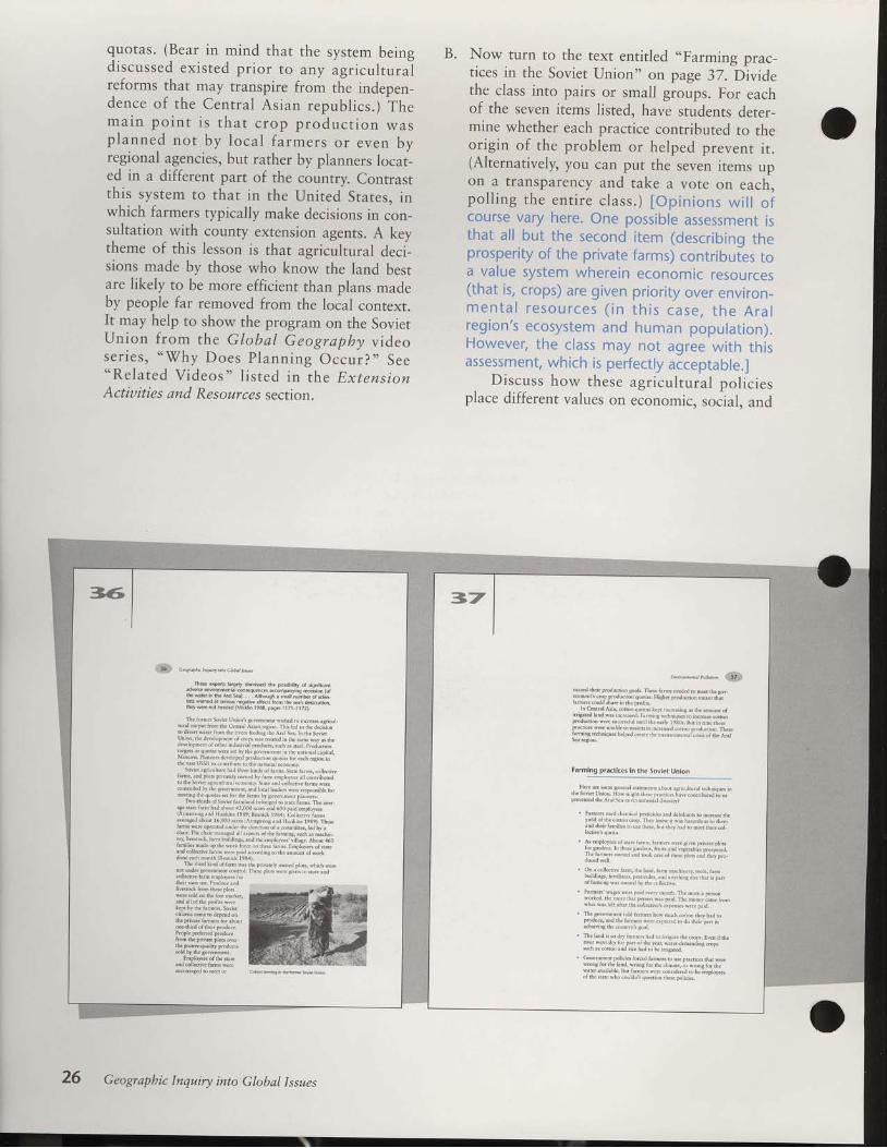
quotas. (Bear in mind that the system beingdiscussed existed pr ior to any agricul turalreforms that may transpire from the indepen-dence of the Central Asian republ ics.) Them a i n p o i n t i s t h a t c r o p p r o d u c t i o n w a sp lanned no t by loca l fa rmers or even byregional agencies, but rather by planners locat-ed in a different part of the country. Contrastth is sys tem ro rhar in the Un i ted Srares , inwhich farmers typically make decisions in con-sultation with county extension agents. A keytheme of this lesson is that agricultural deci-sions made by those who know the land bestare likely to be more efficient than plans madeby people far removed from the loial conrext.It may help to show the program on the SovietUn ion f rom the Globa l Geography v ideos e r i e s , " W h y D o e s P l a n n i n g O c c u r ? " S e e"Re la ted V ideos" l i s ted in the Ex tens ionActiuities and Resources secrion.
Now turn to the text entitled ,.Farming prac-tices in the Soviet lJnion" on page 37. Dividethe class into pairs or small groups. For eachof the seven items listed, have students deter-mine whether each practice contributed to theorigin of the problem or helped prevenr i r .(Alternatively, you can put the seven items upon a transparency and take a vote or,
"".h,po l l ing the en t i re c lass . ) [Op in ions w i l l o fcourse vary here. One possible assessment isthat al l but the second i tem (describing theprosperi ty of the pr ivate farms) contr ibutes toa value system wherein economic resources(that is, crops) are given pr ior i ty over environ_m e n t a l r e s o u r c e s ( i n t h i s c a s e , t h e A r a lreg ion 's ecosys tem and human popu la t ion) .However, the class may not agree with thisassessment, which is perfect ly acceptable.]
D iscuss how these agr icu l tu ra l po l i c iesplace different values on economic. socjal. and
B.
Thdk expeft l.€€y dtmned rhe posbitty ol signf.rr
'hF srel i, ihr 4, i l 9tr
rhey wer. nor heeded (M.kin 19a3, prger I 1 /l I I 72).
Thc itrro nN',r I r ir\rrydilnrd wijcl n) ir.or\r rsrictrlntrrr.rrp' I r. I i lrr Ccn. I I i i .[ jr! !r. j In td r, rhr do.(inr
, ' , ' t r , 1 ' _ ' r . \ ' , i \ . . f . \ l c rUnnrr, irr JNJ,Drun.fr,D !v$ rjf f i j tr I n, sri lrr rvly rs rncd c v r r r t r ( t r r o r o r f c t r n [ n , , f n i t r r \ , ! r h N r { ( . . h o J u . ! . no r g d s ! t r q r f , r \ w f r \ d h r r h r r ! r v r r t r n r n r r i l r . , . r i l o t r r t c r f t r r L ,v ^ . * : l
' ' l " ' ' )s o v ' ( r A r . t r l i t r t u h r i r f r . . t ! t o i h , . \ s i . r . a r , . s , c . r d ( , v .
l r r m r , W 1 r . . f ' i r r . v . r v ' d ( L ) v t i m c r r L , \ r ! r r | . o r L , ! u r oo rhr sovrr .u' iN a,i lt.(rrnir. \rrrr Ndi !) t!.r ivr Iri l r wclc.oniioll. i Lf r[! Alv(onron..jrtrL ti..n 1.,i l^ w..r rtwmsilie rirmccnDg 1[( qtro.r\ ! i ttr i l i( t,rfrs hr !"(rrmdtrt Dt]r1d..
T!v. nnd\.1 s!! 'd i ir i l .r. b.[,8.d n) {irr rinns Thr rlrFi g r n d ( h ' D h i d r h o t r i 4 z , l l ) 1 ) r [ \ ] r l 6 0 0 D r d c n r D [ t r l l ilAnnsi{rs,i l l I h nkix tesL)i R-u,* tcrlr. i !1"o,;" i--,r v . r u c d x b . u r 6 , ( t J O r . b 1 r \ ' \ t i , n r . u J F t u r ( f t l 9 t 9 t t h o s ctx'ns wd.qi{rd u!i l nr! Jid on o}r rdnnnftc., t ld ur ic [ r i r T h c . [ i ; n i l n i ! ( r l ] i l r c r \ ! i r h r i r n r i l r ! . s , J , s D r o l u- , . 1 . , , . i r , _ . . t , - . \ . , , 4 b .' . . n i r \ - . D ' l r \ . I , . 1
" , t 1 | ) . , ' ' . "
. . . . t . . . r - , . 1 , , , , , - / . ' ld.nc crdi drffh dr.i irk le34)' l
hc thnd linl ol hi,f 1vis i lr tyivilf lv.wrcd Fttrs, !rkn lyc,cDor rndcr g.(rnm.n, nrhoL. T[-c f[rs rvr(.srruj nJ ntc Jn
Iru|uq|i l, lhil i ln : '7
.x!!d i lh. nnntdrr s.r[. l [r\. ' i f ln! nccJcil nj nr.{ rfrsovrrnmonrl dr)r t ' .dtr.r on qtr,tris. I l tAIr nrnt!d on nrrr( rnrfri jnr,s.otrLl Ju( ir irc Driri
In Cj.rir i l Asir,.oii.n ( trlrtr kc! tr,$ r*.a djdij iutrtr ort r r i s . t u d h n . l w * l k r s s i t , . r , t r r i j A r d r t r q u \ n , n r t N . o t u o DIr)dndbn wuc ixq!!tr, d I jh! ! rf I IL)BG Inr trj r i lr i lrdscrm.nrs wdd r'.rh r n, dr n.ri I r. jL..s( u,rr rnlltrdrD Th.nh r n r D s t c . h n q t r r r d r d r ( . , r f i , c r N t r , , r n u r . r . f r n , , m d A , r L
Farming pra.tices in the Soviet Union
rsrr.trLL r.J turIr^r,$ DLdr'Sovicr Llrir I [,s ni ! tr 1[(\r t, ir.$ r!(.,trrf jhur!i l io olt ' . v o n t u d r h r I ' r L s f ' . r v r l n r t r D f u J ! . \ n , . :
. l r n n . ^ r \ o J ! [ ( m i 0 L N { n i J c , i t n d , i i r D s n , i j . r . ] r c t h etiru of i l ic.!|!r i.r.t I rrf knny tr w.n rrrr JoN r, domild $rif hd hG n, tr\L rtsc. t( I rrl b.!t ro orcd r[or.ol
, \ , , p . . .
l l r , , r , . . r ' I J . . | . . . d
n n ) t t j . . o a i l j $ ( t t n ! i d l I L f ! p , o
. on r.otlc! ! irn. ,[, N], raflr DilJnrr!. tuoL!. trn' i ' I I '
r l f j r r r , , e n s
. Frnrs lr{j.s srn. f. i l $!rr nrn[ [f Db.r,] FrA.D
Ihfi r 'r! tdr 1il.r rhr..tL!.r! r.\ffr\t! (er rrl., T h c a . y { i l m d n i i f i r n o \ h o w f r t r r L r . n , , r i l j c r h i r t r o
, TLe hil n s. &r tun!^ hd n) rrtLslt. n! rbps. Ficn J irenvdlrftdry br prj oi djc r.r, *rcri.miodir8crupisuch a!.otr.n ind ,i.f hlJ r. [f trra]kd.
' (,overnnieil polici\ in ed Lq.orto un prr.t i..srha wircqrongf.rrhchnd, wrcng lor rtro.l inr,!, or wl.u formew?ki ! i lhbtr Bdhnd\ wu".nu.nt.."d., haq-,y".,!n dre src wh..!r[ l ir qusnon ir\f Do]i. i.r
26 Geograpbic Inquiry into Global Issues

Questions and Answers for page 38
1. How did the fact that agricultural plans were made by government officials in Moscowcontribute to the environmental crisis in Central Asia?
o Answers will vary.
3 .
Do you think this level of environmental pollution would have occurred had local farmersbeen in control of agricultural planning? \fhy or why not?
o Answers will vary.
Who do you think should decide how the environment is used? \7hy?
r Answers will vary.
2.
\ \ r , ! , r L , r . L , ! . , r L l \ , , \ r i i , t r r r 1 , . , , . r \n r [ ! , . n , r ' ! r . r l , , r . ] r r , , I r l i L , t . , , . ! . , r i r f t r . . , . i f , r .t r i ( L t , r i i . . { ! t f ! ! ! f , t i l , ! , . j , \ $ , . ! , i , ! ! 1 , , r t r , , { , t r J
l . , d l . 1 \ L k . I l . r s \ r . L [ . ! . ] r ! r f , , , 1 . j | , . , 1 ! | ! f . , l r ! , j L l
, i i f $ r . l ! . , . D J . ( . . r I I f , , L L k l \ r . t r ! \
i N l . i l I L ! S S r l , { l r r . , ri l 1 ! l L , , , n r ! r r , t r \ i , l u { . I ! . \ , ! f , i r f L i . I : r r r r L !t . \ , , r . 1 . r \ r r . ! . : , , . . J i r r I L . r ] r \ t r \ . , , r . . . 1 { , . i L r , I c . L l
r L J r . r ! n . r , L L r \ L r ! . r ! r u , . u \ J r r ! , r r : f . r r , r , , ! r L n f , . r
P l a n l . D i v e r t i n g w a t e r f r o m S i b e r i a t o C e n r r a l A s i a
( ) i r f r r r r . r l ! r i i ( \ r i i r L r r \ . r l i . [ i l r \i l r i l , r n ! r , ! . \ . : . r l . d . , r r . , d \ r r r 1 , . , ! r ! t r , $ n , i l , ! L . ,\ c . , h N d i l : ! L , ! I L i , f r ! ! ! 5 , . , L r . , r ! , J r ! , , , , r ! ! r \ b t r r rl c u , J , . t r $ , J ! f f . o ) ) . i , \ L , L , r \ ! , f r , , r j \ L ! , 1 c . ! L t r L
f n , a , ! n ( L r , r f f t L A o ( . , L r { . , a . a r ! s j . ! , L r l t \ , ^ ! r ! 1 , ! nr , ( n L , r r l , J r L J L [ ! t ' ! f r \ l J . i r L e $ s ] l ) ' d E L [ . I o J r , ] ! \
l \ore.r V !otrL ffuvr ro,, (o{ y
envi ronment : r l conccrns. Asl< the c lass whetherthey th in l< thcsc l< i r - rds of pol ic ies are workableover long t inre spans, such as 25 years (wi threspect to ecologic i r l s tabi l i ty) .
C. Concluc le by d iscr- rss ing Quest ions l -3 on page38. Ar- rswers wi l l vary i rccorc l ing to thc o l - r iniotrs of thc str,rclcnts. Bc sure to hzrve str-rclentserp la in arrd defcnd thei r choices. (These threequest ior . rs r r i th t wel l form thc basis for a wnt-ten homework assignment . ) The f i r ra l qucst ion,"Who do yo r - r t h i nk shou ld dec ide how thee n v i r o n m e n t i s u s e d ? " h i n t s a t t h e c o n f l i c tbetween local control anci governfrent controlthat is at the heart of malny envi ronmentaldebates in the United States as well as the for-mer Soviet Union. ) i . ,
EnuironmentalPollution 27

ment officials who were unaware of the valueo f a n e n v i r o n m e n t a l r e s o u r c e ( e . 9 . , t h edamming o f C len Canyon) . Cha l lenge yourstudents to come up with local examples ofenvironmental pol lut ion in which a resourcewas damaged for the sake of economic gain.]
How can the Aral Sea crisis be solved?(pages 3&42)
D. Students should read the introductory text,"P lan I . D iver t ing water f rom S iber ia toCentral Asia," and Figure 13 (pages 38-39).
Questions 4-9 on page 40 concern Figure 13.Answers to these questions can be discussedindividually, in pairs, or in groups. However,allow time for a discussion with the entireclass as well.
Next have the class read "Plan II. Managingwater use w i th in Cent ra l As ia" on pages40-42. If necessary explain the extract fromKotlyakov and the plan offered by the scien-t ists part ic ipat ing at the 1990 conference.Discuss Questions 1.0-1.4 on page 42.
Five proposed wate. dive6 on pDjeds ln the former sov etUnion. The width ofthe aifoM indicates ihe volume olwaterthatwai prcpoFdto b€trandercdtoreach project.
The poposal ror Proj<t V was to van$d wat€r iiom theOb River basin otwe*em Siberla to the Aral S€a barh,
Plan ll. Managing water us€ within Centr.l Ada
Vonld diveiting warer tom one counry to .n.rhr rerl lt solv.t h e A r a l s e a p r o b l e m l V M . ( o d y i k o l d n e c t o r o l t h e l n $ i t u t c o lGeogrlphy in rhe Acldemy of $iences in Moscov har suggc$edthat solvirs lhe Arrl Sed envnonhcntal dia$cr no.ds a dfiereni$r.tes. He belicves the danaBcncni ofCcnhal Asirt waic,resource nu$ be improvcd.
fte curent pr..tice ol adju*ing watefd.madds d agri.u[ura produdion deve]opment mu* .hange.On the.onlav the probeff ol wate. u5e 5houd be Se decid,ing fa.tor ln aqr.ultohl pbdu.tion p anr. The bl€ ol .oton in
Geographic Inquiry into Global Issues

A. .1 .
5 .
Questions and Answers for page 40
Approximately how many miles would water have to be moved to divert the flow of the ObRiver to the Aral Sea, according to the plans for Project V?
. By Figure 13's scale, diversion from the Ob to the Aral is at least 1,500 miles.
What does Figure 13 indicate about the size of Project V, in terms of the volume of waterdiverted, as compared to the other projects? rWhat conclusions can you draw about therelative importance of this water diversion project to Moscow (that is, to the central Sovietgovernment)?
r The caption indicates that there is a very large amount of water proposed for diversionrelative to the other projects. This implies that there must be a great need or demand forthis project fron-r the central government planners.
With the USSR dismantled, Project V now would be an international water diversion-fromRussia through l(azakhstan to Uzbekistan, which are now all separate nations. How does thischange affect the likelihood of Project V being built? \fho do you think should pay forProject V if it is built?
r Exact answers here are unknown, owing to the uncertain statlrs of the Commonwealth ofIndependent States and the fluidity of international cooperation among its members. Thatsuch massive projects can no longer be implemented from a powerful central authority(Moscow) reduces the likelihood of construction. Also, most of the new countries are ineconomic and political disarray, so cooperation to build such a project may be unlikely fornow
What would be the economic advantages and disadvantages of diverting water to save theAral Sea?
. Economic (and political advantages) include an increase in jobs during the construction ofthe diversion project, renewal of the Aral's fishing industry, and continued increases inirrigated land for crops. All this may increase the quality of life for the residents of thatarea, lessening social problems. Disadvantages inclr-rde the high cost of the project and thefact that other parts of the former Soviet Union, particularly the regions served by the ObRiver, may protest aid to another region.
\ilhat would be the enuironmental advantages and disadvantages of diverting water to savethe Aral Sea?
r Environmental advantages include more water in the Aral Sea, increased water for soils toreduce salinization, and a chance for vegetation to stabilize the salt badlands.Disadvantages are mainly concentrated in the regions from which the water is diverted:Reduced volume may cause land in the northern parts of the country to become dr5 andloss of water in the Ob River may have ill effects on the fish, bird, and mammal speciesthat depend on the r iver.
6 .
7 .
B.
continued
EnuironmentalPollution 29
9' In- general, do you support the idea of a water diversion project to save the Aral Sea? \7hy orwhy not?
' The key is for the class to recognize that this plan involves trade-offs between theenvironmental and economic conditions in two regions. Many more people live in the AralSea area than in the ob River basin, so some students may feel the tr;de:off is acceptable.others may feel that this plan merely transfers the problem from one place ro another.
Questions and Answers for page 42
Kotlyakov emphasized that water use should dictate agricultural planning and not theother way around. Why? Do you agree?
'S7hy or why not?
' The point here is that sometimes the physical environment limits what can be done. lnthis case, agricultural planners may have asked for too much production of water-intensive crops from this desert area.
\rhat does Kotlyakov mean_when he says that saving the Aral Sea "will require a newattitude"? How do you think this could be achievedir Kotlyakov suggests that the root of the problem is really in the perspecrives rhar
people have about the environment and about conservation of watei and otherresources,
10 .
17,
1'2' How would each of the four recommended steps stabilize the Aral Sea and maintain theregion's environmental quality?
' All of these steps are meant to lower water use in the region, to allow more flow backinto the Aral. Cutting down irrigation will also help reverse soil salinization. Revisingthe type of crop that is produced shifts farming from water-hungry crops (rice, cotton)to crops more suited to the desert environment. Drainage of poliuted water into theIake contributes to the salinity and chemical pollution that hus killed the fish anddamaged the habitats.
1'3-14. \fhich of the two proposed solutions to save the Aral-water diversion or warermanagement-do you think is better? \7hy? Why do you think other people woulddisagree? \7hich plan would be more difficult to underrake? xThy?' '$7hile
these are clearly opinion questions, use the discussion to contrast theperspectives implicit in the two plans. The point here is that the Aral Sea crisisresulted from a values conflict between promoting massive economic developmentand sustaining a quality environment. In the -"t., diu"rrion plan, the problemscreated by the Aral Sea Project are remedied by resorting to another laige-scaleproject, posing similar potential environmental problemi elsewhere. As[ the class ifthis really solves the problem or merely moves ii elsewhere. To achieve rhe watermanagement plan would require people in the Aral region to make ma;'or changes intheir use of the environment. This plan may represent a harder choice because shiftsin fundamental perspectives are involved.
30 Geographic Inquiry into Global Issues

Thesescientt* !trr,rrlJlasrecd thr.tu wa..rlcv.lolrhcAnl ss mD*he $rbil ized to restore theecoloai.rl lerkhor rhe.esioD.They r.sued diardicrqlon! cconomywould bc rc$or.d ifrheenvnon'neDtrl rolLc'ns LV(c rFncd. l,c.plct hohl wouLdinrrovcrndro.hl t.sions worU bc rcdrccd. l 'hcr rcconn.ndcdil,rtthse fou'sqx h.trkcn to ni.r.Bcrhc rcBitri\ lv.tcr nsourccdnd $.biLtr dr. lr. l sc. (Kudydk!v ltel):
. sti l i lJ lntrsr ofqard brcouniris m ih. rrsioo anl intionlcc \ri lcr $ingicchiolosr Ln rLl aus ofdrr.cononyi
. Prch,bt lxpaoion of& lxnd rrer nnJ. trri! i l ion to ieerivcr f lo$ for prcse.v,ngrIc Af]l scr;
. Lii ln rne rnd coitoD rgri.LhLre xid rcni.vc unt.oducdvel.Dd from nriglir. l)cvd![ nisul oilhdrJr, rtEyards, and
. l t o n o r . r r . i l s r l d i r . l i p ( i l t i l . g . i c t r h t r i l l r u n o f f f i o nnrig.rd hild t0 thr A.al Scr.
the country3 economy ako rhouthe pmdu.ton or foodnutrs and toand es wateFint€nslve.rop5.
Th. water rcsourcr ol cental asia mus be inventoiled.Spec al i l tention should be g ven to incea5ing the etrc ency orwilelFrvingl rynems, de.reaslng rgation quotar by 15 ro 20p€rcenl optimizing drainage rynems to redu.e wder coisump-tion, and impbvng resulailon oI runoff. Tho water l ieed n thkway 5houd be osed prmarly foilesolving ecoogca mbJan.es
or ire and healihlorlo.al pop
savnq the Aral rcqion and re$Lvinq i[ knq. of eco og ca,hydroloqicd, and so.oeconomic probemrwil requne a new*tLiude and an entrcly new approach to e.onomi. advry lhrcugh-out Cenra Aia Aqrcuturc and other brncher ol the economyrhould be al owed to return to then tidtonal formr, wh.h hav€b€en denrcy€dov€rthe piltde.ad€s, and ati ludes towadwilaruerhould bechangod (Kotlyakov 199r, paqei r6 r3).
A t x l 9 9 0 c o D i e r n c e h N u [ u s . d r e c t r t i u ] o l r h e U z b e k n h n
rrovince of(rritrbtrl ir,.vc.200 scieDtkc 'ner to devdop a plan
$ s d v c i h e A r r l S c t r . T h c s . s . i c t r t k s i n c l u d € d s F c i r l k 6 i r w , t e rnandscncnr,c.olo$ind'ncdicinc.P.orlcrti.nded fto'nrl l.oun
tics in.hc AmL Sc. brsh.s sdl $ rio'n l{u$h,dicU.icd Srxtcs.aid ovc. 25.rhcrcoun.ilcs.
Enuironmental P ollution

How has the pollution of the Aral Seaaffected people's perspectives ?
W Tirne RequiredOne 50-minute class period. This lesson mayalso be used followlzg Lesson 7 as closure forthe entire module, in lieu of Lesson 8. Studentscan thus also express their feelings about theMadagascar and Mono Lake case studies.
W.Nlater ia ls NeededButcher paperDrawing paperMarking pens or colored pencilsSamples of political cartoons from newspapers
Gl at.,ssary wordenvrronment
Getting StartedHave students look at Figure t4, the photoshowing graffiti on a rock (page 43). Conducta br ie f d iscuss ion cha l leng ing s tudents todescr ibe the perspec t ives o f the gra f f i t i ' sauthor. Include the following questions in thediscussion:
'Vfhat kinds of feelings does the author's
statement seem to express?
Do you think the author reflects or express-es the sentiments of other people living inthe Aral region?
'S7hy does the author personify the Aral Sea
in this graffiti message, giving it the humancharacteristic of forgiveness ?
\7ho is the real audience being addressed(assuming the Aral itself cannot respond!)?
4i3
* - - * r ro r . ' , S
ftffi-.@P*.ffif'liHow has the pollution
of the Aral Sea affectedpeoplet perspectives?
Figure 14 6ratrt wriltef of a ro.k.The graffit i tandatesas: "Come
bacL Aral. Forgive us."
32 Geograpbic Inquiry into Global Issues

ProceduresA. Have students read the text on page 44 (up to
the section entitled "How do you feel aboutthe Aral Sea cr is is?"). This summarizes the
issue, taking the perspective of the residents of
the Aral region. It also introduces the idea ofpolitical art-aft used to express a particularperspective. Bring in some examples of politi-
cal art, such as newspapers to show political
cartoons or comic striPs.
O l d e r s t u d e n t s m a y b e c h a l l e n g e d t oident i fy whether this text is biased. Forinstance, you might ask what would beemphasized in a text t ry ing to promote
the success of the Aral Sea Project (e.9.,
increased income from cotton farming) 'Older students can also be asked to bringin (before the lesson) examples of politi-
cal art related to local issues of interest.
Have students create a piece of political artthat expresses their thoughts about the envi-ronmental crisis they have been studying. Page
44 in the Student DataBook provides a partial
list of possible ways to complete this assign-ment.
Pass out enough drawing paper (or butch-er paper) and a var iety of colored markingpens or pencils so that each student has suffi-cient materials for the activity' Should some
students be uncomfortable with drawing, they
can work in pairs with another student whocan do the actual artwork for the idea. In anycase, all students should be responsible eitherfor the design or for the execution of a piece ofpolitical art.
Post the finished work around the class for
everyone to view. \7ith the whole class recon-vened, ask students to give a brief explanationof their ideas and ask for comments.
B.
C.
.noettn bt4na ttk) .)hbd b,a'
A s c x i l y $ d r c l 9 5 0 r , t c o p l c l i v i n s h n r c A r i ! S o i . r i o r b c c i n r c
iwrrr oli lrc cnvnonmcn.iL problcm! dkctr$rn in dh 'nodllc At
r h $ r i n r c , w h c n r h e r o s i o . t c t r v i r c n m d i h l P n , b l o m s w c r c j L t r . b c s i n '
nnr!, th. S.victf,ovcrnilFit wrs
Dohtion. lhc Drnnrry n,.!s s.s on ccodoNc dovcldP'neDr bi$d
;n phns rid prodtrctl 'r quotis coitoil podu.tion hrd tf ioniv
Thc b!.nk ofdrc Ii l l S...rcr i lcdcd drliL sovonnncrt ioihc
driscsio i lrcnvircnmun. Fnhcnnonco0ld sec i lroJcrcrs.s Ln
thetctchd, Pcqnc ldr i l ,.n$Dcr tcmPcr.urc! inrsscrnd dio
wl.tertcnDs,tures drcrcrso. lIc wrtcr in ihcsci,in thc i!ci l,rrd
m fug"-id Scmnc,-,"-.rd srjt icr chi[hcn.nd rJrhs [.d
no. helth prcblcds, so.irl trnrc$ irocr:cd in drc resLon $ mor
rnd nr.rc proplo Los drci l ivdihoods xDJ lolL si.k laeriJentsot i lc
Aml $.;sioir (mrdiluldwhon il1c wid! wot no! fuLl olsik-
N o ! r . f r ( ! n o r c r h x n 3 0 y . x r s o t c n v n . D r n t n u l p o l l u . l . n , d l c
eDrirc o.onoDric aoJ cnvirorNcnixl $n'.rure olthc Anl rcsl.D hxs
tcetr ovflnnld, Tlc Rn$nn g.ogrrPhd Kony.kov (1991) eLd thri
ir ordcr to savc i l iercsion, icw PeispcdivcswcrcrteJ.d oil lhe rth
rioiirh bctwccn Lhe economy ri ld the eDvtrondcni
!. lt ixl xt 6 r pow.ilul way fo' comnn,ni.dils i lcrsiokvio
c h r i l g c F o p l c s p c $ t c c t i v e s T h c p c s o D w h o w r n c a r c r o s x s c ' n
dtr;c[ lFis'.c ]4 -, p"!" a3) h$ | prdcula' F[n olvicw ilroui
r h a e d [ ' s c s . l ' o l n n . l . ] r i o o n s , c . n r i c $ i p r , a i l d b u N p e r * i c L c 6
l*.rp*i""prru,. rn*" **enrns nriy b! hunoronr, sa.nc!].
n r c s t t . o r r u L d s , b n d r e y r . t y t i . x l l l J r o d , t . i g m n t . r n d
How do you feel about the Aral sea crisis?
H.* wouu vou d$ieD rrhoil,clever. and thoushiltr lrvav i.
c x p r c $ y o u r t h o u s h c l b o n r d r c c i v l r . n m e n r a l p o l l u t i o n o { d r c l r . lScx i.gioD? Her xr! s.meF$ibihii lsl
C o m i c $ r i p s h n s . t b u t t o n s
Tihttsor ha6 PohtioL.rrtoons
Bnnpci$icke6 Po*cs
BilLh.lrd( Liccns.lhcs
Enu il o nm ent a I P o I lut i o n
FIow has Madagascar's environmentbeen degraded?
hectare
shifting cultivation
subsistence farming
W Tirne RequiredTwo SO-minute class periods. Each day's activ-ities can stand independently; one or both dayscan be omitted if you wish to cut time on themodule.
% Materials NeededButcher paperMarking pens or colored pencilsDrawing paperCopies of Activity 3 for all studentsMini-Atlas map 4
Gl atossary wordsbiodiversity
ecosystem
environment
Getting StartedPr io r to beg inn ing th is lesson, exp la in tostudents that, having invest igated one areaaffected by environmental pollution (the AralSea), they now briefly examine the severe envi-ronmental degradation on Madagascar. Askstudents to define degradation to stress whathappens to environments that are seriouslypolluted. It may help to ask what it means todegrade somebody (to reduce in status, to cor-rupt) to equate what has happened to environ-ments that humans have severely abused.
Procedures
What is the issue on Madagascar?(pages 45-48)A. First, using Mini-Atlas map 4 of world physi-
ca l f ea tu res , have s tuden ts desc r ibe theabsolute and relative location of Madagascar.Ask the class what general climatic conditions(temperature, rainfall) one would expect in
45
a,o-.-"*",r" ffi
ffiHow has Madagascart
environment been degraded?
cloisaryWord3
What 13 thc lssue on Madag.3.ar?
To continue our loot .t how envfo.mens ca! be ch.nscd bybunans, wcnowiurn toth.bhnd ofMadrgasor (I isur.15 onpas.47). As wjth th. Aral Sea. human rctivlt ies hrv. caused majo!envirc.nenral chnBe, Bur thoud rh. Aralb piobl.ns d.vclop.dwnhin th. tine .pan of onc genc*tion, Madagalcals .nvtunn ntalprobltu h,ve dcvelop.d ovcr manr g€nemtions-
ef6re hunsns arivcd on Madlgasd! is biodivesiry w,s prob-ablylishd than,ryplace ofsinihi sh on b^n (DuEll 1936).
Geographic Inquiry into Global Issues

l. 9ii:lo:%;lqrg&;l%.&il]ff)these lat i tudes. fAbsolute locat ion: between12" and 25"S lat i tude and 43' to 50"E longi-tude. Relat ive locat ion: in Indian Ocean, iusto f f the coas t o f sou theas t A f r i ca . Th is i s atropical locat ion, and students may have animage of this as a warm and wet environmentthe whole year round.]
B. Ask students to read the text on pages 45-48,which emphasizes that the once-diverse biotao n M a d a g a s c a r i s t h r e a t e n e d b e c a u s e o fremoval of the forests. Questions 1-B on page48 introduce some basic concepts in biogeog-raphy to help explain why the species diversityon Madagascar was once so great. Studentscan work in pa i rs on these ques t ions , bu tyounger students may have di f f icul ty withsome of the exercises and may need additionalguidance. You may wish to lead the entire classthrough the quest ions.
l,r1111i,1rli111r1ii 1u1 i,.rri1f rliil:lrlt :lr ilr;llll
l.,rill1119a:.:..,1i11!4!rrrlrr::iili6.t)::,.:::it:l19lr]:rrrrl9lltts!rr]iiiiia:u:uu:
;.liiili@ll
iillL@'I))))::.'.:..atik
,l.ii11i16lll
:lrl9ltt,,t'
* - ' t '
!rrlgr',iirrlt@l
inq ro cds dnibrlod I i prkh, bnil. l' e q o t r s o m ! 1 5 0 , 0 0 0 [ . d d e \ . r l . r . n r c . c r o d o v g y y t ri rclor{.n pd(r, ' .1 nri l nq airq ind !m/irq, .nn i9 nris vc rlr i l t D'ol ern or tre ]0 m ion rrop e v'rq or Mrdrqi(ra 3 5
r on k !.ownq r i fu t, oi ovpr I ppren i yci, . ai ri l , n&,al i l ,o iviL'bre roren w I be qon.! 'thi, i lr l l l t ino of i dr d i l(hoo todiy un*{ rrefl, iuvls r
bc T.rnd rnywiy (ouiic 1936, pi!r r I r).
n nd lF.LVhr 193e1. Annnrb N!.. roullydiai.rnt trum rho$!r
m.niLmd ttnl oL ttumrny*hrcflsc, fttr i lut Dx(d: Sonc
. 1 , - - l i , i l f ' , \ " d i i
x n d l l r p c . l . s . l g h D t k f l ' * l D r r c l l 1 9 3 6 1 .
Enuironmental Pollwtion 35

Questions and Answers for page 48
1. What two reasons are given for the high number of unique plant and animal species found onMadagascar?
. The reasons are (1) the broad diversity in habitats and (2) the isolation of the island fromthe mainland.
2. How do these two factors help explain Madagascar's high biodiversity?
o Habitat diversity provides many opportunities for plants and animals adapted to differentenvironmental conditions to exisr. Students may be able to identify with this idea moreeasily if you ask them to name some animals and plants that live in deserts and some thatlive in forests-the lists are very different. If a place has both deserts and forests, then bothsets of biota can exist, and total biodiversity is higher. Isolation from the mainland isimportant because, over geologic time, unique species evolve that differ from theircounterparts on the mainland. The sea acts as a barrier to mixing, keeping the speciesseparate and unique. Australia is a great example of this (kangaroos, koalas, platypuses,and so on).
3. At its closest, about how many miles is Madagascar from mainland Africa? Approximatelyhow large, in square miles, is Madagascar?
o Using the map scale on Figure 15's relief map, students can estimate that,at its closest,Madagascar is about 225-250 miles from the Mozambique coast. \fith the map scale, theapproximate size of the island can be determined (very roughly) by figuring the width; , : : , i .1 r1 r . , . . . . : . ' ' , i . , i t t r rand the length 1r , ,1 ! , , 11 ;1 ; ' i , ' L ' l r i ; t ' t i f i r i r : l . l r . Area is equa l to w id th t imes
length, so the area of Madagascar is about 225,000 square miles. (If arithmetic is tooadvanced for your class, save time by giving this answer. You might note that this is almostas large as Texas. Students can use an almanac to make this cornparison.)
4. Looking at the three maps on Figure 15, how many different kinds of environments can youidentify on Madagascar?
o Make a game of this question by giving each student a couple minutes to list differentmixtures of relief and precipitation for each of the three vegetation types. For example,within the "tall grassland and deciduous forest" vegetation type, one can identifyenvironments at both moderate and high altitudes and rainfall amounts ranging from 20inches up to B0 inches. \Tithin the "dry open woodland and thorn forest" typ., there areboth coastal plains and moderate altitudes with rainfall amounts from 10 inches up to B0inches. The point here is that there would be plant and animal species adapted to live inmany different kinds of environments-hence, high species diversity.
5. \fould you expect the number of unique plant and animal species on the Comoros Islands tobe more or less than Madagascar? Why?
. Allow students to speculate on the relationships implied here. The Comoros are smallerthan Madagascar and closer to the mainland. Other things being equal, one would expectfewer unique species on the Comoros because (1)there would not be the diversity of
continued
36 Geographic Inquiry into Global Issues

t\:aa:ttaila
@$i!lull))))))..:a::lllll.111@UUttlt)t:lti.,llLj
3u.1Lhabitats available on the small islands (indeed, only thorn forest is found there), and (2)
there would not be as great a barrier to migration from the mainland because the distanceis not as great.
6. Do you think diversity of plant and animal species is important? \X/hy?
. This is an opinion question. To help focus discussion, ask: I7hat is lost when uniquespecies become extinct? Students are familiar with numerous threatened species: elephants,rhinos, etc. Some students may believe that every species has an inherent right to exist.Others may note that biodiversity has both aesthetic and economic value, as suggested bythe numbers of medicines obtained from plants and animals. Still others may note thatextinction is a natural process when species are unfit to adapt to changed environments.
7. Why is an increasing population leading to destruction of forests on Madagascar?
o As population grows, the pressures for fuelwood and for agricultural land increase. TheDurrell quote on page 48 notes that shifting cultivation, burning, and grazing are theproblems leading to destruction of forests on Madagascar. Emphasize the time frame: Atthe present rate of use, all forests will be lost within the lifetime of today's children.
B. Vhat do you think the author (Durrell) meant in the last sentence of the quote?
r In the last sentence, the author is suggesting that something needs to be done becausepeople will still be dependent on forest products even after the forests are gone. Sustainingthe forests is therefore important because all animals, including humans, rely on theseenvironments for the resources they need to live.
What is shifting cultivation? (pages 49-50)
C. Have students read the text on pages 49-50.Pause during the reading at the point wheret h e t e x t a s k s , " W h y h a s t h e s i t u a t i o nchanged?" (end of third paragraph). Ask stu-dents to specu la te about why th ings havec h a n g e d t o c a u s e s h i f t i n g c u l t i v a t t o n t obecome a problem. Then have students readand discuss the extract "Why has shifting cul-t ivat ion become a problem?" (pages 49-50).Students should see that population growth onMadagascar has made this histor ical systemunstable.
D. After the students complete the reading, passout Activity 3. Students should work in pairsor groups of three to complete this Activity.You will need to provide each group with apiece of butcher paper or drawing paper andcolored markers or pens.
Students should fol low the direct ions onthe Activity. They should order the steps of theshifting cultivation cycle and put these stepsin to a d iagram tha t i l l us t ra tes th is k ind o ffarming. Have students create a circular dia-gram in o rder to i l l us t ra te the sequence o fsteps in the shifting cultivation cycle. See Key
for Actiuity 3.
To get younger students started, i t mayhelp to create an overhead with a ser iesof blank circ les to show how to set up acircular f lowchart . l t is imoortant that stu-dents grasp that the shi f t ing cul t ivat ionsystem is a cycle.
E . P a i r s o r g r o u p s s h o u l d t h e n w r i t e s h o r tanswers to Questions 2-4 on Activity 3 andshare the i r answers w i th the en t i re c lass .Diagrams and answers can be posted aroundthe room fo r v iewing . A l te rna t ive ly , each
EnuironmentalPollution 37

group can select a reporter to read its answers.[The key point is that in a 3-year cycle, theforest does not have enough time to regrow.This means that in a shorter cycle of shiftingcultivation, the soil does not get a chance torecupera te be fo re the nex t p lan t i ng . So ,shorter cycles inevitably lead to a loss of pro-ductivity, which then requires that new forestlands be cleared. This accelerates the pace ofdeforestat ion. A lso, land c leared but la terused for something else can never return toforest.l
For Further InquiryTest students' understanding of the basic bio-geographic concepts covered in the lesson.Make up a hypothet ical dataset of severalis lands of var ious size and distance from amainland. Have students rank which wouldhave the greatest number of unique species.ILarger islands, greater distance]
Assign an essay having students compare theproblems on Madagascar with those of theAral region. IThat are the similarities? Arethere any differences?
",,,",-","',.,,',", l|'WWhat ls shlltlng cuttlvotton?
vithin rhc l ifctimc otrodiyt child4n, rh. divds fore*s ofM.d.gascd wil l b. conpl.t ly lo*, ifpr.€.nt ratcs ofdstiuction.ontinu. (Durcll 1986), As population incre.se,, ihe!. t hishcrd.handlorludwood fionth.forc$s. Ako. more for.*'arclcmovcd to providc apa.. fo r as ric utule . nd I i vc$o.k stazins, fr.popularion ofMrdaFscaf b srowins d over 3 p.rcent p.r yc.i ThLn.onr thar th.cumnt popul.t ion oI 12 mill iotr wil l doubb in onlyabout22ye.N (Populfion Rcferenc. Bur.au 1992),Th! probbm nm r d . n o G s c l c b € r ! s . m o s o f t h c h l a n d ! p . o p l e L v . o n t h ..a$ern lidc ol MrdasdscaFwhdc thc iiopical r.infdrc* k lound.
ft. hain cd$. Ior tbc dccrcale in thc M.drBa.ci! iorc*s i
what th. p@plc otitc Elard call rd,y, which i r i6u ofshift ins
cutiation.Thhndhod dtuming js us.d widelyin topic,l
reion,. It involves cutins dowu dl lne t@s ild vessdbn n rniEa. vh.n rhe v.s.iation t dly enousi !o bu!n, t t s.i otr in.,
w h t h d d s r h e l a n d . T h e s o i l b s o m e s e n , i c h e d b y i h e ! s h , b u t o n l yfor r bricf p.riod oftime. crors ar th.n plan.d. tend.d. and h.Fvc*.d onthi lahd.Tbc land b used unti l thcloil b.cons depl.tcdolntrhienb, *[ich can happcn in ju$ a f.w yc.s in a ward ind serclinatc. Farn.s then aba.don ihc ploa io lcr ihc vcgfration rc-.$,bhn irs.ll snd let ine soil rccup.ratc. Thc l?rftc hove dn ioanoi!.r area oilsnd and r.pcar thc pr6cc$. In this nanncr croproiario! tak.s pllce ovcr a period of yc$.
Whileil i @yseenenvtondcnidlyde*ruciivc, t k an rncientn . t h d o l & r f l n s , $ L - 3 a d ( o , r . i l 9 3 o . l s , y ! ' r , r s IMad,garcar ias b..n produciie. for ccnturier. rb*cvc! since 1950,over 30 pere(ofrhe blaodt foreis harc becn de*roy.d. vny basthc stuadon ch,qcd?
Why has shlft lng (ult ivation b€come a problem?
In Mddisas.ar, as in nany other prrts ofihe wond whcrc shift,inscuftiv*ion occns, ihe pmple who are ensqed in thG netbod ofa8ricukurc ai. substtenc. farnea, ThL nedrs that $en crops sup-ply food or produds only Ior snrall sroups oipeopl., p.rhaps for.Iamilr However,sincc 1950 tl. popnllrion olrhc bland has dou,b h d . l h i r - ' . , \ e ' n p u p . ' a r ' o r F r . l e d - o s o ' r e d D s c c h a n s e i l ntbc faming cycl.. In the p,$ a picce ofl.nd was clefcd and Fplants.dsboutcvery 15 rrs. Bnt beclusether. arenownorepeoplcwhonced to Brow iood iron rhe sam. land, dre cycle has beei shofi.ndto thrc yca^ (Gox 1939). shorter cycles olslifr ins cultivaoon dodot p.rnit enoush lore{ resrowlh ro re$ole rhc soilt fcdiliq Thkieans th,t ihe 6rn prodDciivty nD$ decline (Narion.l Rcsearch
Anoth$considerarion related to i rapidly gtuwing popularion nwhere rhc pcopl. l ive. Shiit ins.utivation fornciy did.orcause.pelm.neniclearins ofland. The lanJ would be cl.,red, fatmed..nddbandond-rl lowil s rh. fo-tur'o esroq BLr r' r\.popul,don
sroM rapidl, hnd used lor crops nay afteNard bm6e a rown o!b. ddelop.d 16r anoiher us., in$ead ol beirs rl lowcd ro relurn rofor.s. lf iore$ ar. nor lllowed ro lesrou new ioFst alar mu$ b.cl.,red toprovidc lodlorf.rmins, In tbbwayth. t iadnionalrob-iion olshifrns cuLivdrio. b broten. and increasing anounh oIrocsed li lds.re temoved for famins lsaher and Kovacik 1989).
38 Geographic lnquiry into Global Issues
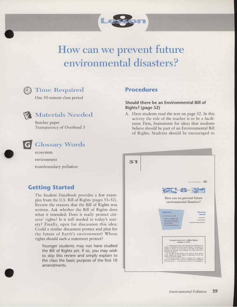
How can we prevent futureenvironmental disasters ?
W Tirne ReqtiredOne 50-minute class period
W Uaterials NeededButcher paperTransparency of Overhead 3
El at.,ssa{), wordsecosystem
environment
transboundary pollution
Getting StartedThe Student DataBook provides a few exam-ples from the U.S. Bill of Rights (pages 51.-52).Review the reasons that the Bill of Rights waswritten. Ask whether the Bill of Rights doeswhat it intended: Does it really protect citi-zens' rights? Is it stil l needed in today's soci-ety? Final ly, open for discussion this idea:Could a similar document protect and plan forthe future of Earth's environment?
'Whose
rights should such a statement protect?
Younger students may not have studiedthe Bill of Rights yet. lf so/ you may wishto skip this review and simply explain tothe class the basic purpose of the first 10amendments.
Procedures
Should there be an Environmental Bi l l ofRights? (page 52)
A. Have students read the text on page 52.In thisactivity the role of the teacher is to be a faclli-tator. First. brainstorm for ideas that studentsbelieve should be part of an Environmental Billof Rights. Students should be encouraged to
How can we orevent futureenvironmen-tal disasters?
EnuironmentalPollution 39

think of rights that protect the environmentand the rights of future generations to have aprotected environment. Record these ideas onthe chalkboard or on butcher paper for refer-ence.
Next. have the class select items from thebrainstormed ideas to be included in the finaldraft of their Environmental Bill of Rights.New ideas may develop as students strive toclarify an item or make one more specific.Have students categorize similar rights ratherthan having a long list.
Finally, have students write a final draftthat guarantees rights for the environment aswell as for the people who interact with theenvironment. The final Environmental Bill ofRights should be a concise statement consist-ing of several principles. With each phase ofthe lesson conduct a discussion with the stu-dents to have the class explain and elaborateon how it made its decisions.
B. Explain that the United Nations came up withits own principles about environmental quality.T h e s e p r i n c i p l e s , k n o w n a s t h e R i oDeclaration, came from the UN Conference onEnv i ronment and Deve lopment in R io de
Janeiro in June 1992. They were based on the
concept of sustainable development, statingthat both economic growth and environmentalquality are necessary to improve the lives of allhumans. The point, however, is that economicdevelopment must not pollute the environmentsuch that future generat ions cannot survive(hence, sustainable development).
Overhead 3 l ists 8 of the 27 pr inciplescomprising the Rio Declaration. Make a trans-parency of this and project it after your classhas created its own principles. Have the classcompare the two and discuss the differencesand similarities.
'Sfhat does each statement
emphasize and why? What, i f anything, ismissing from either statement? Is environmen-tal protection a "human rightr" inasmuch as itaffects the health and well-being of people? Isenvironmental protection treated only in termsof its needs for human survival, or is the sur-vival of other species included? For example,just as the U.S. Bi l l of Rights protects ther i g h t s o f i n d i v i d u a l p e o p l e , s h o u l d a nEnv i ronmenta l B i l l o f R igh ts p ro tec t a l lspecies? These and other leading questions canbe used to br ing closure to the lesson andmodule as a whole.
a n y . f m L . a c a e t o b e a w i r n e s a g n n a h m s e [ , n o . b . d . p r v a dof l i le, ib€d, orpmpoilrwilhourduoproce$ollaw ...
rx. Th. ehumeraton in rhk con*ltution ol cenain i lghb 5ha Inot ba con*.ued to deny o. disparage othe6 rebned by the
Should therc bc an EnvlronmentalBi l l of Rights?
A scierthr t.m Mos.ow shrc Univc$ii, Rubcn .
Mnatsakailyar,has ru8ge*.d drltdre ite[aiionrl prcbrcms oi
! i l v t o i n r e D t r l p . l l u . i o r $ n n o t b e i s n o r c J . r l o a $ u c s t h x t t h c i . b r
nccd for inrdhil io*rl l .w ro prevent t lnsboundary pollrt ion. Hc
bclcvcs thil dcctions nade by individuxl coundiesrhata($tothcr
counticj. ivloincnr.l wclL benrs nrould only 6€ nradeaccordins
toc$rbLsh.dcrnri., Suc[ crnerirNou]d e*rblth rELobil brst for
IuMcintcmdion [s*an h!'nr.s !d rhe envtorm.",.fta.hicvc!ht. Di Mo.crkrnyxD hrs proposed thfta Bil lol
R,shs bcdraft.d I.r thce.vto,inrnr. He susse*sthii i t be mod-
clcd.fier drU.S, Bil lolRlght, w!ihEUarrntes the rights oiinJi
vidual p.o!l.h dreUnned sfures. Hiponn tihatall 01Eailh\
mdiviJurl ecosy*cilN i leed snnihrpf.tc.ion (RicLmm 1990).
. Hos $onld ron wntc an lnvmnncnril Bil l ot Rishs ro sDariniee ihe prote.tion ot lafrh! cnvnondcnt]
. VhatFincii ls would be inportanrb cnsre tbat.nvnon-
meil!.| lollution does not coniinue?
. H o w r r e t h e r i g h h o f U . s . c i t i z n s p r o i e c t e d a n d e n t o r c c d ?
How could lhe cnviornenfs ri8hb be enforc€d?
For Further lnquiryAssign an essay answering the question, "Is itnecessary to have some kind of internationalagreement designed to protect Earth's environ-ment?"
40 Geographic Inquiry into Global Issues 1 2 3 4 5 C P 9 9 9 8 9 7 9 6 9 5

1..
Extension Activitiesand Resources
Related GIGI Modules. Lesson 3 makes note of the high infant mortality rate in
Central Asia. For a series of lessons on the issue of infant mor-tahty, use the GIGI module Infant and Child Mortality.Focusing on the problem in the region of subSaharan Africa,this module provides a wealth of socioeconomic data to showthe complex causes of this problem.
. Much more detail on the problems of agriculture in the devel-oping world is contained in the GIGI module SustainableAgriculture, which focuses on Malaysia, but includes furtherdiscussion on shifting cultivation.
Britannica Global Geography System (BGGS)BGGS provides myriad extension activities to enhance each GIGI
module. For a complete description of the BGGS CD-ROM andvideodiscs and how they work with the GIGI print modules, pleaseread the BGGS Overview in the tabbed section at the beginning ofthis Teacher's Guide.
Related Videos. EBEC offers these videos about the issues and regions explored
in this module: "Population Story: Collision with the Future"l"Africa: Central and Eastern Regions"l and "Rivers in Danger:TheZambezi and the Nile."
o Other related videos include: "Running'Water" (SpaceshipEarth, PBS), "\fhy Does Planning Occur?" (GlobalGeography series, Agency for Instructional Technology),"Disappearing Forests" (Spaceship Earth series, PBS), and"Using Forest Resources" (Global Geography series, AIT).
Additional Activities. Suggest to your class that they get involved in local environ-
mental cleanup efforts. Such programs include the familiar"adopt a highway" various stream cleanup projects, andso on.
. Pursue the concept of transboundary pollution. Have studentsinvestigate local, state, or national examples of this problem.
2.
3 .
4.
41

42 Geograpbic Inqwiry into Global Issues
Have students develop strategies for resolving these disputes.The case of acid rain, and the Canadian diplomatic efforts toreduce United States pollution sources, probably provide themost easily available information.
There are abundant opportunities for students to investigateU.S. environmental debates. Students could study debatesabout livestock grazing on public lands in the'West; any num-ber of large dam projects (historical studies on the HetchHetchy or Glen Canyon dams might be particularly instruc-tive); or logging of old-growth forests in the Pacific Northwest(e.g., the spotted owl controversy). Challenge students to ana-lyze the values issues underlying these debates.
Students could also examine local development projects thatwere controversial. Have the class investigate local papers forstories about housing developments built during the 1950s and1,960s (when there was little opposition to growth in mostcommunities). Students could assess rf any changes in localopinions have occurred in the conflict between economic andenvironmental interests.
The issue of endangered biodiversitg only briefly touchedupon in this module, may prove interesting for students toinvestigate on their own. The biannual series, World Resources(published by the'World Resources Institute), is a good sourceof data on habitat destruction and species loss.
Assign students to investigate treaties and agreements amongcountries to protect Earth's environment. Students should noteif the agreements are specific to certain environmental issues orif the agreements encompass Earth's environment as a whole.For example, students could study the entire Rio Declaration(only a few of its principles are reproduced on Overhead 3).International agreement has also been reached recently regard-ing ozone depletion (the Montreal Protocol).
The class could turn their political art designs from Lesson 6into buttons, bumper stickers, T-shirts, or hats. These could beused for fund-raising projects to assist environmental or othercauses.
Coordinate the Environmental Bill of Rights activity in Lesson8 to coincide with Earth Day or Geography Awareness \Week.
Post and/or publish a copy of your class's Environmental Billof Rights in the local or school newspaper.
5. Writingo Use Figure 14 as the basis for a writing activity. Students could
write (a) a play or a story set in the Aral Sea region that tells

Enuironmental P ollution
about the kind of person who would write the graffiti com-ment on the rock; (b) a reply from the Aral Sea that wouldeither accept or reject the request for forgiveness; or (c) a poemabout the situation in the Aral region.
o Have students write to the following organizatrons to learnmore about water-quality issues and how these problems canbe resolved.
Adopt-a-Stream (P.O. Box 435, Pittsford, NY 1,4534-0435)organizes volunteer programs to help clean up streams andmonltor local water quality.America's Clean'Water Foundation (650 First St., NE, Suite911,
'Washington, DC 20002-4241) creates and distributes
educational materials about water quality.The lzaak
.Walton Leagwe of America (1401, ril/ilson Blvd.,
Arlington, VA22209-2318) runs the "Save Our Streams"program.The'Water Edwcation Foundation (71,7 K St., Suite 517,Sacramento, CA 9581,4-3408) provides information aboutwater issues in the'West.
6. Role Playing. Design a role-playing simulation in which the class conducts a
conference on an environmental problem, such as the Aral Sea.Students can be designated as scientists, doctors, local citizens,fishers or farmers, government planners, and so forth. The goalof the simulation would be to have the class arrive at a consen-sus for resolving the environmental crisis.
43
S'Narnect ivi ty I ooo
Mono Lake Survey
GICI
Enuironment al P ollutio n
Lesson I
I. Before you discussed Mono Lake in this lesson, had you ever heard of or read aboutMono Lake from any of the following sources? (Circle all letters that apply.)
A. Television programs D.B. Newspapers or magazines E.C. Books, pamphlets, or brochures F.
Visit ing Mono LakeOther (Specify)Knew nothing about Mono Lake
2. There may be several reasons for protecting Mono Lake. For each of the reasons listedbelow, circle the number that indicates if it is important to you or not.
Possible reasons forprotecting Mono Lake
Notimportant
Somewhatimportant
Very Noimportant opinion
Protecting the quality ofwater, air, and scenery atMono Lake 1
Protecting the habitatof Mono Lake birdpopulations 1
Providing me with currentrecreation uses such asbird watching, picnics,canoeing 1
Knowing that in the futureI have the option to gothere if I choose 1
fust knowing Mono Lakeexists and is protected 1
Knowing that futuregenerations wil l haveMono Lake as it exists today 1
3. According to Figure 4rthere are three alternatives for water diversion from MonoLake. \X/hich alternative would you prefer to see enacted? (Circle choice.)
Alternative 1
42
432
432
432
Source: Loomis 1987
Alternative 2 Alternative 3

ctiwity 2 o. o page I
1960 1970
60
40
SNarne
Graphing the Aral Sea
Area of Aral Sea, 1960-2000
GIGI
En ui ro n me n tal Pol I ul ion
Lesson 3
2000estimated
2000estimoted
70
60
50
40
30
20.tsc:)
50
1980 "1990
Levef of Aral Sea, 1960-2000
.tscD
30
1960 1970 1980 1990
ctiwity 2 ooo page2
1,200
1,000
800
600
400
200
0
Volume of Aral Sea, 1960-2000
1960 1970 1980 'l9go
Salinity of Aral Sea,1960-2000
GICI
En ui ro n me nt al Pol I ution
Lesson 3
2000estimoted
2000estimated
f
1970 "t990

ctivity 2 ooo page l key
60
"|-960
40
70
Graphing the Aral Sea
Area of Aral Sea, 1960-2000
1970 1980 "1990
GICI
En oi ro n me n tal Pol I ut ion
Lesson 3
2000estimoted
2000estimoted
20
E lL lo l
+ J la.J I- lF I
o l- lc.i IL l( s l
tt, I- l
- lc l
- l
(gv',
+)!
.tscf
50
40
30
60
50
7'lL l(u l
+ r l0 ) l- lF I
! l
.Ecf
\\
\
\
\
\
\
Level of Aral Sea, 1960-2000
\\
\\
\
\
301960 '1970 1980 "t990

octivity 2 .oo page 2key
1,200
1,000
800
600
400
200
'1960
40
"t970 1980 "1990
Salinity of Aral Sea,1 960-2000
GIGI
En oi ron ment al Poll u I io n
Lesson 3
2000estimoted
2000estimoted
BIEI:l3lcf
0
FIc lo lEIo lu lG IL l
EIF I- lL lo l+ r l
; l(I.) |qtat I- lF I
L l
ox! l
E
30
20
10
0
Volume of Aral Sea, 1960-2000
\
\
\\
\\
\
/
/
(
/
1960 1970 1980 ',990

SNarnectivity 3 ooo page I
GICI
E na i r o nme nt al P ollut i o n
The Shift ing Cultivation Cycle Lesson 7
Below are the L0 steps-scrambled up-of a l.S-year cycle of shifting cultivation.Arrange the steps in the proper sequence, showing the order in which they take place.
Steps of a 1S-year Shifting Cultivation Cycle (scrambled!)
The crop is planted.
The land is left fallow for 15 years.
Ash enriches the soil.
The field is abandoned.
The vegetation on the land is cut and left to dry.
The crop is harvested.
The vegetation takes about 15 years to regrow.
The dried vegetation is burned.
After two or three years the soil loses its fertility.
The crop is tended by the farmer.
Put these L0 steps into a diagram to illustrate this cycle. Label all steps.The time line below illustrates the 15-year shifting cultivation cycle over a 25-yearperiod. The shaded years show the time land is left fallow. On the blank time line,shade in the fallow years if the fallow periods last only three years. How many morecultivation cycles occur in the 3-year cycle during a 25-year period?
1S-year cycle (shaded = fallow; blank = cultivated)
Years : 1 2 3 4 5 6 7 I 9 10111213141516171819202122232425
1.2 .
3-year cycle (shaded = fallow blank = cultivated)
ct irr i ty3 ooo page2CIGI
En ui ro nme nt a I Poll u tion
Lesson 7
3. \What are the advantages and disadvantages of shifting cultivation?
4. How is the cycle changed if land cleared for farming is later used for something else(for example, to build cities)?

ctivity 3 ooo page t keyCIGI
En ui ron me nl a I Pol I u tio n
Lesson 7The Shift ing Cultivation Cycle
t. Diagram of cycle. It is importantthat students represent this as acircular flow chart to symbolizethat this is an ongoing, repeatingcycle.
Cycle can begin anywhere. Somestudents may find it more logicalto begin at the "crop is planted"step.
1. Vegetationcut, left to dry.
2. Dried vegeta-tion burned.
10. Vegetationregrows in 15years.
9. Landleftfallow for 15years.
3. Ash enrichessoil.
8. Field isabandoned.
4. Crop isplanted.
5. Crop is tendedby the farmer.
7. After two orthree years, soilIoses fertility.
6. Crop isharvested.

ctirzity 3 o.o page 2keyGIGI
E nr-,i ro nm e nt al P ollut i o n
Lesson 7
2. Time line, 3-year cycle
Years : 1 2 3 4 5 6 7 8 9 1011121314151617 1819202122232425
""-"[-:f --. I l ; r | l " ; [ l
Cultivated is blank; fallow is shaded. Total of four planting periods in 25 years, compared to onlytwo in the 15-year cycle.
3. Advantages: low technology and inexpensive, so poor countries can rely on it. Alsouses natural, not chemical fertilizers. Disadvantages: produces only enough food forsubsistence, not enough to produce surplus for sale. Also leads to erosion and defor-estation if cycle is too short.
4. If cleared land is used for cities or other uses, then new forest land has to be cleared tosupport agriculture. This increases pace of deforestation.

r0e0e souil'o6ocq3 ""':1Y"!gLl:rn!{:9jj9
ffic:vclNNV|d€ vlclvdolc^cNl
ocluuolurcil
uolufl ]3IAOS JaruJoc
dPnr5 ase3 leuorEeg
ulal) ilt{d Pue'uunq'y'q seuef'lllH PII"C 'V
sradola,raq wer8or4
uolrnilodIelueurrrorlArrfl
sanssl l€qoloolq r(rrnbul cFld€r8oa3
IOIO
ilTISNffifi0I0

into Global Issues (GIGI)ter for Geography Education
of Geography,Box260itv of Colorado at Boulderr, CO 80309-0260
James M. DunnPhil Klein
ConsultantsAlan BacklerMichael HartoonianRobert Richburg
Joseph P. Stoltman
Enuironmental P o lluti onFirst draft written by Mary Jo CostelloReviewed by Kenneth Erickson
EBEC Production Staff and AssociatesProject Manager: Emily ClottDirector, Educational Product Development: Martha HopkinsDesign, Editorial, Production: Proof Positive/Farrowlyne Associates' Inc.Senior Buyer: Hazel JankeLogo and Package Design: Richard Laurent
rsBN 0-7825-1.022-6
Copyright A 7995The Regents of the University of Colorado, a Body Corporate
Copyright @ 1995Encyclopedia Britannica Educational Corporation
AcknowledgmentsExcerpts from "Desiccation of the Aral Sea: a water management disaster in the Soviet
Union," by Philip Micklin, in Science, volume 241', pages tt70-7776, copyright O 1988by AAAS. Used with permission.
Excerpt from The State of the Ark, by Lee Durrell, copyright @ 1.986 by Lee Durrell.Used by permission of Doubleday, a division of Bantam Doubleday Dell PublishingGroup, Inc.
Excerpts from "The Aral Sea basin: a critical environment zone," by V. M. Kotlyakov,from Enuironment, !991, volume 33 (1), pages 4-9,36-39. Reprinted with permissionof the Helen Dwight Reid Educational Foundation. Published by Heldref Publications,1319 1Sth St. NIf, Vashington, DC 20036-1802. Copyright @ t99t.
Photographs in Figures 11 and 14 copyright O Steve Gilroy. Used courtesy of Steve Gilroy.
Photo Credits: 11 NASA 24 David Turnley-Black Star 31 David Turnley-Black Star33 Martin Rogers-Tony Stone Images 36 David Turnley-Black Star 41 David Turnley-Black Star 46 Robin White/Fotolex Associates 49 David Austin-Tony Stone Images
This material is based upon work supported by the National Science Foundation underGrant No. ESI 9050204. The Government has certain rights in this material. Any opinions,findings, and conclusions or recommendations expressed in this material are those of theauthors, and do not necessarily reflect the views of the National Science Foundation.
The contents of this book may not be reproduced by any means, electronic or mechanical,including photocopying, except for classroom sets of Activities.

ss seruereJau
€S fressolg
IS tsrels€slP
lelueuuoJlluo aJnln; lua,ta;d aIA uEf, 1troH
SV ;paper8apueeq luotuuoJllue s,recse8epeIN seq ,l\oH
r€csB8€p€Htr :esBJ
€,V lserrtlceds.rad s,aldoedpalceq1e eas IerV er{t Jo uorlnllod aql s€q lvroH
s€ iPa^Es eq eas IErv Oqr uEr 1!\oH
€7 tJalS€sIP l€luouuoJl^uoEas IErv Oqr Jo srreJJo eql erE rEq/N
LI 28ur>1ur.rqs EeS IsrV aqr st dq16
0I iSur8ueqc EOS IE;V eql sI /soH
eas IBrY oql :{pn15
z auollnllod lElueluuoJl^ue oJe^es
Jo srrauo eql ere rEl{ls.:uollnllod lBlueuuorl^ug
I JJETS I9IC eql urory luePrus rql ol otuey{
I r-r((}:5lsitT
u urDlslstDa
uosrrsdruoc
9) r|O(s:S=Da
!t uolslsiD-l
tz lro{sl5cDa
g u't)!s!;aT
z uo:s:sa-l
os€c ro[€I{
v ie>lBT ouoy{
lo ew1 or{t pef,uengur eldoad a^ELI.^aoH I u{r>slsaT
€IuroJrI€J 'a{uT ouotr{ :osl?c Lropnporlul
slualu

ffiffi GIGI NationalField Trial Locations
Anchorage, AI(
Juneau, AKBirmingham, ALGrove Hill, ALVentura, CAArvada, COBoulder, COColorado Springs, COLakewood, CO\Testminster, COWilmington, DENokomis, FLLithonia, GAMarietta, GABeckemeyer, ILRed Bud, ILLafayette, INLa Porte, INMerrillville, INMishawaka, INEldorado, KSMorgantown, I(YLowell, MASouth Hamilton, MAWestborough, MAAnnapolis, MDBaltimore, MDPasadena, MDDetroit, MIMt. Pleasant, MIRochester Hills, MISouth Haven, MISt. Joseph, MI
Jefferson Citg MO
Raymondville, MOSt. Louis, MOMcComb, MSBoone, NCCharlotte, NCOxford, NEFranklin Lakes, NJLakewood, NJSalem, OHPawnee, OI(Milwaukie, ORPortland, ORArmagh, PAMercersburg, PASpring Mills, PAState College, PASwiftwater, PAEasley, SCAlamo, TNEvansville, TNMadison, TNEl Paso, TXGonzales, TXHouston, TXKingwood, TXSan Antonio, TXTyler, TXCenterville, UTPleasant Grove, UTSalt Lake City, UTMonroer'WIRacine, WICheyenne, WY'Worland,
WY

iellq,^ar{1Jo^\ Pue unJ oJB solrlnbul orqdersoe8 lnod adoq e1X'suot8e.r Jeqlo uI enssl eql
JO SUOII€IJEA ,Aaolls l€ql solpnts osEJ JOtJoqs o1!\t Jo ouo pult osl€ IIIIv\
noa 'uor8eJ PIJoAA. Pelf,alos e uI anssl oql ll€rap ((seIpnJS asel roletrlq"
'saceld lpar uI Puno; erc tv.gtenssl lr€qol8 eqr;o se1dt11xa ere osar{I
(6'sorpnts oseo,, ,r.. 1913 'stualqo;d eql Pu€lsrapun nod dlaq o1
'pesn sefJno, ,qi 'o; uorreturoJul uolt€rrlqnd
etalduoc qrr.trr 'serueu lsel 6sJor{lne f,qpenrcqeqdle 'saouaJeJor }o
rsrl e purJ 11,nod elnPoru oql Jo Pue aql rviis-E sa8ed '066r dro8e;g)
:elduexa ,o1 'prpn1,ul osle ore sJeqrunu a8ed'dlrrarrp petonb sI Pasn
IErrerEur eql il 'ig6;I itoderS; :aldruexa lo1 'saseqlue'red ut ua'rt8 a're' '
.rorrrrrlq;a J; iead pue rol{ln€ sil 'IcIc ut sreadde uollcurroJul Jo
acard .ro BaPI u€ eJeI{rN-slsll aJueJo}er IInJ pu€ sef,uoJe1or lxot-ul qll/!\
ewp psorrnos ,1, ,]nig rcic 'sleurnof i;irtt"" uI salsllr€ ;o leord'b
rng 's>looqtxor tsotu e{11un 'seJJnos "qro
uroJt eulof, aseql;o dueyq
.(suortetonb Surpnlour) ixar uelllr,^a pue 'suoouec 'solor{d 'salqet
'sqde.r8 'sderu ,r*oi dueu:l tYo' eulur'xe 11r'u' nod EleP aql- rt^r"" uu Sutrr't8 ueql sol€usselc 'rnod pue nod ot
lnydlaq eroru oq seurlleuros u€f, reqr'sseir ut uottsenb poo8 e 4se noL
,I .suortsanb u.L\o rnod 1se ol Peeu oslE no
.('oor'srql op ol patoodxa
aJE Se^rtserep pue srsrruan5) 'SUOtUtdo Jo suousle.rd'rolut lnod 'toJ >1se
deql .peatsul .SJeA\Sue tfeJJoJ''nc-.ree1o aABq l(uoP suotlsanb S,ICIC
yoLueyq'eJnslouol.noduoq'44'uele'sJo'lasuEr{}Il\\dnaruoroipJ€g,irl nod l€ql sI luellodtut sclerllN i)IO s'1€t{1 lng 'IDID qll^a ulelrerun
oq saulleuos IIII\^ nod 'srer*stt" ril8t' arll eleq doqt arns aq sLervrle
touu€o sa^IlooleP Pu€ slslluol': f
1sn[ :s'le'ta'sue PuE suotlsonb 8ut
-sod dq sef,uerlr ,f i or a'r'eq nod 'ICID iuorJ uJeel
W#::# r",
-^los uI esn ot Plrol eql rnoqe eteP leer noL sa''r'r8 IDID 'uossal qo€e
urqrl.^& suorrJonb Jaglo '{ueu aJE oJaql pue 'uotlsanb e st ellll uos
-sel qf,ee .uotlsonb loleu e PunoJE SJe]ueJ elnPou I{J€[ :senssr 1ego13
luel.rodrur lnoq€ selzznddueur sosod IDIC 'IDIC qrI/Y\ oP no'( l€94
n rtqi 'salzzndol suollnlos Jlot{l lsel ot (alrtratap eql ol '(af,uaplle"
PuE lslluells eqt ol ,,el€p,,) uoll€urJotul osn diqf '8ur't1os-alzznd
sr sa^llfalaP PuE slslluolf,s gloq Jo sseulsnq -ulEitql
'e^Ilf,eleP ro
rslruelrs E o>H ,i"tqt nod ;i suiurcq "rr] 1t-':5:-:tj'IDID qrllA'
'POSn a'r'eq nod s>looqxel lsoul ruoJJ
ruarotJrp sl IDIC req,r ureldxo ol ouleuI slq] alorl!\ e1)N 'onssl plro^\ lue
-rl!!Ip e olul ,rrr.t'bt' oinporu ql"E 'salnPoru Jo solros E Jo erueu oql
sr qrrq^^. 'sanss11,rqop'oiur Knnbul ctqdofioau ro! spuets IOIC
JJtsls IoIo rt{} ttro$
lrraPnls aql ol otual\{
uo \nll o d lo Ma Luuo,{ ! aug

Geographic Inquiry into Global Issues
EnvironrnentalPollution
hat are the effects of severeenvironmental pollution p
o \fhat forms of pollution are a probrem in your community?. nfhy does environmental pollution happen?. S'hat can happen when pollution problems become severe?. How can people prevent severe environmental pollution?
this- module, you will examine case studies from three praces-Mono Lake in california, the Aral Sea Region in centrar erru fro,merly the Soviet Union or USSR), and the island of vt"Jugur.ur. - -
Each case illustrates how human activities have polluted the place,senvironment. using a geographer's point of view, y." *til examineand evaluate information ]rom a viriety of ,our..r. you wilr alsostudy how activities that were planned io use Eurttrt-r.rources in abeneficial wav have sometimes had unpranned, ;;J;;;; disasrrous,results.

t o8ueql IeJIlIIod lf,eue
o1 JaPJO UI SUOIuIdO I€IUOIuUOJIAua Jlaqt A\oqs eldoad uef, A\oH
ilueluuoJIAUeeq] Jo drrlenb oq] o] pe>lq aJIT uetunr{ ;o drrlenb 3I{l sI 1!\oH
islueuuoJ-rrrua lertsdqd or seSueqc u€tunr{;o seouanbesuof, eql oJ? leqd\
tlueuuoJl^ua
lerrsdqd aql uI saSueqc aql erns€eru sraqde;8oa8 op .tn.oH
tslllslralJe.reqc lerrsdqd s,aoeld e e8ueqc sesn Puel u€J l\l'oH
elnpolN sltll u! replsuo) llllvl no^ suollsenb
a
o
cut'ecruuelllS e!Peoolc^cuto
uollsullxo selcoos'uorlslseJol0q
\\\\
uo1ln1;od leluoLuuol!^uo lnoqeuJecuoc uaz!l!3 :sle'l ouot l
j
i." ..-.. -.- ...- ..-......- ..J. -...
* *ffiIslcalle c!ruouoce
puB qlleeq:uollnllodllos pue'raleryr'r!V
ffi uorflllodl,tuawuoilnug

4 Geographic Inqwiry into Global Issues
0
GlossaryWords
ecosystem
environment
How have people influencedthe fate of Mono LakeP
ObjectivesIn this lesson, you will
. Recogn ize that peopleunderstand the importanceof places according totheir own values.
. Be aware that land-usechoices can be influencedby popular opinion.
What is the issue at Mono Lake?Often, people must decide how an environmental resource should
be used. Sometimes, possible land uses conflict because one choice
would pollute the resource so much that the ecosystem is damaged.
Suppose a chemical industry wants to build a plant next to a river.
Some people might object because that river is used for their town's
water supply or is their favorite fishing spot. They might be con-
cerned that chemical pollution would destroy these other uses. On
the other hand, people might support the industry's plan because it
would provide better jobs for the town. In your own communit5
there may be similar debates about how to use a hill, a lake, or a
river.

'I ernSld uI u^\oqs sI da^rns Paqsnqnd aqr Jo ro^of, erll 'eIET ouolN
lnoqE darr.rns e ol uolpnPoJlul oq] se^\ ,,a{eT ouolN Jo uoIldIJJSec,'
Sur.nnollot eql 'ruolsdsore aql olrosard or q8nouo qgry dlddns
Jel€^\ s(alel eqr deo>l ol patuEl\\ dr.ll 'ueld srqr posoddo sueIurolIIEJ
due14:1e^.1 s6e>lel al{lPere,/v\ol e^eq pFoln os Suroq'sela8uy
so-I Jo dlro oqt dlddns ol srs^rr sserll ruoJJ JelE^\ erolu UaAIP ol
petuelv\ re.^aod Pue rel€l1 Jo lueuuedaq sala8uv so-I ogl 'e>lEI _eqr
poal ruql SJOAIT eqt esn ol ^roq lnoqe oJIoI{f, € se^a onssl lV '$ a?ed
uo 7 arnStC) o>lE-I ouotr\J'aslnosoJ leluauuorllue ouo lnoqe 1l3J
eldoad lEr{^a paurBal sueruroJrTEJ ^roq 3as IIr.Aa ";l#:ttltjlt ilrro
uef, sJeuuuld asn-pue1 'st aclnosar € eAaIIeq aldoacl lueUoduriruroqSurureal dg.aornoser ar{} tnoqe suorurdo ,saldoad do.trns ol st de^\
ouo iosJnosal E uo areld aldoad onl€A teq^A ̂\ou)I Srel€tu UOISIJaP
u€f, /!\oH isesn puEI SuBadruoc Suoue esooql aldoad uPf, 1v\oH
'186 [ slurool :Dlnos
zpeq lslue eLll
lulqt no^ op senle^ leqM epuas ournnerp slqt plp seoessoLuleqM 'elel ouol^ Jo anle^ eq] lnoqe suoluldo ,sueluroJllP)
pe{a^Jns solpn}S lelueuuoJl^ul Jo uolsl^lc s/eluJoJlle]
]o {}tsJa^lun oql'olel ouol4 lnoqe {anlns }o Ja^ol1 ern611
9t9g6o3 slq
g#lf,i:J:fl?:ilLt ""'
oqrrclovp €&r€
eplceo no^lo6 tePm eL{+ PlnoLts eleq1
aseleow sql ol lo elsl ouol l oI
* i uottrnllod l^tuawuottnug

*s##.#*.--
ffiffi Geograpbic Inqwiry into Global Issues
Figure 2 Location of Mono Lake and the three major water diversionsystems supplying Los Angeles. How many miles is watertransferred from Mono Lake to Los Angeles? Why does LosAngeles need to import its water?
.,'.,.

'1861_ slLuool :DJnos
'dutrqs
oulrq s,olel oql uo peol oL.lM spltq Outlsou oLuos pue slomol
elnl OurnnoLls ']som du'1oo1 sl Moln 'olel ouoy\ lo qclols g ern611
(
SIIn5?ruojrleS
'(911 e8ed'1361
srurool) Ja1B,^A JoJ spueuop Sunod-ruoc s,ol€ls eql Sutcuepq ul slBIcIIIo
elBls lslssP Ol soclnos Jale,^A e^ll€u-ralle Jo lsoc ol pe;eduoc oq lll.\ sllJe-ueq uo uolleuJoJur slqJ 'o{€T ouoN
Jo socJnoseJ eql luo4 e.'\IJep no^
1,(uu jr1 sltJaueq Jql sululelep o1 '(an-Jns srql Sumo;red sI solpruS lstueru-uoJr^.ug JO UOISIAIC s.EII'LIOJII€J
Jo ,{lrsre,ttun eqJ 'o{€T ouolN
ur Jel€A\ Jo sllJouoq 3ID uo slslxo
uorlBIrIJoJuI ou',{llctllcele luerueceld-oJ pue sesJnos Jote^\ eAll€uJellB JO
slsoc eql uo slstxe uol]€tuJoJul ellq,/$.'saJJnos JelP,r^ s^lluI'IIelle Jo sllJauJq
pu€ slso3 eql uo uoI]elrIJoJUI SeJInDoJ
Surcueleq slqJ 'a{e-I ouol,{ s€
qcns sluetuuoJllue [BJnl€u Sututelutetu
qlrm serlddns lele,^A ueq:n lsoc-,tro1 8ut-cueleq sI et€J lls o,4A uotlsenb eug'flddns pooJ ,spJlq oql ulslsns ol ,'OIes
oo1 euocaq ,(lprtuetod pu? ezIS uI
Iuuqs ol ale'l ouo61 SutsneJ sl uots-Jo,\rp JoIBA\ Jo el€J srql 'Jelo,nrroH 'se
-sod.rnd looplno pue 'sariloq ',futsnput
rog rue,{ qcuo sesn sele8uy so13o z{1t3
oql Jole,r oql Jo luecred 11 apr,to;d
suorsJoAlp Jolel( osoql 'se1e8uy so1
soqcueJ 1l oJoJoq re,trod crrceleorp'(q
selereue8 Pue sJIoAJosoJ ePeAeN
uxols uJels€3 01 peue^lp sI Jele,^& oqJ'aT€"I ouol tr olullaog ,(11uruou plno' t
luql lalB^\ Jo 133J-elre 000'001 sue^rp
sele8uy soT Jo ,fir3 eql f,1lueun3'[mo1eq g ern8tg]
ree,( qcee sJollsr^ Jo spu€snoql slcunl€
uotlnllo d lelualuuollnug

Alternative 1: Minimal Water Diversion (to restore Mono Lake level to pre-1982 levell
1 , Wi th in f ive years, lake level would be 15 feet h igher than in '1982. Most v is ib le tufa
towers would r ise f rom thei r ref lect ions in the water . Good access to lake for recreat ion.
2. Sal t iness of lake water twice that of the ocean-s l ight ly above lake 's natura l level but
s t i l l t o l e rab le f o r b r i ne sh r imp , wh i ch a re a key food sou rce fo r b i rds .
3. Negi t is an is land where gul l nest ing is safe f rom predators '+. About 1 mi l l ion b i rds usJthe lake and near ly 100 species of b i rds stop at the lake
du r i ng m ig ra t i on .b. The o icasional dust s torms do not severely af fect scenic v is ib i l i ty or a i r qual i ty .
MONO LAKE
tI
0 3 m i
0 3 k m
[--___l Lake Size-Alternative 1
[-----l Lake Size-Alternative 2
L fifrNllmmil] Lake Size-Alternative 3
Alternative 2: Substantial Water Diversion (less than present diversion; enough to keep
Mono Lake at 1982 level)1. Low lake level . Some tufa towers r ise f rom water but most are on land' Recreat ional
access to lake d i f f icu l t .2 . Sal t iness of lake water three t imes that of ocean-too sal ty for br ine shr imp to to lerate,
wh i ch wou ld cu t t he f ood supp l y o f t he b i rd popu la t i ons '3. Negi t not an is land, but connected to land. Coyotes and other predators can invade and
prevent gul ls f rom nest ing.+. b i rO populat ions decrease and b i rd d ivers i ty is reduced'5. Sever i ty of dust s torms increases, reducing scenic v is ib i l i ty '
Alternative 3: Maximum Water Diversion (continuation of present diversion levels)
1. Lake level drops 30 more feet dur ing next 30 years. Exposed sho.re is a whi te r ing of
a lka l i mud and dust wi th few plants. Recreat ional access to lake is very d i f f icu l t . No tufa
towers r ise out of water ; a l l are on land.2. Sal t iness of lake water increases to f ive t imes that of ocean-almost a complete loss
o f b r i ne sh r imp ( t he b i rds ' f ood supp l y ) i n 15 yea rs .3 . Bo th paoha and Neg i t a re no l onge r i s l ands , mak ing them unava i l ab le f o r gu l l nes t i ng '
4. Bi rd populat ions at -Mono Lake decrease in 15 years to a smal l f ract ion of current
numbe i , r educ ing wor ld popu la t i ons o f Ca l i f o rn ia Gu l l s , Ea red Grebes , and Wi l son ' s
Phala ropes.5. Sever i ty of dust s torms becomes 2 to 10 t imes worse than current condi t ions, reducing
vis ib i l i ty and creat ing heal th hazards.
To YosemiteNa t ' l Pa rk
8 Geographic lnquiry into Globdl [ssues
Figure 4 Three alternative water diversion plans for Mono Lake. Theenvironmental impacts of each diversion level are l isted.Which alternative do You like best?
e (
0
Source: Loomis 1987.
f
iop nod sE l{f,nlu se lI anl€A daqr oq teJJnosoJsn{t tnoge >luFI} dtlunruuroc .rnod ur eldoad roqlo op leqlN o
luorrnllod tuory errnoser slqlpatord ol puads ol 3ur11un' eq nod PIno/( dauour rlsntu ̂toH o
isqof asol plno] aldoad oluos ler{t luealu tI
Jr uela'lt giloru, oq af,rnosor lelueruuoJllue leql Sutrres PIno/6. o
auorlnllod to urroJ otuos dq poualeerl{l }I sI o
tIq C. iSut.tresa;d quo^a sI >lulql
nod op dttunruruoc .rnod uI ef,rnoser leluauuoJllua qf,IqlN .
:8ur.tno11oy oql ePnllur ;1as.rnod >1su
ot o^Eq deru nod suorlsan[ 'e>lE-I ouolN lnoqe P:oE! suEIurotII€J
euo eql o1t1 'etulla;r1 ;nod uI sl3IIJuoJ esn-Puel aceJ dutu no iluotu-uorrlue or{11noqp suorurdo rnod a;e rpr{6. ;uorrnllod dg pouatee;qr
sem dttunruanot tnoK uI eoJnosoJ leluouuoJllue uE JI leqA,'G5et s.^aaN
poog sI rlv peg) azts lernl€u sll Pre/!\ol eroru u0A0 oslr or oIPI eql
.^aolle ot pIuToJIIEC orroJ Plnor slI{J 'POq e{EI eql;o sued dn-potrp
oqr uro{ eslr slurots lsnP IIEIIE sno.ra8uep esnef,og sPr€Puels drrlenb-rrE IBroPaJ Jo uolrelol^ uI ulseq OIe-I ouow oql arelreP o1 PePuelul
(VaA) dcua8y uollf,otord lelueruuorl^ug'S'n oqt'uotttpPe uI 'Geet
dqdrnyg) senle^ Ietueuuorllue Pue f,Iuof,s s.a>lPI aqt retord ol roPro
ur leeJ Zfi 8 eslr uEf, le^ol e{EI egr tEql os ulsEq a{eT ouolN eqr luorJ
serrs^rlop JOlE,^a Ssol o^raJer saleSuy so-I r€ql pepus(uruoral PrBog
Iortuo3 sarrnosaU talel6. eIuToJIIEC oqr roJ lroder t.66I e'lre; u1'ece1d ue1€l tad tou oAeI{ SUoISJOAIP JOIeA\ Pes€eJJuI eql
'ruatsdsoca aqt uletuleur ot q8noua q8lq lelel ol€l eqr daal ol of,uo-.layard e pesserdxa aldoed dueru os Osn€3efl 'ef,JnoseJ
IeluouuoJlluasrqr Jo enlE^ eql ourrurelap sr3>letu uorsrf,op pedlag sde.rrns Jerllo PUEsrr{r Jo sllnsor aql .aIe-I ouow eAEs ot paf,uerue^uorur 3q ol 3u1111nn
ararrr daqt;r ro pueds Plno./r\ aldoad deuoru qlnlu ^\oq Pe{sE de.'rrns
aql 'perreJerd daqr g a8ed uo 7 ern8tC uI u1v\or{s se^IlEurellE eerqt
oqt Jo r{lg^e esool{r o1 aldoad pe>lse lI 'a>lel eqr Jo sseuanbtun aql
tnoq€ {uHl o1 eldoad pelsE de.trns ag1 'sa1e8uv soT ol r3le. a erolu
uallp o1 ueld aqr dg PeuoleaJql servr ualsdsof,o s(o>le-I ouoy[
ffi uoxruilodl,tuawuo,t(tul

. . - r . : r - , - , . .":,:19:il' Geographic Inquiry into Global Isswes
How is the Aral Sea changing?
GlossaryWords
environment
exotic river
interior drainage
remote sensing
salinization
watershed
to'
What is the Aral Sea environmental disaster?Maps, graphs, and satellite images are some of the tools geogra-
phers use to study changes on the surface of Earth. Photographs ofEarth taken from satellites are examples of a technique called remotesensing. Images taken from space show things that cannot be seenfrom the ground. An example of this is the weather map shown onthe nightly television news. Because the images of the atmosphere aretaken from space, meteorologists can identify weather systems longbefore they reach your region. This helps them predict when largestorms, such as hurricanes, will strike.
Remote-sensing images are also helpful in spotting patterns usefulfor explaining environmental changes. Figures 5 and 6 on pages 12and 13 are satellite photographs of the Aral Sea region in Central

.saJnSIJ Oseql le d11nlorec IooT .elues Oq} SI solnSt; o^A] Oq]
'o elels egl ,sr T?qt-eeJe eruBs og1.{1tcexa,/!\ol{s sa.ln8rl eql'lEspuE-I
pellEl alrlleles € uror} ua>lpl saSerul ateredas 7I Io seltsoduoc
are iain8r; \tsg't*a, Pue LL6I;o s8urrds oqr Sutrnp uol€l EIsV
'986 t
1sn6ny 'uolss1tu Z qDP)odS
s,VsVN {q paqderEoloqdeas leJV aql lo Mal^ lelJav
uo qnllo d laluauuo,tt' nuq
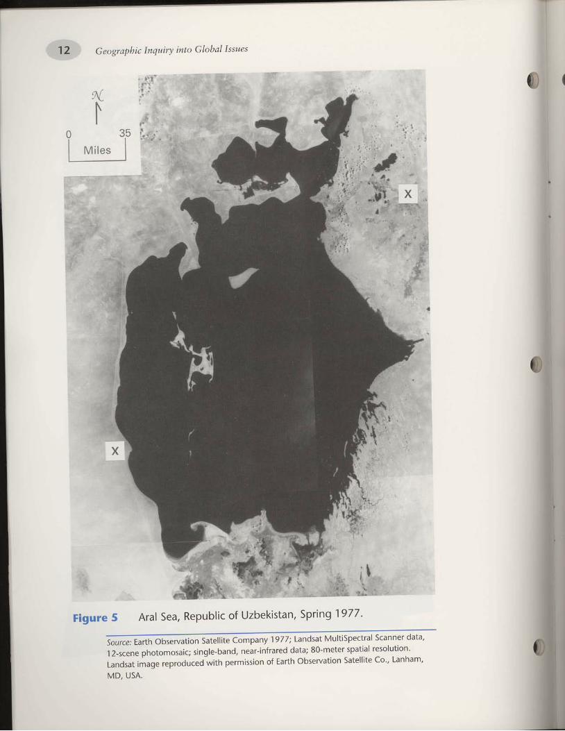
12 Geograpbic Inquiry into Glohal Issues
' t:,\g': l
r . i
F igure5Ara lsea ,Repub l i co fUzbek is tan ,Spr ing l9TT '
0)
rltir'',,.
' T'# q\-
sou,,, ' Earth observation Sate||ite Company 1977; tandsat Mu|tiSpectraI Scanner data,
12-scene photomosaic; single-band, near-infrared data; 80-meter spatial resolution'
Landsat image reproouced with permission of Earth observation satell i te Co', Lanham'
MD, USA.
!ii il};;
$
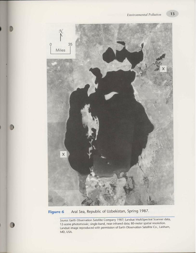
.VSN ,CA
,uequel ,.o3 a1r;1a1e5 uotle^lasqo q}.rel lo uotsstt-urad q]lM pa)nporda.r a6er'ut lespuel.uotlnloser lptleos ralaLu-O8 lelep parelJul-Jeau 'pueq-a;6urs llresouoloqd auals-Z L
'e1ep .rauuer5 1er1:ad5r11n4 lespuel !1961 Auedwof ellllales uolle^rasqo t47re1 :Dtnos
'lg6L 6uud5 'ue1sl>laqzn lo )rlqnde1 /eas lerv 9 ern6ll
Irl7s
uoqnllo J l0 1ua wuo.t t /tug
"14 Geographic Inquiry into Global Issues
Would you have guessed that the Aral Sea situation is as bad as
this writer describes?
Soviet Central Asia faces an ecological disaster of unparal leled
proport ions-and its most dramatic feature is the steady shrinking
of i fre Aral Sea. Once the Aral supported a thriving f ishing
industry, mixed agriculture, and numerous species of plant and
animal l i fe. Now nearly half fof i ts area has] been reduced to a
saline desert-the source of dust storms which, 15 t imes a year,
drop up to 75 metric tons of salt and dust, contaminated with
o"rt i . id"t and other chemicals, onto surrounding areas (Perera
1989, Page 124).
What is the Aral $ea resion like?
Central Asia is the driest region of the former Soviet Union' It has
vasr expanses of deserts and steppes, or plains,. sufrounded by
extrem;ly tall, rugged mountains. Glaciers in these mountains are the
source oi the i.* ,iu.tr that flow through the drier parts of the area'
One of the major physical features of this region is the Aral Sea'
Although it is called a "sea," the Aral is, in fact, alarge saltwater
lake. It has no outflow into the ocean'
Geographers frequently define regions around lakes in terms ot
the waterslied. A laki's watershed is the total land arca from which
runoff feeds the streams that supply the lake. The Aral Sea's region
consists of the independent republics of I(yrgyzstan (pronounced
keer-geez-STAHN), Taj ikistan ( ta-JEEI(-uh-stan )., Turkmenistan' and
uzbekistan (ooz-BEl(-uh-stan), as well as the southern part of .I(azakhstan (I(AZ-uk-stan). \Tithin Uzbekistan, right next to th,e
Aral Sea, is a province called I(arakalpakia (Figure 7 on page 15).
The total population of the region is nearly 40 million. This repre-
senrs about i4 percent of the fot-.r Soviet Union's total population
(Mick l in 1988) .In 1.960 the Aral sea was the fourth largest lake in the world,
covering over 26,000 square miles. But by 1'991', the water level had
d.opp.J over 47 feet. Now, the lake's surface are,, at 14,000 square
-il.i is about 40 percent less than it was rn 1'960 (Micklin 1990;
I(otlyakov IggI). today the Aral Sea is only the world's sixth largest
lake.To understand why this is a problem, you need to understand the
physical geography of the Aral Sea. The Aral Sea's watershed collects
water) b"t itlo.r not release water (except through evaporatio_n)'
because this region has an interior drainage system similar to that of
Mono Lake. This means that the water from rivers that drain into
the Aral Sea goes no further. There is no outflow from the Aral Sea
to other river"s or to the ocean (Armstrong and Hunkins 1989)'
0"
I
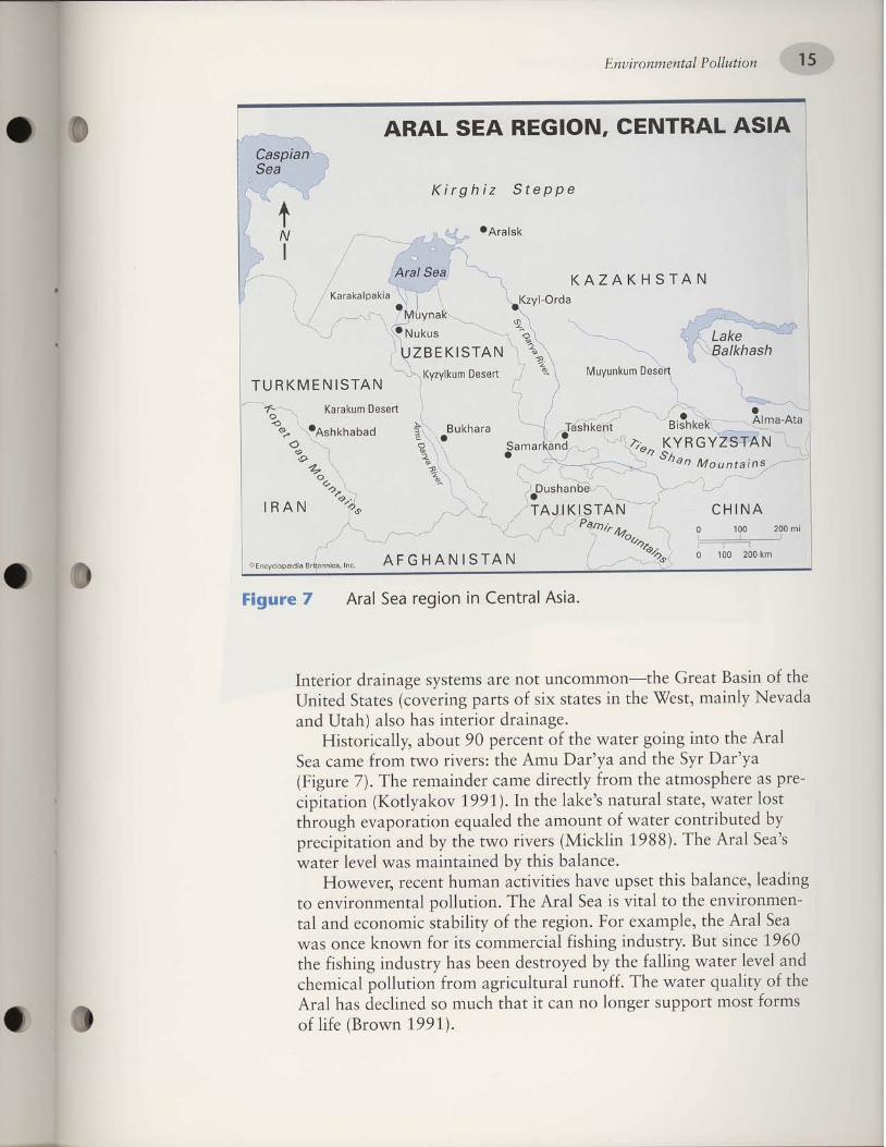
'(rcet urvrorg) aJII JosruroJ lsotu uoddns .ra8uol ou uef, tt legl I{3ntu os PaUITJoP seq I€JV
or.ll Jo drrlenb retB^\ er{J 'JJounr lernllnllr8e ruory uorrnllod lerllueqf,
pue le^ol ret€^\ 3uq1e; aqr dq podo.usep ueoq seq d.nsnpur Surqsg aqr
096I oJuls 1ng 'drlsnpur Surgsr; I€If,raruuof, sll roJ u.taou>l sJuo seln
ees IprV agt 'elduexo rog 'uot8ar orll Jo drrltqers rlruouof,a Pue IEr-ueruuoJrluo eql ot lPlIA sI €eS IEJV aql'uorfnllod letuewuoJlluo ol
Surpeal ,acueleq srql tasdn al€q serlrlrlf,E uerunq lueJeJ 'tarra,t.og'eouelpq stqr dq Pauleluleru sely\ IO^el rele^\
s(EaS IErV oI{I'(886I ulPIrlW) srollr o1!u eql dq pue uotleltdtca.rddq parnqr.rluoo Jete^\ Jo lunoluE eqr polenbe uotle.roderre q8no.lqr
lsol rale.^a'atels lErnleu s(eIEI eqr q 'fieet.,Lo1ed1roy) uotlelrdrc-ord se eraqdsoule eqr IUo{ dlra.lrp eluef, rePuleluor aql'(/ ern8lg)
e,t1eg td5 eqr pue et{'Seq ntuv eqt :sJaAIJ olvu luory aru€J EeS
rEIV ar{' 0rut 3uro3 IelE'l\^''ut.:#;,*if,f,illff tffitiff,f'",
ppe^oN dlureu 'tsel6. aql uI selels xls Jo slred Sutre,roc) salet5 PetIulIar.{t Jo uISpfl IEOJC el{l-uotutuof,un lou are suetsds a8eute.rp JoIJaluI
'ersv lerlueS u1 uor6ar PeS lerv 4 ern611
-r* .r, ,- 'iU^-.-'*-^)
NVJ-slNVHglv cur 'ecluus)rserp€dorc^cu'o
-"q-r---l \-'"'%"- L* ,r,....-. -... .... ./---.r ,,'---f '',-,-""*'rl,tr..l-2l'-
;1..,,'-""'""""./^-'\-v/'vNrH3 ,1^lY':j:!:"Y{
'{(, "1,",, NvuI
':::'::'1.u,us u\
--'\ o\ "' \ \ ,/€q-ueqsnG ,'_, '\ \ _"
-'.'....-)1._) ,.,'.'..) '.Ya\2
..,_,,-.. r'''t -1 '-/,\q9-Y:.r]sno ''-\ , [g
' ,72
i\
",-.--t-""' / \ it/
(-16 u-rnlunAnyl \
"-
r uesa6 un>1;AzAY\'a "'1
NVJ-S IN ] 1A) U NJ.
E'1, ruvrsr)lsz\/\oa
-. - __ snlnry).. r '. . )
\: --:1euAn241-7 \.1\--l ,'\
NVISH)VZV)'>i (
)slervo
vrsv'lvurNfc
addeTg zrtl6trY
'NOlClU V3S ]VUV
W uoqnnodlptuawuo,uaug
16 Gectgralthic lnquiry into Cllobal Issues
IJ
4. The Ara l Sea region covers about 626 '000 square mi les '
D; ; . t i ; ; ; " ; . ;
o f the Uni ted States that is about th is
same s lze.
5. what are rhe names of the mout t ta in ranges that are the
sources for the Amu Dar 'ya and Syr Dar 'ya. r ivers?
Approx imate ly how h igh are these mounta ins?
6. The Amu Dar 'ya and Syr Dar 'ya r ivers.are ca l led exot ic
r ivers because they f low main ly through dcser t . reg lons
ftr i rf t . i t tater sources are in snowfields. in high I r
*ount" inr . F ind two other major r ivers in the wor ld that
are exot ic r ivers.
7. How are the exot ic r ivers you ident i f icd in Qtres: :n 6
different from the rivers of the Aral sea reglon? How afe
they s imi lar?
B. What maior lake in the United Statc.s is similar tf . the e'111
Sea in that it has no outflow and is in a region ot lnterlor
drainage? Is it a freshwater lake?
9. What human act iv i t ies do you suspect are causing the
Aral Sea to shr ink? Why do you th in l< so?0
0

'(9 a6ed '1"661nole{11o;) [sa;rru alenbs
OOO'Z rapun] ]o olel aurJq lleus p euro)eq ol paurlsap sr eas leJVaq] 'saJnseaur lrlserp lnorlllM 'reel) st puaJl aql ' ' ' 'supd alel-pdas om] olur popeler ppq pes lerv eq1 '686
[ ]o pua aq] {g
uorlezrurles
luaLuuoJrAua
lueuruJeno6 ;erluer
sprolvl{resso;9
iSrHurn{s ees [Bry aq] sr {q16
LL uotlnllod lLluduluo.tt/tul

ffi Geograpbic Inquiry into Grobar Issues
PROFILES OF THE ARAL SEA
1976
2000(projected)
Figure 8 The changing profile of the Aral sea, 1960-2000. shadedareas show the actuar size of the Arar sea compurJ t" tl.,.out l ine of the lake as i t was in 1960.
Source: Micklin .|988.
There is little doubt that the Aral Sea is vanishing (Figure gabove). How can this loss of water be explained? The answer can besummed up in two words- irrigation3ni ,ottin. r*i"ii." sysremswere built in the Aral region (Figure 9 on page rgt to"r"pporr pro-duction of comon and ot-her .roir.

I
'166 L ̂o)e^lto>:Drnos
raproS leuorleural,ul .-- - .
leuec - -
r€Aru roler\l
Puet Paleourl t _J
'uor6oJ pas leJV aql u! sulels{s uot}e6lJll 6 arn6!l
\\NVJSINSIA)UNJ
NOl9f U V:lS IVUV :lHI NlSIAISISAS NOIIV9IUUI
IU
V-
(
6Luo4nno d l0luauuo,tllluq
2A Geographic Inquiry into Global Issues
The Aral Sea Project
During the 1930s, cotton was needed for the Soviet Union's tex-tile mills. Government officials in Moscow, the capital of the SovietUnion, decided that the Central Asian region, of which the Aral Seawas a part, could be used to grow cotton. Because the region is most-ly desert, however, it was necessary ro irrigate the fields to supportagriculture (Legvold 1971).
By 1937 irrigation and mechanized agriculture methods hadchanged this desert into a productive farming region. In that year rheUSSR produced enough cotton for both its own use and for export."\fhite gold," as cotton was called, became very profitable andimportant for the struggling Soviet economy (Ellis 1990).
As Central Asia's agricultural potential increased, the central gov-ernment of the Soviet Union raised its demands for oroduction ofcotton and other crops. The Soviet government began the Aral SeaProject in 1,960. This project's primary goal was to maintain Sovietself-sufficiency in cotton production. Another goal was to increaseproduction of fresh fruits and vegetables in the Aral Sea region. Tomeet these goals, the area under irrigation had to be expanded.
The government assigned huge cotton quotas, in the hundreds ofthousands of tons, to the region's collective farms. The amount ofland under irrigation increased annually to meet these demands(Brown 1,991,). By 1992, 47 percent of Uzbekistan's land was plantedin cotton. As a result, Uzbekistan became the world's third largestcotton producer (Lee 1992).
Water withdrawals from the region's rivers
In the 1950s, before the largest irrigation projects began, the AralSea's water level was steady. Each year about 60 cubic kilometers ofthe Aral Sea evaporated away. But the water level was maintained bythe annual inflow of 56 cubic kilometers from the Amu Dar'ya andSyr Dar'ya rivers. Precipitation supplied an additional 5 cubic kilo-meters of water each year. The water system was in balance(I(otlyakov 1991).
In the 1960s, rapid development of irrigated agriculture began,and water withdrawals from the region's rivers greatly increased.Today, over 1.7 million acres in the five Central Asian republics arei r r igated. About 105 cubic k i lometers are wi thdrawn f rom the AmuDar'ya and Syr Dar'ya rivers each year to supply water for these irri-gation systems (Kotlyakov 1,991). This means much more water isnow withdrawn from the rivers than flows into the Aral Sea.
0)
@)
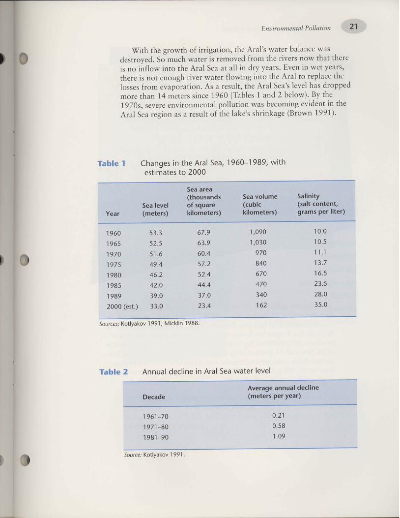
'[66 [ ^ole^l]o) .'alrnos
la^el JeleM eos leJV ul aull)ap lenuuvz elqer
0002 ol selPulllsarlllM '686
l-Og6L 'PoS
lerv oLll u! seoueqf I elqel
'fieet ulro.rg) a8e>lulrqs s(eIEI eqr to llnser e se uot8er EaS IerVaql ur luapr^a Sururoraq sE/\a. uoBnllod letuauluoJl^ua eJe^es 's0L6I
aql dg'(mo1eg TPue 1 se1qe1) 096I eruls sraleru VTueqt erotu
paddorp sBq le^ol s(Eas I€rv eql'l1nsar E sv'uone.rode,ra tuort sessol-
aqr ereldeJ ol IEJV eql olur Surlrog Jel€A\ ralrr qSnouo lou sI eJeql,slead lea ur ueAE .sreed d.lp ur IIe rE Ees IBrv er{l otul lKolJuI ou sI
eJer{l leql A\ou sJeAIJ eql luory PeAoueJ sI Jal€.lll LIJnIu o5 'pedo.lfsap
se^\ ef,uEIEq ret?A\ s(lerv agl 'uoneBIJJI to qutor8 3I{l qlllN
'8861 ulll)ll4 1;661 nole{;lo) jsa.?rno5
uo txnno d Ip lua u/.uo.t x nug

22 Geographic Inqwiry into Global Issues
Up to the end of the 1950s, the environmental stability of theAral Sea region was not threatened. The Aral Sea Project pushed theenvironment out of balance. By some important measures, however,the Aral Sea Project has been uery successful. The Aral region nowproduces 90 percent of the former Soviet Union's cotton, 33 percentof its rice, and 25 percent of its fresh produce (Brown 1,991). Whatdo you think some environmental and social effects of this projecthave been? \What kinds of information would a geographer-oryou-need in order to find out?
D1(
tnod ol Jnf,f,o suortsenbreq/N '986I ur suaddeq leq^a of,rJou uoqt pue '096I ol dn sqde.r8 ozrrleqt ur spuorl oqt af,rtoN 'lralord uorle8r;rl eos IerV aqt Jo speJJe tu€l
-.rodurr eruos ol senlf, epr,r,o.rd y7 a?ed uo 0I arn8rg ur €rup or{J
uorln; ;od {.repunoqsuerl
leq)uolos
uorlezrurles
a6eure.rp JorJalur
lueuuor^uo
uals{sora
luerlolep
spro,lAr{resso;9
irelsBSIplB]ueruuorr^ue Bes [BrY
aql Jo slceJ.fe aql er€ l€rl^A
ri\ral
EZ uoLnlpd l\iuautuo.ttltuz

24 Geographic Inquiry into Global Issues
Figure 1O
I
Woman harvests cottonnear the Aral Sea.
Amount of irrigated land and cotton production inUzbekistan since the Aral Sea Project. Other republics(Kyrgyzstan, Tajikistan, and Turkmenistan) show similartrends. 0
3an
o
t!, P^
: ooq
o
7,000
6,000
5,000
4,000
3,000
2,000
1,000
0
4,000
3,000
2,000
1,000
0
Uzbekistan:Cotton
Production
1956 1960 1965 1910 1975 1980 1985 1988
oo(E
oo
ott
th
o
Uzbekistan:Land lrrigated
for Cotton
1 965 1970 1915 1 980 1985
Source: Cleason 1990.

'(eeO I utt>l:tn) 186L ut'pallpq s:nlr eas lPrV aq] ur 6urqstl letr
-raurLuof ]eq] qsl+ 6ututeual aLll ul qblq os are sapllllsad^;o s1ana1
'pareaddeslp peq sanads qsry a^lleu VZ aql +o OZ 'sgg6;- '(1'rea
aqt ,(e 'alll lllunoe lnoq]lM alel P Mou sl lelv aql '{1r1enb ra}eM
aq1 paperbap ,tlsnorras 1jn.lnnq sluetnllod auroq4e pue-'s1ua1uo:
le)rulaqf pue llPs qbrq'Xl6ursealful .1anat eas 6utran'rol eqI
( t6; i unnorg) sllps puP slPlrulaqr +o alllrrl paler]
-uaruor p sr lprv .qi".'1,n"l saop laleM^alilll ]eqM 'ea5 lery aql olul
Mol+ ,sranlr aL{} }n) {1a'ranas seq uorlebt"i '"tnn'"g
-sPtau a:npord
pue uo]]ol ulol+ JJounl paleululeluor {q pa1nl1od {ltneaq auto)aq
anpq sJanu en,lec ,Xs "qr
pue uz(,1e6 nutv aLl|sulle' uo asn lo+
s11ann {q dn umerp ,'io n"5 lelv aq} o}ul sMol} JaleMpuno'rb ltxo}
,pa1n11o4 'raluMpunorb aq1 olur lros aqt qbnortl],p-"f^'T.1ab {aql
pue '1ros aql alPUlLueluo) slefluaql asaql ln8 '(ratsea butlsanleq
aleuu o1) sa^eal anoLuar lpt4l sluerlo+ap pue 'ln":l1:laql lorluol
oi oprrot"d 'stazrlryal sarinbar {1lerrlar'uuuor uo}}o) butnnol9
ft11enb raleM Paper6aC
I 0
( {i
dwws &@"ew@efi& #'6s s&sw#sffi nwsBffiwgmnw ffie&&
uo \nllo J lp lua wu o'Lt ttu g
ffiaagx6amg'uqsw,&w &wed$wh
's1ue1d pue sleullue {ueu o} flxo} are
'uorlrnpold lern11n:rr6e aseallul o] pasn uaaq aneq q:tqnn 's1er
-luaLll asaLll 'IOOO f sllll) ICO sP q)ns sapr:r1sad-pasn 11r1s 1a{
-pauupq {11er:ri1o 'o.rf p'n s}uello}ap ulor} sanplsa; ale }snp-}les
slq] qllM paxlt^ 'nt5 1n',y aq] uol+^.:a11uu {ueru queld pue sltos
aoeu.rep {lsnotras rtni io iluno*n q6tq qrtnt Map pue uleu'(1661
ururorg)uol}e}|dIfaJduapel-tlesslsLulo}s}snp.}lesaq}L{}!MpalU!|,(1aso13 'pueldolruo '{11nnuue palrsodap alP }snp-}les +o alle
,"Jlp'r"ba 000'L sear' aluos ul ]eql pal'ulrlsa uaaq seq ]l'(1,OOt nole'{1ro)) azls ul sla}autolll
00€ ol dn ale spnol) lsnp asaql 'eas IPJV aq] lo saloqs, aLl] ulol+
dn ]dams 6uraq lsnp-]les ,o spnoll Strq* a6nq paq^der6oloqd
n6ua11oq1al]lnqs alpds aq] +o Marl aq] 986 L ul spulM 6uor1s {q
dn palrrd "rn
,r,rol"p ti"i'"t"q1 'ablaua o1 un6aq aneq 's1eql
-uolos paller 'spuelpeq ites l? sea:e -a6re1
'11nsal e sv 'saullaJoqs
pasodxa {1,r,rau aq}' uo ilrsodap se l}al
uaaq a^eq la}PM aq} u!
pa^losstp "tro
.r"^ ]Ptl] slelaulu aql 'slutlqs eas lPlV aql sV
stuJols ]snp-llPs

Geographic Inqwiry into Global Isswes
Habitat destruction
on land, native plant and animal communit ies have been hardhit by the declining water levels and deteriorating water quality.Prior to 1960, the river deltas were important b5th ecological-lyand economically. The deltas provided food for livestock, spawn-ing grounds for commercial f ish, and opportunit ies for huntingand trapping.
Tugay forests, which are dense stands of tail grasses andshrubs, play a major rore in the ecosystems around the Arar sea.But over the last 30 years, the area of the tugay forests has beencut by half. As this habitat has declined, the Jnimals that dependon it have suffered. once there were 123 different species oi ani-mals in the Aral region-mainly l iving around the river deltas.These animals included "muskrat, wird boar, deer, jackal, manykinds of birds, and even a few t igers" (Mickl in 19gi3, page 1173i.Now only 38 species remain. Highry minerarized *a6, pracesstress on endangered species such as the Asiatic wild ass and thesteppe antelope, which also l ive in the area (Mickl in 1990).
Soil salinization
^ lrrigation provides water to ailow more agriculture in the Aralsea basin, but in t!9 dry crimate irrigation a'iro .arre, a processcalled salinization. This occurs when ialt accumulates in soi l thathas been heavily irrigated. over time, the salt deposits get con-centrated, becoming.toxic to plants (salter and kovaciI toso;.Because of the salts in the solonchaks, vegetation cannot grow.without vegetation to anchor the soil, the r,iinds continue to blowthe salts (Mickl in 1988). Much of the Aral sea basin is now awasteland of salt-poisoned soil .
why does salinization occur? lrrigation water is full of chemi-cals and salts, because of the pesticides and fertilizers added byfarmers. But in hot deserts, evaporation rates are very high anithis dries out the soil surface. water within deeper tayers of thesoil is forced upward toward the drier surface. This ociurs for thesame reason that moisture spreads toward the drier parts of apaper towel. As the soil water is drawn up to the surface, so arethe salts and other minerars that are dissolved in i t . As the waterevaporates, the salts are left behind as a deposit on the soil(Kupchella and Hyland 1989).
0
eq lqEILu uollelndod uPtUnq aql lurlll no'{ oP /noH '9
iuotSrr lErv aql'prlq'qslJ aneq dq16 '9
ur peulllap suottelndod leuueu pue
ilou
lq,m -ro ,{q,1 ;lnlssarrns urrq seq tralo;4::l i:iy^:.ttt
,"qi {ttt noi'op :ut'r'npo'd uouor ur eurlreP rqr ua^ID '?
'$Za8ed uo g I a-rn8r{) to9gl:]tl sili ur uotrnpo'rd
uotlof ul eulllJP aql JoJ suose'J''u"'11'p o1!u aAlD 'f
;uor8o-r aqt Jo sr-ua1qo-rd uorrnllod- l*l:3qt
pue rTps ,t{, oj ,tnqiluo' lrEJ srqr saop 'wo11 'r'uals'{s
,b".r,"rp ,otrrlut uE-Jo uBd st eos IerV aL[r lELl] Ilerau 'Z
'slJalJJ leluauruoJlAue uo s8urpea'r:'roqs
o^It snor^e-rd aqt J; ,li;t Lor; tloutexo uE anrg lpa8u"ql -oo'r3r., ers IP;V
jqr 1o ru"tub'inur aql suq sde'u leq^\ ul 'I
tI
itl\l
ipalrruB
'(eSO t ulll)ln) sdorr raqlo
mo.rb pue qfllMs ol ppq a^eq suolle1ue1d uollof aulos '(L661
nole^llo)) uo]]ol nnor6 ol papaau sz(ep aal;-lsor+ 002 aql upq]
ssal qrnLu sl slql 'st\ep g1L se Ma+ se o] pafnpal uaaq seq uosPas
aar+-lsor, aqi 'ellap u'r{,,rcq nulv aql-ul 'uoseas burmorb all} paua
-uoqs seq slql 'paseaJful-seq slsoll6utttt>t Io a)uallnl)o eql 'saJnl
-eradr-ua] aluarlxa arour q]lM 'aq o] pasn {aq1 ueq} laloo) sla}ulM
pue laulJeM ale slaLuLUnS 'aloul salenllnl' Mou alnleladuual aq1
pue paseal)ap seq uotleltdtrard 'lollalul leluaulluof aq] lo ]eq]
alrl aloul aLuofaq seq aleullll aql 'parnpal uaaq osle seLl aleul
-r1:'1euor6ar aq] uo aruanllur s1r 'lunrqs ::Ui:"Xjl,3ll,; ]13,u,
aql ueq] laLUJeM slalulM pue laloo) alaM slauluuns 'ea5 lely
aqt ulol+ sralaLuolll 002-00|. euoz e ul 'lPaq ;o slunor-ue 1ea'r6
palols raleM aq1 "tne:aq
sl slql 'uot6al 6utpunolrns aq] +O aleLu
-llr aq] alprapoLU padlaq eas lelv aql 'ralen'r +o salpoq lle alll
sa6ueq) aleul!l)
{tuoxwilo d lryua utuo,ttttufl

28 Geographic Inqwiry into Global Issues
How has the pollution @f, the AraE env;ronmentaffected peoPle?
i
, roilM\
Figure 11 "High and dry." What effect on people doesthis photograPh show?
Ie
0(
Source: Kotlyakov 1 991 .
'Sfhat effects on people does the following quotation describe?
Effects on the Aral region economy
When crigory Reznichenko, executive director of f the soviet
magazinel Nivy lAir, visited the shoreside f ishing town of Aralsk in
the late 1950s, he was impressed by the variety of f ish, fruit , and
vegetables on sale at the local markets. when he returned in 1988
at the head of an expedit ion of 33 scientists and writers, he found
a dead city. The sea had retreated about 60 km, leaving the hulks
of abandoned boats aground in a deser t fF igure 11] '
More than 15,000 f isherfolk had left the town, and of the
10 ,000peop |ewho rema ined ,ha | fwe re job |ess .Manyweres i ckwith typhoid or hepatit is, and infant mortal i ty was 10 percent-
four t imes the national average. other Aral ports, such as Muynak
fFigure 7 on page 15], had suffered a similar fate'
0;(

'886 [ ulll]ln :Drnos
ellep JaAIU eA,rcqnuv aql ul sassol lltuouofe lenuue Jo seleullsl€ elqer
'(mo1aq t alqeJ) etlep e[',teq ntuv aql Punor€EerB eql ro; dluo s€/Y\.slql PuB-uoIIIIu OtI$ lnog€ le saSeurep
Ipnuup agr peceld 't86I uI oPelu'aletunsa eug 'dlea' relseslP I?t-ue[uuoJl^ua€aSI€JVaqlluo{sossolJltuouoselProlJosalEtullsg
'tuaored I8 Iq PauITsoP e^Er{ BrlaP el,teq ntuv er{r uI SPIaIJ-deq pue sornls€d 'lee >lf,olse^Il reql sassB.r8 sllDl sllos Jo uon€zruIles
.Pa]nPeJueogoSI€sequotterl€JVeqlutSutste.r>If,olse^I.I' fi661 ulrroq (.9661 sr11E) pessecord Suraq eroJag sollur
09 reqlou€ to; lcttr dq uoqr pue 'selrur 0S Li to1 lrer dq 4eudn7'gJi pea'Orqr er" qity uezorl 'eldruexa rod 'lp-rv oqt ot Sutssacord ro;
pauodsuerl Pue EaS JIllBfl arp uo suod ur sdrqs JJo uo>l€r ere susef,o
circrV pue 'cr;tce4 .rrluelly oql wo{ qsrg 'ue1d €utru'o1o; oqt PesI^aPuorun ler^os rauJoJ er{lJo tueruuJe^os aql 'lse.run
lecrlrlod PIOAEpue uJdo eere aqt uI seIJOuuEc daa>1 o1 'padoldureu]l or€ oq^\ esoql
Euoue lseJun lerrlrlod Jo lpeJr{l e sI aJOI{1 'Slstxo .re8uo1 ou dllsnPut
Eurqsr; lerciaruurof, s6l€rv el{r 13q1/Y\oN '6eet srllg) dlree arllar
ot ro tueudoldule.^aeu PuIt ol rol{lla Parrot ueaq e^Pq PooqIIe^{rlel{l rot IErV eqr uo papuedeP oq,/v\ eldoed Jo sPuesnoql '(91 a8ed
uo I arn8lg) eas oql tuo{ salw 0t uerp srolu sI IBUAnIN 1'Po+ 'fieet u^\org) >l€u^nY{
ur pessef,o.rd servr rr Jo lsoy{ .€es ogl urol; dllenuue ue>lBl oJa/ll qsIJ
;o'spunod uoITIIru 00I etup letll lV 's0S6I aqr,8u1mp sqot parelar-"a,rrgrq ro Surqsr; ur aldoed 000'0I re^o pedoldura'tseol ureqlnos
s(Bos eqt uo af,uo ;4eudny,q drtsnpul Surqsr; I'Itrrotutuoc snoredso.rd-ef,uo aqt PIP os'patp qsIJ al{r sV'ft661eo1) pareeddestp ees IerVeqr or elneu sarcads qsrJ VZ aqr to 07'5861Pue 096I uee^uofl
'@7ya6ed'6g6L e.ra.ra4) ,,qilPf uo a;ll lo pue aql se)pl ileql a)eJ uPrunqaql uaqt ,1r ur anrl l,upf se^lasruaql {aq1 aleqM a}els P o} }uetlluol-t1ue Jteql palnpeJ eneq s6uraq upunLl e)uo,, :plPs oluaq)luzau,BeJe aql JaAo Meu uotlrpadxa aq] sp ssaJlsrp srq 6ul11e:ag
ffi uotxnilodlaluautuo.'xltug

30 Geographic Inquiry into Globdl Issues
DEffects on the health of the Aral,s people
Human health problems related to air and water pollution arenumerous and severe. The situations described in table 4, which fol_lows, are believed to be caused by salt and chemical contaminationof the water and air.
Table 4 Disease in the Aral sea region compared to the whole area ofthe former Soviet Union
Typhoid fever cases
Hepati t is
Kidney disease, gallstones,chronic gastritis, and liver diseasesEsophageal cancer
Birth deformities
Cancers of many other kinds
30 times the national average7 t imes the nat ional average
Above average increases
7 t imes the nat ional averageFar above the nat ionalaverageOn the increase
Sources: French .l 989; Brown 1 991; Kotlyak ov l99l .

'uollnllod sll ̂q pa]lajle
lsou aql ale uol6a.l Pas lPrv aql ul uarpllqJ
'(9g a6ed '1661
no1eXl1o; ur palrt) s.rea{ onn}
]sel aql ur pa;drr1 seq srepro-srp 1e:r6o;oq:{sd pue sno^-rau tuor] 6uua;;ns ualPllql
+o raqurnu aql 'llls {11e:-rl:e:d arP ' erled;eleluYur uaJpllqr aqt +o luaf-rad 97 ]soullv
'{1arn1
-puald q!!q sa^!6 uPuloM]ueu6ard pJlql {.rana Pue'erLUauP uloJ+ laJJns uaLuoM
lo ]uarlad 08 uPql arolA'sreai( a^U ]spl aql u! Pa1du1seq erled;eletey ul alelqleap lPuleleur aql 'Jean
qrea 6urnro.rb sr PUe PIJoMaL.ll u! lsaq6rq aqt lo auosr etqedlele:eY ul uarPllq)
+o alel {1r1epoiu aLlI
I 0
'uoJplrql o] snopJezeq {1;erradsa st 1eq1 aqd-oJlsplpl ge:r6o1o:a +o auo st uol6al eaS lerv aq] leLll suolJPArasqo
pq"i1 tuori paraqleO elpp ,o srs{1eue uol} papnlluor a^eq-'{qd-er6o.ap pue '{6ololros '{qder6oa6 'aut:rpau '{6o;ofa }o seale
aql ul slst;etrads-,,uollnlos pue sur6ll6 :slsllJ ;e:y aq1,, ',unts
-odru{s tpuor}eura}riliru'""q1'rl t}rnoii'},nd L5*o^ aqi'aM CI
:uollBrElrep slqr PensslEes IEJV eqt uo urnrsodruds E ur Surlednrlred uaurol6'uor8a; 1e;yaqt to uorrnllod oreles aql dq peilsJJe lsour ueog a^EII uorPIIrlJ
'(oee r stllE)er>1ecl1e1e.re)I Jo seler raruer PuE dtllet-roru ruelul q8lq aql Suronpa:t
io .Aoq alttll sI aragl'pataldruoc sl ]l llruq'lllnq Sutag sI srlolresar
upalr ruolJ rate^\ .ti 8,tttg ol aurladrd 8uo1-apu- SZI V '(91 aSed
uo I a.rn8rg) .rale,'w-11a^a flxol eql osn ol lnq eslot{r ou seq '000'ZSI
yo ,{lp P PuP er>1ed1e1ere)I Jo uot8a.r eql Jo lerrdec "tIl$.n,,
e,lSeq:dg pue ed,;eq nruv eql Jo seere erlep POlEIndod dlr'teaq aqr
ur tsJo^ sr rualgo.rd aql .salEJ JafueJ Sutsea.rcul pue (ua.lpllgc Suoue
dl.relncrt.red) sassaulll IPuIlsalul Surse_a.r:ur aql JoJ uoseer ulelu 3tl1 AIq
-eqo.rd sI rate^A 8ur>1ur.rp ;o Lrrlenb Surutlcap eL[I ']lxol auoJeq eAEq
iarlddns .rat,^A asaqJ 'Gget e:ra:ra4) rrle^a 3u11u-1'tp rIeL{' roJ sre^Ir
pue slla/\\ .tu p,ltd.p uol8a; IBrV eql ur aldoad eI{} Jo ruarrad 96
tnoqv'slellrueql 1e:rnllnor-r8e dq pereulluuluor uaaq serl ratelN'keet aa1) salgnorl d;olu:rrd
-sor ruorJ roJJns 'ea5 1e:ry eql ol lxau 'etledleIPrE)I ur aldoad aqr JIBI{
d1:ruap 'rerueJ pue aseeslp lreal{ nqe'9961uI uelsl>leqzfl ul qr:ePjo *""r Burpeal prrgr ai{r era^A sesBasrp 3un1 'sasseulll dro_leltdsa.t
ot pel setl soplrltt5d p.t" 's.rezlltue; Iellrualll
'rles dq parnllod :tty
t€u o t I n I lo J lD I u r Luuo.t tlt u1
32 Geographic Inquiry into Global Isswes
How has the Aral Sea disaster affectedother regions?
Following a visit to the Aral region, the geographer PhilipMicklin wrote:
The former eastern shore of the Aral is a barren wasteland withsand and solonchak stretching as far as the eye can see. A thickhaze caused by blowing salt and dust obscured our view towardthe remnant Aral Sea. The eastern shore of the Aral has retreatedover 100 km in some places. The largest dust/salt storms arisefrom here, l i f t ing part icles 4 km [in the air], which are depositedup to 500 km downwind and . . . perhaps much farther (Mickl in1991, page 95) .
Winds carrying Aral salt-dust can be strong and persistent.Scientists have found traces of salts as far away as the Arctic coast ofRussia (Ellis 1990). Most salt from the exposed former lake bed ofthe Aral, however, gets blown toward the southwest by the prevailing
winds (Figure 12 on page 34).If Aral Sea salts have been found in areas hundreds of miles away,
then transboundary pollution has occurred. Transboundary pollutionis pollution that crosses a boundary. Political, physical, or regionalboundaries are some types of boundaries that can be crossed. Theproblem of transboundary pollution is a concern for many countries,including the United States and Canada.
ol

isJJuJnbasuor aLlt Jq
( {
rq8rr-u reqr1 itr tnoqp ruop rq plnoqs lultll no,t op tTlNirel{l tnoqp laal no{ op ̂ oH csallunrrrtuor Sur.roqq8rau
ur SurreurBrJo uortnllod ,,(q partaj1E ,ilrunruuoc "lnol sI 'lZ
1s;oqqSrau sl pue sarets parru{ler{t uoJ.^Naq selJEPunoq lEuollPuJJlul ssoJf,E lnoqP A\oH
iselers prrlu(^l JLll ulqll/\\ rnJJo p[no] lEtll sJlrePunoqatets ssorJe uorrnllod 1o salduuxJ Jutos aJe teq/fr
ilerv eLll tuorJ rlESdq parnllod areJd E ur pa^rl no,{ ;r op no.{ plno,M leql1
1.'(rePunoqlelrrlod e ssoJfe Surteut8tro uorrnllod ot pucldsa"r PInoqs
sarJlunor lJqlo uI srueurulanoB lrrrqt nol op mog
cursuq eas lery Jqr ut Suueut8uo uorrnllod llus,{q palro;ye eq plnor sellunor 8ur:roqq8rau ret{,1N
istutotslslrp-tIEs rojl sa].Inos erE ers IErv er{] Jo sEarP qllLlrN
UC
'6r
'Bi
,LI
'9r0
'sauepunoq
ou sMoul uorlnllod
t€ uotlnlluJ loluduluott/1u1

Geographic Inquiry into Global Issues
PREVAILING WINDSOVER ARAL SEA
0 60m i
0 6okm
ffiW
ff i Rrat's level in 1960
I Arat's level in 1989
{- Direction of prevail ing
Figure 12
S,ource, Micklin 1 991 . Used with permission of P. Micklin'
Lesson summaryThis lesson has described the ecological changes in the Aral Sea
region and the economic and social problems associated with them.
Consider this:
What is the connection between the quality of hwman life and the
qwality of the physical enuironment?
Think of some examples of this connection you can find within your
own community.
Source areas of salt-dust storms from the Aralpredominant direction of the storms is shownarrows.
Sea. Theby the black

'elqpllAeul
pup alqellsap Llloq sp peMaln seM Spaau fll'rjouo)a Jaqlo pue alnl
-lnltJbP ol pa:Io^ep seM Mollul sll llp se alel aulJq lenplsal e ol lerv
Jqi l" a6e>1uuqs eleulllln "'j1
'p"tpul 'eas aq] ulorl sluauaq llu,ou
-ora a;qrbunl trunbn'ilnltn''.tOn' palebrllr uuol; sute6 )ltuouo)a
i;;";ff;;:'aldrurs e uo uorleln)ler srql paseq {eq1 'ea5 lerv
eq] ol palanllap ralaul flqnf aules aq] ueql anlen aroul re; 6uuq
;iil'ronn6,rl, rol pasn lal'M lo^rl lo ralaul lrqnl v :$oap'll
alrqMqlJoM n ,n ,1qi n'res slradxe +o raqulnu e 'eru1l aq] ]v 'azls s]l
atnpal {1yer1ue1sqns pue eas aq} o} Mol}ul afnpal plnoM s!q} }eq}
;;;i't.r;' ,n* rL'rog6 L pue s096 L,aql u! pelrnpuo) 'utseq ea5
rerv aq] ,' ,o,rno,-iiJ io'tuna*" .,otn' e ro; butuueld buttnq
eJn)to eas lerv a{t
se qtns ralseslp lPluaruuoJl^ue uu plnot 'noH
lerr6ololP{q
]ueuluoJln ue
uollPlf lsep
truerloJap
spro,l^rfuesso;9
'srslJr eas lerv 3L{l e^los 01
slesodord oulos elenlEAA '
'ueesoJolun sEAA
.lelsesIP IEIUaI,UuoJIAUO E3S
lery eql dqlr azru8of,o1 '
1il,tr no.{ 'uossal sni} uI
so^!lre[qO
iPe^Bs oq €e s
I€rV eql u€c /!\oH
t\ri \
s€luotlnllo d l9luauwo'rx ttug

36 Geographic Inqwiry into Global lsswes
These experts largely dismissed the possibi l i ty of signif icant
adverse environmental consequences accompanying recession [of
the water in the Aral seal. . . . Although a small number of scien-
tists warned of serious negative effects from the sea's desiccation,
they were not heeded (Mickl in 1988, pages 1171-1172)'
The former Soviet Union's govefnment wished to increase agricul-
tural output from the Central Asian region. This led_to the decision
to divert water from the rivers feeding the Aral Sea. In the Soviet
urriorr, the development of crops was tfeated in the same way as the
J.u.lop-.nt of othe, industrial products, such as steel. Production
targets of quoras were set by the government in the national capital,
MJscow. planners developed production quotas for each region in
the vast USSR to contribute to the national economy'
Soviet agriculture had three kinds of farms. State farms, collective
farms, arrd ilots privately owned by larm employees all contributed
to the Soviei agriiulturai..onotny. State and collective farms were
.trrtroll.d by ti. government, and local leaders were responsible for
meeting the quotas set for the farms by government planners'
Tw[-thiris of Soviet farmland belonged to state farms. The aver-
age state farm had about 42,000 acres and 600 paid employees
i[t-r,ro"g and Hunkins 1,989; Resnick 1'984). Collective farms
averaged u-bout 16,000 acres (Armstfong and Hunkins 1989). These
farms were operated under the direction of a committee, led by a
chair. The chair managed all aspects of the farming, such as machin-
.rf liu.r,ock, farm b.rllditrgs, utrd th. employees\illage. About 460
f"-ili., made up the worklorce on these farms. Employees of state
and collective farms were paid according to the amount of work
done each month (Resnick 1984)'
The third kind of farm was the privately owned plots, which were
not under government control. These plots were given to state and
collective farm emPloYees for
their own use. Produce and
livestock from these Plotswere sold on the free market,
and al l of the profi ts werekept by the farmers. Sovietcit izens came to dePend on
the private farmers for about
one-third of their Produce.People preferred Producefrom the private Plots over
the poorer-qualitY Productssold by the government.
Employees of the stateand collective farms were
encouraged to meet or
e
(
Cotton farming in the former Soviet Union'

'self,ITod aseql uoDsonb l,uPlnof, oq1!\ el€ts 0rll JoseaLoldue eq ol pereprsuof, oJel\ sJeruJEJ lnfl 'elqellB^P ralB^r
tqr toy Suorrvr.ro 'eleurtlo eqr ro; 8uo;rvr (pue1 eqr ;o; Suor,l
sJeA\ lEql SaCrlcBrd esn ol sJOruJ€J peJJOJ SanrlOd luoluuJe^oc
'pateSrrr eq ol pEI{ ef,Ir Pu€ uollof, sE I{Jns
sdorc Sulpueruap-Jele^l 'lead eql Jo rJed .lo1 d.lp lue^\ JOAIJ
aql JI ualg 'sdorc oqt ele8url ot PEr{ sralurel t\tp os sI Puel aqJ
'1eo8 s,drtunoJ oI{} Surrretgoe
ur ued Jlar{t oP ot patcedxe ere,lt. sJeIuJ€J aql Pue 'acnpo;d
or pEI{ daqt uottor qf,ntu ̂\oI{ srerureJ Plol lueururolo8 tql '
'pted ararvr sasuadxe s(e^IlJallo3 egr JOrJe ry01 se^r l€t{la
ruoJ; oru€f, Lauotu aq1 'pred serrL uos.red leqr eJotu aql 'pa>lrorvr
uos.rad e eroru oql .qluoru d.rarra pred a.rarvr saSe,nn (sJeluJec
'alltf,ellof, aqr dq pau/v\o se,l Bulu.re;1o
ued st teqt eslo Surqilue pue'septctlsad's.razt1ruel's8utp1mqur.re; 's1ool 'dreulqcetu ruJEJ (pue1 aqr 'antel e^IlJellol B uO
.lla,/v\ peJnp-ord daqr pue srold osaqr to eref, >lool Pu€ Poulvlo srotureJ eql'pe;edso.rd selqela8al PuE slln{ 'suapre8 esoqt uI 'suapre8 ro;
irold arerrrrd'uerrr3 eJa/v\ sJOIurcl'sustel el,ls Jo saadoldua sy '
'elonb s6aAIlrOI-lol rloql loatu ol peq daql 1nq
(aseqt asn ol seIIItueJ rlel{l Pueruor{t ot snopr€z€tl sE/!\' }I ^\au>l dtql 'dolc uolloc aqt 1o pler''(
er{l esEeJf,ur 01 sluprloJap pue saprcnsod IEf,rrueql Pesn SJaIIIJEC .
tJalseslp IeluauuoJllue Pas IEJV oql palue,nerd
ro or pelnqrrtuof, eAEq sof,Itre.rd osaqt 1t13ru ̂oLI 'uorun leIAoS oql
ur senbruqJel leJnllnrr.r8e lnoge sluouelels le.reuo8 etuos aJ€ oJoH
uolun le!^os eql u! sa)lperd 6u;tulel
'uor8ar eeg
Ierv eqr Jo srsrrr l€lueluuorr^ue oqt olBerJ pedleq sanbtuqcal Sutu.re;
amql .,rotfrttpotduonor paseaJf,ul uIeluIEIu 01 elqeun e.rarrt saltlrerd
asegt arurl uI ]nfl .s0g6I dlree eqr lrlun InJssef,sns ere,A. uotlcnP_ord
uoltoJ espeJf,ul ol senbruqoal Surured 'PeseeJJuI sE.,tA puel palefirrrt
JO lunotuB er{l se Sursea.rour lda>1 setonb uolloc 'etsy le.rlueJ uI
'stgord eql uI erer{s PFol sraureJ
lBql lueetu uorpnpo.rd regSrg 'selonb uorlrnPord dorl s,luaruuro-,r.o3 oqt leau ol pepoeu srurBJ esaql 's1eo3 uotpnPord rloql Paarxa
u o x wllo d loxua Muo tt nul

38 Geographic Inquiry into Global Issues
Plan l. Diverting water from Siberia to Central Asia
How can the Aral Sea crisis be solved?
Whatcanbedone to repa i r theAra l seaenv i ronmen t? I t i sn ' t assimple as stopping all irrigarion.-irtigution is the economic backbone
o f the reg ion ;ove rg0percen to f theharves tcomes f rom i r r i ga tedlands (Mi.ki i ;rgsgl. th.r. ur. nutional campaigns to make irr iga-
tion more efficient, ban pesticides, and clean up polluted waters
(Micklin 1ffi;;{;tr*"y 1991.).But even these acts won't return
theAra lenv i ronmen t to i t s fo rmers ta te .Somepeop lesay theAra l i sbeyondsaving,but local inhabi tantshavenotacce; tedth isb leakjudgment .Fol iowingaretwo'" 'y 'a i r r . 'entp lansto,o luetheAralSea crisis'
I
oneproposa l i s tod i ve r twa te f f roms ibe r ian r i ve rs ,wh ich f l ownorth into the A,.titbttan, and t'un'ft' it via pipelines to the Aral
Sea basin (Figure 1;;p;g; 39). Such water diversion projects have
been discussed for ;;;;'tt-'' plu'-" for Figure 13's Proiect V had
progressed to the engineer ing s tage. in L9B5' but the Soviet govern-
*.r,t rater sherv.d;ri;';;i..1, tui.6in 1988). During the final vears
of the Soviet union, the country was troubled by major economic
problems, "rrd
gouit'-ent planners thought that the enormous'Proi.. t
V would Prove too costlY'
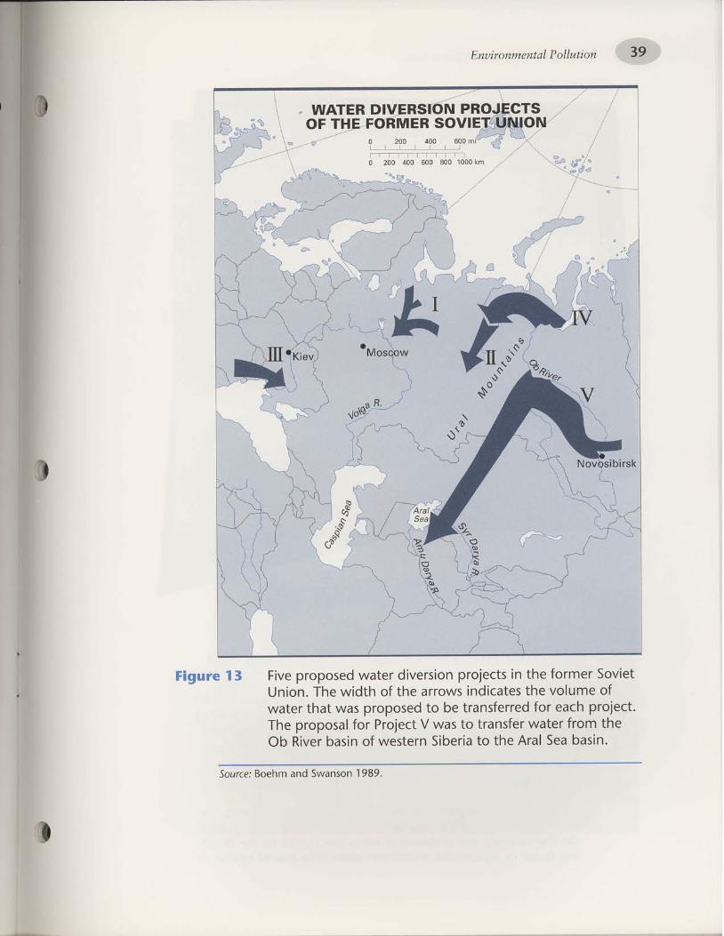
'686 I uosuPMs pue uqaoS :flnos
'utseq eas lerv aLll ol elJaq!s uJalsaM Jo ulseq Ja^lu qoeL{} LuoJJ JeIPM Je}sueJ} ol seM n }lalord ro] lesodold aql
'lreford q)eo JoJ peJJelsueJ1 aq ol pesodold seM leql raleM
Jo erunlo^ aLll salellput sMorre aLll Jo qlplM aql 'uolun
lat^os JaruJoJ aLll u! slrafold uolsJa^lp JoleM pesodo.rd enrlg 1 ern6;g
F*op'm
ffi uottnllodlotuaLuuottnug

40 Geographic Inquiry into Global Issues
r)
4. Approx imate ly how many mi lesrvc lu ld water .have to be'
*Ll,.a to diverrthe f low of the Ob River to the Aral Sea'
accord ing to the p lans for Pro ject V?
5. What does F igure 13 ind icate about the,s ize : l - l?- t^ t 'Y
in terms of the ".f
, i l t of water diverted' as compared ro
; 'h.; i l ;rc, l . .rt i what conclusions can you draw about
; i ; ; ; i ; ; t ;- i 'op,, l",n' ' ' te of this water diversion project to
Moscow ( that is . to the centra l Soviet governmenr) j
6 . Wi t l r the USSR dismant led, Pro ject V3ow would b; an
international water diversion-frttm Russta through
I iazakhstan to Uzbekis tan ' which are now a l l separate
nations. uo* d.*l ini, . l" ,onge affect rhe l ikel ihood of
il;il; V t.i"e r.,"ilii wh" d"o vo' think should pav forPrt t iect V i f i t is bu i l t?
7. \X/lrat would be the econttmic advantaget lnd,l i :- .advantages of d iver t ing wate r to save the Ara l Seal
B. \il/hat would be the enuirrtnmcntal advant,'gt: oT1"'
il"dt;r,og., of diverting water to save the Aral Sea? I0
l
I
II.\fl
Ii
|$td
:fl
fJ.9. ln gener :a l , do Youproject to save the
suppor t the idea of a water d ivers ion
Aial Sea? \rVhY or whY not?
Plan| |ManagingwaterusewithinCentra|Asia
\would diverting water from one country to another really solve
the Aral Sea probllmii. rtn. r<.tlyakov, diiector of the I.stitute of
Geography in the e..uat-y of Sciences in Moscow' has suggested
that solving the Aral Sea environmental disaster needs a different
;;;;.H? b.li.u.s the management of central Asia's water
resource must be lmproveo'
The current practice of adiusting water use to meet the
demands of agricultural production development must cnange'
on the contrarf the problems of water use should be the decid-
ing factor in uit i i ' i tutul production plans' The role of cotton in

'uot6aJ eos lerv aq] ul aloq JeleM P ]P altlel pue slrl)
-dod 1ero1 ro] qlleaq pue a+rl jo suor]rpu"' lii'^"^l"^T :lffYl"iil;:il'fi"J, ffiil ;:#; ;r"i'' o1't1 p n' P a P:: :^?:, ?' H',f,'#ff il ffil j lli'* " qr #o u nr i" : "ll:l: 9-11 6^i i::ij H'"oi :,i,:l :5iH,.i:Tl:t#'";:, 3i'' *xs a 6 e u 1 er p o' r:l Yld ? -"t ", ̂'l::. -iii iq' i nio n u'u o'rn 6' "' 6 u t s ee'r: a p^, :::ltf,t^ l?,iigt]
-ji:"#
l;' ;,-, :'ilJ " ;ft ; #,''';1 ; ;^' 6 " q lf ,"^T : "',1::11' i:l?' o t
]uplsrsar-lles aloLu alnporlul ol pue s+Jnlspoo+ +o uolpnpord aq1
asearful o] palaplsuo)al aq plnoqs osle {uouola s'{l1uno) aql
'selJlunof JaI{]O S:Z JaAo PUP
.salelS petrun agl 'etssnu uIoJJ se IIe'44 se ulseq eas IEJV eql uI sslJl
-unoo IIB uror1 p.pu'irn Jldo'4-'"tlrlpatu pue'd3o1ola'luauraS€ueul
.rat€AA ur stsllellads papnllul slsllualfs esaql-PeS IeJV ar{l aAPS ol
uelc{ e dola,Lap ot totu its,ttta"s 002 Ja^o 'er>1ud1e1ere)I Jo acut'rold
u€rsr>leqzll aI{} Jo l"itdnt aqr 'sn4n51 uI eruoraiuoo 066r e lv
' (g e-g E sa 6ed' 1 66 1 nol eXlio)) pa6u€^qr^ ::^p
l noLls as n
ralpM pleMo] ,.pi1lrn pue 'saperaP lsed aql la^o paAorlsap uaaq
a^pr.r Ll)rqM 'sLulo+ inro'11pn.,1 rlaLll ol urnlal o] paMolle aq plnoqs
{uuouola eq} }o selllueJq laq}o pue arn11n:1r6y 'elsv lelluaf }no
-qOnorql ,{ltnti:e flLuouofe o1 qreoldde Mau {1atr1ua ue pue apn}
-!]lp Mau e altnbal lllM sulalqold :tt'uouoraol)os puu '1e:toolorp^q
'inlooior" ;o'a16ue1 s1t burnlosal pue uot6al lelv aLll 6urne5'suollPln
0
0
( 0
Lft,, :: uoxlnllol l0luautuo'Ltnua

42 Geographic lnquiry into Global Issues
These scientists undnimou5/y agreed that the watef level of the
Aral Sea must be stabilized to festore the ecological health of the
region. They argued that the region's economy would be restored if
th! environmerrial problems were repaired. People's health would
improve and sociaftensions would be reduced. They recommended
that these four steps be taken to manage the region's water fesource
and stabilize the Aral Sea (I(otlyakov 1991):
Strictly limit use of water by cor,rntries in the region and intro-
duce water-saving technology in all areas of the economy;
p l .oh ib i r expansion of the land area under i r r igat ion to f ree
river flow for preserving the Aral Sea;
Limit rice and cotton agriculture and remove unproductive
land from irr igation. Develop instead orchards, vineyards, and
alfalfa crops;
Remove systems that dr:ain polluted agricultur:al runoff from
irr igated land to the Ar:al Sea.
t,
{)
10. Kot lyakov emphasized that water use should d ic tate
agr i iu l tura l p lanning and not the other way around'
\Xlhy? Do you agree? \ i l /hY or whY not?
I 1. \What does Korlyakov rnean when he says that saving the
Aral Sea "wi l l requi re a new at t i tude"? How do you
th ink rh is could be achieved?
12. How woulcl each of the four recommended ste ps stabil ize^- i l ; l ;" is. ; nni *uinrain the region's environmentalqual i ty?
13. Which of the two proposed solut ions to save the-Ara l -
water diversion or'*Jr., management-do you think is
berter? Why?disagree?
why do you th ink other people would
14. Which Otnn *outO,: :
0
more diff iculr to undertake? \f lhy?

'[66 L ̂o)e^[o>:D]nos
,,'sn ontOJol'leJV')teqauroJ,, :se selelsuerl rlrge.rb aql'IloJ e uo uolltJM tlUJeJD71 ern6;1
luoLuuoJrAuo
PJOfvl{resso;9
ise^rlcadsrad qaldoedpelceJJ€ Bas l€rv eq] Jouorlnilod eql sBrI ̂\oH
ffi uouqpdl,luawuott/tug

44 Geographic Inquiry into Global Issues
Asear l yaS the lg60s ,peop le l i v i ng in theAra l sea reg ionbecameaware of the environmental pioble-, dir.r.,tted in this module' At
that time, when the region's'environmental problems were just begin-
ning, the soviet government was not conceined with environmental
oollution. The primary focus was on economic development based
;il;;; "r,J
proa".tion quotas. cotron production had prioritv
over all else (Ellis 1'990) '- -ih. f"opl. of the Aral sea area alefted their governmenr to the
changes'to ih. .r.uironment. Fishermen could see the decreases in
thei rcatches.Peoplefe l t theSummeftemperatures increaseandthewinter temperatures decrease. The watef ln the sea', in the rivers' and
i;,htg;"";d be.am. scarcef and saltier. children and adults had
;";. fealth problems. Social unrest increased in the region as mo.re
;;;;;;;p.fpl" lost their livelihoods and fell sick' Residents of t6e
Aral Sea region ,.-.-b.,ed when the winds were not full of salt-
dust.Now,a f te rmore than30yearso fenv i ronmen ta lpo l l u t i on ' t he
entire economic *J ."uiton-.ntal structure of the Aral regio" !n:
been overrurned. The Russian geographer I(ot lyakov (1991) said that
in order to save the region, new perspectives were needed on the rela-
tionship between the economy and- the environment'political art is a powerful way for communicating ideas to try to
.hurrg. people's persp.ctives' Th9 person who wrote the message on
the rock (Figure li ;" page 43) hns a particular point of view about
these changes. Political cartoon', to-it strips.' and bumper stickers.
also express opinions. These statements -uy b. humorous' satirical'
sarcastic, or serious, but they are typically short' poignant, and
thought Provoking.
I
lr (
How do Youfeel about the Aral Sea crisis?
How would you design a short, clever' and thou.ghtful
express your thoughts ablut the.environmental pollution
Sea region? Here are some possibilities:
way toof the Aral
Comic striPsT-shirts or hatsBumper stickersBillboards
Pins or buttonsPolitical cartoonsPostersLicense plates

'OSet 1a.r.rnq) {ueg uo azls rellruls yo acelddue ueql raq8q dlqe
-qo.rd setr dltsra,rpolq stt 'tecse8ePery uo PaAIJJE suerunq aJoJefl'suorteJaue8 duuur rerro padolo^ep eAEq surelqord
IetuouuoJrluo scJef,se?vpeyn 'uotleJaua8 ouo;o ueds arull oql ulqlllv\
padolazrap sualqord sclerv aqr q8noql lng 'a8ueqr l€lueuuorllue
rofeur pesn€f, eAeI{ seIIIAItJP u€unq'ea5 lery aql qrl^\ sy'(17 a8eduo SI a.rn8rg) .rerse8epeyrg Jo Puelsl eql or uJnl A\ou arrr 'sueurnq
dq pe8ueqo oq ueJ stuaruuoJlluo 1!\oq rE >lool Jno anulluoJ oI
aretseoepPhl uo onss! aql s! lstlll,l
6uruu.rel of ualsrsqns
uorlenrllnf 6urgrqs
eJepeq
IUeUJUOJTAUO
|'rlels{sofo
,firs.renlporq
spro Aftesso19
iPaperSap ueeq luatuuorr^ues.r€cseSepBN sBtI /KoH
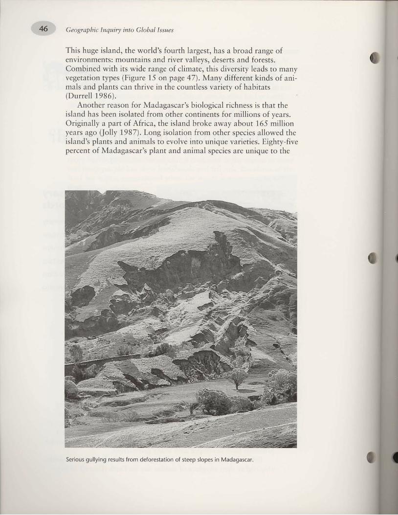
' & Geographic Inqwiry into Global Issues
This huge island, the world's fourth largest, has a broad range ofenvironments: mountains and river valleys, deserts and forests.Combined with its wide range of climate, this diversity leads to manyvegetation types (Figure 15 on page 47). Many different kinds of ani-mals and plants can thrive in the countless variety of habitats(Durrel l 1986\.
Another reason for Madagascar's biological richness is that theisland has been isolated from other continents for millions of years.Originally a part of Africa, the island broke away about 165 millionyears ago (Jolly 1987). Long isolation from other species allowed theisland's plants and animals to evolve into unique varieties. Eighty-fivepercent of Madagascar's plant and animal species are unique to the
Serious gullying results from deforestation of steep slopes in Madagascar.

'Oget 11a.rrnq) srnruel tuer8 yo sonods II pue
'sasrouol luer? o,ru 'sprlg ssalrq8l; tuer8 Jo spul>l aarql :saldruuxeeuos 'roDeru ter{l roJ 'as1e e;eqrvrdue uror; Jo-eJrryV pu€lur€tu
uo asoqt ruo{ tuoretyrp dlleror ore^r sleruluv '(686I relmog) puelsr
'066 [
'uollrpa qlSL'sol]V pPo/\A slapooD :Dlnos
pue 'uorlelrdrrard'sed{t uorlele6an
lenuue'deu ;er;a.r :rerse6epe61g1 e,rn6;1
'cul'ecluuet!E elpedolc^cul O
soqcu! og reno f[seqcur08-og ffiseqcu;99-97 wseqcursy-s7 N.Nlseqcur g7-g; l-l
tseJoluler ueel6rene,teelpeorq ;ecrdo.4
lserol snonplcoppue pue;sserb 11e1
lsoJoj uroql puepuelpoom uodo fuq
nWE
ggslenoqy ffi0901ot009 ffi0090looe w00eol 09t [-N,:.rji l
osl ol o [__l
lo^ol eos o^oqe srolol l
u)00t 00e 002 00t 0lllrl
T------- ---------------t
!u 00t 002 001 0
UVSSVCVCVIN
uo I lnllo J lplu awuolt nul
Geographic Inquiry into Global Issues
Unfortunatelg many of these species no longer exist. Madagascaris a " legacy of misuse" (Jol ly 1987, page 165). Madagascar *a, f irstsettled by humans only about 1,500 years ago. At that time, most ofthe island was covered in forest. But now more than 80 percent ofthe forest is gone and nearly all of the unusual species are extinct.The environmental crisis on Madagascar is summarized in this quote:
Most of the center of Madagascar is barren, with the remain-ing forests distr ibuted in a patchy, broken ring around the coastalregions. Some 150,000 hectares of forest are cleared every year ina relentless pattern of shift ing cult ivation and uncontrol led burn-ing and grazing, causing massive soil erosion and al l i ts concomi-tant problems. Of the 10 mi l l ion people l iv ing on Madagascar , g .5mil l ion of them directly depend on agriculture, and the popula-tion is growing at a rate of over 3 percent a year. . . . At this rate,al l the available forest wil l be gone within the l i fet ime of a chi ld atschool today. Unless alternatives are found, Madagascar wil l loseall i ts forests, and, when these are gone, alternatives wii l have tobe found anyway (Durrel l 1986, page 1 1 1).
I

'Jersebepel ur uorle^rllnr 6urgrqs lo sllnsau6urzr1r1n ]o epour punos{lgerluassa up sr ue}s{seql ]eql. selpfrpul qllqM'srea{
000'Z }seel }p Jo}uorlp^r]lnf 6urryrqs parnl-Pel seq Brsv lseeqlnos'a;duexa Jol 'slsaro]
Jo uorleururr;a u.ra1-6uo;ur pallnser {;;eraua6 1ouseq uorlenr]lnr 6urryrqs'uaaq seq ]l qbnoqlpeardsaprTil'plroM aqljo sr.uals{s ;ern1;nruberoleuu aql ]o auo [st]uorle^rlln) 6ulUqS
euelqord e auro)eq uolle^llln) 6u;ry;qs seq ̂qM
apa8ueqo uortenlrs oqlseq dq16'pedorrsap uooq e^eq slsaroJ s(PuEIsI aqt to luoorad 08 re^o
'0S6I oJurs 'Je.l,a.lloH 'salJnluoJ JoJ elltlnPord ueeg seq .rurse8eP€ntrur Sunure; trrc1'ftg6l IIre^o)I pue rarles) Sunurey Jo poqlotu
luarf,up uE sI tI 'a,nrlln.ltsap dlletueruuoJlluo tuaas deur slql ellqlN's.read yo porrad e rolo aceld so>let uoltelor
do.rr rauueu slqt u1 'ssaeo.rd aql leeda.r Pu€ puEI Jo eere Joqloueot uo ololu sreureJ arll 'eterednca;
IIos eqt tel PUE JIestI qsllqelsa-er uorlete8e,t eqr tel or sroyd eqr uopueqe uorll sraruJud 'eletulll
lo.ta pue TuJEAA e ur sread ,/!\eJ e 1sn[ ut ueddeq u€J LIsIt{.lt 'slualrlnu;o
paraldep soruoreq IIos oqr lltun pasn sI puel 0rll 'PUEI slql uo Palsa^-rer1 pue (popuet 'petueld uorll ore sdo.r3 'ourll
Jo por.lad Jalrg E roJdluo rnq (qse eqt dg pagotrua soluof,oq IIos or{J 'PUEI oqr srealf, I{rlti^a
'err; uo tos sr tI 'urng ot qSnoue d.rp sr uollele8an oql uoql1 'EarE
ue ur uoltelaSorr pue seeJl eqt IIE ul\\oP 8utilno seAIoAuI t1 'suotSer
lerrdo;l ur dlaprrvr posn sI Suru.re; Jo Poqrou sIqI 'uolle^Illnl
Surr;rqs Jo r.uroJ e sI qrlq^\ 'Krwt 11et PuEIsI el{t Jo aldoad aql }eq^\
sr slsoJoJ rerse8epey,g eqt uI aseorf,oP aqr roJ asner uleru aql'punoJ sr lsoJotuler lertdort oqt oJotl,/v\-;ecse8epeyg Jo ePIs uralseo
oqt uo aa.r1 eldoad s(puelsl aqr Jo tsotu osnsf,aq oreAOS aJolu ePELUsr ruolqo.rd eql'ft66l nearng eJuoraJeg uortelndo4) s.rea.'t 77noqedluo ur alqnop IIr./\\ uoIIIIu ZI lo uortelndod tuarrnr aqr reqr sueeru
srql :eed rad tuec.red t rolo le Sur,lorS sl recseSepury Jo uortelndodaq1 '8urzer8
lcotsarrl puu arntlnct.r8e .roy aceds aprrr.ord ol PoloruoreJE slssroJ aJolu 'oslv 'slseroJ aql uloJJ Poo,Aalon} roJ Pueulop
raq8rq sr ererll'sesearlut uorlelndod sV'(986I 11ar:rnq) snulluoruorrnrtsop Jo sater luese.rd Jf
'rso1 dlarelduoo eg ill^a rerseSepellg
to stsaroJ osrollp aqt 'uarplrqr s,.(epot Jo rLurlaIII aqr uIqlIlN
ffi uoxinllodlptuawuo.ttnug
iuoltD^nlm 6u1ry1qs s! lPq,l^

t6.,,,' Geographic Inquiry into Global Issues
forest environments within tradit ional patterns. Farmers would fol-
l owa |oca | | ym ig ra to r ywayo f l i f eby . . . f e l | i ngandbu rn ingapatch of foiest, iaising crops for two or three years until the soil
iost i ts fert i l i ty or unii l weeds encroached, then moving on to
repeat the process in another patch of_forest, eventually returning
to the original location. This fsystem] al lowed the cult ivator to
make susti inable use of the forest environment. As long as there
were only a few cult ivators per square ki lometer, general ly f ive or
less (depending on local circumstances), and provided_ the patch
of farmed forelt land could be left fal low for at least 10 years in
o rde r t o renew i t se l f , t hesys temworked " "Now 'howeve r ' i nmany areas, the numbers of shift ing cult ivators have increased to
a point where there are often three or more t imes as many people
per square kilometer as formerly, with the result that they have
less space for local migration. The upshot is that they [al low] local
ecosysrems insufficieni time to recover. Soils then rapidly become
exhausted, and especial ly in wetter areas, weeds encroach. After
as few as two cycles, the cult ivator is obliged to abandon the area
a l t oge the r , andmoveon tos ta r t a f r esh inanewpa tcho f_p r ima ryforest, hence progressively disrupting undisturbed ftropicalforestsl (Myers 1980, pages 23-24)'
In Madagascar, as in many other parts of the world where shift-
ing cultivatiJn occurs, the people wh-o are engaged in.this method of
ngiicrrltrrr. are subsistence farmers. This means that their crops sup-
piy food or products only for small groups of people' perhaps .for a
?amily. Ho#euer, since 1950 the popu_lation of the island has dou-
bled. This increase in population has led to some drastic changes in
the farming cycle. In ihe past a piece of land was cleared and replant-
ed about .i.ry 15 years. -But
because there are now more people who
need to grow food'from the same land, the cycle has been shortened
to three years (I(nox 1989). Shorter cycles of shifting cultivation do
not permit enough forest regrowth to resto.re the soil's fertility. This
means that the flrm prod,t.iiuity must decline (National Research
Council 1'982).Another consideration related to a rapidly growing population rs
where the people live. Shifting cultivation for_merly did not cause a
perman.nt'clearing of land. ihe lattd would be cleared, farmed', and
abandoned-alloviing the forest to regrow. But as the population
grows rapidlr land used for crops may afte.tward become a town or
6e developed for another use, instead of being allowed to return to
forest. If iorests are not allowed to regro% new forest areas must be
cleared to provide land for farming. In this way the traditional rota-
tion of shifling cultivation is broken, and increasing amoultt o1_
forested landJare removed for farming (Salter and I(ovacik 1989).
o
I

ul pelladLUol aq uoslad {ue ;1eqs lou ' '[tn[ puelD e ]o]ueullf rput lo luaulluasatd e uo ssalun 'aLUu) snoLuelul aslMJaqlo
Jo '1e1rder e ro] raMsue o] plaq oq lleqs uoslad oN n' ' ' palelol^ eq ]ou lleqs
'saJnzlas
pup seqfleas elqpuoseeJun ]sute6p 'slraga pue 'sladed 'sasnoq
)suosrad raq] ut ernres aq ol a;doad aq] ]o 1q61t aq1 '11'sarupnau6 lo ssalPel
e JoJ ]ueuluJa1oD aq] uolllled o1 pue 'a;quuasse o1 {lqea:ead
aldoad aql ]o 1q6u aq1 lo lssald eq] Jo lo'qraads.]o tuopeaJi
aq1 6urbpirqe ro lloateq] aslfJaxo aerl aq1 6urlrqrqold lo 'uot6t1a't
,o ]uaLuqsrlqplsa ue 6urlladsal Mel ou aleuJ lleqs ssar6uoS 'l
(101 u! pelllrer)slq6lU lo lllg 'S'n aqf ulorl sldre)xl
O
uorln ; lod r{.repu noqsu er1
lueLuuoJlAua
ualsr{sora
spro|l^{resso;5
'sJelsPslp IBlueuruoJIAuaaJnlnJ tuonord
ol JOpJO ul 'luotuuo.lr,tuo
eql ol stq8lr saelue.renB
leql luoulelBls e 0]BeJ3 o
11rrvr nod 'uossal slql uI
e^!po[qo
0
i sralsBsrP l€lueuruorr^ueoJnlnJ lua^erd a,,lr, u€c A\oH
u o rynllo d lP 1u a wu o,tt t'tug

-. ..,1. :. :..'.. . :... .if.'$:i:: Geograpbic lnquiry into Global Issues
any criminal case to be a witness against himself, nor be deprivedof life, liberty, or property, without due process of law. . . .
lX. The enumeration in this Constitut ion of certain r ights shallnot be construed to deny or disparage others retained by thepeople.
Should there be an EnvironmentalBill of Rights?
A scientist from Moscow State University Ruben A.Mnatsakanyan, has suggested that the international problems ofenvironmental pollution cannot be ignored. He argues that there is aneed for international law to prevent transboundary pollution. Hebelieves that decisions made by individual countries that aff.ect othercountries' environmental well-being should only be made accordingto established criteria. Such criteria would establish a global basis forfuture interaction between humans and the environment.
To achieve this, Dr. Mnatsakanyan has proposed that a Bill ofRights be drafted for the environment. He suggests that it be mod-eled after the U.S. Bill of Rights, which guarantees the rights of indi-vidual people in the United States. His point is that all of Earth'sindividual ecosystems need similar protection (Richman 1,990).
. How would you write an Environmental Bill of Rights to guar-antee the protection of Earth's environment?
o What principles would be important to ensure that environ-mental pollution does not continue?
. How are the rights of U.S. citizens protected and enforced?How could the environment's rights be enforced?

'urspq ObeuIErP
ro UISEq E sP ol Parrelar oslv'r31E1t\
]o dpoq rPInJIlJed e ol ]JounJ salnqlJl-uor leqt earv PUel eql ilV paqsrerelXt
'euo IEuoISsJ
.ro (lecrsdqd'1ecu[od E sE qf,ns 'pul>l
,(ur;o drepunoq E sessoJf, l€ql uounl-1od;o u.ro1 duy uorlnlod ,fuepunoqsuerl
'd1nue; roll ro slq PUE role^IllnJ
eqr PaeJ or PooJ q8noua dluo seonP-o.rd reqr uoup^ll[n3 Sunurel aJuelslsqns
'sle^ol JaIEA SurPaoa.r Iq
pasnef, tra1r,,r,r11es Jo ̂Poq E JBau PUEI
-PBq llBS € rot Pro,4A ueISSnu v {€qruolos
'['nat Pe11ec
sr uals.,(s slql (JE3s€8EPEtr tr uI 'uol]?l\
-rllno ol .tot.ld peurng Jo lnf, sI JeAof,
1ue1d eqr ,,(11ensn 'srelooer rold rslt;eqr e[Iq.,tA PuEI Jo rold leqroue ale,r
-nlnJ ot UIqs sJeruJEJ 'ute8e pelu.ttl-1nc Sureq aJoJOq dlrlrr.la; JIeI{I JeAof,oJ
ueo deql tegl os eurll E rot PauoPuBqEueql pue slea.t arrtssarf,ns IEJoAes Jot
pete^Itpl ere Puel 1o srold qllq,Aa uI
Sulru.re; Jo Poqlour V uon€alllnr Euupq5
'JalElv\
uorle8trrt;o sarltluenb e8rel 1o uoller-odB,ta erp JJUE 'stueld ol f,IXol s[J^al
ol seullleuros 'llos aql uI elelnuncJe
srles I{lIq,4^ Lq ssoro.rd aql uoIlEzIulIES
'lutod e8eluel luBlsIP P luoJJ
queg lnoge uolletuJotul Surraqtu8
to! Jzpvr pue 'sa8eurt olqleles ',{qder
-Sotogd lerrev lo osn eqJ tursues alotuel{
'uot8a.r eql ePlslno sueof,o Jo SJaAIJ
lJqto ot 3ur.lno1; uPql laqrer uor8a't
E ulqll.^a suISEq Jo so>lel olul .&\olJ
sJeArJ qf,Il{.,tl ur rualsds y a8uulerp JoIJeluI
'uotleroder\a pue uorlelrdrce-rd
sE qf,ns'qtreg uo sasserold polPleJ-rolB,4 pup rel€./!\ o1 sJeJau pcrEolorpz(11
'sa;ce ILV'Z slenba erelf,sq 1 !uals.{s
f,rJlaul oql uI Puul Jo aJnsEalu v aJEFeH
'.raleA yo snydrns E sI erol{l
eJOqIA sulelunoul luef,elPe luo{ Jale^'
slr sta8 lnq olelulll drP 1o uolSar
E ssorJ€ s.4 olJ lEI{l urEaJ}s v JaAIJ f,IloxE
-eco1 lerrsdqd pue'aleutlc'sleurtuepue srueld teqlo Surpnllut 'leurrue ro
rueld e yo s8urpunouns eqJ luetuuoJllug
'luouruoJIAue 1eors.{qd .rreql
Jo stuoruele 8ur.l,r1uou aql PUE slusl-ue8.ro 8ur.tq eqr uael$a9 suollseJalul
aqt qll.la .reqleSot 'srustue8lo 8urlt1 ;osdno.r8 SuotuB suollf,Eralul aq1 uals,{solg
'slseJot Jo IE^ouaJ aql sE rltns
uorlf,P ueunq Lq ro ta8ueqs oleur-rp peuosros dq 'elduexe .ro; tsecr;
-Jns pupl PuE IIos 1o Sutdrq uoIlEJf,ISaC
'JJo IIE' ot se^Pal eql esnef, or stueld
uo polsnp ro pefe.rds lerltuogs V lusIIoJaC
'lelol PUE IPuoIlEu qrog 'solpoq
tuoJeJllp dueru ,tq aPEIu oJe saceld
rol suoISIJeP Pue serotlod eJeq,^a'luetuula.to8
PezIIEJluolaP e>llpn'.(poq euo dq PItq sr,(llunoc aql
ur eoeld d.re,ra Surloe;Je suolslloP PUBsarctlod 8ut>1eru ;o1 ra.Lrod eql I{JIt1.^a
ur ruats.{s lerrlqod V luoruuJe^oE prlua3
'luese.rd satcads
oJolu aJE eJar{} IEI{I sueeul dlts.re,L-rporq raq8rll 'eere uE uI PunoJ sIEIU
-rur pue srueld;o dlat'rel eql Surureu'dtrsre.l,rp
lecrSolorg Jo' lJotls,blsrallporg
u o qnlp d 10 lua wu o.t't ltug
/LIBSSOT( l.\--'

' 9 LII-\ LII tlvT' nuaDs'uolun lal^os
aql ur rals€srp tueure8eueur rele.^A E :€aS IerV aql Jo uoIlBtr3ISeC '886I 'd$qa 'tI{clIN
'sJlurouoJfl lernllncrr8y 1o ]u:rutrtdeq
.SeIPn]S leluellIuoJl^ug Jo uoISIArq .eruro;r1e3
1o dlrsra.l.run :V] .sr.teq
'a4pj ouow Jo sat,tnosay nil1i7'q'4 Jo uorrunlang )twouo)E uV 'L86I'g uqof'srurool
.EJIUUE]IJfl
erpeedolrdcug :o8errq3 '05b9 'oI\ aBa>pa4 :t2tsv p'\ua) Pxnos 'IL6I'ueqog 'p1o'r8e1
' ll tZ6 6l;a gruarda5' Kv p o 1 uono p do'1' uelsDleqzn' 7 6 6I' qtaqeztlg'aa1
'uoleg puu u.{11y :uolsofl 'uoIlIPe Puolas 'am1uy1 Jo uats["5 aqi wqll6
Eurnt, :nuaes lotuaLuuo.ttaug '6861'3 iareEreytg 'pue1'{g Pu€ "[ solreq) 'egaqcdny
'6t-9€ '6-t :( I )f f,Xuacquo.Lrrtyg'euoztuauluorllua IBfIIIJT E :uISEq €eS IEIV aql 'I66I 'W 'A '^o{EAIloX
.Vg-gL:(g)y1'a,t,ta6 'PuEISI uE uolleu oN '686I '1 laru8rulAl 'xou;1
.tgl-gtItft)lLI'crqda&oaSPuotlt2N'uedeplro'ra'e:rerse8epeW'LB6I'uosqy"{1o[
'd11e51c14 pueg :o8ecrq3'(uorrrpe ql8 I ) 066 I'so1ty p1'to1y' s'apoo!)
.t.6-99 :(7)1 'sattrlouottrpN xatltos ]o pu'tno[ 'e1sy.
IErluoJ ur uoltor;o scrrrlod rqi'"-r"#,u pu' uorl'Zrle>lr,tr\J 'g661 'f'rcEer''uosualg
'67-17
:g661aun[1,te1'LPIP;a pl'toy 'uolull ]aI^oS orll ;o Sutuea;8 oql '686I '4 'fuepg 'qruarg
'€l€-167 tLV
'uonon.Lasuo2pc8olotg'rerse8epeytruJerllJouuI.EuErE>luvlBa^rasaJlse
-roy ,r,o'p,rrp 1rr,#r', " roj rlJroaord lueu-ragBusru PuE da,rrn5 '686T'le le "A
'S 'rol^{od
'ZZtG)S€ 's^\eu poo8 sI rIE pEfl '€66I'Wau'tuotmuq
.€6-t.L:ft)Uf 'trqda&oag louoxizl{ '8ur'{p sarl EOS lel^os E :lErV aql '066I 'tuEIIIIrf,t 'SIIIA
'o) arl]larEs uollB^rosqo rllreg-:q1U'urequel'El€p JauuErS
le.rrcad5rrlnyq t"rp,r"1"*o'j'qaetaoloq d'/86L 7ur'rQg 'IISS 4aqzn
'aa5 laty
'oJ elII]arES uollB^resqo
r1tr€fl :CW'ruequel'El€P reuuef,5 lerroad5rtln1N lESPueT uo;r; qderSoroq4
'y157 sur.td'5'UiS 4u-qzn'oas PlV '1161 'f,ueduro3 ellllares uolle^rasqo qu€A
'cu1 'dueduo3 Pue '{ePalqnoq
:151 ,.{rr3 uapreC .uorXzv ut uotlon,esuoS Jo srlly uV :4,tV aql Jo aWlg'986I'aa1'11arrnq
'LZ-02 tl66l
dren.rqegTd.re nuef'qcw1X1 pUoA ' ' ' Suro8 '8uto8 :EaS IErV aql'T66t'l{ ralse'I 'u'^aor[I
'oorualrJ :Vl 'slllH uoISSIW 'tlctto'tiQy lotwln)
pur pttsfiqd y :Kqdo&oa7 pl.top 'egef 'liauref 'uosuezlr5 pue ''9 PrEII]IU
'urqaog
'duedruo3 Surqsrlgn4 IIITTaIN :1-19'snqrunloJ'sa:oq
puo saldoa4:[,qda&oag pltoa.6g61:4'rprurg,surlunll pue '':) Pps(I'Suorlstury
uo \nllo d ID lu a Muo.rt /|ug
secueJaJeH
Britannica Global Geography System
A Note on Assessment
Enclosed is an achievement exam for one module of the Britannica Global GeographySystem (BGGS). It is one of the many tools for you to use in assessing your students'work on Geographic Inquiry into Global Issues (GIGD. The multimedia, inquiry approachof BGGS lends itself to a variety of evaluation options.
This achievement exam includes objective matching, multiple choice, and true-falsequestions, as well as more subjective data analysis and short-answer questions. Testsemphasize four major areas of student comprehension of the GIGI material. First, studentsmust be able to recognize and define important glossary terms. Second, they mustdemonstrate a grasp of the principal geographic concepts introduced in the study of eachglobal issue. Third, they must manipulate examples of data they used in the module toprove their facility with geographic skills. Finally, students are challenged to think criticallyabout analyzing issues and data. Keys provide objective answers and guidelines forevaluating students' written responses.
With the inquiry-based program of GIGI, various techniques of assessment can contributeto your overall program of evaluation. Questions posed in the module are often intended tostimulate open-ended inquiry, speculation, and discussion. As a comprehensive exercise,assign a longer essay, giving your students an opportunity to summarize theirunderstanding of the issues. Essays can be based on each module's leading question (thetitle of the Student DataBook Overview), which incorporates the geographic themeexplored in the module. Have students defend a position, citing data supplied in either themodule or in their independent inquiries.
The BGGS package has many resources for assessment. See the Assessing Learningsection of the Memo to the Teacher section of the Teacher's Guide for suggestions. Moreideas for assessment are provided in the For Further Inquiry sections of many lessons andin the Extension Activities and Resources section at the end of each Teacher's Guide.
Consider having students maintain a Module Portfolio or Student Journal throughout thecourse of their inquiry. A portfolio can include students' definitions of glossary terms,answers to questions, completed activity sheets, and their individual or groupinvestigations. Students may also create and present their own inquiry lessons using theBGGS videodiscs and CD-ROM. They can gather information and design a visual displayabout countries and world issues using GeopediarM.
The possibilities for assessment are limitless. Blend strategies to see if your students haveattained the three main goals of BGGS and GIGI-to promote (1) responsible citizenship;(2) geographic knowledge, skills, and perspectives; and (3) critical and reflectivethinkins.
The GIGI Staff
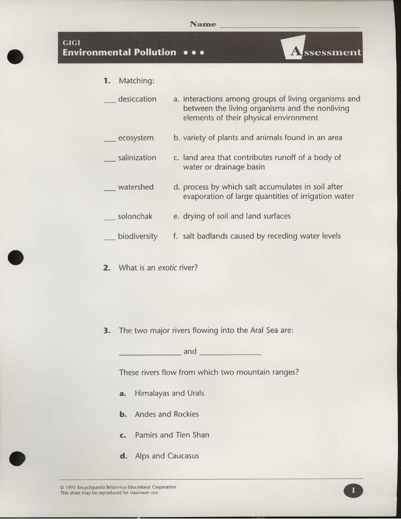
Narne
1. Matching:
_ desiccation
_ ecosystem
_ salinization
_ watershed d.
solonchak e.
a . interactions among groups of l iving organisms andbetween the l iving organisms and the nonlivingelements of their physical environment
variety of plants and animals found in an area
land area that contributes runoff of a body ofwater or drainage basin
process by which salt accumulates in soil afterevaporation of large quantit ies of irrigation water
drying of soil and land surfaces
b.
c.
_ biodiversity f. salt badlands caused by receding water levels
2. What is an exotic river?
3. The two major rivers flowing into the Aral Sea are:
and
These rivers flow from which two mountain ranges?
Himalayas and Urals
Andes and Rockies
Pamirs and Tien Shan
Alps and Caucasus
a.
b.
C.
d.
@ 1 995 Encyclopadia Britannica Educational CorporationThis sheet may be reproduced for classroom use.
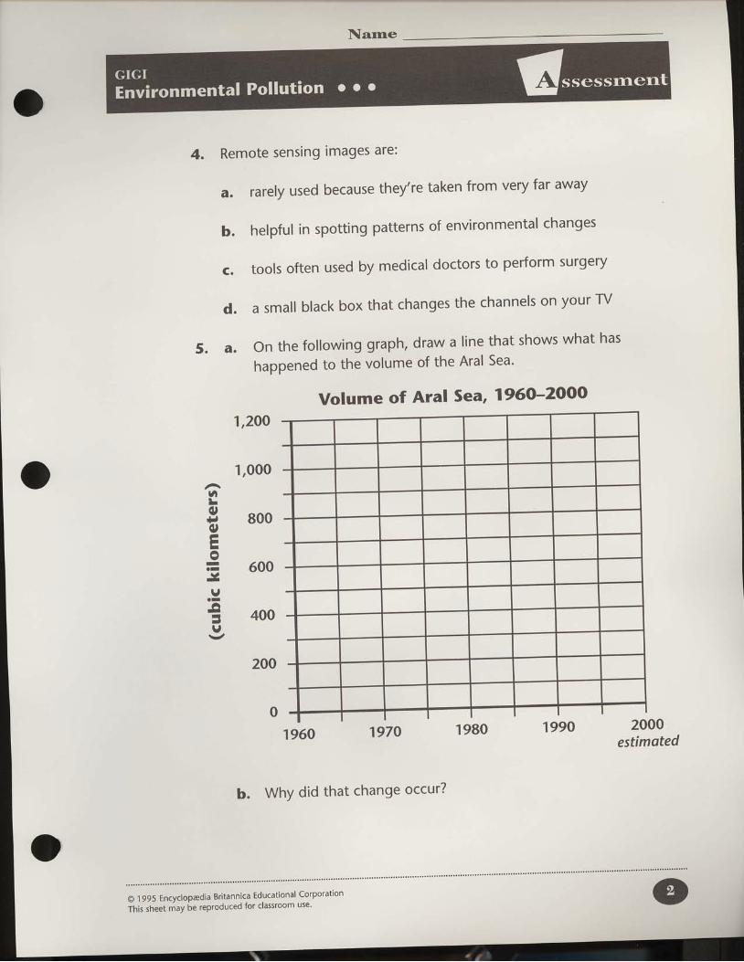
Narne
4. Remote sensing images are:
5. a.
rarely used because they're taken from very far away
helpful in spotting patterns of environmental changes
tools often used by medical doctors to perform surgery
a small black box that changes the channels on your TV
On the following graph, draw a l ine that shows what has
happened to the volume of the Aral Sea'
a.
b.
C .
d.
6L
r; 800e)tr-o= 600\,-
.9;l
E 4oov
'l,2oo
1,000
200
Volume of Aral Sea, 1960-2000
0'1960 1970 1980 1990
b. WhY did that change occur?
2000estimoted
O 1995 Encyclopadia Britannica Educational Corporation
This sheet may be reproduced for classroom use' o
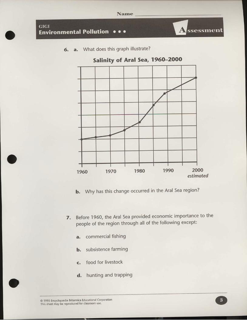
Narne
6. a. What does this graph il lustrate?
1960 1970 1980
b. Why has this change occurred in
'1990 2000estimqted
the Aral Sea region?
Salinity of Aral Sea, 1960-2000
7. Before 1960, the Aral Sea Providedpeople of the region through all of
a. commercial f ishing
b. subsistence farming
c. food for livestock
d. hunting and traPPing
economic imPortance to the
the following excePt:
/
/
(
/
@ 1995 Encyclopadia Britannica Educational Corporation
This sheet may be reproduced for classroom use'

Narne
8. When irrigation was introduced in Central Asia, which physical
change occurred to the environment?
a. The quality of well-water improved'
b. Dust storms became less frequent'
c. The habitats in the river deltas improved'
d. seasonal differences in temperature became more intense.
g. Currently, the rate of evaporation is
flowing into the Aral Sea?
a. greater than
b. less than
c. equal to
the amount of water
1O. True or false?
a. Transboundary pollution can effect people hundreds of miles
away from the original source'
The Soviet government did not predict the environmental
problems that the Aral Sea Project would create'
subsistence farming is a method of farming used to grow crops
for export.
Madagascar once had a very high biodiversity because it has a
wide range of climate and environments'
b.
d .
O 1 995 Encyclopadia Britannica Educational Corporation
This sheet may be reproduced for classroom use'

Narne
11. Both the Mono Lake and Aral Sea regions share a common type ofwatershed system that collects water but does not release it exceptthrough evaporation. This type of system is a/an:
12. Commercial f ishing was hal ted in the Aral Sea region in 1980because:
a. All the people started farming.
b. There wasn't a market for f ish.
c. The fish were contaminated by water pollution.
d. People in the region didn't eat f ish.
13. a. List three ecological effects caused by the shrinking of theAral Sea.
b. Explain how the each of these affects both the human andphysical environment of the Aral Sea region.
O 1995 Encyclopadia Britannica Educational CorporationThis sheet may be reproduced for classroom use.

Narne
14. what group from the Aral Sea region is MosT at risk of health
problems because of the pollution? Explain'
15. Human health problems have increased significantly since the Aral
Sea Project began. WhY?
16. Describe two ways in which the Aral Sea crisis can be solved' what
are the advantages and disadvantages in each of the two plans
discussed?
@ 1995 Encyclopaedia Britannica Educational Corporation
This sheet may be reproduced for classroom use'

Narne
17. Below are six steps of a 1S-year cycle of shift ing cultivation. Arrangethe steps in the proper sequence, showing the order in which theytake place.
Land left fallow for 15 years.
After two or three years, soil loses fertility.
Vegetation regrows in 15 years.
The crop is harvested.
Field is abandoned.
The crop is planted.
1 ._ 2 ._ 3 ._ 4 ._ 5 ._ 6 ._
18. Since "1950, over 80o/o of Madagascar's forests have been destroyed.All of the following are reasons for this destruction except:
a. The increase in population caused shorter cycles of shift ingcultivation.
b. Uncontrolled burning and grazing of the land caused massivesoil erosion.
c. Because of population increases, more towns were built wherethe land used to be abandoned for restoration.
d. People cut down the trees to sell t imber to other countries.
a.
b.
C .
d.
e.
f.
@ 1995 Encyclopadia Britannica Educational CorporationThis sheet may be reproduced for classroom use.
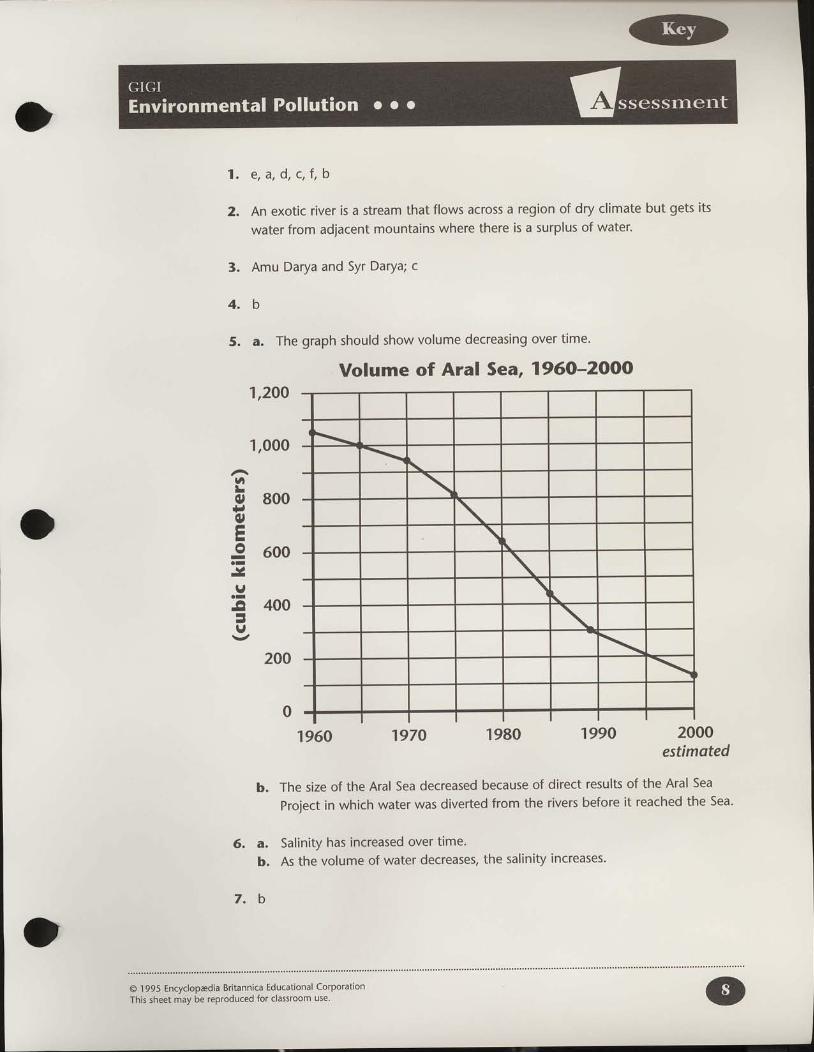
1 .
2.
3.
e , a , d , c , f , b
An exotic river is a stream that flows across a region of dry climate but gets its
water from adjacent mountains where there is a surplus of water.
Amu Darya and Syr Darya; c
4 . b
5. a. The graph should show volume decreasing over time.
Volume of Aral Sea, 1960-2000'l,2OO
1,000
Ui
s 800Iotr-I 600o-\,-I
. I
lt 400I-r,
200
0'|960 "t970 1980 "t990 2000
estimoted
b. The size of the Aral Sea decreased because of direct results of the Aral Sea
project in which water was diverted from the rivers before it reached the Sea.
6. a. Salinity has increased over time'
b. As the volume of water decreases, the salinity increases'
7 . b
\
\
\\
\
\\
\
@ 1 995 Encyclopaedia Britannica Educational CorporationThis sheet may be reproduced for classroom use'
14. Infants and children
I
9 , a
lO. a. Trueb. Truec. Falsed. True
11. Inter ior drainage
72. c
13. a. Ecological effects described include:salt-dust storms degraded water qualityhabitat destruction soil salinizationclimate changes
b. Salt-dust storms cause health problemsboth in the Aral Sea region and throughtransboundary pollution as wind carriesthe salt-dust in the air and gets intopeople,s lungs, covers crops, and endsup back in water.
Water is contaminated by chemical fer_tilizers getting into the groundwater,well-water, and eventually back into theSea.
Declining water levels and deterioratingwater quality affected the food supply forlivestock, spawning grounds forcommercial fish, and opportunities forhunting and trapping. lt also eliminatedseveral species and endangered others.
Soil salinization is soil that iscontaminated by salt, severely reducingthe nutrients available to plants.
Water stores hea! so as the Sea wasshrinking, its influence on the region,sclimate was reduced.
15. Air polluted by salf chemical fertil izers, andpesticides has led to respiratory illnesses.Well-water and river water used for drinkinghas been contaminated by agriculturalchemicals leading to intestinal diseases andincreasing cancer rates.
16. Plan 1. Diverting water from Siberia toCentral Asia.
Disadvantage _ too costly, might notultimately solve the problem and mightcreate problems in Siberian rivers.
Plan 2. Managing water use within CentralAsia.
Advantages _ people,s health wouldimprove; social tensions would bereduced.
l7. f , d, b, e, a, c
r8 . d
)
@ 1995 Encyclopadia Britannicrhis sheet may be reproduc*,:.':;:l,.t:'#'
torPoration