Myanmar: Environmental & Social Impact Study ... - Shell Global
522
The world’s leading sustainability consultancy Myanmar: Environmental & Social Impact Study for Offshore Bay of Bengal Block A-4 Initial Environmental Examination Report 25 November 2015 Environmental Resources Management www.erm.com
-
Upload
khangminh22 -
Category
Documents
-
view
1 -
download
0
Transcript of Myanmar: Environmental & Social Impact Study ... - Shell Global

The world’s leading sustainability consultancy
Myanmar: Environmental & Social Impact Study for Offshore Bay of Bengal Block A-4
Initial Environmental Examination Report
25 November 2015
Environmental Resources Management
www.erm.com
Myanmar: Environmental & Social Impact Study for Offshore Bay of Bengal Block A-4
Initial Environmental Examination Report Document Code: 0274927_IEE Report_Block A4_cover.docx
Environmental Resources Management ERM-Hong Kong, Limited 16/F, Berkshire House 25 Westlands Road Quarry Bay Hong Kong Telephone: (852) 2271 3000 Facsimile: (852) 2723 5660 http://www.erm.com
Client: BG Exploration & Production Myanmar Pte Ltd
Project No: 0274927
Summary: Date: 25. Nov. 2015
This document presents the Initial Environmental Examination Report as required under the study Myanmar: Environmental & Social Impact Study for Offshore Bay of Bengal Block A-4 (Tender Ref 118899TND).
Approved by: Craig A Reid Partner
2 FINAL for MOGE Var BS CAR 20/11/15
1 Revised Final for MOGE Var BS CAR 14/10/15
0 Final Draft for MOGE Var JNG CAR 17/07/15
Revision Description By Checked Approved Date
Distribution
Internal
Public
Confidential

ENVIRONMENTAL RESOURCES MANAGEMENT BG GROUP 0274927_IEE_BG_A4_FINAL_COMPLETE_EN.DOCX NOVEMBER 2015
CONTENTS
1 EXECUTIVE SUMMARY 1-1
1.1 THE PURPOSE AND EXTENT OF THE IEE REPORT 1-1 1.2 SUMMARY OF THE ACTIVITIES UNDERTAKEN DURING THE IEE STUDY 1-2 1.3 PROJECT ALTERNATIVES AND SELECTED ALTERNATIVE 1-2 1.4 DESCRIPTION OF THE ENVIRONMENT TO BE AFFECTED BY THE PROJECT 1-5 1.4.1 Physical Environment 1-5 1.4.2 Biological Environment 1-6 1.4.3 Social Environment 1-7 1.5 SIGNIFICANT ENVIRONMENTAL IMPACTS 1-9 1.5.1 Impact Assessment Methodology 1-9 1.5.2 Cumulative Impacts 1-11 1.6 THE PUBLIC CONSULTATION AND PARTICIPATION PROCESS UNDERTAKEN 1-12 1.7 SUMMARY OF THE ESMP 1-14 1.8 CONCLUSIONS AND RECOMMENDATIONS OF THE IEE REPORT 1-14 1.8.1 Recommendations for Future Activities 1-14 1.8.2 Conclusions of IEE Report 1-15
2 INTRODUCTION 2-1
2.1 PROJECT OVERVIEW 2-1 2.2 PROJECT PROPONENT 2-1 2.3 ENVIRONMENTAL AND SOCIAL EXPERTS 2-2 2.4 THIS INITIAL ENVIRONMENTAL EVALUATION (IEE) 2-2 2.5 IEE OBJECTIVES 2-3 2.6 STUDY LIMITATIONS 2-3 2.7 REPORT STRUCTURE 2-4
3 POLICY, LEGAL AND INSTITUTIONAL FRAMEWORK 3-1
3.1 CORPORATE ENVIRONMENTAL POLICY OF THE PROJECT PROPONENT 3-1 3.2 POLICY AND LEGAL FRAMEWORK 3-1 3.2.1 Draft EIA Legislation in Myanmar 3-1 3.2.2 Relevant Legislation in Myanmar 3-3 3.2.3 International Conventions 3-6 3.2.4 International Standards and Guidelines 3-3 3.3 INSTITUTIONAL FRAMEWORK OF THE PROJECT PROPONENT AND MYANMAR
GOVERNMENT 3-4 3.3.1 Administrative Structure of Myanmar 3-4 3.3.2 PSC Requirements 3-6 3.4 ENVIRONMENTAL AND/OR HEALTH STANDARDS RELATED TO THE PROJECT E.G.
INTERNATIONAL AND/OR DOMESTIC STANDARDS 3-7
4 PROJECT DESCRIPTION AND ALTERNATIVES 4-1
4.1 PROJECT BACKGROUND AND OBJECTIVES 4-1 4.2 PROJECT LOCATION 4-1 4.3 ALTERATIVE SELECTION AND COMPARISON 4-2 4.4 DESCRIPTION OF SELECTED ALTERNATIVE 4-3 4.4.1 Exploration Programme Duration 4-3 4.4.2 Seismic Survey (2D and 3D) Operations 4-3
ENVIRONMENTAL RESOURCES MANAGEMENT BG GROUP 0274927_IEE_BG_A4_FINAL_COMPLETE_EN.DOCX NOVEMBER 2015
4.4.3 Gravity and Magnetic Survey 4-6 4.4.4 Seabed Sampling Survey 4-6 4.4.5 Materials, Supplies, Labour & Logistics 4-7 4.4.6 Emissions, Discharges & Wastes 4-7
5 BASELINE CONDITIONS 5-1
5.1 SETTING THE STUDY LIMITS 5-1 5.2 METHODOLOGY FOR DATA COLLECTION AND ANALYSIS 5-1 5.3 PHYSICAL COMPONENTS 5-1 5.3.1 Climate and Meteorology 5-2 5.3.2 Storms and Cyclones 5-2 5.3.3 Currents and Tides 5-2 5.3.4 Water Quality 5-3 5.3.5 Seabed Bathymetry 5-3 5.3.6 Coastal Geomorphology 5-3 5.3.7 Seabed Composition 5-3 5.4 BIOLOGICAL COMPONENTS 5-4 5.4.1 General 5-6 5.4.2 Coral Habitats 5-6 5.4.3 Mangroves 5-8 5.4.4 Seagrass 5-10 5.4.5 Plankton 5-12 5.4.6 Benthic Invertebrates 5-13 5.4.7 Fish 5-13 5.4.8 Marine Mammals 5-18 5.4.9 Marine Turtles 5-21 5.4.10 Seabirds 5-24 5.4.11 Protected & Environmentally Sensitive Areas 5-25 5.4.12 Seasonality of Sensitivities 5-26 5.4.13 Conclusions 5-26 5.5 SOCIO-ECONOMIC COMPONENTS 5-27 5.5.1 Introduction and Area of Interest 5-27 5.5.2 Social Context 5-28 5.5.3 Fishing Activity in and around Block A-4 5-33 5.5.4 Regional Oil and Gas Exploration 5-45 5.5.5 Shipping and Navigation 5-46 5.6 CULTURAL COMPONENTS 5-47 5.7 VISUAL COMPONENTS 5-47 5.8 BASELINE SUMMARY 5-47 5.9 KEY SENSITIVE RECEPTORS 5-47
6 IMPACT ASSESSMENT 6-1
6.1 IMPACT ASSESSMENT METHODOLOGY AND APPROACH 6-1 6.1.1 Prediction of Impacts 6-2 6.1.2 Evaluation of Impacts 6-2 6.1.3 Impact Magnitude, Receptor/Resource Sensitivity and Impact Significance 6-3 6.1.4 Identification of Mitigation and Enhancement Measures 6-8 6.1.5 Residual Impact Evaluation 6-8 6.1.6 Management and Monitoring 6-9 6.1.7 Cumulative Impact Assessment 6-9
ENVIRONMENTAL RESOURCES MANAGEMENT BG GROUP 0274927_IEE_BG_A4_FINAL_COMPLETE_EN.DOCX NOVEMBER 2015
6.2 IDENTIFICATION OF IMPACTS 6-10 6.2.1 Key Potential Impacts 6-10 6.2.2 Scoped out impacts 6-11 6.3 DETERMINATION OF IMPACT SIGNIFICANCE, MITIGATION MEASURES AND
RESIDUAL IMPACT SIGNIFICANCE 6-16 6.3.1 Impacts from Underwater Sound Generation on Marine Fauna 6-16 6.3.2 Impacts from Unplanned Entanglement of Marine Turtles with Towed
Equipment 6-32 6.3.3 Impacts from Unplanned Hydrocarbon Spills to Marine Fauna and Habitats6-34 6.3.4 Impacts on Fishing Activity from Physical Presence of Seismic Vessel and
Equipment 6-38 6.3.5 Impacts on Fisheries and Livelihoods from Underwater Sound 6-41 6.3.6 Impacts on Divers from Underwater Sound 6-43 6.3.7 Impacts from Unplanned Collisions on Fishing Vessel and Other Marine
Users 6-46 6.3.8 Cumulative Impact Assessment 6-47
7 ENVIRONMENTAL AND SOCIAL MANAGEMENT PLAN 7-1
7.1 EXECUTIVE SUMMARY 7-1 7.2 INTRODUCTION 7-1 7.3 DESCRIPTION OF THE PROJECT 7-1 7.4 POLICY, LEGAL AND INSTITUTIONAL FRAMEWORK 7-1 7.5 GOVERNING PARAMETERS 7-2 7.6 SUMMARY OF IMPACTS AND MITIGATION MEASURES 7-3 7.7 MONITORING PROGRAM 7-1 7.7.1 Environmental & SP Management Organisation 7-1 7.7.2 Contractor Management 7-2 7.7.3 Inspection 7-3 7.8 REPORTING REQUIREMENTS 7-3 7.9 EMERGENCY PLAN 7-4 7.10 CAPACITY DEVELOPMENT AND TRAINING 7-5 7.11 PUBLIC CONSULTATION AND INFORMATION DISCLOSURE 7-5 7.12 WORK PLAN AND IMPLEMENTATION SCHEDULE 7-6
8 PUBLIC CONSULTATION AND DISCLOSURE 8-1
8.1 OVERVIEW 8-1 8.2 REGULATORY AND BG GROUP REQUIREMENTS 8-1 8.2.1 Regulatory Requirements 8-1 8.2.2 BG Group Standards 8-1 8.3 PURPOSE OF THE CONSULTATION 8-2 8.4 METHODOLOGY AND APPROACH 8-3 8.4.1 Identification of Relevant Stakeholders and Potential Issues 8-3 8.4.2 Overall Approach and Scope of Engagement for the Impact Assessment 8-3 8.4.3 Format and Content of Consultation Meetings 8-6 8.5 SUMMARY OF CONSULTATION ACTIVITIES UNDERTAKEN 8-7 8.6 SUMMARY OF MAIN COMMENTS RECEIVED DURING CONSULTATION MEETINGS8-8 8.6.1 Sharing of benefits and social investment 8-8 8.6.2 Impact on fishing 8-9 8.6.3 Information sharing and communication methods 8-10 8.6.4 Grievance redressal 8-10

ENVIRONMENTAL RESOURCES MANAGEMENT BG GROUP 0274927_IEE_BG_A4_FINAL_COMPLETE_EN.DOCX NOVEMBER 2015
8.7 INFORMATION DISCLOSURE 8-10 8.7.1 Disclosure 8-10 8.7.2 Future Consultations 8-10 8.7.3 Grievance Mechanism 8-11
9 CONCLUSION AND RECOMMENDATIONS 9-1
9.1 RECOMMENDATIONS FOR FUTURE ACTIONS 9-1 9.2 CONCLUSION OF THE IEE REPORT 9-1

ENVIRONMENTAL RESOURCES MANAGEMENT BG GROUP 0274927_IEE_BG_A4_FINAL_COMPLETE_EN.DOCX NOVEMBER 2015
ACRONYMS AND ABBREVIATIONS
Acronym Definition % Percentage
2D Two-dimensional
3D Three-dimensional ADB GMR-EOC
Asian Development Bank Greater Mekong Region – Environment Operations Centre
ALARP As Low As Reasonably Practicable
BANCA Biodiversity and Nature Conservation Association
BG BG Group
BGEPM BG Exploration and Production Myanmar Pte Ltd
CH4 Methane
CITES Convention on International Trade of Endangered Species
cm Centimetres
CM Chief Minister
CO Carbon monoxide
CO2 Carbon dioxide
CPUE Catch per unit effort
dB Decibels
DoF Department of Fisheries
ECC Environmental Compliance Certificate
ECD Environmental Conservation Department
EHS Environmental Health and Safety
EIA Environmental Impact Assessment
EMP Environmental Management Plan
ERM Environmental Resource Management
ESIA Environmental and Social Impact Assessment
ESMP Environmental and Social Management Plan
FLO Fisheries Liaison Officer
ft. Feet
GAD General Administration Department
GIIP Good international Industry Practise
GRM Grievance Redressal Mechanism
HES Health, Environment and Safety
HF High Frequency
Hz Hertz
IA Impact Assessment
IEE Initial Environmental Examination
IFC International Finance Corporation
IFC PS International Finance Corporation Performance Standards
ITCZ Inter-Tropical Convergence Zone
IUCN International Union for the Conservation of Nature
JNCC Joint Nature Conservation Committee
kHz Kilohertz
km Kilometres
km2 Square kilometres
LNG Liquefied Natural Gas

ENVIRONMENTAL RESOURCES MANAGEMENT BG GROUP 0274927_IEE_BG_A4_FINAL_COMPLETE_EN.DOCX NOVEMBER 2015
Acronym Definition
m Metres
m3/day Cubic metres per day
MARPOL International Convention for the Prevention of Pollution from Ships
MCS Monitoring, Control and Surveillance
MDO Marine Diesel Oil
MFA Myanmar Fisheries Association
MFF Myanmar Fisheries Federation
MGO Marine Gas Oil
MIC Myanmar Investment Commission
MODIS Moderate Resolution Imaging Spectrometer
MOECAF Ministry of Environmental Conservation and Forestry
MOGE Myanmar Oil and Gas Enterprise
MOH Ministry of Health
MPRL Myanmar Petroleum Exploration and Production
ms-1 Metres per second
MSDS Material Safety Data Sheets
NGO Non-Governmental Organisation
NMHC Non-Methane Hydrocarbons
NOAA National Oceanic and Atmospheric Administration
NOx Nitrogen oxides
Pa Pascal
PAPs Project Affected Populations
ppm Parts per million
PSC Production Sharing Contract
PTS Permanent Threshold Shift
REM Resource and Environment Myanmar
SIA Social Impact Assessment
SO2 Sulphur dioxide
SOLAS International Convention for the Safety of Life at Sea
SOPEP Shipboard Oil Pollution Emergency Plan
sq. km Square kilometres
TTS Temporary Threshold Shift
UKOOA United Kingdom Offshore Operators Association
UNDP United Nations Development Programme
UNEP United National Environment Programme
UNEP-WCMC United National Environment Programme – World Conservation Monitoring Centre
USD United States Dollar
USEPA United States Environmental Protection Agency
WBG World Bank Group
ENVIRONMENTAL RESOURCES MANAGEMENT BG GROUP 0274927_IEE_BG_A4_FINAL_COMPLETE_EN.DOCX NOVEMBER 2015
1-1
1 EXECUTIVE SUMMARY
1.1 THE PURPOSE AND EXTENT OF THE IEE REPORT
Myanma Oil and Gas Enterprise (MOGE) have the exclusive authority to carry out all Petroleum Operations in Myanmar and BG Group, as operator, is responsible to the MOGE for the execution of Petroleum Operations in the A-4 Contract Area. BG Group (through its local branch company BG Exploration and Production Myanmar Pte Ltd) is planning to undertake a geophysical and geological sampling campaign to test the prospectivity of the waters offshore of the Rakhine State for hydrocarbons using seismic, gravity and magnetics surveys in conjunction with seabed sampling surveys (‘the Project’). These works will take place within a specific Activity Area within Block A-4 shown in Figure 1.1.
As per the draft Environmental Impact Assessment (EIA) Procedures, the Project requires an Initial Environmental Examination (IEE) as the appropriate level of assessment. BG Group has commissioned Environmental Resources Management (ERM), supported by local specialists Resource and Environment Myanmar (REM), to undertake the IEE Study. More details on the project overview, justification and purpose are provided in Section 2 of the IEE Report (1). This Final IEE Report is available on BG Group’s website: http://www.bg-group.com/484/where-we-work/myanmar/ and upon request via email: [email protected].
A Project Proposal Report was submitted to the Ministry of Environmental Conservation and Forestry (MOECAF) on 16th February 2015. The Report provided the Screening Study for the Project, including a discussion on the potential impacts and likely mitigation. The Report allowed the MOECAF to determine what type of assessment was required. Under Section 7 of the Environmental Conservation Law (2012) and Articles 52 and 53 of the Environmental Conservation Rules (2014) of the Republic of the Union of Myanmar, it was determined that BG Group is required to undertake an Initial Environmental Examination (IEE) and to obtain an Environmental Compliance Certificate (ECC) in accordance with the Environmental Impact Assessment (EIA) Procedures (“the Procedures”).
The Project Proposal Report allowed a Terms of Reference (ToR) to be created for the Project which set out the required contents of the IEE Report. The new EIA Administrative Instruction (July 2015) provided by MOECAF to ERM in August 2015 was also used to create the IEE Report, this Executive Summary and the Environmental and Social Management Plan.
(1) The Final IEE Report will be available on BG’s website: http://www.bg-group.com.

!
!
!
!
!
!
!
!
!
!
!
!
!
!(
!(
!(
!(
!(
Kyaukpyu
Manaung
Ramree
Thandwe
Toungup
A-4
ZinChaung
San TinMaw
KyaukOo Mou
KyaukNi Maw
Za KuKyun
MagyeeKyun
Ye Kyun
Ka Ei
Kamar
Zee Taw
Thabyugyaing
SinGaung
Gyeiktaw
94°30'0"E
94°30'0"E
94°0'0"E
94°0'0"E
93°30'0"E
93°30'0"E
93°0'0"E
93°0'0"E
92°30'0"E
92°30'0"E92°0'0"E19
°0'0
"N
19°0
'0"N
18°3
0'0"
N
18°3
0'0"
N
18°0
'0"N
18°0
'0"N
400000
400000
450000
450000
500000
500000
550000
550000
600000
600000
650000
650000
2000
000
2000
000
2050
000
2050
000
2100
000
2100
000
2150
000
2150
000
Legend!( Town
!Key Villages /Settlements
Area of Interest
Blocks3D Survey Area
Activity Areashowingorientation ofSeismic Lines
BG OperatedBlock
Depth (m)< 0
0.1 - 10
10.1 - 20
20.1 - 30
30.1 - 40
40.1 - 50
50.1 - 60
60.1 - 70
70.1 - 80
80.1 - 90
90.1 - 100
100.1 - 200
200.1 - 300
300.1 - 400
400.1 - 500
500.1 - 1,000
1,000.1 - 1,500
1,500.1 - 2,000
2,000.1 - 2,500
> 2,500
® 0 2010Kilometres
Service Layer Credits: Sources: Esri, HERE,DeLorme, USGS, Intermap, increment P Corp.,NRCAN, Esri Japan, METI, Esri China (Hong Kong),Esri (Thailand), TomTom, MapmyIndia, ©OpenStreetMap contributors, and the GIS UserCommunity
Myanmar
Thailand
Bay of Bengal
EnvironmentalResourcesManagement
Block A-4 and Area of Interest
Figure 1.1
File: T:\GIS\CONTRACT\0274927\Mxd\Report_A4\0274927_Block_and_AoI_for_Summary_A4.mxdDate: 17/7/2015
ENVIRONMENTAL RESOURCES MANAGEMENT BG GROUP 0274927_IEE_BG_A4_FINAL_COMPLETE_EN.DOCX NOVEMBER 2015
1-2
1.2 SUMMARY OF THE ACTIVITIES UNDERTAKEN DURING THE IEE STUDY
The Project commenced with a screening and scoping phase under which the Project identified potentially affected stakeholders, Project Area of Interest (1), potential impacts and gathered baseline data. The Project also conducted consultations with a number of government bodies, scientific organisations and NGOs in order to collect data. This information fed into the Project Proposal Report. In addition, a scoping assessment was prepared for internal use at BG Group in order to define the study limits and the key potential impacts from the Project.
After the initial screening and scoping phase, the environmental and social impact assessment (ESIA) phase commenced. The ESIA phase included stakeholder consultations in Sittwe, Kyaukphyu, Ramree, Manaung and Thandwe. These consultations were undertaken in order to present the Project information, present BG Group, discuss the currently known baseline conditions and potential impacts and gather comments, concerns or queries from stakeholders to be included in the impact assessment and development of mitigation measures for the IEE Report.
Collecting relevant baseline information also involved a literature review, using a range of published materials, including journals and online resources to help gain an understanding of the biological, physical and social environment. This baseline information was then verified to the extent possible through consultations within Rakhine with a variety of stakeholders during the public consultations.
1.3 PROJECT ALTERNATIVES AND SELECTED ALTERNATIVE
The Project is the initial data-gathering phase, which if the area appears prospective for hydrocarbons may lead to an exploration drilling program, which if successful in finding economic reserves of gas or oil may lead to development and production. Each of these three phases of activity will be preceded by an environmental and social assessment. Securing indigenous resources for the development of Myanmar is strategically important for the country and this first data gathering exercise is both key to an accurate assessment of prospectivity and has a very low environmental and social impact.
Nevertheless consideration of Project alternatives was undertaken as part of the IEE study in order to attempt to avoid or reduce any adverse environmental and social impacts and maximise or enhance any potential project benefits.
The different options included:
(1) The Project Area of Interest was defined as the area within Block A-4 as well as its immediate surroundings
including the adjacent nearshore waters and coasts of Rakhine State mainland.

ENVIRONMENTAL RESOURCES MANAGEMENT BG GROUP 0274927_IEE_BG_A4_FINAL_COMPLETE_EN.DOCX NOVEMBER 2015
1-3
• The type of streamer to be used; it was suggested that solid or gel-filled streamers would be preferential as they do not leak when damaged, and are less sensitive to weather and wave noise.
• The project would be located as far as practicably possible from any key sensitive receivers. In this instance, the Activity Area is around 10 km from the coastline of Manaung Island where there are sensitive coastal habitats (e.g. corals). In addition, although BG Group are licensed for the entirety of Block A-4, BG are not undertaking any Project activities in water depths of less than 50 m; and
• The navigational safety zone during seismic operations was proposed to be mobile (i.e. around the seismic vessels and equipment), instead of covering the whole Block, in order to reduce impacts on other marine users.
• The “No Project” alternative was also considered (i.e. no exploration campaign would be implemented). However, this would imply that no further exploration activity could be conducted in this Block; such as drilling exploration wells. This would in turn mean that no oil and gas development project could be undertaken. As a result, “No Project” would result in fewer opportunities for future gas supply to the domestic market as well as less direct and indirect employment opportunities.
The Selected Project Alternative
A fuller description of the project activities is provided in Section 4 of the IEE Report and is summarised below.
Programme and Seismic Survey Area
The exploration campaign in Block A-4 is proposed to consist of seismic and gravity / magnetic surveys as well as a seabed sampling survey. The seismic and gravity / magnetic surveys are planned to commence in approximately November 2015, and last for a period of two to three months. The seabed sampling survey is due to take place between approximately March and April 2016. The timing of the surveys coincides with the Northeast monsoon (December to April) so as to avoid the cyclone season.
The seismic survey will cover approximately 4,500 km2. The seismic vessel will sail either up or down pre-plotted survey/ sail lines that run north-west to south-east orientation (Figure 1.1). It is envisaged that the survey will generally move from east to west but will initially start in the deeper waters of Block A-4 before acquiring the lines nearer to the shore.
It is planned that two-dimensional (2D) and/or three-dimensional (3D) surveys will be undertaken in the exploration campaign in water depths of over 50 m. It is expected that the seismic survey will be approximately 50 km from the mainland coast and 10 km from Manaung Island at its closest point.

ENVIRONMENTAL RESOURCES MANAGEMENT BG GROUP 0274927_IEE_BG_A4_FINAL_COMPLETE_EN.DOCX NOVEMBER 2015
1-4
Seismic Overview
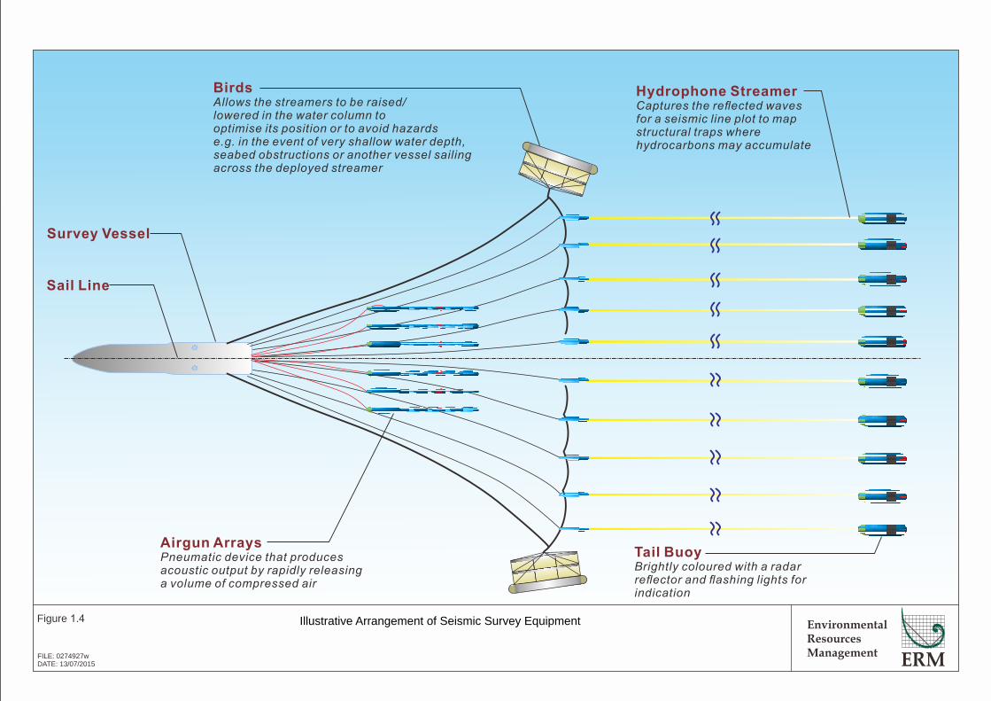
Marine geophysical seismic surveys are used to define sub-seabed deposits and geological structures. A specialized seismic survey vessel is used which tows an impulse emitting sound source. High energy low frequency sounds are produced by the sound source and these sound waves bounce off the sub-surface rock formations and return to the surface where the seismic energy is collected by an array of receivers (hydrophones) fixed onto streamers behind the vessel. The acquired data is then recorded by on-board computers for subsequent processing to produce profiles of the sub-seabed geology for interpretation by geophysicists. The principles behind marine seismic survey operations are illustrated in Figure 1.2.
Vessels
A specialized seismic survey vessel and an appropriate number of chase vessels (typically one to three) will be utilised for the seismic, gravity and magnetic survey. Chase vessels will scout ahead for obstructions and safely warn-off any vessels in the path of the survey. The vessels will be re-supplied with provisions at a port via a support vessel; however, there is no significant onshore component of this Project.
Typical seismic vessels are shown in Figure 1.3 and the layout of the seismic vessel and equipment is shown in Figure 1.4. The different components of this figure are discussed below. A separate vessel will be used to conduct the seabed sampling survey.
Airguns
The seismic sound source is created when a bubble of compressed air is discharged into water from airguns and the bubble subsequently collapses. The sound travels through the water column beneath the vessel to penetrate the subsurface rocks. Each gun is proposed to be towed by the vessels at a water depth of 8 m, using a firing interval of 10 seconds.
Streamers
The receivers (hydrophones) will be encased in long cables or “streamers” towed behind the seismic vessel. There will be up to 12 streamers which are around 8 km in length, which are towed at a water depth of up to 25 m. The acquired data is recorded by on-board computers for processing.
Emissions
Vessels will be required to follow International Convention for the Prevention of Pollution from Ships (MARPOL) Annex I, IV, V, and VI requirements with regards to handling of waste, wastewater, air emissions and effluents.
Gravity and Magnetic Survey
Gravity and magnetic surveys are used to assess the physical properties of the seabed sediments to more accurately target oil and gas deposits. This survey

SEISMIC SURVEY VESSEL
EnvironmentalResourcesManagement
Figure 1.2
FILE: 0274927u.cdrDATE: 13/07/2015
Schematic of Marine Seismic Survey
TAIL
BUOYHYDROPHONE STREAMER
SIGNAL GENERATING DEVICE
SOUND WAVES
REFLECTED
SOUND WAVES
SOLID ROCK STRATA
SEABED SEDIMENTS
WATER COLUMN

Survey Method
Parameter
No. of personnel onboard (POB) (crew + survey personnel)
Length
Width
Draft
Fuel consumption
Minimum operating depth
Maximum load speed
Specification *
30 – 100
50 – 90 m
15 – 20 m
5 – 6 m
9 – 15 tonnes/ day
~ 10 m
Up to 15 Knots
* Indicative only
The seismic survey vessel is purposely built for towing the airguns and streamers for conducting the
seismic surveys.
Indicative seismic survey vessel specifications
Typical Seismic Lines
EnvironmentalResourcesManagement
Figure 1.3
FILE: 0274927v.cdrDATE: 13/07/2015
Illustrative Example of Seismic Survey Vessels
Typical Seismic Vessels
Typical Seismic Vessel
Sail Line
Survey Vessel
Airgun Arrays
Pneumatic device that producesacoustic output by rapidly releasinga volume of compressed air
Hydrophone Streamer
Captures the reflected wavesfor a seismic line plot to mapstructural traps wherehydrocarbons may accumulate
Tail Buoy
Brightly coloured with a radarreflector and flashing lights forindication
Birds
Allow the streamer to be raised/s slowered in the water column tooptimise its position or to avoid hazardse.g. in the event of very shallow water depth,seabed obstructions or another vessel sailingacross the deployed streamer
EnvironmentalResourcesManagement
Figure 1.4
FILE: 0274927wDATE: 13/07/2015
Illustrative Arrangement of Seismic Survey Equipment
ENVIRONMENTAL RESOURCES MANAGEMENT BG GROUP 0274927_IEE_BG_A4_FINAL_COMPLETE_EN.DOCX NOVEMBER 2015
1-5
will be carried out as part of the seismic survey and no additional vessel will be used. The equipment passively measures the naturally occurring variations in the earth’s gravity and magnetic fields and does not have any associated emissions.
Seabed Sampling Survey
Seabed sampling surveys are used to characterise surface and subsurface sediments, which can be used to provide information on the hydrocarbon and reservoir potential of an area as well as environmental, floral and faunal data.
A single dedicated vessel will be used for the sampling survey fitted with specialist sampling equipment, to obtain soft sediment samples approximately 10 centimetres in diameter of the seabed for physicochemical and biological testing and analysis. Prior to seabed coring, the vessel may opt to secure sub bottom profiling to ensure the locations is suitable for a sample (i.e., not rocky). This would involve using echo-sounders to map the seabed.
Approximately 100 core samples (10 cm in diameter) will be collected across the Block. The seabed samples and slick samples will undergo detailed geochemical and geological analysis in onshore laboratories which will provide new data on the hydrocarbon potential of the blocks.
The seabed sampling will commence around the beginning of March 2016 and will run for approximately 1 month.
1.4 DESCRIPTION OF THE ENVIRONMENT TO BE AFFECTED BY THE PROJECT
Information has been collected through stakeholder engagement and field visits have been undertaken from March to May 2015. Further information has been collected through desktop review of publicly available information. Findings of the baseline data review are summarised below. The Area of Interest for the baseline study encompasses Block A-4 and the immediate surroundings, extending for assessment purposes to the adjacent nearshore waters of the Rakhine State mainland (Figure 1.1) and also covers locations where fishing activities may overlap with the Project Activities.
The IEE Report focuses on the physical, environmental and social characteristics in the Area of Interest. A summary of the baseline is provided below.
1.4.1 Physical Environment
The survey will be primarily conducted during the northeast monsoon period which runs from December to April, when winds blowing from the north and east, bring less cloud, scant rainfall, mild temperatures and lower humidity. In the Bay of Bengal the surface circulation moves generally clockwise from January to July and counter-clockwise from August to December. Tides in the Area of Interest are semi-diurnal with a tidal range of 2.5 m at Manaung Island. The continental shelf in the Area of Interest is wide and characterized
ENVIRONMENTAL RESOURCES MANAGEMENT BG GROUP 0274927_IEE_BG_A4_FINAL_COMPLETE_EN.DOCX NOVEMBER 2015
1-6
by the islands of Ramree and Manaung. The water depth within the Activity Area ranges from 50 to 1,500 m and is located at the edge of the continental shelf and over the steep continental slope (1). The seafloor within the majority of the Activity Area is characterised by homogeneous olive grey muds typical of low energy depositional environments (2).
1.4.2 Biological Environment
Shallow nearshore waters within the Area of Interest host habitats with enhanced biological productivity and higher biodiversity (such as coral reefs, seagrass, mangroves). However, the Activity Area will be confined to open deeper waters where typically lower ecological value habitats occur, i.e. areas of lower productivity and biodiversity.
Coral habitats around Manaung Island are closest to the Activity Area (Figure 1.5), which, at the closest extent, are located at least 2 km from the Activity Area; however this is only for two isolated coral habitats; one near the northwest of Manaung Island and one in the south-eastern extent of the Activity Area. The majority of coral habitat is at least 5 km away. Industry studies show that the seismic method has little or no effect on coral habitats even at ranges of a few tens of metres. Photos of common coral species in Rakhine waters are shown in Figure 1.6; taken during a survey near Ngapali beach in Thandwe.
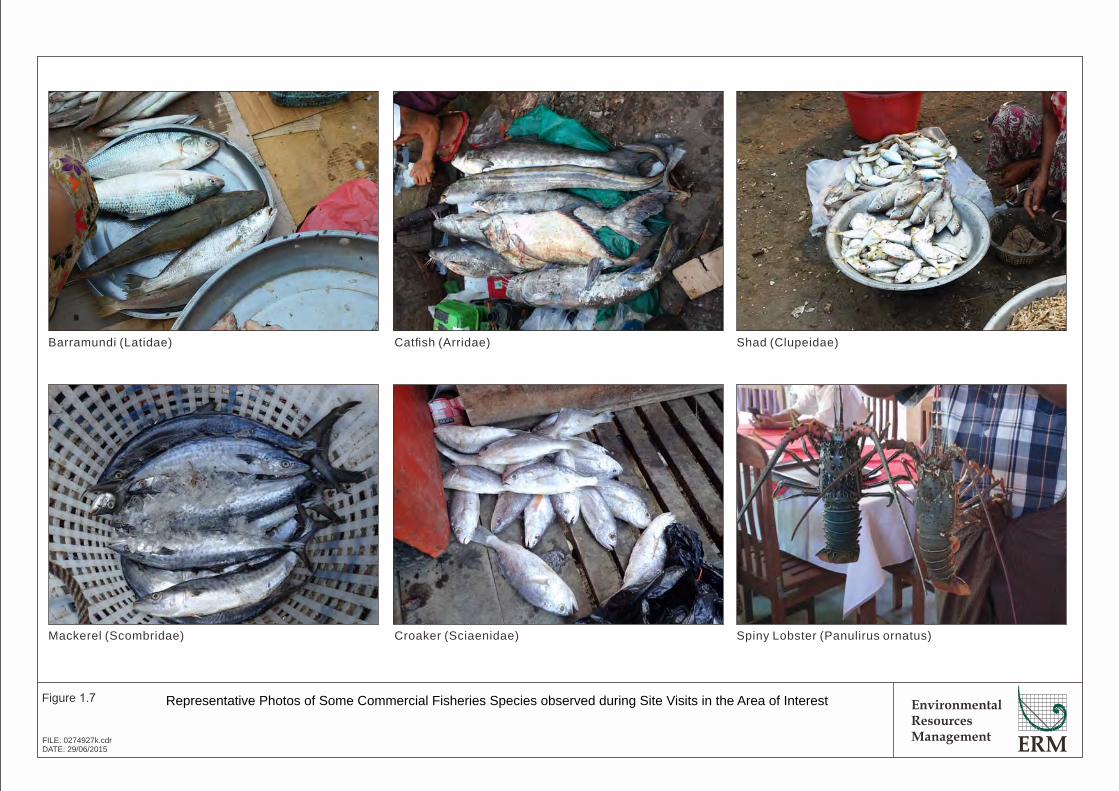
Fish in Rakhine waters have been categorised into three types: pelagic species, which inhabit the open ocean, neither near the seabed nor the coast; demersal species, which live on or near the seabed; and reef associated / coastal species, which live in coral reefs or coastal areas. Of the fish identified from data sources to have been possibly recorded within the Area of Interest, three are listed as species of conservation concern (vulnerable or above) on the IUCN Red List (3); whale shark (Rhincodon typus), bleeker’s grouper (Epinephelus bleekeri) and narrow barred Spanish mackerel (Scomberomorus commerson). Photos of commercial fish species observed during consultations in Rakhine are shown in Figure 1.7.
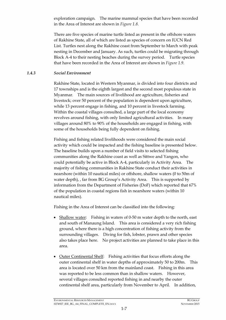
A total of 21 cetaceans (whale and dolphin) and 1 sirenian (dugong) species have been reported from Myanmar waters. The Irrawaddy dolphin (Orcaella brevirostris) and dugong (Dugong dugon) are protected under Myanmar Law (4) but these species are mostly coastal or riverine species and hence not likely to be present in the Activity Area. Numerous marine mammals have also been recorded from a recent seismic survey conducted in 2015 such as the humpback whale (Megaptera novaeangliae) and bryde’s whale (Balaenoptera edeni) in a neighbouring exploration block just south west of Block A-4, it is considered likely that cetaceans will also be present during the proposed
(1) The slope between the shallow waters of the continental shelf, bordering the mainland coast, and the deep waters
of the ocean floor.
(2) Dr Rangin (2005) unpublished data.
(3) The International Union for the Conservation of Nature (IUCN) Red List provides information on the global conservation status of biological species.
(4) Protected under the Myanmar Protection of Wildlife and Conservation of Natural Areas Law.

!
!
!
!
!
!
!
!
!
!
!
!
!
!(
!(
!(
!(
!(
Kyaukpyu
Manaung
Ramree
Thandwe
Toungup
A-4
ZinChaung
San TinMaw
KyaukOo Mou
KyaukNi Maw
Za KuKyun
MagyeeKyun
Ye Kyun
Ka Ei
Kamar
Zee Taw
Thabyugyaing
SinGaung
Gyeiktaw
94°30'0"E
94°30'0"E
94°0'0"E
94°0'0"E
93°30'0"E
93°30'0"E
93°0'0"E
93°0'0"E
92°30'0"E
92°30'0"E92°0'0"E19
°0'0
"N
19°0
'0"N
18°3
0'0"
N
18°3
0'0"
N
18°0
'0"N
18°0
'0"N
400000
400000
450000
450000
500000
500000
550000
550000
600000
600000
650000
650000
2000
000
2000
000
2050
000
2050
000
2100
000
2100
000
2150
000
2150
000
Legend!( Town
!Key Villages /Settlements
Area of Interest
Coral Reefs
Mangrove
Seagrass
Blocks3D Survey
Activity Area
BG Operated
Depth (m)< 0
0.1 - 10
10.1 - 20
20.1 - 30
30.1 - 40
40.1 - 50
50.1 - 60
60.1 - 70
70.1 - 80
80.1 - 90
90.1 - 100
100.1 - 200
200.1 - 300
300.1 - 400
400.1 - 500
500.1 - 1,000
1,000.1 - 1,500
1,500.1 - 2,000
2,000.1 - 2,500
> 2,500
® 0 2010Kilometres
Service Layer Credits: Sources: Esri, HERE,DeLorme, USGS, Intermap, increment P Corp.,NRCAN, Esri Japan, METI, Esri China (Hong Kong),Esri (Thailand), TomTom, MapmyIndia, ©OpenStreetMap contributors, and the GIS UserCommunity
Myanmar
Thailand
Bay of Bengal
EnvironmentalResourcesManagement
Location of Senstitive Habitats in Rakhine
Figure 1.5
File: T:\GIS\CONTRACT\0274927\Mxd\Report_A4\0274927_Location_of_Sensitive_Habitats_A4.mxdDate: 17/7/2015

EnvironmentalResourcesManagement
Figure 1.6
FILE: 0274927f.cdrDATE: 05/06/2015
Coral Photos from Surveys in April 2015, Ngapali Beach
Platygyra sp. Turbinaria sp. Sponges with Porites sp.
Acropora sp. Goniopora sp. Favites sp.
EnvironmentalResourcesManagement
Figure 1.7
FILE: 0274927k.cdrDATE: 29/06/2015
Representative Photos of Some Commercial Fisheries Species observed during Site Visits in the Area of Interest
Barramundi (Latidae) Catfish (Arridae) Shad (Clupeidae)
Mackerel (Scombridae) Croaker (Sciaenidae) Spiny Lobster (Panulirus ornatus)
ENVIRONMENTAL RESOURCES MANAGEMENT BG GROUP 0274927_IEE_BG_A4_FINAL_COMPLETE_EN.DOCX NOVEMBER 2015
1-7
exploration campaign. The marine mammal species that have been recorded in the Area of Interest are shown in Figure 1.8.
There are five species of marine turtle listed as present in the offshore waters of Rakhine State, all of which are listed as species of concern on IUCN Red List. Turtles nest along the Rakhine coast from September to March with peak nesting in December and January. As such, turtles could be migrating through Block A-4 to their nesting beaches during the survey period. Turtle species that have been recorded in the Area of Interest are shown in Figure 1.9.
1.4.3 Social Environment
Rakhine State, located in Western Myanmar, is divided into four districts and 17 townships and is the eighth largest and the second most populous state in Myanmar. The main sources of livelihood are agriculture, fisheries and livestock; over 50 percent of the population is dependent upon agriculture, while 13 percent engage in fishing, and 10 percent in livestock farming. Within the coastal villages consulted, a large part of the local economy revolves around fishing, with only limited agricultural activities. In many villages around 80% to 90% of the households are engaged in fishing, with some of the households being fully dependent on fishing.
Fishing and fishing related livelihoods were considered the main social activity which could be impacted and the fishing baseline is presented below. The baseline builds upon a number of field visits to selected fishing communities along the Rakhine coast as well as Sittwe and Yangon, who could potentially be active in Block A-4, particularly in Activity Area. The majority of fishing communities in Rakhine State conduct their activities in nearshore (within 10 nautical miles) or offshore, shallow waters (0 to 50m of water depth), , far from BG Group’s Activity Area. This is supported by information from the Department of Fisheries (DoF) which reported that 67% of the population in coastal regions fish in nearshore waters (within 10 nautical miles).
Fishing in the Area of Interest can be classified into the following:
• Shallow water: Fishing in waters of 0-50 m water depth to the north, east and south of Manaung Island. This area is considered a very rich fishing ground, where there is a high concentration of fishing activity from the surrounding villages. Diving for fish, lobster, prawn and other species also takes place here. No project activities are planned to take place in this area.
• Outer Continental Shelf: Fishing activities that focus efforts along the outer continental shelf in water depths of approximately 50 to 200m. This area is located over 50 km from the mainland coast. Fishing in this area was reported to be less common than in shallow waters. However, several villages consulted reported fishing in and nearby the outer continental shelf area, particularly from November to April. In addition,
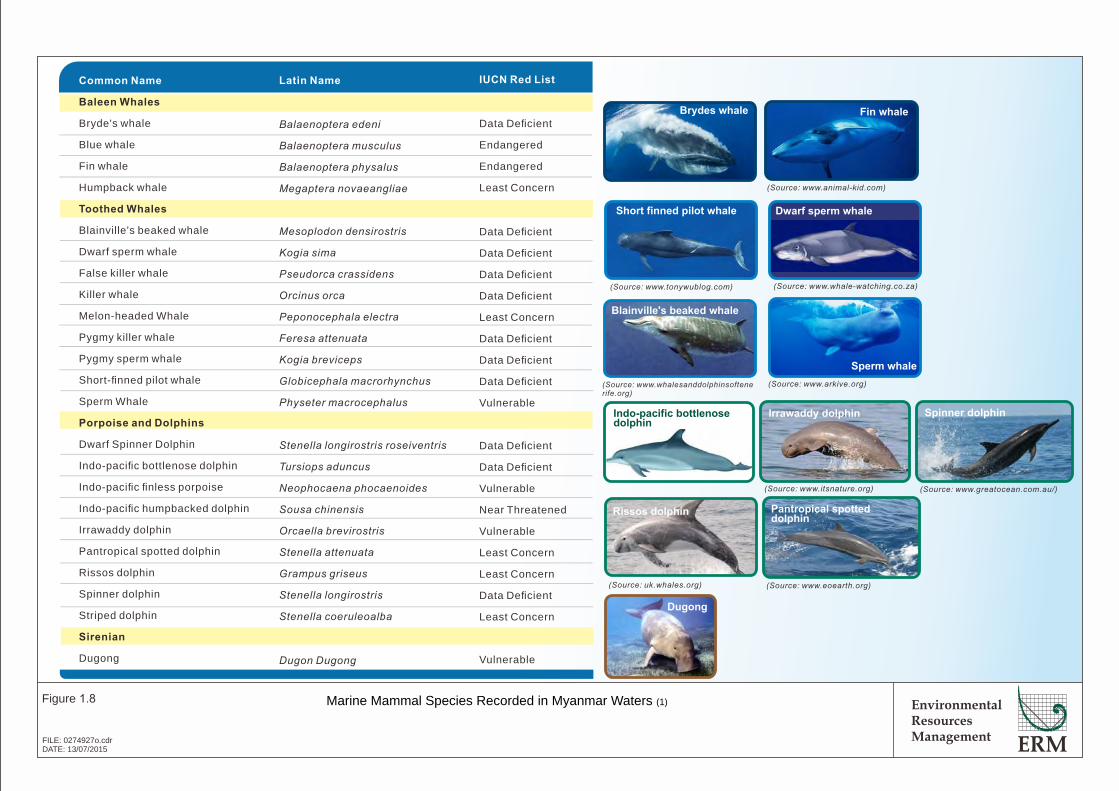
Figure 4.12 Marine Turtles in Rakhine waters
Dugong
Indo-pacific bottlenosedolphin
Irrawaddy dolphin
Brydes whale
(Source: www.whale-watching.co.za)
Dwarf sperm whale
(Source: uk.whales.org)
(Source: )www.greatocean.com.au/(Source: )www.itsnature.org
(Source: www.tonywublog.com)
EnvironmentalResourcesManagement
Figure 1.8
FILE: 0274927o.cdrDATE: 13/07/2015
Marine Mammal Species Recorded in Myanmar Waters ( )1
Rissos dolphin
Short finned pilot whale
Spinner dolphin
Blainville's beaked whale
(Source: www.animal-kid.com)
(Source: www.eoearth.org)
Pantropical spotteddolphin
Latin Name
Balaenoptera edeni
Balaenoptera musculus
Balaenoptera physalus
Megaptera novaeangliae
Mesoplodon densirostris
Kogia sima
Pseudorca crassidens
Orcinus orca
Peponocephala electra
Feresa attenuata
Kogia breviceps
Globicephala macrorhynchus
Physeter macrocephalus
Stenella longirostris roseiventris
Tursiops aduncus
Neophocaena phocaenoides
Sousa chinensis
Orcaella brevirostris
Stenella attenuata
Grampus griseus
Stenella longirostris
Stenella coeruleoalba
Dugon Dugong
IUCN Red List
Data Deficient
Endangered
Endangered
Least Concern
Data Deficient
Data Deficient
Data Deficient
Data Deficient
Least Concern
Data Deficient
Data Deficient
Data Deficient
Vulnerable
Data Deficient
Data Deficient
Vulnerable
Near Threatened
Vulnerable
Least Concern
Least Concern
Data Deficient
Least Concern
Vulnerable
Common Name
Baleen Whales
Bryde's whale
Blue whale
Fin whale
Humpback whale
Toothed Whales
Blainville's beaked whale
Dwarf sperm whale
False killer whale
Killer whale
Melon-headed Whale
Pygmy killer whale
Pygmy sperm whale
Short-finned pilot whale
Sperm Whale
Porpoise and Dolphins
Dwarf Spinner Dolphin
Indo-pacific bottlenose dolphin
Indo-pacific finless porpoise
Indo-pacific humpbacked dolphin
Irrawaddy dolphin
Pantropical spotted dolphin
Rissos dolphin
Spinner dolphin
Striped dolphin
Sirenian
Dugong
Fin whale
(Source: www.whalesanddolphinsoftenerife.org)
(Source: www.arkive.org)
Sperm whale
EnvironmentalResourcesManagement
Figure 1.9
FILE: 0274927p.cdrDATE: 29/06/2015
Marine Turtles in Rakhine waters
Olive Ridley Turtle Loggerhead urtleT Green Turtle
Hawksbill urtleT Leatherback urtleT
Latin Name
Lepoidochely olivacea
Caretta caretta
Chelonia mydas
Eretmochelys imbricata
Dermochelys coriacea
Common Name
Olive ridley turtle
Loggerhead turtle
Green turtle
Hawksbill turtle
Leatherback turtle
Myanmar Name
Leik Lyaung
Leik Khway
Pyin Tha Leik
Leik Kyet Tu Yway
Leik Zaung Lyar
IUCN Status
Endangered
Endangered
Vulnerable
Critically Endangered
Endangered
Potential Presence in Block AD-02
Reported to occur in Rakhine and have been observed bylocal fishermen. Known to be nesting in Rakhine State andlikely to be present in Block A - .D 02
Reported to occur in Rakhine and have been observed bylocal fishermen. Not known to nest on the Rakhine Coast.
Reported to be nesting in Rakhine State and likely to bepresent in Block A - .D 02
Reported to occur in Rakhine and have been observed bylocal fishermen. Known to be nesting in Rakhine State andlikely to be present in Block A - .D 02
Have historically been recorded in Rakhine waters but arenow considered rare.
ENVIRONMENTAL RESOURCES MANAGEMENT BG GROUP 0274927_IEE_BG_A4_FINAL_COMPLETE_EN.DOCX NOVEMBER 2015
1-8
during this period fishing camps are established on Manaung and Ye islands, for fishing around the west coast of Manaung and in this area.
• Deep Water: Fishing in water depths of more than 200 m. There appears to be only limited fishing in this area in any case and little is from local villages. Most fishing in these deeper waters is undertaken by vessels from outside Rakhine State.
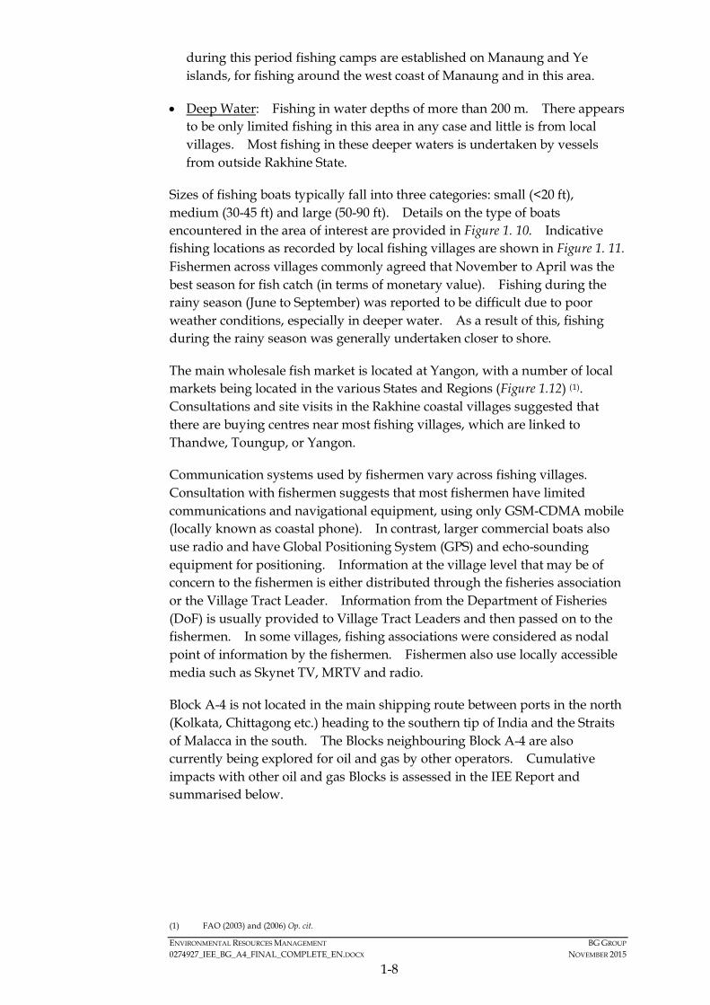
Sizes of fishing boats typically fall into three categories: small (<20 ft), medium (30-45 ft) and large (50-90 ft). Details on the type of boats encountered in the area of interest are provided in Figure 1. 10. Indicative fishing locations as recorded by local fishing villages are shown in Figure 1. 11. Fishermen across villages commonly agreed that November to April was the best season for fish catch (in terms of monetary value). Fishing during the rainy season (June to September) was reported to be difficult due to poor weather conditions, especially in deeper water. As a result of this, fishing during the rainy season was generally undertaken closer to shore.
The main wholesale fish market is located at Yangon, with a number of local markets being located in the various States and Regions (Figure 1.12) (1). Consultations and site visits in the Rakhine coastal villages suggested that there are buying centres near most fishing villages, which are linked to Thandwe, Toungup, or Yangon.
Communication systems used by fishermen vary across fishing villages. Consultation with fishermen suggests that most fishermen have limited communications and navigational equipment, using only GSM-CDMA mobile (locally known as coastal phone). In contrast, larger commercial boats also use radio and have Global Positioning System (GPS) and echo-sounding equipment for positioning. Information at the village level that may be of concern to the fishermen is either distributed through the fisheries association or the Village Tract Leader. Information from the Department of Fisheries (DoF) is usually provided to Village Tract Leaders and then passed on to the fishermen. In some villages, fishing associations were considered as nodal point of information by the fishermen. Fishermen also use locally accessible media such as Skynet TV, MRTV and radio.
Block A-4 is not located in the main shipping route between ports in the north (Kolkata, Chittagong etc.) heading to the southern tip of India and the Straits of Malacca in the south. The Blocks neighbouring Block A-4 are also currently being explored for oil and gas by other operators. Cumulative impacts with other oil and gas Blocks is assessed in the IEE Report and summarised below.
(1) FAO (2003) and (2006) Op. cit.
Typical boats size and associated details in coastal villages of Rakhine Figure 1.10
DATE: June 2015
Medium Boats in Kyauk Ni Maw
Environmental Resources Management
Small boats in Gyeiktaw Big boats in Thabyugyiang
Boat size Dimensions Engine (hp) POB Distance offshore Depth Range (m) Trip Duration (days) Nets used
Small 5.5-6.5m 9 3-4 4.5-8km <25 1 Longline Drift Net
Medium 9-14m 13-30 3-8 Up to 16km 25-60 1-4 Longline Drift Net Trawl Purse seine
Big 15-25m 20-450 8-18 24km to 30km
30-140 2-25 Drift Longline Trawl Purse Seine

Kyaukpyu
Manaung
Ramree
Thandwe
Toungup
A-4
San TinMaw
KyaukOo Mou
Ye Kyun
Ka Ei
ZinChaung
KyaukNi Maw
Za KuKyun
MagyeeKyun
Kamar
Zee Taw
Thabyugyaing
SinGaung
Gyeiktaw
95°0'0"E
95°0'0"E
94°40'0"E
94°40'0"E
94°20'0"E
94°20'0"E
94°0'0"E
94°0'0"E
93°40'0"E
93°40'0"E
93°20'0"E
93°20'0"E
93°0'0"E
93°0'0"E
92°40'0"E
92°40'0"E19
°20'
0"N
19°2
0'0"
N
19°0
'0"N
19°0
'0"N
18°4
0'0"
N
18°4
0'0"
N
18°2
0'0"
N
18°2
0'0"
N
450000
450000
475000
475000
500000
500000
525000
525000
550000
550000
575000
575000
600000
600000
625000
625000
650000
650000
675000
675000
700000
700000
2000
000
2000
000
2025
000
2025
000
2050
000
2050
000
2075
000
2075
000
2100
000
2100
000
2125
000
2125
000
2150
000
2150
000
Legend!( Town
! Village
" Camp
Blocks3D Survey Area
Activity Area
BG Operated Block
Shallow WaterFishing Area
Deep WaterFishing Area
Continental ShelfFisheries Area
Depth (m)< 0
0.1 - 10
10.1 - 20
20.1 - 30
30.1 - 40
40.1 - 50
50.1 - 60
60.1 - 70
70.1 - 80
80.1 - 90
90.1 - 100
100.1 - 200
200.1 - 300
300.1 - 400
400.1 - 500
500.1 - 1,000
1,000.1 - 1,500
1,500.1 - 2,000
2,000.1 - 2,500
> 2,500
0 2010Kilometres
Service Layer Credits: Sources: Esri, HERE, DeLorme,TomTom, Intermap, increment P Corp., GEBCO, USGS,FAO, NPS, NRCAN, GeoBase, IGN, Kadaster NL,Ordnance Survey, Esri Japan, METI, Esri China (HongKong), swisstopo, MapmyIndia, © OpenStreetMapcontributors, and the GIS User Community
®
EnvironmentalResourcesManagement
Locations of Fishing Areas (Excluding Nearshore Fishing)
Figure 1.11
File: T:\GIS\CONTRACT\0274927\Mxd\Report_A4\0274927_Fishing_Location_for_Summary_A4.mxdDate: 17/7/2015
Myanmar
Thailand
Bay of Bengal

Typical buying centres and fish markets in coastal areas of Rakhine Figure 1.12
DATE: June 2015
Dried Tuna Fish in Sittwe market
Local market in Manaung
Environmental Resources Management
Fish Buying Centre in Gyeiktaw Dry Fish Storage in Gyeiktaw
Local Fish Market in Sittwe Sittwe Fish Market: Women selling fish

ENVIRONMENTAL RESOURCES MANAGEMENT BG GROUP 0274927_IEE_BG_A4_FINAL_COMPLETE_EN.DOCX NOVEMBER 2015
1-9
1.5 SIGNIFICANT ENVIRONMENTAL IMPACTS
1.5.1 Impact Assessment Methodology
The impact assessment methodology followed a receptor sensitivity vs. impact magnitude model. Each of the predicted impacts was described in terms of its potential magnitude, derived from an examination of the extent, duration, scale and frequency of the impact. Additionally, for unplanned events only, magnitude incorporates the ‘likelihood’ factor (i.e., a qualitative assessment of the potential for any impact to occur). The sensitivity (including vulnerability and importance) of the impacted resource/receptor was also identified taking into account legal protection, government policy, stakeholder views and economic value. Once impact magnitude and resource/receptor sensitivity have been characterised, the significance can be assigned for each impact. Impact significance is designated using the matrix shown in Table 1.1. If a species is protected by law it is considered to be of high sensitivity so even small impacts will result in a moderately significant outcome.
Table 1.1 Impact Significances
Resource/Receptor Sensitivity
Low Medium High
Mag
nitu
de o
f Im
pact
Negligible Negligible Negligible Negligible
Small Negligible Minor Moderate
Medium Minor Moderate Major
Large Moderate Major Major
Potential Impacts and Mitigation Measures
Potential impacts from proposed project activities (both planned and unplanned) were identified through a systematic scoping process. A full discussion on the potential impact, required mitigation and residual impact significance is provided in Section 6 of the IEE Report. Interactions which were considered to have the potential to result in significant environmental and social impacts from the survey include:
• Potential increases in ambient underwater sound and generation of sound pressure levels from the operation of air guns. These activities have the potential to impact ecologically sensitive receivers, e.g. marine mammals, marine turtles, fish and divers.
• Potential water contamination and related secondary impacts to biodiversity and fishing from accidental spills of chemicals or fuel (e.g. during offshore re-fuelling).
• Potential risk of entanglement with marine turtles by the operating seismic survey hydrophone streamers.
ENVIRONMENTAL RESOURCES MANAGEMENT BG GROUP 0274927_IEE_BG_A4_FINAL_COMPLETE_EN.DOCX NOVEMBER 2015
1-10
• Potential short-term disturbance to fishing activities.
• Potential risk of collisions with fishing vessels and other marine users and entanglement of fishing gear by the operating seismic hydrophone streamers.
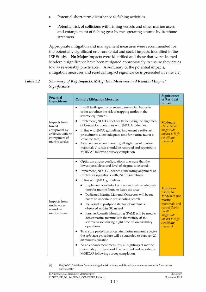
Appropriate mitigation and management measures were recommended for the potentially significant environmental and social impacts identified in the IEE Study. No Major impacts were identified and those that were deemed Moderate significance have been mitigated appropriately to ensure they are as low as reasonably practicable. A summary of the potential impacts, mitigation measures and residual impact significance is presented in Table 1.2.
Table 1.2 Summary of Key Impacts, Mitigation Measures and Residual Impact Significance
Potential Impact/Issue Control / Mitigation Measures
Significance of Residual Impact
Impacts from towed equipment by collision with or entrapment of marine turtles
• Install turtle guards on seismic survey tail buoys in order to reduce the risk of trapping turtles in the seismic equipment.
• Implement JNCC Guidelines (1) including the alignment of Contractor operations with JNCC Guidelines.
• In line with JNCC guidelines, implement a soft-start procedure to allow adequate time for marine fauna to leave the area).
• As an enhancement measure, all sightings of marine mammals / turtles should be recorded and reported to MOECAF following survey completion.
Moderate (Note: Small magnitude impact to high sensitivity resource)
Impacts from underwater sound on marine fauna
• Optimum airgun configurations to ensure that the lowest possible sound level of airguns is selected.
• Implement JNCC Guidelines (1) including alignment of Contractor operations with JNCC Guidelines.
• In line with JNCC guidelines: • Implement a soft-start procedure to allow adequate
time for marine fauna to leave the area, • Dedicated Marine Mammal Observers will be on-
board to undertake pre-shooting search • the vessel to postpone start-up if mammals
observed within 500 m and • Passive Acoustic Monitoring (PAM) will be used to
detect marine mammals in the vicinity of the seismic vessel during night time or low visibility operations.
• To ensure protection of certain marine mammal species, the soft-start procedure will be extended to between 20-30 minutes duration.
• As an enhancement measures, all sightings of marine mammals / turtles should be recorded and reported to MOECAF following survey completion.
Minor (for fishes) to Moderate (for marine mammals and turtle) (Note: Small magnitude impact to high sensitivity resource)
(1) The JNCC “Guidelines for minimising the risk of injury and disturbance to marine mammals from seismic
surveys, 2010”
ENVIRONMENTAL RESOURCES MANAGEMENT BG GROUP 0274927_IEE_BG_A4_FINAL_COMPLETE_EN.DOCX NOVEMBER 2015
1-11
Potential Impact/Issue Control / Mitigation Measures
Significance of Residual Impact
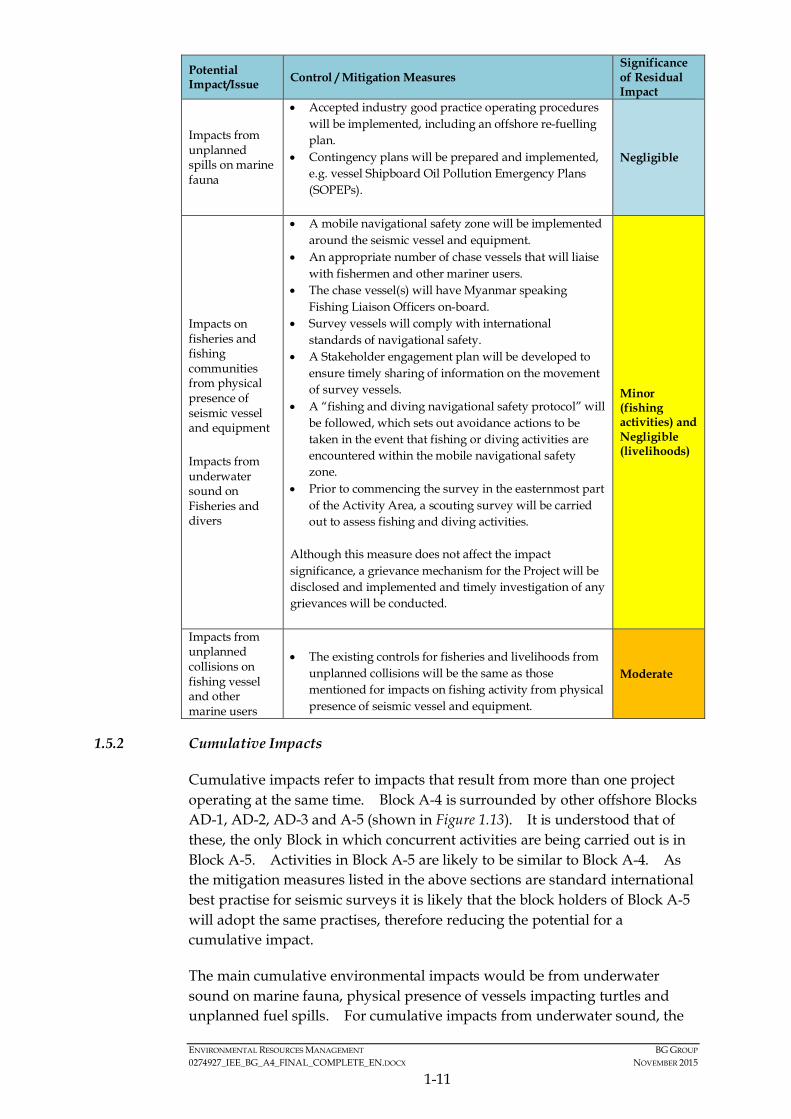
Impacts from unplanned spills on marine fauna
• Accepted industry good practice operating procedures will be implemented, including an offshore re-fuelling plan.
• Contingency plans will be prepared and implemented, e.g. vessel Shipboard Oil Pollution Emergency Plans (SOPEPs).
Negligible
Impacts on fisheries and fishing communities from physical presence of seismic vessel and equipment
Impacts from underwater sound on Fisheries and divers
• A mobile navigational safety zone will be implemented around the seismic vessel and equipment.
• An appropriate number of chase vessels that will liaise with fishermen and other mariner users.
• The chase vessel(s) will have Myanmar speaking Fishing Liaison Officers on-board.
• Survey vessels will comply with international standards of navigational safety.
• A Stakeholder engagement plan will be developed to ensure timely sharing of information on the movement of survey vessels.
• A “fishing and diving navigational safety protocol” will be followed, which sets out avoidance actions to be taken in the event that fishing or diving activities are encountered within the mobile navigational safety zone.
• Prior to commencing the survey in the easternmost part of the Activity Area, a scouting survey will be carried out to assess fishing and diving activities.
Although this measure does not affect the impact significance, a grievance mechanism for the Project will be disclosed and implemented and timely investigation of any grievances will be conducted.
Minor (fishing activities) and Negligible (livelihoods)
Impacts from unplanned collisions on fishing vessel and other marine users
• The existing controls for fisheries and livelihoods from unplanned collisions will be the same as those mentioned for impacts on fishing activity from physical presence of seismic vessel and equipment.
Moderate
1.5.2 Cumulative Impacts
Cumulative impacts refer to impacts that result from more than one project operating at the same time. Block A-4 is surrounded by other offshore Blocks AD-1, AD-2, AD-3 and A-5 (shown in Figure 1.13). It is understood that of these, the only Block in which concurrent activities are being carried out is in Block A-5. Activities in Block A-5 are likely to be similar to Block A-4. As the mitigation measures listed in the above sections are standard international best practise for seismic surveys it is likely that the block holders of Block A-5 will adopt the same practises, therefore reducing the potential for a cumulative impact.
The main cumulative environmental impacts would be from underwater sound on marine fauna, physical presence of vessels impacting turtles and unplanned fuel spills. For cumulative impacts from underwater sound, the

MD-03
AD-12
AD-09
AD-10
AD-13
AD-14
AD-16
A-5
AD-04
A-7AD-05
MD-01
MD-02
M-8
AD-02
AD-03
AD-15M-4
M-7
YWB
AD-1A-3
A-1 A-2
AD-6
AD-8
AD-7
AD-11
YEB
M-1
M-1
M-3
M-6
M-9
M-11 M-12 M-13
M-5
M-2
M-10
A-6
A-4
100°0'0"E
100°0'0"E
98°0'0"E
98°0'0"E
96°0'0"E
96°0'0"E
94°0'0"E
94°0'0"E
92°0'0"E
92°0'0"E
90°0'0"E
90°0'0"E
88°0'0"E
88°0'0"E20
°0'0
"N
20°0
'0"N
18°0
'0"N
18°0
'0"N
16°0
'0"N
16°0
'0"N
14°0
'0"N
14°0
'0"N
0
0
200000
200000
400000
400000
600000
600000
800000
800000
1000000
1000000
1200000
1200000
1600
000
1600
000
1800
000
1800
000
2000
000
2000
000
2200
000
2200
000
®0 200100
Kilometres
Service Layer Credits: Sources: Esri, HERE, DeLorme, USGS,Intermap, increment P Corp., NRCAN, Esri Japan, METI, EsriChina (Hong Kong), Esri (Thailand), TomTom, MapmyIndia, ©OpenStreetMap contributors, and the GIS User Community
EnvironmentalResourcesManagement
Offshore Oil and Gas Blocks within Rakhine Waters
Figure 1.13
File: T:\GIS\CONTRACT\0274927\Mxd\Report_A4\0274927_Offshore_Blocks_A4.mxdDate: 15/7/2015
MYANMAR

ENVIRONMENTAL RESOURCES MANAGEMENT BG GROUP 0274927_IEE_BG_A4_FINAL_COMPLETE_EN.DOCX NOVEMBER 2015
1-12
vessels operating on Block A-4 and A-5 are unlikely to be within close proximity of each other. Typically, to avoid any risk of operational interference, offshore seismic surveys maintain minimum separation distances of at least 20 to 30 km and often far greater. As such, there is unlikely to be a cumulative impact resulting in any auditory injury to these species and any disturbance resulting in temporary behavioural changes will be minimal. Therefore, the impact from underwater sound on all receptors will be the same magnitude as those experienced during the Block A-4 survey, with only a limited risk of overlap and will therefore be of Moderate significance to marine mammals and turtles and of Minor significance for fish. As a result of this, possible cumulative impacts from underwater sound or the physical presence of the surveys acting as a barrier to turtle migratory pathways to nesting beaches are considered to be Negligible. The potential for cumulative spills of fuel from the vessels is extremely unlikely to occur, and as both vessels use light fuels which are readily diluted and dispersed and implement standard mitigation measures, impacts would be expected to be Minor.
Potential cumulative social impacts, particularly those to fishermen, could occur as a result of a number of potential exploration campaigns taking place at the same time in offshore Rakhine waters. Impacts may include the cumulative impact of disturbance to fishing activities, as well as increased risk of collision and disturbance to divers from underwater sound.
However, through the application of a mobile navigational safety zone, and the significant distance between surveys taking place in different blocks, these potential impacts will only be short term and localised. In addition, fishermen tend to fish in greatest numbers in shallow waters of less than 50 m, where no Project activities will take place. Finally, the seismic vessels are only likely to be in the area where fishing occurs for a short period of time (a number of days).
Similarly, to the impact on fishing vessels, the cumulative impact of sound on divers is only relevant for when the survey is within the eastern most part of the Block and will therefore be temporary and localised.
It is expected that, with all mitigation measures in place, cumulative social impacts will be of Minor significance to fishing activities.
1.6 THE PUBLIC CONSULTATION AND PARTICIPATION PROCESS UNDERTAKEN
The stakeholder engagement process is driven by BG Group’s own social performance standards which have been aligned with international best practices, such as IFC PSs, for undertaking stakeholder consultations and social impact assessments.
Following a scoping exercise which included engagement with representatives from government, civil society, and fishing communities and organisations, a range of public consultation meetings were held, focused on significant offshore fishing communities in Rakhine state. Stakeholder engagement was
ENVIRONMENTAL RESOURCES MANAGEMENT BG GROUP 0274927_IEE_BG_A4_FINAL_COMPLETE_EN.DOCX NOVEMBER 2015
1-13
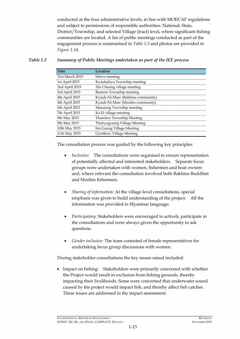
conducted at the four administrative levels, in line with MOECAF regulations and subject to permissions of responsible authorities: National, State, District/Township, and selected Village (tract) level, where significant fishing communities are located. A list of public meetings conducted as part of the engagement process is summarised in Table 1.3 and photos are provided in Figure 1.14.
Table 1.3 Summary of Public Meetings undertaken as part of the IEE process
Date Location 31st March 2015 Sittwe meeting 1st April 2015 Kyaukphyu Township meeting 2nd April 2015 Zin Chaung village meeting 3rd April 2015 Ramree Township meeting 4th April 2015 Kyauk-Ni-Maw (Rakhine community) 4th April 2015 Kyauk-Ni-Maw (Muslim community) 6th April 2015 Manaung Township meeting 7th April 2015 Ka Ei village meeting 8th May 2015 Thandwe Township Meeting 9th May 2015 Thabyugyaing Village Meeting 10th May 2015 Sin Gaung Village Meeting 11th May 2015 Gyeitkaw Village Meeting
The consultation process was guided by the following key principles:
• Inclusive: The consultations were organised to ensure representation of potentially affected and interested stakeholders. Separate focus groups were undertaken with women, fishermen and boat owners and, where relevant the consultation involved both Rakhine Buddhist and Muslim fishermen;
• Sharing of information: At the village level consultations, special emphasis was given to build understanding of the project. All the information was provided in Myanmar language;
• Participatory: Stakeholders were encouraged to actively participate in the consultations and were always given the opportunity to ask questions.
• Gender inclusive: The team consisted of female representatives for undertaking focus group discussions with women.
During stakeholder consultations the key issues raised included:
• Impact on fishing: Stakeholders were primarily concerned with whether the Project would result in exclusion from fishing grounds, thereby impacting their livelihoods. Some were concerned that underwater sound caused by the project would impact fish, and thereby affect fish catches. These issues are addressed in the impact assessment.

Environmental Resources Management
Photo Records of Stakeholder Consultation Sheet Figure 1.14
Photo 1: Consultations in Thabyugyiang Photo 2: Consultations in Gyeiktaw Photo 3: Q&A session at Gyeitaw
Photo 6: Consultations with Sittwe GAD and DoF Photo 4: Meeting with Sittwe Department of Fishery Photo 5: Meeting with Sittwe District GAD

ENVIRONMENTAL RESOURCES MANAGEMENT BG GROUP 0274927_IEE_BG_A4_FINAL_COMPLETE_EN.DOCX NOVEMBER 2015
1-14
• Sharing of benefits and social investment: Stakeholders asked questions about how local people would benefit from BG Group’s presence, including on whether BG Group would invest in community projects.
• Information sharing and communication methods: Stakeholders wanted to know how information related to movement of the Project survey vessel would be communicated to them, and provided suggestions for routes BG Group should use.
• Grievance redressal: Stakeholders wanted to know what BG Group would do in case of a grievance, such as damage to nets or collisions with the seismic vessel and provided information on the current grievance redressal procedure at the village level.
1.7 SUMMARY OF THE ESMP
An ESMP for the Project is provided in Section 7 of the IEE Report and provides the procedures and processes which will be applied to the Project activities to check and monitor compliance and effectiveness of the mitigation measures to which BG Group has committed. The ESMP identifies the structure and responsibilities of the personnel responsible for environmental and social management and implementation of the ESMP. BG Group will work with and influence the contractor to ensure that all contractors are aware of and competent with respect to:
• Sensitive baseline conditions;
• Key environmental and social impacts;
• Necessity of conforming to the requirements of the IEE and ESMP;
• Roles, responsibilities and accountability to achieve that conformity; and
• Documentation and reporting requirements and other ESMP compliance requirements.
Emergency preparedness and response will be reviewed continually by the seismic contractor during operations, and after the occurrence of any accidents or emergency situations to ensure that lessons learnt inform continuous improvement.
1.8 CONCLUSIONS AND RECOMMENDATIONS OF THE IEE REPORT
1.8.1 Recommendations for Future Activities
The disclosure process will include disclosure of the executive summary of the IEE study in Myanmar language in the townships visited; Sittwe, Kyaukphyu, Ramree, Manaung and Thandwe. The IEE Report disclosure will also be advertised in two newspapers; one national and one local Rakhine. The project will also disclose information about the grievance mechanism for the

ENVIRONMENTAL RESOURCES MANAGEMENT BG GROUP 0274927_IEE_BG_A4_FINAL_COMPLETE_EN.DOCX NOVEMBER 2015
1-15
project and information regarding movement of the seismic survey vessel to stakeholders. Detailed plans for disclosure will be developed prior to the commencement of the Project.
The engagement activities thus far, were undertaken as part of the IEE process. However, stakeholder engagement is understood to be a continuous process to be undertaken throughout the life of the Project, in this case during the duration of the seismic survey. BG Group will further develop the Stakeholder Engagement Plan to manage ongoing consultation and respond to stakeholder concerns that may be reported in relation to the implementation of the Project.
1.8.2 Conclusions of IEE Report
The IEE Study for the proposed exploration programme survey in Block A-4 was conducted to comply with the requirements of the MOECAF draft EIA Procedures. The IEE demonstrates the proponent understands the environment and social setting in which they are operating and has properly assessed the key potential environmental and social impacts associated with the proposed Project. A project-specific, dedicated Environmental Social Management Plan (ESMP) has been developed and presented as a tool to manage impacts associated with the Project and ensure legislative compliance and standards of good practice during the execution of the survey programme in Block A-4. Provided that the recommended mitigation measures are properly implemented, it is expected that the environmental and social impacts of the proposed exploration programme at Block A-4 would be managed by BG Group in a professional and acceptable manner. As such, the IEE concludes that no Major impacts on the environment and people are anticipated from this Project and all impacts have been properly mitigated to be as low as reasonably practical.
ENVIRONMENTAL RESOURCES MANAGEMENT BG GROUP 0274927_IEE_BG_A4_FINAL_COMPLETE_EN.DOCX NOVEMBER 2015
2-1
2 INTRODUCTION
2.1 PROJECT OVERVIEW
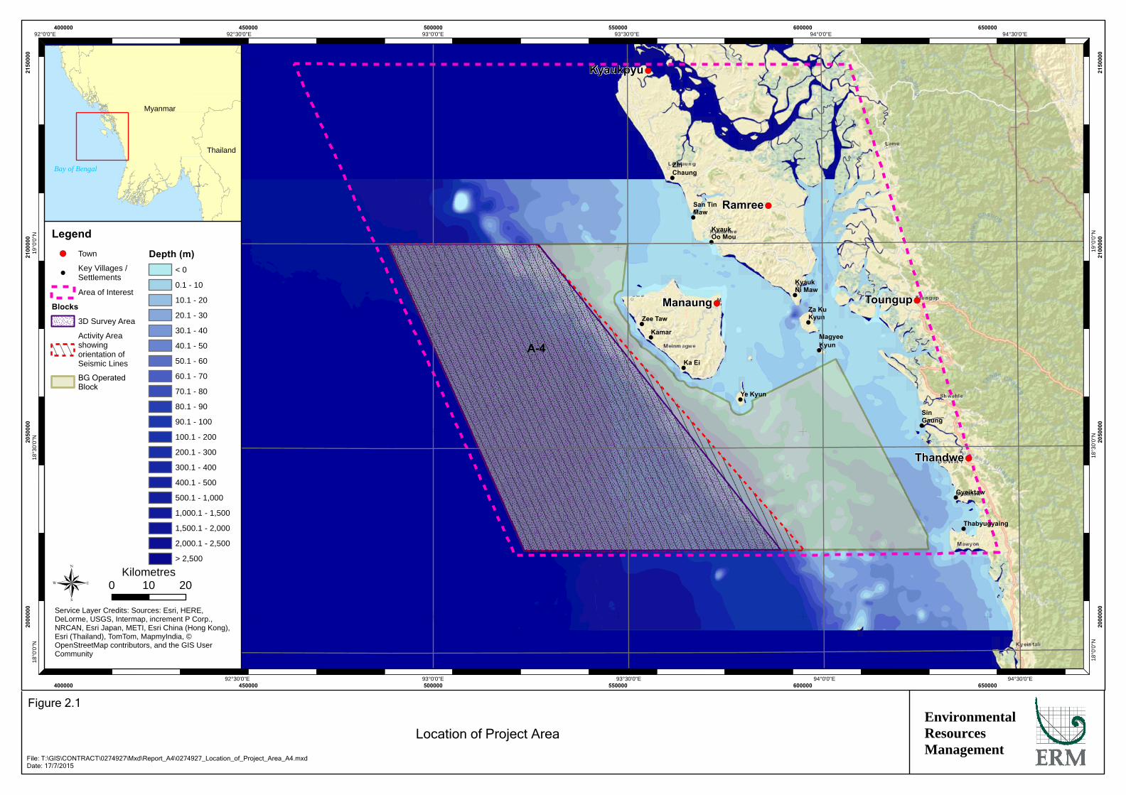
BG Group (through its local branch company BG Exploration and Production Myanmar Pte Ltd - BGEPM) is planning to undertake an exploratory geophysical and geological data gathering campaign in the waters offshore of the Rakhine State in Myanmar. This campaign will inform any future drilling for hydrocarbons by means of a combination of seismic surveys, gravity and magnetics surveys and seabed sampling surveys (“the Project”). These works will take place within Block A-4, which is located within the Bay of Bengal, offshore Myanmar. Block A-4 was awarded to BG Group in 2014 as part of the Myanmar Government’s 2013 Offshore Bid Round. For Block A-4 BG Group is the operator with 45% share and are partnered with Woodside Energy (45%) and Myanmar Petroleum Exploration and Production (MPRL) (10%). The location of the Block is shown in Figure 2.1.
2.2 PROJECT PROPONENT
Myanmar Oil and Gas Enterprise (MOGE) has the exclusive authority to carry out all Petroleum Operations in Myanmar and BG, as operator, is responsible to the MOGE for the execution of Petroleum Operations in the A-4 Contract Area.
MOGE is represented by: U Kyaw Zeya – Deputy Director (Offshore) Myanma Oil and Gas Enterprise (MOGE) Building 44, Ministry of Energy Nay Pyi Taw Fax: 067 411 330
For the purposes of this IEE, the proponent of the Project is BG Group (BG). BG Group is one of the UK’s largest oil and gas companies and specialises in gas exploration and Liquefied Natural Gas (LNG). BG Group has a global footprint with 5,200 employees and over 65 nationalities working in more than 20 countries on 5 continents. BG Group is operating as BG Exploration and Production Myanmar Pte. Ltd. to explore for gas in Myanmar. The headquarters of the company are located in the UK and a local office is established in Yangon, Myanmar. Further information about the company is available at the website http://www.bg-group.com/.
!
!
!
!
!
!
!
!
!
!
!
!
!
!(
!(
!(
!(
!(
Kyaukpyu
Manaung
Ramree
Thandwe
Toungup
A-4
ZinChaung
San TinMaw
KyaukOo Mou
KyaukNi Maw
Za KuKyun
MagyeeKyun
Ye Kyun
Ka Ei
Kamar
Zee Taw
Thabyugyaing
SinGaung
Gyeiktaw
94°30'0"E
94°30'0"E
94°0'0"E
94°0'0"E
93°30'0"E
93°30'0"E
93°0'0"E
93°0'0"E
92°30'0"E
92°30'0"E92°0'0"E19
°0'0
"N
19°0
'0"N
18°3
0'0"
N
18°3
0'0"
N
18°0
'0"N
18°0
'0"N
400000
400000
450000
450000
500000
500000
550000
550000
600000
600000
650000
650000
2000
000
2000
000
2050
000
2050
000
2100
000
2100
000
2150
000
2150
000
Legend!( Town
!Key Villages /Settlements
Area of Interest
Blocks
3D Survey Area
Activity Areashowingorientation ofSeismic Lines
BG OperatedBlock
Depth (m)< 0
0.1 - 10
10.1 - 20
20.1 - 30
30.1 - 40
40.1 - 50
50.1 - 60
60.1 - 70
70.1 - 80
80.1 - 90
90.1 - 100
100.1 - 200
200.1 - 300
300.1 - 400
400.1 - 500
500.1 - 1,000
1,000.1 - 1,500
1,500.1 - 2,000
2,000.1 - 2,500
> 2,500
® 0 2010Kilometres
Service Layer Credits: Sources: Esri, HERE,DeLorme, USGS, Intermap, increment P Corp.,NRCAN, Esri Japan, METI, Esri China (Hong Kong),Esri (Thailand), TomTom, MapmyIndia, ©OpenStreetMap contributors, and the GIS UserCommunity
Myanmar
Thailand
Bay of Bengal
EnvironmentalResourcesManagement
Location of Project Area
Figure 2.1
File: T:\GIS\CONTRACT\0274927\Mxd\Report_A4\0274927_Location_of_Project_Area_A4.mxdDate: 17/7/2015

ENVIRONMENTAL RESOURCES MANAGEMENT BG GROUP 0274927_IEE_BG_A4_FINAL_COMPLETE_EN.DOCX NOVEMBER 2015
2-2
Contact details of BG Group’s country manager for the Project are provided below: Name: John Field Positon: BG Group Exploration and Production Myanmar Pte. Ltd. Myanmar Country Manager Address: Hintha Business Services, Floor 3, 608 Merchant Street (Corner Merchant & 31st), Pabedan Township, Yangon, Myanmar Phone: Mob; +95 (0) 9254 048 936, Office; +95 (0)1 4413421 Fax: +95 (0)1383 591 Email: [email protected]
2.3 ENVIRONMENTAL AND SOCIAL EXPERTS
The key environmental and social experts deployed for the Project are presented in Table 2.1; CVs for the experts are provided in Annex 2.1.
Table 2.1 Environmental and Social Experts for the Project
Team Name Role Organisation Academic Experience
Years’ Experience
Project Management Team
Craig A. Reid Project Director
ERM BSc 17
Project Management Team
Dr Jasmine Ng Project Manager
ERM PhD 10
Advisory Team Dr Robin Kennish
EIA / EMP Expert ERM PhD 19
Advisory Team Neena Singh SIA Expert ERM M.phil / M A
20
IEE and ESMP Technical Team
Becky Summons
Marine Specialist ERM MSc 6
IEE and ESMP Technical Team
Manish Singh SIA Specialist
ERM M.A 10
IEE and ESMP Technical Team
Nicci Ng GIS Specialist
ERM MSc 8
Local Team Dr Win Naing Tun
Local Specialist REM
M.A, M.Res 9
Local Team Dr Soe Thura Tun
Local Specialist
REM MSc 9
Local Team Dr Khin Ohnmar Htwe
Local Specialist REM M.A 9
Local Team Nan Thazin Oo Social Specialist
REM B.A 3
Local Team May Thu Htet Social Specialist
REM A.GTI, BSc 3
2.4 THIS INITIAL ENVIRONMENTAL EVALUATION (IEE)
A Project Proposal Report was submitted to the Ministry of Environmental Conservation and Forestry (MOECAF) on 16th February 2015. The Report provided the Screening Study for the Project, including a discussion on the potential impacts and likely mitigation. The Report allowed the MOECAF to determine what type of assessment was required. Under Section 7 of the

ENVIRONMENTAL RESOURCES MANAGEMENT BG GROUP 0274927_IEE_BG_A4_FINAL_COMPLETE_EN.DOCX NOVEMBER 2015
2-3
Environmental Conservation Law (2012) and Articles 52 and 53 of the Environmental Conservation Rules (2014) of the Republic of the Union of Myanmar, it was determined that BG Group is required to undertake an Initial Environmental Examination (IEE) and to obtain an Environmental Compliance Certificate (ECC) in accordance with the Environmental Impact Assessment (EIA) Procedure (“the Procedure”). In addition, under the Production Sharing Contract (PSC) with the Ministry of Energy, BG Group is also required to undertake a social assessment as part of the IEE process.
In relation to the above, BG Group has commissioned Environmental Resources Management (ERM), supported by local specialists from Resource and Environment Myanmar (REM), to undertake an environmental and social impact assessment (“the IEE Study”) for the Project exploration survey activities in Block A-4 in accordance with the EIA Procedure. This IEE Report has been prepared for BG Group by ERM and REM and presents the objectives, methodology and outcomes of the IEE Study.
2.5 IEE OBJECTIVES
As discussed in the previous section, the overall purpose of the IEE Study is to complete a robust environmental and social assessment to meet requirements of the EIA Procedures for the IEE to be approved by the MOECAF.
Specifically, the objectives of the IEE are:
• To review the proposed Project activities with respect to their potential to interact with environmental and social receptors and resources;
• To identify the potentially vulnerable environmental and social components of the baseline within the Study Area (1);
• To identify and evaluate environmental and social impacts arising from the Project;
• To recommend mitigation or enhancement measures to remove, reduce or avoid adverse impacts;
• To provide an environmental and social management plan (ESMP) including an approach for monitoring; and
• To summarise public consultation and disclosure of the Project.
2.6 STUDY LIMITATIONS
This IEE Report is based on the Project description obtained from BG Group at the time of the IEE Study. Any future changes to the Project description,
(1) The Study Area is the area in which any potential impacts from the project (direct or indirect) could occur. The
Study Area is further defined under the baseline section (Section 5) of this IEE Report in terms of the physical, biological and socio-economic environment.
ENVIRONMENTAL RESOURCES MANAGEMENT BG GROUP 0274927_IEE_BG_A4_FINAL_COMPLETE_EN.DOCX NOVEMBER 2015
2-4
upon which this report is based or additional relevant information revealed as Project design, equipment and service procurement proceed may affect the analysis, assessment and conclusions contained in this report. Should significant changes occur, they would be the subject of further study to verify that the conclusions of this IEE Report do not change and to determine whether any additional mitigation, management or monitoring measures are warranted.
2.7 REPORT STRUCTURE
The remainder of this IEE Report is structured as follows:
• Section 3 defines the institutional framework for the Project including a summary of legislation, guidelines and standards applicable to the Project;
• Section 4 presents the Project description;
• Section 5 presents a summary of environmental and social baseline conditions within the Study Area;
• Section 6 presents the impact assessment methodology and the findings of the assessment of potentially significant impacts to environmental and social receptors and resources and proposed mitigation measures;
• Section 7 details the ESMP and any monitoring measures to be completed;
• Section 8 presents a summary of the public consultation and disclosure carried out for the Project; and
• Section 9 presents the main conclusions of the IEE report, and any recommendations of future actions to be taken.
ENVIRONMENTAL RESOURCES MANAGEMENT BG GROUP 0274927_IEE_BG_A4_FINAL_COMPLETE_EN.DOCX NOVEMBER 2015
3-1
3 POLICY, LEGAL AND INSTITUTIONAL FRAMEWORK
This section sets out the relevant legal and policy context in Myanmar and documents the environmental and social standards with which the Project will achieve compliance as well as the international standards that the Project will follow. Specifically, this section summarises the following:
• BG Group Environmental and Social Policy;
• Policy and Legal Framework; including draft EIA Legislation in Myanmar, relevant Myanmar legislation and international conventions, standards and guidelines relevant to the Project;
• Institutional Framework of the Project Proponent and Myanmar ; including the requirements of the Production Sharing Contract (PSC); and
• Environmental and/or Health standards related to the Project.
Specific benchmarks used to assess individual impacts are also summarised under each assessment topic in Section 6.
3.1 CORPORATE ENVIRONMENTAL POLICY OF THE PROJECT PROPONENT
BG Group has adopted a comprehensive Health, Safety and Environmental (HSE) policy. This policy is an important and integral part of the company's overall management system in meeting its HSE commitments. The corporate standards relevant to this Project include:
• BG Group Standard on Social Performance (BG-ST-PCA-SOC-001);
• BG Group Standard on Environment and Climate Change (BG-ST-ECC-ENV-001);
• BG Group Guideline on Geophysical Operations Procedures (BGA-EXP-GEN-GL-0004); and
• BG Group Guideline on Minimising Acoustic Disturbance to Marine Mammals from Seismic and Site Surveys (BGA-EXP-GEN-GL-0006).
These standards are publically available on BG Group’s website: http://www.bg-group.com/ and are included in Annex 3.1.
3.2 POLICY AND LEGAL FRAMEWORK
3.2.1 Draft EIA Legislation in Myanmar
Legislation related to environmental assessment, conservation and protection in Myanmar is currently within a development phase. Presently, the

ENVIRONMENTAL RESOURCES MANAGEMENT BG GROUP 0274927_IEE_BG_A4_FINAL_COMPLETE_EN.DOCX NOVEMBER 2015
3-2
MOECAF is drafting both EIA Procedures and EIA Guidelines, along with the supporting of an EIA Review Team Committee comprising the members of relevant union ministries, union attorney general’s office, three city development committees and technical support by experts from the Asian Development Bank Greater Mekong Region – Environment Operations Centre (ADB GMS-EOC). Although the guideline are still draft, the approach of this Project has been aligned with the latest draft (Version 6) which was made publically available in 2015.
Under Section 7 of the Environmental Conservation Law (2012) and Articles 52, 53 and 55 of the Environmental Conservation Rules (2014) of the Republic of the Union of Myanmar, there is a requirement for the undertaking of an IEE or an EIA to secure an ECC for certain development projects. The process as outlined in the draft EIA Procedure (Version 6) is described in the following sections.
Screening
The process starts with Screening and MOECAF has the exclusive authority to define screening criteria for a project. This screening criterion is provided in the draft EIA procedure. The MOECAF determines whether the project requires an IEE, an EIA, or is exempt from (not required) to undertake any environmental assessment. If an IEE or an EIA is required, BG Group would be obliged to prepare an IEE / EIA and obtain approval as well as prepare and implement an appropriate Environmental Management Plan (EMP).
BG Group was required to submit a project proposal report to the Environmental Conservation Department (ECD) of MOECAF for screening. This Report was submitted by BG Group on 16th February 2015 and then BG Group met with MOECAF who determined that the Project would require and an IEE as the Project was categorised as an “Offshore Oil and Gas Seismic Survey”. Therefore, BG Group has followed the IEE Type Project route of the draft EIA Procedure.
Initial Environmental Examination and Report Preparation
In accordance with the draft EIA Procedure, BG Group has prepared this IEE Report which properly addresses all adverse physical, biological, social, economic and cultural impacts (including land use, resources use, and ownership of and rights to land and other resources) with appropriate mitigation measure proposed.
This IEE Report includes the results of public consultations and takes into account public concerns when assessing impacts, designing mitigation measures and selecting monitoring parameters. After completing all investigations and public consultation, BG Group will submit the IEE Report to the MOECAF.
BG Group should, within 15 days after submission, disclose the IEE Report (to civil society, Project Affected Populations (PAPs), concerned government
ENVIRONMENTAL RESOURCES MANAGEMENT BG GROUP 0274927_IEE_BG_A4_FINAL_COMPLETE_EN.DOCX NOVEMBER 2015
3-3
organisations and other interested stakeholders) and should arrange for public consultation meetings at local level where the BG should present the IEE Report. All comments and recommendations received will be collected and reviewed by the MOECAF prior to making a final decision on approval of the IEE Report.
The MOECAF should deliver its final decision within 60 days of receipt of the IEE Report. Upon completion of its review of the IEE Report, the MOECAF will issue an ECC or inform BG Group of its decision to require the Project to undergo EIA and publically disclose its decision.
3.2.2 Relevant Legislation in Myanmar
Myanmar Legislation Relevant to the Project
Laws related to environmental and social issues and hence relevant to the IEE process for this exploration drilling are included in Table 3.1. The following legislation has been considered and BG Group have adopted the relevant project mitigation and management measures deemed appropriate to the predicted impacts; refer to Section 7 for a full list of all mitigation and management measures.
Table 3.1 Myanmar Legislation and Relevance to Project
Legislation Description Relevance to the Project Environmental Conservation Law, 2012 (No. 9/ 2012) and Environmental Conservation Rules 2014
Defines MOECAF responsibilities.
The Project shall carry out an impact assessment including an EMP.
Foreign Investment Law, 2012
Regulates certain activities and may only permit these activities with the permission of the Union Government.
The Project shall obtain relevant government permissions.
The Protection of Wildlife and Conservation of Natural Areas Law, 1994 (No. 6/94) (and Rules on Protection of Wildlife, and Protected Area Conservation Law (2003)
Aims to implement a governmental policy for wildlife protection and determine which habitats and species are protected under Myanmar Law. Outlines penalties for “causing water and air pollution, causing damage to a water-course or putting poison in the water in a natural area.
The Project shall not cause water or air pollution.
Myanmar Marine Fisheries Law, 1990 (amended in 1993)
Deals with fishing license applications, payment of duties and fines, registration of fishing vessels, and determination of fishing grounds. Also defines water pollution: “No person shall dispose of living aquatic creatures or any material into the Myanmar Marine Fisheries Waters to cause pollution of water or to harass fishes and other marine organisms.”
The Project shall not cause water pollution.
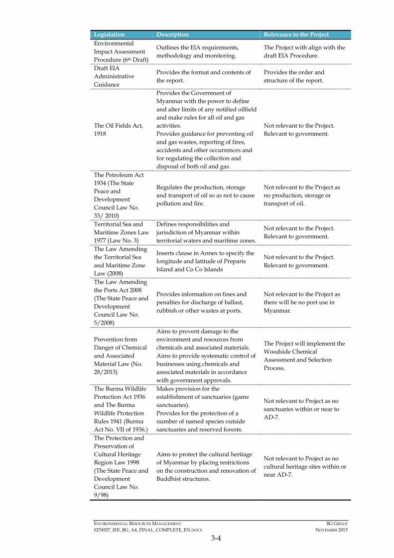
ENVIRONMENTAL RESOURCES MANAGEMENT BG GROUP 0274927_IEE_BG_A4_FINAL_COMPLETE_EN.DOCX NOVEMBER 2015
3-4
Legislation Description Relevance to the Project Environmental Impact Assessment Procedure (6th Draft)
Outlines the EIA requirements, methodology and monitoring.
The Project with align with the draft EIA Procedure.
Draft EIA Administrative Guidance
Provides the format and contents of the report.
Provides the order and structure of the report.
The Oil Fields Act, 1918
Provides the Government of Myanmar with the power to define and alter limits of any notified oilfield and make rules for all oil and gas activities. Provides guidance for preventing oil and gas wastes, reporting of fires, accidents and other occurrences and for regulating the collection and disposal of both oil and gas.
Not relevant to the Project. Relevant to government.
The Petroleum Act 1934 (The State Peace and Development Council Law No. 33/ 2010)
Regulates the production, storage and transport of oil so as not to cause pollution and fire.
Not relevant to the Project as no production, storage or transport of oil.
Territorial Sea and Maritime Zones Law 1977 (Law No. 3)
Defines responsibilities and jurisdiction of Myanmar within territorial waters and maritime zones.
Not relevant to the Project. Relevant to government.
The Law Amending the Territorial Sea and Maritime Zone Law (2008)
Inserts clause in Annex to specify the longitude and latitude of Preparis Island and Co Co Islands
Not relevant to the Project. Relevant to government.
The Law Amending the Ports Act 2008 (The State Peace and Development Council Law No. 5/2008)
Provides information on fines and penalties for discharge of ballast, rubbish or other wastes at ports.
Not relevant to the Project as there will be no port use in Myanmar.
Prevention from Danger of Chemical and Associated Material Law (No. 28/2013)
Aims to prevent damage to the environment and resources from chemicals and associated materials. Aims to provide systematic control of businesses using chemicals and associated materials in accordance with government approvals.
The Project will implement the Woodside Chemical Assessment and Selection Process.
The Burma Wildlife Protection Act 1936 and The Burma Wildlife Protection Rules 1941 (Burma Act No. VII of 1936.)
Makes provision for the establishment of sanctuaries (game sanctuaries). Provides for the protection of a number of named species outside sanctuaries and reserved forests.
Not relevant to Project as no sanctuaries within or near to AD-7.
The Protection and Preservation of Cultural Heritage Region Law 1998 (The State Peace and Development Council Law No. 9/98)
Aims to protect the cultural heritage of Myanmar by placing restrictions on the construction and renovation of Buddhist structures.
Not relevant to Project as no cultural heritage sites within or near AD-7.
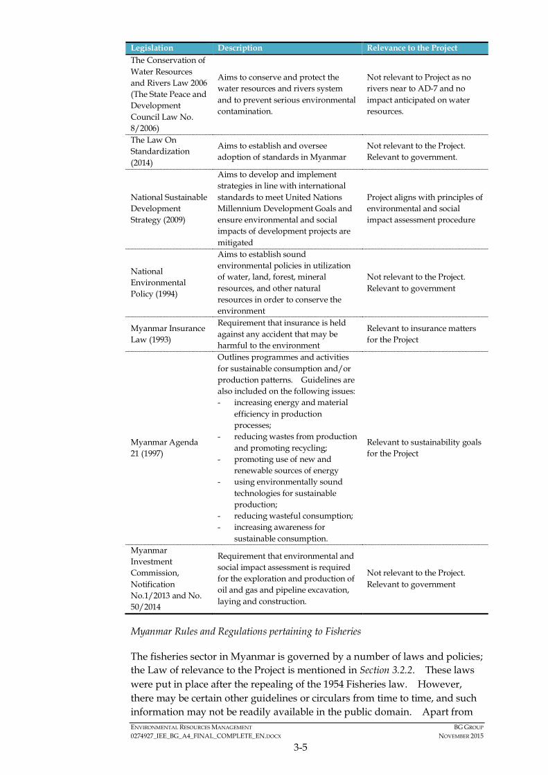
ENVIRONMENTAL RESOURCES MANAGEMENT BG GROUP 0274927_IEE_BG_A4_FINAL_COMPLETE_EN.DOCX NOVEMBER 2015
3-5
Legislation Description Relevance to the Project The Conservation of Water Resources and Rivers Law 2006 (The State Peace and Development Council Law No. 8/2006)
Aims to conserve and protect the water resources and rivers system and to prevent serious environmental contamination.
Not relevant to Project as no rivers near to AD-7 and no impact anticipated on water resources.
The Law On Standardization (2014)
Aims to establish and oversee adoption of standards in Myanmar
Not relevant to the Project. Relevant to government.
National Sustainable Development Strategy (2009)
Aims to develop and implement strategies in line with international standards to meet United Nations Millennium Development Goals and ensure environmental and social impacts of development projects are mitigated
Project aligns with principles of environmental and social impact assessment procedure
National Environmental Policy (1994)
Aims to establish sound environmental policies in utilization of water, land, forest, mineral resources, and other natural resources in order to conserve the environment
Not relevant to the Project. Relevant to government
Myanmar Insurance Law (1993)
Requirement that insurance is held against any accident that may be harmful to the environment
Relevant to insurance matters for the Project
Myanmar Agenda 21 (1997)
Outlines programmes and activities for sustainable consumption and/or production patterns. Guidelines are also included on the following issues: - increasing energy and material
efficiency in production processes;
- reducing wastes from production and promoting recycling;
- promoting use of new and renewable sources of energy
- using environmentally sound technologies for sustainable production;
- reducing wasteful consumption; - increasing awareness for
sustainable consumption.
Relevant to sustainability goals for the Project
Myanmar Investment Commission, Notification No.1/2013 and No. 50/2014
Requirement that environmental and social impact assessment is required for the exploration and production of oil and gas and pipeline excavation, laying and construction.
Not relevant to the Project. Relevant to government
Myanmar Rules and Regulations pertaining to Fisheries
The fisheries sector in Myanmar is governed by a number of laws and policies; the Law of relevance to the Project is mentioned in Section 3.2.2. These laws were put in place after the repealing of the 1954 Fisheries law. However, there may be certain other guidelines or circulars from time to time, and such information may not be readily available in the public domain. Apart from
ENVIRONMENTAL RESOURCES MANAGEMENT BG GROUP 0274927_IEE_BG_A4_FINAL_COMPLETE_EN.DOCX NOVEMBER 2015
3-6
these key laws and policies, the following notifications of relevance to the Project were issued for the management of the fisheries sector:
• Fisheries notification on prohibition of fish importing: this notification lists the fish species that may not be imported, exported, sold or kept in captivity without permission of the DoF;
• Notification for control of endangered fish species: this notification lists all the species of fish and mammals that are protected, including dugong, whale, whale shark, dolphin, giant clam and turtle, and included in the list of endangered species in the Convention on International Trade of Endangered Species (CITES); and
• Notification 2/2001: This notification forbids the catch, harassment, killing, possession, sale, purchase, export or transport of whale shark anywhere in Myanmar waters.
3.2.3 International Conventions
Relevant international treaties to which Myanmar is a signatory, include those related to waste management, biodiversity conservation as well as labour conventions.
The key international conventions of relevance to the Project are included in Table 3.2.

ENVIRONMENTAL RESOURCES MANAGEMENT BG GROUP 0274927_IEE_BG_A4_FINAL_COMPLETE_EN.DOCX NOVEMBER 2015
3-1
Table 3.2 International Conventions of Relevance to the Project
Legislation Description Relevance to the Project
Ratification Status
Environmental
The International Convention for the Prevention of Pollution from Ships 1973, as modified by the Protocol of 1978 relating thereto and by the Protocol of 1997( MARPOL)
Regulates waste, emission and discharges from vessels. Contains the following Annexes: • Annex I: Regulations for the
Prevention of Pollution by Oil (October 1983)
• Annex II: Regulations for the Control of Pollution by Noxious Liquid Substances in Bulk (1986)
• Annex III: Regulations for the Prevention of Pollution by Harmful Substances Carried by Sea in Packaged Form (1992)
• Annex IV: Regulations for the Prevention of Pollution by Sewage from Ships (September 2003)
• Annex V: Regulations for the Control of Pollution by Garbage from Ships (December 1998)
• Annex VI: Regulations for the Prevention of Air Pollution from Ships (1997)
The Project vessels will comply with emissions and discharge standards. Annex I, IV, V and VI are or relevance to the Project.
Entered into force 4 August 1988; (Annexes I and II only)
Vienna Convention for the Protection of the Ozone Layer 1988 and Montreal Protocol on Substances that Deplete the Ozone Layer 1989
Aims at the protection of the ozone layer, including requirements for limiting the production and use of ozone depleting substances.
Not relevant to the Project as the Project will not use any ozone depleting substances.
Accession 16 Sep 1998 (Vienna) & Accession 24 Nov 1993 (Montreal)
Convention on Biological Diversity 1992
Aims to promote national policies for the conservation of wild flora, fauna and habitat that needs to be included in planning policies. The three main goals are: (1) the conservation of the biological diversity; (2) the sustainable use of its components; (3) fair and equitable sharing of the benefits.
The Project will be undertaken in offshore habitats.
Ratified 25 Nov 1994
Basel Convention on the Control of Transboundary Movements of Hazardous Wastes and Their Disposal
The Convention regulates the transboundary movements of hazardous wastes and provides obligations to its Parties to ensure that such wastes are managed and disposed of in an environmentally sound manner.
The Project may generate hazardous wastes.
Entered into force 6 April 2015

ENVIRONMENTAL RESOURCES MANAGEMENT BG GROUP 0274927_IEE_BG_A4_FINAL_COMPLETE_EN.DOCX NOVEMBER 2015
3-2
Legislation Description Relevance to the Project
Ratification Status
United Nations Framework Convention on Climate Change 1992 (UNFCCC) and Kyoto Protocol 1997
Provide a framework for intergovernmental efforts to tackle climate change. Recognises that the climate system is a shared resource whose stability can be affected by industrial and other emissions of carbon dioxide and other greenhouse gases.
The Project will form part of Myanmar’s total emissions output.
Entered in force 23 Feb 1995 (UNFCCC) and 16 Feb 2005 (Kyoto Protocol)
Asia Least Cost Greenhouse Gas (GHG) Abatement Strategy (ALGAS) 1998
Develop national and regional capacity for preparation of GHG inventories. Assist in identifying GHG abatement options and preparation of a portfolio of abatement projects for each country.
The Project will produce air emissions from the survey vessels.
1998
United Nations Agenda 21
Formed by the National Commission for Environmental Affairs (NCEA) in Myanmar. Provides a framework of programmes and actions for achieving sustainable development in the country. Building on the National Environment Policy of Myanmar, takes into account principles contained in the Global Agenda 21. Myanmar Agenda 21 also aims at strengthening and promoting systematic environmental management in the country.
Not relevant to Project. Relevant to government.
Since 1997
Social The International Convention for the Safety of Life at Sea (SOLAS) 1974
Ensures that ships flagged by signatory States comply with minimum safety standards in construction, equipment and operation.
The Project vessels will comply with safety standards.
Entered into Force 11 Feb 1988
Convention on the International Regulations for Preventing Collisions at Sea (COLREG) 1972
Sets out the navigation rules to be followed by ships and other vessels at sea to prevent collisions between two or more vessels.
The Project vessels will comply with navigation rules.
Entered into Force 11 Nov 1987
International Convention on Standards of Training, Certification and Watch-keeping for Seafarers 1978 (STCW)
Sets out requirements for marine environment awareness training and training in leadership and teamwork including new training guidance for personnel operating Dynamic Positioning (DP) Systems.
The Project vessels will comply with training requirements including for DP.
Entered into Force 1988
ENVIRONMENTAL RESOURCES MANAGEMENT BG GROUP 0274927_IEE_BG_A4_FINAL_COMPLETE_EN.DOCX NOVEMBER 2015
3-3
3.2.4 International Standards and Guidelines
In addition to national legislation, a range of international standards, including IFC Performance Standards (IFC PS) and the World Bank Guidelines have been applied to the Project. These standards are set to complement and reinforce national legislation and ensure the Project is conducted under best practices in a way that minimises risks, impacts and ensures compliance and fair practices. The IFC PS and the World Bank Guidelines provide guidance on how to identify risks and impacts, and are designed to help avoid, mitigate and manage risks and impacts. The wording of the PSC signed by BG Group states that the Project should be carried out in accordance with the applicable provisions of the IFC PSs, the World Bank Group Environmental, Health and Safety Guidelines for Offshore Oil & Gas Development (2007) and other good international industry practices. The standards also encourage doing business in a sustainable way and include stakeholder engagement and disclosure obligations of the Project Proponent in relation to project-level activities (1) (2).
BG Group’s policies (as mentioned in Section 3.1) and the PSC (Section 3.3.2) are aligned to international best practice. As such, BG Group’s approach is broadly consistent with the following international guidelines and standards:
• IFC Performance Standards (IFC PS) (2012). The IFC PS represent the ’policy framework’ for the ESIA and sustainable social and environmental management for the Project, whereas the World Bank Group’s EHS Guidelines provide guidance on general and industry best practice as well as recommended numerical limits for emissions to the atmosphere, noise, liquid and solid wastes, hazardous wastes, health and safety, and other aspects of industrial facilities and other types of development projects;
• World Bank Group (WBG) Environmental Health and Safety (EHS) General Guidelines (2007). The EHS Guidelines are technical reference documents with general and industry-specific examples of Good International Industry Practice (GIIP). The EHS Guidelines contain the performance levels and measures that are generally considered to be achievable in new facilities by existing technology at reasonable costs; and
• WBG EHS Guidelines for Offshore Oil and Gas Development (2015): These latest guidelines for offshore oil and gas development (June 2015) consider industry-specific impacts and management relevant to the environment, occupational health and safety and community health and safety, as well as the development of performance indicators and monitoring programs. The applicability of the EHS Guidelines should be tailored to the hazards and risks established for each project on the basis of the results of the environmental assessment.
(1) IFC Performance Standards on Environmental and Social Sustainability, January 2012, International Finance
Corporation, World Bank Group.
(2) Environmental, Health and Safety (EHS) Guidelines – General EHS Guidelines: Introduction, April 2007, International Finance Corporation, World Bank Group
ENVIRONMENTAL RESOURCES MANAGEMENT BG GROUP 0274927_IEE_BG_A4_FINAL_COMPLETE_EN.DOCX NOVEMBER 2015
3-4
• United Nations Environment Program (UNEP) Guidelines on Environmental Management for Oil and gas Exploration and Production (1997): This document provides an overview of the environmental issues and the technical and management approaches to achieving high environmental performance in the activities necessary for oil and gas exploration and production.
Other good international industry practice guidelines from organisations such as the International Maritime Organisation (IMO), American Petroleum Institute (API), International Petroleum Industry Environmental Conservation Association (IPIECA) and International Association of Oil and Gas Producers (IOGP) has been considered for the Project including:
• IAGC Recommended Mitigation Measures For Cetaceans during Geophysical Operations (June 2011).
• UK Joint Nature Conservation Committee (JNCC) Guidelines for minimizing the risk of injury and disturbance to marine mammals from seismic surveys (August 2010).
• Joint OGP/ IAGC position paper Seismic Surveys & Marine Mammals (2004).
• International Petroleum Industry environment and Conservation Association (IPIECA) the Oil Gas Industry: Operating in Sensitive Environments (2003).
• International Association of Oil and Gas Producers(OGP) Environmental management in oil and gas exploration and production (1997).
• OGP Waste Management Guidelines (1993).
• International Cable Protection Committee (ICPC) Procedure to be followed Seismic Survey Work is undertaken in the Vicinity of Active Submarine Cable Systems (ICPC Recommendation No.8).
3.3 INSTITUTIONAL FRAMEWORK OF THE PROJECT PROPONENT AND MYANMAR GOVERNMENT
3.3.1 Administrative Structure of Myanmar
Health, Safety and Environmental (HSE) requirements
Matters pertaining to Health, Safety and Environmental (HSE) requirements are generally under the jurisdiction of the ministries and state-owned enterprises in the oil and gas sector. Key ministries, agencies and state-owned enterprises that have jurisdiction over HSE matters in oil and gas operations include the following:
• Ministry of Environmental Conservation and Forestry (MOECAF) - The Environmental Conservation Department (ECD) of MOECAF has ultimate
ENVIRONMENTAL RESOURCES MANAGEMENT BG GROUP 0274927_IEE_BG_A4_FINAL_COMPLETE_EN.DOCX NOVEMBER 2015
3-5
responsibility in the review and approval, or otherwise, of submissions under the EIA process.
• Myanma Oil and Gas Enterprise (MOGE) - MOGE is the state-owned enterprise responsible for working together with oil and gas companies (local and international) in Myanmar and oversees the PSCs in cooperation with foreign oil companies. MOGE involves in direct communication and coordination with various levels of different government agencies for HSE related issues.
• Ministry of Energy (MOE) - MOE jointly works with MOGE in managing HSE issues of oil and gas operators in Myanmar, in which MOE encourages operators to establish an HSE Management System and prepare their own EIA/SIA for their project.
• Myanmar Investment Commission (MIC) - MIC is a government agency responsible for coordinating with ministries (such as the MOE) and other state entities to facilitate foreign investment in Myanmar. The MIC is also responsible for granting MIC permits which enable foreign investors to carry out business activities under the Foreign Investment Law (1998). The Law specifies MIC shall “take consideration on the facts such as financial credibility, economic justification of the business, appropriateness of technology and protection and conservation of environment in scrutinizing the proposals of investment”.
Fisheries Organizations
The key organizations involved in the governance of the fisheries sector are as discussed in the section below.
Department of Fisheries
The Department of Fisheries (DoF), under the Ministry of Livestock and Fisheries, is the main institutional body which governs the fishing ground, methods and catch volume for the fishing rights operations. The DoF is responsible for the all-round development of the fisheries sector and management of the commercial fisheries activities including exports. The head office dedicates fisheries administrations to the provincial offices in States and Divisions.
The DoF is responsible for the following:
• Issuing of licenses for fisheries/gear/vessels/sites and aquaculture sites/ventures’;
• Advise the Ministry of Livestock and Fisheries and the Divisional and State Government on fisheries and aquaculture matters;
• Act as regulatory body for the correct and proper conduct of fisheries and aquaculture;
ENVIRONMENTAL RESOURCES MANAGEMENT BG GROUP 0274927_IEE_BG_A4_FINAL_COMPLETE_EN.DOCX NOVEMBER 2015
3-6
• Facilitating the technical needs and equipment of the marine sector;
• Undertaking research and development activities; and
• Training and extension.
Myanmar Fisheries Federation
The Myanmar Fisheries Federation (MFF) was formed in 1998 from the Myanmar Fishery Association. It is a Non-governmental Organization (NGO) that deals with the fisheries industries. It was formed as part of the ASEAN Fisheries Federation.
The organization operates at a local and national level, with most of the larger fish farmers being members of the local MFF branch. The MFF is governed by a Central Executive Committee which plays a coordinating role and supported by office holders. The roles of the MFF are as follows:
• Support applications made by its members to DoF for the license to undertake fisheries and aquaculture activities;
• Support applications to the Livestock and Fisheries Bank for loan applications;
• Raise issues of collective importance to their members with the DoF, such as accessing initial investment, raw materials for feeds, negotiating with local authorities to change use of land;
• Assist in the negotiations of selling and harvesting, working collectively;
• Assist in the transferring of technology to farmers; and
• Assist in the communication and cooperation with trans-boundary organization.
3.3.2 PSC Requirements
More specifically, the planned operations at Block A-4 are governed by the Production Sharing Contract. Included in this are the requirements that the Contractor (i.e. BG Group) shall:
• “ …be responsible to conduct environmental impact assessment (EIA) and social impact assessment (SIA) and to development of Environmental Management Plan (EMP) and implementation for the environmental protection and management in the Contract Area in accordance with the laws, rules, regulations, directive and notifications of the Republic of the Union of Myanmar in conformity with international petroleum industry’s practices with respect to the environment protection and mitigation;
• be responsible for execution of Work Programme which shall be implemented in a work-manlike manner and CONTRACTOR shall take such precautions for protection of navigation and fishing and CONTRACTOR shall be responsible
ENVIRONMENTAL RESOURCES MANAGEMENT BG GROUP 0274927_IEE_BG_A4_FINAL_COMPLETE_EN.DOCX NOVEMBER 2015
3-7
to conduct Petroleum Operations in accordance with the applicable provisions of the International Financing Corporation Performance Standards (2012), the World Bank Group Environmental, Health and Safety Guidelines for Offshore Oil & Gas Development (2007), good international petroleum industry practices and the laws, regulations and directives of the Republic of the Union of Myanmar with respect to Environmental and Social protection. The steps to carry out these obligations shall be instituted into the Work programme. It is also understood that the execution of the Work Programme shall be exercised so as not to conflict with the laws of the Republic of the Union of Myanmar as they exist as of the Effective Date.”
3.4 ENVIRONMENTAL AND/OR HEALTH STANDARDS RELATED TO THE PROJECT E.G. INTERNATIONAL AND/OR DOMESTIC STANDARDS
The Project will apply the IFC Performance Standards (IFC PS) and the World Bank Guidelines. As mentioned in Section 3.1, BG Group’s policies and the PSC are aligned to Good International Industry Practise (GIIP). More information on the applicable environmental and social standards is provided in the sections above. The specific emission limit values and environmental quality standards that are relevant to the Project are shown in Table 7.1 of Section 7.
The Project is currently being undertaken to international standards mentioned in this Section. However should national standards come into force prior to commencement of Project operations, the Project will as a minimum adopt the most stringent of these standards.

ENVIRONMENTAL RESOURCES MANAGEMENT BG GROUP 0274927_IEE_BG_A4_FINAL_COMPLETE_EN.DOCX NOVEMBER 2015
4-1
4 PROJECT DESCRIPTION AND ALTERNATIVES
This section provides the detailed description of the proposed offshore exploration programme to be conducted across Block A-4. Information provided in this section is based on data made available during preparation of this IEE Report.
4.1 PROJECT BACKGROUND AND OBJECTIVES
BG Group was awarded the PSC for Block A-4 in 2015. Block A-4 is located in the Bay of Bengal, offshore Myanmar. The location of Block A-4 is shown in Figure 2.1.
BG Group intends to undertake an exploration programme in Block A-4 with an overall schedule spanning up to seven (7) years. The initial geophysical and geological sampling program (Phase 1) is proposed to be undertaken during the first two (2) years of the license (i.e. between 2015 and 2017). The intent of the exploration programme is to test the productivity of the area for hydrocarbons using the following standard survey techniques:
• 2D and/or 3D seismic surveys;
• Gravity and magnetics survey in conjunction with the seismic; and,
• Seabed sampling (coring) surveys.
Following the geophysical and geological sampling program, a number of exploration wells may be drilled in Block A-4. These wells are not included in the scope of this IEE Study, and will be subject to separate environmental and social assessment in the future prior to commencement of those activities.
4.2 PROJECT LOCATION
Block A-4 encompasses an area of approximately 7,500 km2 spanning shallow continental shelf waters adjacent to a portion of the Rakhine State mainland and neighbouring Manaung Island to beyond the shelf break into deep open ocean waters. At its eastern edge, the boundary of Block A-4 lies approximately 6 km offshore from the mainland coast and approximately 2 km away from recognised islands. At its western edge, the boundary of the block is located at a distance of a little over 100 km offshore. Water depth of Block A-4 ranges from less than 10 m to greater than 2,000 m. The shelf break (i.e. the margin of the continental shelf) is located roughly parallel to the coast at a distance of approximately 70 km offshore and at about 200 m water depth. The Block is shown in detail in Figure 2.1.

ENVIRONMENTAL RESOURCES MANAGEMENT BG GROUP 0274927_IEE_BG_A4_FINAL_COMPLETE_EN.DOCX NOVEMBER 2015
4-2
4.3 ALTERATIVE SELECTION AND COMPARISON
The Project is an initial data-gathering phase, which if the area appears prospective for hydrocarbons may lead to an exploration drilling program, which if successful in finding economic reserves of gas or oil may lead to development and production. Each of these three phases of activity will be preceded by an environmental and social assessment. Securing indigenous resources for the development of Myanmar is strategically important for the country and this first data gathering exercise is both key to an accurate assessment of prospectivity and has a very low environmental and social impact.
Nevertheless consideration of Project options and alternatives is a fundamental requirement in the planning of any project as a means of avoiding or reducing adverse environmental and social impacts and maximising or enhancing project benefits. Several options that have been considered for the Project include the following:
• Streamer: it is preferred to use solid or gel-filled streamers rather than kerosene-filled streamers as these solid cables, which are constructed of extruded foam, are robust and resistant to damage, do not leak when damaged either on the vessel or in the sea, and are less sensitive to weather and wave noise; gels are inert.
• Sensitive receiver: the 3D seismic survey area should be sited away from key sensitive receivers as far as practicable to avoid disturbance to the environmental and social sensitive receptors. In this instance, the Activity Area is around 10 km from the coastline of Manaung Island where there are sensitive coastal habitats (e.g. coral habitat). In addition, although BG Group are licensed for the entirety of Block A-4, BG are not undertaking any Project activities in water depths of less than 50 m.
• Operational safety zone: the safety zone during seismic operations should be mobile around the survey vessel rather than restricting access to the whole block, in order to minimise disturbance to the extent possible to nearby marine operators, such as fishing vessels; and
• No Project alternative: The “No Project” alternative means that no seismic survey would be undertaken, which in turn implies that no further exploration activity would take place in this Block. Should there be no further exploration activity, no further oil and gas development project would be able to be developed in this area. As a result, no Project would result in fewer opportunities for future gas supply to the domestic market, as well as less direct and indirect employment opportunities.
Many of these options are of relevance to the assessment of potential impacts. Therefore, as the Project options will not be finalised until the tendering process has been completed the relative impacts of each option will be considered where possible in the impact assessment. Where this is not

ENVIRONMENTAL RESOURCES MANAGEMENT BG GROUP 0274927_IEE_BG_A4_FINAL_COMPLETE_EN.DOCX NOVEMBER 2015
4-3
possible a conservative approach will be taken to undertake the subsequent impact assessment as outlined in further in Section 6.
4.4 DESCRIPTION OF SELECTED ALTERNATIVE
The exploration survey activities to be conducted in Block A-4 include 2D and/or 3D seismic survey, gravity and magnetic survey and a seabed sampling survey. The 2D and 3D seismic survey will be conducted at the same time as the gravity and magnetic survey using the same vessel. The seabed sampling survey will be conducted after the seismic survey and will use a different vessel. More detailed information on these three types of surveys is provided in the following sections.
4.4.1 Exploration Programme Duration
The seismic surveys in Block A-4 are currently planned to commence in November 2015, and last for a period of about two months (i.e. up to about 60 days). The timing of the survey coincides with the Northeast monsoon (December to April) so as to avoid the cyclone season. The gravity and magnetic survey will be conducted as part of the seismic survey, i.e. commencing in November 2015 using the same vessel. The seabed sampling survey is proposed to be conducted following completion of the seismic survey from March to April 2016. A tentative programme for the exploration programme in Block A-4 is shown in Table 4.1.
Table 4.1 Tentative Programme for the Exploration Programme in Block A-4
Activity Schedule 3D Seismic Survey November to January 2015 Gravity and Magnetic Survey* November to January 2015 Seabed Sampling Survey March 2016 * Undertaken using same vessel as seismic survey
4.4.2 Seismic Survey (2D and 3D) Operations
General Principles of Seismic Surveys
Marine geophysical seismic surveys are an integral component of offshore oil and gas exploration and development activities and are used to define sub-seabed deposits and geological structures. During a marine seismic survey, a slow moving survey vessel (typically steaming at about 4 to 6 knots) tows an impulse emitting sound source (array of airguns). High energy low frequency sounds (termed shots) are produced by the airguns and directed downwards at the seabed and underlying sub-seabed geology. These sound waves bounce off the sub-surface rock formations and return to the surface where the seismic energy is collected by an array of receivers (hydrophones). The acquired data is then recorded by onboard computers for subsequent processing to produce profiles of the sub-seabed geology for interpretation by geophysicists. The principles behind marine seismic survey operations are illustrated in Figure 4.1.
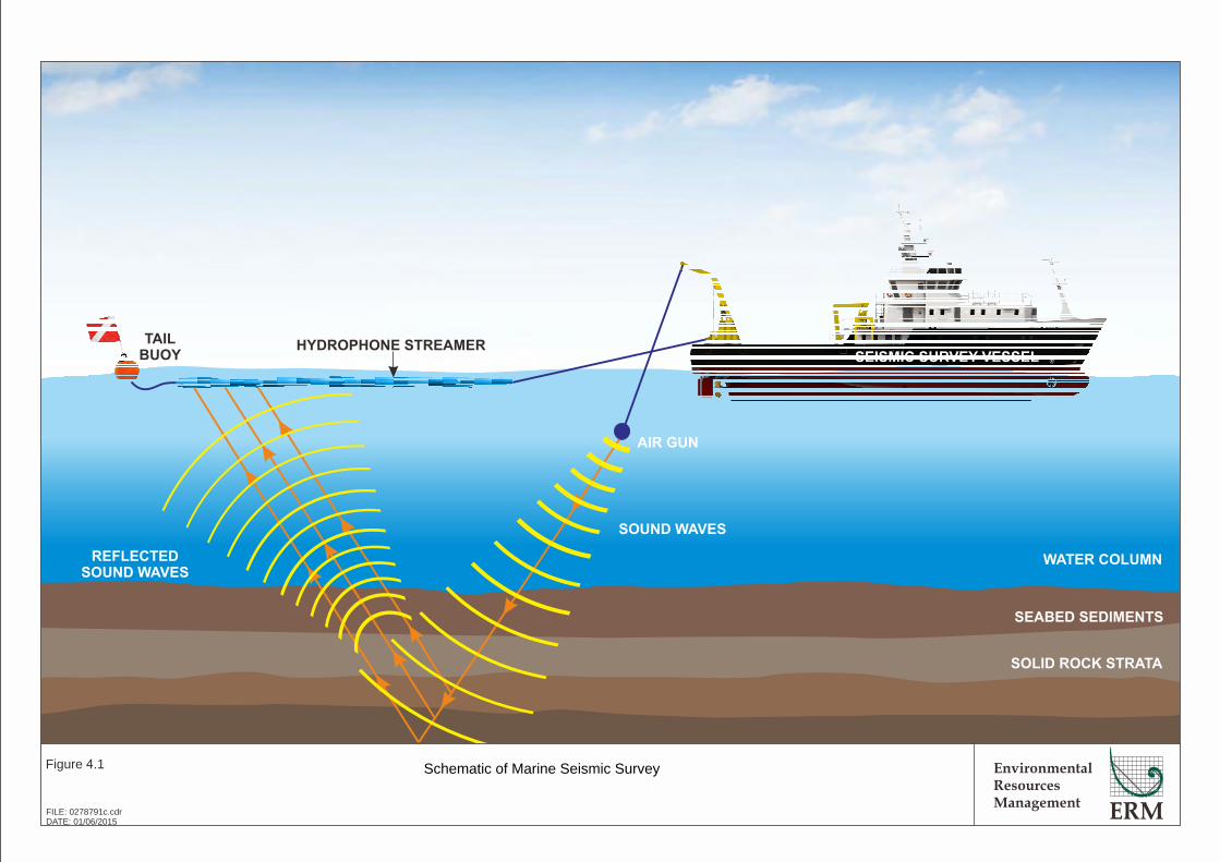
SEISMIC SURVEY VESSEL
EnvironmentalResourcesManagement
Figure 4.1
FILE: 0278791c.cdrDATE: 01/06/2015
Schematic of Marine Seismic Survey
TAIL
BUOYHYDROPHONE STREAMER
AIR GUN
SOUND WAVES
REFLECTED
SOUND WAVES
SOLID ROCK STRATA
SEABED SEDIMENTS
WATER COLUMN
ENVIRONMENTAL RESOURCES MANAGEMENT BG GROUP 0274927_IEE_BG_A4_FINAL_COMPLETE_EN.DOCX NOVEMBER 2015
4-4
When using the marine streamer seismic method, the receivers (hydrophones) are encased in a long cable (streamer), which is towed or “streamed” behind the seismic vessel. The marine seismic survey operations are to be conducted by a specialized seismic survey vessel, which is typically supported by one, or more, smaller vessels referred to as “chase vessels”. The role of the chase vessels is to scout ahead for obstructions (e.g. static fishing gear, fish traps) and to approach and warn-off any shipping that might be ignoring radio warnings to avoid the survey area.
A 2D seismic survey involves acquiring seismic data using a single streamer to detect the reflected seismic energy. It provides data through a two-dimensional, or 2D, vertical cross section of the subsurface geology. A 3D seismic survey involves the use of multiple streamers. As seismic data are acquired from multiple angles, it provides data that can be used to build a detailed 3D model of the subsurface geology. Both types of seismic survey may be conducted in Block A-4.
Seismic Survey Programme
The survey programme will include the following main activities:
• Mobilisation of seismic and support vessels;
• Deployment of towed equipment (i.e. airgun array, streamers);
• Data acquisition, comprising the bulk of the programme; and
• Retrieval of equipment and demobilisation.
The survey itself will cover approximately 7,500 km2 within the block. The location of the Activity Area is shown in Figure 2.1. As per standard operations, the seismic survey will be acquired in swaths (width of the deployed streamer arrangement) in a racetrack formation, as shown in Figure 4.2. The seismic vessel will sail down a pre- plotted line (i.e. survey/ sail line) at the centre of each swath. The sail lines are then acquired at intervals of up to half the swath width. Upon reaching the end of the sail line, the ship will typically take 2 to 3 hours (a manoeuvring area of 10 – 20 km) to turn around and start down another sail line. The survey will be conducted in a north-west to south-east orientation and will most likely commence in the deeper waters of Block A-4 coming in closer to shore as the survey progresses. Each line will be roughly 90 km (the length of the Block).
The 3D survey will encompass the majority of the Activity Area. The 3D seismic survey will be acquired in open ocean waters in depths beyond the 50m depth contour, over an area approximately 50 to 100 km from the mainland coast and at its closest point, around 10 km from Manaung Island.
Airguns
Airguns are the standard marine seismic energy source. The seismic energy pulse is created when a bubble of compressed air is discharged into the water.
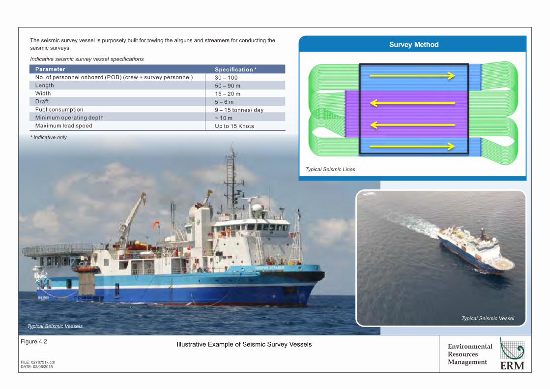
Streamers Survey Method
Parameter
No. of personnel onboard (POB) (crew + survey personnel)
Length
Width
Draft
Fuel consumption
Minimum operating depth
Maximum load speed
Specification *
30 – 100
50 – 90 m
15 – 20 m
5 – 6 m
9 – 15 tonnes/ day
~ 10 m
Up to 15 Knots
* Indicative only
The seismic survey vessel is purposely built for towing the airguns and streamers for conducting the
seismic surveys.
Indicative seismic survey vessel specificationsThe chase / support vessel will maintain an
operational perimeter around the survey
vessel to keep the area clear of obstructions
(e.g. static fishing gear) and to approach
and warn-off any shipping that might be
ignoring radio warnings to avoid the survey
area. Chase boats will normally sail
approximately several hundred meters in
front, at both sides and at the back of the
survey vessel to provide sufficient support.
Chase boats can also act as supply vessels
which support the survey vessel with fuel
and consumables.
A 3D seismic survey is acquired in swaths
(width of the deployed streamer
arrangement) in a racetrack formation.
The seismic vessel sails down a pre-
plotted line (i.e. survey/ sail line) at the
centre of each swath. The footprint of
each swath will depend on the number of
streamers deployed and their separation
and may range from ~ 0.3 to > 1 km
between the outermost streamers. The
sail lines are then acquired at intervals of
up to half the swath width. Upon reaching
the end of the sail line, the ship will
typically take 2 – 3 hours (a manoeuvring
area of 10 – 20 km) to turn around and
start down another sail line.
The seismic survey vessel and the support vessel are
expected to have crew of around 40 and 10 people on board,
respectively. Berlanga will provide On-board
Representatives during the seismic survey to monitor the
performance of the survey contractor and to monitor and
control that all operations are in full compliance with the
seismic acquisition programme.
Typical Seismic Lines
Contracted vessels will be required to follow International Convention for the Prevention of Pollution from Ships (MARPOL) requirements with regards to handling of waste, wastewater and effluents. This includes effluent treatment for sanitary and domestic wastewater to meet MARPOL requirements prior to discharge to sea, maceration of food wastes, collection and treatment of potentially contaminated drainage water and bilge water, and discharge in accordance with MARPOL standards. Used oil and oil/water mixtures from the vessel will either be stored on board, for eventual recycle / reuse onshore at an approved facility, or incinerated on board.
Environmental Resources Management
Figure 4.2
FILE: 0278791k.cdrDATE: 02/06/2015
Illustrative Example of Seismic Survey Vessels
Typical Seismic Vessels
Typical Seismic Vessel
ENVIRONMENTAL RESOURCES MANAGEMENT BG GROUP 0274927_IEE_BG_A4_FINAL_COMPLETE_EN.DOCX NOVEMBER 2015
4-5
An airgun array comprises a number of different sized airguns – this helps to attenuate the residue bubble pulse and enhance the signal level. Illustrative examples of seismic survey airguns are presented in Figure 4.3.
For the seismic survey in Block A-4, seismic activities will use several individual airguns, ranging in size from 20 - 250 cubic inches, with a total airgun array volume around 4,000 cubic inches. Each gun is proposed to be at a water depth of 8 m, using a firing interval of 10 seconds and a shot point interval of 25 m. The airgun array is configured to ensure that guns are positioned as such to reduce the extent at which sound can travel underwater (i.e., the sound is directed towards the seabed to minimise horizontal spreading).
Streamers
For the Block A-4 survey, the receivers (hydrophones) will be encased in long cables (up to 12 streamers), which are towed or “streamed” behind the seismic vessel at a depth of up to 30 m below the sea surface. The streamers will be around 8 km in length and will be spaced 150 m apart behind the vessel with an overall width of around 1.65 km. Hydrophones will be evenly spaced along the streamer to provide the required sub-surface information. Recordings captured by the hydrophones are several seconds long and will be sampled every 1 – 2 milliseconds (thousandths of a second). A tail buoy will be fitted to the end of each streamer and will be brightly coloured and filled with a radar reflector and strobe light. More information on streamer equipment is provided in Figure 4.4 and 4.5. The overall layout of the seismic equipment is provided in Figure 4.6.
Seismic Survey Vessel
For Block A-4 a specialized survey vessel will be selected for the actual seismic survey which is expected to have crew of around 40 people on-board. At the time of writing, the contracting process for the seismic contractor is still in progress so the specific details of the survey cannot be released. However, the information provided is based on standard seismic survey techniques and methods. Illustrative examples of typical seismic survey vessels are presented in Figure 4.2. It can be assumed that the following vessel specifications may be followed (Table 4.2).
Table 4.2 Potential Seismic Survey Vessel Specifications for Block A-4
Typical Seismic Vessel Specification No. Personnel on Board (POB) Maximum of 80 people Length 80 m Beam 16 m Max Draft 8.0 m Gross Tonnage 4,000 GT Fuel consumption 16 metric tons per day
All survey operations will be conducted in accordance with the vessels standard operating procedures, which detail the manner in which all

Environmental Resources Management
Figure 4.3
FILE: 0278791i.cdrDATE: 02/06/2015
Illustrative Example of Airguns for Use in Marine Seismic Surveys
An airgun is a pneumatic
device that produces
acoustic output by
rapidly releasing a
volume of compressed
air.
Sizes of airguns vary
greatly and there is no
“standard” size. The
individual guns are
suspended in the water
from a float system. Airgun
arrays are composed of
sub-arrays, each
suspended from its own
float to maintain the
specified operating depth.
Typical information on
airgun arrays is provided in
the table on the right.* Indicative only
Parameter
Number of airguns per sub-array
Array size options
Operating pressure
Operational depth
Array width
Array length
Firing interval
Distance behind vessel
Specification *
6 - 7 per sub-arrays
750 - 4,000 cubic inches
1,500 - 2,500 psi
4 - 10 m below sea surface
16 - 36 m
14 - 21 m
7 - 10 seconds
100 - 200 m
Hi-pressure air inlet
Solenoid(closed)
Solenoid(open)
Charge Discharge
Indicative Airgun Specifications
(Source:www.stamfordadvocate.com)

Tail Buoys
Environmental Resources Management
Figure 4.4
FILE: 0278791j.cdrDATE: 02/06/2015
Illustrative Example of Tail Buoy and Birds
Birds
Streamer systems are provided with electronic cable levelling /
depth control devices (adjustable fins/ hydroplanes also known
as “birds”). These allow the streamer to be raised/ lowered in the
water column to optimise its position or to avoid hazards.
Birds
Radar Reflector on Bird
A tail buoy is connected to the far end of each streamer to provide positional information and also
warn of presence of the submerged towed streamer both (especially at night). A deivce known as a
“turtle guards” will be installed on the tail buoys for preventing sea turtles from becoming fatally
entrapped in the gaps in the tail buoys undercarriage.
The tail buoys are usually brightly coloured and are provided with a radar reflector and flashing lights;
if required an audible warning device can also be fitted.
(Source: www.seamap.com)
Tail Buoy (Source: www.seamap.com)
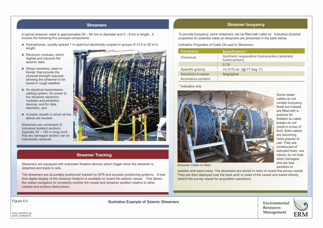
Environmental Resources Management
Figure 4.5
FILE: 0278791l.cdrDATE: 02/06/2015
Illustrative Example of Seismic Streamers
A typical streamer cable is approximately 50 – 80 mm in diameter and 3 – 6 km in length. It houses the following five principal components :
n Hydrophones, usually spaced 1 m apart but electrically coupled in groups of 12.5 or 25 m in length;
n Electronic modules, which digitise and transmit the seismic data;
n Stress members, steel or Kevlar, that provide the physical strength required, allowing the streamer to be towed in rough weather.
n An electrical transmission cabling system, for power to the streamer electronic modules and periphery devices, and for data telemetry; and
n A plastic sheath in which all the above are housed.
Streamers are comprised of individual isolated sections (typically 50 – 150 m long) such that any damaged section can be individually replaced.
Streamers
To provide buoyancy, some streamers can be filled with cable oil. Indicative physical properties for potential cable oil streamers are presented in the table below.
Indicative Properties of Cable Oil used in Streamers
Streamer buoyancy
Streamer Tracking
Parameter
Chemical
Specific gravity
Solubility in water
Aromatics content
Specification *
Synthetic isoparafinic hydrocarbon (aliphatic hydrocarbon)
0.79
<0.01% wt. (@ 77 deg. F)
Negligible
Streamer Cable on ReelStreamers are equipped with automatic flotation devices which trigger when the streamer is detached and starts to sink.
The streamers are accurately positioned/ tracked by GPS and acoustic positioning systems. A real time digital display of the streamer footprint is available on board the seismic vessel. This allows the vessel navigators to constantly monitor the vessel and streamer position relative to other vessels and surface obstructions.
Some newer cables do not contain buoyancy fluids but instead are filled with a polymer for flotation so cable breaks do not result in a loss of fluid. Solid cables are becoming more popular to use. They are constructed of extruded foam, are robust, do not leak when damaged, and are less sensitive to
weather and wave noise. The streamers are stored in reels on board the survey vessel. They are then deployed over the back and/ or sides of the vessel and towed directly behind the survey vessel for acquisition operations.
* Indicative only
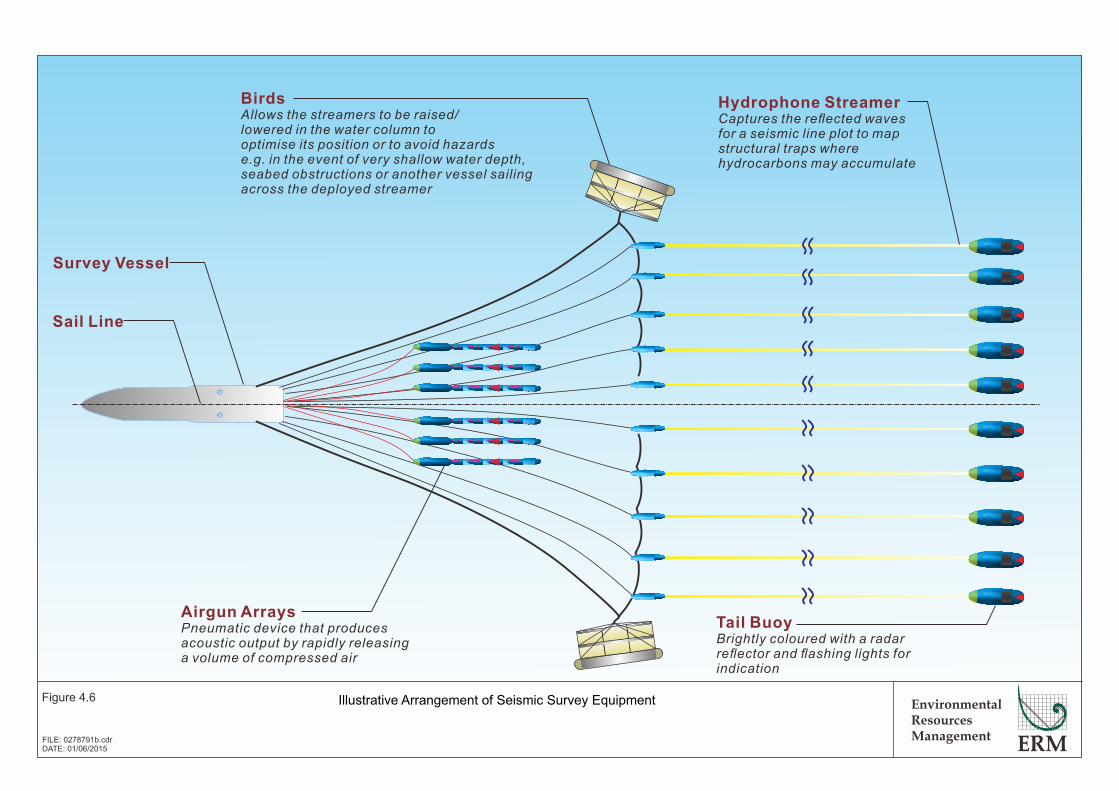
Sail Line
Survey Vessel
Airgun ArraysPneumatic device that produces acoustic output by rapidly releasing a volume of compressed air
Hydrophone StreamerCaptures the reflected waves for a seismic line plot to map structural traps where hydrocarbons may accumulate
Tail BuoyBrightly coloured with a radar reflector and flashing lights for indication
BirdsAllows the streamers to be raised/ lowered in the water column to optimise its position or to avoid hazards e.g. in the event of very shallow water depth, seabed obstructions or another vessel sailing across the deployed streamer
30 minutes pre-survey observation
Proceed with soft start if no marine mammals
observed
Air gun shut down
Proceed with soft start once animals leave the
observation zone
50metres
50metres
me0 tr0 e5 s
5 s0 er0 tme
Environmental Resources Management
Figure 4.6
FILE: 0278791b.cdrDATE: 01/06/2015
Illustrative Arrangement of Seismic Survey Equipment

ENVIRONMENTAL RESOURCES MANAGEMENT BG GROUP 0274927_IEE_BG_A4_FINAL_COMPLETE_EN.DOCX NOVEMBER 2015
4-6
operations are to be conducted. These procedures also detail the responses and actions to be taken in the event of accidental events or upset conditions.
The survey vessel will be equipped with extensive navigation, radio/satellite communication equipment as well as dual radar systems. Regular warning messages will be broadcast advising other vessels in the area of the proposed operations.
Chase Vessels
Typically between one to three chase vessels will be provided by the seismic survey contractor. The chase vessels will maintain an operational perimeter around the survey vessel to keep the area clear of obstructions (e.g. static fishing gear). The chase vessel will also ensure that any shipping or fishing vessels are protected from collision or incidents by providing radio warnings of the presence of the seismic vessel and survey area. Chase vessels will normally sail a few kilometers in front, at both sides and at the back of the survey vessel to provide sufficient support. There will also be a separate supply vessel which supports the survey vessel with fuel and consumables.
BG Group will ensure that all vessels are capable for the operation. Contractor personnel are well-trained in terms of their job responsibilities, health and safety, and environment requirements. In addition, prior to vessel mobilization, BG Group personnel will conduct a full technical and Health, Environment and Safety (HES) audit on the vessel, its crew, operational procedures and equipment.
Each chase vessel is expected to have crew of around 10 people on board. BG Group will provide On-board Representatives during the seismic survey to monitor the performance of the survey contractor and to monitor and control that all operations are in full compliance with the seismic acquisition programme.
4.4.3 Gravity and Magnetic Survey
Gravity and magnetic surveys are used within the oil and gas industry to assess the depth and nature of the seabed sediments, measure the density of the subsurface layer, and map any seabed and subsurface anomalies to more accurately target oil and gas deposits. These surveys will be conducted that the same time as the seismic survey using the same vessel. The equipment passively measures the naturally occurring variations in the earth’s gravity and magnetic fields and does not have any associated emissions.
4.4.4 Seabed Sampling Survey
Seabed sampling surveys are used within the oil and gas industry to assist characterisation of the surface and subsurface sediments found on the seafloor, which can then be used to provide information on the hydrocarbon and reservoir potential of an area.
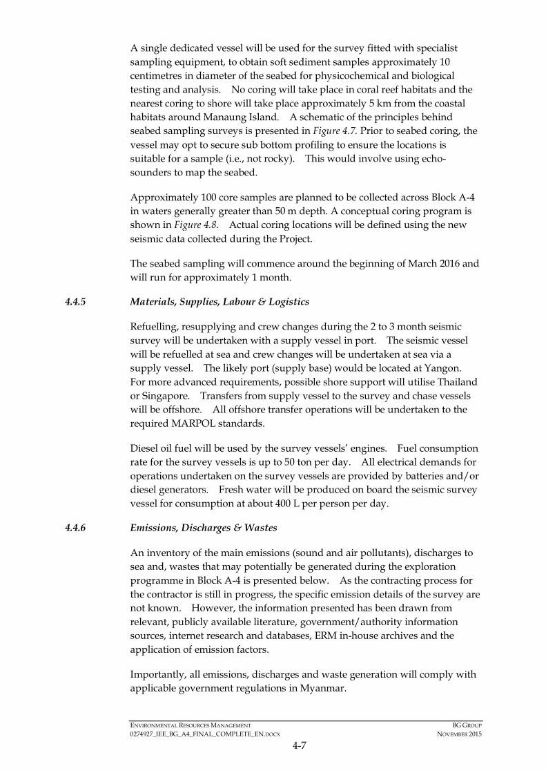
ENVIRONMENTAL RESOURCES MANAGEMENT BG GROUP 0274927_IEE_BG_A4_FINAL_COMPLETE_EN.DOCX NOVEMBER 2015
4-7
A single dedicated vessel will be used for the survey fitted with specialist sampling equipment, to obtain soft sediment samples approximately 10 centimetres in diameter of the seabed for physicochemical and biological testing and analysis. No coring will take place in coral reef habitats and the nearest coring to shore will take place approximately 5 km from the coastal habitats around Manaung Island. A schematic of the principles behind seabed sampling surveys is presented in Figure 4.7. Prior to seabed coring, the vessel may opt to secure sub bottom profiling to ensure the locations is suitable for a sample (i.e., not rocky). This would involve using echo-sounders to map the seabed.
Approximately 100 core samples are planned to be collected across Block A-4 in waters generally greater than 50 m depth. A conceptual coring program is shown in Figure 4.8. Actual coring locations will be defined using the new seismic data collected during the Project.
The seabed sampling will commence around the beginning of March 2016 and will run for approximately 1 month.
4.4.5 Materials, Supplies, Labour & Logistics
Refuelling, resupplying and crew changes during the 2 to 3 month seismic survey will be undertaken with a supply vessel in port. The seismic vessel will be refuelled at sea and crew changes will be undertaken at sea via a supply vessel. The likely port (supply base) would be located at Yangon. For more advanced requirements, possible shore support will utilise Thailand or Singapore. Transfers from supply vessel to the survey and chase vessels will be offshore. All offshore transfer operations will be undertaken to the required MARPOL standards.
Diesel oil fuel will be used by the survey vessels’ engines. Fuel consumption rate for the survey vessels is up to 50 ton per day. All electrical demands for operations undertaken on the survey vessels are provided by batteries and/or diesel generators. Fresh water will be produced on board the seismic survey vessel for consumption at about 400 L per person per day.
4.4.6 Emissions, Discharges & Wastes
An inventory of the main emissions (sound and air pollutants), discharges to sea and, wastes that may potentially be generated during the exploration programme in Block A-4 is presented below. As the contracting process for the contractor is still in progress, the specific emission details of the survey are not known. However, the information presented has been drawn from relevant, publicly available literature, government/authority information sources, internet research and databases, ERM in-house archives and the application of emission factors.
Importantly, all emissions, discharges and waste generation will comply with applicable government regulations in Myanmar.
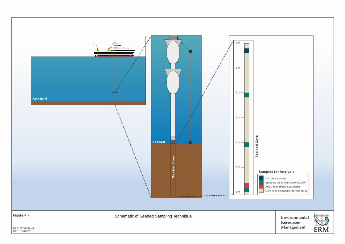
EnvironmentalResourcesManagement
Figure 4.7
FILE: 0274927e.cdrDATE: 05/06/2015
Schematic of Seabed Sampling Technique
Seabed
Seabed
Se
a b
ed
Co
re
0m
1m
2m
3m
4m
5m
6m
Se
a b
ed
Co
re
Samples for Analysis
Microbial Sample
Standard Geochemical Evaluation
AGI Geochemical Evaluation
Core to be shipped for further study
!
!
!
!
!
!
!
!
!
!
!
!
!
!(
!(
!(
!(
!( !(!( !( !(
!( !( !( !( !(
!(
!(!( !( !( !( !(
!(
!(
!( !( !(!(
!(!( !( !( !(
!(
!(
!(
!(
!(
!(
!(!(
!(
!(
!(
!( !(
!(
!(
!(
!(
!(
!(
!(
!(
!(
!(
!(
!(
!(
!(
!(
!(
!(
!(
!(
!(
!(
!(
!(
!(
!( !( !( !( !( !(
!( !(
!( !(
!(
!(
!(
!(!(
!(
!(
!( !(
!(
!(
!(
!(
!(
!(
!(
!(
!(
!(
!(
!(
!(
!(
!(
Manaung
Ramree
Thandwe
Toungup
A-4
ZinChaung
San TinMaw
KyaukOo Mou
KyaukNi Maw
Za KuKyun
MagyeeKyun
Ye Kyun
Ka Ei
Kamar
Zee Taw
Thabyugyaing
SinGaung
Gyeiktaw
94°30'0"E
94°30'0"E
94°0'0"E
94°0'0"E
93°30'0"E
93°30'0"E
93°0'0"E
93°0'0"E
92°30'0"E
92°30'0"E19
°0'0
"N
19°0
'0"N
18°3
0'0"
N
18°3
0'0"
N
18°0
'0"N
18°0
'0"N
450000
450000
500000
500000
550000
550000
600000
600000
650000
650000
2000
000
2000
000
2050
000
2050
000
2100
000
2100
000
Legend
!(
Preliminary SeabedSample Location -Block A-4(Not to scale)
!( Town
!Key Villages /Settlements
Blocks3D Seismic Area
Activity Area
BG Operated Block
Depth (m)< 0
0.1 - 10
10.1 - 20
20.1 - 30
30.1 - 40
40.1 - 50
50.1 - 60
60.1 - 70
70.1 - 80
80.1 - 90
90.1 - 100
100.1 - 200
200.1 - 300
300.1 - 400
400.1 - 500
500.1 - 1,000
1,000.1 - 1,500
1,500.1 - 2,000
2,000.1 - 2,500
> 2,500
® 0 2010Kilometres
Service Layer Credits: Sources: Esri, HERE,DeLorme, USGS, Intermap, increment P Corp.,NRCAN, Esri Japan, METI, Esri China (Hong Kong),Esri (Thailand), TomTom, MapmyIndia, ©OpenStreetMap contributors, and the GIS UserCommunity
Myanmar
Thailand
Bay of Bengal
EnvironmentalResourcesManagement
Sediment Core Sampling Locations
Figure 4.8
File: T:\GIS\CONTRACT\0274927\Mxd\Report_A4\0274927_Sediment_Core_Sampling_Locations_A4.mxdDate: 14/7/2015
ENVIRONMENTAL RESOURCES MANAGEMENT BG GROUP 0274927_IEE_BG_A4_FINAL_COMPLETE_EN.DOCX NOVEMBER 2015
4-8
Underwater Sound Emissions
The primary source of underwater sound associated with seismic surveys is the towed airgun arrays. The sound levels produced by the airguns depend on the number of guns used, their sized (total gas volume), the air pressure level and the depth of their deployment.
Marine seismic survey in Block A-4 will use airgun arrays (high energy, low frequency sound sources). The sources will be simultaneously triggered at fixed period time intervals (10 seconds) while being towed behind the survey vessel. A range of airgun volumes will be used to increase the signal level, focus the signal downwards (limiting the unwanted spread of sound away from the target area) and to reduce seismic echoes.
As the final specifications of the airguns are not available at the time of writing this IEE, the sound exposure levels emitted cannot be confirmed. However, it may be expected that such levels would be in the order of up to 263 dB at 1 m for the array (NB: all dB values quoted for underwater noise are referenced to 1 micro Pascal (*Pa)). The fundamental frequencies are expected to fall within the range 0 - 300 Hz.
The array simulation modelling package which is typically used to produce this type of noise signature data uses sound levels predicted in a far-field location and back calculates to estimate a notional sound level at 1 m from the array, assuming the sound is located at a single point. However, since the array is a distributed source, the sound pressure close to individual guns will be significantly lower than this notional value. Whilst this will not have any impact to the calculation of received sound levels at distance (beyond the near field of the source array), it should be noted that the actual source sound level of a seismic array will not be of the magnitude predicted using this method.
This sound source value is also on-axis (i.e. directly below the array) and underwater sound propagated to the side of the array will be lower than the predicted values.
Emissions to Air
The principal atmospheric emissions during the exploration survey activities will be from the marine seismic survey operations and will comprise exhaust emissions, primarily carbon dioxide (CO2), carbon monoxide (CO), nitrogen oxides (NOX), sulphur dioxide (SO2), methane (CH4) with small quantities of un-burnt hydrocarbons and smoke/particulates discharged from propulsion and power generation equipment on the vessels involved in the survey. Exhaust emissions from vessels are directly related to fuel consumption rates as well as the sulphur content of the fuel (SO2 emissions).
Potential quantities of each pollutant are estimated based on United States Environmental Protection Agency (USEPA) AP-42 Emission Factors and fuel
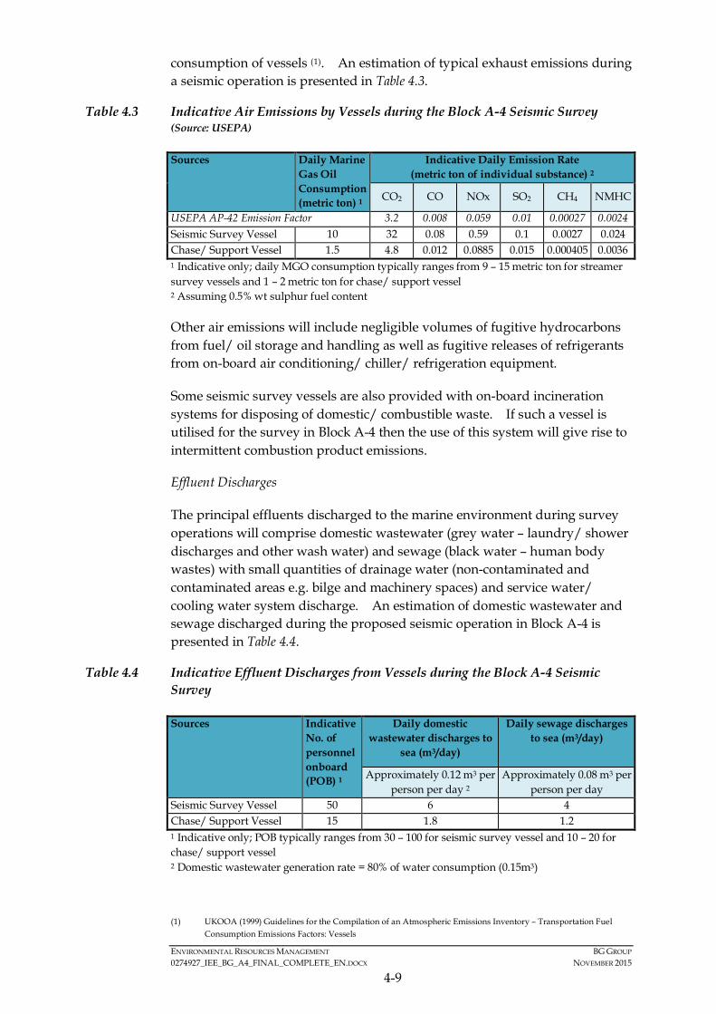
ENVIRONMENTAL RESOURCES MANAGEMENT BG GROUP 0274927_IEE_BG_A4_FINAL_COMPLETE_EN.DOCX NOVEMBER 2015
4-9
consumption of vessels (1). An estimation of typical exhaust emissions during a seismic operation is presented in Table 4.3.
Table 4.3 Indicative Air Emissions by Vessels during the Block A-4 Seismic Survey (Source: USEPA)
Sources Daily Marine Gas Oil Consumption (metric ton) 1
Indicative Daily Emission Rate (metric ton of individual substance) 2
CO2 CO NOx SO2 CH4 NMHC
USEPA AP-42 Emission Factor 3.2 0.008 0.059 0.01 0.00027 0.0024 Seismic Survey Vessel 10 32 0.08 0.59 0.1 0.0027 0.024 Chase/ Support Vessel 1.5 4.8 0.012 0.0885 0.015 0.000405 0.0036 1 Indicative only; daily MGO consumption typically ranges from 9 – 15 metric ton for streamer survey vessels and 1 – 2 metric ton for chase/ support vessel 2 Assuming 0.5% wt sulphur fuel content
Other air emissions will include negligible volumes of fugitive hydrocarbons from fuel/ oil storage and handling as well as fugitive releases of refrigerants from on-board air conditioning/ chiller/ refrigeration equipment.
Some seismic survey vessels are also provided with on-board incineration systems for disposing of domestic/ combustible waste. If such a vessel is utilised for the survey in Block A-4 then the use of this system will give rise to intermittent combustion product emissions.
Effluent Discharges
The principal effluents discharged to the marine environment during survey operations will comprise domestic wastewater (grey water – laundry/ shower discharges and other wash water) and sewage (black water – human body wastes) with small quantities of drainage water (non-contaminated and contaminated areas e.g. bilge and machinery spaces) and service water/ cooling water system discharge. An estimation of domestic wastewater and sewage discharged during the proposed seismic operation in Block A-4 is presented in Table 4.4.
Table 4.4 Indicative Effluent Discharges from Vessels during the Block A-4 Seismic Survey
Sources Indicative No. of personnel onboard (POB) 1
Daily domestic wastewater discharges to
sea (m3/day)
Daily sewage discharges to sea (m3/day)
Approximately 0.12 m3 per person per day 2
Approximately 0.08 m3 per person per day
Seismic Survey Vessel 50 6 4 Chase/ Support Vessel 15 1.8 1.2 1 Indicative only; POB typically ranges from 30 – 100 for seismic survey vessel and 10 – 20 for chase/ support vessel 2 Domestic wastewater generation rate = 80% of water consumption (0.15m3)
(1) UKOOA (1999) Guidelines for the Compilation of an Atmospheric Emissions Inventory – Transportation Fuel
Consumption Emissions Factors: Vessels

ENVIRONMENTAL RESOURCES MANAGEMENT BG GROUP 0274927_IEE_BG_A4_FINAL_COMPLETE_EN.DOCX NOVEMBER 2015
4-10
Seismic survey vessel would be expected to have an on-board sewage handling and treatment system in compliance with the requirements of MARPOL 73/78 Annex IV (Prevention of Pollution by Sewage from Ships; The Convention for the Prevention of Pollution from Ships, 1973 as amended by the 1978 Protocol). The vessel’s compliance will be documented via a Sewage Pollution Prevention Certificate.
Seismic survey vessel would also be expected to fully comply with the requirements of MARPOL 73/78 Annex I (Prevention of Pollution by Oil); the vessel compliance will be documented via Oil Record Book, International Oil Pollution Prevention (IOPP) Certificate, and the installation of an oily water separator for bilge and machinery space drainage and a slop oil tank. Discharges of bilge water or drainage from machinery spaces would therefore be expected to have been treated to a specification of 15 ppm oil content or lower prior to overboard discharge. The separated slop oil will be handled for disposal by a licensed contractor.
Cooling water (typically a once through system) and surplus service water (e.g. from a potable water generation system) may also be discharged to the sea. Discharges from the service water system may contain residual chlorine (typically < 1 ppm).
Other effluents discharged during survey operations such as deck drainage (e.g. rainfall/ sea spray run-off) and effluents from deck wash down operations may contain trace quantities of lube oil, cable oil and fuel oil/ diesel.
Solid & Hazardous Waste Generation
Waste generated during seismic survey operations may comprise of:
• Non-hazardous industrial type solid wastes, which include general refuge (e.g. packaging materials, paper/ plastic bags and containers);
• Domestic food waste from the galleys on the vessels; and
• Small quantities of hazardous wastes, which include solvent, thinner, spent lubrication oil, hydraulic fluids, fluid, oily rags, lithium batteries, slop oil and oil contaminated materials (e.g. containers used to store lubricating fluids).
General refuse will not be disposed of to sea. Combustible wastes will be segregated and disposed by incinerator on-board, non-combustible and recyclable wastes will be stored in containers and returned to shore for disposal. The disposal of non-combustible wastes will be the responsibility of the contractor, who will be required to have a Waste Management Plan in place as well as record all waste retained on-board or transferred to the supply vessel for transport to shore. This will include information on how/where wastes have been disposed. BG will play an assurance and oversight role to support contractor compliance with the agreed Waste Management requirements.

ENVIRONMENTAL RESOURCES MANAGEMENT BG GROUP 0274927_IEE_BG_A4_FINAL_COMPLETE_EN.DOCX NOVEMBER 2015
4-11
The use of specific waste facilities in Myanmar has not been confirmed by the contractor at this stage. However, if any wastes are transferred to shore in Myanmar, it will be handled by the local port authorities and the contractor will retain waste transfer records which BG Group will check and inspect. No hazardous wastes would be transferred to shore in Myanmar for disposal in the absence of suitable disposal facilities. In such case, hazardous wastes would be kept on board until demobilisation back to Singapore. BG Group will collate and report waste volumes and disposal routes to MOECAF after the survey.
Seismic survey vessel would be expected to fully comply with the requirements of MARPOL 73/78 Annex V. Food waste will be macerated into smaller pieces (25 mm) prior to discharge overboard.
All hazardous wastes will be stored in appropriate containers with labels. Hazardous waste storage area will be designated in accordance with their Materials Data Sheet (MSDS). Hazardous wastes will be returned to shore and sent to a licensed disposal facility by a licensed waste contractor.
Control Measures and Built in Mitigation
A number of measures have been built-in to the design of the Project in order to ensure any potential impacts are avoided or reduced to the extent possible. These measures include: compliance with applicable international legislation (e.g. MARPOL) for reducing the impact from waste discharges and the use of Fisheries Liaison Officers on-board vessels to communicate with any fishing vessels in the vicinity of the seismic vessel. A full list of all control measures is included in Section 7 of this IEE Report.
ENVIRONMENTAL RESOURCES MANAGEMENT BG GROUP 0274927_IEE_BG_A4_FINAL_COMPLETE_EN.DOCX OCTOBER 2015
5-1
5 BASELINE CONDITIONS
The following section describes the environmental and social setting of Block A-4 as well as the Area of Interest for the Project. The information provided is based on a review of published information, supplemented with information collected from and provided by various stakeholders consulted as part of the Project, and through review of available BG Group, ERM and REM in-house literature. The consultation undertaken to inform the section is discussed in Section 6 of this IEE Report.
The purpose of this review of baseline conditions is to present an understanding of the potential environmental and social sensitivities of Block A-4 as well as the Area of Interest for the Project to make an informed judgement on the appropriate level of impact assessment.
5.1 SETTING THE STUDY LIMITS
For the purposes of this IEE Report, the Area of Interest is defined as the area within Block A-4 as well as its immediate surrounds, extending as far as the adjacent nearshore waters and coasts of Ramree and Manaung Islands and the Rakhine State mainland (refer to Figure 5.1). For the purposes of the social impact assessment, the Area of Interest also extends to locations where fishing activities may overlap with the Project Activities, such as Yangon.
5.2 METHODOLOGY FOR DATA COLLECTION AND ANALYSIS
Data were collected through a variety of different means for the Project. Firstly, a literature review was undertaken using a range of published materials, including journals and online resources to help gain an understanding of the biological, physical and social environment. The Project also collected and verified secondary and primary data through consultations with a number of different stakeholders, including government bodies (e.g. Ministry of Education's Department of Marine Science), scientific organisations (e.g. Marine Science Association Myanmar), NGOs (Biodiversity and Nature Conservation Association (BANCA)), and local communities. Lastly, information collected was verified to the extent possible through consultations with a variety of stakeholders such as the Marine Sciences Department of Pathein University, Ministry of Education's Department of Marine Science, Marine Science Association Myanmar, and Biodiversity and Nature Conservation Association (BANCA). A full list of stakeholder consulted is provided in Section 5.4.
5.3 PHYSICAL COMPONENTS
This section provides an overview of the physical environment in the Area of Interest.
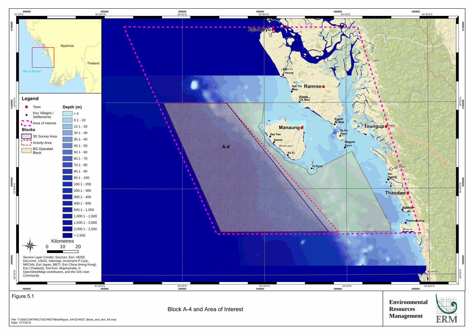
!
!
!
!
!
!
!
!
!
!
!
!
!
!(
!(
!(
!(
!(
Kyaukpyu
Manaung
Ramree
Thandwe
Toungup
A-4
ZinChaung
San TinMaw
KyaukOo Mou
KyaukNi Maw
Za KuKyun
MagyeeKyun
Ye Kyun
Ka Ei
Kamar
Zee Taw
Thabyugyaing
SinGaung
Gyeiktaw
94°30'0"E
94°30'0"E
94°0'0"E
94°0'0"E
93°30'0"E
93°30'0"E
93°0'0"E
93°0'0"E
92°30'0"E
92°30'0"E92°0'0"E19
°0'0
"N
19°0
'0"N
18°3
0'0"
N
18°3
0'0"
N
18°0
'0"N
18°0
'0"N
400000
400000
450000
450000
500000
500000
550000
550000
600000
600000
650000
650000
2000
000
2000
000
2050
000
2050
000
2100
000
2100
000
2150
000
2150
000
Legend!( Town
!Key Villages /Settlements
Area of Interest
Blocks3D Survey Area
Activity Area
BG OperatedBlock
Depth (m)< 0
0.1 - 10
10.1 - 20
20.1 - 30
30.1 - 40
40.1 - 50
50.1 - 60
60.1 - 70
70.1 - 80
80.1 - 90
90.1 - 100
100.1 - 200
200.1 - 300
300.1 - 400
400.1 - 500
500.1 - 1,000
1,000.1 - 1,500
1,500.1 - 2,000
2,000.1 - 2,500
> 2,500
® 0 2010Kilometres
Service Layer Credits: Sources: Esri, HERE,DeLorme, USGS, Intermap, increment P Corp.,NRCAN, Esri Japan, METI, Esri China (Hong Kong),Esri (Thailand), TomTom, MapmyIndia, ©OpenStreetMap contributors, and the GIS UserCommunity
Myanmar
Thailand
Bay of Bengal
EnvironmentalResourcesManagement
Block A-4 and Area of Interest
Figure 5.1
File: T:\GIS\CONTRACT\0274927\Mxd\Report_A4\0274927_Block_and_AoI_A4.mxdDate: 17/7/2015

ENVIRONMENTAL RESOURCES MANAGEMENT BG GROUP 0274927_IEE_BG_A4_FINAL_COMPLETE_EN.DOCX OCTOBER 2015
5-2
5.3.1 Climate and Meteorology
The weather and climate of Myanmar is primarily influenced by the Northeast and the southwest monsoons and the short transitional periods between them. The southwest monsoon (June to September) a period of consistent sometimes strong wind from the Indian Ocean to the south west, is characterized by extensive cloud cover, light rain almost daily, interspersed with rain squalls or thunderstorms. The Northeast monsoon (December to April), a period of winds from the continental interior to the north and east, brings less cloud, scant rainfall, mild temperatures and lower humidity.
The spring and autumn transition periods between the monsoons (April and May, October and November) are generally hot with very variable weather and heavy squalls. The transition periods are governed by the Inter-Tropical Convergence Zone (ITCZ) overhead. This separates the main wind streams of the northern and southern hemispheres. The ITCZ moves seasonally over the area following the sun (northwards in spring and southwards in autumn).
5.3.2 Storms and Cyclones
Gale force winds (17.2 ms-1 or over) are mainly associated with local rain squalls and with severe tropical storms or cyclones most associated with the summer monsoon. The threat of cyclones with winds above 32.7 m s-1 is greatest during the transition periods between the monsoons when solar heating is at its greatest.
5.3.3 Currents and Tides
The surface circulation of the Bay of Bengal moves generally clockwise from January to July and counter-clockwise from August to December, in accordance with the reversible monsoon wind systems. The flow is not constant and depends on the strength and duration of the winds. The effects of a strong wind blowing for a few consecutive days are reflected in the rate of flow. Currents to the northeast generally persist longer and flow at greater speed because of the stronger southwest monsoons. An important vertical circulation or upwelling exists in the Bay of Bengal. Information on the currents in the Area of Interest during NE and SW monsoon periods is provided in Figure 5.2.
Tides in the Area of Interest are semi-diurnal with a tidal range of 4.2 m in the north of Ramree Island, 2.5 m at Manaung Island and 2.3 m at Andrew Bay at spring tides. At a local scale, there are strong tidal currents between the islands and islets of 0.5 to 1.0 knots. Where the tidal currents meet the more static bodies of oceanic water, or where the current runs against the prevailing winds, there are agitated areas of the sea known as overfalls. The tidal currents shape the bathymetry of shallow water areas and add energy to the sedimentary and biological environment in the near shore area in waters less than 25m deep.

!
!
!
!
!
!
!
!
!
!
!
!(
!(
!(
A-4
Manaung
Thandwe
Toungup
KyaukOo Mou
KyaukNi Maw
Za KuKyun
MagyeeKyun
Ye Kyun
Ka Ei
Kamar
Zee Taw
Thabyugyaing
SinGaung
Gyeiktaw
94°20'0"E
94°20'0"E
94°0'0"E
94°0'0"E
93°40'0"E
93°40'0"E
93°20'0"E
93°20'0"E19
°0'0
"N
19°0
'0"N
18°4
0'0"
N
18°4
0'0"
N
18°2
0'0"
N
18°2
0'0"
N
525000
525000
550000
550000
575000
575000
600000
600000
625000
625000
650000
650000
2025
000
2025
000
2050
000
2050
000
2075
000
2075
000
2100
000
2100
000
® 0 2010Kilometres
Legend!( Town
!Key Villages /Settlements
Area of Interest
Curren NE Monsoon
Current SW Monsoon
Intertidal
Subaerial
Blocks3D Survey Area
Activity Area
BG Operated Block
Depth (m)< 0
0.1 - 10
10.1 - 20
20.1 - 30
30.1 - 40
40.1 - 50
50.1 - 60
60.1 - 70
70.1 - 80
80.1 - 90
90.1 - 100
100.1 - 200
200.1 - 300
300.1 - 400
400.1 - 500
500.1 - 1,000
1,000.1 - 1,500
1,500.1 - 2,000
2,000.1 - 2,500
> 2,500
EnvironmentalResourcesManagement
Schematic of Seasonal Oceanic Currents in the Area of Interest
Figure 5.2
File: T:\GIS\CONTRACT\0274927\Mxd\Report_A4\0274927_Oceanic_Currents_A4.mxdDate: 17/7/2015
Service Layer Credits: Sources: Esri, HERE, DeLorme, USGS, Intermap, increment P Corp., NRCAN, EsriJapan, METI, Esri China (Hong Kong), Esri (Thailand), TomTom, MapmyIndia, © OpenStreetMapcontributors, and the GIS User Community
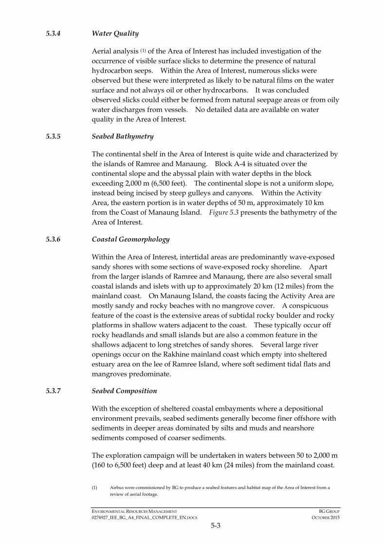
ENVIRONMENTAL RESOURCES MANAGEMENT BG GROUP 0274927_IEE_BG_A4_FINAL_COMPLETE_EN.DOCX OCTOBER 2015
5-3
5.3.4 Water Quality
Aerial analysis (1) of the Area of Interest has included investigation of the occurrence of visible surface slicks to determine the presence of natural hydrocarbon seeps. Within the Area of Interest, numerous slicks were observed but these were interpreted as likely to be natural films on the water surface and not always oil or other hydrocarbons. It was concluded observed slicks could either be formed from natural seepage areas or from oily water discharges from vessels. No detailed data are available on water quality in the Area of Interest.
5.3.5 Seabed Bathymetry
The continental shelf in the Area of Interest is quite wide and characterized by the islands of Ramree and Manaung. Block A-4 is situated over the continental slope and the abyssal plain with water depths in the block exceeding 2,000 m (6,500 feet). The continental slope is not a uniform slope, instead being incised by steep gulleys and canyons. Within the Activity Area, the eastern portion is in water depths of 50 m, approximately 10 km from the Coast of Manaung Island. Figure 5.3 presents the bathymetry of the Area of Interest.
5.3.6 Coastal Geomorphology
Within the Area of Interest, intertidal areas are predominantly wave-exposed sandy shores with some sections of wave-exposed rocky shoreline. Apart from the larger islands of Ramree and Manaung, there are also several small coastal islands and islets with up to approximately 20 km (12 miles) from the mainland coast. On Manaung Island, the coasts facing the Activity Area are mostly sandy and rocky beaches with no mangrove cover. A conspicuous feature of the coast is the extensive areas of subtidal rocky boulder and rocky platforms in shallow waters adjacent to the coast. These typically occur off rocky headlands and small islands but are also a common feature in the shallows adjacent to long stretches of sandy shores. Several large river openings occur on the Rakhine mainland coast which empty into sheltered estuary area on the lee of Ramree Island, where soft sediment tidal flats and mangroves predominate.
5.3.7 Seabed Composition
With the exception of sheltered coastal embayments where a depositional environment prevails, seabed sediments generally become finer offshore with sediments in deeper areas dominated by silts and muds and nearshore sediments composed of coarser sediments.
The exploration campaign will be undertaken in waters between 50 to 2,000 m (160 to 6,500 feet) deep and at least 40 km (24 miles) from the mainland coast.
(1) Airbus were commissioned by BG to produce a seabed features and habitat map of the Area of Interest from a
review of aerial footage.

!
!
!
!
!
!
!
!
!
!
!
!
!
!(
!(
!(
!(Manaung
Ramree
Thandwe
Toungup
A-4
ZinChaung
San TinMaw
KyaukOo Mou
KyaukNi Maw
Za KuKyun
MagyeeKyun
Ye Kyun
Ka Ei
Kamar
Zee Taw
Thabyugyaing
SinGaung
Gyeiktaw
94°30'0"E
94°0'0"E
94°0'0"E
93°30'0"E
93°30'0"E
93°0'0"E
93°0'0"E
92°30'0"E
92°30'0"E19
°0'0
"N
19°0
'0"N
18°3
0'0"
N
18°3
0'0"
N
450000
450000
500000
500000
550000
550000
600000
600000
650000
650000
2050
000
2050
000
2100
000
2100
000
LegendArea of Interest
!( Town
!Key Villages /Settlements
Blocks3D Survey Area
Activity Area
BG Operated Block
Depth (m)< 0
0.1 - 10
10.1 - 20
20.1 - 30
30.1 - 40
40.1 - 50
50.1 - 60
60.1 - 70
70.1 - 80
80.1 - 90
90.1 - 100
100.1 - 200
200.1 - 300
300.1 - 400
400.1 - 500
500.1 - 1,000
1,000.1 - 1,500
1,500.1 - 2,000
2,000.1 - 2,500
> 2,500
® 0 2010Kilometres
Service Layer Credits: Sources: Esri, HERE, DeLorme, USGS,Intermap, increment P Corp., NRCAN, Esri Japan, METI, Esri China(Hong Kong), Esri (Thailand), TomTom, MapmyIndia, ©OpenStreetMap contributors, and the GIS User Community
Myanmar
Thailand
Bay of Bengal
EnvironmentalResourcesManagement
Bathymetry within the Area of Interest
Figure 5.3
File: T:\GIS\CONTRACT\0274927\Mxd\Report_A4\0274927_Bathy_with_AOI_A4.mxdDate: 17/7/2015
ENVIRONMENTAL RESOURCES MANAGEMENT BG GROUP 0274927_IEE_BG_A4_FINAL_COMPLETE_EN.DOCX OCTOBER 2015
5-4
The seafloor is characterised by homogeneous olive grey muds typical of low energy depositional environments (1). To the north and south of Block A-4 seafloor, sediment cores (approximately 20m in length) collected from the continental slope (1,100 to 2,400 m (3,600 to 7,800 feet) deep) comprised olive grey muds with some silty and sandy turbidites. In nearshore waters, seabed sediments in higher energy conditions such as tidal channels between the reefs and islands become coarser and dominated by quartz and coral sand fractions. Nearshore shallow water habitats are fringed with rocky shorelines, some of which may support corals, however, whilst in the Area of Interest they are outside the Activity Area.
Additional environmental interpretation of seabed and habitat features are available through a dedicated study commissioned by BG Group based on spectrographic analysis of high resolution aerial imagery of the marine environment and coastal fringes in the Area of Interest. This analysis provided similar information to previous analyses by the United Nations Environment Programme's World Conservation Monitoring Centre (UNEP-WCMC). Seabed and habitat features based on the analysis are provided in Figure 5.4. The areas of seagrass, mangrove and coral shown on this map are discussed in further detail in Section 5.4.2, 5.4.3 and 5.4.4. Manaung Island is the closest land to the Activity Area. As shown on the interpretation of the aerial data, this island is surrounded by coral sand / fine sediment cover (Figure 5.5).
The environmental interpretation indicated the majority of marine environment within the Area of Interest was categorized as deep water or ‘suspended sediment’. This is an artefact of the aerial data collected which can only be used to map habitats in less than 30 m water depth. Where discernible, seabed composition included ‘sand cover’ seabed in the shallows adjacent to Manaung Island, small coastal islands and in areas in open waters to the southeast of Manaung Island. ‘Fine sediment cover’ was identified to occur along more sheltered areas on the leeward side of Manaung Island, the southern part of Ramree Island and mainland Rakhine. Some bedrock areas in open water to the southeast of Manaung Island were also identified based on the spectrographic interpretation.
5.4 BIOLOGICAL COMPONENTS
The secondary information on the marine biological environment in Rakhine waters is lacking in sufficient spatial and temporal data and very few studies have been conducted in this region.
Numerous stakeholders in Myanmar were consulted in an effort to collect information on the current baseline conditions in offshore and coastal waters of Rakhine. These stakeholders included:
(1) Dr Rangin (2005) unpublished data.
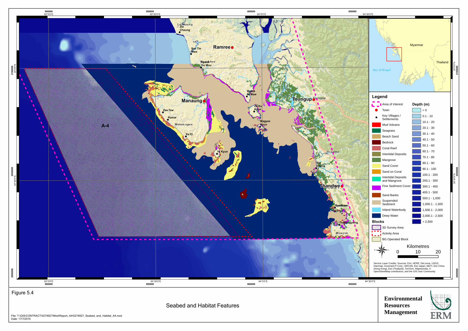
A-4
Manaung
Ramree
Thandwe
Toungup
ZinChaung
San TinMaw
KyaukOo Mou
KyaukNi Maw
Za KuKyun
MagyeeKyun
Ye Kyun
Ka Ei
Kamar
Zee Taw
Thabyugyaing
SinGaung
Gyeiktaw
94°30'0"E
94°30'0"E
94°0'0"E
94°0'0"E
93°30'0"E
93°30'0"E
93°0'0"E
93°0'0"E19
°0'0
"N
19°0
'0"N
18°3
0'0"
N
18°3
0'0"
N
500000
500000
550000
550000
600000
600000
650000
650000
2000
000
2000
000
2050
000
2050
000
2100
000
2100
000
LegendArea of Interest
!( Town
!Key Villages /Settlements
Mud Volcano
Seagrass
Beach Sand
Bedrock
Coral Reef
Intertidal Deposits
Mangrove
Sand Cover
Sand on Coral
Intertidal Depositsand Mangrove
Fine Sediment Cover
Sand Banks
SuspendedSediment
Inland Waterbody
Deep Water
Blocks3D Survey Area
Activity Area
BG Operated Block
Depth (m)< 0
0.1 - 10
10.1 - 20
20.1 - 30
30.1 - 40
40.1 - 50
50.1 - 60
60.1 - 70
70.1 - 80
80.1 - 90
90.1 - 100
100.1 - 200
200.1 - 300
300.1 - 400
400.1 - 500
500.1 - 1,000
1,000.1 - 1,500
1,500.1 - 2,000
2,000.1 - 2,500
> 2,500
®Service Layer Credits: Sources: Esri, HERE, DeLorme, USGS,Intermap, increment P Corp., NRCAN, Esri Japan, METI, Esri China(Hong Kong), Esri (Thailand), TomTom, MapmyIndia, ©OpenStreetMap contributors, and the GIS User Community
Myanmar
Thailand
Bay of Bengal
0 2010Kilometres
EnvironmentalResourcesManagement
Seabed and Habitat Features
Figure 5.4
File: T:\GIS\CONTRACT\0274927\Mxd\Report_A4\0274927_Seabed_and_Habitat_A4.mxdDate: 17/7/2015
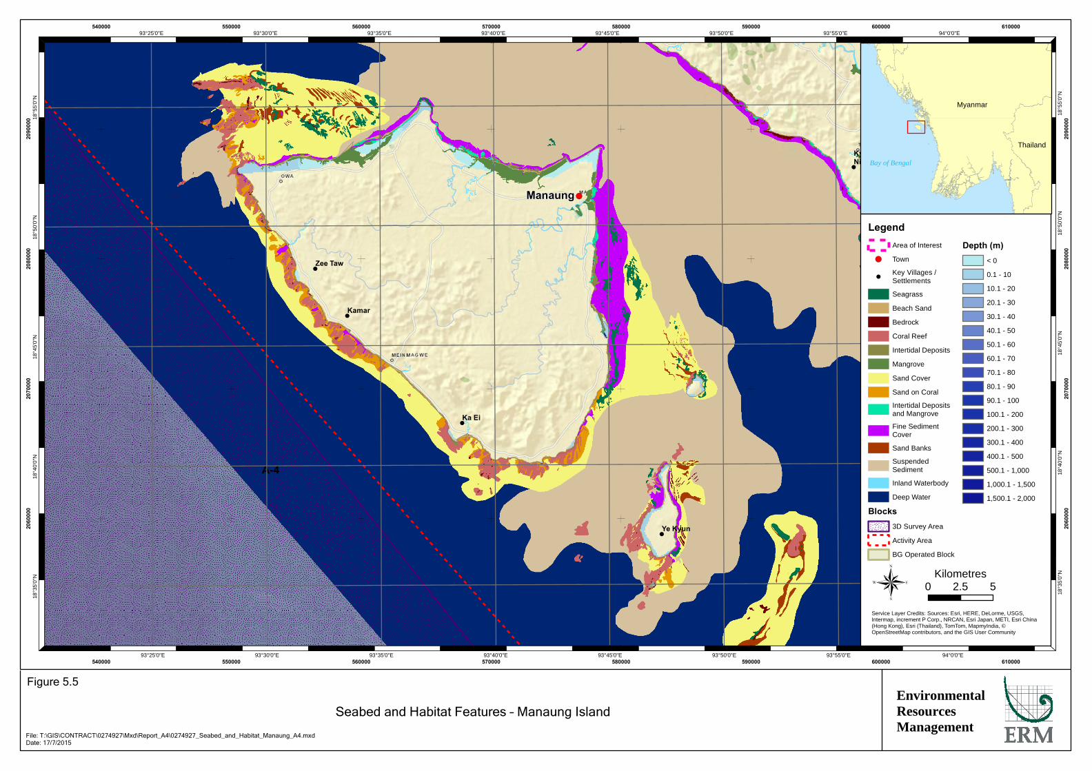
!
!
!
!
!
!
!
!(
A-4
Manaung
KyaukNi Maw
Za KuKyun
MagyeeKyun
Ye Kyun
Ka Ei
Kamar
Zee Taw
94°0'0"E
94°0'0"E
93°55'0"E
93°55'0"E
93°50'0"E
93°50'0"E
93°45'0"E
93°45'0"E
93°40'0"E
93°40'0"E
93°35'0"E
93°35'0"E
93°30'0"E
93°30'0"E
93°25'0"E
93°25'0"E18
°55'
0"N
18°5
5'0"
N
18°5
0'0"
N
18°5
0'0"
N
18°4
5'0"
N
18°4
5'0"
N
18°4
0'0"
N
18°4
0'0"
N
18°3
5'0"
N
18°3
5'0"
N
540000
540000
550000
550000
560000
560000
570000
570000
580000
580000
590000
590000
600000
600000
610000
610000
2060
000
2060
000
2070
000
2070
000
2080
000
2080
000
2090
000
2090
000
LegendArea of Interest
!( Town
!Key Villages /Settlements
Seagrass
Beach Sand
Bedrock
Coral Reef
Intertidal Deposits
Mangrove
Sand Cover
Sand on Coral
Intertidal Depositsand Mangrove
Fine SedimentCover
Sand Banks
SuspendedSediment
Inland Waterbody
Deep Water
Blocks3D Survey Area
Activity Area
BG Operated Block
Depth (m)< 0
0.1 - 10
10.1 - 20
20.1 - 30
30.1 - 40
40.1 - 50
50.1 - 60
60.1 - 70
70.1 - 80
80.1 - 90
90.1 - 100
100.1 - 200
200.1 - 300
300.1 - 400
400.1 - 500
500.1 - 1,000
1,000.1 - 1,500
1,500.1 - 2,000
®Service Layer Credits: Sources: Esri, HERE, DeLorme, USGS,Intermap, increment P Corp., NRCAN, Esri Japan, METI, Esri China(Hong Kong), Esri (Thailand), TomTom, MapmyIndia, ©OpenStreetMap contributors, and the GIS User Community
Myanmar
Thailand
Bay of Bengal
0 52.5Kilometres
EnvironmentalResourcesManagement
Seabed and Habitat Features – Manaung Island
Figure 5.5
File: T:\GIS\CONTRACT\0274927\Mxd\Report_A4\0274927_Seabed_and_Habitat_Manaung_A4.mxdDate: 17/7/2015

ENVIRONMENTAL RESOURCES MANAGEMENT BG GROUP 0274927_IEE_BG_A4_FINAL_COMPLETE_EN.DOCX OCTOBER 2015
5-5
• Marine Sciences Department of Pathein University;
• Ministry of Education's Department of Marine Science;
• Marine Science Association Myanmar;
• Biodiversity and Nature Conservation Association (BANCA);
• EcoDev (part of the Myanmar Environment Rehabilitation-conservation Network (MERN));
• Wildlife Conservation Society - Myanmar Program;
• Forest Resource Environment Development And Conservation Association (FREDA);
• Mangrove Services Network; and
• Marine Science Department Mawlamyine University.
Meetings were held with the Pathein University Marine Sciences Department and, whilst in Rakhine, FREDA. These stakeholders confirmed that there is not much information on the offshore environment in Rakhine. Some data on species (i.e. marine turtles) and coastal habitats (i.e corals, mangroves and seagrass) in Rakhine were provided and are referenced throughout the baseline section of this report. The consultations were unable to provide any data on the type or health of corals near Manaung Island as the stakeholders consulted confirmed that they had not and were not conducting research into these communities at these locations. Rather, surveys on corals were focused to the south of Myanmar, such as the Myeik Archipelago.
An effort was made to validate the known information during the stakeholder consultations in 2015. In many cases, this was useful in confirming information (e.g. turtle nesting times and species reported in secondary data were confirmed in the field by the local communities). The data gaps and assumptions associated with the environmental baseline in this report include:
• Coral reef cover, mangrove locations and seagrass beds were not confirmed in the field in some cases.
• Limited spatial or temporal trends in the baseline are presented due to the lack of such data on most species and habitats.
• The description of the abyssal plain environment is based on sparse information and assumptions have been made on species composition.
• Very limited data are available on the distribution and abundance of birds, turtles, fish and marine mammals in Myanmar waters.
• Migration routes, breeding/spawning areas and species composition are not well understood.
ENVIRONMENTAL RESOURCES MANAGEMENT BG GROUP 0274927_IEE_BG_A4_FINAL_COMPLETE_EN.DOCX OCTOBER 2015
5-6
• As it is not known, it is assumed that fish, turtles and mammals pass through Activity Area.
5.4.1 General
The Area of Interest, as defined in Section 5.2, encompasses both shallow water (<50 m or <160 feet) and deep water (up to 2,000 m or 6,500 feet) habitats as well as coastal and nearshore habitats such as mangroves, coral habitat and seagrasses around Manaung Island and along the Rakhine mainland coastline. The majority of the Block lies in water depths exceeding 500 m (1,600 feet) making up the continental slope and abyssal plain.
Locations of coral habitats, mangroves and seagrass have been recorded based on compiled database records from numerous sources collected by and provided by consultation with various stakeholders, including the United Nations Environment Programme (UNEP), as well as in-house literature of BG Group, ERM and REM. These areas were ground-truthed where practicable during consultations with stakeholders in March, April and May 2015. For more information on the stakeholder consultations, refer to Section 8 of this IEE Report.
The Area of Interest is characterised by a narrow continental shelf extending from the mainland coast to the east of Manaung Island. The shelf break is located as close as approximately 10 km from the coast. Beyond the shelf break, the seabed steeply descends down the continental slope reaching a depth of 500m within around a distance of approximately 10 km. Areas beyond the 200 m isobath constitute deep water habitat where deep-sea communities are likely to exclusively rely on settling organic detritus as a food source (1) . Despite the extensive area in which these deep water areas occur, little is known about the habitat and associated species composition.
5.4.2 Coral Habitats
In shallow waters, coral areas have been identified from secondary data sources. UNEP satellite analyses show coral habitats (usually fringing or patch reefs in Myanmar) occur along the coast of Rakhine State. Potential coral reef and coral habitat areas in the Area of Interest are shown in Figure 5.6.
Hard and soft corals are known to occur in near shore waters in the Area of Interest and the prevalence of rocky substrate in shallow waters indicates favourable conditions for the growth of coral communities are likely(2).
Preliminary coral surveys were undertaken along the Rakhine coastal areas in 2000 which noted 51 species of coral (1). No specific information on coral species or locations, where the surveys were undertaken is available.
(1) Gage JD and Tyler PK 1992. Deep sea biology: a natural history of organisms at the deep sea floor. Cambridge
University Press, Cambridge UK, 504 pp.
(2) Spalding MD, Ravilious C and Green EP 2001. World Atlas of Coral Reefs. UNEP-WCMC. pp436.
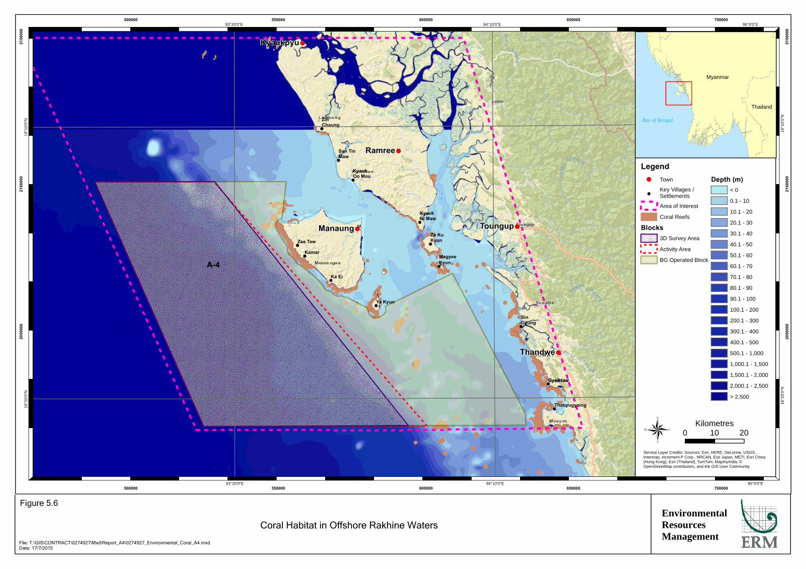
!
!
!
!
!
!
!
!
!
!
!
!
!
!(
!(
!(
!(
!(
A-4
Kyaukpyu
Manaung
Ramree
Thandwe
Toungup
ZinChaung
San TinMaw
KyaukOo Mou
KyaukNi Maw
Za KuKyun
MagyeeKyun
Ye Kyun
Ka Ei
Kamar
Zee Taw
Thabyugyaing
SinGaung
Gyeiktaw
95°0'0"E
95°0'0"E
94°10'0"E
94°10'0"E
93°20'0"E
93°20'0"E19
°10'
0"N
19°1
0'0"
N
18°2
0'0"
N
18°2
0'0"
N
500000
500000
550000
550000
600000
600000
650000
650000
700000
700000
2050
000
2050
000
2100
000
2100
000
2150
000
2150
000
Legend!( Town
!Key Villages /Settlements
Area of Interest
Coral Reefs
Blocks3D Survey Area
Activity Area
BG Operated Block
Depth (m)< 0
0.1 - 10
10.1 - 20
20.1 - 30
30.1 - 40
40.1 - 50
50.1 - 60
60.1 - 70
70.1 - 80
80.1 - 90
90.1 - 100
100.1 - 200
200.1 - 300
300.1 - 400
400.1 - 500
500.1 - 1,000
1,000.1 - 1,500
1,500.1 - 2,000
2,000.1 - 2,500
> 2,500
®Service Layer Credits: Sources: Esri, HERE, DeLorme, USGS,Intermap, increment P Corp., NRCAN, Esri Japan, METI, Esri China(Hong Kong), Esri (Thailand), TomTom, MapmyIndia, ©OpenStreetMap contributors, and the GIS User Community
Myanmar
Thailand
Bay of Bengal
0 2010Kilometres
EnvironmentalResourcesManagement
Coral Habitat in Offshore Rakhine Waters
Figure 5.6
File: T:\GIS\CONTRACT\0274927\Mxd\Report_A4\0274927_Environmental_Coral_A4.mxdDate: 17/7/2015
ENVIRONMENTAL RESOURCES MANAGEMENT BG GROUP 0274927_IEE_BG_A4_FINAL_COMPLETE_EN.DOCX OCTOBER 2015
5-7
During March 2014, coral surveys were undertaken in 35 different sites in the Myeik Archipelago which recorded 287 species of coral across all sites (2). A full list of these 287 coral species is provided in Annex 5.1. This report states that there are a reported 366 confirmed national records for coral species within Myanmar. Corals include representatives of the genus of Acropora, Coscinaraea, Cycloseris, Cyphastrea, Diaseris, Echinopora, Favia, Gonioporam Heteropsammia, Leptoseris, Lithophyllon, Montipora, Platygyra, Plesiastrea, Psammocora, Scolymia, Stylocoeniella and Turbinaria (3).
Sedimentation is an important factor governing abundance and diversity of corals, and turbidity due to river inputs is potentially a constraining factor in many of the nearshore shallow waters in the Area of Interest.
BG Group also commissioned Airbus to survey the distribution of marine habitats in the Area of Interest. This aerial imagery study yielded similar results to UNEP-WCMC. Corals were found to be confined to shallows adjacent to the west coast of Manaung Island and as well as fringing small coastal islands and southern coastal section of the Rakhine mainland. As with previous UNEP-WCMC data, coral areas in open waters were confined to several patches to the southeast of Manaung Island. Other areas, previously identified as coral areas by UNEP-WCMC were categorised as ‘deep water’ by the study. This was probably an artefact on the depth limitations of the study (30 m).
Potential coral habitats around Manaung and the neighbouring islands are shown in Figure 5.5. Between Manaung Island and the neighbouring island of Ye Kyun there is an area with potential high coral cover, with corals fringing the entire island and specifically in the south-east between Manaung Island and Ye Kyun. Another coral area is located to the northwest of Manaung Island which hosts potential coral habitat patches as well as seagrass and bedrock. Long stretches of potential coral habitat was also identified along the fringes of the western shores of Manaung, which faces the Activity Area. As such, at the closest extent, the coral habitat is located 3 km (1.8 miles) from the Activity Area with the majority of potential coral habitat located over 5 km (3.1 miles) from the Activity Area.
Coral habitat information was verified during stakeholder consultations, in March to May 2015, with local fishermen, and recreational divers. The majority of stakeholders consulted suggested that within the Area of Interest the waters around Manaung Island and Ye Kyun have the largest areas of coral cover. Coral areas were also verified during a survey conducted near Ngapali in Thandwe in April 2015. Although data sources suggest the areas
(1) Biodiversity and Nature Conservation Association (BANCA) and Fauna & Flora International (FFI). Status and
challenges of coral reef monitoring in Myanmar. Available from http://earw.icriforum.org/8th_EARW/6-1-8.8th_ICRI_EARW_2012_Korea.pdf.
(2) Tanintharyi Conservation Programme, 2014. Coral diversity and reef resilience in the northern Myeik Archipelago, Myanmar. TCP Report No. 3.
(3) Australian Institute of Marine Science 2015. Coral Fact Sheets. Viewed at:http://coral.aims.gov.au/info/spatial.jsp
ENVIRONMENTAL RESOURCES MANAGEMENT BG GROUP 0274927_IEE_BG_A4_FINAL_COMPLETE_EN.DOCX OCTOBER 2015
5-8
shown in Figure 5.4 are coral habitats, they were actually patchy areas of rock with encrusting corals cover. As such, the area denoted as coral habitats in secondary studies may not be extensive reef systems of coral but could be coral habitat and encrusting coral on rocky substrate. Photos of the corals found in the waters around Ngapali beach, taken during surveys in April 2015, are provided in Figure 5.7. Coral cover was recorded at 5m (16 feet) and 10 m (32 feet) water depth. At 5m water depth, the habitat consisted of patchy areas of sand and rock. At 10 m water depth, the coral cover was sparser and interspersed with sandy sediments. The rocky areas were encrusted with some coral species but the overall coral cover was limited. All of the corals recorded during the survey were hard (Scleractinian) corals.
Coral habitat around Manaung is estimated to be up to water depths of around 20 m based on both local information collected during the stakeholder consultations in 2015 and existing secondary data. This was similar to information collected during the primary data collection around Ngapali, where corals were not observed out past 20 m (65 feet) water depth. As such, at the closest extent, the coral habitat is located 3 km from the Activity Area with the majority of potential coral habitat located over 5 km from the Activity Area. Studies indicate a limited sensitivity of coral habitats to the seismic acquisition method and certainly no impact at the ranges indicated here.
5.4.3 Mangroves
Within Myanmar, the Ayeyarwaddy Delta is the most important area for mangroves. Rakhine State and Tanintharyi Region are two further principal areas for mangroves found along sheltered coasts. As previously discussed, understanding of mangrove habitat in the Area of Interest has incorporated information made available during consultations with stakeholders including Myanmar marine scientists from a number of universities and organisations (Section 5.4).
There are well developed mangrove areas within the Area of Interest with extensive mangrove areas occurring along the shores surrounding the sheltered lee side of Ramree Island and river mouths and inland areas fringing the tidal creeks of rivers. Sheltered areas along the coast also support stands of mangrove (1). BG Group also commissioned Airbus to survey the distribution of marine habitats in the Area of Interest. This aerial imagery analysis also yielded similar results to the UNEP-WCMC data with mangrove occurring on the same coastal areas but with some evidence of smaller areal coverage, presumably due to losses due to human activities. The distribution of mangrove areas within the Area of Interest based on literature reviews and primary observations in the field is illustrated in Figure 5.8. Mangroves recorded from Rakhine State coast include Rhizophora, Xylocarpus, Avicennia, Bruguiera, Sonneratia, Heritiera, Finlaysonia, Ceriops, Lumnitzera, Excoecaria, Nypa and Aegiceras.
(1) UNEP-WCMC 2011. Global Distribution of Mangroves USGS (2011). Viewed at: http://marine-portal.unepwcmc-
001.vm.brightbox.net/datasets/21
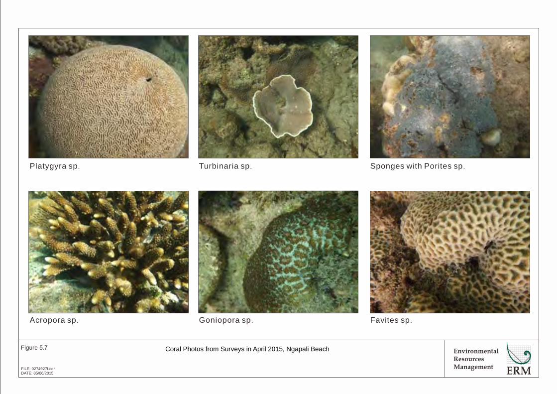
EnvironmentalResourcesManagement
Figure 5.7
FILE: 0274927f.cdrDATE: 05/06/2015
Coral Photos from Surveys in April 2015, Ngapali Beach
Platygyra sp. Turbinaria sp. Sponges with Porites sp.
Acropora sp. Goniopora sp. Favites sp.
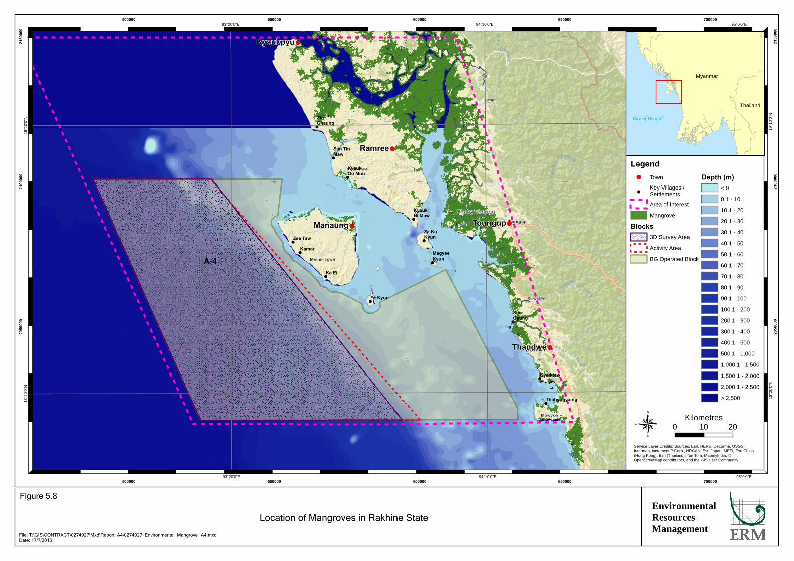
!
!
!
!
!
!
!
!
!
!
!
!
!
!(
!(
!(
!(
!(
A-4
Kyaukpyu
Manaung
Ramree
Thandwe
Toungup
ZinChaung
San TinMaw
KyaukOo Mou
KyaukNi Maw
Za KuKyun
MagyeeKyun
Ye Kyun
Ka Ei
Kamar
Zee Taw
Thabyugyaing
SinGaung
Gyeiktaw
95°0'0"E
95°0'0"E
94°10'0"E
94°10'0"E
93°20'0"E
93°20'0"E19
°10'
0"N
19°1
0'0"
N
18°2
0'0"
N
18°2
0'0"
N
500000
500000
550000
550000
600000
600000
650000
650000
700000
700000
2050
000
2050
000
2100
000
2100
000
2150
000
2150
000
Legend!( Town
!Key Villages /Settlements
Area of Interest
Mangrove
Blocks3D Survey Area
Activity Area
BG Operated Block
Depth (m)< 0
0.1 - 10
10.1 - 20
20.1 - 30
30.1 - 40
40.1 - 50
50.1 - 60
60.1 - 70
70.1 - 80
80.1 - 90
90.1 - 100
100.1 - 200
200.1 - 300
300.1 - 400
400.1 - 500
500.1 - 1,000
1,000.1 - 1,500
1,500.1 - 2,000
2,000.1 - 2,500
> 2,500
®Service Layer Credits: Sources: Esri, HERE, DeLorme, USGS,Intermap, increment P Corp., NRCAN, Esri Japan, METI, Esri China(Hong Kong), Esri (Thailand), TomTom, MapmyIndia, ©OpenStreetMap contributors, and the GIS User Community
Myanmar
Thailand
Bay of Bengal
Thabyichaung
0 2010Kilometres
EnvironmentalResourcesManagement
Location of Mangroves in Rakhine State
Figure 5.8
File: T:\GIS\CONTRACT\0274927\Mxd\Report_A4\0274927_Environmental_Mangrove_A4.mxdDate: 17/7/2015
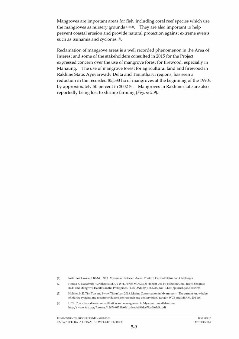
ENVIRONMENTAL RESOURCES MANAGEMENT BG GROUP 0274927_IEE_BG_A4_FINAL_COMPLETE_EN.DOCX OCTOBER 2015
5-9
Mangroves are important areas for fish, including coral reef species which use the mangroves as nursery grounds (1) (2). They are also important to help prevent coastal erosion and provide natural protection against extreme events such as tsunamis and cyclones (3).
Reclamation of mangrove areas is a well recorded phenomenon in the Area of Interest and some of the stakeholders consulted in 2015 for the Project expressed concern over the use of mangrove forest for firewood, especially in Manaung. The use of mangrove forest for agricultural land and firewood in Rakhine State, Ayeyarwady Delta and Tanintharyi regions, has seen a reduction in the recorded 85,533 ha of mangroves at the beginning of the 1990s by approximately 50 percent in 2002 (4). Mangroves in Rakhine state are also reportedly being lost to shrimp farming (Figure 5.9).
(1) Instituto Oikos and BANC. 2011. Myanmar Protected Areas: Context, Current Status and Challenges.
(2) Honda K, Nakamura Y, Nakaoka M, Uy WH, Fortes MD (2013) Habitat Use by Fishes in Coral Reefs, Seagrass Beds and Mangrove Habitats in the Philippines. PLoS ONE 8(8): e65735. doi:10.1371/journal.pone.0065735
(3) Holmes, K.E.,Tint Tun and Kyaw Thinn Latt 2013. Marine Conservation in Myanmar --‐ The current knowledge of Marine systems and recommendations for research and conservation. Yangon WCS and MSAM. 204 pp.
(4) U Tin Tun. Coastal forest rehabilitation and management in Myanmar. Available from http://www.fao.org/forestry/12674-0353fe60e1dd4ede696dce7fca06e5c5c.pdf
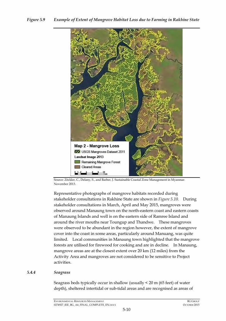
ENVIRONMENTAL RESOURCES MANAGEMENT BG GROUP 0274927_IEE_BG_A4_FINAL_COMPLETE_EN.DOCX OCTOBER 2015
5-10
Figure 5.9 Example of Extent of Mangrove Habitat Loss due to Farming in Rakhine State
Source: Zöckler, C., Delany, S., and Barber, J. Sustainable Coastal Zone Management in Myanmar. November 2013.
Representative photographs of mangrove habitats recorded during stakeholder consultations in Rakhine State are shown in Figure 5.10. During stakeholder consultations in March, April and May 2015, mangroves were observed around Manaung town on the north-eastern coast and eastern coasts of Manaung Islands and well is on the eastern side of Ramree Island and around the river mouths near Toungup and Thandwe. These mangroves were observed to be abundant in the region however, the extent of mangrove cover into the coast in some areas, particularly around Manuang, was quite limited. Local communities in Manaung town highlighted that the mangrove forests are utilised for firewood for cooking and are in decline. In Manaung, mangrove areas are at the closest extent over 20 km (12 miles) from the Activity Area and mangroves are not considered to be sensitive to Project activities.
5.4.4 Seagrass
Seagrass beds typically occur in shallow (usually < 20 m (65 feet) of water depth), sheltered intertidal or sub-tidal areas and are recognised as areas of
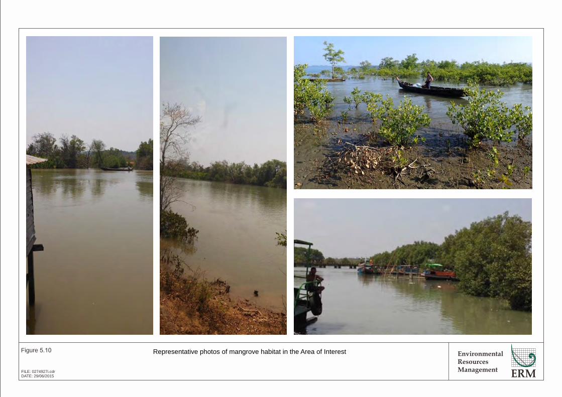
EnvironmentalResourcesManagement
Figure 5.10
FILE: 0274927i.cdrDATE: 29/06/2015
Representative photos of mangrove habitat in the Area of Interest
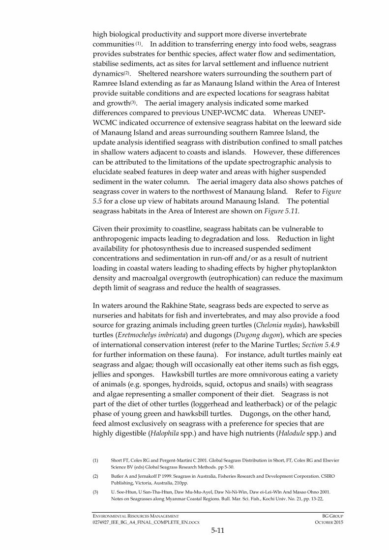
ENVIRONMENTAL RESOURCES MANAGEMENT BG GROUP 0274927_IEE_BG_A4_FINAL_COMPLETE_EN.DOCX OCTOBER 2015
5-11
high biological productivity and support more diverse invertebrate communities (1). In addition to transferring energy into food webs, seagrass provides substrates for benthic species, affect water flow and sedimentation, stabilise sediments, act as sites for larval settlement and influence nutrient dynamics(2). Sheltered nearshore waters surrounding the southern part of Ramree Island extending as far as Manaung Island within the Area of Interest provide suitable conditions and are expected locations for seagrass habitat and growth(3). The aerial imagery analysis indicated some marked differences compared to previous UNEP-WCMC data. Whereas UNEP-WCMC indicated occurrence of extensive seagrass habitat on the leeward side of Manaung Island and areas surrounding southern Ramree Island, the update analysis identified seagrass with distribution confined to small patches in shallow waters adjacent to coasts and islands. However, these differences can be attributed to the limitations of the update spectrographic analysis to elucidate seabed features in deep water and areas with higher suspended sediment in the water column. The aerial imagery data also shows patches of seagrass cover in waters to the northwest of Manaung Island. Refer to Figure 5.5 for a close up view of habitats around Manaung Island. The potential seagrass habitats in the Area of Interest are shown on Figure 5.11.
Given their proximity to coastline, seagrass habitats can be vulnerable to anthropogenic impacts leading to degradation and loss. Reduction in light availability for photosynthesis due to increased suspended sediment concentrations and sedimentation in run-off and/or as a result of nutrient loading in coastal waters leading to shading effects by higher phytoplankton density and macroalgal overgrowth (eutrophication) can reduce the maximum depth limit of seagrass and reduce the health of seagrasses.
In waters around the Rakhine State, seagrass beds are expected to serve as nurseries and habitats for fish and invertebrates, and may also provide a food source for grazing animals including green turtles (Chelonia mydas), hawksbill turtles (Eretmochelys imbricata) and dugongs (Dugong dugon), which are species of international conservation interest (refer to the Marine Turtles; Section 5.4.9 for further information on these fauna). For instance, adult turtles mainly eat seagrass and algae; though will occasionally eat other items such as fish eggs, jellies and sponges. Hawksbill turtles are more omnivorous eating a variety of animals (e.g. sponges, hydroids, squid, octopus and snails) with seagrass and algae representing a smaller component of their diet. Seagrass is not part of the diet of other turtles (loggerhead and leatherback) or of the pelagic phase of young green and hawksbill turtles. Dugongs, on the other hand, feed almost exclusively on seagrass with a preference for species that are highly digestible (Halophila spp.) and have high nutrients (Halodule spp.) and
(1) Short FT, Coles RG and Pergent-Martini C 2001. Global Seagrass Distribution in Short, FT, Coles RG and Elsevier
Science BV (eds) Global Seagrass Research Methods. pp 5-30.
(2) Butler A and Jernakoff P 1999. Seagrass in Australia, Fisheries Research and Development Corporation. CSIRO Publishing, Victoria, Australia, 210pp.
(3) U. Soe-Htun, U San-Tha-Htun, Daw Mu-Mu-Ayel, Daw Ni-Ni-Win, Daw ei-Lei-Wln And Masao Ohno 2001. Notes on Seagrasses along Myanmar Coastal Regions. Bull. Mar. Sci. Fish., Kochi Univ. No. 21, pp. 13-22,
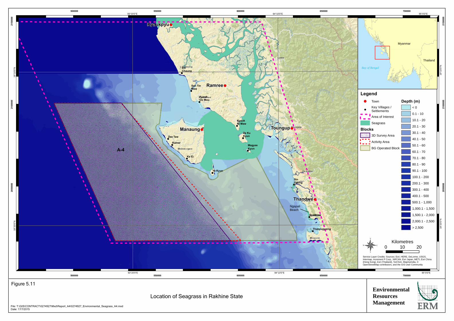
!
!
!
!
!
!
!
!
!
!
!
!
!
!(
!(
!(
!(
!(
A-4
Kyaukpyu
Manaung
Ramree
Thandwe
Toungup
ZinChaung
San TinMaw
KyaukOo Mou
KyaukNi Maw
Za KuKyun
MagyeeKyun
Ye Kyun
Ka Ei
Kamar
Zee Taw
Thabyugyaing
SinGaung
Gyeiktaw
95°0'0"E
95°0'0"E
94°10'0"E
94°10'0"E
93°20'0"E
93°20'0"E19
°10'
0"N
19°1
0'0"
N
18°2
0'0"
N
18°2
0'0"
N
500000
500000
550000
550000
600000
600000
650000
650000
700000
700000
2050
000
2050
000
2100
000
2100
000
2150
000
2150
000
Legend!( Town
!Key Villages /Settlements
Area of Interest
Seagrass
Blocks3D Survey Area
Activity Area
BG Operated Block
Depth (m)< 0
0.1 - 10
10.1 - 20
20.1 - 30
30.1 - 40
40.1 - 50
50.1 - 60
60.1 - 70
70.1 - 80
80.1 - 90
90.1 - 100
100.1 - 200
200.1 - 300
300.1 - 400
400.1 - 500
500.1 - 1,000
1,000.1 - 1,500
1,500.1 - 2,000
2,000.1 - 2,500
> 2,500
®Service Layer Credits: Sources: Esri, HERE, DeLorme, USGS,Intermap, increment P Corp., NRCAN, Esri Japan, METI, Esri China(Hong Kong), Esri (Thailand), TomTom, MapmyIndia, ©OpenStreetMap contributors, and the GIS User Community
Myanmar
Thailand
Bay of Bengal
0 2010Kilometres
EnvironmentalResourcesManagement
Location of Seagrass in Rakhine State
Figure 5.11
File: T:\GIS\CONTRACT\0274927\Mxd\Report_A4\0274927_Environmental_Seagrass_A4.mxdDate: 17/7/2015
NgapaliBeach
ENVIRONMENTAL RESOURCES MANAGEMENT BG GROUP 0274927_IEE_BG_A4_FINAL_COMPLETE_EN.DOCX OCTOBER 2015
5-12
avoid more fibrous species so as to maximise the intake of nutrients rather than bulk(1).
Around Ngapali on the mainland coast in Thandwe (Figure 5.11), seagrass species Halophila decipiens, Halodule pinifolia, Cymododocea serrulata and Syringodium isoetifolium have been observed(2). All four of these species are classified as Least Concern on the International Union for the Conservation of Nature (IUCN) 2015 Red List of Threatened Species which means in terms of survival of individual seagrass species, they are not recognized as a species of conservation concern. Consultation undertaken in April 2015 with fishing communities on Manaung Island identified that seagrass beds have been observed by locals on the south-eastern side of the island in under 20 m water depth. Secondary data has seagrass beds within the 20 m (65 feet) water depth contour. The Activity Area is located over 5 km (3.1 miles) from the Manaung coastline in over 50 m (160 feet) water depth. Given the above, seagrass beds are unlikely to be present in the Activity Area and are at least 5 km (3.1 miles) away.
5.4.5 Plankton
Block A-4 spans both shallow and deep open ocean waters. Moderate Resolution Imaging Spectrometer (MODIS) Aqua satellite datasets(3) from the area within and surrounding Block A-4 show that chlorophyll a concentrations and inferred phytoplankton standing crop levels in the surface layer are higher in the Northeast season (November to March) than in Southwest (June to September). As is typical, highest chlorophyll levels ranging up to 10 mg/m3 occur closest to the coast likely due to nutrient inputs from the land such as from rivers.
There are limited data on the species composition, abundance and distribution of plankton within the Area of Interest. Some studies have been undertaken in the wider Bay of Bengal with for instance; phytoplankton communities found to be dominated by diatoms (Bacillariophyceae) followed by dinoflagellates (Dinoflagellata) in terms of abundance in different survey areas (north, west and east). The composition, abundance and distribution of phytoplankton species was recorded in November 2007 (4) during the northeast monsoon period (the period in which the seismic survey will be undertaken). During this survey, the northern part of the Bay of Bengal (located offshore of the waters of Myanmar between Myanmar and India) was found to be the most productive area with high phytoplankton densities
(1) Aragones, L, 1996, Dugongs and green turtles: Grazers in the tropical seagrass ecosystem, pp. 292. Ph.D. Thesis.
James Cook University, Australia
(2) U. Soe-Htun, U San-Tha-Htun, Daw Mu-Mu-Ayel, Daw Ni-Ni-Win, Daw ei-Lei-Wln And Masao Ohno 2001. Op. cit.
(3) NOAA 2015. Giovanni Ocean Color Radiometry - Water Quality Portal. Viewed at: http://gdata1.sci.gsfc.nasa.gov/daac-bin/G3/gui.cgi?instance_id=WaterQuality
(4) Booonyapiwat, S., Nasiruddin Sada, Md, Mandal, J.M., and Sinha, M.K. Species Composition, Abundance and Distribution of Phytoplankton in the Bay of Bengal. The Ecosystem-Based Fishery Management in the Bay of Bengal.
ENVIRONMENTAL RESOURCES MANAGEMENT BG GROUP 0274927_IEE_BG_A4_FINAL_COMPLETE_EN.DOCX OCTOBER 2015
5-13
recorded, likely associated with nutrient-rich discharges from large rivers on the north coast. Phytoplankton in this northern area were found to dominated by the diatoms Pseudonitzschia pseudodelicatissima (1) and Chaetoceros messanensis which were the main contributors to ‘massive’ phytoplankton blooms of this area at the time of sampling.
Given the limited scope to impact plankton concentrations or abundance, plankton is not particularly sensitive to the Project activities.
5.4.6 Benthic Invertebrates
Benthic habitats within the Area of Interest vary from coral, rocky reefs to muddy shores which are inhabited by a wide variety of epi-benthic (living on seabed surface) and infaunal (living within the sediment) invertebrate species. During consultations, it was noted that a number of benthic invertebrate species are caught such as tiger prawns and other shrimp species, sea cucumber, spiny lobster, conch, snails, clams and other bivalve species. Of these, the prawn is the most commercially important species. Fishermen stated that the majority of the prawn species were caught in shallow waters between Manaung and the mainland and not within the Project Area. Prawn inhabit either rocky or muddy seabed in water depths up to 110 m but are most commonly found between 20 and 50 m. The fishermen in Rakhine stated that they trawled for prawn in the continental shelf area offshore of Manaung in around 20 to 50m water depth. Fishermen caught species such as sea cucumber and snails in the areas identified as coral reefs / coral habitat. These rocky / reef areas are located at least 3 km from the Project Area. As such, shallow water benthic invertebrates are not considered to be sensitive to project activities and important species are not likely to be present in the Block.
Given the lack of data on the deep water habitats (e.g. continental slope and abyssal plain) within the Area of Interest and the wider Bay and Bengal, the composition of benthic invertebrates is not known however common deep water species such as polychaetes, sponges, molluscs and echinoderms .
5.4.7 Fish
Fish communities in the Area of Interest occupy a range of habitats from coral and rocky reefs and seagrass habitat in shallow waters to deep-water habitats below the sun-lit euphotic zone (>200 m or 650 feet) in open ocean, and the open water pelagic zone. Recent trawl surveys to look at fisheries composition were conducted by the R.V. Dr. Fridtjof Nansen in 2013 and covered 41 fishing stations in Rakhine State and west coast of the Ayeyarwaddy Division, as well as other parts of Myanmar waters. The 2013 surveys were conducted using trawls to depths of up to 200 m (650 feet) or 1000 m (3,280 feet) with the results showing a total of 235 fish taxa were
(1) This diatom species is a potentially harmful species that can produce a neurotoxin (domoic acid) linked to amnesic
shellfish poisoning.
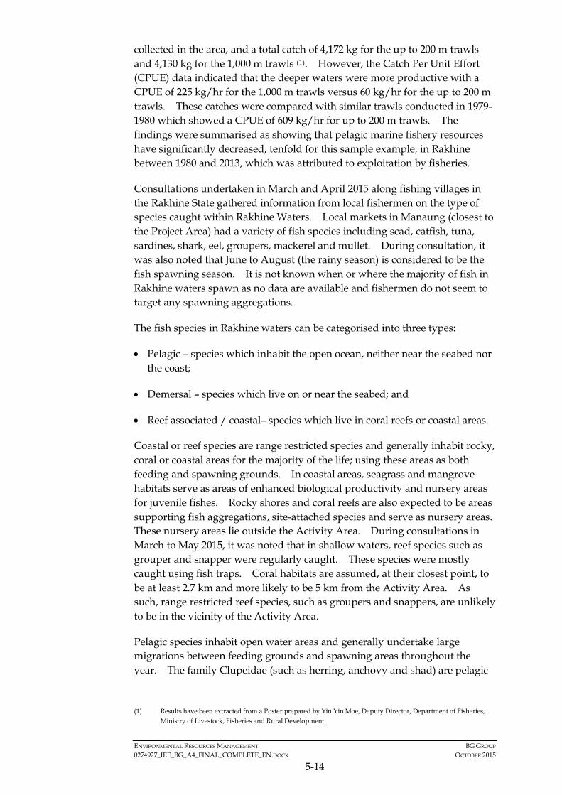
ENVIRONMENTAL RESOURCES MANAGEMENT BG GROUP 0274927_IEE_BG_A4_FINAL_COMPLETE_EN.DOCX OCTOBER 2015
5-14
collected in the area, and a total catch of 4,172 kg for the up to 200 m trawls and 4,130 kg for the 1,000 m trawls (1). However, the Catch Per Unit Effort (CPUE) data indicated that the deeper waters were more productive with a CPUE of 225 kg/hr for the 1,000 m trawls versus 60 kg/hr for the up to 200 m trawls. These catches were compared with similar trawls conducted in 1979-1980 which showed a CPUE of 609 kg/hr for up to 200 m trawls. The findings were summarised as showing that pelagic marine fishery resources have significantly decreased, tenfold for this sample example, in Rakhine between 1980 and 2013, which was attributed to exploitation by fisheries.
Consultations undertaken in March and April 2015 along fishing villages in the Rakhine State gathered information from local fishermen on the type of species caught within Rakhine Waters. Local markets in Manaung (closest to the Project Area) had a variety of fish species including scad, catfish, tuna, sardines, shark, eel, groupers, mackerel and mullet. During consultation, it was also noted that June to August (the rainy season) is considered to be the fish spawning season. It is not known when or where the majority of fish in Rakhine waters spawn as no data are available and fishermen do not seem to target any spawning aggregations.
The fish species in Rakhine waters can be categorised into three types:
• Pelagic – species which inhabit the open ocean, neither near the seabed nor the coast;
• Demersal – species which live on or near the seabed; and
• Reef associated / coastal– species which live in coral reefs or coastal areas.
Coastal or reef species are range restricted species and generally inhabit rocky, coral or coastal areas for the majority of the life; using these areas as both feeding and spawning grounds. In coastal areas, seagrass and mangrove habitats serve as areas of enhanced biological productivity and nursery areas for juvenile fishes. Rocky shores and coral reefs are also expected to be areas supporting fish aggregations, site-attached species and serve as nursery areas. These nursery areas lie outside the Activity Area. During consultations in March to May 2015, it was noted that in shallow waters, reef species such as grouper and snapper were regularly caught. These species were mostly caught using fish traps. Coral habitats are assumed, at their closest point, to be at least 2.7 km and more likely to be 5 km from the Activity Area. As such, range restricted reef species, such as groupers and snappers, are unlikely to be in the vicinity of the Activity Area.
Pelagic species inhabit open water areas and generally undertake large migrations between feeding grounds and spawning areas throughout the year. The family Clupeidae (such as herring, anchovy and shad) are pelagic
(1) Results have been extracted from a Poster prepared by Yin Yin Moe, Deputy Director, Department of Fisheries,
Ministry of Livestock, Fisheries and Rural Development.
ENVIRONMENTAL RESOURCES MANAGEMENT BG GROUP 0274927_IEE_BG_A4_FINAL_COMPLETE_EN.DOCX OCTOBER 2015
5-15
species and as such could potentially be present in the Activity Area. This family is known to be sensitive to underwater sound generation as they are classified as “hearing specialists”. This means that they have the ability to hear underwater sound as they have a connection between their swim bladder and their hearing apparatus which means they can be sensitive to pressure changes (i.e. underwater sounds). Also, the mackerel family (Scombridae) is pelagic and has one species which is considered of potential international conservation concern (Table 5.1). The assessment of Project activities with regards to impacts on fish species will focus on these hearing specialists and identified species of conservation concern. More information on fish sensitivity and the assessment of potential impacts is presented in Section 6 of this IEE Report.
Demersal species are associated with the seabed. They generally feed on the invertebrates and other organisms living with the seabed. Of the species catfish, flatfish and threadfin fish (see Table 5.1). Demersal species may be present in the Activity Area on the seabed however; the majority of the Activity Area is in water depths exceeding 1,000m. On the abyssal plain (>2,000m water depth), information on species composition is not well known. It can be assumed that common deep water fish species such as grenadiers (rat tails) are likely to be present.
The main commercial fish species in Rakhine waters are shown in Table 5.1 This list was compiled from information from the Myanmar National Report (1) and a handout provided by the Kyaukphyu Department of Fisheries during stakeholder consultations in Kyaukphyu in March 2015.
(1) Myint Pe undated. National Report of Myanmar on the Sustainable Management of the Bay of Bengal Large
Marine Ecosystem (BOBLME) GCP/RAS/179/WBG.

ENVIRONMENTAL RESOURCES MANAGEMENT BG GROUP 0274927_IEE_BG_A4_FINAL_COMPLETE_EN.DOCX OCTOBER 2015
5-16
Table 5.1 Main Commercially Important Fish Species Reported to occur in Rakhine Waters
Latin name Common Name IUCN Status
ARRIDAE Sea Cat Fish Demersal Arius caelatus Engraved catfish Not yet assessed Arius maculates Spotted catfish Not yet assessed Arius thalassinus Giant catfish Not yet assessed Arius venosus Veined catfish Not yet assessed Osteogeneiosus militaris Soldier catfish Not yet assessed CARANGIDAE Trevally / Scad Reef associated Alectis indica Indian threadfin (trevally) Not yet assessed Alepes djeddaba Djeddaba crevally Not yet assessed Alepes melanoptera Black fin crevally Not yet assessed Atropus atropus Kuweh trevally Not yet assessed Carangoides chrysophrys Long nose cavalla Not yet assessed Carangoides ciliarius Long fin cavalla Not yet assessed Carangoides ferdau Ferdau's cavalla Not yet assessed Carangoides malabaricus Malabar's cavalla Not yet assessed Caranx ignobilis Giant trevally Not yet assessed Caranx sexfasciatus Dusky jack Least Concern Decapterus macrosoma Layang scad Not yet assessed Decapterus maruadsi Round scad Not yet assessed Gnathanodon speciosus Golden toothless trevally Not yet assessed Megalaspis cordyla Hard tail scad Not yet assessed Scomberoides commersonianus Talang queen fish Not yet assessed Selaroides leptolepis Yellow stripe trevally Not yet assessed Seriolina nigrofasciata Black banded trevally Not yet assessed CLUPEIDAE Herring/Shad/Sardine Pelagic Anodontostoma chacunda Chacunda gizzard shad Not yet assessed Dussmieria acuta Rainbow sardine Not yet assessed Encrasicholina heteroloba shorthead anchovy Not yet assessed Hilsa ilisha Elongate ilisha Not yet assessed Opisthopterus tardoore Tardoore Not yet assessed Sardinella gibbosa Gold stripe sardinella Not yet assessed Tenualosa ilisha Hilsa shad Least Concern EXOCOETIDAE Flying Fish Pelagic Exocoetidae sp. Flying fish - LATIDAE Perch Pelagic Lates calcarifer Barramundi Not yet assessed LUTJANIDAE Snappers Reef associated Aprion virescens Green job fish Not yet assessed Lutjanus argentimaculatus Mangrove red snapper Not yet assessed Lutjanus johnii John's snapper Not yet assessed Lutjanus malabaricus Malabar red snapper Not yet assessed Lutjanus russelli Russell's snapper Not yet assessed Lutjanus sanguineus Blood red snapper Not yet assessed Lutjanus sebae Emperor red snapper Not yet assessed

ENVIRONMENTAL RESOURCES MANAGEMENT BG GROUP 0274927_IEE_BG_A4_FINAL_COMPLETE_EN.DOCX OCTOBER 2015
5-17
Latin name Common Name IUCN Status
Lutjanus vitta Brownstripe red snapper Not yet assessed Pristipomoides typus Sharp toothed snapper Not yet assessed MULLIDAE Goat fish Reef associated Parupeneus heptacanthus Spotted Golden goat fish Not yet assessed Upeneus moluccensis Golden band goat fish Not yet assessed Upeneus sulphureus Yellow goat fish Not yet assessed Upeneus vittatus Yellow stripe goat fish Not yet assessed MURANESOCIDAE Sea eel / Pike conger Demersal Congresox talabon Yellow pike conger Not yet assessed Congresox talabonoides Indian pike conger Not yet assessed NEMIPTERIDAE Threadfin bream Demersal Nemipterus bipunctatus (dalagoae) Dalagoa threadfin bream Not yet assessed
Nemipterus japonicus Japanese threadfin bream Not yet assessed Nemipterus nematophorus Double whip threadfin bream Not yet assessed Nemipterus tolu Notched threadfin bream Not yet assessed PLEURONECTIFORMES Flatfish Demersal Cynoglossidae sp. Tonguesoles - POLYNEMIDAE Threadfin Demersal Eleutheronema tetradactylum Four finger threadfin Not yet assessed Polynemus indicus Indian threadfin Not yet assessed Polynemus sextarius Black spot threadfin Not yet assessed POMADASYIDAE Grunt / Javelin fish Reef associated Pomadasys hasta Silver javelin Least Concern Pomadasys maculatus Blotched (saddle) grunt Least Concern SCIAENIDAE Croaker / Drum Demersal Chrysochir aureus Reeve's croaker Not yet assessed Otolithes rubber Tiger toothed croaker Not yet assessed Otolithoides biauritus Bronze croaker Not yet assessed Ophioscion punctatissimus Spotted croaker Not yet assessed Panna microdon Penna croaker Not yet assessed Pennahia macrophthalmus Big eye croaker Not yet assessed Pennahia macrocephalus Big head pennah croaker Not yet assessed Protonibea diacanthus Spotted croaker Not yet assessed Pterotolithus maculatus Blotched tiger toothed croaker Least Concern SCOMBRIDAE Mackerels Pelagic Katsuwonus pelamis Stripped tuna (skipjack) Least Concern Rastrelliger brachysoma short bodied mackerel Data Deficient Rastrelliger kanagurta Indian mackerel Data Deficient Scomberomorus guttatus Indo-pacific Spanish mackerel Data Deficient Scomberomorus lineolatus Streaked Spanish mackerel Least Concern Scomberomorus commerson Narrow barred Spanish mackerel Near Threatened Scomberomorus maculatus Spanish mackerel Least Concern SERRANIDAE Grouper Reef associated Epinephelus bleekeri Bleeker's grouper Near Threatened Epinephelus tauvina Greasy grouper Data Deficient Epinephelus merra Honeycomb grouper Least Concern STROMATEIDAE Pomfret Demersal
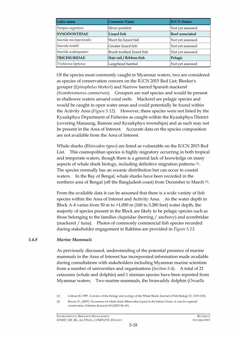
ENVIRONMENTAL RESOURCES MANAGEMENT BG GROUP 0274927_IEE_BG_A4_FINAL_COMPLETE_EN.DOCX OCTOBER 2015
5-18
Latin name Common Name IUCN Status
Pampus argenteus Silver pomfret Not yet assessed SYNODONTIDAE Lizard fish Reef associated Saurida micropectoralis Short fin lizard fish Not yet assessed Saurida tumbil Greater lizard fish Not yet assessed Saurida undosquamis Brush toothed lizard fish Not yet assessed TRICHIURIDAE Hair tail / Ribbon fish Pelagic Trichiurus lepturus Largehead hairtial Not yet assessed
Of the species most commonly caught in Myanmar waters, two are considered as species of conservation concern on the IUCN 2015 Red List; Bleeker's grouper (Epinephelus bleekeri) and Narrow barred Spanish mackerel (Scomberomorus commerson). Groupers are reef species and would be present in shallower waters around coral reefs. Mackerel are pelagic species and would be caught in open water areas and could potentially be found within the Activity Area (Figure 5.12). However, these species were not listed by the Kyaukphyu Department of Fisheries as caught within the Kyaukphyu District (covering Manaung, Ramree and Kyaukphyu townships) and as such may not be present in the Area of Interest. Accurate data on the species composition are not available from the Area of Interest.
Whale sharks (Rhincodon typus) are listed as vulnerable on the IUCN 2015 Red List. This cosmopolitan species is highly migratory occurring in both tropical and temperate waters, though there is a general lack of knowledge on many aspects of whale shark biology, including definitive migration patterns (1). The species normally has an oceanic distribution but can occur in coastal waters. In the Bay of Bengal, whale sharks have been recorded in the northern area of Bengal (off the Bangladesh coast) from December to March (2).
From the available data it can be assumed that there is a wide variety of fish species within the Area of Interest and Activity Area. As the water depth in Block A-4 varies from 50 m to >1,000 m (160 to 3,280 feet) water depth, the majority of species present in the Block are likely to be pelagic species such as those belonging to the families clupeidae (herring / anchovy) and scombridae (mackerel / tuna). Photos of commonly commercial fish species recorded during stakeholder engagement in Rakhine are provided in Figure 5.13.
5.4.8 Marine Mammals
As previously discussed, understanding of the potential presence of marine mammals in the Area of Interest has incorporated information made available during consultations with stakeholders including Myanmar marine scientists from a number of universities and organisations (Section 5.4). A total of 21 cetaceans (whale and dolphin) and 1 sirenian species have been reported from Myanmar waters. Two marine mammals, the Irrawaddy dolphin (Orcaella
(1) Colman JG 1997. A review of the biology and ecology of the Whale Shark. Journal of Fish Biology 51: 1219-1234.
(2) Rowat, D., (2007). Occurrence of whale shark (Rhincodon typus) in the Indian Ocean: A case for regional conservation. Fisheries Research 84 (2007) 96–101.

EnvironmentalResourcesManagement
Figure 5.12
FILE: 0274927r.cdrDATE: 29/06/2015
Fish Types in Rakhine Waters
Land
Coral
Reef Associated
Sea Surface
Seabed
Reef
Jack (Carangidae)
Demersal
Croaker (Sciaenidae)
Pelagic
Shark (Carcharhinidae)

EnvironmentalResourcesManagement
Figure 5.13a
FILE: 0274927k.cdrDATE: 29/06/2015
Representative Photos of Some Commercial Fisheries Species observed during Site Visits in the Area of Interest(1 of 2)
Barramundi (Latidae) Catfish (Arridae) Shad (Clupeidae)
Mackerel (Scombridae) Croaker (Sciaenidae) Spiny Lobster (Panulirus ornatus)
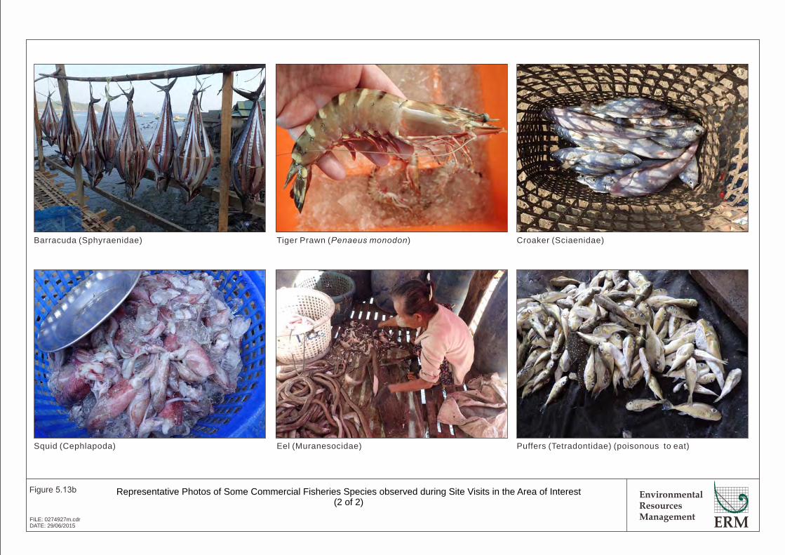
EnvironmentalResourcesManagement
Figure 5.13b
FILE: 0274927m.cdrDATE: 29/06/2015
Representative Photos of Some Commercial Fisheries Species observed during Site Visits in the Area of Interest(2 of 2)
Barracuda (Sphyraenidae) Tiger Prawn ( )Penaeus monodon Croaker (Sciaenidae)
Squid (Cephlapoda) Eel (Muranesocidae) Puffers (Tetradontidae) (poisonous to eat)

ENVIRONMENTAL RESOURCES MANAGEMENT BG GROUP 0274927_IEE_BG_A4_FINAL_COMPLETE_EN.DOCX OCTOBER 2015
5-19
brevirostris) and dugong (Dugong dugon), have been protected under the Myanmar Protection of Wildlife and Conservation of Natural Areas Law since 1994 under the category “completely protected”. These marine mammal species are shown in Figure 5.14.
Cetaceans (Whales and Dolphins)
Of these, most are far-ranging migratory oceanic species while several others are coastal species with closer affinities to shallow water habitat areas and estuarine areas. Such coastal species include Irrawaddy dolphin (Orcaella brevirostris), Indo-Pacific humpback dolphin (Sousa chinensis) and Indo-Pacific bottlenose dolphin (Tursiops aduncus). IUCN-listed threatened cetacean species in Myanmar waters are oceanic species that typically inhabit deep offshore open waters, namely the blue whale (Balaenoptera musculus) (Endangered), fin whale (Balaenoptera physalus) (Endangered) and sperm whale (Physeter macrocephalus) (Vulnerable). The blue whale and the fin whale are also listed as endangered species recognized as of prime importance to the Region and deserving special attention under the ASEAN Agreement on the Conservation of Nature and Natural Resources (1). Other common deeper water species such as humpback whale (Megaptera novaeangliae) and Bryde’s whale (Balaenoptera edeni) are known to occur in offshore waters in Myanmar, however these are listed as Least Concern and Data Deficient on IUCN Red List, respectively.
There are limited data on distribution, abundance, habitat utilization and seasonality of marine mammals in Myanmar due to only a handful of scientific surveys conducted and stranding information. Recently collected data (2015) on species observed to be in offshore Rakhine waters in presented in Table 5.2 (2). Byrde’s whales were found to be the most commonly sighted cetacean. Some of the species of marine mammal could not be identified. Of the species recorded, none are listed as species of conservational concern by the IUCN Red List (refer to Figure 5.14).
It is thought that species such as Indo-Pacific humpback and Indo-Pacific (3) bottlenose dolphins tend to be resident, occurring in localised discrete populations, often around estuaries. Larger species have been recorded in offshore deeper waters which would be in line with their typical life histories. Limited information on sightings of marine mammal species is presented in Figure 5.15 (4).
(1) ASEAN Agreement on the Conservation of Nature and Natural Resources. Kuala Lumpur, 9 July 1985
(2) Data provided by Ophir Energy Plc for the purpose of this IEE. Sighting information was collected in March to June 2015 from Block AD-03 located in deeper waters to the southwest of Block A-4.
(3) Indo-Pacific bottlenose dolphins are also called Asian bottlenose dolphin by some researchers.
(4) Data collected from 1. Tun T, Langakoon AD, PE MT (2010) Dugong in Man Aung Water, Myanmar. Preceedings of the 5th International Symposium on SEASTAR 2000 and Asian Bio*logging Science (The 9th SEASTAR2000 workshop): 63 * 66 and Smith BD, Thant UH, Lwin JM and Shaw CD (1997) Investigation of cetaceans in the Ayeyarwady River and northern coastal waters of Myanmar. Asian Marine Biology (14): 173 * 194

Figure 4.12 Marine Turtles in Rakhine waters
Dugong
Indo-pacific bottlenosedolphin
Irrawaddy dolphin
Brydes whale
(Source: www.whale-watching.co.za)
Dwarf sperm whale
(Source: uk.whales.org)
(Source: )www.greatocean.com.au/(Source: )www.itsnature.org
(Source: www.tonywublog.com)
EnvironmentalResourcesManagement
Figure 5.14
FILE: 0274927o.cdrDATE: 13/07/2015
Marine Mammal Species Recorded in Myanmar Waters ( )1
Rissos dolphin
Short finned pilot whale
Spinner dolphin
Blainville's beaked whale
(Source: www.animal-kid.com)
(Source: www.eoearth.org)
Pantropical spotteddolphin
Latin Name
Balaenoptera edeni
Balaenoptera musculus
Balaenoptera physalus
Megaptera novaeangliae
Mesoplodon densirostris
Kogia sima
Pseudorca crassidens
Orcinus orca
Peponocephala electra
Feresa attenuata
Kogia breviceps
Globicephala macrorhynchus
Physeter macrocephalus
Stenella longirostris roseiventris
Tursiops aduncus
Neophocaena phocaenoides
Sousa chinensis
Orcaella brevirostris
Stenella attenuata
Grampus griseus
Stenella longirostris
Stenella coeruleoalba
Dugon Dugong
IUCN Red List
Data Deficient
Endangered
Endangered
Least Concern
Data Deficient
Data Deficient
Data Deficient
Data Deficient
Least Concern
Data Deficient
Data Deficient
Data Deficient
Vulnerable
Data Deficient
Data Deficient
Vulnerable
Near Threatened
Vulnerable
Least Concern
Least Concern
Data Deficient
Least Concern
Vulnerable
Common Name
Baleen Whales
Bryde's whale
Blue whale
Fin whale
Humpback whale
Toothed Whales
Blainville's beaked whale
Dwarf sperm whale
False killer whale
Killer whale
Melon-headed Whale
Pygmy killer whale
Pygmy sperm whale
Short-finned pilot whale
Sperm Whale
Porpoise and Dolphins
Dwarf Spinner Dolphin
Indo-pacific bottlenose dolphin
Indo-pacific finless porpoise
Indo-pacific humpbacked dolphin
Irrawaddy dolphin
Pantropical spotted dolphin
Rissos dolphin
Spinner dolphin
Striped dolphin
Sirenian
Dugong
Fin whale
(Source: www.whalesanddolphinsoftenerife.org)
(Source: www.arkive.org)
Sperm whale
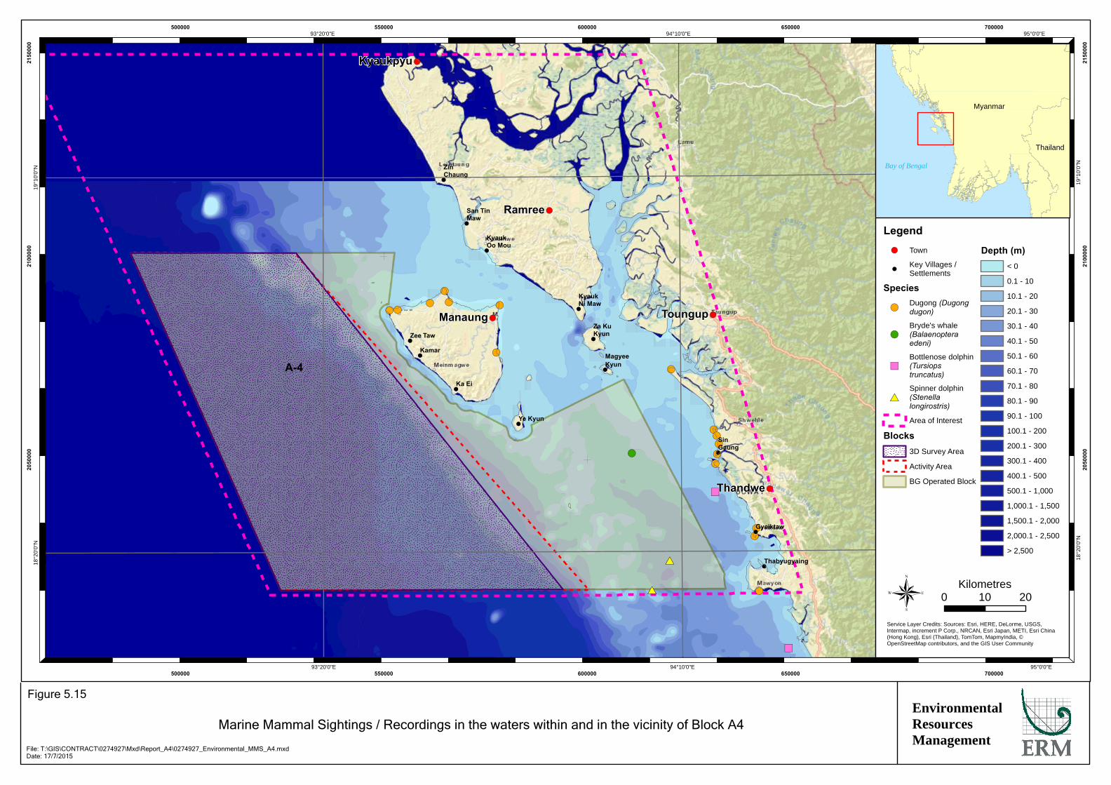
!(!(!(
!(!( !(
!(
!(
!(!(!(
!(!(
!(!(
")
#*
#*
")
!(
!(
!
!
!
!
!
!
!
!
!
!
!
!
!
!(
!(
!(
!(
!(
A-4
Kyaukpyu
Manaung
Ramree
Thandwe
Toungup
ZinChaung
San TinMaw
KyaukOo Mou
KyaukNi Maw
Za KuKyun
MagyeeKyun
Ye Kyun
Ka Ei
Kamar
Zee Taw
Thabyugyaing
SinGaung
Gyeiktaw
95°0'0"E
95°0'0"E
94°10'0"E
94°10'0"E
93°20'0"E
93°20'0"E19
°10'
0"N
19°1
0'0"
N
18°2
0'0"
N
18°2
0'0"
N
500000
500000
550000
550000
600000
600000
650000
650000
700000
700000
2050
000
2050
000
2100
000
2100
000
2150
000
2150
000
Legend!( Town
!Key Villages /Settlements
Species
!(Dugong (Dugongdugon)
!(Bryde's whale(Balaenopteraedeni)
")Bottlenose dolphin(Tursiopstruncatus)
#*Spinner dolphin(Stenellalongirostris)
Area of Interest
Blocks3D Survey Area
Activity Area
BG Operated Block
Depth (m)< 0
0.1 - 10
10.1 - 20
20.1 - 30
30.1 - 40
40.1 - 50
50.1 - 60
60.1 - 70
70.1 - 80
80.1 - 90
90.1 - 100
100.1 - 200
200.1 - 300
300.1 - 400
400.1 - 500
500.1 - 1,000
1,000.1 - 1,500
1,500.1 - 2,000
2,000.1 - 2,500
> 2,500
®Service Layer Credits: Sources: Esri, HERE, DeLorme, USGS,Intermap, increment P Corp., NRCAN, Esri Japan, METI, Esri China(Hong Kong), Esri (Thailand), TomTom, MapmyIndia, ©OpenStreetMap contributors, and the GIS User Community
Myanmar
Thailand
Bay of Bengal
0 2010Kilometres
EnvironmentalResourcesManagement
Marine Mammal Sightings / Recordings in the waters within and in the vicinity of Block A4
Figure 5.15
File: T:\GIS\CONTRACT\0274927\Mxd\Report_A4\0274927_Environmental_MMS_A4.mxdDate: 17/7/2015
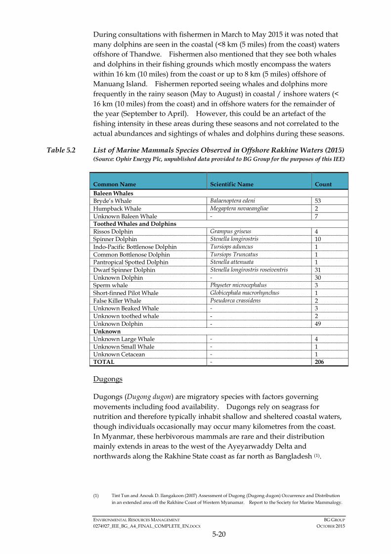
ENVIRONMENTAL RESOURCES MANAGEMENT BG GROUP 0274927_IEE_BG_A4_FINAL_COMPLETE_EN.DOCX OCTOBER 2015
5-20
During consultations with fishermen in March to May 2015 it was noted that many dolphins are seen in the coastal (<8 km (5 miles) from the coast) waters offshore of Thandwe. Fishermen also mentioned that they see both whales and dolphins in their fishing grounds which mostly encompass the waters within 16 km (10 miles) from the coast or up to 8 km (5 miles) offshore of Manuang Island. Fishermen reported seeing whales and dolphins more frequently in the rainy season (May to August) in coastal / inshore waters (< 16 km (10 miles) from the coast) and in offshore waters for the remainder of the year (September to April). However, this could be an artefact of the fishing intensity in these areas during these seasons and not correlated to the actual abundances and sightings of whales and dolphins during these seasons.
Table 5.2 List of Marine Mammals Species Observed in Offshore Rakhine Waters (2015) (Source: Ophir Energy Plc, unpublished data provided to BG Group for the purposes of this IEE)
Common Name Scientific Name Count Baleen Whales Bryde’s Whale Balaenoptera edeni 53 Humpback Whale Megaptera novaeangliae 2 Unknown Baleen Whale - 7 Toothed Whales and Dolphins Rissos Dolphin Grampus griseus 4 Spinner Dolphin Stenella longirostris 10 Indo-Pacific Bottlenose Dolphin Tursiops aduncus 1 Common Bottlenose Dolphin Tursiops Truncatus 1 Pantropical Spotted Dolphin Stenella attenuata 1 Dwarf Spinner Dolphin Stenella longirostris roseiventris 31 Unknown Dolphin - 30 Sperm whale Physeter microcephalus 3 Short-finned Pilot Whale Globicephala macrorhynchus 1 False Killer Whale Pseudorca crassidens 2 Unknown Beaked Whale - 3 Unknown toothed whale - 2 Unknown Dolphin - 49 Unknown Unknown Large Whale - 4 Unknown Small Whale - 1 Unknown Cetacean - 1 TOTAL - 206
Dugongs
Dugongs (Dugong dugon) are migratory species with factors governing movements including food availability. Dugongs rely on seagrass for nutrition and therefore typically inhabit shallow and sheltered coastal waters, though individuals occasionally may occur many kilometres from the coast. In Myanmar, these herbivorous mammals are rare and their distribution mainly extends in areas to the west of the Ayeyarwaddy Delta and northwards along the Rakhine State coast as far north as Bangladesh (1).
(1) Tint Tun and Anouk D. Ilangakoon (2007) Assessment of Dugong (Dugong dugon) Occurrence and Distribution
in an extended area off the Rakhine Coast of Western Myanamar. Report to the Society for Marine Mammalogy.

ENVIRONMENTAL RESOURCES MANAGEMENT BG GROUP 0274927_IEE_BG_A4_FINAL_COMPLETE_EN.DOCX OCTOBER 2015
5-21
Dugongs have been reported to occur in Rakhine waters (1). As previously discussed (refer to seagrass habitats section), seagrass meadows are not likely to be present on the coasts of Manaung Island facing the Activity Area (western coasts). Given the dugong’s preference for nearshore/coastal shallow water environments and their scarcity and association with seagrass habitat, these animals are unlikely to be present in the open oceanic areas west of the Manaung Island and therefore are not expected in or near the Activity Area. From stakeholder consultations undertaken in Rakhine in March to May 2015, it was noted that dugongs have rarely been seen in the waters of Rakhine in recent years and in some cases (i.e., reported by fishermen in Manaung) they have not been seen in the region in decades. Historically dugongs have been incidentally caught in fishing nets and are also sensitive to coastal development or coastal anthropogenic activity causing habitat depletion.
Although dugong are a nationally protected species, given the distance of suitable dugong habitat from the Activity Area (>8 km or 5 miles), dugong are unlikely to be sensitive to Project activities. Historic locations of dugong sightings are provided in Figure 5.15.
5.4.9 Marine Turtles
As previously discussed, understanding of the potential presence of marine turtles in the Area of Interest has incorporated information made available during consultations with stakeholders including Myanmar marine scientists from a number of universities and organisations (Section 5.4). The waters adjacent to Rakhine State host five species of marine turtles, all of which are IUCN-listed threatened species. These turtles are shown in Figure 5.16.
All five species share similar life cycle characteristics, which include migration from foraging areas to mating (inter-nesting) and nesting areas (2). In general, mature adult turtles (approximately 30 to 50 years old) undertake the migration from their coastal shallow benthic foraging areas to shallow water inter-nesting areas waters near nesting beaches every two to eight years. On arrival, turtles mate and females may nest multiple times at about 2 week intervals before returning to foraging areas. Eggs hatch after 8 to 10 weeks of incubation with hatchings dispersing into the open ocean surface waters where they forage for the next 5 to 20 years.
The hawksbill turtle and leatherback turtle have been occasionally reported by fishermen from some parts of Rakhine coastal area and Green Turtle have been sighted by some fishermen in offshore waters. UNEP data suggest sandy shore habitat along Ramree Island, Manaung Island and adjacent small coastal islands are nesting sites for green, olive ridley and hawksbill turtles.
(1) Tint Tun and Anouk D. Ilangakoon (2007) Op. cit..
(2) Miller JD 1997. Reproduction in sea turtles, In: Lutz, P, and Musick, JA (eds), The Biology of Sea Turtles, pp. 51-82, Boca Raton, CRC Press Inc

EnvironmentalResourcesManagement
Figure 5.16
FILE: 0274927p.cdrDATE: 29/06/2015
Marine Turtles in Rakhine waters
Olive Ridley Turtle Loggerhead urtleT Green Turtle
Hawksbill urtleT Leatherback urtleT
Latin Name
Lepoidochely olivacea
Caretta caretta
Chelonia mydas
Eretmochelys imbricata
Dermochelys coriacea
Common Name
Olive ridley turtle
Loggerhead turtle
Green turtle
Hawksbill turtle
Leatherback turtle
Myanmar Name
Leik Lyaung
Leik Khway
Pyin Tha Leik
Leik Kyet Tu Yway
Leik Zaung Lyar
IUCN Status
Endangered
Endangered
Vulnerable
Critically Endangered
Endangered
Potential Presence in Block A-4
Reported to occur in Rakhine and have been observed bylocal fishermen. Known to be nesting in Rakhine State andlikely to be present in Block A-4.
Reported to occur in Rakhine and have been observed bylocal fishermen. Not known to nest on the Rakhine Coast.
Reported to be nesting in Rakhine State and likely to bepresent in Block A-4.
Reported to occur in Rakhine and have been observed bylocal fishermen. Known to be nesting in Rakhine State andlikely to be present in Block A-4.
Have historically been recorded in Rakhine waters but arenow considered rare.
ENVIRONMENTAL RESOURCES MANAGEMENT BG GROUP 0274927_IEE_BG_A4_FINAL_COMPLETE_EN.DOCX OCTOBER 2015
5-22
Data on sea turtles sightings at sea in Rakhine waters has been recently collected data (2015) and presented in Table 5.3(1). 25 sea turtles were observed from March to June 2015, of these most were not identified to species level.
Table 5.3 List of Sea Turtle Species Observed in Offshore Rakhine Waters (2015) (Source: Ophir Energy Plc, unpublished data provided to BG Group for the purposes of this IEE)
Common Name Scientific Name Count Loggerhead Turtle Caretta caretta 2 Olive Ridley Sea Turtle Lepidochelys olivacea 2 Green Sea Turtle Chelonia mydas 1 Unknown Sea Turtle - 20 TOTAL - 25
Annual turtle nesting activity in Rakhine waters is reported to occur between September and March with the peak period of activity occurring from December to January. During stakeholder consultations, local fishermen and the Sittwe Department of Fisheries confirmed that they see turtles nesting on beaches of the west coast of Ramree Island in October and Ye Kyun Island (southern coast of Manaung) in December and January. Reported turtle nesting locations are shown in Figure 5.17.
A review of available data on the numbers of turtles nesting annually was undertaken for Rakhine and neighbouring States / Regions. Anecdotal information from fishermen suggests that low numbers of nests (<10) are encountered at certain beaches annually. There is also information available from the Ministry of Livestock and Fisheries on turtle nesting from Diamond Island (Thameehla) in the Ayeyarwaddy Region around 200 km to the south of Block AD-02. This data was collected from 1986 to 2004 and demonstrates a positive relationship between number of eggs laid and number of hatchlings released (2). The number of nests, eggs laid and the total number of unhatched, damaged and hatched eggs is presented in Table 5.4. Diamond Island is the largest recorded concentration of nesting in Myanmar where approximately 20,000-30,000 green turtle eggs and 7,000-15,000 loggerhead turtle eggs are laid annually according to the DoF (3).
Table 5.4 Turtle Nesting Data from Ayeyarwaddy Region (1986 to 2004)
Year No of Nests Eggs Laid Unhatched
Eggs Damaged Eggs
Hatchlings Released
Hatching Rate (%)
1986 106 5,200 - 4,230 970 18.65
1987 528 16,073 5,890 2,114 8,069 50.2
1988 297 27,900 2,650 15,161 10,089 36.16
(1) Data provided by Ophir Energy Plc for the purpose of this IEE. Sighting information was collected in March to
June 2015 from Block AD-03 located in deeper waters to the southwest of Block A-4.
(2) Sea Turtle (Chelonia mydas) Nesting and Conservation Activity in Thameehla Island, Myanmar by Maung Maung Lwin at the Ministry of Livestock and Fisheries.
(3) John B. Thorbjarnarson, Steven G. Platt, and Saw Tun Khaing. Sea Turtles in Myanmar: Past and Present. Marine Turtle Newsletter 88:10-11, © 2000.

!
!
!
!
!
!
!
!
!
!
!
!
!
!(
!(
!(
!(
!(
A-4
Kyaukpyu
Manaung
Ramree
Thandwe
Toungup
ZinChaung
San TinMaw
KyaukOo Mou
KyaukNi Maw
Za KuKyun
MagyeeKyun
Ye Kyun
Ka Ei
Kamar
Zee Taw
Thabyugyaing
SinGaung
Gyeiktaw
95°0'0"E
95°0'0"E
94°10'0"E
94°10'0"E
93°20'0"E
93°20'0"E19
°10'
0"N
19°1
0'0"
N
18°2
0'0"
N
18°2
0'0"
N
500000
500000
550000
550000
600000
600000
650000
650000
700000
700000
2050
000
2050
000
2100
000
2100
000
2150
000
2150
000
Legend!( Town
!Key Villages /Settlements
Turtle NestingSites
Green
Hawksbill
Olive Ridley
Area of Interest
Blocks3D Survey Area
Activity Area
BG OperatedBlock
Depth (m)< 0
0.1 - 10
10.1 - 20
20.1 - 30
30.1 - 40
40.1 - 50
50.1 - 60
60.1 - 70
70.1 - 80
80.1 - 90
90.1 - 100
100.1 - 200
200.1 - 300
300.1 - 400
400.1 - 500
500.1 - 1,000
1,000.1 - 1,500
1,500.1 - 2,000
2,000.1 - 2,500
> 2,500
®Service Layer Credits: Sources: Esri, HERE, DeLorme, USGS,Intermap, increment P Corp., NRCAN, Esri Japan, METI, Esri China(Hong Kong), Esri (Thailand), TomTom, MapmyIndia, ©OpenStreetMap contributors, and the GIS User Community
Myanmar
Thailand
Bay of Bengal
0 2010Kilometres
EnvironmentalResourcesManagement
Locations of Turtle Nesting Sites in Rakhine Waters
Figure 5.17
File: T:\GIS\CONTRACT\0274927\Mxd\Report_A4\0274927_Environmental_Turtle_A4.mxdDate: 17/7/2015
Manaung
Ye Kyun

ENVIRONMENTAL RESOURCES MANAGEMENT BG GROUP 0274927_IEE_BG_A4_FINAL_COMPLETE_EN.DOCX OCTOBER 2015
5-23
Year No of Nests Eggs Laid Unhatched
Eggs Damaged Eggs
Hatchlings Released
Hatching Rate (%)
1989 549 66,908 27,294 4,583 35,031 52.36
1990 537 52,300 7,321 - 44,979 86
1991 359 34,334 7,395 - 26,939 78.46
1992 369 36,900 7,558 7,413 21,929 59.43
1993 540 47,902 3,143 10,036 34,723 72.49
1994 387 34,461 3,987 - 30,474 88.43
1995 419 39,613 4,516 3,533 31,564 79.68
1996 463 45,928 3,767 5,317 36,844 80.22
1997 456 47,312 5,138 1,689 40,485 85.57
1998 306 30,679 3,664 2,065 24,950 81.33
1999 136 13,651 1,888 - 11,763 86.17
2000 231 45,673 2,201 - 43,472 95.18
2001 402 46,680 3,090 - 43,590 93.38
2002 122 11,549 1,821 595 9,133 79.09
2003 251 21,016 4,711 5,221 11,084 52.74
2004 165 14,347 3,162 7,764 3,421 23.84
Total 6,623 638,426 99,196 69,721 469,509 -
Average 349 33,601 5,511 5,363 24,711 68
Turtle nesting is well known on the Islands around the Bogale River in the Ayeryarwaddy Region (over 250 km from Block AD-02). In 2003, the Department of Fisheries suggested that the annual number of nests is 300. Most nesting in the Ayeyarwaddy Region is performed by olive ridley (70%), loggerhead (20%) and green turtle (10%) (2).
Despite the absence of specific data, it can be assumed that the numbers of turtles nesting in the Rakhine Region will most likely be less than at the Ayeyarwaddy Delta and Islands, which is a well-known turtle nesting site area in Myanmar (1).
Like other countries, Myanmar has a long tradition of turtle egg collection for human consumption, which is one of the main threats to turtle populations in the region(2) (3). During visits for stakeholder consultations, evidence of this continued practice was observed in food markets (Figure 5.18).
Given the location of the Activity Area along the western coast on Manaung, it is assumed that marine turtles can be expected to pass within or close by to Block A-4 and also the Activity Area. As nesting occurs from September to March, turtles are likely to be mating in offshore waters from August to March prior to nesting on the coasts. Turtles will nest one or more times during
(1) Sea Turtles Threats, Conservation and Management in Myanmar ASEAN / SEAFDEC Regional Technical
Consultation on Management and Conservation of Sea Turtle in Southeast Asia, Kuala Lumpur, Malaysia, 16-18 September 2003.
(2) Thorbjarnarson JB, Platt SG and Saw Tun Khaing 2000. Sea turtles in Myanmar: Past and Present. Marine Turtle Newsletter 88:10-11. Available at: http://www.seaturtle.org/mtn/archives/mtn88/mtn88p10.shtml
(3) Shanker K and Pilcher NJ 2003. Marine turtle conservation in south and southeast Asia: Hopeless cause or cause for hope? Marine Turtle Newsletter 100:43-51. Available at :http://www.seaturtle.org/mtn/archives/mtn100/
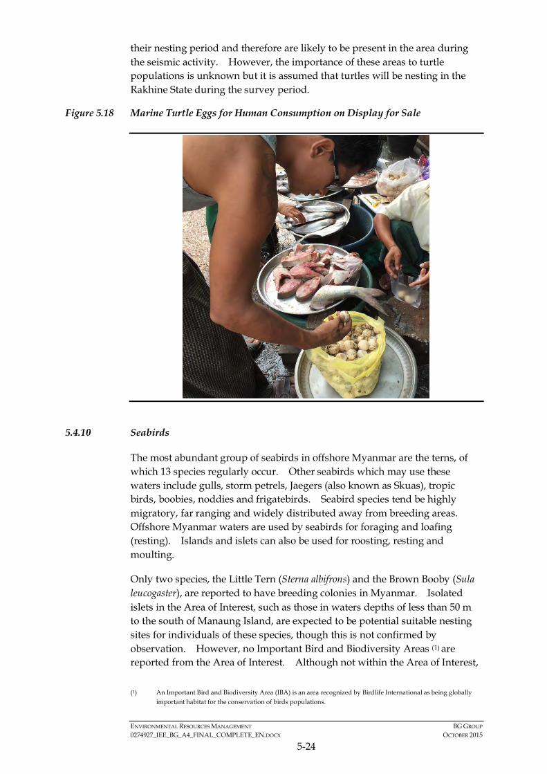
ENVIRONMENTAL RESOURCES MANAGEMENT BG GROUP 0274927_IEE_BG_A4_FINAL_COMPLETE_EN.DOCX OCTOBER 2015
5-24
their nesting period and therefore are likely to be present in the area during the seismic activity. However, the importance of these areas to turtle populations is unknown but it is assumed that turtles will be nesting in the Rakhine State during the survey period.
Figure 5.18 Marine Turtle Eggs for Human Consumption on Display for Sale
5.4.10 Seabirds
The most abundant group of seabirds in offshore Myanmar are the terns, of which 13 species regularly occur. Other seabirds which may use these waters include gulls, storm petrels, Jaegers (also known as Skuas), tropic birds, boobies, noddies and frigatebirds. Seabird species tend be highly migratory, far ranging and widely distributed away from breeding areas. Offshore Myanmar waters are used by seabirds for foraging and loafing (resting). Islands and islets can also be used for roosting, resting and moulting.
Only two species, the Little Tern (Sterna albifrons) and the Brown Booby (Sula leucogaster), are reported to have breeding colonies in Myanmar. Isolated islets in the Area of Interest, such as those in waters depths of less than 50 m to the south of Manaung Island, are expected to be potential suitable nesting sites for individuals of these species, though this is not confirmed by observation. However, no Important Bird and Biodiversity Areas (1) are reported from the Area of Interest. Although not within the Area of Interest,
(1) An Important Bird and Biodiversity Area (IBA) is an area recognized by Birdlife International as being globally
important habitat for the conservation of birds populations.

ENVIRONMENTAL RESOURCES MANAGEMENT BG GROUP 0274927_IEE_BG_A4_FINAL_COMPLETE_EN.DOCX OCTOBER 2015
5-25
there is an Important Bird Area to the north of Sittwe in Northern Rakhine State known as Nantha Island. This area is designated due to the presence of wintering grounds of the spoon billed sandpiper, Calidris pygmaea, a critically endangered species on the IUCN Red List. This species migrates from breeding grounds in arctic Russia to wintering around the coasts of South-East Asia, including Nantha Island. In 2013, 35 individuals were observed to be wintering in this area (1).
The distribution range of one IUCN-listed threatened seabird species, the Christmas Island Frigatebird (Fregata andrewsi) (Critically Endangered) extends as far as Myanmar waters. However, Myanmar waters are at the outer limit of its range. Given this and its rarity, the potential for the occurrence of this seabird in the block is considered low.
Of the seabird species that occur in the Area of Interest, only species of seabird that spend large quantities of time underwater while foraging for food, either underwater swimmers or aerial divers, are considered potentially vulnerable to underwater sound impacts. Feeding by seabirds involves snatching prey items from or below the water surface (terns, noddies, tropic birds, frigate birds, gulls), by paddling (petrels) and mainly kleptoparasitism (i.e. taking from others) (jaeger). Of the species potentially present, only boobies feed by aerial diving.
Although detailed data on distribution, abundance, habitat utilisation and seasonality of seabirds specific to the Area of Interest are limited at present, noting the above it can be conservatively assumed that seabirds may be expected to occasionally pass within or close by to the Activity Area.
5.4.11 Protected & Environmentally Sensitive Areas
Information from the Istituto Oikos and BANCA (2011) reported a total of 43 designated or proposed protected areas with IUCN categories existing in Myanmar. It should be noted that some of the locations are proposed as protected area without authorized designation (i.e. “soft” designation). It is important to note that none of these protected or environmentally sensitive areas lie within the Activity Area.
There are two restricted fishing areas within the Area of Interest which are based on the Department of Fisheries Fishing Blocks A10 and A20. The Sittwe Department of Fisheries stated that these Blocks were restricted for fishing activity for the conservation of species (fish, dugong, turtles, dolphin, shark, whale and coral). The areas are restricted during the rainy season (June to August). The following gears are prohibited; trawl, surrounding net, stow net and long line as well as small engine boats. Although this ban is in place it is unlikely as to the level of enforcement. During the stakeholder consultations in April, 2015, local fishermen mentioned that a new restriction
(1) Birdlife international, Sites - Important Bird and Biodiversity Areas (IBAs). Nantha Island. Available from
http://www.birdlife.org/datazone/sitefactsheet.php?id=31569
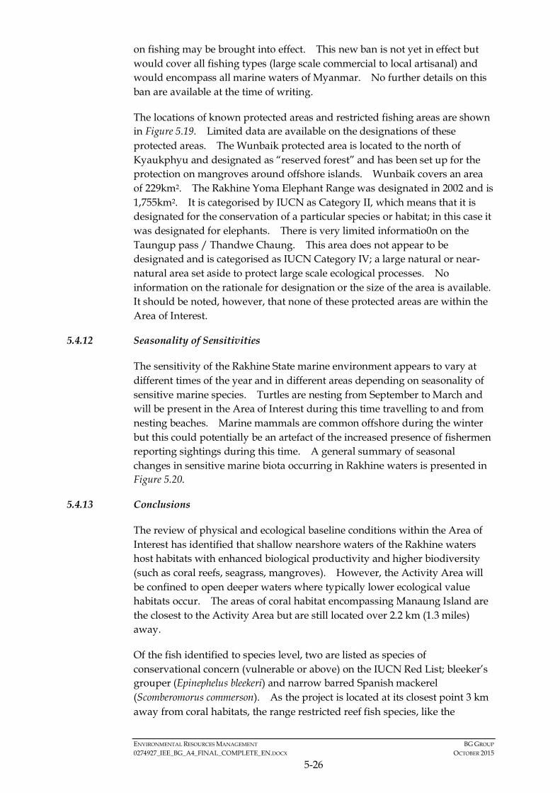
ENVIRONMENTAL RESOURCES MANAGEMENT BG GROUP 0274927_IEE_BG_A4_FINAL_COMPLETE_EN.DOCX OCTOBER 2015
5-26
on fishing may be brought into effect. This new ban is not yet in effect but would cover all fishing types (large scale commercial to local artisanal) and would encompass all marine waters of Myanmar. No further details on this ban are available at the time of writing.
The locations of known protected areas and restricted fishing areas are shown in Figure 5.19. Limited data are available on the designations of these protected areas. The Wunbaik protected area is located to the north of Kyaukphyu and designated as “reserved forest” and has been set up for the protection on mangroves around offshore islands. Wunbaik covers an area of 229km2. The Rakhine Yoma Elephant Range was designated in 2002 and is 1,755km2. It is categorised by IUCN as Category II, which means that it is designated for the conservation of a particular species or habitat; in this case it was designated for elephants. There is very limited informatio0n on the Taungup pass / Thandwe Chaung. This area does not appear to be designated and is categorised as IUCN Category IV; a large natural or near-natural area set aside to protect large scale ecological processes. No information on the rationale for designation or the size of the area is available. It should be noted, however, that none of these protected areas are within the Area of Interest.
5.4.12 Seasonality of Sensitivities
The sensitivity of the Rakhine State marine environment appears to vary at different times of the year and in different areas depending on seasonality of sensitive marine species. Turtles are nesting from September to March and will be present in the Area of Interest during this time travelling to and from nesting beaches. Marine mammals are common offshore during the winter but this could potentially be an artefact of the increased presence of fishermen reporting sightings during this time. A general summary of seasonal changes in sensitive marine biota occurring in Rakhine waters is presented in Figure 5.20.
5.4.13 Conclusions
The review of physical and ecological baseline conditions within the Area of Interest has identified that shallow nearshore waters of the Rakhine waters host habitats with enhanced biological productivity and higher biodiversity (such as coral reefs, seagrass, mangroves). However, the Activity Area will be confined to open deeper waters where typically lower ecological value habitats occur. The areas of coral habitat encompassing Manaung Island are the closest to the Activity Area but are still located over 2.2 km (1.3 miles) away.
Of the fish identified to species level, two are listed as species of conservational concern (vulnerable or above) on the IUCN Red List; bleeker’s grouper (Epinephelus bleekeri) and narrow barred Spanish mackerel (Scomberomorus commerson). As the project is located at its closest point 3 km away from coral habitats, the range restricted reef fish species, like the
!
!
!
!
!
!
!
!
!
!
!
!
!
!(
!(
!(
!(
!(
A-4
Wunbaik
Tanlwe-ma-e-chaung
TaungupPass/Thandwe-chaung
Rakhine YomaElephantRange
Kyaukpyu
Manaung
Ramree
Thandwe
Toungup
Gwa
Manaung
Thandwe
Toungup
Ramree
Kyaukpyu
A10
A20
ZinChaung
San TinMaw
KyaukOo Mou
KyaukNi Maw
Za KuKyun
Magyee Kyun
Ye Kyun
Ka Ei
Kamar
Zee Taw
Thabyugyaing
SinGaung
Gyeiktaw
95°0'0"E
95°0'0"E
94°10'0"E
94°10'0"E
93°20'0"E
93°20'0"E19
°10'
0"N
19°1
0'0"
N
18°2
0'0"
N
18°2
0'0"
N
500000
500000
550000
550000
600000
600000
650000
650000
700000
700000
750000
750000
2000
000
2000
000
2050
000
2050
000
2100
000
2100
000
2150
000
2150
000
Legend!( Town
!Key Villages /Settlements
Protected Areas
SeasonallyRestricted FishingBlocks
Area of Interest
Blocks3D Survey Area
Activity Area
BG Operated Block
Depth (m)< 0
0.1 - 10
10.1 - 20
20.1 - 30
30.1 - 40
40.1 - 50
50.1 - 60
60.1 - 70
70.1 - 80
80.1 - 90
90.1 - 100
100.1 - 200
200.1 - 300
300.1 - 400
400.1 - 500
500.1 - 1,000
1,000.1 - 1,500
1,500.1 - 2,000
2,000.1 - 2,500
> 2,500
®Service Layer Credits: Sources: Esri, HERE, DeLorme, USGS,Intermap, increment P Corp., NRCAN, Esri Japan, METI, Esri China(Hong Kong), Esri (Thailand), TomTom, MapmyIndia, ©OpenStreetMap contributors, and the GIS User Community
Myanmar
Thailand
Bay of Bengal
0 2010Kilometres
EnvironmentalResourcesManagement
Protected Areas and Restricted Fishing Areas in Rakhine State
Figure 5.19
File: T:\GIS\CONTRACT\0274927\Mxd\Report_A4\0274927_Protected_Area_A4.mxdDate: 17/7/2015

EnvironmentalResourcesManagement
Figure 5.20
FILE: 0274927j.cdrDATE: 29/06/2015
Seasonal Sensitivities in Rakhine Waters
Note: Cetacean sightings based on correspondence with fishermen and could be artefact of fishing intensity in these nearshore / offshore areas at time of year.
FebJan Mar Apr May Jun Jul Aug Sep Oct Nov Dec
Cetaceans sightings(offshore)
Turtle sightings(nearshore)
Dolphin sightings(offshore)
Dolphin sightings(nearshore)
Prawn spawning(nearshore)
Turtle nestingperiod (Rakhine)
Peaknesting
Peaknesting
Dolphinsightings
(offshore)
Turtle nesting period(Rakhine)
Survey Period Survey Period

ENVIRONMENTAL RESOURCES MANAGEMENT BG GROUP 0274927_IEE_BG_A4_FINAL_COMPLETE_EN.DOCX OCTOBER 2015
5-27
grouper, are considered to be less sensitive to project activities than pelagic (open water) species, such as the mackerel, that could be present in Block A-4.
The most common species observed in Myanmar waters during a survey in 2015 are dwarf spinner dolphin (Stenella longirostris roseiventris) and Bryde’s Whale (Balaenoptera edeni). The Irrawaddy dolphin (Orcaella brevirostris) and dugong (Dugong dugon) are protected under the Myanmar Protection of Wildlife and Conservation of Natural Areas Law but these species are mostly coastal species and not likely to be present in the Activity Area. Given that many different species of marine mammal have been recorded from survey close to Block A-4, it can be assumed that marine mammals will be present during the survey.
There are five species of marine turtle listed as present in the offshore waters of Rakhine State, all of which are listed as species of concern on IUCN Red List. The green, hawksbill and olive ridley turtle are also known to nest along the Rakhine coast from September to March with peak nesting in December and January. As such, turtles could be migrating to their nesting beaches in the Rakhine State during the survey period.
5.5 SOCIO-ECONOMIC COMPONENTS
5.5.1 Introduction and Area of Interest
Given the off-shore nature of this Project and the absence of any associated onshore activities, an appropriate baseline understanding of local fishing activities in and around Block A-4 is vital to understanding social and health impacts, if any, on communities.
Although the eastern edge of the block extends into shallow waters up to 6km away from the mainland and also around the island of Manuang exploration survey activities will not take place in shallow waters less than 50m in depth. As such, the Project will not interact with or displace fishing in shallow-water, which constitutes the vast majority of fishing in Rakhine State. Therefore, during the scoping process fishing in shallow-water as well as in-shore fishing were scoped out of the assessment.
In order to understand where potential interaction with fishing activity may take place this assessment has sought to understand three areas of offshore fishing activity close to and within the A4 Block: • Shallow-water - fishing in shallow depths approximately less than 50m
(where interaction is not anticipated);
• Continental slope - fishing in the continental slope west of Manuang, in depths greater than 50m;
• Deep-water - fishing in deep in depths approximately greater than 200m.
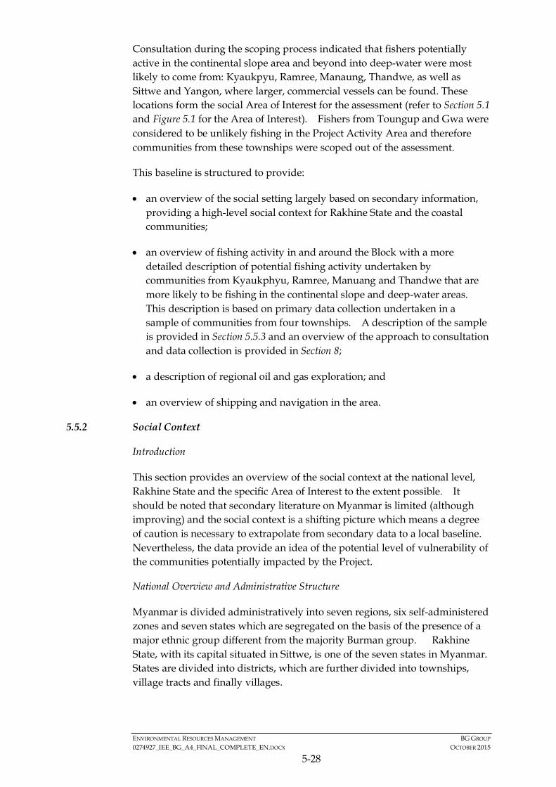
ENVIRONMENTAL RESOURCES MANAGEMENT BG GROUP 0274927_IEE_BG_A4_FINAL_COMPLETE_EN.DOCX OCTOBER 2015
5-28
Consultation during the scoping process indicated that fishers potentially active in the continental slope area and beyond into deep-water were most likely to come from: Kyaukpyu, Ramree, Manaung, Thandwe, as well as Sittwe and Yangon, where larger, commercial vessels can be found. These locations form the social Area of Interest for the assessment (refer to Section 5.1 and Figure 5.1 for the Area of Interest). Fishers from Toungup and Gwa were considered to be unlikely fishing in the Project Activity Area and therefore communities from these townships were scoped out of the assessment.
This baseline is structured to provide:
• an overview of the social setting largely based on secondary information, providing a high-level social context for Rakhine State and the coastal communities;
• an overview of fishing activity in and around the Block with a more detailed description of potential fishing activity undertaken by communities from Kyaukphyu, Ramree, Manuang and Thandwe that are more likely to be fishing in the continental slope and deep-water areas. This description is based on primary data collection undertaken in a sample of communities from four townships. A description of the sample is provided in Section 5.5.3 and an overview of the approach to consultation and data collection is provided in Section 8;
• a description of regional oil and gas exploration; and
• an overview of shipping and navigation in the area.
5.5.2 Social Context
Introduction
This section provides an overview of the social context at the national level, Rakhine State and the specific Area of Interest to the extent possible. It should be noted that secondary literature on Myanmar is limited (although improving) and the social context is a shifting picture which means a degree of caution is necessary to extrapolate from secondary data to a local baseline. Nevertheless, the data provide an idea of the potential level of vulnerability of the communities potentially impacted by the Project.
National Overview and Administrative Structure
Myanmar is divided administratively into seven regions, six self-administered zones and seven states which are segregated on the basis of the presence of a major ethnic group different from the majority Burman group. Rakhine State, with its capital situated in Sittwe, is one of the seven states in Myanmar. States are divided into districts, which are further divided into townships, village tracts and finally villages.

ENVIRONMENTAL RESOURCES MANAGEMENT BG GROUP 0274927_IEE_BG_A4_FINAL_COMPLETE_EN.DOCX OCTOBER 2015
5-29
The World Bank states that Myanmar is in transition building a democratic governance structure following the establishment of a civilian government in 2011 and opening its economy to foreign investment as sanctions are eased. The potential for economic growth is deemed significant by a number of international financial institutions (including the World Bank Group, ADB and IMF (1)) due to the low starting base, abundance of natural resources and economic reforms the government has made since 2011. Whilst prospects appear hopeful, the World Bank also notes that most social indicators at the national level are low with Myanmar currently in the low human development category of the UN Human Development Index (150 out of 187 countries).
Myanmar is a multi-ethnic country and there has been a history of tension and conflict between ethnic groups in some states, including Rakhine State. Recently tensions have increased between the majority Buddhists and Muslim minorities. The Government has taken steps in the last four years to negotiate peace for the long-term with a number of states, especially those with international borders; nevertheless conflict resolution represents another area of transition for the country.
These multiple fronts of transition contribute to significant uncertainty in establishing a social baseline and highlight the importance of monitoring in order to improve understanding of baseline characteristics on an ongoing basis.
Social Context
Physical Characteristics and Land Use
Rakhine (formerly known as Arakan) State is located in Western Myanmar, and is bordered by the Chin State in the North, Magway, Bago and Ayeyarwady Division in the east, the Bay of Bengal in the west and Chittagong Division of Bangladesh in the Northwest. It is the eighth largest region in the country, and has a total land area of 36,780 km2. The area is characterised by a long coastline along the Bay of Bengal, with a number of islands being located within the state’s boundaries. It is also a mountainous territory which is difficult to access and separated from the rest of Myanmar by the Arakan Yoma Mountain range2.
The land use in the region is characterised by a dominance of forests, with approximately 44 percent of the total land area being covered by evergreen forest, while 7 percent of the area is covered by deciduous forest. The eastern boundary of the state is mostly covered by deciduous forest (3). Apart from forest cover, the main land use in the region is agriculture, with twenty-eight
(1) https://www.imf.org/external/np/speeches/2013/120713.htm
http://www.worldbank.org/en/country/myanmar/overview and http://www.adb.org/countries/myanmar/economy
(2) UNICEF Rakhine State: A snapshot of Child Wellbeing
(3) UNDP Multi Hazard Risk Assessment in the Rakhine State of Myanmar: Final Report, 2011

ENVIRONMENTAL RESOURCES MANAGEMENT BG GROUP 0274927_IEE_BG_A4_FINAL_COMPLETE_EN.DOCX OCTOBER 2015
5-30
percent of the land being categorised as agriculture land. Agricultural land is an important resource for the local community for livelihood purposes. The area occupied by settlements is only one percent of the total land area. The settlement area density is higher in the northern part of the state, than in the south. The capital, Sittwe, situated in the north, covers approximately 10 percent of the total land classified as settlements (1).
Administrative Structure
Rakhine State is divided into four districts and 17 townships of which five are located entirely on islands and several more have parts of their territory on islands (2). Figure 5.21 maps the administrative divisions of the state. The four districts and the number of townships and village tracts within them are shown in Table 5.5; the townships that form the Area of Interest are shown.
Table 5.5 Administrative Structure of Rakhine State
District Township Number of Village Tracts Kyaukphyu Ann 30
Kyaukphyu* 54 Manaung* 37 Ramree* 52
Maungdaw Buthidaung 79 Maungdaw 98
Sittwe Kyauktaw 80 Minbya 64 Mrauk-U 95 Myebon 52 Pauktaw 54 Ponnagyun 93 Rathedaung 89 Sittwe 28
Thandwe Gwa 34 Thandwe* 64 Toungup 55
*Area of Interest. Source: UNDP Multi Hazard Risk Assessment in the Rakhine State of Myanmar: Final Report, 2011
Demographics
Rakhine State is the eighth largest and the second most populous state (after Shan State), characterised by a population density of 87 individuals per square kilometre and a positive sex ratio of 1,114 women per thousand men (1). Most of the population is concentrated around the coast and in the northern townships; the populations in the eastern, hilly forests of the State having particularly small populations. Among the 17 townships, Sittwe is the most densely populated (3). An overview of demographics for the state is provided in Table 5.6 with a population data for the townships in the Area of Interest
(1) UNDP Multi Hazard Risk Assessment in the Rakhine State of Myanmar: Final Report, 2011
(2) UNDP Myanmar: Local Governance Mapping: The State of Local Governance: Trends in Rakhine
(3) UNDP Multi Hazard Risk Assessment in the Rakhine State of Myanmar: Final Report, 2011
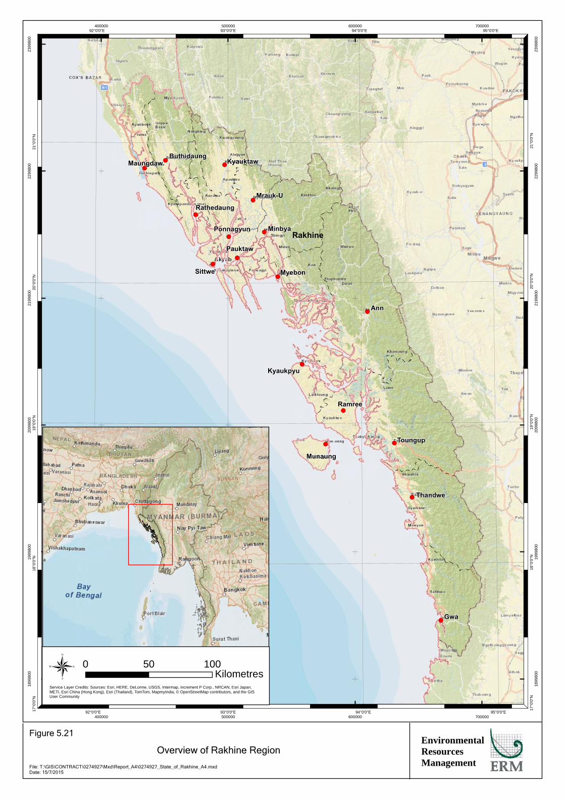
!(
!(
!(
!(
!(
!(
!(
!(
!(
!(
!(
!(
!(
!(
!(
!(
!(
Sittwe
Ponnagyun
Mrauk-U
Kyauktaw
Minbya
Myebon
Pauktaw
Rathedaung
MaungdawButhidaung
Kyaukpyu
Munaung
Ramree
Ann
Thandwe
Toungup
Gwa
Rakhine
95°0'0"E
95°0'0"E
94°0'0"E
94°0'0"E
93°0'0"E
93°0'0"E
92°0'0"E
92°0'0"E21
°0'0
"N
21°0
'0"N
20°0
'0"N
20°0
'0"N
19°0
'0"N
19°0
'0"N
18°0
'0"N
18°0
'0"N
17°0
'0"N
17°0
'0"N
400000
400000
500000
500000
600000
600000
700000
700000
1899
800
1899
800
1999
800
1999
800
2099
800
2099
800
2199
800
2199
800
2299
800
2299
800
2399
800
2399
800
EnvironmentalResourcesManagement
Overview of Rakhine Region
Figure 5.21
File: T:\GIS\CONTRACT\0274927\Mxd\Report_A4\0274927_State_of_Rakhine_A4.mxdDate: 15/7/2015
Service Layer Credits: Sources: Esri, HERE, DeLorme, USGS, Intermap, increment P Corp., NRCAN, Esri Japan,METI, Esri China (Hong Kong), Esri (Thailand), TomTom, MapmyIndia, © OpenStreetMap contributors, and the GISUser Community
® 0 10050Kilometres

ENVIRONMENTAL RESOURCES MANAGEMENT BG GROUP 0274927_IEE_BG_A4_FINAL_COMPLETE_EN.DOCX OCTOBER 2015
5-31
provided in Table 5.7 both highlight that the vast majority of the population resides in rural areas – a reflection of the dependency on agricultural livelihoods.
Table 5.6 Demographic Profile of the Rakhine State
Attribute Rakhine Total Population 3,188,963 Area (sq. km) 36,780 sq. km Population Density (persons per sq. km) 87 Population between 0-14 years 1,039,134 Sex Ratio 1,114 females per 1,000 males Rural Population % 84.2% Urban Population % 15.8% Source: UNDP Myanmar: Local Governance Mapping: The State of Local Governance: Trends in Rakhine and Republic of Myanmar, The Population and Housing Census of Myanmar, 2014: Provisional Results
Table 5.7 Overview of the Demographics of the Area of Interest
Township Population Figures Persons / sq km Total Urban Rural Manaung 64,296 5,362 58,934 123 Ramree 112,186 9,733 102,453 85 Kyaukphyu 171,724 41,025 130,699 98 Thandwe 123,145 18,488 104,657 89 Sittwe 303,614 35,860 184,554 not available Source: Township Health Profile 2011, Department of Health Planning, MOH Like many parts of Myanmar, the state has a diverse ethnic population. The majority of the state’s population (60 percent) is comprised of Rakhine, followed by Muslims who comprise 30 to 35 percent of the population. The other main ethnic groups in the region are Chin, Mro, Bamar, Khami (1).
Violence between the Rakhine Buddhists and Muslims erupted in mid-2012 and again in late 2012. The violence is reported to have resulted in a number of deaths, damage to infrastructure and the displacement of thousands of people, mostly Muslims, who are now residing in camps in the north of the state (2). Tension still remains between the majority Buddhists and the Muslim population.
Livelihood and Economy
Rakhine State is rich in natural resources including the scenic beauty of coastal beaches with high potential for tourism, unexplored potential for oil and natural gas, coastline to support fisheries, and lands supporting rice
(1) UNDP Myanmar: Local Governance Mapping: The State of Local Governance: Trends in Rakhine and Republic of
Myanmar, The Population and Housing Census of Myanmar, 2014: Provisional Results, UNDP Multi Hazard Risk Assessment in the Rakhine State of Myanmar: Final Report, 2011
(2) Conflict Mapping: Rakhine-Rohingya Conflict in Myanmar LB 5525: Conflict Analysis, Northern Rakhine State, June 2010, Conflict and Violence in Arakan (Rakhine) State, Myanmar (Burma), Arakan Human Rights and Development Organization, 2013
ENVIRONMENTAL RESOURCES MANAGEMENT BG GROUP 0274927_IEE_BG_A4_FINAL_COMPLETE_EN.DOCX OCTOBER 2015
5-32
production and plantation. The main sources of livelihood are agriculture, fisheries and livestock holdings, small businesses and the service industry. More than 50 percent of the population is dependent upon agriculture for their livelihood, while 13 percent engage in fishing, and 10 percent in livestock farming. The remaining 25 percent of the population is dependent upon the service industry, small businesses and other activities (1). Small amounts of inferior-grade crude oil are produced from basic, shallow, hand dug wells. In recent years there has been significant investment in the tourism sector. However, issues such as poor infrastructure, particularly road infrastructure, weak connectivity to the rest of the country, lack of electricity, poor communication facilities, the mountainous terrain and social conflict amongst ethnic groups have resulted in major challenges for the state’s socio-economic development(2).
The coastal areas in Rakhine are characterised by fishing and agriculture as the two main livelihood opportunities, followed by tourism and sale of timber. The main crop produced is paddy, which is cultivated across approximately 85 percent of the total cultivated land in the region. Apart from paddy, the main crops are rubber, pepper, pigeon pea, beans, sunflower, mustard and oil seeds. Fishing constitutes a quarter of Rakhine’s estimated economic value with several studies by independent organisations (Oliver et.al., 2014) indicating that around 43 percent of the population in the state relies either on fishing or a combination of fishing/agriculture. The fishing sector also employs a number of landless coastal households (3).
The fisheries sector plays a critical role in terms of employment (4); it is estimated that in the Rakhine region, almost 600,000 individuals are involved in capture fisheries and/or aquaculture, while 150,000 individuals are involved in other stages of the value chain, including processing, wholesale and export (this figure however only includes 489 registered fish traders and more traders may be involved on an informal basis). The fisheries sector is also important for casual labour, with 24 percent of the casual labour workforce in Myanmar reporting the fisheries sector as the first source of income.
Fishing and related activities are present all along the coastline. Key species captured in the Area of Interest include tiger prawn and pomfret (the most valuable catch), small and large prawns, small and large tuna, groupers, mackerel, mullet, red snapper, catfish, squid, anchovy, sardines, shark, eel, lobsters, mahi mahi, scad, and sea bass. In deep-water, herring is also part of the catch.
(1) UNDP Multi Hazard Risk Assessment in the Rakhine State of Myanmar: Final Report, 2011
(2) UNDP Myanmar: Local Governance Mapping: The State of Local Governance: Trends in Rakhine
(3) Fishery Value Chain Analysis in Rakhine State Assessment for village level interventions: http://www.researchgate.net/publication/263320043_Fishery_Value_Chain_Analysis_in_Rakhine_State_Assessment_for_village_level_interventions
(4) Oxfam, Fishery Value Chain Analysis in Rakhine State: Assessment for village level interventions, February 2014

ENVIRONMENTAL RESOURCES MANAGEMENT BG GROUP 0274927_IEE_BG_A4_FINAL_COMPLETE_EN.DOCX OCTOBER 2015
5-33
Agricultural activities (predominantly paddy cultivation and groundnut with minor proportion of maize, pulses, wheat and soybean (1)) are observed in the coastal areas in Kyaukphyu, Ramree and Manaung. Agricultural activity varies in coastal communities depending on access to land. Some coastal communities have limited access to land and are highly dependent on fishing for income and subsistence.
Social Indicators
UNICEF (2013) (2) reports that Rakhine State is characterised by high malnutrition, generally low enrolment and completion in primary education, and poor access to clean water and sanitation. It is also prone to natural hazards such as storms and floods increasing the vulnerability at the community level. It is reported that the inter-community violence in 2012 led to a worsening of social indicators with thousands displaced, suffering from food insecurity, interrupted livelihoods and education, as well as a lack of access to markets.
Literacy levels and access to educational infrastructure in Rakhine Sate are reported to be significantly lower than the national averages. Rakhine State has the lowest pre-school attendance among children aged three to five years in the country at five percent, in comparison to the national average of twenty-three percent. Only about a third of children enrolled at primary school complete their education on time.
A World Bank analysis of 2014 household survey data suggests that Rakhine State, with a poverty rate of 78 percent (national average is 38 percent) may be the poorest region in the country. This is of particular concern given the high level of poverty at the national level and suggests that the population of Rakhine State may be particularly vulnerable.
5.5.3 Fishing Activity in and around Block A-4
Introduction and Approach to Data Gathering
This section starts with a general understanding of the administration of fishing in Rakhine State and then provides details of potential fishing activity in and around the Block A-4, based on identified fishing patterns of local communities within the Project’s social Area of Interest.
The section is based on data gathered through consultation with government agencies, including the Department of Fisheries (DoF) at various levels, district and township administrations, as well as with a sample of fishing communities along the coast bordering Block A-4. The sample was agreed with the State Government covering four townships with specific villages, as well as Sittwe and Yangon:
(1) http://www.fao.org/docrep/011/ai478e/ai478e00.htm#3
(2) A snapshot of child wellbeing Unicef 2013
ENVIRONMENTAL RESOURCES MANAGEMENT BG GROUP 0274927_IEE_BG_A4_FINAL_COMPLETE_EN.DOCX OCTOBER 2015
5-34
• Kyaukphyu Township: Zin Chaung village; • Ramree Townships: Kyauk-Ni-Maw village; • Manaung Township: Ka Ei Village; • Thandwe Township: Thabyugyaing Village, Sin Gaung Village, Gyeitkaw
Village); and • A sample of boat owners from Sittwe and Yangon.
Consultation and data gathering were undertaken in these townships and villages / village tracts and also in Sittwe and Yangon. The details of the consultation with the various stakeholders are covered in detail in Section 8.
The social Area of Interest is focused on those townships where there is potential for fishing communities to interact with the Project. The sample of communities from across the townships was agreed with stakeholders during the scoping process in order to provide a more detailed understanding of those that may be impacted by the Project. This baseline provides a description of this purposive sample selected in order to provide specific information on those fishers more likely be active in the continental slope (50-200m of water depth) and deep-water areas (more than 200m of water depth).
It is however important to note that fishing is undertaken by communities along the entire coastline and that the majority of fishing activity takes place in the nearshore (within 10 nautical miles from the coast) and shallow-water areas (up to 50m of water depth) that will not be impacted by the Project.
Data Gaps and Assumptions
While the sample of villages included in this baseline is representative of the general fishing patterns in the Area of Interest, various data gaps remain:
• Fishing patterns cannot be extrapolated to give an exact description and quantitative indication of fishing activity. Data on fishing activity has been collected through qualitative approaches and in some cases information collected from one community was not corroborated by the data gathered in another;
• Not all the information provided by community members could be verified and may be inaccurate (such as the depth or distance from shore); and
• There is a lack of consistent data around income derived from fishing and food security, and how these are affected by seasonal changes. While indications of income were provided by some of those consulted there was a reluctance to discuss income and it has not been possible to derive adequately robust estimates to provide a general picture of the income levels of those engaged in fishing.
ENVIRONMENTAL RESOURCES MANAGEMENT BG GROUP 0274927_IEE_BG_A4_FINAL_COMPLETE_EN.DOCX OCTOBER 2015
5-35
Administration of Fisheries
Myanmar has a total land area of 676,577 km2 and a coastline of ~3,000 km. The country’s continental shelf is up to 200 m deep and covers an area of ~230,000 km2, while the Exclusive Economic Zone (EEZ) (1) covers ~486,000 km2. Myanmar’s coastline can be divided into three regions: • Rakhine State (~740 km of coastline); • Ayeyarwady and Gulf of Mottama Region (~460 km of coastline); and • Tanintharyi Region (~1,200 km of coastline).
For the purpose of administration and monitoring of fishing activities, the marine territorial waters are divided into 140 grid blocks of fishing grounds, with each block covering an area of 30 x 30 nautical miles (Figure 5.22) (2).
The Department of Fisheries (DoF) at the national level controls offshore fishing activities and licences, while inshore licenses are granted at the state level. At the village level fishing associations manage membership of fishers from the village. The organisational capacity and level of activity of these associations varies from village to village.
The management and development of the fisheries resources is undertaken by the DoF under the Ministry of Livestock and Fisheries. The DoF has established a legal framework with strategies and policies for sustainable development and management of marine fisheries. These include licensing, prescription of exploitable species, designation of environmental friendly fishing gears and methods, and the imposition of closed areas and seasons.
One mechanism for the management of the fisheries resources is the Monitoring, Control and Surveillance (MCS) programme for fishery management. This programme is aimed at providing effective and efficient scientific data for fish stock evaluation and management of fisheries in Myanmar. It is also aimed at providing the basis of effective monitoring and control of fisheries enforcement activities in order to ensure that only authorised or licence holding fishing vessels operate within the designated areas in the EEZ. Some of the key management measures implemented for the control of fishing activities are discussed below (3):
• Surveillance of fishing activities: government departments such as the Myanmar Navy, Myanmar Coastal Guard, DoF, Myanmar Customs Department and Myanmar Police Force are involved in the monitoring and surveillance of fishing activities. Of these, the Myanmar Navy is responsible for the coordination of surveillance efforts.
(1) An Exclusive Economic Zone (EEZ) is a concept adopted at the Third United Nations Conference on the Law of
the Sea (1982), whereby a coastal State assumes jurisdiction over the exploration and exploitation of marine resources in its adjacent section of the continental shelf, taken to be a band extending 200 miles from the shore. (Source: OECD Glossary of Statistical Terms https://stats.oecd.org/glossary/detail.asp?ID=884)
(2) FAO (2003) and (2006) Myanmar Aquaculture and Inland Fisheries
(3) Myanmar Aquaculture and Inland Fisheries, FAO, 2003 and 2006

Figure 5.22
FILE: 0274927s.cdr
DATE: 07/07/2015
EnvironmentalResourcesManagement
Fishing Grounds and Landing Sites in Myanmar
ENVIRONMENTAL RESOURCES MANAGEMENT BG GROUP 0274927_IEE_BG_A4_FINAL_COMPLETE_EN.DOCX OCTOBER 2015
5-36
• Closed fishing areas: as part of the management of fishing activities, commercial fishing vessels such as trawlers and fish purse seiners are prohibited from fishing less than 10 nautical miles from the shore. Nearshore waters (<10 nautical miles from the coast) can be used as nursery grounds for juveniles of fish and shrimp. In addition to this, restricted fishing areas have been identified, protected and managed to ensure survival of the juveniles of commercially important fish species. These areas, comprising two fishing grounds in Rakhine State, four fishing grounds in Ayeyarwady, two in Mon and Tanintharyi Region each, are declared as closed fishing areas for three months (June to August) annually. However, enforcement of these closed areas can be a challenge.
• Licensing and Management Zones: through the system of annual licensing, two fishing zones have been identified by DoF on the basis of specific fishing gear, classes of fishing vessels and ownership. These fishing zones are designed to allow equitable allocation of resources and reducing conflicts between traditional and commercial fishers. Fishing Zone I is designated for coastal fisheries and extends from the shoreline to ten nautical miles (11.5 miles). Fishing Zone II extends from the outer limit of Fishing Zone I to the EEZ limit.
• Controls on size and power of fishing vessels: any change in tonnage or engine power of fishing vessels or construction of fishing vessels requires permission from the Director General of DoF and approval from the respective authority.
• Registration of Fishers: any new individual entering the industry is required to be registered and anybody working and living on a fishing vessel must have a fishers’ registration card.
• 3 months prohibition on fishing: Fishing is banned in coastal areas for three months during the rainy season under Government directives. Fishing in these areas is banned for the conservation of species, including and coincides with the spawning season of fish. However, this ban is not enforced and subsistence fishing continues. More information on these restricted fishing areas in provided in Section 5.4.11.
Fishing Activity and Practices
In order to understand the potential for interaction between the Project and fishing activity, the assessment has sought to understand the fishing activity and practices of communities who may interact with the Activity Area of the Project. Data collected at the sample villages highlights the large diversity in fishing practices by these communities; the following elements appear to be significant variables in fishing activity by these communities.
• size of vessel and trip duration; • fishing locations;
ENVIRONMENTAL RESOURCES MANAGEMENT BG GROUP 0274927_IEE_BG_A4_FINAL_COMPLETE_EN.DOCX OCTOBER 2015
5-37
• fishing gear and type of catch – including hook and line, trawl and drift nets, longline, purse seine;
• use of diving as a technique; • time of day – day and night fishing; • seasonality - weather and species; and the • use of fishing camps.
Each of these variables is described in more detail in the following sections with an overview in this section below.
As mentioned in the introduction the majority of offshore fishing undertaken by coastal communities in Rakhine State occurs in the shallow water area. Consultation indicates that fishing in the shallow water remains a significant activity for the sampled communities who also fish in deeper water (> 50m water depth). Fishing in the continental slope predominantly takes place in the dry seasons; fishing in shallow water continues throughout the year as it is less affected by the hazards brought by the rainy season.
A much smaller number of communities actively fish in the deep-water area. Examples of fishers active in the deep-water area were identified in Ramree, but deep-water fishing does not appear to be practiced by all. This supports DoF records for 2012-13, which report that ten percent of the fishing population in the coastal region were working on deep-water offshore vessels and sixty-seven percent were working on nearshore fisheries (i.e. within 10 nautical miles of the mainland coast).
In general, fishermen suggested that November – May was the best season for fishing as better weather meant that fishing boats are able to travel greater distances from shore. Deep-water fishing beyond the continental shelf is considered to be dangerous in the rainy season, from late May to early September. In the rainy season, most vessels restrict themselves to water depths of less than 50m. However, larger vessels may continue to fish throughout the year.
It was reported that fishing vessels from outside the Area of Interest may also fish in the vicinity of the Block. It is anticipated that there may also be commercial vessels from outside Rakhine State.
Fishing vessels & trip duration
The dimensions of the fishing vessels to a great extent define the fishing pattern followed across the coastal villages. The actual dimensions of the fishing vessels vary across the fishing villages depending upon the type of fishing, depth at which fishing is undertaken and type of fishing gears used.
ENVIRONMENTAL RESOURCES MANAGEMENT BG GROUP 0274927_IEE_BG_A4_FINAL_COMPLETE_EN.DOCX OCTOBER 2015
5-38
The size of the fishing boats mostly falls in three categories, small (<18-20ft / <~5.5-6.5m), medium (30-45ft / ~9-14m) and large (50-80ft /~15-25m) (1); however variations in type of fishing even under these three categories were observed in some of the villages. Some details on the type of boats encountered in the Area of Interest are provided in Figure 5.23.
Most of the small boats undertake single day trips or night fishing; the medium ones undertake two to three day trips, night fishing or single day trips.
For medium boats, examples of 20-25 days trip were also reported in Ramree and 10-15 days trip in Thandwe. The larger vessels which fish in waters over ten nautical miles from the coast are licensed to fish for up to three months per trip.
The engine capacity varies with distance to be covered and trip duration. Usually for single day trips (small and medium boats), the capacity does not exceed 30 HP, while in case of extended trips (10-25 days) usually undertaken by bigger boats, the engine capacity can go up to 450 HP.
The number of people on the boat increases with the size of the vessel; however, it also depends on the season of fishing, especially in case of small and medium boats, with the number of people increasing during peak season.
In most cases, the small and medium boats do not carry ice during fishing trips, and their fishing trips are usually restricted to less than ten miles from the coast.
Larger, commercial vessels, such as trawlers operating out of Thandwe, do carry ice; ice boxes are reportedly not connected to any generators to keep cold. The fishers from Ramree who undertake trips for a longer duration, do not carry ice and dry around ninety percent of the fish catch.
Fishing Locations
During consultation fishermen reported that no fishing locations were ‘fixed’. However, fishermen were able to roughly identify locations, including water depths, where they would normally fish. Practically, the usage of the type of net gear also dictates the fishing locations and water depth at which fishing can be undertaken.
Most small boat fishermen from Kyaukphyu, Ramree and Manaung fish approximately three to five miles from shore, in the shallower water near Manaung. Fishermen from Thandwe travel further, but not to more than 50 - 60 m water depth, which may extend up to 20-30 miles (30 – 50) km from
(1) Please note the imperial measurement system is used in Myanmar and therefore dimensions are provided in feet with metric approximations.
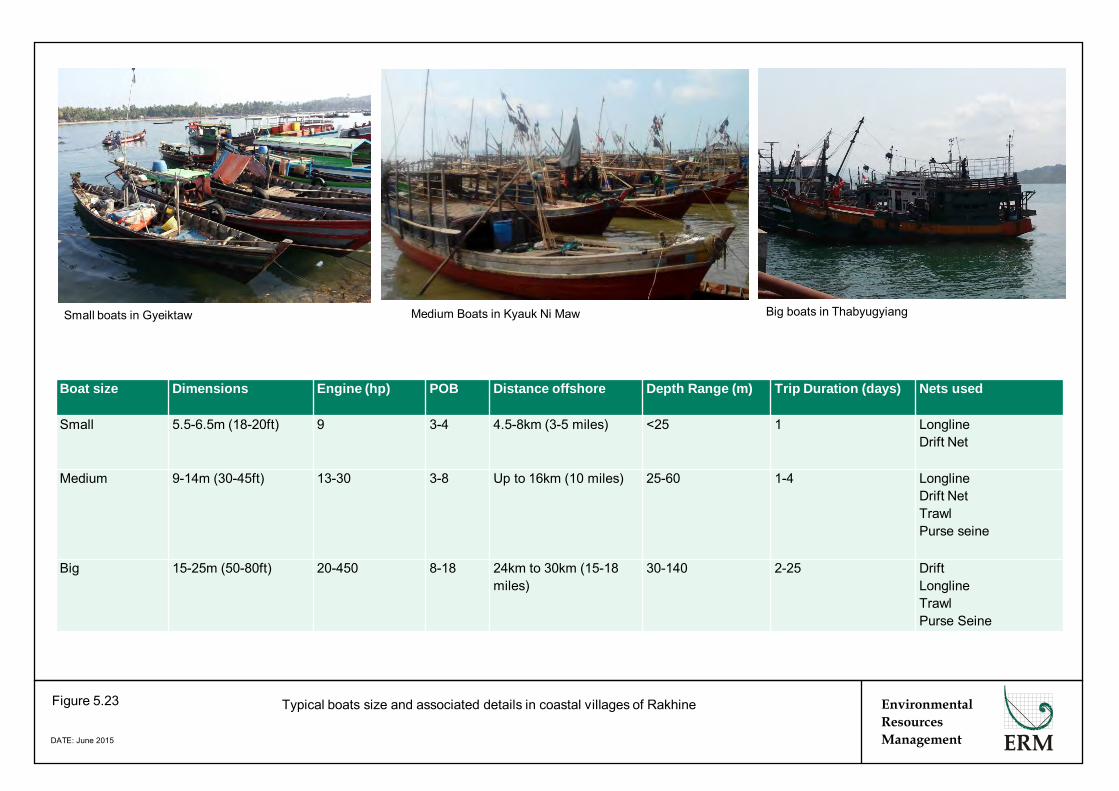
Typical boats size and associated details in coastal villages of Rakhine Figure 5.23
DATE: June 2015
Medium Boats in Kyauk Ni Maw
Environmental Resources Management
Small boats in Gyeiktaw Big boats in Thabyugyiang
Boat size Dimensions Engine (hp) POB Distance offshore Depth Range (m) Trip Duration (days) Nets used
Small 5.5-6.5m (18-20ft) 9 3-4 4.5-8km (3-5 miles) <25 1 Longline Drift Net
Medium 9-14m (30-45ft) 13-30 3-8 Up to 16km (10 miles) 25-60 1-4 Longline Drift Net Trawl Purse seine
Big 15-25m (50-80ft) 20-450 8-18 24km to 30km (15-18 miles)
30-140 2-25 Drift Longline Trawl Purse Seine
ENVIRONMENTAL RESOURCES MANAGEMENT BG GROUP 0274927_IEE_BG_A4_FINAL_COMPLETE_EN.DOCX OCTOBER 2015
5-39
shore. Some of the large boats are also engaged in trawling in shallow waters.
Most of the medium-sized boats travel 8- 10 miles (12 - 16 km) from coast of Manaung and more than 20-30 miles (30 to 50 km) from the mainland Rakhine coast to fish in the continental slope waters. In some cases, smaller boats may extend fishing locations in the continental slope, while the medium sized boats may also fish in the shallower waters. This reiterates the fact that fishing locations are not ‘fixed’.
Fishers in Ramree claim to go up to 200 miles (320 km) from the shore, and reported that they often follow the continental shelf up to that distance, drifting north or south depending on the time of year and general wind directions.
A summary of fishing activity in the context of the Block A-4 (reflecting the sample) is provided in Figure 5.24.
Seasonality
Dry winter season (November to end of February): Fishermen across villages suggested that November to the end of February was the best season for fish catch (in terms of monetary value), as better weather means that fishing boats are able to travel greater distances from shore. Fishing is done during this period in shallow-water, across the continental slope and in deep-water.
Summer Season (end of February to beginning of May): Extending from February to end of April / early May is also considered to be a good season for fishing.. Fishing across the three offshore areas is carried out during this period.
Rainy Season (mid-May to end of October): In contrast, fishing during the rainy season is difficult for many, due to poor weather conditions, especially in the continental slope area. Many fishermen reported fishing closer to shore during the rainy season. Although there is a uniform ban on fishing at this time as discussed above, fishing activity was reported to continue at this time. Some fishermen in shallow-waters reported that June to August was reported to be the best season as this is when they catch tiger prawn, which is highly valuable.
The rainy season is primarily dedicated to repairing of the boats and fishing gears; this activity goes on for a month or two. The rainy season is also the time when the demand for dry fish increases sizeably. There is sizeable out-migration of the migrant workers during rainy season as labour demand from medium-sized vessels reduces. Please see below for information on migrant workers.
Despite the rainy season restricting fishing for some, fishers from trawler vessels in Thabyugyaing reported that fishing continues throughout the year, with no sizeable reduction in income.

Kyaukpyu
Manaung
Ramree
Thandwe
Toungup
A-4
San TinMaw
KyaukOo Mou
Ye Kyun
Ka Ei
ZinChaung
KyaukNi Maw
Za KuKyun
MagyeeKyun
Kamar
Zee Taw
Thabyugyaing
SinGaung
Gyeiktaw
95°0'0"E
95°0'0"E
94°40'0"E
94°40'0"E
94°20'0"E
94°20'0"E
94°0'0"E
94°0'0"E
93°40'0"E
93°40'0"E
93°20'0"E
93°20'0"E
93°0'0"E
93°0'0"E
92°40'0"E
92°40'0"E19
°20'
0"N
19°2
0'0"
N
19°0
'0"N
19°0
'0"N
18°4
0'0"
N
18°4
0'0"
N
18°2
0'0"
N
18°2
0'0"
N
450000
450000
475000
475000
500000
500000
525000
525000
550000
550000
575000
575000
600000
600000
625000
625000
650000
650000
675000
675000
700000
700000
2000
000
2000
000
2025
000
2025
000
2050
000
2050
000
2075
000
2075
000
2100
000
2100
000
2125
000
2125
000
2150
000
2150
000
Legend!( Town
! Village
" Camp
Blocks3D Survey Area
Activity Area
BG Operated Block
Shallow WaterFishing Area
Deep WaterFishing Area
Continental ShelfFisheries Area
Depth (m)< 0
0.1 - 10
10.1 - 20
20.1 - 30
30.1 - 40
40.1 - 50
50.1 - 60
60.1 - 70
70.1 - 80
80.1 - 90
90.1 - 100
100.1 - 200
200.1 - 300
300.1 - 400
400.1 - 500
500.1 - 1,000
1,000.1 - 1,500
1,500.1 - 2,000
2,000.1 - 2,500
> 2,500
0 2010Kilometres
Service Layer Credits: Sources: Esri, HERE, DeLorme,TomTom, Intermap, increment P Corp., GEBCO, USGS,FAO, NPS, NRCAN, GeoBase, IGN, Kadaster NL,Ordnance Survey, Esri Japan, METI, Esri China (HongKong), swisstopo, MapmyIndia, © OpenStreetMapcontributors, and the GIS User Community
®
EnvironmentalResourcesManagement
Locations of Fishing Areas (Excluding Nearshore Fishing)
Figure 5.24
File: T:\GIS\CONTRACT\0274927\Mxd\Report_A4\0274927_Fishing_Location_A4.mxdDate: 17/7/2015
Myanmar
Thailand
Bay of Bengal
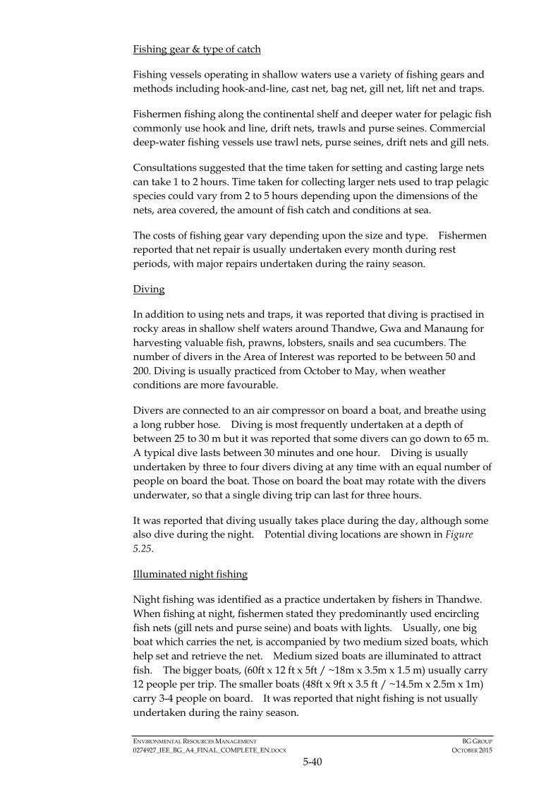
ENVIRONMENTAL RESOURCES MANAGEMENT BG GROUP 0274927_IEE_BG_A4_FINAL_COMPLETE_EN.DOCX OCTOBER 2015
5-40
Fishing gear & type of catch
Fishing vessels operating in shallow waters use a variety of fishing gears and methods including hook-and-line, cast net, bag net, gill net, lift net and traps.
Fishermen fishing along the continental shelf and deeper water for pelagic fish commonly use hook and line, drift nets, trawls and purse seines. Commercial deep-water fishing vessels use trawl nets, purse seines, drift nets and gill nets.
Consultations suggested that the time taken for setting and casting large nets can take 1 to 2 hours. Time taken for collecting larger nets used to trap pelagic species could vary from 2 to 5 hours depending upon the dimensions of the nets, area covered, the amount of fish catch and conditions at sea.
The costs of fishing gear vary depending upon the size and type. Fishermen reported that net repair is usually undertaken every month during rest periods, with major repairs undertaken during the rainy season.
Diving
In addition to using nets and traps, it was reported that diving is practised in rocky areas in shallow shelf waters around Thandwe, Gwa and Manaung for harvesting valuable fish, prawns, lobsters, snails and sea cucumbers. The number of divers in the Area of Interest was reported to be between 50 and 200. Diving is usually practiced from October to May, when weather conditions are more favourable.
Divers are connected to an air compressor on board a boat, and breathe using a long rubber hose. Diving is most frequently undertaken at a depth of between 25 to 30 m but it was reported that some divers can go down to 65 m. A typical dive lasts between 30 minutes and one hour. Diving is usually undertaken by three to four divers diving at any time with an equal number of people on board the boat. Those on board the boat may rotate with the divers underwater, so that a single diving trip can last for three hours.
It was reported that diving usually takes place during the day, although some also dive during the night. Potential diving locations are shown in Figure 5.25.
Illuminated night fishing
Night fishing was identified as a practice undertaken by fishers in Thandwe. When fishing at night, fishermen stated they predominantly used encircling fish nets (gill nets and purse seine) and boats with lights. Usually, one big boat which carries the net, is accompanied by two medium sized boats, which help set and retrieve the net. Medium sized boats are illuminated to attract fish. The bigger boats, (60ft x 12 ft x 5ft / ~18m x 3.5m x 1.5 m) usually carry 12 people per trip. The smaller boats (48ft x 9ft x 3.5 ft / ~14.5m x 2.5m x 1m) carry 3-4 people on board. It was reported that night fishing is not usually undertaken during the rainy season.

!
!
!
!
!
!
!
!
!
!
!
!
!
!(
!(
!(
!(
A-4
ZinChaung
San TinMaw
KyaukOo Mou
KyaukNi Maw
Za KuKyun
MagyeeKyun
Ye Kyun
Ka Ei
Kamar
Zee Taw
Thabyugyaing
SinGaung
Gyeiktaw
Manaung
Ramree
Thandwe
Toungup
94°20'0"E
94°20'0"E
94°0'0"E
94°0'0"E
93°40'0"E
93°40'0"E
93°20'0"E
93°20'0"E
93°0'0"E
93°0'0"E
92°40'0"E
92°40'0"E
92°20'0"E
92°20'0"E19
°20'
0"N
19°2
0'0"
N
19°0
'0"N
19°0
'0"N
18°4
0'0"
N
18°4
0'0"
N
18°2
0'0"
N
18°2
0'0"
N
18°0
'0"N
18°0
'0"N
425000
425000
450000
450000
475000
475000
500000
500000
525000
525000
550000
550000
575000
575000
600000
600000
625000
625000
650000
650000
2000
000
2000
000
2025
000
2025
000
2050
000
2050
000
2075
000
2075
000
2100
000
2100
000
2125
000
2125
000
® 0 2010Kilometres
Service Layer Credits: Sources: Esri, HERE, DeLorme, USGS,Intermap, increment P Corp., NRCAN, Esri Japan, METI, Esri China(Hong Kong), Esri (Thailand), TomTom, MapmyIndia, ©OpenStreetMap contributors, and the GIS User Community
Legend!( Town
!Key Villages /Settlements
Diving Areas
Coral Reefs
Blocks
3D Survey Area
Activity Area
BG Operated Block
Depth (m)< 0
0.1 - 10
10.1 - 20
20.1 - 30
30.1 - 40
40.1 - 50
50.1 - 60
60.1 - 70
70.1 - 80
80.1 - 90
90.1 - 100
100.1 - 200
200.1 - 300
300.1 - 400
400.1 - 500
500.1 - 1,000
1,000.1 - 1,500
1,500.1 - 2,000
2,000.1 - 2,500
> 2,500
EnvironmentalResourcesManagement
Locations of Divers in Rakhine Waters
Figure 5.25
File: T:\GIS\CONTRACT\0274927\Mxd\Report_A4\0274927_Diving_Locations_A4.mxdDate: 15/7/2015
Myanmar
Thailand
Bay of Bengal
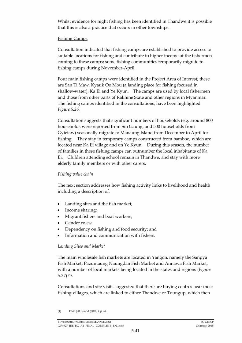
ENVIRONMENTAL RESOURCES MANAGEMENT BG GROUP 0274927_IEE_BG_A4_FINAL_COMPLETE_EN.DOCX OCTOBER 2015
5-41
Whilst evidence for night fishing has been identified in Thandwe it is possible that this is also a practice that occurs in other townships.
Fishing Camps
Consultation indicated that fishing camps are established to provide access to suitable locations for fishing and contribute to higher income of the fishermen coming to these camps; some fishing communities temporarily migrate to fishing camps during November-April.
Four main fishing camps were identified in the Project Area of Interest; these are San Ti Maw, Kyauk Oo Mou (a landing place for fishing focused in shallow-water), Ka Ei and Ye Kyun. The camps are used by local fishermen and those from other parts of Rakhine State and other regions in Myanmar. The fishing camps identified in the consultations, have been highlighted Figure 5.26.
Consultation suggests that significant numbers of households (e.g. around 800 households were reported from Sin Gaung, and 500 households from Gyietaw) seasonally migrate to Manaung Island from December to April for fishing. They stay in temporary camps constructed from bamboo, which are located near Ka Ei village and on Ye Kyun. During this season, the number of families in these fishing camps can outnumber the local inhabitants of Ka Ei. Children attending school remain in Thandwe, and stay with more elderly family members or with other carers.
Fishing value chain
The next section addresses how fishing activity links to livelihood and health including a description of: • Landing sites and the fish market; • Income sharing; • Migrant fishers and boat workers; • Gender roles; • Dependency on fishing and food security; and • Information and communication with fishers.
Landing Sites and Market
The main wholesale fish markets are located in Yangon, namely the Sanpya Fish Market, Pazuntaung Naungdan Fish Market and Annawa Fish Market, with a number of local markets being located in the states and regions (Figure 5.27) (1).
Consultations and site visits suggested that there are buying centres near most fishing villages, which are linked to either Thandwe or Toungup, which then
(1) FAO (2003) and (2006) Op. cit.

!
"
!
!
!
"
"
!
!
!
!
!
!(
!(
!(
!(
!(
Kyaukpyu
Manaung
Ramree
Thandwe
Toungup
A-4
San TinMaw
Ye Kyun
Ka Ei
ZinChaung
KyaukNi Maw
Za KuKyun
MagyeeKyun
KamarZee Taw
Thabyugyaing
SinGaung
Gyeiktaw
94°40'0"E
94°40'0"E
94°0'0"E
94°0'0"E
93°20'0"E
93°20'0"E
92°40'0"E
92°40'0"E19
°20'
0"N
19°2
0'0"
N
18°4
0'0"
N
18°4
0'0"
N
18°0
'0"N
18°0
'0"N
450000
450000
500000
500000
550000
550000
600000
600000
650000
650000
700000
700000
2000
000
2000
000
2050
000
2050
000
2100
000
2100
000
2150
000
2150
000
Legend!( Town
! Village
" Fishing Camp
Blocks
3D Survey Area
Activity Area
BG Operated Block
Depth (m)< 0
0.1 - 10
10.1 - 20
20.1 - 30
30.1 - 40
40.1 - 50
50.1 - 60
60.1 - 70
70.1 - 80
80.1 - 90
90.1 - 100
100.1 - 200
200.1 - 300
300.1 - 400
400.1 - 500
500.1 - 1,000
1,000.1 - 1,500
1,500.1 - 2,000
2,000.1 - 2,500
> 2,500
0 2010Kilometres
Service Layer Credits: Sources: Esri, HERE, DeLorme,TomTom, Intermap, increment P Corp., GEBCO, USGS,FAO, NPS, NRCAN, GeoBase, IGN, Kadaster NL,Ordnance Survey, Esri Japan, METI, Esri China (HongKong), swisstopo, MapmyIndia, © OpenStreetMapcontributors, and the GIS User Community
®
800 HH (Dec - Apr)
500 HH (Dec - Apr)
EnvironmentalResourcesManagement
Locations of Fishing Camps
Figure 5.26
File: T:\GIS\CONTRACT\0274927\Mxd\Report_A4\0274927_Fishing_Camp_A4.mxdDate: 17/7/2015
Myanmar
Thailand
Bay of Bengal
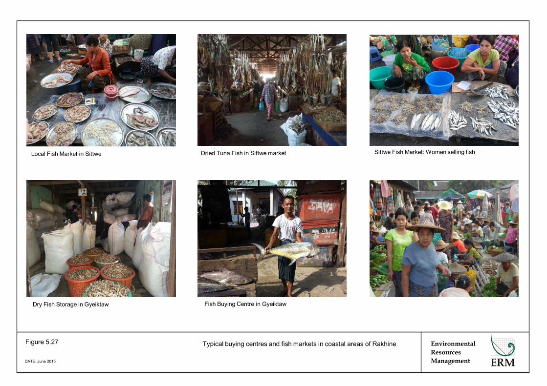
Typical buying centres and fish markets in coastal areas of Rakhine Figure 5.27
DATE: June 2015
Dried Tuna Fish in Sittwe market
Local market in Manaung
Environmental Resources Management
Fish Buying Centre in Gyeiktaw Dry Fish Storage in Gyeiktaw
Local Fish Market in Sittwe Sittwe Fish Market: Women selling fish
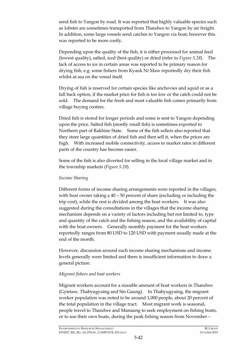
ENVIRONMENTAL RESOURCES MANAGEMENT BG GROUP 0274927_IEE_BG_A4_FINAL_COMPLETE_EN.DOCX OCTOBER 2015
5-42
send fish to Yangon by road. It was reported that highly valuable species such as lobster are sometimes transported from Thandwe to Yangon by air freight. In addition, some large vessels send catches to Yangon via boat; however this was reported to be more costly.
Depending upon the quality of the fish, it is either processed for animal feed (lowest quality), salted, iced (best quality) or dried (refer to Figure 5.28). The lack of access to ice in certain areas was reported to be primary reason for drying fish, e.g. some fishers from Kyauk Ni Maw reportedly dry their fish whilst at sea on the vessel itself.
Drying of fish is reserved for certain species like anchovies and squid or as a fall back option, if the market price for fish is too low or the catch could not be sold. The demand for the fresh and most valuable fish comes primarily from village buying centres.
Dried fish is stored for longer periods and some is sent to Yangon depending upon the price. Salted fish (mostly small fish) is sometimes exported to Northern part of Rakhine State. Some of the fish sellers also reported that they store large quantities of dried fish and then sell it, when the prices are high. With increased mobile connectivity, access to market rates in different parts of the country has become easier.
Some of the fish is also diverted for selling in the local village market and in the township markets (Figure 5.28).
Income Sharing
Different forms of income sharing arrangements were reported in the villages, with boat owner taking a 40 – 50 percent of share (excluding or including the trip cost), while the rest is divided among the boat workers. It was also suggested during the consultations in the villages that the income sharing mechanism depends on a variety of factors including but not limited to, type and quantity of the catch and the fishing season, and the availability of capital with the boat owners. Generally monthly payment for the boat workers reportedly ranges from 80 USD to 120 USD with payment usually made at the end of the month.
However, discussion around such income sharing mechanisms and income levels generally were limited and there is insufficient information to draw a general picture.
Migrant fishers and boat workers
Migrant workers account for a sizeable amount of boat workers in Thandwe (Gyietaw, Thabyugyaing and Sin Gaung). In Thabyugyaing, the migrant worker population was noted to be around 1,000 people, about 20 percent of the total population in the village tract. Most migrant work is seasonal, people travel to Thandwe and Manaung to seek employment on fishing boats, or to use their own boats, during the peak fishing season from November –

Typical fish processing practices in coastal areas of Rakhine Figure 5.28
DATE: June 2015
Preliminary sorting
Selling of dried fish in local market
Environmental Resources Management
Fish Drying Iced and Salted Fish
Fish Landing Fish sorting
ENVIRONMENTAL RESOURCES MANAGEMENT BG GROUP 0274927_IEE_BG_A4_FINAL_COMPLETE_EN.DOCX OCTOBER 2015
5-43
April, returning to their own villages during the rainy season. Most migrant fishermen in Thandwe come from other parts of Rakhine State, but it was reported that some come from other regions of Myanmar.
Migrants sometimes move with their households and usually live in rented accommodation in fishing villages or nearby villages, or in temporary fishing camps. In Thandwe it was reported that migrant workers travel with boat owners to fishing camps near Ka Ei and Ye Kyun. In such cases, workers are paid in advance, and food for boat workers is provided by boat owners. It was reported that no women or children are hired to work on boats.
Fishing activity on large, trawler vessels operating from Thabyugyaing in Thandwe takes place throughout the year. As such, there is a relatively stable population of migrant workers in and around this village throughout the year.
The usual rest period (non-trip period in a month) may vary from five to eight days; sometimes workers are asked to undertake boat repair on non-trip days and are supported by the women in the family. For day trips or overnight trips, workers are themselves responsible for their food, while for the longer trips, the arrangement is made by the boat owners.
Gender Roles
Evidence from stakeholder consultation suggests that there is clear division of labour along gender lines for fishing. Men are responsible for fishing, whilst women are involved in the processing, and marketing of the fish.
Women are mostly engaged in processing (salting, cleaning), drying, and selling of fish in local markets. They usually earn 50 USD per month; this amount may, however, vary depending upon the fish catch, and sharing of profits based on fish catch also happens in some cases. Sometimes wives of boat workers are engaged in net repair (paid, or otherwise considered to be part of monthly wages for the boat workers) although major boat repair and net repair work is usually done by men. In the case of migrant workers, female members of the family usually support family income through seeking employment in the processing stages.
Consultations with women across these villages also suggested that women tend to be able keep control of the income available from selling of fish, and women and men jointly decide the usage of the money in the family. Saving was not reported to be common across most of the villages, and a very limited amount of money was diverted for saving, if any.
The contribution of women to the family income is also reported to be increasing over time with an increase in job opportunities (not necessarily linked to fishing); however, even now specific job options for women are limited.

ENVIRONMENTAL RESOURCES MANAGEMENT BG GROUP 0274927_IEE_BG_A4_FINAL_COMPLETE_EN.DOCX OCTOBER 2015
5-44
In villages where people had access to land, agriculture was undertaken as a livelihood activity. Consultation in women’s focus groups suggested their involvement in the following agriculture related activities: land preparation, buying of seeds and fertilizers, sowing, weeding, harvesting, winnowing and packaging, taking the produce to the market for sale, managing finance.
The role of women in the decision making process is reported to pertain to primarily family affairs, though women do attend village level meetings and represent their households in the same.
Dependence on fishing (including Food Security)
Agriculture is the cornerstone of livelihood in Rakhine State, supplemented by fishing; however, the major coastal fishing villages visited as part of the consultation rely more on fishing for their livelihood than agriculture.
In the Area of Interest some households are totally dependent on fishing and it was observed that in many villages around 80 to 90 percent of households are engaged in fishing. Other livelihood activities also depend on fishing including fish processing (often undertaken by women), transportation of ice (in larger settlements such as Thabyugyaing in Thandwe) and wage labour on vessels. Other jobs identified in the Area of Interest include running grocery shops, tailoring (women) and government jobs.
Fish accounts for a part of local diet in the fishing villages. Fish, rice and vegetables were reported to be the staple diet so fish is an important source of nutrition.
Feedback from consultations in the villages suggests that food scarcity has not been a challenge for coastal fishing communities. However dependence on rice and fish was highlighted in all the communities consulted. In Sin Gaung (Thandwe Township), it was reported that a buffer stock of dried fish which could last for three months is kept by some households, but this does not appear to be a widespread practice.
Information & Communication Systems
Consultation with fishermen suggests that most fishermen have limited communications and navigational equipment, using only GSM-CDMA mobile phones (locally known as coastal phone); radio is also used for listening to the news, if within the network area. In contrast, larger commercial boats from Thabyugyaing also use radio and have Global Positioning System (GPS) and echo-sounding equipment, and navigational charts. The use of such equipment on boats from Kyauk Ni Maw which travel into very deep water could not be confirmed.
For information, fishers call upon the fishing association or Village Tract Leader whilst offshore or when in the village. It should be noted that the organisational capabilities and level of activity of fishing associations varies across villages. Information is usually provided by the Department of

ENVIRONMENTAL RESOURCES MANAGEMENT BG GROUP 0274927_IEE_BG_A4_FINAL_COMPLETE_EN.DOCX OCTOBER 2015
5-45
Fisheries (DoF) to Village Tract Leaders and then passed on to the fishermen through various means including use of loudspeaker in the village. In some villages, fishing associations were considered a key point of information by the fishermen. Information is also received through Skynet TV, MRTV and FM Radio channel, where these are locally accessible.
Appropriate channels for reaching fishers may vary between villages. The preference for receiving information at the village level is dependent on people’s accessibility and the level of engagement with fishing associations, village tract leaders, township office and the DoF office.
Communication and Management of Grievances
Consultations across the villages on access to grievance mechanisms suggested that fishermen use a variety of mechanisms to lodge and resolve grievances. In some cases, grievances related to fishing activity are resolved at the village level, with the fishing association leader or village tract leader playing a mediating role. In other cases, complaints are taken directly to the township Department of Fisheries, who invites aggrieved parties to the Department of Fisheries office, and helps to negotiate and resolve concerns.
5.5.4 Regional Oil and Gas Exploration
With the lifting of international sanctions, licensing has begun on a number of onshore and offshore oil and gas License Blocks in Myanmar. In 2014, the Ministry of Energy announced that 10 shallow water and 10 deep water Blocks had been awarded in Myanmar waters (1). The recently awarded license Blocks within Rakhine waters are listed in Table 5.8 and shown in Figure 5.29. Seismic survey activity has been carried out across Block A-4 in previous years which did not led to any known significant impacts on the local people and environment.
Table 5.8 License Blocks in Rakhine Waters
Block Operators Shallow water A-4 BG Group and Woodside Energy (Myanmar) A-5 Chevron (Unocal Myanmar Offshore Co. Ltd.) A-7 BG Group and Woodside Energy (Myanmar Deep Water AD-02 BG Group and Woodside Energy (Myanmar) AD-03 Ophir Energy PLC AD-05 BG Group and Woodside Energy (Myanmar) AD-09 Shell Myanmar Energy and MOECO AD-10 Statoil and ConocoPhillips AD-11 Shell Myanmar Energy and MOECO
(1) Oil and gas Journal, online. Myanmar awards exploration blocks. Available at
http://www.ogj.com/articles/2014/03/myanmar-awards-exploration-blocks.html
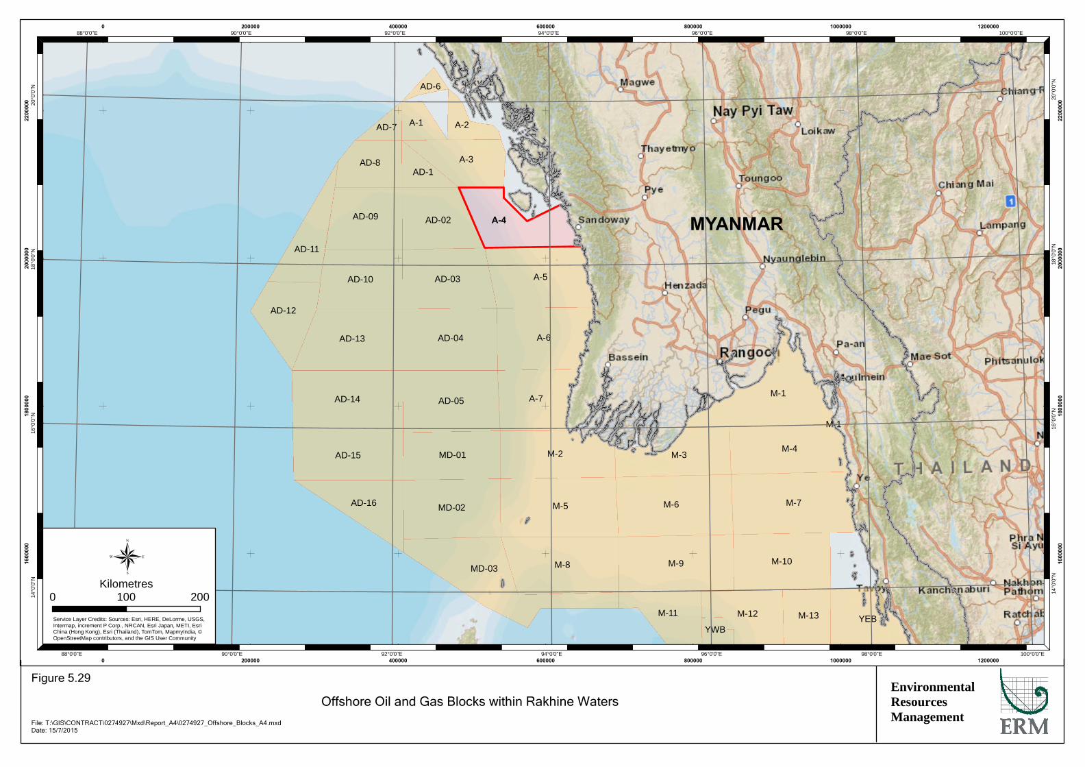
MD-03
AD-12
AD-09
AD-10
AD-13
AD-14
AD-16
A-5
AD-04
A-7AD-05
MD-01
MD-02
M-8
AD-02
AD-03
AD-15M-4
M-7
YWB
AD-1A-3
A-1 A-2
AD-6
AD-8
AD-7
AD-11
YEB
M-1
M-1
M-3
M-6
M-9
M-11 M-12 M-13
M-5
M-2
M-10
A-6
A-4
100°0'0"E
100°0'0"E
98°0'0"E
98°0'0"E
96°0'0"E
96°0'0"E
94°0'0"E
94°0'0"E
92°0'0"E
92°0'0"E
90°0'0"E
90°0'0"E
88°0'0"E
88°0'0"E20
°0'0
"N
20°0
'0"N
18°0
'0"N
18°0
'0"N
16°0
'0"N
16°0
'0"N
14°0
'0"N
14°0
'0"N
0
0
200000
200000
400000
400000
600000
600000
800000
800000
1000000
1000000
1200000
1200000
1600
000
1600
000
1800
000
1800
000
2000
000
2000
000
2200
000
2200
000
®0 200100
Kilometres
Service Layer Credits: Sources: Esri, HERE, DeLorme, USGS,Intermap, increment P Corp., NRCAN, Esri Japan, METI, EsriChina (Hong Kong), Esri (Thailand), TomTom, MapmyIndia, ©OpenStreetMap contributors, and the GIS User Community
EnvironmentalResourcesManagement
Offshore Oil and Gas Blocks within Rakhine Waters
Figure 5.29
File: T:\GIS\CONTRACT\0274927\Mxd\Report_A4\0274927_Offshore_Blocks_A4.mxdDate: 15/7/2015
MYANMAR
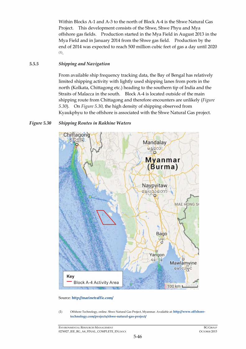
ENVIRONMENTAL RESOURCES MANAGEMENT BG GROUP 0274927_IEE_BG_A4_FINAL_COMPLETE_EN.DOCX OCTOBER 2015
5-46
Within Blocks A-1 and A-3 to the north of Block A-4 is the Shwe Natural Gas Project. This development consists of the Shwe, Shwe Phyu and Mya offshore gas fields. Production started in the Mya Field in August 2013 in the Mya Field and in January 2014 from the Shwe gas field. Production by the end of 2014 was expected to reach 500 million cubic feet of gas a day until 2020 (1).
5.5.5 Shipping and Navigation
From available ship frequency tracking data, the Bay of Bengal has relatively limited shipping activity with lightly used shipping lanes from ports in the north (Kolkata, Chittagong etc.) heading to the southern tip of India and the Straits of Malacca in the south. Block A-4 is located outside of the main shipping route from Chittagong and therefore encounters are unlikely (Figure 5.30). On Figure 5.30, the high density of shipping observed from Kyaukphyu to the offshore is associated with the Shwe Natural Gas project.
Figure 5.30 Shipping Routes in Rakhine Waters
Source: http://marinetraffic.com/
(1) Offshore Technology, online. Shwe Natural Gas Project, Myanmar. Available at: http://www.offshore-
technology.com/projects/shwe-natural-gas-project/
ENVIRONMENTAL RESOURCES MANAGEMENT BG GROUP 0274927_IEE_BG_A4_FINAL_COMPLETE_EN.DOCX OCTOBER 2015
5-47
There are a number of domestic shipping and ferry lanes within shallow waters in Rakhine State. In the Area of Interest, these link Sittwe with Kyaukphyu, Ramree, Manaung, and Toungup. However, none of these crosses the Block.
5.6 CULTURAL COMPONENTS
No known offshore culture heritage was identified in the Block A-4 or in the waters of offshore Rakhine. This was confirmed during consultation in Rakhine State.
5.7 VISUAL COMPONENTS
Given that the Project is located over 10 km from the nearest coastline (Manaung Island), there are unlikely to be any visual impacts from the Project.
5.8 BASELINE SUMMARY
The proposed Project activities will take place in water depths of over 50 m and approximately 10 km from Manaung Island at its closest point. There are no sensitive habitats or protected areas within the Activity Area. The majority of fish species recorded in Rakhine waters are generally not considered of conservation concern. However, there are a number of marine mammals and turtle species in Rakhine waters that are globally and/or nationally protected species. Marine mammals, fish and turtles can be sensitive to underwater sound generation from seismic surveys and are therefore considered to be key ecologically sensitive receptors.
Coastal fishing villages in Rakhine are dependent on fishing for sustenance as well as a source of income; in some villages approximately 80-90% of households are engaged in fishing. The majority of fishing in the Rakhine State occurs in the shallow water areas to the east and south of Manaung Island and in the strait between Ramree and Manaung. Therefore, most artisanal fishing is not conducted in the Activity Area. There Activity Area does, however, overlap with the fishing activities undertaken to the west of Manaung Island and along the continental shelf waters, up to approximately 200m water depth. As such, there is a potential area of overlap between local fishing and the eastern most border of Block A-4 and local fishing communities and livelihoods are considered to be key social receptors.
5.9 KEY SENSITIVE RECEPTORS
Coral reefs, mangroves and seagrass habitats are immobile and can be sensitive to changes in water quality and sedimentation. They act as nursery, spawning and feeding areas for a number of other important receptors (fish, mammals and reptiles). The sensitivity of these habitats is also linked to the species which inhabit it which are generally range-restricted. However, in
ENVIRONMENTAL RESOURCES MANAGEMENT BG GROUP 0274927_IEE_BG_A4_FINAL_COMPLETE_EN.DOCX OCTOBER 2015
5-48
relation to project activities, these habitats are not considered to be sensitive to sound generation from seismic surveys. At the closest extent, there are potential coral habitat areas located approximately 3 km from Block A-4, with the majority of areas over 5 km from the Block. Mangroves and seagrass beds are located over 10 km from Block A-4. At these distances, these habitats are not likely to be sensitive to project activities. Similarly for social receptors, nearshore and shallow water fishermen generally fish in waters up to 50m and in the areas to the north, east, and south of Manaung Island, and in the Cheduba Strait (known locally as the Manaung River). As such, these fishermen do not fish near the Activity Area in Block A-4 and are not considered to be sensitive to project activities.
The key sensitive receptors, which may interact with the Project activity and result in impacts, are:
• Fish are considered sensitive receptors as they can be impacted by underwater sound. However, fish are highly mobile and can avoid areas of temporary disturbance. The commonly caught commercial species are not typically of conservation concern;
• All sea turtles in Myanmar waters are species of conservation concern (internationally protected). Turtles can be sensitive to underwater sound as they hear in low frequencies. Turtles are also considered sensitive to the project as they are more slow moving that fish or marine mammals and are at more risk of becoming entangled in the seismic equipment;
• Marine mammals in Myanmar waters include some species of international and national importance (e.g. blue whale, dugong). Marine mammals are sensitive to underwater sound as they use sound to echolocate and communicate. As with fish, marine mammals are highly mobile and can avoid areas of increased sound;
• Fishers in the continental slope area that may interact with exploration survey activities in the east of the Project’s Activity Area;
• Fishers in the deep-water area that may interact with exploration survey activities;
• Divers operating near Manaung island who may also be close to the Activity Area; and
• Those in the fishing value chain should livelihoods be disrupted namely boat workers (mostly migrant workers) working on the boats and women involved in fish processing and selling.
ENVIRONMENTAL RESOURCES MANAGEMENT BG GROUP 0274927_IEE_BG_A4_FINAL_COMPLETE_EN.DOCX OCTOBER 2015
6-1
6 IMPACT ASSESSMENT
The impact assessment methodology used in this IEE Report provides a basis to characterise the potential environmental and social impacts of the Project. The methodology is based on models commonly employed in impact assessment, and takes into account international best practices.
Potential impacts arising from planned (routine and non-routine) activities and unplanned events are assessed. Unplanned events are those not anticipated to occur during the normal course of Project activities; for example, a vessel collision that may lead to a spill of fuel or damage to a fishing boat.
This Section presents the adopted impact assessment methodology and criteria used to assess the significance of the potential impacts from the Project on sensitive receptors and resources.
6.1 IMPACT ASSESSMENT METHODOLOGY AND APPROACH
Impact identification and assessment starts with scoping, which was conducted for the Project Proposal Report submitted on the 16th February 2015, and continues through the remainder of the impact assessment process. The principal impact assessment (IA) steps are summarized in Figure 6.1 and comprise:
• Impact prediction: to determine what could potentially happen to resources/receptors as a consequence of the Project and its associated activities.
• Impact evaluation: to evaluate the significance of the predicted impacts by considering their magnitude or likelihood of occurrence (for unplanned events), and the sensitivity, value and/or importance of the affected resource/receptor.
• Mitigation and enhancement: to identify appropriate and justified measures to mitigate negative impacts and enhance positive impacts.
• Residual impact evaluation: to evaluate the significance of impacts assuming effective implementation of mitigation and enhancement measures.
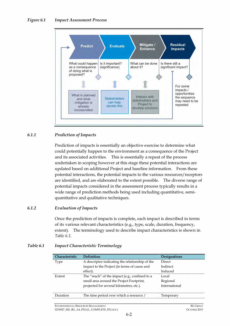
ENVIRONMENTAL RESOURCES MANAGEMENT BG GROUP 0274927_IEE_BG_A4_FINAL_COMPLETE_EN.DOCX OCTOBER 2015
6-2
Figure 6.1 Impact Assessment Process
6.1.1 Prediction of Impacts
Prediction of impacts is essentially an objective exercise to determine what could potentially happen to the environment as a consequence of the Project and its associated activities. This is essentially a repeat of the process undertaken in scoping however at this stage these potential interactions are updated based on additional Project and baseline information. From these potential interactions, the potential impacts to the various resources/receptors are identified, and are elaborated to the extent possible. The diverse range of potential impacts considered in the assessment process typically results in a wide range of prediction methods being used including quantitative, semi-quantitative and qualitative techniques.
6.1.2 Evaluation of Impacts
Once the prediction of impacts is complete, each impact is described in terms of its various relevant characteristics (e.g., type, scale, duration, frequency, extent). The terminology used to describe impact characteristics is shown in Table 6.1.
Table 6.1 Impact Characteristic Terminology
Characteristic Definition Designations Type A descriptor indicating the relationship of the
impact to the Project (in terms of cause and effect).
Direct Indirect Induced
Extent The “reach” of the impact (e.g., confined to a small area around the Project Footprint, projected for several kilometres, etc.).
Local Regional International
Duration The time period over which a resource / Temporary

ENVIRONMENTAL RESOURCES MANAGEMENT BG GROUP 0274927_IEE_BG_A4_FINAL_COMPLETE_EN.DOCX OCTOBER 2015
6-3
Characteristic Definition Designations receptor is affected. Short-term
Long-term Permanent
Scale The size of the impact (e.g., the size of the area damaged or impacted, the fraction of a resource that is lost or affected, etc.)
[no fixed designations; intended to be a numerical value]
Frequency A measure of the constancy or periodicity of the impact.
[no fixed designations; intended to be a numerical value]
The definitions for the type designations are shown in Table 6.2. Definitions for the other designations are resource/receptor-specific, and are discussed in Section 6.3.
Table 6.2 Impact Type Definitions
Designations (Type)
Definition
Direct Impacts that result from a direct interaction between the Project and a resource/receptor (e.g., sound emitted from the survey leading to behavioural changes in marine fauna).
Indirect Impacts that follow on from the direct interactions between the Project and its environment as a result of subsequent interactions within the environment (e.g., reduction in water quality from waste discharges leading to toxic effects in marine fauna).
Induced Impacts that result from other activities (which are not part of the Project) that happen as a consequence of the Project (e.g., influx of camp followers resulting from the importation of a large Project workforce).
The above characteristics and definitions apply to planned and unplanned events. An additional characteristic that pertains only to unplanned events is likelihood. The likelihood of an unplanned event occurring is designated using a qualitative scale, as described in Table 6.3.
Table 6.3 Definitions for Likelihood Designations
Likelihood Definition Unlikely The event is unlikely but may occur at some time during normal operating
conditions. Possible The event is likely to occur at some time during normal operating conditions. Likely The event will occur during normal operating conditions (i.e., it is essentially
inevitable).
6.1.3 Impact Magnitude, Receptor/Resource Sensitivity and Impact Significance
Once an impact’s characteristics are defined, the next step is to assign each impact a ‘magnitude’. Magnitude is a function of some combination (depending on the resource/receptor in question) of the following impact characteristics: • Extent • Duration • Scale

ENVIRONMENTAL RESOURCES MANAGEMENT BG GROUP 0274927_IEE_BG_A4_FINAL_COMPLETE_EN.DOCX OCTOBER 2015
6-4
• Frequency
Additionally, for unplanned events only, magnitude incorporates the ‘likelihood’ factor discussed above.
Magnitude essentially describes the intensity of the change that is predicted to occur in the resource/receptor as a result of the impact. The magnitude designations are: • Positive • Negligible • Small • Medium • Large
In the case of a positive impact, no magnitude designation (aside from ‘positive’) is assigned. It is considered sufficient to indicate that the Project is expected to result in a positive impact, without characterising the exact degree of positive change likely to occur.
The magnitude designations themselves are universally consistent, but the definitions for these designations vary on a resource/receptor-by-resource/receptor basis. The impact magnitude for marine species, marine habitats, water quality impacts and sediment disturbance impacts is provided in Table 6.4, Table 6.5 and Table 6.6 respectively. The impact magnitude criteria for the social assessment are provided in Table 6.7.
Table 6.4 Impact Magnitude for Marine Species
Extent / Duration / Scale / Frequency Large May affect an entire population or species in sufficient magnitude to cause a
decline in abundance and/ or change in distribution beyond which natural recruitment (reproduction, immigration from unaffected areas) would not return that population or species, or any population or species dependent upon it, to its former level within several generations.
Medium May affects a portion of a population and may bring about a change in abundance and/ or distribution over one or more generations, but does not threaten the integrity of that population or any population dependent on it.
Small May affect specific group of localised individuals within a population over a short time period (one generation or less), but does not affect other trophic levels or the population itself.
Negligible Immeasurable, undetectable or within the range of normal natural variation.
Table 6.5 Impact Magnitude for Marine Habitats
Extent / Duration / Scale / Frequency
Large May affect the integrity of an area or region, by substantially changing, in the long term, its ecological features, structures and functions, across its whole area, that enable it to sustain the habitat, complex of habitats and/or population levels of species that makes it important.
Medium May affect some, if not all, of the area’s ecological features, structures and functions in the short or medium term. The area or region may be able to recover
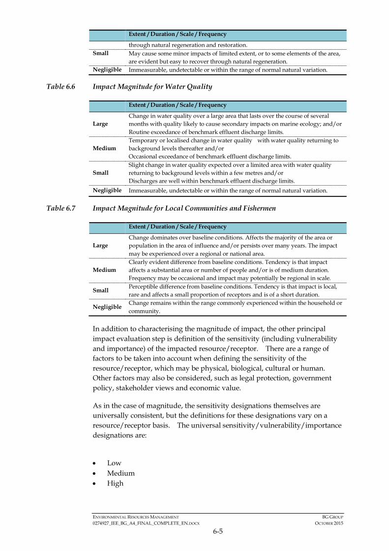
ENVIRONMENTAL RESOURCES MANAGEMENT BG GROUP 0274927_IEE_BG_A4_FINAL_COMPLETE_EN.DOCX OCTOBER 2015
6-5
Extent / Duration / Scale / Frequency
through natural regeneration and restoration. Small May cause some minor impacts of limited extent, or to some elements of the area,
are evident but easy to recover through natural regeneration. Negligible Immeasurable, undetectable or within the range of normal natural variation.
Table 6.6 Impact Magnitude for Water Quality
Extent / Duration / Scale / Frequency
Large Change in water quality over a large area that lasts over the course of several months with quality likely to cause secondary impacts on marine ecology; and/or Routine exceedance of benchmark effluent discharge limits.
Medium Temporary or localised change in water quality with water quality returning to background levels thereafter and/or Occasional exceedance of benchmark effluent discharge limits.
Small Slight change in water quality expected over a limited area with water quality returning to background levels within a few metres and/or Discharges are well within benchmark effluent discharge limits.
Negligible Immeasurable, undetectable or within the range of normal natural variation.
Table 6.7 Impact Magnitude for Local Communities and Fishermen
Extent / Duration / Scale / Frequency
Large Change dominates over baseline conditions. Affects the majority of the area or population in the area of influence and/or persists over many years. The impact may be experienced over a regional or national area.
Medium Clearly evident difference from baseline conditions. Tendency is that impact affects a substantial area or number of people and/or is of medium duration. Frequency may be occasional and impact may potentially be regional in scale.
Small Perceptible difference from baseline conditions. Tendency is that impact is local, rare and affects a small proportion of receptors and is of a short duration.
Negligible Change remains within the range commonly experienced within the household or community.
In addition to characterising the magnitude of impact, the other principal impact evaluation step is definition of the sensitivity (including vulnerability and importance) of the impacted resource/receptor. There are a range of factors to be taken into account when defining the sensitivity of the resource/receptor, which may be physical, biological, cultural or human. Other factors may also be considered, such as legal protection, government policy, stakeholder views and economic value.
As in the case of magnitude, the sensitivity designations themselves are universally consistent, but the definitions for these designations vary on a resource/receptor basis. The universal sensitivity/vulnerability/importance designations are:
• Low • Medium • High
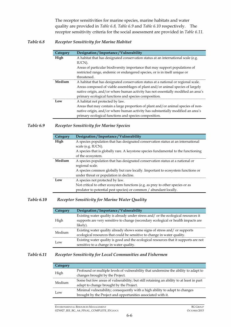
ENVIRONMENTAL RESOURCES MANAGEMENT BG GROUP 0274927_IEE_BG_A4_FINAL_COMPLETE_EN.DOCX OCTOBER 2015
6-6
The receptor sensitivities for marine species, marine habitats and water quality are provided in Table 6.8, Table 6.9 and Table 6.10 respectively. The receptor sensitivity criteria for the social assessment are provided in Table 6.11.
Table 6.8 Receptor Sensitivity for Marine Habitat
Category Designation / Importance / Vulnerability High A habitat that has designated conservation status at an international scale (e.g.
IUCN). Areas of particular biodiversity importance that may support populations of restricted range, endemic or endangered species, or is in itself unique or threatened.
Medium A habitat that has designated conservation status at a national or regional scale. Areas composed of viable assemblages of plant and/or animal species of largely native origin, and/or where human activity has not essentially modified an area’s primary ecological functions and species composition.
Low A habitat not protected by law. Areas that may contain a large proportion of plant and/or animal species of non-native origin, and/or where human activity has substantially modified an area’s primary ecological functions and species composition.
Table 6.9 Receptor Sensitivity for Marine Species
Category Designation / Importance / Vulnerability High A species population that has designated conservation status at an international
scale (e.g. IUCN). A species that is globally rare. A keystone species fundamental to the functioning of the ecosystem.
Medium A species population that has designated conservation status at a national or regional scale. A species common globally but rare locally. Important to ecosystem functions or under threat or population in decline.
Low A species not protected by law. Not critical to other ecosystem functions (e.g. as prey to other species or as predator to potential pest species) or common / abundant locally.
Table 6.10 Receptor Sensitivity for Marine Water Quality
Category Designation / Importance / Vulnerability
High Existing water quality is already under stress and/ or the ecological resources it supports are very sensitive to change (secondary ecological or health impacts are likely).
Medium Existing water quality already shows some signs of stress and/ or supports ecological resources that could be sensitive to change in water quality.
Low Existing water quality is good and the ecological resources that it supports are not sensitive to a change in water quality.
Table 6.11 Receptor Sensitivity for Local Communities and Fishermen
Category
High Profound or multiple levels of vulnerability that undermine the ability to adapt to changes brought by the Project.
Medium Some but few areas of vulnerability; but still retaining an ability to at least in part adapt to change brought by the Project.
Low Minimal vulnerability; consequently with a high ability to adapt to changes brought by the Project and opportunities associated with it.
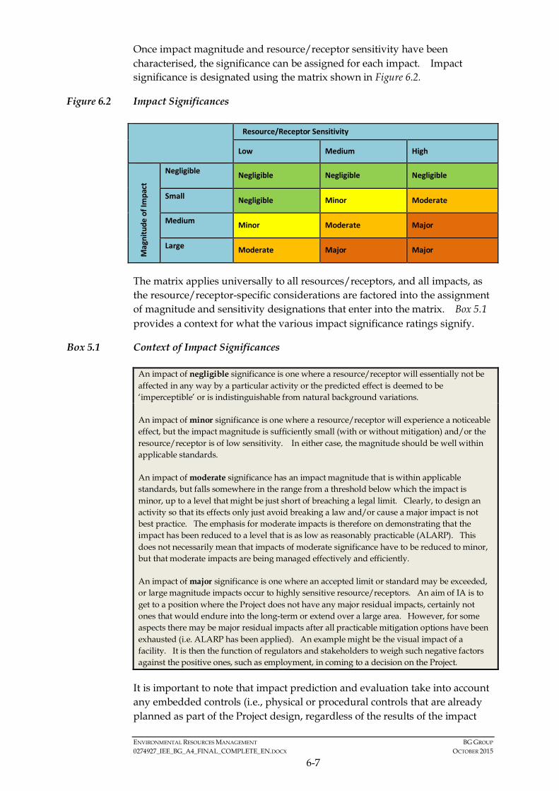
ENVIRONMENTAL RESOURCES MANAGEMENT BG GROUP 0274927_IEE_BG_A4_FINAL_COMPLETE_EN.DOCX OCTOBER 2015
6-7
Once impact magnitude and resource/receptor sensitivity have been characterised, the significance can be assigned for each impact. Impact significance is designated using the matrix shown in Figure 6.2.
Figure 6.2 Impact Significances Resource/Receptor Sensitivity
Low Medium High M
agni
tude
of I
mpa
ct
Negligible Negligible Negligible Negligible
Small Negligible Minor Moderate
Medium Minor Moderate Major
Large Moderate Major Major
The matrix applies universally to all resources/receptors, and all impacts, as the resource/receptor-specific considerations are factored into the assignment of magnitude and sensitivity designations that enter into the matrix. Box 5.1 provides a context for what the various impact significance ratings signify.
Box 5.1 Context of Impact Significances
An impact of negligible significance is one where a resource/receptor will essentially not be affected in any way by a particular activity or the predicted effect is deemed to be ‘imperceptible’ or is indistinguishable from natural background variations.
An impact of minor significance is one where a resource/receptor will experience a noticeable effect, but the impact magnitude is sufficiently small (with or without mitigation) and/or the resource/receptor is of low sensitivity. In either case, the magnitude should be well within applicable standards.
An impact of moderate significance has an impact magnitude that is within applicable standards, but falls somewhere in the range from a threshold below which the impact is minor, up to a level that might be just short of breaching a legal limit. Clearly, to design an activity so that its effects only just avoid breaking a law and/or cause a major impact is not best practice. The emphasis for moderate impacts is therefore on demonstrating that the impact has been reduced to a level that is as low as reasonably practicable (ALARP). This does not necessarily mean that impacts of moderate significance have to be reduced to minor, but that moderate impacts are being managed effectively and efficiently.
An impact of major significance is one where an accepted limit or standard may be exceeded, or large magnitude impacts occur to highly sensitive resource/receptors. An aim of IA is to get to a position where the Project does not have any major residual impacts, certainly not ones that would endure into the long-term or extend over a large area. However, for some aspects there may be major residual impacts after all practicable mitigation options have been exhausted (i.e. ALARP has been applied). An example might be the visual impact of a facility. It is then the function of regulators and stakeholders to weigh such negative factors against the positive ones, such as employment, in coming to a decision on the Project.
It is important to note that impact prediction and evaluation take into account any embedded controls (i.e., physical or procedural controls that are already planned as part of the Project design, regardless of the results of the impact
ENVIRONMENTAL RESOURCES MANAGEMENT BG GROUP 0274927_IEE_BG_A4_FINAL_COMPLETE_EN.DOCX OCTOBER 2015
6-8
assessment process). An example of an embedded control is a standard acoustic enclosure that is designed to be installed around a piece of major equipment. This avoids the situation where an impact is assigned a magnitude based on a hypothetical version of the Project that considers none of the embedded controls.
6.1.4 Identification of Mitigation and Enhancement Measures
Once the significance of an impact has been characterised, the next step is to evaluate what mitigation and enhancement measures are warranted. For the purposes of this IA, the following mitigation hierarchy has been adopted:
• Avoid at Source; Reduce at Source: avoiding or reducing at source through the design of the Project (e.g., avoiding by siting or re-routing activity away from sensitive areas or reducing by restricting the working area or changing the time of the activity).
• Abate on Site: add something to the design to abate the impact (e.g., pollution control equipment).
• Abate at Receptor: if an impact cannot be abated on-site then control measures can be implemented off-site (e.g., fencing to prevent animals straying onto the site).
• Repair or Remedy: some impacts involve unavoidable damage to a resource (e.g. agricultural land and forestry due to creating access, work camps or materials storage areas) and these impacts can be addressed through repair, restoration or reinstatement measures.
• Compensate in Kind; Compensate Through Other Means: where other mitigation approaches are not possible or fully effective, then compensation for loss, damage and disturbance might be appropriate (e.g., planting to replace damaged vegetation, financial compensation for damaged crops or providing community facilities for loss of fisheries access, recreation and amenity space).
The priority in mitigation is to first apply mitigation measures to the source of the impact (i.e., to avoid or reduce the magnitude of the impact from the associated Project activity), and then to address the resultant effect to the resource/receptor via abatement or compensatory measures or offsets (i.e., to reduce the significance of the effect once all reasonably practicable mitigations have been applied to reduce the impact magnitude).
6.1.5 Residual Impact Evaluation
Once mitigation and enhancement measures are declared, the residual impact significance is identified; a repeat of the impact assessment steps discussed above. In some cases, it may only be possible to reduce the impact to a certain degree such as where an impact could not be completely avoided. All
ENVIRONMENTAL RESOURCES MANAGEMENT BG GROUP 0274927_IEE_BG_A4_FINAL_COMPLETE_EN.DOCX OCTOBER 2015
6-9
residual significant impacts are described in this report with commentary on why further mitigation is not feasible.
The degree of significance attributed to residual impacts is related to the weight that should be given to them in reaching a decision on the Project:
• Residual impacts of Major significance are considered to warrant substantial weight in the Project decision making process. Conditions should be imposed to ensure adverse impacts are strictly controlled and monitored;
• Residual impacts of Moderate significance are considered to be of reducing importance to decision-making, but still warrant careful attention to ensure best available techniques are used to keep adverse impacts to as low as is technically and financially feasible;
• Residual impacts of Minor significance should be brought to the attention of the decision-maker but are identified as warranting little if any weight in the decision; and
• Not significant residual impacts are those that, after assessment, are found not to be significant to the decision making about the Project.
6.1.6 Management and Monitoring
The final stage in the impact assessment process is definition of the management and monitoring measures that are needed to identify whether: a) impacts or their associated Project components remain in conformance with applicable standards; and b) mitigation measures are effectively addressing impacts and compensatory measures and offsets are reducing effects to the extent predicted.
A summary of all actions which the Project Proponent has committed to are included in an Environmental and Social Management Plan (ESMP) in Section 7 of this IEE Report. The ESMP includes mitigation measures, compensatory measures and offsets and management and monitoring activities.
6.1.7 Cumulative Impact Assessment
While the impacts of an individual project may be judged to be acceptable, there is also a need to consider the potential for a project’s impacts to interact with impacts associated with other developments - ‘cumulative’ impacts. International Finance Corporation (IFC) Performance Standard (PS) 1 (1) defines cumulative impacts as:
(1) IFC (2012) Performance Standard 1 - Assessment and Management of Environmental and Social Risks and
Impacts. http://www.ifc.org/wps/wcm/connect/3be1a68049a78dc8b7e4f7a8c6a8312a/PS1_English_2012.pdf?MOD=AJPERES
ENVIRONMENTAL RESOURCES MANAGEMENT BG GROUP 0274927_IEE_BG_A4_FINAL_COMPLETE_EN.DOCX OCTOBER 2015
6-10
“Impacts that result from the incremental impact, on areas or resources used or directly impacted by the project, from other existing, planned or reasonably defined developments at the time the risks and impacts identification process is conducted”.
A cumulative impact assessment considers the residual impacts reported for the Project and evaluates these alongside potential impacts from other projects/activities that may affect common resources and receptors. The ultimate goal of this analysis is to capture the total effects of many actions over time that would be missed by evaluating each action individually.
The cumulative impacts assessment will define the geographic and temporal boundaries to identify other relevant projects or activities, which could interact with the Project. The cumulative assessment will be the same as the IA process and once the initial impact assessment is performed, mitigation and management measures will be developed for all significant impacts and the residual impact will be calculated for each relevant receptor. The cumulative impact assessment is presented in Section 6.3.8.
6.2 IDENTIFICATION OF IMPACTS
For the Project, potential impacts have been identified through a systematic process whereby the activities (both planned and unplanned) associated with the Project have been considered with respect to their potential to interact with environmental and social resources or receptors.
The results from the scoping process for the Project are presented in the Scoping Matrix in Table 6.12. The Scoping Matrix displays Project activities against resources/receptors, and supports a methodological identification of the potential interactions between activities and resources/receptors within the Area of Interest for the Project.
6.2.1 Key Potential Impacts
The scoping of impacts indicates that the majority of identified potential impacts are not expected to be significant (i.e. those scoped out above). For activities predicted to have no significant impact (i.e. those in white in the Matrix), no detailed quantification or further assessment will be conducted in this IEE Report.
For activities where possible significant effects could occur, these interactions will be assessed in more detail within this IEE Report. Those interactions include:
Environmental Impacts of Planned Activities
• Increases in ambient underwater sound and generation of sound pressure levels from the operation of air guns leading to disturbance of or injury to potentially ecologically sensitive receptors, e.g. marine mammals, marine turtles and fish.
ENVIRONMENTAL RESOURCES MANAGEMENT BG GROUP 0274927_IEE_BG_A4_FINAL_COMPLETE_EN.DOCX OCTOBER 2015
6-11
Social Impacts of Planned Activities
• Potential short-term disturbance to fishing activities and potential loss of access to fishing grounds within and nearby the Activity Area.
Unplanned Events
• Potential risk of collisions with fishing vessels and other vessels and entanglement of fishing gear with seismic vessel and equipment.
• Potential risk of entanglement between marine turtles and the hydrophone streamers.
• Potential water contamination and secondary impacts to biodiversity and fishing from accidental spills of chemicals or fuel (e.g. during offshore re-fuelling).
Drawing on the outcomes of scoping, Section 6.3 presents the detailed assessment of the key potential environmental and social impacts associated with the seismic survey.
6.2.2 Scoped out impacts
A scoping exercise was undertaken as part of preparing the Project Proposal Report (1). Some of the predicted impacts on receptors from project activities were deemed not to be significant and therefore are not considered in the more detailed impact assessment phase. The rationale for scoping out impacts associated with the seismic, gravity and magnetic and seabed sampling surveys are provided in Table 6.13, Table 6.14 and Table 6.15 respectively.
(1) Myanmar: Environmental & Social Impact Study for Offshore Bay of Bengal Block A-4. Project Proposal Report.
Submitted to MOECAF on 16th February 2015.

ENVIRONMENTAL RESOURCES MANAGEMENT BG GROUP 0274927_IEE_BG_A4_FINAL_COMPLETE_EN.DOCX OCTOBER 2015
6-12
Table 6.12 Scoping Matrix for Geophysical Data Acquisition Program in Block A-4
Resource/ Receptors
Project Activity Sedi
men
t Qua
lity
Seab
ed F
eatu
res/
Pro
file
Mar
ine
Wat
er Q
ualit
y
Air
Qua
lity
Mar
ine
Mam
mal
s
Fish
& P
elag
ic C
omm
uniti
es
Plan
kton
ic C
omm
uniti
es
Mar
ine
Hab
itats
& B
enth
ic C
omm
uniti
es
Mar
ine
Rept
iles
Seab
irds
Fish
ing
Com
mun
ity/
Fish
erie
s
Ship
ping
(Nav
igat
ion
etc.
)
Subs
ea In
fras
truc
ture
Publ
ic H
ealth
& S
afet
y
2D and 3D Towed Streamer Survey
Marine Traffic (Transit/ Anchoring/Operations)Air Emissions
Vessel Operational Discharges to Sea
Airgun Noise
Waste Generation & DisposalGravity and Magnetic Survey
Marine Traffic (Transit/ Anchoring/Operations)Air Emissions
Vessel Operational Discharges to Sea
Waste Generation & DisposalSeabed Coring Survey
Marine Traffic (Transit/ Anchoring/Operations)
Air Emissions
Vessel Operational Discharges to Sea
Seabed Sampling Equipment
Waste Generation & Disposal
Unplanned Event
Accidental Spills/ Leakage
Dropped Objects/ Lost Equipment
Towed Equipment (streamers & airguns)
Key
Interaction not reasonably expected
Non-Significant Impact
Potentially Significant Impact
Physical Biological Socio-Economic
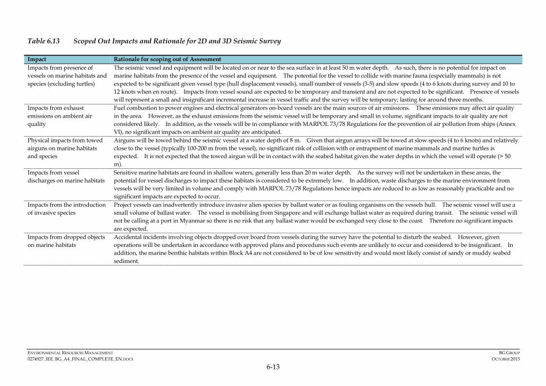
ENVIRONMENTAL RESOURCES MANAGEMENT BG GROUP 0274927_IEE_BG_A4_FINAL_COMPLETE_EN.DOCX OCTOBER 2015
6-13
Table 6.13 Scoped Out Impacts and Rationale for 2D and 3D Seismic Survey
Impact Rationale for scoping out of Assessment Impacts from presence of vessels on marine habitats and species (excluding turtles)
The seismic vessel and equipment will be located on or near to the sea surface in at least 50 m water depth. As such, there is no potential for impact on marine habitats from the presence of the vessel and equipment. The potential for the vessel to collide with marine fauna (especially mammals) is not expected to be significant given vessel type (hull displacement vessels), small number of vessels (3-5) and slow speeds (4 to 6 knots during survey and 10 to 12 knots when en route). Impacts from vessel sound are expected to be temporary and transient and are not expected to be significant. Presence of vessels will represent a small and insignificant incremental increase in vessel traffic and the survey will be temporary; lasting for around three months.
Impacts from exhaust emissions on ambient air quality
Fuel combustion to power engines and electrical generators on-board vessels are the main sources of air emissions. These emissions may affect air quality in the area. However, as the exhaust emissions from the seismic vessel will be temporary and small in volume, significant impacts to air quality are not considered likely. In addition, as the vessels will be in compliance with MARPOL 73/78 Regulations for the prevention of air pollution from ships (Annex VI), no significant impacts on ambient air quality are anticipated.
Physical impacts from towed airguns on marine habitats and species
Airguns will be towed behind the seismic vessel at a water depth of 8 m. Given that airgun arrays will be towed at slow speeds (4 to 6 knots) and relatively close to the vessel (typically 100-200 m from the vessel), no significant risk of collision with or entrapment of marine mammals and marine turtles is expected. It is not expected that the towed airgun will be in contact with the seabed habitat given the water depths in which the vessel will operate (> 50 m).
Impacts from vessel discharges on marine habitats
Sensitive marine habitats are found in shallow waters, generally less than 20 m water depth. As the survey will not be undertaken in these areas, the potential for vessel discharges to impact these habitats is considered to be extremely low. In addition, waste discharges to the marine environment from vessels will be very limited in volume and comply with MARPOL 73/78 Regulations hence impacts are reduced to as low as reasonably practicable and no significant impacts are expected to occur.
Impacts from the introduction of invasive species
Project vessels can inadvertently introduce invasive alien species by ballast water or as fouling organisms on the vessels hull. The seismic vessel will use a small volume of ballast water. The vessel is mobilising from Singapore and will exchange ballast water as required during transit. The seismic vessel will not be calling at a port in Myanmar so there is no risk that any ballast water would be exchanged very close to the coast. Therefore no significant impacts are expected.
Impacts from dropped objects on marine habitats
Accidental incidents involving objects dropped over board from vessels during the survey have the potential to disturb the seabed. However, given operations will be undertaken in accordance with approved plans and procedures such events are unlikely to occur and considered to be insignificant. In addition, the marine benthic habitats within Block A4 are not considered to be of low sensitivity and would most likely consist of sandy or muddy seabed sediment.

ENVIRONMENTAL RESOURCES MANAGEMENT BG GROUP 0274927_IEE_BG_A4_FINAL_COMPLETE_EN.DOCX OCTOBER 2015
6-14
Impact Rationale for scoping out of Assessment Impacts from underwater sound on marine invertebrates and corals
Impacts from underwater sound are not anticipated on marine invertebrate species or coral reefs. Coral reefs and their associated polyps are not known to have sound sense organs indicating that they are unlikely to be impacted by increased exposure to sound. This is supported by the surveys undertaken in Australia investigating the impacts of 3D seismic surveys on coral reefs which demonstrated that impacts to corals do not occur through the use of airguns (1) . Furthermore, the survey is expected to be at least 2.7 km away from the nearest coral habitats and over 5 km from the coral habitats around Manaung Island. Although without sensory organs to perceive sound pressure, some invertebrates can detect the particle motion component of sound via mechanoreceptors and hairs and in this way can detect seismic sound source at close ranges (within 20 meters). However, as these invertebrates are associated with the seabed and as the survey is being conducted in water depth in excess of 50 m there is limited potential for invertebrates to detect and therefore be impacted by underwater sound from the surveys.
Impacts from underwater sound on sea snakes (reptiles)
There is little research on the effects of underwater sound on sea snakes. However, sea snakes rely on vision and olfaction and do not have good hearing abilities in comparison to those of other reptiles. It is not known whether there are any sea snakes within the Area of Interest. If sea snakes are present, it could be expected that they would be located in shallower waters and are hence unlikely to be present in significant numbers in the majority of Block A-4. As such, there is unlikely to be any impact adverse on sea snakes from the proposed activity.
Impacts on fisheries and fishing communities from physical presence of seismic vessel and equipment (shallow water fishermen)
As discussed in Section 5, fishing has been separated into three areas: shallow water (<50 m), continental slope (50 to 200 m) and deep water (>200 m). The fishing vessels operating in the shallow water (<50 m) will not be impacted by the presence of the project vessels over equipment as the Activity Area does not overlap spatially with their fishing grounds. These fishermen tend to fish on the continental shelf area south and west of Manaung Island. The shallow water fishermen represent the largest group of fishermen within the Area of Interest and also contain many of the fishermen most dependent on fishing as a source of sustenance.
Impacts on oil and gas activity and shipping vessels from routine activity
There is little overlap between the exploration survey activity and other oil and gas developers or shipping vessels; no significant shipping lanes cross the Block. Therefore the routine activity of the Project is not expected to significantly affect these receptors and potential impacts have been scoped out.
Table 6.14 Scoped Out Impacts and Rationale for Gravity and Magnetic Survey
Impact Rationale for scoping out of Assessment Impacts from presence of vessels on marine habitats and species
The gravity and magnetic survey will be conducted using the same vessels as the seismic survey. This survey will be conducted in the same location and at the same time as the seismic survey. As such, this survey will be conducted around 50 km from Manaung at its closest point. It should also be noted that the gravity and magnetic survey is “passive” and therefore it doesn’t emit any energy. Please refer to rationale provided in Table 6.13.
Impacts from air emissions on ambient air quality
Please refer to rationale provided in Table 6.13.
Impacts from vessel discharges from vessels on marine habitats
Please refer to rationale provided in Table 6.13.
(1) Grebe CC, Colman JG, Reid CA (2008) Practical application of an adaptive management approach for a marine seismic survey. IAIA08 Conference Proceedings, The Art and Science of Impact Assessment, 28th Annual Conference of
the International Association for Impact Assessment, 4-10 May 2008, Perth Convention Exhibition Centre, Perth, Australia.

ENVIRONMENTAL RESOURCES MANAGEMENT BG GROUP 0274927_IEE_BG_A4_FINAL_COMPLETE_EN.DOCX OCTOBER 2015
6-15
Impact Rationale for scoping out of Assessment Impacts from dropped objects on marine habitats
Please refer to rationale provided in Table 6.13.
Table 6.15 Scoped Out Impacts and Rationale for Seabed Coring Survey
Impact Rationale for scoping out of Assessment Impacts from presence of vessels (Marine Traffic) on marine habitats and species
The seabed coring survey will be conducted using one vessel. Please refer to rationale provided in Table 5.13.
Impacts from air emissions on ambient air quality
Please refer to rationale provided in Table 6.13.
Impacts from vessel discharges from vessels on marine habitats
Please refer to rationale provided in Table 6.13.
Impacts from dropped objects on marine habitats
Please refer to rationale provided in Table 6.13.
Impact of seabed sampling on marine benthic flora and fauna
The seabed sampling will result in temporary seabed disturbance from collection of approximately 100 sediment core samples, spanning locations across the Block. The sediment cores will have a small diameter (10 centimetres) and only a small amount of seabed will be disturbed. The core samples will be taken in waters deeper than 50 m in sandy/muddy seabed areas which are considered low sensitivity habitats. No core samples will be collected from coral habitat or in shallower waters. Given the very small magnitude of seabed disturbance in low sensitivity habitats, the impact is not considered to be significant.
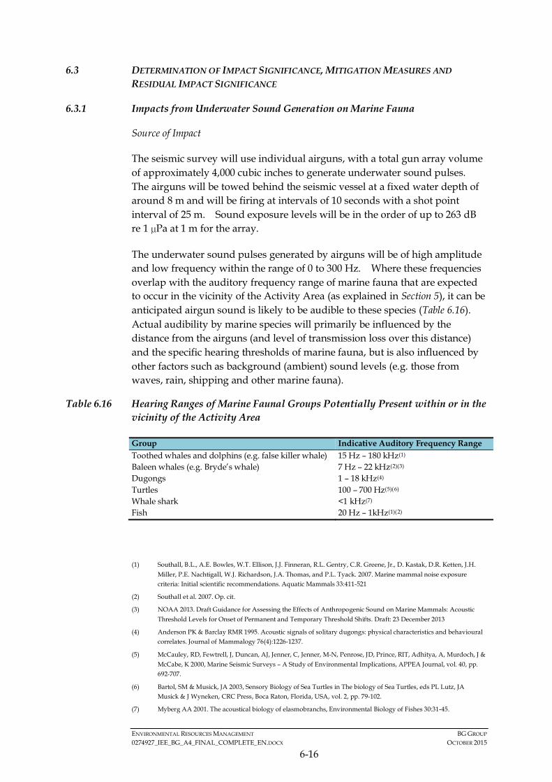
ENVIRONMENTAL RESOURCES MANAGEMENT BG GROUP 0274927_IEE_BG_A4_FINAL_COMPLETE_EN.DOCX OCTOBER 2015
6-16
6.3 DETERMINATION OF IMPACT SIGNIFICANCE, MITIGATION MEASURES AND RESIDUAL IMPACT SIGNIFICANCE
6.3.1 Impacts from Underwater Sound Generation on Marine Fauna
Source of Impact
The seismic survey will use individual airguns, with a total gun array volume of approximately 4,000 cubic inches to generate underwater sound pulses. The airguns will be towed behind the seismic vessel at a fixed water depth of around 8 m and will be firing at intervals of 10 seconds with a shot point interval of 25 m. Sound exposure levels will be in the order of up to 263 dB re 1 µPa at 1 m for the array.
The underwater sound pulses generated by airguns will be of high amplitude and low frequency within the range of 0 to 300 Hz. Where these frequencies overlap with the auditory frequency range of marine fauna that are expected to occur in the vicinity of the Activity Area (as explained in Section 5), it can be anticipated airgun sound is likely to be audible to these species (Table 6.16). Actual audibility by marine species will primarily be influenced by the distance from the airguns (and level of transmission loss over this distance) and the specific hearing thresholds of marine fauna, but is also influenced by other factors such as background (ambient) sound levels (e.g. those from waves, rain, shipping and other marine fauna).
Table 6.16 Hearing Ranges of Marine Faunal Groups Potentially Present within or in the vicinity of the Activity Area
Group Indicative Auditory Frequency Range Toothed whales and dolphins (e.g. false killer whale) 15 Hz – 180 kHz(1) Baleen whales (e.g. Bryde’s whale) 7 Hz – 22 kHz(2)(3) Dugongs 1 – 18 kHz(4) Turtles 100 – 700 Hz(5)(6) Whale shark <1 kHz(7) Fish 20 Hz – 1kHz(1)(2)
(1) Southall, B.L., A.E. Bowles, W.T. Ellison, J.J. Finneran, R.L. Gentry, C.R. Greene, Jr., D. Kastak, D.R. Ketten, J.H.
Miller, P.E. Nachtigall, W.J. Richardson, J.A. Thomas, and P.L. Tyack. 2007. Marine mammal noise exposure criteria: Initial scientific recommendations. Aquatic Mammals 33:411-521
(2) Southall et al. 2007. Op. cit.
(3) NOAA 2013. Draft Guidance for Assessing the Effects of Anthropogenic Sound on Marine Mammals: Acoustic Threshold Levels for Onset of Permanent and Temporary Threshold Shifts. Draft: 23 December 2013
(4) Anderson PK & Barclay RMR 1995. Acoustic signals of solitary dugongs: physical characteristics and behavioural correlates. Journal of Mammalogy 76(4):1226-1237.
(5) McCauley, RD, Fewtrell, J, Duncan, AJ, Jenner, C, Jenner, M-N, Penrose, JD, Prince, RIT, Adhitya, A, Murdoch, J & McCabe, K 2000, Marine Seismic Surveys – A Study of Environmental Implications, APPEA Journal, vol. 40, pp. 692-707.
(6) Bartol, SM & Musick, JA 2003, Sensory Biology of Sea Turtles in The biology of Sea Turtles, eds PL Lutz, JA Musick & J Wyneken, CRC Press, Boca Raton, Florida, USA, vol. 2, pp. 79-102.
(7) Myberg AA 2001. The acoustical biology of elasmobranchs, Environmental Biology of Fishes 30:31-45.
ENVIRONMENTAL RESOURCES MANAGEMENT BG GROUP 0274927_IEE_BG_A4_FINAL_COMPLETE_EN.DOCX OCTOBER 2015
6-17
Underwater sound travels as a pressure wave and the pulsed sounds emitted from airguns are characterized by a rapid rise from ambient pressure to maximal pressure followed by a decay period. These are characteristics that mean underwater sound, at very high levels, has the potential to injure the sensitive auditory organs of marine fauna (3) or, at lower levels cause disturbance and a change in behaviour. Due to transmission loss as sound travels, the sound energy will decrease with distance from the sound source. Depending on received sound levels and the sensitivity of the specific marine fauna, exposure to underwater sound has the potential to affect receptors in four main ways:
• Physical Injury. Direct physical injury due to rupture or damage of body tissue, which may lead to mortality in extreme cases.
• Auditory Injury. Permanent injury to hearing organs (known as a Permanent Threshold Shift (PTS)).
• Physiological and Behavioural Changes. Physiological changes include temporary auditory fatigue (known as Temporary Threshold Shift (TTS). Temporary behavioural changes, which may include for example changes in swimming behaviour or direction of fauna.
• Masking or interfering with other biologically important sounds. This may include vocal communication, echolocation signals and sounds produced by predators or prey.
The effects of the above in relation to different key receptors are discussed below.
Marine Mammals
Marine mammals can be adversely impacted by sound generated from seismic surveys if it affects their ability to echolocate, communicate or causes physical harm (through disorientation, and in extreme cases, trauma to the auditory apparatus). For marine mammals, there have been no confirmed cases where exposure to seismic airgun sound has directly caused mortality or serious physical injuries (4). There is inconclusive evidence whether injuries recorded in stranded marine mammal species are from direct exposure to underwater
(1) Popper AN, Fay RR, Platt C and Sand O 2003. Sound detection mechanisms and capabilities of teleost fishes. In:
Sensory Processing in Aquatic Environments eds. SP Colin and NJ Marshal, Springer-Verlag, New York, USA. pp. 3-38.
(2) Hastings MC, Popper AN, Finneran JJ and Lanford PJ 1996. Effects of low-frequency underwater sound in hair cells of the inner ear and lateral line of the teleost fish Asronotus ocellatus. Journal of the Acoustical Society of America 99:1759-1766.
(3) Southall et al. 2007. Op. cit.
(4) Southall, B.L., A.E. Bowles, W.T. Ellison, J.J. Finneran, R.L. Gentry, C.R. Greene, Jr., D. Kastak, D.R. Ketten, J.H. Miller, P.E. Nachtigall, W.J. Richardson, J.A. Thomas, and P.L. Tyack. 2007. Marine mammal noise exposure criteria: Initial scientific recommendations. Aquatic Mammals 33:411-521.

ENVIRONMENTAL RESOURCES MANAGEMENT BG GROUP 0274927_IEE_BG_A4_FINAL_COMPLETE_EN.DOCX OCTOBER 2015
6-18
sound (1). There is evidence, however, that exposure to underwater sound may cause certain cetacean species to exhibit behavioural changes such as avoidance or displacement and in some cases causes a change in vocalisations, diving and foraging activities, and may alter migratory pathways (1). Whether such behavioural changes results in an affect that could be considered as an adverse impact is, however, difficult to define unless, for example, such a change clearly results in a marine mammal not having access to an area of importance (i.e. critical habitat) during an important period (i.e. breeding or calving).
Exposure to high levels of sound (whether from a seismic survey or other sources) may lead to temporary or permanent hearing impairment TTS or PTS. TTS occurs where the animals’ hearing threshold rises temporarily and a sound must be louder to be heard. TTS can last for a few seconds or minutes to a few days before full recovery is achieved. This is generally referred to as auditory fatigue rather than auditory injury and is likely to cause a temporary change in the animals’ behaviour as opposed to any physical change. PTS occurs when the animal suffers physical damage to its hearing leading to total or partial deafness or an impaired ability to hear sounds within specific frequency ranges (1).
Southall et al. (2007) (2) published recommended cetacean physical injury threshold levels for Sound Exposure Levels (SELs) from multiple pulse sources such as noise generated from seismic operations. The cetacean physical injury threshold which may result in PTS was determined to be 198 dB re 1 µPa2.s cetaceans that hear at mid and low frequencies and 179 dB re 1 µPa2.s for cetaceans that hear at high frequencies. With reference to the SELs, it is important to note that in this case, the majority of cetaceans in the Area of Interest in Block A-4 are mid or low hearing frequency cetaceans.
Vocalisation changes have been recorded in cetacean species where it may represent attempts to overcome ‘masking’ effects and compensating for the additional sound in the environment (3). These changes have been observed in response to sound generation from a variety of anthropogenic activities, including shipping and sonar use as well as seismic activities.
(1) Weilgart, L.,2013. “A review of the impacts of seismic airgun surveys on marine life.” Submitted to the CBD
Expert Workshop on Underwater Noise and its Impacts on Marine and Coastal Biodiversity, 25-27 February 2014, London, UK.
(2) Southall, B.L., A.E. Bowles, W.T. Ellison, J.J. Finneran, R.L. Gentry, C.R. Greene, Jr., D. Kastak, D.R. Ketten, J.H. Miller, P.E. Nachtigall, W.J. Richardson, J.A. Thomas, and P.L. Tyack. 2007. Marine mammal noise exposure criteria: Initial scientific recommendations. Aquatic Mammals 33:411-521.
(3) Di Iorio, L. and Clark, C.W. 2010. Exposure to seismic survey alters blue whale acoustic communication. Biol. Lett. 6 (1): 51-54. doi:10.1098/rsbl.2009.0651
ENVIRONMENTAL RESOURCES MANAGEMENT BG GROUP 0274927_IEE_BG_A4_FINAL_COMPLETE_EN.DOCX OCTOBER 2015
6-19
Of the marine mammal species potentially present in the Activity Area (see Section 5), blue whales (Balaenoptera musculus) have been observed to call more frequently when seismic surveys were being conducted (3), humpback whales (Megaptera novaeangliae) changed their singing behaviour (1), and both pilot whales (Globicephala melas) and bottlenose dolphins (Tursiops truncatus) have been observed to produce more whistles. Some species such as sperm whales (Physeter macrocephalus) and humpback whales have also shown to decrease or temporarily cease calls in response to sound exposure from seismic surveys, and fin whales (Balaenopterid physalus) in response to ship sounds (2). Vocalisations are considered to be used by marine mammals for communication in feeding, mating, threat avoidance, and socialising and impacts to these vocalisations can therefore affect marine mammals.
Increases in ambient underwater sound can also cause behavioural changes in marine mammals such as changes in their surfacing and diving behaviour in the presence of seismic sound (3). As an example, movements of sperm whales in the Gulf of Mexico were recorded before, during and after seismic exposures and it was noted that individuals swimming speed and foraging behaviour appeared reduced. Other changes observed in marine mammals in response to increases in ambient underwater sound included a decrease in the frequency of dives as well as changes in diving depths (4), an increase in the amount of time spent at the surface (5) and increased swimming rate (1).
Turtles
Marine turtles are considered less susceptible than marine mammals to increases in ambient underwater sound as turtles do not have an external hearing organ and can only direct sound through vibrations in their skull and the shell (6). Marine turtle species that have been recorded in the vicinity of the Activity Area, i.e. green turtles and hawksbill turtles, have been shown to respond to sounds higher than 166 dB re 1 μPa (rms) and when levels were higher than 175 dB re 1 μPa (rms) demonstrated "erratic behaviour" or "agitation" (7). However, turtles hear at lower frequencies, with peak hearing
(1) Miller, G.W., J.D. Moulton, R.A. Davis, M. Holst, P. Millman, A. MacGillvray, and D. Hannay. 2005. Monitoring
seismic effects on marine mammals – southeastern Beaufort Sea, 2001-2002, pp. 511-542. In: S.L. Armsworthy, P.J. Cranford, and K. Lee (eds.), Offshore oil and gas environmental effects monitoring/Approaches and technologies. Battelle Press, Columbus, OH.
(2) International Whaling Commission (IWC). 2007. Report of the scientific committee. Annex K. Report of the Standing Working Group on environmental concerns. J. Cetacean Res. Manag. 9 (Suppl.): 227–296.
(3) Weilgart, L.,2013. “A review of the impacts of seismic airgun surveys on marine life.” Submitted to the CBD Expert Workshop on Underwater Noise and its Impacts on Marine and Coastal Biodiversity, 25-27 February 2014, London, UK.
(4) Richardson, W.J., Malme, C.I., Green, C.R., Jr., and Thomson, D.H. 1995. Marine Mammals and Noise. Academic Press, San Diego, CA 576 pp.
(5) Stone, C.J., and Tasker, M.L. 2006. The effect of seismic airguns on cetaceans in UK waters. J. Cetacean Res. Manag. 8: 255–263.
(6) Lenhardt, M.L., Bellmund, S., Byles, R.A., Harkins, S.W. and Musick, J.A. 1983. Marine Turtle reception of bone conducted sound. Journal of Auditory Research 23: 119–1125.
(7) McCauley R.D., J. Fewtrell, A.J. Duncan, C. Jenner, M-N. Jenner, J.D. Penrose, R.I.T. Prince, A. Adhitya, J. Murdoch and K. McCabe, 2000. Marine seismic surveys – A study of environmental implications. APPEA J 40: 692–706.
ENVIRONMENTAL RESOURCES MANAGEMENT BG GROUP 0274927_IEE_BG_A4_FINAL_COMPLETE_EN.DOCX OCTOBER 2015
6-20
range of sea turtles from around 100 to 700 Hz (1) and as such could be more sensitive to the low frequency sounds generated by seismic surveys (typically from 10 to 300 Hz).
Limited information is available on the effects of increased underwater sound on turtles however it is possible that impacts are likely to be similar to other marine fauna including temporary or permanent hearing damage and behavioural changes (1). Studies on turtles in relation to 3D seismic surveys have shown that turtles could exhibit responses (suggesting they are aware of the sound) out to 2 km from the sound source and avoidance behaviour (moving away from the sound) out to 1 km from the sound source (6). As with marine mammals, turtles have also been observed to alter their diving behaviour in response to underwater sound. For example, some loggerhead turtles (Caretta caretta) in the Mediterranean Sea were observed to dive following an airgun shot (2). Loggerhead turtles are thought to be present in the Area of Interest and could be found within the Activity Area.
Fish
There is a lack of understanding about the effect of increases in sound on fish with research into underwater sound and the associated responses from fish currently based on a limited number of species (3). Fish have hearing ranges between 20 Hz – 1 kHz and are generally considered to have good low frequency hearing. The frequency of the sound produced by seismic surveys is within the common fish hearing range.
Behavioural changes in relation to exposure to sound have been observed in fish species with alarm responses (such as noticeable changes in fish swimming behaviour) recorded from 1 to 5 km from the seismic sound source, depending on the species threshold and the sound transmission loss. There have been numerous studies that have reported no significant effect of observed behavioural changes from fish in relation to increases in ambient underwater sound. This is important as it indicates that in many situations fish are not significantly affected by exposure increased levels of underwater sound. However, there are a number of studies which have shown that fish will move away from the area around the sound source following exposure to the sound; this avoidance area can in some instances be up to 2 km (4). Any behavioural changes to fish have been observed to be short-lived (within a few minutes to hours) and fish tend to very quickly exhibit normal behaviour after
(1) Bartol, SM & Musick, JA 2003, Sensory Biology of Sea Turtles in The biology of Sea Turtles, eds PL Lutz, JA
Musick & J Wyneken, CRC Press, Boca Raton, Florida, USA, vol. 2, pp. 79-102.
(2) DeRuiter, SL and Doukara, KL., 2012. Loggerhead turtles dive in response to airgun sound exposure. Endang Species Res. Vol. 16: 55–63, 2012.
(3) Popper, A. N., and M. C. Hastings, 2009. "The effects of anthropogenic sources of sound on fishes." Journal of Fish Biology 75.3: 455-489.
(4) Turnpenny, A. W. H. and Nedwell, J. R. 1994. The effects on marine fish, diving mammals and birds of underwater sound generated by seismic surveys. Consultancy Report FCR 089/94, Fawley Aquatic Research Laboratories Ltd., 40pp.

ENVIRONMENTAL RESOURCES MANAGEMENT BG GROUP 0274927_IEE_BG_A4_FINAL_COMPLETE_EN.DOCX OCTOBER 2015
6-21
an initial startle or avoidance response (1). It should be noted that behavioural responses may not be an adverse impact but generally represent a minor change to the fish’s behaviour such as changes swimming direction or speed.
The potential for physical injury of fish in relation to underwater sound is greater in species which have swim bladders; sacs inside fish filled with air which can be affected by sound pressure waves. However, this type of physical injury is only likely in very close proximity (i.e. a few metres) to the sound source and therefore, is highly unlikely to occur in adult fish as they have been shown to avoid a sound source (2) before it gets to high levels. This is an important point to note as with seismic surveys the exposure of sound to fish is expected to be gradual, due to the continuous firing of the airguns as the seismic vessel sails the survey line. As such it would be expected that fish would swim away from the increasing sound and thereby prevent exposure at levels that may cause physical harm.
Fish eggs and larvae in very close proximity to the sound source could be physically injured as they are present near the sea surface and unable to avoid the sound. However, the number of eggs and larvae likely to be impacted by close exposure to sound from a seismic survey will be negligible when compared to the vast number of fish eggs and larvae that occur throughout the water column (3).
Pelagic fish species are those which inhabit open water areas and generally live in the water column of the ocean (i.e., not associated with the seabed like demersal or benthic species). Some pelagic fish identified in the Area of Interest, such as Clupeids (e.g. herring and anchovy) are considered to be hearing specialists in that they have evolved specialised anatomical structures that enhance hearing sensitivity and hearing range.
The reef species identified as being present in the Area of Interest (such as groupers and snappers) are typically not considered as sensitive to underwater sound as they are not hearing specialists. Reef species are range restricted as they spend the majority of the life associated with coral habitats and use these habitats as both feeding and spawning grounds. As such, unlike pelagic species of fish which, if affected by underwater sound, will be able to swim away to another area, reef species would need to return to the coral areas. Therefore, the distance the sound travels and the time in which the vessel would pass by are important when defining the potential impact on reef species. However, studies have been conducted on coral reef fish species, which showed that no permanent changes in behaviour of fish and
(1) Wardle, C. S., Carter, T. J., Urquhart, G. G., Johnstone, A. D. F., Ziolkowski, A. M., Hampson, G. & Mackie, D.
(2001). Effects of seismic air guns on marine fish. Continental Shelf Research 21, 1005–1027.
(2) Gausland (200). Impact of seismic surveys on marine life. The Leading Edge. August 2000, 903-905.
(3) Popper, A. N., and M. C. Hastings, 2009. "The effects of anthropogenic sources of sound on fishes." Journal of Fish Biology 75.3: 455-489.
ENVIRONMENTAL RESOURCES MANAGEMENT BG GROUP 0274927_IEE_BG_A4_FINAL_COMPLETE_EN.DOCX OCTOBER 2015
6-22
invertebrates were observed (1). For example, in Scott Reef, Australia, a dedicated visual survey of coral reef fish community behavioural reactions to seismic survey airguns was undertaken (2) for a 3D seismic survey. A census of the fish species in the continental slope reef area was taken both before and after the survey. Statistical analysis of species richness and abundance on the coral reef before and after the survey displayed no evidence of significant impacts from the survey and no evidence of lethal or sub-lethal effects. This study indicates that reef fish are typically not particularly sensitive to increased level of underwater sound, and any behavioural change in response to increased sound is temporary without significant long term effects.
Existing/ In Place Controls
Measures to control and minimise any adverse impacts from underwater sound generation during the survey activities will include:
• Implement Joint Nature Conservation Committee (JNCC) Guidelines (3) including alignment of Contractor operating procedures with JNCC Guidelines. The JNCC guidelines reflect best international practice for seismic operators to follow during the planning, operational and reporting stages.
• Optimum airgun configurations to ensure that the lowest possible sound level of airguns is selected for the required activity.
• In alignment with JNCC guidelines, a soft-start procedure will be utilised at the commencement of the seismic survey. The seismic sound will slowly build up to allow adequate time for marine fauna to leave the area.
• In alignment with JNCC guidelines, dedicated Marine Mammal Observers will be on-board the seismic vessel and will undertake pre-shooting search. Should any marine mammals be observed within 500 m of the seismic vessel during the pre-shoot search and soft-start procedures, the airguns will be powered down until the animals have moved beyond 500 m.
• In line with guideline, Passive Acoustic Monitoring (PAM) will be used to detect whether any marine mammals are in the vicinity of the seismic vessel during night time or low visibility operations.
Significance of Impact
In order to quantify the approximate underwater sound levels that will be generated by the seismic survey and the estimated magnitude of the impact
(1) Wardle, C. S., Carter, T. J., Urquhart, G. G., Johnstone, A. D. F., Ziolkowski, A. M., Hampson, G. & Mackie, D.
(2001). Effects of seismic air guns on marine fish. Continental Shelf Research 21, 1005–1027.
(2) Miller and Cripps (2013). Three dimensional marine seismic survey has no measurable effect on species richness or abundance of a coral reef associated fish community. Mar Pollut Bull. 2013 Dec 15;77(1-2):63-70. doi: 10.1016/j.marpolbul.2013.10.031. Epub 2013 Nov 12.
(3) The JNCC“Guidelines for minimising the risk of injury and disturbance to marine mammals from seismic surveys, 2010”
ENVIRONMENTAL RESOURCES MANAGEMENT BG GROUP 0274927_IEE_BG_A4_FINAL_COMPLETE_EN.DOCX OCTOBER 2015
6-23
on potentially sensitive marine species an underwater sound modelling study was conducted to inform the IEE Study. The results of this modelling have been taken into account as part of the impact assessment, as well as a review of published literature on this issue.
Marine Mammals
In order to assess the sensitivity of marine mammals to underwater sound it is necessary to establish quantified criteria for the levels at which it is believed sound will affect (whether physically or behaviourally) particular marine mammal species; these are often referred to as exposure thresholds. The exposure threshold criteria adopted for marine mammals in this IEE are based on published scientific studies, in particular the work by Southall et al. 2007 (1). This sets out differing exposure thresholds for different marine mammal groups, namely species that hear at low, mid or high frequencies.
Low frequency hearing cetaceans that have been observed in the Area of Interest include the baleen whales (Bryde’s whale, blue whale, fin whale and humpback whale). Mid-frequency cetaceans include the toothed whales and dolphins (Blainville's beaked whale, false killer whale, killer whale, pygmy killer whale, short finned pilot whale, spinner dolphin, bottlenose dolphin, spotted dolphin, Irrawaddy dolphin, humpbacked dolphin, finless dolphin, risso’s dolphin and stripped dolphin). In addition, there are two species of toothed whale that have been observed in the Area of Interest (pygmy sperm whale and dwarf sperm whale) that are considered high-frequency cetaceans. While dugongs have a small potential to be present in nearshore waters (outside the Activity Area), these species have a high frequency hearing range (1 to 18 kHz). It has been suggested that dugong hearing values may be similar to pinnipeds in water (2), as provided by Southall et al. 2007, and as such, these values have been used for assessing impacts to dugongs. A summary of the criteria outlined above is presented below in Table 6.17.
(1) Southall, B.L., A.E. Bowles, W.T. Ellison, J.J. Finneran, R.L. Gentry, C.R. Greene, Jr., D. Kastak, D.R. Ketten, J.H.
Miller, P.E. Nachtigall, W.J. Richardson, J.A. Thomas, and P.L. Tyack. 2007. Marine mammal noise exposure criteria: Initial scientific recommendations. Aquatic Mammals 33:411-521.
(2) BOEM, 2014. BOEM (Bureau of Ocean Energy Management) Gulf of Mexico OCS Region. 2014. Atlantic OCS Proposed Geological and Geophysical Activities Mid-Atlantic and South Atlantic Planning Areas Final Programmatic Environmental Impact Statement (PEIS). Prepared by CSA Ocean Sciences Inc. for the U.S. Department of the Interior under GSA Task Order No. M11PD00013.
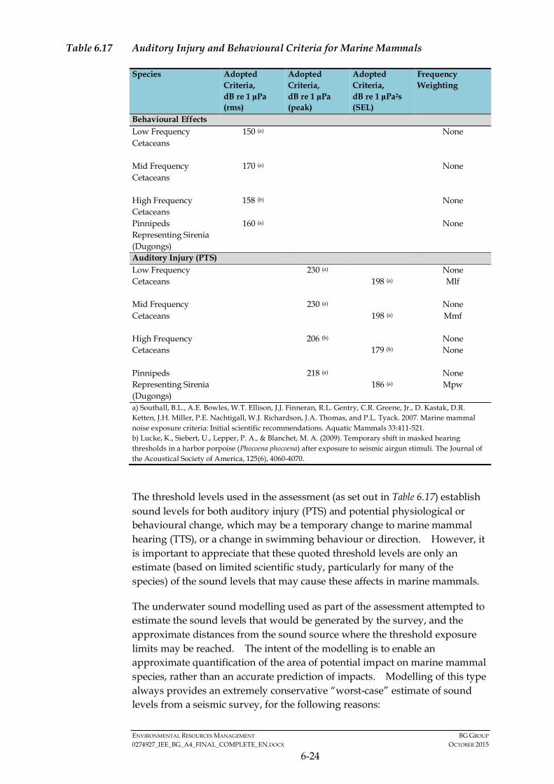
ENVIRONMENTAL RESOURCES MANAGEMENT BG GROUP 0274927_IEE_BG_A4_FINAL_COMPLETE_EN.DOCX OCTOBER 2015
6-24
Table 6.17 Auditory Injury and Behavioural Criteria for Marine Mammals
Species Adopted Criteria, dB re 1 μPa (rms)
Adopted Criteria, dB re 1 μPa (peak)
Adopted Criteria, dB re 1 μPa2s (SEL)
Frequency Weighting
Behavioural Effects Low Frequency Cetaceans
150 (a) None
Mid Frequency Cetaceans
170 (a) None
High Frequency Cetaceans
158 (b) None
Pinnipeds Representing Sirenia (Dugongs)
160 (a) None
Auditory Injury (PTS) Low Frequency Cetaceans
230 (a) None 198 (a) Mlf
Mid Frequency Cetaceans
230 (a) None 198 (a) Mmf
High Frequency Cetaceans
206 (b) None 179 (b) None
Pinnipeds Representing Sirenia (Dugongs)
218 (a) None 186 (a) Mpw
a) Southall, B.L., A.E. Bowles, W.T. Ellison, J.J. Finneran, R.L. Gentry, C.R. Greene, Jr., D. Kastak, D.R. Ketten, J.H. Miller, P.E. Nachtigall, W.J. Richardson, J.A. Thomas, and P.L. Tyack. 2007. Marine mammal noise exposure criteria: Initial scientific recommendations. Aquatic Mammals 33:411-521. b) Lucke, K., Siebert, U., Lepper, P. A., & Blanchet, M. A. (2009). Temporary shift in masked hearing thresholds in a harbor porpoise (Phocoena phocoena) after exposure to seismic airgun stimuli. The Journal of the Acoustical Society of America, 125(6), 4060-4070.
The threshold levels used in the assessment (as set out in Table 6.17) establish sound levels for both auditory injury (PTS) and potential physiological or behavioural change, which may be a temporary change to marine mammal hearing (TTS), or a change in swimming behaviour or direction. However, it is important to appreciate that these quoted threshold levels are only an estimate (based on limited scientific study, particularly for many of the species) of the sound levels that may cause these affects in marine mammals.
The underwater sound modelling used as part of the assessment attempted to estimate the sound levels that would be generated by the survey, and the approximate distances from the sound source where the threshold exposure limits may be reached. The intent of the modelling is to enable an approximate quantification of the area of potential impact on marine mammal species, rather than an accurate prediction of impacts. Modelling of this type always provides an extremely conservative “worst-case” estimate of sound levels from a seismic survey, for the following reasons:

ENVIRONMENTAL RESOURCES MANAGEMENT BG GROUP 0274927_IEE_BG_A4_FINAL_COMPLETE_EN.DOCX OCTOBER 2015
6-25
• The model estimates sound levels from the survey that would be experienced directly beneath the survey array (i.e. the airguns and streamers) rather than the sound that might be experienced laterally from the array (to the side or in front of the survey). As such, the model estimates the highest (worst-case) sound levels that may be generated, whereas in reality seismic surveys are designed to minimise lateral sound levels and therefore sound levels to the side or in front will be significantly lower than the model estimates.
• The modelling does not take into account the soft-start procedure in which, prior to any commencement of airgun firing sound will be gradually increased over a period of around 20 to 30 minutes until it reaches its maximum levels. In reality the soft-start enables marine species to avoid the area of sound disturbance. Therefore, marine species are highly unlikely to ever be exposed to the predicted sound-levels shown by the model.
• The modelling assumes a fixed vessel location and an animal swimming away from it. However as the survey is constantly shooting seismic sound, during normal operations marine species would get considerable warning that the survey is moving towards them i.e. they will potentially hear the sound from many kilometres away. If the sound causes them discomfort they can move away from the area before they are exposed to sound levels estimated by the modelling. Therefore as mammals are likely to avoid the area of increased sound, the exposure to the sound source will be lower than the model predicts as in reality both the animal and vessel are likely to be moving away from one another.
Based on the results of the modelling study the following conclusions have been drawn with regards to cetaceans of low, mid and hearing frequency hearing and dugongs potentially present in the Area of Interest:
• Low and Mid Frequency Hearing Cetaceans: The assessment suggests that mid and low frequency cetaceans (which in the Area of Interest include species such as Bryde’s whale, blue whale, humpback and several dolphin species) would only be at risk of suffering auditory injury (threshold level 198 dB re 1 μPa2s (SEL) if they were exposed to peak operational sound levels (i.e. the airguns firing at full power) within 500 to 700m of the sound source. However, in reality this is highly unlikely to occur as no animals are expected to be within 500m of the sound source when the soft-start commences due to the Project’s application of industry standard control measures. As stated in Section 6.3.1, in line with the JNCC guidelines (1), dedicated Marine Mammal Observers will be on-board the seismic vessel and should any marine mammals be observed within 500 m of the seismic vessel during the pre-shoot search and soft-start procedures, the airguns will be powered down until the animals have moved beyond 500 m.
(1) The JNCC “Guidelines for minimising the risk of injury and disturbance to marine mammals from seismic
surveys, 2010”

ENVIRONMENTAL RESOURCES MANAGEMENT BG GROUP 0274927_IEE_BG_A4_FINAL_COMPLETE_EN.DOCX OCTOBER 2015
6-26
Taking this into account any marine mammal in the vicinity of the vessel at the commencement of soft-start will have 20 to 30 minutes to move away and be well beyond 700m from the sound source before the predicted sound levels are reached. Therefore the natural avoidance behaviour displayed by cetaceans and the controls in place, i.e., soft-start procedures, mean low to mid frequency hearing cetaceans are highly unlikely to be close enough to the sound source to suffer any auditory injury.
• High Frequency Hearing Cetaceans: The majority of marine mammal species reported in the Area of Interest are low or mid-frequency cetaceans. However, two species of high-frequency cetacean, the dwarf and the pygmy sperm whale, are thought to occur in Myanmar waters (although there is no confirmed evidence for this in Rakhine waters). High-frequency cetaceans have a lower threshold exposure limit for auditory injury (179 dB re 1 μPa2s (SEL) because they are deemed to have more sensitive hearing. Due to this lower threshold limit the modelling estimates that the sound levels that could risk some auditory injury (PTS) to these species could extend to between 2 to 7 km from the sound source. However, as explained above in reality these sound levels estimated by the model are unlikely to be experienced by species as the model represents very conservative (worst-case) estimates of sound generated by the survey and in reality high-frequency cetaceans will have a significant amount of time (20to 30 minutes) during soft-start procedures to move away from the area. Assuming a typical swimming speed of approximately 10 km/h within 30 minutes a cetacean would be likely to be over 5 km from the survey by the time the airguns were firing at maximum operational power and therefore at very low risk of exposure to sound levels that would cause any auditory injury. In addition, it should be noted, that the impact assessment for high-frequency cetaceans has been undertaken as a precaution as they are thought to be rare or occasional visitors in Myanmar waters. The actual ranges of these species in Myanmar are not known and no high-frequency cetaceans were observed during the marine mammal observation survey conducted from March to June 2015 in Block AD-03 (located to the southwest of Block A-4).
• Dugong: There are no criteria in Southall et al. (2007) for dugongs, however, it is suggested that pinnipeds can be used as a basis for dugong hearing (1). The modelling suggests that dugongs that start swimming away from the seismic vessel closer than 1.5 km would experience sound exposure which indicates the potential for PTS. In addition, dugongs within approximately 6 km of the sound source could exhibit behavioural reactions. However, the closest dugong habitat is located over 8 km from the Activity Area. As such, no impacts on dugong in the Area of Interest are anticipated.
(1) BOEM, 2014. BOEM (Bureau of Ocean Energy Management) Gulf of Mexico OCS Region. 2014. Atlantic OCS
Proposed Geological and Geophysical Activities Mid-Atlantic and South Atlantic Planning Areas Final Programmatic Environmental Impact Statement (PEIS). Prepared by CSA Ocean Sciences Inc. for the U.S. Department of the Interior under GSA Task Order No. M11PD00013.

ENVIRONMENTAL RESOURCES MANAGEMENT BG GROUP 0274927_IEE_BG_A4_FINAL_COMPLETE_EN.DOCX OCTOBER 2015
6-27
In terms of estimated behavioural reactions (i.e., changes in swimming or diving behaviour or cessation of calls) in marine mammal species, the estimated threshold distance is potentially between 5 and 50 km. The largest distance range is for low frequency cetaceans (which have the lowest sensitivity threshold level) when modelled in deeper waters. These larger distances of estimated behavioural change are primarily driven by the low exposure thresholds used in the assessment. In reality, given the very conservative assumptions of the model sound levels that would cause behavioural disturbance to cetaceans are likely to be limited to within several kilometres of the seismic survey. The majority of published literature on this issue indicates that behavioural change in marine mammals is not experienced at very large (i.e. beyond 10km) distances from seismic surveys. It is important to recognise that behavioural change (for example a change to swimming patterns) is not an injury and any behavioural changes will be temporary i.e., until the species is far enough away from the sound source to not be impacted and until the seismic operation has moved away from an area. Marine mammals are highly mobile and are likely to avoid the area of increased sound around the vessel. The mitigation measures mentioned in Section 6.3.1 will help reduce the potential impact on any marine mammals in the vicinity of the seismic vessel during start-up and will provide more time for marine mammals to vacate the area around the sound source in which potential impacts could occur. As the seismic vessel will also be moving, the temporal extent of the impact will be small on a particular area (a number of hours maximum) and the resultant magnitude of the impact is considered to be small.
Marine mammals are highly sensitive receptors as some of the species present in Rakhine waters are considered international and national species of conservation concern. It is anticipated that with all the existing control measures in place the impact will be of Moderate significance for marine mammals.
Turtles
Although turtles are considered less sensitive to increases in underwater sound than marine mammals, they are also typically less capable of quickly moving away. Marine turtles also show strong fidelity to specific nesting beaches and associated migratory corridors and it is therefore considered they can be susceptible to impacts which could alter these migrations. However, the Activity Area is 50 km from the mainland coast or Ramree Island and is thus not likely to impact these nesting beaches directly. There are also known turtle nesting beaches on Manaung Island, which are located 8 km from the closest point of the Activity Area. There is a potential for migratory routes of turtles to these nesting beaches to be impacted by underwater sound generation by the Project. In addition, turtle nesting activity in Rakhine waters occurs from September to March with peak nesting in December and January. Therefore, during the course of the survey there is potential for turtles to be mating in nearshore waters close to nesting beaches (Manaung and Ramree Islands) and therefore could potentially be within or close to the

ENVIRONMENTAL RESOURCES MANAGEMENT BG GROUP 0274927_IEE_BG_A4_FINAL_COMPLETE_EN.DOCX OCTOBER 2015
6-28
Activity Area. However, during stakeholder consultations, it was stated that the numbers of turtles using the beaches of Rakhine is relatively small. Turtle incubation periods vary from around one to two months therefore turtle hatchlings could also be present, migrating out to sea, during the survey period.
The adopted injury and behavioural criteria as set out by Popper et al. 2014 (1). The criteria for potential injury in turtles is 210 SELcum or>207 dB Peak. For turtles, the zone around the seismic source within which turtles may be at risk of potential injury due to sound is estimated to be within 400 to 500m from the sound source. This model does not however take into account the soft start procedure in place. The soft start will take place over a period of at least 20 to 30 minutes (2) in which time turtles are likely to swim away from the sound source. As such, in reality there is very little risk of turtles being exposed to sound levels high enough with the potential to cause auditory injury.
Sea turtles swim at a cruising speed of around 2 km /h (3) but some turtles are known to be able to swim up to 20 km/h (4). As such, if the soft-start lasts for 20 to 30 minutes, in that time a turtle would be well beyond the estimated distances for potential injury (if the turtle was in close proximity to the sound source at the commencement of the soft start). With the control measures in place, it is unlikely that any turtles will be within these distances from the sound source during the survey. Given the natural avoidance behaviour that will be displayed by turtles and the controls in place, i.e., soft-start procedures, turtles are highly unlikely to be within close proximity to the sound source. As such, injury of turtles is not considered to be likely.
The likely impacts on behaviour of turtles are estimated by using the qualitative guidance in Popper et al. 2014. Typically turtles are expected to experience behavioural effects of “high” level in the near zone. In this context “near” might be considered to be tens of metres from the source. Behavioural effects are predicted to be “moderate” at “intermediate” distances which might be hundreds of metres away. At “far” distances (which could be thousands of metres from the source) a “low” effect is predicted. However, soft start is likely to ensure that no turtles are within either near or intermediate distances from the sound source during the maximum sound exposure levels generated during the survey. As such, behavioural impacts due to sound are likely to be limited to “low”. It is also important to note that any behavioural changes will be very temporary and once the survey has passed through an area (within a few hours) sound will have reduced to a level at which turtles are unaffected and return to normal behaviours.
(1) Popper et al 2014 Sound Exposure Guidelines for Fishes and Sea Turtles: A Technical Report prepared by ANSI0
Accredited Standards Committee S3/SC1 and registered with ANSI. ASA Press. Springer.
(2) The JNCC“Guidelines for minimising the risk of injury and disturbance to marine mammals from seismic surveys, 2010”
(3) Prange, H. D. (1976). Energetics of swimming of a sea turtle. The Journal of experimental biology, 64(1), 1-12.
(4) Watson, K. P., & Granger, R. A. (1998). Hydrodynamic effect of a satellite transmitter on a juvenile green turtle (Chelonia mydas). The Journal of experimental biology, 201(17), 2497-2505.

ENVIRONMENTAL RESOURCES MANAGEMENT BG GROUP 0274927_IEE_BG_A4_FINAL_COMPLETE_EN.DOCX OCTOBER 2015
6-29
Turtles are considered to be highly sensitive receptors as all the species present in Rakhine waters are listed as species of conservational concern on the IUCN Red List. As such, given that the impact to behaviour is temporary (hours) and the vessel is mobile and will not impact one area for a large amount of time, the resultant impact will be of Moderate significance for turtles.
Fish
For seismic sources numerical criteria apply to potential and recoverable injury (which includes auditory injury or PTS) and Temporary Threshold Shift (TTS), which is auditory fatigue which leads to temporary reduction in hearing sensitivity. Qualitative levels are also provided for behavioural changes. Since there is a lack of direct observations of the effect of seismic surveys on the potential for masking effects and behaviour, these aspects are dealt with in a qualitative manner. This is the same process as for sea turtles mentioned above. The adopted injury and behavioural criteria as set out by Popper et al. 2014 (1) are shown in Table 6.17. The criteria for potential injury in fish without a swim bladder is 219 SELcum or >213 dB Peak. This same criteria for fish where the swim bladder is involved in hearing, and potentially more sensitive to sound, is 207 SELcum or >207 dB Peak. The same criteria are used to calculate ranges for fish eggs and larvae. Temporary hearing loss (non-injury) thresholds for all fish are 186 SELcum. The different categories of fish discussed in the Popper et al. 2014 guidance and the estimated impact to these fish types is provided below (1).
• Fish without a swim bladder. In the Area of Interest these include shark species (elasmobranchs) such as the whale shark: Sharks do not have accessory organs of hearing, such as a swim bladder, and therefore are unlikely to respond to acoustical pressure (2). Sharks sense sound pressure through their “lateral line” sensory system and other electro-sensory systems however, it is thought that the lateral line system in sharks only responds to close proximity changes in water displacement (i.e. a few body lengths) and cannot detect changes over this distance, even with large sound intensities (1). There are limited data available on the responses of sharks to marine seismic surveys. Some researchers have noted that sharks do respond to sound and noted that individual shark suddenly turned and swam away from a sound source if its intensity suddenly increases by 20 dB (10 times) or more (3). However, this was only noted when the shark was within 10 m of the sound source. Sharks are known to generally avoid seismic surveys. The threshold ranges for injury and recoverable injury of fish without a swim bladder is within approximately 200 m from
(1) Popper et al 2014 Sound Exposure Guidelines for Fishes and Sea Turtles: A Technical Report prepared by ANSI0
Accredited Standards Committee S3/SC1 and registered with ANSI. ASA Press. Springer.
(2) Myrberg Jr, Arthur A. "The acoustical biology of elasmobranchs." Environmental Biology of Fishes 60.1-3 (2001): 31-46.
(3) Klimley, A. Peter, and Arthur A. Myrberg Jr. "Acoustic stimuli underlying withdrawal from a sound source by adult lemon sharks, Negaprion brevirostris (Poey)." Bulletin of Marine Science 29.4 (1979): 447-458.
ENVIRONMENTAL RESOURCES MANAGEMENT BG GROUP 0274927_IEE_BG_A4_FINAL_COMPLETE_EN.DOCX OCTOBER 2015
6-30
the sound source. It should be noted for the modelling that these values do not take into account the soft-start procedure which will enable fish species to avoid the area of disturbance.
• Fish where the swim bladder is involved in hearing. In the Area of Interest there include Clupeidae (herring, anchovy, sardine) and fish where the swim bladder is not involved in hearing. In the Area of Interest these include reef species such as grouper and snapper: For these fish species, which are considered more sensitive to sound, the calculated distances for the injury and recoverable injury thresholds are met at approximately 500 m from the sound source. For reef species, which are typically range restricted, the coral habitat is located at least 2.7 km away from the Activity Area. Therefore, taking into account the sound modelling reef species will be well beyond the range for injury to occur. Pelagic fish species are likely to be able to avoid the area of increased ambient sound. The soft-start procedure will alert fish to the sound whilst it is at a lower level and fish are likely to be able to swim out to beyond the threshold distances for injury prior to the sound level being at its maximum. Given the threshold ranges for injury and recoverable injury, there is unlikely to be any impact on fish populations as a whole for pelagic species as there is unlikely to be a significant number of fish species affected.
• Fish eggs and larvae: The modelling suggests that any eggs and larvae could potentially be injured within 500m from the sound source. Unlike adults, eggs and larvae cannot avoid the sound source and any eggs or larvae within the threshold distance from the sound source may be killed. However, given the widely dispersed nature of any potential eggs and larvae in the water, any impact at these close ranges would only impact a small percentage of the total larvae and eggs in the water and there would not have an effect on fish at the population level. Anecdotal evidence collected from the Department of Fisheries and local fishing communities in Rakhine stated that the spawning season for fish was in the rainy season (June to August) and hence outside of the survey period. Fish spawning areas within the Area of Interest are unknown, although the density of eggs and larvae over the majority of the Activity Area is unlikely to be very high.
Threshold distances for temporary hearing loss (non-injury) for all fish species were calculated to be between 1.5 and 5 km. However, this is not considered to be an injury and will have no lasting effects on fish populations or individual species. Most coral habitat is located over 5 km from the Activity Area and range restricted reef species are therefore unlikely to be affected. In addition, as mentioned above, the modelled ranges are highly conservative and fish will be able to avoid the area of potential sound disturbance (given the range of industry standard mitigation measures in place) and are therefore unlikely to be impacted.
The threshold distance for changes to fish behaviour was not quantitatively assessed as adequate criteria for fish are not available (refer to Section 6.3.1).
ENVIRONMENTAL RESOURCES MANAGEMENT BG GROUP 0274927_IEE_BG_A4_FINAL_COMPLETE_EN.DOCX OCTOBER 2015
6-31
However, the behavioural reactions of fish are expected to be “Low” when the fish is in the range of thousands of metres from the sound source. The qualitative use of “near”, “immediate” and “far” field from Popper et al. (1) is consistent with other studies that observed behavioural effects out to 2 km (2). As the nearest coral habitats are at least 2.7 km from the Activity Area, fish behavioural reactions are expected to be low. For coral reef communities, no changes to species richness and abundance are expected from the seismic survey and there is to be an impact on fish behaviour in the coral reef areas. In addition, these coral areas are only a few kilometres in length and as such, the seismic vessel will take less than an hour to pass the coral areas during the survey.
Fish are considered to be of medium sensitivity. Although three of the species identified as potentially present in the Area of Interest are listed as species of conservational concern on the IUCN Red List however; these species are not considered to be highly sensitive to underwater sound. The majority of fish species in the Area of Interest are not species of conservational concern. As such, the resultant impact significance will be Minor.
Additional Mitigation, Management and Monitoring
The control measures adopted by the Project are considered international best practice for reducing the impact of underwater sound from seismic surveys on marine fauna (fish, marine mammals and turtles).
In addition, the soft-start procedure will be extended to between 20 to 30 minutes to allow time for the high-frequency cetaceans (dwarf and pygmy sperm whales) to move away from the sound source reach to safe distances. As mentioned in Section 6.3.1 the modelling is pre-cautionary and most likely overestimates the actual distances in which threshold levels are met.
All information collected on marine fauna sightings will be reported to MOECAF as an additional enhancement measure, although this does not affect the overall impact significance rating.
Significance of Residual Impacts
Although the impact is of Moderate significance for turtles and marine mammals, it is highly unlikely that there will be any significant or permanent impact on marine mammals or turtles. The Moderate significance is due to the fact that many species of international conservation concern are present in the waters of the Rakhine State and as numbers of these species present is not known; turtles and marine mammals have been considered as highly sensitive receptors as a precaution. In reality, the actual impact from sound
(1) Popper, A. N., and M. C. Hastings, 2009. "The effects of anthropogenic sources of sound on fishes." Journal of Fish
Biology 75.3: 455-489.
(2) Turnpenny, A. W. H. and Nedwell, J. R. 1994. The effects on marine fish, diving mammals and birds of underwater sound generated by seismic surveys. Consultancy Report FCR 089/94, Fawley Aquatic Research Laboratories Ltd., 40pp.
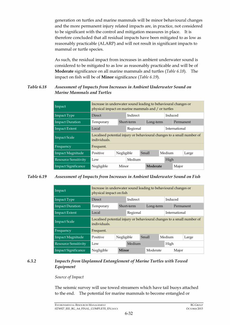
ENVIRONMENTAL RESOURCES MANAGEMENT BG GROUP 0274927_IEE_BG_A4_FINAL_COMPLETE_EN.DOCX OCTOBER 2015
6-32
generation on turtles and marine mammals will be minor behavioural changes and the more permanent injury related impacts are, in practice, not considered to be significant with the control and mitigation measures in place. It is therefore concluded that all residual impacts have been mitigated to as low as reasonably practicable (ALARP) and will not result in significant impacts to mammal or turtle species.
As such, the residual impact from increases in ambient underwater sound is considered to be mitigated to as low as reasonably practicable and will be of Moderate significance on all marine mammals and turtles (Table 6.18). The impact on fish will be of Minor significance (Table 6.19).
Table 6.18 Assessment of Impacts from Increases in Ambient Underwater Sound on Marine Mammals and Turtles
Impact Increase in underwater sound leading to behavioural changes or physical impact on marine mammals and / or turtles
Impact Type Direct Indirect Induced
Impact Duration Temporary Short-term Long-term Permanent
Impact Extent Local Regional International
Impact Scale Localised potential injury or behavioural changes to a small number of individuals.
Frequency Frequent.
Impact Magnitude Positive Negligible Small Medium Large
Resource Sensitivity Low Medium High
Impact Significance Negligible Minor Moderate Major
Table 6.19 Assessment of Impacts from Increases in Ambient Underwater Sound on Fish
Impact Increase in underwater sound leading to behavioural changes or physical impact on fish
Impact Type Direct Indirect Induced
Impact Duration Temporary Short-term Long-term Permanent
Impact Extent Local Regional International
Impact Scale Localised potential injury or behavioural changes to a small number of individuals.
Frequency Frequent.
Impact Magnitude Positive Negligible Small Medium Large
Resource Sensitivity Low Medium High
Impact Significance Negligible Minor Moderate Major
6.3.2 Impacts from Unplanned Entanglement of Marine Turtles with Towed Equipment
Source of Impact
The seismic survey will use towed streamers which have tail buoys attached to the end. The potential for marine mammals to become entangled or
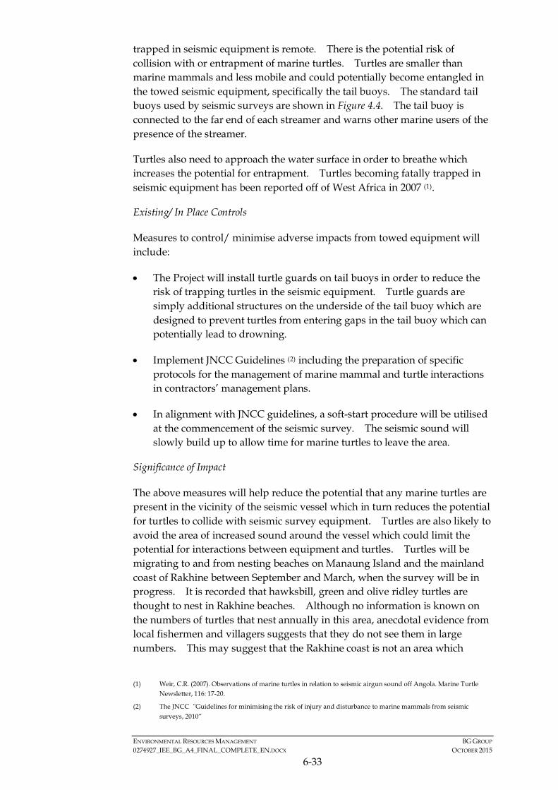
ENVIRONMENTAL RESOURCES MANAGEMENT BG GROUP 0274927_IEE_BG_A4_FINAL_COMPLETE_EN.DOCX OCTOBER 2015
6-33
trapped in seismic equipment is remote. There is the potential risk of collision with or entrapment of marine turtles. Turtles are smaller than marine mammals and less mobile and could potentially become entangled in the towed seismic equipment, specifically the tail buoys. The standard tail buoys used by seismic surveys are shown in Figure 4.4. The tail buoy is connected to the far end of each streamer and warns other marine users of the presence of the streamer.
Turtles also need to approach the water surface in order to breathe which increases the potential for entrapment. Turtles becoming fatally trapped in seismic equipment has been reported off of West Africa in 2007 (1).
Existing/ In Place Controls
Measures to control/ minimise adverse impacts from towed equipment will include:
• The Project will install turtle guards on tail buoys in order to reduce the risk of trapping turtles in the seismic equipment. Turtle guards are simply additional structures on the underside of the tail buoy which are designed to prevent turtles from entering gaps in the tail buoy which can potentially lead to drowning.
• Implement JNCC Guidelines (2) including the preparation of specific protocols for the management of marine mammal and turtle interactions in contractors’ management plans.
• In alignment with JNCC guidelines, a soft-start procedure will be utilised at the commencement of the seismic survey. The seismic sound will slowly build up to allow time for marine turtles to leave the area.
Significance of Impact
The above measures will help reduce the potential that any marine turtles are present in the vicinity of the seismic vessel which in turn reduces the potential for turtles to collide with seismic survey equipment. Turtles are also likely to avoid the area of increased sound around the vessel which could limit the potential for interactions between equipment and turtles. Turtles will be migrating to and from nesting beaches on Manaung Island and the mainland coast of Rakhine between September and March, when the survey will be in progress. It is recorded that hawksbill, green and olive ridley turtles are thought to nest in Rakhine beaches. Although no information is known on the numbers of turtles that nest annually in this area, anecdotal evidence from local fishermen and villagers suggests that they do not see them in large numbers. This may suggest that the Rakhine coast is not an area which
(1) Weir, C.R. (2007). Observations of marine turtles in relation to seismic airgun sound off Angola. Marine Turtle
Newsletter, 116: 17-20.
(2) The JNCC“Guidelines for minimising the risk of injury and disturbance to marine mammals from seismic surveys, 2010”
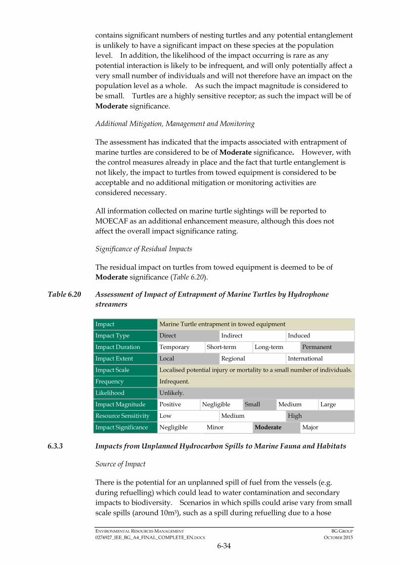
ENVIRONMENTAL RESOURCES MANAGEMENT BG GROUP 0274927_IEE_BG_A4_FINAL_COMPLETE_EN.DOCX OCTOBER 2015
6-34
contains significant numbers of nesting turtles and any potential entanglement is unlikely to have a significant impact on these species at the population level. In addition, the likelihood of the impact occurring is rare as any potential interaction is likely to be infrequent, and will only potentially affect a very small number of individuals and will not therefore have an impact on the population level as a whole. As such the impact magnitude is considered to be small. Turtles are a highly sensitive receptor; as such the impact will be of Moderate significance.
Additional Mitigation, Management and Monitoring
The assessment has indicated that the impacts associated with entrapment of marine turtles are considered to be of Moderate significance. However, with the control measures already in place and the fact that turtle entanglement is not likely, the impact to turtles from towed equipment is considered to be acceptable and no additional mitigation or monitoring activities are considered necessary.
All information collected on marine turtle sightings will be reported to MOECAF as an additional enhancement measure, although this does not affect the overall impact significance rating.
Significance of Residual Impacts
The residual impact on turtles from towed equipment is deemed to be of Moderate significance (Table 6.20).
Table 6.20 Assessment of Impact of Entrapment of Marine Turtles by Hydrophone streamers
Impact Marine Turtle entrapment in towed equipment
Impact Type Direct Indirect Induced
Impact Duration Temporary Short-term Long-term Permanent
Impact Extent Local Regional International
Impact Scale Localised potential injury or mortality to a small number of individuals.
Frequency Infrequent.
Likelihood Unlikely.
Impact Magnitude Positive Negligible Small Medium Large
Resource Sensitivity Low Medium High
Impact Significance Negligible Minor Moderate Major
6.3.3 Impacts from Unplanned Hydrocarbon Spills to Marine Fauna and Habitats
Source of Impact
There is the potential for an unplanned spill of fuel from the vessels (e.g. during refuelling) which could lead to water contamination and secondary impacts to biodiversity. Scenarios in which spills could arise vary from small scale spills (around 10m3), such as a spill during refuelling due to a hose
ENVIRONMENTAL RESOURCES MANAGEMENT BG GROUP 0274927_IEE_BG_A4_FINAL_COMPLETE_EN.DOCX OCTOBER 2015
6-35
break, to larger scale spills such as those from vessel collisions and rupture of the vessels fuel tank (2,000 m3 or around half of the fuel carried by the seismic vessel). Smaller spills are more common but have a smaller magnitude of impact than larger spills. Larger spills are extremely rare. The seismic and other vessels are likely to use fuel which is non-persistent or “light” fuel (such as Marine Gas Oil (MGO) and Marine Diesel Oil (MDO)). These fuel spills, in the unlikely event of occurrence, would evaporate quickly in the open waters environment (such as that found in Block A-4) and would be rapidly diluted and dispersed by ocean currents.
Potential impacts from unplanned spills to marine mammals, marine turtles, fishes and seabirds which may be found within the offshore spill area are discussed below.
Marine Mammals
Marine mammals are highly mobile and a number of field and experimental observations indicate whales and dolphins may be able to detect and avoid surface slicks. However, in this instance, the only likely spill would be from the vessel diesel fuel which is unlikely to cause a surface slick as it is not oil. Marine mammals that have direct physical contact with surface slicks may suffer surface fouling or ingestion of hydrocarbons and inhalation of toxic vapours. This may result in the irritation of sensitive membranes such as the eyes, mouth, digestive and respiratory tracts and organs, impairment of the immune system or neurological damage (1) (2). If prey (fish and plankton) is also contaminated, this can result in the absorption of toxic components of the hydrocarbons, though ‘gulp-feeders’ such as dolphins targeting prey at depth in the water column are likely to be less susceptible.
Seabirds
Offshore Myanmar waters are potential foraging grounds for seabirds, which are vulnerable when coming into contact with surface slicks during feeding or resting on the sea surface. Physical contact of seabirds with surface slicks may result in fouling of feathers and hypothermia (loss of thermoregulation), decreased buoyancy and potential to drown, inability to fly or feed, anaemia, pneumonia and irritation of eyes, skin, nasal cavities and mouths (3) (4)
resulting in mortality due to oiling of feathers or the ingestion of hydrocarbons.
Marine Turtles
(1) Etkins, D.S. (1997) The impacts of oil spills on marine mammals. OSIR Report – Special Report. OSIR.
(2) IPIECA (International Petroleum Industry Conservation Association) (1995). Biological Impacts of Oil Pollution: Rocky Shores, International Petroleum Industry Environmental Conservation Association, No. 7.
(3) AMSA (Australian Maritime Safety Authority) (2012) The effects of maritime oil spills on wildlife including non-avian marine life. http://www.amsa.gov.au/marine_environment_protection/national_plan/general_information/oiled_wildlife/oil_spill_effects_on_wil
(4) IPIECA (International Petroleum Industry Conservation Association) (1995) Op. cit.
ENVIRONMENTAL RESOURCES MANAGEMENT BG GROUP 0274927_IEE_BG_A4_FINAL_COMPLETE_EN.DOCX OCTOBER 2015
6-36
Adult marine turtles exhibit no avoidance behaviour when they encounter an oil slick (1). Contact with surface slicks can therefore result in hydrocarbon adherence to body surfaces (2) causing irritation of mucous membranes in the nose, throat and eyes leading to inflammation and infection (3). Oiling can also irritate and injure skin which is most evident on pliable areas such as the neck and flippers (4). Fish Populations
Fish mortalities are rarely observed to occur as a result of oil spills, especially in open water environments (5). This is often attributed to pelagic fish being able to detect and avoid surface waters underneath oil spills by swimming into deeper water or away from the affected areas.
Existing/ In Place Controls
Measures to control/ minimise adverse impacts from unplanned spills will include:
• Vessel standard operating procedures will be prepared and a refuelling plan will be prepared and implemented; and
• Contingency plans will be prepared and implemented, e.g. vessel Shipboard Oil Pollution Emergency Plans (SOPEPs).
Significance of Impact
The above measures will help reduce the likelihood that a spill would occur. Even if spill of fuel does occur, the extent of the impact is expected to be localised given that the spilled diesel fuel will be evaporated and diluted quickly in the offshore environment of Block A-4.
Small spills in the offshore and nearshore are unlikely to have any significant effects on the marine environment and will be readily diluted and dispersed. Large spills in the offshore environment are also unlikely to have any significant effects. Given the distance offshore of the Activity Area (over 50km from the mainland) and the small volume and high dispersible nature of the fuel, the sensitive habitats along the mainland Rakhine coast are unlikely to be affected by the spills. These spills would generally only affect water quality and animals in close proximity which may occur at the offshore open
(1) Odell, DK. and MacMurray, C. (1986) Behavioural Response to Oil. Final Report: Study on the Effect of Oil on
Marine Turtles. S. Vargo, Lutz, PL., Odell, DK., VanFleet, T. and Bossart, G., Mineral Management Services Contract.
(2) Gagnon, MM. and Rawson CA. (2010) Montara Well Release: Report on necropsies from a Timor Sea green sea turtle. Perth, Western Australia, Curtin University: 15.
(3) Etkins, D.S. (1997) Op. cit.
(4) Lutcavage, ME., Lutz, PL., Bossart, GD., and Hudson, DM. (1995) Physiologic and clinicopathological effects of crude oil on loggerhead sea turtles. Archives of Environmental Contamination and Toxicology 28: 417-422.
(5) ITOPF (International Tank Owners Pollution Federation) (2011) Effects of Oil Pollution on the Marine Environment. Technical Information Paper. Technical paper No. 13. The International Tank Owners Pollution Federation Limited.
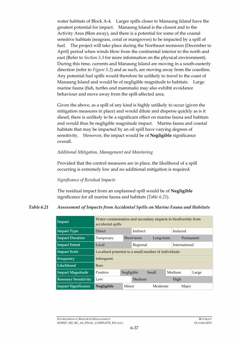
ENVIRONMENTAL RESOURCES MANAGEMENT BG GROUP 0274927_IEE_BG_A4_FINAL_COMPLETE_EN.DOCX OCTOBER 2015
6-37
water habitats of Block A-4. Larger spills closer to Manaung Island have the greatest potential for impact. Manaung Island is the closest and to the Activity Area (8km away), and there is a potential for some of the coastal sensitive habitats (seagrass, coral or mangroves) to be impacted by a spill of fuel. The project will take place during the Northeast monsoon (December to April) period when winds blow from the continental interior to the north and east (Refer to Section 5.3 for more information on the physical environment). During this time, currents and Manaung Island are moving in a south-easterly direction (refer to Figure 5.2) and as such, are moving away from the coastline. Any potential fuel spills would therefore be unlikely to travel to the coast of Manaung Island and would be of negligible magnitude to habitats. Large marine fauna (fish, turtles and mammals) may also exhibit avoidance behaviour and move away from the spill-affected area.
Given the above, as a spill of any kind is highly unlikely to occur (given the mitigation measures in place) and would dilute and disperse quickly as is it diesel; there is unlikely to be a significant effect on marine fauna and habitats and would thus be negligible magnitude impact. Marine fauna and coastal habitats that may be impacted by an oil spill have varying degrees of sensitivity. However, the impact would be of Negligible significance overall.
Additional Mitigation, Management and Monitoring
Provided that the control measures are in place, the likelihood of a spill occurring is extremely low and no additional mitigation is required.
Significance of Residual Impacts
The residual impact from an unplanned spill would be of Negligible significance for all marine fauna and habitats (Table 6.21).
Table 6.21 Assessment of Impacts from Accidental Spills on Marine Fauna and Habitats
Impact Water contamination and secondary impacts to biodiversity from accidental spills
Impact Type Direct Indirect Induced
Impact Duration Temporary Short-term Long-term Permanent
Impact Extent Local Regional International
Impact Scale Localised potential to a small number of individuals.
Frequency Infrequent.
Likelihood Rare
Impact Magnitude Positive Negligible Small Medium Large
Resource Sensitivity Low Medium High
Impact Significance Negligible Minor Moderate Major
ENVIRONMENTAL RESOURCES MANAGEMENT BG GROUP 0274927_IEE_BG_A4_FINAL_COMPLETE_EN.DOCX OCTOBER 2015
6-38
6.3.4 Impacts on Fishing Activity from Physical Presence of Seismic Vessel and Equipment
Source of Impact
The following section assesses the impacts to fishers from potential physical disturbance due to the presence of the seismic vessel and equipment based on the areas / locations in which they fish as defined in Section 5. The assessment excludes the shallow water (<50 m) area which has been determined to be out of scope. This section focuses on potential impacts on fishing activity in continental slope waters (50 m to 200 m) and deep water (>200 m) in Block A-4.
Temporary disturbance of fishing activities could occur due to the presence of the seismic vessel and equipment and implementation of the mobile safety zone. This could mean that some fishers have to spend time and resources travelling to areas outside of the safety zone in order to fish. Local artisanal fishermen from Manaung Island fish close to the eastern boundary of Block A-4. Generally the smaller vessel from Manaung fish in water depths of less than 50 m and are therefore outside of the Activity Area. However larger vessels from Ramree and Thandwe operate in the continental slope area and may interact with the Project. Fishers from Thandwe and other parts of Rakhine State that use the camps near Manaung (Ka Ei and Ye Kyun) also fish the in continental slope waters and could face temporary disturbance to fishing activity.
Temporary disturbance could have knock on effects on livelihoods which could be significant as fishers in the Rakhine State are very poor and during consultation many stated that they rely on their fishing activities for subsistence as well as income.
Miscommunication and a potential lack of accessible information may create a situation where fishers completely avoid the Activity Area and fishing grounds, for fear of interaction with the seismic vessel and equipment. Fishers may also perceive that they have to limit their activity and therefore behave differently with regard to aspects such as hiring of wage labour. Any significant reduction in catch could have a knock on effect on livelihoods in the fishing value chain as well, as there is less fish to process and trade.
There is also the potential for commercial fishing vessels from areas outside of the Rakhine State, such as large trawlers from Yangon, to be in the Activity Area during the survey period. These vessels, however, tend to have larger fishing grounds than those on the continental slope. In the case of Kyauk Ni Maw, the fishing ground extended from Sittwe in the north to Gwa in the south. Therefore displacement from one area is not as significant an impact as that on shallower water fishermen.
ENVIRONMENTAL RESOURCES MANAGEMENT BG GROUP 0274927_IEE_BG_A4_FINAL_COMPLETE_EN.DOCX OCTOBER 2015
6-39
Existing Controls
In order to ensure impacts from the seismic survey on the fisheries and the fishing community are avoided or reduced as far as possible, the following control measures are planned:
• A mobile navigational safety zone around the seismic survey array will be implemented to limit the duration and extent of disruption to the fishing activity in any area.
• An appropriate number of chase vessels will move with the survey vessel in order to liaise with fishermen in the vicinity of the seismic vessel in the day time and at night. The number of chase vessels will vary to help ensure the Project can adequately manage potential interactions with fishers (including divers), take appropriate action to protect the safety of fishers (including divers), and disclose information about the seismic survey as necessary.
• Survey vessels will comply with international standards of navigational safety.
• Chase vessels will have Myanmar speaking Fishing Liaison Officers (FLOs) on-board to facilitate potential interaction with fishermen at sea.
• The survey will follow a fishing and diving safety protocol, which will set out the actions to be taken in the event that fishing or diving activities are encountered within the mobile safety zone.
• Prior to commencement of survey activities in the eastern most part of the Activity Area, a scouting survey would be carried out to assess fishing and diving activities in that area.
• A Stakeholder Engagement Plan will be developed that will support timely sharing of information on the details of the seismic survey in order to inform stakeholders, especially fishers.
A grievance mechanism will be developed and implemented to provide an avenue for stakeholders, including those in fishing communities, to raise concerns with the Project and provide a process for timely resolution of grievances. Although this measure does not affect the impact significance, it has been included as an important component of BG Group’s responsibilities to ensure impacts are avoided or reduced as far as possible.
Communication and information sharing will be designed to minimise misunderstanding regarding the extent of the mobile safety zone and the duration of the activities. Clear information will be provided to fishing communities to ensure that fishers are aware that the project will not exclude people from their fishing grounds, but only potentially cause a temporary disturbance to fishing activities.
ENVIRONMENTAL RESOURCES MANAGEMENT BG GROUP 0274927_IEE_BG_A4_FINAL_COMPLETE_EN.DOCX OCTOBER 2015
6-40
At no stage will there be a message that people cannot fish in specific locations or for a specified duration. The message will be that when asked for right of access, fishermen will have to move temporarily to allow the vessel to sail through.
The Project will use diverse channels to communicate with fishing communities before, during and after the seismic activity.
Significance of Impacts
From consultations with fishermen, it is known that there are no fixed fishing areas and fishermen could cover large areas and freely move in the sea, limited only by their vessel size, time of year and fishing techniques. Fishing vessels from Ramree which go into deep water (>200 m) are not likely to be impacted by Project activity as they fish in a very large area which covers thousands of square kilometres from Sittwe in the north to Gwa in the south. In addition, only a limited number of fishing vessels from Rakhine State are thought to fish in the deep-water area.
For fishermen along the continental slope, the best fishing season overlaps with the survey period as this is when conditions at sea are best. However, the seismic vessel will only be within the continental slope area for a limited number of days (approximately 1-2 weeks) so any impacts will be temporary. In addition, no fishermen reported to fish exclusively in the continental slope area and will potentially be able to fish in other areas within their fishing grounds, such as the shallow water areas which will not be impacted by Project activities.
The communication of timely information will help to raise awareness of seismic activity and potential disturbance to fishing activity to help fishers to avoid the vessel, seismic equipment and the mobile safety zone. In addition, the project will have chase vessels which will communicate with fishing vessels they encounter whilst at sea. The chase vessels will also be able to ensure that fishing vessels, divers and equipment are not in the path of the seismic vessel therefore reducing the potential for damage to fishing vessels or gear. Once the seismic vessel leaves an area, fishing vessels will be able to go back into that area minimising the overall time that fishing is restricted in any particular area.
Whilst fishers may experience some inconvenience, the diversity of fishing areas suggests that they should be able to adapt to this temporary disturbance and therefore sensitivity is rated as medium. With the existing control measures in place, it is expected that the impacts on fishing activities are likely to be Minor and impacts on livelihoods should be Negligible.
Additional Mitigation, Management and Monitoring
No additional mitigation is required. The number of factors will be tracked to monitor the effectiveness of mitigation measures:
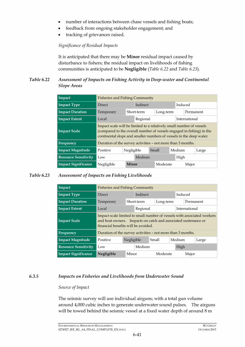
ENVIRONMENTAL RESOURCES MANAGEMENT BG GROUP 0274927_IEE_BG_A4_FINAL_COMPLETE_EN.DOCX OCTOBER 2015
6-41
• number of interactions between chase vessels and fishing boats; • feedback from ongoing stakeholder engagement; and • tracking of grievances raised.
Significance of Residual Impacts
It is anticipated that there may be Minor residual impact caused by disturbance to fishers; the residual impact on livelihoods of fishing communities is anticipated to be Negligible (Table 6.22 and Table 6.23).
Table 6.22 Assessment of Impacts on Fishing Activity in Deep-water and Continental Slope Areas
Impact Fisheries and Fishing Community
Impact Type Direct Indirect Induced
Impact Duration Temporary Short-term Long-term Permanent
Impact Extent Local Regional International
Impact Scale Impact scale will be limited to a relatively small number of vessels (compared to the overall number of vessels engaged in fishing) in the continental slope and smaller numbers of vessels in the deep water.
Frequency Duration of the survey activities – not more than 3 months.
Impact Magnitude Positive Negligible Small Medium Large
Resource Sensitivity Low Medium High
Impact Significance Negligible Minor Moderate Major
Table 6.23 Assessment of Impacts on Fishing Livelihoods
Impact Fisheries and Fishing Community
Impact Type Direct Indirect Induced
Impact Duration Temporary Short-term Long-term Permanent
Impact Extent Local Regional International
Impact Scale Impact scale limited to small number of vessels with associated workers and boat owners. Impacts on catch and associated sustenance or financial benefits will be avoided.
Frequency Duration of the survey activities – not more than 3 months.
Impact Magnitude Positive Negligible Small Medium Large
Resource Sensitivity Low Medium High
Impact Significance Negligible Minor Moderate Major
6.3.5 Impacts on Fisheries and Livelihoods from Underwater Sound
Source of Impact
The seismic survey will use individual airguns; with a total gun volume around 4,000 cubic inches to generate underwater sound pulses. The airguns will be towed behind the seismic vessel at a fixed water depth of around 8 m

ENVIRONMENTAL RESOURCES MANAGEMENT BG GROUP 0274927_IEE_BG_A4_FINAL_COMPLETE_EN.DOCX OCTOBER 2015
6-42
and will be firing at intervals of 10 seconds with a shot point interval of 25 m. The ecological impacts from underwater sound are addressed in Section 6.3.1; this section considers the indirect impacts to fisheries and livelihoods.
Underwater sound generation can have an indirect impact on fisheries as fish could be temporarily displaced from potential fishing grounds as the survey passes through a particular area. The impact assessment for fish species suggests that fish are only at risk of physical injury within very close proximity (a few hundred meters) to the seismic vessel. Given the control measures in place (i.e. soft start procedures), fish are unlikely to be in close proximity to the seismic vessel and will avoid the area in which impacts can occur. Therefore no significant physical impacts on fish are expected to occur.
The impact assessment of underwater sound on fish estimates that there may be behavioural changes in fish species over an area of approximately 1 to 5km from the seismic source; albeit this is a very conservative estimate of impact. The majority of coral habitat is located over 5 km from the Activity Area and there coral reef fish are unlikely to be effected. There are a number of studies (referenced in Section 6.3.1) which have shown that pelagic fish species will move away from the area around the sound source following exposure to the sound, but typically behavioural changes tend to be short-lived (within a few minutes to hours) and fish exhibit normal behaviour after an initial startle or avoidance response. The impact assessment on fish concluded that the residual impact to all fish species (including eggs and larvae) was of Minor significance.
Existing Controls
The direct impact of underwater sound is on the fish species themselves with an indirect impact on fisheries and livelihoods. As such, the existing controls mentioned in Section 6.3.1 for the impact of underwater sound on marine fish species are also relevant here.
Significance of Impact
As mentioned in Section 6.3.1, the direct impact on fish species is generally limited to temporary disturbance and a change in behaviour and will be localised to a relatively small area around the vessel, hence will not impact fish species at a population level. With the existing control measures in place (as mentioned in Section 6.3.1), fish species will have sufficient time to avoid any area of potential injury and behavioural changes (i.e. changes in swimming speed and/or direction), will be temporary and limited to a small area. As such, coral reef species and shallow water species are not likely to be effected, in particular given that the majority of reef areas are approximately 5km from the Activity Area. Pelagic fish species are highly mobile and will be able to avoid the area of disturbance. As there is a Minor overall impact on fish species (refer to Section 6.3.1) it is anticipated that there

ENVIRONMENTAL RESOURCES MANAGEMENT BG GROUP 0274927_IEE_BG_A4_FINAL_COMPLETE_EN.DOCX OCTOBER 2015
6-43
will be only a Minor impact on the fishery; with a Negligible impact on fish catch and livelihoods.
Additional Mitigation, Management and Monitoring
No additional mitigation is required as the impact is of Minor significance to the fishery and Negligible impact to livelihoods.
Significance of Residual Impact
It is anticipated that there may be Minor residual impact on fisheries caused by the indirect impact of underwater sound and a Negligible residual impact to the livelihoods of fishing communities (Table 6.24 and Table 6.25).
Table 6.24 Assessment of Underwater Sound Impacts on Fisheries
Impact Fisheries and Fishing Community
Impact Type Direct Indirect Induced
Impact Duration Temporary Short-term Long-term Permanent
Impact Extent Local Regional International
Impact Scale The direct impact on fish species is temporary and localised to around the vessel and unlikely to impact fish at a population level.
Frequency Duration of the survey activities – not more than 3 months.
Impact Magnitude Positive Negligible Small Medium Large
Resource Sensitivity Low Medium High
Impact Significance Negligible Minor Moderate Major
Table 6.25 Assessment of Underwater Sound Impacts on Indirect Livelihoods Impacts
Impact Fisheries and Fishing Community
Impact Type Direct Indirect Induced
Impact Duration Temporary Short-term Long-term Permanent
Impact Extent Local Regional International
Impact Scale Impact on fish species will be minor and behavioural change will be short-lived, so significant impact on fish catch is not expected.
Frequency Duration of the survey activities – not more than 3 months.
Impact Magnitude Positive Negligible Small Medium Large
Resource Sensitivity Low Medium High
Impact Significance Negligible Minor Moderate Major
6.3.6 Impacts on Divers from Underwater Sound
Source of Impact
It is possible that at very high levels of underwater sound divers can experience potential injury to auditory systems whilst underwater or, at lower
ENVIRONMENTAL RESOURCES MANAGEMENT BG GROUP 0274927_IEE_BG_A4_FINAL_COMPLETE_EN.DOCX OCTOBER 2015
6-44
sound levels divers may experience disturbance that would cause them to stop diving. Exposure to elevated sound levels can cause a temporary hearing impairment (TTS) or permanent hearing impairment (PTS), when in close proximity to a sound source, in much the same way as marine mammals (cetaceans) can be impacted (1).
In the air, humans can perceive sound in the frequency range of 20 Hz to 20,000 Hz (1) and in water the most sensitive frequency range is between 400 Hz to 1000 Hz. This is above the sound frequency of seismic surveys which varies from around 10 to 300 Hz. Divers in the Area of Interest use rudimentary techniques and do not have diver helmets; using a hose and a mask to dive. In this case, divers’ ears, whilst underwater, are filled with water and they can be exposed to louder sounds than in air without damage.
Parvin 2005(2) studied historic investigations into divers and the effects of sound and compiled a set of thresholds for auditory fatigue and disturbance levels at different sound levels and frequencies. In this study auditory fatigue was defined as causing a 10 dB temporary hearing loss in bareheaded divers after a 15 minute continuous noise exposure. However, in practice, divers are unlikely to be exposed to 15 minutes of continuous sound at a level which would cause injury. Measures are in place (Section 6.3.1), such as soft-start procedures, that will alert divers to the presence of the survey and allow divers to leave the water. In addition, it is important to appreciate that temporary hearing loss is not a permanent change to hearing, and hearing quickly recovers to normal levels, therefore it is not a permanent injury. For divers using a mask and ears filled with water (like those in the Area of Interest), the temporary hearing loss levels at a frequency of 500 Hz were calculated to be at a Sound Pressure Level (SPL) of 174 dB re 1 μPa (rms). Divers and swimmers have been estimated to reach a “tolerance” level at SPLs exceeding 170 dB re.1 μPa. This is the sound level at which disturbance to the diver may be sufficient for them to stop diving and come to the surface.
Existing/In Place Controls
The existing controls for avoiding impacts to divers’ health from underwater sound will be the same as those for impacts on fishing activity from physical presence of seismic vessel and equipment in Section 6.3.5.
Significance of Impact
The modelling estimates that the threshold distance for “tolerance level” (i.e. 170 dB re.1 μPa) is approximately 4 to 5km. However, the modelling results are based on divers being exposed to 15 minutes of continuous sound and exposure to the maximum sound level from the start of operations. In
(1) Anthony, T G Wright N A and Evans M A. Review of diver noise exposure [Online] (2010); Available at
http://www.hse.gov.uk/research/rrpdf/rr735.pdf.
(2) Parvin S.J., 2005. Limits for underwater noise exposure for human divers and swimmers. Presented at the National Physics Laboratory Seminar on Underwater Acoustics, Teddington, UK, October 2005. Available at http://www.subacoustech.com/wp-content/uploads/NPLDiverNoisePresentation.pdf
ENVIRONMENTAL RESOURCES MANAGEMENT BG GROUP 0274927_IEE_BG_A4_FINAL_COMPLETE_EN.DOCX OCTOBER 2015
6-45
practice this will not be the case as any divers in the area will experience a gradual increase in sound due to either the soft start procedure or the gradual increase in sound as the vessel moves toward the divers. Divers will therefore, most likely exit the water well before they get to the “tolerance limit” of 170dB. As such, the main impact will be disturbance to the divers’ activities (i.e. an interruption to diving) for a temporary period (a few hours) while the seismic vessel passes through an area. There is only a very remote risk that any divers would be exposed to sound levels that would actually cause them a temporary physical effect such as temporary hearing loss.
Diving within the Area of Interest is usually undertaken between water depths of 25 to 30 m and in some instances dives of up to 65 m were reported. Diving locations within the Area of Interest are shown in Figure 5.25 and are closely associated with rocky / coral habitats. No diving is thought to take place on the continental shelf area (in water depths exceeding 50m). The deeper dives reported of 65m were in areas closer to shore to the south-east of Manaung. As shown in Figure 5.25, diving locations cover a wide area within the Area of Interest and most are within shallower waters to the east and south of Manaung Island. There is a dive area potentially within 4-5 km (the estimated tolerance limit for divers) of the sound source located near the northwest of Manaung Island (2.2 km from the Activity Area) however the majority of diving areas are located over 5 km from the Activity Area, therefore beyond the estimated zone of impact. As such, the numbers of divers who may experience some temporary disturbance to their activities during the survey is expected to be very low and any disturbance would be limited to a few hours while the survey passes through a particular area close to diving locations.
With the existing control measures in place, it is expected that the impacts on divers are likely to be of Minor significance.
Additional Mitigation, Management and Monitoring
As the impact to divers is estimated to be of Minor significance no additional mitigation is required.
Significance of Residual Impacts
Chase vessels will be employed as needed to disclose information about survey activities and help protect the safety of fishers and divers, furthermore, divers will also most likely become aware of underwater sound well in advance of it reaching potentially harmful levels and re-surface. Once the vessel has travelled a safe distance away divers will be able to resume their activity if it had to be halted, limiting temporary disruption. Impacts on the health of divers are likely to be Minor (Table 6.26).

ENVIRONMENTAL RESOURCES MANAGEMENT BG GROUP 0274927_IEE_BG_A4_FINAL_COMPLETE_EN.DOCX OCTOBER 2015
6-46
Table 6.26 Assessment of Impacts on Divers
Impact Divers
Impact Type Direct Indirect Induced
Impact Duration Temporary Short-term Long-term Permanent
Impact Extent Local Regional International
Impact Scale
The number of divers that have the potential to be exposed to sound levels that could have an impact is low. It is not anticipated that divers will remain in the water to be exposed to the tolerance level of 170dB or beyond and therefore any risk to health will be negligible. In most cases, divers will be more than 5 km away from the Activity Area. There may be temporary disturbance (i.e. interruption) to diving activities as the vessel passes through an area, but this would be unlikely to impact overall catch levels or diving effort.
Frequency Duration of the survey activities – not more than 3 months.
Impact Magnitude Positive Negligible Small Medium Large
Resource Sensitivity Low Medium High
Impact Significance Incidental Minor Moderate Major
6.3.7 Impacts from Unplanned Collisions on Fishing Vessel and Other Marine Users
Source of Impact
Any potential physical interactions between fishing vessels and exploration survey activities may result in damage to fishing gear (e.g. nets/lines damaged or entangled), damage to fishing vessels, or sinking of vessels with the potential for loss of life. Additional concerns associated with interactions with other vessels include potential for concomitant pollution effects (fuel oil spillage). The potential impacts from an accidental release of fuel are provided in Section 6.3.3. Any damages would adversely impact the fishermen who would have to pay for replacement gear and would not be able to fish until the damages were fixed. This could lead to secondary effects on fishing communities through a reduction in fishing revenue. Many of the local fishing communities in Rakhine rely on fishing for subsistence as well as income. The issues associated with other marine users are the same as those mentioned above for fishing except for damage to fishing gear.
Existing/In Place Controls
The existing controls for fisheries and livelihoods from unplanned collisions will be the same as those mentioned for impacts on fishing activity from physical presence of seismic vessel and equipment in Section 6.3.4.
Significance of Impacts
The seismic survey vessel will be accompanied at all times by an appropriate number of chase vessels that would act as fishing liaison as well as look out for the presence of other marine users. In addition, the actual area in which local fishing activities and the Activity Area overlap is between water depths

ENVIRONMENTAL RESOURCES MANAGEMENT BG GROUP 0274927_IEE_BG_A4_FINAL_COMPLETE_EN.DOCX OCTOBER 2015
6-47
of 50 to 200 m and only covers a relatively small area of the Block. As such, the potential for encountering fishing vessels is fairly low.
Given the measures in place, the risk of collision between or project and fishing vessels and other marine users or entanglement with fishing equipment is considered unlikely. However, because of the high level of sensitivity (or vulnerability) of the fishing communities, and the risk of potential loss of life, the event of a collision or entanglement the impact is considered to be of Moderate significance.
Additional Mitigation, Management and Monitoring
Mitigation measures to help ensure a collision is unlikely will be the same as those for impacts on fishing activity from physical presence of seismic vessel and equipment in Section 6.3.4.
Significance of Residual Impacts
Based on the assumption that the Project will be able to respond to claims for compensation associated with unplanned events in a timely manner the impacts on fishing vessels and other marine users are likely to be Moderate as the receptor sensitivity is high (Table 6.27).
Table 6.27 Assessment of Unplanned Collisions Impacts on Fishing Vessels and Other Marine Users
Impact Fishing Vessel and Other Marine Users
Impact Type Direct Indirect Induced
Impact Duration Temporary Short-term Long-term Permanent
Impact Extent Local Regional International
Impact Scale Affect the vessels and gear using the block area.
Frequency Duration of the survey activities.
Likelihood Unlikely.
Impact Magnitude Positive Negligible Small Medium Large
Resource Sensitivity Low Medium High
Impact Significance Negligible Minor Moderate Major
6.3.8 Cumulative Impact Assessment
Cumulative impacts encompasses impacts that result from the incremental impact, on areas or resources used or directly impacted by the project, from other existing, planned or reasonably defined developments at the time the risks and impacts identification process is conducted. The IFC (2012) defines cumulative impacts as those generally recognised as important on the basis of scientific concerns and or concerns from affected communities(1).
(1) IFC Performance Standards on Environmental and Social Sustainability, January 2012, International Finance
Corporation, World Bank Group
ENVIRONMENTAL RESOURCES MANAGEMENT BG GROUP 0274927_IEE_BG_A4_FINAL_COMPLETE_EN.DOCX OCTOBER 2015
6-48
Cumulative impacts summarised in this section refer to the additional impacts that may be generated by other developments or activities in the vicinity of the Activity Area, that when added to the impacts of the proposed seismic survey combine to cause a greater impact. Such impacts may arise due to spatial overlap (e.g. overlap in spatial extent of water quality changes) or temporal overlap (e.g. sound impacts caused by seismic activities at the same time from different sources).
Block A-4 is surrounded by other offshore blocks AD-2, AD-3 and A-5 (shown in Figure 5.31). It is understood that oil and gas production activities are being carried out in these blocks which may lead to cumulative impacts with the seismic survey activities in Block A-4. Block AD-2 is operated by BG Group and activities in this Block will not run concurrently with activities in Block A-4. Block AD-3 activities have already been completed and as such will not overlap with activities in Block A-4. The block holders of Block A-5, which is in the same water depth as Block A-4, will be undertaking their seismic activities at the same time (i.e. outside of the rainy season) as Block A-4. Therefore, there is a potential for the seismic surveys in these two Blocks to occur at the same time.
Activities in Block A-5 are likely to be similar to the activities proposed in Block A-4. The main environmental impacts would therefore arise from the generation of underwater sound that could lead to disturbance of marine fauna and the physical presence of seismic equipment which could pose an entanglement risk. The main social impacts arise from the temporary disturbance of fishing activity, specifically fishermen that fish near the continental shelf area where the Activity Area overlaps with potential fishing grounds. As the mitigation measures listed in the above sections are standard international best practise for seismic surveys it is likely that the block holders of Block A-5 will adopt the same practises, therefore reducing the potential for a cumulative impact. In addition, typically, to avoid any risk of operational interference, offshore seismic surveys maintain minimum separation distances of at least 20 to 30 km and often far greater.
In terms of environmental impacts, the impact that has the greatest spatial extent is the generation of underwater sound. As stated above, some temporary behavioural impacts are possible low frequency mammals out to a maximum of 50 km from the survey. However, these behavioural changes would be very limited in scale (i.e. a minor change in swimming patterns) and not affect the species in any significant way. Behavioural changes for fish and turtles are anticipated to be low when animals are over a kilometre away from the sound source. However, these distances are just for behavioural changes and not injury.
Threshold distances are smaller when discussing injury. For low and mid-frequency cetaceans (i.e. the majority of cetacean species in the Area of Interest), the potential for injury is out to a maximum of 700 m from the sound source. However, in reality this is highly unlikely to occur as no animals are expected to be within 500 m of the sound source due to the adoption of the
ENVIRONMENTAL RESOURCES MANAGEMENT BG GROUP 0274927_IEE_BG_A4_FINAL_COMPLETE_EN.DOCX OCTOBER 2015
6-49
industry standard mitigation measures (soft-start, use of marine mammal observers). Therefore low and mid frequency cetaceans are highly unlikely to be close enough to the sound source to suffer any auditory injury. The threshold distances for potential injury in high-frequency cetaceans are greater; out to 2 to 7 km. However, as mentioned in Section 6.3.1 the modelling results are pre-cautionary and have not taken into account the movement of the vessel, the soft-start procedure and the fact that mammals are not likely to be exposed to the maximum modelled level of the sound.
For fish and turtles, the ranges are smaller with potential injury experienced between 400 and 500 m from the sound source. This however does not take into account the 20 to 30 minute soft start procedure which will allow fish and turtles to swim away from the sound source. As such, there is little risk of turtles or fish being exposed to sound levels high enough with the potential to cause auditory injury. Threshold distances for temporary hearing loss (non-injury) for fish species were calculated to be between 1.5 and 5 km. This is not considered an injury and any impact will be temporary. As above, the model distance does not account for the mitigation measures in place and the natural avoidance behaviour of the fish which will reduce the potential for impact.
The operation of the two seismic surveys at the same time could also create a barrier across turtle migratory pathways to their nesting beaches. However, there is unlikely to be a large number of turtle species using these nesting beaches in Rakhine State and turtles will be able to avoid the mobile sound source and continue to migrate to the nesting beaches. In addition, it is not known whether both seismic surveys will be conducted in the same direction (i.e. north to south or east to west), if they are not conducted in the same direction, this limits the potential for a barrier to be created. As assessed in Section 6.3.1, it is expected that potential behavioural changes for turtles are “low” when a kilometre or more from the seismic vessel. With the standard mitigation measures in place, any impacts are unlikely to cause any lasting impacts on the overall behaviour of the species present (i.e., feeding or nesting behaviour) and the resultant impact will be of Negligible significance.
Range restricted fish species (i.e., those that inhabit coral reefs) could be impacted by the sound from both seismic vessels operating at the same time. As the seismic vessels will only be in the vicinity of these reef areas for a number of days, the impacts will be temporary. The time in which the two seismic vessels will be within close enough proximity to each other for overlapping behavioural effects is expected to be a maximum of a few days only (temporary). In addition, BG Group will discuss and plan their seismic activity with the block holders of Block A-5 to ensure minimal overlap of impacts to the extent possible.
Therefore, the impact from sound on all receptors will be the same magnitude as those experienced during the Block A-4 survey but will only have a limited area of overlap and will be therefore of Moderate significance to marine mammals and turtles and of Minor significance for fish.

ENVIRONMENTAL RESOURCES MANAGEMENT BG GROUP 0274927_IEE_BG_A4_FINAL_COMPLETE_EN.DOCX OCTOBER 2015
6-50
In addition, the potential for cumulative spills of fuel from the vessels is extremely unlikely to occur, and as both vessels use light fuels which are readily diluted and dispersed and implement standard mitigation measures, impacts would be expected to be Minor.
In terms of social impacts, although both Blocks are large in size and cover thousands of square kilometres, the exclusion zone for each survey will be limited to a mobile safety zone around each of the vessels. As such, the area from which fishermen will be temporarily displaced is relatively small. In addition, fishermen tend to fish in greatest numbers in shallow waters and around the continental slope area in water depths of up to around 200 m. Therefore, the seismic vessels in both Blocks are only likely to overlap with fishing areas for a short period of time (a number of days only). It is expected that the social impacts from the seismic surveys, if properly mitigated, will be localised to the area where fishing occurs and temporary in nature (a few days). Therefore, the impact will be of Minor significance to fishing activities but this is expected to be a Negligible impact on livelihoods.
ENVIRONMENTAL RESOURCES MANAGEMENT BG GROUP 0274927_IEE_BG_A4_FINAL_COMPLETE_EN.DOCX NOVEMBER 2015
7-1
7 ENVIRONMENTAL AND SOCIAL MANAGEMENT PLAN
This document provides the Environmental and Social Management Plan (ESMP) for the planning and operation of the Project. The Project is the BG Group operated 3D seismic survey in Block A-4 in the waters offshore of the Rakhine State in Myanmar, outlined in Section 2. This ESMP provides the procedures and processes which will be applied to the Project activities to check and monitor compliance and effectiveness of the mitigation measures to which BG Group has committed. In addition, this ESMP is used to ensure compliance with statutory requirements and corporate sustainability policies.
7.1 EXECUTIVE SUMMARY
An executive summary of the Project has been provided in Section 1 of this IEE Report which includes a summary of the key impacts identified for the Project and the measures that will be put in place to manage and monitor such impacts.
7.2 INTRODUCTION
BG Group intends to undertake an exploration campaign in Block A-4, using the following standard survey techniques; 2D and 3D seismic surveys, gravity and magnetics survey in conjunction with the seismic and, seabed sampling (coring) surveys. This campaign will inform potential future drilling for hydrocarbons.
The overall purpose of the IEE Study is to complete a robust environmental and social assessment to meet requirements of the EIA Procedures for the IEE to be approved by the MOECAF. More information on BG Group, the Project and the IEE objectives is provided in Section 2.
7.3 DESCRIPTION OF THE PROJECT
The exploration campaign is planned to commence end of November 2015, and last for a period of about two months (i.e. up to about 60 days). Block A-4 is located in the Rakhine Basin, offshore Myanmar and covers an area of about 7,500 km2. Within Block A-4, the specific Activity Area for the Project spans waters ranging from 50 to 1,500 m deep encompassing areas from around 10 km from coastline of Manaung Island to the continental slope. More detailed information on the Project and survey methodology is provided in Section 4.
7.4 POLICY, LEGAL AND INSTITUTIONAL FRAMEWORK
The Project is being conducted in line with BG Group’s Corporate Sustainability Policy, the requirements of the Production Sharing Contract (PSC), Myanmar regulatory requirements and international conventions,

ENVIRONMENTAL RESOURCES MANAGEMENT BG GROUP 0274927_IEE_BG_A4_FINAL_COMPLETE_EN.DOCX NOVEMBER 2015
7-2
standards and guidelines. The relevant policy and legislative framework is discussed in more detail in Section 3.
7.5 GOVERNING PARAMETERS
The specific emission limit values and environmental quality standards that are relevant to the Project are shown in Table 7.1.
Table 7.1 International Standards of Relevance to the Project
Environmental Parameter
Standard Details
Emissions MAPROL Annex VI
The survey vessels will comply with applicable MARPOL 73/78 Annex IV requirements, including: the discharge of sewage into the sea is prohibited, except when the ship has in operation an approved sewage treatment plant or when the ship is discharging comminuted and disinfected sewage using an approved system at a distance of more than three nautical miles from the nearest land. Sewage which is not comminuted or disinfected has to be discharged at a distance of more than 12 nautical miles from the nearest land.
Waste Discharges
MARPOL Annex I & V
The survey vessels will operate in compliance with MARPOL Annexes I: any oil-in-water content of discharges should not exceed 15 ppm. General waste (excluding food) will not be disposed of to sea in line with MARPOL Annex V Requirements. Combustible wastes will be segregated and disposed by incinerator on-board, should an incinerator be available on the selected vessel (in line with MARPOL Annex V requirements). Non-combustible and recyclable wastes will be stored in containers and returned to the selected vessel shore base for disposal (in line with MARPOL Annex V Requirements). Food waste will be macerated into smaller pieces (25 mm) prior to discharge overboard (if discharged <12 nm from shore) in line with MARPOL Annex V Requirements. Hazardous wastes will be stored on the vessels in appropriate containers with labels. Hazardous waste storage will be designated in accordance with their Materials Data Sheet (MSDS) (in line with MARPOL Annex V requirements). Hazardous wastes will be returned to the vessels’ selected shore base and sent to a licensed disposal facility by a licensed waste contractor (in line with MARPOL Annex V requirements).
Underwater sound generation
JNCC Guidelines (1)
The Project will implement the JNCC Guidelines including alignment of Contractor operating procedures with JNCC Guidelines. These guidelines include: • A soft-start procedure will be utilised at the
commencement of airgun firing. • Dedicated Marine Mammal Observers (MMOs) will be
on-board the vessel to undertake the pre-shoot search.
(1) The JNCC Guidelines for minimising the risk of injury and disturbance to marine mammals from seismic surveys,
2010”

ENVIRONMENTAL RESOURCES MANAGEMENT BG GROUP 0274927_IEE_BG_A4_FINAL_COMPLETE_EN.DOCX NOVEMBER 2015
7-3
Environmental Parameter
Standard Details
• Use of Passive Acoustic Monitoring (PAM) to detect whether any marine mammals are in the vicinity of the seismic vessel during night time or low visibility operations.
Spills MARPOL
Annex I Survey vessel standard operating procedures to be prepared and implemented including (if appropriate) an offshore bunkering procedure. Contingency plans will be prepared and implemented, e.g. vessel Shipboard Oil Pollution Emergency Plans (SOPEPs).
7.6 SUMMARY OF IMPACTS AND MITIGATION MEASURES
BG Group has made commitments to actions to ensure appropriate environmental and social performance. These commitments are not recommendations, but binding commitments as part of the Project. The commitments are organised by Project stage and reference to the IEE, as applicable.
A summary of the Project impacts is presented in Table 7.2 and the committed measures designed to manage and mitigate those impacts are presented in Table 7.3. Schedule and responsibility of implementation of these mitigation measures are identified as necessary.
Table 7.2 Summary of the Potential Impacts and Description of Proposed Mitigation Measures
Potential Impact/Issue Significance of Residual Impact
Impacts of air emissions from vessels on ambient air quality Not Significant
Impacts of waste discharges from vessels on marine water quality Not Significant
Impacts from underwater sound on marine fauna
Minor (fish)
Moderate (marine mammals and turtles) (Note: Small magnitude impact to high sensitivity resource)
Impacts from towed equipment by collision with or entrapment of marine turtles
Moderate (Note: Small magnitude impact to high sensitivity resource
Impacts from unplanned spills on marine fauna Negligible Impacts on fishing activity, fisheries and livelihoods from physical presence of seismic vessel, underwater sound.
Minor
Impacts from unplanned collisions on fishing vessel and other marine users Moderate
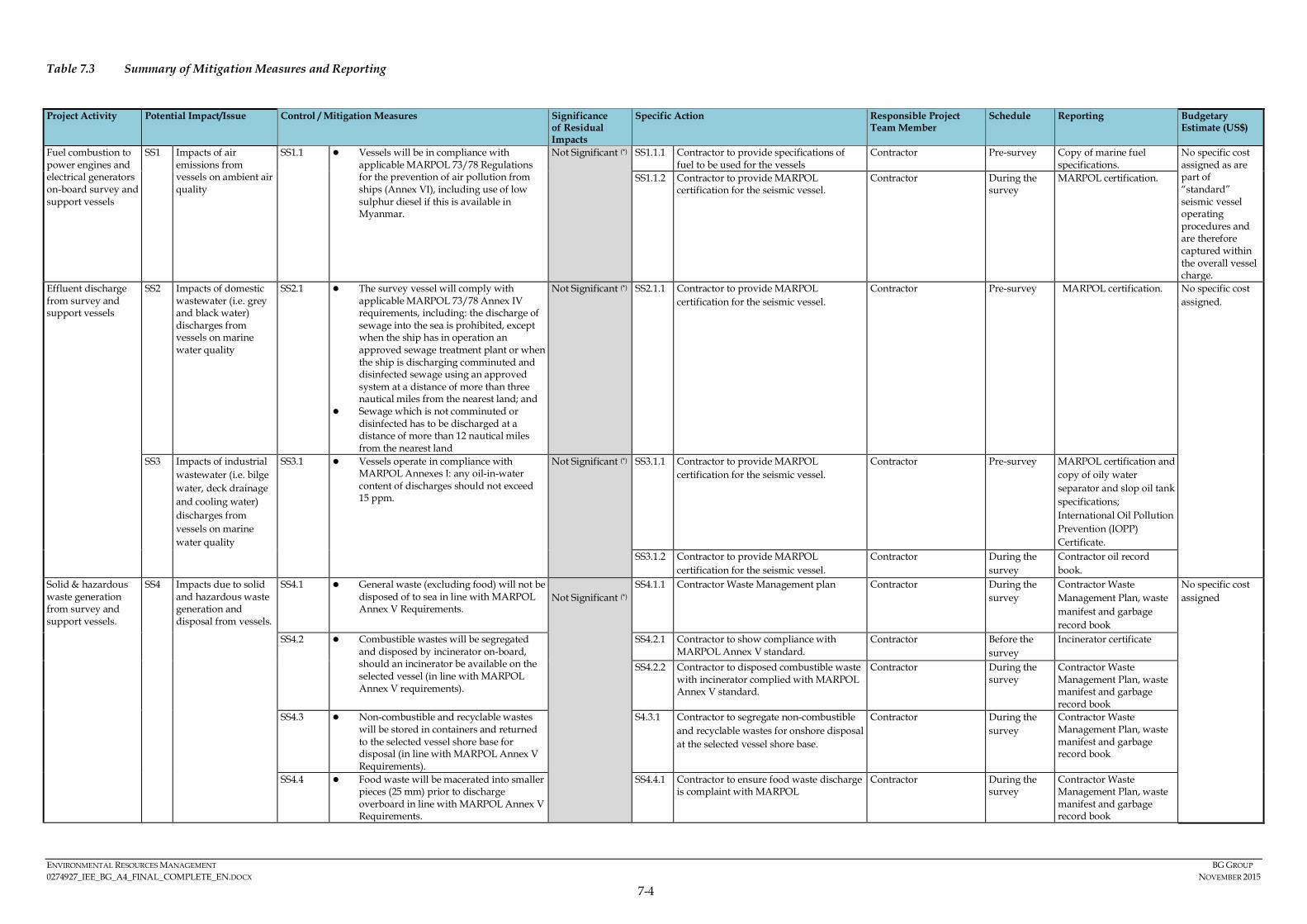
ENVIRONMENTAL RESOURCES MANAGEMENT BG GROUP 0274927_IEE_BG_A4_FINAL_COMPLETE_EN.DOCX NOVEMBER 2015
7-4
Table 7.3 Summary of Mitigation Measures and Reporting
Project Activity Potential Impact/Issue Control / Mitigation Measures Significance
of Residual Impacts
Specific Action Responsible Project Team Member
Schedule Reporting Budgetary Estimate (US$)
Fuel combustion to power engines and electrical generators on-board survey and support vessels
SS1 Impacts of air emissions from vessels on ambient air quality
SS1.1 Vessels will be in compliance with applicable MARPOL 73/78 Regulations for the prevention of air pollution from ships (Annex VI), including use of low sulphur diesel if this is available in Myanmar.
Not Significant (*) SS1.1.1 Contractor to provide specifications of fuel to be used for the vessels
Contractor Pre-survey Copy of marine fuel specifications.
No specific cost assigned as are part of “standard” seismic vessel operating procedures and are therefore captured within the overall vessel charge.
SS1.1.2 Contractor to provide MARPOL certification for the seismic vessel.
Contractor During the survey
MARPOL certification.
Effluent discharge from survey and support vessels
SS2 Impacts of domestic wastewater (i.e. grey and black water) discharges from vessels on marine water quality
SS2.1 The survey vessel will comply with applicable MARPOL 73/78 Annex IV requirements, including: the discharge of sewage into the sea is prohibited, except when the ship has in operation an approved sewage treatment plant or when the ship is discharging comminuted and disinfected sewage using an approved system at a distance of more than three nautical miles from the nearest land; and
Sewage which is not comminuted or disinfected has to be discharged at a distance of more than 12 nautical miles from the nearest land
Not Significant (*) SS2.1.1 Contractor to provide MARPOL certification for the seismic vessel.
Contractor Pre-survey MARPOL certification. No specific cost assigned.
SS3 Impacts of industrial wastewater (i.e. bilge water, deck drainage and cooling water) discharges from vessels on marine water quality
SS3.1 Vessels operate in compliance with MARPOL Annexes I: any oil-in-water content of discharges should not exceed 15 ppm.
Not Significant (*) SS3.1.1 Contractor to provide MARPOL certification for the seismic vessel.
Contractor Pre-survey MARPOL certification and copy of oily water separator and slop oil tank specifications; International Oil Pollution Prevention (IOPP) Certificate.
SS3.1.2 Contractor to provide MARPOL certification for the seismic vessel.
Contractor During the survey
Contractor oil record book.
Solid & hazardous waste generation from survey and support vessels.
SS4 Impacts due to solid and hazardous waste generation and disposal from vessels.
SS4.1 General waste (excluding food) will not be disposed of to sea in line with MARPOL Annex V Requirements.
Not Significant (*) SS4.1.1 Contractor Waste Management plan Contractor During the
survey Contractor Waste Management Plan, waste manifest and garbage record book
No specific cost assigned
SS4.2 Combustible wastes will be segregated and disposed by incinerator on-board, should an incinerator be available on the selected vessel (in line with MARPOL Annex V requirements).
SS4.2.1 Contractor to show compliance with MARPOL Annex V standard.
Contractor Before the survey
Incinerator certificate
SS4.2.2 Contractor to disposed combustible waste with incinerator complied with MARPOL Annex V standard.
Contractor During the survey
Contractor Waste Management Plan, waste manifest and garbage record book
SS4.3 Non-combustible and recyclable wastes will be stored in containers and returned to the selected vessel shore base for disposal (in line with MARPOL Annex V Requirements).
S4.3.1 Contractor to segregate non-combustible and recyclable wastes for onshore disposal at the selected vessel shore base.
Contractor During the survey
Contractor Waste Management Plan, waste manifest and garbage record book
SS4.4 Food waste will be macerated into smaller pieces (25 mm) prior to discharge overboard in line with MARPOL Annex V Requirements.
SS4.4.1 Contractor to ensure food waste discharge is complaint with MARPOL
Contractor During the survey
Contractor Waste Management Plan, waste manifest and garbage record book

ENVIRONMENTAL RESOURCES MANAGEMENT BG GROUP 0274927_IEE_BG_A4_FINAL_COMPLETE_EN.DOCX NOVEMBER 2015
7-5
Project Activity Potential Impact/Issue Control / Mitigation Measures Significance of Residual Impacts
Specific Action Responsible Project Team Member
Schedule Reporting Budgetary Estimate (US$)
SS4.5 All hazardous wastes will be stored on the vessels in appropriate containers with labels. Hazardous waste storage will be designated in accordance with their Materials Data Sheet (MSDS) (in line with MARPOL Annex V requirements).
SS4.5.1 Contractor to store hazardous waste in appropriate containers and at designed storage area in accordance with Contractor Waste Management plan.
Contractor During the survey
Contractor Waste Management Plan, waste manifest and garbage record book
SS4.6 Hazardous wastes will be returned to the vessels selected shore base and sent to a licensed disposal facility by a licensed waste contractor (in line with MARPOL Annex V requirements)..
S4.6.1 Contractor to maintain a waste management record and copies of any relevant waste disposal certification
Contractor Pre-survey Copy of waste contractor's certification and waste disposal records
Firing of airgun array during seismic survey.
SS5 Impacts from underwater sound generation on marine fauna.
SS5.1 Optimum airgun configurations to ensure that the lowest possible sound level of airguns is selected for the required activity.
Minor (for fishes) to Moderate (for marine mammals and turtles)
SS5.1.1 To review Contractor’s airgun configurations and positions.
BG Group Pre-survey BG Group inspection report
No specific cost assigned
SS5.2 Implement JNCC Guidelines (1) including alignment of Contractor operating procedures with JNCC Guidelines.
SS5.2.1 To review Contractor Operational Plans for compliance with JNCC Guidelines
BG Group Pre-survey Contractor Operational Plan
SS5.3 In alignment with JNCC guidelines, a soft-start procedure will be utilised at the commencement of airgun firing.
SS5.3.1 Undertake a 20 to 30 minute soft-start before testing of all airguns at full power
Contractor Marine Mammal Observers and seismic surveyor
During the survey
Marine Mammal Observation (MMO) Report
SS5.3.2 Power should be built up slowly from a low energy start-up (e.g. starting with the smallest airgun in the array and gradually adding in others) over 20 to 30 (2) minutes to give adequate time for marine turtles to leave the area. This build-up of power should occur in uniform stages to provide a constant increase in output.
Contractor Marine Mammal Observers and seismic surveyor
During the survey
Marine Mammal Observation (MMO) Report
SS5.3.3 Once the soft-start has been performed and the airguns are at full power the survey line should start immediately. Operators should avoid unnecessary firing at full power before commencement of the line.
Contractor Marine Mammal Observers and seismic surveyor
During the survey
Marine Mammal Observation (MMO) Report
SS5.3.4 If, for any reason, firing of the airguns has stopped and not restarted for at least 10 minutes, then a pre-shooting search and 20 to 30 minute soft-start should be carried out (the requirement for a pre-shooting search only applies if there was no MMO on duty and observing at this time, and if the break in firing occurred during the hours of daylight). After any unplanned break in firing for less than 10 minutes the Marine Mammal Observer should make a visual assessment for (not a pre-shooting search) within 500 metres of the centre of the airgun array.
Contractor Marine Mammal Observers and seismic surveyor
During the survey
Marine Mammal Observation (MMO) Report
(1) The JNCC“Guidelines for minimising the risk of injury and disturbance to marine mammals from seismic surveys, 2010”
(2) The soft-start has been extended from 20 minutes (as stated in the JNCC Guidelines) to 20-30 minutes in order to mitigate the potential impact on high-frequency cetaceans in the Area of Interest.
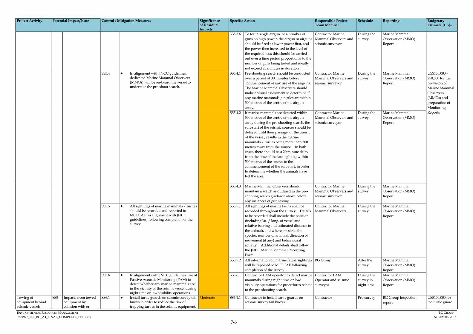
ENVIRONMENTAL RESOURCES MANAGEMENT BG GROUP 0274927_IEE_BG_A4_FINAL_COMPLETE_EN.DOCX NOVEMBER 2015
7-6
Project Activity Potential Impact/Issue Control / Mitigation Measures Significance of Residual Impacts
Specific Action Responsible Project Team Member
Schedule Reporting Budgetary Estimate (US$)
SS5.3.6 To test a single airgun, or a number of guns on high power, the airgun or airguns should be fired at lower power first, and the power then increased to the level of the required test; this should be carried out over a time period proportional to the number of guns being tested and ideally not exceed 20 minutes in duration.
Contractor Marine Mammal Observers and seismic surveyor
During the survey
Marine Mammal Observation (MMO) Report
SS5.4 In alignment with JNCC guidelines, dedicated Marine Mammal Observers (MMOs) will be on-board the vessel to undertake the pre-shoot search.
SS5.4.1 Pre-shooting search should be conducted over a period of 30 minutes before commencement of any use of the airguns. The Marine Mammal Observers should make a visual assessment to determine if any marine mammals / turtles are within 500 metres of the centre of the airgun array.
Contractor Marine Mammal Observers and seismic surveyor
During the survey
Marine Mammal Observation (MMO) Report
US$150,000 -250,000 for the provision of Marine Mammal Observers (MMOs) and preparation of Monitoring Reports SS5.4.2 If marine mammals are detected within
500 metres of the centre of the airgun array during the pre-shooting search, the soft-start of the seismic sources should be delayed until their passage, or the transit of the vessel, results in the marine mammals / turtles being more than 500 metres away from the source. In both cases, there should be a 20 minute delay from the time of the last sighting within 500 metres of the source to the commencement of the soft-start, in order to determine whether the animals have left the area.
Contractor Marine Mammal Observers and seismic surveyor
During the survey
Marine Mammal Observation (MMO) Report
SS5.4.3 Marine Mammal Observers should maintain a watch as outlined in the pre-shooting search guidance above before any instances of gun testing.
Contractor Marine Mammal Observers and seismic surveyor
During the survey
Marine Mammal Observation (MMO) Report
SS5.5 All sightings of marine mammals / turtles should be recorded and reported to MOECAF (in alignment with JNCC guidelines) following completion of the survey.
SS5.5.1 All sightings of marine fauna shall be recorded throughout the survey. Details to be recorded shall include the position (including lat. / long. of vessel and relative bearing and estimated distance to the animal), and where possible, the species, number of animals, direction of movement (if any) and behavioural activity. Additional details shall follow the JNCC Marine Mammal Recording Form.
Contractor Marine Mammal Observers
During the survey
Marine Mammal Observation (MMO) Report
SS5.5.2 All information on marine fauna sightings will be reported to MOECAF following completion of the survey.
BG Group After the survey
Marine Mammal Observation (MMO) Report
SS5.6 In alignment with JNCC guidelines, use of Passive Acoustic Monitoring (PAM) to detect whether any marine mammals are in the vicinity of the seismic vessel during night time or low visibility operations.
SS5.6.1 Contractor PAM operator to detect marine mammals during night time or low visibility operations for procedures related to the pre-shooting search.
Contractor PAM Operator and seismic surveyor
During the survey in night-time
Marine Mammal Observation (MMO) Report
Towing of equipment behind seismic vessels.
SS5 Impacts from towed equipment by collision with or
SS6.1 Install turtle guards on seismic survey tail buoys in order to reduce the risk of trapping turtles in the seismic equipment.
Moderate SS6.1.1 Contractor to install turtle guards on seismic survey tail buoys.
Contractor Pre-survey BG Group inspection report
US$100,000 for the turtle guard.

ENVIRONMENTAL RESOURCES MANAGEMENT BG GROUP 0274927_IEE_BG_A4_FINAL_COMPLETE_EN.DOCX NOVEMBER 2015
7-7
Project Activity Potential Impact/Issue Control / Mitigation Measures Significance of Residual Impacts
Specific Action Responsible Project Team Member
Schedule Reporting Budgetary Estimate (US$)
entrapment of marine turtles
SS6.2 Implement JNCC Guidelines (1) including alignment of Contractor operating procedures with JNCC Guidelines.
SS6.2.1 Refer to SS5.2.1
SS6.3 In alignment with JNCC guidelines, a soft-start procedure will be utilised at the commencement of airgun firing. The seismic sound will slowly build up to allow adequate time for marine turtles to leave the area.
SS6.3.1 Refer to SS5.3.1 SS6.3.2 Refer to SS5.3.2 SS6.3.3 Refer to SS5.3.3 SS6.3.4 Refer to SS5.3.4 SS6.3.5 Refer to SS5.3.5 SS6.3.6 Refer to SS5.3.6
SS6.4 All sightings of marine turtles should be recorded.
SS6.4.1 All sightings of marine turtles shall be recorded throughout the survey. Details to be recorded shall include the position (including lat. / long. of vessel and relative bearing and estimated distance to the animal), and where possible, the species, number of animals, direction of movement (if any) and behavioural activity. Additional details shall follow the JNCC Marine Mammal Recording Form.
Contractor Marine Mammal Observers
During the survey
Marine Mammal Observation (MMO) Report
SS6.4.2 All sightings of marine turtles should be recorded and reported to MOECAF following completion of the survey.
BG Group After the survey
Marine Mammal Observation (MMO) Report
Accidental Spills and Leaks
SS7 Impacts from unplanned spills on marine fauna
SS7.1 Survey vessel standard operating procedures to be prepared and implemented including (if appropriate) an offshore bunkering procedure.
Negligible SS7.1.1 To review Contractor vessel standard operating procedures in relation to spill prevention.
BG Group Pre-survey BG Group inspection report.
No specific cost assigned
SS7.2 Contingency plans will be prepared and implemented, e.g. vessel Shipboard Oil Pollution Emergency Plans (SOPEPs).
SS7.2.1 Contractor to provide SOPEP report to BG Group.
Contractor During the survey
SOPEP Report
SS7.2.2 Any spills to be reported and response measure implemented.
Contractor During the survey
SOPEP Report
Operation of seismic survey vessel.
SS8 Impacts on fishing activity from physical presence of seismic vessel and equipment Impacts on fisheries and livelihoods from underwater sound Impacts from unplanned collisions on fishing vessel and equipment, as well as other marine users leading to damage to vessels or nets
SS8.1 An appropriate number of chase vessels will escort the survey vessel in order to liaise with any fishermen encountered in the vicinity of the seismic survey vessel.
Moderate (unplanned collisions) Minor (fishing activity including diving) and Negligible (livelihoods)
SS8.1.1 Document any interaction with fishermen and/or equipment (BG Group will provide documentation guidelines).
Contractor During the survey
BG Group inspection report
US$50,000-100,000 for the pre-mobilisation stakeholder engagement and running the grievance mechanism. US$50,000-100,000 for provision of FLOs on board vessels.
SS8.1.2 Confirm with the Contractor the number of chase vessels and their deployment during the survey.
BG Group Pre-survey BG Group inspection report
SS8.2 All survey vessels will comply with international standards of navigational safety
SS8.2.1 BG Group inspection to verify international standards of navigational safety are applied.
BG Group Pre-survey Contractor survey operations plan
SS8.3 Chase vessels will have Myanmar speaking Fishing Liaison Officers (FLOs) on-board to inform fishermen at sea of the movements of the seismic vessel and the navigational safety zone.
SS8.3.1 Contractor to facilitate the provision of Myanmar speaking FLOs for the seismic survey.
Contractor Pre-survey and during survey.
BG Group inspection report
SS8.3.2 Provide induction to FLOs, covering baseline understanding, managing interaction with fishermen, and documenting any interaction with fishing boats or equipment.
BG Group & Contractor Pre-survey BG Group inspection report
(1) The JNCC“Guidelines for minimising the risk of injury and disturbance to marine mammals from seismic surveys, 2010”

ENVIRONMENTAL RESOURCES MANAGEMENT BG GROUP 0274927_IEE_BG_A4_FINAL_COMPLETE_EN.DOCX NOVEMBER 2015
7-8
Project Activity Potential Impact/Issue Control / Mitigation Measures Significance of Residual Impacts
Specific Action Responsible Project Team Member
Schedule Reporting Budgetary Estimate (US$)
Impacts on divers from underwater sound (1)
SS8.4 A mobile navigational safety zone around the seismic survey array will be implemented to limit the duration and extent of disruption to the fishing activity in any area.
SS8.4.1 Confirm the extent of mobile navigational safety zone around the seismic survey vessel and implement during the survey through the use of an appropriate number of chase vessels.
BG Group & Contractor Pre-survey and during the survey
Contractor survey operations plan
SS8.5 Stakeholder engagement plan to ensure timely sharing of information on the details of the seismic survey in order to inform stakeholders.
SS8.5.1 BG Group to develop stakeholder engagement plan and disclose information on seismic survey planning and execution to maritime authorities, fisheries authorities, relevant fishing communities and other relevant marine users.
BG Group Pre-survey and during survey.
BG Group’s stakeholder engagement plan.
SS8.6 Disclosure and implementation of the Grievance Redressal Mechanism (GRM) for the Project and timely investigation of any grievances.
SS8.6.1 BG Group to disclose GRM mechanism to maritime authorities, fisheries authorities, fishing communities and other marine users.
BG Group Pre-survey BG Group’s notice released to relevant stakeholders.
SS8.6.2 Contractor to cooperate in closing our potential grievances, as requested by BG Group.
Contractor During and post survey
Grievance log.
SS8.7 The survey will follow a fishing and diving navigational safety protocol, which will set out the avoidance actions to be taken in the event that fishing or diving activities are unexpectedly encountered within the mobile safety zone.
SS8.7.1 BG Group to agree a suitable fishing and diving navigational safety protocol with seismic Contractor,
BG Group Pre-survey and during the survey
Contractor survey operations plan
SS8.8 Prior to commencement of seismic survey activities in the easternmost extent of Block A-4 Activity Area a scouting survey would be carried out to assess density of fishing and diving activities and confirm that seismic can be safely acquired.
SS8.8.1 Contractor to undertaken scouting survey to assess density of fishing and diving activities in eastern most extent of Activity Area prior to commencement of survey in that area and confirm that seismic can be safely acquired.
Contractor Pre- survey Scouting survey report
(1) As all required mitigation measures for impacts on fisheries (including divers) are the same, they have been grouped together for the purpose of this table.
ENVIRONMENTAL RESOURCES MANAGEMENT BG GROPU 0274927_IEE_BG_A4_FINAL_COMPLETE_EN.DOCX NOVEMBER 2015
7-1
7.7 MONITORING PROGRAM
Monitoring and reporting commitments are shown in Table 7.3. Monitoring will be required in order to demonstrate compliance with legal limits and BG Group’s requirements (compliance monitoring), and will also provide verification of the overall design and effectiveness of the implemented control measures.
In developing the monitoring measures, the following considerations and strategies have been applied:
• Consistent with internationally and locally acceptable practices;
• Logistically practical; and
• Cost effective.
7.7.1 Environmental & SP Management Organisation
BG Group is committed to providing resources essential to the implementation and control of the ESMP. Resources include the appropriate human resources and specialised skills. The structure for the organisation responsible for environmental and social management and implementation of the ESMP is depicted in Table 7.4.
Table 7.4 Environmental &SP Management Organisation Roles and Responsibilities
Position Responsibility BG Group Country Manager Oversee and coordinate all activities
pertaining to the Project; ultimately responsible for environmental and social issues. Ensure delivery by the asset of its environmental, social and operational targets. Ensure effective communication with all stakeholders.
Environmental & Social Performance Managers
Provide strategic guideline and advise on the environmental and social performance management of the survey activities to ensure the requirements of the IEE are delivered and that BG Group Environment & SP standards are implemented.
Geophysical Operations Manager Technical aspects of the Project including contractor supervision during operations.
Geophysical HSSE Manager
Ensuring that the Project and subcontractors operate in accordance with applicable regulatory environmental and social requirements and plans. Monitor implementation of environmental and social protection measures, and assist with technical input into oil spill response requirements.
ENVIRONMENTAL RESOURCES MANAGEMENT BG GROPU 0274927_IEE_BG_A4_FINAL_COMPLETE_EN.DOCX NOVEMBER 2015
7-2
Position Responsibility BG Group Rep on Vessel BG Group will have a HSSE rep on the
seismic vessel who will have oversight of the contractors operations and be able to monitor, influence and work with the Contractor on Environmental and Social Performance issues.
Contractor Project Manager Responsible for subcontractor technical
performance and compliance. HSE Manager Ensure that environment and social
regulatory requirements are met and that ESMP requirements are properly implemented.
Supervision of subcontractor activities will be conducted by the seismic contractor and monitored by the BG Group field representative. This will be accomplished through management controls over strategic Project aspects and interaction with subcontractor staff where Project activities take place. The Project organisation will be staffed at a level to allow for continuous effective supervision of subcontractor activities and work products.
7.7.2 Contractor Management
BG Group recognises that it is important that employees at each relevant function and level are aware of the Project’s environmental and social policy; potential impacts of their activities; and roles & responsibilities in achieving conformance with the policy and procedures.
BG Group will work with and influence the contractor to ensure that all contractors are aware of and competent with respect to:
• Important baseline conditions to be aware of, focusing on the key sensitivities of the surrounding environment;
• Environmental and social impacts that could potentially arise from their activities;
• Necessity of conforming to the requirements of the IEE and ESMP (i.e. implementing the control and mitigation measures), in order to avoid or reduce those impacts;
• Roles and responsibilities to achieve that conformity, including with regard to change management and emergency response; and
• Documentation and reporting requirements and other ESMP compliance requirements.
Similarly the Project will require that each of the contractors institute training programmes for its personnel. Each contractor is responsible for site HSE
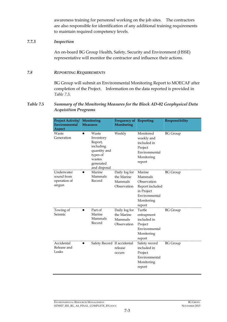
ENVIRONMENTAL RESOURCES MANAGEMENT BG GROPU 0274927_IEE_BG_A4_FINAL_COMPLETE_EN.DOCX NOVEMBER 2015
7-3
awareness training for personnel working on the job sites. The contractors are also responsible for identification of any additional training requirements to maintain required competency levels.
7.7.3 Inspection
An on-board BG Group Health, Safety, Security and Environment (HSSE) representative will monitor the contractor and influence their actions.
7.8 REPORTING REQUIREMENTS
BG Group will submit an Environmental Monitoring Report to MOECAF after completion of the Project. Information on the data reported is provided in Table 7.5.
Table 7.5 Summary of the Monitoring Measures for the Block AD-02 Geophysical Data Acquisition Programs
Project Activity/ Environmental Aspect
Monitoring Measures
Frequency of Monitoring
Reporting Responsibility
Waste Generation
Waste Inventory Report, including quantity and types of wastes generated and disposal
Weekly Monitored weekly and included in Project Environmental Monitoring report
BG Group
Underwater sound from operation of airgun
Marine Mammals Record
Daily log for the Marine Mammals Observation
Marine Mammals Observation Report included in Project Environmental Monitoring report
BG Group
Towing of Seismic
Part of Marine Mammals Record
Daily log for the Marine Mammals Observation
Turtle entrapment included in Project Environmental Monitoring report
BG Group
Accidental Release and Leaks
Safety Record If accidental release occurs
Safety record included in Project Environmental Monitoring report
BG Group

ENVIRONMENTAL RESOURCES MANAGEMENT BG GROPU 0274927_IEE_BG_A4_FINAL_COMPLETE_EN.DOCX NOVEMBER 2015
7-4
7.9 EMERGENCY PLAN
BG Group through the seismic contractor’s HSE Plan has developed plans and procedures to identify the potential for and response to environmental accidents and health and safety emergency situations and for preventing and mitigating potentially adverse environmental and social impacts that may be associated with them.
The plans include but are not limited to: notification procedures; an emergency response organization with personnel properly trained on their roles and responsibilities; having adequate and appropriate emergency response equipment readily available to respond to minor incidents; and having the capability to quickly request additional assistance. The project Emergency Response plans will include, at a minimum:
• Vessel emergency procedure (fire; vessel collision; vessel flooding; etc.).
• Medical emergencies including medevac procedures.
• Search and rescue – includes man-overboard procedures.
• Heavy weather/cyclone plan.
• Hazardous material, oil, and fuel spill response plans.
• Any other emergency response plan required by the Republic of the Union of Myanmar authorities.
In the event of an emergency of any type, the survey vessel Master will act as the Incident Commander (IC) and vessel personnel will assist in implementing the vessels emergency response procedures as directed by the IC. The vessel will maintain communications with the Vessel Operations Manager and Project Geophysicist, and/or other emergency personnel and services as appropriate. Additional emergency response support can be provided by BG Group if requested. The survey vessel and any support vessels will have appropriate emergency equipment on board including, but not limited to, medical equipment, fire-fighting equipment, and oil spill response equipment capable of responding to minor incidents.
Emergency preparedness and response will be reviewed continually by the seismic contractor and BG Group representative during the operations and after the occurrence of any accidents or emergency situations to ensure that lessons learnt inform continuous improvement. Emergency exercises will be undertaken on a regular basis to confirm adequacy of response strategies. Investigations of accidents or incidents will follow formal documented procedures.
The Project will adopt MARPOL requirements and a Shipboard Oil Pollution Emergency Plan (SOPEP) will be prepared and implemented.
ENVIRONMENTAL RESOURCES MANAGEMENT BG GROPU 0274927_IEE_BG_A4_FINAL_COMPLETE_EN.DOCX NOVEMBER 2015
7-5
7.10 CAPACITY DEVELOPMENT AND TRAINING
BG Group will ensure that its contractors are aware of their environmental and social impact mitigation roles and responsibilities, as outlined in the ESMP. To do so, BG will provide adequate environmental and social induction support to the selected contractor so that the contractor is aware of key sensitivities in the social and environmental operating environment, potential environmental and social impacts as identified in the impact assessment, as well as mitigation measures and commitments, as outlined in the ESMP.
Both BG Group and the Contractor will be responsible for ensuring that their personnel involved in the Project is aware of and properly equipped and capacitated to conform to their respective impact mitigation commitments.
In case BG Group identifies any significant gaps in terms of contractor’s capacity or competency to comply with the agreed mitigation measures, adequate resourcing and/or capacity building measures will be discussed. The implementation of such measures will remain the responsibility of the contractor or agreed otherwise with BG Group. It is the ultimate responsibility of the contractor to ensure that their entire staff involved in the Project has the necessary capacity to successfully implement their mitigation requirements.
Finally, BG Group intends to implement a social investment project, benefiting selected local communities in the Project’s area of interest. The specifics of such a project are still to be defined. As a first step BG Group will conduct a feasibility study, which will assess the options and inform the decision making and design of such a social investment project. The feasibility study will consider expectations and needs of local communities, expected to benefit from this project.
7.11 PUBLIC CONSULTATION AND INFORMATION DISCLOSURE
BG Group undertook public consultation in Rakhine State from March to May 2015. The objectives for stakeholder engagement were to inform relevant stakeholders about BG Group and its planned project activities, collect baseline information on the social and biological environment, and engage with potentially affected groups and individuals to understand the scope of fishing activities, potential project impacts and discuss appropriate mitigation measures. The public consultation was conducted in following townships: Sittwe, Kyaukphyu, Ramree, Manaung, and Thandwe. A summary of the consultation, including information on time, date, venue, engagement methodology, and information on the key issues raised is provided in Section 8.
The intended IEE disclosure process includes disclosure of the summarized findings of the IEE Study in local language in the townships visited. The IEE Report will also be disclosed on BG Group’s website and will be advertised in two papers; one national and one local Rakhine journal.

ENVIRONMENTAL RESOURCES MANAGEMENT BG GROPU 0274927_IEE_BG_A4_FINAL_COMPLETE_EN.DOCX NOVEMBER 2015
7-6
BG Group will develop a grievance mechanism tailored to the operating context and aligned with existing communication channels of relevant communities. BG Group intends to inform stakeholders of the grievance mechanism during the IEE disclosure process in Rakhine.
7.12 WORK PLAN AND IMPLEMENTATION SCHEDULE
BG Group plan to commence the 3D seismic survey for 2-3 months from November 2015. The work plan of the ESMP is provided in Table 7.3. The cost of the mitigation measures proposed will be confirmed by the seismic survey contractor prior to the commencement of the survey.
ENVIRONMENTAL RESOURCES MANAGEMENT BG GROPU 0274927_IEE_BG_A4_FINAL_COMPLETE_EN.DOCX NOVEMBER 2015
8-1
8 PUBLIC CONSULTATION AND DISCLOSURE
8.1 OVERVIEW
This section presents a summary of the consultation undertaken in the development of the IEE, including description of:
• regulatory and corporate requirements; • the objectives of consultation; • the approach and scope of engagement for the impact assessment; • the format and content of consultation meetings; • key issues raised during consultation; • further disclosure and consultation; • the approach for developing a grievance mechanism.
8.2 REGULATORY AND BG GROUP REQUIREMENTS
8.2.1 Regulatory Requirements
Myanmar does not currently have legislative requirements in place for environmental assessment, conservation and protection. MOECAF is drafting both EIA Procedures and associated guidelines which are under review at the time of writing. The public consultation process for an IEE according to these procedures have been summarised as follows:
• The Project Proponent shall disclose information about the proposed project to the public and civil society organisations, through various channels including websites, prominent posting of legible sign boards at the project site, which are visible to the public.
• The Project Proponent Shall undertake necessary consultation meetings with stakeholders such as local communities, potential PAPs, local authorities, community based organizations and civil society at appropriate locations.
Section 3 provides more information on the overall regulatory process governing the Project.
8.2.2 BG Group Standards
BG Group has committed to undertake consultations in a transparent, inclusive and culturally appropriate manner with identified affected stakeholders throughout the life its projects. The objectives of stakeholder engagement are to provide a platform for positive relationships between BG Group and its stakeholders. Stakeholder engagement for impact assessment shall:
ENVIRONMENTAL RESOURCES MANAGEMENT BG GROPU 0274927_IEE_BG_A4_FINAL_COMPLETE_EN.DOCX NOVEMBER 2015
8-2
• Contribute to the understanding of the socio-economic context in which the project operations are located to identify the potential impacts, risks and opportunities for stakeholders;
• be cognisant of established community decision-making conventions and protocols, and be supplemented by additional mechanisms to address the needs of inadequately-represented, marginalised or vulnerable groups;
• ensure that identified communities have timely access to full, meaningful and accurate information about the Project, including information relating to positive and negative impacts and mitigation measures as identified in the impact assessment;
• ensure that engagement activities are two-way so that community issues and priorities are taken into account in decision making;
• record all formal and informal consultation activities and outcomes, including documenting how community viewpoints have been taken into consideration.
These standards have been aligned with international good practices, such as International Finance Corporation Performance Standards (IFC PSs), for undertaking stakeholder consultations and social impact assessments. International standards (such as the IFC PSs) are discussed in further detail in Section 3.2.3 of this IEE Report.
The stakeholder engagement process developed for the IEE Study sought to align with government and BG Group requirements in guiding stakeholder consultation in the Project Area of Interest. The Area of Interest is defined as the area within Block A-4 as well as its immediate surrounds, extending as far as the adjacent nearshore waters and coasts of Ramree and Manaung Islands and the Rakhine State mainland. The specific townships consulted are identified in Section 8.4.1.
8.3 PURPOSE OF THE CONSULTATION
The specific objectives for stakeholder engagement were to:
• Inform relevant stakeholders about BG Group and its planned project activities;
• Identify stakeholders and communities potentially affected by project activities;
• Gather baseline information on the social and biological environment; and • Engage with potentially affected groups and individuals to understand the
scope of fishing activities, potential project impacts and discuss appropriate mitigation measures.
ENVIRONMENTAL RESOURCES MANAGEMENT BG GROPU 0274927_IEE_BG_A4_FINAL_COMPLETE_EN.DOCX NOVEMBER 2015
8-3
8.4 METHODOLOGY AND APPROACH
8.4.1 Identification of Relevant Stakeholders and Potential Issues
The process of identifying potentially affected stakeholders started with scoping, which was conducted for the Project Proposal Report submitted to MOGE on the 16th February 2015. The purpose of scoping was to identify relevant issues and the townships and villages potentially impacted. The scoping exercise involved both desk-based and preliminary consultation with a number of stakeholders including government authorities, non-governmental organisations (NGOs), community based organisations (CBOs), members of fishing communities and fishing organisations, those with knowledge of fishing practices in Myanmar and individual experts (e.g. marine specialists from local universities).
The scoping process concluded that those fishers active in and around Block A4 would likely be from Kyaukphyu, Ramree, Manaung, and Thandwe townships, as well as Sittwe and Yangon, which informed planning of the stakeholder engagement process for the assessment and fed into the Stakeholder Engagement Plan submitted to MOGE. Figure 8.1 illustrates the Area of Interest and the location of where consultation has been undertaken.
Stakeholder engagement is an ongoing process and as such new stakeholders may emerge as the Project progresses. This will be captured and inform ongoing stakeholder engagement activity that will be undertaken for the Project.
8.4.2 Overall Approach and Scope of Engagement for the Impact Assessment
Stakeholder engagement was conducted at the four administrative levels, in line with MOECAF regulations and subject to permissions of responsible authorities (1). Figure 8.2 provides an overview of the levels engaged including: National Government, Rakhine State, district and township levels, and selected village (tract) levels focused on those where significant fishing communities are located.
(1) Prior to any public consultation in Rakhine, a meeting was held between BG Group, the environmental
consultants and the Chief Minister of Rakhine to discuss the proposed stakeholder engagement plan and receive permission on visiting the townships. This meeting was held on the 23rd March 2015 in Sittwe.

!
!
!
!
!
!
!
!
!
!
!
!
!
!(
!(
!(
!(
!(
Kyaukpyu
Munaung
Ramree
Thandwe
Toungup
A-4
ZinChaung
San TinMaw
KyaukOo Mou
KyaukNi Maw
Za KuKyun
MagyeeKyun
Ye Kyun
Ka Ei
Kamar
Zee Taw
Thabyugyaing
SinGaung
Gyeiktaw
94°40'0"E
94°40'0"E
94°20'0"E
94°20'0"E
94°0'0"E
94°0'0"E
93°40'0"E
93°40'0"E
93°20'0"E
93°20'0"E
93°0'0"E
93°0'0"E
92°40'0"E
92°40'0"E
92°20'0"E
92°20'0"E19
°20'
0"N
19°2
0'0"
N
19°0
'0"N
19°0
'0"N
18°4
0'0"
N
18°4
0'0"
N
18°2
0'0"
N
18°2
0'0"
N18
°0'0
"N
450000
450000
500000
500000
550000
550000
600000
600000
650000
650000
2000
000
2000
000
2050
000
2050
000
2100
000
2100
000
2150
000
2150
000
®
Gwa
Ramree
Sittwe
Toungup
Thandwe
Manaung
Kyaukpyu
A-4
0 5025Kilometres
Legend!( Town
! Key Villages / Settlements
Area of Interest
Villages for Consultation
Townships
3D Survey Area
Activity Area
BG Operated Block
Service Layer Credits: Sources: Esri, HERE, DeLorme, USGS, Intermap, increment P Corp.,NRCAN, Esri Japan, METI, Esri China (Hong Kong), Esri (Thailand), TomTom, MapmyIndia,© OpenStreetMap contributors, and the GIS User Community
Bay of Bengal
EnvironmentalResourcesManagement
Consultation and Area of Interest
Figure 8.1
File: T:\GIS\CONTRACT\0274927\Mxd\Report_A4\0274927_Consultation_and_AoI_A4.mxdDate: 17/7/2015
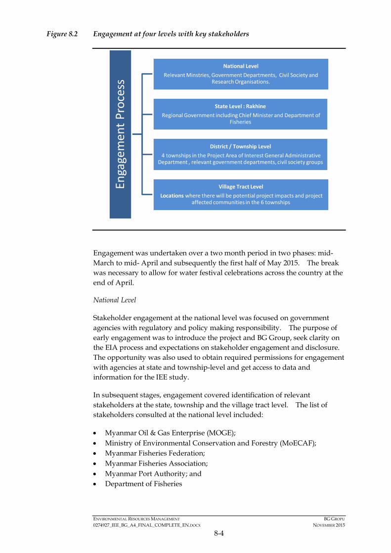
ENVIRONMENTAL RESOURCES MANAGEMENT BG GROPU 0274927_IEE_BG_A4_FINAL_COMPLETE_EN.DOCX NOVEMBER 2015
8-4
Figure 8.2 Engagement at four levels with key stakeholders
Engagement was undertaken over a two month period in two phases: mid-March to mid- April and subsequently the first half of May 2015. The break was necessary to allow for water festival celebrations across the country at the end of April.
National Level
Stakeholder engagement at the national level was focused on government agencies with regulatory and policy making responsibility. The purpose of early engagement was to introduce the project and BG Group, seek clarity on the EIA process and expectations on stakeholder engagement and disclosure. The opportunity was also used to obtain required permissions for engagement with agencies at state and township-level and get access to data and information for the IEE study.
In subsequent stages, engagement covered identification of relevant stakeholders at the state, township and the village tract level. The list of stakeholders consulted at the national level included:
• Myanmar Oil & Gas Enterprise (MOGE); • Ministry of Environmental Conservation and Forestry (MoECAF); • Myanmar Fisheries Federation; • Myanmar Fisheries Association; • Myanmar Port Authority; and • Department of Fisheries
Enga
gem
ent P
roce
ss
National Level Relevant Minstries, Government Departments, Civil Society and
Research Organisations.
State Level : Rakhine Regional Government including Chief Minister and Department of
Fisheries
District / Township Level 4 townships in the Project Area of Interest General Administrative
Department , relevant government departments, civil society groups
Village Tract Level Locations where there will be potential project impacts and project
affected communities in the 6 townships
ENVIRONMENTAL RESOURCES MANAGEMENT BG GROPU 0274927_IEE_BG_A4_FINAL_COMPLETE_EN.DOCX NOVEMBER 2015
8-5
State Level
Stakeholder engagement at the state level focused on obtaining required permission for engagement activities at the township, village tract and village level and get access to information on off-and inshore fishing activities in the state. At the state level the Project had meetings with:
• The Chief Minister; • The Divisional Administrator; • MOECAF’s regional office; • Department of Fisheries; and • Fishermen and boat owners.
District / Township Level
Engagement was focused on four coastal townships in Rakhine State relevant to the Project: Kyaukphyu, Ramree, Manaung, and Thandwe, as suggested during meetings with the Chief Minister of Rakhine State, with some engagement also undertaken with boat owners in Sittwe.
These townships feature varying levels of industrial and artisanal fishing activities, including off-shore and in-shore fishing fleets, processing and supply locations, as well as transportation hubs to domestic and international markets. It was agreed that these townships included communities with some of the greatest reliance on fishing as well as potential presence in or nearby the Activity Area. Therefore a sample of villages from these townships was agreed to provide the most relevant picture of potentially affected fishing communities. It should be noted that the sample communities consulted provide an indication of the fishing activity undertaken in Rakhine but does not fully represent those communities that fish only in the shallow-water areas. The majority of local artisanal fishing in Rakhine waters is thought to occur in this shallow water area; within 10 nautical miles from the mainland coast.
The purpose of engagement was to make the community aware of the project, to obtain necessary local permissions for meetings, seek an understanding of specific issues and stakeholder concerns in the individual townships, discuss potential impacts and mitigation measures and obtain district and township level social and environmental data.
The key stakeholders engaged with included;
• General Administration Department; • Township Fishery Department; • Fishing associations; and • Boat owners and traders.

ENVIRONMENTAL RESOURCES MANAGEMENT BG GROPU 0274927_IEE_BG_A4_FINAL_COMPLETE_EN.DOCX NOVEMBER 2015
8-6
Village Level
Consultations were undertaken in villages with significant fishing activities, both nearshore and offshore. Consultations at the village tracts included consultations with:
• Village Tract Leader (government appointed position); • Village Leaders (non-governmental position); • Fishing communities including boat owners and workers; • Women’s groups engaged in fish processing including, drying and selling; • Fishing association; • Other interested members of the village (e.g. teachers).
8.4.3 Format and Content of Consultation Meetings
Key Principles
The consultation process was guided by the following key principles:
• Inclusive: The consultations were organised to ensure representation of potentially affected and interested stakeholders. Separate focus groups were undertaken with women, fishermen and boat owners and the consultation involved both Rakhine Buddhist and Muslim fishermen.
• Sharing of information: At the township and village level consultations, special emphasis was given to build community level understanding of the Project and all the information was provided in Myanmar language.
• Participatory: Stakeholders were encouraged to actively participate in the consultations and were always given the opportunity to ask questions.
• Gender inclusive: The team consisted of female representatives for undertaking focus group discussions with women.
The approach to consultation, informed by these principles, is described in Section 8.4.
Consultation Approach
The stakeholder consultation meetings were structured as followed:
• Introductions and information disclosure: To introduce BG Group, the project, the IEE, the proposed stakeholder engagement process, the potential environmental and social impacts and mitigation to help the stakeholders understand the project and BG Group’s intentions for engagement;
• Question and answer session for all stakeholders to raise concerns, comments or ask questions to which BG Group can directly respond;
• Data collection: Collection of more in-depth information through focus group discussions (FGDs) and one-on-one interviews with key stakeholder
ENVIRONMENTAL RESOURCES MANAGEMENT BG GROPU 0274927_IEE_BG_A4_FINAL_COMPLETE_EN.DOCX NOVEMBER 2015
8-7
groups. It should be noted that the FGD were only conducted at the township and village level.
In order to inform stakeholders about the Project and share information on the activities, a two page flyer was produced which contained project information and details on how to feedback into the Project (presented in Annex 8.1). All information was communicated through use of visual media (including posters and power point presentations) and was provided in local Myanmar language (see Annex 8.1). The material also provided details for an information hotline telephone number and email address.
To gather more environmental and social baseline data and to identify potentially affected communities, focus group discussions (FGDs) were undertaken with fishermen, women and village leaders, and were guided by questionnaires covering information relating to:
• Village profile: Collected information on demographic patterns, communities, occupations, vulnerable groups, access to infrastructure and services and communication and grievance systems.
• Fishing Methods: Collected information on number / type of boats, fishing season, fishing locations, fishing camps, trip duration and fishing gear used.
• Fishing Markets / Income: Collected information on market locations, price of catch, transportation routes, dependence on fishing- income and vulnerability, workers, migrant population and gender based livelihoods related to fishing.
• Environment: Collected information on type of fish caught, sighting of marine mammals and turtles, locations of sensitive habitats (coral reefs, seagrass beds, and mangroves), locations of turtle nesting beaches, timing of turtle nesting, fish / invertebrate spawning areas, and protected areas.
Visual tools, such as pictures of fishing gear, maps and pictures of marine species, and hands-on activities, such as drawing fishing areas on hard copies of maps, were utilised in order to increase the involvement of the communities in the stakeholder consultation process. All information collected was summarised and confirmed with stakeholders at the end of each discussion. Stakeholders were also given time to share their concerns and views and any further clarifications they required at the end of the meetings.
Any queries raised by the stakeholders was responded to, and also noted to feed into the impact assessment process for the IEE.
8.5 SUMMARY OF CONSULTATION ACTIVITIES UNDERTAKEN
Figure 8.1 provides an overview of where consultation was undertaken; Table 8.1 shows where key consultations, at a regional level and below took place.

ENVIRONMENTAL RESOURCES MANAGEMENT BG GROPU 0274927_IEE_BG_A4_FINAL_COMPLETE_EN.DOCX NOVEMBER 2015
8-8
Photos taken during public consultations in Rakhine State are shown in Figure 8.3 (1).
Table 8.1 Summary of public meetings undertaken as part of the IEE process
Date Location 31st March 2015 Sittwe meeting 1st April 2015 Kyaukphyu Township meeting 2nd April 2015 Zin Chaung village meeting 3rd April 2015 Ramree Township meeting 4th April 2015 Kyauk-Ni-Maw (Rakhine community) 4th April 2015 Kyauk-Ni-Maw (Muslim community) 6th April 2015 Manaung Township meeting 7th April 2015 Ka Ei village meeting 8th May 2015 Thandwe Township Meeting 9th May 2015 Thabyugyaing Village Meeting 10th May 2015 Sin Gaung Village Meeting 11th May 2015 Gyeitkaw Village Meeting
A consultation team consisting of ERM, REM, accompanied by a BG Group representative conducted meetings and consultations at the four administrative levels. The team was also accompanied by a MOGE representative.
8.6 SUMMARY OF MAIN COMMENTS RECEIVED DURING CONSULTATION MEETINGS
Some of the key concerns and expectations of the stakeholder groups identified during the public meetings are detailed in the following sections. A summary of the meeting minutes from the question and answer session is provided in Annex 8.2.
8.6.1 Sharing of benefits and social investment
A common question raised during consultation meetings regarded the likely benefits to local people and/or Rakhine State from the Project. The focus of discussions on social investment concerned what community projects BG Group would undertake during the drilling and production phases or oil and gas exploration. There were also a number of questions regarding the agreement BG Group have in place with the Myanmar government and also related to revenue sharing between Rakhine State and the Union Government.
BG Group explained that social investments were not dealt with within the scope of the IEE, as the study focuses on the impacts derived from the Project. However, social investments will be addressed as part of BG Group’s ongoing engagement at a later stage.
(1) Permission to take photos was requested and granted at each meeting included in the Figure.
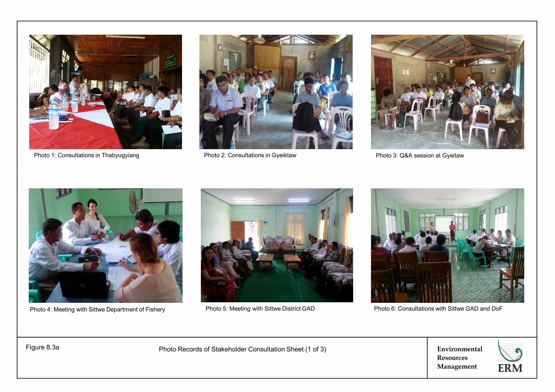
Environmental Resources Management
Photo Records of Stakeholder Consultation Sheet (1 of 3) Figure 8.3a
Photo 1: Consultations in Thabyugyiang Photo 2: Consultations in Gyeiktaw Photo 3: Q&A session at Gyeitaw
Photo 6: Consultations with Sittwe GAD and DoF Photo 4: Meeting with Sittwe Department of Fishery Photo 5: Meeting with Sittwe District GAD

Photo Records of Stakeholder Consultation Sheet (2 of 3) Figure 8.3b
Photo 8: Consultations with Myanmar Fishing Federation
Photo 9: Consultations with Kyaukphyu GAD
Photo 11: Village consultations in Kyauk Ni Maw Photo 12: Women group discussion in Kyauk Ni Maw
Environmental Resources Management
Photo 7: Fishermen and other stakeholders in Sittwe
Photo 10: Village consultations in Kyauk Ni Maw
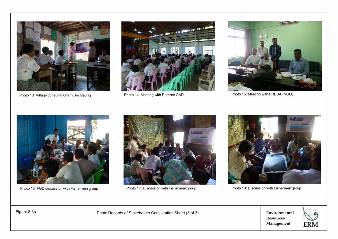
Photo Records of Stakeholder Consultation Sheet (3 of 3) Figure 8.3c
Photo 14: Meeting with Ramree GAD
Photo 18: Discussion with Fishermen group
Environmental Resources Management
Photo 17: Discussion with Fishermen group Photo 16: FGD discussion with Fishermen group
Photo 13: Village consultations in Sin Gaung Photo 15: Meeting with FREDA (NGO)
ENVIRONMENTAL RESOURCES MANAGEMENT BG GROPU 0274927_IEE_BG_A4_FINAL_COMPLETE_EN.DOCX NOVEMBER 2015
8-9
8.6.2 Impact on fishing
As the majority of people consulted were directly involved in the fishing industry, a key concern raised related to the potential impacts of the project on the fishing activities in nearshore and offshore areas. Specific issues of concern are described below.
Fishing Season / Locations
It was noted that the seismic survey activities overlap with the peak fishing season. Some local fishing group representatives suggested that the survey could be scheduled to avoid a significant impact on the fishing activities in the area. The size of the exclusion zone around the vessel was a key concern for some stakeholders who wanted to know the area in which fishing activities will be temporarily displaced. The potential impacts on fishing have been assessed in Section 6 of this IEE Report and the required mitigation measures are provided in the Environmental and Social Management Plan (ESMP) (Section 7).
Fishing Practises / Gear
Stakeholders in Thandwe raised concerns about disruption to fishing activity which overlaps with the easternmost part of the Block. It was suggested the surveys in this area (i.e. closest to Manaung) should be undertaken during the day time to reduce the potential interaction with night fishing vessels in the area. A key issue raised involved the potential risk of collision between the seismic vessel and equipment with fishing vessels and gear, resulting in damage to fishing nets. It was noted that some nets, such as long lines and drift nets take a few hours to pull back into the vessel, so fishermen need prior notice of seismic vessel movements. Another concern related to potential impacts from underwater sound on divers operating in the areas near to Manaung Island. These issues have been considered in the impact assessment (Section 6) and addressed by mitigation measures in the ESMP (Section 7).
Economic Impact
Some questions were asked regarding economic impacts on the boat owners due to a disruption of fishing activities - i.e. if they would be unable to fish but would still have to pay wages to the labourers on the boats. The IEE team clarified that fishing activities would not be significantly disrupted and fishermen will be able to continue fishing, albeit away from the mobile safety zone. This issue is addressed in the impact assessment (Section 6) and in the ESMP (Section 7).
Impacts on Fish Resources
Stakeholders were also concerned about the impact of the sound generated from the survey on the fish themselves. Stakeholders were concerned that sound could scare fish away from the area or kill the fish (and other
ENVIRONMENTAL RESOURCES MANAGEMENT BG GROPU 0274927_IEE_BG_A4_FINAL_COMPLETE_EN.DOCX NOVEMBER 2015
8-10
commercial species) in the area, in turn, impacting their livelihoods. This is addressed in the impact assessment (Section 6).
8.6.3 Information sharing and communication methods
Stakeholders wanted to know how information related to movement of the seismic survey vessel would be communicated to them both prior to and during the survey activities. They also provided suggestions on the channels of communication that would be most effective which have fed into the development of mitigation measures and will support implementation of the mitigation described in the ESMP (Section 7).
8.6.4 Grievance redressal
The process of grievance redressal was highlighted by stakeholders who wanted to know what BG Group would do in case of a grievance, such as damage to nets or collisions with the seismic vessel. They requested that any grievance procedure that BG Group develops should be aligned to the existing grievance procedures they are familiar with. The grievance mechanism is discussed below and in Section 7.
8.7 INFORMATION DISCLOSURE
The disclosure process will include disclosure of the summary findings of the IEE study in the local language in the townships visited. The project will also disclose the grievance mechanism for the project and information regarding movement of the seismic survey vessel to stakeholders. Detailed plans for disclosure will be developed prior to the commencement of the Project.
8.7.1 Disclosure
The disclosure process will include disclosure of the summarized findings of the IEE Study in local language in the townships visited. The IEE Report will also be disclosed on BG Group’s website and will be advertised in two papers; one national and one local Rakhine journal. The Project will also disclose the grievance mechanism for the Project and information regarding movement of the seismic survey vessel to stakeholders. Detailed plans for disclosure will be developed prior to the commencement of the Project.
8.7.2 Future Consultations
The engagement activities thus far, were undertaken as part of the IEE process. However, stakeholder engagement is understood to be a continuous process to be undertaken throughout the life of the Project, in this case during the duration of the exploration programme. BG Group will re-visit all villages consulted during the public consultation to disclose the findings of IEE Report. This will take place prior to the commencement of the survey. BG Group will develop a Stakeholder Engagement Plan (as indicated in the ESMP Section 7) to manage this ongoing consultation, address concerns if new stakeholders emerge and monitor stakeholder feedback.
ENVIRONMENTAL RESOURCES MANAGEMENT BG GROPU 0274927_IEE_BG_A4_FINAL_COMPLETE_EN.DOCX NOVEMBER 2015
8-11
8.7.3 Grievance Mechanism BG Group requirements include development of grievance mechanisms (GM) to facilitate resolution of concerns for all stakeholders directly or indirectly impacted due to the project. The scale and type of a mechanism will reflect the level of risks and impact and be readily accessible, comprehensible, transparent and culturally appropriate.
The grievance mechanism will form an important element of dialogue with the community for this Project and will complement routine stakeholder engagement. The key purpose of the GM will be to allow stakeholders, especially the fishing community to approach the Project should there be any grievances in relation to the exploration programme and / or concerns about potential impact associated with the seismic activity. BG Group will develop a GM tailored to the operating context and aligned with existing process as requested by stakeholders. The GM will also contribute to monitoring of the ESMP for the Project (see Section 7).
ENVIRONMENTAL RESOURCES MANAGEMENT BG GROPU 0274927_IEE_BG_A4_FINAL_COMPLETE_EN.DOCX NOVEMBER 2015
9-1
9 CONCLUSION AND RECOMMENDATIONS
9.1 RECOMMENDATIONS FOR FUTURE ACTIONS
The disclosure process will include disclosure of the executive summary of the IEE study in Myanmar language in the townships visited. The IEE Report disclosure will also be advertised in two newspapers; one national and one local Rakhine. The project will also disclose the grievance mechanism for the project and information regarding movement of the seismic survey vessel to stakeholders. Detailed plans for disclosure will be developed prior to the commencement of the Project.
The engagement activities thus far were undertaken as part of the IEE process. However, stakeholder engagement is understood to be a continuous process to be undertaken throughout the life of the Project, in this case during the duration of the exploration programme. BG Group will further develop the Stakeholder Engagement Plan (as indicated in the ESMP Section 7) to manage ongoing consultation and respond to stakeholder concerns that may arise and be reported in relation to the implementation of the exploration campaign.
9.2 CONCLUSION OF THE IEE REPORT
The IEE Study for the proposed exploration programme survey in Block A-4 was conducted to comply with the requirements of the MOECAF draft EIA Procedures. The IEE demonstrates the proponent understands the environment and social setting in which they are operating and has properly assessed the key potential environmental and social impacts associated with the proposed Project. A project-specific, dedicated Environmental Social Management Plan (ESMP) has been developed and presented as a tool to manage impacts associated with the Project and ensure legislative compliance and standards of good practice during the execution of the survey programme in Block A-4. Provided that the recommended mitigation measures are properly implemented, it is expected that the environmental and social impacts of the proposed exploration programme at Block A-4 would be managed by BG Group in a professional and acceptable manner. As such, the IEE concludes that no Major impacts on the environment and people are anticipated from this Project and all impacts have been properly mitigated to be as low as reasonably practical.

Annex 2.1 CVs of Environmental and Social Experts

Craig A Reid Partner
Craig A. Reid is a Partner with Environmental Resources Management (ERM) and Manager of the Hong Kong based Marine Sciences Group. With over 16 years’ experience Mr Reid is responsible for providing technical services to ERM’s clients worldwide to help manage environmental risks and challenges. Mr Reid has specific experience in servicing ERM’s key industry sectors, namely Oil and Gas, Power and Mining as well as a strong background in Government regulatory and management services. Mr Reid has worked extensively in Myanmar for almost 10 years, most significantly through his role as Project Manager for the Shwe Gas Development Impact Assessments for Blocks A1 and A3, for Daewoo International Corporation. Mr Reid has also worked on assessments related to the Yadana Development for Total, as well as those for China National Petroleum Corporation (CNPC) and Hyundai Heavy Industries. Most recently Mr Reid has been helping international operators such as RocOil and BG understand potential environmental and social risks as well as the regulatory regime as part of their consideration into exploring this market. Through these studies Mr Reid has gained an excellent understanding of the Myanmar environment, as well as strong relationships with local consultancies, academics and Governmental Departments such as the Ministry of Environment, Conservation and Forestry (MOECAF) and the Myanma Oil and Gas Enterprise (MOGE). In addition to the above, Mr Reid has worked on projects related oil and gas infrastructure, seismic survey, exploratory and production drilling, decommissiong, dredging, disposal and reclamation, mud disposal facilities, port management, onshore and offshore power generation, offshore wind farms, sewage infrastructure, sewage treatment plants, sewerage schemes, incinerators, fuel storage facilities, theme parks, highways, railways, submarine cables and overhead power lines. The results of these studies have been used to present information on baseline conditions of sensitive habitats and biodiversity, to assess acceptability of installations, developments or
facilities, or to develop and implement mitigation, management and marine conservation programmes. Through these projects Mr Reid has gained a balance of experiences from the perspective of the proponent as well as that of the contractor and consultant. Mr Reid has been able to bring those skills to ensure projects gain regulatory approval or achieve the desired outcome be it from an environmental, engineering or cost perspective. Based in Hong Kong, Mr Reid has worked extensively internationally, having undertaken studies in Africa (Angola, Benin, Egypt, Gabon, Ghana, Liberia, Nigeria, Sierra Leone and Togo), Middle East (Abu Dhabi, Iran, Bahrain, Qatar and Saudi Arabia) South East Asia (Singapore, Thailand, Philippines, Malaysia, Vietnam, Brunei and Myanmar) East Asia (China, Hong Kong, Japan and South Korea) and the Pacific Rim (Australia, New Zealand and Fiji). EDUCATION • BSc (Hons), Marine Biology, University of
Stirling, Scotland, United Kingdom, 1997 Professional Affiliations & Registrations • Member of the International Association for
Impact Assessment • Member of the Society of Petroleum Engineers • Member of the Marine Biological Association of
Hong Kong • Member of the Hong Kong Institute for
Environmental Impact Assessment FIELDS OF COMPETENCE • Marine Biology, Ecology and Water Quality • Environmental Impact Assessment (EIA) • Environmental Monitoring • Site selection and route assessment • Natural Resource Management
CRAIG A REID PAGE 2 OF 6
PROJECTS IN MYANMAR • ESIA for Exploration of Blocks AD6 and AD8,
Chinnery Assets Limited (CNPC), 2013. Project Director. • Environmental Risk Assessment for Offshore
Exploration, for BG, 2013. Technical Advisor. • Myanmar HSE Regulatory Framework Study, for
RocOil, 2013. Project Director. • Air Dispersion Modelling for Shwe Gas Development,
for Daewoo International Corporation (Myanmar E&P), 2013. Project Director.
• EIA for the Shwe Gas Field Shore Base for Shwe Gas Field Development, for Daewoo International Corporation (Myanmar E&P), 2010. Project Manager.
• EIA for the Midstream Pipeline and Gas Metering Station for Shwe Gas Field Development, for Daewoo International Corporation (Myanmar E&P), 2009. Project Manager.
• Terrestrial Environmental Baseline Study for Onshore Midstream Facilities and Pipeline Landing Site, for Daewoo International Corporation (Myanmar E&P), 2008. Project Manager.
• Marine Environmental Baseline Survey for Midstream Pipeline, for Daewoo International Corporation (Myanmar E&P), 2008. Project Manager.
• Impact Identification Study for the Alternative Midstream Pipelines and Associated Onshore Facilities, for Daewoo International Corporation (Myanmar E&P), 2008. Project Manager.
• Drill Cuttings Modelling Study for Offshore Production Platform, for Daewoo International Corporation (Myanmar E&P), 2007. Project Manager.
• Environmental Impact Assessment for Upstream Facilities in Offshore Myanmar, for Daewoo International Corporation (Myanmar E&P), 2007. Project Manager.
• Marine Environmental Baseline Survey for the Development of Upstream Facilities in Offshore Myanmar, for Daewoo International Corporation (Myanmar E&P), 2006. Project Manager.
• Impact Identification Study for the Development of Upstream Facilities in Offshore Myanmar, for Daewoo International Corporation (Myanmar E&P), 2005. Project Manager.
• EIA for a Medium Compression Platform, Myanmar (Hyundai Heavy Industries & Total E&P Myanmar), 2007. Project Manager.
• Preliminary Environmental and Social Scoping Study for the Development of an Offshore Gas Field, for Daewoo International Corporation (Myanmar E&P), 2004. Project Manager..
OIL AND GAS PROJECTS MARINE SEISMIC SURVEY (2-D, 3-D AND 4-D) • Screening and Scoping Study for 3D Seismic Survey of
three Blocks in the South China Sea, Shell, 2012. Partner in Charge.
• Environmental Scoping and Management Plan for 3D Seismic Survey of Blocks 64/18 and 53/30 in the South China Sea, China, Chevron, 2010. Project Manager.
• Environmental Risk Assessment of a 3D Marine Seismic Survey in Southern Chinese Waters, BG, 2008. Marine Ecology Specialist.
• Survey on Environmental Impact of Marine Seismic Operations, Japanese Oil, Gas and Metals Corp, 2008 - 2009. Project Manager.
• ESHIA for Block G4/50 Seismic Survey, Gulf of Thailand, Chevron, 2008 - 2009. Marine Ecology Specialist.
• Monitoring Impacts of 3D Marine Seismic Surveys for Browse Field Development, Woodside Energy Limited, Australia, 2007 – 2009. Lead Scientist.
• Environmental Review for 2D Marine Seismic Survey in Southern Chinese Waters, BG, 2007. Project Manager.
• Environmental Protection Statement for Maxima 3D Marine Seismic Survey at Scott Reef, Woodside Energy Limited, 2007. Lead Scientist.
• Marine Seismic Survey Integrated Impact Assessments, Offshore Brunei Darussalam, Brunei Shell Petroleum Sdn Bhd, 2004 – 2006. Lead Scientist.
EXPLORATORY / PRODUCTION OPERATIONS • ESHIA for Seismic Exploration of Blocks 15/10 &
15/27 in South China Sea, Chevron, 2013. Project Director.
• ESHIA for Exploration Drilling of Block 42/05 in South China Sea, Chevron, 2013. Project Director.
• ESIA for Exploration Drilling of a Deepwater Well in the Sea of Japan, JX Nippon Oil, Japan, 2012. ESIA Advisor.
• ESHIA for Exploration Drilling of Block 64/11, 53/30 and 42/05 in South China Sea, Chevron, 2011. Project Director.
• ESHIA for Block B Gas Development, Vietnam, for Chevron Vietnam, 2010. Lead Marine Scientist.
• ESHIA for Pandora Offshore Gas Development, Talisman, Papua New Guinea, 2010 ongoing. Lead Marine Scientist.
• ESHIA for Shore Base for Offshore Operations, Thailand, for Chevron Pattani Thailand, 2008 – 2009. Project Manager.
• ESHIA for Block G4/48(c) Production Facility, Gulf of Thailand, Chevron, 2007 – 2008. Lead Marine Scientist.
CRAIG A REID PAGE 3 OF 6
• Status and Trends of HSE Issues in the Oil and Gas Industry, Japanese Oil, Gas and Metals Corp, 2007, 2008 and 2010. Key Presenter.
• Impact Assessment of Mampak Block 4 Field Development, Brunei Shell Petroleum Sdn Bhd, 2006 – 2009. Lead Marine Scientist.
• Main Oil Line Replacement Study, Brunei Shell Petroleum Sdn Bhd, 2007 – 2008. Lead Marine Scientist.
• Impact Assessment of Bugan Field Development, Brunei Shell Petroleum Sdn Bhd, 2006 – 2009. Lead Marine Scientist.
• Pipeline Replacement Project, Brunei Shell Petroleum Sdn Bhd, 2007. Lead Marine Scientist.
• Impact Assessment of Seria North Flank Development, Brunei Shell Petroleum Sdn Bhd, 2006 – 2007. Lead Marine Scientist.
• Bugan Phase II ROV Field Survey, Brunei Shell Petroleum Sdn Bhd, 2006. Lead Marine Scientist.
• Integrated Impact Assessment of the Jetty Relocation Project, Brunei Shell Petroleum Sdn Bhd, 2004. Lead Marine Scientist.
DRILL CUTTINGS AND PRODUCED WATER DISPOSAL • Drill Cuttings Study for Block D12 in Offshore
Sarawak, for Shell Sarawak Berhard, Malaysia, 2012. Project Director.
• Drill Cuttings Modelling for Well SH-05 in Abu Dhabi, for Wintershall, Abu Dhabi, UAE, 2011. Technical Lead.
• Drill Cuttings and Oil Spill Modelling for Hair Dalma HD-09 Well in Abu Dhabi, for ADMA-OPCO, Abu Dhabi, UAE, 2011. Project Manager.
• Drill Cuttings and Oil Spill Modelling for Block 64/11, 53/30 and 42/05 in South China Sea, Chevron, 2011. Project Director.
• Drill Cuttings Modelling Study Bugan Field Development (Brunei Shell Petroleum Sdn Bhd), Brunei, 2008. Project Manager.
• Drill Cuttings Modelling Study Bubut Field Development (Brunei Shell Petroleum Sdn Bhd), Brunei, 2007. Project Manager.
• Peragam Exploration Well Drill Cuttings Modelling, Brunei Shell Petroleum Sdn Bhd, 2006 – 2007. Project Manager.
• BSP CP127ST1 Well CPDP-12, Champion South-East Development Project, for Brunei Shell Petroleum Sdn Bhd, Brunei, 2007. Project Manager.
• Oil Spill Modelling Study for Offshore Production Platform, TOTAL, 2007 – 2008. Project Manager.
• Oil Spill Modelling Study for Offshore Production Platform, Shell Australia, 2007 – 2008. Project Manager.
FLOATING PRODUCTION STORAGE AND OFFLOADING (FPSO) VESSELS • Fishing/Fisheries Scoping/Baseline Study for Offshore
Developments, Ghana, for Tullow Ghana Ltd, 2010 - ongoing. Technical Specialist.
• Integrated Impact Assessment of the Development of Cendor Field, Petrofac, 2005 – 2006. Lead Marine Scientist.
LNG TERMINALS (EXPORT AND RECEIVING) • Environmental Social Health Impact Assessment for a
Floating Liquefied Natural Gas Facility in Offshore Waters, Northwest Australia, Confidential, 2008 – 2009. Marine Ecology Specialist.
• Manzanillo LNG Terminal, Korea, Samsung Engineering Company Ltd (SECL), 2008. Lead Marine Scientist.
• Environmental Impact Assessment (EIA) of Liquefied Natural Gas (LNG) Receiving Terminal and Associated Facilities, CAPCO, 2005 – 2007. Project Coordinator.
• Adequacy Review of Environmental Assessment for Proposed Taranaki LNG (New Plymouth Council), 2008. Lead Marine Scientist.
• Environmental and Risk Assessments for two Natural Gas Facilities in Southeast Asia, CAPCO, 2004 – 2005. Project Coordinator.
• Detailed EIA and FEED Study for Submarine Gas Pipelines from Shenzhen LNG Terminal to Tai Po Gas Production Plant, Hong Kong & China Gas Company, 2002 – 2003. Lead Marine Scientist.
• Study of Potential Land-based Sites for Natural Gas Facilities in Southeast Asia, CAPCO, 2002 – 2003. Project Coordinator.
• Site Selection and Scoping Study for an LNG Terminal in Thailand, Confidential Client, 2005 – 2006. Lead Marine Scientist.
DECOMMISSIONING • Options Assessment Update for Lufeng 22-1 Oil Field
Decommissioning Project, Statoil, 2008–2009. Project Manager.
• Options Assessment for Lufeng 22-1 Oil Field Decommissioning Project, Statoil, 2004. Lead Marine Scientist.
• Platforms Decommissioning Campaign, Offshore Brunei Darussalam, Brunei Shell Petroleum Sdn Bhd, 2004. Lead Marine Scientist.
• Environmental Impact Study of Temsah NW Platform Disposal, Eni E&P, 2005. Lead Marine Scientist.
• Consultation on Decommissioning of Overseas Offshore Platforms, CNOOC, 2005 – 2006. Project

CRAIG A REID PAGE 4 OF 6
Manager. DOWNSTREAM PROJECTS • ESHIA for a Greenfield Refinery in Mandji Free Trade
Zone, Samsung C&T, Gabon, 2012. Project Director. POWER SECTOR PROJECTS • Seawater Recirculation Study for Jeddah South Power
Plant Stage I, HHI, Saudi Arabia, 2012. Partner in Charge.
• Marine Biodiversity Study for Shoaiba Power Plant Stage III, HSBC, Saudi Arabia, 2012. Marine Expert.
• EM&A Team for Installation of Offshore Wind Farm in Southwest Lamma Waters, Hong Kong, for The Hongkong Electric Co., Ltd., 2011 – ongoing. Project Director.
• Investigation into Fish Ingress at Hong Kong Electric Power Station, Lamma Island, Hong Kong, 2010 – 2011. Project Manager.
• ESHIA Update for Mong Duong 2 Power Plant, Vietnam, AES, 2010 – 2011. Marine Ecology Specialist.
• Cooling Mist Dispersion Study at Sabyia Combined Cycle Gas Turbine Power Station, Kuwait, HHI, 2009 – 2010. Project Manager.
• EIA for an Offshore Wind Farm Development in Hong Kong, for The Hongkong Electric Co Ltd, 2007 - 2009. Project Manager.
• Environmental, Health and Safety Impact Assessment (ESHIA) for Vung Ang II Thermal Power, for One Energy, Vietnam. 2008 - 2010. Marine Ecology Specialist.
• Environmental Impact Assessment of the Development of a 2,750MW Power Station and Desalination Plant in Jubail Industrial City, Marafiq IWPP, Kingdom of Saudi Arabia, for WSP Environmental Middle East, 2007. Marine Ecology Specialist.
• Seawater Recirculation Study, Al Dur IWPP, for Hyundai Heavy Industries Co. Ltd, Bahrain, 2008. Project Manager.
• Seawater Recirculation Study, Marafiq IWPP, Hyundai Heavy Industries Co. Ltd., Kingdom of Saudi Arabia, 2006 – 2007. Project Manager.
• Baseline Water Quality Survey, Marafiq IWPP, Hyundai Heavy Industries Co. Ltd., 2006, Kingdom of Saudi Arabia. Project Manager.
• Thermal Plume Dispersion Study, Ma’aden Phosphate Company, Kingdom of Saudi Arabia, 2009. Project Manager.
• Kwang Yang Combined Cycle Power Plant Cooling Water Review, BP, South Korea, 2005.
• Emissions Control Project at the Castle Peak Power Station “B” Units, CAPCO, Hong Kong, 2006. Marine Ecology Specialist.
• Cooling Water Culvert Improvement Works, CLP Power, Hong Kong, 2002. Marine Ecology Specialist.
• EIA for an 1800 MW Gas-Fired Power Station at Lamma Extension, The Hongkong Electric Co., Ltd., Hong Kong, 1998 – 1999. Marine Ecology Specialist.
• Identification of Constraints to the Routing of HEC New Gas Pipeline - Desktop Study, The Hongkong Electric Co., Ltd., 1998. Project Manager.
PORT RELATED PROJECTS • ESIA of a Greenfield Port, APM Terminals, Nigeria,
2012. Project Director. • Contaminated Sediment Disposal Facility at South of
Brothers – EIA Update, Civil Engineering and Development Department, Hong Kong Government, Hong Kong, 2009 - 2010. Project Manager.
• EM&A for Contaminated Mud Pit IV at East of Sha Chau, CEDD, Hong Kong Government, 2009 – 2013. Deputy Environmental Team Leader.
• EM&A for Contaminated Mud Pit IV at East of Sha Chau, CEDD, Hong Kong Government, 2005 – 2009. Deputy Project Manager.
• EM&A for Contaminated Mud Pit IV at East of Sha Chau, CEDD, Hong Kong Government, 1997 – 2002. Project Coordinator.
• Ecological Monitoring for Uncontaminated Mud Disposal, CEDD, Hong Kong Government, 1999 – 2002. Project Manager.
• Review of the Contaminated Mud Disposal Strategy and the need for an Intermediate Contaminated Mud Disposal Facility, CEDD, Hong Kong Government, 2002 – 2003. Project Manager
• Ecological, Fisheries and Water Quality Impact Assessment Study for the Proposed Port Development at Northwest Lantau, EDLB, Hong Kong Government, 2005 – 2007. Water Quality Specialist.
• Environmental Impact Assessment of Savusavu Port, Rural and Outer Islands Project, Asian Development Bank, Fiji, 2006 – 2007. Environmental Team Lead.
• EIA of the Development of a Container Terminal, Vietnam, SPCT/P&O Ports, Vietnam, 2006 – 2008. Lead Marine Scientist.
• Permanent Aviation Fuel Facility, Leighton Contractors Asia Limited, Hong Kong, 2003 – 2009. Environmental Team Leader.
• Strategic Assessment and Site Selection Study for Contaminated Mud Disposal, CEDD, Hong Kong Government, 1999. Marine Ecology Specialist.
• Site Specific Feasibility of Sludge Management Strategy and Sludge Disposal Plan, EPD, Hong Kong Government, 1998 – 2000. Marine Ecology Specialist.
• Focussed Cumulative Water Quality Impact Assessment for the West Po Toi Sand Borrow Area,

CRAIG A REID PAGE 5 OF 6
HAM Dredging & Marine Contractors, 2001. Marine Ecology Specialist.
• Baseline Survey at East Tung Lung Chau, CEDD, Hong Kong Government, 1999. Non-Statutory Marine Environmental Monitoring Update, Airport Authority Hong Kong, 2002 – 2003. Marine Ecology Specialist.
• Performance Verification of Stanley and Shek O Outfalls, EPD, Hong Kong Government, 1999 – 2001. Marine Ecology Specialist.
• Sustainable Development for the 21st Century, Supplementary Agreement for Undertaking Baseline Surveys - Monitoring of Toxics in Marine Sediment and Biota, PlanD, Hong Kong, 2000. Marine Ecology Specialist.
MINING PROJECTS • Marampa Mine ESHIA, London Mining PLC, Sierra
Leone, 2012. Aquatic Specialist • ESHIA of Weda Bay Nickel Mine, ERAMET, Indonesia,
2011. Marine Specialist. TRANSPORT • EIA Review Consultancy for Hong Kong Airport Third
Runway Project, Airport Authority Hong Kong, Hong Kong, 2012-2013. Project Manager
• EIA Review for Area 54 Road Network, Transport Department, Hong Kong, 2012-2013. Project Director.
SEWAGE INFRASTRUCTURE AND DRAINAGE • Agreement No. CE 55/2009 (DS) - Outlying Islands
Sewerage Stage 2 – South Lantau Sewerage Works – Investigation EIA, Hong Kong, for DSD, 2010 – 2014. EIA Manager.
• Agreement No. CE 6/2002 (DS) - Drainage Improvement in Northern New Territories – Package C - Investigation, Design and Construction – EIA for TKL05, Hong Kong, for DSD, 2010 – 2012. EIA Manager.
• Agreement No. CE 6/2010 (DS) - Improvement of Yuen Long Town Nullah (Town Centre Section) – Investigation EIA, Hong Kong, for DSD, 2010 – 2012. EIA Manager.
• Environmental Impact Assessment of Regulation of Shenzhen River Stage IV EIA Study, Hong Kong, for DSD, 2009 – 2011. Water Quality Specialist.
• Hong Kong Sewage Harbour Area Treatment Scheme (HATS) Stage 2 – Supplementary Water Quality Monitoring, EPD, Hong Kong Government, Hong Kong, 2007 – 2011. Project Manager.
NATURAL RESOURCE MANAGEMENT • Total Water Management for Hong Kong – Feasibility
Study, DSD, Hong Kong Government, 2005 – 2008. Project Manager (Environmental).
• Study in Terrestrial Habitat Mapping Based on Conservation Value, SDU, Hong Kong Government, 2002 – 2003. Project Manager.
• Artificial Reef Deployment Study, AFCD, Hong Kong Government, 1998 – 1999. Marine Ecology Specialist.
• Fisheries Resources and Fishing Operations in Hong Kong Waters, AFCD, Hong Kong Government, 1998. Marine Ecology Specialist.
• Seabed Ecology Studies, AFCD, Hong Kong Government, 1998 – 1999. Marine Ecology Specialist.
ROUTE SELECTION AND ENVIRONMENTAL PERMITTING • FLAG North Asian Loop, International Submarine
Cable System, Hong Kong to Taiwan, (FLAG Telecom), Hong Kong, 2001 - 2002. Marine Ecology Specialist
• New T&T Hong Kong Limited, Domestic Cable System (New T&T), Hong Kong, 2000 - 2001. Marine Ecology Specialist
• C2C International Submarine Cable System – Hong Kong Section (SingTel and GB21), Hong Kong, 2000 – 2001. Marine Ecology Specialist
• East Asian Crossing (EAC1) International Submarine Cable System (Asia Global Crossing and KDD SCS), Hong Kong, 2001. Marine Ecology Specialist
• East Asian Crossing (EAC2) International Submarine Cable System (Global Crossing Development Co. and NEC Networks), Hong Kong, 2001. Marine Ecology Specialist
• Telecommunications Installation at Lot 591SA in DD 328, Tong Fuk, South Lantau Coast and Associated Cable Landing Work in Tong Fuk, South Lantau for the North Asia Cable (NAC) Fibre Optic Submarine Cable System (Level(3)), Hong Kong, 2000. Marine Ecology Specialist
• 132kV Submarine Cable Installation for Wong Chuk Hang – Chung Hom Kok 132kV Circuits (The Hongkong Electric Co. Ltd), Hong Kong, 2001 - 2002. Marine Ecology Specialist
• 132kV Submarine Cable Circuits from A Kung Wan to Sai Kung Pier (CLP Power), Hong Kong, 1999. Marine Ecology Specialist
• Seabed Survey Work for the Proposed 11kV Cable Circuits from Tai Mong Tsai to Kiu Tsui (CLP Power ), Hong Kong, 1999. Marine Ecology Specialist
• Seabed Survey Work for the Proposed 11kV Cable
CRAIG A REID PAGE 6 OF 6
Circuit between Pak Lap and Fu Tau Fan Chau (CLP Power), Hong Kong, 1999. Marine Ecology Specialist
SELECTED PUBLICATIONS • Grebe, C.C, Smith, L. & Reid, C.A (2009) The Effects of Marine
Seismic Acquisition in a Coral Reef Environment: Results from a Multi-Disciplinary Monitoring Program at Scott Reef, Western Australia. APPEA Conference 2009.
• Grebe CC, Smith L, Reid CA, Hearn RL and Colman JG (2008) The Effects of Marine Seismic Acquisition in a Coral Reef Environment: A Synthesis of Results from a Multi-Disciplinary Monitoring Program at Scott Reef, Western Australia. APPEA 08.
• Hastings M, Reid CA, Hearn R, Grebe C and Coleman J (2008) The Effects of Seismic Airgun Noise on the Hearing Sensitivity of Tropical Reef Fishes at Scott Reef, Western Australia. Proceedings of the Institute of Acoustics, 2008.
• C.C. Grebe, J.G. Colman & C.A. Reid (2008) Practical application of an adaptive management approach for a marine seismic survey. IAIA08 Paper.
• Qui JW, Reid CA, Kennish R and Qian PY (2003) Recolonisation of Benthic Infauna Subsequent to Capping of Contaminated Mud Pits with Uncontaminated Sediments in East Sha Chau, Hong Kong. Estuarine and Coastal Shelf Science 56 (2003) 819-831.
• Germano JG, Reid CA, Whiteside P and Kennish R (2002) Field Verification of Computer Models Predicting Plume Dispersion in Hong Kong. Dredging 02 - Proceedings of American Society of Engineers.
• Kennish R, Lui PH, Chan A, Allery SC, Leung KF and Reid CA (2002) Sewage Outfall Performance Verification in Hong Kong: The results of an integrated modeling and monitoring approach. Proceedings of the International Conference Wastewater Management & Technologies for Highly Urbanized Coastal Cities 2002, pp 295-301.
• Nicholson S, Clarke SC, Word JQ, Kennish R, Barlow KL & Reid CA (2000) Quality Assurance in the Toxicological Assessment of Hong Kong Dredged Sediments: The Potential Influence of Confounding Factors on Bioassay Results. ISWA Conference Proceedings, October 2000, Hong Kong
CONTACT DETAILS ERM-Hong Kong Ltd., 16th Floor, DCH Commercial Centre, 25 Westlands Road, Quarry Bay, Hong Kong Tel: +852-2271 3179 Mob: +852-6206-5065 Fax: +852-2723-5660 Email: [email protected] Web: www.erm.com
Dr Robin Kennish ESHIA Project Director
Dr Robin Kennish is ERMs Asia Pacific Managing Partner for Impact Assessment and Planning. As a Partner of ERM he has responsibility for managing and directing large scale capital project ESHIAs particularly for the Oil & Gas Sector. Dr Kennish is a Chevron Qualified ESHIA Facilitator (QEF). Dr Kennish has over nineteen years’ experience in environmental management with extensive experience in managing large-scale projects. His particular focus has been on the impacts of oil and gas projects on the environment including the following: Oil & Gas Exploration & Production Vietnam:
Directed ESHIAs of marine seismic, exploratory drilling. This includes ESHIA of full scale gas production in Block B for Chevron.
Oil & Gas Exploration & Production Thailand: Managed ESHIA assessments of infrastructure projects and exploration and production activities for Chevron including work on Blocks 64/50 and 64/48c.
Oil & Gas Exploration & Production Mainland
China: Managed and contributed to ESHIAs for industrial projects including gas pipelines, mining, offshore platforms and marine seismic surveys. This includes work for Chevron in the South China Sea on Blocks 42/05 and 53/30.
Oil & Gas Exploration & Production
Philippines: Provided marine biological input to assessments of exploration and production activities. Directed the preparation of EMS procedures and manuals in readiness for an Oil & Gas major’s exploratory drilling activities.
Oil & Gas Exploration & Production Myanmar:
Directed the ESHIA studies for exploration and production activities in the Shwe Gas field as well as the Yadana block.
In addition to the above, Dr Kennish has also significant experience in the Mining sector throughout the Asia Pacific region. This has included work in the Philippines, Myanmar, Indonesia, China & Vietnam. Fields of Competence • Environmental, Social, Health Impact
Assessments (ESHIAs) • Equator Principle and IFC Performance Standards • Ecology, Marine Biology and Fisheries • Water Quality Assessments • Environmental Permitting • Stakeholder Negotiations Education • BSc (Hons) Marine Biology, University of
Liverpool UK, 1991 • PhD Marine Biology, University of Hong Kong,
1995 Professional Affiliations • Member of the Society of Environmental
Toxicology & Chemistry • Member of the Society of Petroleum Engineers

DR ROBIN KENNISH
Key Relevant Projects Chevron Projects Environmental Screening / Scoping for 3D Seismic Survey of Blocks 15/10 and 15/28 in the Pearl River Estuary of the South China Sea, China, Chevron, 2013-ongoing. ERM was commissioned by Chevron to undertaken a Screening / Scoping study for a marine seismic survey in the South China Sea. The survey was to cover two blocks where key issues related to sensitive marine mammal habitat and fishing operations. Dr Kennish is the QEF for the study Environmental Scoping, ESHIA and Management Plan for Exploratory Drilling of Blocks 42/05, 64/18 and 53/30 in the South China Sea, China, Chevron, 2011-ongoing. ERM was commissioned by Chevron to undertaken Screening / Scoping study for exploratory drilling in the South China Sea. An ESHIA is now underway focusing on key issue identified in the screening/scoping such as drill cuttings disposal and spill modelling. Dr Kennish was the ESHIA Subject Matter Expert for the original study and QEF for the ESHIA Update for Block 42/05. Environmental Scoping and Management Plan for 3D Seismic Survey of Blocks 64/18 and 53/30 in the South China Sea, China, Chevron, 2010. ERM was commissioned by Chevron to undertaken a Screening / Scoping study for a marine seismic survey in the South China Sea. The survey was to cover two blocks where key issues related to sensitive marine mammal habitat and fishing operations. Dr Kennish was the ESHIA Subject Matter Expert for the study.
ESHIA for Block B Gas Production Project Western Vietnam (Chevron Vietnam), 2011-2012. ERM is conducting the ESHIA for an Oil and Gas major to support their project development to extract gas from fields located in western Vietnam waters of the Guld of Thailand. ERM has supported the local regulatory EIA process and also prepared a supplementary ESHIA to meet corporate requirements. Key issues included drill cuttings modelling. Dr Kennish was the project Director.
Block G4/50 3D Seismic Survey ESHIA, Gulf of Thailand (Chevron Thailand) 2008. ERM was commissioned to undertake an ESHIA examining the potential impacts associated with 3D Seismic Surveys of an exploration block in the Gulf of Thailand. Dr Kennish was the Technical Specialist for the project and also lead the Chevron Screening-Scoping
assessment.
Block G4/48(c) Production ESHIA, Gulf of Thailand (Chevron Thailand) 2007. ERM was commissioned to undertake an ESHIA examining the potential impacts associated with the development of an offshore oil production block in the Gulf of Thailand. Dr Kennish was the Technical Specialist for the project and also lead the Chevron Screening-Scoping assessment.
Oil & Gas Projects
Exploratory Drilling Offshore Danang, Vietnam (Confidential Client), 2010 – 2012. ERM is providing EHS services to an Oil and Gas major to support their efforts in exploratory drilling in waters offshore of Danang in Eastern Vietnam. ERM has supported the local regulatory EIA process and also prepared a supplementary EIA to meet corporate requirements. Dr Kennish was the project Director.
Seismic Exploration, Deepwater Southwestern Vietnam (Confidential Client), 2010 – ongoing. ERM is providing EHS services to an Oil and Gas major to support their efforts in marine seismic surveying in deepwater offshore of Southwestern Vietnam. ERM has supported the local regulatory EIA process and also prepared a supplementary EIA to meet corporate requirements. Key issues included the preparation of a marine mammal risk assessment. Dr Kennish was the project Director.
Black Point Power Station Gas Supply Project, Hong Kong (CLP/ExxonMobil), 2009-2010. ERM is undertaking the EIA of the installation and operation of submarine gas pipelines between China and Hong Kong. As part of the EIA ERM also completed Quantitative Risk Assessments of the gas Receiving Stations and conducted 3D water quality and hydrodynamic modeling. Dr Kennish was the Project Director.
Exploratory Drilling Environmental Monitoring Program, Scott Reef, Western Australia, (Woodside Energy Ltd.), 2008 – 2011. Dr Kennish was involved in the design and planning for the execution of a targeted suite of monitoring programs to assess potential impacts of drilling in a sensitive coral reef environment. Dedicated programs to assess the disposal of drill cuttings, wastewater, rig footprint, underwater noise and artificial light have been implemented through a series of offshore surveys resulting in a series of specialised reporting deliverables that fully document the impacts of exploratory drilling on a remote coral reef system.
DR ROBIN KENNISH
Environmental Social Impact Assessment for the West East Pipeline (Shell) 2002. Dr Kennish provided input to the ESIA report for this 1,400 km pipeline that traverses China from Xinjiang to Shanghai. His key responsibilities included an assessment of operation and construction phase impacts to water quality and biodiversity, and the preparation of management and mitigation measures.
EIA of LPG - LNG Plant, Peru (Pluspetrol Peru Corporation) 2003. ERM performed an environmental and social Impact assessment including environmental management and monitoring plan for Camisea Gas Export project facility. The facility includes the gas fractioning plant and a marine loading terminal. Dr Kennish advised the in-country team on installation methods to minimize water quality and ecological impacts to a sensitive nature reserve.
Huizhou 21-1 Natural Gas Submarine Pipeline, CACT Operators Group, 2002 - 2003. ERM has been commissioned to provide consulting services and specialist advice to the project. ERM provides technical assistance and negotiations with various parties and engineering support to the preliminary design of the system. Dr Kennish worked as a technical advisor on the project responsible for government liaisons and pipeline crossing parties.
Environmental Impact Assessment of Exploratory drilling of 4 blocks in the South China and Yellow Seas. – Scoping, EIA and EMMP reporting (Devon Energy Ltd), October 2007-2010. Dr Kennish was the Project Director of the environmental assessment and management plans for four exploratory drilling projects being undertaken in the South China Sea.
Environmental Impact Assessment for Gas Export Facility Development in Offshore Myanmar (Daewoo IC E&P), 2007. ERM was commissioned to conduct the EIA of natural gas exploration and production facilities in offshore Myanmar. Dr Kennish was the Project Director.
Oil Spill Modelling Study for Offshore Production Platform Australia (Total), 2007-2008. ERM was commissioned to undertake an assessment of the potential dispersion characteristics of a potential oil spill associated with an offshore drilling platform operating in the Northwest Australian Basin. ERM used the in-house modelling tool, GEMSS® (Generalized Environmental Modelling System for Surface waters) to investigate various oil spill scenarios and recommended mitigation measures to prevent adverse impacts to water quality. Dr
Kennish was the Technical reviewer.
EIA for a Medium Compression Platform S Myanmar, (Hyundai Heavy Industries & TOTAL E&P), 2007- onwards. ERM undertook Supplementary EIA for additional development works at an operating production field in offshore waters of S Myanmar. Dr Kennish was the Project Director.
Impact Assessment of Bugan Field Development (Brunei Shell Petroleum Sdn Bhd), Brunei, 2006-7. ERM was commissioned to undertake an Impact Assessment (IA) of the Bugan Field Development. As a precursor to the IA, a scoping review is being conducted to identify constraints associated field development. Key environmental constraints include the presence of coral communities within the vicinity of works. Dr Kennish had oversight of the drill cuttings modelling works.
Survey on Environmental Impact of Marine Seismic Operations, Japanese Oil, Gas and Metals Corp, 2008 - 2009. ERM have been commissioned by JOGMEC to undertake a desktop assessment of the potential effects of marine seismic surveys, primarily through the use of airguns and the generation of underwater sound, to marine life. As part of the assessment ERM undertook a generic EIA as well as review current legislative and industry guidelines / corporate practices to recommend mitigation measures that could be applied by Japanese Oil and Gas companies as part of seismic exploration. Dr Kennish was the Project Director for the study leading the technical review of all deliverables and delivering the final presentation to stakeholders from the industry.
Status and Trends of HSE Issues in the Oil and Gas Industry, (Japanese Oil, Gas and Metals Corp) 2008, 2007 and 2009. ERM delivered a 3 day training workshop on ESHIA and HSE Issues that face Oil and Gas companies in 2007 and again in 2008. Dr Kennish organised the Workshop and led four of the presentations (How to do ESIA, Oil and Gas Operations in Sensitive Environments, EIA Related Treaties and Implications for Japanese Oil and Gas companies).
Environmental Review for 2D Marine Seismic Survey in Southern Chinese Waters (British Gas), China, 2007. ERM was commissioned to develop an environmental baseline profile of three exploration blocks in South China Sea intended for seismic exploration. In addition, a preliminary risk

DR ROBIN KENNISH
assessment of the seismic exploration programme was prepared with respect to environmental and stakeholder sensitivities. Dr Kennish was the Lead Marine Scientist for the study.
Monitoring of 3D Seismic Survey for Browse Development Offshore Australia (Woodside), 2007-onwards. ERM lead the design and management of a comprehensive monitoring survey to be conducted as part of 3D seismic work on the Browse development. Surveys were undertaken of coral, reef fish, cetaceans, and marine reptiles before and after the 3D Seismic works. Dr Kennish was the Marine Team Leader also with responsibility of stakeholder workshops.
Oil Spill Modelling Study for Offshore Production Platform Australia (Shell Australia), 2007-2008. ERM undertook an oil spill modelling exercise as part of an EIA assessing the installation of an offshore oil production platform in Northwest Australia. ERM used the in-house model GEMSS® (Generalized Environmental Modelling System for Surface waters) to characterize various potential oil spill scenarios to assist in the development of an Oil Spill Response Plan. Dr Kennish was the Technical reviewer.
Marine Seismic Survey Integrated Impact Assessments, Offshore Brunei Darussalam (BSP) Brunei, 2004-2005. ERM has been commissioned to undertake Integrated Impact Assessments (IIA) to identify the likely health, social and environmental impacts of two marine seismic surveys in Brunei. The work also involves an investigation into the potential environmental effects of airguns on ecologically valuable coral reefs in the exploration area, associated reef fish and commercial fishing grounds. As part of the assessment, ERM will be conducting field trials to evaluate the behavioural response of both free swimming and captive reef fauna to seismic activity as well as a determination of the potential sublethal physiological effects to reef fish exposed to seismic airguns. Coral reef condition before and after the marine seismic surveys will also be monitored to correlate any observed impacts with the pressure levels measured during airgun tests. The results of the investigation will be used to determine the potential significance of impacts and where necessary provide preventive, mitigative and curative measures for future marine seismic surveys applicable to oil exploration and development. Dr Kennish was the Project Director.
Terrestrial Environmental Baseline Study for Onshore Midstream Facilities and Pipeline Landing Site, Myanmar (Confidential Client), 2008. ERM
has been commissioned to undertake an onshore terrestrial ecology survey of the proposed landing site and onshore pipeline for the development of a natural gas export facility in Myanmar. The study will include multi-disciplinary ecological surveys following standard international scientific procedures with the results being used to assist a future environmental impact assessment for the construction and operation of the proposed facilities. Dr Kennish was the Project Director.
Marine Environmental Baseline Survey for Midstream Pipeline, Myanmar (Confidential Client), 2008. As part of a series of studies providing environmental services associated with the assessment of a natural gas export facility in Myanmar, ERM have been commissioned to undertake a second marine baseline study of offshore facilities, this time of the midstream pipeline. The study will involve targeted sediment, water and biological sampling along the pipeline route to suitably characterise the habitats for future impact assessment.
Impact Assessment of Seria North Flank Development (Brunei Shell Petroleum Sdn Bhd), Brunei, 2006-7. ERM has been commissioned to undertake an Impact Assessment (IA) of the Seria North Flank Development. As a precursor to the IA, a scoping review is being conducted to identify constraints to the development options. Key environmental constraints include environmentally sensitive coastal habitats within the vicinity of works. Following the scoping study, an IA will be conducted in order to assess the significance of, and propose mitigation, management and monitoring for key potential environmental, social and health impacts associated with the project. Dr Kennish was the Lead Environmental Scientist for IA.
Drill Cuttings Modelling Study Bubut Field Development (Brunei Shell Petroleum Sdn Bhd), Brunei, 2007. ERM was commissioned to undertake a hydrodynamic and mathematical modelling study of the disposal of drill cuttings as a result of drilling for hydrocarbons in offshore Brunei waters. Key concerns were the potential dispersion of synthetic based drilling fluid muds adhered to drill cuttings and their subsequent potential to deposit on sensitive coral habitats located within close proximity to the works. Dr Kennish had oversight of the drill cuttings modelling works.
Peragam Exploration Well Drill Cuttings Modelling (Brunei Shell Petroleum Sdn Bhd), Brunei, 2006. ERM were commissioned to undertake a
DR ROBIN KENNISH
hydrodynamic and mathematical modelling study of the disposal of drill cuttings as a result of exploratory drilling for hydrocarbons in offshore Brunei waters. Key concerns were the potential dispersion of synthetic based drilling fluid muds adhered to drill cuttings and their subsequent potential to deposit on sensitive coral habitats located within close proximity to the works. Dr Kennish had oversight of the drill cuttings modelling works.
Preliminary Environmental & Social Scoping Study for Gas Export Facility Development in Offshore Myanmar (Confidential Client), 2006. ERM has been commissioned to conduct a scoping study of the scope for Environmental and Social Impact Assessments of natural has exploration and production facilities in offshore Myanmar. Dr Kennish was the Project Director.
Construction of Twin Submarine Gas Pipelines from Shenzhen LNG Terminal to Tai Po Gas Production Plant (Aker Kvaerner) 2004-2006. ERM has been retained to act as Independent Environmental Checker for the construction and installation of a 32 km twin submarine NG pipeline connecting Hong Kong and China. Dr Kennish was the Project Director and prepared the environmental input to the construction tenders.
Detailed EIA and FEED Study for Submarine Gas Pipelines from Shenzhen LNG Terminal to Tai Po Gas Production Plant (Hong Kong & China Gas Company) 2002-2003. ERM was retained to lead the EIA and FEED studies for a 32 km submarine NG pipeline connecting Hong Kong and China. Key issues include impacts to water quality and corals from pipelines jetting works. Dr Kennish was the Project Manager and secured award of Environmental Permits for construction of the project.
Consultation on the Decommissioning of Overseas Offshore Platforms (Confidential Client) 2005 – 2006, China. ERM were commissioned to undertake a desktop review of the relevant laws and regulations, standards, techniques and practices of international oil companies concerning offshore decommissioning operations. As part of the study, potential decommissioning scenarios were evaluated to identify environmental risks and potential mitigation measure. Dr Kennish was the Project Director for the study.
Impact Identification Study for the Development of Upstream Facilities in Offshore Myanmar (Confidential Client), Myanmar, 2006. Following on from a recent high level scoping study, ERM were commissioned to undertake an impact identification
study, or detailed scoping study, of the development of upstream infrastructure for a Gas Export Facility in offshore Myanmar. The project identified key data gaps in available environmental and social information and recommended the way forward for future assessments. Dr Kennish was the Project Director for the study.
Platforms Decommissioning Campaign, Offshore Brunei Darussalam (BSP) Brunei, 2004. Dr Kennish led the marine ecological impact assessment as part of the proposed deployment of artificial reefs through decommissioning of six redundant platforms in waters offshore Brunei. In addition, Dr Kennish was responsible for reviewing the design and deployment site for the proposed artificial reefs as well as recommending mitigation measures and long-term management plans.
Permanent Aviation Fuel Facility (Leighton Contractors Asia), 2003 – 2012. ERM has been retained as the Environmental Team to monitor the construction of an aviation fuel facility that includes a submarine pipeline, receiving jetty and tank farm. Key issues include construction impacts to water quality and monitoring potential impacts to the endangered Indo-pacific Humpbacked Dolphin through underwater acoustics. To address these concerns ERM has been responsible for developing innovative underwater noise mitigation through the installation of bubble jackets around the jetty piling works. Dr Kennish was the Project Director.
Options Assessment Lufeng 22-1 Decommissioning, (Statoil Orient Inc) 2002. Marine specialist to assist in identifying the preferred option for decommissioning the Lufeng 22-1 oil field, a sub-sea facility located 250km southeast of Hong Kong in 330m of water. This was the first decommissioning in the PRC South China Sea and the project demonstrated to regulators that different options had been assessed against cost, safety, stakeholder acceptability and environmental criteria. Dr Kennish role was to evaluate the enhancement potential of the structures if they were to be used as Artificial Reefs.

Dr Jasmine Ng Principal Consultant
Dr Jasmine Ng is a Principal Consultant at ERM-Hong Kong’s Marine Sciences Team. She has over ten (10) years of experience in regional and international marine environmental management. Dr Ng has a strong technical background in marine science and specialises in leading impact assessments and environmental monitoring for Oil and Gas and large-scale development projects in the Asia-Pacific region. Based in Hong Kong, Dr Ng has worked on impact assessment for Oil and Gas projects in South East Asia (Myanmar, Vietnam, Thailand, Malaysia, Singapore, Brunei and Indonesia), North East Asia (China, Hong Kong, Japan and South Korea), Australia, Pakistan, Kazakhstan, Qatar, Romania and Gabon. She has led the environmental, social and health impact assessment (ESHIA) of upstream marine developments including seismic surveys, exploratory drilling operations and full production complexes, and for midstream/ downstream facilities such as pipelines, export facilities, LNG terminals and refineries. Dr Ng is also experienced in managing and preparing impact assessments for reclamations, ports, airport, submarine pipelines, cables and utilities, offshore windfarms and coastal infrastructure/ development projects undertaken to comply with requirements from regulators, international lending organizations and/ or the project owners’/ proponents’ corporate standards. She is therefore familiar with requirements of lenders such as the International Finance Corporation’s Performance Standards and general and industry-specific Environmental, Health, and Safety Guidelines. Dr Ng previously worked as a Marine Environmental Adviser for INPEX Browse Ltd (on secondment) on the proposed Ichthys Gas Field Development (original Maret Islands option, Western Australia). For this gas field and onshore processing facilities development project, Dr Ng was one of the technical authors of the Marine EIA and EMMP prepared as part of the Environmental Impact Statement/ Environmental Review and Management Program (EIS/ ERMP) originally planned for submission to the Western Australian/ Australian Commonwealth Governments.
Fields of Competence • Environmental Impact Assessment (EIA) • Environmental, Social and Health Impact
Assessment (ESHIA) • Marine Ecology and Fisheries
Professional Affiliations & Registrations • Member, Hong Kong Institute of Environmental
Impact Assessment (HKIEIA) • Member, Marine Biological Association of Hong
Kong
Education • PhD in Marine Ecology, The University of Hong
Kong, 2007. • BSc(Hons) in Environmental Life Science, The
University of Hong Kong, 2003.
Languages • English • Chinese (Cantonese and Mandarin)
Key Projects
EIA/ ESHIA Projects – Oil & Gas EIA for Onshore Gas Terminal and Supply Base (Confidential Client), Block A-1 and Block A-3 Gas Development, Myanmar, 2009-2010. ERM were commissioned to undertake an EIA for a proposed onshore supply base facilities, which included a supply base, an access road and a jetty, on Ramree Island, Myanmar, to support the construction, operation and maintenance of offshore and onshore facilities as part of the upstream and midstream development of Block A-1 and Block A-3. Dr Ng was the Marine Scientist and led the preparation of the EIA Report and Environmental Management and Monitoring Plan (EMMP). EIA for Block A-1 and Block A-3 Gas Development and associated Midstream Pipeline (Confidential Client), Myanmar, 2007-2008. ERM undertook the EIA for a proposed offshore gas field development in Myanmar. The scope of works included screening, scoping and assessment of impacts, and seasonal baseline field surveys to support the EIA. Dr Ng was the Marine Scientist and led the preparation of the EIA Report and Environmental Management and Monitoring Plan (EMMP).
DR JASMINE NG
Environmental Impact Assessment (EIA) for a Medium Compression Platform, Myanmar (Hyundai Heavy Industries & Total E&P Myanmar), 2007. ERM undertook a supplementary EIA for additional development works at an operating production field in offshore waters of S Myanmar. Due to a lack of local legislation, the assessment was undertaken to Company HSE Standards supplemented by World Bank and IFC Guidelines. Dr Ng was the Marine Scientist and Project Coordinator and authored the EIA Report. ESHIA Screening & Scoping for Marine 3D Seismic Survey of Blocks 62/17 and 35/10, YingGeHai Basin, South China Sea (Shell China Exploration and Production Co Ltd), 2012-2013. ERM were commissioned to undertake the Screening and Scoping stages of the ESHIA for the proposed marine 3D seismic campaign in Blocks 35/10 and 62/17 of the South China Sea. Dr Ng was the Marine Scientist and completed the desktop screening and scoping studies as per Shell’s internal requirements. ESHIA for YingGeHai Offshore Exploratory Drilling, Hainan, China (Shell China Exploration and Production Co Ltd), 2013. ERM have been tasked to conduct the ESHIA of the proposed exploratory drilling campaign in Blocks 35/10 and 62/17 of the South China Sea. Dr Ng is the ESHIA Technical Specialist and will provide expert input to the ESHIA related to potential impacts of the campaign on the marine environment. Environmental Risk Assessment for Two 3D Seismic Surveys, South China Sea (BG Group), 2008 and 2010. ERM were contracted to conduct two preliminary environmental risk assessments to examine the potential risks associated with 3D seismic surveys in three exploratory blocks in the South China Sea. Dr Ng was the Marine Scientist and was responsible for the preparation of the risk assessment document. Environmental Risk Assessment for Exploratory Drilling Campaign, South China Sea (BG Group), 2008. ERM were contracted to conduct the preliminary environmental risk assessment to examine the potential risks associated with a exploratory drilling campaign in three exploratory blocks in the South China Sea. Dr Ng was the Marine Scientist and was responsible for the preparation of the risk assessment document. Environmental, Social and Health Impact Assessment (ESHIA) Study for Block B Development, Southwest Vietnam Sea (Chevron Vietnam), 2010-2012. ERM were commissioned to conduct a detailed ESHIA to
examine the potential environmental, social and health risks associated with the development of the Vietnam Block B Gas Project (production of Blocks Blocks B & 48/95 and 52/97). Dr Ng is the Senior Marine Scientist of this Project and works directly with the local ESHIA Team and Project Team to establish the environmental baseline profile of the Blocks, assess potential impacts, and identify and develop feasible and practical mitigation, enhancement and monitoring measures. She has been seconded to the project offices in Vietnam for five weeks for the preparation of the ESHIA documents. Supplementary EIAs for Offshore Da Nang Exploratory Drillin Campaigns, East Vietnam Sea (ExxonMobil Exploratory & Production Vietnam Ltd), 2010-2011. The internal SEIA provides an assessment of the potential environmental impacts associated with the exploratory drilling activities in Block 119 in offshore Danang, Vietnam. Dr Ng was the Senior Marine Scientist and authored the SEIA and Environmental Management and Monitoring Plan which outlines the monitoring and mitigation requirements for the project. SEIAs for Offshore Vung May Marine Drop-core and 3D Seismic Surveys, South Vietnam Sea (ExxonMobil Exploratory & Production Vietnam Ltd), 2011. Dr Ng was the lead author for these two SEIAs which assessed the potential environmental impacts associated with 3D seismic survey and marine drop-coring activities within the deep water blocks (Blocks 156-159; up to 2,000 m) in Vietnam. She also provided a desktop technical review of baseline conditions of marine mammals within the blocks. ESHIA for 3D Marine Seismic Survey in Block G4/50, Gulf of Thailand (Chevron Petroleum (Thailand) Ltd), 2008. ERM were commissioned to conduct a detailed ESHIA to examine the potential environmental, social and health risks associated with 3D seismic surveys in the Concession Block G4/50 in the Gulf of Thailand. Key issues for the study relate to assessing disturbance to marine fauna and habitats, potential for marine pollution, interactions with local and commercial fisheries, and potential impacts on dive sites associated with the tourist destinations of Koh Samui, Koh Tao and Koh Pha Ngan. Dr Ng was the Marine Scientist of this Project and was responsible for the preparation of ESHIA documents. EIA for Block G4/48(c) Offshore Production, Gulf of Thailand (Chevron Pattani Ltd), 2007-2008. ERM were commissioned to undertake an ESHIA examining the potential impacts associated with the development of an offshore oil production block in the Gulf of
DR JASMINE NG
Thailand. The proposed development involved the installation of three new wellhead platforms and interconnecting facilities, and key issues relate to potential impacts on the marine environment during different project phases. Dr Ng was the Marine Scientist and Project Coordinator and led the preparation of the ESHIA document. Environmental Impact Statement/ Environmental Review Management Programme (EIS/ERMP) for the Ichthys Gas Field Development (INPEX Browse Ltd), 2007-2008. INPEX proposed to develop the Ichthys Gas Field of Western Australia (WA) and as part of the environmental assessment process, an Environmental Impact Statement/ Environmental Review Management Programme (EIS/ERMP) document would be produced for submission to the authorities. For this gas field and onshore processing facilities development project, Dr Ng was the Marine Environmental Adviser and was one of the technical authors of the Marine Impact Assessment of the EIS/ ERMP originally planned for submission to the Western Australian/ Australian Commonwealth Governments. She was seconded to INPEX Browse in Perth, Australia for six weeks for the preparation of the EIS/ERMP. Environmental Review of Maxima 3D Marine Seismic Survey at Scott Reef, Northwest Shelf of Australia (Woodside Energy Ltd), 2007-2008. ERM were commissioned to provide environmental services to Woodside for the proposed Maxima 3D marine seismic survey at Scott Reef in offshore northwestern Australian waters, as part of the Browse Field Development Study. Dr Ng was the Marine Scientist and reviewed the results of scientific investigations conducted as part of the environmental Adaptive Management Program of the project. She prepared a Synthesis Report which outlined to the industry the ecological implications of 3D marine seismic survey. This work represents one of the largest multi-disciplinary field studies into the environmental effects of seismic surveys on marine life. Environmental Hazard Review (ENVID) for the LR2 Refinery (CHIYODA CTCI Joint Venture), 2013. A ENVID workshop for the construction and operation of the LR2 Refinery was held with the project owner and engineering and construction contractor with a view to identifying potential environmental risks associated with the new refinery tank farms, process infrastructure, utilities and jetty and formulating safeguards and mitigation measures. Dr Ng was the chairperson facilitating the ENVID. ESHIA IFC Gap Analysis for an LNG Import Terminal
Project, Pakistan (Confidential Client), 2011. The purpose of the assignment was to perform a desktop gap analysis for the project EIA against relevant IFC Performance Standards (IFC PS) and provide recommendations for actions needed to address the identified gaps. Dr Ng provided technical review of the project EIA against the requirements of IFC PS1 (Social and Environmental Assessment and Management Systems), PS6 (Biodiversity Conservation and Sustainable Natural Resources Management), and IFC EHS Guidelines for Ports, Harbors, and Terminals. Cumulative Impact Assessment for an LNG Import Terminal, Pakistan (Confidential Client), 2011. Based on the recommendations of the ESHIA IFC Gap Analysis to help achieve compliance with the IFC PS, a cumulative impact assessment was undertaken to assess the potential cumulative environmental and social impacts associated with the concurrent construction and operation of this terminal and other LNG projects being planned in the same area. Dr Ng was the ESHIA Technical Specialist who led the assessment. Domino-1 Exploratory Drilling Evnrionmental Impact Assessment, Offshore Black Sea (ExxonMobil Exploratory & Production Romania Limited), 2011. Dr Ng is the lead author for this internal EIA which assessed the potential environmental impacts associated with exploratory drilling of one well (~ 920 m) in offshore Romanian Black Sea. Key issues include the assessment of potential impacts of unplanned spill event on the western Black Sea coast which comprises RAMSAR and UNESCO wetlands and Important Bird Areas. Marine Monitoring of Oil and Gas Activities in the North Caspian, Republic of Kazakhstan (Agip KCO), 2009. ERM was appointed by Agip KCO to review the marine monitoring data collected in the vicinity of Agip KCO’s facilities in the North Caspian as part of an ongoing programme. Dr Ng applied statistical techniques to aid in the interpretation of three years of monitoring results in respect of the North Caspian environment. The interpretation would help detect if Agip KCO’s activities in the Kashagan field resulted in any environmental impacts in the marine environment in the vicinity. Monitoring results were also checked against relevant local and international standards. Survey on Environmental Impact of Marine Seismic Operations (Japan Oil, Gas and Metals National Corporation [JOGMEC]), 2008-2009. JOGMEC has contracted ERM to undertake a comprehensive desktop review on the potential environmental implications and existing management of marine
DR JASMINE NG
geophysical seismic surveys (towed streamer and ocean bottom cable surveys). Dr Ng was the Marine Scientist and authored the Review Report which presented the fundamentals of marine seismic operations and the potential environmental impacts arising from these operations, summarised the regulatory requirements and management of marine seismic surveys by international and industry associations, oil and gas majors, geophysical contractors and oil/ gas-producing countries, and discussed high-profie case studies and potential alternative techniques to seismic surveys.
EIA for Black Point Gas Supply Project, Hong Kong – China (ExxonMobil/ CLP Power JV), 2008-2010. CAPCO (JV of ExxonMobil and CLP Power) examined the options to obtain natural gas from gas suppliers in Mainland China via submarine gas pipelines to fuel their Black Point Power Station and has commissioned ERM to undertake a series of strategy and permitting studies for achieving timely statutory approval of this Project. Dr Ng is the Project Manager and is responsible for the day-to-day coordination of the Project. She also leads the preparation of various non-statutory and statutory submissions (eg internal strategy papers and EIA reports and supporting submissions for government), and acts as the Field Team Leader for intertidal and benthic surveys undertaken to support the EIA preparation. Environmental Monitoring and Audit (EM&A) for The First Phase of the Black Point Gas Supply Project, Hong Kong (ExxonMobil/ CLP Power JV), 2010-2013. ERM has been commissioned to act as the Environmental Team (ET) consultant to support the implementation of the EM&A programme which includes marine mammal monitoring and water quality monitoring. Dr Ng is the Project Manager and is responsible for the day-to-day coordination of the Project. Liquefied Natural Gas Terminal in Hong Kong (ExxonMobil/ CLP Power JV), 2007-2008. ERM assisted with the pre-construction services for the Hong Kong LNG Project. This work has included baseline environmental surveys, stakeholder liaison activities, Archaeological Rescue Excavation and Landscape masterplanning, etc. Dr Ng was one of the key authors of the marine Environmental Enhancement Plan for the project. EIA/ ESHIA Projects – Power ESHIA for a 2 x 620 MW Coal-fired Thermal Plant in Mong Duong, Vietnam (Confidential Client), 2010-
2011. ERM were commissioned to conduct an ESHIA for a 2 x 620 MW coal-fired thermal plant at the coast of Mong Duong, Vietnam. Dr Ng was the Technical Reviewer and was responsible for providing specialist input and reviewing the Ecological Impact Assessment presented as part of the ESHIA. Marine Biodiversity & Sagea Lagoon Ecology Impact Assessment for a Nickel & Cobalt Mine in Weda Bay, Indonesia (Confidential Client), 2009-2011. ERM were commissioned to conduct a series of marine baseline sur veys and the marine impact assessment for a mining development in Indonesia. Dr Ng was one of the key authors of the marine impact assessment. ESHIA for a 2 x 660 MW Coal-fired Thermal Plant in Vung Ang, Vietnam (Confidential Client), 2008-2009. ERM were commissioned to conduct an ESHIA for a 2 x 660 MW coal-fired thermal plant at the coast of Vung Ang Bay, Vietnam. Dr Ng was the Marine Scientist and led the intertidal rocky shore and sandy shore baseline ecological surveys, and was responsible for the preparation of the Ecological Impact Assessment presented as part of the ESHIA. EIA Study of an Offshore Wind Farm in Hong Kong (Hong Kong Electric Ltd.), 2008 – 2010. ERM undertook an EIA of two potential locations for an offshore wind farms in Hong Kong. Key issues for the EIAs include impacts of sensitive marine habitats for finless porpoise and seabirds. Dr Ng led the intertidal field surveys was the lead author for the Marine Environmental Baseline reports. EIA/ ESHIA Projects – Port & Transport Pre-Environmental Impact Assessment Advisory Services for the proposed Grand Nicaraguan Canal, Nicaragua (Confidential Client), 2013 onwards. The Grand Nicaraguan Canal is a proposed “wet canal” which would connect deepwater ports on the Pacific and Caribbean coasts of Nicaragua to enable ship passage, possibly for post-Panamax ships of up to 250,000 tons. ERM were engaged to provide Pre-EIA services for the proposed canal and the associated supporting infrastructures (which may include railway, roads, ports and airport, etc.). One of the key scope of services is to undertake, in liaison with the Engineering Contractor, route selection and alternatives analysis to determine the preferred route for the canal and the probable location for other supporting infrastructures. Dr Ng is the Hong Kong Liaison and ESIA specialist for this Project who is responsible for collaborating with the Engineering Contractor regularly to discuss potential
DR JASMINE NG
environmental and social risks associated with the potential routes and construction technologies, and review design alternatives and provide feedback. Independent Review for the EIA of the Expansion of Hong Kong International Airport into a Three Runway System (The Airport Authority Hong Kong), 2012-2014. ERM is working as the independent reviewer of the EIA of Hong Kong’s Airport Expansion project. The runway expansion works will include a 650 ha reclamation and ERM’s EIA review team is working with four EIA consultants and three engineering scheme design consultants to complete the regulatory permitting work. Dr Ng is the Project Manager and her duties in this mega-project include managing the day-to-day activities of the EIA review work, client/ consultant/ government liaison, advising permitting strategies and technical review of EIA report and associated submissions. EIA Further Study for Contaminated Sediment Disposal Facility to the south of The Brothers, Hong Kong (Civil Engineering and Development Department, HKSAR Government), 2011-2012. ERM carried out an EIA further assessment to provide a standalone assessment of projected future baseline conditions with and without the South Brothers Facility and the ‘net’ impacts of the Facility for recommending appropriate measures to mitigate and minimise the “net” impact. Dr Ng was the EIA Further Study Lead Liaison Team Lead responsible for reviewing the potential cumulative impacts from concurrent development projects and conducting local public consultations. EIA Review for Contaminated Sediment Disposal Facility at South of Brothers, Hong Kong (Civil Engineering and Development Department, HKSAR Government), 2009-2011. ERM were commissioned to update the approved EIA with particular focus on assessing cumulative impacts from concurrent projects in the vicinity of the facility. The review involved assessment of cumulative impacts from numerous projects in northwest Lantau waters on water quality, fisheries and marine ecology, including seagrass / mangrove habitat and the nearby marine park for the Chinese White Dolphin. Dr Ng is the Project Coordinator and Local Consultation Specilalist for the study and is the key author for the EIA Review Report and led the human/ ecological risk assessments and bioaccumulation assessment. EIA Study for a Marina Development on Lamma Island, Hong Kong, (The Baroque on Lamma Ltd), 2010-2014. ERM is undertaking the EIA and planning
applications for a marina development off southeast Lamma Island. Key issues for the EIAs include impacts of sensitive marine habitats for finless porpoise, marine turtle, and fisheries. Dr Ng is leading the aquatic field surveys (freshwater macro-invertebrates) and baseline fisheries survey and is the lead author for the Fisheries Impact Assessment.
Publications • Ho GWC, Leung KMY, Lajus D, Ng JSS, Chan BKK
(2009) Fluctuating asymmetry of Amphibalanus (Balanus) amphitrite (Cirripedia: Thoracica) in association with shore height and metal pollution. Hydrobiologia 621: 21-32
• Wai TC, Ng JSS, Leung KMY, Williams GA, Dudgeon D (2008) The source and fate of organic matter and the significance of detrital pathways in a tropical coastal ecosystem. Limnology and Oceanography 53(4): 1479-1492
• Hutchinson N, Davies MS, Ng JSS, Williams GA (2007) Trail following behaviour in relation to pedal mucus production in the intertidal gastropod Monodonta labio (Linnaeus). Journal of Experimental Marine Biology and Ecology 349: 313-322
• Ng JSS, Lui KKY, Lai CH, Leung KMY (2007) Harpiosquilla harpax (Crustacea, Stomatopoda) as a biomonitor for trace metal contamination in benthic sediments in Hong Kong waters. Marine Pollution Bulletin 45: 1523-1529
• Lui KKY, Ng JSS, Leung KMY (2007) Spatio-temporal variations in the diversity and abundance of commercially important Decapoda and Stomatopoda in subtropical Hong Kong waters. Estuarine, Coastal and Shelf Science 72: 635-647
• Ng JSS, Wai TC, Williams GA (2007) The effects of acidification on the stable isotope signatures of marine algae and molluscs. Marine Chemistry 103: 97-102
• Ng JSS, Williams GA (2006) Intraspecific variation in foraging behaviour, the influence of shore height on temporal organization of activity in the chiton Acanthopleura japonica. Marine Ecology Progress Series 321: 183-192

Becky Summons Consultant
Becky Summons is a Consultant with ERM based in the Hong Kong Office. Miss Summons has over 6 years’ experience in Environmental and Social Impact Assessments and has worked on a number of projects in the oil and gas, renewables and marine cable industries. Specializing in the marine environment, Becky has extensive knowledge of international regulatory and UK permitting requirements for upstream oil and gas activity. She has particular experience in undertaking environmental and social impact assessment to lender requirements (such as IFC, EBRD, Equator Principles and JBIC). Becky has also prepared and reviewed a number of scopes for feasibility and baseline environmental and / or social studies in support of large scale oil and gas exploration campaigns. Becky has significant experience in the preparation and management of a variety of offshore Environmental, Health and Social Impact Assessments (ESIAs/ EIAs / ESHIAs), Environmental Statements (ESs), Habitat Regulations Assessments (HRAs), Appropriate Assessment (AAs) and Strategic Environmental Assessments (SEAs). As part of these works, Becky has managed a range of projects for clients in the oil and gas industry including BP, BG Gorpu, Statoil, EnQuest, Petrofac, PA Resources, GDF Suez, RWE, South Stream Transport B.V. and Wintershall. Becky has also lead or supported stakeholder engagement for oil and gas projects, ensuring all consultation was conducted to IFC requirements. Becky’s engagement experience includes: setting up and running workshops; preparing engagement plans, consultation databases, meeting minutes and presentation materials and participating in stakeholder consultation. This engagement has included liaison and meetings with local and fishing communities, fishing organizations, governing bodies and local academic institutions. She was seconded to the BP offices in Aberdeen in 2010-2011 where she worked within the subsea and wells environmental team on all environmental permits required for BPs oil and gas activity within the UKCS. This role required liaison with the
Environmental Advisor at BP, the DECC and other statutory bodies. Becky has been involved in a number of upstream offshore oil and gas environmental permits including PONs, OPEPs (Oil Pollution Emergency Plans) and Marine Licenses Through this, Becky has gained extensive knowledge of chemical and environmental impact assessments including air, waste and chemical emissions, oil spills, seabed disturbance and underwater noise. Since joining ERM, Becky has been working on projects for BG Group, Statoil and Chevron related to offshore seismic exploration in Myanmar. EDUCATION • MSc, Marine Environmental Protection, Bangor
University, Wales, United Kingdom, 2009 • BSc (Hons), Marine Biology, University of
Swansea, Wales, United Kingdom, 2003 PROFESSIONAL AFFILIATIONS & REGISTRATIONS • Member of the Institute of Environmental
Management & Assessment (IEMA) • DECC Level 2 Corporate Manager (Oil Spill
Response): Oil Spill Response (September 2011) FIELDS OF COMPETENCE • Marine Biology and Ecology • Environmental Impact Assessment (EIA) • Environmental Monitoring • Oil and Gas Specialist • Environmental Planning and Regulations • Stakeholder Engagement CONTACT DETAILS ERM-Hong Kong, Limited 16th Floor, Berkshire House, 25 Westlands Road, Quarry Bay, Hong Kong Direct Office Line: (852) 2271 3179 Tel: +852-2271-3191 Fax: +852-2723-5660 Email: [email protected] Web: www.erm.com

CRAIG A REID PAGE 2 OF 3
SELECTED PROJECT EXPERIENCE SEISMIC SURVEY • 2D and 3D Seismic Survey, Offshore Myanmar, BG
Group, 2015-Ongoing. Becky is the Project Manager for a 2D and 3D exploration campaign (including seismic surveys, gravity & magnetic surveys and seabed sampling) in Blocks A-4 and Ad-02 in the waters offshore Rakhine State in Myanmar. The role includes client liaison, marine environmental baseline and impact assessment and preparation of the IEE Report to local Myanmar requirements. The work also involved stakeholder engagement in the Rakhine State in 4 townships to participate in focus group discussions on fishing and the environment. The engagement has also involved discussion with key stakeholders such as universities, NGOs, government authorities and Myanmar fishing associations.
• 2D Seismic Survey, Offshore Myanmar, Statoil, 2015-ongoing. Becky is the Project Manager for a 2D seismic survey in Block AD-10 in the waters offshore Rakhine State in Myanmar. The role includes client liaison, marine environmental baseline and impact assessment and preparation of the IEE Report to local Myanmar requirements. The work also involved stakeholder engagement in the Rakhine State in 2 townships to participate in focus group discussions on fishing and the environment.
• Seismic Survey ESIA, Honduras, BG Group, 2014-2015. Becky was the marine ecological project manager for an ESIA required for a seismic survey in Honduran Caribbean waters. Work involved the development of the marine ecological impact methodology and criteria, the preparation of the baseline and impacts assessment and development of mitigation measures and monitoring requirements.
• Seismic Survey Application and ES, PA Resources, Greenland, 2010. Becky was involved in the preparation of applications with an associated ES for proposed 3D seismic activity in Disko Bay (West Coast of Greenland). Work involved liaison with local authorities, review and assessment of baseline environmental data and environmental impact assessment.
• Offshore oil and gas permitting, BP, RWE, GDF Suez, EnQuest, Wintershall, UK 2009-11. Becky has undertaken over 15 applications for seismic surveys within the North Sea. These have included underwater noise modelling analysis, baseline creation and impact assessment to meet permitting requirements.
MIDSTREAM (PIPELINES)
• South Stream Offshore Pipeline Project, South Stream Transport B.V., 2012-2014. The SSOPP was a major development scheme to bring gas from the Russian gas fields to Europe via a pipeline under the Black Sea. Becky was the country manager for the Turkish EIA and ESIA process and was responsible for the delivery of all reports from scoping to final ESIA related to Turkish permitting requirements. She was also responsible for delivering the marine ecology Chapters for all three countries (Russia, Bulgaria and Turkey). Becky also managed the stakeholder engagement aspects of the project within Turkey which included liaison with ministries, NGOs and academic organisations to support the national approval process. She also assisted with the stakeholder consultation primarily focused on fishing communities and organisations as the Project was located >100km from the coastline. Becky’s responsibilities in the marine ecology aspects include: sole author of the scope of work for Turkish, Russian and Bulgarian marine survey. The survey included benthic, mammal and seabird surveys in the Black Sea and was undertaken to meet international standards, development of impact assessment criteria for marine receptors, preparation of the marine ecology chapters for the ESIA and assistance with the planning of HRA/Appropriate Assessment for Bulgaria and other required documents for permitting requirements.
EXPLORATION AND DRILLING • Conrie Field Development Environmental Statement
(ES), EnQuest, UKCS 2011-2012. Becky was project manager, lead author and focal point to deliver the ES for the Conrie Field Development in the Northern North Sea including 8 new wells and a tie-back to the existing Don Platform. This work included the preparation of an ES detailing impacts from construction of and production from the Conrie Field in the Northern North Sea. Work included liaison with statutory bodies, chemical, noise, air and other environmental impacts associated with oil and gas developments based on baseline surveys.
• Don SW and West Don and Exploration offshore oil and gas permitting, EnQuest, 2010-2011. Becky was project manager and focal point for environmental permitting work for EnQuest in their Don Field. Work involved the preparation of a variety of environmental permits (PONs/ OPPCs/ OPEPs) for drilling and intervening wells, seismic surveys and installing pipelines and platforms and liaison with regulatory bodies. Impact assessments were carried out for the following; Don SW and West Don, Heather and Ivy, Crathes and Knightsbridge.
CRAIG A REID PAGE 3 OF 3
• BP Secondment, Aberdeen, BP, 2010 – 2011 (6 months). Becky was seconded into the BP offices in Aberdeen to assist the wells and subsea environmental advisor with permitting regulations of all BP upstream activities in the UKCS. Work involved liaison with statutory bodies and preparation, tracking and submission of E&P permits for the UKCS.
• Offshore oil and gas permitting, BP, RWE, GDF Suez, EnQuest, Wintershall, UK 2009-11. Becky was project manager and focal point for environmental permitting work for EnQuest exploration drilling within the UKCS. Becky was also involved in the preparation and management of environmental assessments and permits of a number of well drilling and intervention programs for a variety of companies operating within the UKCS. Work included; preparation of ESs, seismic surveys applications, drilling and intervention permits for wells, permits for installation of pipelines, platforms and subsea templates.
• Exploration drilling Oil Pollution Emergency Plans (OPEPs), EnQuest, Wintershall, BP, 2010-2011. Becky was the lead author for a number of Oil Pollution Emergency Plans (OPEPs) for BP, Wintershall and EnQuest and undertook frequent liaison with governmental departments on the requirements of new legislation into oil spill response. This work involved assessment of oil spill models and key sensitivities in the area. The OPEP was prepared in accordance with new government guidelines.
• Seaward License Round (R26) Applications, RWE and GDF Suez, 2010. Becky authored the environmental appendix for RWE and GDF Suez to support their 26th round license applications. This involved identification of key sensitivities and assessment of any potential impacts.
DUE DILIGENCE / RISK • TAP / TANAP ESIA Commitments Risk Assessment,
BP, 2014. Becky was the Project Manager for a risk assessment of ESIA commitments contained within the commitment registers for two gas pipelines (TAP and TANAP). This work involved a review, categorisation and pre-screening of the ESIA commitments in order to undertake a risk assessment. The risk assessment focused on business, HSE and financial risks (associated with the inaction of commitments) and highlights those with the greatest risk to the Project.
POWER • Power Cable Constraints Mapping, Transelec, Chile,
2011. Becky was involved in constraints mapping for a
proposed marine cable in Chile. The project aimed to link a new hydroelectric energy dam with the existing infrastructure. The work was mainly GIS based and involved analysis of baseline data and data from the local authorities on key sensitivities in the region.
• Habitats Regulations Assessments (HRA) for siting of a nuclear power station, DECC, 2010. Becky assisted in the preparation of HRAs for two locations within the UK identified as potential sites for nuclear power stations. This work involved assessing potential impacts from the power plants in terms of the impact on neighbouring protected areas.
• GTI and BWII Windfarms due diligence, Germany, 2009-10. Becky was involved in the due diligence work for two large German windfarm developments in the North Sea. Work involved managing the translation of documents from German and overall document management for all key reports. Becky also prepared the environmental and permitting sections of a due diligence report to focus on any key issues that could arise from the proposed wind farms.
• EriGrid cable (England –Ireland Interconnector) ES, Ireland, 2009-2010. Becky assisted in the preparation an ES for a power cable between Ireland and Wales. This involved analysis of baseline data in terms of key sensitivities observed along the cable route. The work also involved constraint mapping using GIS.
FIELD WORK EXPERIENCE (VOLUNTARY AND ACADEMIC) • Menai Strait, Bangor, Wales. Laboratory and shoreline
work. Pier based sampling of plankton, measuring diel vertical migrations exhibited by Elminius modestus (barnacle larvae) and rocky shore sampling of barnacle settlement preferences.
• Gower Peninsula, Wales. Laboratory and shore based work. Seaweed sampling for small epifaunal gastropods on red algal strands in the intertidal, microscope based species identification.
• Millport Biological station, Isle of Cumbrae, Scotland. Laboratory, shoreline and boat work. Sandy shore transects and corers for sediment analysis, measuring beach profiles. Offshore and nearshore grab sampling and bean trawling for benthic species analysis. Lab work (microscope) for taxonomic identification.
• National Oceanography Centre, Southampton and English Channel. Laboratory and boat work. On board research (ROV) into tube worm reefs and Maerl growth open water experiments. Beam trawls for benthic species analysis. Fish stomach analysis.
Neena Singh Partner
Delivering sustainable solutions in a more competitive world
Ms Neena Singh has more than 20 years of experience in the field of social development and is presently a Partner with ERM India, and heads the Impact Assessment and Planning team. As the Head of the team she is responsible for business development as well as co-ordination of all the projects that are undertaken by the Group. She is also a key member of ERM Group’s Social network and responsible for business development in the region. She has extensive experience in carrying out reviews,
assurance audits, social assessments, Social Impact
Assessment and Resettlement and Rehabilitation
studies and preparation of Rehabilitation Action Plans
(RAP), in diverse sectors such as mining, oil and gas,
infrastructure such as roads and power, agriculture,
forestry and water and sanitation. She has also
worked with local governments, both urban and rural,
in the areas of utility and sector reforms, governance
and capacity building/training in environmental and
social management. Prior to joining ERM she was
associated with Centre for Science & Environment, an
international environmental NGO, as a Policy Analyst
and Programme Associate for Forestry and
Conservation and Livelihood programmes. In that
capacity she extensively researched and wrote on
policy issues as well as on grass-root issues in CSE
publications like Down to Earth.
Neena is currently leading a study for the Government of India, Ministry of Mines, to develop a Sustainable Development Framework for the mining sector in India. She has worked in India, Bangladesh, Laos, Vietnam, Indonesia, Mongolia, Russia, Kazakhstan, Angola, Sri Lanka and Jordan in different capacities as a social and R & R expert. Ms. Singh has worked with local, state and central government, and a large number of donor agencies like the World Bank, IFC, ADB, EBRD, DfID, ICEF, WSP-SA and UNICEF. Her key private sector clients include Rio Tinto, BHP Billiton, Holcim, Lafarge, Chevron, BP, Shell, Vedanta Resources and Cairn Energy amongst others. Some of her private banks/financial institutions clients include Citigroup, HSBC, Wachovia, Barclay, Standard Chartered, DEG, FMO etc. In doing this she has been regularly using,
and is very familiar with institutional policies corporate policies, guidance manuals and global commitments to social and environmental goals of such companies. Fields of Competence Social audits, Independent reviews and Assurance
Social Impact Assessments
Resettlement & Rehabilitation
Monitoring and Evaluation
Community relations and stakeholder engagement
Poverty analysis, social analysis and livelihoods studies
Training and Capacity Building
Sector reforms and policy studies
Education M Phil in Geography (Thesis on Rural
Development) from Delhi School of Economics, University of Delhi.
M A (Geography) from Delhi School of Economics. (Specialised in Regional Planning) 1991.
Bachelor of Arts (Honors) in Geography, from Kirori Mal College in Delhi University, 1989.
Languages English
Hindi Key Sectors Power (Conventional and Renewable)
Oil and Gas and energy
Mining
Infrastructure (Roads, Industry, Water and Sanitation etc.)
Local Government and sector reforms
Natural Resource Management
Agriculture
CERTIFICATION

NEENA SINGH
Neena is trained as a Lead Auditor for SA 8000. OTHER EXPERIENCE South Asian Focal Point for the GEF-NGO
Network between 1996 and 1998.
NGO Coordinator at the first Global Environment Facility (GEF) Assembly, held in New Delhi in 1998, where representatives of nearly 150 governments participated.
EMPLOYMENT RECORD
July 06 to present: Partner at ERM
March 03 to July 06: Technical Director with the Social Development and Natural Resources Group at ERM India
Nov ‘ 2002 to March 2003: Principal Consultant at ERM India
May 2001 to November 2002: Senior Consultant with at ERM India
Sept ’98 to May 2001: Consultant at ERM India
July ’95 to Aug ’98: Policy Analyst and Programme Associate, Centre for Science and Environment, New Delhi.
Aug ’94 to June ’95: Research Associate, Indian Institute of Public Administration, New Delhi
Sept ’93 to July ‘ 94: Research Associate in the Centre for Micro Planning and Regional Studies in the Lal Bahadur Shastri National Academy of Administration, Mussoorie.
Mar '93 to Sept '93: Research Associate in the Centre for Education Management and Development, a Delhi based NGO
Socio-economic Impact Assessment, Social Analysis and Resettlement Action Plans Neena has led the Social Consulting team to undertake detailed baseline surveys, social impact assessment and develop Social Management Plans, Resettlement Action Plans as well as specific plans to address livelihood and community development
issues.
Independent Third Party Resettlement Audit for the West Africa Gas Pipeline Project Resettlement Action Plans Client: West Africa Gas Pipeline Company Limited The West Africa Gas Pipeline (WAGP) Project involved the development of a pipeline to transport gas produced in the Western Niger Delta of Nigeria to
three neighboring countries – Benin, Togo and Ghana. A separate RAP has been prepared for each country. ERM has been invited to conduct a third party independent audit for the 4 RAP as well as the Community Development Plans in each country, and assess whether the RAP objectives have been met, the adequacy of the compensation measures and transparency and effectiveness of the grievance redressal mechanisms. Neena was the overall Project Director for the Audit, which involved an international team. Social Assessment and development of Resettlement
Action Plan for the Guangdong LNG Project in Guangzhou, Guangdong province in China: Client: Guangdong LNG Project The GD LNG Project is an equity joint venture (JV) partnership of CNOOC, BP and a number of Sponsor Companies. GDLNG sponsors are committed to socially responsible development of the project and have therefore requested that a Social Impact Assessment be conducted and a Resettlement Plan be developed for the project.
The purpose of the SIA was to identify, at an early stage, potential health and social impacts resulting from the construction and operation of this project and provide management measures to reduce potential impacts and maximise the positive effects as far as practicable. Engagement with project affected people and the wider community was recognized as being crucial to the timely and successful implementation of such projects in China. Neena was the Resettlement Specialist in the project and was involved in preparation of the Public Consultation and Disclosure Plan and RAP.
Impact Assessment and Developing an RAP for Impacts on fishing for an LNG Terminal Project in
Angola, Africa: Client: Cabindia Gulf Oil Company Limited ERM was involved in conducting an Environmental and Social Impact Assessment for a proposed LNG project around the Kwanda Base. Fishing was an important livelihood activity in the project area, and ERM assessed the impacts of the project on fisheries and fishing livelihoods, and eventually preparing an RAP outlining the entitlement framework to compensate and mitigate the impacts on the local community. Neena was a part of a two-member RAP team who prepared the RAP and disclosed it to the local community
Social Impact Assessment & formulation of Social Management Plan (SMP) in Bangladesh
NEENA SINGH
Client: Unocal’s (Chevron) Oil & Gas operations ERM assessed the range of impacts that the 30 year
project will have in the host area, tracing the project
social footprints and formulating a management plan
to mitigate the negative impacts and maximize the
positive benefits. The assignment involves close
coordination with the corporate group and in depth
capacity building and handholding for the Unocal/
Chevron business unit in Bangladesh to actually
implement a Social Management Plan. A series of
workshops and trainings have been organized to
enable the organization for such activities. Neena was
the Senior Reviewer and Quality Assurance Partner
for the project.
Social Assessment and Mitigation strategy for a midstream pipeline project Client: Cairn India Cairn Energy India Limited, in joint venture with
ONGC, is developing oil fields in the Rajasthan state.
There is a proposal to lay an on-shore crude oil
evacuation pipeline and related facilities located about
35 Km North-East of Barmer in State of Rajasthan, up
to a new terminal at Jamnagar-Salaya in State of
Gujarat via Sanchore and Viramgam.
It has been tentatively estimated that the overall
pipeline route length for transportation of crude oil
would be 600 km. The pipeline will traverse through
the state of Rajasthan for approx 150 km and the rest
in the state of Gujarat. The pipeline will cross the
districts of Barmer, Jalore and Sanchore in Rajasthan
and Banaskantha, Ahmedabad, Patan, Rajkot,
Surendranagar and Jamnagar in Gujarat
To meet its internal corporate requirements as well as IFC Performance Standard requirements, Cairn asked ERM to undertake a socio-economic baseline and impact assessment and develop a management plan to address key impacts. Neena was the Project Director for the assignment and responsible for all reporting and deliverables as well as client interaction. ESIA Studies and Resettlement Plan Framework (RPF) for the Western Cluster Iron Ore Project: Liberia Client: Western Cluster Limited ERM has been commissioned to undertake Environmental and Social Impact Assessment (ESIA) and associated studies including preparation of RPF for the development, operation and closure/handover of the Western Cluster iron ore assets in Liberia including the railroad corridor(s) connecting the port and mining developments, road for transportation in
initial years ERM through the ESIA has been asked to inform the Project’s management of environmental and social risks and impacts; meet expectations of good international industry practice (GIIP) and Vedanta’s internal corporate standards; and fulfil Liberian regulatory EIA requirements before commencing with the project. ERM India is playing an important role in the Project design too through environmental and social consideration identified in course of the baseline studies. ERM is also preparing the Resettlement Plan Framework (RPF) for the client which is quite crucial in wake of the complex land issues in Liberia and the regulations which apart from being complex are still in the nascent stages, primarily due to civil war which spanned almost 20 years.
Social Impact Assessment and Resettlement Framework for the Luhri Hydel Power project in Himachal Pradesh. Client: Sutluj Viduy Nigam Limited (SJVN) ERM is undertaking a detailed social impact assessment and preparing a resettlement framework for the 775 MW Luhri Run of the River (RoR) project. The SIA covers 68 potentially impacted villages and includes extensive consultations, household and village impact assessment and drafting a resettlement framework for the project. The project is being funded by the World Bank. Neena is the Partner- in- Charge and lead Social Specialist for the assignment. Social Assessment and preparation of RAP for the Allain Duhangan Hydel Power Project in Himachal Pradesh Client: Rajasthan Spinning and Weaving Mills Pvt Ltd/IFC
RSWML is seeking partial financing from the
International Finance Corporation (IFC) for the
project. To fulfill the requirements of IFC’s
Environmental and Social Review of the project, ERM
India was invited to prepare a detailed information on
environmental and social impact assessment of the
project, along with seven specialized studies and a
reconnaissance survey for the proposed transmission
line corridor, prior to IFC’s approval on financing the
project. ERM prepared a detailed RAP for the project,
recommended institutional and monitoring
mechanisms and developed a detailed Public
Consultation and Disclosure Plan for the entire project

NEENA SINGH
period.
Neena was the lead social specialist for the project
and in addition to undertaking the tasks listed above,
was also responsible for the public consultations,
public hearings and dialogue with villagers, IFC and
the NGOs as a part of the public disclosure
programme.
Social Impact Assessment and preparation of impact mitigation plans for China Light and Power in Jhajjhar, Haryana,
Client: China Light and Power/ ADB/IFC
The assignment involved preparation of a SIA and undertaking census survey of more than 1800 project affected households and developing impact mitigation strategies (like the Livelihood Restoration and Community Development plan) for these families. Neena is the project director and overall in charge of this assignment ESIA and Resettlement Framework for of the Nam Xane 3 Hydropower Project in Lao PDR Client: Rohas Euco Industries Berhad, 2007. Nam Sane 3 Hydroelectric Power (HP) Project, located in Ngan subdistrict of Khoune District, Xieng Khouang Province has been identified as one of the potential sites for hydropower generation in Lao PDR. The proposed Nam Sane 3 hydro power project is being funded and developed by Rohas- Euco Industries (REI) Berhad. As about 500 families are expected to get displaced because of the project, a resettlement framework is also being developed to inform decision for the feasibility stage. Neena was the lead social specialist for the project which includes a social impact assessment and resettlement planning for the proposed hydro power project in a remote and impoverished mountainous region of Laos. RAP External Monitoring & Assurance Client: Sakhalin Energy Investment Company (SEIC)
As a part of its Resettlement Action Plan
commitments, SEIC is committed, in addition to
internal monitoring, a regular Third Party Monitoring
and assurance that is to be conducted by independent
experts. Neena has been appointed as the external
RAP Monitor and is conducting monitoring twice a
year till such time that the expert believes that the
RAP commitments have been met. The objective of
the monitoring is to highlights progress in RAP
implementation, identify gaps or deviations from the
RAP and recommend measures to close those gaps
and improve overall social performance of the
company.
Post Resettlement Audit in Uralsk and Aksai (Kazakhstan) Client: KPO ERM undertook a mid term and end term assessment of the resettlement and rehabilitation of 179 families that were resettled by KPO, a consortium of oil companies. The assignment assessed whether the objectives of the RAP are being met, and processes in place sustainable. The assessment also identified issues that need to be taken up for action and remediation if required. Neena is a part of a 3 member international team as a resettlement specialist. Review of Land Acquisition and Resettlement and advisory services to the proposed Petrochemical and Port Development Project in Vietnam. Client: Confidential ERM is advising a Thailand based company interested in setting up a petrochemical plant in Vietnam on a range of issues including Environment and Social Impact Assessment and resettlement. The assignment included a rapid assessment of land acquisition and resettlement, providing a gap assessment against international standards, and determining the actions to be taken to close the gaps. ERM also conducted a workshop with government and other stakeholders on international standards as a part of the advisory service. Neena was the lead Resettlement Specialist for the assignment. Resettlement Completion Audit
Client: Lafarge Surma Cement Limited, Bangladesh
Lafarge has undertaken construction of a cement plant about 250 km from Dhaka wit funds from the International Finance Corporation (IFC). The company has acquired 178 acres of land for different project components like the cement plant, long belt conveyor (LBC), colony, road and community area. A Resettlement Action Plan (RAP) was prepared for the above mentioned project and has been implemented since 1999. ERM was commissioned to undertake a resettlement completion audit with the objective of assessing resettlement in the context of the objectives of OD 4.30 (Involuntary Resettlement), and determine whether the Resettlement Action Plan (RAP) was implemented in such a way that affected people were not made worse off and, preferably, benefited by the resettlement. Neena was the Project Director and responsible for interaction with the Client and overall project execution.
NEENA SINGH
Independent Review and finalizing of Resettlement
Action Plan for Public Disclosure (Sakhalin,
Russian Federation)
Client: Sakhalin Energy Investment Company (SEIC.)
SEIC has been asked by prospective Lenders (EBRD)
to prepare and RAP and disclose it for public review.
ERM has been asked to independently review the
RAP prepared by SEIC as well as the comments
provided by the Lenders, identify and close gaps, and
highlight potential risks to SEIC. As the Team Leader,
Neena worked closely with the SEIC Social
Performance Team, the Legal team and the Land
Approvals team in Sakhalin to review and finalise the
RAP.
Land Acquisition and Resettlement Advisory Support for integrated cement plant in Darlaghat, Himachal Pradesh, India. Client: Ambuja Cements Limited, Holcim group of companies The assignment involves dealing with and supporting ACL on issues of resettlement, land acquisition strategies and community engagement practices. Preparation of RAP/SIA and implementation of these are some of the crucial aspects of this complex project involving large scale land acquisition and resultant displacement. Neena is the project director and overall in charge of this year long assignment Development of RAP and associated risk management for a voluntary resettlement project in Kazakhstan. Client: Tengizchevroil (TCO) ERM was asked by a consortium of oil companies to assess the impacts of voluntary resettlement of 179 families to an urban settlement in Kazakhstan. ERM analysed the household survey to assess impacts, developed an entitlement framework and a detailed RAP for the project affected families, following the international best practices. The RAP included an implementation plan, institutional arrangements, and a public consultation and disclosure plan. Neena was a part of an international team working on the project. SIA updation and Resettlement Planning for mining operations of Lafarge cement in Meghalaya Client: Lafarge Umiam Mining Private Limited (LUMPL)/IFC
ERM India had conducted the social impact
assessment and done R&R planning for the limestone
mining project proposed by LUMPL in Shella and
Nongtrai Durbar in Meghalaya ERM is currently
updating the SIA and also developing an R&R plan
for the individuals/groups affected by the project.
The assignment involves census survey of all the
project affected households in the mine and the 10
kms long over land belt conveyor area. Neena is the
project director for the assignment.
Developing a Sustainable Development Framework
for the Mining Sector in India
Client: Government of India, Ministry of Mines
ERM has been asked by the Ministry of Mines to develop an SDF for the mining sector in India that integrates the environmental integrity, social concerns and good governance systems. The draft SDF will cover all non-coal, non-fuel minerals (both major and minor minerals and will define the factors and parameters influencing sustainable and scientific mining (and indicators thereof), broad criteria beyond which mining may not be deemed sufficiently sustainable and for scientifically manageable and systemic measures needed to be taken or built in to
increase sustainability of mining operations
considering its entire life cycle
Monitoring and Evaluation of the R&R of Vadodara Halol Road project. Client: Gujarat Toll Road Company Limited. The Government of Gujarat and IL&FS are promoting the widening of the existing state highway (SH-87) between Vadodara and Halol to increase traffic flow capacity in this vital economic zone of Gujarat. The acquisition of land for constructing the bridge has resulted in the loss of agricultural land and livelihood for some people who would be resettled and rehabilitated The monitoring work assigned to ERM involved the assessment of the progress of the resettlement programme to provide the project proponents with an independent evaluation of the situation, identification of difficulties, ascertaining problem areas, providing signals of caution and thereby drawing attention to the mitigation measures required. Neena was the project director and overall in chare of the assignment. Monitoring and Evaluation of the R&R Programme of the Delhi- Noida Project Client: Noida Toll Bridge Company Limited NTBCL has financed the construction of the Noida Toll Bridge over the River Yamuna connecting Delhi and Noida in UP. The acquisition of land for constructing the bridge has resulted in the loss of agricultural land and livelihood for 300 people who had to be resettled and rehabilitated. ERM was appointed to facilitate negotiations, ensure appropriate compensatory arrangements, and to

NEENA SINGH
undertake an independent monitoring and evaluation of the implementation of the rehabilitation program. Independent Review of community engagement and CSR programme for an integrated cement plant in Himachal Pradesh Client: Ambuja Cements/ Holcim ERM India was engaged to review the community engagement and CSR programme of Ambuja's integrated cement plant in Himachal Pradesh. The objective of the review is to provide a third party and unbiased assessment of the approach to community relations and engagement till date, identify the issues of concern and key challenges and provide a broad strategy for the project expansion planned in the near future based on lesson learnt till date. Findings of the review were discussed in a workshop. Neena was the project director and overall in charge of the assignment. Monitoring & Evaluation of the Resettlement and Rehabilitation Action Plan for the proposed Steel Plant in Gopalpur, Orissa Client: Tata Iron & Steel Company (TISCO). TISCO had acquired large tracts of land in Gopalpur, Orissa, for setting up a 10MW integrated steel plant. The land acquisition resulted in the displacement of over 10,000 people in the area. TISCO has undertaken a Resettlement and Rehabilitation (R&R) Action Plan (RAP) for the displaced people. ERM was commissioned by TISCO to monitor and evaluate the implementation of the RAP. Apart from the monitoring and evaluation of the RAP, TISCO had also requested ERM to work in close association with the implementing agency and suggest various income generating activities which could be introduced in the rehabilitation site to ensure a regular and sustainable source of income for the resettled people to restore or improve their standard of living compared to the pre-resettlement period. Monitoring and Evaluation of R & R activities in the Grand Trunk Road Improvement Project. Client: National Highways Authority of India The National Highways Authority of India (NHAI) has been given the mandate for implementation of the National Highways Development programme (NHDP) that includes nearly 421 km of the 900 km long Agra-Dhanbad section of the National Highway-2 (NH-2, which is being strengthened under the Grand Trunk Road Improvement project (GTRIP) funded by a credit from the International Bank for Reconstruction and Development (IBRD). The project proponents intended to have an
independent assessment of the implementation of the R&R Action Plan and its compliance to the World Bank guidelines to enhance its effectiveness and hence reduce the adverse impact on the resettled community. ERM India has been asked by NHAI to conduct monthly and quarterly monitoring of R and R activities as also annual, mid term and end term evaluation. Social Assessment and preparation of the RAP for Ashram Chowk Flyover Project Client: Noida Toll Bridge Company Limited NTBCL proposed to construct a flyover with two clover leaves at the intersection of the Mathura Road and the Ring Road at Ashram Chowk in Delhi. The project is supported by the World Bank. The implementation of the project was likely to result in displacement of about 50 hutments (families) and a partial/total elimination of commercial enterprises in the project affected area. ERM was commissioned to undertake the socio-economic baseline survey of the affected people, identify the project affected persons, evaluate the extent of their loss, develop a compensation package, locate a resettlement site and develop a R&R Action Plan. Neena as a project manager in this assignment was involved in household survey, RAP and specifically overlooked livelihood restoration strategies for all PAFs. Social Impact Assessment and Resettlement Action Plan for proposed cement plant and limestone mine in Rajasthan Client: Gujarat Ambuja Cements Limited/ Holcim
ERM was commissioned by Gujarat Ambuja Cement
Limited (GACL) to carry out a Social Impact
Assessment to understand the extent and degree of
impact among the affected stakeholders arising from
the project and use the assessment to develop a
Resettlement Action Plan and restore the livelihoods
of those impacted. Neena was the Project Director and
lead resettlement expert for the project.
Social Assessment, Preparation of the Public Consultation and Disclosure Plan, Resettlement and Rehabilitation Action Plan and the Indigenous Peoples’ Development Plan for the proposed
limestone mining project in Nongtrai village, Meghalaya Client: Lafarge Surma Cement/IFC.
ERM India conducted the social impact assessment
for the limestone mining project proposed by Lafarge
Surma Cement (LSC), Dhaka, in Nongtrai village in
Meghalaya. LSC had applied to the Internal Finance
Corporation (IFC) to fund part of the project, which
NEENA SINGH
will extract limestone from Meghalaya to be
transported across an elevated conveyor belt to the
cement plant in Bangladesh across the international
border between the two countries. The Social
Assessment, RAP and IPDP reflected the special
socio-economic and political profile of the tribal
communities in this North-Eastern State of India,
while adhering to the requirements of IFC. Neena was
the Project Director and lead resettlement expert for
the project
Preparation of Resettlement Action Plan Framework and a Public Consultation and Disclosure Plan Client: Cairn Energy India Limited (CEIL).
Cairn was seeking IFC funding for the development and operations of their Mangala site in Barmer in Rajasthan state in India, and required to have in place an RAP and a PCDP to address and mitigate all permanent land acquisition and resettlement related impacts. IFC required this RAP to meet its standards on resettlement as well as public disclosure. At this stage ERM prepared the RAP Framework in consultation with IFC and CEIL with the objective that the Framework will inform and guide specific RAPs that get prepared closer to the implementation time. Neena was the Project Manager for the assignment and responsible for all reporting and deliverables as well as client interaction. Updating an Environment and Social Impact Assessment Report to meet EP requirements for a
petroleum refinery project in Gujarat, India Client: Essar Oil Limited ERM is in the process of updating an ESIA report for a petroleum refinery expansion project in Jamnagar, Gujarat. EOL is seeking funds from financial institutions for the purpose. The report needed to meet the requirements of Equator Principles Financial Institutions (EPFIs). Neena was the social specialist in the team. Socio-Economic Baseline Study and impact assessment of a mine exploration site in Madhya Pradesh Client: Rio Tinto Rio Tinto commissioned ERM for a project, which entailed the development of a detailed social baseline for the project, which was at the prospecting stage. The project involved an assessment of local community dependence on forest resources, which may be impacted by the project and issues to enhance the ongoing community relations interventions by the client.
ERM was asked to conduct village appraisals, detailed stakeholder analysis and local institutional assessment to enable the project proponent to make informed decisions for the subsequent stages, including scoping for the impact assessment. Village appraisals were conducted through participatory methods and involved the villagers in the process of developing community maps, resource maps as well as interaction patterns with different receptors. Stakeholder mapping and analysis was done for individual villages as well as for the project as a whole. Neena was the project director and overall in charge of the study. Community Mobilization for Pastureland Management in Mongolia: Client: World Bank ERM executed one component of the project called Community Mobilisation for Pasture Land Management (PLM) which involved mobilizing the local herders to understand the risks and impacts of current grazing and migration activities and building their capacities for improved pasture land management. ERM partnered a local NGO, Centre for Policy Research for the assignment. Neena’s role as a community mobilization specialist is involved documenting best practices in pasture management across the world, preparation of training manuals, developing M & E criteria and indicators and building the capacities of the local NGOs participating in the programme Comprehensive Environment, Social and Health
Impact Assessment: Client: Hazira Port Private Limited (Shell Hazira Group) ERM was commissioned by HPPL, a part of Shell
India, to undertake a CESHIA for all their project
components (multi-cargo port, terminal, pipeline and
infrastructure corridor) in Hazira and prepare an
implementable impact management action plan. The
CESHIA was developed not only under the
requirement of MoEF but also as a corporate
requirement of the Royal Dutch/Shell Group. The
assignment involved extensive field analysis covering
6 villages in and around Hazira and a series of
workshops with Shell personnel to develop a practical
and mutually acceptable management action plan.
Neena is the project director and overall in charge of
this year long assignment
Socio- Economic baseline study for proposed facility in Vadodara and Halol (India): Client: Aloca Asia Limited ERM India was commissioned by Alcoa Asia Limited
NEENA SINGH
to conduct a social screening and social risk profiling
for its proposed Foil manufacturing facilities in
western India. The outcome of the assessment was to
compare the risks and opportunities in two possible
site options for the client. Neena was the Project
Director for the assignment and responsible for all
reporting and deliverables as well as client interaction
Social Baseline studies and stakeholder analysis Client: Cairn Energy India Pvt. Ltd. The assignment included preparation of social
baseline, strategic impact assessment of Cairn’s
operations in the block as well as formulation of
stakeholder management strategy based on
consultations with various categories of stakeholders.
Neena was responsible for regular interaction with the
client, developing the methodology and reviewing the
reports. Neena was the Project Director for the
assignment, with overall responsibility of the project,
client interface and quality assurance of the
deliverables.
Socio-economic Baseline Study for a proposed iron ore mine in Orissa Client: Rio Tinto The study involved preparation of the socio-economic and political profile of the area and provide strategic inputs into their project planning. The study took a broad brush approach drawing on existing data and literature with the multiple purpose of providing the company with background socio-economic, demographic and political information coupled with interpretative assessment. The study brought out a preliminary risk assessment as well as a stakeholder mapping and indicate broad level mitigation strategies.
Environment and Social Impact Assessment, Nepal
Client: Cairn Energy Plc.
Cairn Energy has signed an agreement with the
Government of Nepal to explore oil and gas in 5 block
in primarily the Terai regions of Nepal. The initial
work would include geological field work, airborne
geophysics and seismic surveys in each block. ERM
was asked to conduct a desk-based environmental
and social screening together with a stakeholder
assessment, identification of impacts and
development of generic mitigation measures. The aim
of the early ESIA was to aid planning and design of
the seismic operations, and to provide relevant
information for Cairn’s Nepalese permitting
requirements.
The work was jointly undertaken by ERM India and ERM UK team. Neena was the Social Development Specialist in the project. Social, Environmental and Political Risk Assessment for a Coal Bed Methane Project Client: British Petroleum The client has been awarded a Coal Bed Methane exploration concession in West Bengal. The client is looking for an initial project screening based on desk-op research as well as a reconnaissance visit to understand the major risks to the viability of the project from an environmental and social perspective, and scope out the requirement of a detailed ESIA. Neena is the Project Director for the assignment. Environmental and Social Impact Assessment for Coal Bed Methane Project. Client: British Petroleum The operator of Coal Bed Methane (CBM) exploration
and production license issued by Government of India
for the Birbhum Block located in the State of West
Bengal, India.
ERM was commissioned to undertake the
Environment and Social Impact Assessment study for
the project. The ESIA was done to not only meet the
requirements of the regulatory framework but also to
the standards of BP. Neena was the Partner in Charge
and Project Director for the assignment.
Social and Environmental Analysis for the Second Maharashtra Rural Water Supply and Sanitation
project. Client: Department of Water Supply and Sanitation, Government of Maharashtra
ERM conducted a social and environmental analysis,
which a part of the project preparation study of the
World Bank supported water and sanitation project.
The objective of the study is to assist the GOM in
designing the project taking into account the socio-
economic characteristics of the target population and
the environmental issues, so that the project /
program delivers sustainable water and sanitation
services to rural communities at large and poor and
vulnerable groups (such as women, scheduled castes
and scheduled tribes), in particular. The analysis was
conducted in 20 villages spread over 5 districts
covering different geographical locations in the state
and more than 600 households. A separate Indigenous
Peoples Development Plan (IPDP) was also prepared
with extensive consultations and participatory PRA
and planning activities with tribal communities in
Gram Panchayats (local village representative bodies)
NEENA SINGH
in seven districts with high tribal concentration.
Neena was the project manager and lead social expert
for the assignment. Review and Assurance Neena has been involved in a number of
independent reviews, due diligence assessments as well as provided external assurance to firms and large projects against international standards like the IFC Performance Standards, the various Operational Policies of the World Bank and sister organizations as well as several Equator Banks.
These reviews have been instrumental in identifying gaps and providing guidance to the organizations on measures for gap closure and strengthening their Environment and Social Management Systems. Independent Equator Principle Review of a Coal
reject based Thermal Power Plant in Chhattisgarh. Client: Confidential The client, an American bank, financed a 2*135 MW coal reject-based thermal power plant in Korba in Chattisgarh India. Being an Equator Principle signatory bank, the client required an independent environment and social review of the Environmental Impact Assessment and Environment Management Plan of the project to assess any significant gaps with respect to Equator Principles and the relevant IFC Performance Standards. Neena was the project director, senior reviewer and Partner-in-Charge of the project
IFC Performance Standard Review of the Sasan Ultra Mega Power Plant Client: US Exim Bank R-Power is undertaking the development of an ultra mega power plant in the Singrauli district of Madhya Pradesh. ERM undertook an environmental and social diligence for the same to develop an action plan for key environmental and social commitments for US Exim Bank. Neena was the lead social specialist for the assignment. Independent review of Environmental and Social
Impact Assessment Report/Statement of the 1000MW Hydroelectric Project in Himachal Pradesh Client: An International Financial Bank (Confidential) The proposed HEP envisages construction of a dam on Satluj river. ERM was asked to carry out a review of the ESIA report of the above project to identify environmental and social issues, which would directly or indirectly have financial or legal implications for the project proponent during commissioning,
operation and decommissioning. An assessment of the potential for an adverse reaction on environmental and social grounds on a local, national and international sale was also required. Neena was one of the social and resettlement specialists involved in the review, along with team members from India and UK. Independent review of the ESIA of a proposed Thermal Power Project in Madhya Pradesh, India Client: Citigroup A large Indian EPC contractor was proposing to bid for the Thermal Power Project with Citigroup as its possible financier. Citigroup as an Equator Principle signatory bank, requested ERM India to assess if the Environmental and Social Impact Assessment for the project meets the requirements of the Equator principles and IFC performance Standards, and in case of gaps, the likely costs involved in closing those gaps. The estimated costs were then taken on board in the bid preparation. Neena was the project director and overall in charge of assignment Independent Monitoring of Aryan Coal implementation of ESAP. Client: Wachovia Bank/Wells Fargo ERM has been asked by Wachovia (now Wells Fargo)
to undertake a third party/independent monitoring of
the implementation of the ESAP. The ESAP has been
prepared to meet the Equator Principles requirements
as well as the IFC Performance Standards. ERM will
conduct semi-annual monitoring.
Social and Environmental Screening for a Proposed Wind Power Project Client: BP Alternative Energy ERM undertook an Environmental and Social
screening and Risk Profiling of a proposed 40 MW
Wind Power project in Maharashtra, India. The
objective of the assignment is to identify and highlight
the key risks facing the project, if any, to be able to
effectively inform decisions being made at an early
stage. Neena is the Project Director for the
assignment.
External Assurance Services Client: Rio Tinto The aim of the external assurance was to independently assess Rio Tinto’s corporate social and environment reporting in terms of its relevance, completeness, accuracy and responsiveness. Rio Tinto’s updated version of The Way We Work (TWWW) was the standard against which ERM assessed corporate reporting. Neena was a part of a two member team, as a community specialist, that reviewed Rio Tinto’s

NEENA SINGH
Indian Exploration Operations. The review was conducted through a series of interviews with the Rio Tinto staff, data verification of environment, community, health and safety aspects, site visits and interactions with the local community in their operations in Bangalore, India. Independent environmental and social review of the Colombo-Kutanayake Expressway Project, Sri Lanka Client: Confidential The Expressway is being proposed to link Colombo with the international airport. The client, an international financial institution, required an impendent review of the EIAs and EMPs of the project to assess any significant gaps with respect to WB/IFC/Equator Principles (the ‘Applicable Standards’), before deciding to fund the project. Neena was the lead social expert for the assignment and partner-in-Charge for the project Independent Review and Comparison of World Bank Group Guidelines on Environmental and Social Issues with Indian Regulations Client: International Finance Corporation. As a part of this exercise Neena comprehensively compared the social and environmental policies of these two institutions to highlight the coherence and divergence both at the policy levels as well as operational levels. The study was a part of an initiative by the two institutions to streamline their safeguard policies Independent Desk top assessment of a proposed acquisition of coal mines in Indonesia Client: An International Bank ERM was asked to undertake a desk top review of the ESIA and related information for a proposed acquisition of coal mines in Indonesia by an Indian multinational company to identify key gaps with respect to Equator Principles and IFC/World Bank requirements. ERM was asked to provide broad recommendations to be included in the covenants between the bank and the client company. Neena was the project director and overall in charge of assignment Environmental and social due diligence for the
Lenders Group to the Tangguh project Client: Lenders Group ERM was appointed by the Lenders Group to BP
Berau to undertake an environmental and social due-
diligence of the Tangguh LNG project in West Papua,
Indonesia. ERM was required to review relevant
national and international policies and guidelines and
appraise the compliance of the ESIA (locally called
AMDAL) document that was approved by the
Indonesian Government. In doing so ERM advised the
Lenders groups on risks and way forward. Neena was
a part of the due diligence process as a resettlement
and indigenous community specialist.
Independent Performance Standards Review of a
Sugar Plantation Project in Kenya Client:Confidential The client is planning to revive a major sugarcane plantation and factory in the East coast of Kenya and is proposing to seek international funding. ERM was asked to conduct a detailed independent review of the environmental and social/resettlement performance of the project and suggest measures to close the gaps and develop compliance to the standards. ERM prepared a detailed Action Plan as a recommendation for the client. Neena was the Social and Resettlement expert in the three- member team. Independent Environmental and Social Review of the India Tollroad Expansion Project Client: Citigroup Citigroup was proposing to finance a toll road project in Gujarat and Rajasthan in India, which it had categorized as Category A project, according to the Equator Principles and Citigroup’s internal Environmental and Social Risk Management Policy (ESRMP). Citigroup requested ERM (the Independent Environmental and Social Consultant-IEC) to perform an Environmental and Social Due Diligence (ESSD) of the project to confirm compliance with the Equator Principles, ESRMP, IFC Performance Standards, IFC EHS and World Bank PPAH Guidelines. Neena was the Project Director and Social and Resettlement Specialist in the team. Independent Review of a Cement Plant expansion
project in Assam, India Client: DEG ERM was contracted by Calcom Cement Private Limited to independently review and prepare and action plan for its expansion and development project in the state of Assam, against national environmental, health and safety and labour requirements, ILO convention commitments as well as IFC Performance Standards. Neena was the senior social reviewer for the project. Independent Social Review of the SIA, RAP and IPDP of the Rural Transport Improvement Project in
Bangladesh, Client: Local Government Engineering Department,
NEENA SINGH
Bangladesh. LGED invited ERM India to conduct an independent social and environmental review of the social and environment impact assessment reports and Resettlement Framework of the RTIP to ensure that the reports met the guidelines and basic requirements of the World Bank, which is funding the project. The assignment included assessing the adequacy of data and baseline information, methodology, Project impacts and remedial measures, policy framework assessment, appropriateness of institutional arrangements, implementation mechanisms and monitoring and evaluation. The scope of the social review also included rewriting and finalizing the Social Assessment and Resettlement Framework report. Neena was the Project Director and responsible for interaction with the Client and overall project execution. Developing a Social Investment Strategy Client: British Gas ERM India was commissioned by BG, India to prepare a Social Investment and Sustainable Development Strategy for its subsidiary- Gujarat Gas Company Limited’s operations in the state of Gujarat, India. The strategy aims to enable the company to respond to changing priorities and pressures from the state and country, utilize this strategy as a competitive means to differentiate GGCL as a socially responsible company to its customers and local communities, whose support is important for future expansion and enable the company to face increasing competition going forward. Neena was the project director and overall in charge of the assignment. Indigenous People, Forestry and Biodiversity Conservation: India Case Study Client: World Bank ERM reviewed the World Bank Forestry Sector
Projects to highlight implications and impacts on
biodiversity and indigenous people. The desk based
review involved research into project documents and
assessment reports to demonstrate the extent to which
the objectives and policies as laid down by the
Operational Directives and Operational Policies were
reflected in the field. Neena was the lead social expert
for the assignment.
Assessing social performance of major oil and gas companies Client: Confidential In this desk based study, ERM looked at information available in the public domain for three major companies (BPCL, IOCL and HPCL) and made an assessment of the corporate commitment to social
issues, of their social interventions and investments and the impacts of these interventions. The study also investigated the public image of the companies as reported in the media and as descried in their official websites. This information was supplemented by feedback from strategic interviews with relevant officials to prepare an overview of their social performance. Neena was the project director and over all in charge of the assignment. Review and Assurance Developing Policy and Systems for Environmental and Social Management and Monitoring and Evaluation An increasing focus in preparing action plans to meet international standards has been to ensure that these actions get embedded in robust environmental and social management systems of the organization that improve performance over a period of time, and
the process and outcomes can be monitored and reported. In some cases these assignments involve monitoring and advisory services, and in others developing policies and systems, and capacity building and training. Independent monitoring and advisory support to
Calcom Cements
Client: DEG and FMO
DEG and FMO have together invested in Calcom
Cements in Assam. An earlier social and
environmental due-diligence against IFC Performance
Standards, also conducted by ERM, brought our
several gaps, based on which a detailed
Environmental and Social Action Plan (ESAP) was
prepared. In this assignment ERM has been asked by
DEG and FMO to provide independent monitoring
services for the ESAP implementation as well as
provide expert advice to Calcom on technical studies.
ERM conducts quarterly monitoring and currently a
3-year monitoring is proposed. Neena is the project
director for the assignment.
Independent Monitoring of the Environmental and
Social Action Plan implementation of a slum
rehabilitation and development project in Mumbai
Client: Ackruti City Limited
ERM has been asked by ACL and their financiers to
independently review on a six-monthly basis, the
implementation of an ESAP that came out as
recommendation from a review and gap assessment
of the project by ERM. ERM will undertake a detailed
monitoring of the various commitments made on
NEENA SINGH
environmental, health and safety and social
parameters in the ESAP.
Preparing and Operational Manual and training on
IFC Performance Standards for Infrastructure
Development Finance Company (IDFC)
Client: International Finance Corporation
Environmental Resources Management (ERM), was in collaboration with Econ Pöyry assigned by the International Finance Corporation (IFC) to carry out environmental capacity building in IDFC. The main objectives of the assignment were to align IDFC internal processes and management systems for Environmental and Social Due Diligence (ESDD) with the IFC’s Performance Standards (IFC PSs) and the Equator Principles (EPs); and to build the capacity within IDFC to undertake ESDD according to the updated processes and management systems.
Neena was the team from India and as one of the two
lead trainers.
Environmental Capacity Building Phase II
Client: IFC
The IFC Advisory Services supports the development
of the formal banking sector with a view to increasing
access to finance for businesses and consumers in
India and elsewhere. IFC Advisory Services
implements its mandate through tailored, enterprise
and organization-specific capacity building programs,
training, and research and policy interventions
IFC, as a part of the Environmental Capacity Building Project, Phase II, asked ERM to develop a Generic Operational Manual (the Manual) that would be downloadable from the IFC website. The intent of the Manual was to provide more clear guidance on why and how to implement the IFC PSs. Once an organisation is interested in applying the PSs, the Manual could be used to transform that interest to action.
EHSS Protocol and Systems for Mine Life Cycle for a proposed Nickle mine in North Vietnam. The project involved the development of operational protocols and systems and provision of ongoing support for environment, health, safety and social aspects during construction, operations and closure of the project. Neena was the Technical Advisor on
resettlement. Other Training Training to IDFC’s financial and risk teams on the
IFC Performance Standards
Training to IFC’s Financial Intermediaries, including Banks and Equity firms on Social and Environmental Due Diligence (SEDD) to meet IFC Performance Standards,
Trainer on World Bank Safeguard Policies and Resettlement Implementation for Allahabad Bypass Project, organised by Project Implementation Unit, National Highways Authority of India, 2003, 2004.
Training on Community Environment Management to NGOs and Women’s Groups under the Mumbai Urban Transport Project, funded by the World Bank, 2005.
Resource Person for Training Programme for Donor Agencies on Participation and Participatory Techniques in the Institute of Development Studies, Sussex, England, 1999
Network Co-ordinator and trainer of the Infrastructure Development and Finance Corporation (IDFC) – ERM Joint Initiative on Resettlement & Rehabilitation, 2001.
Training of Trainers Programme on New Economic Policies in the Lal Bahadur Shastri Academy of Administration, Mussoorie in 1993-94
Training of NGOs on Wildlife Act, its proposed Amendments and Implications on People in Ahmedabad in 1997.
Other Assignments Documentation of Projects on Water & Sanitation
in Rajasthan, UNICEF
Performance review of state, divisional and district TSC Sanitation cells in the state of Uttar Pradesh for the Department of Panchayati Raj and UNICEF.
Environmental Impact Assessment of Loktak Lake, Client : Indo-Canada Environment Facility (ICEF)
The Swajal Project: Concurrent Monitoring of Batch 3 along Process Documentation of Project Management Unit / District Project management Unit., World Bank
Performance Assessment of the Environment Improvement in Rainfed Areas Project, ICEF
Impact Monitoring of the India Ecodevelopment Project in Buxa Tiger Reserve, World Bank
Evaluation Studies for Aravalli Afforestation Project, Rajasthan, OECF supported
Study on Participatory Approaches in Watershed
NEENA SINGH
Management in the State of Andhra Pradesh, for International Institute for Environment and Development, London, and Institute of Development Studies, Sussex, UK
Review of the World Bank-Global Environmental Facility funded Ecodevelopment Project in seven protected areas in India, 1996-97
People-Park Conflicts: A study of eight major National Parks in India for the State of India’s Environment: Fifth Citizen Report, Centre for Science and Environment, 1999.
Study on the Global Environment Facility : History, Politics and Progress for the book “Green Politics: Global Environmental Negotiations”, Centre for Science and Environment, 1999-2000
Prepared a Resource Atlas of Karnataka as a part of the Masters course in geography
Publications
Kothari A, N. Singh & S. Suri (eds) 1996. People and Protected Areas: Towards Participatory Conservation in India, Sage Publication, New Delhi
Sarkar S, A. Kothari, N. Singh & S. Suri. 1995. Joint Protected Area Management: Report of a Workshop, IIPA, New Delhi
Struggling to Survive, Down To Earth, Jan 1997
Conservation Boomerang, Down To Earth, September 1995
Sowing Less, Reaping Bare, Down to Earth, April, 1996
Community Participation in India GEF Projects: A Case of Ecodevelopment, paper presented at the GEF Council Meeting, Washington, 1996.
Contributed articles on forest and people’s conflicts in the Ecologist, Economic and Political Weekly, as well as leading India Newspapers.
Manish Singh Senior Consultant
The World’s Leading Sustainability Consultancy
Mr. Manish Singh is a Senior Consultant with post graduate degree in Social work and Economics, and Bachelors Degree in Law and is presently working as Senior Consultant with the Impact Assessment and Planning (IAP) Team of Environmental Resources Management (ERM) India Pvt. Ltd. He has experience of working with Government establishments, engaging with donor supported programmes in tasks such as evaluation, monitoring and impact assessment both through large scale surveys and through community consultations and policy level engagement and with the private sector etc. He has worked in areas that include Rural Development, Natural Resource Management, Water and Sanitation (Urban and rural), Health, Governance, Municipal Sector Reforms, Urban Low Cost Housing, Infrastructure, Power, Climate Change and Adaptation, Renewable Energy, Vulnerability Assessment, Social Impact Assessment (SIA), Rehabilitation and Resettlement (R&R), Dairy, Cooperatives, Corporate Social Responsibility (CSR) Assessment, Forest Rights, Mining, Solid Waste Management etc. He has experience in hard-core grass root level development interventions and overall programme level management. Mr. Singh has carried out Impact assessment, Resettlement Planning Projects, and environmental and Social Due Diligennce in Kenya, Nigeria, Guinea, Liberia, Phillipines, Malaysia, Bangladesh, Nepal, Myanmar and and has done Desk based research for Mali, and Bhutan. Mr. Singh has worked with local, state and central government and a large number of Donor and Funding agencies like the World Bank, ADB, DFID, WSP-SA, Rockefeller Foundation and UNICEF. He is well versed with International Best Practices Standards and Governmental Regulations. He has been
working on international Social and Environmental Standards including World Bank (WB) Safeguards and Policies, International Finance Corporation (IFC) Performance Standards (PS), Equator Principals, ADB SPS Standards, AfDB standards etc. He also has worked on financial institutions funded projects like FMO, DEG etc. His key private sector clients include Cairn Energy, Rio Tinto, Punj Llyod, SunEdison, Sunborne Energy, SIMRAN Energy, Ramky, BPCL, Amaya Capital, KISCOL, Western Cluster Limited etc. among other private and multinational companies and in doing so he has been regularly using, and is familiar with corporate policies, guidance manuals and global commitments in context to social and environmental realm of such companies. Manish’s another core expertise lies in developing the Environmental and Social Management Framework (ESMF); he has recently worked with National Dairy Development Board(NDDB) on world Bank Funded project and with DFID on developing their Environmental and Social Framework for providing financing to small banking services in India (NDDB) and with support from World Bank. Apart from that he has been working on developing Social and Environmental management system for companies like Sunborne Energy, SIMRAN Energy, SunEdison, MEIL etc. In doing so he has developed his capacity as an institutional and system expert. Social Impact Assessment and Rehabilitation and Resettlement are one of the core strengths of Manish. Manish has served as the content Manager for managing resettlement impacts along almost 500 Kms railway line in Guinea. Presently he is involved as in-country Manager, stakeholder specialist, SIA specialist and rehabilitation and resettlement specialist for a mining project in Liberia.
ERM MANISH SINGH
Fields of Competence Social Impact Assessments Vulnerability assessment Social Due diligence and social audit Resettlement & Rehabilitation Monitoring and Evaluation Community relations and stakeholder engagement Project Implementation Training and Capacity Building Sectoral reforms and policy studies.
Education Bachelor of Laws (LLB) from University of Delhi,
2014; Post Graduate Diploma in Environmental Law
(PGDEL), National Law School (NLS) of India University, Bangalore, 2013;
MA in Economics, IGNOU, India, 2009; MA in Social Work, Tata Institute of Social
Sciences (TISS), Mumbai, India, 2005; BSc (H), Zoology, Hindu College, University of
Delhi, India, 2003;
Key Sectors Oil and Gas Infrastructure (Power, Industry, Manufacturing &
processing units, Water and Sanitation etc.) Mining Livelihood & related sectors like dairying etc. Local Government and sector reforms (Urban and
rural) Climate Change and adaptation
Honours & Awards Junior Research Fellow (JRF) Qualified in Social
Work awarded by University Grants Commission (UGC), India, 2008.
National Eligibility Test (NET) Qualified in Criminology, awarded by University Grants Commission (UGC), India, 2006.
Employment Record Oct 2011 to Present: Senior Consultant with the
Impact Assessment and Planning (IAP) vertical at ERM India Pvt. Ltd.
March 2010 to Sept 2011: Consultant with the
Social Development and Natural Resources Group at ERM India
May 2007 to March 2010: Specialist, TARU Leading Edge, New Delhi
August 2005- April 2007: Assistant Project officer (APO) on Deputation in Zila Panchayat (ZP) Bastar, as Young professional, Council for Advancement of People’s Action and Rural Technology (CAPART), Ministry of Rural Development (MoRD), Government of India (GoI).
2005(Brief Period): Research Associate, TARU Leading Edge, New Delhi
Languages English Hindi

ERM MANISH SINGH
Key Projects Environmental & Social Impact Assessment
(ESIA) Resettlement Action Plan (RAP)
Formulation of a “Plan d’action de reinstallation et compensation” for the Early Works Program of the Simandou Project, Guinea - Ongoing Client: Rio Tinto/Simfer SA ERM has been commissioned to undertake an Environmental and Social Impact Assessment as well as preparation of the Land Acquisition and Resettlement Framework for the Simandou Project and its key components of the mine, the port and the trans-Guinean railway corridor. ERM India is leading to resettlement process and as a team member ERM is currently engaged in the formulation of the PARC framework for the early works program that include the acquisition of land for access roads, worker camps and a marine offloading facility. ESIA Studies and Resettlement Policy Framework (RPF) for the Western Cluster Iron Ore Project: Liberia Client: Western Cluster Limited ERM has been commissioned to undertake Environmental and Social Impact Assessment (ESIA) and associated studies including preparation of RPF for the development, operation and closure/handover of the Western Cluster iron ore assets in Liberia including the railroad corridor(s) connecting the port and mining developments, road for transportation in initial years ERM through the ESIA has been asked to inform the Project’s management of environmental and social risks and impacts; meet expectations of good international industry practice (GIIP) and Vedanta’s internal corporate standards; and fulfil Liberian regulatory EIA requirements before commencing with the project. ERM India is playing an important role in the Project design too through environmental and social consideration identified in course of the baseline studies. ERM is also preparing the Resettlement Plan Framework (RPF) for the client which is quite crucial in wake of the complex land issues in Liberia and the regulations which apart from being complex are still in the nascent stages, primarily due to civil war which spanned almost 20 years.
Presently, Manish is involved as in-country Manager, stakeholder specialist, SIA specialist and rehabilitation and resettlement specialist for a mining project in Liberia. Developing a Resettlement Action Plan (RAP) for Azura power in Edo State, Nigeria Client: Amaya Capital Partners (Amayacap) In keeping with Amayacap’s commitment to meeting World Bank standards, the client had requested ERM for the development of a RAP to handle the resettlement issues likely to emerge as the project gets implemented. The project is located in Benin, Edo state, Nigeria. Manish is working on the project as resettlement expert and is responsible for conducting stakeholder consultations, socio economic survey, overseeing enumeration and valuation of the properties leading to full-fledged resettlement action plan for the project. It also includes development of the income restoration strategies for the community likely to be displaced. Mali Regulatory review, institutional Assessment, NGO assessment Client: Gold Fields Gold Fields Mali SARL (Gold Fields) is developing the Komana Advanced Mineral Exploration Project, located in the Yanfolila cercle of the Sikasso region of Mali on the country’s southern border with Guinea and Côted’Ivoire. ERM has been commissioned to prepare resettlement framework for the project. Manish is responsible for conducting regulatory review of the existing laws related to mining, land acquisition with reference to IFC PS. The work also included institutional assessment and NGO assessment for implementation of the RAP. Social Impact Assessment and Resettlement Action Plan (RAP) for Kwale International Sugar Company Limited, Kenya Client: Kwale International Sugar Company Limited KISCOL has ventured into the field of sugarcane plantation and has been in discussion with international donors like the IFC and AfDB for an upcoming Sugar Plant in Msambweni. The project involves land take that is likely to affect 40 villages and around 1000 families and much more in the indirect zone. ERM has been commissioned to undertake a social impact assessment and develop Resettlement action plans for the individual and community losses from the project. The SIA involves a baseline study of the villages within the project’s area

ERM MANISH SINGH
of influence which included a 100% household survey for those directly impacted by land acquisition for the project. Assessment of the social impacts from the project and addressing their mitigation through management plants for stakeholder engagement, livelihood restoration and community development form part of this assessment. As a core team member, Manish is involved in the census survey, field consultations reporting, client interface and preparation of the Resettlement action plans. The work also included audit of the existing resettlement mechanism and the grievance redressal mechanism and the community intervention process planned for the project. Environmental and Social Impact Assessment (ESIA) & Resettlement Action Plan (RAP) for proposed Parallel Piped water Municipal supply System connected to Jaikwadi Dam of Aurangabad Maharashtra Client: Aurangabad City Water Utility Company Limited (ACWUCL) -ongoing Aurangabad Municipal Corporation (AMC) plans to implement its INR 750 crore water supply project through public private partnership with SGPL. As per the Environmental Impact Notification, 2006 of Ministry of Environment and Forests, Government of India, the municipal water supply scheme projects do not require environmental clearance, however, the Project is planning to tap water from the Jayakwadi Dam, which is notified as a Bird Sanctuary and as per the Wildlife Protection Act, 1972 and amendments thereof, permission would be required from MoEF. Environmental and Social Impact Assessment (ESIA) is to be done for this project. The scope of work also includes an Environmental Audit of existing water supply facilities of Aurangabad Municipal Corporation. Subsequently the work also involves preparation for a Resettlement Action Plan (RAP) for this project. Manish is the project manager and key social specialist, resettlement specialist and stakeholder specialist for this Project. EIA of proposed Exploratory drilling operations in offshore block AN-DWN-2003/2 in the union territory of Andaman and Nicobar Islands, June 2011-Ongoing, Client: ENI The work involved carrying out a desk-based EIA study for the proposed offshore exploration drilling activities in the block. The work involved stakeholder consultations, collection of secondary data and
preparation of the SIA report for the project. Manish is the Social Impact Assessment and Stakeholder specialist for this project. ESIA and Rehabilitation Plan for the Nirvana Hills Phase 2 Project in Pune, India Client: ADB/Kumar Urban Developers Limited ERM has been commissioned by KUL to develop an ESIA and Rehabilitation Plan for its ongoing slum rehabilitation project in the city of Pune at the behest of the Asian Development Bank. Manish is responsible for conducting detailed regulatory review for both ESIA and RAP keeping the Slum rehabilitation Scheme, Pune in perspective. As part of the Environmental and Social Management Plan (ESMP) Manish is also developing stakeholder management plan and Labour Management Plan. Strategic Environmental and Social Impact Assessment (SESA) for World Bank supported National Dairy Support Project (NDSP) or National Dairy Plan –I (NDP-I), India Client: National Dairy Development Board (NDDB) The National Dairy Plan (NDP-I), a multi state initiative, is proposed to be implemented in phases by National Dairy Development Board (NDDB) with financial assistance largely from the World Bank. The first phase (NDP-I) would be from April 2011- March 2017. ERM is hired by NDDB to conduct Strategic Environmental and Social Assessment (SESA) for the project activities to be taken under NDP, and also to identify the external social and environmental factors which may possibly impact the dairy sector. The assignment also includes survey of 8000 HHs in 300 villages spread across 8 districts in 4 states of India. On the basis of the finding of the survey and stakeholder consultations, the impacts (both positive and negative) and risks are to be identified. To manage these impacts Environmental and Social Management Framework (ESMF) is to be developed for the project activities under NDP-I. As a part of the assignment Environmental and social audit of the facilities especially related to the milk collection and processing facilities at the village level (Bulk Milk coolers), cluster level ( Chilling centres), District Level ( Processing and Packaging plants) was completed. Environment & Social Impact Assessment (ESIA) and Resettlement Action Plan (RAP) for Durgapur II

ERM MANISH SINGH
Taraiamer Coal Block project for BALCO, Chattisgarh, India Client: Vedanta Resources Plc The Ministry of Coal (Government of India) has allotted the “Durgapur II Taraimar”, an independent coal block in the Mand Raigarh coal field with a reserve base of 211 million tonnes to meet BALCO’s coal requirements for its proposed expansion. The Durgapur II Taraimar coal block is located in the Dharamjaigarh block of Raigarh district. BALCO is a part of Vedanta Resources Plc and located in Korba District i.e. about 78 km away from the proposed Durgapur Taraimer Coal Block. ERM was commissioned to undertake ESIA and RAP in line with international standard by upgrading the existing EIA and SIA study which was based upon regulatory requirements merely. Tufail was involved in this project as a Social Specialist and had been responsible for carrying out socio-economic survey, stakeholder consultations, primary and secondary data collection and generating Social Impact Assessment Report and Resettlement Policy Framework (RPF). Besides these, Tufail was also involved in Social Management Plans which included Stakeholder Engagement Plan, Contractor Labour Management Plan, Community Development Plan, Tribal Development Plan etc. Social Risk Assessment for potentially chromium contaminated sites in the Hooghly district, West Bengal Client: West Bengal Pollution Control Board ERM has been commissioned by the West Bengal Pollution Control Board to develop and plan remediation action plans for industrial hotspots with potential chromium contamination along the Delhi Road in Hooghly district. This project is funded by the World Bank. Manish led the initial social assessment which included preparing a risk profile for each identified site. Regulatory review and future Regulatory Risk assessment for coal mining and Thermal power plant Client: Confidential The client is getting engaged into coal mining and operating Thermal power plant at three locations. As a part of its SEDD the client also wants to identify any foreseeable risks from regulatory changes on environmental and social aspects in the mining and
power sector that may have a risk for the project. Manish, as part of the team is analysing the possible regulations that may be upcoming in the country especially related to the mining and thermal power plant and what it impact it will have for the project.
IFC based Environmental and Social Impact Assessment for a 100.5 MW wind farm project site in in Ratlam and Mandsaur districts in the state of Madhya Pradesh, March 2014-Till date Client: Orange Mamatkheda Wind Private Limited,
The role includes carrying out an Environmental and Social Impact Assessment for proposed wind farm project site based on IFC Performance Standards and General and specific EHS Guidelines and IREDA Guidelines. The study involved Environmental and Social Baseline Assessment, including the understanding of the scope for bird/bat monitoring , shadow flicker impacts of the entire project, identification of the impacts, evaluating the impacts; prepare the Impact Assessment and Mitigation Plan. Also involved in the preparation of Environment management Plans like Waste Water Management Plan, Solid Waste Management Plan etc.
IFC based Environmental and Social Impact Assessment for a 104 MW wind farm project site in Anantapur District in the state of Andhra Pradesh, December 2014-Till date Client: Energon Resources Private Limited
The role includes carrying out an Environmental Impact Assessment for proposed wind farm project site based on IFC Performance Standards and General and specific EHS Guidelines. The study involved Environmental Baseline Assessment, including the understanding of the scope for bird/bat monitoring ,of the entire project, identification of the impacts, evaluating the impacts; prepare the Impact Assessment and Mitigation Plan. Also involved in the preparation of Environment management Plans like Waste Water Management Plan, Solid Waste Management Plan etc.
IFC based Gap Assessment for Environmental and Social Impact Assessment for Kayar Mines in Village Kayar , Maton and Zawar in Ajmer and Udaipur districts respectively in the state of Rajasthan. July 2012- Ongoing Client: HZL

ERM MANISH SINGH
The role includes carrying out an Environmental Impact Assessment for an underground mines based on IFC Performance Standards and General and specific EHS Guidelines. The study involved undergoing a gap analysis task for the existing EIA and upgrading it to an international ESIA meeting Vedanta standard. The study involved Environmental Baseline Assessment, for the construction stage of the entire project, identification of the impacts, evaluating the impacts; prepare the Impact Assessment and Mitigation Plan. Also involved in the preparation of Environment management Plans like Waste Water Management Plan, Solid Waste Management Plan etc.
Environmental and Social Impact Assessment for an Integrated Aluminium Smelter Complex in Village Bargawan, Deosar Tehsil, Singrauli district in the state of Madhya Pradesh. January 2011- Ongoing Client: Aditya Birla Group
The role includes carrying out an Environmental Impact Assessment for an integrated smelter complex based on IFC Performance Standards and General and specific EHS Guidelines. The study involved Environmental Baseline Assessment, for the construction stage of the entire project, identification of the impacts, evaluating the impacts; prepare the Impact Assessment and Mitigation Plan. Also involved in the preparation of Environment management Plans like Waste Water Management Plan, Solid Waste Management Plan etc. Review of the Right to Fair Compensation and Transparency in Land Acquisition, Rehabilitation and Resettlement Act, 2013 against IFC Performance Standard 5 Client: Kfw
The assignment included detailed review of the LARR Act provisions against IFC PS 5: Land Acqusition and Involuntary Resettlement and “UN Basic Principles and Guidelines on Development-based Evictions and Displacement" especially concerning the topics of forced evictions, immediate expropriation, etc. Corporate Social Responsibility Need Assessment Corporate Stakeholder engagement Social Risk Assessment Socio Economic Situational Assessment Strategy for managing Community issues Review of Community Relations and Strategies and Social Impact Assessment for Chanda Cement works, ACC Chandrapur
Client: ACC, Chanda Cement Works ERM is conducting “Review of Community Relations and Strategies and Social Impact Assessment for Chanda Cement works, located in the Chandrapur and Yavatmal districts of Maharashtra. The company is keen to develop a more structured and consistent community engagement strategy and to also assess the influence of project impacts on stakeholders and hence has sought the assistance of ERM to help them develop such a strategy. In this regard it is intended to review the community relations and engagement strategies around Chanda Cement Works and to undertake a third party assessment of the impacts of its operations as well as community investment programs. Manish is the project manager for the assignment. Socioeconomic Situational Analysis Orissa Joint Venture (OJV) Client: Rio Tinto Plc The Orissa Joint Venture (OJV) project has interests in the development of the- Malangtoli (ML T) and Sakradih-Dubna (S-D) leases in Keonjhar and Sundargarh Districts. In this context ERM has been asked by OJV to update the 2006 Socioeconomic Baseline Report and develop methodology and appropriate tools to support the OJV Communities team in the collection and documentation of preliminary socioeconomic baseline data. The work includes analysing the Forest Rights Act, 2006 implications for the project, Stakeholder mapping and identification of issues, Regulatory review of Social, community, land compensation, R&R, Scheduled tribes etc. finally leading to the analysis of the risks for the project and suggesting the way forward. Manish as a Project Manager is responsible for undertaking the complete assignment and presenting the findings to the client for approval through engagement workshop. Assessment of the CSP plans and Need assessment for further community engagement, BPCL, Mahul Client: BPCL BPCL has strengthened its community presence in the Mahul village near to its oil refinery in Mumbai. Community intervention programmes have continued since the last 20 years. BPCL has commissioned ERM to assess the impact of its CSP intervention in the Mahul village and conduct need assessment for the
ERM MANISH SINGH
future intervention in the community. Manish is in charge of field work, client interface and reporting. The work entailed audit of the existing mechanism for community intervention and the existing intervention activities proposed for the community. Assessment of Educational interventions of Universal Chemicals and Industries Limited (UCIL) in Jhunjhunu, Rajasthan, 2005. Client: Universal Chemicals and Industries Limited (UCIL) UCIL runs philanthropic activities and community based intervention across various areas. In Bagger, Rajasthan, it runs three schools and a Technological institute. The assignment entailed preparing Status report and perspective plan after evaluation of the Trust work in the intervention area and suggesting future expansion possibilities as well as possible funding opportunities to increase the capacity of the schools for providing better standard of education in the local intervention area. Environmental and Social Due Diligence
(ESDDs); Environment & Social Audits; Labour Audits; Independent Review; and Annual Monitoring Manish’s role in the various assignments revolves around labour, land, CSR, HR systems etc. Manish in course of designing and preparation of the SEMS for various clients has developed as a systems person and is quite adapt at reviewing systems for management of environmental and Social impacts at site/ facility level, corporate level, FI level etc. IFC and EP requirements based Environment and Social Due Diligence Assessment for a 900 MW and a 300 MW hydro-power project in the state of Himachal Pradesh, November 2013 Client: Taqa capital Advisors Limited The work involved the Environmental, Health and Safety and Social due diligence of the two hydro-power projects in the state of Himachal Pradesh covering the gap assessment with respect to IFC Performance Standards and EP requirements with more stress on the systems, labour, land, and environmental aspects, identification of the key gaps, and preparation of a Corrective Action Plan.
IFC based Environment and Social Due Diligence Assessment for Bikaji Package Foods, Bikaner in the state of Rajasthan for Lighthouse Funds, December 2013. Client: Lighthouse Funds Advisory The work involved reviewing the environmental and social risk assessment of the food processing facility of Bikaji Foods International Limited in the state of Rajastan and suggesting a corrective action Plan. IFC and EP based Environment and Social Assessment of Healthcare facilities at Kolkata and Jamshedpur Client: Quadria Capital Investment Services Private Limited, June 2013 –Ongoing, The scope of work involved carrying out an Environment, Health and Safety Assessment for the hospital industry of Medica Group and recommends a comprehensive Corrective Action Plan for successful Business investment by Quadria Group. The project also involves funding from DEG and IFC. IFC based Environment and Social Due Diligence Assessment of Garment manufacturing company in Bangalore and Bangladesh under CIEL textile, March 2014 Client: Proparco The work involved the Environmental, Health and Safety and Social due diligence of the ready-made garment industry covering the gap assessment with respect to IFC Performance Standards with more stress on the systems, labour, land, and environmental aspects, identification of the key gaps, and preparation of a Corrective Action Plan. IFC based Environment. Social, Health and Safety due Diligence Assessment of a 54 MW wind power plant in Rizal Province, Philippines for Equis Funds Group, April 2014. Client: Equis Fund Group The scope involved undertaking an independent environmental and social review of proposed 54 MW wind energy project located in Philippines. IFC based environmental and Social Due Diligence of Mymensing Agro project of Mymensing Agro in Bangaldesh. May 2014- ongoing. Client: Proparco and FMO The scope involved Environment, Social, and Health & Safety Due Diligence Review for the juice manufacturing facility called as ‘Mymensing Agro’, a
ERM MANISH SINGH
subsidiary of PRAN group and one of the leaders in juice market in Bangladesh with over 70 percent share in the market has been provided below. Mymensing Agro is into manufacture of juices in Mango, Mixed juices, Litchi, orange, Strawberry flavours (44 % of sales), Carbonated drinks (34% of sales), flexible packaging (15 % of sales) & mineral water and energy drinks. Environment and Social Due Diligence of Transfer Storage and Disposal Facilities (TSDF) in Gujarat, India Client: M/s. Saurashtra enviro projects pvt. Ltd. The Assignment included environmental and social due diligence of 3 Transfer Storage and Disposal Facilities (TSDF) in the various stages i.e. Operation, construction and mobilisation stages. The findings of the due diligence were to support the South Asia Clean Energy Management Fund (GEF) for a potential investment opportunity in Gujarat, and subsequently in the future in other states of Karnataka and Andhra Pradesh, India. Manish was the social and management system specialist for the assignment. Environmental, Social and Governance Assessment (ESG Assessment) of Shikhar Dairy Private Limited (SDPL) against DFID ESG Framework. Client: Shikhar Dairy Private Limited (SDPL) ERM has been commissioned by Department for International Development, India (DFID) as third-party consultants to undertake an independent Environmental, Social and Governance Assessment (ESG Assessment) of Shikhar Dairy Private Limited (SDPL). The independent review was performed to assess the environmental, social and governance performance of the SDPL’s planned operations against the DFID’s ESG framework. The review also proposes an Environmental, Social and Governance Action Plan (ESGAP), based on the assessment which highlights key environmental, social and governance issues and gaps and proposed recommendations to comply with the ESG Framework requirements. Environmental and Social Action Plan (ESAP) Monitoring for ASM and African Foundries Limited (AFL), Nigeria Client: African Foundries Limited, Nigeria ERM has been commissioned by African Foundries Limited (AFL) and Citibank International Plc. acting as Global Agent for all the lenders on the project for ESAP monitoring for ASM and AFL assets in Nigeria. The review was undertaken to assess the project sites
compliance levels to specified IFC reference framework and Environment and Social Action Plan (ESAP) agreed between AFL and Lenders, keys gaps and risks associated with respect to the same as well as identify mitigation measures that AFL can implement to achieve compliance. Child labour, Community relations, labour management were some of the key issues covered as part of the ESAP monitoring. Environmental, Social and Governance (ESG) Assessment of Glocal Healthcare System Private Limited (GHSPL) engaged in affordable Health care providing Primary and secondary treatment Client: Local Healthcare System Private Limited (GHSPL) ERM has been commissioned by Department for International Development, India (DFID) as third-party consultants to undertake an independent Environmental, Social and Governance Assessment (ESG Assessment) of a hospital chain under the entity “Glocal Healthcare System Private Limited” located in eastern India. As part of the ESG Assessment, two operational hospitals under Glocal Healthcare System Private Limited (GHSPL) were reviewed namely the facilities located at Bolpur and Sonamukhi in the state of West Bengal. As an outcome of the assessment Environmental, Social and Governance Action Plan has been prepared which describes the key observations, areas of conformance and highlights key issues of non-conformance along with proposed recommendations at corporate level and facility level. Environmental, Social and Governance Due Diligence (ESGDD) of one of DFIDs Financial Intermediaries (FIs) National Housing Board (NHB) against DFID’s Environmental Social and Governance (ESG) framework for their funding in implementation of Affordable Housing Policy, 2009 (AHP). Client: Department for International Development (DFID). The independent third party review was performed to assess the relevant environmental, social and governance (ESG) performance of the developer’s present and planned operations against the DFID’s ESG framework. The review also proposes an Environmental, Social and Governance Action Plan (ESGAP), based on the assessment which highlights key environmental, social and governance issues and related gaps along with proposed recommendations to comply with the ESG Framework requirements. The ESG assessment was conducted on seven (7) out of the 14 developers selected for the implementation of Affordable Housing Policy, 2009 (AHP). The details
ERM MANISH SINGH
of the policy, various stakeholders engaged in implementation of the project and interrelation between the various parties were covered apart from capturing the ESG aspects. . Environmental and Social Advisory Support for supporting the Equis Funds Group (in the management of Environment, Health & Safety and Social (including community, labour) issues. Reviewing of the existing Environment and Social Management Systems, Policies and procedures. Gaps Assessment of the E&S performance of the hydro projects implemented by the Dans Group in Sikkim against IFC Performance Standards and EP requirements. Client: Equis Funds Group & Dans Energy Group The assignment entailed supporting the Equis Funds Group towards Environment and Social Advisory Support for two hydropower projects in the northeast of India. Equis as a part of its investment portfolio, has already invested in an independent hydro power developer named Dans Energy Group, an India-based run-of-the river hydro power developer, owner and operator. Dans is currently completing the construction of two hydro generation facilities in the state of Sikkim, totalling 193 MW. The work included review of the ESMP implementation and detailed IFC and EP requirements based due diligence with more stress on the systems, labour, land, and environmental aspects, identification of the key gaps, and updating of ESMP. Environmental and Social Review (ESR) of 54 MW wind power project, Ananthpur, AP, India Client: Energon Power and Energy Resources Limited Environmental Resources Management (ERM) has been commissioned by Energon Power and Energy Resources Limited (Energon) to undertake an independent environmental and social review of proposed 54 MW wind energy project of Energon (which is part of the 100 MW Tagguparti wind energy project) (‘Project Dossier’) located in the Anantapur District of Andhra Pradesh, India. Manish is social and SEMS specialist for the Project. Environment and Social Due Diligence (ESDD) of Intec Captial, India Client: Intec Captial The ESDD of the Intec Capital is required under the internal procedure of India Business Excellence Fund IIA (IBEF IIA), a private equity fund in order to evaluate any environmental or social risk from the
proposed investment and identify mitigation measures. Intec Capital is reputed market leader in the in SME Financing and one of the leading players in the NBFC segment. The assignment included the portfolio review, lending pattern, financial products offered and the existing social and environmental system to manage any E&S risk associated with the type of investment. Environmental, Social and Governance Assessment (ESG Assessment) of OMC operations. Client: Omnigrid Micropower Corporation Private Limited (OMC) The assignment included Environmental, Social and Governance Assessment (ESG Assessment) of Omnigrid Micropower Corporation Private Limited (OMC), a company engaged in production of solar power in rural remote areas with no or limited access to grid power has not reached. OMC builds, owns and operates micro solar power plants in rural areas. The independent review was performed to assess the environmental, social and governance performance of OMC’s current operations and expansion plans against DFID’s ESG framework. ESAP Monitoring of RFL, Plastic Manufacturing units in Bangladesh, September 2013 Client: RFL group, Bangladesh The assignment included Environmental and Social Action Plan (ESAP) monitoring of RFL group involved in production of various Plastic product lines having production and supply chain linkages with major retail brands like Walmart, Disney etc. ESAP was prepared as part of the review undertaken by DEG for proposed investment in the RFL group. Environmental and Social Review of Portfolio of renewable Energy Projects of Wellspun Renewable Energy Limited (WREL) Client: DEG The Investors are considering providing financing at the Welspun Renewable Energy Limited (WREL) holding level in to further develop and expand their Solar and Wind Power Development Project. The investment will support reducing greenhouse gas emissions and help mitigate climate change through renewable power generation will. WREL is one of the leading renewable power developers in India and currently has 136 MW of operational solar projects and wind power projects, 320 MW under construction. Manish’s role primarily revolved around preliminary site level E&S compliance and corporate specific E&S

ERM MANISH SINGH
management system review for managing impacts associated with portfolio of projects. The associated gaps and mitigation measures were further incorporated as part of the lending agreement. Environmental, Health and Safety and Social Due Diligence (EHSSDD) of a 42.5 MW capacity wind power project, in Gadag, Karnataka, India. Client: Amplus Infrastructure Developers ERM was commissioned by Amplus Infrastructure Developers to undertake an Environmental, Health and Safety and Social Due Diligence (EHSSDD) of a 42.5 MW capacity wind power project. The Due Diligence process entailed the review of the environmental/social sensitivities and conformance gaps of the wind projects with reference to the local laws and regulations, IFC Performance Standards (2012), EHS guidelines) and suggests an Environment and Social Action Plan (ESAP) to close the gaps to be considered by Amplus and Equis Funds Groups. Environmental and Social Audit for the proposed Integrated Municipal Solid Waste (MSW) Project under the Greater Hyderabad Municipal Corporation (GHMC). Client: Ramky Enviro Engineers Ltd The assignment included an environmental and social audit of completed and on-going activities at the Integrated MSW Management Project in Hyderabad and prepare an Environmental and Social Safeguards Audit Report and if necessary a corrective action plan in compliance to ADB’s Safeguards Policy Statement (2009) and the IFC Performance Standards 2012 and Indian national, state and local statutory requirements. The assignment also intended to review the Environmental, Occupational Health & Safety aspects and Social Management Systems of the project proponent in comparison to the Applicable Environmental and Social Requirements. It was also intended to review and assess the current organizational set-up, staffing capacity and availability and status of waste recycling and solid waste equipment of the REEL to handle and manage environmental and social aspects of the project; Environment & Social Due Diligence of Valley Iron & Steel Company, Himachal Pradesh Client: Valley Iron & Steel Company (VISCO) VISCO is seeking investment from a German based financial institution i.e. DEG. As part of the investment decision of DEG, VISCO was suggested to commission ERM India to do an ESDD for its existing
as well as proposed expansion facility in Himachal Pradesh. Manish was involved in this due diligence study as social specialist to look into labour and other social issues associated with the project and assessed the project performance against requirements laid down in IFC Performance Standards. Environmental and Social Audit (ESA), for Gadhvi Solar existing manufacturing unit at Valsad, Gujarat, India. Client: Gadhia Solar The objective of the ESA is to support the IFC investment decision and follow-up approach by independently reviewing and verifying the Gadhia Solar and its relevant facilities against the regulatory requirements, standards and good international industry practices (including identifying compliance gaps, necessary mitigation and follow-up actions, and outlining a managing/monitoring regime) and to give an overall opinion of GS/the Company meeting the applicable environmental and social requirements; and to develop the Action Plan to address non compliances as per the identified gaps. Environmental and Social Due Diligence (ESDD) for Uttam Galva Metallics Limited Iron and Steel Plant located at Wardha, Maharashtra, July 2012 Scope included conducting the environmental due diligence (EDD) to assess the project site complince levels against the IFC performance standards, World Bank general Environment, Health and Safety (EHS), Guidelines and sector specific Integrated Steel Mills IFC EHS Guidelines. Manish was involved as social specialist. Environment & Social Due Diligence for the Cement Plants of Ultratech Cement Ltd Client: Ultratech Cement Ltd (UCL) The objective of the Independent Environmental and Social Due-Diligence is to assess the compliance status of the two plants of Ultratech Cement Ltd named as Rajshree Cement Plant located at Gulbarga, Karnataka as per the environmental and social performance. The independent review is to assess foreseeable risks and mitigation measures with UCL’s operations and to provide an opinion of the project to meet the required standards and the specified reference framework. IFC and EP based Environment and Social Due Diligence Assessment of a textile industry and readymade garment Industry,

ERM MANISH SINGH
Client: Viyellatex Group at Bangladesh, October 2013 –Ongoing. The scope of work involved an Environment, Health and Safety Assessment for the manufacturing facilities of Viyellatex Limited, InterFab Shirt manufacturing Limited and Eco-Couture and Eco-Fab and review of their implementation measures and its adherence to the CAP against the EP requirements and Performance Standards. Environmental and Social Due Diligence of 5 Solar Photo Voltaic (SPV) asset installations in transmission towers in the state of Bihar Client: Applied Solar Technologies Private Limited November 2011- December 2011 The client AST had been requested by their prospective lender IFC to conduct a third party audit prior to the financial closure as per their guiding reference framework for Environmental and Social Protection, the Performance Standards for its SPV assets distributed across various locations in Bihar. AST commissioned ERM to undertake this assessment for any 5 of it 1100 assets in Bihar as well as also review the E&S legal compliance of their assets as per an earlier established compliance register. A two member team was mobilized by ERM to undertake the site assessment as well as prepare an Audit report based on the same which would become the financial closure document for the deal between AST and IFC. Environmental and Social Due Diligence of 25 Solar Photo Voltaic (SPV) asset installations in transmission towers in the state of Bihar Client: Applied Solar Technologies Private Limited March 2012- April 2012 Based on the previous audit for 5 SPV sites in Bihar, ERM received an extension from AST to conduct third party audits for 25 more of their SPV sites in the same state. This was in continuation to the earlier due diligence conducted for the same client previously relatively on bigger scale. Environmental and Social Due Diligence for three assets of Met trade India Pvt. Limited. Client: Met Trade India Private Limited The objective of the Independent Environmental and Social Due-Diligence is to assess the compliance status of its three assets as per the environmental and social performance. The independent review is to assess foreseeable risks and mitigation measures with
MTIL’s operations and to provide an opinion of the project to meet the required standards and the specified reference framework. Environment and Social Due Diligence for SunEdison solar generated power plants in Gujarat Client: SunEdison SunEdison is operating a new plant through SPV at Dhama sit ein Gujarat. For the purpose of this project, SunEdison has taken loan from OPIC. OPIC wanted ESDD to be conducted for the site. As a result, to meet this requirement environment and social due diligence was conducted for those site by Sun Edison. Third Party Monitoring for SWPPL wind Power assets, Tamil Nadu Client: SWPPL SWPPL has earlier got ESIA and ESAP preparation along with the SEMS manual for the wind farm assets in Tamil Nadu. As a part of the compliance to IFC, SWPPL requested ERM to conduct third party monitoring to assess the level of ESAP and SEMS implementation both at the corporate level as well as the Site level. External Independent Audit of the Permanent Land Acquisition for the Mangla Development Project, Barmer, Rajasthan Client: Cairn Energy Cairn Energy India Pty Limited (CEIL), the principal operating subsidiary of Cairn has conducted intensive hydrocarbon exploration and appraisal programs in the block which has yielded significant discoveries including the world-class Mangala field. Land acquisition for Phases I and II had already commenced prior to IFC’s involvement, Cairn’s committed to the IFC PS and completion of the Rajasthan LACP. Cairn commissioned ERM India for an independent review audit of the permanent land acquisition activities associated with Rajasthan Block, in order to provide an additional level of transparency to the implementation of its commitment to meet the intent of the Rajasthan LACP and the IFC – PS5. The assignment aimed to obtain an overall understanding, identify any key issues, possible major gaps or non-compliances with Performance Standard 5 and the LACP. As a core team member, Manish is in charge of the field consultations, client interface, reporting and preparation of the audit report.
ERM MANISH SINGH
Independent Environmental, Health & Safety and Social due diligence (ESDD) of the existing assets of DFL. Ludhiana Client: Deepak Fasteners Limited DFL has expansion plans and these include setting up a new production plant, the site for which has not yet been finalised. DFL has commissioned ERM to undertake an independent Environmental, Health & Safety and Social due diligence (ESDD) of the existing assets of DFL. Manish is a part of the team for the assignment and is in charge of field work, client interface and reporting Independent Environment and Social Due Diligence of the existing assets of Dilip Chhabaria Design Pvt. Limited Client: Dilip Chhabarai Design Pvt. Ltd. Dilip Chhabaria designs (DCD) Private Limited is the leading automobile designer in the country and specialises in providing appropriate solutions through innovative styling The objective of the Independent Environmental and Social Due-Diligence is to inform Banyan Tree on DC’s environmental and social performance. The impendent review is to assess foreseeable risks and mitigation measures with DC’s operations and to provide an opinion of the project to meet the required Standards and the specified reference framework. Social, Environmental, health and Safety
Management System (SEHSMS); Review & Updating of HR system as per IFC
standards Development of an Environment, Social and Corporate Governance (ESG) Framework to support Private Sector Team (PST) of DfID India. Client: Department for International Development India (DfID) The assignment included review of the CDC Investment Code in the context of the DfID PST investment programs and to review the regulatory framework of the country and the IFC Performance Standards to identify the provisions that need to be included in an ESG framework for DFID. ESG framework is supposed to be supplemented with an Implementation Toolkit which can be provided to partners and supporting institutions that DfID chooses to engage with.
The ESG framework will be instrumental for all kind of financial instruments (debt, equity and hybrid) and financial intermediaries (funds, banking/non-banking institutions etc.) and covers all major sectors for investments (agriculture, manufacturing, infrastructure, energy and clean tech, skill development, housing etc.). Manish is instrumental in the review of the CDC and preparation of the ESG framework and subsequently the implementation toolkit. IFC based Review and Development of Environment and Social Management Systems for TTPL and GJEL Toll Roads for Macquarie SBI. July 2013-Ongoing. Client: SBI Macquarie The assignment entailed providing professional assistance in the Developing and Implementing an integrated Environment, Health, Safety and Social Management System (EHS&S-MS) in accordance with IFC General EHS Guidelines, IFC Environmental, Health, and Safety Guidelines for Toll Roads, IFC Performance Standard 2 – Labor and Working condition and applicable Indian Regulatory Environmental, Health, and Safety Regulations.
Review of the SEHSMS system for Boxtrans Logistics India Services Private Limited and develop Corporate Policies and SEHSMS systems. Client: Boxtrans Logistics India Services Private Limited The work involved a complete review of existing Social and environment management system of Boxtran’s operations and selected subsidiaries and on the basis of that a Social and environmental management system had to be developed for the client. Social and Environmental Management System (SEMS) for IBEF IIA, a private equity fund. Source: India Business Excellence Fund IIA (IBEF IIA) India Business Excellence Fund IIA (IBEF IIA) is a private equity fund that has been established to enable select international institutional, corporate and high net worth individual investors to participate in investment opportunities in India or India related investment opportunities. The Social and Environmental Management System (SEMS) is a framework with the objective to integrate social and environmental risk management into IBEF IIA’s business processes. The SEMS intends to describe a set of actions and procedures that are to be implemented concurrently with IBEF IIA’s existing risk management and operational procedures.
ERM MANISH SINGH
Advisory Support for Preparation of Health, Safety and Environment Management Systems (HSEMS) & Social Management Procedures for Fourcee Infrastructure Equipments Private Limited, engaged in the business of providing end-to-end liquid logistics solutions in India- July 2014- Ongoing Client: Fourcee Infrastructure Equipments Private Limited. The work involved development of social and environmental management systems for a logistical service provider and the CMS and various storage yards for the ISO labelled containers and their transportation. Technical Assistance Component for Environmental and Social Appraisal for Ireda. November 2013-Ongoing Client: KfW and Ireda The scope includes providing technical assistance for integrating social and environmental considerations into renewable energy projects which fall within the ambit of Ireda, to integrate requirements of IFC Performance Standards, Identification of gaps in the regulatory framework, and assessment of the resources needed to incorporate and implement those changes. It also includes assessment of its own capacity to implement changes and further capacity building to address those gaps. Independent Environmental and social consultant (“Consultant”) to carry out a Technical Assistance Project in the field of E&S Management for Bhoruka Power Corporation limited. April 2014-Ongoing Client: Deutsche Investitions- und ntwicklungsgesellschaft (DEG) and Oesterreichische Entwicklungsbank (OeEB) The scope includes providing training to various levels of the organization at (BPCL), to provide “on the job” coaching of the E&S department; and overall support to BPCL in developing and implementing more formal and more effective E&S management capabilities as well as relevant procedures, both at project (wind farm) level and at corporate level. Review and Assessment of the Social and Environment Considerations in a Construction Company’s Project Screening and Bid Decision Process Client: The International Finance Corporation (IFC) The International Finance Corporation (IFC) has invested in an Indian construction company, an engineering, procurement and construction (“EPC”)
company, which undertakes EPC contracts in India and other countries.IFC intends to review Company’s existing bid screening and decision process and assess its efficacy as regards ensuring outcomes consistent with IFC Performance Standards. Further based on this assessment, IFC intends to recommend systemic improvements to enhance the efficacy of the said bid screening procedure as necessary. Manish is a key member of the team undertaking the review and suggesting systemic changes to E&S screening process for the Company. Develop and implement a corporate wide Social and environmental Health and Safety Management System (SEHSMS) which is consistent with IFC’s Performance standards including documentation of SEHSMS and review of the HR policy for up gradation to IFC PS. Client: Kiran Energy Solar Power Private Limited (KESPPL) KESPPL as a part of the funding requirement from DEG is expected to prepare a Social Environmental health and Safety Management System (SEHSMS) that will be oriented to the corporate level working framework. The SEHSMS will allow the company to screen its present project and other portfolio of projects with respect to environmental and social risks, undertake an impact assessment if necessary at the appropriate time, and implement measures emerging out of such an assessment to manage those impacts. Specifically the SEHSMS will help in complying with IFC requirement for an Environmental, Social and Health and Safety (H&S) management system at the corporate as well as site level. Manish is the project manager as as well as the over in charge of the SEHSMS development and HR policy up gradation. Developing SEHSMS system at corporate level for Sunborne Energy private Limited. Client: Sunborne Energy Private Limited Sunborne Energy Services India Pvt. Ltd (SESIPL) is venturing into the field of solar thermal power projects. SESIPL intends to establish a detailed Social Environment Health and Safety Management System (SEHSMS) with the aim of developing a comprehensive management system at the corporate screening level by laying down streamlined procedure for assessing and managing social, environmental, health and safety issues at each phase of their activities that can be subsequently guide the implementation of company level systems, compliant to the standards as committed by SESIPL as a corporate entity. Manish is the Project Manager and is also looking at the social components of the SEHSMS system.
ERM MANISH SINGH
The work included audit of the existing Social, environmental, health and safety management system of the entity, which was followed by preparation and updating of the SEHSMS. Developing SEHSMS system for SunEdison at Corporate level and for asset management Client: SunEdison SunEdison has recently embarked into the field of solar power. SunEdison has engaged ERM to develop a social, environmental, occupational health and safety system. As a part of the system, ERM did a complete review of existing Social and environment management system of SunEdiosn and on the basis of that a Social and environmental management system has been developed for the client. Developing SEMS system at corporate level for TEECL ( wind Power Client: Techno Electric & Engineering Company Limited (TEECL) Techno Electric & Engineering Company Limited (TEECL) entered into an agreement with Suzlon Energy Limited for developing and commissioning 200.80 MW of wind farms in a phased manner. The project is being implemented by its wholly-owned subsidiary Simran Wind Project Private Limited (Simran) – its green power company. TEECL wants to develop a Social Environmental Management System (SEMS) at the corporate level that will guide all its upcoming projects to address the social, environmental and health issues arising out of the project. Manish is responsible for the developing the SEMS system. The work included audit of the existing Social, environmental, health and safety management system of the entity, which was followed by preparation and updating of the SEHSMS. Developing SEHSMS system at corporate level for MEIL Client: Mytrah Energy India Limited (MEIL) CEL , an associate company of the Caparo Group has been established with the objective of achieving the status of one of the premier Independent Power Producers in India and seeks to generate predictable and long-term cash flows by building up a portfolio of wind power generating assets in the Indian Wind Energy Market. ERM has been engaged by Caparo Energy (India) Ltd (hereafter referred to as CEL) for providing support and advisory services for the
development of a Social, Environment, Health and Safety Management System (SEHSMS). This proposal pertains to the development of SEHSMS manual, associated policies on social and environmental issues as defined subsequently and an optional task of SEHSMS implementation support. Climate Change Adaptation and Disaster
Management: Social Vulnerability Assessment Asian Cities Climate Change Resilience Network (ACCCRN), Rockfeller Foundation, 2008 in Surat and Indore. Client: Rockefeller Foundation The Rockefeller Foundation has recently embarked on a major climate change initiative that concentrates on building resilience to a changing, challenging natural environment. A component of this initiative focuses on developing new tools, techniques and strategies to address climate risk, poverty and precipitous urbanization with the objective to develop a network of cities in Asia that will have robust plans to prepare, withstand and recover from the predicted impacts of climate change. The ACCCRN is being implemented in four countries- India, Indonesia, Thailand and Vietnam. The project is currently ongoing in three cities of India- Surat, Indore and Gorakhpur. The work included understanding of the water, energy and social foot print of the industries like Textiles, Diamond works, and institutions like hotels, hospitals, and variety of industries primarily engaged in manufacturing and processing. Manish is Key Social science specialist for this long term project. Multi Hazard Risk Assessment and Zonation for Jamnagar and Neighbourhood, Gujarat State Disaster Management Authority (GSDMA), 2009 in Gujarat. Client: Gujarat State Disaster Management Authority (GSDMA) Government of Gujarat (GoG) being aware of the fact that risk and vulnerability to natural hazard is high in the state has commissioned this study. The main objective of this study is to develop hydro-metrological risk mitigation models (flood, cyclones, storm surge and Tsunami) and zoning for Jamnagar City and its neighbourhood (JADA limits). Jamnagar is a growing port city and the disaster impacts are likely to grow with increasing investments already done and new investments planned. This study

ERM MANISH SINGH
includes assessment of wind, storm surge, flood and Tsunami risk assessment and Zonation that can inform city development Authority to mitigate risks and vulnerability to these natural hazards. The assignment also includes analysis of secondary data followed by primary studies on natural hazards risks, demography, infrastructure and economy. Manish is key social science specialist for this project. Water Transitions: Helping the Formal and Informal Urban Water Sectors in Developing Country Cities Adapt to Climate Change Client: ISET The project involved collaboration between two of the leading international NGOs working on the science and policy of climate, water resources, management, and adaptation: the Pacific Institute and ISET, working together with local partners in South and Southeast Asia. The goal of this project is to develop a framework as well as few key tools to guide water resource managers in the formal sector in understanding the potential impacts of climate change on water resources and in developing a process to address these impacts. Through detailed dialogues in an urban area in India, the project will bring together water stakeholders including water managers, NGOs, and the private sector to identify key needs that water stakeholders have in responding to climate change. Manish working at TARU, one of the local partners for this project played a key role in developing the survey tools, training of the field researchers and preliminary analysis of the data collected and findings from a range of stakeholder consultations for this project. Monitoring and Evaluation of social projects
Assessment of social welfare schemes and child sensitive schemes in Dungarpur district of Rajasthan Client: Save the Children Finland (SCF), in 2009. The purpose of this study is to better understand the scope of existing social protection programmes to assist chronically poor to come out of poverty and to ensure that moderately poor do not slide into poverty. In addition, the objective is to understand the implications of social protection programmes for children. Manish is the key social science specialist for this assessment.
Socio-economic Researcher for Prospects to Reach the Poor in India through CSSs (June- July 2007) for DFID, New Delhi. Client: DFID The project was an extension of the Review of the Government of India’s (GoI) Centrally Sponsored Schemes (CSSs) undertaken in 2005. The Earlier project examined an USD 65 billion annual Centre-State transfer and their relevance to State finances and poverty reduction and identified opportunities to improve their effectiveness, efficiency and impact. Undertaken for DFID India, this was the first independent review of CSSs in India. This was followed by another study on Prospects to Reach the Poor in India through CSSs (June- July 2007) for the Eleventh and Twelfth Five Year Plans which reviewed ongoing CSSs by type, Millennium Development Goal (MDG) marker, institutional arrangements at the Central State levels and comprehensively mapped Centre-State transfers to provide strategic input on a possible DFID India engagement with the Government of India (GoI). The assignment involved assessment of fund flows, central state fund transfer mechanism, Allocation of fund to various development sectors and its utilisation with physical progress attained in Government sponsored development programmes. Evaluation of Madhya Pradesh Rural Livelihood Project (MPRLP) Activities using the Madhya Pradesh Rural Employment Guarantee Scheme Funds. Client: World Bank & MPRLP The project was done for MPRLP in 2008. In its role as an Implementing Agency for the NREGS in MP, the MPRLP sees Watershed Management and Net Planning Approaches as an appropriate strategy, which if effectively implemented, could lead to potentially transformative infrastructure development and employment creation opportunities that enrich livelihood potential and hence the current assignment attempts to access the impacts and effectiveness of these approaches and lessons for scaling up in other MPRLP Phase-II. As a key socio- economic researcher evaluated the NREGS activities undertaken by MPRLP especially in context to the effectiveness of the planning processes, strategies adopted for convergence with NREGS-MP vis-à-vis net planning and watershed approach, fund utilization, provision of technical inputs, methods and processes followed to ensure quality of assets (both at the time of construction and maintenance); addressing social and gender provisions as given in the NREGA guideline,
ERM MANISH SINGH
role of community/ gram sabha/ self help groups during implementation; monitoring system followed including schedules of report, physical and financial, quality checks, audit, role of community/ gram sabha/ self help groups; impacts in generating sustainable livelihoods assets and its protection, and safeguards to promote greater transparency and accountability. Manish is the key Socio-Economic Researcher for the project. Desk-based research for SNV Asia for intervention strategy in the South East Asian Region, 2007. Client: SNV Asia Preparing country strategy for Nepal, Bhutan and Bangladesh especially targeting the scope of intervention in context to Millennium Development Goals (MDG) pertaining to the areas of rural water supply and sanitation, adult literacy, smokeless chullas, cardamom plantation, and bamboo cultivation. The project was completed in partnership with Emerging Market Consultants (EMC) for SNV Asia, Professional Development Cooperation Organisation based in Netherland. Review of the World Bank Financed Slum Sanitation Project (SSP) in Mumbai, 2005. Client: World Bank This assignment reviewed the $ 30 million World Bank financed Mumbai Slum Sanitation Program (SSP) and suggested an appropriate demand-responsive participatory approach to scale-up sustainable environmental sanitation services in Mumbai. Based on this review a proposed $ 100 million project was to be structured to provide services to up to 1.5 million slum dwellers and enable improvement in their quality of life, recognizing constraints of land availability, complex land ownership issues and existence of several supply-driven sanitation programs being implemented by various agencies in this mega-city. It also made an assessment of the SSP project design, its approach and process of project implementation with special emphasis on institutional, technical, social, environmental, financial, and monitoring aspects. A detailed study of land ownership and tenure arrangements and a participative appraisal of select community toilets and support agencies were also undertaken. The work included Collection of the data, filed visits, focused group discussion and household visits in the community. Manish is one of the key researchers and as a part of this assignment visited almost 45 slums
and tried to unearth the mechanics of the Slum sanitation programme running in these slums. Data analysis and Preparation of the case studies for these slums was an integral part of the whole project. Mid-term impact assessment of the Madhya Pradesh Urban sector Reforms (MPUSP), DFID, 2009. Client: DFID Madhya Pradesh Urban Services for the Poor is a five-year (2006-11) programme working with the Government of Madhya Pradesh and selected urban local bodies (ULBs) to build their capacity to deliver better services for the poor. To bring out the potential of ULBs to help their poorest citizens, MPUSP has been listening to ULB concerns and working with them to develop a programme of support. MPUSP is working with ULBs in an intensive action planning process, governed by principles of poverty-targeting, participation, consensus, responsiveness and transparency. An important part of MPUSP will be to improve citizen access to government through the introduction of ‘e-governance’ and other delivery systems which will simplify services. The mid term assessment exercise aimed at assessing the effectiveness in the MPUSP cities. Manish is key researcher for this project.
Water supply and sanitation
Impact Assessment of the Nirmal Gram Puraskar (NGP)-awarded Panchayats, UNICEF, 2008 in Andhra Pradesh (AP), Chattisgarh, Maharashtra, Tamil Nadu (TN), Uttar Pradesh (UP) and West Bengal. Client: UNICEF The study covered nearly 6,500 households from across 160 Gram Panchayats in six states. The Impact Assessment intended to assess the impact of interventions in NGP-awarded GPs, the extent and sustainability of behaviour change and local government involvement; and, verify the quality of facilities. At a larger level, the Impact Assessment aimed at enabling informed decisions on amendments needed to the NGP guidelines and practices. The work entailed evaluation of NGP awarded villages primarily to verify the status of villages in term of maintaining cleanliness, slippage if any and left out pockets in areas. Manish is the Research Manager for the states of Maharashtra & Chattisgarh.

ERM MANISH SINGH
Facilitating Rural Water Supply and Sanitation (RWSS) Service Providers in Bihar and Jharkhand to Plan for Change Management, New Delhi, 2007. Client: UNICEF This UNICEF-supported task is one of the first initiatives of its kind in the country where State-level service providers were engaged systematically to develop a Change Management Agenda and Plan for themselves- aimed at improving community participation, source and system sustainability and social equity. In undertaking the preparation of the State-level Change Management Action Plans, the TARU Team acted as the Secretariat to the State-level Change Management Core Groups (CMCGs) formed in the two States. Manish is key socio-economic Researcher for this project.
Other Assignments: Government Worked in the capacity of Assistant Project officer, Zila Panchayat, Bastar, Chattisgarh as Young Professional, of Council for Advancement of people’s action and rural technology (CAPART), Ministry of Rural Development (MoRD), Government of India (GoI) for two years. Key activities included designing, implementation, monitoring and training under the following key projects: National Rural Employment Guarantee Scheme
(NREGS) Swarnajayanti Gram Swarozgar Yojana (SGSY) Watershed Projects Backward Region Grant Fund (Erstwhile
Rashtriya Sam vikas Yojana) In the capacity of Assistant project officer in Zila Panchayat (ZP), simultaneously Manish worked on the three projects which were being run with the coordination of UNDP-GOI in Bastar District. UNDP–GoI sponsored Rural Decentralisation
and Participatory Planning for Poverty Reduction.
UNDP-GoI sponsored Endogenous Tourism Project.
UNDP-GoI newly sponsored District Public Private Community Partnership Project (DPPCP).
Training & Capacity Building
Training to MEIL on implementation of the Social Environmental, health and safety management system;
Training to SunEdison on implementation of the Social Environmental, health and safety management system;
Key Resource person for training of the Government Departments, and more than 100 trainings to Gram Panchayat representatives with regard to implementation of National Rural Employment Guarantee Scheme in Bastar, Chhattisgarh.
Select Clients/ Associations Multilateral Organizations (MOs): UNICEF, World Bank (WB), UNDP Bilateral Organizations: DFID (UK) State Governments: Bihar, Chattisgarh, Gujarat, Jharkhand, Madhya Pradesh (MP), Maharashtra, Rajasthan, Punjab, West Bengal, Orissa, Andhra Pradesh, Uttar Pradesh, Corporate Sector: Universal Chemicals and Industries Limited (UCIL), Cairn Energy, DFL, KISCOL, BPCL, SESIPL, Rio Tinto, Vedanta plc., KESPPL, MEIL, MTIL INGOs: SNV Asia, Rockefeller Foundation Countries: Kenya, Nigria, Guinea, Liberia, South Sudan, Bangladesh, Phillipines, Malaysia, Nepal
Nicci Ng Consultant Geographic Information Systems ERM Hong Kong
JANUARY 2015 NICCI NG PAGE 1 OF 6
Nicci Ng is a Consultant within ERM based in Hong Kong. Nicci is the GIS Team Leader in the Hong Kong office who is responsible for all the GIS work; she also provides GIS service to other ERM offices. Nicci has 7 years of professional experience; her key areas of expertise include spatial analysis and site selection, 3D modeling, database development and maintenance and using GIS for quantitative analysis. Nicci’s project experience focuses on GIS for landscape visual impact assessment (LVIA) and planning, environmental impact assessment (EIA), marine studies, construction and engineering, mapping, and transport information system. She has worked on a variety of projects across the whole of Hong Kong, as well as doing international work, including in America, Brunei, Indonesia, Myanmar, Singapore, Vietnam, Abu Dhabi and projects in Africa (Ghana, Nigeria and Sierra Leone). On joining ERM, Nicci immediately played an important role in GIS, she has involved into various EIA and GIS database related projects, e.g. EIA and HLUS for North South Expressway – Package B and Package C; North East New Territories New Development Areas EIA; North New Territories Drainage Improvement Works – ‘Package C – Remaining Works’ EIA; Formation and Associated Infrastructural Works for Proposed Development of Columbarium, Crematorium and Related Facilities at Sandy Ride Cemetery – Feasibility Study, and GIS Database Design and Data Conversion for Brunei Shell Petroleum. Previously worked with AECOM Asia Co. Ltd., Nicci has hands-on experiences in GIS-related construction and engineering projects, e.g. the Coastal Development at Hideriyyat, Abu Dhabi, UAE; the Hung Hom to Admiralty Section and Wong Tai Sin Section of Shatin-to-Central Link (SCL); the Admiralty Section of South Island Line (SIL); and the West Kowloon Terminus of the Guangzhou-Shenzhen-Hong Kong Express Rail Link (XRL). Environmental projects include 3D EIA for Sludge Treatment Plant in Tuen Mun, and Study of Major Industrial Air Pollution Sources in the Pearl River Delta Region. Besides worked in private sector, Nicci has been also worked for the government sector. She has been involved in various government projects, such as Transport Information System (TIS) for the Transport Department, Hong Kong Map Service (HKMS) and Enhanced Map Archived Retrieval Systems (EMARS) for the Lands Department. When Nicci was pursuing the post graduate studies in college, she was the GIS Cartographic Specialist of the Grey County Emergency Management System Co-op Project, where the project is offered by the Grey County and Sir Sandford Fleming College when she was in Canada.
Fields of Competence • Geographic Information System • Cartography • 3D modelling and spatial analysis • Remote sensing • Database • Web design • Software:
• Adobe (Illustrator, InDesign, Photoshop) • CAD (AutoCAD, MicroStation) • GIS (ArcGIS 9.x and up, MapInfo) • Macromedia (Dreamweaver, Flash) • MAPublisher for Adobe Illustrator • Microsoft Office (e.g. Access, Excel, SQL, Visio) • Programming (VB.NET) • Remote sensing (ERDAS, Idrisi, PCI Geomatica) • VRML • Web programming (e.g. Cold Fusion, PHP)
Experience • Environmental Resources Management, Hong Kong
Consultant – GIS (2011 – Present) • Lands Department, HKSAR, Hong Kong
Assistant Cartographer (2009 – 2011) • AECOM Asia Co. Ltd., Hong Kong
GIS Programmer (2008 – 2009) • PCCW Solutions Ltd, Hong Kong
GIS CAD Draftsman (2007 – 2008) Education • MGIS, Geographic Information Systems
University of Hong Kong, Hong Kong, 2009 • PGCGIS, Geographic Information System –
Cartographic Specialist Sir Sandford Fleming College, Canada, 2006
• BA (Hons), Geography with Economics University of Western Ontario, Canada, 2005
Languages • Cantonese, native speaker • English, fluent • Mandarin, fluent
Nicci Ng Consultant Geographic Information Systems ERM Hong Kong
JANUARY 2015 NICCI NG PAGE 2 OF 6
Key Projects GIS in Database and Data Management GIS Database Update for Brunei Shell Petroleum, Brunei (2015). Project Manager and GIS Specialist To provide service to manipulate and also convert the new survey data to a new database. Update the existing database for the client to fulfil the client’s needs. Create data standard document and data dictionary for the database. Climate Change Risk Screening Tool for CLP Investments, CLP, Hong Kong (2015). GIS Specialist To develop a GIS database for identifying the natural hazards and climate change related risks on a global scale. Tasks include develop natural hazard and climate projection dataset and develop the climate change screening tool. Provision of Services for the Updating of the Wetland Inventory with Field Verification and Digitization on GIS, Phase 2, Agriculture, Fisheries and Conservation Department, Hong Kong (2014). Project Manager and GIS Specialist. To provide service to update the records of the existing Wetland Inventory GIS database based on aerial photo images. Nicci is the project manager who is responsible for the updating works and all project management works include coordinate with client and ecological surveyors, data QC and ensure deliverables are submitted on schedule. Glass Bottle Collection Study, Environmental Protection Department, Hong Kong (2014). GIS Specialist A project to GIS technology to present information on waste glass bottles arisings across the 18 districts (based on the District Council geographical boundaries). An interactive map will be produced which allows users to investigate the distribution of waste glass bottles for each district. Data will be overlaid on the GIS system and will take into account variables such as population density, residential property density, locations of food and beverage (F&B) establishments. Nicci is the task manager who is
responsible to design and build the GIS database; she is also responsible to supervise other junior staffs to work on data collection and manipulation for the GIS database. Provision of Services for the Updating of the Wetland Inventory with Field Verification and Digitization on GIS, Phase 1, Agriculture, Fisheries and Conservation Department, Hong Kong (2013). Project Manager and GIS Specialist To provide service to update the records of the existing Wetland Inventory GIS database based on aerial photo images. Nicci is the project manager who is responsible for the updating works and all project management works include coordinate with client and ecological surveyors, data QC and ensure deliverables are submitted on schedule. GIS Database Design and Data Conversion for Brunei Shell Petroleum, Brunei (2013). Project Manager and GIS Specialist To provide service to convert the current survey data for the client and also to design the database for the current and future survey data to fulfil the client’s needs. Create data standard document and data dictionary for the database. GIS in Mapping ESHIA Study for 1280MW USC Coal Fired Power Plant Project, Toyo-Thai Corporation Public Company Limited, Myanmar (2015). GIS Specialist Toyo-Thai is planning to develop a coal fired power plant in Ye Township, Mon State, Myanmar. Nicci is responsible for reviewing, manipulating, processing and management the survey data. She is also responsible for creating a series of survey maps and processing the survey data and delivering a series of maps for reports. EIS and ESIA for a proposed hydropower plant and pumped storage facility, SN Aboitiz Power Generation, The Philippines (2014-Ongoing). GIS Specialist ESIA and local Environmental Impact Statement (EIS) for a 130MW hydroelectric power plant and 250MW pumped storage facility in northern Philippines. As the GIS Specialist, Nicci is responsible for reviewing,
Nicci Ng Consultant Geographic Information Systems ERM Hong Kong
JANUARY 2015 NICCI NG PAGE 3 OF 6
manipulating, processing and management the survey data. She is also responsible for creating a series of survey maps and processing the survey data and delivering a series of maps for reports. Initial Environmental Examination (IEE) and ESIA for a proposed gas-fired power project, GMS Power and GPSC Group, Myanmar (2014-Ongoing). GIS Specialist. A preliminary E&S risk assessment for a 500MW combined cycle gas-fired power project in Kyaitlat, Ayeyarwady Region in Myanmar. Nicci is responsible for reviewing, manipulating, processing and management the survey data. She is also responsible for creating a series of survey maps and processing the survey data and delivering a series of maps for reports. Environmental, Social and Health Impact Assessment for Exploratory Drilling of Block 15/10 in the South China Sea, Chevron, China (2014-ongoing). GIS Specialist ERM is commissioned by Chevron to undertake an ESHIA Study for the proposed exploratory drilling of Block 15/10 in the South China Sea. Nicci is responsible for data processing and data management and delivering a series of maps for reports. Coral Mapping for Sarawak Shell Berhad, Malaysia (2014). GIS Specialist To obtain survey results from surveyors and create a database for the survey and analysed results; and finally deliver a series of coral maps of the surveyed areas. Nicci is responsible to consolidate and normalize the survey data, apply different interpolation methods to interpolate the coral distributions in order to create coral mapping. Coral Mapping for Brunei Shell Petroleum, Brunei (2014). GIS Specialist To obtain survey results from surveyors and create a database for the survey and analysed results; and finally deliver a series of coral maps of the surveyed areas. Nicci is responsible to consolidate and normalize the survey data, apply different interpolation methods to interpolate the coral distributions in order to create coral mapping. Environmental, Social and Health Impact Assessment for
Phase 2 Exploratory Drilling in Pearl River Mouth Basin, South China Sea, Chevron, China (2013). GIS Specialist ERM were commissioned by Chevron to undertake an ESHIA Study for the proposed Phase 2 Exploratory Drilling at Block 42/05 within the Pearl River Mouth Basin of South China Sea. Nicci is responsible for data processing and data management and delivering a series of maps for reports. Environmental, Social and Health Impact Assessment for Marine 3D Seismic survey of Block 15/10 and Block 15/28 in the South China Sea, Chevron, China (2013). GIS Specialist. ERM were commissioned by Chevron to undertake an ESHIA Study for the proposed marine 3D seismic survey of Block 15/10 and Block 15/28in the South China Sea. Nicci is responsible for data processing and data management and delivering a series of maps for reports. Biodiversity Consultancy Services for the Si Hong 100MW Photovoltaic Power Project, CLP, China (2013). GIS Specialist An Ecological Baseline Survey to verify the wetland habitat condition and wildlife utilization (especially avian fauna) at the project site and its vicinity. Measures based on the site conditions and potential ecological impacts are recommended. Nicci is responsible to prepare survey maps and process the survey data and deliver a series of maps for reports. Ecological Survey for Proposed Muk Wu Sewage Treatment Plant - North District Sewerage Stage 2 (Remainder) and Sewerage to Chuen Lung, Kau Wa Keng Old Village and Lo Wai – Investigation, Design and Construction, Hong Kong (2013) GIS Specialist A baseline ecological survey is needed for the construction of the proposed Muk Wu Sewage Treatment Plant. Nicci is responsible to prepare survey maps and process the survey data and deliver a series of maps for reports. Coc San Hydropower Project ESIA, Confidential Client, Vietnam (2013) GIS Specialist Nicci is responsible to work on all the maps for the project, tasks include consolidate the survey data

Nicci Ng Consultant Geographic Information Systems ERM Hong Kong
JANUARY 2015 NICCI NG PAGE 4 OF 6
(survey location, points, and also habitats) and provide quantitative analysis for the project team. Tai Tam Harbour Environmental Consultancy Services, Confidential Client, Hong Kong (2011-2013) GIS Specialist Nicci is responsible to deliver series constraint maps of the Tai Tam Harbour site. She has to prepare comprehensive environmental, physical and land use planning constraints analysis for potential new cable systems landing in Hong Kong. New Submarine Cable System in Junk Bay, CLP, Hong Kong (2011) GIS Specialist Nicci is responsible to deliver series constraint maps of the Junk Bay area. She has to prepare comprehensive environmental, physical and land use planning constraints analysis for potential new cable systems landing in Hong Kong. Constraint Analysis for Asia Submarine-cable Express (ASE) – Tseung Kwan O, NTT Com Asia, Hong Kong (2010-2011) GIS Specialist Nicci is responsible to offer a constraint mapping service for the route and landing point planning exercise. It is achieved through the use of GIS software through the collation of layers of mapped information showing features, constraints and engineering or planning proposals, to produce a multi-layered constraint map which forms the basis for the identification of unconstrained areas and thereby feasible route. GIS in Environmental Impact Assessment Cross Island MRT Line (EIA), Land Transport Authority, Singapore (2014). GIS Specialist A project to build a major MRT line, the 50 km Cross Island Line (CRL), which will run across the span of Singapore. Nicci is responsible to acquire, manipulate and consolidate the data from different sources, and deliver a series of maps to the surveyors, the Client and also for report submission.
Tseung Kwan O Desalination Plant, Water Supplies Department, Hong Kong (2013–2014) GIS Specialist
A project profile and quantitative risk assessment was required for the application of EIA Study Brief. Nicci is responsible to deliver various maps including Landscape Character Areas (LCA), Landscape Resources (LR), Outline Zoning Plans (OZP), and as well as to create figures for visual impacts by generating visual envelops for the selected project sites. Environmental Impact Assessment (EIA) and Historical Land Use Surveys (HLUS) for North South Expressway – Package B – Ove Arup for Land Transport Authority, Singapore (2013) GIS Specialist The North-South Expressway (NSE) is Singapore’s eleventh expressway. It will run parallel to the Central Expressway (CTE) to alleviate the traffic load on the heavily utilized CTE as well as nearby major arterial roads. Nicci is responsible to deliver a series of land use maps with the new alignments. Environmental Impact Assessment (EIA) and Historical Land Use Surveys (HLUS) for North South Expressway – Package C – Ove Arup for Land Transport Authority, Singapore (2013) GIS Specialist The North-South Expressway (NSE) is Singapore’s eleventh expressway. It will run parallel to the Central Expressway (CTE) to alleviate the traffic load on the heavily utilized CTE as well as nearby major arterial roads. Nicci is responsible to deliver a series of land use maps with the new alignments. Agreement No. CE 15/2010 (DS) Upgrading of Cheung Chau and Tai O Sewerage Collection, Treatment and Disposal Facilities – Design and Construction (Ecological Baseline Survey), Hong Kong (2011-2013) GIS Specialist The project is to conduct terrestrial and marine ecological baseline surveys for Project. Nicci is responsible to deliver a series of ecological survey maps of the project areas, which includes habitat, Landscape Character Areas (LCA), Landscape Resources (LR), Outline Zoning Plans (OZP), and as well as to create maps for survey transects and sampling points for terrestrial and freshwater fauna survey for the project sites. Agreement No. CE 6/2002 (DS) Drainage Improvement in Northern New Territories – Package C – Investigation, Design and Construction, Drainage Services Department,
Nicci Ng Consultant Geographic Information Systems ERM Hong Kong
JANUARY 2015 NICCI NG PAGE 5 OF 6
Hong Kong (2011-2013) GIS Specialist The project is to carry out an Environmental Impact Assessment (EIA) for the Project and identify, assess, resolve and advise on the environmental issues arising from the Project. Nicci is responsible to deliver a series of maps that includes habitat maps, NSR/ASR location maps, Landscape Character Areas (LCA), Landscape Resources (LR), and Outline Zoning Plans (OZP). Environmental Impact Reassessment for the Revised Scheme of South East New Territories Landfill Extension, Environmental Protection Department, Hong Kong (2011-2013) GIS Specialist The objective of the assignment is to review and assess the environmental impacts of the revised scheme of South East New Territories (SENT) Landfill Extension and prepare documents for submission to the Environmental Impact Assessment Authority for variation of the existing Environmental Permit. Nicci is responsible to deliver a series of maps that includes habitat maps, NSR/ASR location maps, Landscape Character Areas (LCA), Landscape Resources (LR), and Outline Zoning Plans (OZP). Agreement No. CE 61/207 (CE) North East New Territories New Development Areas Planning and Engineering Study – Investigation, Planning Department, Hong Kong (2011-2013) GIS Specialist An EIA study to provide information on the nature and extent of environmental impacts arising from the construction and operation of the developments proposed under the Project and related works that take place currently. Nicci is responsible to deliver various maps including Landscape Character Areas (LCA), Landscape Resources (LR), Outline Zoning Plans (OZP), and as well as to create figures for visual impacts by generating visual envelops for the selected project sites. Agreement No. CE 33/2011 (CE) Planning and Engineering Study on Future Land Use at Ex-Lamma Quarry Area at Sok Kwu Wan, Lamma Island – Feasibility Study, Ove Arup for CEDD, Hong Kong (2012 – 2013) GIS Specialist The project is to carry out an Environmental Impact Assessment (EIA) for the Project and identify, assess, resolve and advise on the environmental issues
arising from the Project. Nicci is responsible to deliver a series of maps that includes habitat maps, Landscape Character Areas (LCA), Landscape Resources (LR), and Outline Zoning Plans (OZP). Weda Bay Nickel, Environmental Management and Monitoring Plan for Pre-Construction Minerals Conservation Programme (2011-2012) GIS Specialist Nicci is responsible to process all the survey data and present them in maps, and deliver series habitat maps of the Weda Bay to the client. Hong Kong Offshore Wind Farm in Southeastern Waters - Cable Route Desktop Study, CLP, Hong Kong (2011-2012) GIS Specialist Nicci is responsible for delivering series constraint maps of Southeastern waters region in Hong Kong. She has to prepare comprehensive environmental, physical and land use planning maps for the constraints analysis of the potential new cable systems landing in Hong Kong. Agreement No. CE 43/2010 (HY) Central Kowloon Route – Design and Construction, Highways Department, Hong Kong (2011-2012) GIS Specialist The project is to construct and operate a dual-3 lane tunnel, across the Kowloon Peninsula linking the West Kowloon Reclamation in the west and the proposed Kai Tak Development in the east. An EIA study is conducted to provide information on the nature and extent of environmental impacts arising from the construction and operation of the Project and related activities taking place concurrently. Nicci is responsible for the data presentation for the landscape visual impact assessment phase. She is responsible to deliver maps of Landscape Character Areas (LCA), Landscape Resources (LR), Outline Zoning Plans (OZP), and visual impacts figures for the affected works areas. Agreement No. CE 4/2010 (TP) Planning Study on Future Land Use at Anderson Road Quarry – Feasibility Study, Planning Department, Hong Kong (2011-2012) GIS Specialist The feasibility study aims to identify and assess the potential cumulative environmental impacts arising from the land use proposals and other planned/committed developments within the Study Site and Study Area. Nicci is responsible to deliver
Nicci Ng Consultant Geographic Information Systems ERM Hong Kong
JANUARY 2015 NICCI NG PAGE 6 OF 6
various maps including Landscape Character Areas (LCA), Landscape Resources (LR), Outline Zoning Plans (OZP), and as well as to create figures for visual impacts by generating visual envelops for the project site. Agreement No. CE35/2009 (HY) Elevated Walkway System Along Gloucester Road – Investigation, Highways Department, Hong Kong (2011-2012) GIS Specialist A landscape and visual impact appraisal (LVIA) is conducted to the establishment of the elevated walkway along Gloucester Road, which is one of the busiest areas in Hong Kong. Nicci is responsible to deliver various maps including Landscape Character Areas (LCA), Landscape Resources (LR), Outline Zoning Plans (OZP), and as well as to create figures for visual impacts by generating visual envelops for the selected project sites. 3D Environmental Impact Assessment for CLP Sludge Treatment Plant – Design Phase, CLP, Hong Kong (2008) GIS Programmer Nicci is responsible to process aerial photo, data processing, and programming VRML models for the unmitigated and mitigated 3D models of the CLP Sludge Treatment Plant. GIS in Web Service Enhanced Map Archived Retrieval Systems (EMARS), Lands Department, Hong Kong (2010-2011) Assistant Cartographer The Enhanced Map Archived Retrieval Systems (EMARS) is an enhancement of the current HKMS at Lands Department; with the enhancement service, it aims to provide both digital and paper map sales online service. Nicci plays a role as a project coordinator to get user requirements and prepares documents to get quotation from contractors. She is also responsible to work on the feasibility study on the enhancement features in the new system. Hong Kong Map Services (HKMS), Lands Department, Hong Kong (2009-2010) Assistant Cartographer The Hong Kong Map Service (HKMS) is a system providing round-the-clock service for e-ordering, e-payment and e-delivery of digital map products to the public as well as Government Bureau/Department. Nicci is responsible for testing, checking, and
comment on the final stage of the HKMS with contractor. She plays a role as a project coordinator to fine tune the final product and deliver to users. Nicci is also responsible to communicate with other government departments, private companies to promote the new online map sales service. GIS in Construction & Engineering Guangzhou-Shenzhen-Hong Kong Express Rail Link (XRL) Preliminary Design, Hong Kong, MTR Corporation (2008) GIS Programmer The Guangzhou-Shenzhen-Hong Kong Express Rail Link (XRL) is to provide high speed rail services from Hong Kong to Guangzhou and a connection to the national high-speed passenger rail network serving major mainland cities outside Guangdong province. Nicci is responsible to process the aerial images, work with geologists to process rock head contour data, station information and other land information in order to create 3D models and flythrough videos to demonstrate the landscape and the structure of the station of West Kowloon Terminus. GIS and programming skills such as 3D analysis, spatial analysis, and ArcGIS tools customization techniques are also applied throughout the project. Shatin-to-Central Link (Hung Hom to Admiralty Section and Wong Tai Sin Section) Design Phase, MTR Corporation, Hong Kong (2008) GIS Programmer The Shatin to Central Link (SCL) is a strategic railway line that stretches from Tai Wai to Admiralty, connecting several existing railway lines and passing through multiple districts in Hong Kong, and it will serve areas in East Kowloon that currently do not have any MTR service. Nicci is responsible to process the aerial images, work with geologists to process rock head contour data, pile information and other land information in order to create 3D models and flythrough videos to demonstrate the overview of the landscape and designated rail elevations for the selected construction sites. GIS and programming skills such as 3D analysis, spatial analysis, and ArcGIS tools customization techniques are also applied throughout the project. South Island Line (East) Preliminary Design, MTR Corporation, Hong Kong (2008) GIS Programmer The South Island Line (East) is responded to

Nicci Ng Consultant Geographic Information Systems ERM Hong Kong
JANUARY 2015 NICCI NG PAGE 7 OF 6
longstanding calls from the Southern District residents for improved and alternative transport services. Nicci is responsible to process the aerial images, work with geologists to process rock head contour data, station information and other land information in order to create 3D models and flythrough videos to demonstrate the overview of the landscape and structure of the proposed station in the Admiralty and Wanchai area. GIS and programming skills such as 3D analysis, spatial analysis, and ArcGIS tools customization techniques are also applied throughout the project. Mubadala – South Hydayriat Islands, Abu Dhabi – Project Management – Design Phase, Abu Dhabi Urban Planning Council, United Arab Emirates, Abu Dhabi (2008) GIS Programmer Abu Dhabi is planned to develop another island off the coast; it is to make the capital a city of islands connected by dozens of bridges and tunnels. Nicci is responsible to manipulate the Lidar and bathymetric data from the Contractor in order to perform 3D and spatial analysis, meanwhile she has to process the aerial photos and CAD drawing data with the purpose of to create 3D models and flythrough videos to demonstrate the overview of the selected development site, the before reclamation and dredging scenario, and the completed construction scenario. Volume change calculation is also conducted for island reclamations and channel dredging. HKHA Agreement No.: CB20070002 – Term Geotechnical Consultancy for Natural Terrain Hazard Study, CEDD, Hong Kong (2007 – 2009) GIS Programmer Nicci is responsible for data manipulation in order to create 3D models for perform analysis of the study area of Mt. Davis presentation. She is also responsible to produce fly through videos and maps to demonstrate the outputs for public consultation. Agreement No. CE 9/2007 (GE) – Natural Terrain Hazard Mitigation Works at North Lantau Expressway & Yu Tung Road Near Tung Chung Eastern Interchange – Design & Construction, CEDD, Hong Kong (2008) GIS Programmer Nicci is responsible to ortho-rectified and georeference images for map displaying and 3D models. Process survey data and topo-map data in order to generate 3D model and calculate volume change of the before landslide and after landslide
circumstances. She is also responsible to produce maps to demonstrate the outputs. Agreement No. CE 41/2007 (GE) – Study of Landslides Occurring in Kowloon and the New Territories in 2008 and 2009 – Feasibility Study, CEDD, Hong Kong (2008) GIS Programmer Nicci is responsible to process Lidar and survey data in order to generate 3D models and calculate volume change for before landslide and after landslide. She is also responsible to produce maps to demonstrate the outputs. GIS and Remote Sensing Study of Major Industrial Air Pollution Sources in the Pearl River Delta Region – Design Phase, China (2008) GIS Programmer Nicci is responsible to data searching on China provincial boundary, georeferencing maps, and image processing for the Guangdong region by applying photogrammetry techniques in order to generate maps to demonstrate the pollutant concentrations for the designated areas. GIS in Transportation Transport Information System (TIS), GLD Contract No.:C0162/2006, Hong Kong, Transport Department (2007-2008) GIS CAD Draftsman The Transport Information System (TIS) is a centralized data warehouse for the collection, processing and dissemination of comprehensive traffic and transport information using Geographical Information Systems (GIS) platform. TIS is a value added system, it provides functions such as driving route search, car navigation, fleet management, public transport enquiry and other intelligent system services. Nicci was initially responsible on data conversion, data cleansing, and data manipulation where the data is acquired from the Transport Department, Lands Department, and public transit companies such as MTR, GMB and KMB with different data format. She was then participated in the Intelligent Road Network (IRN) package design implementation and problem solving after the data conversion phase is done. Tasks in this stage include maintain data consistence when transferring data to the sub-contractor and during data submission to the
Nicci Ng Consultant Geographic Information Systems ERM Hong Kong
JANUARY 2015 NICCI NG PAGE 8 OF 6
Transport Department. Meanwhile, she is also responsible on the IRN data accuracy and maintenance for all stages. Other than applying technical skills, Nicci meets up with the sub-contractor to provide training on creating the IRN package dataset, where the IRN package includes typical features such as road segments, turning movements at road junctions, traffic directions, stopping restrictions, speed limit, parking locations, and etc. Other data in the IRN packages include public transport routes, schedule of services, stops, and traffic statistical data. She also provides QA/QC for the returned data from the sub-contractor. Besides deals with the sub-contractor, she was scheduled to have regular meetings with Transport Department staffs to discuss the data requirement and project progress, and therefore to preserve the data quality.
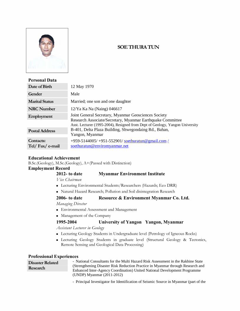
SOE THURA TUN
Personal Data Date of Birth 12 May 1970
Gender Male
Marital Status Married; one son and one daughter
NRC Number 12/Ya Ka Na (Naing) 046617
Employment Joint General Secretary, Myanmar Geosciences Society Research Associate/Secretary, Myanmar Earthquake Committee Asst. Lecturer (1995-2004), Resigned from Dept of Geology, Yangon University
Postal Address B-401, Delta Plaza Building, Shwegondaing Rd., Bahan, Yangon, Myanmar
Contacts: Tel/ Fax/ e-mail
+959-5144005/ +951-552901/ [email protected] / [email protected]
Educational Achievement B.Sc.(Geology), M.Sc.(Geology), A+(Passed with Distinction) Employment Record 2012- to date Myanmar Environment Institute
Vice Chairman Lecturing Environmental Students/Researchers (Hazards; Eco DRR) Natural Hazard Research; Pollution and Soil disintegration Research
2006- to date Resource & Environment Myanmar Co. Ltd. Managing Director Environmental Assessment and Management Management of the Company
1995-2004 University of Yangon Yangon, Myanmar Assistant Lecturer in Geology Lecturing Geology Students in Undergraduate level (Petrology of Igneous Rocks) Lecturing Geology Students in graduate level (Structural Geology & Tectonics,
Remote Sensing and Geological Data Processing) Professional Experiences Disaster Related Research
- National Consultants for the Multi Hazard Risk Assessment in the Rakhine State (Strengthening Disaster Risk Reduction Practice in Myanmar through Research and Enhanced Inter-Agency Coordination) United National Development Programme (UNDP) Myanmar (2011-2012)
- Principal Investigator for Identification of Seismic Source in Myanmar (part of the
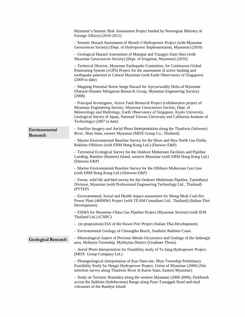
Myanmar’s Seismic Risk Assessment Project funded by Norwegian Ministry of Foreign Affairs) (2010-2011)
- Seismic Hazard Assessment of Shweli-3 Hydropower Project (with Myanmar Geosciences Society) (Dept. of Hydropower Implementation, Myanmar) (2010)
- Geological Hazard Assessment of Manipur and Yazagyo Dam Sites (with Myanmar Geosciences Society) (Dept. of Irrigation, Myanmar) (2010)
- Technical Director, Myanmar Earthquake Committee, for Continuous Global Positioning System (cGPS) Project for the assessment of active faulting and earthquake potential in Central Myanmar (with Earth Observatory of Singapore) (2009 to date)
- Mapping Potential Storm Surge Hazard for Ayeyarwaddy Delta of Myanmar (Natural Disaster Mitigation Research Group, Myanmar Engineering Society) (2008)
- Principal Investigator, Active Fault Research Project (collaborative project of Myanmar Engineering Society, Myanmar Geosciences Society, Dept. of Meteorology and Hydrology, Earth Observatory of Singapore, Kyoto University, Geological Survey of Japan, National Taiwan University and California Institute of Technology) (2007 to date)
Environmental Research
- Satellite Imagery and Aerial Photo Interpretation along the Thanlwin (Salween) River, Shan State, eastern Myanmar (MDX Group Co., Thailand)
- Marine Environmental Baseline Survey for the Shwe and Mya North Gas Fields, Rakhine Offshore (with ERM Hong Kong Ltd.) (Daewoo E&P)
- Terrestrial Ecological Survey for the Onshore Midstream Facilities and Pipeline Landing, Rambye (Ramree) Island, western Myanmar (with ERM Hong Kong Ltd.) (Daewoo E&P)
- Marine Environmental Baseline Survey for the Offshore Midstream Gas Line (with ERM Hong Kong Ltd.) (Daewoo E&P)
- Forest, wild life and bird survey for the Onshore Midstream Pipeline, Tanintharyi Division, Myanmar (with Professional Engineering Technology Ltd., Thailand) (PTTEP)
- Environmental, Social and Health impact assessment for Mong Hkok Coal-fire Power Plant (460MW) Project (with TEAM Consultant Ltd., Thailand) (Italian-Thai Development)
- ESHIA for Myanmar-China Gas Pipeline Project (Myanmar Section) (with IEM Thailand Ltd.) (CNPC)
- (in proposition) EIA of the Dawei Port Project (Italian Thai Development)
- Environmental Geology of Chaungtha Beach, Southern Rakhine Coast
Geological Research - Mineralogical Aspect of Precious Metals Occurrence and Geology of the Indawgyi area, Mohnyin Township, Myitkyina District (Graduate Thesis)
- Aerial Photo Interpretation for Feasibility study of Ta Sang Hydropower Project. (MDX Group Company Ltd.)
- Photogeological interpretation of Kun Dam-site, Phyu Township Preliminary Feasibility Study for Hutgyi Hydropower Project, Union of Myanmar (2006) (Site selection survey along Thanlwin River in Karen State, Eastern Myanmar)
- Study on Tectonic Boundary along the western Myanmar (2006-2008); Fieldwork across the Rakhine (Indoburman) Range along Pyay-Taunggok Road and mud volcanoes of the Rambye Island

Other Professional Activities
- Paleoseismological Trenching Survey, Bago and Phyu sections of the Sagaing Fault, Central Myanmar
- Paleoseismological Survey, Northern Rakhine Shoreline
- Member of the Myanmar Geosciences Society
- Post-Tsunami Survey along the Tanintharyi Coast, Myanmar
- Pondaung Primate Expedition, Myanmar (collaborative research with French, Japan, and American Universities)
Attendance of International Meetings/ Conferences
- (July 1999) Asian Science Seminar on Biodiversity, Primate Research Institute, Kyoto University, Japan
- (Nov 2005) Conference of Asean Federation of Engineering Association (CAFEO 2005) Yangon, Myanmar
- (June, 2006) PACON 2006 (Pacific Congress on Marine Sciences and Technology in Asia) Yangon, Myanmar
- (July 2006) 3rd Annual Congress of Asia Oceania Geosciences Society (AOGS), Singapore
- (Jan 2007) 1st International Workshop on Seismotectonics in Myanmar and Earthquake Risk Management (SMERM 2007), Yangon, Myanmar
- (July 2007) 4th Annual Congress of Asia Oceania Geosciences Society (AOGS), Bangkok, Thailand
- (Feb, 2008) Regional Congress on Tectonics of Northeastern Indochina (TNI 2008), Chiang Mai, Thailand
- (Nov, 2008) GREAT 2008 – IGCP Congress, Bangkok, Thailand
- (April, 2009) 2nd International Workshop on Seismotectonics in Myanmar and Earthquake Risk Management (SMERM 2009), Yangon, Myanmar
- (June, 2009) GEOSEA 2009 Regional Geological Congress, Kuala Lampur, Malaysia
- (July, 2009) 6th Annual Congress of Asia Oceania Geosciences Society (AOGS), Singapore
- (Nov, 2009) Project Formulating Meeting on Myanmar’s Earthquake Risk Assessment Project (Norwegian Ministry of Foreign Affairs and ADPC) (Bangkok, Thailand)
- (October, 2010) International Workshop on Resource and Environment towards Sustainable Development in the Great Mekhong Region (Kunming, China)
- (May, 2011) 3rd International Workshop on Seismotectonics in Myanmar and Earthquake Risk Management (SMERM 2011), Yangon, Myanmar
- (March, 2012) GeoMyanmar 2012, International Conference on Geology of Myanmar, (Sedona Hotel, Yangon, Myanmar)
- (July, 2012) Myanmar Mining Summit 2012 (Sedona Hotel, Yangon, Myanmar)
Award Received - Medal (Second Class) for Excellent Performance in Social Field (2008 January, Government of Myanmar)
Some Recent Publications Soe Thura Tun and Maung Thein (2012) Tectonic Map of Myanmar 2012, Paper read at Myanmar Mining
Summit 2012, 22-25 July 2012, Yangon, Myanmar Soe Thura Tun, Saw Ngwe Khaing, Wang Yu, Nyunt Htay, Yin Myo Min Htwe, Myo Thant, Than Myint and
Kerry Sieh (2012) Surface Ruptures of the 2011 Tarlay Earthquake and Their Relationship to the Active Tectonics of Eastern Myanmar (Paper submitted to Bulletin of the Seismological Society of America)

Yu Wang, Kerry Sieh, Thura Aung, Soe Min, Saw Ngwe Khaing, and Soe Thura Tun (2011) Earthquakes and slip rate of the southern Sagaing fault: insights from an offset ancient fort wall, lower Burma (Myanmar), Geophys. J. Int.
Maung Thein, Than Myint, Soe Thura Tun, and Tint Lwin Swe (2009) Earthquake and Tsunami Hazard in Myanmar Journal of Earthquake and Tsunami, 3, 2, 43–57
Win Swe and Soe Thura Tun (2009) Marine Terraces along the Myanmar Coast and their active tectonic significance Journal of Earthquake and Tsunami, 2, 4, 267– 277
Than Tin Aung, Satake. Kenji, Okamura, Yukinobu, Shishikura, Masanobu, Win Swe, Hla Saw, Tint Lwin Swe, Soe Thura Tun and Thura Aung [2008] Geologic evidence for three great earthquakes in the past 3400 years off Myanmar: Jour. Earthquakes and Tsunami, 2, (4), 259-265
Soe Thura Tun (2006) The Sagaing Fault: a desk study report for seismotectonics implication in Myanmar, Local Publication, Myanmar Earthquake Committee, Myanmar Engineering Society.
Satake, K., Aung, T. T., Sawai, Y., Okamura, Y., Wing, K. S., Swe, W., Swe, C., Swe, T. L., Tun, S. T., Soe, M. M., Oo, T. Z. and Zaw, S. H. (2006) Tsunami heights and damage along the Myanmar coast from the December 2004 Sumatra-Andaman earthquake, Earth Planets Space 58, 243–252.

Resource & Environment Myanmar 2014
GS)
WIN NAING TUN Director and Principal Consultant
Legal System
A. Personal Particulars:
Date of Birth : 01‐01‐1969 Gender/ Sex : Male Passport. No. : 551047, Date of Expiry 18‐01‐2008 Marital Status : Married Nationality : Myanmar Present Address : No.(440), Block (D), Maydarwi Road, North Okkalapa Tsp, Yangon. Telephone : 95‐1‐699975 E‐mail : [email protected]; [email protected] B. Educational Qualifications
1. B.Sc.(Geology), University of Yangon 2. Diploma in Business Law, University of Yangon 3. M.A. (Archaeology) 4. M.P.A. (first year) C. Other Qualifications
1. Microsoft Certified Professional (Exam No. 70‐290) Managing and Maintaining a Microsoft Windows
Server 2003 Environment 2. Certificate in Cisco Certified Network Associate 640‐607 3. Certificate in Linux System / Network Administration Training Program LPIC and Vendor neutral
Certification Track 4. Certificate in Visual Basic 5. Certificate in Accpac Plus 6.1A (Multi Currency) General Ledger and Financial Reporter 6. Can speak, read, write and understand English and German Languages. WORKING EXPERIENCE
Position : Director Company : Resource & Environment Myanmar Ltd., Myanmar Period : 2007 August to present Job Duties/ Achievements: Site Investigation in Geotechnical and Environmental Field Survey GIS Mapping in Environmental Baseline Data collection for proposed PTTEP Gas line route (2008‐9) Logistical Management for Environmental Baseline Data collection for Shwe Gasline (onshore/offshore) (2007‐8)

Resource & Environment Myanmar 2014
Position : Data Manager, Legal Advisor Company : EIA Study Group, Yangon University, EIA for Ta Sang Hydropower Project Period : 2003 to 2007 Job Duties/ Achievements: Environmental Data Management Personnel for Regulatory System Monitoring
OTHER EXPERIENCE
Position : GIS/Remote Sensing Lecturer, Geotechnical Engineering Course Myanmar Geosciences Society: 2009 August to present
IT Consultant 1. Myanma Oceanwin Services Co., Ltd. (Yangon) 2. Aung Pyi Tan Company Limited (Yangon) 3. Golden Galon Company Limited & Meemosa Boutique Shop 4. Padonmar Fine Dining Restaurant 5. Caravan Travels & Tours 6. Elephant House Co., Ltd. 7. Myintmo Trading Co., Ltd. 8. Victory Land Furniture Shop 9. San Yi Co., Ltd. 10. Nautilus Marine Services (Yangon)

Resource & Environment Myanmar 2014
KHIN OHNMAR HTWE Principal Consultant
Social Survey and Impact Assessment
Personal information Name Khin Ohnmar HtweAddress No.1 (b), Shwemann Road, Mandalay University Campus,
Maha Aung Myay Township, Mandalay City, Mandalay Region, The Republic of the Union of Myanmar
Telephones 952‐21131 (Res.), Mobile: 0949301881Email [email protected] of Birth 25 July 1965 Gender Female Nationality Myanmar Race Bamar Religion Buddhism Work experience Position Head of Section Date 2011 to presentMain activities and responsibilities
Lecturing Social Survey, Social Impact Assessment, Social Action Plan in Development Projects Research on Social Issue related to Environment
Type of business Myanmar Environment Institute (MEI) Work experience Position Senior Consultant Date 2009 to presentMain activities and responsibilities
Social Impact Assessment Specialist, managing and preparing for the SIA field observations and reports
Type of business Resource and Environment Myanmar (REM) Work experience Position Administrator and InstructorDate 2007 to 2009 Main activities and responsibilities
Management, Office Work, Assistant Lecturer
Type of business Shinpo Japanese Language School Work experience (Government Staff) Position Tutor , Department of Geography, University of YangonDate 1995 to 1998 Main activities and responsibilities
Teaching and doing research
Type of business Department of Higher Education, Ministry of EducationWork experience Position Principal Date 2001 to 2006 Main activities and responsibilities
Management and Instructor
Type of business Century Childcare, Computer and Language Centre
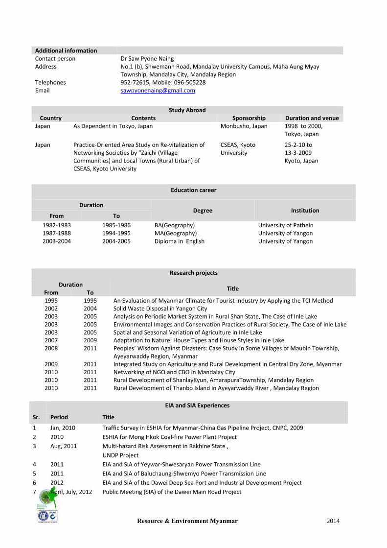
Resource & Environment Myanmar 2014
Additional information Contact person Dr Saw Pyone NaingAddress No.1 (b), Shwemann Road, Mandalay University Campus, Maha Aung Myay
Township, Mandalay City, Mandalay Region Telephones 952‐72615, Mobile: 096‐505228Email [email protected]
Study Abroad
Country Contents Sponsorship Duration and venueJapan As Dependent in Tokyo, Japan Monbusho, Japan 1998 to 2000,
Tokyo, Japan
Japan
Practice‐Oriented Area Study on Re‐vitalization of Networking Societies by "Zaichi (Village Communities) and Local Towns (Rural Urban) of CSEAS, Kyoto University
CSEAS, Kyoto University
25‐2‐10 to 13‐3‐2009 Kyoto, Japan
Education career
Duration Degree Institution
From To
1982‐1983 1987‐1988 2003‐2004
1985‐1986 1994‐1995 2004‐2005
BA(Geography)MA(Geography) Diploma in English
University of Pathein University of Yangon University of Yangon
Research projects
Duration Title
From To 1995 1995 An Evaluation of Myanmar Climate for Tourist Industry by Applying the TCI Method2002 2004 Solid Waste Disposal in Yangon City2003 2005 Analysis on Periodic Market System in Rural Shan State, The Case of Inle Lake 2003 2005 Environmental Images and Conservation Practices of Rural Society, The Case of Inle Lake2003 2005 Spatial and Seasonal Variation of Agriculture in Inle Lake2007 2009 Adaptation to Nature: House Types and House Styles in Inle Lake 2008 2011 Peoples’ Wisdom Against Disasters: Case Study in Some Villages of Maubin Township,
Ayeyarwaddy Region, Myanmar 2009 2011 Integrated Study on Agriculture and Rural Development in Central Dry Zone, Myanmar2010 2011 Networking of NGO and CBO in Mandalay City2010 2011 Rural Development of ShanlayKyun, AmarapuraTownship, Mandalay Region 2010 2011 Rural Development of Thanbo Island in Ayeyarwaddy River , Mandalay Region
EIA and SIA Experiences
Sr. Period Title
1 Jan, 2010 Traffic Survey in ESHIA for Myanmar‐China Gas Pipeline Project, CNPC, 2009
2 2010 ESHIA for Mong Hkok Coal‐fire Power Plant Project
3 Aug, 2011 Multi‐hazard Risk Assessment in Rakhine State ,
UNDP Project
4 2011 EIA and SIA of Yeywar‐Shwesaryan Power Transmission Line
5 2011 EIA and SIA of Baluchaung‐Shwemyo Power Transmission Line
6 2012 EIA and SIA of the Dawei Deep Sea Port and Industrial Development Project
7 April, July, 2012 Public Meeting (SIA) of the Dawei Main Road Project

Resource & Environment Myanmar 2014
8 2011 SIA for Tharkayta Gas Turbine Project
9 April, May 2012 IEE for Small Scale Gold Processing Plant, Modi Taung Project, Yamethin
10 July 2012 SIA of Shweli River II Hydropower Project
11 September 2012 Urban Environmental Issues in Yangon City Area, Joint Study of Japan International
Cooperation Agency and Yangon City Development Committee
12 December 2012 Social Baseline Data Collection for Dawei Special Economic Zone
13 January 2013 Social Impact Assessment for Hlawga 500 MW Combine Cycle Power Plant
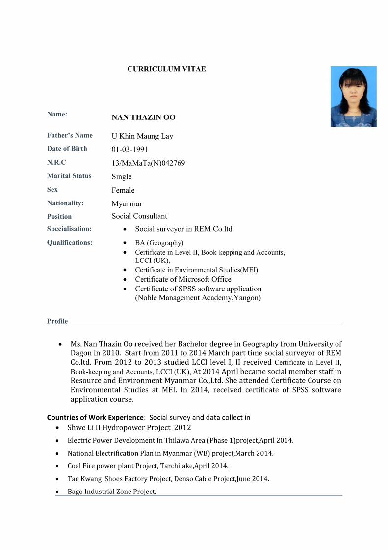
Name:
CURRICULUM VITAE NAN THAZIN OO
Father’s Name U Khin Maung Lay
Date of Birth 01-03-1991
N.R.C 13/MaMaTa(N)042769
Marital Status Single
Sex Female
Nationality: Myanmar
Position Social Consultant Specialisation: Social surveyor in REM Co.ltd
Qualifications: BA (Geography) Certificate in Level II, Book-kepping and Accounts,
LCCI (UK), Certificate in Environmental Studies(MEI) Certificate of Microsoft Office Certificate of SPSS software application
(Noble Management Academy,Yangon)
Profile
Ms. Nan Thazin Oo received her Bachelor degree in Geography from University of
Dagon in 2010. Start from 2011 to 2014 March part time social surveyor of REM Co.ltd. From 2012 to 2013 studied LCCI level I, II received Certificate in Level II, Book-keeping and Accounts, LCCI (UK), At 2014 April became social member staff in Resource and Environment Myanmar Co.,Ltd. She attended Certificate Course on Environmental Studies at MEI. In 2014, received certificate of SPSS software application course.
Countries of Work Experience: Social survey and data collect in
Shwe Li II Hydropower Project 2012
Electric Power Development In Thilawa Area (Phase 1)project,April 2014.
National Electrification Plan in Myanmar (WB) project,March 2014.
Coal Fire power plant Project, Tarchilake,April 2014.
Tae Kwang Shoes Factory Project, Denso Cable Project,June 2014.
Bago Industrial Zone Project,
Lake View Project, May 2014.
Tama 1.2 MW Small Hydropower Project,Auguest,2014
ShweAyeyarnaddy soap factory project, October 2014.
Ngaw Chang Hka Hydropower Project, May 2014.
ESIA Cement Import Terminal, Thilawa Port Project,(REM),October 2012.
Environmental Baseline Survey of Dawei Deep Sea Port and Industrial Development, May 2012(REM)
ESIA of 500 MW CCPP at Hlawga Township, Yanagon, February, 2013(REM) Insein Gas Turbine Project(REM),February 2013.
ESIA of MCC Cement Plant, Mawlamyaing Township, Mon State, Myanmar, April, 2013(REM)
Taungoo Education College Project(REM),May 2013.
Thilawa special Economic Zone Project(REM),July 2013.
Supplemental Socio-Economic Survey and Inventory of Loss for Development of
Thilawa Special Economic Zone (SEZ) ,Auguest 2013.
Oil factory LongloneProject(REM),Auguest 2013.
ESHIA of Baluchaung- Shwemyo 23o kV Transmission Line project, November, 2011(REM)
ModiTaung Gold Mining Project(REM),December 2013.
Coner Stone Zinc Factory Project(REM),January 2014.
Eindu to Kawkareik Road Improvement ADB Project(REM),March 2014.
Mong Wa Hydropower Project, January 2015
Selected Relevant Experience in Present Employment Since 2010
2011 to 2013: Part time social surveyor in REM Co.ltd 2012 to 2013: Study LCCI Course 2014 to date : Social member staff in REM Co.ltd
Language
1. Burmese as mother tongue and Shan.
2. English (read/write/understand/speak)
Contacts
Contact Adress; No.7/ 6 floor, Thukha Street,Kyaukmyaung Gyi Ward, Tamwe Township,Yangon.
09-425302677 Contact Phone; [email protected] Email;
CURRICULUM VITAE
NAME: May Thu Htet
Father’s Name: U Aung Min Lwin
N.R.C No. : 12/LAMANA (N) 144329
Date of Birth: November 11, 1993
Religion: Buddhist
Nationality: Myanmar
Gender: Female
Marital Status: Single
Membership: Myanmar Engineering Society (MES)
Hobby: Travelling, Reading and Drawing
Education: AGTI (Electronic & Communication), BSc (Physics)
Other Qualification: Environmental Studies Level -1, I – Office 2007, Microsoft
Excel in Business Application, AUTOCAD, NK-GIS
Research (Owned): Electronic Circuit for traffic control, elevator, LED
Lighting (West Yangon Technology University)
Work Experience: 2012- Present
Social Consultant for Environmental and Social Impact
Assessment (Resource and Environment Myanmar Co.,
Ltd.)
Base line data collection and data assessment for house hold Survey and co-
operate the public consulting meeting Environmental Impact Assessment and
Environmental Management on:
• Thilawa Special Economic Zone Project at Thanlyn Township (2012)
• Oil factory Longlone Project at Longlone Township (2012)
• 500 KV and 230 KV Transmission Line Project at HlaingTharyar to Bago
Township (2013)
• Eindu toKawkareik Asian Main Road Improvement (ADB) Projectat
Kayin State (2014)
• Oil & Gas Enterprise IOR-4 & IOR-6 Project at Pyay&Manaung
Townships (2014)
• Oil & Gas Enterprise C-1 Project at Maw Lite, Ta Mue Township,
Sagaing Region (2014)
• Oil & Gas Enterprise MOGE – 4 Project at Myanaung, KyanKhinn, and
Pantaung Townships in Ayeyarwaddy and Bago Regions (2015)
• KyeikHteeYoe Cable Car Project (Sky Star Co. Ltd) at Mon State (2015)
• Dawei special Economic Zone Project at Tanintharyi Region (2015)
• Oil & Gas Enterprise A-4 & AD-02 Projectat Rakkhine State (2015)
• Oil & Gas Enterprise A-5 Projectat Rakkhine State (2015)
• Oil & Gas Enterprise AD-10 Project at Rakhine State (2015)
• 225MW Combined Gas Turbine Cycle Project at Mandalay State (2015)
: Sale marketing for GIS software and Satellite Image
• (Imago Global Co. Ltd._ JV with Hexagon International Company)
_Part Time (2013-2014)
Professional: Social Surveyor
Proposed Position: Field Researchers
Contact Address: No (1), Timber Housing, Okkyin, Hlaing Township and
Yangon
Contact Phone No. : 09-43198451, 09-972254894
Email: [email protected]

Annex 3.1 BG Group Policies

Unclassified
BG Group Standard
Environment and Climate Change
BG-ST-ECC-ENV-001
(HSSE Management System Framework Section 9.1.9)
2 of 49 Doc Ref: BG-ST-ECC-ENV-001 Author: Richard Head Version 3.0 (29 April 2014)
BG Group Standard
Environment
Document and Version Control Version Author Issue Date Revision Detail
1.0 Paul Fletcher 01 October 2010
This standard replaces the Environmental Expectations Standard, Best Available Techniques for Environmental Protection Standard, Air Quality Standard, Water Quality Standard, Greenhouse Gas Management Standard, Resource Use and Waste Management Standard and Biodiversity Standard
1.1 Paul Fletcher 01 January 2011 Updated to new Template Issued for use
2.0 Group Environment 01 April 2013
Key changes have been made in the areas of Environmental Impact Assessment (to give more detail on what an EIA is to include) energy efficiency, GHG management and climate change (to support new BG Group GHG target), water risk management (to support BG Group Water Strategy and enhance BG Group oil in water performance), oil spill preparedness (to mitigate increased risks posed to the business) and biodiversity management (to mitigate against increased risks posed to the business). The Standard has also been rationalised by taking out detailed air and water quality standard information from this document and placing into a new Environmental Quality Guidance document Issued for use
3.0 Environment & Climate Change
29 April 2014 Standard updated to reflect HSSE Management System Framework Standard. Mandatory expectations identified, document simplified. Changes: Climate Change (section 9.1.9.16.2), Biodiversity and Ecosystems Services sections, removal of oil spill preparedness and protected areas Issued for use
3 of 49 Doc Ref: BG-ST-ECC-ENV-001 Author: Richard Head Version 3.0 (29 April 2014)
BG Group Standard
Environment
Contents 1.0 Executive Summary ............................................................................... 4
2.0 Ownership ............................................................................................... 5
3.0 Objectives ............................................................................................... 5
4.0 Scope and application ........................................................................... 5
5.0 Links to other controls ........................................................................... 6
6.0 Standard requirements .......................................................................... 7
Environmental Management ........................................................................................................................... 8
Best Available Techniques (BAT).................................................................................................................. 12
Climate Change ............................................................................................................................................. 14
Emissions and Discharges ............................................................................................................................ 21
Water Management ....................................................................................................................................... 22
Contaminated Land and Decomissioning ..................................................................................................... 25
Raw Material Minimisation and Waste Management .................................................................................... 26
Biodiversity and Ecosystem Services ........................................................................................................... 28
Environmental Noise ..................................................................................................................................... 32
7.0 Appendices ........................................................................................... 34
Appendix A – Gap Analysis Template ........................................................................................................... 34
Appendix B – Abbreviations / definitions ....................................................................................................... 38
Appendix C – Minimum BAT performance standards ................................................................................... 42
4 of 49 Doc Ref: BG-ST-ECC-ENV-001 Author: Richard Head Version 3.0 (29 April 2014)
BG Group Standard
Environment
1.0 Executive Summary Effective environmental management delivers and protects business value throughout the lifecycle of an asset and reduces to as low as practicable impacts and risks related to the natural environment.
Thorough and early environmental risk identification and mitigation prevents schedule delay and minimises costs;
Efficient use of energy and natural resources saves product that would otherwise be lost and enhances revenue and production;
A reputation for effective environmental management builds strong relationships with stakeholders and is essential to our ‘Licence to Operate’ which protects investments and facilitates access to new value adding opportunities
Proactive management of environmental risks strengthens BG Group’s resilience to regulatory and fiscal change. It facilitates growth, protects the long term viability of our assets, products and markets and in so doing, preserves the long term sustainability of the business as well as the environment. The purpose of this document is to set out how BG Group will meet the environmental commitments in our Business Principles and HSSE Policy, aligned to accepted industry best practice. The Business Principle commitments relating to environmental management are:
We make a positive contribution to the protection of the environment;
We go beyond compliance with local environmental regulations to meet internationally accepted best practice; and
We reduce to the minimum practicable any adverse effects of our operations on the environment.
5 of 49 Doc Ref: BG-ST-ECC-ENV-001 Author: Richard Head Version 3.0 (29 April 2014)
BG Group Standard
Environment
2.0 Ownership Owning Function: BG Advance Environment & Climate Change Standard owner: Head of Environment Expert advisor: BG Advance Environment & Climate Change Dispensation: Head of Environment
3.0 Objectives The HSSE Management System Framework (MSF) Standard BG-ST-HSSE-HSSE-001 and this Environment and Climate Change Standard sets out our minimum expectations for environmental performance. The document provides guidance to facilitate compliance with the MSF Section 9.1.9 ‘Environment and Climate Change’ and to provide best practice information in support of development and adoption of effective local arrangements / processes for systematically managing risk. This document provides information on the content, format and level of detail used in environmental management in order to deliver the mandatory requirements of the MSF and regulation. BG Group’s environmental management objectives are to meet the commitments in our Business Principles and HSSE Policy. Further guidance is provided in the documents listed in section 5 and referenced throughout this document.
4.0 Scope and application This is an Activity Specific Standard. Application of an Activity Specific Standard is mandatory for all BG Group employees, consultants and other personnel working in controlled1 assets, projects and offices when undertaking the activities described. In non-controlled assets and project developments the Standard will be used as a means for benchmarking by the overseeing asset. Where high-risk deficiencies are identified they will be escalated through asset and Functional lines. For BG Group employees, breach of this Standard may result in disciplinary action, up to and including dismissal. Breach of this Standard by any individual who is not a BG Group employee may result in other appropriate action being taken in relation to the individual and/or the business which supplies services to BG Group, including termination of the relevant contract(s). This Standard is not contractual. BG Group reserves the right to amend, suspend or terminate this Standard. This Standard mandates the minimum requirements for all business segments and applies to all lifecycle stages.
1 Refer to Internal Control Framework - Integrity Standard for the definition of controlled and non-controlled Joint Ventures.
6 of 49 Doc Ref: BG-ST-ECC-ENV-001 Author: Richard Head Version 3.0 (29 April 2014)
BG Group Standard
Environment
5.0 Links to other controls Governing Policies:
Business Principles HSSE Policy Licence to Operate Policy
Complementary and linked Standards:
Internal Control Framework – Integrity: BG-ST-LEG-SECT-001 HSSE Management System Framework: BG-ST-HSSE-HSSE-001 Social Performance: BG-ST-PCA-SOC-001 Crisis Management (for oil spill preparedness): BG-ST-HSSE-SEC-002
Supporting Guidelines:
Best Available Techniques for Environmental Control BG-GL-ECC-ENV-1516 Environmental Reporting BG-GL-ECC-ENV-002 Resource Use and Waste Management BG-GL-ECC-ENV-008 Preparation of Oil Spill Contingency Plans BG-GL-ECC-ENV-001 Managing Technical Environmental Risk BG-GL-ECC-ENV-003 Water Risk Management BG-GL-ECC-ENV-010 Environmental Quality Standards BG-GL-ECC-ENV-011 Use and Disposal of Non-aqueous Drilling Fluids BG-GL-WE-WE-025 Climate Risk BG-GL-ECC-ENV-009 ENVID BG-GL-ECC-ENV-1520
Other Supporting Documents:
BG Group Climate Change Public Position BG Group Unconventional Gas Public Position OGP (2009) Guidelines for waste management with special focus on areas with limited infrastructure International Finance Corporation (IFC) Performance Standards on Environmental and Social Sustainability, January 1, 2012 (and Guidance Notes) www.ifc.org IFC and World Bank Group Environmental, Health, and Safety (EHS) Guidelines (2007) www.ifc.org/ehsguidelines EU BAT Reference (BREF) notes http://eippcb.jrc.es/reference/ Basel Convention on Control of Transboundary Movement of Hazardous Waste and their Disposal http://www.basel.int/text/con-e.pdf OGP Report 342 Environmental Aspects of the Use and Disposal of Non-aqueous Drilling Fluids Associated with Off-shore Oil and Gas Operations www.ogp.org.uk/pubs/342.pdf ISO 14001 - Environmental management
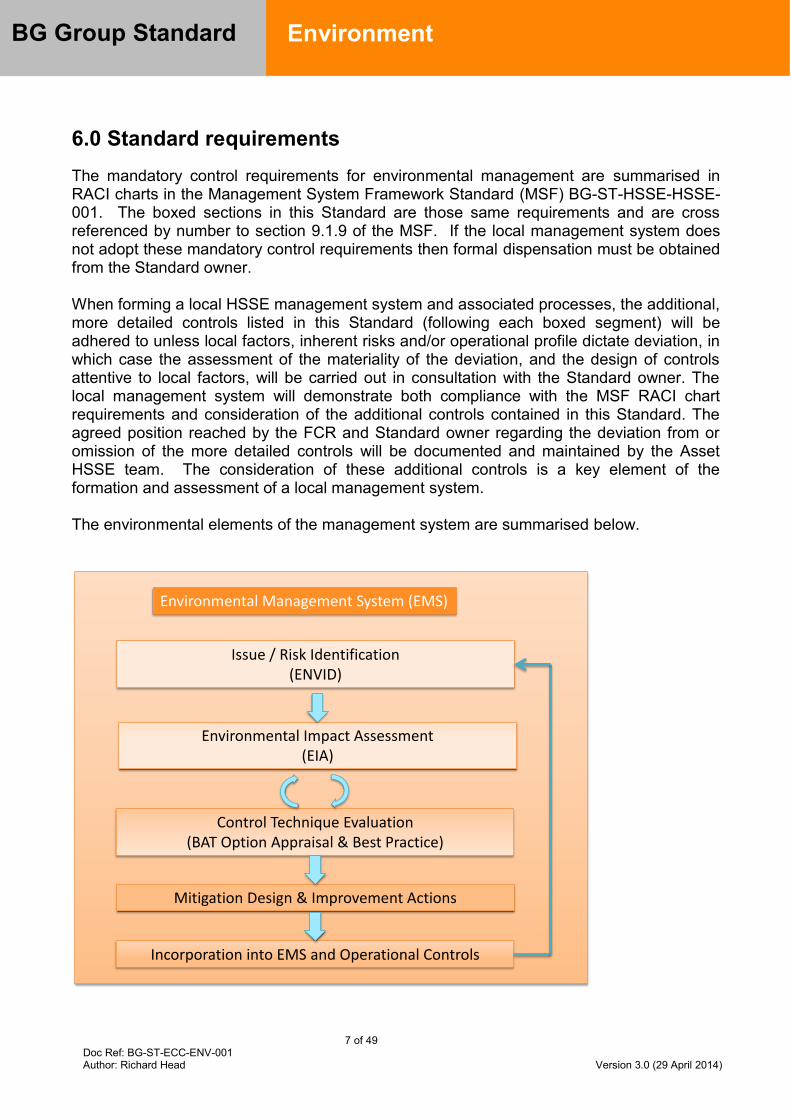
7 of 49 Doc Ref: BG-ST-ECC-ENV-001 Author: Richard Head Version 3.0 (29 April 2014)
BG Group Standard
Environment
6.0 Standard requirements The mandatory control requirements for environmental management are summarised in RACI charts in the Management System Framework Standard (MSF) BG-ST-HSSE-HSSE-001. The boxed sections in this Standard are those same requirements and are cross referenced by number to section 9.1.9 of the MSF. If the local management system does not adopt these mandatory control requirements then formal dispensation must be obtained from the Standard owner. When forming a local HSSE management system and associated processes, the additional, more detailed controls listed in this Standard (following each boxed segment) will be adhered to unless local factors, inherent risks and/or operational profile dictate deviation, in which case the assessment of the materiality of the deviation, and the design of controls attentive to local factors, will be carried out in consultation with the Standard owner. The local management system will demonstrate both compliance with the MSF RACI chart requirements and consideration of the additional controls contained in this Standard. The agreed position reached by the FCR and Standard owner regarding the deviation from or omission of the more detailed controls will be documented and maintained by the Asset HSSE team. The consideration of these additional controls is a key element of the formation and assessment of a local management system. The environmental elements of the management system are summarised below.
Environmental Management System (EMS)
Issue / Risk Identification (ENVID)
Environmental Impact Assessment (EIA)
Control Technique Evaluation(BAT Option Appraisal & Best Practice)
Mitigation Design & Improvement Actions
Incorporation into EMS and Operational Controls
8 of 49 Doc Ref: BG-ST-ECC-ENV-001 Author: Richard Head Version 3.0 (29 April 2014)
BG Group Standard
Environment
Environmental Management
9.1.9.1
Establish a corporate environmental and climate change strategy and management framework which ensures compliance with legal expectations, our Business Principles and sets out the environmental risk management processes
9.1.9.2
All assets shall develop an EMS (either stand alone or integrated into the HSSE MSF). The EMS shall be certified to international standard ISO 14001 within two years of start-up of production or acquisition, using a certifying company approved by BGA E&CC
9.1.9.2.1 To ensure a consistent approach, scope, and standard of certification and to facilitate the identification of trends across assets, BGA E&CC will approve appoint a single certifier the third party verifier of ISO 14001 compliance 9.1.9.2.2 Develop, implement and maintain a robust EMS in order to identify and deliver environmental goals and minimise environmental impacts of local operations/activities, in line with legal and BG Group requirements 9.1.9.2.3 The EMS will, as a minimum:
Identify legal and other requirements (including BG Group requirements); Identify and evaluate environmental aspects relating to asset activities and develop an
environmental aspects and impacts register for the asset; Establish a process to set appropriate objectives and targets to continually improve
environmental performance and maintain compliance with legal and other requirements;
Establish programmes to deliver the objectives and targets; Develop monitoring programmes to measure compliance and performance; Ensure the environmental awareness and competency of the One Team; and Review progress and maintain continuous improvement.
9.1.9.3 Assets shall identify and assess environmental impacts, risks and opportunities within and beyond the asset boundary
9.1.9.3.1 Environmental risk and opportunity identification to be carried out for new project developments during the ‘Create’, ‘Assess’ and ‘Select’ VAF stages and maintained:
Systematically identify environmental aspects through the environmental issues identification (ENVID) process
Broad multi-functional teams to be included in the identification and classification of environmental aspects and management measures development, typically though a workshop
For new project developments, environmental risk identification and opportunity will inform siting of the project and related facilities, project design, construction activities in addition to planned future operations and mitigation measures

9 of 49 Doc Ref: BG-ST-ECC-ENV-001 Author: Richard Head Version 3.0 (29 April 2014)
BG Group Standard
Environment
Environmental impacts and risks identified and agreed management measures will be included in the asset EIA and project EIAs
Significant environmental risks to be embedded in the asset and project risk registers and the environmental aspects and impacts registers
9.1.9.3.2 An environmental risk management process to be established: Identify mitigation measures to eliminate or reduce identified environmental impacts
and risks. Follow a mitigation hierarchy of (in order of preference) avoid, minimise, mitigate, offset or compensate for potential negative residual impacts. Enhance positive impacts.
Where avoidance is not possible, mitigation measures will be included in the environmental aspects and impacts register and the mitigation measures will be included in an asset environmental management plan. Design documents and procedures as appropriate.
International best practice and the BAT process will be used to determine appropriate mitigation measures
Record measures in the BG Group-wide HSSE system and track to competent, timely closure
Implement an effective monitoring and review process and incorporate in the EMS 9.1.9.3.3 Environmental impact and risk identification and assessment will be reviewed and updated regularly through the project life-cycle in accordance with the asset EMS, and significant environmental risks will be included in the asset risk register:
The HSSE risk matrix in the HSSE MSF (section 9.1.25) and the Significance categories in the table below will be used during the impact and RAAM risk assessment process to assess the likelihood of the event and the severity of consequences
Additional quantitative assessment (e.g. modelling studies for air dispersion, aqueous discharge, oil spill dispersion or noise may be required to determine the nature and significance of impacts)
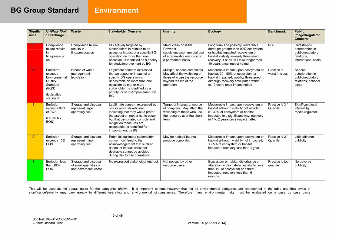
10 of 49 Doc Ref: BG-ST-ECC-ENV-001 Author: Richard Head Version 3.0 (29 April 2014)
BG Group Standard
Environment
Significance
Air/Water/Solid Discharge
Waste Stakeholder Concern Amenity Ecology Benchmark Public Image/Regulator Concern
5 Compliance failure results in fine/prosecution
Compliance failure results in fine/prosecution
BG actively targeted by stakeholders in relation to an aspect or impact of a specific BG operation on more than one occasion. Is identified as a priority for study/improvement by BG
Major claim possible. Prevents subsistence/commercial use of a renewable resource on a permanent basis
Long term and possibly irreversible damage; greater than 90% ecosystem or habitat impacted; ecosystem or habitat viability severely threatened, recovery, if at all, will take longer than 10 years once impact halted
N/A Catastrophic deterioration in public/regulatory relations, international scale
4 Emission exceeds Environmental Quality Standard (EQS)
/legislative standard
Breach of waste management legislation
Legitimate concern expressed that an aspect or impact of a specific BG operation is undesirable on more than one occasion by one or more stakeholder. Is identified as a priority for study/improvement by BG
Multiple, serious complaints. May affect the wellbeing of those who use the resource beyond the life of the operation
Measurable impact upon ecosystem or habitat; 30 - 90% of ecosystem or habitat impacted; viability threatened, although recovery anticipated within 3 to 10 years once impact halted
Practice is worst in class
Serious deterioration in public/regulatory relations, national scale
3 Emission exceeds 60% of EQS
(i.e. >0.6 x EQS)
Storage and disposal represent large operating cost
Legitimate concern expressed by one or more stakeholder indicating that they would prefer the aspect or impact not to occur but that designated controls and mitigation measures are acceptable. Is identified for improvement by BG
Target of interest or source of complaint. May affect the wellbeing of those who use the resource over the short term
Measurable impact upon ecosystem or habitat although viability not affected; 5 - 30% of ecosystem or habitat impacted in a significant way; recovery in 1 to 2 years once impact halted
Practice is 3rd Quartile
Significant local interest by media/regulator
2 Emission exceeds 10% EQS
Storage and disposal represent minor operating cost
Potential legitimate stakeholder concern confined to the acknowledgement that such an aspect or impact whilst not desirable cannot be avoided during day to day operations
May be noticed but not produce complaint
Measurable impact upon ecosystem or habitat although viability not impacted; 1 - 5% of ecosystem or habitat impacted; recovery less than 1 year.
Practice is 2nd Quartile
Little adverse publicity
1 Emission less than 10% EQS
Storage and disposal of small quantities of non-hazardous waste
No expressed stakeholder interest Not noticed by other resource users
Ecosystem or habitat disturbance or alteration within natural variability; less than 1% of ecosystem or habitat impacted; recovery less than 6 months.
Practice is top quartile
No adverse publicity
This will be used as the default guide for the categories shown. It is important to note however that not all environmental categories are represented in the table and that levels of significance/severity may vary greatly in different operating and environmental circumstances. Therefore many environmental risks must be evaluated on a case by case basis

11 of 49 Doc Ref: BG-ST-E&CC-ENV-001 Version: 3.0 (April 2014) Author: Richard Head
BG Group Standard
Environment
9.1.9.3.4 Link to Technical Environmental Risk Management guidance 9.1.9.3.5 Link to ENVID guidance
9.1.9.4
An Environmental Impact Assessment (EIA) shall be undertaken in advance of all exploration activities that could cause disturbance to the environment and all new and brownfield developments and facility decommissioning
9.1.9.4.1 The methodology, scope and schedule of the EIA will be developed with reference to the following requirements:
Host country legal requirements, regulations and expectations;
International Finance Corporation (IFC) Performance Standards; and
Other relevant internationally accepted best practice e.g. IPIECA guidance.
9.1.9.4.2 For all activities and projects requiring an EIA, the process followed will, as a minimum, include studies to sufficiently demonstrate and document:
Planned project activities through design, construction, operations and decommissioning;
Definition of the project area of influence to include planned project facilities, ancillary requirements (e.g. access roads, camps) and associated facilities;
Project alternatives;
Engagement with relevant stakeholders and consideration of their opinions and feedback in the EIA scope;
Identification of all potential environmental issues, concerns and risks;
An understanding of the baseline environment and all potential receptors;
Assessment of all potential direct and indirect environmental impacts and risks (including cumulative impacts) of the proposed project;
The development of comprehensive environmental management plans containing the mitigation measures to be applied for all significant impacts and risks; and
The applicable regulatory framework. 9.1.9.4.3 Where communities in the project area of influence may be potentially affected by BG Group activities, the extent to which potentially affected communities concerns have been considered in the development of mitigation measures will be included in the EIA. 9.1.9.4.4 The environmental setting information, eco-systems services (especially offshore fishing) and other relevant information in the EIA will be used to inform the EMS, Oil Spill Contingency Plan, Risk Register, etc .
9.1.9.4.5 Link to Preparation of Oil Spill Contingency Plans Guideline
9.1.9.4.6 EIAs will be prepared on the assumption they will be subject to third party review and/or published publically as part of a programme of disclosure and consultation

12 of 49 Doc Ref: BG-ST-E&CC-ENV-001 Version: 3.0 (April 2014) Author: Richard Head
BG Group Standard
Environment
9.1.9.4.7 When an EIA is not required for compliance with the national regulatory regime but is required to comply with BG Group Standards, assets will complete an EIA as part of the BG Group risk management programme. 9.1.9.4.8 Assets will notify BGA E&CC when planning to conduct an EIA to confirm scope and expectations and to agree the required support from BGA E&CC 9.1.9.4.9 Risk Assessment and mitigation actions will be recorded in the BG Group-wide HSSE system and tracked to competent, timely closure
9.1.9.4.10 Link to Technical Environmental Risk Management guidance
Best Available Techniques (BAT)
9.1.9.5
Establish a corporate BAT process
9.1.9.5.1 BAT is the technique that results in the highest degree of environmental protection for operations, taking technical and economic constraints into account. BAT is to environment what ALARP is to safety. It is site specific in nature.
9.1.9.5.2 Techniques include technology options and the way that the process is operated 9.1.9.5.3 BGA E&CC will develop and maintain a BAT process which: Applies to developments and operations
Applies across the spectrum from high-level, whole asset strategic concept development options to specific process or technology choices
Integrates environmental considerations into current practice
Defines mandatory minimum standards (minimum BAT performance requirements)
9.1.9.6 Assets shall conduct BAT assessments in accordance with the corporate BAT process. Adoption of minimum BAT performance standards is mandatory (included at Appendix C).
9.1.9.6.1 BAT assessments will be conducted on projects and operational assets
9.1.9.6.2 Apply BAT across all VAF activities. BAT assessments will be reviewed at VAF stage gates RR3 to RR7.
9.1.9.6.3 The greatest opportunity for pollution prevention, resource conservation and cost minimisation during operations arises during the early stages of a project. Specific requirements at each stage are summarised below

13 of 49 Doc Ref: BG-ST-E&CC-ENV-001 Version: 3.0 (April 2014) Author: Richard Head
BG Group Standard
Environment
Stage Requirement Create Evaluate the business opportunity against high level environmental
objectives such as the BG Group Business Principles, HSSE Policy, BG Group GHG reduction targets and HSSE Standard
Assess Undertake a high level ENVID which will feed into a BAT option assessment and an EIA
Prepare a preliminary BAT assessment
Select Take into account the findings of the preliminary BAT assessment during the selection of the concept or option
Prepare an updated BAT assessment with associated justification report, detailing the project option(s) chosen, and the analysis which has been carried out to reach this conclusion
Define Ensure the detailed design leads to optimisation and improvement of the design with regard to impact on the environment
Update the BAT assessment and final justification report used by the project in detailed design and to demonstrate how the project is meeting the Business Principles
Execute Implement controls to minimise the environmental impact of the project during construction and commissioning (including flaring minimisation)
Operate Undertake a BAT review at least every five years using the RAAM process or equivalent environmental impacts and aspects register to highlight key issues for which BAT should be identified. Where gaps between current practice and identified BAT exist, improvements plans will be identified and incorporated into IAPS or equivalent budget and planning systems.
9.1.9.6.4 The BAT assessment can be qualitative or quantitative, using data (e.g. emissions, costs) that are realistic and as certain as possible. A full BAT appraisal is not required where only one available option exists or it is clear from the outset which option represents BAT (in agreement with BGA E&CC). 9.1.9.6.5 The BAT assessment process will be iterative as the project progresses 9.1.9.6.6 Indicative BAT may also be determined by precedent where facilities are designed or operated in similar circumstances to those already declared as BAT 9.1.9.6.7 Where evaluation demonstrates that minimum BAT requirements are not practical in the given circumstances (e.g. due to local availability of materials or technology), document the alternative choice of material and/or technology 9.1.9.6.8 The BAT process will be used to determine alternatives where conflicts between different environmental aspects occur. 9.1.9.6.9 Initial workshops are required, attended by a multidisciplinary team of HSSE and engineering representatives, to identify the scope of BAT assessments, objectives, options to be considered and the removal of options that are considered impractical from the outset

14 of 49 Doc Ref: BG-ST-E&CC-ENV-001 Version: 3.0 (April 2014) Author: Richard Head
BG Group Standard
Environment
9.1.9.6.10 Provide a fully traceable document trail that can support assurance activities
9.1.9.7 Operating assets shall update operational BAT assessments at least every five years from start of production and when major changes occur in the asset
9.1.9.7.1 Operating assets will be able to demonstrate existing equipment and operations are managed to minimise impact on the environment 9.1.9.7.2 An assessment against BAT will be undertaken before major modification to plant or emissions profile occurs or processes employed change significantly in their design or operation 9.1.9.7.3 Immediate upgrade of equipment or processes to meet internationally accepted best practice is not mandatory. However, a plan will be developed to ensure operations are meeting BAT and, where necessary, any equipment or process upgrades necessary will be incorporated into integrated asset planning and budgeting systems, including Safety Case upgrades, in consultation with the Head of Environment.
9.1.9.8 Assets shall engage with BGA E&CC at the start of a BAT process and completed BAT assessments shall be reviewed and endorsed by BGA E&CC
9.1.9.8.1 Assets will notify BGA E&CC when planning to conduct a BAT assessment to confirm scope and expectations and to discuss whether any support BGA E&CC is needed 9.1.9.8.2 For high risk, high environmental impact and/or complex projects/activities, BGA E&CC may lead or participate in the BAT assessment and formally review and endorse the BAT assessment report.
Climate Change
9.1.9.9
Establish a Corporate GHG management framework
9.1.9.9.1 BGA E&CC will establish and maintain a corporate GHG management framework including reporting, analysis and target setting
9.1.9.10 Assets shall develop a life of facility greenhouse gas (GHG) emission rate forecast consistent with the local Business Plan and updated annually
9.1.9.10.1 GHGs considered for forecasting purposes include the main contributing gases of carbon dioxide (CO2) and methane (CH4)
15 of 49 Doc Ref: BG-ST-E&CC-ENV-001 Version: 3.0 (April 2014) Author: Richard Head
BG Group Standard
Environment
9.1.9.10.2 GHG forecasts will reflect as closely as possible the expected future emissions profile (best practice forecasting exercises typically achieve accuracy results within 5% of actual emission levels) 9.1.9.10.3 Indirect emissions from imported electrical power consumption are included in forecasts 9.1.9.10.4 Exploration and drilling activities are excluded from forecasts 9.1.9.10.5 GHG forecasts are derived using the GHG Emissions Forecasting guidance and the GHG calculation toolkit 9.1.9.10.6 Where a large proportion of an asset’s GHG emissions come from fuel combustion in prime movers (gas turbines, for example) the PI Energy and Emissions GHG Forecaster will be used (contact BGA E&CC for appropriate access and training) 9.1.9.10.7 Submit GHG forecasts using the templates provided with the annual Business Plan or from BG Group E&CC
9.1.9.11 All assets shall develop and maintain a quantified inventory of greenhouse gas (GHG) emission sources
9.1.9.11.1 The GHG inventory will form the basis of the life-of-facility forecast 9.1.9.11.2 Project inventories will be derived from project design descriptions, P&IDs, BAT reviews emissions monitoring studies, leak detection programmes, environmental impact assessment documentation and other sources 9.1.9.11.3 The GHG sources inventory will represent an accurate view of GHG emissions from the asset or future development.
9.1.9.11.4 The GHG sources inventory will include fuel use, flaring (operational and well testing), venting and fugitives emissions 9.1.9.11.5 Review inventories and update annually
9.1.9.12
Each facility and project shall have a GHG emissions intensity target agreed with BGA E&CC. For projects the target will be set by the Assess stage of the VAF process and integrated into venture strategy documents
9.1.9.12.1 To meet current and future BG Group GHG reduction targets assets will have a GHG emission intensity target
Emission intensity is defined as total GHG emissions in kilotonnes divided by total gross export production
Throughput loss is defined as the percentage of gas used to generate power, gas flared and vented divided by throughput
16 of 49 Doc Ref: BG-ST-E&CC-ENV-001 Version: 3.0 (April 2014) Author: Richard Head
BG Group Standard
Environment
9.1.9.12.2 Apply appropriate KPIs to Operations and other activities with significant emissions to ensure monitoring and management of GHG emissions, taking account of corporate targets 9.1.9.12.3 Projects will define an operational emission intensity target during Assess with the support of BGA E&CC 9.1.9.12.4 This target will be incorporated into the project HSSE philosophy and become a core success criterion for the project team and appointed design engineering companies. Project teams in Select and Define design stages will demonstrate how the targets can be met or provide robust justification through the BAT process as to why the target cannot be achieved taking site specific considerations into account
9.1.9.13
Each facility shall prepare a rolling five year Energy Management Plan, updated on an annual basis, copied for review, comment and endorsement by BGA E&CC, with plan actions embedded into asset business plans, with milestones included in asset IAPS
9.1.9.13.1 Energy Management Plans (EnMP) outline how to deliver efficiency improvements that add value, enhance production and improve environmental performance by focusing on actions in the following areas:
Existing operations
New developments or projects in existing operations: integrating reliable, high efficiency technologies with leading levels of energy performance monitoring
Organisation: providing leadership and defining roles to manage energy performance through an engaged and informed workforce
Planning: ensuring the energy and emissions consequences of our decisions and actions are fully considered from design to operation and decommissioning, setting appropriate targets and evaluation criteria where relevant
9.1.9.13.2 The EnMP seeks to achieve ownership within operating assets through: Clarity of objectives and responsibilities
Support in understanding energy baselines and how these will change
Identifying improvement opportunities
Developing action plans and appropriate processes
Incorporating actions into budget and integrated activity management plans
9.1.9.13.3 The EnMP is the basis upon which asset specific annual GHG emissions intensity targets are set
9.1.9.14 Facilities shall be designed and operated to have no continuous flaring (except for safety reasons) or any venting of gas
9.1.9.14.1 A template EnMP with supporting guidance has been prepared by BGA E&CC
17 of 49 Doc Ref: BG-ST-E&CC-ENV-001 Version: 3.0 (April 2014) Author: Richard Head
BG Group Standard
Environment
9.1.9.14.2 During normal operation no continuous flaring will occur except where it is required for the safe disposal of gas (e.g. for the management of sour gas) and there are no alternatives to prevent continuous flaring
9.1.9.14.3 Venting of gas is only acceptable if a BAT assessment clearly demonstrates that continuous venting has a better environmental performance compared to a flare and associated ignition system 9.1.9.14.4 Continuous venting requires a dispensation which will only be granted with a supporting BAT assessment 9.1.9.14.5 Design measures and implement operating procedures to minimise the potential for intermittent releases from flares, vents and fugitive emissions sources 9.1.9.14.6 For the purposes of mandatory requirement 9.1.9.14, flaring will be considered continuous if it continues for more than 1 month
9.1.9.15 Assets shall implement all operationally and financially viable energy efficiency and carbon reduction measures for operations and brownfield developments
9.1.9.15.1 Viable opportunities identified within the Energy Management Plan that have positive Net Present Value (NPV) at a discount rate of 6% shall be implemented in a reasonable timescale following feasibility assessment
The NPV calculation shall include carbon emission costs based on the company carbon shadow price or the prevailing local tax / carbon credit trading price, or
Associated future forecasts, whichever is the greater. Contact BGA E&CC for latest forecasts and company carbon shadow price.
Unacceptable risks to safety or operability of the process will mean the opportunity is considered unviable
Opportunities shall be embedded in the asset Business Plan and IAPSs
9.1.9.16
A Flare Minimisation Plan shall be developed for well testing, facility commissioning / early field life, start-ups, shut downs and similar activities, which minimises flaring and ensures compliance with our Business Principles and this Standard, and shall be reviewed and endorsed by BGA E&CC
9.1.9.16.1 Develop a Flare Minimisation Plan which avoids or minimises flaring. The plan will:
Identify potential flaring events, causes and abatement measures;
Establish a flaring forecast at least by calendar quarter and including total CO2e tonnes
18 of 49 Doc Ref: BG-ST-E&CC-ENV-001 Version: 3.0 (April 2014) Author: Richard Head
BG Group Standard
Environment
Establish flaring goals and key performance indicators for all One Team members
Detail flaring mitigation and/or minimisation measures
Will include venting if venting is envisaged
Use root cause analysis and continual improvement concepts to further reduce flaring 9.1.9.16.2 Where emissions from flaring are anticipated to exceed 10,000 tonnes CO2e per annum, advise BGA E&CC so the impact upon BG Group performance can be considered
9.1.9.16.3 Provide start-up flaring minimisation objectives to the engineering, procurement and construction (EPC) contractor at the project definition phase
9.1.9.17
Developments and new acquisitions shall include GHG emissions forecasts, GHG policy and risk assessment appraisal, carbon tax exposure and mitigation proposals as input to investment decision documentation
9.1.9.17.1 Developments and new acquisitions with projected GHG emissions in excess of 25,000 tonnes CO2e per annum will include a commentary in Exploration and Appraisal Committee (EAC) and Investment Committee (IC) papers on GHG risks and mitigation proposals, covering:
The quantity and intensity of GHG emissions forecasted
Sensitivity to future price of carbon (i.e. carbon taxes)
Opportunities to further reduce GHG emissions and energy intensity
Impact of the host country’s energy policy on GHG risk
Pre-investment to facilitate carbon reduction techniques such as Waste Heat Recovery (WHR) and Carbon Capture and Storage (CCS) if not proposed initially (e.g. off-take flanges, space allocation for equipment)
Impact of the development or acquisition on the BG Group GHG reduction target
How the project will comply with the BG Group Business Principles in relation to GHG
The GHG emissions intensity target of the project
The 25,000 tonne CO2e threshold will apply to the gross emissions from a project i.e. not just the BG Group equity share and not just the incremental increase due to a specific change
9.1.9.17.2 Approval by BGA E&CC will be required for the exceptional cases when an ‘accredited’ offset scheme is proposed to overcome technical / commercial barriers that would otherwise prevent development
9.1.9.18 BG Group approved carbon shadow price shall be used in investment appraisal decisions in both existing operations and new developments

19 of 49 Doc Ref: BG-ST-E&CC-ENV-001 Version: 3.0 (April 2014) Author: Richard Head
BG Group Standard
Environment
9.1.9.18.1 Apply as a Project Screening Value to all new or brownfield opportunities, irrespective of the size of their emissions 9.1.9.18.2 The price will be applied in the base economics of the development. 9.1.9.18.3 Operations and brownfield developments will implement all viable energy efficiency and carbon reduction measures that are economic (NPV6 > 0) with the inclusion of fuel savings and carbon prices 9.1.9.18.4 Economic evaluations will be based on current and forecast carbon prices for the life of project or equipment 9.1.9.18.5 The shadow carbon price will be included as a minimum, or market price or BG Group forecast planning price for relevant years, whichever is the higher 9.1.9.18.6 Contact the GM Environment and Climate Change for the BG Group shadow carbon price and market price in the relevant jurisdiction 9.1.9.18.7 The opportunity cost of gas used as fuel or lost through flaring and venting will be based on the greatest value which could be obtained across the gas chain of which the project is a part / net back price 9.1.9.18.8 For major emission sources (e.g. CO2 separated from reservoir gas, power generation), consider investment in mitigation options which have negative marginal economics today in order to negate the potential impacts of future/forecast climate change policy or regulation, and hence create higher long-term value for the development A checklist identifying carbon management processes through the lifecycle of an asset is available from BGA E&CC.
9.1.9.19 Where the CO2 content of reservoir gas is 5% or greater volume, opportunities for carbon capture and storage techniques shall be investigated, documented and reviewed with BGA E&CC
9.1.9.19.1 Carry out risk assessments for fields where the CO2 content is greater than 5% and developments that exceed 25,000 tonne CO2e pa with and without carbon capture and storage in place 9.1.9.19.2 Include an assessment of whether an available reservoir for sequestration exists 9.1.9.19.3 Identify the breakeven carbon cost that maintains financial viability of the development in order to identify the available envelope of mitigation techniques including CCS 9.1.9.19.4 If the assessment identifies the development remains viable with CCS in place, carryout a detailed feasibility assessment in consultation with BGA E&CC
20 of 49 Doc Ref: BG-ST-E&CC-ENV-001 Version: 3.0 (April 2014) Author: Richard Head
BG Group Standard
Environment
9.1.9.19.5 If the development identifies CCS is not viable, agree an approach with BGA E&CC and BGA Development Engineering
9.1.9.20
The threat to facilities due to foreseeable changes in the physical environment resulting from climate change shall be assessed and documented as part of the RAAM process so that assets can demonstrate an understanding of potential climate change impacts and risks and develop and implement appropriate mitigation plans
9.1.9.20.1 When the threat assessment identifies the possibility of environmental change presenting a risk to a facility, carry out a risk assessment to determine the impact on the operation, engineering, environmental performance of the facility and impacts upon any neighbouring community including: Changes to average and extreme temperatures Changes in sea surface temperatures and currents Frequency and intensity of storm events Seasonal precipitation impacting water availability Mean sea level rise and increasing storm surge heights
9.1.9.20.2 Projects and assets will apply the following process: Conduct a risk identification workshop to identify hazards, events and key climate-
related risks, and to agree what extra analysis needs to be done to establish the significance of risks
Develop a risk register, either as a dedicated register or integrated with project or operational HSSE registers
Hold additional meetings or off-line analyses to develop more detailed understanding of climate-related risks and to identify and evaluate risk management actions
Conduct a risk management workshop to identify mitigations, discuss synergies and eliminate potential conflicts between risk management actions
Implement, monitor and assure actions to manage the risks Consider the years 2020 and 2050 (or end of asset life, whichever is nearer)
9.1.9.20.3 Design new projects to cope with the IPCC A2 scenario, which is the mid-case until the 2050s 9.1.9.20.4 The robustness of the design for projects will also be tested against the IPCC upper A1B scenario. If the robustness testing indicates a step-change in costs between these two scenarios, further evaluation will be needed to decide on the final design parameters 9.1.9.20.5 The robustness of existing assets will be tested against the A1B scenario 9.1.9.20.6 BGA E&CC maintains an appraisal of potential climatic changes for different geographies as part of the Portfolio Hazard Analysis Tool and Database. Contact BGA E&CC to access relevant information from the database ahead of any assessment 9.1.9.20.7 Where significant risks are identified an appropriate mitigation plan will be developed, documented and implemented in consultation with BGA E&CC. Threat
21 of 49 Doc Ref: BG-ST-E&CC-ENV-001 Version: 3.0 (April 2014) Author: Richard Head
BG Group Standard
Environment
assessments, mitigation plans and actions shall be recorded in the BG Group-wide HSSE risk register, with actions.
9.1.9.20.8 Link to Climate Risk best practice guidance
Emissions and Discharges
9.1.9.21
Emissions and discharges from BG Group facilities shall be reduced to the minimum practicable and actions taken to ensure they do not exceed BG Group Environmental Quality Standards (EQSs)
9.1.9.21.1 BG Group facility emissions and discharges will not exceed BG Group’s environmental quality standards or those defined by the host country, whichever are the most stringent 9.1.9.21.2 When planning a new process or modifying an existing one, verify emissions to the environment, including cumulative emissions, will not exceed an EQS. An estimate will be made of the change in concentration in the environment due to that release. Simple approaches may be used for screening purposes, whereas sophisticated models may be used in situations where the impacts are potentially significant 9.1.9.21.3 Any estimate/assessment will be reliant on compiling an inventory of releases and understanding the characteristics of the local environment (which will affect the behaviour of the release) and the ambient environmental quality (i.e. the level of contamination already present in the environment) 9.1.9.21.4 Establish and maintain a programme to identify and quantify emissions and discharges from BG Group activities. 9.1.9.21.5 Ensure emissions and discharges from each source will comply with regulatory emission standards and BG Group standards and document in the EIA 9.1.9.21.6 Establish an emissions abatement programme designed to minimise emissions to air from each emission source and incorporate in the EMS 9.1.9.21.7 Develop an emissions monitoring programme for operational assets to establish concentrations emitted. The monitoring programme should be designed to monitor the effectiveness of emissions mitigation measures, compliance with regulatory emission standards and BG Group EQS and should include air quality measurements within the fenceline and outside the facility if necessary. Incorporate the emissions and air quality monitoring programme into the EMS 9.1.9.21.8 As a minimum, assets should monitor the following air emissions: GHG (CO2, CH4, N2O), NOx, SOx, CO, VOCs.
22 of 49 Doc Ref: BG-ST-E&CC-ENV-001 Version: 3.0 (April 2014) Author: Richard Head
BG Group Standard
Environment
9.1.9.21.9 Maintain a register detailing the regulatory and BG Group reporting requirements, including frequency, to whom to report, what to report, reporting method, measurement method, etc. 9.1.9.21.10 Provide asset leadership teams with quarterly briefings on environmental performance. These briefings will include performance against BG Group and/or asset environmental KPIs, significant environmental incidents, any exceedences of regulatory limits and the conclusions of the root cause investigation into the exceedence as well as environmental successes and opportunities. Link to EQS guidance Link to Environmental Quality Standards guidance
9.1.9.22 Environmental emissions and discharges shall be monitored and reported using the standard BG Group methodology
9.1.9.22.1 The BG Group emissions and discharges reporting format is included in the Environmental Reporting Guideline. Reporting requirements apply to operated, joint-operated assets and non-operated joint venture (NOJV) assets. 9.1.9.22.2 BGA E&CC will aggregate BG Group environmental data and report externally, as appropriate. Link to Environmental Reporting guidance
9.1.9.23 Ozone depleting substances shall not be used in BG Group facilities
9.1.9.23.1 Assets will use refrigerants with zero ozone depleting potential and the lowest global warming potential possible 9.1.9.23.2 Assets that have legacy ozone depleting substances will maintain an inventory of ozone depleting substances (ODS) and will develop a plan (agreed with BGA E&CC) to replace ozone depleting substances and report any ODS losses annually via SAP EC
Water Management
9.1.9.24
Emissions and discharges from BG Group facilities shall be reduced to the minimum practicable and actions taken to ensure they do not exceed BG Group Environmental Quality Standards (EQSs)
9.1.9.24.1 BG Group facility emissions will not exceed BG Group’s environmental quality standards or those defined by the host country, whichever are the most stringent 9.1.9.24.2 When planning a new process or modifying an existing one, verify emissions to the environment, including cumulative emissions, will not exceed an EQS. An estimate will be made of the change in concentration in the environment due to that release. Simple

23 of 49 Doc Ref: BG-ST-E&CC-ENV-001 Version: 3.0 (April 2014) Author: Richard Head
BG Group Standard
Environment
approaches may be used for screening purposes, whereas sophisticated models may be used in situations where the impacts are potentially significant 9.1.9.24.3 Any estimate/assessment will be reliant on compiling an inventory of releases and understanding the characteristics of the local environment (which will affect the behaviour of the release) and the ambient environmental quality (i.e. the level of contamination already present in the environment) Link to Environmental Quality Standards guidance
9.1.9.25 Establish and maintain an effective Corporate water management strategy (WMS)
9.1.9.25.1 BGA E&CC will establish and maintain a WMS which identifies longer term, chronic and/or strategic level water related risks to the business and other users so that these issues may be addressed before they impact local operations, business performance or reputation
9.1.9.26 Assets shall complete a Water Risk Assessment (WRA), the WRA shall be sent to BGA E&CC for review and endorsement
9.1.9.26.1 WRAs consider both current risks, risks that could occur over the next five years and emerging risks (risks that could occur in the next five to twenty years) 9.1.9.26.2 Use the WRA process to capture opportunities to improve water management performance, including water consumption, produced and process waters, drainage, etc. Opportunities may include proactive beneficial reuse projects, or treatment system improvements to reduce energy use or operating costs 9.1.9.26.3 For new acquisitions and projects, conduct WRA as part of the normal environmental impacts and risk assessment programme 9.1.9.26.4 For more substantial water risk management issues, some of these aspects will be developed as part of the VAF stage gate process, including formal water risk assessments leading into the RR2 and RR4 decision gates and during Operations (HSSE audits and RR7). 9.1.9.26.5 For existing assets and operations, conduct WRAs as part of the normal business and RAAM process on an annual basis corresponding to the business planning cycle, or as local conditions/changes warrant 9.1.9.26.6 WRAs and any mitigation actions should be captured in the BG Group-wide HSSE risk system and actions tracked to competent, timely closure Link to Water Risk Management guidance
9.1.9.27 Those assets determined as high water risk through the WRA shall develop Water Risk Management Plans (WRMPs), with the involvement of BGA E&CC
24 of 49 Doc Ref: BG-ST-E&CC-ENV-001 Version: 3.0 (April 2014) Author: Richard Head
BG Group Standard
Environment
9.1.9.27.1 The WRMP will describe the water-related risks, plan objectives, design criteria, standards and other key assumptions 9.1.9.27.2 The WRMP will contain the alternatives considered, selected strategy and execution, the monitoring plan, and will assign responsibilities. The plan will be updated iteratively and will be incorporated in the EMS 9.1.9.27.3 The WRMP will clearly define when the acceptable level of mitigation of risk has been achieved
9.1.9.27.4 A WRMP (or elements of a WRMP) may be a legal requirement in certain jurisdictions. Irrespective of the risk rating it is the responsibility of asset HSSE Managers to understand local legal requirements and to align these with internal WRMP requirements 9.1.9.27.5 WRMPs will be reviewed and endorsed by BGA E&CC for the purposes of sharing best practice 9.1.9.27.6 WRMP development participants, revisions to WRMPs, and results of audits / assessments are documented and kept on record locally and with the GTA Water Manager in BGA E&CC. 9.1.9.27.7 A WRMP requires approval from the asset Environmental Manager, asset HSSE Manager, GTA Water Manager (in BGA E&CC) and AGM or Project Manager Link to Water Risk Management guidance
9.1.9.28 The concentration of oil in produced water discharged to sea from offshore installations shall be 15ppm or lower as determined by BAT
9.1.9.28.1 For offshore installations, the concentration of oil in produced water discharged to sea will be reduced to the minimum practicable as determined by BAT 9.1.9.28.2 The reference method used for the oil in water analysis will be the modified version of ISO9377-2 GC-FID, the OSPAR standard
9.1.9.29
Process water, including sewage and drainage waters, shall not be diluted, but shall be treated to acceptable limits as defined in the Environmental Quality Standard (EQS) guidelines
9.1.9.29.1 Demonstration of whether the receiving body meets EQS guidelines will be conducted where: There is a risk that it won’t meet EQS guidelines and/or There are other users or potential pollution sources which make it prudent for BG
Group to understand the quality of the receiving body
25 of 49 Doc Ref: BG-ST-E&CC-ENV-001 Version: 3.0 (April 2014) Author: Richard Head
BG Group Standard
Environment
Contaminated Land and Decomissioning
9.1.9.30 During M&A activities implement effective due diligence processes that ensure existing land, groundwater and marine contamination is identified and liabilities quantified
9.1.9.30.1 All assets acquired will be subject to a screening of its contamination liability 9.1.9.30.2 Where contamination risk is considered low, the assessment may consist of a land use history research and visual inspection 9.1.9.30.3 If contamination risk is considered high then a full soil and groundwater or seabed pollution sampling survey may be required 9.1.9.30.4 When significant contamination is found, remediation costs will be developed and used in the financial analysis of the investment appraisal 9.1.9.30.5 Contact BGA E&CC before any asset is acquired to help scope the due diligence review that will be carried out
9.1.9.31
Assets shall carry out periodic risk assessment to ensure that there is no contamination due to BG Group activities, with findings and actions recorded in the BG Group-wide HSSE system and tracked to competent, timely closure
9.1.9.31.1 On a risk based frequency, periodically review environmental impacts to ensure there is no contamination due to BG Group operations
9.1.9.32 In the event that significant contamination due to BG Group activities is known or suspected, investigations and remediation activities shall be undertaken
9.1.9.32.1 The cause of the contamination will be investigated and mitigation measures will be taken to prevent further contamination 9.1.9.32.2 Undertake remedial action to clean up the contamination to the satisfaction of the local regulatory authorities or to a level that will avoid undue risk to human health or ecological receptors, as determined by a site-specific risk assessment 9.1.9.32.3 Any third parties users affected by the contamination will be contacted and advised of any precautions to be taken 9.1.9.32.4 The local regulatory authorities will be informed and advised of the measures taken to prevent further contamination and remediate the contamination that has occurred
9.1.9.33 A facility decommissioning plan shall be developed for all facilities being decommissioned, which is reviewed and endorsed by BGA E&CC
26 of 49 Doc Ref: BG-ST-E&CC-ENV-001 Version: 3.0 (April 2014) Author: Richard Head
BG Group Standard
Environment
9.1.9.33.1 Prior to developing a decommissioning plan, consult BGA E&CC to ensure that the plan will meet BG Group’s expectations and address contamination issues or liabilities 9.1.9.33.2 Prior to the decommissioning of land based operational facilities a contaminated land and groundwater assessment will be undertaken 9.1.9.33.3 Where significant contamination is found, the site will be cleaned up to the satisfaction of the local regulatory authorities or to a level that will avoid undue risk to future users of the site and ecological receptors, as determined by a site-specific risk assessment, or 9.1.9.33.4 Alternatively, the potential liability will be declared to the buyer or future occupier of the site 9.1.9.33.5 Prior to decommissioning offshore facilities, all risks to the marine environment posed by the decommissioning programme will be assessed 9.1.9.33.6 The assessment will cover all infrastructure related to the offshore facility, for example platforms and jackets, pipelines and floating infrastructure as well as cuttings piles and other sea bed structures
Raw Material Minimisation and Waste Management
9.1.9.34 Assets shall identify and use the lowest hazard material option and recognise limitations in material resource availability
9.1.9.34.1 Assets will recognise limitations in resource availability and minimise both the use of raw materials, and the subsequent generation of waste 9.1.9.34.2 Assets will apply life cycle analysis to identify the lowest hazard raw material option and assess the fate of raw materials
9.1.9.35 Establish the BG Group waste management strategy that supports the effective management of waste
9.1.9.35.1 BGA E&CC will establish and maintain a waste management strategy that identifies longer term, chronic and/or strategic level waste related risks to the business
9.1.9.36 Assets shall establish and maintain an effective Waste Management Plan (WMP)
9.1.9.36.1 Waste will be managed according to the Proximity Principle and the waste management hierarchy. These principles will be applied to extent practical, at all stages of the asset or process life cycle
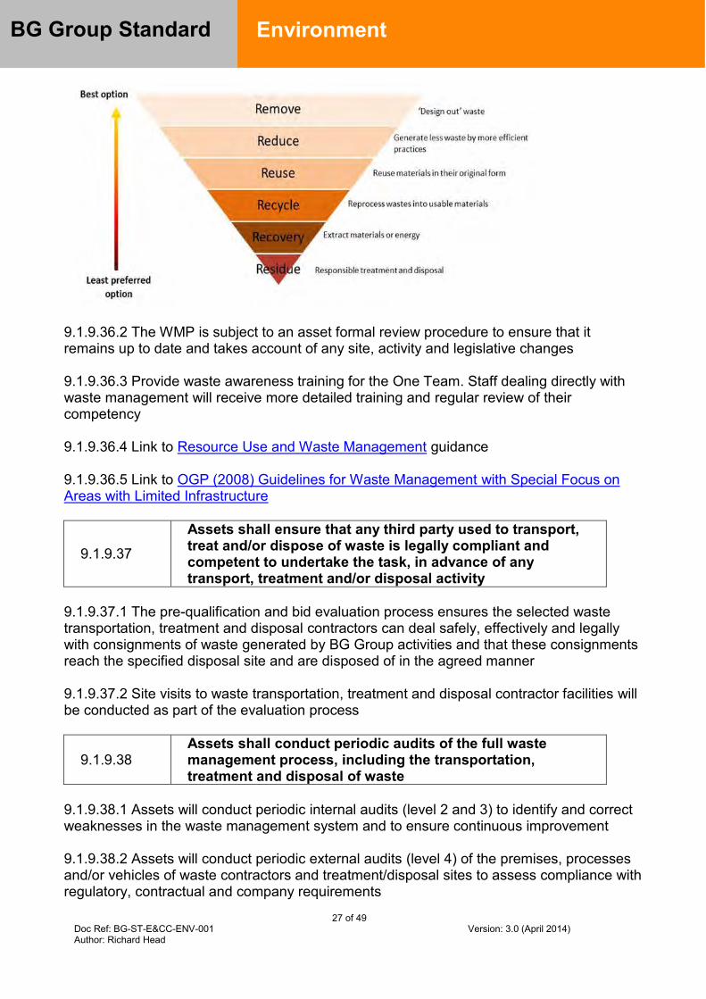
27 of 49 Doc Ref: BG-ST-E&CC-ENV-001 Version: 3.0 (April 2014) Author: Richard Head
BG Group Standard
Environment
9.1.9.36.2 The WMP is subject to an asset formal review procedure to ensure that it remains up to date and takes account of any site, activity and legislative changes 9.1.9.36.3 Provide waste awareness training for the One Team. Staff dealing directly with waste management will receive more detailed training and regular review of their competency 9.1.9.36.4 Link to Resource Use and Waste Management guidance 9.1.9.36.5 Link to OGP (2008) Guidelines for Waste Management with Special Focus on Areas with Limited Infrastructure
9.1.9.37
Assets shall ensure that any third party used to transport, treat and/or dispose of waste is legally compliant and competent to undertake the task, in advance of any transport, treatment and/or disposal activity
9.1.9.37.1 The pre-qualification and bid evaluation process ensures the selected waste transportation, treatment and disposal contractors can deal safely, effectively and legally with consignments of waste generated by BG Group activities and that these consignments reach the specified disposal site and are disposed of in the agreed manner 9.1.9.37.2 Site visits to waste transportation, treatment and disposal contractor facilities will be conducted as part of the evaluation process
9.1.9.38 Assets shall conduct periodic audits of the full waste management process, including the transportation, treatment and disposal of waste
9.1.9.38.1 Assets will conduct periodic internal audits (level 2 and 3) to identify and correct weaknesses in the waste management system and to ensure continuous improvement 9.1.9.38.2 Assets will conduct periodic external audits (level 4) of the premises, processes and/or vehicles of waste contractors and treatment/disposal sites to assess compliance with regulatory, contractual and company requirements

28 of 49 Doc Ref: BG-ST-E&CC-ENV-001 Version: 3.0 (April 2014) Author: Richard Head
BG Group Standard
Environment
9.1.9.38.3 The frequency of internal (level 2 and 3) and external (level 4) audits will be determined on a risk basis, with a minimum frequency of every three years
9.1.9.38.4 Establish a suitable method of managing every waste stream and the ‘end point’ of treatment identified 9.1.9.38.5 Where inadequate local, regional or national waste management facilities exist, BG Group may need to work with third parties to develop capability 9.1.9.38.6 BG Group will not become a handler of third party waste
Biodiversity and Ecosystem Services
9.1.9.39 Establish a corporate biodiversity and natural environment risk management strategy
9.1.9.39.1 BGA E&CC will establish and implement a corporate biodiversity strategy to guide practice across the organisation in line with our Business Principles 9.1.9.39.2 The biodiversity strategy will be aligned with leading industry approach to best practice, e.g. IFC Performance Standard 6
9.1.9.40
Biodiversity screening shall be carried out in the area of influence of all BG Group assets, new acquisitions and project development activities to identify the presence of important biodiversity features
9.1.9.40.1 Screening for important biodiversity features in the area of influence of BG Group activities and new acquisitions will be conducted using recognised screening tools 9.1.9.40.2 Screening for important biodiversity features will be conducted by BGA E&CC or a consultant approved by BGA E&CC. 9.1.9.40.3 Screening will identify as far as reasonably possible the potential for the presence of nationally or globally threatened species, endemic species, restricted range species, migratory or congregatory species, threatened or fragile ecosystems, legally protected areas and internationally recognised areas in the area of influence of BG Group activities. 9.1.9.40.4 The identification of ecosystem services and/or biodiversity considered to be important by stakeholders in the area of influence of BG Group assets or projects will be conducted primarily through stakeholder engagement. This should be carried out as a collaborative process involving both Environment and Social Performance teams. 9.1.9.40.5 BG Groups area of influence will be defined as part of the EIA process for new projects. 9.1.9.40.6 In the absence of detailed knowledge of area of influence, a buffer of 50km beyond the facility fence-line or exploration block will be used
29 of 49 Doc Ref: BG-ST-E&CC-ENV-001 Version: 3.0 (April 2014) Author: Richard Head
BG Group Standard
Environment
9.1.9.40.7 Screening will include best endeavours to identify priority ecosystem services within the area of influence.
9.1.9.41
Where screening identifies important biodiversity features in the area of influence then qualified and competent specialists will be retained by the asset or project to provide expert judgment and advice to define risk and mitigation strategies
9.1.9.41.1 Biodiversity specialists will conduct further identification and assessment of impacts and risks to the identified biodiversity features and/or ecosystem services. Specialists will:
Carry out a detailed review of available literature, including values attached to the
biodiversity and ecosystem services by local stakeholders Conduct an initial risk assessment and prioritise biodiversity features and important
ecosystem services in, or in proximity to, BG Group’s area of influence Identify uncertainties and gaps in available information and scope baseline studies
that would be necessary to address these uncertainties and gaps Define the habitat type using internationally acceptable criteria Establish whether a full Critical Habitat Assessment is required For new projects, develop a terms of reference for the assessment of direct or
indirect impacts and risks to biodiversity to be conducted in the EIA programme Prioritise identified ecosystem services and establish whether an Ecosystem
Services Review is required Develop an agreed approach to application of the mitigation hierarchy in
addressing identified impacts and risks to biodiversity. 9.1.9.41.2 Review of habitat types and impacts to biodiversity will include the potential for impacts to biodiversity in surrounding areas outside the project or asset boundary e.g. downstream of the catchment area
9.1.9.42
A mitigation hierarchy shall be applied for all identified impacts and risks to important biodiversity features that will follow, in order of preference: (i) avoidance; (ii) minimisation of impact; (ii) restoration; and, (iv) offsets or compensation for predicted residual impacts
9.1.9.42.1 The mitigation hierarchy applied for the protection and conservation of biodiversity and ecosystem services will follow:
Avoid (e.g. re-siting of fixed facilities, re-routing of pipelines, set-asides in the concession);
Minimise: implementation of measures to minimise impacts (e.g. footprint minimization, erosion control)
Restore (e.g. post drilling operations, rehabilitation of a pipeline Right of Way); and Offset: for anticipated residual impacts, biodiversity offsets or compensation for the
loss, loss of access to, or degradation of an ecosystem service
30 of 49 Doc Ref: BG-ST-E&CC-ENV-001 Version: 3.0 (April 2014) Author: Richard Head
BG Group Standard
Environment
9.1.9.42.2 Irrespective of the defined habitat type in areas of BG Group activities, impacts and risks to biodiversity will be assessed, minimised and, where necessary, impacts will be monitored. 9.1.9.42.3 The mitigation hierarchy decision making process will be documented and reviewed and endorsed by BGA E&CC. 9.1.9.42.4 Avoidance of areas defined using internationally acceptable criteria as Natural and/or Critical Habitat will be applied wherever possible 9.1.9.42.5 For new project activities, location alternative analysis will be conducted in areas where important biodiversity features and/or priority ecosystem services have been identified as being present to establish whether alternative locations are available 9.1.9.42.6 Where biodiversity criteria indicates that there is a potential for Critical Habitat to be present, a Critical Habitat Assessment will be carried out by qualified and competent specialists. The assessment will use established numerical criteria to classify the criticality of the area
9.1.9.43
New project developments shall only be carried out in areas defined as Critical Habitat or national, regional and international legally protected areas when no other viable alternative locations of development are possible. A robust and credible justification shall be documented and reviewed and endorsed by BGA E&CC
9.1.9.43.1 Justification for activities in Critical Habitat or national, regional or internationally legally protected areas will include mitigation and offsets and a clear biodiversity goal. 9.1.9.43.2 Mitigation measures for unavoidable activities in areas defined as consisting of, or containing, Critical Habitat, will be designed so that adverse impacts to biodiversity features are minimised with a target to achieve no measurable adverse impacts on the ability of the habitat to support the established population of species or functions of the habitat that defined it as Critical Habitat, this will include no net loss in the population of any Critically Endangered or Endangered species as listed in the IUCN Red List of Threatened Species with a target of a net gain 9.1.9.43.3 Unavoidable activities in national, regional or international legally protected areas will be legally permitted and carried out in accordance with area management plans already in place. In such cases, and where necessary and appropriate, BG Group will develop additional mitigation measures to enhance existing protected area management plans along with national and regional authorities and in consultation with other local stakeholders 9.1.9.43.4 BG Group activities in areas defined as Natural Habitats will also be avoided where feasible. Where there is no viable alternative, mitigation measures will be designed to achieve no net loss of biodiversity 9.1.9.43.5 Impacts to priority ecosystem services identified in the area of influence of BG Group activities will be avoided wherever feasible. If impacts are unavoidable, mitigation
31 of 49 Doc Ref: BG-ST-E&CC-ENV-001 Version: 3.0 (April 2014) Author: Richard Head
BG Group Standard
Environment
measures will be implemented in agreement with stakeholders such that ecosystem services are maintained as far as is feasible. Unavoidable adverse impacts that result in a loss of these services will be compensated
9.1.9.44
A Biodiversity Action Plan (BAP) and Biodiversity Mitigation Monitoring Plan (BMMP) will be developed for BG Group activities in areas defined as Critical or Natural Habitat and/or national, regional or international legally protected areas. The BAP and BMMP shall be reviewed and endorsed by BGA E&CC
9.1.9.44.1 A Biodiversity Action Plan (BAP) will be developed for BG Group activities in areas defined as Critical or Natural Habitat and in national, regional or international legally protected areas 9.1.9.44.2 The BAP will be incorporated in the EMS and will contain the mitigation strategy and actions to be taken to implement the designed mitigation measures through a project’s life cycle 9.1.9.44.3 Implementation of the BAP will be evaluated through a Biodiversity Mitigation Monitoring Plan (BMMP) designed to monitor impacts to biodiversity over the long-term. The BMMP will be incorporated into the EMS 9.1.9.44.4 Qualified and competent specialists will be retained to develop the BAP and BMMP 9.1.9.44.5 Biodiversity offsets will be used after avoidance, minimisation and restoration mitigation measures have been considered and implemented to protect and, where feasible, enhance biodiversity features 9.1.9.44.6 Biodiversity offsets will be implemented with agreed and measurable conservation results to be achieved when residual impacts are predicted in Critical and Natural Habitat from BG Group activities. Offsets will be designed to compensate for any net loss in biodiversity as a minimum with a target of a net gain 9.1.9.44.7 A biodiversity offset management plan will be developed for any offset programme to be implemented 9.1.9.44.8 Qualified and competent specialists will be retained to design and implement offset programmes and develop the management plan that will contain the measures to be monitored to demonstrate offset outcomes
9.1.9.45
Assets and projects shall take practical measures to prevent the accidental introduction of alien species. There shall be no intentional introduction of alien species as a result of BG Group activities.
9.1.9.45.1 Evaluate the risk of introducing Invasive Alien Species (IAS) at all assets and during project activities
32 of 49 Doc Ref: BG-ST-E&CC-ENV-001 Version: 3.0 (April 2014) Author: Richard Head
BG Group Standard
Environment
9.1.9.45.2 Follow good practice to avoid the potential for accidental introductions of IAS, including the transportation of substrates and vectors (such as soil, ballast, and plant materials) that may harbour alien species. This is particularly relevant for any shipping operations and construction activities 9.1.9.45.3 Where alien species are already established in BG Group’s area of influence, measures should be implemented to prevent the spread of these alien species
9.1.9.46
Where BG Group is considering involvement in joint industry research projects or similar that involve animal testing the project in question shall be subject to a stringent review of animal welfare safeguards and require endorsement by BGA E&CC
9.1.9.46.1 Alert BGA E&CC to research projects or activities to be undertaken on behalf of BG Group that are likely to involve animal testing include the fitting of monitoring equipment e.g. as part of species monitoring programmes
Environmental Noise
9.1.9.47 Establish BG Group environmental ‘beyond the fence line’ noise controls which meet internationally accepted best practice
9.1.9.47.1 Ensure that environmental noise issues are proactively identified and managed and will employ best practice noise controls by evaluating and applying BAT
9.1.9.48 Noise from BG Group activities shall not exceed acceptable levels at the nearest receptor located outside the BG Group property boundary
9.1.9.48.1 Maximum allowable noise levels are summarised below and will be reviewed at specific locations if noise complaints relating to current activity levels are received from neighbours:
Receptor Maximum allowable noise level
(hourly measurements), in dB(A) Day (0700-2200) Night (2200-0700) Residential, institutional, educational 55 45
Industrial, commercial 70 70
9.1.9.48.2 BG Group environmental noise levels apply unless national legislation prescribes lower limits. Where background noise levels are already above allowable noise levels, a maximum contribution from new facilities to background levels of 3 dB at the nearest receptor location off-site will be met.
33 of 49 Doc Ref: BG-ST-E&CC-ENV-001 Version: 3.0 (April 2014) Author: Richard Head
BG Group Standard
Environment
9.1.9.48.3 Noise with a tonal element (i.e. having a noticeable hiss, whine or hum) and/or impulsive components (e.g. bangs, clicks, clatters, thumps) that could impact the nearest receptor located outside the BG Group property boundary will be:
Avoided during the hours of dark Less than 1 month in duration
9.1.9.48.4 Highly intrusive noises, such as noise from aircraft flyovers and passing trains, will not be included when establishing background noise levels 9.1.9.48.5 Aircraft flight paths to and from BG Group facilities will be designed to avoid residential areas or areas which contain fauna sensitive to noise disturbance wherever feasible 9.1.9.48.6 Further guidance and explanation is available in IFC guidelines. This includes recommendations for noise monitoring 9.1.9.48.7 Link to IFC noise guidance 9.1.9.48.8 Link to BG Group Standard for operational noise controls Occupational Workplace Exposure Standard BG-ST-HSSE-SAF-003
34 of 49 Doc Ref: BG-ST-ECC-ENV-001 Version: 3.0 (April 2014) Author: Richard Head
BG Group Standard
Environment and Climate Change
7.0 Appendices Appendix A – Gap Analysis Template (Please note that this is a summary of requirements, the Standard should be read in full)
Author completes Asset or Function assessing compliance with Standard Ref: Summary of mandatory requirement Accountable
Business Unit
Can Asset / Function meet this requirement?Y/N
Action plan to meet requirement
Action plan completion date
Action owner (name and title)
Dispensation details (if action exceeds allowable implementation time)?
9.1.9.1 Establish a corporate environmental and climate change strategy and management framework which ensures compliance with legal expectations, our Business Principles and sets out the environmental risk management processes
BG Advance
9.1.9.2 All assets shall develop an EMS (either stand alone or integrated into the HSSE MSF). The EMS shall be certified to international standard ISO 14001 within two years of start-up of production or acquisition, using a certifying company approved by BGA E&CC
Asset
9.1.9.3 Assets shall identify and assess environmental impacts, risks and opportunities within and beyond the asset boundary
Asset
9.1.9.4 An Environmental Impact Assessment (EIA) shall be undertaken in advance of all exploration activities that could cause disturbance to the environment and all new and brownfield developments and facility decommissioning
Asset
9.1.9.5 Establish a corporate BAT process BG Advance
9.1.9.6 Assets shall conduct BAT assessments in accordance with the corporate BAT process. Adoption of minimum BAT performance standards is mandatory (included at Appendix C).
Asset
9.1.9.7 Operating assets shall update operational BAT assessments at least every five years from start of production and when major changes occur in the asset
Asset
9.1.9.8 Assets shall engage with BGA E&CC at the start of a BAT process and completed BAT assessments shall be reviewed and endorsed by BGA E&CC
Asset
9.1.9.9 Establish a Corporate GHG management framework BG Advance
9.1.9.10 Assets shall develop a life of facility greenhouse gas (GHG) emission rate forecast consistent with the local Business Plan and
Asset

35 of 49 Doc Ref: BG-ST-ECC-ENV-001 Version: 3.0 (April 2014) Author: Richard Head
BG Group Standard
Environment and Climate Change updated annually
9.1.9.11 All assets shall develop and maintain a quantified inventory of greenhouse gas (GHG) emission sources
Asset
9.1.9.12 Each facility and project shall have a GHG emissions intensity target agreed with BGA E&CC. For projects the target will be set by the Assess stage of the VAF process and integrated into venture strategy documents
Asset
9.1.9.13 Each facility shall prepare a rolling five year Energy Management Plan, updated on an annual basis, copied for review, comment and endorsement by BGA E&CC, with plan actions embedded into asset business plans, with milestones included in asset IAPS
Asset
9.1.9.14 Facilities shall be designed and operated to have no continuous flaring (except for safety reasons) or any venting of gas
Asset
9.1.9.15 Assets shall implement all operationally and financially viable energy efficiency and carbon reduction measures for operations and brownfield developments
Asset
9.1.9.16 A Flare Minimisation Plan shall be developed for well testing, facility commissioning / early field life, start-ups, shut downs and similar activities, which minimises flaring and ensures compliance with our Business Principles and this Standard, and shall be reviewed and endorsed by BGA E&CC
Asset
9.1.9.17 Developments and new acquisitions shall include GHG emissions forecasts, GHG policy and risk assessment appraisal, carbon tax exposure and mitigation proposals as input to investment decision documentation
Asset
9.1.9.18 BG Group approved carbon shadow price shall be used in investment appraisal decisions in both existing operations and new developments
Asset
9.1.9.19 Where the CO2 content of reservoir gas is 5% or greater volume, opportunities for carbon capture and storage techniques shall be investigated, documented and reviewed with BGA E&CC
Asset
9.1.9.20 The threat to facilities due to foreseeable changes in the physical environment resulting from climate change shall be assessed and documented as part of the RAAM process so that assets can demonstrate an understanding of potential climate change impacts and risks and develop and implement appropriate mitigation plans
Asset
9.1.9.21 Emissions and discharges from BG Group facilities shall be reduced to the minimum practicable and actions taken to ensure they do not exceed Group Environmental Quality Standards (EQSs)
Asset
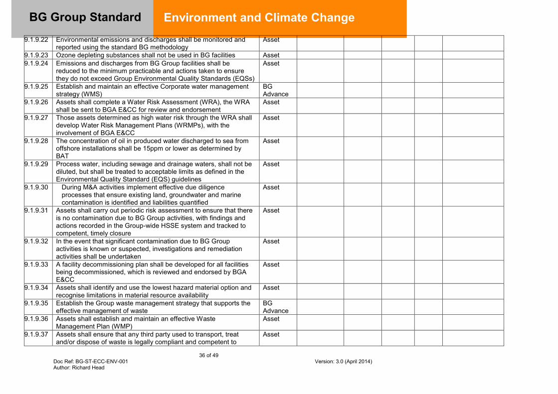
36 of 49 Doc Ref: BG-ST-ECC-ENV-001 Version: 3.0 (April 2014) Author: Richard Head
BG Group Standard
Environment and Climate Change 9.1.9.22 Environmental emissions and discharges shall be monitored and
reported using the standard BG methodology Asset
9.1.9.23 Ozone depleting substances shall not be used in BG facilities Asset 9.1.9.24 Emissions and discharges from BG Group facilities shall be
reduced to the minimum practicable and actions taken to ensure they do not exceed Group Environmental Quality Standards (EQSs)
Asset
9.1.9.25 Establish and maintain an effective Corporate water management strategy (WMS)
BG Advance
9.1.9.26 Assets shall complete a Water Risk Assessment (WRA), the WRA shall be sent to BGA E&CC for review and endorsement
Asset
9.1.9.27 Those assets determined as high water risk through the WRA shall develop Water Risk Management Plans (WRMPs), with the involvement of BGA E&CC
Asset
9.1.9.28 The concentration of oil in produced water discharged to sea from offshore installations shall be 15ppm or lower as determined by BAT
Asset
9.1.9.29 Process water, including sewage and drainage waters, shall not be diluted, but shall be treated to acceptable limits as defined in the Environmental Quality Standard (EQS) guidelines
Asset
9.1.9.30 During M&A activities implement effective due diligence processes that ensure existing land, groundwater and marine contamination is identified and liabilities quantified
Asset
9.1.9.31 Assets shall carry out periodic risk assessment to ensure that there is no contamination due to BG Group activities, with findings and actions recorded in the Group-wide HSSE system and tracked to competent, timely closure
Asset
9.1.9.32 In the event that significant contamination due to BG Group activities is known or suspected, investigations and remediation activities shall be undertaken
Asset
9.1.9.33 A facility decommissioning plan shall be developed for all facilities being decommissioned, which is reviewed and endorsed by BGA E&CC
Asset
9.1.9.34 Assets shall identify and use the lowest hazard material option and recognise limitations in material resource availability
Asset
9.1.9.35 Establish the Group waste management strategy that supports the effective management of waste
BG Advance
9.1.9.36 Assets shall establish and maintain an effective Waste Management Plan (WMP)
Asset
9.1.9.37 Assets shall ensure that any third party used to transport, treat and/or dispose of waste is legally compliant and competent to
Asset

37 of 49 Doc Ref: BG-ST-ECC-ENV-001 Version: 3.0 (April 2014) Author: Richard Head
BG Group Standard
Environment and Climate Change undertake the task, in advance of any transport, treatment and/or disposal activity
9.1.9.38 Assets shall conduct periodic audits of the full waste management process, including the transportation, treatment and disposal of waste
Asset
9.1.9.39 Establish a corporate biodiversity and natural environment risk management strategy
BG Advance
9.1.9.40 Biodiversity screening shall be carried out in the area of influence of all BG assets, new acquisitions and project development activities to identify the presence of important biodiversity features
Asset
9.1.9.41 Where screening identifies important biodiversity features in the area of influence then qualified and competent specialists will be retained by the asset or project to provide expert judgment and advice to define risk and mitigation strategies
Asset
9.1.9.42 A mitigation hierarchy shall be applied for all identified impacts and risks to important biodiversity features that will follow, in order of preference: (i) avoidance; (ii) minimisation of impact; (ii) restoration; and, (iv) offsets or compensation for predicted residual impacts
Asset
9.1.9.43 New project developments shall only be carried out in areas defined as Critical Habitat or national, regional and international legally protected areas when no other viable alternative locations of development are possible. A robust and credible justification shall be documented and reviewed and endorsed by BGA E&CC
Asset
9.1.9.44 A Biodiversity Action Plan (BAP) and Biodiversity Mitigation Monitoring Plan (BMMP) will be developed for BG Group activities in areas defined as Critical or Natural Habitat and/or national, regional or international legally protected areas. The BAP and BMMP shall be reviewed and endorsed by BGA E&CC
Asset
9.1.9.45 Assets and projects shall take practical measures to prevent the accidental introduction of alien species. There shall be no intentional introduction of alien species as a result of BG Group activities
Asset
9.1.9.46 Where BG Group is considering involvement in joint industry research projects or similar that involve animal testing the project in question shall be subject to a stringent review of animal welfare safeguards and require endorsement by BGA E&CC
BG Advance
9.1.9.47 Establish BG Group environmental ‘beyond the fence line’ noise controls which meet internationally accepted best practice
BG Advance
9.1.9.48 Noise from BG Group activities shall not exceed acceptable levels at the nearest receptor located outside the BG property boundary
Asset

38 of 49 Doc Ref: BG-ST-ECC-ENV-001 Version: 3.0 (April 2014) Author: Richard Head
BG Group Standard
Environment and Climate Change
Appendix B – Abbreviations / definitions
Abbreviations
Abbreviation ALARP AoI BAP BAT Boe BMMP CCS CO2e EIA EMS EnMP ENVID EQS GHG GTA IFC IPCC IUCN NOJV ODS OSCP VAF WHR WRA WRMP WMP
As Low As Reasonably Practicable Area of Influence Biodiversity Action Plan Best Available Techniques Barrels of oil equivalent Biodiversity Mitigation and Monitoring Plan Carbon Capture and Storage Carbon dioxide equivalent Environmental Impact Assessment Environmental Management System Energy Management Plan Environmental Issues Identification Environmental Quality Standard Greenhouse gas Group Technical Authority International Finance Corporation Inter-governmental Panel on Climate Change International Union for the Conservation of Nature Non-operated Joint Venture Ozone depleting substances Oil Spill Contingency Plan Value Assurance Framework Waste Heat Recovery Water Risk Assessment Water Risk Management Plan Waste Management Plan
Definitions
Adaptation Practical steps to protect countries, communities and facilities from the likely disruption and damage that will result from effects of climate change
Best Available Techniques (BAT)
BAT is a legal term, originating in the European Directive on Integrated Pollution Prevention and Control. Whilst it does not have legal status outside the scope of that directive, BG Group has chosen to adopt the same definition for the purposes of the BG Group BAT Standard and this guidance document, in line with the Business Principle of employing international best practice. BAT is a ‘whole life’ approach to environmental control. BAT is defined as: ‘the most effective and advanced engineering practices and methods of operation, which are available and practicable, to prevent, and where this is not practicable, reduce emissions and the impact on the environment as a whole’. The essence of BAT is that the selection of techniques to protect the environment should achieve an appropriate balance between the environmental benefits they bring and the costs to implement them. ‘Best’ means the most effective in achieving a high general level of protection of
the environment as a whole ‘Techniques’ includes both the technology used and the way in which the installation is designed, built, maintained, operated and decommissioned
‘Available’ techniques are those developed on a scale which allows implementation in the relevant industrial sector, under economically and technically viable conditions, taking into consideration the advantages and the disadvantages, whether or not the techniques are used or produced inside the
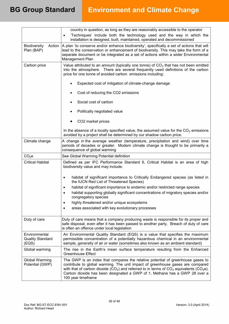
39 of 49 Doc Ref: BG-ST-ECC-ENV-001 Version: 3.0 (April 2014) Author: Richard Head
BG Group Standard
Environment and Climate Change
country in question, as long as they are reasonably accessible to the operator ‘Techniques’ include both the technology used and the way in which the
installation is designed, built, maintained, operated and decommissioned Biodiversity Action Plan (BAP)
A plan ‘to conserve and/or enhance biodiversity’, specifically a set of actions that will lead to the conservation or enhancement of biodiversity. This may take the form of a separate document or be integrated as a set of actions within a wider Environmental Management Plan
Carbon price Value attributed to an amount (typically one tonne) of CO2 that has not been emitted into the atmosphere. There are several frequently used definitions of the carbon price for one tonne of avoided carbon emissions including:
Expected cost of mitigation of climate-change damage
Cost of reducing the CO2 emissions
Social cost of carbon
Politically negotiated value
CO2 market prices
In the absence of a locally specified value, the assumed value for the CO2 emissions avoided by a project shall be determined by our shadow carbon price.
Climate change A change in the average weather (temperature, precipitation and wind) over time periods of decades or greater. Modern climate change is thought to be primarily a consequence of global warming
CO2e See Global Warming Potential definition Critical Habitat Defined as per IFC Performance Standard 6, Critical Habitat is an area of high
biodiversity value and may include: habitat of significant importance to Critically Endangered species (as listed in
the IUCN Red List of Threatened Species) habitat of significant importance to endemic and/or restricted range species habitat supporting globally significant concentrations of migratory species and/or
congregatory species highly threatened and/or unique ecosystems areas associated with key evolutionary processes
Duty of care Duty of care means that a company producing waste is responsible for its proper and
safe disposal, even after it has been passed to another party. Breach of duty of care is often an offence under local legislation
Environmental Quality Standard (EQS)
An Environmental Quality Standard (EQS) is a value that specifies the maximum permissible concentration of a potentially hazardous chemical in an environmental sample, generally of air or water (sometimes also known as an ambient standard)
Global warming The rise in the Earth’s mean surface temperature resulting from the Enhanced Greenhouse Effect
Global Warming Potential (GWP)
The GWP is an index that compares the relative potential of greenhouse gases to contribute to global warming. The unit impact of greenhouse gases are compared with that of carbon dioxide (CO2) and referred to in terms of CO2 equivalents (CO2e). Carbon dioxide has been designated a GWP of 1, Methane has a GWP 28 over a 100 year timeframe
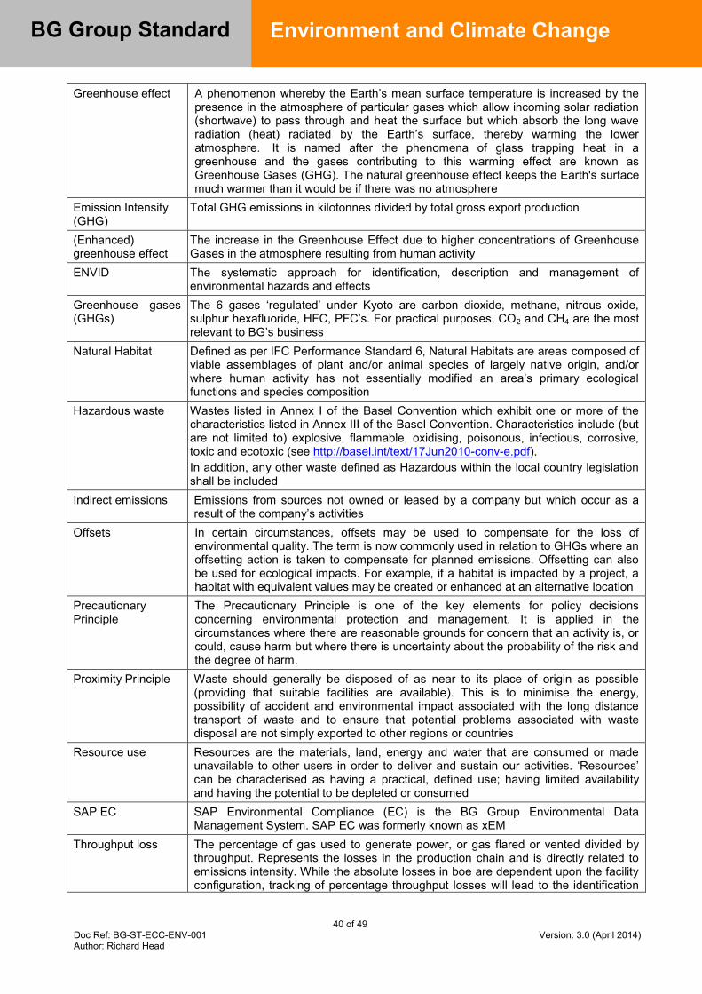
40 of 49 Doc Ref: BG-ST-ECC-ENV-001 Version: 3.0 (April 2014) Author: Richard Head
BG Group Standard
Environment and Climate Change
Greenhouse effect A phenomenon whereby the Earth’s mean surface temperature is increased by the presence in the atmosphere of particular gases which allow incoming solar radiation (shortwave) to pass through and heat the surface but which absorb the long wave radiation (heat) radiated by the Earth’s surface, thereby warming the lower atmosphere. It is named after the phenomena of glass trapping heat in a greenhouse and the gases contributing to this warming effect are known as Greenhouse Gases (GHG). The natural greenhouse effect keeps the Earth's surface much warmer than it would be if there was no atmosphere
Emission Intensity (GHG)
Total GHG emissions in kilotonnes divided by total gross export production
(Enhanced) greenhouse effect
The increase in the Greenhouse Effect due to higher concentrations of Greenhouse Gases in the atmosphere resulting from human activity
ENVID The systematic approach for identification, description and management of environmental hazards and effects
Greenhouse gases (GHGs)
The 6 gases ‘regulated’ under Kyoto are carbon dioxide, methane, nitrous oxide, sulphur hexafluoride, HFC, PFC’s. For practical purposes, CO2 and CH4 are the most relevant to BG’s business
Natural Habitat Defined as per IFC Performance Standard 6, Natural Habitats are areas composed of viable assemblages of plant and/or animal species of largely native origin, and/or where human activity has not essentially modified an area’s primary ecological functions and species composition
Hazardous waste Wastes listed in Annex I of the Basel Convention which exhibit one or more of the characteristics listed in Annex III of the Basel Convention. Characteristics include (but are not limited to) explosive, flammable, oxidising, poisonous, infectious, corrosive, toxic and ecotoxic (see http://basel.int/text/17Jun2010-conv-e.pdf). In addition, any other waste defined as Hazardous within the local country legislation shall be included
Indirect emissions Emissions from sources not owned or leased by a company but which occur as a result of the company’s activities
Offsets In certain circumstances, offsets may be used to compensate for the loss of environmental quality. The term is now commonly used in relation to GHGs where an offsetting action is taken to compensate for planned emissions. Offsetting can also be used for ecological impacts. For example, if a habitat is impacted by a project, a habitat with equivalent values may be created or enhanced at an alternative location
Precautionary Principle
The Precautionary Principle is one of the key elements for policy decisions concerning environmental protection and management. It is applied in the circumstances where there are reasonable grounds for concern that an activity is, or could, cause harm but where there is uncertainty about the probability of the risk and the degree of harm.
Proximity Principle Waste should generally be disposed of as near to its place of origin as possible (providing that suitable facilities are available). This is to minimise the energy, possibility of accident and environmental impact associated with the long distance transport of waste and to ensure that potential problems associated with waste disposal are not simply exported to other regions or countries
Resource use Resources are the materials, land, energy and water that are consumed or made unavailable to other users in order to deliver and sustain our activities. ‘Resources’ can be characterised as having a practical, defined use; having limited availability and having the potential to be depleted or consumed
SAP EC SAP Environmental Compliance (EC) is the BG Group Environmental Data Management System. SAP EC was formerly known as xEM
Throughput loss The percentage of gas used to generate power, or gas flared or vented divided by throughput. Represents the losses in the production chain and is directly related to emissions intensity. While the absolute losses in boe are dependent upon the facility configuration, tracking of percentage throughput losses will lead to the identification

41 of 49 Doc Ref: BG-ST-ECC-ENV-001 Version: 3.0 (April 2014) Author: Richard Head
BG Group Standard
Environment and Climate Change
of major losses and improvement opportunities Waste For the purposes of this Guideline, waste is defined as:
All solid, non-aqueous liquid and contained gaseous material taken offsite for treatment and/or disposal. Solid waste materials range from inert site and platform wastes, scrap metals, oils, sludge and chemicals to excavated material, used fittings and general site and office wastes. Liquid wastes include, for example, used oil and spent drilling muds that are handled offsite by a third party
All solid and non-aqueous liquid material disposed of directly by the company on-site for example by re-injection, landfill, remediation and incineration
All material stored on site for which the company does not have a use e.g. surplus chemicals, waste with no identified responsible disposal route

42 of 49 Doc Ref: BG-ST-ECC-ENV-001 Version: 3.0 (April 2014) Author: Richard Head
BG Group Standard
Environment and Climate Change
Appendix C – Minimum BAT performance standards
Process Parameter Specific
Application Indicative BAT Notes
Prime movers/ combustion processes
Air emissions
General C1.1.1.1 Use of the lowest sulphur content fuel that is available
Heavy fuel oil (HFO) shall be replaced by light distillate fuel with a low sulphur content. Where ambient air quality constraints for sulphur dioxide exist, consideration shall be given to use of ultra-low sulphur distillate.
C1.1.1.2 Evaluation of odour levels at the site boundary to determine that they are within safe and environmentally acceptable limits
Remedial measures shall be implemented as necessary based on the results of this odour monitoring.
Turbines C1.1.2.1 Dry low emissions (DLE) technology for all onshore and offshore turbine applications
A dispensation shall be sought where it can be demonstrated that this is not BAT or is not available to the project.
C1.1.2.2 Use of aero derivative type machines for both onshore and offshore applications
A dispensation shall be sought where this is not deemed BAT.
C1.1.2.3 For new turbine equipment, CO, NOx and UHC emissions from the exhaust stack shall not exceed the limits detailed in Table 2 below.
The specified limits shall apply from 50% to 100% of gas turbine power and shall be guaranteed for an ambient air temperature range of -20 degrees centigrade to +45 degrees centigrade.
Engines C1.1.3.1 Selective catalytic reduction (SCR) for NOx control where ambient air quality constraints exist (ie ambient pollutant levels are approaching air quality standards – see Section 6.3 of this Standard),
Applies to new gas or diesel engine equipment. Procurement of low emission equipment (primary emission control) should be considered before additional abatement is employed (Secondary emission control) though in certain circumstances both may be required.
Boilers with 20MW thermal input or more
C1.1.4.1 Maximum NOx emissions of 50ppmv
Water use and discharges
Process Water
C1.2.1.1 Collection of rainwater and recycling of wastewater from other processes, combined with appropriate water treatment.
Where this is practical.
Pipework C1.2.2.1 The integrity of pipework containing potentially hazardous components shall be checked.
BG Group Operating and Maintenance Standards as well as relevant national codes shall be used. Refer to Section 6.5 for requirements concerning discharge of water.
Waste Turbines C1.3.1.1 Use of a turbine wash that is not harmful to the environment. If this is not possible, turbine wash shall be collected, stored and removed offsite in accordance with BG Group requirements and local
Refer to Section 6.9 for general requirements concerning the management of waste.

43 of 49 Doc Ref: BG-ST-ECC-ENV-001 Version: 3.0 (April 2014) Author: Richard Head
BG Group Standard
Environment and Climate Change
Process Parameter Specific Application
Indicative BAT Notes
waste storage and transfer regulations.
Energy efficiency
General C1.4.1.1 Energy efficiency shall be a prime consideration in the purchase of new equipment and the operation of facilities and shall be maximised.
The requirements of Ref. [7 and 8] shall be applied to the selection of new equipment and the design of new facilities. Particular attention shall be paid to the economics of opportunities for the recovery of waste heat and other energy e.g. CCGT, Cogeneration, turboexpansion. The utilisation of waste heat (and cold) across the facility shall be optimised to maximise energy efficiency. Machines shall be fully loaded and operated as close to design values as possible, with minimum spinning reserve.
C1.4.1.2 Fuel gas and GHG emissions shall be given a value in projects.
This requirement shall apply to all projects
Electricity generation
C1.4.2.1 Use of combined cycle gas turbines (CCGT).
CCGT shall be used where processes allow a gas turbine to be used in combination with a steam turbine.
C1.4.2.2 Combined heat and power (cogeneration) opportunities shall be evaluated.
C1.4.2.3 Waste heat recovery units shall be employed.
Where practical application for the recovered heat can be found and project economics can be justified
Monitoring and metering
General C1.5.1.1 Use of ISO monitoring standards
Emissions C1.5.2.1 Continuous monitoring of combustion product emissions and adjustment of combustion parameters to maintain them within designed limits.
C1.5.2.2 A system that allows monitoring for appropriate parameters. The design of any monitoring system shall include sampling points to allow verification of monitoring results.
Parameters to be monitored will depend on the application and fuel selection and may include SO2, NOx, CO, oxygen and water content, (and also particulates in the case of liquid or solid fuels).
Flares C1.5.3.1 Installation of flare gas meters in order to improve accounting for flare gas.
Unless there is no flow under normal circumstances when the accounting benefit of a flare meter may be low.
Fuel use C1.5.4.1 Use of fuel metering devices to track fuel usage and allow the calculation of CO2 emissions.
C1.5.4.2 Fuel source monitoring at regular intervals in order to ascertain that fuel specifications are correct.
General plant Air emissions
Reservoir gas quality
C2.1.1.1 Investigation of opportunities for carbon capture and storage techniques at the Assess stage where the CO2 content of the
See also Section 6.3.

44 of 49 Doc Ref: BG-ST-ECC-ENV-001 Version: 3.0 (April 2014) Author: Richard Head
BG Group Standard
Environment and Climate Change
Process Parameter Specific Application
Indicative BAT Notes
reservoir gas is >10%. C2.1.1.2 Removal of H2S where the reservoir gas has a higher H2S content than is needed for sale or fuel purposes.
The removed H2S shall be considered as a waste stream unless an appropriate use can be found and BAT shall be employed for its disposal.
C2.1.1.3 Evaluation of re-injection of gas with a high content of H2S or CO2.
Fugitive Emissions
C2.1.2.1 Centralised generation of electric power for pumps and instrument air (rather than individually powered pumps).
To minimise fugitive emissions.
C2.1.2.2 Implementation of a formal programme of leak detection, reduction and repair including periodic ultrasonic surveys.
The leak detection programme should be targeted on seals, flanges, valves, meters and instrumentation and shall be controlled by a robust integrity management system which meets BG Group requirements.
C2.1.2.3 No use of CFC or HCFC compounds in refrigerators.
Water use and water discharge
General C2.2.1.1 Minimisation of water overall use and maximisation of water reuse or recycling of wastewater.
Refer to Section 6.5 for requirements concerning discharge of water.
C2.2.1.2 Preparation of water management plans to mitigate water management risks where appropriate. These shall include flow diagrams and water mass balances.
C2.2.1.3 Evaluation of closed loop cooling systems and minimisation of blow down.
C2.2.1.4 Segregation of uncontaminated surface water from process contributions until after treatment and monitoring
C2.2.1.5 No direct discharge of hydrotest water to the environment
Hydrotest water shall be disposed of to appropriately licensed/permitted facilities.
Waste General C2.3.1.1 Application of the waste hierarchy of: reduce reuse recycle recover energy dispose.
Offsite treatment by final disposal shall only be employed if all alternatives (eliminate, substitute, reduce) are considered impractical.
C2.3.1.2 Application of the Proximity Principle to the off-site disposal of waste
Waste shall be treated or disposed of as close as possible to the point of arising subject to the need to meet BG Group’s health, safety security and environmental expectations.
Storage C2.3.2.1 No emissions from the waste during storage and handling.
Waste shall be stored securely in sound, robust containers that are chemically compatible with the contents. Containers shall be handled so as to avoid damaging them and stored so
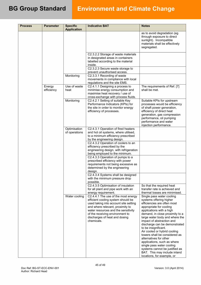
45 of 49 Doc Ref: BG-ST-ECC-ENV-001 Version: 3.0 (April 2014) Author: Richard Head
BG Group Standard
Environment and Climate Change
Process Parameter Specific Application
Indicative BAT Notes
as to avoid degradation (eg through exposure to direct sunlight). Incompatible materials shall be effectively segregated.
C2.3.2.2 Storage of waste materials in designated areas in containers labelled according to the material inside.
C2.3.2.3 Secure waste storage to prevent unauthorised access.
Monitoring C2.3.3.1 Recording of waste movements in compliance with local regulations and the site EMS.
Energy efficiency
Use of waste heat
C2.4.1.1 Designing a process to minimise energy consumption and maximise heat recovery / use of cross-exchange with process fluids.
The requirements of Ref. [7] shall be met.
Monitoring C2.4.2.1 Setting of suitable Key Performance Indicators (KPIs) for the site in order to monitor energy efficiency of processes.
Suitable KPIs for upstream processes would be efficiency of shaft power generation, efficiency of direct heat generation, gas compression performance, oil pumping performance and water injection performance.
Optimisation of operations
C2.4.3.1 Operation of fired heaters and hot oil systems, where utilised, to a minimum efficiency prescribed by the engineering design.
C2.4.3.2 Operation of coolers to an efficiency prescribed by the engineering design, with refrigeration being employed to the minimum.
C2.4.3.3 Operation of pumps to a prescribed efficiency with power requirements not being excessive as determined by the engineering design.
C2.4.3.4 Systems shall be designed with the minimum pressure drop possible.
C2.4.3.5 Optimisation of insulation for all plant and pipe work with an energy requirement.
So that the required heat transfer rate is achieved and thermal losses are minimised.
Water cooling C2.4.4.1 The use of the most energy efficient cooling system should be used taking into account site setting and where relevant, proximity to water resources and the sensitivity of the receiving environment to discharges of heat and dosing chemicals.
Single pass water cooling systems offering higher efficiencies are often most appropriate for cooling applications with a high demand, in close proximity to a large water body and where the impact of abstraction and discharge can be demonstrated to be insignificant. Air cooled or hybrid cooling towers shall be considered as alternatives for other applications, such as where single pass water cooling systems cannot be justified as BAT. This may include inland locations, for example, or
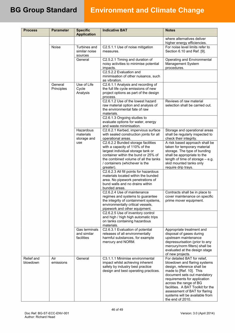
46 of 49 Doc Ref: BG-ST-ECC-ENV-001 Version: 3.0 (April 2014) Author: Richard Head
BG Group Standard
Environment and Climate Change
Process Parameter Specific Application
Indicative BAT Notes
where alternatives deliver higher energy efficiencies.
Noise Turbines and similar noise sources
C2.5.1.1 Use of noise mitigation measures.
For noise level limits refer to Section 6.10 and Ref. [9].
General C2.5.2.1 Timing and duration of noisy activities to minimise potential impacts.
Operating and Environmental Management System procedures.
C2.5.2.2 Evaluation and minimisation of other nuisance, such as vibration.
General Principles
Use of Life Cycle Analysis
C2.6.1.1 Analysis and recording of the full life cycle emissions of new project options as part of the design process.
C2.6.1.2 Use of the lowest hazard raw material option and analysis of the environmental fate of raw materials.
Reviews of raw material selection shall be carried out.
C2.6.1.3 Ongoing studies to evaluate options for water, energy and waste minimisation.
Hazardous materials storage and use
C2.6.2.1 Kerbed, impervious surface with sealed construction joints for all operational areas.
Storage and operational areas shall be regularly inspected to check their integrity.
C2.6.2.2 Bunded storage facilities with a capacity of 110% of the largest individual storage tank or container within the bund or 25% of the combined volume of all the tanks / containers (whichever is the greater).
A risk based approach shall be taken for temporary material storage. The type of bunding shall be appropriate to the length of time of storage – e.g. skid mounted tanks only require drip trays.
C2.6.2.3 All fill points for hazardous materials located within the bunded area. No pipework penetrations of bund walls and no drains within bunded areas.
C2.6.2.4 Use of maintenance regimes and systems to guarantee the integrity of containment systems, environmentally critical vessels, pipework and other equipment.
Contracts shall be in place to cover maintenance on specific prime mover equipment.
C2.6.2.5 Use of inventory control and high / high high automatic trips on tanks containing hazardous materials.
Gas terminals and similar facilities
C2.6.3.1 Evaluation of potential releases of all environmentally harmful substances, for example mercury and NORM.
Appropriate treatment and disposal of gases during upstream maintenance depressurisation (prior to any mercury/norm filters) shall be evaluated at the design stage of new projects.
Relief and blowdown
Air emissions
General C3.1.1.1 Minimise environmental impact whilst achieving inherent safety by industry best practice design and best operating practices.
For detailed BAT for relief, blowdown and flaring systems design, reference shall be made to [Ref. 10]. This document sets out mandatory requirements for application across the range of BG facilities. A BAT Toolkit for the assessment of BAT for flaring systems will be available from the end of 2010.
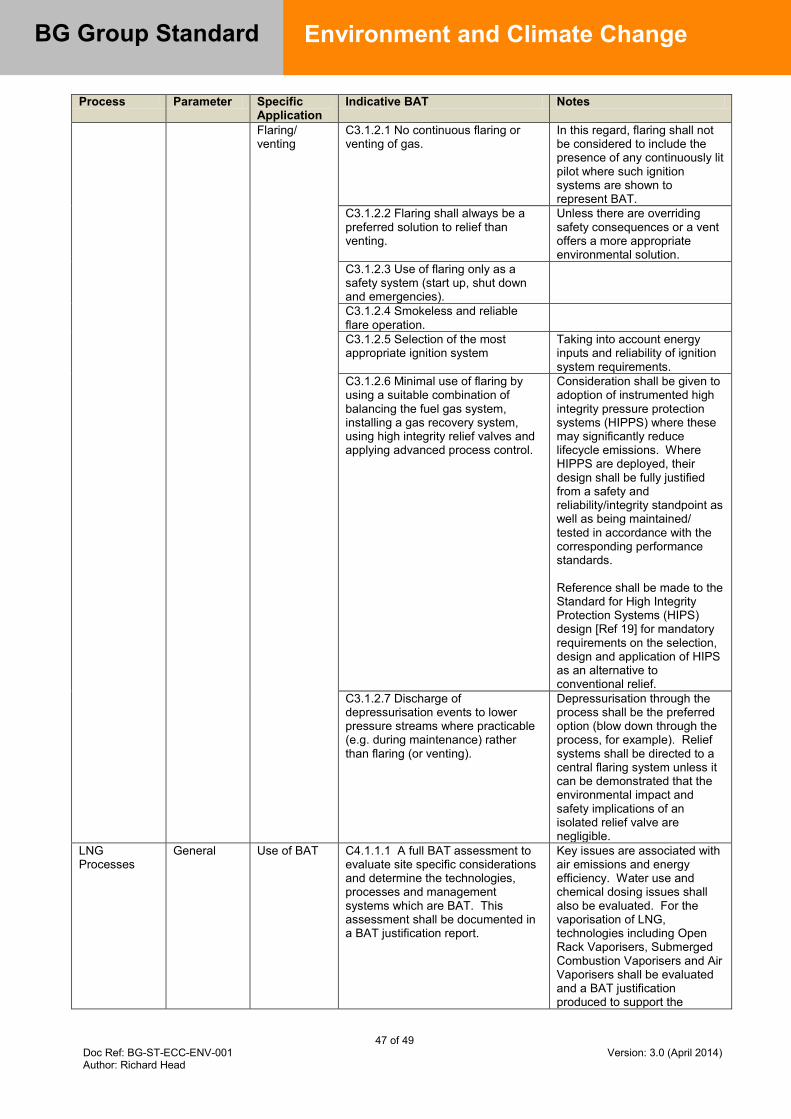
47 of 49 Doc Ref: BG-ST-ECC-ENV-001 Version: 3.0 (April 2014) Author: Richard Head
BG Group Standard
Environment and Climate Change
Process Parameter Specific Application
Indicative BAT Notes
Flaring/ venting
C3.1.2.1 No continuous flaring or venting of gas.
In this regard, flaring shall not be considered to include the presence of any continuously lit pilot where such ignition systems are shown to represent BAT.
C3.1.2.2 Flaring shall always be a preferred solution to relief than venting.
Unless there are overriding safety consequences or a vent offers a more appropriate environmental solution.
C3.1.2.3 Use of flaring only as a safety system (start up, shut down and emergencies).
C3.1.2.4 Smokeless and reliable flare operation.
C3.1.2.5 Selection of the most appropriate ignition system
Taking into account energy inputs and reliability of ignition system requirements.
C3.1.2.6 Minimal use of flaring by using a suitable combination of balancing the fuel gas system, installing a gas recovery system, using high integrity relief valves and applying advanced process control.
Consideration shall be given to adoption of instrumented high integrity pressure protection systems (HIPPS) where these may significantly reduce lifecycle emissions. Where HIPPS are deployed, their design shall be fully justified from a safety and reliability/integrity standpoint as well as being maintained/ tested in accordance with the corresponding performance standards. Reference shall be made to the Standard for High Integrity Protection Systems (HIPS) design [Ref 19] for mandatory requirements on the selection, design and application of HIPS as an alternative to conventional relief.
C3.1.2.7 Discharge of depressurisation events to lower pressure streams where practicable (e.g. during maintenance) rather than flaring (or venting).
Depressurisation through the process shall be the preferred option (blow down through the process, for example). Relief systems shall be directed to a central flaring system unless it can be demonstrated that the environmental impact and safety implications of an isolated relief valve are negligible.
LNG Processes
General Use of BAT C4.1.1.1 A full BAT assessment to evaluate site specific considerations and determine the technologies, processes and management systems which are BAT. This assessment shall be documented in a BAT justification report.
Key issues are associated with air emissions and energy efficiency. Water use and chemical dosing issues shall also be evaluated. For the vaporisation of LNG, technologies including Open Rack Vaporisers, Submerged Combustion Vaporisers and Air Vaporisers shall be evaluated and a BAT justification produced to support the
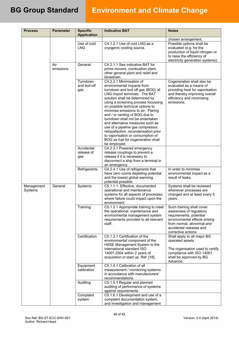
48 of 49 Doc Ref: BG-ST-ECC-ENV-001 Version: 3.0 (April 2014) Author: Richard Head
BG Group Standard
Environment and Climate Change
Process Parameter Specific Application
Indicative BAT Notes
chosen arrangement. Use of cold LNG
C4.1.2.1 Use of cold LNG as a cryogenic cooling source.
Possible options shall be evaluated (e.g. for the production of liquid nitrogen or to raise the efficiency of electricity generation systems).
Air emissions
General C4.2.1.1 See indicative BAT for prime movers, combustion plant, other general plant and relief and blowdown.
Turndown and boil-off gas
C4.2.2.1 Minimisation of environmental impacts from turndown and boil off gas (BOG) at LNG import terminals. The BAT solution shall be determined by using a screening process focussing on possible technical options to minimise emissions to air. Flaring and / or venting of BOG due to turndown shall not be undertaken and alternative measures such as use of a pipeline gas compressor, reliquefaction, recondensation prior to vaporisation or consumption of BOG as fuel for cogeneration shall be employed.
Cogeneration shall also be evaluated as a means of providing heat for vaporisation and thereby improving overall efficiency and minimising emissions.
Accidental release of gas
C4.2.3.1 Powered emergency release couplings to prevent a release if it is necessary to disconnect a ship from a terminal in an emergency.
Refrigerants C4.2.4.1 Use of refrigerants that have zero ozone depleting potential and the lowest global warming potential possible.
In order to minimise environmental impact as a result of leaks.
Management Systems
General Systems C5.1.1.1. Effective, documented operational and maintenance systems for all aspects of processes where failure could impact upon the environment
Systems shall be reviewed whenever processes are changed and at least every 5 years.
Training C5.1.2.1 Appropriate training to meet the operational, maintenance and environmental management system requirements provided to all relevant staff.
Such training shall cover awareness of regulatory requirements, potential environmental effects arising from normal, abnormal and accidental releases and corrective actions.
Certification C5.1.3.1 Certification of the environmental component of the HSSE Management System to the international standard ISO 14001:2004 within 2 years of acquisition or start up. Ref. [18].
Shall apply to all major BG operated assets . The organisation used to certify compliance with ISO 14001 shall be approved by BG Advance.
Equipment calibration
C5.1.4.1 Calibration of all measurement / monitoring systems in accordance with manufacturers’ recommendations.
Auditing C5.1.5.1 Regular and planned auditing of performance of systems against requirements.
Complaint system
C5.1.6.1 Development and use of a complaint documentation system, and investigation and management
49 of 49 Doc Ref: BG-ST-ECC-ENV-001 Version: 3.0 (April 2014) Author: Richard Head
BG Group Standard
Environment and Climate Change
Process Parameter Specific Application
Indicative BAT Notes
procedures. Energy policy C5.1.7.1 Development and
implementation of an energy management policy by all projects and operations.
C5.1.7.2 Inclusion of an energy Value Improvement Practice session (VIP) in the Assess stage of the VAF for projects with high energy requirements.
C5.1.7.3 Utilisation of an energy efficiency plan at the Operate stage
Waste minimisation
C5.1.8.1 Undertaking a waste minimisation assessment (VIP) in the Assess, Define and detailed engineering stages.
Training C5.1.9.1 Training of operations personnel in energy management and environmental awareness so that they understand the key impacts associated with the operations and processes employed at the installation/facility.
For new turbine equipment, CO, NOx and UHC emissions from the exhaust stack shall not exceed the limits specified in the table below (as referenced in the table above).
Turbine Size Gas Fuel Liquid Fuel UHC (ppmv) CO
(ppmv) NOx (ppmv)
CO (ppmv)
NOx (ppmv)
<30MW 50 45 50 95 25 >30MW 25 25 15 90 20

Unclassified
BG Group Standard
Environmental Standard
BG-ST-HSSE-ENV-001

2 of 67 Doc Ref: BG-ST-HSSE-ENV-001 Version: 2.1 (13 May 2013) Author: Andrew Wharton
BG Group Standard
Environmental Standard
Document and Version Control Version Author Issue Date Revision Detail
1.0 Paul Fletcher 01 October 2010
This standard replaces the Environmental Expectations Standard, Best Available Techniques for Environmental Protection Standard, Air Quality Standard, Water Quality Standard, Greenhouse Gas Management Standard, Resource Use and Waste Management Standard and Biodiversity Standard
1.1 Paul Fletcher 01 January 2011 Updated to new Template Issued for use
2.0 Group Environment 01 April 2013
Key changes have been made in the areas of Environmental Impact Assessment (to give more detail on what an EIA is to include) energy efficiency, GHG management and climate change (to support new Group GHG target), water risk management (to support Group Water Strategy and enhance Group oil in water performance), oil spill preparedness (to mitigate increased risks posed to the business) and biodiversity management (to mitigate against increased risks posed to the business). The Standard has also been rationalised by taking out detailed air and water quality standard information from this document and placing into a new Environmental Quality Guidance document Issued for use
2.1 Group Environment 13 May 2013 Update to carbon pricing approach

3 of 67 Doc Ref: BG-ST-HSSE-ENV-001 Version: 2.1 (13 May 2013) Author: Andrew Wharton
BG Group Standard
Environmental Standard
Contents 1.0 Executive Summary .................................................................................................. 4
2.0 Ownership ................................................................................................................. 5
3.0 Objectives .................................................................................................................. 5
3.1 Best Available Techniques (BAT) ....................................................................... 8
4.0 Scope and application .............................................................................................. 9
5.0 Links to other controls ........................................................................................... 10
6.0 Standard requirements ........................................................................................... 12
6.1 Best Available Techniques (BAT) ......................................................................12
6.2 Environmental Management ..............................................................................14
6.3 Climate Change .................................................................................................15
6.4 Air Quality ..........................................................................................................19
6.5 Water Risk Management ...................................................................................19
6.6 Oil Spill Preparedness .......................................................................................21
6.7 Contaminated Land ...........................................................................................23
6.8 Resource Use ....................................................................................................25
6.9 Waste Management ...........................................................................................25
6.10 Biodiversity ........................................................................................................28
6.11 Noise .................................................................................................................30
7.0 Appendices .......................................................................................... 32
7.1 Appendix A – Gap Analysis Template ...............................................................32
7.2 Appendix B – Definitions / Abbreviations ...........................................................44
7.3 Appendix C – Indicative BAT .............................................................................52
7.4 Appendix D – Reference Standards / Guidelines ...............................................64
7.5 Appendix E – Carbon checklist decision tree .....................................................66
8.0 Revision Record .................................................................................. 67
4 of 67 Doc Ref: BG-ST-HSSE-ENV-001 Version: 2.1 (13 May 2013) Author: Andrew Wharton
BG Group Standard
Environmental Standard
1.0 Executive Summary This Standard defines the requirements to demonstrate how BG Group achieves compliance with its Business Principles.
The Environmental Standard sets out our minimum expectations for environmental performance and also how we determine when it is appropriate to go beyond the minimum standard. Regulatory compliance is an essential part of our environmental performance, however, this standard sets out the Best Available Techniques (BAT) process which will ensure both efficient environmental management and that when appropriate we go beyond the minimum to meet internationally accepted best practice and reduce to the minimum practicable any adverse effects of our operations on the environment.
5 of 67 Doc Ref: BG-ST-HSSE-ENV-001 Version: 2.1 (13 May 2013) Author: Andrew Wharton
BG Group Standard
Environmental Standard
2.0 Ownership Owning Function: Environment Standard owner: Head of Environment Expert advisor: Group Environment Dispensation: Head of Environment
3.0 Objectives The purpose of this document is to set out how BG Group will meet its environmental commitments in our Business Principles and HSSE Policy. The Business Principles commitments with regard to environmental management are:
We make a positive contribution to the protection of the environment We go beyond compliance with local environmental regulation to meet
internationally accepted best practice We reduce to the minimum practicable any adverse effects of our operations on the
environment
To meet BG Group’s Business Principles, a number of processes have been established which, when implemented, ensure appropriate environmental protection.
These are:
to use the Best Available Techniques (BAT) process in order to determine the appropriate mitigations to reduce to the minimum practicable any adverse effects of our operations on the environment;
to actively manage emissions of greenhouse gases and to minimise the emission of greenhouse gases in terms of carbon dioxide equivalent (CO2eq) per unit of hydrocarbon produced/transmitted (Greenhouse Gas (GHG) efficiency);
to manage the long term physical risks to facilities resulting from climate change; to reduce to the minimum practicable any adverse effects of our operations on the
environment or people from air emissions; to eliminate the emission of ozone depleting substances; to recognise limitations in resource availability and to minimise demand on those
resources to risk assess and then mitigate to the minimum practicable water management risks
posed to BG Group operations; to minimise noise impacts on third parties; to minimise adverse impacts on biodiversity and maximise opportunities to enhance
biodiversity management; and, to ensure adequate preparation to mitigate against and deal effectively with a spill or
leakage of oil
BG Group’s environmental management objectives are to meet the commitments in our Business Principles and HSSE Policy. This Environmental Standard sets out our minimum expectations for environmental performance and also how we determine when it is

6 of 67 Doc Ref: BG-ST-HSSE-ENV-001 Version: 2.1 (13 May 2013) Author: Andrew Wharton
BG Group Standard
Environmental Standard
appropriate to go beyond the minimum standard. Regulatory compliance is an essential part of our environmental performance, however, this standard sets out the Best Available Techniques (BAT) process which will ensure both efficient environmental management and that when appropriate we go beyond the minimum to meet internationally accepted best practice and reduce to the minimum practicable any adverse effects of our operations on the environment.
In order to determine the environmental requirements that must be met, reference should first be made to the following sub-section which describes the principle of Best Available Techniques (BAT) and then to Section 6.1 which defines BAT and details those processes for which an ‘indicative BAT’ has already been established. Reference should then be made to the relevant Sections (6.2 – 6.11) which describe the standards relating to the emission of pollutants to different media such as air, including greenhouse gases and emissions of ozone depleting substances, the use of natural resources and specific environmental impacts such noise and impacts on biodiversity.

7 of 67 Doc Ref: BG-ST-HSSE-ENV-001 Version: 2.1 (13 May 2013) Author: Andrew Wharton
BG Group Standard
Environmental Standard
The range of Business segments and Value Funnel lifecycle stages to which this Standard applies are identified below:
Business Segment :
Upstream
T&D
Power
LNG
Stage :
Create
Assess
Select
Define
Execute
Operate
Decommission
Note: Assess includes Feasibility studies, Select includes Option assessments, Define includes both Pre-FEED Definition and FEED studies, Execute includes Detail Design, procurement, Construction and Commissioning.

8 of 67 Doc Ref: BG-ST-HSSE-ENV-001 Version: 2.1 (13 May 2013) Author: Andrew Wharton
BG Group Standard
Environmental Standard
3.1 Best Available Techniques (BAT)
3.1.1 BAT is the environmental equivalent of the safety philosophy ‘As Low as Reasonably Practicable’ (ALARP). It is through the BAT process that Projects and operations determine how they will meet the BG Business Principles commitments.
3.1.2 BAT is defined as ‘the most effective and advanced engineering practices and methods of operation which are available, practical and suitable to prevent, and where this is not practicable, reduce emissions and the impact on the environment as a whole’ [Ref 1]. The use of the BAT process drives improvements in efficient environmental management by the adoption of an accepted international methodology that provides an integrated, systematic approach across all environmental media (air, water, land) which might be affected.
3.1.3 The essence of BAT is that it shall drive a clear design process in order to minimise the overall impact on the environment of a development or operation. BAT shall be seen as a design tool used to determine techniques that will be used to protect the environment. The assessment which has to be made in order to be able to justify BAT shall be subject to a reasonable economic test. A cost benefit analysis approach is identified in the Best Available Technique guidance note [Ref 2].
3.1.4 BAT shall be addressed in the Value Assurance Plan within the HSSE Management Plan, as well as the Project Execution Plan and the Operational Assurance Plan. Correct implementation of BAT requires sufficient assessment to be made at the early stages of a Project where the ability to influence the outcome is at its greatest. This Front End Loading (FEL), taking place during the Assess, Select and Define stages of the VAF, is where the application of BAT will have maximum influence for minimum cost. Figure 1 illustrates the BAT activities that need to occur during each stage of the VAF. At each stage, the project shall ensure that environmental risks are being progressively minimised [Ref 29], working towards ALARP, as shown in the bottom section of Figure 1. The three theoretical risk matrices are placed across the VAF framework to show the activities that shall be progressed at each stage.
3.1.5 Requirements that are indicative BAT (see section 6.1.5 and Definition) are seen to meet the minimum environmental expectations as set by BG Group, and have been developed through best practice work and precedent. Opportunities to gain additional environmental benefit should be investigated where multiple options exist wherever practical. Figure 1: Diagram showing where BAT assessment activities need to take place during the VAF process:
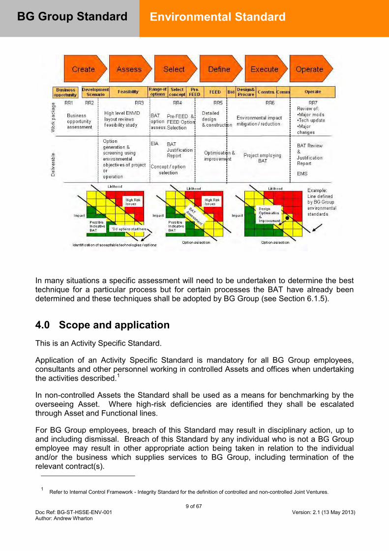
9 of 67 Doc Ref: BG-ST-HSSE-ENV-001 Version: 2.1 (13 May 2013) Author: Andrew Wharton
BG Group Standard
Environmental Standard
In many situations a specific assessment will need to be undertaken to determine the best technique for a particular process but for certain processes the BAT have already been determined and these techniques shall be adopted by BG Group (see Section 6.1.5).
4.0 Scope and application This is an Activity Specific Standard.
Application of an Activity Specific Standard is mandatory for all BG Group employees, consultants and other personnel working in controlled Assets and offices when undertaking the activities described.1
In non-controlled Assets the Standard shall be used as a means for benchmarking by the overseeing Asset. Where high-risk deficiencies are identified they shall be escalated through Asset and Functional lines.
For BG Group employees, breach of this Standard may result in disciplinary action, up to and including dismissal. Breach of this Standard by any individual who is not a BG Group employee may result in other appropriate action being taken in relation to the individual and/or the business which supplies services to BG Group, including termination of the relevant contract(s).
1 Refer to Internal Control Framework - Integrity Standard for the definition of controlled and non-controlled Joint Ventures.
10 of 67 Doc Ref: BG-ST-HSSE-ENV-001 Version: 2.1 (13 May 2013) Author: Andrew Wharton
BG Group Standard
Environmental Standard
This Standard is not contractual. BG Group reserves the right to amend, suspend or terminate this Standard.
The Standard defines the way BG Group uses BAT for the management of environmental impacts in existing operations and new development projects. It also defines:
4.1 the requirements for management of BG Group’s Greenhouse Gas (GHG) emissions; 4.2 Environmental Quality Standards (EQSs) that BG Group considers to be acceptable for air quality and water quality; 4.3 the requirements for BG Group’s use of resources, management of waste, preparedness for oil spills, avoiding and dealing with contaminated land and how it will manage biodiversity impacts; 4.4 maximum acceptable levels of noise impact on third parties from BG operations.
5.0 Links to other controls Governing Policies: Business Principles
HSE Policy
Complementary and linked Standards:
Internal Controls Framework: BG-ST-FIN-SECT-001 Relief, Blow down and Flaring Standard: BGA-NG-PROC-TS-003 Health Management Standard: BG-ST-HSSE-OCH-001] Selection of Rotating Machinery: BG-ST-ENG-MECH-001] Total Cost of Ownership: BGA-CP-CP-OS-0002] HSSE & Asset Integrity Audit Standard: [BG-ST-HSSE-EFF-003] HSSE Performance Monitoring Standard: [BG-ST-HSSE-EFF-002] HSSE Documentation Management Standard: [BGA-HSSE-GEN-ST-0502] High Integrity Protection Systems (HIPS): [BG-ST-ENG-PROC-0012] Crisis Management Standard: [BGA-HSSE-GEN-ST-0900] Well Engineering Standard: [BG-ST-WE-WE-001] Risk Management Standard: [BG-HSSE-GEN-ST-0201]
Supporting Guidelines: Best Available Techniques for Environmental Control Guideline: [BGA-HSSE-ENV-GL-1516] Environmental Reporting: [BG-GL-HSSE-ENV-002] BG Guideline Guidance for Resource Use and waste Management [BG-GL-HSSE-ENV-008] BG Guideline HSSE – Safety Engineering Safety Case Guideline [BG-GL-HSSE-AI-001] BG Guideline Preparation of Oil Spill Contingency Plans [BG-GL-HSSE-ENV-001] BG Guideline Guidance for Managing Technical Environmental Risk [BG-GL-HSSE-ENV-003] BG Guideline Climate Risk Guidance [BG-GL-HSSE-ENV-009] BG Guideline Water Risk Management [BG-GL-HSSE-ENV-010] BG Guideline Environmental Quality Standards [BG-GL-HSSE-ENV-011] Use and Disposal of Non-aqueous Drilling Fluids [BG-GL-WE-WE-025]
Other Supporting Documents: Economic Evaluation and Calculation Guideline– refer to Climate Change Strategy team, Group Strategy
11 of 67 Doc Ref: BG-ST-HSSE-ENV-001 Version: 2.1 (13 May 2013) Author: Andrew Wharton
BG Group Standard
Environmental Standard
OGP (2009) Guidelines for waste management with special focus on areas with limited infrastructure International Finance Corporation (IFC) & World Bank Group (2007) Environmental, Health and Safety (EHS) Guidelines www.ifc.org/ifcext/enviro.nsf/Content/EnvironmentalGuidelines Basel Convention on Control of Transboundary Movement of Hazardous Waste and their Disposal http://www.basel.int/text/con-e.pdf OGP Report 342 Environmental Aspects of the Use and Disposal of Non-aqueous Drilling Fluids Associated with Off-shore Oil and Gas Operations www.ogp.org.uk/pubs/342.pdf IPIECA, 2010 - Alien invasive species and the oil and gas industry
12 of 67 Doc Ref: BG-ST-HSSE-ENV-001 Version: 2.1 (13 May 2013) Author: Andrew Wharton
BG Group Standard
Environmental Standard
6.0 Standard requirements 6.1 Best Available Techniques (BAT)
6.1.1 General
6.1.1.1 Assets shall demonstrate that they are using the BAT process to determine the actions to be taken to meet the BG Group Business Principles. The BG Group BAT Guidance [Ref. 2] associated with this Standard provides guidance on how to build up an appropriate BAT assessment and justification.
6.1.1.2 For situations where indicative BAT has been defined and these requirements have been met, this shall be set out by the Asset and no further justification will be required where no alternatives exist. Areas where indicative BAT has been specified by BG Group are detailed in Appendix C. These indicative BAT requirements are mandatory minimum performance requirements. BAT option appraisal must be carried out where more than one option is present and the potential exists to go beyond these minimum expectations.
6.1.2 Existing Facilities
AGMs of all existing facilities shall:
6.1.2.1 Ensure that an assessment is carried out to determine if their facilities are BAT compliant. An assessment against BAT is required before major modification to plant/emissions occurs or processes employed change significantly in their design or operation.
6.1.2.2 Ensure that their operations are reviewed against BAT requirements at least every 5 years.
6.1.2.3 Demonstrate that existing equipment and operations are being managed to minimise impact on the environment. Immediate upgrade of equipment to meet internationally accepted best practice is not mandatory but, where necessary, a plan shall be in place to ensure operations are meeting BAT.
6.1.2.4 BAT assessments shall be retained and available for review for at least 5 years.
6.1.2.5 Responsibility for discharging BAT requirements and coordinating implementation lies with HSSE managers.
6.1.3 New Developments
Project Managers of all new developments shall:
6.1.3.1 Ensure that all Projects meet the commitments of the BG Group Business Principles.
13 of 67 Doc Ref: BG-ST-HSSE-ENV-001 Version: 2.1 (13 May 2013) Author: Andrew Wharton
BG Group Standard
Environmental Standard
6.1.3.2 Apply BAT across all project design, engineering and management aspects at the earliest opportunity in order to maximise environmental benefits and environmental impact reductions. All design options shall be assessed against BG Group’s BAT requirements.
6.1.3.3 Document BAT assessments according to the requirements of 6.1.4.1, 6.1.4.2, 6.1.4.3 and 6.1.4.4.
6.1.3.4 Demonstrate at the relevant Project Functional Review meeting that BAT has been applied, in advance of the Project Readiness Review.
6.1.3.5 The assessment of BAT should be iterative as the design progresses so that ENVID’s, EIA’s and BAT assessments all feed into the design process.
6.1.4 BAT and the BG Group Value Assurance Framework (VAF)
Refer to Figure 1 above.
Create
6.1.4.1 During the Create stage, the business opportunity shall be evaluated against high level Company environmental objectives such as the BG Group Business Principles, HSSE Policy and the Environmental Standard.
Assess
6.1.4.2 During the Assess stage, a high level ENVID shall be undertaken which shall feed into a BAT option assessment and an EIA. A preliminary BAT assessment shall be prepared
Select
6.1.4.3 The findings of the preliminary BAT assessment shall be taken into account during the selection of the concept or option. An updated BAT assessment with associated Justification Report shall be prepared.
Define
6.1.4.4 The detailed design will lead to optimisation and improvement of the design with regard to impact on the environment. A BAT Assessment and Final Justification Report shall be prepared which will be used by the project in detailed design and demonstrate how the project is meeting the Business Principles.
Execute
6.1.4.5 During this stage, controls shall be implemented to minimise the impact that the project has on the environment as it is being constructed.
Operation

14 of 67 Doc Ref: BG-ST-HSSE-ENV-001 Version: 2.1 (13 May 2013) Author: Andrew Wharton
BG Group Standard
Environmental Standard
6.1.4.6 Periodic BAT reviews shall take place during the Operation stage of the project to ensure environmental efficiency and verify the Business principles are continued to be met. These reviews shall be undertaken at least every 5 years. An assessment against BAT shall be undertaken before major modification to plant/emissions occurs or processes employed change significantly in their design or operation.
6.1.5 Design-specific Requirements and Indicative BAT
6.1.5.1 Where relevant, indicative BAT requirements shall be referred to when designing facilities or purchasing equipment. These represent minimum expectations.
6.1.5.2 The BAT process shall be used to determine alternatives where conflicts between different environmental aspects occur. Table 1 in Appendix C defines indicative BAT for various types of facility/process that occur within BG Group’s business.
6.1.5.3 Indicative BAT may also be determined by precedent where facilities are being designed or operated in similar circumstances to those that have already been declared as BAT, either within BG Group or externally. EU BAT Reference (BREF) notes which provide a reference on external best practice may be found at http://eippcb.jrc.es/reference/. Attention should be drawn to the energy efficiency requirements stated in Appendix C. For all the processes listed in Table 1 of Appendix C, where an evaluation demonstrates that the indicative BAT is not practical in the given circumstances, such as local availability of materials or technology, this shall be documented to justify the alternative choice of material and/or technology.
6.2 Environmental Management
6.2.1 Environmental Management Systems
6.2.1.1 All assets shall establish an environmental management system (EMS) to effectively identify and control key environmental risks and impacts.
6.2.1.2 The minimum requirement of the EMS shall be maintaining regulatory compliance.
6.2.1.3 The EMS shall clearly set out the key environmental processes in the asset and the responsibilities and accountabilities for maintaining these processes.
6.2.1.4 The EMS may be part of the HSSE management system.
6.2.1.5 All major operational assets shall certify the environmental component of their HSSE Management System to the international standard ISO 14001:2004 within 2 years of acquisition or start up [Ref 18].
6.2.1.6 In order to ensure a consistent approach and standard is applied and facilitate the identification of trends across assets, the organisation used to certify compliance with ISO 14001 shall be determined by Head of Environment.
6.2.1.7 Key environmental emissions shall be measured and reported in line with Environmental Reporting Guidance [Ref 5].

15 of 67 Doc Ref: BG-ST-HSSE-ENV-001 Version: 2.1 (13 May 2013) Author: Andrew Wharton
BG Group Standard
Environmental Standard
6.2.2 Environmental Impact Assessment (EIA)
6.2.2.1 In accordance with the BG Risk Management Standard [Ref 24] an Environmental Impact Assessment (EIA) shall be undertaken in advance of all exploration activities (such as seismic survey and drilling) and through the lifecycle of new developments (such as production drilling, hydrocarbon production, process facility operation, hydrocarbon storage, transport and distribution infrastructure operation).
6.2.2.2 The objective of the EIA process shall be to identify and evaluate environmental risks and impacts of the activity or project and to adopt a mitigation hierarchy to anticipate and avoid, or where avoidance is not possible, reduce to the minimum practicable any adverse impacts on the environment.
6.2.2.3 The terms of reference of the EIA for any given project or activity will vary. The type, scale and location of the project shall guide the scope and level of effort devoted to the EIA process. To ensure consistency across BG Group the scope, methodology and schedule of the EIA shall be developed with reference to the following requirements:
Host country legal requirements, regulations and expectations; Regional regulations where applicable e.g. a project in Europe must meet EU
requirements; International Finance Corporation (IFC) Performance Standards; and, Internationally accepted best practice.
6.2.2.4 For all activities and projects requiring an EIA, the process followed shall, as a
minimum, include studies to sufficiently demonstrate and document:
Identification of all potential environmental issues, concerns and risks; An understanding of the receptors; An understanding of the baseline environment; An understanding of the project activities and alternatives; Identification and assessment of all potential environmental impacts including
cumulative impacts of existing and proposed projects; The development of comprehensive environmental management and mitigation
measures; and, An understanding of the applicable regulatory framework
Further detail on the required EIA process is provided in the BG Group Guideline ‘Technical Environmental Risk Management’ [Ref 29].
6.3 Climate Change
6.3.1 Existing Facilities
All facilities shall:
16 of 67 Doc Ref: BG-ST-HSSE-ENV-001 Version: 2.1 (13 May 2013) Author: Andrew Wharton
BG Group Standard
Environmental Standard
6.3.1.1 Develop and maintain a life of field inventory of greenhouse gas (GHG) emission sources and an annual emission rate forecast corresponding to the business plan. This shall also identify the emission intensity in line with the Environmental Reporting Guideline [Ref 5];
6.3.1.2 Periodically review options for the reduction of GHG emissions. This must include a detailed energy efficiency appraisal. The frequency of review shall be at least every 5 years and may be included in the BAT review cycle. More frequent review shall be undertaken where major modification to plant / emissions occurs or if available technology changes. Facilities shall be reviewed using BAT Guidance [Ref 2]; and
6.3.1.3 Establish and maintain agreed facility-specific energy efficiency and/or GHG targets/key performance indicators aimed at reducing their unit greenhouse gas emissions relative to a ‘no action’ situation. Facility emission targets shall be agreed with Group Environment to support both asset and Group objectives and targets.
6.3.1.4 Prepare an Energy Management Plan. This plan shall set out how the facility will manage energy and improve energy efficiency. A template plan is available from Group Environment.
6.3.1.5 The plan shall be for at least 5 years from end Q2 2013 and be reviewed annually.
6.3.1.6 The plan should address energy management actions over a 5 year period and should undergo review and update every 5 years in line with the revised BAT and Energy Efficiency Studies.
6.3.1.7 To ensure adequate and consistent quality the plans shall be reviewed and endorsed by the Head of Environment.
6.3.1.8 The plan shall either be a standalone document or incorporated into established ISO 14001 EMS. Any facility implementing or certified to ISO 50001 is not require to prepare a separate Energy Management Plan.
6.3.1.9 GHG forecasts, mitigation measures and energy efficiency improvement projects shall be incorporated into Integrated Asset Modelling (IAM) and Integrated Activity Planning and Scheduling (IAPS) processes where applicable.
6.3.2 New Developments
All new developments shall:
6.3.2.1 Develop and maintain a life of field forecast of GHG emission sources and a profile of annual GHG emissions over the foreseeable facility life. This shall include a forecast of unit emissions.
6.3.2.2 Set a project specific GHG emission intensity target for operation in the Assess stage of the VAF process in consultation with Group Environment and Engineering Departments, which can be updated as more details of the project become apparent.

17 of 67 Doc Ref: BG-ST-HSSE-ENV-001 Version: 2.1 (13 May 2013) Author: Andrew Wharton
BG Group Standard
Environmental Standard
6.3.2.3 As a minimum, incorporate an emission reduction assessment at the Assess and Define stages of the value assurance process and refine project specific GHG intensity targets accordingly. This shall either be a standalone document or incorporated into the BAT Assessment.
6.3.2.4 Minimise unit greenhouse gas emissions and maximise energy efficiency using the Best Available Techniques (BAT) [Ref. Section 6.1].
6.3.2.5 Have no continuous flaring or venting of gas associated with oil or condensate.
Note: A Dispensation shall be requested for the exceptional cases when a ‘Kyoto accredited’ offset scheme is proposed to overcome technical/commercial barriers that would otherwise prevent development.
6.3.2.6 Develop a flare mitigation plan for any extended well testing and during the Execute (detailed design) stage to minimise flaring during commissioning/early field life and during start up and shut down.
Note: Minimum standards relating to flare management, pilots and purge are stated in this Environmental Standard in the context of demonstrating BAT. Dispensations for BAT compliance shall be against this standard and sent to the Head of Environment. All other dispensations shall relate to the Engineering Standard for Relief, Blowdown and Flaring [Ref 10] and shall be against the Relief, Blowdown and Flaring Standard and sent to the Head of Engineering and copied to the Head of Environment.
6.3.3 Emissions Accounting and Reporting
6.3.3.1 GHG emission accounting and reporting shall be consistent with the BG Environmental Reporting Guideline [Ref 5], which is based on ISO guidance [Ref 4].
6.3.3.2 All BG Operated, Joint Operated and NOJV facilities shall report quarterly (as a minimum) to Group HSSE their greenhouse gas emissions.
6.3.3.3 New agreements with NOJVs shall include a requirement to report quarterly to BG their GHG emissions (including unit emissions) as part of the required HSSE data.
6.3.4 Business Development / Investment Decisions
6.3.4.1 Developments and new acquisitions with projected GHG emissions in excess of 100,000 tonnes CO2-eq per annum shall include a commentary in the Business Development Committee / Investment Committee papers on GHG risks and mitigation proposals. The commentary shall cover:
The quantity and intensity of GHG emissions forecasted;
Sensitivity to future value of carbon (i.e. carbon taxes);
Opportunities to further reduce GHG emissions and energy intensity;
Impact of the host country’s energy policy on GHG risk;
18 of 67 Doc Ref: BG-ST-HSSE-ENV-001 Version: 2.1 (13 May 2013) Author: Andrew Wharton
BG Group Standard
Environmental Standard
Pre-investment to facilitate carbon reduction techniques such as WHR and CCS if not proposed initially (e.g. off-take flanges, space allocation for equipment); and,
How the project will comply with the BG Group Business principles in relation of GHG
Note: The 100,000 tonne CO2-eq threshold shall apply to the gross emissions from a project (i.e. not just the BG equity share and not just the incremental increase due to a specific change).
6.3.4.2 All developments, irrespective of the size of their emissions, within jurisdictions in which there is an existing or foreseeable value to carbon shall account for that value in the base economics of the development (i.e. existing or planned carbon tax: contact Head of Climate Change Strategy for list of jurisdictions).
6.3.4.3 BG Group’s approved treatment of carbon value [Ref. 6] shall be used in consideration of investment in emission reduction projects in both existing operations and new developments.
6.3.4.4 Operations and brownfield developments shall implement all viable energy efficiency and carbon reduction measures that are economic (NPV6 > 0) with the inclusion of fuel savings and carbon prices. Economic evaluations shall be based on current and forecast carbon prices for the life of project or equipment. The latest recommended shadow carbon price within the Economic Evaluation and Calculation Guideline shall be included as a minimum, or market price or Group forecast planning price for relevant years, whichever is the higher.
6.3.4.5 The opportunity cost of gas used as fuel or lost through flaring and venting shall be based on the greatest value which could be obtained across the gas chain of which the project is a part / net back price.
6.3.4.6 Techniques shall be evaluated as part of the Best Available Technique process to reduce environmental risks to As Low As Reasonably Practical.
6.3.4.7 It should be noted that BAT may require the implementation of measures that require a higher carbon price than identified in guidance. For major emission sources (e.g. CO2 separated from reservoir gas, power generation), BG may consider investment in mitigation options which have negative marginal economics to negate the potential impacts of future / forecast climate change policy or regulation. The options for mitigation shall be put to the relevant committee.
6.3.4.8 Where the CO2 content of reservoir gas is greater than 10% or lower than 10% but considered high for other reasons, opportunities for carbon capture and storage techniques shall be investigated, documented and reviewed with Head of Environment.
6.3.4.9 The management approach to carbon mitigation and energy efficiency through the lifecycle of an asset is summarised in Appendix E.
19 of 67 Doc Ref: BG-ST-HSSE-ENV-001 Version: 2.1 (13 May 2013) Author: Andrew Wharton
BG Group Standard
Environmental Standard
6.3.5 Impacts due to Climate Change
6.3.5.1 The threat to all facilities due to foreseeable changes in the environment resulting from climate change shall be assessed and documented. The period considered will be the life of facility.
6.3.5.2 Consultants conducting the climate change threat assessment shall be approved by the Head of Environment.
6.3.5.3 When the threat assessment identifies the possibility of environmental change presenting a risk to a facility, a risk assessment shall be carried out to determine the impact on the operation, engineering, environmental performance of the facility and impacts upon any neighboring community. Examples of changing climatic conditions which may present a risk to facilities include but are not limited to:
Changes to average and extreme temperatures; Changes in sea surface temperatures, currents, frequency and intensity of storm
events; Changes in seasonal precipitation impacting water availability; and, Mean sea level rise, increasing storm surge heights, storm intensity and
frequency [Ref 30]
6.3.5.4 Where significant risks are identified an appropriate mitigation shall be developed, documented and implemented in consultation with Head of Environment. Additional guidance is provided in Climate Risk Guideline - BG-GL-HSSE-ENV-009 [Ref 30].
6.4 Air Quality
6.4.1.1 The emissions to air from any BG facility shall be reduced to the minimum practicable.
6.4.1.2 Emissions to air shall not result in an exceedence of the following Environmental Quality Standards (EQS):
those defined by the host country; or those defined in supporting guidance on Environmental Quality Standards
[Ref 16], whichever are the most stringent.
6.4.1.3 However, the impact from BG’s facility shall be determined as being insignificant if the contribution to ground level airborne concentration is <1% of EQS and under such conditions no further action by the facility is required (other than notification to regulatory authorities as required).
6.4.1.4 There shall be no continuous production of smoke from BG activities.
6.4.1.5 There shall be no emission to air of ozone depleting substances from BG activities.
6.5 Water Risk Management
6.5.1 Existing Facilities

20 of 67 Doc Ref: BG-ST-HSSE-ENV-001 Version: 2.1 (13 May 2013) Author: Andrew Wharton
BG Group Standard
Environmental Standard
6.5.1.1 AGM’s of all existing facilities shall ensure a self-assessment of water related risks to operations, the environment and community is completed. The detail into which the water risk assessment is applied will depend on the list of potential impacts identified and the initial judgment of the asset management team as to the level of risk posed by these impacts.
6.5.1.2 The water risk assessment shall follow the Business Risk Management Standard and be informed by the Water Risk Management Guideline [Ref 31].
6.5.1.3 The water risk assessment will be updated at least every 5 years or when a major modification to plant or process is being planned that will change the water risk profile of the facility.
6.5.1.4 The water risk assessment may be integral to the BAT process and shall be embedded within the EMS to ensure effective implementation and management.
6.5.1.5 The water risk assessment shall be reviewed and endorsed by the Head of Environment.
6.5.1.6 Once a water risk assessment has been undertaken, existing facilities that exhibit high risks in terms of impacts from water management issues shall develop and execute a Water Risk Management Plan that is designed to mitigate these risks. The Water Risk Management Guideline [Ref 31] should be consulted in conjunction with the development of a Water Risk Management Plan.
6.5.1.7 To ensure adequate and consistent quality of Water Management Plans, these plans shall be reviewed and endorsed by the Head of Environment.
6.5.2 New Developments and Acquisitions
6.5.2.1 Project Managers shall ensure that a water risk assessment is carried out as part of due diligence efforts or project plans mitigating against potential threats to current or future operations, the environment and community.
6.5.2.2 The water risk assessment will follow the Business Risk Management Standard and be informed by the Water Risk Management Guideline [Ref 31].
6.5.2.3 The water risk assessment shall be reviewed and endorsed by the Head of Environment.
6.5.2.4 Once a water risk assessment has been undertaken, new projects or acquisitions that exhibit high risks in terms of impacts from water management issues shall develop and execute a Water Management Plan that is designed to mitigate these risks in future project development or acquisition operation. The Water Risk Management Guideline [Ref 31] should be consulted in conjunction with the development of a Water Management Plan that will mitigate project or acquisition water related risks.
6.5.2.5 To ensure adequate and consistent quality of Water Management Plans these plans shall be reviewed and endorsed by the Head of Environment.

21 of 67 Doc Ref: BG-ST-HSSE-ENV-001 Version: 2.1 (13 May 2013) Author: Andrew Wharton
BG Group Standard
Environmental Standard
6.5.3 Water Quality
6.5.3.1 The water quality at 500m (offshore), or the nearest relevant receptor, or the edge of the ‘mixing zone’, whichever is closest to the discharge point, shall be within the Water Quality Standards listed in supporting guidance on Environmental Quality Standards [Ref 16].
6.5.3.2 Where countries have their own Environmental Quality Standards, the more stringent of the local and BG standards shall be used.
6.5.3.3 For offshore installations, the concentration of oil in produced water discharged to sea shall be reduced to the minimum practicable.
6.5.3.4 For offshore installations, the concentration of oil in produced water discharged to sea shall not exceed 15 mg/l on a monthly average.
6.5.3.5 The reference method used for the oil in water analysis shall be the modified version of ISO9377-2 GC-FID, the OSPAR standard.
6.5.3.6 Discharges of especially persistent or bioaccumulative contaminants (e.g. mercury and cadmium) shall be reduced to the minimum practicable using BAT.
6.5.3.7 Process water shall not be diluted, but shall be treated as necessary to meet the limits specified herein, before discharge.
6.6 Oil Spill Preparedness
6.6.1 Oil Spill Contingency Plans
6.6.1.1 In accordance with the BG Group Crisis Management, Well Engineering and other Standards and Guidelines [Ref 20, 21, 22, 23, 24, 27], Emergency Response Plans (ERP) shall be developed based on assessed risks including those relating to potential oil spills.
6.6.1.2 The risks associated with oil spills shall be assessed on a site specific basis and shall take account of the potential reasonable worst case spillage of liquid hydrocarbons including uncontrolled escape from a well.
6.6.1.3 For on-shore sites at which only very low volumes of oil are handled, the plans for responding to oil spills may be included within a broader Emergency Response Plan for the site.
6.6.1.4 For off-shore installations and other sites where the potential risks associated with the spillage of oil are greater, stand-alone oil spill contingency plans (OSCPs) shall be prepared [Ref 27].
6.6.1.5 An OSCP shall be prepared for any asset, facility or operation which produces, stores, or transfers liquid hydrocarbons or where there is the potential for a spillage or leak of hydrocarbon liquids to occur.

22 of 67 Doc Ref: BG-ST-HSSE-ENV-001 Version: 2.1 (13 May 2013) Author: Andrew Wharton
BG Group Standard
Environmental Standard
6.6.1.6 An OSCP shall be documented at the operational level for BG owned or managed sites.
6.6.1.7 In accordance with the BG Guideline on Preparation of Oil Spill Contingency Plans [Ref 27] each OSCP shall include a description of the following as a minimum:
Identified risks, based on: o Details of the liquid hydrocarbons on site/being extracted (types/compositions,
quantities/potential leakage rates, etc.) o Sensitive receivers and distance from site o Environmental setting (including depth of water, climatic conditions, prevailing
winds and tidal currents for off-shore facilities); Roles and responsibilities of individuals at the site responding to an oil spill
emergency; Roles and responsibilities for emergency response leaders including any
agreements with third parties to provide an emergency response service; Resources available (human and material) for response to an oil spill, including o Clean up equipment and chemicals (e.g. dispersants) o Trained operatives – internal and external o Location and inventory of oil spill response material;
The process for identification, notification and escalation of incidents including a description of the internationally recognised three-tier level of response; and,
National government requirements.
6.6.1.8 The OSCP shall contain, or refer to, coordinating instructions, to include contact details and logistics information. This shall include contact details for:
Asset managers and others with specific roles in the event of an oil spill; Other local oil spill response service providers; Contractors and equipment suppliers necessary to support oil spill response
activities i.e. haulage firms, boat suppliers, waste disposal contractors, etc.; Local and national environmental regulatory agencies; Oil Spill Response Ltd (OSRL); Local emergency services including hospitals; and, BG Group relevant contacts – BG Group Duty Manager, HSSE, PCA, etc.
6.6.1.9 The OSCP shall describe how the site emergency response links to the asset incident management system.
6.6.1.10 To ensure adequate and consistent quality of Oil Spill Response Contingency Plans these plans shall be reviewed and endorsed by the Head of Environment.
6.6.2 Resources
6.6.2.1 Tier 1 incidents: the asset shall ensure that there is adequate equipment available and trained personnel to use it to respond effectively to Tier 1 incidents.
23 of 67 Doc Ref: BG-ST-HSSE-ENV-001 Version: 2.1 (13 May 2013) Author: Andrew Wharton
BG Group Standard
Environmental Standard
6.6.2.2 Tier 2 incidents: The asset shall identify and document the Tier 2 response capability at a national level. If this capability is deemed inadequate to effectively respond to a potential asset Tier 2 incident the asset shall make its own arrangements for responding to Tier 2 incidents.
6.6.2.3 Tier 3 incidents: The asset shall ensure that procedures for mobilising Tier 3 resources are clearly defined and understood by all site managers.
6.6.2.4 The asset shall ensure that it has plans in place to effectively support deployment of the Tier 3 responder to the incident location and clearly understands the role the asset organisation will play in a Tier 3 incident.
6.6.2.5 Oil spill response equipment shall be stored in a secure location(s) and in a manner that maintains its operational effectiveness. Oil spill response equipment shall be stored in such a manner that it is and remains available for immediate use. Periodic inspections will be carried out to ensure the equipment is fit for purpose.
6.6.3 Exercises
6.6.3.1 Regular Tier 1 and Tier 2 oil pollution incident exercises shall be conducted to ensure that the arrangements specified in the OSCP are appropriate for responding to an oil spill and that the personnel identified in the OSCP are familiar with the OSCP procedures and the equipment is adequate and available. Recommended frequencies for undertaking the different types of oil spill response exercises are provided in the Preparation of Oil Spill Contingency Plans Guideline [Ref 27].
6.7 Contaminated Land
6.7.1 New Developments and Acquisitions
6.7.1.1 Environmental due diligence shall be undertaken on all land acquired.
6.7.1.2 The due diligence assessment shall include an evaluation to assess the level of risk due to contamination of the land by previous uses. Where previous land contamination is known, expected or otherwise considered a risk an environmental assessment will be carried out to quantity the degree of contamination of land and groundwater and the potential risk and liability this presents.
6.7.1.3 In general, the Purchase Agreement for an acquisition shall ensure that any past environmental liabilities (known or otherwise) remain with the seller.
6.7.1.4 When the acquisition is a public company, and in any other cases where BG takes on the past liabilities, the estimated cost of remediating any contamination shall be included in the overall valuation of the project, development or acquisition.
6.7.1.5 In estimating the cost of remediation, it shall be assumed that the site will need to be cleaned up to the satisfaction of the local regulatory authorities or to a level that will avoid undue risk to human health or ecological receptors, as determined by a site-specific risk assessment, whichever is the more stringent.
24 of 67 Doc Ref: BG-ST-HSSE-ENV-001 Version: 2.1 (13 May 2013) Author: Andrew Wharton
BG Group Standard
Environmental Standard
6.7.1.6 Particular regard shall be paid to acquisitions involving wells located in an area that has already been subject to oil and/or gas exploration to ensure that any contamination as a result of historical wells is clearly identified, understood and quantified. This shall include an investigation into potential contamination of the ground, groundwater or surface waters by liquids and gases.
6.7.2 Operational Sites
6.7.2.1 All BG Group sites shall be designed and operated so as to avoid contamination of land, groundwater and surface waters. Sections 6.5 and 6.9 provide specific requirements relating to water quality and the management of hazardous materials and waste.
6.7.2.2 Based upon a frequency determined by risk assessment, periodic assessment shall be undertaken to confirm that there is no contamination due to BG operations.
6.7.2.3 In the event that significant land and/or water contamination is suspected:
The cause of the contamination shall be investigated and mitigation measures shall be taken to prevent further contamination from that source
Remedial action shall be taken to clean up the contamination to the satisfaction of the local regulatory authorities or to a level that will avoid undue risk to human health or ecological receptors, as determined by a site-specific risk assessment, whichever is the more stringent
Any third parties affected by the contamination shall be contacted and advised of any precautions to be taken
The local regulatory authorities shall be informed and advised of the measures taken to prevent further contamination and remediate the contamination that has occurred
6.7.3 Decommissioning
6.7.3.1 Prior to developing a decommissioning plan assets shall consult with the Head of Environment to ensure that the plan will meet BG Group’s expectations and any address contamination issues or liabilities.
6.7.3.2 During the decommissioning of land based facilities a contaminated land assessment shall be undertaken as part of the decommissioning process. The purpose of this assessment will be to identify any significant contamination of land, groundwater and surface waters.
6.7.3.3 Where significant contamination is found the site shall be cleaned up to the satisfaction of the local regulatory authorities or to a level that will avoid undue risk to future users of the site and ecological receptors, as determined by a site-specific risk assessment, whichever is the more stringent.
6.7.3.4 Alternatively, the potential liability shall be declared to the buyer or future occupier of the site.
25 of 67 Doc Ref: BG-ST-HSSE-ENV-001 Version: 2.1 (13 May 2013) Author: Andrew Wharton
BG Group Standard
Environmental Standard
6.7.3.5 Prior to the decommissioning of offshore facilities all risks to the marine environment posed by the decommissioning programme shall be assessed. The assessment shall cover all infrastructure related to the offshore facility, for example platforms and jackets, pipelines and floating infrastructure as well as cuttings piles and other sea bed structures.
6.7.3.6 If significant risks are identified then mitigations shall be put in place that satisfy the OSPAR convention as a minimum.
6.8 Resource Use
6.8.1 General
All BG Group activities and/or facilities shall:
6.8.1.1 Recognise limitations in resource availability and minimise both the use of resources, such as fresh water, energy and materials, and the subsequent generation of waste by the application of Best Available Techniques (BAT) [Ref Section 2.1] [Ref Table 1 Appendix C].
6.8.1.2 Implement the requirements of the Water Risk Management sections of this Standard (section 6.5) so that a water risk assessment is carried out and a Water Management Plan is developed where necessary.
6.8.2 New developments
In addition to section 6.8.1 all new developments shall:
6.8.2.1 Apply a BAT compliant design and equipment selection process at appropriate stages within the project [Ref Table 1 Appendix C] to minimise resource use across the lifecycle.
6.8.2.2 Ensure that resource related risks are identified as part of the Environmental Impact Assessment (EIA) process [Ref 29] and adequately addressed in the HSSE Management Plan.
6.8.2.3 Ensure that resource related decisions take into account local circumstances e.g. environmental sensitivities and thresholds.
6.8.3 Reporting
6.8.3.1 Resource use reports shall be submitted to Group HSSE in a manner consistent with the HSSE Performance Monitoring and Reporting Standard [Ref 3] and associated Guidance [Ref 5].
6.9 Waste Management
6.9.1 General
All BG activities, assets and new projects shall:
26 of 67 Doc Ref: BG-ST-HSSE-ENV-001 Version: 2.1 (13 May 2013) Author: Andrew Wharton
BG Group Standard
Environmental Standard
6.9.1.1 Develop a waste inventory that documents the quantity and waste classification for each actual or forecast waste stream.
6.9.1.2 Develop and implement appropriate waste management plans (WMPs) and procedures as part of the Environmental Management System (EMS) to manage waste, minimise waste, optimise the use of materials and maintain inventory control.
6.9.1.3 WMPS shall identify the ultimate end point of treatment and disposal for all wastes, including any residues from treatment.
6.9.1.4 Manage all unavoidable waste in such a way that the risk of harm to human health and pollution of the environment is reduced to a practicable minimum.
6.9.1.5 The management and disposal of wastes shall be dealt with on a case-by-case basis through the application of the waste hierarchy [Refs 11 and 12], the Proximity Principle and by the use of BAT to minimise the overall impact on the environment throughout the lifecycle of a material, facility or activity.
6.9.1.6 Opportunities to eliminate, remove, reduce, reuse, recycle and recover waste wherever practicable shall be identified and implemented. Specific attention shall be focused on hazardous and/or high volume wastes.
6.9.1.7 If the absence of viable alternatives results in the provision of on-site or off-site company waste treatment and disposal facilities, these facilities shall not be used for the treatment or disposal of third party waste.
6.9.1.8 Ensure procurement and supply contracts include requirements for the provider to follow the waste hierarchy and that, in order of priority, waste is avoided, reduced, reused, recycled and properly treated or disposed.
6.9.1.9 Undertake a BAT assessment to determine the most appropriate route for disposal of produced water.
6.9.1.10 Facilities shall identify the ultimate end point of treatment and disposal for all wastes, including any residues from treatment.
6.9.1.11 HSSE Manager shall verify through at least one site visit/audit per facility used that facilities handling significant quantities of BG waste are meeting, as a minimum, the regulatory standards and standards set out in this document.
6.9.2 Onsite storage and handling
6.9.2.1 Waste shall only be stored on BG property on a temporary basis until final disposal solutions are identified. When waste is stored on BG facilities appropriate waste permits will be obtained from local regulators.
6.9.2.2 Maintain storage, labeling, segregation and containment of materials and wastes in accordance with the requirements specified in Table 1 of Appendix C General Plant [Refs 12, 13, 25].

27 of 67 Doc Ref: BG-ST-HSSE-ENV-001 Version: 2.1 (13 May 2013) Author: Andrew Wharton
BG Group Standard
Environmental Standard
6.9.2.3 Ensure that hazardous and non-hazardous waste (including drainage water) is not commingled prior to treatment/disposal.
6.9.2.4 Not use underground storage tanks and underground piping for hazardous waste storage (sumps/closed catchment drains that are part of secondary containment systems may be below ground) [Ref 13].
6.9.2.5 Provide adequate spill kits on site and train personnel in order to facilitate a quick and effective response in the event of a breach of containment [Ref 13]. Materials contaminated through use in the clean-up of a hazardous material spill shall themselves be treated as hazardous waste and disposed of accordingly.
6.9.3 Onsite treatment and disposal of waste
6.9.3.1 Evaluate the risks of off-site versus on-site treatment and implement on-site treatment technologies where at all possible as it is better to reduce and treat wastes at source e.g. thermal mechanical and thermal desorption to reduce the quantity and/or hazardous nature of waste prior to disposal, where it is shown to be BAT.
6.9.3.2 Re-inject drill cuttings, drilling muds and produced water from onshore facilities into a subsurface formation where it is shown to be BAT – this could be indicative BAT.
6.9.3.3 Design, operate and decommission lined evaporation ponds so as to avoid contamination of land, groundwater and surface waters.
6.9.4 Waste transfer and offsite treatment and disposal
6.9.4.1 HSSE Manager shall ensure and annually verify that any third party used to transport, treat and/or dispose of waste is competent to undertake the task, in advance of any transport, treatment and/or disposal activity.
6.9.4.2 No BG waste shall be disposed of by burning or dumping in unapproved or unregulated locations.
6.9.4.3 HSSE Manager shall ensure that any transboundary movement of hazardous waste is avoided or minimised and is in compliance with the Basel Convention and any applicable local law [Ref 14].
6.9.5 Monitoring and records
6.9.5.1 Implement a system to ensure that waste quantities are routinely compiled and monitored by type and disposal route. This shall be used to track and communicate performance, identify areas for improvement and to set environmental performance targets.
6.9.5.2 Ensure that all records relating to waste management, including those relating to contractors are maintained by the Company and/or contractor as appropriate and where maintained by contractors the Company shall have access to them.
6.9.5.3 Manage the transport of all waste off-site in accordance with a Waste Manifest System which enables all waste to be traced from the point of origin to the final disposal point.
28 of 67 Doc Ref: BG-ST-HSSE-ENV-001 Version: 2.1 (13 May 2013) Author: Andrew Wharton
BG Group Standard
Environmental Standard
6.9.6 Training
6.9.6.1 Clearly communicate requirements and responsibilities for the management and disposal of wastes to all personnel and contractors.
6.9.7 Audit and review
6.9.7.1 HSSE Manager shall conduct periodic audits of the full waste management process, including the transportation, treatment and disposal of waste [Ref 15].
6.9.7.2 The frequency of audits shall be based upon the risks associated with the types and quantities of wastes being transported and disposed of.
6.9.7.3 Audits of the waste management process, including a sample of waste contractors, shall be conducted at least once every three years.
6.9.8 New developments
In addition to Sections 6.9.1, 2,3,4,5,6,7, all new developments shall:
6.9.8.1 Apply a BAT compliant design and equipment selection process at appropriate stages within the project [Ref Section 2.2] to minimise waste generation across the lifecycle.
6.9.8.2 Ensure that waste related risks are identified as part of the Environmental Impact Assessment (EIA) process [Ref 29] and adequately addressed in the HSSE Management Plan.
6.9.8.3 Ensure that waste related decisions take into account local circumstances, e.g. environmental sensitivities and thresholds and availability of suitable local waste treatment/disposal infrastructure and transportation, and meet the BG Group Business Principles.
6.9.8.4 Work with partners, suppliers and other stakeholders wherever possible to identify ways to use unavoidable wastes as inputs to other processes.
6.9.8.5 Ensure that expected waste quantities are estimated and that all relevant plans and processes, storage facilities and responsible methods of treatment and disposal are identified, evaluated and in place prior to the generation of waste.
6.9.9 Reporting
6.9.9.1 Waste reports shall be submitted to Group HSSE in a manner consistent with the HSSE Performance Monitoring and Reporting Standard [Ref 3] and associated Guidance [Ref 5].
6.10 Biodiversity
6.10.1 General
6.10.1.1 Each BG asset shall identify any sensitive biodiversity in its local area and assess its potential to impact this sensitive biodiversity.

29 of 67 Doc Ref: BG-ST-HSSE-ENV-001 Version: 2.1 (13 May 2013) Author: Andrew Wharton
BG Group Standard
Environmental Standard
6.10.1.2 Where the assessment in Section 6.10.1.1 identifies potential impacts upon sensitive biodiversity a Biodiversity Action Plan (BAP) shall be developed. BAPs shall also be developed when BG activities or facilities:
6.10.1.2.1 that may have an impact on Critical Habitat (as defined by IFC Performance Standard 6), legally protected areas and internationally recognised areas; or
6.10.1.2.2 where action is required to minimise significant impacts on biodiversity as identified in the Environmental (and/or Social Impact) Assessment, environmental review process within an operational environmental management system or baseline socioeconomic assessment.
6.10.1.3 The BAP shall identify the potential impacts and mitigation measure to reduce to the minimum practicable any adverse effects of our operations. Contact Group Environment for advice on BAP completion. To ensure adequate and consistency quality of the BAP these plans shall be reviewed and endorsed by Head of Environment.
6.10.1.4 BG Group operations shall not be carried out within protected areas designated under the World Conservation Union (IUCN) designation I-IV, UNESCO Natural World Heritage Sites, UNESCO Man and the Biosphere Reserves, Key Biodiversity Areas, and wetlands designated under the Convention on Wetlands of International Importance (the Ramsar Convention).
6.10.1.5 BG Group operations in National Parks or similar nationally legally protected areas shall be notified to the Head of Environment.
6.10.1.6 BG Group shall offset direct, long-lived, negative impacts on conservation priority habitats/species with suitable enhancement projects.
6.10.2 Habitat and Species Protection
6.10.2.1 Activities in a Critical Habitat shall not be implemented unless the following requirements are met:
there are no measurable adverse impacts on the ability of the habitat to support the established population of species or functions of the habitat that define it as ‘critical’;
there is no reduction in the overall population or sustainability of any recognised critically endangered or endangered species; and
any lesser impacts are mitigated to achieve no net loss of biodiversity.
6.10.2.1 The BAP shall reduce impacts on biodiversity to the minimum practicable through:
Meeting the BG Group Business Principles; reduction of the physical footprint of all permanent and temporary facilities; design, construction, maintenance and deconstruction of facilities to minimise
the impact associated with runoff, erosion, leaching etc; reduction of cumulative and secondary impacts; and
30 of 67 Doc Ref: BG-ST-HSSE-ENV-001 Version: 2.1 (13 May 2013) Author: Andrew Wharton
BG Group Standard
Environmental Standard
evaluation and implementation of options to rectify residual impacts.
6.10.2.2 Mitigation measures shall be designed to achieve no net loss of biodiversity where practicable, and may include a combination of actions, such as:
post operation restoration of habitats; offset of losses through the creation of an ecologically comparable area that is
managed for biodiversity; compensation to direct users of biodiversity; and. set up and management of local nursery’s to provide indigenous seeds and
plants for restoration of disturbed areas.
6.10.3 Invasive Alien Species
6.10.3.1 All practical measures will be taken to prevent the introduction of alien species.
6.10.3.2 There shall be no intentional introduction of alien species unless the introduction has been subject to risk assessment and the relevant legal approvals have been obtained. Refer to IPIECA guidance [Ref 28] for identification of key risks and control strategies.
6.10.4 Management and Use of Renewable Natural Resources
6.10.4.1 Where project activities will affect the management and use of natural resources by local communities or other stakeholders, the BAP shall balance conservation needs and development priorities.
6.10.4.2 Company support for community investment projects and use of renewable natural resources shall only be given if they are managed in a sustainable manner.
6.10.5 Animal testing
6.10.5.1 Where BG Group is considering involvement in Joint Industry research projects or similar that involve animal testing the project in question shall be subject to a stringent review of animal welfare safeguards
6.10.5.2 Entry into Joint Industry research projects or similar that involve animal testing shall require the approval by the Head of Environment.
6.11 Noise
6.11.1.1 Noise from BG Group activities shall not exceed the following levels at the nearest receptor located outside the BG property boundary.
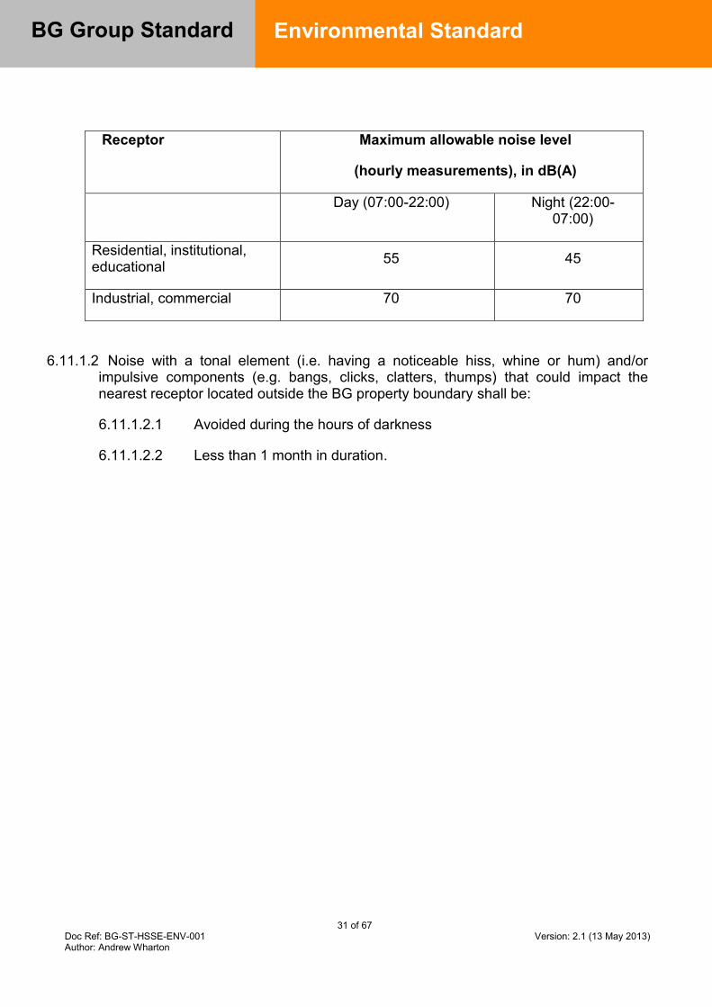
31 of 67 Doc Ref: BG-ST-HSSE-ENV-001 Version: 2.1 (13 May 2013) Author: Andrew Wharton
BG Group Standard
Environmental Standard
Receptor Maximum allowable noise level
(hourly measurements), in dB(A)
Day (07:00-22:00) Night (22:00-07:00)
Residential, institutional, educational 55 45
Industrial, commercial 70 70
6.11.1.2 Noise with a tonal element (i.e. having a noticeable hiss, whine or hum) and/or impulsive components (e.g. bangs, clicks, clatters, thumps) that could impact the nearest receptor located outside the BG property boundary shall be:
6.11.1.2.1 Avoided during the hours of darkness
6.11.1.2.2 Less than 1 month in duration.
32 of 67 Doc Ref: BG-ST-HSSE-ENV-001 Version: 2.1 (13 May 2013) Author: Andrew Wharton
BG Group Standard
Environmental Standard
7.0 Appendices 7.1 Appendix A – Gap Analysis Template

33 of 67 Doc Ref: BG-ST-HSSE-ENV-001 Version: 2.1 (13 May 2013) Author: Andrew Wharton
BG Group Standard
Environmental Standard
Author completes Asset, Project or Function assessing compliance with Standard
Standard Ref / Control Ref. Section
Summary of mandatory requirements Accountable - Asset / Project / Group HSSE
Compliant Y/N
Action plan to meet requirement
Action plan completion date
Action owner (name and title)
Dispensation details (if action exceeds permitted implementation time)
6.1 Best Available Techniques (BAT)
6.1 Assets / Projects shall demonstrate that they are using the BAT process to determine the actions to be taken to meet the BG Group Business Principles.
Asset / Project
6.1.2.2 / 6.1.4.6
Ensure that operations are reviewed against BAT requirements at least every 5 years.
Asset
6.1.2.4 BAT assessments shall be retained and available for review for at least 5 years.
Asset
6.1.3.3 Document BAT assessments according to the requirements of Section 6.1 and subsections.
Project
6.2 Environmental Management
6.2.1 All assets shall establish an environmental management system (EMS), certified to the international standard ISO 14001:2004, in accordance with the 6.2.1 and subsections.
Asset
6.2.1.7 Key environmental emissions shall be measured and reported in line with Environmental Reporting Guidance [Ref 5].
Asset
6.2.2 An Environmental Impact Assessment (EIA) shall be undertaken in advance of all exploration activities and through the lifecycle of new developments. Minimum expectations for an EIA shall be in accordance with terms of reference included in Sections 6.2.2.3 and 6.2.2.4
Project
6.3 Climate Change
6.3.1.1, 6.3.2.1,
All facilities shall develop and maintain a life of field inventory of greenhouse gas (GHG)
Asset / Project
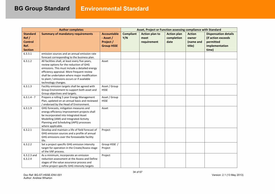
34 of 67 Doc Ref: BG-ST-HSSE-ENV-001 Version: 2.1 (13 May 2013) Author: Andrew Wharton
BG Group Standard
Environmental Standard
Author completes Asset, Project or Function assessing compliance with Standard
Standard Ref / Control Ref. Section
Summary of mandatory requirements Accountable - Asset / Project / Group HSSE
Compliant Y/N
Action plan to meet requirement
Action plan completion date
Action owner (name and title)
Dispensation details (if action exceeds permitted implementation time)
6.3.3.1 emission sources and an annual emission rate forecast corresponding to the business plan.
6.3.1.2 All facilities shall, at least every five years, review options for the reduction of GHG emissions. This must include a detailed energy efficiency appraisal. More frequent review shall be undertaken where major modification to plant / emissions occurs or if available technology changes.
Asset
6.3.1.3 Facility emission targets shall be agreed with Group Environment to support both asset and Group objectives and targets.
Asset / Group HSSE
6.3.1.4 - 7 Prepare a rolling 5 year Energy Management Plan, updated on an annual basis and reviewed / endorsed by the Head of Environment.
Asset / Group HSSE
6.3.1.9 GHG forecasts, mitigation measures and energy efficiency improvement projects shall be incorporated into Integrated Asset Modelling (IAM) and Integrated Activity Planning and Scheduling (IAPS) processes where applicable.
Asset
6.3.2.1 Develop and maintain a life of field forecast of GHG emission sources and a profile of annual GHG emissions over the foreseeable facility life.
Project
6.3.2.2 Set a project specific GHG emission intensity target for operation in the Create/Assess stage of the VAF process.
Group HSSE / Project
6.3.2.3 and 6.3.2.4
As a minimum, incorporate an emission reduction assessment at the Assess and Define stages of the value assurance process and refine project specific GHG intensity targets
Project

35 of 67 Doc Ref: BG-ST-HSSE-ENV-001 Version: 2.1 (13 May 2013) Author: Andrew Wharton
BG Group Standard
Environmental Standard
Author completes Asset, Project or Function assessing compliance with Standard
Standard Ref / Control Ref. Section
Summary of mandatory requirements Accountable - Asset / Project / Group HSSE
Compliant Y/N
Action plan to meet requirement
Action plan completion date
Action owner (name and title)
Dispensation details (if action exceeds permitted implementation time)
accordingly.
6.3.2.5 Have no continuous flaring or venting of gas associated with oil or condensate.
Project/Asset
6.3.2.6 Develop a flare mitigation plan for any extended well testing and during the Execute (detailed design) stage to minimise flaring during commissioning/early field life and during start up and shut down.
Project/Asset
6.3.3.2 and 6.3.3.3
All BG Operated, Joint Operated and NOJV facilities shall report quarterly (as a minimum) to Group HSSE their greenhouse gas emissions.
Project/Asset
6.3.4.1 Developments and new acquisitions shall include a commentary in the Business Development Committee / Investment Committee papers on GHG risks and mitigation proposals as per Section 6.3.4.1.
Project
6.3.4.2 All developments within jurisdictions in which there is an existing or foreseeable value to carbon shall account for that value in the base economics of the development
Project/Asset
6.3.4.3 BG Group’s approved treatment of carbon value shall be used in consideration of investment in emission reduction projects in both existing operations and new developments.
Project/Asset
6.3.4.4 Operations and brownfield developments shall implement all viable energy efficiency and carbon reduction measures as per Section 6.3.4.4.
Project/Asset
6.3.4.5 The opportunity cost of gas used as fuel or lost through flaring and venting shall be based on the greatest value which could be obtained
Project / Asset

36 of 67 Doc Ref: BG-ST-HSSE-ENV-001 Version: 2.1 (13 May 2013) Author: Andrew Wharton
BG Group Standard
Environmental Standard
Author completes Asset, Project or Function assessing compliance with Standard
Standard Ref / Control Ref. Section
Summary of mandatory requirements Accountable - Asset / Project / Group HSSE
Compliant Y/N
Action plan to meet requirement
Action plan completion date
Action owner (name and title)
Dispensation details (if action exceeds permitted implementation time)
across the gas chain of which the project is a part / net back price.
6.3.4.8 Where the CO2 content of reservoir gas is greater than 10% or lower than 10% but considered high for other reasons, opportunities for carbon capture and storage techniques shall be investigated, documented and reviewed with Head of Environment.
Group HSSE / Project
6.3.5.1- 4 The threat to all facilities due to foreseeable changes in the environment resulting from climate change shall be assessed and documented in accordance with Sections 6.3.5.1 – 4.
Project / Asset
6.4 Air Quality
6.4.1.1 – 2 The emissions to air from any BG facility shall be reduced to the minimum practicable and shall not exceed Environmental Quality Standards noted in Section 6.4.1.2.
Project / Asset
6.4.1.4 There shall be no continuous production of smoke from BG activities.
Project / Asset
6.4.1.5 There shall be no emission to air of ozone depleting substances from BG activities.
Project / Asset
6.5 Water Risk Management
6.5.1.1 For existing facilities a self-assessment of water related risks to operations, the environment and communities shall be maintained and updated at least every 5 years in accordance with Sections 6.5.1.1 – 6.5.1.5
Asset
6.5.1.6 – 7 Existing facilities that exhibit high risks in terms of impacts from water management issues
Asset / Group HSSE
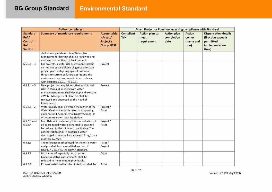
37 of 67 Doc Ref: BG-ST-HSSE-ENV-001 Version: 2.1 (13 May 2013) Author: Andrew Wharton
BG Group Standard
Environmental Standard
Author completes Asset, Project or Function assessing compliance with Standard
Standard Ref / Control Ref. Section
Summary of mandatory requirements Accountable - Asset / Project / Group HSSE
Compliant Y/N
Action plan to meet requirement
Action plan completion date
Action owner (name and title)
Dispensation details (if action exceeds permitted implementation time)
shall develop and execute a Water Risk Management Plan that shall be reviewed and endorsed by the Head of Environment.
6.5.2.1 – 3 For projects, a water risk assessment shall be carried out as part of due diligence efforts or project plans mitigating against potential threats to current or future operations, the environment and community in accordance with Sections 6.5.2.1 – 6.5.2.3.
Project
6.5.2.4 – 5 New projects or acquisitions that exhibit high risks in terms of impacts from water management issues shall develop and execute a Water Management Plan that shall be reviewed and endorsed by the Head of Environment.
Project
6.5.3.1 – 2 Water quality shall be within the higher of the Water Quality Standards listed in supporting guidance on Environmental Quality Standards or a country’s own local legislation.
Project / Asset
6.5.3.3 and 6.5.3.4
For offshore installations, the concentration of oil in produced water discharged to sea shall be reduced to the minimum practicable. The concentration of oil in produced water discharged to sea shall not exceed 15 mg/l on a monthly average.
Project / Asset
6.5.3.5 The reference method used for the oil in water analysis shall be the modified version of ISO9377-2 GC-FID, the OSPAR standard.
Asset / Project
6.5.3.6 Discharges of especially persistent or bioaccumulative contaminants shall be reduced to the minimum practicable.
Asset
6.5.3.7 Process water shall not be diluted, but shall be Asset
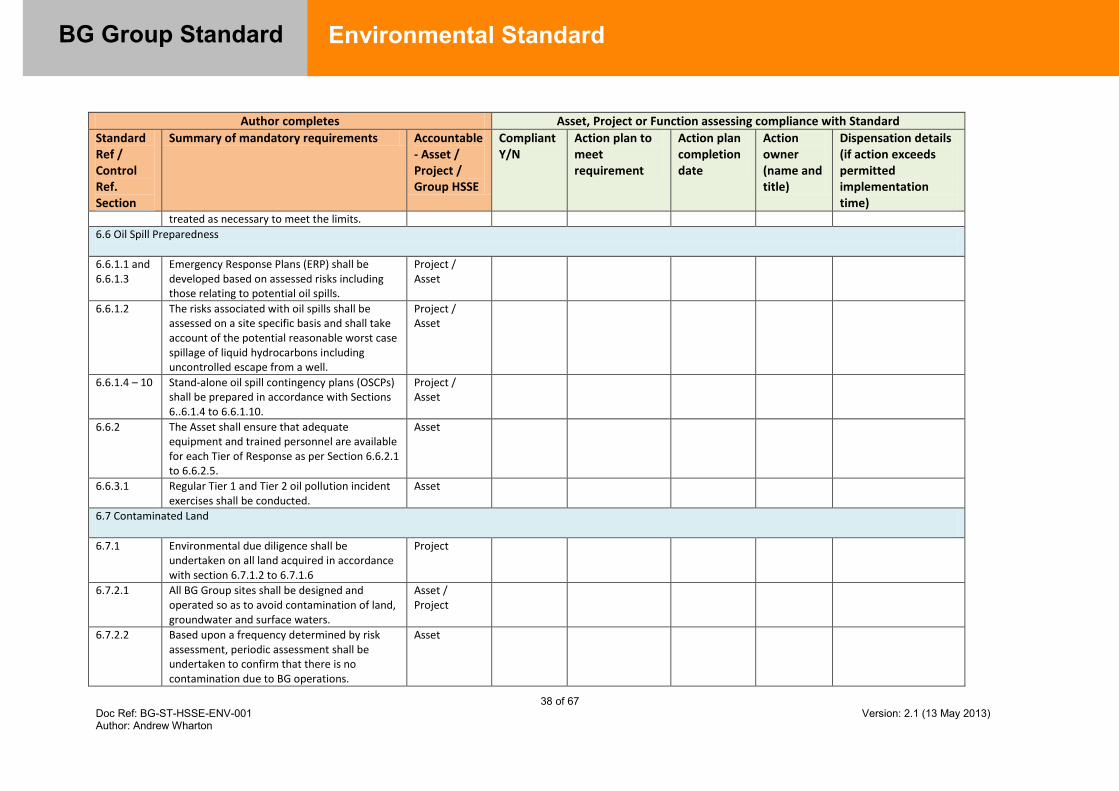
38 of 67 Doc Ref: BG-ST-HSSE-ENV-001 Version: 2.1 (13 May 2013) Author: Andrew Wharton
BG Group Standard
Environmental Standard
Author completes Asset, Project or Function assessing compliance with Standard
Standard Ref / Control Ref. Section
Summary of mandatory requirements Accountable - Asset / Project / Group HSSE
Compliant Y/N
Action plan to meet requirement
Action plan completion date
Action owner (name and title)
Dispensation details (if action exceeds permitted implementation time)
treated as necessary to meet the limits.
6.6 Oil Spill Preparedness
6.6.1.1 and 6.6.1.3
Emergency Response Plans (ERP) shall be developed based on assessed risks including those relating to potential oil spills.
Project / Asset
6.6.1.2 The risks associated with oil spills shall be assessed on a site specific basis and shall take account of the potential reasonable worst case spillage of liquid hydrocarbons including uncontrolled escape from a well.
Project / Asset
6.6.1.4 – 10 Stand-alone oil spill contingency plans (OSCPs) shall be prepared in accordance with Sections 6..6.1.4 to 6.6.1.10.
Project / Asset
6.6.2 The Asset shall ensure that adequate equipment and trained personnel are available for each Tier of Response as per Section 6.6.2.1 to 6.6.2.5.
Asset
6.6.3.1 Regular Tier 1 and Tier 2 oil pollution incident exercises shall be conducted.
Asset
6.7 Contaminated Land
6.7.1 Environmental due diligence shall be undertaken on all land acquired in accordance with section 6.7.1.2 to 6.7.1.6
Project
6.7.2.1 All BG Group sites shall be designed and operated so as to avoid contamination of land, groundwater and surface waters.
Asset / Project
6.7.2.2 Based upon a frequency determined by risk assessment, periodic assessment shall be undertaken to confirm that there is no contamination due to BG operations.
Asset
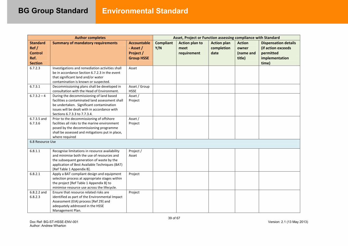
39 of 67 Doc Ref: BG-ST-HSSE-ENV-001 Version: 2.1 (13 May 2013) Author: Andrew Wharton
BG Group Standard
Environmental Standard
Author completes Asset, Project or Function assessing compliance with Standard
Standard Ref / Control Ref. Section
Summary of mandatory requirements Accountable - Asset / Project / Group HSSE
Compliant Y/N
Action plan to meet requirement
Action plan completion date
Action owner (name and title)
Dispensation details (if action exceeds permitted implementation time)
6.7.2.3 Investigations and remediation activities shall be in accordance Section 6.7.2.3 in the event that significant land and/or water contamination is known or suspected.
Asset
6.7.3.1 Decommissioning plans shall be developed in consultation with the Head of Environment.
Asset / Group HSSE
6.7.3.2 – 4 During the decommissioning of land based facilities a contaminated land assessment shall be undertaken. Significant contamination issues will be dealt with in accordance with Sections 6.7.3.3 to 7.7.3.4.
Asset / Project
6.7.3.5 and 6.7.3.6
Prior to the decommissioning of offshore facilities all risks to the marine environment posed by the decommissioning programme shall be assessed and mitigations put in place, where required
Asset / Project
6.8 Resource Use
6.8.1.1 Recognise limitations in resource availability and minimise both the use of resources and the subsequent generation of waste by the application of Best Available Techniques (BAT) [Ref Table 1 Appendix B].
Project / Asset
6.8.2.1 Apply a BAT compliant design and equipment selection process at appropriate stages within the project [Ref Table 1 Appendix B] to minimise resource use across the lifecycle.
Project
6.8.2.2 and 6.8.2.3
Ensure that resource related risks are identified as part of the Environmental Impact Assessment (EIA) process [Ref 29] and adequately addressed in the HSSE Management Plan.
Project
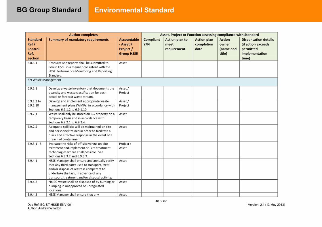
40 of 67 Doc Ref: BG-ST-HSSE-ENV-001 Version: 2.1 (13 May 2013) Author: Andrew Wharton
BG Group Standard
Environmental Standard
Author completes Asset, Project or Function assessing compliance with Standard
Standard Ref / Control Ref. Section
Summary of mandatory requirements Accountable - Asset / Project / Group HSSE
Compliant Y/N
Action plan to meet requirement
Action plan completion date
Action owner (name and title)
Dispensation details (if action exceeds permitted implementation time)
6.8.3.1 Resource use reports shall be submitted to Group HSSE in a manner consistent with the HSSE Performance Monitoring and Reporting Standard.
Asset
6.9 Waste Management
6.9.1.1 Develop a waste inventory that documents the quantity and waste classification for each actual or forecast waste stream.
Asset / Project
6.9.1.2 to 6.9.1.10
Develop and implement appropriate waste management plans (WMPs) in accordance with Sections 6.9.1.2 to 6.9.1.10.
Asset / Project
6.9.2.1 Waste shall only be stored on BG property on a temporary basis and in accordance with Sections 6.9.2.1 to 6.9.2.4.
Asset
6.9.2.5 Adequate spill kits will be maintained on site and personnel trained in order to facilitate a quick and effective response in the event of a breach of containment.
Asset
6.9.3.1 - 3 Evaluate the risks of off-site versus on-site treatment and implement on-site treatment technologies where at all possible. See Sections 6.9.3.2 and 6.9.3.3.
Project / Asset
6.9.4.1 HSSE Manager shall ensure and annually verify that any third party used to transport, treat and/or dispose of waste is competent to undertake the task, in advance of any transport, treatment and/or disposal activity.
Asset
6.9.4.2 No BG waste shall be disposed of by burning or dumping in unapproved or unregulated locations.
Asset
6.9.4.3 HSSE Manager shall ensure that any Asset
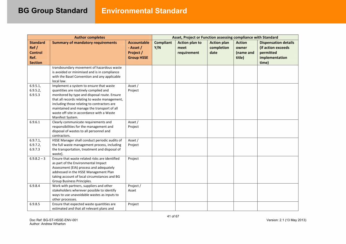
41 of 67 Doc Ref: BG-ST-HSSE-ENV-001 Version: 2.1 (13 May 2013) Author: Andrew Wharton
BG Group Standard
Environmental Standard
Author completes Asset, Project or Function assessing compliance with Standard
Standard Ref / Control Ref. Section
Summary of mandatory requirements Accountable - Asset / Project / Group HSSE
Compliant Y/N
Action plan to meet requirement
Action plan completion date
Action owner (name and title)
Dispensation details (if action exceeds permitted implementation time)
transboundary movement of hazardous waste is avoided or minimised and is in compliance with the Basel Convention and any applicable local law.
6.9.5.1, 6.9.5.2, 6.9.5.3
Implement a system to ensure that waste quantities are routinely compiled and monitored by type and disposal route. Ensure that all records relating to waste management, including those relating to contractors are maintained and manage the transport of all waste off-site in accordance with a Waste Manifest System.
Asset / Project
6.9.6.1 Clearly communicate requirements and responsibilities for the management and disposal of wastes to all personnel and contractors.
Asset / Project
6.9.7.1, 6.9.7.2, 6.9.7.3
HSSE Manager shall conduct periodic audits of the full waste management process, including the transportation, treatment and disposal of waste].
Asset / Project
6.9.8.2 – 3 Ensure that waste related risks are identified as part of the Environmental Impact Assessment (EIA) process and adequately addressed in the HSSE Management Plan taking account of local circumstances and BG Group Business Principles.
Project
6.9.8.4 Work with partners, suppliers and other stakeholders wherever possible to identify ways to use unavoidable wastes as inputs to other processes.
Project / Asset
6.9.8.5 Ensure that expected waste quantities are estimated and that all relevant plans and
Project
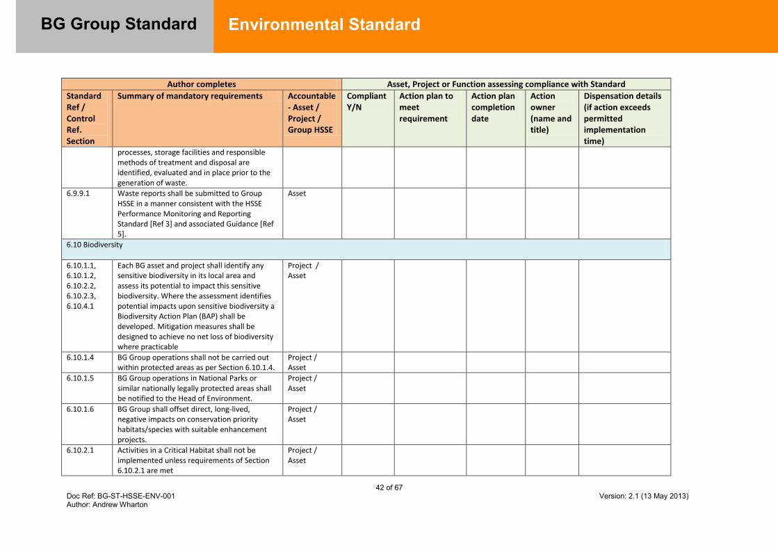
42 of 67 Doc Ref: BG-ST-HSSE-ENV-001 Version: 2.1 (13 May 2013) Author: Andrew Wharton
BG Group Standard
Environmental Standard
Author completes Asset, Project or Function assessing compliance with Standard
Standard Ref / Control Ref. Section
Summary of mandatory requirements Accountable - Asset / Project / Group HSSE
Compliant Y/N
Action plan to meet requirement
Action plan completion date
Action owner (name and title)
Dispensation details (if action exceeds permitted implementation time)
processes, storage facilities and responsible methods of treatment and disposal are identified, evaluated and in place prior to the generation of waste.
6.9.9.1 Waste reports shall be submitted to Group HSSE in a manner consistent with the HSSE Performance Monitoring and Reporting Standard [Ref 3] and associated Guidance [Ref 5].
Asset
6.10 Biodiversity
6.10.1.1, 6.10.1.2, 6.10.2.2, 6.10.2.3, 6.10.4.1
Each BG asset and project shall identify any sensitive biodiversity in its local area and assess its potential to impact this sensitive biodiversity. Where the assessment identifies potential impacts upon sensitive biodiversity a Biodiversity Action Plan (BAP) shall be developed. Mitigation measures shall be designed to achieve no net loss of biodiversity where practicable
Project / Asset
6.10.1.4 BG Group operations shall not be carried out within protected areas as per Section 6.10.1.4.
Project / Asset
6.10.1.5 BG Group operations in National Parks or similar nationally legally protected areas shall be notified to the Head of Environment.
Project / Asset
6.10.1.6 BG Group shall offset direct, long-lived, negative impacts on conservation priority habitats/species with suitable enhancement projects.
Project / Asset
6.10.2.1 Activities in a Critical Habitat shall not be implemented unless requirements of Section 6.10.2.1 are met
Project / Asset
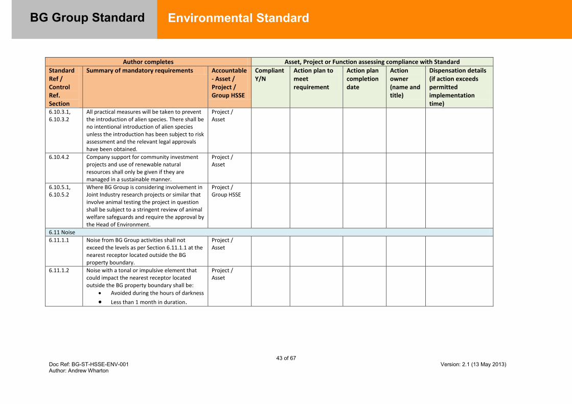
43 of 67 Doc Ref: BG-ST-HSSE-ENV-001 Version: 2.1 (13 May 2013) Author: Andrew Wharton
BG Group Standard
Environmental Standard
Author completes Asset, Project or Function assessing compliance with Standard
Standard Ref / Control Ref. Section
Summary of mandatory requirements Accountable - Asset / Project / Group HSSE
Compliant Y/N
Action plan to meet requirement
Action plan completion date
Action owner (name and title)
Dispensation details (if action exceeds permitted implementation time)
6.10.3.1, 6.10.3.2
All practical measures will be taken to prevent the introduction of alien species. There shall be no intentional introduction of alien species unless the introduction has been subject to risk assessment and the relevant legal approvals have been obtained.
Project / Asset
6.10.4.2 Company support for community investment projects and use of renewable natural resources shall only be given if they are managed in a sustainable manner.
Project / Asset
6.10.5.1, 6.10.5.2
Where BG Group is considering involvement in Joint Industry research projects or similar that involve animal testing the project in question shall be subject to a stringent review of animal welfare safeguards and require the approval by the Head of Environment.
Project / Group HSSE
6.11 Noise
6.11.1.1 Noise from BG Group activities shall not exceed the levels as per Section 6.11.1.1 at the nearest receptor located outside the BG property boundary.
Project / Asset
6.11.1.2 Noise with a tonal or impulsive element that could impact the nearest receptor located outside the BG property boundary shall be:
Avoided during the hours of darkness
Less than 1 month in duration.
Project / Asset

44 of 67 Doc Ref: BG-ST-HSSE-ENV-001 Version: 2.1 (13 May 2013) Author: Andrew Wharton
BG Group Standard
Environmental Standard
7.2 Appendix B – Definitions / Abbreviations
The following definitions apply generally to BG Group Standards and Guidelines: COMPANY BG Group or a wholly owned subsidiary company or other client
organisation as may be defined by the contract;
CONTRACTOR The person, firm or company undertaking to supply services plant, or equipment to which this document applies;
PURCHASER A Procurement Contractor acting on behalf of Company, or Company itself, in the case of a direct purchase
VENDOR The main supplier or manufacturer of the items of plant or equipment to which this document applies, including items that may be designed and / or manufactured by others;
SHALL A mandatory term - no deviation is permitted without written approval from the Group Technical Authority
GROUP TECHNICAL AUTHORITY
The manager or principal discipline engineer responsible for producing and maintaining a given Standard / Guideline; and for reviewing and either approving or rejecting Dispensation Requests made against the Standard by an Asset/Project
DISPENSATION Formal process of approving deviation from a BG Group Standard in exceptional cases. Approval is granted by the relevant GTA/Head of Function following the formal Dispensation process in accordance with the Purpose, Development and Application of BG Advance Standards and Guidelines [Ref 26]
The following additional definitions apply specifically in this document:
BEST AVAILABLE TECHNIQUES (BAT)
This is a ‘whole life’ approach to environmental control. BAT is defined as: ‘the most effective and advanced engineering practices and methods of operation, which are available and practicable, to prevent, and where this is not practicable, reduce emissions and the impact on the environment as a whole’ [Ref 1]
The essence of BAT is that the selection of techniques to protect the environment should achieve an appropriate balance between the environmental benefits they bring and the costs to implement them.
45 of 67 Doc Ref: BG-ST-HSSE-ENV-001 Version: 2.1 (13 May 2013) Author: Andrew Wharton
BG Group Standard
Environmental Standard
The objective is to help to drive improvements in environmental management by adoption of accepted international methodology that provides an integrated, systematic approach across all media which might be affected.
BEST Most effective in achieving a high general level of protection of the environment as a whole
“AVAILABLE" Techniques are those developed on a scale which allows
implementation in the relevant industrial sector, under economically and technically viable conditions, taking into consideration the costs and advantages, whether or not the techniques are used or produced inside the country in question, as long as they are reasonably accessible to the operator
TECHNIQUES includes both the technology used and the way in which the
installation is designed, built, maintained, operated and decommissioned
INDICATIVE BAT Requirements that are indicative BAT are seen to meet the
minimum environmental expectations as set by BG Group, and have been developed through best practice work and precedent. Opportunities to gain additional environmental benefit should be investigated where multiple options exist wherever practical.
MITIGATION Minimisation or remediation of negative (environmental) impact
CARBON DIOXIDE EQUIVALENT - CO2eq
Unit for comparing the radiative forcing, or global warming potential of a GHG, to that of carbon dioxide
CARBON VALUE Value attributed to an amount (typically one tonne) of CO2 that has not been emitted into the atmosphere. There are several frequently used definitions of the carbon price for one tonne of avoided carbon emissions including:
- the expected cost of mitigation of climate-change damage; - the cost of reducing the CO2 emissions; - the social cost of carbon; - the politically negotiated value; and - CO2 market prices.
In the absence of a locally specified value, the assumed value for the CO2 emissions avoided by a project shall be determined by reference to the BG Group Guidance Note on Economic Evaluation and Calculation Guideline [Ref 6]
46 of 67 Doc Ref: BG-ST-HSSE-ENV-001 Version: 2.1 (13 May 2013) Author: Andrew Wharton
BG Group Standard
Environmental Standard
CLIMATE CHANGE CRITICAL HABITATS
A change in the average weather (temperature, precipitation and wind) over time periods of decades or greater. Modern climate change is thought to be primarily a consequence of global warming.
Critical habitats are areas with high biodiversity value, including (i) habitat of significant importance to Critically Endangered and/or Endangered species; (ii) habitat of significant importance to endemic and/or restricted-range species; (iii) habitat supporting globally significant concentrations of migratory species and/or congregatory species; (iv) highly threatened and/or unique ecosystems; and/or (v) areas associated with key evolutionary processes.
GREENHOUSE EFFECT
A phenomenon whereby the Earth’s mean surface temperature is increased by the presence in the atmosphere of particular gases which allow incoming solar radiation (shortwave) to pass through and heat the surface but which absorb the longwave radiation (heat) radiated by the Earth’s surface, thereby warming the lower atmosphere. It is named after the phenomena of glass trapping heat in a greenhouse and the gases contributing to this warming effect are known as Greenhouse Gases( GHG).
The natural greenhouse effect keeps the Earth's surface much warmer than it would be if there was no atmosphere.
ENHANCED GREENHOUSE EFFECT
The increase in the Greenhouse Effect due to higher concentrations of Greenhouse Gases in the atmosphere resulting from human activity
GREENHOUSE GASES (GHG)
The 6 gases ‘regulated’ under Kyoto are carbon dioxide, methane, nitrous oxide, sulphur hexafloride, HFC, PFC’s. For practical purposes, CO2 and CH4 are the most relevant to BG’s business.
GLOBAL WARMING (GW)
The rise in the Earth’s mean surface temperature resulting from the Enhanced Greenhouse Effect
GLOBAL WARMING POTENTIAL (GWP)
The GWP is an index that compares the relative potential of greenhouse gases to contribute to global warming. The unit impact of greenhouse gases are compared with that of carbon dioxide (CO2) and referred to in terms of CO2 equivalents (CO2eq). Carbon dioxide has been designated a GWP of 1 and methane has a GWP of 21 over a 100 year period (as specified in the Second Assessment Report of the IPCC (1995) which defines the values used for the first reporting period under the Kyoto Protocol). Although different GWP values for methane are

47 of 67 Doc Ref: BG-ST-HSSE-ENV-001 Version: 2.1 (13 May 2013) Author: Andrew Wharton
BG Group Standard
Environmental Standard
sometimes quoted, this value is used for consistency of reporting.
Example: GWP of Methane (CH4) = 21, GWP of Carbon Dioxide (CO2) = 1. Combustion of one tonne of CH4 produces 2.75 tonnes of CO2; therefore the capture and combustion of one tonne of otherwise fugitive CH4 emissions yields a GWP benefit of at least 18.25 tonnes CO2 equivalent. If the captured CH4 is used as an energy source (on-site or delivered into a pipeline) the full 21 tonnes of emission reductions can be claimed.
UNIT GHG EMISSIONS
Greenhouse gas emissions unitised relative to a specified business characteristic. Commonly expressed as GHG per unit throughput (production, electricity generation, gas transported etc.).
‘NO ACTION’ The base case in terms of GHG emissions. This corresponds to the ‘as designed’ facility operation in the case of existing plant and ‘standard industry practice’ in the case of new developments.
TIERED PREPAREDNESS FOR OIL SPILLS
Structured approach to establishing oil spill preparedness and undertaking a response based on categorization of spill incidents in terms of their potential severity. Ref 31 provides a checklist to assist in determining the tier level of an incident for spills from BG operations.
TIER 1 (OIL SPILL)
Incident giving rise to a localised release that can be controlled with the resources available on-site.
TIER 2 (OIL SPILL)
Incident in which national resources and support outside the geographical area are required to control the spill.
TIER 3 (OIL SPILL)
Incident for which assistance is required from national and international resources. Bilateral agreements should be mobilised.
BASEL CONVENTION
The Basel Convention on the Control of Transboundary Movements of Hazardous Wastes and Their Disposal [Ref 14] is an international convention which creates obligations for the states that have ratified it. The primary aim of the treaty is to reduce the movement of hazardous waste between nations and specifically to prevent transfer of hazardous waste from developed to less developed countries
CUTTINGS Small pieces of rock waste removed from the well during drilling
activity. BG has adopted the OGP classifications for cuttings contaminated with various types of drilling fluids [Ref 17]
HAZARDOUS WASTE
Wastes listed in Annex I of the Basel Convention [Ref 14] and/or those wastes that exhibit one or more of the following characteristics of hazardous waste listed in Annex III: explosive, flammable liquids, flammable solids, substances or wastes liable to spontaneous combustion, substances or wastes which, in contact
48 of 67 Doc Ref: BG-ST-HSSE-ENV-001 Version: 2.1 (13 May 2013) Author: Andrew Wharton
BG Group Standard
Environmental Standard
with water emit flammable gases, oxidizing, organic peroxides, poisonous (acute), infectious substances, corrosives, liberation of toxic gases in contact with air or water, toxic (delayed or chronic), ecotoxic or capable of yielding another material after disposal, e.g. leachate, which possesses any of the characteristics listed.
In addition, any other waste defined as Hazardous within the local country legislation shall be assumed to be ‘hazardous waste’.
PROXIMITY PRINCIPLE
The proximity principle states that waste should generally be disposed of as near to its place of origin as possible (providing that suitable facilities are available). This is to ensure that potential problems associated with waste disposal are not simply exported to other regions or countries and because transportation of wastes can have a significant environmental impact.
WASTE
For the purposes of this Standard, Waste is defined as: All solid, liquid and contained gaseous material taken offsite for treatment and/or disposal. Solid materials range from inert site and platform wastes, scrap metals, oils, sludge and chemicals to excavated material, used fittings and general site and office wastes. Liquid wastes include for example any produced water, sewage and spent drilling muds that are handled offsite by a third party All solid and non-aqueous liquid material disposed of directly by the company on-site for example by reinjection, landfill, remediation and incineration. Aqueous liquids such as process water, cooling water and produced water which are managed on site by discharge or reinjection are not included All material stored on site for which the company does not have a use e.g. surplus chemicals, waste with no identified responsible disposal route
WATER STRESS
Water Stress is defined as occurring when the demand for water exceeds the available amount during a certain period or when poor quality restricts its use. Water stress causes deterioration of fresh water resources in terms of quantity (aquifer over-exploitation, dry rivers, etc.) and quality (eutrophication, organic matter pollution, saline intrusion, etc.) (Source: European Environment Agency)
ALIEN SPECIES Species introduced to an area that lies outside their natural geographic range. Where the species becomes invasive, it can damage the indigenous biodiversity in the area. This could happen, for example, through the transport and discharge of marine species in ships’ ballast water e.g. Zebra mussels transported from Europe to the USA have had a significant impact on native species in the Great Lakes.
49 of 67 Doc Ref: BG-ST-HSSE-ENV-001 Version: 2.1 (13 May 2013) Author: Andrew Wharton
BG Group Standard
Environmental Standard
BIODIVERSITY (BIOLOGICAL DIVERSITY)
The variability among living organisms from all sources including terrestrial, marine and other aquatic ecosystems, and the ecological complexes of which they are part. This includes diversity within species, between species and of ecosystems (UN Convention on Biological Diversity). In short – the variety of life on earth.
BIODIVERSITY ACTION PLAN
A plan ‘to conserve and/or enhance biodiversity’, specifically a set of actions that will lead to the conservation or enhancement of biodiversity. This may take the form of a separate document or be integrated as a set of actions within a wider Environmental Management Plan.
CRITICAL HABITAT
Habitat with high biodiversity value, including: areas required for the survival of critically endangered or
endangered species, areas with special significance for endemic or restricted
range species, sites that are critical for the survival of migratory species, areas supporting globally significant concentrations or
numbers of individuals of congregatory species areas with unique collections of species or which are
associated with key evolutionary processes areas which provide key ecosystem services areas with biodiversity that has significant social, economic
or cultural importance to local communities
ECOSYSTEM A dynamic complex of plant, animal and micro-organism communities and their non-living environment interacting as a functional unit in a specific place e.g. a pond, forest, estuary, grassland, swamp or mangrove.
ECOSYSTEM FUNCTIONS
Ecosystem functions are the physical, chemical and biological processes or attributes that contribute to the self maintenance of an ecosystem and thereby provide many of the natural resources on which humans depend; in other words what the ecosystem does. Some examples of ecosystem functions are the provision of wildlife habitat, carbon cycling and the trapping of nutrients.
ECOSYSTEM SERVICES
The beneficial outcomes for the natural environment (including people) that result from ecosystem functions. Examples include support of the food chain and the provision of clean water.
ENVIRONMENTAL ASSESSMENT
A process of predicting and assessing the potential environmental impacts associated with a proposed project, identifying alternatives and designing appropriate mitigation, management and monitoring measures.

50 of 67 Doc Ref: BG-ST-HSSE-ENV-001 Version: 2.1 (13 May 2013) Author: Andrew Wharton
BG Group Standard
Environmental Standard
HABITAT The physical and biological environment on which a given species (or group of species) depends for its survival; the place or type of site where an organism or population naturally occurs.
NATURAL HABITAT
Habitat formed largely from native animal and plant species and largely undisturbed by human intervention.
SECONDARY IMPACT
Impacts that do not result directly from project activities, but are usually triggered by the operations that reach outside project or concession boundaries and may begin before or extend beyond a project’s life cycle. Impacts are most commonly associated with changes in human population in an area or of government decisions about infrastructure needs and associated economic growth.
SIGNIFICANTLY CONVERT OR DEGRADE
The elimination or severe diminution of the integrity of a habitat caused by a major, long term change in land or water use or; Modification of a habitat that substantially reduces the habitat’s ability to maintain a viable population of its native species.
Abbreviations
ALARP As low as reasonably practicable API American Petroleum Institute BAP Biodiversity Action Plan BAT Best Available Techniques BPEO Best Practicable Environmental Option BOG Boil Off Gas BS British Standard CCGT Combined cycle gas turbine CO Carbon Monoxide Cogen Co-generation technology DLE Dry low emissions DP Differential Pressure EBRD European Bank for Reconstruction & Development EC European Commission EIA Environmental Impact Assessment EMS Environmental Management System ENVID Environmental Impact Identification EQS Environmental Quality Standard ESD Emergency Shutdown ESDV Emergency Shutdown Valve EU European Union FEED Front End Engineering Design

51 of 67 Doc Ref: BG-ST-HSSE-ENV-001 Version: 2.1 (13 May 2013) Author: Andrew Wharton
BG Group Standard
Environmental Standard
FWPH Flowing Wellhead Pressure GHG Greenhouse Gas GWP Global Warming Potential HFO Heavy fuel oil HIPPS High integrity pressure protection systems HSSE Health Safety Security and Environment IFC International Finance Corporation IPIECA International Petroleum Industry Environmental Conservation Association ISO International Standards Organisation JV Joint Venture KPI Key Performance Indicator LNG Liquefied natural gas MAOP Maximum Allowable Operating Pressure MAC Maximum Allowable Concentration NOJV Non Operated Joint Ventures NORM Naturally Occurring Radioactive Material NOx Oxides of nitrogen OGP International Association of Oil and Gas Producers OSCP Oil Spill Contingency Plan PAH Polyaromatic Hydrocarbons PM Particulate matter ppmv Parts Per Million by Volume SCR Selective catalytic reduction SI Système International d’Unités UHC Unburnt Hydrocarbons VIP Value Improvement Practice US EPA United States Environmental Protection Agency WHO World Health Organisation WMP Waste Management Plan
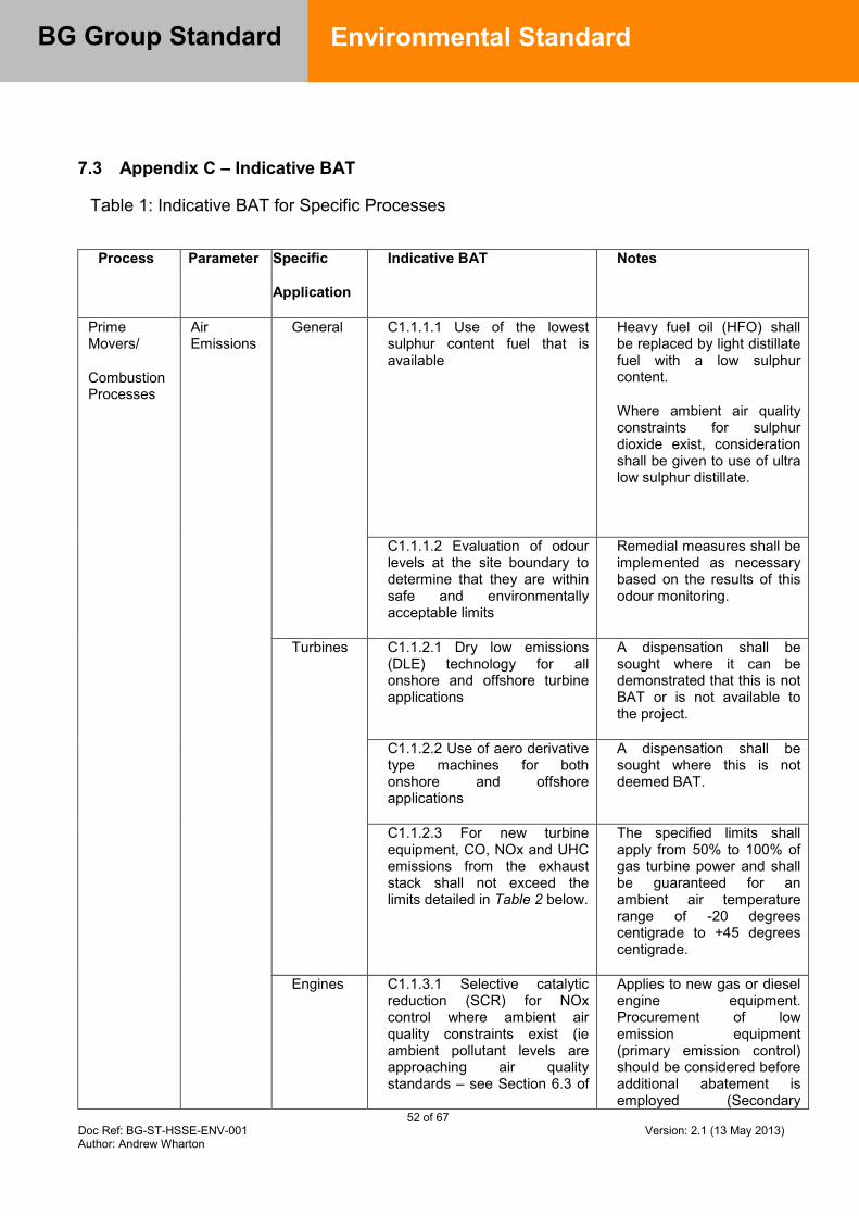
52 of 67 Doc Ref: BG-ST-HSSE-ENV-001 Version: 2.1 (13 May 2013) Author: Andrew Wharton
BG Group Standard
Environmental Standard
7.3 Appendix C – Indicative BAT
Table 1: Indicative BAT for Specific Processes
Process Parameter Specific
Application
Indicative BAT Notes
Prime Movers/
Combustion Processes
Air Emissions
General C1.1.1.1 Use of the lowest sulphur content fuel that is available
Heavy fuel oil (HFO) shall be replaced by light distillate fuel with a low sulphur content.
Where ambient air quality constraints for sulphur dioxide exist, consideration shall be given to use of ultra low sulphur distillate.
C1.1.1.2 Evaluation of odour levels at the site boundary to determine that they are within safe and environmentally acceptable limits
Remedial measures shall be implemented as necessary based on the results of this odour monitoring.
Turbines C1.1.2.1 Dry low emissions (DLE) technology for all onshore and offshore turbine applications
A dispensation shall be sought where it can be demonstrated that this is not BAT or is not available to the project.
C1.1.2.2 Use of aero derivative type machines for both onshore and offshore applications
A dispensation shall be sought where this is not deemed BAT.
C1.1.2.3 For new turbine equipment, CO, NOx and UHC emissions from the exhaust stack shall not exceed the limits detailed in Table 2 below.
The specified limits shall apply from 50% to 100% of gas turbine power and shall be guaranteed for an ambient air temperature range of -20 degrees centigrade to +45 degrees centigrade.
Engines C1.1.3.1 Selective catalytic reduction (SCR) for NOx control where ambient air quality constraints exist (ie ambient pollutant levels are approaching air quality standards – see Section 6.3 of
Applies to new gas or diesel engine equipment. Procurement of low emission equipment (primary emission control) should be considered before additional abatement is employed (Secondary

53 of 67 Doc Ref: BG-ST-HSSE-ENV-001 Version: 2.1 (13 May 2013) Author: Andrew Wharton
BG Group Standard
Environmental Standard
Process Parameter Specific
Application
Indicative BAT Notes
this Standard), emission control) though in certain circumstances both may be required.
Boilers with 20MW thermal input or more
C1.1.4.1 Maximum NOx emissions of 50ppmv
Water Use and Discharges
Process Water
C1.2.1.1 Collection of rainwater and recycling of wastewater from other processes, combined with appropriate water treatment.
Where this is practical.
Pipework C1.2.2.1 The integrity of pipework containing potentially hazardous components shall be checked.
BG Group Operating and Maintenance Standards as well as relevant national codes shall be used.
Refer to Section 6.5 for requirements concerning discharge of water.
Waste Turbines C1.3.1.1 Use of a turbine wash that is not harmful to the environment. If this is not possible, turbine wash shall be collected, stored and removed offsite in accordance with BG Group requirements and local waste storage and transfer regulations.
Refer to Section 6.9 for general requirements concerning the management of waste.
Energy Efficiency
General C1.4.1.1 Energy efficiency shall be a prime consideration in the purchase of new equipment and the operation of facilities and shall be maximised.
The requirements of Ref. [7 and 8] shall be applied to the selection of new equipment and the design of new facilities. Particular attention shall be paid to the economics of opportunities for the recovery of waste heat and other energy e.g. CCGT, Cogeneration, turboexpansion.
The utilisation of waste heat (and cold) across the facility shall be optimised to
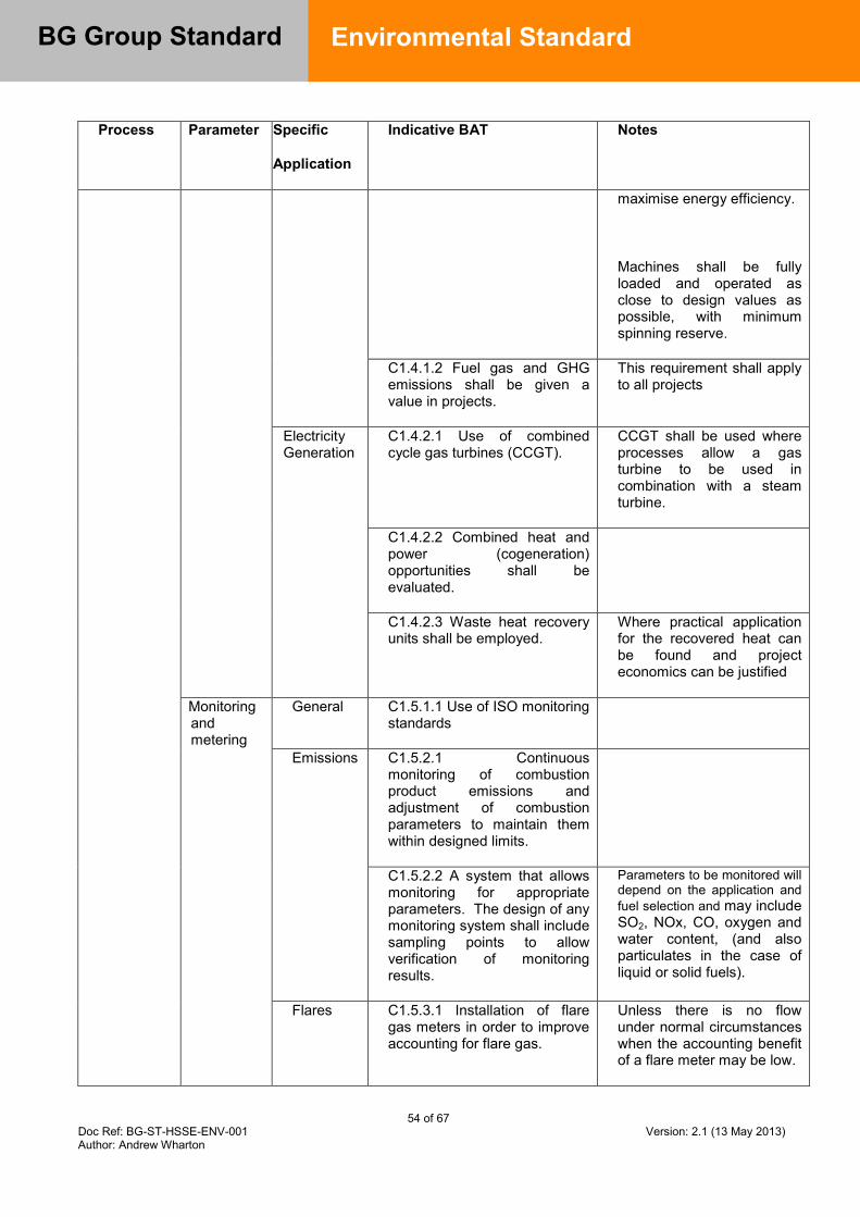
54 of 67 Doc Ref: BG-ST-HSSE-ENV-001 Version: 2.1 (13 May 2013) Author: Andrew Wharton
BG Group Standard
Environmental Standard
Process Parameter Specific
Application
Indicative BAT Notes
maximise energy efficiency.
Machines shall be fully loaded and operated as close to design values as possible, with minimum spinning reserve.
C1.4.1.2 Fuel gas and GHG emissions shall be given a value in projects.
This requirement shall apply to all projects
Electricity Generation
C1.4.2.1 Use of combined cycle gas turbines (CCGT).
CCGT shall be used where processes allow a gas turbine to be used in combination with a steam turbine.
C1.4.2.2 Combined heat and power (cogeneration) opportunities shall be evaluated.
C1.4.2.3 Waste heat recovery units shall be employed.
Where practical application for the recovered heat can be found and project economics can be justified
Monitoring and metering
General C1.5.1.1 Use of ISO monitoring standards
Emissions C1.5.2.1 Continuous monitoring of combustion product emissions and adjustment of combustion parameters to maintain them within designed limits.
C1.5.2.2 A system that allows monitoring for appropriate parameters. The design of any monitoring system shall include sampling points to allow verification of monitoring results.
Parameters to be monitored will depend on the application and fuel selection and may include SO2, NOx, CO, oxygen and water content, (and also particulates in the case of liquid or solid fuels).
Flares C1.5.3.1 Installation of flare gas meters in order to improve accounting for flare gas.
Unless there is no flow under normal circumstances when the accounting benefit of a flare meter may be low.
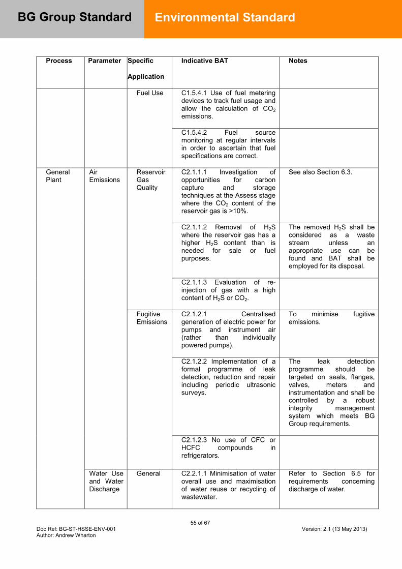
55 of 67 Doc Ref: BG-ST-HSSE-ENV-001 Version: 2.1 (13 May 2013) Author: Andrew Wharton
BG Group Standard
Environmental Standard
Process Parameter Specific
Application
Indicative BAT Notes
Fuel Use C1.5.4.1 Use of fuel metering devices to track fuel usage and allow the calculation of CO2 emissions.
C1.5.4.2 Fuel source monitoring at regular intervals in order to ascertain that fuel specifications are correct.
General Plant
Air Emissions
Reservoir Gas Quality
C2.1.1.1 Investigation of opportunities for carbon capture and storage techniques at the Assess stage where the CO2 content of the reservoir gas is >10%.
See also Section 6.3.
C2.1.1.2 Removal of H2S where the reservoir gas has a higher H2S content than is needed for sale or fuel purposes.
The removed H2S shall be considered as a waste stream unless an appropriate use can be found and BAT shall be employed for its disposal.
C2.1.1.3 Evaluation of re-injection of gas with a high content of H2S or CO2.
Fugitive Emissions
C2.1.2.1 Centralised generation of electric power for pumps and instrument air (rather than individually powered pumps).
To minimise fugitive emissions.
C2.1.2.2 Implementation of a formal programme of leak detection, reduction and repair including periodic ultrasonic surveys.
The leak detection programme should be targeted on seals, flanges, valves, meters and instrumentation and shall be controlled by a robust integrity management system which meets BG Group requirements.
C2.1.2.3 No use of CFC or HCFC compounds in refrigerators.
Water Use and Water Discharge
General C2.2.1.1 Minimisation of water overall use and maximisation of water reuse or recycling of wastewater.
Refer to Section 6.5 for requirements concerning discharge of water.
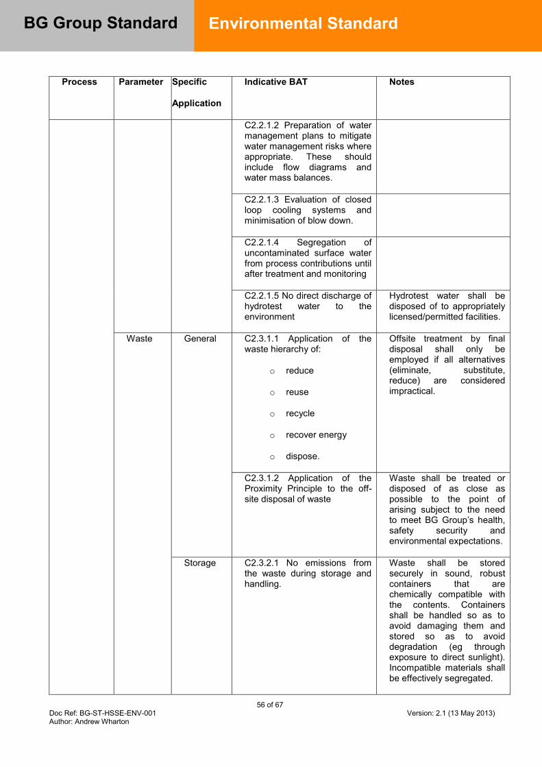
56 of 67 Doc Ref: BG-ST-HSSE-ENV-001 Version: 2.1 (13 May 2013) Author: Andrew Wharton
BG Group Standard
Environmental Standard
Process Parameter Specific
Application
Indicative BAT Notes
C2.2.1.2 Preparation of water management plans to mitigate water management risks where appropriate. These should include flow diagrams and water mass balances.
C2.2.1.3 Evaluation of closed loop cooling systems and minimisation of blow down.
C2.2.1.4 Segregation of uncontaminated surface water from process contributions until after treatment and monitoring
C2.2.1.5 No direct discharge of hydrotest water to the environment
Hydrotest water shall be disposed of to appropriately licensed/permitted facilities.
Waste General C2.3.1.1 Application of the waste hierarchy of:
o reduce
o reuse
o recycle
o recover energy
o dispose.
Offsite treatment by final disposal shall only be employed if all alternatives (eliminate, substitute, reduce) are considered impractical.
C2.3.1.2 Application of the Proximity Principle to the off-site disposal of waste
Waste shall be treated or disposed of as close as possible to the point of arising subject to the need to meet BG Group’s health, safety security and environmental expectations.
Storage C2.3.2.1 No emissions from the waste during storage and handling.
Waste shall be stored securely in sound, robust containers that are chemically compatible with the contents. Containers shall be handled so as to avoid damaging them and stored so as to avoid degradation (eg through exposure to direct sunlight). Incompatible materials shall be effectively segregated.

57 of 67 Doc Ref: BG-ST-HSSE-ENV-001 Version: 2.1 (13 May 2013) Author: Andrew Wharton
BG Group Standard
Environmental Standard
Process Parameter Specific
Application
Indicative BAT Notes
C2.3.2.2 Storage of waste materials in designated areas in containers labelled according to the material inside.
C2.3.2.3 Secure waste storage to prevent unauthorised access.
Monitoring C2.3.3.1 Recording of waste movements in compliance with local regulations and the site EMS.
Energy Efficiency
Use of waste heat
C2.4.1.1 Designing a process to minimise energy consumption and maximise heat recovery / use of cross-exchange with process fluids.
The requirements of Ref. [7] shall be met.
Monitoring C2.4.2.1 Setting of suitable Key Performance Indicators (KPIs) for the site in order to monitor energy efficiency of processes.
Suitable KPIs for upstream processes would be efficiency of shaft power generation, efficiency of direct heat generation, gas compression performance, oil pumping performance and water injection performance.
Optimisation of operations
C2.4.3.1 Operation of fired heaters and hot oil systems, where utilised, to a minimum efficiency prescribed by the engineering design.
C2.4.3.2 Operation of coolers to an efficiency prescribed by the engineering design, with refrigeration being employed to the minimum.
C2.4.3.3 Operation of pumps to a prescribed efficiency with power requirements not being excessive as determined by the engineering design.
C2.4.3.4 Systems shall be designed with the minimum

58 of 67 Doc Ref: BG-ST-HSSE-ENV-001 Version: 2.1 (13 May 2013) Author: Andrew Wharton
BG Group Standard
Environmental Standard
Process Parameter Specific
Application
Indicative BAT Notes
pressure drop possible.
C2.4.3.5 Optimisation of insulation for all plant and pipe work with an energy requirement.
So that the required heat transfer rate is achieved and thermal losses are minimised.
Water Cooling
C2.4.4.1 The use of the most energy efficient cooling system should be used taking into account site setting and where relevant, proximity to water resources and the sensitivity of the receiving environment to discharges of heat and dosing chemicals.
Single pass water cooling systems offering higher efficiencies are often most appropriate for cooling applications with a high demand, in close proximity to a large water body and where the impact of abstraction and discharge can be demonstrated to be insignificant.
Air cooled or hybrid cooling towers shall be considered as alternatives for other applications, such as where single pass water cooling systems cannot be justified as BAT. This may include inland locations, for example, or where alternatives deliver higher energy efficiencies.
Noise Turbines and similar noise sources
C2.5.1.1 Use of noise mitigation measures.
For noise level limits refer to Section 6.10 and Ref. [9].
General C2.5.2.1 Timing and duration of noisy activities to minimise potential impacts.
Operating and Environmental Management System procedures.
C2.5.2.2 Evaluation and minimisation of other nuisance, such as vibration.
General Principles
Use of Life Cycle Analysis
C2.6.1.1 Analysis and recording of the full life cycle emissions of new project options as part of the design process.
C2.6.1.2 Use of the lowest hazard raw material option and analysis of the environmental
Reviews of raw material selection shall be carried
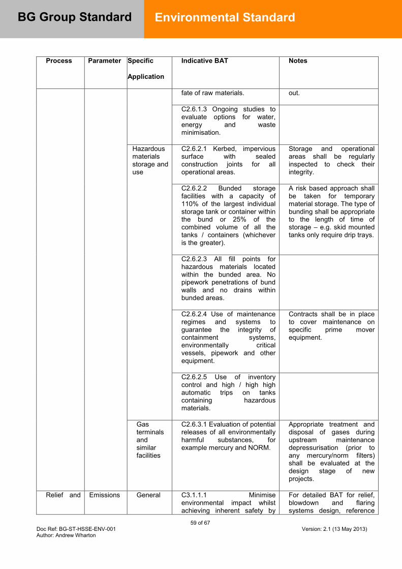
59 of 67 Doc Ref: BG-ST-HSSE-ENV-001 Version: 2.1 (13 May 2013) Author: Andrew Wharton
BG Group Standard
Environmental Standard
Process Parameter Specific
Application
Indicative BAT Notes
fate of raw materials. out.
C2.6.1.3 Ongoing studies to evaluate options for water, energy and waste minimisation.
Hazardous materials storage and use
C2.6.2.1 Kerbed, impervious surface with sealed construction joints for all operational areas.
Storage and operational areas shall be regularly inspected to check their integrity.
C2.6.2.2 Bunded storage facilities with a capacity of 110% of the largest individual storage tank or container within the bund or 25% of the combined volume of all the tanks / containers (whichever is the greater).
A risk based approach shall be taken for temporary material storage. The type of bunding shall be appropriate to the length of time of storage – e.g. skid mounted tanks only require drip trays.
C2.6.2.3 All fill points for hazardous materials located within the bunded area. No pipework penetrations of bund walls and no drains within bunded areas.
C2.6.2.4 Use of maintenance regimes and systems to guarantee the integrity of containment systems, environmentally critical vessels, pipework and other equipment.
Contracts shall be in place to cover maintenance on specific prime mover equipment.
C2.6.2.5 Use of inventory control and high / high high automatic trips on tanks containing hazardous materials.
Gas terminals and similar facilities
C2.6.3.1 Evaluation of potential releases of all environmentally harmful substances, for example mercury and NORM.
Appropriate treatment and disposal of gases during upstream maintenance depressurisation (prior to any mercury/norm filters) shall be evaluated at the design stage of new projects.
Relief and Emissions General C3.1.1.1 Minimise environmental impact whilst achieving inherent safety by
For detailed BAT for relief, blowdown and flaring systems design, reference
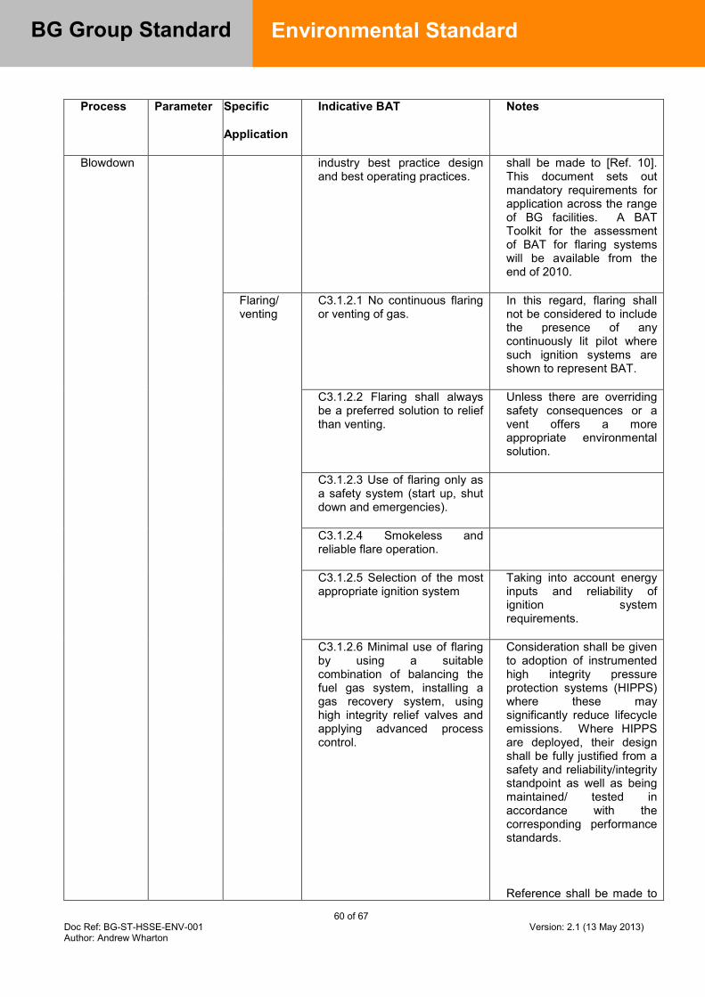
60 of 67 Doc Ref: BG-ST-HSSE-ENV-001 Version: 2.1 (13 May 2013) Author: Andrew Wharton
BG Group Standard
Environmental Standard
Process Parameter Specific
Application
Indicative BAT Notes
Blowdown industry best practice design and best operating practices.
shall be made to [Ref. 10]. This document sets out mandatory requirements for application across the range of BG facilities. A BAT Toolkit for the assessment of BAT for flaring systems will be available from the end of 2010.
Flaring/ venting
C3.1.2.1 No continuous flaring or venting of gas.
In this regard, flaring shall not be considered to include the presence of any continuously lit pilot where such ignition systems are shown to represent BAT.
C3.1.2.2 Flaring shall always be a preferred solution to relief than venting.
Unless there are overriding safety consequences or a vent offers a more appropriate environmental solution.
C3.1.2.3 Use of flaring only as a safety system (start up, shut down and emergencies).
C3.1.2.4 Smokeless and reliable flare operation.
C3.1.2.5 Selection of the most appropriate ignition system
Taking into account energy inputs and reliability of ignition system requirements.
C3.1.2.6 Minimal use of flaring by using a suitable combination of balancing the fuel gas system, installing a gas recovery system, using high integrity relief valves and applying advanced process control.
Consideration shall be given to adoption of instrumented high integrity pressure protection systems (HIPPS) where these may significantly reduce lifecycle emissions. Where HIPPS are deployed, their design shall be fully justified from a safety and reliability/integrity standpoint as well as being maintained/ tested in accordance with the corresponding performance standards.
Reference shall be made to

61 of 67 Doc Ref: BG-ST-HSSE-ENV-001 Version: 2.1 (13 May 2013) Author: Andrew Wharton
BG Group Standard
Environmental Standard
Process Parameter Specific
Application
Indicative BAT Notes
the Standard for High Integrity Protection Systems (HIPS) design [Ref 19] for mandatory requirements on the selection, design and application of HIPS as an alternative to conventional relief.
C3.1.2.7 Discharge of depressurisation events to lower pressure streams where practicable (e.g. during maintenance) rather than flaring (or venting).
Depressurisation through the process shall be the preferred option (blow down through the process, for example). Relief systems shall be directed to a central flaring system unless it can be demonstrated that the environmental impact and safety implications of an isolated relief valve are negligible.
LNG Processes
General Use of BAT
C4.1.1.1 A full BAT assessment to evaluate site specific considerations and determine the technologies, processes and management systems which are BAT. This assessment shall be documented in a BAT justification report.
Key issues are associated with air emissions and energy efficiency. Water use and chemical dosing issues shall also be evaluated. For the vaporisation of LNG, technologies including Open Rack Vaporisers, Submerged Combustion Vaporisers and Air Vaporisers shall be evaluated and a BAT justification produced to support the chosen arrangement.
Use of cold LNG
C4.1.2.1 Use of cold LNG as a cryogenic cooling source.
Possible options shall be evaluated (e.g. for the production of liquid nitrogen or to raise the efficiency of electricity generation systems).
Air emissions
General C4.2.1.1 See indicative BAT for prime movers, combustion plant, other general plant and relief and blowdown.
Turndown and boil-
C4.2.2.1 Minimisation of environmental impacts from turndown and boil off gas
Cogeneration shall also be evaluated as a means of providing heat for
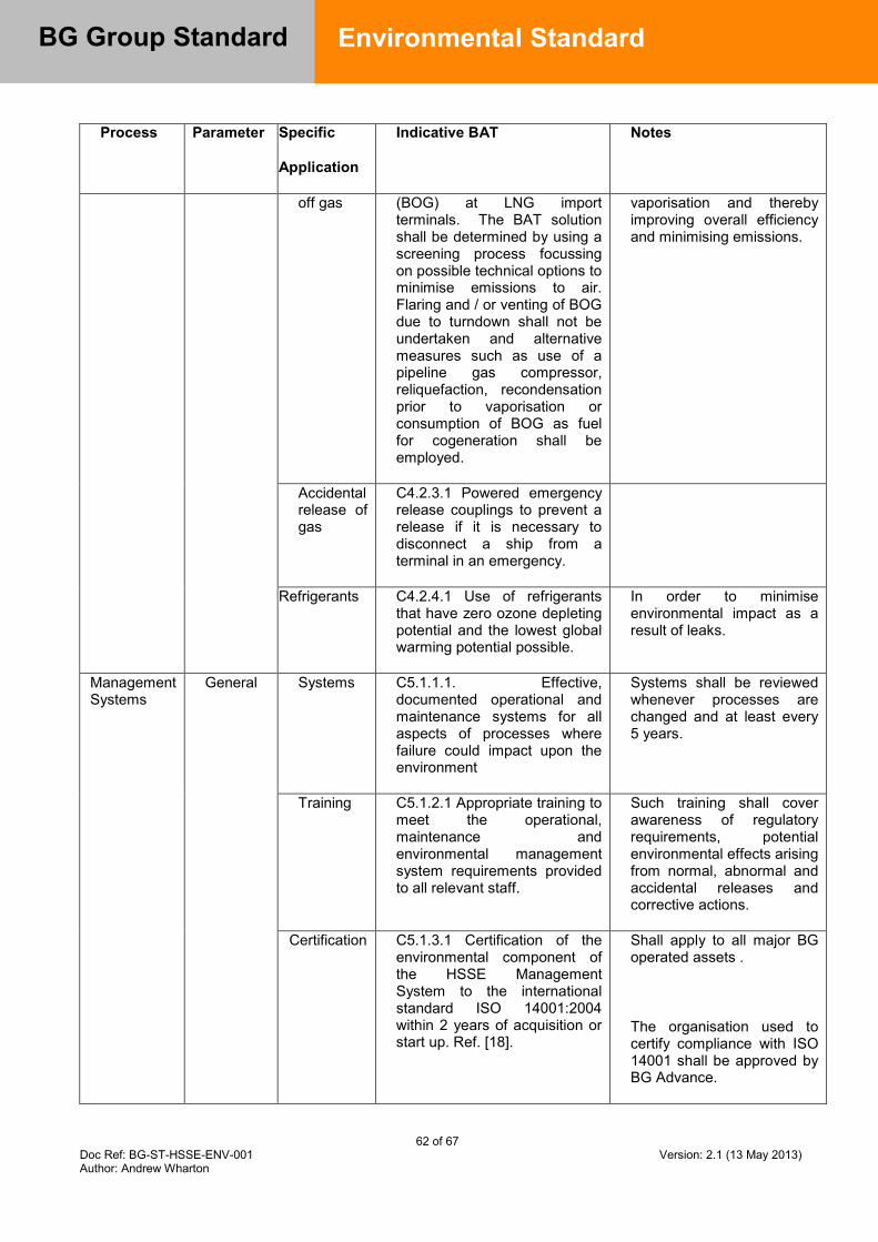
62 of 67 Doc Ref: BG-ST-HSSE-ENV-001 Version: 2.1 (13 May 2013) Author: Andrew Wharton
BG Group Standard
Environmental Standard
Process Parameter Specific
Application
Indicative BAT Notes
off gas (BOG) at LNG import terminals. The BAT solution shall be determined by using a screening process focussing on possible technical options to minimise emissions to air. Flaring and / or venting of BOG due to turndown shall not be undertaken and alternative measures such as use of a pipeline gas compressor, reliquefaction, recondensation prior to vaporisation or consumption of BOG as fuel for cogeneration shall be employed.
vaporisation and thereby improving overall efficiency and minimising emissions.
Accidental release of gas
C4.2.3.1 Powered emergency release couplings to prevent a release if it is necessary to disconnect a ship from a terminal in an emergency.
Refrigerants C4.2.4.1 Use of refrigerants that have zero ozone depleting potential and the lowest global warming potential possible.
In order to minimise environmental impact as a result of leaks.
Management Systems
General Systems C5.1.1.1. Effective, documented operational and maintenance systems for all aspects of processes where failure could impact upon the environment
Systems shall be reviewed whenever processes are changed and at least every 5 years.
Training C5.1.2.1 Appropriate training to meet the operational, maintenance and environmental management system requirements provided to all relevant staff.
Such training shall cover awareness of regulatory requirements, potential environmental effects arising from normal, abnormal and accidental releases and corrective actions.
Certification C5.1.3.1 Certification of the environmental component of the HSSE Management System to the international standard ISO 14001:2004 within 2 years of acquisition or start up. Ref. [18].
Shall apply to all major BG operated assets .
The organisation used to certify compliance with ISO 14001 shall be approved by BG Advance.

63 of 67 Doc Ref: BG-ST-HSSE-ENV-001 Version: 2.1 (13 May 2013) Author: Andrew Wharton
BG Group Standard
Environmental Standard
Process Parameter Specific
Application
Indicative BAT Notes
Calibration of equipment
C5.1.4.1 Calibration of all measurement / monitoring systems in accordance with manufacturers’ recommendations.
Auditing C5.1.5.1 Regular and planned auditing of performance of systems against requirements.
Complaint system
C5.1.6.1 Development and use of a complaint documentation system, and investigation and management procedures.
Energy policy
C5.1.7.1 Development and implementation of an energy management policy by all projects and operations.
C5.1.7.2 Inclusion of an energy Value Improvement Practice session (VIP) in the Assess stage of the VAF for projects with high energy requirements.
C5.1.7.3 Utilisation of an energy efficiency plan at the Operate stage
Waste minimisation
C5.1.8.1 Undertaking a waste minimisation assessment (VIP) in the Assess, Define and detailed engineering stages.
Training C5.1.9.1 Training of operations personnel in energy management and environmental awareness so that they understand the key impacts associated with the operations and processes employed at the installation/facility.
C6.1.1.1 For new turbine equipment, CO, NOx and UHC emissions from the exhaust stack shall not exceed the limits specified in the following table (as referenced in Table 1).

64 of 67 Doc Ref: BG-ST-HSSE-ENV-001 Version: 2.1 (13 May 2013) Author: Andrew Wharton
BG Group Standard
Environmental Standard
Table 2: Emission limits for new turbines
Turbine
Size Gas Fuel Liquid Fuel UHC
(ppmv) CO
(ppmv)
NOx
(ppmv)
CO
(ppmv)
NOx
(ppmv)
<30MW 50 45 50 95 25
>30MW 25 25 15 90 20
7.4 Appendix D – Reference Standards / Guidelines
BG Standards / Guidelines:
[2] Best Available Techniques for Environmental Control Guideline, BGA-HSSE-ENV-GL-1516
[3] HSSE Performance Monitoring Standard, BG-ST-HSSE-EFF-002 [5] Environmental Reporting Guideline, BG-GL-HSSE-ENV-002 [6] Economic Evaluation and Calculation Guideline - BGA-SPE-EC-GL-0002 [7] Total Cost of Ownership – BGA-CP-CP-OS-0002 [8] Selection of Rotating Machinery – BG-ST-ENG-MECH-001 [9] Health Management Standard – BG-ST-HSSE-OCH-001 [10] Relief, Blow down and Flaring Standard – BGA-ENG-PROC-TS-0003 [11] Guideline Guidance for Resource Use and waste Management – BG-GL-HSSE-
ENV-008 [15] HSSE Audit Standard, BG-ST-HSSE-EFF-003 [16] Guideline on Environmental Quality Standards, BG-GL-HSSE-ENV-011 [18] HSSE Documentation Management Standard, BGA-HSSE-GEN-ST-0502 [19] High Integrity Protection Systems (HIPS), BG-ST-ENG-PROC-0012 [20] Crisis Management Standard, BGA-HSSE-GEN-ST-0900 [21] Well Engineering Standard: BG-ST-WE-WE-001 [22] BG Guideline HSSE Management System Project HSSE Deliverables BGA-
HSSE-GEN-GL-0601 [23] Guideline HSSE – Safety Engineering Safety Case Guideline, BG-GL-HSSE-AI-
001 [24] Risk Management Standard – BG-HSSE-GEN-ST-0201 [25] Use and Disposal of Non-Aqueous Drilling Fluids – BG-GL-WE-WE-025 [26] Internal Controls Framework BG-ST-FIN-SECT-001 [27] Guideline Preparation of Oil Spill Contingency Plans - BG-GL-HSSE-ENV-001 [29] Guideline Guidance for Managing Technical Environmental Risk – BG-GL-HSSE-
ENV-003 [30] BG Guideline - Climate Risk Guidance - BG-GL-HSSE-ENV-009 [31] Water Risk Management Guideline – BG-GL-HSSE-ENV-010
65 of 67 Doc Ref: BG-ST-HSSE-ENV-001 Version: 2.1 (13 May 2013) Author: Andrew Wharton
BG Group Standard
Environmental Standard
ISO Standards:
[4] ISO 14064 parts 1 to 3 – Greenhouse Gases
Other:
[1] IPPC Directive 96/61/EC [12]OGP (2009) Guidelines for waste management with special focus on areas with
limited infrastructure [13]International Finance Corporation (IFC) & World Bank Group (2007)
Environmental, Health and Safety (EHS) Guidelines www.ifc.org/ifcext/enviro.nsf/Content/EnvironmentalGuidelines
[14]Basel Convention on Control of Transboundary Movement of Hazardous Waste and their Disposal http://www.basel.int/text/con-e.pdf
[17]OGP Report 342 Environmental Aspects of the Use and Disposal of Non-aqueous Drilling Fluids Associated with Off-shore Oil and Gas Operations www.ogp.org.uk/pubs/342.pdf
[28] IPIECA, 2010 - Alien invasive species and the oil and gas industry
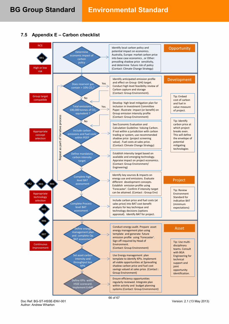
66 of 67 Doc Ref: BG-ST-HSSE-ENV-001 Version: 2.1 (13 May 2013) Author: Andrew Wharton
BG Group Standard
Environmental Standard
7.5 Appendix E – Carbon checklist
Determine economic impact of
carbon policy
Does reservoir gas contain > 10% CO2?
Total emissions > 100,000 tonnes of CO2
equivalent ?
Define mandatory carbon intensity
target
Complete high level BAT
assessment
Complete Process level BAT
assessment
Set asset carbon intensity and
throughput loss KPIs
Define energy management plan and complete Op.
BAT assessment
Include carbon emissions and fuel costs
within PEEP
RR1
RR2 RR3 RR4
RR5
RR7
RR6
Opportunity
Development
Project
Asset
Identify local carbon policy and potential impact on economics.Australia, Europe: market carbon price into base case economics , or Other: prevailing shadow price sensitivity, and determine future risk of policy(Contact: Climate Change Strategy)
Identify anticipated emission profile and effect on Group GHG target. Conduct high level feasibility review of Carbon capture and storage (Contact: Group Environment).
Develop high level mitigation plan for inclusion in Investment Committee Paper. Illustrate impact (or benefit) on Group emission intensity profile (Contact: Group Environment)
See Economic Evaluation and Calculation Guideline: Valuing Carbon. If not within a jurisdiction with carbon trading or system, use recommended shadow price (project screening value) . Fuel costs at sales price. (Contact: Climate Change Strategy)
Tip: Identify carbon price at which project breaks even. This will define the envelope of potential mitigating technologies
Establish intensity target based on available and emerging technology. Appraise impact on project economics.(Contact: Group Environment/ Engineering)
Identify key sources & impacts on energy use and emissions. Evaluate different development concepts. Establish emission profile using ‘Forecaster’. Confirm if intensity target can be attained. (Contact : Group Env)
Include carbon price and fuel costs (at sales price) into BAT cost-benefit analysis for key technique and technology decisions (options appraisal). Identify BAT for project.
Tip: Review Environment Standard for indicative BAT (minimum expectations)
Conduct energy audit. Prepare asset energy management plan using template and generate future emission profile using ‘Forecaster’. Sign off required by Head of Environment. (Contact: Group Environment)
Use Energy management plan template to identify KPIs. Implement all viable opportunities at $prevailing shadow carbon price and fuel cost savings valued at sales price. (Contact : Group Environment)
Define KPIs within HSSE scorecard.
Implement EnMP
Ensure efficiency opportunities regularly reviewed. Integrate plan within activity and budget planning systems (Contact: Group Environment)
Tip: Use multi-disciplinary teams. Consult with BGA Engineering for technical support and joint opportunity identification.
Yes
Yes
No
No
NCE
High or low risk
Group target compatible
Appropriate concept selection
Appropriate technology selection
Continuous improvement
Tip: Embed cost of carbon and fuel in value measure of project.
Rep
eat
as p
art
of
iter
ativ
e p
roce
ss
67 of 67 Doc Ref: BG-ST-HSSE-ENV-001 Version: 2.1 (13 May 2013) Author: Andrew Wharton
BG Group Standard
Environmental Standard
8.0 Revision Record
Issue No. Description of Revision
1.0
This standard replaces the Environmental Expectations Standard, Best Available Techniques for Environmental Protection Standard, Air Quality Standard, Water Quality Standard, Greenhouse Gas Management Standard, Resource Use and Waste Management Standard and Biodiversity Standard Issued for use
1.1 Updated to new Template Issued for use
2.0
Key changes have been made in the areas of Environmental Impact Assessment (to give more detail on what an EIA is to include) energy efficiency, GHG management and climate change (to support new Group GHG target), water risk management (to support Group Water Strategy and enhance Group oil in water performance), oil spill preparedness (to mitigate increased risks posed to the business) and biodiversity management (to mitigate against increased risks posed to the business). The Standard has also been rationalised by taking out detailed air and water quality standard information from this document and placing into a new Environmental Quality Guidance document Issued for use
2.1 Update to carbon pricing approach

Unclassified
BG Group Standard
Social Performance
BG-ST-PCA-SOC-001

2 of 23 Doc Ref: BG-ST-PCA-SOC-001 Version: 2.2 (01 March 2013) Author: Ramanie Kunanayagam
BG Group Standard
Social Performance
Document and Version Control
Version Author Issue Date Revision Detail 2.0 Head of Social
Performance 01 January 2012 Social Performance Standard updated to reflect
new IFC Performance Standards. Inclusion of new clause on Community Health, Safety and Security.
2.1 Social Performance Analyst
08 January 2013 Addition of ‘STEM’ term to section 6.8.
2.2 Internal Controls Manager (Jenny Burden)
01 March 2013 Section 4 changed to include standard applicability wording.
3 of 23 Doc Ref: BG-ST-PCA-SOC-001 Version: 2.2 (01 March 2013) Author: Ramanie Kunanayagam
BG Group Standard
Social Performance
Contents 1.0 Executive Summary .............................................................................. 4
2.0 Ownership.............................................................................................. 5
3.0 Objectives .............................................................................................. 5
4.0 Scope and application .......................................................................... 5
5.0 Links to other controls ......................................................................... 6
6.0 Standard requirements ......................................................................... 7
6.1 Socio-economic baseline assessment ........................................................................................... 7
6.2 Social impact and risk assessment ................................................................................................ 7
6.3 Consultation ................................................................................................................................... 8
6.4 Land acquisition and involuntary resettlement............................................................................... 9
6.5 Indigenous People ....................................................................................................................... 10
6.6 Cultural heritage ........................................................................................................................... 10
6.7 Community health, safety and security ........................................................................................ 11
6.8 Social investment ......................................................................................................................... 11
6.9 Social performance plans ............................................................................................................ 13
6.10 Integration and assurance ........................................................................................................... 13
7.0 Appendices .......................................................................................... 15
7.1 Appendix A – Definitions (for the purposes of this Standard) ...................................................... 15
8.0 Revision Record .................................................................................. 23

4 of 23 Doc Ref: BG-ST-PCA-SOC-001 Version: 2.2 (01 March 2013) Author: Ramanie Kunanayagam
BG Group Standard
Social Performance
1.0 Executive Summary The following Standard has been developed to support the BG Group Social Performance Policy. It provides the implementation framework for the BG Group Society Business Principles, setting out the ten broad areas governing BG Group Assets’ social performance and detailing the requirements with which all Assets must comply. Social Performance Guidelines have also been developed, to support the implementation and management of the requirements set out in this Standard. This document should be referred to in close conjunction with those Guidelines.

5 of 23 Doc Ref: BG-ST-PCA-SOC-001 Version: 2.2 (01 March 2013) Author: Ramanie Kunanayagam
BG Group Standard
Social Performance
2.0 Ownership Owning Function: Social Performance, Policy and Corporate Affairs Standard owner: Head of Social Performance Expert advisor: Social Performance Manager Dispensation: Head of Social Performance
3.0 Objectives BG Group’s Society Business Principles state that: We work to ensure that neighbouring communities benefit from our presence on an
enduring basis; We listen to neighbouring communities and take account of their interests; and We support human rights within our area of influence. This Social Performance standard sets out the basic framework for implementing the Society Business Principles and Social Performance Policy. It covers the aspects of the BG Group’s Human Rights Policy which relate to social issues and social performance. This Standard is supported by a set of related Guidelines.
4.0 Scope and application This is an Activity Specific Standard. Application of an Activity Specific Standard is mandatory for all BG Group employees, consultants and other personnel working in controlled1 Assets and offices when undertaking the activities described. In non-controlled Assets the Standard shall be used as a means for benchmarking by the overseeing Asset. Where high-risk deficiencies are identified they shall be escalated through Asset and Functional lines. For BG Group employees, breach of this Standard may result in disciplinary action, up to and including dismissal. Breach of this Standard by any individual who is not a BG Group employee may result in other appropriate action being taken in relation to the individual and/or the business which supplies services to BG Group, including termination of the relevant contract(s). This Standard is not contractual. BG Group reserves the right to amend, suspend or terminate this Standard. This Standard covers all business segments (E&P, T&D and LNG) and applies to all VAF lifecycle stages (create, assess, select, define, execute, operate and decommission). In the event it is unclear if this Standard shall apply or not, clarification shall be sought from Group Head of Social Performance.
1 Refer to Internal Control Framework - Integrity Standard for the definition of controlled and non-controlled Joint Ventures.

6 of 23 Doc Ref: BG-ST-PCA-SOC-001 Version: 2.2 (01 March 2013) Author: Ramanie Kunanayagam
BG Group Standard
Social Performance
5.0 Links to other controls Governing Policies: Social Performance Policy
Complementary and linked Standards:
Supporting Guidelines: Social Performance BG-GL-PCA-SOC-001
Other Supporting Documents: Social Performance Toolbox
7 of 23 Doc Ref: BG-ST-PCA-SOC-001 Version: 2.2 (01 March 2013) Author: Ramanie Kunanayagam
BG Group Standard
Social Performance
6.0 Standard requirements This Social Performance Standard is supported by a set of eight related Guidelines. This document should be referred to in close conjunction with those Guidelines.
6.1 Socio-economic baseline assessment
All BG Group Assets shall have in place an up-to-date socio-economic baseline assessment to serve as the knowledge base informing all aspects of the Asset’s social performance. This knowledge base is required so that BG Group Assets fully understand the context in which projects are developed and operated. The socio-economic baseline assessment shall: define the geographical and societal areas of impact and influence of the Asset’s
current and future activities; detail, through both quantitative and qualitative information, the key social, political,
institutional, health, environmental and economic factors that characterise identified communities and social groups;
identify communities and social groups (including vulnerable groups) which are directly and indirectly affected by the Asset, or which could affect the Asset;
incorporate views obtained through stakeholder consultation; detail how communities, social groups and relevant government agencies interact,
including the ways in which they are represented and make decisions; assess the sustainable development priorities of host communities and host societies;
and be updated regularly so that changes and trends, and the factors affecting these, can
be tracked and assessed. Development of the socio-economic baseline assessment shall commence with a scoping phase to ensure that relevant risks, issues and opportunities associated with the Asset are identified and prioritised for consideration in the assessment. For large or potentially large developments or activities that are geographically diverse, consist of various projects or give rise to the potential for large-scale national or regional impacts, a consolidated knowledge base is required. This knowledge base can be drawn from various sources, however it shall be integrated to inform strategic social performance, sustainability and business planning covering the development as a whole, and shall include an assessment of macro-level economic, political and institutional factors as well as the socio-economic baseline.
6.2 Social impact and risk assessment
All BG Group Assets, including potential acquisitions and new country entry projects, shall have a documented understanding of the potential positive and negative impacts of their activities on third parties and risks to the business. Where potentially significant impacts and risks are identified, these shall be incorporated into Asset and project risk registers.
8 of 23 Doc Ref: BG-ST-PCA-SOC-001 Version: 2.2 (01 March 2013) Author: Ramanie Kunanayagam
BG Group Standard
Social Performance
For new projects, including those within existing Assets, the impact assessment shall be informed by an up-to-date socio-economic baseline assessment, which shall typically be conducted as part of the same exercise. The impact assessment shall: include an assessment of the potential for adverse impacts on community health, safety
and security from the activities of the Asset; include an assessment of the potential for involuntary resettlement (both physical and
economic), as well as potential impacts on Indigenous Peoples and cultural heritage; determine, where necessary, specialist studies that need to be conducted to
understand and mitigate specific risks and impacts; assess the potential for cumulative impacts, or for impacts resulting from the
construction or operation of associated facilities (as defined by the International Finance Corporation);
identify human rights dimensions that may arise as a result of social impacts; identify mitigation measures for all significant negative impacts; and identify measures for creating or enhancing the socio-economic and broader
sustainable development opportunities that flow from positive impacts. Social impact and risk criteria shall be taken into consideration in the site selection process for major facilities, such as LNG and gas processing plants. For developments, there are four types of impact assessment, the scope of which shall reflect the nature and magnitude of the potential risks and impacts: desktop social impact assessment for low-risk projects; the social component of a traditional ESIA used for regulatory purposes; stand-alone social impact assessment for projects with potential significant adverse
socio-economic impacts that are diverse or irreversible; and integrated strategic assessment for large or potentially large developments or activities
that are geographically diverse, consist of various projects or give rise to the potential for large-scale national or regional impacts.
Management of cross cutting issues identified in the assessment shall be integrated with relevant disciplines, including human rights, environment, safety, security and human resources. Mitigation measures identified in the impact assessments shall be incorporated into the Asset’s development plans (as well as in the Asset’s Social Performance Plan), which set out resource requirements and a schedule to implementation. The impact assessment shall be carried out or managed by experienced social performance specialists with a good understanding of extractive industry projects.
6.3 Consultation
BG Group Assets shall consult with identified interested and affected stakeholders throughout the life of their presence in a particular location. Consultation shall be transparent, inclusive, culturally appropriate and publicly defensible, with the intention of developing broad community support for BG Group’s presence. It shall incorporate information disclosure, as well as more participatory forms of engagement, good faith negotiation2 and, where appropriate and relevant, the development of strategic
2 For the purposes of this Standard, the definition of ‘good faith negotiation’ is that used by the IFC, which states that it is negotiation that is, “conducted with an open mind, a willingness to engage in the process,
9 of 23 Doc Ref: BG-ST-PCA-SOC-001 Version: 2.2 (01 March 2013) Author: Ramanie Kunanayagam
BG Group Standard
Social Performance
partnerships. Consultation with affected stakeholders shall be led or coordinated by a BG Group or Asset representative, including where it is being conducted by a third party on behalf of the company. Consultation procedures shall: be cognisant of established community decision-making conventions and protocols,
and be supplemented, as necessary, by additional mechanisms to address the needs of inadequately-represented, marginalised or vulnerable groups;
ensure that identified communities have timely access to full, meaningful and accurate information about the Asset, including information relating to positive and negative impacts and mitigation measures identified in the impact assessment;
ensure that engagement activities are two-way so that community issues and priorities are taken into account in business decision making; and
record all formal consultation activities and outcomes, including the extent to which community viewpoints have been taken into consideration and all formal commitments and agreements made between the Asset and communities. It is also recommended that informal activities and outcomes are also recorded.
Where communities or other social groups are directly or indirectly affected by a BG Group Asset or project, the Asset shall establish a grievance mechanism to facilitate resolution of any grievances arising in relation to its activities. The scale and type of the grievance mechanism shall be compatible with the level of risks and impacts associated with the Asset or project’s activities. The grievance mechanism shall be readily accessible, follow understandable, transparent and culturally appropriate processes, be designed to resolve grievances promptly, shall not result in any cost or retribution to the party that originates the grievance, and shall not impede access to judicial or administrative remedies. The Asset shall ensure that potential users are fully informed about the grievance mechanism through its stakeholder consultation activities.
6.4 Land acquisition and involuntary resettlement
The applicability of this section of the Standard will be identified during the environmental and social risk and impact assessment process. BG Group Assets shall seek to avoid, and when avoidance is not possible, minimise involuntary resettlement wherever feasible by exploring alternative project designs. Where resettlement is unavoidable, projects shall follow the IFC Performance Standard 5 on Land Acquisition and Involuntary Resettlement and consult with and seek advice from the BG Group Social Performance team. This applies wherever there is potential for either physical displacement of people, or loss of livelihood or access to resources (economic displacement). Resettlement is considered involuntary when affected persons or communities do not have the right to refuse land acquisitions or restrictions on their land that result in physical or economic displacement. Where resettlement is unavoidable, a Resettlement Action Plan (RAP) consistent with IFC Performance Standard 5 shall be developed, managed and independently reviewed by internationally recognised RAP experts who have been approved by the BG Group Social Performance team. and a genuine desire to build solutions and to reach agreement.” (Stakeholder Engagement: A Good Practice Handbook for Companies Doing Business in Emerging Martkets, IFC 2007, p.64).

10 of 23 Doc Ref: BG-ST-PCA-SOC-001 Version: 2.2 (01 March 2013) Author: Ramanie Kunanayagam
BG Group Standard
Social Performance
In cases where there is a potential short-term impact on economic livelihoods of an affected group from the Asset’s or project’s activities, for example as a result of exploration activities, a full RAP may not be required. However in all such cases, impact mitigation and/or compensation measures shall be clearly defined and implemented in consultation with the affected group prior to commencement of the work.
6.5 Indigenous People
The applicability of this section of the Standard will be indentified during the environmental and social risk and impact assessment process. All Assets and projects shall identify communities of Indigenous People that are potentially affected by their activities. Where the status of Indigenous People is unclear, the project shall commission an Indigenous People’s expert to define the status of such communities through detailed ethnographic research. Where Indigenous People are identified as being within an Asset’s area of direct or indirect influence, the Asset shall, above and beyond the other aspects of this Standard: follow an approach that recognises and respects the rights of the Indigenous People
affected as defined in applicable national and international law; recognise the specific histories and aspirations of the IPs, including, where appropriate,
publicly acknowledging any history of displacement; demonstrate regard for the IPs distinct cultural, economic and political systems; conduct good faith negotiations with the IPs; and develop a benefits sharing agreement with the IPs where appropriate, covering the life
of the project and including culturally appropriate opportunities for wealth generation and sustainable development, including through the development of proactive policies and plans on employment, training and business development.
6.6 Cultural heritage
The applicability of this section clause will be identified during the environmental and social risk and impact assessment process. BG Group Assets shall seek to avoid, and where avoidance is not possible, minimise impacts on cultural heritage. Cultural heritage refers to both indigenous and non-indigenous assets that can be both tangible and non-tangible, such as sites and cultural property that have: archaeological, paleontological, historical, ancestral, artistic and religious significance to
host communities and host governments; and environmental features that embody spiritual and cultural significance to communities
such as sacred groves, sacred springs, sacred rocks. The Asset shall consult with relevant national and local authorities and host communities to identify, and incorporate into its decision making process, sites and property that have cultural heritage significance. Where cultural heritage is identified in the socio-economic baseline and/or impact assessments as being within a project’s area of direct or indirect influence, the Asset shall

11 of 23 Doc Ref: BG-ST-PCA-SOC-001 Version: 2.2 (01 March 2013) Author: Ramanie Kunanayagam
BG Group Standard
Social Performance
follow national regulations and IFC Performance Standard 8 (where national regulations are less stringent than IFC PS8, IFC PS8 will prevail), in consultation with and taking the advice of BG Group Social Performance team, and seek expert advice on this subject.
6.7 Community health, safety and security
The applicability of this section of the Standard will be identified during the environmental and social risk and impact assessment process and will draw on relevant HSSE risk assessments and impact/consequence models (e,g, the Asset Safety Case).Where relevant, these assessments should address potential off-site effects and Social Performance staff shall work closely with the asset HSSE department (the functional owner for Asset safety risk assessment, safety case development and emergency response planning processes) to ensure community knowledge and understanding is fully integrated into the process.
Where residual risks to or impacts on community health and safety remain, or where there remains a significant degree of community concern, measures that may include additional information and awareness raising initiatives, emergency response procedures/protocols (including provision of equipment, resources and appropriate training), compensation, offset, resettlement and/or participatory impact monitoring shall be defined and implemented in consultation with the affected community. Such measures shall be reasonable and appropriate to ensure the Asset maintains broad community support and safeguards the reputation of the company, and shall be defined under the advice of the BG Group Social Performance team.
Where applicable, the Asset shall assist and collaborate with the potentially affected communities and local government agencies in the preparation of the emergency preparedness and response system, especially when their participation and collaboration are necessary to ensure effective response. In all cases, the Asset shall consult with potentially affected communities, relevant government agencies and other relevant parties, and shall disclose relevant information relating to the emergency preparedness and response system. In relation to potential impacts of the Asset’s security provisions on local communities, Assets shall consult with the BG Group Head of Security and Head of Social Performance to determine if actions will be necessary to ensure compliance with the Voluntary Principles on Security and Human Rights (VPSHR). Where they are, the Asset shall conduct a risk assessment and develop and implement mitigation measures in accordance with the VPSHR.
6.8 Social investment
Social investment refers to contributions made by BG Group businesses to impacted and neighbouring communities and/or disadvantaged groups in wider society. Social investment shall be conducted in a way that it: creates benefits for these groups over and above the benefits available through
standard project and operational expenditure; assists target beneficiaries to meet their development priorities; and contributes to the ability of the Group or Asset to meet its business objectives.
12 of 23 Doc Ref: BG-ST-PCA-SOC-001 Version: 2.2 (01 March 2013) Author: Ramanie Kunanayagam
BG Group Standard
Social Performance
Social investment can be either mandated (required or obligated through the terms and conditions of a commercial agreement with a host government) or voluntary. Where mandated, the Asset shall seek to influence the social investment spend to achieve a societal benefit that is consistent with the above definition. BG Group does NOT include as social investment the following items: investment in social impact assessment, mitigation or management activities; marketing, sponsorship or strategic communications activities; mandated contributions to government bodies for the stated purpose of social
investment but where the company has no meaningful influence over the use of such funds;
payments made as part of legal settlements, such as compensation, fines and penalties;
core business activities that may have a community or societal benefit, for example payment of taxes and royalties and creation of employment; and
in-kind contributions in the form of equipment or staff time. Where feasible, Assets shall focus the majority of its social investment on projects that are consistent with the Group-wide social investment themes of STEM education (Science, Technology, Engineering and Mathematics), skills development and livelihoods enhancement. Assets shall also endeavour to optimise community content opportunities. All BG Group Assets shall develop a portfolio of social investment projects. The portfolio shall comprise projects that fall in the different categories of social investment defined by BG Group (charitable donations, local community development, regional development and miscellaneous), with the majority of the total investment targeted towards the local community development and regional development categories. The portfolio shall also include a combination of quick-win projects (entry point projects designed to create goodwill and/or demonstrate a tangible outcome in a short timeframe) and long-term development projects. The nature of the social investment portfolio shall be defined in a social investment strategy that shall be designed to demonstrate how the community can benefit from our activities on an enduring basis beyond the term of our direct presence, and this shall be set out in the SP Plan. All social investment projects shall: be developed in collaboration with the target communities and other interested
stakeholders; reflect the sustainable development priorities identified in the socio-economic baseline
assessment where appropriate and through ongoing consultation with target communities, local government and the host country;
quantify the community benefits achievable; have a viable system for monitoring and evaluation on an annual basis; have a viable exit strategy in place; have been subject to ethical conduct due diligence; and clearly define how the project contributes to the Asset’s ability to meet its business
objectives, in particular through the systematic management of risk. BG Group Assets shall report their SI portfolios to the Group SP team on an annual basis, using the template provided by Group SP. BG Group shall report publicly the company’s
13 of 23 Doc Ref: BG-ST-PCA-SOC-001 Version: 2.2 (01 March 2013) Author: Ramanie Kunanayagam
BG Group Standard
Social Performance
annual social investment spend, including separate figures for mandated and voluntary social investment (as defined in this Standard) as well as the combined total.
6.9 Social performance plans
All Assets shall develop a 3-5 year social performance strategy and maintain a Social Performance Plan that is updated on an annual basis. The Social Performance Plan shall: set out the strategic social performance objectives in support of the long-term business
objectives of the Asset; summarise the key findings of the socio-economic baseline and impact assessments,
including key risks, impacts and opportunities identified (where applicable, see sections 1.1 and 1.2 of this Standard);
set out the Asset’s approach to consultation with community and other relevant stakeholders (see section 1.3);
summarise key social impact or risk management processes in place, and refer to associated plans and documents (see sections 1.4 – 1.7);
set out the strategic approach taken to social investment, the rationale behind that approach and an implementation plan for the social investment portfolio (see section 1.8);
summarise the findings of the annual joint assessment process, including an assessment of performance against the social performance objectives set the previous year and of the Asset’s compliance with this Standard (see section 1.10);
set out the social performance objectives and targets for the forthcoming year, and an associated action plan for meeting these;
set out the social performance resources in place to implement the plan, including a detailed budget and description of staff, contractors and consultant support.
The Social Performance Plan shall be updated annually in accordance with the social performance planning cycle and shall be approved for implementation by the Asset General Manager and Group Head of Social Performance by December 31st of each year. The Social Performance Plan should be linked to the annual budget cycle and run from Q1 to Q4 of each year. Where an Integrated Strategic Assessment or an Integrated Regional Assessment is required (see section 1.2), the Social Performance Plan shall be integrated with broader sustainable development considerations as one element of the Asset’s sustainability strategy, to reflect social performance alongside environmental management activities, as well as the broader economic opportunities created by the Asset for host societies.
6.10 Integration and assurance
Social performance shall be delivered by the Asset in a way that is compliant with the requirements of this Standard and consistent with the requirements of the Asset – Function Accountability Standard. The Social Performance Plan shall be the tool for implementing the Social Performance Standard. To ensure that the requirements and intent of the Social Performance Standard, Policy and related BG Group Business Principles are met, Assets shall ensure that:
14 of 23 Doc Ref: BG-ST-PCA-SOC-001 Version: 2.2 (01 March 2013) Author: Ramanie Kunanayagam
BG Group Standard
Social Performance
social performance risks are documented on Asset and Project risk registers, as appropriate;
internal decision making processes take account of social performance implications; projects secure the appropriate level of social performance functional input through the
value assurance process (VAF); linkages with other functions within the Asset are realised, including environment,
safety, security, human rights, contracts and procurement, and human resources; employees receive appropriate training on relevant community issues and cultural
sensitivities, as well as on the BG Group Social Performance Standard and Policy and the Asset’s Social Performance Plan;
where the potential for social performance risks in the supply chain is identified, contracts with third parties shall include clauses specifying actions to avoid, minimise or mitigate social impacts; and
all new and renegotiated Shareholder Agreements and Joint Operator Agreements reference either the BG Group Social Performance Standard or, minimally, the IFC Performance Standards;
where business activities are delivered through existing Shareholder Agreements, Joint Operator Agreements, or non-Operated Joint Venture structures, the Asset shall endeavour to influence its JV partners to manage social performance in a way that is consistent with the BG Group Social Performance Standard or, minimally, the IFC Performance Standards.
BG Group Assets shall demonstrate compliance with the Social Performance Standard through participating in the Asset/Function social performance internal assurance process, which consists of quarterly KPIs, an annual joint assessment and a three-yearly performance review.
15 of 23 Doc Ref: BG-ST-PCA-SOC-001 Version: 2.2 (01 March 2013) Author: Ramanie Kunanayagam
BG Group Standard
Social Performance
7.0 Appendices 7.1 Appendix A – Definitions (for the purposes of this Standard)
Area of direct impact: geographical area within which project activities will directly have an impact, either positive or negative, on people or the environment. Factors to consider in assessing the area of direct impact include siting of project and related facilities, populations in proximity to these areas and the project phase. Area of indirect impact: the area that incorporates the wider, indirect impacts (knock-on effects) that may occur as a result of the project’s existence such as in-migration, cumulative impacts and impacts via the supply chain. It is wider than the area of direct impact. Area of influence: the area in which the project has the potential to influence which normally extends beyond the area of indirect impact for example to regional or national level. This influence can be the result of the direct and indirect impacts outlined above, but also stakeholder relations with those not necessarily affected by direct and indirect impacts. Factors to consider in defining the area of influence include locations of key stakeholders upon which the project may have influence such as national governments through lobbying, input into policy discussions; locations of key stakeholders who can have substantial influence on the project e.g. regional government, NGOs, project and/or major contractors regional offices that service the project and locations of ancillary facilities that are either dependent on the project or set up to service the project. Baseline socio-economic assessments –characterises the socio-economic environment surrounding a project, providing a detailed understanding of the socio-economic status, social/ cultural structure and opinions of communities. The baseline assessment is the holding document for all socio-economic knowledge relating to the project’s area of influence at one point in time, against which changes in the socio-economic environment may be monitored to track social change. Biodiversity: The variety of life in all its forms, levels and combinations. This term includes ecosystem diversity, species diversity, and genetic diversity. Broad Community Support is acknowledged when there is an overall consensus by the affected communities, both of individuals and their recognised representatives, in support of a particular proposal (e.g. the project itself or a smaller initiative). There may be broad community support even if some individuals or groups object to the proposal. Census: a complete count of a target population (e.g. those affected by a project) including collation of demographic and property information. Communication strategies: The most basic form of consultation, this typically involves one-way communication from a project to stakeholders. It does not allow for any meaningful stakeholder participation, but a communication strategy does support more advanced forms of engagement.
16 of 23 Doc Ref: BG-ST-PCA-SOC-001 Version: 2.2 (01 March 2013) Author: Ramanie Kunanayagam
BG Group Standard
Social Performance
Community: A group of people living in the same locality and under the same government. Could refer either to a district or locality where one or several communities may reside; or an ethnic, religious, economic or clan group who identify themselves as a community based on a set of common characteristics. As such a project’s area of direct and indirect impact could include one or several communities. Community mapping: the use of source maps and satellite data (for example, from Google Earth) or a focus area (e.g. a community affected by the project) to identify and map observable socio-economic information relative to that area. Such information can include the location of population centres, number of households, location of agriculture, customary land and natural resource ownership, livelihood activities, userfruct rights and type and location of public infrastructure. Compensation: payment (either financial, in-kind or a combination of both) made by those causing specified and agreed loss, to those who suffer it, in the context of land acquisition, economic displacement (agriculture, grazing, fishing, hunting, gathering of forest products) and for disturbances due to noise, dust and so on, resulting from project activities. Compensation and assistance programme: a programme that outlines measures to be adopted to address issues arising from Type II resettlement impacts causing economic displacement. This type of programme replaces a full Resettlement action Plan (RAP) that is required for other types of resettlement impact. Consultation: is a two-way discussion process between BG Group projects and groups and individuals with a stake in the project, to understand and manage decisions that have the potential to affect both these stakeholders and BG Group projects. A good consultation process meets the needs and expectations of stakeholders for consultation, and shapes business decisions to the benefit of BG Group and stakeholders alike. Cultural Heritage: a place or object to which is ascribed archaeological, cultural, spiritual, aesthetic, historic, religious or social significance by host communities and host governments. Cultural values: commonly held standards of what is acceptable or unacceptable, important or unimportant, right or wrong, workable or unworkable in a community or society. Customary rights: accepted norms, behaviours (such as seasonal events/ celebrations), and use/ ownership of assets (such as land, buildings, waterways, coastal zones) that have evolved and been passed on from generation to generation. These rights are generally not formally documented, and may in some cases conflict with legal status for a particular activity or asset. Displaced person: person who has been affected by either physical or economic displacement through project activities. Economic resettlement/ displacement: means the involuntary taking of land for use by the project which results in loss of individuals’ assets or access to assets that leads to loss of income sources or means of livelihood.

17 of 23 Doc Ref: BG-ST-PCA-SOC-001 Version: 2.2 (01 March 2013) Author: Ramanie Kunanayagam
BG Group Standard
Social Performance
Engagement: see ‘Stakeholder Engagement’ Environmental Impact Assessment (EIA): the systematic examination of the likely impacts of a proposed project on the environment before commencement of any activity. This is normally a requirement imposed by host governments (as per national legislation) or financiers. Environmental and social impact assessment (ESIA): the systematic examination of the likely impacts of a proposed project on people and the environment before commencement of any activity. An ESIA is not normally legally required, although may be preferred where social impacts are likely to be significant. Exclusion zone: normally buffer areas around a piece of infrastructure or operations, from which people are denied access. Free Prior Informed Consent: Term that is increasingly used by NGOs, stipulating that the community has the right to veto a project. There is no universal agreement on the term and its use has been heavily contested by industry and others. The IFC, for example, uses the term ‘free prior informed consultation’ – see below. Free Prior Informed Consultation: is the process by which the community are informed and consulted to enable them to comment on and give feedback about a project. Good faith agreements: see ‘negotiation and good faith agreements’ Grievance mechanism: an accessible and responsive process for stakeholders to raise concerns and grievances about the project throughout its life. The grievance mechanism should be scaled to suit the needs of the project and neighbouring communities Host community: refers to the community which will receive (either permanently or temporarily) the project, or other individuals, families or groups of people not already resident in their population, who have been impacted by either physical or economic displacement as a result of the project. IFC: International Financial Corporation, the private sector arm of the World Bank Group. Impact: An effect or change caused by a project activity, for example a social or environmental impact which improves (positive impact) or deteriorates (negative impact) the wellbeing of people or ecology. The following are commonly used terms used in relation to impacts: Direct impact: an impact that is directly caused by a project activity (e.g. creation of local jobs, contamination of local water sources) Indirect impact: a knock on impact that results from the direct impact caused by a project activity (e.g. in-migration resulting from the creation of local jobs) Cumulative impact: The combined impacts or potential impacts of one or more project activity(s) in a specified area over a particular time period which may occur simultaneously, sequentially, or in an interactive manner.

18 of 23 Doc Ref: BG-ST-PCA-SOC-001 Version: 2.2 (01 March 2013) Author: Ramanie Kunanayagam
BG Group Standard
Social Performance
Synergistic impact: an impact that is co-dependent on another impact such that the two need to be managed simultaneously e.g. an environmental issue that is resulting in health problems for the local community. Impact Prevention: the avoidance of a potential impact through a change in technical design, for example use of alternative project sites, pipeline and transport routes, or use of a closed construction camp and so on. Impact Minimisation: reduces or diminishes a negative impact through different technology, design or management, for example dust and noise suppression techniques, road safety and contractor management Impact Remediation: relocation or replacement of community resources that have social, cultural or economic significance, for example recreation areas, cemeteries or common land Impact Enhancement: identification and development of opportunities for the project to add value and contribute to overall development objectives both locally and in some cases regionally and nationally. Impact assessment: systematic examination of the likely positive and negative impacts of a proposed project on people in the project’s area of influence, prior to the beginning of any activity. Indigenous Peoples: a social group whose identities are distinct from dominant groups in national societies. The criteria for definition include self identification and recognition by others; collective and ancestral attachment to distinct habitats, territories, or natural resources; distinct social, cultural and political institutions; or an indigenous language, often different form the official language of the country or region. Information disclosure: Disclosure is a formal-sounding term for making information accessible to interested and affected parties. It describes a process to systematically disclose information to stakeholders as a project evolves, and is designed to ensure that all stakeholders have accurate and timely information about a project, its impacts and other aspects of interest, with a view to enhancing stakeholders’ capacity to engage constructively and in an ‘informed’ way in other project-related consultation activities. It includes, for example, public disclosure of information relating to the formal consultation process required to develop an impact assessment. Integrated Strategic/ regional impact assessment: an impact assessment that is undertaken in exceptional circumstances for projects (such as trans-boundary projects) where the impacts are mega, multi-sectoral, and are expected to have large-scale regional and/or national impacts. Involuntary Resettlement: refers to both physical displacement (relocation or loss of shelter) and to economic displacement (loss of assets or access to assets that leads to loss of income sources or means of livelihood) as a result of project related land acquisition. Resettlement is considered involuntary when affected individuals or

19 of 23 Doc Ref: BG-ST-PCA-SOC-001 Version: 2.2 (01 March 2013) Author: Ramanie Kunanayagam
BG Group Standard
Social Performance
communities do not have the right to refuse land acquisition which results in displacement. Legitimate representative stakeholder: individuals who hold formal representative roles, such as an elected Member of Parliament, village or district head. It is important to note that a legitimate representative may not be viewed by the community as truly representative of their interests. Livelihood: the form of activity that is undertaken by an individual to enable them to support their existence, financially or vocationally Marginalised groups: people who have been pushed to the edge of society, socially, economically, politically and legally, and who therefore have limited access to standard economic activities and institutional processes. These people often comprise the poorest, the unemployed, indigenous peoples and those most vulnerable. See also vulnerable groups. Negotiation and good faith agreements: An advanced form of consultation with a view to reaching a good faith agreement on an issue or a particular set of issues. Negotiated agreements are appropriate in particularly sensitive situations, involving indigenous communities, resettlement, compulsory land acquisition, economic displacement and so on. They offer a chance to reach a settlement outside of what might often be a long and tedious legal process, reducing time and red tape and creating a higher level of satisfaction amongst affected groups. Non-Governmental Organisation (NGO): A non-profit group or association organized outside of institutionalised political structures to realize particular social objectives (such as environmental protection) or serve particular constituencies (such as indigenous peoples). Nomadic communities: groups of people who have no fixed home and move according to the seasons from place to place in search of food, water, and grazing land. Participation: Informed participation is a more intensive and active form of consultation. Typically, participation involves an in-depth exchange of views and information, leading to joint analysis and decision-making. The more a particular stakeholder group is materially affected by a project’s activities, the more important it is for them to be properly informed and encouraged to participate in matters that have a direct bearing on them. Resettlement planning, designing and implementing community development projects, and engaging with Indigenous People are good examples of where informed participation can lead to better outcomes for a project and its stakeholders. Participatory assessments: assessments that are undertaken with the full participation of the focus populations (e.g. local communities) on whom the assessment is based. There exist different accepted approaches applied by social experts for undertaking a participatory assessment such as a Rapid Rural Appraisal or Participatory Rural Appraisal. Participatory community mapping: where the community itself maps out what is important to them in terms of natural resource value, social and communal boundaries,

20 of 23 Doc Ref: BG-ST-PCA-SOC-001 Version: 2.2 (01 March 2013) Author: Ramanie Kunanayagam
BG Group Standard
Social Performance
spiritual and cultural heritage property, water wells and other sources of basic needs, grazing rights, fishing rights, as well as an indication of who within the community has the right to access these resources. Participatory monitoring: the process of involving directly affected stakeholders in monitoring project impacts, mitigation and benefits or other environmental and social programs. Physical resettlement/ displacement: means the involuntary taking of land for use by the project which results in physical relocation or loss of shelter of people who reside there. Poverty: Poverty is a condition in which a person or community is deprived of, or lacks the essentials for, a minimum standard of well-being and life. Poverty can also represent a lack of opportunity and empowerment. According to the World Bank, the formal definition of poverty is a person living on less than $2 a day. Primary data or information: First hand information collected directly from a respondent population as opposed to secondary or published data. Progress indicators: measurements used to track over time the changes in the socio-economic conditions within the project’s area of direct impact and influence. Public consultation and disclosure plan (PCDP): plan prepared by the project outlining consultation and information awareness/ disclosure activities. Often this can be a regulatory requirement for approval of the EIA or ESIA. Qualitative Data: descriptive or textual data that usually reflects people’s perceptions or beliefs. Such data is usually collected through focus group discussions, participation, observations, participation mapping and interviews. Quantitative Data: numerical data that may provide a general statistical understanding of a group. It is usually collected through census and surveys. Resettlement Action Plan (RAP): a document to be prepared by each project where resettlement issues have been identified. RAPs contain specific and legally binding requirements to be abided by to resettle and compensate all affected parties before implementation of the project activities causing adverse impacts. Replacement cost: means the cost of replacing assets lost or irreversibly affected by project activities. The cost should be sufficient to enable full replacement of lost assets of equivalent or better quality, plus any related transaction costs. Secondary Data – pre-existing or publicly available data that has been collected for another purpose. Social impact assessment (SIA): the systematic examination of the likely impacts of a proposed project on people before commencement of any activity. This is not normally a requirement imposed by host governments (as per national legislation) or financiers unless there are specific social related issues anticipated as a result of the project.

21 of 23 Doc Ref: BG-ST-PCA-SOC-001 Version: 2.2 (01 March 2013) Author: Ramanie Kunanayagam
BG Group Standard
Social Performance
Social investment: a voluntary contribution that a project makes, either to help a community to meet its development priorities (e.g. education, health, income generation) or to examine ways in which it can enhance existing opportunities such as local contractor development and the building of long term skills to benefit local and regional communities. Social Investment comprises activities that transcend impact management, and do not include marketing, sponsorship or strategic communications spending. Social investment plan (SIP): a plan outlining the social investment strategy and related activities of the project for a minimum of a three year period that clearly demonstrates the business case for such activities, and which is reviewed and updated annually. Social performance: means understanding and managing our impacts (positive and negative) on our social environment. It involves: - Doing no harm – managing the social risk associated with our business - Value adding – creating and delivering on opportunities to enhance our benefit to society - Establishing and maintaining effective relations with our stakeholders Social Performance Plan (SPP): is a plan which incorporates all relevant aspects of the Social Performance Standard applicable to the project. The assets shall implement and manage a SPP which sets management objectives and outlines management processes, key activities, resources and key performance indicators or measures. The SPP shall initially be developed for a minimum 3-year planning period and shall thereafter be updated on an annual basis. Significance: Relevance, importance or the presence of meaningful consequences relating to impacts resulting from project activities. These should be considered in terms of magnitude, extent, duration, severity and reversibility (see definitions provided under ‘impacts’) Social and communal boundaries: formal (e.g. administrative/ political boundaries set by the government) or informal boundaries (e.g. social- between communities, tribes, families or environmental) between different terrains, land ownership etc. Social licence to operate: general approval of project proposals received from people residing in the direct area of impact which will enable the project to proceed without disruption. This is not normally a legal requirement (the government may have already provided the legal licence to operate), but without the social licence to operate, a project may face significant problems or delays as a result of, for instance, vandalism, disputes, demonstrations or worker strikes which could in extreme circumstances result in loss of legal licence to operate. Socio-economic environment: covers the conditions in the area of interest relating to social factors that affect the economic welfare of focus populations e.g. jobs/ livelihoods, level of entrepreneurship, health, education, demographics, natural resource use, access to services and infrastructure, social arrangements, and the vulnerabilities and socio-political context that shape these factors. It also identifies a community’s traditional and customary rights, as well as their cultural values. Spiritual heritage: see cultural heritage.
22 of 23 Doc Ref: BG-ST-PCA-SOC-001 Version: 2.2 (01 March 2013) Author: Ramanie Kunanayagam
BG Group Standard
Social Performance
Stakeholder: interested and affected parties (organisation/s, governmental entity/entities or individual/s), who have either real or perceived stakes (both financial and non-financial) in the project. A project’s stakeholders comprise those who are affected by the project as well as those who can affect the project. Stakeholder consultation: see consultation Stakeholder engagement: see consultation Stakeholder representatives: an individual or set of individuals who fully reflect the characteristics or nature of the larger population of a particular stakeholder group and with whom the project can liaise with in order to ensure effective consultation and dialogue. Strategic partnerships: joint activities and collaborative efforts between a project, directly affected communities and other stakeholders, such as government bodies or NGOs, for example relating to environmental stewardship, participatory monitoring of impacts or local economic development initiatives. Survey: The systematic collection, analysis and interpretation of information about some particular aspect of interest. Sustainable Development: development that "meets the needs of the present generation without compromising the ability of future generations to meet their own needs (Brundtland Commission, 1987). BG Group seeks to make a positive and enduring contribution to sustainable development in our host countries by supporting social, economic, environmental and development priorities. Tenure systems: the system in place to provide rights to individuals to hold or occupy land for a certain amount of time Traditional rights: see Customary rights. Type I transactions: acquisition of land rights through expropriation or other compulsory procedures. Type II transaction: acquisition of land rights through negotiated settlements where Type I acquisition results upon the failure of the negotiation Vulnerable Groups: segments of the population who are considered to be at higher risk of changes to their conditions as a result of project activities, and who may be limited in their ability to participate in a project’s socio-economic baseline and impacts assessments, impact management plans and consultation activities, relative to other groups. They may therefore need special attention in order to ensure that any changes are appropriately addressed. These groups may include: those living in poverty (below the national poverty line); widows or female headed households; disabled or ill (e.g. HIV infected persons); marginalized groups (such as indigenous populations); informal sector operators with limited or no access to formal income; incapacitated households – those where no one is fit to work; and child-headed households and street children.

23 of 23 Doc Ref: BG-ST-PCA-SOC-001 Version: 2.2 (01 March 2013) Author: Ramanie Kunanayagam
BG Group Standard
Social Performance
8.0 Revision Record
Issue No. Description of Revision

BG Guideline
Geoscience Geophysical Operations Procedures
BGA-EXP-GEN-GL-0004
Value Assurance Framework (VAF)

Page 2 of 40
DOCUMENT INFORMATION SHEET
TITLE: Geophysical Operations Guidelines
PURPOSE AND SCOPE:
This document sets out the basic guidelines that are to be adhered to for geophysical operations carried out by BG. It references the standard documents that are to be used during the work.
The procedures outlined in this document apply during the acquisition and processing of seismic, gravity, MT and magnetic data.
The guidelines refer to surveys and projects operated by BG. A summary of responsibilities for Non-Operated and Joint Ventures is shown in the table in Section 6.
The objective of geophysical operations is to acquire the highest quality seismic data safely and with minimised impact on the environment and local activities. Any geophysical operation is logistically complex, expensive (typically >£5mm), and often, is the first activity to be conducted by BG or partners in new countries of operations. It is essential therefore all BG’s seismic operations are managed to the highest standards involving all internal and external Stakeholders. Key to this objective is establishing clear roles and responsibilities at an early stage in all seismic operations projects – see section 4. Document No: BGA-EXP-GEN-GL-0004 (In accordance with BG Standard BGA-BGA-GEN-OS-0001)
Issue No: 02
Issue Date: 14th
FOR ISSUE: (Issue after peer and cross
Sept 2010
Signature: Position: Group Technical Authority (Geophysical Operations) /Document Custodian
Name: Howard Crook
Email address: [email protected]
Originating Function : Geophysical Operations
HEAD FUNCTION APPROVALS:
Department Signed by/date Name Position
Exploration Anthony Lewis Head of Geophysics
Exploration John Peachey Head of Group E&A Operations
FINAL APPROVAL:
Signature: Approved Position: SVP Exploration
Name: Malcolm Brown Date:-

Page 3 of 40
APPROVAL AND ISSUE RECORD:
Issue No. Date Description
(see Revision Record for details) Author (name)
Approved (name)
2 14/9/10 Addition of response to Sound and Marine Life James
Streeter Howard Crook
2 14/9/10 Addition of Social Performance requirements Andy
Booth Howard Crook
REVISION RECORD:
Issue No. Description of Revision
Page 4 of 40
1 INTRODUCTION ..............................................................................................................................5Purpose and Scope .............................................................................................................................5Definitions ............................................................................................................................................6Abbreviations .......................................................................................................................................6
2 OVERVIEW ......................................................................................................................................72.1 Project Management ...................................................................................................................72.2 HSSE Responsibility ...................................................................................................................82.3 Procurement and Financial Matters ............................................................................................82.4 Security .......................................................................................................................................92.5 Permitting ....................................................................................................................................92.6 Government and Community Relations ......................................................................................9
3 KEY STAGES IN SEISMIC OPERATIONS .................................................................................. 103.1 Survey Design ............................................................................................................................. 103.2 Planning ................................................................................................................................... 113.3 Tendering ................................................................................................................................. 123.4 Contracting .............................................................................................................................. 133.5 Execution ................................................................................................................................. 143.6 Mobilisation .............................................................................................................................. 153.7 Field Operations ...................................................................................................................... 163.8 Infield Processing .................................................................................................................... 173.9 Demobilisation ......................................................................................................................... 173.10 Data Processing ...................................................................................................................... 18
4 ROLES AND RESPONSIBILITIES ............................................................................................... 194.1 VAF .......................................................................................................................................... 204.2 Budget ...................................................................................................................................... 204.3 Contract Strategy ..................................................................................................................... 204.4 Start up Meeting ...................................................................................................................... 214.5 Planning Meetings ................................................................................................................... 224.6 Survey Objectives .................................................................................................................... 224.7 Survey Planning Document ..................................................................................................... 224.8 HSSE Plan ............................................................................................................................... 234.9 Drafting Tender ........................................................................................................................ 244.10 Tender Submission Commercial Evaluation ............................................................................ 254.11 Tender Submission Technical Evaluation ............................................................................... 264.12 Contractor Award Recommendation ....................................................................................... 264.13 Requisition/Request to Place Contract .................................................................................... 274.14 Contract Award Notification ..................................................................................................... 274.15 Contract Drafting and Execution .............................................................................................. 284.16 Project Manager and QC Selection ......................................................................................... 284.17 Technical Specifications Clarification and Cost Reduction ..................................................... 294.18 Programme Map ...................................................................................................................... 294.19 Approvals ................................................................................................................................. 30
4.19.1 Project Permissions, Approvals and Permits .................................................................. 304.19.2 Partners or Co-Venturers ................................................................................................ 304.19.3 Government / National / Local Approvals and Permits ................................................... 30
4.20 Mobilisation .............................................................................................................................. 314.21 Notification of Commencement of Survey ............................................................................... 324.22 HSSE Audit .............................................................................................................................. 324.23 Kick-off Meeting ....................................................................................................................... 324.24 Project Management ................................................................................................................ 334.25 HSSE Incidents ........................................................................................................................ 344.26 Deliverables ............................................................................................................................. 344.27 Financial – Cost Tracking and Invoice Payment ..................................................................... 354.28 Demobilisation ......................................................................................................................... 35
5 FEEDBACK ................................................................................................................................... 376 APPENDIX A - LIST OF REFERENCED / ASSOCIATED DOCUMENTS ................................... 387 APPENDIX B - FEEDBACK FORM .............................................................................................. 39
Page 5 of 40
1 INTRODUCTION
This Guideline provides details to functional practitioners for implementing the Seismic Operations Standards outlined in Section 8 of the BG Exploration Standards BGA-EXP-GEN-OS-01.
If you are reading a hard copy of this Guideline, you should consider it out of date and refer instead to the version currently on the Portal
Alternatively please contact Howard Crook or any other member of the Geophysical Operations Department based in TVP for further assistance.
Purpose and Scope
This document sets out the basic guidelines that are to be adhered to for geophysical operations carried out by BG. It references the standard documents that are to be used during the work.
The procedures outlined in this document apply during the acquisition and processing of seismic, gravity, MT and magnetic data.
The guidelines refer to surveys and projects operated by BG. A summary of responsibilities for Non-Operated and Joint Ventures is shown in the table in Section 4.
Seismic Operations group shall be involved for surveys and projects where BG has greater than 30% equity and or net expenditure of greater than $1m for acquisition surveys and $250k for processing projects.
The range of Business segments and Value Funnel lifecycle stages to which this Standard / Guideline applies are identified below:
The first part of this document is an overview which sets out the general way a Geophysical operation shall be conducted. That is - organisational structure, communication and execution. The second part lays out roles and responsibilities for each stage of the process.
Business Segment : Upstream
X T&D
Power
LNG
Stage :
Create X
Assess X
Select X
Define X
Execute X
Operate X
Decommission
Note: Assess includes Feasibility studies, Select includes Option assessments, Define includes both Pre-FEED Definition and FEED studies, Execute includes Detail Design, procurement, Construction and
Commissioning.

Page 6 of 40
Definitions
In this document, the following definitions apply: COMPANY BG Group or a wholly owned subsidiary company or other client organisation; CONTRACTOR The person, firm or company undertaking to supply services plant, or
equipment to which his document applies; SHALL A mandatory term - no dispensation is permitted without written approval
using the formal dispensation procedure; GROUP The manager or principal discipline engineer responsible for TECHNICAL producing and maintaining a given Standard / Guideline; AUTHORITY Review and either approve or reject Dispensation Requests made against BG Standards by Asset / Project. [Others as appropriate]
Abbreviations
API American Petroleum Institute BS British Standard EAC Exploration and Appraisal Committee EIA Environmental Impact Assessment ESD Emergency Shutdown FWPH Flowing Wellhead Pressure HSSE Health Security Safety and Environment ITT Invitation to Tender LVL Low Velocity Layer ISO International Standards Organisation MAOP Maximum Allowable Operating Pressure MMO Marine Mammal Observer PAM Passive Acoustic Monitoring QC Quality Control Consultant SI Système International d’Unités SSA Skills Centre Service Agreement UXO Unexploded ordinance VSP Vertical Seismic Profile

Page 7 of 40
2 OVERVIEW
2.1
Project Management
The objective of seismic operations is to acquire the highest quality seismic data safely and with minimised impact on the environment and local activities. Any seismic operation is logistically complex, expensive (typically >£5mm), and often, is the first activity to be conducted by BG or partners in new countries of operations. It is essential therefore all BG’s seismic operations are managed to the highest standards involving all internal and external Stakeholders. Key to this objective is establishing clear roles and responsibilities at an early stage in all seismic operations projects – see Section 4. The success of Seismic operations is directly related to clear roles and responsibilities and a clear line of control to the contractor see Fig 1. The practical aspects of the responsibilities will vary depending on the maturity of the asset and the nature of the operation. For all complex operations such as Land, OBC and complex marine operations it is recommended that a full time project manager is appointed to manage the day to day operations as soon as practically possible (ideally during the tender stage) and shall be embedded in the asset team so that they have close working relationships with the Exploration Manager, Asset Project Geophysicist, HSSE and Procurement. The project manager shall report to the BG Advance Project Manager /Operations Geophysicist so there is a clear line of control of the project. In the case of basic marine surveys and in some cases the Project Manager will be the Advance Operations Geophysicist. The project manager shall be experienced in seismic operations and ideally have experience within the country. The roles and responsibilities to be agreed are outlined in Figure 2 and detailed in the matrix in Section 4.
Figure 1 - Management Team
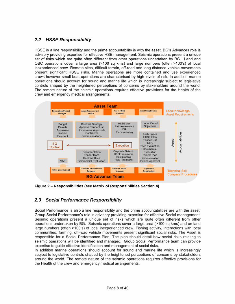
Page 8 of 40
2.2
HSSE Responsibility
HSSE is a line responsibility and the prime accountability is with the asset, BG’s Advances role is advisory providing expertise for effective HSE management. Seismic operations present a unique set of risks which are quite often different from other operations undertaken by BG. Land and OBC operations cover a large area (>100 sq kms) and large numbers (often >100’s) of local inexperienced crew. Remote sites, difficult terrain, off-road and long distance vehicle movements present significant HSSE risks. Marine operations are more contained and use experienced crews however small boat operations are characterised by high levels of risk. In addition marine operations should account for sound and marine life which is increasingly subject to legislative controls shaped by the heightened perceptions of concerns by stakeholders around the world. The remote nature of the seismic operations requires effective provisions for the Health of the crew and emergency medical arrangements.
Figure 2 – Responsibilities (see Matrix of Responsibilities Section 4)
2.3
Social Performance Responsibility
Social Performance is also a line responsibility and the prime accountabilities are with the asset, Group Social Performance’s role is advisory providing expertise for effective Social management. Seismic operations present a unique set of risks which are quite often different from other operations undertaken by BG. Seismic operations cover a large area (>100 sq kms) and on land large numbers (often >100’s) of local inexperienced crew. Fishing activity, interactions with local communities, farming, off-road vehicle movements present significant social risks. The Asset is responsible for a Social Performance Plan. The plan should detail how social risks relating to seismic operations will be identified and managed. Group Social Performance team can provide expertise to guide effective identification and management of social risks. In addition marine operations should account for sound and marine life which is increasingly subject to legislative controls shaped by the heightened perceptions of concerns by stakeholders around the world. The remote nature of the seismic operations requires effective provisions for the Health of the crew and emergency medical arrangements.
BG Advance Team
Asset Team
Chief Geophysicist Chief Geophysicist
Asset HSSE Asset HSSE Manager Manager
Advance HSSE Advance HSSE Manager Manager
Asset Procurement Asset Procurement Officer Officer
Advance Procurement Advance Procurement Engineer Engineer
Exploration/Project Exploration/Project Manager Manager
Asset Geophysicist Asset Geophysicist
Operation Operation Geophysicist Geophysicist Technical Skill
Company Procedures
Local Knowledge Asset Requirements
Budget Permits
Approvals Invoice
Payment
Contract Strategy Approve Tender List
Government Approvals Contractor
Communications
Documentation Tender Docs
Contract Docs Commercial Evaluation
HSSE Plan
EIA
Training
Local Coord Objectives
Tech Specs HSSE Plan Tender List
QC ’ s Tech Evaluation
Commercial Evaluation
Project Plan Communication Invoice Approval VAF
A
Accountabilities
BG Control Execution
BG Advance Team
Asset Team
Chief Geophysicist Chief Geophysicist
Asset HSSE Asset HSSE Manager Manager
Advance HSSE Advance HSSE Manager Manager
Asset Procurement Asset Procurement Officer Officer
Advance Procurement Advance Procurement Engineer Engineer
Exploration/Project Exploration/Project Manager Manager
Asset Geophysicist Asset Geophysicist
Operation Operation Geophysicist Geophysicist Technical Skill
Company Procedures
Local Knowledge Asset Requirements
Budget Permits
Approvals Invoice
Payment
Contract Strategy Approve Tender List
Government Approvals Contractor
Communications
Documentation Tender Docs
Contract Docs Commercial Evaluation
HSSE plan Risk Assessment
EIA Perf monitoring
Local Coord Objectives
Tech Specs HSSE Plan Tender List
QC ’ s Tech Evaluation
Commercial Evaluation
Project Plan Communication Invoice Approval VAF
Agr
ee
Acc
ount
abilit
ies
BG Control Execution
Corporate Seismic HSSE framework
Best practice HSE Risk Mgmt
Page 9 of 40
2.4
Procurement and Financial Matters
Procurement will be carried out by either the Asset or BG Advance Procurement, depending on each asset’s in-country requirement. Procurement responsibility shall be determined at the point of identifying a seismic operations requirement and agreed between Procurement in BG Advance and the Asset. All procurement will adhere to local legislation as well as BG Business Principles and Procurement Policies and Assurance Framework. BG Advance will supply budget estimates, scopes of work, technical specifications and input into potential contractors. It is recommended this process commences as soon as possible (ideally greater than 1 year before required) so that a suitable contracting strategy can be implemented. Upon contract award, the Asset will be responsible for raising and issuing the Purchase Order in SAP, irrespective of whether the Procurement was carried out by the Asset or BG Advance. The PO must be based on the terms of the Contract, and the value agreed in the Contract Approval Form or Agreement for Expenditure (form type shall vary depending on each assets internal requirement). Invoices shall be submitted to the nominated BG Representative in the Asset, and the Asset shall be responsible for reviewing the invoice and ensuring the BG Advance Operations Geophysicist has reviewed and approved this, before the Asset approves the invoice for payment in SAP through SES process. It is important that all personnel and contractors are paid promptly as there is a limited number of contractors and expertise in the market.
2.5
Security
Security of all personnel is the responsibility of the asset and shall be taken into account from the earliest opportunity as it will impact the timing, cost and complexity of the operation. The security issues can vary significantly from one area to another, from danger of kidnapping and extortion, theft and current/past military activity (mines/munitions etc) to requirements of military presence and escorts. It is vital that these are coordinated by personnel who understand the workings of a seismic operation. BG Group Security standards and guidelines provide the details for effective management of security.
2.6
Permitting
The asset is usually responsible for most of the permitting. It is important that the operation does not mobilise the contractor until all these are in place and this will require a clear understanding of what the requirements are and how long the process will take. The process cannot usually commence until the timing and in the case of marine surveys till the work vessels are identified.
2.7
Government
The asset is usually responsible for most of the government relations. It is important that these are considered on both the local and national level. In many cases dialogue should be set up with the contractor especially if it’s a new country entry as they may already have good contacts which can be developed. .
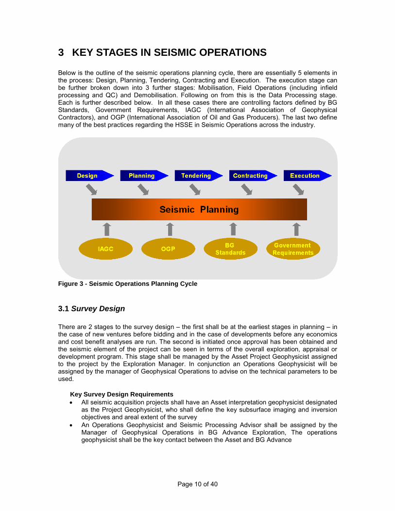
Page 10 of 40
3 KEY STAGES IN SEISMIC OPERATIONS Below is the outline of the seismic operations planning cycle, there are essentially 5 elements in the process: Design, Planning, Tendering, Contracting and Execution. The execution stage can be further broken down into 3 further stages: Mobilisation, Field Operations (including infield processing and QC) and Demobilisation. Following on from this is the Data Processing stage. Each is further described below. In all these cases there are controlling factors defined by BG Standards, Government Requirements, IAGC (International Association of Geophysical Contractors), and OGP (International Association of Oil and Gas Producers). The last two define many of the best practices regarding the HSSE in Seismic Operations across the industry.
Figure 3 - Seismic Operations Planning Cycle
3.1 Survey Design
There are 2 stages to the survey design – the first shall be at the earliest stages in planning – in the case of new ventures before bidding and in the case of developments before any economics and cost benefit analyses are run. The second is initiated once approval has been obtained and the seismic element of the project can be seen in terms of the overall exploration, appraisal or development program. This stage shall be managed by the Asset Project Geophysicist assigned to the project by the Exploration Manager. In conjunction an Operations Geophysicist will be assigned by the manager of Geophysical Operations to advise on the technical parameters to be used. Key Survey Design Requirements
• All seismic acquisition projects shall have an Asset interpretation geophysicist designated as the Project Geophysicist, who shall define the key subsurface imaging and inversion objectives and areal extent of the survey
• An Operations Geophysicist and Seismic Processing Advisor shall be assigned by the Manager of Geophysical Operations in BG Advance Exploration, The operations geophysicist shall be the key contact between the Asset and BG Advance

Page 11 of 40
• Assess project in relation to Health, Safety, Security and Environment risks, e.g. security threats, sound and marine life, terrain, environmental constraints, impact on local communities and crew availability.
• Operations Geophysicist and Seismic Processing Advisor to advise on seismic acquisition/processing design, parameters, timing and cost
• Asset Exploration Manager to secure budget approval • Redefine seismic acquisition/processing design, parameters, timing and cost in light of
overall project requirements • Identify all asset or 3rd
• Fully identify expected Geophysical requirements of the data beyond horizon interpretation – ie Inversion, Characterisation, Pre-Stack Depth Migration etc
party activity in and around survey area such as drilling, production operations, offshore platforms, diving and other seismic activity in the area.
• Commission detailed survey design – essential for all land, OBC and complex marine operations.
Typical Issues • Failure to identify arrival of rigs in the area (noise and standby issues $0.5m/day) • Failure to appreciate the strength of fishing lobby (unable to shoot survey returned
following year) • Failure to understand impact of migration apertures on cost of survey (on a small survey
this can double the area to be shot and the cost)
3.2
Planning
This stage expands the project and will bring on all the other stakeholders in the process such as HSSE, Social Performance, Procurement and Security. It will also initiate collaboration between the Asset and BG Advance specialists. It is vital that the responsibilities are clearly assigned at this stage. The roles will vary depending on the maturity of the asset, the type of survey, and the expected issues that are likely to be confronted in executing the seismic operation.
Key Planning Requirements • Define roles and responsibilities of key personnel – Exploration Manager, Asset Project
Geophysicist, BG Advance Operations Geophysicist and BG Advance Processing Advisor
• Identify and recruit a full time project manager (this will be a requirement for most Land, OBC and complex marine operations)
• Establish nominated Procurement person either in Asset or BG Advance, and engage them in considering contracting strategies and market and internal forces influencing tendering options.
• Identify Asset HSSE support for the seismic exploration project and define the role of BG Advance HSSE Manager.
• Develop BG HSSE and Social Performance Risk Register following an initial Internal Hazard Identification Workshop to feed into the contract and later HSSE and Social Performance plans (note this needs to be followed up post award with a further workshop involving all stakeholders)
• Finalise survey design to address detailed technical requirements and HSSE risks to a level suitable for tendering
• Understand all legal and permitting requirements and obtain approval from Government agencies.
• An EIA shall be undertaken for the seismic survey that will identify, assess and mitigate risks to the environment and stakeholders, including local communities;

Page 12 of 40
• Where required by local regulations the EIA shall be submitted to and approved by the responsible regulator. The scale and scope of the EIA should reflect the scale of the survey and the sensitivity of the area (Ref: BG tool - Encompass).
• For offshore surveys, particular attention shall be paid to the issue of sound and marine life (Ref: BGA-EXP-GEN-GL-06 Guideline for Minimising Acoustic Disturbance to Marine Mammals).
• Operations and Asset Geophysicist to engage with external stakeholders such as partners and national and local governments
• Ensure ancillary work is planned to mitigate HSSE and social risks i.e. hazard identification (shallow water, neighbouring fishing communities, UXO etc)
• Identify other planned work in the area that may change the contracting strategy (save on mobilisation) or impact on timing (ie to eliminate timesharing)
• Ensure ancillary work is planned for enhancing geophysical data quality ie uphole’s, LVL refraction surveys, incorporating non seismic surveys, obtaining existing seismic and non seismic data
• Preparing well data ie reprocessing Sonic logs, Dipole Sonic logs etc • Initiate rock physics studies and modelling. • Plan to ensure that contracted BG Project Manager and QC’s have required BG HSSE
training • Develop key messages for affected local communities, with support from Group/Asset
Social Performance team. • Further define the Contracting Strategy
Typical Issues • Permitting delays (standby issues $0.5m/day) • Failure to identify shallow water area (marked as a wreck on charts – necessitating
shallow hazard survey and consequent delays – mitigated additional costs by strong contractual terms)
• Failure to understand amount of work required and need for Project Manager • Failure to identify shipping channels in the survey area, leading to curtailment.
3.3
Tendering
Tendering shall commence as soon as possible so that the required resources can be secured. The tendering, strategy and timescales shall consider the prevailing market conditions. In some countries this process can be very protracted, requiring government and partner approvals. If not appropriately allowed in the strategy timeframe, this can seriously delay the project and can frequently take significantly longer than the field operations. The tendering will be done by either the asset or BGA Procurement making use of existing Pro Forma Contract and Tendering documents from BGA Procurement and Technical Specs from Geophysical Operations. It is important that BG presents a standard view to contractors, and that Procurement activity is performed within the Procurement Policies and Assurance Framework. It is also important that Geophysical Operations are fully involved in the technical and commercial evaluations as it will not be clear to people unfamiliar with the international market and technological advances in seismic operations of the impact of differences between contractors equipment on the duration (and hence cost) of the project.
Key Tendering Requirements • Asset Exploration Manager to approve ITT process and bid list and to agree which
Procurement team would conduct the ITT process • Geophysical Operations Geophysicist to write scope of work and define technical
specifications and include HSSE and Social Performance sections to ITT

Page 13 of 40
• Procurement to control tendering process and evaluation and to ensure tender meets current Pro Forma
• Evaluation criteria (hurdles and weightings) to be agreed between Asset and BG Advance Geophysical Operations
• Evaluation of tenders shall adhere to local government regulations. Evaluation of technical and commercial bids shall be strictly segregated to adhere to BG’s internal and Procurement standard
• Use of electronic procurement portal where possible • BG Advance Operation Geophysicist to perform technical evaluation • BG Advance Operations HSSE specialist to perform HSSE evaluation and have it
approved by Asset HSSE • BG Advance Operations Geophysicist to assist in defining basic commercial evaluation
criteria to be performed by BG Procurement • BG Procurement to perform commercial evaluation in asset • BG Advance Operations Geophysicist perform or to check and add detail to initial
commercial evaluation (ie impact of equipment and weather) • All shortlisted contractors shall be audited and required to have robust HSSE
management systems and approach to identifying social risks. • BG Advance Operations Geophysicist to write recommendation for submission to
Procurement Representative • Procurement Representative to seek approval of recommendation • MMOs will be used unless the EIA states otherwise. Ideally BG shall contract the MMOs
directly. • PAM, combined with Pamguard software, will be used based on risk or as required by
regulator.
Typical Issues • Failure to identify all extra costs (extra chase boats, fuel costs) • Failure to identify physical differences between offered equipment and their impact on the
timing of the operations and subsequent costs • Failure to understand impact of weather on different contractors and subsequent costs
3.4
Contracting
Contract negotiations shall be conducted by BG Procurement in conjunction with the Asset Project Geophysicist and the BG Advance Operations Geophysicist. It is essential these are carried out with advice from BG Advance Procurement where the procurement responsibility lies with the Asset, to ensure that the Company keeps a consistent approach to contracting with the contracting market worldwide. This is particularly important regarding liabilities and some technical aspects such as allowable noise levels. The final contract must be approved by the Asset. Key Contracting Requirements
• Asset exploration manager to approve award of the tender to contractor deemed to have offered best bid, balancing technical, HSSE and commercial aspects
• Procurement to conduct contract negotiations with contractor in conjunction with Asset Project Geophysicist and BG Advance Operation Geophysicist
• Project Manager engaged • Project Manager and BG Advance Operation Geophysicist to ensure field operations
logistics and issues such as technical variations, HSSE issues, social performance issues, project timescales and schedules are factored into contract negotiations.

Page 14 of 40
• It is strongly suggested that at this point the contractor and BG Advance Operations Geophysicist compare estimated costs to completion.
• BG Advance Operations Geophysicist to draw up detailed cost estimate including all ancillary costs such as QC’s, SSA time and processing.
• Contractor to be made aware of all requirements for managing environmental and stakeholder, including local community, risks
• Social Performance Plan to identify how social risks will be managed and key messages will be delivered to engage the local community (fishing, villages, tribal, regional and local administration)
• Conduct an operational audit of contractors crew on previous ‘job’ • BG QC’s and HSSE representatives identified and HSSE induction & Behavioural Based
Training instigated • Develop security plan (if required) • BG shall contract the MMOs. • PAM operator may be contracted by BG or by seismic contractor.
Typical Issues • Significant issues identified with actual crew being proposed (poor HSSE standards) • Contractors failure to understand the environment and terms that they are required to
work in (long running disputes and litigation on liabilities) • Budget does not include full costs of work ie Audits, QC’s, SSA time etc
3.5 Execution The execution stage is the most complex element and the mobilisation stage is the most important of all. The success of this stage will largely determine how smoothly the rest of the project runs. The logistics involved should not be under estimated, and most of this will be under the control of the contractor. The project manager will be monitoring and facilitating their progress whilst ensuring that BG’s standards and procedures are implemented. How this is done will largely determine the relationships throughout the contract. It is vital that the BG Advance Operations Geophysicist and the Project Geophysicist coordinate their activities to provide clear leadership and support to the Project Manager. It is also important that the chain of command is not compromised; although the Project Manager may not be BG personnel, they shall (if chosen correctly) have the most experience in that environment of running Seismic Operations (they are usually ex contractor Party Chiefs or Country Managers). Land operations will involve the contractor employing large numbers of local labour and training them in HSSE and technically – this does not happen instantaneously and will be ongoing throughout the project. It is vital that BG does not take control over any elements of the project which will expose it to liability not covered by the contract or be considered as a change of terms (ie changing working hours) without making a contractual amendment. In addition it is important that the processing is considered as part of the process, meeting aggressive deadlines will require a coordinated approach between acquisition and processing – delivering fast track volumes, priority areas etc.
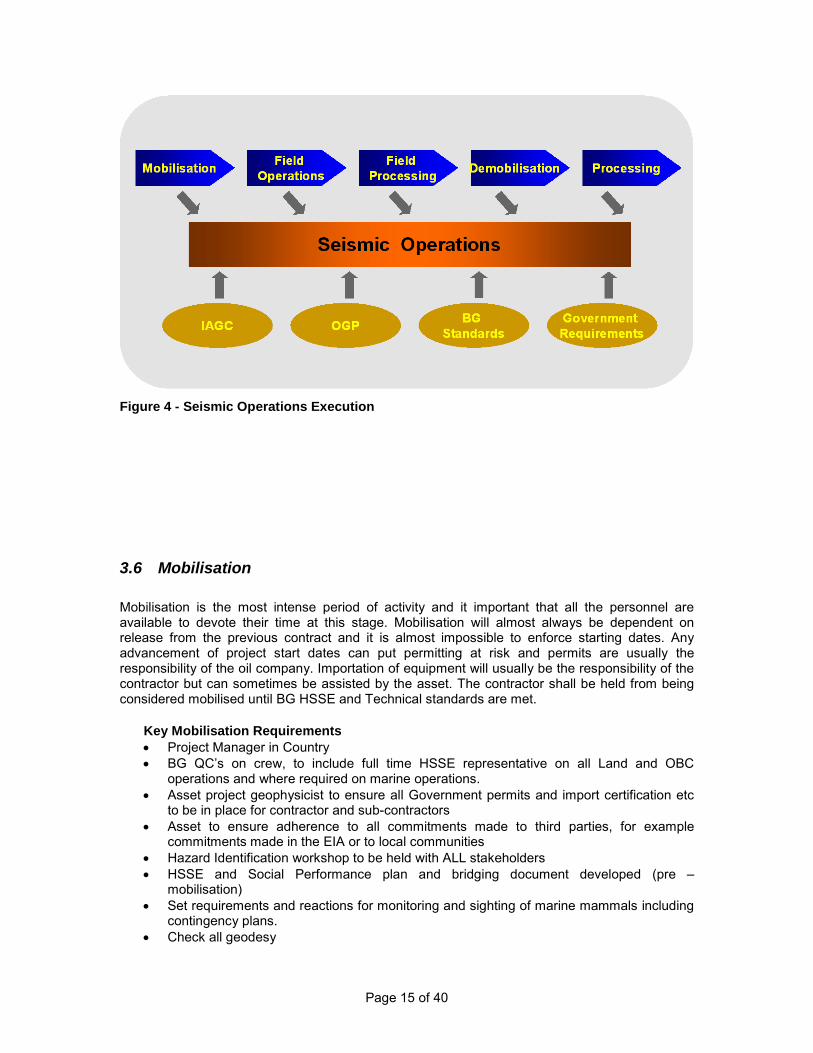
Page 15 of 40
Figure 4 - Seismic Operations Execution
3.6 Mobilisation Mobilisation is the most intense period of activity and it important that all the personnel are available to devote their time at this stage. Mobilisation will almost always be dependent on release from the previous contract and it is almost impossible to enforce starting dates. Any advancement of project start dates can put permitting at risk and permits are usually the responsibility of the oil company. Importation of equipment will usually be the responsibility of the contractor but can sometimes be assisted by the asset. The contractor shall be held from being considered mobilised until BG HSSE and Technical standards are met.
Key Mobilisation Requirements • Project Manager in Country • BG QC’s on crew, to include full time HSSE representative on all Land and OBC
operations and where required on marine operations. • Asset project geophysicist to ensure all Government permits and import certification etc
to be in place for contractor and sub-contractors • Asset to ensure adherence to all commitments made to third parties, for example
commitments made in the EIA or to local communities • Hazard Identification workshop to be held with ALL stakeholders • HSSE and Social Performance plan and bridging document developed (pre –
mobilisation) • Set requirements and reactions for monitoring and sighting of marine mammals including
contingency plans. • Check all geodesy

Page 16 of 40
• Develop and implement plans for engagement of the local community including accounting for regional/local variations across the survey area.
• Implement security plan • Pre Mobilisation HSSE audit • Pre Mobilisation Technical audit • Medivac exercise to test communications and resources within first few days of operation • Review of risk register and enforcement of mitigation measures • Operating phase HSSE audit within 1 month of start of operation • Senior management visit by Asset • HSSE Incentive scheme evaluated and if required then established • Daily and weekly reporting structure including HSSE performance to be set up
Typical Issues • BG QC’s not able to get to crew because of changes to timing • Medivac fails to work, helicopters not available, hospitals not staffed, phones don’t work • Survey in wrong place due to error in transforming coordinates
3.7 Field Operations Once operations have started it is important that the crew is developed to improve its HSSE performance, productivity and quality. This requires not just active engagement by the Field QC’s but direction from the Project Manager and BG Advance Operations Geophysicist. Communication is the key to this. In practice most operations will encounter HSSE and technical problems. These need to be dealt with pro-actively, using engagement of all parties. It must be noted that the Project Manager and QC’s are free individuals and good ones are not easily replaced – how they are treated will determine whether they work for BG again. Contractors are also limited and availability is the key; poor management of problems will cost BG money in the future. Also at this stage it is important that community relationships are monitored – this is often more important to BG than the contractor as we are likely to be drilling later and have responsibilities to the affected community.
Key Requirements for Field Operations Requirements • Daily and Weekly reporting from the Field QC’s and HSSE representatives • Ensure Field QC’s are active on the crew • Summary reporting from the Project Manager • Project Manager organising BG personnel rotations and logistics to and from the crew • Project Manager visibility on the crew • Project Manager and BG Advance Operations Geophysicist engagement with Party Chief • BG visibility on the crew, with senior management visits to Land and OBC crews • Senior management engagement with contract Country Manager • Operational HSSE audit to be conducted within 1st
• BG Advance Operations Geophysicist to sign off on all invoices month of start up
• Project Geophysicist to ensure prompt payment of all invoices • Ongoing HSSE and Social Performance plan to be implemented, HSSE performance
monitoring and initiatives. • Behaviour Based Safety to be implemented if appropriate culture and project duration
permits • Environmental mitigation measures identified in the EIA, particularly for offshore surveys
in relation to sound and marine life, shall be implemented (Ref: BGA-EXP-GEN-GL-0006 Guideline for Minimising Acoustic Disturbance to Marine Mammals from Seismic and Site Surveys)
• Involve NOC/Government personnel if required
Page 17 of 40
• Project Geophysicist and Project Manager to ensure community relationships are not deteriorating
• Follow up on HSSE and Technical audits
Typical Issues • QC’s not performing as expected on crew (HSSE QC’s not engaging with field
operations) • Lack of BG visibility on crew to ensure BG’s standards are implemented (not that of
previous client) • Community and staff relationships getting out of hand (insufficient entertainment leading
to ‘riot’ like situations, alcohol abuse) • Failure to maintain HSSE standards (poor driving standards, sound and marine life
monitoring and mitigation, failure to maintain journey planning control)
3.8
Infield Processing
Infield processing can serve two purposes, the first is to check data quality and the second is to fast track data. Fast tracking data will require a high level of expertise in the field and some good knowledge of the data in the area. Checking of data quality with basic stacks is essential and can frequently allow judgements to be made on the data quality allowing data to be accepted that would fail the prescribed technical specifications. This is particularly important in adverse environments where wind noise, sea states or man made noise is problematic. However to make use of this it is important that the correct communications are in place to make this data available to both the BG Advance Operations Geophysicist and the Seismic Processing Advisor. Fast track processing can serve a useful purpose but the fact that the whole sequence must be determined in a short time on the first few lines acquired and the lack of experience in the field usually means the product will be only of use for general structural mapping.
Key Infield Processing Requirements • BG Advance Operations Geophysicist to determine basic infield QC products • BG Advance Operations Geophysicist to ensure field QC understand products • Processing Advisor to determine infield processing requirements • Project Manager to ensure suitable communication route to BG Advance Typical Issues • QC’s produce products but don’t analyse them failing to identify problems • Wrong record lengths, source errors • Data rejected due to noise that could be accepted (increasing costs)
3.9
Demobilisation
Demobilisation is a critical part of the project and where BG personnel are often not fully engaged. It is important that the crew is monitored carefully in terms of HSSE as this is a stage where the pattern of operations is disrupted and hence prone to unexpected problems. It is also a stage where it is important to ensure that the environment is restored to its previous condition, and any issues mitigated to the satisfaction of the local community
Key Demobilisation Requirements • Maintain focus on HSSE until ‘off contract’

Page 18 of 40
• BG Field QC’s, HSSE and Project manager to issue project reports • Contractor to issue final project report • Project Manager to ensure delivery of field tapes and ALL positional field data to
processing contractor from the contractor before they leave the field of operation/or on marine start the next project
• Project Geophysicist to ensure all government data regulations are met • Project Manager to ensure contractor meets all environmental reinstatement
requirements
Typical Issues • Data not delivered from crew for months • Reports not completed and do not include relevant data (ie Geodetics)
3.10 Data Processing Data processing shall commence as soon as it is feasible to get the first data from the field. Data shipments should be organised on about a 2 weekly basis. Fast track volumes should be planned from the earliest possible dates but it is important that there are not too many output dataset deliveries or errors may occur (ie multiple fast track deliveries). Close involvement from the Asset Project Geophysicist is essential for good data quality. This requires availability at key stages such as start-up, velocity interpretation and final parameter selection.
Key Data Processing Requirements • Project Manager to ensure initial data delivery is as soon as possible, minimum of 1 line • Project Manager to ensure deliveries every 2 weeks approximately • Project Manager to ensure contractor pays all dues required by customs • Project Manager to ensure comprehensive transmittals • Project Manager to ensure all relevant data is shipped together • Processing Advisor to organise start up meeting with Project Geophysicist and Contractor • Project Geophysicist to be involved in velocity interpretation and velocity modelling • Processing Advisor to ensure schedules are realistic • Processing Advisor to select optimum sequence and ensure delivery
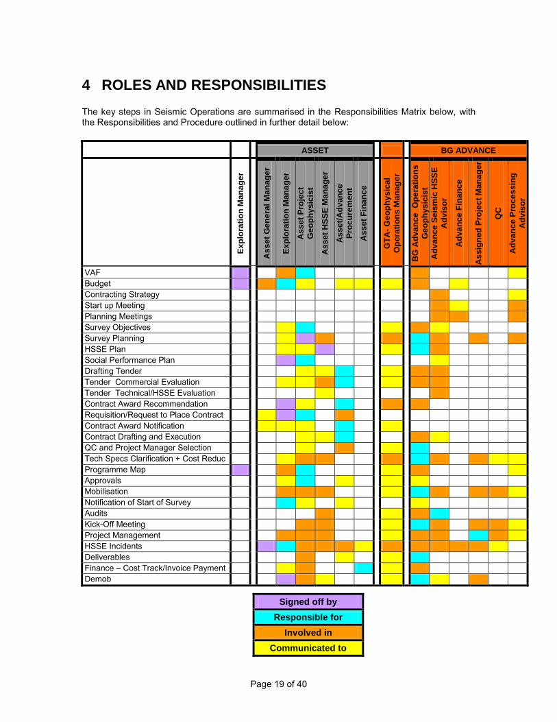
Page 19 of 40
4 ROLES AND RESPONSIBILITIES The key steps in Seismic Operations are summarised in the Responsibilities Matrix below, with the Responsibilities and Procedure outlined in further detail below: ASSET BG ADVANCE
Expl
orat
ion
Man
ager
Ass
et G
ener
al M
anag
er
Expl
orat
ion
Man
ager
Ass
et P
roje
ct
Geo
phys
icis
t
Ass
et H
SSE
Man
ager
Ass
et/A
dvan
ce
Proc
urem
ent
Ass
et F
inan
ce
G
TA- G
eoph
ysic
al
Ope
ratio
ns M
anag
er
B
G A
dvan
ce O
pera
tions
G
eoph
ysic
ist
Adv
ance
Sei
smic
HSS
E A
dvis
or
Adv
ance
Fin
ance
Ass
igne
d Pr
ojec
t Man
ager
QC
Adv
ance
Pro
cess
ing
Adv
isor
VAF Budget Contracting Strategy Start up Meeting Planning Meetings Survey Objectives Survey Planning HSSE Plan Social Performance Plan Drafting Tender Tender Commercial Evaluation Tender Technical/HSSE Evaluation Contract Award Recommendation Requisition/Request to Place Contract Contract Award Notification Contract Drafting and Execution QC and Project Manager Selection Tech Specs Clarification + Cost Reduc Programme Map Approvals Mobilisation Notification of Start of Survey Audits Kick-Off Meeting Project Management HSSE Incidents Deliverables Finance – Cost Track/Invoice Payment Demob
Signed off by Responsible for
Involved in Communicated to
Page 20 of 40
4.1 VAF
Responsibility
The Asset Project Geophysicist shall ensure that the project follows these VAF guidelines and is part of the Group E&A Work Programme or is part of the Appraisal and Development Programme.
Procedure
The normal procedure is that the program will be part of the approved Group Forward E&A Work Programme. These projects will then require formal EAC approval for expenditure on a project by project basis.
4.2 Budget
Responsibility
It is important that Geophysical Operations are involved at the earliest stages of exploration, prior to bidding for blocks to ensure that seismic exploration costs are fully understood for the subsurface target and the surface topography and conditions. For development work it is essential that Geophysical Operations identify the key criteria that will ensure delivery of a seismic ‘development’ dataset that includes possibilities for 4D, fracture identification etc and that these costs are reflected in the budgetary estimates The Operations Geophysicist will provide the Exploration Manager with a budget estimate for the work. The budget shall include the cost of the total project, ie. Acquisition Contractor, Project Management, QC, Audits, Ancillary costs such as Chase Boats, Compensation, Fuel, Explosives etc. An estimate of SSA time required from BG Advance shall also be included. The Asset Exploration Manager is responsible for obtaining budget approval from the Exploration Committee and for informing the operations group of approved work following the annual budget approval. This will be for acquisition, processing, VSP’s and site surveys. It is also important that allowances are made for budgetary expenditure prior to the main acquisition contract to cover costs for Project Managers, QC’s, Audits, HSSE, and Social Performance etc.
Procedure
The Asset Exploration Manager will inform the Operations Group in writing the preferred timing and of any timing constraints of all projects ranked ‘A’ for the following year and any other work that becomes likely during the course of the year.
4.3 Contract Strategy
Responsibility
BG Advance Procurement is responsible for compiling the BG Global Geophysical Operations Contract Strategy for the forthcoming 2-3 years (on a rolling basis). Input shall be provided from

Page 21 of 40
Asset and Advance Geophysicists and Processing Advisor, with sign off in each asset from Exploration Manager and Asset General Manager. The ITT process and contracting strategy for each project shall be determined by the Asset Procurement Representative, with input from the BG Advance Project Co-ordinator. Asset Exploration Manager will approve the process.
Procedure
At the beginning of each year, Advance Procurement shall create the Geophysical Operations Contract Strategy, identifying where projects are approved and the associated contracting requirements over the rolling 2-3 year timeframe. At this stage, the responsibility for Procurement between Asset and Advance shall be identified. For each project, the Procurement Representative will propose a contract strategy to be reviewed by BG Advance Operations, and Procurement where the Asset is conducting the Procurement. BG Advance will ensure that a consistent strategy is maintained and developed across all assets, identify any possible synergies across assets, ensure costs are minimised and a single vision of BG is presented to the market. The contract strategy shall consider all services required including project management, audits, QC and processing. The ITT process for the project will consider the timing due to environmental factors such as weather and seasonal factors, identify permits required and how long they will take, and ensure contingency measures are in place should there be any delays. It is important that the key personnel are identified at this stage and roles and responsibilities are defined. In particular
i) Budget ii) AFE iii) Purchase Orders iv) Who invoices will be directed to? v) Approvals for Payment
As a guide, these shall be in line with the Roles and Responsibilities Matrix. (Section 4)
4.4 Start up Meeting
Responsibility
The Asset Project Geophysicist is responsible for setting-up and minutes of an initial meeting to review survey objectives with Exploration or Development Teams, Acquisition, Processing & Modelling Specialists and HSSE Specialists, Social Performance representation and documenting the survey objectives and requirements, areal extent, budgetary constraints and timescale.
Procedure
The Asset Project Geophysicist will set-up and minute an initial meeting to review survey objectives and assign roles with Exploration or Development Teams, Acquisition, Processing & Modelling Specialists, HSSE and Social Performance Specialists. These requirements may include AVO analysis, inversion or depth imaging. Any license commitments etc must be considered. The Operations Geophysicist will assist the Asset Project Geophysicist to define the survey giving advice on costs, logistics, survey design and survey timing. The Asset Project

Page 22 of 40
Geophysicist will ensure that the HSSE and Social Performance are consulted and provision is made in the budget for any necessary health, safety, community, security or environmental work relevant to the geophysical operation. The Asset Project Geophysicist will then document the survey objectives and requirements, areal extent, budgetary constraints and timescale and pass these to the Operations Geophysicist.
4.5 Planning Meetings
Responsibility
The Operations Geophysicist is responsible for organising and running the planning meetings.
Procedure
The Operations Geophysicist will organise planning meetings at appropriate intervals in the run up to the survey. The Operations Geophysicist will ensure that the Asset Project Geophysicist, Operation HSSE Advisor, Social Performance, Procurement and any other relevant personnel are represented at these meeting. All meetings will be minuted.
4.6 Survey Objectives
Responsibility
The Asset Geophysicist is responsible for defining the survey objectives and framing the project.
Procedure
The Asset Geophysicist will define the survey area and objectives with reference to previous geophysical work in the area, noting any deficiencies or problems in data quality. They will also clearly state the time frame for the project.
4.7 Survey Planning Document
Responsibility
The Operations Geophysicist is responsible for designing the technical specifications and method that will meet the defined Survey Objective taking into account the sampling requirements required by the processing to produce the results required for imaging, inversion and characterisation. They shall also be responsible for compiling a Survey Planning Document formalising survey objective, techniques and perceived risks and including a scope of work for the tender document.
Procedure
The Operations Geophysicist will plan the survey to ensure that the Project Teams objectives are met in the most cost effective and timely manner. This shall include an appraisal of all appropriate techniques. BG Advance Seismic HSSE Advisor will recommend on the HSSE implications of any proposed techniques. The Asset Project Geophysicist will specify the datum and projection information to be used for the project in accordance with BG's Geodetic Guidelines. The Operations Geophysicist will
Page 23 of 40
ensure that these are written into the technical specifications and are used for all positioning information. The Operations Geophysicist will produce a Project Scope of Work and Technical Specifications for tendering purposes after consultation with the Asset Project Geophysicist using the latest standard documentation, examples can be found on H:\Geophys\Technical Resources\Standards Documents\Contract Models – Scope of Work and Technical Specifications In addition material is available on relevant OGP, UKOOA and IAGC guidance and regulations H:\Geophys\Technical Resources\Standards Documents\Industry Standards. Finally standard formats such as tape formats are defined in H:\Geophys\Technical Resources\Standards Documents\Seismic Standards The Operations Geophysicist will produce a Survey Planning Document that will describe the objectives of the survey, the methods and equipment to be used, the timing of the survey, terrain and logistical factors, tides, currents and weather, HSSE risks and sampling requirements for processing. This document will be signed off by the Asset Project Geophysicist.
4.8 HSSE Plan
Responsibility
The BG Advance Operations Seismic HSSE Advisor is responsible for liaising with the Asset HSSE support to produce a robust project HSSE plan. The HSSE plan will present the necessary activities to meet the HSSE goals and objectives of the survey work. . The Advance Seismic HSSE advisor will work with the Operations Geophysicist and Asset HSSE Advisor to compile a Risk Register and ensure that HSSE audits are carried out. This will take into account the conditions from the Environmental Impact Assessment. The detailed roles and responsibilities will form part of the HSSE plan produced during pre-mobilisation stage in the project.
Procedure
At an early stage in the project the Asset Project Geophysicist will consult with the Operations Geophysicist and their HSSE support to determine what level of HSSE planning for the survey is necessary. The Operations Seismic HSSE Advisor shall work with Operations Geophysicist to produce a HSSE risk register very early in the project that aids to identify and address HSSE risks during the Project lifecycle. Actions from this risk assessment will be incorporated into the ITT. Any specific HSSE requirements will be communicated to the Operations Geophysicist in a timely manner such that any operational constraints can be included in the tender process if required. The HSSE risk register would be updated to feed into the detailed Project HSSE plan. The HSSE plan will be project specific and follows the BG standards and guidelines as well as the OGP report no. 6.92/317 titled ‘HSE aspects in a contracting environment for geophysical operations’. If any local or government authorities require a specific HSSE requirement (e.g. Environmental Impact Assessment, Security permits), the Asset HSSE Manager will ensure that it is carried out in good time and the results are presented to the regulatory body and consents obtained within the time limit. The Asset HSSE Manager will sign off confirming the level of assessment is sufficient for the operation.

Page 24 of 40
The Operations Geophysicist will ensure that any required modifications to the survey based on the identified environmental risks (which are typically collated within the Environmental Impact Assessment) are carried out, and that these requirements are accepted and understood by the geophysical contractor and the QC Supervisor. The Operations Seismic HSSE and Operations Geophysicist will work with the contactor to merge BG’s HSSE plan with that of the contractors. It is vital that a detailed Hazard Identification Workshops is held with all the stakeholders and there is no over-reliance on pro forma summaries from the contractor. It is the Core management team’s responsibility to ensure the contractor compiles a detailed operational HSSE contingency (the contractor HSSE plan) and operational project plan. The Operations Geophysicist will ensure that the contractor contingency plan has been approved by Asset HSSE Advisor and is lodged in the assets Emergency response room.
4.9 Social Performance Plan
Responsibility
The Asset Project Geophysicist is responsible for liaising with the Group Social Performance to produce a robust project Social Performance plan. The Social Performance plan will present the necessary activities to meet the Social Performance goals and objectives of the survey work. . The Asset Geophysicist and Group Social Performance advisor will work with the Operations Geophysicist to compile a Risk Register and ensure that mitigation measures are carried out.
Procedure
At an early stage in the project the Asset Project Geophysicist will consult with Group Social Performance advisor and the Operations Geophysicist to determine what level of Social Performance planning for the survey is necessary. The Asset Project Geophysicist shall work with Group/Asset Social Performance and Operations Geophysicist to produce a Social Performance risk register very early in the project that aids to identify and address Social risks during the Project lifecycle. Actions from this risk assessment will be incorporated into the ITT. Any specific Social requirements will be communicated to the Operations Geophysicist in a timely manner such that any operational constraints can be included in the tender process if required. The Social Performance risk register would be updated to feed into the detailed Project Social Performance plan. The Social Performance plan will be project specific and follows the BG standards and guidelines The Asset Project Geophysicist and Operations Geophysicist will work with the contactor to merge BG’s Social Performance plan with that of the contractors. It is the Core management team’s responsibility to ensure the contractor compiles a Social contingency and operational project plan.
4.10 Drafting Tender
Responsibility
The Procurement Representative will draft a Tender Strategy Paper summarising the Assets requirements and priorities, and propose the Bid List, with input from the Operations

Page 25 of 40
Geophysicist. Asset Project Geophysicist and Exploration Manager to approve this Paper before Tender is issued. It is recognised that in some instances, single sourcing the services may be the best contracting strategy, but this should be the exception rather than the rule. The Operations Geophysicist is responsible for preparing the Invitation to Tender Scope of Work and Technical Specifications to ensure that the Project Teams technical and budgetary requirements and schedules are met. Within the ITT there will be a clear brief from the Asset Project Geophysicist describing the extent of the survey, its geophysical objectives and geological setting. This shall also include any limitations of the currents data, poor imaging, multiples contamination, static problems, poor freq content etc. The Procurement Representative is responsible for pulling the Invitation to Tender package together, based on the technical information provided by the Operations Geophysicist, and standard Seismic Acquisition contract model and Compensation and HSSE schedules for the relevant asset. Procurement Representative shall issue the Tender package and be the single point of contact for Tender clarifications during the full tendering period in accordance with Procurement Policies and Assurance Framework.
Procedure
The Operations Geophysicist will supply the Procurement Representative with the suggested list for tenderers, Technical Specifications and Scope of Work, and a recommended tendering period following Contracting and Contract Strategy BGA-CP-CP-OS-0014 and the Contracts and Procurement Policies and Assurance Framework The Procurement Representative will prepare and send out the Invitation to Tender package. The Operations Geophysicist will inform Asset HSSE that the tender has been issued and the area and possible dates for the survey. All tender communications will be directed to Procurement Representative. Any commercial queries will be answered by the Procurement Representative and copied to Geophysical Operations to ensure there are no technical implications. Any technical queries will be answered by the Operations Geophysicist via the Procurement Representative. Responses shall be provided to all bidders unless the query relates to a bidder-specific factor.
4.11 Tender Submission Commercial Evaluation
Responsibility
Procurement Representative will arrange the Tender Opening in accordance with BG Procurement Guidelines and pass the technical documents onto the Operations Geophysicist. The Tender Evaluation Criteria will be completed by Procurement Representative and Operations Geophysicist and approved by the Exploration Manager before the tenders are opened. Procurement Representative will be responsible for evaluating the commercial submissions.
Procedure
Commercial evaluation will be done in 2 parts: pricing and contractual. All contractual qualifications will be reviewed, and resolved with the preferred bidder before award. Pricing will be evaluated by the Operations Geophysicist in order to build up an accurate total contract price. Procurement Representative will ensure that all proposed rates are comparable and that any exceptions are taken into account.
Page 26 of 40
Operations Geophysicist will ensure that the commercial evaluation fully accounts for the effects of variations in equipment on the duration of the survey. Procurement Representative will be the focal point for any Tender Clarifications and Meetings during the tender evaluation period.
4.12 Tender Submission Technical Evaluation
Responsibility
The Operations Geophysicist and Seismic Operations HSSE will review the technical content of the proposals and compile a technical tender evaluation. Operations Geophysicist will be responsible for evaluating the technical submissions, with input from Seismic Operations HSSE on the HSSE submissions and Group/Asset Social Performance on the Social Performance components of submissions. Procurement Representative will issue any tender clarifications required.
Procedure
Operations Geophysicist will evaluate each technical submission and request clarification on any unclear or undefined points through the Procurement Representative. Where there is a lengthy bid list, the Operations Geophysicist and Procurement Representative may short-list the bidders, but document clear justification for discounting those bidders not included on the short-list. The Exploration Manager and Asset Project Geophysicist will be kept up to date with evaluation progress, and submission responses to key drivers such as budget, vessel availability and budget.
4.13 Contractor Award Recommendation
Responsibility
The Asset Procurement team is responsible for writing the Contract Award Recommendation paper after a thorough tender evaluation and consultation with the Operations Geophysicist. The Operations Geophysicist will provide the estimated contract price, based on the final commercial evaluation.
Procedure
The Contract Award Recommendation paper shall summarise the evaluation, both commercial and technical, and outline the justification for the award. This shall include the total estimated contract price. The following shall be in place before Contract Award Recommendation is made:
- Where Asset Procurement is responsible for the evaluation, Procurement Representative and Operations Geophysicist will review comments and recommendations on short-listed companies
- Completed Commercial Evaluation - Technical review of contractors by Operations Geophysicist (including technical and
regional experience, training, equipment etc). - A review by the Seismic Operations HSSE advisor on the submitted documentation of
any vessels or aircraft tendered. - Updated schedules of availability of Contractors
Page 27 of 40
- The asset shall solicit input from Advance Procurement Representative if they are unfamiliar with the seismic market.
The contractor will be selected at a meeting consisting of the Asset Project Geophysicist, Seismic Operations HSSE advisor, the Operations Geophysicist and Procurement Representative. Endorsement of this paper shall be received from Procurement Representative, Operations Geophysicist, Operations HSSE Advisor, Group/Asset Social Performance representative and Asset Project Geophysicist. Approval to award shall come from either the Exploration Manager or Asset General Manager, depending on contract value. Approval of the Contract Award Recommendation paper shall follow the Financial Authorities Standards for Purchase and Invoice: http://bgportal.ad.bgep.co.uk/irj/go/km/docs/bg_documents/Content/Group%20Functions/Finance/Group%20Office%20Finance/Financial%20Authorities%20Standard/Financial%20Authorities%20Standard%2031.01.2008.xls A copy of the approval will be held by Procurement Representative with a copy supplied to the Operations Geophysicist. The Asset Project Geophysicist will report the results of the tender evaluation to any partners.
4.14 Requisition/Request to Place Contract
Responsibility
The Asset Project Geophysicist is responsible for raising the necessary approval for expenditure and ensuring that it adequately reflects the services required including the cost of the total project, ie Acquisition Contractor, Project Management, QC, Audits, Ancillary costs such as Chase Boats, Compensation, Fuel, and Explosives etc.
Procedure
The Operations Geophysicist will compile the expenditure amounts and the Asset Project Geophysicist will obtain the necessary approval signatures (both internal and from partners) to place the contract. The requisition is responsibility of the Asset Project Geophysicist. Asset Procurement shall ensure a purchase order is raised and issued to the Contractor in accordance with the agreed terms of the contract.
4.15 Contract Award Notification
Responsibility
The Procurement Representative is responsible for notifying the successful bidder of the contract award, and drafting any Letter of Intent if necessary.
Procedure
The Procurement Representative will notify the successful bidder, and follow up with drafting the contract.
Page 28 of 40
4.16 Contract Drafting and Execution
Responsibility
The Procurement Representative will draft the contract and ensuring that it is approved within Financial and Procurement Standards.
Procedure
The Procurement Representative will draft any letters of intent, letters of award and contract documents.
4.17 Project Manager and QC Selection
The Operations Geophysicist is responsible for defining the level of external or internal Quality Control services that are required and putting the relevant Project Manger and Quality Control services in place.
Responsibility
The Operations Geophysicist has overall responsibility for the data acquisition. The Project Manager will deal with most day to day operations issues and be the main contact with the QC’s in the field and the Party Chief. The Core Project Management Team will work in close consultation with the Asset Project Geophysicist.
Procedure
The Operations Geophysicist will define the level of QC services that are required for the project. Account shall be taken of the nature of the project, area, terrain, complexity, Contractor experience, HSSE and anticipated community impacts etc. when defining this level. These services may be internal or more likely from an outside consultancy, and may involve hire of QC equipment as well as personnel. As a guide most land, OBC and complex marine surveys will require a full time Project Manager based in country (rotated if required on a 4-8 week basis). In addition there will be a full time Geophysical QC and HSSE Advisor in the field (again rotated on 4-8 week basis usually out of sync with the crew rotation). Marine operations require a full time navigation QC. It is imperative that the best people are retained for these roles. The Operations Geophysicist is responsible for organising any QC services required. Provision of Project Manager and Quality Control Services will be contracted to Consultancy companies as recommended by the Operations Geophysicist. Framework Agreements have been set up with the most widely used Consultancy service providers. BG Advance Procurement shall be consulted in the first instance to establish the best contracting mechanism for securing these services. Normally the choice will be based on the best personnel available rather than on cost considerations which are normally negligible compared to the cost of the project. The following shall be in place before the contractor selection process is concluded:
- Completed cost form for the duration of the project - Agreed Contract Terms and Conditions - Technical review of potential contractors by Operations Geophysicist (including
experience, training) The QC consultant selection will be recommended by the Operations Geophysicist.

Page 29 of 40
It is recommended that all these personnel attend BG HSSE and Behavioural Based training programs before the start of work. It is also recommended that the Project Manager shall be in place and involved in the seismic acquisition contractor contract negotiations. The contract with the Project Manager and QC’s shall be made by, or on behalf of the Asset by the nominated Procurement Representative. It is possible that the personnel could be contracted by BG Advance and time-write to the asset but this cross charging is not recommended for tax reasons.
4.18 Technical Specifications Clarification and Cost Reduction
Responsibility
The Operations Geophysicist is responsible for arranging a meeting with the Contractor to ensure complete understanding of the Technical Specifications and Scope of Work and to challenge the specifications to identify possible cost reductions.
Procedures
The Operations Geophysicist will arrange meeting(s) with the Asset Project Geophysicist, Procurement, Project Manager, QC representative and the Contractor to finalise and clarify the Technical Specifications and Scope of Work. The meeting shall where possible challenge the specifications and scope in such a way as to seek cost reductions without affecting the goals of the project. Any amendments will be given to Procurement Representative.
4.19 Programme Map
Responsibility
The Asset Project Geophysicist is responsible for producing the final proposed survey outline map and corner coordinate points in consultation with the Operations Geophysicist. The Asset Project Geophysicist is responsible for commissioning a third party Geodetic Audit to ensure the integrity of the program position data supplied to the Operations Geophysicist.
Procedures
The Asset Project Geophysicist will provide the Operations Geophysicist with program maps as prescribed in the BGEP Geodetic Procedures as early in the project as possible. This map will indicate full fold area in the case of 3D seismic surveys, or full fold coverage
in the case of 2D seismic surveys i.e. care will be taken that any migration apertures are included. The program map will be clearly annotated with spheroid, datum and projection information. At this point, all incursions into adjoining blocks / waters / airspace's will be identified and communicated to all parties involved.
The Asset Project Geophysicist will commission an audit from a qualified third party surveyor to ensure the validity and continuity of the ellipsoid, datum, projection and transformation parameters specified in the program map. The Operations Geophysicist will provide the contractor with a map produced by the Asset Project Geophysicist showing the survey outline and the proposed lines.
Page 30 of 40
The contractor will return a pre-plot program map to the Operations Geophysicist who will check it for discrepancies with the original map. Special emphasis will be put on geodetic parameters and transformations following BG's Geodetic Procedures Manual.
4.20 Approvals
4.20.1 Project Permissions, Approvals and Permits
Responsibility
The Asset Project Geophysicist is responsible for confirming that all authorisations within BG have been obtained including EAC approval for the project budget expenditure. The Operations Geophysicist is responsible for ensuring that the Asset Project Geophysicist has given approval for the project plan.
Procedures
Prior to contract award, the Asset Project Geophysicist will ensure that all permissions from all the necessary BG sources have been obtained. The Operations Geophysicist will consult with the Asset Project Geophysicist to ensure that the technical objectives, program size, financial constraints and any prioritising have all been approved.
4.20.2 Partners or Co-Venturers
Responsibility
The Asset Project Geophysicist is responsible for ensuring that all necessary permissions and approvals from partners or co-venturers have been obtained.
Procedures
The Asset Project Geophysicist will determine what permissions are required from each of the partners or co-venturers and will ensure that these have been given.
4.20.3 Government / National / Local Approvals and Permits
Responsibility
The Asset Exploration Manager is responsible for obtaining permissions for international surveys. It is important that there is full understanding of how long they will take and realistic timescales are used and communicated to Procurement and Geophysical Operations. It is recommended that weekly updates are sent out on their progress.
Procedures
The Operations Geophysicist and the Asset Project Geophysicist will identify any other prospects, permits, border areas etc. that the survey will infringe (turning circles for seismic vessels for example).

Page 31 of 40
The Operations Geophysicist supply the Asset Exploration Manager with any information required to allow local permitting, import, resolution of border issues etc. The Asset Exploration Manager will then arrange for any such permission to be obtained. Consultation with impacted local communities should be undertaken prior to seismic activities, in accordance with the requirements of the BG Group Social Performance Standard. In the UK local and national government and official body permissions will be obtained as part of the PON 14 notification process. At least 90 days notice is required for some of these permissions and so the Asset Project Geophysicist will initiate the process as soon as possible. The Operations Geophysicist will supply any information that is required to assist in obtaining these permits. The Operations Geophysicist will ensure that these approvals are in place to allow the survey to proceed.
4.21 Mobilisation
Responsibility
The Operations Geophysicist is responsible for organising the survey mobilisation meeting and shall ensure attendance of the Project Manager, Asset Project Geophysicist and HSSE representation from either the Asset or BG Advance.
Procedures
The Operations Geophysicist will organise a mobilisation meeting with the contractor and QC representatives to ensure that all personnel involved are familiar with the contract requirements, and objectives, HSSE goals and objectives, social performance considerations (e.g. cultural sensitivities, key messages), priorities, reporting etc. The Operations Geophysicist will ensure the contractor employs suitable labour, engages with the local community (ie fisheries liaisons, ensures local labour is fairly distributed) and mitigating measures are in place (ie picket vessels, security etc) where appropriate from sources that will minimise potential confrontation and possible disruption. The Operations Geophysicist will ensure that reports using the Contractors or QC representatives’ standard daily and weekly reporting forms will be produced and distributed as appropriate. The Operations Geophysicist and Asset HSSE manager shall ensure the contractor and sub- contractors are operating to:- BGA-HSSE-GEN-ST-XXX BG HSSE Standards BGA –BGA-OPS-OS-0020 Entry into vessels and confined spaces BGA –BGA-OPS-OS-0022 Permit to work systems BGA –BGA-OPS-OS-0042 Hoisting and Lifting Operations BGA –BGA-OPS-OS-0043 Marine Operations Standard BGA –BGA-OPS-OS-0044 Aviation Operations Standard BG Social Performance Standard In addition they should also refer to the following OGP documents Report OGP 317 – Managing HSE in a Geophysical Contract This report makes reference to many OGP References which can be obtained free from the Web
Page 32 of 40
4.22 Notification of Commencement of Survey
Responsibility
The Asset Exploration Manager is responsible for ensuring that all relevant authorities are notified prior to the start of the survey ie UK PON14.
Procedures
The Asset Project Geophysicist/local operations manager will ensure that all relevant authorities are informed of the survey start up. The Operations Geophysicist will check that notification has been given where necessary.
4.23 HSSE Audit
Responsibility
The Operations Geophysicist will organise HSSE Audit as appropriate during the Project lifecycle. The Purchase Order for this service will be raised by the Project Geophysicist in the Asset.
The Operations Geophysicist will assess the level of auditing that the Contractor has undertaken recently, and obtain copies of these audits if possible.
Procedures
Unless deemed unnecessary, HSSE Safety Audit will be arranged on advice by the Operations HSSE Advisor. The Operations HSSE Advisor will ensure that the audit is undertaken and produce a report which will be distributed to the Operations Geophysicist and the Asset Project Geophysicist.
4.24 Kick-off Meeting
Responsibility
The operations geophysicist will arrange a kick-ff meeting with the contractor. The Asset Project Geophysicist, Asset HSSE and Social Performance representative and the Operations HSSE advisor will also attend. The contractor shall ensure that the project manager, party chief, HSSE manager, on board HSSE advisor and heads of departments (Survey, Navigation, Guns, and Vibs etc) attend. In addition BG’s QC’s shall also attend
Procedures
The contractor will be presented with the survey objectives and HSSE and Social briefing. The hazard register and technical specifications shall be worked through with the contractor on a line by line item. The Operations Geophysicist shall minute the meeting.

Page 33 of 40
4.25 Project Management
Responsibility
The Core Management Team is responsible for the survey management and for coordinating with the Asset Project Geophysicist and BG QC to ensure that the survey objectives are met. The Project Manager will handle the day to day issues under the direction of the Operations Geophysicist. The Operations Geophysicist is responsible for ensuring that all reporting is carried out as detailed below.
Procedures
The Project Manager will closely monitor the contractor and QC reports, and maintain regular (daily) communications with the QC’s in the field. They will brief the Operations Geophysicist and they will jointly agree actions required to improve crew performance throughout the survey. They will also ensure that the Asset Project Geophysicist and Exploration Manager are kept informed of progress and HSSE performance. They will create an operations project file/folder with the following sections: Section 1 - Contractors daily reports Section 2 - QC daily reports Section 3 - HSSE reports
Section 4 - Weekly environmental reports (including MMO reports and emissions Reports)
Section 5 - Contractor weekly summaries Section 6 - Contractor monthly reports If appropriate Section 7 - Navigation reports If necessary Section 8 – Health & Safety Incidents If necessary Section 9 - Environmental incidents If necessary Section 10 – Security incidents If necessary Section 11 – local community incidents The Operations Geophysicist will produce a mailing list of relevant persons to be kept informed of the survey progress and any incidents to include the HSSE departments, Asset Project Geophysicist and Head of G&G Operations. The Core Management Team will file the following reports in the project operations folder:
• Daily acquisition reports from the contractor • Daily reports from the QC • Weekly HSE reports • Weekly environmental reports • Weekly Social Performance reports • Monthly contractor reports • Weekly contractor reports • Navigation reports (if appropriate)
The Core Management Team will check the daily logs to ensure there are no health and safety, community or environmental incidents. Any such incidents will be reported immediately as per BG incident notification matrix in line with Assets’ HSSE management system. The Operations Geophysicist will produce weekly progress reports and circulate them to the project mailing list.
Page 34 of 40
4.26 HSSE and Social Performance Incidents
Responsibility
The Incident reporting procedure timings and responsibility is defined in the HSSE and Social Performance plans. In broad terms the contractor is responsible for informing the Exploration Manager of any Health and Safety, Environmental or Community incidents in an agreed manner and timeframe.
In addition the BG QC representative is responsible for informing the Operation Geophysicist of any Health and Safety or Environmental incidents.
The Exploration Manager will ensure that the Country Manager, Geophysics Manager and Operations HSSE Advisor are made aware of any minor Health and Safety or Environmental incidents.
Significant incidents will involve the Emergency response plan.
Procedures
(i) Health & Safety incidents
The contractor is required to report all notifiable Health and Safety incidents directly to the Exploration Manager. In addition all incidents involving Health or Safety will be reported by the survey BG representative to the Operations Geophysicist.
The Exploration Manager will then pass all the incident details onto Asset HSSE Manager, Operations HSSE Advisor, the Geophysical Operations Manager and Asset General Manager.
After discussions with the Asset HSSE Manager and the Core Management Team the Exploration Manager will ensure that appropriate action is taken by the BG representative and Contractor to ensure that appropriate action is taken to prevent a reoccurrence.
The Operations Geophysicist will file the incident report in the operations project file.
(ii) Environmental incidents As per Safety incidents. For offshore surveys the MMO shall report in accordance with the
BGA-EXP-GEN-GL-0006 Guideline for Minimising Acoustic Disturbance to Marine Mammals from Seismic and Site Surveys
(iii) Security incidents The contractor should report Security incident to the Exploration Manager for further action in consultation with Asset Security Manager or BG Group Security function. (iv) Local Community Incidents The contractor should report the community incident to the Exploration Manager for further action in consultation with Asset/Group Social Performance representation
4.27 Deliverables Responsibility

Page 35 of 40
The Operations Geophysicist is responsible for ensuring that all the data and reports have been delivered to the appropriate people. The Operations Geophysicists is responsible for ensuring continuity of cover against damage or loss of tapes or data from the time where cover is no longer provided by standard acquisition contract
Procedure
The Operations Geophysicist will check to ensure that all deliverables are received on schedule and distributed. The Operations Geophysicist will liaise with Processing Geophysicists and Procurement Representative to ensure continuity of cover against risk of unprotected damage/loss of tapes/data.
Procedures
4.28 Financial – Cost Tracking and Invoice Payment
Responsibility
The Operations Geophysicist is responsible for tracking cost of the project and giving the Asset Project Geophysicist budget estimates. Invoices will be submitted to the Asset and logged into SAP by the Asset. Prior to approval for payment, the Asset Project Geophysicist will forward the invoice to the Operations Geophysicist for review and approval, or comments where otherwise. The Asset is responsible for making payment to all contractors performing services in support of the Project. Payment shall only be made once Operations Geophysicist and necessary Asset person with appropriate financial authority have confirmed approval.
Procedures
The Operations Geophysicist will check all invoices relating to the survey before advising the Asset Project Geophysicist whether approval to pay the invoice shall be given in SAP. This is to ensure the services being invoiced have been received and are satisfactory.
4.29 Demobilisation
Responsibility
The Operations Geophysicist is responsible for ensuring that all the survey requirements have been met.
Procedure
The Operations Geophysicist will ensure that all the survey requirements have been met before demobilisation, in consultation with the BG QC representative. The Operations Geophysicist will inform the project mailing list when data acquisition has is completed. The Operations Geophysicist will ensure the delegated person has carried out an environmental check on all abandoned camps and survey areas. If necessary a report will be written and copied to the Asset HSSE department.
Page 36 of 40
The Operations Geophysicist will ensure that the post-survey calibration checks have been carried out. The Operations Geophysicist will arrange a post survey de-brief meeting with the QC, Contractor (and where appropriate Project Manager). The Operations Geophysicist will ensure that all the data deliverables have been received by the appropriate persons. The Operations Geophysicist shall ensure a close out meeting is held with the asset and that any recommendations are collated and circulated. The Operations Geophysicist shall put together a brief presentation of the main aspects of the project
• Financial • HSSE • Social Performance (if required) • Contractor Performance • Data Quality
Any lessons learnt shall be recorded and captured for future requirements.

Page 37 of 40
5 FEEDBACK Where inaccuracies, errors, omissions or other general areas for quality or performance improvement are identified in this document the Feedback Form, provided in Appendix B shall be completed and returned to the Group Technical Authority (Document Custodian) identified in the Document Information Sheet.

Page 38 of 40
6 APPENDIX A - LIST OF REFERENCED / ASSOCIATED DOCUMENTS
BG Standards / Guidelines: Material to construct the relevant documents and examples can be found on H:\Geophys\Technical Resources\Standards Documents\Contract Models – Scope of Work and Technical Specifications The following documents are available from the Contracts and Procurement Department, or on the Procurement Intranet site:
BGA-CP-CP-OS-0014 Contracting and Contract Strategy
Contracts and Procurement Policies and Assurance Framework
HSSE Standards frequently used BGA-HSSE-GEN-ST-XXX BG HSSE Standards BG Social Performance Standard and Guidelines BGA –BGA-OPS-OS-0020 Entry into vessels and confined spaces BGA –BGA-OPS-OS-0022 Permit to work systems BGA –BGA-OPS-OS-0042 Hoisting and Lifting Operations BGA –BGA-OPS-OS-0043 Marine Operations Standard BGA –BGA-OPS-OS-0044 Aviation Operations Standard BGA-EXP-GEN-GL-0006 Guideline for Minimising Acoustic Disturbance to Marine Mammals from Seismic and Site Surveys Financial Standards for approvals are on the portal http://bgportal.ad.bgep.co.uk/irj/go/km/docs/bg_documents/Content/Group%20Functions/Finance/Group%20Office%20Finance/Financial%20Authorities%20Standard/Financial%20Authorities%20Standard%2031.01.2008.xls Industry Standards: Report OGP 317 – Managing HSE in a Geophysical Contract Other relevant material can be found on H:\Geophys\Technical Resources\Standards Documents\Industry Standards Format Definitions: H:\Geophys\Technical Resources\Standards Documents\Seismic Standards Further Assistance:-

Page 39 of 40
For further assistance please contact Howard Crook or any other member of the Geophysical Operations Department based in TVP for more information.
7 APPENDIX B - FEEDBACK FORM
FEEDBACK FORM
This form shall be used to notify comment or suggestions for improvement, relating to any aspect of the document identified below. Please return the completed form by Email, to the Technical Authority identified in the associated Document Information Sheet.
Document title:
Guideline -
Document No:
BGA-
Issue No:
Issue Date:
Comments by:
Name: ………………………………………………..
Position: …………………………………………..
Date: …………………………
Email address / Contact Tel.No: …………………………
Project / Business Unit: …………………………..
Page / Section No: Comment

Page 40 of 40

BG Guideline
Geoscience Minimising Acoustic Disturbance to Marine Mammals
from Seismic and Site Surveys
Guideline BGA-EXP-GEN-GL-0006
Value Assurance Framework (VAF)
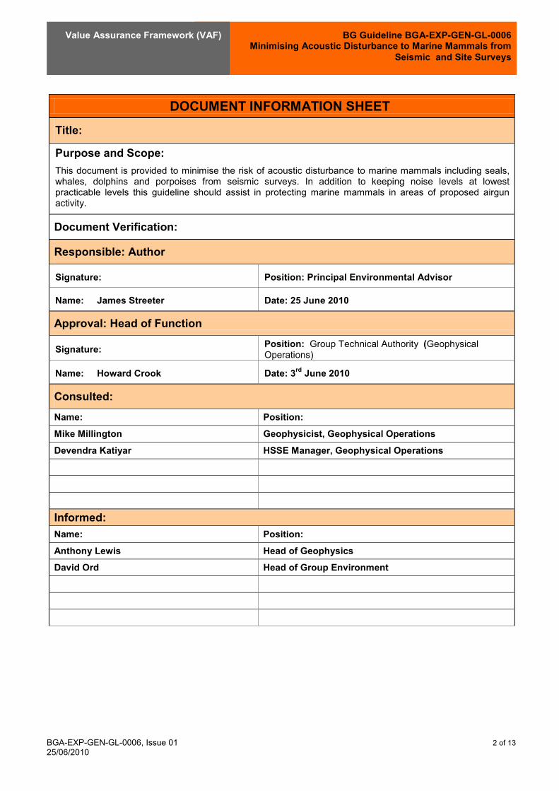
BG Guideline BGA-EXP-GEN-GL-0006 Minimising Acoustic Disturbance to Marine Mammals from
Seismic and Site Surveys
Value Assurance Framework (VAF)
BGA-EXP-GEN-GL-0006, Issue 01 2 of 13 25/06/2010
DOCUMENT INFORMATION SHEET Title:
Purpose and Scope: This document is provided to minimise the risk of acoustic disturbance to marine mammals including seals, whales, dolphins and porpoises from seismic surveys. In addition to keeping noise levels at lowest practicable levels this guideline should assist in protecting marine mammals in areas of proposed airgun activity.
Document Verification:
Responsible: Author
Signature: Position: Principal Environmental Advisor
Name: James Streeter Date: 25 June 2010
Approval: Head of Function
Signature: Position: Group Technical Authority (Geophysical Operations)
Name: Howard Crook Date: 3rd June 2010
Consulted: Name: Position: Mike Millington Geophysicist, Geophysical Operations Devendra Katiyar HSSE Manager, Geophysical Operations
Informed: Name: Position: Anthony Lewis Head of Geophysics David Ord Head of Group Environment

BG Guideline BGA-EXP-GEN-GL-0006 Minimising Acoustic Disturbance to Marine Mammals from
Seismic and Site Surveys
Value Assurance Framework (VAF)
BGA-EXP-GEN-GL-0006, Issue 01 3 of 13 25/06/2010
Approval and Issue record:
Issue No. Date Description
(see Revision Record for details) Author (name)
Approved (name)
01 03.06.10 James Streeter Howard Crook
Revision Record:
Issue No. Description of Revision

BG Guideline BGA-EXP-GEN-GL-0006 Minimising Acoustic Disturbance to Marine Mammals from
Seismic and Site Surveys
Value Assurance Framework (VAF)
BGA-EXP-GEN-GL-0006, Issue 01 4 of 13 25/06/2010
1.0 INTRODUCTION 5 1.1 Purpose and Scope 5 1.2 Definitions 5 1.3 Abbreviations and Definitions 6
2.0 RECOMMENDATIONS 7 2.1 How to use this guidance 7 2.2 Design and Planning 7 2.3 Tendering and Contracting 7 2.4 Execution 8
3.0 FEEDBACK 11
APPENDIX A - LIST OF REFERENCED / ASSOCIATED DOCUMENTS 12
APPENDIX B - FEEDBACK FORM 13

BG Guideline BGA-EXP-GEN-GL-0006 Minimising Acoustic Disturbance to Marine Mammals from
Seismic and Site Surveys
Value Assurance Framework (VAF)
BGA-EXP-GEN-GL-0006, Issue 01 5 of 13 25/06/2010
1.0 INTRODUCTION
This Guideline should be read in conjunction with the Purpose, Development and Application of BG Standards and Guidelines Standard (BGA-BGA-GEN-OS-0001).
BG Guidelines are provided to support the mandatory BG Standards. Whilst this and all other Guidelines are not mandatory, it is strongly recommended that the content is understood and considered for implementation by employees, secondees and contractors.
If you are reading a hard copy of this Guideline, you should consider it out of date and refer instead to the version currently on the Portal.
1.1 Purpose and Scope
This guideline is aimed at minimising the risk of acoustic disturbance to marine mammals including seals, whales, dolphins and porpoises from seismic surveys. In addition to keeping noise levels at lowest practicable levels this guideline should assist in protecting marine mammals in areas of proposed airgun activity. This guideline is based on the United Kingdom Joint Nature Conservation Committee (JNCC) Guideline which is widely accepted as best international practice. Where local or national standards/guidelines exist the most stringent should be used. It supports the Geophysical Operating Procedure (BGA-EXP-GEN-GL-0004) and the Exploration Standards (BGA-EXP-GEN-OS-0001). The range of Business segments and Value Funnel lifecycle stages to which this Guideline applies are identified below:
Business Segment : Upstream
X T&D
Power
LNG
Stage :
Create X
Assess X
Select X
Define X
Execute X
Operate X
Decommission X
Note: Assess includes Feasibility studies, Select includes Option assessments, Define includes both Pre-FEED Definition and FEED studies, Execute includes Detail Design, procurement, Construction and
Commissioning.
1.2 Definitions
In this document, the following definitions apply: COMPANY BG Group or a wholly owned subsidiary company or other client organisation; CONTRACTOR The person, firm or company undertaking to supply services plant, or equipment to
which his document applies; SHALL A mandatory term - no dispensation is permitted without written approval using the
formal dispensation procedure; GROUP The manager or principal discipline engineer responsible for TECHNICAL producing and maintaining a given Standard / Guideline; AUTHORITY Review and either approve or reject Dispensation Requests made against BG Standards by Asset / Project.

BG Guideline BGA-EXP-GEN-GL-0006 Minimising Acoustic Disturbance to Marine Mammals from
Seismic and Site Surveys
Value Assurance Framework (VAF)
BGA-EXP-GEN-GL-0006, Issue 01 6 of 13 25/06/2010
1.3 Abbreviations and Definitions
JNCC UK Joint Nature Conservation Committee PAM Passive acoustic monitoring Software system that utilises hydrophones to detect the
vocalisations of marine mammals. High Resolution Seismic Site Survey: surveys using an airgun array of 180 cubic inches or less. Marine Mammal Observer (MMO): Individual responsible for conducting visual watches for marine mammals. For some seismic surveys it may be requested that observers are trained, dedicated and / or experienced. The MMO may also be a PAM operative if sufficiently trained.
• Trained MMO: Has been on a JNCC recognised course. • Dedicated MMO: Trained observer whose primary and only role is to conduct visual watches for
marine mammals. • Experienced MMO: Trained observer with 3 years of field experience observing for marine
mammals, and has practical experience of implementing the JNCC mitigation guidelines. Mitigation Zone: The area where a Marine Mammal Observer keeps watch for marine mammals PAMGuard: is a software system for analyzing the calls of animals detected by hydrophones. Developed by the Sound and Marine Life JIP this software is becoming the industry standard. PAM Operative: Person experienced in the use of PAM software and hardware and marine mammal acoustics. Seismic Survey: 2D/3D/4D and OBC (Ocean Bottom Cabling) surveys and any similar techniques Shot Point Interval (SPI): Interval between firing of the airgun or airguns. Site Survey: Seismic survey of a limited area proposed for drilling, infrastructure emplacement etc (typically with source size of 180 cubic inches or less). Soft-Start: Turning on the airguns at low power and gradually and systematically increasing the output until full power is achieved (usually over a period of 20 minutes). The appropriate soft-start method is dependant upon the type of seismic survey Vertical Seismic Profiling (VSP) or Borehole Seismic: Seismic survey undertaken ‘down hole’ in connection with well operations (typically with a source size of 500 cubic inches).
BG Guideline BGA-EXP-GEN-GL-0006 Minimising Acoustic Disturbance to Marine Mammals from
Seismic and Site Surveys
Value Assurance Framework (VAF)
BGA-EXP-GEN-GL-0006, Issue 01 7 of 13 25/06/2010
2.0 RECOMMENDATIONS
2.1 How to use this guidance
This guidance is designed to be used by BG Group, contractors and consultants. The exploration manager or seismic operations manager should be aware of it and the HSE manager should be familiar with it. It should be given to the EIA consultant, seismic contractor, MMO provider and other relevant parties at the earliest opportunity. Ideally this should be at the tendering stage. This guidance is structured according to the seismic operations planning cycle: Design, Planning, Tendering, Contracting and Execution.
2.2 Design and Planning
Risk Assessment An environmental assessment should be undertaken for the seismic survey. The scale and scope of this assessment should reflect the risks of the survey and the sensitivity of the area (Ref: BG tool - Encompass). The assessment should consider as a minimum:
• What marine mammal species are likely to be present in the survey area and assess if there are any
seasonal considerations that need to be taken into account, for example periods of migration, breeding, calving or pupping.
• The prevailing regulatory standards, guidance and best industry practice. • The use of trained Marine Mammal Observers (MMOs) to implement the BG and prevailing national
standards and guidelines. Unless the EIA /risk assessment says otherwise, MMO will be used on all seismic vessels.
• Depending on the level of risk implement the following best practice measures: o Only commence seismic activities during the hours of daylight when visual mitigation using
Marine Mammal Observers (MMOs) is possible. o Only commence seismic activities during the hours of darkness, or low visibility, or during
periods when the sea state is not conducive to visual mitigation, if a Passive Acoustic Monitoring (PAM) system is in use to detect marine mammals likely to be in the area (noting the limitations of available PAM technology).
o Plan surveys so that the timing will reduce the likelihood of encounters with marine mammals. o Use the lowest practicable power levels to achieve the geophysical objectives of the survey. o Seek methods to reduce and/or baffle unnecessary high frequency noise produced by
airguns.
The duration of the pre-shooting search (at least 30 minutes) and the soft-start procedure (at least 20 minutes) should be factored into the survey design.
2.3 Tendering and Contracting
Request experience of TENDERER in managing the issue of sound and marine life, in particular their experience with MMOs, PAM, PAMGuard and execution of mitigation measures such as the soft start. TENDERER to incorporate into tender the logistics of carrying on the vessel MMOs and PAM operators, as identified in the Risk Assessment. In accordance with the level of risk and considering any prevailing regulations, a clear set of actions should be devised in the event of the seismic survey encountering marine mammals within its area of influence. These actions should be agreed between BG, the seismic contractor and the MMO. To enable the MMOs to perform their tasks more effectively they should be directly hired by BG.

BG Guideline BGA-EXP-GEN-GL-0006 Minimising Acoustic Disturbance to Marine Mammals from
Seismic and Site Surveys
Value Assurance Framework (VAF)
BGA-EXP-GEN-GL-0006, Issue 01 8 of 13 25/06/2010
2.4 Execution
Detecting Marine Mammals Marine Mammal Observers (MMO) The primary role of an MMO is to act as an observer for marine mammals and to recommend a delay in the commencement of seismic activity should any marine mammals be detected. In addition, a MMO should advise the crew on the prevailing regulations and industry best practice (eg JNCC guidelines). MMO shall complete a marine mammal recording form during the survey and upon completion the MMO shall compile a report and submit it to the exploration manager and the regulatory authorities as required. Completed MMO reports should be copied and sent to BG Group Geophysical Operations. Completed reports shall be collated and provided annually to BG Group Environment. All marine observations should be undertaken from the source vessel (where the airguns are being deployed from) The pre-shooting search should be conducted over a period of 30 minutes before commencement of any use of the airguns. The MMO should make a visual assessment to determine if any marine mammals are within 500 metres of the centre of the airgun array. In deep waters (>200m) the pre-shooting search should extend to 60 minutes due to the fact that deep diving species (e.g. sperm whale and beaked whale) are known to dive for longer than 30 minutes. To facilitate more effective timing of proposed operations, the pre-shooting search can commence before the end of the survey line (whilst the airguns are still firing, however, still termed the ‘pre-shooting search’). If a marine mammal is detected during the search, whilst airguns are still firing, there is no requirement to stop firing airguns. Acoustic Monitoring Visual observation is an ineffective mitigation measure during periods of darkness or poor visibility (such as fog), or during periods when the sea state is not conducive to visual mitigation. Under such conditions, PAM is considered to be the only available mitigation technique that can be used to detect marine mammals, although the systems have their limitations and can only be used to detect vocalising species of marine mammals. PAM systems consist of hydrophones that are deployed into the water column, and the detected sounds are processed using specialised software. PAM operatives are needed to set up and deploy the equipment and to interpret the detected sounds. Use of PAM as a mitigation tool PAM has limited accuracy in determining range and therefore should be used in combination with visual observation where ever possible. In cases where the accuracy of range determination is poor, this expert judgement of the PAM operator and/or MMO will constitute the basis for deciding whether an area is free from cetaceans prior to the soft-start. Software that processes and analyses cetacean sounds has been developed. PAMGuard is open source software that has been developed as part of the International Association of Oil and Gas Producers Joint Industry Project (JIP). Where BG Group seismic surveys use PAM they shall use PAMGuard software. For areas that are important for marine mammals: • Experienced MMOs and PAM should be used. • The PAM system should be used to supplement visual observations, or as the main mitigation tool if
the seismic survey activity commences during periods of darkness or poor visibility, or during periods when the sea state is not conducive to visual mitigation.
• Two marine mammal observers should be used when daylight hours exceed approximately 12 hours per day (between 1st April and 1st October north of 57o
latitude), or the survey is in an area considered particularly important for marine mammals.

BG Guideline BGA-EXP-GEN-GL-0006 Minimising Acoustic Disturbance to Marine Mammals from
Seismic and Site Surveys
Value Assurance Framework (VAF)
BGA-EXP-GEN-GL-0006, Issue 01 9 of 13 25/06/2010
Mitigation Measures Mammals Seen within the Mitigation Zone If marine mammals are seen within 500 metres of the centre of the airgun array during the pre-shooting search the soft-start of the seismic sources should be delayed until their passage, or the transit of the vessel, results in the marine mammals being more that 500 metres from the source. In both cases, there should be a 20 minute delay from the time of the last sighting within 500 metres to the commencement of the soft-start to determine if the animals have left the area. If PAM is used it is the responsibility of the PAM operatives to assess any acoustic detections and determine if there are likely to be marine mammals within 500 metres of the source. If the PAM operatives consider marine mammals are present within that range then the start of the operation should be delayed as outlined above. If marine mammals are detected within 500 metres of the centre of the airgun array whilst the airguns are firing, either during the soft-start procedure or whilst at full power, there is no requirement to stop firing the airguns. The Soft Start Power should be built up slowly from a low energy start-up (e.g. starting with the smallest airgun in the array and gradually adding in others) over at least 20 minutes to give adequate time for marine mammals to leave the area. There should be a soft-start every time the airguns are used, the only exceptions being for certain types of airgun testing (see below), and the use of a ‘mini-airgun’ (single gun volume less than 10 cubic inches), these are used on site-surveys. The duration of the pre-shooting search (at least 30 minutes) and the soft-start procedure (at least 20 minutes) should be factored into the survey design. Soft-start requirements for site survey or Vertical Seismic Profiling (VSP) Soft start should be undertaken for site survey and vertical seismic profiling: • The standard method where power is built up slowly from a low energy start-up (e.g. starting with the
smallest airgun in the array and gradually adding in others) over at least 20 minutes to give adequate time for marine mammals to leave the vicinity.
• As the relationship between acoustic output and pressure of the air contained in the airgun is close to linear and most site surveys / VSP operations use only a small number of airguns a soft-start can be achieved by slowly increasing the air pressure in 500 psi steps. From our understanding the minimum air pressure which the airgun array can be set to will vary, as this is dependent on the make and model of the airgun being used. The time from initial airgun start up to full power should be at least 20 minutes.
• Over a minimum time period of 20 minutes the airguns should be fired at an increasing frequency (by decreasing the Shot Point Interval (SPI)) until the desired firing frequency is reached.
For ultra high resolution site surveys that only use a ‘mini-airgun’ (single airgun with a volume of less than 10 cubic inches) there is no requirement to perform a soft-start, however, a pre-shooting search should still be conducted before its use. Soft-start and Air Gun Testing Depending on the number of guns and the power level of the test, a soft start may be required. • If the intention is to test all airguns at full power then a 20 minute soft-start is required. • If the intention is to test a single airgun on low power then a soft-start is not required. • If the intention is to test a single airgun, or a number of guns on high power, the airgun or airguns
should be fired at lower power first, and the power then increased to the level of the required test; this should be carried out over a time period proportional to the number of guns being tested and ideally not exceed 20 minutes in duration.
BG Guideline BGA-EXP-GEN-GL-0006 Minimising Acoustic Disturbance to Marine Mammals from
Seismic and Site Surveys
Value Assurance Framework (VAF)
BGA-EXP-GEN-GL-0006, Issue 01 10 of 13 25/06/2010
MMOs should maintain a watch as outlined in the pre-shooting search guidance before any instances of gun testing. Line Changes The requirement for soft start relating to line change depends upon the airgun volume:
• Seismic surveys with an airgun volume of 500 cubic inches or more. If the line change time is expected to be greater than 20 minutes, airguns should be terminated at the end of the line and a full 20 minute soft-start undertaken before the next line. A pre-shooting search should also be undertaken during the scheduled line change, and the soft-start delayed if marine mammals are seen within 500 metres of the centre of the array.
• Seismic surveys with an airgun volume of 180 cubic inches or less (site surveys). If the line change time is expected to be greater than 40 minutes, airgun firing should be terminated at the end of the line and a full 20 minute soft-start undertaken before the next line. The pre-shooting search should also be undertaken during the scheduled line change, and the soft-start delayed if marine mammals are seen within 500 metres of the centre of the airgun array. If the line change time is expected to be less than 40 minutes, airgun firing can continue during the turn, but the Shot Point Interval (SPI) should be increased (longer duration between shots). Ideally, the SPI should not exceed 5 minutes during the turn.
For any further information and clarification refer to BG Group Geophysical HSSE Advisor or BG Group Geophysical Operations Manager.

BG Guideline BGA-EXP-GEN-GL-0006 Minimising Acoustic Disturbance to Marine Mammals from
Seismic and Site Surveys
Value Assurance Framework (VAF)
BGA-EXP-GEN-GL-0006, Issue 01 11 of 13 25/06/2010
3.0 FEEDBACK
Where inaccuracies, errors, omissions or other general areas for quality or performance improvement are identified in this document the Feedback Form, provided in Appendix B shall be completed and returned to the Group Technical Authority (Document Custodian) identified in the Document Information Sheet.

BG Guideline BGA-EXP-GEN-GL-0006 Minimising Acoustic Disturbance to Marine Mammals from
Seismic and Site Surveys
Value Assurance Framework (VAF)
BGA-EXP-GEN-GL-0006, Issue 01 12 of 13 25/06/2010
APPENDIX A - LIST OF REFERENCED / ASSOCIATED DOCUMENTS
BG Standards / Guidelines: Geophysical Operating Procedure (BGA-EXP-GEN-GL-0004) Exploration Standards (BGA-EXP-GEN-OS-0001). External Standards / Guidelines: UK JNCC guidelines for minimising the risk of disturbance and injury to marine mammals from seismic surveys. June 2009. http://www.jncc.gov.uk/pdf/Seismic%20Guidelines%20June%202009_ver01.pdf

BG Guideline BGA-EXP-GEN-GL-0006 Minimising Acoustic Disturbance to Marine Mammals from
Seismic and Site Surveys
Value Assurance Framework (VAF)
BGA-EXP-GEN-GL-0006, Issue 01 13 of 13 25/06/2010
APPENDIX B - FEEDBACK FORM
FEEDBACK FORM
This form should be used to notify comment or suggestions for improvement, relating to any aspect of the document identified below. Please return the completed form by Email, to the Technical Authority/Document Custodian identified in the associated Document Information Sheet.
Document title:
Guideline -
Document No:
BGA-
Issue No:
Issue Date:
Comments by:
Name: ………………………………………………..
Position: …………………………………………..
Date: …………………………
Email address / Contact Tel.No: …………………………
Project / Business Unit: …………………………..
Page / Section No: Comment
Annex 5.1 List of Coral Species
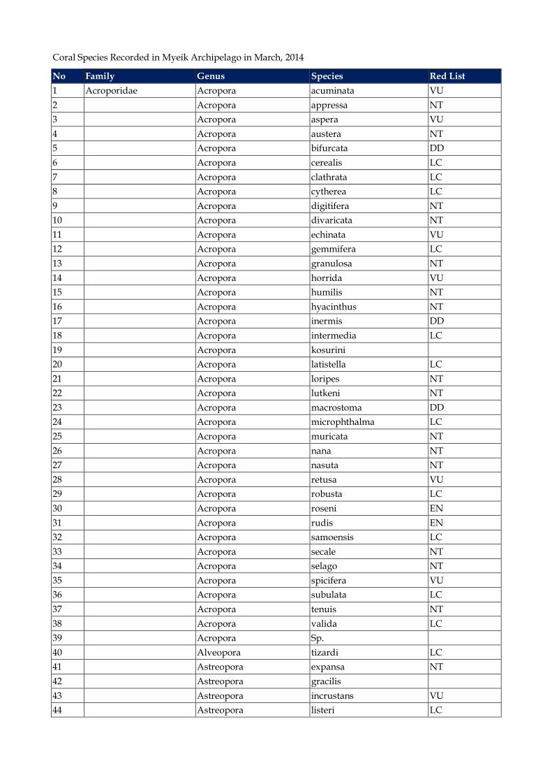
Coral Species Recorded in Myeik Archipelago in March, 2014
No Family Genus Species Red List 1 Acroporidae Acropora acuminata VU 2 Acropora appressa NT 3 Acropora aspera VU 4 Acropora austera NT 5 Acropora bifurcata DD 6 Acropora cerealis LC 7 Acropora clathrata LC 8 Acropora cytherea LC 9 Acropora digitifera NT 10 Acropora divaricata NT 11 Acropora echinata VU 12 Acropora gemmifera LC 13 Acropora granulosa NT 14 Acropora horrida VU 15 Acropora humilis NT 16 Acropora hyacinthus NT 17 Acropora inermis DD 18 Acropora intermedia LC 19 Acropora kosurini 20 Acropora latistella LC 21 Acropora loripes NT 22 Acropora lutkeni NT 23 Acropora macrostoma DD 24 Acropora microphthalma LC 25 Acropora muricata NT 26 Acropora nana NT 27 Acropora nasuta NT 28 Acropora retusa VU 29 Acropora robusta LC 30 Acropora roseni EN 31 Acropora rudis EN 32 Acropora samoensis LC 33 Acropora secale NT 34 Acropora selago NT 35 Acropora spicifera VU 36 Acropora subulata LC 37 Acropora tenuis NT 38 Acropora valida LC 39 Acropora Sp. 40 Alveopora tizardi LC 41 Astreopora expansa NT 42 Astreopora gracilis 43 Astreopora incrustans VU 44 Astreopora listeri LC
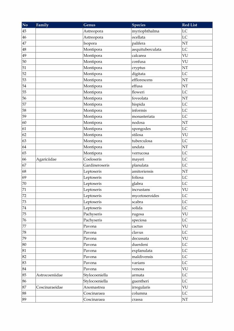
No Family Genus Species Red List 45 Astreopora myriophthalma LC 46 Astreopora ocellata LC 47 Isopora palifera NT 48 Montipora aequituberculata LC 49 Montipora calcarea VU 50 Montipora confusa VU 51 Montipora cryptus NT 52 Montipora digitata LC 53 Montipora efflorescens NT 54 Montipora effusa NT 55 Montipora floweri LC 56 Montipora foveolata NT 57 Montipora hispida LC 58 Montipora informis LC 59 Montipora monasteriata LC 60 Montipora nodosa NT 61 Montipora spongodes LC 62 Montipora stilosa VU 63 Montipora tuberculosa LC 64 Montipora undata NT 65 Montipora verrucosa LC 66 Agariciidae Coeloseris mayeri LC 67 Gardineroseris planulata LC 68 Leptoseris amitoriensis NT 69 Leptoseris foliosa LC 70 Leptoseris glabra LC 71 Leptoseris incrustans VU 72 Leptoseris mycetoseroides LC 73 Leptoseris scabra LC 74 Leptoseris solida LC 75 Pachyseris rugosa VU 76 Pachyseris speciosa LC 77 Pavona cactus VU 78 Pavona clavus LC 79 Pavona decussata VU 80 Pavona duerdeni LC 81 Pavona explanulata LC 82 Pavona maldivensis LC 83 Pavona varians LC 84 Pavona venosa VU 85 Astrocoeniidae Stylocoeniella armata LC 86 Stylocoeniella guentheri LC 87 Coscinaraeidae Anomastrea irregularis VU 88 Coscinaraea columna LC 89 Coscinaraea crassa NT

No Family Genus Species Red List 90 Coscinaraea exesa 91 Coscinaraea monile LC 92 Coscinaraea wellsi LC 93 Coscinaraea Sp. 94 Dendrophylliidae Tubastrea micrantha 95 Tubastrea zpp 96 Turbinaria frondens LC 97 Turbinaria irregularis LC 98 Turbinaria mesenterina VU 99 Turbinaria peltata VU 100 Turbinaria stellulata VU 101 Euphyllidae Euphyllia ancora VU 102 Euphyllia glabrescens NT 103 Physogyra lichtensteini VU 104 Plerogyra sinuosa NT 105 Faviidae Barabattoia amicorum LC 106 Caulastrea connata VU 107 Cyphastrea chalcidicum LC 108 Cyphastrea microphthalma LC 109 Cyphastrea serailia LC 110 Diploastrea heliopora NT 111 Echinopora gemmacea LC 112 Echinopora lamellosa LC 113 Echinopora pacificus 114 Favia danae LC 115 Favia favus LC 116 Favia helianthoides NT 117 Favia lizardensis NT 118 Favia maritima NT 119 Favia matthai NT 120 Favia maxima NT 121 Favia pallida LC 122 Favia rosaria 123 Favia rotumana LC 124 Favia speciosa LC 125 Favia stelligera NT 126 Favia truncatus LC 127 Favia veroni NT 128 Favia vietnamensis NT 129 Favites abdita NT 130 Favites acuticolis NT 131 Favites bestae 132 Favites chinensis NT 133 Favites complanata NT 134 Favites halicora NT
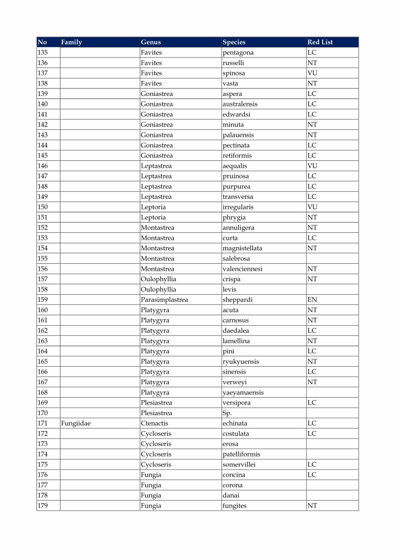
No Family Genus Species Red List 135 Favites pentagona LC 136 Favites russelli NT 137 Favites spinosa VU 138 Favites vasta NT 139 Goniastrea aspera LC 140 Goniastrea australensis LC 141 Goniastrea edwardsi LC 142 Goniastrea minuta NT 143 Goniastrea palauensis NT 144 Goniastrea pectinata LC 145 Goniastrea retiformis LC 146 Leptastrea aequalis VU 147 Leptastrea pruinosa LC 148 Leptastrea purpurea LC 149 Leptastrea transversa LC 150 Leptoria irregularis VU 151 Leptoria phrygia NT 152 Montastrea annuligera NT 153 Montastrea curta LC 154 Montastrea magnistellata NT 155 Montastrea salebrosa 156 Montastrea valenciennesi NT 157 Oulophyllia crispa NT 158 Oulophyllia levis 159 Parasimplastrea sheppardi EN 160 Platygyra acuta NT 161 Platygyra carnosus NT 162 Platygyra daedalea LC 163 Platygyra lamellina NT 164 Platygyra pini LC 165 Platygyra ryukyuensis NT 166 Platygyra sinensis LC 167 Platygyra verweyi NT 168 Platygyra yaeyamaensis 169 Plesiastrea versipora LC 170 Plesiastrea Sp. 171 Fungiidae Ctenactis echinata LC 172 Cycloseris costulata LC 173 Cycloseris erosa 174 Cycloseris patelliformis 175 Cycloseris somervillei LC 176 Fungia concina LC 177 Fungia corona 178 Fungia danai 179 Fungia fungites NT

No Family Genus Species Red List 180 Fungia granulosa LC 181 Fungia moluccensis LC 182 Fungia paumotensis LC 183 Fungia repanda LC 184 Fungia scabra LC 185 Fungia scruposa LC 186 Fungia scutaria LC 187 Fungia seychellensis VU 188 Herpolitha limax LC 189 Herpolitha weberi 190 Lithophyllon undulatum 191 Podabacia crustacea LC 192 Podabacia lankaensis 193 Polyphillia novaehiberniae 194 Polyphillia talpina LC 195 Sandalolitha dentata 196 Sandalolitha robusta LC 197 Hydrozoa Heliopora coerulea VU 198 Millepora exesa LC 199 Millepora platyphylla LC 200 Millepora tenaera 201 Merulinidae Hydnophora exesa NT 202 Hydnophora microconos 203 Hydnophora rigida LC 204 Merulina ampliata LC 205 Scapophyllia cylindrica 206 Mussidae Acanthastrea brevis VU 207 Acanthastrea echinata LC 208 Acanthastrea hemprichii VU 209 Acanthastrea regularis 210 Acanthastrea rotundoflora NT 211 Acanthastrea subechinata NT 212 Australomussa rowleyensis 213 Blastomussa merletti LC 214 Cynarina lachrymalis NT 215 Lobophyllia corymbosa LC 216 Lobophyllia flabelliformis 217 Lobophyllia hataii LC 218 Lobophyllia hemprichii LC 219 Lobophyllia pachysepta NT 220 Lobophyllia robusta LC 221 Micromussa amakusensis NT 222 Scolymia australis 223 Symphyllia agaricia LC 224 Symphyllia radians LC
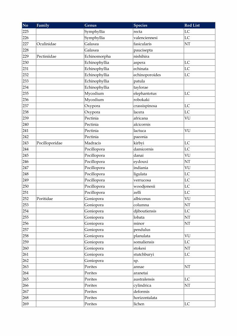
No Family Genus Species Red List 225 Symphyllia recta LC 226 Symphyllia valenciennesi LC 227 Oculinidae Galaxea fasicularis NT 228 Galaxea paucisepta 229 Pectiniidae Echinomorpha nishihira 230 Echinophyllia aspera LC 231 Echinophyllia echinata LC 232 Echinophyllia echinoporoides LC 233 Echinophyllia patula 234 Echinophyllia taylorae 235 Mycedium elephantotus LC 236 Mycedium robokaki 237 Oxypora crassispinosa LC 238 Oxypora lacera LC 239 Pectinia africana VU 240 Pectinia alcicornis 241 Pectinia lactuca VU 242 Pectinia paeonia 243 Pocilloporidae Madracis kirbyi LC 244 Pocillopora damicornis LC 245 Pocillopora danai VU 246 Pocillopora eydouxi NT 247 Pocillopora indiania VU 248 Pocillopora ligulata LC 249 Pocillopora verrucosa LC 250 Pocillopora woodjonesii LC 251 Pocillopora zelli LC 252 Poritidae Goniopora albiconus VU 253 Goniopora columna NT 254 Goniopora djiboutiensis LC 255 Goniopora lobata NT 256 Goniopora minor NT 257 Goniopora pendulus 258 Goniopora planulata VU 259 Goniopora somaliensis LC 260 Goniopora stokesi NT 261 Goniopora stutchburyi LC 262 Goniopora sp. 263 Porites annae NT 264 Porites aranetai 265 Porites australensis LC 266 Porites cylindrica NT 267 Porites deformis 268 Porites horizontalata 269 Porites lichen LC

No Family Genus Species Red List 270 Porites lobata NT 271 Porites lutea LC 272 Porites monticulosa LC 273 Porites nigrescens VU 274 Porites profundus LC 275 Porites rus LC 276 Porites silimaniana 277 Porites solida LC 278 Porites stephensoni 279 Siderastreidae Psammocora albopicta DD 280 Psammocora digitata NT 281 Psammocora explanulata LC 282 Psammocora niestraazi LC 283 Psammocora obtusangula NT 284 Psammocora profundacella LC 285 Pseudosiderastrea tayami NT 286 Pseudosiderastrea sp. (cf. formosa) 287 Siderastrea savignyana LC 288 Trachyphylliidae Trachyphyllia geoffroyi NT IUCN Red List: DD = Data Deficient, LC = Least Concern, NT = Near Threatened, VU = Vulnerable, EN = Endangered, CR = Critically Endangered
Annex 8.1 Consultation Materials

The world’s leading sustainability consultancy
BG Group လပငနးမတဆကႏင ရညရြယခက
■ BG Group သည Aဂၤၤလနႏငငတြငရေသာ Aႀကးဆး ေရနႏငသဘာဝဓါတေငြ႔ကမၸဏမားထမ တစချဖစသည။
■ BG ေရနတးေဖာေရးႏင Production Myanmar Pte. Ltd တ႔သည စြမးAငဝနႀကး ဌာန၊ ျမနမာေရနႏင သဘာဝဓါတေငြ႔လပငနးတ႔ႏင Aကးတပးေပါငး၍ကမးလြန ေရနတးေဖာရနAတြက သေဘာတစာခပ လကမတေရးထးၿပးျဖစပါသည။
■ ႏငငတကာစခနစညႊနးမားAရ လပငနးစတငသညႏင တၿပငနက သဘာဝပတဝနးကငႏင လမႈေရးရာထခကပကစးမႈမားက နားလညသေဘာေပါကေစရနကနU းပတဝနးကငစစေဆးမႈက လပေဆာငမညျဖစပါသည။
■ ယခ AစညးAေဝး၏ Aဓကရညရြယခကမာ BG လပငနးစ၏ လကရလႈပရားမႈမားက ရငးလငးေျပာျပရနႏင ေဒသခ ငါးဖမးလပသားမား၏ AေျခAေနက
နားလည သေဘာေပါကရနျဖစသည။ The world’s leading sustainability consultancy
2
The world’s leading sustainability consultancy
ေလလာဆနးစစျခငး - ၂၀၁၅၊ ႏဝငဘာလတြင စတငမည
3The world’s leading sustainability consultancy
ေရနတးေဖာမႈကနUးဆနးစစခက
BG ၏ ေရနတးေဖာမႈ Aေျချပဇယား
4
ေလလာဆနးစစျခငး
ကနUးဆနးစစခက
၆ လ ၂ - ၃ ႏစ ၅ႏစ
၂၀၁၅ ၂၀၁၅ - ၂၀၁၈ ၂၀၁၈ - ၂၀၂၃
The world’s leading sustainability consultancy
ျဖစႏငေျခရေသာ Aကးသကေရာကမႈမားႏင ေဘးAႏရာယေလာပါးေရး စမခက
5
ျဖစႏငေျခရေသာသကေရာကမႈမား
စကမႈလပငနးမားAတြက ေဘးAႏရာယေလာပါးေရး တငးတာခကမား
လမားAေပၚ သကေရာကမႈ (ငါးဖမးလပငနးမားAေပၚယာယထခကမႈ ႏင ေရနတငသေဘာၤမားဖတစငႏငမႈ)
ငါးဖမးလပသားမားက လပငနးစလငႀကတငAသေပးျခငး။ ပြငလငးျမငသာသည AျပနAလနဆကသြယမႈ။ ေရနတငသေဘာၤတြင ျမနမာစကား ေျပာႏငသညသ ထားရျခငး။ ေရနတငသေဘာၤ လAပသမက တတႏငသမ ေထာကပ
ေပးျခငး။
တရစၦာနမားAေပၚသကေရာကမႈ(ေျမေAာကေရထတြင ဆညသျဖစေပၚေစမႈ ႏငလပ ႏင Aျခားသတဝါမား မးတနးေပာကကြယေစမႈ Aႏရာယ)
Aသထြကေပၚမႈကေႏးေကြးေစျခငးျဖင တရစၦနမားေဘးလြတရာသ႔ ေျပးႏငေစရန Aခနေပးျခငး။
AနးAနားပတဝနးကငရ သကရသတဝါမားက ေစာငၾကညျခငး။
လပမားက ကရယာမားႏင ဖမးသညAႏရာယမ ကာကြယႏငေစရနAတြက Aေစာငမားခထားျခငး။
The world’s leading sustainability consultancy
စမကနးႏင ဆကစပသည Aႀကျပခကမား၊စးရမခကမား၊ စစမးေမးျမနးလသညမားႏင
ေမးခြနးမားက ေAာကပါ ဆကသြယရန နပါတသ႔ဆကသြယပါ။
6
BG လပငနးစဖနး- ၀၉၉ ၇၇ ၀၈၆ ၀၆၉
Aႀကျပခကမားက ၂၀၁၅-ခႏစ စကတငဘာလAထလကခသြားပါမည။
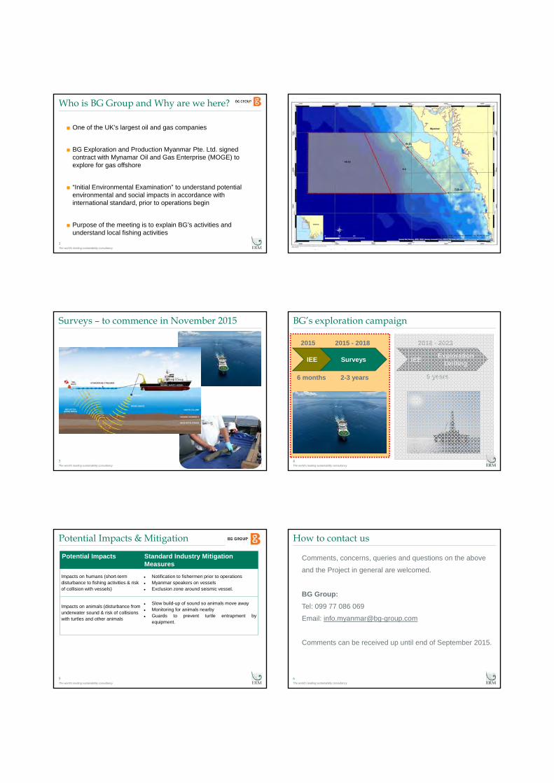
The world’s leading sustainability consultancy
Who is BG Group and Why are we here?
1
■ One of the UK’s largest oil and gas companies
■ BG Exploration and Production Myanmar Pte. Ltd. signed contract with Mynamar Oil and Gas Enterprise (MOGE) to explore for gas offshore
■ “Initial Environmental Examination” to understand potential environmental and social impacts in accordance with international standard, prior to operations begin
■ Purpose of the meeting is to explain BG’s activities and understand local fishing activities
The world’s leading sustainability consultancy
2
8km
50km
The world’s leading sustainability consultancy
Surveys – to commence in November 2015
3The world’s leading sustainability consultancy
Exploration DrillingIEE
BG’s exploration campaign
4
SurveysIEE
6 months 2-3 years 5 years
2015 2015 - 2018 2018 - 2023
The world’s leading sustainability consultancy
Potential Impacts & Mitigation
5
Potential Impacts Standard Industry MitigationMeasures
Impacts on humans (short-termdisturbance to fishing activities & risk of collision with vessels)
Notification to fishermen prior to operations Myanmar speakers on vessels Exclusion zone around seismic vessel.
Impacts on animals (disturbance from underwater sound & risk of collisions with turtles and other animals
Slow build-up of sound so animals move away Monitoring for animals nearby Guards to prevent turtle entrapment by
equipment.
The world’s leading sustainability consultancy
How to contact us
6
Comments, concerns, queries and questions on the above
and the Project in general are welcomed.
BG Group:Tel: 099 77 086 069
Email: [email protected]
Comments can be received up until end of September 2015.
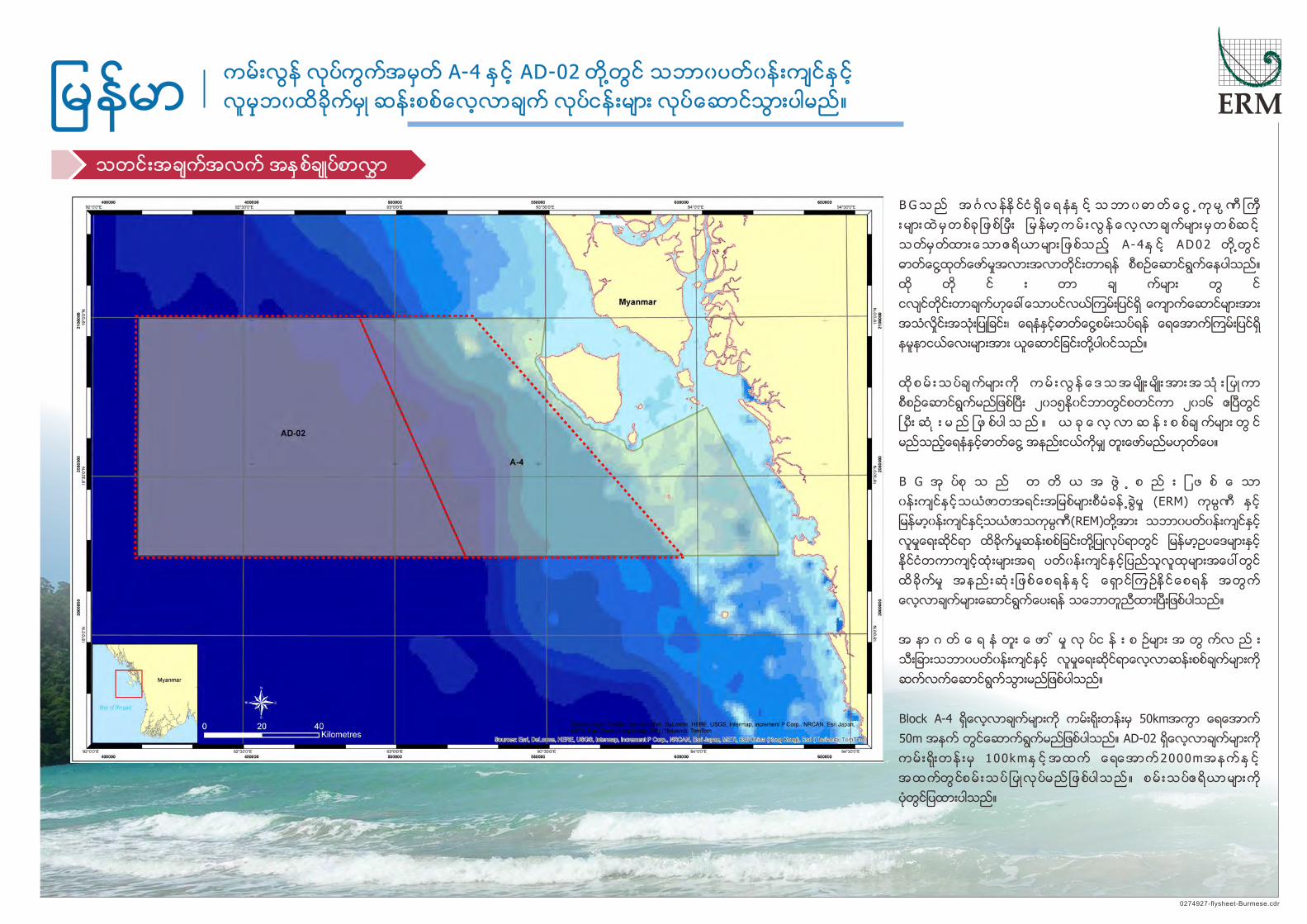
ကမးလြန လပကြကအမတ A-4 ႏင AD-02 တ ႔တြင သဘာ၀ပတ၀နးကငႏင
လမဘ၀ထခကမ ဆနးစစေလလာခက လပငနးမား လပေဆာငသြားပါမည။ျမနမာသတငးအခကအလက အႏစခပစာလႊာ
0274927-flysheet-Burmese.cdr
B G သ ည အ ဂၤ လ နန ငင ရ ေ ရ နႏ င သ ဘာ ၀ ဓာ တ ေ ငြ ႕ က မ ၸ ဏ ႀ က
း မား ထ မ တ စခ ျ ဖ စၿ ပး ျ မ နမာ က မ း လြ န ေ လ လာ ခ ကမား မ တ စဆ င
သတမတထားေသာဧရယာမား ျ ဖစသည A - 4ႏ င AD02 တ ႔တြ င
ဓာတေငြ႔ထတေဖာမႈအလားအလာတငးတာရန စစဥေဆာငရြကေနပါသည။
ထ တ င း တာ ခ ကမား တြ င
ငလငတငးတာခကဟေခၚေသာပငလယၾကမးျပငရ ေကာကေဆာငမားအား
အသလႈငးအသးျပျခငး၊ ေရနႏငဓာတေငြ႔စမးသပရန ေရေအာကၾကမးျပငရ
နမနာငယေလးမားအား ယေဆာငျခငးတ႔ပါ၀ငသည။
ထ စ မ း သ ပခ ကမား က က မ း လြ န ေ ဒ သ အ မး မး အား အ သ း ျ ပ ကာ
စစဥေဆာငရြကမညျဖစၿပး ၂၀၁၅န၀ငဘာတြငစတငကာ ၂၀၁၆ ဧၿပတြင
ၿ ပး ဆ း မ ည ျ ဖ စပါ သ ည ။ ယ ခ ေ လ လာ ဆ န း စ စခ ကမား တြ င
မညသညေရနႏငဓာတေငြ႔ အနညးငယကမ တးေဖာမညမဟတေပ။
B G အ ပစ သ ည တ တ ယ အ ဖြ ႔ စ ည း ျ ဖ စ ေ သာ
၀နးကငႏင သယဇာတအရငးအျမစမားစမခန႕ခြမႈ (ERM) ကမၸဏ ႏင
ျမနမာ၀နးကငႏင႔သယဇာသကမၸဏ(REM)တ႔အား သဘာ၀ပတ၀နးကငႏင
လမႈေရးဆငရာ ထခကမႈဆနးစစျခငးတ႔ျပလပရာတြင ျမနမာဥပေဒမားႏင
နငငတကာကငထးမားအရ ပတ၀နးကငႏင ျပညသလထမားအေပၚတြင
ထခကမႈ အနည းဆ း ျဖစေစရနႏ င ေရာငၾကဥနငေစရန အတြက
ေလလာခကမားေဆာငရြကေပးရန သေဘာတညထားၿပးျဖစပါသည။
အ နာ ဂ တ ေ ရ န တး ေ ဖာ မႈ လ ပင န း စ ဥမား အ တြ ကလ ည း
သးျခားသဘာ၀ပတ၀နးကငႏင လမႈေရးဆငရာေလလာဆနးစစခကမားက
ဆကလကေဆာငရြကသြားမညျဖစပါသည။
Block A-4 ရေလလာခကမားက ကမးရးတနးမ 50kmအကြာ ေရေအာက
50m အနက တြငေဆာကရြကမညျဖစပါသည။ AD-02 ရေလလာခကမားက
ကမ းရးတန းမ 100kmႏ င အထက ေရေအာက2000mအနကႏ င
အထကတြငစမ းသပ ျ ပလပမည ျ ဖစပါသည ။ စမ းသပဧရယာမားက
ပတြငျပထားပါသည။
Designated areas A-4 and AD-02 offshore Myanmar

ကမးလြန လပကြကအမတ A-4 ႏင AD-02 တ ႔တြင သဘာ၀ပတ၀နးကငႏင
လမဘ၀ထခကမ ဆနးစစေလလာခက လပငနးမား လပေဆာငသြားပါမည။ျမနမာသတငးအခကအလက အႏစခပစာလႊာ
0274927-flysheet-Burmese.cdr
A typical survey vessel carrying out a seismic survey.
အသတနခါမတငး သေဘၤာ
ေရေၾကာငးျပ ေဘာရာ အၿမး
ေကဘယလ ႀကးမား
အသရငးျမစ
အသလငးမားပတငျပနလာေသာ
အသလငးမား
ေကာကေဆာင ေကာကခလႊာ
ေရေအာကၾကမးျပငရ အနညအႏစမား
ေရ ေကာလ
တနခါ မတ င းတာခကမားတြင ပငလယေရေအာကၾကမ း ျ ပငမ
ဘမေဗဒဆငရာ အခကအလက မားကရယရန အသလႈငးမားက
အသးျပမညျဖစပါသည။ အသကတနခါမႈတငး သေဘၤာမား၏
ေ နာ ကတြ င ခ တဆြ ထား ေ သာ က ရ ယာ မား မ ထ တလႊ င
မ ည ျ ဖ စပါ သ ည ။ ပ ငလ ယၾ က မ း ျ ပ င ေ အာ က
ေကာကေဆာငမားမပတင ျပနလာေသာ အသလႈင းမားအား
င လ ငတ င း သေ ဘၤ ာ မား ၏ ေ နာ ကတြ င ခ တဆြ ထား ေ သာ
ေကဘယလ ႀကးရညမားျဖင မတတမး တငထားမညျဖစပါသည။
ပ ငလ ယၾ က မ း ျ ပ င န မ နာ ေ လ လာ ခ ကမား တြ င
သေ ဘၤ ာ တြ ငတ ပဆ ငထား ေ သာ ျ ပြ န ျ ဖ င
ေ ရေ အာ ကၾ က မ း ျ ပ ငရ အ န ညန မ နာ အ န ည း င ယက သာ ရ ယ မ ည ျ ဖ စသ ည ။
ထနမနာအားယာဥေပၚသ ႔ျပနသယေဆာငလာကာ ေရနႏင ဓာတေငြ႕ေၾကာမားအတြက
ဓာတခြခနးတြငမစမးသပမအထ လျခစြာသမးဆညးထားပါမည။ ေရေအာကၾကမးျပငရ
ထ န မ နာ င ယ ရာ ေ ပါ င း မား စြာ က က မ း လြ နတ စ ေ လာ ကတြ င
ေခါကတ႕ေခါကျပနရယမညျဖစပါသည။
စမကနးႏင ဆကစပသည အႀကျပခကမား၊ စးရမခကမား၊
စ စမးေမးျမနးခကမားႏင ေမးခြနးမားက ႀကဆပါတယ။
ကြႏ ပတ ႔က ဘယလ ဆကသြယရမာလ။
ဖနး: 099 77 086 069
အးေမးလ: [email protected]
၂၀၁၅-ခႏစ ၊ စကတငဘာလ ကနသညအထ အႀကျပခကမားက
လကခသြားပါမည။
BG လပငနးစ
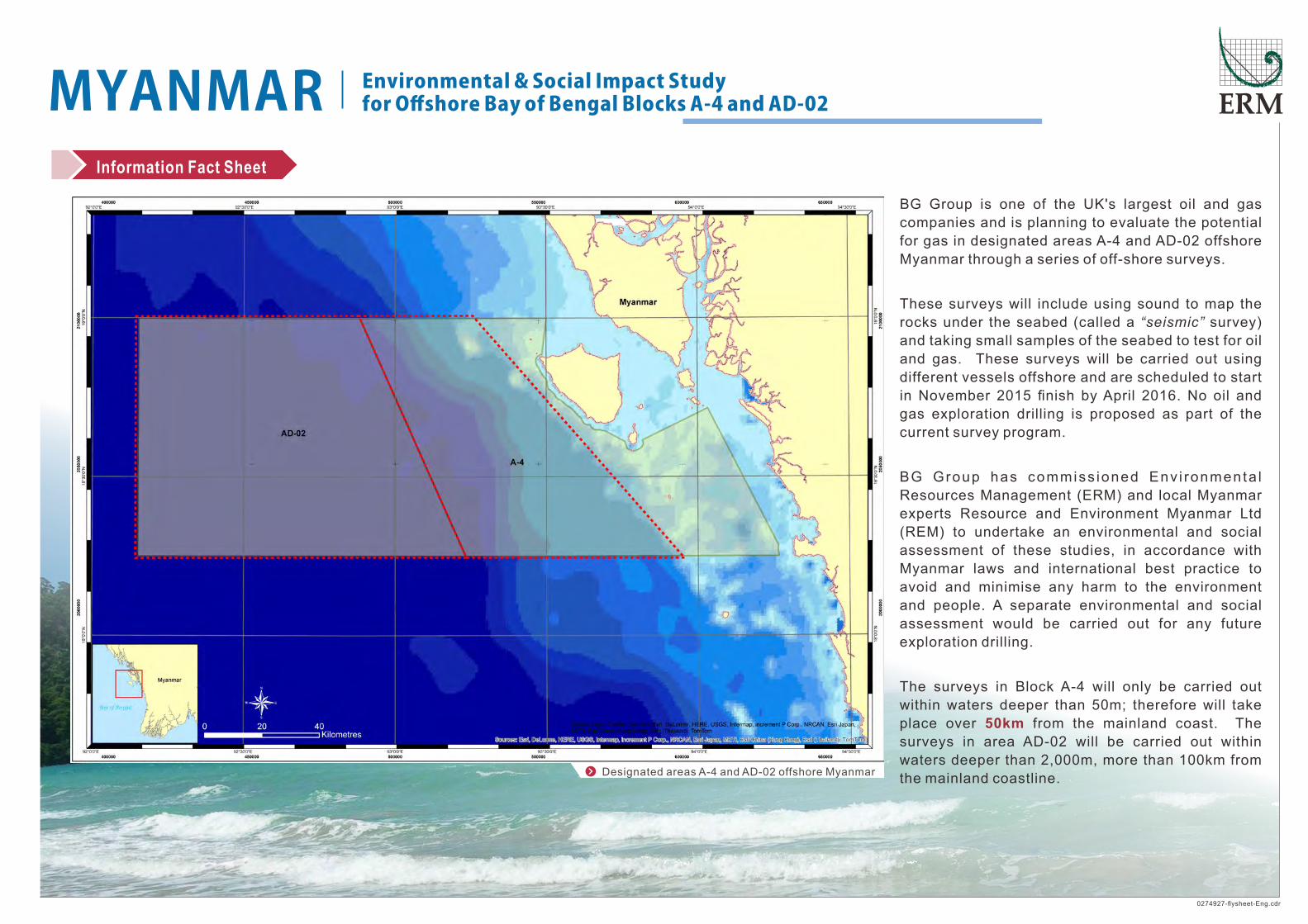
Environmental�&�Social�Impact�Study�for�Offshore�Bay�of�Bengal�Blocks�A-4�and�AD-02�MYANMAR
0274927-flysheet-Eng.cdr
Information Fact Sheet
BG Group is one of the UK's largest oil and gas
companies and is planning to evaluate the potential
for gas in designated areas A-4 and AD-02 offshore
Myanmar through a series of off-shore surveys.
These surveys will include using sound to map the
rocks under the seabed (called a “seismic” survey)
and taking small samples of the seabed to test for oil
and gas. These surveys will be carried out using
different vessels offshore and are scheduled to start
in November 2015 finish by April 2016. No oil and
gas exploration drilling is proposed as part of the
current survey program.
BG Group has commiss ioned Env i ronmenta l
Resources Management (ERM) and local Myanmar
experts Resource and Environment Myanmar Ltd
(REM) to undertake an environmental and social
assessment of these studies, in accordance with
Myanmar laws and international best practice to
avoid and minimise any harm to the environment
and people. A separate environmental and social
assessment would be carried out for any future
exploration drilling.
The surveys in Block A-4 will only be carried out
within waters deeper than 50m; therefore will take
place over from the mainland coast. The 50km
surveys in area AD-02 will be carried out within
waters deeper than 2,000m, more than 100km from
the mainland coastline. Designated areas A-4 and AD-02 offshore Myanmar

Environmental�&�Social�Impact�Study�for�Offshore�Bay�of�Bengal�Blocks�A-4�and�AD-02�MYANMAR
0274927-flysheet-Eng.cdr
Information Fact Sheet
BG Group is one of the UK's largest oil and gas
companies and is planning to evaluate the potential for
gas in designated areas A-4 and AD-02 offshore
Myanmar through a series of off-shore surveys.
These surveys will include using sound to map the rocks
under the seabed (called a “seismic” survey) and taking
small samples of the seabed to test for oil and gas.
These surveys will be carried out using different vessels
offshore and are scheduled to start in November 2015
finish by April 2016. No oil and gas exploration drilling is
proposed as part of the current survey program.
BG Group has commissioned Environmental Resources
Management (ERM) and local Myanmar exper ts
Resource and Environment Myanmar Ltd (REM) to
undertake an environmental and social assessment of
these studies, in accordance with Myanmar laws and
international best practice to avoid and minimise any
harm to the environment and people. A separate
environmental and social assessment would be carried
out for any future exploration drilling.
The surveys in Block A-4 will only be carried out within
waters deeper than 50m; therefore will take place over
50km from the mainland coast. The surveys in area AD-
02 will be carried out within waters deeper than 2,000m,
more than 100km from the mainland coastline.
A seismic survey uses sound waves to provide
information about the geology beneath the
s e a b e d . T h e s o u n d i s g e n e r a t e d b y
equipment towed behind the seismic survey
vessel. The sound waves are reflected back
from the rocks beneath the seabed, and
recorded on very long cables, which are
towed behind the seismic vessel.
The seabed sampl ing survey involves a vessel
lowering a tube down to the seabed which then extracts a
small sample of the seabed sediment a few meters long. This
sample is brought back up to vessel and stored before being
tested in a laboratory for traces of oil and gas. A few hundred
of these small samples of the seabed would be taken across
both offshore blocks.
A typical survey vessel carrying out a seismic survey.
SEISMIC SURVEY VESSEL
TAILBUOY
CABLE
SOUND SOURCE
SOUND WAVES
REFLECTED SOUND WAVES
SOLID ROCK STRATA
SEABED SEDIMENTS
WATER COLUMN
Comments, concerns, queries and questions on the above
and the Project in general are welcomed.
How to Contact Us:
BG Group:
Tel: 099 77 086 069
Email: [email protected]
Comments can be received up until end of September 2015.
Annex 8.2 Minutes of Question and Answer Sessions from Public Consultation
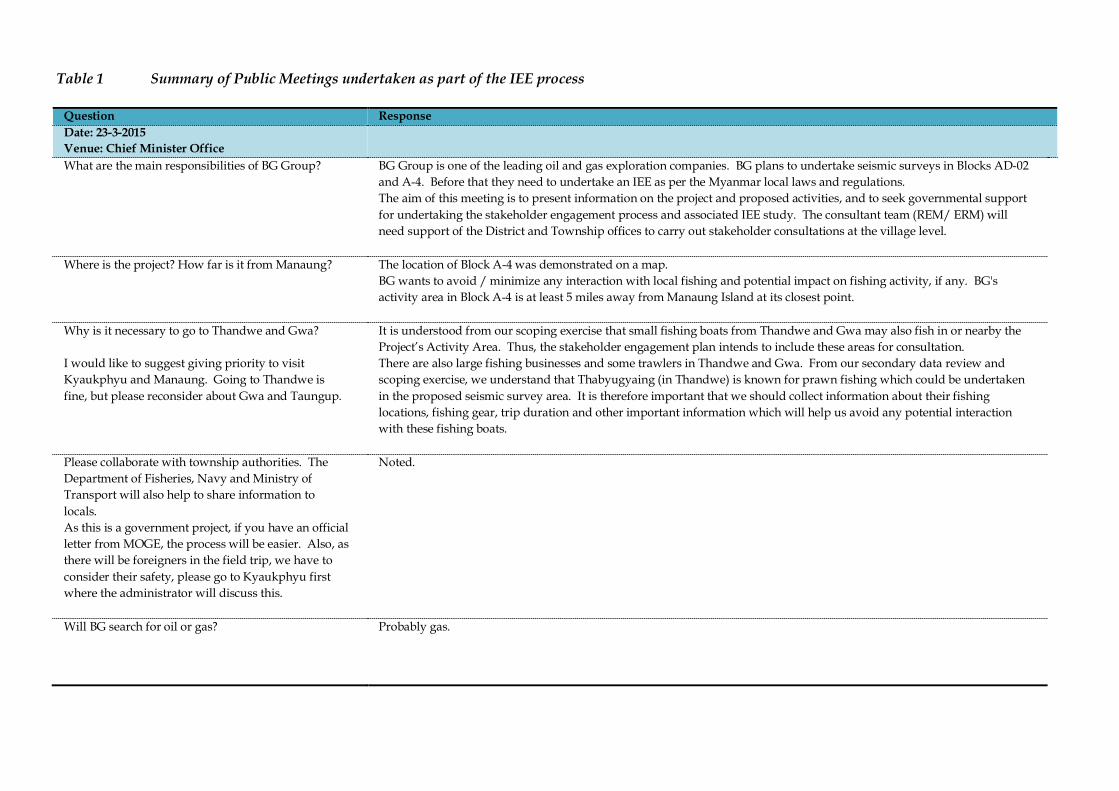
Table 1 Summary of Public Meetings undertaken as part of the IEE process
Question Response Date: 23-3-2015 Venue: Chief Minister Office
What are the main responsibilities of BG Group?
BG Group is one of the leading oil and gas exploration companies. BG plans to undertake seismic surveys in Blocks AD-02 and A-4. Before that they need to undertake an IEE as per the Myanmar local laws and regulations. The aim of this meeting is to present information on the project and proposed activities, and to seek governmental support for undertaking the stakeholder engagement process and associated IEE study. The consultant team (REM/ ERM) will need support of the District and Township offices to carry out stakeholder consultations at the village level.
Where is the project? How far is it from Manaung?
The location of Block A-4 was demonstrated on a map. BG wants to avoid / minimize any interaction with local fishing and potential impact on fishing activity, if any. BG's activity area in Block A-4 is at least 5 miles away from Manaung Island at its closest point.
Why is it necessary to go to Thandwe and Gwa? I would like to suggest giving priority to visit Kyaukphyu and Manaung. Going to Thandwe is fine, but please reconsider about Gwa and Taungup.
It is understood from our scoping exercise that small fishing boats from Thandwe and Gwa may also fish in or nearby the Project’s Activity Area. Thus, the stakeholder engagement plan intends to include these areas for consultation. There are also large fishing businesses and some trawlers in Thandwe and Gwa. From our secondary data review and scoping exercise, we understand that Thabyugyaing (in Thandwe) is known for prawn fishing which could be undertaken in the proposed seismic survey area. It is therefore important that we should collect information about their fishing locations, fishing gear, trip duration and other important information which will help us avoid any potential interaction with these fishing boats.
Please collaborate with township authorities. The Department of Fisheries, Navy and Ministry of Transport will also help to share information to locals. As this is a government project, if you have an official letter from MOGE, the process will be easier. Also, as there will be foreigners in the field trip, we have to consider their safety, please go to Kyaukphyu first where the administrator will discuss this.
Noted.
Will BG search for oil or gas?
Probably gas.
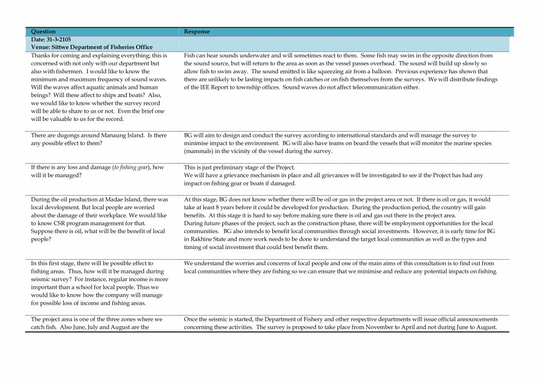
Question Response Date: 31-3-2105 Venue: Sittwe Department of Fisheries Office
Thanks for coming and explaining everything; this is concerned with not only with our department but also with fishermen. I would like to know the minimum and maximum frequency of sound waves. Will the waves affect aquatic animals and human beings? Will these affect to ships and boats? Also, we would like to know whether the survey record will be able to share to us or not. Even the brief one will be valuable to us for the record.
Fish can hear sounds underwater and will sometimes react to them. Some fish may swim in the opposite direction from the sound source, but will return to the area as soon as the vessel passes overhead. The sound will build up slowly so allow fish to swim away. The sound emitted is like squeezing air from a balloon. Previous experience has shown that there are unlikely to be lasting impacts on fish catches or on fish themselves from the surveys. We will distribute findings of the IEE Report to township offices. Sound waves do not affect telecommunication either.
There are dugongs around Manaung Island. Is there any possible effect to them?
BG will aim to design and conduct the survey according to international standards and will manage the survey to minimise impact to the environment. BG will also have teams on board the vessels that will monitor the marine species (mammals) in the vicinity of the vessel during the survey.
If there is any loss and damage (to fishing gear), how will it be managed?
This is just preliminary stage of the Project. We will have a grievance mechanism in place and all grievances will be investigated to see if the Project has had any impact on fishing gear or boats if damaged.
During the oil production at Madae Island, there was local development. But local people are worried about the damage of their workplace. We would like to know CSR program management for that. Suppose there is oil, what will be the benefit of local people?
At this stage, BG does not know whether there will be oil or gas in the project area or not. If there is oil or gas, it would take at least 8 years before it could be developed for production. During the production period, the country will gain benefits. At this stage it is hard to say before making sure there is oil and gas out there in the project area. During future phases of the project, such as the construction phase, there will be employment opportunities for the local communities. BG also intends to benefit local communities through social investments. However, it is early time for BG in Rakhine State and more work needs to be done to understand the target local communities as well as the types and timing of social investment that could best benefit them.
In this first stage, there will be possible effect to fishing areas. Thus, how will it be managed during seismic survey? For instance, regular income is more important than a school for local people. Thus we would like to know how the company will manage for possible loss of income and fishing areas.
We understand the worries and concerns of local people and one of the main aims of this consultation is to find out from local communities where they are fishing so we can ensure that we minimise and reduce any potential impacts on fishing.
The project area is one of the three zones where we catch fish. Also June, July and August are the
Once the seismic is started, the Department of Fishery and other respective departments will issue official announcements concerning these activities. The survey is proposed to take place from November to April and not during June to August.
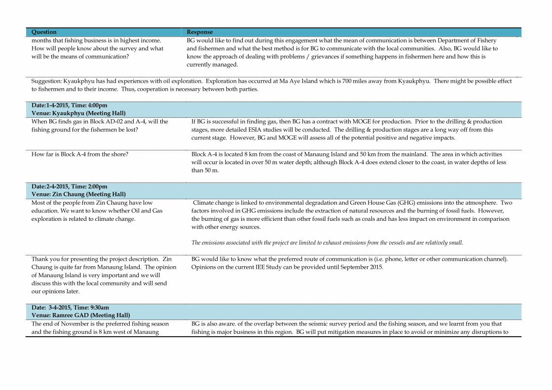
Question Response months that fishing business is in highest income. How will people know about the survey and what will be the means of communication?
BG would like to find out during this engagement what the mean of communication is between Department of Fishery and fishermen and what the best method is for BG to communicate with the local communities. Also, BG would like to know the approach of dealing with problems / grievances if something happens in fishermen here and how this is currently managed.
Suggestion: Kyaukphyu has had experiences with oil exploration. Exploration has occurred at Ma Aye Island which is 700 miles away from Kyaukphyu. There might be possible effect to fishermen and to their income. Thus, cooperation is necessary between both parties. Date: 1-4-2015, Time: 4:00pm Venue: Kyaukphyu (Meeting Hall)
When BG finds gas in Block AD-02 and A-4, will the fishing ground for the fishermen be lost?
If BG is successful in finding gas, then BG has a contract with MOGE for production. Prior to the drilling & production stages, more detailed ESIA studies will be conducted. The drilling & production stages are a long way off from this current stage. However, BG and MOGE will assess all of the potential positive and negative impacts.
How far is Block A-4 from the shore?
Block A-4 is located 8 km from the coast of Manaung Island and 50 km from the mainland. The area in which activities will occur is located in over 50 m water depth; although Block A-4 does extend closer to the coast, in water depths of less than 50 m.
Date: 2-4-2015, Time: 2:00pm Venue: Zin Chaung (Meeting Hall)
Most of the people from Zin Chaung have low education. We want to know whether Oil and Gas exploration is related to climate change.
Climate change is linked to environmental degradation and Green House Gas (GHG) emissions into the atmosphere. Two factors involved in GHG emissions include the extraction of natural resources and the burning of fossil fuels. However, the burning of gas is more efficient than other fossil fuels such as coals and has less impact on environment in comparison with other energy sources. The emissions associated with the project are limited to exhaust emissions from the vessels and are relatively small.
Thank you for presenting the project description. Zin Chaung is quite far from Manaung Island. The opinion of Manaung Island is very important and we will discuss this with the local community and will send our opinions later.
BG would like to know what the preferred route of communication is (i.e. phone, letter or other communication channel). Opinions on the current IEE Study can be provided until September 2015.
Date: 3-4-2015, Time: 9:30am Venue: Ramree GAD (Meeting Hall)
The end of November is the preferred fishing season and the fishing ground is 8 km west of Manaung
BG is also aware. of the overlap between the seismic survey period and the fishing season, and we learnt from you that fishing is major business in this region. BG will put mitigation measures in place to avoid or minimize any disruptions to

Question Response Island. The proposed seismic survey falls with the same fishing area and fishing period. How will BG take responsibility for any impacts during the seismic survey?
fishing in the area This consultation aims to help BG understand more about local fisheries in the vicinity of the Block and the potential for impacts to arise. By doing so, BG will be able to decide how to control and minimize the impact, if any. This consultation intends to understand communication options between fishermen and BG. BG would like to know how and where fishermen normally file complaint. For example, whether the complaints are routed through village tract leaders, fishing association at the village level or through township GAD or the Department of Fisheries. Based on this information, BG will hopefully be able to understand the local grievance redressal system and can develop one for the project, aligned to the existing practice. BG will establish a communication channel, such as a direct telephone number, in order to receive feedback after this consultation and up to September of this year.
November to April is good fishing season. If there are any problems relate to fishing, the Department of Fisheries takes an interest in it and can assist in finding a solution in consultation with the appropriate administrative department and regional authorities.
Thank you very much for sharing this important information.
Date: 4-4-2015, 10:15am Venue: Kyauk-Ni-Maw (Rakhine side) (Meeting Hall)
There are many nearshore fishermen in our region. Nearshore fishing is conducted out to 10 miles from the coastline. We would like to share the information about Chinese Shwe Gas project. Chinese extracts the gas from Rakhine area and they use gas for electricity in China but we didn't have any benefit. Most of the population here is poor. People cannot afford to buy even batteries for their radios.
The activity area is at least 10 km from the coastline and thus nearshore fishing activities will not be affected. BG has signed a contract with MOGE. BG has enlisted the help of a team of environmental consultants (REM & ERM) for this project. We will record and answer all the comments and opinions undertake the IEE Study for submission to MOECAF. This IEE Study is required under Myanmar’s environmental conservation law 2012. Now all the foreign investment projects must be transparent in comparison to past projects.
We are afraid that the sound wave produced by the seismic activities will have similar effect to an earthquake. We would also like to know if these activities are linked to climate change.
The sound waves will not be similar to an earthquake. Seismic surveys are conducted all over the world and BG has a lot of experience in undertaking similar projects in many countries. In these cases, there have not been any earthquake impacts or any other consequences due to seismic survey activity.
We rely on sea for our livelihood. We are fishing around 10 miles from coastline.
The Block is located 50 km (30miles) from the mainland of the Rakhine coast. The survey will only be conducted in water depths of over 50 m. The Block is located 5 miles west of Manaung Island.
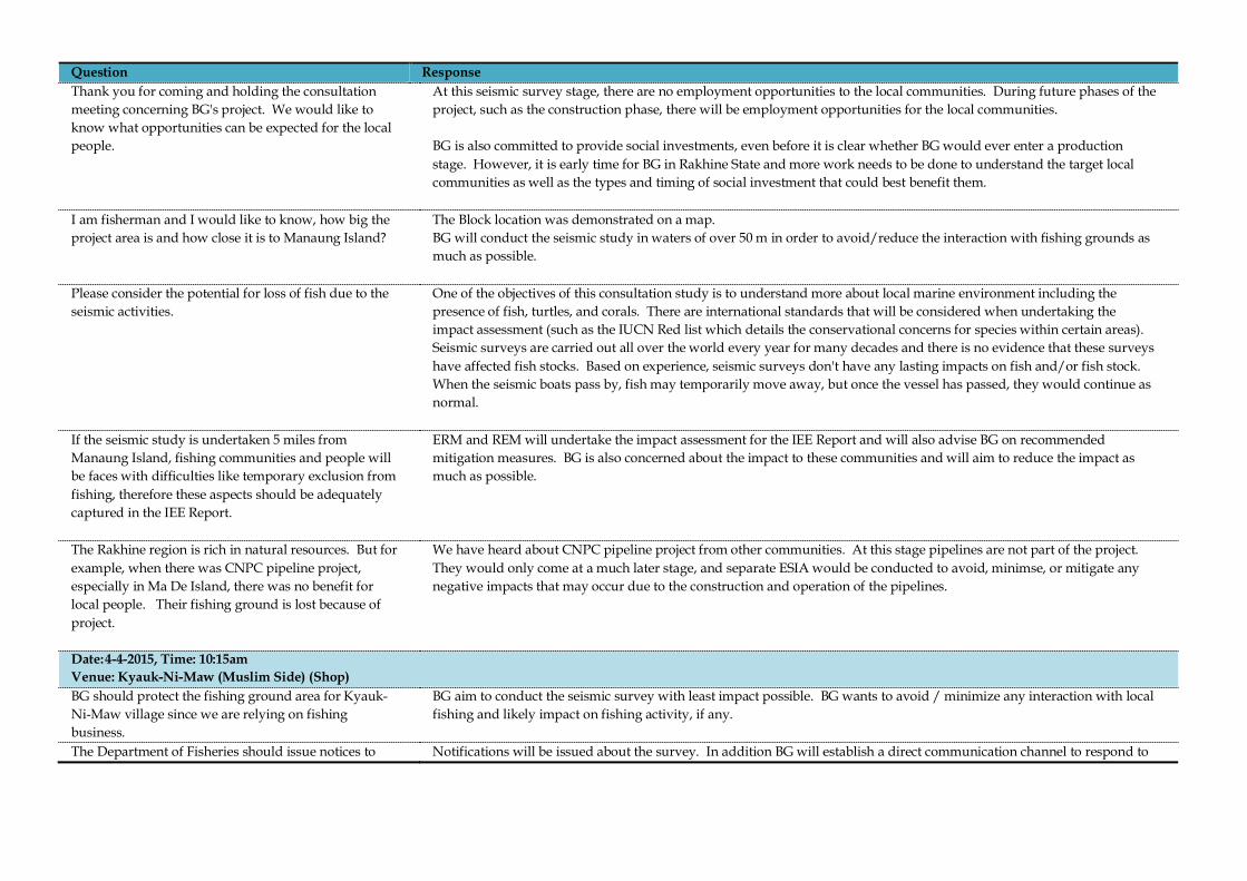
Question Response Thank you for coming and holding the consultation meeting concerning BG's project. We would like to know what opportunities can be expected for the local people.
At this seismic survey stage, there are no employment opportunities to the local communities. During future phases of the project, such as the construction phase, there will be employment opportunities for the local communities. BG is also committed to provide social investments, even before it is clear whether BG would ever enter a production stage. However, it is early time for BG in Rakhine State and more work needs to be done to understand the target local communities as well as the types and timing of social investment that could best benefit them.
I am fisherman and I would like to know, how big the project area is and how close it is to Manaung Island?
The Block location was demonstrated on a map. BG will conduct the seismic study in waters of over 50 m in order to avoid/reduce the interaction with fishing grounds as much as possible.
Please consider the potential for loss of fish due to the seismic activities.
One of the objectives of this consultation study is to understand more about local marine environment including the presence of fish, turtles, and corals. There are international standards that will be considered when undertaking the impact assessment (such as the IUCN Red list which details the conservational concerns for species within certain areas). Seismic surveys are carried out all over the world every year for many decades and there is no evidence that these surveys have affected fish stocks. Based on experience, seismic surveys don't have any lasting impacts on fish and/or fish stock. When the seismic boats pass by, fish may temporarily move away, but once the vessel has passed, they would continue as normal.
If the seismic study is undertaken 5 miles from Manaung Island, fishing communities and people will be faces with difficulties like temporary exclusion from fishing, therefore these aspects should be adequately captured in the IEE Report.
ERM and REM will undertake the impact assessment for the IEE Report and will also advise BG on recommended mitigation measures. BG is also concerned about the impact to these communities and will aim to reduce the impact as much as possible.
The Rakhine region is rich in natural resources. But for example, when there was CNPC pipeline project, especially in Ma De Island, there was no benefit for local people. Their fishing ground is lost because of project.
We have heard about CNPC pipeline project from other communities. At this stage pipelines are not part of the project. They would only come at a much later stage, and separate ESIA would be conducted to avoid, minimse, or mitigate any negative impacts that may occur due to the construction and operation of the pipelines.
Date: 4-4-2015, Time: 10:15am Venue: Kyauk-Ni-Maw (Muslim Side) (Shop)
BG should protect the fishing ground area for Kyauk-Ni-Maw village since we are relying on fishing business.
BG aim to conduct the seismic survey with least impact possible. BG wants to avoid / minimize any interaction with local fishing and likely impact on fishing activity, if any.
The Department of Fisheries should issue notices to Notifications will be issued about the survey. In addition BG will establish a direct communication channel to respond to

Question Response avoid an incident with fishing nets. We need to know the exact schedule and, if possible, we need it on a daily basis.
any issues, concerns, or grievances that might arise during the course of the survey. Finally, BG will also disclosure the findings of the IEE and will provide updates on the planned survey. BG understands that the people rely much on fishing and the survey will be designed and conducted in a manner so as to avoid or minimize impacts any negative impacts that may occur on fishing activities..
Date: 7-4-2015 Venue: Ka Ei (Meeting Hall)
The project area is more than 50 m water depth and west of Manaung Island. Villagers fish out to 160m water depth. So, the project will affect the fishing ground area.
BG will design, conduct and mitigate the seismic survey activity in order to avoid or reduce adverse input to fishing community.
According to presentation, fishing business many stop temporally. So, what is the responsibility of BG?
The purpose of these meetings is to confirm fishing locations to inform the assessment in the IEE Study. Mitigation measures will be derived to avoid or minimise any impacts to fishing activities. The project will potentially cause temporary disruptions, if we have to ask fishing boats to move out of the way of the seismic vessel. However, we will not exclude people from fishing as fishing boats can go back to the area once the seismic vessel passed.
What benefit will we get from this exploration (e.g. job opportunities, etc)?
For this seismic survey stage, the required staff number is small and jobs require staff with high degree of specialized and technical skills. More opportunities would arise in the future if, for example, BG decided to move into the construction phase. However, these are early days and it is uncertain whether BG will ever advance to construction phase. However, BG is committed to deliver early stage benefits through social investments during the exploratory phase.
Date: 6-4-2015, Time: 1:00pm Venue: Manaung GAD (Meeting Hall)
Block A-4 is quite close to Manaung Island. If the seismic study is undertaken in November, how will we be able to manage our livelihood? Government's regulation and ASEAN agreement do not allow us to fish from June to August. We can undertake sustenance fishing but not for commercial purposes. We want to know who will be responsible for loss of fishing due to the BG's seismic operation.
We have recorded your questions and concerns. This important issue will be discussed in the IEE Report and associated Environmental Management Plan (EMP). The project will not cause the suspension of fishing activities but will only cause potential temporary interruptions, if a boat is required to move away from the mobile navigational safety zone around the seismic survey vessel. We will not exclude people from fishing as fishing boats can go back to the area once the seismic vessel passed. The survey will be designed and conducted in a manner so as to avoid or minimize any negative impacts that may occur on fishing activities. .
The nearshore fishing grounds are located up to 10 miles from the Rakhine coast and Manaung Island falls
The objective of this consultation is to gather information on local fishing activity in Manaung Island and social economic conditions in order to inform our impact assessment. The IEE Study will aim to avoid or reduce any impacts and will

Question Response within this area. People from Manaung also fish up to 5 miles from Manaung Island. Due to the seismic operation, the fishing business will need to stop for 6 months, so we would like to know, how BG will be taking responsibility for this issue.
suggest mitigation measures where required. We thank you for your comments and opinions and we will include those in IEE Report. . The project will not cause the suspension of fishing activities but will only cause potential temporary interruptions, if a boat is required to move away from the mobile navigational safety zone around the seismic survey vessel. We will not exclude people from fishing as fishing boats can go back to the area once the seismic vessel passed. The survey will be designed and conducted in a manner so as to avoid or minimize any negative impacts that may occur on fishing activities..
I would like to suggest BG undertake seismic operations during the months of June, July and August as nobody is allowed to fish during that time.
Thank for you for suggestion. However, due to safety concerns of the vessel and the quality of data to be collected, BG cannot undertake the seismic vessel during June to August as the sea state is too rough.
How far is Block A-4 from Manaung Island?
It is 5 miles or 8 km from Manaung Island and over 50 km from Rakhine coast.
November to April period is the fishing season. For those 6 months period, BG should be responsible for the temporary suspension of fishing and should manage the livelihood of people as well.
The information and detailed notice will be announced through fishery department. The project will not cause the suspension of fishing activities but will only cause potential temporary interruptions, if a boat is required to move. We will not exclude people from fishing. The survey will be designed and conducted in a manner so as to avoid or minimize impacts or mitigate any negative impacts that may occur on fishing activities.. Also, the survey in Block A-4 will only last for 3 months not 6 months.
We would like to know the detailed schedule for each block; we understand that the seismic survey of each block will be taking 3 months. Nearshore is more important than offshore for Manaung people.
More detailed information and notices to mariners prior to the commencement of the survey will be announced through fishery department.
My suggestion is that the seismic survey should not be conducted in Nov-Jan to avoid the fishing season and should be conducted in June, July and August. Fishing activity near Manaung is undertaken throughout the year.
Thank you for your suggestion. Due to safety concerns of the vessel and the quality of data to be collected, BG cannot undertake the seismic vessel during June to August as the sea state is too rough.
We would like to thank the project for consulting with us. If gas is found, it should be used for Manaung Island. We only have access to electricity for 6 hours per day and we rely on firewood for cooking. This causes environmental degradation and deforestation. If gas is found we can use gas for cooking and reduce
As the current project only covers the seismic survey phase it is difficult to comment on what will happen during the later phases of the project. It is not a certainty that gas will be found.

Question Response the deforestation. We can also access the electricity 24 hours. Date: 8-5-2015, Time: 1:00pm Venue: Thandwe GAD (Meeting Hall)
Will the whole Block be restricted?
No, the exclusion zone will be mobile around the seismic vessel and will thus be temporary at a given area.. If fishing boats are in front of the vessel, there will be chase boats present to move them out of the way. The chase boats will operate day and night. While the seismic vessel is surveying, chase boats will communicate with the fishing boats as the seismic vessels can’t stop. Once the seismic vessel and equipment leaves an area, the fishing boats will be able to go back into that area. Therefore fishing boats will only be asked to stay away from the zone around the vessel and equipment.
How does sound affect the fish? What distance will the fish be effected?
Seismic surveys have been and are being conducted worldwide. They are considered low impact activities within the oil and gas industry. Sound may cause short term behavioural changes to fish behaviour; however, there is unlikely to be any impact on fish catches or migration patterns. We will be assessing the impact distances as part of the IEE Report and will be conducting underwater sound modelling to assess the impacts. However, based on previous experience the impacts are likely to be localised and short-term.
What were the comments raised from previous consultations?
People have previously raised concerns about the exclusion zone, however, any exclusion zone will be temporary and mobile. We will aim to minimise the effect on fishing as much as possible. All concerns will be published in the IEE Report and displayed in the township office.
How will the sound reduce away from the vessel? Is there equipment underwater? Will this study be used for another purpose?
There is sound recording equipment on the seismic survey vessel. However, there is no equipment underwater apart from the streamers. There will be some effect on marine life close to the sound source, though it should be noted that the sound will go directly vertically down and not laterally. Although some sound does travel away from the vessel, this reduces down to levels at which we don't anticipate impacts within a few kilometres and is only temporary.
Fishing is my main job. If sound can cause changes to fish behaviour? If this activity causes fish to go extinct, will the company take responsibility? What do you mean by temporary changes in fish behaviour?
There is evidence from previous studies of reef fish species that there is no major impact on the fish. Minor changes in behaviour means that the fish will swim away from the sound source but will return to the area once the vessel has past. Fish behaviour will return to normal after the sound / vessel has moved away. This is likely to be a short-term and localised impact. The assessment will be presented in the IEE Report.
You say you will minimise or avoid the impacts, if there are impacts will there be any social investment or benefits for the community?
BG will aim to avoid to the extent possible any possible impact on the people or the environment. The survey will be designed and conducted to minimise all potential impacts. BG does invest in areas when it makes a long term commitment but for this project, BG is planning to conduct social investments during this exploration phase.. However, it is too early to say what would be done in terms of social
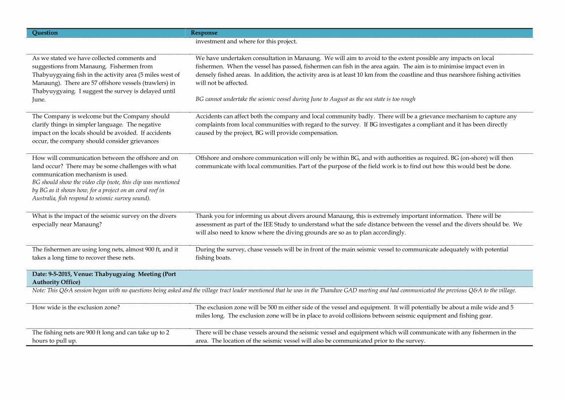
Question Response investment and where for this project.
As we stated we have collected comments and suggestions from Manaung. Fishermen from Thabyuygyaing fish in the activity area (5 miles west of Manaung). There are 57 offshore vessels (trawlers) in Thabyuygyaing. I suggest the survey is delayed until June.
We have undertaken consultation in Manaung. We will aim to avoid to the extent possible any impacts on local fishermen. When the vessel has passed, fishermen can fish in the area again. The aim is to minimise impact even in densely fished areas. In addition, the activity area is at least 10 km from the coastline and thus nearshore fishing activities will not be affected. BG cannot undertake the seismic vessel during June to August as the sea state is too rough
The Company is welcome but the Company should clarify things in simpler language. The negative impact on the locals should be avoided. If accidents occur, the company should consider grievances
Accidents can affect both the company and local community badly. There will be a grievance mechanism to capture any complaints from local communities with regard to the survey. If BG investigates a compliant and it has been directly caused by the project, BG will provide compensation.
How will communication between the offshore and on land occur? There may be some challenges with what communication mechanism is used. BG should show the video clip (note, this clip was mentioned by BG as it shows how, for a project on an coral reef in Australia, fish respond to seismic survey sound).
Offshore and onshore communication will only be within BG, and with authorities as required. BG (on-shore) will then communicate with local communities. Part of the purpose of the field work is to find out how this would best be done.
What is the impact of the seismic survey on the divers especially near Manaung?
Thank you for informing us about divers around Manaung, this is extremely important information. There will be assessment as part of the IEE Study to understand what the safe distance between the vessel and the divers should be. We will also need to know where the diving grounds are so as to plan accordingly.
The fishermen are using long nets, almost 900 ft, and it takes a long time to recover these nets.
During the survey, chase vessels will be in front of the main seismic vessel to communicate adequately with potential fishing boats.
Date: 9-5-2015, Venue: Thabyugyaing Meeting (Port Authority Office)
Note: This Q&A session began with no questions being asked and the village tract leader mentioned that he was in the Thandwe GAD meeting and had communicated the previous Q&A to the village. How wide is the exclusion zone? The exclusion zone will be 500 m either side of the vessel and equipment. It will potentially be about a mile wide and 5
miles long. The exclusion zone will be in place to avoid collisions between seismic equipment and fishing gear.
The fishing nets are 900 ft long and can take up to 2 hours to pull up.
There will be chase vessels around the seismic vessel and equipment which will communicate with any fishermen in the area. The location of the seismic vessel will also be communicated prior to the survey.

Question Response We will need to wait for news of when vessel has passed our area, when will it be communicated?
A communication system will be in place prior to the survey and will be confirmed with fishermen. The whole block will not be excluded. The seismic vessel will take maximum 2 hours to pass a certain area. The boat can still continue to fish outside the route of the seismic vessel. Whenever a fishing boat gets too close to the seismic vessel, a chase boat will communicate with potential fishing boats. BG would like to know from the community the best way to communicate. Potentially, announcements will be made over the offshore radio regarding the location of the seismic vessel.
Suggestions / other queries:
• BG should provide a specific radio frequency to communicate with the fishermen; • Exact information on location (coordinates) and movement of the seismic vessels should be provided. This should be
provided at a specific time (e.g. 7 AM or 9 AM) to help fishermen plan their days fishing; • Channel Number 1077200 was suggested for communication as it is the strongest channel; however this may change
over time. • Fishermen suggested that the fishing association leader should be contacted to inform the company of the most
appropriate channel.
Date: 10-5-2015. Venue: Sin Gaung Meeting (School)
Are there any impacts on the fish resources? We are not interested in the exclusion zone, only in the fish.
The sound is low frequency (200 hertz) and the sound reduces further away from the seismic vessel. The sound reduces down to a level within a few miles / km where we don't anticipate impacts. As the seismic vessel passes, fish move away but come back once it has gone. The impact on fish will be assessed in the IEE Report.
You are giving us suffering as we are fishing in the Block. Fish come from deeper water to shallower waters, you say it takes 1 day to go up and down (i.e. for the seismic vessel to undertake one line in north to south direction), but fishing is seasonal so one day may affect us.
The seismic vessel will emit noise but this will be localised to around the vessel and there is unlikely to be any impact on fish migrations and in turn on fish catches. The fishermen will not be asked to stop fishing during the movement of the seismic vessel for the survey. They will be asked to shift locations only when they get too close to boat.
The way we fish is to stop and wait for fish so if the vessel / exclusion zone are present, we need to wait for it to pass.
The navigational safety zone will be mobile around the vessel. If the fishing vessel gets too close chase vessels will ask them to move away from the vessel and equipment.
It takes 1 to 5 hrs (5 hours for bigger nets which are full of catch) to pick up the spread net.
This is important information for us. We will consider this information when planning for our exclusion zone and chase vessel procedures as it is important to give enough time to the fishermen to pull up their nets.
Question Response Some fishermen pay their workers in advance and if they make loss in fish catch, they will not be able to recover the cost.
We will not be preventing anyone from fishing; this project could just temporarily displace fishing activity. You will still have the other areas for fishing nearby.
A concern was raised about Manaung where most of the fishermen are fishing during the night.
While the seismic vessel is surveying, chase boats will communicate with fishing boats to ensure safe distance from the seismic vessel. Chase boats will operate day and night to ensure fishermen will not be impacted.
Date: 10-5-2015.Venue: Gyeitkaw Village (Meeting Hall)
How are ERM and REM integrating? Is the process transparent?
REM and ERM have no bias and are experienced undertaking environmental and social impact assessment for seismic projects. The IEE Report will be transparent and will be submitted to MOGE and will be assessed / approved by MOECAF.
What is the risk of earthquakes?
Offshore seismic surveys have been conducted all over the world and have not been linked to earthquakes.
Will the hole drilled in the seabed cause any seabed impact / collapse? (referring to the potential future drilling stage of the project)
This stage, the project is only a seismic survey and drilling is outside the scope of the project. But we will respond to your drilling query. . The hole in the seabed during drilling is small (around 30 inches). Whilst drilling, special parameters are monitored to maintain the pressure in the well and reservoir. Oil and gas wells have been drilled all around the world and they have never caused a vacuum to be created. .
There is fishing near Manaung (in rocky areas), sometimes for 2 to3 days at sea. How would any clash/ accident with seismic survey vessel be avoided?
The seismic survey will be undertaken almost 5 miles away from the Manaung coast. BG aims to avoid and reduce any potential impact to fishermen in this area. There will be a mobile navigational safety zone around the seismic survey vessel and equipment. While the seismic vessel is surveying, chase boats will communicate with the fishing boats as the seismic vessels can’t stop. Fishing boats will be asked to stay away from the navigational safety zone.
ERM consulting services worldwide www.erm.com
ERM has over 150 officesAcross the followingcountries worldwide
ArgentinaAustraliaBelgiumBrazilCanadaChinaColombiaFranceGermanyHong KongHungaryIndiaIndonesiaIrelandItalyJapanKazakhstanKoreaMalaysiaMexico
New ZealandPanamaPeruPolandPortugalPuerto RicoRomaniaRussiaSingaporeSouth AfricaSpainSwedenTaiwanThailandThe NetherlandsUnited Arab EmiratesUnited KingdomUnited StatesVietnam
Environmental Resources Management
16/F Berkshire House25 Westlands RoadQuarry Bay, Hong Kong
Telephone 2271 3000Facsimile 2723 5660
www.erm.com