Environmental and Social Assessment with Management Plan ...
144
Final Report Environmental and Social Assessment with Management Plan for laying of Branch Sewers and Allied Works in Sewerage District-I of Kanpur City, Uttar Pradesh Prepared for NATIONAL GANGA RIVER BASIN AUTHORITY (NGRBA) (Ministry of Environment and Forests, Government of India) SFG1690 V2 Public Disclosure Authorized Public Disclosure Authorized Public Disclosure Authorized Public Disclosure Authorized
-
Upload
khangminh22 -
Category
Documents
-
view
2 -
download
0
Transcript of Environmental and Social Assessment with Management Plan ...
Final Report
Environmental and Social Assessment
with Management Plan for laying of
Branch Sewers and Allied Works in
Sewerage District-I of Kanpur City,
Uttar Pradesh
Prepared for
NATIONAL GANGA RIVER BASIN AUTHORITY (NGRBA)
(Ministry of Environment and Forests,
Government of India)
SFG1690 V2P
ublic
Dis
clos
ure
Aut
horiz
edP
ublic
Dis
clos
ure
Aut
horiz
edP
ublic
Dis
clos
ure
Aut
horiz
edP
ublic
Dis
clos
ure
Aut
horiz
ed
Environmental and Social Assessment with Management Plan (Sewerage District-I, Kanpur)
ii
© The Energy and Resources Institute 2014
Suggested format for citation
T E R I. 2013
Environmental and Social Assessment with Management Plan for laying of Branch
Sewers and Allied Works in Sewerage District-I of Kanpur City, Uttar Pradesh
New Delhi: The Energy and Resources Institute.
[Project Report No. 2010WM13]
For more information Sonia Grover
Research Associate – Water Resources Division
T E R I Tel. 2468 2100 or 2468 2111
Darbari Seth Block E-mail [email protected]
IHC Complex, Lodhi Road Fax 2468 2144 or 2468 2145
New Delhi – 110 003 Web www.teriin.org
India India +91 • Delhi (0)11
Environmental and Social Assessment with Management Plan (Sewerage District-I, Kanpur)
iii
Table of Contents
EXECUTIVE SUMMARY ................................................................................................................... 2
CHAPTER 1 INTRODUCTION ......................................................................................................... 8
1.1 Ganga Clean up Initiatives ............................................................................................. 8
1.2 The Ganga River Basin Project ....................................................................................... 8
1.2.1 World Bank Assistance ..................................................................................... 9
1.3 Project Components ......................................................................................................... 9
1.3.1 Component One: Institutional Development ................................................ 9
1.3.2 Component Two: Priority Infrastructure Investments .............................. 11
1.4 Structure of the Report .................................................................................................. 12
CHAPTER 2 PROJECT DESCRIPTION ........................................................................................... 13
2.1 About the City ................................................................................................................ 13
2.2 Existing Sewerage Facilities in Kanpur City .............................................................. 14
2.2.1 Works Completed under Ganga Action Plan Phase .................................. 15
2.2.2 On-going works under JNNURM................................................................. 16
2.2.3 City Sewerage Plan ......................................................................................... 17
2.3 Necessity of this project ................................................................................................ 18
2.4 Location of Proposed Sewerage Project ...................................................................... 19
2.5 Proposed Sewerage System .......................................................................................... 20
2.5.1 Components of Proposed Sewerage Work .................................................. 22
2.5.2 Implementation Schedule .............................................................................. 23
2.5.3 Financing .......................................................................................................... 23
CHAPTER 3 APPROACH AND METHODOLOGY ......................................................................... 25
3.1 Methodology.................................................................................................................. 25
3.2 Project Screening ............................................................................................................ 27
3.3 Conclusion of Screening Activity ................................................................................ 40
CHAPTER 4 REGULATIONS AND LEGAL FRAMEWORK ............................................................. 41
4.1 Applicable Laws and Regulations – Environmental................................................. 41
4.1.1 Legal Framework of Government of India .................................................. 41
4.1.2 Key Environmental Laws and Regulations ................................................. 41
4.2 Applicable Laws and Regulations - Social ................................................................. 44
4.2.1 National Policies and Acts ............................................................................. 44
4.2.2 Right to Fair Compensation and Transparency in Land Acquisition
and Rehabilitation and Resettlement (RFCTLAR&R) Act- 2013 .............. 45
4.2.3 Land Acquisition Act, 1894 (As Modified Until 1st September, 1985) .... 45
4.2.4 Forest Rights Act 2006 .................................................................................... 46
4.2.5 Environmental and Social Management Framework of NGRBA ............ 47
4.3 Other Legislations applicable to Construction Projects under NGRBP ................. 53
4.4 Conclusion ...................................................................................................................... 54
CHAPTER 5 BASELINE STATUS ................................................................................................... 56
5.1 Baseline Environmental Status ..................................................................................... 56
5.1.1 Physiography and Topography .................................................................... 56
5.1.2 Climate .............................................................................................................. 56
5.1.3 Geological and Geophysical features ........................................................... 57
Environmental and Social Assessment with Management Plan (Sewerage District-I, Kanpur)
iv
5.1.4 Ambient Air Quality ....................................................................................... 58
5.1.5 Noise Environment ......................................................................................... 60
5.1.6 Water Environment ........................................................................................ 61
5.1.7 Storm Water Drainage .................................................................................... 66
5.1.8 Waste Water Management ............................................................................. 67
5.1.9 Solid Waste Management .............................................................................. 70
5.1.10 Biological Environment ................................................................................. 71
5.2 Baseline Social Status ..................................................................................................... 74
5.2.1 Details of Social Surveys ................................................................................ 79
5.2.2 Access to Basic Services .................................................................................. 79
5.2.3 Status of Poverty in Kanpur .......................................................................... 79
CHAPTER 6 ENVIRONMENTAL AND SOCIAL IMPACTS ............................................................ 85
6.1 Potential Environmental Impacts ................................................................................ 85
6.1.1 Design and Development Phase ................................................................... 85
6.1.2 Impacts during construction ......................................................................... 85
6.1.3 Impacts during operation .............................................................................. 87
6.2 Potential Social Impacts ................................................................................................ 88
6.2.1 Social Impacts .................................................................................................. 88
6.3 Conclusion ...................................................................................................................... 92
CHAPTER 7 MITIGATION AND MANAGEMENT PLAN .............................................................. 94
7.1 Environmental Management plan ............................................................................... 94
7.1.1 Implementation of EMP Specific activities by UPJN ................................. 94
7.1.2 Implementation of EMP ................................................................................. 94
7.2 Environmental Monitoring Plan ................................................................................ 106
7.3 EMP Budget .................................................................................................................. 106
7.4 Social Management Plan ............................................................................................. 118
7.4.1 Social mitigation plans during construction phase .................................. 118
7.4.2 Social mitigation plans during operation phase ....................................... 120
7.4.3 Mitigation measures adopted by locals during similar nature of
project activities ............................................................................................. 120
7.4.4 Consultation Framework for Participatory Planning and
Implementation of Mitigation Plan ............................................................ 123
7.4.5 Assess the Capacity of Institutions and Mechanisms for
Implementing Social Development Aspects and Social Safeguard
Plans; Recommend Capacity building measures ..................................... 124
7.4.6 Develop Monitoring and Evaluation Mechanisms to Assess Social
Development Outcomes ............................................................................... 125
CHAPTER 8 SOCIAL DEVELOPMENT OUTCOMES AND ISSUES ............................................... 126
8. 1 Social Development Outcomes of the sub project ................................................... 126
8.2 Social development issues in project vicinity and social services to be
provided by the project ............................................................................................... 127
CHAPTER 9 CONCLUSION ......................................................................................................... 129
ANNEXURE 1 QUESTIONNAIRE ................................................................................................. 130
ANNEXURE 2 MINUTES OF MEETING WITH KEY STAKEHOLDERS ......................................... 132
ANNEXURE 3 CENSUS DATA ..................................................................................................... 137
Environmental and Social Assessment with Management Plan (Sewerage District-I, Kanpur)
v
List of Tables
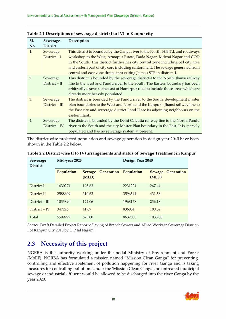
Table 2.1 Descriptions of sewerage district (I to IV) in Kanpur city ................................ 18
Table 2.2 District wise (I to IV) arrangements and status of Sewage Treatment in
Kanpur ..................................................................................................................... 18
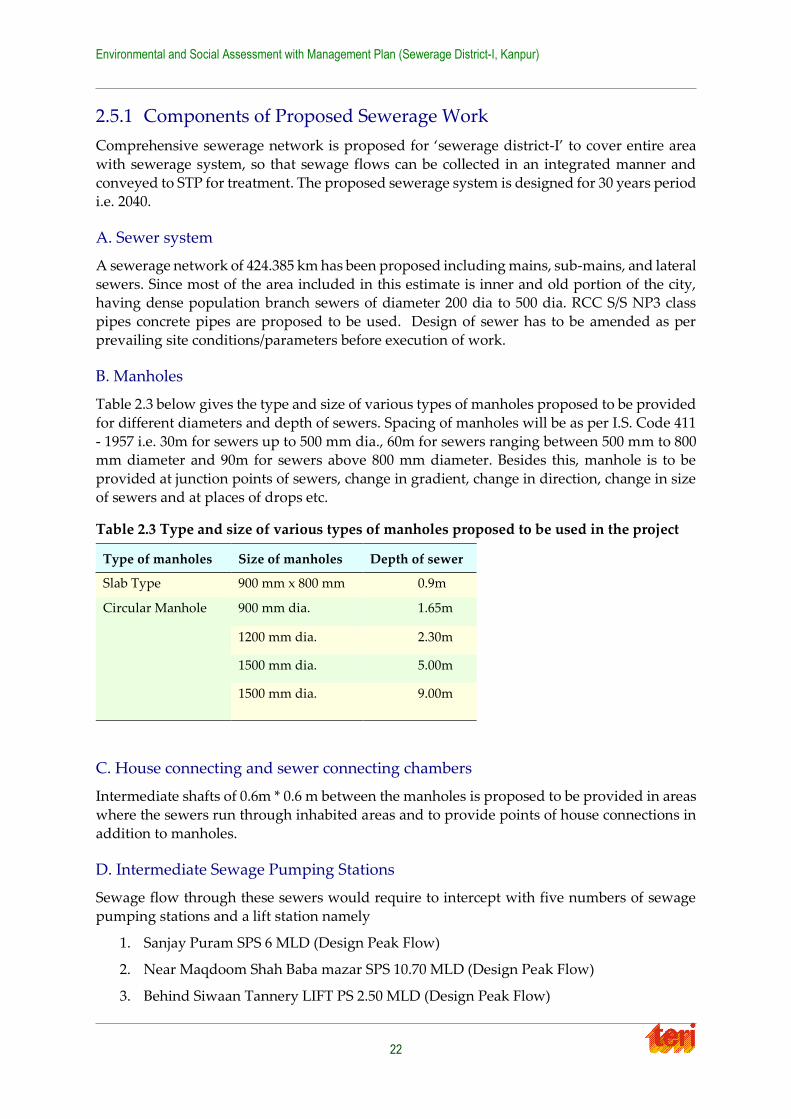
Table 2.3 Type and size of various types of manholes proposed to be used in the
project ....................................................................................................................... 22
Table 2.4 Abstract of Cost of Works Proposed .................................................................... 24
Table 3.1 Findings from Environment and Social Screening ............................................ 28
Table 4.1 Environmental Regulations and Legislations..................................................... 41
Table 4.2 The Land Acquisition Process .............................................................................. 46
Table 4.3 Entitlement Matrix ................................................................................................. 48
Table 5.1 Historic Temperature and Rainfall Data for Kanpur (A) Station .................... 57
Table 5.2 Geological succession ............................................................................................. 57
Table 5.3 Summary of Noise Level Monitored at selected location in Kanpur city ...... 60
Table 5.4 Water consumption in sewerage district-I .......................................................... 61
Table 5.5 Water quality at selected locations upstream and downstream of Kanpur ... 63
Table 5.6 Water quality analysis of few nallas passing through sewerage district-I
of Kanpur city ......................................................................................................... 69
Table 5.7 Biochemical Oxygen Demand (BOD) in mg/L Concentrations in Influent
and Effluent Streams of Kanpur STPs ................................................................. 70
Table 5.8 Solid waste generation in sewerage district-I, Kanpur city .............................. 71
Table 5.9 Ward wise census population and projected population and observed
land use .................................................................................................................... 75
Table 5.10 Ward wise details of the survey ........................................................................... 82
Table 7.1 Generic Environmental Guidelines / Management Plan for Low impact
category Investments ............................................................................................. 96
Table 7.2 Environmental Monitoring Plan ........................................................................ 108
Table 7.3 Cost information of EMP ..................................................................................... 111
Table 7.4 Cost of Environmental Monitoring Plan ........................................................... 117
Table 7.5 Social Management Plan ..................................................................................... 121
Table 7.6 Role of stakeholders in implementation and mitigation ................................ 125
Environmental and Social Assessment with Management Plan (Sewerage District-I, Kanpur)
vi
List of Figures
Figure 2.1 Location of Kanpur City ........................................................................................ 13
Figure 2.2 City Sewerage plan for Kanpur, GPCU, UPJN, Kanpur ................................... 17
Figure 2.3 Map of sewerage district-I of Kanpur city .......................................................... 21
Figure 3.1 Flowchart describing the steps adopted for Environmental and Social Assessment
................................................................................................................................... 25
Figure 5.1 Geology map of Kanpur ........................................................................................ 58
Figure 5.2 Ambient RSPM concentrations at Jajamau, Kanpur during year 2006
to 2009 ...................................................................................................................... 59
Figure 5.3 Month wise variation of SO2, NO2 and RSPM at Jajmau station in Kanpur . 60
Figure 5.4 Location of Kanpur Zoo Lake, adjacent to Azadnagar locality ....................... 62
Figure 5.5 Total coliform profile of river Ganga during rainy season of year 2010
and 2011 ................................................................................................................... 64
Figure 5.6 Location of Nalas emerging from Kanpur and emptying into the
River Ganga ............................................................................................................. 67
Figure 5.7 Map of trees in Kanpur sewerage District I ........................................................ 72
Figure 5.8 Satellite image showing agricultural areas (green points) in Kanpur
District-I (top) and zoomed in area at Nawabganj (left) and land between Westgate
and Ghasiyari Mandi (right), within Kanpur
sewerage district ‘I’ ................................................................................................ 73
Figure 5.9 Map showing some of the nearest eco-sensitive areas around
Kanpur city .............................................................................................................. 74
Figure 5.10 Map indicating major land use and social survey locations for Kanpur
District-I ................................................................................................................... 84
Figure 6.1 GIS map showing the road network of Kanpur District-I, with
highlighted regions of dense road network. ....................................................... 89
Figure 7.1 Broad Institutional arrangements for implementation of EMP ....................... 95

Environmental and Social Assessment with Management Plan (Sewerage District-I, Kanpur)
2
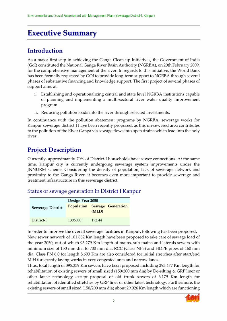
Executive Summary
Introduction
As a major first step in achieving the Ganga Clean up Initiatives, the Government of India (GoI) constituted the National Ganga River Basin Authority (NGRBA), on 20th February 2009,
for the comprehensive management of the river. In regards to this initiative, the World Bank
has been formally requested by GOI to provide long-term support to NGRBA through several phases of substantive financing and knowledge support. The first project of several phases of
support aims at:
i. Establishing and operationalizing central and state level NGRBA institutions capable of planning and implementing a multi-sectoral river water quality improvement
program.
ii. Reducing pollution loads into the river through selected investments.
In continuance with the pollution abatement programs by NGRBA, sewerage works for
Kanpur sewerage district I have been recently proposed, as this un-sewered area contributes
to the pollution of the River Ganga via sewage flows into open drains which lead into the holy river.
Project Description
Currently, approximately 70% of District-I households have sewer connections. At the same
time, Kanpur city is currently undergoing sewerage system improvements under the JNNURM scheme. Considering the density of population, lack of sewerage network and
proximity to the Ganga River, it becomes even more important to provide sewerage and
treatment infrastructure in this sewerage district.
Status of sewage generation in District I Kanpur
In order to improve the overall sewerage facilities in Kanpur, following has been proposed.
New sewer network of 101.882 Km length have been proposed to take care of sewage load of
the year 2050, out of which 93.279 Km length of mains, sub-mains and laterals sewers with
minimum size of 150 mm dia. to 700 mm dia. RCC (Class NP3) and HDPE pipes of 160 mm
dia. Class PN 6.0 for length 8.603 Km are also considered for initial stretches after start/end
M.H for speedy laying works in very congested area and narrow lanes.
Thus, total length of 395.359 Km sewers have been proposed including 293.477 Km length for
rehabilitation of existing sewers of small sized (150/200 mm dia) by De-silting & GRP liner or
other latest technology except proposal of old trunk sewers of 6.179 Km length for
rehabilitation of identified stretches by GRP liner or other latest technology. Furthermore, the
existing sewers of small sized (150/200 mm dia) about 29.026 Km length which are functioning
Sewerage District
Design Year 2050
Population Sewage Generation
(MLD)
District-I 1306000 172.44
Environmental and Social Assessment with Management Plan (Sewerage District-I, Kanpur)
3
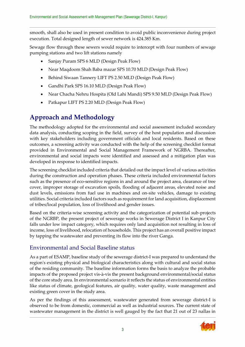
smooth, shall also be used in present condition to avoid public inconvenience during project
execution. Total designed length of sewer network is 424.385 Km.
Sewage flow through these sewers would require to intercept with four numbers of sewage
pumping stations and two lift stations namely
Sanjay Puram SPS 6 MLD (Design Peak Flow)
Near Maqdoom Shah Baba mazar SPS 10.70 MLD (Design Peak Flow)
Behind Siwaan Tannery LIFT PS 2.50 MLD (Design Peak Flow)
Gandhi Park SPS 16.10 MLD (Design Peak Flow)
Near Chacha Nehru Hospita (Old Lahi Mandi) SPS 9.50 MLD (Design Peak Flow)
Patkapur LIFT PS 2.20 MLD (Design Peak Flow)
Approach and Methodology
The methodology adopted for the environmental and social assessment included secondary data analysis, conducting scoping in the field, survey of the host population and discussion
with key stakeholders including government officials and local residents. Based on these
outcomes, a screening activity was conducted with the help of the screening checklist format provided in Environmental and Social Management Framework of NGRBA. Thereafter,
environmental and social impacts were identified and assessed and a mitigation plan was
developed in response to identified impacts.
The screening checklist included criteria that detailed out the impact level of various activities
during the construction and operation phases. These criteria included environmental factors
such as the presence of eco-sensitive regions in and around the project area, clearance of tree cover, improper storage of excavation spoils, flooding of adjacent areas, elevated noise and
dust levels, emissions from fuel use in machines and on-site vehicles, damage to existing
utilities. Social criteria included factors such as requirement for land acquisition, displacement of tribes/local population, loss of livelihood and gender issues.
Based on the criteria-wise screening activity and the categorization of potential sub-projects
of the NGRBP, the present project of sewerage works in Sewerage District I in Kanpur City falls under low impact category, which requires only land acquisition not resulting in loss of
income, loss of livelihood, relocation of households. This project has an overall positive impact
by tapping the wastewater and preventing its flow into the river Ganga.
Environmental and Social Baseline status
As a part of ESAMP, baseline study of the sewerage district-I was prepared to understand the region's existing physical and biological characteristics along with cultural and social status
of the residing community. The baseline information forms the basis to analyze the probable
impacts of the proposed project vis-à-vis the present background environmental/social status of the core study area. In environmental scenario it reflects the status of environmental entities
like status of climate, geological features, air quality, water quality, waste management and
existing green cover in the study area.
As per the findings of this assessment, wastewater generated from sewerage district-I is
observed to be from domestic, commercial as well as industrial sources. The current state of
wastewater management in the district is well gauged by the fact that 21 out of 23 nallas in

Environmental and Social Assessment with Management Plan (Sewerage District-I, Kanpur)
4
Kanpur are present in the district -I area. These include nallas such as the Sisamau nalla,
Ganda nalla and COD nalla. Summary of wastewater quality analysis conducted by UP Pollution Control Board for some select nallas passing through sewerage district-I, showed
signs of high levels of Biochemical Oxygen Demand (BOD) which has been re-affirmed by
foul odour and smell. Such occurrences of pollution impact not only on the drinking water but also other sectors such as fisheries, irrigation, and recreational bathing, all of which are
majorly dependent on the River Ganga. In terms of surface water quality of the river in Kanpur
the biochemical oxygen demand (BOD) levels at the downstream monitoring stations are often above the permissible 3.0 mg/l for outdoor bathing waters and, both upstream and
downstream stations indicated BOD above the water quality criteria (Class A) of 2.0 mg/l for
the drinking water without treatment but after disinfection (as per CPCB’s surface water classification for Designated Best Use). Total coliform at downstream monitoring stations are
more than 18 times the total coliform count at upstream monitoring locations in all seasons
and all years. Total Coliform count is higher in most of the season at Kanpur section
As far as air quality is concerned the available data from NAMP monitoring shows that the
dust levels, Respirable Suspended Particulate Matter (RSPM) near Jajmau area have violated
the annual average standards of 60µg/m3 and indicates an upward trend from 2006 to 2009. Nitrogen dioxide and sulphur dioxide levels are within the permissible standards of CPCB.
For noise level assessment, 4 stations in Kanpur are monitored of which 1 (Ghantaghar) falls
in district 1 and other 2 (Kidwai Nagar and Hallet hospital station) are close to it. The noise levels were observed to be above the permissible limits laid down by CPCB (for both day and
night time) in most of the monitoring stations.
With respect to solid waste presently there is no waste processing plant at Kanpur and the total waste is taken to disposal sites, which are generally in open.
Based on field surveys, stakeholder consultations and assessment of the baseline status, in the
context of upcoming future sewerage works and also keeping in view the already underway JNNURM sewerage work in the city, potential environmental and social impacts were
identified and analyzed. It was found that although there would not be any permanent
negative or adverse environmental or social impacts; there may be certain temporary impacts on water resources, air quality (impact on health), traffic blockages, safety hazards for
pedestrians, possible interruption in commercial activity, and accidental damage to public
utilities and infrastructure such as water pipes, telephone lines, etc.
Potential Environmental and Social Impacts
Although there would not be any permanent negative or adverse environmental or social impacts, but will have temporary impacts on water quality, air quality (impact on health),
traffic blockages, safety hazards for pedestrians, possible damage to private property, possible
interruption in commercial activity.
The identified environmental impacts were further classified under the heads of air quality,
noise quality, water environment, soil quality and ecology. Certain sensitive areas prone to a
higher degree of inconvenience and impact were identified. These included schools and colleges such as Harcourt Butler Technological Institute, Chandra Shekhar Azad University
of Agriculture and Technology, ICFAI National College, DAV College, hospitals such as RK
Devi eye hospital, Gastro Liver Hospital, Chandhini Hospital, Sahani Hospital and areas with narrow lanes and crowded streets such as Patkapur, Chowk Sarafa, LIC Chauraha, General
Ganj, Cooper Ganj and Collector Ganj among others.
Environmental and Social Assessment with Management Plan (Sewerage District-I, Kanpur)
5
Social assessment clearly defines that no significant issues arise from the land to be acquired
for pumping stations in Kanpur District-I. This explicitly implies that there will be no loss of income, loss of livelihood or need for relocation of households or displacement of encroached
settlements. However, if any loss of livelihood would be noticed during implementation of
this project, then the affected party will be compensated according to Environment and Social Management Framework (ESMF) guidelines set by the NGRBA. Moreover, some
inconvenience caused to the local public has been reported along with the local mitigation
plan which is to be adopted to overcome any inconvenience during the ongoing JNNURM project. A prominent suggestion which was received during the consultations was execution
of construction work within a scheduled time frame with provision of prior notice to residents
and shop-owners. A public grievance mechanism (as prescribed by ESMF of NGRBA) is to be followed. A section chalking out institutional mechanism, capacity building requirements and
monitoring and evaluation mechanism is also presented.
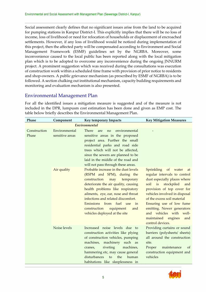
Environmental Management Plan
For all the identified issues a mitigation measure is suggested and of the measure is not
included in the DPR, lumpusm cost estimation has been done and given as EMP cost. The table below briefly describes the Environmental Management Plan.
Phase Component Key temporary Impacts Key Mitigation Measures
Environmental
Construction
Phase
Environmental
sensitive areas
There are no environmental
sensitive areas in the proposed
project area. Further the small
residential parks and road side
trees which will not be affected,
since the sewers are planned to be
laid in the middle of the road and
will not pass through these areas.
- -
Air quality
Probable increase in the dust levels
(RSPM and SPM), during the
construction may temporary
deteriorate the air quality, causing
health problems like respiratory
ailments, eye, ear, nose and throat
infections and related discomfort.
Emissions from fuel use in
construction equipment and
vehicles deployed at the site
Sprinkling of water at
regular intervals to control
dust especially places where
soil is stockpiled and
provision of top cover for
vehicles involved in disposal
of the excess soil material
Ensuring use of low fume
emitting. Newer generators
and vehicles with well-
maintained engines and
control devices.
Noise levels Increased noise levels due to
construction activities like plying
of construction vehicles, pumping
machines, machinery such as
cranes, riveting machines,
hammering etc, may cause general
disturbances to the human
habitations like sleeplessness in
Providing curtains or sound
barriers (polysheets/ sheets)
all around the construction
site.
Proper maintenance of
construction equipment and
vehicles
Environmental and Social Assessment with Management Plan (Sewerage District-I, Kanpur)
6
Phase Component Key temporary Impacts Key Mitigation Measures
case construction activity is
extended into the night hours.
Water resources
Contamination of nearby water
bodies via storm drains (during
rainfall) by un-managed
construction related material like
suspended particles, pollutants like
oil, grease, cement etc, There may
also be temporary blockage of
drains due to unmanaged material
and construction debris.
Suggestion to ensure proper
handling and disposing off
construction wastes at
identified refusal sites.
Proper stock piling of
excavated soil and not in any
storm drains or any other
areas where water would
naturally accumulate
causing flooding.
Operation
Phase
Noise air quality
Water quality
No air and noise problem from
sewer line as they will be laid
underground.
Inappropriate handling at IPS
Proper handling and regular
maintenance of operating
machines at SPS including
pumps, generators, air
diffusers, etc.
Social
Construction Livelihood No impact, as there will be no
impact on livelihood of any
permanent shop-owners, licensed
kiosks
But suggested if noticed
during construction, then
should be compensated
according to ESMF
Land acquisition No impact, as no fresh land is
required for any construction
-
Inconvenience to
public
There will be some minor
inconveniences to the public due to
construction like access to their
premises, etc.
Public notice to be circulated,
construction should be
completed in the given time,
debris should be cleared in
time
Health issues-due
to dust, noise
pollution
During construction dust and noise
generated, can cause nuisance to
people especially elderly and
children, but impact is very
limited.
Use of acoustics and water
sprinkling
The identified temporary impacts may be mitigated with appropriate mitigation plans, which
have been suggested as well, along with monitoring and evaluation of future projects. A lump-sum cost of probable environmental management plans, which were not a part of the
DPR was estimated to be approximately Rs.7595630/- (approximately 76 Lakhs).
Social Management Plan
Some social concerns are associated with the environmental issues and for them a social
management plan has been developed comprising of mitigation measures. Table below describes the social issues and mitigation measures as a part of social management plan.
Key temporary impact Key mitigation measures
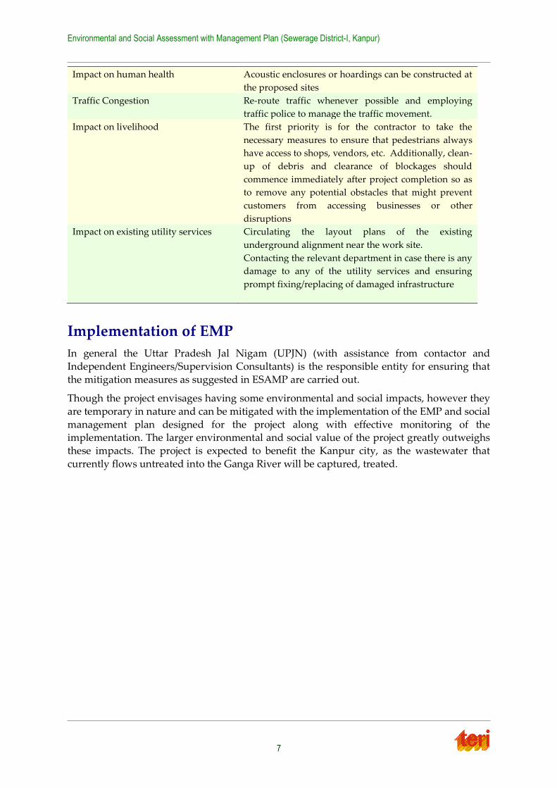
Environmental and Social Assessment with Management Plan (Sewerage District-I, Kanpur)
7
Impact on human health
Acoustic enclosures or hoardings can be constructed at
the proposed sites
Traffic Congestion
Re-route traffic whenever possible and employing
traffic police to manage the traffic movement.
Impact on livelihood
The first priority is for the contractor to take the
necessary measures to ensure that pedestrians always
have access to shops, vendors, etc. Additionally, clean-
up of debris and clearance of blockages should
commence immediately after project completion so as
to remove any potential obstacles that might prevent
customers from accessing businesses or other
disruptions
Impact on existing utility services
Circulating the layout plans of the existing
underground alignment near the work site.
Contacting the relevant department in case there is any
damage to any of the utility services and ensuring
prompt fixing/replacing of damaged infrastructure
Implementation of EMP
In general the Uttar Pradesh Jal Nigam (UPJN) (with assistance from contactor and
Independent Engineers/Supervision Consultants) is the responsible entity for ensuring that
the mitigation measures as suggested in ESAMP are carried out.
Though the project envisages having some environmental and social impacts, however they
are temporary in nature and can be mitigated with the implementation of the EMP and social
management plan designed for the project along with effective monitoring of the implementation. The larger environmental and social value of the project greatly outweighs
these impacts. The project is expected to benefit the Kanpur city, as the wastewater that
currently flows untreated into the Ganga River will be captured, treated.
Environmental and Social Assessment with Management Plan (Sewerage District-I, Kanpur)
8
Chapter 1 Introduction
The river Ganga has significant economic, environmental and cultural value in India. Rising in the Himalayas and flowing in to the Bay of Bengal, the river traverses a course of more than
2,500 km through the plains of north and eastern India. The Ganga basin – which also extends
into parts of Nepal, China and Bangladesh – accounts for 26 per cent of India’s landmass, 30 per cent of its water resources and more than 40 per cent of its population. The Ganga also
serves as one of India’s holiest rivers whose cultural and spiritual significance transcends the
boundaries of the basin.
Despite its importance, extreme pollution pressures from increasing population and
industrialization pose a great threat to the biodiversity and environmental sustainability of
the Ganga, with detrimental effects on both the quantity and quality of its flows. Discharge of untreated sewage and industrial wastewater, non-point pollution sources from religious
activities along the river, agriculture and livestock as well as poor solid waste management
are the main causes for pollution in river Ganga.
1.1 Ganga Clean up Initiatives
The Government of India (GoI) has undertaken numerous clean-up initiatives in the past. The
most prominent of such efforts was the Ganga Action Plan, launched in 1985 later
complemented by a similar plan for the Yamuna, the biggest tributary of the Ganga. These programmes have faced significant public scrutiny and, despite some gains made in slowing
the rate of water quality degradation, they have been widely perceived as failure. The main
shortcomings of these initiatives were: (1) inadequate attention to institutional dimensions, including the absence of a long-tem-basin planning and implementation framework; (2) little
effort made in addressing systemic weakness in the critical sectors of urban wastewater, solid
waste management, environmental monitoring, regulation and water resources management; and (3) inadequate scale, coordination and prioritization of investments, with little emphasis
on ensuring their sustainability. These programs also did not pay enough attention to the
social dimensions of river clean-up, failing to recognize the importance of consultation, participation and awareness-raising.
The lessons drawn from these prior experiences indicate that improving water quality in the
Ganga cannot be achieved by plugging the infrastructure gap alone. Rather, any effective initiative will have to adopt a three-pronged approach:
Establishing a basin-level, multi-sectoral framework for addressing pollution in the
river (including national/state policies and river basin management institutions);
Making relevant institutions operational and effective (e.g. with the capacity to plan,
implement and manage investments and enforce regulations); and,
Implementing a phased program of prioritized infrastructure investments (with emphasis on sustainable operations and mobilization of community support)
1.2 The Ganga River Basin Project
As a major first step in achieving the above, the Government of India (GoI) constituted the
National Ganga River Basin Authority (NGRBA), on 20th February 2009, for the comprehensive management of the river. The NGRBA will adopt a river-basin approach and
Environmental and Social Assessment with Management Plan (Sewerage District-I, Kanpur)
9
has been given a multi-sector mandate to address both water quantity and quality aspects.
The NGRBA has resolved that by year 2020, no untreated municipal sewage or industrial effluents will be discharged into River Ganga.
Building on the high-level dialogue with GoI on Ganga, The World Bank has been formally
requested to provide long-term support to NGRBA, through several phases of substantive financing and knowledge support. While, the overall technical assistance and program
development under the proposed project will focus on the entire Ganga main stem, the initial
emphasis of the specific investments under the first project will focus on main stem of Ganga flowing through five basin states of Bihar, Jharkhand, Uttar Pradesh, Uttarakhand and West
Bengal in India. These pollution abatement programmes in cities on the banks of these States,
would include a range of municipal investments such as sewer networks, waste water treatment facilities, industrial pollution control measures, river front management and solid
waste disposal. This is expected to be enabled through several phases of substantive financing
and knowledge support.
The first project of such several phases of support aims at:
i. Establishing and operationalizing central and state level NGRBA institutions capable
of planning and implementing a multi sectoral river water quality improvement program and;
ii. Reducing pollution loads into the river through selected investments.
To achieve the above, the proposed World Bank assisted National Ganga River Basin Project (NGRBP) envisages two main components.
1.2.1 World Bank Assistance
The Government of India has sought programmatic assistance from the World Bank to
support the NGRBA in the long term. This project is the first operation under this agreement,
and aims to support the NGRBA in establishing its operational-level institutions and implementing priority investments.
1.3 Project Components
The project will have two components relating to institutional development and priority
infrastructure investments. The first component would seek to build the institutional capacity to effectively implement the overall NGRBA program, including infrastructure investments
funded by the second component.
1.3.1 Component One: Institutional Development
1.3.1.1 Objective
The objectives of this component are to: (i) build functional capacity of the NGRBA’s
operational institutions at both the central and state levels; and (ii) provide support to associated institutions for implementing the NGRBA program. The activities financed under
this component are grouped under the following sub-components:
a. Sub-component A: NGRBA Operationalization and Program Management
b. Sub-component B: Technical Assistance for ULB Service Providers
Environmental and Social Assessment with Management Plan (Sewerage District-I, Kanpur)
10
c. Sub-component C: Technical Assistance for Environmental Regulators
1.3.1.2 Sub Component A: NGRBA Operationalization and Program Management
This sub-component is aimed at supporting the nascent operational institutions established for implementing the NGRBA program at the central and state levels on a full time basis.
The NGRBA’s operational institutions comprise the Program Management Group (PMG) at
the central level, and SGRCA Program Management Groups (SPMGs) at the state level. The PMG is being established as a fully owned society of the Government of India, with suitable
structure, staff, powers and leadership, to lead the planning and program management of the
NGRBA program at the national level. It is supported and housed by the MoEF as the nodal Ministry. Similarly, the SPMGs are being established in the form of registered societies1, to
ensure effective planning and program management at the state level.
Separating Program Management from Investment Execution: The rationale for establishing the PMG and SPMGs is to have institutions with single point responsibility for the NGRBA’s
program planning, management and long-term sustainability
Program Management for the Entire NGRBA Program: The sub-component will provide for initial setup costs of office infrastructure and equipment, as well as provision of critical
consultancies, incremental staffing, training, and operation costs. Key NGRBA program
management activities included under this sub-component are described below2:
a. Enhancing Ganga Knowledge Resources
b. Communications and Public Participation
c. Innovative Pilots
d. Program of Action for Carbon Credits
1.3.1.3 Sub component B: Technical Assistance for ULB Service Provider
The long term operation and maintenance of the NGRBA-funded assets is the responsibility of the ULBs and local service providers, and this sub-component is aimed at providing
assistance that can gradually enable them to take on their role.
1.3.1.4 Sub-component C: Technical Assistance for Environmental Regulator
This sub-component is aimed at addressing the key constraints faced by the CPCB and SPCBs related to their functions regarding the Ganga. The subcomponent will support:
a. Capacity building of the CPCB and SPCBs
b. Up-gradation of Ganga Water Quality Monitoring System
1 With exception of Jharkhand, where instead of establishing a dedicated SPMG, the nodal state department
(Department of Urban Development) will implement the NGRBA program. This is because a dedicated agency is
not justified given the small stretch of the Ganga River in Jharkhand.
2 For more details refer “Environmental and Social Management Framework for World Bank Assisted National
Ganga River Basin Project, 2011”. PMG, National Ganga River Basin Authority, MoEF.
Environmental and Social Assessment with Management Plan (Sewerage District-I, Kanpur)
11
1.3.2 Component Two: Priority Infrastructure Investments
1.3.2.1 Objective
The objective of this component is to finance demonstrative infrastructure investments to
reduce pollution loads in priority locations on the river.
1.3.2.2 Four Investment Sectors
The majority of investments are expected to be in the wastewater sector, particularly in wastewater treatment plants and sewerage networks. Investments will also be supported in
industrial pollution control and prevention (e.g. common effluent treatment plants), solid
waste management (e.g. collection, transport and disposal systems), and river front management (e.g. improvement of the built environment along river stretches, improvement
of small ghats and electric crematoria, and the conservation and preservation of ecologically
sensitive sites). Many investments are likely to combine elements of more than one of these sectors.
1.3.2.3 The Framework Approach
In lieu of defining and appraising specific investments, the project preparation has focused on developing investments framework covering all four key sectors of intervention under the
NGRBA program. This single framework will apply to all investments under the NGRBA
program.
The objectives of the investments framework are to:
a. provide a filter for all the NGRBA investments, for ensuring that the selected
investments are well-prepared and amongst the most effective in reducing the pollution loads;
b. make transparent the decision-making process on investments selection; and
c. ensure that the investments are implemented in a sustainable manner.
1.3.2.3.1 Framework Criteria
The investments framework prescribes the criteria and quality assurance standards covering
various aspects including eligibility, prioritization, planning, technical preparation, financial and economic analyses, environmental and social management, long term O&M
sustainability, community participation, and local institutional capacity3.
1.3.2.4 Investment Execution
The investments program will be planned and managed by the NGRBA PMG and SPMGs, while the execution of specific infrastructure investments will be done by the selected existing
and qualified state-level technical agencies. To foster competition and tap private sector
efficiencies, the state governments with significant infrastructure investments are setting up a public-private joint venture infrastructure company, to execute NGRBA and other similar
investments in the respective states in the medium to long term.
3 For more details refer “Environmental and Social Management Framework for World Bank Assisted National
Ganga River Basin Project, 2011”. PMG, National Ganga River Basin Authority, MoEF.
Environmental and Social Assessment with Management Plan (Sewerage District-I, Kanpur)
12
1.3.2.5 Rehabilitation of existing infrastructure
Investments involving rehabilitation of existing infrastructure will be included on priority,
due to their intrinsically higher returns in terms of reductions in pollution loads entering the Ganga.
1.4 Structure of the Report
The Detailed project Report is being prepared by UPJN and TERI has been working closely with them while carrying out environmental and social assessment. This report deals with the
Environment and Social Assessment with Management Plan for the Sewerage works in
Sewerage District ‘A’ of Allahabad, Uttar Pradesh. It rolls out the baseline status of the existing sewage situation and analyses the situation if the proposed project is implemented, with its
possible implications and to negate those implications management plan is advised which is
as per the Environment and Social Management Framework. The present ESAMP report is described in following 9 chapters as given below:
Chapter 1 is an introduction about the programme to clean up River Ganga and various
mechanisms to implement the project. This chapter details out the functionalities of the institutions involved in the project.
Chapter 2 details put specific project description pertaining to the proposed sewerage project
in District I of Kanpur.
Chapter 3 of the report talks about the methodology adopted for the environmental and social
assessment.
Chapter 4 of the report presents the applicable laws and guidelines related to such kind of projects.
Chapter 5 presents detailed baseline scenario of the information available for city and for
sewerage district A for both environmental and social aspects. Thereafter, Chapter 6, discusses associated environmental and social impacts.
For the identified impacts, mitigation measures have been suggested in Chapter 7 of the
report.
Chapter 8 is a presentation of social development outcomes of the proposed project and
related issues.
Chapter 9 finally concludes the inferences brought out from the environmental and social analysis of the project activities in Kanpur District ‘I’. It also highlights the conclusion based
on the analysis which shows that the proposed project can be categorized as ‘Low Impact’.
Environmental and Social Assessment with Management Plan (Sewerage District-I, Kanpur)
13
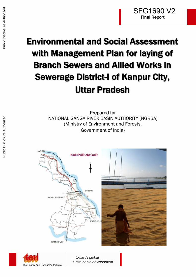
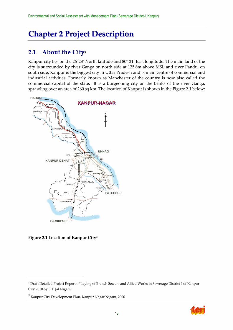
Chapter 2 Project Description
2.1 About the City4
Kanpur city lies on the 26°28’ North latitude and 80° 21’ East longitude. The main land of the city is surrounded by river Ganga on north side at 125.6m above MSL and river Pandu, on
south side. Kanpur is the biggest city in Uttar Pradesh and is main centre of commercial and
industrial activities. Formerly known as Manchester of the country is now also called the commercial capital of the state. It is a burgeoning city on the banks of the river Ganga,
sprawling over an area of 260 sq km. The location of Kanpur is shown in the Figure 2.1 below:
Figure 2.1 Location of Kanpur City5
4 Draft Detailed Project Report of Laying of Branch Sewers and Allied Works in Sewerage District-I of Kanpur
City 2010 by U P Jal Nigam.
5 Kanpur City Development Plan, Kanpur Nagar Nigam, 2006
Environmental and Social Assessment with Management Plan (Sewerage District-I, Kanpur)
14
The city is known for its textile and leather industries, and is one of the biggest producers of
these products. Other prominent industrial activities in the city include fertilizer, chemicals, two wheelers, soaps, pam masala, arms and other engineering industries. Additionally,
Kanpur is also an important pilgrimage destination, and home to several globally recognized
institutions such as IIT Kanpur, Harcourt Butler Technological Institute (HBTI) and GSVM Medical College.
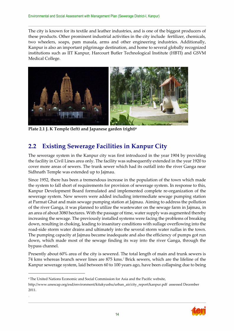
Plate 2.1 J. K Temple (left) and Japanese garden (right)6
2.2 Existing Sewerage Facilities in Kanpur City
The sewerage system in the Kanpur city was first introduced in the year 1904 by providing
the facility in Civil Lines area only. The facility was subsequently extended in the year 1920 to
cover more areas of sewers. The trunk sewer which had its outfall into the river Ganga near Sidhnath Temple was extended up to Jajmau.
Since 1952, there has been a tremendous increase in the population of the town which made
the system to fall short of requirements for provision of sewerage system. In response to this, Kanpur Development Board formulated and implemented complete re-organization of the
sewerage system. New sewers were added including intermediate sewage pumping station
at Parmat Ghat and main sewage pumping station at Jajmau. Aiming to address the pollution of the river Ganga, it was planned to utilize the wastewater on the sewage farm in Jajmau, in
an area of about 3080 hectares. With the passage of time, water supply was augmented thereby
increasing the sewage. The previously installed systems were facing the problems of breaking down, resulting in choking, leading to insanitary conditions with sullage overflowing into the
road-side storm water drains and ultimately into the several storm water nallas in the town.
The pumping capacity at Jajmau became inadequate and also the efficiency of pumps got run down, which made most of the sewage finding its way into the river Ganga, through the
bypass channel.
Presently about 60% area of the city is sewered. The total length of main and trunk sewers is 74 kms whereas branch sewer lines are 875 kms.7 Brick sewers, which are the lifeline of the
Kanpur sewerage system, laid between 60 to 100 years ago, have been collapsing due to being
6 The United Nations Economic and Social Commission for Asia and the Pacific website,
http://www.unescap.org/esd/environment/kitakyushu/urban_air/city_report/kanpur.pdf assessed December
2011.
`
Environmental and Social Assessment with Management Plan (Sewerage District-I, Kanpur)
15
old. These problems are further aggravated by the dilapidated conditions of sewers in some
parts of the city. The rapid developments of the city in the peripheral areas are still lacking the sewerage facilities.
UPJN (Uttar Pradesh Jal Nigam) is the agency responsible for pollution prevention and
planning capital projects for sewerage. UPJN also operates and maintains large pumping stations and the treatment plant. Kanpur Jal Sansthan is responsible for maintenance of trunk
sewers, lateral sewers and collection of revenue from house connections. The brief details
about the completed/ on-going/ approved sewerage projects in Kanpur city are described below.
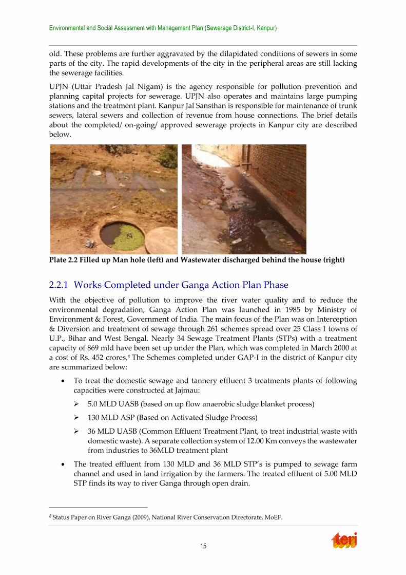
Plate 2.2 Filled up Man hole (left) and Wastewater discharged behind the house (right)
2.2.1 Works Completed under Ganga Action Plan Phase
With the objective of pollution to improve the river water quality and to reduce the
environmental degradation, Ganga Action Plan was launched in 1985 by Ministry of Environment & Forest, Government of India. The main focus of the Plan was on Interception
& Diversion and treatment of sewage through 261 schemes spread over 25 Class I towns of
U.P., Bihar and West Bengal. Nearly 34 Sewage Treatment Plants (STPs) with a treatment capacity of 869 mld have been set up under the Plan, which was completed in March 2000 at
a cost of Rs. 452 crores.8 The Schemes completed under GAP-I in the district of Kanpur city
are summarized below:
To treat the domestic sewage and tannery effluent 3 treatments plants of following
capacities were constructed at Jajmau:
5.0 MLD UASB (based on up flow anaerobic sludge blanket process)
130 MLD ASP (Based on Activated Sludge Process)
36 MLD UASB (Common Effluent Treatment Plant, to treat industrial waste with
domestic waste). A separate collection system of 12.00 Km conveys the wastewater from industries to 36MLD treatment plant
The treated effluent from 130 MLD and 36 MLD STP’s is pumped to sewage farm
channel and used in land irrigation by the farmers. The treated effluent of 5.00 MLD STP finds its way to river Ganga through open drain.
8 Status Paper on River Ganga (2009), National River Conservation Directorate, MoEF.

Environmental and Social Assessment with Management Plan (Sewerage District-I, Kanpur)
16
2.2.2 On-going works under JNNURM
In order to encourage the cities for taking up the initiative to bring about improvement in the
existing services levels in a financially sustainable manner, Jawaharlal Nehru National Urban
Renewal Mission (JnNURM) was launched in December 2005 by the Government of India. The primary objective of the JnNURM is to create economically productive, efficient, equitable
and responsive cities. With reference to Kanpur city, the under mentioned works have been
sanctioned under JNNURM Part I, II & III for improvement of sewerage infrastructure of the Kanpur city.
• Projects approved under JNNURM (Part – I)
Renovation/Rehabilitation of existing Common Sewage Pumping Station (CSPS)
Renovation/Rehabilitation of existing 5 MLD & 130 MLD sewage treatment plants
and 36 MLD tannery waste water treatment plant.
Renovation/Rehabilitation of existing 7 Nos. intermediate sewage pumping stations.
Renovation/Rehabilitation of existing 4 Nos. tannery sewage pumping stations.
Renovation/Rehabilitation of existing rising mains of 4 Nos. tannery waste water pumping stations.
Laying of 350 mm to 2000 mm diameter trunk sewers in 69.00 Km length in core
area of the city.
Augmentation of 130 MLD capacity Jajmau STP by constructing another unit of
43 MLD based on ASP technology.
15 MLD capacity MPS and STP at Baniyapura in Sewerage District III based on the topography of this sewerage district. As per projections, 124 MLD STP shall be
required for sewerage district – III. As 15 MLD STP has already been sanctioned,
the proposal of remaining required STP of 109 MLD is under preparation
• Projects approved under JNNUM (Part-II)
Sewage treatment plant of 210 MLD at Bingawan. New DPR for balance requirement
of 105MLD STP and MPS are under sewerage system.
• Project approved under JNNURM (Part - III)
Comprehensive proposals have been made in this project to provide sewerage facilities
in sewerage district IV of Kanpur for 4 wards namely Chakeri (10), Sanigawan (19) Delhi Sujanpur (53) and Shyam Nagar Sujatpur (77). Works proposed in this project
include
Intermediate sewage pumping stations of 14 and 40 MLD respectively
42 MLD main sewage pumping station and a STP of 42 mld capacity laying of
130.90 km RCC sewers and other allied works.
Environmental and Social Assessment with Management Plan (Sewerage District-I, Kanpur)
17
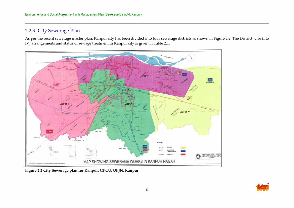
2.2.3 City Sewerage Plan
As per the recent sewerage master plan, Kanpur city has been divided into four sewerage districts as shown in Figure 2.2. The District wise (I to
IV) arrangements and status of sewage treatment in Kanpur city is given in Table 2.1.
Figure 2.2 City Sewerage plan for Kanpur, GPCU, UPJN, Kanpur
District I
District II District III
District IV
Environmental and Social Assessment with Management Plan (Sewerage District-I, Kanpur)
18
Table 2.1 Descriptions of sewerage district (I to IV) in Kanpur city
Sl.
No.
Sewerage
District
Description
1. Sewerage
District – 1
This district is bounded by the Ganga river to the North, H.B.T.I. and roadways
workshop to the West, Armapur Estate, Dada Nagar, Kidwai Nagar and COD
in the South. This district further has city central zone including old city area
and eastern part of city core including cantonment, The sewage generated from
central and east zone drains into exiting Jajmau STP in district -I.
2. Sewerage
District – II
This district is bounded by the sewerage district-I to the North, Jhansi railway
line to the west and Pandu river to the South. The Eastern boundary has been
arbitrarily drawn to the east of Hamirpur road to include those areas which are
already more heavily populated.
3. Sewerage
District – III
The district is bounded by the Pandu river to the South, development master
plan boundaries to the West and North and the Kanpur – Jhansi railway line to
the East city and sewerage district-I and II are its adjoining neighbours on the
eastern flank.
4. Sewerage
District – IV
The district is bounded by the Delhi Calcutta railway line to the North, Pandu
river to the South and the city Master Plan boundary in the East. It is sparsely
populated and has no sewerage system at present.
The district wise projected population and sewage generation in design year 2040 have been
shown in the Table 2.2 below.
Table 2.2 District wise (I to IV) arrangements and status of Sewage Treatment in Kanpur
Sewerage
District
Mid-year 2025 Design Year 2040
Population Sewage Generation
(MLD)
Population Sewage Generation
(MLD)
District-I 1630274 195.63 2231224 267.44
District-II 2588609 310.63 3596544 431.58
District – III 1033890 124.06 1968178 236.18
District – IV 347226 41.67 836054 100.32
Total 5599999 673.00 8632000 1035.00
Source: Draft Detailed Project Report of laying of Branch Sewers and Allied Works in Sewerage District-
I of Kanpur City 2010 by U P Jal Nigam.
2.3 Necessity of this project
NGRBA is the authority working under the nodal Ministry of Environment and Forest (MoEF). NGRBA has formulated a mission named “Mission Clean Ganga” for preventing,
controlling and effective abatement of pollution happening for river Ganga and is taking
measures for controlling pollution. Under the ‘Mission Clean Ganga’, no untreated municipal sewage or industrial effluent would be allowed to be discharged into the river Ganga by the
year 2020.
Environmental and Social Assessment with Management Plan (Sewerage District-I, Kanpur)
19
Presently, sewer network exists mainly in core areas of city and in some part of southern and
western area of the city and was laid in piece meal manner right from 1904 till date depending upon need and availability of funds. Many of laid trunk sewers were constructed in brick
masonry and are in dilapidated condition. Further due to improper cleaning, sewers get
chocked and are giving frequent trouble. The inadequacy of sewerage facilities have led to unhygienic conditions as manholes and inadequate size of sewers back flow and the domestic
sewage accumulates in depressed localities of the city causing health hazards. Thus the
present system of sewerage network needs an immediate attention to be redesigned and extended to uncovered area.
The City is currently undergoing sewerage system improvements under the JNNURM
scheme. Considering the increasing population, absence of sewerage network, dilapidated condition of existing old sewers, proximity to the Ganga river, it becomes more important to
provide sewerage infrastructure in the district-I.
With view to Mission Clean Ganga objective of NGRBA, it is proposed to provide sewerage system of laterals, branches and trunk sewers in Sewerage District –I in this DPR. It will
include new sewer network of 101.882 Km length have been proposed to take care of sewage
load of the year 2050, out of which 93.279 Km length of mains, sub-mains and laterals sewers with minimum size of 150 mm dia. to 700 mm dia. RCC (Class NP3) and HDPE pipes of 160
mm dia. Class PN 6.0 for length 8.603 Km are also considered for initial stretches after
start/end M.H for speedy laying works in very congested area and narrow lanes.
Thus, total length of 395.359 Km sewers have been proposed including 293.477 Km length for
rehabilitation of existing sewers of small sized (150/200 mm dia) by De-silting & GRP liner or
other latest technology except proposal of old trunk sewers of 6.179 Km length for rehabilitation of identified stretches by GRP liner or other latest technology. Furthermore, the
existing sewers of small sized (150/200 mm dia) about 29.026 Km length which are functioning
smooth, shall also be used in present condition to avoid public inconvenience during project execution. Total designed length of sewer network is 424.385 Km. Besides 4 IPS and 2 lift
stations are also proposed as per the following detail.
Sanjay Puram SPS 6 MLD (Design Peak Flow)
Near Maqdoom Shah Baba mazar SPS 10.70 MLD (Design Peak Flow)
Behind Siwaan Tannery LIFT PS 2.50 MLD (Design Peak Flow)
Gandhi Park SPS 16.10 MLD (Design Peak Flow)
Near Chacha Nehru Hospita (Old Lahi Mandi) SPS 9.50 MLD (Design Peak Flow)
Patkapur LIFT PS 2.20 MLD (Design Peak Flow)
2.4 Location of Proposed Sewerage Project
As per the latest sewerage master plan, Kanpur city has been divided into four sewerage districts I-IV. Out of four, sewerage district-I lies at 26°26'59.72" North latitude and
80°19'54.75" East longitude9, located in the north part of the city and adjoining the river Ganga
in the upstream side. District-1 has 34 wards and has an area of 33.2 Km2. It includes the old city core with an old sewerage network dating back to as early as 1910 and the tannery district
located east of the cantonment area, Jajmau. The district is bound by the Ganga river to the
9 Google Earth
Environmental and Social Assessment with Management Plan (Sewerage District-I, Kanpur)
20
North, roadways workshop to the West, Armapur estate, Dada Nagar and Kidwai Nagar to
the South. The sewage generated from this district drains into existing Jajmau Main Pumping Station, and then pumped to existing Jajmau STP located in District – 1 (East). As mentioned
earlier around 70%% of the district-I households have sewer connections and 100 % coverage
will be achieved under the on-going JNNURM project and proposed projects under NGRBA. The area is mixed residential and commercial area with industrial area mostly existing at the
north east part of the sewer district-I.
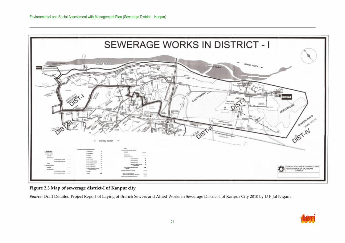
2.5 Proposed Sewerage System
The Detailed project Report is being prepared by UP Jal Nigam and TERI has been working closely with them while carrying out environmental and social assessment. The proposed
sewerage network in sewerage district-I covers the following area in Kanpur city shown in
Figure 2.3.
Sewerage District – 1: This sewerage district is bounded by the Ganga River to the
North, H.B.T.I. and roadways workshop to the West, Armapur Estate, Dada Nagar,
Kidwai Nagar and COD in the South. The area extends along the east axis of the city taking in the area north of Delhi-Calcutta track beyond COD gate up to the master
planning boundary in the east.
City central zone: Central part of city core including old city area. The sewage generated from this district drains into existing Jajmau Main Pumping Station, and
then pumped to existing Jajmau STP located in District – 1 (East). In this district four
pumping stations were commissioned for nala interception and diversion. One pumping station is proposed in this Master Plan
East Zone: Eastern part of city core, including cantonment. The sewage generated from
this district is conveyed to Jajmau STP same as District -1 (Central). New trunk sewer is proposed to convey domestic wastewater generated in tannery zone contaminated
by tannery industrial wastewater to UASB unit of Jajmau STP separately from
domestic wastewater from District- 1 (Central)
The proposed sub-project aim to provide complete sewerage facilities in the sewerage district-
1 of the Kanpur city through laying of sewerage network including all required trunk/ branch/
lateral sewer.
Environmental and Social Assessment with Management Plan (Sewerage District-I, Kanpur)
21
Figure 2.3 Map of sewerage district-I of Kanpur city
Source: Draft Detailed Project Report of Laying of Branch Sewers and Allied Works in Sewerage District-I of Kanpur City 2010 by U P Jal Nigam.
Environmental and Social Assessment with Management Plan (Sewerage District-I, Kanpur)
22
2.5.1 Components of Proposed Sewerage Work
Comprehensive sewerage network is proposed for ‘sewerage district-I’ to cover entire area
with sewerage system, so that sewage flows can be collected in an integrated manner and
conveyed to STP for treatment. The proposed sewerage system is designed for 30 years period i.e. 2040.
A. Sewer system
A sewerage network of 424.385 km has been proposed including mains, sub-mains, and lateral
sewers. Since most of the area included in this estimate is inner and old portion of the city, having dense population branch sewers of diameter 200 dia to 500 dia. RCC S/S NP3 class
pipes concrete pipes are proposed to be used. Design of sewer has to be amended as per
prevailing site conditions/parameters before execution of work.
B. Manholes
Table 2.3 below gives the type and size of various types of manholes proposed to be provided
for different diameters and depth of sewers. Spacing of manholes will be as per I.S. Code 411
- 1957 i.e. 30m for sewers up to 500 mm dia., 60m for sewers ranging between 500 mm to 800 mm diameter and 90m for sewers above 800 mm diameter. Besides this, manhole is to be
provided at junction points of sewers, change in gradient, change in direction, change in size
of sewers and at places of drops etc.
Table 2.3 Type and size of various types of manholes proposed to be used in the project
Type of manholes Size of manholes Depth of sewer
Slab Type 900 mm x 800 mm 0.9m
Circular Manhole 900 mm dia. 1.65m
1200 mm dia. 2.30m
1500 mm dia. 5.00m
1500 mm dia. 9.00m
C. House connecting and sewer connecting chambers
Intermediate shafts of 0.6m * 0.6 m between the manholes is proposed to be provided in areas
where the sewers run through inhabited areas and to provide points of house connections in
addition to manholes.
D. Intermediate Sewage Pumping Stations
Sewage flow through these sewers would require to intercept with five numbers of sewage
pumping stations and a lift station namely
1. Sanjay Puram SPS 6 MLD (Design Peak Flow)
2. Near Maqdoom Shah Baba mazar SPS 10.70 MLD (Design Peak Flow)
3. Behind Siwaan Tannery LIFT PS 2.50 MLD (Design Peak Flow)
Environmental and Social Assessment with Management Plan (Sewerage District-I, Kanpur)
23
4. Gandhi Park SPS 16.10 MLD (Design Peak Flow)
5. Near Chacha Nehru Hospita (Old Lahi Mandi) SPS 9.50 MLD (Design Peak Flow)
6. Patkapur LIFT PS 2.20 MLD (Design Peak Flow)
TERI team did a field reconnaissance survey at the proposed IPS sites and consulted UPJN
officials and local people in this regard.
IPS at Sanjay Puram. Land of this pumping station belongs to private land owner and he has
agreed to hand over the land to U.P. Jal Nigam after getting compensation. Rate will be
according to District Magistrate circle rate. Accordingly amount required for the land has been sent to Nagar Nigam, Kanpur and this amount will be released by Govt. of U.P.
At Gandhi Park: Process for land acquisition has been initiated and availability of land is yet
to be finalized by Nagar Nigam, Kanpur.
Near Chacha Nehru Hospital: Process for land acquisition has been initiated and availability
of land is yet to be finalized by Nagar Nigam, Kanpur.
Near Maqdoom Shah Baba mazar: Process to aquire premise has been initiated with Nagar Nigam, Kanpur and possession is yet to be finalized.
Overall, none of the proposed site of land will face the issue of displacement or resettlement.
2.5.2 Implementation Schedule
It has been presumed that the proposed works would be completed in first three years i.e. 36
months. The operation and maintenance of proposed sewerage system is also considered for five years after commission of the system.
2.5.3 Financing
Detailed Project Report (DPR) of ‘Laying of Branch Sewers and Allied Works in Sewerage
District-I of Kanpur City’, 2013 by U P Jal Nigam. The total cost of the project, under NGRBA,
is budgeted for an amount of Rs. 397.31 crores. Under the National River Conservation Plan (NRCP), the Central Government will provide financial assistance of 70% of the total project
cost. The remaining 30% of the project cost will be borne by the State Government of UP and
the ULB/ Allahabad Municipal Corporation. The share of the Central Government shall accordingly be Rs. 261.36 crore. Balance amount of Rs. 135.95 crore will be shared by the Govt.
of UP.
Table 2.4 gives the summary of cost of the proposed sewerage work in sewerage district-I of Kanpur city.
Environmental and Social Assessment with Management Plan (Sewerage District-I, Kanpur)
24
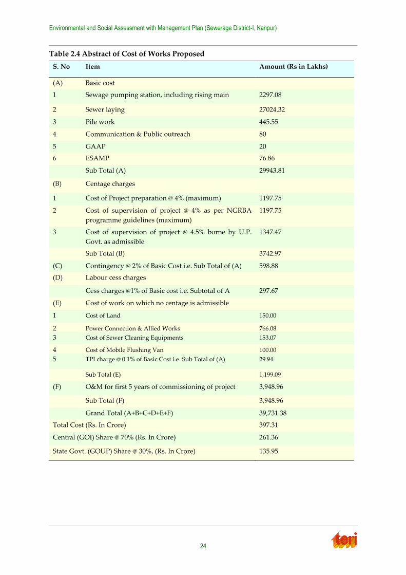
Table 2.4 Abstract of Cost of Works Proposed
S. No Item Amount (Rs in Lakhs)
(A) Basic cost
1 Sewage pumping station, including rising main 2297.08
2 Sewer laying 27024.32
3 Pile work 445.55
4 Communication & Public outreach 80
5 GAAP 20
6 ESAMP 76.86
Sub Total (A) 29943.81
(B) Centage charges
1 Cost of Project preparation @ 4% (maximum) 1197.75
2 Cost of supervision of project @ 4% as per NGRBA
programme guidelines (maximum)
1197.75
3 Cost of supervision of project @ 4.5% borne by U.P.
Govt. as admissible
1347.47
Sub Total (B) 3742.97
(C) Contingency @ 2% of Basic Cost i.e. Sub Total of (A) 598.88
(D) Labour cess charges
Cess charges @1% of Basic cost i.e. Subtotal of A 297.67
(E) Cost of work on which no centage is admissible
1 Cost of Land
150.00
2 Power Connection & Allied Works
766.08
3 Cost of Sewer Cleaning Equipments
153.07
4 Cost of Mobile Flushing Van
100.00
5 TPI charge @ 0.1% of Basic Cost i.e. Sub Total of (A)
29.94
Sub Total (E) 1,199.09
(F) O&M for first 5 years of commissioning of project 3,948.96
Sub Total (F) 3,948.96
Grand Total (A+B+C+D+E+F) 39,731.38
Total Cost (Rs. In Crore) 397.31
Central (GOI) Share @ 70% (Rs. In Crore) 261.36
State Govt. (GOUP) Share @ 30%, (Rs. In Crore) 135.95
Environmental and Social Assessment with Management Plan (Sewerage District-I, Kanpur)
25
Chapter 3 Approach and Methodology
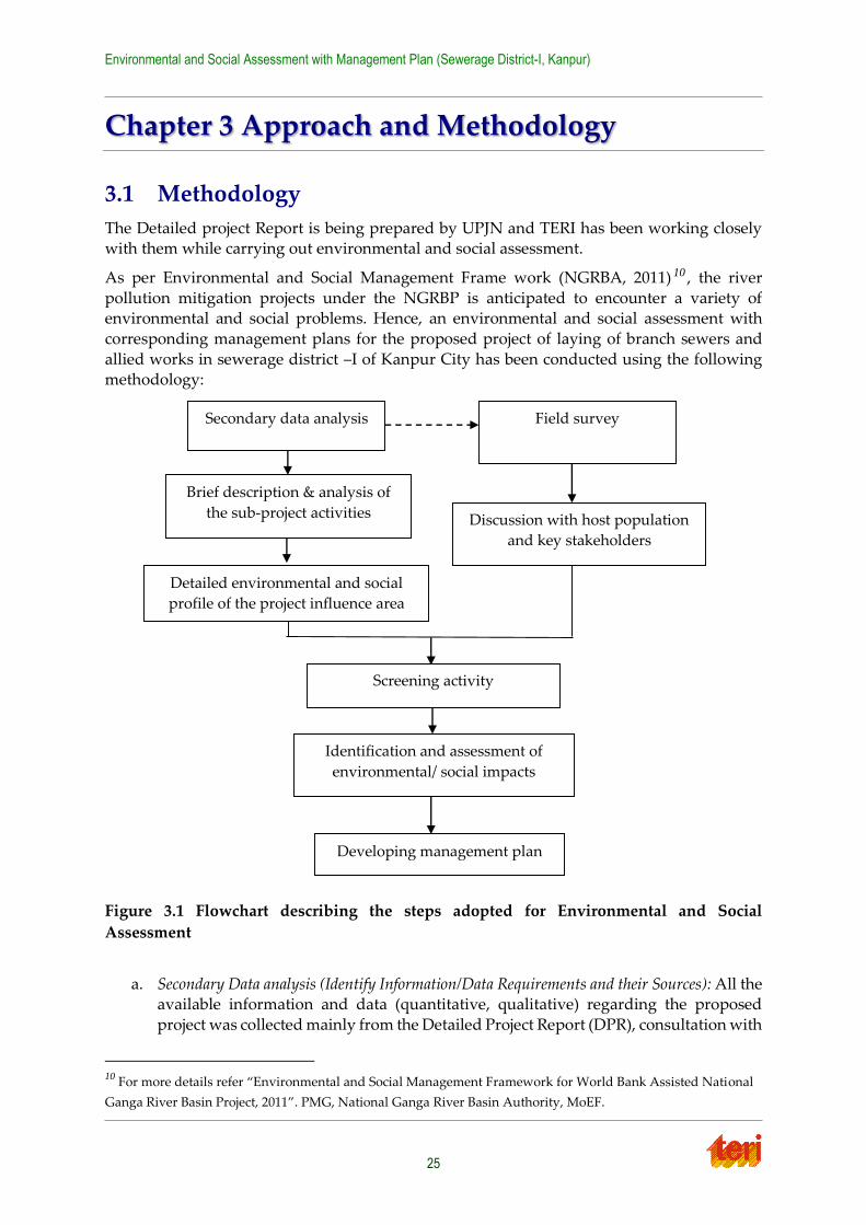
3.1 Methodology
The Detailed project Report is being prepared by UPJN and TERI has been working closely with them while carrying out environmental and social assessment.
As per Environmental and Social Management Frame work (NGRBA, 2011) 10 , the river
pollution mitigation projects under the NGRBP is anticipated to encounter a variety of environmental and social problems. Hence, an environmental and social assessment with
corresponding management plans for the proposed project of laying of branch sewers and
allied works in sewerage district –I of Kanpur City has been conducted using the following methodology:
Figure 3.1 Flowchart describing the steps adopted for Environmental and Social
Assessment
a. Secondary Data analysis (Identify Information/Data Requirements and their Sources): All the available information and data (quantitative, qualitative) regarding the proposed
project was collected mainly from the Detailed Project Report (DPR), consultation with
10 For more details refer “Environmental and Social Management Framework for World Bank Assisted National
Ganga River Basin Project, 2011”. PMG, National Ganga River Basin Authority, MoEF.
Developing management plan
Identification and assessment of
environmental/ social impacts
Screening activity
Secondary data analysis Field survey
Brief description & analysis of
the sub-project activities
Detailed environmental and social
profile of the project influence area
Discussion with host population
and key stakeholders
Environmental and Social Assessment with Management Plan (Sewerage District-I, Kanpur)
26
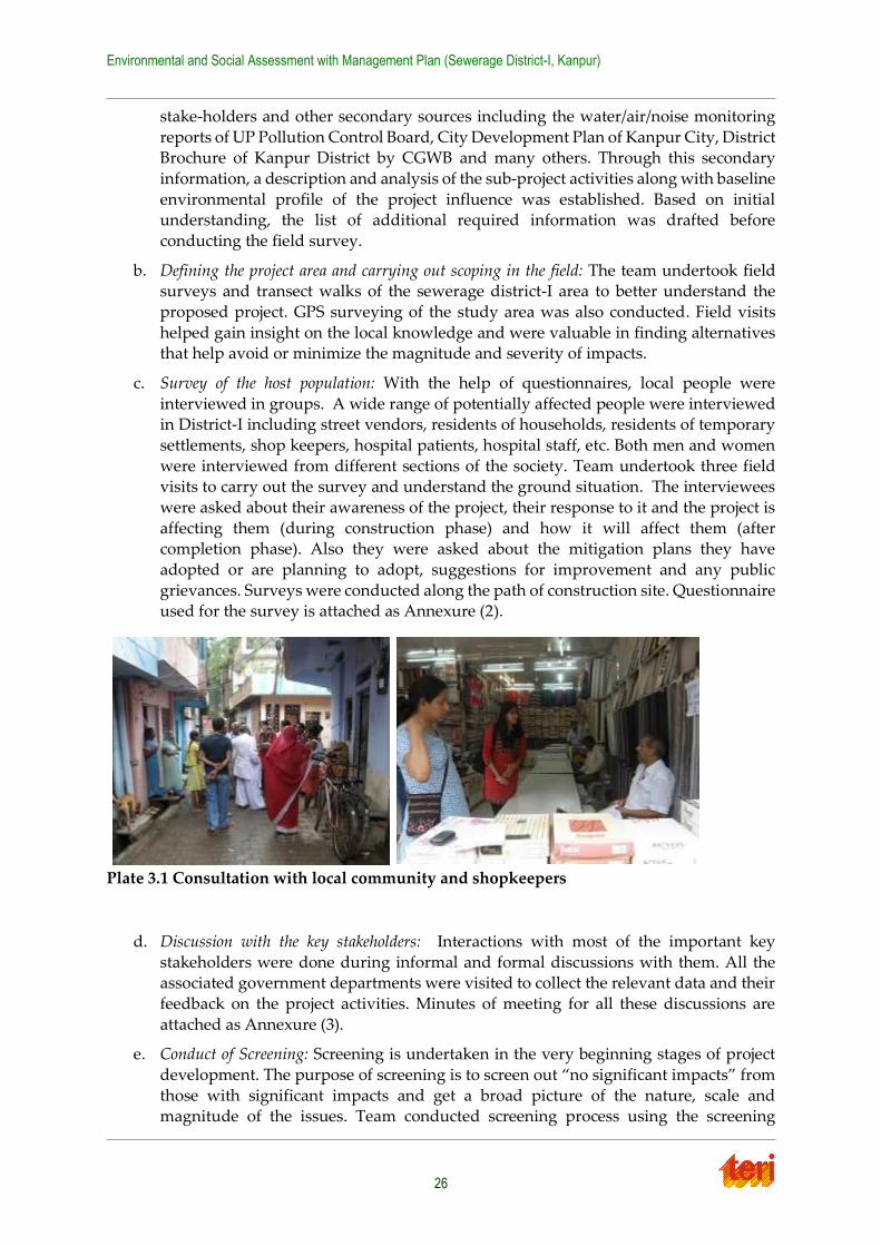
stake-holders and other secondary sources including the water/air/noise monitoring
reports of UP Pollution Control Board, City Development Plan of Kanpur City, District Brochure of Kanpur District by CGWB and many others. Through this secondary
information, a description and analysis of the sub-project activities along with baseline
environmental profile of the project influence was established. Based on initial understanding, the list of additional required information was drafted before
conducting the field survey.
b. Defining the project area and carrying out scoping in the field: The team undertook field surveys and transect walks of the sewerage district-I area to better understand the
proposed project. GPS surveying of the study area was also conducted. Field visits
helped gain insight on the local knowledge and were valuable in finding alternatives that help avoid or minimize the magnitude and severity of impacts.
c. Survey of the host population: With the help of questionnaires, local people were
interviewed in groups. A wide range of potentially affected people were interviewed in District-I including street vendors, residents of households, residents of temporary
settlements, shop keepers, hospital patients, hospital staff, etc. Both men and women
were interviewed from different sections of the society. Team undertook three field visits to carry out the survey and understand the ground situation. The interviewees
were asked about their awareness of the project, their response to it and the project is
affecting them (during construction phase) and how it will affect them (after completion phase). Also they were asked about the mitigation plans they have
adopted or are planning to adopt, suggestions for improvement and any public
grievances. Surveys were conducted along the path of construction site. Questionnaire used for the survey is attached as Annexure (2).
Plate 3.1 Consultation with local community and shopkeepers
d. Discussion with the key stakeholders: Interactions with most of the important key
stakeholders were done during informal and formal discussions with them. All the associated government departments were visited to collect the relevant data and their
feedback on the project activities. Minutes of meeting for all these discussions are
attached as Annexure (3).
e. Conduct of Screening: Screening is undertaken in the very beginning stages of project
development. The purpose of screening is to screen out “no significant impacts” from
those with significant impacts and get a broad picture of the nature, scale and magnitude of the issues. Team conducted screening process using the screening

Environmental and Social Assessment with Management Plan (Sewerage District-I, Kanpur)
27
checklist format provided in ESMF report of NGRBA, which is described in
subsequent section.
f. Identify and assess the impacts: Based on the analysis of the data gathered from field
survey, stakeholder interaction/ consultation and secondary sources, issues related to
the environmental and social sectors were been identified. The impacts so identified were compared with the existing baseline environmental and social condition of the
study region.
g. Develop a mitigation plan: Based on the identified environmental and social issues, the mitigation plan recommends measures needed to prevent, minimize, mitigate, or
compensate for identified impacts and improve environmental performance. The
mitigation plan may be suggested for different stages, as applicable: designing phase, construction phase and, operation and maintenance phase.
3.2 Project Screening
The project screening was carried out to understand the nature, scale and magnitude of
environmental and social issues associated with the project. The screening activity was conducted as per the guidelines provided in Environmental and Social Management
Framework of NGRBA (NGRBA, 2011)11 and on the secondary data analysis, field assessments
and stakeholder interaction/ consultation. The detail of screening is summarized in the Table 3.1 below.
11 For more details refer “Environmental and Social Management Framework for World Bank Assisted National
Ganga River Basin Project, 2011”. PMG, National Ganga River Basin Authority, MoEF.
Environmental and Social Assessment with Management Plan (Sewerage District-I, Kanpur)
28
Table 3.1 Findings from Environment and Social Screening
(Format attached as Annexure 1)
Project Title: Laying of Branch Sewers and Allied Works in Sewerage District-I of Kanpur City, Uttar
Pradesh
Implementing agency: Ganga Pollution Control Unit, U. P. Jal Nigam, Kanpur
Project cost: 397.31 Crore Rupees
Project components: The sewerage network includes laying and rehabilitation of 424.385 km of sewer lines
and construction of 4 nos. of sewage pumping stations and 1 sewage lift station
Project location (Area/ district): Sewerage District-I in Kanpur
This district is bounded by the Ganga river to the North, H.B.T.I. and roadways workshop to the West,
Armapur Estate, Dada Nagar, Kidwai Nagar and COD in the South. This district further has city central zone
including old city area and eastern part of city core including cantonment, The sewage generated from central
and east zone drains into exiting Jajmau STP in district -I.
S. No Screening Criteria Assessment
of category
Explanatory note for
categorization
Evidence and
references
1 Is the project in an
eco-sensitive area
or adjoining an eco-
sensitive area?
(Yes/No) If Yes,
which is t h e
area? Elaborate
i m p a c t
accordingly.
No There are no eco-sensitive
areas in the project.
A zoological park known as
Allen Zoo Park exists in the
north-west side of sewerage
district-I of Kanpur, which will
not be effected by this
proposed project work as
sewer lines will be laid in the
centre of the roads and will not
pass through this area.
Figure 5.9: Map showing
some of the Eco-sensitive
areas closest to Kanpur
sewerage district-I.
Field visits, secondary
information and interaction
with U.P. Jal Nigam and
other Government officials.
2
Will the project create significant/limited/no social impacts?
2.1 Land
acquisition
resulting in
loss of income
from
agricultural
land,
plantation or
other existing
land-use.
No social
impacts
Land acquisition is required
but will not result in loss of
income.
As per first hand observation
in the field and through
interviews of key
stakeholders, residents, local
people, and other sources like
DPR, it has been established
that 4 plots of land would be
acquired for construction of
new SPS.
These include:
1. Vishnupuri (Sanjay Puram)
2. Gandhi Park (Krishna
Nagar)
Figure 5.11: indicating that the
sewer line will pass through
the residential colonies,
commercial areas of the district
and would not enter or pass
through agricultural fields.
Field visits, consultation with
stakeholders, like local people
(for JNNURM projects), local
residents, government
officials.
Environmental and Social Assessment with Management Plan (Sewerage District-I, Kanpur)
29
S. No Screening Criteria Assessment
of category
Explanatory note for
categorization
Evidence and
references
3. Near Chacha Nehru
Hospital
4.Near Maqdum Shah Baba
Mazar
Sewer line would be laid on
the public roads. Therefore no
loss of income from
agricultural land is expected.
Also there exist no squatters
or encroachers in and around
the premises who could get
affected by the project.
2.2 Loss of
livelihood
No Loss of livelihood is not
expected and since mobile
vendors can change their
location, there would be no
loss. There could be minor
disruption in terms of access
to shops.
Consultation with
stakeholders, like (for
JNNURM projects),
DPR & CRR
2.3 Land
acquisition
resulting in
relocation of
households.
No social
impacts
Land acquisition required but
no relocation of households
required since identified plots
of land do not have any
habitations or settlements.
As per the first hand
observation in the field and
through interviews of key
stakeholders, residents, local
people, and UPJN, has been
established that 4 plots of land
would be acquired for
construction of new SPS.
These include:
1. Vishnupuri (Sanjay Puram)
2. Gandhi Park (Krishna
Nagar)
3. Near Chacha Nehru
Hospital
4.Near Maqdum Shah Baba
Mazar
Also there exist no squatters
or encroachers in and around
the premises which will be
affected.
Field survey, Consultations
with stakeholders, like local
people (for JNNURM projects),
local residents, government
officials.
Environmental and Social Assessment with Management Plan (Sewerage District-I, Kanpur)
30
S. No Screening Criteria Assessment
of category
Explanatory note for
categorization
Evidence and
references
2.4 Any reduction
of access to
traditional and
river
dependent
communities
(to river and
areas where
they earn for
their primary
or substantial
livelihood).
No social
impacts
No access problem to river Field visits and consultations
with the shop keepers, mobile
vendors, expert opinions
2.5 Any
displacement
or adverse
impact on
tribal
settlement(s).
No social
impacts
There are no tribal settlements
in the project area.
Consultations with
stakeholders, like local people
(for JNNURM projects), local
residents, government
officials.
2.6 Any specific
gender issues.
No social
impacts
No gender issues were
reported during survey.
Consultations, interviews,
which were taken up with
females specifically.
3 Will the project create significant / limited / no environmental impacts during the construction
stage? (Significant / limited / no impacts)
3.1 Clearance of
vegetation/
tree-cover
No
environm
ental
impacts
Inner core area (such as Old
Kanpur, Kasimganj, Collector
Ganj, Talaq Mahal, Parade,
Mulganj, Hatia, General Ganj,
Patkapur, Krishna Nagar) of
district-I is highly populated
has insignificant tree cover,
whereas the tree/ vegetation
cover in other areas (Civil
lines, Jail Chauraha, Company
Bagh Chauraha) are aligned
along the road sides and will
not be affected as the sewer
lines will be laid in the centre
of the roads.
There will also be no impact
on the residential parks such
as Mahatma Gandhi Park and
Anand Bagh Park, in
Colonelganj area Central park
in Sarojini Nagar area,
Valmiki Park, and Japnese
garden in Harsh Nagar area
Field visits and Interaction
with UP Jal Nigam, Nagar
Nigam department.
Figure 5.10: GIS map of ward
localities in District I.
Figure 3.2: Satellite image
showing the alignment of trees
along the sides of the roads in
District I.
Figure 5.7: GIS map of
identified tree clusters in
Kanpur District I.
Environmental and Social Assessment with Management Plan (Sewerage District-I, Kanpur)
31
S. No Screening Criteria Assessment
of category
Explanatory note for
categorization
Evidence and
references
and Phool Bagh in Naughara
region.
3.2 Direct
discharge of
construction
run-off,
improper
storage and
disposal of
excavation
spoils, wastes
and other
construction
materials
adversely
affecting water
quality and
flow regimes.
Limited Possibility of temporary
flushing away of un-managed
spoils and construction
wastes during rainfall to river
Ganga via storm water drains.
If not appropriately managed,
there may be potential for
temporary effect on storm
water flows by obstruction to
flows and blockage of drains,
especially during rainfall. This
may cause floods.
Interaction with UP Jal Nigam
and other Government officials
and consultation with local
residents of sewerage District
I.
Figure 5.6: Schematic figure
showing the drainage outlets
emptying into the River
Ganga.
Plate 5.1 showing storm
drainage system in Kanpur
District-I.
Plate 5.2(right) showing an
overflowing drain due to
blockage.
3.3 Flooding of
adjacent areas
Limited
For sewerage works in the
entire sewerage district-I,
flooding could be an issue
during the monsoons,
especially in the congested
regions like Kasimganj,
Collector Ganj, Talaq Mahal,
Parade, Mulganj, Hatia,
General Ganj, Patkapur. This
issue may further aggravate
due to blocked drains and
poor solid waste
management.
Final Report: Kanpur City
Development Plan Under
JNNURM, JPS Associates (P)
Ltd. Consultants, 2006)
Plate 5.2: Image showing
blocked storm water drain and
improper solid waste
management.
Plate 3.3: Image showing an
open drain loaded with solid
waste.
3.4 Improper
storage and
handling of
substances
leading to
contamination
of soil and
water
Limited
The storage of construction
related material will not cause
any contamination since these
materials would typically
include: Concrete, pipes,
masonry, rubber pipes.
The project area contains one
water body i.e. Kanpur Zoo
Lake situated in north west
corner of District-I. However
this water body will not be
affected as sewer lines are not
Plate 3.2 and Plate 3.7: Image
showing the condition of roads
due to sewerage construction
work.
Plate 3.6: Image showing work
related to upgradation of
sewer lines.
Figure 5.4: Satellite image
showing the location of
Kanpur Zoo Lake, adjacent to
Azadnagar locality.
Environmental and Social Assessment with Management Plan (Sewerage District-I, Kanpur)
32
S. No Screening Criteria Assessment
of category
Explanatory note for
categorization
Evidence and
references
planned to be laid through
this area.
However, with other finer
materials such as construction
powders, fluids and greases, if
not appropriately managed or
in the event of an accident,
there may be potential for
temporary contamination of
the river Ganga via the
various drains and nallas in
sewerage District-I, during
rainfall.
The agricultural land in
sewerage district I is limited to
area situated near Ghasiyari
Mandi and near Nawabganj
and may be temporarily
contaminated via powders,
fluids and greases if
construction material is not
handled appropriately.
Section 5.1.10.1 provides
details about agricultural land
in the project area.
Figure 5.8: Satellite image
showing agricultural practice
is mainly limited to
Nawabganj (left) and land
between Westgate and
Ghasiyari Mandi (right),
within Kanpur sewerage
district ‘I’.
3.5 Elevated noise
and dust
emission
Limited
For sewage works,
construction is likely to
increase dust and noise levels
temporarily.
Temporary impacts may
especially be felt at
educational facilities like
schools/colleges (Harcourt
Butler Technological Institute,
Chandra Shekhar Azad
University of Agriculture and
Technology, ICFAI National
College, DAV College, BNSD
Shiksha Niketan Inter College,
Kanpur Paramedical College,
PPN Degree College, Air
Force school ), hospitals (RK
Devi eye hospital, Gastro
Liver Hospital, Chandhini
Hospital, Sahani Hospital),
cultural/religious centres
including all temples,
mosques, churches and
Gurudwaras in the Kanpur
Sewerage District-I.
Consultation with local
residents, and interaction with
UP Jal Nigam and other
Government officials.
Environmental and Social Assessment with Management Plan (Sewerage District-I, Kanpur)
33
S. No Screening Criteria Assessment
of category
Explanatory note for
categorization
Evidence and
references
Provided that construction
works near schools and
colleges are carried out during
vacations and preferably
during night and works near
hospitals are completed on
priority basis (in shorter time
period with alternate
provision of traffic,
accessibility of exit/entry gates
etc.), the impacts may be
limited.
If construction schedule is
followed, then impacts will be
temporary as 1 km of sewer
line is approximated to be
completed within 2.6 days.
(since total length = 424.385
km and time = 3 years)
Refer to ‘Construction
schedule’: DPR for Laying of
Branch Sewers and Allied
works in Sewerage District – I
of Kanpur City Volume I’, 2009-
2010 by UP Jal Nigam.
3.6 Disruption to
traffic
movements
Limited Sewer construction leads to
the temporary tearing-up of
roads and increase in large
construction vehicles, which
might impair traffic
movement, especially in the
congested areas as seen
mainly in Mutthiganj,
Rambagh, and Malaka region.
Traffic disruption can also be
expected in busy areas such as
Harjinder Nagar and Chauk
Sarafa.
Figure 6.1: GIS map showing
the road network of Kanpur
District-I, with identified
regions of dense road network.
Plate 3.9: Image showing a
typical busy street market in
the Chauk Sarafa area, of
Kanpur sewerage district-I.
3.7 Damage to
existing
infrastructure,
public utilities,
amenities etc.
Limited If not appropriately managed,
there may be potential for
temporarily affecting the
existing public utilities like
water supply, telephone,
electricity cables etc.
However, it is expected that
main utility lines might run
along main roads such as Mall
Road, Nai Sarak Road,
Parwati Bagla Road, Ganga
Barrage Road, Narona Road
and Tagore Road and hence
impact would be limited and
temporary.
Field visits and interaction with
U.P. Jal Nigam and other
Government officials and
consultation with local
residents.
Environmental and Social Assessment with Management Plan (Sewerage District-I, Kanpur)
34
S. No Screening Criteria Assessment
of category
Explanatory note for
categorization
Evidence and
references
3.8 Failure to
restore
temporary
construction
sites
Limited From field visits and as per
JNNURM project
reinstatement of dismantled
roads after filling and proper
compaction was observed.
Although temporary,
concerns regarding failure to
restore construction sites
including failure to close and
appropriately fence-off open
pits were cited as safety
concerns especially for
children.
Field visits and interaction with
U.P. Jal Nigam and other
Government officials and
consultation with local
residents.
Plate 3.8: Image shows the
good practice of fencing-off
construction areas; this was
followed in the JNNURM
phase sewerage project in
Kanpur.
3.9 Possible
conflicts with
and/or
disruption to
local
community
Limited
For the laying of sewer works,
there will be temporary
disruption to the local
community in terms of access
to roads, (especially in dense
areas and narrow roads),
shops and residences.
Conflicts/disruption to local
community was inferred as
limited based on survey
responses which indicated the
community’s ability to adapt
to temporary disruptions, and
their overall preference for the
project.
Consultation with local
people.
Refer to Figure 6.1, which
shows the road network of
Kanpur District –I and
identifies areas with dense
road network including (LIC
Chauraha, General Ganj,
Cooper Ganj, Collector Ganj,
Chowk Sarafa, Parade in the
West and Om Purwa, Jajmau
South and Harzinder Nagar in
the east).
Refer to Plate 6.1, showing an
example of a narrow street in
the Patkapur area.
3.10
Health risks
due to
unhygienic
conditions at
workers camps
Limited
Field visits and as per
JNNURM project no worker
camps were seen. However
there might be small camps
within which, if hygienic
conditions are not
maintained, there may be
temporary impacts.
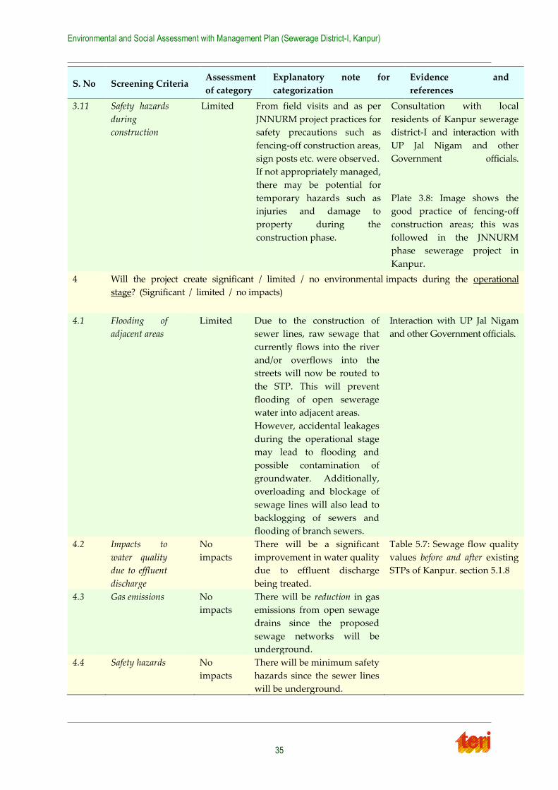
Environmental and Social Assessment with Management Plan (Sewerage District-I, Kanpur)
35
S. No Screening Criteria Assessment
of category
Explanatory note for
categorization
Evidence and
references
3.11 Safety hazards
during
construction
Limited From field visits and as per
JNNURM project practices for
safety precautions such as
fencing-off construction areas,
sign posts etc. were observed.
If not appropriately managed,
there may be potential for
temporary hazards such as
injuries and damage to
property during the
construction phase.
Consultation with local
residents of Kanpur sewerage
district-I and interaction with
UP Jal Nigam and other
Government officials.
Plate 3.8: Image shows the
good practice of fencing-off
construction areas; this was
followed in the JNNURM
phase sewerage project in
Kanpur.
4 Will the project create significant / limited / no environmental impacts during the operational
stage? (Significant / limited / no impacts)
4.1 Flooding of
adjacent areas
Limited Due to the construction of
sewer lines, raw sewage that
currently flows into the river
and/or overflows into the
streets will now be routed to
the STP. This will prevent
flooding of open sewerage
water into adjacent areas.
However, accidental leakages
during the operational stage
may lead to flooding and
possible contamination of
groundwater. Additionally,
overloading and blockage of
sewage lines will also lead to
backlogging of sewers and
flooding of branch sewers.
Interaction with UP Jal Nigam
and other Government officials.
4.2 Impacts to
water quality
due to effluent
discharge
No
impacts
There will be a significant
improvement in water quality
due to effluent discharge
being treated.
Table 5.7: Sewage flow quality
values before and after existing
STPs of Kanpur. section 5.1.8
4.3 Gas emissions No
impacts
There will be reduction in gas
emissions from open sewage
drains since the proposed
sewage networks will be
underground.
4.4 Safety hazards No
impacts
There will be minimum safety
hazards since the sewer lines
will be underground.
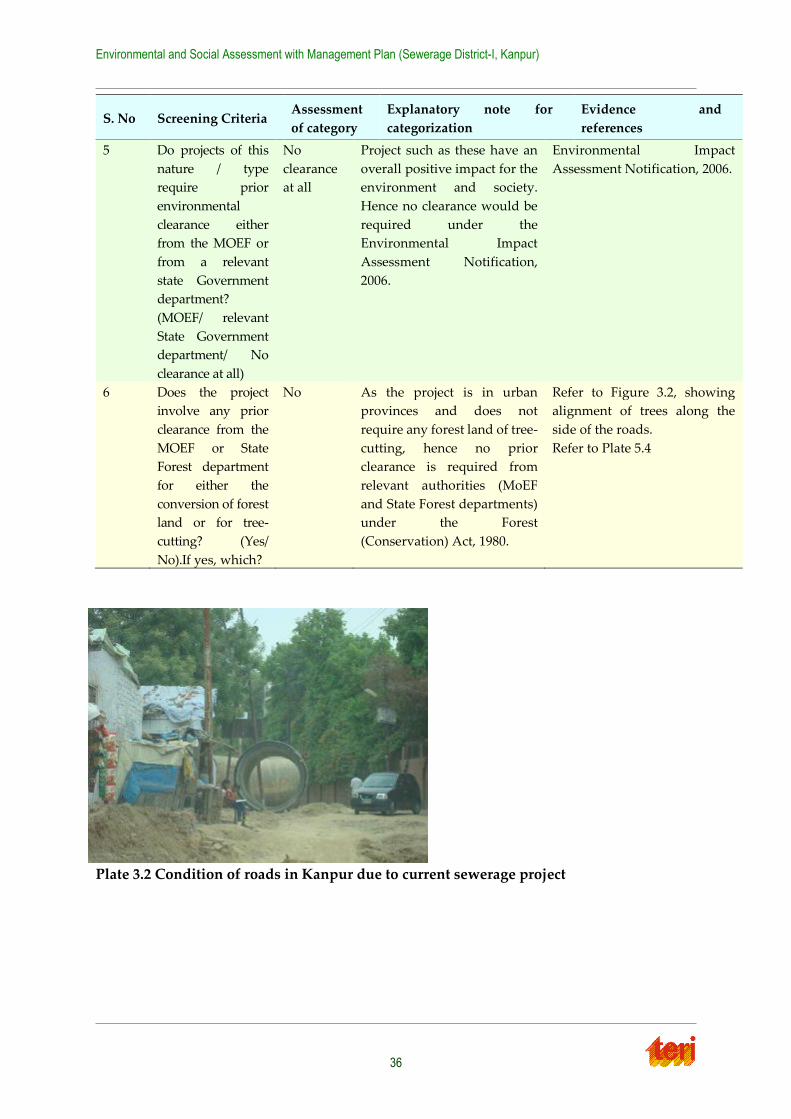
Environmental and Social Assessment with Management Plan (Sewerage District-I, Kanpur)
36
S. No Screening Criteria Assessment
of category
Explanatory note for
categorization
Evidence and
references
5 Do projects of this
nature / type
require prior
environmental
clearance either
from the MOEF or
from a relevant
state Government
department?
(MOEF/ relevant
State Government
department/ No
clearance at all)
No
clearance
at all
Project such as these have an
overall positive impact for the
environment and society.
Hence no clearance would be
required under the
Environmental Impact
Assessment Notification,
2006.
Environmental Impact
Assessment Notification, 2006.
6 Does the project
involve any prior
clearance from the
MOEF or State
Forest department
for either the
conversion of forest
land or for tree-
cutting? (Yes/
No).If yes, which?
No As the project is in urban
provinces and does not
require any forest land of tree-
cutting, hence no prior
clearance is required from
relevant authorities (MoEF
and State Forest departments)
under the Forest
(Conservation) Act, 1980.
Refer to Figure 3.2, showing
alignment of trees along the
side of the roads.
Refer to Plate 5.4
Plate 3.2 Condition of roads in Kanpur due to current sewerage project
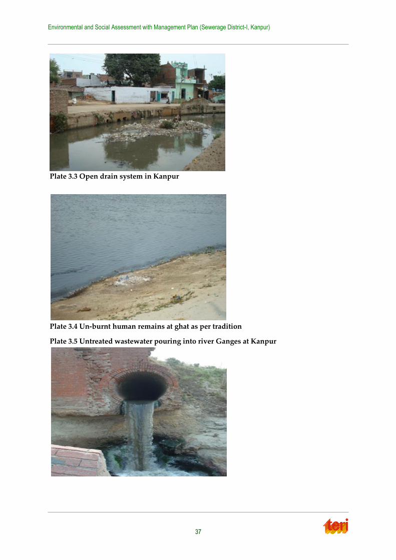
Environmental and Social Assessment with Management Plan (Sewerage District-I, Kanpur)
37
Plate 3.3 Open drain system in Kanpur
Plate 3.4 Un-burnt human remains at ghat as per tradition
Plate 3.5 Untreated wastewater pouring into river Ganges at Kanpur
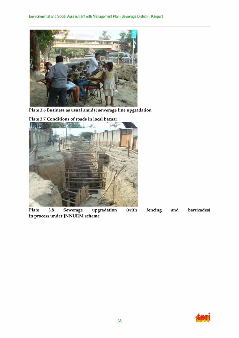
Environmental and Social Assessment with Management Plan (Sewerage District-I, Kanpur)
38
Plate 3.6 Business as usual amidst sewerage line upgradation
Plate 3.7 Conditions of roads in local bazaar
Plate 3.8 Sewerage upgradation (with fencing and barricades)
in process under JNNURM scheme
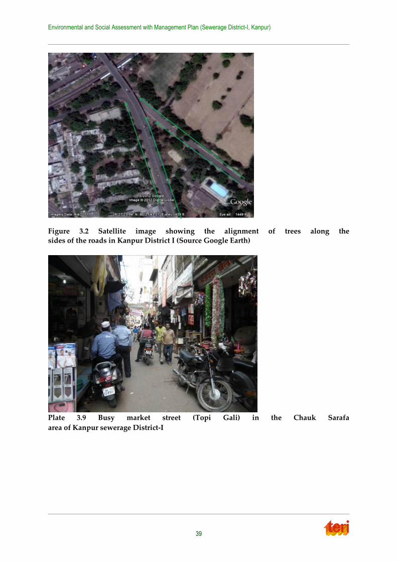
Environmental and Social Assessment with Management Plan (Sewerage District-I, Kanpur)
39
Figure 3.2 Satellite image showing the alignment of trees along the
sides of the roads in Kanpur District I (Source Google Earth)
Plate 3.9 Busy market street (Topi Gali) in the Chauk Sarafa
area of Kanpur sewerage District-I
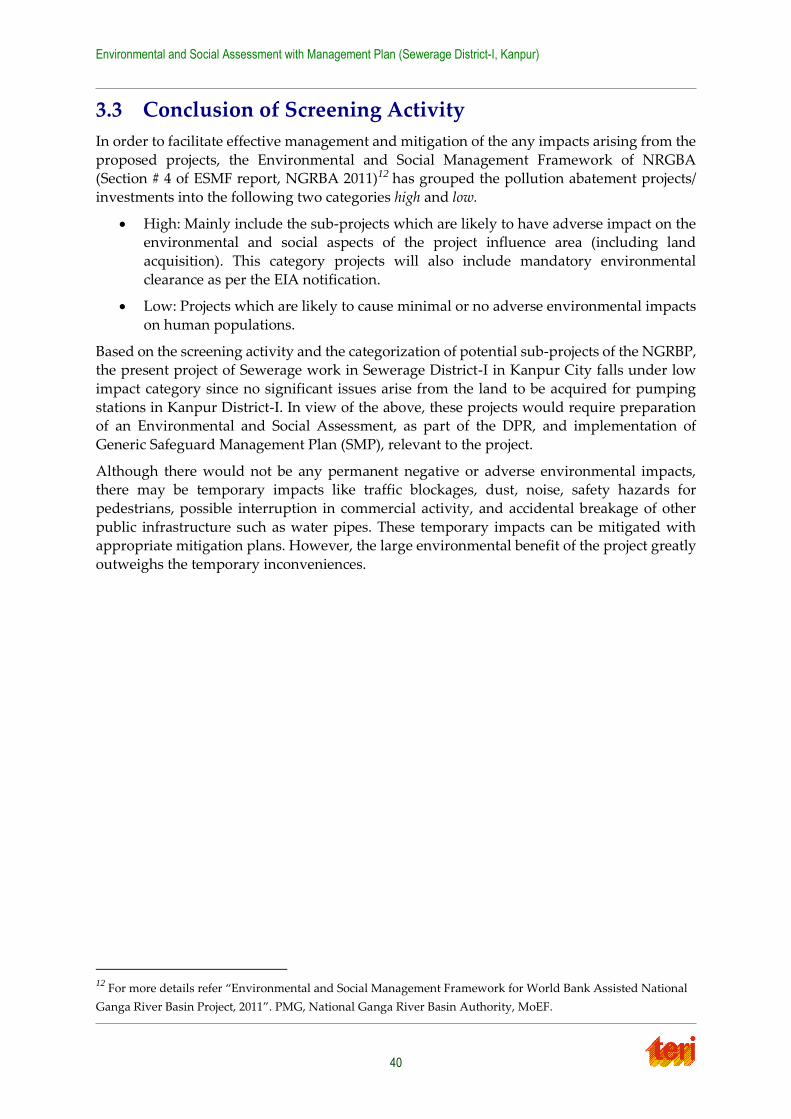
Environmental and Social Assessment with Management Plan (Sewerage District-I, Kanpur)
40
3.3 Conclusion of Screening Activity
In order to facilitate effective management and mitigation of the any impacts arising from the
proposed projects, the Environmental and Social Management Framework of NRGBA (Section # 4 of ESMF report, NGRBA 2011)12 has grouped the pollution abatement projects/
investments into the following two categories high and low.
High: Mainly include the sub-projects which are likely to have adverse impact on the environmental and social aspects of the project influence area (including land
acquisition). This category projects will also include mandatory environmental
clearance as per the EIA notification.
Low: Projects which are likely to cause minimal or no adverse environmental impacts
on human populations.
Based on the screening activity and the categorization of potential sub-projects of the NGRBP, the present project of Sewerage work in Sewerage District-I in Kanpur City falls under low
impact category since no significant issues arise from the land to be acquired for pumping
stations in Kanpur District-I. In view of the above, these projects would require preparation of an Environmental and Social Assessment, as part of the DPR, and implementation of
Generic Safeguard Management Plan (SMP), relevant to the project.
Although there would not be any permanent negative or adverse environmental impacts, there may be temporary impacts like traffic blockages, dust, noise, safety hazards for
pedestrians, possible interruption in commercial activity, and accidental breakage of other
public infrastructure such as water pipes. These temporary impacts can be mitigated with appropriate mitigation plans. However, the large environmental benefit of the project greatly
outweighs the temporary inconveniences.
12 For more details refer “Environmental and Social Management Framework for World Bank Assisted National
Ganga River Basin Project, 2011”. PMG, National Ganga River Basin Authority, MoEF.
Environmental and Social Assessment with Management Plan (Sewerage District-I, Kanpur)
41
Chapter 4 Regulations and Legal Framework
4.1 Applicable Laws and Regulations – Environmental
The following laws and regulations are applicable to the environmental and social aspects of the investments implemented under the programme:
Policy and Regulatory Framework of Government of India (GoI)
Environmental Policy and Regulations of the respective State Governments
Legislations applicable to construction activities
4.1.1 Legal Framework of Government of India
The Government of India has laid out various policy guidelines, acts and regulations
pertaining to environment. The Environment (Protection) Act, 1986 is umbrella legislation for
the protection of environment. As per this Act, the responsibility to administer the legislation has been jointly entrusted to the Ministry of Environment and Forests (MoEF) and the Central
Pollution Control Board (CPCB)/ State Pollution Control Boards (SPCBs).
4.1.2 Key Environmental Laws and Regulations
The key environmental laws and regulations as relevant to the projects under the NGRBP are
given in Table 4.1. The key environmental regulations can also be accessed at www.moef.nic.in/rules-and-regulations.
Table 4.1 Environmental Regulations and Legislations
S.
No
Act / Rules Purpose Applicable
Yes/ No
Reason for
Applicability
Authority
1 Environment
Protection Act-
1986
To protect and
improve overall
environment
Yes As all environmental
notifications, rules
and schedules are
issued under this act.
MoEF, Gol,
DoE, State Gov.
CPCB, SPCB
2 Environmental
Impact
Assessment
Notification
14th Sep-2006
To provide
environmental
clearance to new
development
activities following
environmental
impact assessment
No The present project is
only a sewerage
network project and
hence as per the
notification including
its amendments does
not attract
requirement of
environmental
clearance as per the
notification.
MoEF, EIAA
3 The Municipal
Solid Wastes
(Management and
Handling) Rules,
2000
To manage the
collection,
transportation,
segregation,
treatment, and
Yes The present project
involves solid waste
management
measures.
MoEF, EIAA,
CPCB, SPCBs
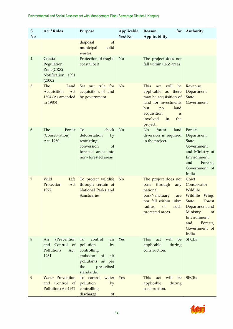
Environmental and Social Assessment with Management Plan (Sewerage District-I, Kanpur)
42
S.
No
Act / Rules Purpose Applicable
Yes/ No
Reason for
Applicability
Authority
disposal of
municipal solid
wastes
4 Coastal
Regulation
Zone(CRZ)
Notification 1991
(2002)
Protection of fragile
coastal belt
No The project does not
fall within CRZ areas.
5 The Land
Acquisition Act
1894 (As amended
in 1985)
Set out rule for
acquisition. of land
by government
No This act will be
applicable as there
may be acquisition of
land for investments
but no land
acquisition is
involved in the
project..
Revenue
Department
State
Government
6 The Forest
(Conservation)
Act. 1980
To check
deforestation by
restricting
conversion of
forested areas into
non- forested areas
No No forest land
diversion is required
in the project.
Forest
Department,
State
Government
and Ministry of
Environment
and Forests,
Government of
India
7 Wild Life
Protection Act
1972
To protect wildlife
through certain of
National Parks and
Sanctuaries
No The project does not
pass through any
national
park/sanctuary are
nor fall within 10km
radius of such
protected areas.
Chief
Conservator
Wildlife,
Wildlife Wing,
State Forest
Department and
Ministry of
Environment
and Forests,
Government of
India
8 Air (Prevention
and Control of
Pollution) Act,
1981
To control air
pollution by
controlling
emission of air
pollutants as per
the prescribed
standards.
Yes This act will be
applicable during
construction.
SPCBs
9 Water Prevention
and Control of
Pollution) Act1974
To control water
pollution by
controlling
discharge of
Yes This act will be
applicable during
construction.
SPCBs
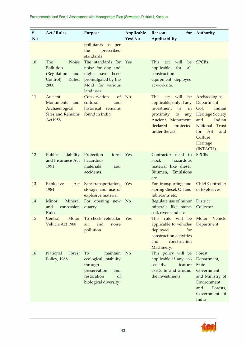
Environmental and Social Assessment with Management Plan (Sewerage District-I, Kanpur)
43
S.
No
Act / Rules Purpose Applicable
Yes/ No
Reason for
Applicability
Authority
pollutants as per
the prescribed
standards
10 The Noise
Pollution
(Regulation and
Control) Rules,
2000
The standards for
noise for day and
night have been
promulgated by the
MoEF for various
land uses.
Yes This act will be
applicable for all
construction
equipment deployed
at worksite.
SPCBs
11 Ancient
Monuments and
Archaeological
Sites and Remains
Act1958
Conservation of
cultural and
historical remains
found in India
No This act will be
applicable, only if any
investment is in
proximity to any
Ancient Monument,
declared protected
under the act.
Archaeological
Department
Gol, Indian
Heritage Society
and Indian
National Trust
for Art and
Culture
Heritage
(INTACH).
12 Public Liability
and Insurance Act
1991
Protection form
hazardous
materials and
accidents.
Yes Contractor need to
stock hazardous
material like diesel,
Bitumen, Emulsions
etc.
SPCBs
13 Explosive Act
1984
Safe transportation,
storage and use of
explosive material
Yes For transporting and
storing diesel, Oil and
lubricants etc.
Chief Controller
of Explosives
14 Minor Mineral
and concession
Rules
For opening new
quarry.
No Regulate use of minor
minerals like stone,
soil, river sand etc.
District
Collector
15 Central Motor
Vehicle Act 1988
To check vehicular
air and noise
pollution.
Yes This rule will be
applicable to vehicles
deployed for
construction activities
and construction
Machinery.
Motor Vehicle
Department
16 National Forest
Policy, 1988
To maintain
ecological stability
through
preservation and
restoration of
biological diversity.
No This policy will be
applicable if any eco
sensitive feature
exists in and around
the investments
Forest
Department,
State
Government
and Ministry of
Environment
and Forests,
Government of
India
Environmental and Social Assessment with Management Plan (Sewerage District-I, Kanpur)
44
S.
No
Act / Rules Purpose Applicable
Yes/ No
Reason for
Applicability
Authority
17 The Mines Act The mining act has
been notified for
safe and sound
mining activity.
No
The construction
activities for
investments will
require aggregates.
These will be
procured through
mining from
approved quarries.
Department of
mining, State
Government
4.2 Applicable Laws and Regulations - Social
All strategic interventions on human development, spread across all social issues, need
directives of policies and legal support to operationalize the appropriate actions. These policies and legislations help to overcome the constraints and support administrator,
implementer, community and individual in delivery of justice. This section includes the
National policies and Acts as detailed under:
National Policies and Acts
Environmental and Social Management Framework for NGRBA
National Tribal Policy, 2006
Right to Fair Compensation and Transparency in Land Acquisition and Rehabilitation
and Resettlement Act, 2013
Forest Rights Act, 2006
4.2.1 National Policies and Acts
The National Tribal Policy (2006)
The Policy has the following objectives:
Regulatory Protection
Providing an environment conducive to the preservation of traditional and customary systems and regime of rights and concessions enjoyed by different ST communities,
and reconciliation of modes of socio-economic development with these.
Preventing alienation of land owned by STs and restoring possession of wrongfully alienated lands.
Protection and vesting of rights of STs on forestlands and other forest rights including
ownership over minor forest produce (MFP), minerals and water bodies through appropriate legislations and conversion of all forest villages into revenue villages.
Providing a legislative frame for rehabilitation and resettlement in order to minimize
displacement, ensure that affected persons are partners in the growth in the zone of influence, provide for compensation of social and opportunity cost in addition to
market value of the land and rights over common property (NPV).
Environmental and Social Assessment with Management Plan (Sewerage District-I, Kanpur)
45
Empowerment of tribal communities to promote self-governance and self-rule as per
the provisions and spirit of the Panchayats (Extension to the Scheduled Areas) Act, 1996.
Protection of political rights to ensure greater and active participation of tribal peoples
in political bodies at all levels.
4.2.2 Right to Fair Compensation and Transparency in Land Acquisition
and Rehabilitation and Resettlement (RFCTLAR&R) Act- 2013
The Act is very progressive and lays downs processes and procedures to ensure “fair, fast and
final” delivery of compensation and R&R services that is based on the principle of participation, consultation and transparency. The Act fully incorporates or exceeds many of
the Bank’s long-standing policy and practice requirements. In that respect, the Act’s salient
features include:
a) mandatory ex-ante social assessments to determine whether an acquisition serves a
public purpose ;
b) requirements to ascertain the minimum land requirements, assess the impact of the acquisition on livelihoods, shelter, public infrastructure , and community assets ;
c) provisions to minimize adverse impacts, assessment of cost and benefits of
acquisition, enhanced land-loss compensation formulas; livelihoods support for affected persons; comprehensive resettlement and rehabilitation benefits and
assistance; census of the affected families to record their socio-economic profile and
potential losses, and inventory of affected public and community assets, options and choices for affected families and special provisions for disadvantaged groups; and a
legal mandate that affected persons must receive compensation and assistance before
their property is taken; and; and
d) Consultations and disclosure, and post-implementation audits.
At the same time, there are a few notable differences between the Act and the Bank’s policy
requirements:
a) a three-year residency requirement for affected persons to receive resettlement and
rehabilitation benefits (the Bank uses the date on which the project was notified or
census survey of the affected people undertaken as the cutoff date);
b) persons who live or depend on rights-of-way or public lands seem to be excluded from
the Act’s benefits and entitlements; and
c) the valuation of assessing buildings and structures under the act remains based on depreciation method as under previous Act (rather than their replacement cost
without depreciation under the Bank policy).
The Act significantly reduces differences between India’s national standards for land acquisition and R&R and the Bank’s policy requirements regarding involuntary resettlement.
As such it could greatly ease the application of OP 4.12 in Bank-assisted projects.
4.2.3 Land Acquisition Act, 1894 (As Modified Until 1st September, 1985)
The Act is applicable to the whole of India except the state of Jammu and Kashmir. The policy
provides a broad guideline of procedure of land acquisition. The Land Acquisition (LA) Act
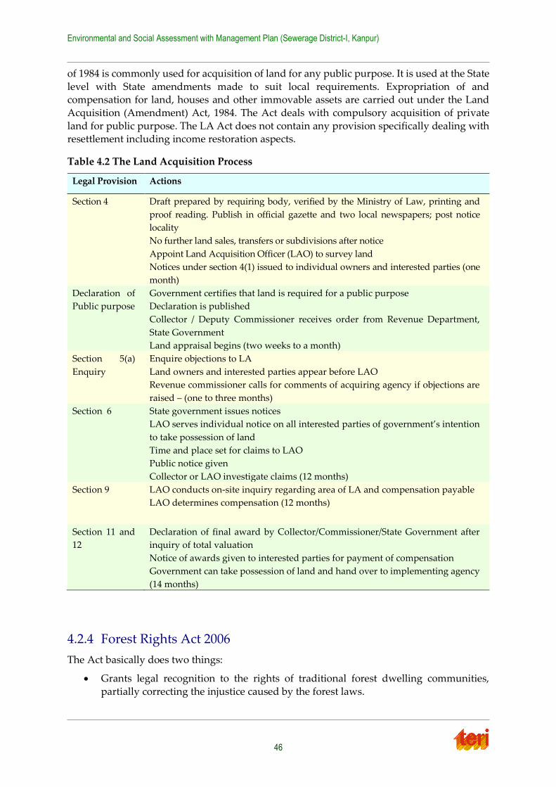
Environmental and Social Assessment with Management Plan (Sewerage District-I, Kanpur)
46
of 1984 is commonly used for acquisition of land for any public purpose. It is used at the State
level with State amendments made to suit local requirements. Expropriation of and compensation for land, houses and other immovable assets are carried out under the Land
Acquisition (Amendment) Act, 1984. The Act deals with compulsory acquisition of private
land for public purpose. The LA Act does not contain any provision specifically dealing with resettlement including income restoration aspects.
Table 4.2 The Land Acquisition Process
4.2.4 Forest Rights Act 2006
The Act basically does two things:
Grants legal recognition to the rights of traditional forest dwelling communities,
partially correcting the injustice caused by the forest laws.
Legal Provision
Actions
Section 4
Draft prepared by requiring body, verified by the Ministry of Law, printing and
proof reading. Publish in official gazette and two local newspapers; post notice
locality
No further land sales, transfers or subdivisions after notice
Appoint Land Acquisition Officer (LAO) to survey land
Notices under section 4(1) issued to individual owners and interested parties (one
month)
Declaration of
Public purpose
Government certifies that land is required for a public purpose
Declaration is published
Collector / Deputy Commissioner receives order from Revenue Department,
State Government
Land appraisal begins (two weeks to a month)
Section 5(a)
Enquiry
Enquire objections to LA
Land owners and interested parties appear before LAO
Revenue commissioner calls for comments of acquiring agency if objections are
raised – (one to three months)
Section 6 State government issues notices
LAO serves individual notice on all interested parties of government’s intention
to take possession of land
Time and place set for claims to LAO
Public notice given
Collector or LAO investigate claims (12 months)
Section 9 LAO conducts on-site inquiry regarding area of LA and compensation payable
LAO determines compensation (12 months)
Section 11 and
12
Declaration of final award by Collector/Commissioner/State Government after
inquiry of total valuation
Notice of awards given to interested parties for payment of compensation
Government can take possession of land and hand over to implementing agency
(14 months)
Environmental and Social Assessment with Management Plan (Sewerage District-I, Kanpur)
47
Makes a beginning towards giving communities and the public a voice in forest and
wildlife conservation
4.2.5 Environmental and Social Management Framework of NGRBA
Project has prepared an Environmental and Social Management Framework to ensure socially and environmentally sustainable development in NGRBA’s endeavour of Mission Clean
Ganga by effective management of environmental and social issues in all the investments with
a special focus on the following:
ensure that all investments adhere to the national, state and local regulatory
requirements during the design, implementation and operation stages
ensure that best environmental and social practices are mainstreamed/ integrated during design, implementation and operation of the investments
strive to enhance environmental conditions wherever feasible
undertake to develop communication strategy, capacity building and training initiatives for all stakeholders such as the SPMGs, EAs, ULBs, NGOs and common
citizens.
The purpose of the ESMF is to facilitate the management of environmental and social issues of the river pollution mitigation investments. The Environment and Social Management
Framework (ESMF), therefore, would be used as an umbrella by the NGRBA program (the
PMG and SPMGs) and all implementing agencies while preparing and/ or appraising, approving and executing the investments. The ESMF includes a Resettlement Policy and Land
Acquisition Framework (RPLAF), which specifies the procedures, eligibility, grievance
redressal and other measures to be followed in the event that resettlement or land acquisition is required for any sub-project. As part of the ESMF, a Gender Development Framework has
been designed which will help to analyze gender issues during the preparation stages of the
sub-project, and to design interventions to address women’s needs. Gender analysis will be part of the social assessment at the sub-project level. The RPLAF, has a screening checklist to
identify any adverse impact. The project has also prepared an entitlement matrix to address
the adverse impacts as given below. The entitlement matrix is based on NPRR 2007 is under revision now. The revised entitlement matrix will be based on RFCTLAR&R Act 2013.
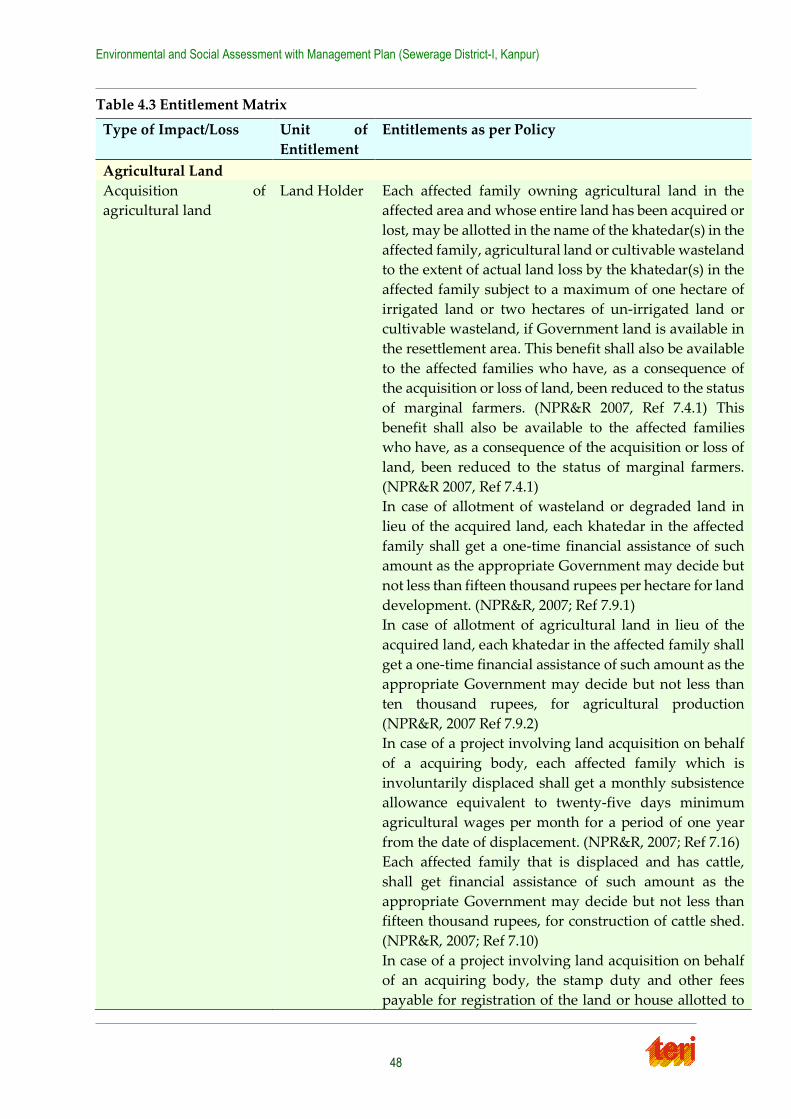
Environmental and Social Assessment with Management Plan (Sewerage District-I, Kanpur)
48
Table 4.3 Entitlement Matrix
Type of Impact/Loss Unit of
Entitlement
Entitlements as per Policy
Agricultural Land
Acquisition of
agricultural land
Land Holder Each affected family owning agricultural land in the
affected area and whose entire land has been acquired or
lost, may be allotted in the name of the khatedar(s) in the
affected family, agricultural land or cultivable wasteland
to the extent of actual land loss by the khatedar(s) in the
affected family subject to a maximum of one hectare of
irrigated land or two hectares of un-irrigated land or
cultivable wasteland, if Government land is available in
the resettlement area. This benefit shall also be available
to the affected families who have, as a consequence of
the acquisition or loss of land, been reduced to the status
of marginal farmers. (NPR&R 2007, Ref 7.4.1) This
benefit shall also be available to the affected families
who have, as a consequence of the acquisition or loss of
land, been reduced to the status of marginal farmers.
(NPR&R 2007, Ref 7.4.1)
In case of allotment of wasteland or degraded land in
lieu of the acquired land, each khatedar in the affected
family shall get a one-time financial assistance of such
amount as the appropriate Government may decide but
not less than fifteen thousand rupees per hectare for land
development. (NPR&R, 2007; Ref 7.9.1)
In case of allotment of agricultural land in lieu of the
acquired land, each khatedar in the affected family shall
get a one-time financial assistance of such amount as the
appropriate Government may decide but not less than
ten thousand rupees, for agricultural production
(NPR&R, 2007 Ref 7.9.2)
In case of a project involving land acquisition on behalf
of a acquiring body, each affected family which is
involuntarily displaced shall get a monthly subsistence
allowance equivalent to twenty-five days minimum
agricultural wages per month for a period of one year
from the date of displacement. (NPR&R, 2007; Ref 7.16)
Each affected family that is displaced and has cattle,
shall get financial assistance of such amount as the
appropriate Government may decide but not less than
fifteen thousand rupees, for construction of cattle shed.
(NPR&R, 2007; Ref 7.10)
In case of a project involving land acquisition on behalf
of an acquiring body, the stamp duty and other fees
payable for registration of the land or house allotted to
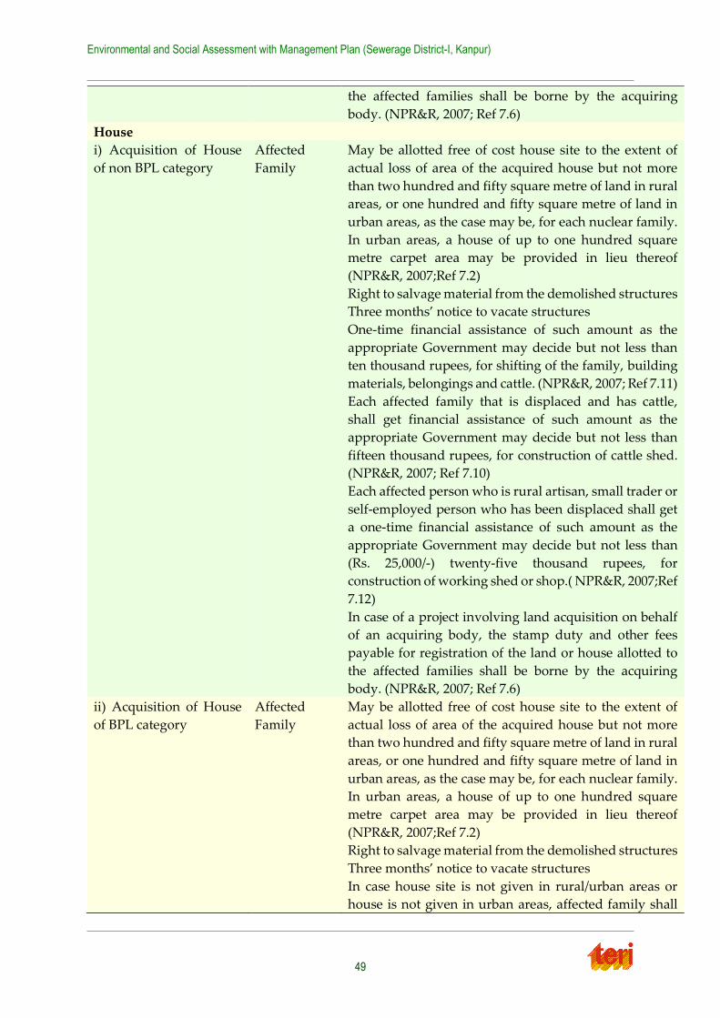
Environmental and Social Assessment with Management Plan (Sewerage District-I, Kanpur)
49
the affected families shall be borne by the acquiring
body. (NPR&R, 2007; Ref 7.6)
House
i) Acquisition of House
of non BPL category
Affected
Family
May be allotted free of cost house site to the extent of
actual loss of area of the acquired house but not more
than two hundred and fifty square metre of land in rural
areas, or one hundred and fifty square metre of land in
urban areas, as the case may be, for each nuclear family.
In urban areas, a house of up to one hundred square
metre carpet area may be provided in lieu thereof
(NPR&R, 2007;Ref 7.2)
Right to salvage material from the demolished structures
Three months’ notice to vacate structures
One-time financial assistance of such amount as the
appropriate Government may decide but not less than
ten thousand rupees, for shifting of the family, building
materials, belongings and cattle. (NPR&R, 2007; Ref 7.11)
Each affected family that is displaced and has cattle,
shall get financial assistance of such amount as the
appropriate Government may decide but not less than
fifteen thousand rupees, for construction of cattle shed.
(NPR&R, 2007; Ref 7.10)
Each affected person who is rural artisan, small trader or
self-employed person who has been displaced shall get
a one-time financial assistance of such amount as the
appropriate Government may decide but not less than
(Rs. 25,000/-) twenty-five thousand rupees, for
construction of working shed or shop.( NPR&R, 2007;Ref
7.12)
In case of a project involving land acquisition on behalf
of an acquiring body, the stamp duty and other fees
payable for registration of the land or house allotted to
the affected families shall be borne by the acquiring
body. (NPR&R, 2007; Ref 7.6)
ii) Acquisition of House
of BPL category
Affected
Family
May be allotted free of cost house site to the extent of
actual loss of area of the acquired house but not more
than two hundred and fifty square metre of land in rural
areas, or one hundred and fifty square metre of land in
urban areas, as the case may be, for each nuclear family.
In urban areas, a house of up to one hundred square
metre carpet area may be provided in lieu thereof
(NPR&R, 2007;Ref 7.2)
Right to salvage material from the demolished structures
Three months’ notice to vacate structures
In case house site is not given in rural/urban areas or
house is not given in urban areas, affected family shall
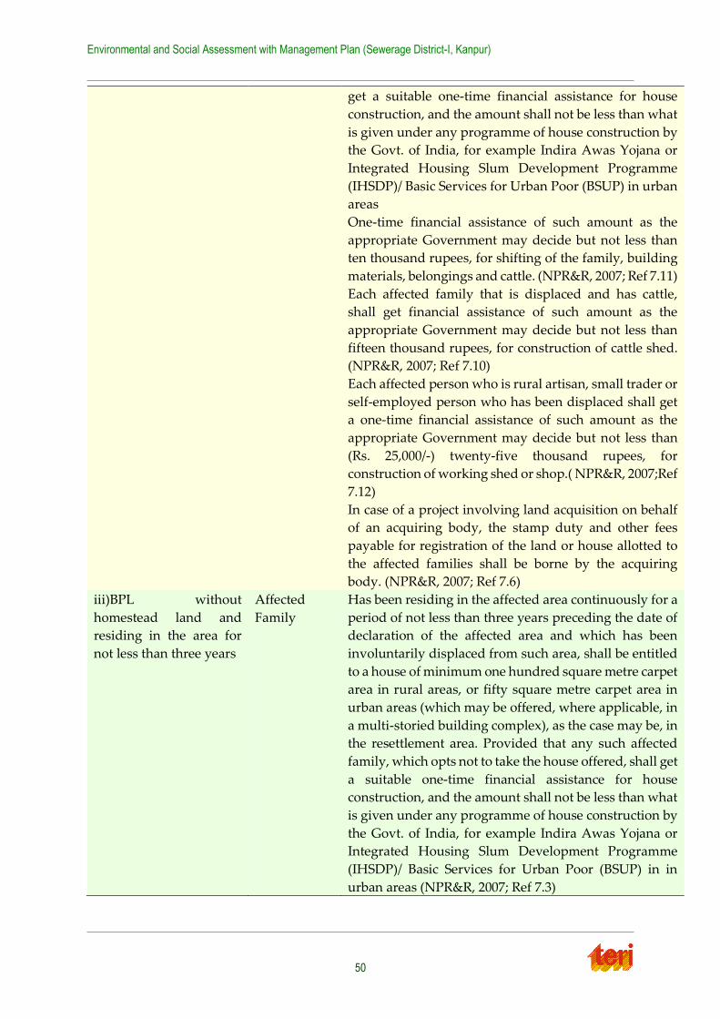
Environmental and Social Assessment with Management Plan (Sewerage District-I, Kanpur)
50
get a suitable one-time financial assistance for house
construction, and the amount shall not be less than what
is given under any programme of house construction by
the Govt. of India, for example Indira Awas Yojana or
Integrated Housing Slum Development Programme
(IHSDP)/ Basic Services for Urban Poor (BSUP) in urban
areas
One-time financial assistance of such amount as the
appropriate Government may decide but not less than
ten thousand rupees, for shifting of the family, building
materials, belongings and cattle. (NPR&R, 2007; Ref 7.11)
Each affected family that is displaced and has cattle,
shall get financial assistance of such amount as the
appropriate Government may decide but not less than
fifteen thousand rupees, for construction of cattle shed.
(NPR&R, 2007; Ref 7.10)
Each affected person who is rural artisan, small trader or
self-employed person who has been displaced shall get
a one-time financial assistance of such amount as the
appropriate Government may decide but not less than
(Rs. 25,000/-) twenty-five thousand rupees, for
construction of working shed or shop.( NPR&R, 2007;Ref
7.12)
In case of a project involving land acquisition on behalf
of an acquiring body, the stamp duty and other fees
payable for registration of the land or house allotted to
the affected families shall be borne by the acquiring
body. (NPR&R, 2007; Ref 7.6)
iii)BPL without
homestead land and
residing in the area for
not less than three years
Affected
Family
Has been residing in the affected area continuously for a
period of not less than three years preceding the date of
declaration of the affected area and which has been
involuntarily displaced from such area, shall be entitled
to a house of minimum one hundred square metre carpet
area in rural areas, or fifty square metre carpet area in
urban areas (which may be offered, where applicable, in
a multi-storied building complex), as the case may be, in
the resettlement area. Provided that any such affected
family, which opts not to take the house offered, shall get
a suitable one-time financial assistance for house
construction, and the amount shall not be less than what
is given under any programme of house construction by
the Govt. of India, for example Indira Awas Yojana or
Integrated Housing Slum Development Programme
(IHSDP)/ Basic Services for Urban Poor (BSUP) in in
urban areas (NPR&R, 2007; Ref 7.3)
Environmental and Social Assessment with Management Plan (Sewerage District-I, Kanpur)
51
One-time financial assistance of such amount as the
appropriate Government may decide but not less than
ten thousand rupees, for shifting of the family, building
materials, belongings and cattle. (NPR&R, 2007; Ref 7.11)
Each affected family that is displaced and has cattle,
shall get financial assistance of such amount as the
appropriate Government may decide but not less than
fifteen thousand rupees, for construction of cattle shed.
(NPR&R, 2007; Ref 7.10)
Each affected person who is rural artisan, small trader or
self-employed person who has been displaced shall get
a one-time financial assistance of such amount as the
appropriate Government may decide but not less than
(Rs. 25,000/-) twenty-five thousand rupees, for
construction of working shed or shop.( NPR&R, 2007;Ref
7.12)
In case of a project involving land acquisition on behalf
of an acquiring body, the stamp duty and other fees
payable for registration of the land or house allotted to
the affected families shall be borne by the acquiring
body. (NPR&R, 2007; Ref 7.6)
Livelihood losses
i) Rural artisan, small
trader or self-employed
Person displaced
Each affected
person
Will get a one-time financial assistance of such amount
as the appropriate Government may decide but not less
than (Rs. 25,000/-) twenty-five thousand rupees, for
construction of working shed or shop.( NPR&R, 2007;
Ref 7.12)
ii) Employment
Assistance
Affected
Family
The acquiring body shall give preference to the affected
families – at least one person per nuclear family - in
providing employment in the project, subject to the
availability of vacancies and suitability of the affected
person for the employment;
Wherever necessary, the acquiring body shall arrange
for training of the affected persons, so as to enable such
persons to take on suitable jobs;
The acquiring body shall offer scholarships and other
skill development opportunities to the eligible persons
from the affected families as per the criteria as may be
fixed by the appropriate Government;
The acquiring body shall give preference to the affected
persons or their groups or cooperatives in the allotment
of outsourced contracts, shops or other economic
opportunities coming up in or around the project site;
and
Environmental and Social Assessment with Management Plan (Sewerage District-I, Kanpur)
52
The acquiring body shall give preference to willing
landless labourers and unemployed affected persons
while engaging labour in the project during the
construction phase.( NPR&R, 2007;Ref 7.13.1)
Other Benefits
i) Additional Assistance
to vulnerable persons
(Disabled, destitute,
orphans, widows,
unmarried girls,
abandoned women, or
persons above fifty years
of age; who are not
provided or cannot
immediately be provided
with alternative
livelihood, and who are
not otherwise covered as
part of a family (Ref 6.4
V)
Each Person The project authorities shall, at their cost, arrange for
annuity policies that will pay a pension for life to the
vulnerable affected persons of such amount as may be
prescribed by the appropriate Government subject to a
minimum of five hundred rupees per month. (NPR&R,
2007;Ref 7.17)
ii) Additional assistance
for Tribal families
Affected
Family
Preference in allotment of land –for-land for schedule
caste families (NPR&R, 2007;Ref 7.21.3)
In case of land being acquired from members of the
Scheduled Tribes, at least one-third of the compensation
amount due shall be paid to the affected families at the
outset as first instalment and the rest at the time of taking
over the possession of the land. (NPR&R, 2007;Ref
7.21.4)
In case of a project involving land acquisition on behalf
of an acquiring body, each Scheduled Tribe affected
family shall get an additional one-time financial
assistance equivalent to five hundred days minimum
agricultural wages (500 MAW) for loss of customary
rights or usages of forest produce. (NPR&R, 2007;Ref
7.21.5)
In case of a project involving land acquisition on behalf
of an acquiring body, the Scheduled Tribes affected
families resettled out of the district will get twenty-five
per cent. higher rehabilitation and resettlement benefits
in monetary terms (NPR&R, 2007;Ref 7.21.8)
iii)Who have not been
provided agricultural
land; or employment
Affected
family
Shall be entitled to a rehabilitation grant equivalent to
seven hundred fifty days minimum agricultural wages
(750 MAW) or such other higher amount as may be
prescribed by the appropriate Government (NPR&R,
2007;Ref 7.14 )
Exemptions from stamp duty etc.
Environmental and Social Assessment with Management Plan (Sewerage District-I, Kanpur)
53
In case of a project involving land acquisition on behalf
of an acquiring body, the stamp duty and other fees
payable for registration of the land or house allotted to
the affected families shall be borne by the acquiring
body. (NPR&R, 2007; Ref 7.6)
Trees and standing crops
Trees on land being
acquired
Land holders Market value of the trees to be computed as per the
provisions of Horticulture and Forest Department.
Standing crops at the
time of acquisition , if
any
Land holders Advance notice to harvest crops
Market value of standing crops to be computed as per
provisions of Agriculture Department.
4.3 Other Legislations applicable to Construction Projects
under NGRBP
Construction stage generally involves equity, safety and public health issues. The construction
agencies therefore will be required to comply with laws of the land, which include inter alia,
the following:
1. Workmen's Compensation Act 1923 (the Act provides for compensation in case of
injury by accident arising out of and during the course of employment);
2. Payment of Gratuity Act, 1972 (gratuity is payable to an employee under the Act on satisfaction of certain conditions on separation if an employee has completed 5 years);
3. Employees PF and Miscellaneous Provision Act 1952 (the Act provides for monthly
contributions by the employer plus workers);
4. Maternity Benefit Act, 1951 (the Act provides for leave and some other benefits to
women employees in case of confinement or miscarriage, etc.);
5. Contract Labor (Regulation and Abolition) Act, 1970 (the Act provides for certain welfare measures to be provided by the contractor to contract labour);
6. Minimum Wages Act, 1948 (the employer is supposed to pay not less than the
Minimum Wages fixed by the Government as per provisions of the Act);
7. Payment of Wages Act, 1936 (it lays down as to by what date the wages are to be paid,
when it will be paid and what deductions can be made from the wages of the workers);
8. Equal Remuneration Act, 1979 (the Act provides for payment of equal wages for work of equal nature to Male and Female workers and not for making discrimination against
Female employees);
9. Payment of Bonus Act, 1965 (the Act provides for payments of annual bonus subject to a minimum of 83.3% of wages and maximum of 20% of wages);
10. Industrial Disputes Act, 1947 (the Act lays down the machinery and procedure for
resolution of industrial disputes, in what situations a strike or lock-out becomes illegal and what are the requirements for laying off or retrenching the employees or closing
down the establishment);
11. Industrial Employment (Standing Orders) Act; 1946 (the Act provides for laying down rules governing the conditions of employment);
Environmental and Social Assessment with Management Plan (Sewerage District-I, Kanpur)
54
12. Trade Unions Act, 1926 (the Act lays down the procedure for registration of trade
unions of workers and employers. The trade unions registered under the Act have been given certain immunities from civil and criminal liabilities);
13. Child Labour (Prohibition and Regulation) Act, 1986 (the Act prohibits employment
of children below 14 years of age in certain occupations and processes and provides for regulation of employment of children in all other occupations and processes.
Employment of child labour is prohibited in Building and Construction Industry);
14. Inter-State Migrant Workmen’s (Regulation of Employment and Conditions of Service) Act, 1979 (the inter-state migrant workers, in an establishment to which this
Act becomes applicable, are required to be provided certain facilities such as housing,
medical aid, travelling expenses from home to the establishment and back, etc.);
15. The Building and Other Construction Workers (Regulation of Employment and
Conditions of Service) Act, 1996 and the Cess Act of 1996 (all the establishments who
carry on any building or other construction work and employs 10 or more workers are covered under this Act; the employer of the establishment is required to provide safety
measures at the building or construction work and other welfare measures, such as
canteens, first-aid facilities, ambulance, housing accommodation for Workers near the workplace, etc.);
16. The Factories Act, 1948 (the Act lays down the procedure for approval of plans before
setting up a factory, health and safety provisions, welfare provisions, working hours and rendering information-regarding accidents or dangerous occurrences to
designated authorities);
17. Hazardous Wastes (Management, Handling and Trans-boundary Movement) Rules, 2008 (the Rules govern handling, movement and disposal of hazardous waste);
18. Manufacture, Storage and Import of Hazardous Chemicals Rules 1989, amended 1994
and 2000 (the Rules provide indicative criteria for hazardous chemicals and require occupiers to identify major accident hazards and prepare on-site and off-site
emergency plans).
19. All the laws and regulations set by different authorities (MoEF, NGRBA, CPCB, etc.) have been reviewed to understand the applicable laws in the context of this proposed
sub-project in Kanpur District I. All the applicable laws enlist the responsible authority
and reasons for its applicability. It is therefore proposed that during the implementation of this project responsible authorities should be contacted acted by
the implementing agency for monitoring the law and regulation.
4.4 Conclusion
The applicable laws and regulations pertaining to environment and social safeguards for the present project are listed below:
1. Environment Protection Act 1986;
2. Air (Prevention and Control of Pollution) Act, 1981
3. Water Prevention and Control of Pollution) Act1974
4. The Noise Pollution (Regulation and Control) Rules, 2000
5. Public Liability and Insurance Act 1991

Environmental and Social Assessment with Management Plan (Sewerage District-I, Kanpur)
55
6. Explosive Act 1984
7. Central Motor Vehicle Act 1988
8. Other legislations are mentioned in section 4.3
Environmental and Social Assessment with Management Plan (Sewerage District-I, Kanpur)
56
Chapter 5 Baseline Status
The baseline environmental and social status is important to understand the region's existing physical and biological characteristics along with cultural and social status of the residing
community. Information and data presented in this section is based on field surveys, stake-
holder interaction/consultation and secondary data collection which majorly include the draft Detailed Project Report (DPR) of proposed sewerage work in Kanpur city, City Development
Plan (CDP) report under JNNRUM by JPS associates (P) Ltd., Water/ Air quality monitoring
report of UP Pollution Control Board, City census data and others. The information on the baseline environmental conditions forms the basis to analyse the probable impacts of the
proposed project vis-à-vis the present background environmental quality of the core study
area.
5.1 Baseline Environmental Status
5.1.1 Physiography and Topography
Kanpur metropolis forms a part of Ganga alluvial plain. It exhibits more or less a flat topography with the master slope from northwest to south-east with average land surface
elevation of about 125 m above mean sea level. The area is drained by the river Ganga and its
tributary Pandu. The proposed sewerage district-I is located in north-eastern part of the city, adjoining the river Ganga on north side.
The terrain of Kanpur is differentiated into lowland and upland. The upland lies in Yamuna
– Ganga interfluves with elevations of 125 to 141 m above Mean Sea Level (MSL). The lowland with elevations of 110 to 135 m. about MSL consists of older flood plain and active flood plain.
Sewerage district-I of Kanpur city fall under the low land or Younger Alluvial plain, which is
being identified as flat to gently sloping and slightly undulating terrain of large areal extent. This low land area is formed by river deposition, and is limited along river Ganga with the
breadth not exceeding 5 km.
5.1.2 Climate
Kanpur district experiences sub-tropical climate with average normal annual rainfall as 851
mm which is mostly received through the south-west monsoon. There is a large range of variation in temperatures of day and night. Kanpur experiences both very dry hot summers
and very cold winters every year. Dust storms in summer and cold north winds in winter are
common. The mean maximum monthly temperatures 41.3°C has been recorded during May and minimum of 8.5°C in January. The climate information of Temperature and Rainfall at
Kanpur is given in Table 5.1 below.
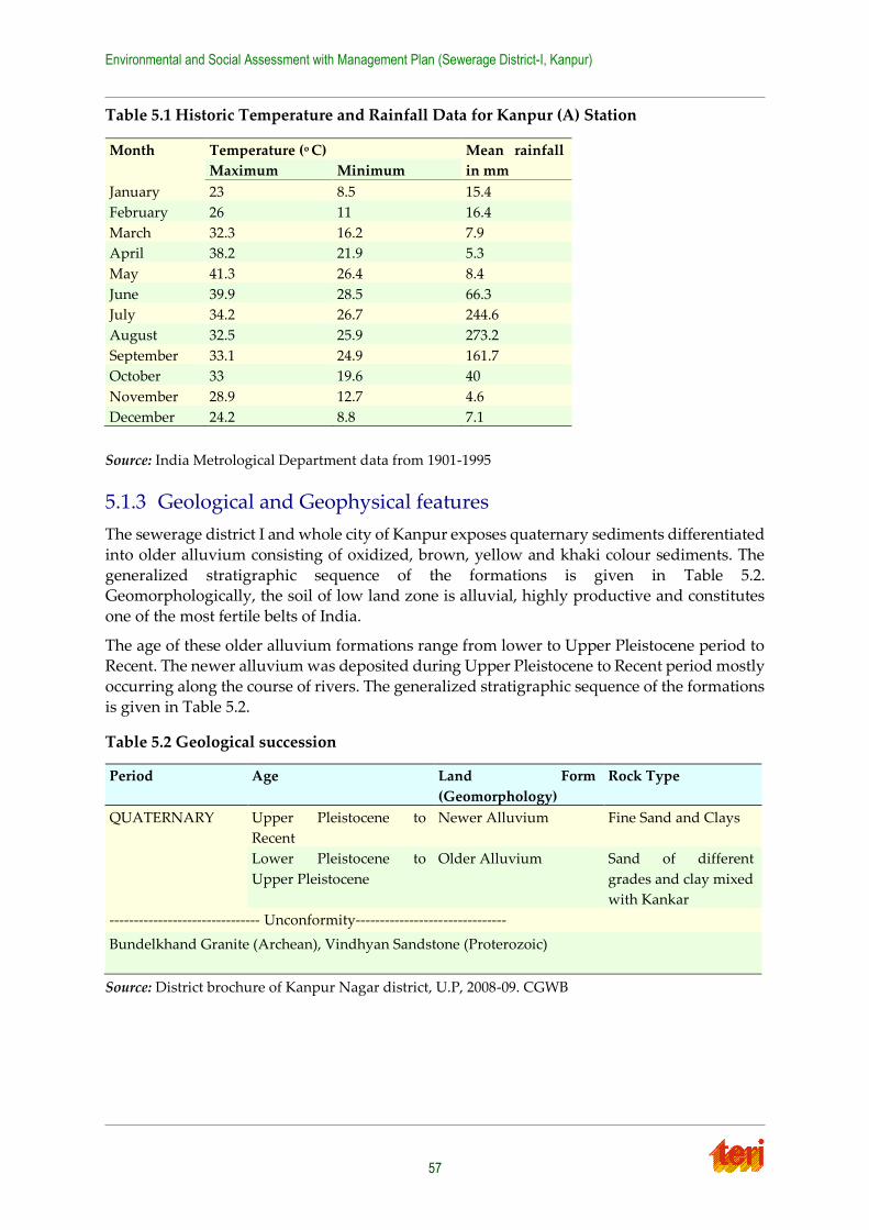
Environmental and Social Assessment with Management Plan (Sewerage District-I, Kanpur)
57
Table 5.1 Historic Temperature and Rainfall Data for Kanpur (A) Station
Source: India Metrological Department data from 1901-1995
5.1.3 Geological and Geophysical features
The sewerage district I and whole city of Kanpur exposes quaternary sediments differentiated
into older alluvium consisting of oxidized, brown, yellow and khaki colour sediments. The
generalized stratigraphic sequence of the formations is given in Table 5.2. Geomorphologically, the soil of low land zone is alluvial, highly productive and constitutes
one of the most fertile belts of India.
The age of these older alluvium formations range from lower to Upper Pleistocene period to Recent. The newer alluvium was deposited during Upper Pleistocene to Recent period mostly
occurring along the course of rivers. The generalized stratigraphic sequence of the formations
is given in Table 5.2.
Table 5.2 Geological succession
Source: District brochure of Kanpur Nagar district, U.P, 2008-09. CGWB
Month Temperature (o C) Mean rainfall
in mm Maximum Minimum
January 23 8.5 15.4
February 26 11 16.4
March 32.3 16.2 7.9
April 38.2 21.9 5.3
May 41.3 26.4 8.4
June 39.9 28.5 66.3
July 34.2 26.7 244.6
August 32.5 25.9 273.2
September 33.1 24.9 161.7
October 33 19.6 40
November 28.9 12.7 4.6
December 24.2 8.8 7.1
Period Age Land Form
(Geomorphology)
Rock Type
QUATERNARY Upper Pleistocene to
Recent
Newer Alluvium Fine Sand and Clays
Lower Pleistocene to
Upper Pleistocene
Older Alluvium Sand of different
grades and clay mixed
with Kankar
------------------------------- Unconformity-------------------------------
Bundelkhand Granite (Archean), Vindhyan Sandstone (Proterozoic)
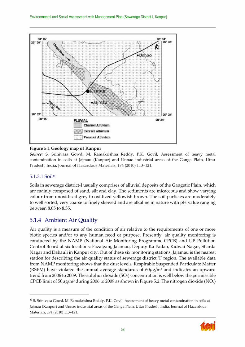
Environmental and Social Assessment with Management Plan (Sewerage District-I, Kanpur)
58
Figure 5.1 Geology map of Kanpur Source: S. Srinivasa Gowd, M. Ramakrishna Reddy, P.K. Govil, Assessment of heavy metal
contamination in soils at Jajmau (Kanpur) and Unnao industrial areas of the Ganga Plain, Uttar
Pradesh, India, Journal of Hazardous Materials, 174 (2010) 113–121.
5.1.3.1 Soil13
Soils in sewerage district-I usually comprises of alluvial deposits of the Gangetic Plain, which
are mainly composed of sand, silt and clay. The sediments are micaceous and show varying colour from unoxidised grey to oxidized yellowish brown. The soil particles are moderately
to well sorted, very coarse to finely skewed and are alkaline in nature with pH value ranging
between 8.05 to 8.35.
5.1.4 Ambient Air Quality
Air quality is a measure of the condition of air relative to the requirements of one or more biotic species and/or to any human need or purpose. Presently, air quality monitoring is
conducted by the NAMP (National Air Monitoring Programme-CPCB) and UP Pollution
Control Board at six locations: Fazalganj, Jajamau, Deputy Ka Padao, Kidwai Nagar, Sharda Nagar and Dabauli in Kanpur city. Out of these six monitoring stations, Jajamau is the nearest
station for describing the air quality status of sewerage district ‘I’ region. The available data
from NAMP monitoring shows that the dust levels, Respirable Suspended Particulate Matter (RSPM) have violated the annual average standards of 60µg/m3 and indicates an upward
trend from 2006 to 2009. The sulphur dioxide (SO2) concentration is well below the permissible
CPCB limit of 50µg/m3 during 2006 to 2009 as shown in Figure 5.2. The nitrogen dioxide (NO2)
13 S. Srinivasa Gowd, M. Ramakrishna Reddy, P.K. Govil, Assessment of heavy metal contamination in soils at
Jajmau (Kanpur) and Unnao industrial areas of the Ganga Plain, Uttar Pradesh, India, Journal of Hazardous
Materials, 174 (2010) 113–121.
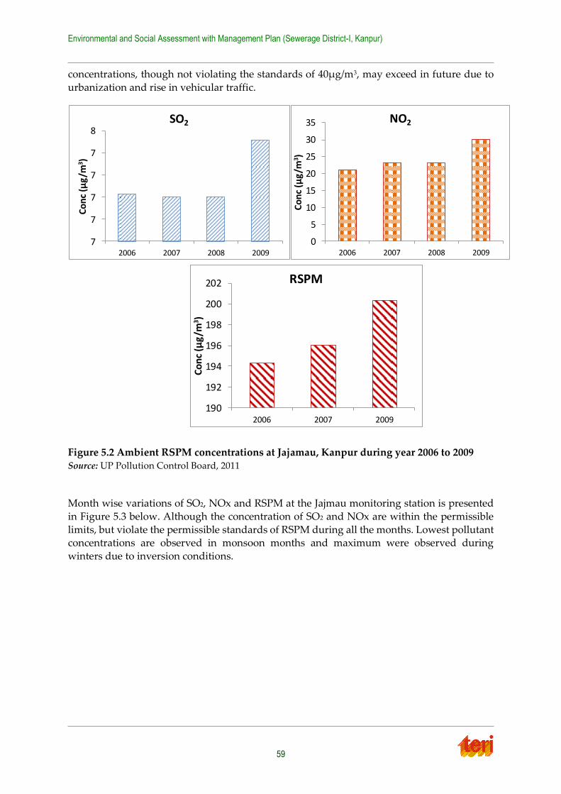
Environmental and Social Assessment with Management Plan (Sewerage District-I, Kanpur)
59
concentrations, though not violating the standards of 40µg/m3, may exceed in future due to
urbanization and rise in vehicular traffic.
Figure 5.2 Ambient RSPM concentrations at Jajamau, Kanpur during year 2006 to 2009 Source: UP Pollution Control Board, 2011
Month wise variations of SO2, NOx and RSPM at the Jajmau monitoring station is presented
in Figure 5.3 below. Although the concentration of SO2 and NOx are within the permissible
limits, but violate the permissible standards of RSPM during all the months. Lowest pollutant concentrations are observed in monsoon months and maximum were observed during
winters due to inversion conditions.
7
7
7
7
7
8
2006 2007 2008 2009
Co
nc
(µg
/m3 )
SO2
0
5
10
15
20
25
30
35
2006 2007 2008 2009
Co
nc
(µg
/m3)
NO2
190
192
194
196
198
200
202
2006 2007 2009
Co
nc
(µg
/m3 )
RSPM
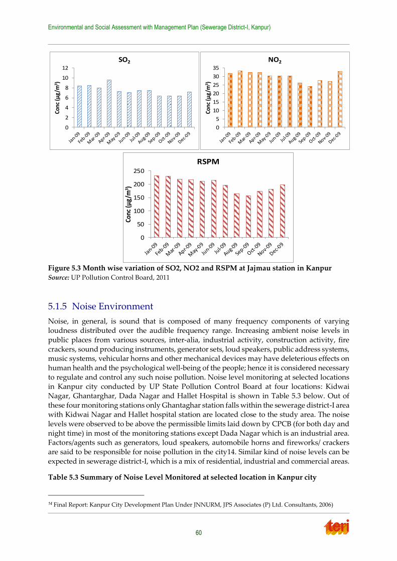
Environmental and Social Assessment with Management Plan (Sewerage District-I, Kanpur)
60
Figure 5.3 Month wise variation of SO2, NO2 and RSPM at Jajmau station in Kanpur Source: UP Pollution Control Board, 2011
5.1.5 Noise Environment
Noise, in general, is sound that is composed of many frequency components of varying loudness distributed over the audible frequency range. Increasing ambient noise levels in
public places from various sources, inter-alia, industrial activity, construction activity, fire
crackers, sound producing instruments, generator sets, loud speakers, public address systems, music systems, vehicular horns and other mechanical devices may have deleterious effects on
human health and the psychological well-being of the people; hence it is considered necessary
to regulate and control any such noise pollution. Noise level monitoring at selected locations in Kanpur city conducted by UP State Pollution Control Board at four locations: Kidwai
Nagar, Ghantarghar, Dada Nagar and Hallet Hospital is shown in Table 5.3 below. Out of
these four monitoring stations only Ghantaghar station falls within the sewerage district-I area with Kidwai Nagar and Hallet hospital station are located close to the study area. The noise
levels were observed to be above the permissible limits laid down by CPCB (for both day and
night time) in most of the monitoring stations except Dada Nagar which is an industrial area. Factors/agents such as generators, loud speakers, automobile horns and fireworks/ crackers
are said to be responsible for noise pollution in the city14. Similar kind of noise levels can be
expected in sewerage district-I, which is a mix of residential, industrial and commercial areas.
Table 5.3 Summary of Noise Level Monitored at selected location in Kanpur city
14 Final Report: Kanpur City Development Plan Under JNNURM, JPS Associates (P) Ltd. Consultants, 2006)
0
2
4
6
8
10
12
Conc
(µg/
m3 )
SO2
0
5
10
15
20
25
30
35
Conc
(µg/
m3 )
NO2
0
50
100
150
200
250
Conc
(µg/
m3 )
RSPM
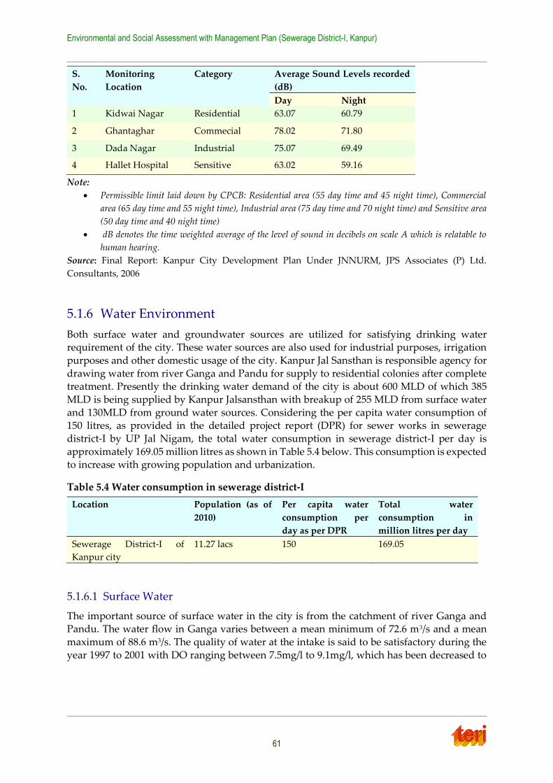
Environmental and Social Assessment with Management Plan (Sewerage District-I, Kanpur)
61
S.
No.
Monitoring
Location
Category Average Sound Levels recorded
(dB)
Day Night
1 Kidwai Nagar Residential 63.07 60.79
2 Ghantaghar Commecial 78.02 71.80
3 Dada Nagar Industrial 75.07 69.49
4 Hallet Hospital Sensitive 63.02 59.16
Note:
Permissible limit laid down by CPCB: Residential area (55 day time and 45 night time), Commercial
area (65 day time and 55 night time), Industrial area (75 day time and 70 night time) and Sensitive area
(50 day time and 40 night time)
dB denotes the time weighted average of the level of sound in decibels on scale A which is relatable to
human hearing.
Source: Final Report: Kanpur City Development Plan Under JNNURM, JPS Associates (P) Ltd.
Consultants, 2006
5.1.6 Water Environment
Both surface water and groundwater sources are utilized for satisfying drinking water requirement of the city. These water sources are also used for industrial purposes, irrigation
purposes and other domestic usage of the city. Kanpur Jal Sansthan is responsible agency for
drawing water from river Ganga and Pandu for supply to residential colonies after complete treatment. Presently the drinking water demand of the city is about 600 MLD of which 385
MLD is being supplied by Kanpur Jalsansthan with breakup of 255 MLD from surface water
and 130MLD from ground water sources. Considering the per capita water consumption of 150 litres, as provided in the detailed project report (DPR) for sewer works in sewerage
district-I by UP Jal Nigam, the total water consumption in sewerage district-I per day is
approximately 169.05 million litres as shown in Table 5.4 below. This consumption is expected to increase with growing population and urbanization.
Table 5.4 Water consumption in sewerage district-I
Location Population (as of
2010)
Per capita water
consumption per
day as per DPR
Total water
consumption in
million litres per day
Sewerage District-I of
Kanpur city
11.27 lacs 150 169.05
5.1.6.1 Surface Water
The important source of surface water in the city is from the catchment of river Ganga and Pandu. The water flow in Ganga varies between a mean minimum of 72.6 m3/s and a mean
maximum of 88.6 m3/s. The quality of water at the intake is said to be satisfactory during the
year 1997 to 2001 with DO ranging between 7.5mg/l to 9.1mg/l, which has been decreased to
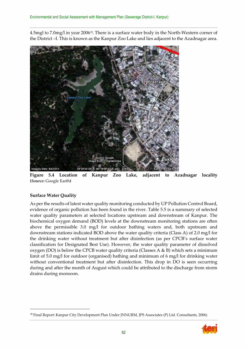
Environmental and Social Assessment with Management Plan (Sewerage District-I, Kanpur)
62
4.5mgl to 7.0mg/l in year 200615. There is a surface water body in the North-Western corner of
the District –I. This is known as the Kanpur Zoo Lake and lies adjacent to the Azadnagar area.
Figure 5.4 Location of Kanpur Zoo Lake, adjacent to Azadnagar locality (Source: Google Earth)
Surface Water Quality
As per the results of latest water quality monitoring conducted by UP Pollution Control Board,
evidence of organic pollution has been found in the river. Table 5.5 is a summary of selected
water quality parameters at selected locations upstream and downstream of Kanpur. The biochemical oxygen demand (BOD) levels at the downstream monitoring stations are often
above the permissible 3.0 mg/l for outdoor bathing waters and, both upstream and
downstream stations indicated BOD above the water quality criteria (Class A) of 2.0 mg/l for the drinking water without treatment but after disinfection (as per CPCB’s surface water
classification for Designated Best Use). However, the water quality parameter of dissolved
oxygen (DO) is below the CPCB water quality criteria (Classes A & B) which sets a minimum limit of 5.0 mg/l for outdoor (organised) bathing and minimum of 6 mg/l for drinking water
without conventional treatment but after disinfection. This drop in DO is seen occurring
during and after the month of August which could be attributed to the discharge from storm drains during monsoon.
15 Final Report: Kanpur City Development Plan Under JNNURM, JPS Associates (P) Ltd. Consultants, 2006)
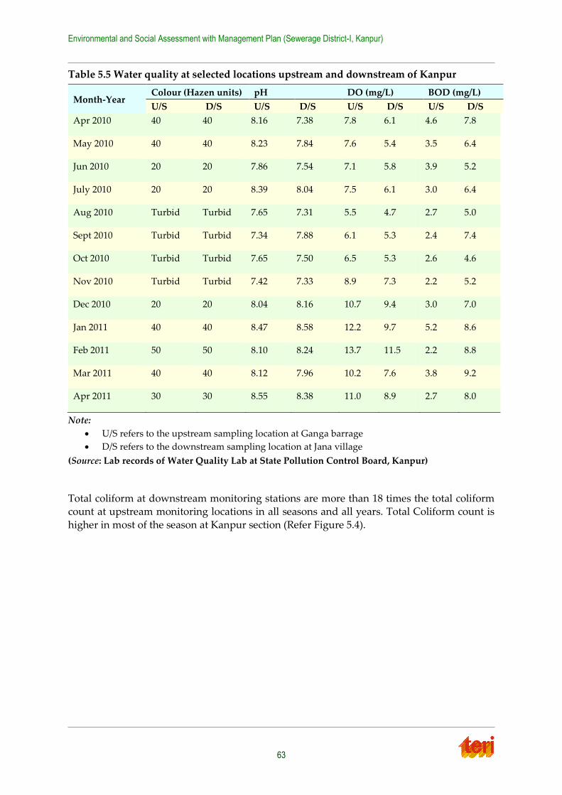
Environmental and Social Assessment with Management Plan (Sewerage District-I, Kanpur)
63
Table 5.5 Water quality at selected locations upstream and downstream of Kanpur
Month-Year Colour (Hazen units) pH DO (mg/L) BOD (mg/L)
U/S D/S U/S D/S U/S D/S U/S D/S
Apr 2010 40 40 8.16 7.38 7.8 6.1 4.6 7.8
May 2010 40 40 8.23 7.84 7.6 5.4 3.5 6.4
Jun 2010 20 20 7.86 7.54 7.1 5.8 3.9 5.2
July 2010 20 20 8.39 8.04 7.5 6.1 3.0 6.4
Aug 2010 Turbid Turbid 7.65 7.31 5.5 4.7 2.7 5.0
Sept 2010 Turbid Turbid 7.34 7.88 6.1 5.3 2.4 7.4
Oct 2010 Turbid Turbid 7.65 7.50 6.5 5.3 2.6 4.6
Nov 2010 Turbid Turbid 7.42 7.33 8.9 7.3 2.2 5.2
Dec 2010 20 20 8.04 8.16 10.7 9.4 3.0 7.0
Jan 2011 40 40 8.47 8.58 12.2 9.7 5.2 8.6
Feb 2011 50 50 8.10 8.24 13.7 11.5 2.2 8.8
Mar 2011 40 40 8.12 7.96 10.2 7.6 3.8 9.2
Apr 2011 30 30 8.55 8.38 11.0 8.9 2.7 8.0
Note:
U/S refers to the upstream sampling location at Ganga barrage
D/S refers to the downstream sampling location at Jana village
(Source: Lab records of Water Quality Lab at State Pollution Control Board, Kanpur)
Total coliform at downstream monitoring stations are more than 18 times the total coliform count at upstream monitoring locations in all seasons and all years. Total Coliform count is
higher in most of the season at Kanpur section (Refer Figure 5.4).
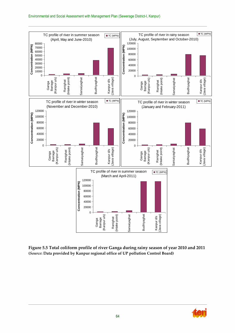
Environmental and Social Assessment with Management Plan (Sewerage District-I, Kanpur)
64
Figure 5.5 Total coliform profile of river Ganga during rainy season of year 2010 and 2011 (Source: Data provided by Kanpur regional office of UP pollution Control Board)
TC profile of river in summer season
(April, May and June-2010)
0
10000
20000
30000
40000
50000
60000
70000
80000
Ga
ng
a
Ba
rra
ge
(Ka
np
ur
u/s
)
Ra
nig
ha
t
(In
take
po
int)
Sa
rsa
iya
gh
at
Bu
dh
iya
gh
at
Ka
np
ur
d/s
(Ja
va
villa
ge
)
Co
nc
en
tra
tio
n (
MP
N)
TC (MPN)
TC profile of river in summer season
(March and April-2011)
0
20000
40000
60000
80000
100000
120000
Ga
ng
a
Ba
rra
ge
(Ka
np
ur
u/s
)
Ra
nig
ha
t
(In
take
po
int)
Sa
rsa
iya
gh
at
Bu
dh
iya
gh
at
Ka
np
ur
d/s
(Ja
va
villa
ge
)
Co
nc
en
tra
tio
n (
MP
N)
TC (MPN)
TC profile of river in rainy season
(July, August, September and October-2010)
0
20000
40000
60000
80000
100000
120000
Ga
ng
a
Ba
rra
ge
(Ka
np
ur
u/s
)
Ra
nig
ha
t
(In
take
po
int)
Sa
rsa
iya
gh
at
Bu
dh
iya
gh
at
Ka
np
ur
d/s
(Ja
va
villa
ge
)
Co
nc
en
tra
tio
n (
MP
N)
TC (MPN)
TC profile of river in winter season
(November and December-2010)
0
20000
40000
60000
80000
100000
120000
Ga
ng
a
Ba
rra
ge
(Ka
np
ur
u/s
)
Ra
nig
ha
t
(In
take
po
int)
Sa
rsa
iya
gh
at
Bu
dh
iya
gh
at
Ka
np
ur
d/s
(Ja
va
villa
ge
)
Co
nc
en
tra
tio
n (
MP
N)
TC (MPN) TC profile of river in winter season
(January and February-2011)
0
20000
40000
60000
80000
100000
120000
Ga
ng
a
Ba
rra
ge
(Ka
np
ur
u/s
)
Ra
nig
ha
t
(In
take
po
int)
Sa
rsa
iya
gh
at
Bu
dh
iya
gh
at
Ka
np
ur
d/s
(Ja
va
villa
ge
)
Co
nc
en
tra
tio
n (
MP
N)
TC (MPN)
Environmental and Social Assessment with Management Plan (Sewerage District-I, Kanpur)
65
5.1.6.2 Ground Water
According to the Central Ground Water Board (CGWB), the stage of groundwater
development in the Kanpur Nagar district is about 67.33% 16 and the dependence on this resource has increased over the years mainly due to rapid urbanization and increasing
population levels. With reference to the exploratory drilling data of CGWB and state tube well
department, it is evident that there are three distinct granular zones at Kanpur city
Shallow aquifers ranging up to 150 mbgl17
Middle aquifer ranging from 150 to 250 mbgl and
Deeper aquifer lies below 250 mbgl.
Although the extension of individual zones might be variable over the Kanpur district, the
sewerage district-I comes under deeper aquifer zone. Past 10 years (1998-2007) data of
National Hydrograph Stations of Kanpur Nagar district shows a declining water level with about 4 to 63 cm/year decline in pre-monsoon period. In the city water level has gone down
to 36.0 mbgl. The depth to water level at Nirala Nagar, Fazalganj, Juhi depot, Kidwai Nagar,
Babupurwa, Rawatpur and Defence Colony are more than 20.0 mbgl18.
Ground Water Quality19
Pre Monsoon water quality
As per groundwater quality monitoring conducted by CPCB, the pH levels in the groundwater at sewerage district-I, is said to be ranging between 6.7-6.8 which is well within
the standard limit (IS 10500-1991) for drinking. The Total Dissolved Solids (TDS)
concentration the groundwater is between 673-980 mg/l which is higher than the standard limit (IS 10500-1991). COD ranges from 6.2 to 4.6 mg/l and the BOD ranges 1.4 to 2mg/l, which
is though being negligible but slightly higher than the industrial area, indicating that this
increase is due to higher organic content in the effluents from residential area. The values of Fluoride are ranging between 0.01 to 0.92 mg/L which are within the IS 10500-1991 standard
limits except near Ghandigram area near Airport side of sewerage district-I which is about
1.16mg/l. Total coliform was nil in most of the locations in sewerage district-I, except area nearer to Gandigram where about TC of 4 MPN/100ml was observed, indicating possibility of
bacteriological contamination. No pesticides were found in this area.
Post Monsoon water quality
The average value of pH in groundwater during post monsoon period in most of the locations
in the sewerage district-I almost neutral ranging between 6.6-7.3 which is well within the
standard limit for drinking water. In regard to sewerage district I the values of TDS lie in the range of 595-749 mg/L. COD ranges from 5.8 to 4.0 mg/l and the BOD ranges 1.6 to 1.2 mg/l,
which is comparatively lesser than the pre-monsoon water quality status. Total coliform
presence was nil in most of the locations in sewerage district-I during post monsoon period.
16 District brochure of Kanpur Nagar district, U.P, 2008-09. CGWB
17 Meters below ground level
18 District brochure of Kanpur Nagar district, U.P, 2008-09, CGWB 19 Source: Status of ground water quality in India part-2, CPCB 2008
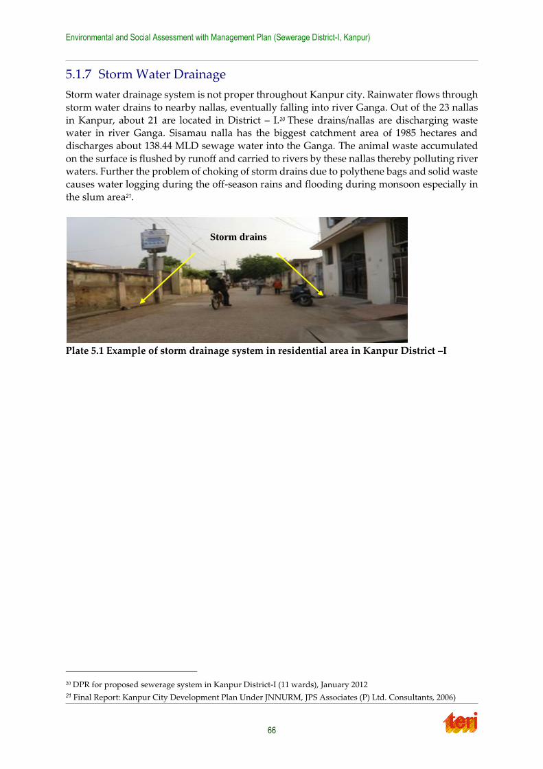
Environmental and Social Assessment with Management Plan (Sewerage District-I, Kanpur)
66
5.1.7 Storm Water Drainage
Storm water drainage system is not proper throughout Kanpur city. Rainwater flows through
storm water drains to nearby nallas, eventually falling into river Ganga. Out of the 23 nallas
in Kanpur, about 21 are located in District – I.20 These drains/nallas are discharging waste water in river Ganga. Sisamau nalla has the biggest catchment area of 1985 hectares and
discharges about 138.44 MLD sewage water into the Ganga. The animal waste accumulated
on the surface is flushed by runoff and carried to rivers by these nallas thereby polluting river waters. Further the problem of choking of storm drains due to polythene bags and solid waste
causes water logging during the off-season rains and flooding during monsoon especially in
the slum area21.
Plate 5.1 Example of storm drainage system in residential area in Kanpur District –I
20 DPR for proposed sewerage system in Kanpur District-I (11 wards), January 2012 21 Final Report: Kanpur City Development Plan Under JNNURM, JPS Associates (P) Ltd. Consultants, 2006)
Storm drains
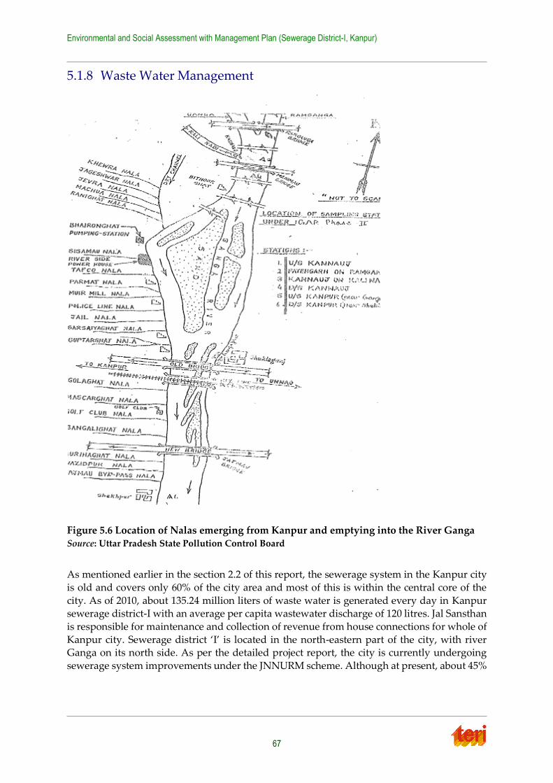
Environmental and Social Assessment with Management Plan (Sewerage District-I, Kanpur)
67
5.1.8 Waste Water Management
Figure 5.6 Location of Nalas emerging from Kanpur and emptying into the River Ganga Source: Uttar Pradesh State Pollution Control Board
As mentioned earlier in the section 2.2 of this report, the sewerage system in the Kanpur city
is old and covers only 60% of the city area and most of this is within the central core of the
city. As of 2010, about 135.24 million liters of waste water is generated every day in Kanpur sewerage district-I with an average per capita wastewater discharge of 120 litres. Jal Sansthan
is responsible for maintenance and collection of revenue from house connections for whole of
Kanpur city. Sewerage district ‘I’ is located in the north-eastern part of the city, with river Ganga on its north side. As per the detailed project report, the city is currently undergoing
sewerage system improvements under the JNNURM scheme. Although at present, about 45%
Environmental and Social Assessment with Management Plan (Sewerage District-I, Kanpur)
68
of District I is sewered, once the JNNURM project is completed, 50% of all households in
District-1 will be provided a sewer connection22.
Wastewater generated from sewerage district I includes wastes discharged from residential,
commercial and industrial wastes. Summary of wastewater quality analysis conducted by UP
Pollution Control Board for some select nallas passing through sewerage district-I, is presented in Table 5.6 below. High level of BOD along with presence of unpleasant odour and
colour indicates possible contamination from domestic/ industrial wastes. The major issue of
wastewater disposal is the associated environmental impact which is derived from worsening of water quality and causing direct impact not only on the drinking water sector but also other
sectors such as fisheries, irrigation, and recreation.
22 As per personal communications with UP Jal Nigam staff
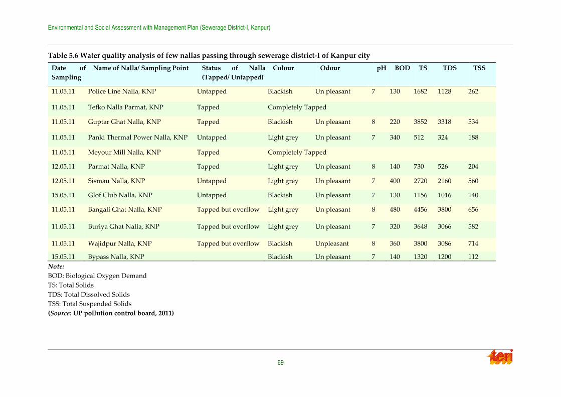
Environmental and Social Assessment with Management Plan (Sewerage District-I, Kanpur)
69
Table 5.6 Water quality analysis of few nallas passing through sewerage district-I of Kanpur city
Date of
Sampling
Name of Nalla/ Sampling Point Status of Nalla
(Tapped/ Untapped)
Colour Odour pH BOD TS TDS TSS
11.05.11 Police Line Nalla, KNP Untapped Blackish Un pleasant 7 130 1682 1128 262
11.05.11 Tefko Nalla Parmat, KNP Tapped Completely Tapped
11.05.11 Guptar Ghat Nalla, KNP Tapped Blackish Un pleasant 8 220 3852 3318 534
11.05.11 Panki Thermal Power Nalla, KNP Untapped Light grey Un pleasant 7 340 512 324 188
11.05.11 Meyour Mill Nalla, KNP Tapped Completely Tapped
12.05.11 Parmat Nalla, KNP Tapped Light grey Un pleasant 8 140 730 526 204
12.05.11 Sismau Nalla, KNP Untapped Light grey Un pleasant 7 400 2720 2160 560
15.05.11 Glof Club Nalla, KNP Untapped Blackish Un pleasant 7 130 1156 1016 140
11.05.11 Bangali Ghat Nalla, KNP Tapped but overflow Light grey Un pleasant 8 480 4456 3800 656
11.05.11 Buriya Ghat Nalla, KNP Tapped but overflow Light grey Un pleasant 7 320 3648 3066 582
11.05.11 Wajidpur Nalla, KNP Tapped but overflow Blackish Unpleasant 8 360 3800 3086 714
15.05.11 Bypass Nalla, KNP Blackish Un pleasant 7 140 1320 1200 112
Note:
BOD: Biological Oxygen Demand
TS: Total Solids
TDS: Total Dissolved Solids
TSS: Total Suspended Solids
(Source: UP pollution control board, 2011)
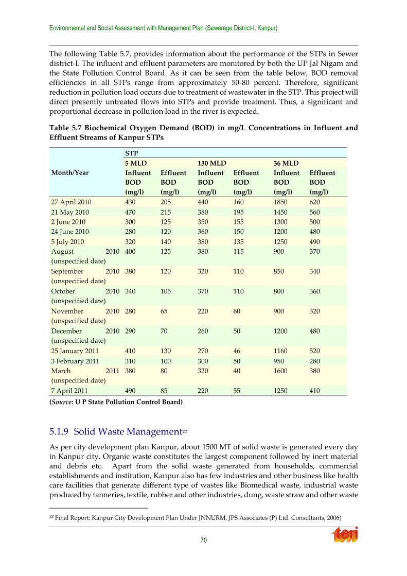
Environmental and Social Assessment with Management Plan (Sewerage District-I, Kanpur)
70
The following Table 5.7, provides information about the performance of the STPs in Sewer
district-I. The influent and effluent parameters are monitored by both the UP Jal Nigam and the State Pollution Control Board. As it can be seen from the table below, BOD removal
efficiencies in all STPs range from approximately 50-80 percent. Therefore, significant
reduction in pollution load occurs due to treatment of wastewater in the STP. This project will direct presently untreated flows into STPs and provide treatment. Thus, a significant and
proportional decrease in pollution load in the river is expected.
Table 5.7 Biochemical Oxygen Demand (BOD) in mg/L Concentrations in Influent and
Effluent Streams of Kanpur STPs
(Source: U P State Pollution Control Board)
5.1.9 Solid Waste Management23
As per city development plan Kanpur, about 1500 MT of solid waste is generated every day in Kanpur city. Organic waste constitutes the largest component followed by inert material
and debris etc. Apart from the solid waste generated from households, commercial
establishments and institution, Kanpur also has few industries and other business like health care facilities that generate different type of wastes like Biomedical waste, industrial waste
produced by tanneries, textile, rubber and other industries, dung, waste straw and other waste
23 Final Report: Kanpur City Development Plan Under JNNURM, JPS Associates (P) Ltd. Consultants, 2006)
Month/Year
STP
5 MLD 130 MLD 36 MLD
Influent
BOD
(mg/l)
Effluent
BOD
(mg/l)
Influent
BOD
(mg/l)
Effluent
BOD
(mg/l)
Influent
BOD
(mg/l)
Effluent
BOD
(mg/l)
27 April 2010 430 205 440 160 1850 620
21 May 2010 470 215 380 195 1450 560
2 June 2010 300 125 350 155 1300 500
24 June 2010 280 120 360 150 1200 480
5 July 2010 320 140 380 135 1250 490
August 2010
(unspecified date)
400 125 380 115 900 370
September 2010
(unspecified date)
380 120 320 110 850 340
October 2010
(unspecified date)
340 105 370 110 800 360
November 2010
(unspecified date)
280 65 220 60 900 320
December 2010
(unspecified date)
290 70 260 50 1200 480
25 January 2011 410 130 270 46 1160 520
3 February 2011 310 100 300 50 950 280
March 2011
(unspecified date)
380 80 320 40 1600 380
7 April 2011 490 85 220 55 1250 410

Environmental and Social Assessment with Management Plan (Sewerage District-I, Kanpur)
71
from dairies, silt from nallas and drains, etc. The total quantity of solid waste generated from
sewerage district-I, is estimated by considering the average quantity (350gms) of solid waste generated per capita per day (pcpd), which comes to about 394 MT as shown in Table 5.8.
With growth in population, the per capita waste generation is also expected to increase
thereby increasing the solid waste.
Table 5.8 Solid waste generation in sewerage district-I, Kanpur city
Location Population (as of
2010)
Average solid waste
generation per capita
per day
Total solid waste
generated in MT
Sewerage District-I of
Kanpur city
11.27 lacs 350 gms 394
The solid waste management in sewerage district-I is handled by Kanpur Nagar Nigam,
which involves primary and secondary collection, transportation of wastes and disposal at
landfill site. Issues related to primary and secondary collection of garbage include dumping of wastes along roadside and into drains leads to choking of drains, lack of segregation of bio-degradable and non-degradable waste at source, large scale public littering leading to inattentiveness of street sweeping and cleaning activities. Presently there is no waste processing plant at Kanpur and the total waste is taken to disposal size. Representative
pictures of observed open dumping of solid waste in sewerage district-I, is shown in Plate 5.2.
As a result of such practices the entire area in and around the disposal sites is unhygienic and poses a serious threat to the environment and to the public health. Open dumping of wastes
also causes choking of sewers which in turn leads to water logging throughout the city.
Plate 5.2 Open waste dumping (left) and blocked overflowing drain at Chauk Sarafa
ward (right)
5.1.10 Biological Environment
5.1.10.1Green cover
Gardens/ Parks: There are no ecologically sensitive identified gardens/ parks in sewerage
district-I. However the region has small residential parks, which will not be threatened by the
proposed sewer works, since the sewers are planned to be laid in the middle of the road and
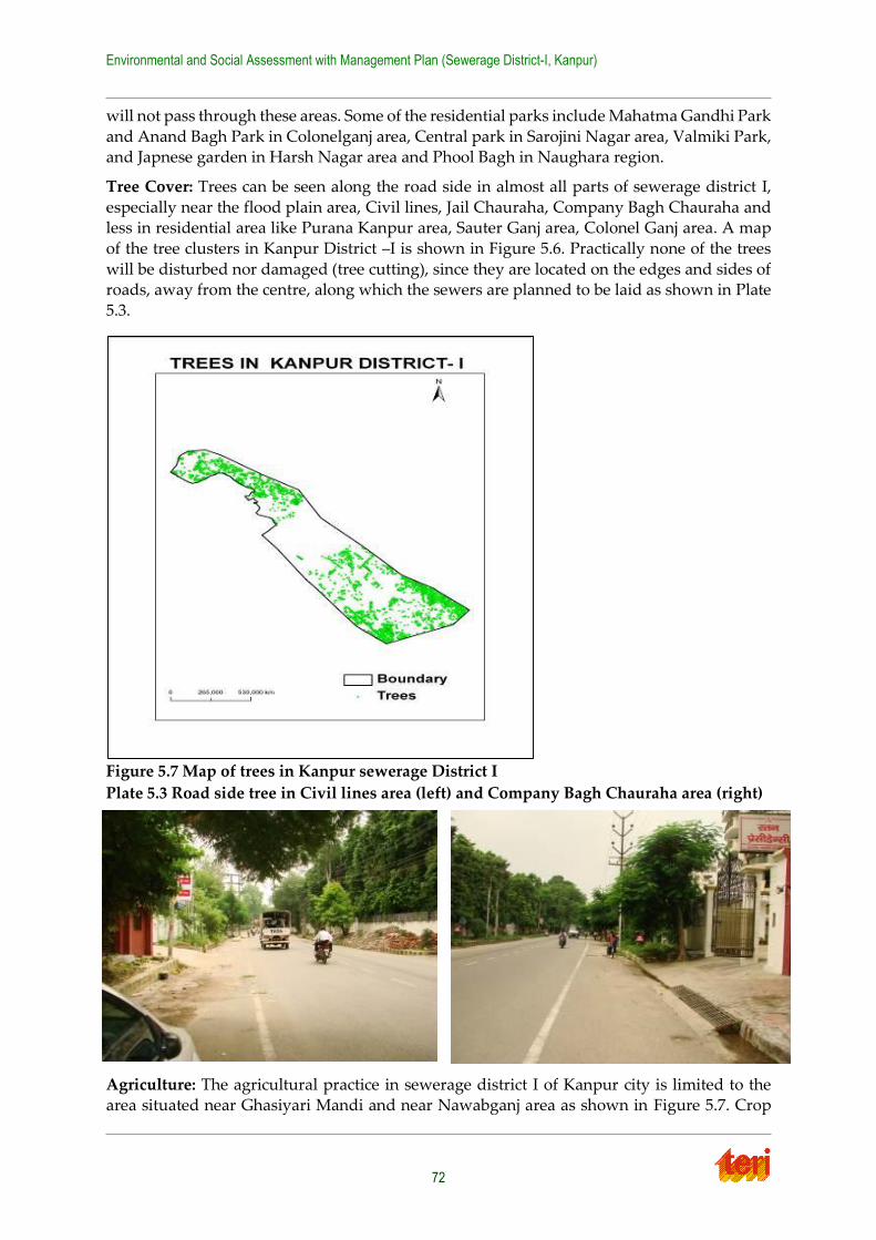
Environmental and Social Assessment with Management Plan (Sewerage District-I, Kanpur)
72
will not pass through these areas. Some of the residential parks include Mahatma Gandhi Park
and Anand Bagh Park in Colonelganj area, Central park in Sarojini Nagar area, Valmiki Park, and Japnese garden in Harsh Nagar area and Phool Bagh in Naughara region.
Tree Cover: Trees can be seen along the road side in almost all parts of sewerage district I,
especially near the flood plain area, Civil lines, Jail Chauraha, Company Bagh Chauraha and less in residential area like Purana Kanpur area, Sauter Ganj area, Colonel Ganj area. A map
of the tree clusters in Kanpur District –I is shown in Figure 5.6. Practically none of the trees
will be disturbed nor damaged (tree cutting), since they are located on the edges and sides of roads, away from the centre, along which the sewers are planned to be laid as shown in Plate
5.3.
Figure 5.7 Map of trees in Kanpur sewerage District I
Plate 5.3 Road side tree in Civil lines area (left) and Company Bagh Chauraha area (right)
Agriculture: The agricultural practice in sewerage district I of Kanpur city is limited to the area situated near Ghasiyari Mandi and near Nawabganj area as shown in Figure 5.7. Crop
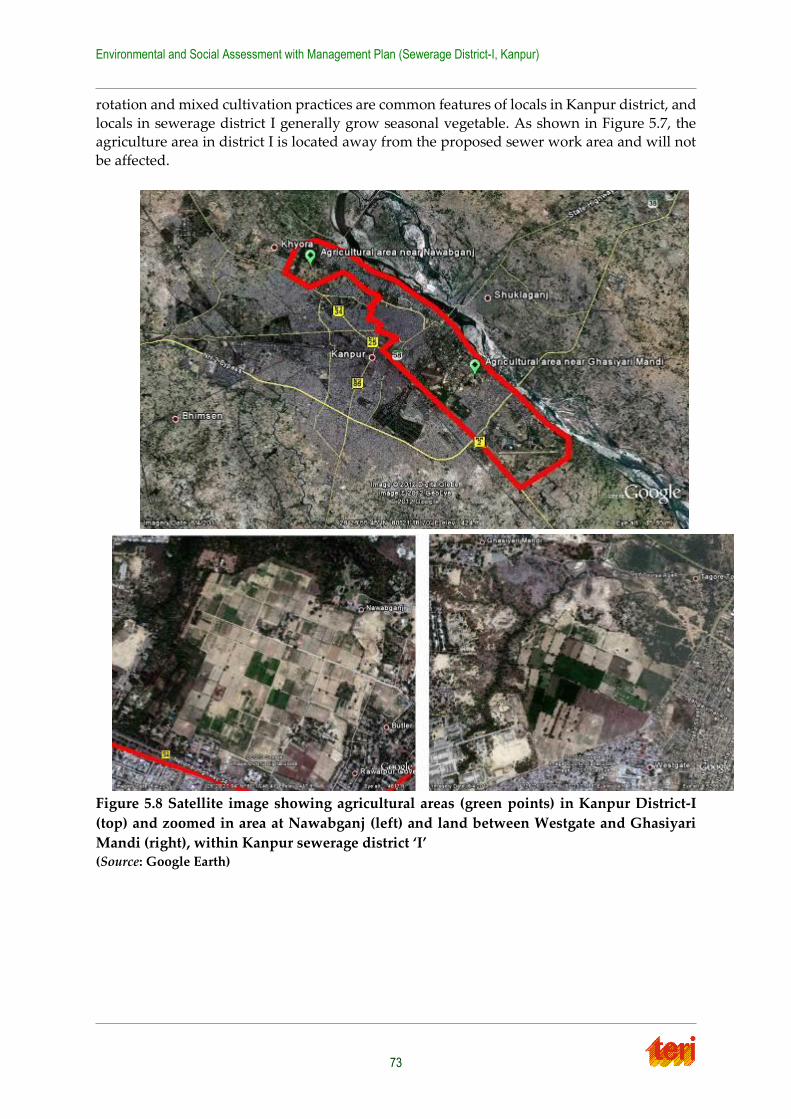
Environmental and Social Assessment with Management Plan (Sewerage District-I, Kanpur)
73
rotation and mixed cultivation practices are common features of locals in Kanpur district, and
locals in sewerage district I generally grow seasonal vegetable. As shown in Figure 5.7, the agriculture area in district I is located away from the proposed sewer work area and will not
be affected.
Figure 5.8 Satellite image showing agricultural areas (green points) in Kanpur District-I
(top) and zoomed in area at Nawabganj (left) and land between Westgate and Ghasiyari
Mandi (right), within Kanpur sewerage district ‘I’ (Source: Google Earth)
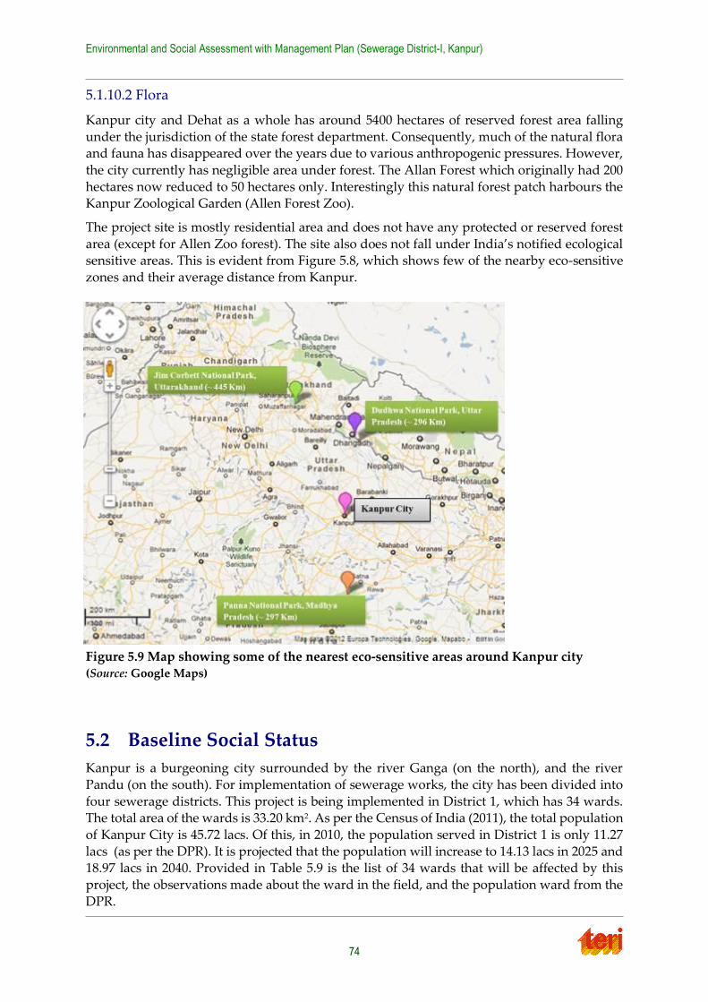
Environmental and Social Assessment with Management Plan (Sewerage District-I, Kanpur)
74
5.1.10.2 Flora
Kanpur city and Dehat as a whole has around 5400 hectares of reserved forest area falling
under the jurisdiction of the state forest department. Consequently, much of the natural flora and fauna has disappeared over the years due to various anthropogenic pressures. However,
the city currently has negligible area under forest. The Allan Forest which originally had 200
hectares now reduced to 50 hectares only. Interestingly this natural forest patch harbours the Kanpur Zoological Garden (Allen Forest Zoo).
The project site is mostly residential area and does not have any protected or reserved forest
area (except for Allen Zoo forest). The site also does not fall under India’s notified ecological sensitive areas. This is evident from Figure 5.8, which shows few of the nearby eco-sensitive
zones and their average distance from Kanpur.
Figure 5.9 Map showing some of the nearest eco-sensitive areas around Kanpur city (Source: Google Maps)
5.2 Baseline Social Status
Kanpur is a burgeoning city surrounded by the river Ganga (on the north), and the river
Pandu (on the south). For implementation of sewerage works, the city has been divided into
four sewerage districts. This project is being implemented in District 1, which has 34 wards. The total area of the wards is 33.20 km2. As per the Census of India (2011), the total population
of Kanpur City is 45.72 lacs. Of this, in 2010, the population served in District 1 is only 11.27
lacs (as per the DPR). It is projected that the population will increase to 14.13 lacs in 2025 and 18.97 lacs in 2040. Provided in Table 5.9 is the list of 34 wards that will be affected by this
project, the observations made about the ward in the field, and the population ward from the
DPR.
Environmental and Social Assessment with Management Plan (Sewerage District-I, Kanpur)
75
Kanpur Nagar is a relatively urban district and, correspondingly, it has a large and highly
stratified population. Its literacy rate is almost 75%. Non-workers outnumber workers by more than two-to-one, but 83% of those employed have regular employment. In terms of
education, Kanpur Nagar has very few people (less than 5%) with no education, and the
largest group is in the Diploma range; however, those with Middle level education or below outnumber those with Diploma or above by about 400,000 people. The vast majority (65%)
have permanent residences. Kanpur Nagar has a relatively small SC population, mostly from
the Chamar caste. Tribal populations are also relatively small, with the three largest tribes accounting for only 0.04% of the total population. Drinking water facilities and safe drinking
water also are relatively available, especially with electricity access. Paved roads also
outnumber mud roads by over 60%, in terms of number of villages. Medical facilities and communication facilities (post office, telephone facility, etc.) appear fairly common. Full
demographic details are available as Annexure 4.
Kanpur has some sewage system, but its reach is not vast enough and much of it is too old (and in parts, defunct). Overall, 30% of Kanpur city, by area, is sewered. In District 1 (the
project area), 2668 ha is sewered while 2957 ha is not. The unsewered area is located primarily
in the eastern part of the District 1, which includes part of the city core and the cantonment. A new trunk sewer to take waste from the tannery zone to the Jajmau STP aims to account for
the future projected pollution load of 267.44 MLD by 2040. As for the quality of the sewers,
many of them are old brick sewers laid between 50 and 100 years ago. The last major sewer renovation project took place in 1952, and was meant to support a population of 9.25 lakhs
and is clearly inadequate for the present population of 11.27 lakhs, let alone the projected
increases in the future.
Table 5.9 Ward wise census population and projected population and observed land use
S.
No
Ward
Ref.
No.
Wards Land use observation
in field
Population Projected Population
(Source: DPR)
2001 2010 2025 2040
1 1 Old Kanpur Extremely congested,
mix of residential and
commercial uses.
24158 31500 42300 72600
2 2 Laxmipurwa Both residential and
commercial uses. The
main roads are fairly
wide, but interior lanes
are very narrow and
congested. Presence of
mobile vendors in the
streets.
26440 35700 49600 84704
3 4 Gwaltoli Mixed use with
commercial and
residential buildings.
The buildings are old
and have houses on
top, and shops below.
21130 25600 31800 50900
4 5 Chunniganj Residential and
commercial, very
congested area.
21735 26300 32800 52400

Environmental and Social Assessment with Management Plan (Sewerage District-I, Kanpur)
76
S.
No
Ward
Ref.
No.
Wards Land use observation
in field
Population Projected Population
(Source: DPR)
5 9 Vishnupuri Mixed use with
institutional and
residential.
26377 34400 46200 79300
6 13 Khalasiline Also called Tilak
Nagar. Purely
residential area with
very high income
housing.
19717 24800 32100 55300
7 15 Parmat Mixed use with
commercial and
residential.
22091 27800 36000 62000
8 28 Krishna Nagar Primarily a residential
area.
26137 29885 46560 72539
9 29 Safipur Mixed use with
commercial and
residential.
19757 22590 35194 54831
10 37 Harjinder
Nagar
Congested market area
with a few houses.
22730 25989 40490 63082
11 40 Anwarganj Old residential
neighbourhood
constructed in the
British era. Contains
the railway quarters.
Brick footpaths are
ubiquitous.
23858 27800 33000 52700
12 44 Ompurwa Commercial and
residential. Markets are
along the main roads
and residences are in
the interior lanes.
Predominantly low
income housing.
23726 27128 42265 65847
13 45 Nawab ganj Commercial and
residential, not very
congested. Many two
lane roads are seen.
Presence of a few
slums. Nalas are
overflowing. A large
mandi (vegetable
market) area is seen.
26588 35900 49800 85200
14 59 Civil Lines Residential and hotels.
Roads are wide. Area
seems wealthy.
25418 34300 47600 81400
Environmental and Social Assessment with Management Plan (Sewerage District-I, Kanpur)
77
S.
No
Ward
Ref.
No.
Wards Land use observation
in field
Population Projected Population
(Source: DPR)
15 66 Jajmau South Industrial area home to
leather and textile
industries.
23430 27900 41738 65026
16 70 Tiwaripur Institutional and
residential area.
21081 24104 37553 58506
17 71 Gandhigram Primarily residential
neighbourhood with
middle income
housing.
20227 23127 36031 56135
18 76 Sooterganj The main roads are
wide, and interior
roads are narrow. The
area contains some old
abandoned factories.
24717 32200 43300 74300
19 84 Dalelpurwa Highly congested area
predominantly
populated by Muslims.
Presence of mosques,
shops, and houses.
21283 25800 32100 51300
20 85 Cooperganj Residential and
industrial area, highly
congested.
23098 26930 32000 51100
21 86 Jajmau North Industrial area home to
leather and textile
industries.
24650 28185 43911 68412
22 92 Chatai Mohal Extremely congested
area with both
residential and
commercial spaces.
22206 26900 33500 53500
23 95 Chandari Mainly a residential
area with
predominantly Muslim
population. Presence of
several slums noted.
26611 30427 47404 73854
24 97 Harbans
Mohal
The main road is fairly
wide but interior lanes
are extremely
congested. Some shops
have extended their
display of wares on to
the road since the space
is so limited.
21652 25100 29900 47700
25 100 Patkapur Very congested with
mixed income groups
living in this
neighbourhood. It is
23871 27800 33100 52800
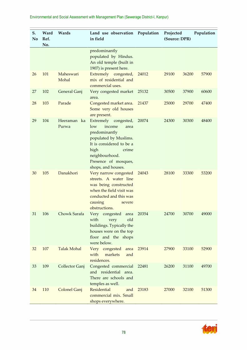
Environmental and Social Assessment with Management Plan (Sewerage District-I, Kanpur)
78
S.
No
Ward
Ref.
No.
Wards Land use observation
in field
Population Projected Population
(Source: DPR)
predominantly
populated by Hindus.
An old temple (built in
1907) is present here.
26 101 Maheswari
Mohal
Extremely congested,
mix of residential and
commercial uses.
24012 29100 36200 57900
27 102 General Ganj Very congested market
area.
25132 30500 37900 60600
28 103 Parade Congested market area.
Some very old houses
are present.
21437 25000 29700 47400
29 104 Heeraman ka
Purwa
Extremely congested,
low income area
predominantly
populated by Muslims.
It is considered to be a
high crime
neighbourhood.
Presence of mosques,
shops, and houses.
20074 24300 30300 48400
30 105 Danakhori Very narrow congested
streets. A water line
was being constructed
when the field visit was
conducted and this was
causing severe
obstructions.
24043 28100 33300 53200
31 106 Chowk Sarafa Very congested area
with very old
buildings. Typically the
houses were on the top
floor and the shops
were below.
20354 24700 30700 49000
32 107 Talak Mohal Very congested area
with markets and
residences.
23914 27900 33100 52900
33 109 Collector Ganj Congested commercial
and residential area.
There are schools and
temples as well.
22481 26200 31100 49700
34 110 Colonel Ganj Residential and
commercial mix. Small
shops everywhere.
23183 27000 32100 51300
Environmental and Social Assessment with Management Plan (Sewerage District-I, Kanpur)
79
Cultural Significance
Holy Ganges passes through the city and people consider taking bath in the river as a pious ritual. During certain festival and occasions, more people take a holy bath in the river.
5.2.1 Details of Social Surveys
The approach and methodology followed for social survey and social baseline study has been
discusses in the Section 2.6
Household surveys, group discussion and stakeholder consultations were performed during
the field surveys to assess the situation and get the feedback about the project from all the
concerned stakeholders. Household owners in 33 out of the total 34 wards were consulted, additionally other important set of locals interviewed or consulted were pedestrians, shop-
owners, mobile vendors, members of sensitive places like hospital staff, school teachers, slum
dwellers etc. Several wards have mixed residential and commercial land use patterns. There were no tribal population in the surveyed areas.
Several members of the local community have already experienced the construction impacts
of sewerage projects during the on-going execution of JNNURM projects. The need for improving the sewerage facilities in Kanpur, and reducing pollution into the river is
acknowledged almost universally by all. However, local stakeholders have provided a few
suggestions on improvement of the project implementation process such that the inconveniences caused to their lives are minimized.
Households surveyed included respondents across the socio-economic spectrum, both male
and female. The average household size in the study area is 6. Most of the household have access to drinking water facilities and electricity and have toilets as well, but most of the toilets
are not connected to sewer networks. They have pit toilets as disposal system. But most of
them responded that they are not aware that whether their household will be connected to sewer network or not.
5.2.2 Access to Basic Services
Out of total houses, still 33 percentage houses are not covered by electricity, 17 percent by safe
drinking water and 36.5 percent by toilet. Still 10 percent houses are not covered by any of
basic services. Little over half of the households in Kanpur enjoy the facility of electricity; drinking water and toilet 24 . Approximately 20 percent of households have sewer
connectivity25.
5.2.3 Status of Poverty in Kanpur26
Though no recent study is available to accurately assess the extent of poverty levels in Kanpur
but from the discussions with various stakeholders we understand that poverty levels are
quite high in Kanpur. Kanpur was an industrial town having a dozen textile mills, shoe manufacturing units, tanneries, a scooter unit, spice packaging units and various other small
and medium scale industries. Many of the industries have closed down in recent past. This
24 Source: Kanpur Development Authority Vision Document, Draft Final Report, November 2003
25 Source : Primary survey data 26 JP Associates (2006) Citi Development Plan of Kanpur City
Environmental and Social Assessment with Management Plan (Sewerage District-I, Kanpur)
80
along with many other sick units has led to large unemployment and increase in urban
poverty.
In addition to this, more than twenty percent of the population in Kanpur stays in areas
marred with unhygienic living conditions and lack of civic amenities. The urban infrastructure
is not satisfactory enough to bring homogenous development in new areas. The growth of housing stock is not able to keep pace with the population growth. This has increased the
housing stock deficit which has given rise to slum dwellings.
5.2.4 Slums in Kanpur
As per the survey conducted by DUDA and documents from KNN, total slums in Kanpur are
390. According to census 2001, the slum population was 3.68 lakh i.e. 14.5 percent of total
Population. As per the survey conducted by D.U.D.A in 1997-98, the population was 4,19,859 and total households were 98,208. As per K.N.N estimate, slum population is about 5.0 lakh
in 2006 which is twenty percent of total population. A large number of below poverty line
(BPL) population (about 60%) also live-in slums.
5.2.5 Employment
In slum areas, more than 24 percent (1,02,763) are unemployed out of total eligible people for employment. Out of total employed persons (15%), 39 percent people are self-employed. 25
percent are working in private offices whereas about 20% have government jobs. The
maximum percentage of slum dwellers (about 39 %) is self-employed which shows that either they have their own small establishments or work as casual labourers. It has also been
observed that a large number of women’s are also employed. They are working mainly as
maid in nearby colonies. The child labour is also in existence as one can see children’s working in the collection of solid waste and its segregation etc.
5.2.6 Sanitation Facilities
Presently, access to sanitation services is markedly less than access to other basic services. The
proportion of people having access to sanitation in urban areas is considerably greater when
compared to their rural counterparts; the problems are more exacerbated in slums. Urban sanitation is perceived as being important because of the health factor. In case of alums, the
sanitation facilities are worst and in alarming condition. Majority of households use public
toilets followed by households using individual flush. Even then open defecation is still at a large scale.
To minimize open defecation and to bring improvement in overall sanitation, two schemes
have been introduced: a) Low Cost Sanitation Scheme b) Construction of Community toilets. Centrally sponsored low cost sanitation schemes continue to remain a key component of
urban sanitation not only for urban poor or slum populations, but it is also an appropriate
intervention wherever the costly option of underground drainage is not feasible. Under Low Cost Sanitation Scheme of
KNN, 2430 off-site toilets and 2366 on-site toilets were provided beneficiating 12490 and 12161
population respectively. In totality, 105138 slum dwellers have been benefited under this scheme. However, during visits to slum areas it has been observed that low cost sanitation
scheme for building individual toilets was not widely accepted by the individuals due to lack
of space in their houses and not in a position to pay their share.
Environmental and Social Assessment with Management Plan (Sewerage District-I, Kanpur)
81
5.2.7 Sewerage System and Solid Waste Management
In most of the slums, sewerage system is either non-existent or is chocked. The problem of
blocked sewerage also exists in the slums where people stay in pucca houses. The open drains
in the slums are of very small size and are mostly blocked due to lack of cleaning and solid waste finding its way into drains. There is no proper way of solid waste disposal which exists
at the slum level. In 40% of the slums solid waste is collected by govt. or private persons but
disposal sites are either non-existent or are poorly managed. In many slums solid waste can be seen flowing in the drains leading to chocked drains and health hazardous situation.
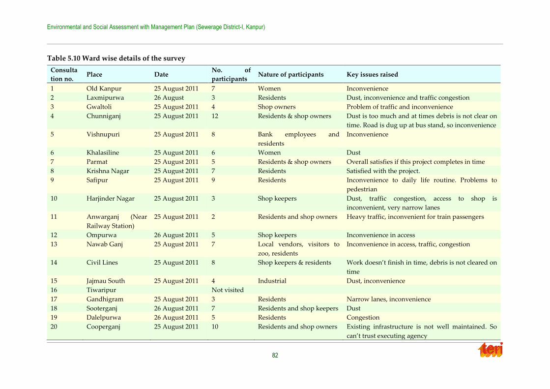
Environmental and Social Assessment with Management Plan (Sewerage District-I, Kanpur)
82
Table 5.10 Ward wise details of the survey
Consulta
tion no. Place Date
No. of
participants Nature of participants Key issues raised
1 Old Kanpur 25 August 2011 7 Women Inconvenience
2 Laxmipurwa 26 August 3 Residents Dust, inconvenience and traffic congestion
3 Gwaltoli 25 August 2011 4 Shop owners Problem of traffic and inconvenience
4 Chunniganj 25 August 2011 12 Residents & shop owners Dust is too much and at times debris is not clear on
time. Road is dug up at bus stand, so inconvenience
5 Vishnupuri 25 August 2011 8 Bank employees and
residents
Inconvenience
6 Khalasiline 25 August 2011 6 Women Dust
7 Parmat 25 August 2011 5 Residents & shop owners Overall satisfies if this project completes in time
8 Krishna Nagar 25 August 2011 7 Residents Satisfied with the project.
9 Safipur 25 August 2011 9 Residents Inconvenience to daily life routine. Problems to
pedestrian
10 Harjinder Nagar 25 August 2011 3 Shop keepers Dust, traffic congestion, access to shop is
inconvenient, very narrow lanes
11 Anwarganj (Near
Railway Station)
25 August 2011 2 Residents and shop owners Heavy traffic, inconvenient for train passengers
12 Ompurwa 26 August 2011 5 Shop keepers Inconvenience in access
13 Nawab Ganj 25 August 2011 7 Local vendors, visitors to
zoo, residents
Inconvenience in access, traffic, congestion
14 Civil Lines 25 August 2011 8 Shop keepers & residents Work doesn’t finish in time, debris is not cleared on
time
15 Jajmau South 25 August 2011 4 Industrial Dust, inconvenience
16 Tiwaripur Not visited
17 Gandhigram 25 August 2011 3 Residents Narrow lanes, inconvenience
18 Sooterganj 26 August 2011 7 Residents and shop keepers Dust
19 Dalelpurwa 26 August 2011 5 Residents Congestion
20 Cooperganj 25 August 2011 10 Residents and shop owners Existing infrastructure is not well maintained. So
can’t trust executing agency
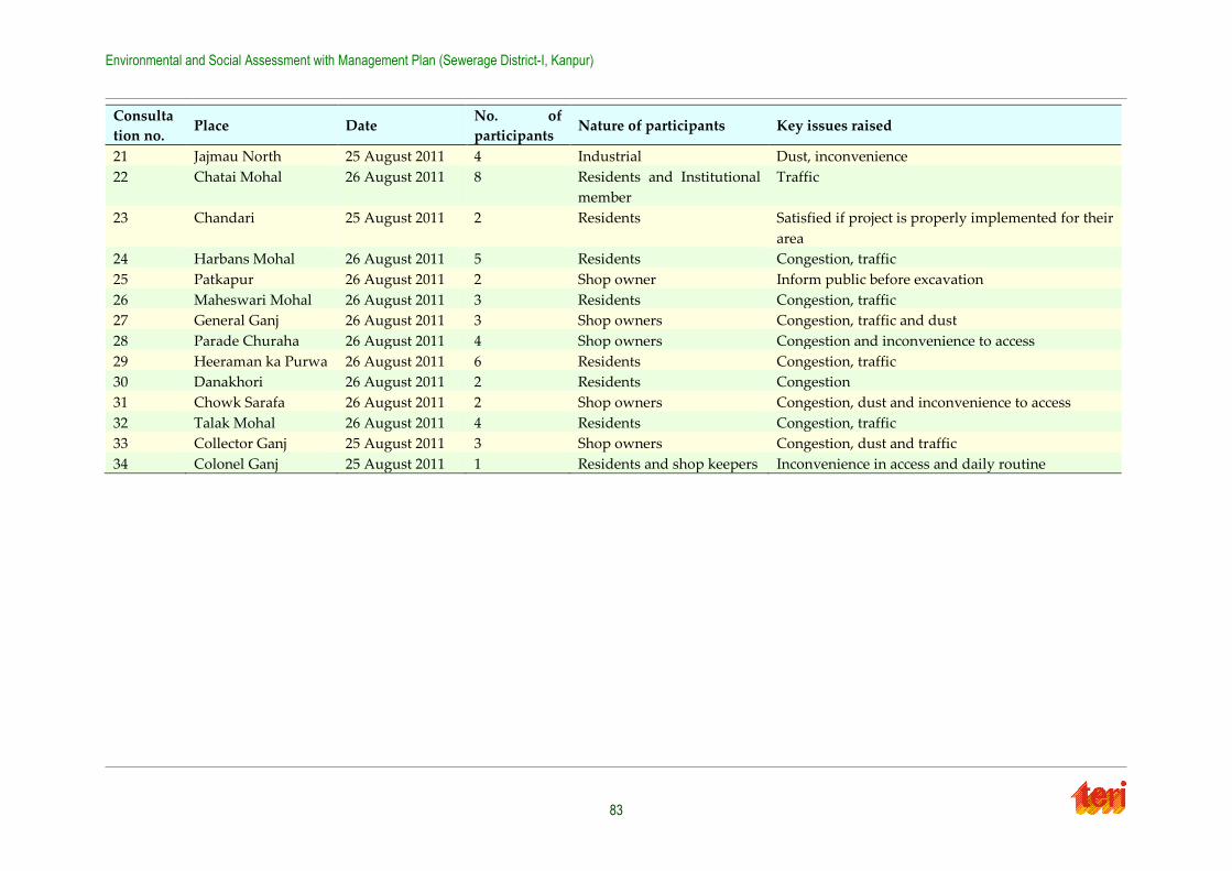
Environmental and Social Assessment with Management Plan (Sewerage District-I, Kanpur)
83
Consulta
tion no. Place Date
No. of
participants Nature of participants Key issues raised
21 Jajmau North 25 August 2011 4 Industrial Dust, inconvenience
22 Chatai Mohal 26 August 2011 8 Residents and Institutional
member
Traffic
23 Chandari 25 August 2011 2 Residents Satisfied if project is properly implemented for their
area
24 Harbans Mohal 26 August 2011 5 Residents Congestion, traffic
25 Patkapur 26 August 2011 2 Shop owner Inform public before excavation
26 Maheswari Mohal 26 August 2011 3 Residents Congestion, traffic
27 General Ganj 26 August 2011 3 Shop owners Congestion, traffic and dust
28 Parade Churaha 26 August 2011 4 Shop owners Congestion and inconvenience to access
29 Heeraman ka Purwa 26 August 2011 6 Residents Congestion, traffic
30 Danakhori 26 August 2011 2 Residents Congestion
31 Chowk Sarafa 26 August 2011 2 Shop owners Congestion, dust and inconvenience to access
32 Talak Mohal 26 August 2011 4 Residents Congestion, traffic
33 Collector Ganj 25 August 2011 3 Shop owners Congestion, dust and traffic
34 Colonel Ganj 25 August 2011 1 Residents and shop keepers Inconvenience in access and daily routine
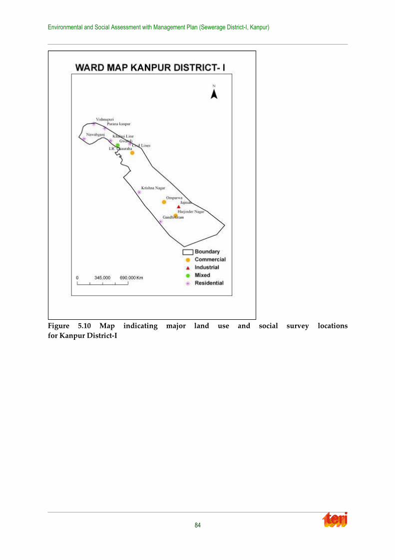
Environmental and Social Assessment with Management Plan (Sewerage District-I, Kanpur)
84
Figure 5.10 Map indicating major land use and social survey locations
for Kanpur District-I
Environmental and Social Assessment with Management Plan (Sewerage District-I, Kanpur)
85
Chapter 6 Environmental and Social Impacts
Pollution abatement projects may prove beneficial for the environment and society or they may have some adverse impacts as well. Planners and decision makers have realized the
importance of understanding the consequences of any such projects on both environmental
and social sectors, and have started taking steps to prevent any potential adverse impacts. Based on the major findings obtained from the field visits and secondary data analysis, the
possible environmental and social issues with reference to the proposed sewer works in
sewerage district- I of Kanpur city have been discussed in these sections.
6.1 Potential Environmental Impacts
The proposed project of sewer works in sewerage district I would influence the environment
in three distinct phases:
• During Designing phase
• During the construction phase which would be temporary and short term;
• During the operation phase which would have long term effects
6.1.1 Design and Development Phase
Sewer lines
All sewer lines including trunk, lateral and branch sewer lines must be designed considering
the future population and waste generation rate. Otherwise the constructed sewer may not carry the waste load, leading to failure and financial loss. The alignment of sewer lines and
sewerage pumping station must be properly planned; else it may lead to both technical and
social problems along with environmental issues of back flow creating foul smell and unhygienic conditions.
6.1.2 Impacts during construction
The sewerage network includes laying and rehabilitation of 424.385 km of sewer lines, and
construction of 4 nos. of sewage pumping stations and 2 sewage lift stations.
The construction activities would generally include earthworks, (excavation, filling, shuttering, compacting), temporary diversion of existing sewer lines, civil construction (sewer
lines, SPS, etc) and E & M installation and commissioning. The impacts of these construction
stage activities on the various environmental and social parameters are examined below:
1. Environmental parameters
i. Air quality
Based on the field observation of ongoing JNNRUM projects and interaction/consultation with stake-holders, it is expected that the levels of dust (RSPM and SPM), carbon mono-oxide
(CO), hydrocarbons and NOx (NO &NO2) is likely to increase during the construction phase
mainly because of:
Excavation, backfilling, compaction activity and movement of vehicles on un-paved
roads (increases dust level)
Environmental and Social Assessment with Management Plan (Sewerage District-I, Kanpur)
86
Vehicle exhausts from construction machinery and from light and heavy vehicles for
transportation of pipes and construction material like cement, etc (increases NO2).
Use of portable diesel generators and other fuel fired machinery, and (increases CO).
Further these construction activities cause temporary deterioration of the air quality, causing
health problems of respiratory ailments such as bronchitis and asthma due to increased suspended particulate matter (SPM) in the air. A high concentration of SPM could also be a
leading cause for eye, ear, nose and throat infections and related discomfort. Laying of
sewerage lines mainly falls in the residential area, hence temporary impact on air quality in these areas is of greater concern.
ii. Noise levels
Noise levels in the vicinity of any construction activity rise due to plying of transport vehicles and use of portable generators, mechanical machinery such as cranes, riveting machines,
hammering etc. These activities may occur round the clock and the noise pollution thus
created may affect human habitations, particularly during the night time. The increase in noise levels may thus be a major concern at the project site, since it is located in the urbanized area
of the city and close to habitation. The primary impact of noise level would be mainly on
workers operating high noise generating machines if appropriate control measures are not adopted. Schools and educational institutes such as Harcourt Butler Technological Institute,
Chandra Shekhar Azad University of Agriculture and Technology, ICFAI National College,
DAV College, BNSD Shiksha Niketan Inter College, Kanpur Paramedical College, PPN Degree College, Air Force school and hospitals like RK Devi eye hospital, Gastro Liver
Hospital, Chandhini Hospital, Sahani Hospital may suffer temporarily due to the elevated
noise levels. Increase of noise level at night may produce disturbances, causing sleeplessness in people in the vicinity of the site in case construction activity is extended into the night
hours. However, these impacts are of temporary nature, lasting only during the construction
period.
iii. Water environment
The natural water bodies/drainage channels of the project area are likely to be affected in the
following ways:
By wastewater from construction activities – This would mostly contain suspended
impurities. Other pollutants, which may find their way to it, are likely to be in
insignificant concentrations and may be safely disregarded.
Flooding is likely during monsoon as drainage paths could be obstructed by the
excessive debris noted during field visits; this concern was also voiced by residents.
If adequate arrangements are not made to ensure proper drainage of wastewater from the construction sites, such waters may form stagnant pools, which might promote breeding of
mosquitoes and create generally unsanitary conditions.
Due to the diversion of sewer lines during the desilting/rehabilitation/replacement works to be carried out for the existing sewers.
The above wastes are likely to be discharged to the nearby surface drains and would hence
temporarily increase the pollution load of these drains/nallas.
2. Management and Disposal of Excavated Material during construction
Environmental and Social Assessment with Management Plan (Sewerage District-I, Kanpur)
87
The proposed project will have lot of construction involved and as such if the management
and disposal of excavated material is not properly done, it will impose a problem to local people and residents. This would be a temporary impact but a mitigation measure for this has
been suggested.
Digging and backfilling of trench for laying sewer lines may render topsoil loose. Soils of the construction area may be contaminated by wastewaters. This contamination may be due to:
Alteration of chemical make-up of the soils, increased acidity/alkalinity
Pressure of pathogens and other organic material in the excavated material
These impacts will be minor and limited to the construction phase only. No major impact on
soil quality is anticipated.
i. Ecology
The project site does not involve any forestland / ecologically sensitive areas. Thus, there will
be no significant impact on the ecology of the area. The forested area to the west of the district
I is Allen Forest area. However, as gathered from discussions with UPJN engineer, the forest area will not be impacted since sewer lines will not be laid through that area.
6.1.3 Impacts during operation
i. Water environment
Water resources in the project area would be the most positively benefited by the sanitation
project since additional sewage will now be routed to the STP. Therefore proper operation and maintenance mechanism must be followed for efficient working of the system. The
probably environmental impacts related to water during operation stage may include
unpredictable events such as:
Temporary flooding of adjacent areas due to accidental leakages/bursts and also due to
blockages and backlogging of lines.
Water pollution and possibility of mixing with water supply line due to leakages/ overflows from the sewer lines
Impairment of receiving water quality in surface/sub-surface source due to inadequate
/inefficient sewage treatment process.
ii. Noise and air quality
Improper handling and irregular maintenance of operating machines including pumps,
generators, air diffusers, etc may lead to increased noise pollution during operation activity. There will also be minimisation of gas being emitted from the sewage drains, since during
operation, most of the works will be laid underground.
iii. Sludge Disposal from the Pumping Station
It is possible that during the operation of pumping station sludge generated may not be
properly handled. This could be a cause of concern from environmental aspect.
Environmental and Social Assessment with Management Plan (Sewerage District-I, Kanpur)
88
6.2 Potential Social Impacts
Based on the surveys, interviews with the key stakeholders, interaction with the coordinating
agencies, a screening checklist was prepared to identify the social issues associated with the project during construction phase.
The proposed project will only influence social sector during construction phase. During the
construction phase, the impacts identified below would be temporary and short term.
6.2.1 Social Impacts
1. Impact on human health
One of the potential impacts of the proposed sub-projects will be on the air quality due to the dust generated during excavation. The amount of dust generated will depend upon the level
of digging and the prevailing weather conditions and can have an adverse impact on the
health of the persons residing or working near the project sites. Increased dust was witnessed during the field visit during construction of JNNURM-related sewage projects. Since the
district has more of residential land use, the number of people who will be affected is more.
Residential population includes more vulnerable groups such as elderly and children. Some of the residential colonies include, Vishnupuri, Chunni Ganj, Nawab Ganj, etc.
2. Traffic Congestion
Due to the excavation work which will take place on the main roads of the city, there will be a disturbance in the traffic movement. People may suffer some inconvenience during the
morning and evening peak hours. This issue is discussed in the DPR, and suggests de-routing
of the traffic as the mitigation measure. Main traffic congestion related problem was witnessed in wards like Colonel Ganj, Cooper Ganj, LIC Chauraha, etc. Many of the roads in the district
are as narrow as in the range of 7-12 feet. Any excavation in these areas would disrupt traffic
and already most of them witness traffic congestion during peak hours.
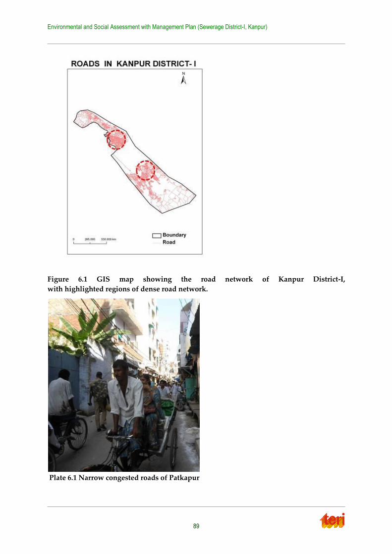
Environmental and Social Assessment with Management Plan (Sewerage District-I, Kanpur)
89
Figure 6.1 GIS map showing the road network of Kanpur District-I,
with highlighted regions of dense road network.
Plate 6.1 Narrow congested roads of Patkapur

Environmental and Social Assessment with Management Plan (Sewerage District-I, Kanpur)
90
3. Impact on livelihood
The excavation will lead to road blockage and as a result the commercial establishments and
vendors will have some trouble in operating their business on daily basis. But there will be no loss of livelihood. Ambulatory vendors can very well shift their place as and when required.
So, overall no loss of livelihood has been reported during the survey. On a better note, most
of the interviewed shop-owners and vendors are satisfied with proposed project and suggest that it should be completed well in time to minimize their inconvenience.
4. Impact on existing utility services
The road opening activities may damage the underground water pipelines or electricity poles in the vicinity of the site for the proposed sub-projects. This will lead to water supply
interruptions, disruption in electricity supply and will involve expensive repair costs.
Flooding of areas could also occur. One water supply interruption was witnessed during the field visit; in this instance, flooding of one street did occur near Civil Line area. With no other
alternative source readily available, people have to buy water from private tankers or buy
bottled water for drinking purpose till the time service is restored to normal. The DPR also notes impacts on utility services as a potential issue.
5. Safety hazards
There are potential hazards for the workers as well as for the pedestrians. Additionally, there
have been reports, gathered during the field visit, of children falling into holes left open by construction crews on JNNURM projects, and children were seen playing around active
construction sites. Safety equipment for workers is provided as part of the DPR.
6. Damage to buildings
Interviews with city officials brought to notice the potential issue that some old houses have used the cities nearly century’s old sewer system as the foundation for their homes. It is feared
that should this sewer system be disturbed as part of the reconfiguration and laying of new
sewer lines, that the houses built on top would be adversely affected in the form of settling or cracks. It is not expected, however, that cracks will develop in housing for any other reason
but this. Areas where these old buildings exist are Gwaltoli, Anwar Ganj, Collector Ganj, etc.
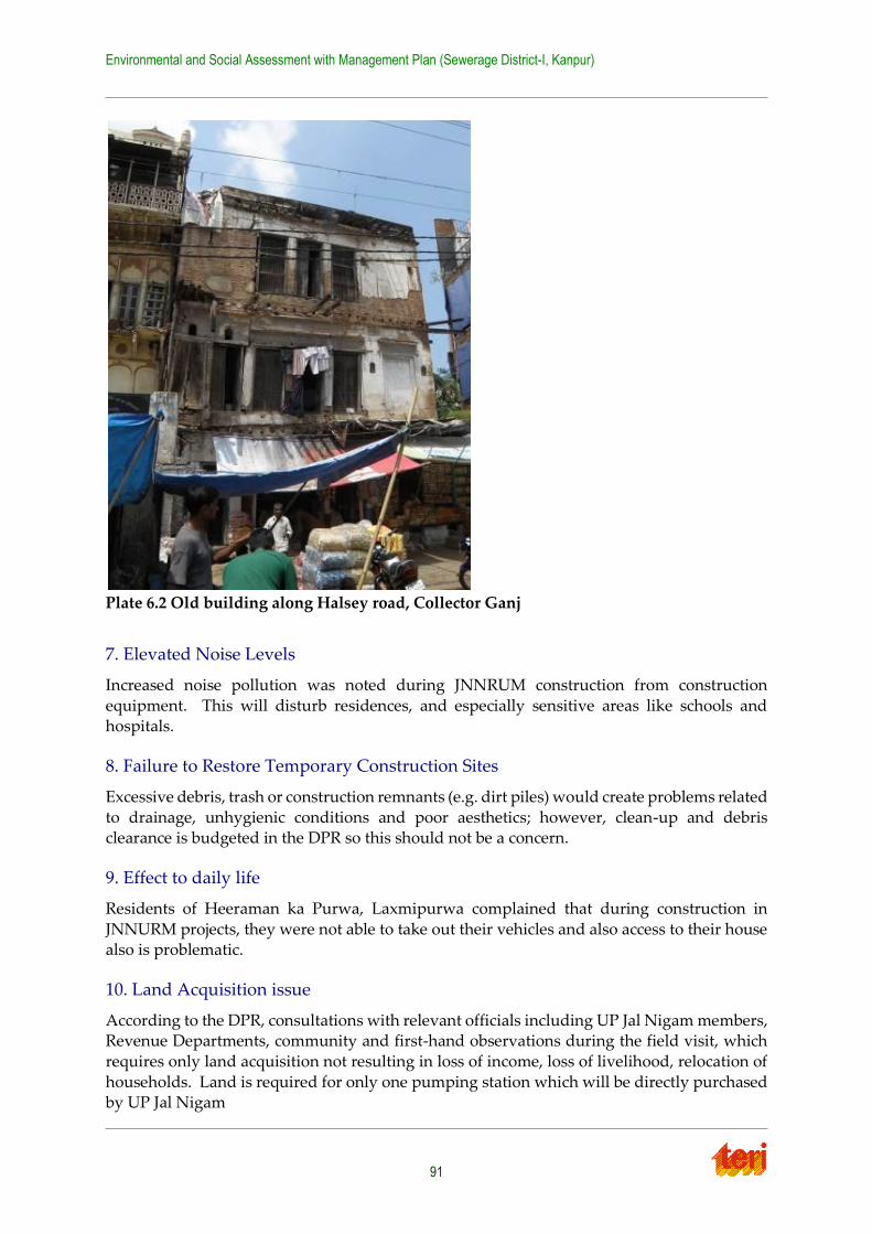
Environmental and Social Assessment with Management Plan (Sewerage District-I, Kanpur)
91
Plate 6.2 Old building along Halsey road, Collector Ganj
7. Elevated Noise Levels
Increased noise pollution was noted during JNNRUM construction from construction
equipment. This will disturb residences, and especially sensitive areas like schools and hospitals.
8. Failure to Restore Temporary Construction Sites
Excessive debris, trash or construction remnants (e.g. dirt piles) would create problems related
to drainage, unhygienic conditions and poor aesthetics; however, clean-up and debris clearance is budgeted in the DPR so this should not be a concern.
9. Effect to daily life
Residents of Heeraman ka Purwa, Laxmipurwa complained that during construction in
JNNURM projects, they were not able to take out their vehicles and also access to their house also is problematic.
10. Land Acquisition issue
According to the DPR, consultations with relevant officials including UP Jal Nigam members, Revenue Departments, community and first-hand observations during the field visit, which
requires only land acquisition not resulting in loss of income, loss of livelihood, relocation of
households. Land is required for only one pumping station which will be directly purchased by UP Jal Nigam
Environmental and Social Assessment with Management Plan (Sewerage District-I, Kanpur)
92
Additionally, there are no squatters or settlements around the proposed works, thus no
relocation is required. There will be no loss of income or livelihood due to purchase of land for one pumping station. The other land parcels required are government land free of all
encroachment and other encumbrances.
Details of land requirements and applicability to Land Acquisition Act of 1894:
1. Sanjay Puram– Private Land
Pumping station: 6 MLD
Applicability of RFCTLAR&R Act 2013: Since land will be directly purchased by UPJN, the Act will not apply.
Since there is no activity on the identified piece of land (agriculture, shop, homestead etc),
there will be no requirement for Resettlement and Rehabilitation (R&R) plan. As per UPJN, the negotiations between UPJN and the land owner have been finalized.
Action required: UPJN to sign a memorandum of understanding with the Land Owner
indicating the amount agreed for and timeframe within which money will be transferred to the owner. Post disbursement of compensation, ownership of land will be transferred to
government of Uttar Pradesh.
2. Gandhi Park (Krishna Nagar)
Pumping station: 16.10 MLD
Applicability of RFCTLAR&R Act 2013: Since this is a public land, there will be not
acquisition hence the Act will not apply.
Action required: UPJN to sign an MOU with the Resident Welfare Association and agree on
activities to develop the remaining part of the park.
3. Near Chacha Nehru Hospital
Pumping station: 9.50 MLD
Applicability to Land Acquisition Act 1894: Since land is already under the possession of
Nagar Nigam so there will be no acquisition of land
4. Near Maqdoom Shah Baba mazar
Pumping station: 10.70 MLD
Applicability to Land Acquisition Act 1894: Since land is already under the possession of Nagar Nigam so there will be no acquisition of land.
6.3 Conclusion
Based on the overall secondary data analysis and field investigation, the proposed project is
expected to benefit the Kanpur City, as the wastewater that currently flows untreated into the Ganga river will be captured, treated and the remainder of the treated effluent will be allowed
to flow into the river. The likely beneficial impacts of the projects include
Improvement in sewerage collection and treatment within the cities/towns
Prevention of storm drains carrying sanitary sullage or dry weather flow
Prevention of ground water and soil pollution due to infiltration of untreated liquid
waste
Environmental and Social Assessment with Management Plan (Sewerage District-I, Kanpur)
93
Prevention of discharge of untreated sewage into River Ganga
Improvement in water quality of River Ganga, a national resource
Improvement in environmental sanitation health and reduction in associated health
hazards within the cities/towns
Improvement in quality of life, human dignity and increased productivity
Reduced nuisance of open defecation due to low cost sanitation and reduced malarial
risks and other health hazards
Although there would not be any permanent negative or adverse environmental impacts, but will have temporary impacts, that can be mitigated with appropriate mitigation plans.
However, the large environmental benefit of the project greatly outweighs the temporary
inconveniences.
Environmental and Social Assessment with Management Plan (Sewerage District-I, Kanpur)
94
Chapter 7 Mitigation and Management Plan
7.1 Environmental Management plan
Table 7.1 summarizes the generic environmental management plan for low category investment that identifies the potential issues of various activities that are anticipated in the
design and development, construction, and operation phases of the proposed sewer work in
sewerage district ‘A’. The environmental management plan ensures to suggest appropriate mitigation measure against the issues/ concerns identified during the environmental and
social assessment study.
In general, the Uttar Pradesh Jal Nigam (UPJN) (with assistance from Contractor and Independent Engineer/Supervision Consultant) is the responsible entity for ensuring that the
mitigation measures as suggested in the ESMP. The roles and responsibilities of the involved
institutes are described below.
7.1.1 Implementation of EMP Specific activities by UPJN
The role of UPJN in the implementation of EMP involves the following activities:
EMP clearance from NMCG and World Bank and disclosure as required;
Integrating the EMP in the bid document of contractor as an addendum;
7.1.2 Implementation of EMP
The contractor shall be responsible to implement the EMP primarily in assistance with the
Project Management Consultant team. The Environmental Specialist from the Independent Engineer/ Supervision Consultant shall monitor the compliance of the EMP and all the design
drawings of various civil structures shall be implemented after his approval.
The State, local Government will be responsible for Coordination, Monitoring and evaluation of the Environment Management Plan. It should ensure all the safeguarding plans are in line
and acted upon. Contractor shall report the implementation of the Environment Management
Plan to the Environmental Expert and the Project management consultant as well as to UP Jal Nigam through monthly reports. Further a quarterly report is required to be prepared and
required to be given to National Mission for Clean Ganga (NMCG) for the progress made in
implementing the Environment Management Plan.
Feedback from the local residents can also be taken from time to time to cross check the
contractor’s report. Project management consultants should make inspection visits at
construction site to check the implementation of Environment Management Plan as per the contract. Broad Institutional arrangement for implementation of EMP is shown in figure 7.1
below:
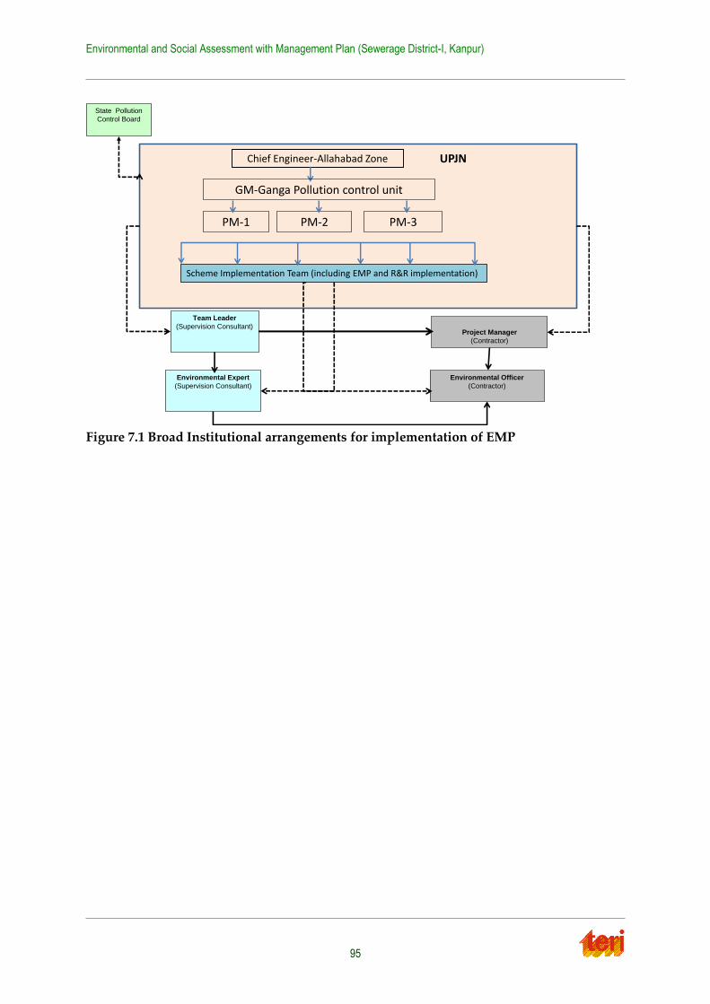
Environmental and Social Assessment with Management Plan (Sewerage District-I, Kanpur)
95
Figure 7.1 Broad Institutional arrangements for implementation of EMP
Chief Engineer-Allahabad Zone
Scheme Implementation Team (including EMP and R&R implementation)
UPJN
Project Manager
(Contractor)
Environmental Officer
(Contractor)
Team Leader
(Supervision Consultant)
Environmental Expert
(Supervision Consultant)
State Pollution
Control Board
PM-1 PM-2 PM-3
GM-Ganga Pollution control unit
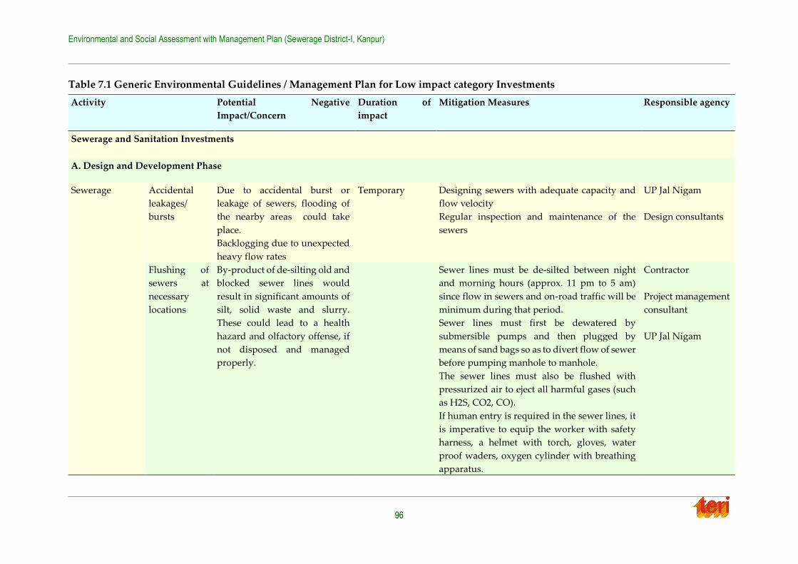
Environmental and Social Assessment with Management Plan (Sewerage District-I, Kanpur)
96
Table 7.1 Generic Environmental Guidelines / Management Plan for Low impact category Investments
Activity Potential Negative
Impact/Concern
Duration of
impact
Mitigation Measures Responsible agency
Sewerage and Sanitation Investments
A. Design and Development Phase
Sewerage Accidental
leakages/
bursts
Due to accidental burst or
leakage of sewers, flooding of
the nearby areas could take
place.
Backlogging due to unexpected
heavy flow rates
Temporary Designing sewers with adequate capacity and
flow velocity
Regular inspection and maintenance of the
sewers
UP Jal Nigam
Design consultants
Flushing of
sewers at
necessary
locations
By-product of de-silting old and
blocked sewer lines would
result in significant amounts of
silt, solid waste and slurry.
These could lead to a health
hazard and olfactory offense, if
not disposed and managed
properly.
Sewer lines must be de-silted between night
and morning hours (approx. 11 pm to 5 am)
since flow in sewers and on-road traffic will be
minimum during that period.
Sewer lines must first be dewatered by
submersible pumps and then plugged by
means of sand bags so as to divert flow of sewer
before pumping manhole to manhole.
The sewer lines must also be flushed with
pressurized air to eject all harmful gases (such
as H2S, CO2, CO).
If human entry is required in the sewer lines, it
is imperative to equip the worker with safety
harness, a helmet with torch, gloves, water
proof waders, oxygen cylinder with breathing
apparatus.
Contractor
Project management
consultant
UP Jal Nigam
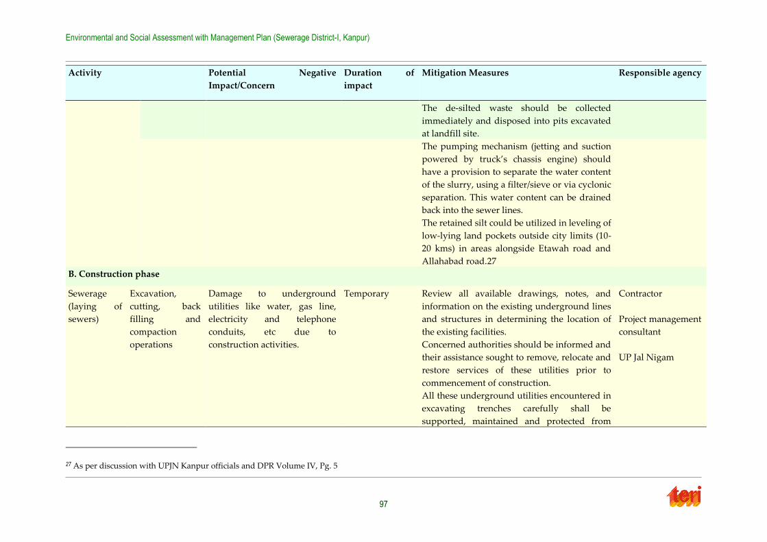
Environmental and Social Assessment with Management Plan (Sewerage District-I, Kanpur)
97
Activity Potential Negative
Impact/Concern
Duration of
impact
Mitigation Measures Responsible agency
The de-silted waste should be collected
immediately and disposed into pits excavated
at landfill site.
The pumping mechanism (jetting and suction
powered by truck’s chassis engine) should
have a provision to separate the water content
of the slurry, using a filter/sieve or via cyclonic
separation. This water content can be drained
back into the sewer lines.
The retained silt could be utilized in leveling of
low-lying land pockets outside city limits (10-
20 kms) in areas alongside Etawah road and
Allahabad road.27
B. Construction phase
Sewerage
(laying of
sewers)
Excavation,
cutting, back
filling and
compaction
operations
Damage to underground
utilities like water, gas line,
electricity and telephone
conduits, etc due to
construction activities.
Temporary Review all available drawings, notes, and
information on the existing underground lines
and structures in determining the location of
the existing facilities.
Concerned authorities should be informed and
their assistance sought to remove, relocate and
restore services of these utilities prior to
commencement of construction.
All these underground utilities encountered in
excavating trenches carefully shall be
supported, maintained and protected from
Contractor
Project management
consultant
UP Jal Nigam
27 As per discussion with UPJN Kanpur officials and DPR Volume IV, Pg. 5
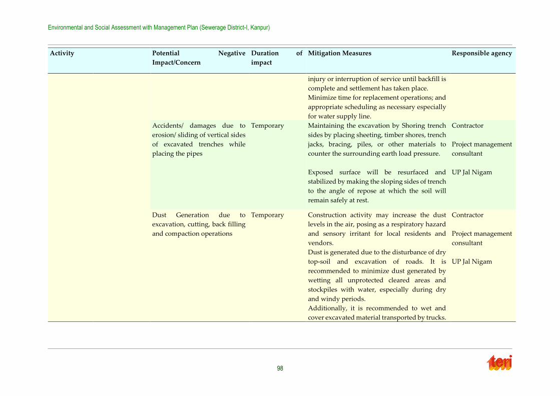
Environmental and Social Assessment with Management Plan (Sewerage District-I, Kanpur)
98
Activity Potential Negative
Impact/Concern
Duration of
impact
Mitigation Measures Responsible agency
injury or interruption of service until backfill is
complete and settlement has taken place.
Minimize time for replacement operations; and
appropriate scheduling as necessary especially
for water supply line.
Accidents/ damages due to
erosion/ sliding of vertical sides
of excavated trenches while
placing the pipes
Temporary Maintaining the excavation by Shoring trench
sides by placing sheeting, timber shores, trench
jacks, bracing, piles, or other materials to
counter the surrounding earth load pressure.
Exposed surface will be resurfaced and
stabilized by making the sloping sides of trench
to the angle of repose at which the soil will
remain safely at rest.
Contractor
Project management
consultant
UP Jal Nigam
Dust Generation due to
excavation, cutting, back filling
and compaction operations
Temporary Construction activity may increase the dust
levels in the air, posing as a respiratory hazard
and sensory irritant for local residents and
vendors.
Dust is generated due to the disturbance of dry
top-soil and excavation of roads. It is
recommended to minimize dust generated by
wetting all unprotected cleared areas and
stockpiles with water, especially during dry
and windy periods.
Additionally, it is recommended to wet and
cover excavated material transported by trucks.
Contractor
Project management
consultant
UP Jal Nigam
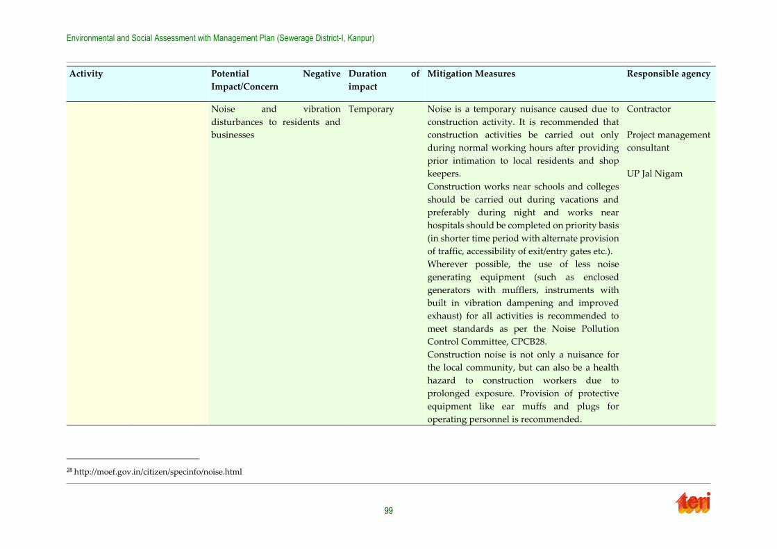
Environmental and Social Assessment with Management Plan (Sewerage District-I, Kanpur)
99
Activity Potential Negative
Impact/Concern
Duration of
impact
Mitigation Measures Responsible agency
Noise and vibration
disturbances to residents and
businesses
Temporary Noise is a temporary nuisance caused due to
construction activity. It is recommended that
construction activities be carried out only
during normal working hours after providing
prior intimation to local residents and shop
keepers.
Construction works near schools and colleges
should be carried out during vacations and
preferably during night and works near
hospitals should be completed on priority basis
(in shorter time period with alternate provision
of traffic, accessibility of exit/entry gates etc.).
Wherever possible, the use of less noise
generating equipment (such as enclosed
generators with mufflers, instruments with
built in vibration dampening and improved
exhaust) for all activities is recommended to
meet standards as per the Noise Pollution
Control Committee, CPCB28.
Construction noise is not only a nuisance for
the local community, but can also be a health
hazard to construction workers due to
prolonged exposure. Provision of protective
equipment like ear muffs and plugs for
operating personnel is recommended.
Contractor
Project management
consultant
UP Jal Nigam
28 http://moef.gov.in/citizen/specinfo/noise.html
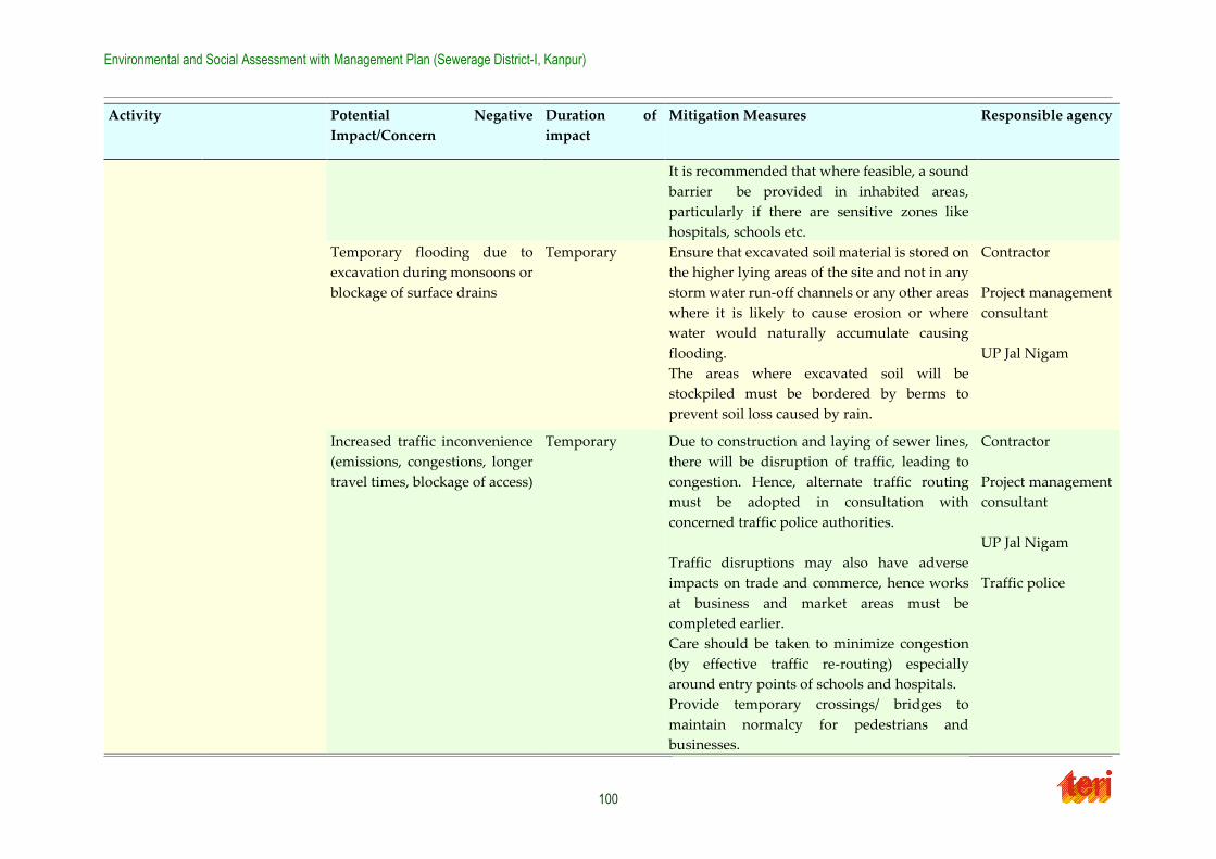
Environmental and Social Assessment with Management Plan (Sewerage District-I, Kanpur)
100
Activity Potential Negative
Impact/Concern
Duration of
impact
Mitigation Measures Responsible agency
It is recommended that where feasible, a sound
barrier be provided in inhabited areas,
particularly if there are sensitive zones like
hospitals, schools etc.
Temporary flooding due to
excavation during monsoons or
blockage of surface drains
Temporary Ensure that excavated soil material is stored on
the higher lying areas of the site and not in any
storm water run-off channels or any other areas
where it is likely to cause erosion or where
water would naturally accumulate causing
flooding.
The areas where excavated soil will be
stockpiled must be bordered by berms to
prevent soil loss caused by rain.
Contractor
Project management
consultant
UP Jal Nigam
Increased traffic inconvenience
(emissions, congestions, longer
travel times, blockage of access)
Temporary Due to construction and laying of sewer lines,
there will be disruption of traffic, leading to
congestion. Hence, alternate traffic routing
must be adopted in consultation with
concerned traffic police authorities.
Traffic disruptions may also have adverse
impacts on trade and commerce, hence works
at business and market areas must be
completed earlier.
Care should be taken to minimize congestion
(by effective traffic re-routing) especially
around entry points of schools and hospitals.
Provide temporary crossings/ bridges to
maintain normalcy for pedestrians and
businesses.
Contractor
Project management
consultant
UP Jal Nigam
Traffic police
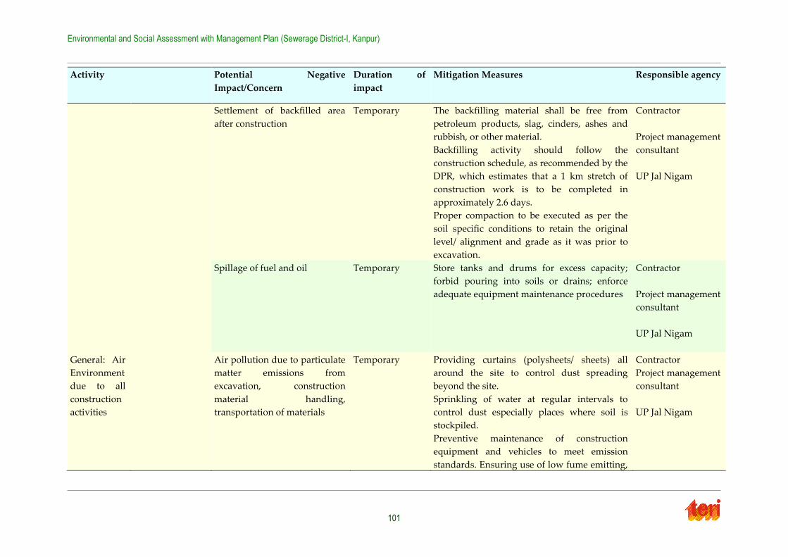
Environmental and Social Assessment with Management Plan (Sewerage District-I, Kanpur)
101
Activity Potential Negative
Impact/Concern
Duration of
impact
Mitigation Measures Responsible agency
Settlement of backfilled area
after construction
Temporary The backfilling material shall be free from
petroleum products, slag, cinders, ashes and
rubbish, or other material.
Backfilling activity should follow the
construction schedule, as recommended by the
DPR, which estimates that a 1 km stretch of
construction work is to be completed in
approximately 2.6 days.
Proper compaction to be executed as per the
soil specific conditions to retain the original
level/ alignment and grade as it was prior to
excavation.
Contractor
Project management
consultant
UP Jal Nigam
Spillage of fuel and oil Temporary Store tanks and drums for excess capacity;
forbid pouring into soils or drains; enforce
adequate equipment maintenance procedures
Contractor
Project management
consultant
UP Jal Nigam
General: Air
Environment
due to all
construction
activities
Air pollution due to particulate
matter emissions from
excavation, construction
material handling,
transportation of materials
Temporary Providing curtains (polysheets/ sheets) all
around the site to control dust spreading
beyond the site.
Sprinkling of water at regular intervals to
control dust especially places where soil is
stockpiled.
Preventive maintenance of construction
equipment and vehicles to meet emission
standards. Ensuring use of low fume emitting,
Contractor
Project management
consultant
UP Jal Nigam
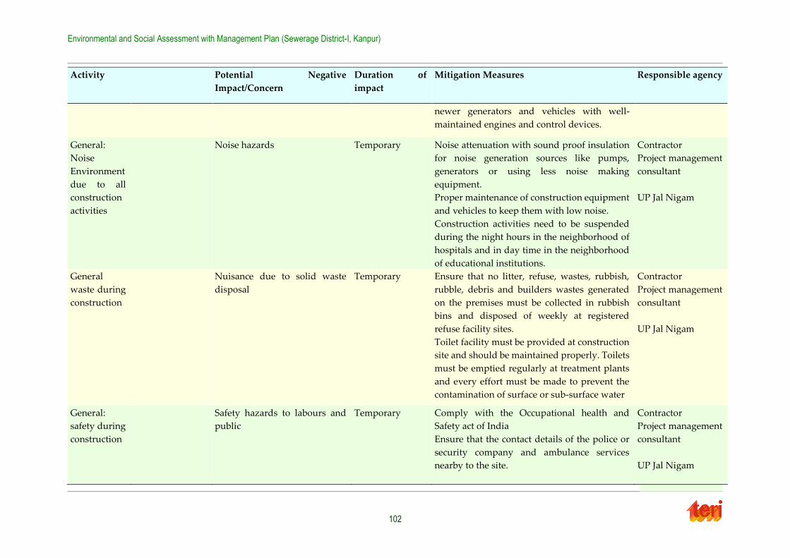
Environmental and Social Assessment with Management Plan (Sewerage District-I, Kanpur)
102
Activity Potential Negative
Impact/Concern
Duration of
impact
Mitigation Measures Responsible agency
newer generators and vehicles with well-
maintained engines and control devices.
General:
Noise
Environment
due to all
construction
activities
Noise hazards Temporary Noise attenuation with sound proof insulation
for noise generation sources like pumps,
generators or using less noise making
equipment.
Proper maintenance of construction equipment
and vehicles to keep them with low noise.
Construction activities need to be suspended
during the night hours in the neighborhood of
hospitals and in day time in the neighborhood
of educational institutions.
Contractor
Project management
consultant
UP Jal Nigam
General
waste during
construction
Nuisance due to solid waste
disposal
Temporary Ensure that no litter, refuse, wastes, rubbish,
rubble, debris and builders wastes generated
on the premises must be collected in rubbish
bins and disposed of weekly at registered
refuse facility sites.
Toilet facility must be provided at construction
site and should be maintained properly. Toilets
must be emptied regularly at treatment plants
and every effort must be made to prevent the
contamination of surface or sub-surface water
Contractor
Project management
consultant
UP Jal Nigam
General:
safety during
construction
Safety hazards to labours and
public
Temporary Comply with the Occupational health and
Safety act of India
Ensure that the contact details of the police or
security company and ambulance services
nearby to the site.
Contractor
Project management
consultant
UP Jal Nigam
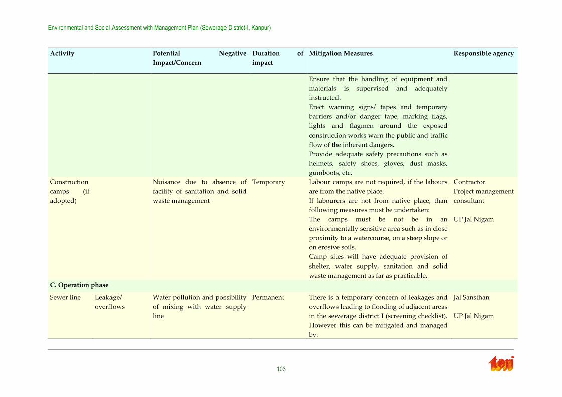
Environmental and Social Assessment with Management Plan (Sewerage District-I, Kanpur)
103
Activity Potential Negative
Impact/Concern
Duration of
impact
Mitigation Measures Responsible agency
Ensure that the handling of equipment and
materials is supervised and adequately
instructed.
Erect warning signs/ tapes and temporary
barriers and/or danger tape, marking flags,
lights and flagmen around the exposed
construction works warn the public and traffic
flow of the inherent dangers.
Provide adequate safety precautions such as
helmets, safety shoes, gloves, dust masks,
gumboots, etc.
Construction
camps (if
adopted)
Nuisance due to absence of
facility of sanitation and solid
waste management
Temporary Labour camps are not required, if the labours
are from the native place.
If labourers are not from native place, than
following measures must be undertaken:
The camps must be not be in an
environmentally sensitive area such as in close
proximity to a watercourse, on a steep slope or
on erosive soils.
Camp sites will have adequate provision of
shelter, water supply, sanitation and solid
waste management as far as practicable.
Contractor
Project management
consultant
UP Jal Nigam
C. Operation phase
Sewer line Leakage/
overflows
Water pollution and possibility
of mixing with water supply
line
Permanent There is a temporary concern of leakages and
overflows leading to flooding of adjacent areas
in the sewerage district I (screening checklist).
However this can be mitigated and managed
by:
Jal Sansthan
UP Jal Nigam
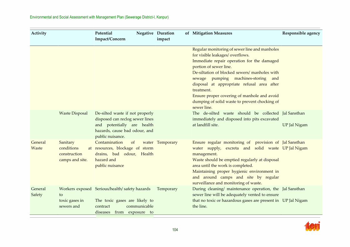
Environmental and Social Assessment with Management Plan (Sewerage District-I, Kanpur)
104
Activity Potential Negative
Impact/Concern
Duration of
impact
Mitigation Measures Responsible agency
Regular monitoring of sewer line and manholes
for visible leakages/ overflows.
Immediate repair operation for the damaged
portion of sewer line.
De-siltation of blocked sewers/ manholes with
sewage pumping machines-storing and
disposal at appropriate refusal area after
treatment.
Ensure proper covering of manhole and avoid
dumping of solid waste to prevent chocking of
sewer line.
Waste Disposal De-silted waste if not properly
disposed can reclog sewer lines
and potentially are health
hazards, cause bad odour, and
public nuisance.
The de-silted waste should be collected
immediately and disposed into pits excavated
at landfill site.
Jal Sansthan
UP Jal Nigam
General
Waste
Sanitary
conditions at
construction
camps and site.
Contamination of water
resources, blockage of storm
drains, bad odour, Health
hazard and
public nuisance
Temporary Ensure regular monitoring of provision of
water supply, excreta and solid waste
management.
Waste should be emptied regularly at disposal
area until the work is completed.
Maintaining proper hygienic environment in
and around camps and site by regular
surveillance and monitoring of waste.
Jal Sansthan
UP Jal Nigam
General
Safety
Workers exposed
to
toxic gases in
sewers and
Serious/health/ safety hazards
The toxic gases are likely to
contract communicable
diseases from exposure to
Temporary During cleaning/ maintenance operation, the
sewer line will be adequately vented to ensure
that no toxic or hazardous gases are present in
the line.
Jal Sansthan
UP Jal Nigam
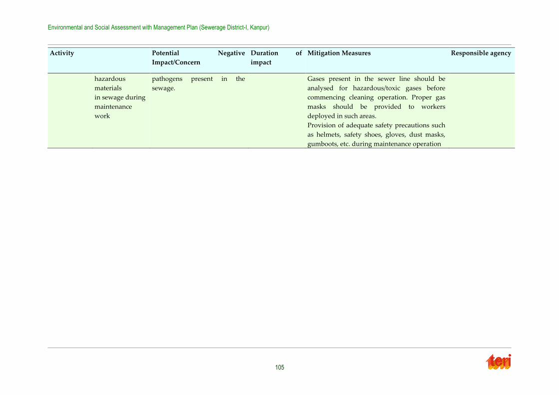
Environmental and Social Assessment with Management Plan (Sewerage District-I, Kanpur)
105
Activity Potential Negative
Impact/Concern
Duration of
impact
Mitigation Measures Responsible agency
hazardous
materials
in sewage during
maintenance
work
pathogens present in the
sewage.
Gases present in the sewer line should be
analysed for hazardous/toxic gases before
commencing cleaning operation. Proper gas
masks should be provided to workers
deployed in such areas.
Provision of adequate safety precautions such
as helmets, safety shoes, gloves, dust masks,
gumboots, etc. during maintenance operation
Environmental and Social Assessment with Management Plan (Sewerage District-I, Kanpur)
106
7.2 Environmental Monitoring Plan
The Environmental Monitoring Programme has been detailed out in Table 7-2. Successful
implementation of the Environmental Monitoring Program is contingent on the following:
The Project Management Consultant (PMC) along with UPJN to request the Contractor
to commence all the initial tests for monitoring (i.e. for Air, Water Quality and Noise
Levels) early in the Contract to establish 'base' readings (i.e. to assess the existing conditions prior to effects from the Construction activities being felt);
The PMC along with UPJN to request the Concessionaire / Contractor to submit for
approval a proposed schedule of subsequent periodic tests to be carried out;
Monitoring by the PMC's Environmental Officer of all the environmental monitoring
tests, and subsequent analysis of results;
Where indicated by testing results, and any other relevant on-site conditions, PMC to instruct the Concessionaire / Contractor to:
Modify the testing schedule (dates, frequency);
Modify (add to or delete) testing locations;
Verify testing results with additional testing as/if required;
Require recalibration of equipment, etc., as necessary; and,
Request the Concessionaire to stop, modify or defer specific construction equipment, processes, etc., as necessary, that are deemed to have contributed
significantly to monitoring readings in excess of permissible environmental "safe"
levels.
Monitoring of Concessionaire / Contractor's Facilities, Plant and Equipment
All issues related to negative environmental impacts of the Contractor's Facilities,
Plant and equipment are to be controlled through;
The Contractor's self-imposed quality assurance plan;
Regular / periodic inspection of the Concessionaire / Contractor’s plant and
equipment;
Monthly appraisal of the Contractor.
Other environmental impacts are to be regularly identified and noted on the monthly
appraisal inspection made to review all aspects of the Contractor's operation. The officer is to review all monthly appraisal reports, and through the team leader is to instruct the Contractor
to rectify all significant negative environmental impacts.
7.3 EMP Budget
The environmental budget for the various environmental management measures proposed in
the ESMP is detailed in Table 7-3 and the cost of the Environmental Monitoring is given in
Table 7-4. There are several other environmental issues that have been addressed as part of good engineering practices, the costs for which have been accounted for in the Engineering
Cost. The rates adopted for the budget has been worked out on the basis of market rates and
Environmental and Social Assessment with Management Plan (Sewerage District-I, Kanpur)
107
the Schedule of rates. Various environmental aspects covered/will be covered under
engineering costs are listed below:
Proper drainage arrangements to prevent water stagnation/ flooding in SPS site area
Appropriate siting, and enclosing within building to reduce noise and odour nuisance
to surrounding area Drainage along the ghats to collect the discharge from the residents and connecting to city sewer
Alternate traffic re-routing,
Ensuring storage of excavated soil material on the higher lying areas
Solid Waste Management
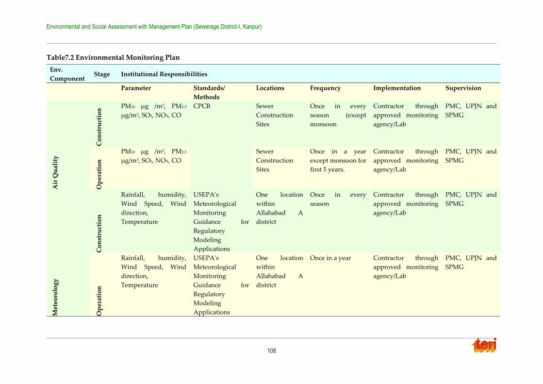
Environmental and Social Assessment with Management Plan (Sewerage District-I, Kanpur)
108
Table7.2 Environmental Monitoring Plan
Env.
Component Stage Institutional Responsibilities
Parameter Standards/
Methods
Locations Frequency Implementation Supervision
Air
Qu
alit
y
Co
nst
ruct
ion
PM10 μg /m3, PM2.5
μg/m3, SO2, NOX, CO
CPCB
Sewer
Construction
Sites
Once in every
season (except
monsoon
Contractor through
approved monitoring
agency/Lab
PMC, UPJN and
SPMG
Op
erat
ion
PM10 μg /m3, PM2.5
μg/m3, SO2, NOX, CO
Sewer
Construction
Sites
Once in a year
except monsoon for
first 5 years.
Contractor through
approved monitoring
agency/Lab
PMC, UPJN and
SPMG
Met
eoro
log
y
Co
nst
ruct
ion
Rainfall, humidity,
Wind Speed, Wind
direction,
Temperature
USEPA's
Meteorological
Monitoring
Guidance for
Regulatory
Modeling
Applications
One location
within
Allahabad A
district
Once in every
season
Contractor through
approved monitoring
agency/Lab
PMC, UPJN and
SPMG
Op
erat
ion
Rainfall, humidity,
Wind Speed, Wind
direction,
Temperature
USEPA's
Meteorological
Monitoring
Guidance for
Regulatory
Modeling
Applications
One location
within
Allahabad A
district
Once in a year Contractor through
approved monitoring
agency/Lab
PMC, UPJN and
SPMG
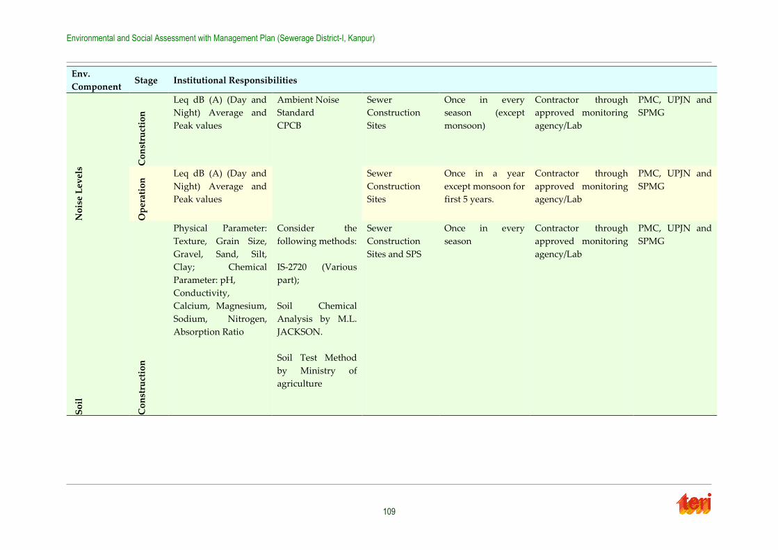
Environmental and Social Assessment with Management Plan (Sewerage District-I, Kanpur)
109
Env.
Component Stage Institutional Responsibilities
No
ise
Lev
els
Co
nst
ruct
ion
Leq dB (A) (Day and
Night) Average and
Peak values
Ambient Noise
Standard
CPCB
Sewer
Construction
Sites
Once in every
season (except
monsoon)
Contractor through
approved monitoring
agency/Lab
PMC, UPJN and
SPMG
Op
erat
ion
Leq dB (A) (Day and
Night) Average and
Peak values
Sewer
Construction
Sites
Once in a year
except monsoon for
first 5 years.
Contractor through
approved monitoring
agency/Lab
PMC, UPJN and
SPMG
So
il
Co
nst
ruct
ion
Physical Parameter:
Texture, Grain Size,
Gravel, Sand, Silt,
Clay; Chemical
Parameter: pH,
Conductivity,
Calcium, Magnesium,
Sodium, Nitrogen,
Absorption Ratio
Consider the
following methods:
IS-2720 (Various
part);
Soil Chemical
Analysis by M.L.
JACKSON.
Soil Test Method
by Ministry of
agriculture
Sewer
Construction
Sites and SPS
Once in every
season
Contractor through
approved monitoring
agency/Lab
PMC, UPJN and
SPMG
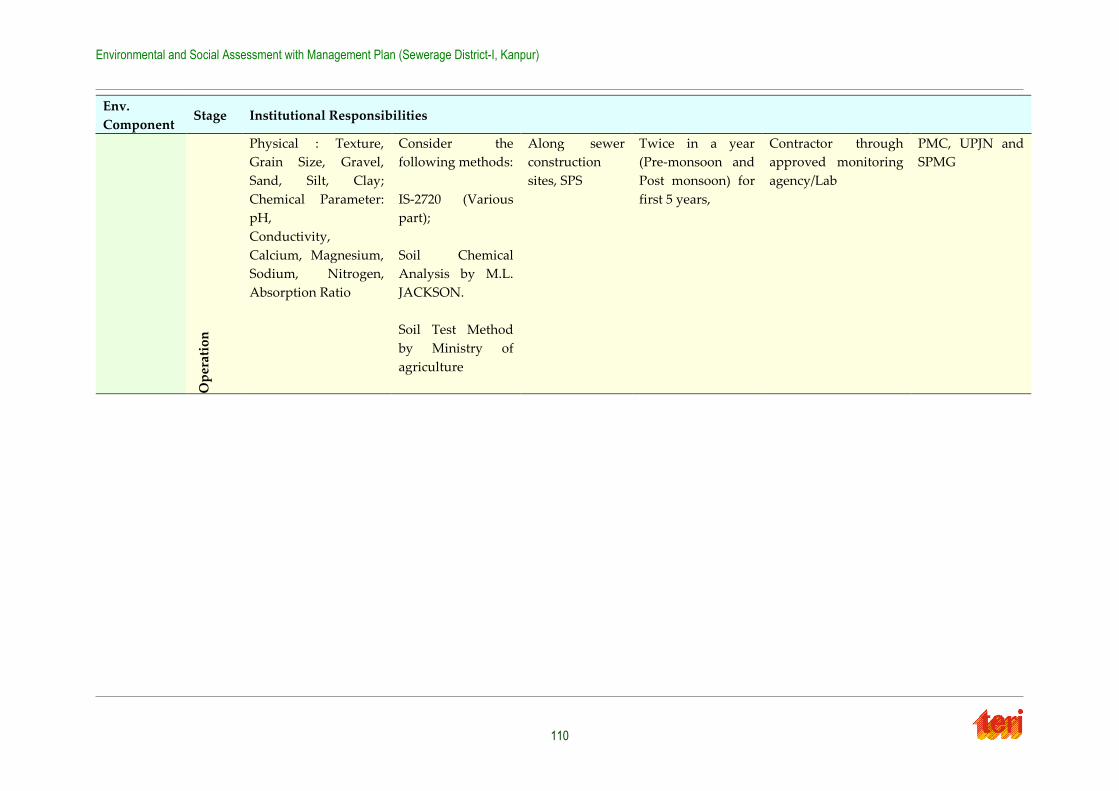
Environmental and Social Assessment with Management Plan (Sewerage District-I, Kanpur)
110
Env.
Component Stage Institutional Responsibilities
Op
erat
ion
Physical : Texture,
Grain Size, Gravel,
Sand, Silt, Clay;
Chemical Parameter:
pH,
Conductivity,
Calcium, Magnesium,
Sodium, Nitrogen,
Absorption Ratio
Consider the
following methods:
IS-2720 (Various
part);
Soil Chemical
Analysis by M.L.
JACKSON.
Soil Test Method
by Ministry of
agriculture
Along sewer
construction
sites, SPS
Twice in a year
(Pre-monsoon and
Post monsoon) for
first 5 years,
Contractor through
approved monitoring
agency/Lab
PMC, UPJN and
SPMG
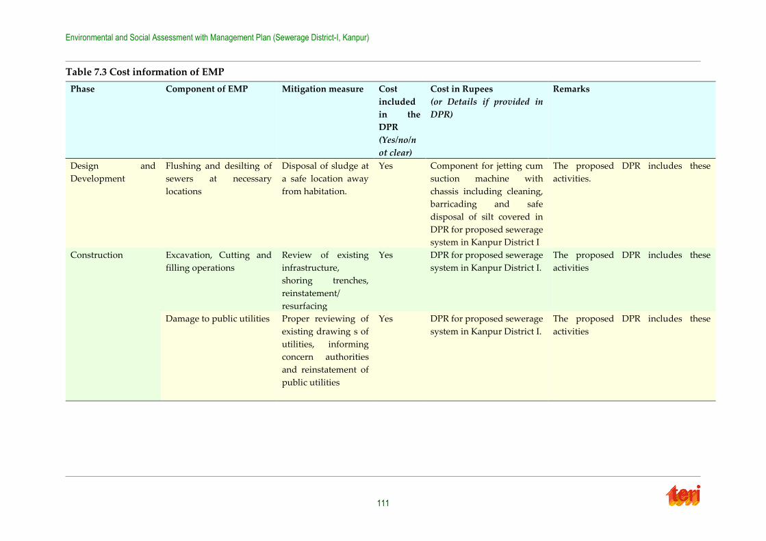
Environmental and Social Assessment with Management Plan (Sewerage District-I, Kanpur)
111
Table 7.3 Cost information of EMP
Phase Component of EMP Mitigation measure Cost
included
in the
DPR
(Yes/no/n
ot clear)
Cost in Rupees
(or Details if provided in
DPR)
Remarks
Design and
Development
Flushing and desilting of
sewers at necessary
locations
Disposal of sludge at
a safe location away
from habitation.
Yes Component for jetting cum
suction machine with
chassis including cleaning,
barricading and safe
disposal of silt covered in
DPR for proposed sewerage
system in Kanpur District I
The proposed DPR includes these
activities.
Construction Excavation, Cutting and
filling operations
Review of existing
infrastructure,
shoring trenches,
reinstatement/
resurfacing
Yes DPR for proposed sewerage
system in Kanpur District I.
The proposed DPR includes these
activities
Damage to public utilities Proper reviewing of
existing drawing s of
utilities, informing
concern authorities
and reinstatement of
public utilities
Yes DPR for proposed sewerage
system in Kanpur District I.
The proposed DPR includes these
activities
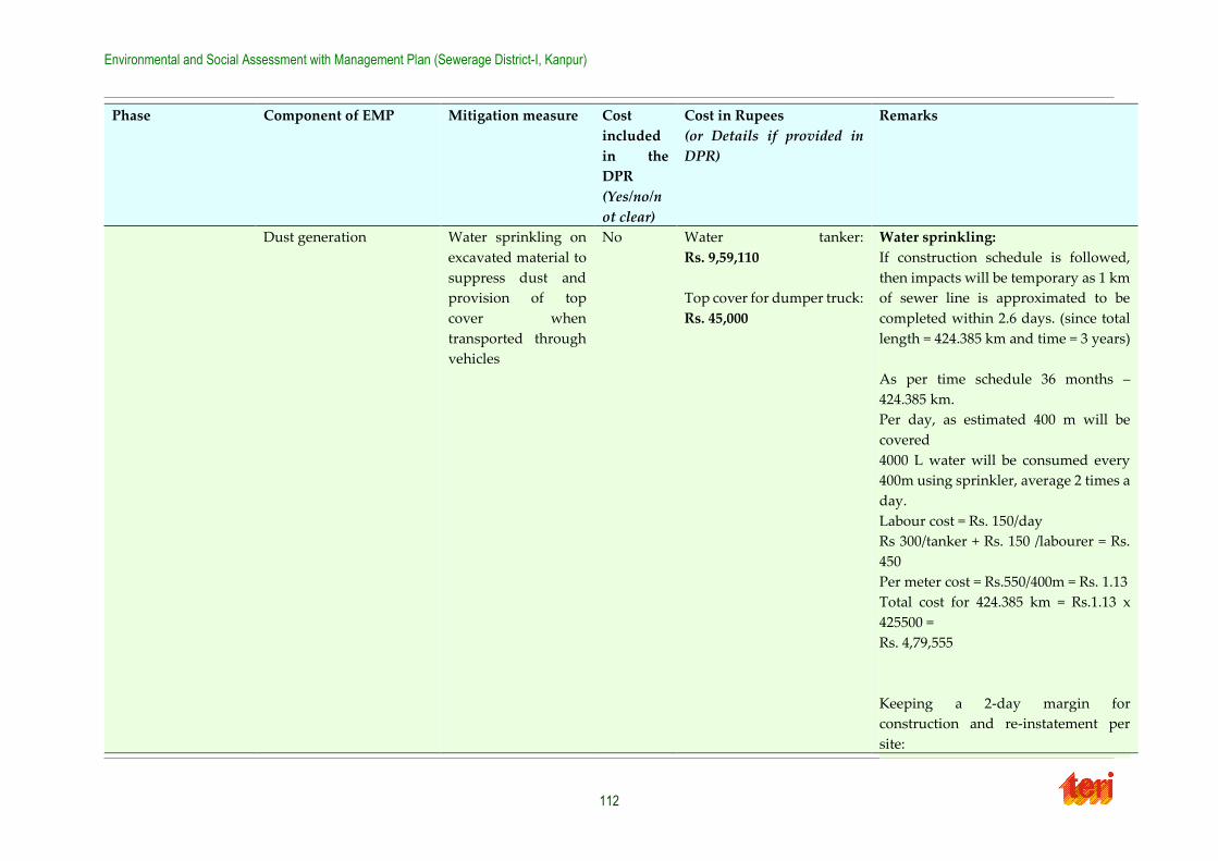
Environmental and Social Assessment with Management Plan (Sewerage District-I, Kanpur)
112
Phase Component of EMP Mitigation measure Cost
included
in the
DPR
(Yes/no/n
ot clear)
Cost in Rupees
(or Details if provided in
DPR)
Remarks
Dust generation Water sprinkling on
excavated material to
suppress dust and
provision of top
cover when
transported through
vehicles
No Water tanker:
Rs. 9,59,110
Top cover for dumper truck:
Rs. 45,000
Water sprinkling:
If construction schedule is followed,
then impacts will be temporary as 1 km
of sewer line is approximated to be
completed within 2.6 days. (since total
length = 424.385 km and time = 3 years)
As per time schedule 36 months –
424.385 km.
Per day, as estimated 400 m will be
covered
4000 L water will be consumed every
400m using sprinkler, average 2 times a
day.
Labour cost = Rs. 150/day
Rs 300/tanker + Rs. 150 /labourer = Rs.
450
Per meter cost = Rs.550/400m = Rs. 1.13
Total cost for 424.385 km = Rs.1.13 x
425500 =
Rs. 4,79,555
Keeping a 2-day margin for
construction and re-instatement per
site:
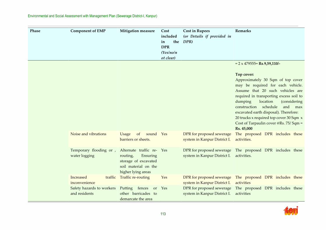
Environmental and Social Assessment with Management Plan (Sewerage District-I, Kanpur)
113
Phase Component of EMP Mitigation measure Cost
included
in the
DPR
(Yes/no/n
ot clear)
Cost in Rupees
(or Details if provided in
DPR)
Remarks
= 2 x 479555= Rs.9,59,110/-
Top cover:
Approximately 30 Sqm of top cover
may be required for each vehicle.
Assume that 20 such vehicles are
required in transporting excess soil to
dumping location (considering
construction schedule and max
excavated earth disposal). Therefore:
20 trucks x required top cover 30 Sqm x
Cost of Tarpaulin cover @Rs. 75/ Sqm =
Rs. 45,000
Noise and vibrations Usage of sound
barriers or sheets.
Yes DPR for proposed sewerage
system in Kanpur District I.
The proposed DPR includes these
activities.
Temporary flooding or ,
water logging
Alternate traffic re-
routing, Ensuring
storage of excavated
soil material on the
higher lying areas
Yes DPR for proposed sewerage
system in Kanpur District I.
The proposed DPR includes these
activities.
Increased traffic
inconvenience
Traffic re-routing Yes DPR for proposed sewerage
system in Kanpur District I.
The proposed DPR includes these
activities
Safety hazards to workers
and residents
Putting fences or
other barricades to
demarcate the area
Yes DPR for proposed sewerage
system in Kanpur District I.
The proposed DPR includes these
activities
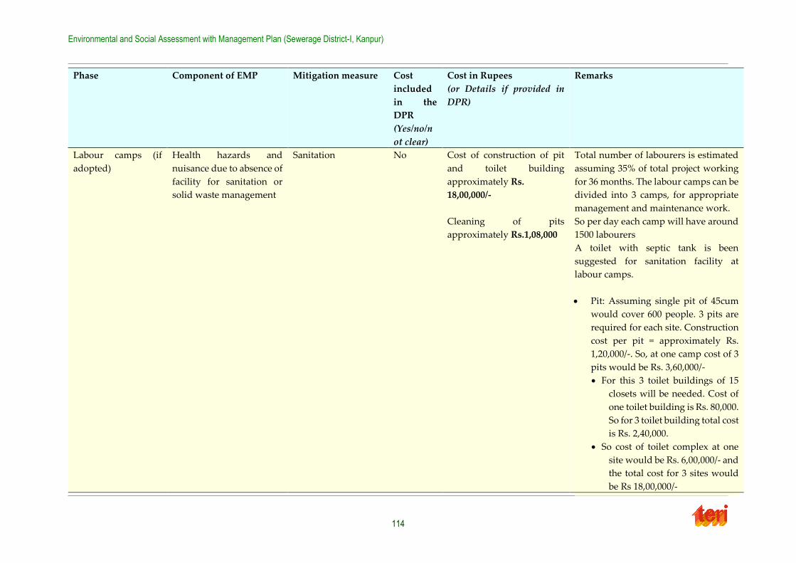
Environmental and Social Assessment with Management Plan (Sewerage District-I, Kanpur)
114
Phase Component of EMP Mitigation measure Cost
included
in the
DPR
(Yes/no/n
ot clear)
Cost in Rupees
(or Details if provided in
DPR)
Remarks
Labour camps (if
adopted)
Health hazards and
nuisance due to absence of
facility for sanitation or
solid waste management
Sanitation No Cost of construction of pit
and toilet building
approximately Rs.
18,00,000/-
Cleaning of pits
approximately Rs.1,08,000
Total number of labourers is estimated
assuming 35% of total project working
for 36 months. The labour camps can be
divided into 3 camps, for appropriate
management and maintenance work.
So per day each camp will have around
1500 labourers
A toilet with septic tank is been
suggested for sanitation facility at
labour camps.
Pit: Assuming single pit of 45cum
would cover 600 people. 3 pits are
required for each site. Construction
cost per pit = approximately Rs.
1,20,000/-. So, at one camp cost of 3
pits would be Rs. 3,60,000/-
For this 3 toilet buildings of 15
closets will be needed. Cost of
one toilet building is Rs. 80,000.
So for 3 toilet building total cost
is Rs. 2,40,000.
So cost of toilet complex at one
site would be Rs. 6,00,000/- and
the total cost for 3 sites would
be Rs 18,00,000/-
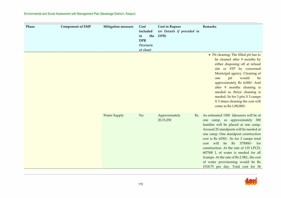
Environmental and Social Assessment with Management Plan (Sewerage District-I, Kanpur)
115
Phase Component of EMP Mitigation measure Cost
included
in the
DPR
(Yes/no/n
ot clear)
Cost in Rupees
(or Details if provided in
DPR)
Remarks
Pit cleaning: The filled pit has to
be cleaned after 9 months by
either disposing off at refusal
site or STP by concerned
Municipal agency. Cleaning of
one pit would be
approximately Rs 4,000/- And
after 9 months cleaning is
needed so thrice cleaning is
needed. So for 3 pits X 3 camps
X 3 times cleaning the cost will
come as Rs.1,08,000/-
Water Supply No Approximately Rs.
20,15,250
As estimated 1500 labourers will be at
one camp, so approximately 300
families will be placed at one camp.
Around 25 standposts will be needed at
one camp. One standpost construction
cost is Rs 6250/-. So for 3 camps total
cost will be Rs 375000/- for
construction. At the rate of 135 LPCD,
607500 L of water is needed for all
3camps. At the rate of Rs 2.5KL, the cost
of water provisioning would be Rs
1518.75 per day. Total cost for 36
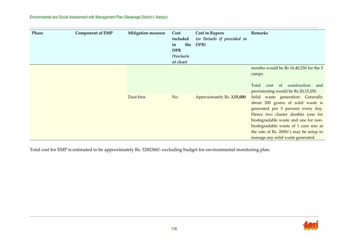
Environmental and Social Assessment with Management Plan (Sewerage District-I, Kanpur)
116
Phase Component of EMP Mitigation measure Cost
included
in the
DPR
(Yes/no/n
ot clear)
Cost in Rupees
(or Details if provided in
DPR)
Remarks
months would be Rs 16,40,250 for the 3
camps
Total cost of construction and
provisioning would be Rs 20,15,250
Dust bins No Approximately Rs. 3,55,000
Solid waste generation: Generally
about 200 grams of solid waste is
generated per 5 persons every day.
Hence two cluster dustbin (one for
biodegradable waste and one for non-
biodegradable waste of 1 cum size at
the rate of Rs. 2000/-) may be setup to
manage any solid waste generated.
Total cost for EMP is estimated to be approximately Rs. 5282360/- excluding budget for environmental monitoring plan.
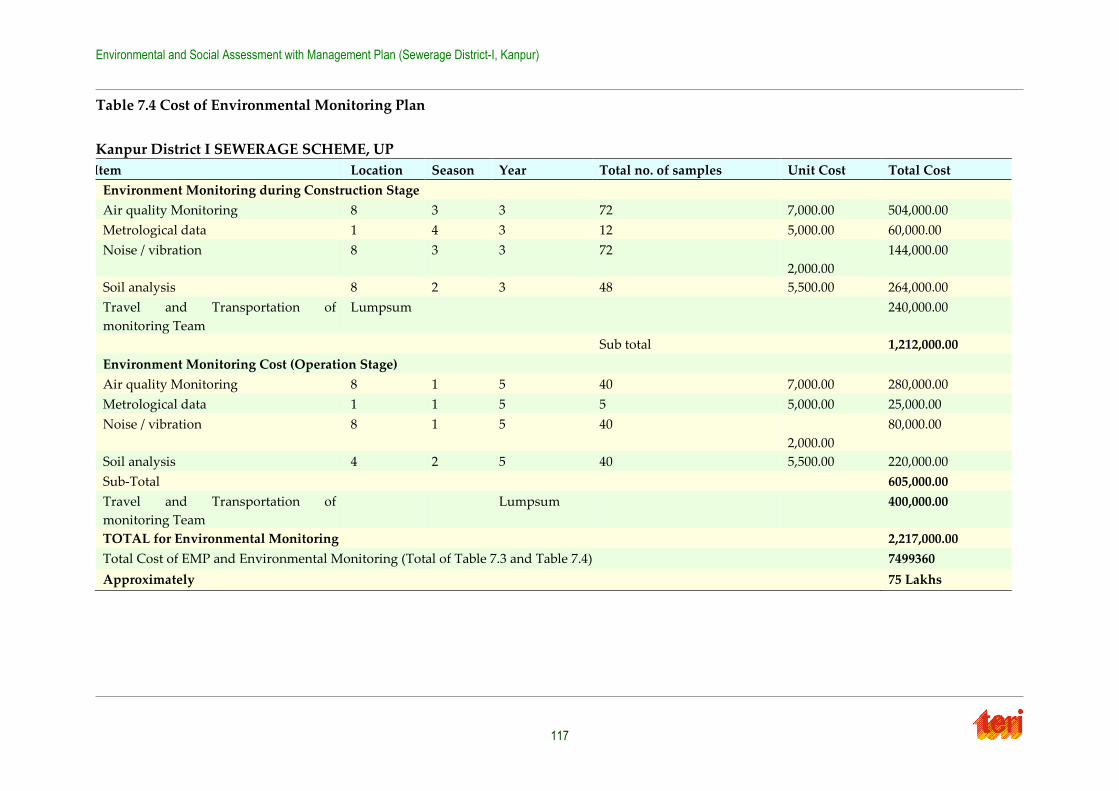
Environmental and Social Assessment with Management Plan (Sewerage District-I, Kanpur)
117
Table 7.4 Cost of Environmental Monitoring Plan
Kanpur District I SEWERAGE SCHEME, UP
Item Location Season Year Total no. of samples Unit Cost Total Cost
Environment Monitoring during Construction Stage
Air quality Monitoring 8 3 3 72 7,000.00 504,000.00
Metrological data 1 4 3 12 5,000.00 60,000.00
Noise / vibration 8 3 3 72
2,000.00
144,000.00
Soil analysis 8 2 3 48 5,500.00 264,000.00
Travel and Transportation of
monitoring Team
Lumpsum 240,000.00
Sub total 1,212,000.00
Environment Monitoring Cost (Operation Stage)
Air quality Monitoring 8 1 5 40 7,000.00 280,000.00
Metrological data 1 1 5 5 5,000.00 25,000.00
Noise / vibration 8 1 5 40
2,000.00
80,000.00
Soil analysis 4 2 5 40 5,500.00 220,000.00
Sub-Total 605,000.00
Travel and Transportation of
monitoring Team
Lumpsum 400,000.00
TOTAL for Environmental Monitoring 2,217,000.00
Total Cost of EMP and Environmental Monitoring (Total of Table 7.3 and Table 7.4) 7499360
Approximately 75 Lakhs
Environmental and Social Assessment with Management Plan (Sewerage District-I, Kanpur)
118
7.4 Social Management Plan
7.4.1 Social mitigation plans during construction phase
Based on the identified social issues, doable mitigation plans are proposed. Some of these
measures are already listed in the DPRs, and some of them are additionally recommended for
social development of the project affected people and the concerned stakeholders.
a. Impact on human health
Mitigation Measure: Acoustic enclosures or hoardings can be constructed at the proposed
sites
Our mitigation plan involves the erection of temporary enclosures around construction sites.
These barriers will help entrap some of the dust that is brought up in digging. They will also
provide safety benefits, to be detailed below. Water sprinkling will be undertaken as well, according to the contractors.
b. Traffic Congestion
Mitigation Measure: Re-route traffic whenever possible and employing traffic police to manage the traffic movement.
Traffic must be re-routed to facilitate ease of movement. Proper signage should provide
detailed information on the dates and duration of road closures and which detours will be available, ideally well in advance of actual construction so residents can plan accordingly.
Strategic placement of traffic cops at critical intersections will also facilitate better flow of
traffic. Plans and budget for these measures are already included in the DPR.
c. Impact on livelihood
Sewer constructions will invariable lead to road closures, which will adversely affect shops
on those streets. The first priority is for the contractor to take the necessary measures to ensure that pedestrians always have access to shops, vendors, etc. For mobile vendors, this may
include adjusting the location of the cart, etc. to a similar location in the immediate vicinity of
the original location for the duration of the project. Projects should also proceed on schedule so as to minimize disruption. Additionally, clean-up of debris and clearance of blockages
should commence immediately after project completion so as to remove any potential
obstacles that might prevent customers from accessing businesses or other disruptions.
In the event that the contractor, despite best efforts, is unable to avoid blockages of the roads
and/or disruption of local businesses, some compensation is necessary. The ESMF currently
mandates compensation only in the case of permanent livelihood loss or displacement and provides no provisions for temporary livelihood loss. Additionally, no regulation, policy,
guideline, etc. exists which can provide precedent or guidance in this instance ESMF clearly
states that mobile/ambulatory hawkers: fruit cart vendors, etc. who can easily relocate fall into this category. These vendors are most eligible for a temporary relocation just outside the
construction area, and will thus not be eligible for compensation as is the case for this proposed
project.
However if during the construction of the project any party faces livelihood loss due to the
proposed project, then that party should be compensated according to the entitlement matrix
given in the ESMF report.
Environmental and Social Assessment with Management Plan (Sewerage District-I, Kanpur)
119
d. Impact on existing utility services
Mitigation Measure:
Circulating the layout plans of the existing underground alignment near the work site.
Contacting the relevant department in case there is any damage to any of the utility
services and ensuring prompt fixing/replacing of damaged infrastructure
Temporary shifting of power/water lines for construction purposes is already budgeted for in
the DPR. Nevertheless, all construction personnel must receive detailed layout plans of
existing underground structures to prevent accidental water/electricity supply disruptions. The relevant departments should also be made aware of the timing and location of digging
near supply lines so they can make the necessary preparations to respond swiftly to
disruptions.
e. Safety hazards
Mitigation Measure: Fencing of the excavation site and providing proper caution sign boards.
As mentioned above, fencing should be erected around construction sites and appropriately marked with caution signage. These fences/signs should remain in place even if construction
is not active, so long as a hazard (e.g. open pit) remains.
f. Damage to buildings
In summary, the task of correctly identifying the vulnerable parties is virtually impossible.
Thus, the best mitigation plan is to reroute sewage lines to avoid disturbing the old sewage
network in instances where the contractors determine that a house may be built upon it. The mitigation plan for this social concern proceeds in the following steps:
Redirecting sewer lines around those houses that rely on the sewage lines for
foundation.
Should that not prove possible, identification of affected houses and categorization
into different level of houses (permanent, semi-permanent, etc.) to determine possible
compensation.
Payment of compensation to affected houses on a “cost of repairs” basis. Should total
destruction of the property ensue, then the full valuation of the property must be paid,
and resettlement/rehabilitation policies (outlined below) come into effect.
Before beginning detailing these plans, it is important to emphasize simply how difficult
phases 2 and 3 would be. As the UP Jal Nagam explained there is no documentation of which
houses will be affected. A simple survey of the old sewage lines and noting adjacent houses would not suffice as many if not most of the houses likely have a proper, solid foundation and
would thus not be affected by alterations to the old sewer line. Surveying those residents
would prove difficult as well, as if they are the owners, they will want to conceal the illegal nature of their construction, and if they are not the owners, they likely would not know the
nature of their foundation. Finally, in the 3rd phase, homes with proper foundations but that lie
on the old sewage line could falsely claim damages and it would be difficult to determine whether this was true or not. Essentially, a survey of every house in the area would be
required, and residents would have to be compelled to show documents detailing the content
of their foundation.
Still, if the 1st option is not possible, and the 2nd and 3rd options must be followed, a stakeholder
consultation must be initiated. At this consultation, residents must be asked to come forward
Environmental and Social Assessment with Management Plan (Sewerage District-I, Kanpur)
120
if their homes are built on the old sewer line, with proper reassurances that they will not be
prosecuted. At a follow up session, those potentially afflicted parties must have their compensatory rights explained. Then a survey of their properties can commence to note their
current state, allowing a baseline for future comparisons. If, after construction is done, it is
determined that damage has occurred, appropriate compensation will be paid based on a formula TBD. As is clear, this method still has many of the problems of above in terms of
people not coming forward about their house using the old sewer line as foundation and
people making false claims. Thus, it is essential that the construction avoid those houses which rest on the old sewer line.
g. Elevated Noise Levels
According to UP Jal Nigam officials, construction will take place after school hours or at other times of school closing to avoid interfering with school function. Beyond that, construction
must simply proceed in a deliberate and judicious manner to avoid unnecessary noise
pollution.
h. Failure to Restore Temporary Construction Sites
As mentioned above, provisions to rehabilitate roads and clear debris are already included in
the DPR.
i. Public Notice
According to the suggestion given by the locals during the interview. Government and
contractor should give a prior notice to each and every locality with the details of the project, street wise start date of construction and street wise end date of construction. Contact person
during emergency. This information would help them better adjust to the situation and make
necessary adjustments and provisions.
j. Health Programmes for Workers
If un-sanitary conditions prevail at workers camp, health programs for their well-being
should be implemented.
7.4.2 Social mitigation plans during operation phase
Noise pollution due to improper handling of machines: proper O&M should be carried out during the operation phase to ensure least disturbance is caused to the neighbouring
residents.
7.4.3 Mitigation measures adopted by locals during similar nature of
project activities
From the field surveys and interviewing the locals including shop-owners, residents, mobile vendors, following local adaptive measures have been recorded;
Using transparent plastic sheets to block entry of dust into shops
Avoiding opening of windows, especially when the construction is going on
Taking different routes if possible to avoid areas where construction is happening
Laying wooden/plywood plank over the excavated pits for making access route to
house or shops
Environmental and Social Assessment with Management Plan (Sewerage District-I, Kanpur)
121
Mobile vendors stated that they place their carts at some other place and vacate
construction area for the time when construction is on
Many public institutes like hospitals, schools and colleges reported that they have
more than one gate which makes the access easier during construction period.
The above measures indicate that the general public has already created adaptation measures to sewage construction projects.
Public Grievances
Locals also reported few instances where they lodged complaints about un-cleared debris, or damage of public utility generally to UP Jal Nigam officials. They usually do not lodge
complaints due to the prior experience of the lack of response from government officials.
Additionally, the interviewees said that they understood the inconveniences were of a temporary measure and are providing a social good. Thus, they have created local adaptation
measures as quick and efficient ways to mitigate the temporary inconveniences. However the
proposed project has grievance redress mechanism which will be adopted as mentioned in the Environment and Social Management Framework.
Table 7.5 Social Management Plan
Activity Potential Negative
Impact/Concern
Mitigation Measures Cost Issues
I. Sewerage and Sanitation Projects
A. Design and Development Phase
Land acquisition
for new pumping
station
NA
SPS is planned on
land already
owned by the
government and
confirmed by the
Revenue
department and in
fenced off location,
where in only this
new pumping
station would
come up
NA
NA As per first hand observation in the
field and through interviews of key
stakeholders, residents, local people,
and other sources like DPR, it has
been established that 4 plots of land
would be acquired for construction of
new SPS.
These include:
1.Vishnupuri (Private -Compensation
required)
2.Gandhi Park (public)
3.Collector Ganj (public)
4.Budhiya Ghaat (public)
The land pocket in Vishnupuri is
owned privately, which will require
compensation (as per Land
Acquisition Act) to be provided to the
Land Owner by PEA.
NA
B. Construction Phase
Safety hazards
to workers and
residents
Dust generation,
with resulting
Provide workers
with adequate
safety equipment
such as helmets,
safety shoes,
gloves, etc.
Safety gear provided
by contractor
Putting fences or
other barricades to
demarcate the area is
already being done.
Environmental and Social Assessment with Management Plan (Sewerage District-I, Kanpur)
122
Activity Potential Negative
Impact/Concern
Mitigation Measures Cost Issues
implications for
human health
Reduced
pedestrian and
vehicle access to
residences and
businesses
Temporary
water ,
electricity,
supply
interruptions
Increased traffic
inconvenience
(emissions,
congestions,
longer travel
times)
Fences/temporary
enclosures should
be put around
construction sites
(even inactive
ones, if hazards,
like open pits,
remain);
enclosures should
be properly
marked with
caution signs.
Water sprinkling,
removal of excess
materials,
cleaning of sites
upon completion
of activities.
Construction of
temporary
enclosures to entrap
dust.
Water sprinkling
Work should
proceed on
schedule so as to
minimize road
closures
Upon project
completion, quick
clearance of
debris, etc. will
facilitate access by
customers to local
business and
residents to their
households
Debris clearance
budgeted for in DPR.
Circulation of
layout plan for all
underground
infrastructure to
ensure that
contractor is
aware of
water/electricity
lines in
Provision for
temporary shifting of
water/power lines,
etc. already in DPR.
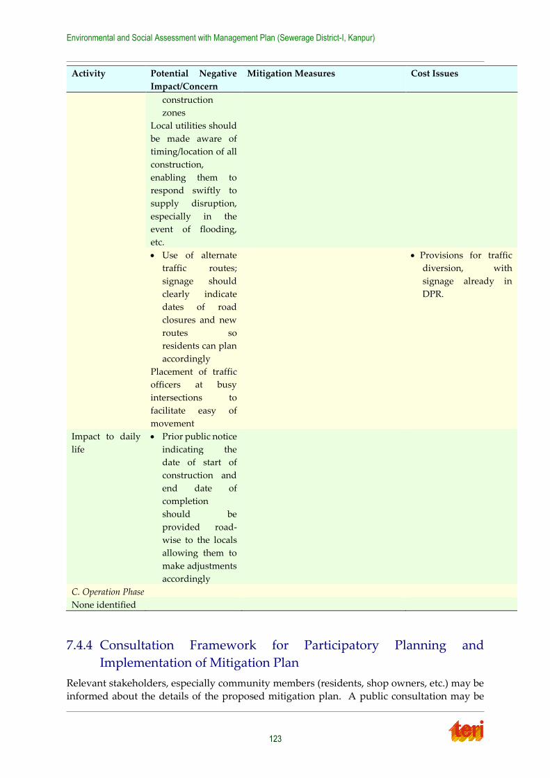
Environmental and Social Assessment with Management Plan (Sewerage District-I, Kanpur)
123
Activity Potential Negative
Impact/Concern
Mitigation Measures Cost Issues
construction
zones
Local utilities should
be made aware of
timing/location of all
construction,
enabling them to
respond swiftly to
supply disruption,
especially in the
event of flooding,
etc.
Use of alternate
traffic routes;
signage should
clearly indicate
dates of road
closures and new
routes so
residents can plan
accordingly
Placement of traffic
officers at busy
intersections to
facilitate easy of
movement
Provisions for traffic
diversion, with
signage already in
DPR.
Impact to daily
life
Prior public notice
indicating the
date of start of
construction and
end date of
completion
should be
provided road-
wise to the locals
allowing them to
make adjustments
accordingly
C. Operation Phase
None identified
7.4.4 Consultation Framework for Participatory Planning and
Implementation of Mitigation Plan
Relevant stakeholders, especially community members (residents, shop owners, etc.) may be
informed about the details of the proposed mitigation plan. A public consultation may be
Environmental and Social Assessment with Management Plan (Sewerage District-I, Kanpur)
124
conducted where the mitigation plan is presented, and feedback solicited from the
community. Individual meetings with other key stake holders – government officials, relevant NGOs, etc. – could be scheduled to solicit their feedback as well. Once construction
begins and the mitigation plan is put into effect, a follow up field visit should be conducted
so as to evaluate the efficacy of the mitigation plan, as well as gauge local sentiments related to the construction and identify/address new issues that may have arisen during construction.
Stakeholders that should be involved in planning and implementation of the mitigation plan
include;
All affected persons (APs), program beneficiaries, including representatives of
vulnerable households;
decision makers, policy makers, elected representatives of people, community and citizens, NGOs etc;
staff of executing agency, implementing agencies, GPCU, etc
officials of the revenue departments, social welfare department etc; and
Representatives of the various state government departments, as required.
7.4.5 Assess the Capacity of Institutions and Mechanisms for
Implementing Social Development Aspects and Social Safeguard
Plans; Recommend Capacity building measures
Roles and functions of the institutions are pre-defined, but they can enhance their capacity for
better implementation and operation of the project. There should be synergies and continual
interaction amongst the departments for better coordination. The officers of the relevant departments can be trained in the issues like social sciences, social management plan, etc.
Institutional reform and capacity building of local body is in process under JNNURM, it will
be required to ensure that operating authorities have the ability and equipment to properly manage and finance the operation and maintenance of sewerage schemes. Otherwise
continued development will not be sustainable.
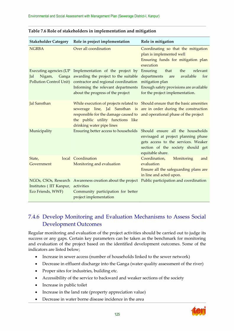
Environmental and Social Assessment with Management Plan (Sewerage District-I, Kanpur)
125
Table 7.6 Role of stakeholders in implementation and mitigation
7.4.6 Develop Monitoring and Evaluation Mechanisms to Assess Social
Development Outcomes
Regular monitoring and evaluation of the project activities should be carried out to judge its success or any gaps. Certain key parameters can be taken as the benchmark for monitoring
and evaluation of the project based on the identified development outcomes. Some of the
indicators are listed below;
Increase in sewer access (number of households linked to the sewer network)
Decrease in effluent discharge into the Ganga (water quality assessment of the river)
Proper sites for industries, building etc.
Accessibility of the service to backward and weaker sections of the society
Increase in public toilet
Increase in the land rate (property appreciation value)
Decrease in water borne disease incidence in the area
Stakeholder Category Role in project implementation Role in mitigation
NGRBA Over all coordination Coordinating so that the mitigation
plan is implemented well
Ensuring funds for mitigation plan
execution
Executing agencies (UP
Jal Nigam, Ganga
Pollution Control Unit)
Implementation of the project by
awarding the project to the suitable
contractor and regional coordination
Informing the relevant departments
about the progress of the project
Ensuring that the relevant
departments are available for
mitigation plan
Enough safety provisions are available
for the project implementation.
Jal Sansthan While execution of projects related to
sewerage line, Jal Sansthan is
responsible for the damage caused to
the public utility functions like
drinking water pipe lines
Should ensure that the basic amenities
are in order during the construction
and operational phase of the project
Municipality Ensuring better access to households
Should ensure all the households
envisaged at project planning phase
gets access to the services. Weaker
section of the society should get
equitable share.
State, local
Government
Coordination
Monitoring and evaluation
Coordination, Monitoring and
evaluation
Ensure all the safeguarding plans are
in line and acted upon.
NGOs, CSOs, Research
Institutes ( IIT Kanpur,
Eco Friends, WWF)
Awareness creation about the project
activities
Community participation for better
project implementation
Public participation and coordination
Environmental and Social Assessment with Management Plan (Sewerage District-I, Kanpur)
126
Chapter 8 Social development outcomes and
issues
8. 1 Social Development Outcomes of the sub project
Access to sewer network: this service will cater to the projected population until the year 2050. According to the DPR, population is expected to increase from 11.27 lakhs
in 2010 to 13.06 lakhs by 2050. Increased sewerage will prevent outflow of waste water
to the Ganga.
Better hygienic conditions: with the sewerage network there will be better
environmental conditions leading to better health conditions and hence will reduce
the medical expenses. Specifically, rapid development of the peripheral areas of the city has resulted in this area being the most unsewered, according to the DPR. On the
field visit, it was observed that, in areas without proper sewerage, nallas are
commonly used. It is estimated in DPR that around 393 ha of District I-City Central area is unsewered. These areas suffered from powerful odours and greater amounts
of flies/mosquitoes than observed elsewhere in the city. Moreover according to DPR
the areas not covered by sewerage system are using septic tanks for disposal of sewage, which overflows on the roads at present.
Strengthening of the old sewer network: According to the DPR, the primary sewer
lines were built in 1904, and most are currently in a dilapidated. Specifically, clogging and chocking is common, resulting in unhygienic conditions; occasional collapses has
occurred. Despite a major reorganization of the sewerage system in 1952 – which
included new sewers, an intermediate SPS at Parmat Gain and a main SPS at Jajmau – large increases in wastewater generated have led to a requirement for new additions.
This project will strengthen those lines and add to the existing network, thus
increasing the carrying capacity of the system.
Increase in household connections: According to the DPR, only 30% of Kanpur
residents currently have sewer access. The new project requires that any household
with a possible connection point within about 10m of new/existing lines be provided access.
Decrease in water pollution: Because of the sewer line connection, all the waste water
will be collected and directed to treatment plant, which only after treatment will be disposed of to the river, hence decreasing the pollutant load in the river. Due to
current pollution, water quality in the river Ganga is impaired at the City of Kanpur.
As per data collected by the regional office of the Uttar Pradesh Pollution Control Board, the biochemical oxygen demand (BOD) levels upstream and downstream often
go above the permissible 3.0 mg/l for outdoor bathing waters, and very often go above
the 2.0 mg/l limit for the drinking water standard, as set by the Indian Standard code. Thus, those who consume the water will suffer health problems.
Increase in aesthetic value of the project area: connection to sewer lines enhance the
aesthetic value of the area, as there will be more cleanliness and no wastewater discharge to open area. This will also lead to appreciation in the property value. This
will eventually lead to increase in standard of living of the people in the project site.
Environmental and Social Assessment with Management Plan (Sewerage District-I, Kanpur)
127
The support for this statement comes from the counter-factual scenario observed in
areas with only nalas (bad odour, insects, etc.).
Cultural sentiments: Proper sewage disposal would increase the river water quality.
As the holy river is attached to many rituals and customs, enhanced river water quality
would connect to sentiments of the people. Especially during ‘festivals’ better water quality for bathing would be boon for pilgrims. Presently according to the State
Pollution Control Board, and as mentioned above, the river water quality is not fine,
as it contains excess of chromium, chloride, BOD and total coliform due to un-treated domestic sewage and industrial effluent. With the proper sewage treatment, these
parameters would be in check and river water quality would enhance.
8.2 Social development issues in project vicinity and social
services to be provided by the project
The social benefits of the proposed project are given in previous sections. The social services
required to ensure that these benefits are realized are given below:
Ensure backward section of the society gets the facility: Some residents complained that they did not feel they personally would benefit from the project as their houses
did not have sewer connection. Thus, increasing household connections will ensure
that project benefits are equitably distributed. Plans for increasing connections are detailed in the DPR that is the new project requires that any household with a possible
connection point within about 10m of new/existing lines be provided access. Special
care should be taken to ensure access for backward and vulnerable sections of the society. Full benefits of the facilities proposed under DPR cannot be realized unless a
programme to improve coverage of branch sewers and household connection is
carried in parallel.
Increasing public toilet facilities: Similarly to the above point, increasing public toilet
facilities will ensure that the 35% of residents of Kanpur Nagar without permanent
housing are able to benefit from the increased sewage access. Increasing toilet access will decrease practices such as Open Defecation, which leads to reduced water quality,
less sewage being treated and has negative social ramifications for the individuals as
well.
Ensure proper treatment of sewage: With increased sewer lines, these STPs will face
a greater load, so their efficiency must increase concurrently. Proper monitoring of
staff requirements will ensure that the coming load increase can be dealt with. These currently operational STPs are working on the present load. If there capacity is not
augmented then the whole purpose of provision of sewerage network will be defeated.
Targeting of economically weaker communities: for construction jobs related to sub-project: In order to ensure that the economic benefits of the sub-project is felt by those
must in need, those from backward communities should be specifically targeted for
relevant jobs.
Proper clean-up of project debris: In order to maximize aesthetic benefits and ensure
that debris does not clog sewer path, proper clean-up of project areas must be
performed after the project is completed. Collection and disposal of debris is essential for proper function of other essential processes like traffic routing, pedestrian

Environmental and Social Assessment with Management Plan (Sewerage District-I, Kanpur)
128
pathways, and clearance of dust and particles causing pollution. Clean area will also
enhance the aesthetic value and increase the property rate of the area.
Environmental and Social Assessment with Management Plan (Sewerage District-I, Kanpur)
129
Chapter 9 Conclusion
The project report of the proposed sub-project for sewerage district-I of the Kanpur city after environment and social analysis concludes that the project falls in ‘low impact’ category and
have overall positive benefits on the life and environment of the people. The proposed
sewerage project mainly involves laying of sewers along the road and construction of new Pumping Stations, which requires only land acquisition not resulting in loss of income, loss
of livelihood, relocation of households. As per environmental and social management
framework guidelines of NGRBA, Environmental and Social Assessment, with a Generic Safeguard Management Plan was conducted for addressing possible issues/ concerns arising
from proposed project.
Impacts of activities identified during the assessment fell under two separate categories of Construction and Operation. Although no such permanently negative or adverse
environmental or social impacts were identified, there were certain temporary impacts, for
which appropriate mitigation plans have been suggested. The environmental management plan brings forth appropriate mitigation measures against the issues/ concerns identified
during the environmental and social analysis. All the social and environmental issues were
appropriately studied and have been substantiated using appropriate evidences, to ascertain the magnitude of their impacts. Even the issues of public grievances and public notice have
been taken care in the report to confirm transparency during the project implementation. The
report also ensures that well defined institutional mechanism is in place to monitor and evaluate the progress of the project during construction, implementation and operation
phases.
Stakeholder consultations, and interviews helped in understanding the general perception of public towards the project and it can be determined that the people of the project site are
happy and welcome such an initiative for their betterment. It was also pointed out that the
large overall environmental benefits of the project such as prevention of discharge of untreated sewage into River Ganga, improvement in sewerage collection, improvement in
quality of life, human dignity and increased productivity greatly outweigh the temporary
inconveniences faced during the implementation stages.
Environmental and Social Assessment with Management Plan (Sewerage District-I, Kanpur)
130
Annexure 1 Questionnaire
TERI-Water Resources Division Date:__/__/2011
NGRBA Social Impact Assessment
Interviewer:__________________
Site: Kanpur District-I Project: New Sewer Lines
Interviewee:________________________
Location: Residebtial____Public Place_______
For PP: Park______Office____Market__School____Store______Religious place____
Classification: Resident______Shop Keeper___Street Vendor_____Office
worker____School_______Pedistrian___Religious figure_____Other
1. Do you have sewer linkages? How does having/not having sewer access affect you?
2. Are you aware that this project will be constructed?
3. What do you think will be the consequences of the construction this project on the
following:
a. Traffic blockages?
b. Parking?
c. Aesthetic value of neighbourhood
d. Health
e. Access to river water source
f. Noise?
g. Pollution? Dust, air quality, leakages
h. Smell/flies, etc.?
i. Basic services? Drinking water pipes, electricity poles, etc.
j. Livelihood?
k. Family?
l. Daily Life?
m. Impact of worker’s camp (unsanitary conditions there, safety concerns, etc.)
n. Other?
Environmental and Social Assessment with Management Plan (Sewerage District-I, Kanpur)
131
4. What do you think will be the consequences of this project, post completion?
a. Pollution?
b. Smell/flies, etc.?
c. Access to river water source
d. Basic services? Drinking water pipes, electricity poles, etc.
e. Livelihood?
f. Family?
g. Daily Life?
h. Other?
5. Are you generally in favor, or do you generally oppose this plan?
6. For women only
a) Do you feel you will be especially hindered by this project?
b) Do you feel you will especially benefit from this project?
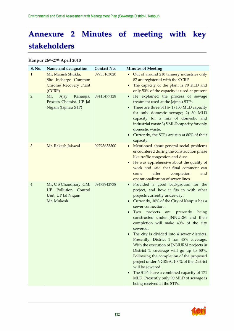
Environmental and Social Assessment with Management Plan (Sewerage District-I, Kanpur)
132
Annexure 2 Minutes of meeting with key
stakeholders
Kanpur 26th-27th April 2010
S. No. Name and designation Contact No. Minutes of Meeting
1 Mr. Manish Shukla,
Site Incharge Common
Chrome Recovery Plant
(CCRP)
09935163020 Out of around 210 tannery industries only
87 are registered with the CCRP
The capacity of the plant is 70 KLD and
only 50% of the capacity is used at present
2 Mr. Ajay Kanaujia,
Process Chemist, UP Jal
Nigam (Jajmau STP)
09415477128 He explained the process of sewage
treatment used at the Jajmau STPs.
There are three STPs- 1) 130 MLD capacity
for only domestic sewage; 2) 30 MLD
capacity for a mix of domestic and
industrial waste 3) 5 MLD capacity for only
domestic waste.
Currently, the STPs are run at 80% of their
capacity.
3 Mr. Rakesh Jaiswal 09793633300 Mentioned about general social problems
encountered during the construction phase
like traffic congestion and dust.
He was apprehensive about the quality of
work and said that final comment can
come after completion and
operationalization of sewer lines
4 Mr. C S Chaudhary, GM,
UP Pollution Control
Unit, UP Jal Nigam
Mr. Mukesh
09473942738 Provided a good background for the
project, and how it fits in with other
projects currently underway.
Currently, 30% of the City of Kanpur has a
sewer connection.
Two projects are presently being
constructed under JNNURM and their
completion will make 40% of the city
sewered.
The city is divided into 4 sewer districts.
Presently, District 1 has 45% coverage.
With the execution of JNNURM projects in
District 1, coverage will go up to 50%.
Following the completion of the proposed
project under NGRBA, 100% of the District
will be sewered.
The STPs have a combined capacity of 171
MLD. Presently only 90 MLD of sewage is
being received at the STPs.
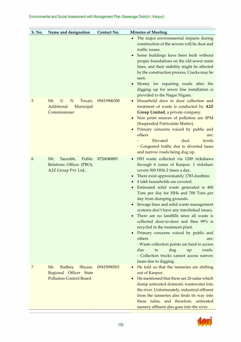
Environmental and Social Assessment with Management Plan (Sewerage District-I, Kanpur)
133
S. No. Name and designation Contact No. Minutes of Meeting
The major environmental impacts during
construction of the sewers will be dust and
traffic issues.
Some buildings have been built without
proper foundations on the old sewer main
lines, and their stability might be affected
by the construction process. Cracks may be
seen.
Money for repairing roads after the
digging up for sewer line installation is
provided to the Nagar Nigam.
5 Mr U N Tiwari,
Additional Municipal
Commissioner
09415906300 Household door to door collection and
treatment of waste is conducted by A2Z
Group Limited, a private company.
Non point sources of pollution are SPM
(Suspended Particulate Matter).
Primary concerns voiced by public and
others are:
- Elevated dust levels
- Congested traffic due to diverted lanes
and narrow roads being dug up.
6 Mr. Saurabh, Public
Relations Officer (PRO),
A2Z Group Pvt. Ltd,.
8726040885 HH waste collected via 1200 rickshaws
through 6 zones of Kanpur. 1 rickshaw
covers 500 HHs 2 times a day.
There exist approximately 1783 dustbins
4 lakh households are covered.
Estimated solid waste generated is 400
Tons per day for HHs and 700 Tons per
day from dumping grounds.
Sewage lines and solid waste management
systems don’t have any interlinked issues.
There are no landfills since all waste is
collected door-to-door and then 99% is
recycled in the treatment plant.
Primary concerns voiced by public and
others are:
- Waste collection points are hard to access
due to dug up roads.
- Collection trucks cannot access narrow
lanes due to digging.
7 Mr. Radhey Shyam,
Regional Officer State
Pollution Control Board
09415090501 He told us that the tanneries are shifting
out of Kanpur.
He mentioned that there are 26 nalas which
dump untreated domestic wastewater into
the river. Unfortunately, industrial effluent
from the tanneries also finds its way into
these nalas, and therefore, untreated
tannery effluent also goes into the river.
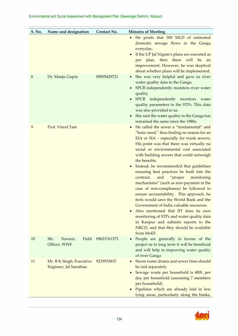
Environmental and Social Assessment with Management Plan (Sewerage District-I, Kanpur)
134
S. No. Name and designation Contact No. Minutes of Meeting
He posits that 300 MLD of untreated
domestic sewage flows in the Ganga
everyday.
If the UP Jal Nigam’s plans are executed as
per plan, then there will be an
improvement. However, he was skeptical
about whether plans will be implemented.
8 Dr. Manju Gupta 09005429721 She was very helpful and gave us river
water quality data in the Ganga.
SPCB independently monitors river water
quality.
SPCB independently monitors water
quality parameters in the STPs. This data
was also provided to us.
She said the water quality in the Ganga has
remained the same since the 1980s.
9 Prof. Vinod Tare He called the sewer a “fundamental” and
“basic need,” thus finding no reason for an
EIA or SIA – especially for trunk sewers.
His point was that there was virtually no
social or environmental cost associated
with building sewers that could outweigh
the benefits.
Instead, he recommended that guidelines
ensuring best practices be built into the
contract, and “proper monitoring
mechanisms” (such as non-payment in the
case of non-compliance) be followed to
ensure accountability. This approach, he
feels would save the World Bank and the
Government of India valuable resources.
Also mentioned that IIT does its own
monitoring of STPs and water quality data
in Kanpur and submits reports to the
NRCD, and that they should be available
from MoEF.
10 Mr. Naveen, Field
Officer, WWF
09621761373 People are generally in favour of the
project as in long term it will be beneficial
and will help in improving water quality
of river Ganga
11 Mr. B K Singh, Executive
Engineer, Jal Sansthan
9235553815 Storm water drains and sewer lines should
be laid separately.
Sewage waste per household is 400L per
day per household (assuming 7 members
per household).
Pipelines which are already laid in low
lying areas, particularly along the banks,
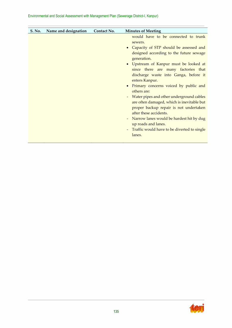
Environmental and Social Assessment with Management Plan (Sewerage District-I, Kanpur)
135
S. No. Name and designation Contact No. Minutes of Meeting
would have to be connected to trunk
sewers.
Capacity of STP should be assessed and
designed according to the future sewage
generation.
Upstream of Kanpur must be looked at
since there are many factories that
discharge waste into Ganga, before it
enters Kanpur.
Primary concerns voiced by public and
others are:
- Water pipes and other underground cables
are often damaged, which is inevitable but
proper backup repair is not undertaken
after these accidents.
- Narrow lanes would be hardest hit by dug
up roads and lanes.
- Traffic would have to be diverted to single
lanes.
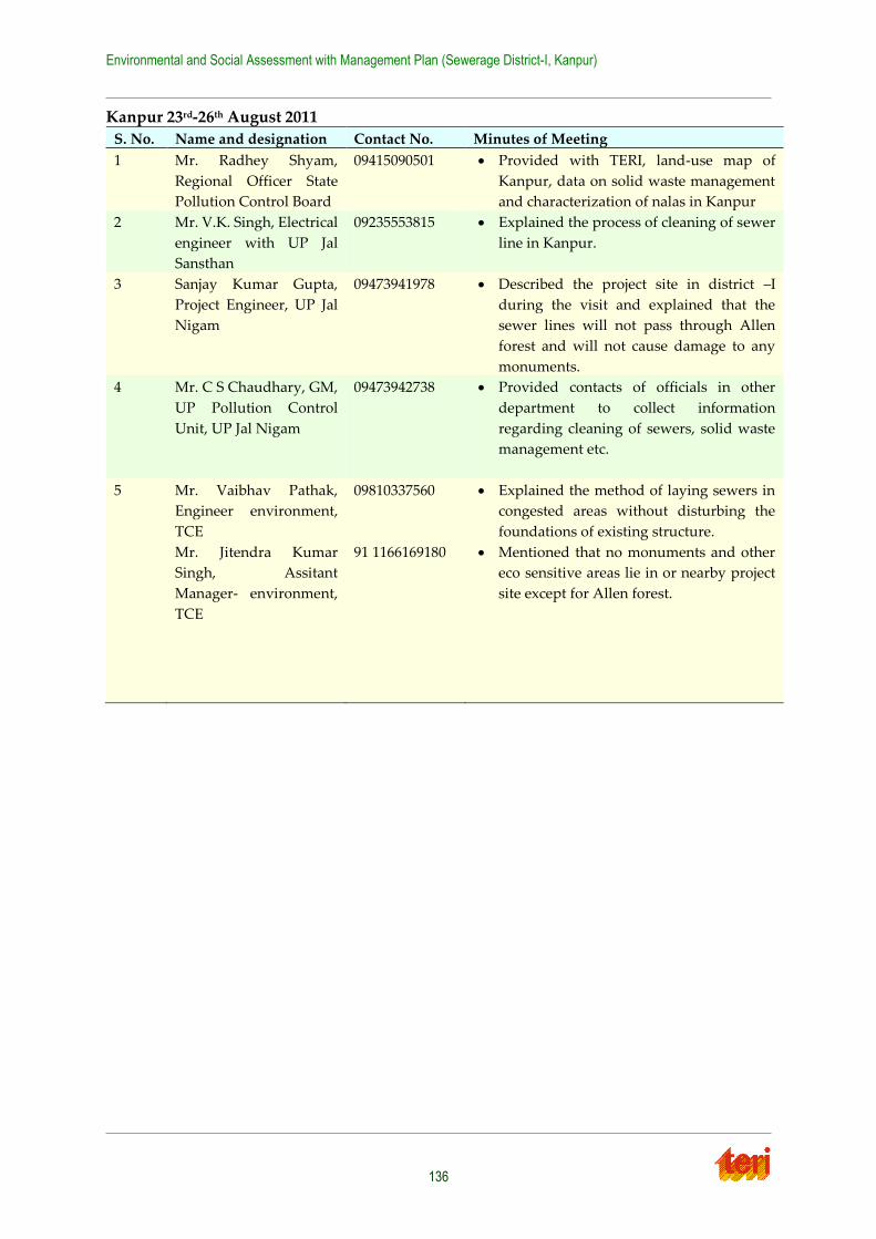
Environmental and Social Assessment with Management Plan (Sewerage District-I, Kanpur)
136
Kanpur 23rd-26th August 2011
S. No. Name and designation Contact No. Minutes of Meeting
1 Mr. Radhey Shyam,
Regional Officer State
Pollution Control Board
09415090501 Provided with TERI, land-use map of
Kanpur, data on solid waste management
and characterization of nalas in Kanpur
2 Mr. V.K. Singh, Electrical
engineer with UP Jal
Sansthan
09235553815 Explained the process of cleaning of sewer
line in Kanpur.
3 Sanjay Kumar Gupta,
Project Engineer, UP Jal
Nigam
09473941978 Described the project site in district –I
during the visit and explained that the
sewer lines will not pass through Allen
forest and will not cause damage to any
monuments.
4 Mr. C S Chaudhary, GM,
UP Pollution Control
Unit, UP Jal Nigam
09473942738 Provided contacts of officials in other
department to collect information
regarding cleaning of sewers, solid waste
management etc.
5 Mr. Vaibhav Pathak,
Engineer environment,
TCE
Mr. Jitendra Kumar
Singh, Assitant
Manager- environment,
TCE
09810337560
91 1166169180
Explained the method of laying sewers in
congested areas without disturbing the
foundations of existing structure.
Mentioned that no monuments and other
eco sensitive areas lie in or nearby project
site except for Allen forest.
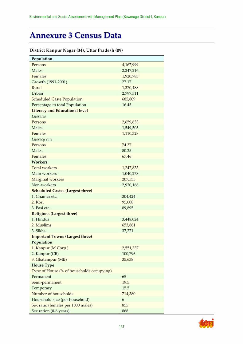
Environmental and Social Assessment with Management Plan (Sewerage District-I, Kanpur)
137
Annexure 3 Census Data
District Kanpur Nagar (34), Uttar Pradesh (09)
Population
Persons 4,167,999
Males 2,247,216
Females 1,920,783
Growth (1991-2001) 27.17
Rural 1,370,488
Urban 2,797,511
Scheduled Caste Population 685,809
Percentage to total Population 16.45
Literacy and Educational level
Literates
Persons 2,659,833
Males 1,549,505
Females 1,110,328
Literacy rate
Persons 74.37
Males 80.25
Females 67.46
Workers
Total workers 1,247,833
Main workers 1,040,278
Marginal workers 207,555
Non-workers 2,920,166
Scheduled Castes (Largest three)
1. Chamar etc. 304,424
2. Kori 95,008
3. Pasi etc. 89,895
Religions (Largest three)
1. Hindus 3,448,024
2. Muslims 653,881
3. Sikhs 37,271
Important Towns (Largest three)
Population
1. Kanpur (M Corp.) 2,551,337
2. Kanpur (CB) 100,796
3. Ghatampur (MB) 35,638
House Type
Type of House (% of households occupying)
Permanent 65
Semi-permanent 19.5
Temporary 15.5
Number of households 714,380
Household size (per household) 6
Sex ratio (females per 1000 males) 855
Sex ration (0-6 years) 868
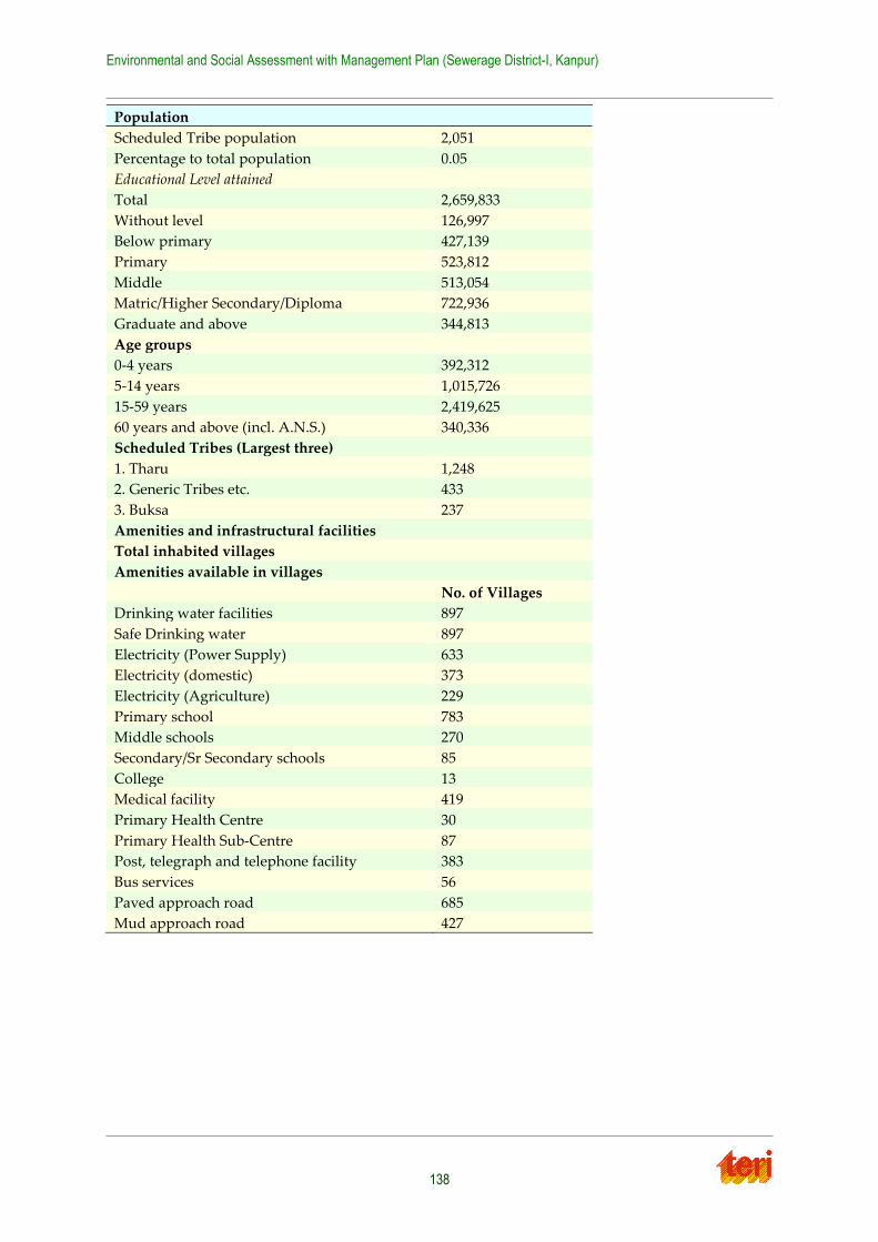
Environmental and Social Assessment with Management Plan (Sewerage District-I, Kanpur)
138
Population
Scheduled Tribe population 2,051
Percentage to total population 0.05
Educational Level attained
Total 2,659,833
Without level 126,997
Below primary 427,139
Primary 523,812
Middle 513,054
Matric/Higher Secondary/Diploma 722,936
Graduate and above 344,813
Age groups
0-4 years 392,312
5-14 years 1,015,726
15-59 years 2,419,625
60 years and above (incl. A.N.S.) 340,336
Scheduled Tribes (Largest three)
1. Tharu 1,248
2. Generic Tribes etc. 433
3. Buksa 237
Amenities and infrastructural facilities
Total inhabited villages
Amenities available in villages
No. of Villages
Drinking water facilities 897
Safe Drinking water 897
Electricity (Power Supply) 633
Electricity (domestic) 373
Electricity (Agriculture) 229
Primary school 783
Middle schools 270
Secondary/Sr Secondary schools 85
College 13
Medical facility 419
Primary Health Centre 30
Primary Health Sub-Centre 87
Post, telegraph and telephone facility 383
Bus services 56
Paved approach road 685
Mud approach road 427