Environment and Settlement: Ørland 600 BC – AD 1250
426
Ingrid Ystgaard (red.) NORDIC OPEN ACCESS SCHOLARLY PUBLISHING Environment and Settlement: Ørland 600 BC – AD 1250 ARCHAEOLOGICAL EXCAVATIONS AT VIK, ØRLAND MAIN AIR BASE
-
Upload
khangminh22 -
Category
Documents
-
view
4 -
download
0
Transcript of Environment and Settlement: Ørland 600 BC – AD 1250

EN
VIR
ON
ME
NT
AN
D S
ET
TL
EM
EN
T:
ØR
LA
ND
600 B
C – A
D 1
250
Ingrid Ystgaard (red.)
Ingrid Ystgaard (red.)
ISBN 978-82-02-66483-1
www.cda.no
NORDIC OPEN ACCESS SCHOLARLY PU BLISHING
During the Late Bronze Age, the Iron Age and early medieval period (c. 600 BC–AD 1250) settlement at Vik in the Ørland peninsula emerged, flourished, vanished and emerged anew. Local landscape and vegetation development, cross-regional cultural developments and global climatic events were of great significance to the farmer-fisher communities at Vik throughout these periods.
In this book, results from the 2014–2016 archaeological excavations at Ørland main air base have been refined and developed. The 13 papers deal with landscape, vegetation and environmental aspects related to the excavated settlement, as well as the spatial and social organization of the built environment. Building traditions, disposal practices, the form and representation of everyday objects, subsistence and landscape use are central to the discussions.
Environment and Settlement: Ørland 600 BC – AD 1250ARCHAEOLOGICAL EXCAVATIONS AT VIK, ØRLAND MAIN AIR BASE
Human Environment_HARDCOVER.indd All PagesHuman Environment_HARDCOVER.indd All Pages 29.11.2019 08:37:3329.11.2019 08:37:33

ENVIRONMENT AND SETTLEMENT: ØRLAND 600 BC - AD 1250
Archaeological excavations at Vik, Ørland main air base
Ingrid Ystgaard (ed.)

© 2019 Ingrid Ystgaard, Magnar Mojaren Gran, Ulf Fransson, Anders Romundset, Thomas R. Lakeman, Anette Overland, Kari Loe Hjelle, Johan Linderholm, Richard Macphail, Philip Buckland, Sofi Östman, Samuel Eriksson, Jan-Erik Wallin, Roger Engelmark, Aina M. Heen-Pettersen, Astrid B. Lorentzen, Marte Mokkelbost, Jan Storå, Marieke Ivarsson-Aalders, Grete Irene Solvold, Ellen Wijgård Randerz, Ellen Grav Ellingsen and Raymond Sauvage.
This work is protected under the provisions of the Norwegian Copyright Act (Act No. 2 of May 12, 1961, relating to Copyright in Literary, Scientific and Artistic Works) and published Open Access under the terms of a Creative Commons Attribution 4.0 International (CC BY 4.0) License (https://creativecommons.org/licenses/by/4.0/). This license allows third parties to freely share, copy and redistribute the material in any medium or format as well as adapt, remix, transform, and build upon the material for any purpose, including commercial purposes, provided the work is appropriately credited to the author(s), including a link to the license, and changes, if any, are thoroughly indicated. Attribution can be provided in any reasonable manner, however, in no way that suggests the author(s) endorse(s) the third party or the third party’s use of the work.
Third parties are prohibited from applying legal terms or technological measures that restrict others from doing anything permitted under the terms of the license. Note that the license may not provide all of the permissions necessary for an intended reuse; other rights, for example publicity, privacy, or moral rights, may limit third party use of the material.
This book is made possible with support from the Norwegian Defense Estate Agency and the Departement of Archaeology and Cultural History at NTNU University Museum.
ISBN print edition: 978-82-02-66483-1ISBN web-PDF: 978-82-02-59531-9 DOI: https://doi.org/10.23865/noasp.89
This book is a peer-reviewed anthology.
Typesetting and cover design: Have a bookList of photographers, photos before each chapter:
Magnar Mojaren Gran: Preface, chapter 2, 3, 4, 5, 11.Åge Hojem: Chapter 1, 7, 9, 10, 12, 13.Ingrid Ystgaard: Chapter 6Marte Mokkelbost: Chapter 8
Front cover photo: Åge Hojem
Cappelen Damm Akademisk/[email protected]
FORSVARSBYGGNORWEGIAN DEFENCE ESTATES AGENCY

CONTENTS
Ingrid YstgaardPREFACE 9
Ingrid Ystgaard | Magnar Mojaren Gran | Ulf Fransson ENVIRONMENT AND SETTLEMENT AT VIK, ØRLAND: A PHASE FRAMEWORK 23
Anders Romundset | Thomas R. LakemanSHORELINE DISPLACEMENT AT ØRLAND SINCE 6000 CAL. YR BP 51
Anette Overland | Kari Loe HjelleVEGETATION DEVELOPMENT AT ØRLAND, AND IN THE REGION, FROM 260 BC TO THE PRESENT 69
Johan Linderholm | Richard Macphail | Philip Buckland | Sofi Östman | Samuel Eriksson | Jan-Erik Wallin | Roger EngelmarkØRLANDET IRON AGE SETTLEMENT PATTERN DEVELOPMENT: GEOARCHAEOLOGY (GEOCHEMISTRY AND SOIL MICROMORPHOLOGY) AND PLANT MACROFOSSILS 107
Ulf FranssonPRE-ROMAN IRON AGE HOUSES AT VIK: AN ANALYSIS OF CONSTRUCTION, FUNCTION AND SOCIAL SIGNIFICANCE 135
Aina m. Heen-Pettersen | Astrid B. LorentzenROMAN IRON AGE AND MIGRATION PERIOD BUILDING TRADITIONS AND SETTLEMENT ORGANISATION AT VIK, ØRLAND 167
Marte MokkelbostROMAN PERIOD WASTE DEPOSITS AT ØRLAND, NORWAY 195
Jan Storå | Marieke Ivarsson-Aalders | Ingrid YstgaardUTILIZATION OF ANIMAL RESOURCES IN ROMAN IRON AGE VIK: ZOOARCHAEOLOGY AT ØRLAND 233
6
Environment and settlement | contents
Grete Irene SolvoldTHE POTTERY AT VIK IN THE EARLY IRON AGE 261
Ulf FranssonA FARMSTEAD FROM THE LATE VIKING AGE AND EARLY MEDIEVAL PERIOD. HOUSE CONSTRUCTIONS AND SOCIAL STATUS AT VIK, ØRLAND 323
Ellen Wijgård RanderzA SHOE, A TROUGH AND A TINY BOAT: A STUDY OF EVERYDAY OBJECTS FROM THE MEDIEVAL FARM VIK, ØRLAND, CENTRAL NORWAY 353
Ingrid YstgaardSPATIAL ORGANIZATION OF FARMSTEADS AT IRON AGE AND EARLY MEDIEVAL VIK (C. 400 BC – AD 1250) 373
Ellen Grav Ellingsen | Raymond SauvageTHE NORTHERN SCANDINAVIAN VIKING HALL: A CASE STUDY FROM VIKLEM IN ØRLAND, NORWAY 399


9
Ingrid YstgaardDepartment of Archaeology and Cultural History, NTNU University MuseumDepartment of Historical Studies, Norwegian University of Technology and [email protected]
Preface
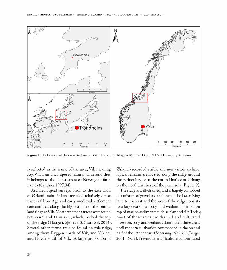
ØRLAND AND VIK: GEOGRAPHY AND ARCHAEOLOGYØrland is a flat, low-lying peninsula, situated on the Norwegian coast, at the mouth of the Trondheim fjord (Figure 1). The name of the peninsula means the land of the flat, wide tidal zone (Schøning 1979:283). The Trondheim fjord reaches far inland, and connects the important sea route along the Norwegian coast to one of Norway’s main agricultural regions on the eastern shores of the Trondheim fjord. Records of several harbours in the outer Trondheim fjord area show the region’s significance in communications and trade in ancient and historical times (Henriksen 1997:102-108, Sognnes 2005:188-189, Berglund & Solem 2017). The coastal region in central Norway is very rich in marine resources and has a long history of fisheries (Elvestad 1998). The landscape in the coastal region is less well suited for crop cultivation, but the fertile Ørland peninsula with its marine sediments constitutes an exception (Herje 1984:4, Berger 2001:33-34). Due to the strategic significance of its geographical position, and to the rich marine and agricultural resources, the outer Trondheim fjord area in general and Ørland in particular have a very rich archaeological record (Berglund & Solem 2017, Figure 2). In the eastern, higher lying parts of the peninsula there are several traces of Bronze Age
occupation and ritual activities (Henriksen 2014:157). Bronze axes have been found in Astrått, Hovde and Storfosna (Henriksen 2014:172, Berglund & Solem 2017:209). A birch bark vessel containing so-called bog butter, dating to the transition between the Bronze Age and the pre-Roman Iron Age, was found in Røstad (Henriksen 2014:157). Across the peninsula, there are several Iron Age burials. The burials tend to be particularly well preserved. Iron Age burials contain both weaponry and jewellery. They also often contain preserved remains of the deceased, as a result of the calcareous, shell-sand soils (Herje 1984:4, Stuedal 1998). There are several recorded and preserved large burial mounds with a diameter of more than 20m (Figure 2, Forseth & Foosnæs 2017, cf. Ringstad 1987, Berglund & Solem 2017). There has also been found payment gold at Røstad near Austrått (Berglund & Solem 2017:209). A number of settlement sites from the Iron Age and medieval periods have been exca-vated in recent years (Grønnesby 1999, Birgisdottir & Rullestad 2010, Mokkelbost & Sauvage 2014, Sauvage & Mokkelbost 2016, Eidshaug & Sauvage 2016, Ellingsen & Sauvage Ch. 13). There are records of at least three medieval churches that no longer exist (Brendalsmo 2001:291-293). Two medieval churches are still standing at Viklem and Austråt,

10
Environment and settlement | Ingrid Ystgaard
the latter forming part of a 16-17th century manor complex (Andersen & Bratberg 2011:66). The number of preserved Iron Age burials, large burial mounds, medieval churches, and large-scale Iron Age settlement sites excavated in Ørland places it among the areas in central Norway with the high-est densities of Iron Age and medieval remains (cf. Forseth & Foosnæs 2017).
Today, Vik lies on on a marked, dry ridge, c. 11m above sea level, in the central parts of the Ørland peninsula. However, the name of Vik together with the shape of today’s landscape reveal that in earlier times, Vik (meaning bay) was indeed situated next
to a large, shallow bay which covered large parts of what is today dry land. The flat profile of the land, combined with the land upheaval after the last Ice Age, has caused profound changes to the landscape since Ørland rose from the sea in the last part of the Bronze Age and right up to today. Archaeological remains reveal that Vik had a cen-tral and strategic position in Ørland during the Early Iron Age (for the Norwegian chronological scheme see Table 1). A number of graves have been excavated along the ridge at Vik, and one of Ørland’s medieval churches was situated at Vik (Brendalsmo 2001:293).
Figure 1. The location of the excavated area at Vik. Illustration: Magnar Mojaren Gran, NTNU University Museum.

11
Preface
EXTENSION OF ØRLAND MAIN AIR STATION. SURVEY AND EXCAVATIONIn World War II, during the German occupation of Norway (AD 1940 – 1945), the German occu-pational forces established an airfield in the central parts of Ørland. The main part of the airfield was located at Vik. After the war, the Norwegian Air Force developed the airfield as a base for F16 jet fighters (Hovd 2004). In 2012, the Norwegian Parliament decided on investing in an entirely new fleet of F35 jet fighters, and that these jets should be stationed in Ørland. As a result, the existing air base had to be enlarged. As part of the planning of the extended air base, an extensive archaeological survey was conducted by Sør-Trøndelag (South Trøndelag) County Council in 2013 (Figures 3
Figure 2. Large burial mounds, Iron Age graves and medieval churches in Ørland. The stone churches at Austrått and Viklem are still standing. Illustration: Magnar Mojaren Gran, NTNU University Museum.
Bronze AgeEarly Bronze Age 1700 – 1100 BCLate Bronze Age 1100 – 500 BCEarly Iron AgePre-Roman Iron Age 500 – 1 BCEarly Roman Iron Age AD 1 – 200Late Roman Iron Age AD 200 – 400Migration period AD 400 – 575Late Iron AgeMerovingian period AD 575 – 800Viking period AD 800 – 1030Medieval periodEarly medieval period AD 1030 – 1130High medieval period AD 1130 – 1350Late medieval period AD 1350 – 1537Modern period AD 1537 – now
Table 1. Chronological table.

12
Environment and settlement | Ingrid Ystgaard
and 4). The survey revealed that relatively dense Iron Age settlement traces were located along the central ridge running through Ørland from north to south, approximately 11m above the present day sea level. A large part of the surveyed archaeological remains were found within the planned extension area of the air base at Vik (Haugen, Sjøbakk & Stomsvik 2014).
An initial archaeological excavation was con-ducted by the Norwegian University of Science and Technology (NTNU) University Museum in 2014, in order to allow for the building of a tempo-rary construction road. The excavation revealed the
outskirts of early Iron Age settlement areas, with postholes, cooking pits, agricultural layers and water holes (Fields 1-3, Figure 5; Engtrø & Haug 2015). The main part of the archaeological excavation was conducted by the NTNU University Museum in 2015 and 2016 (Fields A-E, Figure 5; Ystgaard et al. 2018). The survey and excavations were financed by the Norwegian Defence Estates Agency (NDEA), according to the terms of the exemption from the protection by the Cultural Heritage Act granted by the Directorate for Cultural Heritage. In a sep-arate agreement between the NDEA and NTNU University Museum, the NDEA agreed to finance
Figure 3. Overview of the Ørland airfield planning area and sites with mainly Iron Age settlement remains under cultiva-ted land, surveyed by Sør-Trøndelag County Council in 2013 (Haugen, Sjøbakk & Stomsvik 2014). Illustration: Magnar Mojaren Gran, NTNU University Museum.

13
Preface
the publication of results from the excavation in a scientific publication – the present book.
EXCAVATION AIMS, RESEARCH OBJECTIVES AND THE CONTENTS OF THIS BOOKThe geography of Vik is of a special character. The flat landscape has led to comparatively rapid landscape changes throughout the Iron Age and medieval periods due to land upheaval. Moreover, the Ørland
peninsula and Vik seem to have been more or less continuously settled from the time the peninsula became inhabitable. This has made the area a suit-able laboratory for the study of relations between landscape change, vegetation and human activity throughout the Iron Age and medieval periods.
The excavations conducted prior to the extension of Ørland airbase are among the hitherto largest excavations in Norway in terms of area size, cov-ering c. 117 000m2 altogether. Development-led
Figure 4. Survey trenches from 2013 (Haugen, Sjøbakk & Stomsvik 2014), defining protected area with Iron Age and early medieval settlement traces (ID 174774, 60212, and 174801). Parts of the protected area were excavated in 2014, 2015 and 2016. Survey trenches extended throughout the planned area of the airfield (Figure 3). Illustration: Magnar Mojaren Gran, NTNU University Museum.
Figure 5. Excavation area with Fields 1-3 (2014 excavation, Engtrø & Haug 2015) and Fields A-E (2015 and 2016 excavations, Ystgaard et al. 2018). Illustration: Magnar Mojaren Gran, NTNU University Museum.

14
Environment and settlement | Ingrid Ystgaard
excavations are often connected to road and railway projects, and only cover those parts of settlement sites that happen to lie in the confined area of the road or railway construction sites. This means that the totality of a settlement is often not explored and excavated. However, at Vik a larger area could be excavated due to the size of the planned air base enlargement. Because of this, the totality of several settlement concentrations could be examined. This has contributed to the large scientific potential of the Vik excavations.
Based on these preconditions, the main part of the excavations at Vik carried out in 2015 and 2016 had two main aims or research frameworks as guidelines:
1. To gain a coherent understanding of the rela-tionship between landscape development and settlement from the Late Bronze Age to the early medieval period.
2. To study the spatial and social organization of the settlement from the Late Bronze Age to the early medieval period.
A starting point for the first research framework was an already existing shore displacement curve for the region (Kjemperud 1986), but the curve lacked detailed data from c. 1000 BC to the present. Therefore, an important question was how more nuanced data would affect the shoreline displacement curve. The Norwegian Geological Survey agreed to provide more nuanced data in order to make a more detailed shore displacement curve. The new curve is presented by Romundset & Lakeman in Chapter 2. Today, most of Ørland is cultivated, but much land was only cultivated relatively recently, after large swamps and marshes had been drained (Schøning 1979:293, Berger 2001:36-37). Only limited data existed on the vegetation history and natural con-ditions in Ørland before modern times. Therefore,
it was of great importance to gain new, coherent pollen data from the region and from the local area surrounding Vik, as well as from the excavation area itself. The Natural History Department at the University Museum, University of Bergen, agreed to perform pollen analysis and so help us to deepen our understanding of the environment, natural conditions, landscape development, settlement and farming economy in Ørland and at Vik. Their results are presented by Overland & Hjelle in Chapter 3. The results from the shoreline displacement curve and the vegetation history analysis are co-inter-preted with large-scale tendencies in the data from the archaeological excavations at Vik by Ystgaard, Gran & Fransson in Chapter 1. This chapter also provides a phasing and a chronological framework for the interpretations in each chapter of this book.
A starting point for the second research framework was the survey results, which revealed that several concentrations of Iron Age settlement traces from different parts of the Iron Age and medieval period were found along the well-drained ridge at Vik (Haugen, Sjøbakk & Stomsvik 2014). The 2015 and 2016 excavations uncovered traces of eight different concentrations of settlement, dating from varying phases from the pre-Roman Iron Age to the medie-val period (Ystgaard et al. 2018). A series of studies of the spatial organization of the settlement traces, and to some extent also of the social organization implied, is presented in this volume. Work with the analysis of the spatial organization of the settlement took up much of the project group’s time. Therefore, analysis of the social organization was narrowed down to the exploration of aspects related to the spatial organization. The social organization of the settlement has therefore not yet been fully analyzed.
Geoarchaeological analyses and interpretations were of vital importance to the study of spatial organ-ization of settlement from most phases. Results from geoarchaeological studies, including geochemistry,

15
Preface
soil micromorphology and plant macrofossil studies, are presented by Linderholm, Macphail & Buckland in Chapter 4. Results from the archaeological excavations are presented chrono logically, with emphasis on research questions relevant to each period. Most chapters relate to the main research framework, focusing on spatial organization of the settlement. Pre-Roman Iron Age houses and farmsteads are discussed by Fransson in Chapter 5. Roman Iron Age settlement traces were abundant and very informative, and thus four of the chapters in this book focus on material from this period. Building traditions and settlement organization in the Roman Iron Age are discussed by Heen-Pettersen & Lorentzen in Chapter 6. Large waste deposits were preserved in Roman Iron Age contexts. The waste deposits, their spatial relations to contem-porary settlement, and their information potential are presented by Mokkelbost in Chapter 7. Most zooarchaeological material stemmed from Roman Iron Age contexts, and mainly from waste deposits. This large and informative material is presented by Storå, Ivarsson-Aalders & Ystgaard in Chapter 8. Roman Iron Age contexts also yielded relatively large quantities of pottery. Pottery is rarely found in large amounts in central Norwegian settlement sites from this period. Therefore, pottery from Vik is thoroughly analyzed and presented by Solvold in Chapter 9. After the extensive settlement activity in the Roman Iron Age, settlement declined from the last part of the Roman Iron Age and during the first part of the Migration period. Around AD 550, settlement at Vik was completely abandoned. New settlement traces did not occur until the late Viking Age. Two chapters deal with remains of a late Viking Age / early medieval period farmstead. Settlement remains are presented and discussed by Fransson in Chapter 10, while exceptionally well preserved finds of organic material from a well that was examined in this farmstead are presented
by Randerz in Chapter 11. Spatial organization of the built environment in Vik from the Late Bronze age to the early medieval period, and some aspects of the social organization, are summarized and discussed by Ystgaard in Chapter 12. These results are highlighted by a discussion of the finds of a hall environment from the Viking Age in nearby Viklem by Ellingsen & Sauvage in Chapter 13.
PROJECT PUBLISHING POLICYThe size and potential of the material from the Vik excavations led the project group to make a few choices regarding the publishing policy of the project. As soon as the NDEA had granted funding for a scientific publication of the excavation results, the outlines of a publishing policy in three stages were established. The first stage of publication is the exca-vation report (Ystgaard et al. 2018). The excavation report contains the basic results of the excavation, and gives the reader access to the immediate results and interpretations of the excavated areas. This includes full site descriptions, a list of excavated features, a finds catalogue, a list of radiocarbon dates, and lists of macrofossil samples, micromorphological samples, pollen samples, wood determinations, photos and drawings.
This book represents the second stage of publica-tion. Here, the excavation results have been refined through a second stage of scientific processing and writing, focusing on research questions which developed out of the research frames of the orig-inal excavation project. An aim of this scientific publication has been to allow the archaeologists in the project group to expand on their results from the fieldwork, through defining tighter research objectives and presenting their results to a scientific audience. Field supervisors were included early on in the planning of the publication. It is my belief that this helped field supervisors maintain high standards of scientific quality both in their day-to-day work

16
Environment and settlement | Ingrid Ystgaard
in the field and in their work with the excavation report. It also helped them maintain high standards in their scientific thinking and in the discussions within the excavation team and the project group. In the long term, the opportunity to scientifically develop and publish excavation results helps field archaeologists gain scientific merits and develop their careers. Scientifically merited field archaeol-ogists with sound careers are of vital importance to ensure a close connection between excavation archaeology and scientific development within the field of archaeology. There is no doubt that scien-tifically up-to-date field archaeology is vital to the legitimation of the excavation practice in today’s cultural heritage management.
An opportunity to publish results is also of impor-tance to the projects’ specialist cooperators. The common aim of a project publication encourages communication and scientific discussions between the specialists, and between the specialists and archaeologists. It is our experience that the con-tinuously ongoing dialogue between archaeologists and specialists, and also between different specialists, raises the quality of the work we do developing our objectives. I also raises the quality of our fieldwork, analyses and discussions (cf. Gjerpe 2013).
The third stage of publication starts as soon as the Vik material has been made available to the scientific community through the excavation report and this book. The Vik material has the potential to raise and contribute to several research objectives, both cultural historical, methodological and theoretical. Archaeologists and other scientists can now explore the opportunities found in the results of a methodo-logically up-to-date and scientifically facilitated material. Below, a few questions are outlined which have not yet been thoroughly addressed.
FURTHER SCIENTIFIC POTENTIAL OF THE VIK MATERIALThe results of the collaboration between archaeolo-gists and natural scientists can be developed into further research. In particular, there is a poten-tial in closer comparisons between the empirical archaeological data sets and the results of the geological, botanical, and soil chemical analyses – this could lead, among other things, to closer discussions about the nature of animal husbandry and agriculture, and their relation to settlement and natural conditions.
Methods and possibilities within radiocarbon dating have developed continually since the introduc-tion of radiocarbon dating in the 1950s. Today, it is possible to date very small amounts of charred mate-rial, and at the same time the costs for each sample are going down (Bayliss 2009:125). Accordingly, the Vik project chose to lead an ambitious sampling and dating policy. Radiocarbon samples were collected from a wide range of contexts. Samples were prio-ritized for dating from all the excavated buildings, and from a wide selection of waste deposits, cooking pits and agricultural layers. Altogether 626 radio-carbon dates from varying contexts from Vik have been dated. The large dating material represents the settlement activity in Vik very well, and this opens up many possibilities when it comes to chronological and methodological issues. The next step could be to analyze the dating material further, employing statistical analytical methods in order to establish more nuanced chronologies (Bayliss 2009:126). Within the second stage of publishing, i.e. this pub-lication, the project group had the chance to perform initial statistical analysis of the radiocarbon sample set (Ystgaard, Gran & Fransson, Ch. 1). However, the statistical modelling of radiocarbon dates has been restricted to initial modelling at this stage of publication. Bayessian modelling presupposes that a number of a priori interpretations are conducted

17
Preface
before one perfoms the statistical modelling of the dating material (Bayliss 2015, Herschend 2016). In this volume, focus has been on the a priori interpre-tations. Our preliminary modelling results are not ready for publication in this volume. However, the groundwork in terms of archaeological interpreta-tions has been done, and the material is ready for the next step of chronological analysis.
Chronological questions concerning the Vik material can be asked on many different levels. A key area is narrowing down the probability of the date spans for a large number of archaeological contexts such as buildings and waste deposits. This might well make it possible to refine quite a few of the chronological discussions in the excavation report and in this book. The total sum of radiocarbon dates can be employed to explore main chronological events of the site, for instance to determine more exactly when the site was first inhabited with per-manent buildings. Perhaps even more interesting is the potential for dating and assessing the nature of the abandonment of the settlement around AD 550, and interpreting this in the light of the Late Antique Little Ice Age (Büntgen et al. 2016) as it is recorded in global natural historical and archaeo-logical records.
Further cultural historical questions can also be explored based on the Vik material. In this volume, the nature and contacts of the finds material, apart from the pottery from buildings and waste deposits, has not been addressed specifically. A first impres-sion is that the material from the Roman Iron Age settlement contexts does not differ fundamentally from contemporary grave contexts. This impression could be something to pursue more closely, compar-ing the material worlds of the living and the dead.
Another area that offers potential is a deeper examination of the relation between the various subsistence practices in Roman Iron Age Vik. The different aspects of the Vik material represent widely
different practices such as fisheries, shell foraging, animal husbandry, crop cultivation and hunting. The rich and well-documented animal osteological mate-rial could form the starting point of several studies which could go in a diversity of directions, employing analytical methods such as aDNA, strontium and isotope analysis. Such studies could deepen our knowledge not only of the economic organization of the Roman Iron Age farmsteads at Vik, but also of the development of domesticated animals and of cod fisheries prior to the development of commercial fisheries in the medieval period.
A large number of cooking pits were uncovered and excavated during the project. This intriguing material has so far been only superficially treated, and further analyses, perhaps in combination with the already analyzed pottery material (Solvold, Ch.9), will undoubtedly bring new light to our knowledge of pre-Roman and Roman Iron Age commensality and rituals.
A preliminary interpretation of the organizations of Iron Age and Early medieval buildings and farmsteads has been provided in this book. In 1997, a pre-Roman Iron Age farmstead was excavated at Hovde, approximately 3km south of Vik. Hovde is situated on the same well-drained ridge as Vik (Grønnesby 1999). A comparison between the set-tlement remains at Vik and Hovde could provide deeper insights into the organization of society in Ørland in the Early Iron Age. It is possible to extend the comparison of Early Iron Age settlements further, and widen it into a synthesis of central Norwegian settlement material. This could form the basis of a deeper analysis of the social organization of the Iron Age societies at Vik, central Norway and Norway. Further, there is potential in a comparison between the late Viking Age and early medieval settlement at Vik, presented by Fransson, Ch. 10, and the Viking age settlement at Viklem, presented by Ellingsen & Sauvage, Ch. 13.

18
Environment and settlement | Ingrid Ystgaard
DEVELOPMENT-LED EXCAVATIONS AND THEIR SCIENTIFIC POTENTIALNorwegian cultural heritage management practice is based on the Cultural Heritage Act (Lov om kul-turminner). Among other things, two principles of this Act are of importance to development-led exca-vations. First, all archaeological and other remains older than AD 1537 (the year of the Lutheran Reformation in Norway) are protected. Exemptions from protection are sometimes granted for develop-ment projects. Every such decision is based on an evaluation of the cultural heritage site(s) in question, focusing on the scientific value of an excavation as opposed to the value of continued preservation. Second, if an exemption is granted, the developer applying for exemption has to finance the costs of archaeological excavation (polluter pays principle).
The excavations at Vik were development-led and financed by the developer, in accordance with the provisions in the Cultural Heritage Act. Development-led excavations should safeguard the source value of the archaeological remains in question, according to the established practice of Norwegian archaeological heritage management. However, such development-led excavation projects are not supposed to extend their work into, or to finance, scientific research or scientific publications. Therefore, development-led excavations are seldom extended scientifically beyond the incorporation of the finds material in museum collections and the publication of the excavation report in a museum’s report series.
However, somewhat paradoxically, the Directorate for Cultural Heritage (Riksantikvaren) demands that development-led excavations are based on research questions emanating from the “current state of research”. Today, all archaeological excavations (except for medieval towns, churches and fortresses)
are carried out by five university museums in Norway (based in Tromsø, Trondheim, Bergen, Stavanger, and Oslo). When a university museum is planning a development-led excavation, it often finds there is no up-to-date “state of research” review upon which it can draw, since earlier development-led excavations are most often not processed scientifically beyond the basic excavation reports.
In other words, the “current state of research”, which is, as we have seen, demanded as a start-ing-point for new excavations, is often non-existent. This means that new archaeological excavations, and research developing from them, lack an up-to-date scientific evaluation of results from earlier devel-opment-led excavations. Museums’ collections and excavation reports are of course of vital importance. However, if the aim of cultural heritage manage-ment is to carry out archaeological excavations based on an updated research status, the results of these excavations need to be developed beyond the excavation reports, into publications and subsequent research projects. Without up-to-date results and scientific analysis from development-led excavations to draw upon, new development-led excavations tend to reproduce existing knowledge instead of challenging it.
Thanks to the generous cooperation of the Norwegian Defence Estate Agency and a separate agreement between the NDEA and the NTNU University Museum, the Vik project had the chance to go beyond the limits of today’s practice, and pre-pare this volume, which represents a first scientific processing of the Vik material. We sincerely hope that this volume will lift the Vik material into the consciousness of the scientific community, and that the scientific processing of the results presented here will contribute to further scientific development of the practice of development-led excavations.

19
Preface
ACKNOWLEDGEMENTSWe are profoundly grateful to the Norwegian Defence Estate Agency for granting us the opportunity to write this book. We also want to thank our editor at Cappelen Damm Akademisk, Simon Aase, and our copy editor, Richard Peel. The authors are grateful for
the comments by the anonymous peer reviewers. We would like to thank the Department of Archaeology and Cultural History at NTNU University Museum for facilitating the Vik project during four years. Last, but not least, a sincere thank you to the project’s field archaeologists for their enthusiasm and courage.

20
Environment and settlement | Ingrid Ystgaard
REFERENCES
Andersen, H. A. & T. Bratberg 2011: Austrått. En norsk herregårds historie. Pirforlaget, Trondheim.
Bayliss, A. 2009: Rolling out revolution: Using radiocarbon dating in archaeology. Radiocarbon, Vol 52, Nr 1: 123–147.
Bayliss, A. 2015: Quality in Bayesian chronological models in archaeology. World Archaeology Vol. 47, Nr. 4: 677–700.
Berger, O. G. 2001: Utdrag fra Ørland. En kyst- og garnisonskommune. Om utviklingen av jordeiendomsforhold og kulturlandskap fra middelalderen og fram til år 2000. Hovedfagsoppgave i geografi, Universitetet i Trondheim.
Berglund, B. & T. Solem 2017: Maktkontinuitet i munningen av Trondheimsfjorden. Arkeologi og vegetasjonshistorie 800 BC – 1200 AD. Heimen, 3-2017 Vol. 56: 206–235.
Birgisdottir, B. B. & S. Rullestad 2010: Utgravningsrapport 2010. Hårberg (gnr. 69/6) Ørland kommune, Sør-Trøndelag fylke. Undersøkelse i tilknytning til regulerings-plan for ny adkomstvei frå Fv. 245 til Hårberg bustadfelt i Ørland kommune, Sør-Trøndelag fylkeskommune. NTNU Vitenskapsmuseet topografisk arkiv.
Brendalsmo, J. 2006: Kirkebygg og kirkebyggere. Byggherrer i Trøndelag ca. 1000 – 1600. Unipub forlag.
Büntgen, U. et al. 2016: Cooling and societal change during the Late Antique Little Ice Age from 536 to around 660 AD. Nature Geoscience, vol. 9, issue 3. ISSN 1752-0894.
Eidshaug, J. S. P. & R. Sauvage 2016: Arkeologisk undersøkelse av gårdshaug på Viklem, Ørland kommune. NTNU Vitenskapsmuseet arkeologisk rapport 2016:11.
Elvestad, E. 1998: Typologi som arkeologisk praksis. En analyse av klassifiserte fiskeredskaper fra Trøndelags forhistorie. Hovedfagsoppgave i arkeologi, Universitetet i Trondheim.
Engtrø, D. Ø., & A. Haug, 2015: Arkeologiske undersøkelser - anleggsvei på Ørland kampflybase, Ørland kommune, Sør-Trøndelag. NTNU Vitenskapsmuseet arkeologisk rapport 2015:2.
Forseth, L. & K. Foosnæs 2017: Maktens monumentalitet. Frostatingets lokalisering sett i lys av storhaugene i Trøndelag. In Risbøl, O. (ed.): Frostatinget i et historisk lys. Gunneria 81: 41–70. NTNU Vitenskapsmuseet, Trondheim.
Gjerpe, L. E. 2013: Om arkeometri, en fornøyd arkeologi og jordbruk i eldre jernalder. Primitive Tider 2013: 33–46.
Grønnesby, G. 1999: Eldre jernalders hus og hall på Hovde i Trøndelag. Viking 62: 69–80.
Haugen, H., I. Sjøbakk & K. H. Stomsvik 2014: Arkeologisk rapport. Maskinell søkesjakting og manuell prøvestikking i forbindelse med reguleringsplan for ny kampflybase, samt ny gang- og sykkelveg mellom Uthaug og Hårberg, Ørland kommune. Sør-Trøndelag fylkeskommune.
Henriksen, M. M. 1997: Nøkkelen til Trøndelag. Bosetning, kommunikasjon og kontroll. Agdenes og Snillfjord 500 f.Kr. til 1000 e.Kr. Hovedoppgave i arkeologi ved Institutt for arkeologi og kulturhistorie, Vitenskapsmuseet, NTNU.
Henriksen, M. M. 2014: Stille vann har dyp bunn. Offerteoriens rolle i forståelsen av depotfunn belyst gjennom våtmarksdepoter fra Midt-Norge ca. 2350-500 f.Kr. Avhandling (Ph.D.), Norges teknisk-naturvitenskapelige universitet, Det humanistiske fakultet, Institutt for historiske studier, 2014:304.
Herje, T. 1984: Landskap og samfunn i endring. Bjugn og Ørlandet i jernalder – en analyse av økonomi og samfunnsorganisasjon i et midt-norsk kystmiljø. Avhandling til magistergraden i nordisk arkeologi ved Universitetet i Oslo.
Herschend, F. 2016: Towards a standardized discussion of priors in Bayesian analyses of 14C dated archaeological periods: A study based on the dates from Gjøsund. Journal of Archaeology and Ancient History Nr. 19.
Hovd, R. (ed.) 2004: Ørland hovedflystasjon. Okkupasjon – Kald krig – Ny tid – Lokalsamfunn. Ørland hovedflystasjon, Ørland.
Kjemperud, A. 1986: Late Weichselian and Holocene shoreline displacement in the Trondheimsfjord area, Central Norway. Boreas 15: 61–82.
Mokkelbost, M. & R. Sauvage 2014: Arkeologisk utgravning Ørland kirkegård, Ørland kommune. NTNU Vitenskapsmuseet arkeologisk rapport 2014:16.
Ringstad, B. 1987: Vestlandets største gravminner. Et forsøk på lokalisering av forhistoriske maktsentra. Magistergradsavhandling, Bergen.
Sauvage, R. & M. Mokkelbost 2016: Rural buildings from the Viking and early medieval period in Central Norway. In: Iversen, F. & H. Petersson (eds.): The agrarian life of the North 2000 BC – AD 1000. Studies in rural settlement and farming in Norway, pp. 275-292. Kristiansand. Portal Academic.
Schøning, G. 1979 [1778]: Reise som giennem en deel af Norge i de aar 1773, 1774, 1775 på Hans Majestæt Kongens bekostning er giort og beskreven af Gerhard Schøning. Tapir, Trondheim.

21
Preface
Sognnes, K. 2005: I bronsens og jernets tid. In: Aune, K. (ed.): Fosens historie fra istid til 1730, pp. 137–198. Skrifter utgitt av Fosen historielag 7, Orkanger.
Stuedal, H. V. 1998: Rapport fra arkeologisk utgravning av 2 flatmarksgraver, Uthaug gnr. 74, bnr. 10 Liabø, Ørland kommune, Sør-Trøndelag. Topografisk arkiv, NTNU Vitenskapsmuseet.
Ystgaard, I., M. M. Gran, M. Mokkelbost, U. Fransson, A. Heen-Pettersen, A. B. Lorentzen, G. I. Solvold & E. W. Randerz 2018: Arkeologiske utgravninger på Ørland kampflybase 2015 – 2016. NTNU Vitenskapsmuseet arkeologisk rapport 2018:27.


23
c h a p t e r 1
Ingrid Ystgaard Department of Archaeology and Cultural History, NTNU University MuseumDepartment of Historical Studies, Norwegian University of Technology and [email protected] Mojaren Gran Department of Archaeology and Cultural History, NTNU University MuseumUlf Fransson Department of Archaeology and Cultural History, NTNU University Museum
Environment and settlement at Vik, Ørland: A phase framework
ABSTRACTAn aim of the excavation project at Vik was to gain a coherent understanding of the relationship between landscape develop-ment, vegetation history, climatic change and settlement at Vik from the Late Bronze Age to the early medieval period. The flat profile of the Ørland peninsula and the postglacial land upheaval have caused a profound transformation of the land-scape since the peninsula rose from the sea c. 600+/-100 BC (Romundset & Lakeman, Ch. 2). A sheltered bay formed a safe harbor during the period from c. 400 BC to AD 600, when the bay eventually dried out and left the settlement at Vik in a less strategic position. An extensive pollen analysis provided data on vegetation history, and also on effects of climatic change (Overland & Hjelle, Ch. 3). A generalized interpretation of archaeological and botanical data from Vik suggests periods of intensive settlement and agriculture in the Pre-Roman Iron Age and Roman Iron Age, while the Migration Period was a period of decline. Settlement and agriculture nearly disappeared in Vik during the Merovingian and Early Viking periods, coinciding with the re-vegetation of the landscape after the global climatic catastrophe of AD 536. Vik was re-settled very late, not before c. AD 950, possibly because of the extinction of the bay and the harbor due to land upheaval. In this paper, land upheaval, vegetation history and settlement development at Vik are combined in a scheme of ten phases. The phasing provides an introduction and a chronological and interpretational framework to the papers in this book.
INTRODUCTIONThe landscape of the Ørland peninsula is particu-larly flat, compared to the hilly coastal landscape surrounding the mouth of the Trondheimsfjord (Figure 1). The flatness of the landscape in com-bination with the postglacial land upheaval has caused profound transformation of the landscape
since the highest part of the peninsula rose from the sea in the Late Bronze Age (Kjemperud 1986). Today, Vik is found in the central part of Ørland, but the landscape profile of the peninsula reveals that there was a bay east of Vik during parts of the period between the time when the highest ridge rose from the sea and now. This landscape feature
24
Environment and settlement | Ingrid Ystgaard – Magnar Mojaren Gran – Ulf Fransson
is reflected in the name of the area, Vik meaning bay. Vik is an uncomposed natural name, and thus it belongs to the oldest strata of Norwegian farm names (Sandnes 1997:34).
Archaeological surveys prior to the extension of Ørland main air base revealed relatively dense traces of Iron Age and early medieval settlement concentrated along the highest part of the central land ridge at Vik. Most settlement traces were found between 9 and 11 m.a.s.l., which marked the top of the ridge (Haugen, Sjøbakk & Stomsvik 2014). Several other farms are also found on this ridge, among them Ryggen north of Vik, and Viklem and Hovde south of Vik. A large proportion of
Ørland’s recorded visible and non-visible archaeo-logical remains are located along the ridge, around the extinct bay, or at the natural harbor at Uthaug on the northern shore of the peninsula (Figure 2).
The ridge is well-drained, and is largely composed of a mixture of gravel and shell-sand. The lower- lying land to the east and the west of the ridge consists to a large extent of bogs and wetlands formed on top of marine sediments such as clay and silt. Today, most of these areas are drained and cultivated. However, bogs and wetlands dominated these areas until modern cultivation commenced in the second half of the 19th century (Schøning 1979:293, Berger 2001:36-37). Pre-modern agriculture concentrated
Figure 1. The location of the excavated area at Vik. Illustration: Magnar Mojaren Gran, NTNU University Museum.

25
Environment and settlement at Vik, Ørland: A phase framework
on the self-drained ridge. Detailed pollen analysis from Ryggamyra and from archaeological contexts at Vik confirm that wetland areas were found close to the settlement sites throughout the Iron Age and early medieval period (Overland & Hjelle, Ch. 3).
The natural historical and cultural historical preconditions of the excavation site led the exca-vation project to focus on the relationship between landscape development, vegetation history and settlement from the Late Bronze Age to the early medieval period (Ystgaard & Sauvage, 2014). Cross-disciplinary cooperation proved essential in the work of this project. In this paper, we explore how shoreline data from the outer Trondheimsfjord area, and pollen data from the Bjugn/Ørland region and from local contexts at Vik, correspond with archaeological data from the excavations of Iron
Age and early medieval settlements at Vik. In order to arrange the different data sets in a common framework, a phasing of the settlement at Vik in ten stages was developed. While employing settle-ment data as a point of departure, shoreline data and vegetation history data have been included in the phasing in order to develop the interpretation of the main sequence of events in each phase. The phasing provides a background and a chronological and interpretational framework for the following chapters of this book.
METHODS AND MATERIAL: GEOLOGY, VEGETATION HISTORY, ARCHAEOLOGY, AND RADIOCARBON DATINGIn order to provide a detailed shore displace-ment curve for the last 3000 years in the outer
Figure 2. Large burial mounds, Iron Age graves and medieval churches in Ørland. The stone churches at Austrått and Viklem are still standing. Illustration: Magnar Mojaren Gran, NTNU University Museum.

26
Environment and settlement | Ingrid Ystgaard – Magnar Mojaren Gran – Ulf Fransson
Trondheimsfjord region, geologists from the Geological Survey of Norway collected sediment samples from four isolation basins in the region near the excavated area (Romundset & Lakeman, Ch. 2). A shore displacement curve from the region already existed, and indicated that the shoreline fell below 11 m. a. s. l. about 3000 years before present (Kjemperud 1986). However, this assessment was based on a single isolation basin record. The objective of the new study was to gather more data for late Holocene shoreline changes at Ørland, in order to improve our knowledge of the rates of relative sea-level changes. The method employed in this study is described in detail in Romundset & Lakeman, Ch. 2. In the Ørland case, close co-operation between geologists and archaeologists meant that the geolo-gists could also rely on dates from the archaeological excavations when calibrating their own results.
To provide vegetation history data on a regional scale, botanists from the University of Bergen ana-lyzed pollen from the geologists’ sediment core from Eidsvatnet in Bjugn, approx. 11km to the east of the excavation area. Eidsvatnet was the closest isolation basin to the site (Romundset & Lakeman, Ch. 2, Figure 4; Overland & Hjelle, Ch. 3, Figure 1). To provide data on a local scale, a turf core sample was taken from Ryggamyra, approx. 1km north of the northernmost part of the excavation area (Overland & Hjelle, Ch. 3, Figure 1). Ryggamyra was the closest preserved peat bog to the excavation site. To provide pollen data recording on-site vegetation during the settlement, the botanists analyzed sam-ples from archaeological features in the excavation area. Based on the cores and on-site samples, an outline of the history of vegetation at Ørland and Vik was established (Overland & Hjelle, Ch. 3). The Eidsvatnet sediment core covered the period back to 2135+/-30 BP, while the Ryggamyra peat core went back to 2340 +/-30 BP (Overland & Hjelle, Ch. 3, Figures 4 and 5). Thus these cores do not
give information on the vegetation in the earliest phases of occupation at Vik (below).
Archaeological questions and objectives set the framework for the work of the cross-disciplinary team that evolved around the excavation project. Large-scale top-soil stripping, digital documenta-tion and Geographical Information Systems (GIS) analysis were the main tools used during collection and analysis of archaeological data. Digital docu-mentation and GIS are prerequisites in order to collect, store and analyze the vast amount of data which a large-scale archaeological excavation pro-duces (Løken et al. 1996, Rønne 2004, Gran 2018).
Figure 3. Overview of excavated areas at Vik. Eight concentrations of settlement remains discussed in the text are marked. The shape of Mølnhaugen, which was removed during WW2, is reconstructed after a land consolidation map from 1943. Illustration: Magnar Mojaren Gran, NTNU University Museum.

27
Environment and settlement at Vik, Ørland: A phase framework
The excavations at Vik revealed eight concen-trations of Iron Age and early medieval settlement traces along the highest part of the ridge, at intervals of 150 – 500 m (Figure 3). Radiocarbon dates from excavated features revealed that all eight concentra-tions had traces of use in the Pre-Roman Iron Age (c. 500 – 1 BC), with most substantial traces in Field B as well as in the two northernmost concentrations in Field A. The seven northernmost concentrations also had traces of use in the Roman Iron Age (c. AD 1 – 400). Three out of these concentrations had intensive traces of use in the Roman Iron Age (central parts of Fields A and E, central part of Field C, and central parts of Field D). Activity in Field C and the southern part of Field E lasted into the earliest part of the Migration period (c. AD 400 – 500). During the last part of the Migration period (c. AD 500 – 575), the Merovingian Period (c. AD 575 – 800) and the first part of the Viking Age (c. AD 800 – 950), there were almost no signs of activity in any of the eight settlement concentrations. In the southern part of Field E, settlement was resumed in the Late Viking Age and early medieval period (c. AD 950 – 1250).
Top-soil stripping excavations are heavily reliant on radiocarbon dating in order to build chronological sequences and interpretations. Most radiocarbon dates from Vik were analyzed by the National Laboratory for Age Determination at the NTNU University Museum. Great emphasis was put on radiocarbon dating on carbonized material from a wide range of archaeological features. Altogether 610 14C dates have been calculated. 210 dates are from charred material from cooking pits, while 116 dates are from charred material from postholes, divided between 30 buildings (Figure 4). The remaining dates include carbonized material, and in a few instances bones. These remaining dates stem from hearths, waste deposits, wells, agricultural layers, ditches and sunken lanes. Dates from cooking pits and postholes
represent settlement traces which are found in all parts of the excavation area. Their relatively large number indicates a certain correlation with the settlement activity over time. However, cultural preferences regarding the use of cooking pits and building con-structions with postholes remain a source of error. Cooking pits and postholes in buildings dominate in the Pre-Roman Iron Age, Roman Iron Age and Migration period. The use of cooking pits, as a gen-eral rule, decrease markedly from the onset of the Merovingian period (Bukkemoen 2016, Grønnesby 2016), while the use of postholes in buildings also decreases from the Merovingian period, however not as rapidly as the use of cooking pits (Eriksen 2015, Sauvage & Mokkelbost 2016). Re-structuring of the built environment and the disuse of cooking pits could therefore explain the decrease in dates recorded from the Merovingian period onwards. However, natural historical data from Vik indicate that a decrease in activity did take place in the Merovingian period (Overland & Hjelle, Ch. 3).
Source critical considerations must be made when choosing features for sampling and sample material for radiocarbon dating, as well as when interpreting the radiocarbon dating results (Gustafson 2005, Loftsgarden et al. 2013, Diinhoff & Slinning 2013, Herschend 2016, Fransson 2018a). In Vik, most buildings have no preserved hearth. This leaves us with the buildings’ postholes for sampling for radiocarbon dating. Postholes are not closed fea-tures, and charred material could enter postholes in different ways. If the posthole was dug through an existing cultural layer when the building was erected, chances are that older, charred material could be mixed into the posthole fill. If the posts were removed from the holes after the building had been abandoned, younger charred material could be trapped in the hollow left by the post. Also, charred material in the posthole could stem from activity within the building during its lifetime. If poles were

28
Environment and settlement | Ingrid Ystgaard – Magnar Mojaren Gran – Ulf Fransson
fired in the lower end to prevent them from rotting, charred material from the poles themselves could be preserved in the posthole fill. To ensure that such material was selected for sampling, samples were always taken from the post impression if such an impression was preserved. At Vik, however, post impressions were seldom preserved, so we were left with dating material from postholes which could in theory both pre- and postdate the life span of the building investigated (cf. Gustafson 2005:55, Diinhoff & Slinning 2013:66). To compensate for this important source of error, a series of postholes from each building were dated, and results compared and interpreted in relation to their archaeological context (see Ystgaard et al. 2018 for detailed discus-sions regarding the dating of each building).
The own age of the dated material must also be considered (Gustafson 2005:55, Loftsgarden et al. 2013:60). Thus charred grains with a lifetime of only one year were preferred as dating material to charred wood with a considerably longer possible lifetime. Deciduous wood species were preferred to conifer-ous wood species, as oak was not represented in the material and spruce was represented only to a small extent. Also, twigs and bark were preferred to larger pieces of charred wood. In some instances, we were left with no other option but to date material with a possible high own age. This has been taken into consideration in the interpretations of the dates of the features in question (see Ystgaard et al. 2018 for detailed discussions of each feature). At Vik, dates on carbonized straw tended to be dated one to two
Figure 4. Summed probability distribution of radiocarbon dates from Vik. Illustration: Magnar Mojaren Gran, NTNU University Museum.

29
Environment and settlement at Vik, Ørland: A phase framework
hundred years older than the date implied by the context. Our hypothesis is that this could be a result of a marine reservoir effect (Bondevik et al. 1999). The straws grew on relatively recently exposed marine sediments and took up carbon from them (Alexandre et al. 2016). This could have caused the high age of the dates (Martin Seiler, personal communication). The radiocarbon dates from Vik are here shown as a summed probability distribution (Figure 4).
Variations in the natural 14C content cause the 14C clock rate to vary through time, causing the
need for calibration of the 14C timescale. Between c. 800 – 400 BC there is a problematic range, or a plateau, in the calibration curve, often named the Hallstatt plateau after the famous find site in Austria dating to this period. The plateau causes all radiocarbon dates from this period to calibrate to c. 800 – 400 BC. This means that chronological sequences within the frames of this period cannot be distinguished (van der Plicht 2004). Shorter plateaus exist between c. 400 and 200 BC, c. AD 350 – 550 and c. AD 1050 – 1220 (Figure 5).
Figure 5. The calibration curve (IntCal13) with the radiocarbon dates from Vik. Parts of the curve with less nuanced dating results are highlighted. Illustration: Magnar Mojaren Gran, NTNU University Museum.

30
Environment and settlement | Ingrid Ystgaard – Magnar Mojaren Gran – Ulf Fransson
Phase Period (approx.) Activity emerges Activity ceases Buildings
0 1100 – 800 BC Bronze Age Vik emerges from the sea. Sporadic activity in Field E.
-
1 800 – 400 BC Bronze Age / Pre-Roman Iron Age
Pioneer settlement, first possible building in Field A.
House 1, Field A
2 400 BC – 50 BC Pre-Roman Iron Age
Farm settlement in Field B, cooking pits in other areas.
House 9, Field A
Houses 3, 6, 7, 8, 10, 11, 13, Field C
House 18, Field B
3 50 BC – AD 350 Roman Iron Age Farm settlement in Fields A, C and D. Waste deposits in Fields A and C.
Farm settlement in Field B ceases
House 31, Field A
Houses 2, 4, 15, 16, 17, 34, Field C
Houses 21, 22, 23, 24, 26, 28, 29, 30, Field D
4 AD 350 – 550 Migration period Farm settlement in Field D ceases
House 25, Field E
5 AD 550 – 900 Merovingian period / Viking Age
Farm settlement in Fields A, C and E cease
-
6 AD 900 – 1250 Late Viking Age /early medieval period
Farm settlement in Field E
Houses 20, 38 Field E. Possibly Houses 5, 14, 27 and 40, Field E
7 AD 1250 – 1850 High and late medieval period / modern period
Pasture, all fields Farm settlement in Field E ceases -
8 AD 1850 – 1940 Modern period Modern farm settlement in Fields A, B, D and E
4 farms: Øveraunet 70/3, Field A. Øveraunet 70/8, Field E. Lundheim 70/41, Field B. Lykkens prøve (Tokstad-gården) 70/4, Field D.
9 AD 1940 – present
Recent Air station Modern farms cease -
Table 1. Settlement phases at Vik. Dates are in calibrated years.

31
Environment and settlement at Vik, Ørland: A phase framework
RESULTS: DATING AND PHASING OF THE VIK SETTLEMENTPhase 0 c. 1100 – 800 BC: Early activity near the high-water mark (Figure 6)The highest parts of the ridge at Vik, apart from the now removed Mølnhaugen, rose above the high- water mark around 2600 +/- 100 BP (Romundset & Lakeman, Ch. 2). Dates of four cooking pits in Fields A and E, all earlier than the Hallstatt plateau in the calibration curve c. 800 – 400 BC, show that the land was temporarily accessible at this early stage (pits 207130, 205573, 201658, 140064, cf. Ystgaard et al. 2018). Still, sea spray and storm surge must have made the newly exposed land unsuitable for
permanent occupation (Romundset & Lakeman, Ch. 2). Vegetation was probably scarce, although, as noted above, we have no pollen data at this early point.
Phase 1 c. 800 – 400 BC: Pioneer settlement (Figure 7)The duration of this phase corresponds with the duration of the Hallstatt plateau in the calibration curve, which means the calibrations cover a wide time range and hinders closer dating of events within this time span. During this period the land kept rising from the sea, and sea spray and storm surge became less of a problem. Dates to this phase from archaeological features mainly stem from
Figure 6. The shoreline at Ørland and dated features at Vik in Phase 0. Illustration: Magnar Mojaren Gran, NTNU University Museum.

32
Environment and settlement | Ingrid Ystgaard – Magnar Mojaren Gran – Ulf Fransson
cooking pits. As a rule, the cooking pits are found in areas that became permanently settled later on. It is possible, but not certain, that the very earliest permanent settlement at Vik was established in this period. The house in question, House 1, is difficult to date precisely, since the Hallstatt plateau causes dates from the building to calibrate over the wide range of 800 – 400 BC (Fransson, Ch. 5).
Phase 2 c. 400 – 50 BC: Farm settlement Field B, cooking pits (Figure 8)The Vik ridge became fully accessible for set-tlement and agriculture during Phase 2. Dates from Phase 2 were recorded in all eight areas
with concentrations of archaeological features at Vik (Figure 3). Cooking pits from Phase 2 were recorded in all eight areas, while houses from Phase 2 were only recorded in four out of the eight areas. Areas which included houses were as follows: the two northernmost settlement areas in Field A with one house each (Houses 9 and 1), the central part of Field B with seven houses (Houses 3, 6, 7, 8, 10, 11, and 13), and the central part of Field C with one house from Phase 2 (House 18). Thus, Field B represents an early example of a fixed settlement (Gjerpe 2017:130-131) from the middle and late part of the pre-Roman Iron Age (Fransson, Ch. 10, Ystgaard, Ch. 12). The overall impression of Phase
Figure 7. The shoreline at Ørland and dated features at Vik in Phase 1. Illustration: Magnar Mojaren Gran, NTNU University Museum.

33
Environment and settlement at Vik, Ørland: A phase framework
2 settlement is thus both of an extensive nature, with diverse settlement traces spread over most of the excavation area, and of a more intensive nature, concentrated in Field B.
Pollen analysis of the sediment core from Eidsvatnet shows an open and grass-rich vegetation in the region during Phases 2 and 3. Analysis of the peat core from Ryggamyra in Phases 2 and 3 shows local marsh vegetation, indicating that new land to the east of the Vik ridge was wet and dominated by bogs and marshes. Traces of agricultural activity and animal husbandry from nearby settlements were present in the Ryggamyra core, represented
by pollen from barley, herbs and weeds, as well as high charcoal values. Pollen samples from on-site archaeological features showed barley, heath vege-tation, and shore vegetation (Overland & Hjelle, Ch. 3). Human influence on the vegetation through animal husbandry and agriculture was thus present in this phase of extensive settlement, which was characterized by mixed farming combining animal husbandry and crop cultivation. A fishing sinker (T27071:4) found in a pit dated to this phase high-lights the importance of marine resources, even though other material indicating fisheries is lacking from this phase.
Figure 8. The shoreline at Ørland and dated features at Vik in Phase 2. Illustration: Magnar Mojaren Gran, NTNU University Museum.

34
Environment and settlement | Ingrid Ystgaard – Magnar Mojaren Gran – Ulf Fransson
Phase 3 c. 50 BC – AD 350: Farm settlement in Fields A, C and D (Figure 9)Phase 3 was characterized by significant settlement concentrations in Fields A / E, C and D (Figure 3). Settlement in the central parts of Fields A / E consisted of three large waste deposits, containing large amounts of animal bones, fish bones, cockles and sea shells as well as artefacts (Storå et al. Ch. 8, Mokkelbost Ch. 7, Solvold Ch. 9). Damage caused by later activity hindered the recognition of buildings connected to the waste deposits, except for House 31 (Ystgaard Ch. 12). In the central part of Field C, altogether seven buildings were iden-tified, of which one was dated to Phase 2 (House
18), four to Phase 3 (Houses 4, 16, 17, and 34) and two to the late part of Phase 3 and the early part of Phase 4 (Houses 2 and 15, Heen-Pettersen & Lorentzen Ch. 6). Comparable to Fields A / E, extensive waste deposits containing large amounts of animal bones, fish bones, cockles and sea shells as well as artefacts characterized Field C in Phase 3. Bones and artefacts were also retrieved from the buildings, most from House 2 (Storå et al. Ch. 8, Mokkelbost Ch. 7, Solvold Ch. 9). In Field D, eight buildings were identified, all of them dated to Phase 3 (House 21, 22, 23, 24, 26, 28, 29, and 30), but no large waste deposits were preserved (Heen-Pettersen & Lorentzen Ch. 6). Settlement in
Figure 9. The shoreline at Ørland and dated features at Vik in Phase 3. Illustration: Magnar Mojaren Gran, NTNU University Museum.

35
Environment and settlement at Vik, Ørland: A phase framework
Field D vanished towards the end of Phase 3, while settlement in Fields A and C lasted into Phase 4.
The available land increased steadily during Phase 3. However, only the highest part of the ridge was naturally drained, while the emerging land to the east consisted mainly of beach areas, and to the west partially of marsh and partially of beach areas. Thus land suitable for agriculture did not increase significantly, while grazing areas probably increased to a certain extent. The sheltered bay to the east of Vik receded and diminished somewhat in size throughout the phase, but it was probably still well suited for landing boats safely from the elements, such as the prevailing southwestern winds.
No major differences between Phases 2 and 3 were recognized in the pollen diagrams from Eidsvatnet and Ryggamyra (Overland & Hjelle Ch. 3). Analysis from a water hole in Field D shows that the landscape was completely open, with promi-nent crop cultivation with barley. Other indicators of agriculture and animal husbandry were weeds and herbs. Fungal spores indicating dung – and thus animal husbandry – were present (Overland & Hjelle 2017:55, Ch. 3).
Phase 4 c. AD 350 – 550: Recession (Figure 10)Settlement in Fields A and C lasted into Phase 4, but no new buildings were erected. The indications
Figure 10. The shoreline at Ørland and dated features at Vik in Phase 4. Illustration: Magnar Mojaren Gran, NTNU University Museum.

36
Environment and settlement | Ingrid Ystgaard – Magnar Mojaren Gran – Ulf Fransson
are that settlement activity declined in Phase 4 compared to the previous period. Only one build-ing was erected in Phase 4: House 25 in Field E. Around AD 550, settlement in Fields A, E and C was abandoned. Radiocarbon dates from the mid 6th century in Vik indicate a very rapid decline in settlement following the global climatic event in 536 (Büntgen et al. 2016). Pollen analysis of the Eidsvatnet sediment core, however, shows intensive agricultural activity in the region in the period before c. AD 550. This might indicate that the settlement recession registered in Vik during Phase 4 was a local phenomenon. On the other hand, the Eidsvatnet core showed that forests gained land at the transition
to the Merovingian period, thus indicating that the setback commencing from c. AD 550 in Vik reflected a regional agricultural decline. In the Ryggamyra core, barley was registered in the Migration period, indicating that cultivation did take place in the vicinity. At the same time, lower charcoal values than before indicate that occupation was further away from the sample site than in previous phases. This could imply that some farms survived while others were abandoned in the Ryggamyra vicinity during Phase 4. Like the Eidsvatnet core, the Ryggamyra core showed that re-forestation occurred at the transition to the Merovingian period and Phase 5 (Overland & Hjelle 2017:56). This implies that
Figure 11. The shoreline at Ørland and dated features at Vik in Phase 5. Illustration: Magnar Mojaren Gran, NTNU University Museum.

37
Environment and settlement at Vik, Ørland: A phase framework
the decline in agriculture around AD 550 was both a regional and a local phenomenon.
Phase 5 c. AD 550 – 900: Silence (Figure 11)The transition to Phase 5 stands out in archaeological data from Vik as well as in pollen data. The sedi-ment core from Eidsvatnet and the peat core from Ryggamyra both show forest re-growth, indicating low agricultural activity both on a regional and local level (Overland & Hjelle 2017:56). Almost no settlement activity has been recorded at Vik in the Merovingian period. Activity was still low in the early Viking period, even though a few features, such as cooking pits, postholes and ditches, all in
Field E, were dated to this period. There were also a few indications of activity in the transition from the Migration period to the Merovingian period in Field C, but all in all the main impression of this period is of abandonment of all the settlements at Vik. Land upheaval changed the landscape profoundly from c. AD 550 to c. 900. The flat bottom of the previous bay rose above sea level, and the shore regressed by more than a kilometer from Vik. During this period, however, regression did not characterize all of Ørland. There was still settlement in nearby Hårberg (Birgisdottir & Rullestad 2010), as well as in Viklem (Berglund & Solem 2017). Also, a few graves, including graves containing weaponry, are
Figure 12. The shoreline at Ørland and dated features at Vik in Phase 6. Illustration: Magnar Mojaren Gran, NTNU University Museum.

38
Environment and settlement | Ingrid Ystgaard – Magnar Mojaren Gran – Ulf Fransson
known from the transition between the Migration and Merovingian periods at Røstad (B 1462-1463) and Opphaug (T14456, Ystgaard 2014).
Phase 6 c. AD 900 – 1250: A medieval farm in Field E (Figure 12)After almost 400 years with very few signs of occu-pation, settlement activity showed up in Field E around AD 900. Before the decline around AD 550, this part of Vik was characterized by continu-ity in activity, represented mainly by cooking pits and agricultural and cultural layers, from the Pre-Roman Iron Age to the Migration period. Around AD 1000, after 400 years of abandonment, this area was chosen for the establishment of a new farm, with a longhouse (House 20), a pit house (House 40), three other buildings with possible dates to this period (Houses 5, 14 and 27), as well as three wells (Fransson Ch. 10, Randerz Ch. 11). During Phase 6, historic records show that a church was built at Vik, probably south of our excavation area (Brendalsmo 2001:291). There was also a church at nearby Viklem, as well as contemporaneous settle-ment traces (Brendalsmo 2001:289-291, Ellingsen & Sauvage Ch. 13).
Pollen analysis of the Eidsvatnet sediment core showed that forest growth continued from Phase 5, but around AD 1000 a significant de-forestation commenced while outfield grazing increased. The Ryggamyra peat core also showed forest growth until the early Viking Age, even though some barley pollen indicated agricultural activity in the vicinity. Increased cultural activity was indicated in the early and high medieval periods (Overland & Hjelle 2017:56-57).
Phases 7 – 9, c. AD 1250 – present: Pasture, modern farms, air station After the abandonment of the Field E farm c. AD 1250, there is some evidence of activity in a few
pits with buried animals in Fields B and D, and pasture has been recognized in the pollen diagram from the Ryggamyra core as well as in pollen from archaeological features in Field A (Overland & Hjelle Ch. 3). No traces of buildings have been recognized from Phase 7 (c. AD 1250 – 1850). Four farms were established within the excavation area in the 1800s, during Phase 8 (c. AD 1850 – 1940, Rian 1988:235, 237, 240, 250-253). Prehistoric settlement traces in Fields A and E were partially damaged by two of these farms. From c. 1940, the farms were abandoned, and the airfield was established (Rian 1986, Hovd 2004). Military activity also affected settlement traces in Fields A and E.
DISCUSSIONBronze Age pioneer visitsIn the pioneer phase with non-permanent set-tlement traces at Vik (Phase 0, Figure 7), human activity was dictated by natural conditions, namely the accessibility of the land. The emergence of the Vik land ridge from the sea around 2600 BP was a prerequisite for human settlement. It is reasonable to assume that the first people to visit the ridge came from the higher, already inhabited land in the eastern part of Ørland, where Bronze Age farming took place (Henriksen 2014:174-175). A shallow bay separated the ridge from the land to the east. On quiet days, the ridge was probably accessible on foot, by walking and wading. A large stone cairn, called Nøkkelhaugen, on a then small island to the west of the newly exposed land ridge, has not been dated (Figure 2). Cairns of similar size and construction, which are found on prominent ridges in the landscape and/or are communicating towards nearby sea routes, have been dated to the Bronze Age (Grønnesby 2009, 2012). The cairn indicates that people frequented the shallow waters and the small islands at an early stage, and that the seaside landscape had both economic and ritual importance.

39
Environment and settlement at Vik, Ørland: A phase framework
The shallow waters were not very suitable for fish-ing, but other marine resources such as shells and cockles were probably abundant. Moreover, the shallow water and the wide, tidal beach were rich in bird life. It is possible that the area was suitable for grazing before people found it safe to establish their own homes on the exposed land. This would suggest that foraging, fishing and herding were early activities on the newly exposed ridge. The very earliest activity concentrated on Mølnhaugen, which possibly gave some shelter.
Settling new land in the Pre-Roman Iron Age: Patterns of land-use organizationDuring the first phases of more permanent settlement at Vik (Phases 1 and 2, c. 800 – 50 BC, Figures 7 and 8), land-use transformed from a mobile to a more permanent pattern. All eight concentrations of activity traces at Vik are dated to Phases 1 and 2.
All eight activity concentrations contained Phase 1 and 2 cooking pits, while only four had recorded traces of Phase 1 and 2 buildings. There are a number of possible reasons why only cooking pits and no buildings were preserved in four out of eight activity concentrations. One explanation could be lack of representation. In the central part of Fields A/E, subsoil conditions with coarse and gravelly sand with rocks, as well as modern disturbance, made any house remains almost impossible to distinguish. In the southern part of Field E, modern disturbance had left settlement traces damaged, and no Phase 2 buildings were identified. Still, detailed analysis of cultivation layers and cultural layers indicated permanent pre-Roman Iron Age farm occupation nearby (Macphail 2017, Fransson Ch. 5, Linderholm et al. Ch. 4). In the central part of Field D, a number of cooking pits indicated activity in Phase 2, while none of the eight buildings recorded were dated earlier than Phase 3. Modern agricultural activity and erosion had left the cooking pits and postholes
in the area very shallow. This might imply that traces of Phase 2 buildings were simply not preserved, assuming they were shallower than the Phase 3 buildings. In the southernmost part of Field D, the group of cooking pits dated to Phase 2 probably represented the outskirts of a settlement area which extended to the east and out of the excavation area. If so, it is possible that Phase 2 buildings are pre-served outside of the excavation area. All in all, lack of representation does not fully explain the absence of buildings in these four concentrations. However, negative evidence must be treated with caution.
Another explanation why only cooking pits were preserved in four out of eight activity concentrations could be that cooking pits could actually occur without any connection to contemporary buildings. According to Maria Petersson, pre-Roman Iron Age cooking pits with no connection to buildings in Västra Östergötland might be associated with animal herding (Petersson 2006:169). This expla-nation could fit the Vik material well. A theory of animal herding dominating in the pre-Roman Iron Age is not contradicted by palaeobotanical data, which does indeed indicate animal herding during this period (Overland & Hjelle Ch. 3). Interestingly, permanent settlement with houses followed in two of the Phase 2 cooking pit areas in the later Phase 3 – in the central part of Field A and E, and in the central part of Field D. This could imply that ear-lier herding traditions had significance when later permanent settlement was established.
The areas between the eight Phase 1 and 2 activity concentrations mostly showed few traces of activity. No fences or demarcations between the concentra-tions were identified. In the excavation area north of Mølnhaugen (Fields A and E), no traces of activity have been found in the area between the two north-ernmost concentrations, and this is striking. No obvious natural cause for the lack of activity traces was observed, as there was no difference in elevation

40
Environment and settlement | Ingrid Ystgaard – Magnar Mojaren Gran – Ulf Fransson
or subsoil composition. However, natural precon-ditions distinguished a demarcation zone between the two southernmost settlement concentrations in Fields A and E. Here, there was a distinctly lower and more moist area, with a modern day drainage ditch. Between Fields E and B, Mølnhaugen formed a natural barrier. In the area between the settlement concentrations in Fields B and C, a possible natural barrier could also be discerned. Here, the ground was marginally lower – only about 0.1-0.2 meters, but enough to cause the ground to be slightly more moist (Fransson 2018b). On the other hand, there was no apparent reason why there were no settlement traces between Fields C and D. The elevation of the landscape and the composition of the subsoil were very similar in the areas with archaeological features and the areas without such features.
Thus, natural conditions in the shape of lower- lying and more moist areas, or in the shape of the hillock Mølnhaugen, did separate some of the Phase 1 and 2 activity concentrations. However, there were also empty areas between activity concentrations that were just as well suited for occupation as the settled areas. This indicates that the relatively equal distances between the settlement concentrations were not exclusively caused by natural conditions. Instead, cultural conceptions probably also dictated the dis-tance between settlements during the pre-Roman Iron Age. The indications are that farmsteads at Vik in the pre-Roman Iron Age “wandered” (Ystgaard Ch. 12, with references). The two northernmost activity concentrations in Field A, concentrating on House 9 and House 1 respectively, were not occupied simultaneously. House 1 was probably abandoned before c. 400 BC, while House 9 was probably not erected before c. 250 BC (Fransson Ch. 5, Ystgaard Ch. 12). Provided people still remem-bered the location of the previous House 1, the distance between the two farmsteads could indicate the distance required between an earlier occupied
farmstead and the location for the new farmstead concentration on House 9.
A general trait of pre-Roman Iron Age land-use in Scandinavia is that buildings usually lasted one generation, and that new buildings were rarely built on the remains of older ones. Instead, new buildings were often moved to a new location, on pristine land (Gerritsen 1999, Myhre 2002, Løken 2006, Grønnesby 2013, Bukkemoen 2015, Gjerpe 2017). Central Norwegian material does not contradict this general impression. In Torgård and Kvennild near Trondheim, Bronze and pre-Roman Iron Age settlement concentrated on a relatively limited space, but no buildings overlapped (Grønnesby 2013:84). In the later part of the pre-Roman Iron Age, this pattern changed towards more stable settlements (Gjerpe 2017:151). At Hovde in Ørland, c. 3 km south of the excavation area at Vik, a Late Pre-Roman Iron Age fenced farm has been examined. Early Roman Iron Age buildings were placed on top of the remains of Late Pre-Roman Iron Age buildings, signifying a different attitude towards older buildings, which could now be removed, with new buildings being erected in the same spot (Grønnesby 1999).
A similar pattern occurs in Field B at Vik. From around 400 BC settlement concentrated in Field B, and several buildings succeeded each other in the same concentration over the next c. 300 years. Some of the buildings were possibly occupied simultaneously (Fransson Ch. 5). This indicates that an intensifica-tion of settlement took place in Field B during the pre-Roman Iron Age. This occurred simultaneously with wandering settlements and extensive herding activity, as recorded in Fields A, E, C and D.
During the pre-Roman Iron Age, therefore, the narrow Vik peninsula was an area of quite intensive human activity, but with ever-changing patterns of land use organization. Wandering settlements, probably with an emphasis on animal herding, dom-inated in Fields A, E, B and D. At the same time,

41
Environment and settlement at Vik, Ørland: A phase framework
in Field B, settlement was concentrated on one spot for a longer period of time. In the long run, this preceded a disruption of the earlier, mobile land-use organization.
Roman Iron Age concentration and intensificationOccupation in Phase 3 (c. 50 BC – AD 350, Figure 9) was found in the same areas of activity concen-trations as in Phase 2. In Phase 3, however, activity was concentrated in five of the eight previous con-centrations. The northernmost concentration on House 9 in Field A possibly continued into Phase 3, but this settlement extended to the north and out of the excavation area and was therefore not fully excavated. The southern part of Field E was occupied in Phases 3 and 4, but only one Phase 4 building (House 25) was identified, possibly because of modern disturbance. This leaves us with three areas with major concentrations of Phase 3 set-tlement remains: one concentration in the central part of Fields A and E, one in the central part of Field C, and one in the central part of Field D. The continuity in the use of space between Phases 2 and 3 indicates that some of the cultural preconditions behind the Phase 2 land use organization were still at play in Phase 3.
Phase 3 farmsteads were more intensively used than the Phase 2 farmsteads. As a rule, two buildings were occupied at the same time, and substantial waste deposits accumulated in two of the Phase 3 farm-steads. Abandoned Phase 3 buildings were replaced by new buildings nearby. Generally, Phase 3 gave an impression of more concentrated and intensified settlement than Phase 2. Radiocarbon dates from postholes and cooking pits do not increase markedly from Phase 2 to 3 (Figure 4). However, more build-ings were in use simultaneously in Fields A/E, C and D in phase 3. The stable number of radiocarbon dates from postholes and cooking pits is partially a result of a more strict sampling policy in Fields C
and D than in Field B (Ystgaard et al., 2018). Also, radiocarbon dates from other features, mainly waste deposits and hearths, increase in number from Phase 2 to 3 (Figure 4). This indicates increased activity connected to each house, and possibly an increased number of inhabitants in each house (cf. Myhre 2002:159, Herschend 2009:242).
Landscape changes from Phase 2 to 3 meant that more land became available. The new land was, however, most likely marshy and not suitable for crop cultivation (Berger 2001:121). Instead, new land possibly meant more grazing land and thereby larger herds of animals. Evidence of stor-age of manure in the large waste deposits in Field A might support the idea of larger herds, and greater efforts in fertilizing and soil improvement (Macphail 2016). There are no major changes in the pollen data regarding vegetation from Phase 2 to 3. The lack of evidence of change in the vege-tation between the two periods could mean that the concentration and intensification of the set-tlement pattern at Vik from Phase 2 to 3 relied on an organizational and cultural background, rather than on natural preconditions. At the same time, the steadily increasing amount of land also could have had an effect on the size of the herds, and thus the availability of manure for the barley fields. This might have been of great importance to the intensification of settlement and increase in population witnessed during Phase 3.
The Great Decline: Migration period settlement decrease and Merovingian Period abandonmentWhile settlement activity at Vik reached a peak in Phase 3, the overall sum of radiocarbon dates indicates that stagnation and a decrease in activity occurred as early as AD 250 (Figure 4). However, building activity did not decrease until Phase 4. The possible decline starting c. AD 250 could therefore be a question of change of use of the waste deposits.

42
Environment and settlement | Ingrid Ystgaard – Magnar Mojaren Gran – Ulf Fransson
The use of buildings declined from c. AD 350–400, during the period when the northernmost activity area around House 9 in Field A and the large set-tlement concentration in the central part of Field D were abandoned (Heen Pettersen & Lorentzen Ch. 6). Settlement continued in the central part of Fields A and E, in the southern part of Field E, and in the central part of Field C. In both Fields A and C settlement moved slightly towards the north, while it became less intensive than in the previous phase. Buildings erected in Field C in the last part of Phase 3 continued in use into Phase 4, but no new buildings were erected in Field C in Phase 4. The only building erected in phase 4 was House 25 in Field E. Towards the end of this phase, activity in all three concentrations ceased. Cooking pit activity, on the other hand, remained relatively stable in Phase 4 (Figure 4).
No major changes occurred in land upheaval or vegetation cover during this period. The bay to the east of the settlement was probably still accessible, although it was getting very shallow. Pollen diagrams from both Eidsvatnet and Ryggamyra indicate that settlement, agriculture and pasture in Ørland and Bjugn continued throughout Phase 4, and did not cease until the transition to Phase 5. Still, the Ryggamyra core indicates that settlement in Phase 4 was located further from the pollen sample site than in previous phases. This could imply that some of the settlements close to Ryggamyra were abandoned during this phase. An interpretation of the decline at Vik in Phase 4 could be that the intensification in Phase 3 went too far, and that the land available could not sustain the presumably high population of people and animals, even taking the available marine resources into account. Local environmental and archaeological data cannot fully support this hypothesis. However, compilations of tree-ring data, sea surface temperatures and rising lake levels imply a colder and wetter period in Scandinavia
from AD 480-540 (B. E. Berglund 2003). This has also been registered in tree-ring data from Jämtland (Linderholm & Gunnarson 2005). Climatic varia-tions such as these had consequences for the length of the growing season and the cultivation of barley (Stamnes 2016).
Regional and local environmental causes of the diminishing settlement at Vik during Phase 4 are still hard to pinpoint. Cultural explanations of the reduced settlement activity should therefore also be sought. The economic system of the Western Roman Empire had significant impact on the barbarian hin-terland and the Scandinavian societies. The collapse of this economy had, amongst other things, the effect of stopping the flow of prestigious objects, which were important as elite symbols in the increasingly stratified Scandinavian societies. Trading opportu-nities also diminished, leaving a decline in income from trade in iron and probably other products exported from Scandinavian societies to continental Europe and the Roman Empire (Lund Hansen 1987, Hedeager 1992, Solberg 2000, Herschend 2009, Stenvik 2015). Warfare and raiding emanating from Scandinavia and directed towards continental Europe ceased, because opportunities to win goods in conflict collapsed with the withdrawal of the Roman army from the Limes region (Hedeager & Kristiansen 1985, Herschend 2009:359, Ystgaard 2014:259). These developments probably had over-reaching effects on economy, trade, production and warfare in Scandinavian societies. Imported drinking glass, and glass and amber beads from Phases 3 and 4 at Vik, indicate that the Vik farms, which were probably not of the highest social standing, still had contacts which made the acquisition of imported goods possible (Ystgaard Ch. 12). Changes in economic, cultural and political connections could represent changes in the connections, and thus the power base, of people at Vik, and leave them in a difficult situa-tion. Elsewhere in central Norway, elites probably

43
Environment and settlement at Vik, Ørland: A phase framework
lost external contacts and opportunities for external acquisition – important spurces of power and prestige in local communities (Herschend 2009, Ystgaard 2014). A setback in communications, warfare and trade could, in turn, lead to a decline in population. A settlement decline can be observed during this period in several areas in Scandinavia, and in several cases it commenced as early as c. AD 200 (Myhre 2002:105, Gundersen 2016, Gjerpe 2017:194-197, Løken in press, chapters 16 and 17).
In Phase 5 (c. AD 550 – 900, Figure 13), settlement at Vik was as good as completely abandoned. Pollen diagrams indicate re-forestation both regionally and locally in Phase 5. Land upheaval caused the bay to dry out, and the seashore receded relatively rapidly from the Vik ridge. With the drying bay, suitable boat landing areas moved further away from the settlement area. The earlier strategic advantages of Vik’s location were diminished, and this coincided with the abandonment of the settlement at Vik. The drying out of the bay might therefore serve as a local, environmental explanation why settlement ceased in Phase 5. However, the decline seemingly started well before the bay went completely dry. Also, settlement decline in the 6th and 7th century is recognized in several regions of Scandinavia and northern Europe, and this widespread phenomenon has been tied to a major change in the global environmental – the Late Antique Little Ice Age, caused by a volcanic eruption in AD 536 (Gräslund & Price 2012, Büntgen et al. 2016). However, the AD 536 volcanic eruption in itself cannot explain the decline in the settlement at Vik. First, the decline started as early as the 4th century. Second, the land upheaval and the extinc-tion of the local bay must have had significance for the local course of events. Altogether, explanations of the decline in the Vik settlements should be sought both in natural and cultural processes, with both over-regional, regional and local effects over a period from c. AD 350 to AD 900.
Re-settlement: Late Viking Age and early medieval periodVik was almost completely abandoned for nearly four centuries. The dry bay and the reduced strategic qualities of the site might explain why it took this long before the site was re-settled (Fransson, Ch. 10). Pollen diagrams show new agricultural activity from the Late Viking Age. Associated with the Late Viking Age / early medieval period farm in Field E was an open environment with herb-rich grasslands and cultivated fields. Heathlands had developed in the vicinity, probably reflecting outfield grazing (Overland & Hjelle Ch. 3).
Knowledge of non-urban settlement from this period in central Norway is so far relatively limi-ted, and there is not much comparable material relating to farm layout and organization of land use (B. Berglund 2003, cf. Martens 2009). However, evidence of Late Viking Age and medieval period settlement is increasing (Sauvage & Mokkelbost 2016). Comparing all available evidence, the main impression is that the Field E farm was of modest social standing, not least in comparison with the possible hall buildings excavated at nearby Viklem (Fransson, Ch. 10, Ellingsen & Sauvage Ch. 13).
Modern day continuity in land use organization?The location of the Phase 2 settlement concentra-tions and their Phase 3, 4 and 6 successors on the Vik ridge allowed each farmstead access to arable land on the top of the ridge. In addition, one might suggest that the location of the farmsteads on top of the ridge also gave each farmstead access to the marsh areas to the east and the west of the ridge, perhaps all the way to the constantly withdrawing beach zones on each side. Parts of the marshes and the beach zones were probably valuable grazing areas.
Archaeological and written sources relating to the settlement at Vik are very scarce in Phase 7 (c. 1250 – 1850, Sandnes 1971:31-34, Bjørkvik

44
Environment and settlement | Ingrid Ystgaard – Magnar Mojaren Gran – Ulf Fransson
1975:8-9). During this phase, however, large estates were formed, centering on manors in Austrått and Storfosna. Vik belonged to the Austrått estate in the 17th century (Bjørkvik 1975:42). Some estates in Hordaland have been proven to date back to the Late Iron Age (Iversen 2008). The map recording the re-division of land at Vik in 1874 in order to assemble smaller farm plots into larger areas could, with reservations, reflect historical principles (Figure 13). The 1874 farm boundaries show that the farms along the main ridge in Ørland, namely Rønne, Vik, Hårberg, Viklem, and Brekstad, were
all concentrated, with their farm buildings, on the ridge. At the same time, outland areas to the east and the west were secured for each farm. Two of the farms, Vik and Hårberg, extended to the western shore. 19th century Vik farmers traditionally led their herds to pasture at Djupdalen, directly to the west of the farm (Berger 2001:121).
CONCLUSIONEnvironmental changes affected the accessibility of the land in the first two phases of occupation at Vik, c. 1100 – 400 BC (Phases 0 and 1). Storm surge and sea
Figure 13. Farm boundaries in Ørland from 1874. The background map shows the topography. Illustration: Magnar Mojaren Gran, NTNU University Museum.
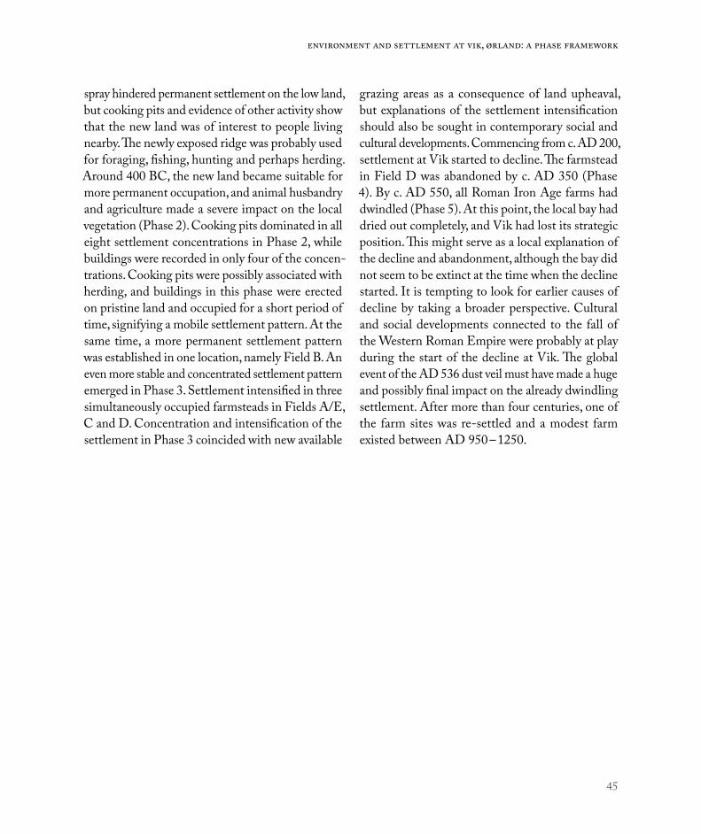
45
Environment and settlement at Vik, Ørland: A phase framework
spray hindered permanent settlement on the low land, but cooking pits and evidence of other activity show that the new land was of interest to people living nearby. The newly exposed ridge was probably used for foraging, fishing, hunting and perhaps herding. Around 400 BC, the new land became suitable for more permanent occupation, and animal husbandry and agriculture made a severe impact on the local vegetation (Phase 2). Cooking pits dominated in all eight settlement concentrations in Phase 2, while buildings were recorded in only four of the concen-trations. Cooking pits were possibly associated with herding, and buildings in this phase were erected on pristine land and occupied for a short period of time, signifying a mobile settlement pattern. At the same time, a more permanent settlement pattern was established in one location, namely Field B. An even more stable and concentrated settlement pattern emerged in Phase 3. Settlement intensified in three simultaneously occupied farmsteads in Fields A/E, C and D. Concentration and intensification of the settlement in Phase 3 coincided with new available
grazing areas as a consequence of land upheaval, but explanations of the settlement intensification should also be sought in contemporary social and cultural developments. Commencing from c. AD 200, settlement at Vik started to decline. The farmstead in Field D was abandoned by c. AD 350 (Phase 4). By c. AD 550, all Roman Iron Age farms had dwindled (Phase 5). At this point, the local bay had dried out completely, and Vik had lost its strategic position. This might serve as a local explanation of the decline and abandonment, although the bay did not seem to be extinct at the time when the decline started. It is tempting to look for earlier causes of decline by taking a broader perspective. Cultural and social developments connected to the fall of the Western Roman Empire were probably at play during the start of the decline at Vik. The global event of the AD 536 dust veil must have made a huge and possibly final impact on the already dwindling settlement. After more than four centuries, one of the farm sites was re-settled and a modest farm existed between AD 950 – 1250.

46
Environment and settlement | Ingrid Ystgaard – Magnar Mojaren Gran – Ulf Fransson
REFERENCES
Alexandre, A., J. Balesdent, P. Cazevieille, C. Chevassus-Rosset, P. Signoret, J. C. Mazur, A. Harutyunyan, E. Doelsch, I. Basile-Doelsch, H. Miche & G. M. Santos 2016: Direct uptake of organically derived carbon by grass roots and allocation in leaves and phytoliths: C-13 labeling evidence. Biogeosciences 13(5):1693-703.
Berger, O. G. 2001: Utdrag fra Ørland. En kyst- og garnisonskommune. Om utviklingen av jordeiendomsforhold og kulturlandskap fra middelalderen og fram til år 2000. Hovedfagsoppgave i geografi. Universitetet i Trondheim.
Berglund, B. 2003: Hus og gard – den arkeologiske bakgrunnen. In: Skevik, O. (ed.): Middelaldergården i Trøndelag. Foredrag fra to seminar, pp. 25-62. Stiklestad nasjonale kultursenter. Verdal.
Berglund, B. & T. Solem 2017: Maktkontinuitet i munningen av Trondheimsfjorden. Arkeologi og vegetasjonshistorie 800 BC - 1200 AD. Heimen, 3-2017 vol 56: 206–235.
Berglund, B. E. 2003: Human impact and climate changes – synchronous events and a causal link? Quarternary International 105: 7–12.
Birgisdottir, B. & S. Rullestad 2010: Utgravningsrapport. Hårberg (gnr. 69/6) Ørland kommune, Sør-Trøndelag fylke. Undersøkelse i tilknytning til reguleringsplan for ny adkomstvei frå Fv. 245 til Hårberg bustadfelt i Ørland kommune, Sør-Trøndelag fylkeskommune. NTNU Vitenskapsmuseet topografisk arkiv.
Bjørkvik, A. M. 1975: Jordeiendomsforhold i Stadsbygd og Ørland prestegjeld i 1661 og ved slutten av katolsk tid. Hovedoppgave i historie, Universitetet i Trondheim.
Bondevik, S., H. H. Birks, S. Gulliksen & J. Mangerud 1999: Late Weichselian marine C-14 reservoir ages at the western coast of Norway. Quaternary Research 52(1): 104–14.
Brendalsmo, J. 2001: Kirkebygg og kirkebyggere. Byggherrer i Trøndelag ca. 1000-1600. Avhandling (dr. philos.). Universitetet i Tromsø, 2001.
Bukkemoen, G. B. 2015: Ett hus – mange livsløp. Boligens biografi i førromersk jernalder belyst gjennom et gårdsanlegg i Askim. Viking 2015: 95–118.
Bukkemoen, G. B. 2016: Cooking and feasting: Changes in food practice in the Iron Age. In: Iversen, F. and H. Petersson (eds.): The agrarian life of the North 2000 BC – AD 1000. Studies in rural settlement and farming in Norway, pp. 117-131. Portal Academic. Kristiansand.
Büntgen, U., Myglan, V.S., Ljungqvist, F.C., McCormick, M., Di Cosmo, N., Sigl, M., Jungclaus, J., Wagner, S., Krusic, P.J. & J. Esper 2016: Cooling and societal change
during the Late Antique Little Ice Age from 536 to around 660 AD. Nature Geoscience 9: 231–236.
Eriksen, M. H. 2015: Portals to the Past. An archaeology of doorways, dwellings, and ritual practice in Late Iron Age Scandinavia. Dissertation for the degree of philosophiae doctor. Dept. of Archaeology, Conservation, and History. University of Oslo.
Fransson, U. 2018a: 14C-datering og kildekritiske hensyn. In: Ystgaard et al.: Arkeologiske utgravninger på Ørland kampflybase 2015 – 2016. NTNU Vitenskapsmuseet arkeologisk rapport 2018:27.
Fransson, U. 2018b: Fält B. In: Ystgaard et al.: Arkeologiske utgravninger på Ørland kampflybase 2015 – 2016. NTNU Vitenskapsmuseet arkeologisk rapport 2018:27.
Gerritsen, F. 1999: The cultural biography of Iron Age houses and the long-term transformation of settlement patterns in the southern Netherlands. In: Fabech, C. & J. Ringtved (eds.): Settlement and Landscape. Jutland Archaeological Society. Højbjerg.
Gjerpe, L. E. 2017: Effektive hus. Bosetning, jord og rettigheter på Østlandet i jernalder. Institutt for arkeologi, konservering og historie, Universitetet i Oslo.
Gran, M. M. 2018: Dokumentasjon. In: Ystgaard et al.: Arkeologiske utgravninger på Ørland kampflybase 2015 – 2016. NTNU Vitenskapsmuseet arkeologisk rapport 2018:27.
Gräslund, B. & N. Price 2012: Twilight of the gods? The ’dust veil event’ of AD 536 in critical perspective. Antiquity 86: 438–444.
Grønnesby, G. 1999: Eldre jernalders hus og hall på Hovde i Trøndelag. Viking 62: 69–80.
Grønnesby, G. 2009: En reise gjennom liv og død, ild og vann. En eldre bronsealders gravruin i Steinkjer. In: Brattli, T., G. Grønnesby & M. M Henriksen (eds.): Det 10. nordiske bronsealdersymposium. Trondheim 5.-8. okt. 2006. Vitark 6, pp. 66–78. Tapir.
Grønnesby, G. 2012: Bronsealdergravene på Toldnes og Holan. Markører av en passasje. In: Grønnesby, G. (ed.): Graver i veien. Arkeologiske undersøkelser E6 Steinkjer. Vitark 8, pp. 172–185. Tapir.
Grønnesby, G. 2013: Bosetning på Torgårdsletta, Trondheim og Egge, Steinkjer. Et innlegg i diskusjonen om den norske gårdens opprinnelse. In: Diinhoff, S., M. Ramstad & T. Slinning (eds.): Jordbruksbosetningens utvikling på Vestlandet. UBAS 7, pp. 77–92. University of Bergen, Bergen.
Grønnesby, G. 2016: Hot rocks! Beer brewing on Viking and medieval age farms in Trøndelag. In: Iversen, F. & H. Petersson (eds.): The agrarian life of the North 2000 BC – AD 1000. Studies in rural settlement and farming in Norway, pp. 133-149. Portal Academic. Kristiansand.

47
Environment and settlement at Vik, Ørland: A phase framework
Gundersen, I. M. 2016: Brytningstid i Gudbrandsdalens jernalder. Natur- og kulturhistoriske forutsetninger for maktsenterutviklingen. In: Gundersen, I. M. (ed.): Gård og utmark i Gudbrandsdalen. Arkeologiske undersøkelser i Fron 2011-2012. Portal Academic. Kristiansand.
Gustafson, L. 2005: Hvor gammelt er huset? Om datering av langhusene på Veien, Ringerike. In: Høgestøl, M. et al. (eds.): Konstruksjonsspor og byggeskikk. Maskinell flateavdekking - metodikk, tolkning og forvaltning. AmS Varia 43, pp. 45–56. Stavanger.
Hansen, U. L. 1987: Römischer Import im Norden. Warenaustasch zwischen dem Römischen Reich und dem freien Germanien. Nordiske fortidsminder, Serie B, Bind 10. Det Kongelige Nordiske Oldskriftselskab. København.
Haugen, H. I. Sjøbakk & K. H. Stomsvik 2014: Arkeologisk rapport. Maskinell søkesjakting og manuell prøvestikking i forbindelse med reguleringsplan for ny kampflybase, samt ny gang- og sykkelveg mellom Uthaug og Hårberg, Ørland kommune. Sør-Trøndelag fylkeskommune.
Hedeager, L. 1992: Iron Age Societies. From Tribe to State in Northern Europe, 500 BC to AD 700. Blackwell.
Hedeager, L. & K. Kristiansen 1985: Krig og samfund – fra stenalderfejde til atomkrigtrussel. Den Jyske historiker. Historieteoretisk tidsskrift, vol. 31/32: 9–24.
Henriksen, M. 2014: Stille vann har dyp bunn. Offerteoriens rolle i forståelsen av depotfunn belyst gjennom våtmarksdepoter fra Midt-Norge ca. 2350-500 f.Kr. Avhandling (Ph.d.), Norges teknisk-naturvitenskapelige universitet, Det humanistiske fakultet, Institutt for historiske studier, 2014:304.
Herschend, F. 2009: The Early Iron Age in South Scandinavia: Social Order in Settlement and Landscape. Occasional papers in archaeology 46. Uppsala.
Herschend, F. 2016: Towards a standardized discussion of priors in Bayesian analyses of 14C dated archaeological periods: A study based on the dates from Gjøsund. Journal of Archaeology and Ancient History, 2016, Nr. 19.
Hovd, R. (ed.) 2004: Ørland hovedflystasjon. Okkupasjon – Kald krig – Ny tid – Lokalsamfunn. Ørland hovedflystasjon, Ørland.
Iversen, F. 2008: Eiendom, makt og statsdannelse. Kongsgårder og gods i Hordaland i yngre jernalder og middelalder. UBAS Nordisk 6, Universitetet i Bergen.
Kjemperud, A. 1986: Late Weichselian and Holocene shoreline displacement in the Trondheimsfjord area, Central Norway. Boreas 15: 61–82.
Loftsgarden, K., B. Rundberget, J. H. Larsen, & P. H. Mikkelsen 2013: Bruk og misbruk av C14-datering ved utmarksarkeologisk forskning og forvaltning. Primitive Tider 15: 59–69.
Løken, T., O. Hemdorff and L. Pilø 1996: Maskinell flateavdekking og utgravning av forhistoriske jordbruksboplasser. En metodisk innføring. AmS Varia 26, Arkeologisk museum i Stavanger.
Løken, T. 2006: Høvding, bonde, leilending og ufri i Rogalands eldre jernalder. In: Glørstad, H., B. Skar and D. Skre (eds): Historien i forhistorien. Festskrift til Einar Østmo på 60-årsdagen. Kulturhistorisk museum, Skrifter 4. Oslo.
Løken, T. in press: The Bronze and Iron Age settlement at Forsandmoen: Analysis of houses and site development. AmS Skrifter.
Macphail, R. 2016: Ørland main air station (near Trondheim, Norway): soil microorphology. Report for Museum of Natural History and Archaeology, Norwegian University of Science and Technology, Trondheim, Norway.
Macphail, R. 2017: Ørland main Air Station (2016 samples), Norway: soil micromorphology (including SEM/EDS analyses). Report for Museum of Natural History and Archaeology, Norwegian University of Science and Technology, Trondheim, Norway.
Martens, J. 2009: Middelalderens jordbruksbebyggelse i de sentrale strøk. Den tapte middelalder? In: Martens, J., V. V. Martens and K. Stene (eds): Den tapte middelalder? Middelalderens sentrale landbebyggelse. Varia 71. Kulturhistorisk museum, Fornminneseksjonen. Oslo.
Myhre, B. 2002: Landbruk, landskap og samfunn. In: Myhre, B. & I. Øye: Norges landbrukshistorie I. 4000 f.Kr. – 1350 e.Kr. Jorda blir levevei, pp. 11-213. Det norske samlaget, Oslo.
Petersson, M. 2006: Djurhållning och betesdrift. Djur, människor och landskap i Västra Östergötland under yngre bronsålder och äldre järnålder. Riksantikvarieämbetet.
Rian, I. 1986: Ørlandsboka I. Fra Kråkvåg til Flatnes. Ørland kommune.
Rian, I. 1988: Ørlandsboka II. Fra Hovde til Berg. Ørland kommune.
Rønne, O. 2004: Utgravningsstrategi – flateavdekking. In: Glørstad, H. (ed.): Svinesundprosjektet. Bind 4. Oppsummering av Svinesundprosjektet. Varia 57, pp. 90-95. Universitetets kulturhistoriske museer, Fornminneseksjonen. Oslo.
Sandnes, J. 1971: Ødetid og gjenreising. Trøndsk busetningshistorie ca. 1200 – 1600. Universitetsforlaget. Oslo – Bergen – Tromsø.
Sandnes, J. 1997: Gards- og andre bustadnamn. In: Sandnes, J. and O. Stemshaug: Norsk stadnamnleksikon, pp. 32-37. Det Norske Samlaget. Oslo.
Sauvage, R. & M. Mokkelbost 2016: Rural buildings from the Viking and early Medieval period in Central Norway. In: Iversen, F. & H. Petersson (eds.): The agrarian life of

48
Environment and settlement | Ingrid Ystgaard – Magnar Mojaren Gran – Ulf Fransson
the North 2000 BC – AD 1000. Studies in rural settlement and farming in Norway, pp. 275-292. Portal Academic, Kristiansand.
Schøning, G. 1979 [1778]: Reise som giennem en deel af Norge i de aar 1773, 1774, 1775 på Hans Majestæt Kongens bekostning er giort og beskreven af Gerhard Schøning. Tapir, Trondheim.
Solberg, B. 2000: Jernalderen i Norge ca. 500 før Kristus til 1030 etter Kristus. Cappelen Akademisk Forlag.
Stamnes, A. A. 2016: Effect of Temperature Change on Iron Age Cereal Production and Settlement Patterns in Mid-Norway. In: Iversen, F. & H. Petersson (eds.): The agrarian life of the North 2000 BC – AD 1000. Studies in rural settlement and farming in Norway, pp. 27-39. Portal Academic, Kristiansand.
Stenvik, L. F. 2015: Fra malm og skog til jern og stål. Heimen, bind 52: 219–232.
van der Plicht, J. 2004: Radiocarbon, the Calibration Curve and Scythian Chronology. In: E. Marian Scott, A. Yu. Alekseev & G. Zaitseva (eds.): Impact of the Environment on Human Migration in Eurasia. NATO Science Series: IV: Earth and Environmental Sciences book series (NAIV, volume 42), pp. 45-61.
Ystgaard, I. 2014: Krigens praksis. Organisert voldsbruk og materiell kultur i Midt-Norge ca. 100-900 e.Kr. Doktoravhandlinger ved NTNU 2014:68.
Ystgaard, I. & R. Sauvage 2014: Prosjektplan for arkeologisk utgravning. Søknad om dispensasjon fra Kulturminneloven § 8.4 – reguleringsplan for Ørland hovedflystasjon. NTNU Vitenskapsmuseet.
Ystgaard, I., M. M. Gran, M. Mokkelbost, U. Fransson, A. Heen-Pettersen, A. B. Lorentzen, G. I. Solvold & E. W. Randerz 2018: Arkeologiske utgravninger på Ørland kampflybase 2015 – 2016. NTNU Vitenskapsmuseet arkeologisk rapport 2018:27.


51
c h a p t e r 2
Anders RomundsetGeological Survey of Norway (NGU)Thomas R. LakemanGeological Survey of Norway (NGU)
Shoreline displacement at Ørland since 6000 cal. yr BP
ABSTRACTA new reconstruction of the shoreline displacement at and near Ørlandet has been developed. Sediment core samples were collected from four lake basins that have been raised above sea level in the past as a result of land upheaval. Analysis of the lake sediments yields new chronological information on the relative sea level changes during the last 6000 years. The inves-tigated lake basins are located close to the excavation site at Ørlandet, at the same uplift isobase but at different elevations. Isolation boundaries in the sedimentary records, i.e. the stratigraphic level representing the last incursion of marine water into the basins, were pinpointed using analysis of macroscopic remains of plants and animals. Terrestrial plant material for radiocarbon dating was picked from several levels across each determined isolation boundary. In addition, pumice recovered from beach sediments at the excavation site was geochemically correlated to the Katla volcanic complex in Iceland. The age of the pumice is estimated to be 3200-3400 years old and represents a maximum-limiting age for the 11 m above sea level (asl.) shoreline. Collectively, the results document a continuous regression of the sea through the period, with a possible accelera-tion in the rate of relative sea level fall around 2000 cal yr BP.
INTRODUCTIONThe study of shoreline displacement, i.e. changes in the elevation of the shoreline position through time, has a long tradition in Nordic geology. Shoreline displacement results from the combined effects of changes in land level (isostasy) and sea level (eustasy), see Figure 1. The field is crucial to Quaternary and glacial geology and for understanding coastal land-scape changes since the last ice age. Knowledge of relative sea level changes in the past is also important to studies of present-day sea level change, including prospects for the future in light of human-induced
climate change. In order to understand how multiple interrelated processes affect dynamic changes in nature today, detailed knowledge of past changes is vital.
Geological data regarding shoreline displacement is also widely used in the field of archaeology to constrain the the time-span of of coastal/near-coastal archaeological sites. Shoreline displacement is thus an important dating tool in coastal archaeology, especially in glacio-isostatically uplifted regions like Scandinavia. However, due to large spatial differences in crustal uplift, the development of a
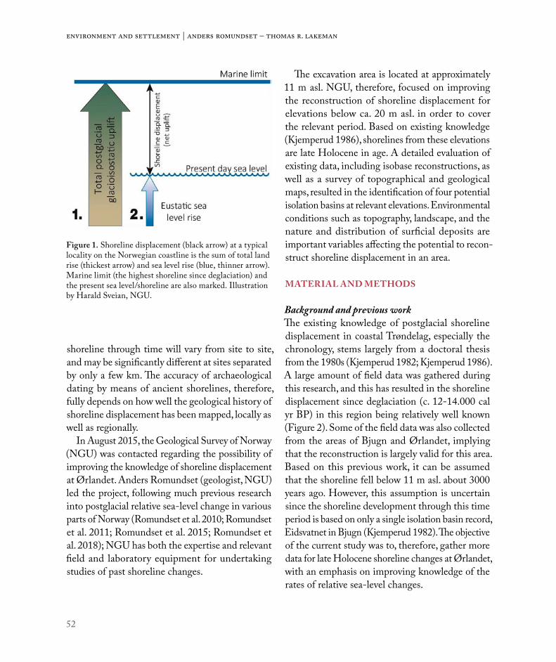
52
Environment and settlement | Anders Romundset – Thomas R. Lakeman
shoreline through time will vary from site to site, and may be significantly different at sites separated by only a few km. The accuracy of archaeological dating by means of ancient shorelines, therefore, fully depends on how well the geological history of shoreline displacement has been mapped, locally as well as regionally.
In August 2015, the Geological Survey of Norway (NGU) was contacted regarding the possibility of improving the knowledge of shoreline displacement at Ørlandet. Anders Romundset (geologist, NGU) led the project, following much previous research into postglacial relative sea-level change in various parts of Norway (Romundset et al. 2010; Romundset et al. 2011; Romundset et al. 2015; Romundset et al. 2018); NGU has both the expertise and relevant field and laboratory equipment for undertaking studies of past shoreline changes.
The excavation area is located at approximately 11 m asl. NGU, therefore, focused on improving the reconstruction of shoreline displacement for elevations below ca. 20 m asl. in order to cover the relevant period. Based on existing knowledge (Kjemperud 1986), shorelines from these elevations are late Holocene in age. A detailed evaluation of existing data, including isobase reconstructions, as well as a survey of topographical and geological maps, resulted in the identification of four potential isolation basins at relevant elevations. Environmental conditions such as topography, landscape, and the nature and distribution of surficial deposits are important variables affecting the potential to recon-struct shoreline displacement in an area.
MATERIAL AND METHODS
Background and previous workThe existing knowledge of postglacial shoreline displacement in coastal Trøndelag, especially the chronology, stems largely from a doctoral thesis from the 1980s (Kjemperud 1982; Kjemperud 1986). A large amount of field data was gathered during this research, and this has resulted in the shoreline displacement since deglaciation (c. 12-14.000 cal yr BP) in this region being relatively well known (Figure 2). Some of the field data was also collected from the areas of Bjugn and Ørlandet, implying that the reconstruction is largely valid for this area. Based on this previous work, it can be assumed that the shoreline fell below 11 m asl. about 3000 years ago. However, this assumption is uncertain since the shoreline development through this time period is based on only a single isolation basin record, Eidsvatnet in Bjugn (Kjemperud 1982). The objective of the current study was to, therefore, gather more data for late Holocene shoreline changes at Ørlandet, with an emphasis on improving knowledge of the rates of relative sea-level changes.
Figure 1. Shoreline displacement (black arrow) at a typical locality on the Norwegian coastline is the sum of total land rise (thickest arrow) and sea level rise (blue, thinner arrow). Marine limit (the highest shoreline since deglaciation) and the present sea level/shoreline are also marked. Illustration by Harald Sveian, NGU.

53
Shoreline displacement at Ørland since 6000 cal. yr BP
Isolation basins and coring equipmentIn this study we used so-called isolation basins to make a detailed reconstruction of the shoreline displacement at Ørlandet. The method has been used extensively in Norway because the landscape in many coastal regions contains numerous widespread peat bogs, ponds and small lakes which are ideally suited for this methodology.
Geological records from isolation basins are unique sea level archives. By sampling (i.e. coring) and analyzing the stratigraphy from multiple basins, it is commonly possible to reconstruct past relative sea level changes with high precision (Figure 3). Isolation basins are essentially depressions in bed-rock (often produced by glacial erosion) which have been uplifted above sea level during postglacial land emergence. The basins are, therefore, only located below marine limit, and record the transition from
marine to lacustrine depositional environments. In Norway, marine limit varies from only a few meters asl. to more than 200 m asl., depending on the amount of glacio-isostatic depression (the thickness of the ice sheet) during the last glaciation. At Ørlandet, marine limit is probably situated close to 140 m asl. By radiocarbon dating the transition from marine to lacustrine facies in sediment cores collected from the basins, it is possible to discern precisely when various basins became disconnected from the sea, and also whether the basins at some point were submerged during transgressions. More information on the isolation basin method may be found in Romundset (2010) and Long et al. (2011).
The surficial geology in Ørlandet consists of thick till deposits, possibly representing an ice-marginal position during the early stages of the last deglaci-ation. The till is in most places covered by marine
Figure 2. The pre-existing shoreline displacement curve from Kjemperud (1986). Note that the development through the last four thousand years is based solely on one basin isolation with a single bulk sediment radiocarbon age.

54
Environment and settlement | Anders Romundset – Thomas R. Lakeman
sediments of varying thickness. Along most of the present coastline of Ørlandet there is abundant beach gravel near the surface. The beach gravel was deposited during postglacial regression that gradually exposed the former seabed. Since Ørlandet consists mainly of these surficial deposits, the landscape is not well-suited for isolation basin studies. However, by surveying areas located near the same uplift iso-base, north and south of Ørlandet, we found four basins that we assume do not significantly deviate
from Ørlandet with regard to past uplift rates, at least not for the late Holocene. We found basins in Bjugn (Eidsvatnet, also investigated by Kjemperud) and in Vassbygda/Agdenes (low-lying Storvatnet, Litjvatnet, and the higher Eidemstjønna – which was also investigated by Kjemperud).
Except for Litjvatnet, we used a modified piston coring apparatus to sample the lake sediments during January-March 2016 from frozen lake ice surfaces. A standard 110 mm diameter PVC-tube, with a
Figure 3. The principle of the isolation basin method. Left (A-C). a theoretical transect perpendicular to the coastline, with a small basin situated near the sea. A. the situation just after deglaciation, with the shoreline at marine limit, well above the basin threshold. Marine sediments (silt, clay and remains of marine biota, e.g. mollusk shells) are deposited. B. the shoreline has been lowered and salt sea enters the basin across the threshold during high tide, twice a month. During a relatively brief period the basin environment is brackish, with depleted salinity. Black, finely layered sediments are deposi-ted on the lake floor, with almost no remains from living organisms (i.e. subfossil parts of animals and plants). C. the basin is long since isolated. Brownish gyttja (a typical lake sediment) is deposited. The vertical line illustrates how a core sample will penetrate the sedimentary sequence and retrieve deposits from the geological archive. D. Field photo of coring with a Russian corer from the rim of a lake. E. Field photo of piston coring at a frozen lake in wintertime.

55
Shoreline displacement at Ørland since 6000 cal. yr BP
piston mounted in its lower end, was attached to a cable and lowered to the lake floor. A second cable was attached to the piston and secured on the lake ice surface. A third cable was fastened to a weight (25 kg) that was used to strike the top of the coring apparatus repeatedly (up to several thousand times), thus hammering the PVC-tube slowly downwards into the sediments. Upon recovery, all sediment was captured in the sample tube as a result of the locked piston, which provided suction and prevented the sediment from sliding out the bottom of the tube. This type of piston corer may retrieve up to 6 m-long core samples of 110 mm diameter, and can be used in water depths of 100 m or more. The piston corer provides long, continuous sequences, but the oper-ation is time-consuming and involves much work with equipment and transportation. Frozen lakes are a great advantage to the work, compared to using a floating raft. One full work day is normally needed for coring one lake basin.
The Litjvatnet basin is shallow and was there-fore sampled using a so-called Russian peat corer ( Jowsey 1966), i.e. one-meter long samplers of various diameters, attached to rods. The corer was lowered to desired sampling depths, and rotated 180 degrees to capture sediment within the closed sampler. One meter-long samples were raised to the surface without being disturbed and collected for subsequent analysis. Sampling with a Russian peat corer is logistically much easier than piston coring and requires less time. Recovered samples constitute half-cylinders, the volume of which depends on the diameter of the sampler used (i.e. 5–11cm). Smaller samplers are more easily low-ered through the sediment and this means they can penetrate deeper through deeper stratigraphy, including sand layers and wood. Conversely, smaller samplers may yield insufficient amounts of sample material and plant material from certain depths for radiocarbon dating.
Laboratory work – sediment analysis and radiocarbon datingIn this study, macrofossil analysis was used to iden-tify changes in the basin environment through time. Macrofossils are sub-fossil remains of plants or animals (>150μm). This method is replacing diatom analysis, which has traditionally been the more commonly used proxy for detecting salinity changes in basin environments. Many common plant and animal species live in either fresh or saltwater, and some prefer brackish conditions. Salinity changes affect the species assemblage of the basin environ-ment. Remains of dead organisms sink to the lake floor and become part of the lake sediment. While soft tissue generally decays rapidly, some harder, more resistant parts are preserved in the sediment. The macrofossils recovered from sediment cores of isolation basins (i.e. the biostratigraphy) will therefore record the environmental changes that took place when the basin became disconnected from the sea during land emergence and isolation. Reworking and transport by wind and/or sea spray may be a problem for microfossil records (diatoms and pollen), but these processes do not generally affect larger macrofossils. The stratigraphic level marking the transition from marine/brackish to limnic species is interpreted to represent the last incursion of saltwater into the basin across the basin threshold during highest astronomical tide. Thus, it is important to note that the elevation represents high tide and not mean sea level. Most shoreline displacement curves represent mean sea level and the basin elevations therefore need to be adjusted for the local tidal difference.
The ages of the stratigraphic boundaries were determined by radiocarbon dating of macrofossils. A common problem in late Pleistocene-Holocene palaeoenvironmental studies has been the errors associated with radiocarbon dating of bulk sediment samples. This methodology commonly involved

56
Environment and settlement | Anders Romundset – Thomas R. Lakeman
cutting several cm-thick slices of sediments from the core sample, (cf. Kjemperud 1986), and using all the material therein for radiocarbon analysis. This technique, therefore, often resulted in the inclusion of minerogenic carbon in the dated sample; as well as reservoir effects and/or reworked material that could influence the measured radiocarbon age. Today, these problems are avoided by use of AMS-dating of selected terrestrial plant macrofossils, which allows dating of small samples (less than 10 mg) with high precision. Typical material that was dated in this study includes leaves from trees or bushes, small twigs, pine needles, and other terrestrial material that was large enough to be identified. Where possible, we obtained multiple radiocarbon dates from material collected from several levels (at least three) spanning the isolation boundary/event, to ensure a robust chronology.
Pumice at ØrlandetThe elevation of pumice (11 m asl.) discovered at Ørlandet and its occurrence on a raised shoreline allow its approximate age to be determined on the basis of a previously published relative sea-level curve (Kjemperud, 1986). While rates of late Holocene RSL change are not well-constrained for this region, the pumice was most likely deposited between 2000 and 4000 calibrated years before present. To determine the age of the pumice more precisely, we attempted to correlate the pumice to known late Holocene Icelandic volcanic eruptions. Specifically, we used electron probe microanalyses to determine the major element composition of two pumice sample-sets – one from Ørlandet and another from Kobbvika at the island of Averøya (Table 1), as well as of eight tephras from the Katla volcanic complex on Iceland (which has previously been correlated to Norwegian pumice; (Table 2; Newton 1999)). Major element composition of the pumice and tephras was determined using a
Cameca SX100 electron probe microanalyzer at the Department of Geosciences, University of Edinburgh. Each sample was analyzed 10-20 times in the electron probe microanalyzer and the data is presented in Table 3.
RESULTSA thorough survey of existing maps, aerial photos and digital elevation models was first conducted in order to identify potential isolation basins located at the relevant elevations (below c. 20 m asl.). All of the prospective basins are situated on or near the same isobase, thus avoiding the effects of (unknown) differential land uplift. The distance between basins may still be quite large, however, given that their distribution follows the isobase direction. A few apparently deep bogs were found in the eastern part of Ørlandet, in addition to the large lake Eidsvatnet in Bjugn (Figure 4). In addition, some relevant lakes in Vassbygda, Agdenes, on the opposite side of Trondheimsfjord, were found and are situated on the same isobase as Eidsvatnet.
After initial field reconnaissance and some attempts to core the bogs at Ørlandet, including the now reconstructed Rusasetvatnet, we found that these basins were too shallow and therefore not suitable sea-level reconstructions. So we shifted our focus to larger lakes containing the desired strati-graphic record. At first, coring was done from lake ice in Agdenes in January 2016, where after several attempts we recovered a core sample from c. 16 m water depth in Storvatnet. Litjvatnet is relatively shallow and was successfully cored along several transects using the Russian peat corer, in February, 2016. Eidemstjønna is deeper and here we collected three piston cores.
Laboratory analyses of the collected core samples were carried out at NGU during the months follow-ing fieldwork in spring, 2016. The main task was to identify biostratigraphical boundaries representing

57
Shoreline displacement at Ørland since 6000 cal. yr BP
the time when the basins were uplifted above con-temporary sea level. Identification and preparation of selected radiocarbon dating samples (terrestrial plant remains) was carried out at NGU, whereas the AMS measurement was performed at Poznan Radiocarbon Laboratory, Poznan, Poland. Multiple samples from different levels near each isolation boundary were dated in order to gain a robust chronology of basin isolation events.
Basin 1 – EidemstjønnaWe cored at three different sites in the middle of this lake and from each site we recovered a c. 4 m long core. The sequence comprises marine sand in the lower part, with increasing amounts of shells fragments, followed by ca. 2 m of pure shell sand and gyttja on top. The sudden transition from a high-energy deposit (shell sand) to gyttja suggests there is a hiatus in the record, which unfortunately
Figure 4. Map of the field area. Basins are numbered as follows. 1. Eidemstjønna, 2. Eidsvatnet, 3. Storvatnet and 4. Litjvatnet. The white stippled lines mark the shoreline isobase direction which is near coast-parallel. Isobases are theoreti-cal lines that cross areas that experienced similar amounts of shoreline displacement since the last deglaciation.
58
Environment and settlement | Anders Romundset – Thomas R. Lakeman
makes it a poorly developed sequence, not suitable for a precise sea-level determination (Figure 5). This is probably a result of conditions at the basin threshold, where thick beach gravel deposits dam the lake. Dating the gyttja would at best yield a minimum age for the palaeo-sea level and would not improve the precision of the existing reconstruction. No further analysis was therefore carried out on the record from Eidemstjønna.
Basin 2 – EidsvatnetThe elevation of Eidsvatnet (the lake surface) is reported on topographic maps as 10 m asl., but the actual elevation is about 8 m asl. Distinct traces of a former lake shoreline can be seen as an abrasion notch at about 12 m asl. visible around much of the lake (Figure 6). It is known that the lake level was lowered twice, most recently in AD 1948 by
ca. 120cm. The outlet stream is deeply incised into beach deposits (shell-bearing gravel and rocks). The deposits are massive and are located in a sheltered location with regard to waves, so there is little risk that significant incision of the threshold took place after the lake had become isolated. Man-made channelizing in modern times caused the lowering. Based on these observations, we place the original lake elevation at ca. 10 m asl. (+/- 0.5 m) before humans impacted the threshold.
The depth of the lake floor was mapped along several transects in the southern (deeper) part of the lake. A larger and flat-bottomed area of ca. 50x100 m below the hill Ørnklumpen was found to be the deepest at ca. 8.5 m depth. We cored in this area (Figure 6), which is probably different from where Kjemperud recovered his sample, since he gives a water depth of 4.9 m. Usually, the best location
Figure 5. A section of the cored sequence from Eidemstjønna, showing the shell sand and the abrupt transition to gyttja above. Up is toward the left.

59
Shoreline displacement at Ørland since 6000 cal. yr BP
for coring is the deepest and flattest area of the lake floor. This provides little risk of disturbance by potential mass movements, thereby giving the best chance of recovering a complete, uninterrupted sedimentary sequence.
The core sample from Eidvatnet comprised a well-developed and undisturbed isolation sequence. The transition to a lake environment is well defined at 903 cm depth (below the lake surface) and has been dated from four samples to about 2300-2200 cal years BP. This is about 400 years younger than Kjemperud’s result, and thereby a useful revision of the existing reconstruction. The four congruent radiocarbon dates from a continuous sequence give an accurate and robust age determination for this palaeo-sea level.
Basin 3 – StorvatnetThe lake surface of Storevatnet is presently ca. 4.6 m asl. It is known, however, that the lake was lowered in the 1920s by about one meter. There are also indications of an older shoreline (abrasion notch)
at about 6.5 m asl. in several locations around the lake. Therefore we infer that the lake surface prior to human influence was near 6 m asl. Using an existing map of the bathymetry of Storvatnet we obtained cores from the deepest part of the lake (slightly deeper than 16 m), which had a relatively flat bottom (Figure 7).
We collected several relatively short (1-2 m) cores from Storvatnet. Collection of longer cores was prohibited by very compact and thus impenetrable deposits.. Due to low sedimentation rates in this basin, however, the short cores that were retrieved do contain the desired complete marine-lacustrine sequence. The disconnection from the sea is clearly represented by a finely laminated unit. Thin laminae of alternating black and lighter layers were deposited when the lake had a brackish/anoxic environment (Figure 8). Based on the analysis of various macro-fossils, the isolation boundary was placed at 1685cm. A series of four radiocarbon dates allows for precise age determination of the isolation event to 1700-1600 cal years BP.
Figure 6. Left. elevation model of the terrain near Eidsvatnet. The black arrows mark an older shoreline (abrasion notch) at ca. 12 m asl. It represents an older, original elevation of the lake at near 10 m asl. Right. From field work. The core sample has been lifted and placed on the lake ice.

60
Environment and settlement | Anders Romundset – Thomas R. Lakeman
Basin 4 – LitjvatnetLitjvatnet is located next to, and downstream of Storvatnet. The threshold of Litjvatnet has been mod-ified by humans several times, and the outlet stream, Nordgjerdelva, is today channelized. Lowering of the lake surface by about 1 m occurred in the 1920s (similar to Storvatnet). The lake level was again lowered by 50-80cm in 1962/63 when a ca. 200 m wide area in the eastern part of the lake was made dry land. The lake was leveled in 1977 to 4.03m asl. (normal high lake level), and in 1987 the outlet was cleared and the elevation was lowered again by an additional 70cm to 3.33m asl. The present lake surface is located ca. 3.7m asl. The original lake elevation is obviously uncertain, but we assume it
was near 5 m asl. The dating results from this work show that the two lakes Litjvatnet and Storvatnet were separated at the time of isolation.
A bathymetric map also exists for Litjvatnet (Iversen et al.1996). The shallow depths allowed for the use of the Russian peat sampler from the frozen surface of the lake. Core samples were collected from several transects across the lake. The samples were examined in the field and facilitated a good understanding of the lateral variations of different sedimentary units. (Figure 9).
The isolation of Litjvatnet is well defined at 498cm depth and was dated using samples from two different core sites. Multiple macrofossil samples from levels spanning the isolation boundary were dated from
Figure 7. Bathymetric map of Storvatnet (made available by NVE). The position of the core sample in the deepest, flat-bottomed part of the lake is indicated.

61
Shoreline displacement at Ørland since 6000 cal. yr BP
Figure 8. A section of the cored sequence from Storvatnet, with the isolation from the sea represented by thin, black-colored laminations. Up is toward the left.
Figure 9. Left. Depth contours of Litjvatnet (Iversen 1996). The lake was cored along several transects, whereas the analysis and dating was done on a core sample from the deepest part. Right. A half-cylinder core sample from Litjvatnet is opened on the spot and documented in the field.

62
Environment and settlement | Anders Romundset – Thomas R. Lakeman
both core sites. Based on the results, we conclude that the isolation took place 1600-1400 cal years BP, i.e. a short time after Storvatnet. Nonetheless, the radiocarbon dating results from the two lakes, do yield statistically significant different ages for the two lake isolation events.
Clay slide near LitjvatnetAn additional result from coring Litjvatnet was the discovery of a ca. 30cm thick, light-grey colored deposit of clay and silt, stratigraphically located about 10cm above the isolation boundary. The unit was found at all core sites and had similar character
and thickness across the lake. Sedimentological analysis demonstrates that the layer was deposited in a lacustrine environment. We believe the layer was deposited following a slide of uplifted marine clays that are found within the lake catchment. The lack of similar deposits in the record of Storvatnet suggests that the slide happened locally. A laser-scan terrain model of the area (Figure 10) shows possible slide scars associated with the deposit, northeast of the lake. There are indications of slide scars both near Løstad and along the stream Vassbekken. Based on the radiocarbon dates from the lake record, the slide most likely took place about 1000 cal years BP.
Figure 10. Terrain model of the area northeast of Litjvatnet. The colors indicate elevations. Arrows show likely source areas for clay slides. See text for details.

63
Shoreline displacement at Ørland since 6000 cal. yr BP
Dep
th
belo
w su
rfac
e (cm
)
Sam
ple
nam
ePu
rpos
e/ st
rati-
grap
hic l
evel
Cal
ibra
ted
age (
a BP,
2σ
)
Wei
ghte
d av
erag
e (μ
)M
ater
ial d
ated
Sam
ple
weig
ht
(mg)
Labo
rato
ry
num
ber
Rad
ioca
rbon
ag
e (a B
P)
Litjv
atne
t, A
gden
es. I
nser
t coo
rdin
ates
. Iso
latio
n bo
unda
ry d
eter
min
ed at
498
cm d
epth
.
411
OR-
1-1-
1La
min
ated
uni
t27
0-20
130
Bulru
sh st
alk
29Po
z-86
903
90 ±
30
BP
490
OR-
1-1-
2Is
olat
ion
(abo
ve)
1700
-152
015
90M
osse
s5
Poz-
8690
416
80 ±
30
BP
490
OR-
1-1-
3Is
olat
ion
(abo
ve)
1320
-118
012
60Te
rres
tria
l lea
f fra
gmen
ts24
Poz-
8690
513
40 ±
40
BP
490
OR-
1-1-
4Is
olat
ion
(abo
ve)
1350
-126
013
00Pl
ant s
talk
s, a t
wig
18Po
z-86
906
1375
± 3
0 BP
490
OR-
1-1-
5Is
olat
ion
(abo
ve)
1390
-129
013
40A
sing
le st
alk
8Po
z-86
907
1450
± 3
0 BP
510
OR-
1-1-
6Is
olat
ion
(bel
ow)
1820
-162
017
30W
ood
7Po
z-86
908
1800
± 3
0 BP
517
OR-
1-1-
7Is
olat
ion
(bel
ow)
1720
-156
016
50La
rge t
wig
404
Poz-
8690
917
40 ±
30
BP
500-
502
OR-
1-2-
1Is
olat
ion
(just
belo
w)18
10-1
560
1670
Twig
with
unh
arm
ed co
rtex
37Po
z-86
910
1760
± 4
0 BP
502-
503
OR-
1-2-
2Is
olat
ion
(bel
ow)
2040
-188
019
50St
alks
21Po
z-86
911
2005
± 3
0 BP
503-
504
OR-
1-2-
3Is
olat
ion
(bel
ow)
2000
-187
019
30St
alks
and
mos
ses
17Po
z-86
913
1980
± 3
0 BP
498-
500
OR-
1-3-
1Is
olat
ion
(just
belo
w)19
50-1
810
1880
Pota
mog
eton
frui
ts33
Poz-
8688
919
30 ±
30
BP
504
OR-
1-3-
2Is
olat
ion
(bel
ow)
1830
-162
017
40Sm
all E
ricac
eae t
wig
with
bud
s7
Poz-
8689
018
05 ±
30
BP
Stor
vatn
et, A
gden
es. I
nser
t coo
rdin
ates
. Iso
latio
n bo
unda
ry d
eter
min
ed at
168
5 cm
dep
th.
1631
OR-
2-1
Top
of co
re sa
mpl
e43
0-m
oder
n23
0St
alk
22Po
z-86
893
235
± 30
BP
1631
OR-
2-2
Top
of co
re sa
mpl
e29
0-m
oder
n14
0A
sing
le P
inus
cone
80Po
z-86
894
140
± 30
BP
1671
-167
2O
R-2-
3Is
olat
ion
(abo
ve)
1400
-130
013
50Te
rres
tria
l lea
f fra
gmen
ts19
Poz-
8689
514
60 ±
30
BP
1673
-167
5O
R-2-
4Is
olat
ion
(abo
ve)
1550
-140
014
70Se
eds,
stem
frag
men
t21
Poz-
8689
615
90 ±
30
BP
1683
-168
5O
R-2-
5Is
olat
ion
1730
-156
016
60C
onife
r nee
dle,
Bet
ula s
eeds
(N
>50)
and
leaf
frag
men
ts7
Poz-
8689
717
50 ±
30
BP
1693
OR-
2-6
Isol
atio
n (b
elow
)20
00-1
870
1930
One
sing
le le
af12
Poz-
8689
919
80 ±
30
BP
Eid
svat
net,
Bjug
n. In
sert
coor
dina
tes.
Isol
atio
n bo
unda
ry d
eter
min
ed at
903
cm d
epth
.
838-
839
OR-
3-1
Top
of co
re sa
mpl
em
oder
nA
sing
le st
alk
7Po
z-86
900
137.
67 ±
0.3
3 pM
C
838-
839
OR-
3-2
Top
of co
re sa
mpl
em
oder
nTe
rres
tria
l pla
nt fr
agm
ents
9Po
z-86
901
140.
44 ±
0.3
5 pM
C
885-
886
OR-
3-3
Isol
atio
n (a
bove
)17
00-1
540
1620
Terr
estr
ial p
lant
frag
men
ts35
Poz-
8686
717
05 ±
30
BP
896-
897
OR-
3-4
Isol
atio
n (a
bove
)23
10-1
990
2120
Terr
estr
ial p
lant
frag
men
ts13
Poz-
8686
821
30 ±
40
BP
899-
900
OR-
3-5
Isol
atio
n23
00-2
000
2110
Terr
estr
ial p
lant
frag
men
ts17
Poz-
8686
921
25 ±
30
BP
902-
903
OR-
3-6
Isol
atio
n23
10-2
060
2210
Betu
la se
eds a
nd le
af fr
agm
ents
15Po
z-86
870
2170
± 3
0 BP
Tabl
e 1. R
adio
carb
on d
ated
sam
ples
from
Litj
vatn
et, S
torv
atne
t and
Eid
svat
net.

64
Environment and settlement | Anders Romundset – Thomas R. Lakeman
Results for the pumice findAbundant pumice (Figure 11) was found within a small part of the excavation area. All the pumice was situated at the same elevation, near 11 m asl. Pumice is a unique rock type produced by volcanic eruptions, containing abundant vesicles, including trapped gas bubbles, that commonly render it less dense than water. Discoveries of pumice along raised palaeo-shorelines along the Norwegian coastline are not rare, but most of the documented sites are from levels close to the mid-Holcoene Tapes trans-gression shoreline. The Tapes transgression led to erosion and reworking, and thereby concentrated
previously deposited pumice as a lag deposit at the transgression highstand level. The elevation of the Tapes level varies largely depending on geographical location (isobase), but for Ørlandet there is little doubt given the new and existing relative sea level data that the 11 m shoreline is much lower – and thus younger. Multiple pumice samples were col-lected from Ørlandet and a subset of these were geochemically analysed along with a second sam-ple-set from Kobbvika (from a similar geological setting), primarily to investigate possible correlations to known eruptions/tephras from the Icelandic Katla volcanic complex (Larsen et al. 2001).
The microprobe data contains few outliers and represents a significant improvement upon pre-vious efforts to precisely determine the major element composition of pumice collected from raised shorelines in the North Atlantic region (Newton, 1999). Bi-plots of Fe vs. Ti and other cations illustrate that variability within the pumice data is comparable to that for the analyzed tephras. The major element composition of the pumice from Ørlandet and Kobbvika is most similar to that of the SILK-YN, MN, -LN, and -N4 tephras (Figure 12). The percentage by weight of Ti in the Ørlandet and Kobbvika pumice (when OK-P-10 is excluded) most closely matches that of SILK-MN and –LN; however, the pumice exhibits greater variance in Fe (Figure 12). Given the known late Holocene age of the pumice we propose a genetic correlation to SILK-MN or -LN, suggesting that the pumice was deposited following the Katla eruption that deposited either: i) SILK-MN at approximately 3.2 cal ka BP, ii) SILK-LN at approximately 3.4 cal ka BP, or iii) both SILK-MN and -LN. We note that SILK-LN has much less variance in Ti, which averages 1.22 +/- 0.01 and has a trendline that most closely parallels the pumice data in Fe vs. Ti plots. The current compositional data, however, prevents us making a more robust correlation to
Figure 11. Pumice collected at Ørlandet, a subsample of which was sent to the University of Edinburgh for geo-chemical analysis.

65
Shoreline displacement at Ørland since 6000 cal. yr BP
SILK-LN. Nonetheless, the pumice data provides a robust new maximum-limiting age for the 11 m asl. shoreline of c. 3.2-3.3 cal ka BP.
OK-P-10 exhibits greater variance in Ti among the pumice samples and its range of values matches most closely the data for SILK-N4 (Figure 12). It may, therefore, have been sourced from the SILK-N4 eruption ca. 3.9 cal ka BP but transported to and/or deposited along the Norwegian coast following a subsequent eruption (i.e. SILK-MN or -LN). Its occurrence within a littoral facies characterized by high concentrations of pumice indicates that its deposition was likely due to high rates of beach stranding following an Icelandic eruption, as opposed
to more random redeposition from a higher shoreline during relative sea-level regression.
DISCUSSION
The revised shoreline displacement curveThe main result of the present investigation is the revised shoreline displacement curve (Figure 13), covering the period since 6000 cal years BP. The curve illustrates the development of the mean sea level through this period, and is based on new field data and the chronology obtained in this study.
Important aspects regarding the interpretation and use of the curve
Figure 12. Plot of the composition of iron and titanium for the pumice and for relevant tephra deposits in Iceland. Ellipsoides show the distribution and overlap of measured values.

66
Environment and settlement | Anders Romundset – Thomas R. Lakeman
• The curve is drawn as a line representing the most likely development of shoreline displacement at this isobase (running across Ørlandet). The full uncertainty envelope is not indicated on the curve, and centennial-scale deviations might be expected. The uncertainty of the reconstruction depends on the chronological accuracy of each single isolation event and possible deviations from the determined threshold elevations.
• The results show that the excavation area emerged from the sea (and high tide level) around 2600 years ago. Due to the exposed setting of Ørlandet in relation to the sea, the outer part of the area
was obviously exposed to large waves, storm surges and sea spray for a while after emergence. Nonetheless, our results document that the shore-line fell relatively rapidly during the subsequent centuries. Based on the sea level curve it probably took less than 500 years before the excavation area was completely separated from the influence of storms etc.
• The shoreline displacement curve represents highest astronomical tide level. The difference between mean sea level and highest astronomical tide in Trondheim is about 180 cm. Therefore, the curve ends at this elevation for the present day.
Figure 13. The new shoreline displacement curve for the period 6000 years BP to present. Note that the timescale is given in calibrated years before present, whereas Kjemperud’s curve is given in radiocarbon years before present. See text for details.

67
Shoreline displacement at Ørland since 6000 cal. yr BP
REFERENCES
Iversen, T. H., P. Andreassen, H. Kråkvik & H. Svare 1996: Litjvatnet Agdenes i Sør-Trøndelag. Plantebiosenteret, Botanisk Institutt, NTNU Dragvoll.
Jowsey, P. C. 1966: An improved peat sampler. New Phytologist 65, 245-248.
Kjemperud, A. 1982: Late Weichselian and Holocene shoreline displacement in parts of Trøndelag, Central Norway. PhD thesis. Dept. of Geology, Univ. of Oslo.
Kjemperud, A. 1986: Late Weichselian and Holocene shoreline displacement in the Trondheimsfjord area, Central Norway. Boreas 15, 61-82.
Larsen, G., A. J. Newton, A. J. Dugmore & E. G. Vilmundardóttir 2001: Geochemistry, dispersal, volumes and chronology of Holocene silicic tephra layers from the Katla volcanic system, Iceland. Journal of Quaternary Science 16, 119-132.
Long, A. J., S. A. Woodroffe, D. H. Roberts & S. Dawson 2011: Isolation basins, sea-level changes and the Holocene history of the Greenland Ice Sheet. Quaternary Science Reviews 30, 3748-3768.
Newton, A. 1999: Ocean-transported pumice in the North Atlantic. PhD thesis. University of Edinburgh.
Romundset, A. 2010: Relative sea level, deglaciation and tsunami history deduced from isolation basins. http://munin.uit.no/handle/10037/2703. PhD thesis, University of Tromsø, Tromsø, Norway.
Romundset, A., S. Bondevik & O. Bennike 2011: Postglacial uplift and relative sea level changes in Finnmark, northern Norway. Quaternary Science Reviews 30, 2398-2421.
Romundset, A., O. Fredin & F. Høgaas 2015: A Holocene sea-level curve and revised isobase map based on isolation basins from near the southern tip of Norway. Boreas 44, 383-400.
Romundset, A., T. Lakeman & F. Høgaas 2018: Quantifying variable rates of postglacial relative sea level fall from a cluster of 24 isolation basins in southern Norway. Quaternary Science Reviews 197 (2018), 175-192.
Romundset, A., Ø. S. Lohne, J. Mangerud & J. I. Svendsen: The first Holocene relative sea-level curve from the middle part of Hardangerfjorden, western Norway. Boreas 39, 87-104.


69
c h a p t e r 3
Anette OverlandDepartment of Natural History, University Museum, University of Bergen, [email protected] LOE HJELLEDepartment of Natural History, University Museum, University of Bergen, Norway
Vegetation development at Ørland, and in the region, from c. 260 BC to the present
ABSTRACTThe vegetation history at Ørland is based on pollen analysis of a local bog (Ryggamyra), and several archaeological contexts, such as cultivation layers and plow mark, a refuse/cesspit, and wells and waterholes. Ryggamyra reflects important activity periods, in the Pre-Roman Iron Age and Roman Iron Age, where barley was cultivated and areas with herbaceous grasslands existed in connection with settlement areas. In comparison, pollen analysis from lake sediments (Eidsvatnet) reflects a larger region. Eidsvatnet covers the period c. 260 BC to the present, during which three periods of more intensive human activity can be identified, when forest is cleared, grass-dominated vegetation increases, and outfield grazing areas are established. These periods are the Roman Iron Age and Migration Period (c. AD 1-540), parts of the Viking Age and Early and High Middle Ages (c. AD 900–1360), and recent times (from AD 1600 onwards). In both pollen profiles, Eidsvatnet and Ryggamyra, the Merovingian period represents a period with structural changes in landscape utilization and perhaps less human activity overall. Ørland has largely been characterized by marshes and wetland areas through the past, dominated by Cyperaceae. On the drier main ridge, where settlement areas existed in the Pre-Roman Iron Age and Roman Iron Age, and again in the early medieval period, the pollen profiles indicate a completely open landscape with herb-rich grassy vegetation and cultivation of barley and wheat. The increase in heather from the Late Viking Age to the early medieval period is seen in Ryggamyra and is reflected in the archaeological deposits, indicating utilization of heathlands for whole-year grazing. Pollen analysis also suggests local production/use of hemp and increased use of wheat in medieval times. The area around Eidsvatnet seems to be influenced by the late medieval depression and Black Death, with the increase in coniferous woodland and reduced outfield grazing activity.
INTRODUCTIONArchaeological excavations at Ørland Main Air Base, carried out by NTNU Science Museum 2014–2016, revealed settlements from the Bronze Age/Iron Age transition through the Early Iron Age, followed by a new phase of settlement in the Late Viking Age/Middle Ages. At the transition Early/Late Iron Age, the archaeological data are scarce. The highest
activity seems to have been during Pre-Roman and Roman Iron Age, with several house remains, cooking pits and different deposits reflecting farm settlements. Pollen samples were collected from archaeological contexts including cultivation layers, plow marks, refuse/cesspits, wells and waterholes. The aims of the pollen analysis were to provide knowledge on environment, natural conditions,

70
Environment and settlement | Anette Overland – KARI LOE HJELLE
Figure 1. Localities for pollen analysis. Eidsvatnet (lake), Ryggamyra (bog) and archaeological contexts in excavation Field A (152149), Field D (616154, 616349/616346, 616158) and Field E (223883, 224758/224324, 222721, 223002, 223668), (See Buckland et al. (2017) for pollen analysis of 151397, 337695, 337696, 338506). Map: Magnar Mojaren Gran, NTNU University Museum.
71
Vegetation development at Ørland, and in the region, from c. 260 BC to the present
landscape development, settlement and farming economy at Ørland. The investigation also included pollen analysis of a local peat profile, Ryggamyra, and sediments from the lake Eidsvatnet (Fig. 1). Ryggamyra represents a local palaeobotanical archive, which will reflect the development of the environ-ment and landscape at Ørland, as well as human impact on the local vegetation and landscape. Pollen analysis of sediments from Eidsvatnet, which is situated approximately 10.5km from Ryggamyra and the archaeological excavation areas, will provide the regional setting for landscape and vegetation development. Earlier studies from Ørland include analysis of pollen samples from bogs at Borgestad and Veklem. At Borgestad, c. 5.5km east of the excavation area, the development of an open cul-tural landscape with cultivation and grazing in the Late Bronze Age and Early Iron Age, is indicated (Solem 2009). Pollen analysis from a small bog at Veklem close to Ørland church reveals an open landscape from the Late Bronze Age (Berglund & Solem 2017). At that site, cultivation is docu-mented from the Middle Ages whereas grazing was found from the Iron Age. Also a few pollen samples previously analyzed from Field D at Vik (Engtrø & Haug 2015) indicated open arable fields and grasslands in Pre-Roman and Roman Iron Age. Except for these investigations, all made in relation to archaeological projects, no investigation of the vegetation history at Ørland has earlier been carried out. However, the Holocene vegetation history is well documented at the island Frøya, c. 44km west of Ørland (Paus 1982). Contemporary with the settlement at Ørland, open heathlands managed through grazing and burning characterized the landscape of Frøya. On the islands outside Ørland (incl. Tarva), there is evidence of at least 300 years of managed heathland (Kaland & Kvamme 2013). Coastal heathlands represent a human-induced vegetation type developed and maintained through
burning and grazing (Kaland 1986, 2014). They are found in an oceanic climate, giving possibilities for whole-year grazing. In historic time, they have characterized the western coast of Norway, but the development spans over several thousand years and shows large variations along the coast (Kaland 1986, Prøsch-Danielsen & Simonsen 2002, Tveraabak 2004, Hjelle et al. 2010, 2018). Ørland is located within the coastal heathland belt, and our study gives new information on their history in relation to settlement in this part of Norway.
MATERIAL AND METHODS
Samples and radiocarbon datesThe sediment core from Eidsvatnet (63.7388N, 9.8375E, 64ha, Fig. 1) was collected by NGU (Geological Survey of Norway) (Romundset & Lakeman Ch. 2). Pollen samples (volume 1cm3) were collected at NGU, every 0.5cm continuously through the core. Loss-on-ignition was done on the sample directly below the analyzed pollen sample. The isolation of the lake is radiocarbon dated to c. 2200 cal. yr BP while two dates from the top of the core (838–839cm, Poz-86900/86901) gave modern age (Table 1). Based on the radiocarbon dates (Table 1) and the age 1950 given to the upper dated level, an age-depth model is presented (Fig. 2). Sediment stratigraphy is shown in Table 2. Eidsvatnet is located 10.5km east of the archaeo-logical excavation areas.
The bog Ryggamyra (id 282408, 63.7185N, 9.6355E, 4ha, Fig. 1) is situated on the central ridge of the peninsula which first became exposed above sea level around 2400 years ago (Romundset & Lakeman ch. 2), and is situated c. 1000m north of the archaeological excavation areas. A bog monolith was extracted and subsampled for pollen analysis (sample volume 1cm3) and loss-on-ignition in the laboratory at the University of Bergen. Radiocarbon

72
Environment and settlement | Anette Overland – KARI LOE HJELLE
Lab. ID C14-age, calibration (2σ) Depth (cm) Dated materialEidsvatnet. Depth: from water surface
Poz-86900 137.67±0.33 pMC (’percent modern carbon’) 838–839 Wooden twig
Poz-86901 140.44±0.35 pMC (’percent modern carbon’) 838–839 Terrestrial plant fragments
Beta-467912 480±30 BP, Cal. AD 1409–1451 851–852 Terrestrial plant fragments, chironomids
Beta-467913 1160±30 BP, Cal. AD 774–967 864–865 Wood fragmentBeta-467914 1520±30 BP, Cal. AD 428–608 877–878 Wooden twigBeta-469526 1780±30 BP, Cal. AD 138–333 884–885 SeedPoz-86867 1705±30 BP, Cal. AD 253–400 885–886 Terrestrial plant fragmentsPoz-86868 2130±30 BP, 349–53 Cal. BC 896–897 Terrestrial plant fragmentsPoz-86869 2125±30 BP, 346–53 Cal. BC 899–900 Terrestrial plant fragmentsPoz-86870 2170±30 BP, 359–118 Cal. BC 902–903 Betula fruit and leaf fragmentRyggamyra (282408). Depth: from peat surfaceBeta-474786 620±30 BP, Cal. AD 1292–1400 79–80 Terrestrial plant fragmentsPoz-1116326 1045±30 BP, Cal. AD 901–1029 110-111 Terrestrial plant fragmentsBeta-451876 1150±30 BP, Cal. AD 773–970 120–121 Terrestrial plant fragmentsTRa-11515 1440±20 BP, Cal. AD 584–649 129–130 Terrestrial plant fragmentsBeta-451877 2340±30 BP, 506–367 Cal. BC 153–154 Terrestrial plant fragmentsField A (152149). Depth: from base of monolithBeta-474785 850±30 BP, Cal. AD 1152–1260 34.5–48.5 CharcoalTRa-11514 2005±20 BP, Cal. 46 BC–AD 53 20–28.5 Charcoal, Alnus/BetulaTRa-11513 2300±20 BP, 404–361 Cal. BC 9–20 CharcoalSample ID C14-age, calibration (2σ) Context ID Dated materialField D801906 1845±20 BP, Cal. AD 88–236 616349, 616346 Wood, Alnus
Four cooking pits below context c. 350 Cal. BC–Cal. AD 50. Two cooking pits dug into context c. Cal. AD 80–240
616158 Charcoal
Field E223913 TRa-11402 916±14 BP, cal. AD 1046–1165 223883, (223995) Wood222847, TRa-11094 935±15 BP, Cal. AD 1034–1154 223002 Charcoal223321, TRa-11101 950±20 BP, Cal. AD 1026–1155 223002 Charcoal223323, TRa-11102 890±20 BP, Cal. AD 1046–1214 223002 Charcoal223348, TRa-11117 1020±25 BP, Cal. AD 970–118 223002 Charcoal222635, TRa-11308 1120±15 BP, Cal. AD 890–975 222721 Charcoal222344, TRa-11361 2195±20 BP, 360–198 Cal. BC 222721 Charcoal222789, TRa-11307 2205±25 BP, 361–201 Cal. BC 222721 Charcoal223669, TRa-11122 2215±30 BP, 371–202 Cal. BC 223668 Charcoal224815, TRa-11066 960±20 BP, Cal. AD 1020–1121 224324, 224758 Wood
Table 1. Radiocarbon dates for Eidsvatnet, Ryggamyra and archaeological contexts associated with pollen analysis. Calibrated from OxCal v4.2.4 (Bronk Ramsey 2013, Reimer et al. 2013).

73
Vegetation development at Ørland, and in the region, from c. 260 BC to the present
dates are given in Table 1, and an age-depth model is presented in Figure 2. Peat stratigraphy is shown in Table 2.
From the archaeological excavations, a monolith from prehistoric agricultural soils was extracted in Field A and subsampled for pollen analysis in the laboratory. In Fields D and E pollen samples were taken directly from profile walls during archaeo-logical investigations (Fig. 3). For samples taken in archaeological contexts, ages are based on radio-carbon dates from these contexts or stratigraphic relationships to dated contexts (Tabell 1, Overland & Hjelle 2017, Ystgaard et al. 2018:51).
Laboratory workIn the laboratory, samples for loss-on-ignition were dried at 110°C for 24 hours and ignited at 550°C for 6 hours. All pollen samples were processed using the methods described in Fægri and Iversen (1989) with acetolysis and HF-treatment. Pollen identification followed the key in Fægri and Iversen (1989) with additional use of Beug (2004) and the pollen reference collection at UiB. For identification of non-pollen-pal-ynomorphs (NPP) several sources were consulted (Geel 1978, Pals et al. 1980, Geel et al. 1981, van der Wiel 1982, van Dam et al. 1988, van Smeerdijk 1989, Geel et al. 2003, http://nonpollenpalynomorphs.tsu.ru/index.html). The pollen diagrams are plotted using Core 2.0 (Natvik & Kaland 1993), where black curves/histograms are showing percentage values and yellow curve/histogram show this value ×10. All pollen data are calculated on the basis of ∑P (total terrestrial pollen), while the percentages of spores, aquatics, algae and other microfossils are based on ∑P + X, were X is the constituent in question. Some taxa are omitted from the diagrams, and complete diagrams as well as detailed methodology, results and interpretations, are presented in Overland and Hjelle (2017). Beate Helle (University Museum, UiB), did the final editing of pollen diagrams.
Data analysisVegetation cover in Ørland peninsula was estimated using the Landscape Reconstruction Algorithm (LRA, Sugita 2007a, 2007b). Due to differences in pollen production and dispersal among species, the relation-ship between the plant abundance in the vege tation and the pollen percentage in a sample is not one to one. LRA accounts for these differences and a better representation of vegetation cover is obtained by using LRA than is given by only pollen percentages (e.g. Hellman et al. 2008, Sugita et al. 2010, Poska et al. 2014, Hjelle et al. 2016). LRA consists of two models: REVEALS, which estimate the regional vegetation cover within a radius of 50 to 100km surrounding the investigated site (Sugita 2007a) and which we applied on the data from Eidsvatnet, and LOVE which com-bines the regional vegetation cover with pollen data from local sites (Ryggamyra and samples from the excavated fields) to reconstruct the local vegetation (Sugita 2007b). The pollen samples from Eidsvatnet and Ryggamyra were grouped into the agreed Vik archaeological phases (Ystgaard, Gran & Fransson Ch. 1) and hundred-year periods based on ages esti-mated in the age-depth models (Fig. 2). To carry out these reconstructions, pollen productivity estimates for taxa included in the analysis are needed. In Ørland, eight tree taxa (Alnus, Betula, Corylus, Fraxinus, Picea, Pinus, Quercus and Ulmus), two shrub taxa (Juniperus, Salix) and ten open-land taxa (Artemisia, Calluna, Cerealia, Cyperaceae, Filipendula, Plantago lanceolata, P. major, P. maritima, Poaceae, Rumex acetosa-type) with available pollen productivity estimates were included in the analysis. The same pollen productivity estimates as those found to give a good approximation of the vegetation cover in western Norway (Hjelle et al. 2015) were used. These estimates are based on data sets from Norway (Hjelle & Sugita 2012), Denmark (Nielsen 2004) and mean values from Europe (Mazier et al. 2012). The programs REVEALS.v5.0.win64.exe and LOVE.v4.7.1.exe (both Shinya Sugita, unpubl.) were

74
Environment and settlement | Anette Overland – KARI LOE HJELLE
Depth (cm) Layer Description of layer Troels-Smith (1955) classification system for unconsolidated sediments
Eidsvatnet, Bjugn835–881
6Gray/brown, laminated silt and clay with organic remains. Inorganic bands at 838 cm, 850,5 cm, 875 cm and 876 cm.
As1-, Ag2+, Ga+, Ld1-, Nig2, Strat3, Elas2, Sicc2, LimS3
881–884 5 Brown/gray, laminated silt and clay with organic remains.
As1-, Ag2+, Ga+, Ld1, Nig2, Strat3, Elas2, Sicc2, LimS3
884–888 4 Brown/gray, laminated silt and clay with some macrofossils.
As1-, Ag2+, Ga+, Ld1, Dl/Dh/Dg/Th/Tl/Tb+, Nig2, Strat3, Elas2, Sicc2, LimS3
888–902.5 3 Gray-brown, laminated silt and clay with organic remains.
As1-, Ag2+, Ga+, Ld1-, Nig2, Strat3, Elas2, Sicc2, LimS3
Ryggamyra, Ørland
75–58 6 Fibrous, less decomposed peat. Th/Dh41, Tb+, Ld+, Nig3, Strat0, Elas2, Sicc2, LimS0
75–109 5 Fibrous, bands of light brown to yellow peat with twigs and moss.
Th/Dh/Tb41, Tl/Dl+, Ld+, Nig3-, Strat+, Elas2+, Sicc2, LimS0
109–120 4 Loose, fibrous peat, with woody twigs. Brown/yellow bands.
Th/Dh/Tb42, Tl/Dl+, Ld+, Nig3-, Strat+, Elas2, Sicc2, LimS0
120–130 3 Compact, fibrous, less decomposed peat. Brown/yellow bands.
Th/Dh/Tb41, Ld+, Nig3-, Strat1, Elas2, Sicc2, LimS0
130–155.5 2 Dark brown, fibrous, somewhat decomposed silty peat.
Ld22-3, Th/Dh/Tb23, Ag+, Nig3+, Strat1, Elas2, Sicc2, LimS1
Table 2. Description of lake sediments in Eidsvatnet, Bjugn, and peat in Ryggamyra, Ørlandet. Depth refers to cm below water/peat surface.
Figure 2. Age models, Eidsvatnet and Ryggamyra. Smooth spline in Clam, R-code for classical age-depth modelling version 2.2 (Blaauw 2010). Calibrations by IntCal13 (Reimer et al. 2013), using 95 % probability.

75
Vegetation development at Ørland, and in the region, from c. 260 BC to the present
applied. The wind speed was set to 3m/sec., and the regional vegetation to 50km. The relevant source area of pollen (RSAP) – the area in which the vegetation cover can be reconstructed using LOVE (cf. Sugita 1994, 2007b) – differs between a radius of 800 and 2200m for different periods in Ryggamyra. RSAP for the excavated fields is estimated to a radius of 300m in most cases, but also to 2200 and, in one case, 4400m. The resulting cover estimates were compared to estimates using a fixed RSAP of radius1500m, and only small differences appeared (not shown). In the hundred-year periods for Ryggamyra, 1500m was used applying the program LOVE.v5.1.win64.exe (Shinya Sugita, unpubl.).
The overall pattern in the pollen data from Ørland was investigated by gradient analysis within the program Canoco for Windows 4.5 (ter Braak and Smilauer 2002). The data revealed a short gradient (< 2.2) using Detrended Correspondence Analysis, and Principal Component Analysis (PCA) was carried out. Initial analysis of the total data set separated the samples from Eidsvatnet from all other samples. This reflects the different basins/deposits analyzed. Analyses of two different data sets are shown in the present paper. PCA of the samples from Ryggamyra, Fields A, D and E reflects similarities and differences between the off-site data from the bog and the on-site data. Eidsvatnet is included as supplementary data in this analysis. To get a more detailed picture of the pollen composition in different archaeological contexts and phases, PCA using only the pollen samples from the excavated areas was carried out. For both data sets, the pollen/spore percentages were square-root transformed prior to analysis. In the PCA-plots, pollen-types are abbreviated, while full names are given in Appendix I.
RESULTS AND INTERPRETATIONThe pollen diagrams from Eidsvatnet and Ryggamyra (Figs. 4–5) are zoned based on changes in the
respective pollen data through time (E1–E7 and R1–R5), and shown in relation to the archaeolog-ical phases Vik 2–Vik 9. The pollen samples from archaeological contexts are presented in relation to sampled layer and archaeological phase within the respective areas (Fields A, D and E, Figs. 6–8). The vegetation cover is reconstructed for the different Vik phases (Fig. 9), with Vik 7 separated in two due to large changes in the pollen composition in Eidsvatnet within the period AD 1250–1850. Additionally, reconstructions in hundred-year inter-vals were carried out (Fig. 10). Finally, the pollen data are summarized in ordinations (Figs. 11, 12) where the analyzed context is illustrated together with the Vik archaeological phase.
Pre-Roman Iron Age – Migration Period, c. 400 BC–AD 550 (E1–E2, ≈R1), Vik 2 – Vik 4The area surrounding Eidsvatnet was partly domi-nated by woodland, mainly Pinus, Betula and Alnus, partly by open grasslands (Poaceae), indicated both in the pollen percentage diagram (Fig. 4) and in the reconstructed vegetation cover (Fig. 9 and 10). In sheltered areas more demanding trees like Quercus, Fraxinus and Ulmus were most likely present (cf. Holten 1978). In the bottom part of the Eidsvatnet diagram (E1) representing the PRIA, the openness of the vegetation is likely to be affected by isolation processes, and the estimated tree cover in Vik 3 is probably more representative of the openness of the regional landscape. Throughout the period the area was grazed and cereals were cultivated. During the Late Roman Iron Age, woodland clearance took place resulting in less than 40% woodland cover between AD 300 and AD 500. Peaks in Juniperus, Poaceae and herbs are probably connected to intensification in outfield grazing and expansion of hay meadows. Cannabis/Humulus-type is recorded in the Roman Iron Age (see discussion).

76
Environment and settlement | Anette Overland – KARI LOE HJELLE

77
Vegetation development at Ørland, and in the region, from c. 260 BC to the present
Figure 3. Profile drawings for contexts with pollen analysis at excavation Field D and E. Pollen sample number refer to id in PCA plots. Illustration: Magnar Mojaren Gran, NTNU University Museum.

78
Environment and settlement | Anette Overland – KARI LOE HJELLE
Figure 4. Percentage pollen diagram for Eidsvatnet. Some taxa are omitted from the diagram. Complete diagram presented in Overland and Hjelle (2017).
SPORES AQ NPP CHARCOAL
Analysis: Kari Loe Hjelle 2017
Cam
panu
laP
lant
ago
lanc
eola
taP
oten
tilla
type
Mel
ampy
rum
Cal
tha
type
Cirs
ium
Ane
mon
e ty
peR
umex
long
ifoliu
s ty
peS
inap
is ty
peN
arth
esiu
mP
olyg
onum
avi
cula
re ty
peC
heno
podi
acea
eTr
ifoliu
m p
rate
nse
type
Spe
rgul
a ar
vens
isA
lche
mill
aA
chill
ea ty
pe
1038
1013
1034
1074
1026
1088
102010271207
1017
1004
1084
100910301027
1026
1025
1035
1045105910211050100110481019
1025
1038
1053
1012
1041
704
Sum
PO
LLE
NG
ymno
carp
ium
dry
opte
risLy
copo
dium
ann
otin
umH
uper
zia
sela
go
10 20
Pol
ypod
iace
ae
Pol
ypod
ium
vul
gare
Pte
ridiu
mS
elag
inel
laB
otry
chiu
mS
phag
num
Cal
litric
heIs
oete
sM
enya
nthe
sM
yrio
phyl
lum
alte
rnifl
orum
Nym
phae
aP
otam
oget
on e
u.P
otam
oget
on c
ol.
Rup
pia
Spa
rgan
ium
10 20
Bot
ryoc
occu
s
Ped
iast
rum
Ope
rcul
odin
ium
cen
troca
rpum
Tille
tia s
phag
niG
elas
inos
pora
HdV
1G
elas
inos
pora
ret H
dV 2
Sor
daria
HdV
55
Spo
rorm
iella
HdV
113
Sor
daria
ceae
Cer
coph
ora
HdV
112
Pod
ospo
ra H
dV 3
68C
last
eros
poriu
m H
dV 1
26
10 30 50
HdV
128
HdV
495
10 30 50
Cha
rcoa
l
EV1
EV2
EV3
EV4
EV5
EV6EV7EV8EV9
EV10
EV11
EV12EV13EV14EV15EV16
EV17
EV18EV19EV20EV21EV22EV23EV24EV25
EV26
EV27
EV28
EV29
EV30
EV31
Sam
ple
ID in
PC
A p
lot
Eidsvatnet. Bjugn, Sør-Trøndelag
HERBS
HERBSTREES SHRUBS DSHRUBS
8,9
7
6
5
4
3
2
Vik
arch
aeol
ogica
l pha
se
840
850
860
870
880
890
900
Dep
th (c
m) b
elow
wat
er s
urfa
ce
480± 30
1160 ± 30
1520 ± 30
1780 ± 30
1705 ± 30
2130± 30
2125 ± 30
2170 ± 30
Rad
ioca
rbon
dat
es B
P
10 20
Loss
on
igni
tion
E7
E6
E5
E4
E3
E2
E1
Loka
le p
olle
nson
er
TREE
S
SHR
UBS
DW
ARF
SHR
UBS
HER
BS
UN
IDEN
TIFI
ED
10 30 50 70 90
Ulm
usFr
axin
usQ
uerc
usSo
rbus
Prun
us p
adus
10 20
Alnu
s
Popu
lus
10 20
Betu
la
10 30 50
Pinu
s
Cor
ylus
Pice
aVi
burn
umSa
lix
10 20
Juni
peru
s co
mm
unis
Eric
ales
Cal
luna
Vacc
iniu
m ty
peEm
petru
mM
yric
aC
eras
tium
font
anum
gr
Hyp
eric
umPl
anta
go m
ajor
Rhi
nant
hus
type
Plan
tago
mar
itim
aSi
lene
dio
ica
type
Filip
endu
laAp
iace
aeR
anun
culu
s ac
ris ty
peVa
leria
naU
rtica
Gal
ium
type
Aste
race
ae s
ect.C
ich
Trifo
lium
repe
ns ty
peR
umex
ace
tosa
type
Rum
ex a
ceto
sella
Thal
ictru
m
10
Cyp
erac
eae
Arte
mis
iaR
anun
culu
s fla
mm
ula
type
Ros
acea
eBr
assi
cace
ae
Poz-86901
Poz-86900
Beta-467912
Beta-467913
Beta-467914
Beta-469526
Poz-86867
Poz-86868
Poz-86869
Poz-86870
137.67± 0.33 pMC
140.44± 0.35 pMC
Cer
ealia
Hor
deum
type
Ave
na ty
peTr
iticu
m ty
pe
10 20
Poa
ceae
Suc
cisa
Gal
eops
isS
olid
ago
Can
nabi
s H
umul
us ty
peTr
ient
alis

79
Vegetation development at Ørland, and in the region, from c. 260 BC to the present
Figure 5. Percentage pollen diagram for Ryggamyra. Some taxa are omitted from the diagram. Complete diagram presen-ted in Overland and Hjelle (2017).
Ryggamyra, ID 282408. Ørland, Sør-TrøndelagTREES SHRUBS D-SHRUBS
7
6
5
4
3
2
Vik a
rcha
eolog
ical p
hase
70
80
90
100
110
120
130
140
150
Dept
h (c
m) b
elow
peat
surfa
ce
6
5
4
3
2
Stra
tigra
phica
l laye
rs
620± 30Beta-474786
1045± 30Poz-1116326
1150± 20Beta-451876
1440± 20TRa-11515
2340± 30Beta 451877
Radio
carb
on d
ates
BP
R5
R4
R3
R2
R1
Loca
l poll
en zo
nes
TREE
S
SHRU
BS
DWAR
F SH
RUBS
HERB
SUN
IDEN
TIFI
ED
10 30 50 70 90
Ulm
usQu
ercu
sAl
nus
10 30
Pinu
s
Cory
lus
10 30 50 70
Betu
la
Pice
aHi
ppop
hae
rham
noide
s
10 20
Salix
10
Junip
erus
com
mun
isM
yrica
10
Vacc
inium
type
Empe
trum
10 30
Callu
na
Rum
ex se
ct. a
ceto
saSe
cale
type
Hord
eum
type
Tritic
um ty
peCe
reali
aCe
rasti
um fo
ntan
um g
rVa
lerian
aCe
rasti
um ty
peCh
enop
odiac
eae
Polyg
onum
avic
ulare
Cham
aepe
riclym
enium
Vicia
type
Cirs
ium ty
peGa
leops
isSi
napis
type
Rosa
ceae
Vicia
crac
ca ty
peCe
rasti
um ce
rasto
ides g
r
46 %
Bras
sicac
eae
10
Filipe
ndula
Lotus
type
Aster
acea
e sec
t.Cich
Urtic
a
10
Poten
tilla t
ype
HERBS UI SPORES AQ NPP
Analysis: Anette Overland 2016/17
10 30
Poac
eae
Ranu
nculu
s acr
is typ
eGa
lium
type
Apiac
eae
Arte
misi
aTr
ifoliu
m ty
peRh
inant
hus E
uphr
asia
type
Succ
isa
10 30 50
Cype
race
ae
Ranu
nculu
s flam
mula
type
Calth
a typ
ePe
dicula
risLy
chnis
type
Sper
gula
arve
nsis
Solid
ago
type
Plan
tago
lanc
eolat
aAc
hillea
type
Mela
mpy
rum
Dros
era
Rubu
s cha
mae
mor
us
10
Unide
ntifie
d
388
346
379
378
195
466
107
488944739
1058654944766864616610
570615653656
1001594674668358420
Sum
POL
LEN
Ophio
gloss
umSe
lagine
llaLy
copo
dium
spGy
mno
carp
ium d
ryop
teris
10
Polyp
odiac
eae
Pter
idium
10 30
Spha
gnum
Pota
mog
eton
eup
ot.
Men
yant
hes
10 20
Pedia
strum
sp
Botry
ococ
cus
HdV
128
HdV
496
10 20Hd
V 49
5
Gelas
inosp
ora
HdV
1Ge
lasino
spor
a re
t. Hd
V 2
Sord
aria
HdV
55Ce
rcop
hora
HdV
112
Spor
orm
iella
HdV
113
Clas
tero
spor
ium H
dV 1
26Ti
lletia
spha
gni H
dV 2
7
10 30 50
Char
coal
R1
R2
R3
R4
R6
R7
R8R9R10R11R12R13R14R15R16R17
R18R19R20R21R22R23R24R25R26R27
HERBS
41 %
76 %
R5
Sam
ple ID
on
PCA
plot
10 30 50 70 90
Loss
on
igni
tion

80
Environment and settlement | Anette Overland – KARI LOE HJELLE
Figure 6. Percentage pollen diagram for agricultural layers in Field A. Some taxa are omitted from the diagram. Complete diagram presented in Overland and Hjelle (2017).
Field A, agricultural layers from monolith ID 152149. Ørland, Sør-TrøndelagTREES S DS HERBS
30
35
40
45
50
55
Dep
th (c
m) f
rom
top
of m
onol
ih
4
3
2
1
Laye
r
850± 30Beta-474785
2005± 20TRa11514
2300± 20TRa11513
Rad
ioca
rbon
dat
es B
P
TREE
S
SHR
UBS
(S)
DW
ARF
SHR
UBS
(DS)
HER
BS
UN
IDEN
TIFI
ED
10 30 50 70 90
Alnu
sBe
tula
Pice
a
10Pi
nus
Ulm
usQ
uerc
usJu
nipe
rus
com
mun
isSa
lixVi
burn
umC
allu
naEr
ical
esAc
hille
a ty
peAp
iace
aeAr
tem
isia
Aste
race
ae s
ect.
Aste
r.As
tera
ceae
sec
t. C
icho
r.Br
assi
cace
aeC
alth
a ty
peC
aryo
phyl
lace
ae p
p.C
eras
tium
type
Cer
astiu
m c
eras
toid
es g
rC
heno
podi
acea
e
10 30
Cyp
erac
eae
Faba
ceae
10
Filip
endu
laG
aliu
m ty
peG
eran
ium
Hyp
eric
umLo
tus
type
Mel
ampy
rum
Plan
tago
lanc
eola
taPl
anta
go m
ariti
ma
Vik
arch
aeol
ogic
al p
hase
2
3
6
SPORES NPPAQ CHARCOAL
Analysis: Anette Overland 2016/17
574
615
417
534
550
102
Sum
PO
LLEN
Botry
chiu
m lu
naria
Gym
noca
rpiu
m d
ryop
teris
Lyco
podi
um s
pO
phio
glos
sum
10
Poly
podi
acea
ePt
erid
ium
Sela
gine
llaSp
hagn
umPo
tam
oget
on e
upot
.Ti
lletia
sph
agni
HdV
27
Gel
asin
ospo
ra re
t. H
dV 2
Sord
aria
HdV
55
Spor
orm
iella
HdV
113
HdV
128
10 30 50 70 90
Cha
rcoa
l
UI
Cer
ealia
und
iff.
Hor
deum
type
Triti
cum
type
Pote
ntilla
type
Ran
uncu
lus
acris
type
Rhi
nant
hus
Euph
rasi
a ty
peR
osac
eae
Rum
ex a
ceto
sa ty
peR
umex
ace
tose
llaSc
hrop
hula
riace
ae
10
Sina
pis
type
Solid
ago
type
Sper
gula
arv
ensi
sSu
ccis
aTr
ifoliu
m p
rate
nse
type
Trifo
lium
repe
ns ty
peU
rtica
10
Uni
dent
ified
10 30 50
Poac
eae
HERBS
Sam
ple
ID in
PC
A pl
ot
A47
A46
A43
A42
A45
A44

81
Vegetation development at Ørland, and in the region, from c. 260 BC to the present
Figure 7. Percentage pollen diagram for Field D. Complete diagram presented in Overland and Hjelle (2017).
Pollen samples from excavation Field D. Ørland, Sør-TrøndelagTREES S DS HERBS
RIA
PRIA
?PR
IAAg
e
616349
616346
616154
616158
Polle
n sa
mpl
e se
ries
(ID)
Water hole
Agr.layer
Agr.layer
Con
text TR
EES
SHR
UBS
(S)
DW
ARF
SHR
UBS
(DS)
HER
BS
UN
IDEN
TIFI
ED
10 30 50 70 90
Alnu
sBe
tula
Pice
aPi
nus
Hip
poph
ae rh
amno
ides
Juni
peru
sSa
lixVi
burn
umC
allu
naEr
ical
esAc
hille
a ty
peAp
iace
ae
10
Arte
mis
iaAs
tera
ceae
sec
t. As
ter.
10 20
Aste
race
ae s
ect.
Cic
hor.
Bras
sica
ceae
Cal
tha
type
Cam
panu
la ty
peC
anna
bis
Hum
ulus
type
Car
yoph
ylla
ceae
pp.
Cer
astiu
m ty
peC
eras
tium
cer
asto
ides
gr
Cer
astiu
m fo
ntan
um g
r
10
Che
nopo
diac
eae
Cirs
ium
type
10
Cyp
erac
eae
Epilo
bium
10
Filip
endu
laG
aleo
psis
Gal
ium
type
Hyp
eric
umLy
chni
s ty
peLo
tus
type
Pers
cica
ria m
acul
osa
Plan
tago
lanc
eola
taPl
anta
go m
ajor
Plan
tago
mar
itim
aPl
anta
go s
p
606502
602265
602265
Vik
arch
aeol
ogic
al p
hase
3
2?
2
Laye
r
1
2
3
4
4
3
1
2
3
3
UI SPORES AQ NPP CHARCOAL
Analysis: Anette Overland 2017
Succ
isa
Trifo
lium
pra
tens
e ty
peTr
ifoliu
m re
pens
type
Urti
ca
10 30
Uni
dent
ified
270
318
193
303
296
298
184
237
130
398
392
270
245
Sum
PO
LLEN
Botry
chiu
m b
orea
leG
ymno
carp
ium
dry
opte
risLy
copo
dium
ann
otin
umLy
copo
dium
sp.
10
Oph
iogl
ossu
m
10
Poly
podi
acea
ePo
lygo
num
vul
gare
Pter
idiu
mSe
lagi
nella
Spha
gnum
Pota
mog
eton
eu.
Botry
ococ
cus
Pedi
astru
m s
pTi
lletia
sph
agni
HdV
27
Gel
asin
ospo
ra H
dV 1
Gel
asin
ospo
ra H
dV 2
10
Sord
aria
HdV
55
Cer
chop
hora
HdV
112
10
Spor
orm
iella
HdV
113
HdV
128
Podo
spor
a H
dV 3
68O
perc
ulod
iniu
m c
entro
carp
um
10 30 50 70 90C
harc
oal
D1
D2
D3
D4
Sam
lpe
ID in
PC
A pl
ots
10203040
Poac
eae
Hor
deum
type
Triti
cum
type
Seca
le t
cfPo
lygo
num
avi
cula
rePo
tent
illa ty
pePr
unel
la ty
peR
anun
culu
s ac
ris ty
peR
hina
nthu
s Eu
phra
sia
type
10
Rum
ex a
ceto
sa ty
peR
umex
ace
tose
llaR
umex
long
ifoliu
s ty
peSi
napi
s ty
peSp
ergu
la a
rven
sis
Stac
hys
D5
D6
D7
D8
D9
D10
D11
D13
D12
HERBS

82
Environment and settlement | Anette Overland – KARI LOE HJELLE
Figure 8. Percentage pollen diagram for Field E. Complete diagram presented in Overland and Hjelle (2017).
Pollen samples from excavation Field E. Ørland, Sør-TrøndelagTREES S DS HERBS
MA
AD 1100
MA
MA
0-900AD
360-200 BC
PRIA
Age
223883
223002
224324
224758
222721
223668
Polle
n sa
mpl
e se
ries
(ID)
Waterhole
Refusepit
Well
Well
Agr.layer
Plougm.
Con
text
TREE
S
SHR
UBS
(S)
DW
ARF
SHR
UBS
(DS)
HER
BS
UN
IDEN
TIFI
ED
10 30 50 70 90
Alnu
s
10
Betu
laC
oryl
usPi
cea
10
Pinu
sU
lmus
Que
rcus
Fran
gula
aln
usJu
nipe
rus
Salix
1020
Cal
luna
Empe
trum
Vacc
iniu
m ty
peAc
hille
a ty
peAp
iace
aeAr
tem
isia
Aste
race
ae s
ect.
Cic
hor.
Bras
sica
ceae
Cal
tha
type
Cam
panu
la ty
peC
anna
bis
Hum
ulus
type
Cer
astiu
m c
eras
toid
es g
rC
eras
tium
font
anum
gr
Che
nopo
diac
eae
10 30 50
Cyp
erac
eae
10
Filip
endu
laG
aleo
psis
Gal
ium
type
Hyp
eric
umLy
chni
s ty
peLo
tus
type
Mel
ampy
rum
Nar
thec
ium
Pedi
cula
risPe
rsic
aria
mac
ulos
aPl
aant
ago
lanc
eola
taPl
anta
go m
ajor
Plan
tago
mar
itim
a
273638
270600
224093
224093
223022
Vik
arch
aeol
ogic
al p
hase
6
2
HERBS
E27E28E29E30E31E32E33E34E35E21E22E23E24E25E26E36E37E38E39E40E41E14E15E16E17E18E19E20E48
Laye
r
4
53-5
8
9
1
3
2
12
4
5
4
54
12
3
3
UI Spores AQ NPP CHARCOAL
Analysis: Anette Overland 2017
Pole
mon
ium
Poly
gonu
m a
vicu
lare
type
10
Pote
ntilla
type
Ran
uncu
lus
acris
type
Ran
uncu
lus
flam
mul
a ty
peR
hina
nthu
s Eu
phra
sia ty
pe
1020
Rum
ex a
ceto
sa ty
pe
Rum
ex a
ceto
sella
Rum
ex lo
ngifo
lius
type
Sina
pis
type
Solid
ago
type
Sper
gula
arv
ensi
sSu
ccis
aTr
ifoliu
m p
rate
nse
type
Trifo
lium
repe
ns ty
peU
rtica
Vici
a cr
acca
type
Vici
a ty
pe
10
Uni
dent
ified
821
1129
1028
1014
1022
1034
806
1069
581
929
937
738
789
1113
894
525
491
564
388
501
499
1031
1037
1152
743
842
810
1081
796
Sum
PO
LLEN
Botry
chiu
m lu
naria
Botry
chiu
m b
orea
leG
ymno
carp
ium
dry
opte
risO
phio
glos
sum
Poly
podi
acea
ePo
lygo
num
vul
gare
Pter
idiu
mSe
lagi
nella
Spha
gnum
Men
yant
hes
Pota
mog
eton
eu.
Botry
ococ
cus
Gel
asin
ospo
ra H
dV 1
Gel
asin
ospo
ra H
dV 2
10
Sord
aria
HdV
55
Cer
coph
ora
HdV
112
10
Spor
orm
iella
HdV
113
10
Cla
ster
ospo
rium
HdV
126
HdV
128
Podo
spor
a H
dV 3
68
10 30
HdV
495
10 30 50 70 90C
harc
oal
10 30 50
Poac
eae
Aven
a ty
peC
erea
lia u
ndiff
.H
orde
um ty
peTr
iticu
m ty
peSt
achy
s
Sam
ple
ID in
PC
A pl
ot

83
Vegetation development at Ørland, and in the region, from c. 260 BC to the present
Figure 9. Estimated vegetation cover using the Landscape Reconstruction Algorithm (Sugita 2007a, b). Regional and local vegetation cover based on pollen data combined into Vik phases. Vik phase 7 has been separated in two (see text). Pollen data were only available for three phases from the excavation areas.
0 10 20 30 40 50 60 70 80 90 100
Vik phase 2
Vik phase 3
Vik phase 4
Vik phase 5
Vik phase 6
Vik phase 7A
Vik phase 7B
Vik phase 8/9
REVEALS estimated vegetation cover based on Eidsvatnet
Deciduous trees and shrubs Coniferous trees Juniperus Calluna Cyperaceae Poaceae Cerealia Other herbs
0 10 20 30 40 50 60 70 80 90 100
Vik phase 2
Vik phase 3
Vik phase 4
Vik phase 5
Vik phase 6
Vik phase 7A
LOVE estimated vegetation cover based on Ryggamyra
Deciduous trees and shrubs Coniferous trees Juniperus Calluna Cyperaceae Poaceae Cerealia Other herbs
0 10 20 30 40 50 60 70 80 90 100
D: Vik phase 2
D: Vik phase 3
E: Vik phase 2
E: Vik phase 6
A: Vik phase 2
A: Vik phase 3
A: Vik phase 6
LOVE estimated vegetation cover based on excavation fields
Calluna Cyperaceae Poaceae Cerealia Other herbs

84
Environment and settlement | Anette Overland – KARI LOE HJELLE
Figure 10. REVEALS and LOVE estimated vegetation cover in hundred years’ time intervals, Eidsvatnet and Ryggamyra.
0 10 20 30 40 50 60 70 80 90 100
300-200 BC200-100 BC
100 BC-AD 1AD 1-100
AD 100-200AD 200-300AD 300-400AD 400-500AD 500-600AD 600-700AD 700-800AD 800-900
AD 900-1000AD 1000-1100AD 1100-1200AD 1200-1300AD 1300-1400AD 1400-1500AD 1500-1600AD 1600-1700AD 1700-1800AD 1800-1900AD 1900-2000
REVEALS es�mated vegeta�on cover for 100 years' �me intervals Eidsvatnet
0 10 20 30 40 50 60 70 80 90 100
400-300 BC300-200 BC200-100 BC
100 BC-AD 1AD 1-100
AD 100-200AD 200-300AD 300-400AD 400-500AD 500-600AD 600-700AD 700-800AD 800-900
AD 900-1000AD 1000-1100AD 1100-1200AD 1200-1300AD 1300-1400AD 1400-1500AD 1500-1600
LOVE es�mated vegeta�on cover for 100 years' �me intervals Ryggamyra
Deciduous trees and shrubs Coniferous trees JuniperusCalluna Cyperaceae Poaceae Cerealia Other herbs

85
Vegetation development at Ørland, and in the region, from c. 260 BC to the present
Locally in Ørland the peat profile Ryggamyra (R1) suggests presence of an open Cyperaceae-rich wetland (Fig. 5). Ryggamyra was situated close to farmed landscapes reflected by records of Hordeum-type and Triticum-type, as well as a range of ruderal and grassland taxa, and the charcoal values are high. During the Pre-Roman Iron Age (Vik 2) there was a farm in Field B and cooking pits in Field A, and in the Roman Iron Age (Vik 3) there were farms in Fields A, C and D. The estimated cover of cereal fields was at its highest in the Early Roman Iron Age (Figures 9, 10), followed by increased cover of sedges (Cyperaceae). In the end of R1 (Vik 4) there is an increase in coprophilous fungi (Sordaria HdV-55, Sporormiella HdV-113) suggesting increased grazing activity at and around Ryggamyra (Geel et al. 2003, Mazier et al. 2009, Cugny et al. 2010, Davies 2019). The farm settlement in Field D was abandoned in this period (Vik 4).
Agricultural soils (monolith ID 152149) from Field A (Fig. 6) are associated with Vik 2 and Vik 3. Pollen samples and reconstructions (Fig. 9) suggest moist grassland during Vik 2 (layer 1) with species such as Cyperaceae and Filipendula, in addition to Poaceae, Asteraceae sect. Cichorioideae, Ranunculus acris-type, Rumex acetosa-type, Caryophyllaceae, Galium-type, Potentilla-type and Rhinanthus/Euphrasia-type. Hordeum-type is present in all samples. Ruderal taxa of frequently disturbed soils associated with agriculture (Chenopodiaceae, Artemisia, Brassicaceae, Sinapis-type, Rumex ace-tosella, Spergula arvensis) are also present, as well as Urtica, a taxon related to nitrogen. The aquatic herb Potamogeton eupotamogeton reflects local wetlands. Both Ophioglossum and Botrychium lunaria that are associated with lime rich soils, and Plantago maritima, may be associated with seashore vegetation. The pollen profile from Field A represents cultivation and grazing activity.
From Field D, pollen samples associated with agricultural soils (pollen series 616158 and 616154 from context 602265) from Vik 2 (and possibly later), and a water hole/well (pollen series 616349 and 616346 from context 606502) associated with the settlement during Vik 3, were investigated (Fig. 1, Fig. 7). Pollen samples from the agricultural soils are characterized by grassland herb pollen (Poaceae, Cyperaceae and Asteraceae sect. Cichorioideae). Preservation of pollen is exceptionally low, with as much as 10–35% of total pollen sum representing corroded, unidentified pollen grains, typical for agri-cultural soils. Hordeum-type is present in some pollen samples, and Cannabis/Humulus-type is present in layer 1 (id 616158). Taxa indicating frequently dis-turbed soil and agriculture are Brassicaceae, Spergula arvensis, Chenopodiaceae, Sinapis-type, Rumex ace-tosella, Galeopsis and Artemisia (Behre 1981), while grassland indicators include Ranunculus acris-type, Rumex acetosa-type, Galium-type, Achillea-type, Plantago lanceolata, Trifolium repens-type and T. pre-tense-type (Hjelle 1999). Coprophilous fungi Sordaria (HdV-55), Cercophora (HdV-112), Sporormiella (HdV-113), and Gelasinospora (HdV-1) suggest use of manure/grazing animals, and green alga (Pediastrum, Botryococcus) and HdV-128 suggest open, mesotrophic-eutrophic waters (Geel 1976, Geel et al. 1981), possibly associated with manure and farm animals. The dinophyceae cyst Operculodinium sug-gests presence of salt water. The ferns Ophioglossum and Botrychium boreale, on the other hand, are asso-ciated with lime rich grasslands/seashore vegetation, while taxa related to nutrient-poor heathland/bog (Cyperaceae, Juniperus, Calluna, Lycopodium annotinum, Selaginella) and aquatic environments (Potamogeton eupotamogeton and Caltha-type) are present, sug-gesting a varied local environment.
The pollen samples from the water hole in Field D, Vik 3 (Fig. 7) are characterized by relatively high values of Hordeum-type, and ruderal taxa of

86
Environment and settlement | Anette Overland – KARI LOE HJELLE
frequently disturbed soils and agriculture (Triticum-type, Chenopodiaceae, Artemisia, Brassicaceae, Sinapis-type, Rumex acetosella, Persicaria maculosa, Polygonum aviculare, Spergula arvensis). The sam-ples are also characterized by grassland indicators (Poaceae, Cyperaceae, Asteraceae sect. Cichorioideae, Ranunculus acris-type, Rumex acetosa-type, Apiaceae, Potentilla-type, Plantago lanceolata, Achillea-type). Presence of Plantago major probably suggests tram-pling. Also present are relatively high values of some of the coprophilous fungi, Sordaria (HdV-55), Cercophora (HdV-112), Sporormiella (HdV-113), Podospora (HdV-368) and Gelasinospora (HdV-1). The greenalga Pediastrum and Botryococcus suggest nutri-tious water, and dinophyceae cyst Operculodinium suggests salt water. Microscopic charcoal values are high.
Altogether the pollen samples from Field D sug-gest an open landscape near the settlement where barley and hemp may have been cultivated (see discussion). There is presence of both calcareous coastal vegetation, as well as nutrient-poor wet-lands, which both may have been grazed. An open, grassland-dominated landscape with cereal fields is also evident from the LOVE-based reconstruc-tions (Fig. 9). Aquatic algae also suggest supply of nutritious water, partly brackish, and coprophilous fungus spores are probably related to farm animals and use of manure.
From Field E, pollen samples associated with two water holes/wells, one refuse pit, and agricultural layers including plow mark were investigated (Fig. 1, Fig. 8). The plow mark (pollen series 223668, context 223669) was associated with Vik 2, whereas the agri-cultural layers (pollen series 222721, profile 223022), were most likely associated with Vik 2–5. The pollen samples (Fig. 8) are generally characterized by herb pollen, mainly Poaceae, but also Cyperaceae, and in some samples from the agricultural layers Filipendula, Rumex acetosa-type, Trifolium repens-type
and Urtica are well represented. Other grassland indicators include Achillea-type, Asteraceae sect. Cichorioideae, Ranunculus acris-type, Plantago lan-ceolata and Potentilla-type. Taxa indicating disturbed soil and agriculture are Artemisia, Brassicaceae and Spergula arvensis, which are frequently registered, and Chenopodiaceae, Rumex acetosella, Galeopsis, Sinapis-type and Polygonum aviculare, which are present in some samples. Hordeum-type is present in all samples, while Triticum-type and Cannabis/Humulus-type are identified in layer 5. Ophioglossum is well represented in all samples, and also Botrychium lunaria, Botrychium boreale and Polemonium are registered in some samples, all species associated with lime-rich soils (shell-sand). Some coprophilous fungi (Sordariaceae) are registered.
Field E was generally associated with agriculture (barley), and open grassland vegetation (cf. also the reconstructions, Fig. 9). In the Pre-Roman Iron Age, Vik 2 (plow-mark and agriculture layer 8, 9), the area is associated with both heather, most likely on wet and acid environments, and brackens (and herbs) of lime-rich soils, suggesting a variety of pollen sources. This may suggest grazing animals on outfields (both heathland, and seashore envi-ronments) and/or nearby heathland (Mølnhaugen?). Micromorphology suggests that layer 9 represents a farmyard (household waste and manure; Macphaile 2017), probably associated with a settlement nearby in the PRIA. Layer 5 suggests increase in grassland, possibly associated with mowing. Also Cannabis/Humulus-type is recorded, in addition to barley and wheat. This is a wet site, possibly due to bedrock with sparse soil cover, guiding surface water from Mølnhaugen, and subsequently forming iron pan (post-depositional processes). In layer 4, the rep-resentation of barley increases. Layers 4 and 5 are disturbed (see archaeological report), so there is a chance that these changes in vegetation represent younger periods.

87
Vegetation development at Ørland, and in the region, from c. 260 BC to the present
Merovingian – early Viking Age, c. AD 550–900 (≈E3 and R2), Vik 5During the Merovingian Period there is increase in woodland surrounding Eidsvatnet (E3, Fig. 4), but farming activity is still present, indicated by records of Cerealia and possibly Cannabis/Humulus-type. The estimated tree cover indicates increase in both conifers and deciduous species with around 10% on a regional level from AD 500 to AD 600 and a further increase from AD 800 to AD 900 (Fig. 10).
At Ørland the peat profile Ryggamyra suggests a natural succession from the minerotrophic wet-land to raised bog (R2), in which Sphagnum and a succession of shrubs (especially Salix, but also Betula, incl. Betula nana), dwarf shrubs and bog taxa play a role (Figs. 5, 9, 10). There is probably still farming activity with grazing and cereal cul-tivation in the area (Hordeum-type, Pl. lanceolata, coprophilous fungi), but throughout the period charcoal is declining, as is input of minerogenic material (LOI-curve), suggesting less activity. This fits well with the archaeological results from Vik, with no settlement recorded during Vik 5. The bog may have formed part of outfield grazing areas (see discussion), but the estimated local tree/shrub cover >90% AD 800–AD 900) indicates that the grazing pressure was too low to prevent shrub/woodland development.
Late Viking Age and Early/High Medieval Period c. AD 900–1250 (≈start of E4, R3 and early R4), Vik 6The period is characterized by woodland clearance surrounding Eidsvatnet (Pinus, Betula, Alnus), with maximum opening of the woodland AD 1100–1200, and an increase in Juniperus and Poaceae, most likely related to expansion of outfield grazing areas (Figs. 4, 10). Herb taxa indicative of grazing and mowing increase in representation or are recorded for the first time, e.g. Poaceae, Rumex acetosa-type, Asteraceae
sect. Cichorioideae, Potentilla-type, Thalictrum and Achillea-type (Hjelle 1999). There are more or less continuous records of the cereal Hordeum-type, and also records of Avena-type, Triticum-type and Cannabis/Humulus-type. The period is characterized by an open landscape (nearly 70% open) with outfield pastures, but also infields with cereal cultivation and mown meadows.
The record from Ryggamyra (Fig. 5) suggests a peat bog dominated by shrub vegetation (incl. B. nana) and dwarf shrubs (Calluna). The marked increase in Calluna with maximum cover AD 1000–1100 (Fig. 10) together with coprophilous fungi (Sordaria HdV-55) suggest that the bog formed part of out-field grazing areas. Local hydrological changes and reduced minerogenic input may have provided suitable habitats for expansion of Sphagnum. The high variations in percentage of Sphagnum in R3 and R4 may be caused by local peat disturbances such as grazing activity.
In agricultural soils from Field A (Fig. 6, layer 4), there is a marked increase in Poaceae, together with Asteraceae sect. Cichorioideae and Rumex acetosa-type. There is a decline in Cyperaceae com-pared to Vik 3, which may suggest drier conditions, and possibly mowing (Hjelle 1999). There is also a drop in charcoal that may indicate changed farming practice. Triticum-type is present and grasslands with cultivated fields are indicated in the recon-structions (Fig. 9).
Locally at Vik a farm is established in Field E (Vik 6). The pollen samples associated with the medieval period (Vik 6, and Vik 7?) in Field E relate to contexts from wells (pollen series 224758 and 224324, context 224093), a water hole (pollen series 223883, context 273638) and a refuse/cess pit (pollen series 223002, context 270600) (Fig. 1, Fig. 8).
The pollen samples from the water hole (pollen series 223883) can be interpreted through four phases (Fig. 3) according to micromorphology

88
Environment and settlement | Anette Overland – KARI LOE HJELLE
(Macphaile 2017). Pollen samples E35 and E34 in the bottom represent the “use phase” of the water hole; pollen samples E33 and E32 represent
“redisposition of byre material”, probably after the water hole fell into disuse; pollen samples E31–E29 represent “naturally deposited, thin laminations” also after disuse of the locality as a water hole; and pollen samples E28 and E27, from mineral soil, may be associated with much later activity. This interpretation fits well with the pollen record (Fig. 8). During the “use phase” the surrounding area is probably wet. Cyperaceae dominates, and there is presence of Clasterosporium (HdV-126), a fungi growing on Carex (Cyperaceae). Also the green algae Pediastrum and NPP HdV-128 suggest open water. Some coprophilous fungi (Sordaria HdV-55 and Podospora HdV-368) are registered, indicating some pollution by animal dung. The “byre material”, which according to micromorphology is represented by coppice (Macphaile 2017), may be of Betula, Frangula alnus and Calluna (Fig. 8). The samples associated with redeposited byre material have particularly high values of Calluna, Melampyrum and Potentilla-type, which may reflect outfield heath-land grazing. Pollen samples representing “natural laminations” are associated with Calluna, Juniperus, Potentilla-type, a peak in the moss Sphagnum, and fungi (NPP) HdV-495 that are associated with the heathland grass Molinia caerulea. The deposit suggests reduced local activity, i.e. laminated organic deposits and less micro-charcoal, but the pollen record also indicates continuing grazing activity and cultivation (Hordeum-type and Tritium-type) nearby. The pollen samples from layer 1 and 2, which may be associated with much later activity, are characterized by higher values of Hordeum-type and Cannabis/Humulus-type.
Pollen samples from infill in a well (pollen series 224758 and 224324) probably reflect the local environment in the period after the well was in use.
Pollen series 224758 has a strong representation of Calluna and grazing indicators Cerastium fonta-num gr., Achillea-type, Lotus, Trifolium repens-type, Plantago maritima, and cultivation indicators such as Hordeum-type, Triticum-type and Spergula arvensis (Fig. 8). The samples also have strong representa-tion of coprophilous fungi Sordaria (HdV-55), Cercophora (HdV-112), Sporormiella (HdV-113) and Gelasinospora, as well as the green algae Botryococcus and fresh water algae HdV-128. This suggests that pollen series 224758, which relates to the earliest stages of infill in the well, represents deposition during a period with presence of animal dung and nutritious water. The well may have been used as water source for farm animals in the early stage of infilling, but has probably also received household waste, latrine and byre material. This is in accordance with the interpretation of the macrofossil record. There has been open water, but also dry periods and infill of animal dung and refuse (Moltsen 2017). In the later stages (pollen series 224324) presence of Hordeum-type and coprophilous fungi are much reduced, but Cannabis/Humulus-type is regularly recorded, suggesting a change in local environment/activity.
The pollen samples from the refuse/cess pit (pollen series 223002) are likely to mainly contain pollen grains from deposited waste, and also local rud-eral herbs associated with the settlement (Fig. 8). The pollen samples are characterized by Poaceae, grassland herbs and ruderal taxa, which in general may relate to byre/stabling debris, supporting the interpretation of the micromorphology (Macphaile 2017). Hordeum-type is also well represented, and both Triticum-type and Avena-type are recorded, which most likely reflect household waste or latrine deposits (cf. Macphaile 2017). The charcoal values are high, which may have different sources, but according to micromorphology reflects industrial (iron working) traces.

89
Vegetation development at Ørland, and in the region, from c. 260 BC to the present
The landscape in general reflects an open environ-ment (Fig. 9, assuming that pollen in the different deposits reflects the surrounding vegetation in phase 6), where herb-rich grasslands and ruderal herbs associated with settlement dominate the excavation areas, together with cultivated fields. Hordeum is well represented, and Cannabis/Humulus-type is regularly identified, probably reflecting locally grown crops, unless imported (see discussion). Heathlands had developed in the vicinity in this period, probably reflecting outfield grazing.
High/Late Medieval and Early Modern times, c. AD 1250–1850 (≈end of E4–E6, R4 and R5), Vik 7There are significant changes in vegetation cover surrounding Eidsvatnet during Vik 7 (Fig. 4). In the period c. AD 1380–AD 1550 (E5) there is reforestation involving particularly Betula and Pinus. At the same time there is a drop in Juniperus, Calluna, Poaceae and Cyperaceae, and in microscopic charcoal. Using hundred-year intervals indicates that the main increase in regional tree cover (>25%) took place from AD 1400 to AD 1500 (Fig. 10). This may be related to less farming activity in the late medieval depression period and in the aftermath of the Black Death (AD 1349). Hordeum-type is recorded in the start of the zone, and also ruderal species like Artemisia and Spergula arvensis. Some increase in Urtica may indicate expansion of fallows.
At Ørland, reflected by Ryggamyra (R4 and R5), there is local outfield grazing activity in this period. Estimations of local vegetation cover using hundred-year intervals indicate increased shrubs/trees cover AD 1300–1400, followed by clearance and expansion of grasslands (Fig. 10). There are records of Cerealia, Hordeum-type, Triticum-type and ruderal species (Fig. 5), most likely spread from nearby settlements. From c. AD 1400 the charcoal curve suggests increased human activity around
Ryggamyra, probably related to heathland burning. A new expansion of heathlands and bogs is estimated to have taken place after AD 1500.
Surrounding Eidsvatnet there is significant wood-land clearance after AD 1550 (E6, Fig. 4), and an increase in shrubs, dwarf-shrubs and herbs relating to open fields, pastures and meadows (Juniperus, Calluna, Cyperaceae, Filipendula, Melampyrum, Poaceae, Potentilla-type, Ranunculus acris-type, Rumex acetosa-type). There are records of Cannabis/Humulus-type and Hordeum-type, and ruderal species like Spergula arvensis, Chenopodiaceae and Artemisia. Coprophilous fungi (Sordaria HdV-55, Sordariaceae) are also recorded. The regional landscape is most likely a mosaic of outfield pastures/heathlands and infields with cereal cultivation and mown meadows during this period, with an estimated tree cover of <30% after AD 1600. Locally at Ørland, pollen data from the last part of Vik phase 7 is lacking.
Modern, c. AD 1850–present (≈E7), Vik 8 and 9Around Eidsvatnet there is an increase in Poaceae and a reduction in Juniperus, suggesting better representation of infield meadow areas, reflecting intensification in land-use practices surrounding Eidsvatnet (Fig. 4, 9, 10). There are also changes in representation of algae (Botryococcus, Pediastrum) and HdV-128.
Summary of the data revealed through gradient analysisCombining pollen data from Ryggamyra and the excavation area in one gradient analysis, with the samples from Eidsvatnet positioned passively on the PCA-plot, reveals the difference between various deposits and contexts analyzed (Fig. 11). The first axis differentiates between samples characterized by cereals, ruderal species (e.g. Artemisia, Brassicaceae, Spergula arvensis), grasses and other grassland taxa (e.g. Ranunculus acris-type, Rumex acetosa-type), on

90
Environment and settlement | Anette Overland – KARI LOE HJELLE
Figure 11. Principal Component Analysis (PCA) showing the main gradients based on pollen samples from archaeological contexts and Ryggamyra, Ørlandet. Samples from Eidsvatnet are treated as supplementary (passive) data; a) samples, numbers referring to sample id in pollen diagrams (Figs. 6–8), and b) selected pollen types. See Appendix I for abbreviations of names.
a)
b)
-1.0 1.5
-0.8
0.8
D1
D2
D3
D4
D5
D6
D7
D8
D9D10
D11D12
D13
E14
E16
E18
E19
E20
E21E22
E23
E24
E27
E28
E29
E30 E31E32
E33
E34 E35
E36 E37
E38
E39
E40
E41
A42A43
A44
A45A46
A47
R1R2
R3
R4R5
R6 R7
R8
R9R10
R11
R12R13
R14
R15R16R17
R18R19
R20
R21
R22R23R24 R25
R26
R27
EV1 EV2
EV5EV9 EV11
EV17
EV18
EV19EV24
EV27
EV31
Field A Field D Field E
Ryggamyra Vik 2-4 Ryggamyra Vik 5 Ryggamyra Vik 6-7 Eidsvatnet
-1.0 1.0
-0.6
0.8
Alnus
Betula
Coryl Picea
PinusUlmus
Junip
SalixVibur
CalluEmpetErical
Myrica
Vacci
Achil
Apiac
Ast As
Ast Ci
Brass
Caryo
Ceras
Cer fo
Cyper
Drosera
FilipGaliu
Melam
Pedic
Pl lanPoace Horde Stach
Pol av
Poten
Ran ac
Rhi Eu
Rub ch
Rum ac
Rum la
Sinap
Spe ar
Succ
Tri re
UI
Bot bo
Lyc anOphio
Polyp
Selag
a)
b)

91
Vegetation development at Ørland, and in the region, from c. 260 BC to the present
Figure 12. Principal Component Analysis (PCA) showing the gradients in the pollen data from archaeologi-cal contexts; a) samples, numbers referring to sample id in pollen diagrams (Figs. 6–8), and b) selected pollen types. See Appendix I for abbreviations of names.
a)
b)

92
Environment and settlement | Anette Overland – KARI LOE HJELLE
the left hand side, and samples with higher values of heathland, outfield grazing and woodland taxa (e.g. Calluna, Vaccinium, Juniperus, Betula, Pinus), on the right hand side. Samples having high values of Cyperaceae are found at the top of the plot. Nearly all samples from the excavated areas are found to the left. Some samples from Field E are found more to the right in the plot, due to their high values of Calluna. Samples from the Early Iron Age phases from Ryggamyra (Vik 2–4) are quite similar to samples from the excavated areas, especially to sam-ples from the waterhole and refuse pit, Vik 6, and also to samples from Field A having high values of Cyperaceae. Vik phase 5 from Ryggamyra, with its high values of Salix, differs from all other samples and represents a transition between the older phases (Vik 2–4) and Ryggamyra (Vik phases 6, 7), charac-terized by dwarf shrubs (e.g. Calluna). Eidsvatnet is found in the tree-dominated part of the plot, with the increased human impact in the top of the diagram separating the two topmost samples (Vik 8–9) from the older phases. The first axis explains 39.8% of the variation in the data, the second axis 12.5%.
The PCA plot showing samples from the exca-vated fields (Fig. 12) indicates that samples from the same context and archaeological phase are most often placed in the vicinity of each other. Moreover, the plot separates samples from water hole, well and refuse pit in field E (Vik 6) on the left hand side, from all other samples to the right. Unidentified pollen grains are positively correlated to the first axis (right hand side of the plot), reflecting a high degree of corroded pollen grains in agricultural soils. Asteraceae sect. Cichorioideae and Brassicaceae are also found on this side of the plot, whereas most taxa, including cereals, are found on the negative side of the first axis. This may reflect increased use of cereals in Vik 6 compared to earlier periods. More likely, however, this reflects better preservation
conditions for pollen grains in the rather moist deposits from Vik 6 (water hole, well and refuse pit), in combination with the fact that pollen grains from cereals most often follow the harvest/crop (cf. Vuorela 1973, Krzywinski & Fægri 1979, Hall 1989), rather than being dispersed on the site of cultivation. Grassland taxa such as Poaceae, Rumex acetosa-type and Trifolium repens-type are found on the negative side of the second axis (bottom of the plot), whereas Cyperaceae is found on the positive side of this axis. The first axis explains 30.6% of the variation in the data, the second axis 12.7%.
DISCUSSION
Vegetation types and natural conditions at ØrlandThe excavated areas at Ørland became dry land around 2400 years ago (Romundset 2017), and were in pre-history most likely dominated by wetland areas with poor drainage. At some stage the wetland developed into a variation of Atlantic blanket bog (Skogen 1965, Moen et al. 2011). The development from minero-trophic wetland to ombrotrophic blanket bog can be seen in Ryggamyra from the Roman Iron Age, a change that may be caused by a combination of several factors, both involving human impact and climatic change (see below). Drainage schemes in the last few hundred years have transformed the landscape in Ørland completely, towards modern fields and grasslands (Berger 2001). Skogen (1965), who gives an outline of contemporary vegetation in Ørland, describes the landscape in 1961 as heavily influenced by human occupation and animal grazing. The rem-nants of natural vegetation types could only be found in patches, in the most remote beaches, the steepest rocky outcrops, and the wettest ombrotrophic bogs.
In the present pollen analysis there are pollen-types related to variations of dry herb-rich grasslands, some

93
Vegetation development at Ørland, and in the region, from c. 260 BC to the present
of which may be related to lime-rich soils and shell-sand, or dry rocky outcrops. These include species like Trifolium repens, Rhinanthus/Euphrasia, Galium, Lotus corniculatus, Vicia cracca-type, Campanula rotundifo-lia, Achillea millefolium, Apiaceae (e.g. Carum carvi), Potentilla-type, Leontodon autumnalis, Polemonium, Plantago lanceolata, Cannabis/Humulus, Ophioglossum and Botrychium lunaria. Some species may also exist in dry heathlands, as on the island Tarva outside Ørland (Fremstad & Nilsen 2000). The heathland vegetation on these islands today represents the scanty remains of a former, and much more widespread, vegetation type and management that existed along the coast previous to the introduction of modern farming (Kaland & Kvamme 2013).
The woodland at and near Ørland has contained both coniferous (pine and spruce) and deciduous species. In the sheltered south-facing Rusaset/Reitan area, including the south-facing Fosenheia, there are thermophilous trees (Corylus and Ulmus) (Holten 1978), that most likely represent remnants of more extensive woodlands (Skogen 1965). In the pollen data species like Corylus, Ulmus, Quercus, Viburnum, Frangula alnus and Humulus lupulus (https://www.artsdatabanken.no) may have originated in and around these areas.
Representation in our dataThe history of the vegetation at Ørland is based on a pollen diagram from the bog Ryggamyra and pollen data from settlement contexts, such as agricultural layers, water holes, a well and a refuse pit. The local vegetation dominates the pollen composition both at Ryggamyra and in the agricultural fields, but they also receive pollen from a larger area and an estimated relevant source area of pollen (RSAP) (Sugita 1994) of up to a radius of around 2000 m is in accordance with studies from cultural landscapes elsewhere (e.g. Nielsen & Sugita 2005, Poska et al. 2011). Based on our estimates, the pollen data from
agricultural fields mainly reflect the archaeological excavation areas, whereas Ryggamyra reflects a larger area including the excavated areas. The size of the RSAP varies with the size of vegetation patches in the landscape and the spatial distribution of taxa; the larger the patch size and lower the species evenness, the larger the RSAP (e.g. Bunting et al. 2004, Hellman et al. 2009a, b).
Pollen samples from Eidsvatnet were analyzed with the aim of putting the vegetation development at Ørland into a regional context, and also for the purpose of carrying out local vegetation reconstruc-tions at Ørland using the Landscape Reconstruction Algorithm (Sugita 2007a, b). Eidsvatnet is a large lake, probably reflecting the vegetation in an area of radius up to 50–100km. This means that the lake gives a regional pattern of the vegetation develop-ment, including the Ørland area, but with higher impact on the pollen assemblages from the land-scape surrounding the lake, as well as from Austrått with its important medieval farm, situated between Ørland and Eidsvatnet.
Two assumptions for the Landscape Reconstruction Algorithm – no plants should grow on the sampling point and pollen should be wind dispersed (Sugita 2007a, b) – are not met in our data. Both Ryggamyra and agricultural fields have local vegetation that may be overrepresented in the reconstructions. Moreover, human activity may be an important pollen disper-sal agent for samples from archaeological contexts. Nevertheless, while being aware of this source of error, we have included samples from archaeological contexts in order to get a potential indication of the importance of the various vegetation types through time. We assume that the pollen composition is dominated by wind-dispersed pollen from the local vegetation, and that the potential plant material that is anthropogenically deposited brings pollen that has originated in the local vegetation.

94
Environment and settlement | Anette Overland – KARI LOE HJELLE
Farming and resource utilization at ØrlandDue to sea level changes the last 2400 years (Romundset 2017) local environment and resource exploitation at Ørland has changed throughout prehistoric and historic times. Pollen records from various contexts, areas and time phases can cast light on these local changes in vegetation development, landscape and resource exploitation. The peat profile Ryggamyra represents an archive of local activity in the area and forms the oldest palynological record directly associated with farming activity in Ørland. Ryggamyra shows the presence of open sedge rich wetland/fen, situated close to farmed landscapes during the Pre-Roman and Roman Iron Age (Vik 2 and 3) where the fen’s catchment received run-off direct from farming activity. This was the main period of the farming settlement at Vik (Fransson Ch. 5, Heen-Pettersen & Lorentzen Ch. 6). Barley was cultivated in the catchment area of Ryggamyra, and animals most likely grazed both in wetland areas and drier seashore grasslands. Prehistoric settlements at Ørland, with associated agricultural fields and herb-rich grazed grasslands, were most likely situated on areas with the most favorable drainage and in more or less totally open landscapes. This is reflected by excavation Fields A, B and E in the Pre-Roman Iron Age (Vik 2), and in Fields A, C and D during the Roman period (Vik 3) (Engtrø & Haug 2015, Ystgaard et al. 2018). Pollen samples from agricultural soils, plow marks and water holes from the settlement sites reflect farming activity, where barley was the main crop cultivated (also see Engtrø & Haug 2015). During Vik 2 and Vik 3 the seashore was much nearer than today (Romundset 2017), as reflected by the regular occurrence of salt water indicators (Operculodinium) in pollen samples (Field D). Otherwise, saltwater indicators may reflect animal grazing on the sea-shore, which is also likely. Spores of adders-tongue (Ophioglossum vulgatum) were regularly recorded in
the pollen records in Fields D and E, in contexts relating to Vik 2 and Vik 3. Adders-tongue is a fern related to lime-rich beaches and grasslands, often found in salty soils (Mossberg & Stenberg 2014), and is today recorded on Storfosna, west of Ørland (https://www.artsdatabanken.no). The fern is sensitive to competition (Mossberg & Stenberg 2014). Another fern, moonwort (Botrychium), is recorded in the pollen record in Fields A, E and D, and has also been present at Ryggen (near Ryggamyra) until recent (Skogen 1965). Both ferns are relatively rare species and can today be found on remote beaches. Previously, both species may have found a niche in traditionally managed grazed and mowed grasslands, where they were able to expand and thrive due to removal of competitive grasses by grazing animals and mowing (cf. Losvik 1993). Their pollen record may therefore reflect a landscape of traditionally managed grasslands and meadows with minor/moderate manuring at Vik during phases Vik 2 and Vik 3. Mowing is generally connected to development of the scythe in the Late Iron Age (Solberg 2003). However, the species composition connected to traditional hay meadows (Losvik 1993, Hjelle 1999) seems to appear at least from the Pre-Roman Iron Age in western Norway (Hjelle 2005), supporting the view that hay meadows may have existed also at Ørland during Vik 2 and Vik 3. The presence of longhouses (Fransson Ch. 5, Heen-Pettersen & Lorentzen Ch. 6) also indicates the stalling of animals and the need of winter fodder, probably gained through the cutting of grasslands.
The regional development as reflected around Eidsvatnet was dominated by woodland and open grasslands, with patches of heathland and cereal cultivation during Vik 2–4. Compared to the data from Ørland, there were probably areas further east that were covered by woodland, whereas the western part of the peninsula was open. This is also

95
Vegetation development at Ørland, and in the region, from c. 260 BC to the present
supported by the data from Borgestad (Solem 2009) and Veklem (Berglund & Solem 2017). Records of hemp/hops (Cannabis/Humulus) are associated with the Roman Iron Age around Eidsvatnet. In Scandinavia local hemp retting is suggested from c. AD 1–400 (Larsson & Lagerås 2015), and it is pos-sible that hemp was grown in the Eidsvatnet region. Otherwise hops are naturally present in sheltered south-facing rocky outcrops in South Trøndelag (Skogen 1965). In the Late Roman Iron Age and Migration period, the regional farming activity inten-sified, with woodland clearance, which also involved Ulmus and Quercus woodland, and with increased grazing. Earlier pine-dominated woodland may have become outfield pasture: grassland with juniper, and heathland. This regional development of extensive areas of grazed outfield from the Migration Period is parallel to the local development in Ørland. The Migration Period (Vik 4) is interpreted as a period of less activity at Vik (Heen-Pettersen & Lorentzen Ch. 6), where Field D was no longer in use as a settlement site, while the settlements at Fields A, C and E were abandoned in the Merovingian period (Vik 5). There are suggestions of an increase in grassland, and possibly of mowing (cf. Hjelle 1999) related to pollen series 222721 (Field E), and also records of barley, wheat and hemp/hops suggest continuous farming activity in the area. Around Ryggamyra there was less activity, reflected by a drop in charcoal values and in minerogenic run-off from human activity (LOI near 100%). While Ryggamyra during Vik 2, 3 and 4 was within the catchment area of infield farming, Ryggamyra from Vik 5 onwards was situated within the outfield grazing area. Ryggamyra underwent a natural suc-cession from minerotrophic wetland to raised bog with heathland vegetation, maybe due to reduced minerogenic run-off from human impact and/or local hydrological and/or regional climatic changes. This development may be a consequence of local
sea-level changes (Romundset 2017, Romundset & Lakeman Ch. 2) that may have impacted on settlement patterns. Changing settlement patterns most likely also resulted in reorganization of infield and outfield areas, and impacted on local resource utilization.
A steady increase in regional woodland takes place in Vik 5, but farming activity is still present. The vegetation development around Eidsvatnet, as in Ryggamyra, suggests a “period of change” at the transition to the Merovingian period. This may be associated with structural changes in society, which may again be influenced by climatic changes per-haps related to volcanic eruptions (Solberg 2003, Myhre 2004, Büntgen et al. 2016). At Ørland the changes in settlement patterns (Ystgaard, Gran & Fransson, Ch. 1) may be linked to sea level changes (Romundset 2017), which most likely impacted hugely on harbor facilities and exploitation of marine resources. Again, changing settlement patterns and sea level changes most likely influenced the trophic status in wetlands and bogs, which could partly be responsible for development of ombrotrophic peat-bogs that became suitable for outfield grazing. The change from wetlands to ombrotrophic peat bog in Ryggamyra need not indicate a reduction in overall human impact at Ørland, but may reflect changes in settlement patterns and exploitation of outfield resources. The estimated increase in tree cover regionally seems to have had minor effect on the regional cover of heathlands.
In the last part of the Late Iron Age woodland clearance on a regional level took place, with expan-sion of outfield grazing areas with, in particular, juniper (Vik 6). The period is characterized by an open landscape with outfield pastures, but also by infields with mown meadows and cultivated fields. This expansion may be connected to increased activity, for instance around the manor Austrått, a substantial farm situated c. 4.5km from the excavated areas, and

96
Environment and settlement | Anette Overland – KARI LOE HJELLE
mentioned in the Islandic saga literature. There are burial mounds from the Viking period at the manor area, indicating that the manor itself may trace its roots back to the 10th century or before (Andersen & Bratberg 2005).
Within the excavation area, spores of the fern adders-tongue (Ophioglossum) are recorded with much less frequency during Vik 6, than before. This may again be a consequence of sea-level changes and a larger distance to this fern’s optimal habitat, but it may also be a consequence of intensified farming with highly manured infields. Pollen assemblages relating to mowing (Hjelle 1999) are indicated in Field A (monolith id 152149), which may suggest hay production. Increased use of manure, indicated by coprophilous fungi (Geel et al. 2003, Mazier et al. 2009, Cugny et al. 2010, Davies 2019), to promote grass production and higher hay yield, would have been of disadvantage to the small fern adders-tongue. Parallel to intensified infield production in Vik 6 there was outfield exploitation involving grazed heathland vegetation. Ryggamyra, during Vik 6, formed part of outfield grazing areas marked by expansion in Calluna cover and presence of copro-philous fungi. Palynological investigations in Aukra, situated c. 170km southwest of Ørland also suggest expansion in heathland development in the Late Iron Age and the medieval period, connected to changes in settlement pattern (Hjelle & Solem 2008, Hjelle et al. 2013). Utilization of coastal heathlands seems generally to be important in this period, as well as the expansion of heathland management into new areas (e.g. Kaland 1986, Tveraabak 2004, Hjelle et al. 2010, 2018). This is also most likely linked to the increased representation of heather in pollen samples from the archaeological contexts in Field E (refuse pit, wells and waterholes). Increasingly, wetlands may have turned into ombrotrophic peats with heather vegetation, which were used as outfield grazing. Locally at Ørland this development may
have been triggered by hydrological changes in association with sea-level changes.
During Vik 6 a farm is established in Field E, and pollen records from wells, water holes, and refuse pit reflect the local activity and vegetation associated with this farming activity. The refuse pit is deposited during the time of the farm, and reflects an open farmyard with abundant ruderal species and grasses. Barley is very well represented and may be connected to household waste or latrine material (see Macphail 2017). Pollen samples from another well in Field E (pollen series 224758) have slightly elevated values of wheat, and in the same layer macro fossil of cornflower (Centaurea cyanus) was recorded (Moltsen 2017). Macro remains of Centaurea cyanus are recorded in Trondheim from the medieval period (Sandvik 2006:210) and their presence at Ørland may suggest import of cere-als for consumption and/or for sowing. Increased contact with Trondheim and the outside world is very likely considering Ørland’s position along the gateway to Trondheim (cf. Ystgaard, Gran & Fransson Ch. 1). The source of pollen grains such as cereals found in household waste and latrine material may be locally cultivated or be the result of trade. The presence of Cerealia pollen grains also in agricultural layers and around Eidsvatnet shows that local cereal cultivation took place. As in pre-vious phases, barley (Hordeum) seems to have been the most important cereal in Vik 6. The presence of oats (Avena) and wheat (Triticum) indicates that these were also cultivated, and wheat may have been more common at Ørland in Vik 6 than before. A seed of flax (Linum usitatissimum) (Moltsen 2017) documents the presence and probable cultivation of flax at Ørland, but is not recorded in the pollen samples. Pollen of flax is rarely found in cultivation layers and may well have been cultivated at Ørland, in spite of its absence in the pollen record.

97
Vegetation development at Ørland, and in the region, from c. 260 BC to the present
The regional landscape during Vik 7 was most likely a mosaic of outfield pastures and infields with cereal cultivation and mown meadows. A significant reforestation (pine and spruce) and a reduction in outfield areas are visible around Eidsvatnet c. AD 1360–1550. This may be a consequence of population depletion during the Black Death (c. AD 1350; Lunden 2004). At Ørland, as reflected by Ryggamyra, there was local outfield grazing activity until the 14th century, with records of Cerealia, barley, wheat and ruderal species, most likely spread from nearby settlements. From c. AD 1400 the charcoal curve suggests increased human activity around Ryggamyra. This could relate to summer farm activity, which is well known from late historical times (Schøning 1910). The increased charcoal could also relate to heathland burning. Finally, in historical times, farmsteads (husmannsplasser) were established in outfield areas in Vik (Berger 2001).
During Vik 7 there may also have been local hemp production or import, unless the pollen type reflects naturally grown hops (pollen series 616158, 224324 and 223883). Pollen grains of hemp and hops are difficult to separate, and are often grouped together in the same pollen-type. Pollen grains of hemp have somewhat larger pollen grains than hops, but the sizes often overlap (Beug 2004). According to Fægri & Iversen (1989) the pollen grains of hops are below 20μ in diameter while pollen grains of hemp are above 20μ, but according to Beug (2004) hops can be up towards 24μ, and hemp > 25μ. In the pollen samples from Ørlandet the pollen grains have a diameter of up towards 29μ, and may represent hemp. Historical sources indicate production of hemp in Ørland c. AD 1770 (Schøning 1910).
The manor at Austrått had an expansion period from about AD 1500 (Andersen & Bratberg 2005). A significant woodland clearance is visible around Eidsvatnet from c. AD 1590 and a regional forest cover comparable to that of recent time was established between AD 1600 and 1700. This is in accordance
with historical sources that point to a lack of wood-land and the introduction of peat as a source of fuel from c. 1600 at Ørland (Schøning 1910). In Field D there is an increase in pollen types connected to hay meadows, suggesting an increase in mowing, which has been important in Ørland historically (Rian 1986). In early modern times large drainage schemes transformed outfield commonage in Ørland into infield meadows and fields (Berger 2001).
CONCLUSIONSThe vegetation history of Vik, Ørland is based on a pollen diagram from the bog Ryggamyra, spanning the period from c. 500 BC to recent times, and pollen data from a variety of settlement contexts at Vik dating to Pre-Roman Iron Age, Roman Iron Age, and the early medieval period. Pollen analysis suggests that Ørland throughout its past has been largely characterized by open landscapes of marshes and wetland areas, with poor drainage, and that her-baceous grasslands and barley cultivation existed in connection with farmed landscapes and settlement sites at Ryggen during Pre-Roman Iron Age and Roman Iron Age. Barley was cultivated and animals grazed both in wetland areas and drier, lime-rich seashore grasslands.
Pollen samples from the lake Eidsvatnet, further east, were analyzed to give a regional context to the vegetation development at Ørland. Eidsvatnet covers the period from c. 260 BC to recent times, and reflects areas of woodland and open grasslands, with patches of heathlands and cereal cultivation during Pre-Roman Iron Age and Roman Iron Age. Around Eidsvatnet three periods of more intensive human activity can be identified, when forest is cleared, grass-dominated vegetation increases, and outfield grazing areas are established. These periods are the Roman Iron Age and Migration Period (c. AD 1–540), parts of the Viking Age and Early and High Middle Ages (c. AD 900–1360), and recent times (from AD 1600 onwards).

98
Environment and settlement | Anette Overland – KARI LOE HJELLE
The Migration Period is interpreted as a period of less activity at Vik, Ørland. At this time Ryggamyra underwent a natural succession from minerotrophic wetland to raised bog with heathland vegetation. This can be a consequence of interrelated environmental factors involving changing sea levels and changing settlement patterns. The vegetation development at both Eidsvatnet and Ryggamyra suggest a period of change at the transition to the Merovingian period, which may be associated with structural changes in society influenced by climatic changes.
In the last part of the Late Iron Age Eidsvatnet suggests woodland clearance on a regional level, with the expansion of outfield grazing areas. This period is characterized by an open landscape with outfield pastures, but also by infields with mown meadows and cultivated fields. Parallel to intensified infield production at Ørland in the late Viking Age and early medieval period, there was outfield exploitation involving grazed heathland vegetation (Ryggamyra), a development also reflected in the archaeological contexts at Vik.
Presence of pollen from cornflower in a medieval context at Ørland may suggest import of cereals for consumption and/or for sowing. Increased contact with the outside world is likely considering Ørland’s position along the gateway to Trondheim. As in previous phases, barley seems to have been the most important cereal in Middle Ages. Pollen
analysis also suggests local production/use of hemp and increased use of wheat in the medieval period.
The regional landscape in the late medieval period was most likely a mosaic of outfield pastures and infields with cereal cultivation and mown mead-ows. Eidsvatnet seems to record the late medieval depression and the Black Death, with the increase in coniferous woodland and reduced outfield grazing activity. At Ørland, as reflected by Ryggamyra, there was local outfield grazing activity until the 14th century, with records of undifferentiated cereals, barley, wheat and ruderal species, most likely spread from nearby settlements. From c. AD 1400 the charcoal curve suggests increased human activity around Ryggamyra, which could relate to summer farm activity, and/or heathland burning.
The main vegetation development and interpretation of the pollen data was summarized through gradient analysis showing similarities and differences between samples from the archaeological contexts, the bog and the lake. Landscape openness reconstructions further contributed to the identification of periods of high and low human activity at and around Ørland, with decrease and increase in tree cover, respectively. These analyses revealed a high degree of correspondence with the number of radiocarbon dates from archae-ological contexts, opening up new potentials in the collaboration between archaeology and pollen analysis in environmental and landscape research projects.

99
Vegetation development at Ørland, and in the region, from c. 260 BC to the present
LITTERATURE
Andersen, H.A. & T. Bratberg 2005: Austrått. En norsk herregårds historie. Pirforlaget.
Behre, K.-E. 1981: The interpretation of anthropogenic indicators in pollen diagrams. Pollen et Spores 23: 225–245.
Berger, O.G. 2001: Ørland – En kyst og garnisonskommune – Om utviklingen av jordeiendomsforhold og kulturlandskap fra middelalder og frem til år 2000. Hovedfagsoppgave i geografi. Geografisk institutt, Fakultet for samfunnsvitenskap og teknologiledelse, NTNU, Trondheim.
Berglund, B. & T. Solem 2017: Power continuity at the mouth of the Trondheimsfjord in central Norway. Archaeology and vegetation history 800 BC–1200 AD. Heimen 54: 206–234.
Beug, H.-J. 2004: Leitfaden der Pollenbestimmung für Mitteleuropa und angrenzende Gebiete. Verlag Dr. Friedrich Pfeil, Munchen.
Blaauw, M. 2010: Methods and code for ‘classical’ age-modelling of radiocarbon sequences. Quaternary Geochronology 5: 512–518.
Bronk Ramsey, C. 2013: OxCalProgram4.2.4.Buckland, Ph., J. Linderholm, S. Östman, S. Eriksson,
J.-E. Wallin & R. Engelmark 2017: Environmental archaeoological analysis from the archaeological excavations at Ørland kampflybase, Vik 70/1, Ørland, Sør-Trøndelag, Norway. Environmental archaeology lab, report no. 2017-012. Department of historical, philosophical & religious studies, Umeå Universitet.
Bunting, J., M.J. Gaillard, S. Sugita, R. Middleton & A. Broström 2004: Vegetation structure and pollen source area. Holocene 14: 651–660.
Büntgen, U., V.S. Myglan, F.C. Ljungqvist, M. McCormick, N. Di Cosmo, M. Sigl, J. Jungclaus, S. Wagner, P.J Krusic & J. Esper 2016: Cooling and societal change during the Late Antique Little Ice Age from 536 to around 660 AD. Nature Geoscience 9: 231–236.
Cugny, C., F. Mazier & D. Galop 2010: Modern and fossil non-pollen palynomorphs from the Basque mountains (western Pyrenees, France): The use of coprophilous fungi to reconstruct pastoral activity. Vegetation History and Archaeobotany 19: 391–408.
Dam van H., B. van Geel, A. van der Wijk, J.F.M. Geelen, R. van der Heijden & M.D. Dickman 1988: Palaeolimnological and documented evidence for alkalization and acidification of two moorland pools (The Netherlands). Review of Palaeobotany and Palynology 55: 273–316.
Davies, A. L. 2019: Dung fungi as an indicator of large herbivore dynamics in peatlands. Review of Palaeobotany and Palynology 271: 104–108.
Engtrø, D.-Ø. & A. Haug 2015: Arkeologisk undersøkelse - midlertidig anleggsvei på Ørland Kampflybase, Ørland, Sør-Trøndelag. NTNU Vitenskapsmuseet arkeologisk rapport 2015-2.
Fremstad, E. & L.S. Nilsen 2000: Tarva: verdifull kulturmark i utmark. Rapport botanisk serie 2000-10. Norges teknisk-naturvitenskaplige universitet, Vitenskapsmuseet.
Fægri, K. & J. Iversen 1989: Textbook of pollen analysis. 4th edition, Fægri, K., P.E. Kaland & K. Krzywinski (eds.) John Wiley & Sons.
Geel, B. van 1976: Fossil spores of Zynemataceae in ditches of a prehistoric settlement in Hoogkarspel (The Netherlands). Review of Paleobotany and Palynology 22: 337–344.
Geel, B. van, S.J.P. Bohncke & H. Dee 1981: A palaeoecological study of an upper Late Glacial and Holocene sequence from “De Borchert”, The Netherlands. Review of Palaeobotany and Palynology 31: 367–448.
Geel, B. van, J. Buurman, O. Brinkkemper, J. Schelvis & A. Aptroot 2003: Environmental reconstruction of a Roman Period settlement site in Uitgeest (The Netherlands), with special reference to coprophilous fungi. Journal of Archaeological Science 30: 873–883.
Hall, V.A. 1989: A study of the modern pollen rain from a reconstructed 19th century farm. Irish Naturalists’ Journal 23: 82–92.
Hellman, S., M.J. Gaillard, A. Broström & S. Sugita 2008: The REVEALS model, a new tool to estimate past regional plant abundance from pollen data in large lakes: validation in southern Sweden. Journal of Quaternary Science 23: 21–42.
Hellman, S., M.J. Bunting & M.-J. Gaillard 2009a: Relevant Source Area of Pollen in patchy cultural landscapes and signals of anthropogenic landscape disturbance in the pollen record: A simulation approach. Review of Palaeobotany and Palynology 153: 245–258.
Hellman, S., M.-J. Gaillard, M.J. Bunting & F. Mazier 2009b: Estimating the Relevant Source Area of Pollen in the past cultural landscapes of southern Sweden — A forward modelling approach. Review of Palaeobotany and Palynology 153: 259–271.
Hjelle, K.L. 1999: Modern pollen assemblages from mown and grazed vegetation types in western Norway. Review of Palaeobotany and Palynology 107: 55–81.
Hjelle, K.L. 2005: Pollenanalyse — en nødvendig metode for å forstå jernalderens jordbrukslandskap I: Bergsvik, K. A., A. Engevik jr. (eds.): Fra funn til samfunn. Jernalderstudier tilegnet Bergljot Solberg på 70-årsdagen. UBAS Nordisk 1: 91–103.
Hjelle, K.L. & T. Solem 2008: Botaniske undersøkelser Ormen Lange Nyhamna. I: Bjerck, H.B., L.I. Åstveit, T. Meling, J. Gundersen, G. Jørgensen & S. Normann: NTNU Vitenskapsmuseets arkeologiske undersøkelser Ormen

100
Environment and settlement | Anette Overland – KARI LOE HJELLE
Lange Nyhamna, pp. 477–545. Tapir Akademisk Forlag, Trondheim.
Hjelle, K.L. & S. Sugita 2012: Estimating pollen productivity and relevant source area of pollen using lake sediments in Norway: How does lake size variation affect the estimates? The Holocene 22: 313–324.
Hjelle, K.L., L.S. Halvorsen & A. Overland 2010: Heathland development and relationship between humans and environment along the coast of western Norway through time. Quaternary International 220: 133–146.
Hjelle, K.L., T. Solem, L.S. Halvorsen & L.I. Åstveit 2013: Human impact and landscape utilization from the Mesolithic to medieval time traced by high spatial resolution pollen analysis and numerical methods. Journal of Archaeological Science 39: 1368–1379.
Hjelle, K.L., I.K. Mehl, S. Sugita & G.L. Andersen 2015: From pollen percentage to vegetation cover: evaluation of the Landscape Reconstruction Algorithm in western Norway. Journal of Quaternary Science 30: 312–324.
Hjelle, K.L., L.S. Halvorsen, L. Prøsch-Danielsen, S. Sugita, A. Paus, P.E. Kaland, I.K. Mehl, A. Overland, R. Danielsen, H.I. Høeg & I. Midtbø 2018: Long-term changes in regional vegetation cover along the west coast of southern Norway: the importance of human impact. Journal of Vegetation Science 29: 404–415.
Holten, J. I. 1978: Verneverdige edellauvskoger i Trøndelag. Rapport, Botanisk serie 1978–4. Det Konglige Norske Videnskabers Selskap, Museet, Botanisk avdeling. Universitetet i Trondheim.
Kaland, P.E. 1986: The origin and management of Norwegian coastal heaths as reflected by pollen analysis. In: Behre, K.-E. (red): Anthropogenic Indicators in Pollen Diagrams, pp. 19–36. AA Balkema/Rotterdam.
Kaland, P.E. 2014: Heathlands – land-use, ecology and vegetation history as a source for archaeological interpretations. In: Gulløv, H.C. (ed.) Northern Worlds – landscapes, interactions and dynamics. Research at the National Museum of Denmark. Proceedings of the Northern Worlds Conference Copenhagen 28–30 November 2012, pp.19–47. Odense: University Press of Southern Denmark.
Kaland, P.-E. & M. Kvamme 2013: Kystlyngheiene i Norge – kunnskapsstatus og beskrivelse av 23 referanseområder. Rapport M23. Miljødirektoratet, Skipnes AS.
Krzywinski, K. & K. Fægri 1979: Etnobotanisk bidrag til funksjonsanalyse. Eksempler fra middelalderundersøkelser i Bergen. Arkeo: 33–39.
Larsson, M. & P. Lagerås 2015: New evidence on the introduction, cultivation and processing of hemp (Cannabis sativa L.) in southern Sweden. Environmental Archaeology 20(2): 111–119.
Lid, J. & D.T. Lid 2005: Norsk flora. Det Norske Samlaget. Oslo. 7. edition.
Losvik, M.H. 1993: Total species number as a criterion for conservation of hay meadows. In: Bunce, R.G.H., L. Ryszkowski & M.G. Paoletti (eds.): Landscape Ecology and Agroecosystems, pp. 105–111. Lewis Publishers, Boca Raton.
Lunden, K. 2004: The Epoch of the Plagues ca. 1350–1520. In: Almås, R. (ed.): Norwegian Agricultural History, pp. 144–232. Tapir Academic Press, Trondheim.
Macphail, R.I. 2017: Ørland Main Air Station (2016 samples), Norway: soil micromorphology (including SEM/EDS analyses). Report from Institute of Archaeology, University College London (UCL), July 2017.
Mazier, F., D. Galop, M.J. Gaillard, C. Rendu, C. Cugny, A. Legaz, O. Peyron & A. Buttler 2009: Multidisciplinary approach to reconstructing local pastoral activities—An example from the Pyrenean Mountains (Pays Basque). Holocene 19: 171–188.
Mazier, F., M.-J Gaillard, P. Kunes, S. Sugita, A.-K. Trondman & A. Broström 2012: Testing the effect of site selection and parameter setting on REVEALS-model estimates of plant abundance using the Czech Quaternary Palynological Database. Review of Palaeobotany and Palynology 187: 38–49.
Mehl, I.K., A. Overland, J. Berge & K.L. Hjelle 2015: Cultural landscape development on a west-east gradient in western Norway - potential of the Landscape Reconstruction Algorithm (LRA). Journal of Archaeological Science 61: 1–16.
Moen, A., A. Lyngstad & D.-I. Øien 2011: Kunnskapsstatus og innspill til faggrunnlag for oseanisk nedbørmyr som utvalgt naturtype. Rapport botanisk serie 2011-7. 73 s. NTNU Norges teknisk-naturvitenskaplige universitet, Vitenskapsmuseet.
Moltsen, A.S.A. 2017: Utvidede makrofossilanalyser fra Ørland kampflybase. NOK-rapport nr. 20-2017. NOK Natur og kultur.
Mossberg, B. & L. Stenberg 2014: Gyldendals store nordiske flora. Gyldendal Norsk Forlag AS, 2. opplag 2014.
Myhre, B. 2004: Agriculture, landscape and society ca. 4000 BC – AD 800. In: Almås, R. (ed.): Norwegian Agricultural History, pp.14–77. Tapir Academic Press, Trondheim.
Natvik, Ø. & P.E. Kaland 1993: Core 2.0 Unpublished computer program.
Nielsen, A.B. 2004. Modelling pollen sedimentation in Danish lakes at c. A.D. 1800: an attempt to validate the POLLSCAPE model. Journal of Biogegraphy 31: 1693–1709.
Nielsen, A.B. & S. Sugita 2005: Estimating relevant source area of pollen for small Danish lakes around AD 1800. Holocene 15: 1006–1020.

101
Vegetation development at Ørland, and in the region, from c. 260 BC to the present
Overland, A. & K.L. Hjelle 2017: Pollenanalyser i tilknytning til de arkeologiske undersøkelsene ved Ørland kampflybase, Vik 70/1, Ørland kommune, Sør-Trøndelag. Paleobotanisk rapport fra Avdeling for naturhistorie, Universitetsmuseet, Universitetet i Bergen. Rapport nr. 09/2017.
Paus, A. 1982: Paleo-økologiske undersøkelser på Frøya, Sør-Trøndelag. Den vegetasjonshistoriske utviklingen fra senistiden og fram til i dag. Hovedoppgave, Universitetet i Trondheim.
Poska, A., V. Meltsov, S. Sugita & J. Vassiljev 2011: Relative pollen productivity estimates of major anemophilous taxa and relevant source area of pollen in a cultural landscape of the hemi-boreal forest zone (Estonia). Review of Palaeobotany and Palynology 167: 30–39.
Poska, A., L. Saarse, K. Koppel, A. B. Nielsen, E. Avel, J. Vassiljev & V. Väli 2014: The Verijärv area, South Estonia over the last millennium: A high resolution quantitative land-cover reconstruction based on pollen and historical data. Review of Palaeobotany and Palynology 207: 5–17.
Prøsch-Danielsen, L. & A. Simonsen 2000: Palaeoecological investigations towards the reconstruction of the history of forest clearance and coastal heathlands in southwestern Norway. Vegetation History and Archaeobotany 9: 189–204.
Reimer, P.J., E. Bard, A. Bayliss, J. W. Beck, P. G. Blackwell, C. Bronk Ramsey, C. E. Buck, H. Cheng, R. L. Edwards & M. Friedrich 2013: IntCal13 and MARINE13 radiocarbon age calibration curves 0-50000 years cal BP. Radiocarbon 55(4): 1111–1150.
Rian, I. 1986: Ørlandsboka I – fra Kråkvål til Flatnes. Ørland Kommune, Brekstad.
Romundset, A. 2017: Kort rapport frå NGUs arbeid med strandforskyving i samband med arkeologiske utgravingar ved den nye kampflybasen på Ørlandet. NGU.
Sandvik, P.U. 2006: Frå Nidarosen til Nidarneset: Ein integrert naturvitskapleg – arkeologisk – historisk rekonstruksjon av framveksten av Trondheim. Doktorgradavhandling 2006:65, NTNU, Trondheim.
Schøning, G. 1910: Reise som giennem en deel af Norge i de aar 1773, 1774, 1775 paa hans majestæt kongens bekostning er giort og beskreven af Gerhard Schøning. Udgivet af det kongelige norske videnskabers selskab i Trondhjem i anledning af dets 150-aars jubileum. A/S Adresseavisens bogtrykkeri, Trondhjem.
Skogen, A. 1965: Flora og vegetasjon i Ørland herred, Sør-Trøndelag. Kongelige Norske Videnskabers Selskab Museet Årbok 1965: 13–124.
Solberg, B. 2003: Jernalderen i Norge. Ca. 500 f.Kr. –1030 e.Kr. Cappelen, Oslo.
Solem, T. 2009: Pollenanalyse av en sekvens i myr ved
Borgestad, Ørland, Sør-Trøndelag. I: Henriksen, M.M. Stille vann har dyp bunn. Offerteoriens rolle i forståelsen av depotfunn belyst gjennom våtmarksdepoter fra Midt-Norge ca. 2350-500 f. Kr, s. 401–408. Doktorgradsavhandling, NTNU, Trondheim.
Sugita, S. 1994: Pollen representation of vegetation in Quaternary sediments: theory and method in patchy vegetation. Journal of Ecology 82: 881–897.
Sugita, S. 2007a: Theory of quantitative reconstruction of vegetation. I: pollen from large sites REVEALS regional vegetation. Holocene 17: 229–241.
Sugita, S. 2007b: Theory of quantitative reconstruction of vegetation. II: all you need is LOVE. Holocene 17: 243–257.
Sugita, S., T. Parshall, R. Calcote & K. Walker 2010: Testing the Landscape Reconstruction Algorithm for spatially explicit reconstruction of vegetation in northern Michigan and Wisconsin. Quaternary Research 74(2): 289–300.
ter Braak, C.J.F. & P. Šmilauer 2002: Canoco for Windows Version 4.5. Biometris – Plant research International: Wageningen.
Troels-Smith, J. 1955: Karakterisering af løse jordarter. Danmarks Geologiske Undersøgelse IV rk, 3(10): 1–73.
Tveraabak, U. 2004: Lowland Calluna heath vegetation along the coast of North Trøndelag and Nordland, Norway: present state, development and changes during the last 4–5000 years. Dr. scient. thesis, Department of Biology, Faculty of Science, University of Tromsø.
Vuorela, I. 1973: Relative pollen rain around cultivated fields. Acta Botanica Fennica 102: 1–27.
Wallin, J.-E. 2016: Appendix 2. Pollen analysis report. In: Buckland, P., J. Linderholm, S. Östman, S. Eriksson, J.-E. Wallin & R. Engelmark: Environmental archaeological analysis from the archaeological excavations at Ørland kampflybase, Vik 70/1, Ørland, Sør-Trøndelag, Norway. 2015-2016. Environmental Archaeological lab. Department of historical, philosophical & religious studies, Umeå Universitet.
Wiel van der A. M. 1982: A palaecological study of a section from the foot of the Hazendonk (Zuid-Holland), based on the analysis of pollen, spores and macroscopic remains. Review of Palaeobotany and Palynology 38: 35–90.
World Wide Web (internet): https://www.artsdatabanken.noWorld Wide Web (internet): www.linnaeus.nrm.se/floraWorld Wide Web (internet): http://nonpollenpalynomorphs.
tsu.ru/index.htmlWorld Wide Web (internet): www.riksantikvaren.noYstgaard, I., M. Mokkelbost, U. Fransson, A. Heen-Pettersen,
A.B. Lorentzen, M.M. Gran, G.I. Solvold & E.W. Randerz 2018: Arkeologiske utgravninger på Ørland kampflybase 2015 – 2016. NTNU Vitenskapsmuseet arkeologisk rapport 2018:27.

102
Environment and settlement | Anette Overland – KARI LOE HJELLE
APPENDIXPollen-types with abbreviations used in figures, Norwegian names from Lid & Lid (2005), and common English name from www.linnaeus.nrm.se/flora.
Pollen-type (abbreviations used in Fig. 11, 12) Norwegian name Common English name
Achillea-type (Achil) prestekrage/ryllik oxeye daisy/yarrow
Alchemilla marikåpe lady’s mantel
Alnus or alder
Anemone-type (Anemo) hvitveis wood anemone
Apiaceae (Apiac) skjermplanter umbellifer family
Artemisia (Artem) burot mugworth
Asteraceae sect. Aster (Ast As) kurvplanter composite family
Asteraceae sect. Cich (Ast Ci) svæve-type composite family (dandelion-type)
Avena havre oats
Betula bjørk birch
Betula nana dvergbjørk dwarf birch
Botrychium boreale fjellmarinøkkel -
Botrychium lunaria marinøkkel moonwort
Brassicaceae (Brass) korsblomster crucifer family
Callitriche vasshår water-starwort
Calluna (Callu) røsslyng heather
Caltha-type (Calth) bekkeblom marsh-marigold
Campanula blåklokke bluebell
Cannabis/Humulus-type (Can) hamp/humle hemp/hops
Caryophyllaceae (Caryo) nellikfamilien carnation family
Cerastium cerastoides gr. arve mouse-ear
Cerastium fontanum gr. (Cer fo) arve common mouse-ear
Cerastium-type (Ceras) storarveslekten mouse-ear
Cerealia korn cereals
Chamaepericlymenum skrubbær dwarf cornel
Chenopodiaceae (Cheno) melder amaranth family
Cirsium tistel thistle
Corylus (Coryl) hassel hazel
Cryptogramma (Crypt) hestespreng parsley fern
Cyperaceae (Cyper) halvgress/starr sedge family

103
Vegetation development at Ørland, and in the region, from c. 260 BC to the present
Pollen-type (abbreviations used in Fig. 11, 12) Norwegian name Common English name
Drosera soldogg sundew
Empetrum (Empet) krekling crowberry
Ericaceae (Erical) lyngordenen Heather family
Fabaceae (Fabac) ertefamilien pea family
Fagus bøk beech
Filipendula (Filip) mjødurt meadowsweet
Frangula alnus trollhegg alder buckthorn
Fraxinus ask European ash
Galeopsis då hemp-nettle
Galium (Galiu) maure bedstraw
Geranium storknebb crane’s-bill
Gymnocarpium dryopteris fugletelg oak-fern
Hippophaë rhamnoides (Hippo) tindved sea-buckthorn
Hordeum-type (Horde) bygg barley
Huperzia selago (Hup se) lusegras fir clubmoss
Hypericum (Hyper) perikum St. john’s-wort
Juniperus (Junip) einer juniper
Lotus-type (Lotus) tiriltunge common bird’s-foot trefoil
Lychnis-type hanekam/tjæreblom ragged-robin/sticky catchfly
Lycopodium annotinum (Lyc an) stri kråkefot interrupted clubmoss
Melampyrum (Melam) marimjelle cow-wheat
Menyanthes bukkeblad bog bean
Montia kildeurt blinks
Myrica pors bog myrtle
Myriophyllum alterniflorum tusenblad alternate water-milfoil
Narthecium rome bog asphodel
Nymphaea nøkkerose white water-lily
Onagraceae/Epilobium mjølke willowherb
Ophioglossum (Ophio) ormetunge adders-tongue
Oxalis gaukesyre sorrel
Parnassia jåblom grass-of-Parnassus
Pedicularis (Pedic) myrklegg lousewort
Persicaria maculosa hønsegress redshank

104
Environment and settlement | Anette Overland – KARI LOE HJELLE
Pollen-type (abbreviations used in Fig. 11, 12) Norwegian name Common English name
Picea gran spruce
Pinus furu pine
Plantago lanceolata (Pl lan) smalkjempe ribworth plantain
Plantago major groblad broadleaf plantain
Plantago maritima (Pl mar) strandkjempe sea plantain
Poaceae (Poace) gress grasses
Polemonium fjellflokk Jacob’s ladder
Polygonum aviculare (Pol av) tungress knotgrass
Polypodiaceae (Polyp) sisselrotfamilien ferns
Polypodium vulgare sisselrot polypod
Populus osp poplar/aspen
Potamogeton col. tjønnaks pondweed
Potamogeton eupot. tjønnaks pondweed
Potentilla-type (Poten) tepperot/myrhatt tormentil/marsh cinquefoil
Prunella-type blåkoll selfheal
Prunus padus hegg bird cherry
Pteridium einstape bracken
Quercus (Querc) eik oak
Ranunculus acris-type (Ran ac) engsoleie meadow buttercup
Ranunculus flammula-type (Ran fl) grøftesoleie lesser spearwort
Rhinanthus/Euphrasia-type (Rhi Eu) engkall/øyentrøst yellow-rattle/-eyebright
Rosaceae rosefamilien rose family
Rubus chamaemorus (Rub ch) molte cloudberry
Rumex acetosella (Rum la) småsyre sheep’s sorrel
Rumex longifolius-type (Rum lo) høymol northern dock
Rumex sect. acetosa (Rum ac) engsyre common sorrel
Ruppia havgras tasselweed
Sagina småarve pearlwort
Salix selje/vier willow
Saxifraga oppositifolia-type sildre purple saxifrage
Schrophulariaceae maskeblomsterfamilien figwort family
Scilla-type blåstjerne squill
Secale rug rye
Sedum bergknapp stonecrop

105
Vegetation development at Ørland, and in the region, from c. 260 BC to the present
Pollen-type (abbreviations used in Fig. 11, 12) Norwegian name Common English name
Selaginella (Selag) dvergjamne lesser clubmoss
Silene dioica-type (Sil di) jonsokblom campion
Sinapis-type (Sinap) sennepslekten charlock, mustard
Solidago (Solid) gullris goldenrod
Sorbus rogn rowan/mountain-ash
Spergula arvensis (Spe ar) linbendel corn spurrey
Sphagnum torvmose peat moss
Stachys (Stach) svinerot woundwort
Succisa (Succ) blåknapp devilsbit
Thalictrum frøstjerne meadow-rue
Tilia lind lime
Trientalis (Trien) skogstjerne chickweed-wintergreen
Trifolium pratense-type rødkløver red clover
Trifolium repens-type (Tri re) hvitkløver white clover
Triticum-type (Triti) hvete bread wheat
Ulmus alm elm
Unidentified (UI)
Urtica nesle nettle
Vaccinium-type (Vacci) bærlyng blueberry/lingonberry
Valeriana valeriana valerian
Verbascum kongslys mullein
Viburnum (Vibur) krossved guelder-rose
Vicia cracca-type (Vic cr) fuglevikke vetch
Vicia-type vikke vetch


107
c h a p t e r 4
Johan Linderholm1*, Richard Macphail2, Philip Buckland1, Sofi Östman1, Samuel Eriksson1, Jan-Erik Wallin1 & Roger Engelmark1
1. The Environmental Archaeology Laboratory, Department of Historical, Philosophical & Religious Studies, Umeå University, 901 87, Sweden
2. Institute of Archaeology, University College London (UCL), 31-34, Gordon Sq., London WC1H 0PY, UK* [email protected]
Ørlandet Iron Age settlement pattern development: Geoarchaeology (geochemistry and soil micromorphology) and plant macrofossils
ABSTRACTMacrofossil and geoarchaeological data from a variety of contexts and periods at Vik can provide either in situ or proxy information on the human – environment interactions at the site through time. The aim of this paper is to discuss settlement activity patterns through time and space, with special emphasis on agriculture and animal husbandry strategies. The calcar-eous shell bank deposits at the site led to a reduction of the amount of analysed citric soluble phosphate and are apparently also linked to very poor macrofossil preservation. The analysis shows that farming in the pre-Roman Iron Age involved animal management and manuring of fields where naked and hulled barley were cultivated. Stock was kept in the long houses. There are also indications that animals grazed along the shore. In the Roman Iron Age there is no clear evidence of keep-ing livestock indoors; byre residues were instead found in house-associated waste heaps, where chemical data indicate that dung was left to ferment. Near-house Roman Iron Age waste deposits were also characterised by latrine and fish processing waste, as well as by high temperature artisan residues – fuel ash and iron working materials. Analysis of soil chemical samples indicates an increase and intensification of occupation over time during the pre-Roman Iron Age and the Roman Iron Age. Viking-medieval features were also a remarkable source for monitoring latrine, byre and industrial waste, including the sec-ondary use of water holes and wells that supplied water to both people and animals.
INTRODUCTIONThe multi-period site of Vik is characterised by a natural background geology that reflects the recently emerged pattern of coastal sediments and is com-posed of a number of typical settlement components, which were the focus of sampling (Figures 1a-d). Of
special note is the increase in emerged land from the pre-Roman Iron Age (c. 500 BC – 0, PRIA) to the Roman Iron Age (c. 1 BC – AD 400, RIA) Periods (Romundset & Lakeman, Ch. 2; Ystgaard, Gran & Fransson, Ch. 1). Data from a variety of contexts and periods, including the Migration Period

108
Environment and settlement | Linderholm, Macphail, Buckland, Östman, Eriksson, Wallin & Engelmark
(c. AD 400 – 575, MP), and Late Iron Age (c. AD 575 – 1030, LIA), comprising the Viking Age (c. AD 800 – 1030) and the medieval periods (c. AD 1030 – 1537, see below) can provide either in situ or proxy information on the human – environment interactions at the site through time. The aim of this chapter is to present our macrofossil and geo-archaeological (chemistry, magnetic susceptibility and soil micromorphology) findings associated with the settlement’s constructions and activities. Other laboratories also supplied pollen and macrofossil data: we are grateful for the work done by Anette Overland and Kari Loe Hjelle, Bergen University, and Annine Moltsen, Nature and Culture, Copenhagen, respectively. Their results will not be dealt with in this paper. In this paper, we will discuss settlement activity patterns through time and space, with spe-cial emphasis on agriculture and animal husbandry strategies, and how these were applied during the various periods of occupation. The macrofossil and geoarchaeological data are discussed on the basis of the archaeological appraisal. In this paper we will examine these findings in the light of the current archaeological models for Vik (Ystgaard, Gran & Fransson, Ch. 1).
Settlement components (see Romundset & Lakeman, Ch. 2; Ystgaard, Gran & Fransson, Ch. 1) include ‘constructions’ (long houses, pit houses, pits, cooking pits, trenches/ditches), structures asso-ciated with the ‘water management’ and supply (waterholes and wells), communicating ‘trackways’ (sunken lanes), and activities associated with ‘animal management’ (presumed long house byres and other zones of dung concentrations), ‘waste disposal’ sensu lato (features fills, waste heaps, farm mounds) and ‘domestic’ life and ‘industrial’ undertakings (feature fills), as well as agriculture, which is mainly peripheral to the settlement (cultivation, stock management and grazing) (see Macphail et al. 2017; Macphail
& Goldberg 2018:386-489). Previous integrated studies were carried out on the E18 Gulli-Langåker Project, Vestfold and Sea-Kings Manor at Avaldsnes, Karmøy, Rogaland (Macphail & Linderholm 2017; Viklund et al. 2013).
MATERIAL AND METHODSThe two year investigation involved 322 carbonised macrofossil samples, 9 pollen and 1632 soil survey samples (CitP and MS), and the study of 53 thin sections employing soil micromorphology and SEM/EDS. In addition, a total of 576 feature samples were analysed for fractionated P, LOI, MS, and MS550.
Macrofossil studies were carried out at MAL (The Environmental Archaeology Laboratory, Umeå University, Sweden) on samples from the 2015 excavation season at Vik, while both 2015 and 2016 samples were investigated employ-ing soil micromorphology at UCL (Institute of Archaeology, University College London) and bulk geochemical studies at MAL. Johan Linderholm (MAL) and Richard Macphail (UCL), along with other specialists, visited the site in August 2016. Four sets of methods were applied to the samples, namely 1 and 2, palaeobotanical, and 3 and 4, geoarchaeological (Figures 1b-d, Buckland et al. 2017):
1) plant macrofossil/archaeobotanical analysis (Fields A, B and C – 2015 season). Plant macro-fossils from Fields D and E - 2016 season - were not analysed by MAL, but instead by Annine Moltsen, Nature and Culture, Copenhagen, due to Norwegian university of Technology and Science NTNU purchase policies.
2) pollen analysis, mainly from Field B, because of specific questions related to the use of the area between Fields B and C. (Pollen from archaeo logical features in Fields A, E and D

109
Ørlandet Iron Age settlement pattern development
Figure 1. Location of Ørland in Norway, with the excavated area. Illustration: Magnar Mojaren Gran, NTNU University Museum.

110
Environment and settlement | Linderholm, Macphail, Buckland, Östman, Eriksson, Wallin & Engelmark
were analysed by Bergen University, see Overland & Hjelle, Ch. 3).
3) soil chemical and magnetic susceptibility analysis (Fields A, B, C, D, and E (all Fields, 2015-2016 seasons)).
4) soil micromorphology (Fields A, D and E, which were the fields with the best conditions for micro-morphology sampling – 2015-2016 seasons, Machphail 2016, 2017).
The four sets of samples were analysed as follows:
• 322 bulk samples analysed for carbonised plant macrofossils, soil chemistry and magnetic sus-ceptibility properties, from Fields A, B and C (a small subset of 9 samples submitted for pollen analysis)
• 267 subsamples from features (where macrofossils were studied by Annine Moltsen, Nature and Culture, Copenhagen) analysed for soil chemistry and magnetic susceptibility properties (Fields D and E)
• 1632 surface survey samples analysed for soil chemistry and properties
• 53 thin section soil micromorphology samples from features, feature fills and soils were ana-lysed.
SamplingSampling in connection with the excavation process was undertaken by NTNU archaeological staff, after discussion with Johan Linderholm from MAL. Bulk samples were collected from archaeological features and stored in six litre plastic buckets or three litre plastic bags. Sample size varied between 0.5 – 5.5 litres and samples were ascribed sample numbers (Prov nr). Soil survey sampling was conducted after removal of the Ap-horizon by excavator. Sampling grids were used with distances ranging from 1, 2, 5,
10, and up to 20 m depending on the archaeolog-ical contexts and need for precision. In two of the structures (Houses 2 and 4, Field C), parallel lines of samples were collected along axial lines inside the buildings.
The samples arrived in Umeå packed on pallets, and were then organized and marked with a local sample ID (MAL no). From the bulk samples, sub-samples were extracted in the lab for soil chemical analysis and pollen analysis (where requested). To ensure a statistically representative subsample of the bulk samples, the material was poured out on a tray and c. 10 ml of soil representing the whole sample collected and processed separately according to analysis method (see method descriptions below). All samples were assigned a local ID and stored in a drying room at 30°C before processing.
Undisturbed soil micromorphological sam-ples (soil monoliths) were collected employing metal boxes; these were received at the Institute of Archaeology, UCL, where they were assessed and subsampled as necessary.
Plant macrofossil analysesPrior to analysis, samples were stored in a drying room (+30°C) to eliminate moisture and reduce the risk of mould which could prevent accurate 14C dating. Sample volume was estimated before floatation and washing with water through 2 mm and 0.5 mm sieves. The resulting material (flotant) was sorted and identified under a stereo microscope (8x) with the help of MAL’s plant macrofossil ref-erence collection and reference literature (Cappers et al. 2006). Only charred/carbonised material was extracted from samples, and the amount of woody charcoal estimated at this time. (Note that non-charred material found in carbonised contexts should always be treated with suspicion as there is a high probability of it being contaminant). Material for

111
Ørlandet Iron Age settlement pattern development
14C analysis was extracted during identification, and weighed. Charcoal proportions, when given, were assessed in addition to any seeds and straw frag-ments found in the samples. Charcoal was returned to NTNU for submission to another laboratory for charcoal analysis and additional 14C dating.
Plant macrofossil identifications at all levels of detail are referred to as “taxa” (“taxon” in the singular). When preservation is at its best, cereal identification can be performed at the subspecies level, such as Hordeum vulgare var. vulgare (hulled barley/agnekledd bygg) or Hordeum vulgare var. nudum (naked barley/naken bygg). With suboptimal preservation, cereals can be identified at best to the species level, e.g. Hordeum vulgare (barley/bygg), or at worst simply as cerealia (indet). Half cereal grains or small pieces and fragments are referred to as cerealia fragmenta. When a macrofossil looks like a particular species but lacks the species specific characteristics necessary for a 100% reliable identification, it is referred to as “cf. taxa” (cf. Triticum, means “looks like” wheat). This system is applied to all of the botanical mate-rial. Plant names are given in the text as “Scientific/Linnean name (English/Norwegian)”.
Other material potentially of archaeological significance encountered during the macrofossil processing was also recorded and its volume or quantity estimated. This includes bones, ceramics and other small pieces of archaeological remains.
Macrofossil analyses were undertaken by Sofi Östman, Jenny Ahlqvist and Roger Engelmark, and the interpretation assisted by Philip Buckland. Radoslaw Grabowski kindly provided additional advice on the interpretation of some of the results.
Pollen analysesSamples were treated according to the standard methodology for pollen preparation as described by Moore et al. (1991). Concentrated pollen was
placed on a slide and coloured with saffron-dyed glycerine. Pollen taxa were identified under micro-scope using the keys of Beug (1961) and Moore et al. (1991), counted, and summarised for this report. All pollen samples derive from subsamples of nine bulk sampled archaeological features. Pollen analysis was undertaken by Jan-Erik Wallin, Pollenlaboratoriet AB/MAL.
Bulk soil chemical and physical propertiesFor survey samples, two parameters (Citric solu-ble phosphate Cit-P and Magnetic susceptibility, MS) were analysed throughout (1632 in total). A five parameter analysis routine was applied for the feature samples of the study (577 bulk samples analysed). The five parameter analysis routine has been developed and adapted for soil prospection and bulk analysis of occupation soils and features. Analysed parameters comprise organic matter (loss on ignition [LOI]) (Carter 1993), two fractions of phosphate (inorganic [Cit-P]), and sum of organic and inorganic [Cit-POI]) (Engelmark & Linderholm 1996; Linderholm 2007) and magnetic susceptibility (MS-χlf and MS550) (Clark 2000; Engelmark & Linderholm 2008). These analyses provide information on various aspects in relation to phosphate, iron and other magnetic components, and total organic matter in soils and sediments and its relationship to phosphate. (Further details can be found in Viklund et al. 2013).
Soil micromorphologyThe undisturbed monolith samples were subsampled for the processing of 53 thin sections (Macphail 2016, 2017a). A wide variety of features and areas were sampled providing a broad coverage of the Vik settlement’s components (Table 3). These samples were impregnated with a clear polyester resin-ace-tone mixture, then topped up with resin, ahead of

112
Environment and settlement | Linderholm, Macphail, Buckland, Östman, Eriksson, Wallin & Engelmark
curing and slabbing for 75x50 mm-size thin section manufacture by Spectrum Petrographics, Vancouver, Washington, USA (Goldberg & Macphail 2006; Murphy 1986 – an example is shown in Figure 6). Thin sections were further polished with 1,000 grit papers and analysed using a petrological microscope under plane polarised light (PPL), crossed polar-ised light (XPL), oblique incident light (OIL) and using fluorescence microscopy (blue light – BL), at magnifications ranging from x1 to x200/400. Selected features from 6 thin sections were also studied – microchemical elemental analysis using Scanning Electron Microscopy/Energy Dispersive X-Ray Spectrometry (SEM/EDS) (Weiner 2010) (for examples see figures 10-11, 15-19). Thin sec-tions were described, ascribed soil microfabric types and microfacies types, and counted according to established methods (Bullock et al. 1985; Courty 2001; Courty et al. 1989; Macphail & Cruise 2001; Macphail & Goldberg 2018; Nicosia & Stoops 2017; Stoops 2003; Stoops et al. 2010, 2018).
RESULTS AND DISCUSSION
Geological backgroundThe Pre-Roman Iron Age occupation especially took place on relatively recently exposed marine sediments (Romundset & Lakeman, Ch. 2), which included shell-rich sand banks and ‘beach rock’ (Figure 2), where sands had been cemented by calcium car-bonate, presumably during late last-glacial and earliest Holocene times. These calcareous deposits, and especially the shell bank deposits, have the effect of reducing the amount of analysed citric soluble phosphate and are apparently also linked to very poor macrofossil preservation (see below).
The number of preserved remains varies consid-erably between different areas of the site, reflecting to a considerable degree the dominating sediment
types underlying the structures (Figure 3). The archaeological remains also represent structures of different sizes which have been sampled to differ-ent extents, and in different types of context (e.g. postholes, pits, hearths etc.) depending on their availability, stratigraphy and sampling strategies. Thus, comparing changes in the absolute, raw counts of macrofossil remains (Figure 3) between different areas or structures, although providing useful data for interpretation of the presence of different crops and activities, would give a false impression of changes over space and time.
Finer marine sediments, such as silty clay loams, were also introduced into the site for constructional purposes and as tracked-in material (hearth 671324 at House 24, see Figure 8 below, and pit capping 150017 in waste deposit 110297, see Figure 9 below), and this is of relict coastal pond and intertidal/coastal wetland origin (Table 1; see Overland & Hjelle, Ch. 3; Heen-Pettersen & Lorentzen, Ch. 6; Mokkelbost, Ch. 7). Silty clay of earlier formed shal-low water marine origin was also found underlying beach sands in Fields B and E, and in the deepest wells (Randerz, Ch. 11, Figure 2). Such fine marine sediments have also been described from below beach sands at Heimdaljordet, Vestfold, where they have been described as ‘slowstand’ sediments associated with post-glacial land emergence (Kelley et al. 2010; Macphail et al. 2013). The sea and coastal environ-ment seems to have provided important resources to the settlements through time (see below).
The location of houses in Fields C and D is clearly restricted to former shell banks. This is an unlikely random choice by the inhabitants. The reason for this may be that stabling of animals and subsequent manuring practices will benefit from the relatively higher pH-levels as the manure will
“burn” and nitrification be promoted. Also, culti-vation on these sediments may be less favourable

113
Ørlandet Iron Age settlement pattern development
as they are presumably highly drained and simply rather alkaline, so it may be that the settlers made a similar choice of location as Iron Age settlements along the Norrland coast, Sweden, although here on the Norrland coast houses were placed close to blocky moraine and bedrock, while finer sediments were selected for cultivation and areas of fodder production (Liedgren 1992).
Consequences affecting the archaeological records in these areas are as follows:
1) Lower degree of preservation of carbonized material partly due to mechanical-physical weathering
2) A higher degree of oxidation of general humic/organic matter due to higher pH-levels (which means that the turnover is not comparable over the site as a whole)
3) Lower responses in the citric acid extraction due to neutralization of acid.
Pre-Roman Iron Age and Iron Age HousesMost house data comes from post-holes and post-hole impressions (Tables 1-2, Figures 3-5). Few houses burnt down, hence the paucity of charred seeds, and some houses had short-lived occupancy and their geochemical characteristics may have been influenced by later activities. An important question
Figure 2. Aerial photo of Field D looking east and towards the present day coast. Pale areas are composed of calcareous shell sand and grey areas are composed of marine clay. Photo: 330-skvadronen. Ørland Air Base.

114
Environment and settlement | Linderholm, Macphail, Buckland, Östman, Eriksson, Wallin & Engelmark
Figure 3. Summary of plant macrofossil raw counts for selected areas of the site. The figure shows selected crops individu-ally and sum totals for seeds of weeds and meadow/wetland/grazing plants. Only well preserved remains, i.e. identified to genus or species, are included here; the relationship between these finds and unidentifiable fragments is shown in Figure 4 (Area D data are not included, as this area was not studied by the current authors – see Moltsen 2017).
Field House Cultivated Weeds Meadow/ wetland/grazing Other
A 1 1 3B 3 6 5 0 2B 6 16 1 0 2B 7 805 165 6 22C 2 96 12 6 2C 4 141 3 0 0C 16 23 2 0 2C 17 56 5 2 1C 34 54 3 3 1
Total: 1197 196 17 32
Table 1. Sums of plant macrofossil remains per house and cultural/ecological category.

115
Ørlandet Iron Age settlement pattern development
Postholes onlyPhase Age House Cultivated Weeds Meadow/wetland /grazing Other
2 400 – 50 BC 3, 6, 7 72 18 0 103 50 - 200 AD 4, 16, 17, 34 90 6 2 2
3-4 200 – 550 AD 2 84 11 5 1
All features House Cultivated Weeds Meadow/wetland/grazing Other2 400 – 50 BC 3, 6, 7 70 20 0 93 50 - 200 AD 4, 16, 17, 34 90 6 2 3
3-4 200 – 550 AD 2 83 10 5 2
Table 2. Relative abundance (%) of plant macrofossil remains per phase and area where best preservation was evident within the houses. The contents of postholes provide a comparable material to the remains found in all features (including pits and hearths) within each structure.
Figure 4. Relative proportion of identifiable plant macrofossil remains for three areas of the site. Total number of samples and seeds/fragments (blue) are given to the right. Fragmented remains are over-represented as several fragments may come from a single seed. House 2 data are presented separately because both shell bank and other subsoil materials affected preservation.
Figure 5. Relative abundance of selected plant macrofossil remains, identified to at least genus level, for three groups of houses, with number of seeds shown as numbers within or above the bar segments. Note that the number of seeds found in House 2 is too few for relia-ble interpretation in comparison with the other parts of the site.

116
Environment and settlement | Linderholm, Macphail, Buckland, Östman, Eriksson, Wallin & Engelmark
concerning long houses of this period is whether they had internal divisions, with space for different activities, including the stalling of animals, as found, for example, in southern Sweden and in Vestfold, Norway (Engelmark & Viklund 1986; Myhre 2004; Viklund et al. 1998; Viklund et al. 2013).
Field AHouse 1: In PRIA House 1, Field A, (Figure 6a-c), posthole fills in the centre of the house have a high CitP and PQuota, suggesting that this could have been the location of a byre. Unfortunately, plant mac-rofossil remains, consisting of a single unidentifiable
cereal grain and three seeds of Chenopodium album (fat-hen), were too poorly preserved to support this interpretation. It is, however, noteworthy that soil micromorphology sample 149038 from floor remains 148321 in House 1 recorded amorphous organic matter of possible byre waste origin (along with the remains of a possible plank floor, Fransson, Ch. 5). Although it is assumed that long houses included a byre area (Myhre 2004) there is not always clear geochemical or macrofossil evidence of this, and posthole fills generally have a lower P-Quota – an indication of organic phosphate present – compared to ‘layers’ and ‘pits’, but the location of houses on
Figure 6. House 1, Field A: Relative number and proportion of plant macrofossil remains. Illustration: Magnar Mojaren Gran, NTNU University Museum.

117
Ørlandet Iron Age settlement pattern development
shell sands probably skews this finding (see below and Buckland et al. 2017).
Field BPlant macrofossils were most abundantly preserved in Field B – the area of Houses 3, 6 and 7, dated to the pre-Roman Iron Age – because these were not located on shell sand banks (Figure 7a-c). The preservation elsewhere on the site was minimal, most likely a reflection of multiple taphonomic processes (see below) including post-depositional effects, and sampling practices (Fransson, Ch. 5). All macrofossil samples were subjected to standardized,
laboratory-based processing techniques, and this should thus not have caused any differential effects between samples from different areas. The same pat-terns in preservation are observed over the entire site, through the whole of its period of occupation, and in the analysis results of two different laboratories (see Buckland et al. 2017 and Moltsen 2017). This taphonomic bias is strikingly evident in the raw numbers of macrofossils retrieved (Table 1), even when selecting only samples from house structures, which usually provide for the best preserved material.
The diversity of both crops and weeds was low in all samples, with at most five species of weed being
Figure 7. Houses 3, 6 and 7, Field B: Relative number and proportion of plant macrofossil remains. Illustration: Magnar Mojaren Gran, NTNU University Museum.

118
Environment and settlement | Linderholm, Macphail, Buckland, Östman, Eriksson, Wallin & Engelmark
found in any one sample (House 7; see below). It is therefore not possible to extrapolate any trends in the type of crop or cultivation and processing techniques used over time at the site.
Closer examination shows that House 7 is respon-sible for the vast majority of macrofossil remains on the entire site (Table 1).
PRIA House 7 is interpreted as a crop processing and possibly storage building due to the large number of cereal grains and weed seeds found. Despite better preservation in House 7, the weed assemblage is of poor diversity and highly dominated by seeds of Stellaria media (Common Chickweed) towards the eastern end of the building. This is a low-growing weed, the presence of which in the building suggests harvesting at a low height. High-growing weeds, including Persicaria lapathifolia (Pale Persicaria), were also found in the same samples, as would be expected.
The large number of weeds in the eastern end of the building, and almost pure cereal assem-blages in the western end, suggest that crops were processed in the eastern end for storage in the western. Alternatively, this could represent order of crop processing, with a more refined product to the west, but storage elsewhere (Figure 7). Overall, however, House 7 seems to show that it had separate activity areas.
Considerable amounts of what was initially iden-tified as straw were found in House 3 (Buckland et al. 2018). This material was found primarily in postholes, and at an initial stage was interpreted as evidence for cereal processing. A subsequent reas-sessment of the material in the light of Mooney’s (2018) overview on the use of seaweed in North Atlantic contexts suggests that the material could be seaweed, which is easily mistaken for straw under poor preservation conditions. Mooney (2018) offers
a range of potential uses of seaweed in an Iron Age context: as fuel, soil amendment (fertilizer), animal fodder, bedding straw. The presence of seaweed would also explain the “too old” 14C dates from this context, caused by the reservoir effect on marine plants containing older carbon than the terrestrial material in the enclosing contexts.
In the case of house 3 (Field B), slightly higher P-quotas can be observed in the postholes with higher values, especially towards the eastern part of the house. This coincides with the occurrence of the straw/seaweed macrofossil finds, suggesting that the main activity/use of this house is related to animal stabling, bedding and fodder. This material may also have been stored and used for soil improvement.
The lack of significant amounts of straw in other areas of the site may be explained by the poor general preservation of macrofossils in structures or features located on the shell banks.
Field CAlthough RIA House 2 is located on a shell bank, which overall has affected plant macrofossil preserva-tion adversely, some feature fills seem less influenced by this subsoil type (Tables 1-2, Figures 3-5). Small amounts of both cereal and weed seeds were found across the house and give no clue to any house divi-sions, while some well-preserved chemical signatures indicate general household activities (i.e. heating and cooking) – no evidence of stalling is present.
Field DIn relationship to house construction, whilst the use of a plank floor was noted at PRIA House 1 (Area 1), a wetland clay loam had been imported to construct a hearth base in RIA House 24 in Area D, as an example of a use of coastal resource exploitation (Figure 8).

119
Ørlandet Iron Age settlement pattern development
Pre-Roman Iron Age and Roman Iron Age HousesIn conclusion, it can be suggested that although there seems to be evidence of different uses of space within the long houses for both periods, it is only in Pre-Roman Iron Age houses that there are persua-sive indications of the indoor stalling of animals. It should be pointed out that changes to vegetation can also be brought into this debate concerning animal management (Overland & Hjelle, Ch. 3).
Field ELastly, the presence of possible phosphatised wooden floor residues in late medieval trench 215566, Field
E, is noteworthy (Figure 9). In urban medieval sites in Oslo, Tønsberg and Trondheim, for example, wooden floors often became phosphate saturated, which enabled them to resist decay (Macphail & Goldberg 2018, 377-378).
Other structuresIt is briefly worth noting here that there was second-ary use of pits/cooking pits, and the Late Viking/early medieval (Vik phase 6) pit house (204477, 222855, Figure 9) seems to contain discarded materials, including byre waste (Figure 10; see below), and other waste including latrine deposits (see below).
Figure 8. Field D, with micromorphology sample spot. Illustration: Magnar Mojaren Gran, NTNU University Museum.

120
Environment and settlement | Linderholm, Macphail, Buckland, Östman, Eriksson, Wallin & Engelmark
HearthsHearths record some of the highest geochemical (Cit-P and LOI) and magnetic susceptibility (MS) values, consistent with in situ burning and presence of fuel ash and other use-residues. Microchemical studies of charcoal associated with some hearths also suggest that driftwood was sometimes used as fuel (see below).
Wells and waterholesA number of wells and waterholes were investigated (see Figure 10). In addition to providing water for the population and animals, the fills themselves provide further insights into activities and the site’s management, for example in their secondary fills.
In Vik Phase 3 (Roman Iron Age), some interest-ing results are, for example, Layer 3 in well 606502, which may have included retting waste (Moltsen 2017), while animal use of the waterholes led to sediment churning (606502, 614956, Figure 8), an impact on waterholes also suggested by Annine Moltsen (2017).
In Vik Phase 6 (Late Viking Age/early medieval period), at waterhole 273638, 223971, primary prob-able clean water extraction was recorded in the part of the well that was wood-revetted. Well deposits (224093; Layer 3) include wood chips of wood-work-ing origin (Figures 9 and 10), but this could be waste from the use of wood to support the well. Waterhole
Figure 9. Fields A (north) and E (south). Illustration: Magnar Mojaren Gran, NTNU University Museum.

121
Ørlandet Iron Age settlement pattern development
273638 provides examples of major secondary use of such features (Figure 9). They were used for discard, and both soil micromorphology and plant macrofossil analysis found layered plant remains which had been dumped at this location, and it is interesting to note that some of these included byre residues characterised by dung spherulites (Shahack-Gross 2011).
Sunken lanes, waste disposal and domestic and industrial activitiesSettlements are complex, and as an example Figures 13a and 13b demonstrate the interconnectivity of two zones in Area A and E, in part through the use of the RIA sunken lane. In the southern zone, with activity dated from almost all periods between the Pre-Roman Iron Age and the medieval period, where
many features are CitP rich, there is an especially high concentration of CitP in RIA sunken lane sample 150835 (Figure 9), which together with evident dung residues are evidence of considerable livestock movements. In the northern zone, with activity dated mainly to the Roman Iron Age and the Migration period, samples 152172, 152173, 152174 also show inputs of dung, but faecal and other middening waste disposal seems more important here (138080, 138081, Figure 9). In addition, MS indicates that the northern zone is characterised by a much more marked activity area (Figure 11b); however, this pattern of evidence of pre-medieval activity may be compromised by the presence of a modern farmstead in the area (Ystgaard et al. 2018:114-118).
Figure 10. Scan from well 224093; photomicrograph from pit house 204477, 222855, layer 8; photomicrograph from waste pit 270600, layer 2.

122
Environment and settlement | Linderholm, Macphail, Buckland, Östman, Eriksson, Wallin & Engelmark
Figure 11. a: Fields A (north) and E (south), CitP surface samples. The sunken lane links southern and northern zones. Note high concentration of CitP in sunken lane (thin section) sample 150835 (cf. Figure 9) in the southern zone and possible transportation route of manure/dung/waste from the house complex. Illustration: Magnar Mojaren Gran, NTNU University Museum.
Figure 11. b: Fields A (north) and E (south), MS (magnetic susceptibility) surface samples. In this case, the greatest activity is recorded in the northern zone and is clearly linked to the abundance of cooking pits. Illustration: Magnar Mojaren Gran, NTNU University Museum.

123
Ørlandet Iron Age settlement pattern development
Sunken lanes were formed by traffic, including probable livestock movements (Figures 13a and 13b), as indicated by the presence of dung residues in sunken lanes (Roman Iron Age 130000, and 217254,) and likely associated phosphate-stain-ing, as found at other Norwegian sites such as Hørdalsåsen and Bamble, Vestfold (Macphail et al. 2017a; Viklund et al., 2013). It is also clear that at Vik livestock were also venturing across beach and wetland areas.
It can be noted that Early Iron Age 110297 and Early/Late Iron Age 106581 waste heaps, both in Field A, include both byre and household waste (Mokkelbost, Ch. 7). Pre-Roman Iron Age deposits (223022) also involved household waste disposal, with burnt material raising MS levels. Human waste is also present at the site, presumably raising general Cit-P measurements, for example at Pre-Roman Iron Age House 1 floor 148321 (Figure 6a), indicating typical poor hygiene practised in long houses (cf. Macphail & Linderholm 2017). In addition, waste heaps include latrine deposits such as at Early Roman Iron Age 110297 and Early/Late Roman Iron Age 106581. At Early Medieval pit 270600 (Figure 9) SEM/EDS was employed to analyse these concentrated cess deposits (e.g. 4.91-7.51% P; 13.8-35.7% Fe; see Figures 14, 15), which also contain fish remains Late medieval/early modern age Trench 215566 (Figure 9) also includes such human waste, demonstrating the ubiquity of such waste disposal through time. It must be remembered, however, that some faecal remains may be of pig husbandry origin; animal osteology has identified RIA pig bones (Storå et al, Ch. 8; Macphail & Goldberg 2018, 452 et seq.). It may be significant that byre waste is found in pits of RIA and a pit dating to the early medieval period – at the latter it could have been a possible seasonal deposit, possibly associated with springtime byre clearance.
A possible Roman Iron Age pit sample (possible pit house 224245, Figure 9) was found to include both byre waste and iron use/working traces. Later (early medieval period) refuse deposits in pit 270600 (Figure 9; Fransson 2018:336), besides containing latrine inputs (‘cess’) demonstrating fish consumption, are equally importantly characterised by industrial and artisan activity waste (see below and Figures 19-23). Moreover, this rich pit fill records possible seasonal deposition of byre waste, as well as charcoal of fire installation origin.
Fuel residuesFuel ash waste which includes charcoal and wood char occurs in hearths and pits, for example, and it can be noted that SEM/EDS analysis found instances of fuel waste containing anomalously high amounts of chlorine (7.61% Cl in charcoal; max 16.6% Cl in char; RIA central hearth B24 671324; see Figure 12). Although this may possibly be a relict from salt-working, it is more likely that this records the use of driftwood, as noted at other coastal Norwegian sites (Korsmyra 1, Bud, Møre og Romsdal, Nannestad, Akerhus and Trondheim; Macphail 2017b, 2018; Macphail et al. 2016).
Remains of industrial activityAlthough no evidence of non-ferrous metal working was found, likely RIA industrial activity indicators were found in pit fills. For example, indicators of iron use/working were found in pit 224245 (Figure 9), while clay-capped pit 150017 within RIA waste layer 110297 contained a heat-affected siliceous sand-rich fragment of what might possibly have been a crucible (Figure 9, Mokkelbost, Ch. 7). More significant iron working traces seem to be apparent in early medieval Pit 270600 (Layer 2) and include weathered iron fragments (63.1% Fe - ~90% Fe2O3), possible slag, iron-stained charcoal with 7.31-9.54%

124
Environment and settlement | Linderholm, Macphail, Buckland, Östman, Eriksson, Wallin & Engelmark
Fe, fuel ash waste and a possible iron-rich furnace prill; see Figures 9 and 16-19 (cf. Berna et al. 2007). It is possible, for example, that ‘cooking pit’ activity could be linked to industrial processes, thus produc-ing mapped areas of high magnetic susceptibility in the northern part of Field E (Figure 11b).
Settlement developmentSettlement development can be analysed through the accumulation of phosphate over time (see Table 3 for soil micromorphological studies and phosphatic deposits in Figures 16 and 18). In terms of mapped phosphate, a good example is to compare Fields B, C and D, which comprise the best preserved settlement areas. The main phase of Field B is the Pre-Roman Iron Age while Field D is placed in the Roman Iron Age. Field C belongs to later Roman Iron Age with some Migration Period activity. In this case we have compared the
chemical response of the posthole fills belonging to the different houses and areas. In Figure 13, a comparison of feature fills and surrounding surface samples are compiled into box plots. Here, a clear time gradient (from B to D to C) shows the grad-ual increase and intensification of the occupation over time. Differences between surface and feature samples have different explanations. In Field C (and Field D) the shell banks lower the responses in CitP, whereas the posthole fills represent ‘top-soil’ infills of the time, and are less affected by the underlying sediments.
It may be that the relatively low phosphate con-centrations in Field B are related to this zone being a pioneering settlement before redistribution of nutrients, and that the chemical signal in the surface samples represents later phases of use. A similar signature is displayed by the magnetic susceptibility (Figure 14) where the MS intensity increases over
Figure 12. Left: X-Ray backscatter image of ORL 223011A (Waste Pit 270600, Layer 2). Right: X-Ray Spectrum 2 of ORL 223011A (Waste Pit 270600, Layer 2)

125
Ørlandet Iron Age settlement pattern development
Settlement area Direct and Proxy data sources Selected Settlement Activities (animal management and waste disposal)
Constructions
Long houses (also a pit house, pits and trenches)
Plank floors: house 1 floor 148321; Cit-P in-house concentrationsClay loam floor: house 28 floor 611987Plank floor remains: trench 215566; plant floor coverings: well 224093Cit-P concentrations between houses
Animal management (PRIA stabling within houses; RIA storage of dung between houses?)Waste disposal (secondary use of pit house)
Trackways
Sunken lane(s)Traffic, including livestock: sunken lanes 130000, 115254 and 217254, 225768; Cit-P concentrations in lane.
Animal management (coastal grazing and movements within settlement)
Water management
Wells and waterholes(wood revetted well)
Clean water use: waterhole 273638, 223971 (and wood revetted well)Animal use: waterhole 606502, 614956
Animal management (animal use of waterholes)Waste disposal (secondary use of wells and waterholes – byre residues, flooring and plant processing residues)
Specialist domestic and industrial activities
Wood working: well 224093Iron working?: pit 224245, pit 270600? Fuel ash (charcoal and wood char): pit 151748, pit 270600; longhouse 28 - hearth 611987.Driftwood(?) fuel: pit 151748, longhouse 24 hearth 671324Crucible(?): pit 151748Hearth floor: long house 28 floor 611987Mapped high magnetic susceptibility in association with ‘cooking pits’
Waste disposal (general hearth and industrial activity discard)
Waste disposal (middening)
Household debris: waste heaps 106581 and 110297 Waste disposal (waste heaps between houses)
Human waste disposalFaecal material: Waste heaps 106581 and 110297, long house 1 floors 148321; Trench 215566, pit 270600 (fish remains)
Waste disposal (house-associated waste heaps and pit fills)
FarmingAnimal management
Stabling
Byre residues: long houses, waste heaps, trenches 215566 and 223253; well 224093; pit 270600, waterhole 273638, 223971; pit house 204477, 222855.PRIA: Cit-P in-house concentrationRIA: Cit-P concentrations between houses
Animal management (PRIA stabling within houses; RIA storage of dung between houses?; not all dung put onto fields)
Grazing (e.g. on coastal wetland?) and stock movements
Dung residues, phosphate, beach sediments and wetland soil clasts: Sunken lane(s) 130000, 115254, 217254, 225768, 276020
Animal management (coastal grazing)
Agriculture(Manured cultivation)
Manuring with household waste and dung: buried soil 141800, 107348; agricultural layers 612056, 602265 and 671676,602265Nitrophilous weed seeds
Animal management (manuring with dung; not all dung put onto fields – storage heaps)Waste disposal (as a form of manuring)
Table 3. Ørland – settlement components and selected activities; soil micromorphology including SEM/EDS

126
Environment and settlement | Linderholm, Macphail, Buckland, Östman, Eriksson, Wallin & Engelmark
Figure 13. A chronological development based on phosphate concentrations in posthole fills and corresponding surroun-ding surface samples (number of samples indicated in boxes). The shaded 200 ppm level shows from where more intense enrichment starts.
Figure 14. MS – magnetic susceptibility enhancement signal (number of samples indicated in boxes). The shaded bar repre-sents levels from where more intense impact can be detected.

127
Ørlandet Iron Age settlement pattern development
time, and points in the same direction as the phos-phate response. It should be noted as a caveat, however, that mineralisation of phosphate in the alkaline shell banks (especially Field C) may be another factor as to why phosphate enrichment is more evident in Field B compared to the other two areas.
Lastly, Figure 15 shows the intensity of potential manuring practices and stabling. Field B shows the highest Pquotas. Either this shows that the ‘virgin’ soil of the area was a grassland area or that the settlement had more manure management within buildings and/or in the vicinity of houses. In fact, there are hints of this in the soil micromorphology. For example, as noted above (Houses) in House 1, although there is little macrofossil evidence, the soil micromorphology, CitP and PQuota data point towards a central byre. We have also noted the
numerous instances of dung residues found in fills near houses across the site as a whole.
In Field C, from a large waste heap (id. 200500, Mokkelbost Ch. 7), seven bulk macro samples were collected and analysed chemically. The Cit-P range in the samples varies from 600-1300 ppm, which are quite high values, and the Pquotas varies around 1.3 to 1.8, which is significant given the high Cit-P amounts. If large amounts of dung (and household waste) were stored in this location, fermentation would lead to oxidation of organic matter increasing the Cit-P levels, and organic content would decrease, reaching levels of 4-5%. This may suggest a possible interpretation of there being a different manure management in Field C, and it could also indicate how the settlement was abandoned, with a ‘precious’ dung heap being left undistributed to the fields.
AgricultureManuring with household waste (including burnt mineral material) and dung was noted in the thin section studies of Roman Iron Age clear-ance cairn-buried soil layers (141800, 107348; Mokkelbost 2018:151-157) and Pre-Roman Iron Age agricultural layers 602265, 612056 and 671676 (Figure 8, Lorentzen 2018:204). This led to raised levels of biological activity. Examples of weed seeds and cereal grains were found in Roman Iron Age clearance cairn 141800, while seeds of nitrophilous plants in general may suggest manuring. As already mentioned, there is evidence of animal management which included livestock movements across the site and onto wetland grazing land.
Using the chronology of Ystgaard, Gran & Fransson (Ch. 1) we can attempt to investigate indications of changing cultivation practices and manuring levels over time by looking at discrete areas with different dates. Indications can be extracted most reliably from a combination of
Figure 15. A chronological overview on the Pquota and Loss on ignition relationship based solely on posthole fills from house areas B, C and D. Circle sizes are relative to the CitP amount.

128
Environment and settlement | Linderholm, Macphail, Buckland, Östman, Eriksson, Wallin & Engelmark
plant macrofossil and geoarchaeological results from posthole samples, which act as complementary proxies depending on the physical circumstances. Relative differences in sampling, preservation and size of structures also make the use of raw counts of plant macrofossils of limited comparative value on their own (see above and Figure 3). Looking at the relative proportion of macrofossil remains (Figure 4, Table 2) is therefore more useful, as raw counts alone would give an unreliable indication of differences between site areas. The possibility for differentiating between subspecies of barley (hulled and naked) is only possible in House 7 due to its better preservation, and this should not be considered as a diagnostic feature with respect to comparisons with other areas. The presence of these two subspecies together is, however, somewhat typical for the pre-Roman Iron Age (Engelmark & Viklund 2008) in southern Sweden, and is consistent with the pollen analyses carried out at Vik (Overland & Hjelle, Ch. 3). There is little empirical macro-fossil data from Norway with which to compare, however, and Ørlandet thus provides important new information for mapping the development of agriculture across Scandinavia.
Settlement Patterns and organisation of resourcesAs suggested in Figures 13a-13b, 16-17, and in Table 3, complex patterns of activities are recorded. In addition to domestic and craft/industrial occu-pational activities (Figures 19-23), which included crop processing within and around houses (Figures 4-5), farming also involved management of both animals and their dung. In addition, not all domestic settlement waste was dumped – some was also added to the fields as manure. Combined soil micromor-phological and chemical data suggests that there was a chronological development of animal management. For example, there are signs of animals in houses in the Pre-Roman Iron Age, but no evidence of animals
in the Roman Iron Age houses. Foddering of live-stock in winter and summer grazing is assumed in prehistoric Norway (Myhre 2004), but at the coastal site of Vik, because of its better climate, there are proxy indicators that during the Roman Iron Age animals grazed along the shore (micromorphological analyses in profile 223022). Animal management involving in-house foddering (PRIA) and all year grazing without the option of stalling livestock (RIA), could be consistent with interpretations of pollen data (Overland & Hjelle, Ch. 3). Other signs of resource management are collected driftwood that seems to have contributed to the settlement’s fuel resources (Figure 16) and unused fodder from houses that had decayed and which was sometimes dumped into local wells and waterholes (Figure 10). The organisation of farms not only included the houses themselves, but also household and human waste disposal, as waste heaps during the Roman Iron Age (110297, 106581, Mokkelbost Ch. 7) and trenches associated with houses and rubbish pits in the Medieval period (Field E) testify. It can be noted that human waste disposal was not always 100% efficient, with traces also found in the floor of Pre-Roman Iron Age House 1. This is not, how-ever, atypical of long houses (cf. Avaldsnes Royal Manor; Macphail & Linderholm 2017). Another important resource for any settlement is water. This seems to have been properly organised at Vik, with water for both humans and animals (Roman Iron Age waterhole 606502, Lorentzen 2018:601); wells, especially, could supply clean fresh water for human consumption and for livestock (medieval wells in Field E, cf. Fransson 2018:314-335).
CONCLUSIONSFrom a methodological point of view, the studies at Ørlandet have shown that the soil/sedimentary context needs to be thoroughly accounted for in relation to analysed data. The varying taphonomy

129
Ørlandet Iron Age settlement pattern development
Figure 16. X-Ray spectrum of ORL616767 (Central hearth B24, 671324); wood char (fuel slag) characterised by 35.2% Ca, 16.6% Cl and 4.02% Fe.
Figure 17. Left: X-Ray backscatter image of ORL223010B (Waste Pit 270600). Right: X-Ray Spectrum of ORL223010B (Waste Pit 270600).
Figure 18. Left: X-Ray backscatter image of ORL223010B (Waste Pit 270600). Right: X-Ray Spectrum of ORL223010B (Waste Pit 270600).

130
Environment and settlement | Linderholm, Macphail, Buckland, Östman, Eriksson, Wallin & Engelmark
of, for instance, charred botanical remains may lead to very different interpretations if this is not taken into consideration, especially when generalising and making comparisons between sites in larger geographic areas and with different soil-sedimen-tary situations. As has been emphasised above, the presence of calcareous shell sand and ‘beach rock’ adversely affected plant macrofossil preservation and accurate measurement of phosphate.
Because of different levels of preservation, palaeobotanical, physical, chemical, and soil micro-morphological techniques cannot always be mutually employed on the same sample set (the full sample suite was unavailable to this team). It is quite clear, however, that it is where the study has involved multi-method interdisciplinary investigation of the same contexts that the most confident consen-sus interpretations have been achieved. We have therefore been able to provide some insights into how the settlement both developed and functioned. For example, the development of farming in the pre-Roman Iron Age involved animal management and manuring of fields where two subspecies of barley were cultivated (naked barley and hulled barley). During this period livestock was kept in the long houses, but there is no clear evidence of this in the Roman Iron Age, in which period byre residues are found in house-associated waste heaps,
pits and trenches. It is possible that in later periods, including medieval times, byres were present and – one pit records possible seasonal byre cleaning. There is chemical data indicating that dung heaps were left to ferment in open areas (and/or in livestock enclosures within the settlement), and this suggests that not all of it was utilised in the fields. A sunken lane linked different parts of the settlement, and there are indications that animals were grazed during the Roman Iron Age along the shore. Animal manage-ment involving in-house foddering (PRIA), and all year grazing without stalling (RIA) options could also be consistent with the pollen data. Clean fresh water, especially valuable for human consumption, came from wells (at least during medieval times), whilst earlier (e.g. RIA) waterholes probably supplied both people and livestock, with stock trampling also being evident. These features also had a secondary use, as places where decayed, unused fodder/bedding from long houses was dumped. Domestic residues were disposed of in probably house-associated pits, trenches, waste heaps and disused pit houses – and included mineralised human faecal waste, containing fish remains. Burnt debris included fuel ash waste and probable iron working residues, with some fuel including likely driftwood; there are also indications that this form of settlement waste was also used on the fields.

131
Ørlandet Iron Age settlement pattern development
REFERENCES
Berna, F., A. Behar, R. Shahack-Gross, J. Berg, E. Boaretto, A. Gilboa, I. Sharon, S. Shalev, S. Shilstein, N. Yahalom-Mack, J. R. Zorn & S. Weiner 2007: Sediments exposed to high temperatures: reconstructing pyrotechnological processes in Late Bronze Age and Iron Age Strata at Tel Dor (Israel): Journal of Archaeological Science, v. 34: 358–373.
Beug, H.-J. 1961: Leitfaden der Pollenbestimmung für Mitteleuropa und angrenzende Gebiete. Lief. 1. Stuttgart: Gustav Fischer Verlag.
Buckland, P., J. Linderholm, S. Östman, S. Eriksson, J.-E. Wallin & R. Engelmark 2017: Environmental archaeological analysis from the archaeological excavations at Ørland kampflybase, Vik 70/1, Ørland, Sør-Trøndelag, Norway. Environmental archaeology lab, report no. 2017-012. Department of historical, philosophical and religious studies, Umeå Universitet.
Bullock, P., N. Fedoroff, A. Jongerius, G. Stoops & T. Tursina 1985: Handbook for Soil Thin Section Description. Wolverhampton, Waine Research Publications.
Cappers, R.T.J., R. M. Bekker & J.E.A. Jans 2006: Digitale Zadenatlas van Nederland Digital seed atlas of the Netherlands. Groningen Archaeologic.
Carter, M. R. 1993: Soil sampling and methods of analysis. London, Lewis Publishers.
Clark, A. 2000: Seeing beneath the soil: prospecting methods in archaeology. New edition. London, Routledge.
Courty, M. A. 2001: Microfacies analysis assisting archaeological stratigraphy. In: Goldberg, P., V.T. Holliday & C. R. Ferring (eds.): Earth Sciences and Archaeology, pp. 205-239. Kluwer, New York.
Courty, M. A., P. Goldberg & R. I. Macphail 1989: Soils and Micromorphology in Archaeology (1st Edition). Cambridge Manuals in Archaeology. Cambridge University Press, Cambridge.
Engelmark, R., & J. Linderholm 1996: Prehistoric land management and cultivation. A soil chemical study. In: Mejdahl, V. & P. Siemen (eds.): Proceedings from the 6th Nordic Conference on the Application of Scientific Methods in Archaeology, pp. 315–322. Arkæologiske Rapporter Nr. 1: Esbjerg Museum, Esbjerg.
Engelmark, R., & J. Linderholm 2008: Miljöarkeologi, Människa och Landskap – en komplicerad dynamik. Projektet Öresundsförbindelsen. Malmö.
Engelmark, R., & K. Viklund 1986: Järnålders jordbruk i Norrland - Teori och praktik. Populär Arkeologi, v. 4, no. 2: 22–24.
Engelmark, R., & K. Viklund 2008: Jordbruket i Sverige. In: Widen, B. & M. Widén (eds.): Botanik. Systematik, evolution, mångfald. Lund.
Fransson, U. 2018: Felt A og E, søndre del. In: Ystgaard, I., M. M. Gran, M. Mokkelbost, U. Fransson, A Heen-Pettersen, A B. Lorentzen, G. I. Solvold & E. W. Randerz: Arkeologiske undersøkelser på Ørland kampflybase 2015-2016, pp. 242–453. NTNU Vitenskapsmuseet arkeologisk rapport 2018:27.
Goldberg, P., & R. I. Macphail 2006: Practical and Theoretical Geoarchaeology. Blackwell Publishing, Oxford.
Kelley, J. T., D. F. Belknap & S. Claesson 2010: Drowned coastal deposits with associated archeological remains from a sea-level “slowstand”: Northwestern Gulf of Maine, USA. Geology, v. 38: 695–698.
Liedgren, L. 1992: Hus och gård i Hälsingland. En studie av agrar bebyggelse och bebyggelseutveckling i norra Hälsingland Kr.f.-600 e.Kr. Studia archaeologica universitatis Umensis 2. Umeå universitet. Arkeologiska institutionen. Avhandling (PhD).
Linderholm, J., 2007: Soil chemical surveying. A path to a deeper understanding of prehistoric sites and societies in Sweden. Geoarchaeology, v. 22, no. 4: 417–438.
Lorentzen, A. B. 2018: Felt D. In: Ystgaard, I., M. M. Gran, M. Mokkelbost, U. Fransson, A Heen-Pettersen, A B. Lorentzen, G. I. Solvold & E. W. Randerz: Arkeologiske undersøkelser på Ørland kampflybase 2015-2016 pp. 546–604. NTNU Vitenskapsmuseet arkeologisk rapport 2018:27.
Macphail, R. 2016: Ørland main air station (near Trondheim, Norway): Soil microorphology. Report for Museum of Natural History and Archaeology, Norwegian University of Science and Technology, Trondheim, Norway.
Macphail, R. 2017a: Ørland main Air Station (2016 samples), Norway: Soil micromorphology (including SEM/EDS analyses). Report for Museum of Natural History and Archaeology, Norwegian University of Science and Technology, Trondheim, Norway.
Macphail, R. 2017b: Korsmyra 1, Bud, Møre og Romsdal, Norway: soil micromorphology (including SEM/EDS), chemistry and magnetic susceptibility studies (report for Cultural history Museum, University of Olso): Institute of Archaeology, University College London.
Macphail, R. 2018: Dronningens gate 5 site, Trondheim, Norway (TA2017/14): soil micromorphology (and SEM/EDS) (report for NIKU): Institute of Archaeology, University College London.
Macphail, R. I., J. Bill, R. Cannell, J. Linderholm, & C. L. Rødsrud 2013: Integrated microstratigraphic investigations of coastal archaeological soils and sediments in Norway. The Gokstad ship burial mound and its environs including the Viking harbour settlement of Heimdaljordet, Vestfold. Quaternary International, no. 315: 131–146.

132
Environment and settlement | Linderholm, Macphail, Buckland, Östman, Eriksson, Wallin & Engelmark
Macphail, R. I., J. Bill, J. Crowther, C. Haită, J. Linderholm, D. Popovici & C. L. Rødsrud 2017: European ancient settlements – a guide to their composition and morphology based on soil micromorphology and associated geoarchaeological techniques; introducing the contrasting sites of Chalcolithic Borduşani-Popină, Borcea River, Romania and the Viking Age Heimdaljordet, Vestfold, Norway. Quaternary International, v. 460: 30–47.
Macphail, R. I., & G. M. Cruise 2001: The soil micromorphologist as team player: a multianalytical approach to the study of European microstratigraphy. In: Goldberg, P., V. Holliday & R. Ferring (eds.): Earth Science and Archaeology, pp. 241–267. Kluwer Academic/Plenum Publishers, New York.
Macphail, R. I., & P. Goldberg 2018: Applied Soils and Micromorphology in Archaeology. Cambridge University Press, Cambridge.
Macphail, R. I., & J. Linderholm 2017: Avaldsnes: Scientific Analyses – Microstratigraphy (soil micromorphology and microchemistry, soil chemistry and magnetic susceptibility). In: Skre, D. (ed.): Avaldsnes - A Sea-King’s Manor in First-Millenium Western Scandinavia, pp. 379–420. De Gruyter, Berlin.
Macphail, R. I., J. Linderholm & S. Eriksson 2016: Nannestad Vicarage, cadastral number 27/1/6 – Nannestad municipality - Akershus County, Norway: soil micromorphology, chemistry and magnetic susceptibility studies (report for Cultural History Museum, University of Oslo): Institute of Archaeology, University College London.
Mokkelbost, M. 2018: Felt A og E, nordre del. In: Ystgaard, I., M. M. Gran, M. Mokkelbost, U. Fransson, A Heen-Pettersen, A B. Lorentzen, G. I. Solvold & E. W. Randerz: Arkeologiske undersøkelser på Ørland kampflybase 2015-2016, pp.122-158.. NTNU Vitenskapsmuseet arkeologisk rapport 2018:27.
Mooney, D. E. 2018: Charred Fucus-Type Seaweed in the North Atlantic: A Survey of Finds and Potential Uses. Environmental Archaeology, DOI:10.1080/14614103.2018.1558805.
Moltsen, A. S. A., 2017: Udvidede makrofossilanalyser fra Ørland kampflybase (report for NTNU): Natur Og Kultur.
Moore, P. D., J.A. Webb & M. E. Collinson 1991: Pollen
Analysis. Blackwell Scientific Publications, Oxford.Murphy, C. P. 1986: Thin Section Preparation of Soils and
Sediments. A B Academic Publishers, Berkhamsted.Myhre, B. 2004: Agriculture, landscape and society ca. 4000
BC-AD 800. In: Almås, R. (ed.): Norges landbrukshitorie, pp. 14-77. Tapir Academic Press, Trondheim.
Nicosia, C. & G. Stoops 2017: Archaeological Soil and Sediment Micromorphology. Wiley Blackwell, Chichester.
Shahack-Gross, R. 2011: Herbivorous Livestock Dung: Formation, Taphonomy, Methods For Identification, and Archaeological Significance. Journal of Archaeological Science, v. 38: 205–218.
Stoops, G. 2003: Guidelines for Analysis and Description of Soil and Regolith Thin Sections. Soil Science Society of America, Inc. Madison, Wisconsin.
Stoops, G., V. Marcelino & F. Mees 2010: Interpretation of Micromorphological Features of Soils and Regoliths. Elsevier, Amsterdam.
Stoops, G., V. Marcelino & F. Mees 2018: Interpretation of Micromorphological Features of Soils and Regoliths (2nd Edition): Elsevier, Amsterdam.
Viklund, K., R. Engelmark & J. Linderholm 1998: Fåhus från bronsålder till idag. Skrifter om skogs- och lantbrukshistoria 12. Nordiska Museet, Lund.
Viklund, K., J. Linderholm & R. I. Macphail 2013: Integrated Palaeoenvironmental Study: Micro- and Macrofossil Analysis and Geoarchaeology (soil chemistry, magnetic susceptibility and micromorphology). In: Gerpe, L.-E. (ed.): E18-prosjektet Gulli-Langåker. Bind 3: Oppsummering og arkeometriske analyser, pp. 25–83. Fagbokforlaget, Bergen.
Ystgaard, I. 2018: Felt A og E, felles innledning. In: Ystgaard, I., M. M. Gran, M. Mokkelbost, U. Fransson, A Heen-Pettersen, A B. Lorentzen, G. I. Solvold & E. W. Randerz: Arkeologiske undersøkelser på Ørland kampflybase 2015-2016, pp.109-121. NTNU Vitenskapsmuseet arkeologisk rapport 2018:27.
Ystgaard, I., M. M. Gran, M. Mokkelbost, U. Fransson, A Heen-Pettersen, A B. Lorentzen, G. I. Solvold & E. W. Randerz 2018: Arkeologiske undersøkelser på Ørland kampflybase 2015-2016. NTNU Vitenskapsmuseet arkeologisk rapport 2018:27.
Weiner, S., 2010: Microarchaeology. Beyond the Visible Archaeological Record. Cambridge University Press, Cambridge.


135
Pre-Roman Iron age houses at Vik: An analysis of construction, function and social significance
c h a p t e r 5
Ulf FranssonDepartment of Archaeology and Cultural History, NTNU University [email protected]
Pre-Roman Iron age houses at Vik: An analysis of construction, function and social significance
ABSTRACTThe excavations at Vik in Ørland, central Norway, revealed 10 longhouses and some outbuildings from the pre-Roman Iron Age. They had different form and interiors and their length varied from 5 to 30 m. With the purpose of creating a clearer chronology between the houses, the 14C analyses from the Late Bronze Age and the pre-Roman Iron Age have been sub divided into three phases, here referred to as PRIA 1–3. The phase division has formed the basis for an analysis of the changes of the longhouses’ interior and exterior shape and room division. The results demonstrate changes during all three phases. Difference in size between buildings was significant during PRIA 3. The results have finally been put into a compara-tive societal perspective and analyzed in relation to an increasing social differentiation of society.
INTRODUCTIONScandinavian burials dating from the pre- Roman Iron Age often lack archaeological artefacts. Therefore, the analysis of longhouses is of great importance for the understanding of social changes during the pre-Roman Iron Age. Due to problems with two longer plateaus in the 14C curve during the pre-Roman Iron Age, it is difficult to analyse chronological changes during the period. In this chapter a method is presented that provides an opportunity to create a relative chronology between the longhouses.
The excavations at Vik revealed 10 longhouses, two outbuildings, several cooking pits and two wells
dated to the pre-Roman Iron Age (Figures 1 and 2). All the postholes of the buildings have been exca-vated, and artefacts and palebotanic material have been analysed. The longhouses varied considerably in construction, design and size.
In this chapter, the aim is to come as close as pos-sible to an understanding of the spatial organization of the longhouses. In order to achieve this, a variety of architectural variables such as the position of the roof-bearing trestles, the location and shape of the hearths, and whether the longhouses had stables are examined. Finally, the results are discussed from a comparative social perspective.

136
Environment and settlement | Ulf Fransson
Figure 1. The location of the excavated area at Vik. Map: Magnar Mojaren Gran, NTNU University Museum.
Figure 2. Overview of the excavation area with pre-Roman Iron Age archaeological features: Longhouses, cooking pits, and wells. Map: Magnar Mojaren Gran, NTNU University Museum.
137
Pre-Roman Iron age houses at Vik: An analysis of construction, function and social significance
DATING WITHIN THE PRE-ROMAN IRON AGEBased on archaeological artefacts, the pre-Roman Iron Age in Norway is usually divided into two periods: Period 1, 500–200 BC, and Period 2, 200 BC – AD 1 (Solberg 2000: 38–39). At Vik, very few artefacts date from the pre-Roman Iron Age. The longhouses superimposed each other only in a few cases, and there were only single examples of postholes with a clear horizontal stratigraphy. The chronology between all buildings is therefore based solely on 14C analyses.
In line with customary practice, the Ørland pro-ject has prioritized radiocarbon dating of samples from the longhouses’ hearths (Gustafson 2005). However, only a few longhouses had preserved hearths. Therefore, most dating has been done on organic features from the postholes. The approach involves source-critical problems that have been highlighted in several works (Göthberg 2000: 19–20; van der Plicht 2005: 50; Diinhoff & Slinning 2013: 66–67, Gjerpe 2017: 63–65).
The pre-Roman Iron Age is known for the two long plateaus in the 14C curve. The longest – the Hallstatt plateau – spans the period 800–400 BC, while the second plateau spans the period c. 300–200 BC. The plateaus create problems with regard to establishing detailed chronologies between 800 BC and AD 1 (van der Plicht 2005: 46, Gjerpe 2017: 63–65). In this context, our assessment is that using Bayesian analyses do not hold clear advantages. The radiocarbon dates have been so affected by the uneven 14C curve that the individual longhouses cannot be dated more accurately than to the respective plateau.
In this chapter, the plateaus have been used to subdivide the pre-Roman Iron Age into three long periods, PRIA 1 – PRIA 3. They should not be confused with the overall phase division of the excavations at Vik (Ystgaard, Gran and Fransson:
this volume). In practice, PRIA 1 corresponds to Phase 1, while PRIA 2 and PRIA 3 roughly cor-respond to Phase 2.
PRIA1 corresponds to the Hallstatt plateau between c.800–400 BC. The plateau spans part of the Late Bronze Age, but this should not have any significance for the interpretation of the Ørland material. The ground level at the excavated areas is generally at c.11 m asl. Recent investigations of the shoreline displacement in Ørland show that the area became dry in the period 700–500 BC (Romundset & Lakeman, Ch. 2 this volume). One would not expect a permanent settlement to have been established until the ground level was 1–2 m above the high tide level. This can be dated to c. 500 BC.
PRIA 2 corresponds to the period c.400–200/150 BC. In practice, most of the dates in PRIA 2 demon-strate a clear centre of gravity to the second plateau between c. 300–200 BC, but the distribution curves often include parts of the centuries immediately before or after the plateau.
PRIA3 corresponds to the period 200/150 BC–AD 50. The period does not include a plateau in the 14C curve, but dating from the 1st century BC can, with two sigma, include parts of the 1st century AD.
The division is a method of structuring the dating material from the pre-Roman Iron Age. However, the plateaus in the 14C curve are so wide that they cover a considerably longer time span than that of a single longhouse. Studies have revealed that longhouses with roof-supporting wooden posts were unlikely to have survived longer than c.50–100 years (Göthberg 2000: 108–109; Webley 2008: 39–40; Diinhoff & Slinning 2013: 67, 74). Analyses have also highlighted the importance of social systems. During the pre-Roman Iron Age events as wedding and death, among other things, limited the long-houses to roughly a one-generational life (Herschend 2009: 157, 167-175; Holst 2010: 162, 170-172).
138
Environment and settlement | Ulf Fransson
This means that the division of the phases does not indicate when a longhouse was built or abandoned, but rather a longer interval that included the time when a longhouse stood on the site.
Another source-critical problem is the dating of burnt straw. Large quantities of burnt straw were found in Houses 3 and 7 (Buckland et al. 2017: 43, 49). Straw has a short lifetime and should be an excellent dating material. However, straws have received early dating compared to other dated mate-rial from the same contexts. It is possible that the straw had either been exposed to a reservoir effect due to the site’s proximity to the sea, or that it came from turf that was used as fuel or as roofing material (Ystgaard, Gran & Fransson, Ch. 1 this volume, Marie -Josée Nadeau, personal com.).The uncertainty about its origin means that the dating of straw should be treated with caution.
PRE-ROMAN IRON AGE LONGHOUSE CHRONOLOGY AT VIKThe dates of the longhouses at Vik are compiled in two tables. Most of the houses from the pre-Roman Iron Age were excavated in Field B (Table 1). The longhouses from Field A and C are shown in Table 2.
There were seven longhouses and maybe one outbuilding in Field B. The area stands out from the rest of Vik because more than 95% of the dates from features in this field were from the pre-Roman Iron Age. This included not only all the longhouses, but also the wells and nearly all the cooking pits (Fransson 2018: 445-446, 452). In the other fields, several longhouses and cooking pits were dated to the Roman Iron Age, the Migration period and in some cases the Viking age and the early medieval period. The differences indicate that Field B was used intensively during most of the pre-Roman Iron Age, but that the area was abandoned towards the end of the period (Ystgaard, Gran & Fransson, Ch. 1).
Houses 8 and 10 do not have dates in PRIA 3 but have about the same number of dates in PRIA 1-2. They are probably the oldest houses in Field B (Fransson 2018:375-386).
The vast majority of dates from House 3 and House 7 are covered by the plateau between 300 – 200 BC. However, charcoal from a hearth at the centre of the dwelling area in House 3 has been 14C dated to the Late Roman Iron Age. The remains of House 7 were overlain by a cooking pit that has been dated to just before and after the year AD 1 (Table 1). There were very few late dates in and around Houses 3 and 7. Thus, the two latest dates probably indicate sporadic reuse of the site during the Roman Iron Age (Fransson 2018:411–431).
The analysis of the soil chemistry and palaeo-botanical material showed that House 3 and House 7 were probably destroyed by fire (Buckland et al. 2017:43). This means that the latest date should give a good idea of when the houses were aban-doned. There were no dates from PRIA3 in House 3, which indicates that the house was abandoned during PRIA2. In House 7 there were later dates, but the house was also overlaid by a later cooking pit. However, a dating to PRIA2 is strengthened by the fact that 700 fragments of burnt cereal grains were found in a posthole. They were probably part of a storage that was destroyed during the fire (Buckland et al. 2017: 49). The grains have been dated to 374–197 BC (TRa-11552, 2210±30 BP) and this shows that House 7 should be dated to the second plateau.
Houses 6, 11, and 13 have similar numbers of dates in PRIA2 and PRIA3. Three hearths in House 6 were dated within the period 361–121 BC. Dates of cerealia from the house fall late in PRIA 2, or in PRIA 3. This suggests that House 6 is later than House 3 and House 7, although all three longhouses were close to each other in time. This interpretation

139
Pre-Roman Iron age houses at Vik: An analysis of construction, function and social significance
is supported by the fact that they were located in the same occupation area and that, for Vik, they had an unusual north-west to south-east orientation (Fransson 2018: 387–388. Fig 8.242). North-east of House 6, a rectangular construction was excavated. The construction had been damaged in modern times, and it is unsure if it is a c.12 m long house, or two or more smaller outbuildings. Charcoal from several postholes and cooking pits around and probably inside the construction gives it a date to PRIA 2.
The location, dates and orientation at a clear angle to House 6 suggest that this has been one or more outbuildings related to House 6 (Fransson 2018: 410-411).
House 11 and House 13, c.20 m northwest of House 6, were on the same farmstead (Norw. tun) and were constructed above the earlier House 8. Only a small part of House 11 remained, and the dates are very scattered. My interpretation is that the postholes in House 11 are contaminated, either by
House 10, Field B
House 8, Field B
House 6, Field B
House 13, Field B
House 3, Field B
House 7, Field B
House 11, Field B
Late Bronze Age,
1000–700
2 (straw) (839–778 BC)
1 (straw) (798–769 BC)
PRIA1, 700–400 BC
2 (736–408
BC)
2 (787–391
BC)
1 (straw) (514–395
BC)1
(471–379 BC)
1 (536–405
BC) cereal grain
1 (728–396
BC)
PRIA2, 400–200/150
BC
3 (402–206
BC)
2 (403–184
BC)
6 (361–121
BC) 3 from hearths
3 (396–93 BC)
2 from hearths
3 (390–208
BC) 2 cereal grain
4 (378–184
BC) 4 cereal
grain
1 (358–56 BC)
PRIA3, 200/150–0/50 BC
1 (183–60 BC) cereal grain
3 (192–41 BC) grain from
hearth
1 (190–55 BC) cereal grain
1 (206–87
BC)
Early Roman Iron Age,
AD 0/50–200
2 (92 BC – AD 60)
1 cereal grain
1 (56 BC – AD 68)
cooking pit
1 (26 BC – AD 322)
Late Roman Iron Age
AD 200–400
1 (AD
215–400) hearth
1 (AD
260–410)
Table 1. Comparison of results of 14C analyses from longhouses in Field B. The numbers of dates are listed at the top of each cell, with the total time span for all dates in the group shown in parenthesis below. Unless otherwise indicated, the dating is based on charcoal from postholes. One date from the Middle Ages in House 7 is not included.

140
Environment and settlement | Ulf Fransson
earlier or later material (Fransson 2018:433). House 13 was also disturbed. The two earliest dates probably represent contamination from the earlier House 8. Charcoal from the two hearths in the longhouse is dated to PRIA 2. A third date, from a cereal grain in one of the hearths, is dated to PRIA 3. This later date is supported by four additional dates in PRIA 3. Of these, the two latest dates are in the range 92 BC – AD 60. House 13 should date to PRIA 3, and it is probably later than House 6 (Fransson 2018:405–406).
In Fields A and C there were fewer houses dated to the pre-Roman Iron Age. In Field A, two
longhouses and one outbuilding were excavated (Figure 4). Most parts of Field A were used during the pre-Roman Iron Age. This is evident not least from the fact that cooking pits from the period are scattered throughout the area.
The earliest longhouse in Field A was House 1, for which six dates are in PRIA 1 and five are in PRIA 2 (Mokkelbost 2018b:143–145). The dates from the Roman Iron Age and the Migration Period show that the site of House 1 was reused in later periods.
Of eight dates within House 9, five or six are in PRIA 2 or PRIA 3. The latest date is in the range 166–47 BC. Although the date is comparatively late
Figure 3. Archaeological features and buildings from the pre-Roman Iron Age in Field B. Map: Illustration: Magnar Mojaren Gran, NTNU University Museum.

141
Pre-Roman Iron age houses at Vik: An analysis of construction, function and social significance
House 1, Field A
House 9, Field A
House 18, Field C
PRIA1, 700-400 BC
6 (790–408 BC)
1 (774–547 BC)
PRIA2, 400–200/150 BC
5 (396–203 BC)
7 (366–103 BC)
PRIA3, 200/150 BC – AD 0/50
1 (166–47 BC)
4 (193–3 BC)
1 (94 BC – AD 52)
Early Roman Iron Age AD 0/50–200
1(AD 82-215)
4 (AD 33-333)
2 from hearthsLate Roman Iron Age
AD 200–400Migration Period
AD 400–550 1
Table 2. The results of 14C analyses from all longhouses dating from the pre-Roman Iron Age in Field A and Field C. A late medi-eval date from House 18 has not been included.
Figure 4. Archaeological features and buildings from the pre-Roman Iron Age in Field A. Map: Illustration: Magnar Mojaren Gran, NTNU University Museum.

142
Environment and settlement | Ulf Fransson
in PRIA 3, it is partially overlapped by four earlier dates. All dates are from charcoal, but the age and type of wood is not known in all samples. The dating of the house indicates that it may be contemporary with House 6. However, next to House 9 were sev-eral cooking pits with rather late dates in PRIA 3 (Mokkelbost 2018a:129–130, 134–136). House 9 is therefore probably later than House 6.
In Field C, House 18 was the only longhouse dated to the pre-Roman Iron Age. It lacked a hearth, but five of the six dates from the postholes are between 193 BC and AD 52. Some of the dates fall in the late part of PRIA 3, which probably shows that the
longhouse was in use around the year AD 1. The dating is also supported by 10 cooking pits to the west of House 18. Most of these are dated to PRIA 3, and some had a late date, to the time around the year AD 1. The longhouses directly north of House 18 have been dated to the Roman Iron Age. This indicates that House 18 is the earliest building in Field C (Heen-Pettersen 2018:467–468, 543–545).
THE SHAPE AND CONSTRUCTION OF THE LONGHOUSES DURING PRIA 1The earliest longhouses from PRIA 1 are House 8 and House 10 in Field B, and House 1 in Field A.
Figure 5. Archaeological features and buildings from the pre-Roman Iron Age in Field C. Map: Illustration: Magnar Mojaren Gran, NTNU University Museum.
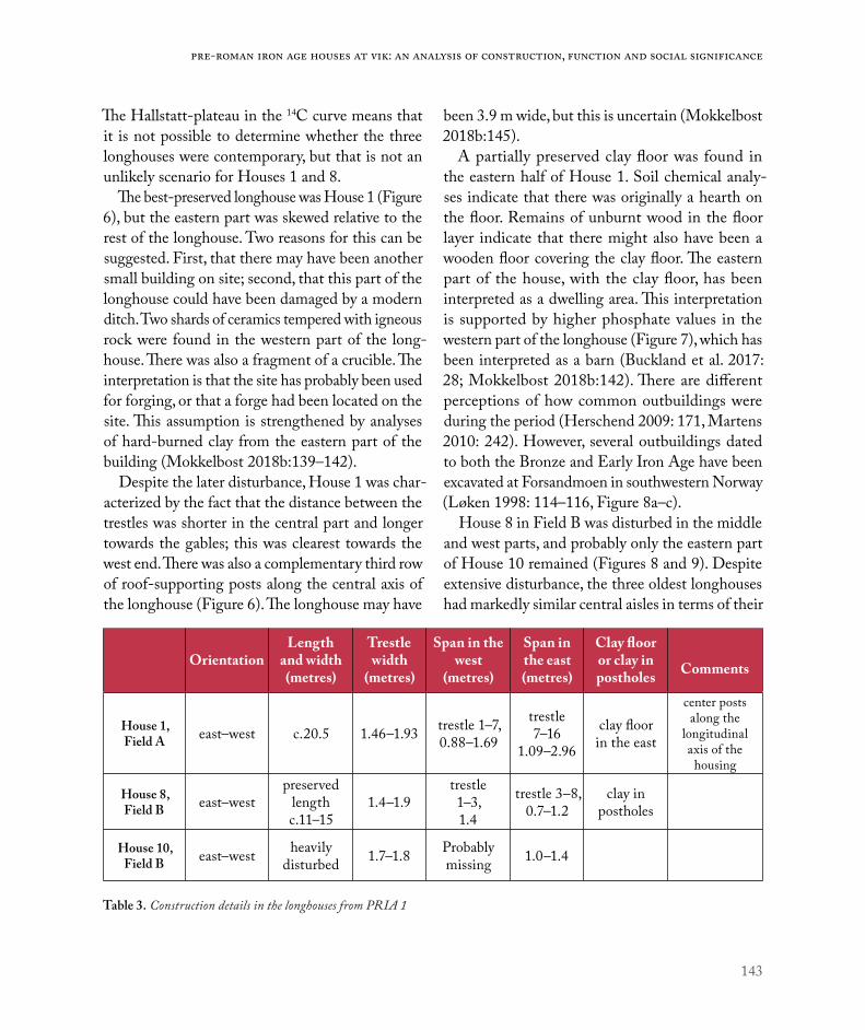
143
Pre-Roman Iron age houses at Vik: An analysis of construction, function and social significance
The Hallstatt-plateau in the 14C curve means that it is not possible to determine whether the three longhouses were contemporary, but that is not an unlikely scenario for Houses 1 and 8.
The best-preserved longhouse was House 1 (Figure 6), but the eastern part was skewed relative to the rest of the longhouse. Two reasons for this can be suggested. First, that there may have been another small building on site; second, that this part of the longhouse could have been damaged by a modern ditch. Two shards of ceramics tempered with igneous rock were found in the western part of the long-house. There was also a fragment of a crucible. The interpretation is that the site has probably been used for forging, or that a forge had been located on the site. This assumption is strengthened by analyses of hard-burned clay from the eastern part of the building (Mokkelbost 2018b:139–142).
Despite the later disturbance, House 1 was char-acterized by the fact that the distance between the trestles was shorter in the central part and longer towards the gables; this was clearest towards the west end. There was also a complementary third row of roof-supporting posts along the central axis of the longhouse (Figure 6). The longhouse may have
been 3.9 m wide, but this is uncertain (Mokkelbost 2018b:145).
A partially preserved clay floor was found in the eastern half of House 1. Soil chemical analy-ses indicate that there was originally a hearth on the floor. Remains of unburnt wood in the floor layer indicate that there might also have been a wooden floor covering the clay floor. The eastern part of the house, with the clay floor, has been interpreted as a dwelling area. This interpretation is supported by higher phosphate values in the western part of the longhouse (Figure 7), which has been interpreted as a barn (Buckland et al. 2017: 28; Mokkelbost 2018b:142). There are different perceptions of how common outbuildings were during the period (Herschend 2009: 171, Martens 2010: 242). However, several outbuildings dated to both the Bronze and Early Iron Age have been excavated at Forsandmoen in southwestern Norway (Løken 1998: 114–116, Figure 8a–c).
House 8 in Field B was disturbed in the middle and west parts, and probably only the eastern part of House 10 remained (Figures 8 and 9). Despite extensive disturbance, the three oldest longhouses had markedly similar central aisles in terms of their
OrientationLength
and width (metres)
Trestle width
(metres)
Span in the west
(metres)
Span in the east(metres)
Clay floor or clay in postholes Comments
House 1, Field A east–west c.20.5 1.46–1.93 trestle 1–7,
0.88–1.69
trestle 7–16
1.09–2.96
clay floor in the east
center posts along the
longitudinal axis of the housing
House 8, Field B east–west
preserved length c.11–15
1.4–1.9trestle 1–3, 1.4
trestle 3–8, 0.7–1.2
clay in postholes
House 10, Field B east–west heavily
disturbed 1.7–1.8 Probably missing 1.0–1.4
Table 3. Construction details in the longhouses from PRIA 1

144
Environment and settlement | Ulf Fransson
Figure 6. House 1, Field A. Illustration: Magnar Mojaren Gran, NTNU University Museum.
Figure 7. Spatial distribution of soil phosp-hate content (Cit-P) in and around House 1. Illustration: Magnar Mojaren Gran, NTNU University Museum.

145
Pre-Roman Iron age houses at Vik: An analysis of construction, function and social significance
Figure 8. House 8, Field B. The plan presents two alternative interpretations of the western part of the house. Illustration: Magnar Mojaren Gran, NTNU University Museum.
Figure 9. House 10, Field B. Illustration: Magnar Mojaren Gran, NTNU University Museum.

146
Environment and settlement | Ulf Fransson
width. There were no dug pits with hearths in Houses 8 and 10. Although House 8 was disturbed, it was possible to determine that it was divided into two sections. In the eastern section, the trestles were placed significantly closer together in the western part. A number of postholes in the longhouse con-tained unburnt clay, but here the clay was found in the bottom levels of the postholes. The subsoil was rich in sand, and the clay might have been used as packing material to support the posts (Fransson 2018: 377–379, 382–385).
THE SHAPE AND CONSTRUCTION OF THE LONGHOUSES DURING PRIA 2Houses 3 and 7 probably burned down and were abandoned during PRIA 2. They are the earliest long-houses with a new, and at Vik unusual, north-western – south-eastern orientation (Figure 3).
The best-preserved House 3 was divided into two sections (Figure 10). The dwelling part was in the northwest end of the house, where there were long distances between the trestles. In the southeast part, the postholes were much closer together, and there were many additional postholes. There were
also three or four sparsely spaced central posts along the house’s longitudinal axis.
In the central part of the house there was a round, charcoal-rich pit. It was flanked by two smaller postholes, which indicate that there had probably been some type of structure above the cooking pit. The term “cooking pit” is probably incorrect in this context. This pit had been reused on several occasions. By contrast, most of the contemporary cooking pits excavated in Field B appear to have been used only once. The differences indicate that the cooking pit inside House 3 should be defined as a dug hearth. A few metres to the northwest, there was an oval dug hearth in the centre of the dwelling area. This hearth also seemed to have been an original part of the longhouse, but this interpretation is uncertain because charcoal from the hearth has a late date, in the early Roman Iron Age (Fransson 2018: 414–420).
The postholes being so close together in the southeastern part of House 3 can indicate a barn. In the possible barn area there were remains of a clay floor (Figure 10). However, it has been pointed out that it would not have been practical to have a clay floor in a barn, at least not in the absence of a
House Area Orientation Length
(metres)
Trestle width
(metres)
Span in north-west
part
Span in south-east
part
Clay floor or clay in postholes
Comments
House 3, Field B
north-west – south-east c.16 1.7–2.6
(1.9–2.3)trestle 8–11, 1.9–2.5 m
trestle 1–8, 0.7–1.7 m
clay floor in south-east
part, clay in the postholes
center posts along the
longitudinal axis of the housing
House 7, Field B
north-west –south-east c.14 1.9–2.4 trestle 1–3,
2.5–2.5 mtrestle 3–8, 1.1–1.4 m
probably center posts along the
longitudinal axis of the housing
Table 4. Construction details in the longhouses from PRIA 2.

147
Pre-Roman Iron age houses at Vik: An analysis of construction, function and social significance
wooden floor. Clay was therefore more likely to have been used for floors in threshing barns (Petersson 2006: 67–68). In this case, the clay floor might indicate a dwelling area. The southeastern half of the longhouse was also lower-lying than the dwelling part, and during the excavations, the postholes were often filled with groundwater. The large numbers of postholes in this part of the house might therefore be due to problems with high groundwater levels, and not with faeces from stalled animals.
House 7 was also divided into two sections (Figure 11). The row of postholes in the northeast part of House 7 was less well preserved than the row in the
south-west. However, the excavations revealed that the distance between the trestles in the northwestern part of the longhouse were longer than between those in the south-eastern part. Both the trestle width and the distance between the trestles were consistent with corresponding measurements in House 3, although House 7 was a few metres shorter. A posthole in the southeastern end indicates that House 7, like House 3, had a central row of posts, at least in parts of the building (Fransson 2018:426–427).
There appear to be no barns in Houses 3 and 7. The phosphate mapping of the filling in the post-holes and the surface layers within and around the
Figure 10. House 3, Field B. Illustration: Magnar Mojaren Gran, NTNU University Museum.

148
Environment and settlement | Ulf Fransson
houses indicate that domestic animals were kept outside the south end of the two longhouses (Figure 12). The impression is supported by the results of paleobotanical analysis. Although there were finds of carbonised grains of barley in House 3, there were no traces of meadow and/or wetland seeds in the material. This is despite the fact that there were significant amounts of straw in the samples, which suggests that the preservation conditions were suf-ficient for such fragile remains to survive. Meadow and/or wetland seeds should have survived to a similar degree if they had been present (Buckland 2017: 43, Figure 39, 42–43).
A large amount of paleobotanical material was also found in House 7. However, the composition of the material differed from that in House 3. It was more diverse, and included naked barley, hulled barley, oats, flax and a relatively large amount of seeds from both meadow and wetland species. The analyses indicated that the southeastern part of the longhouse was used as a threshing barn. In a posthole in the northwestern part of the longhouse, a deposit containing 700 cereal grains together with pine tar residue was found (Figure 12). This combi-nation indicates that the grain had been stored in a now degraded container, and that this part of the
Figure 11. House 7, Field B. Illustration: Magnar Mojaren Gran, NTNU University Museum.
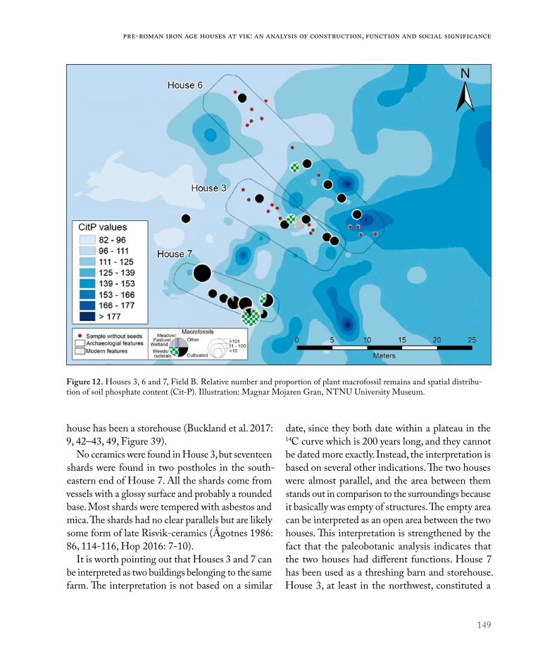
149
Pre-Roman Iron age houses at Vik: An analysis of construction, function and social significance
house has been a storehouse (Buckland et al. 2017: 9, 42–43, 49, Figure 39).
No ceramics were found in House 3, but seventeen shards were found in two postholes in the south-eastern end of House 7. All the shards come from vessels with a glossy surface and probably a rounded base. Most shards were tempered with asbestos and mica. The shards had no clear parallels but are likely some form of late Risvik-ceramics (Ågotnes 1986: 86, 114-116, Hop 2016: 7-10).
It is worth pointing out that Houses 3 and 7 can be interpreted as two buildings belonging to the same farm. The interpretation is not based on a similar
date, since they both date within a plateau in the 14C curve which is 200 years long, and they cannot be dated more exactly. Instead, the interpretation is based on several other indications. The two houses were almost parallel, and the area between them stands out in comparison to the surroundings because it basically was empty of structures. The empty area can be interpreted as an open area between the two houses. This interpretation is strengthened by the fact that the paleobotanic analysis indicates that the two houses had different functions. House 7 has been used as a threshing barn and storehouse. House 3, at least in the northwest, constituted a
Figure 12. Houses 3, 6 and 7, Field B. Relative number and proportion of plant macrofossil remains and spatial distribu-tion of soil phosphate content (Cit-P). Illustration: Magnar Mojaren Gran, NTNU University Museum.

150
Environment and settlement | Ulf Fransson
dwelling area. Unlike the other houses, these two have also burnt down, something that may have happened at the same time.
Thirty metres northwest of House 7, House 11 was excavated. House 11 was far too disturbed for its construction to be analysed in detail, but it had the same unusual northwest to southeast orientation as Houses 3 and 7. The few preserved trestles in House 11 had also approximately the same width between postholes as found in Houses 3 and 7 (Fransson 2018:433–435). This indicates that House 11 can be dated to PRIA 2, but the interpretation is uncertain. The spread of the 14C-dates may indicate that the house is late and does not belong to the pre-Roman Iron Age.
THE SHAPE AND CONSTRUCTION OF THE LONGHOUSES UNDER PRIA 3Houses 6 and 13 in Field B, House 8 in field A and House 18 in Field C are dated to PRIA 3. The
earliest of these buildings is probably House 6, and the latest is House 18.
The dates indicate that House 6 is later than House 3 and 7, although the three longhouses were probably close in time. All these three houses also had the same unusual north-west to south-east orientation (Figure 3). However, House 6 had a different construction and layout than the earlier longhouses. There were no traces of a clay floor in House 6, and all three hearths were dug down in the subsoil. House 6 was also c.30 m in length, and the longest longhouse in Field B (Figure 13). Remains of the external walls show that the house was c.5.5 m wide at the northwest gable, and just over 6 m wide in the middle part. The width of the central aisle in relation to the external wall shows that the longhouse had a balanced or overbalanced roof construction (Table 5).
The distance between the trestles was longer in the central part compared to the two ends. This indicates that there were three sections: one larger
Orientation Length / width (metres)
Trestle width
(metres)
Span length,
north-west or west part
Span length, south-east or
east partComments
House 6 Field B
north-west – south-east c.29.5–30/5.5–6.5 2.7–3.3 trestle 1–6,
1.4–5 m (?) Trestle 6–13; 1.4–3 m
House 9, Field A
east-northeast – west–southwest c.22/5.3 2.7–3.05 ? 1.3–1.8 m
span heavily disturbed, but
there were center posts along the
longitudinal axisHouse 13, Field B east–west longer than 8 m. 2.8–3.1 0.9–2.0 m ? heavily disturbed
House 11, Field B
north-west – south-east Longer than 5 m. 1.6–1.8 0.9–1.1 m ? heavily disturbed
House 18, Field C
east-northeast – west–southwest c.10.5 2.2–2.7 trestle 1–2;
3.2 mtrestle 2–4, 3.4–3.8 m
Table 5. Construction details in the longhouses from PRIA 3.
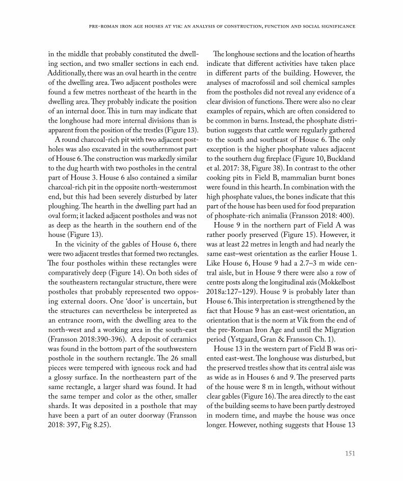
151
Pre-Roman Iron age houses at Vik: An analysis of construction, function and social significance
in the middle that probably constituted the dwell-ing section, and two smaller sections in each end. Additionally, there was an oval hearth in the centre of the dwelling area. Two adjacent postholes were found a few metres northeast of the hearth in the dwelling area. They probably indicate the position of an internal door. This in turn may indicate that the longhouse had more internal divisions than is apparent from the position of the trestles (Figure 13).
A round charcoal-rich pit with two adjacent post-holes was also excavated in the southernmost part of House 6. The construction was markedly similar to the dug hearth with two postholes in the central part of House 3. House 6 also contained a similar charcoal-rich pit in the opposite north-westernmost end, but this had been severely disturbed by later ploughing. The hearth in the dwelling part had an oval form; it lacked adjacent postholes and was not as deep as the hearth in the southern end of the house (Figure 13).
In the vicinity of the gables of House 6, there were two adjacent trestles that formed two rectangles. The four postholes within these rectangles were comparatively deep (Figure 14). On both sides of the southeastern rectangular structure, there were postholes that probably represented two oppos-ing external doors. One ‘door’ is uncertain, but the structures can nevertheless be interpreted as an entrance room, with the dwelling area to the north-west and a working area in the south-east (Fransson 2018:390-396). A deposit of ceramics was found in the bottom part of the southwestern posthole in the southern rectangle. The 26 small pieces were tempered with igneous rock and had a glossy surface. In the northeastern part of the same rectangle, a larger shard was found. It had the same temper and color as the other, smaller shards. It was deposited in a posthole that may have been a part of an outer doorway (Fransson 2018: 397, Fig 8.25).
The longhouse sections and the location of hearths indicate that different activities have taken place in different parts of the building. However, the analyses of macrofossil and soil chemical samples from the postholes did not reveal any evidence of a clear division of functions. There were also no clear examples of repairs, which are often considered to be common in barns. Instead, the phosphate distri-bution suggests that cattle were regularly gathered to the south and southeast of House 6. The only exception is the higher phosphate values adjacent to the southern dug fireplace (Figure 10, Buckland et al. 2017: 38, Figure 38). In contrast to the other cooking pits in Field B, mammalian burnt bones were found in this hearth. In combination with the high phosphate values, the bones indicate that this part of the house has been used for food preparation of phosphate-rich animalia (Fransson 2018: 400).
House 9 in the northern part of Field A was rather poorly preserved (Figure 15). However, it was at least 22 metres in length and had nearly the same east–west orientation as the earlier House 1. Like House 6, House 9 had a 2.7–3 m wide cen-tral aisle, but in House 9 there were also a row of centre posts along the longitudinal axis (Mokkelbost 2018a:127–129). House 9 is probably later than House 6. This interpretation is strengthened by the fact that House 9 has an east-west orientation, an orientation that is the norm at Vik from the end of the pre-Roman Iron Age and until the Migration period (Ystgaard, Gran & Fransson Ch. 1).
House 13 in the western part of Field B was ori-ented east-west. The longhouse was disturbed, but the preserved trestles show that its central aisle was as wide as in Houses 6 and 9. The preserved parts of the house were 8 m in length, without without clear gables (Figure 16). The area directly to the east of the building seems to have been partly destroyed in modern time, and maybe the house was once longer. However, nothing suggests that House 13

152
Environment and settlement | Ulf Fransson
Figure 13. House 6, Field B. Illustration: Magnar Mojaren Gran, NTNU University Museum.
Figure 14. House 6, Field B, trestle pairs and posthole depth indica-ted. Illustration: Magnar Mojaren Gran, NTNU University Museum.

153
Pre-Roman Iron age houses at Vik: An analysis of construction, function and social significance
was as long as Houses 6 or 9. The preserved area probably represents a dwelling area. In the middle part were a preserved hearth and a nearby pit with a fireplace with two adjacent postholes, significantly similar to those dug hearths that were excavated in Houses 3 and 6. A few metres to the west, there were two adjacent postholes that probably marked the position of an internal door – a construction recognizable from the northern half of House 6 (Fransson 2018:407–408).
House 18 in Field C had an east–west orientation and lacks exterior walls and a dug hearth (Figure 17). Four trestles were considered to be part of a longhouse with a minimum length of 10.5 m. In
the west there was a fifth trestle, but the postholes were not quite in line with the postholes in the other trestles. With a fifth trestle, the longhouse would have been about 14-15 m in length (Figure 17). However, the house had a wide central aisle of 2.2–2.7 m. The wide central aisle is reminiscent of the aisles in Houses 6, 9 and 13. Another similarity is the apparent distance of 3.2–3.8 m between the trestles (Heen-Pettersen 2018: 466-467).
SHARDS AND CERAMICSThere are finds of shards of ceramics in several of the longhouses at Vik. Deposits of ceramics in Norwegian longhouses dated to pre-Roman Iron
Figure 15. House 9, Field A. Illustration: Magnar Mojaren Gran, NTNU University Museum.

154
Environment and settlement | Ulf Fransson
Figure 17. House 18, Field C. Illustration: Magnar Mojaren Gran, NTNU University Museum.
Figure 16. House 13, Field B. Illustration: Magnar Mojaren Gran, NTNU University Museum.

155
Pre-Roman Iron age houses at Vik: An analysis of construction, function and social significance
Age are few. However, beneath the floor level in a 30 m long house (House CXIX) at Forsandmoen, there were deposited both a pottery vessel and a grindstone for grinding grain. The longhouse at Forsandmoen is from the second part of the period, and the deposits have, together with the length of the house, been interpreted as an indication of higher social status (Løken 2001: 59, Figures 3a and 4).
A comparable deposit of pottery was found in the southern part of House 6 at Vik (Figure 13). Most of the shards were found in the southwestern posthole in the southern rectangle, with comparatively deep postholes (see above). Another large shard of pottery was found in one of the postholes associated with the eastern external door in the same part of the longhouse (Fransson 2018: 397, Figure 8.25). All the ceramic shards were found near the dug hearth in the southeast, and can be interpreted as waste. The fact that the former finding was made in the bottom part of the posthole, and that the shards were so crushed, suggests that they were deposited before the roof-supporting post was placed in the posthole (Fransson 2018: 397, Fig 8.25).
However, at Vik, the conditions were complex because ceramics were also found in Houses 1 and 7 (Figure 11). As in House 6, most of the shards in House 7 were found in the south-west part of the longhouse. It is also possible to interpret these finds as waste (Fransson 2018: 428–429). However, in Field B shards of ceramics were found only in the longhouses, although a large number of other structures from the pre-Roman Iron Age were excavated. This indicate that pottery have been treated differently in different context on the area. Together with the similarity between the houses and the location of the deposits in post-holes suggests that the deposits were intentional. Ritual deposits of pottery in postholes is a well-known phenomenon, but better documented in southern Scandinavia (Carlie 2004: 47–57, 65, 202–205, Figure 11.4).
Unlike the conditions at Forsandmoen, there were deposits in houses of different sizes and functions at Vik. This indicates that the tradition varied between different parts of Scandinavia.
THE LONGHOUSES AT VIK AND THEIR CONSTRUCTION IN A PRE-ROMAN IRON AGE CONTEXTThe standard view today is that the pre-Roman Iron Age longhouses in Scandinavia had an east-west orientation and were rather short. Analyses have shown that there was a large group of longhouses that had a length of 6-16 m. There were larger houses, but they were no longer than 20-25 m, and 6 m wide. Both types of houses often had four, or sometimes six, pairs of trestles, and were divided into a dwelling part with clay floor and a barn (Pedersen & Widgren 1998: 416–426; Myhre 2002: 45–47, 97–99, 116–119; Webley 2008: 51–53, Herschend 2009: 171-176, 182-183).
This model is based on studies of longhouses in southern Scandinavia. The possibility that differ-ent regions in Scandinavia have partly their own traditions has been highlighted in several works. Analyses in Skåne have confirmed that there were also houses with more pairs of trestles in southern Scandinavia, particularly in the period after 200 BC (Artursson 2005: 81- 86, 91-93; Webley 2008:51; Martens 2009: 240-241, 246). The review of the longhouses at Vik shows that they also usually had considerably more than only six pairs of trestles. This fact has already been highlighted in earlier analyses of longhouses from the pre-Roman Iron Age in Trøndelag (Grønnesby 2005:99).
The two issues at Vik of clay floors and whether or not the hearth is dug down in the subsoil are impor-tant. The excavations at Forsandmoen have shown that houses earlier then 200 BC often had a clay floor but lacked a dug hearth. The hearth was probably placed on top of the clay floor, and was subsequently

156
Environment and settlement | Ulf Fransson
destroyed by ploughing. At Forsandmoen, no clay was found in postholes postdating c. 200 BC, indi-cating that the clay floors had disappeared. Another contemporary innovation was that the hearths were dug down into the subsoil (Løken 1999: 53–56; 2001: 56).
A similar change can be seen in the material from Vik. All longhouses dated to PRIA 1 lack signs of dug hearths, and House 1 had a preserved clay floor. During PRIA 2, the picture is more mixed. It was now common with dug hearths, but in House 3 there was also a clay floor. It is not until House 6 in the transition to PRIA 3 that there was definitely no clay floor. Clay floors were also lacking in PRIA 3 Houses 9, 13 and 18.
It has also been emphasized that the longhouses were dominated by balanced and overbalanced roof constructions in several parts of Scandinavia during the late Bronze Age and the pre-Roman Iron Age. Between c. 200 BC - AD 200 there are, at first, occasional, and then more and more examples of underbalanced constructions. This represents a change in which the underbalanced constructions come to dominate the material during the Roman Iron Age. Simplified, this means that the central aisle in the tree-aisled houses successively became narrower in relation to the width of the entire building. This probably affected the construction of the roof (Herschend 1989: 83–84, 90–95; Komber 1989: 26, 124–131; Göthberg 2000: 20–22, 91, 121; Wikborg & Onsten-Molander 2007: 109, 114; Gjerpe 2017: 77–79, 111).
However, this change towards more underbal-anced constructions is difficult to date, especially in cases where the longhouses do not have preserved remains of exterior walls or parallel internal posts. Furthermore, the dating of the earliest underbal-anced longhouses implies a successive change, with variation between different regions and sometimes also within a region, as in the county of Østfold
(Artursson 2005: 87, 97–98, 112, 14; Karlenby 2007: 132–133, 135–136, Figure 6-10, Gjerpe 2017: 111–113).
Few longhouses at Vik had preserved exterior walls, and an analysis must be made with caution. House 6 has such a wide central aisle in relation to the exterior walls that the construction was balanced to overbalanced. In the earlier longhouses during PRIA 1, the central aisles were not wider than 1.9 m, and during PRIA 2, at most 2.4–2.6 m. None of these longhouses had preserved exterior walls, and it is not possible to decide if they were overbalanced or underbalanced. However, they did have a nar-rower central aisle than House 6. None of the late houses during PRIA 3 had any exterior walls, but they had central aisles with a width of 2.7–3.1 m. It is a width comparable to House 6, even though some of these later longhouses were shorter than the ones from PRIA 1 and 2.
In underbalanced constructions, the central aisle occupies about one-third of the full width of the longhouse (Göthberg 2000:48). Nothing suggests that Houses 9, 13 or 18 were underbalanced. Instead, they should be compared to a rather short house that has been excavated at nearby Viklem in Ørland. There, House 1 was dated to the second half of the pre-Roman Iron Age. It had a well-preserved exterior wall and was c.11 m long and c.5-6 m wide (Øien 2008: 8–10, Figure 4). The length is comparable with Houses 13 and 18 at Vik, indicating that even these longhouses have been about as wide. Although the interpretation is uncertain, the change towards wider central aisles from PRIA 1 to PRIA 3 should not be neglected. After all, the ever wider trestles show that the construction of the longhouses’ roof-bearing struc-tures at Vik changed during the pre-Roman Iron Age.
In this context, the roof-supporting posts along the middle axis in Houses 1, 3, 7 and 9 should be mentioned. They represent a constructional element that may be more common than recorded. They occur

157
Pre-Roman Iron age houses at Vik: An analysis of construction, function and social significance
occasionally in Scandinavia during both the Bronze and Iron Age, but their function is not clear. They may have had significance for the roof-construction, but it has also been suggested that these posts have supported a ceiling, or a loft (Wikborg & Onsten-Molander 2007: 115 with references).
A BARN OR NOTAs already indicated, most of the longhouses at Vik break with the classic division into a dwelling part and a barn. This can be perceived as a radical interpretation, but it cannot be taken for granted that the livestock were kept indoors. Winter barns are not a general phenomenon in northern Europe. In the British Isles and parts of Eastern Europe, winter barns were introduced in the Middle Ages, if at all. As late as in the 1600s and 1700s, there are also examples that cattle were left outdoors for much of the winter in some regions in Scandinavia. In fact, cattle can manage to survive outdoors in very cold weather, preferably in places where the snow depth rarely exceeds 20–30 cm (Pedersen & Widgren 1999:253-256, Petersson 2007: 84, 256). For Norway, it has been pointed out that the coastal districts in the counties of Møre og Romsdal and Trøndelag have such mild winters that cattle may have been left outdoors in the winter (Myhre 2002: 79). This area includes Vik and Ørland.
However, cattle can be sensitive to moisture, which may explain why the practice of keeping them indoors was introduced in parts of Scandinavia. Other reasons that have been emphasized are that keeping cows in barns would have made milking and collecting dung easier. These explanations have, however, been questioned, because both milking and collecting dung can easily be done outside if the animals are enclosed near the house during the night. A barn was also a simple way to protect the animals against wild animals and hostile raids. A more social explanation is that the barns would have
been a way to demonstrate the size of a farm’s herd, which also demonstrated wealth and status. However, if winter grazing was practised, the number of ani-mals kept might have been greater than what can be estimated simply from the size of a barn (Løken 1998: 117–118; Pedersen & Widgren 1999: 255-256; Myhre 2002: 98-101; Petersson 2006: 60–63, 84, 256, 364–365; Martens 2010: 245-246).
Archaeologists have often been criticised for using criteria for keeping livestock in barns that are conflicting, or that only one criterion has been proposed (Petersson 2006: 64–71, 81–82; Karlenby 2007: 135). In practice, it has been difficult to determine traces of internal divisions indicative of barns in the Scandinavian peninsula. Recently, examples of internal divisions in some longhouses at Hofstad in Melhus in Trøndelag have been presented (Henriksen & Bryn 2019:182–186). Otherwise, it has been pointed out that no examples have been found in Norwegian longhouses from either the Late Bronze Age or the pre-Roman Iron Age (Myhre 2002: 98; Gjerpe 2016: 208). In other cases, it has been possible to show that the long-houses had barns. However, even when there are examples, it has been difficult to demonstrate that keeping livestock has been the dominant practice in a given area (Pedersen & Widgren 1998: 256–258). There are also examples that the practice of keeping animals indoors might have varied over time, and between different social groups. For example, in Östergötland in Sweden stables seems to have been rare during the pre-Roman iron Age. However, there were indications of a stable in a few of the longest longhouses. During the Roman Iron Age, the clearest indication comes from medium-sized longhouses. The example highlight that it changes in the role of cattle, and whether there were barns or not, can reflect differences between resources and aims of different social groups (Petersson 2006: 84–85, 92–93, 253).

158
Environment and settlement | Ulf Fransson
According to Maria Petersson, the problem is that the debate on barns is based on the assumption that livestock were always kept indoors during winter. Instead, she emphasizes the relationship between the longhouse and animal husbandry. In principle, livestock were always present in connection with the houses, but how they were cared for varied. This approach does not contradict the interpretation that the practice of keeping animals in barns occurred during the Early Iron Age. It also seems to have been common that animals were only kept in parts of the longhouses for limited periods, for instance when they were sick or during calving (Petersson 2006: 63–64, 80–82, 87–93).
A less rigid interpretation of the divisions of the longhouses can also explain the high phosphate values south of Houses 3, 6 and 7 at Vik. In these cases the animals have not been, or have only seldom been, indoors. Instead, they have regularly been kept in outdoors enclosures just south of the longhouses (Figure 12).
LONG LONGHOUSES AT VIKAt Forsandmoen, longhouses considerably longer than c. 20 m did occur from around the year 200 BC. Later, about year AD 1, there were also really large houses that could be 50 m in length. The introduction of longer longhouses did not take place simultaneously in all parts of Scandinavia. Denmark was dominated by smaller and medium-sized long-houses until the beginning of the Late Roman Iron Age. In contrast, longhouses of 30-40 m have been found in Norway, and in Mälardalen and Skåne in Sweden, from the end of the pre-Roman Iron Age (Løken 1998:116–119; 1999: 54–55; 2001:59–60; Artursson 2005:91–93, 97–98; Wikborg & Onsten-Molander 2007: 119; Martens 2010: 241-242; Gjerpe 2017: 111).
One example is House 6 in Field B, but it is impos-sible to detect a continuous and steady development
from shorter to longer longhouses at Vik. Houses 3 and 7 were, respectively, c.16 m and c.14 m in length, which is shorter than the earlier House 1. Together, the two longhouses from PRIA 2 were the same length as House 6, dated slightly later. In other words, the early 20 m long House 1, which is supplemented by a small outbuilding, that were superseded by a structure where the dwelling house, House 3, and the outbuilding, House 7, were of almost the same size. This could indicate that more functions had moved out of the dwelling house. Later, these func-tions maybe moved back into the larger House 6. In the latest phase of PRIA 3, Houses 13 and 18 are significantly shorter than House 6, indicating that the houses’ functions have changed again.
The fact that House 6 was much longer and had another internal architecture with a broader central aisle appears to represents something radically new. However, already in the construction of Houses 3 and 7, new ways of building houses were introduced. This is evident from, among other things, the radi-cally altered orientation (Figure 3). It is noteworthy that a similar change in orientation also occurs at Kvenild at Tiller, south of Trondheim, in Trøndelag. Here, about 20 houses dated to 1000-100 BC were excavated. Most, but not all, were earlier than those at Vik, and had an east-west orientation. The only exception was the largest longhouse, House Q, which had a northwest - southeast orientation. House Q has been dated to the 400s or 300s BC (Grønnesby 2005: 99, 102–105), a date that can be compared with PRIA 2 and Houses 3 and 7 and maybe the slightly later House 6 at Vik. House Q is just a single example, but it suggests that reorientations of larger houses occurred in several places in Trøndelag during PRIA 2. Later on, it seems to have been important to return to an earlier orientation.
The changes of orientation should also be inter-preted as intentional. Analyses from the county of Østfold in Norway, and from Denmark, have shown

159
Pre-Roman Iron age houses at Vik: An analysis of construction, function and social significance
that the orientation of longhouses can only to some extent be explained by the prevailing wind direction. All exceptions show that their orientation was closely related to changes in sacred or mental perceptions (Webley 2008: 56–60; Gjerpe 2017: 124).
LONG LONGHOUSES IN TRØNDELAGHouse 6 is not the only c.30 m long longhouse known from the pre-Roman Iron Age in central Norway. Three longhouses of a comparable size have been excavated at Hofstad in Melhus. At that site two smaller houses were interpreted as outbuildings with large hearths or ovens, probably used in cooking (Henriksen & Bryn 2019:181–191). Previously, two unusually long longhouses, Houses I and IV, had been excavated at Søberg in Melhus (Rønne 2005: 89–93). Another comparably long longhouse was excavated at Husby in Stjørdal (Henriksen 2007: 72, Figure 3) and at Sjetnan in Trondheim municipality (Mokkelbost & Ystgaard 2015: 30–35).
These longhouses are about 25–33 m in length and are dated to PRIA 3 or the latter half of the pre-Roman Iron Age. At Valum-Hallem in Verdal municipality, a c.40 m long longhouse has been dated to 200 BC – AD 135 (Mokkelbost & Sauvage 2014: 64, 69, Table 5). A number of these dates are rather late, and the house may be dated to the last century BC or the first century AD. The interpretation is supported by analyses of houses with a comparable length in Mälardalen and Skåne in Sweden. They do not appear to be earlier than about AD 1 (Karlenby 2007: 137; Martens 2010: 242).
A similar interpretation may also be applied to Houses D and E at Hovde in Ørland. The two houses were, respectively, 28 and 33 metres in length. One 14C analysis dates House E to 360-35 BC, but the longhouse has been interpreted as contemporary with House D, which has been dated to 115 BC – AD 55. House D was overlaid and probably quickly
replaced by House F, which has been dated to AD 70–310 (Grønnesby 1999: 69–71, 74–75, 77). Given that houses with posts dug into the ground rarely last longer than 100 years, Houses E and D were probably built towards the end of pre-Roman Iron Age. The oldest houses at Hovde should therefore be contemporary with House 18 in Field C, and with the longhouse at Valum-Hallem.
LARGE LONGHOUSES AND SOCIAL DIVERSITY IN THE PRE-ROMAN IRON AGEThe pre-Roman Iron Age has been treated as a period of decline, characterized by a low degree of social differentiation. This has often been interpreted as a result of unrest in continental Europe during the first centuries of the period. Another factor that often is highlighted is that Scandinavia was hit hard by climate deterioration around 500 BC (Pedersen & Widgren 1998: 246–247). Today, this particular climate change is considered to have been more gradual and to have started earlier, already by about 1000 BC. The period that followed has also been revaluated and is often described as a third agricultural revolution (Solberg 2000: 65; Myhre 2002: 76, 92–97). The importance of agriculture was also evident in funeral contexts. From about the year 200 BC, hand sickles, needles, and awls started to be included in both women’s and chil-dren’s burials (Petersen & Widgren 1998: 352–357; Solberg 2000: 99).
In the early pre-Roman Iron Age there are also single finds of weapons and prestigious Celtic arte-facts in different contexts in southern Scandinavia (Hedeager 1990: 52–55, 195–199; Martens 2011). A gradual change towards a society with hierarchical differences became more evident in the second half of the period. In western Norway, Celtic prestigious items, single weapons and female jewellery had already been introduced in burials by around 200 BC.

160
Environment and settlement | Ulf Fransson
The examples are few, but it is likely that they indicate the introduction of some form of chiefdom (Solberg 2000: 94–103; Løken 2001: 52–53). Similar changes occurred in Sweden and in other parts of Norway during the last century of the period (Nicklasson 1997: 138; Solberg 2000: 42–48, 65). In Trøndelag the earliest burial with weapons, a spearhead and a shield boss dated to the last hundred years BC were excavated at Hø in Inderøy (Møllenhus 1973: 15, Fig. 13–14). It has also been pointed out that during the end of the pre-Roman Iron Age there were new ways of looking at property rights. A previous system, where land belonged to the community, was starting to dissolve during the end of the pre-Roman Iron Age. Instead one or a few dominant families were beginning to establish ownership rights over the land, or at least over some of the land (Herschend 2009: 170–171).
The changes in both agriculture and the social system indicate that the pre-Roman Iron Age was characterized by several parallel processes. Weapons and jewellery were used to indicate high status. Tools used in crafts and agriculture can be interpreted in the same way, especially given that they often only occur in certain graves, or together with other high status objects such as jewellery. The shape of the longhouses certainly formed part of these changes.
Archaeologists have generally neglected the inter-nal organisation and division of functions in the longer longhouses from the pre-Roman Iron Age (Carlie & Artursson 2005: 197; Karlenby 2007: 135). Although there are some examples. In the longhouses from Husby, Søberg, and Valum-Hallem, there were probably three or four rooms or sections (Mokkelbost & Sauvage 2014: 69–70, Figure 54). Another example is the earliest longhouses at Hovde, which had hearths located in different parts of the house (Grønnesby 1999: 72–73). Recently, there has also been carried out a room analysis of the
longhouses at Hofstad in Melhus (Henriksen & Bryn 2019: 191–194).
The distribution of hearths in House 6 at Vik is comparable to the longhouses at Hovde. It is obvi-ous that different household tasks were carried out in different parts of House 6. The high phosphate values around the southern hearth suggest that the activities generated a lot of waste, which might not have been desirable in the dwelling area. In the Scandinavian peninsula, comparable rooms with hearths near the gables of large longhouses from the Roman Iron Age have been interpreted as spaces where the servants, or slaves, lived and worked (Norr 1996; Myhre 2001: 116). It is uncertain whether this was the case also in the pre-Roman Iron Age. The analyses carried out to examine evidence of social differentiation during the pre-Roman Iron Age are mainly based on material from southern Scandinavia (Herschend 2009). Our knowledge about division of labour and social and/or gender-related conditions is therefore limited in other parts of Scandinavia, especially at a local level.
An example of these local differences is the 33 m long longhouse (House 2) at Hofstad in Melhus. It has been interpreted as two smaller houses with two separate households that have been built into a larger longhouse. Two rather equal households each had their own living area in the two short ends of the longhouse, separated by a large common barn in the middle part of the house (Henriksen & Bryn 2019: 191–196, Figure5). House 6 at Vik did not have a barn, and the living part was situated in the middle part of the longhouse. The differences indicate that there have been regional differences between the coast and inland districts in Trøndelag.
In another example, the interior of the long House CXIX at Forsandmoen was subdivided into several sections and a barn. Like House 6 at Vik, House CXIX had a larger space or room in the centre of

161
Pre-Roman Iron age houses at Vik: An analysis of construction, function and social significance
the longhouse. It was characterized by a centrally placed hearth and sparsely spaced roof-supporting posts. This construction is not quite comparable to House 6, but the room in House CXIX has been highlighted as an example of a hall already in use during the pre-Roman Iron Age (Løken 2001: 56–59, 69, 81, Figure 3a). Based on similar criteria, the 33 m long House D in Hovde at Ørland has been interpreted as a hall. It is not an impossible interpretation, given the location of Hovde, with a wide view overlooking the sailing routes in and out of the Trondheim fjord, and offering the possibility of exercising control over this traffic (Grønnesby 1999: 72–73, 77–78).
The halls highlighted in the literature are generally dated to the first millennium AD. The criteria also include more exceptional artefacts in glass and gold (see Herschend 1993: 182–185). In this context, it is important to emphasize that there is an ongoing and more differentiated discussion about the hall concept. Leif Karlenby has pointed out that a space defined as a hall within the longhouses has almost always been found in excavated settlements from the Roman Iron Age in Mälardalen. Such spaces could have been halls, but Karlenby argues for an increased differentiation of the concept. Instead, he argues, the larger open spaces in medium-sized longhouses should be interpreted as a room for meetings, but at a family level. This type of meeting room also has an earlier history in the pre-Roman Iron Age. Halls identified in the largest houses during the Roman Iron Age do often have a similar design and shape to the less exclusive ones, but the artefacts are more exclusive and are clearly linked to the highest social strata of chieftains and petty kings. These halls were used to create and maintain political and military relations between different groups (Karlenby 2007: 123–128, 131, 133).
The middle part of House 6 can be interpreted as a hall or at least as a place for social gathering.
However, it is more uncertain whether a chief lived here. It is still not known if House 6 was built for just a single household, or if it was occupied by an extended family. Another question is how House 6 is related to the later houses, like Houses 13 and 18, which are so much smaller. These houses indicate a beginning of a new stage in Field B. The area was already abandoned during the latter part of PRIA 3. In this case Field B is not comparable with the other areas at Vik. There may have been several reasons for the abandonment, but the area does not appear to have been used for settlement during the rest of the Iron Age or the Middle Ages. This indicates that the site was no longer considered suitable for housing. It is also possible that the abandonment had a background in a changed view of property rights, in line with what has been propounded with regard to southern Scandinavia in general (See Herschend 2009). In order to better understand these changes, the material from the pre-Roman Iron Age should be compared with that from the Roman Iron Age, a task that lies beyond the scope of this article.
On the other hand, these discussions and research results demonstrate the potential in an analysis of longhouses from the pre-Roman Iron Age. In the Scandinavian peninsula, more exclusive jewellery and weapons were introduced in burials during the last century BC. Houses 3, 7 and 6 were earlier. The size and the orientation of the houses may just be one part of a larger picture. A precursor to the hall, an incipient division of labour inside the longhouses and depositions in different parts of the buildings surely can be other traces of important changes. Together they indicate that during PRIA 2 longhouses already constituted a significant way of expressing social, sacral and mentality differences.
CONCLUSIONThe purpose of this article was to investigate the longhouses from the pre-Roman Iron Age at Vik.

162
Environment and settlement | Ulf Fransson
The longhouses have been divided into three differ-ent chronological phases, PRIA 1-3. The earliest buildings, Houses 1, 8 and 10 belonged to PRIA 1 (700-400/ 350 BC). All the longhouses were oriented in an east-west direction. In the best-preserved House 1, there were remnants of a clay floor in the east, where traces of a fireplace show that this was a dwelling area. In the western half, elevated phos-phate values show that this part was used as a barn.
Houses 3, 7 and maybe 11 belonged to PRIA 2 (c. 350/ 300–200 BC). Unlike the earlier houses, the hearths had been dug into the subsoil. Both House 3 and 7 were divided into two sections and were oriented in a northwest to south-east direction. Analysis show that House 3 constituted a dwelling house but lacked a barn. House 7 was probably a combination of a threshing barn and a storage building. The two houses were probably in use simultaneously and together they constituted the buildings of a farm.
The latest group belonged to PRIA 3 (200 BC–AD 50) and included Houses 6, 9, 13 and 18. The date of House 6 was probably close in time to Houses 3 and 7. The three houses had the same orientation, but House 6 was c. 30 metres long and 6 metres wide. The later Houses 9, 13 and 18 were smaller,
but like House 6 they all seem to lack a barn. All the houses in the latest group had wider central aisles than the earlier houses.
Overall, PRIA 2 appears to have marked the beginning of an eventful period. With Houses 3 and 7, the older preference of orientation of the houses was broken, while the previous multi-functional longhouse was split up and functions divided between two longhouses. Later during the opening phase of PRIA 3, the larger House 6 was built. Later, the houses were shorter, and the houses were once again laid out in the earlier west-east orientation. This orientation dominated the later building tradition at Vik throughout the Roman Iron Age. The changes in size, shape and orientation of the longhouses at Vik also give a good indication of the value of analysing longhouses in order to better understand the changes in society during the pre-Roman Iron Age.
ACKNOWLEDGEMENTSA special thanks to Marie-Josée Nadeau, Associate Professor and Leader of the National laboratory for Age Determination at NTNU University Museum in Trondheim, for good advice and source-critical remarks about the 14C method.

163
Pre-Roman Iron age houses at Vik: An analysis of construction, function and social significance
REFERENCES
Artursson M. 2005: Böndernas hus. In: Carlie, A. (ed.): Järnålder vid Öresund. Band 1. Specialstudie och syntes, pp. 76-161. UV Syd, avdelningen för arkeologiska undersökningar. Riksantikvarieämbetet. Lund.
Buckland, P., J. Linderholm, S. Östman, S. Eriksson, J.-E. Wallin & R. Engelmark 2017: Environmental archaeological analysis from the archaeological excavations at Ørland kampflybase, Vik 70/1, Ørland, Sør-Trøndelag, Norway. Environmental archaeology lab, report no. 2017-012. Department of historical, philosophical and religious studies, Umeå Universitet.
Carlie, A. 2004: Forntida byggnadskult. Traditioner och regionalitet i södra Skandinavien. Riksantikvarieämbetet. Riksantikvarieämbetets förlag. Stockholm.
Carlie, A. & Artursson, M. 2005: Böndernas gårdar. In: Carlie, A. (ed.): Järnåldern vid Öresund. Band 1. Specialstudier och syntes. Skånska spår – arkeologi vid Väskustbanan, pp. 162–245. UV Syd, Avdelningen för arkeologiska undersökningar. Riksantikvarieämbetet. Lund.
Diinhoff, S. & T. Slinning 2013: Langhus på Gjøsund og dateringsproblematikken. In: Diinhoff, S., M. Ramstad & T. Slinning (eds.): Jordbruksbosetningens utvikling på Vestlandet. UBAS 7: 65–75. Universitetet i Bergen.
Fransson, U. 2018: Fält B. In: Ystgaard, I. et al: Arkeologiske utgravninger på Ørland kampflybase 2015 – 2016. Rapport. NTNU Vitenskapsmuseet arkeologisk rapport 2018:27: 366–456.
Gustafson, L. 2005: Hvor gammelt er huset? Om datering av langhusene på Veien, Ringerike. In: Høgestøl, M., L. Selsing, T. Løken, A.J. Nærøy & L. Prøsch-Danielsen (eds.): Konstruksjon og byggeskikk. Maskinell flateavdekking – metodikk, tolkning og forvaltning. AmS-Varia, 43: 45–56. Arkeologisk museum, Stavanger.
Gjerpe, L. E. 2016: Iron Age Building Traditions in Eastern Norway. Regions and Landscapes. In: Iversen, F. & H. Petersson (eds): The Agrarian Life of the North 2000 BC – 1000 AD: Studies in rural settlement and farming in Norway, pp. 203–220. Portal. Kristiansand.
Gjerpe, L. E. 2017: Effektive hus. Bosetning, jord og rettigheter på Østlandet i jernalder. Bind 1-2. Institutt for arkeologi, konservering og historie. Det humanistiske fakultet. Universitetet i Oslo. (PhD).
Göthberg, H. 2000: Bebyggelse i förändring. Uppland från slutet av yngre bronsålder till tidig medeltid. OPIA 25. Uppsala universitet. (PhD).
Grønnesby, G. 1999: Eldre jernalders hus og hall på Hovde i Trøndelag. Viking, 62: 69-80.
Grønnesby, G. 2005: Fra stolpehull til hushold. Utgravning
av hustomter på Kvenild, Trondheim 1998. AmS-Varia 43: 97–107. Stavanger.
Hedeager, L. 1990: Danmarks jernalder. Mellem stamme og stat. Aarhus universitetsforlag. Århus.
Heen-Pettersen A. M. 2018: Felt C. In: Ystgaard, I. et al: Arkeologiske utgravninger på Ørland kampflybase 2015 – 2016. Rapport, pp. 457–545.NTNU Vitenskapsmuseet arkeologisk rapport 2018:27.
Henriksen, M. M. 2007: Husby i Stjørdal - kongsgård eller ferdahus? Viking 70: 71–88.
Henriksen, M. M. & H. Bryn 2019: Hofstad i Melhus – Bolig og hushold i førromersk jernalder. Arkeologi og kulturhistoria fra norskekysten til Østersjøen. Festskrift til professor Birgitta Berglund. Acta Archaeologica Nidrosiensia, Vitark 11: 177–203.
Herschend, F.1989: Changing Houses. Early medieval houses types in Sweden 500 to 1100 AD. Tor 22: 79–104. Uppsala.
Herschend, F. 1993: The origin of the Hall in southern Scandinavia. Tor 25: 175–200. Uppsala.
Herschend, F. 2009: The Early Iron age in South Scandinavia. Social order in settlement and landscape. OPIA 46. Uppsala universitet. Uppsala
Holst, K.H. 2010: Inconstancy and stability - Large and small farmsteads in the village of Nørre Snede (Central Jutland) in the first millennium AD. Siedlungs- und Küstenforchung im südlichen Nordseegebiet 33: 155-179. Niedersächsishes Institut für historische Küstenforschung.
Hop, H. M. B. 2016: Asbestos ceramics along the West Norwegian Coast - Influences, age and morphology in the Bronze Age - Early Pre-Roman Iron age (ca. 1700-400BC). In: Eklöv Pettersson, P. (ed.) Prehistoric pottery across the Baltic. BAR S2785: 3-12.
Karlenby, L. 2007: Bostadens inre liv under nordisk äldre järnålder – betraktelser kring hem och hall. In: Göthberg, H. (ed.): Hus och bebyggelse i Uppland. Delar av förhistoriska sammanhang. Arkeologi E4 Uppland - studier, Volym 3: 123–151. Riksantikvarieämbetet. UV GAL, Societas archaeologica Upsaliensis, Upplandsmuseet. Uppsala.
Komber, J. 1989: Jernalderens gårdshus. En bygningsteknisk analyse. AmS-Varia 18. Arkeologisk Museum i Stavanger. Randaberg Trykk A/S. Stavanger.
Løken, T. 1998: Hustyper og sosialstruktur gjennom bronsealder på Forsandmoen, Rogaland, Sørvest-Norge. In: Løken, T. (ed.): Bronsealder i Norden
– regioner og interaksjon. Foredrag ved det 7. nordiske bronsealdersymposium i Rogaland 31. august – 3. september 1995, pp. 107–121. AmS-Varia 33. Arkeologisk museum i Stavanger.

164
Environment and settlement | Ulf Fransson
Løken, T. 1999: The longhouses of Western Norway from the Late Neolithic to the 10th Century AD: Representatives of a common Scandinavian building tradition or a local development? In: Schjelderup, H. & O. Storsletten (Eds.): Grindbygde hus i Vest-Norge. NIKU-seminar om grindbygde hus. Bryggens Museum 23-25. 03. 98, pp. 52–64. NINA-NIKU Stiftelsen for naturforskning og kulturminnesforskning. NIKU temahefte 030. Oslo.
Løken, T. 2001: Oppkomsten av den germanske hallen – Hall og sal i eldre jernalder i Rogaland. Viking, 64: 49–86.
Martens. J. 2010: Pre-Roman Iron Age Settlement in Sothern Scandinavia. In: Meyer, M. (ed.): Haus - Gehöft
- Weiler - Dorf. Berliner Archäologische Forschungen 8: 229–250. Berlin.
Martens, J. 2011: Weapons, armaments and society. The Pre-Roman Iron Age in Zealand and scania. In: Boye, L. (ed.): The Iron Age on Zealand. Status and perspectives, pp. 147–174. The Royal Society of Northern Antiquaries. Copenhagen.
Mokkelbost, M. 2018a: Hus 9 med kokegropfelt, gjerde og dyrkingslag (Felt A): En gård fra yngre førromersk jernalder og romertid. In: Ystgaard, I. et al: Arkeologiske utgravninger på Ørland kampflybase 2015 – 2016, pp. 124–136.Rapport. NTNU Vitenskapsmuseet arkeologisk rapport 2018:27.
Mokkelbost, M. 2018b: Hus 1 med kokegroper og dyrkingslag: En gård fra førromersk jernalder samt yngre strukturer. In: Ystgaard, I. et al: Arkeologiske utgravninger på Ørland kampflybase 2015 – 2016, pp. 136–149.. Rapport. NTNU Vitenskapsmuseet arkeologisk rapport 2018:27.
Mokkelbost, M. & R. Sauvage 2014: Arkeologiske undersøkelser, Valum-Hallem. Verdal kommune. NTNU. Vitenskapsmuseet, arkeologisk rapport 2014:17.
Mokkelbost M. & I. Ystgaard 2015: Arkeologiske undersøkelser på Sjetnan Øvre, Trondheim kommune. NTNU. Vitenskapsmuseet, arkeologisk rapport 2015:18.
Møllenhus, K.R. 1973: Den eldste bosetning på Inderøy. Inderøyboka, pp. 1–45. Steinkjer.
Myhre, B. 2002: Landbruk, landskap og samfunn 4000 f.Kr.-800 e.Kr. In: Myhre, B. & I. Øye (eds): Norges landbrukshistorie. Bind 1, 4000 f.Kr.-1350 e.Kr. Jorda blir levevei, pp. 11–213. Det Norske Samlaget. Oslo.
Nicklasson, P. 1997: Svärdet ljuger inte. Vapen från äldre järnålder på Sveriges fastland. Acta achaeologica Lundensia. Serie prima in 4o, 22. Almqvist & Wiksell International. Stockholm. (PhD).
Norr, S. 1996: A place for proletarians? A contextual hypothesis on social space in Roman and Migration Period long-houses. Current Swedish Archaeology 5:157–164.
Pedersen, E.A. & M. Widgren 1998: Järnålder, 500 f.Kr. – 1000 e.Kr. In: Myrdal, J. (ed.): Det svenska jordbrukets historia. Del 1. Jordbrukets första femtusen år. 4000 f.Kr.
– 1000 e.Kr. pp. 237–459. Natur och kultur/Lts förlag, Almqvist & Wiksell, Uppsala.
Petersson, M. 2006: Djurhållning och betesdrift. Djur, människor och landskap i västra Östergötland under yngre bronsålder och äldre järnålder. Riksantikvarieämbetet & Institutionen för arkeologi och antikens historia, Uppsala universitet. (PhD).
Rønne, P. 2005: Arkæologiske undersøgelser forud for bygningen af ny E6 gennem Melhus, Sør-Trøndelag. In: Høgestøl, M., L. Selsing, T. Løken, A. J. Nærøy & L. Prøsch-Danielsen (eds): Konstruksjonsspor og byggeskikk. Maskinell flateavdekking – metodikk, tolkning og forvaltning, pp. 87–96. AmS-Varia 43. Arkeologisk museum i Stavanger.
Solberg, B. 2000: Jernalderen i Norge, ca. 500 f.Kr.-130 e.Kr. Cappelen Akademisk. Oslo
van der Plicht, J. 2005: Radiocarbon, the calibration curve and Scythian Chronology. In: Alekseev, A. Y., G.I. Zaitseva & E.M. Scott (eds): Impact of the Environment on Human Migration in Eurasia. Series IV, Earth and Environmental Sciences, 42: 45–61. Springer Netherlands.
Webley, L. 2008: Iron Age households: Structures and practice in Western Denmark, 500 BC-AD 200. Jutland Archaeological Society. Moesgård museum. Aarhus university press. Aarhus. (PhD).
Wikborg, J. & A, Onsten-Molander 2007: Aspekter på tid. Hus i Tiundaland under äldre järnålder. In: Göthberg, H. (ed.): Hus och bebyggelse i Uppland. Delar av förhistoriska sammanhang. Arkeologi E4 Uppland - studier, Volym 3: 107–122. Riksantikvarieämbetet. UV GAL, Societas archaeologica Upsaliensis, Upplandsmuseet. Uppsala.
Ystgaard, I., M. M. Gran, M. Mokkelbost, U. Fransson, A. Heen-Pettersen, A. B. Lorentzen, G. I. Solvold & E. W. Randerz 2018: Arkeologiske utgravninger på Ørland kampflybase 2015-2016. Rapport. NTNU Vitenskapsmuseet arkeologisk rapport 2018:27.
Øien, R. I. 2008: Arkeologiske undersøkelser i forbindelse med utvidelse av Ørland Kirkegård. Viklem, Ørland Prestegård gnr/bnr 68/1, Ørland Kommune, Sør-Trøndelag. (Viklem Ørland Prestegård). Gnr/bnr 68/1. Ørland kommune. Sør-Trøndelag. Rapport fra arkeologiske flateavdekking høsten 2007. (T-nummer:23509). NTNU Vitenskapsmuseet 2008.
Ågotnes, A 1986: Nordvestnorsk asbestkeramikk. Karfor, godsstruktur, urbredelse og datering. Arkeologisk skrifter fra Historiska Museum 3: 86-118. Bergen.


167
c h a p t e r 6
AINA M. HEEN-PETTERSEN Department of Archaeology and Cultural History, NTNU University MuseumDepartment of Historical Studies, Norwegian University of Technology and ScienceASTRID B. LORENTZENDepartment of Archaeology and Cultural History, NTNU University [email protected]
Roman Iron Age and Migration period building traditions and settlement organisation at Vik, Ørland
ABSTRACTThis article examines Roman Iron Age and Migration Period building traditions, settlement organisations and the social rela-tions of two multiphase farmsteads in Fields C and D at southern Vik, Ørland. Firstly and by applying a geometric approach to the Iron-Age buildings, it is established that an axis of symmetry is present in all of the investigated longhouses. It is sug-gested here that four of the buildings were so similar that they may represent a common building tradition at Vik throughout the Roman Period. Secondly and in terms of settlement layout, it is suggested that, in each phase, a longhouse was accom-panied by a smaller building. Several farmstead categories are identified, including the lined, the parallel, the angled and the dispersed settlement. Finally and regarding the social and spatial relations between the farms, it is argued that the evidence points towards the presence of two large, but socially equal neighbouring settlements. The reason for the abandonment of southern Vik in the early 6th century is unknown, but it follows a trait seen in many parts of Norway, where sites with contin-ued settlement in the Early Iron Age were abandoned during the Migration Period.
INTRODUCTIONThis article focuses on the Roman Iron Age and the Migration Period house remains uncovered on Fields C and D at Southern Vik, Ørland. During two field seasons in 2015-2016, seven RIA and MP longhouses and seven smaller building comprising two multi-phased sites were investigated. Remains of a further Roman Iron Age farm and a small Migration Period building were also excavated in Fields A and E, located some 500 m North of Field C. These were however only partly preserved and no longhouses were identified. For this reason, the settlement remains in Field A and E will not be discussed in this article.
The excavation at Vik led to a significant increase in the number of Roman Iron Age and Migration period buildings from central Norway. Furthermore, due to the large areas investigated, the material provided a unique opportunity to examine the spatial and social relations between contemporary neighbouring farms. Prior to the excavations at Ørland, only two Roman Iron Age/Migration Period sites in Trøndelag, from Hovde, Ørlandet and Bertnem, Overhalla had been published (Farbregd 1980; Løken 1992a; Grønnesby 1999, 2000). This article therefore provides a signifi-cant addition to the very small corpus of published settlements from this part of Norway.

168
Environment and settlement | Aina m. Heen-Pettersen – Astrid B. Lorentzen
This article examines the Roman Iron Age and Migration Period building traditions and farmsteads at Vik, focusing on the following research topics:
• Which patterns in building traditions and settlement layout can be identified in the archaeological material at Vik?
• What were the social and spatial relations between the farms at Vik, and how do they compare with other known Roman Iron Age settlements in the region?
METHODOLOGICAL APPROACHES
Geometric observations in early Iron Age longhousesIron-Age buildings are generally identified by the presence of postholes arranged in certain align-ments or patterns. In this article, we will apply a geometric approach when considering the posthole arrangement of the buildings at Vik, based on the methodological model recently presented by Theo Gil (2016). This approach focuses on the distribution of internal roof-supporting posts in three-aisled long-houses and their symmetrical relation to the main axial line running along the centre of the buildings. The main theory behind this approach is that the structural elements of the house (the roof-bearing posts) were arranged in relation to this axial line. By placing paired roof-bearing posts equidistant from the mid-axis of a longhouse, a bilateral symmetric arrangement was created, generating an equilibrated and architecturally robust structure (See Gil 2016: 227-230 for a detailed description).
The building remains from Vik largely comprised roof-bearing posts disposed in pairs with little evidence of wall-structures. We will focus on ana-lysing the symmetry between these pairs of posts in relation to the mid-axis of the building. On this analysis, each post pair will form a polygon with
its neighbouring post pair. When tracing diagonal lines between the opposite corners of these pairs, a centre point can be identified. These points should fall in a line along the mid-axis along the building, if they functioned as roof-bearing posts. Although the method is relatively simple and indirectly forms the basis in many field interpretations (see discussion in Diinhoff 2017), it is nonetheless only rarely described or explicitly integrated into building interpretations. We therefore regard this approach as a useful tool in confirming or identifying associated posthole pairs, while it also assists in identifying repairs or replacements which took place after the original building had been constructed (Gil 2016:230-233).
Dating and phasingOrganic material from fireplaces and/or postholes from all buildings were 14C dated. As discussed elsewhere (see e.g. Diinhoff & Slinning 2013), there are several methodological challenges when dating occupation phases from material from building structures that used posts, especially when strati-graphic evidence is lacking. Issues such as how the organic material ended up in structures, the use of old wood in buildings and fireplaces, and the spe-cies of wood used for dating are perhaps the most common factors to be considered in order to limit the sources of error.
Moreover, the 14C results sometimes show a wide timespan of 150-200 years, and this makes for further difficulties in obtaining the necessary chronological resolution to assign buildings to settlement phases of only 20-30 years. With these issues in mind, a calibration of the overall 14C dates from buildings, together with the recovered artefact information and spatial layout, forms the main basis for sug-gesting dates and phases of occupation. Dates from fire-places are regarded here as more reliable than dates from material from postholes, since there is

169
Roman Iron Age and Migration period building traditions and settlement organisation at Vik, Ørland
more uncertainty connected to the original con-text of the material which eventually ended up in these structures (see Gjerpe 2008: 86-97). Species identification was carried out on all charcoal used for 14C dating.
RESULTS AND DISCUSSION
The longhouses: architectural and geometrical observationsOn Field C, two longhouses (Longhouse 4 and 34, see Figure 1) and two smaller buildings (16 and 17) can be dated to the Early Roman Iron Age.
The majority of the dates of both longhouses fall approximately within the period 50-220 AD (see Figure 2). It is, however, not possible to establish a chronological relationship between longhouses 4 and 34, since the 14C dates are wide and largely overlapping. The latest phase is represented by Longhouse 2a/2b and a smaller building 15, all of which can be placed to the Late Roman Iron Age/ Early Migration Period.
In Field D, all buildings comprising five long-houses (21, 26, 28, 29 and 30) and three smaller buildings (22, 23 and 24) belong to the Roman Iron Age. Three of the longhouses (21, 28, 30) were placed
Figure 1. The Roman Iron Age and Migration Period settlement in Fields C and D, in the southern part of the excavation area at Vik. Illustration: Magnar Mojaren Gran, NTNU University Museum.

170
Environment and settlement | Aina m. Heen-Pettersen – Astrid B. Lorentzen

171
Roman Iron Age and Migration period building traditions and settlement organisation at Vik, Ørland

172
Environment and settlement | Aina m. Heen-Pettersen – Astrid B. Lorentzen

173
Roman Iron Age and Migration period building traditions and settlement organisation at Vik, Ørland
Figure 2. 14C-dates from the buildings in Fields C and D, Southern Vik.

174
Environment and settlement | Aina m. Heen-Pettersen – Astrid B. Lorentzen
parallel to each other and the 14C-dates suggest a successive chronological order, where house 21 is the earliest and house 30 the latest. Stratigraphic observations indicate that Longhouse 29, which partly overlapped longhouses 21 and 28, was built slightly later.
Longhouses 2a, 4, 21, 28These longhouses had similar lengths, only diverging from 29.7 to 33.3 m. The measurements are based on the well-preserved roof-bearing posts, since evidence of walls and side-aisles was only rarely preserved. Consequently, the dimensions given in this article must be regarded as minimums, and most buildings were probably somewhat larger. This is also true for the smaller non-residential buildings (see below).
The roof-bearing elements of longhouses 2a, 4, 21 and 28 have a very similar symmetrical layout, defined by four main elements:a) The western section is characterised by closely
placed, but wide trestles creating a broad, central aisle.
b) The trestle width increases gradually from both gables and reaches a maximum in the central section of the longhouse, which, together with an extended distance between the trestles, creates a large open space.
c) The eastern section forms a narrower central aisle with fewer trestles, placed further apart.
d) The paired posts at each gable end are clearly tapered-in.
The western section of the buildings comprises 6 to 7 closely placed trestles, forming an 11.5 – 11.7 m long space in longhouses 4, 21 and 28, and a slightly longer 14.6 m space in longhouse 2a. Here the width of the central aisles measured between 2.4 and 4.2 m, with a clear tendency to increase towards the central area of the house. Regarding the geometry in this part of the buildings, it may be noted that symmetry would still exist even if only every other
trestle were included in the construction. In a simi-lar case from Forsandmoen (Longhouse 150), Gil (2016:236) suggests that this attribute may be the result of repair, since only half of the posts seemed to be needed for structural purposes. Also Løken (1983: 85) proposes a similar explanation for some buildings from Forsandmoen (Longhouse II). In contrast, we believe that all trestles in the buildings at Vik were erected simultaneously, since this trait is shared by all longhouses of this character and also found in the exact same part of the buildings. While there may be a functional purpose behind this layout, it could perhaps also be the result of a number of social and symbolic reasons (See below).
The wide, open space in the central part of the longhouses forms a 5.1 to 7.2 m long and 3.1 – 4.1 m wide section. This section is largest in the Roman period buildings and becomes slightly smaller with one less trestle in longhouse 2a, and this represents the final phase of the settlement at Vik.
The eastern section of the longhouses comprises 4 to 5 trestles. Here the mid-aisle forms a 9.9-15.9 m long and 2.1-3.4 m wide space which is slightly shorter than the space in the western part of the houses.
All houses were clearly tapered-in at both gable ends, which measured 2.1 to 3.5 m in width. In addition, a pair of corner posts was identified at the eastern end of house 28. The placement of the corner pairs does not appear to be dependent on bilateral symmetry, since the diagonal point is slightly unaligned with the main axis. This trait can also be observed in the geometric analysis of some of the longhouses at Forsandmoen, Rogaland (Gil 2016:233).
As shown in Figure 3, the roof-bearing posts in all four longhouses are consistent with the geometric principles described above. Although Longhouse 2a at first glance appeared very different from the rest, the layout of the roof-supporting posts is comparable

175
Roman Iron Age and Migration period building traditions and settlement organisation at Vik, Ørland
Figure 3. Longhouses 2a, 4, 21 and 28. Individually presented with geometric features displayed and as a compilation showing only roof-supporting posts. Illustration: Astrid B. Lorentzen, NTNU University Museum.

176
Environment and settlement | Aina m. Heen-Pettersen – Astrid B. Lorentzen
to the earlier buildings 4, 21 and 28. The sections of Longhouse 2a may, however, have functioned differently compared with earlier periods (see fig. 4). The symmetric analysis also indicates that several posts in the eastern section form a separate, but parallel alignment to the main axis of Longhouse 2a. These postholes (termed 2b) could either be interpreted as a separate 17 m long building or, more likely, a repair/different phase of Longhouse 2a. The posts of 2b were certainly filled with the same dark,
distinctive material as those of Longhouse 2a, and the parallel alignment does not seem coincidental. Moreover, it may be noted that if the axial line were to be extended west of 2b, three fireplaces would sit neatly on the centre of the axial line. This could indicate that the phase 2b building was originally longer, but that the remains in this part had not survived. In the rest of this article, House 2a and 2b are therefore regarded as two phases of continued occupation.
Figure 4. Longhouse 2a and Building 2b, individually presented with geometric features and as a compilation showing the relation between the buildings’ central axis. Please note the two options for the symmetrical post-pairs in the eastern end of house 2, as indicated by the blue line (top illustration). Illustration: Astrid B. Lorentzen, NTNU University Museum.

177
Roman Iron Age and Migration period building traditions and settlement organisation at Vik, Ørland
Longhouses 26, 29, 30 and 34The remaining longhouses differ from the previously described group, but do not themselves represent a uniform type. Their size varies from 16.5-23.5 m. Although somewhat smaller than the longhouses described above, at least longhouse 29, 30 and 34 appear to have functioned as the main dwelling in their respective settlement phases (see Figure 6). Their
main characteristics are parallel rows of roof-bearing posts, and a lack of closely placed trestles seen in the other longhouses at Vik. The longhouses’ main structure consists of five to seven trestles.
Evidence of repair or replacement of posts was identified in longhouses 30 and 34. Longhouse 30 is the latest of the three parallel longhouses located in Field D. It consisted of seven trestles, included
Figure 5. Longhouses 26, 29 and 30 presented indi-vidually and as a compi-lation. Illustration: Astrid B. Lorentzen, NTNU University Museum.

178
Environment and settlement | Aina m. Heen-Pettersen – Astrid B. Lorentzen
two pairs of corner posts, one of which seems to be a repair/replacement (Figure 6). As shown in Figure 6, both phases are true to the geometrical layout of the longhouse and a later context might have disturbed the original eastern corner post.
The geometric examination of house 34 identified evidence of repair in the western section: a trestle replacement that maintained the building’s sym-metric mid-axis. Figure 7 shows what we interpret as the original placement of the trestle foundations, regularly placed at an equal distance (red dotted line).
At a later stage, the area east of the fireplaces has undergone a repair, as is evident by the addition of two extra trestles (blue dotted line). This represents a deviation from longhouses 2, 4, 21 and 28 since there is not a symmetric arrangement between the second and third trestle, but each of these has symmetry with the first and fourth trestle. This indicates that the two trestles did not stand at the same time, but that one of them (possibly the third trestle) has replaced the other (possibly the second trestle) while the building was still standing.
Figure 6. Longhouse 30, with evidence of rebuild, and asymmetrical corner posts. Illustration: Astrid B. Lorentzen, NTNU University Museum.
Figure 7. Longhouse 34 with evidence of trestle replacement maintaining the symmetry in the longhouses central axis, in comparison to an unsymmetrical axis in the case of all trestles being concurrent. Illustration: Astrid B. Lorentzen, NTNU University Museum.

179
Roman Iron Age and Migration period building traditions and settlement organisation at Vik, Ørland
BUILDING TRADITIONS AT VIK – TRENDS AND PATTERNSThe longhouses at Vik were short-lived and only occupied for one generation or so, since longhouses with no or few replaced roof-bearing posts only stood for approx. 30-40 years (Herschend 2017:32). The exception is longhouse 2, which was occupied for longer, as indicated by the phase of repair/rebuilding and by the many fireplaces which were probably not in use simultaneously. It has been suggested that longhouses which were regularly maintained and repaired, could last up to 100-150 years (Børsheim & Soltvedt 2002:254).
While a continuous occupation over three to four generations can be demonstrated in both fields, it is notable that the longhouses only rarely physically overlapped, and, with the exception of Longhouse 29, people appear to have avoided building on the same spot as previous buildings. Instead, new buildings were systematically raised adjacent to the old, and the relative absence of finds and waste indicates that the houses were cleared as part of a deliberate and planned abandonment process.
While some variation exists in the construction of the longhouses at Vik, the consistency in size and layout of the roof-bearing posts in Longhouses 2a, 4, 21 and 28 is striking. These similarities could express a shared idea of how the main dwelling should look and, perhaps, function. Buildings 4 and 21 were the earliest structures of this type in their respective fields, and appear to have been copied by houses 2a and 28, which were constructed parallel to their predecessors. Copying buildings of social and religious importance is a trait seen in many cultures in both historic and prehistoric times (Ó Carragáin 2010:143-149). The practice of replicating attributes of the earliest buildings at Vik, perhaps also with direct incorporation of earlier fabric, may therefore express a deliberate choice to retain an ancestral link with the former settlement.
With regard to building layout, the best par-allels to this group are found at Veien, Buskerud and Forsandmoen, Rogaland (Løken 1983, 2001, Gustafsson 2000, Dahl 2009). The latter is often referred to as the “Forsandmoen type”. Forsandmoen and Ørland also represent rare examples from Norway, where a continued building tradition within a limited geographical area can be demonstrated throughout the Roman Iron Age period. Moving further afield, a similarly arranged ground floor is also seen in other parts of Scandinavia such as Slöinge in Halland (Sweden) and Hodde, central Jutland (Denmark) (see Løken 2001: Fig. 7 and 21). Nevertheless, despite these shared characteristics, the four longhouses 2, 4, 21 and 28 at southern Vik do differ from these other parallels, particularly in view of their distinctive and clearly tapered-in gable ends and the consistently different widths of the mid-aisles in the eastern and western part of the buildings. Furthermore, the entrances of the
“Ørland-type” longhouses were far less defined compared with the apparently parallel buildings mentioned here.
As already noted, the remaining longhouses at Ørland represented a fairly standard building type comprising two parallel rows of roof-bearing posts. This type is common in large parts of Scandinavia and is also known from several places in the Trøndelag region, e.g. Melhus Field VIII, Longhouse I (Rønne 2005:90), and Hovde Longhouses D and F, and, typologically, even Longhouse E. The latter building was originally interpreted to belong to a Pre-Roman Iron Age based on a date from the original excavation (Grønnesby 2000:42).
EntrancesEntrances were only identified in Longhouse 34 and perhaps also Longhouse 4. The lack of clear entrances in the majority of longhouses at Vik may indicate that these were integrated into the outer
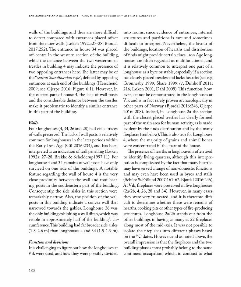
180
Environment and settlement | Aina m. Heen-Pettersen – Astrid B. Lorentzen
walls of the buildings and thus are more difficult to detect compared with entrances placed offset from the outer walls (Løken 1992a:27-28; Bjørdal 2017:252). The entrance in house 34 was placed off-centre in the western section of the building, while the distance between the two westernmost trestles in building 4 may indicate the presence of two opposing entrances here. The latter may be of the “central Scandinavian type”, defined by opposing entrances at each end of the buildings (Herschend 2009; see Gjerpe 2016, Figure 6.1). However, in the eastern part of house 4, the lack of wall posts and the considerable distance between the trestles make it problematic to identify a similar entrance in this part of the building.
WallsFour longhouses (4, 34, 26 and 28) had visual traces of walls preserved. The lack of wall posts is relatively common for longhouses in the later periods within the Early Iron Age (Gil 2016:234), and has been interpreted as an indication of wall panelling (Løken 1992a: 27-28, Brekke & Schelderup1997:11). For longhouse 4 and 34, remains of wall posts have only survived on one side of the buildings. A notable feature regarding the wall of house 4 is the very close proximity between the wall and roof-bear-ing posts in the southeastern part of the building. Consequently, the side aisles in this section were remarkably narrow. Also, the position of the wall posts in this building indicate a convex wall that narrowed towards the gables. Longhouse 26 was the only building exhibiting a wall ditch, which was visible in approximately half of the building’s cir-cumference. This building had far broader side aisles (1.8-2.6 m) than longhouses 4 and 34 (1.5-1.9 m).
Function and divisionsIt is challenging to figure out how the longhouses at Vik were used, and how they were possibly divided
into rooms, since evidence of entrances, internal structures and partitions is rare and sometimes difficult to interpret. Nevertheless, the layout of the buildings, location of hearths and distribution of finds might provide certain clues. Iron Age long-houses are often regarded as multifunctional, and it is relatively common to interpret one part of a longhouse as a byre or stable, especially if a section has closely placed trestles and lacks hearths (see e.g. Grønnesby 1999, Skare 1999:77, Diinhoff 2011: 216, Løken 2001, Dahl 2009). This function, how-ever, cannot be demonstrated in the longhouses at Vik and is in fact rarely proven archaeologically in other parts of Norway (Bjørdal 2016:246, Gjerpe 2016: 208). Indeed, in Longhouse 2a the section with the closest placed trestles has clearly formed part of the main area for human activity, as is made evident by the finds distribution and by the many fireplaces (see below). This is also true for Longhouse 4, where the majority of grains and animal bones were concentrated in this part of the house.
The presence of hearths in longhouses is often used to identify living quarters, although this interpre-tation is complicated by the fact that many hearths may have served a range of non-domestic functions and may even have been used in byres and stalls (Schütz & Frölund 2007:161-62, Bjørdal 2016:246). At Vik, fireplaces were preserved in five longhouses (2a/2b, 4, 26, 28 and 34). However, in many cases, they were very truncated, and it is therefore diffi-cult to determine whether these were remains of hearths, cooking pits or other types of fire-producing structures. Longhouse 2a/2b stands out from the other buildings in having as many as 22 fireplaces along most of the mid-axis. It was not possible to isolate the fireplaces into different phases based on the 14C dates. However, and as noted above, the overall impression is that the fireplaces and the two building phases most probably belong to the same continued occupation, which, in contrast to what
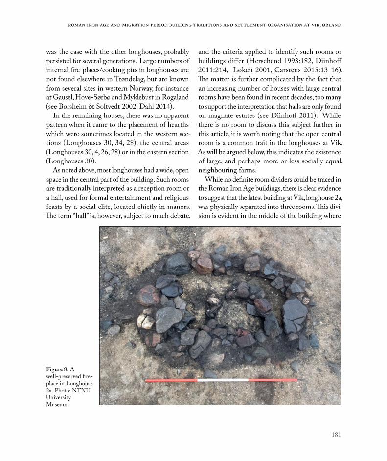
181
Roman Iron Age and Migration period building traditions and settlement organisation at Vik, Ørland
was the case with the other longhouses, probably persisted for several generations. Large numbers of internal fire-places/cooking pits in longhouses are not found elsewhere in Trøndelag, but are known from several sites in western Norway, for instance at Gausel, Hove-Sørbø and Myklebust in Rogaland (see Børsheim & Soltvedt 2002, Dahl 2014).
In the remaining houses, there was no apparent pattern when it came to the placement of hearths which were sometimes located in the western sec-tions (Longhouses 30, 34, 28), the central areas (Longhouses 30, 4, 26, 28) or in the eastern section (Longhouses 30).
As noted above, most longhouses had a wide, open space in the central part of the building. Such rooms are traditionally interpreted as a reception room or a hall, used for formal entertainment and religious feasts by a social elite, located chiefly in manors. The term “hall” is, however, subject to much debate,
and the criteria applied to identify such rooms or buildings differ (Herschend 1993:182, Diinhoff 2011:214, Løken 2001, Carstens 2015:13-16). The matter is further complicated by the fact that an increasing number of houses with large central rooms have been found in recent decades, too many to support the interpretation that halls are only found on magnate estates (see Diinhoff 2011). While there is no room to discuss this subject further in this article, it is worth noting that the open central room is a common trait in the longhouses at Vik. As will be argued below, this indicates the existence of large, and perhaps more or less socially equal, neighbouring farms.
While no definite room dividers could be traced in the Roman Iron Age buildings, there is clear evidence to suggest that the latest building at Vik, longhouse 2a, was physically separated into three rooms. This divi-sion is evident in the middle of the building where
Figure 8. A well-preserved fire-place in Longhouse 2a. Photo: NTNU University Museum.

182
Environment and settlement | Aina m. Heen-Pettersen – Astrid B. Lorentzen
four rectangular structures with postholes appear to have formed two opposing entrances leading into the eastern and western part of the building from the smaller central room. The western section was the largest room in the house and functioned as the main space for daily activity, as is evident from a large, central hearth and 10 further fireplaces and cooking pits along the mid-axis of the room. The majority of finds were also concentrated in this part of the house (see Storå et al., Ch.8; and Solvold, Ch. 9). These included a variety of artefacts such as pottery, a quern stone, fishhook, iron fragments, whetstones, nails, knife blade and a large number of animal bones. The animal bones included a near complete foal, dated to 361-538 AD, buried in the extreme western end of the building. This find may represent a ritual deposition in connection with the termination of the house, or an act which took place shortly after the house had been abandoned, perhaps while the remains were still visible (See also Storå et al., Ch. 8).
Small amounts of animal bones and pottery were also recovered from longhouses 21, 28 and 34, but these were too few or widespread to provide clear indications of room divisions.
FARMSTEADS AT ØRLAND FROM EARLY RIA TO MP
Settlement organisationWhile pre-Roman settlements are generally aban-doned after only one phase of occupation, farmsteads from the Roman period are generally characterised by a continued settlement on the same site over several generations (Herschend 2009, Diinhoff 2011, Gjerpe 2017, but see Fransson (Ch. 5) on contin-ued occupation on a pre-Roman IA farm at Field B). As noted above, this trait is also demonstrated at Roman Iron Age Vik, where there is evidence of three to four settlement phases in both Fields C and D. In the following discussion, we will consider how the individual houses may have been related, and operated collectively as a unit, in the different phases of settlement. It should be noted that the interpretations presented here are based on the premise that smaller buildings with no clear residential function are likely to be associated with one of the longhouses, which probably functioned as the main dwelling house in each phase of settle-ment. This principle, which harmonises well with 14C dates and the spatial layout of the buildings, forms the main analytic tool when proposing settlement units. Although no wall-bearing posts have been
Field Phase Period Approx. date Settlement typeC 1/2 Early Roman period 50-200 AD Angled settlement (building 4 and 17)C 1/2 Early Roman period 50-200 AD Parallel settlement (building 34 and 16)
C 3 Late Roman- /Migration period 200-500/550 AD Dispersed settlement (building 2 and 15)
D 1 Early Roman period 0-200 AD Parallel settlement (building 21 and 22)D 2 Early Roman period 75-250 AD Lined settlement (building 28 and 26)D 3 Late Roman period 90-340 AD Parallel settlement (building 30 and 24)D 4 Late Roman period 90-325 AD Angled settlement (building 29 and 23)
Table 1. The different settlement phases in Fields C and D, their approximate age and spatial arrangement.

183
Roman Iron Age and Migration period building traditions and settlement organisation at Vik, Ørland
preserved, the smaller buildings can probably be defined as “short three-aisled buildings”, comprising a maximum of 3-4 trestles with a building length of no more than approximately 15 m (see Göthberg 2000:45). In most cases, there is little evidence to suggest their purpose. Unless otherwise stated, these buildings are therefore regarded as ancillary structures of unknown function.
The spatial layout of Iron Age buildings has been divided into five categories, referred to as the solitary longhouse, the lined settlement, the parallel settlement, the angled settlement and the disperse/scattered settlement (Hvass 1988; Løken 1992b;
Bjørdal 2016). The last category includes buildings “lying at some distances from each other, but which in all likelihood functioned together” (Bjørdal 2016:244). As will be illustrated below, the latter four categories were present at Vik.
The angled settlementEvidence of angled or L-shaped settlements was identified in both fields. Both were similarly arranged, comprising an east-west orientated longhouse together with a smaller north-south orientated building located only a few metres northeast of the longhouse.
Figure 9. The different phases of settlement in the southern area of Vik in the Roman Iron Age and Migration Period. Illustration: Magnar Mojaren Gran, NTNU University Museum.

184
Environment and settlement | Aina m. Heen-Pettersen – Astrid B. Lorentzen
In Field C, the angled settlement included Longhouse 4 and the smaller Building 17. The latter comprised five evenly placed trestles forming a 10.5 m long building. The only find from this building was a bone from a ruminant, and only a small number of fragmented grains were recovered from the postholes. Although the building does not appear to have had a residential function, a fireplace in the northern part of the house may indicate that heat or light was needed for the activity which took place here. While both building 4 and 17 date to the Early Roman Iron Age, different dates from the fireplaces (TRa-11583, cal. 67-130 AD and TRa-11594 cal. 135-232 AD) may indicate that the latter building was raised towards the end of the settlement phase.
In Field D, the angled settlement included long-house 29 and the smaller building 23. These buildings represent the final phase of settlement in Field D. The latter consisted of four trestles forming a building with a minimum length of 7.5 m which is interpreted as an ancillary structure of unknown function. Both buildings were dated to the latter part of the Roman Iron Age and therefore not contemporary with the angled layout in Field C. Longhouse 29 partly overlaps Longhouse 21 and possibly Longhouse 28. It is thus the only building in Field D which does not respect the layout of the earlier building.
The lined settlementThe only example of a lined settlement was repre-sented by Longhouse 28 and the smaller longhouse 26 in Field D. Based on the size and spatial organi-sation, Longhouse 28 appears to have functioned as the main dwelling in this phase. This was also the only building in this phase with finds (pottery and animal bones) present. Longhouse 26 was nonethe-less of a fairly substantial size, measuring 16 x 7 m. Its function is unknown, but a fireplace was present
in the centre and the building may have served a range of purposes. The phase dates to the early RIA.
The parallel settlementThree examples of parallel settlements were recog-nized, one in Field C and two in Field D.
In Field C, the parallel settlement comprised longhouse 34 and the smaller building 16, although the relationship between these two buildings cannot be ascertained with any certainty because of the rather wide range of 14C dates from the postholes of the latter building. Building 16 was at least 7.2 m long, and comprised four pairs of roof-bearing posts. While no finds were recovered, three postholes contained charred botanical material, a few Hordeum vulgare (barley) grains and some common weeds of Fallopia convolvulus (Black-bindweed) and Stellaria media (common chickweed). The weeds are closely connected to agriculture, and may have entered the building through harvest and crop processing, or have been used as fodder for cattle (Buckland et al. 2017:68). This indicates that building 16 served as storage, in which cereals, fodder and possibly other material was present.
In Field D, one of the two parallel settlements comprised Longhouse 21 and the smaller building 22. Building 22 consisted of only three roof-bearing trestles, forming a building with a minimum length of 6.5 m, with a possible fireplace in the centre.
Finally, the third parallel settlement at southern Vik was represented by Longhouse 30 and the smaller building 24. The latter was located less than 25 m. north-northwest of the longhouse. However, unlike most of the smaller buildings at Vik, building 24 cannot be classified as a regular ancillary structure. While it was a fairly small building, with an estimated size of approximately 14 x 6,5 m, the postholes were substantial, and two fireplaces were located in the western section. Finds from the building consisted of different types of pottery, animal bones and an
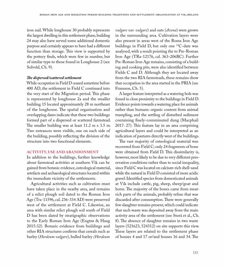
185
Roman Iron Age and Migration period building traditions and settlement organisation at Vik, Ørland
iron nail. While longhouse 30 probably represents the largest dwelling in this settlement phase, building 24 may also have served some additional domestic purpose and certainly appears to have had a different function than storage. This view is supported by the pottery finds, which were few in number, but of similar type to those found in Longhouse 2 (see Solvold, Ch. 9).
The dispersed/scattered settlementWhile occupation in Field D ceased sometime before 400 AD, the settlement in Field C continued into the very start of the Migration period. This phase is represented by longhouse 2a and the smaller building 15 located approximately 28 m northeast of the longhouse. The spatial organisation and overlapping dates indicate that these two buildings formed part of a dispersed or scattered farmstead. The smaller building was at least 11.2 m x 3.5 m. Two entrances were visible, one on each side of the building, possibly reflecting the division of the structure into two functional elements.
ACTIVITY, USE AND ABANDONMENTIn addition to the buildings, further knowledge about farmstead activities at southern Vik can be gained from botanic evidence, osteological material, artefacts and archaeological structures located within the immediate vicinity of the settlements.
Agricultural activities such as cultivation must have taken place in the nearby area, and remains of a relict plough soil dated to the Roman Iron Age (Tra-11596, cal. 236-334 AD) were preserved west of the settlement at Field C. Likewise, an area with similar relict plough soil south of Field D has been dated by stratigraphic observations to the Early Roman Iron Age (Engtrø & Haug 2015:32). Botanic evidence from buildings and other RIA structures confirms that cereals such as barley (Hordeum vulgare), hulled barley (Hordeum
vulgare var. vulgare) and oats (Avena) were grown in the surrounding area. Cultivation layers were also present in areas west of the Roma Iron Age buildings in Field D, but only one 14C-date was analysed, with a result pointing the to Pre-Roman Iron Age (TRa-12176, cal. 363-206BC). Further Pre-Roman Iron Age remains, consisting of a build-ing and cooking pits, were also identified between Fields C and D. Although they are located away from the two RIA farmsteads, these remains show that occupation in the area started in the PRIA (see Fransson, Ch. 5).
A larger feature interpreted as a watering hole was found in close proximity to the buildings in Field D. Evidence points towards a watering place for animals rather than humans: organic content from animal trampling, and the settling of disturbed sediment containing finely-comminuted dung (Macphail 2017: 27). This feature lay in an area comprising agricultural layers and could be interpreted as an indication of pastures directly west of the buildings.
The vast majority of osteological material was recovered from Field C; only 24 fragments of bone were obtained from Field D. This dissimilarity is, however, most likely to be due to very different pres-ervation conditions rather than to social inequality, since Field C was located on calcium-rich shell-sand while the natural in Field D consisted of more acidic gravel. Identified species from domesticated animals at Vik include cattle, pig, sheep, sheep/goat and horse. The majority of the bones came from meat-rich parts of the animals, probably refuse that was discarded after consumption. There were generally few slaughter remains present, which could indicate that such waste was deposited away from the main activity area of the settlement (see Storå et al., Ch. 8). The absence of slaughter remains in two waste layers (521623, 524312) on site supports this view. These layers are related to the settlement phase of houses 4 and 17 or/and houses 16 and 34. The

186
Environment and settlement | Aina m. Heen-Pettersen – Astrid B. Lorentzen
spatial organisation indicates that waste deposition during the Early Roman period was designated to the western outskirts of these farms.
Although the fields at Vik are regarded as agricul-tural settlements, the exploitation of other resources was also targeted. Sea resources were especially important, made evident by bones from a wide range of fish species and by a large amount of cockles for human consumption. Cod was the most common fish amongst the fishbone material at southern Vik, but other species such as common ling, haddock, pol-lock and whiting were also consumed. Whalebones and a single bone from a red deer were the only osteological material from wild mammals, which indicates that wildlife resources were of limited importance during this period.
Perhaps not surprisingly, a large number of cooking pits were also associated with the Roman Iron Age settlements at Vik. Some of these lay spread some distance away from the farmsteads, but many of them were also clustered just outside the buildings. This pattern is especially clear with regard to longhouse 4, where cooking pits were clustered immediately east, west and north of the building.
The Roman Iron Age cooking pits show a clear change in the spatial organisation compared with the pre-Roman period when the cooking pits were placed some distance away from the buildings (see Fransson, Ch. 5). This may reflect a wider social change in food practice, where the open air cooking pit sites lose their importance as meeting places and communal meals were instead moved closer to the farm (Bukkemoen 2016). It is therefore interesting to note that cooking pits in the very final phase of the settlement at Vik were not only located outside the longhouse, but also inside. Dates from eight of these pits confirm that they are contemporary with the fireplaces of the house. This could indicate a fur-ther change in ritual and social practice, where rites associated with the preparation and consumption of
food from cooking pits become more strongly linked to the longhouse, compared with previous periods.
The final phase of settlementIn the last phase of settlement at southern Vik, the buildings were placed further apart than the general trend in the previous period. This may perhaps indicate a change of activity where larger areas than before were included in the daily activity of the settlement. The building organisation and the location of contemporary dispersed structures (fire-places, pits and postholes) indicate that the central area of activity was located north/northeast of the buildings. Further changes in the spatial organisa-tion are indicated by the waste deposition (500200), which lay south of house 2a/2b. The layers were partly preserved in a shallow depression, which may be the result of repeated removal of waste, perhaps for use as fertiliser in the surrounding fields (see Mokkelbost, Ch. 7). Two outdoor fireplaces were also located south of the house, including a large circular structure (1.8 m in dia.) filled with fish and animal bones. This feature was dated to 425-555 AD (TRa-11026), which indicates that it represents an event towards the very end of the settlement.
A large number of animal bones were recovered in many structures both inside and outside the longhouse, especially the waste layer. The material shows the presence of the same domestic animals as were present in the previous phase, such as cattle, ox, pig, sheep, sheep/goat. The number of pig bones does, however, increase, and there was also a bone from a dog. Fish continues to be an important resource and fishhooks were discovered in and near the longhouse. Bones from a variety of wild mammals such as seal, whale, elk and brown bear may indicate that the exploitation of outlying resources becomes more important than in the previous period, but it could also be the result of a generally larger number of bones deposited in this final phase of settlement.

187
Roman Iron Age and Migration period building traditions and settlement organisation at Vik, Ørland
The overall impression is that the people at Vik, in the period when the field was abandoned, had access to a wide range of resources, mainly from farming and fishing, but outlying resources were also exploited. All in all, it appears that the people at Vik had access to resources beyond mere subsistence.
SOCIAL AND SPATIAL RELATIONS BETWEEN THE FARMS AT ØRLANDLarge RIA farms are known from many parts of Norway. Many of these are traditionally explained as chiefly manors, which functioned as centres for
social, economic and military power and activities (e.g. Myhre 1987, Løken 2001). However, the many open area excavations in Norway in the last two decades have led to a significant increase in the number of large longhouses being identified. In some areas, longhouses with ‘halls’ are situated too close together to support the interpretation that they chiefly represent estates (Diinhoff 2011:218).
While there is no room to discuss this subject in detail here, it is worth drawing attention to the fact that a comparable situation is also present at Vik, where fairly large and similar-sized buildings were located on neighbouring farms, which were
Figure 10. Working shot of the excavation of Longhouse 2. Photo: NTNU University Museum.

188
Environment and settlement | Aina m. Heen-Pettersen – Astrid B. Lorentzen
probably settled simultaneously. The Roman Iron Age settlements in Fields C and D lay only 120 m apart. There was no apparent natural precondition for the relative lack of archaeological structures between the fields, which suggests some form of agreed land use or division. Moreover, as mentioned above, a further RIA farm was located at Field A, some 500 m north of Field C. The archaeology in this area was only partially preserved and no long-houses were securely identified. However, a number of postholes were recorded east of the layers and these are likely to be the remains of very truncated buildings. This could indicate a similar organisation as that seen in the ERIA at Field C, where waste deposition was designated to the western part of the farmstead. While the social relationship between northern and southern Vik is difficult to assert, the animal bones certainly suggest that the two areas had rather different subsistence economies. The difference in the husbandry strategies between farms in Fields A and C may suggest some sort of division of work between contemporaneous farms (Storå et al., Ch. 8), but both areas had flexible subsistence economies and access to a wide range of resources.
The farms at Vik appear to have had access to similar resources, with land for grazing and cul-tivation, and harbours situated further east in the nearby sheltered bay, the importance of which is reflected in the name of the area (Vik meaning bay). The overall impression based on the archaeological evidence suggests the presence of two, possibly three (if Field A is included) large, but probably more or less socially equal, neighbouring farms at Vik in the Roman Period. This largely corresponds with the social structure which Diinhoff (2011) has suggested for western Norway during the Roman Iron Age and early Migration Period. Here he argues for the existence of a more decentralized form of power structure, which “would allow several
in principle socially equal, large farms to appear, even as neighbouring farms” (Ibid: 220). There is little archaeological evidence to suggest that one of the farms at Vik was superior to the others. Admittedly, there were far more finds and bones recovered from Field C than Field D, which at first glance may give the impression of a social or economic difference; however, as noted above, the large difference in the quantity of animal bone from the two fields is almost certainly the result of preservation conditions, rather than reflecting a true difference in the husbandry resources on the two farms.
While the majority of the Roman Iron Age buildings revealed few or no finds, there was one exception; the south-eastern corner post of building 34, which contained pottery from three different vessels and some bones of horse, sheep/goat. The deposition must have taken place after the post had been removed, and this event appears to be a ritual deposition in connection with the abandonment of the building. At least one of the vessels, a fairly large cooking pot, was complete when deposited. Moreover, the fragments of a small drinking cup have been refitted to a near complete vessel (see Solvold, Ch. 9), and may also have been whole when deposited.
There were indeed certain finds associated with a high status, such as an imported drinking glass and a silver ring, but these stemmed from the final settlement at the southern area of Vik, when only one farm was occupied. The fairly high number of artefacts from this final period was partly a result of the chance preservation of a refuse layer which contained a large number of finds, but also partly a result of a different abandonment practice than seen in the earlier houses. While the limited quantity of finds from the ERIA buildings may indicate a process of deliberate house clearance, the situation was rather different for the final abandonment of the settlement at Vik. At this concluding stage, the

189
Roman Iron Age and Migration period building traditions and settlement organisation at Vik, Ørland
building was left without the clearing process of the previous period being carried out.
The only known Roman Iron Age settlement at Ørland prior to the excavations at Vik was situated at Hovde, approx. 2 km south of Vik (Grønnesby 1997, 1999 and 2000). This settlement comprised, as interpreted by the excavator, two parallel long-houses together with a smaller, third building. The settlements at Hovde and Vik are situated some distance apart, and the relationship between them is therefore difficult to determine. They do, how-ever, appear to have been begun at the same time, and the longhouses at Hovde and southern Vik
are of similar size. However, the farm at Hovde was perhaps slightly larger if all three houses were occupied simultaneously, as argued by Grønnesby (2000, 1999). The placement of Hovde within its surrounding landscape, with a navigable port just east of the settlement and wetlands to the west, resembles that at Vik. This could indicate that the farms at Vik and Hovde had access to and exploited a similar range of resources.
Further settlement evidence is reflected in three unpublished excavation reports of Roman Iron Age burials from the vicinity. These include two inhumation burials located at the farm Røine, some
Figure 11. Pottery (T27079:1) found in Posthole from Longhouse 34. Photo: Åge Hojem, NTNU University Museum.

190
Environment and settlement | Aina m. Heen-Pettersen – Astrid B. Lorentzen
500 m northeast of the excavated area at Vik. Both burials were modestly furnished, but each con-tained combs typologically dated to the ERIA (NTNU University Museum accession number: T16237, T16922). Furthermore, two RIA spear-heads originate from the farm Hårberg, located just south of Vik (NTNU University Museum accession number: T3775, T3776). Although the spear-heads are regarded as stray finds, they do represent a set of weapons typically found in burials and are thus clear indications of occupation in this area.
CONCLUSION/FINAL THOUGHTSThis article has examined Roman Iron Age and Migration Period building traditions, settlement organisations and the social relations of two mul-tiphase farmsteads at southern Vik, Ørland.
Firstly, and by applying a geometric approach to the buildings at Ørland, we have established that an axis of symmetry is present in all of the longhouses in Fields C and D. Although some differences existed in the layout of the longhouses, it is suggested here that four of the buildings were so similar that they may represent a common building tradition at Vik throughout the Roman Period.
Figure 12. Areas of Ørland with identified activity in the Roman Iron Age. Map: Magnar Mojaren Gran, NTNU University Museum.

191
Roman Iron Age and Migration period building traditions and settlement organisation at Vik, Ørland
In each settlement phase, a longhouse was accom-panied by a smaller building where the longhouse functioned as the main dwelling house. There is, however, no discernible pattern for the spatial organ-isation of the buildings. In the Roman Period, several farmstead categories have been identified: the lined settlement, the parallel settlement and the angled settlement. The final phase in the Late Roman Period/Early Migration Period was arranged as a “dispersed” settlement, with the two buildings lying at some distance from one another.
Finally, we have argued that the evidence from the southern area of Vik suggests the presence of two large and socially equal neighbouring settlements. During the beginning of the 6th century, the last remaining farm at Vik disappeared, and in the course of the 7th and 8th centuries settlement activity shifted to new sites, such as Uthaug, Grande at Viklem
(Ystgaard, Gran & Fransson, Ch. 1). The reason for the abandonment of Vik is unknown, but the overall impression is that people during the final phase of settlement had access to a wide range of resources beyond mere subsistence. The settlement’s abandonment must therefore be found in some unknown cause not directly related to a lack of local resources. This follows a trait seen in many parts of Norway, where sites with continued settlement in the Early Iron Age were abandoned during the Migration Period (Iversen 2013, Grønnesby & Heen-Pettersen 2015, Bjørdal 2016, Gjerpe 2017).
ACKNOWLEDGEMENTSWe are most grateful to the anonymous referee for constructive and useful feedback, and to Ingrid Ystgaard for commenting on the initial draft of this paper.

192
Environment and settlement | Aina m. Heen-Pettersen – Astrid B. Lorentzen
REFERENCES
Bjørdal, E. 2016: Late Iron Age settlement evidence from Rogaland. In: Iversen, F. & H. Petersson (eds.): The Agrarian Life of the North 2000 BC – 1000 AD. Studies in rural settlement and farming in Norway, pp. 241-274. Portal Academic. Kristiansand.
Brekke, N. G & H. Schjeldrup 1997: Hus på vestkysten gjennom 4000 år: vandreutstilling i kulturminneåret 1997. Bergen/Stavanger 1997.
Buckland et al. 2017: Environmental archaeological analysis from the archaeological excavations at Ørland kampflybase, Vik 70/1, Ørland, Sør-Trøndelag, Norway. 2015-2016. Department of Historical, Philosophical & Religious studies, Umeå Universitet.
Bukkemoen, G. 2016: Cooking and feasting: Changes in food practice in the Iron Age. In: Iversen, F. & H. Petersson (eds.): The Agrarian Life of the North 2000 BC – 1000 AD. Studies in rural settlement and farming in Norway, pp. 117-132. Portal Academic, Kristiansand.
Børsheim, R. & E. Soltvedt 2002: Gausel-utgravningene i 1997-2002. AmS-Varia, vol. 39. Arkeologisk museum, Universitetet i Stavanger.
Carstens, L. 2015: Powerful space. The Iron-Age Hall and its development during the Viking Age. In: Hem Eriksen, M., U. Pedersen, B. Rundberget, I. Axelsen & H. Lund Berg (eds.) Viking Worlds – Things, Spaces and Movement, pp. 12-27. Oxbow books, Oxford.
Dahl, B. 2009: En presentasjon av fire utvalgte hus fra Forsandsmoen 2007. In: Nitter, M. & E. Pedersen (eds.). Tverrfaglige perspektiver. AmS Varia 49, pp. 87-104. Arkeologisk museum, UiS, Stavanger.
Dahl, B. 2014: Arkeologisk utgravning av hus og graver. Myklebust gnr. 3, Sola kommune, Rogaland. Utgravningsrapport 2014/20. Arkeologisk museum, Universitetet i Stavanger. Stavanger.
Diinhoff, S. 2011: Chiefly Manors and the Establishment of a Socially Hierarchical Settlement Pattern in Western Norway during the Late Roman Iron Age and Early Migration Period. Arkæologi i Slesvig. Sachsensymposion i Haderslev 2010, pp. 211-222. Wachholtz.
Diinhoff, S. & T. Slinning 2013: Langhuset på Gjøsund og dateringsproblematikken. In: Diinhoff, S., M. Ramstad & T. Slinning (eds.): Jordbruksbosetningens utvikling på Vestlandet. Kunnskapsstatus, presentasjon av nye resultater og fremtidige problemstillinger. UBAS - Universitetet i Bergen Arkeologiske Skrifter 7, pp. 65-75. Bergen.
Diinhoff, S. 2017: Bokanmeldelse: Frode Iversen og Håkan Petterson (red): Agrarian Life of the North 200 BC – AD 1000. Primitive Tider 19: 135-140.
Engtrø, D.-Ø. & A. Haug 2015: Arkeologisk undersøkelse - midlertidig anleggsvei på Ørland Kampflybase, Ørland, Sør-Trøndelag. NTNU Vitenskapsmuseet, Arkeologisk rapport 2015-2.
Farbregd, O. 1980: Perspektiv på Namdalens jernalder. Undersøkingar på Veiem, Sem, Værem og Bertnem. Viking XLIII: 20-80.
Gil, T. 2016: Geometric Observations regarding Early Iron Age Longhouses in Southwest Norway. In: Iversen, F. & H. Petersson (eds): The Agrarian Life of the North 2000 BC – 1000 AD. Studies in rural settlement and farming in Norway, pp. 221-239. Portal Academic, Kristiansand.
Gjerpe, L. E. 2008: Kulturhistoriske, metodiske og administrative erfaringer. Bind 4. E18-prosjektet Vestfold. Varia, vol. 74. Kulturhistorisk museum, Fornminneseksjonen. Oslo
Gjerpe, L. E. 2016: Iron Age Building Traditions in Eastern Norway: Regions and Landscapes. In: Iversen, F. and H. Petersson (eds): The Agrarian Life of the North 2000 BC – 1000 AD. Studies in rural settlement and farming in Norway, pp. 203-220. Portal.
Gjerpe, L. E. 2017: Effektive hus. Bosetning, jord og rettigheter på Østlandet i jernalder. PhD thesis, Oslo University.
Grønnesby, G. 1999: Eldre jernalders hus og hall på Hovde i Trøndelag. Viking LXII: 69–80.
Grønnesby, G. 2000: Langhus fra eldre jernalder på Hovde. Årbok for Fosen 39: 41–52.
Grønnesby, G. & A. Heen-Pettersen 2015: Gården i yngre jernalder – et spørsmål om erkjennelse? Belyst ved utgravningen av et yngre jernalders gårdstun på Ranheim. Viking, 169–88.
Göthberg, H. 2000: Bebyggelse i förändring: Uppland från slutet av yngre bronsålder till tidlig medeltid. Institutionen för arkeologi och antik historia, Uppsala Universitet, Uppsala.
Gustafsson, L. 2000: I Oluf Ryghs fotspor på Veien, Ringerike. Langhus, graver og stedsnavn. In: Sandnes B. (ed): Oluf Rygh. Rapport fra et symposium på Stiklestad 13. – 15. Mai 1999, pp. 95–119. NORNA-rapporter 70B. Uppsala.
Herschend, F. 1993: The Origin of the Hall in Southern Scandinavia. TOR Vol. 25: 175-200. Department of Archaeology and Ancient History, Uppsala University, Uppsala.
Herschend, F. 2009: The Early Iron Age in South Scandinavia. Social order in Settlement and Landscape. Occasional Papers in Archaeology, vol. 46. Uppsala University, Uppsala.
Herschend, F. 2017: Askim-tunets kronologi. En tillämpad bayesiansk analys. Viking LXXX: 25–38.
193
Roman Iron Age and Migration period building traditions and settlement organisation at Vik, Ørland
Hvass, S. 1988: Jernalderens bebyggelse. In: Mortensen, P. & B. M. Rasmussen (eds.): Fra Stamme til Stat i Danmark 1, pp. 53–92. Moesgård: Jysk Arkeologisk Selskabs Skrifter Vol. XXII.
Iversen, F. 2013: Big bang, lordship or inheritance? Changes in the settlement structure on the threshold of the Merovingian Period, South-Eastern Norway. In: Klapste, J. (ed.): Hierarchies in rural settlements, pp. 341–358. Brepols: Turnout.
Løken, T. 1983: En ny type gårdsanlegg fra Forsand i Rogaland. In: Ólafsson, G. (ed.): Hus, gård och bebyggelse. Föredrag från det XVI nordiska arkeologmötet, Island 1982, pp. 81–92. Þjóðminjasafn Íslands, Reykjavík 1983.
Løken, T. 1992a: En folkevandringstidsgård – langhus og grophus på Bertnem i Overhalla. Spor – fortidsnytt fra Midt-Norge. 1992/2: 26–28.
Løken, T. 1992b: Forsand og jernalderens landsbyanlegg i Rogaland – belyst ved flateavdekkende utgravninger. In: Kyhlberg, O. (ed.): Gård-tettsted-kaupang. N. U. B. Nytt fra utgravningskontoret i Bergen, Nr. 3, pp. 53–70. Riksantikvaren, Bergen.
Løken, T. 2001: Oppkomsten av den germanske hallen – Hall og sal i eldre jernalder i Rogaland. Viking LXIV: 49–86.
Macphail, R. 2017: Ørland main Air Station (2016 samples), Norway: soil micromorphology (including SEM/EDS
analyses). Report for Museum of Natural History and Archaeology, Norwegian University of Science and Technology, Trondheim, Norway.
Myhre, B. 1987: Chieftains’ graves and chiefdom territories in South Norway in the Migration Period. Studies zur Sachsenforchung 6: 169–190.
Ó Carragáin, T. 2010: Churches in early Medieval Ireland. Yale University Press. New Haven and London.
Rønne, P. 2005: Arkæologiske undersøgelser forud for bygningen af ny E6 gennem Melhus, Sør-Trøndelag. In: Høgestøl, M., L. Selsing, T. Løken, A. J. Nærøy & L. Prøsch-Danielsen (eds): Konstruksjonsspor og byggeskikk. Maskinell flateavdekking – metodikk, tolkning og forvaltning, pp. 87–96. AmS-Varia 43. Arkeologisk museum i Stavanger.
Schütz, B. & P. Frölund 2007: Korta hus under äldre järnålder. Arkeologi E4 Uppland - studier volym 3. Hus och bebyggelse i Uppland: delar av förhistoriska sammanhang, pp. 153-172. Riksantikvarieämbetet, Societas Archeologica Upsaliensis & Upplandsmuseet, Uppsala.
Skare, K. 1999: Romlig organisering og sosial struktur. En studie av langhuset fra yngre romertid og folkevandringstid i Rogaland. Unpublished master thesis in archaeology, University of Tromsø.

195
Roman period waste deposits at Ørland, Norway
c h a p t e r 7
Marte MokkelbostDepartment of Archaeology and Cultural History, NTNU University MuseumDepartment of Archaeology, History, Cultural Studies and Religion, University of [email protected]
Roman period waste deposits at Ørland, Norway
ABSTRACTIn this article, six large waste deposits and six smaller waste pits from Roman Iron Age Vik are analysed, the temporal and spatial relations between the waste deposits and the contemporary farms are discussed, and the activities related to the waste deposits are considered. Based on these findings, I suggest that local production of pottery occurred in the northern area at Vik (Field A) during the Early Roman period, together with some metalworking. In the later period, pottery was imported to Vik. Slaughter of animals took place outside the known settlement, while cooking and consumption took place within the settlement – sometimes in the form of feasts. Spatial analysis reveals that the location of the waste changed from the Early to the Late Roman period, gradually moving away from the central yard. Although waste from pottery manufacture and metal-working indicates a slight degree of division of labour between the farms in Fields A and C in the Early Roman period, the remaining waste points to socially equated farms with a fisher-farmer economy throughout the entire Roman period.
INTRODUCTIONDuring the excavations at Ørland Main Air Base in 2015 and 2016 (Figure 1), eleven Roman period (AD 0-400) and one Migration period (AD 400-575) waste contexts were examined (Figure 2). Four of these contexts (106581, 110297, 210240, 500200) were especially complex in that they contained traces of activities not only connected to waste deposition in the form of discarded household waste, but also activities such as cooking, production and/or manure management.
Large waste deposits, rich both in finds and osteological material, are rare within Roman Iron Age settlements in Norway. A comprehensive review of Roman settlements in Norway falls outside the
scope of this article, but a superficial look into some of the published work on Roman settlements shows that few contained waste layers similar to those at Vik (e.g. Børsheim 2001, Diinhoff 2010, Gjerpe & Østmo 2008, Grønnesby 1999, Meling 2016), although waste pits were not unusual. There are some instances of waste layer formations, though different from the ones at Vik: at Rødbøl in Larvik, Vestfold, two Roman period waste layers were found, though related solely to smithing (Gjerpe & Rødsrud 2008). However, in Rogaland there are a few examples of Roman period waste layers that bear resemblance to those at Vik: at Einargården in Sola, a rare waste layer measuring 3 m x 11 m was found, directly outside a three-aisled building. This layer contained pottery

196
Environment and settlement | Marte Mokkelbost
shards as well as some tools (slickstone, whetstone), slag, and animal bones (Aanderaa 2015), and is therefore comparable to the layers at Vik, at least when considering finds and layer size. At Skadberg in Sola, a shallow waste layer both covering and containing different types of features, such as some pits and a coal bed, was also placed directly outside a three-aisled building. This layer contained unburnt stones, pottery and burnt bones (Husvegg, Soltvedt & Dahl 2017), thus appearing similar to the Vik waste layers in both finds and activities. The feature at Skadberg has been interpreted as a remnant of a succession of waste pits (ibid p.46), which means
that its apparent resemblance to the large waste layers at Vik is superficial.
There may be several reasons why similar waste layers are uncommon: soils in Norwegian agricul-tural landscapes tend to be acidic and not favourable for preservation of organic materials. Settlement excavations before the breakthrough of the top soil stripping method (e.g. Petersen 1933, 1936, Grieg 1934, 1938) focused on the buildings, thus missing possible waste heaps or layers located between build-ings or on the outskirts of the settlement. Today’s mechanical top soil stripping uncovers much larger areas, but modern-day agricultural activities have
Figure 1. The location of the excavated area at Vik. Map: Magnar Mojaren Gran, NTNU University Museum.

197
Roman period waste deposits at Ørland, Norway
Figure 2. Roman Iron Age settlements at Fields A and E (north) and C (south) with building remains and waste deposits. Illustration: Magnar Mojaren Gran, NTNU University Museum.

198
Environment and settlement | Marte Mokkelbost
possibly destroyed traces of waste heaps and shallow layers before excavations take place (e.g. Løken et al. 1996, Høgestøl et al. 2005, Drewett 2011, Renfrew & Bahn 2016).
Favourable preservation conditions rendered the waste deposits at Vik rich in finds and osteo-logical material, and they provided a great deal of information concerning a wide range of farm activities. (Traces of day-to-day activities are rarely observed through the building material alone.) In addition, the Vik waste deposits yield insight into spatial and temporal organisation of activities in two contemporary Roman period farms (Field A, northern area and Field C, southern area), located a mere 500 m apart.
This article presents and analyses the Roman period waste contexts found at Vik at Ørland. It aims to relate activities revealed in the waste deposits to both chronological developments and functional divisions of the farms at Fields A and C in the northern and southern part of the excavation area at Vik, in order to gain insight into the chronological, spatial, and social organization of the Roman period farms. The main research questions are:
• How did the waste deposits and activities indi-cated through these deposits, relate temporally and spatially to the farms at Vik?
• What types of waste did the deposits contain?• Which activities does this material indicate?
MATERIAL AND METHODSThis article investigates six complex waste deposits (106581 + 216960, 110297, 210240, 500200, 509677, 521623) and six less complex waste pits (116675, 117191, 117654, 143733, 152996, 613254), mainly dating to the Roman period (Figure 3). These depos-its were unusually rich in finds and osteological material, comprising 670 finds and thousands of animal bones (Table 1).
The large waste deposits in Fields A, E and C were related to two farm areas dated within the Roman period, one in the north and one in the south of the excavation area. Both areas were fully excavated (Figure 2). The buildings of the farm in Field C were significantly better preserved than the possible buildings found in Fields A and E, which had been heavily disturbed by modern activity. However, considerable pre-historic activity in Fields
Area Field Type ID No. finds NISP osteology
NorthA
Large waste deposit 106581* 78 3558Large waste deposit 110297* 315 3136Small waste pit 116675 1 1Small waste pit 117191 2 -Small waste pit 117654 2 6Small waste pit 143733 - 2Small waste pit 152996 2 101
E Large waste deposit 210240 94 4686
SouthC
Large waste deposit 500200* 166 925Large waste deposit 509677 6 768Large waste deposit 521623* 9 402
D Small waste pit 613254 2 9
Table 1. Context overview (* = feature has several related features within its use phase; finds and NISP in related features are included in the total count).

199
Roman period waste deposits at Ørland, Norway
Figure 3. Dates from waste deposits with related features. Illustration: Magnar Mojaren Gran, NTNU University Museum.

200
Environment and settlement | Marte Mokkelbost
A and E, comprising several waste deposits, nearly 200 cooking pits, and numerous postholes, bore witness of a solid Roman period settlement even though buildings with residential functions were not discovered during the excavation. In Field D, approximately 100 m south of the farm in Field C, a farm from partially the same period and comparable in social standing to the farm examined in Field C was excavated. It proved to lack the large waste layers found in Fields A/E and C (Heen-Pettersen & Lorentzen, Ch. 6).
The waste deposits were generally preserved in shallow depressions in the subsoil (Figure 4). In Field C the ground consisted of sand with a high shell content, while in Field A the sandy soil seemed partially waterlogged. Subsoil conditions and the fact that the largest deposits were preserved in depressions that protected them from modern dis-turbances were major contributors to their survival. The gravelly sand in Field D, lacking in calcium-rich seashells and moisture, was less favourable for the preservation of similar layers.
In Field A in the northern part of the excavation area, the two large waste deposits 106581 and 110297 were found in close proximity to each other. Both contained a high number of finds and animal bones.
In the area surrounding the waste deposits features such as waste pits, cooking pits and postholes were numerous, and predominantly dated to the Roman period (Mokkelbost & Fransson 2018). Deposit 110297 seemed chronologically and spatially related to two identified buildings, Houses 31 and 39, as well as to four of the smaller waste pits in this area, 116675, 117191, 143733 and 152996 (Figure 2). Waste deposit 106581 (Figure 4) was chronologically related to a small four-post building, House 36, as well as one small waste pit 117654. There was also a spatial relationship between these two and the waste deposit, in that they were situated within a few metres of each other. Additionally, deposit 216960, a few metres to the east of deposit 106581, seemed related to the latter because of similarities in age and finds. In Field E, adjoining Field A in the northern area, a large waste deposit in the shape of a pit, 210240, containing large amounts of cockles and fish bones and a small amount of other household waste, was found. The area between and surrounding the Field A and E waste deposits had been disturbed by modern activities, so no apparent occupational buildings of the same age were found close by – for a more thorough discussion, see Mokkelbost & Fransson 2018.
Figure 4. Excavation of waste deposit 106581 in Field A. Photo: NTNU University Museum.

201
Roman period waste deposits at Ørland, Norway
The two other large waste deposits 500200 and 521623 and waste pit 509677, all containing finds, animal bones and related features, were situated in Field C in the southern part of the excavation area (Figure 2). These features were related chronologically and spatially to at least two different phases of a farm found in this area (Heen-Pettersen & Lorentzen, Ch. 6). One smaller waste pit 613254 was found in the very north of Field D in the southern area, and seemed related to the farm in Field C in both time and space (Lorentzen 2018:600-601).
MethodsIn the investigation of these waste contexts, different types of methods were used. Physical excavation methods and contextual assessment were applied during the excavation. Within this article, compar-ative analysis of 14C dates as well as of spatial and physical aspects of the contexts was applied.
Before and during excavation, the large waste deposits were investigated by means of metal detec-tors. The soil from the waste deposits was sifted through a 4 mm mesh. Dry soil was dry-sifted, while compact, sticky or wet soil was sifted with water. All finds and bone material found through sifting or in situ were 3D located using GPS/CPOS in the approximate or exact place of discovery and related to their original context. Scientific analyses such as macrofossil analyses and 14C-sampling, as well as osteological and taphonomic analyses of animal bones, were a priority (Storå et al., Ch. 8).
Special care was taken during the excavation of the waste deposit 110297 in Field A. Here, the exact find spots were documented with GPS/CPOS, thus making this deposit well suited for spatial analysis of distribution patterns and discovery of possible activity areas. In addition, micromorphological sample series enabled detailed analyses of this context as well as of the other large waste deposit in Field
A, 106581 (Macphail 2016). Micromorphological analysis gives insight into soil composition, thereby contributing greatly to the analysis of activities within these layers. Unfortunately, the very dry and coarse, stony conditions of the waste layers in Field C meant that micromorphological sampling was not possible there.
RESULTS AND DISCUSSIONFirst, the Roman Iron Age waste deposits’ chrono-logy and their spatial relation to other contexts and settlement traces will be presented and discussed. Then, traces of activities observed within the contexts will be presented and discussed.
Temporal and Spatial distribution of Waste Deposits: Northern areaThe large waste deposit 110297 in Field A formed on top of several features, among these an older cooking pit 152646, dated to the Late Pre-Roman – Early Roman period, 38 BC-AD 66 (TRa-10776, phase 1, Figure 5). The main use phase of layer 110297 lasted from AD 7 (TRa-11280) at the earliest, until AD 347 (TRa-11273) at the very latest (phase 2, Figures 3 and 5). During the main use phase, many other features were formed within the body of the layer; these consisted of cooking pits, designated waste pits and other pits, as well as at least one ditch, a clay layer and some smaller, limited layers containing waste.
Towards the end of the main use phase of layer 110297, the other large Field A waste layer 106581 started forming (Figures 3, 4 and 6). A few cook-ing pits 117222 (AD 29-168, TRa-10778) and 136625 (AD 131-242, TRa-10788) were situated in the same spot as layer 106581, but predated the layer (Figure 6). The latest of these pits was of the same age as most of the features from the main use phase of waste deposit 110297. However, the

202
Environment and settlement | Marte Mokkelbost
stratigraphic position of this pit, beneath the waste layer, indicated that waste deposition started later in layer 106581 than in 110297. The main use phase of layer 106581 lasted from AD 244 (TRa-10782) at the very earliest to AD 407 (TRa-11379) at the very latest (Figure 3). Like 110297, deposit 106581 also contained other features within its main use phase, but here these features consisted solely of cooking pits. A smaller waste layer 216960, dated to AD 337-407 (TRa-11379), and positioned 2 m north of the larger deposit 106581, is regarded as a continuation of the larger deposit. Despite its small number of finds and meagre amount of animal bones,
the smaller deposit is included in the interpretation of the larger deposit 106581 in this article because of the proximity, similarity in age, accumulation practice, and finds and osteology deposition.
The use phases of layers 110297 and 106581 might overlap somewhat (Figure 3); however, this could be a result of uncertainties in the calibration of the 14C dates, and may not represent simulta-neous use of the layers. Nevertheless, these layers were clearly separated, with no spatial overlap, which might indicate an intentional separation of two contemporary features, and therefore a period of simultaneous use. Based on the collected 14C
Figure 5. Field A waste deposit 110297 with phases and features. Illustration: Magnar Mojaren Gran, NTNU University Museum.
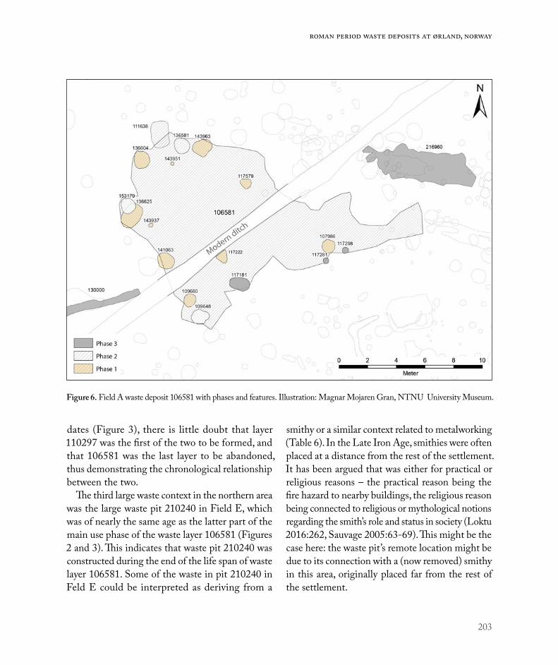
203
Roman period waste deposits at Ørland, Norway
dates (Figure 3), there is little doubt that layer 110297 was the first of the two to be formed, and that 106581 was the last layer to be abandoned, thus demonstrating the chronological relationship between the two.
The third large waste context in the northern area was the large waste pit 210240 in Field E, which was of nearly the same age as the latter part of the main use phase of the waste layer 106581 (Figures 2 and 3). This indicates that waste pit 210240 was constructed during the end of the life span of waste layer 106581. Some of the waste in pit 210240 in Feld E could be interpreted as deriving from a
smithy or a similar context related to metalworking (Table 6). In the Late Iron Age, smithies were often placed at a distance from the rest of the settlement. It has been argued that was either for practical or religious reasons – the practical reason being the fire hazard to nearby buildings, the religious reason being connected to religious or mythological notions regarding the smith’s role and status in society (Loktu 2016:262, Sauvage 2005:63-69). This might be the case here: the waste pit’s remote location might be due to its connection with a (now removed) smithy in this area, originally placed far from the rest of the settlement.
Figure 6. Field A waste deposit 106581 with phases and features. Illustration: Magnar Mojaren Gran, NTNU University Museum.

204
Environment and settlement | Marte Mokkelbost
Temporal and Spatial distribution of Waste deposits: Southern areaThe dates from waste layers 500200 and 521623 in the southern area indicated three phases of waste activities (Figures 3 and 7). As opposed to the northern area, traces of large farm buildings were preserved in Field C. Hence, the relationship between waste layers and settlement can be discussed more thoroughly for the southern area.
In the southern area, the first waste deposition probably started with layer 524312, dated to AD 56-209 (TRa-11595). This feature was very small, and had a clear, rounded shape, which might suggest it originated as a pit. The main waste layer 521623
covered this pit/layer (Figure 7). Dates of fea-tures related to waste layer 521623 indicate activity during the Early to Mid-Roman period (Figure 3). Chronologically and spatially, layer 524312 was related to Longhouse 4, and perhaps Longhouse 34, from the Early Roman occupational phase of the Field C farm. Houses 34 and 16 are interpreted as constituting a spatial layout of the farm called parallel settlement, while Houses 4 and 17 together constitute an angled settlement (Heen Pettersen & Lorentzen, Ch. 6). Because of the overlap in dates from these four houses, it is impossible to determine the succession here. However, it is possible to define the central yard of each of these two settlements: in
Figure 7. Field C waste deposits 500200 and 521623 with phases and features. Illustration: Magnar Mojaren Gran, NTNU University Museum.

205
Roman period waste deposits at Ørland, Norway
the parallel settlement, the central yard is defined as the space directly between the houses, while in the angled settlement, the central yard is defined as an imagined square of which the houses represent two sides. Thus, waste deposition during the Early Roman period took place in the western outskirts of the central yard regardless of farm layout (Figure 2; Heen-Pettersen & Lorentzen, Ch. 6).
Waste pit 523692 to the north of 521623 was not dated, but probably belonged to phase 1 of this complex of features. The waste pit was sealed off with a clay layer 523438, possibly during the Early Roman period (Figures 3 and 7). Waste deposit 500200 appears to have formed on top of the clay layer, thus indicating that the oldest pit was deliberately closed off before new waste accumulated in the same area.
The dates of the large waste layer 500200 span from AD 256 at the earliest (TRa-11022) to AD 397 at the very latest (TRa-11023), both dates are based on the dating of Cerealia samples. The layer contained a number of cooking pits within its use phase. Cooking pit 523574, dated on a Betula twig, had the same dates as the layer, and was probably constructed during the layer’s main use phase. The large cooking pit 522925, however, had an overlap of only 50 years with waste layer 500200 (Figure 3). Yet, since stratigraphic relations proved the layer to cover the cooking pit, the pit must be of the same age as the layer, probably pinpointing the use phase of this layer to the late 5th century (c. AD 350-400). This is in concordance with the dates of House 2 and House 15 in Field C (Figure 2). These two buildings form a third type of settlement defined as the dispersed or scattered settlement (Heen Pettersen & Lorentzen, Ch. 6).
The large waste pit 509677 to the north of the Roman period farm in Field C was dated to the Migration period (AD 403-535, Tra-11021). It is however possible that this pit was constructed during the main use phase of House 2 and House
15 in Field C, thus representing waste disposal of the final use phase of this farm.
The central yard of the Late Roman/Early Migration period Houses 2 and 15 in Field C, which constituted the latest and northernmost phase of the farm cluster, is believed to have been located north/northeast of these buildings (Heen-Pettersen & Lorentzen, Ch. 6). In this phase of the farm, waste deposition no longer seemed to take place within the central yard, as indicated by the location of the contemporary waste layer 500200 to the south of House 2, and of waste pit 509677 some distance northwest of House 2.
One smaller waste pit 613254 situated 30 m south of House 4 was probably related to one of the phases of the above-mentioned Roman period farm, although which phase is unclear, because the dates from this pit cover all phases of the farm (see Figures 2 and 3).
Waste in Time and Space: DiscussionThe first waste layers formed during the Early Roman period (AD 0-200), in relation to Early Roman farms in Fields A/E and C. The Early Roman waste deposits were abandoned around the middle of the Roman period. There are indications that the aban-donment of the waste deposits correlates with the abandonment of contemporary buildings, namely in Field C. Waste pit 523692 appears to have been sealed off with clay layer 523498. The sealing was potentially contemporaneous with the abandonment of House 34, and perhaps of House 4. Both these longhouses seem to have been cleaned in connec-tion with abandonment (Storå et al., Ch. 8), and a deposition of three ceramic vessels in a posthole in House 34 after abandonment indicates closing rituals (Heen-Pettersen & Lorentzen, Ch. 6). The sealing of a connected waste pit could indicate that abandonment rituals also affected the waste disposal area. As suggested by Haak (2016:85, 94-95) the

206
Environment and settlement | Marte Mokkelbost
closing and abandonment of waste pits and layers may coincide with a change of ownership or major refurbishments of the layout of the buildings or farms related to the waste contexts. In Field C, 14C dates are nicely grouped within either the Early or the Late Roman period (Figure 3), and thus canindicate a sharp division between the Early and Late Roman activities. In Field A, on the other hand, the picture is less clear, and 14C dates indicate that the large waste layers 110297 and 106581 may have co-existed and terminated during the Late Roman period (Figures 3 and 8).
The evidence suggests that the location of waste deposition areas in relation to farm buildings changed from the Early to the Late Roman period. Waste deposits moved from the outskirts of the central yard in the older period to entirely outside the yard in the later period.
Early Roman waste deposits 521623 and 523692 in Field C were established few metres to the west of contemporary Longhouses 34 and 4. After aban-donment and closing of both buildings and waste deposits, a new waste layer 500200 formed par-tially on top of the sealed-off deposit. Thus, waste deposition continued in the same area in the Late Roman period. However, farm buildings were moved. House 2 was built to the north of Houses 34 and 4, and the yard with activities connected to House 2 seems to have been moved to the north of this building (Heen-Pettersen & Lorentzen, Ch. 6). Thus, although it remained in the same spot as before, the Late Roman waste disposal area (500200 with phase 3 features) now found itself outside the main yard (Figure 2). Towards the end of the occupation phase of the Field C farm, pit 509677 containing traces of specialised activities and waste was formed a good 20 metres to the north of the farm area. This falls into a pattern in which the distance between the central parts of the farm, i.e. the farm buildings
with their yards, and waste disposal areas increased during the Late Roman period.
In Field A, the Late Roman waste layer 106581 was established a few metres east of the older layer 110297, thus also here indicating a continued use of the previously established waste disposal area. However, surrounding 14C dates suggest that occu-pation moved towards the north in the Late Roman period (Mokkelbost & Fransson 2018). This could mean that the distance between the occupied area and the waste deposits increased in the Late Roman period, in the same manner as in the south. At the same time, the curious waste pit 201240, contain-ing a large amount of cockles and fish bones, was established on the eastern outskirts of the assumed farm area in Field A/E.
Waste layers were most in demand during the Late Roman period (Figures 2 and 3). This coincides partially with the general activity in the fields that included Roman period waste contexts (Fields A, C, D and E; Ystgaard, Gran & Fransson, Ch. 1).
Activities and Functions indicated by Waste Deposits: The Northern AreaThe two waste layers 110297 and 106581 in Field A both seemed to result mainly from deposition of household waste (animal bones, broken household items and latrine/byre) and discharge from cooking pits. The oldest layer 110297 contained the most finds (Figure 8). A high content of animal dung also indicates that manure was stored in and possibly distributed from these waste deposits. Both depos-its were probably accumulated over time. Regular removal of waste and byre would help to insure sanitary conditions in and around the buildings. Contemporary parallels of regular cleaning are observed in Østfold, Southern Norway, e.g. House 3 at Ringdal, Larvik (Gjerpe & Østmo 2008), and House I (the hall) at Missingen, Råde (Bårdseth & Sandvik 2007). The houses were swept regularly in

207
Roman period waste deposits at Ørland, Norway
order to transport waste out of the buildings through one of the entrances (Gjerpe & Østmo 2008:61). Yet, in these cases, waste was not deposited in the same deliberate way as at Vik, and it was preserved only in wall ditches.
Waste pit 210240 in Field E, on the other hand, consisted mainly of disposed cockles and fish bones, interspersed with a few bones from farm animals as well as a small amount of metalworking waste and nails. There were no traces of latrine or byre waste, nor of manure in the deposit. The contents of pit 210240 might have been deposited over a short period, attested to by both archaeological and dietary observations: in a deep pit left open over a long time, the sides will eventually fall in due to gravity and erosion, and mineral layers will accu-mulate on top of depositions in the pit. Continued deposition over an interval of time should have created distinct stratigraphical layers. If the pit was kept up by regular re-shaping of the sides, the
action of re-digging the pit would have created traces along the pit’s walls, and stratigraphical layers would have formed here too. In addition, due to the limited food value of molluscs, great quantities are required in order to feed even a few people, and there are estimates showing that 3 months’ supply of molluscs for 100 people would weigh as much as 3 tons (Fagan & Durrani 2016:276). Therefore, the undisturbed vertical shape of pit 210240 and low degree of mineral layer formation, as well as the uniform nature of the fill (13000 cockles of the same type), provide evidence of deposition within a rather short period perhaps representing a single episode (a feast?), which nevertheless may have lasted for days.
The most frequent material found in all the waste contexts in the northern area was osteological mate-rial - almost 8kg in the form of more than 11,000 fragments (NISP – Number of Identified Specimens) originated from these contexts (Table 2). No specific
Figure 8. Total number of finds, osteology excluded, within the large waste deposits in the north-ern area. Illustration: Marte Mokkelbost, NTNU University Museum.
78
315
94
0
50
100
150
200
250
300
350
A A E
106581 and 216960 110297 and features fromphase 2
210240 and related features
No. of finds

208
Environment and settlement | Marte Mokkelbost
spatial concentrations of different species of animals were observed within layers 110297 and 106581, confirming that the contexts contained secondarily deposited osteological waste, deposited on a casual but regular basis.
All three large waste contexts exhibited evidence of animal husbandry, hunting and fishing, although with variations regarding species and frequency of species (Aalders et al. 2017a, Aalders et al. 2017b, Storå et al. Ch. 8). A fishhook found in pit 210240 was another indication of fishing (Table 3). Foraging and collection of seashells and cockles was also important, cockles/seashells were found in all the main contexts (Table 4). The huge quantity of cock-les consisting of approximately 13,000 specimens (almost 350 litres) found in the large waste pit 210240 in field E, together with a large amount of fish bones. The uniform nature of the cockles in this pit, all of the same type, as well as the quantity of fish bones, attests to large-scale consumption of seafood, though perhaps over a limited period. The bones in this pit consisted of 97% fish bones, which was noticeably different compared to the
composition of bones in the layers in Field A (see also Table 3 in Storå et al., Ch. 8).
Similar waste management strategies are known from other periods and other parts of the world, as in the Bronze/Early Iron Age midden at East Chisenbury on Salisbury Plain, Wiltshire, England (McOmish 1996). This is an enormous, circular midden more than 2 m deep and 200 m in diam-eter, containing organic material and artefacts with a large ceramic component. The midden has not yet been fully excavated, but there have been several surveys and trial excavations (e.g. McOmish 1996, Wessex Archaeology 2017). One of three hypo theses regarding the formation of this large midden is that it was formed as a result of “sporadic and massive depositional events incorporating the consumption and disposal of huge quantities of meat, the disposal of pottery, some associated with food processing and presentation, and the incorporation of large quantities of animal and human bedding” (Tubb 2011:47). The “sporadic and massive depositional events” could have been feasts – ritual events where food played an important
110297 106581 210240 Small waste pits
NISP 3136 3558 4686 110Weight (g) 4047.81 3055.04 757.65 101.47Species (interpreted)
Domesticated Cattle, horse, pig, sheep, sheep/goat
Cattle, goat, horse, pig, sheep, sheep/goat Cattle, pig, sheep/goat Cattle,
sheep/goat
Wild animals Deer, moose, red deer. Seal, whale
Moose, red deer.Harp seal, Harbour seal, seal, whale
Seal
Fish Atlantic cod, codfish, common ling, pollock
Atlantic cod, codfish, common ling, haddock, herring, ling, pollock, righteye flounder
Atlantic cod, codfish, common ling, haddock, herring, pollock
Atlantic cod, codfish, pollock
Birds Little auk, great cormorant
Galliformes, European herring gull?
Anseriformes (duck), falconiformes (falcon)
Other Canid, human (tooth, toe bone), otter Canid
Table 2. Osteology within the northern area main waste contexts.

209
Roman period waste deposits at Ørland, Norway
role. The two other hypotheses postulate formation by means of accumulation of waste from domestic settlement, or by tertiary disposals – deposits first accumulated elsewhere and then moved (ibid.), all of which resemble the waste management in several of the waste deposits at Vik, e.g. 110297, 106581, 500200.
The small waste pits surrounding the large waste layers naturally reflected smaller amounts of bones and fewer species. Mammal bones were the most frequent within these pits. The pit 152996, which was found within the main use phase of the large waste layer 110297, contained the most bones and varieties of species. Curiously, and probably not
Provenience Type 106581 and 216960
110297 and features from phase 2
210240 and related features SUM
Found in all three contexts
Flint flake 2 19 1 22Grindstone 2 11 1 14Pottery 10 109 1 120Rivet 49 4 25 78
Found in both waste layers Bead 1 3 4
Found in both Late Roman contexts
Chisel 1 1 2Nail 4 1 5Needle 1 1 2
106581 only
Belt buckle 1 1Belt stone 1 1Iron fitting 2 2Whetstone 1 1
110297 only
Birch bark strip 1 1Glass fragm. 2 2Grindstone plate 3 3Handmill 1 1Knife 1 1Staurolite 4 4Textile fragm. 1 1Trident 1 1Whetstone prep. 1 1
210240 only
Comb, bone 1 1Dagger, iron 1 1Fish hook 1 1Iron fragment 2 2Loop, iron 1 1Ring 1 1Spike, small 2 2
SUM 75 161 40 276
Table 3. Household items in the northern area.

210
Environment and settlement | Marte Mokkelbost
Activities 106581 110297 210240 Small waste pits
General household activities
Cooking (cooking pits) x x x xFishing/hunting and consumption x x x xForaging (seashells/cockles) and consumption x x xImport (glass/amber beads) x x
Household production
Metalworking x xPottery production x
Farming/ agriculture
Fertiliser production x xFlour production/tool maintenance (grindstones/grindstone plates/whetstone) x x x
Animal husbandry x x x xGrains x x x x
Table 4. Activities observed in the northern area contexts.
Figure 9. Cooking pits within the main use phase of waste deposits 110297 and 106581 in Field A. Illustration: Magnar Mojaren Gran, NTNU University Museum.

211
Roman period waste deposits at Ørland, Norway
linked to the diet, a human tooth was found within cooking pit 130832 in the main use phase of the largest and oldest waste layer 110297. For more information on the osteology, see Storå et al. (Ch. 8).
In addition to osteological material, both layers included cooking pits in their use phases, indicating that some of the cooking took place within the actual waste layers themselves (Figure 9). When looking at the items that could be related to the household (Table 3), it is clear that the most frequent find was pottery. Pottery was used for storing and cooking food and fluids, as well as for serving food and for drinking (see Solvold, Ch. 9). Pottery sherds were found in all three northern waste contexts, although 90% of it was found in the Early Roman waste layer 110297 (Figure 10).
The small Early and Late Roman waste pits sur-rounding the waste layers showed many of the same characteristics as the large waste deposits 110297 and 106581 regarding colour and observations (Table 5). They contained discarded household items and/or animal bones that were similar to those found in the waste layers, and all contained fire-cracked stones.
All three large waste contexts included finds of tools and personal items (Figures 11 and 12). They also bore witness to activities related to tool maintenance and the grinding of grains, demon-strated by the deposition of grindstone plates and whetstones for sharpening tools, and grindstones, a handmill and some staurolites (Figures 11, 12 and 13, Table 3). A staurolite is a red-brown to black, mostly opaque, mineral, which is a form of garnet
59
2
10
109
1
2
32
39
0 20 40 60 80 100 120
106581 and 216960
110297 and features from phase 2
210240 and related features
Production indicators
slag pottery kiln fragments
Figure 10. Production indicators in the large waste contexts in the northern area. Illustration: Marte Mokkelbost, NTNU University Museum.

212
Environment and settlement | Marte Mokkelbost
stone. The staurolites found at Ørland should prob-ably not be regarded as jewellery, but as remnants from millstones like those from the quarry at Selbu, which were rich in staurolites (Figure 12, Grenne et al. 2008).
The two large waste layers in Field A contained a few imported items, such as two amber beads and two blue glass beads (Table 3, Figure 12). The amber beads might have originated from countries around the Baltic Sea (e.g. Vinsrygg 1979:28), while the glass beads might be of western European provenance (e.g. Callmer 1977:177).
The large waste layer 110297 differed from the other northern contexts in that it displayed solid evidence of the production of pottery and metal-work in the form of kiln remnants and slag, and also pottery (Figures 14 and 15). Analysis of two kiln fragments from the waste layer 110297 showed that the sand and silt mixed clay had been fired/heated up to temperatures of 900-1000°C. These
temperatures could be associated with metalwork-ing (Brorsson 2016), but the high temperatures do not exclude production of e.g. cookware pottery/pots for cooking, which need to withstand shifting temperatures of between 500°C and 1500°C, over an open fire (Rødsrud 2012:79, 316). The characteristic shape and “holes” of hardening gaskets related to metalworking (e.g. Gjerpe et al. 2008:103, fig. 6.35) were also lacking, strengthening the impression that these were kilns for pottery production.
The large waste layer 110297 and the large waste pit 210240 contained most of the slag found in the northern area, indicating metalwork in relation to these deposits. However, despite containing only 25% of the slag fragments, the collected weight of the slag from layer 110297 constituted 83% of the collected weight of the slag from these con-texts (Table 6), interpreted as forge-slag. Forge-slag is associated with purification of iron, while the lighter slag might be related to the hammering and
Feature type
Context id. Fill colour
Birc
h ba
rk
Ani
mal
bon
es
Bur
nt an
imal
bo
nes
Bur
nt cl
ay
Cha
rcoa
l
Raw
clay
Find
s
Fire
-cra
cked
ston
e
Pott
ery
Sea s
hells
Slag
Woo
d
Waste layer106581 * x x x x x x x x 110297 * x x x x x x x x x x x x
Large waste pit 210240 * x x x x x x x x x
Small waste pits
116675 Dark grey x x x x x117191 Dark brown x x x x117654 Dark brown x x x x
143733 Greyish brown/ brownish grey x x x
152996 Dark brown x x x x x
Table 5. Observations in waste contexts in the northern area. * = see Table 7.

213
Roman period waste deposits at Ørland, Norway
Figure 11. T27070:3, 4 and 5: Grindstone, whetstone and belt stone from waste deposit 106581. T27402:1, 8, 9, 10 and 42: Fragment of bone comb and iron artefacts from waste pit 210240. T27070:31, 52-54: Nails and rivets from waste deposit 106581. T27070:2, 30 and 56: Chisel, belt buckle, and needle from waste deposit 106581. Photo: Åge Hojem, NTNU University Museum.
Figure 12. T27070:69, 70, 182, 282 and 283: Pearls and glass fragments. T27070:178, 179 and 267: Staurolites. T27070:224: Birch bark. T27070:126 and 268: Knife and fishing tool. All finds are from waste deposit 110297. Photo: Åge Hojem, NTNU University Museum.

214
Environment and settlement | Marte Mokkelbost
welding of iron (e.g. Gjerpe et al. 2008). Based on differences in fragmentation and weight, the slag from the contexts 110297 and 210240 is derived from different processes or stages of metalworking. However, the total amount of slag is too small to determine whether the different types of slag rep-resent a change in metal-working practice from the Early to the Late Roman period.
Although rivets were found in all three main north-ern contexts, the oldest waste layer contained very few
rivets, while the two Late Roman features 106581 and 210240 were rich in this type of find (Table 3). Perhaps this could indicate local production of rivets, i.e. metal working/blacksmithing. A concentration of rivets was found to the east of layer 106581 (Figure 16), probably reflecting an episode of disposal of waste containing many rivets, e.g. fragments of a boat, furniture or construction item. Additionally, both Late Roman contexts contained iron chisels (Table 3), which might possibly indicate metalworking.
Figure 13. T 27070:284 quern, bottom part, from waste deposit 110297. Photo: Åge Hojem, NTNU University Museum.
106581 110297 210240 SumCatalogued posts 1 32 40 73Fragments 2 35 98 135Weight (g) 2.8 1164.9 234.75g 1402.45
Table 6. Slag found in the northern area main waste contexts.

215
Roman period waste deposits at Ørland, Norway
Figure 14. Distribution of pottery vessels found in waste layer 110297 and other features within phase 2 of this layer. Illustration: Magnar Mojaren Gran, NTNU University Museum.
Figure 15. Distribution of production indica-tors (pottery, kiln fragments and slag) in waste deposit 110297, Field A. Illustration: Magnar Mojaren Gran, NTNU University Museum.

216
Environment and settlement | Marte Mokkelbost
In layer 110297, production remnants such as slag and burnt clay were concentrated to the eastern half, near the clay layer 150017 (Figure 5). This circular clay layer, dated to AD 128-240 (TRa-11271, 1830+ 22BP) and measuring 1.65 m x 1.4 m, covered the remnants of a smaller charcoal-filled pit 151748, dated to AD 61-133 (TRa-10767, 1900+20BP) (Figure 17). Micromorphological analysis disclosed a marked difference in content between these features. The presence of possible sand-based siliceous crucible fragments indicated metalworking in relation to pit 151748. Fuel res-idues originating from construction debris and driftwood could be indications of industrial activity (Macphail 2016:26-27). Accordingly, it is highly likely that the slag fragments in this area were related to this small pit, strengthening evidence of metalworking in the northern area during the Early Roman period.
The 8 cm thick clay layer 150017 was high in chlorine, which indicated a marine origin (Macphail 2016:11). In size and appearance, it bore a striking resemblance to the clay basins found at Augland near Kristiansand, Norway during the 1970s. The basins at Augland measured between 1.2-1.6 m in diameter, and were up to 0.32 m deep. They were created in order to mature clay by leaving it out-doors during the winter, exposing it to changing climate and temperatures. Raw, fresh clay is not very suitable for pottery production – it needs to be processed and matured first (Rolfsen 1980:17). During sectioning of the clay layer at Ørland, it was discovered that the water level was quite high here, with rapid influx of water into the little trench dug for the section. These humid/wet conditions probably fit well with the conditions required for maturing and processing marine clay intended for pottery production or production of kilns for firing
Figure 16. Distribution of nails and rivets in layer 106581 in the north-ern area. Illustration: Magnar Mojaren Gran, NTNU University Museum.
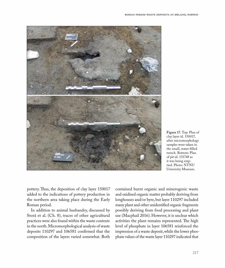
217
Roman period waste deposits at Ørland, Norway
pottery. Thus, the deposition of clay layer 150017 added to the indications of pottery production in the northern area taking place during the Early Roman period.
In addition to animal husbandry, discussed by Storå et al. (Ch. 8), traces of other agricultural practices were also found within the waste contexts in the north. Micromorphological analysis of waste deposits 110297 and 106581 confirmed that the composition of the layers varied somewhat. Both
contained burnt organic and minerogenic waste and oxidised organic matter probably deriving from longhouses and/or byre, but layer 110297 included many plant and other unidentified organic fragments possibly deriving from food processing and plant use (Macphail 2016). However, it is unclear which activities the plant remains represented. The high level of phosphate in layer 106581 reinforced the impression of a waste deposit, while the lower phos-phate values of the waste layer 110297 indicated that
Figure 17. Top: Plan of clay layer id. 150017, after micromorphology samples were taken in the small, water-filled trench. Bottom: Plan of pit id. 151748 as it was being emp-tied. Photo: NTNU University Museum.

218
Environment and settlement | Marte Mokkelbost
this was a different type of deposit (Buckland et al. 2017:40), as demonstrated by the varying finds and features related to layer 110297. Layer 110297 clearly contained more material of an organic character than the other two contexts (Table 5).
The large waste layers and waste pit in the northern area contained many of the same types of fill, with minor variations. This conformity was also reflected through the fill colour of the contexts (see Tables 5 and 7). However, within pit 210240 there was a striking difference regarding the ratio of the fill elements. Whereas in the Field A deposits organic material should be regarded as mere inclusions in the fill, in pit 210240 the fill consisted mainly of cockles, while the remaining mineral ingredients should be regarded as inclusions within the cockle fill.
As indicated by the micromorphology results, the depressions where the waste layers were preserved might have had another function other than waste deposition. These areas might have been used for storing byre/latrine and other types of organic waste in order to achieve composting, so that the product could be used as fertiliser in the fields during the growing season. Similar waste management strategies are known from Europe (e.g. Jones 2012), and there is evidence that this was a common technique in the Norwegian Iron Age (e.g. Mjærum 2012). This type of storage and processing probably meant that the layers were deposited, removed and redeposited on a regular basis (R. Macphail and J. Linderholm, pers. comm. 2018). It also implies that the waste layers may not have been stable entities deposited
110297 106581 210240 Size 235.2m2 129.3 m2 4.7 m2
Colour Mostly dark brown, sometimes reddish, interspersed with greyish areas Dark grey to greyish black Dark brown
and black
Fill Humic sandy silt, charcoal, fire-cracked stones, crushed shells
Gravelly sand, charcoal, fire-cracked stones
Sand and silt, fire-cracked stones, approx. 13 000 cockles
Micro-morphology
The layer seems trampled.Coprolitic bone, charcoal, abundant raw amorphous organic matter, charred plant material -> byre waste + possible latrine/cess detritus, probably collected from nearby longhouses.Short period of stasis is present. After stasis, continued deposition of latrine waste, fine bone/cess, much plant and other unidentified organic fragments and charcoal. Plant fragments may derive from food processing and plant use. (*)Low levels of phosphate = this layer seems to represent a different type of deposit than 106581. (**)
Marked fine coprolitic and human cess/mineralised pig waste content. Burnt organic and minerogenic waste, probably from longhouses.Oxidised organic matter, from wooden constructional and/or byre waste. (*)High level of phosphate = waste deposit. (**)
-
Macrofossils Cereal, indeterminate, 1 grain. (**) Oats (avena), 1 grain. Cereal, indeterminate, 1 grain. (**)
Barley (Hordeum vulgare), 1 grain. (***)
* Macphail 2016. ** Buckland et al. 2017. *** Moltsen 2017.
Table 7. Composition of the three large waste contexts in the northern area.

219
Roman period waste deposits at Ørland, Norway
once and for all, but may have started out as waste heaps laid directly on the ground, while the con-tinued removal and redeposition of waste gradually created the shallow depressions where the layers were preserved after they were abandoned. Furthermore, the presence of a pathway or cattle path 130000 in relation to these waste layers could be evidence of transport of fertilised waste from the layers to fields along the way. For more information on this path, see Mokkelbost & Fransson 2018.
Activities and Functions indicated by Waste Deposits: The Southern Area
The large Late Roman waste layer 500200 con-tained the most finds of the waste contexts in the southern area (Figure 18 and Table 8). It was more than three times the size of the second-largest layer
521623, yet it contained almost twenty times more finds than the other two waste contexts in this area. The finds within this context showed a random spread, although with a larger amount of finds in the eastern half, which was closest to the settlement. As in the northern area, the numerous finds, bones and related sub-contexts within this layer made it possible to relate more activities to this layer than to the other contexts in the southern area.
All of the main waste contexts in the southern area contained household waste (Table 9), which seemed to be the primary function of these contexts. Waste pit 613254 in field D contained few finds and reflected fewer aspects of the Roman age farm. However, burnt and raw clay, fire-cracked stones and variations in colour might suggest some kind of production or cooking requiring heat.
166
9 60
20406080
100120140160180
500200 and relatedfeatures phase 3
521623 and related features
509677 and features withinthe pit
No. of finds
Figure 18. Total number of finds, osteology excluded, within the large waste contexts in the southern area. Illustration: Marte Mokkelbost, NTNU University Museum.

220
Environment and settlement | Marte Mokkelbost
Provenience Type500200 and related features phase 3
521326 and rela ted features
509677 and features within the pit
SUM
All three contexts Pottery 63 8 1 72
Contexts related to house 2 and 15
Iron fitting 1 1 1Iron fragm. 5 1 6Rivet 64 2 66
500200 only
Arrowhead, bone 1 1Bead 1 1Clay, burnt 2 2Fish hook, iron 1 1Glass, beaker/ crucible 1 1Glass fragm. 1 1Key 1 1Knife 5 5Needle - 2 bone, 2 iron 4 4Ring - silver, bronze, iron 3 3Whetstone 3 1Worked stone 1 1
521326 only Belt buckle 1 1509677 only Spoon, bone 1 1SUM 157 9 6 169
Table 8. Household items found in the southern area main waste contexts.
Activities Layer 500200
Layer 521623
Pit 509677
Pit 613254
General household activities
Cleaning of hearths in longhouse 2 xCooking x x x xFishing/hunting and consumption x x x xForaging (seashells/cockles) and consumption x x xSewing/textile work (needles) xImport (glass beaker, beads, noble metals, pottery) x
Farming/ agriculture
Fertiliser production xTool maintenance (whetstones) xAnimal husbandry x x x xGrains x x x x
Table 9. Activities observed in the southern area contexts.

221
Roman period waste deposits at Ørland, Norway
The largest waste layer 500200 contained 12 types of finds that were not found within the other two contexts, representing traces of activities not found in the other two waste contexts in the southern area (Tables 8 and 9). The stones deposited in the stony layer 523529 within the main use phase of the large layer 500200 were similar to stones used in hearths in the contemporary House 2, indicating that the stony layer consisted of material originating from cleaning and maintenance of hearths in that specific longhouse (Heen Pettersen 2018:526). Layer 500200 also showed evidence of tool maintenance in the form of whetstones and evidence of sewing in the form of needles. Several items were imported, such as a glass beaker fragment of a Roman type, similar to R.337/338 (Rygh 1885); a blue glass bead, and a silver and a bronze ring. The variation in finds in this layer was not surprising, considering that it was the largest waste context in this field, located close to substantial farm buildings (Figures 19, 20 and 21).
Cooking seems to have taken place in relation to all southern waste contexts, since the contexts included either cooking pits, fire-cracked stones (Table 10), and/or pottery (Table 8) within their main use phases (layer 500200). The osteological material indicates both animal husbandry, fishing and hunting activities. Foraging for and consumption of shells were evident in all contexts.
Pottery was the only household item found in all three waste contexts in the southern area. Most of it was found within the largest waste layer 500200, which contained sherds from 22 different vessels. (Solvold, Ch. 9, discusses sixteen of these vessels.)
In addition to the finds of household items/pottery related to cooking, large amounts of animal bones were found in the southern area, providing evidence of the species that were included in the diet (Table 11). As within the northern area, the osteological material was the most frequent material found in all of the three large waste contexts here.
Figure 19. T27074:9, 10 and 11: Whetstones. T27074:101: Bone arrowhead. T27074:49, 51, 52, 53 and 54: Iron rivets. T27074:12 and 295: Bone needle. All finds are from waste layer 500200. Photo: Åge Hojem, NTNU University Museum.

222
Environment and settlement | Marte Mokkelbost
Figure 20. T27074:1, 2, 3 and 4: Silver ring, bronze ring, glass bead, fragment of glass beaker from waste layer 500200. T27078:1: Decorated handle of bone spoon from waste pit 521397. Photo: Åge Hojem, NTNU University Museum.
Figure 21. T27074:6, 102 and 103: Fishing hook, knife, and key from waste layer 500200. Photo: Åge Hojem, NTNU University Museum.

223
Roman period waste deposits at Ørland, Norway
More than 3kg of osteological material, consisting of more than 2000 fragments (NISP), originated from these contexts. The animal bones from all the three large contexts indicate both animal husbandry and fishing, although with some variations regarding species and frequency of species (Karlsson et al. 2018). In addition, the waste contexts related to the Late Roman/Migration period Houses 2 and 15 indicate that hunting took place within this household. The Late Roman waste layer impressively contained fragments of tibia from brown bear (Ursus). For more information on the osteology, see Storå et al, Ch. 8. The cockles found in the Migration period
waste pit 509677 indicate that some local foraging was a subsistence strategy.
No substantial evidence for household production activities such as metalworking and production of bone items was found within the southern waste contexts. Although the waste contexts here contained some production remnants such as kiln fragments and slag, the number of such items was much smaller than in the northern area. A faint trace of such materials was found within the largest waste layer 500200 (Figure 22), but in quantities too small to interpret with certainty as being remains of actual production in this area.
Context id.
Birch bark
Animal bones
Burnt animal bones
Burnt clay
Charcoal Raw clay
Finds Fire-cracked stone
Pottery Sea shells
Slag
500200 x x x x x x x x x x509677 x x x x x x521623 x x x x x x613254 x x x x x x
Table 10. Observations in waste contexts in the southern area.
521623 * 500200 * 509677 * Pit 613254 **NISP 402 925 768 9Weight (g) 428.01 2239.44 587.55 4.2Species (interpreted)
Husbandry Cattle, goat, horse, pig, sheep/goat
Cattle, horse, pig, sheep, sheep/goat Cattle, pig, sheep/goat
Hunting Brown bear, mooseSeal, whale Whale
Fishing Codfish, haddockAtlantic cod, codfish, common ling, haddock, herring, ling, saithe
Atlantic cod, codfish, common ling, haddock, pollock
Atlantic cod
Bird ChickenOther Canid, artefact Rodent* Preliminary osteology report field C (Karlsson et al. 2018)** Final osteology report Field D (Aalders et al. 2017b)
Table 11. Osteology within the southern area waste contexts.

224
Environment and settlement | Marte Mokkelbost
The amount of pottery (94 sherds) found within the large waste layer was significant but no kilns from the Late Roman period were found in this area. However, two kilns were found within, but pre-dating the Early Roman house 34, located 1.5 m east of the layer. These kilns were dated very early within the Early Roman period: 522729 was dated to 38 BC-AD 59 (Tra-13059, 1985+15 BP) and 522089 was of the same age, dated to 45 BC-AD 50 (Tra-13060, 2005±15 BP). It is thus unlikely that these kilns were the source of the pottery within the Late Roman waste layer (Heen-Pettersen & Lorentzen Ch. 6, Solvold Ch. 9). Considering that the entire excavation area contained no Late Roman kilns, it is possible that the pottery within the Late Roman contexts was imported to Vik.
The youngest waste layer 500200 as well as waste pit 509677 shared some similarities regarding finds, although the amount of rivets found in these contexts
differed greatly. The similarities are not surprising, considering these contexts were related to the same household. A large quantity of rivets was found within waste layer 500200 as well as five iron knives and an iron fishhook, while 509677 contained a few rivets. However, the lack of slag and waste from metal production during the Late Roman and Migration period indicates that metal items were not produced within the southern area during these periods.
Whale bone was found in both 500200 and 509677. Storå et al. (Ch. 8) suggest that whale bone could be used as raw material for bone craft, and as such, bone items in the form of an arrowhead and some needles in 500200 and a decorated bone spoon from 509677 could have been produced locally. However, the lack of waste from bone production contradicts this view, probably indicating that bone items were imported.
Because of the coarse and stony fill of the waste contexts in field C, micromorphological analyses
Figure 22. Production indicators in the southern area main waste deposits. Illustration: Marte Mokkelbost, NTNU University Museum.
363
8
1
4
0 10 20 30 40 50 60 70
500200 and related features phase 3
521623 and related features
509677 and features within the pit
Production indicators
slag pottery kiln fragments

225
Roman period waste deposits at Ørland, Norway
were not possible. However, they were all quite similar in colour and fill (tables 10 and 12). The largest layer 500200 was the most diverse, including both birch bark, burnt animal bones, burnt clay and some slag, which were not present in the other two contexts. It also contained a relatively large amount of grains, although only one type of grain was determined. However, this was the only rye found in this field, making this a very interesting find.
One cooking pit 524509 in the small waste layer 521623 contained a variety of plant species, including oats, which seemed to be quite common in Field C, and one rare fragment of hazelnut. In addition, there was an assortment of weeds, perhaps disposed of after weeding had been done. The context could have been a mixed cooking pit and waste context, or the sample could have contained material from two different usage phases (Buckland et al. 2017:71).
Because micromorphological sampling was not possible in waste deposit 500200, the presence or absence of latrine/byre content could not be estab-lished. However, the layer was preserved in a large, shallow depression in the ground, like the layers in Field A. It is likely that this depression originated from the repeated removal of midden-like contents designated as fertiliser on nearby fields, thereby implying that fertiliser production took place in Field C too.
Roman Period Activities at Vik: DiscussionThe analysis of the northern and southern areas revealed that that many activities on the Roman period farm could be inferred from the waste deposits. They are discussed below, grouped under the broad themes subsistence, production and personal life.
500200 521623 509677 613254Size 88.34m2 27.9m2 2.9m2 2.8m2
Colour Greyish black Greyish black Dark grey
Red, black, grey, dark greyish brown and brownish black
FillGravelly sand with stones (some fire-cracked)
Gravelly sand Sand, stones (some fire-cracked)
Gravel, charcoal lenses, fire-cracked stones, silt/raw clay
Macrofossils (*)
Rye (Secale cereale), 1 grain; Cerealia indet., 2 grains; cerealia indet. et. fragmenta, 11 fragm.; weeds (Stellaria media, Carex) (*).
Layer 521623: Cerealia indet., 1 grain.Layer 524312: Cerealia indet., 2 grains.Cooking pit id. 524509: oats (Avena), 1 grain; an assortment of weeds (Chenopodium album, Persicaria lapathifolia, Stellaria media, Carex), 1 fragment of hazelnut (Corylus avellana) (*).
Layer 521429: Cerealia indet., 1 grain (*).
Barley (Hordeum vulgare), 1½ grain. Grass (**).
* Buckland et al. 2017. ** Moltsen 2017
Table 12. Composition of the largest waste contexts in the southern area.
226
Environment and settlement | Marte Mokkelbost
SubsistenceThe waste contexts at Ørland provided considerable insight into the Roman period diet, where domes-ticated animals and sea resources such as fish, sea mammals and cockles were especially important. Wild animals entered the menu occasionally, in the form of both terrestrial and aquatic mammals. Animal bones were deposited after the meat was consumed (see also Storå et al., Ch. 8). Analysed lipids from several vessels revealed that both terres-trial and aquatic foods had been cooked or stored in these vessels (Isaksson 2017, see also Solvold, Ch. 9). Three fragments of an imported glass beaker found in the Late Roman layer 500200 and in a cooking pit 519779, as well as several fragments of small pottery cups/beakers with handles, all from waste deposit 500200 (see Solvold, Ch. 9) serve as reminders that drink also was part of the diet. Analyses of Danish pottery and bronze drinking vessels as well as drinking horns from the Roman period have shown that drink could have consisted of mead, or beer made from grains, herbs, berries and honey (Rødsrud 2010:57).
Within the osteological material, very few toe bones/metapodia from domestic species were present, implying that waste from slaughter was absent among the household waste at Vik. This could indicate that the animals were slaughtered elsewhere (Storå et al., Ch. 8), and/or that slaughter waste was deposited outside the excavation area. One might see this as evidence that animal husbandry was not present at Vik; hence, meat from domestic animals might have been brought in from farms outside Vik. However, coprolite bone – bones that have been digested and defecated – was found within layer 106581, which also contained pig manure (Macphail 2016). This is clear evidence of pig husbandry at Vik, also showing that bones, perhaps as part of slaughter waste, were part of the pigs’ diet, though it has not been examined whether these were cooked (food
remains) or raw bones (slaughter waste). Furthermore, the presence of manure from other domestic animals in the northern waste layers as well as in the cattle path 130000 in the northern area, and a deposit of an almost complete foal within Longhouse 2 in the south (Heen-Pettersen & Lorentzen, Ch. 6) indicate that domestic animals were raised within the exca-vation area. It therefore seems likely that domestic animals at Vik were slaughtered at a distance from the settlement, and that slaughter waste was deposited at or near the place of slaughter, while the butchered meat was brought back to the settlement.
It could be argued that slight differences in animal/fish species representation and culling age of domes-tic animals such as cattle and sheep (see Storå et al., Ch. 8) in the two areas represent different subsistence economies – i.e. specialised economies. I would however argue that the differences are too slight to indicate totally different economies, and I would rather characterise the economy throughout Vik as fishing-farming. The waste contexts all contained bones from various species of fish as well as cockles and other seashells, indicating that marine resources were of great importance for the settlement at Vik. At the same time, animal husbandry was clearly another important aspect of the economy, while ard marks, grains and fertiliser production hint at the existence of arable farming. Granted, there is a difference in culling ages of cattle and sheep from the Early to the Late Roman period (Storå et al., Ch. 8). When it comes to the question as whether wool production or meat production was more impor-tant, analysis of the culling age of different types of animals (Storå et al., Ch. 8) indicates that this fluctuated, and it is tempting to conclude that, during the Late Roman period, the northern area might have provided the meat while the southern area focused on wool production. However, both areas still contained other indicators of a fisher-farmer economy, such as substantial evidence of fishing in

227
Roman period waste deposits at Ørland, Norway
the form of several types of fish bone and fishing equipment, together with bones from sea mammals, wild animals and birds as well as of domesticated species such as cattle and sheep (e.g. Bertelsen 2018). There is a slight variation concerning the frequency of fish species within the northern area contexts, especially haddock and common ling (Storå, p. 5-6, and Table 4), but this might have other causes (see the discussion below on feasts).
The deposited material in the waste contexts at Vik bears close resemblance to the assemblage in the previously discussed East Chisenbury midden in Wiltshire, England, in that it contained similar artefacts as well as animal bones and dung. In addi-tion, the hypothesis regarding evidence of sporadic and massive feasting in the East Chisenbury midden (Tubb 2011:47), may also be true of some of the waste deposits in Vik: Meat of horse was handled and consumed on site in both northern and southern areas (Storå et al., Ch. 8). The consumption of horse meat is commonly related to ritual activities, which often take place at special occasions (e.g. Mansrud 2004, Oma 2005). In at least one instance, there is undeniable proof of a single or short-termed incident of massive food consumption at Vik: the large waste pit 210240 in Field E. During the Late Roman period, an enormous quantity of cockles together with large amounts of fish were devoured and later deposited within this waste pit. Haddock was well represented, and since it is commonly regarded as an excellent food fish, this further strengthens the impression of a large feast wherein good food played a central role. Haddock was also plentiful within the southern area in general, but uncommon in waste contexts in Field A. Apart from that, the fish species representation in Field A contexts resembled the other waste contexts at Vik, containing other good food fish such as codfish and saithe. Furthermore, all the large waste deposits contained much pottery, together with large amounts of animal bones, echoing the East
Chisenbury assemblage. Thus, it could be argued that the waste context assemblage at Vik contained several indicators of feasts and ritual activities.
ProductionIndications of Early Roman pottery production in the northern area (deposit 110297, Field A) existed in the form of kiln fragments, however in the Late Roman period there was no evidence for such production at Vik. The kilns in the southern area predated both the area’s Roman period settle-ment and the waste contexts that included pottery. Pottery production in the Early Roman period therefore took place only in the northern area (Field A). Likewise, only the northern area (again deposit 110297) exhibited evidence of metal working in the form of heavy slag. In the Late Roman period, this pattern was slightly changed – only the northern Field E deposit 210240 displayed evidence of any kind of production, and in this period only of metal working in the form of very light slag, perhaps indicating a farm smithy.
While the metal production remnants in the two northern deposits were frequent compared to the southern deposits (Figures 14 and 20), the collected amounts were relatively small, suggest-ing production on a small, localized scale. Pottery production remnants, however, were more frequent. It therefore seems that the northern area relied on manufacturing their own iron during the Early Roman period, while at the same time the pottery production might have supplied all farms at Vik. In this period, the southern area probably reaped the benefits of the northern pottery production, while iron products might have been imported from outside Vik. Unfortunately, the number of Early Roman finds in the south was limited, making it hard to come to any firm conclusions about the southern area’s practice of pottery and iron acquisition.

228
Environment and settlement | Marte Mokkelbost
No remains of Late Roman kilns were found at Vik, thus indicating that all pottery was imported during this later period. Metalworking in this period took place on a small scale and was related to ham-mering and welding of iron, based on the light slag usually associated with these types of activities. This production could probably not supply both areas with iron items, indicating that the southern area imported such items.
This analysis suggests that a slight division of labour existed between the two areas, at least during the Early Roman period, where the southern area might have relied on northern production of pot-tery. In the Late Roman period, this had changed, and production was so small that it probably only supported the northern area, thus not really indi-cating a division of labour anymore. In this period, the southern area was reliant on imports of both pottery and metals, while the northern area seemed to rely on imports of at least pottery.
Personal lifePersonal items such as beads, rings, hairpins and pins/needles from buckles/brooches were found within the larger deposits. Interestingly, together with sherds from a large rimmed vessel and a decorated buck-et-shaped vessel (Solvold, Ch. 9), these items bear close resemblance to the assemblage usually found within graves from this era (e.g. Solberg 2000:77), suggesting that Roman period graves could be used to gain insight into the Roman period household.
The deposition of the small personal items within the waste contexts can be interpreted as either inten-tional or unintentional depositions. The latter requires that there was no knowledge of the original wherea-bouts of these valuable items before deposition – they might have been lost and then swept off the floor or collected together with regular household refuse to be deposited as waste. Intentional deposition, however, requires knowledge of the deposition. The
items could simply have been discarded because they were broken, and for some of them this would seem to be a plausible explanation. However, several of the items were whole and undamaged when excavated. Could it be that these valuables were deposited in the waste deposits for a ritual purpose? The similarity with grave goods is very interesting, considering that grave goods are always intentionally deposited (e.g. Solberg 2000:31, Mokkelbost 2007:21-22), and may have ritual or symbolic connotations - e.g. serve a practical function in the after-life, or serve as material representations of the deceased’s status and position (Solberg 200:31). The fact that personal items, similar to grave goods, were found whole and undamaged in the waste layers, can perhaps imply that there were intentional depositions also at Vik. However, most of these items were quite small and probably ended up in the waste layers by chance. Additionally, it is not possible to discern a particular pattern in the deposition of these items. Accordingly, they should probably not be regarded as sacrifices or ritual depositions.
CONCLUSIONDepositional practices at Vik varied according to the type and size of the features. When compar-ing waste pits with waste layers, it seems that the pits represented episodic events as opposed to the complex and multifaceted waste layers. The small pits reflected similar but fewer activities than the large waste contexts. However, the large pit 210240 reflected the same amount of activities as the layers. It functioned as a receptacle for the remains of a single occurrence of cockle consumption, while at the same time to some extent mirroring other household and production activities.
Context is very important within archaeologi-cal interpretation, yet when studying refuse/waste, the provenance of items is often hard to disclose. However, in the case of Vik the farms were dispersed

229
Roman period waste deposits at Ørland, Norway
at regular intervals, spatially congruent with waste deposits. Dating material that corresponded to spatial patterns further helped indicate the origin of the secondary waste, thus making it possible to describe the activities that took place at the different farms at different times.
The waste deposited at Vik originated not only from ordinary household activities such as cooking, food consumption, cleaning, sewing, animal hus-bandry, everyday metalworking and tool maintenance, but also from specialised production in the form of kilns for firing of pottery. During the Early Roman period, pottery was produced locally in kilns in the northern area. In the Late Roman period, this had changed – no Late Roman kilns were found within the entire excavation area, and pottery seemed to have been imported to Vik as a whole. In the same period, some light metal working took place in the northern area only.
Most of the waste found in the waste contexts at Ørland was secondary refuse from households, originating from residential buildings, byres or cooking pits. However, production waste in the form of kiln fragments found in layer 110297 seems to have been dumped in the actual production area. Some cooking took place in cooking pits within the waste layers themselves.
The amount of waste and number of waste con-texts were largest in the Early Roman period, which corresponds with the other activity in this area. In this period, the waste was placed within the central yard. In the Late Roman period, a change appeared regarding the spatial distribution of the waste, which was now placed in the outskirts of, or outside, the central yard. In the transition between these peri-ods, one waste context in Field C was abandoned and sealed before the construction of a new waste layer on the same spot. The same happened to a contemporary house, which was cleaned out and closed (Heen-Pettersen & Lorentzen, Ch. 6). This
ritual could have reflected a change in ownership of the farm – a possibility discussed above.
As previously suggested, organic waste was proba-bly discarded regularly to insure sanitary conditions on the farms, while at the same time it was regarded as a resource in this farming community, in the form of fertiliser for the fields.
The osteological and botanical material in the waste contexts yields insight into a large subsistence foundation, where animal husbandry, fishing, forag-ing, hunting and grain production were important ingredients in a fisher-farmer economy. Domestic animals were slaughtered outside the excavation area, while the meat was cooked and consumed on site, as demonstrated by large amounts of bones and cooking ware in the contexts. Preparation of the food took place inside buildings, but also in cook-ing pits within and beside the waste layers. Some of the meals must be regarded as feasts, perhaps in relation to the cockle-filled pit 210240 in the northern area. Although layer 500200 in Field C contained the highest number of imported items of all the Roman period waste contexts, these items did not automatically represent an elevated social status of the farm related to this layer. Imported items were few, and the farm itself was characterised as socially equal to its neighbours (Heen-Pettersen & Lorentzen, Ch. 6). Overall, the waste contexts at Vik revealed only minor differences in activities and temporal aspects, contributing to the impression of established, self-sustainable and socially equal farms at Ørland in the Roman period.
ACKNOWLEDGEMENTSAdvice given by Dr. Ingrid Ystgaard, project manager at The Ørland Main Air Base excavations 2015-2016, has been a great help in writing this article. I also wish to thank the anonymous referee for comments that greatly improved the manuscript.

230
Environment and settlement | Marte Mokkelbost
REFERENCES
Aalders, M., C. Olson, J. Karlsson & J. Storå 2017a: Osteological Analysis of Animal Bones from Ørland Kampflybase, Field A. OFL rapport 2017:6, Stockholms universitet.
Aalders, M., C. Olson, J. Karlsson & J. Storå, 2017b: Osteological Analysis of Animal Bones from Ørland Kampflybase, Field D. OFL rapport 2017:9, Stockholms universitet.
Aanderaa, F. 2015: Arkeologiske undersøkelser av treskipet hus og øvrige bosetningsspor fra eldre jernalder. Einargården, Sande gnr. 33, bnr. 8, Sola kommune, Rogaland. Del 1: rapport. Oppdragsrapport B, 2015/16. Universitetet i Stavanger/Arkeologisk museum.
Bertelsen, R. 2018: The origin and development of the fisher-farmer economy in Hålogaland. In: Mahler, D.L. (ed.) Gruel, Bread, Ale and Fish. Changes in the Material Culture Related to Food Production in the North Atlantic 800-1300 AD, PNM Publications from the National Museum, Studies in Archaeology & History Vol. 26, Copenhagen.
Brorsson, T. 2016: Analys av bränd lera från Ørland kampflybase, Sør-Trøndelag. Rapport 105, 2016. KKS, Kontoret för Keramiska Studier, Höganäs.
Buckland, Ph., J. Linderholm, S. Östman, S. Eriksson, J.-E. Wallin & R. Engelmark 2017: Environmental archaeological analysis from the archaeological excavations at Ørland kampflybase, Vik 70/1, Ørland, Sør-Trøndelag, Norway. Environmental archaeology lab, report no. 2017-012. Department of historical, philosophical & religious studies, Umeå Universitet.
Børsheim, R.L. 2001: Gauselutgravingene 1997-2000. Varia 39. Arkeologisk museum i Stavanger.
Bårdseth. G.A. & P.U. Sandvik 2007: Kapittel 9. Missingen. Ein storgard frå romartid (lokalitet 4 og 5). In: Bårdseth, G.A. (ed.) E6-prosjektet Østfold: Band 1. Hus og gard langs E6 i Råde kommune. Varia 65, pp.123-190. Kulturhistorisk museum, Fornminneseksjonen, Oslo.
Callmer, J. 1977: Trade beads and bead trade in Scandinavia ca. 800-1000 A.D., Acta Archaeologica Lundensia, series in 4. Vol. 11. Lund, Gleerup.
Diinhoff, S. 2010: Store gårde og storgårde på Vestlandet fra yngre romersk jernalder og folkevandringstid. In Gundersen, I.M. & M.H. Eriksen (eds.): På sporet av romersk jernalder – nye resultater fra forskning og forvaltning, pp. 79–86. Nicolay Skrifter 3, Oslo.
Drewett, P. 2011: Field Archaeology. An Introduction. Second edition. Routledge. London and New York.
Fagan, B. M., & N. Durrani 2016: Archaeology: A Brief Introduction. Routledge.
Gjerpe, L. E., M. Samdal, M. Østmo, O. Rønne, S. Pettersson, P. Persson, A. Mansrud & G. B. Bukkemoen 2008: E18-prosjektet Vestfold: Bind 2. Steinalderboplasser, boplasspor, graver og dyrkningsspor. Varia vol. 72. Kulturhistorisk museum, Fornminneseksjonen, Oslo.
Gjerpe, L. E. & C. L. Rødsrud 2008: Kapittel 4. Rødbøl 19, 20 og 21 - hus og boplasspor fra romertid, jernvinne fra middelalder og graver fra eldre jernalder. In: Gjerpe, L. E. (ed.): E18-prosjektet Vestfold: Bind 3. Hus, boplass- og dyrkningsspor. Varia vol. 73, pp. 143–193. Kulturhistorisk museum, Fornminneseksjonen, Oslo.
Gjerpe, L. E. & M. Østmo 2008: Kapittel 3. Ringdal 13 – Hus fra romertid-merovingertid og graver fra førromersk jernalder. In: Gjerpe, L. E. (ed.): E18-prosjektet Vestfold: Bind 3. Hus, boplass- og dyrkningsspor. Varia vol. 73, pp. 39-142. Kulturhistorisk museum, Fornminneseksjonen, Oslo.
Grenne, T., T. Heldal, G. B. Meyer & E. G. Bloxam 2008: From Hyllestad to Selbu: Norwegian millstone quarrying through 1300 years. Geology for Society. Geological Survey of Norway Special Publication, 11: 47–66.
Grieg, S. 1934. Jernalderhus på Lista. Oslo: Instituttet for sammenlignende kulturforskning. Serie B Skrifter, XXVII.
Grieg, S. 1938. «Vikingtidshus i Gudbrandsdalen». Årbok for Dølaringen 1938:16–125.
Grønnesby, G. 1999: Eldre jernalders hus og hall på Hovde i Trøndelag. Viking 62: 69–80.
Haak, A. 2016: Cesspits and finds: archaeological study of waste management and its social significance in medieval Tartu, Estonia. In: Sosna, D, & L. Brunclíková (eds.): Archaeologies of waste: encounters with the unwanted, pp. 83–99. Oxbow Books.
Heen-Pettersen, A. 2018: Felt C, Vik. In: Ystgaard, I. et al.: Arkeologiske utgravninger på Ørland kampflybase 2015-2016, pp. 457–545. NTNU Vitenskapsmuseet arkeologisk rapport 2018:27.
Husvegg, J.R., E.C. Soltvedt & B. Dahl 2017: Arkeologisk og naturvitenskapelig undersøkelser av røyser fra E.BRA og hus fra Y.ROM ved Skadberg skole (id. 157229 og 65854). Skadberg gnr. 32 bnr. 19, Sola kommune, Rogaland. Oppdragsrapport, 2017/01. Universitetet i Stavanger/Arkeologisk museum.
Høgestøl, M., L. Selsing, T. Løken, A. J. Nærøy & L. Prøsch-Danielsen (eds.) 2005: Konstruksjonsspor og byggeskikk. Maskinell flateavdekking – Metodikk, tolking og forvaltning. AmS-Varia 43, Stavanger.
Isaksson, S. 2017: Analys av organiska lämningar i keramik från Ørlandprojektet, Trondheim, Norge Uppdragsrapport nr 321. Arkeologiska forskningslaboratoriet, Stockholms universitet.

231
Roman period waste deposits at Ørland, Norway
Jones, R. 2012: Manure Matters: Historical, Archaeological and Ethnographic Perspectives. Farnham Surrey: Routledge.
Karlsson, J., M. Aalders, C. Olson & J. Storå 2018: Osteological Analysis of Animal Bones from Ørland Kampflybase Field C. Preliminary report, OFL, Stockholms universitet.
Loktu, L. 2016: Kapittel 24. Langhus med smie. Smievirksomhet i langhus på gårdsanlegg fra romertiden og folkevandringstiden. In Gundersen, I.M. (ed.): Gård og utmark i Gudbrandsdalen. Arkeologiske undersøkelser i Fron 2011-2012, pp. 242–269. Kulturhistorisk museum, Arkeologisk seksjon. Portal forlag. Kristiansand.
Lorentzen, A. B. 2018: Felt D. In: Ystgaard et al.: Arkeologiske utgravninger på Ørland kampflybase 2015-2016, pp. 546–613. NTNU Vitenskapsmuseet arkeologisk rapport 2018:27.
Løken, T., L. Pilø & O. Hemdorff 1996: Maskinell flateavdekking og utgravning av forhistoriske jordbruksboplasser – en metodisk innføring. AmS-Varia 26. Arkeologisk museum i Stavanger.
Macphail, R. 2016: Ørland main air station (near Trondheim, Norway): soil micromorphology. Report for Museum of Natural History and Archaeology, Norwegian University of Science and Technology, Trondheim, Norway.
Mansrud, A. 2004: Dyret i jernalderens forestillingsverden. En studie av forholdet mellom mennesker og dyr i nordisk jernalder, med utgangspunkt i dyrebein fra graver. Hovedfagsoppgave, IAKK, Oslo.
McOmish, D. 1996: East Chisenbury: ritual and rubbish at the British Bronze Age—Iron Age transition. Antiquity, 70: 68-76.
Meling, T. 2016: Farm–Manor–Estate: Agricultural Landscape and Settlement at Hundvåg, Southwest Norway. In Iversen, F. & H. Petersson (eds.): The Agrarian Life of the North 2000 BC–AD 1000, p.151–172. Portal Academic. Kristiansand.
Mjærum, A. 2012: Åkre og beitemarker i Fevanggrenda – nytt om jernalderlandbruket i Vestfold. Viking 2012: 109–130.
Mokkelbost, M. 2007: Sittegravbyggerne i Sandvika. En arkeologisk analyse av en lokal tradisjon i yngre jernalder på øya Jøa i Ytre Namdal. Masteroppgave, NTNU, Trondheim.
Mokkelbost, M. & U. Fransson 2018: Felt A og E, midtre del. In: Ystgaard, I. et al.: Arkeologiske utgravninger på Ørland kampflybase 2015-2016, pp. 159–241. NTNU Vitenskapsmuseet arkeologisk rapport 2018:27.
Oma, K.A. 2005: Hestetenner i kokegroper – på sporet av blot? Eit perspektiv frå Veien. In: Gustafson, L., T. Heibreen & J. Martens (eds.): De gåtefulle kokegroper. Varia vol. 58: 243–250. Fornminneseksjonen, Kulturhistorisk museum, Universitetet i Oslo.
Petersen, J. 1933: Gamle gårdsanlegg i Rogaland fra forhistorisk tid og middelalder. Instituttet for sammenlignende kulturforskning, Serie B: Skrifter XXIII. Aschehoug, Oslo.
Petersen, J. 1936: Gamle gårdsanlegg i Rogaland: Fortsettelse: Utsira, Lyngaland, Håvodl, Birkelandstølen, Hanaland. Instituttet for sammenlignende kulturforskning, Serie B: Skrifter XXXI. Aschehoug, Oslo.
Renfrew, C. & P. Bahn 2016: Archaeology: Theories, Methods and Practice. 7th edition. Thames & Hudson, London.
Rolfsen, P. 1980: Et pottemakerverksted fra romertiden. Universitetets Oldsaksamling Skrifter 3: 15–20.
Rødsrud, C. L. 2010: Drikk og lev vel! Gravkeramikk som kilde til gjestebudskultur i eldre jernalder. In: I.M. Gundersen & M.H. Eriksen (eds.): På sporet av romersk jernalder: artikkelsamling fra romertidsseminaret på Isengran 23.–24. januar 2010. Nicolay skrifter 3, Oslo.
Rødsrud, C. L. 2012: I liv og død: Keramikkens sosiale kronologi i eldre jernalder. PhD Dissertation. Museum of Cultural History, University of Oslo.
Rygh, O. 1885: Norske oldsager. Cammermeyer, Christiania.Sauvage, R. 2005: Jern, smie og smed. Jernhåndverkere og
jernhåndverk i Midt-Norge ca. 600-1100 e.Kr. Master thesis, NTNU.
Solberg, B. 2000: Jernalderen i Norge. Ca. 500 f.Kr. -1030 e.Kr. Cappelen Akademisk Forlag, Oslo.
Tubb, P. C. 2011: Late Bronze Age/Early Iron Age transition sites in the Vale of Pewsey: the East Chisenbury midden in its regional context. Wiltshire Archaeological and Natural History and Magazine, 104: 44–61.
Vinsrygg, S. 1979: Merovingartid i Nord-Noreg; Studie i utvalt materiale frå gravfunn. Arkeologiske Avhandlinger Vol.2. Historisk Museum, Universitetet i Bergen.
Wessex Archaeology 2017: East Chisenbury Midden, Salisbury Plain, Wiltshire. Archaeological Evaluation Report, ref. 70241.01. Salisbury, Wiltshire
Ystgaard, I., M. M. Gran, M. Mokkelbost, U. Fransson, A. Heen-Pettersen, A. B. Lorentzen, G. I. Solvold and E. W. Randerz 2018: Arkeologiske utgravninger på Ørland kampflybase 2015-2016. NTNU Vitenskapsmuseet arkeologisk rapport 2018:27.

233
c h a p t e r 8
Jan StoråDepartment of Archaeology and Classical Studies, Stockholm [email protected] Ivarsson-AaldersDepartment of Archaeology and Classical Studies, Stockholm UniversityIngrid YstgaardDepartment of Archaeology and Cultural History, NTNU University MuseumDepartment of Historical Studies, Norwegian University of Technology and Science
Utilization of animal resources in Roman Iron Age Vik: Zooarchaeology at Ørland
ABSTRACTDuring the archaeological excavations at Vik, Ørland in 2015 and 2016, a large assemblage of faunal remains was recovered. The assemblage of animal bones from Roman Iron Age contexts weighed altogether c. 25.4kg, and stemmed mainly from waste deposits and, to a lesser degree, from building remains from three farmsteads. The main aims of the analyses were to investigate the utilization of animal resources. Kill-off patterns of domestic animals show preferences for meat production, wool production but also dairying. Not all parts of the domestic animals were found on site, indicating that prime meat- bearing elements and possibly hides were transported or traded from Vik. Some wild mammals, both terrestrial and marine, were hunted for food and raw materials. Fishing occurred on a quite large scale in the coastal waters but also on the open sea. The fish bone material does not provide evidence for stockfish processing or trade in fish at this early stage. The osteological finds from Ørland provide a picture of a dynamic subsistence economy that must have been flexible. In view of this, it is not likely that the settlement decline in Vik from the 4th century AD onwards reflects changes in available natural and/or domestic resources.
INTRODUCTIONØrland is situated at the mouth of the Trondheim fjord, where the sea route to the inner parts of Central Norway meets the important sea route along the Norwegian coast. Vik lies in central Ørland, and consisted of cultivated land prior to the excavations. The excavations came about as a result of the planned extension of the Ørland Main Air Station. The excavated area covered c.
117 000 m2, and was situated along a former raised beach, forming a ridge approx. 9-11 m asl. (Figure 1). The settlement traces covered ten phases from c. 1100 BC – present. Extensive finds of bone material mainly stemmed from features dating to Phase 3 (c. 50 BC – AD 350), while some bones were also found in features dating to Phase 2 (c. 400 BC – AD 50), Phase 4 (c. AD 350 – 550), Phase 6 (c. 900 – 1250), Phase 7 (c. AD 1250 – 1850),

234
Environment and settlement | Jan Storå – Marieke Ivarsson-Aalders – Ingrid Ystgaard
and Phase 8 (c. AD 1850 – 1940, Figure 2, cf. Ystgaard et al. Ch.1).
The assemblage is the largest in Norway hitherto recovered from an open-air site using mechanical top soil stripping. Earlier zooarchaeological finds from similar contexts are limited in size and/or most often burnt (e.g. Lie 1993, Berglund 1996:75-81; Perdikaris 1999, Macheridis 2013, Wickler & Narmo 2014, Hufthammer 2015, Hufthammer & Mjærum 2016).
The analysis in this paper focuses on animal bones from the Roman Iron Age (Phase 3) con-texts. The main aim of the osteoarchaeological
analyses, apart from identifying animal classes and species, was to investigate the utilization of animal resources in this phase. Kill-off patterns for cattle and sheep/goats were examined in order to assess the extent and importance of meat, milk and wool production at Roman Iron Age Vik. The representation of wild mammals in the assemblage was examined in order to assess the utilization of wild mammals versus domestic animals. The large assembly of fish bones was assessed with the aim of characterizing the fisheries and establishing whether fishing was directed towards local con-sumption or for a larger market at this early stage.
Figure 1. The location of the excavation area. Illustration: Magnar Mojaren Gran, NTNU University Museum.

235
Utilization of animal resources in Roman Iron Age Vik: Zooarchaeology at Ørland
Finally, patterns in waste deposition and building remains were examined.
MATERIAL AND METHODS
Contexts with bonesThe subsoil of the flat landscape at Vik was domi-nated by shell sand, but this alternated with gravel and silt (Linderholm et al., Ch. 4, Figure 2). In areas dominated by shell sand, preservation conditions for bones were good. In areas dominated by silt and gravel, preservation conditions for bones were comparably poor, although in some areas waterlogged
gravel and silt also secured good preservation con-ditions for bone material.
Features dating to Phase 3 were concentrated on settlement remains in the central parts of Fields A/E in the northern area, and in the central parts of Fields C and D in the southern area. These areas represented three Roman Iron Age farmsteads. The central part of Fields A/E was situated in an area with a mixture of shell sand and gravel. The subsoil in the western part of Field A was partially waterlogged. Most of the bones were found in two large waste deposits, 110297 and 106581. They were surrounded by a range of smaller features such as cooking pits, hearths and
Figure 2. Spatial distribution of the faunal remains at Vik. Illustration: Magnar Mojaren Gran, NTNU University Museum

236
Environment and settlement | Jan Storå – Marieke Ivarsson-Aalders – Ingrid Ystgaard
Figure 3. Central part of Fields A/E (Phase 3 settlement area) with features containing animal bones. Illustration: Magnar Mojaren Gran, NTNU University Museum.
Figure 4. Central part of Field C (Phase 3 settlement area) with fea-tures containing animal bones. Illustration: Magnar Mojaren Gran, NTNU University Museum.

237
Utilization of animal resources in Roman Iron Age Vik: Zooarchaeology at Ørland
also possible building remains, although no buildings were preserved, due to modern-day activity. Another waste pit, 210240 in Field E, was located c. 45 m to the northeast of the two large waste deposits, and contained c.8.5kg of fish bones and a large number of cockles (Figure 3, Mokkelbost, Ch. 7).
In the southern area, most of the finds were close to a farmstead from Phase 3 in the central parts of Field C. The farmstead and the finds were found on shell sand subsoil (Figure 4). The complex consisted of one Phase 2 building (House 18), and six Phase 3 buildings (House 4, 17, 16, 34, 2 and 15) and large Phase 3 waste deposits (500200 and 521623, Figure 4. See also Heen-Pettersen & Lorentzen, Ch. 6).
The central part of Field D had a mixture of shell sand and gravel subsoil. Here, remains of eight Phase 3 buildings were identified, but no large waste deposits were preserved. Some animal bones were recovered from features within the building remains (Figure 5, Appendix B; Heen-Pettersen & Lorentzen, Ch. 6).
Thus, the largest share of the bone material from Phase 3 settlements came from waste deposits. The large waste deposits from the central parts of Fields A/E and C covered from 4.7 to 235.2 m2 (Figures 3 and 4). The size of these waste deposits, as well as their composition of a mixture of household waste, waste from cooking pits and waste connected to
Figure 5. Central part of Field D (Phase 3 settlement area) with features containing animal bones. Illustration: Magnar Mojaren Gran, NTNU University Museum

238
Environment and settlement | Jan Storå – Marieke Ivarsson-Aalders – Ingrid Ystgaard
storage of manure, ensured excellent preservation for bone material (Mokkelbost, Ch. 7). A fair share of bones was also recovered from building remains. Houses 2, 4, and 34 from Field C had a considerable number of bones preserved in postholes, hearths, cooking pits and other pits (Figure 4), while the building remains in Field C also had some bones preserved, mainly in postholes (Figure 5).
Scattered finds of bones were also found in pits, waste pits and agricultural layers in the northern parts of Field A, while in the southern parts of Field E, bones were recovered in pits, waste pits, wells, ditches and postholes. These contexts were mainly dated to Phase 6 (c. AD 900 – 1250), while a few were dated to Phase 4 (c. AD 350 – 550). Lastly, bones were found in archaeological features scattered in Field B, mainly dated to Phase 2 (c. 400 BC – AD 50). Finds of recent bones, comprising larger parts of animal carcasses, were found in Fields B and D, and these may be linked to historic period activities (Phase 7, c. AD 1250 – 1850, and Phase 8, c. AD 1850 – 1940, Figure 2). Bones from Phases 2, 4, 6, 7, and 8, will not be further discussed in this paper.
The bone materialThe assemblage of animal bones from all phases in Vik comprised a total of 22,696 specimens weighing 34.4kg. The bones from Phase 3 contexts weighed altogether c. 25.4kg. A detailed presentation of the osteological finds dated to Phase 3, sorted by excavation area and context, is found in Appendix A-C. A majority of the bones were unburnt, c. 97% by weight, Appendix A.
MethodsThe osteological and taphonomic analyses were performed using standard methods and techniques for species identification, assessment of age-at-death and sex, identification of butchery marks,
and investigations of anatomical representation. Furthermore, taphonomic data on weathering, frag-mentation, level of firing and fracture patterns were recorded. Standard references used were Habermehl 1961, Silver 1969, Grant 1982, Stiner et al. 1995, Vretemark 1997, Outram 2001, 2002, Storå 2001, Magnell 2006, Carter & Magnell 2007, and Lyman 2008. The osteological and the taphonomic data was evaluated in relation to contextual information in order to investigate the depositional patterns and evaluate possible preservation bias, but mostly to conduct intra-site analyses. Special focus was directed towards the depositional patterns in the features and layers and houses. We report the results of the quantifications according to the number of identified specimens (NISP), which for this assemblage, due to the high level of fragmentation and the high number of features with small numbers of fragments, was considered the most suitable unit. Units such as minimum number of individuals (MNI) or mini-mum number of elements (MNE) would not have provided more reliable estimates (see e.g. Lyman 2008). For comparisons of the age structure of the killed animals based on tooth eruption and wear we use MNE estimates for jaws. The results of the analyses from each excavation area (Fields A-E) have been summarized in separate reports where detailed information may be found (see Ystgaard et al. 2018).
RESULTS AND DISCUSSION
Identified speciesThe level of fragmentation was high and most mammal bone fragments were smaller than 2 cm. Due to the high level of fragmentation a large number of specimens were identified only to a group or class of animals such as mammal, large mammal, bird or fish (Tables 1-2, Appendix A-C).

239
Utilization of animal resources in Roman Iron Age Vik: Zooarchaeology at Ørland
Animal type Species Central area of Field A and E
Central parts of Field C
Central parts of Field D Total
Large mammal
Horse 39 28 67Cattle 169 224 3 396Moose 4 2 6Red deer 3 1 4Large ungulate 22 96 118Large ruminant 25 1 26Large mammal 306 384 3 693
Middle- sized mammal
Sheep 6 6 12Goat 2 1 3Sheep/goat 270 138 2 410Pig 74 58 132Middle-sized mammal 1008 831 8 1847Middle-sized ruminant 27 27Middle-sized ungulate 1 8 9
Ruminant/ungulate/Indet. size
Deer 6 6Bovid 13 13 26Ungulate 7 118 125Middle-sized - large mammal 15 42 1 58Ruminant 122 99 2 223Middle-sized - large ungulate 1 1
Carnivore/terrestrial
Canid 2 1 3Brown bear 2 2Otter 3 3Carnivore (terrestrial) 1 1
Seals
Grey seal 1 1Harbour seal 1 1Harp seal 1 1Seal 45 8 53
Small - middle sized mammal Small – middle-sized mammal 4 4
Small mammal Small mammal 5 5 10Whale Whale 21 3 2 26Mammal Mammal 1496 1530 1 3027
Bird
Chicken 1 1Galliformes 1 1Galliformes? 1 1Red-breasted Merganser? 1 1Anseriformes 3 3Little auk 1 1Great cormorant 1 1European herring gull? 1 1Falconiformes 1 1Passerine 6 6Bird 23 8 31
Total 3737 3609 23 7369
Table 1. Identified mammals and birds (NISP) in the central areas of Field A/E, C and D at Vik, Ørland. Two human bones (and three amphibian bones) are excluded. The species are ordered according to the size of the animals in order to aid interpretations based on the categories of groups of animals.
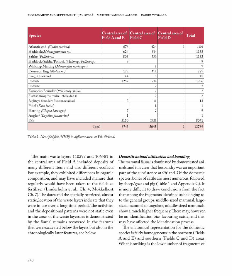
240
Environment and settlement | Jan Storå – Marieke Ivarsson-Aalders – Ingrid Ystgaard
The main waste layers 110297 and 106581 in the central area of Field A included deposits of many different items and also different ecofacts. For example, they exhibited differences in organic composition, and may have included manure that regularly would have been taken to the fields as fertilizer (Linderholm et al., Ch. 4; Mokkelbost, Ch. 7). The dates and the spatially restricted, almost static, location of the waste layers indicate that they were in use over a long time period. The activities and the depositional patterns were not static even in the areas of the waste layers, as is demonstrated by the faunal remains recovered in the features that were excavated below the layers but also in the chronologically later features, see below.
Domestic animal utilization and handlingThe mammal fauna is dominated by domesticated ani-mals, and it is clear that husbandry was an important part of the subsistence at Ørland. Of the domestic species, bones of cattle are most numerous, followed by sheep/goat and pig (Table 1 and Appendix C). It is more difficult to draw conclusions from the fact that among the fragments identified as belonging to to the general groups, middle-sized mammal, large-sized mammal or ungulate, middle-sized mammals show a much higher frequency. There may, however, be an identification bias favouring cattle, and this may have affected the identification process.
The anatomical representation for the domestic species is fairly homogeneous in the northern (Fields A and E) and southern (Fields C and D) areas. What is striking is the low number of fragments of
Species Central area of Field A and E
Central area of Field C
Central area of Field D Total
Atlantic cod (Gadus morhua) 676 424 1 1101Haddock(Melanogrammus m.) 624 514 1138Saithe (Pollach v.) 803 330 1133Haddock/Saithe/Pollock (Melanog./Pollach sp. 9 9Whiting/Merling (Merlangius merlangus) 7 7Common ling (Molva m.) 175 112 287Ling, (Lotidae) 44 3 47Codfish 1252 714 1966Codfish? 2 2European flounder (Platichthys flesus) 2 2Flatfish (Scopthalmidae 1/Soleidae 1) 2 2Righteye flounder (Pleuronectaidae) 2 11 13Pike? (Esox lucius) 1 1Herring (Clupea harengus) 7 2 9Angler? (Lophius piscatorius) 1 1Fish 5150 2921 8071
Total 8743 5045 1 13789
Table 2. Identified fish (NISP) in different areas at Vik, Ørland,

241
Utilization of animal resources in Roman Iron Age Vik: Zooarchaeology at Ørland
the peripheral parts of animals, such as phalanges, metapodia and the carpal and tarsal bones. In fact, these parts of the animals seem to be missing at both Roman Period settlement areas. It appears that the parts of the animals which are rich in meat are common in the deposited faunal assemblage, while the distal parts of the extremities are uncommon. These skeletal elements are among the hardest in the animal skeleton, so their absence is not caused by preservation bias. They are often characterized as slaughter waste, even if, for example, the meta-podia of cattle and horse would be suitable for raw material. The peripheral parts of the skeletons may also have been left in the hides of the animals that might possibly have been processed elsewhere.
Not all parts of the animals are present in the assemblage. The parts of the animals which are poor in meat are not common, but this is also the case with vertebral and rib fragments. These parts of the animals have a high meat value, and would probably have been preferred when it came to utility and meat consumption. Their rareness is interesting and indicates that some parts of the animals were actually taken from the site, possibly through trade. Some level of preservation bias may have to be considered since the ribs are rather fragile and may not have been preserved.
Butchery marks were identified on bones of domestic animals. Chop marks were found in all anatomical regions of the animals but there is an interesting difference between the species rep-resentation of the bones and the different types of marks. In both the northern and the southern areas, bones of large mammals more often exhibited chop marks, while middle-sized mammals more often exhibited cut marks on the bones. The ratio between chops and cut marks was 35:7 for large mammals but 14:12 for middle-sized mammals in Fields A/E, and 56:4 for large mammals and 24:15 for middle-sized mammals in Field C (and D). The
slaughter technique was cruder for large mammals (cattle) where the body parts were chopped into smaller pieces. The meat parts of the middle-sized mammals (sheep, pig) were probably possible to dismember with less force as knives were more often used than heavier tools for sheep/goat and pig. The fracture analysis shows that the long bones of both cattle and sheep were regularly deliberately fractured in order to extract the within-bone nutrients (see data in Ystgaard et al. 2018).
The bones may highlight important aspects of the animals that were slaughtered and utilized not only for meat and dairy products but also for other reasons. The slaughtered animals provided hides and bone for raw material in craft activities, as is evident in the bone artefacts recovered during the excavations. The whale bone recovered at Ørland might also have been used as raw material.
Of some interest are the bones of horse that were found scattered in both areas of the site. A few of these exhibit marks of slaughter, and some bones also bear evidence of fresh fractures, i.e. they were fractured when still in a fresh state. It seems that the meat of horses, at least occasionally, was handled and consumed at the site. There was also one find of an almost complete foal in depression 512103, excavated west of House 2, Field C in the southern area. While the deposition is probably slightly later than House 2, it is of interest that a few bones bear evidence of slaughter. It is possible that the animal was skinned prior to deposition, see below.
Domestic animal kill-off patternsIt seems that the meat that was consumed at Ørland came from well prepared and selected parts of the slaughtered animals. Interestingly, the animals in the central areas of Fields A/E and Field C were slaughtered at different ages, as indicated by tooth eruption and wear. In the central part of Fields A/E, c.43-55% of the cattle were slaughtered as adult

242
Environment and settlement | Jan Storå – Marieke Ivarsson-Aalders – Ingrid Ystgaard
animals, while in Field C the proportion was 28-45% (Figure 6). Layer 500200 has the lowest frequency of older animals. The culling of old cattle reflects the slaughter of older cows utilized for dairying, and the material thus implies that cattle were kept for dairy production to a slightly larger extent in Field A/E than in Field C. The difference between the areas is more marked when it comes to the slaughter of sub-adult animals. The higher incidence of older sub-adult individuals (2 yrs+) compared to younger sub-adults shows that breeding for meat was more important in Field A/E than in Field C.
There is also an interesting difference in the kill-off patterns between waste deposits 110297 and 106581, both in Field A. The culling age is fairly similar for sheep/goat and cattle in 110297, while in 106581 the sheep/goat bones are more often from younger animals, whereas for cattle there is a slight increase in the culling age for older animals. This could reflect a chronological change in sheep utilization, from the slaughter of older animals, possibly kept for wool production, to the culling of older sub-adult animals that were slaughtered in their second or third year of life. This culling
would fit a breeding strategy for meat production. The higher incidence of old cattle indicates that milking cows were slaughtered, whereas, since most of the sub-adult individuals were older than 2 years, these younger animals may have been bred mainly for meat. The culling of pigs was similar in both excavation areas. Almost all pigs were slaughtered prior to adult age, which is a common pattern (e.g. Vretemark 1997).
The central parts of Field C exhibited a higher frequency of young cattle (calves) compared to young sheep (Figure 6). The high frequency of bones from old sheep indicates a husbandry strategy where old animals kept for wool were slaughtered. In contrast to this, the breeding strategy for cattle indicates the slaughter of young animals. The culling of sub-adult animals at a younger age could suggest that the husbandry of cattle in the central part of Fields C was more directed towards milk production than in the central parts of Fields A/E. Thus, even if the same parts of the animals were consumed – and discarded - in both excavation areas at Ørland, the husbandry strategies that are reflected through the osteoarchaeological finds were different for both
Figure 6. Age distribution for cattle (left) and sheep/goat (right) in the northern and southern areas. Ageing based on tooth eruption/wear and the minimum number of elements (MNE) in each age group. Illustration: Jan Storå.

243
Utilization of animal resources in Roman Iron Age Vik: Zooarchaeology at Ørland
cattle and sheep/goat. As very few bones of goat were identified, the breeding strategies probably concern sheep.
Wild mammalsThe utilization of animal resources at Ørland was varied and included a variety of marine mammals and especially fish. It may be assumed that shellfish, too, were of importance at Vik since shells, notably cockles, were recovered in large quantities in the waste pit 210240 (Field E) and oyster shells were found in the large waste layers 110297, 106581 and 200500.
Bones of both seal and whale were present, but not in larger numbers. A similar number of wild species was identified in the central part of Fields A/E (6) and the central parts of Field C (5), although the number of specimens was higher in Field A, Table 2. Whale bone was more common in Fields A/E and here most of the fragments were recovered in a rather restricted area of the waste layer 106581 (19 fragments, Appendix C). The same layer also con-tained 26 bones of seal, including at least one each from harp seal and harbour seal, and 2923 fish bones. Three mandibular fragments of otter were identified in waste deposit 110297. One tibia (2 fragments) of brown bear was recovered in waste deposit 500200 in Field C. This isolated find is of interest when we consider the other specific depositions of animals and body parts found on the site (see below).
FishThe number of fish bones was highest in the central part of Fields A/E, although here waste pit 210240 (NISP=4573) introduces bias into the comparison (see Table 2 and Appendix C). There is not only a difference between the two central areas in Fields A/E and C in the frequency of wild mammals and fish, but also in the species within the classes. Harp seal and harbour seal were identified in the central
part of Fields A/E, while grey seal was identified in the central parts of Field C.
Atlantic cod is the most common fish species in the central part of Fields A/E. The central part of Field C exhibits a higher frequency of other fish species, among them various flatfish and even angler. Noteworthy in both areas is the low number of herring bones. This species is probably underrep-resented due to preservation bias and possibly also some level of recovery bias, mostly the use of 4 mm mesh. It may be noted, though, that the soil in waste pit 210240 was sieved through a fine mesh and that this did not produce finds of herring.
The identified fish species varied within different contexts, and most visibly in the central part of Fields A/E. Here bones of haddock were more common in the waste pit 210240 than in the two waste deposits 110297 and 106581 (Figure 7). In contrast, bones of common ling were more numerous in the waste deposits, but infrequent in the waste pit, Appendix C.
There were, then, important differences in the representation of different fish species from context to context in the excavated areas at Vik, indicating extensive fishing that targeted different species. Another important difference between the areas in terms of the fish material is in the size of the Atlantic cod that were captured and utilized (Figure 8). In the central parts of Field C the captured cod
Figure 7. Identified codfish (NISP) in Fields A, E, and C of Ørland. Illustration: Jan Storå.

244
Environment and settlement | Jan Storå – Marieke Ivarsson-Aalders – Ingrid Ystgaard
had a length of between 60 – 80 cm, while small (<50 cm) and larger cod (90 cm+) dominated in Fields A and E.
All identified species occur today in the waters around Ørland, both in the waters in the fjord and west towards the open sea (Olson & Storå 2018). The size distribution of Atlantic cod in the central area of Fields A/E shows two size clusters that might represent different fisheries (Figure 8). At the time of occupation, the location was probably favourable for the fishing of various species of codfish, but also for species like flatfish and herring. As already mentioned, the importance of herring fishing cannot be evaluated, but the few finds are noteworthy. The species representation is rather varied at Ørland, and with differences between the excavation areas. Perhaps of some surprise is the lack of bones from salmon or salmonidae, fish that probably occurred in the waters around Ørland. There may be some
preservation bias here as the fatty bones of salmon do not preserve well and are sensitive to destruction and degradation. If there was salmon fishing, the archaeo-logical traces might have been lost. Regardless of this, the fish bone assemblage indicates that fishing occurred in different kinds of waters and probably also during different seasons.
Haddock is represented mainly by small individu-als, and was presumably available in nursing grounds in the shallow waters close to the site area. Cod and saithe were probably caught some distance from the bay in the deeper waters of the fjord. The large ling must have been caught at a depth of 100 metres or more, presumably closer to the open sea. Finds of fish hooks indicate that hook and line fishing was used. Hook and line would have been used for catching medium and large codfish from boats some distance away from the shore. Fishing strategies may have altered somewhat through time. There
Figure 8. Size of Atlantic cod (NISP) in the northern (Fields A/E) and southern areas of Ørland. Size estimation is based on the dimensions of the first and second vertebra. Illustration: Jan Storå.

245
Utilization of animal resources in Roman Iron Age Vik: Zooarchaeology at Ørland
can be no doubt that fishing, and especially fishing for codfish, was a significant aspect of the Roman Iron Age subsistence economy at Ørland. Seasonal fishing settlements, such as that at Borgvær, were present in the Lofoten area as early as the Migration period (Wickler & Narmo 2014). Caves in coastal areas were also used for seasonal fishing settlement in the Iron Age (Haug 2012). Interestingly, it is around this same time that sites with large areas with (open-air) cooking-pits, such as the ones at Ørland, decrease in number (Bukkemoen 2016). The relatively small size of the codfish as a whole suggests that fishing was carried out in the local waters. Large cod (120 cm+) are rare at Ørland, possibly suggesting that deep sea fishing did not occur, at least not extensively. It does not seem that an extensive export or trade of fish and fish products, such as dried fish, took place at Ørland, although some level of trade of faunal resources, including fish, should not be excluded.
Fishing, and especially cod fishing in Northern Europe, has been the focus of extensive research, and this has traced the development of deep sea fishing in the Viking Age, which later developed into the important stockfish trade in coastal Northwest Europe (e.g. Enghoff 2000, Barret et al. 2004, Perdikaris & McGovern 2007, 2008). So far, it has not been possible to illuminate conditions in the Early Iron Age through osteoarchaeology, as has been done for the Stone Age and Late Iron Age – this is largely due to the lack of extensive faunal assemblages.
Considering the character of the site and the archaeological finds at Vik, we might expect that the farmsteads had well developed networks for trade and communication. To cast light on this, we might examine the size distribution of cod at Ørland in relation to the possible trade of dried cod. At Ørland cod smaller or larger than the optimal size range suitable for drying (60 – 110 cm, Perdikaris
1999) are most common in Fields A/E. In Field C, the most common size of cod is 60 – 80 cm, i.e. at the lower end of the scale. The size variation for the codfish is, then, not typical for the processing of stockfish. Neither is the anatomical representation for cod (including codfish). The Late Iron Age processing sites are often characterized by certain biases in the anatomical representation for cod(fish), where cranial elements are frequently found on the processing sites while the backbone and the cleithrum (of the pectoral girdle) follow the dried body of the fish from the sites. At Ørland we see no such bias in element representation; we identified 76 premaxillae, 64 maxillae, 63 dentary bones of the cranium and 70 cleithrale of the pectoral girdle (at the gill opening). In total we identified 332 cranial elements and 1508 vertebra of cod and codfish. Thus, at Ørland, we probably do not see the same special-ized fishing for cod(fish) with extensive production of stockfish for export and trade that developed in Norway in the Late Iron Age (e.g. Enghoff 1999, 2000, Perdikaris 1999, Barrett et al. 2004, Barrett et al. 2011, Perdikaris & McGovern 2007, 2008, Wickler & Narmo 2014, Star et al. 2017). It seems that this fish trade actually developed after the site at Ørland had been abandoned.
Depositional patternsThe recovered animal bones stem from refuse depos-ited after the utilization of the animal carcass. The depositional patterns were structured, and the refuse handling was, it seems, to some extent organized, at least spatially. The houses had varying amounts of bone, which is probably a reflection of function. However, the number of bones may in some cases be related to the cleaning of the houses. House 2 in Field C had high numbers of bones in many different types of feature, while Houses 34 and 4 in the same area exhibited fewer finds. In House 34 most of the bones were recovered in a hearth,

246
Environment and settlement | Jan Storå – Marieke Ivarsson-Aalders – Ingrid Ystgaard
while the bones in House 4 the bones were almost exclusively recovered in post holes (see Appendix B). House 4 had probably been cleaned out, while the later dated House 2 does not seem to have been cleaned out after abandonment (Heen-Pettersen and Lorentzen, Ch. 6).
Utilization pattern of animals through timeThere is evidence that the utilization patterns of ani-mals changed over time at Ørland. In the northern area this may be illustrated by comparing the faunal remains in the two main waste deposits, 106581 and 110297. The latter layer is probably slightly older than 106581, even if the datings for both layers still fall within the Roman Iron Age. There are only minor differences between the two layers in the representation of domestic species. The features excavated below the waste deposit 106581 lack bones of, for example, deer, carnivores, seal, whale and bird bones, which occur in the overlying waste layer. It seems as if the area was initially used to process meat of domesticated animals in cooking pits and other features. In a later phase, wild resources were also utilized here. Interestingly, the skeletal elements that are uncommon in layer 106581, such as phalanges and other distal elements, are uncommon also in the older features. Thus, the selection of anatomical parts seems to have been consistent, even if we see differences in the species representation over time.
Waste deposit 110297 overlays only a few fea-tures, but is overlain itself by several features. The composition and character of the faunal remains in the later overlying features is rather similar to that of the waste layer. Even if new features such as pits for cooking or food processing were used in the same area as the older waste layer, the uti-lization patterns of the faunal resources and the meat apparently did not change markedly. Thus the osteological finds show that the activities developed differently through time in the two waste layers. In
the area of waste deposit 106581 we see a change in the utilization of species through time, while the anatomical representation remains similar. Here, the waste layer overlays smaller features. In the area of waste deposit 110297, the utilization patterns seem to have remained unchanged as regards the handling of species and anatomical parts, but here the waste deposit is overlaid by smaller features.
Towards abandonmentThere are observations that hint at specific depo-sitional practices both within the house structures and outside of them, although they are difficult to interpret. Still, they suggest practices beyond the economic utilization of animals (for a discussion see e.g. Carlie 2004, 2006; Hamerow 2006; Lucas & McGovern 2007, Magnell et al. 2013 - for the slightly later Uppåkra). A few finds of near-complete skeletons are of interest here. In House 2, Field C, the near-complete skeletons of a foal and a pig were found. The foal was approximately 6 months old and the pig 12 – 16 months old. The pig was recovered from cooking pit 512883, in the western part of House 2 (Figure 4), and radiocarbon dated to cal. AD 250 – 385 (TRa-11648). This places it in late Phase 3/early Phase 4, and corresponds to the final occupation phase of the house. The foal was recovered west of House 2 in posthole 512103 (Figure 4), and was radiocarbon dated to cal. AD 361 – 538 (Beta 478375, Phase 4). While the foal was probably deposited after the house had been abandoned, the remains and the foundations of the building must still have been visible. These illustrate that the activities on the site included specific dep-osition of animals, or large parts of animals, on the site of the abandoned remains of House 2. The latest finds in House 2 date to approximately the same period which means that the deposition of the pig might actually be one of the last actions there. The near-complete skeleton of a calf was recovered in a

247
Utilization of animal resources in Roman Iron Age Vik: Zooarchaeology at Ørland
refuse pit 512115, c.14 m north of House 2 (Figure 4), and dated to cal. AD 552 - 648 (Beta 478358), i.e. later than the house structure and in Phase 5, a phase where almost no other activity is recorded on the entire site (Ystgaard, Gran & Fransson, Ch. 1). The spatial connection between the deposit and the house is noteworthy; maybe the house foundations caught the attention of the successors on the site (Carlie 2004, Heen-Pettersen and Lorentzen, Ch. 6).
While the Early Iron Age activities at Ørland in Vik decrease in intensity after the 4th century AD, the osteological finds provide a picture of a dynamic subsistence economy that must have been flexible. When the subsistence economy as a whole is con-sidered, it does not appear likely that the settlement decline reflects changes in available natural and/or domestic resources.
Ørland in comparison to other Norwegian Iron Age sites with animal bonesThe faunal assemblage from Ørland is in many respects unique, but it does exhibit both similari-ties and differences to other previously recovered assemblages. The osteological finds from open air (settlement) sites are often not well preserved, a point which emphasizes the value of the assemblage from Ørland (Hufthammer 2015). Favourable pres-ervation has been observed in cave sites, which at least on some occasions were in use during the Iron Age, for example at the rock shelter Smiehelleren in Rauma, where bones of domesticated animals date back to the Pre-Roman Iron Age (Haug 2012). In general, cave sites have revealed important infor-mation on Stone Age subsistence and, to a lesser extent, highlighted Iron Age conditions (see e.g. Bergsvik & Hufthammer 2009). In contrast, open air settlement sites have, so far, most often revealed information on the Late Iron Age, especially the Viking Age, but also later periods – the sites in question include Tjøtta in Helgeland (Berglund
1996), Toften and Bleik (Perdikaris 1999), and Borgvær (Wickler 2013; Wickler & Narmo 2014), all three in the Lofoten area, Modvo in Sogn (Lie 1993), and finally Avaldsnes in Karmøy (Macheridis 2013), to name a few. A recent study has also shown the importance of pre-modern fresh water fishing in the southern Norwegian inland (Hufthammer & Mjærum 2016).
The roughly contemporaneous site at Modvo (in Luster, Sogn), c.300 km S-SW of Ørland, offers some insights, although the bones were burnt and highly fragmented (N=6570). Rolf Lie (1993) identified bones from sheep/goat (29), goat (1), cattle (7), pig (3) as well as canidae (1) and hare (1). In addition, nine fragments of birds were identified (whereof one of an indeterminate galliform bird, probably domestic fowl). Even if the material was limited in size it shows that a variety of faunal resources were exploited along the Norwegian coastal and fjord areas in the Early Iron Age. The finds from Ørland are, as mentioned, richer and more extensive, and the preservation of unburnt bone has provided new opportunities for osteoarchaeological analyses. Furthermore, few sites have offered insights into the spatial patterning of faunal remains as Ørland has. Here we might mention the Avaldsnes site where the faunal remains were highly fragmented, primarily burnt, and recovered from many different contexts and layers (Macheridis 2013). Even if the number of bones was limited (644,97g/2310 fragments) the distribution patterns seem to resemble those at Ørland. Identified species at Avaldsnes were cattle, sheep/goat, sheep, domestic pig, red deer and polecat (Macheridis 2013). The assemblage also included fish, mostly from cod, and one bird bone.
CONCLUSIONSThe faunal assemblage recovered at Ørland is in many respects unique. The preservation and the contextual information provide insights into the Roman Iron

248
Environment and settlement | Jan Storå – Marieke Ivarsson-Aalders – Ingrid Ystgaard
Age of coastal Norway. Subsistence was based on a varied utilization of cattle and sheep, where kill-off patterns vary within the different areas. Husbandry strategies, as interpreted through the kill-off patterns, include preferences for meat production and wool production, but also for dairying. Pigs were not as commonly utilized, and occasionally horsemeat was consumed. The assemblage comprises mainly of parts from the meat-rich areas of the animals. The parts which are poor in meat, and also some meat bearing parts, are uncommon. Possibly some parts of the animals, including good meat parts and also hides, were transported/traded from Vik. Preservation bias does need to be considered, however. The number of bones from wild mammals is small, but shows that marine mammals were utilized, probably both as food and as a source of raw materials (whale bone, seal fat, skins etc.). Bones of birds are uncommon at Ørland, while the assemblage of fish bones is extensive. The fish bone assemblage shows that fishing occurred not only in the coastal waters but also in the open sea. Codfish were important and Atlantic cod, saithe and
haddock, as well as common ling, were the most fre-quent species. The fish bones were recovered in many areas of the site, but there are a few contexts with high numbers of fish bones suggesting some differences in the handling and processing of fish. The material does not provide evidence for stockfish processing. The osteoarchaeological analyses show that the subsistence economy was dynamic and flexible, and that refuse handling was organized and structured. Towards the end of Phase 3, more or less complete animals were deposited in association with the abandonment of House 2. The general conclusion must be that the osteological finds from Ørland provide a picture of a flexible and dynamic subsistence economy. It is thus not likely that the settlement decline commencing from c. AD 350 reflects changes in available natural and/or domestic resources.
ACKNOWLEDGEMENTS: The authors would like to thank our anonymous peer reviewer for many valuable comments.

249
Utilization of animal resources in Roman Iron Age Vik: Zooarchaeology at Ørland
REFERENCES
Barrett, J.H, A. M. Locker & C. M. Roberts 2004: ‘Dark Age Economics’ revisited: the English fish bone evidence AD 600 – 1600. Antiquity 78: 618-636.
Barrett, J.H et al. 2011: Interpreting the expansion of sea fishing in medieval Europe using stable isotope analysis of archaeological cod bones. Journal of Archaeological Science 38: 1516 – 1524.
Berglund, I.B. 1996: Tjøtta-riket. En arkeologisk undersøkelse av maktforhold og sentrumsdannelser på Helgelandskysten fra Kr.f. til 1700 e.Kr. Dr. Philos. avhandling 1995. Fakultetet for Arkeologi og Kulturhistorie/AVH. Universitetet i Trondheim. 2. opplag. Trondheim.
Bergsvik, K. A. & A. K. Hufthammer 2009: Stability and change among marine hunter–fishers in western Norway 7000–4500 cal BC. Results from the excavations of two rockshelters in Hardanger. In: Crombe, P., M. Van Strydonck, J. Sergant, M. Boudin & M. Bats (eds.): Chronology and Evolution within the Mesolithic of North-West Europe: Proceedings of an International Meeting, Brussels. May 30th –June 1st 2007, pp. 435–449.Cambridge: Cambridge Scholars Publishing.
Bukkemoen, G.B. 2016: Cooking and Feasting: changes in food practice in the Iron Age. In: Iversen, F. & H. Petersson (eds.): The Agrarian Life of the North 2000 BC
– AD 1000. Studies in Rural Settlement and Farming in Norway, pp. 117 – 132. Portal Academic, Kristiansand.
Carlie, A. 2004: Forntida byggnadskult. Tradition och regionalitet i södra Skandinavien. Stockholm, Riksantikvarieämbetet.
Carlie, A. 2006: Ancient building cults. Aspects of ritual traditions in southern Scandinavia. In: Andrén, A. et al. (eds.): Old Norse Religion in Long-Term Perspectives. Origins, Changes and Interactions, pp. 206–211. Lund: Nordic Academic Press.
Carter, R. & O. Magnell 2007: Age estimation of wild boar (Sus scrofa) based on molariform mandibular tooth development and its application to seasonality at the Mesolithic site of Ringkloster. In: Albarella, U., K. Dobney, A. Ervynck & P. Rowley-Conwy (eds.): Pigs and Humans. 10,000 Years of Interaction, pp. 197–217.Oxford, Oxford University Press.
Enghoff, I.B. 1999: Fishing in the Baltic region from the 5th century BC to the 16th century AD: evidence from fish bones. Archaeofauna 8: 41–85.
Enghoff, I.B. 2000: Fishing in the southern North Sea region from the 1st to the 16th century AD: evidence from fish bones. Archaeofauna 9: 59–132.
Grant, A. 1982: The use of tooth wear as a guide to the age of domestic ungulates. In: Wilson, B., C. Grigson &
S. Payne (eds.). Ageing and Sexing Animal Bones from Archaeological Sites, pp. 91 – 108. Oxford: BAR British Series 109.
Habermehl, K. H. 1961: Die Alterbestimmung bei Haustieren, Pelztieren und beim Jagdbaren Wild. Berlin and Hamburg: Paul Parey.
Hamerow, H. 2006: ‘Special deposits’ in Anglo-Saxon settlements. Medieval Archaeology 50: 1–30.
Haug, A. 2012: Rock shelters in Central Norway: Long-Term Changes in Use, Social organization and Production. In: Bergsvik, K.A. & R. Skeates (eds.): Caves in Context. The Cultural Significance of Caves and Rockshelters in Europe, pp. 39 – 47. Oxbow books: Oxford.
Hufthammer, A.-K. 2015: Animal Osteology in Norway. In: Sellevold, B. (ed.): Old Bones. Osteoarchaeology in Norway: Yesterday, Today and Tomorrow, pp.53 – 71. NIKU, Novus forlag, Oslo.
Hufthammer, A-K. & A. Mjærum 2016: Fjellfunn og fiskebein – Om fiske og bruken av fjellet i fortiden. In: Mjærum, A. and E.U. Wammer (eds.): Fjellfiske i Fortiden. Årtusener med svømmende rikdom, pp. 111 – 125. Kulturhistorisk museum, Norsk Maritimt Museum og Oppland fylkeskommune. Portal, Kristiansand.
Lie, R. 1993: Beinmaterialet fra Modvo, Luster i Sogn. In: Solberg, B (ed.): Minneskrift Egil Bakka, pp. 235 – 245. Arkeologiske skrifter 7, Historisk museum, Universitetet i Bergen.
Lyman, R. L. 2008: Quantitative paleozoology. Cambridge: Cambridge University Press.
Macheridis, S. 2013: Eld, kultur och natur: osteologisk analys av djurbensmaterial från Avaldsnes, Karmøy. Reports in Osteology 2013:3. Department of Archaeology and Ancient History, Lund University.
Macphail, R.I. 2016: Ørland Main Air Station (near Trondheim, Norway): soil Micromorphology Report for Museum of Natural History and Archaeology, Norwegian University of Science and Technology, Trondheim, Norway – NTNU. Institute of Archaeology, University College London (UCL), 31 – 34, Gordon Sq., London WC1H 0PY, UK
Magnell, O. 2006: Tooth wear in wild boar (Sus scrofa). In: Ruscillo, D. (ed.): Recent Advances in Ageing and Sexing Animal Bones. Proceedings of the 9th ICAZ Conference, Durham 2002. Oxford.
Magnell, O., A. Boethius & J. Thilderqvist 2013: Fest i Uppåkra. En studie av konsumtion och djurhållning baserad på djurben från ceremonihus och vapendeposition. In: Hårdh, B. & L. Larsson (eds.): Folk, fä och fynd. Uppåkrastudier 12, pp. 85 – 132. Acta Archaeologica Lundensia Series in 8°, No. 64. Lund university.

250
Environment and settlement | Jan Storå – Marieke Ivarsson-Aalders – Ingrid Ystgaard
Olson, C. & J. Storå 2018: Osteological analysis of fish bones from Vik, Ørland, Sør Trøndelag, Norway. OFL Rapport 2018:3. Osteoarkeologiska forskningslaboratoriet, Stockholms Universitet.
Outram, A.K. 2001: A New Approach to Identifying Bone Marrow and Grease Exploitation: Why the
“Indeterminate” Fragments should not be Ignored. Journal of Archaeological Science 28: 401–410.
Outram, A.K. 2002: Bone Fracture and Within-bone Nutrients: an Experimentally Based Method for Investigating Levels of Marrow Extraction. In: Miracle, P. & N. Milner (eds.): Consuming passions and patterns of consumption, pp. 51–63. McDonald Institute Monographs. Oxbow Books.
Perdikaris, S. 1999: From Chiefly Provisioning to Commercial Fishery: Long Term Economic Change in Arctic Norway. World Archaeology 30: 388–402.
Perdikaris, S. & T. H. McGovern 2007: Cod fish, Walrus, and Chieftains: Economic intensification in the Norse North Atlantic. In: Thurston, T.L. & C. T. Fisher (eds.): Seeking a Richer Harvest: The Archaeology of Subsistence Intensification, Innovation, and Change, pp. 193 – 216. Springer: New York.
Perdikaris, S. & T. H. McGovern 2008: Codfish and Kings, Seals and Subsistence. In: Rick, T.C. & J. M. Erlandson (eds.): Human Impacts on Ancient Marine Ecosystems: A Global Perspective, pp. 187 – 214. University of California Press.
Silver, I. A. 1969: The Ageing of Domestic Animals. In: Brothwell, D. & E. Higgs (eds.): Science in Archaeology. 2nd ed. London.
Star, B., S. Boessenkool, A. T. Gondek, E. A. Nikulina, A. K. Hufthammer, C. Pampoulie, H. Knutsen, C. André, H. M. Nistelberger, J. Dierking, C. Petereit., D. Heinrich, K. S. Jakobsen, N.Chr. Stenseth, S. Jentoft & J.H. Barrett
2017: Ancient DNA reveals the Arctic origin of Viking Age cod from Haithabu, Germany. Proceedings of the National Academy of Sciences 114 (34): 9152 – 9157.
Stiner, M.C., S.L. Kuhn, S. Weiner & O. Bar-Yosef 1995: Differential Burning, Recrystallization, and Fragmentation of Archaeological Bone. Journal of Archaeological Science 22 (2): 223–237.
Storå, J. 2001: Skeletal development in the Grey seal Halichoerus grypus, the Ringed seal Phoca hispida botnica, the Harbour seal Phoca vitulina vitulina and the Harp seal Phoca groenlandica. Epiphyseal Fusion and Life History. In: Pike-Tay, A. (ed.): Assessing season of capture, age and sex of archaeofaunas. ArchaeoZoologia Vol XI: 199–222.
Vretemark. M. 1997: Från ben till boskap: Kosthåll och djurhållning med utgångspunkt i medeltida benmaterial från Skara. Del I. Skara: Skaraborgs Länsmuseum.
Wickler, S. 2013: The potential of shoreline and shallow submerged Iron Age and Medieval Archaeological Sites in the Lofoten Islands, Northern Norway. In: Daire, M.Y. et al. (eds.): Ancient Maritime Communities and the Relationship between People and Environment along the European Atlantic Coasts, pp. 63–73. BAR International Series 2570.
Wickler, S. & L. E. Narmo 2014: Tracing the Development of Fishing Settlement from the Iron Age to the Modern Period in Northern Norway: A Case Study from Borgvær in the Lofoten Islands. Journal of Island & Coastal Archaeology 9: 72–87.
Ystgaard, I., M. M. Gran, M. Mokkelbost, U. Fransson, A. Heen-Pettersen, A. B. Lorentzen, G. I. Solvold & E. W. Randerz 2018: Arkeologiske utgravninger på Ørland kampflybase 2015 – 2016. NTNU Vitenskapsmuseet Arkeologisk rapport 2018:27. Trondheim.

251
Utilization of animal resources in Roman Iron Age Vik: Zooarchaeology at Ørland
APPENDIX AIdentified classes of animals and level of firing in the central areas of Field A/E, C and D at Ørland, Vik. 1, according to number of identified specimens and 2, according to weight (g).
1. Field/class of animals Unburnt Slightly burnt Charred Varying Incinerated Total
Central area of Field A and E
Human 2 2
Mammal 3178 58 90 189 116 3631
Marine mammal 68 68
Bird 36 2 38
Fish 8692 16 35 8743
Indeterminate 15 3 100 3 121
Central area of Field C
Mammal 3753 52 68 31 3904
Marine mammal 11 1 12
Bird 10 10
Fish 5035 3 2 5 5045
Indeterminate 3 3
Central area of Field D
Mammal 15 2 4 21
Marine mammal 2 2
Fish 1 1
Total 20821 119 178 289 194 21601
2. Field/class of animals Unburnt Slightly burnt Charred Varying Incinerated Total
Central area of Field A and E
Human 1,8 1,8
Mammal 6500,44 43,1 37,8 57,7 32,2 6671,24
Marine mammal 428,3 428,3
Bird 9 3,7 12,7
Fish 9554,1 1,43 3,14 9558,67
Indeterminate 5,11 1,6 35 0,3 42,01
Central area of Field C
Mammal 7547,8 115,8 29,5 11,6 7704,7
Marine mammal 70,7 13,5 84,2
Bird 5,5 5,5
Fish 701,8 0,22 0,16 0,23 702,41
Indeterminate 1,23 1,23
Central area of Field D
Mammal 22,5 1,5 9,6 33,6
Marine mammal 146 146
Fish 0,6 0,6
Total 24994,88 175,72 72,59 92,7 57,07 25392,96
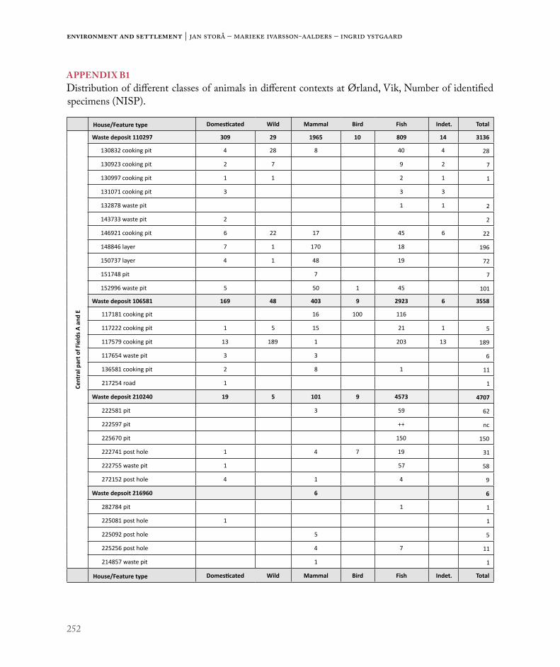
252
Environment and settlement | Jan Storå – Marieke Ivarsson-Aalders – Ingrid Ystgaard
APPENDIX B1Distribution of different classes of animals in different contexts at Ørland, Vik, Number of identified specimens (NISP).
House/Feature type Domesticated Wild Mammal Bird Fish Indet. Total
Cent
ral p
art o
f Fie
lds A
and
E
Waste deposit 110297 309 29 1965 10 809 14 3136
130832 cooking pit 4 28 8 40 4 28
130923 cooking pit 2 7 9 2 7
130997 cooking pit 1 1 2 1 1
131071 cooking pit 3 3 3
132878 waste pit 1 1 2
143733 waste pit 2 2
146921 cooking pit 6 22 17 45 6 22
148846 layer 7 1 170 18 196
150737 layer 4 1 48 19 72
151748 pit 7 7
152996 waste pit 5 50 1 45 101
Waste deposit 106581 169 48 403 9 2923 6 3558
117181 cooking pit 16 100 116
117222 cooking pit 1 5 15 21 1 5
117579 cooking pit 13 189 1 203 13 189
117654 waste pit 3 3 6
136581 cooking pit 2 8 1 11
217254 road 1 1
Waste deposit 210240 19 5 101 9 4573 4707
222581 pit 3 59 62
222597 pit ++ nc
225670 pit 150 150
222741 post hole 1 4 7 19 31
222755 waste pit 1 57 58
272152 post hole 4 1 4 9
Waste depsoit 216960 6 6
282784 pit 1 1
225081 post hole 1 1
225092 post hole 5 5
225256 post hole 4 7 11
214857 waste pit 1 1
House/Feature type Domesticated Wild Mammal Bird Fish Indet. Total

253
Utilization of animal resources in Roman Iron Age Vik: Zooarchaeology at Ørland
Cent
ral p
arts
of F
ield
CWaste deposit 500200 151 9 627 2 136 925
523529 1 7 1 9
523777 hearth 1 1
523529 layer 4 1 5
522925 cooking pit 22 208 1 34 265
522612 layer 33 33
522626 layer 4 4
523593 layer 4 1 5
523679 layer 7 38 4 49
Waste deposit 521623 23 1 269 1 108 402
524312 waste layer 12 92 1 26 131
523989 cooking pit 4 60 86 150
524509 cooking pit 2 11 1 14
Agricultural layer 511160 5 7 12
521585 cooking pit 1 1
Waste deposit 521360 1 4 1 58 64
521358 waste layer 4 2 6 31 43
521359 waste layer 9 6 15
521397 waste layer 9 53 1 224 287
521429 layer 11 1 36 310 358
Central courtyard Field C
523481 depression 2 1 4 24 2 33
503886 hearth 4 61 578 643
504395 depression 4 9 13
504742 layer 2 3 5
505161 depression 1 3 4
505507 post hole 1 12 13
506186 post hole 1 1
518859 depression 2 2
505507 post hole 1 12 13
518845 depression 4 36 2 42
515648 cooking pit 1 1

254
Environment and settlement | Jan Storå – Marieke Ivarsson-Aalders – Ingrid Ystgaard
APPENDIX B2 Distribution of different classes of animals in different contexts at Ørland, Vik, Number of identified specimens (NISP).
House/Feature type Domesticated Wild Mammal Bird Fish Indet. Total
Fiel
d C
Northern courtyard Field C
514663 post hole 1 1
517296 post hole 1 1
517440 post hole 2 2
Western courtyard Field C
523746 post hole 1 1
Cent
ral p
arts
of F
ield
C
House 4 7 22 3 32
507539 depression 1 1
508212 depression 1 1
507350 post hole 1 1
507448 post hole 1 1
507462 post hole 1 1
507501 post hole 3 3
507619 post hole 1 1
507631 post hole 1 3 4
507644 post hole 2 2
507671 post hole 1 1
508156 post hole 4 4
508265 post hole 1 1
508359 post hole 1 1
508371 post hole 1 1
518291 post hole 2 4 3 9
House 17 2 2
Post hole
506268 post hole 2 2
House 34 10 35 7 52
522089 depression 4 4
512922 hearth 3 2 5
514373 hearth 3 23 2 28
503802 pit 2 4 6
504038 post hole 1 1
504920 post hole 2 2
505331 post hole 3 3
505987 post hole 1 1
512836 post hole 1 1
515307 post hole 1 1

255
Utilization of animal resources in Roman Iron Age Vik: Zooarchaeology at Ørland
Cent
ral p
arts
of F
ield
CHouse 2 437 5 308 1 165 916
512989 cooking pit 2 5 7
513032 cooking pit 1 6 2 9
513085 cooking pit 1 2 3
513154 cooking pit 6 1 7
512883 cooking pit/pig 314 3 317
503066 depression 2 2
506827 depression 1 1
513189 depression 2 2
517131 depression 1 1 6 33 41
523364 depression 1 1 1 3
512103 depression/foal 1 1
512162 hearth 3 3
512212 hearth 2 2 43 8 55
512802 hearth 9 9
515236 hearth 8 3 11
519507 hearth 25 135 1 161
523611 hearth 49 49
523647 hearth 1 1
500301 post hole 1 1 2
500332 post hole 2 2
502045 post hole 2 1 11 14
502090 post hole 1 1 1 3
502116 post hole 1 1 1 3
502139 post hole 13 13
502315 post hole 1 1
502381 post hole 1 1
504306 post hole 11 8 19
504320 post hole 1 1
504349 post hole 1 1
505836 post hole 1 1

256
Environment and settlement | Jan Storå – Marieke Ivarsson-Aalders – Ingrid Ystgaard
APPENDIX B3Distribution of different classes of animals in different contexts at Ørland, Vik, Number of identified specimens (NISP).
House/Feature type Domesticated Wild Mammal Bird Fish Indet. Total
Cent
ral p
arts
of F
ield
C
House 2, continued
506784 post hole 1 1 5 14 21
511782 post hole 3 3 33 39
512137 post hole 1 1
512249 post hole 1 1 2
513059 post hole 2 2
521710 post hole 2 2 2 6
521731 post hole 2 2
521805 post hole 15 15
521819 post hole 2 29 31
522059 post hole 3 3 8 14
522072 post hole 3 2 1 6
522202 post hole 1 1
523217 post hole 25 25
524377 post hole 1 1
525905 post hole 6 1 7
Cent
ral p
arts
of F
ield
D
House 21
616104 post hole 1 1
House 28
603861 post hole 1 1
611892 post hole 1 1
614895 post hole 1 1
614905 post hole 1 1
616900 post hole 1 1
616916 post hole 1 1
603861 post hole 1 1
611892 post hole 1 1
611777 waste pit 1 1
House 30
605914 hearth 1 1
House 24
671339 hearth 1 1
612709 posthole 1 1
Fiel
d/su
bare
a
Human
Horse
Cattle
Moose
Red deer
Large bovid
Large mammal
Large ruminant
Large ungulate
Sheep
Goat
Sheep/goat
Pig
Middle sized ruminant
Middle sized ungulate
Middle sized mammal
Bovid
Ungulate
Ruminant
Canid
Deer
Brown bear
Otter
Carnivore
Grey seal
Harbour seal
Harp seal
Seal
Middle sized - large mammal
Middle sized - large ungulate
Small - middle sized mammal
Small mammal
Whale
Mammal
Total
Cent
ral a
rea
of F
ield
A a
nd E
1065
818
621
277
53
42
7714
115
62
110
11
124
52
1914
262
0
1102
971
2982
31
118
220
172
131
5422
148
710
686
16
31
147
14
22
1127
2303
East
ern
area
108
132
391
15
15
139
Nea
r 106
581
14
414
194
16
224
Nea
r 110
297
11
834
120
41
561
232
321
637
1
Wes
tern
ar
ea3
13
241
32
Stra
yfind
1212
Cent
ral a
rea
of F
ield
C
5002
006
752
139
552
4819
210
17
471
24
116
778
6
Nea
r 500
200
114
4215
18
744
71
102
174
326
5216
233
51
665
123
154
24
13
133
293
Cent
ral a
rea
621
14
492
101
6816
2
Hous
e 02
179
182
232
323*
211
310
87
41
5875
0
Hous
e 04
32
33
11
121
329
Hous
e 17
22
Hous
e 34
16
113
72
1545
NE
area
82
11
21
281
145
Nor
th a
rea
151
532
53
NW
are
a3
46
811
185
31
21
1113
6
SW a
rea
519
789
223
53
224
1439
868
1289
Cent
ral a
rea
of F
ield
D
Hous
e 21
11
Hous
e 24
11
2
Hous
e 28
13
12
7
Hous
e 30
11
Nor
th a
rea
34
18
SW a
rea
21
14
Tota
l2
6739
66
41
693
2611
712
341
044
927
918
4726
125
223
36
23
11
11
5358
14
1026
3027
7640

257
Utilization of animal resources in Roman Iron Age Vik: Zooarchaeology at Ørland
APPENDIX C1Identified mammals in different areas of the fields at Ørland at Vik, NISP.* includes 317 specimens of a complete pig. See original osteological reports for description of the subareas (Ystgaardet al. 2018)
Fiel
d/su
bare
a
Human
Horse
Cattle
Moose
Red deer
Large bovid
Large mammal
Large ruminant
Large ungulate
Sheep
Goat
Sheep/goat
Pig
Middle sized ruminant
Middle sized ungulate
Middle sized mammal
Bovid
Ungulate
Ruminant
Canid
Deer
Brown bear
Otter
Carnivore
Grey seal
Harbour seal
Harp seal
Seal
Middle sized - large mammal
Middle sized - large ungulate
Small - middle sized mammal
Small mammal
Whale
Mammal
Total
Cent
ral a
rea
of F
ield
A a
nd E
1065
818
621
277
53
42
7714
115
62
110
11
124
52
1914
262
0
1102
971
2982
31
118
220
172
131
5422
148
710
686
16
31
147
14
22
1127
2303
East
ern
area
108
132
391
15
15
139
Nea
r 106
581
14
414
194
16
224
Nea
r 110
297
11
834
120
41
561
232
321
637
1
Wes
tern
ar
ea3
13
241
32
Stra
yfind
1212
Cent
ral a
rea
of F
ield
C
5002
006
752
139
552
4819
210
17
471
24
116
778
6
Nea
r 500
200
114
4215
18
744
71
102
174
326
5216
233
51
665
123
154
24
13
133
293
Cent
ral a
rea
621
14
492
101
6816
2
Hous
e 02
179
182
232
323*
211
310
87
41
5875
0
Hous
e 04
32
33
11
121
329
Hous
e 17
22
Hous
e 34
16
113
72
1545
NE
area
82
11
21
281
145
Nor
th a
rea
151
532
53
NW
are
a3
46
811
185
31
21
1113
6
SW a
rea
519
789
223
53
224
1439
868
1289
Cent
ral a
rea
of F
ield
D
Hous
e 21
11
Hous
e 24
11
2
Hous
e 28
13
12
7
Hous
e 30
11
Nor
th a
rea
34
18
SW a
rea
21
14
Tota
l2
6739
66
41
693
2611
712
341
044
927
918
4726
125
223
36
23
11
11
5358
14
1026
3027
7640

258
Environment and settlement | Jan Storå – Marieke Ivarsson-Aalders – Ingrid Ystgaard
APPENDIX C2 Identified birds and fish in different areas of the fields at Ørland at Vik, NISP. See original osteological reports for description of the subareas (Ystgaardet al. 2018)
Fiel
d/su
bare
a
Chicken
Galliformes
Galliformes?
Red-breasted Merganser?
Anseriformes
Little auk
Great cormorant
European herring gull?
Falconiformes
Passerine
Bird
Atlantic cod
Haddock
Saithe
Haddock/Pollock
Whiting
Common ling
Ling
Codfish
Codfish?
European flounder
Flatfish
Righteye flounder
Pike
Herring
Angler
Fish
Total
Cent
ral a
rea
of F
ield
A
and
E
1065
811
17
188
442
316
044
605
24
114
9229
32
1102
971
18
4261
691
609
819
East
ern
area
31
66
445
620
307
97
537
329
3448
78
Nea
r 106
581
429
33
Nea
r 110
297
11
82
1978
109
Wes
tern
are
a1
18
10
Cent
ral a
rea
of F
ield
C
5002
001
110
215
21
331
7213
8
Nea
r 500
200
12
1423
40
5216
231
54
71
212
6810
9
Cent
ral a
rea
101
238
11
165
142
863
8
Hous
e 02
118
125
1840
162
166
N o
f Hou
se 0
226
13
1747
Hous
e 04
33
Hous
e 34
22
21
7
NE
area
13
321
151
9314
6
Nor
th a
rea
56
11
NW
are
a2
115
3520
311
334
363
1
SW a
rea
217
244
019
06
8740
02
111
1808
3119
Cent
ral a
rea
of F
ield
D
Nor
th a
rea
11
Tota
l1
11
13
11
11
631
1101
1138
1133
97
287
4719
662
22
131
91
8071
1383
7


261
The pottery at Vik in the Early Iron Age
c h a p t e r 9
Grete Irene SolvoldDepartment of Archaeology and Cultural History, NTNU University [email protected]
The pottery at Vik in the Early Iron Age
ABSTRACTThis article will analyse the ceramics found at Early Iron Age settlement areas from Vik, Ørland Municipality, in central Norway. It will describe the ceramics present at Vik, and discuss if pottery was locally produced, what the pottery might reveal about temporal, spatial and social organization and if it can provide additional information when compared to pottery from burials. Disregarding the discovery of two almost complete vessels, the remainder of the material consist of sherds. The vessel types discussed in the article are bucket-shaped pots, finer tableware, coarse household wares and some other types named by Johs. Bøe as early bowls, foreign decorated ware and the small cooking pot (1931). Lipid analysis was carried out on 16 vessels. The ceramic material from Vik shows considerable variation in types deposited over a long period between the Bronze Age and the Migration period, with an increase in quantity and types in the Late Roman Iron Age. A number of parallels are from southwest and eastern Norway, in addition to some closer ones, from central Norway and Sweden. My analysis leads me to suggest there are strong indications of local production of pottery in the Early Roman Iron Age. In the Late Roman Iron Age, the indications are less clear, but some vessels still indicate local production. In the Early Roman Iron Age, the ceramics consist of both coarse and finer household wares. Some appear to have been ritual deposits in houses. In the Late Roman Iron Age, the material from Vik shows an increase in finer tableware and bucket-shaped pots. This I relate to a change in food practice, with commensality – with a farm’s status and power clearly on display – becoming more common. The analysis here also shows that settlement contexts can contribute further information about the use of ceramics, whether for daily use, feasts, and/or rituals. Finally, it raises the question of whether 14C-dating of settlement contexts can provide a more precise dating framework for some pots.
INTRODUCTIONIn connection with the expansion of Ørland Main Air Base, archaeological excavations were carried out. Over two seasons archaeologists found a large number of ceramic vessels. It is rare to find ceramics on archaeological excavations in central Norway or at settlement sites in Norway in general. The vessels range in type from coarse large pots to smaller, more elaborate, decorated pots, and can be typologically dated from Bronze Age and/or Pre-Roman Iron
Age to the Viking Age and/or Middle Ages, with the majority dating from the Roman Iron Age. The material divides into 6 different settlement areas within five excavated areas (fields A–E).
The ceramics from Vik, Ørland Municipality, in the county of Trøndelag, are mainly from waste deposits and waste pits, as well as from features associated with houses, such as hearths and postholes. A small proportion of the sherds were found in a few cooking pits, other types of pit, cultural layers, a

262
Environment and settlement | Grete Irene Solvold
sunken lane, and ditches, as well as hearths and post-holes that were not associated with defined houses.
Research on ceramics in Norway has largely focused on pottery from burial contexts, and the main empha-sis has been on bucket-shaped pots dating to around AD 350–550 (Bøe 1931: 166–167; Kristoffersen & Magnus 2010; Fredriksen 2012; Kristoffersen 2012). The ceramic material from Ørland extends the total number of Early Iron Age pots and sherds from central Norway by c. 20%, and therefore represents a significant contribution to the corpus.
Previous research on Early Iron Age potteryApart from presentations in early overviews (e.g. Rygh 1885; Müller 1885; 1897), there were few
studies exclusively of ceramics prior to Haakon Shetelig’s works on bucket-shaped pots and Pre-Roman ceramics (Shetelig 1904; 1913). Johs. Bøe published the first major overview of various types of vessels in 1931 (Jernalderens keramikk i Norge), and this is still the standard reference work today. Subsequently, researchers mainly focused on buck-et-shaped pots, but some have also concentrated on other types of ceramic vessels (e.g. Ågotnes 1986; Stout 1986; Jørgensen & Olsen 1988; Kristoffersen 2012; Magnus 2012; Rødsrud 2012). Over the years, research has studied different aspects of buck-et-shaped pots. Typology and chronology have been of constant interest (e.g. Magnus 1975, 1984; Kristoffersen 1999; Engevik 2007; Kristoffersen
Figure 1. Map of the excavations at Ørland Air Base with excavation fields A-E and relevant contexts mentioned in the chapter. Illustration: Magnar Mojaren Gran, NTNU University Museum.
263
The pottery at Vik in the Early Iron Age
& Magnus 2010), as have been the origin of the pots and the technological influence they show (e.g. Gjessing 1941; Rolfsen 1974b; Magnus 1984; Jørgensen 1988; Kleppe 1993; Engevik 2002; Zimmermann et al. 2016). There have been dis-cussions on how they were produced, and to what extent the making of these pots was a specialized craft (e.g. Kleppe & Simonsen 1983; Kleppe 1993; Engevik 2007; Fredriksen 2012), and what value and function ceramics had in the Early Iron Age has also been a focal point of interest (e.g. Magnus 1980; 2012; Engevik 2002; 2005). Some have addressed specific regional areas and regional variation (e.g. Nicolaissen 1920; Rynning 2007; Engevik 2007). In addition, in recent years the social context and social significance of ceramics has been discussed (e.g. Engevik 2007; Fredriksen 2005; 2006).
There are few studies of ceramics in central Norway, with the exception of Breivik (2006) and Johansen (2003). Breivik concludes in her thesis that buck-et-shaped pottery in central Norway was probably locally produced (2006:80). Johansen gives an over-view of ceramics from Early Iron Age burials from central Norway (2003).
Among the published articles on Early Iron Age ceramics from settlement contexts, Egil Bakka’s exca-vation at Modvo in Sogn & Fjordane (Kristoffersen 1993) and the more recent excavation at Avaldsnes (Kristoffersen & Hauken 2017) are particularly important. Earlier literature includes sites in Lista and Rogaland (Shetelig 1909; Petersen 1933; 1936; Grieg 1934, Rolfsen 1974a).
Research on Early Iron Age ceramics has mostly concentrated on southwestern Norway, which has by far the richest material.
Research objectivesThe ceramics from Early Iron Age burials is often associated with social status and ritual use (Kristoffersen & Hauken 2017: 528). In contrast, finds from settlement contexts can also shed light on
the daily life on farms, as well as the social and eco-nomic contexts of the farms (Kristoffersen 1993:154).
The purpose of this chapter is to determine which ceramic traditions existed at Vik, and to show what a fragmented material can contribute to research on ceramics. I aim to discuss the fol-lowing questions:
• What types of ceramics and vessels are present at Vik?
• Was the pottery produced locally?• What does use and discard of pottery tell us about
the temporal, spatial and social organization of the Roman Iron Age farms at Vik?
• Does pottery from settlements provide additional information, when compared to pottery from burials?
MATERIAL AND METHODSIn Field A, in the northern part of the excavation site, the ceramics are mainly from waste deposits 110297 and 106581. Waste deposit 110297 has been 14C dated from the end of Early Roman Iron Age to Late Roman Iron Age, and 106581 has been 14C dated to the Late Roman Iron Age. In Field E, adjoining Field A, most ceramics were found in waste pit 210240 and associated contexts, which are dated to Late Roman Iron Age and the transition to Migration period (Mokkelbost, Ch. 7).
In the southern part of the excavation site, in Field B, ceramics were found in Houses 6 and 7, that date to Pre-Roman Iron Age (Fransson, Ch. 5). In Field C, the ceramics come from both waste contexts and houses. The majority of these sherds were found in waste deposit 500200, which dates to the Late Roman Iron Age. This concurs with the dates for the first phases of House 2 in the same field, but House 2 also has phases that extend to Early Migration period. House 34 and waste deposit 521623 (with associated contexts) are dated to Early Roman Iron Age. In Field D, the ceramics were

264
Environment and settlement | Grete Irene Solvold
mainly found in House 21, which dates from the Early Roman Iron Age and beginning of the Late Roman, as well as from Houses 24 and 29, both of which have dates spanning the early and Late Roman Iron Age (Heen-Pettersen & Lorentzen, Ch. 6; Mokkelbost, Ch. 7).
Concerning the first objective, the main part of the work involved identifying which vessel types are represented in the excavated material, by comparing them to the existing corpus (mainly Shetelig 1904; Bøe 1931; Stout 1986; Ågotnes 1986; Straume 1987; Johansen 2003; Breivik 2006; Kristoffersen & Magnus 2010; Rødsrud 2012). The majority of the existing corpus is found in graves and is dated through relative chronological frameworks. However, the vessels from Vik are found in contexts that have absolute radiocarbon dates. Relative chronological frameworks are built up of studies of how different artefact types appear together, and cross-dating these with historical datable material (Solberg 2000: 23). You build up a sequence of how the artefacts are distributed over time, but the units can be poorly subdivided. On the other hand, the 14C-method has a degree of uncertainty that is always applied to a result (Solberg 2000: 24). Even though the radiolog-ical laboratories have developed calibration curves, there is still a great margin of error in such analysis.
A chronological division of the phases at Vik is presented in the first chapter (Ystgaard, Gran & Fransson, Ch. 1), but the main period for ceramic use (the Roman period and Migration period) is too roughly divided to use in this chapter. Therefore, I refer to Lund Hansen’s (1987) and Kristoffersen’s (1999) chronological frameworks for these periods (Figure 2).
With regard to the question of local production, identification of possible kilns, raw materials and production sites was crucial.
As a large quantity of ceramics were found in rela-tively large contexts, such as waste deposits, it became important to determine which sherds belonged to the same vessels. A set of criteria was established
575
525
475
400
310/320300
250/260
210/220200
150/160
100
70
40
0 0
B1a
600
500
400
300
200
100
Lund Hansen 1987 Kristoffersen 1999
D1
D2a
D2b
Early Roman Period
Late Roman Period
Migra�on Period
ADBC
C3
C2
C1b
C1a
B2
B1b
Figure 2. Chronological framework. Illustration: Grete Irene Solvold, NTNU University Museum.
265
The pottery at Vik in the Early Iron Age
to identify sherds that were parts of the same vessel, including sherds that fit together. The fabric should appear similar to the eye, i.e. it should be tempered with the same raw materials; the size and amount of the inclusions should be fairly similar; and finally the surface treatment of the sherds should be similar. One problem regarding the latter criterion was that the preservation conditions varied and the original surface treatment of some sherds was difficult to determine. In addition, the vessels should have the same form and type of decoration (assuming that decoration was present and possible to determine), and the sherds should be more or less the same in terms of thickness and colour. However, since the making of pottery is a skilled craft and it can be difficult to control the oxygen supply during firing, thickness and colour can vary greatly within a single vessel (Rødsrud 2012: 316–330), and therefore least emphasis was placed on these criteria.
To understand the use of the ceramic items, the relation between vessel types and find context was analysed, in addition to using lipid-analysis to get closer to what these vessels contained.
In cases where sherds from unglazed vessels are used for cooking and storing foods, liquids from those foods can remain in the porous surfaces of the pottery for a long time (Heron & Evershed 1993: 250–251). Analysis of such degraded fats, oils, and waxes (i.e. lipid residues) can be extracted with the aid of a solvent and analysed to provide insights into what the vessels were used for and if the fats were heated in the vessel (Evershed et al. 2001: 228, 331–332; Isaksson 2017: 3).
In his doctoral dissertation, Rødsrud analysed 13 vessels from burial context. He found that the food and drink content supported Bøe’s functional divi-sion of the vessels, whereby the cooking and storage vessels, and the small cooking pots, appear to have contained food, and the finer tableware, especially the vessels with handles, were used for drinking (Rødsrud 2012: 89–90). From Vik, 16 sherds from
different types of vessel and from different contexts have been analysed for lipids to see whether they give similar results. Sven Isaksson, Archaeological Research Laboratory, Stockholm University, con-ducted the analysis (2017).
To try to determine whether the vessels had different functions, sherds from different types of pots and different contexts were included in the analysis. Only rim sherds or definite upper body sherds were analysed because lipid values are usually highest at the upper part of the pot (Roffet-Salque et al. 2017: 629).
An analysis of the contextual distribution of the vessels from Vik may provide insights into both usage and their significance in the daily life on the Roman Iron Age farm. However, the preservation of different context categories differs between the different settlement areas. In Field A, there were large waste deposits, but no remains of houses. By contrast, Field C contained both waste deposits and houses, while in Field D there were houses, but no waste deposits (Heen-Pettersen & Lorentzen, Ch. 6; Mokkelbost, Ch. 7). Thus, the contextual analysis cannot reveal a full picture.
RESULTSThe sherds found at Vik are very fragmented, and the contexts in which they were preserved varied. As a result, descriptions of the identified vessels occupy a relatively large section in this chapter. Where pos-sible, I suggest references to other vessels reported in the literature, and mention if similar vessels are found in nearby regions (Trøndelag in Norway, and Jämtland and Medelpad in Sweden). With regard to the latter point, I also draw on earlier reviews of ceramics ( Johansen 2003; Breivik 2006).
622 sherds (3296 g) were found during the exca-vation at Ørland Air Base, and a minimum of 68 vessels have been identified from the material. The sherds vary in their degree of fragmentation. In addition, the different conditions in which they

266
Environment and settlement | Grete Irene Solvold
Field Type of context Context Number
Related context
The dating of the context * Period Number
of sherdsWeight of sherds (g)
A House 1 ca. 800 - 400 BC Bronze Age/Pre-Roman Iron Age 2 13,5
A Waste deposit 106581 AD 250 - 407 Late Roman period 9 96,1
A Waste deposit 110297 Clay layer 150017 AD 128 - 240 Transition to late
Roman period 2 4,9
A Waste deposit 110297 Cooking pit 131071 AD 65 - 130 Early Roman
period 1 1,7
A Waste deposit 110297 Pit 151748 AD 61 - 133 Early Roman period 1 0,6
A Waste deposit 110297 Waste pit 152996 AD 82 - 221 Transition to late
Roman period 1 15,8
A Waste deposit 110297 AD 7 - 375 Roman period 322 846,8
A Waste pit 116675 40 BC - 84 AD Transition to early Roman period 1 3,3
A Waste pit 117191 AD 90 - 230 Transition to late Roman period 1 4,1
A Waste pit 132878 Not dated 3 7,2
A+E Road 217254Possibly from Late Roman period and later
13 60,6
B House 6 361 - 162 BC Pre-Roman Iron Age 27 18,6
B House 7 300 - 200 BC Pre-Roman Iron Age 18 20,6
C Cooking pit 522925 AD 348 - 502 Late Roman period 1 3,2
C House 2 AD 140 - 425Late Roman period to beg. of Migration period
12 88,2
C House 34 AD 70 - 130 Early Roman period 69 1435,3
C Pit 521429 Bottom of 521225 AD 403 - 535 Migration period 1 9,3
C Kiln? 522729 Kiln? 522089 38 BC - AD 59 Transition to early Roman period 1 3,1
C Pit 523481 Not dated 1 2,7C Postholes 505507 Not dated 1 1,5C Waste deposit 500200 AD 256-397 Late Roman period 95 425,7
C Cooking pit 523989+ 524509 521623 AD 133 - 245 Transition to late
Roman period 5 16,7
C Layer 511160+ 522626 521623
AD 236-334 (522626: Strat. older than 500200)
Late Roman period 2 4,8
C Waste deposit 521623 AD 56 - 241Early Roman and beg. late Roman period
4 8,4
D Ditch 616167 AD 258 - 416 Late Roman period 1 1,9

267
The pottery at Vik in the Early Iron Age
were preserved have affected the interpretation of the material, since sherds that were probably from the same vessel have weathered at different rates and might have lost their original surface. Of the 622 sherds, 133 sherds (21%) are either too small or abraded to identify as belonging to one of the 68 vessels.
The vessels are made of clay with different tem-pering materials, including asbestos, steatite, natural sand, and crushed rock (mostly quartz). The majority of the sherds are body sherds, but there are also a number of sherds from rims, bases (from the tran-sition between the body and base), and necks or collars, which can provide some information about the form of the vessels.
The vessels divide into the following three main types:
• Bucket-shaped pots• Finer handled vessels and similar fine ware forms• Coarse household ware
In addition, there are special types of vessel, which I have chosen to describe as “other vessel types”.
The majority of the vessels appear to date to the Roman Iron Age, but some belong to the Migration Period. A few sherds from vessels with asbestos tempering probably belong to the asbestos ceramic tradition from northwest Norway, dated between the Early Bronze Age and Early Iron Age (Ågotnes 1986: 114). Additionally, a foot from a ceramic vessel, a spout from a spouted vessel, and some sherds of a ladle handle, dating from the Middle Ages, were found in Field E. This article will not discuss the medieval pottery further.
Field Type of context Context Number
Related context
The dating of the context * Period Number
of sherdsWeight of sherds (g)
D House 21 AD 0-250Early Roman and beg. late Roman period
5 77,9
D House 29 AD 44-340 Roman period 1 0,7
D Waste pit 613254 AD 135 - 325 Transition to/and late Roman period 1 0,5
D House 24 AD 140 - 340 Transition to/and late Roman period 3 30
D+E Stray finds 2 50,1
E Cooking pit 218622 204 - 58 BC Pre-Roman Iron Age 1 8,6
E Cultural layer/Waste layer 216960
Structures around are dated to Roman period
4 11,1
E Cultural layer 222611 359 - 172 BC Pre-Roman Iron Age 1 2,2
E Hearth 218579 AD 397 - 535 Migration period 1 4,6E Posthole 225256 Not dated 2 3,3
E Waste pit (fish) 210240 Waste pit 225660 AD 340 - 411 Transition to
Migration period 7 12,6
Table 1. Distribution of sherds by context with dating of the context. * See Ystgaard et al. 2018.

268
Environment and settlement | Grete Irene Solvold
Bucket-shaped potsThe bucket-shaped pots are a particular Norwegian type that first occurred in the Late Roman Iron Age. These pots are cylindrical in shape, but differ in their forms and ornamental features (Shetelig 1905: 47; Bøe 1931: 165). The pots characteristically have finely ground asbestos or steatite as the main tempering component of their fabric, for which the clay functioned as a binder (Kristoffersen & Magnus 2010: 10).
The bucket-shaped pots from Vik divide into two groups, based on the main component in the tempering material. The difference between the two groups is very significant: the sherds tempered with a high proportion of crushed steatite have a ‘soapstone-like’ surface, whereas the sherds tempered with asbestos contain a large proportion of asbestos fibres, but the clay is more visible.
225 sherds (750.8 g) are from bucket-shaped pots, of which 32 sherds (161.5g) are tempered with asbestos and 193 sherds (589.3 g) are tempered with steatite. The sherds with steatite are more fragmented and weathered than the sherds tempered with asbestos. At least 17 different bucket-shaped pots have steatite tempering and 17 different pots have asbestos.
In cases where the rim sherds are well preserved and are of a reasonable size, attempts were made to reconstruct the rim diameter of the vessels. Although there is a certain margin of uncertainty, the sizes
of the vessels can be determined with a reasonable degree of confidence. The rim diameters could be reconstructed for 15 vessels. Of these, five had a diameter of 12–14 cm, three had a diameter of 15–16 cm, and six had a diameter of 18–23 cm (see Appendix 1). One pot stands out with a diameter of 30 cm. This pot was tempered with such a large proportion of steatite that initially it was assumed to be a steatite jar (#2, Figure 3).
The majority of bucket-shaped pots in the Norwegian corpus are small, with an external rim diameter of 11–14 cm, but some have a rim dia-meter of 15–16 cm (Kristoffersen & Magnus 2010: 40). Large pots with rim diameters in the range of 27–33 cm were mainly used as urns and containers for cremated bones in graves, and the majority have been found in Rogaland. However, an almost complete vessel of this size has been found in a cooking pit inside a house at Avaldsnes (S12772:66) (Kristoffersen & Hauken 2017: 530–531). The sherds from the pot from Vik differ in that they were found in a waste deposit (106581).
Most of the sherds from Vik are too small to say anything about vessel forms. Where enough material is available, most of the vessels appear to belong to Kristoffersen and Magnus’ type AB, which are cylindrical or slightly conical vessels in which the rim diameter is the same as, or wider than, the base diameter (Kristoffersen & Magnus 2010: 26).
Tempering material Almost complete pots Belly
sherdsRim sherds
Belly/bottom sherds
Neck/col-lar sherds Indefinite Sum
Steatite (soapstone) 160 22 11 193Asbestos 39 7 5 51Rock/Quartz 2 pots/vessels (54 sherds) 230 16 9 11 9 329Natural/Sand 38 7 1 2 48Sum 2 pots/vessels (54 sherds) 467 52 25 12 11 621
Table 2. Correlation between tempering material and sherd type.

269
The pottery at Vik in the Early Iron Age
Some exceptions exist that will be described later in this article.
As a group, the bucket-shaped pots represent a rich and varied selection of early pot types. The following paragraphs will present a selection of these pots.
Kristoffersen & Magnus divide the vessels into types according to their form and the composition of their decoration (i.e. the relative positions of the decorative elements) and their dating is based on cross-dating with other burial equipment, such as weapons, finer handled vessels, fibulas, Westland cauldrons and gold bracteates (Kristoffersen & Magnus 2010).
The pot form and the decorative composition can be determined from relatively few of the sherds excavated at Vik. Therefore, I have chosen to present the pots based on the identifiable decorative elements. Where possible, I present parallels and possible dates.
Bucket-shaped pots tempered with steatiteSteatite-tempered pots are generally thicker than the asbestos-tempered vessels; however, they are less well preserved. Where the original surface is present, you can see a finely smoothed surface. The decoration on the majority of the pots consists of lines and impressions of varying width and depth, made with stick and comb tools. The visibility of the combing varies according to how well the sherds’ surfaces are preserved.
Bucket-shaped, steatite tempered pots with line and/or comb decorationWaste deposit 110297 in Field A contained sherds from a medium-sized, bucket-shaped pot with line decoration (#5, Figure 4). The pot has two parallel horizontal grooves just below the rim. Below these, there are vertical triple grooves and triple diagonal grooves. The pot is reminiscent of a vessel from Østabø, Vindafjord Municipality, Rogaland (S2262, Kristoffersen & Magnus 2010; Pl. 1, Figure 26), which is classified as an AB1.
In waste deposit 500200, a body sherd from a pot with irregular comb decoration was found (#34, Figure 4). The vessel probably had an open decoration of irregular crossing lines lightly drawn with a three-toothed comb tool, almost like an AB4 pot from Forsandmoen, Forsand Municipality, Rogaland (S4162) or a C4 pot from Kvassheim (B6002 c), Hå Municipality, Rogaland (Kristoffersen & Magnus 2010; Pl. 6, Figure 95 & Pl. 12, Figure 209). Kristoffersen & Magnus (2010: 46) associate C4 pots with open, simple comb decoration with the simple comb decoration in the AB group, and therefore date them to AD 350–500. The pot from Forsandmoen came from a burial with a cruciform dated to AD 400–550 (Unimus S4162:a).
Another sherd was entirely decorated with vertical cordons (without any hatched lines), drawn with a four-toothed comb so closely spaced that an irregular
Figure 3. Kristoffersen & Magnus’s four types of bucket-shaped pots (after. Kristoffersen & Magnus 2010).

270
Environment and settlement | Grete Irene Solvold
‘fluted’ effect is created on the surface (#19, Figure 4). The decoration is reminiscent of a C1 pot from Fretheim, Aurland Municipality, in the county of Sogn & Fjordane (B9176, Kristoffersen and Magnus 2010: Pl. 7, Figure 126), but the cordons are weaker and overlap in the case of the pot from Vik. This vertical composition of dense surface-filled plastic decoration occurs on C1 pots, which in Sogn & Fjordane were common in the period AD 400–500 (Kristoffersen & Magnus 2010: Figure 6).
Bucket-shaped, steatite-tempered pots with bead decorationA small sherd from a small pot with bead decoration (#59, Figure 4) was found in an area that has been levelled in recent times. It is possible that it origi-nally originated from a burial context. The sherd has three rows of bead stamps between a small cordon. The sherd probably comes from a vessel similar to the E3 pot from Skaim, Aurland Municipality, Sogn & Fjordane (B11694: IIp, Kristoffersen & Magnus 2010: Pl. 16, no. 267). Straume dates the vessel from Skaim to late D2 (D2b: AD 525 – 575) (1987: 97–98; Fredriksen 2005: 156).
Figure 4. Bucket-shaped pots tempered with steatite (soapstone). Photos: Åge Hojem, NTNU University Museum.

271
The pottery at Vik in the Early Iron Age
Bucket-shaped, steatite-tempered pots with other decorative elements (without parallels)Three different steatite-tempered bucket-shaped pots are from waste deposit 500200. A rim sherd with a horizontal band of diagonal incised lines about 2 cm below the rim made with a stick represents the first pot (#25, Figure 4). On one fractured edge there are remains of holes, indicating that the pot either had rim fittings or had been repaired.
The second pot has a horizontal band consisting of a row of circular depressions just above a single incised line, and diagonal incised lines below it (#28, Figure 4). There are traces of three holes in the sherds, probably made in connection with repairs and/or a rim fitting.
The third pot has a rim sherd decorated with a groove at the top of the rim (#29, Figure 4). The rim is thick and rounded, with a flattened top. Moreover, the transition to the body of the pot is slightly concave.
In a waste pit with a lot of fish bones and cockle shells in Field E (210240), three rim sherds and three body sherds that probably came from the same pot were found (#54, Figure 4). Two of the body sherds have a band of parallel lines separated by a slightly elevated undecorated zone, 0.4 cm in width. The undecorated field appears elevated due to the two bands made by a comb tool on each side of it. The sherds are small and therefore it is difficult to say whether the decoration is horizontal or vertical. The pot differs from the other steatite-tempered vessels in that it has a much thinner body wall; whereas the above-mentioned pots have a thickness of 0.5–0.7 cm, this one is only 0.3 cm thick.
There is a general tendency for the 14C dating of the find context for bucket-shaped pots with steatite tempering to be somewhat older than the dating of the types of the parallels, but in some cases the difference is insignificant (see Table 3).
Vessel number Typological dating Reference Context Radicarbon dating of the context
2 AD 350-550 * Waste deposit 106581 AD 250-407
5 AD 400-500 Kristoffersen & Magnus 2010: fig. 6 Waste deposit 110297 AD 7-347
34AD 350-500 Kristoffersen &
Magnus 2010: 46 Waste deposit 500200 AD 256-397AD 400-550 Cruciform Unimus S4162a
19 AD 400-500 Kristoffersen & Magnus 2010: fig. 6 Waste deposit 500200 AD 256-397
59 D2b (AD 527-575) Straume 1987: 97-9825 AD 350-550 * Waste deposit 500200 AD 256-39728 AD 350-550 * Waste deposit 500200 AD 256-39729 AD 350-550 * Waste deposit 500200 AD 256-39754 AD 350-550 * Waste pit 210240 AD 340-411* It is a common opinion that bucket-shaped pots occurred in Norway from the last half of the AD 300s and disappeared around AD 550 (Bøe 1931: 166–167; Kristoffersen & Magnus 2010: 9; Fredriksen 2012; Kristoffersen 2012)
Table 3. Dating of the find context and relative dating of the parallels of bucket shaped pots tempered with steatite.
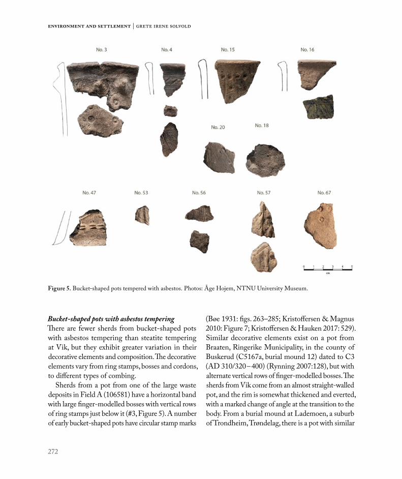
272
Environment and settlement | Grete Irene Solvold
Bucket-shaped pots with asbestos temperingThere are fewer sherds from bucket-shaped pots with asbestos tempering than steatite tempering at Vik, but they exhibit greater variation in their decorative elements and composition. The decorative elements vary from ring stamps, bosses and cordons, to different types of combing.
Sherds from a pot from one of the large waste deposits in Field A (106581) have a horizontal band with large finger-modelled bosses with vertical rows of ring stamps just below it (#3, Figure 5). A number of early bucket-shaped pots have circular stamp marks
(Bøe 1931: figs. 263–285; Kristoffersen & Magnus 2010: Figure 7; Kristoffersen & Hauken 2017: 529). Similar decorative elements exist on a pot from Braaten, Ringerike Municipality, in the county of Buskerud (C5167a, burial mound 12) dated to C3 (AD 310/320 – 400) (Rynning 2007:128), but with alternate vertical rows of finger-modelled bosses. The sherds from Vik come from an almost straight-walled pot, and the rim is somewhat thickened and everted, with a marked change of angle at the transition to the body. From a burial mound at Lademoen, a suburb of Trondheim, Trøndelag, there is a pot with similar
Figure 5. Bucket-shaped pots tempered with asbestos. Photos: Åge Hojem, NTNU University Museum.
273
The pottery at Vik in the Early Iron Age
composition of horizontal bands of finger-modelled bosses (T27). It differs from the Vik pot in that it has vertical and angled bands of combed lines on the body rather than ring stamps. There were no other finds from the burial mound that could date the pot.
A rim sherd and two body sherds from waste deposit 110297 in Field A are likely to have come from a highly decorated straight-walled pot (#4, Figure 5). The pot would have had a horizontal zone consisting of a slightly raised cordon with angled incised lines defined by double lines, which are lightly incised with a two-toothed comb. The rim is heavily thick and is rounded. The two body sherds have a vertical band made with a two-toothed comb, with diagonal bands extending from the vertical ones. The sherds are reminiscent of a pot from Døssland, Kvinnherad Municipality, Hordaland (B11476:Ib, Kristoffersen & Magnus 2010: Pl. 5, no. 78), dated to C3/D1 by Straume (1987: 77). A sherd with similar horizontal bands on the rim has been found at Avaldsnes, in the county of Rogaland (S12770: 36), but probably had different decoration on the wall of the pot (Kristoffersen & Hauken 2017: 533–534, Figure 21.7).
From waste deposit 500200 in Field C one pot (#16, Figure 5) was decorated with a horizontal band with at least three parallel, deeply incised grooves. Just below there are vertical bands of double grooves, with diagonal pairs of deeply incised grooves on each side. The decoration is similar to that on a vessel from Gjerla, Stokke Municipality, in the county of Vestfold (C22475:a, Bøe 1931: Figure 282; Straume 1987: Pl. 31: 3a). The vessel from Gjerla came from a burial dated to the AD 300s (Bøe 1931: 178). A vessel with similar decoration was found in a stone burial mound (a cairn) at Vikstraum, Hitra Municipality, Trøndelag (T22369:3).
A further three bucket-shaped pots that lack parallels, from the same waste deposit (500200), will be described in the following paragraphs.
A rim sherd has a narrow horizontal band with a number of circular depressions just below the rim (#15, Figure 5). Below this, the surface of the pot has parallel vertical grooves with vertical bands of the same circular impressions in between. Although there are no parallels for the decoration, its composition is relatively common. AB pots with vertical decoration and narrow horizontal bands are a relatively homo-geneous group, which dates within AD 400–500. However, some sherds also show that dating may extend to the Late Roman Iron Age (Kristoffersen & Magnus 2010: 42 – 43).
A body sherd with bossed decoration came from a relatively thick pot (0.76 cm) in a fabric tempered with both asbestos and steatite (#18, Figure 5). The pot was probably small, c.11 cm in diameter at the point from which the sherd has come. The surface is less smooth than the other sherds from Vik. The boss is small (c.0.5 cm high), almost four-sided, and appears to be have been added (not pinched or pressed out).
Another body sherd has combing and circular stamps (#20, Figure 5). The decoration consists of two circular stamps positioned more or less horizontally on the vessel, and possibly part of a horizontal band. From them, there are double asymmetrical lines. One line is almost vertical and the other is diagonal.
Five sherds from the same pot are from a cultural layer in Field E (216960, and related contexts). Two of these are decorated body sherds and two are base sherds (#56, Figure 5). The base sherds indicate a base diameter of 8 cm, and remains of the transition to the body suggest that the pot was a round-bodied pot. The decoration is open, with irregularly drawn borders, lightly drawn with three-toothed and four-toothed comb tools. One border is vertical, and the other two borders have different angles. The pot may have been of the same type as a C4 pot from Kvassheim, Hå Municipality, Rogaland (B6002:c, Kristoffersen & Magnus 2010: Pl. 12, no. 209).

274
Environment and settlement | Grete Irene Solvold
C4 pots are a small group and not found in combi-nation with weapons, but Kristoffersen & Magnus (2010: 46) consider it reasonable to associate the light combing with the AB Group, and therefore date them to AD 350–500.
A yellow-burnt body sherd decorated with ring stamp decoration (#67, Figure 5) was found in a hearth (671339) in House 24 in Field D. The ring stamps are placed in angled lines. They were probably part of vertical rows of ring stamps of varying length, and therefore the sherd might have come from a vessel with zones with vertical divisions. Bucket-shaped vessels usually date from the late AD 300s onward (Bøe 1931: 166–167; Kristoffersen & Magnus 2010; Fredriksen 2012; Kristoffersen 2012), but a grain of barley found in the hearth is dated to AD 137 – 242 (TRa-12016). Since the sherd is considerably affected by heat (i.e. burnt yellow), it is probable that the
vessel is from the same period as the hearth. This would suggest an unusually early date for the vessel.
In a pit (521429) in Field C, a body sherd from near the base of a small bucket-shaped pot was found (#47, Figure 5). The decoration consists of a horizontal row of short double imprints made with two-toothed combs on the lower part of the pot. Above this is a longer vertical comb impression with angled incised lines on either side. The sherd is too small to determine what type of pot it came from with any degree of certainty, but it might have come from a bucket-shaped pot type with horizon-tal decoration, such as C3. The majority of pots in the C3 group are dated to within AD 450–550 (Kristoffersen & Magnus 2010: 44), which fits with the 14C dating of the pit (see Table 4).
A small sherd from a bucket-shaped pot was found in a posthole (505507) that was not associated with
Vessel number Typological dating Reference Context Radicarbon dating of
the context3 C3 (AD 310/320-400) Rynning 2007: 128 Waste deposit 106581 AD 250-4074 C3/D1 (AD 310/320-475) Straume 1987: 77 Waste deposit 110297 AD 7-34716 AD 300s Bøe 1931: 178 Waste deposit 500200 AD 256-397
15 AD 400-500 Kristoffersen & Magnus 2010: 42 Waste deposit 500200 AD 256-397
18 AD 350-550 * Waste deposit 500200 AD 256-39720 AD 350-550 * Waste deposit 500200 AD 256-397
56 AD 350-500 Kristoffersen & Magnus 2010: 46 Cultural layer 216960
67 AD 350-550 * Fireplace 671339 in House 24 AD 137-242
47 AD 450-550 Kristoffersen & Magnus 2010: 44 Pit 521429 AD 403-535
53 AD 400-500 Kristoffersen & Magnus 2010: 43 Posthole 505507 Activity area can extend
to Migration period
57 AD 400-450(500) Kristoffersen & Magnus 2010: 43 Sunken lane
Same as 106581 and 110297, and extend to period after
* It is a common opinion that bucket-shaped pots occurred in Norway from the last half of the AD 300s and disappeared around AD 550 (Bøe 1931: 166–167; Kristoffersen & Magnus 2010: 9; Fredriksen 2012; Kristoffersen 2012)
Table 4. Dating of the find contexts and relative dating of the parallels of bucket-shaped pots tempered with asbestos.
275
The pottery at Vik in the Early Iron Age
any of the houses in Field C. The sherd has narrow vertical cordons, made by closely spaced grooves (#53, Figure 5). One of the cordons has traces of angled incised lines. The sherd might have come from the same type as a C1 type pot found at Ugulen, Luster Municipality, Sogn & Fjordane (B6109:IIIa; Bøe 1931: Figure 295; Kristoffersen & Magnus 2010: Pl. 7, no. 114). According to Bøe (1931: 186); this was a uniform thin type in well-mixed fabric tempered with finely ground asbestos, grey in colour and partially yellow on the exterior. Bøe’s description of the fabric matches the appearance of the Vik sherd. Kristoffersen & Magnus date the C1-group to AD 400 – 500 (2010: 43). Similar vessels have been found at Hol, Inderøy Municipality, Trøndelag (T9840) and at Vang, Oppdal Municipality, Trøndelag (T22464: 16). The vessel from Hol was found in a grave with relief-brooches dated to the first half AD 500s (Magnus 1975: 66, Johansen 2003: 152). The posthole in which the sherd was found at Vik is undated. However, there was a general tendency for activity in the northern part of Field C to last into the Migration period, which fits with the dating of the C1-vessels.
In Field A, a sunken lane extends along the southeastern edge of the excavated area, crosses over the large waste deposits (110297 and 106581), and then continues to Field E. Four sherds with very weathered surfaces were found (#57, Figure 5) in the fill of the sunken lane, at the transition between Fields A and E. They have both asbestos and crushed rock tempering, and their external surfaces are com-pletely oxidized yellow. The sherds may have come from a vessel densely decorated with cordons with stick impressions in vertical zones, one of which was vertically organized, and another diagonally organized. A vessel of this type has been found at Brekke, Vik Municipality, Sogn & Fjordane (B372, Kristoffersen & Magnus 2010: Pl. 24, no. 120). The vessel belongs to the C1 group, which was common
in the period AD 400–450 (500) (Kristoffersen & Magnus 2010: 43). A similar vessel has been found at Hollingen, Aukra Municipality, Møre & Romsdal (T19096: g), but, instead of diagonally hatched cordons like the Vik pot, it has zones of horizontal cordons. The sunken lane is difficult to date, but it seems to have been in use at the same time as the waste deposits, extending to the period after.
In case of the asbestos-tempered bucket-shaped pots there is a better relationship between the dating of the find context and the dating of the parallel types (see Table 4). However, for a couple of pots the contexts is clearly older (#15 & #67).
Finer tableware: handled vessels and similar formsHandled vessels have wide convex bodies and a wide neck opening, often with a lug handle on the side (Bøe 1931:49). Characteristically, they have finer fabrics compared to other vessel types; tempered with quartz and feldspar particles less than 1 mm in size. The pots generally range from dark brown to black in colour, and usually have a black-burnished surface (Stout 1986: 9). The majority of the sherds in this group from Vik are fragmentary and lack handles; however, they are round-bodied pots of fine fabric and with decoration that can be considered as having come from handled vessels or similar forms.
The material includes 50 thin sherds (248.2 g). The fabrics are mainly dark brown and tempered with fine crushed quartz and/or feldspar. It is pos-sible to distinguish at least 13 pots of this type. The following section presents a selection of some of this finer tableware.
In a posthole in House 2, Field C, a rim sherd with remains of a decorated shoulder was found. The sherd is possibly from a handled vessel, although no handle is present (#40, Figure 6). It is weathered, but has remains of an original black-burnished surface. The pot has a short everted rim and a relatively long shoulder with decoration. The decoration consists of

276
Environment and settlement | Grete Irene Solvold
four horizontal parallel grooves with circular depres-sions (dimples) at the end. Below there is a weak cordon with diagonal incised lines. It is reminiscent of a vessel from Godøy, Giske Municipality, Møre & Romsdal (B12144), except that the numbers of grooves and depressions differ (Stout 1986: Plate II). According to Bøe (1931:7), the decoration on the handled vessels often has a marked end to the pattern adjacent to the handle. The depressions on the sherd from Vik give a similar impression. The pot could possibly associate with Bøe’s early series with a rounded transition to the body (Bøe 1931: 49–54) or Stout’s Group I (Stout 1986: 14–21). Stout (1986: 51) dates Group I to AD 300–400 in western Norway.
From another posthole (502394) in the same house is a rim sherd in a paler and somewhat thinner fabric (#41, Figure 6). The sherd is undecorated and the surface is very weathered, but has patchy remains of a black-burnished surface. Its profile indicates that it came from a vessel with everted rim and relatively long neck, either with or without a handle. Stout dates the handled vessels to AD 300–500 (1986: 8), and the vessels with a tall neck, without a handle, are dated to AD 300 – 400 (Bøe 1931:108).
Two adjoining body sherds (#42, Figure 6) were found, respectively in a posthole (522059) and a nearby pit (513189), in House 2. The sherds have a distinct s-shaped profile, suggesting that they may have come from a bowl-shaped pot with rounded
Figure 6. Finer tableware: handled vessels and similar forms. Photos: Åge Hojem, NTNU University Museum.

277
The pottery at Vik in the Early Iron Age
transition to the body and sharply everted neck, pos-sibly an early handled form. The decoration consists of a chevron border with double lines made with a stick, contained within upper and lower horizontal lines. The upper three boundary lines are just below the everted rim and the lower boundary of two lines is directly on the transition to the body. The lower part of the body has double hanging curved lines (hanging arches). The decoration is similar to that from a pot from Mound 40 at Hunn, Fredrikstad Municipality, in the county of Østfold (C28974:b, Resi 1986: Pl.15: 13), but the shape may be different. Resi (1986: 74) dates the grave to the last part of the AD 300s or C3.
From waste deposit 500200 in Field C, additional sherds are of the same category as the pots described in the preceding paragraphs. Two adjoining sherds are from the everted rim of a fine ware round-bodied pot (#17, Figure 6). The sherds have a weak s-shaped profile that shows the contour of a neck and shoulder. The decoration, which is on the shoulder, consists of horizontal finger-drawn grooves within upper and lower lines. The containing lines consist of three
parallel lines drawn with a two-toothed comb tool. The lower lines are somewhat irregular. The profile and decoration may be reminiscent of a vessel from Kvassheim, Hå Municipality, Rogaland (B5377:g, Bøe 1931: Figure 62). Stout placed this vessel in Group II (Stout 1986: Table IV), which she dated to approximately AD 375–475 (Stout 1986: 51). A similar pot has been found in Färsta, in Medelpad, Sweden (SHM 10726: 12). Wenche Slomann (1948: 33) dated this vessel to the late AD 300s, but Klas-Göran Selinge (1977: 265) has placed it in the first part of the Migration period.
In addition, there are a number of smaller sherds with black-burnished surfaces, in fine fabrics, and with thin vessel walls (0.4–0.46 cm) from waste deposit 500200. There are two different types of rim sherds in this fabric. Two rim sherds have a straight profile (#31, Figure 6), probably from a handled vessel or a beaker. A third rim sherd is strongly concave and is likely to have come from a pot with a wide flaring rim (#32, Figure 6). In addition to these, there are a number of sherds in the same fabric, and with line decoration, that are likely to
Vessel number Typological dating Reference Context Radicarbon dating of the
context
40 AD 300-400 Stout 1986: 14–21 Posthole in House 2 AD 250-400 (AD 140-440)
41 AD 300-500 Stout 1986: 8 Posthole in House 2 AD 250-400 (AD 140-440)
42 late 300s (C3) Resi 1986: 74 Posthole and pit in House 2 AD 250-400 (AD 140-440)
17 AD 375-475 Stout 1986: 51 Waste deposit 500200 AD 256-397
31 Waste deposit 500200 AD 256-397
32 Waste deposit 500200 AD 256-397
21 D1 (AD 400-475) Johansen 2002: 244
Table 5. Dating of the find contexts and relative dating of the parallels of handled vessels.

278
Environment and settlement | Grete Irene Solvold
have come from one of these pots. Two body sherds fit together and probably come from the shoulder of a round-bodied urn with a somewhat marked transition to the body (T27074: 22, Figure 6). The sherds have two bands of parallel lines drawn with two-toothed comb tools. Another sherd has three parallel lines that end in a fan shape (T27074: 29, Figure 6). It is unclear whether these decorated sherds are from the same vessel.
A further two sherds come from a vessel with a horizontal band of three parallel lines, with angled incised lines below (#21, Figure 6). The two sherds show that the diagonal lines are facing the opposite way. Sherds from a similar pot have been found in a burial, at Størset, Rissa Municipality, Trøndelag (T13505: g), 14km in linear distance from Vik. The burial has been dated to D1 on the basis of a belt buckle ( Johansen 2002: 244).
There seem to be some correlation between the radiocarbon dates of the find context and the rela-tive dating of the handled vessels. All though, the find contexts seems to be somewhat older for some vessels (i.e. #17) (see Table 5).
Coarse (household) waresIn the coarse ware group, the sherds are usually from thick pots in coarse-tempered fabrics. The fabrics consist of clay tempered with relatively large amounts of crushed quartz, and they are 0.7–1.18 cm thick. There are 185 sherds (658.4g) of this type, and it has been possible to distinguish a minimum of 12 different vessels, some of which are described in the following.
Of two almost complete pots found in a posthole (503802) in House 34 in Field C, one is a coarse ware type (#48, Figure 7); the second is discussed under the heading “other vessels”. The coarse ware pot is a large, undecorated vessel with a short neck with straight rim, with a sharp transition to the body, high rounded shoulder, and a flat base. The
rim diameter is 13.5 cm and the vessel is 15 cm high. Its form is reminiscent of a pot from Tjentland, Hjelmeland Municipality, Rogaland (S315), but it is somewhat smaller and the rim is not everted (Bøe 1931: Figure 14). A similar vessel was found in a posthole in House CXIX at Forsandmoen (Løken 2001: Figure 4). This pot probably belongs the type of large “storage vessel with new features”, and differs from the earlier “situla” form pots in the more careful treatment of its surface and the more everted rim. In the absence of accompanying grave goods, such coarse ware pots are difficult to date, but a large number date to the Roman Iron Age (Rødsrud 2012: 206). A grain from the posthole is dated to AD 75–214 (TRa-11024), and food residues from the pot are dated to AD 0–130 (Beta-484602).
In addition, sherds from one pot were found in three different postholes (503802, 503082, and 524867) in House 34. The rim sherds indicate that the pot was of the same type, with a high rounded shoulder and straight rim (#51, Figure 7). The fabric is red, burnt, cracked, and the surface sintered in some places, indicating that the pot has been heated several times. The rim diameter is c.18.5 cm.
Some sherds from a coarse-tempered pot (#66, Figure 7) were found in a posthole (671378) in House 24 in Field D. The sherds fit together and show a weak S-shaped profile, probably from the transition from the neck to the body on the pot. In contrast to the two pots just described, the tran-sition to the body on this pot is rounded. The pot would have had a diameter of c.16 cm. 14C dating from House 24 is AD 140 – 340 (Heen-Pettersen & Lorentzen, Ch. 6).
A large rim sherd with a concave collar and everted rim was found in Field D (#63, Figure 7). The rim is cut straight with a somewhat bevelled surface externally, and the diameter of the pot is c.18

279
The pottery at Vik in the Early Iron Age
cm. The fabric is very coarse, tempered with quartz and feldspar, and is one of the thickest (1.14 cm) registered from Vik. The sherd is thought to have come from a cooking pit area. The pot was probably a ‘situla’ type, dating to the Pre-Roman Iron Age and the transition to the Early Roman Iron Age (Rødsrud 2012: 205).
The dating of the find contexts for the coarse ware at Vik supports Rødsrud’s argument that a large number of these vessels can be dated to the Roman Iron Age (2012: 206). Most of these contexts at Vik dates to the early part of the period.
Figure 7. Coarse household ware. Photos: Åge Hojem, NTNU University Museum.
Vessel num-ber
Typological dating Context
Radicarbon dating of the context
48 *Posthole 503802 in House 34
AD 75-214 AD 0-130
51 * 3 postholes in House 34
AD 75-214 AD 0-130
66 *Posthole 671378 in House 24
AD 140-340
63 * Stray find * Coarse ware pots are difficult to date, but a large number date to the Roman Iron Age (Rødsrud 2012: 206).
Table 6. Dating of the find contexts and relative dating of the parallels of coarse ware.

280
Environment and settlement | Grete Irene Solvold
Other vesselsThe material includes sherds and pots that have a more specific typology or cannot be placed within the previous types. They are described in more detail in the following.
From the same posthole in House 34 as the one in which the almost complete coarse ware pot (#48) was found, there was a second almost complete pot. It is smaller, and reconstructed from four large sherds (184.5g) (#49, Figure 8). The pot has a short collar with a mildly everted rim, and a sharp but rounded
transition to the body. The belly is evenly curved, and it has a flat base. The pot is only 7 cm high and has a rim diameter of 8 cm. The upper part of the body has a grid pattern below a horizontal band of double lines just below the collar. The grid pattern consists of bands of three lines irregularly applied with a stick. The fabric has tempering of coarse quartz and is rather thick (0.68 cm) compared to the earlier described finer tableware. The colour is pale brown, but black on the surface of the lower part of the body on one side. The external surface is
Figure 8. Other vessels. Photos: Åge Hojem, NTNU University Museum.

281
The pottery at Vik in the Early Iron Age
finely smoothed. The form is similar to one of Bøe’s early bowl forms (Bøe 1931: Figure 44) but differs in its decoration. According to Rødsrud (2012: 49, 211), the early bowl forms appeared in the AD 200s or possibly earlier. As mentioned earlier, a grain from the posthole has been dated to AD 75–214 (TRa-11024), and food residues from the coarse ware pot from the same posthole are dated to AD 0–130 (Beta-484602).
In waste deposit 110297 in Field A, four sherds (25.9g) were found that probably came from one vessel (#9, Figure 8). The pot probably had a very rounded body with a narrow neck or collar. The surface is weathered but has traces of black bur-nishing. The decoration consists of one horizontal band infilled with hatching, more specifically two parallel lines with diagonal incised lines between them. Such decoration is common on the pots that Bøe (1931: 26) called foreign decorated ware. The fabric has a high proportion of sand inclusions, as is common in this type of pot (Bøe 1931: 24). The original black-burnished surface does not have any sand, which suggests that the pot was dipped in a clay slip to make the surface as smooth as possible prior to burnishing. According to Bøe, these vessels appear to come from the Jutland ceramic industry (Bøe 1931: 26–33). However mineralogical analyses of several such jars from Hunn in Østfold have shown that they were probably produced locally (Resi 1986: 51–53). These vessels appeared around AD 100 in the areas in and around present-day Vestfold (Bøe 1931: 34, Rødsrud 2012: 48, 208). The dating of the waste deposit ranges from Early Roman to Late Roman Iron Age, but the sherds were mainly found in the lowermost layer, which suggests that the pot was probably deposited in the earliest phase of the waste deposit.
A number of sherds from a pot (#65, Figure 8) were found in a posthole (671502) in House 21 in
Field D. The pot seems to have had a rounded profile with a somewhat high neck and slightly everted rim. The body has two zones with zigzag line borders or chevrons separated by a linear boundary consisting of bands of horizontal lines at the everted rim and the broadest part of the body. The lines and chevrons consist of three to five lines made with a stick. The pot is rather thick-walled and has a pale orange fabric with a dark brown external surface. Since it has not been possible to join the neck sherd to any of the body sherds, the complete profile of the pot is uncertain. A vessel from Bliksbjerg II (C19791), Lisbjerg, Århus Municipality, in Denmark, has similar decoration and possibly the same shape (Nordling-Christensen 1954: Pl. 23, Figure 9). The vessel at Vik is clearly reminiscent of Jutland ceramic industry and can be regarded as an example of Bøe’s foreign decorated ware. House 21 dates to AD 1 – 230, which coincides with the dating of the Bliksbjerg grave to B2 (AD 70 – 150/160) (Nordling-Christensen 1954: 52).
At an excavation in 2018, at Brekstad, Ørland (only 3km away), several sherds of Bøe’s foreign decorated ware were found in a well dated to AD 1. Some of the sherds have the same decoration as the first vessel – bands infilled with hatching – but, all in all, the decoration on the sherds is more varied. The sherds (T27897:50-66) originate from one or two vessels with facetted rim (Krag & Grønnesby in prep).
A small sherd from the transition to the body of a pot of Bøe’s small cooking pot type (1931: figs. 244–261) (#27, Figure 8) was found in waste deposit 500200 in Field C. The fabric contains a high pro-portion of sand, is burnt red, and the external surface is decorated with horizontal rows of fingernail impressions. The clearest row of this decoration is directly on the transition from the neck to the body, and the fractured edge of the sherd shows evidence of another row below that. The sandy fabric and

282
Environment and settlement | Grete Irene Solvold
fingernail decoration on the body are typical of the small cooking pot types that were widespread in the Late Roman Iron Age and Migration period (Bøe 1931: 156–157). The fingernail decoration dates back to AD 250–300 and lasted throughout AD 500s (Rødsrud 2012: 231).
In the same waste deposit, a further 20 sherds were found from a pot without parallels (#24, Figure 8). The pot had a rounded collar with an everted rim. The rim has a rounded top but is not thickened. The fabric has tempering of finely crushed quartz and is dark brown in colour. The surface treatment appears special, and may be perceived as decorative: the pot is entirely covered in horizontal irregular ‘stripes’, up to the rim. This may have been done deliberately if the pot was rubbed in a horizontal direction when it was semi-dry, or if it was covered with a layer of grass or straw while drying or possibly during firing.
There seem to be correlation between the radiocar-bon dates of the find context and the relative dating of the foreign decorated ware and the small cooking pot (#9, #65 & #27; see Table 7). The dating of the context of the early bowl type of vessels supports
Rødsrud’s suggestion that these types may appear earlier than the AD 200s (#49).
Early pottery with asbestos tempering (Asbestos ceramics)This ceramic material includes 21 sherds (38.3g) with asbestos tempering that differ from the bucket-shaped pots in fabric composition and form. It has been possible to distinguish three different pots, all from different contexts. The sherds are undecorated and in grey-brown fabric with a relatively high proportion of finely sorted asbestos fibres, as is common in asbestos ceramics from northwestern Norway (Ågotnes 1986: 86–88). Asbestos ceramics are thought to have been in use from the late Neolithic to the Pre-Roman Iron Age, but Ågotnes (1986: 104) believes that use of the material from northwestern Norway cannot be verified before the Early Bronze Age.
Two of the pots were found in postholes in House 7 in Field B (#13, Figure 9 & #14), which is dated within the Early Pre-Roman Iron Age (Ystgaard et al. 2018: 430). There were just a few small sherds from the body of the vessels.
Vessel number Typological dating Reference Context Radicarbon dating of
the context
49 From AD 200s Rødsrud 2012: 49 House 34 AD 75-214 AD 0-130
9 From AD 100s Bøe 1931: 34 Rødsrud 2012: 48 Waste deposit 110297 AD 7-347
65 B2 (AD 70-150/160)Nordling-Christensen 1954: 52
House 21 AD 0-230
27
Late Roman Iron Age to Migration period
Bøe 1931: 156-157
Waste deposit 500200 AD 256-397AD 250/300 to AD 500s Rødsrud
2012: 23124 Waste deposit 500200 AD 256-397
Table 7. Dating of the find contexts and relative dating of the parallels of other vessels.

283
The pottery at Vik in the Early Iron Age
A rim sherd (#26, Figure 9) from waste deposit 500200 in Field C has a smoothed area just below the rim, and is similar to a rim sherd from Skrivarhelleren, Årdal Municipality, Sogn & Fjordane (B12523, Ågotnes 1986: Figure 6B). However, the dating for this deposit points to the Late Roman Iron Age.
Additionally, there are two sherds in a mica-tem-pered fabric (#1, Figure 9). In northern Norway, mica-tempered pottery is considered a separate group within the northern Norwegian asbestos ceramic tradition, although this group is mainly concentrated in Varanger ( Jørgensen & Olsen 1988: 20). The sherds from Vik are highly weathered. Therefore, they provide no information about the vessel form (or forms) from which they came. However, they were found respectively in a posthole and in floor
layers dated to the Pre-Roman Iron Age in House 1 in Field A (Ystgaard et al. 2018: 144).
Table 8 generally shows correlation between the common dating of this vessel type and the contexts in which they are found at Vik. One sherd was found in a waste deposit with later dates. However, House 18, 25 m southeast of the waste deposit, is dated to the Pre-Roman Iron Age, which means it is not unthinkable that the sherd was redeposited.
Contextual analysis: In what contexts were the ceramics found?The ceramics from Vik were only found in settlement contexts and the finds were dispersed over all five excavation Fields, A–E (see Figure 10).
Figure 9. Early pottery with asbestos tempering (Asbestos ceramics). Photos: Åge Hojem, NTNU University Museum.
Vessel number Typological dating Reference Context Radicarbon dating of the
context13
Early Bronze Age - Pre-Roman Iron Age Ågotnes 1986: 104
Posthole in House 7 Pre-Roman Iron Age14 Posthole in House 7 Pre-Roman Iron Age26 Waste deposit 500200 AD 256-397 1 Posthole/floor in House 1 Pre-Roman Iron Age
Table 8. Dating of the find contexts and relative dating of the parallels of early asbestos pottery.

284
Environment and settlement | Grete Irene Solvold
However, the distribution between the five areas and within them varied. As can be seen in Table 9, the majority of the sherds were found in waste deposits and in association with features relating to buildings, while few sherds were found in cooking pits.
Waste depositsIn total, 65% of the sherds were found in what have been interpreted as waste deposits. The largest waste deposits contained the largest number of sherds: the waste deposits in field A (106581 and 110297) and Field C (500200 and 521623). In addition to these, I include a waste pit with a number of fish bones and shells from Field E (210240). There were major differences between the waste deposits in the respective areas (Mokkelbost, Ch. 7).
Table 9 shows that the ratio of the number of sherds to the number of vessels differs, especially with regard to waste deposits 110297 and 500200. Deposit 110297 contained a large number of sherds,
but some of these come from the same vessel. In contrast, 500200 contained a smaller number of sherds, but a much higher number of different types of vessels. Figure 11 shows that waste deposit 500200 had a larger number of finer tableware pieces, such as handled vessels (or similar forms) and bucket-shaped pots, than waste deposits 110297 and 521623, which also contain coarser ceramic types.
Shard (%)
A B C D E
Figure 10. Percentage distribution of sherds by excavated area. Illustration: Grete Irene Solvold, NTNU University Museum.
Field Type of context
Con-text Num-ber
Number of shards
Num-ber of vessels
A House 1 2 1A Waste deposit 106581 8 3A Waste deposit 110297 236 6A Waste pit 117191 1 1A Waste pit 132878 3 1A+E Sunken lane 217254 11 4B House 6 27 1B House 7 18 2C House 2 11 7C House 34 69 4C Waste deposit 500200 63 22C Postholes 505507 1 1C Layer 511160 1 1C Pit 521429 1 1C Waste deposit 521623 4 2C Pit 522729 1 1C Cooking pit 523989 5 2D House 21 5 1D Ditch 616167 1 1D House 24 3 3D+E Stray finds 2 2E Waste pit (fish) 210240 6 1E Cultural layer 216960 4 2E Hearth 218579 1 1E Cooking pit 218622 1 1E Postholes 225256 2 1
Table 9. Distribution by area, context, sherd, and vessel.

285
The pottery at Vik in the Early Iron Age
The chronological difference between the con-texts in question can be one explanation for this difference. Waste deposits 110297 and 521623 are older than 500200, but 106581 and 210240 are simultaneous to 500200 (Mokkelbost, Ch. 7). Nevertheless, the large number of vessels and amount of finer tableware may indicate a possible difference in the status of the households that used the deposits. This coincides with observations made
by other contributors to this volume (Mokkelbost, Ch. 7; Storå et al., Ch. 8).
HousesIn total, 27% of the sherds were found in contexts that can be linked to construction features. This applies to contexts such as postholes, cooking pits, pits, and floor layers associated with a house. From the distribution of the types of pots found in the
Figure 11. Distribution of vessel types by context. Illustration: Grete Irene Solvold, NTNU University Museum.
0 5 10 15 20 25
Waste deposit 500200
House 2
House 24
House 34
Waste deposit 521623
House 21
House 7
South area
House 6
Waste pit 210240
Waste deposit 106581
Waste deposit 110297
House 1
North area
Bucket-shaped po�ery Handled vessels and similar forms
Coarse ware Bøes "Early bowls"
Bøes "Foreign decorated ware" Bøes "The li�le cooking-pot"
Vessel no. 24 Early po�ery tempered with asbestoes
286
Environment and settlement | Grete Irene Solvold
houses (Figure 11), it is apparent that there was wide variation between the different houses. The most likely explanation is that the houses reflect different settlements phases at Vik. In Houses 1 and 7, asbestos ceramics have been found which coincided with the 14C dating of the houses to Pre-Roman Iron Age. In House 6, which was also dated to the Pre-Roman Iron Age, coarse ware pot types were found. In House 34, which dated to the Early Roman Iron Age, a coarse ware pot and an early bowl form were found. In House 21, which is dated to the Early Roman Iron Age and the beginning of the Late Roman Iron Age, a vessel of Bøe’s type foreign decorated ware was found. In House 24 and House 2 a variety of bucket -shaped pots and han-dled vessels were found, although a smaller amount from House 24, with its additional sherd of coarse ware. House 24 is dated to the transition to/and the Late Roman Iron Age. House 2 has dates from the same period but extends into the Migration period.
Lipid analysisA long-standing question in research on ceramic vessels is their usage. Pots, especially the finer tableware and bucket-shaped ones, have often been linked to high status and ritual use (Kristoffersen and Hauken 2017: 528). To cast light on this question, lipid residues from 16 ceramic vessels were analysed using gas chromatogra-phy (see report Isaksson 2017). It is important to clarify that the conclusions based on this kind of analysis are interpretations, and can often be ambiguous. The fats in the sherd usually come from the ingredient with most fat, but it is not necessarily the main ingredient in the dish (Isaksson 2017: 1-2). The fats extracted are probably from the last use of the vessel, but some ingredients leave clearer traces, and can survive longer. The soil it was found in and the following treatment (i.e. fingerprints, packing material, marking and glue) can affect the result of such analysis. However, most of these points can be avoided by comparing results with earlier analysis (Rødsrud 2012:332).
Museum number
Vessel number Type of vessel Context Field Quantity Content
Visible food residue
Interpretation
T27070:75 5
Bucket-shaped pottery, tempered with steatite (soapstone) and decorated with incised lines
110297 Waste layer
A None
T27074:35 27
”The small cooking pot” decorated with imprints made by fingernail
500200 Waste layer
C None
T27079:2 49Bøe’s early bowl forms with grid pattern
Posthole in House 34
C None
T27080:7 51Coarse household ware with sintered outer
Posthole in House 34
C None
T27404:4 65
Bøe’s “foreign decorated ware” with neck and chevrons
Posthole in House 21
D None
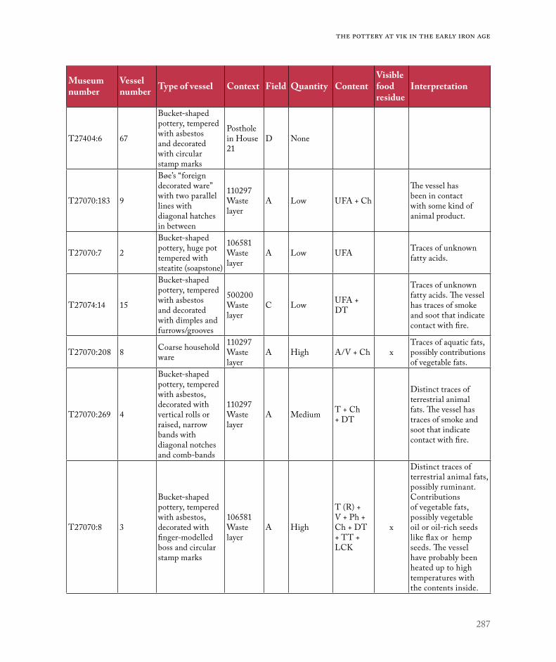
287
The pottery at Vik in the Early Iron Age
Museum number
Vessel number Type of vessel Context Field Quantity Content
Visible food residue
Interpretation
T27404:6 67
Bucket-shaped pottery, tempered with asbestos and decorated with circular stamp marks
Posthole in House 21
D None
T27070:183 9
Bøe’s “foreign decorated ware” with two parallel lines with diagonal hatches in between
110297 Waste layer
A Low UFA + Ch
The vessel has been in contact with some kind of animal product.
T27070:7 2
Bucket-shaped pottery, huge pot tempered with steatite (soapstone)
106581 Waste layer
A Low UFA Traces of unknown fatty acids.
T27074:14 15
Bucket-shaped pottery, tempered with asbestos and decorated with dimples and furrows/grooves
500200 Waste layer
C Low UFA + DT
Traces of unknown fatty acids. The vessel has traces of smoke and soot that indicate contact with fire.
T27070:208 8 Coarse household ware
110297 Waste layer
A High A/V + Ch xTraces of aquatic fats, possibly contributions of vegetable fats.
T27070:269 4
Bucket-shaped pottery, tempered with asbestos, decorated with vertical rolls or raised, narrow bands with diagonal notches and comb-bands
110297 Waste layer
A Medium T + Ch + DT
Distinct traces of terrestrial animal fats. The vessel has traces of smoke and soot that indicate contact with fire.
T27070:8 3
Bucket-shaped pottery, tempered with asbestos, decorated with finger-modelled boss and circular stamp marks
106581 Waste layer
A High
T (R) + V + Ph + Ch + DT + TT + LCK
x
Distinct traces of terrestrial animal fats, possibly ruminant. Contributions of vegetable fats, possibly vegetable oil or oil-rich seeds like flax or hemp seeds. The vessel have probably been heated up to high temperatures with the contents inside.

288
Environment and settlement | Grete Irene Solvold
0 1 2 3 4 5 6
Bucket-shaped pot
Coarse household ware
Finer tableware
Bøe's foreign decorated ware
Bøe's little cooking pot
Bøe's early bowl
No lipids Lipids
Figure 12. Presence of lipids by vessel type. Illustration: Grete Irene Solvold, NTNU University Museum.
Museum number
Vessel number Type of vessel Context Field Quantity Content
Visible food residue
Interpretation
T27074:18 18
Bucket-shaped pottery, tempered with asbestos and steatite (soapstone), decorated with small square boss.
500200 Waste layer
C Medium T (R) + V + Ch + PA
Distinct traces of terrestrial animal fats, possibly ruminant. Also traces of plant foods (green plants).
T27076:5 40Finer tableware, handled vessel with short neck
Posthole in House 2
C Medium T (R) Distinct traces of terrestrial animal fats, possibly ruminant.
T27076:6 41Finer tableware, handled vessel with long neck
Posthole in House 2
C High T (R) + V + DT
Distinct traces of terrestrial animal fats, possibly ruminant. Also traces of vegetable fats and smoke/soot.
T27079:1 48Coarse household ware, nearly complete pot
Posthole in House 34
C Medium T (R) + V + DT x
Distinct traces of terrestrial animal fats, possibly ruminant. Possible contributions of green plants or fatty acids from ruminant. In addition, traces of soot and smoke
Table 10. Results of lipid analysis. Contents: Ch – Cholesterol, UFA - Unknown Fatty Acid, DT - Diterpines (from Pinacaea), TT - Triterpines (from Betulaceae), T - Terrestrial animal products, A - Aquatic animal products, V - Vegetable fats/Plant foods, R – Ruminant, Ph - Phytosterol, LCK - Long chained ketones, PA - Phytanic Acid.

289
The pottery at Vik in the Early Iron Age
UFA
UFA – Unknown Fatty Acid, T – Terrestrial animal products, A – Aquatic animal productsV – Vegetable fats/Plant foods, R – Ruminant
T R V A
0 1 2 3 4 5 6 7 8 9 10
Waste layers
Poste holes in houses
No lipids Lipids
Figure 13. Distribution of lipid types by vessel type. Illustration: Grete Irene Solvold, NTNU University Museum.
Figure 14. Distribution of vessels with and without lipids by context type. Illustration: Grete Irene Solvold, NTNU University Museum.

290
Environment and settlement | Grete Irene Solvold
The results of the lipid analysis showed that six pots did not have any lipids remains. Their usage did not leave traces of fats in their fabric. In another three samples, only weak traces of fats were found. Of the remaining seven samples, one contained traces of aquatic animals, while the other six contained traces of terrestrial animals, five of which were probably ruminants. In four of the samples with traces of fats from animals, there were also indications of vegetable fats, and in one case traces of oil-rich vegetables (Isaksson 2017: 7; summarized in Table 10).
In contrast to the results of Rødsrud’s lipid analy-sis of pots from burial contexts in eastern Norway (2012), the results from Vik showed more variety in the use of the pots.
There does not seem to be any connection between the type of pot and the presence of lipids in the ceramic material from Vik (see Figure 12). Some pots of the same type had lipid residues, while others did not. Only the small bowl and the small cooking pot stood out by not having any lipid residues, but there was only one sample from each of these types.
Closer examination of the types of lipids found revealed that the same lipid types were found in almost all of the pots (see Figure 13). One of the coarse ware pots is noteworthy because it had traces of aquatic animals.
From the distribution of pots with lipids from the selected differing contexts, it can be seen that more of pots with lipid residues were found in the waste deposits than from postholes in house contexts (see Figure 14).
DISCUSSION
The origin of the ceramics at Vik.The ceramic material from Vik shows considerable variation in types deposited over a long period between the Bronze Age and the Migration period. During the transition to the Late Roman Iron Age,
the ceramic material from Vik increased in quantity and types, with increasing amounts of finer tableware, such as bucket-shaped pots and handled vessels (or similar forms) in Fields A and C.
Figure 15 shows the distribution of the origins of the parallels for the ceramics at Vik. Most of the identified parallels are for the bucket-shaped pots. This is probably due to the larger amount of research done on those vessels. All the bucket-shaped pots with steatite tempering have parallels in western Norway. However, the asbestos-tempered ones show a more varied picture. The handled vessels show more geographical variation in the possible parallels. Other vessels, like the coarse ware, represent forms that are similar over a great distance. It is not surprising to find a parallel for Bøe’s foreign decorated ware in Denmark, since he argues that the origin for these vessels is in Jutland (1931).
This shows that the early vessels are influenced by a geographically extended ceramic tradition, which represents similar forms and decoration over a greater distance. As early as the Early Roman Iron Age, there are indications that the people at Vik belonged to a ceramic tradition that extended from Jutland all the way to Ørland. However, when bucket-shaped pots came into fashion, most of the decorative influence come from western Norway.
Although the pots from Vik have similarities to these parallels, none of them is quite the same; there are some differences in the decoration.
For some pots, it has not been possible to find any parallels (e.g. #15 and #19, Figure 4 and 5), probably because pottery manufacture is a craft guided by fashion and personal preferences. This is an argument for seeing the pots as made by both professional and unprofessional potters, whereby the latter would have made the coarse house-hold pots and the professional potters finer pots (Kleppe 1993: 297). The total material from Vik clearly shows chronological differences between the

291
The pottery at Vik in the Early Iron Age
different types of vessel. However, there are also differences in the quality within the types, which may be explained by professionalism, fashion or the potters’ preferences.
With regard to the largest group of pots from Vik, the bucket-shaped pots, the majority were found in contexts dating to the Late Roman Iron Age and occasionally from the transition to the Migration period. At Vik, only a couple sherds have decoration that can be dated with certainty to the late type, with more complex decorative patterns, from the Migration period (e.g. #59, Figure 4). It is a common opinion that bucket-shaped pots occurred in Norway from the last half of the AD 300s and disappeared around AD 550, and that the tradition started in the contemporary pottery-man-ufacturing centre in Rogaland (Bøe 1931: 166–167; Kristoffersen & Magnus 2010; Fredriksen 2012; Kristoffersen 2012). The bucket-shaped pots from Vik are of the early types, and this may indicate that contact between Ørland and western Norway was
already well established, and that the distribution of the type spread quickly. The similarities in form and decorative composition may indicate that the bucket-shaped pots found at Vik were part of a larger ceramic tradition, but the decorative elements also show a local tradition (e.g. #15 and #19, Figure 4 and 5). With regard to the remaining ceramics, the forms are similar over a great distance. The decoration shows a similar technique and type of pattern, but there are sometimes small differences in the composition of the patterns. The ceramics finds from Vik alone do not give a definite answer to the question of local tradition and production.
To try to get closer to an answer, some other features that may shed light on the subject will now be discussed.
A concentration of burnt clay (sintered clay) and slag was found in waste deposit 110297 in Field A. The burnt clay from this area has a firing temperature of 900–1000 °C and is interpreted as having come from a clay-capped kiln used in the production of
Figure 15. Distribution of the origins of the parallels. Illustration: Grete Irene Solvold, NTNU University Museum.
0 2 4 6 8 10 12
Handled vessels
Bucket-shaped pots with asbestos tempering
Bucket-shaped pots with steatite tempering
Bøe's foreign decorated ware
Western Norway Eastern Norway Central Norway
Medelpad - Sweden Århus - Denmark

292
Environment and settlement | Grete Irene Solvold
metalwork (Brorsson 2016: Table 2). The different types of slag and the location far away from the settlement support this. A clay layer 150017 (1,65 x 1,4 m) was found in the waste deposit. The clay was medium coarse and contained silt, sand, and mica but was rinsed of organic matter. According to Brorsson (2016: 19), such clay is suitable for ceramics and moulds. Such reservoirs can be interpreted as pits to store and mature the clay in before using it for ceramics or moulds (see also Rolfsen 1980:17; Mokkelbost, Ch. 7). However, no moulds were found in the waste layers.
The firing temperature of the kiln would have been too high for prehistoric ceramics, which are considered to have been fired at lower temperatures (Rødsrud 2012: 328). However, it has also been sug-gested that in simple kiln chambers made of stone, such as are found at Augland, temperatures could have reached 900 °C (Rolfsen 1980: 19).
An analysis of the firing temperature of the clay can reveal the highest temperature at which clay would have burnt. In cases where there is a more or less permanent kiln capped with clay or/and stone, and if knowledge of how to regulate the tempera-ture inside it existed, it is probable that such a kiln could had more than one function. In an attempt to address this question, I return to the ceramics found in the waste deposit. One of the pots in waste deposit 110297 was probably broken at the site. This bucket-shaped pot with line decoration (#5, Figure 4), consisting of 153 sherds, lacked lipid residues. Lack of lipid residues and the fact that the vessel was probably broken near the waste deposit might be a result of the vessel being damaged during production, which could easily happen in a kiln (see Mokkelbost, Ch. 7). The clay layer (150017) is dated to AD 128-240 (Tra-11271, 1830±22BP). Bucket-shaped pottery was in use from around AD 350, so there are no correlations between the clay layer and pot #5. However, as we have no dating on the kiln
fragments, it could be possible that the kiln could have existed earlier or for a longer time. Some of the fragments show that the kiln has been repaired, as you can see layers of sintered clay.
Another possible kiln was found in Field C. Two closely spaced pits contained a large amount of burnt and sintered clay (Ystgaard et al. 2018: 497). Three samples from these pits had a firing temperature of 900–1000 °C and one sample had a firing tem-perature of 600–700 °C. These finds have also been interpreted as having come from a kiln’s capping layer, and Brorsson explains the lower firing temperature by arguing that it might have come from the exterior of the kiln (Brorsson 2016: 21). However, some of the fragments of burnt clay had the remains of round openings that could be interpreted as remnants of air ducts between two chambers – in which case the clay with lower firing temperature could come from an upper chamber of a two-chamber kiln (Ihr pers. comm., 2018).
Sherds from one of the other pots without lipid residues (#51, Figure 7) were found in three of the postholes in House 34 on top of the kiln. The pot was completely oxidized red, and partially sintered on the external surface. One interpretation is that this vessel was destroyed during firing, and that the sintering occurred when the broken sherds were used as a heat shield when firing new pots in the kiln (Rødsrud pers. comm., 2018). The kiln dates to 45 BC – AD 59 (TRa-13059 & TRa-13060), but as the sample was pine, it is believed to be a bit younger (Ystgaard et al. 2018: 497). As the kiln predates House 34, waste from the period of the kiln’s usage could have fallen into the posthole with the filling during the house’s construction.
The finds indicate that there were kilns capped with clay and possibly a two-chambered kiln at Vik in the Early Roman Iron Age. It cannot be claimed with certainty that they were used to fire pottery, but finds of ceramics with unfamiliar decorations (e.g.

293
The pottery at Vik in the Early Iron Age
#15 and #19), pits with raw materials (150017), and ceramics without lipid residues (#5 and #51) can be seen as evidence of the local production of pots at Vik in the Early Roman Iron Age.
Geological analysis of both foreign decorated ware from Østfold and handled vessels from west-ern Norway have shown that such pots could be locally produced (Resi 1986: 51-53; Stout 1986: 66; Kristoffersen 1993: 169). Potentially, compar-ison of the results of an analysis of the clay in the sherds and the results of an analysis of the raw clay in Field A might provide evidence in support of this interpretation but no such analyses have been carried out to date. Moreover, further analysis may provide exact information about the temperatures at which the ceramics were fired.
What do use and discard of pottery imply about the temporal, spatial and social organization of the Roman Iron Age farm at Vik?The ceramics at Vik are mainly from waste deposits or features related to houses from different periods. In the Early Roman Iron Age, there are coarse wares and a few sherds of finer tableware from three fields (A, C and D). There are, as has been seen, indications of local ceramics production in Field A and Field C. There are also indications of ritual deposits of both coarse ware and finer dec-orated vessels in Fields C and D (House 34 and House 21). Compared to previous periods we see the beginning of a differentiation of the ceramics, where the coarse ware was used for cooking and storage, and the finer tableware for serving food and drink. From the beginning of this period, there is, in eastern Norway, a shift from the use of urns for human remains in graves to depositing sets of vessels besides the human remains. It is as if the dead person got a whole feast with him or her into the grave (Rødsrud 2012: 194). However, ceramics are still been used as urns in ritual deposits at Vik.
In the Late Roman Iron Age, there was evidently a marked increase in the number of pots at Vik, especially handled vessels and bucket-shaped pots (e.g. 500200). There is no sure indication of local ceramics production in this period, but much sug-gests that some might have been locally produced.
The increase in pots may be related to change within the food practices that started in the Early Roman Iron Age, were commensality was the new ideal, and the need for a more elaborate set of table-ware arose. The use of sets of tableware in graves in eastern Norway extends to the Late Roman Iron Age, and decreases in the Migration period (Rødsrud 2012: 194). The analysis carried out by Rødsrud of the organic residue from the sets in graves shows that there was a functional division between the coarse ware and the finer wares: the coarse vessels contained food and the finer vessels contained some kind of drink (Rødsrud 2012: 196). However, the lipid analysis of the pots from Vik may give another picture.
At Vik, lipid residues from ruminants and veg-etables were found in both coarse ware and finer tableware like handled pots and bucket-shaped pots (Table 10). In one of these, a bucket-shaped pot (#3, Figure 5), there were traces of long-chained ketones. Long-chained ketones are organic compounds that occur when fat products are heated, and indicate that the vessel was heated with the food inside (Isaksson 2017:3). This supports Kleppe’s argument that the introduction of the bucket-shaped pots can be explained as a product of a change in cooking procedures, as these pots could easily be used in direct contact with fire (Kleppe & Simonsen 1983: 36). However, the analysis of the pottery at Vik shows a more varied picture. Most of the pots have no evi-dence of being heated with the contents inside, and were probably used as vessels for storing or serving.
The results of the lipid analysis of 16 pots from Vik show that only one with detected lipids had

294
Environment and settlement | Grete Irene Solvold
aquatic animal residues, while six had residues from terrestrial animals (see Table 10). Given that Ørland is located on the coast and at the mouth of a fjord, it is strange that more lipid residues from aquatic animals were not found in the pots. Since pots absorb the taste and smell of food, separate pots may have been needed for different types of food, to avoid tainting (Heron & Evershed 1993: 259). Furthermore, since fish has a strong flavour and smell when cooked, it is reasonable to suggest that separate vessels would have been used for fish. However, given that the one sample with aquatic animal residues came from a coarse household pot from waste deposit 110297, while five samples with terrestrial animal residues came from finer tableware and bucket-shaped pots, one could suggest that the relative lack of marine products might have had something to do with food status and commensality. Until recent times, fish had a lower status in food traditions, and therefore it is possible that meat was served to show that the host could afford to slaughter the farm’s livestock. The fact that the one coarse pot with residues from terrestrial animals is from a ritual deposit in a house could support this hypothesis. In addition, the argument, proposed by Rødsrud, that ceramics are used as materialized symbols for ideology and power relations could further support it (2012: 194). A change in the spatial organisation of the cooking pits at the settlement at Vik and the location of cooking pits inside House 2 also support this idea, as communal meals and commensality seem to be moved closer to the farm (see Fransson, Ch. 5; Heen-Pettersen & Lorentzen, Ch. 6).
The lipid analysis showed that ceramics from settlement contexts might have had more varied contents than ceramics from burial contexts. Thus the pottery from the settlement contexts may con-tribute to knowledge of daily food traditions. As the use of pottery increased, and bearing in mind the relatively small presence of fish products occurring at
Vik, it can be argued that ceramics were increasingly associated with uses that were more specialized, and that these uses can be seen in terms of a new context: the growth a more sophisticated commensality.
One of the farms at Vik stands out as it has a wider selection of vessel types, with a higher degree of fragmentation (Field C, 500200 and House 2). This may be correlated to the farm achieving a higher status because of the relocation of the farm in Field D in the same period. This suggestion is further supported by finds of other items, such as fragments of glass beakers with trailing, and silver rings in 500200. House 2, which is simultaneous with 500200, shows a similar pattern, with a varied selection of bucket-shaped pots or finer tableware. The higher status can also be seen in connection with the manifestation of commensality close to the farm, when finer wares, better food, and probably particular types of drinks would have been required, for which there seems to be supporting evidence from Field C at Vik.
What do the ceramics finds from these settlements contribute to research?Ceramics finds from various settlement contexts may contribute further information about the use of ceramics, whether for daily use, feasts, and/or rituals. However, a problem has arisen with regard to the typological dating of the pots from Vik, especially the bucket-shaped pots, which raises the question of whether settlement contexts can provide a more pre-cise dating framework for the pots than, for example, ceramic grave goods? Most of the published material on ceramics in Norway come from graves, and the typological series were done before the 14C method was common. Ceramics at Vik are found in contexts that are dated more directly, with the 14C method. The contexts in question show a tendency towards earlier 14C-dates than those given by typological dating of the vessels. For example, a sherd from a

295
The pottery at Vik in the Early Iron Age
bucket-shaped pot decorated with a ring stamp was found in a hearth in House 24 in Field D (#67, Figure 5). The sherd is completely burnt yellow, indicating that it was discarded in the hearth when it was in use. But the 14C dating from the hearth precedes the period when the bucket-shaped pots are assumed to have been in use (see results section). Observations based on just one sherd are, on their own, not enough to determine whether the dating frame should be expanded. However, there are indications of earlier dates for the bucket-shaped pots from two boat-houses in Sola, Rogaland (Rolfsen 1974a: 72-73; 1974b: 112). One can wonder if the ceramics found in graves could have been in circulation for a longer period, before they were was deposited, thus allowing for earlier dating of their usage at settlements.
The distribution of the various types of pots in the various houses shows a large degree of varia-tion, mainly in terms of dating. The majority of the ceramics finds were from postholes, which raises the following question: did the sherds end up in the postholes together with surrounding soil by chance during the construction or demolition of the house, or might they have been deposited intentionally? The tradition of burying pots in houses is a well-known phenomenon from different periods and cultures around the world (Carlie 2004: 41), yet this begs the question of what is required to interpret pottery as a ritual deposit.
In a study of the ritual use of pots in Sweden and Denmark, only whole pots are referred to as ritual deposits in the case of Denmark, while sherds, too, have been interpreted as “house offerings” in the case of Sweden (Carlie 2004). The difference is explained by the fact that the conditions for the preservation of ceramics differ in the two countries. The study also shows that there was an increase in such ritual deposits from the Pre-Roman Iron Age, peaking in the Roman Iron Age (Carlie 2004). To identify intentional depositions in houses, Tine
Sønderby Kristensen stipulated two criteria (2006: 29, translated by the author);
• The artefacts must be found in, or in distinct context with, a house construction.
• The finds have to be extraordinary (e.g. hole items, several sherds together, whole or special parts of animals, or ceramics in places you don’t expect).
Judged by these criteria, the material from Vik shows ceramics in ritual deposits associated with houses since the Pre-Roman Iron Age.
Two almost complete pots (coarse ware and early bowl) were found in a posthole in House 34 in Field C, and have since been interpreted as having been deposited ritually when the house was abandoned or demolished (Ystgaard et al. 2018: 493). Large numbers of sherds from a pot with a neck and chevrons (foreign decorated ware) were found in a posthole in House 21 in Field D. Both houses date to the Early Roman Iron Age. And sherds from handled vessels and bucket-shaped pots were found in a posthole and in the fireplace in House 2 in Field C, which dates to the Late Roman Iron Age. Additionally, asbestos pottery from Pre-Roman Iron Age was found houses in Fields A and B (House 1, 6 & 7) (Fransson, Ch. 5), all of which is considered to be ritual deposits.
Two of the pots from what have been interpreted as “house offerings” do not have any lipid residues (#49 from House 34 and #65 from House 21). They may have been deposited without having being used. Alternatively, they could have contained something that would not have left any clear lipid residues, such as fluids (without fats) for drinking. Of the two pots found in the same posthole in House 34, one had lipid residues from ruminants and vegetables, and the other had no residues. So, while one of the pots contained food, it is possible that the smaller bowl

296
Environment and settlement | Grete Irene Solvold
was a drinking vessel. However, it cannot be ruled out that this small pot was produced for a specific purpose, namely a “house offering”.
Some house offerings are interpreted as foun-dation sacrifices, to ensure a favourable life in the house for people and livestock (Paulsson 1993: 48) and as a symbol in a rite of passage to insure the farm’s fertility and future existence (Kristensen 2010: 66-67). However, there is evidence that the two pots in House 34 were put in the posthole by those clearing the area when the house was abandoned (Ystgaard et al. 2018: 493). In the case of ceramics in graves, Fredriksen proposes that ceramic contain-ers are both symbolic and ontological metaphors for the buried individual, and (e.g. bucket-shaped pots) serve as models to explain physical, social and mythical transformations (Fredriksen 2006: 134-135). Moving from and removing the house structures is a physical transformation on the same level as burying people or constructing a house. Therefore, it is possible that the offering in House 34 can be connected to the house transition to the new phase or to death.
CONCLUSIONSThe ceramics from Vik show a wide variety of pot types, and variations in between, over a long period. Even though you can find parallels with the same forms and decoration in other areas (e.g. western Norway), the material indicates that some of the vessels were produced locally. Finds of kiln remains, pits with raw clay, and pots without lipid residues in clusters around the kiln, all suggest the same. The evidence is clearer from the Early Roman Iron Age than from the Late Roman Iron Age. On the other hand, in the Late Roman Iron Age the quantity of ceramics is higher, and we can witness a larger contact area from similarities in the ceramics. Most of the parallels stem from the coast of western Norway.
The contexts in which the ceramics occurred were mainly waste deposits and remains of fea-tures associated with buildings. Asbestos ceramics were found in contexts dated to the Bronze Age and Pre-Roman Iron Age. Contexts dated to the Early Roman Iron Age contained coarse storage and cooking pots, as well as early bowl forms and foreign decorated wares. From the Late Roman Iron Age (and the transition to the Migration period), the material reflects a rapid expansion in the use of finer tableware like handled vessels and bucket-shaped pots. In the Late Roman Iron Age, this expansion is explained as being due to a change in food practices, when commensality connected with status and power resulted in a need for finer types of pottery and the serving of better food and beverages. There are also difference between ceramics deposited in the waste deposits in the different fields. In Field A there are a great number of sherds, but from fewer pots. In Field C there are fewer sherds, but a greater number of different pots. This can be explained with regard to the difference in time and the difference in the usage of pots in the Early and Late Roman Iron Age, but may also imply that the farm in Field C was wealthier than the one in Field A, an interpretation possibly supported by other finds (e.g. glass beaker).
It appears that although the pottery at Vik was used for storage and cooking, most of the ceram-ics had a special role, in all phases, such as ritual deposits in houses, and in the later phase as part of commensality connected to the farm’s status and power. The farms at Vik would have had a central location in the landscape in the Early Iron Age, and probably had an important function or role in trade or trade networks along the coast and within the areas adjacent to the fjord. Similarities with ceramic material from western Norway (especially the bucket-shaped pots), as well as the early dating for them, suggest that contact networks had already

297
The pottery at Vik in the Early Iron Age
been established before the expansion in the usage of ceramics in the Late Roman Iron Age, and that objects and new social ideas were adopted fast.
Ceramic material from settlement contexts such as Vik provide additional information about the usage of ceramics in Early Iron Age Norway. This material shows that the ceramics had a special role in society in addition to being used as vessels for storage of cooking. The early dates of the contexts of some of the bucket-shaped pots may indicate an earlier inception than what is generally assumed, and that ceramic vessels from graves may have a longer time span of circulation.
ACKNOWLEDGEMENTSI am grateful to my project manager, Ingrid Ystgaard, for believing in me and giving me the opportunity to write this article. I want to thank Bente Magnus, Torbjørn Brorsson and Heidi M. Breivik for giving me the first introduction to Iron Age ceramics through the material from Vik, Sven Isaksson for conducting the Lipid analysis and Christian Rødsrud for helping me in answering some questions that has arisen during writing this article. At last I want to thank the peer reviewer for fruitful comments and clarifications.

298
Environment and settlement | Grete Irene Solvold
REFERENCES
Breivik, H. M. 2006: Spannformede leirkar i Midt-Norge – En studie i regionale særpreg. Masters thesis in Archaeology. NTNU, Trondheim.
Brorsson, T. 2016: Analys av bränd lera från Ørland kampflybase, Sør-Trøndelag. Rapport 105. Kontoret för keramiska studier.
Bøe, J. 1931: Jernalderens keramikk i Norge. Bergens Museums Skrifter. Nr. 14.
Carlie, A. 2004: Forntida byggnadskult. Tradition och regionalitet i södra Skandinavien. Stockholm, Riksantikvarieämbetet.
Engevik, A. 2002: Spannforma leirkar – forbilder og funksjon. Viking LXV: 49–69.
Engevik, A. 2005: Bunndekor på spannformede leirkar – pynt, produksjonsmerke eller symbol? In: Bergsvik, K. A. & A. Engevik (eds.): Fra funn til samfunn. Jernalderstudier tilegnet Bergljot Solberg på 70-årsdagen: pp. 189–208. UBAS, Nordisk. Universitetet i Bergen.
Engevik, A. 2007: Bucket-Shaped Pots. Style, chronology and regional diversity in Norway in Late Roman and Migration periods. Dissertation (PhD), University of Bergen.
Evershed, R. P., S. N. Dudd, M. J. Lockheart & S. Jim 2001: Lipids in archaeology. In: Brothwell, D. R. & A. M. Pollard (ed.): Handbook of Archaeological Sciences: pp. 331–349.
Fredriksen P. D. 2005: Karet/kroppen/identiteten: Spannforma leirkar i graver. Master thesis in Archaeology, University of Bergen.
Fredriksen, P. D. 2006: Moving closer to the fire: Heat transformations and bucket shaped pots in burials. Norwegian Archaeological Review, 39:2: 126–137.
Fredriksen, P. D. 2012: Når kunnskapar møtest: frå leire til kar. Frá haug ok heiðni, 1 -2012: 29–32.
Gjessing, G. 1941: Et kjeramikk-problem. Naturen, nr. 11.Grieg, S. 1934: Jernalderhus på Lista. Instituttet for
sammenlignende kulturforskning, Serie B Skrifter, XXVII.
Heron, C. & R. P. Evershed 1993: The Analysis of Organic Residues and the Study of Pottery Use. In: Schiffer, M. B. (ed.): Archaeological Method and Theory, Vol. 5: 247–284.
Isaksson, S. 2017: Analys av organiska lämningar i keramik från Ørlandprojektet, Trondheim, Norge. Uppdragsrapport nr. 321. Arkeologiska forskningslaboratoriet. Institusjonen för arkeologi och antikens kultur. Stockholms universitet.
Johansen, T. 2003: Jern og grav. Maktpolitiske kontekster i Trøndelags eldre jernalder. Masters thesis in Archaeology (Hovedfag), University of Bergen.
Jørgensen, R. 1988: Spannforma leirkar. Opphavsproblemene sett fra en Nordskandinavisk synsvinkel. Viking, LI: 51–65.
Jørgensen, R. & B. Olsen 1988: Asbestkeramiske grupper i Nord-Norge. Tromura, kulturhistorie, Nr. 13. Tromsø.
Kleppe, E. J. 1993: On the provenance of bucket-shaped pottery. Acta Archaeologica vol. 64 (2) 1993: 293–300.
Kleppe, E. J. & S. E. Simonsen 1983: Bucket-shaped pots – a West-Norwegian Ceramic Form. Experiments with Production Methods. AmS-skrifter 10, Stavanger.
Krag, E. M. F. & G. Grønnesby in prep: Arkeologiske undersøkelser på Brekstad 67/-. NTNU Vitenskapsmuseet arkeologisk rapport 2019.
Kristensen, T. S. 2006: Husoffer? En feministisk analyse av nedleggelser i huskonstruksjoner gjennom jernalderen. Masters thesis in Archaeology (Hovedfag), University of Oslo.
Kristensen, T. S. 2010: Husgeråd som husoffer. Primitive tider 2010 (12): 61–70.
Kristoffersen, S. 1993: Gård og gjenstandsmateriale – sosial sammenheng og økonomisk struktur. In: Solberg, B. (ed.): Minneskrift Egil Bakka: pp. 151–206. Arkeologiske Skrifter 7, Historisk musem, Universitetet i Bergen.
Kristoffersen, S. 1999: Migration Period Chronology in Norway. In: Hines, J., K. Høilund Nielsen & F. Siegmund (eds.): The Pace of change. Studies in early-medieval chronology: 93–114. Oxbow.
Kristoffersen, S. 2012: Leire – ild – kar. Keramikkfylket Rogaland. Introduksjon. Frá haug ok heiðni, 1 -2012: 3–16.
Kristoffersen, E. S. & Å. D. Hauken 2017: Migration Period Pottery from Avaldsnes: A study of Shards from Bucket-shaped Pots. In: Skre, D. (ed.): Avaldsnes – A Sea-kings’ manor in first-millennium western Scandinavia: pp. 527–549. De Gruyter, Berlin/Boston.
Kristoffersen, S. & B. Magnus 2010: Spannformete kar. Utvikling og variasjon. AmS-Varia 50. University of Stavanger, The Museum of Archaeology.
Lund Hansen, U. 1987: Römischer Import im Norden. Waarenaustausch zwischen dem Römischen Reich und dem freien Germanien während der Kaiserzeit unter besonderer Berücksichtigung Nordeuropas. Nordiske Fortidsminner Serie B, nr. 10. Det Kongelige Nordiske Oldtidskriftselskab. København.
Løken, T. 2001: Oppkomsten av den germanske hallen – Hall og sal i eldre jernalder i Rogaland. Viking LXIV
– 2001: 49–86.Magnus, B. 1975: Krosshaugfunnet. Et forsøk på kronologisk og
stilhistorisk plassering i 5. århundre. Stavanger Museums Skrifter Nr. 9, Stavanger.
299
The pottery at Vik in the Early Iron Age
Magnus, B. 1980: On mending of bucket-shaped pots of the Migration Period in Norway. Studien zur Sachsenforschung 2, pp. 275–288. Niedersächsisces Landesmuseum Hannover, Hildesheim.
Magnus, B. 1984: The interlace motif on the bucket-shaped pottery of the Migration period. Festskrift til Thorleif Sjøvold på 70-års dagen: pp. 139–157. Universitetets Oldsaksamlings Skrifter, Ny rekke, Nr. 5. Oslo.
Magnus, B. 2012: Hva ble leirkarene brukt til? Frá haug ok heiðni, 1 -2012: 17–22.
Müller, S. 1885: Ordning af Danmarks oldsager II. Jernalderen. Librarie Renouard, Paris/Kjøbenhavn.
Müller, S. 1897: Vor Oldtid. Danmarks forhistoriske Archæologi. Det Nordiske forlag, Kjøbenhavn.
Nicolaissen, O. 1920: Urner fra Nord-Norges graver. Tromsø Museum Årshefter 42 (1919). Nr. 4. Tromsø.
Nordling-Christensen, H. 1954: Katalog over ældre romersk jærnalders grave i Århus amt. Nordiske fortidsminder IV. Bind 2. Hefte. Det Kgl. Nordiske Oldskriftselskab.
Paulsson, T. 1993: Huset och lyckan. En studie i byggnadsoffer från nordisk järnålder och medeltid. AK-003 vt-93, Arkeologiska institutonen, Lunds universitet.
Petersen, J. 1933: Gamle gårdsanlegg i Rogaland - fra forhistorisk tid og middelalder. Instituttet for sammenlignende kulturforskning, Serie B Skrifter, XXIII.
Petersen, J. 1936: Gamle gårdsanlegg i Rogaland – fortsettelse: Utsira, Lyngaland, Håvodl, Birkelandstølen, Hanaland. Instituttet for sammenlignende kulturforskning, Serie B Skrifter, XXXI.
Resi, H. G. 1986: Gravplassen Hunn i Østfold. Norske Oldfunn XII, Universitetets Oldsaksamling, Oslo.
Roffet-Salque, M., J. Dunne, D. T. Altoft, E. Casanova, L. J. E. Cramp, J. Smyth, H. Whelton & R. P. Evershed 2017: From the inside out: Upscaling organic residue analysis of archaeological ceramics. Journal of Archaeological Science: Reports 16 (2017): 627–640.
Rolfsen, P. 1974a: Båtnaust på Jærkysten. Stavanger museums skrifter 8, Stavanger.
Rolfsen, P. 1974b: Når og hvor oppsto det spannformede karet? Viking XXXVIII: 109–116.
Rolfsen, P. 1980: Et pottemakerverksted fra romertiden. In: Johansen, Ø., L. Marstrander, E. Mikkelsen & P. Rolfsen (eds.): Festskrift til Sverre Marstrander på 70-årsdagen: 15-20. Universitetets Oldsaksamlings Skrifter. Ny rekke. Nr. 3. Oslo.
Rygh, O. 1885: Norske Oldsager. Cammermeyer, Christiania.Rynning, I. C. 2007: Spannformede kar fra Østlandet:
Produksjon, distribusjon og kommunikasjon. Masters thesis in Archaeology, University of Oslo.
Rødsrud, C. R. 2012: I Liv og Død: Keramikkens sosiale kronologi i eldre jernalder. PhD Dissertation. Museum of Cultural History, University of Oslo.
Selinge, K. G. 1977: Järnålderns bondekultur i Västernorrland. In: Baudou, E. & K.-G. Selinge (eds.) Västernorrland förhistoria, pp. 153–459. Motala.
Shetelig, H. 1905: Spandformede lerkar fra folkevandringstiden. Aarsberetning for Foreningen til norske fortidsmindesmærkers bevaring, 1904: 42–91.
Shetelig, H. 1909: En ældre jernalders gaard paa Jæderen. Bergens Museums Aarbog 1909, No. 5.
Shetelig, H. 1913: Den førromerske jernalderen i Norge. Oldtiden III: 117-145.
Slomann, W. 1950: Medelpad og Jämtland i eldre jernalder. Universitetet i Bergen Årbok 1948:4-78, Historisk antikvarisk rekke, Nr. 2.
Solberg B. 2000: Jernalderen i Norge. Cappelen Akademisk Forlag, Oslo.
Stout, A. M. 1986: The finer Handled Vessels of Western Norway’s Early Iron Age. Arkeologiske Skrifter Historisk Museum No. 3 - 1986: 7–85. Universitetet i Bergen, Bergen.
Straume, E. 1987: Gläser mit Facettensschliff aus skandinavischen Gräbern des 4. und 5. Jahrhunderts n. Chr. Serie B: Skrifter LXXIII. Universitetsforlaget.
Ystgaard, I., U. Fransson, M. Mokkelbost, A. Heen-Pettersen, A. B. Lorentzen, M. M. Gran, G. I. Solvold & E. W. Randerz 2018: Arkeologiske utgravninger på Ørland kampflybase 2015 - 2016. NTNU Vitenskapsmuseet arkeologisk rapport 2018:27.
Zimmermann, U., E. V. Kristoffersen, P. D. Fredriksen, S. A. R. Bertolino, A. Andó & D. Bersani 2016: Provenance and composition of unusually chrome and nickel-rich bucket-shaped pottery from Rogaland (southwestern Norway). Sedimentary Geology 336 (2016): 183–196.
Ågotnes, A. 1986: Nordvestnorsk asbestkeramikk. Karform, godsstruktur, utbredelse og datering. Arkeologiske Skrifter Historisk Museum No. 3 - 1986: 86–118. Universitetet i Bergen, Bergen.
PERSONAL COMMUNICATION:Magnus, Bente 25.04.2017Ihr, Anna 18.01.2018Rødsrud, Christian Løchsen 20.12.2017-03.01.2018
INTERNET SOURCE:Unimus, 02.01.2018: S4162:a.

300
Environment and settlement | Grete Irene Solvold
APP
EN
DIX
: FIN
DS
CA
TA
LO
GU
E.
Vess
el
num
ber
Type
of
vess
elTy
polo
gica
lly
date
d to
: Ve
ssel
shap
e (K
risto
ffers
en
& M
agnu
s 20
10: fi
g. 3
.)
Rim
di
am.
Rim
fo
rmD
ecor
ele
men
tsM
useu
m
num
ber
Sub
num
ber
Num
ber
of
shar
ds
Type
of
shar
dSu
rfac
e tr
eat-
men
t
Tem
pere
d w
ithFo
od
crus
tCo
ntex
t
1
Early
pot
-te
ry te
m-
pere
d w
ith
Asbe
stoe
s
Bron
ze A
ge/
Pre-
Rom
an
Iron
Age
T270
681
1B
FSm
M
Hou
se 1
, floo
r
T270
682
1B
DM
H
ouse
1, p
ost
hole
2Bu
cket
-sh
aped
po
tter
y
Late
Rom
an
Age
AB30
F
T270
706
1R
FSm
StW
aste
Dep
osit
1065
81
T270
707
2R
FSm
StW
aste
Dep
osit
1065
81
T270
7058
1Bo
FSm
StW
aste
Dep
osit
1065
81
T270
7059
1B
FSm
StW
aste
Dep
osit
1065
81
3Bu
cket
-sh
aped
po
tter
y
Late
Rom
an
Age
(C3)
AB1
13I
Fing
er m
odel
led
boss
and
circ
ular
st
amp
mar
ks
T270
708
1R
FSm
AYe
sW
aste
Dep
osit
1065
81T2
7070
91
BFS
mA
Yes
Was
te D
epos
it 06
581
4Bu
cket
-sh
aped
po
tter
yC3
-D1
19,5
H
T270
7026
91
BFS
mA
Was
te D
epos
it 11
0297
T270
7028
01
BFS
mA
Was
te D
epos
it 11
0297
T270
7033
11
RFS
mA
Was
te D
epos
it 11
0297

301
The pottery at Vik in the Early Iron Age
Vess
el
num
ber
Type
of
vess
elTy
polo
gica
lly
date
d to
: Ve
ssel
shap
e (K
risto
ffers
en
& M
agnu
s 20
10: fi
g. 3
.)
Rim
di
am.
Rim
fo
rmD
ecor
ele
men
tsM
useu
m
num
ber
Sub
num
ber
Num
ber
of
shar
ds
Type
of
shar
dSu
rfac
e tr
eat-
men
t
Tem
pere
d w
ithFo
od
crus
tCo
ntex
t
5Bu
cket
-sh
aped
po
tter
y
Late
Rom
an
Iron
Age
AB1
Ca.
16F
Ope
n de
cor o
f fu
rrow
s. N
arro
w
horiz
onta
l ban
d w
ith v
ertic
al
kom
posi
tion
T270
7071
12B
FSm
StW
aste
Dep
osit
1102
97
T270
7072
53R,
B, B
oFS
mSt
Was
te D
epos
it 11
0297
T270
7073
45R,
BFS
mSt
Was
te D
epos
it 11
0297
T270
7074
4R,
BFS
mSt
Was
te D
epos
it 11
0297
T270
7075
2R,
BFS
mSt
Was
te D
epos
it 11
0297
T270
7012
02
BFS
mSt
Was
te D
epos
it 11
0297
T270
7012
11
BFS
mSt
Was
te D
epos
it 11
0297
T270
7012
31
BFS
mSt
Was
te D
epos
it 11
0297
T270
7012
42
BFS
mSt
Was
te D
epos
it 11
0297
T270
7018
816
R, B
, Bo
FSm
StW
aste
Dep
osit
1102
97
T270
7018
97
BFS
mSt
Was
te D
epos
it 11
0297
T270
7021
83
BFS
mSt
Was
te D
epos
it 11
0297
T270
7021
91
BD
StW
aste
Dep
osit
1102
97
T270
7027
04
R, B
FSm
StW
aste
Dep
osit
1102
97

302
Environment and settlement | Grete Irene Solvold
Vess
el
num
ber
Type
of
vess
elTy
polo
gica
lly
date
d to
: Ve
ssel
shap
e (K
risto
ffers
en
& M
agnu
s 20
10: fi
g. 3
.)
Rim
di
am.
Rim
fo
rmD
ecor
ele
men
tsM
useu
m
num
ber
Sub
num
ber
Num
ber
of
shar
ds
Type
of
shar
dSu
rfac
e tr
eat-
men
t
Tem
pere
d w
ithFo
od
crus
tCo
ntex
t
6Co
arse
ho
useh
old
war
e
T270
7080
1R
FSm
Q
Was
te D
epos
it 11
0297
T270
7081
1Bo
FSm
Q
Was
te D
epos
it 11
0297
T270
7083
1Bo
FSm
Q
Was
te D
epos
it 11
0297
T270
7084
4B,
RFS
mQ
W
aste
Dep
osit
1102
97
T270
7088
5B
FSm
Q
Was
te D
epos
it 11
0297
T270
7089
2B
FSm
Q
Was
te D
epos
it 11
0297
T270
7090
1B
FSm
Q
Was
te D
epos
it 11
0297
T270
7091
2B
FSm
Q
Was
te D
epos
it 11
0297
T270
7092
1B
FSm
Q
Was
te D
epos
it 11
0297
T270
7093
13B
FSm
Q
Was
te D
epos
it 11
0297
T270
7094
1B
FSm
Q
Was
te D
epos
it 11
0297
T270
7095
2B
FSm
Q
Was
te D
epos
it 11
0297
T270
7096
1B
FSm
Q
Was
te D
epos
it 11
0297
T270
7097
3B
FSm
Q
Yes
Was
te D
epos
it 11
0297
T270
7098
1B
FSm
Q
Was
te D
epos
it 11
0297
T270
7099
3B
FSm
Q
Was
te D
epos
it 11
0297
T270
7011
33
BFS
mQ
W
aste
Dep
osit
1102
97

303
The pottery at Vik in the Early Iron Age
Vess
el
num
ber
Type
of
vess
elTy
polo
gica
lly
date
d to
: Ve
ssel
shap
e (K
risto
ffers
en
& M
agnu
s 20
10: fi
g. 3
.)
Rim
di
am.
Rim
fo
rmD
ecor
ele
men
tsM
useu
m
num
ber
Sub
num
ber
Num
ber
of
shar
ds
Type
of
shar
dSu
rfac
e tr
eat-
men
t
Tem
pere
d w
ithFo
od
crus
tCo
ntex
t
6Co
arse
ho
useh
old
war
e
T270
7019
16
R, B
FSm
Q
Was
te D
epos
it 11
0297
T270
7020
31
BFS
mQ
W
aste
Dep
osit
1102
97
T270
7020
63
B (B
o)FS
mQ
W
aste
Dep
osit
1102
97
T270
7020
75
B (B
o)FS
mQ
Ye
sW
aste
Dep
osit
1102
97
T270
7021
04
BFS
mQ
Ye
sW
aste
Dep
osit
1102
97
T270
7021
13
BFS
mQ
W
aste
Dep
osit
1102
97
T270
7021
31
BFS
mQ
W
aste
Dep
osit
1102
97
T270
7021
41
BFS
mQ
W
aste
Dep
osit
1102
97
T270
7027
31
BFS
mQ
W
aste
Dep
osit
1102
97
T270
7027
42
BFS
mQ
Ye
sW
aste
Dep
osit
1102
97
T270
7027
51
BFS
mQ
W
aste
Dep
osit
1102
97
T270
7031
81
BFS
mQ
W
aste
Dep
osit
1102
97
T270
7032
41
BFS
mQ
W
aste
Dep
osit
1102
97
7
Sim
ilar
form
as
hand
led
vess
els
10
T270
7082
1R
FSm
QW
aste
Dep
osit
1102
97
8Co
arse
ho
useh
old
war
e
T270
7011
41
BFS
mQ
W
aste
Dep
osit
1102
97T2
7070
198
1B
FSm
Q
Was
te D
epos
it 11
0297
T270
7020
83
BFS
mQ
Ye
sW
aste
Dep
osit
1102
97

304
Environment and settlement | Grete Irene Solvold
Vess
el
num
ber
Type
of
vess
elTy
polo
gica
lly
date
d to
: Ve
ssel
shap
e (K
risto
ffers
en
& M
agnu
s 20
10: fi
g. 3
.)
Rim
di
am.
Rim
fo
rmD
ecor
ele
men
tsM
useu
m
num
ber
Sub
num
ber
Num
ber
of
shar
ds
Type
of
shar
dSu
rfac
e tr
eat-
men
t
Tem
pere
d w
ithFo
od
crus
tCo
ntex
t
9
Fore
ign
deco
rate
d w
are
(Bøe
s fr
emm
ed
deko
rert
va
re)
Early
Rom
an
Iron
Age
Band
of t
wo
hori-
sont
al li
nes w
ith
diag
onal
hat
ches
in
bet
wee
n
T270
7011
71
BBB
F &
QW
aste
Dep
osit
1102
97
T270
7018
31
B, S
, NBB
F &
QW
aste
Dep
osit
1102
97
T270
7018
61
NBB
F &
QW
aste
Dep
osit
1102
97
T270
7019
21
N/C
BBF
& Q
Was
te D
epos
it 11
0297
10Bu
cket
-sh
aped
po
tter
y
Late
Rom
an
Iron
Age/
M
igra
tion
Perio
d
13,5
I
T270
7031
31
RFS
m
StYe
sW
aste
Pit
1171
91
11Bu
cket
-sh
aped
po
tter
y
Late
Rom
an
Iron
Age/
M
igra
tion
Perio
d
T270
7031
91
BFS
mSt
Yes
Was
te P
it 13
2878
T270
7032
02
BFS
mSt
Yes
Was
te P
it 13
2878
12Co
arse
ho
useh
old
war
e?
T270
7313
1B
SmQ
Hou
se 6
, pos
t-ho
le 3
0239
6
T270
7314
26B
SmQ
Hou
se 6
, pos
t-ho
le 3
0239
6
13
Early
pot
-te
ry te
m-
pere
d w
ith
Asbe
stoe
s
Bron
ze A
ge/
Pre-
Rom
an
Iron
Age
T270
7321
6B
FSm
A &
MH
ouse
7, p
ost-
hole
308
208
T270
7345
11B
FSm
A &
MH
ouse
7, p
ost-
hole
308
208
14
Early
pot
-te
ry te
m-
pere
d w
ith
Asbe
stoe
s
Bron
ze A
ge/
Pre-
Rom
an
Iron
Age
T270
7346
1B
0A
Yes
Hou
se 7
, pos
t-ho
le 3
0815
7
15Bu
cket
-sh
aped
po
tter
y
Late
Rom
an
Iron
Age
AB1
18,5
IFu
rrow
s & p
its
(sta
mpe
d)
T270
7414
1R
FSm
AW
aste
Dep
osit
5002
00
16Bu
cket
-sh
aped
po
tter
y
Late
Rom
an
Iron
Age
Prob
able
AB1
15I
Line
s with
com
b to
ol
T270
7415
1R
FSm
AYe
sW
aste
Dep
osit
5002
00T2
7074
171
BFS
mA
Yes
Was
te D
epos
it 50
0200
T270
7410
91
BFS
mA
Was
te D
epos
it 50
0200

305
The pottery at Vik in the Early Iron Age
Vess
el
num
ber
Type
of
vess
elTy
polo
gica
lly
date
d to
: Ve
ssel
shap
e (K
risto
ffers
en
& M
agnu
s 20
10: fi
g. 3
.)
Rim
di
am.
Rim
fo
rmD
ecor
ele
men
tsM
useu
m
num
ber
Sub
num
ber
Num
ber
of
shar
ds
Type
of
shar
dSu
rfac
e tr
eat-
men
t
Tem
pere
d w
ithFo
od
crus
tCo
ntex
t
17
Sim
ilar
form
as
hand
led
vess
els
Wid
e fu
rrow
s (d
raw
n w
ith
finge
r)
T270
7416
1N
, SFS
mQ
Was
te D
epos
it 50
0200
18Bu
cket
-sh
aped
po
tter
y
Late
Rom
an
Iron
Age
Smal
l qua
drati
c bo
ss
T270
7418
1B
SmA
& S
tW
aste
Dep
osit
5002
00
19Bu
cket
-sh
aped
po
tter
y
Late
Rom
an
Iron
Age
Line
s with
com
b to
ol, c
over
s the
en
tire
surf
ace,
G
roov
ed.
T270
7419
1B
FSm
StW
aste
Dep
osit
5002
00
20Bu
cket
-sh
aped
po
tter
y
Late
Rom
an
Iron
Age
Circ
ular
sta
mp
mar
ks &
line
s w
ith tw
otoo
thed
co
mb
tool
T270
7420
1B
FSm
AYe
sW
aste
Dep
osit
5002
00
21
Sim
ilar
form
as
hand
led
vess
els
Line
s with
com
b to
ol
T270
7421
1B
DSa
Was
te D
epos
it 50
0200
T270
7423
1B
DSa
Was
te D
epos
it 50
0200
T270
7427
1B
DSa
Was
te D
epos
it 50
0200
21?
Sim
ilar
form
as
hand
led
vess
els
Line
s with
com
b to
ol
T270
7425
1B
FSm
SaW
aste
Dep
osit
5002
00
22Bu
cket
-sh
aped
po
tter
y
Late
Rom
an
Iron
Age
Dee
p fu
rrow
sT2
7074
241
BFS
mA
Was
te D
epos
it 50
0200
23
Sim
ilar
form
as
hand
led
vess
els
Line
s with
com
b to
ol
T270
7426
3B
BB?
SaYe
sW
aste
Dep
osit
5002
00
T270
7430
3B
BB?
SaYe
sW
aste
Dep
osit
5002
00
T270
7436
1B
BB?
SaYe
sW
aste
Dep
osit
5002
00
T270
7446
1B
BB?
SaYe
sW
aste
Dep
osit
5002
00
T270
7410
51
B (B
o)BB
?Sa
Yes
Was
te D
epos
it 50
0200
T270
7412
61
BBB
?Sa
Yes
Was
te D
epos
it 50
0200

306
Environment and settlement | Grete Irene Solvold
Vess
el
num
ber
Type
of
vess
elTy
polo
gica
lly
date
d to
: Ve
ssel
shap
e (K
risto
ffers
en
& M
agnu
s 20
10: fi
g. 3
.)
Rim
di
am.
Rim
fo
rmD
ecor
ele
men
tsM
useu
m
num
ber
Sub
num
ber
Num
ber
of
shar
ds
Type
of
shar
dSu
rfac
e tr
eat-
men
t
Tem
pere
d w
ithFo
od
crus
tCo
ntex
t
24
Unk
now
n,
bow
l sh
aped
w
ith o
ut-
war
d go
ing
rim
17?
Gro
oved
, irr
egul
ar
T270
7430
3B
GQ
Was
te D
epos
it 50
0200
T270
7432
1R
GQ
Was
te D
epos
it 50
0200
T270
7410
45
R, B
GQ
Was
te D
epos
it 50
0200
T270
7410
84
BG
QW
aste
Dep
osit
5002
00
T270
7411
11
BG
QW
aste
Dep
osit
5002
00
T270
7411
23
BG
QW
aste
Dep
osit
5002
00
T270
7412
21
BoG
QW
aste
Dep
osit
5002
00
T270
7412
74
BG
QW
aste
Dep
osit
5002
00
T270
7412
81
BG
QW
aste
Dep
osit
5002
00
25Bu
cket
-sh
aped
po
tter
y
Late
Rom
an
Iron
Age
AB?
12F
Diag
onal
das
h lin
es m
ade
with
co
mb
tool
T270
7431
2R,
BFS
mSt
Yes
Was
te D
epos
it 50
0200
26
Early
pot
-te
ry te
m-
pere
d w
ith
Asbe
stoe
s
Bron
ze A
ge/
Pre-
Rom
an
Iron
Age
2
T270
7434
1B
SmA
Was
te D
epos
it 50
0200
27
The
little
co
okin
g po
t (B
øes l
ille
koke
kar)
Late
Rom
an
Iron
Age
Impr
ints
with
fin
gern
ails
, min
. tw
o ho
rison
tal
row
s
T270
7435
1B
SmSa
Was
te D
epos
it 50
0200
28Bu
cket
-sh
aped
po
tter
y
Late
Rom
an
Iron
Age
AB?
18F
Pits
& li
nes w
ith
circ
ular
sta
mp
&
com
b to
ol
T270
7438
2R,
BFS
mSt
Yes
Was
te D
epos
it 50
0200
29Bu
cket
-sh
aped
po
tter
y
Late
Rom
an
Iron
Age
18C
Line
s T2
7074
391
RFS
mSt
Was
te D
epos
it 50
0200

307
The pottery at Vik in the Early Iron Age
Vess
el
num
ber
Type
of
vess
elTy
polo
gica
lly
date
d to
: Ve
ssel
shap
e (K
risto
ffers
en
& M
agnu
s 20
10: fi
g. 3
.)
Rim
di
am.
Rim
fo
rmD
ecor
ele
men
tsM
useu
m
num
ber
Sub
num
ber
Num
ber
of
shar
ds
Type
of
shar
dSu
rfac
e tr
eat-
men
t
Tem
pere
d w
ithFo
od
crus
tCo
ntex
t
30Bu
cket
-sh
aped
po
tter
y
Late
Rom
an
Iron
Age
12,5
I
T270
7440
1R
FSm
AYe
sW
aste
Dep
osit
5002
00
T270
7445
1R
FSm
AW
aste
Dep
osit
5002
00
31
Sim
ilar
form
as
hand
led
vess
els
12
T270
7442
1R
BBSa
Was
te D
epos
it 50
0200
T270
7411
81
RBB
SaW
aste
Dep
osit
5002
00
32
Sim
ilar
form
as
hand
led
vess
els
T270
7443
1R
BBSa
Was
te D
epos
it 50
0200
33Bu
cket
-sh
aped
po
tter
y
Late
Rom
an
Iron
Age
13F
T270
7444
1R
StW
aste
Dep
osit
5002
00
34Bu
cket
-sh
aped
po
tter
y
Late
Rom
an
Iron
Age
Line
s with
com
b to
ol
T270
7410
61
BFS
mSt
Was
te D
epos
it 50
0200
35Bu
cket
-sh
aped
po
tter
y
Late
Rom
an
Iron
Age
Line
s with
com
b to
ol
T270
7410
71
BFS
mSt
Was
te D
epos
it 50
0200
T270
7411
01
BFS
mSt
Was
te D
epos
it 50
0200
36Sa
me
as
nr. 1
6
37Bu
cket
-sh
aped
po
tter
y
Late
Rom
an
Iron
Age
23F
T270
7411
91
RFS
mSt
Was
te D
epos
it 50
0200
38
Sim
ilar
form
as
hand
led
vess
els
T270
751
1B
FSm
QW
aste
Dep
osit
5216
23
38
Sim
ilar
form
as
hand
led
vess
els
T270
8022
1B
FSm
QCo
okin
g pi
t 52
3989
und
er
Was
te D
epos
it 52
1623

308
Environment and settlement | Grete Irene Solvold
Vess
el
num
ber
Type
of
vess
elTy
polo
gica
lly
date
d to
: Ve
ssel
shap
e (K
risto
ffers
en
& M
agnu
s 20
10: fi
g. 3
.)
Rim
di
am.
Rim
fo
rmD
ecor
ele
men
tsM
useu
m
num
ber
Sub
num
ber
Num
ber
of
shar
ds
Type
of
shar
dSu
rfac
e tr
eat-
men
t
Tem
pere
d w
ithFo
od
crus
tCo
ntex
t
39Co
arse
(h
ouse
hold
) w
are
T270
752
1B
FSm
QW
aste
Dep
osit
5216
23
T270
753
2B
FSm
QW
aste
Dep
osit
5216
23
T270
8018
1B
FSm
QCo
okin
g pi
t 52
3989
und
er
Was
te D
epos
it 52
1623
T270
8019
1B
FSm
QCo
okin
g pi
t 52
3989
und
er
Was
te D
epos
it 52
1623
T270
8020
1B
FSm
QCo
okin
g pi
t 52
3989
und
er
Was
te D
epos
it 52
1623
T270
8021
1B
FSm
QCo
okin
g pi
t 52
3989
und
er
Was
te D
epos
it 52
1623
T270
8023
1B
QLa
yer 5
1116
0 be
side
Was
te
Dep
osit
5216
23
40
Hand
led
vess
el w
ith
shor
t out
-go
ing
rim
Late
Rom
an
Iron
Age
(AD
300-
400)
12Fu
rrow
s,
pits
, cor
ded
orna
men
ts
T270
765
1R/
SBB
SaH
ouse
2,
Post
hole
50
0301
41
Hand
led
vess
el
with
long
st
raig
ht ri
m
T270
766
1R
D, F
Sm/
BBSa
Hou
se 2
, Po
stho
le
5023
94
42
Sim
ilar
form
as
hand
led
vess
els
Chev
rons
and
ha
ngin
g ar
ches
T270
767
1R
FSm
QH
ouse
2,
Post
hole
52
2059
T270
769
1Bo
FSm
QH
ouse
2, p
it 51
3189
T270
7610
1B
FSm
QH
ouse
2, p
it 50
4088
43Bu
cket
-sh
aped
po
tter
y
Late
Rom
an
Iron
Age
ABT2
7076
81
BoFS
mA
Hou
se 2
, Co
okin
g pi
t 51
2162

309
The pottery at Vik in the Early Iron Age
Vess
el
num
ber
Type
of
vess
elTy
polo
gica
lly
date
d to
: Ve
ssel
shap
e (K
risto
ffers
en
& M
agnu
s 20
10: fi
g. 3
.)
Rim
di
am.
Rim
fo
rmD
ecor
ele
men
tsM
useu
m
num
ber
Sub
num
ber
Num
ber
of
shar
ds
Type
of
shar
dSu
rfac
e tr
eat-
men
t
Tem
pere
d w
ithFo
od
crus
tCo
ntex
t
43Bu
cket
-sh
aped
po
tter
y
Late
Rom
an
Iron
Age
ABT2
7076
121
BFS
mA
Hou
se 2
, fire
-pl
ace
5122
12
44Bu
cket
-sh
aped
po
tter
yLi
nes
T270
7611
1B
FSm
StYe
sH
ouse
2, fi
re-
plac
e 51
2212
45Bu
cket
-sh
aped
po
tter
y
Late
Rom
an
Iron
Age
T270
7613
1B
FSm
AH
ouse
2,
Post
hole
50
2074
46
Sim
ilar
form
as
hand
led
vess
els
T270
7614
2N
FSm
, al
mos
t BB
QYe
sH
ouse
2, fi
re-
plac
e 51
5236
47Bu
cket
-sh
aped
po
tter
y
Mig
ratio
n Pe
riod
C?St
amp
with
tw
o-to
othe
d co
mb
tool
T270
782
1B/
BoFS
mA
Yes
Pit 5
2142
9 in
re
latio
n to
pit
5096
77
48
Coar
se
(hou
seho
ld)
war
e w
ith
stra
ight
rim
Rom
an Ir
on
Age
13,5
T270
791
50FS
mQ
Yes
Hou
se 3
4, p
ost-
hole
503
802
49
Bøe’
s Ear
ly
bow
l for
m
with
shor
t st
raig
ht ri
m
8G
rid p
atter
n
T270
792
4FS
mQ
Hou
se 3
4, p
ost-
hole
503
802
50Co
arse
(h
ouse
hold
) w
are
T270
793
4Sl
, Co
QH
ouse
34,
pos
t-ho
le 5
0380
2
51
Coar
se
(hou
seho
ld)
war
e w
ith
roun
ded
stra
ight
rim
Rom
an Ir
on
Age
18,5
T270
805
8B
FSm
QH
ouse
19,
Po
stho
le
5040
19
T270
806
1B
FSm
QH
ouse
19,
Po
stho
le
5030
82T2
7080
72
R/B
FSm
QH
ouse
19,
Po
stho
le
5248
67

310
Environment and settlement | Grete Irene Solvold
Vess
el
num
ber
Type
of
vess
elTy
polo
gica
lly
date
d to
: Ve
ssel
shap
e (K
risto
ffers
en
& M
agnu
s 20
10: fi
g. 3
.)
Rim
di
am.
Rim
fo
rmD
ecor
ele
men
tsM
useu
m
num
ber
Sub
num
ber
Num
ber
of
shar
ds
Type
of
shar
dSu
rfac
e tr
eat-
men
t
Tem
pere
d w
ithFo
od
crus
tCo
ntex
t
52
Sim
ilar
form
as
hand
led
vess
els
Line
s
T270
8044
1B
FSm
SaPi
t 522
729
53Bu
cket
-sh
aped
po
tter
y
Mig
ratio
n Pe
riod
C1Ve
rtica
l ela
vate
d lin
e w
ith h
atch
es
T270
8069
1B
DA
Post
hole
50
5507
54Bu
cket
-sh
aped
po
tter
y
Late
Rom
an
Iron
Age
15F
Line
s
T274
022
1B
FSm
StW
aste
Dep
osit
2102
40 (F
ishp
it)
with
rela
ted
cont
exts
T274
023
1R
FSm
StW
aste
Dep
osit
2102
40 (F
ishp
it)
with
rela
ted
cont
exts
T274
024
1R
FSm
StW
aste
Dep
osit
2102
40 (F
ishp
it)
with
rela
ted
cont
exts
T274
025
2B
FSm
StW
aste
Dep
osit
2102
40 (F
ishp
it)
with
rela
ted
cont
exts
T274
026
1FS
mSt
Was
te D
epos
it 21
0240
(Fis
hpit)
w
ith re
late
d co
ntex
ts55
Buck
et-
shap
ed
pott
ery
Late
Rom
an
Iron
Age
18,5
FT2
7403
101
RFS
mA
Cultu
ral
Laye
r216
960
T274
0320
1B
FSm
ACu
ltura
l La
yer2
1696
0
56Bu
cket
-sh
aped
po
tter
y
Late
Rom
an
Iron
Age
C?Li
nes w
ith c
omb
tool
T274
0311
1Bo
DA
Yes
Road
217
254
T274
0312
1Bo
DA
Post
hole
22
5256
T274
0313
1B
DA
Post
hole
22
5256
T274
0314
1B
DA
Cultu
ral
Laye
r216
960
T274
0321
1Bo
?D
A Ye
sCu
ltura
l La
yer2
1696
0

311
The pottery at Vik in the Early Iron Age
Vess
el
num
ber
Type
of
vess
elTy
polo
gica
lly
date
d to
: Ve
ssel
shap
e (K
risto
ffers
en
& M
agnu
s 20
10: fi
g. 3
.)
Rim
di
am.
Rim
fo
rmD
ecor
ele
men
tsM
useu
m
num
ber
Sub
num
ber
Num
ber
of
shar
ds
Type
of
shar
dSu
rfac
e tr
eat-
men
t
Tem
pere
d w
ithFo
od
crus
tCo
ntex
t
57Bu
cket
-sh
aped
po
tter
y
Mig
ratio
n Pe
riod
C1?
Band
s with
co
mb
tool
and
el
evat
ed p
arts
be
twee
n. T
he
elev
ated
par
ts
are
hatc
hed.
D
ence
dec
or.
T274
0315
4B
DA/
QYe
sRo
ad 2
1725
4
58Bu
cket
-sh
aped
po
tter
y
Late
Rom
an
Iron
Age/
M
igra
tion
Perio
d
Hor
ison
tal
furr
ow w
ith a
n el
evat
ed li
ne
unde
r
T274
0316
1B
DSt
Road
217
254
T274
0323
1B
FSm
StRo
ad 2
1725
4
59Bu
cket
-sh
aped
po
tter
y
Mig
ratio
n Pe
riod
EBe
adst
amps
and
el
evat
ed li
nes
T274
0317
1B
StSt
ray
find
60Co
arse
(h
ouse
hold
) w
are
T274
0319
2B
SmQ
Road
217
254
61Co
arse
(h
ouse
hold
) w
are
T274
0324
1Bo
?Co
QRo
ad 2
1725
4
T274
0325
1B
FSm
QYe
sRo
ad 2
1725
4
T274
0329
1B
QRo
ad 2
1725
4
62Co
arse
(h
ouse
hold
) w
are
T274
0326
1B
DQ
Fire
plac
e 21
8579
T274
0327
1B
DQ
Cook
ing
pit
2186
22
63Co
arse
(h
ouse
hold
) w
are
Rom
an Ir
on
Age
18T2
7404
21
RSm
QYe
sSt
ray
find
64Bu
cket
-sh
aped
po
tter
y
Late
Rom
an
Iron
Age
C/D/
E?T2
7404
31
B/Bo
DSt
Ditc
h 61
6167
65
Bøe’
s Fo
reig
n de
core
ted
war
e
Chev
rons
with
lin
ear b
ound
ries
T274
044
5N
, BFS
mSa
Hou
se 2
1,
Post
hole
67
1502

312
Environment and settlement | Grete Irene Solvold
Vess
el
num
ber
Type
of
vess
elTy
polo
gica
lly
date
d to
: Ve
ssel
shap
e (K
risto
ffers
en
& M
agnu
s 20
10: fi
g. 3
.)
Rim
di
am.
Rim
fo
rmD
ecor
ele
men
tsM
useu
m
num
ber
Sub
num
ber
Num
ber
of
shar
ds
Type
of
shar
dSu
rfac
e tr
eat-
men
t
Tem
pere
d w
ithFo
od
crus
tCo
ntex
t
66Co
arse
(h
ouse
hold
) w
are
T274
045
1B
FSm
QYe
sH
ouse
24,
Po
stho
le
6713
78
67Bu
cket
-sh
aped
po
tter
y
Late
Rom
an
Iron
Age/
M
igra
tion
Perio
d
Verti
cal r
ows o
f ci
rcul
ar s
tam
p m
arks
T274
046
1B
SmA
Hou
se 2
4, fi
re-
plac
e 67
1339
68
Sim
ilar
form
as
hand
led
vess
els
T274
047
1B
FSm
Q, Q
& M
, Cr
ushe
dH
ouse
24,
fire
-pl
ace
6713
39
Too
smal
l or
peel
ed
off
Furr
ows w
ith
com
b to
olT2
7070
761
BFS
mQ
Was
te D
epos
it 11
0297
Too
smal
l or
peel
ed
off
T270
7077
2R,
BFS
mQ
Was
te D
epos
it 11
0297
Too
smal
l or
peel
ed
off
T270
7078
3R,
BFS
mQ
Was
te D
epos
it 11
0297
Too
smal
l or
peel
ed
off
T270
7079
2R/
BQ
Was
te D
epos
it 11
0297
Too
smal
l or
peel
ed
off
T270
7085
1S
FSm
QW
aste
Dep
osit
1102
97
Too
smal
l or
peel
ed
off
T270
7086
1S
FSm
QW
aste
Dep
osit
1102
97
Too
smal
l or
peel
ed
off
T270
7087
4B
FSm
QW
aste
Dep
osit
1102
97
Too
smal
l or
peel
ed
off
T270
7010
01
BQ
Was
te D
epos
it 11
0297

313
The pottery at Vik in the Early Iron Age
Vess
el
num
ber
Type
of
vess
elTy
polo
gica
lly
date
d to
: Ve
ssel
shap
e (K
risto
ffers
en
& M
agnu
s 20
10: fi
g. 3
.)
Rim
di
am.
Rim
fo
rmD
ecor
ele
men
tsM
useu
m
num
ber
Sub
num
ber
Num
ber
of
shar
ds
Type
of
shar
dSu
rfac
e tr
eat-
men
t
Tem
pere
d w
ithFo
od
crus
tCo
ntex
t
Too
smal
l or
peel
ed
off
T270
7010
11
BQ
Yes
Was
te D
epos
it 11
0297
Too
smal
l or
peel
ed
off
T270
7010
21
BSm
QW
aste
Dep
osit
1102
97
Too
smal
l or
peel
ed
off
T270
7010
31
BFS
m
(BB)
SaW
aste
Dep
osit
1102
97
Too
smal
l or
peel
ed
off
T270
7010
47
BFS
mQ
Yes
Was
te D
epos
it 11
0297
Too
smal
l or
peel
ed
off
T270
7010
51
FSm
QW
aste
Dep
osit
1102
97
Too
smal
l or
peel
ed
off
T270
7010
61
BQ
Was
te D
epos
it 11
0297
Too
smal
l or
peel
ed
off
T270
7010
71
BQ
Was
te D
epos
it 11
0297
Too
smal
l or
peel
ed
off
T270
7010
82
BQ
Was
te D
epos
it 11
0297
Too
smal
l or
peel
ed
off
T270
7010
92
BQ
Yes
Was
te D
epos
it 11
0297
Too
smal
l or
peel
ed
off
T270
7011
01
BSa
Was
te D
epos
it 11
0297

314
Environment and settlement | Grete Irene Solvold
Vess
el
num
ber
Type
of
vess
elTy
polo
gica
lly
date
d to
: Ve
ssel
shap
e (K
risto
ffers
en
& M
agnu
s 20
10: fi
g. 3
.)
Rim
di
am.
Rim
fo
rmD
ecor
ele
men
tsM
useu
m
num
ber
Sub
num
ber
Num
ber
of
shar
ds
Type
of
shar
dSu
rfac
e tr
eat-
men
t
Tem
pere
d w
ithFo
od
crus
tCo
ntex
t
Too
smal
l or
peel
ed
off
T270
7011
11
BFS
mQ
Was
te D
epos
it 11
0297
Too
smal
l or
peel
ed
off
T270
7011
22
BQ
Was
te D
epos
it 11
0297
Too
smal
l or
peel
ed
off
T270
7011
53
BFS
mQ
Was
te D
epos
it 11
0297
Too
smal
l or
peel
ed
off
T270
7011
61
BQ
Was
te D
epos
it 11
0297
Too
smal
l or
peel
ed
off
T270
7011
81
BQ
Was
te D
epos
it 11
0297
Too
smal
l or
peel
ed
off
Curv
ed, n
arro
w
elev
ated
line
T270
7011
91
BQ
Was
te D
epos
it 11
0297
Too
smal
l or
peel
ed
off
T270
7012
21
BQ
Was
te D
epos
it 11
0297
Too
smal
l or
peel
ed
off
T270
7012
51
QW
aste
Dep
osit
1102
97
Too
smal
l or
peel
ed
off
T270
7018
41
NBB
F &
QW
aste
Dep
osit
1102
97
Too
smal
l or
peel
ed
off
T270
7018
52
NBB
F &
QW
aste
Dep
osit
1102
97

315
The pottery at Vik in the Early Iron Age
Vess
el
num
ber
Type
of
vess
elTy
polo
gica
lly
date
d to
: Ve
ssel
shap
e (K
risto
ffers
en
& M
agnu
s 20
10: fi
g. 3
.)
Rim
di
am.
Rim
fo
rmD
ecor
ele
men
tsM
useu
m
num
ber
Sub
num
ber
Num
ber
of
shar
ds
Type
of
shar
dSu
rfac
e tr
eat-
men
t
Tem
pere
d w
ithFo
od
crus
tCo
ntex
t
Too
smal
l or
peel
ed
off
T270
7018
71
S?BB
F &
QW
aste
Dep
osit
1102
97
Too
smal
l or
peel
ed
off
T270
7019
02
R/B
FSm
QW
aste
Dep
osit
1102
97
Too
smal
l or
peel
ed
off
T270
7019
33
BoFS
mQ
Was
te D
epos
it 11
0297
Too
smal
l or
peel
ed
off
T270
7019
44
BFS
mQ
Was
te D
epos
it 11
0297
Too
smal
l or
peel
ed
off
T270
7019
51
BFS
mQ
Was
te D
epos
it 11
0297
Too
smal
l or
peel
ed
off
T270
7019
62
BFS
mQ
Was
te D
epos
it 11
0297
Too
smal
l or
peel
ed
off
T270
7019
73
BFS
mQ
Was
te D
epos
it 11
0297
Too
smal
l or
peel
ed
off
T270
7019
94
BFS
mQ
Was
te D
epos
it 11
0297
Too
smal
l or
peel
ed
off
T270
7020
01
BFS
mQ
Was
te D
epos
it 11
0297
Too
smal
l or
peel
ed
off
T270
7020
11
N?
BBF
& Q
Was
te D
epos
it 11
0297

316
Environment and settlement | Grete Irene Solvold
Vess
el
num
ber
Type
of
vess
elTy
polo
gica
lly
date
d to
: Ve
ssel
shap
e (K
risto
ffers
en
& M
agnu
s 20
10: fi
g. 3
.)
Rim
di
am.
Rim
fo
rmD
ecor
ele
men
tsM
useu
m
num
ber
Sub
num
ber
Num
ber
of
shar
ds
Type
of
shar
dSu
rfac
e tr
eat-
men
t
Tem
pere
d w
ithFo
od
crus
tCo
ntex
t
Too
smal
l or
peel
ed
off
T270
7020
21
N?
BBF
& Q
Was
te D
epos
it 11
0297
Too
smal
l or
peel
ed
off
T270
7020
41
BFS
mQ
Was
te D
epos
it 11
0297
Too
smal
l or
peel
ed
off
T270
7020
52
BFS
mQ
Yes
Was
te D
epos
it 11
0297
Too
smal
l or
peel
ed
off
T270
7020
91
BFS
mQ
Was
te D
epos
it 11
0297
Too
smal
l or
peel
ed
off
T270
7021
21
BFS
mQ
Was
te D
epos
it 11
0297
Too
smal
l or
peel
ed
off
T270
7021
51
BQ
Yes
Was
te D
epos
it 11
0297
Too
smal
l or
peel
ed
off
T270
7021
61
BQ
Yes
Was
te D
epos
it 11
0297
Too
smal
l or
peel
ed
off
T270
7021
71
BQ
Yes
Was
te D
epos
it 11
0297
Too
smal
l or
peel
ed
off
T270
7022
01
RSm
QW
aste
Dep
osit
1102
97
Too
smal
l or
peel
ed
off
T270
7027
11
BSa
Was
te D
epos
it 11
0297

317
The pottery at Vik in the Early Iron Age
Vess
el
num
ber
Type
of
vess
elTy
polo
gica
lly
date
d to
: Ve
ssel
shap
e (K
risto
ffers
en
& M
agnu
s 20
10: fi
g. 3
.)
Rim
di
am.
Rim
fo
rmD
ecor
ele
men
tsM
useu
m
num
ber
Sub
num
ber
Num
ber
of
shar
ds
Type
of
shar
dSu
rfac
e tr
eat-
men
t
Tem
pere
d w
ithFo
od
crus
tCo
ntex
t
Too
smal
l or
peel
ed
off
T270
7027
21
BFS
mQ
Was
te D
epos
it 11
0297
Too
smal
l or
peel
ed
off
T270
7027
61
BFS
mSa
Was
te D
epos
it 11
0297
Too
smal
l or
peel
ed
off
T270
7027
71
BFS
mQ
Was
te D
epos
it 11
0297
Too
smal
l or
peel
ed
off
T270
7027
81
BFS
mQ
Was
te D
epos
it 11
0297
Too
smal
l or
peel
ed
off
T270
7027
91
BSm
QW
aste
Dep
osit
1102
97
Too
smal
l or
peel
ed
off
T270
7028
11
BSm
QW
aste
Dep
osit
1102
97
Too
smal
l or
peel
ed
off
T270
7031
21
BSm
QW
aste
Pit
1166
75
Too
smal
l or
peel
ed
off
T270
7032
11
RQ
Clay
laye
r 15
0017
in
Was
te D
epos
it 11
0297
Too
smal
l or
peel
ed
off
T270
7032
21
BQ
Clay
laye
r 15
0017
in
Was
te D
epos
it 11
0297
Too
smal
l or
peel
ed
off
T270
7032
31
RQ
Pit 1
5174
8,
unde
r Cla
y la
yer 1
5001
7 in
W
aste
Dep
osit
1102
97

318
Environment and settlement | Grete Irene Solvold
Vess
el
num
ber
Type
of
vess
elTy
polo
gica
lly
date
d to
: Ve
ssel
shap
e (K
risto
ffers
en
& M
agnu
s 20
10: fi
g. 3
.)
Rim
di
am.
Rim
fo
rmD
ecor
ele
men
tsM
useu
m
num
ber
Sub
num
ber
Num
ber
of
shar
ds
Type
of
shar
dSu
rfac
e tr
eat-
men
t
Tem
pere
d w
ithFo
od
crus
tCo
ntex
t
Too
smal
l or
peel
ed
off
T270
7032
91
hand
le?
DSa
Was
te D
epos
it 11
0297
Too
smal
l or
peel
ed
off
T270
7012
341
BBQ
Was
te D
epos
it 11
0297
Too
smal
l or
peel
ed
off
Line
s with
com
b to
olT2
7074
227
B, N
BBSa
Was
te D
epos
it 50
0200
Too
smal
l or
peel
ed
off
Buck
et-
shap
ed
pott
ery
Late
Rom
an
Iron
Age
Line
s with
com
b to
olT2
7074
281
BFS
m
AW
aste
Dep
osit
5002
00
Too
smal
l or
peel
ed
off
Line
s with
com
b to
olT2
7074
293
BBB
SaW
aste
Dep
osit
5002
00
Too
smal
l or
peel
ed
off
T270
7433
1B
FSm
QW
aste
Dep
osit
5002
00
Too
smal
l or
peel
ed
off
T270
7437
1B
SmQ
Was
te D
epos
it 50
0200
Too
smal
l or
peel
ed
off
T270
7441
1B
FSm
QW
aste
Dep
osit
5002
00
Too
smal
l or
peel
ed
off
Buck
et-
shap
ed
pott
ery
T270
7447
1B
FSm
StW
aste
Dep
osit
5002
00
Too
smal
l or
peel
ed
off
T270
7448
1B
SmSa
Was
te D
epos
it 50
0200

319
The pottery at Vik in the Early Iron Age
Vess
el
num
ber
Type
of
vess
elTy
polo
gica
lly
date
d to
: Ve
ssel
shap
e (K
risto
ffers
en
& M
agnu
s 20
10: fi
g. 3
.)
Rim
di
am.
Rim
fo
rmD
ecor
ele
men
tsM
useu
m
num
ber
Sub
num
ber
Num
ber
of
shar
ds
Type
of
shar
dSu
rfac
e tr
eat-
men
t
Tem
pere
d w
ithFo
od
crus
tCo
ntex
t
Too
smal
l or
peel
ed
off
Buck
et-
shap
ed
pott
ery
Late
Rom
an
Iron
Age
Two
lines
T270
7411
31
BFS
mSt
Was
te D
epos
it 50
0200
Too
smal
l or
peel
ed
off
Buck
et-
shap
ed
pott
ery
Late
Rom
an
Iron
Age
Two
lines
T270
7411
41
BFS
mSt
Was
te D
epos
it 50
0200
Too
smal
l or
peel
ed
off
Sim
ilar
form
as
hand
led
vess
els
T270
7411
51
RBB
SaW
aste
Dep
osit
5002
00
Too
smal
l or
peel
ed
off
T270
7411
61
BFS
mQ
Was
te D
epos
it 50
0200
Too
smal
l or
peel
ed
off
One
furr
owT2
7074
117
1B
FSm
SaW
aste
Dep
osit
5002
00
Too
smal
l or
peel
ed
off
Buck
et-
shap
ed
pott
ery
Late
Rom
an
Iron
Age
ABT2
7074
120
1Bo
FSm
StW
aste
Dep
osit
5002
00
Too
smal
l or
peel
ed
off
Buck
et-
shap
ed
pott
ery
Late
Rom
an
Iron
Age
T270
7412
12
Bo B
FSm
StW
aste
Dep
osit
5002
00
Too
smal
l or
peel
ed
off
T270
7412
32
FSm
QW
aste
Dep
osit
5002
00
Too
smal
l or
peel
ed
off
T270
7412
42
BFS
mQ
Was
te D
epos
it 50
0200
Too
smal
l or
peel
ed
off
Buck
et-
shap
ed
pott
ery
Late
Rom
an
Iron
Age
T270
7412
51
BD
StW
aste
Dep
osit
5002
00

320
Environment and settlement | Grete Irene Solvold
Vess
el
num
ber
Type
of
vess
elTy
polo
gica
lly
date
d to
: Ve
ssel
shap
e (K
risto
ffers
en
& M
agnu
s 20
10: fi
g. 3
.)
Rim
di
am.
Rim
fo
rmD
ecor
ele
men
tsM
useu
m
num
ber
Sub
num
ber
Num
ber
of
shar
ds
Type
of
shar
dSu
rfac
e tr
eat-
men
t
Tem
pere
d w
ithFo
od
crus
tCo
ntex
t
Too
smal
l or
peel
ed
off
Sim
ilar
form
as
hand
led
vess
els
T270
7412
91
BBB
SaW
aste
Dep
osit
5002
00
Too
smal
l or
peel
ed
off
Sim
ilar
form
as
hand
led
vess
els
T270
7413
01
BFS
mQ
Was
te D
epos
it 50
0200
Too
smal
l or
peel
ed
off
T270
7413
11
BFS
mQ
Was
te D
epos
it 50
0200
Too
smal
l or
peel
ed
off
Buck
et-
shap
ed
pott
ery
T270
7615
1B
FSm
StH
ouse
2, fi
re-
plac
e 51
5236
Too
smal
l or
peel
ed
off
Sim
ilar
form
as
hand
led
vess
els
Line
s & fu
rrow
sT2
7080
401
BD
SaCo
okin
g pi
t 52
2925
Too
smal
l or
peel
ed
off
Sim
ilar
form
as
hand
led
vess
els
Chev
rons
with
lin
ear b
ound
ries
T270
8042
1B
FSm
QLa
yer 5
2262
6 be
side
Was
te
Dep
osit
5216
23
Too
smal
l or
peel
ed
off
T270
8070
1B
D Q
Yes
Pit 5
2348
1
Too
smal
l or
peel
ed
off
T274
027
1B
DQ
Was
te D
epos
it 21
0240
(Fis
hpit)
w
ith re
late
d co
ntex
tsTo
o sm
all o
r pe
eled
off
Buck
et-
shap
ed
pott
ery
Late
Rom
an
Iron
Age/
M
igra
tion
Perio
d
T274
0322
1B
FSm
StRo
ad 2
1725
4
Too
smal
l or
peel
ed
off
T274
0328
1B
QCu
ltiva
tion
Laye
r 222
611

321
The pottery at Vik in the Early Iron Age
Vess
el
num
ber
Type
of
vess
elTy
polo
gica
lly
date
d to
: Ve
ssel
shap
e (K
risto
ffers
en
& M
agnu
s 20
10: fi
g. 3
.)
Rim
di
am.
Rim
fo
rmD
ecor
ele
men
tsM
useu
m
num
ber
Sub
num
ber
Num
ber
of
shar
ds
Type
of
shar
dSu
rfac
e tr
eat-
men
t
Tem
pere
d w
ithFo
od
crus
tCo
ntex
t
Too
smal
l or
peel
ed
off
T274
048
1FS
mSa
Hou
se 2
9,
Was
te P
it 60
5400
Too
smal
l or
peel
ed
off
T274
049
1FS
m
SaW
aste
Pit
6132
54
Type
of s
hard
: R –
Rim
, B –
Bel
ly, B
o –
Bott
om, S
– S
houl
der,
N –
Nec
k, C
– C
olla
r, H
– ha
ndle
.
Surf
ace
trea
tmen
t: D
– D
ecom
pose
d, S
m –
Sm
ooth
ed, F
Sm –
Fin
e sm
ooth
ed, B
B - B
lack
-bur
nish
ed, G
– G
roov
ed, S
l – S
ludg
ed, C
o –
Coar
se.
Tem
pere
d w
ith: A
– A
sbes
toes
, M –
Mic
a, S
t – S
teati
te (S
oaps
tone
), Q
– Q
uart
z, F
– F
elds
par,
Sa –
San
d (n
atur
al).


323
c h a p t e r 10
Ulf FranssonDepartment of Archaeology and Cultural History, NTNU University [email protected]
A farmstead from the late Viking Age and early medieval period. House constructions and social status at Vik, Ørland
ABSTRACTThe excavations at Vik were largely dominated by settlement remains from the Early Iron Age. However, in the southern part of Field E, longhouses, wells, ditches and a pit house from the late Viking Age and early medieval period were exca-vated. Relatively few settlements from this period have been identified in the Scandinavian countryside. In Ørland, however, another settlement from this period has been examined at Viklem. In total, there are about ten houses from the period on the peninsula. In this context, the houses at Vik constitute a starting point for an analysis of settlement and house construction during the period. The remains at Vik are discussed in a larger context with other Late Iron Age and medieval remains in Ørland and in Trøndelag. Finally, the remains are discussed in a social perspective.
INTRODUCTIONThe aim of this paper is to present and discuss the remains of the late Viking Age / early medieval period farm at Vik (Figure 1). In the southern part of Field E, a farmstead from the late Viking age and early medieval period was excavated (Figure 2).
The shortage of excavated houses from the Late Iron Age and early medieval period in Scandinavia has been highlighted by several authors (Skre 1996:63; Göthberg 2007: 440–445, Figure 15; Gjerpe 2017: 132–136, 194–210, Figure 9.2). These condi-tions also characterize the countryside in Trøndelag (Rønne 2005: 29-30). However, over the last decade a couple of new settlements from the period have been excavated, at Ranheim east of Trondheim
(Grønnesby & Heen-Pettersen 2015) and at Viklem in Ørland (Sauvage & Mokkelbost 2017, Ellingsen and Sauvage, Ch. 13).
Viklem is located just under a kilometer south of the settlement at Vik, and at the two sites a handful of longhouses and some other types of buildings from the Viking Age and early medieval period have been excavated. There are more longhouses from the period in Trøndelag, but those from Ørland are in general better preserved. At Vik, a longhouse from the Migration Period, House 25, has been excavated (Fransson & Mokkelbost 2018). At the nearby site Hårberg, House 1 is dated to the Merovingian period (Birgisdottir & Rullestad 2010). While these longhouses do not give a complete representation

324
Environment and settlement | Ulf Fransson
of the changes in longhouse construction between the years AD 500 and 1200, they do provide the opportunity to discuss a few aspects of changes in the constructions of longhouses in Ørland during the Late Iron Age.
The location of House 20 was a relatively damp area, not ideal for settlement. The site was abandoned both during the Migration period and again during the 13th century. These events are discussed in rela-tion to climate variations. Finally, the establishment and occupation of House 20 in the late Viking Age
/early medieval period is discussed in relation to the social status of the inhabitants.
THE EXCAVATIONS AT VIKThere were significantly fewer features at Vik dated to after c. AD 550 than to before. However, the southern part of Field E was an exception, with a concentration of features dating from the 10th and 13th centuries AD. The excavated farm in Field E consisted of at least one longhouse (House 20), some outbuildings, a pit house, wells, waste pits and ditches (Figure 5).
Figure 1. The location of the excavation sites at Vik, Viklem and Hårberg. Illustration: Magnar Mojaren Gran, NTNU University Museum.

325
A farmstead from the late Viking Age and early medieval period
The excavation areas at Vik were divided into Fields A-E. In this paper, focus is on Fields A and E, which lay north of a rocky outcrop, Mølnhaugen. Fields B-D lay south of Mølnhaugen. All the exca-vation fields at Vik were dominated by settlement remains from the Early Iron Age. In Fields A and E, all longhouses were located on a flat ridge with a north-south orientation (Figure 3). All over the area a large number of features from the Early Iron Age were excavated, including several longhouses, waste deposits, cooking pits, ditches and sunken lanes. A
couple of longhouses dated to the pre- Roman Iron Age were excavated in the northern part of the area. During the Roman Iron Age and the Migration period, the activity was more intense in the central parts of Fields A and E. In the southern part of Field E, directly north of Mølnhaugen, several cooking pits and postholes from the Early Iron Age were excavated. House 25 found in this area was dated to the Migration period (Figure 5; Ystgaard, Gran & Fransson, Ch.1).
Figure 2. The shoreline at Ørland and dated features at Vik in Phase 6. Illustration: Magnar Mojaren Gran, NTNU University Museum.

326
Environment and settlement | Ulf Fransson
THE DATING OF A LATE VIKING AGE / EARLY MEDIEVAL PERIOD FARMSTEADMost features dating from the late Viking Age and early medieval period were found in the area around House 20. These features represented a wide time span from c. AD 700 until the end of the 14th century. Only two dates stemmed from the end of the Merovingian period, from which there are generally very few signs of occupation in Vik. Three features were dated to the 900s AD,
while 25 samples were dated to the period from c. AD 990 to 1215. Only three dates were later than AD 1215, between them covering the 13th and 14th centuries. There were no features with later dates. The distribution of dated features indicated that the southern part of Field E was extensively used during the Merovingian and early Viking Age, as well as after the 13th century. The twenty-five dates between c. AD 990 and 1215 indicated an intensive use of the site during the last part of the Viking Age, in the early medieval period, and in the first part of the high medieval period.
Nearly all the dated samples from the Late Iron Age and early medieval period at Vik are analyzed on charcoal. Tree species and tree parts with a higher likelihood of a low own age were prioritized for dating. Some of the 14C dates were calculated on charcoal from the filling in postholes in the external walls of the buildings. These are not ideal sampling contexts, but in Field E better sampling contexts were not available. Another source-crit-ical problem was the presence of features of older dates on the site. In some cases, this has resulted in earlier material being mixed into later features. This makes the interpretation of the date of each feature more difficult (Fransson 2018b with ref-erences). Radiocarbon dating in the Late Iron age and early medieval period is also complicated by a couple of short plateaus in the 14C curve. They create problems in establishing detailed chronol-ogies during the periods. In this case, the most important plateau is from c. AD 1050 to 1200 (Gjerpe 2017: 204).
Several of these source-critical problems affect the dating of House 20. Out of ten dates, six are from the Early Iron Age (Figure 5). This is probably a result of contamination from earlier activity. Four dates in and near House 20 are concentrated to the time span between AD 1022 and 1155, and they probably date the occupation period of the house.
Figure 3. Topographic model over Fields A and E, Vik. In the western part of the model, the ground is disturbed by a modern gravel pit. Illustration: Magnar Mojaren Gran.

327
A farmstead from the late Viking Age and early medieval period
However, the plateau in the calibration curve affects these dates, and House 20 can therefore not be dated more accurately than to the 200-year period from AD 1000 to 1200 (Fransson & Mokkelbost 2018: 287–288, Figur 6.35).
The suggested dating of House 20 is supported by the fact that it is a two-aisled longhouse. In Scandinavia, two-aisled longhouses are either dated to the Neolithic and Early Bronze Age (Myhre 2002:
45), or to the Viking Age and early medieval period (Skov 1994; Artursson 2005: 122–123; Göthberg 2000: 79–81). Vik is so low above the sea level that it could not have been inhabited before the end of the Bronze Age (Romundset & Lakeman, Ch. 3).
Studies have exposed that longhouses with roof-supporting wooden posts were unlikely to have survived longer than c. 50–100 years (Göthberg 2000: 108–109; Webley 2008: 39–40; Diinhoff
Figure 4. Radiocarbon dates from House 20, Vik. Illustration: Magnar Mojaren Gran, NTNU University Museum.

328
Environment and settlement | Ulf Fransson
& Slinning 2013: 67, 74). The southern part of House 20 has been repaired at least once, but the other parts of the building appear to have been left intact after it had been built. The repairs may indicate that the longhouse has been standing for a longer period, but it is highly uncertain whether it has existed for 200 years. Since the postholes are only superimposed by modern features, House 20 should have been one of the latest longhouses on the site. This indicates that the longhouse can probably be dated to the 12th century, even if it is possible that the settlement already existed during the 11th century.
The interpretation of the occupation period of House 20 is strengthened by the 14C-analyses of material from a couple of well-defined contexts nearby (Figure 5). A few meters north of the long-house, a waste pit was excavated (id. 270600). A thick charcoal layer at the bottom of the pit was dated to AD 970–1118 (Figure 6, layer 5, TRa-11117, 1020±25 BP). With a slightly lower probability of 94.1%, the time span is reduced to AD 970–1043. This is one of few dates at the site that can be con-sidered to be earlier than the plateau in the 14C-curve. A second date comes from a cooking pit (id. 218700) just south of House 20. It is the only cooking pit from
Figure 5. Archaeological features and buildings in the southern part of Fields A and E. Illustration: Magnar Mojaren Gran, NTNU University museum.

329
A farmstead from the late Viking Age and early medieval period
the Late Iron Age at Field E, and it is dated to AD 880-975 (TRa-11308, 1120±15 BP). A third early date to AD 989–1029 (TRa-11116, 1020±15 BP) stems from the bottom of the posthole id. 225501 in the pit house (House 38) situated some meters to the west of House 20 (Figure 5 and 10). It should be pointed out that wood can preserved for a long time before use (Fransson 2018a with references). It is therefore not possible to claim that the farm was already established in the late 900s.
The waste pit id. 270600 had been sealed with a layer of clay (Figure 6, Layer 3). The latest layer deposited under the clay is Layer 2. It is 14C-dated on charcoal from birch, c. three annual growth rings under the bark, to AD 1046–1214 (TRa-11102, 890±20 BP). In Layer 2 a button of amber (T:27403: 2) and some continental ceramic shards (T27403: 18) were found (Figure 7). The shards were unglazed with an earthenware similar to stoneware typical for the continental Paffrath ceramics. The type constitutes a subgroup under the Pingsdorf ceramics, and was
manufactured in the Rhineland between c. 900 and 1250. This particular type of Paffrath ceramics is dated to the end of the 12th century or to the first half of the 13th century (Dunning et al.1959: 56–60, Fig. 32, Fransson & Mokkelbost 2018: 338–340).
The Paffrath type ware is important because it indicates that the farm still existed around 1200 AD. Layer 1, above the clay layer, is 14C-dated to AD 1056–1155 (TRa-11101, 950±20 BP). It is likely to have been a secondary culture layer, containing material from the farm which has been deposited on the clay layer at a later occasion. The dates from both Layer 1 and 3 lie in the time span of the plateau between AD 1050 and 1200. This strengthens the interpretation that the Paffrath type vessel had not been used for a long time before it was deposited. It was part of a sealed waste layer deposited during the early medieval period. There are also very few dates from the site from the 13th and 14th centuries. Together, all these dating results indicate that the farm was abandoned during the first decades of
Figure 6. Waste pit 270600, profile. Illustration: Magnar Mojaren Gran, NTNU University museum.

330
Environment and settlement | Ulf Fransson
the 13th century, and that the area was used only extensively afterwards.
THE SITE AND THE TWO-AISLED LONGHOUSE: HOUSE 20Most of the remains on the southern part of Field E were found on two narrow elevation ridges. One extended in a north-south direction over both Fields E and A. On that ridge a variety of cooking pits, wells, ditches as well as Houses 20 and 25 were excavated. The other ridge stretched in an east-west direction from House 25 and sloped gently down to the wetlands in the west. On the east-west ridge, cooking pits, wells, ditches and Houses 5, 14 and 27 were excavated (Figures 3 and 4).
The north-south ridge was originally wider. Directly east of Houses 20 and 25, a clear north-south terrace indicated the location of the western boundary of the large modern sand quarry in the
east (Figures 3 and 4). In the north, the southern part of Fields A and E was delimited by a modern, east-west oriented ditch. In the south, Field E was delimited by Mølnhaugen, a rocky hillock which was removed during World War II. Directly south of Mølnhaugen, in Field B, a couple of waste pits were dated to AD c. 950–1140 (Fransson 2018b: 437–438). This could indicate that the early-medieval farm also used land south of Mølnhaugen (Ystgaard, Gran & Fransson, Ch. 1, Figure 3).
The early medieval House 20 was 18.5 meters long and had straight gable walls. The building was two-aisled with grounded posts along the external walls. The long walls were basically straight, but with some irregularities. The width of the house therefore varied between 3.5–3.9 meters (Figure 8). The house was built as a stave construction with roof supporting posts, timber frames and walls with either vertical or horizontal planks. In parts of Scandinavia, it has
Figure 7. Artifacts from the waste pit id. 270600. To the left shards from a Paffrath type vessel. Centre top, a nail, center below, a piece of amber from a button. To the right a fragment of a baking stone (no. bakstehelle). Photo: Åge Hojem, NTNU University Museum

331
A farmstead from the late Viking Age and early medieval period
been observed that there can be significant differ-ences in the distance between the roof supporting posts. In House 20, the distance can be defined as short, which indicates that the sills that carried the plank walls were also short (Göthberg 2000: 81).
A single row of postholes ran along the longitu-dinal axis of the house. The distance between these posts was 5.3–5.8 m. Adjacent to the third center post from the northwest were a couple of shallow postholes which could represent an inner wall. On the southwestern long wall, west of the same center post, an unusually wide distance between the wall posts could indicate the location of an exterior door.
There may have been another door on the opposite northeastern side of the longhouse, but that part of the external wall was damaged by a modern pit.
In the southeastern end of the longhouse was a parallel row of postholes along the exterior wall. This indicates repair, possibly due to the fact that the house had been exposed to moisture damage. Some of the early postholes were overlaid by one of three oval trenches. This shows that these three trenches did not form a part of the original longhouse, but that they were dug around the gable in connection with the repair of the house (Fransson & Mokkelbost 2018: 286–295, Figure 6.38).
Figure 8. House 20 in plan (left) and photographed towards the northwest (right), with drainage pits emptied. Illustration: Magnar Mojaren Gran, NTNU University museum.

332
Environment and settlement | Ulf Fransson
The comparatively low phosphate values (Figure 9) and the lack of macrofossil finds suggest that House 20 lacked a barn (Buckland et al. 2017: 75, Figure 67, Moltsen 2017: 9). Several studies in Scandinavia have pointed out that the barn was separated from the longhouse during the Viking Age. This forms part of a general trend where the older, three-aisled, multifunctional longhouse gradually splits up into several smaller buildings (Myhre 1980: 358, 368, Skre 1996: 63–65, Myrdal 2011: 91–92). This interpretation is strengthened by the fact that in the Danish material, single- and two-aisled longhouses
from the period usually lack indications of barns (Svart Kristiansen 2005: 181).
THREE BUILDINGS WITH UNCERTAIN DATES AND FUNCTIONSWest of House 20, on the east-west ridge, three houses or house-like structures were identified: Houses 5, 14 and 27 (Figure 5). In the area there were a lot of scattered post holes with dates stretch-ing from the Roman Iron Age to the medieval period. The dates demonstrate that there was activity, and possibly buildings, on the site during several
Figure 9. Soil phosphate mapping (Cit-P) of the southern parts of Fields E and A. Illustration: Magnar Mojaren Gran, NTNU University museum.

333
A farmstead from the late Viking Age and early medieval period
periods. The fillings in the postholes had either a gray or a dark-brown color. The dates from the postholes indicate that the gray fillings are earlier, and can possibly be connected to Early Roman Iron Age or pre-Roman Iron Age activity (Fransson & Mokkelbost 2018: 263–265, Figure 6.156).
Interpretations of Houses 14 and 27 also imply recurring reuse of the site. In both cases, the houses had a construction that appears typologically to stem from the Late Iron Age or the medieval period. All dates in House 14 were, however, from the Roman Iron Age. Next to House 14, a pit was excavated where the filling was dated to the Roman Iron Age (id. 140566). The composition of the filling indicated
that the pit had been a well (Fransson & Mokkelbost 2018: 280–285, 315–317). The presence of a well indicates a nearby house during the same period. The lay-out of House 14, however, makes it difficult to conclude whether this building was erected during the Roman Iron Age, which it is dated radiologically to, or during the medieval period, towards which the construction of the building points.
The number of postholes inside and around House 27 makes the reconstruction uncertain. It is not clear whether House 27 was a one- or two-aisled longhouse. The length of the building is also unclear. Different interpretation alternatives imply lengths of 8 or 10, 6 m. It is probable that more houses or
Figure 10. Photo showing House 5 after excavation. Photo NTNU University Museum.

334
Environment and settlement | Ulf Fransson
constructions were present in the area, although they could not be discerned during excavation. A posthole in the central part of House 27 was superimposed by a well, id. 273638. Unburned wood from the bottom of the well has been dated to the plateau in the 14C-curve between AD 1050 and 1200. Palaeobotanical analyses indicate that the well was abandoned rather quickly, and left open for a long time during which it was successively filled with plant material. This indicates that House 27 was earlier than the well, and that there were probably no later buildings at this spot (Fransson & Mokkelbost 2018: 296–301, 324–329).
West of House 14, House 5 was excavated. House 5 was situated in a humid place and consisted of 33 rather tightly placed postholes positioned in the shape of the letter T (Figure 10). Comparable constructions, called Pfostenrosten, and interpreted as the foundation for a raised platform or founda-tion in wood for warehouses or storage rooms, have been excavated in Denmark and northern Germany (Zimmermann 1992: 228–261, Abb. 191, 201, 204, Schütz & Frölund 2007: 163, Figures 3 & 6).
House 5 includes a continuous sequence of dates from the pre-Roman Iron Age to AD 14th century. This probably demonstrates that the postholes were dug through earlier layers. The latest dating probably gives an idea about when it was erected, but it is also possible that the construction is even later (Fransson & Mokkelbost 2018: 275-278, Figure 6.164). The so-called Pfostenrosten houses are usually dated to the Roman Iron Age, but similar constructions from the 17th century have been described in England (Zimmermann 1992: 261). A comparable and well-known Scandinavian building with posts that carry the floor a bit above the ground is a type of warehouse building called
“stabbur” in Norway and “härbre” in Sweden. This is a type of building that has been in use right up to the 20th century.
The location of House 5 can be compared to a pair of late structures on the western and humid part of Field B. Here, some pits with slaughter waste from cows were dated to the 16th and 17th centuries. Written sources describe summer barns of a local type (Norw.: løer) adjacent to the wetlands directly west of the excavation areas. From that perspective, the slaughter waste probably indicates the importance of animal husbandry and grazing on the wetlands (Fransson 2018b: 372–373 with references, Figure 8.7). There are no traces of slaughter near House 5, and the construction has been interpreted as a storehouse, or a hay barn (Mokkelbost 2016:14-15; Fransson and Mokkelbost 2018: 275). Indirectly, this demonstrates that the wetland was an important resource. However, the dating indicates that House 5 is considerably later than House 20. It also indicates that House 5 possibly constituted an example of a later agricultural system without any connection with the farm from the early medieval period.
WELLS, AND TRACES OF WOODEN WALLS AND FLOORSThe area with Houses 14 and 27 has not only been used as a building area. In total, three wells were excavated here (Figure 5). One was, as mentioned above, dated to the Roman Iron Age (id. 140566). A few meters to the west of the medieval well id. 273638, a third well was excavated (id. 224093). In the bottom section of this well a wooden frame was preserved. Two dendrochronological analyses showed that the wood was felled during the AD 1090s. The woodwork consisted of some recycled boards from a boat, but above all of recycled boards from houses with plank walls. The boards had a lot of drilled holes, and one board was burnt on one side.
Traces of wood craftmanship were also found in the well, including processed wood pieces. One of the pieces was a notched log from the corner joint system used in log houses (Fransson & Mokkelbost

335
A farmstead from the late Viking Age and early medieval period
2018: 321–322, T27400: 12). This suggests that there may have been a log house or log construction on the site. If parts of Houses 14 or 27 were built using that technology, it could explain why they were difficult to reconstruct. Cases where different parts of an early medieval wooden house were constructed in different technologies are well documented in the medieval layers in Trondheim (Christophersen & Nordeide 1994: 161-169.
The micromorphological analysis of samples from the two medieval wells showed that they contained animal faeces in combination with traces of wood. This has been interpreted as residue after cleaning of wooden floors and could indicate that the animals had access to houses with wooden floors (Macphail 2017: 13-14, 20-25, 33-36). This could indicate that Houses 14 and / or 27 were used as barns. The phosphate analysis also indicates that animals occupied the area, but the phosphate values in the postholes were not high enough for it to be possible to prove that the two houses had indeed been barns (Buckland et al. 2017: 75, Figure 63).
A fourth well, id. 270321, was excavated to the east of House 20 (Figure 5). Here were found, among other things, preserved leather shoes, a miniature wooden boat and food remains in the shape of animal bones (Randerz, Ch. 11). The boat and the shoes were found in different layers in the well, but were both 14C-dated to the plateau between AD 1050–1200 (Fransson & Mokkelbost 2018: 330–334). The dates probably indicate that the well has been refilled with waste and cultural layers from the nearby House 20 after it went out of use.
A PIT HOUSE AND A SMALL FOUR-POST BUILDINGTen meters west of House 20 a pit house, House 38, was excavated. It had a rectangular shape, 3 x 2.75 m in size (Figure 11). In the northern corner, the remains of a filling of soil and fire-cracked
stones was interpreted as the base for a hearth. The construction had originally been almost square and c. 20-25 cm thick. It probably consisted of a built-up earthen foundation with a wooden frame. On top of the base, a slightly oval hearth was pre-served (Fransson & Mokkelbost 2018: 303-312). Similar features are known from Late Iron Age and early medieval period Norwegian and Swedish countryside contexts (Ramqvist 1998: 52-86, 139, Fig. 38, 40b, Skre 1996: 67, Sørheim 2003: 98-100, Finstad 2009: 115, 123-125, Fig. 2, 6-8). The use of timber in similar constructions in the region is evident from excavations at Foss Lian in Melhus, Trøndelag. Here a pit house with walls of timber logs has been dated to the Viking Age (Fretheim & Henriksen in prep.).
Charcoal of hazel from a posthole in the pit house has been dated to AD 989–1029 (TRa-11116, 1020±15 BP), a date that can be older than the plateau in the 14C-curve. However, another date on charcoal of birch from the hearth coincides with the plateau. The assessments of how long a pit house has been in use vary greatly, from 30 to 140 years (Lindkvist 2017: 113–114). It is therefore uncertain whether the pit house should be dated solely to the 11th century, or if it was also in use during the 12th century.
A large fragment of a soapstone baking stone (no. bakstehelle, T27403: 8) was found next to the hearth. On the floor, next to the base of the built-up earthen foundation, a large fragment of a soapstone pot (T27403: 3) was found. On the northern side of the same foundation there was a concentration of c. 200 hard burned fragments of bone from pig or unspecified medium mammals (Storå et al. 2017). Phosphate analyses demonstrated higher values on the floor than on the surfaces around the pit house, confirming the impression that the pit house had been used for cooking meat (Buckland et al. 2017: 83, Fig. 69). No fish or poultry bones were found

336
Environment and settlement | Ulf Fransson
(Storå et al. 2017), possibly indicating that the cooking was relatively specialized.
A small, rectangular building, House 40, lay directly south of the pit house (Figure 11). Three postholes with similar solid stone packings were excavated, and charcoal of pine from one of these has been dated to the same plateau in the 14C-curve as the pit house. It is therefore not possible to deter-mine which of the buildings is the earliest (Fransson & Mokkelbost 2018: 312–314). However, the two houses indicate that the area was used for several different activities.
VIKING AGE AND EARLY MEDIEVAL LONGHOUSES FROM ØRLAND AND TRØNDELAGThe shortage of excavated houses from the Late Iron Age and early medieval period in the countryside has been highlighted by several authors (Skre 1996: 63, Göthberg 2007: 440–445, Figure 15, Gjerpe 2017: 132–136, 194–210, Figure 9.2). Several early medieval houses have been excavated in the town of Trondheim in Trøndelag (Christophersen & Nordeide1994). In the countryside, the shortage of excavated houses has been the same as in other parts of Skandinavia (Rønne 2005: 29–30). However,
Figure 11. Pit house (House 38) and four-post building (House 40). Illustration: Magnar Mojaren Gran, NTNU University museum.

337
A farmstead from the late Viking Age and early medieval period
over the last decade, a couple of new settlements from the period have been excavated. Eight more or less fragmented longhouses were recently excavated at Ranheim, east of Trondheim. The exterior walls were preserved in only one three-aisled building. In some of the other houses, the distance between the two roof-carrying post rows was less than 1.5 m, which probably indicates that these longhouses were also three-aisled. In two cases, the distance was greater than 4 m, which may indicate single-aisled houses. Three of the longhouses have been 14C dated, and most of the dates stem from the Viking Age (Grønnesby & Heen-Pettersen 2015:178, 182-183, Tabell 1).
Four single-aisled houses and a pit house dated to the Viking and Middle Ages have been excavated at Viklem in Ørland (Figure 12). A well-preserved dwelling building, House I, measured 12.5x6 m. It was divided into two roughly equal rooms. Two considerably larger houses, Houses III and IV, had convex exterior walls. The earliest, House III, dated to the Viking Age. It was 18x7 m in size. By the end of the Viking Age it had already been replaced by a similar long house, House IV, with a preserved length of 27 m and width of 8.8 m. 14C dates indi-cate that this house was in use during the early medieval period. All these houses had postholes along the exterior walls, and there were no inner
Figure 12. Late Iron Age buildings at Viklem, Ørland. Illustration: Magnar Mojaren Gran, NTNU University museum.

338
Environment and settlement | Ulf Fransson
roof-supporting postholes. Postholes from external, supporting posts (no. skårder) were excavated outside the exterior walls on the two largest houses, a type of construction recognized from the Trelleborg houses (Sauvage & Mokkelbost 2017: 281-283, 287, Figure 1, Table 2). These two large houses have been interpreted as halls on a significant farm (Ellingsen & Sauvage, Ch. 13).
In addition to these excavations, a house dated to the 15th century has been excavated in connection with the enlargement of the modern day cemetery at Viklem (Berglund & Solem 2017: 218, Figure 6). Another earlier example from Viking Age Trøndelag is a single-aisled house at Nedre Humlehaugen, Trondheim municipality (Sauvage & Mokkelbost 2017: Figure 2–3, Table 2). South of Trondheim, three log houses have been excavated. They have been dated to the Viking Age and the first half of the Middle Ages (Berglund 2003: 38–49).
The limited number of houses from the period creates a risk of over-interpretation. It is therefore important to emphasize tendencies in the material instead of trying to create a detailed chronology (Diinhoff 2009: 160–162, Eriksen 2015: 52, Fig. 3.3). At the same time, it should be emphasized that it is important to analyze even relatively limited materials. There have been examples of unique, or exceptionally exclusive, artifacts in archaeology that have been given great attention, despite the fact that these artifacts, because of their exclusive nature, often lack good comparative material.
In Ørland, at least two farms from the Viking Age and early medieval period have been excavated. In the same area, a few longhouses from the Migration and Merovingian periods have also been excavated. In total, this means about 10 longhouses from the Late Iron Age and medieval period. This limited number can be considered too small for an analysis of the development of longhouse construction during the period. However, there is no general rule that
determines how many longhouses, or artifacts for that matter, it takes for an analysis to be possible. There is always a chance that new excavations and new results will generate new knowledge.
In this case, the longhouses represent several different types of buildings, and they are spread on a time line from the Migration period that extends from the Late Iron age to the early medieval period. This offers an opportunity to highlight changes over time, and at the same time point out indications of social differences. The conclusions can be dis-cussed, but the discussion about these issues must start somewhere, probably in a particular locality, and why not on Ørland with all the peninsula’s longhouses?
LONGHOUSE CONSTRUCTION IN ØRLAND DURING THE LATE IRON AGE AND EARLY MEDIEVAL PERIODSeveral Early Iron Age longhouses have been exca-vated at Vik. Among those dated as the latest was House 25, which was excavated directly north of House 20. House 25 is dated to the Late Roman Iron Age and/ or the Migration period. The latest dating suggests a time span for these longhouses that stretches to the year AD 580, and gives no dates from the 600s or 700s.
House 25 was built in an east-west direction. The central aisle was c. 1.8 meters wide, but the last trestle in the west was nearly three meters wide. This probably constituted the gable posts. In the east, the building bordered on an area disturbed by the modern gravel pit in the eastern part of Field E (Figure 3 and 4). A pair of postholes in the eastern part of House 25 may have been gable posts. Based on this reconstruction, House 25 was approximately 10 m long. However, postholes excavated and dated in the damaged area east of the building indicate that House 25 could have been 5–10 m longer (Figure 13).

339
A farmstead from the late Viking Age and early medieval period
In the preserved parts of House 25, two hearths were excavated. The palaeobotanical analysis indicates that this part of the building had a residential func-tion (Moltsen 2017: 16–17). At the same time, an area with very high phosphate values was measured directly east of the preserved parts of the building. If House 25 was, in fact, longer than 10 m, then the phosphates could indicate the location of a destroyed barn (Figure 9).
The gable posts in the west demonstrate that the house could have been at least three meters wide. House 25 did not have preserved exterior walls, but a pair of drainage ditches were found along
the northern side of the exterior wall, and traces of another ditch were found to the south. The ditches indicate that the house was 6–7 m wide, and their shape suggests that the exterior walls were convex (Fransson & Mokkelbost 2018: 266–274).
Most of the longhouses from the Roman Iron Age at Vik lacked exterior walls. In cases where traces of exterior walls were found, clear examples of convex long walls were missing. However, a later longhouse with heavily convex walls has been excavated at Hårberg, a site 1,3km south of Field E. House 1 at Hårberg had a well-preserved northern exterior wall that consisted of a row of posts dug down
Figure 13. House 25, two interpretations. Illustration: Magnar Mojaren Gran, NTNU University museum.

340
Environment and settlement | Ulf Fransson
into the subsoil. The exterior wall on the southern side was poorly preserved but had a similar shape (Figure 14). The longhouse was 20 m long, and the central part had a width of 8.5 meters. Three 14C analyses, two from postholes and one from the central hearth, were all within the time span of AD 655–785 (Birgisdottir & Rullestad 2010: 10-12, Appendix 9). The dates clearly indicate that the longhouse is from the Merovingian period, most likely from its second half.
If longhouses from the Viking Age and the early medieval period are unusual in Scandinavian archae-ology, longhouses from the Merovingian period
are still more unusual. Only one well preserved longhouse from this period has been excavated in Trøndelag, and that is the one from Hårberg. Together, House 25 at Vik and House 1 at Hårberg represent a transitional period between the three-aisled longhouses of the Roman Iron Age, and the later two-, or single-aisled longhouses of the Viking Age and early medieval period. More than 100 years passed between the two longhouses. Still, they share a couple of common features. Both houses were relatively short compared to other three-aisled longhouses from these periods. They also had convex long walls, a phenomenon that is rather common
Figure 14. House 1 at Hårberg. Illustration: Magnar Mojaren Gran, NTNU University museum after Birgisdottir and Rullestad 2010.

341
A farmstead from the late Viking Age and early medieval period
in other regions of Scandinavia during the same period. In several works, it has been argued that the central aisle of smaller and medium-sized longhouses became narrower in relation to the total width of the longhouse during the second half of the Early Iron Age. There are regional differences, but the general change meant that the longhouses had increasingly underbalanced roof constructions (Løken 1999: 56, Göthberg 2000: 48, 2007: 405–406, Artursson 2005: 104 –113, 121–125, 150, Karlenby 2007: 132–133, 135–136, Figure 9, Gjerpe 2017: 111–113). In Vik House 25 and Hårberg House 1, the two rows of roof-supporting posts were straight. In combination with the house´s convex exterior walls, these con-structions were considerably underbalanced. This is most evident in Hårberg House 1.
During the Roman Iron Age and Migration periods, it is common that there are no remains of postholes for the exterior walls (Liedgren 1992: 136; Løken 1999: 55). During the Merovingian period, however, long rows of deep postholes along the exterior walls are more common, probably due to the fact that the underbalanced roof constructions needed increasingly stronger exterior walls. Hårberg House 1 exemplifies these new exterior walls, and can be considered as a transitional form, pointing forward towards the Viking Age’s single-aisled houses (Göthberg 2000: 49).
Scandinavian Viking Age buildings are char-acterized by a great diversity. Single-aisled houses existed in parallel with two-aisled and more or less three-aisled buildings. During the same period, houses were also built on wooden sills, a phenom-enon that became increasingly common during the Middle Ages. The narrow central aisle that was often found during the Merovingian period disappeared gradually. This probably had a background in the ever-increasing importance of the roof-supporting walls. In many cases the number of trestles decreased, and the roof-supporting posts were placed closer
to, or even adjacent to, the exterior walls. In prac-tice, this meant that the roof constructions were usually balanced or heavily overbalanced (Myhre 1980: 260–362; Göthberg 2000: 79–81, 92; 2007: 406–407, 410; Øye 2002: 276–277; Artursson 2005: 122–124, 140-141, 147; Gjerpe 2017: 211–216; Bjørdal 2017: 244).
It is uncertain when the three-aisled longhouses finally disappeared in Western Scandinavia. In the southeast of Norway they disappeared during the Viking Age. In Rogaland, they were still in use during the Middle Ages, in parallel with single-aisled houses. In Nordland, there are also examples of very large three-aisled multifunctional longhouses, like the one in Borg in Lofoten (Skre 1996: 65, 68; Bjørdal 2017: 261; Øye 2002: 278–279).
It is uncertain if three-aisled longhouses in Trøndelag were common during the early medie-val period. A three-aisled longhouse dated to the 15th century has been excavated at Viklem cemetery on Ørland (Berglund & Solem 2017:218, Figur 6). However, it is uncertain whether this was a resi-dential building, and there are no other medieval examples in Trøndelag.
The small number of excavated houses from Viking Age Trøndelag means that the change from three- to single-aisled longhouses cannot be followed in detail. Both types appear to have been repre-sented at Ranheim near Trondheim, but they were poorly preserved and there was no clear chronology (Grønnesby & Heen-Pettersen 2015). A better preserved longhouse is the earliest hall, House III, at Viklem. House III indicates that the single-aisled construction with roof-supporting wall posts existed in Ørland during the 10th century (Sauvage & Mokkelbost 2017: 286, Table 2).
This dating is in line with how the single-aisled houses have been dated in southern Scandinavia (Skov 1994: 139–141). Today, researchers consider that single-aisled houses existed earlier, and that

342
Environment and settlement | Ulf Fransson
there were already single-aisled dwelling houses in southern Scandinavia at the end of the Merovingian period (Göthberg 2007: 405–410; Gjerpe 2017: 99–100; Artursson 2005: 141). The origin of the two-aisled longhouse has a more uncertain history. In Denmark, two-aisled longhouses occur during the 10th century and are considered to be common in the early Middle Ages (Skov 1994: 141–142). The construction with two aisles probably implied that the houses could be made wider. However, there are postholes along the middle axis even in houses that are only four meters wide. It has also been noticed that the center posts have sometimes been placed on flat stones, or as a parts of interior walls. This indicates that there might have existed a considerably higher number of two-aisled houses than has been identified, and that they may have already existed before the year AD 900 (Svart Kristiansen 2005:168).
Another example of diversity is that the two-aisled longhouse at Vik is not directly comparable to the single-aisled houses at Viklem. The dwelling house at Viklem, House I, was shorter, wider and with a more rectangular shape than House 20 at Vik. House I was also divided into two rooms of about the same size, with a construction that is similar to several other houses from the Middle Ages (Skre 1996: 67; Sauvage & Mokkelbost 2017: 283). The difference between House 20 at Vik and the two halls at Viklem is even more obvious. The halls lacked traces of inner roof-supporting posts, and it is uncertain whether they should be compared to the Trelleborg houses (Ellingsen & Sauvage, Ch. 13). In southern Scandinavia, however, there are Trelleborg houses without internal roof-supporting posts. This variety may be due to the halls being built in different types of social contexts (Artursson 2005: 121–122, 131–133, Figure 17–18).
The interpretation is interesting because this emphasizes the importance of diversity during the
period. The archaeological material in Trøndelag is small, but it indicates a broad tradition with several different techniques for building houses – a diversity that is recognized in other parts of Scandinavia.
SETTLEMENT, CLIMATE AND HOUSE 20The choice of location for the early medieval farm at Vik is not obvious. About 50 m to the north, there was a farmstead in the Roman Iron Age. In the same place, a modern farm was established during the 19th century (Ystgaard, Gran & Fransson, Ch. 1). In this context, it is important to emphasize that the area where House 20 was established seems to be comparatively moist, especially in relation to the Roman Iron Age settlement area in the north. In connection with the excavation, rainwater was standing for several days around House 20. At the settlement area to the north, rainwater was quickly absorbed, and the ground was considerably drier. The settlers were probably aware that the place was damp, and that it needed to be drained. This can be seen from the fact that there was a concentration of more than 10 ditches in connection with House 20.
Ditches were also found in connection with a couple of the earlier longhouses at Vik, but not in the same numbers as in connection with House 20. One long ditch south of House 27, and those north of House 25, were dated to the Roman Iron Age and the Migration period. Generally, these early ditches were seldom straight in shape, and were comparatively shallow, rarely more than c. 15 cm in depth. The fillings in four of the other ditches near House 20 have been dated to the Late Viking Age and the early medieval period (Figure 15). Another couple of undated ditches next to the southeastern gable of House 20 are definitely from the same period. This is evident not least from the ditch id. 277225, which was dug after the southeastern part of House 20 had been repaired (Fransson & Mokkelbost 2018: 343–350, Tabell 6.58).

343
A farmstead from the late Viking Age and early medieval period
A peculiarity was that the late ditches were relatively deep and lacked drainage. Two of the ditches southeast of House 20 had a depth of up to 30 cm, were four to five meters long and they were oblong in shape, but they had no drainage (Figure 16). In the early medieval layers in Trondheim, similar ditches have been interpreted as mark-ings of boundaries between different properties (Christophersen & Nordeide1994: 117-122). This has probably not been the case at House 20. It can also be questioned whether they were in fact ditches, but no elements in the filling indicated that they had been used as waste pits. They also show
similarities with oblong and fairly deep ditches recorded in connection with house foundations’ terraces in Hälsingland in eastern Sweden. These ditches often lacked a sloping bottom and drainage, and they have been interpreted as water collectors, where the water would later sink down into the subsoil (Liedgren 1992: 124). In reality, these ditches probably lowered the groundwater level both inside and outside the houses. They should therefore be considered effective as drainage ditches, even though they did not have the same function as the later and longer drainage ditches that were dug during early modern times.
Figure 15. Ditches in the southern part of Field E. Ditch 273435, 223206, 223253 and 223268 all have Roman Iron Age/Migration period dates. Illustration: Magnar Mojaren Gran, NTNU University Museum.

344
Environment and settlement | Ulf Fransson
The fact that the site was damp may also have contributed to its abandonment on several occasions. The number of dates at Vik are few from c. AD 600 to 900. The decline started as early as in the 5th century, but accelerated in the 6th century (Ystgaard, Gran & Fransson, Ch. 1). The longhouse with the latest date from the earliest occupational phase is House 25. It was abandoned during the 6th century, and the date of the abandonment seems to correlate with the year AD 536.
A change in the settlement structure in Scandinavia during the 6th century has been obvious
and debated for a long time (Myhre 2002: 170–189, Göthberg 2007: 440–443, Figure 15, Gjerpe 2017: 151, 194–199). New empirical evidence has strengthened the interpretation that a number of volcanic eruptions created a global climate dete-rioration after AD 536, affecting agriculture and society (Gräslund & Price 2012, Eriksen 2015: 52, Sigl et al. 2015, Iversen 2016: 43–46). Analyses with data modeling have demonstrated that these lower temperatures would quickly have negative effects on agriculture in Trøndelag (Stamnes 2016: 37–38).
Figure 16. Excavation of the large ditches at the southeast end of House 20. Photo: NTNU University Museum.

345
A farmstead from the late Viking Age and early medieval period
The climate has also been highlighted as a factor behind settlement changes during the Viking Age and early medieval period. From the year AD 800, and especially between c. AD 950 and 1200, the climate in Trøndelag probably became warmer and drier. After AD 1200 the climate changed, and became colder and more humid again (Øye 2002: 234–236, 251, Stamnes 2015: 31, Table 2). Like House 25, which was abandoned in connection with the climate changes during the AD 500s, House 20 was also abandoned when a drier and warmer period came to an end.
The repeated abandonment of the site in con-nection with a deteriorating and humid climate indicated that this was actually an exposed site. This impression is reinforced by the fact that no residences were built at the site after the 13th century. That the site may later have been used more extensively to store hay (House 5) does not contradict this interpretation. The fact that there were much drier and better suited areas to the north indicates that the people who built House 20 had no opportunity to choose the location of their farm. Possibly, they were allotted to the moist soils near Mølnhaugen, something that suggests that they had a relatively low position in society.
SLAVES AND FARMERSIn Hordaland, the emergence of larger estates during the Iron Age and Middle Ages can often be linked to places with early church institutions and large burial mounds (Iversen 2008: 9–10, 65–76, 380–383). It is possible to argue that there were also larger farms in Trøndelag during the Viking and medieval periods. The Ørland peninsula was an important part of the seaborne communications along the Atlantic coast and into the Trondheim Fjord. The settlements at Opphaug and Austrått on Ørland are mentioned in Heimskringla, and they belonged to a high ranked dignitary in the region (Berglund &
Solem 2017:223). The Viking and medieval period settlement at Viklem has also been interpreted as an estate, featuring not only Viking Age halls. The building was also erected in an exposed location on a smaller hill next to one of Sør-Trøndelag’s largest burial mounds (Ellingsen & Sauvage, Ch. 13). In other words, the peninsula has not lacked represent-atives of the upper social strata during this period.
In several works, the Iron Age longhouses have been divided into groups based on length and size. The longest longhouses are generally considered to represent people from the highest social strata of society, and already during the Migration period these houses could be more than 50 m in length. At the same time, there was a large and growing group of longhouses that were no longer than 10–20 m. Those who lived in these considerably smaller houses are often considered to belong to lower social groups. On the other hand, analyses indicate that even the normal-sized longhouses became shorter during the Late Iron Age (Göthberg 2000: 48, 76–79, 2007: 433, Artursson 2005: 111–112, 127–133, 147, Øye 2002: 277–278).
From that perspective, House 20 with its length of 18.5 m should not be considered a small house. However, it could not compete with the very large longhouses that were erected during the same period. The halls at Viklem were considerably larger. On the other hand, the residential building at Viklem, House 1, was about the same size as House 20. Another indication that the farmstead centering on House 20 should not be considered a low status farm is the discovery of the objects of amber and continental ceramics at the site. It could be discussed how these objects came to the farm. But at all events, the foreign objects and the size of the household point to a relatively prosperous farm.
House 20 is located in the central parts of Ørland’s cultivated areas. Nevertheless, the damp location of the settlement, and the fact that there were better

346
Environment and settlement | Ulf Fransson
places for a settlement nearby, indicate that the site was a secondary choice.
The organization of the ownership of land in Ørland during the late Viking Age is not known, but, as mentioned above, there were at this time at least two more significant farms on the peninsula. This also means that the probability is high that there have been powerful landowners in the area. Vik lies in the middle of Ørland’s most fertile farmland. The area where House 20 is located was moist, but it was no wilderness. The area was probably perceived as valuable. Who owned the land, or who had rights to the land, must have been important during the early medieval period. It can be assumed that it was not possible to establish a farm on this site without some kind of permission or consent from those who claimed entitlement to the land.
In line with Tore Iversen (1994) and Dagfinn Skre (1998), it is possible from such a perspective to argue that House 20 is an example of a farm erected by a released slave family. The increasing number of freed slaves is considered to have formed the basis for the emergence of medieval estates. Released slaves were also important for the cultivation of new agricultural land (Iversen 1994, 2003: 27–28, 43, Myrdal 2000: 96–98, 100, Øye 2002: 259–264). It has been argued that the slaves were usually permitted access to land relatively far away from their original owners’ farms. More detailed analyses have, however, revealed examples where released slaves were also allocated land adjacent to the owner’s main farm (Iversen 2003: 35–36). This may have been the case at Vik.
An argument for the presence of a freed slave is the damp location, and the fact that this is a farm that could have been built on land that already belonged to someone has already been highlighted. Another argument is the short distance between the roof supporting posts, and the irregular shape of the external walls on House 20 (Figure 8). This is in contrast to the contemporary House I at Viklem,
which had straight external walls (Figure 12, Sauvage & Mokkelbost 2017: 182–283). The irregular walls of House 20 need not be interpreted as an indication that the builder did not master the technique of building straight walls. Instead, they could indicate that the builder was not able to buy or obtain timber with the right dimensions. This interpretation is reinforced by the fact that there was such a short distance between the postholes.
There are medieval documents demonstrating that released slaves were provided with seed and livestock in connection with the right to use land (Iversen 2003: 39, Myrdal & Tollin 2003: 140–141). From that perspective, the irregular walls can be interpreted as a result of the builder receiving building mate-rials as part of a contract, but that the timber was secondhand, and had already been used. The reason behind why the house had such irregular walls, and so short distances between the post, may therefore be due to the fact that the building material had irregular and too small dimensions. The analyses of the building material in the well id. 224093 also showed that nearly all the boards were reused, and that the trees were felled in the 1090s. This fits well with what we know about House 20, which may well have been built during the early 12th century AD.
It is obviously not certain that the person who established the farm was a freed slave. House 20 was not a very small house, and amber and continental ceramics have been found nearby. The cultivation of new land was not the only manner in which set-tlement changed during the early medieval period. There were also different varieties of division of already existing farms (Øye 2002: 248–251, 247–278). From such a perspective, it is possible to conjecture that House 20 could have been established, for example, by a younger sibling, who acquired the right to use a limited part of a larger farm.
On the other hand, freed slaves were not “equal”. Most of them had only performed heavier jobs, but

347
A farmstead from the late Viking Age and early medieval period
there was also a hierarchy, including foremen and the like. Higher-ranked slaves seem to have gained access to larger farms (Myrdal & Tollin 2003: 133–140, 161–162). It is therefore not unreasonable to argue that this house was given to a freed slave, although it is possible to argue for other explanations as well.
CONCLUSIONRemains of a farmstead, dated to the early medieval period, were found at Vik on Ørland. The farm centered on House 20, a two-aisled longhouse built as a stave construction with roof supporting posts, timber frames and walls with either vertical or horizontal planks. A combination of 14C dates and finds of continental Paffrath type ceramics show that the farm was built during the 11th or 12th century, and that it was abandoned during the first half of the 13th century.
House 20 constituted a distinctly different con-struction than the nearby tree-aisled Migration period House 25. However, Merovingian period House 1 at Hårberg as well as the Viking Age Houses I, II and III at Viklem can be understood as intermediate building forms that stretch over the Late Iron Age. The Migration House 25 at Vik did not have any wall posts, but the results from excavation indicate that the longhouse had convex external walls. However, the three-aisled House 1 at Hårberg had a clearly convex form where the wall
posts carryied a larger proportion of the weight of the roof. The delineation of the wall posts shows that the long walls of the Merovingian period house were convex. The position of the posts in the trestles shows that both houses were underbalanced. The later one-aisled Viking Age Houses at Viklem had straight walls, pointing forward towards the construction of Vik House 20.
Migration Period House 25 was probably aban-doned in connection with climate deterioration after AD 536. The re-establishment of the farmstead comprising House 20 in the period between AD 1000-1200 correlates with a warmer and drier period during the late Viking Age and early medieval period. The abandonment of the site possibly correlates with an increasingly cold and humid climate. The site indeed gives the impression of being exposed to humidity, and that it was a secondary choice for a settlement. These factors strongly suggest that those who established themselves on this site during the early medieval period belonged to a lower social group.
It is therefore possible that the farmstead was established by a freed slave or a younger sibling who was given the right to use an inferior part of a larger property. House 20 had irregular long walls and the wall posts were fairly close together. This could possibly be explained by a limited access to suitable building timber, and that the builder had to use recycled building material.

348
Environment and settlement | Ulf Fransson
REFERENCES
Artursson M. 2005: Böndernas hus. In: Carlie, A. (ed.): Järnålder vid Öresund. Band 1. Specialstudie och syntes. Skånska spår – arkeologi vid Väskustbanan. UV Syd, avdelningen för arkeologiska undersökningar, pp. 76-161. Riksantikvarieämbetet. Lund.
Berglund, B. 2003: Hus og gard – den arkeologiske bakgrunnen. In: Skevik, O. (ed.): Middelaldergården i Trøndelag. Foredrag fra to seminar, pp. 25-62. Stiklestad Nasjonale Kultursenter.
Berglund, B. & T. Solem 2017: Maktkontinuitet i munningen av Trondheimsfjorden. Arkeologi og vegetasjonshistorie 800 BC – 1200 AD. Heimen 54(3): 206–234.
Birgisdottir, B. B. & S. Rullestad 2010: Utgravningsrapport 2010. Hårberg (gnr. 69/6) Ørland kommune, Sør-Trøndelag fylke. Undersøkelse i tilknytning til reguleringsplan for ny adkomstvei frå Fv. 245 til Hårberg bustadfelt i Ørland kommune, Sør-Trøndelag fylkeskommune. NTNU Vitenskapsmuseet topografisk arkiv.
Bjørdal, E. 2017: Late Iron Age settlement evidence from Rogaland. In: Iversen, F. & H. Petersson (eds.): The agrarian life of the North 2000 BC – AD 1000. Studies in rural settlement and farming in Norway, pp. 241-274. Kristiansand. Portal Academic.
Buckland, P., J. Linderholm, S. Östman, S. Eriksson, J.-E. Wallin & R. Engelmark 2017: Environmental archaeological analysis from the archaeological excavations at Ørland kampflybase, Vik 70/1, Ørland, Sør-Trøndelag, Norway. Environmental archaeology lab, report no. 2017-012. Department of historical, philosophical and religious studies, Umeå Universitet.
Christophersen, A. & S. W. Nordeide 1994: Kaupangen ved Nidelva. 1000 års byhistorie belyst gjennom de arkeologiske undersøkelsene på Folkebibliotekstomten i Trondheim 1973-1985. Riksantikvarens Skrifter nr. 7. Oslo.
Diinhoff, S. 2009: Middelalderens landbebyggelse på Vestlandet. In: Martens, J., V. V: Martens & K. Stene (eds.). Den tapte middelalder? Middelalderens sentrale landbebyggelse, Varia 71: 155-164. Kulturhistorisk museum, Universitetet i Oslo.
Diinhoff, S. & T. Slinning 2013: Langhus på Gjøsund og dateringsproblematikken. In: Diinhoff, S., M. Ramstad & T. Slinning (eds.): Jordbruksbosetningens utvikling på Vestlandet. UBAS 7: 65–75. University of Bergen.
Dunning, G. C., J. G. Hurst, J. N. L. Myres og F. Tischler 1959: Anglo-Saxon Pottery: A Symposium. Medieval Archaeology, 01/1959, Vol.3(1): 1-78.
Eriksen, M. H. 2015: Portals to the Past: An archaeology of
doorways, dwellings, and ritual practice in Late Iron Age Scandinavia. Dissertation for the degree of philosophiae doctor. Dept. of Archaeology, Conservation, and History. University of Oslo.
Finstad, E. 2009: Bygge- og ildstedskikk på landsbygda i Sørøst-Norge i middelalder. In: Martens, J., V. V. Martens, & K. Stene (eds.). Den tapte middelalder? Middelalderens sentrale landbebyggelse. Varia 71: 111-126. Kulturhistorisk museum, Universitetet i Oslo.
Fransson, U. 2018a: 14C-datering og kildekritiske hensyn. In: Ystgaard, I. et al.: Arkeologiske utgravninger på Ørland kampflybase 2015 – 2016. Rapport. NTNU Vitenskapsmuseet arkeologisk rapport 2018:27, pp. 54-58.
Fransson, U. 2018b: Felt B. In: Ystgaard, I. et al.: Arkeologiske utgravninger på Ørland kampflybase 2015 – 2016. Rapport. NTNU Vitenskapsmuseet arkeologisk rapport 2018:27, pp. 366-456.
Fransson, U. & M. Mokkelbost 2018: Felt A og E, søndre del. In: Ystgaard, I. et al.: Arkeologiske utgravninger på Ørland kampflybase 2015 – 2016. Rapport. NTNU Vitenskapsmuseet arkeologisk rapport 2018:27, pp. 242-357.
Fretheim, S. & M. M. Henriksen, in prep.: Arkeologisk undersøkelse av bosetningsspor og kulturlag på Foss Lian. E6 Gyllan-Røskaft, Melhus kommune, Trøndelag. NTNU Vitenskapsmuseet arkeologisk rapport.
Gjerpe, L. E. 2017: Effektive hus. Bosetning, jord og rettigheter på Østlandet i jernalder. Dissertation (PhD), University of Oslo.
Gräslund, B. & N. Price 2012: Twilight of the gods? The ‘dust veil event’ of AD 536 in critical perspective. Antiquity 86: 438-444.
Grønnesby, G. & A. M. Heen-Pettersen 2015: Gården i yngre jernalder – et spørsmål om erkjennelse? Belyst ved utgravningen av et yngre jernalders gårdstun på Ranheim. Viking 78: 169-188.
Göthberg, H. 2000: Bebyggelse i förändring. Uppland från slutet av yngre bronsålder till tidig medeltid. Occasional Papers in Archaeology 25. Insititutionen för arkeologi och antikens historia, Uppsala universitetet. Uppsala. Dissertation (PhD).
Göthberg, H. 2007: Mer än bara hus och gård. In: Göthberg, H. (ed.): Hus och bebyggelse i Uppland. Delar av förhistoriska sammanhang. Arkeologi E4 Uppland - studier, Volym 3: 403-447. Riksantikvarieämbetet. UV GAL, Societas archaeologica Upsaliensis, Upplandsmuseet. Uppsala.
Iversen, F. 2008: Eiendom, makt og statsdannelse. Kongsgårder og gods i Hordaland i yngre jernalder og middelalder. UBAS. Nordisk, 6. Institutt for arkeologi, historie,

349
A farmstead from the late Viking Age and early medieval period
kultur og religionsvitenskap. Det humanistiske fakultet. Universitetet i Bergen. Avhandling (PhD).
Iversen, F. 2016: Estate division: Social cohesion in the aftermath of AD 536-7. In: Iversen, F. & H. Petersson (eds.): The agrarian life of the North 2000 BC – AD 1000. Studies in rural settlement and farming in Norway, pp. 41-71. Kristiansand. Portal Academic.
Iversen, T. 1994: Trelldommen. Norsk slaveri i middelalderen. Historisk Institutt, Universitet i Bergen. Avhandling (PhD).
Iversen, T. 2003: Fra trell til leilending - frigivning, bosetning og herredømme i Norge, Norden og Vest-Europa i tidlig middelalder. In: Lindkvist, T & J. Myrdal (eds.): Trälar. Ofria i agrarsamhället från vikingatid till medeltid, pp. 22-49. Skrifter om skogs- och lantbrukshistoria 17. Nordiska museet förlag. Stockholm.
Karlenby, L. 2007: Bostadens inre liv under nordisk äldre järnålder – betraktelser kring hem och hall. In: Göthberg, H. (ed.): Hus och bebyggelse i Uppland. Delar av förhistoriska sammanhang. Arkeologi E4 Uppland - studier, Volym 3: 123-151. Riksantikvarieämbetet. UV GAL, Societas archaeologica Upsaliensis, Upplandsmuseet. Uppsala.
Liedgren, L. 1992: Hus och gård i Hälsingland. En studie av agrar bebyggelse och bebyggelseutveckling i norra Hälsingland Kr.f.-600 e.Kr. Studia archaeologica universitatis Umensis 2. Umeå universitet. Arkeologiska institutionen. Avhandling (PhD).
Lindkvist, A. 2017: Under ytan – grophus och centralitet. In: Borenius Jörpeland, L., H. Göthberg, A. Seiler & J. Wikborg (eds.): at Upsalum - människor och landskapande. Utbyggnaden av Ostkustbanan genom Gamla Uppsala . Arkeologisk undersökning. Rapport; Arkeologerna, Statens historiska museer 2017:1, Upplandsmuseets rapporter 2017:1, SAU 2017:1, pp. 105–128. Arkeologerna, Stockholm.
Løken, T. 1999: The longhouses of Western Norway from the Late Neolithic to the 10th Century AD: representatives of a common Scandinavian building tradition or a local development? In: Schjelderup, H. & O. Storsletten (eds.): Grindbygde hus i Vest-Norge. NIKU temahefte Vol. 30: 52–64. Oslo: NIKU.
Macphail, R. 2017: Ørland main Air Station (2016 samples), Norway: soil micromorphology (including SEM/EDS analyses). Report for Museum of Natural History and Archaeology, Norwegian University of Science and Technology, Trondheim, Norway.
Mokkelbost, M. 2016: Flerstolpehuset på Vik – det eneste i sitt slag? Spor nr. 1 2016:14–15.
Moltsen, A.S.A. 2017: Udvidede makrofossilanalyser fra Ørland kampflybase. NOK-rapport nr. 20–2017. Natur og kultur.
Myhre, B. 1980: Gårdsanlegget på Ullandhaug, I. Arkeologisk museum i Stavanger, Skrifter nr. 4. Stavanger.
Myhre B. 2002: Landbruk, landskap og samfunn 4000 f.Kr. – 800 e.Kr. In Myhre, B. & I. Øye (eds.): Norges landbrukshistorie 1. 4000 f.Kr. – 1350 e.Kr. Jorda blir levevei, pp. 10–213. Det norske samlaget. Oslo.
Myrdal, J. 2000: Jordbruket under feodalismen, 1000-1700. Det Svenska jordbrukets historia, 2. Natur och kultur/Lts förlag, Almqvist & Wiksell, Uppsala.
Myrdal, J. 2011: Farming and feudalism, 1000-1700. In: Myrdal, J. & M. Morell (eds.) The agrarian history of Sweden. From 4000 BC to AD 2000, 72–117. Nordic Academic Press. Lund.
Myrdal J. & C.Tollin 2003: Brytar och tidigmedeltida huvudgårdar. In: Lindkvist, T & J. Myrdal (eds.): Trälar. Ofria i agrarsamhället från vikingatid till medeltid. Skrifter om skogs- och lantbrukshistoria 17: 133–168. Nordiska museet förlag. Stockholm.
Ramqvist, P. 1998: Arnäsbacken. En gård från yngre järnålder och medeltid. HB Prehistorica, Umeå.
Rønne, P. 2005: Arkæologiske undersøgelser over middelalderens landbebyggelse i Midt-Norge som de ser ud i C14-dateringerne. In: Martens, J., V.V. Martens & K. Stene (eds.): Den tapte middelalder? Middelalderens sentrale landbebyggelse. Varia 71: 29–52. Kulturhistorisk museum, Oslo.
Sauvage, R. & M. Mokkelbost 2017: Rural buildings from the Viking and early medieval period in Central Norway. In: Iversen, F. & H. Petersson (eds.): The agrarian life of the North 2000 BC – AD 1000. Studies in rural settlement and farming in Norway, pp. 275-292. Kristiansand. Portal Academic.
Schütz, B & P. Frölund 2007: Korta hus under äldre järnålder. In: Göthberg, H. (ed.): Hus och bebyggelse i Uppland. Delar av förhistoriska sammanhang. Arkeologi E4 Uppland - studier, Volym 3. Riksantikvarieämbetet, pp. 153–171. UV GAL, Societas archaeologica Upsaliensis, Upplandsmuseet. Uppsala.
Sigl, M., et al. 2015: Timing and climate forcing of volcanic eruptions for the past 2500 years. Nature, 523(7562): 543–549.
Skov, H. 1994: Hustyper i vikingetid og tidlig middelalder. Udviklingen af hustyperne i det gammeldanske område fra ca. 800 – 1200 e.Kr. Hikuin 21: 139–162. Moesgard: Forlaget Hikuin.
Skre, D. 1996: Rural Settlements in Medieval Norway, AD 400-1400. RURALIA I, Památky archeologické – Supplementum 5:53–71, Praha.
Skre, D. 1998: Herredømmet. Bosetning og besittelse på Romerike 200–1350 e.Kr. Acta humaniora 32. Universitetet i Oslo. Skandinavian University Press. Oslo. Avhandling (Ph.D.).

350
Environment and settlement | Ulf Fransson
Sørheim, H. 2003: Ildsteder og de første laftehusene. Middelaldergården i Trøndelag. Foredrag fra to seminar, pp. 91-125. Stiklestad Nasjonale Kultursenter.
Stamnes, A. A. 2016: Effect of temperature change on Iron Age cereal production and settlement patterns in Mid-Norway. In Iversen, F. & H. Petersson (eds.) The agrarian life of the north 2000 BC – AD 1000. Studies in rural settlement and farming in Norway, pp. 27-39. Kristiansand. Portal Academic.
Storå, J., M. Aalders and C. Olson 2017: Osteological Analysis of Animal Bones from Ørland Kampflybase Field E. OFL Rapport 2017:10. Osteoarkeologiska forskningslaboratoriet, Stockholms Universitet.
Svart Kristiansen, M. 2005: Bygninger. In: Svart Kristiansen, M. (ed.): Tårnby. Gård og landsby gennem 1000 år. Jysk arkæologisk selskab skrifter 56: 163-264. Moesgård. Højbjerg.
Webley, L. 2008: Iron Age households: Structure and Practice in Western Denmark, 500 BC-AD 200. Jutland Archaeological Society.
Zimmermann, W. H. 1992: Die Siedlungen des 1.bis 6. Jahrhunderts nach Christus von Flögeln-Eekhöltjen, Neidersachen: Die Bauformen und ihre funktionen. Probleme der Küstenforschung im südlichen Nordseegebiet. Bd. 19. Herausgegeben vom Niedersächsischen Institut für historische küstenforschung, Wilhelmshaven. Verlag Aufust Lax. Hildesheim.
Øye I. 2002: Landbruk under press 800-1350. In: Myhre, B. & I. Øye (eds.): Norges landbrukshistorie 1. 4000 f.Kr.
– 1350 e.Kr. Jorda blir levevei. pp. 215-414. Det norske samlaget, Oslo.


353
c h a p t e r 11
Ellen Wijgård RanderzDepartment of Archaeology and Cultural History, NTNU University [email protected]
A shoe, a trough and a tiny boat: a study of everyday objects from the medieval farm Vik, Ørland, central Norway
ABSTRACTIn this paper the author presents a new and unusual find from an 11th-13th century well at Vik, Ørland, central Norway. In this well archaeologists found several leather shoes, a miniature boat and a trough, the latter two made from wood. These are unusual finds outside of a city context. The purpose of this article is to present the finds and compare them to urban material from the nearby city of Trondheim and rural finds from central Norway. The author also discusses what the objects can tell us about the individuals at the medieval farm at Vik. The conclusion is that there are few rural parallels to the finds but several parallels in the urban material. None of the artefacts indicates excessive wealth, and the objects do not indicate any difference in material culture between rural and urban populations. The objects tell of everyday activities of the people at the farm, such as play and pastimes, and can be interpreted to indicate something about the social standing of their owners.
INTRODUCTIONDuring the excavation of the medieval farm at Vik, in Trøndelag, Norwegian archaeologists uncov-ered a well dated to 11th-13th century in a partly waterlogged condition (Fransson, Ch. 10). Objects found in this structure - several shoes, a trough and a miniature boat interpreted as a toy - resemble artefacts typically found in urban settings, only on a significantly smaller and more intimate scale. If they had been found in an urban context, these finds would have been described as relatively common. Since the finds stem from a rural context, however, they are in fact quite rare, if not unique, in a Norwegian setting.
I have only found one other reference to medi-eval shoes linked to a rural domestic dwelling in Scandinavia: a find of several shoes and other artefacts from Västannortjärn in Leksand, Sweden, mentioned by Per Lindquist in his thorough examination of the research on Scandinavian shoes. Lindquist reaches the conclusion that there are a few finds of shoes from medieval churches, cemeteries and fortresses in Scandinavia, but except for the find from Västannortjärn, none are linked to single farmsteads or village waste deposits (Lindqvist 2007:73).
Both leather and wooden objects require special conditions to survive in the ground. Cultural layers

354
Environment and settlement | Ellen Wijgård Randerz
built up in a medieval city create conditions that preserve organic materials, due to a high concen-tration of organic waste and compact moisture-rich layers, but smaller waste deposits on rural sites do not usually create these conditions, and organic material deteriorates faster. Cultural deposits on rural sites, such as medieval farm mounds, may contain wooden and leather artefacts if the soil type and moisture levels are favourable, but this is rarely the case (Martens 2016).
During the 11th-13th centuries, when the well was in use, rural dwellings were not in any way uncom-mon. It is likely that an overwhelming majority of the Norwegian population lived in the countryside at this time. According to the census conducted in Norway in the 1660s, more than 90% of the popu-lation lived in the countryside (Bakke & Mykland 1987:165), and this percentage stayed stable until the 19th century century (Tveite 1975:1, 95).
Despite this, archaeologists rarely find and exca-vate rural medieval dwellings (Martens, 2009), while several urban sites have been thoroughly excavated and studied (Christophersen & Nordeide 1994; Hansen 2005; Brendalsmo & Molaug 2014). One reason for this may be that many farm buildings in this period were constructed in a way that leave fewer traces in the ground than earlier rural build-ings, namely the cross-timber technique (Sauvage & Mokkelbost 2016:276, 283). Another explanation may be that present-day farms still occupy the same plots as their medieval predecessors, so that large-scale construction work that generates contract archaeology rarely rarely impinges on these sites. (Martens, 2009:7). The medieval structures at Vik were found right next to the ruins of a 20th century farm, abandoned in the 1950s. There is however no continuity between the two. There are no signs of activity at the medieval farm after the 15th century, while the modern farm was built in the 19th century, leaving the plot uninhabited for about 400 years (Fransson, Ch. 10).
Most research on medieval rural settlements in Norway focuses on buildings and larger structures (Skevik 2004; Martens 2009). Artefacts do not get the same attention. There appears to be no conclu-sive answer to the question of whether the type and design of everyday objects differ between rural and urban contexts in medieval Norway.
The detailed examination of belongings from a single household may tell us something more per-sonal about the people that produced and used them. Current trends in archaeology strive to emphasize the individual and to highlight the people behind the material culture. The development and imple-mentation of aDNA techniques and other natural sciences in archaeology offer new possibilities to study individuals of the past. It may be possible, for example, to show the diversity amongst the common population in a medieval city as described by Suppersberger et al. (2017). Another way to trace the individuals connected to the archaeological materials is through the study of personal belong-ings. Everyday objects were made by, consumed by, and used by individuals and may tell a story of individuality and identity amongst ordinary people (Hansen, Ashby & Baug 2015).
The aim of this paper is to present the recent find of 11th – 13th century leather and wood arte-facts from Vik and investigate how they compare to contemporary finds from the nearby medieval city of Trondheim and from rural sites in central Norway. I will also discuss what the study of these objects might tell about life at the medieval farm Vik. Central Norway is here defined as the geographic region spanning Nordmøre and Romsdal, Trøndelag and Nordland south of Salten.
METHODSThe organic finds from the well came from a water-logged context. This type of material is fragile and sensitive to changes in temperature and humidity. In order to secure the scientific value of the objects

355
A shoe, a trough and a tiny boat: a study of everyday objects from the medieval farm Vik, Ørland, central Norway
from the well, they had to be conserved as soon as possible. Examination and documentation of the objects were carried out before conservation as the drying of the objects may cause some shrinkage and deformation. All sampling for C14 analysis was done prior to conservation. The shoe samples were taken from the inside of the uppers, the sample size being ca 1g of wet material. The sample from the toy boat consisted of 0.4g of wet material taken from a crack in the broken end of the object.
Finding parallelsThe University museum at the Norwegian University of Science and Technology (NTNU) in Trondheim is responsible for cataloguing and curation all archae-ological material from central Norway. Comparable material from rural and urban contexts in central Norway was found by searching the NTNU uni-versity museum’s version of the MUSIT database. MUSIT, short for Museum IT, maintains the joint Norwegian archaeological collection databases used by all Norwegian university museums. In this article the letter T or N followed by a number refers to a database id.
The shoes were found using the key word “fottøy” (footwear). The database provided information about find locations, making it easy to distinguish between finds from rural and urban contexts. I examined all rural shoe finds in person.
A detailed search through the extensive urban shoe material, consisting of hundreds of posts, was more of a challenge. The database rarely mentions type, and, in most cases, there are no digital draw-ings or photographs. For this reason I decided to let the substantial and well-documented shoe finds from the excavations at Folkebibliotekstomten (the Trondheim public library site) represent the finds from urban Trondheim in this article. The excava-tion work at the Trondheim public library site in central Trondheim took place from 1973- 1985 and uncovered some of the earliest remains of the
medieval city (Christophersen & Nordeide 1994). Church buildings, graveyards, secular buildings and streets were found, along with large waste deposits containing well-preserved organic materials. Several hundred shoes were found during this excavation. The shoes have been analysed in detail by Marstein (1989).
Wooden troughs were located by using the key-word “trau”. The miniature boats are a bit harder to find in the database since there is no standard for cataloguing this type of object. Miniature boats can be catalogued as “båt”(boat), “lekebåt” (toy boat), “leketøy” (toy) etc. Two publications describe some of the toy boats in the collection (Fahre 1998, Sylvester 2004). Using the information from these publications and from different database searches I have found all wooden miniature boats in the collection that are in any way catalogued as such. Most of the database posts had sketches attached, and some had photographs. I have not studied any of the troughs or boats in person. The troughs and boats cannot be dated by type, and few are dated in the database. Many of the troughs and miniature boats were excavated at the Trondheim public library site and can be related to dated stratigraphic layers.
THE WELLThe principal finds from the well are a wooden trough, a wooden miniature boat, and several frag-mented leather shoes. In Norway preserved organic artefacts are rare outside of the medieval cities, and the excavation team initially suspected the objects to be of a later date. Shoes from the 1940-50s had been discovered in the modern agricultural soil layer on the site, along with other 19th and 20th century objects. The top of the well contained glass and ceramics typical for the late 19th century, and the well was suspected to have gone out of use in this period. As the excavation proceeded, and carbon dating results arrived, it became clear that the well had gone out of use in the 12th or 13th century.

356
Environment and settlement | Ellen Wijgård Randerz
The well appears to have been refilled during a short timespan, comprising a couple of months or even days. If one excludes the modern material in the surface layer, objects from the top and bottom can be dated to roughly the same period (Figure 1, Figure 2). Furthermore, only a few, hard-to-dis-tinguish layers were recognisable during excavation. Use of the well as a garbage dump over time would probably have resulted in more layers and a broader
span in the C14 dating, so one or two refilling inci-dents are likely.The well was located ca. 6 metres east of House 20 (Figure 3), an early medieval building. Two more wells of a similar date, a pit house, and some smaller waste deposits were located a few metres to the west of House 20. The pit house and waste deposits contained fragments of several soapstone artefacts –cooking vessels, griddle stones and a spindle whorl
Figure 1. Cross section of the well id. 270321. Illustration: Magnar Mojaren Gran, NTNU University Museum.
Figure 2. Radiocarbon dates. Illustration: Magnar Mojaren Gran, NTNU University Museum.

357
A shoe, a trough and a tiny boat: a study of everyday objects from the medieval farm Vik, Ørland, central Norway
(T27403) – in addition to fragments of pottery (T27403:18). One of the other wells (224093) had a preserved wooden structure made from repur-posed planks and an assortment of woodchip and wooden plugs at the bottom. The planks, woodchip and plugs have been analysed for tool marks and other details, and the results are presented in the museum database (T27400) and excavation report (Ystgaard et.al. 2018).
Wooden objectsWhilst the study of footwear, calceology, is a well-es-tablished discipline within archaeology, the same cannot be said about the study of wooden miniature boats and troughs. They do appear to be present
on many medieval sites, but not in the same num-bers as shoes, and there is no established typology comparable to that for shoes. While studying the miniature boat finds from central Norway in the MUSIT database I have observed that the shape of the stern may give a rough indication of age. Boats found in early medieval contexts often have a pointed stern, while boats that originate from a late medieval or modern context tend to have a flat stern. Unfortunately the late medieval examples in the database are not precisely dated, and my estimate of their age is only based on the type of object they were found with, according to the database. The early medieval ones can be more precisely dated, and all the complete examples have a pointed stern.
Figure 3. The location of well id. 270321 in relation to surrounding structures of the same date. Illustration: Magnar Mojaren Gran, NTNU University Museum.

358
Environment and settlement | Ellen Wijgård Randerz
Detailed miniature boats may possibly be compared to full size ship types to get a more precise dating. Moving on to wooden troughs, dating according to typology is very difficult. Troughs do not appear to change in design over time, but the design may say something about the use of the object.
The miniature boat T27401:7The miniature boat has been C 14 dated to AD 1046 -1210 (Figure 2). A small sample from the boat was analysed, and it was found to be made of pine. The boat is in a more complete state than the trough, but due to deterioration its surface has lost all traces of tool marks, and approximately 5 cm of the object’s length is missing. The boat measured 20 cm in length, 5.5 cm in width, and 4 cm in height before conservation. It may initially have measured about 25 cm in length. There is a hole for a mast, and the shape of the keel resembles that of a real ship. At first glance the boat may appear to have a dramati-cally pointed bow, but when examined further it is apparent that the sides are noticeably deteriorated. What now appears to be the bow may originally just as likely have been the stern, as boats of the time often had a pointed stern. The miniature boat, in its deteriorated state, cannot with any certainty be clas-sified according to its resemblance to full-size ships
Urban and rural parallelsThe database search revealed 20 miniature boats in the NTNU museum collections. 15 stem from Trondheim: at least 10 of them, all from the Trondheim public library site, are medieval and dated to between AD 1050 and 1275, roughly the same time as the miniature boat from Vik. These medieval miniature boats from Trondheim range in style from simple versions with a V-shaped hull and no traces of sail, to detailed designs with a carefully carved keel, and holes for a mast and rigging. None of the miniature boats are identical to each other or to the boat from Vik. The ones that are complete share the feature of a pointed stem and stern. The five miniature boats from Trondheim that are not dated in the database can be presumed to be medieval or from a later date since they, in most cases, were found in association with clay pipes, pottery and glass of late medieval or early modern type. One of the miniature boats is broken, the others share the feature of a flat stern.
There are only three miniature boats from rural contexts in the collection. One (T20750:467) is dated to the 17th-18th century based on pottery from the same context; this miniature boat has a flat stern. The other two share some design features with the boat from Vik and early medieval miniature boats
Figure 4a-b. Top and side views of the miniature boat before conservation. Photo: Ellen Wijgård Randerz, NTNU University Museum.
a) b)

359
A shoe, a trough and a tiny boat: a study of everyday objects from the medieval farm Vik, Ørland, central Norway
from Trondheim, and they may be of medieval or earlier date. One of them (T11808) was found in a bog on the island Tautra and given to the museum in 1914. It measures about 25 cm in length and strongly resembles some of the miniature boats from Trondheim. For the other one (T17740), a quite large and detailed miniature boat, has been suggested to date from around AD 1100 based on construction details (Sylvester 2004). This miniature boat was found in 1956 at a depth of 90 cm in a peatbog at Ryggaunet on Ørland, approximately 2km from Vik. The boat is large compared to most other finds, 62.5 cm long and 20.5 cm wide, and it has holes for rigging. The mast that was found with it is 43.4 cm long.
Sylvester (2004) mentions two additional boats found in bogs on the islands Tautra and Otterøya. These were only recorded in writing and are now lost. The boats are noted to have been 0.8 to 1 m long, which is significantly larger than most of the boats mentioned above. They may, as Sylvester (2004) suggests, have been made to be sacrificed rather then played with. Sylvester links this practice to pre-Christian traditions.
To summarize: there are three finds of minia-ture boats from rural contexts. Two of these may
be medieval, but none are C 14 dated. The large boat from Ørland has been suggested to date from around AD 1100 based on construction details (Sylvester 2004). There are 11 miniature boats from medieval Trondheim that can be dated based on stratigraphic layers, some are of a similar shape and size to the one from Trondheim.
The trough T27401:8The trough is a type of object that has remained unchanged for hundreds if not thousands of years. Thus, troughs are next to impossible to date typo-logically. The trough has not been C 14 dated, but it was lying in the same layer and on the same level as the miniature boat, mentioned above, and it is assumed to be of the same age.
Only half of the trough remains, and the handles are in an especially bad condition. The trough is on the small side: it originally measured approximately 30 cm long, 20 cm wide and 10 cm deep. The rim of the “bowl” forms a soft curve where it meets the handle. The growth rings show that it was carved from half a log. Both the inside and the outside surface have been given a smooth finish. The trough is probably made from pine; microscopic wood anal-yses were not possible without damaging the object.
Figure 5. The trough T27401:8 before con-servation. Photo: Ellen Wijgård Randerz, NTNU University Museum.

360
Environment and settlement | Ellen Wijgård Randerz
Urban and rural parallelsA search for “trau”, the Norwegian word for a trough, in the NTNU museum database yields 45 hits for wooden troughs. Out of these, 35 are from exca-vations in Trondheim. Nine were found in rural contexts, mainly in bogs, and one belongs to the ethnographic collection.
Two of the rural finds may be of medieval or earlier date but none of them can be dated with any certainty based on shape or context. Most of the rural finds of troughs are described as “of recent date”, which, in the museum database, usually means post-Reformation or later.
There are 35 troughs from the city of Trondheim. 28 are from the the Trondheim public library site excavation and can be dated by context. All but one of the dated troughs can be dated to between AD 1000 and 1300. The troughs come in different designs, with one or two handles, with traces of a lid or irregular shapes; some have a pointed side designed for scoping or pouring. A few troughs are too fragmented to esti-mate the original measurements, but most appear to have been quite large, several must have been over a metre long and up to half a metre wide. There is only one trough (N34073) about the size of the one from Vik. The archaeologists that catalogued the troughs occasionally interpreted the use of the objects, such as for feeding pigs, for baking or for cheese making, but they do not provide any argumentation or references to support these interpretations.
To summarize: there are no troughs from rural contexts dated to the medieval period. None of the rural finds are of a similar design to the trough from Vik. There are several troughs from Trondheim dated to roughly the same time as the one from Vik; none of them is identical in design, most are much larger, one is of similar size.
ShoesThe study of footwear, calceology, is a well-estab-lished practice within archaeology. Details in the
construction, choice of materials and signs of use of a shoe can provide clues about the technical process of medieval shoemaking as well as the physique and social status of the shoe’s owner (Volken 2014:1-27).
There have been several attempts at establishing a typology for shoes, both nationally and internationally. In the last 40 years or so of the 20th century several researchers have attempted to establish a typology for the Norwegian shoe material, analysing material from Borgund in Sunnmøre (Larsen 1970), Mindets tomt in Oslo (Schia 1975), Bryggen in Bergen (Larsen 1992) and the Public Library site in Trondheim (Marstein 1989). The Scandinavian material has more recently been assessed by Lindquist (2007), who also discusses gender and social status as reflected in the archaeological shoe material. The most recent and probably most detailed holistic study of European archaeological footwear is Volken’s work from 2014. All the researchers mentioned here observe how cer-tain models peak in popularity for a couple of decades, only to then decline and disappear. Some types and design elements appear to be in production for sev-eral hundred years, whilst others go out of fashion in less than a century. A general conclusion is that the fashion of medieval shoes changed at such a pace that they can be used for dating if one can accept an uncertainty of more than 100 years, depending on type. There are regional variations and using a local typology will probably give the most accurate results.
The shoes examined in this article have been dated typologically using Marstein’s publication from the public library site (Marstein 1989), and the table for stratigraphic layers at the Trondheim public library site in Christophersen & Nordeide (1994:35). I have supplemented Marstein’s local type names with the terminology established by Volken (2014) where appli-cable. The definition of a shoe type is here written like this: “Marstein type”/”Volken type”, with “Marstein type” referring to the type catalogue and definitions in Marstein (1989) and “Volken type” referring to the type catalogue and definitions in Volken (2014).

361
A shoe, a trough and a tiny boat: a study of everyday objects from the medieval farm Vik, Ørland, central Norway
UppersThere are one nearly complete upper and two par-tially fragmented uppers. The nearly complete upper (T27401:1) will be referred to as “Shoe 1”. It was
found on the bottom of layer 4 (Figure 1) and 14 C
dated to AD 1026 -1155 (Figure 2).Shoe 1 is, excluding the top band and lacing details,
composed of three parts. The main part was cut
a)
b)
Figure 6a-b. Shoe 1. Photo and drawing before conservation. Photo and illustration: Ellen Wijgård Randerz, NTNU University Museum.

362
Environment and settlement | Ellen Wijgård Randerz
a)
b)
Figure 7a-b. Shoe 2. Photo and drawing before conservation. Photo and illustration: Ellen Wijgård Randerz, NTNU University Museum.

363
A shoe, a trough and a tiny boat: a study of everyday objects from the medieval farm Vik, Ørland, central Norway
in the Z shape (Volken 2014:72), with two smaller pieces forming an insert at the instep that overlaps the front opening when the shoe is laced. There is a top band, now detached, that fits around the opening and one side of the instep. Leather strips are threaded through a row of six horizontal slits on each side of the shaft, forming loops for spiral lacing. The loops and a small part of the lace remain, the lace attaches to the overlapping insert through a small hole with a knot on the inside. There is also a small leather strip with pointed ends that may have served as a thung (figure 6b upper right corner). The top band consists of a folded piece of leather ca. 1 cm wide. Deformation of the leather, caused by stress during use, can be observed at the heel and in the seam between the inserts. The shoe measured approximately 16 cm in height, including the top band. The upper measured about 66 cm around the foot and 23 cm over the instep when laid flat. Shoe 1 is of the type “støvel 3” / “Parma (3 rows) -Z” (Figure 6a-b).
Figure 4. Shoe 2The second, fragmented upper (T27401:2), “Shoe
2”, is only partially preserved: most of the front part and a little of the sides remain. There are traces of seams at the top, indicating a longer shaft. Shoe 2 appears to be a boot, like Shoe 1, but with a dif-ferent type of lacing (Figure 7a-b). It measured 20 cm over the instep when laid flat. The height and measurement around the foot could not be measured due to its fragmented state but, judging from the width and the distance between toe and instep, it appears to be similar in size to Shoe 1.
On the last of the fragmented uppers (T27401: 3), “Shoe 3”, pieces of leather have been cut from the instep and opening, most likely for reuse. This has removed any distinct diagnostic features. One can determine that the object is a shoe upper of adult size, but not the height, cutting pattern or fastening method (Figure 8). Judging from its size,
Figure 8. Fragmented upper with pieces cut off. Photo and illustration: Ellen Wijgård Randerz, NTNU University Museum.

364
Environment and settlement | Ellen Wijgård Randerz
this upper may originally have formed a pair with one of the others, but it lacks the details to prove it.
SolesThere are two larger sole fragments, one heel part from a two-piece sole, and one more complete sole. The seam holes in both pieces indicate an edge/flesh stitch attaching the sole to the upper. The larger sole fragment is in poor condition, missing sections of both the toe and heel part, possibly due to heavy wear in these areas. It is also delaminated and deformed by wear. Due to the thin and delicate nature of the object, it dried so quickly that it was already partially dry before it could be adequately packed and stored, causing additional deformation and shrinkage.
The heel part shows signs of heavy use and appears to be worn right through at one spot. It also has a seam line on the edge towards the front, where it was attached to the rest of the sole (Figure 9). This indicates that it was worn through in the same spot once before. Seams under the foot of soles like this are often interpreted as repairs rather than as the economic use of material. If it is a repair, it has been skilfully executed using thread and hogs bristle or needle. Repairs of this kind are often interpreted as the work of a professional, as opposed to crude repairs made with leather strips that can be found on shoes from the same time (Schia 1977:40-41, Lindqvist 2007:72).
Figure 9. Fragments of soles. Photo and illustration: Ellen Wijgård Randerz, NTNU University Museum.

365
A shoe, a trough and a tiny boat: a study of everyday objects from the medieval farm Vik, Ørland, central Norway
FragmentsThe fragments include several small inserts, like those on Shoe 1, in addition to torn pieces of uppers and several rand fragments (Figure 10). The rand is a strip of leather placed in the seam connecting the soul to the upper – the rand seals and protects the seam from wear. All the fragments appear to originate from shoes. The fragments that do match larger pieces have been paired with these. It is likely that several of the remaining fragments originate from the more complete parts, but this cannot be confirmed.
Urban parallelsMarstein lists 80 finds of “støvel type 3” from the Trondheim public library site (Marstein 1989
p33,139 -140). Many of the shoes of this type have details such as top bands, heel stiffeners and rands, but only one of the “støvel type 3” shoes from the Trondheim public library site are decorated with embroidery (Marstein 1989:33, 139 -140). This is worth noting, as more than 30% of the 12th century shoes at this site have embroidery of some sort, and the same goes for shoes from Oslo and Bergen (Hansen 2015:46). There are few examples of children’s shoes in this style from the Trondheim public library site.
Rural parallelsWhile shoes are a common find in urban contexts, preserved shoes from rural areas are uncommon. There are no exact parallels to Shoe 1 from rural
Figure 10. An example of the different types of fragments. From left to right: two upper fragments, one deformed sole fragment, one complete upper insert and one rand fragment. Photo and illustration: Ellen Wijgård Randerz, NTNU University Museum.

366
Environment and settlement | Ellen Wijgård Randerz
sites in central Norway, but there are a few finds that date to roughly the same time.
In 1907, a pair of low-cut drawstring shoes found in a bog in Midsund was added to the NTNU museum collection (T8203). The shoes are of the type “Vipperow -J” /“lav reim I” with a pointed heel dated ca. to AD 900 -1100. A year later, the priest H. Saxlund donated a similar shoe from a bog in Sandøy to the museum (T8650). This shoe is the “lav reim V”/ “Oslo-jf ” type with a pointed heel, also dating to AD 900 -1100. The museum record from 1908 shows that this shoe was found in asso-ciation with remnants of a small, collapsed building described as a “gamme”, constructed with peat blocks,
sticks and a stone floor. The shoe was found in two pieces and was later mounted for display. The sole appears to be too large for the upper, and the parts may originate from different shoes of a similar type. H. Saxlund, who supervised the excavation of the site in 1908, interpreted the building as a form of huntsman’s hut used for seasonal hunting, probably bird hunting, and fishing (Saxlund 1909). Lie (2011 p51-53) supports this interpretation.
The last pair of shoes found in a rural context to be considered here (T18842:208 -209) were found under the floor of Mære church during excavations in 1966-67. The shoes were found below two burials dating from the 17th-18th century, and the excavation
Figure 11. Reconstruction drawing of the Mære shoes, the smaller fragment showing deformation that indicates a pointed toe. The dotted lines represent the author’s interpretation of the original design. Illustration: Ellen Wijgård Randerz, NTNU University Museum.
367
A shoe, a trough and a tiny boat: a study of everyday objects from the medieval farm Vik, Ørland, central Norway
supervisor interpreted the footwear as remnants of an older grave, probably related to the wooden church that predates the standing stone church (Lidén 1999:30). The shoes are too fragmented to provide a complete understanding of the original shape. They are low cut, with a pointed toe, and tiny slits around the wrist. This would put them in the
“lav reim” category like the ones mentioned above. The slits around the wrist appear to be too close and narrow for functional lacing; they may have held a decorative lacing detail (Figure 11). I have not been able to find any Norwegian examples of similar decoration, although Larsen (1992:33) has some examples of decoration using a leather thong. It is not impossible that the slits were meant for func-tional lacing, and that the shrinkage of the material caused by uncontrolled drying of the deteriorated leather makes them appear too small for the purpose.
Even when finds dated later than the 13th century are included, the search for medieval shoes from rural contexts does not prove very fruitful. There are no rural finds that can be securely dated to the period AD 1200-1400 in central Noway. There is one larger find of shoes from Alstahaug church in Helgeland, built in the late 12th century. The church was excavated in 1967 by Håkon Christie (T18846). The shoe material contains two soles of the “kølle” type that dates to ca. AD 1225-1600 according to Marstein’s (1989:87) typology, and several fragments of later types common in the 15-1600s.
To summarize: the shoes from Midsund and Sandøy are variations of a type known from city contexts; there are direct parallels in Marstein’s and Volken’s publications. Just like Shoe 1 from the well, these shoes are common in urban contexts in Norway and several other European countries. Marstein lists 73 shoes of the “lav reim” type from the Trondheim public library site, and Volken lists several exampels of the Oslo and Vipperow type from different locations in Europe.
The construction of the shoe from Mære point towards a “lav reim” type similar to early medieval shoes from Trondheim and other locations. The poor condition of the shoe makes it impossible to assign it to a subtype in this category. The pointed toe is partially broken or cut off, but it is likely to have been a small point around 2 cm long, something common on similar shoes from Trondheim.
This database survey shows that finds of early medieval shoes do occur in rural settings, but with only four finds registered during the last hundred years it is fair to say that they are rare. None of the finds relate to a farm or village context.
DISCUSSION AND CONCLUSIONSThere are few rural finds of miniature boats, troughs and shoes in central Norway and no direct parallels to any of the objects from Vik. There are two boats that may be of the same date, and one of them slightly resembles the boat from Vik in shape and size, while the other is larger and more detailed. There are no known troughs with a medieval dating found in rural contexts. Three rural shoe finds from central Norway, all variations of the “lav reim” type, date to roughly the same period as the shoes from Vik.
All the shoes from rural contexts, including the ones from Vik, have clear parallels in medieval Trondheim as well as in other Norwegian and European towns and cities. The shoes from Mære are incomplete and therefore hard to define typo-logically, but they have one decorative feature, the distinctly pointed toe, whilst the other examples appear in a more basic form.
What can this small assemblage of objects tell us about the people at Vik? First, we consider the shoes. The shoes may be well suited to explore this type of question, and indeed several recent articles have explored the topic of footwear with the individual in mind. Hansen (2015) and Andersen (2016) use foot-wear to explore different aspects of urban life, whilst
368
Environment and settlement | Ellen Wijgård Randerz
Mould (2015) investigates the simple one-piece shoe as a marker of social status in prehistoric and medieval society, with emphasis on the rural population.
The shoes from Vik date from AD 1125 – 1250 (Figure 2). During this period, a limited number of footwear designs were in use in Norwegian cities. The cut and closure of the shoes at the time seem to have been of similar design for both men and women, rich and poor. Indicators of gender or class may be found in the details, such as the skill of the craftsman, the quality of the leather, decorative elements and the presence or absence of repairs (Lindquist 2007, Hansen 2015). Shoes of the same type can have different extras added in the form of functional elements, such as reinforcements at the heel and around the top, or decorative elements such as extremely pointed toes, cut-out patterns and embroidery. Shoes with elaborate silk embroidery have been found in Trondheim, Bergen and Oslo. Hansen (2015) argues that they can be associated with the upper classes, based (in part) on calculations of cost for materials and labour.
The shoes from the medieval well at Vik appear to be skilfully made, with details such as top bands and rands. There are no noticeable differences between the shoes and fragments at Vik and shoes of the same type from Trondheim. Shoes of the same type are known from Bergen (Larsen 1992:20) and Oslo (Schia 1975: 103,107) as well as from several sites in Europe (Volken 2014:355; Grew & Neergaard 2001:14-15). The shoes from the well are of a type that seldom has embroidery or similar decorative elements. This type of shoe in urban contexts has been interpreted as an everyday work shoe. (Marstein 1989; Lindqvist 2007).
There is no indication of embroidery or other purely decorative elements on the shoes; this, how-ever, does not prove that rural people did not use shoes with decorative elements. The footwear on its
own is not representative of the entire household at Vik – there are for example no children’s shoes, although the find of a toy boat indicates the pres-ence of children.
When it comes to the wooden trough, we note that there were several similar artefacts found in Trondheim, but no exact parallels. There was one trough of similar dimension that may have served a similar purpose, but the aesthetic features differ quite a lot. While the trough from Vik has a rounded shape, the one from Trondheim is rectangular with sharp angles. A trough is a versatile and useful utensil likely to serve a purpose in most household contexts. The shape and size of a trough may vary, in line with the purpose of the object and the personal taste and skill of the maker. Most styles of trough appear to have a continuity of hundreds if not thousands of years. The simple design of the object makes it hard to connect any size or shape with a particular use, although one may be able to narrow down the possibilities. A small carefully designed and carved trough, like the one from Vik, would not be suitable for feeding pigs, and the size would make it unpractical for baking It may, for example, have been used for serving, preparing or storing smaller quantities of food.
The miniature boat from Vik resembles miniature boats from Trondheim, most of which have been interpreted as toys, both in the museum database and in the master thesis by Lena Fahre (1998) where she studies toys from the Trondheim public library site. Similar finds from Bergen are interpreted in the same way (Mygland 2007:36-38) None of the miniature boats are identical; they all differ slightly in size and shape, although they may have been based on the same type of ship. The differences in design are probably the result of the skill and effort of the individual carver, as well as the size and quality of available material. This makes every boat unique,

369
A shoe, a trough and a tiny boat: a study of everyday objects from the medieval farm Vik, Ørland, central Norway
in contrast to a professionally made standardised item, like shoes.
The trough and miniature boat where found within 20 cm of each other in the upper part of the medieval layers in the well (Figure 2). Some of the shoes were found at the bottom of the same layer, while others lay further down. It is likely that the shoes were deposited together with other household waste and soil to fill the well after it went out of use. The boat and trough may have been deposited at the same time or as the result of later actions. The filling of the well appears to have left a slight depression in the ground and, given the wet conditions at the site, it was probably occasionally filled with water. This would have been a good place for a child to play with a toy boat, and the broken trough may also
have served as a toy. As described by Fahre (1998) children can turn anything into a toy, and parts of broken furniture or kitchen utensils may well have been given a new function in the hands of a child. Fahre argues that such artefacts found together with purposely made toys, like the miniature boat, can be considered as possible toys (ibid:18).
The trough, together with other medieval finds from the site – the soapstone artefacts, the ceramics, the woodchips and the reused planks – are traces of everyday activities such as cooking, textile craft and carpentry. None of the medieval structures or artefacts at the site show signs of excessive wealth or poverty. The shoes are so similar to finds from Trondheim that they may well have been bought on a trip there; they were made by a skilled craftsman working in the
Figure 12. Reconstruction of Shoe 1 made and photographed by Ellen Wijgård Randerz, NTNU University Museum.

370
Environment and settlement | Ellen Wijgård Randerz
style and technique of the time. The miniature boat closely resembles miniature boats from Trondheim, and it is likely inspired by the same type of ship.
It is problematic (in many aspects impossible?) to compare one small rural, find with the numerous finds from large waste deposits formed in a city. The latter is obviously more diverse and more commonly excavated, enabling large-scale comparative studies. What one can say is that all the artefacts from the well at Vik are of the same type and quality as those found in the city. None of the artefacts indicate excessive wealth or poverty, and in this they are in line with the other medieval structures and finds on the site (Fransson, Ch. 10). The location of Vik at Ørland in relation to communication routes of the time meant that it was in no way a remote area, and, given beneficial preservation conditions, it should come as no surprise to find many of the same everyday artefacts in Trondheim.
To conclude: the finds show no indications of difference in material culture between the urban and the rural areas. It is true that the material from Vik shows less variation in type and style than the
material from Trondheim – this may primarily be due to the small number of artefacts, but it may also reflect the similarities in social standing amongst the population at a medieval farm in contrast to the diversity of a densely populated city.
There are limits to what we can interpret from this small amount of material. We cannot carry out the kind of statistical analysis that is possible with large urban deposits. However, this type of finds can still enable us to identify with the people of the time and spark our curiosity, hinting at activities that often remain hidden in the archaeological material. We can identify at least one adult, probably more, and one child in the material – a child that played with a toy boat and a broken trough in a puddle of water on this very spot 900 years ago. There was time for play at Vik and time to carve a nice toy for the child to play with.
We do not have any DNA or osteological material that enables us to reconstruct the faces of the people at Vik; the closest we get is the reconstruction of the shoe from the well which allows one the experience of walking in the shoes of the people of the past.

371
A shoe, a trough and a tiny boat: a study of everyday objects from the medieval farm Vik, Ørland, central Norway
REFERENCES
Andersen, V. L. 2016: Sko og skidt – i københavnernes fodspor i middelalder og tidlig moderne tid. Kulturstudier, Nr. 2: 77–100.
Bakke, S. & K. Mykland 1987: Norge i dansketiden. Politikens Danmarkshistorie. København.
Christophersen, A. & Nordeide, S. W. 1994: Kaupangen ved Nidelva: 1000 års byhistorie belyst gjennom de arkeologiske undersøkelsene på Folkebibliotekstomten i Trondheim 1973-1985. Oslo: Riksantikvaren
Fahre, L. 1998: Livet leker! En studie av lekematerialet fra folkebibliotekstomten i Trondheim, som er datert til perioden 970-1500. Hovedoppgave i arkeologi. Universitetet i Oslo.
Grew, F. & M. de Neegaard 2001: Shoes and patterns, c. 1150–c. 1450. New ed. Woodbridge: Boydell Press.
Suppersberger S. H., G. A. Ersland, V. Daux, W. Parson& C. Wilkinson 2017: Three individuals, three stories, three burials from medieval Trondheim, Norway. PLoS ONE 12(7): e0180277. https://doi.org/10.1371/journal.pone.0180277
Hansen, G. 2005: Bergen c. 800- c. 1170: The emergence of a town. Fagbokforlaget. Bergen.
Hansen G. 2015: Sko, kammer og klær – en nedenfra studie av bergensernes økonomiske evne på 1100 tallet. In: Risvaag, J. A., R. Berge & T. Brattli (eds.): Inn i fortida
- ut i verden - i museet!: pp. 36–51. VitArk 9. NTNU University Museum, Museumsforlaget. Trondheim.
Hansen, G., S. P. Ashby & I. Baug (eds.) 2015: Everyday products in the Middle Ages. Crafts, consumption and the individual in northern Europe, c. AD 800-1600. Oxbow Books. Oxford.
Larsen, A. J. 1970: Skomaterialet fra utgravningene i Borgund på Sunnmøre, 1954-1962. Årbok for universitetet i Bergen 1970:1. Bergen.
Larsen, A. J. 1992: Footwear from the Gullskoen area of Bryggen. The Bryggen Papers, Main series, No. 4. Scandinavian University Press. Bergen.
Mygland, S. S. 2007: Children in medieval Bergen: An archaeological analysis of child-related artefacts. The Bryggen Papers Main series no 7. Fagbokforlaget. Bergen.
Lidén, H. E. 1999: Undersøkelsene i Mære kirke. In: Hoff, A. M. & A. T. Hommedal (eds.): En gullgubbe. Festskrift til Hans-Emil Lidén. Alvheim & Eide, Bergen.
Lindqvist, P. 2007: Skor och skomakeri under medeltiden: en studie av skandinaviskt material. Historiska rum. Visby.
Marstein, O. 1989: Sko og andre gjenstander i lær: en typologisk analyse. Meddelelser. Fortiden i Trondheim bygrunn: Folkebibliotekstomten nr. 23. Riksantikvaren. Trondheim.
Martens, J. 2009: Middelalderens jordbruksbebyggelse i de sentrale strøk. Den tapte middelalder? In: Martens, J., V. V. Martens & K. Stene (eds.): Den tapte middelalder? Middelalderens sentrale landbebyggelse. Varia 71. Kulturhistorisk museum, Fornminneseksjonen. Oslo.
Martens, V.V. 2016: Preserving rural settlement sites in Norway? Investigations of archaeological deposits in a changing climate. Geoarchaeological and bioarchaeological studies, vol. 16. Vrije Universiteit, Amsterdam.
Mould, Q. 2015: The home-made shoe, a glimpse of a hidden, but most «affordable», craft. In: Hansen, G., S. P. Ashby, & I. Baug (eds.): Everyday products in the Middle Ages. Crafts, consumption and the individual in northern Europe, c. AD 800-1600: pp. 125–142. Oxbow Books, Oxford.
Brendalsmo, J. & P. B. Moulaug 2014: To norske byer i middelalderen – Oslo og Tønsberg før ca. 1300. Collegium Medievale vol 27. 137–202.
Lie, R. O. 2011: Fuglefangst på kysten. Ressursutnytting i jern og middelalder. Norsk Maritimt Museum årbok 2011: 45–74.
Sauvage, R. & M. Mokkelbost 2016: Rural buildings from the Viking and Early Medieval period in Central Norway. In: Iversen, F. & H. Petersson (eds.): The agrarian life of the North 200 BC – AD 1000. Studies in rural settlement and farming in Norway. Portal Academic. Kristiansand.
Saxlund H. 1909: Orten gammen m. m., medelelser om fund gjorte i Akerø i yttre Romsdalen 1908. DKNVS Skrifter no. 6. Trondheim.
Schia, E. 1975. Skomaterialet fra ”Mindets tomt”. Magistergradsavhandling i nordisk arkeologi. Universitetet i Oslo.
Skevik O. (ed.) 2004: Middelaldergården i Trøndelag: foredrag fra to seminar. Verdal: Stiklestad Nasjonale Kultursenter.
Sylvester M. 2004: Miniatyrbåter – små båter før små mennesker? Spor 2004(19) nr. 2: 43–45.
Tveite, S. 1975: Norsk landbrukshistorie. 1750-1914. Utvalgte emner pp. 1–95. Ås.
Volken, M. 2014: Archaeological footwear: development of shoe patterns and styles from prehistory till the 1600’s. SPA Uitgevers. Zwolle.
Ystgaard, I., M. M. Gran, M. Mokkelbost, A. Heen-Pettersen, A. B. Lorentzen, G. I. Solvold, & E. W. Randerz 2018: Arkeologiske utgravninger på Ørland kampflybase 2015 - 2016. NTNU Vitenskapsmuseet arkeologisk rapport 2018:27.


373
c h a p t e r 1 2
Ingrid YstgaardDepartment of Archaeology and Cultural History, NTNU University MuseumDepartment of Historical Studies, Norwegian University of Technology and [email protected]
Spatial organization of farmsteads at Iron Age and early medieval Vik (c. 400 BC – AD 1250)
ABSTRACTStudies of social organization based on the spatial organization of Iron Age buildings and farmsteads have become increas-ingly important in south Scandinavian archaeology during the past few decades. In this chapter, I compare the spatial organization of buildings and farmsteads at Iron Age and early medieval Vik, in order to explore long-term changes. In doing so, I aim to add to the existing central Norwegian material, and to expand our knowledge from this region further. The Vik settlements reflect an increasingly complex spatial organization throughout the pre-Roman and Roman Iron Age. A turning point took place c. 200 BC, when the earliest fixed settlement appeared, marking a closer relation between people and place, and a more diverse social organization in comparison with the previous wandering farmsteads. Another turning point took place around the time of the birth of Christ, when three fixed farmsteads were established, and were more or less simulta-neously occupied over the next four centuries, until the Early Migration period. After decline and abandonment during the Late Migration, Merovingian and Early Viking periods, a new farmstead was established in Vik in the Late Viking Age and early medieval period. This farm formed part of a new spatial and social organization, where the Vik farm was probably subject to a farm of a higher social standing, perhaps Viklem, c. 1km south of Vik.
INTRODUCTIONThe material from Vik, Ørland makes a significant contribution to the existing knowledge base, pri-marily of Early but also of Late Iron Age settlement development in central Norway. The main reason why the Vik material is of great importance is the large size of the excavated area. Six relatively well preserved farmsteads from the Early Iron Age and one farmstead from the Late Iron Age are repre-sented. Therefore, spatial relations can be compared between these farmsteads, over a long period of time from the pre-Roman Iron Age to the early
medieval period. A thorough understanding of the spatial organization of the living space is in turn of great importance to studies of social organization of Iron Age societies.
Studies of Scandinavian societies from the last few centuries focus on an increasingly differentiated society during the course of the Iron Age and Viking Age (Fabech 1999, Widgren 1998, Solberg 2000:94-103, Løken 2001:52-53, Myhre 2002). Top-soil stripping and Iron Age settlement archaeology was established earlier in southern Scandinavia than in Norway, and as a consequence, larger, synthesizing

374
Environment and settlement | Ingrid Ystgaard
works concerning the nature of spatial and social organization of Iron Age settlements mainly focus on south Scandinavia (Karlenby 2007, Webley 2008, Herschend 2009, Holst 2010). Norwegian studies concerning social organization traditionally employ a broad archaeological record, with grave material at the base. However, settlement remains have become increasingly important also in Norwegian archaeology, not least after the breakthrough of the machine-assisted top-soil stripping method in the 1990s.Two synthesizing studies based on material from southeastern Norway have also appeared recently (Eriksen 2015, Gjerpe 2017), and a much-awaited publication of the important Forsand site is forthcoming (Løken, in prep.). Central Norwegian material from the Early Iron Age has not yet been synthesized, but significant contributions based on developer-led excavations include Grønnesby 1999, 2000, 2005, 2013, 2016, Frey 2010, Grønnesby & Heen-Pettersen 2015, Rønne 2005, Henriksen 2007, and Henriksen & Bryn 2019. These contributions depart from large excavations with several Iron Age buildings and other features. The central Norwegian material from the Late Iron Age is less extensive, but significant contributions have also been made from this period during the past decades (Berglund 2003, Grønnesby 2013, 2015, Grønnesby & Heen Pettersen 2015, Sauvage & Mokkelbost 2016, Berglund & Solem 2017, Ellingsen & Sauvage Ch. 13).
In this chapter, the aim is to explore how the settlement development at Vik compares with the general central Norwegian, southeastern Norwegian and Scandinavian trends in spatial organization of the settlement. The material from Vik, Ørland allows for a time-depth analysis of the spatial organization of farmsteads at the site throughout the Iron Age. The preservation at Vik does not allow detailed analysis of each building. Instead, we compare relations between buildings, and relations between
buildings and features such as cooking pits, waste deposits, sunken lanes and agricultural layers, in space and time. Following these comparisons, we touch upon some aspects of the changing social organization in Vik.
In this chapter, farmstead (equivalent to Norw. tun) denotes the built environment of a farm, including buildings, cooking pits, wells, ditches, waste deposits, and sunken lanes. However, activities and practices performed by the inhabitants of the Iron Age and medieval period farmsteads at Vik covered consider-ably larger areas than the excavated area. Agriculture most likely focused on the best-drained areas of the peninsula, which were found on the top of the main ridge, where the settlement was also located. Ritual practices connected to burials took place on the edges of the cultivated land to the east of the settled area, facing the now extinct bay and the harbor. Animal herding made use of a wider area, including the marshlands and beaches surrounding the settled area on the main ridge. People foraged for shellfish in the wide tidal zones to both sides of the dry land, and they took their boats and went fishing in the nearby seas. Communication on land found a main route along the dry main ridge. Communication at sea reached far to the north and south along the Norwegian coast as well as inland via the Trondheim fjord. Locally at Vik, sea communication focused on the harbor in the sheltered bay to the east of the settlement. Traces of many of the activities were found in the farmsteads, in the shape of mac-rofossils, traces of dung, animal bones, fish bones, shells, placed deposits, and artefacts. In this chapter, however, focus will be on the spatial organization of the built environment in the farmsteads during the different phases of inhabitation at Vik. The Early Iron Age here denotes pre-Roman Iron Age (c. 500 – 1 BC), Roman Iron Age (c. AD 1 – 400), and the Migration period (c. AD 400 – 575), while the Late Roman Iron Age points to the Merovingian period

375
Spatial organization of farmsteads at Iron Age and early medieval Vik (c. 400 BC – AD 1250)
(c. AD 575 – 800), and the Viking Age (c. AD 800 – 1030), following the established Norwegian period nomenclature (Solberg 2000).
CHANGING SPATIAL AND SOCIAL ORGANIZATIONS OF FARMSTEADS DURING THE EARLY AND LATE IRON AGE IN SCANDINAVIAEarly pre-Roman Iron Age farmsteads generally consisted of a single, three-aisled longhouse, some-times accompanied by a four-post construction. Early pre-Roman Iron Age buildings were often divided in two parts. This division is often, but not always, interpreted as a reflection of a functional division of the building into one part for humans, and the other part for storage or a byre (Fransson Ch. 5 with refer-ences). These single longhouses tended to be built on pristine ground, thus moving around from place to place in the landscape, avoiding re-occupation of the same ground by new buildings (Herschend 2009:140, Gjerpe 2017:130). Mostly, early pre-Roman Iron Age buildings were occupied for only one generation (Gerritsen 1999:139, Holst 2010:159, Bukkemoen 2015:105). These farmsteads are described by several authors as wandering (Gerritsen 1999:139, Holst 2010:170), while Gjerpe labels them as random (my translation, Gjerpe 2017: 130). Wandering farmsteads can be understood as expressions for a relatively egalitarian society, where the right to cultivate land was not inherited within families, but distributed within social groups (Holst 2010:171, Gjerpe 2017:189-190). Herschend describes this settlement pattern as “balanced”, in terms of a sense of balance between the settlement and the subsistence area, and a sense of balance between longhouses and families (Herschend 2009:171-193).
During the last part of the pre-Roman Iron Age and the Roman Iron Age, there was a grow-ing tendency towards more stable farmsteads. Buildings often lasted longer than one generation,
and farmstead sites were used for a larger number of buildings over a larger number of generations. From around 200 BC, the diversity of the layout and the size of the buildings also increased. Some longhouses were markedly longer than before, they were divided into several rooms, and long-houses had longer and more complex life-spans. The earliest evidence of enlarged central rooms occurred in the last part of the pre-Roman Iron Age (Grønnesby 1999, Løken 2001:56-58, Göthberg 2000, Karlenby 2007:129-130, Webley 2008:65, 152, Martens 2010:243, Bukkemoen 2015:108). In some areas of Northern Europe and in parts of southern Scandinavia, late pre-Roman Iron Age and Early Iron Age farmsteads were built closer to each other, in nucleated settlements (Gerritsen 1999, Holst 2010). Pre-Roman Iron Age farmsteads connecting into a possibly nucleated settlement have also been found in central Norway, at Kvennild, Trondheim (Grønnesby 2013).
From around the start of the Roman Iron Age, the diversity of the buildings again increased, as long-houses were often accompanied by shorter buildings of various sizes and methods of constructions. The tendency towards a re-occupation of settlement sites intensified, indicating a closer connection between people and place. Together, these developments signify a more hierarchical society. As a part of this development, researchers picture closer ties between principles of inheritance and rights to use of land (Herschend 2009:141, Bukkemoen 2015:113, Gjerpe 2017:191-194). Re-occupied farmsteads are described by Gjerpe as fixed (2017:130-131, my translation).
Fixed settlement lasted throughout the Migration period in southeastern Norway, although settlement intensity decreased, and some settlement sites went out of use, without new settlements being established (Gjerpe 2017:193). Around AD 600, a major break relating to building customs and the organization of

376
Environment and settlement | Ingrid Ystgaard
settlements took place in Norway (Myhre 2002:187-189, Grønnesby 2013, 2015, Eriksen 2015, Gjerpe 2017:194, Løken forthcoming). A general lack of finds of settlements from c. AD 600 onwards has led Gjerpe to launch the notion of the unknown settle-ment (Gjerpe 2017:32). The three-aisled longhouse was still dominating, but from c. AD 600, consider-ably fewer examples are known (Eriksen 2015:47). In Norway, traces of Late Iron Age farmsteads are repeatedly found underneath historically known farms, indicating that the farming landscape we know from historical times might have had its origin in the 7th century (Myhre 2002:188, Grønnesby 2013, 2015, Grønnesby & Heen-Pettersen 2015, Bjørdal 2016). In central Norway, studies of Late Iron Age farmsteads in Egge, Steinkjer, and Torgård and Ranheim, Trondheim, have shown that these farmsteads were also established in locations that were new, compared to where Early Iron Age farm-steads were located (Grønnesby 2013, 2015). Geir Grønnesby emphasizes that land ownership was central to the new spatial organization. The new farm structure seems to have been based on a divi-sion of the landscape into farm territories, which were owned and inherited within families. This formed a hierarchy based on the division between families who owned land and families who did not (Grønnesby 2015:126).
A development where the settlement pattern moved from wandering to fixed settlements during the pre-Roman and the Roman Iron Age is thus observed in central Norway as in Norway as a whole, and, indeed, throughout Scandinavia. In the Norwegian material, a re-organization of the settlement structure is observed around AD 600, where a new and stable settlement organization based on a division of land into farm territories emerged. This development is also observed in central Norway (Grønnesby 1999, 2005, 2013, 2015, Grønnesby & Heen-Pettersen 2015, Rønne 2005,
Henriksen 2007, Henriksen & Bryn 2019). In what follows, the spatial organization of the settlement at Vik will be analysed in order to compare Vik with the general trends observed not only elsewhere in central Norway, but also in Norway as a whole and elsewhere in Scandinavia.
MATERIAL AND METHODSThe excavations at Ørland Main Air base uncov-ered c. 117 000 m2 of mainly agricultural land by top-soil stripping (Engtrø & Haug 2015, Ystgaard et al. 2018). The size of the excavated area is so far the largest in the region, and also among the largest in Norwegian archaeology. The excavation area was located along the highest gravel ridge (c. 11 m above sea level) on the otherwise flat Ørland peninsula. Both earlier registered Iron Age graves and the surveys conducted as part of the planning process of the expansion of Ørland Main Air base indicated relatively dense Iron Age settlement con-centrations in the area (Haugen, Sjøbakk & Stomsvik 2014, Engtrø & Haug 2015). The archaeological excavations conducted in 2014, 2015 and 2016 uncovered eight concentrations of Iron Age and early medieval period settlement traces (Engtrø & Haug 2015, Ystgaard et al. 2018). Seven of these concentrations marked a relatively well-preserved prehistoric farmstead, while the eighth and southern-most concentration possibly marked the peripheral part of another farmstead. This settlement con-centration could not be fully excavated, because it extended out of the development area. The prehistoric and medieval settlement remains examined at Vik spanned a period of altogether c. 1750 years, from c. 500 BC – c. AD 1250 (Figures 1 and 2).
The site was heavily affected by modern day agricultural activities. Only the lower parts of the archaeological features were preserved. Few hearths were preserved within the buildings, and postholes from wall posts and door posts were also rarely

377
Spatial organization of farmsteads at Iron Age and early medieval Vik (c. 400 BC – AD 1250)
preserved. In most instances, the total layout and the functional division of the buildings could not be determined. Thus, a full analysis of the layout and functional division of all the buildings at Vik cannot be provided, and several vital questions must remain unanswered. However, the material can support the examination of broader tendencies, such as the spatial distribution of the buildings and the core construction principles. Building construction at Vik is discussed for the pre-Roman Iron Age by Fransson (Ch. 5), for the Roman Iron Age by Heen-Pettersen & Lorentzen (Ch. 6), and for the late Viking Age & early medieval period by Fransson (Ch. 10).
Altogether 36 buildings were examined. Out of these, 26 were three-aisled houses, four were four-post
constructions, two were pit houses, and one was a one-aisled longhouse. Three houses were of unique constructions or could not be determined precisely. The dating of the buildings was for the most part based on seeds or charcoal form the postholes. This method requires the addressing of several source-critical questions, but was still chosen, since better methods of dating were not available (for a detailed discussion, see Ystgaard, Gran & Fransson, Ch. 1). The suggested dating spans for each building therefore refer to the 14C dating span, rather than to an estimated life span of each building. The life span of each building was probably shorter than the dating span referred to in Figure 3. Therefore, the life span of each building should be within the dating span in the figure.
Figure 1. The location of the excavation area. Illustration: Magnar Mojaren Gran, NTNU University Museum.

378
Environment and settlement | Ingrid Ystgaard
Figure 2. The excavation area at Vik, Ørland. Eight concentrations of settlement traces are highligh-ted. Illustration: Magnar Mojaren Gran, NTNU University Museum.
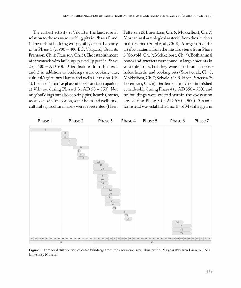
379
Spatial organization of farmsteads at Iron Age and early medieval Vik (c. 400 BC – AD 1250)
The earliest activity at Vik after the land rose in relation to the sea were cooking pits in Phases 0 and 1. The earliest building was possibly erected as early as in Phase 1 (c. 800 – 400 BC, Ystgaard, Gran & Fransson, Ch. 1; Fransson, Ch. 5). The establishment of farmsteads with buildings picked up pace in Phase 2 (c. 400 – AD 50). Dated features from Phases 1 and 2 in addition to buildings were cooking pits, cultural/agricultural layers and wells (Fransson, Ch. 5).The most intensive phase of pre-historic occupation at Vik was during Phase 3 (c. AD 50 – 350). Not only buildings but also cooking pits, hearths, ovens, waste deposits, trackways, water holes and wells, and cultural /agricultural layers were represented (Heen
Pettersen & Lorentzen, Ch. 6, Mokkelbost, Ch. 7). Most animal osteological material from the site dates to this period (Storå et al., Ch. 8). A large part of the artefact material from the site also stems from Phase 3 (Solvold, Ch. 9; Mokkelbost, Ch. 7). Both animal bones and artefacts were found in large amounts in waste deposits, but they were also found in post-holes, hearths and cooking pits (Storå et al., Ch. 8; Mokkelbost, Ch. 7; Solvold, Ch. 9, Heen Pettersen & Lorentzen, Ch. 6). Settlement activity diminished considerably during Phase 4 (c. AD 350 – 550), and no buildings were erected within the excavation area during Phase 5 (c. AD 550 – 900). A single farmstead was established north of Mølnhaugen in
Figure 3. Temporal distribution of dated buildings from the excavation area. Illustration: Magnar Mojaren Gran, NTNU University Museum

380
Environment and settlement | Ingrid Ystgaard
Phase 6 (C. AD 900 – 1250), comprising buildings, waste deposits, wells, and ditches (Fransson, Ch. 10).
Macrofossils from archaeological features are usually of vital importance to the interpretation of the spatial and social organization of Iron Age and medieval settlement. Therefore, macrofossil samples were analyzed from a large number of the postholes excavated at Vik. However, preservation conditions for macrofossils were very poor (Linderholm et al., Ch. 4; Moltsen 2017; Ystgaard et al. 2018:47). There are two possible reasons for this. First, few of the buildings at Vik had burned down, so the macrofossils were not carbonized and were therefore less well preserved. Second, only the lower part of most postholes were preserved under the plough soil, and macrofossils from the upper parts of the structures were therefore not preserved.
Soil chemistry, i.e. content of phosphate, can in some instances also indicate functional divisions of Iron Age houses into living spaces for humans and animal byres. Sometimes, the presence of animals outside of buildings can also be indicated. The level of magnetic susceptibility can be an indicator of human activity which heated up the subsoil, i.e. hearths and ovens. However, there are several sources of error connected to all these methods (for a detailed discussion, see Linderholm et al., Ch. 4). Soil chemistry samples were collected both in grids from the subsoil surface in areas with Iron Age occupation, and from archaeological features such as hearths and postholes.
In instances where floor remains are preserved, soil micromorphology can indicate functions in the relevant part of the building by assessing the contents of the floor (Macphail 2016, 2017). Floor remains from only one building at Vik were analyzed (see below). Soil micromorphological analyses were also carried out on samples from agricultural and cultural layers, waste deposits, wells, and sunken lanes (Macphail 2016, 2017, Linderholm et al. Ch. 4).
SPATIAL ORGANIZATION OF PRE-ROMAN IRON AGE FARMSTEADS AT VIK (PHASES 1 AND 2)In the earliest phase of occupation, Phase 1, the Vik farmsteads seem to have been of the wandering type, characterized by one longhouse, alternatively one longhouse and a four-post construction, comprising all the functions of the farm that required a roof. The earliest pre-Roman Iron Age longhouse at Vik, House 1 in Field A, was established on pristine land in Phase 1, and occupied for a short period of time, possibly only one generation. Houses 8 and 10 in Field B were established on pristine land either in Phase 1 or very early in Phase 2, and might also represent a wandering pattern of settlement (Figures 4 and 5; Buckland et al. 2017:28; Fransson, Ch. 5). While the sites of Houses 1 and 10 were never re-occupied after the buildings were abandoned, new buildings (Houses 11 and 13) were erected on the site of House 8 in the earliest part of Phase 2. The erection of new buildings on earlier occupied sites became the rule at Vik during Phase 2. Houses 3 and 7 in Field B were probably occupied simultane-ously, and House 6 followed them on the same site (Figure 5). Together, these buildings constituted a farmstead which moved towards the fixed farmstead, in that buildings followed each other on the same site, and that functions within the farmstead were shared between two buildings (Houses 3 and 7, Fransson Ch. 5).
House 9 in Field A, dating to Phase 2, was also built on pristine ground (Figure 4; Buckland et al. 2017:35; Fransson Ch. 5), but indications are that House 9 was part of a farmstead extending to the north, outside of the development area (Haugen, Sjøbakk & Stomsvik 2014). Based on dates of the cooking pits surrounding House 9, I suggest that this farmstead was occupied in Phase 2 and the follow-ing Phase 3 (c. AD 50 – 350). My interpretation is also based on the situation of House 18 in Field C,

381
Spatial organization of farmsteads at Iron Age and early medieval Vik (c. 400 BC – AD 1250)
which was built towards the end of Phase 2. House 18 was also built on pristine ground, but constituted the first building in a Phase 3 to 4 farmstead in Field C, which was found to the north of House 18 (Heen-Pettersen & Lorentzen, this volume). It is an intriguing fact that the buildings of Phase 2 do not overlap in time with buildings from Phase 3 (Figure 3). We do not yet have a good explanation for this, but further statistical analysis of the dating material might shed more light on this question.
Cooking pits were associated with all the recorded pre-Roman Iron Age buildings, but the number of
cooking pits associated with each building varied throughout the pre-Roman Iron Age. Relatively few pits were associated with the earliest buildings on the site, Houses 1, 8 and 10, (Figures 4 and 5). Altogether 18 cooking pits surrounded House 1, and they were found in a spread-out pattern. Nine of the pits were dated: three were from the early pre- Roman Iron Age, five were from the late pre-Roman Iron Age, and one pit dated to the Roman Iron Age (Mokkelbost & Fransson 2018:144). Possibly, cooking pits marked the limit between infields or a kitchen garden area connected to the house, and
Figure 4. Phase 1 and 2 (pre-Roman Iron Age) buildings in the northern part of Field A. Illustration: Magnar Mojaren Gran, NTNU University Museum.

382
Environment and settlement | Ingrid Ystgaard
outfields and grazing areas combined with other agricultural land further off. In Field B, relatively few cooking pits were from the same period as the early buildings Houses 8 and 10 (Fransson 2018:446). The tendency for the earliest buildings at Vik to be associated with relatively few cooking pits could be explained by their relatively short periods of occupation.
In Phase 2, there are a higher number of cooking pits associated with each building. Quite a few cooking pits in Field B were dated to the first part of Phase 2, i.e. c. 400 – 200/250 BC, and most of these pits were clustered in groups around Houses
3 and 7. Several cooking pits were also dated to the second part of Phase 2, and were clustered around House 6 (Figure 5; Fransson 2018:447; Fransson Ch. 5). A fair number of pits were associated with House 9 in Field A and House 18 in Field C, both dated to the later part of Phase 2. A large number of the cooking pits associated with these buildings formed an irregular line towards the west, where the terrain from both houses fell towards a lower and more moist area (Figures 4 and 6). This pattern is comparable to a situation described at Torgård, Trondheim, where large clusters of cooking pits were found in the transition zone between dry
Figure 5. Phase 1 and 2 (pre-Roman Iron Age) buildings in Field B. Illustration: Magnar Mojaren Gran, NTNU University Museum.

383
Spatial organization of farmsteads at Iron Age and early medieval Vik (c. 400 BC – AD 1250)
land and marshland, suggesting rituals connected to the cooking pits focusing on the transitional area between dry and wet land (Grønnesby 2015:123).
There were also a fair number of cooking pits dated to Phases 1 and 2 which were not associated with contemporary buildings. These pits were found in central parts of Field A and E, in Field E, and in Fields C and D (Figures 6 – 9; Ystgaard, Gran & Fransson Ch. 1, Figures 7 and 8). This indicates that cooking pits were not strictly associated with the built environment. Instead, some of the cooking pits from Phase 1 and the earliest part of Phase 2 can possibly be associated with animal herding and a mobile land-use pattern. This must have occurred both before and contemporaneously with the built environment (Petersson 2006:169; Ystgaard, Gran & Fransson, Ch. 1).
The Pre-Roman Iron Age farmsteads show var-ying evidence of the presence of animals. The best evidence of indoor stabling of animals on the entire site comes from early Pre-Roman Iron Age House 1, which had remains of a clay floor with a wooden top layer preserved. In the clay flooring, traces of animal dung were found, as well as higher levels of phosphates in the western part of the building (Linderholm et al., Ch. 4; Fransson, Ch. 5). Based on the distance between the trestles, and on the absence of a fireplace, the southern end of House 3, Field B, can be interpreted as a barn, but the evidence is not conclusive (Fransson, Ch. 5). The other buildings from the period were either poorly preserved or did not produce any evidence for barns or byres. Evidence for animal husbandry outside building remains from the pre-Roman Iron Age includes indications of manuring in agricultural layers. The clearest evidence of manuring practices comes from Field E. In this area, dates from cooking pits and a few postholes indicate settlement in the pre-Roman Iron Age, but no buildings from this period were identified, due to disturbance caused
by a 19th century farm. Here, a cultural/agricultural layer was investigated, dating to Phase 2 (Fransson 2018:249-250). In the cultural/agricultural layer, micromorphology analyses indicated fertilizing with both household waste and animal dung (Macphail 2017:32-33). Pollen analyses from the same layers indicated cultivation of barley, some wheat, and some hemp or hops (Overland & Hjelle 2017:38-39).
Buildings 3 and 7, Field B, were among the few buildings at Vik that possibly burnt down. Both yielded a large macrofossil material, indicating crop cultivation (Fransson 2018:414). Based on the presence of both naked and hulled barley, as well as large amounts of straw, House 7 is interpreted as a combined storehouse and threshing barn. Large amounts of straw were also present in House 3, supporting the interpretation of one end of the building as a barn (Fransson, Ch. 5).
Compared to later periods at Vik, fishing is poorly represented in the evidence from the pre-Roman Iron Age. Fish bones were not preserved in any great amounts from pre-Roman Iron Age contexts, but a fishing weight was found in a pit in the southern part of Field A, dated to Phase 2 (Mokkelbost 2018:335). Also, a whale bone was found in a pre-Roman Iron Age well in Field B. This suggests strongly that the location of Vik close to the marine resources was most likely important for its pre-Roman Iron Age inhabitants.
Although the evidence of animal husbandry, agri-culture and fisheries is poorly preserved and in many cases lacking, there is, nevertheless, some evidence of all three activities taking place in pre-Roman Iron Age Vik. Animal husbandry is present in the evidence throughout the period, and judging from evidence elsewhere in Scandinavia and northern Europe, animal husbandry, and perhaps especially that of cattle, was of great importance, both econom-ically and culturally, to pre-Roman Ion Age societies. The change towards more fixed farmsteads during

384
Environment and settlement | Ingrid Ystgaard
Phase 2 possibly indicates an increasing importance for agriculture, associated with a closer relationship between people and place.
Although no graves have been identified close to the pre-Roman Iron Age settlement at Vik, ritual activities are probably present in the material. In both Houses 6 and 7, pottery was found in postholes in the southwestern parts of the longhouses. The deposits could be interpreted as waste, but an interpretation as placed deposits, in line with deposits from the same period in southern Scandinavia, is an option (Fransson Ch. 5, with references).
SPATIAL ORGANIZATION OF ROMAN IRON AGE AND MIGRATION PERIOD FARMSTEADS AT VIK (PHASES 3 AND 4)The earliest fixed farmstead in Vik, comprising Houses 3, 6, 7 and perhaps also Houses 8, 11 and 13, all in Field B, was abandoned towards the end of Phase 2, around 50 BC. At the same time, new settlement was established in Field C, commencing with House 18 (Fransson, Ch. 5). Settlement in Field C thrived throughout Phase 3, and also lasted a while into Phase 4. At the same time, occupation was also intense in the central parts of Fields A and D. Unfortunately, only
Figure 6. Phase 2 and 3 buildings in Field C. Illustration: Magnar Mojaren Gran, NTNU University Museum.

385
Spatial organization of farmsteads at Iron Age and early medieval Vik (c. 400 BC – AD 1250)
parts of the settlement, and no longhouses, were preserved in Field A, because of a 19th century farmstead and modern day military activity. In contrast, buildings in Field D were relatively well preserved. All these three settlements were truly fixed farmsteads, lasting for several generations between c. AD 50 and AD 350, and some also continuing until c. AD 550, with an activity peak around AD 150 – 200 (Figures 6-8).
The layout and function of the settlements in Fields C and D have been analyzed by Heen-Pettersen & Lorentzen (Ch. 6). Their analysis shows that both farmsteads had two longhouses of a distinct
building tradition (Houses 2 and 4 in Field C, and Houses 21 and 28 in Field D). The longhouses had relatively wide center aisles and closely placed tres-tles in the western part of the building, an enlarged central room, and a narrower central aisle and tres-tles placed further apart in the eastern end of the building (Heen-Pettersen & Lorentzen, Ch. 6). The remaining four Roman Iron Age longhouses, House 34 in Field C and Houses 26, 29 and 30 in Field D, comprised two rows of roof-bearing posts, a type recognized from other parts of central Norway and elsewhere in Norway (Heen-Pettersen & Lorentzen, Ch. 6, with references).
Figure 7. Phase 3 (Roman Iron Age) buildings in Field D. Illustration: Magnar Mojaren Gran, NTNU University Museum.
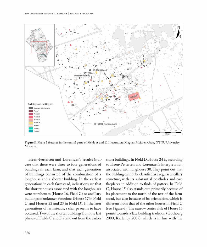
386
Environment and settlement | Ingrid Ystgaard
Heen-Pettersen and Lorentzen’s results indi-cate that there were three to four generations of buildings in each farm, and that each generation of buildings consisted of the combination of a longhouse and a shorter building. In the earliest generations in each farmstead, indications are that the shorter houses associated with the longhouses were storehouses (House 16, Field C) or ancillary buildings of unknown functions (House 17 in Field C, and Houses 22 and 23 in Field D). In the later generations of farmsteads, a change seems to have occurred. Two of the shorter buildings from the last phases of Fields C and D stand out from the earlier
short buildings. In Field D, House 24 is, according to Heen-Pettersen and Lorentzen’s interpretation, associated with longhouse 30. They point out that the building cannot be classified as a regular ancillary structure, with its substantial postholes and two fireplaces in addition to finds of pottery. In Field C, House 15 also stands out, primarily because of its placement to the north of the rest of the farm-stead, but also because of its orientation, which is different from that of the other houses in Field C (see Figure 6). The narrow center aisle of House 15 points towards a late building tradition (Göthberg 2000, Karlenby 2007), which is in line with the
Figure 8. Phase 3 features in the central parts of Fields A and E. Illustration: Magnar Mojaren Gran, NTNU University Museum.
387
Spatial organization of farmsteads at Iron Age and early medieval Vik (c. 400 BC – AD 1250)
dating of the building suggested by Heen-Pettersen and Lorentzen. In Heen-Pettersen and Lorentzens interpretation, House 15 is associated with House 2.
Leif Karlenby (2007) has found that in the Mälaren valley in Sweden, larger, central rooms start appearing in longhouses from around the time of the birth of Christ (Karlenby 2007:124). The enlarged, central room met the need for a meeting room and a room for the greater occasions in life – a storstuga – in farmsteads which had become increas-ingly fixed in place, and which had an increasing number of inhabitants. Around 400 AD, however, argues Karlenby, the functions which, until then, had been served by the main room in the longhouse, were moved out of the longhouse, and held in a separate building. These buildings were the earliest versions of the free-standing hall. In its earliest version, the free-stranding hall was found on almost every farmstead in the Mälaren valley (Karlenby 2007:125). In south Scandinavia, Frands Herschend has found that separate hall buildings existed in most farms from the 3rd to 4th century (2009:253). The removal of the hall functions from the central hearth of the family home accompanied a transition from a kin-based to a class-based society (Karlenby 2007:124). Karlenby has found evidence that after the hall functions had been removed to separate buildings the longhouses remained, but without their former, enlarged central rooms (Karlenby 2007:131). Trond Løken has observed that most longhouses in Forsand had enlarged central rooms, while one building possibly represented a separate hall building (Løken 2001).
In Field D, longhouses 21 and 28 were both of the same building tradition with an enlarged central room. Both longhouses had an ancillary house. We cannot determine the functions of these houses. Associated with longhouse 21 was House 22, a small building with three pairs of trestles and a fireplace in its western end (Lorentzen 2018:564).
No macrofossils were preserved. Associated with House 28 was House 26, which was considerably larger, with six trestles placed in three groups of four posts, and with a central fireplace. A few grains of barley were preserved in the postholes (Lorentzen 2018:576-579). In contrast, longhouse 30 was of the more common building tradition, without the clearly marked central room of Houses 21 and 28, although with a greater distance between the trestles in the central part of the building (Lorentzen 2018:592). Associated with House 30 was the quite special, smaller House 24. The buildings in Field D could illustrate Karlenby’s findings from the Mälaren valley, where house pairs 21 + 22 and 26 + 28 represent longhouses with enlarged central rooms accompa-nied by ancillary houses. In contrast, house pair 24 + 30 could represent the earliest free-standing hall, combined with a longhouse without an enlarged central room.
Field C is more difficult to interpret. Here, House 4 had an enlarged central room, and was associated with House 17, which was of uncertain function but possibly functioned as a combined storehouse and living quarters (Heen-Pettersen 2018:484). House 34 had one, possibly two, larger rooms, although it was not built in the same tradition as House 4. Associated with House 34 was House 16, which most likely was a storage house (Heen-Pettersen 2018:479). House 2 was also a building with an enlarged central room, and associated with House 15, a possible free-standing hall building. This does not fit with the notion that a longhouse associated with an early, free-standing hall should not have an enlarged central room (Karlenby 2007:131). However, House 2 had two phases; House 2a, which was the large version of the longhouse with an enlarged central room, and House 2b, which was a shorter version of the longhouse, without an enlarged central room (Heen-Pettersen & Lorentzen, Ch. 6). One could suggest that House 2b was the house associated

388
Environment and settlement | Ingrid Ystgaard
with House 15, and thus that the functions of the main room of House 2a were moved to House 15, while the remaining functions of the longhouse were found in House 2b. However, 14C dates from the three buildings overlap, and a more nuanced chronological relationship between the buildings has not yet been established (Heen-Pettersen & Lorentzen, Ch. 6).
With these reservations, one can still suggest that the earliest phases of the farmsteads in Fields C and D had longhouses with enlarged central rooms, and that there are indications of free-standing halls in the later phases of the farmsteads. The material corresponds well with the pattern from the Mälaren valley. However, the first possible free-standing halls in Vik occurred around AD 300, which is early in comparison with the Mälaren valley material. The pottery at Vik demonstrates an increasing proportion of finer tableware in the Late Roman Iron Age. This indicates a change in food practice, when commen-sality connected with status and power brought about finer types of pottery and the serving of better food and beverages (Solvold, Ch. 9). This is consistent with a more explicit culture with feasts and rituals focusing on the halls.
The farmstead in Field D was abandoned around AD 350. Farmstead activity in both Fields C and A continued into Phase 4, but there is no evidence of new buildings being erected, and both farmsteads seem to have been abandoned around AD 550. Only one building from Phase 4 (AD 350 – 550) is recorded at Vik, namely House 25 in Field E. This house is found in an area where modern day disturbance and activity through many prehistoric phases blur the picture, and a full interpretation of the layout of the Migration period farmstead in Field E cannot be established (Fransson, Ch. 10). Around AD 550, activity in Field E ceased, and there was an absence of activity at Vik for the next almost 400 years.
Several cooking pits were associated with the Phase 3 farmsteads at Vik. Many were dispersed around the farmsteads, but a large number were concentrated in the areas surrounding the buildings and the area between the buildings (Heen-Pettersen & Lorentzen, Ch. 6). A considerable amount of the contents of the large waste deposits recorded in the central parts of the farmsteads in Fields A and C consisted of fire-cracked stones and charcoal, probably from cooking pits, and there were cooking pits both underneath and surrounding the waste deposits (Mokkelbost, Ch. 7). In the last phases of occupation in Field C, there were even cooking pits inside House 2 (Heen-Pettersen, 2018). A general tendency is therefore that the cooking pits became increasingly tied to the farmstead and to the buildings of the farmstead during Phase 3 (Heen-Pettersen & Lorentzen, Ch. 6). Meals associated with feasts seem to concentrate more on the built environment in Phase 3 than in Phase 2.
Large waste deposits dating mainly to Phase 3 were associated with the fixed farmsteads in Fields A and C. In Field C, where both waste deposits and buildings were preserved, the largest waste deposit was situated just outside and to the west of longhouses 34, 4 and 2. Analysis of the waste deposit in Field C indicates that the earlier parts of this waste deposit were associated with House 4, and perhaps also House 34, while the latter layers of the deposit were associated with House 2 (Mokkelbost, Ch. 7). The waste deposit in Field C consisted of material from cooking pits, as well as household waste including material which had probably been cleaned out of fireplaces in House 2. Whetstones, bone artefacts, rivets and nails, a knife, a fishing hook and a key were represented in the waste deposit. Finer items such as a glass bead and fragments of an imported drinking glass, a silver ring and a bronze ring, as well as pottery and large amounts of animal and fish bones were also found in the waste deposit
389
Spatial organization of farmsteads at Iron Age and early medieval Vik (c. 400 BC – AD 1250)
(Mokkelbost, Ch. 7; Solvold, Ch. 9; Storå et al., Ch. 8). In the central parts of Field A, the relation between buildings and the waste deposits cannot be discerned, since few buildings could be identified. However, the large waste deposit in this area was rich in finds and information. The contents of the deposit indicated that material from cooking pits and fireplaces was represented. Micromorphology analyses of the contents of the deposit identified animal dung and human waste (Macphail 2016:4). Artefacts from the deposit included whetstones, a broken belt stone, rivets and nails, a knife, a fish hook, glass and amber beads and a hand quern as well as pottery; in addition, large amounts of animal and fish bones were also found in the deposit (Mokkelbost, Ch. 7; Solvold, Ch. 9; Storå et al., Ch. 8).
Household waste, human waste and animal dung from the fixed settlements in Fields A and C was thus collected and deposited in defined areas located close to the farmsteads. From these heaps, waste was probably transported to the nearby fields as fertilizer. In Field A, waste transportation is probably recorded in the sunken lane (Buckland et al. 2017; Linderholm et al., Ch. 4).
Evidence of animal husbandry is abundant in Phase 3, thanks to the well preserved waste deposits in Fields A and C (Storå et al., Ch. 8). In the bone material, cattle and sheep/goats were represented to a large degree, and some pig bones were also present. A few bones of wild species indicate that some hunting also took place, but to a limited extent. Kill-off patterns of cattle and sheep indicate that production in Fields A and C was somewhat differently directed. In the Field A waste deposits, cattle kill-off patterns favored adult animals, indi-cating that dairy production was central. In Field C waste deposits, kill-off patterns indicate that meat production was more important. For sheep/goats, kill-off patterns in Field A deposits indicate that meat production was important, while in Field C
animals lived longer and thus wool production could have had greater importance. Analysis of cattle bones show that toe bones were generally not present, indicating that slaughter took place elsewhere, or possibly that hides with attached feet bones were taken elsewhere (Storå et al., Ch. 8).
Fish bones were present in all waste deposits, indicating that local fisheries were of great impor-tance to the everyday diet in Phase 3 Vik. Codfish dominated in all deposits, but codfish species such as Atlantic cod, common ling, haddock and saithe were not evenly distributed. The distribution might indicate that fisheries were specialized towards dif-ferent codfish species in different farmsteads. Also, it could reflect different fishing practices (Storå et al., Ch. 8).
Cultivation took place in the nearby areas, and agricultural layers at Vik are dated to Phase 3. Macrofossils preserved in buildings in Fields C and D as well as in House 25 from Phase 4 in Field E, show that barley was cultivated along with some oats.
Analysis of the Phase 3 pottery at Vik indicates that at least some of the bucket-shaped pottery recovered from waste deposits and buildings was locally produced (Solvold, Ch. 9). Some remnants of what appear to have been ovens and kilns have been examined, but we cannot state whether they were used for pottery production or other production (Mokkelbost, Ch. 7; Solvold, Ch. 9). A pair of ovens were excavated in depressions stratigraphically older than House 34 in Field C. These were most likely baking ovens, although pottery production cannot be excluded (Heen-Pettersen 2018:497-498).
There are a few examples of placed deposits from Phase 3 contexts at Vik. In a posthole in House 34 in Field C, two compete pottery jars were deposited. Our interpretation is that the vessels were depos-ited in connection with rituals associated with the abandonment of the building (Heen-Pettersen & Lorentzen, Ch. 6; Solvold, Ch. 9). A similar deposit,

390
Environment and settlement | Ingrid Ystgaard
this time of a fragmented vessel, was found in House 21 in Field D (Lorentzen 2018:555-556). In general, Phase 3 buildings seem to have been cleaned in connection with abandonment, since very few finds were made in them. This is in contrast to House 2, which does not seem to have been cleaned in the same way. In the case of House 2 complete animals were buried in the final stages of residence in the house; a piglet in a cooking pit, and a foal in a pit associated with the building (Heen-Pettersen & Lorentzen, Ch. 6, Storå et al., Ch. 8).
DECLINE AND ABANDONMENT (PHASE 5)Both archaeological and botanical material indicate that Vik was more or less deserted for a period of almost 400 years between c. AD 550 and c. AD 950 (Fransson, Ch. 10; Overland & Hjelle, Ch. 3, Ystgaard, Gran & Fransson, Ch. 1). This period of decline largely corresponds with material from other parts of Scandinavia. Several reasons for the decline have been suggested, including climatic deterioration both on a long and short term, and in the aftermath possible outbreaks of plague, and societal changes in continental Europe in the aftermath of the fall of the Western Roman Empire (Fransson Ch. 10 with references; Ystgaard, Gran & Fransson, Ch. 1 with references). The Late Antique Little Ice Age (Büntgen et al. 2016) is a very likely reason why the already dwindling settlement came to such an abrupt end. At Vik, signs of local activity are hardly present between c. AD 550 and 950. Still, regional archaeological finds as well as botanical data do show that the region was not deserted altogether (Fransson Ch. 10; Overland & Hjelle, Ch. 3).
SPATIAL ORGANIZATION OF LATE VIKING AGE AND EARLY MEDIEVAL PERIOD FARMSTEADS AT VIK (PHASE 6)Re-occupation in Vik took place in Field E, a part of the excavation area where there are signs of
occupation from most parts of the Iron Age, but where interpretation of these remains has been difficult due to modern day disturbance. The Phase 6 farm was probably not completely preserved. However, a two-aisled longhouse, built in a timber framing technique, was the farmstead’s central build-ing (House 20), constituting a completely different construction technique compared to the Phase 3 and 4 three-aisled buildings at Vik. In addition to the longhouse, a pit house with a raised fireplace was excavated (House 38), as well as three well-preserved wells, a waste pit and three buildings with uncertain dates (Houses 5, 14 and 27), which could possibly represent economy buildings related to the Phase 6 farm (Figure 9; Fransson Ch. 10).
The Phase 6 farmstead thus represented a new spatial organization, where the functions of the farm were divided among several buildings, as opposed to the Early Iron Age preference for collecting functions under the same roof of the three-aisled longhouse (Sauvage & Mokkelbost 2016:289). Oma (2016) argues that the separation of functions between several buildings observed in early medi-eval period farmsteads might reflect a separation between humans and animals as well as between members of the farmstead’s community, and she further relates this to the change from a pagan to a Christian world view. The separation of the functions of the farm between a larger number of buildings also contributed to a more marked gap between the different social groups of the farm (Sørheim 2016). Based on the relatively poor position of the Field E farm, in an area with some moisture in the ground, and on indications of a building technique which reflects re-use of timber, Fransson suggests that the inhabitants of the Phase 6 farmstead at Vik belonged to the lower strata of society. In nearby Viklem, a Viking Age and early medieval period farm with hall buildings, probably belonging to the upper strata of society, has recently been examined (Ellingsen

391
Spatial organization of farmsteads at Iron Age and early medieval Vik (c. 400 BC – AD 1250)
& Sauvage, Ch. 13). The Phase 6 farmstead at Vik gives the impression of being a farm subordinate to the Viklem farm, or possibly to another high status farm in the nearby area (Fransson, Ch. 10).
A characteristic of Late Iron Age farms is that the number of cooking pits decreases. Instead, layers of burnt rocks, associated with beer brewing, are often found close to the farmsteads (Grønnesby 2016, Bukkemoen 2016). At Vik, very few cooking pits were dated to the same period as the Phase 6 farmstead. However, there are no indications of brewing stones near the farmstead. This could be a question of representation, since the area has
been disturbed by modern day activities. However, another explanation could be the relatively low social status of the inhabitants of the farm. Perhaps social expectations of brewing beer and holding feasts did not apply to farmers of the lower social strata (cf. Grønnesby 2016, Bukkemoen 2016)?
Waste was collected in designated pits, and was also discarded in wells which had gone out of use (Fransson, Ch. 10; Randerz, Ch. 11). Micromorphology analysis from a waste pit or a latrine (id. 270600) indicated a combination of household waste, human waste, byre waste and possibly indications of a nearby smithy. The pit
Figure 9. Features from Phases 1, 2, 4 and 6 in Field E. Illustration: Magnar Mojaren Gran, NTNU University Museum.
392
Environment and settlement | Ingrid Ystgaard
was sealed off with clay (Macphail 2017:34-35; Fransson Ch. 10).
Three wells were preserved at the Phase 6 farm-stead. They were different in structure and possibly also function. In one of the wells (id. 224093), a wooden frame, built of re-used wood from boats and buildings, kept the drinking water fresh. The frame closely resembled frames in wells excavated in the medieval town of Trondheim, for instance in The Public Library Site (Christophersen & Nordeide 1994:151, Harald Bentz Høgseth, personal commu-nication). In another well (id. 270321), dug more than 1.5 m down into the clay ground underneath the farmstead, leather shoes, a wooden toy boat and a wooden trough were found in backfill layers, all dating to the early medieval period (Randerz, Ch. 11).
Three buildings of unknown function and obscure date possibly belonged to the Phase 6 farmstead (Houses 5, 14 and 27). These buildings could have been economy buildings or barns belonging to the farmstead. Better indications of the presence of ani-mals, however, are the several ditches that have been examined at the farmstead (Fransson Ch. 10, Figure 14). Animal dung is recorded in micromorphology samples both in waste pits and wells. Botanical studies from archaeological features related to the Phase 6 farm also indicate the presence of animals. Pollen associated with byre material from the waste pit 270600 hold high values of heather and herbs, indicating outfield heathland grazing (Overland & Hjelle, Ch. 3). Both barley and hops/hemp have been identified. Indications are that smithing took place in the farmstead (Macphail 2017:34-35).
CONCLUSIONAs a general tendency, farmsteads at Vik followed the main patterns of spatial organization recorded elsewhere in Scandinavia, although with local var-iations both in layout and chronology. The earliest farmsteads from the first part of the pre-Roman
Iron Age at Vik were of the wandering type, with a short-lived building erected on pristine ground. A spread-out pattern of cooking pits enhances the mobility of the settlement pattern in Phases 1 and 2. The widely spread cooking pits were probably asso-ciated with animal herding, while at the same time cooking pits were also found in association with the built environment. A similar, semi-mobile settlement pattern can be found throughout Scandinavia and Northern Europe during the pre-Roman Iron Age. At Vik, however, a more fixed farmstead already existed around 200 BC, when, in Field B, new buildings were erected close to and over earlier building sites (last part of Phase 2). This indicates that central Norway did not lag behind the southern parts of Scandinavia regarding the first transition towards a more fixed settlement pattern in the last few centuries before Christ. A new transition occurred at Vik around the time of the birth of Christ, when three fixed farmsteads were established in Fields A, C and D, constituting Phase 3. These farmsteads were even more accentuated than the Phase 2 farmstead in Field B. The Phase 3 farmsteads lasted for c. 4 centuries. Extensive remains of these buildings have survived, as have waste deposits. The longhouses in Fields C and D in the first parts of Phase 3 had enlarged central rooms, while in the last part of Phase 3, a separate hall building was erected in both Field C and Field D. The enlarged room is a common trait in early Roman Age buildings in Norway and southern Scandinavia. The later, separate hall building does also seem to represent a common trait, and has been found in south Scandinavia, the Mälaren valley, as well as in Forsand.
Following a steady decline in the Migration period, with only one new building being built (Phase 4), an abrupt decline in settlement at Vik occurred in the last part of the Migration period and the first part of the Merovingian period (Phase 5). This abrupt decline occurring around AD 550 can

393
Spatial organization of farmsteads at Iron Age and early medieval Vik (c. 400 BC – AD 1250)
most likely be connected to the Late Antique Little Ice Age. The decline was followed by an absence of activity during the Merovingian and Early Viking periods. When settlement was re-established in the late Viking Age, only one farmstead was established, in Field E (Phase 6). The three-aisled longhouse, which dominated the previous settlement, was not present in this farmstead. Instead, functions were divided between a two-aisled longhouse and a small group of buildings. There is no evidence supposing that the establishment of this farm-stead formed the beginning of a historically known farm. On the contrary, there are several reasons for attributing it to a low social status. First, it was erected in an area where there had previously been
settlement throughout the Early Iron Age. Second, the farmstead was abandoned by c. AD 1250. This was not the beginnings of a historical farm that was to survive and play a major local role. All in all, the Field E farmstead leaves the impression of a farmstead belonging to the lower social stratum. Perhaps it was subject to the neighboring high status farmstead at Viklem? It is possible that we have found evidence here in Field E of the lower strata of a class-divided society.
ACKNOWLEDGEMENTSThanks to the members of the project team for dis-cussions of the ideas put forward in this paper, and to Ole Risbøl for his comments on an early draft.
394
Environment and settlement | Ingrid Ystgaard
REFERENCES
Berglund, B. 2003: Hus og gard – den arkeologiske bakgrunnen. In: Skevik, O. (ed.): Middelaldergården i Trøndelag. Foredrag fra to seminar, pp. 25-62. Stiklestad Nasjonale Kultursenter.
Berglund, B. & T. Solem 2017: Maktkontinuitet i munningen av Trondheimsfjorden. Arkeologi og vegetasjonshistorie 800 BC – 1200 AD. Heimen 54(3): 206–234.
Bjørdal, E. 2017: Late Iron Age settlement evidence from Rogaland. In: Iversen, F. & H. Petersson (eds.): The agrarian life of the North 2000 BC – AD 1000. Studies in rural settlement and farming in Norway, pp. 241-274. Portal Academic. Kristiansand.
Buckland, P., J. Linderholm, S. Östman, S. Eriksson, J.-E. Wallin & R. Engelmark 2017: Environmental archaeological analysis from the archaeological excavations at Ørland kampflybase, Vik 70/1, Ørland, Sør-Trøndelag, Norway. Environmental archaeology lab, report no. 2017-012. Department of historical, philosophical and religious studies, Umeå Universitet.
Bukkemoen, G. B. 2015: Ett hus – mange livsløp. Boligens biografi i førromersk jernalder belyst gjennom et gårdsanlegg i Askim. Viking 2015: 95-118.
Bukkemoen, G. B. 2016: Cooking and feasting: Changes in food practice in the Iron Age. In: Iversen, F. & H. Petersson (eds.): The agrarian life of the North 2000 BC – AD 1000. Studies in rural settlement and farming in Norway, pp. 117–131. Portal Academic. Kristiansand.
Büntgen, U. et al. 2016: Cooling and societal change during the Late Antique Little Ice Age from 536 to around 660 AD. Nature Geoscience, vol. 9, issue 3. ISSN 1752-0894.
Christophersen, A. & S. W. Nordeide 1994: Kaupangen ved Nidelva. 1000 års byhistorie belyst gjennom de arkeologiske undersøkelsene på folkebibliotekstomten i Trondheim 1973-1985. Riksantikvaren.
Engtrø, D. Ø., & A. Haug, 2015: Arkeologiske undersøkelser - anleggsvei på Ørland kampflybase, Ørland kommune, Sør-Trøndelag. NTNU Vitenskapsmuseet arkeologisk rapport 2015:2.
Eriksen, M. H. 2015: Portals to the Past. An archaeology of doorways, dwellings, and ritual practice in Late Iron Age Scandinavia. Dissertation for the degree of philosophiae doctor. Dept. of Archaeology, Conservation, and History. University of Oslo.
Fabech, C. 1999: Centrality in sites and landscapes. In: Fabech, C. & J. Rigtved (eds.): Settlement and Landscape, pp. 455-473. Jutland Archaeological Society.
Frey, E. H. 2010: Byggeskikk i Trøndelag gjennom eldre jernalder – belyst ved materiale fra moderne flategravinger. Masteroppgave i arkeologi, NTNU.
Fransson, U. 2018: Fält B. In: Ystgaard, I., M. M. Gran, M. Mokkelbost, U. Fransson, A. Heen-Pettersen, A. B. Lorentzen, G. I. Solvold & E. W. Randerz 2018: Arkeologiske utgravninger på Ørland kampflybase 2015-2016. Rapport: 366–456. NTNU Vitenskapsmuseet arkeologisk rapport 2018:27.
Gerritsen, F. 1999: The cultural biography of Iron Age houses and the long-term transformation of settlement patterns in the southern Netherlands. In: Fabech, C. & J. Ringtved (eds.): Settlement and Landscape, pp. 139–148. Jutland Archaeological Society.
Gjerpe, L. E. 2017: Effektive hus. Bosetning, jord og rettigheter på Østlandet i jernalder. Institutt for arkeologi, konservering og historie, Universitetet i Oslo.
Grønnesby, G. 1999: Eldre jernalders hus og hall på Hovde i Trøndelag. Viking 62: 69–80.
Grønnesby, G. 2005: Fra stolpehull til hushold. Utgravninger av hustomter på Kvenild, Trondheim 1998. In: Høgestøl, M., L. Selsing, T. Løken, A. J. Nærøy & L. Prøsch-Danielsen (eds.): Konstruksjonsspor og byggeskikk. Maskinell flateavdekking – metodikk, tolkning og forvaltning. AmS-Varia 43: 97–107. Arkeologisk museum i Stavanger.
Grønnesby, G. 2013: Bosetning på Torgårdsletta, Trondheim og Egge, Steinkjer. Et innlegg i diskusjonen om den norske gårdens opprinnelse. In: Diinhoff, S., M. Ramstad & T. Slinning (eds.): Jordbruksbosetningens utvikling på Vestlandet. UBAS 7: 77–92. University of Bergen, Bergen.
Grønnesby, G. 2015: Jernalderens bosetning i Trøndelag. In: Hedeager, L. (ed.): Dalemfunnet. Norske Oldfunn XXX: 119–127. Kulturhistorisk museum, Universitetet i Oslo.
Grønnesby, G. 2016: Hot rocks! Beer brewing on Viking and medieval age farms in Trøndelag. In: Iversen, F. and H. Petersson (eds.): The agrarian life of the North 2000 BC – AD 1000. Studies in rural settlement and farming in Norway, pp. 133-149. Portal Academic. Kristiansand.
Grønnesby, G. & A. M. Heen-Pettersen 2015: Gården i yngre jernalder – et spørsmål om erkjennelse? Belyst ved utgravningen av et yngre jernalders gårdstun på Ranheim. Viking 78: 169-188.
Göthberg, H. 2000: Bebyggelse i förändring. Uppland från slutet av yngre bronsålder till tidig medeltid. Occasional Papers in Archaeology 25. Insititutionen för arkeologi och antikens historia, Uppsala universitetet. Uppsala. Dissertation (PhD).
395
Spatial organization of farmsteads at Iron Age and early medieval Vik (c. 400 BC – AD 1250)
Haugen, H., I. Sjøbakk & K. H. Stomsvik 2014: Arkeologisk rapport. Maskinell søkesjakting og manuell prøvestikking i forbindelse med reguleringsplan for ny kampflybase, samt ny gang- og sykkelveg mellom Uthaug og Hårberg, Ørland kommune. Sør-Trøndelag fylkeskommune.
Heen-Pettersen, A. 2018: Felt C. In: Ystgaard, I., M. M. Gran, M. Mokkelbost, U. Fransson, A. Heen-Pettersen, A. B. Lorentzen, G. I. Solvold & E. W. Randerz 2018: Arkeologiske utgravninger på Ørland kampflybase 2015-2016. Rapport: 457–545. NTNU Vitenskapsmuseet arkeologisk rapport 2018:27.
Henriksen, M. M. 2007: Husby i Stjørdal – kongsgård eller ferdahus? Viking 2007: 71–88.
Henriksen, M. M. & H. Bryn 2019: Hofstad i Melhus – bolig og hushold i førromersk jernalder. In: Berge, R. & M. M. Henriksen (eds): Arkeologi og kulturhistorie fra norskekysten til Østersjøen. Festskrift til professor Birgitta Berglund: 176 – 200. Vitark 11, NTNU Vitenskapsmuseet og Museumsforlaget, Trondheim.
Herschend, F. 2009: The Early Iron Age in South Scandinavia: Social Order in Settlement and Landscape. Occasional papers in archaeology 46. Uppsala.
Holst, M. 2010: Inconstancy and stability – Large and small farmsteads in the village of Nørre Snede (Central Jutland) in the first millennium AD. Siedlungs- und Küstenforaschung im südlichen Nordseegebiet 33: 155–179.
Karlenby, L. 2007: Bostadens inre liv under nordisk äldre järnålder – betraktelser kring hem och hall. In: Göthberg, H. (ed): Hus och bebyggelse i Uppland. Delar av förhistoriska sammanhang. Arkeologi E4 Uppland-studier, Volym 3, pp. 123-151. Riksantikvarieämbetet. UV GAL, Societas archaeologica Upsaliensis, Upplandsmuseet. Uppsala.
Lorentzen, A. B. 2018: Felt D. In: Ystgaard, I., M. M. Gran, M. Mokkelbost, U. Fransson, A. Heen-Pettersen, A. B. Lorentzen, G. I. Solvold & E. W. Randerz 2018: Arkeologiske utgravninger på Ørland kampflybase 2015-2016. Rapport: 546–613. NTNU Vitenskapsmuseet arkeologisk rapport 2018:27.
Løken, T. 2001: Oppkomsten av den germanske hallen – hall og sal i eldre jernalder i Rogaland. Viking LXIV: 49–86.
Løken, T. in prep.: The Bronze and Iron Age settlement at Forsandmoen: Analysis of houses and site development. AmS Skrifter.
Macphail, R. 2016: Ørland main air station (near Trondheim, Norway): soil micromorphology. Report for Museum of Natural History and Archaeology, Norwegian University of Science and Technology, Trondheim, Norway.
Macphail, R. 2017: Ørland main Air Station (2016 samples), Norway: soil micromorphology (including SEM/EDS analyses). Report for Museum of Natural History and Archaeology, Norwegian University of Science and Technology, Trondheim, Norway.
Martens, J. 2010: Pre-Roman Iron Age Settlements in Southern Scandinavia. In: Meyer, M. (Hrsg.): Haus
– Gehöft – Weiler – Dorf. Siedlungen der Vorrömischen Eisenzeit im nördlichen Mitteleuropa. Internationale tagung an der Freien Universität Berlin vom 20.-22. März 2009. Berliner Archäologische Forschungen 8: 229–250. Verlag Marie Leidorf GmbH. Raden/Westfalen.
Myhre, B. 2002: Landbruk, landskap og samfunn. In: Myhre, B. & I. Øye: Norges landbrukshistorie I. 4000 f.Kr. – 1350 e.Kr. Jorda blir levevei, pp. 11-213. Det norske samlaget, Oslo.
Mokkelbost, M. & U. Fransson 2018: Felt A og E, nordre del. In: Ystgaard, I., M. M. Gran, M. Mokkelbost, U. Fransson, A. Heen-Pettersen, A. B. Lorentzen, G. I. Solvold and E. W. Randerz 2018: Arkeologiske utgravninger på Ørland kampflybase 2015-2016. Rapport: 122-158. NTNU Vitenskapsmuseet arkeologisk rapport 2018-27.
Oma, K. 2016: A shattered farm: Changes in making space from pagan to Christian Norway. In: Dommasens, L. H., D. Gustsmiedl-Schumann & A. T. Hommedal (eds.): The Farm as a Social Arena, pp. 172-190. Waxmann 2016, Münster, New York.
Overland, A. & K. L. Hjelle 2017: Pollenanalyser i tilknytning til de arkeologiske undersøkelsene ved Ørland kampflybase, Vik 70/1, Ørland kommune, Sør-Trøndelag. Paleobotanisk rapport fra Avdeling for naturhistorie, Universitetsmuseet, Universitetet i Bergen. Nr. 09 – 2017.
Petersson, M. 2006: Djurhållning och betesdrift. Djur, människor och landskap i Västra Östergötland under yngre bronsålder och äldre järnålder. Riksantikvarieämbetet.
Rønne, P. 2005: Arkæologiske undersøgelser forud for bygningen af ny E6 gennem Melhus, Sør-Trøndelag. In: Høgestøl, M., L. Selsing, T. Løken, A. J. Nærøy & L. Prøsch-Danielsen (eds.): Konstruksjonsspor og byggeskikk. Maskinell flateavdekking – metodikk, tolkning og forvaltning. AmS-Varia 43: 87–96. Arkeologisk museum i Stavanger.
Sauvage, R. & M. Mokkelbost 2016: Rural buildings from the Viking and early medieval period in Central Norway. In: Iversen, F. and H. Petersson (eds.): The agrarian life of the North 2000 BC – AD 1000. Studies in rural settlement and farming in Norway, pp. 275-292. Portal Academic.

396
Environment and settlement | Ingrid Ystgaard
Solberg, B. 2000: Jernalderen i Norge ca. 500 før Kristus til 1030 etter Kristus. Cappelen Akademisk Forlag.
Sørheim, H. 2016: House, farmyard and landscape as social arena in a time of transition. In: Dommasens, L. H., D. Gustsmiedl-Schumann & A. T. Hommedal (eds.): The Farm as a Social Arena, pp. 191-217. Waxmann 2016, Münster, New York.
Webley, L. 2008: Iron Age households. Structure and Practice in Western Denmark, 500 BC-AD 200. Jutland Archaeological Society.
Widgren, M. 1998: Kulturgeografernas bönder och arkeologernas guld – finns det nogån väg till en syntes?
In: Larsson, L. & B. Hårdh (eds.): Centrala platser – centrala frågor. Samhällsstrukturen under järnåldern. En vänbok till Bertha Stjärnquist. Acta Archaeologica Lundensia 28, pp. 281-296. Almqvist & Wiksell, Stockholm.
Ystgaard, I., M. M. Gran, M. Mokkelbost, U. Fransson, A. Heen-Pettersen, A. B. Lorentzen, G. I. Solvold & E. W. Randerz 2018: Arkeologiske utgravninger på Ørland kampflybase 2015-2016. Rapport. NTNU Vitenskapsmuseet arkeologisk rapport 2018:27.


399
c h a p t e r 1 3
Ellen Grav Ellingsen Department of Archaeology and Cultural History, NTNU University [email protected] SauvageDepartment of Archaeology and Cultural History, NTNU University [email protected]
The northern Scandinavian Viking hall: A case study from Viklem in Ørland, Norway
ABSTRACTOur aim with this paper was to discuss two possible Viking Age and Early medieval wooden hall buildings from Viklem at Ørlandet in relation to the Scandinavian Viking Age halls. To do this we analysed the buildings from Viklem to see to what extent they meet well-established criteria for Viking Age halls in Scandinavia. Since the Viklem halls are the northernmost known examples of such freestanding hall buildings, we have to take local and regional conditions into consideration, such as fundamental geographical factors, political demands and its physical manifestations at Ørlandet and the surrounding areas. Our results showed that the large buildings at Viklem meet many of the criteria that have been established by research in southern Scandinavia. However, we see that the Viklem halls are smaller, and lack the large number of prosperity items that that are associated with most in most of the known halls in the south. We discuss these differences in the perspective of Viklem’s location, close to the sailing route that connected it to the international Viking world. In conclusion, we argue that the large buildings at Viklem must be seen as halls, in view of their size, building technique, location and other factors that distinguish them from contemporary buildings in the same area. Since they also stand out as being markedly different from the southern Scandinavian material, we conclude that the Viklem halls should be interpreted as the first known examples of a northern type of Scandinavian Viking Age hall.
INTRODUCTIONUntil recently, there were no clear traces of late Iron Age and early medieval free-standing hall-type buildings in the archaeological material in northern Scandinavia. An important reason for this is that there have been very few archaeologi-cal investigations of buildings and farms from the Viking Age and early Middle Ages, and, prior to
2014, hardly any were known outside the medieval urban settlements (Sauvage & Mokkelbost 2016). One that was known, and that has been investigated, is a rare indication of a hall-like building; it was found in Trøndelag at Mære, and it has indeed been referred to as an indisputably important find in Scandinavia (e.g. Jørgensen 2009). Mære is one of very few examples of a cult site that the Norse

400
Environment and settlement | Ellen Grav Ellingsen – Raymond Sauvage
sagas clearly mention, and the possibility that there was a hall there cannot be ruled out. Archaeological investigations below the church at Mære have revealed traces of two pre-Christian buildings, and the discoveries of gold votive offerings (gullgubber) can be linked to ritual activity and a possible hall (Lidén 1969). However, archaeological traces of the building itself are very fragmentary (Lidén 1969), and therefore little is known about what type of building this may have been.
In recent years, we have investigated extensive traces of parts of a farmstead dating from the Viking Age and the Middle Ages, on the present-day farm at Viklem, which is strategically placed at Ørland by the important hub in the sailing route along the Norwegian coast – the Norvegr. Two visible monuments located centrally on the farm, a very large Iron Age burial mound with a diameter of at least 50 m, and a medieval stone church, display the status of the farmstead in the Iron Age and the Middle Ages. Archaeological investigations have revealed two free-standing, possibly hall, buildings, one overlapping the other, almost 18 m and 30 m in length and dated to the Viking Age and early Middle Ages.
The localisation near the Norvegr meant that Ørlandet was closely connected to the international Viking world. Because of this, it should be possible to interpret the large buildings on Viklem as belonging to the group of buildings classified as “Scandinavian Viking Age halls”. However, they stand out from most of the known hall buildings in several ways: they are smaller, they appear quite late in the Viking Age and they do have supporting posts outside one of the walls. If these buildings should be interpreted as halls, they are the northernmost free-standing hall buildings known from the Viking Age.
The hall concept has been deduced mainly from the Northern European sagas and heroic poems. In the sagas the hall was an important building as a
focal point for kings, chieftains, and royal retainers (hirden), and as a meeting point between the farm owner and the wider social sphere (e.g. Herschend 1993, 1997, 1998, 2009, Jørgensen 2002, 2009, Söderberg 2005, Gansum 2008, Carstens 2015). Numerous free-standing Viking Age halls are known from southern Scandinavia, but in Norway only one has been proven until now, at Husby in Tjølling in the county of Vestfold (Skre 2007), but two more possible halls have been revealed by GPR (ground penetrating radar) at Borre, also in Vestfold (Gansum 2008). In addition, a pos-sible Migration Period hall has been suggested at Avaldsnes recently, in the county of Rogaland (Skre 2017a). Two of the sites with Viking halls are located in or near Oslofjorden, which then formed the district of Viken, where the political connections with southern Scandinavia were strong. The most substantial suggested hall at Avaldsnes, is is dated to the Migration Period and thus outside the scope of this paper.
Houses 3 and 4 at Viklem were large buildings, one of which replaced the other. Both houses con-sisted of just one large room with a high roof. They were located in an environment in which symbols of power indicated the farm’s status both in ear-lier and later times. Currently, the definitions of halls are based solely on material from southern Scandinavia, and thus do not take into account geographical and regional variations that might occur in other parts of Scandinavia. In other words, we lack an understanding of the free-standing halls in northern Scandinavia from the Viking Age and/or early Middle Ages – that is, in the areas north of the southern Scandinavian Viking age complex, including the Oslofjord region. If we do interpret these building as halls, we might be able to point out some local attributes, which could be the beginning of an understanding of a “northern type” of the Viking Age hall.

401
The northern Scandinavian Viking hall: A case study from Viklem in Ørland, Norway
In this paper we discuss to what extent Houses 3 and 4 at Viklem meet the criteria existing for the southern Scandinavian Viking Age halls, and compare similarities and differences. The landscape at Ørland, the farms’ strategic position along the main sailing route, and the Viklem monuments as political and symbolic communications in this landscape, are an important point of departure.
We use the term “northern Scandinavia” as a means of distinguishing western, central and northern parts of Norway, and northern Sweden, from the southern Scandinavian Viking age complex. We use “southern Scandinavia” to define the area of Denmark, southern Sweden, and southern Norway surrounding the Oslo Fjord. We only consider free-standing hall-type buildings, which rules out longhouses with hall-like sections as seen in Borg in Lofoten.
MATERIAL AND METHODA number of researchers (e.g. Herschend 1998; Carstens 2015) have tried to determine what criteria can be used to identify halls in archaeological remains. The best known criteria have been established by Herschend (1998). He points out that a hall should be located on a large farm, have originally consisted of one room constructed with a minimum number of posts, have a prominent location on the farm and have hearths that were not used for cooking or crafts; further, he maintains that the artefacts found within it should differ from those found in the dwelling house. It is important to be aware that this definition is based on archaeological material spanning a long period and covering an assumed course of development from the Early Iron Age to the early Middle Ages. Furthermore, the definition covers both three-aisled longhouses with hall-like open spaces that formed an integral part of the buildings and halls that were detached constructions. Among researchers who have most recently studied
this subject, Carstens (2015) has focused on the Viking Age in her investigation of Scandinavian halls and identified certain features that they have in common. We will look at these features more closely, and, through a discussion of Houses 3 and 4 in relation to her criteria, assess to what extent the houses fit the definition of halls.
One problem with proposing general definitions is that there is a risk of looking for common features across large geographical areas, which are then gen-eralized to fit other places. In order to understand the halls at Viklem, we consider it necessary to take into account both local and regional conditions. In this regard, factors such as geographical assumptions and political demands become relevant.
The landscape surrounding Ørland contains a number of archaeological manifestations of polit-ical power, and these are particularly evident in monumental burial mounds (Berglund & Solem 2017). Such large mounds have visual impact and were intended to signify power and a sense of belonging at a time when it was important to visualize status and rights. Their visibility from the sea and from routes travelled on land would have served to visualize the farm owner’s status as being clearly above that of others who lived in the area (Carstens 2015:16, Skre 2017a). Medieval stone churches are another political feature in the same landscape, and the first stone church at Viklem was probably built in the mid-1100s, when the latest hall building was still in use. The construction of the stone churches can be seen in the context of both national politics and Church policy (Røskaft 2005:192). By considering the political landscape of which the halls at Viklem form a part, we will be able to perceive them in a larger chronological and geographical framework, which in turn may enable us to gain better insight into the halls in central Scandinavia and the criteria for under-standing them.

402
Environment and settlement | Ellen Grav Ellingsen – Raymond Sauvage
RESULTS
The landscape and the monumentsThe farmstead at Viklem was historically in the care of priests at Ørland and had a strategic location at Brekstad, a present-day trading centre on the edge of Trondheimsfjord. Ørland is situated on Fosen peninsula at the mouth of Trondheimsfjord, opposite Agdenes on the other side of the fjord (Figure 1). Several researchers have pointed to the importance of the area, which linked with all coastal traffic, and to the fact that all routes into and out of the rich agricultural communities in Trøndelag passed through it. Hence, those who
controlled the areas around the mouth of the fjord exerted most power over that traffic (Henriksen 1997, Berglund & Solem 2017). Large monumen-tal burial mounds are part of the archaeological landscape there. Apart from very large concentra-tions of burial sites in the inner parts of the fjord, Ørland and the neighbouring areas have the highest density of large mounds around Trondheimsfjord (Berglund & Solem 2017:209, Forseth & Foosnæs 2017:55). In Ørland, there are large mounds on the Hovde, Viklem, and Opphaug farms. Originally, there were numerous burial mounds, especially along the higher parts in the landscape where the majority of the settlements were also concentrated
Figure 1. The outer area of Trondheimsfjorden and the location of Ørland with Viklem and key sites. Illustration: Magnar Mojaren Gran, NTNU University Museum.
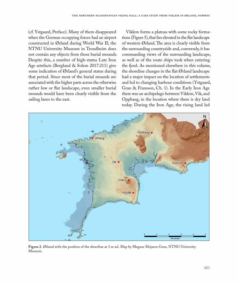
403
The northern Scandinavian Viking hall: A case study from Viklem in Ørland, Norway
(cf. Ystgaard, Preface). Many of them disappeared when the German occupying forces had an airport constructed in Ørland during World War II; the NTNU University Museum in Trondheim does not contain any objects from those burial mounds. Despite this, a number of high-status Late Iron Age artefacts (Berglund & Solem 2017:211) give some indication of Ørland’s general status during that period. Since most of the burial mounds are associated with the higher parts across the otherwise rather low or flat landscape, even smaller burial mounds would have been clearly visible from the sailing lanes to the east.
Viklem forms a plateau with some rocky forma-tions (Figure 5), that lies elevated in the flat landscape of western Ørland. The area is clearly visible from the surrounding countryside and, conversely, it has commanding views of the surrounding landscape, as well as of the route ships took when entering the fjord. As mentioned elsewhere in this volume, the shoreline changes in the flat Ørland landscape had a major impact on the location of settlements and led to changing harbour conditions (Ystgaard, Gran & Fransson, Ch. 1). In the Early Iron Age there was an archipelago between Viklem, Vik, and Opphaug, in the location where there is dry land today. During the Iron Age, the rising land led
Figure 2. Ørland with the position of the shoreline at 3 m asl. Map by Magnar Mojaren Gran, NTNU University Museum.

404
Environment and settlement | Ellen Grav Ellingsen – Raymond Sauvage
to the shoreline shifting to a new position to the south and east, and by the Viking Age there would have been a good harbour in an area c.500–600 m northeast of the Viklem plateau (Figure 2). Today, two monuments in a central position on the farm at Viklem indicate the farm’s status in the Iron Age and the Middle Ages: the burial mound and the church. The halls were located close to the cemetery and must have been similarly visible monuments in the landscape. In the following, we review these monuments from the landscape perspective presented in the Introduction.
The ‘Viklem mound’, c.60 m north of the medie-val church, is the most prominent archaeological cultural monument in Viklem today. It has been surveyed with the latest topographical and terrain models based on airborne laser scanning (LiDAR), and is c.50 m in diameter and c.6 m in height (Hoydedata.no 2018). The mound has a number of traces of earlier excavations, and earlier aerial
photographs show traces of a potetkjeller (a partly stone-built construction for storing potatoes and other root vegetables) in the northwest, as well as traces of trenches dug across the mound (Figure 4). We do not have any information about who dug the trenches or whether there were any finds from them. However, in 2002, a square exploratory trench measuring 1 m2 was dug at the base of the mound (Berglund & Solem 2017:224). A possible burnt layer was found at the base of the mound, above which a row of three stones was visible, and interpreted as possibly forming part of a stone circle. Charcoal from the bottom layer was dated to the Bronze Age and pre-Roman Iron Age (BC 800–555 (Tua-4202, 2550 +/- 50 BP) (Berglund & Solem 2017:224). The exca-vation only afforded a brief insight into the edge of the burial mound. Notably, no clear connection was established between the burnt layer and the burial mound. The latter point has also been emphasized by Berglund & Solem (2017:224), who think that
Figure 3. The church and the large burial mound at Viklem. Photo: Kristian Pettersen.

405
The northern Scandinavian Viking hall: A case study from Viklem in Ørland, Norway
the burnt layer should be seen in relation to activity prior to construction of the mound. However, the possible remains of a stone circle indicate that the burial mound might have originated from the Early Iron Age, or possibly either the Roman period or the Migration Period. We find it somewhat prob-lematic to conclude that three stones aligned in a 1 × 1 m row can be interpreted as being part of a
circle around the entire mound. Thus, the dating of the Viklem mound must be regarded as uncertain. Earlier investigations have shown that large mounds were often the result of a number of events over time, which often represented different burials. The oldest are likely to have dated from the Roman or Migration Period, when they would have appeared as low mounds (e.g. Ellingsen & Grønnesby 2012;
Figure 4. Aerial photo from 1969 showing Viklem farm, church, churchyard and the burial mound (Norgesbilder.no).

406
Environment and settlement | Ellen Grav Ellingsen – Raymond Sauvage
Østmo & Bauer 2017a). Thereafter, they were rebuilt a number of times, with extensions and additions, and eventually ended up as large mounds in the late Iron Age.
In their time, Houses III and IV would have been clearly visible monuments at Viklem. They were located c.50 m west of the large burial mound, and oriented roughly east–west. When their location is plotted on a modern map of the Viklem plateau
(Figure 3), it can be seen that they were on the periphery of the occupied area, just on the edge of the plateau to the north. Traces have been found of several possible buildings associated with the Viking and medieval farmstead to the west and east, and thick layers of cultural deposits from the medieval farm are known to exist within the courtyard of the modern farmstead just to the southeast. The halls clearly lie within the northern boundary of
Figure 5. The Viklem plateau with the main monuments and archaeological observations. Map by Raymond Sauvage, 3D data by Hoydedata.no/Kartverket.

407
The northern Scandinavian Viking hall: A case study from Viklem in Ørland, Norway
the farm (Figure 5). We suspect there was a har-bour c.500–600 m to the north of Viklem (Figure 6), and, if that were the case, the halls would have been highly visible due to their orientation. Thus, for those travelling from the harbour and up to the Viklem plateau, the halls and not least the nearby burial mound must have been clearly in view as prominent monuments in the landscape.
Besides the Viklem burial mound, the white-washed church is the only early monument visible in Viklem today (Figure 4). The church has a com-plex construction history. The building that exists
today was probably built around AD 1450–1520 (Brendalsmo 2006:336), but some sections of the building indicate that parts of an earlier stone church were used when the present church was built. Brendalsmo (2006:241, 301) is of the opin-ion that the oldest church dated from the period AD 1140–1160, at a time when there was a lot of stone church construction activity in Trøndelag, and the country in general. It is probable that this was a planned development as part of the wider organization of the Church in Norway in the High Middle Ages (Røskaft 2005:192). The farm at Viklem
Figure 6. Viewshed analysis of Viklem. The monuments could be seen from the green areas in the map. The possible har-bour area lies to the north. GIS application by Raymond Sauvage, NTNU University Museum, 3D data by Hoydedata.no/Kartverket.

408
Environment and settlement | Ellen Grav Ellingsen – Raymond Sauvage
might have eventually been incorporated into that process, since priests were associated with the farm, according to written sources dating from the mid-1300s (Brendalsmo 2006:425). The construction of the stone church on the site indicates that Viklem probably became incorporated into a context of politics and church politics at a high level in the Middle Ages. However, the dating of a possible earlier stone church to the mid-1100s indicates that the latest of the two halls would have existed while that church was under construction (Tables 1 and 2). We also note that the church has been built farther to the east on the Viklem plateau and thus would also have been visible from the sea, located adjacent to the burial mound and the later of the two halls (Figure 2).
Previous investigationsInvestigations carried out at Viklem prior to c.2007 indicated that the area was inhabited throughout the Bronze Age (Berglund & Solem 2017), after which there was continuous settlement on the farm-stead until the Middle Ages. The earliest traces of settlements in Viklem have been found in an area west of the church and the cemetery, where three wooden, three-aisled longhouses dating from the pre-Roman Iron Age and early Roman period have been excavated (Berglund & Solem 2017:217). In both design and size, the houses are reminiscent of other houses known from the pre-Roman Iron Age (e.g. Grønnesby 2005:99, Henriksen 2007:73). There are far fewer traces of buildings from the late Roman period and the Migration Period (Berglund & Solem 2017:218). In the area to the west, there was a distinctive group of cooking pits and postholes of unknown function. A number of the cooking pits were quite large (Mokkelbost & Sauvage 2015:98, Fig. 68).
New investigations in 2014In 2014, new investigations were conducted at
Viklem in connection with a planned expansion of the cemetery. They resulted in the first securely dated Viking and early medieval finds from the farm. A total of five buildings were excavated: four single-aisled buildings with earth dug posts and one pit house (Figure 7). The site was 20–40 m west of the large burial mound, and farther north than where finds had previously been made. The present-day farm in Viklem is located between the main area investigated in 2014 and the area investi-gated earlier (Figure 3). Exploratory investigations on the site, including those carried out in 2016, revealed cultural layers dating from the Middle Ages (Eidshaug & Sauvage 2016). It is likely that the area contains further traces of the Viking and medieval farmstead, and that the area discovered in 2014 was part of a larger complex.
Description of all buildings and finds from 2014 have been published (Sauvage & Mokkelbost 2016), and are only treated superficially here; an overview of them is presented in Figure 7. A rectangular single-aisled house measuring 12.5 m × 6 m (House 1) dated to approximately AD 975–1030, and a large pit house measuring c.6.5 m × 6.5 m (House 2) with a large, stone-lined hearth in one corner, dated to AD 970–1164. Several finds from the pit house will be discussed later (in the section headed ‘Artefacts from the 2014 investigations’). In addition, a rectangular single-aisled house was discovered (House 5). Stratigraphically, it was later than Houses 3 and 4 and differed from them in orientation, and has therefore been interpreted as a later element.
The two buildings that we focus mainly on in this article are the single-aisled Houses 3 and 4, which we think may be examples of central Scandinavian halls (Figure 8).

409
The northern Scandinavian Viking hall: A case study from Viklem in Ørland, Norway
Houses 3 and 4 have been described in detail by Sauvage & Mokkelbost (2016:280–283) and in the excavation report for the 2014 investigations (Mokkelbost & Sauvage 2015). These houses differ significantly from the buildings excavated at Viklem, especially in terms of their size, the fact that they had the same orientation and were similar in design and construction method, and the fact that one over-lapped the other. The earliest house, House 3, was 18 m in length and 7 m wide, and its long walls were convex in plan. In the long walls, roof-supporting wall posts were set in wall trenches up to 50 cm deep. Although the trenches had been disturbed by later activity, it was still possible to observe postholes at intervals of c.80 cm. Outside the northeastern wall trench there was a slightly curved row of 16
posts set in oblique-angled postholes, which have been interpreted as supporting posts (skårder) for the northern long wall. Postholes at the gable ends marked the position of the end walls. There were no clear traces of internal divisions, and thus all remains indicated that the building had only one room, with an area of 140 m2. Radiocarbon dating of charcoal from an internal posthole (Table 1) securely linked the posthole to the house, but since there were no traces of other internal posts, it is not interpreted as part of an internal partition. Because of this the post must have been erected in connection with other activities. The strong roof-supporting wall elements and the external angled supporting posts suggest that the house had a strong foundation and therefore was probably a tall building. Remains of
Figure 7. Plan of buildings excavated in 2014. Illustration by Raymond Sauvage, NTNU University Museum.

410
Environment and settlement | Ellen Grav Ellingsen – Raymond Sauvage
burnt and unburnt animal bones were found among the macrofossils in two of the roof-supporting postholes in the wall trenches. Additionally, the postholes contained a lot of charcoal, which may indicate that the house was burnt down at some stage. Charcoal from the base of one of the wall trenches has been radiometrically dated to AD 778–995, while charcoal from a small post found inside the house has been radiocarbon dated to a slightly later period: AD 895 – 1021. Charcoal from a roof-supporting posthole in the northern wall trench has been dated to AD 897 – 1024. The dates thus fall within the range AD 780–1024, and therefore the house can be dated to the Viking Age. On the basis of this material, it is difficult to give a closer estimation of the construction year
or when the burning occurred, but we return to the question of dating in the discussion of the next building.
House 4 was built immediately after House 3 had been burnt. The new house was at least 27 m in length and 8.8 m in width. To the north, the exca-vated area of the house was disturbed by a modern cable trench, and therefore the total length of the house is somewhat uncertain. However, the possi-ble end of the northern wall trench was observed just west of the modern trench and may indicate that the house was originally 30 m in length. In common with its predecessor, House 4 had strong foundation posts set in two parallel wall trenches. However, unlike the long convex walls in the pre-vious phase, the long walls were quite straight. The
Figure 8. Plan of the hall buildings, Houses 3 and 4. Illustration by Raymond Sauvage, NTNU University Museum.

411
The northern Scandinavian Viking hall: A case study from Viklem in Ørland, Norway
spaces between the posts in the wall trenches were relatively small, which may indicate that many of the posts were replaced during the time in which the house was in use. The spacing may also suggest that the house has had a longer phase of use than House 3, if posts were replaced when they rotted. A number of postholes on the north side of the building could be interpreted as having contained angled support posts (skårder) for the roof struc-ture. The strong foundations, roof-supporting wall elements, and external angled supports indicate that House 4 must also have been a tall building. Several postholes found inside the house have been interpreted as belonging to the building, but were not arranged in such a way that suggested they were the remains of internal partition walls. This building, too, probably consisted of one room, with a total area of 237 m2 – almost 100 m2 larger than its predecessor. Additionally, burnt and unburnt animal bones were found in a wall trench, both in the remains of an internal post and in a posthole belonging to one of the end walls.
It is difficult to establish the exact transition date of the burning of House 3 and the construction of House 4. The last dates from the earlier House 3 lie within the range of 897–1024 AD, and charcoal from the bottom of the eastern wall trench of the younger house 4 has been radiometrically dated to
AD 1041-1218 (Table 1 and 2). This large range in the later date is caused by a plateau in the calibration curve in the late Viking Age and early medieval period that makes it difficult to establish which part of the centuries the last dates represent. However, since House 4 is superimposed on top of, and cuts into the remains of, house 3, and the later building was raised in the same style as the previous one, it is reasonable to assume that house 4 was quickly constructed after House 3 burned down. Our opinion is that this action took place within the earliest part of the range of the latter date. Based on the range of the last dates from House 3 we assume this took place in the first half of the 11th century.
The last dates from House 4 come from two posts in what might have been the remains of end walls. Their range indicates a later date for this construc-tion, in the late Middle Ages. We are uncertain how this should be interpreted, but we think that such a late dating may reflect a long phase of use, during which the posts were replaced a number of times. This evidence was observed in the long wall trenches as multiple post-holes that represent several replacements of wall posts during the life of the building. With a construction phase in the first half of the 11th century and a last phase in the later middle ages, we suggest that the building had a long lifespan of at least 300 years.
Context Dated material Lab. ID Date before
present (BP)Calibrated age (68.2% probability)
Calibrated age (95.4% probability)
Wall trench 425 Charcoal BETA-389188 1120±30 893–970 AD 778–995 AD
Internal post 230 Wood, Pinus BETA-401518 1070±30 BP 905– 1016 AD 895–1021 AD
Roof-supporting Posthole 372 in wall ditch
Charcoal, Pinus
BETA-401516 1060±30 BP 970–1019 AD 897–1024 AD
Table 1. 14C dates from House 3.

412
Environment and settlement | Ellen Grav Ellingsen – Raymond Sauvage
Houses 3 and 4 were undoubtedly large build-ings, although they are a lot smaller than their south Scandinavian relatives. This is pointed out in a review of all known building remains from central Norway from the same period (Sauvage & Mokkelbost 2016), as well as by Berglund & Solem (2017), who emphasize that they are the largest Viking and early medieval buildings discovered in Trøndelag. It has previously been argued that, as single-aisled buildings, Houses 3 and 4 must have been built using stave construction methods without internal roof-supporting posts (Sauvage & Mokkelbost 2018). The method is known from archaeological contexts throughout much of northern Europe (Christie 1974, Hauglid 1989, Jensenius 2010), but is probably best known from the later stave churches, of which the oldest ones – known as post churches (e.g. Jensenius 2010) – had earth dug posts, often with corner staves and intermediate staves in the walls. Traces of such buildings have been found below a number of medieval churches ( Jensenius 2010). The closest example in Trøndelag is an earlier wooden church in Sparbu, the remains of which were found below the church at Mære (Mære kirke) (Lidén 1969). A further example is a profane building with preserved wooden remains, found at the public library site in Trondheim (Christophersen & Nordeide 1994:164). The excavated elements in
those buildings were similar to the building traces dating from the AD 900s and later at Viklem. The style of building was introduced around the AD 900s, as it was elsewhere in northern Europe (Sauvage & Mokkelbost 2016:289). The technique makes it pos-sible to build higher structures than those with three aisles, and therefore larger and more open internal spaces would have been possible (Olsen 2009:130). In the case of Houses 3 and 4, this resulted in open rooms, or halls, of 140 m2 and 237 m2 respectively.
Houses 3 and 4 had deep wall trenches in which roof-supporting wall posts were set. A parallel is known from Omgård in west Jutland, where a number of sequential buildings have been inter-preted as halls, three of which resemble Houses 3 and 4. The houses at Omgård had supporting stave walls – 22–26 m in length and 6–7.8 m wide – set in wall trenches similar to those at Viklem (Nielsen 1980:194–197, Figs. 19 and 20). Another parallel in terms of construction method is the stave-built church found below the Mariakirken in Oslo, where both of the long walls were set in trenches, as in Houses 3 and 4 at Viklem. At the bottom of the trenches, the staves rested on timbers that had been split lengthwise (halvkløyving) ( Jensenius http://www.stavkirke.info/). It cannot be ruled out that Houses 3 and 4 had a similar construction. Terje Gansum (2008:207–208) points out that the need
Context Dated material Lab ID Date before
present (BP)Calibrated age (68.2% probability)
Calibrated age (95.4% probability)
Wall trench 345 Charcoal BETA-389188 890±30 1050–1206 AD 1041–1218 ADRoof-supporting posthole 6620 in wall ditch
Charcoal BETA-401518 590±30 1313–1403 AD 1299–1413 AD
Post 6609 from the end wall Wood, Pinus BETA-401516 570±30 1320–1411 AD 1304–1423 AD
Table 2. 14C dates from House 4.

413
The northern Scandinavian Viking hall: A case study from Viklem in Ørland, Norway
for such a strong foundation was clearly due to the fact that the buildings were tall. Another striking feature, previously unknown in Trøndelag, is the angled exterior posts (skårder). Such posts have been found in specific circumstances, such as in contexts with harsh climates or with tall buildings such as Møre-type stave churches (Christie 1978). Ørland is exposed to wind and harsh weather conditions, and given the prevailing often strong winds from the south-west at Ørlandet, it seems reasonable to assume that the construction method was used at Viklem.
Artefacts from the 2014 investigationsThe material excavated at Viklem primarily relates to activities that can be expected to have taken place on a Viking or early medieval farmstead. Can any of the finds shed further light on the possible halls and features associated with them? Most of the artefacts were found in association with the pit house to the north-east of Houses 3 and 4 (Figure 9). The finds came from different contexts, indicat-ing that they were deposited in different phases. A group of finds was discovered associated with the phase in which the pit house was in use, including a spherical copper alloy weight with two opposing flattened poles and weighing 24.92g from the floor layer. Other findings from the same phase included two spindle whorls, loom weights, an arrowhead, slate needle sharpeners with holes at one end, nails, and needles (Mokkelbost & Sauvage 2015:79–83). Especially the latter artefacts are typical in textile production the Viking Age, probably the late Viking Age (Mokkelbost & Sauvage 2015:94).
Another group of discoveries was made higher up in the infill in the pit house. These included a bronze alloy ringed pin (Mokkelbost & Sauvage 2015:85). The pin is 8.2 cm long, with a flat head with linear decoration on both surfaces (Figure 9). The head is 1.6 cm long, has an uneven diamond
shape, and appears to have lost a number of protru-sions. The upper 2.5 cm of the shaft below the head has linear decoration in the form of crossing lines. The ring was originally c.1 cm in diameter and was undecorated. The ringed pin probably belongs to a type called flat-headed ringed pins and might have been ‘link-ringed’ (Fanning 1994:109–110, Fig. 92). There do not seem to be any parallels in Norway; the nearest parallels have been found in Hedeby, Dublin, and Schleswig (Glørstad 2015:85). Another discovery from the same phase at Viklem is a finger ring 2–3 cm in diameter and made of braided silver threads (Figure 9). The ring was initially thought to have been made of bronze (Mokkelbost & Sauvage 2015:95), and the fact that it was silver was only revealed during conservation (conservator Leena Airola, pers.comm. March 2015). The ring is similar in appearance to a Viking gold ring from Waterford in Ireland (Bøe 1940:105, Fig. 72).
A third group of finds comprises surface finds from the ploughsoil, found by metal detection in advance of the archaeological investigations in 2014 (Figure 10). They consist of four possible weights, and one or two possible lead seals. Other surface finds include a pendant (the shape of which is rem-iniscent of Thor’s hammer), a conical lead spindle whorl, a copper alloy fitting, and some unidentified copper alloy fragments (Mokkelbost & Sauvage 2015:89–92). The four possible weights and lead seals are difficult to date typologically, as they do not have any distinguishing characteristics. A parallel for the spindle whorl was found in the pit house, and may date from the Viking Age or early Middle Ages. All of the finds came from north of the occupied area, where the terrain starts to slope down away from the site. Exploratory archaeological surveys there have only revealed two possible postholes (Mokkelbost & Sauvage 2015). Although the findings cannot be more closely related to contexts, buildings, and periods, they nevertheless reflect activities on the

414
Environment and settlement | Ellen Grav Ellingsen – Raymond Sauvage
farm in the Late Iron Age and the Middle Ages. One possibility is that the objects were moved down the slope from the more central occupied area as a result of later farming activities.
The artefacts from Viklem derive from two dif-ferent types of activities. The first group can be related to crafts and manufacturing at a time when the pit house was in use. They include objects that might have had different functions on a farm. For example, the weights might have had various uses, particularly in connection with textile production and fine metalworking (Pedersen 2001:24–27). Others, such as the loom weights, needles, and needle sharpeners with a hole pierced at one end, can also
typically be associated with textile production. A stretched interpretation of pit houses is that they were linked to crafts such as textile production, due to the artefacts found in them (e.g. Fallgren 1994; Milek 2012), and the pit house at Viklem fits with this interpretation.
The second group of artefacts was found in the destruction layers in the pit house. These finds were not necessarily related to activities in the pit house, but might have been deposited there at a later date from elsewhere on the farm. The group of finds may thus be indicative of other activities on the farm. Dating of the last burning of the hearth in the pit house and the associated finds suggests that the pit
Figure 9. Metal objects from the pit house. Photo: Åge Hojem, NTNU University Museum.

415
The northern Scandinavian Viking hall: A case study from Viklem in Ørland, Norway
house was dismantled in the early Middle Ages (Mokkelbost & Sauvage 2015:94) and the artefacts might have been deposited in connection with that event. Interestingly, neither the ringed pin nor the finger ring has close parallels in Norway, but they seem to have had a southern Scandinavian or insular origin. Some of the finds made by metal detection cannot be related to specific activities, but they reflect activity on the farm at some time between the Iron Age and Middle Ages. In the absence of a secure context, it is difficult to date some of the other items. The weights and the lead seal may indicate that exchange or trading took place to some extent (cf. Skre 2007:343, Sindbæk 2011:41–43, Pedersen
& Rødsrud 2013:119), but the finds are too few and random to be able to make any further suggestions, with the exception of the possible Thor’s hammer pendant that can be linked to religion and must date to the Viking Age.
DISCUSSIONIn the following we discuss Houses 3 and 4 further in the light of the criteria proposed earlier for the defi-nition of halls, in order to consider more closely how they should be interpreted. It is undoubtedly chal-lenging that the criteria are based solely on southern Scandinavian contexts, but to this date we have found no other examples of similar free-standing hall
Figure 10. Finds made by metal detection, with the possible Thor’s hammer. Photo: Åge Hojem, NTNU University Museum.
416
Environment and settlement | Ellen Grav Ellingsen – Raymond Sauvage
buildings along the western coast, in central Norway or northern Scandinavia at all. In the absence of close parallels for Houses 3 and 4 at Viklem, we can only rely on the southern Scandinavian material available for comparison. However, the strategic position of Ørland and Viklem along the main coastal sailing route, clearly ties this area as we have noted, to the international Viking world. In such a context, relations and similarities to southern Scandinavian free-standing halls should probably be expected. In the following three subsections, we review criteria that Carstens has established for the Viking halls in southern Scandinavia in order to assess to what extent Houses 3 and 4 at Viklem meet them.
Criterion 1: All Viking halls were established at one height in the terrainCarstens’s claim that Viking halls were established at similar raised altitudes (Carstens 2015) applies also to the hall-type buildings at Viklem, as they were situated at a height at which they would have been clearly visible from the sailing routes. The Viklem plateau is also one of the highest places in Ørland, and therefore we can assume that tall buildings such as Houses 3 and 4 were visible from long distances. Thus, those living in Ørland in the Late Iron Age would have been reminded of the power held by the farm at the entrance to Trondheimsfjord every day. In addition, the hall-type buildings were situated close to the large burial mound, as is the church, which might have related to the latest of the two buildings. Visual relationships between the farm and/or church and the fjord indicate that the burial mound, the church, and the probable halls were perceived as symbolic forms of communication by those sailing on the fjord (Guttormsen 2002:44). The large burial mound, the halls, and later the church all faced towards the sea and the sailing route, as well as towards the land routes across Ørland. A parallel can be found at Avaldsnes,
where Dagfinn Skre (2017b) claims that the Iron Age aristocracy used visible structures such as large burial mounds, boat-shaped stones, and a possible hall building as monuments to clearly communicate the large farm’s status and strategic position in Karmøysundet. The monuments were constructed in a way that primarily conveyed information to those on the sailing route, a pattern repeated throughout the Iron Age and later in the Middle Ages, with the construction of a stone church and a royal manor. In our opinion, there are signs of a similar situation at Viklem, where the monuments would have marked and communicated the power and status of the place. All those who entered the fjord would have known that there were powerful people at Viklem.
A number of the southern Scandinavian halls, such as Lejre, Tissø, Omgård, and Uppsala, are associated with royal power and wider international networks (Christensen 2010: 238-239, Herschend 1998:17, Nielsen 1980, Söderberg 2005:109, 183, Jørgensen 2002, Ljungkvist & Frölund 2015). The possible hall buildings found at Viklem are somewhat smaller, but indisputably large in a regional context and clearly stand out in many ways. The situation at Viklem thus resembles the situation known from large farms in southern Scandinavia.
Criterion 2: All Viking halls have traces of cultural activity in or near themAccording to Carstens (2015), with the exception of Boeslunde in Denmark, all Viking halls have traces of cultural activity either in them or near them, or they have been described as cult places in written sources from the Middle Ages. This cultural aspect seems to have become more important over time, usually culminating in churches (Carstens 2015:22, with references to Anglert 1989).
In a number of structures in and around Houses 3 and 4, some osteological remains from animals,

417
The northern Scandinavian Viking hall: A case study from Viklem in Ørland, Norway
both burnt and unburnt, were found. Such finds are often interpreted as traces of ritual sacrifices and cult activity, which formed part of the big feasts held in Viking halls (Gansum 2008:205, Carstens 2015:17). Carstens points out that the cultural activity in the halls would have strengthened the power of the halls’ owners when they organized sacrificial feasts and when the gods were worshiped on their farms (Carstens 2015:17). Previous investigations indicate that bones are more likely to be connected to ritual activity if the bones found are of a special kind (Nielsen 1997:384-385). The animal bones at Viklem have not been analysed, but both the number of bones and the amount of material indi-cate that they represent food waste as well as traces of ritual activity. Still, only a very small number of the roof-bearing posts at Viklem was excavated and emptied, so the actual quantity of animal bones in the posts is an unknown factor.
Another exciting find is the possible Thor’s hammer made of lead (T26288: 121), which was found by metal detection in the vicinity of the halls. The pendant was found in the ploughsoil and should therefore be considered an isolated find. However, its wider context means it is worth closer examination. According to Norse mythology, Thor’s hammer Mjølne was made by dwarfs, and always hit any target. A Thor’s hammer was the best protection that Åsgård (the home of the gods) could have had against the jotuns (giants), who were Thor’s arch enemy (Steinsland 2005:203). The ‘Thor’s hammer’ from Viklem is not a prestigious object and appears to have been home-made, but its symbolism was still the same – it would have afforded protection against evil forces. This sym-bolic item was in common use among the elite up to and including early Christian times (Steinsland 2005:203). The Norse sagas mention a Thor cult in Trøndelag, and, according to monk Oddr Snorrason’s saga of Olav Tryggvason, Thor was worshiped at
the pagan temple at Mære (Steinsland & Sørensen 1994). Nine examples of Thor’s hammer artefacts are known from Norway, only one of which was found in Trøndelag, although the circumstances of its discovery are somewhat unclear. Furthermore, few place names are associated with the cult of Thor in Trøndelag (Nordeide 2006:219). Moreover, given our uncertainty about whether the find from Viklem should be interpreted as a Thor’s hammer, and bearing in mind the fact that it was an isolated find and lacked a secure context, we do not wish to place too much emphasis on it. However, since it was found just outside the halls we still consider it worth mentioning.
Thus far, we have no further indications of any other cultural activity at Viklem, other than the fact that the church was built there in the Middle Ages. The main challenge in this regard is that only parts of the farm have been investigated archaeologically.
Criterion 3: All Viking halls are associated with production sitesAccording to Carstens, with the exception of the hall in Alby, Sweden, each of the well-known Viking halls has been found in association with a produc-tion site with traces of fine metalwork (Carstens 2015:22). No such finds have been made at Viklem. The closest feature to a production site is the pit house, where textiles were produced (Sauvage & Mokkelbost 2016:283). Weights were found within the pit house, and although weights have earlier been found in contexts associated with fine metalworking (Pedersen 2001) the fact that only one weight was found and no other traces of metalworking were discovered does not provide grounds for assuming that any such activities occurred in the Viklem pit house. However, the pit house at Viklem falls within a pattern similar to that seen in southern Scandinavia. Pit houses are common features on large Viking farms, such as Tissø in Denmark, and Toftegård in

418
Environment and settlement | Ellen Grav Ellingsen – Raymond Sauvage
Sweden. This observation supports our assumption that Viklem was an important farm in the Viking and early Medieval phase, where some degree of production for local consumption took place beyond what would have been needed on a smaller farm. However, it cannot yet be claimed that there was a production site at Viklem. That said, we do have to consider that only parts of the farmstead and the surrounding area have been investigated. Traces of production could therefore still remain within the un-investigated areas.
Other factorsAlthough Houses 3 and 4 do not meet all of the criteria for Viking halls suggested by Carstens, we nevertheless claim that they were halls, for several reasons. First, we assume that there were regional differences: ‘There were no DIN standards and no building authorities’ (Carstens 2015:14). Since, to date, we do not have any other material from central Scandinavia, it may be equally important to argue the case for the halls on the basis of local and regional circumstances. Accordingly, we take as our starting point the fact that the buildings were distinct: their size and design, location, and the uninterrupted continuity in the existence of buildings of the same type. We have not found similar parallels for this feature of Houses 3 and 4 in Ørland or elsewhere in northern parts of Norway and Sweden. However, a number of other features in common with the southern Scandinavian halls have been found at Viklem, and must therefore be included in the discussion.
A distinctive feature of Houses 3 and 4 is their unusual size (140 m2 and 237 m2 respectively) within their geographical area: no other house types from the same period had a similar large open space, and therefore the need for such a large space may be questioned. Apart from the fact that it could have held a large number of people at the same time, it
might have been intended to impress visitors by its monumental scale. Such large spaces with high ceilings must have made a considerable impact on people who were used to much smaller and simpler buildings (Carstens 2015:6). The contemporary dwelling buildings at Viklem were much smaller, with smaller spaces indoors, and we have not seen any indications that their walls needed extra support, in contrast to Houses 3 and 4. This may mean that the roofs were lower on the dwelling houses, and thus, Houses 3 and 4 would have appeared as significantly different from contemporary houses on the farm. The fact that the halls were built in an entirely different style from the other houses must have created the impression that they were special in some way. In her discussion of halls found in southern Sweden, Maud Cecilia Andersson (2001) points out that the halls would have had large dimensions, with short distances between the roof-supporting posts across their width, but long distances between the posts along the length, to create the effect of a large open space. The same impact would have been achieved at Viklem – or an even greater impact, since the halls did not have internal roof-supporting posts. This fits well with Andersson’s argument, despite the difference in construction style. The halls at Omgård in west Jutland had a similar architectural style (Nielsen 1980:187–188).
The external angled support posts on the east side of Houses 3 and 4 suggest there were problems with the stability of the roof structure. They were evidently placed to counteract the force of the prevailing winds from the south-west. Similar support posts on one side of the hall at Omgård have been interpreted as signs of repair and stabilization of the construction specifically in relation to the direction of prevailing winds (Nielsen 1980:88). The same might have been the case at the halls in Phases 3 and 4 at Tissø, where there was an absence of roof-supporting posts in the interiors ( Jørgensen 2009:342, Fig. 14). In our view,

419
The northern Scandinavian Viking hall: A case study from Viklem in Ørland, Norway
it is not unthinkable that, in an early phase of the single-aisled building tradition, there was a need to resort to such solutions when there was a desire to construct tall buildings, although such construction methods were not customary. Further, the single-aisled style of building was not introduced until the Viking Age (Sauvage & Mokkelbost 2016), a relatively short time before the halls were built at Viklem.
Another interesting observation is that we did not find any traces of hearths within the Viklem halls. A commonly applied criterion for halls is that they did not contain hearths used for cooking, but only as sources of light and heat (Herschend 1993:8, 1998:16, Andersson 2001:73). The houses at Viklem might have had hearths when they were in use, but the investigated area had been ploughed and cultivated for many years, and therefore archae-ological finds and structures might have disappeared during that time. A further possibility is that raised hearths were used in the halls, in which case traces of such hearths would have disappeared even faster, as the result of intensive ploughing. Given their size, such buildings must have had some form of heating for them to be used most times of the year at this altitude. In any case, since hearths are not always found in hall-type buildings (Andersson 2001:81), we need not place too much emphasis on the absence of traces of hearths at Vicklem.
As several researchers have pointed out, a very important aspect of the discussion of halls is the principle of continuity (Andersson 2001, Carstens 2015). A number of the Viking halls either replaced earlier halls or were replaced following fires. House 3 was built in the late Viking Age and appears to have burnt down at some time late in the AD 900s. Subsequently, House 4 was built on the same site and its walls overlapped those of the earlier building. The two buildings were identical in construction style: both had stave walls set in wall trenches, were tall, and lacked internal partition posts. The
continuity in their building sequence and their spatial relationship is rather distinctive, but seems to have similarities with some of the known hall localities (Söderberg 2005, Carstens 2015). For example, the hall at Tissø was built in the same place twice ( Jørgensen 2009:342). Similarly, the hall at Järrestad (Sweden) was rebuilt at least three times on the same site (Söderberg 2005). If the hall was an important aspect of the owner’s expression of status, perhaps rebuilding was commonly practised and the remains of such rebuilding activities should be expected. Furthermore, rebuilding the hall on the same site might have been an important symbolic act marking continuity and stability among the local leadership (Carstens 2015:19). In this context, it is interesting to note that House 3 was burnt before House 4 was built on the same site. The burning of halls might have had a special meaning. Hall burning is mentioned a number of times in earlier Eddic poems, in which it is often described as signifying ‘the end of a king’s dynasty and his family’s rule’ (Carstens 2015:18). It is difficult to determine from the archaeological material whether House 3 was deliberately burnt, but it is probable that halls were burnt due to rivalry. The hall at Uppåkra has been interpreted as having been burnt down as a result of an attack. Traces were found of the hall having been ritually buried, which supports the suggestion that the attacker was victorious (Carstens 2015:19). However, when the hall was rebuilt in the same place, it could have been an expression that the newly established ruler quickly rebuilt the hall in order to restore the status quo (Carstens 2015:9). Since the phenomenon of ritual or intentional burning is well-known from other halls, Houses 3 and 4 at Viklem fall within a well-known pattern.
Another aspect often emphasized in relation to the definition of halls is that high-status objects are frequently found within or adjacent to them (e.g. Herschend 1998, Andersson 2001:81, Carstens

420
Environment and settlement | Ellen Grav Ellingsen – Raymond Sauvage
2015:15). However, there are very few traces of high-status objects at Viklem. Furthermore, having examined a large body of material relating to halls in Scandinavia, Carstens points out that they were ‘Either very exclusive finds or no finds at all’ (Carstens 2015:15). It is possible that the halls might have been cleared before they were abandoned. Although the hall at Fosie IV (Sweden) lacked artefacts of the type normally expected from halls, it has been assumed that they disappeared during the process of uncovering the sites prior to excavation (Björhem & Säfvestad 1993). That might also have been the case at Viklem.
Although few artefacts were recovered from Viklem, a certain amount of information can be derived from them. Both the ringed pin and the silver finger ring lack parallels in Norway. Indeed, the fact that most of the very few objects from the farm are similarly special in character is an important point that may connect Viklem to the political landscape in Viking Age Scandinavia. The finger ring might have been used as payment in silver, but there were no other traces of hack-silver on the farm. Since it lacks parallels in Norway, it can be interpreted as an imported object, either as the result of looting or as a gift from a high-ranking person. Gifting was often a way of expressing alliances. The hall was central to the relationship between the warriors (hirden) and rulers. Guilds and fests held in the hall maintained loyalty between them, and gifting was important in this respect (Beowulf line 2633, translated by Heaney 1999). The ring from Viklem can be understood in the same context.
The ringed pin is an important item, as such pins emerged as ideological and political status symbols used by men among the elite during the AD 800s. These pins were symbols of their wearers’ alliances and loyalty to the king. There is evidence of their use being especially widespread in western Norway, where Harald Hårfagre had a strong following
(Glørstad 2010:41–249). We know of very few flat-headed ringed pins from central and northern Norway, and therefore it is of particular interest that one is found at Viklem. If it were interpreted as an expression of connection with royal power, it would serve to confirm Viklem’s political role, which in turn would support the suggestion that Houses 3 and 4 should be interpreted as halls. In what way is it possible to link Viklem to royal powers – is it in the form of an alliance or as a decreed protector? This strategic location would have been a key site, providing the opportunity of visually controlling all vessels entering and leaving the Trondheimsfjord.
It is natural to imagine that its commanding position afforded great opportunities to control the traffic, possibly through taxation, offers of protection, or threats of plundering. In addition, a farmer with a large farm close to a large burial mound would have had the advantage that the location itself marked the farmer’s status relative to that of his ancestors, which in turn would have confirmed the need for land and power there (Carstens 2015:7). One way in which petty kings could have gained control in the area would have been to enter into an alliance with the farmer who owned a large farm at Viklem. The ringed pin could therefore be interpreted as confirmation of such an alliance, as was often the case in western Norway (Glørstad 2010).
It is worth noting that, in contrast to a number of other large farms in Ørland, Viklem is not mentioned in the sagas. This is quite strange, considering the results of the archaeological investigations. From written sources, it appears that the farm at Opphaug was the most powerful farm in the late AD 900s (Rian 1992:460). A powerful man named Skjegge Asbjørnsson, also known as Jarnskjegge, had his seat there until he was killed at the pagan temple at Mære in AD 997. Jarnskjegge was the leader of the pagan Trøndelag farmers’ opposition to King Olav Tryggvason, and is traditionally said to have been

421
The northern Scandinavian Viking hall: A case study from Viklem in Ørland, Norway
buried at Austrått. According to sagas about Harald Hardråde (Harald Sigurdsson, king of Norway in the mid-1000s), Austrått was a large farm in the mid-1000s, and must have been confiscated by the earlier kings (Holmsen 1976:113). There might have been a shift in power after Jarnskjegge’s death. During the Late Iron Age, the harbour at Opphaug and Hov was lost due to the land rising (cf. Ystgaard, Gran & Fransson, Ch.1). According to written sources, it seems that Austrått might have acquired a central position during that period, and the archaeological material gives the impression that Viklem, too, was important in that respect. Dagfinn Skre (2017b) is of the opinion that prior to the unification of Norway, the petty kings in western Norway were mainly linked to large farms at stra-tegic points in the landscape, where good harbour conditions and proximity to the coastal routes were crucial. A number of farms may have had differing relationships of dependency on one another – some may have been under the control of one person. It can be assumed that a number of the large farms were seized in connection with the unification of the petty kingdoms. However, Skre indicates that they often continued to have key functions, such as administrative and/or church functions (Skre 2017b:798). We regard Viklem as one of the farms in Ørland that was clearly characterized by such a link, due to its proximity to the coastal sailing route and vessels entering Trondheimsfjord. In this respect, we also see there was a continuation of important functions in the Middle Ages, such as churches and eventually farms managed by priests. According to the sagas, the earls of Håløyg (Lade, Trondheim) conquered the northern coastal areas and Nordmøre in the Late Iron Age, and initially settled in the area around the mouth of the fiord. Two important players were Grjotgard Jarl, who was associated with Selva in Agdenes, and his son Håkon Jarl (Håkon Sigurdsson). Håkon Jarl had a
seat in Ørland before he settled at Lade in alliance with Harald Hårfagre in connection with the uni-fication process (Henriksen 1997:89–90, including references). Could the farmer at Viklem have been in alliance with these key actors? Alternatively, was the farm directly subject to the earls of Holøyg and thus under royal power in connection with the unification of the petty kingdoms. Regardless, why Viklem is not mentioned in the sagas is unclear, but we think it relevant to ask what underlying strategic or political factors could have lain behind its non-appearance there.
A church built on a large farm might have been seen as a political mark of support for the king’s power (Skre 1988:8–10). The church at Viklem appears to have been built at the same time as the church on the farm Austrått, and since the con-struction of stone churches called for skills that were likely to have been sourced externally (Skre 1988), is it reasonable to ask whether there might have been cooperation between the two farms in this respect. Since the farm at Austrått had been subject to the rule of kings relatively early, the construction of the church at Viklem should be seen as a sign that those in authority there were also in league with the kings, which may be confirmed by the ringed pin found at Viklem. Furthermore, although a number of farms in the area probably had wooden churches, there must have been a reason why Viklem had a stone church. Clearly, the circumstances were in place for church construction precisely there: the farm was a focal point, with surpluses in terms of its economy, and it had a central location in relation to the traffic on the fjord. The sense of belonging with the ancestors who had lived on the farm would have been supported and confirmed by the existence of the large burial mound. The drying of the harbour at Opphaug and Hov (and at Vik, as discussed in Ystgaard, Gran & Fransson, Ch. 1) must have had a major impact on the development potential of the two farms. In this

422
Environment and settlement | Ellen Grav Ellingsen – Raymond Sauvage
case too, an alliance with petty kings might have led to support for the building of the church, not only making it possible, but also important.
The large monuments at Viklem would have been been highly visible in the flat landscape at Ørland, as visualised in the viewshed analysis in Figure 6. The tall hall buildings and the burial mound would have been eye-catching to those who sailed in and out of the Trondheimsfjord in this important junction in the coastal sailing route - Norvegr. The visual relationships between the farm and fjord must have been such that both the burial mound and the halls would have been perceived by travellers both on the fjord and the Norvegr as symbolic forms of commu-nication. The location itself marks and confirms the status of those responsible for the construction of the halls in relation to their ancestors, and is a strong symbol of the requirements for both land and power there. Later, the stone church was also included as another manifestation and visual monument, and should be seen as a similar expression. At the same time, it also expressed the fact that the medieval farm was part of a larger institutionalized organization, in which the function of the halls eventually ceased.
CONCLUSIONSIn the introduction, we set out to discuss to what extent Houses 3 and 4 at Viklem meet the existing criteria for Viking Age halls, and to try to define some local attributes to better understand the hall as a building in a northern context. The landscape at Ørland, the farms’ strategic position along the Norvegr, and the Viklem monuments as political and symbolic communications in this landscape were an important point of departure.
Although we know little of how the hall in a north-ern Scandinavian perspective should be understood, a number of factors indicate that the large houses at Viklem should be interpreted as halls. The reason behind our claim is that the houses differ significantly
from other contemporary houses found at Viklem. Houses 3 and 4 were much larger, with only one large room, and appear to have been very tall, in addition to having an elevated position in the landscape. There are no signs of common farm functions, such as living quarters, barns, or stables. When House 3 seems to have been burnt down, it was replaced on the same site by a larger house. Such continuity in the hall buildings is quite distinct and is well documented in southern Scandinavia. The location is close to an earlier large burial mound and a later medieval church, on a strategically well-positioned farm at the entrance to the Trondheimsfiord, where there were many other special large burial mounds. Thus there was continuity in a landscape over time, manifested by monuments that also expressed the need for consolidation of power – burial mound, hall, and church.
The halls are clearly distinct in their local and regional context, where we have no clear parallels. The halls and the other monuments at Viklem can be seen as manifestations of power at Ørland, that communicate visually with those sailing in and out of the entrance to the Trondheimsfjord and on the main coastal sailing route. We interpret this as grounds for interpreting the large houses at Viklem as halls in the social sense, as an interface between the owner of an important farmstead along the sailing route, the travellers and the locals. However, the houses should also be seen as halls in a political sense, as an expression of practical power in a strategic central landscape, connected back in time through the large burial mound and forward in time through the church.
The halls differ from the southern Scandinavian archetype in several ways. We have found no clear production site associated with Viklem, and the traces of cultic activity are few and are from the medieval church. However, the farmstead is not fully excavated and such activities may lie within

423
The northern Scandinavian Viking hall: A case study from Viklem in Ørland, Norway
unexplored parts of the area. We also have some hints of cultic activity, such as animal bones in post-holes, and the find of a possible Thor’s hammer. The halls at Viklem are built on the same architectonic principles, but they were smaller, and had adopted outside angular supports on their northwestern side. Perhaps this reflects an adaptation to the local environment, because of the harsh climate along the Norwegian coast, where the flat landscape at Ørland is particularly exposed to strong sea winds. This observation suggests that halls in the northern Scandinavian contexts could have been deliberately built smaller and stronger than their contemporaries in the south.
When new material comes to light, we will be able to further explore the northern free-standing halls. The lack of a production area and larger numbers of finds with special features may be among the relevant factors that could be further tested. Also we should investigate the nature and significance of
local adaptations concerning size, architecture and construction. Similarities regarding situation and connection to other monuments, like large burial mounds and medieval churches, seem to be an impor-tant factor, and should be taken into consideration. Perhaps the criteria need to be adjusted and adapted to local variations in this part of Scandinavia. In the future we might find other similarities that do not emerge from such a small basis for comparison.
ACKNOWLEDGEMENTSSpecial thanks are due to Marte Mokkelbost for comments on earlier parts of this article, and for her considerable contribution to the interpretation of the finds made by metal detection and the pit house. Additionally, we thank Ingrid Ystgaard and Geir Grønnesby for their comments and discussions. We also forward our thanks to the anonymous referee, for helpful insights in the finishing stages of preparing this paper for publishing.

424
Environment and settlement | Ellen Grav Ellingsen – Raymond Sauvage
REFERENCES
Anglert, M. 1989: Den kyrkliga organisationen under äldre medeltid. In: Anderson,H. & M. Anglert (ed.): By, huvudgård och kyrka. Studier i Ystadsområdets medeltid, pp. 221–242.
Lund Studies in Medieval Archaeology, Vol. 5. Almqvist and Wiksell, Stockholm.
Andersson, M.C. 2001: Om problemet att lokalisera hallar. In Hårdh, B. (ed.): Centrum och Sammanhang. Uppåkrastudier 3: 71–86. Acta Archaeologica Lundensia No. 34. Stockholm.
Berglund, B. & T. Solem 2017: Maktkontinuitet i munningen av Trondheimsfjorden: arkeologi og vegetasjonshistorie 800 BC–1200 AD. Heimen 54 (2): 206–234.
Björhem, N. & U. Säfvestad 1993: Fosie IV: Bebyggelsen under brons- och järnålder. Malmöfynd 6. Malmö museer, Malmö.
Brendalsmo, J. 2006: Kirkebygg og kirkebyggere. Byggherrer i Trøndelag. Ca.1000 – 1600. Unipub forlag, Oslo 2006.
Carstens, L. 2015: Powerful space: The Iron-Age hall and its development. In: Eriksen, M.H., U. Pedersen, B. Rundberget, I. Axelsen & H.L. Berg (eds.): Viking Worlds: Things, Spaces, and Movement, pp. 13–27. Oxbow Books, Oxford.
Christie, H. 1974: Middelalderen bygger i tre. Universitetsforlaget, Oslo.
Christensen, T. 2010: Lejre beyond the legend – the archaeological evidence. Settlement and Coastal Research in the Southern North Sea Region, 33: 237–254.
Christophersen, A. & S.W. Nordeide 1994: Kaupangen ved Nidelva. Riksantikvarens Skrifter nr. 7. Riksantikvaren, Trondheim.
Ellingsen, E.J.G. & G. Grønnesby 2012: Gravene på Lø: Oversikt over hauger og funn. In: Grønnesby, G. (ed.): Graver i veien. Arkeologiske undersøkelser E6 Steinkjer, pp. 12–28. Vitark: Acta archaeologica Nidrosiensia 8. Akademika forlag, Trondheim.
Eidshaug, J.S. & R. Sauvage 2016: Arkeologisk undersøkelse av gårdshaug på Viklem, Ørland kommune. NTNU Vitenskapsmuseet arkeologisk rapport 2016:11. NTNU Vitenskapsmuseet, Trondheim.
Fallgren, J.-H. 1994: En vendel- och vikingatida grophusbebyggelse i Övra Wannborga på Öland. TOR 26: 107–144.
Fanning, T. 1994: Viking Age ringed pins from Dublin. Medieval Dublin Excavations 1962-81, Ser. B: Vol. 4. Royal Irish Academy and the National Museum of Ireland, Dublin.
Forseth, L. & K. Foosnæs 2017: Maktens monumentalitet: Frostatingets lokalisering sett i lys av storhaugene i Trøndelag. In: Risbøl, O. (ed.): Frostatinget i et historisk lys, pp. 41–67. Gunneria 81. NTNU Vitenskapsmuseet, Trondheim.
Gansum, T. 2008: Hallene og stavkirkene – kultbygninger i en overgangstid. In: Childis, K., J. Lund & C. Prescott (eds.): Facets of Archeology: Essays in Honour of Lotte Hedeager on Her 60th Birthday, pp. 199–213. Unipub and Institutt for arkeologi, konservering og historiske studier, Universitetet i Oslo, Oslo.
Glørstad, A.Z.T. 2010: Ringspennen og kappen: kulturelle møter, politiske symboler og sentraliseringsprosesser i Norge ca.800-950. PhD thesis. Universitetet i Oslo, Oslo.
Grønnesby, G. 2005: Fra stolpehull til hushold. Utgravninger av hustomter på Kvenild, Trondheim 1998. In: Høgestøl, M., L. Selsing, T. Løken, A. J. Nærøy & L. Prøsch-Danielsen (eds.): Konstruksjonsspor og byggeskikk. Maskinell flateavdekking – metodikk, tolkning og forvaltning. AmS-Varia 43: 97–107. Arkeologisk museum i Stavanger.
Guttormsen, T. 2002: Gård og landskap – mellom natur og kultur i jernalderens jordbrukssamfunn. Primitive tider 2002: 39–53.
Henriksen, M. 1997: Nøkkelen til Trøndelag: Bosetning, kommunikasjon og kontroll. Agdenes og Snillfjord 500 f.Kr. til 1000 e. Kr. Unpublished Cand. Philol thesis. NTNU, Trondheim.
Henriksen, M.M. 2007: Husby i Stjørdal – Kongsgård eller ferdahus? Viking LXX: 71–88.
Hauglid, R. 1989: Nordens eldste trekirker. Fornvännen: Journal of Swedish Antiquarian Research 84: 51–56.
Heaney, S. 1999: Beowulf. A New Translation. Faber and Faber. 1999.
Herschend, F. 1993: The origin of the hall in Southern Scandinavia. TOR 25: 175–199.
Herschend, F. 1997: Livet i hallen: tre fallstudier i den yngre järnålderns aristokrati. Occcasional Papers in Archaeology 14. Institutionen för arkeologi och antik historia, Uppsala universitet, Uppsala.
Herschend, F. 1998: The Idea of the Good in Late Iron Age Society. Occcasional Papers in Archaeology 15. Department of Archaeology and Ancient History, Uppsala University, Uppsala.
Herschend, F. 2009: The Early Iron Age in South Scandinavia. Social order in settlement and landscape. Occasional Papers in Archaeology 46. Department of Archaeology and Ancient History, Uppsala University, Uppsala.
Holmsen, A. 1976: Nye studier i gammel historie. Universitetsforlaget, Oslo, Bergen, and Tromsø.

425
The northern Scandinavian Viking hall: A case study from Viklem in Ørland, Norway
Hoydedata.no 2018: Statens kartverk. Accessed 2018-09-08Jensenius, J.H. 2010: Bygningstekniske og arkeologiske
bemerkninger og trekirker i Norge i vikingtid og middelalder. Collegium Medievale 2010: 147–178.
Jensenius, J.H. Stavkirke.info. http://www.stavkirke.info/ Accessed: 2018-09-18.
Jørgensen, L. 2002: Kongsgård – kultsted – marked: Overvejelser omkring Tissøkompleksets struktur og funktion. In: Jennbert, K., A. Andrén & C. Raudevere (eds.): Plats och praxis: studier i nordis förkristen ritual, pp. 215–247. Vägar till Midgård 2. Nordic Academic Press, Lund.
Jørgensen, L. 2009: Pre-Christian cult at aristocratic residences and settlement complexes in southern Scandinavia in the 3rd–10th centuries AD. In: von Freeden, U., H. Friesinger & E. Wamers (eds.): Grabe, Kult und Herrschaft: Phänomene de Religiösen im 1. Jahrtausende n. Chr. In Mittel- und Nordeuropa, pp. 329–558. Akten des 59. Internationalen Sahsensymposions und der Grundprobleme der frühgeshihtlihen Entwiklung im Miteldonauraum. Dr. Rudolf Habelt GmbH, Bonn.
Lidén, H. 1969: From pagan sanctuary to Christian church: The excavation of Mære Church in Trøndelag. Norwegian Archaeological Review 2: 3–21.
Ljungkvist, J. & P. Frölund 2015: Gamla Uppsala – the emergence of a centre and a magnate complex. Journal of Archaeology and Ancient History ( JAAH) 16: 1–29.
Milek, K. 2012: The roles of pit houses and gendered spaces on Viking-Age farmsteads in Iceland. Medieval Archaeology 56: 85–130.
Mokkelbost, M. & R. Sauvage 2015: Arkeologisk utgraving, Ørlandet kirkegård, Ørland kommune. NTNU Vitenskapsmuseet arkeologisk rapport 2014:16. NTNU Vitenskapsmuseet, Trondheim.
Nielsen, A.-L. 1997: Pagan Cultic and Votive acts at Borg. An Expression of the Central Significance of the farmstead in the Late Iron Age. In: H. Andersson, P. Carelli & L. Ersgård (eds.): Visions of the past. Trends and Traditions in Swedish Medieval Archaeology. Lund Studies in Medieval Archaeology 19. Lund/Stockholm.
Nielsen, L.C. 1980: Omgård: A settlement from the Late Iron Age and Viking Period in West Jutland. Acta Archaeologica 50: 173–208.
Nordeide, S.W. 2006: Thor’s hammer in Norway: A symbol of reaction against the Christian cross. In: K. Jennbert, A. Andren & C. Raudvere (eds.): Old Norse Religion in Long-term Perspectives: Origins, Changes and Interactions, pp. 218–223. Vägar til Midgård 8. Nordic Academic Press, Lund.
Olsen, J. 2009: Middelalderens trebygninger – spor vi kan forvente å finne. In: Martens J., V.V. Martens & K. Stene (eds.): Den tapte middelalder? Middelalderens sentrale landbebyggelse, pp. 127–136. Varia 71. Kulturhistorisk museum, Fornminneseksjonen, Universitetet i Oslo, Oslo.
Pedersen, U. 2001: Vektlodd – sikre vitnesbyrd om handelsvirksomhet. Primitive tider 4: 19–36.
Pedersen, U. & C. L. Rødsrud 2013: Nye vektlodd fra Vestfold. Nicolay 2013: 53–60.
Rian, I. 1992: Ørlandsboka III – fra Hoøya til Austrått. Ørland kommune, Ørland.
Røskaft, M. 2005: Kristningen og de tidlige kirkene. In: Alsaker, S., I. Bull & K. Moe (eds.): Trøndelags historie: B. 1: Landskapet blir landsdel: fram til 1350, pp.181–194. Tapir akademisk forlag, Trondheim.
Sauvage, R. & M. Mokkelbost 2016: Rural buildings from the Viking and early Medieval Period in central Norway. In: Iversen, F. & H. Petersen (eds.): The Agrarian Life of the North 2000 BC–AD 1000: Studies in Rural Settlement and Farming in Norway, pp. 275–292. Portal Akademisk, Kristiansand.
Sindbæk, S. 2011: Silver economies and social ties: Long-distance interaction, long-term investments – and why the Viking Age happened. In: Graham-Campbell, J., S. Sindbæk & G. Williams (eds.): Silver Economies, Monetisation and Society in Scandinavia, AD 800-1100, pp. 41–65. Aarhus University Press, Aarhus.
Skre, D. 1988: Gard og kirke, bygd og sogn: Organiseringsmodeller og organiseringsenheter i middelalderens kirkebygging i Sør-Gudbrandsdalen. Riksantikvarens rapporter 16. Riksantikvaren, Oslo.
Skre, D. (ed.) 2007: Kaupang in Skiringssal. Kaupang Excavation Project Publication Series, Volume 1. Norske Oldfunn XXII. Aarhus University Press, Aarhus.
Skre, D. 2017a: The warrior manor. In: Skre, D. (ed.): Avaldsnes – A Sea-Kings’ Manor in First-Millennium Western Scandinavia, pp. 765–780. Reallexikon der Germanischen Altertumskunde - Ergänzungsbände 104. De Gruyter, Berlin.
Skre, D. 2017b: The sea-kings on the Norðvegr. In: Skre, D. (ed.): Avaldsnes – A Sea-Kings’ Manor in First-Millennium Western Scandinavia, pp. 781–803. Reallexikon der Germanischen Altertumskunde - Ergänzungsbände 104. De Gruyter, Berlin.
Steinsland, G. & P.M. Sørensen 1994: Menneske og makter i vikingenes verden. Universitetsforlaget, Olso and Bokklubben kunnskap og kultur, Århus.
Steinsland, G. 2005: Norrøn religion: Myter, riter og samfunn. Pax forlag, Oslo.

426
Environment and settlement | Ellen Grav Ellingsen – Raymond Sauvage
Söderberg, B. 2005: Aristokratiskt rum och gränsöverskridande: Järrestad och sydöstra Skåne mellan region och rike 600-1100. Doctoral thesis. Riksantikvarieämbetet, Stockholm.
Østmo, M.A. & E.L. Bauer 2017a: Grave monuments at Avaldsnes. In: Skre, D. (ed.) Avaldsnes – A Sea-Kings’ Manor in First-Millennium Western Scandinavia, pp. 227–252. Reallexikon der Germanischen Altertumskunde
- Ergänzungsbände 104. De Gruyter, Berlin.
Østmo, M.A. & E.L. Bauer 2017b: The prehistoric settlement and buildings. I: Skre, D. (ed.) Avaldsnes – A Sea-Kings’ Manor in First-Millennium Western Scandinavia, pp. 103–136. Reallexikon der Germanischen Altertumskunde - Ergänzungsbände 104. De Gruyter, Berlin.