Emerging Technologies for Smart Cities' Transportation - MDPI
45
Citation: Ang, K.L.-M.; Seng, J.K.P.; Ngharamike, E.; Ijemaru, G.K. Emerging Technologies for Smart Cities’ Transportation: Geo- Information, Data Analytics and Machine Learning Approaches. ISPRS Int. J. Geo-Inf. 2022, 11, 85. https://doi.org/10.3390/ ijgi11020085 Academic Editor: Wolfgang Kainz Received: 1 December 2021 Accepted: 15 January 2022 Published: 24 January 2022 Publisher’s Note: MDPI stays neutral with regard to jurisdictional claims in published maps and institutional affil- iations. Copyright: © 2022 by the authors. Licensee MDPI, Basel, Switzerland. This article is an open access article distributed under the terms and conditions of the Creative Commons Attribution (CC BY) license (https:// creativecommons.org/licenses/by/ 4.0/). International Journal of Geo-Information Review Emerging Technologies for Smart Cities’ Transportation: Geo-Information, Data Analytics and Machine Learning Approaches Kenneth Li-Minn Ang 1, *, Jasmine Kah Phooi Seng 2,3 , Ericmoore Ngharamike 4 and Gerald K. Ijemaru 1 1 School of Science, Technology and Engineering, University of the Sunshine Coast, Petrie, QLD 4502, Australia; [email protected] 2 School of AI and Advanced Computing, Xian Jiaotong Liverpool University, Suzhou 215123, China; [email protected] 3 School of Computer Science, Queensland University of Technology, Brisbane, QLD 4000, Australia; [email protected] 4 Department of Computer Science, Federal University Oye-Ekiti, Oye Ekiti 371104, Ekiti, Nigeria; [email protected] * Correspondence: [email protected] Abstract: With the recent increase in urban drift, which has led to an unprecedented surge in urban population, the smart city (SC) transportation industry faces a myriad of challenges, including the development of efficient strategies to utilize available infrastructures and minimize traffic. There is, therefore, the need to devise efficient transportation strategies to tackle the issues affecting the SC transportation industry. This paper reviews the state-of-the-art for SC transportation techniques and approaches. The paper gives a comprehensive review and discussion with a focus on emerging technologies from several information and data-driven perspectives including (1) geoinformation approaches; (2) data analytics approaches; (3) machine learning approaches; (4) integrated deep learning approaches; (5) artificial intelligence (AI) approaches. The paper contains core discussions on the impacts of geo-information on SC transportation, data-driven transportation and big data technology, machine learning approaches for SC transportation, innovative artificial intelligence (AI) approaches for SC transportation, and recent trends revealed by using integrated deep learning towards SC transportation. This survey paper aimed to give useful insights to researchers regarding the roles that data-driven approaches can be utilized for in smart cities (SCs) and transportation. An objective of this paper was to acquaint researchers with the recent trends and emerging technologies for SC transportation applications, and to give useful insights to researchers on how these technologies can be exploited for SC transportation strategies. To the best of our knowledge, this is the first comprehensive review that examines the impacts of the various five driving technological forces— geoinformation, data-driven and big data technology, machine learning, integrated deep learning, and AI—in the context of SC transportation applications. Keywords: geo-information; transportation; smart cities; machine learning; data analytics; big data; deep learning; artificial intelligence (AI) 1. Introduction The initial concept of a SC has been acknowledged as a framework that builds upon the advancements in the ICT (information and communication technology) field to address urbanization challenges. People are increasingly engaging with SC platforms in multiple ways (e.g., mobile devices, connected cars, smart homes). However, the development of frameworks for SCs has not fully matured to be able to take advantage of new and emerging data-driven technologies. The advancement of new technologies in big data, AI, machine learning, deep learning, and internet of things (IoT) will further shape the ISPRS Int. J. Geo-Inf. 2022, 11, 85. https://doi.org/10.3390/ijgi11020085 https://www.mdpi.com/journal/ijgi
-
Upload
khangminh22 -
Category
Documents
-
view
0 -
download
0
Transcript of Emerging Technologies for Smart Cities' Transportation - MDPI

�����������������
Citation: Ang, K.L.-M.; Seng, J.K.P.;
Ngharamike, E.; Ijemaru, G.K.
Emerging Technologies for Smart
Cities’ Transportation: Geo-
Information, Data Analytics and
Machine Learning Approaches.
ISPRS Int. J. Geo-Inf. 2022, 11, 85.
https://doi.org/10.3390/
ijgi11020085
Academic Editor: Wolfgang Kainz
Received: 1 December 2021
Accepted: 15 January 2022
Published: 24 January 2022
Publisher’s Note: MDPI stays neutral
with regard to jurisdictional claims in
published maps and institutional affil-
iations.
Copyright: © 2022 by the authors.
Licensee MDPI, Basel, Switzerland.
This article is an open access article
distributed under the terms and
conditions of the Creative Commons
Attribution (CC BY) license (https://
creativecommons.org/licenses/by/
4.0/).
International Journal of
Geo-Information
Review
Emerging Technologies for Smart Cities’ Transportation:Geo-Information, Data Analytics and MachineLearning ApproachesKenneth Li-Minn Ang 1,*, Jasmine Kah Phooi Seng 2,3, Ericmoore Ngharamike 4 and Gerald K. Ijemaru 1
1 School of Science, Technology and Engineering, University of the Sunshine Coast, Petrie, QLD 4502, Australia;[email protected]
2 School of AI and Advanced Computing, Xian Jiaotong Liverpool University, Suzhou 215123, China;[email protected]
3 School of Computer Science, Queensland University of Technology, Brisbane, QLD 4000, Australia;[email protected]
4 Department of Computer Science, Federal University Oye-Ekiti, Oye Ekiti 371104, Ekiti, Nigeria;[email protected]
* Correspondence: [email protected]
Abstract: With the recent increase in urban drift, which has led to an unprecedented surge in urbanpopulation, the smart city (SC) transportation industry faces a myriad of challenges, including thedevelopment of efficient strategies to utilize available infrastructures and minimize traffic. Thereis, therefore, the need to devise efficient transportation strategies to tackle the issues affecting theSC transportation industry. This paper reviews the state-of-the-art for SC transportation techniquesand approaches. The paper gives a comprehensive review and discussion with a focus on emergingtechnologies from several information and data-driven perspectives including (1) geoinformationapproaches; (2) data analytics approaches; (3) machine learning approaches; (4) integrated deeplearning approaches; (5) artificial intelligence (AI) approaches. The paper contains core discussionson the impacts of geo-information on SC transportation, data-driven transportation and big datatechnology, machine learning approaches for SC transportation, innovative artificial intelligence(AI) approaches for SC transportation, and recent trends revealed by using integrated deep learningtowards SC transportation. This survey paper aimed to give useful insights to researchers regardingthe roles that data-driven approaches can be utilized for in smart cities (SCs) and transportation. Anobjective of this paper was to acquaint researchers with the recent trends and emerging technologiesfor SC transportation applications, and to give useful insights to researchers on how these technologiescan be exploited for SC transportation strategies. To the best of our knowledge, this is the firstcomprehensive review that examines the impacts of the various five driving technological forces—geoinformation, data-driven and big data technology, machine learning, integrated deep learning,and AI—in the context of SC transportation applications.
Keywords: geo-information; transportation; smart cities; machine learning; data analytics; big data;deep learning; artificial intelligence (AI)
1. Introduction
The initial concept of a SC has been acknowledged as a framework that builds uponthe advancements in the ICT (information and communication technology) field to addressurbanization challenges. People are increasingly engaging with SC platforms in multipleways (e.g., mobile devices, connected cars, smart homes). However, the developmentof frameworks for SCs has not fully matured to be able to take advantage of new andemerging data-driven technologies. The advancement of new technologies in big data,AI, machine learning, deep learning, and internet of things (IoT) will further shape the
ISPRS Int. J. Geo-Inf. 2022, 11, 85. https://doi.org/10.3390/ijgi11020085 https://www.mdpi.com/journal/ijgi

ISPRS Int. J. Geo-Inf. 2022, 11, 85 2 of 45
framework of a SC and revolutionize the different sectors in SCs [1,2]. Geoinformation andcommunication technology (GeoICT) [3] is another emerging field which is increasinglybeing utilized to foster urban sustainability and SCs. GeoICT has significant importancefor the implementation of ICTs, involving geographic information science and systems inSCs to support analysis and decision-making.
SCs involve various ICTs and advanced technologies, which can transform manysocio-economic aspects of society including health, energy, education, and transportation,thus enabling smart technologies to create change in society. The SC transportation industryis bound to face myriads of technological challenges as a result of unprecedented urbanmigration. Hence, it is expedient to devise efficient strategies to utilize the availableinfrastructure and to minimize traffic. Smart transportation systems play an importantrole in urban areas to address issues such as traffic control and urban congestion. Smarttransportation systems can provide services to improve road safety, reduce accidents, andgive on-time information to drivers and users. An example of a SC deployment can befound in the proposal by Alphabet (Google) to build public WiFi kiosks on streets inNew York, with the potential to exchange data with autonomous vehicles & other urbansystems [4].
SCs utilize a variety of tools and techniques, including technologies that rely on Intel-ligent Transportation Systems (ITS), big data, and data analytics, as well as AI, machinelearning, deep learning, IoT, and edge analytics. SC technology-focused research addressesseveral research areas in smart transportation and its applications, which are significantcomponents of SC requiring intelligent instrumentations and interconnections. These ap-plications in transportation include driver experience, autonomous vehicles, collaborativetraffic control, and management and traffic flow prediction.
In recent years, big data analytics has been utilized in the design and planning ofsmart transportation, control systems, and communities. In smart transportation, data isobtained from multiple heterogeneous sources such as GPS data, transportation logisticdata, video data, social media data, sensors, and systems data e.g., vehicle-sensing data(VSD), vehicular mobile service data, advanced driver-assistance data, connected carsdata, etc. A generic architecture of utilizing and deploying big data analytics in smarttransportation systems is shown in Figure 1. The architecture has three layers for datasensing and collection, data analytics, and smart transportation application.
Figure 1. Generic architecture for big data analytics in smart transportation.
In the field of data science, machine learning is used for modelling and analyticsto derive trends and patterns from data. In general, there are three categories for ma-chine learning algorithms: (1) supervised learning algorithms; (2) unsupervised learningalgorithms; (3) reinforcement learning algorithms. Neural networks (NN) are a popular su-pervised learning technique for both classification and regression [5]. Supervised learning

ISPRS Int. J. Geo-Inf. 2022, 11, 85 3 of 45
algorithms require the use of labelled data for classification and regression. Unsupervisedlearning algorithms do not require labelled data and have been used for different smarttransportation applications, such as traffic flow prediction [6,7], transportation travel routeevaluation [8], parking spaces forecasting [9], bus arrival time prediction [10], etc.
A recent trend in modern machine learning algorithms is the emergence of deeplearning (DL) models. Some DL models are the convolutional neural network (CNN),deep restricted Boltzmann machine, recurrent neural network, deep reinforcement learningmodels, stacked auto-encoders, etc. A survey of deep reinforcement learning for intelligenttransportation can be found in [11]. Some applications include vehicle detection [12], trafficdata imputation [13], and prediction of traffic flow density [14,15]. This paper focuses oninnovative AI techniques for traffic modelling and prediction, traffic management andcontrol, transportation and mobility, public transportation and other related applicationsfor SCs.
The motivation behind this study was to investigate the impacts of the five driving,emerging technological forces—geoinformation, big data analytics, machine learning,integrated deep learning, and AI approaches—in the context of SC transportation strategies.The study was aimed to acquaint researchers with the recent trends and useful insightsinto the emerging technologies for SC transportation applications and using the state-of-the-art techniques to address the enormous challenges of the SC transportation industry.Although different methods have considered adopting each of the various techniques forthe transportation industry, none have considered addressing the enormous challenges inthe context of SC transportation strategies, using a combination of the various approaches.Due to the large volumes of real-time data being generated daily as a result of a rapidand unprecedented surge in urban migration, the existing conventional data processingtools are deficient to effectively realise the key targets of a SC transportation ecosystem.Consequently, this has brought enormous challenges for the SC transportation sector,including in traffic congestion, route planning issues, fleet management problems, parkingrequest modelling problems, short-term forecasting problems, as well as the developmentof efficient strategies to utilize available infrastructures to minimize traffic/accidents andimprove road safety. Thus, there is need to address these challenges by considering theintegration of big data technology with other emerging technologies into the transportationsector and exploiting them for SC transportation applications. Hence, this paper consideredthe need to devise a state-of-the-art integrated approach to tackle the enormous challengesfacing the SC transportation industry, with a focus on the use of emerging informationand data-driven technologies (referred to as the five driving emerging technological forces)for SC transportation applications. The paper also examines several use cases that can beexploited for SC transportation strategies.
In this paper, we present a comprehensive review and representative studies with thefocus on the emerging technologies from five information and data-driven perspectives:(1) geoinformation approaches; (2) data analytics approaches; (3) machine learning ap-proaches; (4) integrated deep learning approaches; (5) artificial intelligence approaches. Theremainder of the paper is as follows. Section 2 presents the research method while Section 3gives an overview of smart transportation and comparison. This is followed by Sections 4–6which give discussions on the impacts of geo-information on SC transportation, data-driventransportation, and big data technology, as well as machine learning approaches for SCtransportation. Section 7 discusses recent trends using integrated deep learning towardsSC transportation and Section 8 gives some discussions on transportation empowered byother artificial intelligence (AI) techniques. Section 9 concludes the paper.
2. Research Method
One of the main objectives and contributions of this paper was to present a compre-hensive study of the state-of-the-art for SC transportation techniques and approaches, witha focus on the emerging technologies, termed as the five driving technological forces. Theliterature review has been considered as a valid approach and a necessary step in structur-

ISPRS Int. J. Geo-Inf. 2022, 11, 85 4 of 45
ing a research field, and thus constitutes an integral part of research [16]. Consequently,this study adopts a four-step research method used in [16,17] for collecting and analyz-ing the literature, namely, (1) defining the unit of analysis, (2) selecting the classificationcontext, (3) collecting publications and delineating the field, (4) analyzing or evaluatingthe materials. Thus, within the parameters of this objective, this study presents literaturecovering over 867 research articles from journals and over 203 cited references at the end.
The literature has been structured under two main categories, namely: (1) an overviewof smart city transportation and comparison, and (2) emerging technologies for SC trans-portation. Figure 2 shows a summary of the scope of reviews in this paper and Table 1shows a summary of the classification descriptors and references showing areas, discussion,and studies. The relevant papers have been searched using Google Scholar, IEEE Explore,and Scopus databases from 2010 onwards, while others have been obtained via cross-referencing. However, a wide range of publications was found between 2017 and 2020, asshown in Figure 3; this was instrumental for the authors to refine their search in order toidentify any missing publications, including traditional and new items relating to the key-words. In finding relevant publications, the authors also considered a single research paperas the unit of analysis, and employed a set of keywords to ensure the collection of a largenumber of studies. These studies have been analyzed under two major contexts, namely:(1) the problem context and (2) the solution/methodology context, to sufficiently coverboth studies on smart city transportation strategies, as well as methods utilizing emergingtechnologies for smart city transportation applications, in order to address problems.
Figure 2. Scope of reviews.
Table 1. Classification descriptors and references.
Classification Descriptor ReferencesOverview of Smart City Transportation and Comparison
Intelligent transportation [18,19]Transportation system architectures [20–24]Traffic monitoring and management [25–28]
Social transportation and crowdsourcing [29–31]Platooning for sustainable transportation [32,33]
UAV-enabled transport for smart city [34]Ridesharing in smart city [35]
Multi-station vehicle sharing in smart city [36]Waste transportation in smart city [37]
Emerging Technologies for Smart City Transportation
Impacts of geo-information on smart citytransportation [38–66]
Data-driven transportation and Big datatechnology [67–136]
Machine learning approaches for smart citytransportation [137–159]
Integrated deep learning towards smart citytransportation [160–182]
Transportation empowered by AI and othertechniques [183–205]

ISPRS Int. J. Geo-Inf. 2022, 11, 85 5 of 45
Figure 3. Statistics of distribution of the papers by the publication year.
3. Overview of SC Transportation and Comparison
This section presents an overview of SC transportation and the comparison of someof the literature. Several research efforts have been made to study previous works anddetermine how the SC transportation-enabling technologies can effectively be utilised.Smart cities (SCs) utilize a variety of sensors for data collection to perform analytics. Theauthors in [18] discussed several characteristics of SCs such as smart governance, smartcommunities, smart economy, smart environment, and smart mobility. The characteristicof smart mobility refers to the integration of ICT and sustainable transportation. The roleof ITS in SCs is a key focus of a SC. A smart transport system allows for several usefulapplications, such as traffic monitoring, and informs traffic participants about potentialhazards and situations. The following discussions give an overview of SC transportation,which are compared with the current review.
Intelligent Transportation: Intelligent transportation systems (ITS) utilize varioustechnologies ranging from core applications such as traffic signals, control, and monitoringsystems to useful applications such as parking guidance and decision-based informationsystems. An example of an intelligent transportation application is the intelligent vigilaresystem (IVS) for intelligent transportation services for SCs proposed by the authors in [19].Figure 4 shows the architecture of the proposed IVS framework. The IVS utilizes severalforms of ICT technology for data sensing, information processing, and cloud storage, whichare integrated to perform the useful IVS application. The authors proposed the applicationof one of the five driving technological forces under our review—big data technology (in-corporating IoT, ICT, and data-mining technologies, which they termed as the three pillarsof any SC transportation project) for ITS. Their main purpose was to utilize the big datatechnologies to tackle the various ITS issues, including safety, security, and management. Incontrast, we studied the combination of the five driving technological forces in the contextof SC transportation strategies. Our main purpose was to acquaint researchers with therecent trends using integrated deep learning approaches and with useful insights into thedata-driven approaches that can be exploited for SCs and transportation architectures.
Transportation System Architectures: This section presents some review studies onSC transportation architectures. The authors in [20] conducted a study and discussedvarious transportation architectures for SC applications. The architectures addresseddifferent applications, such as traffic communications, shared vehicles, navigation, andenergy. In [21], the authors proposed a cloud-based, smart car-parking transportationarchitecture for SCs. They first established this in a university campus using three tiers inthe architecture (see Figure 5): (1) Cloud Tier—cloud storage and computation services.The data include parking lots, the car driven, and the user’s location; (2) Web Servers Tier—connection of the mobile applications tier and the cloud tier. It supports the deployment of

ISPRS Int. J. Geo-Inf. 2022, 11, 85 6 of 45
applications and provides the environment to modularize the applications into a bundle;and (3) Mobile Applications Tier—makes requests to the car parking web server asking foravailable car parking lots. The server will find an available car parking lot by following theuser’s profile and return application driving information to the user.
Figure 4. Architecture of IVS framework [18].
Figure 5. Smart parking transportation architecture [21].
The authors in [22] proposed a smart public transport system architecture by utiliz-ing smart GPS-based buses, smart ticketing, and automatic fare collection. Their systemarchitecture consisted of three modules: (1) Bus Transmitter Module; (2) Bus TerminusControl Module; and (3) Passenger Service Module. The Bus Transmitter Module con-sisted of a GPS module, a single board computer (Raspberry Pi), and a GSM Module. ThePassenger Service Module consisted of a smart phone application to find the location ofthe bus and the time it will take to reach the destination. The authors in [23] discusseda SC transportation system and a framework for systems governance using the classifi-cation of the Singapore Land Transportation System (SLTS). Figure 6 shows the entitiesand relationship within the SLTS. The governance framework for the next-generation SCtransportation system is shown depicting the governing body and the SLTS. The authorsin [24] proposed an approach termed as ACP (artificial system, computational experiment,and parallel execution) and focused on a parallel transportation management and controlsystem (PTMS). A new architecture for building new generation intelligent transportationsystems (ITS), which is an expansion of PTMS, was proposed. Figure 7 shows the proposedACP smart transportation architecture. Their approach utilized IoT and cloud-computingtechnologies for social transportation and agent-based systems. In their approach, theagent-based traffic control utilizes its autonomy and adaptability to handle the dynamicnature of the traffic environments. In contrast to conventional control approaches, whichare static, the agents can be adapted in real time based on the surrounding traffic status.

ISPRS Int. J. Geo-Inf. 2022, 11, 85 7 of 45
The traffic agents are implemented as software as a service (SaaS) and are mobile withinthe network. The application was implemented on the MapReduce framework.
Figure 6. SLTS main entities and relationships [23].
Figure 7. ACP smart transportation architecture [24].
The above discussions are limited to existing SC transportation architectures andcompared to various parameters with the aim of building robust and generic software archi-tectures for the SC transportation sector. The proposed architectural solutions are targetedto address a few issues, including car-parking, navigation, energy management, etc. Whencompared to our study, the aforementioned discussions do not present a comprehensivereview study and are limited to only architectural solutions. Moreover, recent studiesreveal that the challenges of the SC transportation industry surpass the mere provision

ISPRS Int. J. Geo-Inf. 2022, 11, 85 8 of 45
and application of only architectural solutions, but rather require some integrated solution–strategies, which are examined in the present study. This is because such architecturalsolutions are not encompassing and have a limited capacity to address a variety of issuesaffecting the SC transportation sector.
Traffic Monitoring and Management—This section reviews a few research worksrelated to traffic management and monitoring for SCs. The objective of traffic managementis to ensure the effectiveness of intersections, roads, and motorways. These systems provideuseful information to road users (e.g., real-time information and traffic density forecasts)and on the implementation of intelligent systems to reduce negative impacts (e.g., roadaccidents, traffic congestion). Useful information on traffic patterns can be gathered byconnecting smart lighting and signals with traffic control systems. The authors in [25]proposed an intelligent traffic system to reduce the waiting time for vehicles. Their adaptivesystem uses detectors to gather information about the state of the road, which is used tocalculate the optimal traffic signal time. The authors in [26] proposed an approach forspatio-temporal congestion-aware path planning for ITS. They embedded SDN technologyinto the ITS and proposed a grid-based model to quantify the traffic-congestion probabilityfor forecasting. Figure 8 shows the SDN-enabled SC and the grid-square-embedded model.The traffic-congestion probability of an area is proportional to the average traffic flow ateach square area.
Figure 8. SDN-enabled smart city and the grid-square embedded model [26]: (a) SDN-enabled SCwith distributed path planning management; (b) Grid-based network model.
Traffic flow prediction is an important problem to address for SC environments. Thepredictive tasks can be classified into three categories based on the traffic duration to beforecasted: (1) long-term traffic prediction; (2) medium-term traffic prediction; and (3) short-term traffic prediction. The authors in [27] have presented a review in this SC applicationarea. The authors in [28] classify traffic flow prediction approaches into five categories:(1) statistical analysis models; (2) artificial intelligence (AI) models; (3) nonlinear theorymodels; (4) traffic simulation models; (5) combined prediction models. The aforementionedstudies are restricted to traffic flow predictions and monitoring, and thus have limitationswith regards to devising comprehensive solution–strategies, which require a collaborationof the five technological forces, as presented in our study for SC transportation applica-tions. The summation of their investigations is just a component of the several solutionmechanisms reviewed in the present study. In contrast to our study, their studies lack acomprehensive review of an integrated approach to address the various issues affecting theSC transportation industry.
Social Transportation and Crowdsourcing—Social networking systems can be utilisedto develop smart transportation systems. For example, maintenance and improvementof public transportation services are important in SCs. However, the implementation ofnew and improved features can be costly. A social-based approach can be utilised to collectreal-time tracking data using participatory sensing, also termed as mobile crowdsensing or

ISPRS Int. J. Geo-Inf. 2022, 11, 85 9 of 45
crowdsourcing. In this approach, the mobile devices from passengers are used to collectdata. The authors in [29] proposed a crowdsensing-based public transport informationservice for SC applications (shown in Figure 9).
Figure 9. Mobile crowdsensing smart transportation architecture [29].
Their approach utilized an Android user interface termed as TrafficInfo (shown inFigure 10), which is implemented on a XMPP communication framework to facilitatethe development of the crowd-assisted smart city application. The authors used XMPPand its generic publish/subscribe communication model in the framework to implementinteractions. It could also be configured to use the OpenStreetMap (OSM) [30], which isa crowdsourcing-based mapping service. The TrafficInfo has three main features: (1) vi-sualization; (2) information sharing, and (3) sensing. The figure shows the TrafficInfoscreenshots for vehicle visualization, the user feedback form and the sensor data flow inTrafficInfo. Again, these approaches do not address the critical issues of the SC transporta-tion sector, as being examined in our study, which require an integrated solution using thefive emerging technologies currently being reviewed by the present study.
Figure 10. TrafficInfo smart transportation application [29].
Package delivery services are in high demand due to the rapid growth of onlineretailers. The authors in [31] proposed a city-wide package distribution and a frameworkcalled the crowdsourced public transportation system (CPTSs). This approach aims toutilise the of idle capacity of CPTS vehicles. There are four states (waiting, riding, re-waiting,

ISPRS Int. J. Geo-Inf. 2022, 11, 85 10 of 45
and unloaded) in package delivery. The delivery scheme determines the state of anypackage at any time slot, and calculates the optimal time for delivering all packages. Theauthors formulated the problem as an NP-hard problem and proposed an efficient heuristicsolution using ILP techniques. Figure 11 shows a comparison between the traditionallogistic distribution model, where each logistic company distributes packages to theircustomers independently, and the proposed approach. Their experimental work wasvalidated using simulations with data from a real bus transportation network.
Figure 11. Comparison between traditional logistic distribution (a) and CPTS model (b) [31].
Platooning for Sustainable Transportation in Smart Cities—In an SC, it is importantto ensure the sustainable development of urban transportation, which considers fuelconsumption as well as traffic efficiency. Platooning is a cooperative driving applicationwhere autonomous vehicles move on the same lane in a train-like manner [32]. The vehiclesin the lane are maintained at a constant inter-vehicle distance to reduce fuel consumptionand to achieve road safety. The authors in [33] proposed a systematic framework forvehicular platoon formation. In their approach, an optimal speed model is first computedto optimise the total fuel consumption. Next, an insertion point based on a Q-learningmodel is derived and used for the vehicles in the platoon. Their approach also designed acollision detection model for new vehicles joining the platoon.
UAV-Enabled Transport for Smart Cities—UAVs have also been proposed to play arole in smart transportation for SCs. The authors in [34] discussed the potential of UAVs inSC transportation. Some examples of the applications that can be enabled by UAVs includeaerial accident report agents, aerial speed cameras, aerial policing, and aerial traffic signals.Figure 12 shows a UAV smart transportation architecture for an aerial accident report agent,where one UAV could fly to the accident location and issue a report or alarm (e.g., video),and then land and transmit its report or alarm for other UAVs.
Ridesharing in Smart Cites—Ridesharing in smart cities provides benefits such as areduction in traffic congestion, reductions in carbon footprint and travel cost, enabling apartial solution to parking problems, etc. The authors in [35] discussed the possibility ofquantifying an individual contribution towards sustainability and a reciprocal incentiveapproach to encourage voluntary behavioural development towards sustainable mobilitysolutions. They also proposed a framework called WeDoShare, which is a ridesharingframework in transportation for sustainable mobility in SCs. Figure 13 shows the conceptualview of WeDoShare in an IoT-based transportation System. This work addressed the issuesof ridesharing and promoting the long-term engagement of Single Occupancy Vehicles(SOV) owners in ridesharing.

ISPRS Int. J. Geo-Inf. 2022, 11, 85 11 of 45
Figure 12. UAV smart transportation architecture [34]: (a) a UAV is exploited to provide the rescueteam an advance report prior to reaching the incident scene; (b) Police exploits UAV to catch trafficviolations; (c) a UAV is used as a flying RSU that broadcasts a warning about road hazards detectedin areas devoid of an RSU.
Multi-Station Vehicle Sharing in Smart Cities—The authors in [36] proposed a trans-portation system architecture for multi-station vehicle sharing. There are three componentsin this architecture: (1) the User Trip Registration component; (2) the System Managementcomponent; (3) the Vehicle component. The User Trip Registration Component registersthe requests for vehicles, which requires signing up. The System Management Componentcontains the information of users, vehicles, and requests. The data from the vehicles andregistration kiosks can be analyzed to give information on user trip behavior and vehicleoperation. Radio transponders can be used to communicate with the system management.

ISPRS Int. J. Geo-Inf. 2022, 11, 85 12 of 45
Figure 13. Ride sharing transportation architecture [35].
Waste Transportation in Smart Cities—An important function in SCs is solid wastecollection and management. The authors in [37] discussed a study on methods for efficientwaste transportation and recycling. Their work considered IoT-based solutions for wastetransportation management, which included two use cases: (1) survey and data collection;(2) IoT-based smart waste transportation system. The authors performed simulations andimplemented a prototype system using a case study of a metro region. The simulationscenarios were for: (1) waste collection; (2) waste recycling. Figure 14 shows the wastecollection simulation and the waste recycling simulation. Their work demonstrated sev-eral benefits for SCs, including reducing traffic congestion, and thus saving both fuelconsumption and time.
Figure 14. Waste transportation architecture [37].
All the aforementioned works are advancing the topic but have overlooked or over-sighted the need to comprehensively examine the technological impacts of the five driving

ISPRS Int. J. Geo-Inf. 2022, 11, 85 13 of 45
forces and emerging technologies—(1) geoinformation, (2) data-driven & big data technol-ogy, (3) machine learning, (4) integrated deep learning, and (5) artificial intelligence (AI)in the context of SC transportation strategies. Such a comprehensive study is crucial andcritical with regards to acquainting researchers with the recent trends and state-of-the-arttechnologies that can be exploited for SC transportation strategies. When compared toother approaches, this study aimed to comprehensively examine the combined impacts ofthe five driving technological forces in the context of SC transportation strategies. We alsonote that, to the best of our knowledge, this is the first comprehensive review to considerand examine these five technological approaches for SC transportation applications.
4. Impacts of Geo-Information on SC Transportation
This section presents the impact of geo-information on SC transportation and somerepresentative works in this area. Some studies on the utilization of geoinformation andgeospatial technologies in SCs can be found in [38–40]. The authors in [41] discussedthe transformation of traditional urban spaces to digital spaces and the utilization ofgeoinformation for deployment in SCs. The authors in [42] explored SC frameworks and theenvironmental impacts of ICT solutions. Geoinformation and communication technology(GeoICT) offers solutions for sustainability in SCs. The authors in [43] presented a studywhich highlighted the role of GeoICT in the development of SCs. The authors in [39]presented an approach for geomatics contribution called GeoSmartCity. Their approachutilized data such as location, routing, correlation, and spatial interactions. Visualizationtools provide real-time information on colored maps showing traffic flow.
The authors in [44] discussed the application of GeoDesign in SCs and how three-dimensional planning can be utilized for sustainable design. The authors in [45] proposedan approach to three-dimensional model fusion in geographical information systems (GIS).In this work, the authors discussed the usefulness of a three-dimensional model which canbe used as an input for other urban models such as telecommunication networks, disastermanagement, and renewable energy planning. The authors in [46] proposed a multi-scale3D-GIS approach for the assessment and dissemination of solar income of digital citymodels. The authors in [47] proposed the usage of location-based services (LBS) by theutilization of mobile devices, networks, and service providers. The location of users andtheir contexts are important to LBS [48]. Some applications of LBS for SCs include security,disaster management, and mobile workforce management.
The authors in [49–51] proposed utilizing large volume of spatiotemporal and bigdata for SCs. Location analytics or geospatial big data analytics [52] involves the use ofgeo-computing and spatial analysis to mine for new knowledge which could be embeddedin the spatio-temporal data. Examples of applications can be found in the analysis ofgeo-tagged location data (e.g., Twitter), such as activity patterns, population estimation,and disaster management [53–56]. Advancements in remote sensing (e.g., satellite data)could also assist by providing information about the environment [57]. These GeoICTs arederived from satellite images and form the concept of the digital earth and a georeferenceddigital representation of the planet. The use of geospatial technologies can be utilizedtowards analysis and monitoring of urban areas based on environmental indicators [58].
The authors in [59] proposed an approach to analyze vulnerabilities in urban transportsystems through the metrics of complex networks. Complex network metrics is an approachto model complex interactions between objects in high dimensionality (e.g., transportationroutes and stops can be modelled as a graph). The authors in [60] discussed some keytechnologies in smart transportation for SCs. Figure 15 shows the structural diagram of thesmart transportation system. The system utilizes different ICT technologies to combine theinteractions and communication among the various entities (e.g., people, vehicles, roads)into a digital map. Some applications include the selection of the optimal driving routebased on real-time traffic information and location of vehicles, using the GPS positioningtechnology.

ISPRS Int. J. Geo-Inf. 2022, 11, 85 14 of 45
Figure 15. Structural diagram of smart transport architecture [58].
The authors in [61] proposed an approach termed as ELTRO for a geo-informationmodel of a magnetic levitation transport system. A recent advancement in GIS presentsthe concept of simultaneous localization and planning (SLAM). The authors in [62] pro-posed a framework to integrate the GIS and SLAM technologies for smart transportationsystems. Their work proposed the utilization of SLAM for power distribution networksto support urban transport systems and the charging of electric vehicles (EVs). Theirimplementation utilized a cloud-based centralized SLAM on the GIS framework to ensurestable power delivery, based on load forecasting through vehicle localization. The authorsin [63] proposed geostatistical methods for estimating individual transport speeds. Theirapproach utilized geographically weighted regression techniques and methods of Krigingfamily and considered real urban conditions. Their experimental work used real data fromNovosibirsk. The authors in [64] proposed an urban sprawl classification analysis usingimage processing in GIS. Their work used Lansat satellite images for feature extraction.
The authors in [65] proposed an approach termed as the latent factor modelling oftraffic trajectory data. They proposed a generative model termed as TraLFM to mine thehuman mobility patterns underlying traffic trajectories. Their approach used three observa-tions: (1) mobility patterns are reflected by the sequences of locations in the trajectories;(2) mobility patterns vary with people; (3) mobility patterns are cyclical and vary over time.The authors performed extensive experiments on vehicle passage records (VPR) and taxidata. The VPR data were collected from the traffic surveillance system in the city of Jinan.The taxi data were collections from the complete trips of 442 taxis in the city of Porto. Theirexperimental results showed that the proposed TraLFM approach could outperform thepredictions from other state-of-the-art methods.
The authors in [66] proposed an approach to estimate the influence distance of busstops using the bus GPS data and bus stop properties. The influence distance of a bus stopis the distance between the start and end points of the zone where the road traffic nearby isadversely affected by the buses. Their work aimed to analyze the traffic behavior of thebuses around the bus stops and to show the effects of the surrounding network. Their workalso aimed to determine whether different traffic behavioral dynamics are influenced bythe contextual properties (e.g., number of lanes, traffic light locations). Figure 16 showsthe data preprocessing with map matching. Their experimental work was validated usingdata from 12 distinct bus routes in the city of Istanbul, which contained GPS data from over5000 bus vehicles and 450 bus stops.

ISPRS Int. J. Geo-Inf. 2022, 11, 85 15 of 45
Figure 16. Data preprocessing with map matching [66].
5. Data-Driven Transportation and Big Data Technology
Data is revolutionizing our world and transforming the way we live in and interactwith our society. It is transforming the way our society and its infrastructures are operated,and how industries produce goods and offer services. Data are considered as a digitalcommodity, which, if properly utilized, can pilot significant social change, as well as eco-nomic development [67]. With the development of SCs, massive number of sensor devices,wireless communication devices, hardware devices, as well as software applications havebeen integrated with infrastructures and services to generate data about our everyday life,which are utilized to enhance infrastructural development and service delivery.
The transportation system as an integral part of the society and a key element in theSC ecosystem generates large volumes of data daily. As a result of the volume, variety, andvariability of transportation data, it is highly necessary to realize data-intensive jobs such asdata integration, data visualization, data querying, and data analysis for extensive real-timeapplications, in order to efficiently utilize the potential of data. Existing conventional dataprocessing tools are deficient in the effective realization of the aforementioned tasks forextensive real-time applications [68]. Big data in this context, has been proposed as thekey technology that can efficiently address data-related challenges in the transportationindustry, due to its ability to obtain, store, manage, and analyze large volumes of data toextract useful information needed for implementing ITS [69].
5.1. Data Collection and Sources
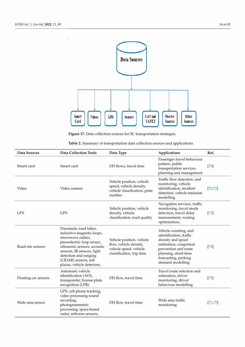
Advances in technology such as IoT, social media, etc. have widened sources throughwhich huge amounts of data can be generated and collected from devices, vehicles, sensors,and people, for utilization in ITS. Data collection in ITS therefore refers to the job of collatingdata generated from these sources using suitable various channels. The authors in [70,71]provide insights on the transportation data sources and types. One of the transportationdata collection sources is the smart card. Many urban transportation systems (BRT, rail, etc.)make use of automatic fare collection (AFC) systems, which require that passengers wouldhave to use their smart cards to pay for fares. When passengers use (touch) their smartcards, the electronic reader captures details about their boarding time, source–destinationinformation etc. Figure 17 shows some sources of data collection for ITS. Table 2 presents asummary of transportation data collection sources and their applications.
ISPRS Int. J. Geo-Inf. 2022, 11, 85 16 of 45
Figure 17. Data collection sources for SC transportation strategies.
Table 2. Summary of transportation data collection sources and applications.
Data Sources Data Collection Tools Data Type Applications Ref.
Smart card Smart card OD flows, travel time
Passenger travel behaviourpattern, publictransportation servicesplanning and management
[70]
Video Video camera
Vehicle position, vehiclespeed, vehicle density,vehicle classification, platenumber
Traffic flow detection, andmonitoring, vehicleidentification, incidentdetection, vehicle emissionmodelling
[70,72]
GPS GPSVehicle position, vehicledensity, vehicleclassification, road quality
Navigation services, trafficmonitoring, travel modedetection, travel delaymeasurement, routingoptimisation,
[73]
Road site sensors
Pneumatic road tubes,inductive magnetic loops,microwave radars,piezoelectric loop arrays,ultrasonic sensors, acousticsensors, IR sensors, lightdetection and ranging(LIDAR) sensors, tollplazas, vehicle detectors,
Vehicle position, vehicleflow, vehicle density,vehicle speed, vehicleclassification, trip time
Vehicle counting, andidentification, trafficdensity and speedestimation, congestionprevention and routeplanning, short-timeforecasting, parkingdemand modelling
[74]
Floating car sensors
Automatic vehicleidentification (AVI),transponder, license platerecognition (LPR)
OD flow, travel time
Travel route selection andestimation, drivermonitoring, driverbehaviour modelling
[75]
Wide area sensor
GPS, cell phone tracking,video processing soundrecording,photogrammetricprocessing, space-basedradar, airborne sensors,
OD flow, travel time Wide area trafficmonitoring [71,75]

ISPRS Int. J. Geo-Inf. 2022, 11, 85 17 of 45
Table 2. Cont.
Data Sources Data Collection Tools Data Type Applications Ref.
Connected andautonomous vehicles(CAVs) and VANET
Various sensors Coordinates, speed,acceleration, safety data
Online vehicle diagnosis,smart charging planning,travel delay reduction,safety performanceenhancement, congestionand accident detection,traffic flow prediction
[76–78]
Passive collection
Social media (tweeter,Facebook, Weibo,), mobilephone, collaborativeapplications
Travel time, OD flowReal-time congestionavoidance routing, ODestimation
[79–81]
Other sourcesSmart grid, smart meters,cellular service, dedicatedtests
Electric and energyconsumption, location,channel data
Performance and efficiencyimprovement, dashboardanalysis
[82,83]
5.2. Data Analytics for Transportation
Data analytics is the process of inspection, selection, transformation, governance, andrepresentation of data, with the goal of discovering useful information and assisting orboosting decision-making systems. Transportation is an integral part of our contemporarysociety. It provides the means of movement of people and goods and drives economicdevelopment. As the urban population surges, the transportation industry faces thechallenge of developing effective and efficient strategies to utilize available infrastructureand reduce traffic [84]. With the advent of SC and ITS, sensors, GPS devices, smartphones, automatic fare collection (AFC) systems, etc., have been deployed to generate datadaily from passengers, infrastructures, and transport services. The large volumes of datagenerated are processed with data processing models to gain valuable information thatcan be utilized by governments and private companies to conduct in-depth analysis andmonitoring to make informed decisions to enhance the quality of their services.
However, most conventional tools for data analysis, such as relational databases,are deficient in storing and managing such highly voluminous data [85]. Recently, bigdata analytics has been applied in many sectors including the transportation industrybecause it provides big data platforms at the highest level for the application of learning,pattern inference, and optimization techniques. Big data provides some features that giveit a competitive edge over traditional models. Several studies propose that applying asimple model to highly voluminous data produces a more reliable accurate result thanapplying sophisticated learning algorithms to less voluminous data [68]. Also, big dataanalytics defines the sophistication of the models themselves and how they support scholarsobtaining fresh insight. Big data promises speed and efficiency in the transportationservices, although the enormousness of real-time data in transportation, and in the mannerthat big data analytics predicts the condition of components in ITS, constitute some majorchallenges that need to be addressed. In this context, several studies have been conductedto incorporate big data analytics into the transportation sector.
The authors in [87] designed an analytic technique to manage the massive data regard-ing traffic volume count, and to carry out congestion analysis. The study was done usinghuge traffic volume count data collected by radio frequency identification (RFID) devices inNanjing, China. Their aim was to apply software, analytical, and virtualization approachesto data to determine the peak hours, off-peak hours, and places of high and low trafficvolume. The authors acquired three sets of data for vehicle movement, RFID reader, andvehicle type. Attributes captured in the vehicle movement data included license number,the time and date detected by the RFID reader, the vehicle type identification code, theroad lane’s number, where the vehicle was detected, and the RFID reader identificationcodes that detected the vehicle.

ISPRS Int. J. Geo-Inf. 2022, 11, 85 18 of 45
The authors in [88] proposed a real-time vehicle traffic analysis framework based onbig data analytics and IoT devices to provide predictions for future policy-making in smarttransportation. The study was carried out in four routes in the Ernakulam district of thestate of Kerala during a two-peak period of 7.00 am to 8:30 am and 4:00 pm to 6:30 pm,using four buses. Their aim was to provide the decision-making authorities a guide fordeveloping transport policies, such as deciding if a road bumper or speed breaker is neededby correlating the data with daily traffic analysis, and in allocating funds to infrastructureprojects in the future. The proposed system was composed of four modules—a GPS module,an IoT module for GPS data collection, a server module (for receiving data), and a mobileapp module. The proposed system also employed Hadoop and Apache Spark for theanalysis of stored historic data and real-time data, respectively. The GPS module wasplaced on vehicles while the receiver module was placed in the control section, and thedata generated were collected and analyzed at various intervals of time to identify regularcongested routes. The results were transmitted by the transmitter module to the controlsection, which, alongside with the software section, assesses the congestion and presents agraphical analysis of traffic flow as output to end users via a mobile application.
The authors in [89] proposed a method to estimate passengers alighting behaviors atbus stations using automated fare collection (AFC) transaction data generated from busrapid transit (BRT) users’ smart cards between bus terminals and corridors. The methodused the origin–destination (OD) matrices as its parameters for estimation. The study usedtransaction data obtained from AFC payment systems, with the entry–exit mechanism ofa BRT system in Jakarta. The data was preprocessed to remove duplicate data and singletransactions, filter completed transactions (tap-in and tap-out), and classify transactionstapped at adjacent times. Information extracted and used for the algorithm implementationincluded the transaction timestamp, smart card serial no, flag status (in or out), bus stop,sub-corridors, corridors reference, and stops. The study estimated BRT user’s alightingstation in Jakarta at several levels of available corridors by developing OD matrices asa result. The result was validated with the AFC exit data as a valid alighting station. Acomparison of the result of this method at different levels of validity with OD matricesestimation showed that this method gives results with up to 94% accuracy.
The authors in [90] employed taxi booking and GPS trajectories datasets combinedwith mobile-sensing datasets to build a system for city transportation service analyticscalled TRANSense. To give a practical realization of the proposed framework, the au-thors demonstrated two analytic applications: (1) the taxi service analyzer (TSA) whichdetects commuters queuing for taxis and utilizes taxi trip information to identify possiblehigh demand taxi locations and selectively activate mobile sensing-based analytics fornearby commuters to evaluate their waiting time; (2) subway boarding analyzer (SBA),which identifies instances of travelers failure to board arriving trains. It achieved this byapproximating the arrival times of trains from the temporal patterns of travelers’ depar-ture at station booths, and subsequently used mobile sensing-based analysis of travelers’behavioral movement on platforms. Experiments performed with real-world datasetscollected from over 20,000 taxis and 1.7 million passengers in Singapore revealed that TSAdetected passengers queuing with an accuracy of over 90%, with an insignificant energyoverhead, and estimated wait time with less than a 15% error margin. On the other hand,SBA detected failed boarding situations with over 90% precision.
The authors in [91] applied data analytics to determine city hotspots depending ontime and location, using the 2016 city of Chicago big taxi dataset. The authors provideddescriptive, predictive, and prescriptive analysis to help determine taxi companies thatneeded improvements in customer service, maximize drivers’ earnings, obtain informationon trips, examine the average range of drivers’ drop-offs and next pick-ups, and work outbetter commute patterns. In the descriptive analysis, the authors visualized the data byemploying the Python library MatPlotLib to enable the plotting of the data to discoverpatterns. The graph revealed the volume of trips undertaken by the ten highest earningcompanies.
ISPRS Int. J. Geo-Inf. 2022, 11, 85 19 of 45
The authors in [92] employed real-time big data acquired from the Florida Departmentof Transport (FDOT), online data streamed from vehicles on the road, and data collectedfrom vehicle detectors on the roadside to develop a big data system to increase roadwaysafety, prevent or minimize accidents, and decrease congestion. Their method was based onsplitting the roadway into sections utilizing the available infrastructure and minor accidentfeatures. They applied a linear regression (LR) model to the data to accurately providethe estimated time of arrival (ETA), while naïve Bayes (NB) and distributed random forest(DRF) were used to predict accidents and congestion before they occurred. In an accidentor congestion situation, the ETA is updated by predicting the correct time needed to clearit. To make the proposed system fast, accurate, and reliable, the authors integrated thelambda architecture into their framework, based on its ability to provide scalability, speedand fault tolerance. They ensured that a relevant set of features was selected to enhance theefficiency, accuracy, and speed of the proposed model.
Using city-scale transport data (bus, subway, etc.,), the authors in [93] developed ananalytics framework for identifying tourists and understanding their preferences, calledTourSense. They first presented a graph-based iterative propagation learning algorithmto identify tourists from public passengers and designed an analytical model for touristpreferences to learn and predict the tourists’ next trips. Experiments performed on real-work datasets collected from over 5.1 million passengers and their 462 million trips showedthat the proposed framework was very effective. In [94], authors designed a proof-of-concept system that analyses bus schedules and real-time bus locations for the city ofBrasov, Romania. Their aim was to develop a system to revamp public transportation inthe city and to enhance the city’s attractiveness. The system was built atop of the CityPulseframework, which supports many smart city solution creations using data analytics, real-time IoT data, distributed systems, social media data streams, and so on.
The authors in [95] proposed a MATLAB-based data analytic method to model thedemand and route planning for a bus transport system, utilizing data gathered fromelectronic ticket machines (ETM). The authors used ETM data generated from the dailyticket sales transactions made by the Road Transport Corporation in the state of Kerala(KSRTC), at six bus stations in the city of Trivandrum between the period of 2010 and 2013.The extremely huge dataset generated by the ETM is estimated to be around one millionpoints, on average, of commuters’ monthly transactions. The authors focused on auditingand compiling the dataset to ascertain commuters’ demand, operators’ performance, andoperators’ service effectiveness. With the MATLAB tool, the dataset could be queried toascertain the origin–destination (OD) matrix of bus passengers, which assists in modellingdemands, in making decisions, and in formulating policies for future predesign of thetransport system. Likewise, it is possible with the use of the analytic tool to ascertain thelink-volume of the transport network, and also to obtain information about boarding andalighting of commuters at bus stops from the ETM dataset.
The authors in [85] designed a data analytic approach integrated with Hadoop toenhance the operational efficiency of transportation and logistics companies. The authorscollected data about speed, fuel, acceleration, driver’s ID, date, GPS location coordinatesand time from vehicle sensors and GPS devices, which were then transferred to a Hadoopclustered server. These raw data were generated and sent in packets to a HDFS system byhundreds of motor vehicles every two seconds. These terabytes of raw data are analyzedweekly or monthly using analytics method to enable transportation firms to monitor thedriving behavior of drivers, determine fuel usage, and assess risks undertaken by drivers.This will help to cut down cost and enhance productivity.
The authors in [97] proposed an effective route planning technique called SubBus forshared subway commute buses using crowd-sourced mobile data to predict commuterflow at bus stations and for the effective planning of routes. First, the authors analyzedthe travel behaviors of residents to ascertain five predictive attributes which includedflow, location, time, week, and bus, and used them to predict the travel needs for sharedbuses using machine learning model. Using the operating features of the shared buses,

ISPRS Int. J. Geo-Inf. 2022, 11, 85 20 of 45
the authors designed a dynamic programming algorithm to create dynamic a best routewith fixed destinations for several running buses. The authors therefore incorporated thedynamic programming algorithm together with the five predictive features into the sharedbus dynamic route planning approach (SubBus) to plan workable routes using the activelychanging travel needs. The evaluation of SubBus showed it outperformed other methods.
The authors in [98] proposed a hybrid data-driven transportation simulation modelthat can assess and visualize parameters that measure network performance to enhance theoperational response to real-world smart city scenarios. The traffic model incorporates themerging of preset data intersections and real-time data-driven intersections and depictsa traffic passageway partly provisioned with smart devices capturing high velocity, highvolume datasets with short lifespans. The model has emulated seventeen successive inter-sections on a passageway where the vehicle volume and signal control at two intersectionswere driven by real-time emulation data from in-field sensors, while the other intersectionswere controlled by preset data in the calibrated model. The study used various Python andPERL scripts to fetch data continuously from the in-field sensors to populate the database.Because of the high volume, velocity, and broad variation of the stream of data, the archi-tecture employed data analytics to extract useful features. The result of the simulation withthe proposed hybrid model showed strong effectiveness in working with high volumes ofdata when compared to models that employed preset values. The proposed model alsoresponded sufficiently to changing values of real-time input data.
The authors in [99] designed a graph-based algorithm to reduce the pressure on theUniversity of Nebraska Omaha (UNO) shuttle transport system. The system utilized dataabout time, the number of students expected to use the shuttle, and the cost of fuel tooptimize the route in order to reduce user pressure and minimize carbon impact of thetransportation network. The implementation of the model when compared with an existingrouting model revealed that an average of 1.2 min was saved per shuttle run. For 257 shuttleruns daily, the proposed model made a saving of 308.4 min daily and 1542 min weekly.This eventually paid off in the long run with respect to CO2 emissions, fuel consumption,and cost.
The authors in [100] proposed a traffic-aware approach for offloading data from big-data-enabled ITS applications with a focus on discovering and selecting gateways. Theiraim was to offer reliable communication with little delay for offloading data while allevi-ating network overhead incurred in gateway discovery. To achieve this aim, the authorsdesigned an adaptive gateway advertisement algorithm that managed the frequency andarea of advertisement dynamically using network and traffic reports in the gateway’senvironment. The proposed system was evaluated using practical simulation domain withrespect to gateway access overhead and data offloading success ratio. Results showed aremarkable improvement in regards to permitting big traffic data centric ITS. Using NewYork City taxi and limousine commission datasets, the authors in [101] designed a systemto analyze the runtime and predictive performance of several machine learning algorithmson a Spark cluster. They found that increasing the size of the dataset had an insignificantimprovement on the accuracy of their classification, and the use of complex tree-ensemblemethods contributed little to enhance the results produced by simpler algorithms.
5.3. Big Data Technology and Transportation
Big data describes blending advanced analytic techniques (such as machine learningand pattern recognition) together with a huge assembly of structured and unstructured,enormously and exponentially increasing in size, and extremely complex data to discoveruseful patterns, realize complex facts, trends, and relationships that exist in the data inorder to improve decision making and process optimization [102]. Big data technologiesrefer to software frameworks that enable fast and efficient extraction, processing, andanalysis of data from highly complex and vast datasets in a manner which conventionaldata management tools can never deal with. Big data has been employed in the transporta-
ISPRS Int. J. Geo-Inf. 2022, 11, 85 21 of 45
tion industry to resolve many conventional data-based challenges, and has enabled newapplications, services, and opportunities [68].
5.3.1. Big Data Technological Frameworks
Some big data platforms have been used tremendously for research in SC trans-portation. This subsection reviews some big data technological frameworks for big dataprocessing. It particularly describes some of the widely used technological platforms(i.e., software frameworks) for processing very large volumes of data and their use cases.
Apache Hadoop: Hadoop is a technology that satisfies the requirements of big dataas it is scalable and designed as a software for big data processing. Hadoop is the mostcommonly used open source, distributed, and scalable software framework for storing andprocessing highly voluminous datasets. It offers a general big data process platform thatenables the execution of diverse data analytical operations. Hadoop’s capability to handledistributed processing makes it very suitable for analyzing data generated in ITS (e.g., smartcard, social media, various sensors, GPS data, etc.). It was originally designed for use in thearea of business intelligence, but its use has widened to various urban domains that utilizebig data applications [104]. Hadoop enables the distribution of processing load among thenodes of the cluster which improves the processing strength. The number of nodes in acluster can be increased or decreased depending on the need and can form homogenousclusters using diverse categories of machines to process unstructured data, rather thanusing a single costly supercomputer [105]. One main advantage of Hadoop is that it isinexpensive to use, since it is an open-source framework.
The Hadoop framework is made up of three major layers. The first layer is the Hadoop-distributed file system (HDFS) which uses the master–slave architecture to store, process,and analyze huge datasets to extricate relevant insight from data. The HDFS splits the bigfiles and puts them into standard blocks and saves the blocks into the big cluster. In thesecond layer is the MapReduce, which has four basic elements (input, mapper, reducer, andoutput). Its operation involves splitting the big job into smaller jobs and executing themappropriately. At the third layer is the Yet Another Resource Negotiator (YARN), which isthe resource manager responsible for allocating resource requests (CPU, memory) of theHadoop cluster to different tasks. Because of Hadoop’s popularity in big data processingin both industry and research communities, several of its extensions have been proposedsuch as HadoopGIS, HadoopTrajectory, HadoopDB, Hadoop++, etc. [106].
Apache Spark: Spark is a general and an extensively used distributed frameworkimplemented using a large in-memory cluster of machines to better handle the processingof big data. Unlike Apache Hadoop, which is a disk-based system developed for I/Oefficiency, Spark takes advantage of increased growth in the main memory capacity ofmachines that make up the cluster to attain better performance [107]. It permits the loadingof user program data into the cluster and queries it repeatedly. Spark is very suitablefor the deployment of machine learning methods and applications. The authors in [108]designed a method to analyze transportation data using Hadoop together with Spark toprocess transportation data in real-time. The architecture of the system is made up of fourdistinct layers—the data collection and acquisition layer, network layer, data processinglayer, and application layer. The first employs methods that use sensors to collect data,and the collected data is then subjected to cleaning and transformation using data-filteringtechniques to remove noise and unwanted information. At the processing layer, the datareceived from the data collection layer is further preprocessed and normalized using theMin-Max normalization technique. This technique was employed by the Hadoop ecosystemto efficiently process data [109], since the data was collected from diverse sources (e.g., road,parking). The proposed architecture provides modules for processing offline and onlinedata. The Hadoop ecosystem was utilized to process offline data, while Spark together withthe Hadoop ecosystem was used to process the online data. MapReduce of the Hadoopwas used to deal with the big data. To optimize the processing power of the MapReduce,a scheduling algorithm was incorporated to split the task on the Hadoop server and to
ISPRS Int. J. Geo-Inf. 2022, 11, 85 22 of 45
adaptively regulate the task on the Hadoop ecosystem using memory requirement andCPU utilization to move a task from one node to another.
Two drawbacks were observed in the Hadoop ecosystem—high performance nodesoften switch to idle mode while low performance nodes maintain the active mode andremain busy always. To deal with these problems, the system incorporated a load balancerto monitor and balance the load among Hadoop and Spark nodes. After the data processing,the result (output) was stored using the HDFS. The HDFS enables the efficient and speedyprocessing of output data by the decision module. The proposed system incorporatedHBASE in order to provide fast real-time access, and optimized caching of the output data.The output data from the Hadoop ecosystem is transferred to the application layer where itis used to make informed decisions. This work demonstrates how big data technologiesenable the design and implementation of big data systems.
Python Library: Python recently has been utilized as a data analytics platform. ThePyStack is well equipped with libraries that support data analysis, but a lot of these librariesare implemented to run on one CPU core and to handle data of similar sizes as that ofthe main memory. As a result, Python is not effective in processing big data. On theother hand, one can make use of PySpark to execute big data utilizing Spark on a clusterof machines. Presently, Spark remains the most commonly used distributed in-memoryall-round execution engine that enables the use of a range of key libraries (e.g., SparkSQL,MLlib, etc.).
5.3.2. Big Data Architectures
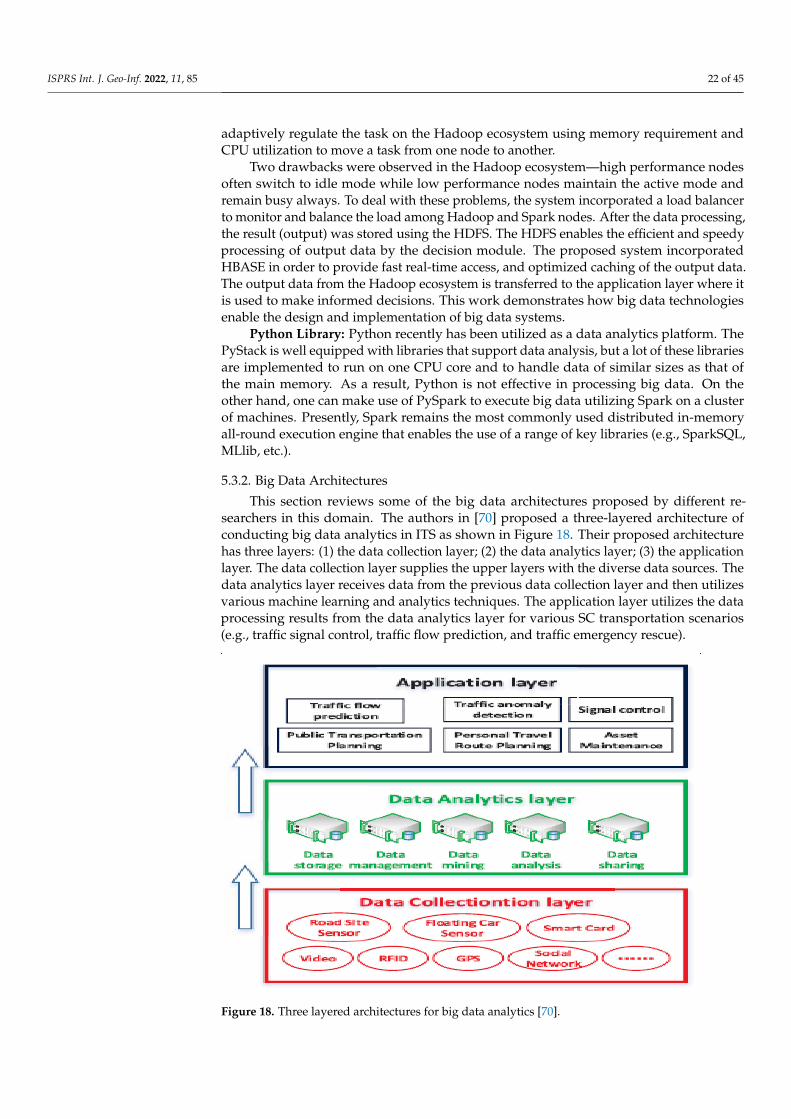
This section reviews some of the big data architectures proposed by different re-searchers in this domain. The authors in [70] proposed a three-layered architecture ofconducting big data analytics in ITS as shown in Figure 18. Their proposed architecturehas three layers: (1) the data collection layer; (2) the data analytics layer; (3) the applicationlayer. The data collection layer supplies the upper layers with the diverse data sources. Thedata analytics layer receives data from the previous data collection layer and then utilizesvarious machine learning and analytics techniques. The application layer utilizes the dataprocessing results from the data analytics layer for various SC transportation scenarios(e.g., traffic signal control, traffic flow prediction, and traffic emergency rescue).
Figure 18. Three layered architectures for big data analytics [70].

ISPRS Int. J. Geo-Inf. 2022, 11, 85 23 of 45
The authors in [108] proposed a four-layered architecture to analyse big data andbring forward a system that can handle real-time transportation data. Figure 19 shows theirproposed architecture. The architecture has four layers: (1) the data collection layer (2); thedata communication layer; (3) the data processing layer; (4) the data application layer. Theirproposed system collects data from various RFIDs installed at various locations in an SC.The RFIDs are programmed to identify malicious vehicles using their registration numbers,vehicle models, etc. The network layer consists of an SDN architecture to efficientlyprocess and transport the data to the next layer. The data processing layer utilises variousmachine learning algorithms to efficiently analyse the data using the Hadoop platform.The application layer distributes the data to the users.
Figure 19. Four layered architectures for Big data analytics [110].
The authors in [111] proposed a big data analytics platform for smart urban trans-portation management (Figure 20). Their platform focuses on the City AdministrationDashboard, which is a public transport analytics application that has been developed on topof the Europe-Brazil Collaboration of Big Data Scientific Research through Cloud-CentricApplications (EUBra-BIGSEA) platform. The City Administration Dashboard provides sta-tistical trends about bus usage. The architecture includes several services such as PRIVAaaS(PRIVAcy as a Service), DQaaS (Data Quality as a Service), and EMaaS (Entity Matching asa Service).
5.3.3. Research Works on Big Data for Transportation
Researchers have utilized big data to try and solve challenges to improve the trans-portation system for SCs. Some of the problem areas that will be largely aided usingbig data includes transport planning, road safety, environment, traffic management, avia-tion, connected and autonomous vehicles (CAVs), freight and logistics, cost-effectiveness,railway, and data-related issues [102]. Major challenges related to planning includes: cross-media traffic operation, mobility on demand, changes in infrastructure to accommodateCAVs, ticketing, etc.

ISPRS Int. J. Geo-Inf. 2022, 11, 85 24 of 45
Figure 20. Integrated Big data analytics platform for smart urban transportation [111].
Using Shanghai traffic data alongside taxi and subway trajectory data, the authorsin [113] designed a transit–transportation planning strategy between taxi and subways.Experiments showed that the strategy offered a very timely and bounded travel time usingreal city traffic, saving travel cost and time. Consequently, it can alleviate pressure on cities’road networks, minimize the general energy utilization of society, and expand the scopeof public transport systems. The authors in [114] utilized vehicle positioning and smartcard data to analyze the planning and operational processes of two real cases from Swedenand Netherlands. The processing and relevant insight obtained from data enabled gooddecision making and enhanced the public transport system.
To increase the efficient use of the road infrastructure, there is a need for dynamic trafficmanagement. Big data applications have been utilized in major areas in traffic management,such as in congestion prevention and route planning, short-term forecasting, individualizedtravel information systems, parking request modelling, and fleet management, to provideinsights at real-time. The authors in [115] proposed a graph-oriented scheme to analyzebig data of traffic and vehicular networks, such as timestamps, geographical locations,and traffic intensity (speed and vehicle count) generated from IoT sensors installed onroads and vehicles to enable road users and traffic management authorities to make smarttransport decisions. The architecture employed Graph tools along with parallel processingservers to realize real-time efficiency. The system implementation utilized Spark and Graphtools mounted on Hadoop parallel nodes to create and process graphs almost at real-time.
The authors in [116] designed a three-layer big data method for smart bus transporta-tion management. The study was conducted with real world data acquired from roughly2000 buses during a period of seven months from a vast bus network containing about300 routes that span almost 5000 bus stops in the city of Fortaleza, Brazil. GPS trackingdevices were installed on the buses to send the latitude and longitude coordinates every15–30 s. Transaction data from automatic fare collection (AFC) machines at all bus stopswere also collected. The big GPS signal and AFC data were processed using MapReduceto calculate the bus travel time and to determine travelers boarding location in the firstlayer. The authors in [117] discussed the role of big data analytics for smart transportationsystems. The authors in [24] proposed a traffic flow prediction service based on cloudcomputing and big data analysis and conducted a traffic flow prediction based on theMapReduce framework, consisting of three stages: (1) model selection; (2) parameterestimation; (3) model combination. In [118], authors utilized big data generated from amicrowave vehicle detection system (MVDS) installed on a motorway network in Orlando

ISPRS Int. J. Geo-Inf. 2022, 11, 85 25 of 45
to design a dynamic strategy to monitor traffic and to simultaneously evaluate operationand safety in real-time. Their study confirmed that congestion significantly impacts thelikelihood of a crash. The authors in [92] employed H2O and WEKA tools to analyze fiveclassifiers on a big traffic accident dataset. Their analysis showed effectiveness in predictingaccidents before they occurred and that traffic flow and safety decisions are tremendouslyimpacted by drivers’ behavior.
The authors in [120] designed a big data platform to show how big data can motivatelarge scale deployment of green vehicles. They used two datasets made up of 4.5 milliontrips and recorded parking events of 28,000 conventional fuel vehicles, which were moni-tored for more than one month period. The result of their analysis revealed the potential ofbig data for policy assessment towards low-emissions and the deployment of green vehicles.The authors in [121] conducted an analysis to investigate the driving range and factorsinfluencing the energy consumption rate of completely battery-powered, electric vehicles(BEV) using real-world patterns and found that weather variables and driving patterninfluence the driving range of BEVs in the real-world. The authors in [122] proposed amethod to measure the carbon emission flow data of self-driving tour traffic from the year2014 and evaluated its spatial connection with attractive locations based on data-miningtechniques.
Rail transportation systems have enjoyed substantial transformation as a result ofthe increased attention and adoption of big data analytics in recent years [123]. This isbecause of their ability to generate and process huge amount of data that includes real-timetrain speed and location, departure and arrival time at certain stations, and passengerOD information. Big data analytics can enable operators of rail transport system to makeinformed decisions about train control and to improve operation efficiency. The areas wherebig data is expected to positively impact the rail transport system includes informationmanagement (e.g., passenger information, ticketing, tracking), train control (communi-cation systems, automation, etc.), energy (intelligent power supply, smart metering etc.),infrastructure (track condition, signal systems, surveillance analytics etc.), and predictivemaintenance (safety, real-time rescheduling). The authors in [124,125] proposed a big dataanalytic method that analyses rail big data and displays an overview of a selected railwaynetwork area. This enables operators to study operations and make informed decisions.The authors in [126] applied big data analytics to optimize the shortest path fare strategy ofBeijing rail transit. Big data analytics was then used to process the basic data of passengers’entry and exit from stations to obtain a real travel time distribution from any originationto destination. The result of the analysis achieved by the proposed method will enableoperators to determine the actual fare payable by passengers for any trip.
The authors in [127] proposed a model to analyze the cascading failure of weightedurban railway transit networks (URTNs). The model adopted the estimated operationinterruption time of the station (EOITS) to distinguish the disturbance intensity of thesystem. The authors in [128] applied big data analytics to determine passengers’ flow inShenzhen’s subway using smart card data. The result of the analysis enabled the derivationof policies for reducing urban congestion and optimizing network traffic. In [129], authorsproposed a big data visualization framework to analyze passenger flow, while in [130], theauthors proposed an approach for big data classification and transportation in rail networks.They presented a new framework for future data-driven railway condition monitoringsystems (RCM). Figure 21 shows the proposed architecture for classified transportationof large-scale sensor data in rail networks. The architecture is composed of two mainparts (data analysis and data transmission). The authors proposed two ways to performclassification on the data, which are signal analysis (SA)-based methods and machinelearning (ML)-based approaches. To convert a signal from the time-domain to frequency-domain, discrete Fourier transformation (DFT) is used for time-frequency conversion. Theone-class support vector machine (SVM) is selected for classification. The performance ofthe classifier was evaluated using real experimental data. Their work demonstrated goodperformances on various data sets under different operating conditions.

ISPRS Int. J. Geo-Inf. 2022, 11, 85 26 of 45
Figure 21. Big data classification and transportation in rail networks [130].
In achieving a smart aviation industry, big data is considered a key element. Theauthors in [102] categorized the challenges in the aviation sector into three types: (1) op-erations and air transport management (delay mitigation, weather resistance, flight planoptimization); (2) security and safety (on-board monitoring, privacy, air space operationsin all weather, resilience against cyber-attacks); (3) incorporation of new technologies (de-ploying drones for air logistics). Big data has been employed to address some of thesechallenges. The authors in [132] proposed a hybrid analytic model to manage air cargologistics. Their model combined a cluster and associative models for their analysis andincorporated the Diffusion of Innovative theory together with Resource Dependence theoryinto the analysis result to generate the operational strategy. The assessment of their strategyproved effective to improve cargo logistics.
The authors in [133] proposed a policy analytic framework for air connectivity inIndia and discussed how application of big data can help improve operational efficiency. Abig data analytic method to optimize airline route profitability was presented by authorsin [134], while the authors in [135] proposed a civil aircraft big data for civil aviation tofacilitate developmental decisions. The authors in [136] proposed a big data-based securityframework to preserve privacy and protect data.
6. Machine Learning Approaches for SC Transportation
Machine learning offers an auspicious avenue for SC transportation, consideringits capability to exploit the power of data that has become increasingly available to SCtransportation administrators and researchers. With the high volumes of data generatedby SC transportation data sources (e.g., sensors, smart cards, videos, etc.) that cannot beexamined individually, it is necessary to have a system that can learn and optimize on itsown, based on previous experience. The operational changes in the context of SC trans-portation applications necessitate a generic, dynamic, and continuous learning technique.Therefore, for increased efficiency, it is critical to investigate the potentials of machinelearning in the development of individualized services in SC transportation. Machinelearning techniques are rapidly evolving due to improved algorithms, enhanced data col-lection methods, improved communication networks, new sensor/IO units, and interest inself-customization in response to user activity. The primary goal of machine learning is toeffectively interpret new data and make predictions beyond the training sample, similar toreal-time data. In general, machine-learning-based methods can offer descriptive (describethe current state of a system), predictive (predict the future state and values of a system) or
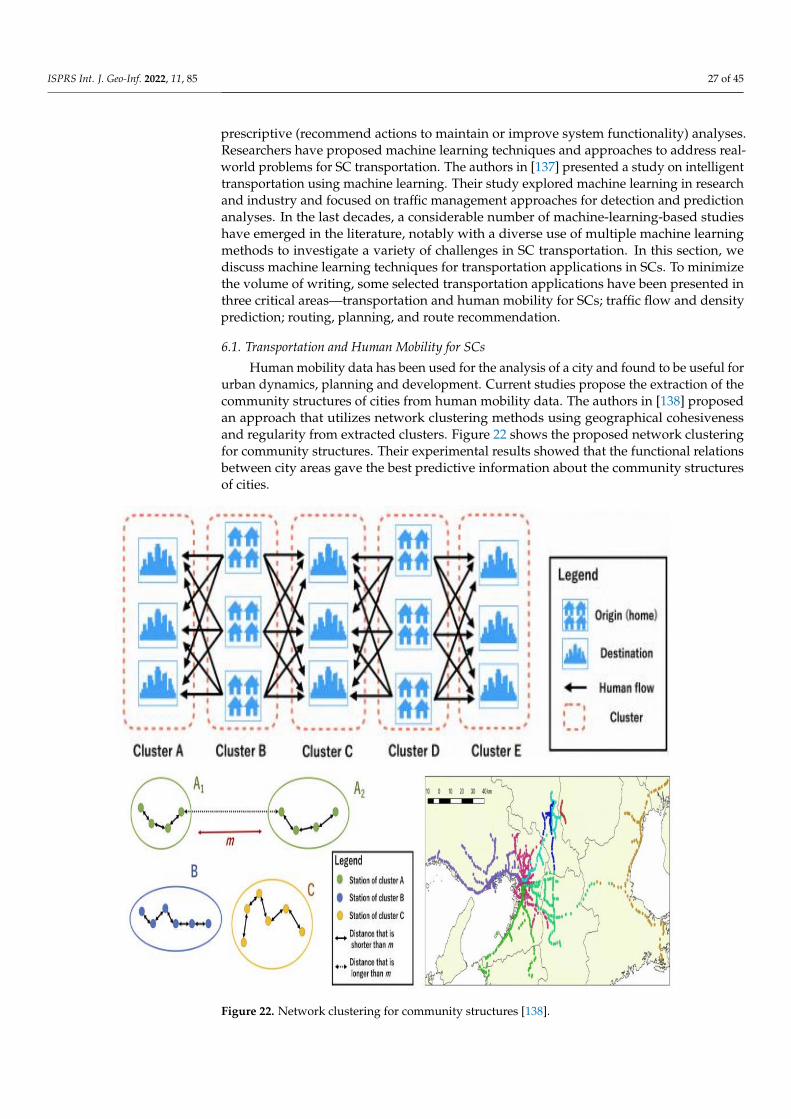
ISPRS Int. J. Geo-Inf. 2022, 11, 85 27 of 45
prescriptive (recommend actions to maintain or improve system functionality) analyses.Researchers have proposed machine learning techniques and approaches to address real-world problems for SC transportation. The authors in [137] presented a study on intelligenttransportation using machine learning. Their study explored machine learning in researchand industry and focused on traffic management approaches for detection and predictionanalyses. In the last decades, a considerable number of machine-learning-based studieshave emerged in the literature, notably with a diverse use of multiple machine learningmethods to investigate a variety of challenges in SC transportation. In this section, wediscuss machine learning techniques for transportation applications in SCs. To minimizethe volume of writing, some selected transportation applications have been presented inthree critical areas—transportation and human mobility for SCs; traffic flow and densityprediction; routing, planning, and route recommendation.
6.1. Transportation and Human Mobility for SCs
Human mobility data has been used for the analysis of a city and found to be useful forurban dynamics, planning and development. Current studies propose the extraction of thecommunity structures of cities from human mobility data. The authors in [138] proposedan approach that utilizes network clustering methods using geographical cohesivenessand regularity from extracted clusters. Figure 22 shows the proposed network clusteringfor community structures. Their experimental results showed that the functional relationsbetween city areas gave the best predictive information about the community structuresof cities.
Figure 22. Network clustering for community structures [138].
ISPRS Int. J. Geo-Inf. 2022, 11, 85 28 of 45
6.2. Traffic Flow and Density Prediction
Various approaches have been proposed for traffic parameters’ prediction. The authorsin [139] proposed an approach to predict flight delay using a machine learning (ML) modeland a convolution neural network (CNN) model on airline on-time performance (AOTP)and quality controlled local climatological datasets. The ML model achieved the bestpredictive result of 89.07% while the CNN model achieved a slightly better result, with89.32% prediction accuracy. The authors in [140] proposed a model for short-term trafficvolume prediction in transportation systems and presented a novel hybrid model (Gaussianprocess regression based on statistical learning theory and Bayesian theory) to predict thepassenger flow volume. Their approach considered factors such as temporality, origin–destination spatiality, frequency and self-similarity, and historical probabilistic distributionperspectives. Their experimental results showed good performance even when the timeintervals for traffic flow prediction were increased. In [141], authors proposed the onlinesupport vector machine for regression (OL-SVMR) approach to predict short-term traffic intypical and atypical conditions. Their experimental results showed good performance withthe proposed approach. In [142], authors applied a framework that used the Haar cascadeclassifier and supervised learning (AdaBoost learning algorithms) to identify the directionsof traffic streams and to extract the traffic flow parameters. The authors in [143] usedGPS tracking systems in public transportation to analyze and predict passenger flow inreal-time, while the authors in [144] proposed a short-term traffic flow prediction approachthat utilizes wavelets and an extreme learning machine (ELM). An ERS-ELM (ensemblereal-time sequential extreme learning machine) prediction approach was proposed in [145]for highway traffic peak and nonstationary states. The experimental results showed a highprediction accuracy of ERS-ELM, with an optimized training time.
The authors in [146] proposed an approach for the estimation of user demand in thepublic transportation network typified in the origin–destination matrix (ODM) from buses.The authors validated their model using data from the city of Quito. The authors in [147]proposed a hybrid forecasting model for short-term passenger flow prediction. Theirapproach utilized a combination of wavelet transformation (WT) and a kernel extremelearning machine (KELM). The authors validated their model using data from the cityof Beijing. Their experimental results showed that the WT-KELM approach could giveaccurate information for the monitoring and early warning of urban rail transit. A studyon machine learning algorithms for green, context-aware transportation systems waspresented in [148]. The objective was to recommend the best transportation routes forthe different means of transportation (train, metro, and bus) to reach a destination basedon some user parameters. The authors in [149] performed a comparative analysis offour neural networks—two machine learning models based on back propagation neuralnetworks (BPNN) and two deep learning models on recurrent neural networks (RNN).Their experimental results showed that models implemented on BPNN showed highperformance when compared to those of RNN.
Besides, traditional approaches such as traffic sensors and devices, Internet data fromsocial networks (e.g., Twitter) have become new sources for traffic flow prediction. Theauthors in [150] proposed a framework that retrieves and uses data from heterogeneoussources, including data from social networks, to detect traffic flows or patterns. Figure 23shows the proposed framework. Their applications utilize data from various sources,such as entities extraction in tweets, event classifications, and classification of traffic statesfrom image sources. Other research works on analytics from heterogeneous sources ormultimodalities e.g., text, image, video, and speech, can be found in [151–153].
The authors in [154] proposed a neural network-based model for public transportationprediction using the traffic density matrix (as shown in Figure 24). The objective was to offersolutions to the bus arrival times at bus stations by considering local traffic conditions. Thetraffic conditions were represented in terms of a traffic density matrix. The network trainingwas performed using stochastic gradient descent (SGD). In [155], authors proposed a real-time public transportation prediction with machine learning algorithms, including optimal

ISPRS Int. J. Geo-Inf. 2022, 11, 85 29 of 45
least square (OLS) linear regression and support vector regression (SVR). Their work wasvalidated on the SUMO (Simulation of Urban MObility) simulator [156]. Their experimentalresults showed that the proposed approach could outperform other approaches and reducethe mean absolute prediction error.
Figure 23. Framework from heterogeneous sources in intelligent transportation [150].
Figure 24. Neural network approach for public transportation prediction [154].
6.3. Routing, Planning and Route Recommendation
Machine learning can also be applied to assist users plan their travel trip and routes.To improve the utilization efficiency of public transportation services, the authors in [157]proposed a bus routing model that identifies and optimizes region pairs with flawed busroutes. The authors generated the human mobility patterns among regions using taxi tracesand bus transactions. Their experimental results used real-world data collected in the city ofBeijing, which contained 19 million taxi trips and 10 million bus trips. In [158], the authorsproposed a hybrid solution for real-time travel mode detection and trip purpose prediction,which considered the use of a single preprocessing algorithm (using location traces obtainedthrough smartphone sensors) for both problems. Experimental results showed accuraciesof 88% for travel mode detection and 81% for trip purpose prediction. In [159], authorsproposed a novel approach for public transport anonymous data collection.

ISPRS Int. J. Geo-Inf. 2022, 11, 85 30 of 45
7. Integrated Deep Learning towards SC Transportation
Deep learning models are inspired by the multi-layered structure of the human neu-ral system. The authors in [160] surveyed the role of deep learning models in ITS andhighlighted different types of deep learning models in the context of ITS for SC ecosys-tems. This section presents some representative studies for utilizing deep learning for SCtransportation.
7.1. Routing and Planning
A Gaussian-prioritized approach to deploy additional routes for transportation wasproposed in [161] using neural-networked-based passenger flow inference. Their exper-imental results recorded an improvement from 7 to 24% over the existing methods. Interms of route-based techniques, the authors in [162–164] studied a travel time predictionin both the forward and reverse trajectories based on deep belief networks (DBN), LSTM-based, and deep-travel models, respectively. The authors in [163] proposed an attentionmechanism to aggregate context from local trajectory embeddings made by an LSTM (longshort-term memory) network, while authors in [166] proposed a travel time estimationapproach for the optimization of taxi–carpool systems. The authors in [167] proposed amultimodal transport recommender system using deep learning and tree models, whichcombined the weighted average ensemble method of CNN and GBDT (gradient-boosteddecision trees). In order to enhance the categorical features for travel-mode preferenceprediction in deep learning, the authors in [168] proposed a deep neural network (DNN)architecture with entity embeddings (see Figure 25). The DNN architecture consists offour layers (embedding layer, concatenate layer, fully connected layer and output layer)and can efficiently learn the vector representations of the categorical data. The results oftheir experiments conducted on the London travel dataset showed that their approachwith the entity-embedding technique outperformed other neural network models andtree-based models.
Figure 25. Deep neural network travel prediction framework [168].
7.2. Traffic Flow and Density Prediction
In recent years, traffic flow prediction has received extensive attention to preventand minimize traffic congestions in SCs. Traffic prediction entails forecasting the trafficconditions, such as traffic volume and speed. The authors in [169] proposed a VGRAN(variational graph recurrent attention neural networks) model, utilizing a Bayesian frame-work for uncertainty-aware traffic forecasting, aimed to model the topology structure ofroad sensor networks and the spatial correlations among sensors to predict future trafficconditions. Figure 26 shows the architecture of the proposed VGRAN model. Their ex-perimental work used two real-world traffic datasets: METR (dataset collected from LosAngeles County); and PEMS (dataset collected from Bay Area in California). The results

ISPRS Int. J. Geo-Inf. 2022, 11, 85 31 of 45
showed that the proposed model outperformed other known state-of-the-art traffic speedforecasting models. The authors in [170] proposed an approach that models traffic flowover graph-like structures using a novel diffusion convolution layer.
Figure 26. VGRAN framework for traffic forecasting [169].
The authors in [171] proposed a deep and embedding learning approach (DELA) thatcan learn from fine-grained traffic information, route structure, and weather conditions.Their proposed architecture consists of an embedding component (used to capture thecategorical feature information and identify correlated features), a CNN component (usedto learn the two-dimensional traffic flow data), and a LSTM component (used to maintainthe memory of historical data). Figure 27 shows the analytical process, which has two stages:(1) data preprocess; (2) data analysis based on deep and embedding learning approaches.Their experimental results showed that the proposed approach could outperform existingmethods in terms of prediction accuracy.
Figure 27. Deep learning approach for urban traffic flow prediction [171].

ISPRS Int. J. Geo-Inf. 2022, 11, 85 32 of 45
The authors in [172] considered the problem of predicting the in-flow and out-flowof traffic within a city and proposed a deep-learning-based approach, called ST-ResNet,to collectively forecast the in-flow and out-flow of crowds in each region of a city. A cityis discretized to a two-dimensional grid and traffic flow is represented as a dense three-dimensional grid. Their work developed deep spatio-temporal residual networks for theprediction. The authors in [173] proposed a novel deep learning model termed as ST-3DNet(deep spatio-temporal 3D convolutional neural network) for traffic raster data prediction.This model uses 3D convolutions to capture the correlations of traffic data in the spatialand temporal dimensions. It consists of two major components to describe the two kinds oftemporal properties of traffic data. ST-3DNet utilizes three-dimensional convolutions andblocks to model the two kinds of patterns and then aggregates them together in a weightedway for the final prediction. Their experimental results showed that ST-3DNet outperformsthe state-of-the art baselines.
In [174], authors proposed a short-term traffic flow prediction model that combinedthe spatio-temporal analysis with a gated recurrent unit (GRU). A GRU is a type of recurrentneural network (RNN) and is a variant of the LSTM network. While maintaining the effectand making the structure simpler, it keeps the RNN prediction performance and has asignificant increase in speed. GRU is simpler and has only two gates (update gate andthe reset gate), while an LSTM network has three gate functions (input gate, forget gate,and output gate). Figure 28 shows the overall forecasting process. Their experimentscompared the proposed model with the CNN model, and the results showed that theproposed method outperforms both in accuracy and stability.
Figure 28. GRU framework for traffic prediction [174].
The authors in [175] proposed an ensemble model (EM) based on LSTM, DAE (deepautoencoder), and CNN for short-term traffic prediction. Their work considered the spatialand temporal characteristics of the traffic conditions. They evaluated their EM modelson traffic data from two cities (California and London) and compared them with somewell-known existing prediction models. Their experimental results showed that the EMcan achieve better performance in terms of prediction accuracy.
Intelligent toll gates (ITGs) connect nearby metropolitan cities through smart highways;thus, they are also important infrastructure in SCs. Electronic toll collection (ETC) suffersfrom network limitations, such as optimal route utilization, long outstanding queues ofconnected smart vehicles (CSVs), fixed toll-pricing schemes for all CSVs, higher waitingtime, variable delays, traffic congestion at toll gates, and complex payment mechanisms.The authors in [176] proposed DwaRa, which is a deep learning-based dynamic toll pricingscheme for ITS. The DwaRa system model is shown in Figure 29. In DwaRa, futuretraffic is predicted based on Markov queues to balance the congestion at different lanesat ITGs efficiently. An approach termed as the SI-LSTM (spatially induced-long-short-term memory) model is then used to predict current traffic and weather. For time seriesprediction of traffic which are updated in real-time, LSTM is a preferred choice.

ISPRS Int. J. Geo-Inf. 2022, 11, 85 33 of 45
Figure 29. Dwara deep learning framework for dynamic toll pricing [176].
7.3. Passenger Flow in Public Transportation and City
The authors in [177] proposed a two-step K-means clustering model to capture pas-senger flow variation trends and ridership volume characteristics. They developed apredictability assessment model to recommend a reasonable time granularity interval toaggregate passenger flows. Then, a LSTM approach called CB-LSTM model, was pro-posed to conduct short-term passenger flow forecasting, based on the above clusteringoutcomes and the recommended time granularity interval. Figure 30 shows a frameworkof their model. Their experimental results showed that the proposed approach gave goodpredictive performance for short-term passenger flow on a network.
Figure 30. LSTM deep learning framework for passenger flow forecasting [177].
The authors in [178] combined deep learning (DL) and support vector machines (SVM)and proposed a DL-SVM model for urban rail transit (URT) passenger flow prediction. The

ISPRS Int. J. Geo-Inf. 2022, 11, 85 34 of 45
deep belief network (DBN) was first used to extract the features and inherent variationof passenger flow data. Then SVM regression model was developed to predict passengerflow. Their experimental results showed that the DL-SVM outperforms the other modelsin accuracy and stability. Subway station passenger flow prediction is important forforecasting future passenger volume. The authors in [179] proposed a recurrent neuralnetwork RNN-based subway passenger flow rolling prediction. Their approach can helpto inform safety warnings and evacuation passenger flow. The time series of passengervolumes was combined with weather data to create several supervised sequences, accordingto different values of timestep. Two artificial features were added as input to accelerateconvergence. They used data from Shanghai traffic cards in their experiments. Theirexperimental results showed that the GRU network, with a timestep of 1.5 h gave thebest performance for the long-term traffic flow rolling prediction. For short-term rollingprediction, GRU with a timestep of 45 min gave the best result.
In the rail transit system, due to the stochastic nature of the short-term dynamicpassengers’ origin and destination demand (OD matrix), accurate prediction of the distri-bution of passenger travel spatio-temporally is a challenge. The authors in [180] used anorigin–destination matrix as input to a CNN-based model for predicting the in-flow andout-flow of nodes in a Beijing subway network. The authors in [181] proposed a combinedmultisource data with a deep learning method to improve the prediction of dynamic originand destination demand (OD) matrix accuracy. The multisource data, such as smart carddata, weather data, and mobile phone data were analyzed quantitatively based on theinfluencing factors; and 31 features were selected as model inputs. The authors in [182] alsoproposed a method that uses an LSTM to learn mobility patterns and to predict count-basedtraffic data between nodes in subway and bus networks.
8. Transportation Empowered by Artificial Intelligence (AI) and Other Techniques
AI is emerging as the driving force for new technologies and for the fast transitionof intelligent transportation from mainly functional systems to truly intelligent and smartinfrastructures. This section presents a review of the applications of AI techniques, suchas evolutionary algorithms and swarm intelligence in the transportation industry. As thepopulation of people in major cities continues to increase progressively, thus creating newmobility challenges, it is necessary for the transportation system to continue to evolve toeffectively deal with the challenges. With the advent of ITS, which enables the massivegeneration of highly voluminous data, various AI techniques have been incorporated by theITS to offer new services. These services normally require managing a notable volume ofdata generated by sensor devices, AFCs, GPS devices, social media, and smart phones [183].
Different AI techniques have been applied in several areas in ITS, such as trafficprediction and control, where systems are developed with the aim to minimize trafficcongestion, control traffic signal, predict traffic volume, etc. The authors in [184] proposeda dynamic intelligent traffic light control system (DITLCS) based on fuzzy inference anddeep reinforcement learning. The proposed DITLCS accepts real-time traffic informationas input and makes adjustments to the traffic light duration dynamically. The proposedsystem operates in three modes (fair, priority, and emergency modes) where vehicles arecategorized based on operational priority. The simulation results prove the efficiency of theproposed system when compared to recent algorithms on several performance parameters.
The authors in [185] proposed an intelligent traffic control system for vehicle passingat intersections using a back propagation (BP) neural network. Based on the model,the controller area network (CAN) communication network has been improved using theearliest deadline first (EDF) dynamic algorithm. The system was tested through simulationsand proved very effective. The authors in [186] proposed an approach termed as BRBES(belief rule-based expert system) to control traffic signals at the intersection of roads. Theproposal used belief rule base (BRB), which serves as the knowledge representation schema,while evidential reasoning serves as the inference engine. Their experimental resultsshowed the proposed approach gave better reliability when compared to existing systems.

ISPRS Int. J. Geo-Inf. 2022, 11, 85 35 of 45
AI techniques have also been applied in the area of vehicle control systems to improveautonomous driving, reduce fuel and energy consumption, improve advanced brakingsystems, etc. The authors in [187] proposed an intelligent unidirectional and decentralizedcontrol method based on FLC for vehicle platooning. The controller performance wastuned by hybridizing the FLC using GA and proportional-integral-derivative (PID), andby the adaptation of FLC using neural networks to form the fuzzy x-tuned controllers tocontrol the follower vehicles to attain their goals. Performance evaluation of each of eachcontroller using simulations, regarding spacing error convergence and desired velocitytracking, revealed that all the controllers achieved their tasks amidst certain limitations.
The authors in [188] proposed a power control strategy using a genetic algorithm(GA) with a fuzzy logic controller (FLC) to efficiently control power transmission in electricvehicles. The simulation results exhibited that the proposed method was effective andsuperior. Using GA, the authors in [189] designed a simulation framework for charging thecontrol system. The framework was used to simulate three scenarios and results showedthat it can maximize the profit or reduce the charging time, depending on the objective ofthe various parking lots.
Urban transportation infrastructure affects immensely the quality of transport services.Implementing an optimal infrastructure enables the increased probability of considerablyimproving transport services [190]. The authors in [191] applied an evolutionary algorithmand a genetic operator to optimise the transit network design problem (TNDP). The authorsnoted that the increased use of private vehicles contributes immensely to traffic congestion,accidents, and pollution. They argued that having a viable, efficient and low-cost publicbus network would discourage citizens from using personal vehicles. The simulationresults of their proposal showed its effectiveness in addressing SC challenges. Using anevolving fuzzy neural network (EFNN), the authors in [192] predicted the travel speedmultiple steps ahead using 2 min travel speed data obtained from remote traffic microwavesensors in the city of Beijing, and utilized a Takagi-Sugeno system to complement the fuzzyinference. The predictive performance of the proposed model was evaluated and comparedagainst six traditional models. The EFNN produced better performance than those of thetraditional models because of its strong learning ability. The authors in [193] aimed toimprove the accuracy of traffic flow states by proposing a fusion clustering strategy fortraffic flow state identification. The authors used three indices for evaluation (flow, velocity,and occupancy) for fusion. The optimized evaluation index weight was introduced intothe clustering algorithm (fuzzy c-means) to realize traffic flow state identification based onmulti-parameter fusion clustering. The process is shown in Figure 31.
The authors in [194] proposed and developed an innovative fuzzy logic approach todetect and predict the delay of public transport modes. The authors utilized predictiveanalytics and incorporated a knowledge variety of heterogeneous data, including transitdata and weather data. The data was categorized based on fuzzy logic and randomforest regression was applied to predict transit delays. The experimental works usedtransportation data from the city of Toronto. The authors in [195] proposed a hybridRBF (radial basis function) neural network and fuzzy system for short-term road speedforecasting. Their work combined the fuzzy logic system with the RBF neural network.The authors in [196] proposed a fuzzy neural network model (FNM) to predict traffic flowin urban street networks. The authors in [184] proposed a fuzzy inference-enabled deepreinforcement learning-based traffic light control. The authors in [198] proposed a vehiclerouting problem model with multiple fuzzy windows for the time-varying traffic flow. Theperformance of their model was confirmed through simulations and compared with theant colony optimization (ACO) algorithms. Passenger flow is the basis for bus operationscheduling. The authors in [199] proposed the analysis of bus trip characteristic analysisand demanded forecasting based on GA-NARX (genetic algorithm optimized NARX neuralnetwork model). Their work combined the genetic algorithm with the neural networkmodel. The GA-NARX was developed for the prediction to provide basic data for real-timescheduling and management of bus operations’ management.
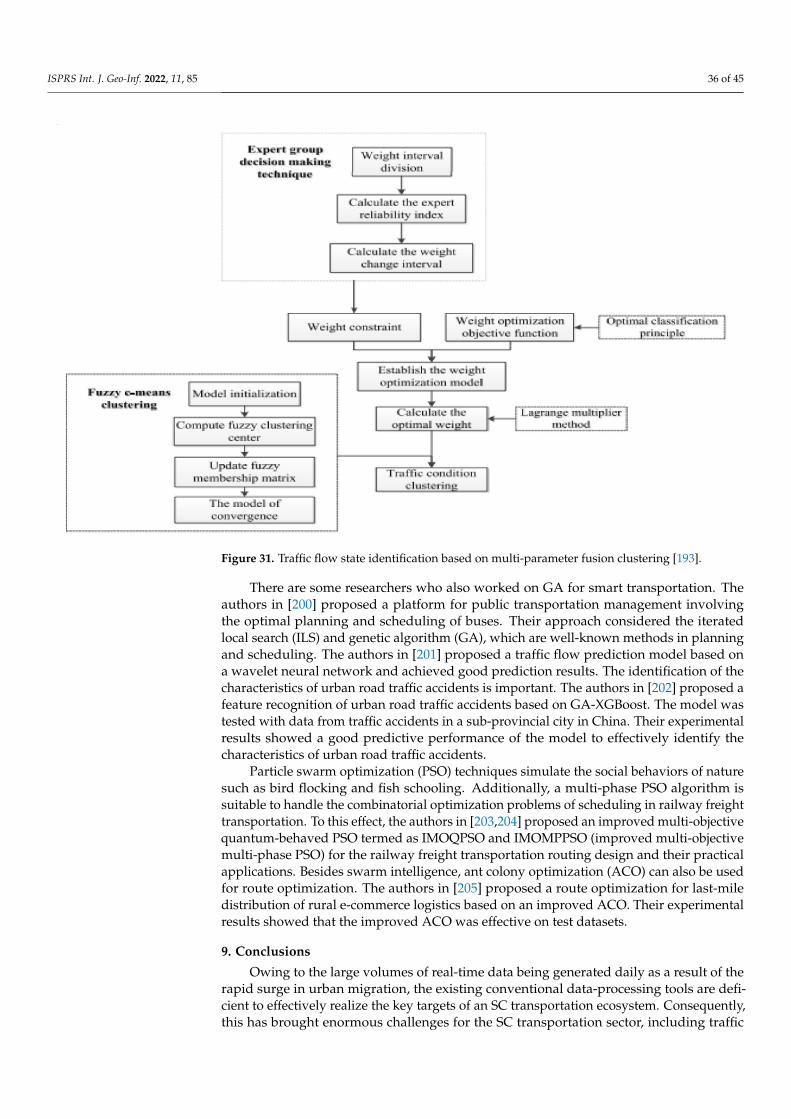
ISPRS Int. J. Geo-Inf. 2022, 11, 85 36 of 45
Figure 31. Traffic flow state identification based on multi-parameter fusion clustering [193].
There are some researchers who also worked on GA for smart transportation. Theauthors in [200] proposed a platform for public transportation management involvingthe optimal planning and scheduling of buses. Their approach considered the iteratedlocal search (ILS) and genetic algorithm (GA), which are well-known methods in planningand scheduling. The authors in [201] proposed a traffic flow prediction model based ona wavelet neural network and achieved good prediction results. The identification of thecharacteristics of urban road traffic accidents is important. The authors in [202] proposed afeature recognition of urban road traffic accidents based on GA-XGBoost. The model wastested with data from traffic accidents in a sub-provincial city in China. Their experimentalresults showed a good predictive performance of the model to effectively identify thecharacteristics of urban road traffic accidents.
Particle swarm optimization (PSO) techniques simulate the social behaviors of naturesuch as bird flocking and fish schooling. Additionally, a multi-phase PSO algorithm issuitable to handle the combinatorial optimization problems of scheduling in railway freighttransportation. To this effect, the authors in [203,204] proposed an improved multi-objectivequantum-behaved PSO termed as IMOQPSO and IMOMPPSO (improved multi-objectivemulti-phase PSO) for the railway freight transportation routing design and their practicalapplications. Besides swarm intelligence, ant colony optimization (ACO) can also be usedfor route optimization. The authors in [205] proposed a route optimization for last-miledistribution of rural e-commerce logistics based on an improved ACO. Their experimentalresults showed that the improved ACO was effective on test datasets.
9. Conclusions
Owing to the large volumes of real-time data being generated daily as a result of therapid surge in urban migration, the existing conventional data-processing tools are defi-cient to effectively realize the key targets of an SC transportation ecosystem. Consequently,this has brought enormous challenges for the SC transportation sector, including traffic

ISPRS Int. J. Geo-Inf. 2022, 11, 85 37 of 45
congestion, fleet management/route planning problems, as well as the development ofeffective and efficient strategies to utilize the available infrastructures and to minimizetraffic. To address these challenges, we have studied the state-of-the-art techniques forSC transportation applications with a focus on the emerging technologies from severalinformation- and data-driven perspectives. This paper has given a comprehensive sur-vey of the research area of smart transportation systems and emerging technologies. Thepaper contains core discussions on the impacts of geo-information on SC transportation,data-driven transportation, Big data technology, machine learning approaches for SC trans-portation, and recent trends using integrated deep learning towards SC transportation. Theresearch findings in this survey paper give useful insights to researchers that demonstratethat data-driven approaches can be utilized for smart cities and transportation architecture.We also hope that this study will acquaint researchers with the recent trends and emergingtechnologies for SC transportation applications, as well as provides useful insights intohow these technologies can be further exploited for SC transportation strategies. In essence,we have examined several use cases that can be exploited for SC transportation strategies.
The main limitation of this study is that it lacks some practical implementation of anyof the use cases that were reviewed. Hence, our future work will present some practicalconsiderations and implementation of any of the use cases. For instance, we intend tocombine these approaches to implement a more efficient SC waste transport system.
Author Contributions: Conceptualization, Kenneth Li-Minn Ang and Jasmine Kah Phooi Seng;writing—original draft preparation, Jasmine Kah Phooi Seng, Ericmoore Ngharamike and KennethLi-Minn Ang; writing—review and editing, Gerald K. Ijemaru and Kenneth Li-Minn Ang. All authorshave read and agreed to the published version of the manuscript.
Funding: This research received no external funding.
Institutional Review Board Statement: Not applicable.
Informed Consent Statement: Not applicable.
Data Availability Statement: Not applicable.
Conflicts of Interest: The authors declare no conflict of interest.
References1. Batty, M.; Axhausen, K.W.; Giannotti, F.; Pozdnoukhov, A.; Bazzani, A.; Wachowicz, M.; Ouzounis, G.; Portugali, Y. Smart cities of
the future. Eur. Phys. J. Spéc. Top. 2012, 214, 481–518. [CrossRef]2. Ang, L.-M.; Seng, K.P.; Zungeru, A.M.; Ijemaru, G. Big Sensor Data Systems for Smart Cities. IEEE Internet Things J. 2017, 4,
1259–1271. [CrossRef]3. Abdalla, R. Introduction to Geospatial Information and Communication Technology (GeoICT); Springer: Singapore, 2016.4. Weinberg, C. Is Alphabet Going to Build a City? The Information. 5 April 2016. Available online: https://www.theinformation.
com/articles/is-alphabet-going-to-build-a-city (accessed on 30 November 2021).5. Mohri, M.; Rostamizadeh, A.; Talwalkar, A. Foundations of Machine Learning; MIT Press: Cambridge, MA, USA, 2018.6. Sun, H.; Liu, H.; Xiao, H.; He, R.R.; Ran, B. Use of Local Linear Regression Model for Short-Term Traffic Forecasting. Transp. Res.
Rec. J. Transp. Res. Board 2003, 1836, 143–150. [CrossRef]7. Vlahogianni, E.; Karlaftis, M.G.; Golias, J.C. Optimized and meta-optimized neural networks for short-term traffic flow prediction:
A genetic approach. Transp. Res. Part C Emerg. Technol. 2005, 13, 211–234. [CrossRef]8. Zenina, N.; Borisov, A. Regression Analysis for Transport Trip Generation Evaluation. Inf. Technol. Manag. Sci. 2013, 16, 89–94.
[CrossRef]9. Zhu, X.; Guo, J.; Huang, W.; Yu, F. Short Term Forecasting of Remaining Parking Spaces in Parking Guidance Systems. In
Proceedings of the Transport Research Board Annual Meeting, Washington, DC, USA, 10–14 January 2016. No. 16-5060.10. Bin, Y.; Zhongzhen, Y.; Baozhen, Y. Bus Arrival Time Prediction Using Support Vector Machines. J. Intell. Transp. Syst. 2006, 10,
151–158. [CrossRef]11. Haydari, A.; Yilmaz, Y. Deep Reinforcement Learning for Intelligent Transportation Systems: A Survey. IEEE Trans. Intell. Transp.
Syst. 2020, 23, 11–32. [CrossRef]12. Chen, T. Going Deeper with Convolutional Neural Network for Intelligent Transportation; Worcester Polytechnic Institute: Worcester,
MA, USA, 2015.13. Duan, Y.; Lv, Y.; Kang, W.; Zhao, Y. A deep learning based approach for traffic data imputation. In Proceedings of the 17th
International IEEE Conference on Intelligent Transportation Systems (ITSC), Qingdao, China, 8–11 October 2014; pp. 912–917.

ISPRS Int. J. Geo-Inf. 2022, 11, 85 38 of 45
14. Polson, N.G.; Sokolov, V.O. Deep learning for short-term traffic flow prediction. Transp. Res. Part C Emerg. Technol. 2017, 79, 1–17.[CrossRef]
15. Huang, W.; Hong, H.; Li, M.; Hu, W.; Song, G.; Xie, K. Deep architecture for traffic flow prediction. In Proceedings of theInternational Conference on Advanced Data Mining and Applications, Hangzhou, China, 14–16 December 2013; Springer:Berlin/Heidelberg, Germany, 2013; pp. 165–176.
16. Srivastava, S.K. Green supply-chain management: A state-of-the-art literature review. Int. J. Manag. Rev. 2007, 9, 53–80. [CrossRef]17. Esmaeilian, B.; Wang, B.; Lewis, K.; Duarte, F.; Ratti, C.; Behdad, S. The future of waste management in smart and sustainable
cities: A review and concept paper. Waste Manag. 2018, 81, 177–195. [CrossRef]18. Govada, S.S.; Spruijt, W.; Rodgers, T. Smart city concept and framework. In Smart Economy in Smart Cities; Springer: Singapore,
2017; pp. 187–198.19. Kumar, R.; Goel, S.; Sharma, V.; Garg, L.; Srinivasan, K.; Julka, N. A Multifaceted Vigilare System for Intelligent Transportation
Services in Smart Cities. IEEE Internet Things Mag. 2020, 3, 76–80. [CrossRef]20. Parmar, P.; Champaneria, T. Study and comparison of transportation system architectures for smart city. In Proceedings of the 2017
International Conference on I-SMAC (IoT in Social, Mobile, Analytics and Cloud) (I-SMAC), Palladam, India, 10–11 February 2017;pp. 675–680.
21. Ji, Z.; Ganchev, I.; O’Droma, M.; Zhang, X. A cloud-based intelligent car parking services for smart cities. In Proceedings of the2014 31st URSI General Assembly and Scientific Symposium (URSI GASS), Beijing, China, 16–23 August 2014; pp. 1–4.
22. Vakula, D.; Raviteja, B. Smart public transport for smart cities. In Proceedings of the 2017 International Conference on IntelligentSustainable Systems (ICISS), Thirupur, India, 12–13 December 2017; IEEE: New York, NY, USA, 2017. [CrossRef]
23. Lee, O.L.; Tay, R.I.; Too, S.T.; Gorod, A. A Smart City transportation System of Systems Governance Framework: A Case Study ofSingapore. In Proceedings of the 2019 14th Annual Conference System of Systems Engineering (SoSE), Anchorage, AK, USA,19–22 May 2019; pp. 37–42.
24. Zhu, F.; Li, Z.; Chen, S.; Xiong, G. Parallel Transportation Management and Control System and Its Applications in BuildingSmart Cities. IEEE Trans. Intell. Transp. Syst. 2016, 17, 1576–1585. [CrossRef]
25. Malik, F.; Shah, M.A.; Khattak, H.A. Intelligent Transport System: An Important Aspect of Emergency Management in SmartCities. In Proceedings of the 2018 24th International Conference on Automation and Computing (ICAC), Newcastle upon Tyne,UK, 6–7 September 2018; pp. 1–6.
26. Lin, C.; Han, G.; Du, J.; Xu, T.; Shu, L.; Lv, Z. Spatiotemporal Congestion-Aware Path Planning Toward Intelligent TransportationSystems in Software-Defined Smart City IoT. IEEE Internet Things J. 2020, 7, 8012–8024. [CrossRef]
27. Chen, X.; Chen, R. A Review on Traffic Prediction Methods for Intelligent Transportation System in Smart Cities. In Proceedingsof the 2019 12th International Congress on Image and Signal Processing, BioMedical Engineering and Informatics (CISP-BMEI),Suzhou, China, 19–21 October 2019; pp. 1–5.
28. Acunzo, D.; Zhu, Y.; Xie, B.; Baratoff, G. Context-Adaptive Approach for Vehicle Detection under Varying Lighting Conditions. InProceedings of the 2007 IEEE Intelligent Transportation Systems Conference, Bellevue, WA, USA, 30 September–3 October 2007;pp. 654–660.
29. Farkas, K.; Fehér, G.; Benczúr, A.; Sidlo, C. Crowdsending based public transport information service in smart cities. IEEECommun. Mag. 2015, 53, 158–165. [CrossRef]
30. Haklay, M.; Weber, P. OpenStreetMap: User-Generated Street Maps. IEEE Pervasive Comput. 2008, 7, 12–18. [CrossRef]31. Cheng, G.; Guo, D.; Shi, J.; Qin, Y. Smart City-Wide Package Distribution Using Crowdsourced Public Transportation Systems.
IEEE Internet Things J. 2019, 6, 7584–7594. [CrossRef]32. Bergenhem, C.; Shladover, S.; Coelingh, E.; Englund, C.; Tsugawa, S. Overview of platooning systems. In Proceedings of the 19th
ITS World Congress, Vienna, Austria, 22–26 October 2012.33. Chen, C.; Zhang, Y.; Khosravi, M.R.; Pei, Q.; Wan, S. An Intelligent Platooning Algorithm for Sustainable Transportation Systems
in Smart Cities. IEEE Sens. J. 2020, 21, 15437–15447. [CrossRef]34. Menouar, H.; Guvenc, I.; Akkaya, K.; Uluagac, A.S.; Kadri, A.; Tuncer, A. UAV-Enabled Intelligent Transportation Systems for the
Smart City: Applications and Challenges. IEEE Commun. Mag. 2017, 55, 22–28. [CrossRef]35. Tripathy, A.K.; Tripathy, P.K.; Mohapatra, A.G.; Ray, N.K.; Mohanty, S.P. WeDoShare: A Ridesharing Framework in Transportation
Cyber-Physical System for Sustainable Mobility in Smart Cities. IEEE Consum. Electron. Mag. 2020, 9, 41–48. [CrossRef]36. Barth, M.; Todd, M. Intelligent transportation system architecture for a multi-station shared vehicle system. In Proceedings of the
2000 IEEE Intelligent Transportation Systems, Dearborn, MI, USA, 6 August 2002; pp. 240–245.37. Mahmood, I.; Zubairi, J.A. Efficient Waste Transportation and Recycling: Enabling technologies for smart cities using the Internet
of Things. IEEE Electr. Mag. 2019, 7, 33–43. [CrossRef]38. Daniel, S.; Doran, M.A. geoSmartCity: Geomatics contribution to the smart city. In Proceedings of the 14th Annual International
Conference on Digital Government Research, New York, NY, USA, 17–20 June 2013; pp. 65–71.39. Doran, M.-A.; Daniel, S. Geomatics and Smart City: A transversal contribution to the Smart City development. Inf. Polity 2014, 19,
57–72. [CrossRef]40. Roche, S. Geographic Information Science I: Why does a smart city need to be spatially enabled? Prog. Hum. Geogr. 2014, 38,
703–711. [CrossRef]

ISPRS Int. J. Geo-Inf. 2022, 11, 85 39 of 45
41. Nahiduzzaman, K.M.; Aldosary, A.S. City structure in transition: A conceptual discourse on the impact of information andcommunication technology (ICT). In Social Development and High Technology Industries: Strategies and Applications; IGI Global:Hershey, PA, USA, 2012; pp. 187–199.
42. Ahvenniemi, H.; Huovila, A.; Pinto-Seppä, I.; Airaksinen, M. What are the differences between sustainable and smart cities?Cities 2017, 60, 234–245. [CrossRef]
43. Aina, Y.A. Achieving smart sustainable cities with GeoICT support: The Saudi evolving smart cities. Cities 2017, 71, 49–58.[CrossRef]
44. Abukhater, A.; Walker, D. Making smart growth smarter with GeoDesign. Directions Magazine, 20 July 2010.45. Liu, T.; Zhao, D.; Pan, M. An approach to 3D model fusion in GIS systems and its application in a future ECDIS. Comput. Geosci.
2016, 89, 12–20. [CrossRef]46. Bremer, M.; Mayr, A.; Wichmann, V.; Schmidtner, K.; Rutzinger, M. A new multi-scale 3D-GIS-approach for the assessment and
dissemination of solar income of digital city models. Comput. Environ. Urban Syst. 2016, 57, 144–154. [CrossRef]47. Steiniger, S.; Neun, M.; Edwardes, A.; Lenz, B. Foundations of LBS, CartouCHe-Cartography Swiss Higher Education. Obtido Em
2008, 20, 2010.48. Jiang, B.; Yao, X. Location-based services and GIS in perspective. Comput. Environ. Urban Syst. 2006, 30, 712–725. [CrossRef]49. Batty, M. Big data, smart cities and city planning. Dialog Hum. Geogr. 2013, 3, 274–279. [CrossRef]50. Chauhan, S.; Agarwal, N.; Kar, A.K. Addressing big data challenges in smart cities: A systematic literature review. Info 2016, 18,
73–90. [CrossRef]51. Li, D.; Cao, J.; Yao, Y. Big data in smart cities. Sci. China Inf. Sci. 2015, 58, 1–12. [CrossRef]52. Li, S.; Dragicevic, S.; Anton, F.; Sester, M.; Winter, S.; Çöltekin, A.; Pettit, C.; Jiang, B.; Haworth, J.; Stein, A.; et al. Geospatial big
data handling theory and methods: A review and research challenges. ISPRS J. Photogramm. Remote Sens. 2016, 115, 119–133.[CrossRef]
53. Adnan, M.; Leak, A.; Longley, P. A geocomputational analysis of Twitter activity around different world cities. Geo-Spat. Inf. Sci.2014, 17, 145–152. [CrossRef]
54. De Albuquerque, J.P.; Herfort, B.; Brenning, A.; Zipf, A. A geographic approach for combining social media and authoritativedata towards identifying useful information for disaster management. Int. J. Geogr. Inf. Sci. 2015, 29, 667–689. [CrossRef]
55. Hawelka, B.; Sitko, I.; Beinat, E.; Sobolevsky, S.; Kazakopoulos, P.; Ratti, C. Geo-located Twitter as proxy for global mobilitypatterns. Cartogr. Geogr. Inf. Sci. 2014, 41, 260–271. [CrossRef] [PubMed]
56. Yang, W.; Mu, L.; Shen, Y. Effect of climate and seasonality on depressed mood among twitter users. Appl. Geogr. 2015, 63, 184–191.[CrossRef]
57. Aina, Y.A. Applications of geospatial technologies for practitioners: An emerging perspective of geospatial education. In EmergingInformatics–Innovative Concepts and Applications; InTech: Rijeka, Croatia, 2012; pp. 1–20.
58. Jackson, D.; Simpson, R. (Eds.) D_City: Digital Earth|Virtual Nations| Data Cities: Connecting Global Futures for EnvironmentalPlanning; DCity: Newton, NSW, Australia, 2013.
59. Pertence, A.A.; Mini, R.A.; Marques-Neto, H.T. Vulnerability Analysis of the Urban Transport System in the Context of SmartCities. In Proceedings of the 2020 IEEE International Smart Cities Conference, Piscataway, NJ, USA, 28 September–1 October 2020;pp. 1–8.
60. Tong, L. Research on the Application of Key Technologies in the Construction of Smart Cities Based on Smart Transportation.In Proceedings of the 2020 IEEE Conference on Telecommunications, Optics and Computer Science (TOCS), Shenyang, China,11–13 December 2020; pp. 189–194.
61. Htay, T.Z.; Komapov, V.G.; Glushenkov, V.A. Creation of an interactive geo-information model of the multifunctional magneticlevitation transport system ELTRO in Naypyidaw, Republic of Myanmar. In Proceedings of the 2021 3rd International YouthConference on Radio Electronics, Electrical and Power Engineering (REEPE), Moscow, Russia, 12–14 March 2021; pp. 1–5.
62. Ghosh, K.; Musti, K.S. Integration of SLAM with GIS to model sustainable urban transportation system: A smart city perspective.In Proceedings of the 2020 12th International Conference on Computational Intelligence and Communication Networks (CICN),Bhimtal, India, 25–26 September 2020; pp. 261–267.
63. Timofeev, V.S.; Teselkina, K.V.; Veselova, A.S. Development and Research of Transport Speed Models Using the Methods ofGeo-Statistical Data Analysis. In Proceedings of the 2018 XIV International Scientific-Technical Conference on Actual Problems ofElectronics Instrument Engineering (APEIE), Novosibirsk, Russia, 2–6 October 2018; pp. 315–319.
64. Shanmugasundaram, R.; Santhiyakumari, N. Urban Sprawl Classification Analysis Using Image Processing Technique inGeoinformation System. In Proceedings of the 2018 Conference on Emerging Devices and Smart Systems (ICEDSS), Tiruchengode,India, 2–3 March 2018; pp. 192–196.
65. Chen, M.; Yu, X.; Liu, Y. TraLFM: Latent factor modeling of traffic trajectory data. IEEE Trans. Intell. Transp. Syst. 2019, 20,4624–4634. [CrossRef]
66. Gokasar, I.; Cetinel, Y.; Baydogan, M.G. Estimation of Influence Distance of Bus Stops Using Bus GPS Data and Bus Stop Properties.IEEE Trans. Intell. Transp. Syst. 2019, 20, 4635–4642. [CrossRef]
67. Ghasemaghaei, M.; Calic, G. Assessing the impact of big data on firm innovation performance: Big data is not always better data.J. Bus. Res. 2020, 108, 147–162. [CrossRef]
ISPRS Int. J. Geo-Inf. 2022, 11, 85 40 of 45
68. Torre-Bastida, A.I.; Del Ser, J.; Laña, I.; Ilardia, M.; Bilbao, M.N.; Campos-Cordobés, S. Big Data for transportation and mobility:Recent advances, trends and challenges. IET Intell. Transp. Syst. 2018, 12, 742–755. [CrossRef]
69. Kaffash, S.; Nguyen, A.T.; Zhu, J. Big data algorithms and applications in intelligent transportation system: A review andbibliometric analysis. Int. J. Prod. Econ. 2021, 231, 107868. [CrossRef]
70. Zhu, L.; Yu, F.R.; Wang, Y.; Ning, B.; Tang, T. Big data analytics in intelligent transportation systems: A survey. IEEE Trans. Intell.Transp. Syst. 2019, 20, 383–398. [CrossRef]
71. Mohammed, S.; Arabnia, H.R.; Qu, X.; Zhang, D.; Kim, T.H.; Zhao, J. IEEE Access Special Section Editorial: Big Data Technologyand Applications in Intelligent Transportation. IEEE Access 2020, 8, 201331–201344. [CrossRef]
72. Kim, K.; Gutesa, S.; Dimitrijevic, B.; Lee, J.; Spasovic, L.; Mirza, W.; Singh, J. Performance evaluation of video analytics for trafficincident detection and vehicle counts collection. In Recent Advances in Intelligent Image Search and Video Retrieval; Springer: Cham,Switzerland, 2017; pp. 213–231.
73. Wang, X.; Zhao, S.; Dong, L. Research and application of traffic visualization based on vehicle GPS big data. In Proceedings of the2nd International Conference on Intelligent Transportation, Singapore, 25 November 2016; pp. 293–302.
74. Shukla, S.N.; Champaneria, T.A. Survey of various data collection ways for smart transportation domain of smart city. InProceedings of the 2017 IEEE International Conference on i-Smac (Iot in Social, Mobile, Analytics and Cloud) (I-Smac), Palladam,India, 10–11 February 2017; IEEE: Piscataway, NJ, USA, 2017; pp. 681–685.
75. Wen, S.; Gao, Y.; Zhang, D.; Yang, J.; Li, Q. An Efficient Data Acquisition System for Large Numbers of Various Vehicle Terminals.IEEE Trans. Intell. Transp. Syst. 2020, 1–6. [CrossRef]
76. Chen, C.; Luan, T.H.; Guan, X.; Lu, N.; Liu, Y. Connected vehicular transportation: Data analytics and traffic-dependentnetworking. IEEE Veh. Technol. Mag. 2017, 12, 42–54. [CrossRef]
77. Lam, A.Y.; James, J.Q.; Hou, Y.; Li, V.O. Coordinated autonomous vehicle parking for vehicle-to-grid services: Formulation anddistributed algorithm. IEEE Trans. Smart Grid 2018, 9, 4356–4366. [CrossRef]
78. Contreras-Castillo, J.; Zeadally, S.; Ibañez, J.A. Solving vehicular ad hoc network challenges with big data solutions. IET Netw.2016, 5, 81–84. [CrossRef]
79. Zheng, X.; Chen, W.; Wang, P.; Shen, D.; Chen, S.; Wang, X.; Zhang, Q.; Yang, L. Big data for social transportation. IEEE Trans.Intell. Transp. Syst. 2015, 17, 620–630. [CrossRef]
80. Mounica, B.; Lavanya, K. Social Media data analysis for intelligent transportation systems. In Proceedings of the 2020 IEEEInternational Conference on Emerging Trends in Information Technology and Engineering (ic-ETITE), Vellore, India, 24–25February 2020; IEEE: Piscataway, NJ, USA, 2020; pp. 1–8.
81. Ghahramani, M.; Zhou, M.; Hon, C.T. Mobile Phone Data Analysis: A Spatial Exploration Toward Hotspot Detection. IEEE Trans.Autom. Sci. Eng. 2019, 16, 351–362. [CrossRef]
82. Cottrill, C.D.; Derrible, S. Leveraging Big Data for the Development of Transport Sustainability Indicators. J. Urban Technol. 2015,22, 45–64. [CrossRef]
83. Zhu, L.; Yu, F.R.; Ning, B.; Tang, T. Cross-Layer Handoff Design in MIMO-Enabled WLANs for Communication-Based TrainControl (CBTC) Systems. IEEE J. Sel. Areas Commun. 2012, 30, 719–728. [CrossRef]
84. Biuk-Aghai, R.P.; Kou, W.T.; Fong, S. Big data analytics for transportation: Problems and prospects for its application in China. InProceedings of the 2016 IEEE Region 10 Symposium (TENSYMP), Bali, Indonesia, 9–11 May 2016; IEEE: Piscataway, NJ, USA,2020; pp. 173–178.
85. Ayed, A.B.; Halima, M.B.; Alimi, A.M. Big data analytics for logistics and transportation. In Proceedings of the 2015 4th IEEEInternational Conference on Advanced Logistics and Transport (ICALT), Valenciennes, France, 20–22 May 2015; IEEE: Piscataway,NJ, USA, 2020; pp. 311–316.
86. Davenport, T.H.; Barth, P.; Bean, R. How’big data’is different. MIT Sloan Manag. Rev. 2012, 54, 43.87. Wemegah, T.D.; Zhu, S. Big data challenges in transportation: A case study of traffic volume count from massive Radio Frequency
Identification (RFID) data. In Proceedings of the 2017 IEEE International Conference on the Frontiers and Advances in DataScience (FADS), Xi’an, China, 23–25 October 2017; IEEE: Piscataway, NJ, USA, 2017; pp. 58–63.
88. Ramesh, R.; Divya, G.; Dorairangaswamy, M.A.; Unnikrishnan, K.N.; Joseph, A.; Vijayakumar, A.; Mani, A. Real-Time VehicularTraffic Analysis using Big Data Processing and IoT based Devices for Future Policy Predictions in Smart Transportation. InProceedings of the 2019 IEEE International Conference on Communication and Electronics Systems (ICCES), Coimbatore, India,17–19 July 2019; IEEE: Piscataway, NJ, USA, 2019; pp. 1482–1488.
89. Syarif, M.; Adji, T.B. Big data analytics: Estimation of destination for users of bus rapid transit (BRT) public transportation inJakarta. In Proceedings of the 2019 IEEE International Conference of Artificial Intelligence and Information Technology (ICAIIT),Yogyakarta, Indonesia, 13–15 March 2019; IEEE: Piscataway, NJ, USA, 2019; pp. 209–214.
90. Lu, Y.; Misra, A.; Wu, H. Smartphone sensing meets transport data: A collaborative framework for transportation service analytics.IEEE Trans. Mob. Comput. 2017, 17, 945–960. [CrossRef]
91. Trueblood, F.; Rodriguez, D.; Hernandez, J.; Salomon, M.; Soundarajan, S.; Pirouz, M. Demystifying Transportation UsingBig Data Analytics. In Proceedings of the 2019 IEEE International Conference on Computational Science and ComputationalIntelligence (CSCI), Las Vegas, NV, USA, 5–7 December 2019; IEEE: Piscataway, NJ, USA, 2019; pp. 1281–1286.

ISPRS Int. J. Geo-Inf. 2022, 11, 85 41 of 45
92. Al Najada, H.; Mahgoub, I. Anticipation and alert system of congestion and accidents in VANET using Big Data analysis forIntelligent Transportation Systems. In Proceedings of the 2016 IEEE Symposium Series on Computational Intelligence (SSCI),Athens, Greece, 6–9 December 2016; IEEE: Piscataway, NJ, USA, 2016; pp. 1–8.
93. Lu, Y.; Wu, H.; Liu, X.; Chen, P. TourSense: A framework for tourist identification and analytics using transport data. IEEE Trans.Knowl. Data Eng. 2019, 31, 2407–2422. [CrossRef]
94. Puiu, D.; Bischof, S.; Serbanescu, B.; Nechifor, S.; Parreira, J.; Schreiner, H. A public transportation journey planner enabled by IoTdata analytics. In Proceedings of the 2017 20th IEEE Conference on Innovations in Clouds, Internet and Networks (ICIN), Paris,France, 7–9 March 2017; IEEE: Piscataway, NJ, USA, 2017; pp. 355–359.
95. Cyril, A.; George, V.; Mulangi, R.H. Electronic ticket machine data analytics for public bus transport planning. In Proceedings ofthe 2017 IEEE International Conference on Energy, Communication, Data Analytics and Soft Computing (ICECDS), Chennai,India, 1–2 August 2017; IEEE: Piscataway, NJ, USA, 2017; pp. 3917–3922.
96. Kwon, O.; Lee, N.; Shin, B. Data quality management, data usage experience and acquisition intention of big data analytics. Int. J.Inf. Manag. 2014, 34, 387–394.
97. Kong, X.; Li, M.; Tang, T.; Tian, K.; Moreira-Matias, L.; Xia, F. Shared subway shuttle bus route planning based on transport dataanalytics. IEEE Trans. Autom. Sci. Eng. 2018, 15, 1507–1520. [CrossRef]
98. Saroj, A.; Roy, S.; Guin, A.; Hunter, M.; Fujimoto, R. Smart city real-time data-driven transportation simulation. In Proceedings ofthe 2018 IEEE Winter Simulation Conference (WSC), Gothenburg, Sweden, 9–12 December 2018; IEEE: Piscataway, NJ, USA, 2018;pp. 857–868.
99. Nelson, Q.; Steffensmeier, D.; Pawaskar, S. A simple approach for sustainable transportation systems in smart cities: A graphtheory model. In Proceedings of the 2018 IEEE Conference on Technologies for Sustainability (SusTech), Long Beach, CA, USA,11–13 November 2018; IEEE: Piscataway, NJ, USA, 2018; pp. 1–5.
100. Darwish, T.S.; Bakar, K.A.; Kaiwartya, O.; Lloret, J. TRADING: Traffic Aware Data Offloading for Big Data Enabled IntelligentTransportation System. IEEE Trans. Veh. Technol. 2020, 69, 6869–6879. [CrossRef]
101. Howard, A.J.; Lee, T.; Mahar, S.; Intrevado, P.; Woodbridge, D.M.K. Distributed data analytics framework for smart transportation.In Proceedings of the 2018 20th IEEE International Conference on High Performance Computing and Communications; IEEE 16thInternational Conference on Smart City; IEEE 4th International Conference on Data Science and Systems (HPCC/SmartCity/DSS),Exeter, UK, 28–30 June 2018; IEEE: Piscataway, NJ, USA, 2018; pp. 1374–1380.
102. Katrakazas, C.; Antoniou, C.; Vazquez, N.S.; Trochidis, I.; Arampatzis, S. Big data and emerging transportation challenges:Findings from the noesis project. In Proceedings of the 2019 6th IEEE International Conference on Models and Technologies forIntelligent Transportation Systems (MT-ITS), Cracow, Poland, 5–7 June 2019; IEEE: Piscataway, NJ, USA, 2019; pp. 1–9.
103. Demirkan, H.; Delen, D. Leveraging the capabilities of service-oriented decision support systems: Putting analytics and big datain cloud. Decis. Support Syst. 2013, 55, 412–421. [CrossRef]
104. Bibri, S.E. The IoT for smart sustainable cities of the future: An analytical framework for sensor-based big data applications forenvironmental sustainability. Sustain. Cities Soc. 2018, 38, 230–253. [CrossRef]
105. Singh, J.; Singla, V. Big data: Tools and technologies in big data. Int. J. Comput. App. 2015, 112, 6–10.106. Alam, M.M.; Torgo, L.; Bifet, A. A Survey on Spatio-temporal Data Analytics Systems. arXiv 2021, arXiv:2103.09883. [CrossRef]107. Alam, M.M.; Ray, S.; Bhavsar, V.C. A Performance Study of Big Spatial Data Systems. In Proceedings of the 7th ACM SIGSPATIAL
International Workshop on Analytics for Big Geospatial Data, Seattle, WA, USA, 6 November 2018; pp. 1–9.108. Jan, B.; Farman, H.; Khan, M.; Talha, M.; Din, I.U. Designing a smart transportation system: An internet of things and big data
approach. IEEE Wirel. Commun. 2019, 26, 73–79. [CrossRef]109. Azeroual, O.; Fabre, R. Processing Big Data with Apache Hadoop in the Current Challenging Era of COVID-19. Big Data Cogn.
Comput. 2021, 5, 12. [CrossRef]110. Galliers, R.D.; Newell, S.; Shanks, G.; Topi, H. Datification and its human, organizational and societal effects. J. Strateg. Inf. Syst.
2017, 26, 185–190. [CrossRef]111. Fiore, S.; Elia, D.; Pires, C.E.; Mestre, D.G.; Cappiello, C.; Vitali, M.; Andrade, N.; Braz, T.; Lezzi, D.; Moraes, R.; et al. An
Integrated Big and Fast Data Analytics Platform for Smart Urban Transportation Management. IEEE Access 2019, 7, 117652–117677.[CrossRef]
112. Wang, Y.; Kung, L.; Byrd, T.A. Big data analytics: Understanding its capabilities and potential benefits for healthcare organizations.Technol. Forecast. Soc. Change 2018, 126, 3–13.
113. Guo, Y.; Wang, S.; Zheng, L.; Lu, M. Trajectory Data Driven Transit-Transportation Planning. In Proceedings of the 2017 5th IEEEInternational Conference on Advanced Cloud and Big Data (CBD), Shanghai, China, 13–16 August 2017; IEEE: Piscataway, NJ,USA, 2017; pp. 380–384.
114. Van Oort, N.; Cats, O. Improving public transport decision making, planning and operations by using big data: Cases fromSweden and the Netherlands. In Proceedings of the 2015 18th IEEE international conference on intelligent transportation systems,Gran Canaria, Spain, 15–18 September 2015; IEEE: Piscataway, NJ, USA, 2015; pp. 19–24.
115. Rathore, M.M.; Ahmad, A.; Paul, A.; Jeon, G. Efficient graph-oriented smart transportation using internet of things generatedbig data. In Proceedings of the 2015 11th IEEE International Conference on Signal-Image Technology & Internet-Based Systems(SITIS), Bangkok, Thailand, 23–27 November 2015; IEEE: Piscataway, NJ, USA, 2015; pp. 512–519.

ISPRS Int. J. Geo-Inf. 2022, 11, 85 42 of 45
116. Wang, Y.; Ram, S.; Currim, F.; Dantas, E.; Sabóia, L.A. A big data approach for smart transportation management on busnetwork. In Proceedings of the 2016 IEEE International Smart Cities Conference (ISC2), Trento, Italy, 12–15 September 2016; IEEE:Piscataway, NJ, USA, 2016; pp. 1–6.
117. Shukla, S.; Balachandran, K.; Sumitha, V.S. A framework for smart transportation using Big Data. In Proceedings of the 2016International Conference on ICT in Business Industry & Government, Indore, India, 18–19 November 2016; pp. 1–3.
118. Shi, Q.; Abdel-Aty, M. Big data applications in real-time traffic operation and safety monitoring and improvement on urbanexpressways. Transp. Res. Part C Emerg. Technol. 2015, 58, 380–394. [CrossRef]
119. Marshall, A.; Mueck, S.; Shockley, R. How leading organizations use big data and analytics to innovate. Strategy Leadersh. 2015,43, 32–39. [CrossRef]
120. De Gennaro, M.; Paffumi, E.; Martini, G. Big data for supporting low-carbon road transport policies in Europe: Applications,challenges and opportunities. Big Data Res. 2016, 6, 11–25. [CrossRef]
121. Fetene, G.M.; Kaplan, S.; Mabit, S.L.; Jensen, A.F.; Prato, C.G. Harnessing big data for estimating the energy consumption anddriving range of electric vehicles. Transp. Res. Part D Transp. Environ. 2017, 54, 1–11. [CrossRef]
122. Huang, Z.; Cao, F.; Jin, C.; Yu, Z.; Huang, R. Carbon emission flow from self-driving tours and its spatial relationship with scenicspots—A traffic-related big data method. J. Clean. Prod. 2017, 142, 946–955. [CrossRef]
123. Land, A.; Buus, A.; Platt, A. Data Analytics in Rail Transportation: Applications and Effects for Sustainability. IEEE Eng. Manag.Rev. 2020, 48, 85–91. [CrossRef]
124. Dimanche, V.; Goupil, A.; Philippot, A.; Riera, B.; Urban, A.; Gabriel, G. Massive Railway Operating Data Visualization; a Tool forRATP Operating Expert. IFAC-PapersOnLine 2017, 50, 15841–15846. [CrossRef]
125. Zhang, G.; Lin, J.; Zhang, Y.; Xue, K.; Nan, J.; Li, B. Big Data Based Intelligent Operation and Maintenance Platform. InProceedings of the 2020 5th IEEE International Conference on Intelligent Transportation Engineering (ICITE), Beijing, China,11–13 September 2020; IEEE: Piscataway, NJ, USA, 2020; pp. 249–253.
126. Gao, H.; Liu, S.; Cao, G.; Zhao, P.; Zhang, J.; Zhang, P. Big Data Analysis of Beijing Urban Rail Transit Fares Based on PassengerFlow. IEEE Access 2020, 8, 80049–80062. [CrossRef]
127. Liu, B.; Zhu, G.; Li, X.; Sun, R. Vulnerability Assessment of the Urban Rail Transit Network Based on Travel Behavior Analysis.IEEE Access 2020, 9, 1407–1419. [CrossRef]
128. Wang, Y.; Zhang, W.; Zhang, F.; Yin, L.; Zhang, J.; Tian, C.; Jiang, W. Analysis of subway passenger flow based on smart card data.In Proceedings of the 2020 6th IEEE International Conference on Big Data Computing and Communications (BIGCOM), Deqing,China, 24–25 July 2020; IEEE: Piscataway, NJ, USA, 2020; pp. 198–202.
129. Zhiyuan, H.; Liang, Z.; Ruihua, X.; Feng, Z. Application of big data visualization in passenger flow analysis of Shanghai Metronetwork. In Proceedings of the 2017 2nd IEEE International Conference on Intelligent Transportation Engineering (ICITE),Singapore, 1–3 September 2017; IEEE: Piscataway, NJ, USA, 2017; pp. 184–188.
130. Saki, M.; Abolhasan, M.; Lipman, J. A novel approach for big data classification and transportation in rail networks. IEEE Trans.Intell. Transp. Syst. 2019, 21, 1239–1249. [CrossRef]
131. Saboo, A.R.; Kumar, V.; Park, I. Using big data to model time-varying effects for marketing resource (re) allocation. Mis Q. 2016,40, 911–939. [CrossRef]
132. Wu, P.J.; Yang, C.K. Unstructured big data analytics for air cargo logistics management. In Proceedings of the 2018 IEEEInternational Conference on Service Operations and Logistics, and Informatics (SOLI), Singapore, 31 July–2 August 2018; IEEE:Piscataway, NJ, USA, 2018; pp. 274–278.
133. Sankaranarayanan, H.B.; Thind, R.S. Multi-modal travel in India: A big data approach for policy analytics. In Proceedingsof the 2017 7th IEEE International Conference on Cloud Computing, Data Science & Engineering-Confluence, Noida, India,12–13 January 2017; IEEE: Piscataway, NJ, USA, 2017; pp. 243–248.
134. Kasturi, E.; Devi, S.P.; Kiran, S.V.; Manivannan, S. Airline Route profitability analysis and Optimization using BIG DATAanalyticson aviation data sets under heuristic techniques. Procedia Comput. Sci. 2016, 87, 86–92. [CrossRef]
135. Li, S.; Yang, Y.; Yang, L.; Su, H.; Zhang, G.; Wang, J. Civil aircraft big data platform. In Proceedings of the 2017 11th IEEEInternational Conference on Semantic Computing (ICSC), San Diego, CA, USA, 30 January–1 February 2017; IEEE: Piscataway,NJ, USA, 2017; pp. 328–333.
136. Zhijun, W.; Caiyun, W. Security-as-a-service in big data of civil aviation. In Proceedings of the 2015 IEEE International Conferenceon Computer and Communications (ICCC), Chengdu, China, 10–11 October 2015; pp. 240–244.
137. Alsrehin, N.O.; Klaib, A.F.; Magableh, A. Intelligent transportation and control systems using data mining and machine learningtechniques: A comprehensive study. IEEE Access 2019, 7, 49830–49857. [CrossRef]
138. Maeda, T.N.; Mori, J.; Hayashi, I.; Sakimoto, T.; Sakata, I. Comparative examination of network clustering methods for extractingcommunity structures of a city from public transportation smart card data. IEEE Access 2019, 7, 53377–53391. [CrossRef]
139. Jiang, Y.; Liu, Y.; Liu, D.; Song, H. Applying Machine Learning to Aviation Big Data for Flight Delay Prediction. In Proceedingsof the 2020 IEEE International Conference on Dependable, Autonomic and Secure Computing, International Conference onPervasive Intelligence and Computing, International Conference on Cloud and Big Data Computing, International Conference onCyber Science and Technology Congress (DASC/PiCom/CBDCom/CyberSciTech), Calgary, AB, Canada, 17–22 August 2020;IEEE: Piscataway, NJ, USA, 2020; pp. 665–672.

ISPRS Int. J. Geo-Inf. 2022, 11, 85 43 of 45
140. Diao, Z.; Zhang, D.; Wang, X.; Xie, K.; He, S.; Lu, X.; Li, Y. A hybrid model for short-term traffic volume prediction in massivetransportation systems. IEEE Trans. Intell. Transp. Syst. 2018, 20, 935–946. [CrossRef]
141. Castro-Neto, M.; Jeong, Y.S.; Jeong, M.K.; Han, L.D. Online-SVR for short-term traffic flow prediction under typical and atypicaltraffic conditions. Exp. Syst. Appl. 2009, 36, 6164–6173. [CrossRef]
142. Ke, R.; Li, Z.; Tang, J.; Pan, Z.; Wang, Y. Real-time traffic flow parameter estimation from UAV video based on ensemble classifierand optical flow. IEEE Trans. Intell. Transp. Syst. 2018, 20, 54–64. [CrossRef]
143. Zhang, J.; Shen, D.; Tu, L.; Zhang, F.; Xu, C.; Wang, Y.; Tian, C.; Li, X.; Huang, B.; Li, Z. A real-time passenger flow estimation andprediction method for urban bus transit systems. IEEE Trans. Intell. Transp. Syst. 2017, 18, 3168–3178. [CrossRef]
144. Feng, W.; Chen, H.; Zhang, Z. Short-term traffic flow prediction based on wavelet function and extreme learning machine. InProceedings of the 2017 8th IEEE International Conference on Software Engineering and Service Science (ICSESS), Beijing, China,24–26 November 2017; pp. 531–535.
145. Wang, D.; Xiong, J.; Xiao, Z.; Li, X. Short-term traffic flow prediction based on ensemble real-time sequential extreme learningmachine under non-stationary condition. In Proceedings of the 2016 IEEE 83rd Vehicular Technology Conference (VTC Spring),Nanjing, China, 15–18 May 2016; pp. 1–5.
146. Zapata, L.P.; Flores, M.; Larios, V.; Maciel, R.; Antúnez, E.A. Estimation of people flow in public transportation network throughthe origin-destination problem for the South-Eastern corridor of Quito city in the smart cities context. In Proceedings of the 2019IEEE International Smart Cities Conference (ISC2), Casablanca, Morocco, 14–17 October 2019; pp. 181–186.
147. Liu, R.; Wang, Y.; Zhou, H.; Qian, Z. Short-term passenger flow prediction based on wavelet transform and kernel extremelearning machine. IEEE Access 2019, 7, 158025–158034. [CrossRef]
148. Said, A.M.; Abd-Elrahman, E.; Afifi, H. A comparative study on machine learning algorithms for green context-aware intelligenttransportation systems. In Proceedings of the 2017 International Conference on Electrical and Computing Technologies andApplications (ICECTA), Ras AI Khaimah, United Arab Emirates, 21–23 November 2017; pp. 1–5.
149. Heghedus, C.; Chakravorty, A.; Rong, C. Neural network frameworks. Com$parison on public transportation prediction. InProceedings of the 2019 IEEE International Parallel and Distributed Processing Symposium Workshops (IPDPSW), Rio de Janeiro,Brazil, 20–24 May 2019; pp. 842–849.
150. Bazzan, A.L.; Chamby-Diaz, J.C.; Estevam, R.S.; Schmidt, L.D.A.; Pasin, M.; Samatelo, J.L.A.; Ribeiro, M.V.L. Using Informa-tion from Heterogeneous Sources and Machine Learning in Intelligent Transportation Systems. In Proceedings of the 2019IEEE 15th International Conference on Intelligent Computer Communication and Processing (ICCP), Cluj-Napoca, Romania,5–7 September 2019; pp. 213–220.
151. Seng, K.P.; Ang, L.M. A big data layered architecture and functional units for the multimedia Internet of Things. IEEE Trans.Multi-Scale Comput. Syst. 2018, 4, 500–512. [CrossRef]
152. Seng, J.K.P.; Ang, K.L.M. Multimodal Emotion and Sentiment Modeling From Unstructured Big Data: Challenges, Architecture, &Techniques. IEEE Access 2019, 7, 90982–90998.
153. Shoumy, N.J.; Ang, L.M.; Seng, K.P.; Rahaman, D.M.; Zia, T. Multimodal big data affective analytics: A comprehensive surveyusing text, audio, visual and physiological signals. J. Netw. Comput. Appl. 2019, 149, 102447. [CrossRef]
154. Panovski, D.; Scurtu, V.; Zaharia, T. A neural network-based approach for public transportation prediction with traffic densitymatrix. In Proceedings of the 2018 7th European Workshop on Visual Information Processing (EUVIP), Tampere, Finland,26–28 November 2018; pp. 1–6.
155. Panovski, D.; Zaharia, T. Real-time public transportation prediction with machine learning algorithms. In Proceedings of the 2020IEEE International Conference on Consumer Electronics (ICCE), Las Vegas, NV, USA, 4–6 January 2020; pp. 1–4.
156. Panovski, D.; Zaharia, T. Simulation-based vehicular traffic lights optimization. In Proceedings of the 2016 12th InternationalConference on Signal-Image Technology & Internet-Based Systems (SITIS), Naples, Italy, 28 November–1 December 2016;pp. 258–265.
157. Liu, Y.; Liu, C.; Yuan, N.J.; Duan, L.; Fu, Y.; Xiong, H.; Xu, S.; Wu, J. Intelligent bus routing with heterogeneous human mobilitypatterns. Knowl. Inf. Syst. 2017, 50, 383–415. [CrossRef]
158. Soares, E.F.D.S.; Revoredo, K.; Baião, F.; de MS Quintella, C.A.; Campos, C.A.V. A combined solution for real-time travel modedetection and trip purpose prediction. IEEE Trans. Intell. Transp. Syst. 2019, 20, 4655–4664. [CrossRef]
159. Minea, M.; Dumitrescu, C.; Chiva, I.C. Unconventional public transport anonymous data collection employing artificial intelli-gence. In Proceedings of the 2019 11th International Conference on Electronics, Computers and Artificial Intelligence (ECAI),Pitesti, Romania, 27–29 June 2019; pp. 1–6.
160. Veres, M.; Moussa, M. Deep learning for intelligent transportation systems: A survey of emerging trends. IEEE Trans. Intell.Transp. Syst. 2019, 21, 3152–3168. [CrossRef]
161. Lin, F.; Fang, J.Y.; Hsieh, H.P. A Gaussian-Prioritized Approach for Deploying Additional Route on Existing Mass Transportationwith Neural-Network-Based Passenger Flow Inference. In Proceedings of the 2020 IEEE Congress on Evolutionary Computation(CEC), Glasgow, UK, 19–24 July 2020; pp. 1–8.
162. Siripanpornchana, C.; Panichpapiboon, S.; Chaovalit, P. Travel-time prediction with deep learning. In Proceedings of the 2016IEEE Region 10 Conference (TENCON), Singapore, 22–25 November 2016; pp. 1859–1862.
163. Wang, D.; Zhang, J.; Cao, W.; Li, J.; Zheng, Y. When will you arrive? Estimating travel time based on deep neural networks. InProceedings of the AAAI Conference on Artificial Intelligence, New Orleans, LA, USA, 2–7 February 2018.

ISPRS Int. J. Geo-Inf. 2022, 11, 85 44 of 45
164. Zhang, H.; Wu, H.; Sun, W.; Zheng, B. Deeptravel: A neural network based travel time estimation model with auxiliarysupervision. arXiv 2018, arXiv:1802.02147.
165. Zhu, X.; Li, J.; Liu, Z.; Wang, S.; Yang, F. Learning transportation annotated mobility profiles from GPS data for context-awaremobile services. In Proceedings of the 2016 IEEE International Conference on Services Computing (SCC), San Francisco, CA,USA, 27 June–2 July 2016; pp. 475–482.
166. Jindal, I.; Qin, Z.T.; Chen, X.; Nokleby, M.; Ye, J. Optimizing taxi carpool policies via reinforcement learning and spatio-temporalmining. In Proceedings of the 2018 IEEE International Conference on Big Data (Big Data), Seattle, WA, USA, 10–13 December 2018;pp. 1417–1426.
167. Abedalla, A.; Fadel, A.; Tuffaha, I.; Al-Omari, H.; Omari, M.; Abdullah, M.; Al-Ayyoub, M. MTRecS-DLT: Multi-modal transportrecommender system using deep learning and tree models. In Proceedings of the 2019 Sixth International Conference on SocialNetworks Analysis, Management and Security (SNAMS), Granada, Spain, 22–25 October 2019; pp. 274–278.
168. Ma, Y.; Zhang, Z. Travel Mode Choice Prediction Using Deep Neural Networks with Entity Embeddings. IEEE Access 2020, 8,64959–64970. [CrossRef]
169. Zhou, F.; Yang, Q.; Zhong, T.; Chen, D.; Zhang, N. Variational Graph Neural Networks for Road Traffic Prediction in IntelligentTransportation Systems. IEEE Trans. Ind. Inform. 2020, 17, 2802–2812. [CrossRef]
170. Li, Y.; Yu, R.; Shahabi, C.; Liu, Y. Diffusion convolutional recurrent neural network: Data-driven traffic forecasting. arXiv 2017,arXiv:1707.01926.
171. Zheng, Z.; Yang, Y.; Liu, J.; Dai, H.N.; Zhang, Y. Deep and embedded learning approach for traffic flow prediction in urbaninformatics. IEEE Trans. Intell. Transp. Syst. 2019, 20, 3927–3939. [CrossRef]
172. Zhang, J.; Zheng, Y.; Qi, D. Deep spatio-temporal residual networks for citywide crowd flows prediction. In Proceedings of theAAAI Conference on Artificial Intelligence, San Francisco, CA, USA, 4–9 February 2017.
173. Guo, S.; Lin, Y.; Li, S.; Chen, Z.; Wan, H. Deep spatial–temporal 3D convolutional neural networks for traffic data forecasting.IEEE Trans. Intell. Transp. Syst. 2019, 20, 3913–3926. [CrossRef]
174. Dai, G.; Ma, C.; Xu, X. Short-term traffic flow prediction method for urban road sections based on space–time analysis and GRU.IEEE Access 2019, 7, 143025–143035. [CrossRef]
175. Zheng, G.; Chai, W.K.; Katos, V. An Ensemble Model for Short-Term Traffic Prediction in Smart City Transportation System. InProceedings of the 2019 IEEE Global Communications Conference (GLOBECOM), Waikoloa, HI, USA, 9–13 December 2019;pp. 1–6.
176. Shukla, A.; Bhattacharya, P.; Tanwar, S.; Kumar, N.; Guizani, M. Dwara: A deep learning-based dynamic toll pricing scheme forintelligent transportation systems. IEEE Trans. Veh. Technol. 2020, 69, 12510–12520. [CrossRef]
177. Zhang, J.; Chen, F.; Shen, Q. Cluster-based LSTM network for short-term passenger flow forecasting in urban rail transit. IEEEAccess 2019, 7, 147653–147671. [CrossRef]
178. Zhu, K.; Xun, P.; Li, W.; Li, Z.; Zhou, R. Prediction of passenger flow in urban rail transit based on big data analysis and deeplearning. IEEE Access 2019, 7, 142272–142279. [CrossRef]
179. Sha, S.; Li, J.; Zhang, K.; Yang, Z.; Wei, Z.; Li, X.; Zhu, X. RNN-based subway passenger flow rolling prediction. IEEE Access 2020,8, 15232–15240. [CrossRef]
180. Li, J.; Peng, H.; Liu, L.; Xiong, G.; Du, B.; Ma, H.; Wang, L.; Bhuiyan, M.Z.A. Graph CNNs for urban traffic passengerflows prediction. In Proceedings of the 2018 IEEE SmartWorld, Ubiquitous Intelligence & Computing, Advanced & TrustedComputing, Scalable Computing & Communications, Cloud & Big Data Computing, Internet of People and Smart City Innovation(SmartWorld/SCALCOM/UIC/ATC/CBDCom/IOP/SCI), Guangzhou, China, 8–12 October 2018; pp. 29–36.
181. Li, D.; Cao, J.; Li, R.; Wu, L. A Spatio-Temporal Structured LSTM Model for Short-Term Prediction of Origin-Destination Matrixin Rail Transit with Multisource Data. IEEE Access 2020, 8, 84000–84019. [CrossRef]
182. Toqué, F.; Côme, E.; El Mahrsi, M.K.; Oukhellou, L. Forecasting dynamic public transport origin-destination matrices withlong-short term memory recurrent neural networks. In Proceedings of the 2016 IEEE 19th International Conference on IntelligentTransportation Systems (ITSC), Rio de Janeiro, Brazil, 1–4 November 2016; pp. 1071–1076.
183. Machin, M.; Sanguesa, J.A.; Garrido, P.; Martinez, F.J. On the use of artificial intelligence techniques in intelligent transportationsystems. In Proceedings of the 2018 IEEE Wireless Communications and Networking Conference Workshops (WCNCW),Barcelona, Spain, 15–18 April 2018; IEEE: Piscataway, NJ, USA, 2018; pp. 332–337.
184. Kumar, N.; Rahman, S.S.; Dhakad, N. Fuzzy inference enabled deep reinforcement learning-based traffic light control forintelligent transportation system. IEEE Trans. Intell. Transp. Syst. 2020, 22, 4919–4928. [CrossRef]
185. Lv, Z.; Lou, R.; Singh, A.K. AI Empowered Communication Systems for Intelligent Transportation Systems. IEEE Trans. Intell.Transp. Syst. 2021, 22, 4579–4587. [CrossRef]
186. Hossain, M.S.; Sinha, H.; Mustafa, R. A belief rule based expert system to control traffic signals under uncertainty. In Proceedingsof the 2015 International Conference on Computer and Information Engineering (ICCIE), Rajshahi, Bangladesh, 26–27 November2015; IEEE: Piscataway, NJ, USA, 2015; pp. 83–86.
187. Olwan, M.A.; Mostafa, A.A.; AbdELAty, Y.M.; Mahfouz, D.M.; Shehata, O.M.; Morgan, E.I. Behavior Evaluation of Vehicle Platoonvia Different Fuzzy-X Tuned Controllers. In Proceedings of the 2020 8th EEE International Conference on Control, Mechatronicsand Automation (ICCMA), Moscow, Russia, 6–8 November 2020; IEEE: Piscataway, NJ, USA, 2020; pp. 149–155.

ISPRS Int. J. Geo-Inf. 2022, 11, 85 45 of 45
188. Wang, W.C.; Tai, C.C.; Wu, S.J.; Liu, Z.Y. A hybrid genetic algorithm with fuzzy logic controller for wireless power transmissionsystem of electric vehicles. In Proceedings of the 2015 IEEE International Conference on Industrial Technology (ICIT), Seville,Spain, 17–19 March 2015; IEEE: Piscataway, NJ, USA, 2015; pp. 2622–2627.
189. Yeh, Y.C.; Tsai, M.S. Development of a genetic algorithm based electric vehicle charging coordination on distribution networks. InProceedings of the 2015 IEEE Congress on Evolutionary Computation (CEC), Sendai, Japan, 25–28 May 2015; IEEE: Piscataway,NJ, USA, 2015; pp. 283–290.
190. Alaguvelu, R.; Curry, D.M.; Dagli, C.H. Fuzzy—Genetic algorithm approach to generate an optimal meta-architecture for a smart,safe & efficient city transportation system of systems. In Proceedings of the 2016 11th IEEE System of Systems EngineeringConference (SoSE), Kongsberg, Norway, 12–16 June 2016; IEEE: Piscataway, NJ, USA, 2016; pp. 1–6.
191. Nayeem, M.A.; Islam, M.M.; Yao, X. Solving transit network design problem using many-objective evolutionary approach. IEEETrans. Intell. Transp. Syst. 2019, 20, 3952–3963. [CrossRef]
192. Tang, J.; Liu, F.; Zou, Y.; Zhang, W.; Wang, Y. An improved fuzzy neural network for traffic speed prediction considering periodiccharacteristic. IEEE Trans. Intell. Transp. Syst. 2017, 18, 2340–2350. [CrossRef]
193. Bao, D. A multi-index fusion clustering strategy for traffic flow state identification. IEEE Access 2019, 7, 166404–166409. [CrossRef]194. Leung, C.K.; Elias, J.D.; Minuk, S.M.; de Jesus, A.R.R.; Cuzzocrea, A. An Innovative Fuzzy Logic-Based Machine Learning
Algorithm for Supporting Predictive Analytics on Big Transportation Data. In Proceedings of the 2020 IEEE InternationalConference on Fuzzy Systems (FUZZ-IEEE), Glasgow, UK, 19–24 July 2020; pp. 1–8.
195. Ai, C.; Jia, L.; Hong, M.; Zhang, C. Short-term road speed forecasting based on hybrid RBF neural network with the aid of fuzzysystem-based techniques in urban traffic flow. IEEE Access 2020, 8, 69461–69470. [CrossRef]
196. Yin, H.; Wong, S.; Xu, J.; Wong, C.K. Urban traffic flow prediction using a fuzzy-neural approach. Transp. Res. Part C Emerg.Technol. 2002, 10, 85–98. [CrossRef]
197. Schmidhuber, J. Deep learning in neural networks: An overview. Neural Netw. 2015, 61, 85–117. [CrossRef] [PubMed]198. Zheng, J. A Vehicle Routing Problem Model With Multiple Fuzzy Windows Based on Time-Varying Traffic Flow. IEEE Access
2020, 8, 39439–39444. [CrossRef]199. Sun, F.; Wang, X.L.; Zhang, Y.; Liu, W.X.; Zhang, R.J. Analysis of bus trip characteristic analysis and demand forecasting based on
GA-NARX neural network model. IEEE Access 2020, 8, 8812–8820. [CrossRef]200. Thiranjaya, C.; Rushan, R.; Udayanga, P.; Kaushalya, U.; Rankothge, W. Towards a Smart City: Application of Optimization for
a Smart Transportation Management System. In Proceedings of the 2018 IEEE International Conference on Information andAutomation for Sustainability (ICIAfS), Colombo, Sri Lanka, 21–22 December 2018; pp. 1–6.
201. Yang, H.J.; Hu, X. Wavelet neural network with improved genetic algorithm for traffic flow time series prediction. Optik 2016, 127,8103–8110. [CrossRef]
202. Qu, Y.; Lin, Z.; Li, H.; Zhang, X. Feature recognition of urban road traffic accidents based on GA-XGBoost in the context of bigdata. IEEE Access 2019, 7, 170106–170115. [CrossRef]
203. Zhang, Q.; Liu, S.; Gong, D.; Zhang, H.; Tu, Q. An improved multi-objective quantum-behaved particle swarm optimization forrailway freight transportation routing design. IEEE Access 2019, 7, 157353–157362. [CrossRef]
204. Wang, R.; Zhang, Z.; Wang, L.; Zhang, H. Resource-Expandable Railway Freight Transportation Routing Optimization. IEEEAccess 2019, 7, 161607–161620. [CrossRef]
205. Liu, W. Route optimization for last-mile distribution of rural E-commerce logistics based on ant colony optimization. IEEE Access2020, 8, 12179–12187. [CrossRef]