Efficient ConvNet Feature Extraction with Multiple RoI Pooling ...
15
Research Article Efficient ConvNet Feature Extraction with Multiple RoI Pooling for Landmark-Based Visual Localization of Autonomous Vehicles Yi Hou, 1 Hong Zhang, 2 Shilin Zhou, 1 and Huanxin Zou 1 1 College of Electronic Science and Engineering, National University of Defense Technology, Changsha, Hunan, China 2 Department of Computing Science, University of Alberta, Edmonton, AB, Canada T6G 2E8 Correspondence should be addressed to Yi Hou; [email protected] Received 12 May 2017; Revised 28 July 2017; Accepted 11 October 2017; Published 9 November 2017 Academic Editor: Paolo Bellavista Copyright © 2017 Yi Hou et al. is is an open access article distributed under the Creative Commons Attribution License, which permits unrestricted use, distribution, and reproduction in any medium, provided the original work is properly cited. Efficient and robust visual localization is important for autonomous vehicles. By achieving impressive localization accuracy under conditions of significant changes, ConvNet landmark-based approach has attracted the attention of people in several research communities including autonomous vehicles. Such an approach relies heavily on the outstanding discrimination power of ConvNet features to match detected landmarks between images. However, a major challenge of this approach is how to extract discriminative ConvNet features efficiently. To address this challenging, inspired by the high efficiency of the region of interest (RoI) pooling layer, we propose a Multiple RoI (MRoI) pooling technique, an enhancement of RoI, and a simple yet efficient ConvNet feature extraction method. Our idea is to leverage MRoI pooling to exploit multilevel and multiresolution information from multiple convolutional layers and then fuse them to improve the discrimination capacity of the final ConvNet features. e main advantages of our method are (a) high computational efficiency for real-time applications; (b) GPU memory efficiency for mobile applications; and (c) use of pretrained model without fine-tuning or retraining for easy implementation. Experimental results on four datasets have demonstrated not only the above advantages but also the high discriminating power of the extracted ConvNet features with state-of-the-art localization accuracy. 1. Introduction Efficient and reliable visual localization is a core requirement for smart transportation applications such as autonomous cars, self-driving public transport vehicles, and mobile robots. Its aim is to use visual sensors such as cameras to solve the problem of “where am I?” and facilitate life-long navigation, by determining whether the current view of the camera corresponds to a location that has been already visited or seen [1]. Compared to the solutions that use other sensors such as LIDAR, visual localization is inherently more flexible and cheaper to use [1]. erefore, visual localization for transportation systems has become a hot topic. In particular, recent interest in autonomous vehicles has created a strong need for visual localization techniques that can efficiently operate in challenging environments. Although current state- of-the-art approaches have made great strides [2–12], visual localization for long-term navigation of autonomous vehicles still remains an unsolved problem when image appearance experiences significant changes caused by time of the day, season, weather, camera pose, etc. [1]. Recently, a ConvNet landmark-based visual localization approach proposed in [13] has achieved state-of-the-art localization accuracy under conditions of significant envi- ronmental and viewpoint changes, raising the interest of the community [1, 14, 15]. Some sample examples of matched image pairs produced by such an approach are illustrated in Figure 1. Its key idea is to leverage the discrimination power of ConvNet features to describe high-level visual landmarks in the image, in order to achieve viewpoint invariance [1, 13]. For this point, such an approach relies heavily on the great descriptive power of ConvNet features to match detected landmarks between images. At the same time, a practical consideration for ConvNet feature extraction is to be efficient. Hindawi Mobile Information Systems Volume 2017, Article ID 8104386, 14 pages https://doi.org/10.1155/2017/8104386
-
Upload
khangminh22 -
Category
Documents
-
view
0 -
download
0
Transcript of Efficient ConvNet Feature Extraction with Multiple RoI Pooling ...

Research ArticleEfficient ConvNet Feature Extraction with MultipleRoI Pooling for Landmark-Based Visual Localization ofAutonomous Vehicles
Yi Hou,1 Hong Zhang,2 Shilin Zhou,1 and Huanxin Zou1
1College of Electronic Science and Engineering, National University of Defense Technology, Changsha, Hunan, China2Department of Computing Science, University of Alberta, Edmonton, AB, Canada T6G 2E8
Correspondence should be addressed to Yi Hou; [email protected]
Received 12 May 2017; Revised 28 July 2017; Accepted 11 October 2017; Published 9 November 2017
Academic Editor: Paolo Bellavista
Copyright © 2017 Yi Hou et al. This is an open access article distributed under the Creative Commons Attribution License, whichpermits unrestricted use, distribution, and reproduction in any medium, provided the original work is properly cited.
Efficient and robust visual localization is important for autonomous vehicles. By achieving impressive localization accuracy underconditions of significant changes, ConvNet landmark-based approach has attracted the attention of people in several researchcommunities including autonomous vehicles. Such an approach relies heavily on the outstanding discrimination power of ConvNetfeatures tomatch detected landmarks between images. However, a major challenge of this approach is how to extract discriminativeConvNet features efficiently. To address this challenging, inspired by the high efficiency of the region of interest (RoI) poolinglayer, we propose a Multiple RoI (MRoI) pooling technique, an enhancement of RoI, and a simple yet efficient ConvNet featureextraction method. Our idea is to leverage MRoI pooling to exploit multilevel and multiresolution information from multipleconvolutional layers and then fuse them to improve the discrimination capacity of the final ConvNet features.Themain advantagesof our method are (a) high computational efficiency for real-time applications; (b) GPUmemory efficiency for mobile applications;and (c) use of pretrained model without fine-tuning or retraining for easy implementation. Experimental results on four datasetshave demonstrated not only the above advantages but also the high discriminating power of the extracted ConvNet features withstate-of-the-art localization accuracy.
1. Introduction
Efficient and reliable visual localization is a core requirementfor smart transportation applications such as autonomouscars, self-driving public transport vehicles, and mobilerobots. Its aim is to use visual sensors such as cameras tosolve the problem of “where am I?” and facilitate life-longnavigation, by determining whether the current view of thecamera corresponds to a location that has been already visitedor seen [1]. Compared to the solutions that use other sensorssuch as LIDAR, visual localization is inherently more flexibleand cheaper to use [1]. Therefore, visual localization fortransportation systems has become a hot topic. In particular,recent interest in autonomous vehicles has created a strongneed for visual localization techniques that can efficientlyoperate in challenging environments. Although current state-of-the-art approaches have made great strides [2–12], visual
localization for long-term navigation of autonomous vehiclesstill remains an unsolved problem when image appearanceexperiences significant changes caused by time of the day,season, weather, camera pose, etc. [1].
Recently, a ConvNet landmark-based visual localizationapproach proposed in [13] has achieved state-of-the-artlocalization accuracy under conditions of significant envi-ronmental and viewpoint changes, raising the interest of thecommunity [1, 14, 15]. Some sample examples of matchedimage pairs produced by such an approach are illustrated inFigure 1. Its key idea is to leverage the discrimination powerof ConvNet features to describe high-level visual landmarksin the image, in order to achieve viewpoint invariance [1, 13].For this point, such an approach relies heavily on the greatdescriptive power of ConvNet features to match detectedlandmarks between images. At the same time, a practicalconsideration forConvNet feature extraction is to be efficient.
HindawiMobile Information SystemsVolume 2017, Article ID 8104386, 14 pageshttps://doi.org/10.1155/2017/8104386

2 Mobile Information Systems
(a) UACampus
(b) St. Lucia
(c) Nordland
(d) Mapillary
Figure 1: Sample examples of matched image pairs produced by a ConvNet landmark-based visual localization approach, which extractedConvNet features by one variant of our proposed method, that is,MRoI-FastRCNN-AlexNet (see Section 5.1.2 for details).These images comefrom the testing datasets used in our experiments (see Section 5.1.1 for details). Six images on each row come from one dataset, and the threepairs illustrate images correctly matched by our method. The bounding boxes of the same color in each pair of matched images show thelandmarks that have been matched. For clarity, we show only ten matched landmarks in each image. Best viewed in color.
However, to the best of our knowledge, efficient extrac-tion has been largely overlooked in visual localizationresearch, and people rely on existing ConvNet feature extrac-tion methods introduced for computer vision applicationssuch as image classification [16–18] and object detection[19–21], without specializing them for the visual localizationapplication. As we will discuss in detail in Section 3, theseexisting methods fall into two groups: original image-basedand feature map-based. In general, methods in the first groupare accurate enough for localization but time-consumingwhile those in the second group are fast enough but notaccurate as the first group for localization. Therefore, thereis an urgent need to develop a method to achieve the speedand accuracy at the same time.
To this end, in this paper we present a simple yetefficient method to extract discriminative ConvNet featuresfor visual localization of autonomous vehicles that is highlyefficient both in computation and in GPUmemory, using thetechnique which we refer to as multiple RoI (MRoI) pooling.As an enhancement of a special pooling layer called region ofinterest (RoI) [20], MRoI pooling inherits the high efficiencyof RoI pooling.Therefore, we are able to useMRoI pooling toefficiently exploit multilevel andmultiresolution informationfrom multiple convolutional layers, instead of only one as in
previous feature map-based methods. Furthermore, we fuseinformation across multiple layers to improve the discrimi-nation capacity of the final ConvNet features.
Extensive experimental results on four datasets with vari-ous changes in environmental conditions have demonstratedthat (a) our proposed method is fast, GPU memory efficient,and based on a pretrained model without fine-tuning orretraining and (b) the discrimination capacity of ConvNetfeatures extracted by our method is higher than those offeature map-basedmethods on all testing datasets. Moreover,our method is also comparable with those of original image-based methods, with state-of-the-art localization accuracy.
The rest of this paper is organized as follows. Section 2briefly reviews related literature with respect to visual local-ization. Section 3 describes and analyzes existingmethods forextracting ConvNet features. Section 4 provides the detailsof our proposed method. Section 5 presents the experimentsand results. Finally, we conclude the work in Section 6.
2. Related Work
Prior to the emergence of CNN, visual localization ap-proaches mainly depended on hand-crafted features devel-oped in computer vision, in order to represent the scenes

Mobile Information Systems 3
observed by vehicles or mobile robots during navigation. Apopular baseline algorithm among traditional approaches isFAB-MAP [2]. It used local features like SURF to representan image and achieved efficient image matching with bags-of-words. For SLAM, RTABMap [22, 23] used both SIFTand SURF. On the other hand, some methods used binarylocal features for the high-efficiency matching. For example,by encoding BRIEF and FAST into a bag of binary words,[24] performed fast localization. Recently, ORB-SLAM [25]showed promising performance by employing ORB fea-tures. However, most of local feature-based approaches havedemonstrated only a limited degree of environmental invari-ance, despite displaying a reasonable degree of viewpointinvariance [1]. The reason for this limited success is that localfeatures are usually only partially invariant to environmentalchanges.
In contrast, global feature-based methods have demon-strated better environmental invariance. For example, Gistfeatures were used to construct a whole descriptor of animage in visual localization applications such as [3, 6]. BesidesGist, BRIEF-Gist [5] further integrated BRIEF to improve theefficiency of image matching by computing the Hammingdistance. To handle significant environmental changes dueto weather, daylight, and season, SeqSLAM [7] and itsvariants [8–10] have been developed.They exploited temporalinformation and consistency of image sequences instead ofsingle images to define places. However, these global feature-based approaches are known to fail easily in the presenceof viewpoint changes. In summary, traditional approachesare difficult to satisfy practical requirements in conditionsthat experience both environmental and viewpoint changessimultaneously [1].
With the outstanding power on various visual tasks, CNNhas been popularly applied to visual localization and hasachieved promising results [12, 26, 27]. A comprehensiveevaluation performed in [26] has demonstrated that thediscrimination capacity of ConvNet features is much morethan those of the state-of-the-art hand-crafted features suchas Gist [28], BoW [29], Fisher vector [30], and VLAD [31].In addition, the advantages of ConvNet features in environ-ments with various changes have been further confirmed byanother evaluation study [27]. Since then, ConvNet featureshave been widely applied to improve some existing visuallocalization methods such as SeqSLAM [7] and a season-robust method using network flows [11], where hand-craftedfeatures were replaced by ConvNet features [12, 32].
Instead of directly using pretrained CNN models, someworks [33, 34] fine-tuned or redesigned and retrained special-ized CNNs on datasets that are specific to visual localization,in order to further improve the discrimination capacity ofConvNet features. Regardless, becauseConvNet featureswerestill used as a global image descriptor, all these approachesmentioned above suffer the weakness of viewpoint sensitivity,although their robustness against environmental changes hasbeen improved.
To address this problem, a ConvNet landmark-basedapproach was proposed in [13]. It has been shown state-of-the-art localization accuracy in challenging environments.This success is attributed to two reasons. First, viewpoint
invariance is achieved by combining the benefits of globaland local features [1]. Second, compared to previousmethodsusing hand-crafted visual features, this approach improvesthe description capability of the detected landmarks, bymaking full use of the discrimination power of ConvNetfeatures [26, 27]. However, the ConvNet feature extractionmethod used in such an approach lacks time efficiency thatis required in a visual localization application of autonomousvehicles. It is the need for producing an efficient solution withexcellent invariance properties that motivated our researchdescribed in this paper.
3. Existing ConvNet FeatureExtraction Methods
In this section, we will describe existing methods for extract-ing ConvNet features and discuss their advantages anddisadvantages in detail. According to the type of subimagesfrom which a ConvNet feature is extracted, existing ConvNetfeature extraction methods fall into two groups: originalimage-based and feature map-based. Similar to R-CNN [19],original image-based methods usually first crop correspond-ing subimages from the original input image according tothe bounding boxes of detected landmarks as shown inFigure 1 and then resize them to predefined dimensions,before feeding them into a CNN network to extract ConvNetfeatures. As shown in [13], the ConvNet features extractedby such a method are discriminative enough to achievethe state-of-the-art localization accuracy under challengingconditions. However, its computation is usually too time-consuming tomeet the real-time requirement.This is becausethese methods need to not only resize the cropped subimagesbut also repeatedly evaluate the layers of the CNN networkas many times as there are landmarks detected in an image.Even though sending all cropped regions into the networkas a batch can reduce the running time, the computationalefficiency is still unsatisfactory. Moreover, the batch process-ing of all cropped images increases the requirement on GPUmemory, making its implementation difficult in embeddedsystems ormobile devices with limitedGPU resources, whichare popularly equipped in an autonomous vehicle.
On the contrary, feature map-based methods are muchmore efficient in computation and GPU memory, but theirConvNet features are less discriminative. Similar to FastR-CNN [20], feature map-based methods directly extractConvNet features from the feature maps at the last andcoarsest convolutional layer. Specifically, they utilize RoI [20]to directly pool the feature of a detected landmark on thefeature maps and then generate a fixed-length representationfor describing this landmark. In this way, the convolutionallayers of a CNN network are needed to be computed onlyonce on the entire image. For this reason, feature map-based methods are much faster than original image-basedmethods. Despite the computational advantage, the ConvNetfeatures extracted by existing feature map-based methodsare less discriminative than those of original image-basedmethods. This is due to the fact that the feature maps are adownsampled form of the original image, causing a loss inperformance. For example, the size of each feature map at

4 Mobile Information Systems
(i) (ii) (iii)
(a) Fast R-CNN
Input BBs
Input BBsInput BBs
Conv1 Conv3 Conv4 Conv5
(b) Rol poolingConv
feature mapsRol
pooling Rol poolingfeature
(c) MRol: multiple Rol pooling
· · ·· · ·· · ·
Conv1 Conv3 Conv4 Conv5
· · ·· · ·· · ·
⧺⧺2IF3
2IF5
2IF52IF4
p3
p5
p5
p4
pi
fo
f-IF
Figure 2: Illustration of our proposed ConvNet feature extraction method with multiple RoI pooling (MRoI). For ease of understanding,we show in (a) the existing feature map-based methods which directly use the Fast R-CNN [20] to extract ConvNet features. In addition, wealso show the principle of a RoI pooling layer in (b). Our method is illustrated in (c). Obviously, our method is very simple because it onlyneeds to add two extra RoI pooling layers (i.e., RoI
3 and RoI4) behind the Conv3 and Conv4 layers. Note that “𝑝𝑖” (𝑖 = 3, 4, 5) represents thevectorized RoI pooling features from the corresponding RoI pooling layer. For the purpose of feature fusion, 𝑝𝑖 is first ℓ2-𝑛𝑜𝑟𝑚𝑎𝑙𝑖𝑧𝑒𝑑 andthen concatenated (�). The final output ConvNet features of Fast R-CNN and our method are denoted as “𝑓𝑜” and “𝑓MoI,” respectively. Forclarity, we present only three of the bounding boxes (BBs) detected within an image.
the Conv5 layer is as small as 14 × 14 pixels when sendingan original input image of 224 × 224 × 3 pixels into theAlexNet network [16]. Obviously, such a small feature mapis fairly coarse. Consequently, the extracted ConvNet featureof a landmark may not contain adequate discriminativeinformation if its bounding box is not large enough. Thedeficient discrimination power of ConvNet features oftenreduces the final localization accuracy, especially in the caseof significant viewpoint change.
To sum up, existing feature extraction methods have notsuccessfully tackled the issue of achieving high computationaland GPU memory efficiency and high discrimination powerat the same time, serving as the motivation of our research.
4. Our Proposed Method toVisual Localization
In this section, we present the proposed method for efficientConvNet landmark-based visual localization. Details of ourmethod are illustrated in Figure 2. As will be seen, ourmethod is simple and straightforward. Here, we first describehow to construct the proposedmultiple RoI pooling layer andthen present our feature extraction method.
4.1. MRoI: Multiple RoI Pooling. In essence, our proposedMRoI is an enhanced version of the RoI pooling layer, whichis a special pooling layer following the Conv5 layer of Fast R-CNN [20].
The principle of an RoI pooling layer is illustrated inFigure 2(b). It takes as input the 𝐶 (the number of channels)feature maps at the corresponding convolutional layer andthe bounding boxes (BBs) of all detected landmarks, asshown in Figure 2(b)-(i). Based on the transform relationshipbetween the sizes of the original input image and the featuremaps, these BBs are converted to corresponding regions ofinterest (RoIs) on the feature maps. For each RoI, its regionis divided into 6 × 6 spatial bins, as shown in Figure 2(b)-(ii) (for clarity we draw only 4 × 4 spatial bins). Moreover,the max pooling is performed within each spatial bin acrossall channels. Thus, for each detected landmark, its subimageson the feature maps, which are a multidimensional array ofsize 6 × 6 × 𝐶, can be obtained, as shown in Figure 2(b)-(iii).These subimages are finally used as the RoI pooling featureof the landmark. Therefore, by using the RoI pooling layer,a feature map-based method such as Fast R-CNN computesthe feature maps from the entire image only once and thenpools features in the arbitrary region of a detected landmark

Mobile Information Systems 5
Table 1: Main properties of four testing datasets used in our experiments. For a dataset with multiple subsets, two subsets with extremechanges are listed below and will be matched in our experiments. “No.” indicates the number of images in a subset. “—” means the change isnegligible.
Dataset Subset No. Main changesIllumination Shadow Season Viewpoint
UACampus [35] 06:2022:15
649647 large — — —
St. Lucia [36] 2009-09-10 08:452009-09-11 15:45
10001000 moderate large — minor
Nordland [37] Springwinter
10001000 large — large —
Mapillary [38] mploop1mploop2
20282028 moderate — — large
to generate its representation. Most importantly, RoI poolingavoids repeatedly computing the convolutional layers. This isthe main reason why feature map-based methods are usuallymuch faster than original image-based methods.
Despite the speed superiority, the ConvNet featuresextracted by existing feature map-based methods are lessdiscriminative than desired, because these methods extractfeatures from only one RoI pooling layer after the Conv5layer, that is, the coarsest convolutional layer. To enhance thediscrimination capacitywhile retaining the high computationefficiency, we propose a MRoI pooling layer, which are madeup of three RoI pooling layers, to exploit the finer and richerinformation from multiple convolutional layers than thatavailable from a single layer.
The construction of MRoI is simple. As illustrated inFigure 2(c), we only need to simply add two extra RoI poolinglayers, that is, RoI3 and RoI4, behind the Conv3 and Conv4layers, respectively. Note that the two extra RoI pooling layersare easy to insert in any pretrained CNNs, because we onlyneed to slightly modify the corresponding configuration file,that is, by replicating the setting of RoI5 behind the Conv3and Conv4 layers.Therefore, our method can work in a “plugand play” solution.
4.2. ConvNet Feature Extraction with MRoI. For each land-mark detected within an image, we extract its ConvNetfeature based on MRoI in three steps:
(S1) MRoI pooling at multiple convolutional layers: fromeach RoI pooling layer of MRoI, the RoI poolingfeature corresponding to the detected landmark isfirst obtained. As described above, this RoI poolingfeature is a multidimensional array of size 6 × 6 × 𝐶.So it is then vectorized. We denote the vectorized RoIpooling features from a RoI pooling layer as 𝑝𝑖, where𝑖 = 3, 4, 5.
(S2) ℓ2-normalizingMRoI features layer by layer.With thisnormalization, we observed an improvement in local-ization accuracy in our experiments. Its definition isas follows:
𝑝𝑖ℓ2
= ℓ2 norm (𝑝𝑖) , 𝑖 = 3, 4, 5. (1)
(S3) Fusing normalized features across the MRoI layers.In order to improve the discrimination capacity ofthe final ConvNet feature, 𝑓MoI, we fuse the ℓ2-𝑛𝑜𝑟𝑚𝑎𝑙𝑖𝑧𝑒𝑑 features across the MRoI layers by con-catenation:
𝑓MoI = 𝑝3
ℓ2
�𝑝4ℓ2
�𝑝5ℓ2
, (2)
where �means concatenation [34].
The ConvNet features of all detected landmarks areextracted as described above. Note that Steps 2 and 3 areconsidered to postprocess the output ofMRoI layers obtainedby Step 1.
5. Experimental Evaluation
To verify the effectiveness our proposed method, we per-formed experimental assessments on four datasets. In thissection, the experimental setup is first provided from theaspects of testing datasets, compared methods, evaluationprototype, and evaluation metrics. Then, we will presentexperimental results with respect to the localization accuracyreflecting the discrimination capacity of extracted ConvNetfeatures, the computational cost, and GPU memory effi-ciency.
5.1. Experimental Setup
5.1.1. Testing Datasets. In this paper, four popular visuallocalization datasets that exhibit typical variations in real-world visual localization applications were used to evaluatethe performance. Main properties of all datasets are listed inTable 1. Sample images are shown in Figure 1.
(a) For theUACampus [35] dataset, two subsets capturedat 06:20 and 22:15 were used, for the reason thatthey exhibit the greatest relative illumination change.To generate the ground truth, their images weremanually matched.
(b) For the St. Lucia [36] dataset, two subsets collected at08:45 on September 10, 2009, and at 15:45 on Septem-ber 11, 2009, were used, because they exhibit the

6 Mobile Information Systems
greatest appearance changes caused by illuminationand shadow. In our experiments, we used 1000 imagesuniformly sampled from each of the two subsets.To generate the ground truth, two images within 30metres of the distance calculated based on GPS areconsidered to be the same position.
(c) For the Nordland [37] dataset, spring and wintersubsets were used, because they exhibit the great-est variation in appearance caused by the seasonalchanges. In our experiments, we used 1000 imagesuniformly sampled from each of the two subsets. Thefact that these subsets have been time-synchronizedwas used to create the ground truth. In other words,an image with a given frame number in the springsubset corresponds to the image with the same framenumber in the winter subset.
(d) The Mapillary [38] dataset was downloaded fromMapillary [39], an alternative service like GoogleStreet View. It is regarded as an ideal platform thatprovides datasets for visual localization under every-day conditions [13]. To evaluate the performanceunder a significant viewpoint change as well as someappearance changes due to variations in the weather,we specifically downloaded 2028 image pairs with dif-ferent viewpoints across several countries in Europe.Considering the fact that the GPS reading attached ineach image is quite inaccurate, we first used the GPSreadings to create the initial ground truth and thenrefined the initial ground truth manually.
5.1.2. Compared Methods. To evaluate the performance ofour proposed method, we compared our method with therepresentative methods from the two aforementioned groupsin the following experiments. Moreover, in order to examinethe capability of our method with respect to generalizationto different CNN models, we conducted experiments onAlexNet [16] and VGG-M1024 [17], two basic and popularCNNmodels. It is worth noting that our strategy to compareperformance was to use the best performing single CNNlayer (i.e., pool5) as a representative and compare it with theproposed MRoI method. The relative performance of singlelayer was established in an earlier study of ours [26], to justifythe use of pool5 as the representative. For simplicity, in therest of this paper we adopt the following notations to referthe two kinds of compared methods and two variants of ourproposed method:
(i) AlexNet and VGG-M1024 are two typical representa-tives of existing original image-based methods. Theyextract ConvNet features at the pool5 layer of CNNmodels of AlexNet and VGG-M1024, respectively.Note that resized subimages can be fed into the CNNmodels in one of two ways: (a) one-by-one and (b)in a batch. The two ways produce the same ConvNetfeatures but require different computational costsand GPU memories, as we will discuss in the resultsection.
(ii) FastRCNN-AlexNet and FastRCNN-VGG-M1024 aretwo typical representatives of exiting feature map-based methods. We directly ran Fast-RCNN [20] onCNN models of AlexNet and VGG-M1024 to extractConvNet features at the pool5 layer.
(iii) Two variants of our proposed method are essentiallythe enhanced versions of above representatives offeature map-based methods. Accordingly, they aredenoted as MRoI-FastRCNN-AlexNet and MRoI-FastRCNN-VGG-M1024. Our method extracts Con-vNet features at not only the RoI5 layer but alsothe added RoI3 and RoI4 layers. With respect to thevalues of𝐶 corresponding to the RoI3, RoI4, andRoI5layer, those ofMRoI-FastRCNN-AlexNet are 384, 384,and 256, respectively, and those ofMRoI-FastRCNN-VGG-M1024 are 512, 512, and 512, respectively.
5.1.3. Visual Localization Prototype. To verify the effective-ness of our proposed method in ConvNet landmark-basedvisual localization, we ran visual localization using the state-of-the-art framework proposed in [13]. Here we provide abrief summary of this framework for completeness. For moredetails regarding this framework, the reader is referred to [13].Note that our feature extraction method is not specific to thisframework and could easily be adapted to other frameworksfor ConvNet landmark-based visual localization.
(i) Landmark detection: in [13], 100 landmarks per imagewere detected. Compared with [13], the differenceof our experiments is that we detected landmarksusing BING [40] instead of EdgeBoxes [41], which aretwo object proposal methods developed by the objectdetection community.We prefer BING for the follow-ing three reasons: (a) as has been demonstrated in[42], compared to EdgeBoxes, BING has slightly bet-ter repeatability, which is an important property forlocalization accuracy; (b) our previous experimentalevaluation also shows that the localization accuracyachieved by BING is comparable with, or in somecases even better than, EdgeBoxes in the presenceof severe environmental changes; and (c) BING hasthe speed advantage, which is a crucial considerationfor real-time visual localization applications. In ourtest, BING is one order of magnitude faster thanEdgeBoxes, with an execution time of 24ms per imageon a desktop PC.
(ii) ConvNet feature extraction and dimensionality re-duction: to improve the efficiency in the subsequentimage matching and storage, dimensionality reduc-tion with an appropriate method is usually appliedto the extracted ConvNet features. Following [13],the dimensions of all extracted ConvNet features inour experiments were reduced to 1024-D using Gaus-sian Random Projection (GRP) [43, 44]. Note thatall extracted ConvNet features were 𝑙2-normalizedbefore GRP was performed.
(iii) Image matching: the method of [13] uses bidirec-tional matching based on a linear nearest neighbour

Mobile Information Systems 7
search to find the matched landmarks. This matchingstrategy is optimized for accuracy and is thereforeappropriate for comparing the discrimination capac-ity of extracted ConvNet features. Therefore, we haveimplemented the method of [13] for our evaluation.To ensure the validity of our experimental evaluation,our implementation has been verified to reproducethe results in [13].
For each dataset in Table 1, the first subset was consideredas the query set of visual localization, and the second subsetwas used as the database (map) set. For each image in thequery set, we find its best-matched image from the databaseset. Here we focus on finding the correct location withoutthe customary verification using, for example, multiviewgeometry. Therefore, the corresponding ground truth isutilized to determine the correctness and then evaluate thelocalization accuracy.
Note that all the experiments in this paper were runon a desktop PC with eight cores [email protected], 32GBRAM memory, and a single GeForce GTX TITAN X GPUwith 12GB memory. In all the experiments, we use Caffe[45], which is a popular deep learning framework, to extractConvNet features.
5.1.4. Evaluation Metrics. To evaluate the discrimination ca-pacity of ConvNet features extracted by the proposedmethodfor visual localization, we compare its localization accuracywith those of compared methods in terms of the followingfour popular metrics:
(a) Precision-recall curve is a standard criterion usedto evaluate the localization accuracy for a range ofconfidence thresholds [1]. It is defined as follows:Precision = TP/(TP + FP), Recall = TP/(TP + FN),where TP, FP, and FN indicate the number of truepositives, false positives, and false negatives, respec-tively. By varying the confidence threshold, we canproduce a precision-recall curve. In general, a highprecision over all recall values is desirable.
(b) Maximum precision at 100% recall is a popular crite-rion for directly evaluating the localization accuracywithout using a confidence threshold. This criterionis useful, especially in environments under changingconditions or cross multiple different regions. In suchan environment, an optimal confidence threshold isusually difficult to be predetermined. To avoid miss-ing out the possible correct localization, in this caseeach query image always finds one best match fromthe database images without a confidence threshold.
(c) Maximum recall at 100% precision is a key metric toevaluate the performance of a method in cases ofprioritizing avoidance of false positive localization.
(d) Average precision (AP) is useful when a scalar valueis required to characterize the overall performanceof visual localization [26, 46]. Average precisioncaptures this property by computing the average ofthe precisions over all recall values of a precision-recall curve.
Besides, the average running time per imagewasmeasuredto evaluate the computational efficiency. Finally, the actualcost ofGPUmemorywas recorded to assess theGPUmemoryefficiency.
5.2. Localization Accuracy. In this section, we compare thelocalization accuracy of two variants of our method, MRoI-FastRCNN-AlexNet/VGG-M1024, with those of comparedmethods in terms of the first four above metrics. Thecorresponding results are shown in Figure 3 and Tables 2, 3,and 4. It can be generally observed from these results that,among all methods, the two variants of our method are thebest or tying for the best across all of the testing datasets, andoriginal image-based methods are the second or tying for thebest, followed by featuremap-basedmethods being theworst.The following observations can be further made.
(a) As can be seen in Figure 3 and Table 2, FastRCNN-AlexNet/VGG-M1024 are comparable to AlexNet/VGG-M1024 in environments without significantviewpoint changes, such as the UACampus, St. Lucia,and Nordland datasets. However, they are inferiorto AlexNet/VGG-M1024 in handling significant view-point change as exhibited in the Mapillary dataset.This demonstrates the problemwe aim to solve in thispaper.
(b) It can be clearly seen from Figure 3 and Table 3that two variants of our method outperform orig-inal image-based methods, that is, AlexNet/VGG-M1024, in environments without significant view-point change (as exhibited in the UACampus, St.Lucia, and Nordland datasets) and are comparable tothese original image-based methods in environmentswith significant viewpoint variation like theMapillarydataset.
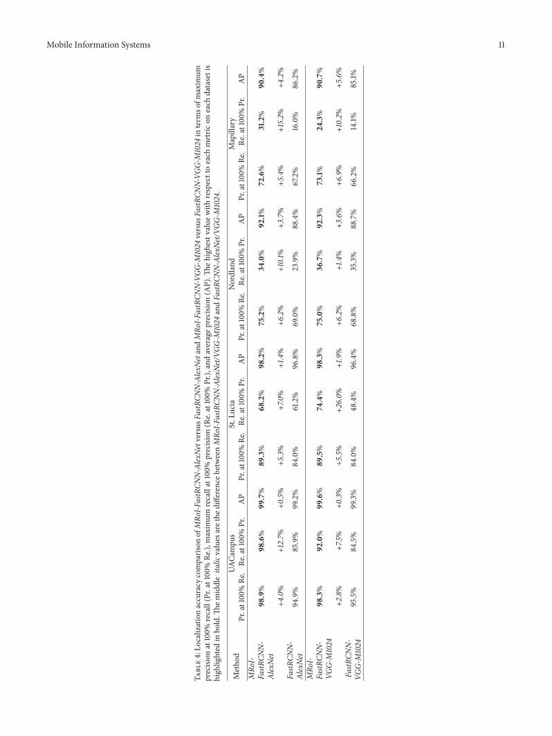
(c) One can clearly observe fromFigure 3 andTable 4 thatthe precision-recall curves and the three numericalmetrics produced by our MRoI-FastRCNN-AlexNet/VGG-M1024 are higher than those of feature map-based methods, that is, FastRCNN-AlexNet/VGG-M1024, on all datasets. Moreover, the superiority oftwo variants of our method becomes more obviousin environments significant viewpoint change such asthe Mapillary dataset. Considering the fact that fea-ture map-based methods extract features from onlyone RoI pooling layer after the coarsest convolutionallayer (i.e., the Conv5 layer), these comparison resultsdemonstrate that using our MRoI method to fuse thefeatures extracted from multiple RoI pooling layersis able to enhance the discrimination capacity ofthe final ConvNet features. As a result, our methodimproves the localization accuracy of feature map-based methods in environments with different kindsof conditional changes.
To qualitatively evaluate the matched results obtainedby our method, Figure 1 shows examples of matched imagepairs and corresponding matched landmark pairs producedby our MRoI-FastRCNN-AlexNet. Six images on each row

8 Mobile Information Systems
0.2 0.4 0.6 0.8 10Recall
0.65
0.7
0.75
0.8
0.85
0.9
0.95
1
Prec
ision
MRoI-FastRCNN-AlexNetMRoI-FastRCNN-VGG-M1024FastRCNN-AlexNetFastRCNN-VGG-M1024AlexNetVGG-M1024
(a) UACampus
0.2 0.4 0.6 0.8 10Recall
0.65
0.7
0.75
0.8
0.85
0.9
0.95
1
Prec
ision
MRoI-FastRCNN-AlexNetMRoI-FastRCNN-VGG-M1024FastRCNN-AlexNetFastRCNN-VGG-M1024AlexNetVGG-M1024
(b) St. Lucia
0.2 0.4 0.6 0.8 10Recall
0.65
0.7
0.75
0.8
0.85
0.9
0.95
1
Prec
ision
MRoI-FastRCNN-AlexNetMRoI-FastRCNN-VGG-M1024FastRCNN-AlexNetFastRCNN-VGG-M1024AlexNetVGG-M1024
(c) Nordland
0.2 0.4 0.6 0.8 10Recall
0.6
0.65
0.7
0.75
0.8
0.85
0.9
0.95
1
Prec
ision
MRoI-FastRCNN-AlexNetMRoI-FastRCNN-VGG-M1024FastRCNN-AlexNetFastRCNN-VGG-M1024AlexNetVGG-M1024
(d) Mapillary
Figure 3: Comparisons of localization accuracy in terms of the precision-recall curve.

Mobile Information Systems 9
Table2:Lo
calizationaccuracy
comparis
onofFastR
CNN-Alex
NetversusA
lexNe
tand
FastR
CNN-VGG
-M1024
versus
VGG-
M1024
interm
sofm
axim
umprecision
at100%
recall(Pr.at100%
Re.),
maxim
umrecallat100%
precision
(Re.at100%
Pr.),
andaveragep
recisio
n(A
P).Th
ehighestvaluew
ithrespecttoeach
metric
oneach
datasetish
ighlighted
inbo
ld.Th
emiddleita
licvalues
arethe
differenceb
etweenFastR
CNN-Alex
Net/V
GG-M
1024
andAlexNe
t/VGG
-M1024.
Metho
dUA
Campu
sSt.Lucia
Nordland
Mapillary
Pr.at100%Re
.Re
.at100%Pr.
AP
Pr.at100%Re
.Re
.at100%Pr.
AP
Pr.at100%Re
.Re
.at100%Pr.
AP
Pr.at100%Re
.Re
.at100%Pr.
AP
FastR
CNN-Alex
Net
94.9%
85.9%
99.2%
84.0%
61.2%
96.8%
69.0%
23.9%
88.4%
67.2%
16.0%
86.2%
−0.6%
−5.4%−0
.2%−2
.6%
−3.9%−0
.7%−0
.5%
+5.3%
+0.9%−6
.2%
−17.4
%−5
.3%
AlexNe
t95
.5%
91.3%
99.4%
86.6%
65.1%
97.5%
69.5%
18.6%
87.5%
73.4%
33.4%
91.5%
FastR
CNN-VGG
-M1024
95.5%
84.5%
99.3%
84.0%
48.4%
96.4%
68.8%
35.3%
88.7%
66.2%
14.1%
85.1%
+1.0%
−0.5%
+0.2%
+2.7%
+2.1%
+0.7%
−1.7%
+10.8%
−0.1%
−8.1%
−13.8%
−6.9%
VGG-
M1024
94.5%
85.0%
99.1%
81.3%
46.3%
95.7%
70.5%
24.5%
88.8%
74.3%
27.9%
92.0%

10 Mobile Information Systems
Table3
:Localizationaccuracy
comparis
onofMRo
I-FastRCN
N-Alex
NetversusA
lexNe
tand
MRo
I-FastRCN
N-VGG
-M1024
versus
VGG-
M1024
interm
sofm
axim
umprecision
at100%
recall
(Pr.at100%
Re.),
maxim
umrecallat100%
precision
(Re.at100%
Pr.),
andaveragep
recisio
n(A
P).Th
ehighestvaluew
ithrespecttoeach
metric
oneach
datasetish
ighlighted
inbo
ld.Th
emiddleita
licvalues
arethe
differenceb
etweenMRo
I-FastRCN
N-Alex
Net/V
GG-M
1024
andAlexNe
t/VGG
-M1024.
Metho
dUA
Campu
sSt.Lucia
Nordland
Mapillary
Pr.at100%Re
.Re
.at100%Pr.
AP
Pr.at100%Re
.Re
.at100%Pr.
AP
Pr.at100%Re
.Re
.at100%Pr.
AP
Pr.at100%Re
.Re
.at100%Pr.
AP
MRo
I-FastRCN
N-
AlexNe
t98
.9%
98.6%
99.7%
89.3%
68.2%
98.2%
75.2%
34.0%
92.1%
72.6%
31.2%
90.4%
+3.4%
+7.3%
+0.3%
+2.7%
+3.1%
+0.7%
+5.7%
+15.4%
+4.6%−0
.8%
−2.2%
−1.1%
AlexNe
t95.5%
91.3%
99.4%
86.6%
65.1%
97.5%
69.5%
18.6%
87.5%
73.4%
33.4%
91.5%
MRo
I-FastRCN
N-
VGG-
M1024
98.3%
92.0%
99.6%
89.5%
74.4%
98.3%
75.0%
36.7%
92.3%
73.1%
24.3%
90.7%
+3.8%
+7.0%
+0.5%
+8.2%
+28.1%
+2.6%
+4.5%
+12.2%
+3.5%
−1.2%
−3.6%
−1.3%
VGG-
M1024
94.5%
85.0%
99.1%
81.3%
46.3%
95.7%
70.5%
24.5%
88.8%
74.3%
27.9%
92.0%
Mobile Information Systems 11
Table4:Lo
calizationaccuracy
comparis
onofMRo
I-FastRCN
N-Alex
NetversusF
astRCN
N-Alex
Netand
MRo
I-FastRCN
N-VGG
-M1024
versus
FastR
CNN-VGG
-M1024
interm
sofm
axim
umprecision
at100%
recall(Pr.at100%
Re.),
maxim
umrecallat100%
precision
(Re.at100%
Pr.),
andaverageprecision
(AP).Th
ehigh
estv
alue
with
respecttoeach
metric
oneach
datasetis
high
lighted
inbo
ld.Th
emiddleita
licvalues
arethe
differenceb
etweenMRo
I-FastRCN
N-Alex
Net/V
GG-M
1024
andFastR
CNN-Alex
Net/V
GG-M
1024.
Metho
dUA
Campu
sSt.Lucia
Nordland
Mapillary
Pr.at100%Re
.Re
.at100%Pr.
AP
Pr.at100%Re
.Re
.at100%Pr.
AP
Pr.at100%Re
.Re
.at100%Pr.
AP
Pr.at100%Re
.Re
.at100%Pr.
AP
MRo
I-FastR
CNN-
AlexNe
t98
.9%
98.6%
99.7%
89.3%
68.2%
98.2%
75.2%
34.0%
92.1%
72.6%
31.2%
90.4%
+4.0%
+12.7%
+0.5%
+5.3%
+7.0%
+1.4%
+6.2%
+10.1%
+3.7%
+5.4%
+15.2%
+4.2%
FastR
CNN-
AlexNe
t94.9%
85.9%
99.2%
84.0%
61.2%
96.8%
69.0%
23.9%
88.4%
67.2%
16.0%
86.2%
MRo
I-FastR
CNN-
VGG-
M1024
98.3%
92.0%
99.6%
89.5%
74.4%
98.3%
75.0%
36.7%
92.3%
73.1%
24.3%
90.7%
+2.8%
+7.5%
+0.3%
+5.5%
+26.0%
+1.9%
+6.2%
+1.4%
+3.6%
+6.9%
+10.2%
+5.6%
FastR
CNN-
VGG-
M1024
95.5%
84.5%
99.3%
84.0%
48.4%
96.4%
68.8%
35.3%
88.7%
66.2%
14.1%
85.1%

12 Mobile Information Systems
Table 5: Comparisons of average running time per image and the GPU memory cost between two variants of our method and comparedmethods for extracting ConvNet features. The total running time consists of the computational costs for preprocessing, going through theCaffe and postprocessing. Note that 𝐴𝑙𝑒𝑥𝑁𝑒𝑡𝑏/VGG-M1024b refer to the costs of computation and GPUmemory when sending 100 detectedlandmarks into Caffe as a batch of 100. “—” means the computational cost is negligible. We can clearly see that the computation speed andGPUmemory consumption of two variants of our method are close to those of FastRCNN-AlexNet/VGG-M1024 and several times faster andfewer than those of 𝐴𝑙𝑒𝑥𝑁𝑒𝑡
𝑏/VGG-M1024b.
Method GPUMemory(MB)
Average running time (ms)Pre Caffe Post Total
MRoI-FastRCNN-AlexNet 240 6.9 18.3 3.8 29.0MRoI-FastRCNN-VGG-M1024 396 33.5 5.8 46.2FastRCNN-AlexNet 218 6.9 13.3 — 20.2FastRCNN-VGG-M1024 367 31.0 — 37.9AlexNet 183
30.3
518.5 — 548.8VGG-M1024 229 998.8 — 1029.1𝐴𝑙𝑒𝑥𝑁𝑒𝑡
𝑏 880 115.9 — 146.2VGG-M1024b 1965 199.7 — 230.0
come fromone dataset, and the three pairs represent correctlymatched images by our method. It can be seen that thematched landmarks are correctly identified, even in envi-ronments with different changes. These results demonstratethat the ConvNet features extracted by our method havesatisfactory discrimination capacity.
5.3. Computational Efficiency. To evaluate the computationalefficiency, we report average running time per image of ourmethod and compared methods for extracting ConvNet fea-tures inTable 5. ForAlexNet/VGG-M1024, we also report theircomputational cost when sending 100 detected landmarksinto Caffe as a batch of 100. The corresponding cost isdenoted as 𝐴𝑙𝑒𝑥𝑁𝑒𝑡𝑏/VGG-M1024b. Specifically, the tablelists the breakdown of average running time per image, thatis, the computational costs for preprocessing, going throughCaffe and postprocessing. For the preprocessing, the costof AlexNet/VGG-M1024 and 𝐴𝑙𝑒𝑥𝑁𝑒𝑡𝑏/VGG-M1024b is thehighest.The reason is as follows. Before feeding into the Caffewhen using an original image-based method, subimages ofdetected landmarks need to first be cropped from the originalinput image according to their bounding boxes, and allcropped subimages are then resized to predefined dimensionsto meet the requirement of the networks. As a result, thecomputational cost is as high as 30.3ms per image. For thepostprocessing, only our method needs several millisecondsfor 𝑙2-normalizing the output from the MRoI pooling layer.In addition, some further observations can bemade based onresults in Table 5, as follows.
(a) FastRCNN-AlexNet/VGG-M1024 are much fasterthan AlexNet/VGG-M1024 (≈27/27 times) and even𝐴𝑙𝑒𝑥𝑁𝑒𝑡𝑏/VGG-M1024b (≈seven/six times). Thisverifies our motivation, that is, feature map-basedmethods are greatly superior in computational effi-ciency to original image-based methods.
(b) Both variants of our method, MRoI-FastRCNN-AlexNet/VGG-M1024, are only approximately ninems
per image slower than corresponding feature map-based methods, FastRCNN-AlexNet/VGG-M1024.More importantly, the two variants achieve real-timecomputing efficiency, with average running times of29.0 and 46.2ms per image, respectively. Such highefficiency of the two variants is expected becausethey inherit the characteristic of feature map-basedmethods.
(c) Two variants of our method are 19 and 22 times fasterthan AlexNet/VGG-M1024, respectively, and both areapproximately five times faster than 𝐴𝑙𝑒𝑥𝑁𝑒𝑡𝑏/VGG-M1024b.
5.4. GPU Memory Efficiency. To evaluate the GPU memoryefficiency, we report the GPU memory cost of our methodand compared methods for extracting ConvNet features inTable 5. It can be seen that AlexNet/VGG-M1024 require theminimal GPU memory (183/229MB); however, 𝐴𝑙𝑒𝑥𝑁𝑒𝑡𝑏/VGG-M1024b consume the maximal GPU memory (880/1965MB) because they send 100 detected landmarks intoCaffe as a batch of 100 for speed-up. Compared with thoseof AlexNet/VGG-M1024, the GPU memory costs of ourmethods, MRoI-FastRCNN-AlexNet/VGG-M1024, increaseby 57MB and 167MB, respectively. Nevertheless, our GPUmemory consumption is still approximately four and fivetimes less than those of 𝐴𝑙𝑒𝑥𝑁𝑒𝑡𝑏/VGG-M1024b, respec-tively. In addition, compared with those of FastRCNN-AlexNet/VGG-M1024, our GPU memory consumption onlyincrease by 22MB and 29MB, respectively, for the reasonof using MRoI pooling layer. Perhaps most importantly, theGPU memory costs of our two variants still retain 240MBand 396MB, respectively.This means that our method is ableto meet the requirement of visual localization on embeddedsystems or mobile devices with limited GPU resources.
6. Conclusion
In this paper, we have proposed a simple and efficientmethodof ConvNet feature extraction with multiple RoI pooling for

Mobile Information Systems 13
landmark-based visual localization of autonomous vehicles.The aim of our method is to deliver excellent localizationaccuracy comparable to original image-based methods whileremaining the high computational efficiency of feature map-based methods. To achieve this, our method exploits theefficiency of RoI pooling and fuses the multilevel and mul-tiresolution information from multiple RoI pooling layers toimprove the discrimination capacity of extracted ConvNetfeatures.
Experimental results on four popular visual localiza-tion datasets have demonstrated that the ConvNet featuresextracted by our method are discriminative to allow us toachieve the state-of-the-art localization accuracy and highcomputational efficiency with an average running time of29.0ms per image at the same time. In addition, our methodis GPU memory efficient for mobile devices. Moreover, it isbased on a pretrained CNN model without fine-tuning orretraining for ease of use, which is important for us to over-come the difficulty caused by the lack of training data in visuallocalization research. In short, the proposed MRoI methodextracts highly discriminating ConvNet features efficiently,and the idea can be potentially extended in solving othervision tasks, such as object detection and object recognition.
Conflicts of Interest
The authors declare no conflicts of interest.
Acknowledgments
The authors gratefully acknowledge the support from theHunan Provincial Innovation Foundation for Postgraduate(CX2014B021) and the Hunan Provincial Natural ScienceFoundation of China (2015JJ3018). This research is alsosupported in part by the Program of Foshan Innovation Team(Grant no. 2015IT100072) and byNSFC (Grant no. 61673125).
References
[1] S. Lowry, N. Suenderhauf, P. Newman et al., “Visual placerecognition: a survey,” IEEE Transactions on Robotics, vol. 32,no. 1, pp. 1–19, 2016.
[2] M. Cummins and P. Newman, “FAB-MAP: probabilistic local-ization and mapping in the space of appearance,” InternationalJournal of Robotics Research, vol. 27, no. 6, pp. 647–665, 2008.
[3] G. Singh and J. Kosecka, “Visual loop closing using gistdescriptors in Manhattan world,” in Proceedings of the in IEEEInternational Conference on Robotics and Automation (ICRA)Omnidirectional Robot Vision Workshop, 2010.
[4] H. Zhang, “BoRF: Loop-closure detection with scale invariantvisual features,” in Proceedings of the 2011 IEEE InternationalConference on Robotics and Automation, ICRA 2011, pp. 3125–3130, May 2011.
[5] N. Sunderhauf and P. Protzel, “BRIEF-Gist - Closing the loop bysimple means,” in Proceedings of the 2011 IEEE/RSJ InternationalConference on Intelligent Robots and Systems: Celebrating 50Years of Robotics, IROS’11, pp. 1234–1241, September 2011.
[6] Y. Liu and H. Zhang, “Visual loop closure detection with acompact image descriptor,” in Proceedings of the 25th IEEE/RSJ
International Conference on Robotics and Intelligent Systems,IROS 2012, pp. 1051–1056, October 2012.
[7] M. J. Milford and G. F. Wyeth, “SeqSLAM: Visual route-basednavigation for sunny summer days and stormy winter nights,”in Proceedings of the IEEE International Conference on Roboticsand Automation (ICRA), pp. 1643–1649, 2012.
[8] Y. Liu and H. Zhang, “Towards improving the efficiency ofsequence-based SLAM,” in Proceedings of the 10th IEEE Interna-tional Conference on Mechatronics and Automation (ICMA ’13),pp. 1261–1266, Takamatsu, Japan, August 2013.
[9] M. Milford, “Vision-based place recognition: How low can yougo?” International Journal of Robotics Research, vol. 32, no. 7, pp.766–789, 2013.
[10] E. Pepperell, P. I. Corke, and M. J. Milford, “All-environmentvisual place recognitionwith SMART,” inProceedings of the 2014IEEE International Conference on Robotics and Automation,ICRA 2014, pp. 1612–1618, June 2014.
[11] T. Naseer, L. Spinello, W. Burgard, and C. Stachniss, “Robustvisual robot localization across seasons using network flows,”in Proceedings of the AAAI Conference on Artificial Intelligence,pp. 2564–2570, July 2014.
[12] Z. Chen, O. Lam, A. Jacobson, and M. Milford, “Convolutionalneural network-based place recognition,” in Proceedings of theAustralasian Conference on Robotics and Automation, ACRA2014, pp. 2–4, December 2014.
[13] N. Sunderhauf, S. Shirazi, A. Jacobson et al., “Place recognitionwith convnet landmarks: Viewpoint-robust, condition-robust,training-free,” in Proceedings of the 2015 Robotics: Science andSystems Conference, RSS 2015, Rome, Italy, July 2015.
[14] P. Neubert and P. Protzel, “Local region detector + CNNbased landmarks for practical place recognition in changingenvironments,” in Proceedings of the European Conference onMobile Robots, ECMR 2015, pp. 1–6, September 2015.
[15] P. Neubert and P. Protzel, “Beyond Holistic Descriptors, Key-points, and Fixed Patches: Multiscale Superpixel Grids for PlaceRecognition in Changing Environments,” IEEE Robotics andAutomation Letters, vol. 1, no. 1, pp. 484–491, 2016.
[16] A. Krizhevsky, I. Sutskever, andG. E.Hinton, “Imagenet classifi-cation with deep convolutional neural networks,” in Proceedingsof the 26th Annual Conference on Neural Information ProcessingSystems (NIPS ’12), pp. 1097–1105, December 2012.
[17] K. Chatfield, K. Simonyan, A. Vedaldi, and A. Zisserman,“Return of the devil in the details: delving deep into convolu-tional nets,” in Proceedings of the 25th British Machine VisionConference (BMVC ’14), Nottingham, UK, September 2014.
[18] K. Simonyan and A. Zisserman, “Very deep convolutional net-works for large-scale image recognition,” in Proceedings of thein International Conference on Learning Representations (ICLR),2015.
[19] R. Girshick, J. Donahue, T. Darrell, and J. Malik, “Rich fea-ture hierarchies for accurate object detection and semanticsegmentation,” in Proceedings of the 27th IEEE Conference onComputer Vision and Pattern Recognition (CVPR ’14), pp. 580–587, Columbus, Ohio, USA, June 2014.
[20] R. Girshick, “Fast R-CNN,” in Proceedings of the 15th IEEEInternational Conference on Computer Vision (ICCV ’15), pp.1440–1448, December 2015.
[21] S. Ren, K. He, R. Girshick, and J. Sun, “Faster R-CNN: towardsreal-time object detection with region proposal networks,” inAdvances in Neural Information Processing Systems, pp. 91–99,2015.

14 Mobile Information Systems
[22] M. Labbe and F. Michaud, “Appearance-based loop closuredetection for online large-scale and long-term operation,” IEEETransactions on Robotics, vol. 29, no. 3, pp. 734–745, 2013.
[23] M. Labbe and F.Michaud, “Online global loop closure detectionfor large-scale multi-session graph-based SLAM,” in Proceed-ings of the 2014 IEEE/RSJ International Conference on IntelligentRobots and Systems, IROS 2014, pp. 2661–2666, September 2014.
[24] D. Galvez-Lopez and J. D. Tardos, “Bags of binary words forfast place recognition in image sequences,” IEEE Transactionson Robotics, vol. 28, no. 5, pp. 1188–1197, 2012.
[25] R. Mur-Artal, J. M. M. Montiel, and J. D. Tardos, “ORB-SLAM: a versatile and accuratemonocular SLAM system,” IEEETransactions on Robotics, vol. 31, no. 5, pp. 1147–1163, 2015.
[26] Y.Hou,H. Zhang, and S. Zhou, “Convolutional neural network-based image representation for visual loop closure detection,” inProceedings of the IEEE International Conference on Informationand Automation(ICIA), pp. 2238–2245, August 2015.
[27] N. Sunderhauf, S. Shirazi, F. Dayoub, B. Upcroft, and M.Milford, “On the performance of ConvNet features for placerecognition,” in Proceedings of the IEEE/RSJ International Con-ference on Intelligent Robots and Systems, IROS 2015, pp. 4297–4304, October 2015.
[28] A. Oliva and A. Torralba, “Modeling the shape of the scene:a holistic representation of the spatial envelope,” InternationalJournal of Computer Vision, vol. 42, no. 3, pp. 145–175, 2001.
[29] J. Sivic and A. Zisserman, “Video google: a text retrievalapproach to object matching in videos,” in Proceedings of the 9thIEEE International Conference on Computer Vision (ICCV ’03),pp. 1470–1477, October 2003.
[30] F. Perronnin and C. Dance, “Fisher kernels on visual vocabu-laries for image categorization,” in Proceedings of the 2007 IEEEComputer Society Conference on Computer Vision and PatternRecognition, CVPR’07, pp. 1–8, June 2007.
[31] H. Jegou,M. Douze, C. Schmid, and P. Perez, “Aggregating localdescriptors into a compact image representation,” inProceedingsof the IEEE Computer Society Conference on Computer Visionand Pattern Recognition (CVPR ’10), pp. 3304–3311, June 2010.
[32] T. Naseer, M. Ruhnke, C. Stachniss, L. Spinello, andW. Burgard,“Robust visual SLAM across seasons,” in Proceedings of theIEEE/RSJ International Conference on Intelligent Robots andSystems, IROS 2015, pp. 2529–2535, October 2015.
[33] M. Shahid, T. Naseer, and W. Burgard, “DTLC: Deeply trainedloop closure detections for lifelong visual SLAM,” inProceedingsof the RSSWorkshop onVisual Place Recognition:What is it GoodFor? 2016.
[34] R. Arroyo, P. F. Alcantarilla, L. M. Bergasa, and E. Romera,“Fusion and binarization of CNN features for robust topologicallocalization across seasons,” in Proceedings of the 2016 IEEE/RSJInternational Conference on Intelligent Robots and Systems, IROS2016, pp. 4656–4663, October 2016.
[35] Y. Liu, R. Feng, and H. Zhang, “Keypoint matching by outlierpruning with consensus constraint,” in Proceedings of the 2015IEEE International Conference on Robotics and Automation,ICRA 2015, pp. 5481–5486, May 2015.
[36] A. J. Glover, W. P. Maddern, M. J. Milford, and G. F. Wyeth,“Fab-map + ratslam: appearance-based slam for multiple timesof day,” in Proceedings of the IEEE International Conference onRobotics and Automation (ICRA ’10), pp. 3507–3512, May 2010.
[37] P. Neubert, N. Sunderhauf, and P. Protzel, “Superpixel-basedappearance change prediction for long-term navigation acrossseasons,” Robotics and Autonomous Systems, vol. 69, no. 1, pp.15–27, 2015.
[38] Y. Hou, H. Zhang, and S. Zhou, “Tree-based indexing for real-time ConvNet landmark-based visual place recognition,” Inter-national Journal of Advanced Robotic Systems, vol. 14, no. 1, 2017.
[39] Mapillary, 2016, https://www.mapillary.com.[40] M.-M. Cheng, Z. Zhang, W.-Y. Lin, and P. Torr, “BING: Bina-
rized normed gradients for objectness estimation at 300 fps,” inProceedings of the 27th IEEEConference onComputer Vision andPattern Recognition (CVPR ’14), pp. 3286–3293, June 2014.
[41] C. L. Zitnick and P. Dollar, “Edge boxes: locating object propos-als from edges,” in Proceedings of the European Conference onComputer Vision (ECCV ’14), pp. 391–405, Springer, 2014.
[42] J. Hosang, R. Benenson, P. Dollar, and B. Schiele, “What makesfor effective detection proposals?” IEEE Transactions on PatternAnalysis and Machine Intelligence, vol. 38, no. 4, pp. 814–830,2016.
[43] S. Dasgupta, “Experiments with random projection,” in Pro-ceedings of the Conference on Uncertainty in Artificial Intelli-gence, pp. 143–151, 2000.
[44] E. Bingham and H. Mannila, “Random projection in dimen-sionality reduction: applications to image and text data,” inProceedings of the 7th ACM SIGKDD International Conferenceon Knowledge Discovery and Data Mining (KDD ’01), pp. 245–250, August 2001.
[45] Y. Jia, E. Shelhamer, J. Donahue et al., “Caffe: convolutionalarchitecture for fast feature embedding,” in Proceedings of theACM International Conference on Multimedia, pp. 675–678,ACM, Orlando, Fla, USA, November 2014.
[46] W. Su, Y. Yuan, andM. Zhu, “A relationship between the averageprecision and the area under the ROC curve,” in Proceedingsof the 5th ACM SIGIR International Conference on the Theoryof Information Retrieval, ICTIR 2015, pp. 349–352, September2015.

Submit your manuscripts athttps://www.hindawi.com
Computer Games Technology
International Journal of
Hindawi Publishing Corporationhttp://www.hindawi.com Volume 2014
Hindawi Publishing Corporationhttp://www.hindawi.com Volume 2014
Distributed Sensor Networks
International Journal of
Advances in
FuzzySystems
Hindawi Publishing Corporationhttp://www.hindawi.com
Volume 2014
International Journal of
ReconfigurableComputing
Hindawi Publishing Corporation http://www.hindawi.com Volume 2014
Hindawi Publishing Corporationhttp://www.hindawi.com Volume 201
Applied Computational Intelligence and Soft Computing
Advances in
Artificial Intelligence
Hindawi Publishing Corporationhttp://www.hindawi.com Volume 2014
Advances inSoftware EngineeringHindawi Publishing Corporationhttp://www.hindawi.com Volume 2014
Hindawi Publishing Corporationhttp://www.hindawi.com Volume 2014
Electrical and Computer Engineering
Journal of
Hindawi Publishing Corporation
http://www.hindawi.com Volume 2014
Advances in
Multimedia
International Journal of
Biomedical Imaging
Hindawi Publishing Corporationhttp://www.hindawi.com Volume 2014
Advances in
Hindawi Publishing Corporationhttp://www.hindawi.com Volume 201
RoboticsJournal of
Hindawi Publishing Corporationhttp://www.hindawi.com Volume 2014
Hindawi Publishing Corporationhttp://www.hindawi.com Volume 2014
Computational Intelligence and Neuroscience
Industrial EngineeringJournal of
Hindawi Publishing Corporationhttp://www.hindawi.com Volume 2014
Modelling & Simulation in EngineeringHindawi Publishing Corporation http://www.hindawi.com Volume 2014
The Scientific World JournalHindawi Publishing Corporation http://www.hindawi.com Volume 2014
Hindawi Publishing Corporationhttp://www.hindawi.com Volume 2014
Human-ComputerInteraction
Advances in
Computer EngineeringAdvances in
Hindawi Publishing Corporationhttp://www.hindawi.com Volume 2014