Edwards, D. N. and Mills, A. J. 2013. ‘Pharaonic’ Sites in the Batn al-Hajar – the...
16
S UDAN & N UBIA The Sudan Archaeological Research Society Bulletin No. 17 2013
Transcript of Edwards, D. N. and Mills, A. J. 2013. ‘Pharaonic’ Sites in the Batn al-Hajar – the...
SUDAN & NUBIAThe Sudan Archaeological Research Society Bulletin No. 17 2013

RED SEA
Wadi el- Allaqi
Blue Nile
White N
ile
Wadi Howar
Wad
i Muq
add a
m
Wadi el- Melik
6th cataract
2nd cataract
3rd cataract
4th cataract
1st cataract
Nile
Atbara
N
0 250 km
Egypt
Sudan
Ethiopia
Eritrea
MODERN TOWNS
Wadi Gabgaba
Ancient sites
KHARTOUM
ABU HAMED
KAREIMA
ATBARA
OMDURMAN
ASWAN
ED-DEBBA
KASSALA
WAD MEDANI
GEDAREF
KOSTISENNAR
SouthSudan
Sedeinga
Kawa
Dangeil
Gala Abu Ahmed
El-Ga’ab Basin
Fifth Cataract
Usli
es-Sour
JawgulTinare
el-Kurru
Sudan MilitaryRailway
Batn el-Hajar
Jebel Dosha
Atbara/Setiet
el-Metemma
Berber
Aba Island
Akasha

1
Dangeil 2012: Sacred Ram – Avatar of the God Amun 70Julie Anderson and Salah Mohamed Ahmed
Dangeil, A Preliminary Report on the Petrography 78Meredith Brand
A Third Season of Rescue Excavations in the Meroitic 90Cemetery at Berber, October 2012: Preliminary ReportMahmoud Suliman Bashir
Jawgul – A Village Between Towers 101Mariusz Drzewiecki and Piotr Maliński
The Archaeology of the Medieval and Post-Medieval 109Fortress at Tinare in the Northern El-MahasAbdelrahaman Ibrahim Saeed Ali
Upper Atbara Setiet Dam Archaeological Salvage 113Project (ASDASP), the Rescue Excavation Results on the Western Bank of the Atbara: Preliminary ReportMurtada Bushara Mohamed, Mohammed Saad Abdalah, Sami Elamien Mohammed and Zaki aldien Mahmoud
Archaeological, Ethnographical and Ecological 124Project of El-Ga’ab Basin in Western Dongola: A Report on the Second Season 2010Yahia Fadl Tahir
Surveys at the Fifth Cataract and on the Sudan Military 131Railway and excavations at Kawa, 2012-13Derek A. Welsby
Archaeological Survey in El-Metemma area 137Nada Babiker Mohammed Ibrahim
Archaeological Survey of Aba Island: 142Preliminary ReportAhmed Hussein Abdel Rahman Adam
From Nubia to Arizona – and back; or, Reisner 149comes HomeWilliam Y. Adams
Miscellaneous
Obituary 154Michel Azim Brigitte Gratian
Review 154Giovanni R. Ruffini 2012. Medieval Nubia. A Social and Economic HistoryWilliam Y. Adams
Contents
Reports
Lithic Material from the Late Neolithic Site of 2es-Sour, Central SudanAzhari Mustafa Sadig
‘Pharaonic’ Sites in the Batn el-Hajar – the 8‘Archaeological Survey of Sudanese Nubia’ Revisited.David N. Edwards and A. J. Mills
A Note on the Akasha Rock-Inscriptions [21-S-29] 17Vivian Davies
Creating a Virtual Reconstruction of the Seti I 18Inscription at Jebel DoshaSusie Green
Archaeobotanical Investigations at the Gala Abu Ahmed Fortress in Lower Wadi Howar, Northern Sudan
The Site and the Findings 24Friederike Jesse
Phytoliths on Grinding Stones and 28Wood Charcoal AnalysisBarbara Eichhorn
The Fruit and Seed Remains 33Stefanie Kahlheber
New Excavations at El-Kurru: Beyond the Napatan Royal Cemetery
Introduction 42Geoff Emberling and Rachael J. Dann
Investigating Settlement at El-Kurru 43Geoff Emberling
Geophysical Prospection in the Archaeological 48Settlement of El-KurruMohamed Abdelwahab Mohamed-Ali
Coring and Soundings in the El-Kurru Settlement 50Tim Boaz Bruun Skuldbøl
Five-sided Corinthian Capitals in the Mortuary 54Temple at El-KurruJack Cheng
Geophysical Survey at the El-Kurru cemetery 56Ed Blinkhorn
Sedeinga 2012: A Season of Unexpected Discoveries 61Claude Rilly and Vincent Francigny
The Latest Explorations at Usli, Northern Province 66Miroslav Bárta, Lenka Suková and Vladimír Brůna
SUDAN & NUBIAThe Sudan Archaeological Research Society Bulletin No. 17 2013
Front cover: The descendary of Tomb IV T 1 near Sedeinga under excavation (© V. Francigny / SEDAU).
Sudan & Nubia is a peer-reviewed journal
8
‘Pharaonic’ Sites in the Batn el-Hajar – the ‘Archaeological Survey of Sudanese Nubia’ Revisited.David N. Edwards and Anthony J. Mills
Of the Nubian Archaeological Campaigns (see Adams 1992; Mills 1992) which took place in response to the construc-tion of the Aswan High Dam, the survey and excavation programmes carried out within Sudanese Nubia represented perhaps the greatest archaeological achievements of the larger enterprise. Many components of the larger project have been published, producing a body of often fundamental studies which have often transformed our knowledge of this important section of the Nile Valley. However, the results of one core element, the Archaeological Survey of Sudanese Nubia between the Second Cataract and the Dal Cataract, a distance of c. 130km along the river, remain substantially unpublished.
During the first reconnaissance survey which traversed the whole region in 1963-64, c. 240 sites were registered (Mills 1965) in addition to the work of a German Epigraphic Mission led by Professor Fritz Hintze which traversed the region separately, recording the rock art and inscriptions. The following year the Archaeological Survey of Su-danese Nubia (ASSN) survey team began its work in earnest to survey and excavate areas and sites not oth-erwise assigned to other missions, starting at its northern end, in the most imminently threatened area. It completed the survey of areas south of Gemai as far as Saras, investigat-ing 69 sites between November 1964 and April 1965, and was able to publish a preliminary report on that work (Mills and Nordström 1966). The following season (Octo-ber 1965 - March 1966) covered the region between Saras and Semna, recording a further 101 sites; a re-port relating to this was published in the next volume (for 1967-68) of Kush (Mills 1973). Reports on the subsequent seasons were not however, forthcoming following the lapse of the journal Kush (not revived until 1993), so not
even preliminary reports have been published for the three further seasons. Of those the 1966-67 season focussed mainly on excavations in the Semna-Attiri area, while the final two seasons (November 1967 - April 1968 and October 1968 - April 1969) took the survey southwards to Dal.
With a total of c. 1000 ‘sites’ of all kinds identifiable in published reports and unpublished archives relating to the Gemai-Dal region it was thought at this time that a brief review of the records relating to the 38 sites (Figure 1) regis-tered as ‘Pharaonic’ or potentially so might usefully introduce this one component of the archive.1 It is hoped that it will be possible within the not too distant future to prepare a full publication of this relatively small but interesting body of material. With a number of other projects concerned with the Egyptian presence in Nubia now active in the region it is hoped that this summary may also prove of some wider interest at this time. As preliminary reports have already ap-peared for the areas between Gemai and Semna, only a few additional observations will be made here concerning sites in these more northerly areas and most of this brief paper
1 As will be seen, a number of these ‘Pharaonic’ sites can now be rec-ognised as dating to the 25th Dynasty/Napatan period.
Figure 1. ‘Pharaonic’ sites in the Batn el-Hajar.

Sudan & nubia
9
will be concerned with sites south of Semna recorded in the 1960s but as yet unreported. It may be useful here to establish both the overall scale and distribution of sites as well as make some preliminary comment on some of the more interesting. While it has recently been recognised that some prominent sites (e.g. Shelfak and Uronarti) survive above water level, note will also be made of some other sites which have, or seem likely to have survived flooding. Readily accessible satellite imagery also makes it possible to identify additional so-far unrecorded sites located in areas (above the 180m contour) unsurveyed in 1960s.
As made clear in the preliminary reports, away from the series of Middle Kingdom forts only a few small sites were identified, mainly small-scale occupation sites and occasional small groups of burials of New Kingdom date (Mills and Nordström 1966, 11). Of these, two lay within the Finnish concession, at Gemai East and Murshid. Just south of the cataract an occupation site with a small cemetery of c. 15 New Kingdom graves [11-D-5 = FNE 15]2 was investigated, while some further burials in two groups lay just beyond the Mur-shid bend behind the village of Sigaga. These were recorded within two separate sites [11-I-7 = FNE 39] and [11-I-32 = FNE 41], the former consisting mainly of Meroitic burials. Records for these sites have been published by the Finnish Nubia expedition (Donner 1998).
Otherwise the Pharaonic presence between Gemai and Semna was concentrated in two main clusters of sites. The first of these was around the Middle Kingdom fort [11-L-1] on Askut island, excavated in the 1960s and studied more recently by Smith (1995; 2012). Associated with this and probably later episodes of occupation at Askut was a large cemetery on Kagnarti island [11-L-26] with c. 250 graves inserted into rocky crevasses (Mills and Nordström 1966, 11). A sample of 24 of these was excavated in 1965. As noted by Williams (1990, 36) some of these burials could be of Napatan date, although preliminary examination of the little pottery recovered suggests an earlier date for most. At least one of a small group of burials excavated on the west bank a few miles downstream [11-M-6] would seem to be Napatan. On the west bank, a group of eight tombs, with one unfinished example [11-L-18], was largely robbed out but appeared to be of New Kingdom date. A second small but very heavily eroded cemetery [11-L-22] was thought likely to be associated with the fort. Close by on the west bank, at least two small mud-brick structures [11-L-24] seem likely to have been of New Kingdom date.
Towards the southern end of the Saras plain the Egyptian presence is very marked in a cluster [11-Q-59, 11-Q-61, 11-Q-62, 11-Q-63] of Middle Kingdom gold-working sites (Plate
2 Following practice established by W. Y. Adams at the start of the programme (see Adams 1992, 9) and subsequently within the Ar-chaeological Map of Sudan (A.M.S) sites are registered to each of the 1:250,000 Sudan Survey maps by 15-minute grid square. The full and unique registration number for all sites noted here will include the prefix NF-3-1 for the ‘Wadi Halfa’ map sheet, e.g. NF-3-1/11-D-5.
1) associated with one or more mines [11-Q-60] located up to 2km from the east bank, and a group of burials [11-Q-65] on the high ground to the north east. These have received some attention previously, with a brief published description of the complex of sites (Mills 1973, 204-207), which were further discussed in a paper delivered at the 9th International Nubian Conference at Boston in 1998. These lie within a stretch of river bank which was clearly one of the more attractive and hospitable parts of the region in later prehistory, the location of quite a large numbers of C-Group and/or Kerma sites as well as numerous rock drawings. The spatial correlation between abundant rock drawings and the numerous 3rd-2nd millennia sites is perhaps a useful indicator that much of this rock art is also of this date.
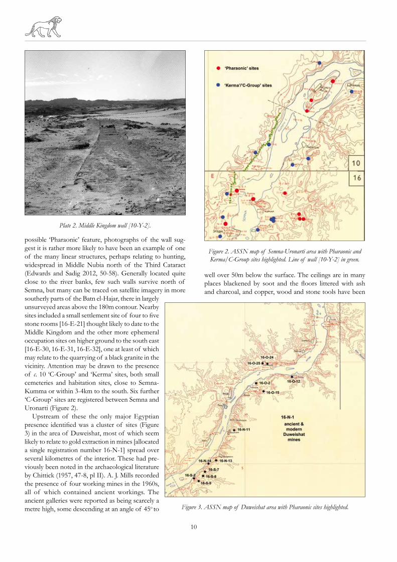
Approaching the Semna Cataract from the north, another notable feature (Plate 2) on the west bank is the Middle King-dom wall [10-Y-12] which was traced running from opposite Kajinjera island (just to the south of Uronarti) to just above Semna West fort (Mills 1973, 206, pl. XXXVIIIb). Nearly all of this seems to have run below the 180m contour but a short length of c. 300m of the feature is visible on satellite imagery around 21°30’26.41”N/30°58’0.15”E.3 A small group of (seven) probable New Kingdom graves [16-E-28] were later cut into this wall a little to the south west of Semna West. A little to the south the enclosed building complex at Semna South [16-E-3] overlooks what was likely to have been the landing point for boats portaging over the cataract (Reisner 1929). Subsequent excavations there confirmed that the desert wall [10-Y-12] had originally extended as far south as here (Žabkar and Žabkar 1982, 13), a total length of c. 5.5km. No other Pharaonic sites were recorded here on the west bank.
On the east bank, running northwards from east of Kumma [16-E-2], a low stone wall [16-E-40] was recorded running north north east for c. 3km. While registered as a
3 Thanks to Derek Welsby for pointing out this surviving fragment of the wall.
Plate 1. Stone-lined feature within Saras gold-working workshop site [11-Q-62].
10
possible ‘Pharaonic’ feature, photographs of the wall sug-gest it is rather more likely to have been an example of one of the many linear structures, perhaps relating to hunting, widespread in Middle Nubia north of the Third Cataract (Edwards and Sadig 2012, 50-58). Generally located quite close to the river banks, few such walls survive north of Semna, but many can be traced on satellite imagery in more southerly parts of the Batn el-Hajar, there in largely unsurveyed areas above the 180m contour. Nearby sites included a small settlement site of four to five stone rooms [16-E-21] thought likely to date to the Middle Kingdom and the other more ephemeral occupation sites on higher ground to the south east [16-E-30, 16-E-31, 16-E-32], one at least of which may relate to the quarrying of a black granite in the vicinity. Attention may be drawn to the presence of c. 10 ‘C-Group’ and ‘Kerma’ sites, both small cemeteries and habitation sites, close to Semna-Kumma or within 3-4km to the south. Six further ‘C-Group’ sites are registered between Semna and Uronarti (Figure 2).
Upstream of these the only major Egyptian presence identified was a cluster of sites (Figure 3) in the area of Duweishat, most of which seem likely to relate to gold extraction in mines [allocated a single registration number 16-N-1] spread over several kilometres of the interior. These had pre-viously been noted in the archaeological literature by Chittick (1957, 47-8, pl II). A. J. Mills recorded the presence of four working mines in the 1960s, all of which contained ancient workings. The ancient galleries were reported as being scarcely a metre high, some descending at an angle of 45o to
well over 50m below the surface. The ceilings are in many places blackened by soot and the floors littered with ash and charcoal, and copper, wood and stone tools have been
Figure 2. ASSN map of Semna-Uronarti area with Pharaonic and Kerma/C-Group sites highlighted. Line of wall [10-Y-2] in green.
Figure 3. ASSN map of Duweishat area with Pharaonic sites highlighted.
Plate 2. Middle Kingdom wall [10-Y-2].

Sudan & nubia
11
found within them. Some of these ancient galleries have been back-filled with rubble. Around the mines, marks of ancient prospecting were noted in the form of many test pits, usually small excavations about 1m in diameter or less, generally occurring in groups, often in a straight line, about 1.5-2m apart. Some of these and other extraction sites in the Duweishat region have been reported in the Klemm’s recent study of Egyptian gold mining in Egypt and Nubia (Klemm and Klemm 2013, 557-564). In this context attention may also be drawn to what appears to have been a copper mine at ‘Umm Fahm’ of Middle Kingdom date, or perhaps even earlier (Klemm and Klemm 2013, 564-568). This site and what may be further New Kingdom gold extraction sites lie at a distance of c. 25km from the river. These sites seem likely to have been accessed along the Khor Murrat, which reached the Nile close to Attiri village.
The northernmost of the riverine sites was located near the Attiri bend near the hamlet of Sorki [16-O-12], with further workshop sites spread over a distance of c. 10km between site [16-O-2], near the hamlet of Jedagur and site [16-S-2], upriver of the hamlet of Shuwerta. The workshop sites were generally quite small, usually with an area of 25m2 or less, and were recognisable by the presence of large heavy grindstones. These are of two types, the first a large, flat granite piece with a shallow oval depression in it used for crushing the quartz, and the second a cube of granite with smaller, round, deeper depressions in several sides, apparently used for further grinding this to a powder. There is a certain amount of New Kingdom pottery on the surface of these sites but apparently no local ‘Nubian’ pottery. Site [16-O-2] comprised at least three activity areas marked by scatters of granite mortars and grindstones (Plate 3), a lot of broken/
crushed quartz and some sherds, chiefly soft brown wheel-made bowls. Of three areas investigated the largest (‘Kom C’) measured c. 70m north-south x 30m east-west x 3m max. height. The northern quarter of the site was tested, revealing two levels of structures in a complex of at least nine rooms (Plate 4) with additional work areas around them. As at Saras, it would seem that the quartz rock was brought down from the mines and crushed and washed close to the river.
The site [16-O-12] in the village of Sorki (Attiri) lay just above the alluvial land on the lower hill slopes and was over-built by the 20th century village. While disturbed by modern construction two test excavations confirmed the survival of structures with walls surviving up to 400mm high. Test 1 at the south end of the site cleared an area of c. 19m x 14m. While the buildings here were badly damaged, with many incomplete walls, the plan suggested that clusters of three or four rooms formed units (Plate 5), connected by common walls to other units of three or four rooms. Some stone features constructed of upright large slabs formed bins, some also mud-plastered, the largest measuring c. 2m x 1m. A second test area, about 75m away in the centre of the village, revealed similar stone walls, mud floors, and units of two, three or four rooms.
A quite large site [16-N-13] c. 350m south of the village of Shuntefagir is located on a rocky slope near the river at the mouth of a khor, c. 200m east of the river bank. It is partly overbuilt by a modern house. It covered an area of c. 150 x 60m, marked by scatters of rocks, both from buildings and granite tools, much crushed quartz and sherds. One area, about 45 x 30m, was selected for testing. While very denuded, at least 13 separate rooms/areas of dry stone construction could be distinguished, floored by bedrock and mud. These
Plate 3. Excavated structure and grindstones in gold-working workshop [16-O-2].
Plate 4. Excavated structure in gold-working site [16-O-2].
12
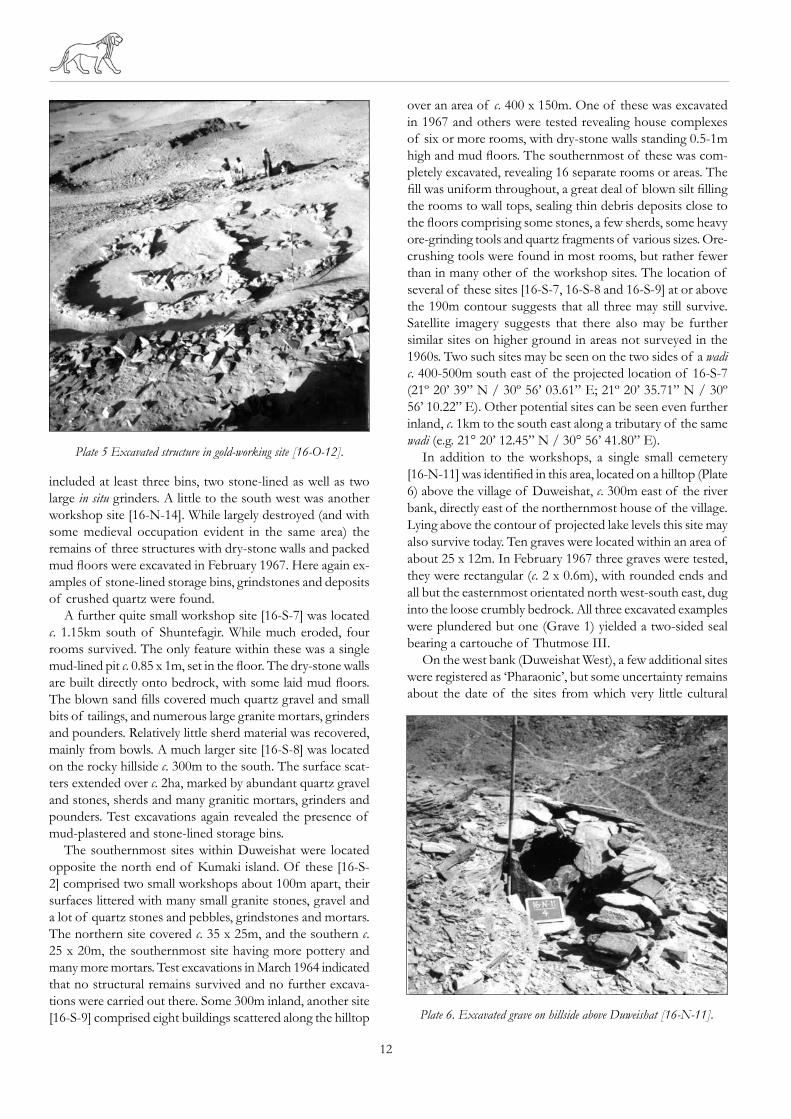
included at least three bins, two stone-lined as well as two large in situ grinders. A little to the south west was another workshop site [16-N-14]. While largely destroyed (and with some medieval occupation evident in the same area) the remains of three structures with dry-stone walls and packed mud floors were excavated in February 1967. Here again ex-amples of stone-lined storage bins, grindstones and deposits of crushed quartz were found.
A further quite small workshop site [16-S-7] was located c. 1.15km south of Shuntefagir. While much eroded, four rooms survived. The only feature within these was a single mud-lined pit c. 0.85 x 1m, set in the floor. The dry-stone walls are built directly onto bedrock, with some laid mud floors. The blown sand fills covered much quartz gravel and small bits of tailings, and numerous large granite mortars, grinders and pounders. Relatively little sherd material was recovered, mainly from bowls. A much larger site [16-S-8] was located on the rocky hillside c. 300m to the south. The surface scat-ters extended over c. 2ha, marked by abundant quartz gravel and stones, sherds and many granitic mortars, grinders and pounders. Test excavations again revealed the presence of mud-plastered and stone-lined storage bins.
The southernmost sites within Duweishat were located opposite the north end of Kumaki island. Of these [16-S-2] comprised two small workshops about 100m apart, their surfaces littered with many small granite stones, gravel and a lot of quartz stones and pebbles, grindstones and mortars. The northern site covered c. 35 x 25m, and the southern c. 25 x 20m, the southernmost site having more pottery and many more mortars. Test excavations in March 1964 indicated that no structural remains survived and no further excava-tions were carried out there. Some 300m inland, another site [16-S-9] comprised eight buildings scattered along the hilltop
over an area of c. 400 x 150m. One of these was excavated in 1967 and others were tested revealing house complexes of six or more rooms, with dry-stone walls standing 0.5-1m high and mud floors. The southernmost of these was com-pletely excavated, revealing 16 separate rooms or areas. The fill was uniform throughout, a great deal of blown silt filling the rooms to wall tops, sealing thin debris deposits close to the floors comprising some stones, a few sherds, some heavy ore-grinding tools and quartz fragments of various sizes. Ore-crushing tools were found in most rooms, but rather fewer than in many other of the workshop sites. The location of several of these sites [16-S-7, 16-S-8 and 16-S-9] at or above the 190m contour suggests that all three may still survive. Satellite imagery suggests that there also may be further similar sites on higher ground in areas not surveyed in the 1960s. Two such sites may be seen on the two sides of a wadi c. 400-500m south east of the projected location of 16-S-7 (21º 20’ 39” N / 30º 56’ 03.61” E; 21º 20’ 35.71” N / 30º 56’ 10.22” E). Other potential sites can be seen even further inland, c. 1km to the south east along a tributary of the same wadi (e.g. 21° 20’ 12.45” N / 30° 56’ 41.80” E).
In addition to the workshops, a single small cemetery [16-N-11] was identified in this area, located on a hilltop (Plate 6) above the village of Duweishat, c. 300m east of the river bank, directly east of the northernmost house of the village. Lying above the contour of projected lake levels this site may also survive today. Ten graves were located within an area of about 25 x 12m. In February 1967 three graves were tested, they were rectangular (c. 2 x 0.6m), with rounded ends and all but the easternmost orientated north west-south east, dug into the loose crumbly bedrock. All three excavated examples were plundered but one (Grave 1) yielded a two-sided seal bearing a cartouche of Thutmose III.
On the west bank (Duweishat West), a few additional sites were registered as ‘Pharaonic’, but some uncertainty remains about the date of the sites from which very little cultural
Plate 6. Excavated grave on hillside above Duweishat [16-N-11].
Plate 5 Excavated structure in gold-working site [16-O-12].

Sudan & nubia
13
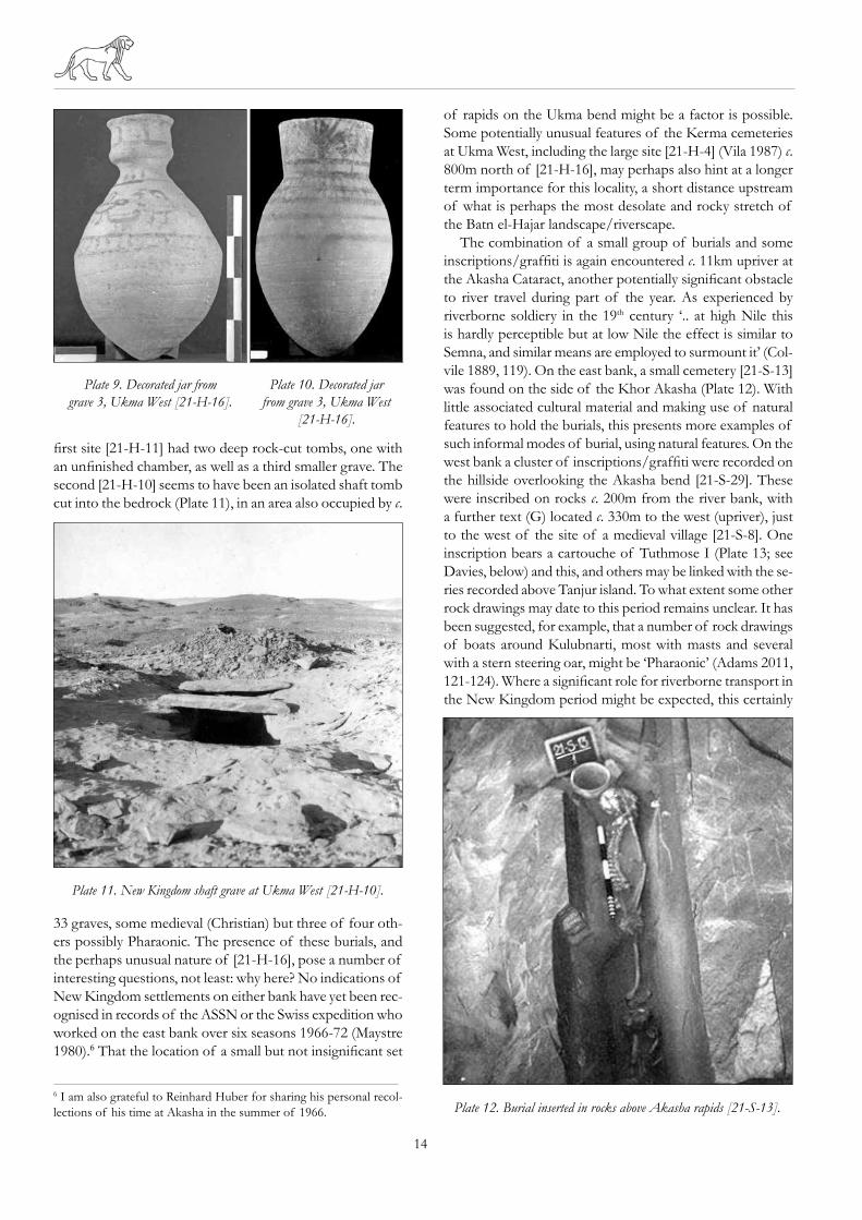
upriver. The most significant of these was a cemetery [21-H-16] of at least eight graves, largely undisturbed, with multiple burials, thought likely to be mainly of women and children. One burial at least had been placed in a wooden sarcophagus with a painted mummiform gesso lid, and others in simpler coffins (Plate 8). The associated pottery includes vessels with some unusual painted decoration (Plates 9 and 10). Another c. 1km to the south two further groups of what seem likely to be New Kingdom burials were located on the high ground south west of the village of Jebel en-Nasr. The
material was recovered. In the area of Askur village a rather dispersed habitation site [16-O-25] and some scattered burials [16-O-24] were located. The settlement was spread out over a considerable area to the west of Askur village, extending northwards; c.15-20 stone huts were set on the rocky hillside up to 800m from the river. Most were isolated structures with a few clusters of two or three small rooms, normally sub-rectangular, c. 1.5-2m across. Many were constructed in naturally sheltered positions, set against a rock face. None were well preserved and walls commonly survived as only one or two courses of rough stonework. This site appears very different from the gold-working sites on the east bank and suggests a relatively brief occupation. On the rocky hillside to the north of Askur a scatter of c. 15 graves was also found [16-O-24]. Rather than being excavated into the jebel they were inserted against a rock face where there was a horizontal surface, with the grave apparently closed off with stones piled over the burial. Much disturbed, few artefacts of any kind were found. However, small quantities of pot-tery and scarabs found in two of the five graves investigated suggest a 25th Dynasty/Napatan date, with vessel forms paral-leling examples from the mid-8th to 7th centuries BC levels at Elephantine (Aston 1999, pl. 54). Such may also be the date of the nearby structures.
Moving upstream, no Pharaonic settlement or cemetery sites were identified anywhere in the area of Ambikol and Melik en-Nasr/Tanjur, a distance of c. 30km, notwithstanding the presence of a series of at least six New Kingdom inscrip-tions/graffiti at Sahaba (Hintze and Reineke 1989, 168-9) and 37 around Tanjur, divided amongst five ‘sites’ (Hintze and Reineke 1989, 170-7),4 the last (upstream) examples of these fall with the area of Sonki (Hintze and Reineke 1989, 178-9).5 Those at Tanjur are found spread along several kilometres of (south/east) river bank, mainly upstream of Tanjur island and the extended rapids of Ambikol. As found elsewhere such graffiti are evidently located in the areas of rapids/cataracts which interrupt river travel, often neces-sitating the tracking of boats through dangerous stretches of river and the off-loading of vessels. The dangers of such activities, with the frequent loss of both boats and human lives, are well-demonstrated in 19th century accounts of the region (e.g. Colvile 1889).
Moving upstream another small group of burials was found at Sonki West [21-I-19] for which a 25th Dynasty/Napatan date may be proposed (Plate 7). Like those at Askur there is no evidence that these relate to any significant pres-ence at this location, opposite the prominent landmark of Kidinkony mountain, a Nobiin toponym for the ‘the upstream end of the rocky region’ (Bell 1970, 64). More interesting perhaps is another group of New Kingdom burials sites encountered on the west bank within Ukma West, c. 3km
4 These sites were designated [21-E-1 to 4] and [21-D-1]. These duplicate A.M.S. registration numbers in the ASSN register.5 These were registered by Hintze and Reineke as sites [21-E-6] and [21-D-3]. These duplicate A.M.S. registration numbers in the ASSN register.
Plate 7. 25th Dynasty/Napatan vessels from a burial at Sonki West [21-I-19].
Plate 8. New Kingdom grave with wooden sarcophagus at Ukma West [21-H-16].
14
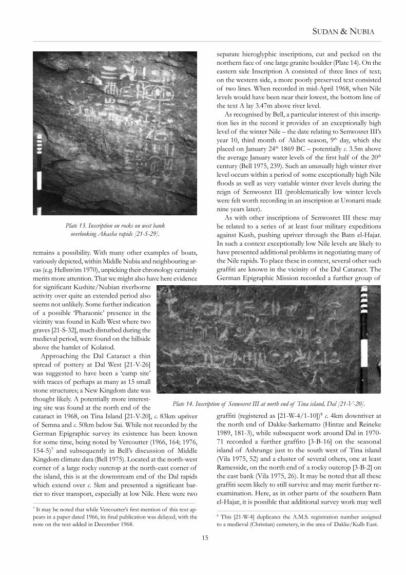
first site [21-H-11] had two deep rock-cut tombs, one with an unfinished chamber, as well as a third smaller grave. The second [21-H-10] seems to have been an isolated shaft tomb cut into the bedrock (Plate 11), in an area also occupied by c.
33 graves, some medieval (Christian) but three of four oth-ers possibly Pharaonic. The presence of these burials, and the perhaps unusual nature of [21-H-16], pose a number of interesting questions, not least: why here? No indications of New Kingdom settlements on either bank have yet been rec-ognised in records of the ASSN or the Swiss expedition who worked on the east bank over six seasons 1966-72 (Maystre 1980).6 That the location of a small but not insignificant set
6 I am also grateful to Reinhard Huber for sharing his personal recol-lections of his time at Akasha in the summer of 1966.
of rapids on the Ukma bend might be a factor is possible. Some potentially unusual features of the Kerma cemeteries at Ukma West, including the large site [21-H-4] (Vila 1987) c. 800m north of [21-H-16], may perhaps also hint at a longer term importance for this locality, a short distance upstream of what is perhaps the most desolate and rocky stretch of the Batn el-Hajar landscape/riverscape.
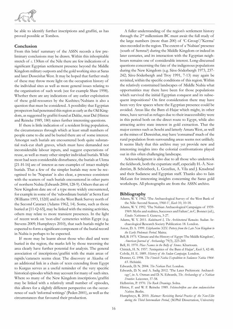
The combination of a small group of burials and some inscriptions/graffiti is again encountered c. 11km upriver at the Akasha Cataract, another potentially significant obstacle to river travel during part of the year. As experienced by riverborne soldiery in the 19th century ‘.. at high Nile this is hardly perceptible but at low Nile the effect is similar to Semna, and similar means are employed to surmount it’ (Col-vile 1889, 119). On the east bank, a small cemetery [21-S-13] was found on the side of the Khor Akasha (Plate 12). With little associated cultural material and making use of natural features to hold the burials, this presents more examples of such informal modes of burial, using natural features. On the west bank a cluster of inscriptions/graffiti were recorded on the hillside overlooking the Akasha bend [21-S-29]. These were inscribed on rocks c. 200m from the river bank, with a further text (G) located c. 330m to the west (upriver), just to the west of the site of a medieval village [21-S-8]. One inscription bears a cartouche of Tuthmose I (Plate 13; see Davies, below) and this, and others may be linked with the se-ries recorded above Tanjur island. To what extent some other rock drawings may date to this period remains unclear. It has been suggested, for example, that a number of rock drawings of boats around Kulubnarti, most with masts and several with a stern steering oar, might be ‘Pharaonic’ (Adams 2011, 121-124). Where a significant role for riverborne transport in the New Kingdom period might be expected, this certainly
Plate 11. New Kingdom shaft grave at Ukma West [21-H-10].
Plate 12. Burial inserted in rocks above Akasha rapids [21-S-13].
Plate 9. Decorated jar from grave 3, Ukma West [21-H-16].
Plate 10. Decorated jar from grave 3, Ukma West
[21-H-16].
Sudan & nubia
15
remains a possibility. With many other examples of boats, variously depicted, within Middle Nubia and neighbouring ar-eas (e.g. Hellström 1970), unpicking their chronology certainly merits more attention. That we might also have here evidence for significant Kushite/Nubian riverborne activity over quite an extended period also seems not unlikely. Some further indication of a possible ‘Pharaonic’ presence in the vicinity was found in Kulb West where two graves [21-S-32], much disturbed during the medieval period, were found on the hillside above the hamlet of Kolatod.
Approaching the Dal Cataract a thin spread of pottery at Dal West [21-V-26] was suggested to have been a ‘camp site’ with traces of perhaps as many as 15 small stone structures; a New Kingdom date was thought likely. A potentially more interest-ing site was found at the north end of the cataract in 1968, on Tina Island [21-V-20], c. 83km upriver of Semna and c. 50km below Sai. While not recorded by the German Epigraphic survey its existence has been known for some time, being noted by Vercoutter (1966, 164; 1976, 154-5)7 and subsequently in Bell’s discussion of Middle Kingdom climate data (Bell 1975). Located at the north-west corner of a large rocky outcrop at the north-east corner of the island, this is at the downstream end of the Dal rapids which extend over c. 5km and presented a significant bar-rier to river transport, especially at low Nile. Here were two
7 It may be noted that while Vercoutter’s first mention of this text ap-pears in a paper dated 1966, its final publication was delayed, with the note on the text added in December 1968.
separate hieroglyphic inscriptions, cut and pecked on the northern face of one large granite boulder (Plate 14). On the eastern side Inscription A consisted of three lines of text; on the western side, a more poorly preserved text consisted of two lines. When recorded in mid-April 1968, when Nile levels would have been near their lowest, the bottom line of the text A lay 3.47m above river level.
As recognised by Bell, a particular interest of this inscrip-tion lies in the record it provides of an exceptionally high level of the winter Nile – the date relating to Senwosret III’s year 10, third month of Akhet season, 9th day, which she placed on January 24th 1869 BC – potentially c. 3.5m above the average January water levels of the first half of the 20th century (Bell 1975, 239). Such an unusually high winter river level occurs within a period of some exceptionally high Nile floods as well as very variable winter river levels during the reign of Senwosret III (problematically low winter levels were felt worth recording in an inscription at Uronarti made nine years later).
As with other inscriptions of Senwosret III these may be related to a series of at least four military expeditions against Kush, pushing upriver through the Batn el-Hajar. In such a context exceptionally low Nile levels are likely to have presented additional problems in negotiating many of the Nile rapids. To place these in context, several other such graffiti are known in the vicinity of the Dal Cataract. The German Epigraphic Mission recorded a further group of
graffiti (registered as [21-W-4/1-10])8 c. 4km downriver at the north end of Dakke-Sarkematto (Hintze and Reineke 1989, 181-3), while subsequent work around Dal in 1970-71 recorded a further graffito [3-B-16] on the seasonal island of Ashrunge just to the south west of Tina island (Vila 1975, 52) and a cluster of several others, one at least Ramesside, on the north end of a rocky outcrop [3-B-2] on the east bank (Vila 1975, 26). It may be noted that all these graffiti seem likely to still survive and may merit further re-examination. Here, as in other parts of the southern Batn el-Hajar, it is possible that additional survey work may well
8 This [21-W-4] duplicates the A.M.S. registration number assigned to a medieval (Christian) cemetery, in the area of Dakke/Kulb East.
Plate 14. Inscription of Senwosret III at north end of Tina island, Dal [21-V-20].
Plate 13. Inscription on rocks on west bank overlooking Akasha rapids [21-S-29].
16
be able to identify further inscriptions and graffiti, as has proved possible at Tombos.
ConclusionFrom this brief summary of the ASSN records a few pre-liminary conclusions may be drawn. Within this inhospitable stretch of c. 130km of the Nile there are few indications of a significant Egyptian settlement presence beyond the Middle Kingdom military outposts and the gold working sites at Saras and later Duweishat West. It may be hoped that further study of these may throw more light on the occupation history of the individual sites as well as more general issues relating to the organisation of such work (see for example Shaw 1998). Whether there are any indications of any earlier exploitation of these gold-resources by the Kushites/Nubians is also a question that must be considered. A possibility that Egyptian prospectors had penetrated this region as early as the Old King-dom, as suggested by graffiti found at Dakke, near Dal (Hintze and Reineke 1989, 180) raises further interesting questions.
If there is little indication of a resident living population, the circumstances through which at least small numbers of people came to die and be buried there are of some interest. Amongst such burials are encountered both quite substan-tial rock-cut shaft graves, which must have demanded not inconsiderable labour inputs, and suggest expectations of reuse, as well as many other simpler individual burials. While most had seen considerable disturbance, the burials at Ukma [21-H-16] are of interest as rare examples of intact multiple burials. That a few of the simpler burials may now be rec-ognised to be ‘Napatan’ is also clear, a presence consistent with the scatters of such burials encountered in other parts of northern Nubia (Edwards 2004, 128-9). Others that are of New Kingdom date are of a type more widely encountered, for example in some of the ‘subordinate burials’ at Serra East (Williams 1993, 152ff) and in the West Bank Survey north of the Second Cataract (Adams 1962, 14). Some, such as those buried at [11-Q-65], may be linked with the mining activities, others may relate to more transient presences. In the light of recent work on ‘non-elite’ cemeteries within Egypt (e.g. Stevens 2009; Humphreys 2010), that such burials might be expected to form a significant component of the burial record in Nubia is perhaps to be expected.
If more may be learnt about those who died and were buried in the region, the marks left by those traversing the area clearly have further potential for analysis. The general association of inscriptions/graffiti with the main areas of rapids/cataracts seems clear. The discovery at Akasha of an additional link in a chain of texts extending from Egypt to Kurgus serves as a useful reminder of the very specific historical episodes which may account for many of such sites. Where so many of the New Kingdom inscriptions/graffiti may be linked with a relatively small number of episodes, this allows for a slightly different perspective on the occur-rence of such ‘informal writings’ (Peden 2001), as well as the circumstances that favoured their production.
A fuller understanding of the region’s settlement history through the 2nd millennium BC must await the full study of the large numbers (more than 200) of ‘C-Group’/’Kerma’ sites recorded in the region. The extent of a ‘Nubian’ presence (south of Semna?) during the Middle Kingdom or indeed in later centuries, and its interaction with the Egyptian neigh-bours remains one of considerable interest. Long-discussed questions concerning the fate of the indigenous populations during the New Kingdom (e.g. Säve-Söderbergh 1973, 237-242; Säve-Söderbergh and Troy 1991, 7-13) may again be revisited, within the specific conditions of this region. Within the relatively constrained landscapes of Middle Nubia what opportunities may there have been for those populations which survived the initial Egyptian conquest and its subse-quent impositions? On first consideration there may have been very few spaces where the Egyptian presence could be avoided. Areas like the Batn el-Hajar which might, in other times, have served as refuges due to their inaccessibility were in this period both on the direct route to Egypt, while also attracting active state interest in gold extraction. That the major centres such as Sesebi and latterly Amara West, as well as the mines of Duweishat, may have ‘consumed’ much of the rural population from surrounding areas seems not unlikely. It seems likely that this archive may yet provide new and interesting insights into the colonial confrontations played out in this often challenging landscape.
Acknowledgment is also due to all those who undertook the fieldwork, both the expatriate staff, especially H.-Å. Nor-dström, B. Schönbeck, L. Gezelius, A. Vila and J. Knudstad and their Sudanese and Egyptian staff. Thanks also to Iain McLean for interesting insights concerning the Saras gold workshops. All photographs are from the ASSN archive.
BibliographyAdams, W. Y. 1962. ‘The Archaeological Survey of the West Bank of
the Nile: Second Season, 1960-1’, Kush 10, 10-18.Adams, W. Y. 1992. ‘The Nubian Archaeological Campaigns of 1959-
1969: Myths and realities, Successes and Failure’, in C. Bonnet (ed.), Études Nubiennes I. Geneva, 3-27.
Adams, W. Y. 2011. Kulubnarti I, The Architectural Remains. Sudan Ar-chaeological Research Society Publication 18. London.
Aston, D. A. 1999. Elephantine XIX: Pottery from the Late New Kingdom to the Early Ptolemaic Period. Mainz.
Bell, B. 1975. ‘Climate and the History of Egypt: The Middle Kingdom’, American Journal of Archaeology 79(3), 223-269.
Bell, H. 1970. Place Names in the Belly of Stones. Khartoum.Chittick, H. N. 1957. ‘Antiquities of the Batn el Hajjar’, Kush 5, 42-48.Colvile, H. E. 1889. History of the Sudan Campaign. London.Donner, G. 1998. The Finnish Nubia Expedition to Sudanese Nubia 1964-
65. Helsinki.Edwards, D. N. 2004. The Nubian Past. London.Edwards, D. N. and A. Sadig 2012. ‘The Later Prehistoric Archaeol-
ogy’, in A. Osman and D. N. Edwards, The Archaeology of a Nubian Frontier. Leicester, 37-58.
Hellström, P. 1970. The Rock Drawings. Solna.Hintze, F. and W. F. Reineke 1989. Felsinschriften aus dem sudanesischen
Nubien. Berlin.Humphreys, R. 2010. Matmar: Revisiting Burial Practice of the Non-Elite
during the Third Intermediate Period, (M.Phil Dissertation, University
Sudan & nubia
17
of Birmingham), http://etheses.bham.ac.uk/963/Klemm, R. and D. D. Klemm 2013. Gold and Gold Mining in Ancient
Egypt and Nubia: Geoarchaeology of the Ancient Gold Mining Sites in the Egyptian and Sudanese Eastern Deserts. London.
Maystre, C. 1980. Akasha I. Geneva.Mills, A. J. 1965. ‘The Reconnaissance Survey from Gemai to Dal: A
Preliminary Report for 1963-64’, Kush 13, 1-12. Mills, A. J. 1973. ‘The Archaeological Survey from Gemai to Dal. Report
on the 1965-1966 season’, Kush 15, 200-210.Mills, A. J. 1992. ‘The Archaeological Survey from Gemai to Dal’, in
C. Bonnet (ed.), Études Nubiennes I. Geneva, 29-31.Mills, A. J. and H.-Å. Nordström 1966. ‘The Archaeological Survey
from Gemai to Dal; Preliminary Report of the Season 1964-65’, Kush 14, 1-15.
Peden, A. 2001. The Graffiti of Pharaonic Egypt: Scope and Roles of Informal Writings (c. 3100-332 B.C.). Leiden.
Reisner, G. A. 1929. ‘Ancient Egyptian Forts at Semna and Uronarti’, Bulletin of the Museum of Fine Arts 27, 64-75.
Säve-Söderbergh, T. 1973. ‘Preliminary Report of the Scandinavian Joint Expedition’, Kush 15, 211-50.
Säve-Söderbergh, T. and L. Troy 1991. New Kingdom Pharaonic Sites. (Volume 5:2), Uppsala.
Shaw, I. 1998. ‘Exploiting the Desert Frontier. The Logistics and Poli-tics of Ancient Egyptian Mining Expeditions’, in A. B. Knapp, V. C. Pigott and E. W. Herbert (eds), Social Approaches to an Industrial Past: The Archaeology and Anthropology of Mining. London, 242-258.
Smith, S. T. 1995. Askut in Nubia. London.Smith, S. T. 2012. ‘Pottery from Askut and the Nubian Forts’, in R.
Schiestl and A. Seiler (eds), Handbook of the Pottery of the Egyptian Middle Kingdom, Volume II: The Regional Volume. Vienna, 377-405.
Stevens, A. 2009. ‘South Tombs Cemetery’, in B. J. Kemp ‘Tell el-Amarna, 2008-9’, Journal of Egyptian Archaeology 95, 11-27.
Vercoutter, J. 1966. ‘Semna South Fort and the Records of Nile Levels at Kumma’, Kush 14, 125-64.
Vercoutter, J. 1976. ‘Egyptologie et climatologie. Les crues du Nil à Semnah’, CRIPEL 4, 139-172.
Vila, A. 1975. La prospection archéologique de la vallée du Nil au sud de la Cataracte de Dal. 2. Paris.
Vila, A. 1987. Le cimetière kérmaïque d’Ukma ouest. Paris.Williams, B. B. 1990. Twenty-fifth Dynasty and Napatan Remains at Qustul:
Cemeteries W and V. Chicago.Williams, B. B. 1993. Excavations at Serra East. Chicago.Žabkar, L. V. and J. J. Žabkar 1982. ‘Semna South. A Preliminary Report
on the 1966-68 Excavations of the University of Chicago Oriental Institute Expedition to Sudanese Nubia’, Journal of the American Research Center in Egypt 19, 7-50.
A Note on the Akasha Rock-Inscriptions [21-S-29]Vivian Davies
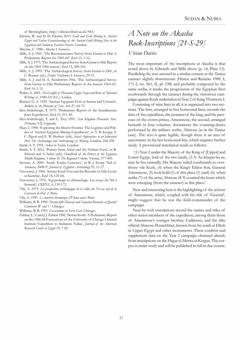
The most important of the inscriptions at Akasha is that noted above by Edwards and Mills above (p. 14, Plate 13). Paralleling the text attested in a similar context at the Tanjur cataract slightly downstream (Hintze and Reineke 1989, I, 171-2, no. 561, II, pl. 238) and probably composed by the same scribe, it marks the progression of the Egyptian fleet southwards through the cataract during the victorious cam-paign against Kush undertaken in Year 2 of King Thutmose I.
Consisting of nine lines in all, it is organized into two sec-tions. The first, arranged in five horizontal lines, records the date of the expedition, the prenomen of the king, and the pres-ence of the crown-prince, Amenmose; the second, arranged beneath in four columns, documents the counting-duties performed by the military scribe, Ahmose (as in the Tanjur case). The text is quite legible, though there is an area of uncertainty in the last horizontal line, which requires further study. A provisional translation reads as follows:
‘(1) Year 2 under the Majesty of the King of [Upper] and Lower Egypt, lord of the two lands, (2-3) Aa-kheper-ka-re, may he live eternally. His Majesty sailed southwards to over-throw vile Kush, (4) when the King’s Eldest Son, General Amenmose, (5) took hold (?) of this place (?) (and) (6) when scribe (7) of the army, Ahmose (8-9) counted the boats which were emerging (from the cataract) at this place.’
New and interesting here is the highlighting of the actions of Amenmose, which, coupled with his title of ‘General’, might suggest that he was the field-commander of the campaign.
Near-by rock inscriptions record the names and titles of other senior members of the expedition, among them those of Amenmose’s younger brother, Uadjmose, and the elite official Ahmose-Pennekhbet, known from his tomb at Elkab in Upper Egypt and other monuments. These confirm and supplement data on the Year 2 campaign obtained already from inscriptions on the Hagar el-Merwa at Kurgus. The cor-pus is under study and will be published in full in due course.


Please order these books from the Honorary Secretary at the Society’s address.
Sudan’s First RailwayThe Gordon Relief Expedition and The Dongola Campaign
by Derek A. Welsby
London 2011149 pages, 6 tables, 47 figures, 173 colour and 19 b&w platesISBN 978 1 901169 1 89
Begun in 1875 by the Egyptian khedive, Ismail Pasha, the railway played an important role during the Gordon Relief Expedition of 1884-5 and Kitchener’s Dongola Campaign in 1896. It was abandoned and cannibalised to build other railways in Sudan during the first decade of the 20th century. For much of its course it runs through the desert and in those areas the roadbed, the associated military installations and the innumerable construction camps are extremely well preserved. This book is the result of a photographic survey of these installations together with the detailed archaeological surveys undertaken within them. A report on the artefacts, which includes personal equipment, ammunition, fragments of rolling stock, bottles, tins and ceramics, completes the volume.
Retail price £22. Available to members at the discounted price of £20 (p&p £2.50, overseas £5.50).
Gabati A Meroitic, Post-Meroitic and Medieval Cemetery in Central Sudan. Vol. 2: The Physical Anthropology
by Margaret A. Judd, with a contribution by David N. EdwardsLondon 2012xii + 208 pages, 110 tables, 15 figures, 66 maps, 73 colour plates ISBN 978 1 901169 19 7
The cemetery at Gabati, dating from the Meroitic, post-Meroitic and Christian periods was excavated in advance of road construction in 1994-5, the detailed report being published by SARS in 1998. This complementary volume provides an in-depth analysis of the human remains. A final chapter, a contribution from David Edwards, the field director of the project, in conjunction with Judd, assesses the archaeological results in light of continuing research in the region over the last decade and more.
Retail price £33. Available to members at the discount price of £29. Please add £3.50 (Overseas £5.50) for postage and packing.
THE SUDAN ARCHAEOLOGICAL RESEARCH SOCIETY ISSN NUMBER 1369-5770
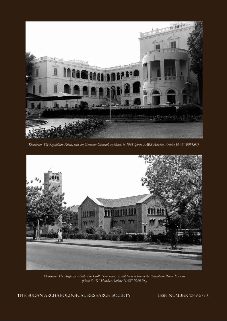
Khartoum. The Anglican cathedral in 1968. Now minus its bell tower it houses the Republican Palace Museum (photo SARS Hawkes Archive HAW P090.01).
Khartoum. The Republican Palace, once the Governor General’s residence, in 1968 (photo SARS Hawkes Archive HAW P091.01).