Editor-in-Chief - Дніпровський національний університет ...
215
-
Upload
khangminh22 -
Category
Documents
-
view
0 -
download
0
Transcript of Editor-in-Chief - Дніпровський національний університет ...


EDITORIAL BOARD
Editor-in-Chief:Associate professor, Ph.D., Manyuk Volodymyr, Assoc. Prof. of Department of Earth Sciences, Oles Honchar Dnipro National University, Dnipro, Ukraine; E-mail: [email protected]; tel.: +067 947 45 04; +095 824 61 77.
Deputy Editors:Professor, Dr. hab., Andrzej Tomasz Solecki, Scientific Head of the team of WS Atkins-Polska Sp. z o.o. experts preparing the report on uranium metallogeny, Institute of Geological Sciences University of Wrocław, Wrocław University, market and prospects in Poland for the Polish Ministry of the Environment, Poland; E-mail: [email protected]; tel. +48 600 96 63 61.Professor Şaşmaz Ahmet, Dr. Sc. in environmental geochemistry and mining deposits, Head of Geology Department, Firat University, Elazığ, Turkey; E-mail: [email protected]; tel. +90 424-2370000.
Executive Editor: Professor, Dr. Sc., Sherstyuk Natalya Petrivna, Oles Honchar Dnipro National University, Head of Department of Earth Sciences, Faculty of Chemistry, Dnipro, Ukraine; E-mail: [email protected]; tel.+38-096-124-15-35.
Members of the editorial board:
Professor (mult.), Dr. hab., Harald G. Dill, Dr.h.c in economic geology (additional focal disciplines: applied sedimentology/ geomorphology, technical mineralogy), Gottfried-Wilhelm-Leibniz University, Mineralogical Department, Hannover, Germany. E-mail: [email protected]; tel. +49-(0) 511 643 2361.Professor in Biostratigraphy-Micropaleontology, D.Sc., Karoui – Yaakoub Narjess, Carthage University, Faculty of Science of Bizerte (Departament of Earth Science), Jarzoura, Bizerte,Tunisia E-mail: [email protected]. Research Fellow William A.P. Wimbledon, Dept. of Earth Sciences, University of Bristol; Member Geological Society of London's Conservation Committee, Member of Berriasian (Jurassic-Cretaceous) Working Group (International Subcommission on Cretaceous Stratigraphy); E-mail: [email protected] in Geology, Dr.Sc., José Bernardo Rodrigues Brilha, University of Minho, Department of Earth Science, Braga, Portugal, E-mail: [email protected]; tel. +351-25-3604306.Ph.D., MSc., Afsoon Moatari-Kazerouni, Geology Lecturer Geology Department - RhodesUniversity Grahamstown, Eastern Cape, South Africane, E-mail: [email protected]; tel: +27 (0)46-603-8618
The main aim of the Journal of Geology, Geography and Geoecology is to publish high quality research works and provide Open Access to the articles using this platform. Collection of scientific works publishes refereed original research articles and reviews on various aspects in the field of geological, geographical and geoecological sciences. Journal materials designed for teachers, researchers and students specializing in the relevant or related fields of science. Journal included in the list of professional publications, you can publish the main results of dissertations for the degree of doctor and candidate of geological sciences. The scope of distribution: international scientific journal. All published articles will be assigned DOI provided by Cross Ref.

Professor in Geology, Dr.Sc., Abderrazak El Albani, Université de Poitiers, Laboratory IC2MP, Poitiers, France, E-mail: [email protected]; tel. +33 (0)5.49.45 39 26Associate Professor, lIya V. Buynevich, Temple University, College of Science and Technology Department of Earth and Environmental Science, Philadelphia, USA, E-mail: [email protected], tel: 215-204-3635Prof., Dr. Sc., Mokritskaya Tatiana, Oles Honchar Dnipro National University, Ukraine; Faculty of Chemistry, E-mail: [email protected]; tel.: 098 257 70 19.Prof., Dr. Sc., Yevhrashkina Galina Petrivna, Oles Honchar Dnipro National University, Faculty of Chemistry, Ukraine; E-mail: [email protected]; tel.: 067 565 51 13Prof., Dr. Sc., Reynard Emmanuel, Prof. of physical geography at the University of Lausanne, Faculty of geosciences, Switzerland; E-mail: [email protected];Associate Prof., Dr.Sc., Afroz Ahmad Shan, Assoc. Prof. of Structural Geology with the Faculty of Science, Department of Petroleum Geology University of Brunei Darussalam, Brunei; E-mail: [email protected];Prof., Dr. Sc., Gerasimenko Natalia, Department of Earth Sciences and Geomorphology Taras Schevchenko National University of Kyiv, Kyiv, Ukraine; E-mail: [email protected] R.S., M. Sc. Hazard analyst, Idukki District Emergency Operations Centre (Idukki-DEOC), Idukki District Disaster Management Authority (Idukki DDMA), Department of Disaster Management, Government of Kerala, Painavu, Idukki, Kerala (State), INDIA, tel. +91-9061762170, E-mail: [email protected], [email protected] professor, PhD Anatoliy Melnychuk, Assoc. Prof. of Department of Economic and Social Geography Taras Shevchenko Kyiv National University, Kyiv, Ukraine; E-mail: [email protected]., Dr. Sc., Baranov Volodymyr, Head of Lab. Invest. Structural changes in rock, Senior Researcher Institute of Geotechnical Mechanics of NAS of Ukraine, Department of Geology and exploration of mineral deposits SHEI "National Mining University," Ukraine; E-mail: [email protected]; tel.: +38 097 506 43 73.Prof., Dr. Sc. Berezovsky Anatolii, Dean of Mining - Processing Faculty, Krivyi Rig Technical University, Ukraine; E-mail: [email protected]: tel.: +38 098236 84 27.
Associate professor, Ph.D., Maniuk Vadym, Assoc. Prof. of Department of Geography Oles Honchar Dnipro National University, Dnipro, Ukraine; E-mail: [email protected]; tel.: +38 098 290 80 69; +38 066 270 14 48.Professor, Dr. Sc., Kroik Anna Arkadyevna, Oles Honchar Dnipro National University, Dnipro, Ukraine; E -mail: [email protected]; tel.: +38 095 149 65 50.Professor, Dr. Sc., Prikhodchenko Vasiliy Fedorovich, Dean of the Faculty of exploration, Head. Department of Geology and mineral exploration National TU Dnipro Polytechnic; Dnipro, Ukraine; E-mail: [email protected]; tel.: +38 056 24 7 33 52.Professor, Dr. Sc., Lurie Anatolii, V.N. Karazin Kharkiv National University, Ukraine; E-mail: [email protected]; tel.: +38 067 579 89 41.Prof., Dr. Sc., Zelenska Lyubov Ivanivna, Oles Honchar Dnipro National University, Head of Department of geography, Dnipro, Ukraine; E-mail: [email protected]; tel.:067 56067 02Prof., Dr. Sc., Shevchyuk Viktor Vasylievych, Taras Shevchenko National University of Kyiv, Ukraine; E-mail: [email protected]; tel.: +38 050 656 33 20. Prof., Dr. Sc., Baranov Petro M., Oles Honchar Dnipro National University, Ukraine; Faculty of Chemistry, E-mail: [email protected]; tel.: +38 097 291 68 13.
Literary editors: P.V. Bradbeer, M.O. Tikhomyrov. Cover design: Vadym V. Manyuk. Text Layout: Vadym V. Manyuk.
Information about publication: Journal of Geology, Geography and Geoecology. (ISSN 2617-2909 (print), ISSN2617-2119 (online). Complete information on the requirements for the publication of copyright articles in the collection can be found on the website of the journal www.geology-dnu.dp.ua or by addressing the Editor-in-Chief Volodymyr Manyuk at [email protected].
In accordance with the Order of the Ministry of Education and Science of January 15, 2018, №32 «Journal of Geology, Geography and Geoecology» December 18, 2018 is included in category A «List of professional publications of Ukraine» by specialties 103 (Earth Sciences) and 106 (Geography)
Approved by the Decision of the Scientific Council of the Oles Honchar Dnipro National University, 72 Gagarin ave., Dnipro, 49010, Ukraine.___________________________________________________© Oles Gonchar Dnipro National University, 2020

233
Tourism geography: functional structure and role in tourismology
Oresta Y. Bordun, Pavlo V. Romaniv, Wolodymyr R. Monasryrskyy
Ivan Franko National University of Lviv, Lviv, Ukraine, [email protected]
Abstract. The objective basis of tourism as a phenomenon of social life makes it a complex, multi-faceted object of scientific knowledge. Geography was one of the sciences that has studied tourism since it became a phenomenon of human existence and has initiated an innovatory scientific direction, that is tourism geography. We researched the theoretical approaches to the definition of the notion tourism geography, tourism studies and
tourismology as integral notions in the scientific discourse regarding the study and research on tourism. We determined the main legal, organizational, natural, socio-economic, humanitarian and other basics of the geography of tourism which are orientated at provision of dynamic development in the sphere in general. Modern traditions and tendencies of the European school of tourism studies, novel scientific orientations in the block of adjacent disciplines were evaluated and the authors` interpretation of the functional structure of the direction “Tourism geography” are presented. We determined the integral character of the theory of tourism geography with its characteristic structural changes due to the multi-functionality of scientific directions, because tourism geography is a complex natural-ecological-socio-economic system which covers geographical, ecological, socio-cultural, economic, political, organization-legal and other aspects, processes and phenomena is related to comfortable and safe recreation. The position of tourism geography in the system of sciences and scientific disciplines with updated notion-category apparatus were characterized. We determined the peculiarities of the structural-functional scheme of the touristic sphere (use of the natural and cultural-historical resources – providing touristic services – obtaining economic profits). We should note the increasing attention to the ecological problems of tourism geography, balance of the social, ecological, economic components at different levels of territorial organization of the touristic process.
Key words: tourismology, tourism studies, geography of recreational resources, geography of tourism infrastructure, geography of changes in the environment of tourism, geography of touristic movement, country studies for tourism, local studies for tourism
Географія туризму: функціональна структура та роль у туризмознавстві
О.Ю. Бордун, П.В. Романів, В.Р. Монастирський
Ivan Franko National University of Lviv, Lviv, Ukraine, [email protected]
Анотація. Об’єктивне підґрунтя туризму як явища суспільного життя робить його складним, багатогранним об’єктом наукового пізнання. Географія була однією з наук, що досліджувала туризм з початку перетворення його у феномен людського буття і започаткувала інноваційний науковий напрям– географію туризму. Простежено теоретичні підходи до визначення сутності поняття географія туризму, туризмознавства і туризмології як інтеграційних понять у науковому дискурсі стосовно вивчення й дослідження туризму. Визначено загальні правові, організаційні, природничі, соціально-економічні, гуманітарні і інші засади географії туризму, що спрямовані на забезпечення динамічного розвитку галузі в цілому. Оцінено сучасні тра-диції і тенденції європейської школи туризмознавства, новітні наукові напрями в блоці суміжних дисциплін і представлене авторське трактування функціональної структури напряму “Географії туризму”. Визначено інтегральний характер теорії географії туризму з його характерними структурними змінами у зв’язку з багатофункціональністю наукових напрямків, оскільки географія туризму складна природо-еколого-соціо-економічна система, яка охоплює географічні, екологічні, соціокультурні, економічні, політичні, організаційно-правові та інші аспекти, процеси і явища, пов’язані з комфортним та безпечним відпочинком і оздоровленням. Охарактеризовано позицію географії туризму у системі наук та наукових дисциплін з оновленим понятійно-категоріальним апаратом. Визначено особливості структурно-функціональної схеми туристичної галузі (використання природних та культурно-історичних ресурсів – надання туристичних послуг – отримання економічних прибутків). Акцентується на необхідності збільшення уваги до екологічних проблем географії туризму, збалансованість суспільної, екологічної, економічної складової на різних рівнях територіальної організації туристичного процесу. Ключові слова: туризмологія, туризмознавство, географія туризму, географія рекреаційних ресурсів, географія туристичної інфраструктури, географія змін туристичного середовища, географія туристичного руху, туристичне країнознавство, ту-ристичне краєзнавство
Received: 09.12.2019Received in revised form: 21.03.2020Accepted: 23.04.2020
Oresta Y. Bordun, Pavlo V. Romaniv, Wolodymyr R. Monasryrskyy Journ. Geol. Geograph. Geoecology, 29 (2), 233–242.
Journal of Geology, Geography and
Geoecology
Journal home page: geology-dnu-dp.ua
ISSN 2617-2909 (print)ISSN 2617-2119 (online)
Journ. Geol. Geograph.Geology,
29(2), 233–242.doi: 10.15421/112021

234
Oresta Y. Bordun, Pavlo V. Romaniv, Wolodymyr R. Monasryrskyy Journ. Geol. Geograph. Geoecology, 29(2), 233–242.
Introduction. Tourism has a dominating and priority position regarding the vectors of the development of the economy and culture, and is one of the most promising directions of socio-economic development, because it demonstrates stable tempi of growing demand for it. The formation of the new scientific direction – tourism studies – has become a specific response to social demand, urgent need of modern society.
In the scientific literature, the capacity of the terms “tourism geography”, “tourism studies”, “tour-ismology”, particularly from the systemic perspective, was defined in the works of contemporary Ukrainian scientists (N. Krachylo, 1980, 1987, O. Ljubiceva, 2004, 2006, 2010; M. Malska, 2008; V. Fedorch-enko, 2013;) and foreign researchers (V. Alejziak (Alejziak); Р. Батлер (R.W. Butler); P. Bernecker (P. Bernecker), R. Winiarski; W. Gaworecki, I. Zorin, W. Hunzicker, M. Hall (Hall, C. M), А. Kovalchuk, J. Krippendorf (J. Krippendorf), K. Kraft (K. Kraft), W. Kreisel (Kreisel, Werner), O. Lazzarotti (Lazzarot-ti, Olivier), S. Liszewski, V. Kvartalnov, M. Mironov, V. Preobrazhenskij, D.G. Pearce, P. Risch, J. Stradner and others.
Every year, the amount of specialized scien-tific journals describing the problem of tourism as a modern phenomenon increases around the world. In 1971–1990, 16 additional journals devoted to the problems of tourismology emerged, and in the pe-riod of 1991–2004, the list of journals has enlarged with another 39 positions, and currently Hospitality & Tourism refers to the list of touristic scientific peri-odic editions comprising 131 names, which according to the analysis conducted by Cheng C.-K., Li X. R., Petrick J. F. & O›Leary J. T contain only a compara-tively small share of the articles by geographic scien-tists focusing on the phenomenon of tourism (Cheng, C.-K., Li, X. R., Petrick, J. F., & O’Leary, J. T., 2011). Among the defences of Candidate of Sciences disser-tations, the share specializing in tourism geography is also very small according to the researchby Egyptian scientists Jafari and Aaser (Jafari, J., Aaser D., 1988). However, we consider the geographic approaches to the research most correct for understanding the sus-tainable (balanced) development of tourism.
Geography is a perfect discipline for the study of the global touristic sphere. There are many prin-cipally geographic aspects of tourism orientated to the following principle: touristic product as economic and geographic category is traded and consumed in the place of origin and purpose of tourists, tourism transforms the environment of the visited places by the means different from non-touristic processes,
provides transport of people, goods, services, ideas and money through space; provides a special way in which people understand and treat the environment.
Considering the essential spatial aspects of tour-ism, foreign geographers have made a significant contribution to academic research on tourism. They have developed some key conceptual models for the explanation of the development of tourism, including the morphology of the resort, touristic-historical plac-es and the life cycle of the touristic zone. Moreover, geographers have made an important contribution to the study of ecological dimensions of tourism and the concept of sustainable development of tourism and ecotourism.
Despite the fact that tourism geography is based on the study of tourism, and has also increased the number of students of the Geography Faculty, ironi-cally it occupied a certain peripheral position in aca-demic geography. This status could partly be due to the inertia of the academic institutions and staff , who do not consider tourism a serious subject for study, and also difficulties in assessment of the touristic sphere compared with primary and secondary sectors of the economy.
Therefore, having analyzed foreign and domestic experience of studying geography as an interdisciplin-ary sphere of knowledge in tourism, we should distin-guish the range of the main tasks of our publication: to determine the peculiarities of the system approach to tourism as multi-aspect phenomenon; character-ize the structure of tourism studies and tourismology; find and distinguish the place of tourism geography in the system of tourismologic disciplines; describe the relationship of tourism geography and various sciences, disciplines, interdisciplinary scientific prob-lems, determine the directions and the content of such relationships. Materials and methods. The continuous increase in the amount of travel and qualitative content of such phenomenon as tourism is indicated by the statistical methods developed by the World Tourism Organization (UNWTO). Thus, without analysis of the material by the UNWTO, there would have been no integral, systematic perception of the formation of tourism geography as a fundamental direction in post-classic geography. Integration of the theoretical bases of tourism geography was performed using philosophical methods of dialectics and general scientific methods of analysis, synthesis, induction and deduction. Results and their analysis. Based on the modern interpretation of tourism as a phenomenon of social life, there occur certain difficulties in the approaches

235
Oresta Y. Bordun, Pavlo V. Romaniv, Wolodymyr R. Monasryrskyy Journ. Geol. Geograph. Geoecology, 29(2), 233–242.
at the beginning of its emergence, establishment and further development. However, most researchers agree that its start should be attributed to the introduction into everyday life of a certain number (or category) of people who spend their free time traveling into every-day life. Therefore, the studies of such phenomenon begun with the process of mass, in some way organized, touristic movement.
As noted by the authors Ljubiceva O.O., Malska M.P., Zinko Y.V., tourism geography, perhaps, is one of the first scientific disciplines which have chose tourism as the subject of their research almost since the beginning of its development when it was developing from individual travel to a mass phenomenon, i.e. the XIX century.
The first scientific-practical studies of the touristic process were recorded in European countries such as Austria, Switzerland, Germany, in the late XIX century. At the same time, the touristic glossary was enlarging etymologically with specialized terms and notions. Let us look at the key events and dates at the turn of the XIX-XX centuries in European touristic science and practice (Table 1).
The first half of the XX century witnessed the emergence and work of educational institutions which became the creators, promoters of science and practice of tourism. Such institutions are:
1) Düsseldorf College of Hotel Trade and Transport, 1919
2) Research Institute for Tourism of Berlin College of Trade, 1929;
3) Scientific-Research Institute of Tourism of College of Global Trade in Vienna (now the Vienna University of Economics and Business), 1934;
4) Institute of Tourism Research in Bern and Seminar on Tourism (Seminar für Fremdenverkehr) in St. Gallen in 1941. There, the first fundamental works on tourism by professors W.Hunzicker and K. Kraft were published.
After the WWII, the science of tourism devel-oped further. In Switzerland (Bern) in 1949, the Inter-national Association of Scientific Experts in Tourism (AIEST) was founded, which began to publish the Journal “Revue de tourisme”. A significant role in the establishment of this institution belongs to the Swiss professor C. Kaspar. Under his influence, the first centers of academic studies for tourism geography emerged in the economically developed countries of Western Europe, which in the process of their scientif-ic work have generalized the national scientific find-ings. Particularly, the British scientific contribution was summed up in the researches by D. Pearce and R Butler (Pearce, D.G. & Butler, R.W. 1993), W. Kreisel
defined the contribution and scientific condition of the German tourism geography (Kreisel, Werner, 2004.), Oliver Lazzarotti has done the same regarding the French tourism geography (Lazzarotti, Olivier, 2002), and Michael Hall has analyzed the possibilities of co-operation of national European schools of geography and tourism (Hall, 2009, 2013.).
The results of American studies in tourism geog-raphy were summarized in the research by K. Mey-er-Arendt and A. Lew (Meyer-Arendt, Klaus J., and Alan A. Lew, 2003).
Later, the theory of tourism began to develop in Eastern Europe, where the educational institutions of preparation of responsible specialists appeared. The historical analysis of the establishment of tourism ge-ography conducted by M. Rutynsky (Rutynsky M., 2016) shows the appearance of fundamental research-es on tourism geography in Slovenia (monograph by V. Brachich), Bulgaria (M. Bychvarova), Poland (J. Warzynska and A. Jackowski), Russia (P. Zachini-aiev and N. Falkovych, M. Ananiev, E. Kotliarova).
The start for tourism studies in the domestic sci-ence was made by several scientific disciplines. The first one was tourism geography. Particularly this sci-entific direction would further develop and form the basics of the meta-theory of tourism. This is reflected in the general structure of human geography general-ized by O. Shabliy, where in the block of disciplines of Economic Geography, the direction Tourism Geog-raphy is presented (Shabliy O. I., 2001). As tourism emerged as a social phenomenon, it took a leading place in this structure. Since the mid 1990s, the sub-ject of research in recreational geography was study of geospatial patterns of the human behavior in the process of recreational activity and provision of rec-reational facilities.
A significant breakthrough in the development of tourism geography in Ukraine was observed between the mid 1990s and the beginning of the XXI century. First of all, it is related to the defense of candidate dissertations by Krachyla M. P., Ljubiceva O. O., Bei-dyk O. O. and a number of candidate dissertations, as well as the publication of fundamental monographs (Bejdyk, O.O., 2001; Ljubiceva, O.O., 2006), and also regional monograph editions (Fedorchenko V. K., Pazenok V. S., Kruchek O. A. and others., 2013).
In O. O. Bejdyk`s monograph, the methodologi-cal basics were systematized and the methods of the research of recreation-touristic resources was elabo-rated, the knowledge of their structure was enlarged, and the notion-terminological apparatus of recreation-al geography and tourism geography was deepened. Resource-recreational assessment and passportization

236
of administrative-territorial subjects of Ukraine was conducted, and its rating recreational zoning was sub-stantiated.
The monograph of Ljubiceva O. O. (Ljubiceva, 2006) focused on the theory, methodology and meth-ods of the study of geospatial aspects of the develop-ment of the market of touristic services, mechanism and patterns of its functioning and territorial organi-zation at different hierarchic levels.
According to O. Ljubiceva, tourism studies was precisely the most theoretically developed interdisci-plinary scientific direction which reveals all the com-plex basic theories of tourism as a social phenomenon (Ljubitseva, 2010).
Tourism studies is a scientific direction with-in which tourism is studied as social phenomenon (Ljubitseva., 2010). In the collective monograph ed-ited by V. Pazenok, V. Fedorchenko, tourism studies was defined as a notion which covers any knowledge of tourism: general and partial, theoretic and prac-tical, abstract and specific, rational and sensitive, ideal and real (Fedorchenko, Pazenok, Kruchek and others., 2013), and tourismology is interpreted as a meta-theory of tourism based on philosophy of tour-ism as a phenomenon of nowadays.
The Ukrainian (Fedorchenko V. K., Pazenok V. S., Kruchek O. A. and others., 2013; Krachylo N.P., 1987; Ljubitseva O.O., 2010) and foreign scien-tists (Alejziak, Winiarski, 2003; Kvartalnov, 2003; Mironenko, Tverdohlebov, 1981; Preobrazhenskij, 1988) in general terms had similar ideas on the divi-sion of tourism studies into scientific directions which formed on the boundary of economics, geography,
history, philosophy, pedagogy, psychology, and law. In the novel history of science of tourism, one of
the first one to start generalizing the knowledge about tourism asa multi-faceted and multi-aspect phenom-enon was Birzhakov M. B. In his study “Introduction to Tourism”, he proposed the section “Names of the sciences on tourism” (Birzhakov, 2006). This section contained definitions of the science which deals (will deal with) tourism as a certain system of knowledge concerning this phenomenon. These names are con-fined to: touristics, tourology, tourography.
Polish researcher V. Alejziak proposed to call the science “touristology”, where the main, central, integral object of the research would be the tourist, psychology of the tourist. According to V. Alejziak, “study of tourism as a phenomenon includes interdis-ciplinary knowledge, multifacetedness, flexibility and variation of forms of participation, similarly to or-ganizational structures and systems of management, extreme increase in the number of travelers and load on the most visited objects (Alejziak, Winiarski, red., 2005).
We think that these notions do not reflect tour-ism as a systematic phenomenon, because touristics is used as a Polish-borrowed term, tourology and tourography have the term “tour” in common, which does not fully reflect the essence of tourism as a sys-tematic phenomenon. Therefore, definition of “tour-ism studies”, and the science “tourismology” most successfully reflect the phenomenon of tourism, in-cluding the subjective-objective component, the study of which requires knowledge of different sciences and disciplines.
Table 1 Most notable events of the initial stage of tourism science, particularly tourism geography, at the turn of the XIX-XX centu-ries.
№ Author Event (year) Event
1 E.Fruler 1883 Report about the development of Swiss hotel management in Zurich
2 J. Stradner 1884 Report at the Congress on Intensification of Tourist Development in Austrian provinces in Graz
3 E. Fruler 1896 Publication of study “Significance of touristic statistics”
4 J. Stradner 1905 Term Fremdenverkehrsgeographie emerged – geography of for-eign tourism (German)
5 J. Stradner 1917 Notions “tourism geography” and “touristic district” were for the first time used in study “Breakthrough of tourism”
6 K. Spiuts 1919 Vienna, Austria. Notion “Touristic industry” was introduced
7 R. Blanchard 1924 Publication of study “Tourism in the French Alps”
8 A. Marioti
Oresta Y. Bordun, Pavlo V. Romaniv, Wolodymyr R. Monasryrskyy Journ. Geol. Geograph. Geoecology, 29(2), 233–242.

237
As with the structure of tourism studies, this problem has a number of propositions and variants. For example, Mironov Y. B. differentiates tourism studies into such directions as: economic, manage-ment, geographic, historical, philosophical, psycho-logical, and pedagogical (Mironov, 2018).
Tourism geography was distinguished as a di-rection from economic geography as a result of con-vergence with adjacent sciences and has become the basic discipline in the system of tourism studies and tourismology as a result of divergent processes in sci-ence.
Tourism geography is one of the first directions in tourism studies, and our research was performed particularly within this branch. Tourism geography has been developed at the same time by domestic and foreign scientists. Because geography as science has been established long time ago and was organi-cally united with travels, then tourism geography is the most developed scientific direction of tourism studies. The main founders of tourism geography in Central-Eastern Europe could be considered the Aca-demic School of Polish professor S. Lishensky, con-tinued by Jackowski, and among the most contempo-rary researchers – W. Alejziak. Among the Ukrainian researchers of tourism geography, О. Beidyk and О. Ljubiceva should be distinguished. Generalizing the
views of Ukrainian and foreign researchers of tour-ism geography, in its structure, 5-7 separate scientific directions are distinguished (Fig. 1).
The main preconditions for tourism are natural factors which contribute to the active recreation and health improvement of people. It is particularly due to such recreational resources that tourism has developed as a phenomenon. The main goal and the main direction for geographers today is still the geography of recreational resources of tourism.
The post-industrial stage of the development of tourism originated as a new direction in tourism geography – geography of touristic infrastructure. Non-evenness of provision of touristic resources in different parts of the world, regions and districts causes changes in the environment which is exploited by tourists for too long and therefore a new direction emerged – geography of changes in the touristic environment.
Flows of tourists occur between donor countries of tourism and countries which accept them. Particularly the flows of tourists are the subject of geography of touristic movement.
If as the subject we consider the study of countries which have touristic-recreational potential (TRP), then the discipline tourism country studies forms. The studies of local areas for presence of
Fig.1 Structure of tourism geography
Oresta Y. Bordun, Pavlo V. Romaniv, Wolodymyr R. Monasryrskyy Journ. Geol. Geograph. Geoecology, 29(2), 233–242.

238
TRP are conducted through the discipline of heritage tourism ( tourism studies ). Typological diversity is studied by geography of types of tourism, and the central geographical discipline in this sense is tourism geography.
The place of tourism geography in the system of sciences is determined objectively by the need and scope of goals orientated towards solving the social needs. Tourism geography is a complex natural-ecological-socio-economic system dealing with geographical, ecological, socio-cultural, economic, political, organizing-legal and other aspects, processes and phenomena, associated with comfortable and safe recreation and health improvement.
No doubt the basis for tourism geography is formed by natural (geography of natural resources, knowledge on landscape, geoecology, recreational-landscape projecting, specialized natural sciences) and social geographies.
According to the definition by H. Denysyk, “Natural geography is the science which consistently studies the nature of the Earth or its particular re-gions from their natural condition through history of land use to the current anthropogenic development” (Denysyk, Stefankov, Chyzh, 2018). The leading sci-entists, L. H. Rudenko, Y. O. Maruniak, I. H. Cher-vaniov (Rudenko, Maruniak, Chervaniov, 2018) have formed the corresponding concept of the development of national geography on the basis of the paradigm of innovatory development and emphasize the increase in innovatory, informational and pragmatic functions of geography. Researchers O. Topchiev, V. Nudelman, L. Rudenko report on drastic changes in the demands of domestic society regarding the development of the natural-geographic basis for the needs of the regional-izing the country. Geographers have already opposed the geographical determinism which emphasized the direct dependence of society on the natural environ-ment with the concept of possibilism, using which the natural-resource potential of the territory is only a number of opportunities which could be used to dif-ferent extent (Topchijev, Nudelman, Rudenko, 2012). No doubt, natural geography, by the level of dealing with the natural objects and phenomena, dominates among other sciences in tourism geography, originat-ing another discipline – geography of recreational re-sources.
However, no less important is social geography that deals with territorial organization of touristic ac-tivity, conditions and peculiarities of its development and accommodation, population, culture and also economy in the world in general and in separate re-gions in particular.
Ukrainian researchers O. I. Shabliy (Shabliy, 2001), Y. B. Oliinyk, A. V. Stepanenko (Oliinyk, Oliinyk, Stepanenko, 2012), M. Pistun (Pistun, 1996; Pistun, 2005) and others express another point of view that social geography is a group of geographical sciences including economic geography, social geog-raphy, geography of population, science geography, which fundamentally contribute to the development of tourism geography.
This block also includes the recreational geogra-phy represented by such prominent Ukrainian scien-tists as O. Bejdyl (Bejdyk, 1997; Bejdyk, 2001), O. Ljubiceva (Ljubiceva, 2004, 2006, 2010), P. Masljak (Мasljak, 2008), I. Smal (Smal, 2010). Researchers are developing theoretical-methodological bases of the territorial organization of recreation and health im-provement, determining and evaluating recreational resources, determining recreational capacity and pos-sible border loads based on the scientifically substanti-ated standards with the purpose of optimizing the de-velopment and functioning of TRS (Ljubiceva,, 2004).
Tourism, especially in the XXI century, is closely associated with the geography of services. The most significant contribution to this direction was made by the domestic researchers M. Malska (Malska, Аntonuk, Hanych, 2008), O. Ljubiceva (Ljubiceva, 2004, 2006, 2010) and others. Particularly, the re-searchers study the functionality and dynamics of the market of services and the mechanisms in the tourist activity regarding transport connections, accommo-dation, food, and also leisure services.
As society develops, the needs of consumers of touristic services change. The modern day tourist de-mands much more from the Roman metonymic phrase “Bread and circuses” (Lat. panem et circenses). Meet-ing the demands of the time, there is currently a new direction in the social geography developing – cul-ture geography. The firstto distinguish this scientific direction and term in Ukrainian geography was S. Rudnytskyi (Rudnytskyi, 1905). Culture geography as a science continues to be studied and its theoret-ical-methodological basis developed by research-ers I. Rovenchak (Rovenchak, 2008), O. Ljubitseva (Ljubitseva, 2010), L. Shevchuk (Shevchuk, 2007). The researchers distinguish territorial and national integrities of culture in the context of geographical environment.
According to V. Gerasymenko, the integral char-acter of the theory of tourism is deepening. Char-acteristic structural changes occur in the contents of the theory of tourism, because it included many functional scientific directions such as marketing, planning, finances, human resource management, etc
Oresta Y. Bordun, Pavlo V. Romaniv, Wolodymyr R. Monasryrskyy Journ. Geol. Geograph. Geoecology, 29(2), 233–242.

239
(Gerasymenko, 2011). Furthermore, today it is hard to imagine integral study of tourism without integrating it into other scientific fields: sociology, psychology, geography, medicine, ecology, history, culturology, etc. Gradually, tourism has taken its place among the subjects of many sciences, which in turn contributed to the enlargement and complication of the subject of its own. Today, tourism could be studied and man-aged only by mutual efforts of specialists in different scientific spheres. Therefore, some authors consider knowledge of tourism as a universal science which is managed by a number of related sciences and be-comes a component of these sciences itself.
Tendencies of rapid development of the touris-tic industry around the world createthe necessity of quick harmonious interaction, quick response, logis-tics between all the links of the touristic product. The responsibility for all these processes is imposed on the adjacent sciences. In the system of tourism, the relationships of economics and culture, employment of population, international relations and safety, hotel business, transport organizations, are closely inter-weaved.
Let us consider in more detail the place of the adjacent sciences in the structural-functional position. We should note the duality of the mutual influences of tourism geography and adjacent sciences.
Because the economy of the tourist business generalizes the economic indicators of touristic activity from economies of certain business entities – natural persons and juridical persons, the economy as science in the context of tourism geography could have two levels:
1) economy of tourism as inter-branch complex of tourist services;
2) economy of subjects of touristic industry. The system of tourist services is not confined to
only commercial (market) relations, they also include fulfillment of social needs, because the main object of tourism is human. The social aspect of market services (social) is satisfaction of needs of people in recreation, travel, maintaining the health and recuperation. This is not the full list of constituents of tourism, an important and constant aspect of which is exploring and educational functions which contribute to the development of socialization, religious, political integration, cross-culture communication. In this we see the mutual influences of social sciences (sociology, political science, law, ethnology and anthropology, etc) and tourism geography, particular international.
Tourism is one of the main forms of international relations and forms (or rather is able to form) favourable
international economic and communicative climates. International governmental and institutional touristic cooperation of states effectively develops at bilateral, regional, subregional, interregional and global levels, including within the frameworks of international organizations, international touristic conferences, forums, symposiums and is an effective mechanism of creating a favourable environment for tourism, integration into global touristic processes.
Among the exact sciences (particularly mathematics, computer sciences), the latter is of special significance in the interrelations with tourism geography. Currently, in tourism geography in Ukraine and around the world, great attention is paid to the computerization of the touristic process, use of computer technologies, etc.
Information technologies enhance the processes of globalization and integration of various resources, demand qualitatively new approaches to ecological, legal, economic and information-documentation provision of the organization of data on tourism and geography of touristic activity. In our opinion, in the system of tourism geography, such disciplines should be included which are related to the development and introduction of information technologies which could present trips, travels, tourism in virtual view.
Virtual tourism involves virtual excursions, virtual tours, virtual meetings, where everyday reality is substituted virtually. Predecessors and historical origins of such type of tourism are popular TV-shows which familiarized the viewers with interesting touristic places. Due to the virtual tourism, interesting regions, objects, phenomena, processes become available to the internet users without any great additional costs. Such type of tourism gives advantages, particularly to handicapped people, and also new options for travelers to travel, though they become passive viewers. Virtual trips to notable historic, cultural and architectural monuments and objects of the nature-reserve fund could be seen in many web-pages in the internet, presented as described excursions with numerous photo and video materials. Virtual experience helps to approach the reality. Virtualization also helps in selecting potential touristic destinations which the tourist would visit in real life.
Taking into account the peculiarities of the structural-functional scheme of the touristic sphere (use of natural and cultural-historical resources – provision of touristic services – obtaining economic effects), the ecologisation of tourism geography leads to understanding of the processes of balanced public, ecological, economic components at different stages of territorial organization of touristic processes.
Oresta Y. Bordun, Pavlo V. Romaniv, Wolodymyr R. Monasryrskyy Journ. Geol. Geograph. Geoecology, 29(2), 233–242.

240
Also tourism geography is directly related to the town-building spheres, especially in the context of development of urban tourism, specifics of its organization, appropriateness of cities and their certain parts for the needs of tourism, recreation, excursion activity.
For tourism geography, particularly in the aspect of information evaluation, geographical patterns of location of resources, etc, historical sciences are important, particularly specific historical disciplines, such as: archeology, genealogy, heraldry, information evaluation, historical demography, heritage studies.
Tourism geography forms its notion-category apparatus at the border with other sciences and dis-ciplines. Of course, as the basis, the notion-category apparatus of tourismology was taken and enlarged. It has to be noted that the dictionary of terms in the sphere of tourism is regularly being enlarged due to rapid development of new directions of market of services. However, as noted by O. Ljubiceva, despite numerous attempts to achieve the integrity of inter-pretation of even basic terms and notions, definition of the main category, no unanimity has been achieved (Ljubiceva, 2006).
Notion-category apparatus was significantly ex-panded by O. Beidyk. In tourism geography, new definitions appeared:
recreational agglomeration – interrelated combi-nation of settlements which develop in a certain ter-ritory based on the common use of recreational re-sources and infrastructure (Bejdyk, 1997);
capacities of TRS (Touristic-recreational system) – characteristics (diversity, dynamics, comfort, sta-bility, effectiveness, hierarchization, reliability, etc) (Bejdyk О.О., 1997);
Geoqualimetry – science about assessing the qualities of geosystems, bordering the scientific di-rection the objective of which is evaluation of natural conditions and resources (Bejdyk, 1997);
Ecological capacity of region, quantitatively ex-pressed ability of natural or natural-economic com-plex to maintain the necessary social-ecologic bal-ance in certain territory (Bejdyk, 1997).
Currently, the following terminological notions are gaining popularity in tourism geography : coun-try-tourism – ethnographic tourism, one of the types of educational tourism which has become popular in rural areas; canyoning – sport traveling through water-falls and canyons using speleological equipment and technologies; cultural-information landscape – col-lection of cultural-information, compactly arranged locations which have sufficient cultural-historical potential for the fulfillment of the cultural and rec-
reational needs of people (Bejdyk О.О., 1997). The foregoing geographic-touristic notion-terminological apparatus add to the definitions of adjacent sciences: economic, political, historical, town-building, etc.
With time, these researches form the theoretic bases of tourismology. According to V. A. Kvartalnov, tourismology as science requires:
-integral complex approach to it as a subject of scientific knowledge;
- systematization of already developed basis of the analysis of the development of tourism;
-clear definitions of the objective, subject and ob-ject of study;
- determination of frames of factual scientific problematic, uniting its separate components into a general picture;
-generalization of accumulated knowledge and methods of study of geotourism;
- study of the system of interdisciplinary relation-ships, particularly with such sciences as anthropolo-gy, ecology, economics, recrealogy, etc (Kvartalnov, 2003).
Considering the above-mentioned thoughts, we should note that the main methodological functions of tourism studies are integrative, system-forming, and structural-functional. The incompleteness of sci-entific and practical knowledge of tourism as a multi-aspect phenomenon of social life is affirmed by the idea that tourismology is a multi-vector scientific di-rection which unites philosophical, geographical, le-gal, sociologic, culturological, pedagogic, and other dimensions awaiting their researchers (Fedorchenko, Pazenok, Kruchek and others., 2013).
Tourism geography has been formed on the conceptual-theoretical fundamental bases of geographical science, particularly nature (theory of nature resource management, landscape studies, geoecology, recreation-landscape planning and other specific natural sciences) and classic social (economic, recreational, culture, services, religion) geographies. However, today tourism geography is expanded by many adjacent functional scientific directions, particularly, the block of economical sciences such as: marketing, planning, finances, management of human resources, etc. Furthermore, in the XXI century, integral knowledge of tourism is impossible without its integration into other scientific spheres: international relations, geopolitics, history, psychology, medicine, culturology, etc. Conclusions. We have generalized the knowledge and approaches to the understanding of tourism geography, tourism studies and tourismology as integration notions in the scientific discourse regarding study and
Oresta Y. Bordun, Pavlo V. Romaniv, Wolodymyr R. Monasryrskyy Journ. Geol. Geograph. Geoecology, 29(2), 233–242.

241
research of tourism as a phenomenon of social life. The peculiarities of tourism geography as the
fundamental discipline of tourism studies, object of scientific knowledge and research, effective sphere of economy, part of fundamental and applied sciences, its structure, and also the methodological functions of tourism geography such as integratory, system-formational, structural-functional ones, were sequentially considered.
The integral character of the theory of tourism with its distinctive structural changes due to the multi- functionality was studied. Special attention was paid to the place of tourism geography in the system of sciences and separate disciplines, relations between them and mutual influences. We outlined the main directions of tourism geography: geography of recreational resources, geography of touristic infrastructure, geography of changes in touristic environment, geography of touristic movement, touristic social studies, local history studies regarding tourism, geography of types of tourism.
We presented the notion-category apparatus of tourism geography, which is regularly expanding due to rapid development of new directions of the market of services, because today new terminological notions are gaining popularity, such as recreational agglomeration, geoqualimetry, cultural-informational landscape, country-tourism, canyoning, touristic-recreational system, etc.
References
Alejziak, W., Winiarski, R., 2003. Perspektywy rozwoju nauk o turystyce [Perspectives of Tourism Scien-ces Development]. Nauki o turystyce. Studia i Monografie AWF 7, Kraków. (In polish)
Alejziak, W. & Winiarski R., red., 2005. Tourism in scien-tific research, Krakow-Rzeszow.
Beard, L., Scarles, C. & Tribe, J., 2016. Mess and method: Using ANT in tourism research. Annals of Tour-ism Research, 60, 97-110.
Bejdyk, О.О., 1997. Slovnyk-dovidnyk z heohrafii tury-zmu, rekrealohii ta rekreatsiinoi heohrafii [Dic-tionary of Tourism, Recreation and Recreational Geography]. Kyiv, Palitra, 130 p. (In Ukrainian).
Bejdyk, O.O., 2001. Rekreacijno-turysts’ki resursy Ukrai’ny: metodologija ta metodyka analizu, ter-minologija, rajonuvannja [Recreational and tourist resources of Ukraine: methodology and methods of analysis, terminology, zoning]. «Kyi’vs’kyj universytet», Kyiv, 395 (in Ukrainian).
Birzhakov, М.B. 2006. Vvedenye v turyzm: [Introduction to Tourism] 512 р.
Butler, Richard., 2004. “Geographical Research on Tour-ism, Recreation, and Leisure: Origins, Eras, and
Directions.” Tourism Geographies 6.2: 143–162. Cheng, C.-K., Li, X. R., Petrick, J. F., & O’Leary, J. T.,
2011. An examination of tourism journal develop-ment. Tourism Management, 32(1), 53-61.
Denysyk, G., Stefankov L., Chyzh O., 2018. Fizychna chy pryrodnycha heohrafiia Ukrainy [Physical or nat-ural geography of Ukraine] Collection of scientific works. Kharkiv. Edition 28. 26-33 (In Ukrainian).
Fedorchenko, V. K., Pazenok V. S., Kruchek O. A. and others., 2013. Tourismology: conceptual foundations of the theory of tourism: monograph, VTS Academy, Kyiv. (In Ukrainian).
Gerasymenko, 2011 Teoriia turyzmu yak skladova turyzmolohii [The theory of tourism as a component of tourismology] Journal of Social and Economic Research, V 2 (42) (In Ukrainian).
Gołembski, red., 2003. Trends of Tourism Research Devel-opment.
Hall, C. M., 2013. Framing Tourism Geography: Notes from the Underground. Annals of Tourism Re-search 43: 601–623.
Hall, C. M., and Page S. J., 2009. Progress in Tourism Management: From the Tourism Geography to Geographies of Tourism, A Review.Tourism Man-agement 30.1: 3–16.
Jafari, J., Aaser D., 1988. Tourism as the Subject of Doc-toral Dissertations. Annals of Tourism Research, Vol. 15, p. 413.
Kvartalnov, V.A., 2003. Teoria i praktyka turyzma [Theory and practice of tourism]: A textbook for high schools], Finance and Statistics, Moskwa. (In Russian).
Kowalczyk, Andrzej, 2001. Geografia turuzmu [Tourism geography]. Warszawa: Wydawnictwo Naykowe PWN, 287 p.
Krachylo, N.P., 1987. Geographia turyzma [Tourism geog-raphy]. Kiev, Vyshcza szkola, 208 p. (in Russian)
Krachylo, N.P., 1980. Osnovy turismowedenia [Basis of tourism science] Kiev: Vyshcza szkola.,. – 120 p. (in Russian)
Kreisel, Werner, 2004. Geography of Leisure and Tourism Research in the German-speaking World: Three Pillars to Progress. Tourism Geographies 6.2: 163–185.
Lazzarotti, Olivier, 2002. French Tourism Geographies: A Review. Tourism Geographies 4.2: 135–147.
Liszewski, S., Jackowski A., Richling A. (red.), 2008. Powstanie i rozwój geografii turyzmu [Establish-ment and development of tourism geography] Historia geografii polskiej, Wyd. Nauk. PWN, Warszawa, 206–219. (In Polish)
Ljubiceva, O.O., 2004. Rekreatsiina heohrafiia i rozvytok turyzmu [Recreational Geography and Tourism Development] Collection of Theses of the Inter-national Scientific-practical conference on peda-gogic and recreational technologies in the modern leisure industry (In Ukrainian).
Ljubiceva, O.O., 2006. Rynok turystychnyh poslug (geo-prostorovi aspekty) [Market of tourist services
Oresta Y. Bordun, Pavlo V. Romaniv, Wolodymyr R. Monasryrskyy Journ. Geol. Geograph. Geoecology, 29(2), 233–242.

242
(geospatial aspects)]. Altpres, Kyiv, 436 (in Ukrainian).
Ljubitseva, O.O., 2010. Do pytannia terminologi’i v tu-ryzmi [On the issue of Terminology in Tourism] Geography and Tourism, 7-10. (In Ukrainian).
Ljubiceva, O.O., Malska, M. P., Zin’ko Ju.W, 2011. Rozvy-tok ta transformatsiia predmetnoi sutnosti heohra-fichnykh doslidzhen turyzmu // [Development and transformation of the subject matter of geo-graphical studies of tourism] Economic and So-cial Geography: V. 62. - p. 12-17 (In Ukrainian)
Malska, M. P., Аntonuk N. V., Hanych N. V., 2008. Mizhnarodnyi turyzm i sfera posluh [International tourism and services]. Kyiv, Znannia, 886 p. (In Ukrainian).
Мasljak,P.О., 2008. Rekreatsiina heohrafiia [Recreational Geography]. Tutorial, Kyiv, Znannia, 343 p. (In Ukrainian).
Mironov,Yu. B. 2018. Turyzmologia jak napr’jam nau-kovych doslid’zen [Tourismology as the direction of scientific research]. Collection of Theses of the 3rd International Scientific and Practical Conference “Scientific Research in the 3rd Millennium: Social, Legal, Economic and Humanitarian Dimensions” (Kropivnitsky, April 27, 2018) Kropivnitskyj: PVVZ KIDMU. 150-153. (In Ukrainian).
Mironenko, N.S., Tverdohlebov I.T., 1981. Rekreacionnaja heohrafija [Recreational Geography]. MSU, Mos-cow, 207 (in Russian)
Meyer-Arendt, Klaus J., and Alan A. Lew, 2003. Recre-ation, Tourism and Sport. In Geography in Amer-ica at the Dawn of the 21st Century. Edited by Gary L. Gaile and Cort J. Willmott, 526–542. Ox-ford: Oxford University Press.
Napierala, T. & Wlodarczyk, B. 2018. Komisja Geografii Turyzmu Polskiego Towarzystwa Geograficzne-go [In book]: Polskie Towarzystwo Geograficzne w setną rocznicę działalności, Tom 3, Historia komisji tematycznych Polskiego Towarzystwa Geograficznego Publisher: Polskie Towarzystwo Geograficzne, Wydział Nauk Geograficznych Uniwersytetu Łódzkiego (In Polish)
Oliinyk, Ya., Oliinyk Ch., Stepanenko A., 2012. Sotsialnyi lokalitet zhyttia osobystostei i terytorialnykh spilnostei. [Social locality of life of individuals and territorial communities]. Ekonomichna ta sotsialna heohrafiia. Vidp. red. Ishchuk S.I. 2 (65). 3-22 (In Ukrainian).
Pearce, D.G. & Butler, R.W. 1993. Tourism Research: Cri-tiques and Challenges, Routledge, London.
Pistun, M. D., 1996. Osnovy teorii suspilnoi heohrafii [Fundamentals of the theory of social geography]: Tutorial, Kyiv: Vyshcha shkola, (In Ukrainian).
Pistun, M. D., 2005. Pro novi napriamy rozvytku suspilno-
heohrafichnykh doslidzhen v Ukraini u 90-ti rr. ХХ – na pochatku ХХ1 stolittia [About new directions of development of social-geographical researches in Ukraine in 90th of XX - beginning of ХХ1 century]. Istoriia ukrainskoi heohrafii.1, 12-15. (In Ukrainian).
Preobrazhenskij, V.S., 1988. Teorija rekreacionnoj heohrafii [Theory of Recreational Geography]. Institut geo-grafy, M., 55 (in Russian).
Rovenchak, I.I., 2008. Heohrafiia kultury: problemy teorii, metodolohii ta metodyky doslidzhennia [Geography of culture: problems of theory, methodology and methods of research]: Моnograph. - Lviv: LNU named Ivan Franko - 240 с. (In Ukrainian).
Rudnytskyi, S., 1905. Nynishna heohrafiia [Current geography]. – Львів,– 34 с. (In Ukrainian).
Rudenko, L.H., Maruniak, Eu.O., Chervaniov, I.H. 2018. Heohrafiia: aktualizatsiia ta tli svitovykh trendiv [«Come on!» Geography: updating toward world trends] Ukrainian Geographical Journal. 2, 17-25 (In Ukrainian).
Rutynskyi, M Heohrafiia turyzmu: stan, vektory y aktualni tendentsii rozvytku u ХХІ stolitti [Tourism geography: the state, vectors and cur-rent trends in the ХХІ century] Visnyk of the Lviv University. Series Geography. 2016. Issue 50. P. 318–336.
Smal, I.V., 2010. Turystychni resursy svitu [Tourism resources of the world]. Nizhyn: Vydavnytstvo Nizhynskoho derzhavnoho universytetu imeni Mykoly Hoholia, 336 p (In Ukrainian).
Shabliy, O. I., 2001. Suspilna heohrafiia: teoriia, istoriia, ukrainoznavchi studii [Social Geography: Theory, History, Ukrainian Studios]. Lviv, Ivan Franko LNU 744. (In Ukrainian).
Shevchuk, L.T., 2007. Sotsialna heohrafiia [Social geography]. Tutorial, Kyiv, Znannia, 350 p. (In Ukrainian).
Topchijev, O.G., 2005. Suspil’no-geografichni doslidzhen-nja: metodologija, metody, metodyky [Socio-geo-graphical research: methodology, methods, tech-niques]. Astroprynt, Odesa, 632 (in Ukrainian)
Topchijev, O.G., Nudelman, V. I., Rudenko, L.H., 2012. Heohrafiia pered novitnimy vyklykamy i zapytamy (Ukrainskyi aspekt) [Geography in the face of the latest challenges and questions (Ukrainian aspect)], Ukrainian Geographical Journal, 3-10 (In Ukrainian).
Vlah, M., Kotyk, L., 2018. Teoriia i metodolohiia heohrafichnoi nauky: navch. Posib. [Theory and Methodology of Geographical Science] Lviv, Ivan Franko LNU (In Ukrainian).
Winiarski R., red., 2003, 2004. Tourism Sciences, Krakow, 2 volumes.
Oresta Y. Bordun, Pavlo V. Romaniv, Wolodymyr R. Monasryrskyy Journ. Geol. Geograph. Geoecology, 29(2), 233–242.

243
Andriy L. Bricks, Ruslan B. Gavryliuk, Yuriy O. Negoda Journ. Geol. Geograph. Geoecology, 29 (2), 243–251.
Journal of Geology, Geography and
Geoecology
Journal home page: geology-dnu-dp.ua
ISSN 2617-2909 (print)ISSN 2617-2119 (online)
Journ. Geol. Geograph.Geology,
29(2), 243–251.doi: 10.15421/112022
Hazard of petrochemical pollution of ponds of the “Olexandria” arboretum (Bila Tserkva)
Andriy L. Bricks, Ruslan B. Gavryliuk, Yuriy O. Negoda
Institute of Geological Sciences of NAS of Ukraine, Kyiv, Ukraine, [email protected]
Abstract. Groundwater pollution in the territory of Bila Tserkva aircraft repair plant developed in a latent form for decades, in a similar fashion to the territory of any object of the supply of petroleum products. In the early 90s of the last century, the first signs of this pollution were detected in places of natural drainage of the groundwater flow directed to the
ponds cascade of the Western Hollow. It should be noted that this cascade of ponds located on the border of the arboretum protects the rest of the park by absorbing pollutants that migrate from the plant territory. More than 10 years of research of the contaminated area with the goal of designing remediation measures began and continued after that. This project was not implemented in full because of a lack of funds. Based on a comparative analysis of the results of ecological and hydrogeological studies of the past years and a modern survey of the western part of the arboretum “Olexandria” and the adjacent territory of the former aircraft repair plant, it was established that pollution of the pond “Poterchata” continues to this day. Over the past 12 years, the scheme of pollutants incoming into ponds has changed. At first, the main stream of oil pollutants directed to the upper reaches of the beam was considered as very dangerous. Nowadays, perhaps due to the remediation measures taken, this flow seems to be exhausted. However, there were signs of discharge of a polluted underground stream in the lower reaches of the pond “Poterchata”. In the soil samples from wells drilled near the water edge, the oil content is 600-900 mg/kg, and in places of water sampling from ponds, the content of dissolved hydrocarbons varies from 2 to 3 mg/dm3, that is, 60 times higher than the standard for fish farms ponds. It is assumed that LNAPL and contaminated groundwater move towards the cascade of ponds of the Western Hollow not in a continuous stream, but in the form of narrow tongues in places of increased conductivity, which are consistent with the lateral shallow gullies crossing the slope of hollow. It is possible that over time, oil pollution will reach the lower “Rusalka” pond. However, one cannot exclude the assumption of natural attenuation processes, the significance of which increased after the closure of the plant and a decrease in the volume of LNAPL because of its extraction from the subsoil. In order to confirm or refute the assumptions made and decide on the need to protect the ponds of the arboretum it has been planned to equip the observation points in places where we should expect influent of pollutants.
Keywords: Oil pollution. Geological environment, Remediation measures, Groundwater and Surface water, Pollution hazard
Небезпека нафтохімічного забруднення ставків дендропарку«Олександрія» (Біла Церква)
А. Л. Брикс, Р. Б. Гаврилюк, Ю. О. Негода
Інститут геологічних наук НАН України, Київ, Україна, [email protected]
Анотація. Забруднення підземних вод на території Білоцерківського авіаремонтного заводу, як і будь-якого об’єкту нафто-продуктового забезпечення, розвивалося у прихованому вигляді десятки років. На початку 90х років минулого сторіччя були виявлені перші ознаки цього забруднення в місцях природного дренування ґрунтового потоку, спрямованого в бік каскаду ставків Західної балки, яка розташована на границі державного дендропарку «Олександрія». Тоді ж розпочалися і продовжувалися більше 10 років дослідження забрудненої території з метою обґрунтування проекту ремедіаційних заходів. Через брак коштів цей проект не було реалізовано в повному обсязі. На основі порівняльного аналізу результатів еколого-гідрогеологічних досліджень минулих років і сучасного обстеження західній частині дендропарку «Олександрія» та прилеглої до неї території колишнього авіаремонтного заводу встановлено, що нафтопродуктове забруднення найближчого до верхів’я балки ставка «Потерчата» триває до теперішнього часу. За останні 12 років змінилася схема надходження забруднювачів у ставки. Якщо раніше основним і реально небезпечним вважався потік нафтопродуктів, спрямований у верхів’я балки, в наш час, можливо завдяки проведеним ремедіаційним заходам, цей потік видається виснаженим. Натомість виявлено ознаки розвантаження потоку нафтопродуктового забруднювача в нижній частині ставка «Потерчата». У зразках ґрунту з свердло-вин, пробурених поблизу урізу води, вміст нафтопродукту складає 600900 мг/кг, а в місцях відбору проб води зі ставків вміст розчинених вуглеводнів змінюється від 2 до 3 мг/дм3, тобто в 60 разів перевищує ГДК для рибоводних ставків. Припускається, що нафтопродуктова рідина і забруднені ґрунтові води рухаються в бік каскаду ставків Західної балки не суцільним фронтом, а у
Received: 05.12.2019Received in revised form: 14.01.2020Accepted: 01.04.2020

244
вигляді вузьких язиків в місцях підвищеної провідності, які узгоджуються з бічними улоговинами, що пересікають схил балки. Можливо згодом можна очікувати надходження нафтопродуктового забруднення до ставка «Русалка», який розташований нижче за течією від ставка «Потерчата». Однак не можна виключати припущення про процеси природнього послаблення, значимість яких зросла після закриття заводу і зменшення обсягу легкого нафтопродукту в результаті його вилучення з надр. Для того, щоб підтвердити або спростувати висунуті припущення і вирішити питання щодо необхідності захисту дендропарку передбачається облаштувати пункти спостереження в місцях, де слід очікувати надходження забруднювачів у водойми.
Ключові слова: нафтопродуктове забруднення, геологічне середовище, ремедіаційні заходи, ґрунтові і поверхневі води
Introduction. Arboretum “Olexandria” (Bila Tserkva city) is known not only in Ukraine, but also beyond its borders as one of the oldest objects of the nature reserve fund of Ukraine, it has undoubted scientific, aesthetic and historical value. Since 1946, the arbore-tum has been subordinated to the National Academy of Sciences of Ukraine (NAS). The main objective of the management of the arboretum is the imple-mentation of scientific research aimed at preserving the plant gene pool in the forest-steppe conditions of Ukraine and the restoration and reconstruction of historical park landscapes [Galkin & Kalashnikova, 2013]. However, in the broader list, in addition to the tasks usual for landscape parks, there should also be protection of that part of the environment, which, due to its increased sensitivity to the influence of techno-logical factors and the dynamism of the processes that occur in it, requires attention not only on the protected area, but also beyond its boundaries. This is not about pollution of the atmosphere and surface water, which nowadays is the subject of constant attention, but about the underground hydrosphere, or rather its up-per part, which is most sensitive to the polluting effect of technogenesis. This article discusses the peculiari-ties of formation of ecological and hydrogeological situation in the western part of the arboretum under the influence of technogenesis from the adjacent ter-ritory of the residential and industrial borough “Ha-yok”.Research purpose. The research aims at determining the current level of oil pollution of the western part of the arboretum and evaluation of the dynamics of the hazard of this process in the future. Realization of this goal is necessary for planning of remediation activities. Previously we consider two possible situa-tions. If stabilization or intensification of the hazard of contamination is detected, active protective mea-sures should be initiated. Hazard reduction justifies the introduction of a controlled natural attenuation strategy (EPA, 1999; NRC, 2000).Study of the territory. Arboretum “Olexandria” is located on the outskirts of the city of Bila Tserkva. From the northeast side, industrial enterprises of the Bila Tserkva city have a negative impact on it. At least, such a conclusion can be drawn from the results
of hydrogeological studies 2001 presented in (Kulik, 2003). For several decades, a large airbase operated to the west of the arboretum, and with it an aircraft repair plant, designed to serve this airbase. (Fig. 1).
Nowadays, the air base does not exist anymore, and in 2000 the Municipal Enterprise “Belotserkivsky Cargo Aviation Complex” (BCAC) was established on the basis of the factory and the military airfield. At the BCAC industrial site, the buildings of two workshops, access roads and railways, fuel storage, etc. were kept in working order. It is not possible to determine whether active sources of petroleum prod-uct contamination of the geological environment are available in this territory now. However, it can be ar-gued that high content of petroleum hydrocarbons in the soil in groundwater that have been formed in re-cent years are still preserved. This is already a feature of the petroleum pollution centers of the geological environment this pollutant is able to migrate in a con-cealed way for several decades towards the natural or economic objects, which may require protection later (CL, 2014; Cohen & Mercer, 1990; Mironenko & Ru-mynin, 1999; Thomas & Middleton, 2003).
When collecting information about the history of the formation of the pollution zone in the study area, we were convinced of the absence of full and overall accounting for production losses of fuel. The article by the former director of the “Olexandria” arbore-tum, included in the collection of articles (Kolyshni ..., 2003), states that the volume of lost NAPLs is approximately 500-600 tons. The source of this in-formation is uknown, therefore it is very difficult to assess its reliability. Based on the experience of re-searching similar objects located in various regions of Ukraine, we assume that here a significantly larger amount of oil products was lost and penetrated into the subsurface for 30-40 years, as a result of system-atic leaks and, possibly, accidental spills. The geo-logical environment, which has a significant assimi-lative capacity, absorbed the pollutant and delayed its spread for some time. As presented in numerous articles that describe the behavior of lost hydrocar-bons (CL, 2014; Cohen & Mercer, 1990; Ognyanik et al., 2006), a long stage of formation in the subsoil of the mobile layer of a light non-aqueous phase liquid
Andriy L. Bricks, Ruslan B. Gavryliuk, Yuriy O. Negoda Journ. Geol. Geograph. Geoecology, 29(2), 243–251.

245
(hereinafter LNAPL or lens1* of LNAPL) and a plume of dissolved hydrocarbons elongated in the direction of groundwater flow begins. Only in the early 90s of the last century, when the pollution front reached the place of natural drainage of groundwater in the upper reaches of the Western Hollow, does LNAPL spill on the earth surface and the film of oil products becomes visible on the water of the “Poterchata” pond. Thus, the pollution process finished the state of latent devel-opment. In the next ten years, various organizations performed large-scale geo-ecological studies in the arboretum and adjacent areas.
Due to the lack of information about unregulated fuel losses at the regime facility that was the aircraft repair plant, it can be only assumed that during 30-40 years, as a result of systematic and possibly accidental leaks (discharges), a considerable amount of NAPL came into the soil.
Obviously, for some time, a geologic environ-ment with significant assimilative capacity absorbed the pollutant and delayed its spread. And then, as usual, there is a long stage of formation in the soil thickness of the mobile layer of light petroleum liquid (hereinafter NAPL or lenses *) and the advance plume of dissolved hydrocarbons elongated in the direction of the groundwater flow. Only in the early 1990s, the
1 * A lens is an outdated definition for a mobile LNAPL layer that can be used as a simplified expression
pollution front reached the point of natural unload-ing of groundwater, that leakage to the surface of the NAPL was found in the upper reaches of the Western Beam, and an oil film appeared in the water. Thus, the contamination process has emerged from the stage of latent development. Given the undeniably nega-tive impact of oil pollution on freshwater ecosystems (Nikanorov & Stradomskaya, 2008; Green & Trett, 1989), large geo-ecological studies have been carried out in the territory of the arboretum and adjacent areas by different organizations and programs.
The most complete information on hydrogeologi-cal conditions and pollution of the geological envi-ronment is contained in the materials of the Pravo-berezhna geological and hydrogeological expedition (Kulik, 2003). As the results of these detail geochemi-cal investigations, probable sources of pollution, con-touring the area of maximum contamination of soil, ground and surface waters with mainly hexavalent chromium compounds and petroleum products. In 1990, mobile LNAPLs were found only in the up-per reaches of the Western Hollow and near the fuel storage in the northwestern part of the plant territory (see the Fig. 1). In the rest of the plant, where there should be sources and a pathway of pollutants migra-tion in the geological environment, the presence of NAPL is detected only with the help of organolep-tic analysis, that is, by the specific smell and color
Fig. 1. Site overview 1 - boundary of the territory of the arboretum; 2 – contour line; 3 – geological environment polluted by oil products (information of the Pravoberezhna Geological Expedition 1990); 4 – fuel storage; 5 – cascade of artificial ponds; 6 – mobile layer of LNAPL (information of Institute of Geological Sciences of NAS 2007); 7 – aircraft repair workshop – probable source of ground water pollution.
Andriy L. Bricks, Ruslan B. Gavryliuk, Yuriy O. Negoda Journ. Geol. Geograph. Geoecology, 29(2), 243–251.

246
of moraine loam detected by exploratory wells2*. Ac-cording to the Pravoberezhna geological and hydro-geological expedition data (Kulik, 2003), the contour of the LNAPL-lens in the upper reaches of the hollow has not changed for 10 years since the beginning of the study, except that the thickness of the LDL layer in the observation wells decreased by 3040 cm. The width of the oil product flow at the site of its drainage on the slope of the hollow reached 35 m. The con-tent of hydrocarbons dissolved in water at the place of drainage of the LNAPL fluid reached 5.6 mg/dm3.
In 2007, the Institute of Geological Sciences of the National Academy of Sciences of Ukraine, on the request of the State Governance for Environmen-tal Protection in the Kiev region, carried out pre-de-signed works that were integrated into the ecological and geological studies of contaminated sites adjacent to the territory of the arboretum. Private firms “In-geokom” (development of a working draft), “EcoHy-droGeo” (drilling works) and “Zemelna kompaniya” (commissioning) were involved in these works. As a result of research work in the central part of the study area, a layer of free LNAPL was discovered and contoured (hereafter “the southern lens”). This lens extended almost 600 m from the aircraft repair workshop to the western boundary of the arboretum (Fig. 1). The lens area was almost 65 000 m2. The maximum thickness of the LNAPL layer, determined by measuring the levels of water and LNAPL in the well, reached 1.5 m. It seems that, moving to the right side of the hollow, the lens was divided into two branches directed to the lateral shallow gullies cross-ing the slope of the hollow, which are quite clearly defined in the relief. Thus, in 2007 the LNAPL lens was located at a distance only 120–150 m far from the pond. Therefore, the threat of contamination of the “Poterchata” pond from this side already seemed quite probable at that time. However, due to the exist-ing restrictions on hazardous work in the townships, the remote site of location of north lens near the head-waters of the Western Hollow was chosen as the site of recovery measures. After that, the potential hazard of the southern lens was forgotten.
Thus, the project was approved, but, its authors did not participate in the implementation of the reme-diation actions, and the IGS the NAS of Ukraine does not have information about these actions and their im-pact on the environment. Usually, “entrepreneurs” at their own expense and at their discretion, extract lost petroleum products from the bowels. In the absence of proper control and additional financing, they are
2 * Our version of the distribution of LNAPL in the sub-soil of this territory is presented in [Bricks, 2008]
not interested in environmental monitoring. Exactly so, with few exceptions, Ukraine is fighting ground-water oil pollution (Ognyanik, 2017). Assessment of the condition of environmental hazard. 12 years have passed since the last inspec-tion of the western part of the arboretum. Until 2007, there was an opinion that the influx of LNAPL and dissolved hydrocarbons into the water bodies of the Western Hollow occurs only in the upper reaches of the “Poterchata” pond. At the beginning of the 90s the maximum inflow of LNAPL was approximately up to 500 liters per a day. As for the aforementioned south-ern lens, which moved across the western slope of the hollow and was 120-150 m far from the pond, its discharge into the reservoir was considered only de-ferred in time. However, to calculate this time due to poor knowledge of the geological and hydrogeologi-cal conditions of the slope of the hollow was almost impossible. The lack of reliable baseline data makes it necessary to think up with different versions of the de-velopment of the pollution process. So, if the level of groundwater on the slope of the hollow is contained in weakly permeable moraine loams, the front of the lens can move at a speed of several meters per a year. And this means delaying critical pollution of the pond for several decades. An alternative version assumes the transformation of moraine loams in places of lateral depressions, where local replacement of fine material with coarse sand can occur. It is in these places a sig-nificant acceleration of the flow of groundwater and, of course, migration of the pollutant can be expected. Presenting the main material. In May 2019, the In-stitute of Geological Sciences of the NAS of Ukraine, under the agreement on scientific cooperation with the State Dendrological Park of the NAS of Ukraine “Olexandria”, resumed monitoring of the contaminat-ed area (Bricks, 2008).
We will divide all planned studies into three parts in order of execution. First, it is necessary to determine the legal capacity of the monitoring net-work used in the past. As expected, many of observed long-drilled wells have partially worn out for twelve years without any supervision. Private entrepreneurs still use some of them to produce petroleum liquid products. At the time of the examination, the LNAPL thickness at the measurement points had the smallest values at which the use of simple and therefore the most common hydraulic remediation methods were not effective. However, the measurement results are also evidence that the clusters of mobile LNAPL in the territory adjacent to the arboretum is preserved. This means that there is still a danger of their migra-tion to ponds.
Andriy L. Bricks, Ruslan B. Gavryliuk, Yuriy O. Negoda Journ. Geol. Geograph. Geoecology, 29(2), 243–251.

247
Then, before proceeding with an active search for signs of modern pond oil pollution, it is advisable to conduct a visual inspection of the surface of the slope of the hollow and the water surface near the coast. In general, the right coast of the “Poterchata” pond forms an almost smooth line. However, there is an exception three small coves, which are the estuarine part of the lateral shallow gullies, which cross the sur-face of the slope (Fig. 2).
It is appropriate to think about the origin of these shallow gullies. The first thing that comes to mind is the effect of the erosive action of surface (rain) flows. There is almost no doubt about the definition of the first shallow gully located in the upper reaches of the Western Hollow. This, of course, is the effect of a peak erosion, which usually leads to the advancement of the upper reaches of the hollow to the watershed. However, it is rather difficult to explain the origin of other lateral shallow gullies only by the effect of slope erosion. The formation of gullies, leads to the exces-sive cultivation of the land; however, no one has been
using this territory for a long time. In addition, dense vegetation completely protects the slope from ero-sion. Therefore, let us recall the possible connection between the relief forms and the geological structure of the study area.
Precambrian crystalline rock with a weathering crust and a complex of Quaternary deposits partici-pate in geological structure of the site. The structure of the crystalline massif in the considered area is poorly known. However, it is known that fracture-block structure is characteristic of crystalline mas-sifs, and therefore, the possible relationship between deep fractures and the formation of a ravine-hollow network should not be rejected. Greenish-gray clay with fragments of crystalline rocks represents the weathering crust. Near the ponds, it lies at a depth of 1012 m and, therefore, can hardly affect the process of groundwater pollution.
We also ignore loess-like loams that make up the aeration zone over almost the entire territory adjacent to the arboretum. They can be the object of research
Fig. 2. Scheme of location of the lateral shallow gullies1 – the Earth’s surface contour line; 2 – thalweg of shallow gullies.
Andriy L. Bricks, Ruslan B. Gavryliuk, Yuriy O. Negoda Journ. Geol. Geograph. Geoecology, 29(2), 243–251.

248
at the locations of surface sources of pollution, that is, on the territory of the plant, but in the area of the hol-low, these loams are absent.
The most interesting in the context of the topic are deposits of the Dnipro glacial complex (Fig. 3).
Dnipro glacial complex, including supra-moraine sandy loam and sands that make the aeration zone; moraine deposits, represented by heavy loam; sub-moraine sandy loam and diverse sands. It is in these moraine and sub-moraine sediments on the site of the western slope of the hollow that mobile LNAPL and groundwater with dissolved hydrocarbons has been moving to the pond. Moraine or glacial sediment is mainly heavy loam and clay with fragments of crys-talline rocks and has low permeability and very high heterogeneity. Heavy loam or clay without even be-ing completely saturated, but only moistened become impermeable for LNAPL. However, in addition to the clay, it contains quite a variety of granular material, which forms not only isolated lenses but also elongate interlayers. These interlayers are formed, of course, not randomly, but genetically determined, that is, as
a result of the transfer of coarse-grained material by water flows during the melting of the glacier. Thus, it is quite likely that in the strata of low permeable sediments separate zones of preferential (selective) migration of pollutants are present. The credibility of this assumption is confirmed in publications devoted to the description of LNAPL behavior in fluvioglacial deposits, e.g. (CL: AIRE, 2014).
Fig. 3 reflects a generalized geological and hydro-geological section (profile), crossing the Western Hol-low, that is, along the main direction of groundwater flow and the estimated migration of pollutants. The right part of the figure shows two variants of the geo-logical structure of the hollow slope and the corre-sponding variants of the relief line. The first option is typical for a normal slope of the hollow. The second option corresponds to a lateral shallow depression that intersects the slope of the hollow. In both cases, groundwater levels also vary significantly. The level line, designated as GWL1 in the figure, corresponds to filtration in the low permeable moraine loam. This line is gently sloping and only near the surface of the
Fig. 3. Conceptual scheme of the geological structure of the western part of the “Olexandria” Arboretum1 – root layer; 2 – loess-like sandy loam; 3 – supra-moraine sandy loam and sands; 4 – moraine deposits, represented by heavy loam, containing layers of sand and fragments of crystalline rocks; 5 – sub-moraine sandy loam and diverse sands sub-moraine sandy loam and diverse sands sub-marine lake-glacial sandy loams and sands and water-glacial multigrain sands; 6 – sand interlayers in moraine sediments; 7 – layer of mobile LNAPLs (lens); 8 – groundwater level – GWL: GWL1 – within the slope of the hollow, GWL2 – along the side shallow gully; Transverse slope line: SL1 – prevalent slope line of the hollow; SL2 – slope line along the side shallow gully.
Andriy L. Bricks, Ruslan B. Gavryliuk, Yuriy O. Negoda Journ. Geol. Geograph. Geoecology, 29(2), 243–251.

249
slope, it abruptly drops to the water level in the pond, and sometimes the line crosses the earth surface where a spring forms. The level line (GWL2) corresponds to the filtration on the site elongate along the side shal-low gully, that is, where, by our assumption, there should be many sandy interlayers in the moraine.
A useful conclusion could be made from the above considerations. The location of side shallow gullies as an indirect sign should be used to search for areas of high conductivity in moraine sediments. It can be assumed that the position of these secondary elements of the relief indicates the presence in of the pathways of selective migration of pollutants in the subsoil. Precisely that way we chose among the four possible migration routes of pollutants. The first way, directed to the upper reaches of the Western Hollow,
has been known since the research of twenty years ago (Kulik, 2003). Once here was a LNAPL seeping in the form of a weak stream. Presently, due to the LNAPL recovery at the top of the stream, there is no free flow, but latent contamination is possible. The second way is defined on the basis of the considerable size (width and depth) of the shallow gully, which, by our assumption, may indicate a significant influence on its formation of the geological and hydro-geolog-ical factor. The third option is the shortest way for a possible migration of an oil product pollutant from the “southern” LNAPL lens to the aforementioned small cove on the west bank of “Poterchata” pond, where, a film of oil product was found on the surface of the water (Fig. 4).
The fourth option, which points to the possibility of migration of an oil contaminant from the “south-
ern” LNAPL lens to the “Rusalka” pond, seems the least likely, but worth verification.
The scheme of the study area (Fig. 5) shows all the described trajectories of expected migration of the oil pollution.
The diagram shows the soil and water sampling points. The content of petroleum products in water and soil samples was determined in a certified “Labo-ratory of Petrochemical Studies of the Geological En-vironment” of the IGN of the NAS of Ukraine using the “Mikran” analyzer by UV spectrophotometry of hexane extract.
In soil samples from other wells drilled in the up-per reaches of the Western Hollow (W. 7, 8) and on the way to the “Rusalka” pond (W. 6), we found no signs of oil pollution.
At the sampling points (see Fig. 5), the content of dissolved hydrocarbons fluctuates from 2.0 to 3.2 mg/dm3, which is a clear indication of a significant exceedance of the maximum permissible concentrations of NAPLs for fish ponds3*.Conclusions. Based on the results of the studies, it can be stated that the process of oil product pollution of the Western Hollow ponds continues to the pres-ent day. In past years, the main pathway for migration of the pollutant went from the territory of the former aircraft repair plant to the upper reaches of the hollow. Modern data indicates the depletion of this stream. On the other hand, signs of drainage of the NAPL-pollutant flow were found in the estuary part of one of the lateral shallow gully crossing the surface of
3 * Maximum permissible concentrations of NAPLs for fish ponds 0,05 mg/dm3
Fig. 4. The film of oil products on the water surface of the “Poterchata” pond*. *The location of the photo point is shown in the Fig. 5.
Andriy L. Bricks, Ruslan B. Gavryliuk, Yuriy O. Negoda Journ. Geol. Geograph. Geoecology, 29(2), 243–251.

250
the western slope of the hollow (“Poterchata” pond). This gives a reason to build a new conceptual model of contamination site considered. The main idea of this model is that the migration of pollutants from the groundwater recharge zone, where pollution sources are located, to the place of their drainage in the West-ern Hollow through moraine deposits occurs in zones of increased conductivity formed by interlayers of
fluvioglacial sand. According to our assumption, an external sign of such zones location may be lateral basins on the slope of the Western beam. In order to confirm these assumptions, it is necessary to perform monitoring at the sites of the expected selective mi-gration of the pollutant at least for one year. Acknowledgment. The authors of the article thank the Management of the “Olexandria” Arboretum for their
Fig. 5. Survey scheme of the western part of the Alexandria arboretum (May August 2019).
1 – wells of the monitoring network that existed before 2007; 2 – test wells drilled in May 2019; 3 – water sampling points (near the shore and at a distance of 3 m); 4 – the first (2nd, 3rd and 4th) version of a possible mi-gration way for an oil product; 5 – points of photography on May 3, 2019 (see the Fig. 4); 6 – Earth’s surface contour lines.
Andriy L. Bricks, Ruslan B. Gavryliuk, Yuriy O. Negoda Journ. Geol. Geograph. Geoecology, 29(2), 243–251.

251
assistance in conducting research, O. Logvinenko, junior researcher of the IGN of the NAS of Ukraine for determining the content of petroleum products in samples, G. Golub, researcher of IGN NAS of Ukraine and I. Kiryakov, Director of a Private Limited Com-pany “EcoHydroGeo” for information on the history of the study and implementation of remediation mea-sures in the territory under consideration.
References
Bricks, A. L., & Negoda, Yu. A., 2008. Formirovanie zonyi neftehimicheskogo zagryazneniya vblizi den-droparka «Aleksandriya» (g. Belaya Tserkov) [Formation of a zone of petrochemical pollution near the Alexandria arboretum (Belaya Tserkov)]. Geological Journal, 325 (4), 106-112. (In Rus-sian).
CL:AIRE. 2014. An illustrated handbook of LNAPL transport and fate in the subsurface. Retrieved from: www.claire.co.uk/LNAPL.
EPA. (1999). Use of Monitored Natural Attenuation at Superfund, RCRA Corrective Action, and Underground Storage Tank Sites. Directive number 9200.4-17P. Washington, D.C.: EPA, Office of Solid Waste and Emergency Response.
Halkin, S. I., & Kalashnikova, L. V., 2013. Zberezhennia bioriznomanittia – osnova kontseptsii ekolohich-noi stezhky dendrolohichnoho parku «Oleksan-driia» NAN Ukrainy [The concept of ecologi-cal trails in dendrologocal park “Alexandria” of National Academy of Sciences for biodiversity conservation]. Scientific Bulletin of UNFU, 23(5), 209-213. (In Ukrainian).
Kolosova (Red.). (2003). Kolishnі vіjskovі teritorіj viprobuvannya civіlnim zhittyam. Potrіbnіst’ “nepotrіbnih” teritorіj. Kyiv: UNCPD. (In Ukrainian).
Kulik, S. M., 2003. Dynamika rozpovsiudzhennia tekhnohennoho zabrudnennia u biokosnykh
systemakh terytorii derzhavnoho dendroparku “Oleksandriia” [Development of the monitoring of groundwater contaminated by petroleum products]. Search and Environmental Geochemistry. 2-3, 58-61. (In Ukrainian).
Mercer, J. W., & Cohen, R. M. (1990). A review of immiscible fluids in the subsurface: Properties, models, characterization and remediation. Contam. Hydrol, 6, 107-163.
Mironenko V. A., & Rumyinin V. G., 1999. Problemyi gidrogeologii. [The Problems hydrogeology]. Vol. 3, (book 2). Moscow Mining University, Moscow. (In Russian).
NRC. (2000). Natural Attenuation for Groundwater Remediation. Washington, Washington, DC: The National Academies Press. doi:10.17226/9792
Nikanorov, A. M., & Stradomskaya, A. G., 2008. Problemy neftyanogo zagryazneniya presnovodnyih ekosistem [Problems of oil pollution of freshwater ecosystems]. Ed. NOK, Rostov-on-Don. (In Russian).
Ognianik, M. S., Briks, A. L., & Havryliuk, R. B. 2017. Rozvytok monitorynhovykh doslidzhen u zviazku iz zabrudnenniam pidzemnykh vod naftoproduktamy [Development of the monitoring of groundwater contaminated by petroleum products]. Geological Journal, 358(1), 37-46. (In Ukrainian).
Ognianik, N. S., Paramonova, N. K., Bricks, A. L., Pashkovskiy, I. S., & Konnov, D. V., 2006. Osnovy izucheniya zagryazneniya geologicheskoy sredy legkimi nefteproduktami [The fundamentals of studying of subsurface contamination with light petroleum products]. A.P.N., Kyiv. (In Russian).
Green, J., & Trett, M. W. (Eds.). (1989). The fate and effects of oil in freshwater. London: Elsevier Applied Science. doi:10.1007/978=04-009-1109-3
Thomas, L., & Middleton, J. (2003). Guidelines for Management Planning of Protected Areas. Gland, Switzerland: IUCN.
Table. Results of determination of oil product content in water and soil samples
Sampling date Place of soil and water* sampling Sample of soil Hydrocarbons content in soil samples mg/kg
03.05.2019 W.1: 35-40 m from the pond/ depth 2-3 m Water-saturated light loam < 0.01W.2: 5 m from the pond/ depth 0.4 m Water-saturated light loam 621W.2: 5 m from the pond/ depth 0.9 m Water-saturated light loam 640
30.07.2019 W.3: 20 m from the pond/ depth 0.8 m Water-saturated sandy loam 819W.4: 2m from the pond/ depth 0.8 m Water-saturated sandy loam 918W.5: 5m from the pond/ depth 0.5-0.7 m Water-saturated light loam 39.0W.6: 35 m from the pond/ depth 2.2 m Water-saturated light loam or
clay sand26.7
* Note: see the soil sampling locations in the Fig. 5.
Andriy L. Bricks, Ruslan B. Gavryliuk, Yuriy O. Negoda Journ. Geol. Geograph. Geoecology, 29(2), 243–251.

252
Detection of mineralogically accentuated biogenic structures with high-resolution geophysics: implications for ichnology and geoecology
Ilya V. Buynevich
Temple University, Philadelphia, USA, [email protected]
Abstract. Identification and mapping of small-scale physical and biogenic structures in sand has been a challenge to sedimentologists and ichnologists. Under natural conditions, biogenic activity (trampling tracks, burrows) alter primary sedimentary structures, but also serve as important paleoenvironmental indicators of geotechnical properties of sediments,
omission surfaces, and ecosystem dynamics. Therefore, the ability to recognize such structures as anomalies in shallow subsurface, especially when using indirect non-invasive methods, such as geophysical imaging, is an important aspect of assessing their relative contribution to the overall erosional-depositional record. This study presents experimental evidence of the viability of two high-resolution geophysical methods in detecting sediment deformation that mimics shallow animal traces. High-frequency (800 MHz) ground-penetrating radar (GPR) imaging aided in visualizing a buried depression produced by a deer hoofprint cast indenter, with high-amplitude reflection return enhanced by a heavy-mineral concentration (HMC). Bulk in situ low-frequency (930 Hz), low-field magnetic susceptibility (MS) experiment supported the theoretical pattern of a decrease in MS over the thickest cover sand (maximum indentation depth) to ~0 mSI and the highest values over raised HMC horizon (marginal ridge; >8 mSI). Because both methods are affected by the presence and relative abundance of heavy minerals, the present approach can be applied in most siliciclastic settings. This study demonstrates the promise of extending the 2D visualization of subsurface targets to 3D datasets, with potential implications for sedimentological, ichnological, archaeological, and geoecological research that involves animal-sediment interaction at different scales.
Keywords: Georadar, magnetic susceptibility, heavy minerals, ichnology
Виявлення мінерально-акцентованих біогенних структур з використанням геофізичних методів високої роздільної здатності: наслідки для іхнології та геоекології Ілля В. Буйнєвич
Teмпльский університет, Філадельфія, США, [email protected]
Анотація. Ідентифікація та відображення дрібномасштабних фізичних та біогенних структур у піску є викликом для седиментологів та іхнологів. У природних умовах біогенна активність (трамбування, сліди, нори) змінює первинні осадові структури, але також слугує важливими палеоекологічними показниками геотехнічних властивостей опадів, ерозійних поверхонь та динаміки екосистем. Тому здатність розпізнавати такі структури як аномалії в неглибоких шарах, особливо при використанні непрямих неінвазивних методів, таких як геофізична візуалізація, є важливим аспектом оцінки їх відносного внеску в загальний ерозійно-осадовий запис. У цьому дослідженні представлено експериментальні докази життєздатності двох геофізичних методів високої роздільної здатності при виявленні деформації осаду, що імітує неглибокі сліди тварин. Високочастотний (800 МГц) наземний георадар (GPR) дозволяє допомогти візуалізувати поховану западину, вироблену ін-дектором відливу копита відбитків оленя, з віддачею відбиття з високою амплітудою, посиленим концентрацією важких мі-нералів (HMC). Експеримент з низькою частотною (930 Гц) низькопольовою магнітною сприйнятливістю (МС) підтримував теоретичну схему зменшення МС вiд ~ 0 mSI над покривним піском (максимальна глибина відступу) до найвищих значень над підштовхнутим HMC горизонтом (граничний хребет; > 8 mSI). Оскільки обидва способи впливають на наявність та відносне надходження важких мінералів, даний підхід може використовуватися в різних субстратах. Це дослідження демонструє перп-сектививу розширити двовимірну візуалізацію підповерхневих цілей до 3D, з потенційними наслідками для седиментологічних, іхнологічних, археологічних та геоекологічних досліджень, що передбачає взаємодію тварин та опадів в різних масштабах.
Ключові слова: Георадар, магнітна сприйнятливість, важкі мінерали, іхнологія
Ilya V. Buynevich Journ. Geol. Geograph. Geoecology, 29 (2), 252–257.
Journal of Geology, Geography and
Geoecology
Journal home page: geology-dnu-dp.ua
ISSN 2617-2909 (print)ISSN 2617-2119 (online)
Journ. Geol. Geograph.Geology,
29(2), 252–257.doi: 10.15421/112023
Received: 19.04.2020Received in revised form: 02.05.2020Accepted: 10.05.2020

253
Introduction. A wide suite of vertebrate and inverte-brate organisms is responsible for generating billions of biogenic structures (surface traces and burrows) in both modern and ancient depositional settings (Vi-alov, 1966; Frey and Pemberton, 1986; Loope 1986; Fornós et al. 2002; Roberts 2003; Hasiotis et al., 2007; Lockley et al. 2007; Milàn et al. 2007a,b; Zonneveld, 2016). However, both preservation and detection of these structures, particularly in unconsolidated sandy substrates (= media) have been long considered to be challenging aspects in neo- and paleo-ichnological re-search (Loope, 1986; Allen, 1997; Fanelli et al., 2007; Buynevich, 2015). However many such traces rework the substrate, sometimes resulting in zoogeomorphic-scale impact (Laporte and Behrensmeyer, 1980; But-ler, 1995; Scott et al., 2008). In recent decades, new ap-plications of high-resolution geophysical techniques, such as ground-penetrating radar (GPR or georadar),
have demonstrated success in rapid continuous imag-ing of shallow tracks and large burrows (Stott 1996; Buynevich, 2010; Buynevich, 2011b,c; Buynevich, 2012; Urban et al., 2019). The presence of mineral-ogical anomalies, such as heavy-mineral concentra-tions (HMCs), which consist of magnetite, ilmenite, garnet and other minerals denser than the background quartz and feldspar matrix often visually accentuates the traces in plan view and cross-section (Fig. 1; Van der Lingen and Andrews, 1969; Lewis and Titheridge, 1978). These anomalies also produce characteristic
high-amplitude signal return in georadar images and can be detected using low-field magnetic suscepti-bility (MS) surveys (Buynevich, 2012). The latter is especially sensitive to ferrimagnetic (magnetite) con-tent. Therefore, these techniques are potentially ap-plicable to detecting near-surface biogenic structures accentuated by HMCs. This paper presents examples of laboratory experiments using an ungulate cast track indenter, with the aim of demonstrating the ability to detect the near-surface structure using high-resolution georadar imaging and magnetic susceptibility trends.Materials and methods. The laboratory experiment consisted of two separate stages (GPR and MS survey techniques) that simulate natural conditions (Table 1; Fig. 2). For georadar imaging (Fig. 2B), a quartz-rich sand surface (10-cm-thick layer in a plastic box) was imprinted with a cast of a white-tailed deer (Odocoi-leus virginianus) hoofprint (length = 7 cm; maximum
width: 4 cm) to a depth of ~1-2 cm (heel-to-toe) to simulate traces observed in natural settings (Fig. 1B). The imprint produced slight marginal ridges (MR) or expulsion rims (Fig. 2A, Part 1). The entire track sur-face was then covered by a thin (1-2 mm) layer of mixed almandine garnet and magnetite heavy-mineral concentration (Fig. 2A, Part 2; Fig. 3A). Subsequent-ly, this surface was capped by a layer of quartzose sand to a depth of 1-2 cm in order to bury the track (Fig. 2A, Part 3; Fig. 3B). A survey transect was col-lected along the central longitudinal path of the track
Fig. 1. Examples of ungulate tracks in sand: A) Deer hoofprints in coarse fluvial sand (Delaware River, Pennsylvania, USA; MR – marginal ridge); B) Large and small ungulate tracks (deer, boar) on a lagoon shoreline, with slight heavy-mineral (almandine) enrichment (Curonian Lagoon, Lithuania); C) Feral horse footprint in coastal dune sand, with heavy-mineral concentration (HMC+) composed of magnetite along the marginal ridge (Assateague Island, Maryland, USA)
Table 1. Flowchart of experimental design of GPR and MS experiments
Stage Georadar (GPR) Magnetic Susceptibility (MS) Example (Figure)
Imprinting Track cast indent into 10 cm sand bed Track cast and sensor indents 2A(1), 4A
Accentuation Garnet-magnetite mix (1-2 mm HMC) Garnet-magnetite mix (1-2 mm HMC)
Random MS sensing of HMC
2A(2), 3A, 4B
Burial 1 cm of quartz sand (more over indent) 2 mm of quartz sand (more over indent) 2A(3), 3B
Imaging 800 MHz monostatic antenna profile MS2K field sensor profile 2B, 2D, 3C, 4C
Ilya V. Buynevich Journ. Geol. Geograph. Geoecology, 29(2), 252–257.

254
using a digital MALÅ Geoscience radar system with a monostatic 800 MHz antenna (Fig. 2B). The result-ing radargram was not post-processed due to lack of surface topography and the need for detection of small-scale subsurface sediment deformation (for ap-plication GPR technique in neo-ichnological research see Buynevich, 2011a). The heavy mineral layer was used to accentuate the electromagnetic radar signal response (Fig. 2D).
In a second experiment, the in situ low-field magnetic susceptibility surveys, a Bartington MS meter with an MS2K field sensor (930 Hz; Fig. 2C) was used. Similar to georadar setup, a track cast (Fig. 4A) was imprinted into a quartz sand surface with low bulk susceptibility (κ ~0 mSI; Fig. 2D). In addition, a shallow (2-3 mm) imprint was produced by pushing the 2.5-cm-wide sensor into the sand behind the hoofprint, thereby simulating a small trace or an upper part of a burrow shaft (Table 1; Fig. 4B). The detection sensitivity of the sensor is a 50% signal decay at a depth of 0.3 cm. Several random measurements of heavy mineral layer were taken prior to burial. Conceptually, due to variations in the thickness of
cover sediment over the HMC-accentuated tracking surface, it is expected that the bulk susceptibility will range from near-minimum background over deepest parts of the indented features to near-maximum over shallow elements, such as marginal ridge (Fig. 2D).Results and Discussion. The results of this study show success of both near-surface geophysical meth-ods in detecting sediment deformation. Indenter me-chanics. The impression of a track cast is manifested as a downward-dipping reflection in the GPR image (Fig. 3D), consistent with high-amplitude response of a heavy-mineral lamina (as indicated in Fig. 2D). The mechanical deformation is typical for that of an indenter, with the likely formation of undertracks (Al-len, 1989; Allen, 1997; Milàn and Bromley, 2006.). These are likely expressed by truncated sediment lay-ers below the main hoofprint image, at a depth of at least 4 cm (Fig. 3D). Therefore, even an 800 MHz fre-quency is sufficient to detect the buried feature, with even better results expect for higher-frequency setups. It is important to note that detection, rather than verti-cal resolution, was the focus of this study. The latter is limited by incoming electromagnetic pulse frequency
Fig. 2. A) A conceptual sequence of a buried tracking surface with a mineralogical anomaly: (1) track (T) emplacement and mar-ginal-ridge (MR) formation on a sand surface with minor heavy-mineral content (UT – undertracks), (2) heavy-mineral concentra-tion (HMC) formation due to aeolian action (HMC+ - enhanced enrichment over MR), and (3) burial of the accentuated track by quartz-rich cover sand. B) a monostatic 800 MHz GPR antenna over a cover sand; C) Bartington low-field magnetic susceptibility (MS) control unit with an MS2K sensor; D) idealized cross-section of a buried track (see location in A3). Oscilloscope shows higher magnitude electromagnetic georadar response to HMC. Bulk MS values (κ) are shown for different media and expected surface result (see Table 1 for experimental flowchart)
Ilya V. Buynevich Journ. Geol. Geograph. Geoecology, 29(2), 252–257.
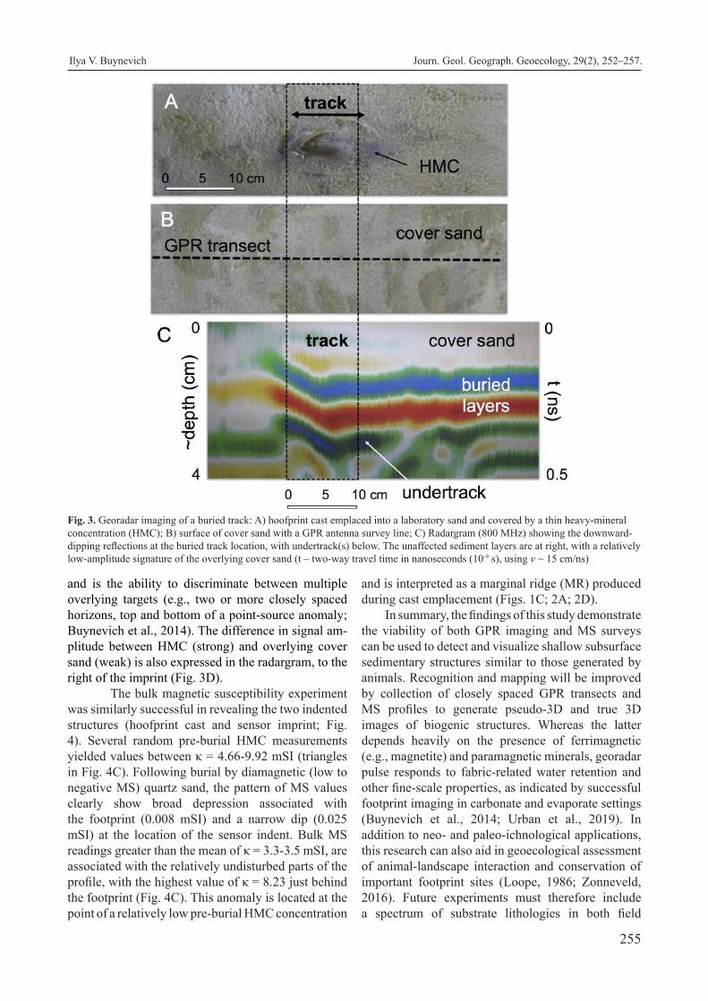
255
and is the ability to discriminate between multiple overlying targets (e.g., two or more closely spaced horizons, top and bottom of a point-source anomaly; Buynevich et al., 2014). The difference in signal am-plitude between HMC (strong) and overlying cover sand (weak) is also expressed in the radargram, to the right of the imprint (Fig. 3D).
The bulk magnetic susceptibility experiment was similarly successful in revealing the two indented structures (hoofprint cast and sensor imprint; Fig. 4). Several random pre-burial HMC measurements yielded values between κ = 4.66-9.92 mSI (triangles in Fig. 4C). Following burial by diamagnetic (low to negative MS) quartz sand, the pattern of MS values clearly show broad depression associated with the footprint (0.008 mSI) and a narrow dip (0.025 mSI) at the location of the sensor indent. Bulk MS readings greater than the mean of κ = 3.3-3.5 mSI, are associated with the relatively undisturbed parts of the profile, with the highest value of κ = 8.23 just behind the footprint (Fig. 4C). This anomaly is located at the point of a relatively low pre-burial HMC concentration
and is interpreted as a marginal ridge (MR) produced during cast emplacement (Figs. 1C; 2A; 2D).
In summary, the findings of this study demonstrate the viability of both GPR imaging and MS surveys can be used to detect and visualize shallow subsurface sedimentary structures similar to those generated by animals. Recognition and mapping will be improved by collection of closely spaced GPR transects and MS profiles to generate pseudo-3D and true 3D images of biogenic structures. Whereas the latter depends heavily on the presence of ferrimagnetic (e.g., magnetite) and paramagnetic minerals, georadar pulse responds to fabric-related water retention and other fine-scale properties, as indicated by successful footprint imaging in carbonate and evaporate settings (Buynevich et al., 2014; Urban et al., 2019). In addition to neo- and paleo-ichnological applications, this research can also aid in geoecological assessment of animal-landscape interaction and conservation of important footprint sites (Loope, 1986; Zonneveld, 2016). Future experiments must therefore include a spectrum of substrate lithologies in both field
Fig. 3. Georadar imaging of a buried track: A) hoofprint cast emplaced into a laboratory sand and covered by a thin heavy-mineral concentration (HMC); B) surface of cover sand with a GPR antenna survey line; C) Radargram (800 MHz) showing the downward-dipping reflections at the buried track location, with undertrack(s) below. The unaffected sediment layers are at right, with a relatively low-amplitude signature of the overlying cover sand (t – two-way travel time in nanoseconds (10-9 s), using v ~ 15 cm/ns)
Ilya V. Buynevich Journ. Geol. Geograph. Geoecology, 29(2), 252–257.

256
and laboratory settings, with the ultimate goal of assembling diagnostic criteria for distinguishing physical and biogenic structures.Acknowledgments
This research was funded by the National Geographic Society CRE Grant #8060-06 and the College of Science and Technology, Temple University. The author thanks Christopher Seminack, Zachary Grimes, Donatas Pupienis, Albertas Bitinas, and Aldona Damušytė for assistance in the field and Justin Darrow for help with laboratory experiments.
References
Allen, J. R. L., 1989. Fossil vertebrate tracks and indenter mechanics. Journal of the Geological Society, London, 146, 600-602.
Allen, J.R.L., 1997. Subfossil mammalian tracks (Flandrian) in the Severn Estuary, S.W. Britain: mechanics of formation, preservation and distribution. Philos. Trans. R. Soc. Lond., B 352, 481-518.
Butler, D.R., 1995. Zoogeomorphology – Animals as geomorphic agents. Cambridge University Press, Cambridge, 240 p.
Buynevich, I.V., 2011a. Buried tracks: ichnological applications of high-frequency georadar. Ichnos, 18, 189-191.
Buynevich, I.V., 2011b . Heavy minerals add weight to neoichnological research. Palaios, 26, 1-3.
Buynevich, I.V., Darrow, J.S., Grimes, Z.T.A, Seminack, C.T., Griffis N., 2011. Ungulate tracks in coastal sands: recognition and sedimentological signifi-cance. Journal of Coastal Research, SI 64, 334-338.
Buynevich, I.V., 2012. Morphologically induced density lag formation on bedforms and biogenic struc-tures in aeolian sands. Aeolian Research, 4, 1-5.
Buynevich, I.V., 2015. Recent vertebrate tracks in sandy substrates and their paleoenvironmental implica-tions: examples from coastal Lithuania. Baltica, 28, 29-40.
Buynevich, I.V., Curran, H.A., Wiest, L.A., Bentley, A.P.K., Kadurin, S.V., Seminack, C.T., Savarese, M., Bustos, D., Glumac, B., Losev, I.A., 2014. Near-surface imaging (GPR) of biogenic structures in siliciclastic, carbonate, and gypsum dunes. In Hembree, D.I., Platt, B.F., and Smith, J.J., (eds.), Experimental Approaches to Understanding Fos-sil Organisms: Lessons from the Living, Springer, Dordrecht, The Netherlands, pp. 405-418.
Fanelli, F., Palombo, M.R., Pillola, G.L., and Ibba, A., Tracks and trackways of “Praemegaceros” ca-zioti (Depéret, 1897) (Artiodactyla, Cervidae) in Pleistocene coastal deposits from Sardinia (West-ern Mediterranean, Italy). Bollettino della Soci-età Paleontologica Italiana, 46, 47-54.
Fornós J.J., Bromley, R.G., Clemmensen, L.A., Rodriguez-
Fig. 4. Low-field magnetic susceptibility (MS) transect: A) hoofprint cast; B) track (at left) and MS2K sensor (at right) imprints into laboratory sand covered by a thin heavy-mineral concentration (dashed line shows the MS sampling transect); B) surface of cover sand with a GPR antenna survey line; C) MS values (2 cm interval) of sediment surface following burial by quartz-rich cover sand (triangles show random point measurements of HMC prior to burial). Note the low values below the two imprints and a peak likely related to the marginal ridge
Ilya V. Buynevich Journ. Geol. Geograph. Geoecology, 29(2), 252–257.

257
Perea A., 2002. Tracks and trackways of Myotra-gus balearicus Bate (Artiodactyla, Caprinae) in Pleistocene aeolianites from Mallorca (Balearic Islands, Western Mediterranean). Palaeogeogra-phy, Palaeoclimatology, Palaeoecology, 180, 277-313.
Frey, R.W., Pemberton, S.G., 1986. Vertebrate Lebens-spuren in intertidal and supratidal environments, Holocene barrier islands, Georgia: Senckenber-giana Maritima, 18, 45-99.
Hasiotis, S.T., Platt, B.F., Hembree, D.I., Everhart, M., 2007. The trace-fossil record of vertebrates. In: Miller, W., III (ed.) Trace fossils-concepts, prob-lems, prospects. Elsevier Press, pp. 196-218.
Laporte, L.F., Behrensmeyer, A.K., 1980. Tracks and sub-strate reworking by terrestrial vertebrates in Qua-ternary sediments of Kenya. Journal of Sedimen-tary Petrology, 50, 1337-1346.
Lewis, D.W., Titheridge, G., 1978. Small scale sedimen-tary structures resulting from foot impressions in dune sands. Journal of Sedimentary Petrology, 48, 835-838.
Loope, D.B., 1986. Recognizing and utilizing vertebrate tracks in cross section, Cenozoic hoofprints from Nebraska. Palaios 1, 141-151.
Milàn, J., Bromley, R.G., 2006. True tracks, undertracks and eroded tracks: experimental work with tetra-pod tracks in laboratory and field. Palaeogeogra-phy, Palaeoclimatology, Palaeoecology, 231, 253-264.
Milàn, J., Clemmensen, L.B., Buchardt, B., Noe-Nygaar, N., 2007a. A late Holocene tracksite in the Lodb-jerg dune system, northwest Jylland, Denmark.
In: Lucas, S.G., Spielman, J.A., Lockley, M. (eds.) Cenozoic vertebrate tracks and traces, vol 42. New Mexico Museum of Natural History and Science, Albuquerque, pp. 241-250.
Milàn, J., Bromley, R.G., Titschack, J., Theodorou, G., 2007b. A diverse vertebrate ichnofauna from a Quaternary eolian oolite from Rhodes, Greece. SEPM Special Publications, 88, 333-343.
Scott, J.J., Renaut, R.W., Owen, R.B., 2008. Preservation and paleoenvironmental significance of a foot-printed surface on the Sandai Plain, Lake Bogo-ria, Kenya Rift Valley. Ichnos, 15, 208-231.
Stott, P., 1996. Ground-penetrating radar: a technique for investigating the burrow structure of fossorial vertebrates. Wildlife Research, 22, 519-530.
Urban, T.M., Bennett, M.R., Bustos, D., Manning, S.W., Reynolds, S.C., Belvedere, M., Odess, D., San-tucci, V.L., 2019. 3-D radar imaging unlocks the untapped behavioral and biomechanical archive of Pleistocene ghost tracks. Scientific Reports, 9, 16470.
Van der Lingen, G.J. and Andrews, P.B. 1969, Hoof-print structures in beach sand: Journal of Sedimentary Petrology, 39, 350-357.
Vialov, O. S., 1966. Sledy Zhiznedeyatelnosti Organizmov i Ikh Paleontologicheskoe Znachenie. [Traces of the Vital Activity of Organisms and their Paleontological Significance]. Kiev, Naukova Dumka, Academy of Sciences, Ukrainian S.S.R., 219 pp. [in Russian].
Zonneveld, J.-P., 2016. Applications of experimental neoichnology to paleobiological and evolutionary problems. Palaios, 31, 275-279.
Ilya V. Buynevich Journ. Geol. Geograph. Geoecology, 29(2), 252–257.

258
Time series analysis of karst breakdown development on the potassium salt deposit areas within Precarpathian region
Ihor V. Chepurnyi, Serhii M. Bagriy, Eduard D. Kuzmenko, Tetiana B. Chepurna
Institute of Geology and Geophisics, National Technical University of Oil and Gas, Ivano-Frankivsk, Ukraine, [email protected]
Abstract. The work is devoted to the analysis of karst breakdown development over time within the area of the Kalush-Golynske and Stebnytske potassium salt deposits. A study of the relationship between the development of karst breakdowns with the factors influencing their development in natural conditions and in the conditions of natural-technogenic sys-
tems is presented. Time series of karst breakdowns in the Kalush-Golynske and Stebnytske deposits of potassium salt were selected for the investigation. The time series reflect the number of formed failures of the earth’s surface due to karst processes. Climatic (average annual temperature and annual precipitation), heliophysical (solar activity), seismic (number and energy of earthquakes), hydrogeo-logical (groundwater levels) were chosen as such factors. Breakdown phenomena, which are included in the time series of their long-term dynamics, are associated with different hydrodynamic zones of karst processes. For these zones, the indirectness degree of the influence of the selected for the analysis factors is different and the meteorological parameters are more effective in the supply zone, seismic factors work in all zones. Statistical methods such as correlation analysis, calculation of autocorrelation and cross-correlation functions, spectral analysis are used for the analysis of the time series. Statistical regularities in the series of karst breakdown develop-ment for Kalush-Golynske and Stebnytske potassium salt deposits and between the selected natural time factors and karst series have been established, which allows asserting the indirect influence of natural component of karst activation. The presence of periodic com-ponents in the long-term series of karst breakdowns should be associated with the natural factors that indirectly activate karst processes. These factors should be investigated and taken into account when creating temporal prognostic models for the development of karst breakdown processes within the deposits of potassium salt of Precarpathia.
Key words: karst, potassium salt deposits, time series, meteorological factors, time series analysis
Часовий аналіз розвитку карстопровальних процесів на родовищах калійної солі Передкарпаття
І.В. Чепурний, С.М. Багрій, Е.Д. Кузьменко, Т.Б. Чепурна
Інститут геології та геофізики Національного технічного університету нафти і газу, Івано-Франківськ, Україна, [email protected]
Анотація. Роботу присвячено аналізу часового розвитку карстопровальних явищ, які інтенсивно проявляються у межах від-працьованих родовищ калійної солі українського Передкарпаття (Калуш-Голинського та Стебницького родовищ калійної солі) і пов’язані з наявністю гірничих виробок та інтенсивними процесами розвитку соляного карсту за рахунок розчинення засолених порід при інфільтрації підземних вод. Виконано дослідження зв’язку розвитку провально-просадкових проявів карстових процесів із факторами, що впливають на їх розвиток у природніх умовах, та відповідно характеризують природну складову їх активізації, а в умовах природно-техногенних систем, якими є відпрацьовані соляні родовища можуть опосередковано визначати їх розвиток у часі. Такими факторами обрано кліматичні (середньорічна температура та річна кількість опадів), геліофізичні (сонячна активність), сейсмічні (кількість та енергія землетрусів), гідрогеологічні (рівні ґрунтових вод). Для аналізу часових рядів використано статистичні методи – кореляційний аналіз, розрахунок функцій автокореляції та функцій взаємної кореляції, спектральний аналіз. Встановлено статистичні закономірності у рядах розвитку провально-просадкових проявів карстових процесів для Калуш-Голинського та Стебницького родовищ калійної солі та між рядами обраних природних часових факторів та рядами карсту, що дозволяє стверджувати про опосередкований вплив природної складової активізації карсту. Встановлено, що у часових рядах карстової активності наявні періодичні складові, зокрема для Калуш-Голинського родовища часовий ряд має виразну періодику в 10-12 років. За результатами автокореляційного та спектрального аналізів, виконаних з метою визначення основних періодів гармонічних часових коливань в рядах часових факторів визначено основні
Ihor V. Chepurnyi, Serhii M. Bagriy, Eduard D. Kuzmenko, Tetiana B. Chepurna Journ. Geol. Geograph. Geoecology, 29 (2), 258–268.
Journal of Geology, Geography and
Geoecology
Journal home page: geology-dnu-dp.ua
ISSN 2617-2909 (print)ISSN 2617-2119 (online)
Journ. Geol. Geograph.Geology,
29(2), 258–268.doi: 10.15421/112024
Received: 15.07.2019Received in revised form: 24.02.2020Accepted: 07.05.2020

259
періодичності, зокрема для ряду сонячної активності періодичність складає приблизно 10-11 років, для річної кількості опадів чіткої періодичності не виявлено, незначні періодичні складові виявляються раз на 9-11 років, у ряді рівнів ґрунтових вод 15 та 17 років, в ряді середньорічної температури існує слабка періодичність у 8-10 років, у ряді логарифмів енергії землетрусів існує деяка періодичність у 8-11 років. Оцінено вплив та охарактеризовано закономірності впливу ініціюючих часових факторів на активізацію карстових процесів. Зокрема, аналіз кроскореляційних функцій показав, що між рядами кількості карстопроявів та річної кількості опадів суттєвої синфазності не спостерігається, кількості карстопроявів та середньорічної температури спостерігається слабка обернена кореляція, кількості карстопроявів та енергії землетрусів слабка пряма кореляційна залежність, для пари рядів «кількість карстопроявів – числа Вольфа» встановлено, що ці ряди знаходяться в протифазі, для ряду рівня грунтових вод спостерігається протифаза зі зміщенням на 1 рік. Зазначені фактори слід досліджувати та враховувати при створенні часових прогностичному моделей розвитку карстопровальних процесів у межах родовищ калійної солі Передкарпаття.
Ключові слова: карст, родовища калійної солі, часові ряди, метеорологічні фактори, аналіз часових рядів
Introduction. In Ukraine deposits of potassium salts are found in the Precarpathian Prefecture, which forms the Precarpathian Potassium Basin (Fig. 1). Deposits of potassium and potassium-magnesium salts of the Precarpathian potassium basin belong to the Kalush strata of the Stebnyk and Vorotyschenska neogene formation and lie in the form of layered and lenticular deposits of 3.0 – 120.0 m thickness. Much of these reserves are concentrated at the depth of 600-700 m. Most of the mined potassium salts in Ukraine were used to produce potassium mineral fertilizers. Potassium salts can also be used in the chemical industry to obtain more than ten kinds of chemical products, the main component of which is potassium (potassium sulfate, potassium-magnesium, potas-sium nitrate, caustic potash, etc.). State balance of mineral reserves of Ukraine accounted for 13 depos-its of potassium-magnesium salts, of which two had been being exploited for quite a long time. These are the Kalush-Holynske deposit (JSC “Oriana”, Ivano-Frankivsk region) and the Stebnyk one (“Polimin-eral”), Lviv region. At present, both productions are stopped. Since 2007, due to the emergency condition of the mine №1 and the lack of funds for its recon-struction, mining works within the Stebnitske deposit have been discontinued. Extraction of potassium salts at the Dombrovsky quarry of The Kalush-Golinske deposit has also not been carried out since 2007, and production has been decommissioned (Mineral Re-sources, 2014).
The development of potassium salt deposits in the territory of the Precarpathian region (Kalush-Golynske and Stebnytske deposits) by the under-ground method led to the creation of significant artifi-cial cavities at depths of 100-400 m, the total volume of which is 35 mln м3. At present, most of the oper-ating chambers have been eliminated by filling with saturated brines or waste products. The operation of the Kalush-Golynske deposit is completed and one of two mines at the Stebnytske deposit is filled with brines and the second one is temporarily suspended. The presence of underground cavities, which were
formed during the operation, led to the violation of mechanical equilibrium of the rock masses and, ac-cordingly, to the violation of geological, hydrogeo-logical, and geomorphological conditions. This led to the activation of dangerous geological processes, among which land subsidence and dips are the most widespread ones.
As noted in (Gaidin, 2016), the main cause of sub-sidence and failures on the territories with potassium salt deposits is the development of karst processes. Failures and deformations of the earth’s surface are the final phase of this. The mechanism of karst pro-cesses development in the conditions of the fulfilled salt deposits is difficult, especially for conditions of mines which are in a stage of wet preservation (flood-ing by brines as on the Stebnytske deposit). It can be established only on the basis of water movement di-rection. However, in (Gaidin, 2016) it is noted that for the hydrodynamic system of karst formations there are areas of supply, transit and discharge. In the feed-ing area, salt rocks are intensively dissolved by fresh water, and the rate of their dissolution depends on its temperature and flow rate. In the transit section, the karst process fades, surface deformations are insignif-icant. The dissolution of salts intensifies at the place of discharge. Especially dangerous when discharge takes place in the mined space, which leads to the deformation of the earth’s surface. The consequence of hydrodynamic processes in potassium salt deposits (especially now seen on the example of Stebnytske, mine №2 which is in the stage of flooding with brines) is the erosion of the ceiling of mines and interchamber pillars, and karst breakdowns. The term karst break-down is employed in this paper to denote the total-ity of processes and phenomena of gravitational and/or hydrodynamic destruction of the ceiling of a karst cavity and of the overlying sediments, was adopted from (Klimchouk, 2005). This intensifies the forma-tion of significant collapses (failures 30.09.2017 and 15.03.2020), and are directly related to geomechani-cal processes in the mines. In this article we will over-see just one type of karst manifestation - breakdowns.
Ihor V. Chepurnyi, Serhii M. Bagriy, Eduard D. Kuzmenko, Tetiana B. Chepurna Journ. Geol. Geograph. Geoecology, 29(2), 258–268.

260
Our previous scientific studies on regional prog-nostic modeling allow us to state that the dynamics of any exogenous geological processes, including karst processes, is associated with the dynamics of such natural phenomena as climatic, heliophysical, seis-mic, and hydrogeological phenomena (Chepurnyj, 2018; Kuzmenko, 2017).
On the one hand, these characteristics form a sep-arate group of time factors, which are associated with the karst activity, and, in addition, are imposed on the permanent spatial factors (geological, geophysical, landscape, geomorphological, hydrogeological, etc.).
Each of the above mentioned temporal or spa-tial factors can be evaluated by its quantitative factor characteristic.Output data. Surface manifestations of karst are controlled by a number of natural and anthropogenic factors. The recognized definition of the basic
conditions for the karst formation is given in the work (Sokolov, 1962): “As a geological process, the karst is steadily developing where the four conditions exist simultaneously: solubility of rocks, their water permeability, presence of mobile waters, and their soluble ability”. The provided four conditions for the emergence and development of karst are indispensable, but the process of karst formation is associated with a number of accompanying natural processes and phenomena.
At present, one of the main directions of research of natural processes, and karst processes in particu-lar, is a direction, which is based on the ideas about the regularities of repetition of the majority of natu-ral phenomena for the separate territories or for the whole globe (Sheko, 1984; Trofimova, 1985; Sheko, 1999). Since the process of karst formation is a multi-factorial system, it is manifested under the influence
Fig. 1. Schematic image of location of salt deposits and manifestations in the western part of Ukraine
Ihor V. Chepurnyi, Serhii M. Bagriy, Eduard D. Kuzmenko, Tetiana B. Chepurna Journ. Geol. Geograph. Geoecology, 29(2), 258–268.

261
of a certain number of natural and anthropogenic fac-tors that have their own rhythmicity, it is expedient to reveal the time regularities of karst formation with the help of the theory of the rhythm of natural processes.
Time series of karst breakdowns in the Kalush-Golynske and Stebnytske deposits of potassium salt were selected for the study. The time series reflect the number of formed subsidence of the earth’s surface due to karst processes. For the Kalush-Golynske de-posit of potassium salt, the series is represented by 24 failures from 1975 to 2015, for the Stebnytske deposit of potassium salt - 21 failures from 1980 to 2016. The natural and technogenic process of karst formation in salt rocks has a significant rate of development over time and is characterized by a fairly high frequency of formation of new karst craters and dips, therefore, one should expect expressive time regularities in the development of the karst process and the factors that determine it, and on the other hand, these regularities can have a less expressed nature due to the influence of the technogenic component (Kuzmenko, 2017;
Chepurnyj, 2018) . The technogenic component that significantly affects the development of karst in the salt deposits under consideration is the presence of artificial underground cavities and applied measures for wet conservation of mines, which significantly af-fected the stability of the territory.
In order to assess the conditions for the devel-opment of karst processes in terms of the impact on this process of natural factors, (which were discussed above), consider the mine №2 of Stebnytske potas-sium salt deposit (Fig. 2). As can be seen from the figure, the development of karst processes within the mine №2 is dedicated to 3 cells. Consider them in more detail. The center of development of karst near by the valley of the river Vyshnytsia, is characterized by intensive development of karst processes and dedi-cated to the zone of supply and transit of groundwater. Karst processes have been developing here since 2000 and by 2016 there were 5 failures. Groundwater move-ment is directed towards drainage chambers (Gaidin, 2016; Kuzmenko, 2019). The depression funnel here
Fig. 2. Map of the distribution of karst failures within the mine №2 of the Stebnytske deposit of potassium salt
Ihor V. Chepurnyi, Serhii M. Bagriy, Eduard D. Kuzmenko, Tetiana B. Chepurna Journ. Geol. Geograph. Geoecology, 29(2), 258–268.

262
stretches west towards the Vyshnytsia river valley and southwest towards the lake. Another center of devel-opment of karst is the zone of the mine shaft «East» of the mine №2 (Fig. 1 - south-eastern part), where the intensive development of karst failures led to its elimination. South of this area there is a center for the spread of breakdown karst phenomena, which is as-sociated with the groundwater supply zone (Gaidin, 2016; Kuzmenko, 2019) - previously present stream Kolpetskaya beam. There were 10 intensifications of the development of failure-subsidence phenomena of karst from 1982 to 1999. In recent years, there has been a significant intensification of this phenomena over the extraction chambers - the catastrophic failure of 2016 (Kuzmenko, 2019). It was dedicated to the zone of groundwater discharge.
Breakdown phenomena, which are included in the time series of their long-term dynamics, are as-sociated with different hydrodynamic zones of karst processes. For these zones, the indirectness degree of the influence of the selected for analysis factors will be different, it is obvious that the meteorologi-cal parameters are more effective in the supply zone, seismic factors work in all zones . As we have seen in the example of karst breakdowns at the mine №2 of Stebnytske potassium deposit, most of them are dedi-cated to the hydrodynamic supply zone. The intensity of the inflow of aggressive fresh water into which de-pends on natural meteorological factors. Failures of the earth’s surface, which are associated with the sta-bility of the ceiling of the chambers and interchamber pillars are intensifying recently. Obviously, this is due to erosion processes during the flooding of mine №2. When the underground cavities of the mine №2 are flooded and groundwater levels stabilize, the hydro-dynamic conditions will change accordingly, which will lead to a change in the intensity of karst break-downs. The main purpose of this study is to assess the degree of indirect influence of natural time factors in the long term in order to be able to use them in prog-nostic models of karst processes development at the local and regional level.
The relationship between exogenous geologi-cal processes (EGP) with factors such as annual pre-cipitation, average annual temperature, solar activity (a sequence of Wolf numbers), earthquake energy, groundwater level are outlined in general terms by the authors of (Sheko, 1984; Trofimova, 1985; Sheko, 1999; Panagopoulos, 2006). According to the solubil-ity of rocks and, first of all, salt rocks, its correlation with the precipitation does not need any comments. The relationship between the solubility of salt rocks and temperature of the groundwater is also indicated in literature, in particular in (Gaidin, 2016). The lat-
ter factor correlates with the air temperature. Logic dictates that seismic processes are involved in the transition of the covered karst into the open one, i. e. they contribute to the failure phenomena, disrupt-ing the equilibrium of the mountain mass due to the oscillations of the layer of rocks of the near-surface zone. This is obvious therefore we chose seismic-ity as one of the factors. So, there are already four long-term karstinification factors: the amount of pre-cipitation, groundwater level, air temperature, and earthquake energy. A separate issue is the Wolf num-ber, which characterizes the solar activity. In the lit-erature, starting from the well-known monograph by A. Chizhevskyi (Chizhevskyi, 1976) and till now, the relationship of solar activity with natural processes that occur on the Earth surface is indicated. There are all reasons to believe that solar activity is associated with the EGP activity and with the factors that initiate them. In particular, this is indicated in works (Sheko, 1984; Trofimova, 1985; Sheko, 1999) and in many others. The relationship of solar activity with mete-orological factors at the quantitative level has been thoroughly investigated in work (Herman, 1978), and the relationship of solar activity with landslides and earthquakes in works (Kuzmenko, 2004; Goshovs-kiy, 2004; Kuzmenko, 2007). However, given the ex-ternal relations, the nature of such relations remains unclear, although there is a number of a hypothesis regarding these causes. Moreover, there is also no close universal connection between solar activity and any EGP factor: there is a correlation with a certain sign that corresponds to physical representations of the process, but this correlation is not always essen-tial. Therefore, we propose to consider solar activity as one of the equal factors of the EGP, which is valid for the factors mentioned above.
The main task of this investigation is the estab-lishment of possible time regularities in karst forma-tion processes development in the potassium deposits within the territory of Precarpathian.
We have developed the methodological basis for the assessment of the complex effect of a combina-tion of natural temporal factors on the processes of karst formation, which are displayed in the value of the complex integral factor indicator with the sub-sequent determination of the probability distribution of this indicator over time, extrapolation of which is considered as the predicted probability distribution of karst and mudflow activation (Kuzmenko, 2012; Che-purna, 2017).
The sequence of studies that allow us to analyze the time series of the development of karst break-downs and their indirect natural factors is as follows:
- creation of the database of time annual series of
Ihor V. Chepurnyi, Serhii M. Bagriy, Eduard D. Kuzmenko, Tetiana B. Chepurna Journ. Geol. Geograph. Geoecology, 29(2), 258–268.

263
formation of the surface karst breakdowns in accor-dance with the existing catalogs and climatic, helio-physical, seismic, hydrogeological factors;
- calculation and development of autocorrelation functions of time series of karst breakdowns and each factor for the estimation of its rhythmicity;
- calculation and development of the mutual cor-relation functions of time series for the selected fac-tors with a series of karst formations for the assess-ment and justification of the shifting of the series of factors in time in relation to a number of karst forma-tions;
- spectral analysis of time series in order to iden-tify the main rhythmic components.
The obtained results will reflect the formal sta-tistical relationship between the time series of karst breakdowns series and natural factors. And its cardi-nality is unlikely to be significant, but it will allow us to follow the general trend - to assess the degree of influence of the natural component in the formation of
dips in the earth’s surface. It will also make it possible to correlate between the time series of the develop-ment of karst breakdowns for different deposits. Will assess the possibility of using natural time factors in creating prognostic time models at the local level. Of course, the geomechanical parameters of mines are important in predicting the spatial development of karst breakdowns at the object level, but they change over time under the influence of hydrodynamic fac-tors, which are indirectly influenced by natural factors that are not decisive. The influence of natural factors can be manifested under conditions of their signifi-cant variation - extreme manifestations that can be predicted by modeling.Results of experimental studies. Time series of karst breakdowns in the Kalush-Golunske and Stebnytske deposits of potassium salt for the period from 1975 to 2016 were selected for the experimental studies to determine the regularities for it development and initiating factors (Fig. 3). The developed
Fig. 3. Time series of karst breakdowns of surface in the Kalush-Golynske and Stebnytske deposits of potassium salt (units)
Fig. 4. Diagram of the autocorrelation function for the karst breakdowns in the Kalush-Golynske deposit of potassium salt
Ihor V. Chepurnyi, Serhii M. Bagriy, Eduard D. Kuzmenko, Tetiana B. Chepurna Journ. Geol. Geograph. Geoecology, 29(2), 258–268.
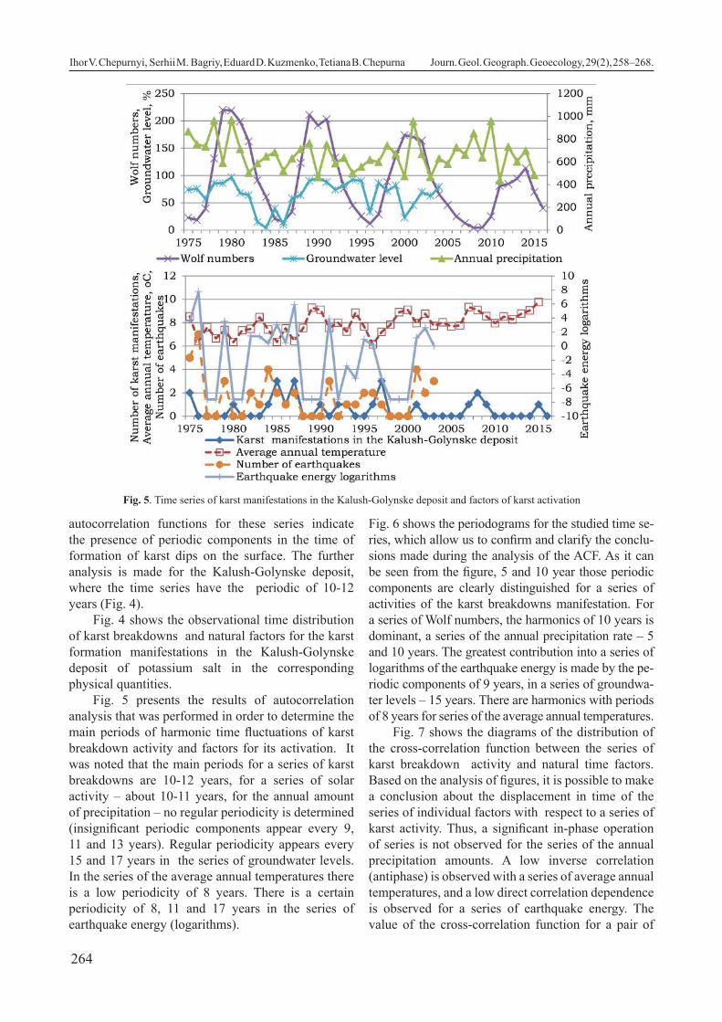
264
autocorrelation functions for these series indicate the presence of periodic components in the time of formation of karst dips on the surface. The further analysis is made for the Kalush-Golynske deposit, where the time series have the periodic of 10-12 years (Fig. 4).
Fig. 4 shows the observational time distribution of karst breakdowns and natural factors for the karst formation manifestations in the Kalush-Golynske deposit of potassium salt in the corresponding physical quantities.
Fig. 5 presents the results of autocorrelation analysis that was performed in order to determine the main periods of harmonic time fluctuations of karst breakdown activity and factors for its activation. It was noted that the main periods for a series of karst breakdowns are 10-12 years, for a series of solar activity – about 10-11 years, for the annual amount of precipitation – no regular periodicity is determined (insignificant periodic components appear every 9, 11 and 13 years). Regular periodicity appears every 15 and 17 years in the series of groundwater levels. In the series of the average annual temperatures there is a low periodicity of 8 years. There is a certain periodicity of 8, 11 and 17 years in the series of earthquake energy (logarithms).
Fig. 6 shows the periodograms for the studied time se-ries, which allow us to confirm and clarify the conclu-sions made during the analysis of the ACF. As it can be seen from the figure, 5 and 10 year those periodic components are clearly distinguished for a series of activities of the karst breakdowns manifestation. For a series of Wolf numbers, the harmonics of 10 years is dominant, a series of the annual precipitation rate – 5 and 10 years. The greatest contribution into a series of logarithms of the earthquake energy is made by the pe-riodic components of 9 years, in a series of groundwa-ter levels – 15 years. There are harmonics with periods of 8 years for series of the average annual temperatures.
Fig. 7 shows the diagrams of the distribution of the cross-correlation function between the series of karst breakdown activity and natural time factors. Based on the analysis of figures, it is possible to make a conclusion about the displacement in time of the series of individual factors with respect to a series of karst activity. Thus, a significant in-phase operation of series is not observed for the series of the annual precipitation amounts. A low inverse correlation (antiphase) is observed with a series of average annual temperatures, and a low direct correlation dependence is observed for a series of earthquake energy. The value of the cross-correlation function for a pair of
Fig. 5. Time series of karst manifestations in the Kalush-Golynske deposit and factors of karst activation
Ihor V. Chepurnyi, Serhii M. Bagriy, Eduard D. Kuzmenko, Tetiana B. Chepurna Journ. Geol. Geograph. Geoecology, 29(2), 258–268.

265
rows in the number of karst manifestations – the Wolf numbers show that these series are in the antiphase,
and for a series of groundwater levels, the antiphase with a reduction of 1 year is observed.
Fig. 6. Diagram of the autocorrelation function for the karst breakdown manifestations in the Kalush-Golynske deposits of potassium salt and natural factors of karst activation
Table 1. The main parameters of the periodicity indications in the time series for the Kalush-Golynske deposit
Time series
Determined periods and displacement, yearsAccording to autocor-
relation functionAccording to the Fou-rier spectral analysis
According to the function of the mutual
correlationActivity of karst manifestation 10-12 5, 10 -Annual precipitation amount 9, 11, 13 10, 4 -1Average annual temperature 8 8, 5 0 (reversed)Wolf numbers 10-11 10 0 (reversed)Groundwater level 15, 17 15, 10, 4 +1 (reversed)Logarithm of the earthquake energy 8, 11 9, 4 0 (low)
Ihor V. Chepurnyi, Serhii M. Bagriy, Eduard D. Kuzmenko, Tetiana B. Chepurna Journ. Geol. Geograph. Geoecology, 29(2), 258–268.

266
Similar developments are made for the karst formation of the Stebnytske deposit.
In order to systematize the obtained data, a table with the main characteristics of time series was created (Table 1).Conclusions. Within the territory of the abandoned deposits of potassium salt in the Ukrainian Precarpathian region, subsidence and surface dips, which are associated with the presence of mines (in total 35 mln m3), with the development of karst processes, which is caused by a complex hydrodynamic mechanism with the presence of zones of supply, transit and discharge, characterized by different intensity of the formation of karst. A
significant number of failures are associated with geomechanical processes in dedicated mines.
The subsidence of the earth’s surface is of a plane nature and it complies with the mining works in time. The intensity of karst breakdowns occurrence on the surface (quantity in time) in the multiannual cycle contains the periodic component, which is expressed for the Kalush-Golynske deposit and is estimated by the correlation analysis every 10-12 years, and by Fourier spectral analysis – 5 and 10 years. For Steb-nytske deposit, this component is less expressive and has periods of 8 and 15 years respectively, and also 4, 8 and 14 years. The reasons of the difference are probably consist on the technogenic component of the
Fig. 7. Periodograms for the karst breakdown manifestations in the Kalush-Golynske deposits of potassium salt and fac-tors of karst activation
Ihor V. Chepurnyi, Serhii M. Bagriy, Eduard D. Kuzmenko, Tetiana B. Chepurna Journ. Geol. Geograph. Geoecology, 29(2), 258–268.

267
A comparative analysis of the autocorrelation and cross correlation functions, as well as the spectral periodograms of the series of karst breakdowns mani-festations and the factors indicated above, show some consistency in the presence of phase displacements.
In order to deepen the knowledge about the na-ture of karst breakdown processes and their connec-tion with the natural factors, it should be considered expedient to continue research in this direction with the application of modern analysis methods. The
development of these processes, unknown at differ-ent stages of the process of wet conservation in these deposits.
The presence of periodic components in the long-term series of karst breakdowns should be associated with the natural factors that indirectly activate karst processes. Such factors are meteorological (precipi-tation, temperature), heliophysical (solar activity), hydrogeological (groundwater levels), seismological (earthquake energy).
Fig. 8 Functions of mutual correlation for the karst breakdowns in the Kalush-Golynske potassium salt deposit and factors of karst activation
Ihor V. Chepurnyi, Serhii M. Bagriy, Eduard D. Kuzmenko, Tetiana B. Chepurna Journ. Geol. Geograph. Geoecology, 29(2), 258–268.

268
obtained results indicate the presence of a natural component in the development of breakdown mani-festations of karst, the influence of which is formed indirectly by natural climatic, heliophysical, seismic, hydrogeological factors. In the future, the results ob-tained may become part of the prognostic spatio-tem-poral model of the emergence and activation of karst breakdown processes.
References
Chepurna, T., 2017. Geoinformational prognostic model of mudflows hazard and mudflows risk for the ter-ritory of Ukrainian Carpathians. Contemporary Trends in Geoscience 6, 1, 57-69. DOI: 10.1515/ctg-2017-0005
Chepurnyj, I., Podholov, V., Kuzmenko, E., Chepurna T., Bagriy, S., 2018. Analysis Of Time Factors Of The Karst Processes Development Within Areas Of Potassium Salt Deposits Of Precarpathians. 12th Internat. Conf. on Monitoring of Geologi-cal Processes and Ecological Condition of the Environment. EAGE. DOI: 10.3997/2214-4609.201803211
Chizhevskiy, A. P, 1976. Zemnoe eho solnechnyih bur. [Earth echo of solar storms]. Moskva, Mysl. (In Russian).
Gaidin, A.M., Rudko G.I. 2016. Tehnogennyj karst. [Tech-nogenic karst]. Kyiv; Chrnivtsi: Bukrec, 196 p. (In Russian).
Goshovskiy, S. V., Kuzmenko, E. D., Blinov, P. V., Karpen-ko, A. N., Shtogrin, L. V., 2004. Dolgosrochnyi prognoz opolzney v Zakarpatskom regione. 2. Prostranstvennoe raspredelenie opolzney. Ritmichnost kak teoreticheskaya osnova vremennogo prognozirovaniya. [Long-term fore-cast of landslides in the Transcarpathian region. 2. Time forecast. Justification of the period of mass activation]. Geoinformatika 3, 64-72. (In Ukrainian)
Goshovskiy, S. V., Kuzmenko, E. D., Blinov, P. V., Karpen-ko, A. N., Shtogrin, L. V., 2004. Dolgosrochnyi prognoz opolzney v Zakarpatskom regione. 1. Prostranstvennoe raspredelenie opolzney. Ritmi-chnost kak teoreticheskaya osnova vremennogo prognozirovaniya [Long-term forecast of land-slides in the Transcarpathian region. 1. The spatial distribution of landslides. Rhythm as a theoretical basis for temporal prediction]. Geoinformatika 2, 42-49. (In Ukrainian)
Herman, John R., Goldberg, Richard A. 1978. Sun, Weath-er, and climate. Washington, 1978, 319 p.
Kuzmenko, E., Davybida, L., Bagriy, S., & Chepurnyi, I. (2019). Analysis and modeling of the hydrogeo-dynamic situation within the Stebnyk deposit of potassium salts. Mineral resources of Ukraine, (4),
30-37. https://doi.org/10.31996/mru.2019.4.30-37Klimchouk, Alexander & Andrejchuk,. (2005). Karst break-
down mechanisms from observations in the gyp-sum caves of the Western Ukraine: Implications for subsidence hazard assessment. Environmental Geology. 336-359. 10.1007/s00254-005-1279-1
Kuzmenko, E. D. Kryizhanivskiy, E. I., Pronishin, R. S., Karpenko, A. N., Chepurnyiy, I. V, 2007. O tsikli-chnosti karpatskih zemletryaseniy i ih svyazi s solnechnoy aktivnostyu. [On the cyclical nature of the Carpathian earthquakes and their connec-tion with solar activity]. Geophysical journal. 29, 4, 66 – 76. (In Russian)
Kuzmenko, E. D. Chepurnyi, I. V., Chalyi, P. P., 2012. Dovgostrokove prognozuvannya provalno-pro-sadkovih proyaviv karstu. [Long-term forecast-ing of failing-downward manifestations of karst]. Ivano-Frankaivsk, IFNTUNG. (In Ukrainian)
Kuzmenko, E. D., 2017. Otsinka nebezpeky prypover-khnevykh deformatsii hirskykh porid u mezhakh stebnytskoho kaliinoho rodovyshcha metodom PIEMPZ. [Estimation of hazards of the surface deformations of rocks within Stebnyk potassium salt deposit area by method ENPEMF]. Geody-namics 1, 22, 98-113 (In Ukrainian). https://doi.org/10.23939/jgd2017.01.98
Mineral Resources of Ukraine, 2014. Kyiv, State Research and Production Enterprise «State Information Geological Fund of Ukraine» (In Ukrainian)
Panagopoulos, G., 2006. The contribution of time series analysis to the study of the hydrodynamic charac-teristics of the karst systems: Application on two typical karst aquifers of Greece (Trifilia, Almyros Crete). Journal of Hydrology, 329, 3–4, 368-376. https://doi.org/10.1016/j.jhydrol.2006.02.023
Sheko, A. I., 1984. Metody dolgovremennyh regionalnyh prognozov ekzogennyh geologicheskih protsess-ov. [Methods of long-term regional forecasts of exogenous geological processes]. Moskow. Ne-dra. (In Russian)
Trofimova, V. T., 1985. Dolgovremennyie prognozyi pry-avleniya ekzogennyih geologicheskih protsessov. [Long-term predictions of exogenous geological processes]. Moskva, Nauka. (In Russian)
Sheko, A. I., 1999. Metodicheskie rekomendatsii po sos-tavleniyu dolgosrochnyh prognozov ekzogen-nyih geologicheskih protsessov v sisteme gosu-darstvennogo monitoringa geologicheskoy sredy. [Guidelines for the compilation of long-term forecasts of exogenous geological processes in the state monitoring system]. Moskva, VSEGIN-GEO. (In Russian)
Ihor V. Chepurnyi, Serhii M. Bagriy, Eduard D. Kuzmenko, Tetiana B. Chepurna Journ. Geol. Geograph. Geoecology, 29(2), 258–268.

269
Military landscapes of the Pryvododilni Gorgany as a premise for increasing tourist attractiveness of the area (the case of the Chorna Klyva mountain)
Oleksandr O. Halahan, Olha V. Kovtoniuk, Natalia P. Korohoda, Yulian S. Braychevskyy
Taras Shevchenko National University of Kyiv, Kyiv,Ukraine, [email protected]
Abstract. The article examines the potential of military landscapes for promoting envi-ronmentally sustainable forms of active tourism (aimed at both natural sightseeing and mili-tary history of the area) in the Ukrainian Carpathians region focusing on the case of military landscapes of the mountain Chorna Klyva (the Bratkivskyi Ridge of the Pryvododilni Gor-
gany). The line of fortifications, which constitute their basis, used to belong to the so called “St. Laslo Line” built in 1939-1943 on the remains of the World War I fortifications. These fortifications (the system of trenches) were built in the upper parts of the mountain slopes allowing ideal observation of the lower areas and ensuring fire superiority along the border (at the time it was a border between Czechoslovakia and Poland. These trenches were designed in a way to organically use natural landscape features for both engineering and tactical purposes. Absence of intensive fighting as well as slow speed of natural recovery in that particular area contributed to a good state of their preservation often noted by occasional trail hikers. The goal of this article is to analyze both historical and natural conditions in which those landscapes have evolved as well as assess their current state. We discuss the prospects of promoting those landscapes as tourist attractions combining elements of natural scenery and sites of historical interest. The analysis is based upon historical geographic approach coupled with the original field observations. The article examines the most important features of those military landscapes, which can be used for tourism promotion in the area. An overview of comparable international experience in promoting military landscapes as tourist attractions is given to emphasize the potential of the area in question, which so far has been neglected by local communities and tourism businesses alike. We point out the factors limiting tourist flows, yet, at the same time, we argue that promotion of military landscapes will boost the number of visitors in the area generating demand for tourist services, hence promoting small business development. We argue that boosting such forms of tourism can bring positive effect to local communities and promote the area between Svydovets and Pryvododilni Gorgany ranges in the Chorna Tysa river basin for better preservation of the unique natural and historical sights. For the first time, a comprehensive study of historical events and natural landscapes in a spe-cific area at the Chorna Klyva mountain has been performed with the focus on how human activities have conjoined with the natural landscape processes resulting in what we now call military landscapes. The obtained results prove that these military landscapes are of significant natural and historical value and can be successfully promoted as tourist attractions.
Keywords: military landscapes, Chorna Klyva mountain, Bratkivskyi ridge, military tourism, natural and cognitive tourism
Белігеративні ландшафти Привододільних Ґорґан як передумова підвищення туристичної атрактивності району (на прикладі г.Чорна Клива)
О.О.Галаган, О.В. Ковтонюк, Н.П. Корогода, Ю.С. Брайчевський
Київський національний університет імені Тараса Шевченка, м. Київ, Україна, [email protected]
Анотація. У роботі наводяться результати дослідження белігеративних ландшафтів та можливостей їх використання для підвищення туристичної атрактивності верхньої частини басейну р. Чорна Тиса у межах Братківського хребта (Привододільні Ґорґани). Метою роботи стало вивчення історичних та природних умов формування белігеративних ландшафтів у привершинній ділянці гори Чорна Клива та оцінка їх сучасного стану і перспектив використання для просування та розвитку екологічно сталих активних форм туризму. В роботі проаналізовано теоретико-методологічні основи дослідження белігеративних ландшафтів, та-кож розглянуто питання використання подібних ландшафтних комплексів в туристичній сфері в Європі загалом та Українських Карпатах зокрема. Методологічно дослідження ґрунтується на історико-географічному підході, розробках з планування та ор-ганізації турів та результатах власних експедиційних ландшафтознавчих досліджень. Белігеративні ландшафти даного регіону є прикладом антропогенномодифікованих природних комплексів високогір’я Українських Карпат. На дослідженій території розташовані залишки фортифікацій, що входили до складу частини оборонної лінії Арпада, побудованої в період 1939-1943 років на основі укріплень часів І-ї Світової війни. Вони нині становлять як військово-історичний, так і природопізнавальний
Oleksandr O. Halahan, Olha V. Kovtoniuk, Natalia P. Korohoda, Yulian S. Braychevskyy Journ. Geol. Geograph. Geoecology, 29 (2), 269–278.
Journal of Geology, Geography and
Geoecology
Journal home page: geology-dnu-dp.ua
ISSN 2617-2909 (print)ISSN 2617-2119 (online)
Journ. Geol. Geograph.Geology,
29(2), 269–278.doi: 10.15421/112025
Received: 15.07.2019Received in revised form: 15.04.2020Accepted: 04.05.2020

270
інтерес. Представлені у межах г. Чорна Клива белігеративні ландшафти відносяться до двох типів польових белігеративних ландшафтів, таких як: укріплення для закриття позиції від дії вогню, перешкоди від штурму та довгострокові белігеративні ландшафти. Головними причинами, що зумовили їх добрий стан збереженості, визначено: відсутність інтенсивних бойових дій на даному відрізку лінії оборони під час ІІ-ї Світової війни, особливості природних процесів самовідновлення ландшафтів та господарське використання даної території. У статті зазначено, що популяризація белігеративних ландшафтів як комплек-сних об’єктів природопізнавального та військового туризму сприятиме зростанню загальної кількості відвідувачів у регіоні, що, у свою чергу, створить попит для розвитку малого бізнесу у сфері надання туристичних послуг, та сприятиме збереженню даних природних комплексів та історичних пам’яток території.
Ключові слова: белігеративні ландшафти, гораЧорна Клива, хребет Братківський, військовий туризм, природопізнавальний туризм
Introduction. Advancing environmentally sustainable forms of tourism with educational component requires promotion of tourist attractions, which can serve as examples demonstrating various natural and/or social processes, phenomena, and events at both scientific and popular level. Hence, there is a need to reevaluate the way in which the already well-known sites are promoted and think about promoting the new ones.
In this light, military landscapes (ML) make a po-tentially interesting resource for tourism. By military landscapes we mean a genetically specific type of landscapes, which evolve in the combat zones, where either actual fighting took place or special prepara-tions for it were made. In other words, those land-scapes that formed because of the military activities (Milkov, 1973). H.Denysyk and O.Antoniuk (2017) believe that military landscapes are self-sufficient and important sites of combined natural and manmade or-igin. They preserve social history of a certain period and, at the same time, represent natural processes of the area, therefore being of great educational impor-tance. The current consensus is that the most efficient way to use military landscapes is by promoting them for recreation (Antoniuk, 2010) and tourism activities, especially for the natural sightseeing and educational types of tourism (Bortnyk, Kravchuk, Kovtoniuk & Lavruk, 2018) as well as for military tourism (Kush-nariov & Polischuk, 2014) preserving the sites with their historical and cultural heritage.
Of the previous research done in this direction, we can mention a number of works stressing the im-portance of military landscapes for preservation of historical and cultural heritage in general (Antoniuk, 2007, 2010; Denysyk & Antoniuk, 2017; Korzhyk, 2009). There are also contributions exploring military landscapes’ potential for tourism (Ierko & Melnyk, 2016; Nosa, 2015; Polischuk, 2014 (a); Semeryaga, 2014 (b)). And yet, in spite of the number of works published over the last decade promoting tourist attrac-tions in the Carpathian region, e.g. (Giletskyj, 2009; Palkov, 2012), the military landscapes found on the popular hiking and cycling trails, specifically those in the Gorgany, Pryvododilni Gorgapny and Chornohora ranges, are often overlooked due to, among other rea-
sons, the lack of information about historical events, which took place in those areas. There is a big gap in spotlighting historical and geographic features of the military landscapes in the area in question in scientific and popular educational publications. Contributions of this sort would be useful for trail arrangement and could help drawing a larger number of visitors boost-ing tourism activities in the region.
In our previous research (Halahan, Kovtoniuk & Korogoda, 2018) we stressed that there are only few if any applied works in Ukraine focusing on military landscapes in the mountainous areas combining both historical and natural perspectives and investigating their potential for direct involvement in tourism ac-tivities. Therefore, the aim of this article is to inves-tigate the history of construction and use of fortifi-cations as well as their natural features and social factors, conditioning the current state of the military landscapes of the upper areas of the Chorna Klyva mountain (Bratkivsky ridge of the Pryvododilni Gor-gany range). This will allow considering those land-scapes as potentially attractive for natural sightseeing, educational, and military tourism. Data and research methods. As H. Denysyk and O.Antoniuk (2017) note, successful exploration and preservation of military landscapes require under-standing of their integral nature and inseparability of natural and manmade heritage. Therefore, for the study of the military landscapes in the upper areas of the Chorna Klyva mountain, we employed the his-torical-geographic approach (Semeryaga, 2014 (a)), relying on the published literary sources, archived materials and maps on history and geography of the area and combined those with our own field obser-vations of the sites. Our conclusions on the potential of the area to attract visitors premise on the work of O.Lubiceva (2003) on tourism activities planning and arrangement.Results and their analysis. Military landscapes are attractive for visitors as integral fortification sites with unique history of their formation and because of significance of historical events related to them. Their attractiveness is also strengthened by the nat-ural sightseeing potential. At the same time, an im-
Oleksandr O. Halahan, Olha V. Kovtoniuk, Natalia P. Korohoda, Yulian S. Braychevskyy Journ. Geol. Geograph. Geoecology, 29(2), 269–278.

271
portant factor is their physical accessibility (time and effort spent on getting there should not considerably exceed the time spent and satisfaction experienced at the site).
International and domestic experience shows that military landscapes of various sizes, locations, time of creation and purposes can be equally attractive for visitors. In Europe, there are museums created on the numerous remains of the well-known fortifica-tions of the World War I and World War II periods. Sites along the Atlantic Wall and the Maginot Line in France and the Salpa Line in Finland are used for or-ganized excursions; the unfurnished fragments of the Mannerheim Line (built by Finns, now the territory of Russia), the Stalin Line (the Kyiv city fortification area, Ukraine) and others are destinations for both organized and unorganized visiting. Popular sites not only include those with ferroconcrete structures but also those preserving remains of trenches constituting part of the military landscapes.
In Ukrainian Carpathians, military landscapes mostly formed as a result of defense preparations during the World War I and World War II. In 1939-1944, the Hungarian government has constructed the system of fortifications under the common name of the “Arpad Line”, which stretched across the territory of today’s Poland, Slovakia, Ukraine, and Romania. It included both newly built and already existing for-tifications remaining from the World War I and the interwar period. Those fortifications were installed utilizing topographic features of the area. They were mostly located along ridge crests and valleys of the biggest rivers. Overall, the fortification system was almost 600 km long and up to 70 km wide. The line was not continuous and consisted of separate nods and several defense lines built at various times. Of those, the major ones within Ukrainian Carpathians included the Hunyadi Line along the Outer Carpathians ranges, Szent László Line along the Central Carpathians rang-es, and the Árpád Line stretching 15-20 km to the west of the Szent László Line with the defense nods in the valleys of Tysa, Teresva, Tereblia and Latorytsia rivers and their tributaries (Semeryaga, 2014; Szabó, 2002).
At present, those fortifications are sites of mili-tary and educational tourism (Polischuk, 2014 (b)) maintained and promoted by the interested local hos-pitality businesses and NGOs without sufficient re-gional government support (Nosa, 2015). There are several destinations in the region with available orga-nized excursions to the military history sites (Nosa, 2015; Turystychnyj marshrut “Liniia Arpada”):
1) the vehicle route Árpád Line (190 km long, de-signed by F.Shandor) through the towns and villages
of Svaliava, Uklyn, Verkhnia Hrabivnytsia, Pidpoloz-zia, Huklyve, Mizhhir’ia, Synevyr;
2) the Árpád Line museum in the village of Kolo-chava;
3) the Árpád Line hiking trail (1.5 km long, de-signed by the NPP Synevyr staff)
The latter one, representing the Synevyr section of the Khust direction of the Árpád Line, can be con-sidered an example of military landscapes being used for tourism purposes. There is a maintained, techni-cally and informationally equipped trail amidst fer-roconcrete structures and earthen trenches. The above mentioned trails are quite popular among both domes-tic and foreign visitors.
At the same time, military landscapes of the central part of Ukrainian Carpathians are not at all represented by the military history trails. The Bratkivskyi ridge in the south-eastern part of the Pryvododilni Gorgany is among such unrepre-sented districts. It belongs to the medium-height ridges and stretches for 15 km to the north-west of the Legion Pass to the valley of the Dovzhy-na stream. Above the flattened upper area of the ridge, there rise arched-topped and soft-featured peaks of Durnia, Hropa, Mala Bratkivska, Ruska, Chorna Klyva, Chornyi Hrun. The highest eleva-tion point in the area is Velyka Bratkivska moun-tain – 1788 m.
Along the ridge axis, there lies the fragment of the so-called “thousand-year borderline” sepa-rating countries or their administrative parts. At various times it separated Hungary and Rzecz-pospolita, Hungary and Galicia within the Austro-Hungarian empire, Poland and Czechoslovakia (the latter is still visible by the remaining stone border poles marked «ČS» on one side and «P» on the other, see Fig. 1), Hungary and the USSR, and, these days, separating Zakarpattia from Iva-no-Frankivsk and Lviv oblasts of Ukraine.
In the upper area of the Bratkivskyi ridge, there stretches the fragment of the Szent László fortifica-tion line. It was designed to cover possible troops withdrawal from the Hunyadi Line to the Árpád Line positions. Creation of this fortification line began si-multaneously with the creation fo the Árpád Line for-tifications in the river valleys in 1939. Remains of the World War I fortifications built between 1914-1916 were used as the basis for the construction. In 1943 the finished fortification line got its name in honor of Szent László – one of the most notable kings of Hunga-ry of the Árpád dynasty. The line was not continuous
Oleksandr O. Halahan, Olha V. Kovtoniuk, Natalia P. Korohoda, Yulian S. Braychevskyy Journ. Geol. Geograph. Geoecology, 29(2), 269–278.

272
and consisted of smaller strongpoints, covered firing points, and machine-gun pits. It is worth noting that, within the Bratkivskyi ridge, the Szent László fortifi-cations have never been part of an actual battlefield, especially during the East-Carpathian Operation, which was happening in September-October 1944. It is probably due to this fact that they remained intact until the present day (Halahan et al, 2018; Ravasz, 2006; Szabó, 2002).
Remains of one of the defense strongpoint of the Szent László line is located in the upper area of the Chorna Klyva mountain. It can be potentially inter-esting to those visitors who, for various reasons, do not have an opportunity to hike along the whole Brat-kivskyi ridge but wish to get a first-hand impression of the fortification line. For the most part, the Brat-kivskyi ridge is a rather remote area. Visiting most of the sites along the ridge requires a several-day hike with a certain degree of trailing experience. At the same time, there are remains of several fortification points located close to each other at the upper area of the Chorna Klyva mountain, which can be accessed by an average visitor without special physical re-quirements during a one day relatively easy hike. The mountain is located in close proximity to the Chorna Tysa village. An important factor that can boost at-tractiveness of this site is its close proximity to the quite popular trail “To the Origin of Tysa” (Giletskyj, 2009; Halahan, Kovtonyuk, Korogoda & Tsvelykh, 2017) as well as to the trails from Svydovets to Gor-gany (see Fig.2). If properly arranged, attending the Chorna Klyva mountain can become either part of those trails raising their popularity, especially among foreign visitors, or a self-sufficient destination for his-torical, military and natural sightseeing tourism.
Among other things, ascend to the Chorna Klyva summit offers an opportunity to explore the variety
of natural landscapes of the Pryvododilni Gorgany at various elevations in a compact timeframe. Un-der approximately 1450-1500 m above the sea level, the slopes are covered with the spruce forest, which change upwards to krummholtz composed of moun-tain pine, juniper, blueberry and lingberry shrubs. The upper areas, with the elevations over 1500 m, are sometimes covered by the loose stone fields, typical for the Gorgany (Halahan et al., 2018). The panoram-ic view, which opens from the summit, allows to learn the orographic structure of Ukrainian Carpathians as well as reveals differing features of its parts: the rang-es of Gorgany, Svydovets and Chornohora. This kind of information may be used for the nature-learning content of excursions.
The military landscapes at the Chorna Klyva mountain, according to the Semeryaga’s classifica-tion (2014 (b)), belong to the open type, which include fortifications for protecting positions from gunfire and making obstacles to enemy’s assault (breastworks, sconces, trenches, connecting corridors) as well as entrenchments and manmade barriers. There is also the long-term type of military landscapes present in the area including blindages and wooden-earthen fire-points, etc.
One may distinguish two parts of the military landscapes at the Chorna Klyva mountain. The first one is a fragment of the fortification line stretching along the ridge crest. It consists of separately located entrenchments and fire-points at elevations within 1600-1700 m range above the sea level looking over the northern slope of the ridge. Those were designed to protect the frontier against the possible onslaught from the upper Bystrytsia Nadvirnianska and Dovzhy-na basins as well as from the watershed between them. Fortifications were arranged in the gravelly soil. Those positions were additionally protected by the barbed
Fig. 1. Borderline pole #35 at the top of the Chorna Klyva mountain (photograph by O. Kovtoniuk)
Oleksandr O. Halahan, Olha V. Kovtoniuk, Natalia P. Korohoda, Yulian S. Braychevskyy Journ. Geol. Geograph. Geoecology, 29(2), 269–278.

273
wire, still remaining on the slopes and posing a certain danger of injury to those leaving the trail. Czechoslo-vakian post-cards issued during the interwar period give the idea of how those positions looked like. One of the post-cards (see Fig.3) depicts the fortification at that period with the inscription on the other side “Yas-ynia. Chorna Kleva. War-time barbed wire obstacles” giving a clear location reference.
Analysis of the literary sources, maps and ar-chived materials allows comparing vegetation cov-ering the area in question. The topographic map is-sued in 1935 by the Military Institute of Geography (Wojskowy Instytut Geograficzny (WIG)) in Warsaw designates the upper areas of the Bratkivsky ridge (in-cluding the Chorna Klyva mountain) as moorlands and pastures (see Fig. 4). According to Stoyko (2012), it was
Fig. 2. Location of the military landscapes in the upper part of the Chorna Klyva mountain and popular trails
Fig. 3. A post-card depicting fortifications on the Chorna Klyva mountain during the interwar period (Postcards.Carpatho-Ukraine)
Oleksandr O. Halahan, Olha V. Kovtoniuk, Natalia P. Korohoda, Yulian S. Braychevskyy Journ. Geol. Geograph. Geoecology, 29(2), 269–278.

274
since the early 17th century, that the vegetation typical for the subalpine belt (1600-1800 m) in this area, includ-ing green alder (Alnus alnobetula), junipers, and moun-tain pine has been destroyed in order to extend pasture areas. This led to formation of secondary grasslands and extended areas covered with shrubs of blueberry and lingberry.
Nowadays, since herding is almost extinct in the area, mountain pine and juniper krummholtz, as well as sparse growth of spruce trees appear to restore amidst blueberry-lingberry-moss covered moors. Re-mains of the entrenchments and fire-points are only partially turfed. The current appearance of the forti-fications at the Chorna Klyva summit is representa-tive of the current state of the whole fortification line along the ridge (see Fig. 5а, b).
In addition to the main defense line, there also are remains of the command point. It is located on the transversal spur of the main ridge dividing Velykyi
Vedmezhyi and Malyi Vedmezhyi streams’ basins about 1 km away from the Chorna Klyva summit at the elevation of 1540m above the sea level. It is ac-cessible by the trail along the slope and the dirt-road. At the flattened surface of the watershed, there is an earthen breastwork, two lines of trenches encircling the position and remains of the blindage (see Fig.6). Unlike the trenches along the ridge, these ones are strengthened by the uncemented sandstone plates. At the time of construction, according to the map (see Fig.4), the slopes were covered with the forest mask-ing the fortification. These days, the slopes of Velykyi Vedmezhyi and Malyi Vedmezhyi streams’ valleys are also covered with spruce woods, which do not hinder the spectacular view of both upper ridge and the defense line. In addition to the strongpoint fea-tures and location, there are remains of the cart-roads approaching the point along both stream valleys and the watershed giving evidence to the fact that the site
Fig. 4. A fragment of the topographic map «PAS 55 SŁUP 38 RAFAJŁOWA» (1935 р.) (Topograficheskiye karty zapada Ukrainy)
Oleksandr O. Halahan, Olha V. Kovtoniuk, Natalia P. Korohoda, Yulian S. Braychevskyy Journ. Geol. Geograph. Geoecology, 29(2), 269–278.

275
served as a command point. A fragment of the road cut into the slope and strengthened with stone retain-ing walls is observable between the two locations.
It was mostly natural features, namely steepness of the slopes and depth of erosion, which conditioned the advantage of the Chorna Klyva Mountain for lo-cating a defense strongpoint there. At the same time, gravel screes (evolved as a result of sandstone de-nudation) offered natural material for strengthening the fortification. A more detailed analysis of the geo-morphological conditions, in which the military land-scapes of the Bratkivsky ridge were created is given in our work elsewhere (Halahan et al, 2018).
Fortifications at the Chorna Klyva mountain are generally well preserved for the two main reasons. Firstly, this portion of the defense line was spared from becoming an actual battlefield, thus the fortifications were saved from physical destruction. Secondly, the area has very slow rate of natural landscape restoration due to the specifics of geological, geomorphological and climatic conditions.
Of course, attracting visitors to the above-de-scribed sites requires, at the very least, elementary arrangements with marking trails and placing infor-mation stands at points of interest. Good examples of
similar projects implemented in Ukrainian Carpath-ians include “Geo-Carpathians” (Bubniak & Solecki, 2013) as well as the “Arpad Line” hiking trail (Tu-rystychnyj marshrut “Liniia Arpada”).
International experience provides numerous ex-amples of economic development in similar areas by promoting sustainable forms of tourism, which cre-ates demand for tourism-related services but still fo-cuses on preservation of the natural environment and historical heritage. The most popular forms of such tourism are hikes and horse-riding excursions along specially designated trails with pre-arranged spots for resting, drinking water, camping and sheltering with controlled trash and waste management. Such forms of tourism promote healthy lifestyles, popularize nat-ural and historical-ethnographic heritage of the area and preserve both unique natural landscapes and man-made historical artifacts.
We believe that the best infrastructure model would comprise large hotels within bigger settlements (the town of Yasynia), smaller lodgings in private homesteads (green tourism) within smaller villages (the village of Chorna Tysa) as well as small autono-mous shelters and designated camping sites along the trails arranged at distances allowing easy one-day
а bFig. 5. Fragments of the fortification line on the summit of the Chorna Klyva mountain.а – turf covered line of entrenchments in front of the view of the Dovbushanka ridge (Gorgany range); b – turf covered fire-point trenches (photographs by O.Kovtoniuk)
Oleksandr O. Halahan, Olha V. Kovtoniuk, Natalia P. Korohoda, Yulian S. Braychevskyy Journ. Geol. Geograph. Geoecology, 29(2), 269–278.

276
hikes to the most important tourist attractions in the area. Active involvement of local households into the hospitality business is instrumental for improving employment among the local population.
The overall strategy of exploiting military land-scapes as tourist attractions may include the following tasks:
Promoting these attractions.Planning trails with regard to various categories
of visitors based on their physical conditions.Furnishing the trails: marking it in the field, in-
stalling litter bins, assigning spots for resting and camping.
Identifying key requirements for tourist infra-structure: driving access to the trail start points, avail-ability of the appropriate vehicles, time saving op-tions of lodging.
Involvement of a wider circle of stakeholders in order to promote this kind of recreation and drawing a larger number of local people into the hospitality business. We mean promoting joined efforts of the already involved local businesses, tourist agencies, local governance bodies, NGOs (both domestic and international), potential investors, and the public. In-ternational experience in promoting sustainable forms of tourism in similar areas is of great importance here.
Inviting professionals for actual excursion ar-rangement, namely professional tourist guides and carriers.
Conclusions. The article represents a study of the military landscapes in the upper areas of the Chorna Klyva mountain, which allows us to treat them as in-tegral sites with rich natural and cultural heritage with strong potential of becoming a tourist attraction. The factors contributing to this potential are as follows:
1. Military landscapes at the Chorna Klyva mountain are in a well preserved condition;
2. They are representative of the fortification sites all over the Bratkivskyi ridge, thus giving a good impression of the whole fortification line;
3. The variety of natural landscapes is highly representative of the natural variety of the Pryvododilni Gorgany range, while the panoramic view from the summit provides a great visual representation of the geomorphology of Ukrainian Carpathians highlighting differing features of their parts;
4. Already existing and quite popular trails in close proximity to the military landscapes of the Chorna Klyva mountain makes it easier to add those sites to the list of tourist attractions in the region.
Making the most out of the tourist attracting potential of the military landscapes at the Chorna Klyva mountain depends on the two key tasks. The first one is promotion of these sites and integrating them into the list of well-known tourist attractions in the region. The second one has to do with the general development of tourist infrastructure allowing for better accessibility of the area opening it for hiking
а bFig. 6. a - Fragment of an earthen breastwork next to the command strongpoint. b – coil of barbed wire in front of the earthen breastwork. (photograph by O.Kovtoniuk)
Oleksandr O. Halahan, Olha V. Kovtoniuk, Natalia P. Korohoda, Yulian S. Braychevskyy Journ. Geol. Geograph. Geoecology, 29(2), 269–278.

277
and horse riding excursions, thus making it accessible for visitors with weaker physical conditions. In this way, it could contribute to promoting sustainable forms of tourism in the area.
References
Antoniuk, O.O., 2007. Doslidjennia beligeratyvnyh landshaftiv Podillia [Research of the military landscapes of Podillia]. Istoriia ukraiinskoii geografii ta kartogafii. Ternopil, 111-112 (in Ukrainian).
Antoniuk, O.O., 2010. Zberejennia beligeratyvnyh land-shaftiv iak pryrodno-istorychnoi spadshchyny Podillia [Preservation of the military landscapes as a natural-historical heritage of Podillia]. Nau-kovi zapysky Vin. Peduniv. Ser. Geogr., 21, 5 – 9 (in Ukrainian).
Bortnyk, S.Yu., Kravchuk, E.V., Kovtoniuk, O.V., Lavruk, T.M., 2018. Organizaciia pryrodopiznavalnyh turystychnyh marshrutiv na terytoriji centralnoji chastyny girskogo masyvu Svydovec (Ukrajin-ski Karpaty) [Arranging natural sightseeing and cognitive trails within the central part of the Svy-dovets range (Ukrainian Carpathians)]. Fizych-na geografiia ta geomorfologiia, 91(3), 55-65. Retrieved from: https://phgg.knu.ua/index.php/PhGG/article/view/186 (in Ukrainian).
Bubniak, I.M. & Solecki, A.T. (Eds.). (2013). Heoturystychnyy putivnyk po shlyakhu Heo-Karpaty Krosno - Boryslav – Yaremche [Geotour-ist guide to the path of Geo-Carpathians Krosno - Boryslav - Yaremche]. Rutenus, Krosno (in Ukrainian).
Denysyk, G., Antoniuk, O., 2017. Naukove i prykladne znachennia doslidjennia beligeratyvnyh land-shaftiv [Scientific and practical significance of studying military landscapes]. Visn. Kyiv. Na-tion. Univ. im. Tarasa Shevchenka. Vijsk.-Spez. Nauky, 1 (36), 13-16 (in Ukrainian).
Giletskyj, J, 2009. Ukrajinski Karpaty. Pishohidni marshruty: putivnyk [Ukrainian Carpathian Mountains. Hiking Trails: Guide], Ladeks, Lviv (in Ukrainian).
Halahan, O.O., Kovtoniuk, O.V., Korogoda, N.P., 2018. Geomorfologichni peredumovi formuvannia beligeratyvnyh landshaftiv (na prykladi hrebta Bratkivskyj (Pryvododilni Horhany)) [Geomor-phological preconditions of the formation of mili-tary landscapes (on the example of the Bratkivsky ridge (Pryvododilny Gorgany))]. Science and Ed-ucation a new Dimension. Natural and Technical Sciences, VI (20), 13 -18 (in Ukrainian).
Halahan, O., Kovtonyuk, O., Korogoda, N., Tsvelykh E., 2017. Pryrodnycho-geografichna skladova tu-rystychnyh marshrutiv (na prykladi marshrutu
dolynoju Chornoji Tysy) [Natural-geographical part of tourist routes (using the example of the tourist route in the valley of the Chorna Tisa river)] Visn. Kyiv. Nation. Univ. im. Tarasa Shevchenka. Ser. Geografiia, 66 (1), 77-80 (in Ukrainian).
Ierko, I., Melnyk, D., 2016. Beligeratyvni landshafty u sferi turyzmu pivnichno-zahiidnogo ekonomichnogo rajonu Ukrainy [Military landscapes in the tour-ism sphere of the North-West economic region of Ukraine]. Rekreacijna geografiia i turyzm. Nauk. Zapysky, 1, 127-130 (in Ukrainian).
Korzhyk, V.P., 2009. Beligeratyvni geokompleksy Bukovy-ny iak svidky istoryko-geografichnogo procesu landshaftiv [Military geocomplexes of Bukovina as witnesses of the historical and geographic pro-cess]. Visn. Cherniv. Univ. Geografiia. 480-481, 189 – 193 (in Ukrainian).
Kushnariov, V., Polischuk, O., 2018. Militari-turyzm iak in-novacijnyj napriamok extremalnogo ta piznaval-no-rozvajalnogo turyzmu [Military tourism as an innovative strand of extreme and cognitive-recreational tourism]. Visn. Kyiv. Nation. Univ. kultury i mystectv. Ser. Turyzm. 1, 107 – 118 (in Ukrainian).
Liubiceva, O.O., 2003. Metodyka rozrobky turiv: Navch.posibn [Methodology of tour development: A Textbook]. Alterpres, Kyiv (in Ukrainian).
Milkov, F. N., 1973. Chelovek i landshafty [Human and landscapes]. Mysl, Moskva (in Russian).
Nosa, B.M., 2015. Vijskovi oboronni objekty Zakarpattia iak regionalnyj turystychnyj product [Military fortifications in Zakarpattia region as a regional tourist product]. Improvement of the mechanisms of activization of economic processes and creating competitiveness of the national economy, region, and enterprise under conditions of globalization: proceedings of the International research-to-prac-tice internet-expositional and verbal-and-dem-onstrational conference . Uzhgorod, 117-119 (in Ukrainian).
Palkov, S., 2012. Zakarpattia turystychne [Transcarpathia tourist], Ladeks, Lviv(in Ukrainian).
Polischuk, O., 2014 (a). Osoblyvosti ta skladovi militari-turyzmu. Obekty vijskovo-piznavalnogo turyzmu [Special features and components of military tourism. Military and cognitive tourism atrac-tions] [electronic resource]. Retrieved from https://www.sworld.com.ua/konfer36/30.pdf (in Ukrainian).
Polischuk, O.V., 2014 (b). Teoretychni zasady doslidjennia militari-turyzmu [Theoretical premises of military tourism studies] [electronic resource]. Retrieved from https://www.sworld.com.ua/konfer36/29.pdf (in Ukrainian).
Ravasz, István2006. Mo. és a M. Kir. Honvédség a XX. sz. vh-ban 1914-1945. Nagykovácsi.
Semeryaga, O.P., 2014 (a). Analitychnyj ogliad metodiv doslidzennia beligeratyvnyh landshaftiv [Ana-
Oleksandr O. Halahan, Olha V. Kovtoniuk, Natalia P. Korohoda, Yulian S. Braychevskyy Journ. Geol. Geograph. Geoecology, 29(2), 269–278.

278
lytical review of methods of study of military landscapes] [electronic resource]. Retrieved from http://geopolitika.cfuv.ru/wp-content/uploads/2016/11/033semer.pdf (in Ukrainian).
Semeryaga O., 2014 (b). Klasyfikaciia ta vykorystannia u turyzmi beligeratyvnyh landshaftiv Dnipropetro-vskoji oblasti [Сlassification and use in tourism of the military landscapes of Dnipropetrovsk Region]. Rekreacijna geografiia i turyzm, 1, 168 -175 (in Ukrainian).
Stoyko S.M., 2012. Antropohenni zminy v Ukrayins’kykh lisakh Karpat ta vehetatsiyni stupeni yak ekosystemni modeli renatualizatsiyi transformovanykh fitotsenoziv [Anthropogenic changes in the Ukrainian forests of the Carpathians and vegetation stages as ecosystem models of renatulation of transformed phytocenoses]. Visnyk LDU BZHD. 6, 196 – 202 (in Ukrainian).
Szabó, János József, 2002. Az Árpád-vonal. A Magyar Királyi Honvédség védelmi rendszere a Keleti-Kárpátokban 1940—1944. Timp kft. Kiadó, Budapest.
Turystychnyj marshrut “Liniia Arpada” [Tourist route “Arpad Line”] [electronic resource]. Retrieved from http://www.npp-synevyr.net.ua/footpath_arpada.html (in Ukrainian).
Postcards.Carpatho-Ukraine.[electronic resource]. Retrieved from https://www.darabanth.com/en/major-auction/33/categories~Postcards/Carpatho-Ukraine~13904/
Topograficheskiye karty zapada Ukrainy 1:100000 [Topo-graphic maps of the west of Ukraine 1: 100000] [electronic resource]. Retrieved from https://maps.vlasenko.net/historical/mapa-taktyczna-polski/P55_S38_Rafajlowa.jpg
Oleksandr O. Halahan, Olha V. Kovtoniuk, Natalia P. Korohoda, Yulian S. Braychevskyy Journ. Geol. Geograph. Geoecology, 29(2), 269–278.

279
Tourist potential of Cherkasy region
Viktor V. Hrushka1, Natalia A. Horozhankina2, Constantin M. Horb2
1 Oles Honchar Dnipro National University, Dnipro, Ukraine,[email protected] University of Customs and Finance, Dnipro, Ukraine, [email protected], [email protected]
Abstract.The resource and recreational potential of Cherkasy region is analyzed. A large number of monuments of archeology, architecture, history, nature, developed centers of tra-ditional crafts and trades, and a fairly dense network of sacred structures stands out among the objects of recreation.Forests and reservoirs play an important role in the recreational
area. Conservation areas, which are valuable in recreational terms, occupy 1.2% of the area of the region. Mineral waters and healing properties of the forest climate are the main manifestations of the recreational properties of space in Cherkasy region. A significant contribution to the resource component of the recreational potential of Cherkasy region was made by a large number of historical and cultural reserves – of which there are 8 in the region, two of which have national status. The sanatorium-resort and preventive-health establishments of the region are considered. It is established that they are represented by sanatoriums (including children’s ones), tourist bases and other recreation establishments, whose number is decreasing every year. It is established that according to the capacity index, the largest number of tourists can spend the night at such resorts as «Svitanok» in the village of Svidovok, «Moshnohirya» in the village of Budyshche, «Akvadar» in the town of Mankivka, children’s «Ruska Polyana» in the village of Ruska Polyana of Cherkasy district and «Ukraine» and «Sosnoviy bir», which are located in the city of Cherkasy. The most significant recreation facilities are located in the village of Vigraev, Korsun-Shevchenkivskyi district («Ros» VAT «SPK Merydian», «Dubky», «Ros» (Relay and Automation Plant, Kazar-Ros), Prokhorovka village, Kaniv district («Sonyachna», «Komsomolska»), in the village of Chapayevka of the Zolotonisky district («Prydniprovska»).It is established that there is an increase in the number of subjects of tourist activity. More than 80% of them are travel agencies that are not focused on domestic and inbound tourism. It is found that the transport structure of Cherkasy region is represented by all major passenger types (rail, road, river and air) and its functioning is provided by appropriate infrastructure. The rating of level of development of Cherkasy region on such indicators as hotel infrastructure, restaurant infrastructure, health-improvement establishments, archeology monuments, architectural monuments and historical monuments was conducted. It is revealed that five districts of the region (Zolotonisky, Kaniv, Uman, Cherkasy, Chyhyryn) have a high level of tourist potential supply, ten districts of the region have a medium level of provision (Horodyshche, Zvenihorod, Kamyansky, Korsun-Shevchenkivsky, Mankiv, Smilyansky, Talne, Khrystyniv, Chornobaiv, Shpolyan), five areas are outsiders with low levels of tourism potential (Drabiv, Zhashkiv, Katerynopil, Lysyansky, Monastyrische).
Keywords: tourism, tourist sites, regional tourist resources, development of regional tourist sites, tourist product
Туристичний потенціал Черкаської області
В.В. Грушка1, Н.А. Горожанкіна2, К.М. Горб2
1 Дніпровський національний університет імені Олеся Гончара, Дніпро, Україна, [email protected] Університет митної справи та фінансів, Дніпро, Україна, [email protected], [email protected]
Анотація. Проаналізовано ресурсно-рекреаційний потенціал Черкаської області. Серед об’єктів рекреації виділяється велика кількість пам’яток археології, архітектури, історії, природи, розвинуті осередки традиційних ремесел і промислів, досить густа мережа сакральних споруд. У групі рекреаційних угідь важливе місце посідають ліси та водойми. Природоохоронні території, цінні у рекреаційному відношенні, займають 1,2% площі регіону. Мінеральні води та лікувальні властивості клімату лісових масивів є основними проявами на Черкащині групи рекреаційних властивостей простору. Вагомий внесок у ресурсну складову рекреаційного потенціалу Черкаської області зробила велика кількість історико-культурних заповідників – їх на території регіону 8, два з яких мають статус національних. Розглянуто санаторно-курортні та профілактично-оздоровчі заклади регіону, встановлено, що вони представлені санаторіями (у тому числі дитячими), базами та іншими закладами відпочинку, кількість яких з кожним роком скорочується. Встановлено, що відбувається збільшення кількості суб’єктів туристичної діяльності, більше ніж 80% з них складають туристичні агентства, які у своїй діяльності не орієнтуються на розвиток внутрішнього та
Viktor V. Hrushka, Natalia A. Horozhankina, Constantin M. Horb Journ. Geol. Geograph. Geoecology, 29 (2), 279–288.
Journal of Geology, Geography and
Geoecology
Journal home page: geology-dnu-dp.ua
ISSN 2617-2909 (print)ISSN 2617-2119 (online)
Journ. Geol. Geograph.Geology,
29(2), 279–288.doi: 10.15421/112026
Received: 15.07.2019Received in revised form: 15.04.2020Accepted: 04.05.2020

280
в’їзного туризму.З’ясовано, що транспорт Черкаської області представлений всіма основними пасажирськими видами (за-лізничним, автомобільним, річковим і повітряним) і його функціонування забезпечується відповідною інфраструктурою.Здійснивши бальну оцінку забезпеченості Черкаської області за таким показниками як готельна інфраструктура, ресторанна інфраструктура, лікувально-оздоровчі заклади, пам’ятки археології, пам’ятки архітектури, пам’ятки історії виявлено, що високий рівень забезпеченості туристичним потенціалом мають п’ять районів області (Золотоніський, Канівський, Уманський, Черкаський, Чигиринський), десять районів області мають середній рівень забезпеченості (Городищенський, Звенигород-ський, Кам’янський, Корсунь-Шевченківський, Маньківський, Смілянський, Тальнівський, Христинівський, Чорнобаївський, Шполянський), п’ять районів-аутсайдерів із низьким рівнем забезпеченості туристичним потенціалом (Драбівський, Жашківський, Катеринопольський, Лисянський, Монастирищенський).
Ключові слова: туризм, туристичні об’єкти, регіональні туристичні ресурси, розвиток регіональних туристичних об’єктів, туристичний продукт
Introduction. Today, the value of tourism in the world is constantly increasing. This is due to the increasing impact of tourism on the economies of many countries in the world. Tourism revenues are seen as an important indicator of its economic importance. Ukraine has considerable natural, historical and economic prerequisites for the development of the tourism industry. However, tourism in our country lacks the proper state support it deserves. As a result, the tourism of Cherkasy region does not find a worthy place in the strategic plans of national and economic development of Ukraine.
An important indicator of the development of tourism in the regions and in the country as a whole is the availability of tourist infrastructure - hotels, sanatoriums, children’s health camps, restaurants, cultural establishments and more.
The need to consider the development of tourism potential in Cherkasy region is especially urgent, as this region has powerful tourist and recreational resources. Cherkasy region is a unique region in terms of its historical and cultural significance, geographical location and natural and recreational resources.For the development of the tourism industry in Cherkasy region there are such important prerequisites as an extensive network of transport corridors, proximity to the state capital, mild climate, availability of labour resources (relatively cheap opportunity to use all modes of transport (road, rail, water, air), favourable climate for investors( low internal competitiveness), developed agrarian sector, traditional hospitality of the local population against the background of relatively well preserved ecological status.All these factors create the conditions for the development of ecological tourism and the growth of tourist and recreational complexes.Research methods. The study applied literary, analytical, comparative, mathematical and statistical methods, method of scientific systematization and point evaluation.Results and their analysis. Rich historical, cultural, historical-architectural and natural-recreational re-
sources are important factors in the development of the tourism industry of Cherkasy region.
There are 4 national and 5 state historical and cultural reserves in Cherkasy region.
In addition, there are 21 state-owned museums, 26 district and city museums, 247 museums and museum rooms created on a public basis, 132 regional and historical monuments and 37 nationally-owned services for tourists and locals.The region also in-cludes the geographical center of Ukraine (Shpolyan district, northern outskirts of Maryanivka village), local tourist sites of national importance, Taras Shevchenko’s homeland and site of his burial, the Hetman’s capital Chyhyryn, Korsun-Shevchenkivsky.
Within the region there are more than 524 objects of protected areas with a total area of about 63 thousand hectares. They are especially unique landscapes: 21 objects of nature reserve fund of national importance with more developed tourist infrastructure with a total area of about 28 thousand hectares (national parks «Biloozersky» and «Nyzhnosulsky», 4 nature reserves, 6 natural monuments, 6 gardens and monuments, Kaniv Nature Reserve and Cherkasy Zoological Park) (Leonenko, Stetsenko, Vodnyi, 2003, Konovalenko, Karastan, 2006).
Health resorts and preventive-health establishments of Cherkasy region as recreational infrastructural resources attract recreational health-improvement services. Institutions in the region are represented by sanatoriums (including children’s ones), recreational centers and other recreation facilities. It should be noted that during the period 1995-2017 there was a reduction and reorganization of the above mentioned establishments: the number of sanatoriums and boarding houses providing treatment decreased by 22%, tourist bases and other establishments of rest - by 74%. It is particularly dis-couraging that prophylactic sanatoriums have stopped functioning since 2015 (Holovne, 2019).
Among the region’s sanatorium and health resorts (41 units as of 2017) , recreation centers (34 units) lo-cated by the Kremenchug Reservoir and health resorts
Viktor V. Hrushka, Natalia A. Horozhankina, Constantin M. Horb Journ. Geol. Geograph. Geoecology, 29(2), 279–288.

281
and boarding houses providing treatment (7 units) are prevalent Not all administrative districts of Cherkasy region have similar institutions in their territory: they are located in only 10 districts out of 20.
An important indicator of accommodation facilities is their capacity. The largest number of tourists can be accommodated for overnight stays at such resorts as «Svitanok» in the village Svydivok (592), «Moshnohirya» in the village Budyshche (500), «Akvadar» in the town of Mankivka (240), children’s «Ruska Polyana» in the village Ruska Polyana (205) of Cherkasy region and «Ukraine» (260), «Sosnovyiy bir» (240), which are located in the city of Cherkasy.
Recreation centers of Cherkasy region can accommodate 2,400 guests. The largest recreation centers located in the village of Vigraev, Korsun-Shevchenkivskyi district («Ros» VAT «SPK Meryd-ian» - 450 places, «Dubky» - 300 places, «Ros» (Relay and Automation Plant, Kazar-Ros) – 260 places, Prokhorovka village, Kaniv district («Sony-achna» - 267 places, «Komsomolska» - 256 places), in the village of Chapayevka of Zolotonsky district («Prydniprovska» - 250 places) (Derzhavna, 2019).
Countryside children’s recreation facilities can be used as specialized accommodation in tourism. There are 16 such establishments in Cherkasy region with 2,763 places. Most of the countryside children’s health institutions are located in the Zolotonisky district (4 establishments with a capacity of 1,330 people). Two out of town children’s camps are located on the out-skirts of Cherkasy with a total capacity of 335 places. Zvenyhorod, Kamyansky, Korsun-Shevchenkivsky, Lysyansky, Smilyansky, Khristyniv, Chyhyryn, Shpolyan districts have one such institution that can accommodate 80 to 300 people (Derzhavna, 2019).
It should be noted that tourist-excursion services in Cherkasy region are represented by both tour operators and travel agents, but they are too unevenly spread in the region. The number of licensees of tourist activity is constantly increasing: in 2010, 56 entities were registered, of which 9 were tour operators and others were travel agents, in 2018, 75 enterprises were licensed to perform tourism activities, 15 of which were tour operators, 60 - travel agents (Cherkaska, 2019).
Despite the positive dynamics of the increase in the number of subjects of tourism, more than 80% of them are travel agencies that are not focused on the development of domestic and inbound tourism.
The overwhelming majority of tourist enterprises are located in the city of Cherkasy; three companies are registered in the cities of Smila and Uman, one in the cities of Zvenyhorodka, Zolotonosha, Kamy-
anka, Kaniv, Korsun-Shevchenkivsky, Drabivtsi vil-lage of Zolotonisky district and Geronimivka village of Cherkasy district.36 tourism licensees have one branch, 6 have two branches, and two enterprises have.three and four branches The branches mainly work with the head office in one settlement, but there are 5 tourist enterprises registered in Cherkasy region which also have branches located in other regions of Ukraine: Kyiv city, Pryluky city in Chernihiv region, Kremenchug city in Poltava region.There are many branches of tourist companies operating in Cherkasy region, whose main offices are in other regions of Ukraine, including Gamalia, SAM, the network of travel agencies «Horyashchye putevky» and others.
There is a tendency to decrease in the number of tourists served by the tourist activity of Cherkasy region. This situation is related to both objective (such as the global crisis, changing priorities among tourists, insufficient level of infrastructure, unsatisfactory condition of individual objects in the cities of Kaniv and Chyhyryn), and subjective reasons (lack of clear organization in the industry, the lack of regulation of the subjects of tourism in connection with the processes of reorganization).
It can be noted that the uneven placement of tour operators and travel agents throughout Cherkasy region, their excessive concentration in the regional center does not contribute to a balanced development in the field of recreation (in particular, internal and inbound tourism). Recently, the situation has been getting better, as tourism businesses are created in places with a large concentration of recreational facilities.
When considering the hotel infrastructure of the region, it can be noted that both collective and individual accommodation are used to accommodate tourists. However, tourists prefer the first group, and among the collective accommodation facilities hotels are the most popular.In 2018, there were 54 collective accommodation facilities operating in the region (Derzhavna, 2019).The largest number of hotel enterprises is located in the cities of Cherkasy (27.8% of the total) and Uman (8.3%), which are the centers of industrial enterprises and centers of tourist flows.
In 2018, hotel enterprises of Cherkasy region had 1,092 rooms, and their one-time capacity - 2139 plac-es.Although the construction of hotels is underway, the development of the hotel industry is very low.The provision of hotel places per 1,000 residents in Ukraine is on average 2.38.For comparison, we give examples of the leading countries in terms of tourism: in Spain it amounts to 20 places per 1,000 inhabitants, in the USA - 18. The rate of availability of hotel places
Viktor V. Hrushka, Natalia A. Horozhankina, Constantin M. Horb Journ. Geol. Geograph. Geoecology, 29(2), 279–288.

282
per 1,000 inhabitants on average across Cherkasy region is 1.59 places (the penultimate place among the regions of Ukraine).
According to the calculated indicator of the number of hotel places per 1,000 inhabitants, it is found that it is the highest in Uman district (3.9) and Cherkasy district (2.36 - close to the average in Ukraine) areas. All other districts are lower than the average in Ukraine, in 7 districts per 1,000 inhabitants there is less than 1 place in hotel enterprises, and 4 districts in general do not have hotel type enterprises.
Health-improvement establishments are repre-sented in Cherkasy region by sanatoriums (including children’s ones), sanatoriums-prophylactic hospitals, recreation centers.
Accommodation of tourists can be provided in the large country houses used for rural (green) tourism. Although the capacity of these recreational establishments is not very large and this area is just beginning to develop in the Cherkasy region, the possibilities of this type of tourist accommodation should also be taken into account and this infrastructure resource of the region be more widely involved in the implementation of tourism activities.
Transport in Cherkasy region is represented by all major passenger types (rail, road, river and air) and its functioning is provided by appropriate infrastructure.
Railways connect the area with different regions of Ukraine, as well as with other countries. The total length of railways in Cherkasy region is 649.5 km, of which only 22.3% are electrified. The density of the railway network is 31.4 km / thousand km2 of the territory of the region, which is significantly lower than the average Ukrainian figure of 37.6 km / thousand km2.The busiest route in passenger transportation is the section Myronivka - Tsvitkove - Taras Shevchenko - Znamyanka (Holovne, 2019). The rail network of the region needs improvement of technical equipment and increase of throughput.
The basis of the transport infrastructure of the region is the network of national, regional and local highways. Roads of national importance provide transport links to the most important cities in the region, within Ukraine and with other countries. The length of public roads is 6,072.5 km, including 5,884.7 km (96.9%) with hard surface . The density of roads is 299 km and 282.1 km / thousand km2 of the territory of the region, and roads of national importance 29.4 km / thousand km2 (average Ukrainian density is 21.6 km / thousand km2). On the balance sheet of Cherkasy region there are more than 205 thousand units of rolling stock of motor transport, 76% of which are cars, and 2% buses. The developed road
network facilitates the development of long-distance and suburban bus services. There are 43 bus stations in the region. Some bus stations do not correspond by the level of technical equipment to the volume of transportation conducted , so they need reconstruction and new bus stations need to be constructed (Holovne, 2019).
River transport is also actively used in the region. The operational length of the navigable waterways of Cherkasy region for general use of the Kremenchug reservoir is 150.0 km, of which 87.8 km (or 58.5% of the total length) are equipped with lighting and reflective signs. Despite the dense river network of the Cherkasy region, the density of waterways is only 7 km / thousand km2. On the territory of the region there is a river port and three ports in the city of Kaniv, the town of Irkliev and the village of Adamivka. It is possible to receive ships of the river-sea type.
Air connections are made from Cherkasy airport, which according to its technical characteristics belongs to the 5th class, dimensions and technical condition of the runway allows aircraft type AN-24, Yak-40, L-410, An-2 and An- 26 to operate. In addition, there are a number of airfields and heliports for local air services in the area that are virtually non-operational due to crisis in the industry (Holovne, 2019).
Of great importance among the objects of recreation of he region are its monuments of history and culture, which include monuments of archeology, architecture, arts, history, monuments, historical and cultural reserves. All of them are represented in large numbers on the territory of Cherkasy region and represent the rather impressive resource and recreational potential of the region (Beidyk, 2001).
A large number of archaeological sites pertaining to different periods (Paleolithic, Copper, Bronze, Scythian, early Slavic) and cultures (Trypillya, Zarubinets, Chernyakhiv) are concentrated in Cherkasy region.This is due to the fact that people have inhabited the territory now occupied by the region since ancient times. They explored these spaces as early as the Stone Age - Paleolithic, as evidenced by the various archeological finds of stone tools made about 40 thousand years ago.According to the concentration of various archeological monuments, we can note the areas that most attracted people in all historical periods.A significant accumulation of archeological sites from the Stone Age to the Late Middle Ages is observed along the Dnipro River (right and left banks), some of which are in the floodplain of the Kremenchuk and Kaniv reservoirs. Areas with a high density of archeological monuments include the following rivers ; Tyasmin, Hirskyy Tikych, Hnylyy
Viktor V. Hrushka, Natalia A. Horozhankina, Constantin M. Horb Journ. Geol. Geograph. Geoecology, 29(2), 279–288.

283
Tikych, Umanka, Revukha, Sinitsa, Udych and their tributaries, small rivers and streams (Novykova, 2006).
Among the archeological sites of greatest interest is the mammoth bone dwelling found at the site of the late Paleolithic (20-15 thousand BC) site, located in the village of Mezhyrich in the Kaniv area. Trypillian culture includes about 100 settlements in the district of Talne, among which are the world-famous settlement-giants near the villages of Talyanka, Vesely Kut, Maidanetske and others. It is on the basis of these monuments that the State Historical and Cultural Reserve «Trypillya Culture» was created in the Talne district. Arrays of Trypillian cultural monuments have also been found in such areas as Zvenigorod, Monastyrische, Uman, Mankiv, Khrystyniv, Lysyansky, Korsun-Shevchenkivsky, Kaniv. The Trakhtemirs State Historical and Cultural Reserve was organized on the basis of settlements, settlements, burial grounds near Buchak village, villages Grigorivka and Trakhtemirs, former villages of Monastyrok, Zarubentsy on the basis of various ep-ochs (from Trypillian, Bronze Age to Kievan Rus).The reserve contains the chronicle of the Zarubsky Monastery and the sanctuary of the Kozak Trakhtemir Monastery (Novykova, 2007).
Archaeological sites of Cherkasy region are not only of great scientific importance but also of considerable cognitive value, so they are widely used and can be used in spiritual and intellectual recreation, in particular for conducting excursions, organizing cultural, educational, educational and business tourism.
Architectural monuments that have historical, scientific, artistic value due to their particular quali-ties (characteristic, traditional, typical or exclusive, unique) may be represented by individual objects or architectural ensembles and complexes , all of which exist in Cherkasy region.The most prominent and valuable architectural sites and complexes have already been declared monuments of national and local architecture. According to the state register of such objects and complexes, in Cherkassy region there are 152 and 121 respectively. However ,these figures do not accurately represent the true situation, in one case, an architectural complex consisting of several objects is counted as one unit, in another, all components of the architectural ensemble are counted as separate objects (for example, almost 100 elements of the National Dendrological Park «Sofiyivka» are considered as separate architectural monuments).
The architectural monuments of Cherkasy region are represented by all groups of architecture (public,
sacral, palace, industrial, military). The most numerous are the public and sacral architecture.The architectural monuments in Cherkasy region are distributed fairly evenly, although there are districts with single objects (Drabiv district) or with none (Chernobaiv district). The region has significant architectural and resource potential of national importance, despite the fact that most sites have only local protection status. This gives reason to hope that not only domestic but also for-eign tourists will take an interest in the architectural monuments of the region .
Monuments of art in the Cherkasy region are represented by works of fine and decorative arts. Most of them are concentrated in art galleries, museums, art exhibitions or take the form of monuments, park sculptures, decorations of buildings and more. The State Register of Immovable and Movable Monuments of Ukraine includes about 400 art monuments of Cherkasy region, which are of national and local importance. They are all used and can be used in cognitive spiritual and intellectual recreation.
Among the approximately 1600 historical and local monuments of Cherkasy region that are listed in the State Register are those that relate to a particular historical event and those that relate to a specific fa-mous person.
Event recreational resources («the most significant manifestations of social and natural movements, landmark events in the history of a certain territory» (Beidyk, Novykova, 2002), including political, military, cultural, economic, environmental events, are very clearly manifested within the region.
The territory of Cherkasy region was a part of the lands on which the core of the early East Slavic lands formed at the beginning of our era. And during the existence of the Kievan Rus, the territory of Cherkasy region was the southern edge of the Kyiv principality. The population of the region played a special role in the emergence and development of Ukrainian Cossacks, the establishment of its military-political organization the Zaporіzka Sich, as well as the register of Cossacks.
The main Cossack regiments were formed in such cities as Cherkasy, Korsun, Chyhyryn, Kaniv, Kropyvna, Uman. This is where the state-building processes that led to the formation of the Ukrainian Cossack state in the middle of the seventeenth century arose. The first capital of this state was the city of Chyhyryn. Cherkasy region was one of the main areas of the formation of the Haidamak detachments in Ukraine and the development of the Haidamak movement, which reached its highest elevation in 1768 under the leadership of Maxim Zaliznyak and
Viktor V. Hrushka, Natalia A. Horozhankina, Constantin M. Horb Journ. Geol. Geograph. Geoecology, 29(2), 279–288.

284
became known under the name of Koliyivshchyna.At the beginning of 1944, the Korsun-
Shevchenkivsky battle took place in Cherkasy region, one of the largest battles during the Second World War. Nine infantry divisions, the Viking SS armored division, and other fascist units met their ignominious endless end here (Novykova, 2007).
Cherkasy region has a rich resource and recreational potential for reflecting the lives of famous individuals - significant biosocial resources, because the territory of the modern Cherkasy region is the homeland, place of residence and activity of many famous people. Cherkasy region is called the Shevchenko Territory, because Taras Shevchenko was born in the village of Moryntsi (now Zvenigorod district) and found his eternal rest on Chernechia Mountain in Kaniv. The Shevchenko National Reserve and the National Taras Shevchenko Homeland are actively functioning within the oblast. Cherkasy region is also closely related to the name of Bohdan Khmelnytsky: in the village of Subotiv (Chyhyryn district) he spent his childhood years and at his residence in Chyhyryn he received ambassadors from many European countries. From the village of Subotiv, the hetman led the armed forces in the liberation war of the Ukrainian people from 1648 to 1654, where he signed his own universal declaration of service to the people. The hetman is buried in the Church of Elijah.
There are many monuments within the Cherkasy region that perpetuate the memory of certain events as well as of specific people. Among the monuments, historical events are most devoted to the heroic struggle of the Soviet people during the Great Patriotic War. Monuments are erected in the area mainly to prominent figures that were born, worked or buried on Cherkasy land. Ukraine’s first monument to Taras Shevchenko’s mother, Kateryna Shevchenko, was erected in the village of Moryntsi, Zvenigorod district (on the occasion of the 192nd anniversary (2006) of the Great Kobzar’s birthday). This monument symbolizes the bright image of the Mother of God worshiped and loved by the true knights of freedom, the Ukrainian Cossacks, thus honoring all Ukrainian Mothers, the Protectors of our Motherland (Konovalenko, Karastan, 2006).
Cherkasy region’s numerous historical and cultural monuments, their great diversity gives grounds for priority development within the region of cognitive spiritual and intellectual recreation (excursions, cultural and cognitive tourism), for which historical and cultural monuments are the main recreational resource. This sphere of recreational
activity can develop locally, nationally, globally, as the region has attractions of local, national and international importance.
We also include all kinds of natural monuments, except complex ones, for recreation. These are «monuments» created not by man but by nature. They can be used as display objects for sightseeing and cultural tourism. The 1000-year-old oak of Maxim Zaliznyak, which grows on the Buda farm of Chyhyryn district, is considered the patriarch of forests not only of Cherkasy region but also of Europe. The height of this oak reaches more than 22 m and the circumference of the trunk is 8.7 m.
The 800-year-old oak tree from Didovа Gora (Korsun-Shevchenkivsky district) is called Haid-amatsky due to the liberation movement in Ukraine in the 18th century. Shevchenko’s oak is located on Mikhailova Gora near Prokhorovka village (Kaniv district). Until recently, the 300-year-old Gogol pine grew there., It is named after the great writer because he loved to rest here while visiting this village in October 1832.
The Three Wells hydrological site is located near the village of Subotiv (Chyhyryn district). It is connected with the events of the struggle of the Ukrainian people against the oppressors under the leadership of B. Khmelnytsky.Among the geological monuments of Cherkasy region are many of great scientific importance. There are a large number of historically significant natural monuments of orographic origin - the rock of Alexander Pushkin made of pink granite on the River Tasmin on the outskirts of Kamianka, the rocks of Ivan Nechuy-Levitsky, Adam Mickiewicz and others (Konovalenko, Karastan, Karastan, Karastan, 2006).
We also include attractions and landmarks in the recreation group that are not declared as monuments, but which attract the attention of tourists.These can be any spatially-localized material formations of value for spiritual and intellectual recreation, including excursion activities, cultural and cognitive (including ethnographic), business and ethnic tourism: places related to the life and activities of the famous people of a certain ethnic community, with traditional arts and crafts, significant events, outstanding and interesting natural and social phenomena, nostalgic memories and more.The potential of this group of recreational resources in Cherkasy region is still underused.
The traditional material culture in the Cherkasy region is preserved in the form of Ukrainian national clothes, country houses, furniture and interior decoration, tools, utensils and household items.These objects which have been preserved outside
Viktor V. Hrushka, Natalia A. Horozhankina, Constantin M. Horb Journ. Geol. Geograph. Geoecology, 29(2), 279–288.

285
museums and are being created today can have aesthetic, historical, scientific value and be used as resources for recreational activities. Therefore, it is important to identify and maintain centers of folk crafts and trades.Some of them have survived to this day and are represented by the following types - pottery (villages Mliiv, Starosillya, Sounki, etc.), woodworking (villages Moshny, Bilozirya, Zhabotin, etc.), sheepskin coats (Smila), weaving, pleating, embroidery (in different areas of the region) crafts.The leaders in these types of crafts are Chyhyryn, Mankiv and Chernobaiv districts. We can say that the region has good prospects for cultural and educational recreation, in particular ethnographic tourism.
Sacred structures are an important component of recreational sites. They serve as the basis for spiritual and religious recreation, which attracts believers, pilgrims, researchers. There are more than 540 religious communities on the territory of Cherkasy region, practically each of which has premises for worship. Christian denominations prevail. In their structure, the most numerous is Orthodoxy: more than 270 religious communities belong to the Ukrainian Orthodox Church, about 40 to the Ukrainian Orthodox Church of the Kiev Patriarchate and 14 to the Ukrainian Autocephalous Orthodox Church.
There are 5 monasteries in Cherkasy region, 3 of which are female: Matroninsky Trinity in Chyhyryn district, Trakhtemyrivsky Uspensky in Kaniv district, Krasnogorsk Svyatopokrovsky in Zolotoniski district, and 2 – male monasteries: Lebedinsky Georgievsky in Shpolyan district, Chubovsky Onufrievsky in Cherkasy district. The Onufrievsky Monastery in Cherkasy is restored around the Church of the Nativity of the Blessed Virgin (Konovalenko, Karastan, 2006).
Cherkasy region is rich in water resources. Waterways are used for fishing, shipping and water tourism. In the region there is the southern part of the Kaniv and most of the Kremenchug reservoir, 1037 rivers with a total length of more than 7.5 thousand km, the banks of which are almost universally used for recreation. A large number of reservoirs and ponds (over 2,000) are not only of economic importance but also of recreational importance (Konovalenko and Karastan, 2006).
Lakes and ponds are important recreational ar-eas. All these types of water recreational resources are represented in the studied region, and their surface is 4% of the area of the region. Waterways are used for bathing, fishing, shipping and more. The largest among them are the Dnipro, the Ros with its tributary the Rosava, the Tyasmin with its tributary the Hnyliy Tashlyk, Supiy, Zolotonoshka, HirskyyTikych with
its tributary the Hnylyy Tikych with the Shpolka, Bolshaya Vis, the Yatran with its tributary the Umanka, the Sinitsa. Water sports on inflatable and paddle boats and canoes can be organized on separate sections of the Dnipro and Ros rivers.
Dnipro River cruises along the route «From Varangians to the Greeks» are known not only to Ukrainian but also to foreign tourists. There are more than 2 thousand reservoirs, ponds and lakes in the region. The wide expanses of the Kremenchug and Kaniv reservoirs are chudoviymy places for sailing and windsurfing enthusiasts. More than 30 species of freshwater fish are widespread in the waters of Cherkasy region, among which the most valuable are bream, carp, zander, pike, crucian carp, ziege, tench, catfish, silver carp, white carp (Novykova, 2007).
Conservation areas, which are part of the recreation grounds, are a major recreational resource of the region. Particularly important are those in which the recreational function is leading: national nature parks, regional landscapes, parks, gardens, botanical gardens, arboretums, zoos. There are no botanical gardens and national nature parks in Cherkasy region. However , the Kaniv Nature Reserve with an area of 2,027 hectares now actually performs the functions of a national nature park in the absence of such nature reserve sites in central Ukraine.
Trakhtemyriv Regional Landscape Park (terminologically consistent with the notion of a national nature park of local importance) established in 2000 in Cherkasy (5,562.5 ha) and Kyiv (5,148.7 ha) regions in order to preserve relatively unchanged natural landscapes and natural ecosystems, historical, cultural and archeological heritage.
The world-renowned Sofiyivka National Dendrological Park is called the Pearl of Ukraine. It is one of the unique parks in Europe with magnificent landscapes, numerous water reservoirs, man-made grottoes, exquisite antique sculpture. The collections of plants in the dendropark are listed in the National Heritage Register.
Cherkasy operates one of Ukraine’s 7 zoological parks of national importance. More than 120 species of animals are kept here, 13 of which are listed in the Red Data Book of Ukraine. It is also a significant recreational resource of the region (Konovalenko and Karastan, 2006).
The Cherkasy Region Conservation Fund has more than 550 objects covering an area of about 50,000 hectares, which is 1.9% of the area.However, not all of them can be used for recreational activities, since some objects and territories of the nature reserve fund are declared as such only because of
Viktor V. Hrushka, Natalia A. Horozhankina, Constantin M. Horb Journ. Geol. Geograph. Geoecology, 29(2), 279–288.

286
their conservation or scientific value, but they may not be of recreational utility, so they are not attractive to people seeking recreation.
In the territory of Cherkasy region 277 objects of the nature reserve fund were found that could be used in recreational activities, with a total area of 25.2 thousand hectares or 1.2% of the area of the region.
The healing properties of the natural space in Cherkasy region are represented by mineral waters and a healing forest climate. Prophylactic and health recreation and health tourism are developing on their basis.
Mineral waters in areas such as Zvenigorod, Kamyansky and Lysyansky contain significant amounts of radon, iron and bromine and are not inferior to the glorious waters of Tschaltubo, Zheleznovodsk, Yessentuki, and other major resorts in the world. Radon water springs are also found in such areas as Zhashkiv and Uman. Hydrocarbonate sodium-magnesium-calcium waters, located in the town of Talne, are close in composition to oxygenated narzan. Due to the flatness of the Cherkasy region, natural sources of mineral waters (self-leaching) are rare. Wells are often drilled within the region to detect waters with high levels of mineralization with therapeutic effect (Novykova, 2008).
According to the method of Beidyk O.O. (Beidyk, 2010) a point score was used to compare the level of tourism infrastructure development and recreational potential. On this basis, by adding all points and the method of arithmetic, you can reduce all points to a single score, getting a certain number of points for each district of Cherkasy region. This number of points will determine the level of potential of different components of the tourist infrastructure for each of the administrative units of Cherkasy region (Table 1).
The state of provision of tourism potential by administrative districts of Cherkasy region was distributed according to the following levels:
1) Low level from 1.0 to 2.0 points;2) Average level from 2.1 to 3.0 points;3) High level from 3.1 to 5.0 points (Fig. 1).We have made a point assessment of the tour-
ism potential of Cherkasy region by such indicators as hotel infrastructure, restaurant infrastructure, health –improvement establishments, archeology monuments, architectural monuments and historical monuments.Based on the indicators of this scoring, we can distinguish five districts with high levels of tourism potential (Zolotonisky, Kaniv, Uman, Cherkasy, Chigirin), ten districts with average level (Horodyshche, Zvenigorod, Kamyansky, Korsun-Shevchenkivsky, Mankiv, Smilyansky, Talne,
Khristinoiv, Chernobaiv, Shpolyan), five areas-outsiders with low level of tourism potential (Drabiv, Zhashkiv, Katerynopil, Lysyansky, Monastyrische).Conclusions. Among the objects of recreation in Cherkasy region is a large number of monuments of archeology, architecture, history, nature, developed centers of traditional crafts and trades, a fairly dense network of sacral structures. Forests and reservoirs play an important role in the recreational area. Conservation-protected areas occupy 1.2% of the region’s area. Mineral waters and healing properties of the forest climate are the main manifestations of the recreational properties of space in Cherkasy region. A significant contribution to the resource component of the recreational potential of Cherkasy region was made by a large number of historical and cultural reserves – of which there are eight at regional level, and two of national status .
The sanatorium-resort and preventive-health establishments of the region are considered. It is established that they are represented by sanatoriums (including children’s ones), tourist bases and other recreation establishments, whose number is decreasing every year. It is established that according to the capacity index, the sites with the largest capac-ity for overnight accommodation of tourists are such resorts as «Svitanok» in the village of Svidovok, «Moshnohirya» in the village of Budyshche, «Akvadar» in the town of Mankivka, children’s «Ruska Polyana» in the village of Ruska Polyana of Cherkasy district and «Ukraine» and «Sosnoviy bir», which are located in the city of Cherkasy. The most sig-nificant recreation facilities are located in the village of Vigraev, Korsun-Shevchenkivskyi district («Ros» VAT «SPK Merydian», «Dubky», «Ros» (Relay and Automation Plant, Kazar-Ros), Prokhorovka village, Kaniv district («Sonyachna», «Komsomolska»), in the village of Chapayevka of the Zolotonisky district («Prydniprovska»).
It is established that there is an increase in the number of subjects of tourist activity. More than 80% of them are travel agencies that are not focused on domestic and inbound tourism. It is found that the transport of Cherkasy region is represented by all major passenger types (rail, road, river and air) and its functioning is provided by appropriate infrastructure.
When analyzing the components of the tourism potential of the Cherkasy region by the method of scoring, it can be concluded that in the region there are five districts with high levels of tourism potential, such as: Zolotonisky, Kaniv, Uman, Cherkasy and Chyhyryn.This is due to the fact that in these areas all components of the tourist potential, such as well-
Viktor V. Hrushka, Natalia A. Horozhankina, Constantin M. Horb Journ. Geol. Geograph. Geoecology, 29(2), 279–288.

287
developed tourist infrastructure and recreational resources are strongly represented.
Ten districts in the region have average levels of
tourist potential: Horodyshche, Zvenihorod, Kamyan-sky, Korsun-Shevchenkivsky, Mankiv, Smilyansky, Talne, Khrystyniv, Chornobaiv and Shpolyan. They
Table 1 Overall assessment of the tourism potential of the Cherkasy region
Administrative districts Overall assessment of tourism infrastructure availability
Overall assessment of the availability of natural and
recreational facilities
Overall assessment of tourism potential
1 2 3 4
Horodyshche 1.4 1.6 3
Drabiv 0.7 0.6 1.3
Zhashkiv 0.9 1 1.9
Zvenigorod 0.8 1.8 2.6
Zolotonisky 1.9 1.5 3.4
Kamyansky 0.9 1.3 2.2
Kaniv 1.4 2.1 3.5
Katerynopil 0.6 1 1.6
Korsun-Shevchenkivsky 0.9 1.8 2.7
Lysyansky 0.7 1.1 1.8
Mankiv 0.9 1.8 2.7
Monastyrische 0.6 1 1.6
Smilyansky 0.9 2 2.6
Talne 0.9 1.5 2.4
Uman 1.8 2 3.8
Khrystyniv 0.9 1.3 2.2
Cherkasy 2.5 2.1 4.6
Chyhyryn 0.8 2.1 3.9
Chernobaiv 1.4 1.3 2.7
Shpolyan 1.1 1.8 2.9
Fig. 1 State provision of tourist potential by administrative districts of Cherkasy region
Viktor V. Hrushka, Natalia A. Horozhankina, Constantin M. Horb Journ. Geol. Geograph. Geoecology, 29(2), 279–288.

288
are represented by a balanced level of tourism potential.
According to the results of the study, the outsider areas were identified by the low level of tourism potential supply (5 districts): Drabiv, Zhashkiv, Katerynopil, Lysyanskyand Monastyrische. These areas have very weak development in the tourism potential, namely recreational resources and tourist infrastructure.
References
Beidyk, O.O., 2001. Rekreatsiino-turystski resursy Ukrainy: Metodolohiia i metodyka analizu, terminolohiia, raionuvannia: Monohrafiia [Recreational and tourism resources of Ukraine: Methodology and methods of analysis, terminology, zoning: Monograph]. Kyiv: Publishing and Printing Center «Kyiv University», 395 (in Ukrainian).
Beidyk, O.O., 2010. Rekreatsiini resursy Ukrainy: Navchalnyi posibnyk [Recreational Resources of Ukraine: Textbook]. Kyiv: Alterpress, 404 (in Ukrainian).
Beidyk, O.O., Novykova, V.I., 2002. Rekreatsiino-turyst-ski resursy Serednoho Podniprovia (na prykladi Cherkaskoi oblasti) [Recreational and tourism re-sources of the Middle Dnieper region (on the ex-ample of Cherkasy region)]. Tourism in the 21st Century: Global Trends and Regional Features: Proceedings of the Second International Scientific and Practical Conference. Kyiv: Znannya Ukray-iny, 485-498 (in Ukrainian).
Cherkaska oblasna rada: ofitsiinyi sait, 2019 [Cherkasy Regional Council: official site]. Retrieved-fromURL: https://www.oblradack.gov.ua/istorychni-ta-kulturni-obekty (in Ukrainian).
Derzhavna sluzhba statystyky Ukrainy: ofitsiinyi sait. Turystychna diialnist Cherkaskoi oblasti, 2019 [State Statistics Service of Ukraine: official site.
Tourist Activity of Cherkasy region] Retrieved-fromURL: http://www.ukrstat.gov.ua
Holovne upravlinnia statystyky u Cherkaskii oblasti, 2019 [Main Department of Statistics in Cherkasy Re-gion]. RetrievedfromURL: http://www.ck.ukrstat.gov.ua/ (in Ukrainian).
Konovalenko, O. S., Karastan I. M., 2006.Pryrodno-zapo-vidnyi fond Cherkaskoi oblasti [Nature Reserve Fund of Cherkasy region]. Cherkasy: Vertical, 196 (in Ukrainian).
Leonenko, V. B., Stetsenko, M. P., Vodnyi, Yu.M., 2003.Atlas obiektiv pryrodno-zapovidnoho fondu Ukrainy [Atlas of Objects of the Nature Reserve Fund of Ukraine]. Kyiv: Kyiv University, 72 (in Ukrainian).
Novykova, V.I., 2006. Rozvytok pryrodno-zapovidnoho fondu Ukrainy: dynamika, perspektyvy, pidsylennia rekreatsiinoi tsinnosti obiektiv [Development of the Nature Reserve Fund of Ukraine: dynamics, prospects, enhancement of the recreational value of objects]. Chernivtsi University Scientific Bulletin: Collection of Scientific Papers. Geography. Chernivtsi: Ruta, Issue 304, 124-133 (in Ukrainian).
Novykova, V.I., 2007. Resursno-rekreatsiinyi potentsial Cherkaskoi oblasti: suspilno-heohrafichna otsin-ka dlia rekreatsiinoi diialnosti [Resource and rec-reational potential of Cherkasy region: socio-geo-graphical assessment for recreational activity]. Scientific Notes of Vinnytsia State Pedagogical University named after Mikhail Kotsyubynsky. Geography Series.Vinnitsa: Thesis, Issue 13, 220-228 (in Ukrainian).
Novykova, V.I., 2008. Vyiavlennia elementiv terytorial-noi struktury rekreatsiinoi diialnosti v rehionakh Ukrainy ta Cherkaskii oblasti iz zastosuvanniam metodu kontent-analizu [Identification of ele-ments of the territorial structure of recreational activity in the regions of Ukraine and Cherkasy region using the content analysis method]. Ge-ography and Modernity: Collection of scientific works. Kyiv: Publishing House of M.P. Drago-manov National Pedagogical University, Issue 18, 159-172 (in Ukrainian).
Viktor V. Hrushka, Natalia A. Horozhankina, Constantin M. Horb Journ. Geol. Geograph. Geoecology, 29(2), 279–288.

289
Petrogeochemical features of the Neogene collision volcanism of the Lesser Caucasus (Azerbaijan)
Nazim A. Imamverdiyev1, Minakhanym Y. Gasanguliyeva2, Vagif M.Kerimov3, Ulker I.Kerimli1
1 Baku State University, Azerbaijan Republic, Baku, [email protected] 2 Institute of Geology and Geophysics, National Academy of Sciences of Azerbaijan, Azerbaijan Republic, Baku,3 Azerbaijan Industrial and Oil University, Azerbaijan Republic, Baku
Abstract. The article is devoted to the petrogeochemical features of Neogene collision volcanism in the central part of the Lesser Caucasus within Azerbaijan. The main goal of the study is to determine the thermodynamic conditions for the formation of Neogene volcanism in the central part of the Lesser Caucasus using the available petrogeochemical material.
Using factor analysis, as well as the “IGPET”, “MINPET”, “Petrolog-3” programs, material balance calculations were performed that simulate the phenocryst fractionation process, the crystallization temperature, pressure, and figurative nature of the rock-forming minerals of the formation rocks were calculated. It was determined that at the early and middle stages of crystallization of the rocks of the andesite-dacite-rhyolite formation, the fractionation of amphibole played an important role in the formation of subsequent differentiates. Based on computer simulation, it was revealed that rocks of the andesite-dacite-rhyolite formation were formed by fractional crystallization of the initial high-alumina basaltic magma of high alkalinity in the intermediate magma foci. The calculations of the balance of the substance, simulating the process of fractionation of phenocrysts, as well as magnetite, confirmed the possibility of obtaining rock compositions from andesites to rhyolites as a result of this process. In this case, the process of crystallization differentiation was accompanied by processes of contamination, hybridism and mixing. Based on the geochemical features of rare and rare-earth elements, changes in their ratios, the nature of the mantle source and the type of fractionation process are determined. It was revealed that the enrichment of formation rocks by light rare earths, as well as by many incoherent elements, is associated with the evolution of enriched mantle material. Under high water pressure, as a result of the fractionation of olivine and pyroxene, high-alumina basalts are formed from primary high-magnesian magma, which can be considered parental magma. It was established that, in contrast to the elevated Transcaucasian zone in the more lowered East Caucasus, under conditions of increased fluid pressure and reduced temperature, the melt underwent fractional crystallization in the intermediate centers, being enriched with alkaline, large-ion lithophilic elements, light REEs, etc. This is evidenced by the presence of large crystals of feldspars, the contamination of these minerals by numerous crystals of biotite, magnetite, several generations of these minerals, zonality, as well as the presence of related “water” inclusions, such as hornblendites, hornblende gabbro, etc. The physicochemical conditions for the formation of Neogene volcanic rocks of the Lesser Caucasus are determined.
Key words: Neogene collision volcanism, petrogeochemical features, crystallization differentiation, physical and chemical conditions of assotiation, Lesser Caucasus
Петрогеохімічні особливості неогенового колізійного вулканізму Малого Кавказу (Азербайджан)
Н.А. Імамвердієв1, М.Я. Гасангулієва2, В.М. Керімов3, У.І. Керімлі1
1Бакінский Державний Університет, Азербайджанська республіка, Баку, [email protected] 2 Інститут геології і геофізики НАН Азербайджану, Азербайджанська республіка, Баку,3Азербайджанскій Індустріальний і Нафтовий Університет, Азербайджанська республіка, Баку
Анотация. Стаття присвячена петрогеохімічним особливостям неогенового вулканізму центральній частині Малого Кавказу в межах Азербайджану. Основна мета дослідження – на наявному петрогеохімічному матеріалі з’ясувати термодинамічні умови неогенового вулканізму у центральній частині Малого Кавказу. За допомогою факторного аналізу, а також програм «IGPET» і «MINPET», «Петрологія-3» проведено розрахунки балансу речовини, що моделюють процес фракціонування вкрапленників, підрахована температура кристаллізаціі, тиск, фугітивність породоутворюючих мінералів порід формації. Визначено, що на ранній і середній стадіях кристалізації порід андезит-дацит-ріолітової формації фракціонування амфіболу зіграло важливу роль для утворення наступних діференціатів. На основі комп’ютерного моделювання було виявлено, що породи андезит-дацит-
Nazim Imamverdiyev, Minakhanym Gasanguliyeva, Vagif Kerimov, Ulker Kerimli Journ. Geol. Geograph. Geoecology, 29(2), 289–303.
Journal of Geology, Geography and
Geoecology
Journal home page: geology-dnu-dp.ua
ISSN 2617-2909 (print)ISSN 2617-2119 (online)
Journ. Geol. Geograph.Geology,
29(2), 289–303.doi: 10.15421/112027
Received: 01.11.2019Received in revised form: 09.01.2020Accepted: 28.02.2020

290
ріолітової формації утворилися шляхом фракційної кристалізації вихідної високоглиноземистої базальтової магми підвищеної лужності в проміжних магматичних осередках. Проведені розрахунки балансу речовини, що моделюють процес фракціонування вкраплеників, а також магнетиту, підтвердили можливість отримання складу порід від андезитів до ріолітов в результаті цього процесу. При цьому процес кристалізаційної диференціації супроводжувався процесами контамінаціі, гібриідізму і змішування. На основі геохімічних особливостей рідкісних і рідкісноземельних елементів, зміни їх співвідношень визначають характер джерела мантії і тип процесу фракціонування. Виявлено, що збагачення порід формації легкими рідкоземельними, а також багатьма некогерентними елементами пов’язано з еволюцією збагаченої мантійної речовини. В умовах високого водного тиску в результаті фракціонування олівіну і піроксену з первинної високомагнезіальной магми утворюються високоглиноземисті базальти, які можуть вважатися материнської магмою. Встановлено, що на відміну від піднятої Транскавказскої зони в більш опущеному Східному Кавказі в умовах підвищеного флюїдного тиску і зниженої температури розплав зазнав фракційну кристалізацію в проміжних осередках, збагачуючись при цьому лужними, крупноіонними літофільнимі елементами, легкими РЗЕ і т. д. Про це свідчить наявність великих кристалів польового шпату, зараженість цих мінералів численними кристалами біотиту, магнетиту, декількох генерацій цих мінералів, зональність, а так само наявність первинних «водних» включень, таких як горнблендіти, роговообманкове габро та ін.
Ключові слова: неогеновий колізійний вулканізм, петрогеохімічні особливості, кристалізаційна диференціація, фізико-хімічні умови утворення, Малий Кавказ
Introduction. One of unsolved tasks in the magmatic petrology is the origin of andesites and rhyolites and therefore this aspect is described in a sufficient amount of scientific publications. And, in particular, a still more complicated problem is the origin of andesites which form an integral category with basalt, dacite and rhyolite. There are a number of hypotheses that explain the origin of andesites:
1) crystallization differentiation of basalt magma; 2) partial melting of the rocks of the lower horizon of the Earth’s crust; 3) partial melting of the Oceanic crust which underwent subduction; 4) partial melting of rocks of the Earth’s mantle; 5) assimilation of the material of the Earth`s crust with melted basalt; 6) integral process of crystallization and assimilation.
All these hypotheses have mutually exclusive inconsistencies. To solve this problem, as a unique object, the andesite-dacite-rhyolite assotiation of the Upper Miocene – Lower Pliocene age could be taken, which belongs to late-collision stage of the development of the central part of the Lesser Caucasus. In order to solve these tasks, the survey of different types of rocks on the modern level is needed. Geochemical peculiarities of coherent and non-coherent elements and their relationship allow one to determine the character of the source of the mantle and the type of the process of fractioning. Crystallization differentiation, mingling of the magmas, evaluation of the role of the process of assimilation in the formation of the rock assotiation are solved using computer modeling with well-known software IGPET and MINPET, FC modeller (Keskin, 1997). To explain the origin of the rocks of andesite-dacite-rhyolite assotiation, in this article the model of fractional crystallization is used.
Unlike the main and acidic volcanic rocks, the nature of the middle rocks, particularly andesites, trachyandesites and Caucasus formations close to
them in basicity, has long been a subject discussion in the literature.
They are usually considered as typically crust (Genshaft Y. S., 1977), mantle formations, (Kyshiro I.,1977; Kyshiro I., Yoder H.S. Jr., 1969) or the products of fractioning of femic minerals of the basalt magma or assimilating-fractional crystallization (AFC) of basalt magmas and finally, as hybrid rocks formed as a result of mingling of crust and mantle magmas (Gushchin A.V., 1977; Ivanova, T.A., Ganzeeev, A.A., Gushchin A.V., 1989; Molyavko V.G., 1990; Popov V.S., Semina V.A., Nikolayenko Y.S., 1987, Tolstoy et al., 1980 and others).
It has to be noted that such hypotheses are broadly applied for Late Cenozoic volcanic rocks of the Caucasus, regardless of the region of distribution and age. This is especially the case with regard to the latter hypothesis. We think that solving the question of origin of middle rocks of Caucasus requires accurately conducted formation analysis, series identification of volcanic rocks, and also full information of depth structure of the region. Therefore, it is recommended to separately analyze origin of Miocene-Pliocene andesites and other related rocks of calc-alkaline series, acidic Upper Pliocene-Lower Quaternary rhyolite-trachyrhyolites and Upper Pliocene-Quaternary trachybasalt-trachyandesibasalt-trachyandesite series of the Eastern Caucasus. Their origins could not be united under the same process, especially with the volcanic zone of the Transcaucasian transverse elevation and the Greater Caucasus. Each formation is a separate formation. In our opinion, as the main reason, the origin of the middle rocks as a result of mingling of the main and acidic melting took place mainly within the Transcaucasian transverse elevation and the Greater Caucasus, where Pre-Paleozoic basement is highly elevated and thickness of granite layer is great.
Nazim А.Imamverdiyev, Minakhanym Y. Gasanguliyeva, Vagif M. Kerimov, Ulker I.Kerimli Journ. Geol. Geograph. Geoecology, 29(2), 289–303.
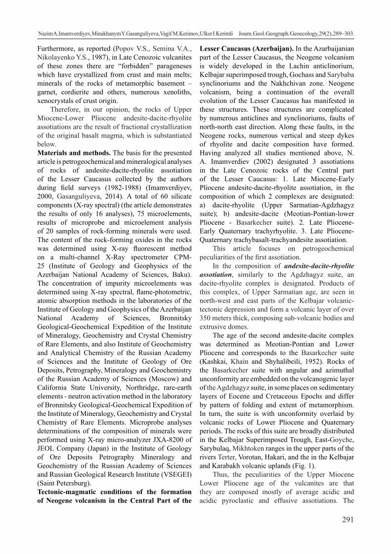
291
Furthermore, as reported (Popov V.S., Semina V.A., Nikolayenko Y.S., 1987), in Late Cenozoic vulcanites of these zones there are “forbidden” parageneses which have crystallized from crust and main melts; minerals of the rocks of metamorphic basement – garnet, cordierite and others, numerous xenoliths, xenocrystals of crust origin.
Therefore, in our opinion, the rocks of Upper Miocene-Lower Pliocene andesite-dacite-rhyolite assotiations are the result of fractional crystallization of the original basalt magma, which is substantiated below. Materials and methods. The basis for the presented article is petrogeochemical and mineralogical analyses of rocks of andesite-dacite-rhyolite assotiation of the Lesser Caucasus collected by the authors during field surveys (1982-1988) (Imamverdiyev, 2000, Gasanguliyeva, 2014). A total of 60 silicate components (X-ray spectral) (the article demonstrates the results of only 16 analyses), 75 microelements, results of microprobe and microelement analysis of 20 samples of rock-forming minerals were used. The content of the rock-forming oxides in the rocks was determined using X-ray fluorescent method on a multi-channel X-Ray spectrometer CPM-25 (Institute of Geology and Geophysics of the Azerbaijan National Academy of Sciences, Baku). The concentration of impurity microelements was determined using X-ray spectral, flame-photometric, atomic absorption methods in the laboratories of the Institute of Geology and Geophysics of the Azerbaijan National Academy of Sciences, Bronnitsky Geological-Geochemical Expedition of the Institute of Mineralogy, Geochemistry and Crystal Chemistry of Rare Elements, and also Institute of Geochemistry and Analytical Chemistry of the Russian Academy of Sciences and the Institute of Geology of Ore Deposits, Petrography, Mineralogy and Geochemistry of the Russian Academy of Sciences (Moscow) and California State University, Northridge, rare-earth elements - neutron activation method in the laboratory of Bronnitsky Geological-Geochemical Expedition of the Institute of Mineralogy, Geochemistry and Crystal Chemistry of Rare Elements. Microprobe analyses determinations of the composition of minerals were performed using X-ray micro-analyzer JXA-8200 of JEOL Company (Japan) in the Institute of Geology of Ore Deposits Petrography Mineralogy and Geochemistry of the Russian Academy of Sciences and Russian Geological Research Institute (VSEGEI) (Saint Petersburg).Tectonic-magmatic conditions of the formation of Neogene volcanism in the Central Part of the
Lesser Caucasus (Azerbaijan). In the Azarbaijanian part of the Lesser Caucasus, the Neogene volcanism is widely developed in the Lachin anticlinorium, Kelbajar superimposed trough, Gochass and Sarybaba synclinoriums and the Nakhchivan zone. Neogene volcanism, being a continuation of the overall evolution of the Lesser Caucasus has manifested in these structures. These structures are complicated by numerous anticlines and synclinoriums, faults of north-north east direction. Along these faults, in the Neogene rocks, numerous vertical and steep dykes of rhyolite and dacite composition have formed. Having analyzed all studies mentioned above, N. A. Imamverdiev (2002) designated 3 assotiations in the Late Cenozoic rocks of the Central part of the Lesser Caucasus: 1. Late Miocene-Early Pliocene andesite-dacite-rhyolite assotiation, in the composition of which 2 complexes are designated: a) dacite-rhyolite (Upper Sarmatian-Agdzhagyz suite); b) andesite-dacite (Meotian-Pontian-lower Pliocene - Basarkecher suite). 2. Late Pliocene-Early Quaternary trachyrhyolite. 3. Late Pliocene-Quaternary trachybasalt-trachyandesite assotiation.
This article focuses on petrogeochemical peculiarities of the first assotiation.
In the composition of andesite-dacite-rhyolite assotiation, similarly to the Agdzhagyz suite, an dacite-rhyolite complex is designated. Products of this complex, of Upper Sarmatian age, are seen in north-west and east parts of the Kelbajar volcanic-tectonic depression and form a volcanic layer of over 350 meters thick, composing sub-volcanic bodies and extrusive domes.
The age of the second andesite-dacite complex was determined as Meotian-Pontian and Lower Pliocene and corresponds to the Basarkecher suite (Kashkai, Khain and Shyhalibeili, 1952). Rocks of the Basarkecher suite with angular and azimuthal unconformity are embedded on the volcanogenic layer of the Agdzhagyz suite, in some places on sedimentary layers of Eocene and Cretaceous Epochs and differ by pattern of folding and extent of metamorphism. In turn, the suite is with unconformity overlaid by volcanic rocks of Lower Pliocene and Quaternary periods. The rocks of this suite are broadly distributed in the Kelbajar Superimposed Trough, East-Goyche, Sarybulaq, Mikhtoken ranges in the upper parts of the rivers Terter, Vorotan, Hakari, and the in the Kelbajar and Karabakh volcanic uplands (Fig. 1).
Thus, the peculiarities of the Upper Miocene Lower Pliocene age of the vulcanites are that they are composed mostly of average acidic and acidic pyroclastic and effusive assotiations. The
Nazim А.Imamverdiyev, Minakhanym Y. Gasanguliyeva, Vagif M. Kerimov, Ulker I.Kerimli Journ. Geol. Geograph. Geoecology, 29(2), 289–303.

292
composition of vulcanites mostly corresponds to andesite, trachyandesite, dacite, trachydacite, rhyolite and trachyrhyolite and on very rare occasions consists of andesibasalt and basalt. According ot geological data, the age of the assotiation is determined as Late Miocene-Lower Pliocene (Kashkai et al., 1952).Petrography. The Upper Sarmatian dacite-rhyolite complex. Dacite, rhyodacite and rhyolite are the main rocks of the dacite-rhyolite complex. Dacites are mostly porphyry rocks. Phenocrysts are composed of plagioclase, hornblende, sometimes quartz and biotite. The size of phenocrysts reaches 3-10 mm. The structure of the main mass is hyalopilitic, pilotaxitic, hyaline. The quantitative-mineralogical composition of dacites is as follows: the main mass is 50-75%, plagioclase – 15-20%, hornblende – up to 5%, quartz – 2.5%, biotite – 2-3%, ore mineral – 1-2%. The main mass comprises microlites of altered acidic plagioclase, quartz, sometimes potassium feldspars, sintered glass.
Rhyodacites are distinct from dacites by higher content of quartz (5-8%) and biotite (3-5%), presence
of potassium feldspar in the main mass. The main mass (45% of the volume of the rock) consists of acidic plagioclase, potassium spar and quartz sintered by glass. The structure of the main mass is spherulite, vitreous, microfelsitic. It has fluidal texture.
Rhyolite and trachyrhyolites compose the upper part of the cross-section of the Agdzhagyz suite. Rhyolites are dominant in the composition of the complex. In the lower part of the cross-section they are replaced by rhyodacites, in the upper part – trachyrhyodacites and form their own flows. Phenocrysts of these rocks comprise acidic plagioclase, quartz, biotite and potassium feldspar. Quantitative-mineralogical composition of rhyolites is as follows: main mass – 60-70%, plagioclase – 10-20%, biotite – 3-5%, potassium feldspar – sanidine – up to 5%, quartz – 5-10%, ore mineral – 1-2%. In trachyrhyolites, the amount of sanidine increases (8-10%), while quartz decreases (4-5%). The main mass is composed of feldspars, quartz and glass, differs by vitreous, felsitic, microfelsitic structures.
Crystallization of mineral parageneses varies.
Fig. 1. Schematic geological map of Late Cenozoic volcanic assotiations of the Central part of the Lesser Caucasus (Azerbaijan) (scale 1:500 000). According to N .A Imamverdiyev (2000).1- Tufa, volcanic ashes, tuff breccias, pebble, sands, sandstones, loams; 2-trahybasalts,basalt trachyandesites, trachyandesites; 3-rhyolites, perlite, obsidians; 4-andesites, dacites, rhyodacites, rhyolites; 5-volcanogenic flysch; 6- andesites and basalts (a), shiests (b), limestones (c); 7-volcanoclastic sediments; 8- granodiorites, granosyenites, quartzitic syenites, granites; 9- granodiorites, granosyenites, quartzitic diorites, diorites; 10-ophiolites; 11-faults; 12-largest centers of flows from the volcanoes.
Nazim А.Imamverdiyev, Minakhanym Y. Gasanguliyeva, Vagif M. Kerimov, Ulker I.Kerimli Journ. Geol. Geograph. Geoecology, 29(2), 289–303.

293
Usually the first to crystallize is magnetite, then sometimes biotite and hornblende crystallize together, and then plagioclase, quartz and orthoclase. Sometimes, one can see the following situation: magnetite, biotite, and then pyroxene. Afterwards, plagioclase+quartz+hornblende appear, and finally, in small amount K-Na feldspar is distinguished.
During the effusive stage, a process of cooling occurs in the residual melt, and crystallization of plagioclase, grains of quartz, and sometimes potassium-sodium feldspar in the rocks continues. Crystallization of phenocrysts of acidic rocks takes place in two stages: 1) intratelluric stage – due to saturation with water from the melt, release of dark-coloured minerals, such as hornblende, biotite, and then plagioclase; 2) phenocrysts form closely to the surface (especially quartz, acidic plagioclase, K-Na feldspars and others).
Rocks of lava facies of andesite-dacite complex are represented by dacite-trachydacite, andesite-trachyandesite and quartzitic latites. Dacite and trachydacites are composed of fractioned, pelitized phenocrysts of feldspar of 3-5 mm in length, and, on rare occasions, microcrystals of quartz. In many cases quartz is absent. Of coloured minerals, biotite in rare cases is recorded as micro phenocrysts.
Mineralogical composition of dacites is as follows: the main mass was 65-70%, plagioclase (An30-40) – 20-25%, biotite – 5-10%, quartz – 5%. The main mass has felsitic, vitrophyric, microlitic, spherulite structure, fluidal texture. These rocks are characteristic of cavities filled with aggregates of fine-grained quartz. In dacites, secondary minerals are represented by chlorite and sericite.
The Meotian-Pontian-Lower Pliocene andesite-dacite complex is composed mainly of andesite and its moderately alkaline types. Andesites, trachyandesites, quartz latites are the most distributed large-porphyry rocks, macroscopically composed of plagioclase, potassium-sodium feldspar, hornblende, sometimes notably seen are phenocrysts of biotite. Quartz latites are different from andesites and trachyandesites by content of potassium-sodium feldspars. The structure of rocks is porphyric, the main mass has an andesite, vitrophyric, pilotaxitic structure.
Depending on the mineral parageneses, these rocks are divided into pyroxene and pyroxene-hornblende types. Mineralogical composition of rock, depending on the type, changes as follows: feldspars (25-35%), hornblende (10-15%), clinopyroxene (5-10%), biotite (3-5%), main mass 50-60%. The main mass comprises feldspars, hornblende, clinopyroxene, volcanic glass and ore mineral.
The content of plagioclases in rocks includes An30-40 and forms paragenesis with amphibole, biotite, clinopyroxene, potassium-sodium feldspar. Plagioclases of the second generation crystallized during their effusive stage have relatively acidic content (An20-30). Potassium-sodium feldspar in rocks is present in quartz latites, trachyandesites. The content ranges Or55.3 Ab26.3 An0.3 to Or73.4 Ab44.0 An3.4. They belong to intermediate structural-optic type and are monoclinic, and not homogenous, represented by albite and orthoclase phases. The content of clinopyroxene changes from middle rocks to acidic and the share of Fs component increases: Wo37.1–41.4 En43.9–40.0 Fs19.0–19.6 (for andesites), Wo40.0–44.4 En45.4–44.8 Fs15.2–11.2 (for quartz latites) and Wo41.7–42.7 En36.3–34.6 Fs22.0–22.7 (for dacites). Compositions of amphiboles, according to B. E. Leake (Leake, 1968), correspond to tschermakite, pargasite and magnesium hornblende (Imamverdiyev, 1999, Imamverdiyev et. al., 2017).
Therefore, early crystallization of magnetite, hornblende, biotite, appearance of clinopyroxene liquidus, the structural position of feldspars indicate that crystallization of magma melt and evolution occurred in the conditions of high pressure of water vapor in intermediary hotbeds. During the development, relatively acidic types of rocks of the assotiation (dacites and rhyodacites) interacted with the surrounding rocks.
Very little research has been done on the crystalline inclusions in volcanic rocks of Neogene age of the Lesser Caucasus. Short reports about their composition and distribution could be found in the studies by N. A. Imamverdiyev (1988, 2002), A.Dj.Ismail –Zadeh (1986, 1989, 2001), Y.S. Genshaft (1983, 1986), V.G. Molyavko (1990) and other authors.
N. A. Imamverdiyev (2002) divides crystalline inclusions of andesite-dacite-rhyolite assotiation into two types: 1) cumulate rocks of parent material, i.e. homogenous inclusion, and 2) crust xenolytes, i.e. inclusions occupied by melt from rocks of the Earth`s crust. Mantle-derived phnenocrysts were not found in the Neogene vulcanites.
Homogenous inclusions are represented by pyroxenites, mildly-alkaline gabbroids, hornblendites, amphibolized gabbros and diorites. These rocks are partly melted, oval irregular in shape, macroscopically completely crystalline, fine and average-grained. For these rocks with surrounding rocks, recreational interrelation is absent. This type of inclusion is mainly composed of the main plagioclase, diopside-augite and hornblende. Many phenocrysts undergo intense cataclysis and following partial amphibolization.
Nazim А.Imamverdiyev, Minakhanym Y. Gasanguliyeva, Vagif M. Kerimov, Ulker I.Kerimli Journ. Geol. Geograph. Geoecology, 29(2), 289–303.

294
Mineral composition of xenolytes to a certain extent correlates with phenocrysts of the rocks which contain them. Therefore, broadly distributed amphibole-containing inclusions are even more broadly distributed in hornblende type of the middle rocks.
The second type of pnenocrysts includes rocks which become occupied by the melt while traveling to the surface from the surrounding Meso-Cenozoic sediments. Usually they are broadly distributed among average- and acidic explosive rocks. Among these xenolytes, quartz-feldspar rocks, quartz diorites, amphibolites, shiests can be seen. Petrochemistry. According to silica acidity, the rocks of assotiation form antidromic sequence from dacite-rhyolites to andesites (SiO2³60%) (Table 1), and ac-cording to the ratio (Na2O+K2O)-SiO2 (Le Bas et al., 1986) are the rocks of normal alkalinity and more rarely moderately alkaline (Fig. 2). On the diagram K2O-SiO2, the vulcanites correspond to highly-potas-sium calc-alkaline series and differ from the series of normal alkalinity.
The rocks of this assotiation are characterized by different contents of petrogenic oxides of the ele-ments. In the volcanic rocks of the assotiation, with increase in the content of SiO2, the contents of TiO2, Al2O3, Fe2O3, MgO, CaO, P2O5 decrease due to titano-magnetite, clinopyroxene, plagioclase and possibly apatite. At the same time, there was seen some in-
crease in Na2O and K2O in the rocks with the increase in the silica acidity. The process of increase in potas-sium alkalinity is accompanied by crystallization of potassium feldspar in more acidic types of rocks.
The main petrochemical types of the rocks of andesite-dacite-rhyolite assotiations were divided using factor analysis on the basis of over 60 analy-ses. On factor F1-F2 diagram (Fig. 4), developed on the basis of nine petrogenic elements (SiO2, TiO2, Al2O3, FeO*, MgO, CaO, Na2O, K2O, P2O5), andes-ite-trachyandesite-quartz latites, dacite-trachydacites and rhyodacite-rhyolites form individual groups. The calculations showed that the share of the total disper-sion for the first factor equaled 58.5%, and affects the two element association: I – SiO2 (-0.86); II – TiO2 (0.77), Al2O3 (0.66), Na2O (0.76), P2O5 (0.83), FeO* (0.71). The share of the second factor in the total dis-persion equals 14.69% and affects the association of the following elements: MgO (0.63), CaO (0.78) and K2O (-0.86). This is explained by the fact that SiO2 and K2O with other petrogenic elements give nega-tive correlation, indicating fractioning in the process
of differentiation of feldspar, titanomagnetite and apatite. As we will mention later, during increase the amount of SiO2 in the assotiation, the amount of titan oxides, aluminum, iron, magnesium, calcium, phos-phorus in the rocks decreases, while alkali concentra-tion (Na and K) increases. The reason of such pattern is fractioning of the mentioned minerals.
Fig. 2. Positions of the contents of the rocks of the Late Cenozoic volcanic assotiations of the Lesser Caucasus on the diagram TAS (Le Bas et al., 1986). (Note: all the analyses of the authors are indicated)
Nazim А.Imamverdiyev, Minakhanym Y. Gasanguliyeva, Vagif M. Kerimov, Ulker I.Kerimli Journ. Geol. Geograph. Geoecology, 29(2), 289–303.

295
During increase in the amount of SiO2 in the volcanic rocks due to fractioning of titanomagne-tite, clinopyroxene, plagioclase, apatite, the amount of TiO2, Al2O3, FeO*, MgO, CaO, P2O5 decreases. This pattern clearly manifests during the change in the amount of SiO2 between 60-68%. In other words, for the assotiation of dacites from andesites, fraction-ing of the abovementioned minerals plays the leading role. This pattern can be explained by crystallization
of potassium feldspar in more acidic rocks (Gasangu-liyeva, 2014).
Therefore, in the development of the rocks of the assotiation, a quite sufficient role was played by the fractioning of titanomagnetite, plagioclase, clinopy-roxene, amphibole and apatite.
Thus, assotiation of the late-collision Neogene highly potassium calc-alkaline series with peculiar petrochemical content is characteristic of the central
Fig. 3. Positions of the content of the Late Cenozoic vulcanite assotiations of the Lesser Caucasus on the diagram K2O-SiO2 (Peccerillo A., Taylor S.R., 1976).
Fig. 4. Diagram of distribution of F1 и F2 factors in the rocks
Nazim А.Imamverdiyev, Minakhanym Y. Gasanguliyeva, Vagif M. Kerimov, Ulker I.Kerimli Journ. Geol. Geograph. Geoecology, 29(2), 289–303.

296
part of the Lesser Caucasus and is distinct from the typical calc-alkalineof the series of normal alkalinity, formed in other geodynamic conditions.
The peculiarities of the inclusions in the rocks of andesite-dacite-rhyolite assotiation depend on the type, mineral composition, and also their genetic type. Relative (homogenous) inclusions (xenoliths) are presented by pyroxenites, hornblendites, gab-broids, diorites. In these rocks, the content of silica changes 45.0-57.9%, the content of MgO is relatively higher than in the containing andesites, and the rocks are characterized by relatively higher contents of TiO2, CaО, Kuno differentiation index (S.I) (Table 1) (In the article, only 16 analyses are shown). These xenoliths are characterized by average ferruginosity (F=42-65), but lower than in the containing andesites. Geochemistry. In vulcanites of differentiated andesite-dacite-rhyolite assotiation, from andesites to rhyolites, at increase in SiO2 and decrease in MgO, the coherent elements, as in the petrogenic oxides and macroelements, give dependency expressed linearly or sometimes with broken trend (Imamverdiyev et al., 2017). At the beginning of these trends, there are figurative points of hypogene inclusions. Therefore, in homogenous inclusions of the main content composed of the main plagioclase, olivine, clinopyroxene, hornblende, magnetite, there are observed increased amounts of elements of groups of iron and strontium. Distribution of these elements in the rocks of the assotiation is controlled by fractioning of the rock-forming minerals. It should be mentioned that in the inclusions, the decrease in these elements is more notable, and in the transition to containing andesites, the geochemical trends disrupt. Such distribution of macro- and microelements in the inclusions indicates the comagmaticity with the volcanic rocks.
The amount of incompatible elements (Rb, U, Th, Nb, Zr, Nb, Hf, LREE and others) in the hypogene inclusions is minimum, increasing in the sequence andesite-dacite-rhyolite. From middle to acidic rocks, the content of non-coherent elements increases approximately by 2.5-3 times (Table 1).
Typically incompatible elements Zr, Nb, Ta, U, Th accumulate in the melt and their ratio in the process of evolution of the magmatic melt does not change. On the diagram of the dependence of SiO2, MgO, taken as index of differentiation of the indicated elements, their ratio minimally decreases, indicating the role of contamination along with the crystallization differentiation during the formation of the rocks. By contrast, La/Yb, K/Rb ratios in the rocks of the formation depending on the content of SiO2 begin to increase or decrease. Increase in K/Rb
ratio, increase in La/Yb ratio could be explained by high coefficient of distribution for K and Yb between the mineral and the melt. Hornblende could be such a mineral (Gasanguliyeva, 2014; Imamverdiyev et al., 2017). Fractioning of this mineral is the reason for decrease in K/Rb and increase in La/Yb ratios in the process of differentiation. When MgO in the rocks of the formation reduces, K/Rb ratio decreases and becomes controlled by crystallization of leucocratic minerals.
In the rocks of the assotiation, REE changes in small intervals and light lanthanides (åCe) dominate over heavy ones (∑Y) (Table 1). This is explained by high value of La/Yb ratio (25-40), and for the same reason, on the normalized diagram, curvature is seen in the distribution of REE. In the evolution of vulca-nites, the sum of REE is observed in quartz latites. Rocks of the assotiations differ also by Eu anomaly which bears important genetic information. In the middle rocks (quartz latites, andesites), this ratio ap-proaches one (Eu/Eu*=0.94-1.05), in more acidic rocks, low minimum is observed (Eu/Eu*=0.58-0.63) and indicates fractioning of plagioclase in the development of more acidic rocks (Balashov ,1976, Imamverdiyev, 2003).
Distribution of REE in the hypogene inclusions shows almost the same situation. In melanocratic in-clusions, the content of light lanthanides is high and the form of the graph is more rounded, and in some rocks, slight Europium minimum was seen.
To evaluate the role of the mantle fluids and the extent of melting in the development of the rocks of the assotiation, we used the ratios of the elements with close geochemical properties.
The studies revealed that in the rocks of andes-ite-dacite-rhyolite assotiation, the content of Ba and Ba/Y, Rb/Y, Th/Yb ratios rapidly increases. To a cer-tain extent, increase in Nb/Y and Nb/Yb ratios was seen. Enrichment of the rocks of formation with litho-phylous and rare earth elements is due to relatively high degree of melting of fluid-enrichment melt. On the other hand, on the graphs of dependence of Ba/La, U/Nb, Zr/Nb, La/Nb ratios on Th/Nb, the increase in the latter clearly indicates the important role of the en-richment of the mantle formed due to fluids separate from the materials of subduction.
Thus, geochemical data, in particular high values of Th/Nb, Ba/Nb, K/Ti ratios in the studied rocks and also low values of Nb/Y and Ti/Y ratios in combina-tion with regional geological data indicate that mantle sources under the Lesser Caucasus are metasomatized by more ancient subduction processes, they contain highly potassium and impoverished HFSE water-
Nazim А.Imamverdiyev, Minakhanym Y. Gasanguliyeva, Vagif M. Kerimov, Ulker I.Kerimli Journ. Geol. Geograph. Geoecology, 29(2), 289–303.

297
Table 1 Content of petrogenic oxides (%) and microelements (ppm) in the presented samples of rocks of andesite-dacite-rhyolite assotiation of the Lesser Caucasus (according to Imamverdiyev, 2000 and Gasanguliyeva, 2014)
№ 1 2 3 4 5 6 7 8 9 10 11 12 13 14 15 16
Ele-ments 40 46 8 194 15 100 106 74 96 4-А 3-А 3-в 186-в 194-в 190-в 191-в
SiO2 61.09 63.26 63.8 62.84 62.32 62.99 64.81 65.99 68.19 73.74 74.21 44.92 45.92 45.94 49.8 57.92
TiO2 0.59 0.63 0.49 0.75 0.58 0.60 0.60 0.52 0.27 0.32 0.32 1.88 1.61 1.58 1.15 0.98
Al2O3 15.70 17.15 15.41 17.15 16.9 16.60 17.03 16.41 15.77 14.76 15.67 14.85 16.15 13.09 8.46 16.99
Fe2O3 3.47 3.93 2.5 4.94 3.91 3.28 3.38 3.59 1.69 1.41 1 9.98 6.29 9.66 5.62 5.13
FeO 1.29 0.62 0.94 0.43 1.01 1.29 0.73 0.28 0.43 0.28 0.43 1.15 1.45 1.74 3.33 1.6
MnO 0.06 0.06 0.06 0.09 0.04 0.09 0.03 0.09 0.04 0.05 0.03 0.16 0.11 0.19 0.18 0.1
MgO 1.85 2.29 1.77 1.86 1.95 1.90 1.43 1.31 0.05 0.37 1.05 7.81 7.47 8.13 12.43 2.62
CaO 4.85 4.23 5.34 5.25 4.24 4.32 3.97 3.19 1.32 1.58 0.54 10.96 14.7 13.47 13.74 6.74
Na2O 4.19 4.43 3.93 3.3 4.07 4.08 4.27 4.05 4.57 3.48 2.06 4.05 2.23 2.99 2 4.32
K2O 3.54 3.65 2.73 1.87 2.95 3.08 3.47 2.55 4.14 2.23 3.14 0.77 0.72 0.89 0.92 2.01
P2O5 0.41 0.43 0.38 0.35 0.28 0.30 0.33 0.23 0.06 0.01 0.07 1.75 0.09 1.7 0.13 0.68
LOI 0.81 0.2 1.96 0.38 0.54 0.46 0.47 0.96 0.27 2.49 1.56 0.63 0.38 0.49 0.39 0.43
Sum 98.63 100.88 99.31 99.21 99.08 98.1 100.72 98.15 99.23 100.72 100.08 98.91 97.12 99.87 98.15 99.52
Rb 83 61 66 51 63 74 86 72 97 72 66 20 10 27 20 30
Li 20 18 14 8 19 19 12 14 13 13 14 11 33 22 23 21
Sr 1105 840 935 860 935 850 935 833 420 790 660 1000 1300 1100 349 1700
Ba 1250 640 640 850 650 690 690 760 830 660 990 580 380 440 389 730
Cr 120 100 180 - 180 180 180 100 - 100 150 320 - - - -
V 170 100 40 110 60 60 40 100 40 100 50 260 210 210 170 170
Ni 24 20 22 25 30 31 32 25 15 25 30 79 100 70 70 36
Co 20 20 30 24 35 16 3 15 9 15 12 32 29 35 35 16
Sc 7 10 6 10 7 13 10 10 3 10 18 40 30 20 35 20
Cu 20 30 20 28 37 83 22 26 13 59 70 50 78 41 41 118
Zn 65 60 63 97 65 54 57 59 70 26 20 75 52 100 100 100
Zr 178 163 150 160 160 150 170 150 240 150 150 - 70 85 110 190
Nb 12 9 10 11 11 10 14 14 17 14 18 - 10 19 10 13
Ta 0.84 0.88 0.82 0.77 0.72 0.94 1.4 1.1 1.2 1 1.1 0.67 0.29 0.68 0.4 0.86
Hf 4.8 3.7 4 4.3 3.6 3.3 4.7 4.2 6 4 8.1 3 1.5 3.1 2.8 4.1
Th 11 8.6 11 10 9.3 10 18 16 5.2 15 - 3.2 2 5.1 4 7.7
U 2.7 - 4.7 4 5.7 4.4 5.4 3.3 14 3.4 - 4 4 5.3 2 4
La 45 52 37 47 43 36 47 38 47 - - 55 17 68 23 55
Ce 88 73 73 91 77 76 87 74 78 - - 120 37 140 46 110
Sm 4.2 5.4 3.6 5.1 3.9 4.2 3.6 4.4 5 - - 12 5.5 14 7.9 6.8
Eu 1.2 1.1 1 1.6 1.2 1 1.1 0.95 0.79 - - 2.8 1.6 3.2 2 1.7
Tb 0.67 0.42 0.43 0.9 0.56 0.58 0.44 0.42 0.57 - - 1.4 1.2 1.5 1.6 0.73
Yb 1.2 1.5 1.3 1.8 1.4 1.5 1.3 1.3 1.4 - - 2.6 2.3 3 3.7 1.7
Lu 0.19 0.24 0.18 0.23 0.2 0.2 0.17 0.17 0.18 - - 0.39 0.38 0.52 0.64 0.27
Y 36 11 16 13 11 10 - 11 29 - - - 19 27 25 19
1-11 – rocks: 1-2-quartz latite, area near Ayıçınqıllı volcano; 3-4-andesite, lava flow between the volcanos Sarimsagli and Sarıcalı; 5-6- andesite, area near Dikpillakan volcano; 7- dacite, area near Galinkaya volcano; 8-dacite, south-west slope of the Sarimsagli volcano; 9- rhyodacite, slope of the Dikpillakan volcano; 10-11-rhyolite, area near Moz village 12-16 –xenolithes: 12-14- amphibole gabbro; 15- pyroxenite; 16-quartz diorite «-« -undetermined.
Nazim А.Imamverdiyev, Minakhanym Y. Gasanguliyeva, Vagif M. Kerimov, Ulker I.Kerimli Journ. Geol. Geograph. Geoecology, 29(2), 289–303.

298
rich fluids. According to L. I. Demina and N. V. Ko-ronovsky (2008), the source of fluids in the conditions of collision could be dehydration. To solve this prob-lem more accurately, a MORB-normalized spider-di-agram of compatible and incompatible elements was used.
Compared with basalts of the mid-ocean ridges (MOR) of N-MORB type (Sun S.S., McDonough
W.F., 1998), the rocks of andesite-dacite-rhyolite assotiation are enriched with Sr, Rb, Ba, La, Ce, and poor in highly charged elements (Ta, Nb, Zr, Hf, Ti, Y, Yb) (Fig. 5).
As demonstrated in Fig. 5, N-MORB normalized distribution of microelements for andesites, quartz latites, dacites and trachyrhyodacites repeats in general terms, indicating their genetic commonality. Deep minimum of Ta in the rocks of the assotiation should be noted, as seen in the similar rocks formed in different geo-dynamic conditions (Frolova T.I., Burikova I.A., 1997). The reason for appearance of Ta and Nb minimum is explained by these authors. In our opinion, due to oxidized fluids, the first to crystallize is magnetite, which, while being removed from melt, also carries out the rare elements, including Ta and Nb, which easily enter the structure of titanomagnetites. The rocks of this series are the analogues of calc-alkaline and, partly, mildly alkaline Neogene series of the Lesser Caucasus. Petrological peculiarities. Analysis of the abovementioned petrogeochemical materials suggests the formation of andesite-dacite-rhyolite assotiation in the Upper Miocene-Lower Pliocene periods in the
Azerbaijanian part of the Lesser Caucasus, which belongs to highly potassium calc-alkaline or calc-alkaline and mildly alkaline petrochemical series. In the similar formations of Nakhchivan and Armenia, pyroxene-olivine, olivine basalts, dolerites and andesibasalts are present in subordinate amount.
Antidromic evolution of the rocks of the assotiation, presence of homogenous mafic inclusions
with cumulative textures indicate that initial magmas for the differentiated calc-alkaline series are volatile-rich highly alumina basalt magmas with relatively high content of alkali (Frolova T.I., Burikova I.A., 1997).
It is hard to judge the nature of original basalt magmas. However, based on the experimental data (Green D. H., Ringwood A.E , 1968; Yoder G. S., Tilly K. E., 1965; Yoder Kh. , 1979; Ryabchikov I. D, 1987), the current most substantiated hypothesis is that the original basalt magma could have melted from the peridotite substrate of the upper mantle. At the same time, the compound of these magmas at the level of originating corresponds to cotectics with participation of olivine and clinopyroxene.
According to the experimental data, the cotectic olivine + clinopyroxene + plagioclase is the richest normative plagioclase at the depth of around 25 km, corresponding to the pressure of »7 kilobars (Popov V. S., 1981).
Summarizing the experimental studies, V. S. Popov (1981) came to a conclusion that the rocks of calc-alkalineseries originate or differentiate within the continental crust at the depth of no more than 20-30 km.
Fig. 5. Distribution of rare elements in the rocks of andesite-dacite-rhyolite assotiation of the Lesser Caucasus (data for N-MORB, according to Sun S.S., McDonough W.F., 1998).
Nazim А.Imamverdiyev, Minakhanym Y. Gasanguliyeva, Vagif M. Kerimov, Ulker I.Kerimli Journ. Geol. Geograph. Geoecology, 29(2), 289–303.
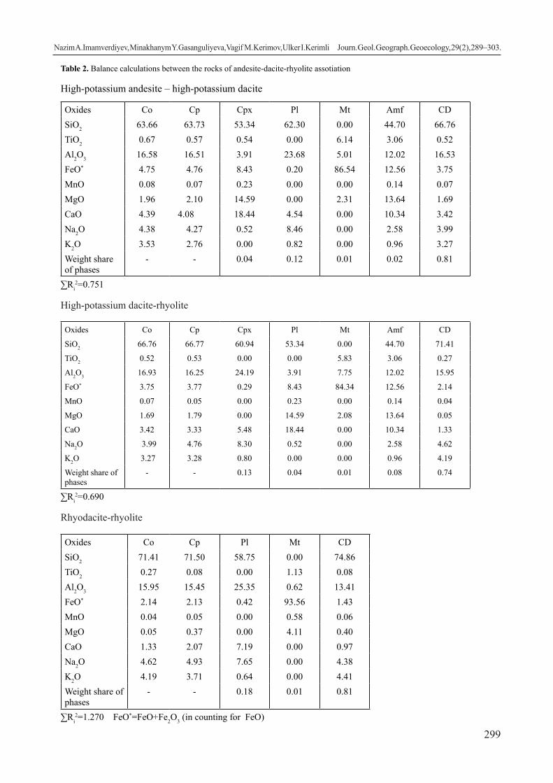
299
Table 2. Balance calculations between the rocks of andesite-dacite-rhyolite assotiation
High-potassium andesite – high-potassium dacite
Oxides Co Cp Cpx Pl Mt Amf CDSiO2 63.66 63.73 53.34 62.30 0.00 44.70 66.76TiO2 0.67 0.57 0.54 0.00 6.14 3.06 0.52Al2O3 16.58 16.51 3.91 23.68 5.01 12.02 16.53FeO* 4.75 4.76 8.43 0.20 86.54 12.56 3.75MnO 0.08 0.07 0.23 0.00 0.00 0.14 0.07MgO 1.96 2.10 14.59 0.00 2.31 13.64 1.69CaO 4.39 4.08 18.44 4.54 0.00 10.34 3.42Na2O 4.38 4.27 0.52 8.46 0.00 2.58 3.99K2O 3.53 2.76 0.00 0.82 0.00 0.96 3.27Weight share of phases
- - 0.04 0.12 0.01 0.02 0.81
∑Ri2=0.751
High-potassium dacite-rhyolite
Oxides Co Cp Cpx Pl Mt Amf CD
SiO2 66.76 66.77 60.94 53.34 0.00 44.70 71.41
TiO2 0.52 0.53 0.00 0.00 5.83 3.06 0.27
Al2O3 16.93 16.25 24.19 3.91 7.75 12.02 15.95
FeO* 3.75 3.77 0.29 8.43 84.34 12.56 2.14
MnO 0.07 0.05 0.00 0.23 0.00 0.14 0.04
MgO 1.69 1.79 0.00 14.59 2.08 13.64 0.05
CaO 3.42 3.33 5.48 18.44 0.00 10.34 1.33
Na2O 3.99 4.76 8.30 0.52 0.00 2.58 4.62
K2O 3.27 3.28 0.80 0.00 0.00 0.96 4.19
Weight share of phases
- - 0.13 0.04 0.01 0.08 0.74
∑Ri2=0.690
Rhyodacite-rhyolite
Oxides Co Cp Pl Mt CDSiO2 71.41 71.50 58.75 0.00 74.86TiO2 0.27 0.08 0.00 1.13 0.08Al2O3 15.95 15.45 25.35 0.62 13.41FeO* 2.14 2.13 0.42 93.56 1.43MnO 0.04 0.05 0.00 0.58 0.06MgO 0.05 0.37 0.00 4.11 0.40CaO 1.33 2.07 7.19 0.00 0.97Na2O 4.62 4.93 7.65 0.00 4.38K2O 4.19 3.71 0.64 0.00 4.41Weight share of phases
- - 0.18 0.01 0.81
∑Ri2=1.270 FeO*=FeO+Fe2O3 (in counting for FeO)
Nazim А.Imamverdiyev, Minakhanym Y. Gasanguliyeva, Vagif M. Kerimov, Ulker I.Kerimli Journ. Geol. Geograph. Geoecology, 29(2), 289–303.

300
Basalt fluids which appear at such depths lead to the development of alumina basalts, composition of which at atmospheric pressure significantly differs from the cotectic pressure. Such basalts are characteristic for Neogene calc-alkaline series of Nakhchivan and west Daralagez.
The appearance of such alumina melts could be related to the partial melting of ultrabase solid substrate, as well as differentiation at the same hypsometric level of deeper basalts with olivine deleted from them, and possibly orthopyroxene. The low content of elements of iron group (Ni, Co, Cr) in alumina basalts also indicates the assotiation of these melts as the result of precipitation from the primary magma of olivine and chromospinelides. The high content of Cr in some rocks of the assotiation could be due to primary chromospinelides which remained in the rocks.
In our opinion, from such primary magmas, as a result of fractional crystallization, Neogene middle and acidic rocks of the Lesser Caucasus could have been formed. The reality of such process is confirmed by spatial and temporal association of basalts and these rocks (within Nakhchivan, west Daralagez); presence of liquidus phases among femic minerals, as a result of fractioning of which acidic melts form; belonging of all rocks to the integral petrochemic series with preservation of heightened alkalinity; presence of several generations of hollow parageneses of minerals in all rocks of the series; finding of homogenous inclusions which have the main content, containing andesites; pattern of distribution of microelements; presence of Eu – minimums in middle and acidic rocks; distribution of more acidic, without notable features of crystallization, natural glass in andesites and dacites of the assotiation.
All these data confirm fractioning of dark-coloured and partially leucocratic minerals in intermediate hotbeds, as a result of which middle and acidic differentiates have formed.
The main evolutional mechanism of the melt of the surveyed series is the crystallization differentiation. The calculations of the balance of the substance which model the process of fractioning of phenocrysts, and also magnetites, confirmed the possibility of development of the compounds of rocks from andesites to rhyolites as a result of this process.
This model correlates with the data of E. F. Osborn (1983). According to this author, in oxidative situation, during lower pressures, near the liquidus, magnetite and hornblende appear, which is the reason for the formation of middle and acidic rocks. According to the scheme of J. Gill (Gill J.B., 1981),
andesites form as a result of fractioning from the basalt magma of the association olivine + augite + magnetite.
Our assessments confirm the conclusions of these authors. Therefore, the fractioning of paragenesis of augite + hornblende + plagioclase + magnetite in the intermediate hotbeds caused assotiation of dacite and rhyodacite from high-potassium andesite (Table 2). An attempt at calculation of the formation of the rocks of trachyrhyolite assotiation out of rhyodacites failed because between the real and calculated compounds, the values of errors of connection equaled ∑Ri
2>1: this indicates absence of crystallization connection between rhyodacite and rhyolite. Physical-chemical conditions of the assotiation. The temperature interval of crystallization of pheno-crysts of quartz latites, andesites, dacite-rhyodacites lies within the range of 1,155° С – 1,020° С. The as-sessments of the temperatures are based on the coef-ficient of distribution of Sr between Pl/glass (Drake M.J., Well D.F., 1975), coefficient of distribution of Ni between Cpx/glass and Ol/glass (Hakli T.A., Wright T.L., 1967), and also plagioclase geother-mometer according to Kudo, Weill (Kudo A.M., Weill D.F., 1970). Temperature of the development of the rocks correlates well with the temperature of homog-enization of quartz from these rocks (Panina et al., 1989, Imamverdiyev, 2000, 2003).
The value of fo2 in these temperatures for the in-dicated rocks is in the interval between 10-7.4 and 10-1.5 atm, determined according to (Nikolyev G. S. , Bor-isov A. A. , Ariskin A. A., 1996; Sack R.O., Carmi-chael I.S.E., Rivers M., 1980), which is closer to the Mag – Hm buffer.
The pressure calculated according to the method of (Frolova T. I. , Perchuk L. L , Burikova I. A.,1989) for most of the magnesia basalts from the region (Bi-chanak suite) varies 1.6-1.7 GPa, which corresponds to the border between the crust and the mantle (H=51-53 km) and correlates with the experimental studies. Therefore, according to I. Kushiro (1984), highly silica basalts original for most calc-alkaline series are in equilibrium with the mantle peridotite at the depth of 50 km (1.7 GPa) in the temperature of 1,3200С and water content of 1.5% in the melt.Discussion of the results. Therefore, during the formation of rocks of andesite-dacite-rhyolite assotiation, the leading mechanism was crystallization differentiation and there are evidences of relation between the middle rocks and the main and acidic rocks. Naturally, to explain this genesis of these rocks, the model of their crust-mantle origin is used, either as a result of assimilation of the crust material
Nazim А.Imamverdiyev, Minakhanym Y. Gasanguliyeva, Vagif M. Kerimov, Ulker I.Kerimli Journ. Geol. Geograph. Geoecology, 29(2), 289–303.

301
or mingling of crust and mantle magmas. It seems that these processes can occur, however it is doubtful that they dominate. First of all, because in the upper parts of relatively cold crust, partly crystallized basalt melts, manifested for example within Nakhchivan, Daralagez, could assimilate limited amount of the containing rocks. Secondly, because in the lower part of the crust, the acidic rocks are limitedly distributed, and for the formation of hybrid rocks of andesibasalt composition, up to 30-40% of the crust substrate of granite composition and even greater amount of middle rocks need to be assimilated (Popov V.S.,1982; Keskin M., Pearce J.A., 1994). Certain limitations affect also the processes of the mingling of the melts due to their different density and different temperature of crystallization, which could obstruct the formation of large amounts of relatively homogenous melts. Furthermore, the weakness of the hypothesis of the mingling is the inconstancy of the compounds and similar products – the model assessments of the processes of mingling (Popov V.S., 1982) indicate that for obtaining hybrid rocks of different basicity, in each particular case the original melts should change, which, taking into consideration the relative homogeneity of the main melts, is unlikely.
We assume only partial contamination with the crust materials in the processes of evolution of the main magma of the rocks of andesite-dacite-rhyolite assotiation. Unlike the elevated Transcaucasian zone in more depressed Eastern Caucasus in the conditions of elevated fluid pressure and decreased temperature, the melt underwent fractional crystallization in the intermediate hotbeds, at the same time becoming enriched with alkaline, large-ion lithophyllous elements, light REE, etc. This is indicated by the presence of large crystals of feldspars, contamination of these materials with numerous crystals of biotite, magnetite, several generations of these minerals, zoning, and also presence of relative “aqueous” inclusions, such as hornblendites, hornblende gabbro and others. The observed high contents of aqueous minerals, high levels of lithophyllous elements, high concentrations of REE (5-15 times exceeding the chondritic content for heavy rocks and over 100 times for light ones) in the rocks of this assotiation cannot be achieved due to the fractioning of the abovementioned minerals, because according to the data (Popov V.S., Semina V.A., Nikolayenko Y.S., 1987), their main concentrators are the accessory minerals.
It appears that increased contents of REE, and also Sr, Ba, U, Th, Rb in the considered rocks are due to low levels of selective melting of metasomatically changed
substance of the mantle at great depths, as presumed by V.S. Popov et al. (Popov V.S., Semina V.A., Nikolayenko Y.S., 1987) and N. A. Imamverdiyev et al. (2000, 2003, 2017, 2018) regarding the formation of the Upper Pliocene-Quaternary mildly alkaline series of the Lesser Caucasus. Conclusions:
1. Analysis of the presence of the abovementioned petrogeochemical materials suggests that the formation of the differentiated andesite-dacite-rhyolite assotiation, belonging to high potassium calc-alkaline or calc-alkaline and mildly alkaline petrochemical series, in the Late Miocene-Early Pliocene periods in the Azerbaijanian part of the Lesser Caucasus. Similar assotiations of Nakhchivan and Armenia, in the subordinate amount, contain pyroxene-olivine, olivine basalts, dolerites and andesibasalts.
Antidromic evolution of the rocks of the assotiation and presence of homogenous mafic inclusions with cumulative textures indicate that the original magmas for the differentiated calc-alkaline series are volatile-rich high silica basalt magmas with relatively high content of alkali. It could be noted that most antidromic andesite-dacite-rhyolite magmatic systems were found in subductive island-arc conditions characteristic of long-existing hotbeds of acidic magma.
2. The studies revealed that in the rocks of andesite-dacite-rhyolite assotiation, the content of Ba and Ba/Y, Rb/Y, Th/Yb ratios rapidly increase. To a certain extent, the increase in Nb/Y and Nb/Yb ratios is observed. The enrichment of the rocks of the assotiation with lithophyllous and rare earth elements is due to the relatively high extent of the melting of the melt enriched with fluids. On the other hand, increase in Th/Nb ratios clearly indicates an important role of the enrichment of the mantle, formed due to fluids separated from the materials of subduction.
3. Rocks of andesite-dacite-rhyolite assotiation were formed by fractional crystallization of the pri-mary high silica basalt magmas of heightened alka-linity in the intermediate magmatic hotbeds. At the same time, the process of crystallization differentia-tion was accompanied by the processes of contamina-tion, hybridism and mingling. Temperature interval of crystallization of phenocrysts of rocks of the assotia-tion lies within 1,155°-1,020°С, value of fo2 for these rocks in these temperatures equals 10-7.4 to 10-1.5 atm, which approaches to the buffer Mag-Hm. Pressure for the most magnesia basalts of the region (Bichanak suite) varies 1.6 to 1.7 GPa, which corresponds to the border between the crust and mantle (H=51-53 km).
Nazim А.Imamverdiyev, Minakhanym Y. Gasanguliyeva, Vagif M. Kerimov, Ulker I.Kerimli Journ. Geol. Geograph. Geoecology, 29(2), 289–303.

302
References
Balashov, Yu.A., 1976. Geokhimiya redkozemel’nykh elementov [Geochemistry of rare-earth elements]. M.: Nauka, 265 (in Russian).
Demina, L.I., Koronovskiy, N.V., 2008. Geodinamicheskiye sledstviya protsessov degidratatsii v zemnoy kore kollizionnykh oblastey [Geodynamic con-sequences of dehydration processes in the earth’s crust of conflict areas]. Nauchnaya konferentsiya, Lomonosovskiye chteniya, sektsiya geologiya, 30-31 (in Russian).
Gasanguliyeva, M.Ya., 2014. Petrogeokhimicheskaya model’ neogenovogo vulkanizma tsentral’noy chasti Malogo Kavkaza [Petrogeochemical model of Neogene volcanism in the central part of the Lesser Caucasus]. Avtoref. diss. dokt. filosofii nauk o Zemle. Baku, 25 (in Azerbaijanian and Russian).
Gasanguliyeva, M.Ya., 2014. Petrogeokhimicheskiye osobennosti neogenovogo vulkanizma tsentral’noy chasti Malogo Kavkaza [Petrogeochemical features of Neogene volcanism in the central part of the Lesser Caucasus]. Otechestvennaya geologiya, 2, 45-53 (in Russian).
Gasanguliyeva, M.Ya., Veliyev, A.A., Imamverdiyev, N.A. i dr., 2010. Voprosy petrogenezisa pozdnekaynozoyskogo kollizionnogo vulkanizma Malogo Kavkaza [Issues of petrogenesis of Late Cenozoic collision volcanism of the Lesser Caucasus]. Otechestvennaya geologiya, 4, 33-42 (in Russian).
Genshaft, Yu.S., 1977. Eksperimental’noye issledovaniya v oblasti glubinnoy mineralogii i petrologii [Experimental research in the field of deep mineralogy and petrology]. M: “Nauka”, 204 (in Russian).
Green, D.H., Ringwood, A.E., 1968. Proiskhozhdeniye bazal’tovykh magm [The origin of basaltic magmas]. V kn.: Petrologiya verkhney mantii, M.: Mir,132-228 (in Russian).
Gushchin, A.V., 1977. Raspredeleniye khroma i nikelya v porodakh vulkanicheskoy seriy kak indikator dinamiki petrogeneticheskikh protsessov [Distribution of chromium and nickel in the rocks of the volcanic series as an indicator of the dynamics of petrogenetic processes]. V kn.: Magmaobrazovaniye i yego otrazheniye v vulkanicheskom protsesse, M.: Nauka, 92-98 (in Russian).
Ivanova, T.A., Ganzeeev, A.A., Gushchin, A.V., 1989. Redkozemel’nyye elementy v apatite iz shchelochnykh vulkanicheskikh porod na yuge-vostoke Armenii [Rare-earth elements in apatite from alkaline volcanic rocks in the south-east of Armenia]. Izvestiya Vuzov, Geologiya i Razvedka. 6, 72-75 (in Russian).
Imamverdiyev, N.A., 1999. Mineralogicheskiye osobennosti i evolyutsiya sostava porodoobrazuyu-shchikh i aktsessornykh mineralov porod pozdnekaynozoyskikh vulkanicheskikh seriy Malogo Kavkaza [Mineralogical features and evolution of the composition of rock-forming and accessory minerals of rocks of the Late Ce-nozoic volcanic series of the Lesser Caucasus]. Mineralogicheskiy zhurnal. Kiyev. vol. 21, № 5/6, 93-100.
Imamverdiyev, N.A., 2000. Geokhimiya pozdne-kaynozoyskikh vulkanicheskikh kompleksov Malogo Kavkaza [Geochemistry of the Late Cenozoic volcanic complexes of the Lesser Caucasus]. Baku: Nafta-Press, 192 (in Russian).
Imamverdiyev, N.A., 2003. Geochemistry of rare-earth ele-ments of the Late Cenozoic volcanic series of the Lesser Caucasus. Geochemistry International, “Springer” Pleiades Publishing, Ltd, vol.4, No.4, 379-394.
Imamverdiyev, N.A., 2003. Physical and chemical con-ditions for crystallization of the Late Cenozoic volcanic formations of the Lesser Caucasus. Petrologiya, “Springer” Pleiades Publishing, Ltd, vol.11, No.1, 75-93.
Imamverdiyev N.A., Baba-zadeh V.M., Romanko A. et al. 2017. Formation of the late cenozoic volca-nic complexes of the Lesser Caucasus. Geotec-tonics, “Springer” Pleiades Publishing, Ltd. vol. 51, No. 5, 489–498. https://doi.org/10.1134/ S0016852117050041
Imamverdiyev, N.A., Gasanguliyeva, M.Ya., Babayeva, G.D. et al., 2018. Petrogenesis of Late Cenozoic collision volcanism in the central part of the Less-er Caucasus (Azerbaijan). Russian Geology and Geophysics, Elsevier, Pleiades Publishing, Ltd. vol.59, issue 1, 42-55. https://doi.org/10.1016/j.rgg.2018.01.003
Imamverdiyev, N.A., Gasanguliyeva, M.Ya., Veliyev, A.A., 2015. Petrogeokhimicheskaya model’ pozdnepli-otsen-chetvertichnogo kollizionnogo vulkanizma Malogo Kavkaza [Petrogeochemical model of Late Pliocene-Quaternary collision volcanism of the Lesser Caucasus]. Vestnik Bakinskogo Uni-versiteta, seriya yestestvennykh nauk. 1, 66-80 (in Russian).
Imamverdiyev, N.A., Veliyev, A.A., Gasanguliyeva, M.Ya., 2017. Petrologiya i geokhimiya pozdnekayno-zoyskogo kollizionnogo vulkanizma Malogo Ka-vkaza [Petrology and geochemistry of Late Ceno-zoic collision volcanism of the Lesser Caucasus]. Baku, 317 (in Azerbaijanian).
Yoder, G.S., Tilli, K.E., 1965. Proiskhozhdeniye bazal’to-vykh magm [The origin of basaltic magmas]. M. Mir, 247 (in Russian).
Yoder, Kh.,1979. Obrazovaniye bazal’tovoy magmy [The formation of basaltic magma]. M., Mir, 238 (in Russian).
Nazim А.Imamverdiyev, Minakhanym Y. Gasanguliyeva, Vagif M. Kerimov, Ulker I.Kerimli Journ. Geol. Geograph. Geoecology, 29(2), 289–303.

303
Kushiro, I., 1984. Genezis magm ostrovnykh dug na pri-mere Yaponskikh dug [Genesis of magma island arcs on the example of Japanese arcs]. Petrologi-ya, Doklady 27-y sessii MGK, t.9, Moskva, 122-130 (in Russian).
Molyavko, V.G., 1990. Petrologiya pozdnekaynozoyskogo magmatizma Al’piyskogo poyasa Yugo-Vostochnoy Yevropy [Petrology of the Late Cenozoic magmatism of the Alpine belt of Southeastern Europe]. Avtoref. diss.. dokt.geol-min.nauk, Kiyev, 37 (in Russian).
Nikolayev, G.S., Borisov, A.A., Ariskin, A.A., 1996. Novyye fO2-barometry dlya zakolochnykh stekol razlichnykh petrokhimicheskikh seriy [New fO2 barometers for barrett glass of various petrochemical series]. Geokhimiya, 9, 836-839 (in Russian).
Osborn, Ye.F., 1983. Reaktsionnyy printsip [The reaction principle]. V kn.: Evolyutsiya izverzhennykh porod, M. Mir, 136-171 (in Russian).
Panina L.I., Makhmudov S.A., Imamverdiyev N.A., Mamedov M.N. i dr., 1989. Osobennosti evolyutsionnogo preobrazovaniya sostava sub-shchelochnoy nefelin-normativnoy bazal’toidnoy magmy v protsesse fraktsionnoy kristallizatsii [Features of the evolutionary transformation of the composition of the mildlyalkalinenepheline-normative basaltoid magma in the process of fractional crystallization]. Geologiya i geofizika, 4 ,94-101 (in Russian).
Peccerillo A., Taylor S.R., 1976. Geochemistry of Eocene calc-alkaline volcanic rocks from the Kastamonu area, northern Turkey. Contrib. Miner. Petrol., vol. 58, No. 1, 63-81.
Popov, V.S., 1981. Posledovatel’nost’ kristallizatsii izvestkovo-shchelochnykh magm i yeye petrologicheskoye znacheniye [The crystallization sequence of calc-alkaline magmas and its petrological significance]. Geokhimiya, 11, 1665-1675 (in Russian).
Popov, V.S., 1982. Petrologo-geokhimicheskaya model’ formirovaniya orogennykh izvestkovo-shchelochnykh seriy [Petrological and geochemical model of the formation of orogenic calc-alkaline series]. V kn: Geokhimiya magmatizma, M.Nauka, 93-124 (in Russian).
Popov, V.S., Semina, V.A.., Nikolayenko, Yu.S. ,1987. Geokhimiya noveyshikh vulkanov Kavkaza i ikh proiskhozhdeniye [Geochemistry of the latest volcanoes of the Caucasus and their origin]. V kn.: Geokhimiya kontinental’nogo vulkanizma, M., Nauka, 143-231 (in Russian).
Ryabchikov, I.D., 1987. Fiziko-khimicheskiye usloviya protsessov generatsii i differentsiatsii kislykh i srednikh magm [Physical and chemical conditions for the processes of generation and differentiation of acidic and medium magmas]. Magmaticheskiye
gornyye porody, t.4, M.: Nauka, 348-359 (in Russian).
Tolstoy, M.I., Shirinyan, K.G., Ostafiychuk, I.M. i dr., 1980. Sostav, fizicheskiye svoystva i voprosy petrogenezisa noveyshikh vulkanicheskikh obrazovaniy Armenii [Composition, physical properties and issues of petrogenesis of the latest volcanic formations of Armenia]. Izd.-vo AN Arm. SSR, Yerevan, 322 (in Russian).
Frolova, T.I., Burikova, I.A., 1997. Magmaticheskiye formatsii sovremennykh geotektonicheskikh obstanovok [Magmatic formations of modern geotectonic environments]. Izd-vo Moskovskogo Universiteta, 319 (in Russian).
Frolova, T.I., Perchuk, L.L., Burikova, I.A., 1989. Magmatizm i preobrazovaniye Zemnoy kory aktivnykh okrain [Magmatism and transformation of the Earth’s crust of active margins]. M., Nedra, 261 (in Russian).
Drake, M.J., Well, D.F., 1975. Partition of Sr, Ba, Ca, Y, Eu2+, Eu3+ and other REE between plagioclase feldspar and magmatic liquid: an experimental study. Geochim. et Cosmochim acta, 39, 689-712.
Gill, J.B., 1981. Orogenic andesites and plate tectonics. N.Y.-L. Berlin: Springer-Verlag, 396.
Hakli, T.A., Wright, T.L., 1967. The fractionation of nickel between olivine and augite as a geothermometer. Geochemica et Cosmochimica Acta, 31, 877-884.
Keskin, M., Pearce, J.A., 1994. Trace element and isotope systematics of Collision-related volcanism on the Erzurum-Kars Plateau, North-Eastern Turkey. International volcanological Congress, Abstracts, Ankara.
Kudo, A.M., Weill, D.F., 1970. An igneous plagioclase thermometer. Contribs. Mineral. and Petrology, 25 (1).
Kyshiro, I., 1977. Melting of hydrous mantle and possible generation of andesitic magma: an approach from synthetic systems. Earth and Planet. Sci. Lett., 22 (4), 294-299.
Kyshiro, I., Yoder, H.S. Jr., 1969. Melting of forsterite and enstatite at high pressures under hydrous Conditions. Carnegie Inst. Washington Yearb., 67, 153-158.
Le Bas, M.J., Le Maitre, R.W., et al., 1986. A chemical classification of volcanic rocks based on the total alkali-silica (TAS) diagram. J. Petrol., 27, 745-750.
Sack, R.O., Carmichael, I.S.E., Rivers, M., 1980. Ferric-ferrous equilibria in natural silicate liquids at 1 bar. Contrib. Mineral. and Petrolology, 75, 369-376.
Sun, S.S., McDonough, W.F., 1989. Chemical and isotopic systematics of oceanic basalts: implications for mantle composition and processes. Eds. A.D.Sannders, M.I.Norry. Magmatism in the ocean basin. Geol. Soc. Spec. Publ., 42,313-345.
Nazim А.Imamverdiyev, Minakhanym Y. Gasanguliyeva, Vagif M. Kerimov, Ulker I.Kerimli Journ. Geol. Geograph. Geoecology, 29(2), 289–303.

304
Researches of the chemical composition of surface water in Ukraine, 1920-2020 (review)
Valentyn K. Khilchevskiy1, Natalia P. Sherstyuk 2, Myroslava R. Zabokrytska3
1 Taras Shevchenko National University of Kyiv, Kyiv, Ukraine, [email protected] Oles Gonchar National University of Dnipro, Dnipro, Ukraine, [email protected] Lesya Ukrainka Eastern European National University, Lutsk, Ukraine, [email protected]
Abstract.. The development of researches of the chemical composition of surface waters (rivers, lakes, reservoirs and ponds) is due to problems that are solved at one stage or an-other in the development of the country’s economy and are related to water quality issues. Depending on the tasks set during hydrochemical researches, attention is paid to a particular
group of chemical components in water: 1) the main ions and their total amount (water mineralization); 2) dissolved gases; 3) biogenic elements; 4) organic matter; 5) microelements (including heavy metals); 6) radioactive elements; 7) specific pollutants. The article pres-ents an analytical review of studies of the chemical composition of surface waters of Ukraine from the beginning of systematic research in the first half of the 20th century to the present day (1920-2020). The authors identified four typical chronological periods in the his-tory of hydrochemical studies of surface waters in Ukraine. I period (1920s-1950s) – the beginning of systematic hydrochemical studies of surface waters; the appearance of regular observations of the chemical composition of water at the posts of hydrometeorological service on the Dnipro and Southern Bug rivers (1930s) and publication of these data in “Hydrological Yearbooks”; hydrochemical stud-ies for selected large projects (Dnipro hydroelectric power station). II period (1950s-1970s) - expansion of hydrochemical research to meet the needs of water and hydropower construction, forecasting their possible impact on the country’s water resources; increasing the number of observation points for the chemical composition of water on large and medium-sized rivers; development of hydrochemistry of reservoirs. III period (1970s – at the beginning of the 2000s) – development of complex hydrochemical researches in the conditions of increasing anthropogenic load on water objects; creation of a system of hydrochemical monitoring of water bodies within the frame-work of the national system of observation and control of the environment (1973); application of sanitary and hygienic criteria for as-sessment of water quality – universal maximum acceptable concentrations (MAC); publication of quarterly “Hydrochemical Bulletins” (since 1967); development of radioecological studies of natural waters after the Chernobyl accident (1986); first publication in Ukraine of textbooks on hydrochemistry. IV period (after the beginning of the 2000s) – reformatting of hydrochemical research (monitoring system) to the requirements of the Water Framework Directive of the European Union, especially after the signing of the EU-Ukraine Association Agreement in 2014; reforming the water monitoring system based on environmental rationing with the identification of reference indicators; components of state monitoring of surface waters are the monitoring of biological, hydromorphological, chemical and physico-chemical parameters. The article also describes scientific hydrochemical schools: Institute of Hydrobiology of NAS of Ukraine; Taras Shevchenko National University of Kyiv; Ukrainian Hydrometeorological Institute of the State Emergency Service of Ukraine and NAS of Ukraine.
Keywords: chemical composition, hydrochemical studies, surface waters, monitoring, water quality, scientific school, Ukraine
Вивченість хімічного складу поверхневих вод в Україні, 1920-2020 рр. (огляд)
В.К. Хільчевський1, Н.П. Шерстюк 2, М.Р. Забокрицька3
1 Київський національний університет імені Тараса Шевченка, Київ, Україна, [email protected] Дніпровський національний університет імені Олеся Гончара, Дніпро, Україна, [email protected] Cхідноєвропейський національний університет імені Лесі Українки, Луцьк, Україна, [email protected]
Анотація. Розвиток досліджень хімічного складу поверхневих вод (річки, озера, водосховища і ставки) зумовлюється проблемами, які вирішуються на тому чи іншому етапі розвитку економіки країни і пов’язані з питаннями якості водних ресурсів. Залежно від поставлених завдань, при гідрохімічних дослідженнях увага приділяється тим чи іншим групам хімічних компонентів, що знаходяться у воді: 1) основні іони та їхня сума (мінералізація води); 2) розчинені гази; 3) біогенні елементи; 4) органічні речовини; 5) мікроелементи (серед них важкі метали); 6) радіоактивні елементи; 7) специфічні забруднювальні речовини. У статті представлено аналітичний огляд досліджень хімічного складу поверхневих вод України
Valentyn K. Khilchevskiy, Natalia P. Sherstyuk, Myroslava R. Zabokrytska Journ. Geol. Geograph. Geoecology, 29(2), 304–326.
Journal of Geology, Geography and
Geoecology
Journal home page: geology-dnu-dp.ua
ISSN 2617-2909 (print)ISSN 2617-2119 (online)
Journ. Geol. Geograph.Geology,
29(2), 304–326.doi: 10.15421/112028
Received: 04.11.2019Received in revised form: 25.11.2020Accepted: 27.02.2020

305
з початку систематичних досліджень у першій половині ХХ ст. і до наших днів (1920-2020 рр.). Виділено чотири характерні хронологічні періоди в історії гідрохімічних досліджень поверхневих вод на території України. I період (1920-і – 1950-і рр.) - початок систематичних гідрохімічних досліджень поверхневих вод; поява регулярних спостережень за хімічним складом води на постах гідрометслужби на річках Дніпро та Південний Буг (1930-ті рр.) і публікація цих даних в «Гідрологічних щорічниках»; гідрохімічні дослідження для окремих великих проектів (Дніпровська ГЕС). II період (1950-і – 1970-і рр.) - розширення гідрохімічних досліджень для забезпечення потреб водогосподарського та гідроенергетичного будівництва, прогнозування можливого їх впливу на водні ресурси країни; збільшення кількості пунктів спостереження за хімічним складом води на великих і середніх річках; розвиток гідрохімії водосховищ. IІI період (1970-і – до початку 2000-х рр.) - роз-виток комплексних гідрохімічних досліджень в умовах зростаючого антропогенного навантаження на водні об’єкти; ство-рення системи гідрохімічного моніторингу водних об’єктів в рамках загальнодержавної системи спостереження і контролю за навколишнім природним середовищем (1973 р.); застосування санітарно-гігієнічних критеріїв оцінювання якості вод – універсальних гранично допустимих концентрацій (ГДК); публікація щоквартальних «Гідрохімічних бюлетенів» (з 1967 р.); розвиток радіоекологічних досліджень природних вод після аварії на Чорнобильській АЕС (1986 р.); публікації вперше в Україні підручників з гідрохімії. IV період (після початку 2000-х рр.) - переформатування гідрохімічних досліджень (системи моніторингу) згідно вимог Водної рамкової директиви Європейського Союзу, особливо після підписання в 2014 р. угоди про асоціацію Україна-ЄС; реформування системи моніторингу вод на основі екологічного нормування з виявленням референcних показників; складовими державного моніторингу поверхневих вод є моніторинг біологічних, гідроморфологічних, хімічних і фізико-хімічних показників. В статті охарактеризовані також наукові гідрохімічні школи: Інституту гідробіології НАН Укра-їни; Київського національного університету імені Тараса Шевченка; Українського гідрометеорологічного інституту ДСНС України та НАН України.
Ключові слова: хімічний склад, гідрохімічні дослідження, поверхневі води, моніторинг, якість води, наукова школа, Україна
Introduction. The chemical composition of natural waters (surface, underground and marine) is studied by hydrochemistry - the science of the chemical composition of natural waters and the laws of its changing depending on the chemical, physical and biological processes that take place in the environment. The chemical composition of natural waters largely determines their quality and the possibility of using them for water supply, irrigation, fisheries, and recreation. Nowadays, hydrochemical knowledge is important for the environmental assessment of the state of water bodies. Depending on the tasks set, during the study of the chemical composition of natural waters, attention is paid to one or another group of components in the water: 1) the main ions (НСО3
-, SO42-, Cl-, Ca2+, Mg2+, Na+, K+)
and their sum ( mineralization of water); 2) dissolved gases (primarily oxygen); 3) nutrients (compounds, nitrogen, phosphorus, etc.); 4) organic matter; 5) trace elements (heavy metals among them); 6) radioactive elements; 7) specific pollutants.
The development of studies of the chemical composition of surface waters (rivers, lakes, reservoirs and ponds) in Ukraine, as well as in other countries, reflects many problems that were solved at one stage or another of the country’s economic development and were related to the quality of water resources used.
It should be noted that some aspects of the study of the chemical composition of surface water in Ukraine were previously covered in review articles (Denisova, Nahshina, 1974; Khilchevskyi, 2001). The same issue is also briefly addressed in the introductory part of some textbooks on hydrochemistry (Khilchevskyi et al., 2012; 2019).
One of the first scientific papers on the chemical composition of surface waters in Ukraine is the work of F.F. Kirkor “Materials on the issue of fluctuations of the composition of river water: A chemical study of the water of the Ros River 1904-1905”, which was based on materials from the laboratory of the All-Russian Society of Sugar Producers (Kirkor, 1907). The researcher also made a report on this subject at the First Mendeleev Congress on General and Applied Chemistry (Department of Hygiene) in 1907 in St. Petersburg.
The beginning of systematic hydrochemical studies should be attributed to the 1920s, when the formation of the hydrometeorological service in Ukraine (1921) took place, and the works on salt lakes by B.S. Burkser (1923) appeared, the Dnipro Hydroelectric Power Station reservoir on the Dnipro River near the city of Zaporizhia began (1927). During this period, regular observations were made of the chemical composition of river waters (main ions, nutrients) at some hydrological posts of the hydrometeorological service (Dnipro and Southern Bug basins), data on which began to be published in the Hydrological Yearbooks in the 1930s. In the second half of the hundred-year period considered here, a significant number of monographic works were published on the hydrochemistry of rivers, reservoirs, the relationship of the chemical composition of various types of natural waters, reclamation hydrochemistry, methodological aspects of the study of heavy metals, and others. Among them are the works of famous Ukrainian hydrochemists like O.M. Almazov, O.I. Denysova, V.I. Peleshenko, L.M. Horiev, P.M. Lynnyk, V.I. Osadchyi, V.K. Khilchevskyi and others.
Valentyn K. Khilchevskiy, Natalia P. Sherstyuk, Myroslava R. Zabokrytska Journ. Geol. Geograph. Geoecology, 29(2), 304–326.

306
Description of the problem and source materials. The main purpose of this article is an analytical review of studies of the chemical composition of surface water in Ukraine from the beginning of systematic research in the 20 century to the present day (1920-2020). To solve this problem, published materials of Ukrainian scientists, which dealt with the issues of hydrochemistry of rivers, lakes, reservoirs, cooling basins and ponds, were used. Publications of authors of this article are also used.Review of hydrochemical studies by periods. There are four chronological periods can be distinguished in the history of hydrochemical studies of Ukraine: I) 1920s - 1950s - the beginning of systematic studies of the chemical composition of surface waters; II) 1950s - 1970s - expansion of hydrochemical research to meet the needs of water and hydropower construction; III) 1970s - until the early 2000s - the development of integrated hydrochemical studies under conditions of increasing anthropogenic pressure on water bodies; IV) after the beginning of the 2000s - reformatting of hydrochemical studies according to the requirements of the Water Framework Directive of the European Union. This chronological division with the allocation of four periods was first proposed to research (Khilchevskyi, 2019).
The names of ministries and departments in Ukraine, as well as research institutes and universities which were engaged in hydrochemical research changed over the long considered period. Therefore, in the article, when characterizing different periods, there may be slightly different names for the same institution or department.
I period (1920s - 1950s) – the beginning of systematic hydrochemical studies of surface waters. This period is characterized by the appearance of regular hydrochemical observations on some rivers (at the hydrological posts of the hydrometeorological service on the Dnipro, Southern Bug) in Ukraine before the start of the World War II and the publication of these data in the 1930s in the “Hydrological Yearbooks” (Table 1).
The research institutions in the pre-war years were the Dnipro Biological Station in Kyiv, transformed in 1939 into the Institute of Hydrobiology of the Academy of Sciences of the Ukrainian SSR (with a department of hydrochemistry); Institute of Hydrobiology of Dnipro State University; All-Ukrainian State Black Sea-Azov Scientific and Industrial Station in Kherson; Institute of Geological Sciences, Academy of Sciences of the Ukrainian SSR; Kharkiv State University.
The organization of regular observations of the chemical composition of river waters (1938) including ions, nutrients, and mineralization of water on the
network’s supervision of the hydrometeorological service became a prototype of future monitoring of water quality. These materials were subsequently used for hydrochemical generalizations throughout the entire former USSR territory (Alekin, 1950).
In the early 1920s studies of the highly miner-alized waters of salt lakes and estuaries of southern Ukraine for balneological purposes began, the re-sults of which were published in the scientific reports (Burkser, Krokos, 1923; Burkser, 1927). In the late 1920s hydrochemical studies of the estuary section of the Dnipro River are being carried out. Particu-lar attention is paid to the regime of oxygen in wa-ter (Sheptitskiy, 1928). In the early 1930s scientists studied the hydrochemical regime of the river Dnipro and its tributaries on the site of the Dnipro reservoir in the Zaporizhia region (Husynska, 1938). We must remind here that the Dnipro hydroelectric station was put into operation in 1932 (the first turbine). Also, the hydrochemistry of the largest Dnipro tributary - Des-na was studied at this period (Tsytovych, 1936). Al-ready at that time, scientists began to pay attention to the sanitary-hydrobiological condition of the Donbass reservoirs and the impact of the regional industrial fa-cilities on them (Shkorbatov, 1936). In 1941, the hy-drochemical features of the Dnipro floodplain ponds in the area above and below Kyiv were researched (Tovbyn, 1941).
After the World War II, researchers began to study the chemical composition of precipitation by major ions and mineralization (Burkser, Fedorova, 1949, 1955), which were carried out as a part of a general program throughout the territory of the for-mer USSR.
ІІ period (1950s - 1970s) – is the period of ex-pansion of hydrochemical studies for the needs of water management and hydropower construction. A characteristic feature of the period is significant hy-drochemical researching to substantiate large water management and hydropower projects: a cascade of reservoirs on the Dnipro (1950-1974); irrigation sys-tems in the south of the country (Inhulets and others), The North Crimean canal, and others; drainage sys-tems in Ukrainian Polesia.
In the postwar years, comprehensive hydro-chemical and hydrobiological studies of water bodies were unfolding. The leading center for hydrochemical research during this period in Ukraine was the Insti-tute of Hydrobiology of the Academy of Sciences of the Ukrainian SSR, in which the department of hy-drochemistry was developed (1947). The Institute of Hydrobiology of the Academy of Sciences of the Ukrainian SSR conducts studies of surface waters by basic ions, mineralization, nutrients, gas regime
Valentyn K. Khilchevskiy, Natalia P. Sherstyuk, Myroslava R. Zabokrytska Journ. Geol. Geograph. Geoecology, 29(2), 304–326.

307
(oxygen and carbon dioxide content). The main riv-ers of the country were studied: the Dnipro (Almazov, 1955), the Dniester, the Southern Bug (Almazov et al., 1959) and their tributaries, reservoirs (Almazov et al., 1967), estuarine sections of rivers and estuaries of the Northern Black Sea Region (Almazov, 1960 , 1962), estuaries of the northwestern part of the Black Sea (Almazov, Denisova, 1955).
During this period, significant studies were car-ried out on the hydrochemistry of small rivers, ponds
and small bodies of water in various natural zones of the country. In total, there are over 63 thousand rivers in Ukraine, including 8 large rivers (Dnipro, Desna, Dniester, Danube, Prypiat, Siverskyi Donets, Southern Bug, Tisza), about 20 thousand lakes, over 49 thousand ponds and more 1,100 reservoirs, among which 7 can be considered large - on the Dnipro and Dniester rivers (Vodnyi fond Ukrainy, 2015). This made it possible to develop hydrochemical zoning of the territory of Ukraine, which reflects the spatial
Table 1. Description of the water management situation in general and hydrochemical studies in Ukraine by chronological periods (1920 - 2020)
Period Years Description of the water manage-ment
Dynamics of hydrochemical research and develop-ment of the monitoring system
I period: the begin-ning of systematic hydrochemical studies of surface waters
1920-s - 1950-s
Creation of a hydrometeorological service in Ukraine (1921). Start of construction of the first reservoir on the Dnipro river for the Dnipro hydroelectric station in the city of Zaporizhia (1927)
The appearance of publications on hydrochemistry. The beginning of regular observations of the chemi-cal composition of water at the hydrometeorologi-cal service posts on the Dnipro and Southern Bug rivers (1930s) and the publication of these data in the Hydrological Yearbooks. Hydrochemical studies for individual large projects (Dnipro Hydroelectric Power Station)
ІІ period: expansion of hydro-chemical research for the needs of water and hydroen-ergy construction
1950-s – 1970-s
Implementation of large hydro-en-ergy and water projects, creation of cascade of reservoirs on the Dnipro (1950-1974) and other rivers; of irrigation systems in the south of the country (Inhulets and others), The North Crimean canal, etc.; of drainage systems in Ukrainian Polesia
Research of the hydrochemical regime of the rivers on which reservoirs were built, forecasting their impact on the country’s water resources. An increase in the number of observation points for the chemical composition of water on large and medium-sized rivers. Development of hydrochemistry of reservoirs (Institute of Hydrobiology of the NAS of Ukraine), hydrochemical zoning of the territory of Ukraine (for small rivers). The publication of “Hydrochemi-cal Bulletins” (1967)
ІІІ period: develop-ment of complex hydrochemical studies under the conditions of increasing anthro-pogenic pressure on water bodies
1970-s – till the beginning
of 2000-s
Increased water consumption and wastewater discharge. The his-torical maximum of water intake from water bodies in Ukraine was noted - in 1990 (35.6 km3). Accordingly, the maximum water discharge is 20.3 km3. Construc-tion of a reservoir for the Dniester hydroelectric station (1981-1987). Accident at the Chernobyl nuclear power plant (1986). Emergence of new divisions of the hydrochemi-cal profile
Creation of a system for hydrochemical monitoring of water bodies within the framework of the OGSS (1973). Criteria for assessing the quality of water - sanitary-hygienic (MPC). There were 284 hydro-chemical monitoring stations in the hydrometeoro-logical system of Ukraine in the 1970-1980s. The “Annual data on water quality” was published for the first time. Development of radioecological stud-ies of natural waters after the Chernobyl accident. Textbooks on hydrochemistry began to be published in Ukraine for the first time (Taras Shevchenko National University of Kyiv)
ІV period: reformat-ting of hydrochemical studies according to the requirements of the Water Framework Directive of the Euro-pean Union
After the beginning of
2000-s
During 1991-2000 Ukraine experienced a sharp decline in the economy, after which a certain rise began. Ukraine’s GDP in 2000 amounted to 40% of the 1990 GDP. GDP in 2013 amounted to 70% of the GDP in 1990. Correspondingly, there are no large water management or hy-dropower projects. In 2013, water withdrawal amounted to 13.6 km3, water disposal - 7.7 km3. Signifi-cant reduction in the number of hydrochemical units
After 2014 (signing the Ukraine-EU Association Agreement), the water monitoring system is being reformed in accordance with the requirements of the EU WFD based on environmental regulation. State monitoring of surface waters should be carried out according to biological, hydromorphological, chemical and physico-chemical indicators. Since 2020, water monitoring should be carried out on surface water bodies, more than 9.000 of which have been allocated. Their ecological and chemical status is determined. In 2019, the hydrometeorologi-cal departments of the State Emergencies Service of Ukraine conducted hydrochemical monitoring of surface waters at 327 points and 56 sea stations; The State Water Agency of Ukraine - at 436 points
Valentyn K. Khilchevskiy, Natalia P. Sherstyuk, Myroslava R. Zabokrytska Journ. Geol. Geograph. Geoecology, 29(2), 304–326.

308
physical, geographical, climatic, and geological con-ditions for the formation of the chemical composition of water in small and medium rivers (Konenko, 1952, 1971). However, the relashionship with the physical-geographical zoning is not displayed as clearly as in the case of hydrological zoning, because of the influ-ence of local geological and soil conditions. The areas of distribution one or another hydrochemical type of water are distinguished in the hydrochemical zoning of the territory of Ukraine, and the value of their total mineralization is indicated. The main hydrochemical types of water are as follows: 1) calcium bicarbon-ate; 2) bicarbonate-calcium-magnesium-sodium; 3) sulfate-bicarbonate-calcium-sodium; 4) sulfate-chlo-ride-sodium-calcium; 5) sodium chloride-sulfate.
At the same time, the water mineralization of small and medium rivers in Ukraine is growing from 200-300 mg/L to 1,500-3,000 mg/L from the north-west to the southeast - from Ukrainian Polesia to the Sea of Azov. There is a change in the hydrochemical types of river waters, that happens in the same direc-tion, and which is confirmed by modern research (Kh-ilchevskyi, Kurylo, Sherstyuk, 2018).
In the 1950s large-scale hydrochemical studies were carried out on the river Dnipro in connection with the beginning of construction of a cascade of Dnipro reservoirs, as well as the Inhulets irrigation system and the Northern Crimean Canal, which were supposed to receive water from the Dnipro (Tovbin et al., 1954; Denisova, Almazov, 1961; Denysova, Maistrenko, 1962). Particular attention was paid to the chemical composition of the lower reaches of the Dnipro and Inhulets rivers in order to achieve optimal mineralization of the water in the Inhulets irrigation system (built in 1952-1963) and the forecast of the hydrochemical regime of the Kakhovka reservoir, from which water should enter the Northern Crimean Canal (the canal was built in stages in 1957-1975). In total, a cascade of six reservoirs was built on the Dnipro. The list of reservoirs downstream the river is as follows: Kyiv (1964-1966); Kaniv (1974-1976); Kremenchuk (1959-1961); Kamianske (1963-1964); Dnipro (1932, 1948); Kakhovka (1955-1958). The largest among them are Kakhovka (18.2 km3) and Kremenchuk (13.5 km3).
The results of further hydrochemical studies con-cerning the Dnipro, its tributaries, and the created res-ervoirs are summarized in monographs of scientific-researchers of the Institute of Hydrobiology of the Academy of Sciences of the Ukrainian SSR (Mayst-renko, 1965; Almazov et al., 1967) and in a number of articles. A complete hydrochemical characteristics of the Dnipro basin was carried out, the features of the
formation of the natural hydrochemical regime and its changes during flow regulation were established, a forecast was made regarding a possible change in the regime of the estuarine section of the river after river flow reduction due to the construction of reservoirs (Denisova, 1965, 1968, 1971; Denysova et al., 1971). Attention was paid to studies of the hydrochemical re-gime, ionic and biogenic runoff of the Upper Dnipro (to Kyiv), as a section of a river that is not planned to be regulated by reservoirs (Nakhshyna, 1964; Nah-shina, 1968).
Ukrainian scientists have joined to the study of the hydrochemical regime of the transboundary river Danube (the Soviet section of the river back then). They took part in the International Program devel-oped by the Danube countries (Almazov, Maystrenko, 1953, 1961).
Hydrochemical studies were also carried out in other institutions of the Academy of Sciences of the Ukrainian SSR, higher education institutions and re-search institutes. The researchers of the Institute of Hydrobiology of Dnipro State University studied the hydrochemical regime of small rivers and reservoirs in the middle Dnipro region, as well as the Dnipro and Kamianske (then Dniprodzerzhynsk) reservoirs, assessed the sanitary condition of reservoirs in the Dnipro region (Rovinskaya, Parsenyuk, 1953; Rovin-skaya, 1955).
Hydrochemical regime of ponds, reservoirs and cooling ponds of thermal power plants in the Kharkiv region and Donbass was also studied at the Depart-ment of Hydrobiology of Kharkiv National Universi-ty (Abremskaya, 1969; Baranov et al., 1971; Beluha, 1969; Pashkova 1956). The chemical composition of the mine waters of the Luhansk region was studied and issues of surface water protection from their in-fluence were developed (Soboleva, Peltihin, 1962).
The issues of pollution the river Desna by indus-trial and domestic wastewaters were discussed, which along with the river Dnipro. Desna river is a source of drinking water in Kyiv (Nakhshyna, Almazov. 1964, Shtitelman, Almazov, 1963).
In the “Hydrological Yearbooks” published by the hydrometeorological service, the number of monitoring points with information on the chemical composition of surface waters, which was published before 1975, increased. In 1967, “Hydrochemical Bulletins” appeared, published quarterly by the hy-drometeorological service, in which the number of identified chemical components was expanded cov-ering specific pollutants (petroleum products, pesti-cides, some heavy metals). Observations of the chem-ical composition of surface waters began to be carried
Valentyn K. Khilchevskiy, Natalia P. Sherstyuk, Myroslava R. Zabokrytska Journ. Geol. Geograph. Geoecology, 29(2), 304–326.

309
out by the laboratories of the water inspection of the Ministry of Land Reclamation and Water Manage-ment of Ukraine.
The annual monitoring of the chemical composi-tion of waters and the general condition of estuaries and salt lakes of the Black Sea region since 1953 be-gan to be carried out by the Hydrogeological opera-tion and maintenance station in Odesa (the works had been carried out until 1996).
III period (1970s - until the beginning of the 2000s) - the development of integrated hydrochemi-cal studies under the conditions of an increasing an-thropogenic pressure on water bodies. This period is characterized by a significant increase in water con-sumption, especially in industry, an increase in waste-water discharge into water bodies. The historical maximum water intake from water bodies in Ukraine was reached in 1990 - 35.6 km3. At the same time, the maximum discharge was 20.3 km3. The construc-tion of the Dniester hydroelectric reservoir took place (1981-1987). In 1986, an accident occurred at the Chernobyl nuclear power plant.
The characteristic features of the period are the emergence of new research hydrochemical units; in-creased attention to water quality issues; creation of a system for hydrochemical monitoring of water bodies within the framework of the national environmental monitoring and control system in 1973; studying the consequences of radioactive contamination of natu-ral waters caused by the accident at the Chernobyl nuclear power plant in 1986; the textbooks on hydro-chemistry for higher education institutions began to be published for the first time in Ukraine.
In 1972, the United Nations Conference on the Human Environment was held in Stockholm, at which considerable attention was paid to the problem of environmental pollution by harmful substances and, accordingly, to the issue of deepening environ-mental monitoring. The decision to organize the Na-tional Monitoring and Control Service based on the hydrometeorological service, separated by the level of pollution of environmental objects, was made in the former USSR as the response to the conference in Stockholm. For all water bodies of the country, uni-versal sanitary and hygienic criteria for assessing the quality of water by maximum permissible concentra-tions of substances are applied.
New research and production institutions are being created in Ukraine. New laboratories are also being created in existing institutions, in which hy-drochemical and hydroecological applied studies are intensified. It should be noted, that with the establish-ment of Ukraine as an independent state (1991), many
institutions changed their names, some subsequently closed.
The following are being created: Kyiv Hydrome-teorological Observatory of the Hydrometeorological Service of Ukraine with the Department for Monitor-ing and Control of Environmental Pollution (1973), now it is the Central Geophysical Observatory named after Boris Sreznevsky State Emergency Service of Ukraine (SES); State Water Inspection of the Min-istry of Land Reclamation and Water Resources of the Ukrainian SSR with hydrochemical laboratories (1970s); All-Union Scientific Research Institute of Water Conservation of the USSR Ministry of Land Reclamation and Water Management in Kharkiv (1971), now it is the Ukrainian Scientific Research In-stitute of Environmental Problems; Ukrainian branch of the Central Research Institute for the Integrated Use of Water Resources of the Ministry of Land Rec-lamation and Water Resources of the USSR (1973), now is Ukrainian Research Institute of Water and Environmental Problems; the Department of Hydro-chemistry at the “Ukrgiprovodkhoz” Institute (early 1980s), now is the “Ukrvodproekt” Institute; labora-tory of hydrochemistry at the Ukrainian Research In-stitute of Hydrotechnics and Land Reclamation of the Ministry of Land Reclamation and Water Resources of the USSR (early 1980), now is the Institute of Wa-ter Problems and Land Reclamation of the National Academy of Agrarian Sciences of Ukraine; the De-partment of radiation and hydrochemical monitoring (1986), as well as the department of hydrochemistry (1996) at the Ukrainian Research Hydrometeorologi-cal Institute.
In 1971, the Faculty of Geography of Kyiv Na-tional University named after T.G. Shevchenko cre-ated a problematic research laboratory of hydrochem-istry (Hilchevskiy, 2018), and in 1976 the Department of Land Hydrology was renamed in the Department of Hydrology and Hydrochemistry (Hilchevskiy, 2019).
In 1980, the hydrometeorological service, instead of the quarterly “Hydrochemical Bulletins”, began to publish “Annual Data on the Quality of Surface Water on the Land” (an annual bulletin that was published before 1990). Since 1976, they stopped publishing data on the chemical composition of surface waters in the Hydrological Yearbooks.
Researchers increased attention to water quality. One of the important areas of research at All-Union Scientific Research Institute of Water Protection was the development of approaches to environmental as-sessments of surface water quality from a water pro-tection position (Lozanskiy et al., 1979; Vernichenko, 1979), methods for integrated assessment of water
Valentyn K. Khilchevskiy, Natalia P. Sherstyuk, Myroslava R. Zabokrytska Journ. Geol. Geograph. Geoecology, 29(2), 304–326.

310
quality using combinatorial indices (Gurariy, Shayn, 1975). An ecological classification of watercourses of Ukraine was carried out (Vernichenko, Poddashkin, 1993).
The development of traditional topics on the hy-drochemistry of reservoirs continued with the clari-fying of methods for predicting changes in their hy-drochemical regime (Denisova, 1979; Denisova et al., 1979), the deepening of studies of trace elements (Nahshina, 1983), forms of migration of heavy metals in fresh waters, as an integral part of ecological toxi-cological characteristics of aquatic ecosystems. (Lin-nik, Nabivanets, 1986; Linnik, 1989, 1990; Linnik et al., 1993).
It was established that, along with factors that de-termine the natural hydrochemical regime of the river (mainly the influence of the Upper Dnipro tributaries and the natural hydrological regime of the river), new factors have appeared that largely determine the hy-drochemical regime of reservoirs and lower sections of the river. These include both an altered hydrologi-cal regime and various physical, biological processes occurring in reservoirs.
A significant influence on the hydrochemical re-gime of reservoirs is their cascade arrangement. The upper reservoir (Kyiv), in which the formation of the hydrochemical regime occurs under the influence of the rivers feeding it, differs from the middle ones and especially from the closing cascade of the reservoir (Kakhovka), since inernal-water processes and the influence of the upper reservoirs (Denisova, 1979, 1981; Denisova et al., 1979) play the main role in the last ones.
Water quality studies of the Danube estuary were carried out in connection with the designing works at the Danube- Dnipro canal. These works were summa-rized in a monograph on hydroecology of the lower Danube (Harchenko et al., 1993).
The regulation of the main waterways of Ukraine and the significant withdrawal of water for irrigation and water supply necessitated the study of estuarine sections of rivers (Dnipro and Southern Bug), estuar-ies (Dnipro, Southern Bug, Dniester), development of a forecast of the hydrochemical regime of the Dnipro -Bug estuary (Zhuravleva, 1972, 1989, 1991) on vari-ous options for reducing the flow of the Dnipro, in-cluding the construction of a barrier dam in the area of Ochakov (in the 1980s, such a project was developed).
Scientists at the Taras Shevchenko National Uni-versity of Kyiv evaluated the relationship between the chemical composition of various types of natural waters of Ukraine (precipitation, surface and ground-waters) (Peleshenko, 1975, 1980); hydrochemical
zoning of surface waters of the territory of Ukraine by hydrochemical fields was developed (Zakrevskiy et al., 1979); hydrochemical mapping methods have been developed (Peleshenko et al., 1979); probabilis-tic-statistical methods for processing hydrochemical information have been introduced (Peleshenko, Ro-mas, 1977). Subsequently (1980-1995), new scien-tific directions appeared at the department and in the laboratory, which significantly expanded the range of hydrochemical studies (Peleshenko et al., 1989; Hilchevskiy, 2018).
The formation of the chemical composition of at-mospheric precipitation in Ukraine through a network of weather stations has been studied (Romas, 1979). The theoretical and methodological foundations of ameliorative hydrochemistry, the proposed unified mathematical methods for optimizing the function-ing of irrigation systems were developed. The sci-entific direction - hydrochemistry of irrigated lands was founded (Gorev, 1986; Gorev, Peleshenko 1984, 1988).
Based on hydrochemical studies of water bod-ies of Ukrainian Polesia, processes of migration and accumulation of chemical elements in natural waters in drained territories were studied (Zakrevskiy et al., 1985; Zakrevskiy, 1991, 1992; Peleshenko et al., 1978, 1980).
As a result of hydrochemical studies at the ex-perimental water collectors of the Pridesnyansk (mixed forest zone), Boguslavsk (forest-steppe zone) and Veliko-Anadolsk (steppe) water balance stations, a methodology was developed for assessing the ef-fect of agrochemicals on the chemical composition of natural waters. An agrohydrochemistry, the new sci-entific direction was founded (Hilchevskiy, 1990; Kh-ilchevskiy, 1994; Khilchevskiy, 1995, 1996, 1996).
Methodological research approaches have been developed and a system of hydrochemical monitoring of natural waters in nuclear copwer plant areas have been established (Romas, 2002, 2004). The content of a number of trace elements in the natural waters of Ukraine was studied and new approaches to their determination were created (Savitskii et al., 1986; Savitskiy et al., 1994). A conceptual model has been developed to study hydrochemical systems as a com-plex of chemicals and processes that occur in natural waters (Snizhko, 2002, 2004).
Some generalizations concerning the flow of chemicals from the territory of Ukraine have been made (Zakrevskii et al., 1989), the anthropogenic im-pact on the chemical composition of river waters (Kh-ilchevskii et al., 1994, 1999), published maps of the chemical composition of surface waters of Ukraine in
Valentyn K. Khilchevskiy, Natalia P. Sherstyuk, Myroslava R. Zabokrytska Journ. Geol. Geograph. Geoecology, 29(2), 304–326.

311
the “Hydrochemical Atlas of the USSR” (Peleshenko et al., 1990), of methods for environmental assessment of surface water quality in the relevant categories by the team of authors of the Institute of Hydrobiology of the NAS of Ukraine, the Ukrainian Research Institute of Water-Environmental Problems, approved in 1998 by the Ministry of Ecology and Natural Resources of Ukraine as a normative document (Romanenko et al., 1998) was an important step in ensuring the regulato-ry framework for assessing the status of water bodies. The basis of this technique is a system of environmen-tal classifications of the surface water quality, which consists of three groups of indicators: salt composi-tion, trophic-saprobiological (ecological-sanitary) and substances of toxic and radiation effects.
In addition to the main methodology, together with the Institute of Geography of the National Acad-emy of Sciences of Ukraine, the “Methodology for mapping the ecological state of surface waters of Ukraine” was created (Rudenko et al., 1998).
Post-Chernobyl radiological-hydrochemical studies. A typical feature of hydrochemical studies in the 3rd period is their combination with the study of the factors and consequences of radioactive con-tamination of natural waters caused by the accident at the Chernobyl nuclear power plant in April 1986. This meant the start of a new type of research that can be qualified as “post-Chernobyl radiological-hydrochemical”, closely related to hydroecological and sanitary research.
Such studies aimed at constant studying of the role of the radiation factor in the dynamics of hydro-ecosystems and the degree of danger caused by using water resources radioactively contaminated territories to public health.
For example, the authors of the Institute of Hy-drobiology of the National Academy of Sciences of Ukraine discuss the issues of post-Chernobyl radioac-tive and chemical pollution of the river Dnipro and its reservoirs, primarily strontium-90 and cesium-137 (Romanenko et al., 1992), as well as the hydroeco-logical consequences of the Chernobyl accident (Ev-tushenko et al., 1992).
The two-volume work of a team of specialists from various institutes outlines approaches to moni-toring the radioactive contamination of natural waters of Ukraine (1st volume) (Voytsehovich, 1997) and forecasting radioactive contamination of water, as-sessing the risks of water use and the effectiveness of water protection countermeasures for water ecosys-tems in the zone of influence of the Chernobyl ac-cident (Voytsehovich, 1998). The issues of surface water quality management in the impact zone of the
Chernobyl accident were also investigated (Voytse-hovich, 2001; Los et al., 2001).
In addition, in this direction, we can distinguish the works on the radioecology of rivers (Merezhko, 1991), reservoirs (Kuzmenko, 1998), the creation of a cadastre of radioactive contamination of local use water bodies of Ukraine (Samoilenko, 1998).
IV period (from the beginning of the 2000s) - re-formatting of hydrochemical studies according to the requirements of the EU Water Framework Directive (Directive, 2000). A typical feature of the period is a decrease in the research units of the hydrochemi-cal profile in connection with a significant decrease in practical projects in the country.
During this period, the following areas of hydro-chemical research and organizational activities relat-ed to water monitoring can be noted: 1) continuation of hydrochemical research, characteristic of scientific areas that have developed in the relevant institutions of the country; 2) due to the lack of large expeditions on research vessels along the cascade of reservoirs on the river. The Dnipro increased attention to hydro-chemical studies of small water bodies in urban areas, as well as water bodies of the Black Sea region; 3) the interest to the water quality in transboundary river basins, especially those with the EU countries, is in-creased; 4) the beginning of the reform of the state water monitoring system in accordance with the re-quirements of the Water Framework Directive of the European Union, especially after 2014 (signing of the Ukraine-EU Association Agreement); 5) the emer-gence of studies related to climate change. We con-sider these areas below.
1) In general, during this period hydrochemical studies continued in Ukraine, which are typical sci-entific areas that have been developed in the relevant institutions of the country. Hydrochemists at the In-stitute of Hydrobiology of the National Academy of Sciences of Ukraine (Kyiv) have developed studies of heavy metals in river waters and bottom sediments (Linnik, Zubenko, 2000; Vasilchuk, Linnik, 2004; Linnik, et al., 2012; Linnik RP, Zubenko et al., 2012). These studies are devoted to the role of various groups of dissolved organic substances of surface waters in metal migration (Linnik, et al., 2013; Zhezheria et al., 2017), the behavior of individual metals in water, for example, aluminum, vanadium, copper, and lead (Linnik and Zhezheria, 2010; Linnik, 2014; Linnik, Linnik, 2018). Regional hydrochemical studies were also carried out (Morozova A.A., 2018).
Scientists at the Taras Shevchenko National Uni-versity of Kyiv carried out regional hydrochemical studies of various river basins: assessing the effect
Valentyn K. Khilchevskiy, Natalia P. Sherstyuk, Myroslava R. Zabokrytska Journ. Geol. Geograph. Geoecology, 29(2), 304–326.

312
of sulfate karst on the chemical composition of the Dniester river water and ion removal (Aksom, Kh-ilchevskyi, 2002; Khilchevskyi et al., 2019), studying the hydrochemical regime of the Ukrainian Polesia rivers (Kowalczuk et al., 2002), the hydrodynam-ics and hydrochemistry of slope watercourses (Bud-nik, Khilchevskiy, 2005), as well as the hydrological and hydrochemical characteristics of the minimal river flow in the Dnipro basin (Khilchevskyi, edit., 2007), an assessment of the hydroecological state of the Ros River and its water quality (Khilchevskyi, edit., 2009), Horyn River in the region of the Khmel-nitsky NPP (Hilchevskiy, edit., 2011), river Southern Bug (Khilchevskyi, edit., 2009), river Inhulets (Kh-ilchevskyi, Kravchynskyi, Chunarov, 2012), river Dniester (Khilchevskyi, Stashuk, edit., 2013), riv-ers Sula, Psel, and Vorskla (Khilchevskyi, Stashuk, edit., 2014). Together with scientists from the Oles Honchar Dnipro National University, the features of hydrochemical processes in technogenic and natu-ral reservoirs of Krivbass were studied (Sherstyuk, Khilchevskyi, 2012). Generalizations were made on the chemical composition of various types of natural waters of Ukraine (Khilchevskyi, Kurylo, Sherstyuk, 2018), as well as on the effect of the chemical com-position of atmospheric precipitation on water bodies (Khilchevskyi, et al., 2019). Together with scientists from the Carpathian National Natural Park, the chem-ical composition of the spring water in the Ukrainian Carpathians was studied (Kravchynskyi et al., 2019).
Researchers from Ukrainian Hydrometeoro-logical Institute created a number of hydrochemical maps for the “National Atlas of Ukraine” (Osadchyi et al., 2007). The institute also studies hydrochemical processes (Nabyvanets et al., 2007; Osadchyi, 2008; Osadchyi et al., 2008; 2013; 2016), studies the humic substances (Osadcha, 2011; Osadcha et al., 2017), and regional aspects of hydrochemical research using hy-drochemical modeling.
Ukrainian Institute of Environmental Problems (Kharkiv) improved the methodology for environ-mental assessment of the surface water quality in the relevant categories (Hrytsenko et al., 2012), issues on environmental standardization of the surface water quality were developed taking into account regional features (Vasenko et al., 2013, 2017).
2) Due to economic problems in the country, large expeditions on research vessels on the cascade of res-ervoirs on the river Dnipro were ceased. Therefore, the attention to hydrochemical studies of reservoirs of urbanized and technologically congested areas as part of integrated hydroecological studies has been increased. This includes the study of the reservoirs
of Kyiv (Afanasieva, 2010; Lynnyk et al., 2015; Mo-rozova, Diachenko, 2018), Lutsk (Zabokrytska et al., 2016), Krivbass (Sherstyuk, 2011), the development of issues on the revitalization of rivers in urban areas (Khilchevskyi, 2017). Scientists at Odesa State Envi-ronmental University have expanded research on the quality of water in the Black Sea water bodies (Hryb et al., 2019; Loboda et al., 2016).
3) It should be noted that the projects on as-sessment of the water quality in the basins of trans-boundary rivers (Tisza, Western Bug, Dnipro, Prypiat, Dniester), as well as the Southern Bug, which were funded by the European Union, were carried out in Ukraine from the early 2000s. Among a number of publications on transboundary river basins, the mono-graphs abput Dnipro can be noted - identification and assessment of the bwater body pollution sources (Romanenko et al., 2004), the Western Bug - water quality in Ukraine (Zabokrytska et al., 2006), Prypiat - quality management waters of the sub-basin (Aliev et al., 2012), as well as some modern articles on the hydrochemistry of the Western Bug (Khilchevskyi, Zabokrytska, Sherstyuk, 2018; Gopchak et al., 2019), Tisza (Skoblei, Lynnyk, 2014; Linnik, Skobley, 2018; Khilchevskyi, Leta, 2016, 2017), Danube (Klebanov, Osadcha, 2012; Nabivanets Yu.B., et al., 2016; Kh-ilchevskyi, 2019). Scientists also developed the pilot projects for river basin management of the river Tisza (Natsionalnyi plan, 2012) and Southern Bug (Plan, 2014), which should serve as a model for drawing up formal river basin management plans.
4) In 2016, the Verkhovna Rada of Ukraine ad-opted the Law of Ukraine “On Amending Certain Legislative Acts of Ukraine Regarding the Implemen-tation of Integrated Approaches in Water Resources Management on the Basin Principle”, which adopted many provisions specific to the EU WFD. Based on the previously developed methodology (Grebin et al., 2013; Khilchevskyi et al., 2019), a new hydrographic zoning of the country’s territory with 9 river basin districts was approved: Dnipro, Dniester, Danube, Southern Bug, Don, Vistula, Crimea rivers, rivers of the Black Sea, rivers of the Azov region (Zakon Ukrainy, 2016). The adopted changes are included in the Water Code of Ukraine (Vodnyi kodeks, 1995).
The “Procedure for the implementation of state water monitoring” was approved by the Decree of the Cabinet of Ministers of Ukraine of September 19, 2018 No. 758 (Postanova, 2018). The components of the state monitoring of the surface water are monitor-ing of biological, hydromorphological, chemical and physic-chemical indicators. Instead of a universal cri-terion, MPC should determine the reference values of
Valentyn K. Khilchevskiy, Natalia P. Sherstyuk, Myroslava R. Zabokrytska Journ. Geol. Geograph. Geoecology, 29(2), 304–326.
313
controlled indicators for various river basins. Since 2020, water monitoring should be carried out on the surface water bodies, of which 9.015 were allocated in Ukraine. Based on these data, the ecological and chemical status of the surface water masses will be determined, on the basis of which plans will be de-veloped for river basin management and the level of achievement of environmental goals - higher water quality will be evaluated.
The hydrochemical monitoring system is being reformed in the same context. The list of pollutants to determine the chemical state of surface and groundwa-ter massifs and the ecological potential of an artificial or substantially altered surface water massif were ap-proved (Perelik, 2017). Ukrainian scientists conducted research on the analysis of the surface water quality assessment methods used in Ukraine, and identified the main tasks of their adaptation to European legisla-tion (Osadcha et al., 2013; Yatsiuk et al., 2017).
5) The question regarding the impact of climate change on the chemical composition of the surface water in Ukraine at this stage does not yet have a clear answer. There are few publications on this subject. Thus, the studies (Khilchevskyi, Kurylo, 2014; Kh-ilchevskiy, Kurilo, 2015) on the transformation of the chemical composition of the river waters over a long period (since the 1950s) showed a tendency towards an increase in water mineralization due to sulfate and chloride ions, especially for left-bank tributaries of Dnipro. The authors conclude that there is an influ-ence of underground nutrition on this process. This is manifested in a decrease in the volume of surface water runoff during the spring flood, which is associ-ated with a decrease in snow reserves in water collec-tors in winter due to frequent thaws. As a result, the share of underground nutrition increases at this time. As it is known, the groundwater has a large salinity, which affects the increase in salinity and content of major ions in river waters. Similar conclusions are made in the work on the hydrochemistry of the rivers Psel and Vorskla (Loboda, Pylypiuk, 2017). The au-thors believe that the effect of climate change on the abiotic factors of aquatic ecosystems is manifested in changes of the content and temperature regime of river water.
Another scientific research (Osadchyi, 2017) is devoted to assessing the resources and quality of the surface waters of Ukraine under anthropogenic pres-sure and climate change. The author concludes that the indicators of the chemical composition of the river waters, which depend on natural factors (water min-eralization, humus content), have not changed over many years.
Scientific hydrochemical schools in Ukraine. Dur-ing the period under review, several scientific hydro-chemical schools (centers) were formed, which can be localized by institutions. Candidates and doctors of sciences who defended doctoral dissertations in hydrochemistry were also trained at these centers (Hilchevskiy, Gopchenko, Loboda et al., 2017; Gre-ben, Zabokritskaya, 2018).
Scientific hydrochemical school of the Institute of Hydrobiology of the National Academy of Sciences of Ukraine - was formed on the basis of the department of hydrochemistry of this institute (since the 1950s). The greatest increase in research was associated with the study of the hydrochemistry of small rivers and ponds; hydrochemical features of estuarine areas of rivers; hydrochemical regime of the cascade of Dni-pro reservoirs; forms of stay of heavy metals in water and bottom sediments. The employees of the Institute of Hydrobiology defended four doctoral dissertations in hydrochemistry (Table 2): hydrochemistry of the lower reaches of rivers, open estuaries and the estu-ary seaside of the Northern Black Sea Region (Alm-azov, 1960); hydrochemical regime of the Dnipro reservoirs and methods for its prediction (Denisova, 1981); forms of location and basic patterns of mi-gration of heavy metals in the surface waters of the Ukrainian SSR (Linnik, 1990); hydrochemical regime of water bodies in contact with the sea, and the effect of hydraulic engineering construction on it (Zhurav-leva, 1991).
Scientific hydrochemical school of Taras Shevchenko National University of Kyiv - was formed in the 1970s basing on the research laboratory of hy-drochemistry, as well as the department of hydrology and hydrochemistry (Hilchevskiy, 2019). The main studies were devoted to: studying the relationship of the chemical composition of various types of natu-ral land waters in Ukraine (precipitation, surface and groundwater); the impact of drainage and irrigation land improvement on the chemical composition of natural waters; hydrochemical mapping; the study of the effect of agrochemicals (primarily nitrogen and phosphorus compounds) on the quality of surface wa-ters in experimental water collectors in various natu-ral zones of Ukraine; assessing the impact of nuclear and thermal energy on water quality; the study of hy-drochemical systems as a complex of chemicals and processes in natural waters. The specialists of Kyiv University defended six doctoral dissertations in hy-drochemistry: an assessment of the relationship of the chemical composition of various types of natural land waters (assessment, balance and forecast) using the territory of Ukraine as an example (Peleshenko,
Valentyn K. Khilchevskiy, Natalia P. Sherstyuk, Myroslava R. Zabokrytska Journ. Geol. Geograph. Geoecology, 29(2), 304–326.

314
Table 2. Doctoral dissertations in hydrochemistry defended by Ukrainian scientists for the period under review (as of 2019)No Full name, scientist’s life
period, work placeAcademic
degree, year of defense of the dissertation
Topic of the doctoral dissertation Code, scientific specialty
Institution where the defense took
place
1 Almazov Oleksandr Markovych
(1912-1966),Institute of Hydrobiology,
Academy of Science of UkrSSR
Doctor of Geographical
Sciences, 1960
Hydrochemistry of the lower reaches of rivers, open estuaries and pre-estuary seaside (Northern Black Sea Coast)
* land hydrology Lomonosov Moscow State University,Moscow
2 Peleshenko Vasyl Ilarionovych
(1927-2014),Taras Shevchenko National
University of Kyiv
Doctor of Geographical
Sciences, 1981
Assessing the relationship of the chemical composition of various types of natural land waters (assess-ment, balance and forecast by the example of the territory of Ukraine)
11.00.10** - hydrochemistry
Hydrochemical Institute, Rostov-on-Don
3 Denysova Oleksandra Ivanivna
(1924-2005), Institute of Hydrobiology,
Academy of Science of UkrSSR
Doctor of Geographical
Sciences,
1982
Hydrochemical regime of the Dnipro reservoirs and methods for its prediction
11.00.10 -
hydrochemistry
Hydrochemical Institute, Rostov-on-Don
4 Horiev Leonid Mykolaiovych (1939-
1999),Taras Shevchenko National
University of Kyiv
Doctor of Geographical
Sciences, 1987
Theoretical and methodological foundations of the hydrochemistry of irrigated land
11.00.10 – hydro-chemistry
Hydrochemical Institute, Rostov-on-Don
5 Zhuravlova Lidiia Olekciivna
(1932-2001),Institute of Hydrobiol-
ogy, Academy of Science of UkrSSR
Doctor of Geographical
Sciences, 1991
Regularities of the formation of the hydrochemical regime of certain types of water bodies in contact with the sea and its changes under the influence of hydraulic engineer-ing construction
11.00.07 - *** land hydrology, water resources, hydrochemistry
Hydrochemical Institute, Rostov-on-Don
6 Lynnyk Petro Mykytovych (1952), Institute of Hydrobiology
Academy of Science of UkrSSR
Doctor of Chemical Sciences,
1991
Forms of research and basic pat-terns of migration of priority heavy metals in surface waters of land (on the example of water bodies of Ukraine)
11.00.11 -
еnvironmental protection
D. Mendeleev Institute of Chemi-cal Technology of Russia, Moscow
7 Zakrevskyi Dmytro Vasylovych,
(1929-2006) Taras Shevchenko National
University of Kyiv
Doctor of Geographical
Sciences, 1992
Hydrochemistry of drained lands (in the Northern-Western conditions of Ukraine)
11.00.07 - land hydrology, water resources, hydro-
chemistry
Hydrochemical Institute, Rostov-on-Don
8 Khilchevskyi Valentyn Kyrylovych (1953), Taras Shevchenko National
University of Kyiv
Doctor of Geographical
Sciences, 1996
Assessment of the influence of agrochemicals on the runoff of chemical substances and the quality of surface waters (on the example of the Dnipro basin)
11.00.07 - land hydrology, water resources, hydro-
chemistry
Taras Shevchenko National University of Kyiv, Kyiv
9 Snizhko Serhii Ivanovych (1958),
Taras Shevchenko National University of Kyiv
Doctor of Geographical
Sciences, 2002
Theory and methods of analysis of regional hydrochemical systems
11.00.07 - land hydrology, water resources, hydro-
chemistry
Taras Shevchenko National University of Kyiv, Kyiv
10 Romas Mykola Ivanovych
(1943-2009), Taras Shevchenko National
University of Kyiv
Doctor of Geographical
Sciences, 2004
Hydrochemistry of of nuclear and thermal energy water bodies
11.00.07 - land hydrology, water resources, hydro-
chemistry
Taras Shevchenko National University of Kyiv, Kyiv
11 Osadchyi Volodymyr Ivanovych (1955),
Ukrainian Hydrometeoro-logical Institute of the State
Emergency Service
Doctor of Geographical
Sciences, 2008
Methodological foundations of the study of factors and processes of the formation of the chemical composi-tion of surface waters
11.00.07 - land hydrology, water resources, hydro-
chemistry
Taras Shevchenko National University of Kyiv, Kyiv
12 Osadcha Nataliia Mykolaivna (1959), Ukrainian Hydrometeoro-
logical Institute of the State Emergency Service
Doctor of Geographical
Sciences, 2011
Patterns of migration of humic sub-stances in surface waters of Ukraine
11.00.07 - land hydrology, water resources, hydro-
chemistry
Taras Shevchenko National University of Kyiv, Kyiv
13 Sherstyuk Nataliіa Petrivna (1962), Oles Honchar Dnipro Na-
tional University
Doctor of Geographical
Sciences, 2013
Hydrochemistry of water bodies of iron ore basins (on the example of the Kryvyi Rih- Kremenchuk iron ore area)
11.00.07 - land hydrology, water resources, hydro-
chemistry
Odesa State Environmental University,Odesa
Valentyn K. Khilchevskiy, Natalia P. Sherstyuk, Myroslava R. Zabokrytska Journ. Geol. Geograph. Geoecology, 29(2), 304–326.

315
1980); theoretical and methodological foundations of hydrochemistry of irrigated lands (Gorev, 1986); hydrochemistry of drained lands in the north-west of Ukraine (Zakrevskiy, 1992); assessment of the impact of agrochemicals on the flow of chemicals and sur-face water quality in the Dnipro basin (Khilchevskyi, 1996); theory and methods of analysis of regional hydrochemical systems (Snizhko, 2002); hydrochem-istry of water bodies of nuclear and thermal energy (Romas, 2004).
Textbooks and tutorials in hydrochemistry, which used the results of scientific research, were also developed at the scientific hydrochemical school of Kyiv University. Textbooks have been published on: the basics of reclamation hydrochemistry (Gorev, 1991); hydrochemistry of Ukraine (Horiev, Pelesh-enko, Khilchevskyi, 1995); general hydrochemistry (Peleshenko, Khilchevskyi, 1997); hydroecological aspects of water supply and sanitation (Khilchevskyi, 1999); assessment and prediction of natural water quality (Snizhko, 2001); the basics of hydrochemis-try (Khilchevskyi, Osadchyi, Kurylo, 2012); regional hydrochemistry of Ukraine (Khilchevskyi, Osadchyi, Kurylo, 2019).
The Scientific Hydrochemical School of Ukrai-nian Hydrometeorological Institute of the State Emer-gencies Service of Ukraine and the NAS of Ukraine - was formed on the basis of the Department of Re-gional Hydrochemistry in the 2000s. The staff of Ukrainian Hydrometeorological Institute defended two doctoral dissertations in hydrochemistry: meth-odological foundations of the study of factors and processes of formation of the chemical composition of surface waters of Ukraine (Osadchyi, 2008); stud-ies of the migration of humic substances in the sur-face waters of Ukraine (Osadcha, 2011). Based on regional hydrochemical studies (Zabokrytska et al., 2006; Ukhan, Osadchyi, 2010; Luzovitska Yu.A., et al., 2011; Klebanov, Osadcha, 2012), the develop-ment of issues of hydrochemical modeling (Osipov, Osadchaya, 2017) was prepared a number of candi-date dissertations.
It should be noted that Ukrainian scientists are also engaged in research on the chemical composition and other types of water. In particular, the chemical composition of groundwater, including mineral water, is studied at the Institute of Geological Sciences of the National Academy of Sciences of Ukraine (Shes-
topalov et al., 2003; 2019). The Institute of Colloid and Water Chemistry of the National Academy of Sciences of Ukraine is developing new technologies for the purification and disinfection of drinking wa-ter and wastewater (Goncharuk, 2010; Goncharuk et al., 2006). The Ukrainian Research Institute of Medi-cal Rehabilitation and Balneology is engaged in the study of mineral waters and peloids for balneology. Occasionally, the problems of hydrochemistry of es-tuarine areas of rivers are studied at the Institute of Marine Biology of the National Academy of Sciences of Ukraine (Garkavaya et al., 2008). However, these researches are a topic for another study.Works awarded by the State Prize of Ukraine. In 1972, six hydrochemical scientists from the Institute of Hydrobiology of the Academy of Sciences of the Ukrainian SSR were awarded with the State Prize of the Ukrainian SSR for the series of scientific works “Hydrochemistry of Surface Water of Ukraine” (Post-anova, 1972). The team of authors included: Olexandr Almazov, Masha Feldman, Yuriy Maystrenko, Olena Nakhshyna, Olexandra Denysova, Hanna Konenko.
In 2017, eight leading Ukrainian scientists from various institutions were awarded with the State Prize of Ukraine in the field of science and technology for a series of scientific papers of a hydrochemical and hydroecological nature “Assessment, Forecasting and Optimization of the State of Water Ecosystems of Ukraine” (Ukaz, 2018; Zabokritskaya, 2018). The team of authors includes: Volodymyr Osadchyi, Yuriy Nabyvanets (Ukrainian Hydrometeorological Insti-tute of the State Emergencies Service of Ukraine and the NAS of Ukraine), Valentyn Khilchevskyi (Taras Shevchenko National University of Kyiv), Petro Lyn-nyk, Oleksandr Protasov and Volodymyr Shcherbak (Institute of Hydrobiology of the NAS of Ukraine), Yevhenii Nykyforovych (Institute of Hydromechanics of the NAS of Ukraine), Borys Kornilovych (NTUU “Igor Sikorskyi Kyiv Polytechnic Institute”). The first four authors in this team are hydrochemists. Conclusions.
1. Hydrochemical studies in Ukraine can be effectively considered in the context of the proposed four chronological periods: I) 1920s - 1950s. - the beginning of systematic studies of the chemical composition of surface waters; ІІ) 1950s - 1970s - expansion of hydrochemical research to meet the needs of water and hydropower construction; ІІІ) 1970s -
Notes: * - code and the exact name of the scientific specialty of Almazov are not established; ** 11.00.10 - code and name of the scientific specialty “hydrochemistry” was adopted by the Higher Attestation Commission (HAC) of the former USSR in 1981-1987; *** 11.00.07 - code and name of the scientific specialty «land hydrology, water resources, hydrochemistry», was adopted since 1988 in the Higher Attestation Commission of the former USSR, and transferred to the nomenclature of specialties of the Higher Attesta-tion Commission of Ukraine, created in 1992.
Valentyn K. Khilchevskiy, Natalia P. Sherstyuk, Myroslava R. Zabokrytska Journ. Geol. Geograph. Geoecology, 29(2), 304–326.

316
until the beginning of the 2000s - the development of integrated hydrochemical studies under conditions of increasing anthropogenic pressure on water bodies; IV) after the beginning of the 2000s. - reformatting of hydrochemical studies according to the requirements of the EU WFD.
2. In Ukraine, for the considered period, quite serious methodological and regional studies of the chemical composition of surface waters on the main ions, nutrients, and trace elements have been developed.
3. The country has developed scientific hydrochemical schools - at the Institute of Hydrobiology of the National Academy of Sciences of Ukraine, Taras Shevchenko National University of Kyiv, Ukrainian Hydrometeorological Institute of the State Emergencies Service of Ukraine and the National Academy of Sciences of Ukraine.
4. It is noted that hydrochemical research were mostly developed in the third period (until the beginning of the 1990s), by the reason of significant water and hydropower construction.
5. In the modern IV period (since the early 2000s), the reforming of the system of hydrochemical monitoring in Ukraine takes place in accordance with the requirements of the EU WFD.
6. Along with reformatting of the water monitoring to solve the water management tasks, it is necessary to maintain water monitoring of an ecological nature, which has long series of observations and allows solving scientific and practical problems related to the study of the transformation of the chemical composition of the water over a long period of time.
7. In the short term, the tasks of hydrochemical research of the surface waters in Ukraine lie in the plane of achieving one of the UN global goals in the field of sustainable development related to ensuring the availability and sustainable management of water resources and sanitation. At the same time, issues of a possible impact of the climate change on the transformation of the water chemical composition should be taken into account.
References
Abremskaya, S.I., 1969. Sravnitelnaya gidrohimiches-kaya harakteristika vodoemov-ohladiteley yuga Ukrainyi [Comparative hydrochemical character-istics of cooling ponds in the south of Ukraine]. Gidrobiologicheskiy zhurnal. 5(1). 12-18 (in Rus-sian).
Aksom, S.D., Khilchevskyi ,V.K., 2002. Vplyv sulfatnoho karstu na khimichnyi sklad pryrodnykh vod u
baseini Dnistra [Influence of sulfate karst on the chemical composition of natural waters in the Dniester basin]. Kyiv, Nika-Tsentr (in Ukrainian).
Alekin, O.A., 1950. Gidrohimicheskaya karta rek SSSR [Hydrochemical map of the rivers of the USSR]. Trudyi Gos. gidrologicheskogo instituta. 25 (79). 5-24 (in Russian).
Aliev, K.A., Anufriev, V.N., Afanas`ev S.A. i dr., 2012. Upravlenie transgranichny`m bassejnom Dnepra: subbassejn reki Pripyati [Management of the Dnipro transboundary basin: the sub-basin of the Pripyat River]. Kiev, Kafedra (in Russian).
Almazov, A.M., 1955. Gidrohimicheskiy stok rek Dunaya i Dnepra v Chernoe more [Hydrochemical flow of the rivers of the Danube and the Dnipro into the Black Sea]. Gidrohimicheskie materialyi. 23. 39-47 (in Russian).
Almazov, A.M., 1960. Gidrohimiya nizovev rek, otkryityih limanov i predustevogo vzmorya (Severnoe Prichernomore) [Hydrochemistry of the lower reaches of rivers, open estuaries and pre-shore seashore (Northern Pontic)]. Avtoreferat diss. doktora geogr. nauk. Moskovskiy gos. universitet im. M.V. Lomonosova. Moskva (in Russian).
Almazov, A.M., 1962. Gidrohimiya ustevyih oblastey rek [Hydrochemistry of river mouth areas]. Kiev. Izd-vo AN USSR (in Russian).
Almazov, A.M., Denisova, A.I., 1955. Gidrohimiya Dnestrovskogo limana [Hydrochemistry Dniester estuary]. Kiev. Izd-vo AN USSR (in Russian).
Almazov, A. M., Denisova A. I., Maystrenko Yu. G., Nahshina E.P., 1967. Gidrohimiya Dnepra, ego vodohranilisch i pritokov [Hydrochemistry of the Dnipro, its reservoirs and tributaries]. Kiev. Nauk. Dumka (in Russian).
Almazov, A.M., Maystrenko, Yu.G.b 1961. Gidrologicheskaya i gidrohimicheskaya harakteristika sovetskogo uchastka Dunaya [Hydrological and hydrochemical characteristics of the Soviet section of the Danube]. Trudyi In-ta gidrobiologii. 36. 24-32 (in Russian).
Almazov, A.M., Maystrenko, Yu.G., 1953. Gidrohicheskiy rezhim nizovev Dunaya [Hydrochemical regime of the lower reaches of the Danube]. Trudyi In-ta gidrobiologii. 29. 63-85 (in Russian).
Almazov, O.M., Maistrenko Yu.H., Diatlovytska, F.H., 1959. Hidrokhimiia Dniprovsko-Buzkoho lymanu [Hydrochemistry of the Dnipro-Bug estuary]. Kyiv. Vyd-vo AN URSR (in Ukrainian).
Afanasieva, O.A., Bahatska, T.S., Olianytska L.H. ta in. 2010. Ekolohichnyi stan Kyivskykh vodoim [The ecological state of the Kyiv reservoirs]. Kyiv. Fitosotsiotsentr (in Ukrainian).
Baranov, V.A., Zibold, F.F., Popov, L.N., 1961. Opyit gidrologo-gidrohimicheskogo issledovaniya na vodohralischah Donbassa [Experience hydrological and hydrochemical research on the reservoirs of Donbass]. Gidrohimicheskie materialyi. 32. 32-38 (in Russian).
Valentyn K. Khilchevskiy, Natalia P. Sherstyuk, Myroslava R. Zabokrytska Journ. Geol. Geograph. Geoecology, 29(2), 304–326.

317
Beluha, A.D., 1969. Gidrohimicheskaya harakteristika prudov Luganskoy oblasti [Hydrochemical characteristics of ponds of the Luhansk region]. Gidrobiologicheskiy zhurnal. 5(4). 23-32 (in Russian).
Budnik, S.V., Hilchevskiy, V.K., 2005. Gidrodinamika i gidrohimiya sklonovyih vodotokov [Hydrodynamics and hydrochemistry of sloping watercourses]. Kiev. IGL “Obrii” (in Russian).
Burkser, B.S., 1927. Soloni ozera ta lymany Ukrainy (hidrokhimichnyi narys) [Salt lakes and estuaries of Ukraine (hydrochemical essay)]. Pratsi fiz..-mat. viddilu VUAN. 8(1). 23-46 (in Ukrainian).
Burkser, B.S., Krokos, V.I., 1923. Geologicheskie i fiziko-himicheskie issledovaniya Slavyanskih lechebnyih ozer [Geological and physico-chemical studies of Slavic healing lakes]. Kurortnoe delo. 7. 46-58 (in Russian).
Burkser, B.S., Fedorova, N.E., 1949. Opyit issledovaniya himicheskogo sostava atmosfernyih vod [Experience in the study of the chemical composition of atmospheric water]. Gidrohimicheskie materialyi. 16. 34-42 (in Russian).
Burkser, B.S., Fedorova, N.E., 1955. Rol himicheskogo sostava atmosfernyih osadkov v formirovanii prirodnyih vod [The role of precipitation chemical composition in the formation of natural waters]. Gidrohimicheskie materialyi. 24. 17-24 (in Russian).
Denisova, A. I., 1981. Gidrohimicheskiy rezhim vodohranilisch Dnepra i metodyi ego prognozirovaniya [Hydrochemical regime of the Dnipro reservoirs and methods for its prediction]. Avtoreferat dis. doktora geogr. nauk. 11.00.10 – gidrohimiya. Gidrohimicheskiy in-t. Rostov-na-Donu (in Russian).
Denisovam, A.I., 1979. Formirovanie gidrohimicheskogo rezhima vodohranilisch Dnepra i metodyi ego prognozirovaniya [Formation of the hydrochemical regime of the Dnipro reservoirs and methods for its prediction]. K.: Nauk. Dumkа (in Russian).
Denisova, A.I., 1965. Osnovnyie osobennosti v formirovanii gazovogo rezhima vodohranilisch Dnepra (na primere Kahovskogo i Kremenchutskogo vodohranilischa) [The main features in the formation of the gas regime of the Dnipro reservoirs (on the example of the Kakhovka and Kremenchuk reservoirs)]. Gidrohimicheskie materialyi. 39. 27-35 (in Russian).
Denisova, A.I., 1971. Vliyanie kaskadnogo raspolozheniya vodohranilisch na gidrohimicheskiy rezhim [Influence of cascade arrangement of reservoirs on the hydrochemical regime]. Gidrobiologicheskiy zhurnal. 7(5). 35-41 (in Russian).
Denisova, A.I., 1968. Zakonomernosti izmeneniya gidrohimicheskogo rezhima Dnepra pri ego zaregulirovanii [Regularities of changes in the
hydrochemical regime of the Dnipro during its regulation]. Gidrohimicheskie materialyi. 44. 42-49 (in Russian).
Denisova, A.I., Almazov, A.M., 1961. Prognoz mineralizatsii vodyi Kahovskogo vodohranilischa i ego opravdyivaemost [Forecast of the mineralization of water in the Kakhovsky reservoir and its justification]. Gidrohimicheskie materialyi. 32. 35-42 (in Russian).
Denisova, A.I., Nahshina E.P., 1974. Ob izuchenosti gidrohimii poverhnostnyih vod Ukrainyi [On the study of the hydrochemistry of the surface waters of Ukraine] Vodnyie resursyi. 5. 38-48 (in Russian).
Denisova, A.I., Timchenko V.M., Nahshina E.P. i dr., 1989. Gidrologiya i gidrohimiya Dnepra i ego vodohranilisch, [Hydrology and hydrochemistry of the Dnipro and its reservoirs]. Kyiv, Nauk. dumka (in Russian).
Denysova, A.I., Maistrenko, Yu.H., 1962. Hidrokhimiia Kakhovskoho vodoimyshcha [Hydrochemistry of Kakhovsky reservoir]. Kyiv. Vyd-vo AN URSR (in Ukrainian).
Denysova, A.I., Maistrenko, Yu.H. , Almazov, O.M. 1971. Hidrokhimichnyi rezhym Dniprovsko-Buzkoho lymanu pislia zarehuliuvannia stoku Dnipra [Hydrochemical regime of the Dnipro-Bug estuary after the regulation of the water runoff of the Dnipro] / Dniprovsko-Buzkyi lyman. Kyiv, Naukova dumkа (in Ukranian).
Directive 2000/60/EC of the European Parliament and of the Council of 23 October 2000 establishing a framework for Community action in the field of water policy. Official Journal EU. L 327. 22/12/2000. P. 0001-0073.
Evtushenko, N.Yu., Kuzmenko, M.I., Sirenko, L.A. i dr., 1992. Gidroekologicheskie posledstviya avarii na Chernobyilskoy AES [Hydroecological consequences of the accident at the Chernobyl nuclear power plant]. Kiev. Nauk. dumka (in Russian).
Garkavaya, G.P., Bogatova, Yu.P., Berlinskij, N.A. i dr., 2008. Mnogoletnyaya izmenchivost` stoka biogenny`kh veshhestv Dnestra [Long-term variability of the nutrient flow of the Dniester]. Vodny`e resursy. 35(6). 1-8 (in Russian).
Goncharuk, V.V., 2010. SOS: pit`evaya voda [SOS: drinking water]. Khimiya i tekhnologiya vody. 32(5). 463-511 (in Russian).
Goncharuk, V.V., Kucheruk, D.D., Samsoni-Todorov, A.O., Skubchenko, V.F., 2006. Sovremenny`e tekhnologii ochistki vody [Modern technologies of water purification]. Nauka ta innovatsii. 2(5). 66–77 (in Russian).
Gopchak I., Basiuk, T., Bialyk I., Pinchuk O., Gerasimov I., 2019. Dynamics of changes in surface water quality indicators of the Western Bug River basin within Ukraine using GIS technologies. Journal of Water and Land Development. 42 (І). 67–75.
Valentyn K. Khilchevskiy, Natalia P. Sherstyuk, Myroslava R. Zabokrytska Journ. Geol. Geograph. Geoecology, 29(2), 304–326.

318
doi.org/10.2478/jwld-2019-0046 (in English).Gorev, L.N., 1986. Teoreticheskie i metodicheskie osnovyi
gidrohimii oroshaemyih zemel [Theoretical and methodological foundations of hydrochemistry of irrigated lands]. Avtoreferat dis. doktora geogr. nauk. 11.00.10 – gidrohimiya. Gidrohimicheskiy in-t. Rostov-na-Donu (in Russian).
Gorev, L.N., Peleshenko, V.I., 1984. Meliorativnaya gidrohimiya: uchebnoe posobie [Meliorative hydrochemistry]. Kiev. Vischa shkola (in Russian).
Gorev, L.N., Peleshenko, V.I., 1991. Osnovy` meliorativnoj gidrokhimii: uchebnik [Basics of reclamation hydrochemistry: textbook]. Kiev. Vishha shkola (in Russian).
Gorev, L.N., Peleshenko, V.I., 1988. Sovremennyie metodyi optimizatsii orositelnyih melioratsiy [Modern methods of optimization of irrigation amelioration]. Kiev. Vischa shkola (in Russian).
Greben, V.V., Zabokritskaya, M.R., 2018. Universitetskaya deyatelnost i osnovnyie napravleniya gidrologo-gidrohimicheskih issledovaniy professora V.K. Hilchevskogo [University activities and the main directions of hydrological and hydrochemical studies of professor V.K. Khilchevskyi]. Hidrolohiia, hidrokhimiia i hidroekolohiia. 2 (49). 59-92 (in Russian).
Grebin, V.V., Mokin, V.B., Stashuk, V.A., Khilchevskyi, V.K. ta in., 2013 Metodyky hidrohrafichnoho ta vodohospodaskoho raionuvannia terytorii Ukrainy vidpovidno do vymoh Vodnoi ramkovoi dyrektyvy Yevropeiskoho Soiuzu [Methods of hydrographic and water management zoning of the territory of Ukraine in accordance with the requirements of the European Union Water Framework Directive]. Kyiv. Interpres (in Ukrainian).
Gurariy, V.I., Shayn, A.S., 1975. Kompleksnaya otsenka kachestva vodyi [Comprehensive assessment of water quality]. Problemyi ohranyi vod. 6. 143-150 (in Russian).
Harchenko, T.A., Timchenko, V.M., Kovalchuk, A.A. i dr., 1993. Gidroekologiya ukrainskogo uchastka Dunaya i sopredelnyih vodoemov [Hydroecology of the Ukrainian section of the Danube and adjacent water bodies]. Kiev. Naukova dumka (in Russian).
Hilchevskiy, V., 1990. Certcetari hidrochemice in cadrul bazinului experimental al unui riu mic, dintr-o zona de agricultura intennsiva [Hydrochemical studies on experimental watersheds of small rivers in the zone of intensive agriculture]. Analele Universitati Bucuresti: Geografie. 39. 71-77 (in Romanian).
Hilchevskiy, V.K., 2018. Nauchnaya gidrohimicheskaya shkola Kievskogo natsionalnogo universiteta imeni Tarasa Shevchenko – 50 let issledovaniya prirodnyih vod [Scientific Hydrochemical School of Taras Shevchenko National University of Kyiv
- 50 years of natural water research]. Hidrolohiia, hidrokhimiia i hidroekolohiia. 4 (51). 6-46 (in Russian).
Hilchevskiy, V.K., 2019. Nauchnaya gidrohimicheskaya shkola Kievskogo natsionalnogo universiteta imeni Tarasa Shevchenko - polveka issledovaniy kachestva vod [Scientific Hydrochemical School of Taras Shevchenko National University of Kiev - half a century of water quality research]. Hidrolohiia, hidrokhimiia i hidroekolohiia. 3(54). 82-85 (in Russian).
Hilchevskiy, V.K., 2019. Kafedra gidrologii i gidroekologii Kievskogo universiteta imeni Tarasa Shevchenko - 70 let podgotovki kadrov i nauchnyih issledovaniy (1949-2019 gg.) [Department of hydrology and hydroecology of Taras Shevchenko National University of Kyiv - 70 years of training and re-search (1949-2019)]. Hidrolohiia, hidrokhimiia i hidroekolohiia. 1 (52). 6-35 (in Russian).
Hilchevskiy, V.K., Gopchenko, E.D., Loboda, N.S. i dr., 2017. Gidrologiya v universitetah Ukrainyi – istoriya, sostoyanie, perspektivyi [Hydrology at Ukrainian universities - history, status, prospects]. Hidrolohiia, hidrokhimiia i hidroekolohiia. 4 (47). 6-28 (in Russian).
Hilchevskiy, V.K., Kurilo, S.M., 2015. Transformatsiya himicheskogo sostava rechnyih vod Ukrainyi v usloviyah izmeneniya klimata [The transformation of the chemical composition of the river waters of Ukraine in a changing climate]. Materialyi Mezhdunarod. Nauchn. konferentsii: Problemyi gidromet. obespecheniya hoz. deyatelnosti v usloviyah izmenyayuschegosya klimata. Minsk. 47-48. (in Russian). Retrieved from https://core.ac.uk/download/pdf/38539389.pdf.
Horiev, L. M., Peleshenko, V. I., Khilchevskyi, V. K., 1995. Hidrokhimiia Ukrainy: pidruchnyk [Hydrochemistry of Ukraine: textbook]. Kyiv, Vyshcha shkola (in Ukrainian).
Hryb, O.M., Loboda, N.S., Yarov, Ya.S., Hryb, K.O., 2019. Kharakterystyka suchasnykh fizyko-khimichnykh pokaznykiv ta rezultaty otsinky yakosti vody vodnykh obiektiv nyzhnoho Dnistra v litno-osinnii period 2018 roku [Characterization of modern physical and chemical indicators and the results of water quality assessment of water bodies of the Lower Dniester in the summer-autumn period of 2018]. Hidrolohiia, hidrokhimiia i hidroekolohiia. 3 (54). 38-40 (in Ukrainian).
Hrytsenko, A.V., Vasenko, O.H., Vernichenko, H.A. ta in., 2012. Metodyka ekolohichnoi otsinky yakosti poverkhnevykh vod za vidpovidnymy katehoriiamy [Methodology of ecological assessment of surface water quality by appropriate categories]. Kharkiv. UkrNDIEP (in Ukrainian).
Husynska, S.A., 1938. Hidrokhimiia Dniprovskoho vodoskhovyshcha [Hydrochemistry of the Dnipro reservoir]. Visnyk Dnipropetrovskoi hidrobiolohichnoi stantsii. 3, 25-33 (in Ukrainian).
Valentyn K. Khilchevskiy, Natalia P. Sherstyuk, Myroslava R. Zabokrytska Journ. Geol. Geograph. Geoecology, 29(2), 304–326.

319
Khil’chevskii, V.K., Chebot’ko, K.A., 1994. Evaluation of the ecological and hydrochemical state of natural waters in Ukraine. Water Resources. 21(2). 166–172.
Khil’chevskii, V.K., Khil’chevskii R.V., Gorokhovskaya M.S., 1999. Environmental aspects of chemical substance discharge with river flow into water bodies of the Dnipro River basin. Water Resources. 26(4). 453–458.
Khilchevskyi, V.K., 2019. Dissolved load in the Danube Delta (branches Kiliya, Sulina and St. George). Materials of the All-Ukrainian Scientific and Practical Conference “Rivers and Estuaries of the Black Sea in the Beginning of the 21 Century”. Odesa. Ukraine. 155-157.
Khil’chevskiy, V.K., 1994. Effect of agricultural production on the chemistry of natural waters: a survey. Hydrobiological Journal. 30(1). 82–93.
Khilchevskyi, V.K., 1995. Ahrohidrokhimiia [Agrohydrochemistry]: navch. posibnyk. Kyiv. VPTs: Kyivskyi universytet (in Ukrainian).
Khilchevskyi, V.K., 2017. Hidroekolohichni problemy revitalizatsii richok na terytorii miskykh ahlomeratsii – mizhnarodnyi ta ukrainskyi dosvid [Hydroecological problems of rivers revitalization on the urban ares - international and Ukrainian experience]. Hidrolohiia, hidrokhimiia i hidroekolohiia. 2 (45). 6-12 (in Ukrainian).
Khilchevskyi, V.K., 1996. Otsinka vplyvu ahrokhimichnykh zasobiv na stik khimichnykh rechovyn ta yakist poverkhnevykh vod (na prykladi baseinu Dnipra) [Evaluation of the influence of agrochemicals on the water runoff of chemicals and the quality of surface water (for example, the Dnipro basin)]. Avtoreferat dys. doktora heohr. nauk. 11.00.07. Kyivskyi nats. un-t im. Tarasa Shevchenka. Kyiv (in Ukrainian).
Khilchevskyi, V.K., 1996. Rol ahrokhimichnykh zasobiv u formuvanni yakosti vod baseinu Dnipra [The role of agrochemicals in shaping the quality of the waters of the Dnipro basin]. Kyiv. VPTs: Kyiv. universytet (in Ukrainian).
Khilchevskyi, V.K., 2001. Rozvytok hidrokhimichnykh i hidroekolohichnykh doslidzhen v Ukraini [Development of hydrochemical and hydroecological research in Ukraine]. Hidrolohiia, hidrokhimiia i hidroekolohiia. 2. 22-29 (in Ukrainian).
Khilchevskyi, V.K., 1999. Vodopostachannia i vodovidvedennia: hidroekolohichni aspekty: pidruchnyk [Water supply and sewage: hydroeco-logical aspects: textbook]. Kyiv. VPTs Kyivskyi universytet (in Ukrainian).
Khilchevskyi, V.K., za red., 2011. Hidroekolohichnyi stan baseinu Horyni (v raioni Khmelnytskoi AES) [Hydroecological state of the Goryn basin (near Khmelnitsky NPP)]. Kyiv. Nika-Tsentr (in Ukrainian).
Khilchevskyi, V.K., za red., 2009. Hidroekolohichnyi
stan baseinu richky Ros [Hydroecological state of the Ros River Basin]. Kyiv. Nika-Tsentr (in Ukrainian).
Khilchevskyi, V.K., za red., 2007. Hidroloho-hidrokhimichna kharakterystyka minimalnoho stoku richok baseinu Dnipra [Hydro-hydrochemical characteristic of the minimum runoff of the rivers of the Dnipro basin]. Kyiv. Nika-Tsentr (in Ukrainian).
Khilchevskyi, V.K., za red., 2009. Vodni resursy ta yakist richkovykh vod baseinu Pivdennoho Buhu [Water resources and quality of river basins of the South-ern Bug]. Kyiv, Nika-Tsentr (in Ukrainian).
Khilchevskyi, V.K., Grebin, V.V., Sherstyuk, N.P., 2019. Modern Hydrographic and Water management zoning of Ukraine’s territory in 2016 - imple-mentation of the WFD-2000/60/EC. Electronic book with full papers XXVIIІ Conference of the Danubian Countries on Hydrological Forecasting and Hydrological Bases of Water Management. Kyiv. 209-223. Retrieved from https://uhmi.o rg . u a / c o n f / d a n u b e _ c o n f e r e n c e _ 2 0 1 9 /papers_abstracts/Electronic_Book_Danube_Conference_2019.pdf.
Khilchevskyi, V.K., Kravchynskyi, R.L., Chunarov, O.V., 2012. Hidrokhimichnyi rezhym ta yakist vody Inhultsia v umovakh tekhnohenezu [Hydrochemical regime and water quality of Ingulets in the conditions of technogenesis]. Kyiv, Nika-Tsentr (in Ukrainian).
Khilchevskyi, V.K., Kurylo, S.M., 2014. Analiz bahatorichnoi transformatsii khimichnoho skladu richkovykh vod Ukrainy [Analysis of long-term transformation of the chemical composition of river waters of Ukraine]. Hidrolohiia, hidrokhimiia i hidroekolohiia. 2(33). 17-28 (in Ukrainian).
Khilchevskyi, V.К., Kurylo, S.М., Sherstyuk, N.P., 2018. Chemical composition of different types of natu-ral waters in Ukraine. Journal of Geology, Geog-raphy and Geoecology. 27(1). 68-80. Retrieved from https://doi.org/10.15421/111832 (in Eng-lish).
Khilchevskyi, V.К., Kurylo S.М., Sherstyuk N.P., Zabokrytska M.R. 2019. The chemical composi-tion of precipitation in Ukraine and its potential impact on the environment and water bodies. Journal of Geology, Geography and Geoecol-ogy. 28(1). 79-86. Retrieved from https: //doi.org/ 10.15421/111909.
Khilchevskyi, V.K., Leta, V.V., 2016. Kompleksna otsinka yakosti vody r. Chorna Tysa [Comprehensive as-sessment of water quality in the Chorna Tysa Riv-er]. Hidrolohiia, hidrokhimiia i hidroekolohiia. 3(42), 50-56 (in Ukranian).
Khilchevskyi, V.K., Leta, V.V., 2017. Otsinka yakosti vody richky Bila Tysa [Assessment of the quality of the water of the White Tisza River]. Hidrolohiia, hidrokhimiia i hidroekolohiia. 4(47). 57-66 (in Ukranian).
Valentyn K. Khilchevskiy, Natalia P. Sherstyuk, Myroslava R. Zabokrytska Journ. Geol. Geograph. Geoecology, 29(2), 304–326.

320
Khilchevskyi, V.K., Osadchyi, V.I., Kurylo, S.M., 2012. Osnovy hidrokhimii: pidruchnyk [Fundamentals of Hydrochemistry: textbook]. Kyiv. Nika-Tsentr (in Ukrainian).
Khilchevskyi, V.K., Osadchyi, V.I, Kurylo, S.M., 2019. Rehionalna hidrokhimiia Ukrainy: pidruchnyk [Regional Hydrochemistry of Ukraine: textbook]. Kyiv. VPTs «Kyivskyi universytet» (in Ukrainian).
Khilchevskyi, V.K., Stashuk, V.A., za red., 2014. Hidrokhimiia richok Livoberezhnoho lisostepu Ukrainy [Hydrochemistry of the rivers of the Left Bank forest-steppe of Ukraine]. Kyiv. Nika-Tsentr (in Ukrainian).
Khilchevskyi, V.K., Stashuk V.A., za red., 2013. Hidrokhimichnyi rezhym ta yakist poverkhnevykh vod baseinu Dnistra na terytorii Ukrainy [Hydrochemical regime and quality of surface waters of the Dniester basin in the territory of Ukraine]. Kyiv. Nika-Tsentr (in Ukrainian).
Khilchevskyi, V., Zabokrytska,M., Honchar, O., 2019. Description of the hydrochemical regime of the Dnister river (by basic ions). Materials of the All-Ukrainian Scientific and Practical Conference “Rivers and Estuaries of the Black Sea in the Beginning of the 21 Century”. Odesa. Ukraine. 158-160.
Khilchevskyi, V.К., Zabokrytska, M.R., Sherstyuk ,N.P., 2018. Hydrography and hydrochemistry of the transboundary river Western Bug on the territory of Ukraine. Journal of Geology, Geography and Geoecology. 27(2). 232-243. Retrieved from https://doi.org/ 10.15421/111848.
Klebanov, D.O., Osadcha N.M., 2012. Otsinka vynosu spoluk vazhkykh metaliv vodamy r. Dunai v suchasnyi period [Assessment of removal of compounds of heavy metals by the waters of the Danube River in the modern period]. Naukovi pratsi UkrNDHMI. 263. 131-151(in Ukrainian).
Kirkor, F.F., 1907. Materialyi po voprosu o kolebaniyah sostava rechnoy vodyi: Himicheskoe issledovanie vodyi reki Rosi 1904-1905 gg. [Materials on the fluctuation of the composition of the river water: Chemical study of the water of the river Ros 1904-1905]. Kiev. Tip. R.K. Lubkovskogo (in Russian).
Konenko A.D., 1952. Gidrohimicheskaya harakteristika malyih rek Ukrainyi [Hydrochemical characteris-tics of small rivers in Ukraine]. Kiev. Izd-vo AN USSR (in Russian).
Konenko, H.D., 1971. Hidrokhimiia stavkiv ta vodoimy-shch Ukrainy [Hydrochemistry of ponds and res-ervoirs of Ukraine]. Kyiv. Naukova dumkа (in Ukrainian).
Kowalczuk, I., Chilczewski, W., 2002. Hydrologiczne i hydroekologiczne problemy Ukrainskiego Polesia [Hydrologic and hydroecologic problems of Ukrainian Polissia]. Acta Agrophysica. 68. 73-88 (in Polish).
Kravchynskyi, R.L., Khilchevskyi V.K., Korchemliuk
M.V., Stefurak O.M., 2019. Monitorynh pryrod-nykh vodnykh dzherel Karpatskoho natsional-noho pryrodnoho parku [Monitoring of springs of the Carpathian National Nature Park]. Red. V.K. Khilchevskyi. Ivano-Frankivsk. Foliant (in Ukrai-nian).
Kuzmenko, M.I., 1998. Radioekologicheskie problemyi vodoemov Ukrainyi [Radioecological problems of water bodies of Ukraine]. Gidrobiologicheskiy zhurnal. .34(6). 95-119 (in Russian).
Linnik, P.N., 1999. Bottom Sediments of Water Bodies as a Potential Source of Secondary Pollution of Aquatic Environment by Heavy Metal Com-pounds. Hydrobiological Journal. 35 (2). 97-109.
Linnik, P.N., 2014. Copper in Surface Waters of Ukraine: Content, Forms of Occurrence, and Regularities of Migration. Hydrobiological Journal. 50 (1). 81-99. DOI: 10.1615/HydrobJ.v50.i1.70.
Linnik, P.N., 1989. Formyi nahozhdeniya tyazhelyih metallov v prirodnyih vodah-sostavnaya chast ekologo-toksikologicheskoy harakteristiki vod-nyih ekosistem [Forms of finding heavy metals in natural waters - an integral part of the ecological and toxicological characteristics of aquatic eco-systems]. Vodnyie resursyi. 1. 123-134 ((in Rus-sian).
Linnik, P.N., Linnik, R.P., 2018. Coexisting Forms of Vanadium in Surface Water Objects (Review). Rus-sian Journal of General Chemistry. 88 (13). 2997-3007. doi.org/10.1134/S1070363218130273.
Linnik, P.N., Skobley, M.P., Zhezherya, V.A., 2018. Kont-sentratsiya i osobennosti raspredeleniya tyazhely-ih metallov sredi razlichnyih fraktsiy vzveshenny-ih veschestv v rekah basseyna Tisyi v zavisimosti ot sposoba ih izvlecheniya [Concentration and distribution features of heavy metals among vari-ous fractions of suspended solids in the rivers of the Tisza basin, depending on the method of their extraction]. Hidrolohiia, hidrokhimiia i hi-droekolohiia. 3(50). 23-31 (in Ukrainian).
Linnik, P.N., Zhezherya, V.A., 2010. Peculiarities of the Distribution of Aluminum among Its Coexisting Forms in Surface Water Bodies of Various Types. Hydrobiological Journal. 46(2). 85-101. DOI: 10.1615/HydrobJ.v46.i2.100.
Linnik, P.N., Zhezherya, V.A., Ivanechko, Ya.S., 2013. Influence of the Component Composition of Organic Matter on Relationship between Dissolved Forms of Metals in the Surface Waters. Hydrobiological Journal. 49(1). 91-108. DOI: 10.1615/HydrobJ.v49.i1.90.
Linnik, P.N., Zhezherya, V.A., Zubenko, I.B., 2012. Con-tent of Metals and Forms of Their Migration in the Water of the Rivers of the Pripyat River Ba-sin. Hydrobiological Journal. 48(2). 85-101. DOI: 10.1615 / HydrobJ.v48.i2.90.
Linnik, P.N., Zhuravleva, L.A., Samoilenko, V.N., Nabivanets, Yu.B., 1993. Influence of exploi-tation regime on quality of water in the Dnipro
Valentyn K. Khilchevskiy, Natalia P. Sherstyuk, Myroslava R. Zabokrytska Journ. Geol. Geograph. Geoecology, 29(2), 304–326.

321
reservoirs and mouth zone of the Dnipro River. Hydrobiological Journal. 29(1). 86-99.
Linnik, P.M., Zubenko, I.B., 2000. Role of bottom sediments in the secondary pollution of aquatic environments by heavy metal compounds. Lakes & Reservoirs: Research & Management. 5(1). 11-21. doi.org/10.1046/j.1440-1770.2000.00094.x.
Linnik, R.P., Zubenko, I.B., Zhezherya, V.A., Linnik, P.N., 2012. Peculiarities of Metals Distribution among Their Coexisting Forms in the Water of the Desna River. Hydrobiological Journal. 48(5). 91-106. DOI: 10.1615 / HydrobJ.v48.i5.90.
Linnik, P.N., 1990. Formy` nakhozhdeniya i osnovny`e zakonomernosti migraczii prioritetny`kh tyazhely`kh metallov v poverkhnostny`kh vodakh sushi (na primere vodoemov i vodotokov Ukrainskoj SSR) [Forms of location and the main patterns of migration of priority heavy metals in surface land waters (for example, water bodies and watercourses of the Ukrainian SSR)]. Aftoreferat dis. doktora khim. nauk. 11.00.11 - okhrana okruzhayushhej sredy` i raczional`noe ispol`zovanie prirodny`kh resursov. Moskovskij khim.-tekhn. in-t. Moskva (in Russian).
Linnik, P.N. Nabivanets, B.Y., 1986. Formyi migrat-sii metallov v presnyih poverhnostnyih vodah. [Forms of metal migration in fresh surface wa-ters]. Leningrad: Gidrometeoizdat (in Russian).
Lynnyk, P.M., Zhezheria, V.A., Batoh, S.V. ta in., 2015. Ekolohichnyi stan vodnykh obiektiv urbanizovanykh terytorii. Kytaivski stavky [Ecological state of water objects of urbanized territories. Kytaivski ponds]. Kyiv. Instytut hidrobiolohii NANU (in Ukrainian).
Loboda, N.S., Hryb, O.M., Yarov, Ya.S., Hryb, K.O., 2016. Hidrokhimichni pokaznyky ta yakist vod vodotokiv ta vodoim pivdenno-skhidnoi chastyny vodozboru Kuialnytskoho lymanu (balky Hildendorfska, Korsuntsivska, ozera Peresypu) [Hydrochemical indicators and water quality of streams and reservoirs in the southeastern part of the Kuyalnitsky estuary catchment (Gildendorfska, Korsuntsivska beams, Peresyp lake)]. Hidrolohiia, hidrokhimiia i hidroekolohiia. 3 (42). 42-49 (in Ukrainian).
Loboda, N.S., Pylypiuk, V.V., 2017. Zminy klimatu ta yikh mozhlyvi naslidky u formuvanni yakosti vod (na prykladi richok Psel i Vorskla) [Climate change and their possible consequences for the formation of water quality (for example, the Psel and Vor-skla rivers)]. Visnyk Odeskoho derzh. ekolohich-noho univ. 22. 69-79 (in Ukrainian).
Los, I.P., Voytsehovich, O.V., Shepelevich, K.I., 2001. Opyit obespecheniya radiologicheskoy zaschityi v upravlenii kachestvom vodyi posle avarii na Chernobyilskoy AES [Experience in providing radiological protection in the management of water quality after the Chernobyl accident]. Kiev (in Russian).
Lozanskiy, V.R., Belogurov, V.P., Pesina, S.A., Belichenko, Yu.P., 1979. Obobschennyiy pokazatel dlya otsenki zagryaznennosti vodnyih ob’ektov [A generalized indicator for assessing the pollution of water bodies]. Tezisyi Vsesoyuz. konf. po otsenke i klassifikatsii kachestva poverhnostnyih vod dlya vodopolzovaniya. Harkov. 24-26 (in Russian).
Luzovitska, Yu.A., Osadcha, N.M., Osadchyi, V.I., 2011. Vynos biohennykh elementiv z baseinu richky Desny [Removal of nutrients from the Desna river basin]. Naukovi pratsi UkrHMI. 261. 117–138 (in Ukranian).
Maystrenko, Yu.G., 1965. Organicheskoe veschestvo vodyi i donnyih otlozheniy rek i vodoemov Ukrainyi [Organic matter of water and bottom sediments of rivers and reservoirs of Ukraine]. Kiev. Naukova dumkа (in Russian).
Merezhko, O.I., 1991. Radioekolohiia richok [Radioecology of rivers]. Kyiv. Naukova dumkа (in Ukrainian).
Morozova, A.A., 2018. Sezonnaya izmenchivost neorga-nicheskih form azota i fosfora v vodoemah Shatskogo NPP [Seasonal variability of inorganic forms of nitrogen and phosphorus in the waters of the Shatsky NNP]. Hidrolohiia, hidrokhimiia i hidroekolohiia. 3(50). 31-37 (in Russian).
Morozova, A.O., Diachenko, T.M., 2018. Ekolohichnyi stan maloi urbanizovanoi vodoimy oz. Nebryzh za deiakymy hidrokhimichnymy ta hidrobiolo-hichnymy pokaznykamy [Ecological status of a small urban lake of water. Negrozh according to some hydrochemical and hydrobiological param-eters]. Hidrolohiia, hidrokhimiia i hidroekolohiia. 3(50). 38-44 (in Ukranian).
Nabivanets, Yu.B., Klebanov, D.A., Osadcha , N.N., Osad-chiy, V.I., 2016. Ionnyiy stok r. Dunay i otsenka sostoyaniya ego nizhnego uchastka po obschey mineralizatsii vodyi [Ion drain p. Danube and as-sessment of the state of its lower section on the overall water salinity]. Prirodopolzovanie (NAN Belarusi). 30. 60-69 (in Russian).
Nabyvanets, B.Yo., Osadchyi, V.I., Osadcha, N.M., Nabyvanets, Yu.B., 2007. Analitychna khimiia poverkhnevykh vod [Analytical chemistry of surface waters]. Kyiv. Naukova dumkа (in Ukra-nian).
Nahshina, E.P., 1968. Ionnyiy i biogennyiy stok rek bassey-na Verhnego Dnepra [Ion and biogenic runoff of the rivers of the Upper Dnipro basin]. Gidrohim. materialyi. 48. 34-41 (in Russian).
Nahshina, E.P., 1983. Mikroelementyi v vodohranilischah Dnepra [Trace elements in the reservoirs of the Dnipro]. Kiev. Naukova dumkа (in Russian).
Nakhshyna, O.P., 1964. Osoblyvosti zymovoho hidrokhi-michnoho rezhymu verkhnoho baseinu Dnipra [Features of the winter hydrochemical regime of the upper basin of the Dnipro]. Dopovidi AN URSR. 48. 53-61 (in Ukranian).
Nakhshyna, O.P., Almazov, O.M., 1964. Hidrokhimichnyi rezhym Desny ta vplyv na noho promyslovykh
Valentyn K. Khilchevskiy, Natalia P. Sherstyuk, Myroslava R. Zabokrytska Journ. Geol. Geograph. Geoecology, 29(2), 304–326.

322
ta pobutovykh stichnykh vod [Hydrochemistry of the Desna and the influence of industrial and domestic sewage] / Desna v mezhakh URSR. Kyiv. Naukova dumka (in Ukranian).
Natsionalnyi plan upravlinnia baseinom r. Tysa, 2012. [National Tisza River Basin Management Plan]. Retrieved from http://buvrtysa.gov.ua/newsite/download/National%20plan%20final_ost.pdf (in Ukranian).
Osadcha, N.M., 2011. Formy mihratsii humusovykh rechovyn u poverkhnevykh vodakh [Forms of migration of humus substances in surface waters]. Naukovi pratsi UkrHMI. 260. 110-124 (in Ukranian).
Osadcha, N.M., 2011. Zakonomirnosti mihratsii humusovykh rechovyn u poverkhnevykh vodakh Ukrainy [Laws of migration of humus substances in surface waters of Ukraine]. Avtoreferat dys. doktora heohr. nauk. 11.00.07 - hidrolohiia sushi, vodni resursy, hidrokhimiia. Kyivskyi natsionalnyi un-t im. Tarasa Shevchenka. Kyiv (in Ukranian).
Osadcha, N.M., Nabyvanets, Yu.B., Yatsiuk, M.V., 2013. Analiz otsinky yakosti vody v Ukraini ta osnovni zavdannia yii adaptatsii do yevropeiskoho zakonodavstva [Analysis of the water quality assessment in Ukraine and the main tasks of its adaptation to European legislation]. Naukovi pratsi UkrHMI. 265. 46-53 (in Ukranian).
Osadcha, N.M., Osadchyi, V.I., Zinets, I.A. ta in. 2017. Polovi eksperymentalni doslidzhennia vynosu humusovykh rechovyn z torfianystykh runtiv i otsinka yikh roli v transportuvanni rozchynenykh form zaliza [Field experimental studies of the removal of humic substances from peat soils and evaluation of their role in the transport of dissolved iron forms]. Hidrolohiia, hidrokhimiia i hidroekolohiia. 3 (46). 48-58 (in Ukranian).
Osadchyi, V.I., 2008. Metodolohichni osnovy doslidzhennia chynnykiv ta protsesiv formuvannia khimichnoho skladu poverkhnevykh vod Ukrainy [Methodological bases of research of factors and processes of formation of chemical composition of surface waters of Ukraine]. Avtoreferat dys. doktora heohr. nauk. 11.00.07 - hidrolohiia sushi, vodni resursy, hidrokhimiia. Kyivskyi natsionalnyi un-t im. Tarasa Shevchenka. Kyiv (in Ukranian).
Osadchyi, V.I., 2017. Resursy ta yakist poverkhnevykh vod Ukrainy v umovakh antropohennoho navantazhennia ta klimatychnykh zmin [Resources and quality of surface waters of Ukraine in conditions of anthropogenic loading and climate change]. Visnyk NAN Ukrainy. 8. 29-46 (in Ukranian).
Osadchyi,V.I., Nabyvanets, B.I., P.M. Lynnyk, P.M., Osadcha, N.M., Nabyvanets, Yu.B., 2013. Protsesy formuvannia khimichnoho skladu
poverkhnevykh vod [Processes of forming the chemical composition of surface water]. Kyiv. Nika-Tsentr (in Ukranian).
Osadchyy, V., Nabyvanets B., Linnik P., Osadcha N., Nabyvanets, Y., 2016. Processes Determining Surface Water Chemistry. Springer.
Osadchyi, V.I., Nabyvanets, B.I., Osadcha, N.M., Nabyvanets Yu.B., 2008. Hidrokhimichnyi dovidnyk [Hydrochemical Directory]. Kyiv. Nika-Tsentr (in Ukrainian).
Osadchyi, V.I., Osadcha, N.M., Nabyvanets, Yu.B., Khilchevskyi, V.K., 2007. Hidrokhimichni karty Ukrainy, M 1:4000000, M 1:5000000 / Natsionalnyi atlas Ukrainy [Hydrochemical Maps of Ukraine, Scale 1: 4000000, M 1: 5000000 / National atlas of Ukraine]. Za red. L.H. Rudenka. Kyiv. DNVP Kartohrafiia. 181, 409, 410 (in Ukrainian).
Osipov, V.V., Osadchaya, N.N., 2017. Modelirovanie vynosa biogennyh elementov s vodosbora maloj reki zony smeshannyh lesov Ukrainy s primeneniem modeli SWAT [Modeling the removal of nutrients from the catchment of a small river in the zone of mixed forests of Ukraine using the SWAT model]. Ukrainskyi heohr. zhurnal.. 3(99). 47-56 (in Russian).
Pashkova, A.T., 1956. Gidrohimicheskiy ocherk ryibovodnyih prudov Bogoduhovskogo rayona [Hydrochemical sketch of fish ponds of Bogodukhovsky district]. Tr. Harkovskogo gos. un-ta. 23. 60-68 (in Russian).
Peleshenko, V.I., 1980. Issledovanie vzaimosvyazi himicheskogo sostava razlichnyih tipov prirodnyih vod sushi (otsenka, balans i prognoz na primere Ukrainyi) [The study of the relationship of the chemical composition of various types of natural land waters (assessment, balance and forecast on the example of Ukraine)]. Avtoreferat dis. doktora geogr. nauk. 11.00.10 – gidrohimiya. Gidrohimicheskiy in-t. Rostov-na-Donu (in Russian).
Peleshenko, V.I., 1975. Otsenka vzaimosvyazi himicheskogo sostava razlichnyih tipov prirodnyih vod (na primere ravninnoy chasti Ukrainyi) [Assessment of the relationship of the chemical composition of various types of natural waters (for example, the flat part of Ukraine)]. Kiev. Vischa shkola (in Russian).
Peleshenko V.I., Gorev, L.N., Zakrevskiy, D.V., Romas, N.I., Hilchevskiy, V.K., 1990. Gidrohimicheskie kartyi Ukrainyi, M 1:4000000 / Gidrohimicheskiy atlas SSSR [Hydrochemical Maps of Ukraine, Scale 1: 4000000 / Hydrochemical Atlas of the USSR]. Pod red. A.M. Nikanorova. Moskva. GUGK. 60-65 (in Russian).
Peleshenko, V.I., Khilchevskyi, V.K., 1997. Zahalna hidrokhimiia: pidruchnyk [General Hydro-chemistry: textbook]. Kyiv. Lybid (in Ukranian).
Valentyn K. Khilchevskiy, Natalia P. Sherstyuk, Myroslava R. Zabokrytska Journ. Geol. Geograph. Geoecology, 29(2), 304–326.

323
Peleshenko, V.I. i dr., 1979. Gidrohimicheskoe kartirovanie s primeneniem veroyatnostno-statisticheskih metodov [Hydrochemical mapping using probabilistic-statistical methods]. Kiev. Vyscha shkola (in Russian).
Peleshenko, V.I., Romas, N.I., 1977. Primenenie veroyatnostno-statisticheskih metodov dlya analiza gidrohimicheskih dannyih [The use of probabilistic statistical methods for the analysis of hydrochemical data]. Kiev. Izd-vo Kiev. un-ta (in Russian).
Peleshenko, V.I., Zakrevskiy, D.V., Gorev, L.N., Romas,’ N.I., Khil’chevskiy, W.K., 1989. Hydrochemical problems in developing natural resources in the Ukrainian SSR. Izvestiya Vsesoyuznogo Geograficheskogo Obshchestva. 121(3), 244–249.
Peleshenko, V.I., Zakrevskyi D.V., Khilchevskyi V.K., 1978. Pro vplyv osushuvalnykh melioratsii na khimichnyi sklad vod Shatskoho pryrodnoho pidraionu [About the effect of drainage reclamation on the chemical composition of waters of the Shatsky natural subdistrict]. Visnyk Kyiv. un-tu. Heohrafiia. 20. 56-60 (in Ukranian).
Peleshenko, V.I., Zakrevskyi, D.V., Khilchevskyi, V.K., 1980. Khimichnyi sklad drenazhnykh i poverkhnevykh vod nyzhnoi chastyny osushuvalnoi systemy «Verkhiv”ia r. Stokhid» [Chemical composition of drainage and surface waters of the bottom of the drainage system «Verkhiv’ ia r. Stokhid»]». Visnyk Kyiv. un-tu. Heohrafiia. 22. 41-47 (in Russian).
Perelik zabrudniuiuchykh rechovyn dlia vyznachennia khimichnoho stanu masyviv poverkhnevykh i pidzemnykh vod ta ekolohichnoho potentsialu shtuchnoho abo istotno zminenoho masyvu poverkhnevykh vod, 2017 [A list of pollutants for determining the chemical status of bodys of surface water and groundwater and the ecological potential of an artificial or substantially altered surface water body]. Dodatok do nakazu Ministerstva ekolohii ta pryrodnykh resursiv Ukrainy vid 06.02.2017 № 45 (in Ukrainian). Retrieved from http://zakon5.rada.gov.ua/laws/show/z0235-17.
Plan upravlinnia richkovym baseinom Pivdennoho Buhu: analiz stanu ta zakhody, 2014 [River Basin Management Plan for Southern Bug: State and Event Analysis]. Za red. S. Afanasieva, V. Stashuka, A. Peters, O. Yaroshevycha. Kyiv, Interservis (in Ukranian).
Postanova Kabinetu Ministriv Ukrainy vid 19.09.2018 r. №758. Poriadok zdiisnennia derzhavnoho monitorynhu vod [ Procedure for the implementation of state monitoring of water] http://zakon.rada.gov.ua/laws/show/758-2018-%D0%BF (in Ukranian).
Postanova, Tsentralnoho Komitetu Kompartii Ukrainy i
Rady Ministriv Ukrainskoi RSR № 578 vid 18 hrudnia 1972 r. Pro prysudzhennia Derzhavnykh premii URSR 1972 roku. [On the awarding of the State Prizes of the Ukrainian SSR in 1972] (in Ukranian).
Romanenko, V.D., Afanas`ev, S.A., Vasenko, A.G., Osadchij, V.I. i dr., 2004. Identifikacziya i oczenka istochnikov zagryazneniya vodny`kh ob`ektov (“goryachikh tochek”) v bassejne Dnepra na territorii Ukrainy [Identification and assessment of sources of pollution of water bodies (“hot spots”) in the Dnipro basin in Ukraine]. Kiev, PoligrafKonsalting (in Russian).
Romanenko, V.D., Zhukynskyi V.Iu., Oksiiuk O.P. ta in., 1998. Metodyka ekolohichnoi otsinky yakosti poverkhnevykh vod za vidpovidnymy katehoriiamy [Methodology of ecological assessment of surface water quality by appropriate categories]. Kyiv. Symvol-T (in Russian).
Romanenko, V.D. Kuzmenko, M.I., Evtushenko, N.Yu. i dr., 1992. Radioaktivnoe i himicheskoe zagryaznenie Dnepra i ego vodohranilisch posle avarii na Chernobyilskoy AES [Radioactive and chemical pollution of the Dnipro and its reservoirs after the accident at the Chernobyl nuclear power plant]. Kiev. Nauk. dumka (in Russian).
Romas, M.I., 2002. Hidrokhimiia vodnykh obiektiv atomnoi i teplovoi enerhetyky [Hydrochemistry of water objects of nuclear and thermal energy]. Kyiv. VPTs: Kyivskyi universytet (in Ukranian).
Romas, M.I., 2004. Hidrokhimiia vodnykh obiektiv atomnoi i teplovoi enerhetyky [Hydrochemistry of water objects of nuclear and thermal energy]. Avtoreferat dys. doktora heohr. nauk. 11.00.07 - hidrolohiia sushi, vodni resursy, hidrokhimiia. Kyivskyi natsionalnyi un-t im. Tarasa Shevchenka. Kyiv (in Ukranian).
Romas, N.I., 1979. O formirovanii himicheskogo sostava atmosfernyih osadkov v razlichnyih fiziko-geograficheskih zonah USSR [On the formation of the chemical composition of precipitation in various physiographic zones of the Ukrainian SSR]. Fiz. geografiya i geomorfologiya. 21. 126-131 (in Russian).
Rovinskaya, R.S., 1955. Gidrohimicheskaya harakteristika Dneprovskogo vodohranilischa posle ego voss-tanovleniya [Hydrochemical characteristics of the Dnipro reservoir after its recovery]. Vestnik In-ta gidrobiologii Dnepropetrovskogo gos. un-ta. 11. 45-54 (in Russian).
Rovinskaya, R.S., Parsenyuk, L.N., 1953. Sanitarno-himi-cheskoe issledovanie prudov Dnepropetrovskoy oblasti [Sanitary-chemical study of ponds of the Dnepropetrovsk region]. Vestnik In-ta gidrobiolo-gii Dnepropetrovskogo gos. un-ta. 10. 18-25 (in Russian).
Rudenko, L.H., Razov, L.H., Zhukynskyi, V.M. ta in., 1998. Metodyka kartohrafuvannia ekolohichnoho
Valentyn K. Khilchevskiy, Natalia P. Sherstyuk, Myroslava R. Zabokrytska Journ. Geol. Geograph. Geoecology, 29(2), 304–326.

324
stanu poverkhnevykh vod Ukrainy za yakistiu vody [Methodology of mapping the ecological state of surface waters of Ukraine for water qual-ity]. Kyiv. Symvol-T (in Ukrainian).
Samoilenko, V.M., 1998. Kadastr radioaktyvnoho zabrud-nennia vodnykh obiektiv Ukrainy mistsevoho vodokorystuvannia. T. 1. [The inventory of radio-active contamination of water bodies of Ukraine of local water use. V. 1]. Kyiv. Nika-Tsentr (in Ukrainian).
Savitskii, V.N., Stets’ko, N.S., Osadchii, V.I., Khil’chevskii, V.K., 1994. Content and distribution of some pol-lutants in Danube water. Water Resources. 20(4). 462–468 (in English).
Savitskiy, V.N., Peleshenko V.I., Osadchiy V.I., 1986. Ekstraktsionno-atomno-absorbtsionnoe opredele-nie mikrogrammovyih kolichestv medi i zheleza v prirodnyih vodah [Extraction-atomic absorption determination of microgram amounts of copper and iron in natural waters]. Gidrobiologicheskiy zhurnal. 27(1). 62-65 (in Russian).
Shkorbatov, L.A., 1936. Vodohranilischa Donbassa. San-itarno-gidrobiologicheskoe issledovanie [Res-ervoir Donbass. Sanitary and hydrobiological research]. V sb.: Donbass, ego sanitarnoe izuche-nie i ozdorovlenie. Kiev. Gosmedizdat. 41-49 (in Russian).
Sheptitskiy, G.A., 1928. Materialyi po gidrologii i gidro-himii Dnepra u g. Hersona (po nablyudeniyam 1925-1927 gg.) [Materials on the hydrology and hydrochemistry of the Dnipro near the city of Kherson (according to the observations of 1925–1927)]. Tr. Gos. ihtiologicheskoy stantsii. 3(2). 19-27 (in Russian).
Sherstiuk, N.P., 2011. Hidrokhimiia vodoimyshch khv-ostoskhovyshch Kryvorizkoho zalizorudnoho baseinu [Hydrochemistry of reservoirs of tail-ings of Kryvyi Rih iron ore basin]. Hidrolohiia, hidrokhimiia i hidroekolohiia. 2(23). 90-101 (in Ukrainian).
Sherstiuk, N.P., Khilchevskyi, V.K., 2012. Osoblyvosti hidrokhimichnykh protsesiv u tekhnohennykh ta pryrodnykh vodnykh obiektakh Kryvbasu [Fea-tures of hydrochemical processes in man-made and natural water bodies of Kryvbas]. Dniprop-etrovsk. Aktsent (in Ukrainian).
Sherstiuk, N.P., 2015. Vplyv hirnycho-vydobuvnoi promys-lovosti Kryvorizhzhia na mihratsiini vlastyvosti mikroelementiv u vodi richok Inhulets ta Saksa-han [Influence of the Kryvyi Rih mining industry on the migration properties of trace elements in the water of the rivers Ingulets and Saksagan]. Hidrolohiia, hidrokhimiia i hidroekolohiia. 3 (38). 83-91(in Ukrainian).
Shestopalov, V.M. vidp. red. Klasyfikatsiia mineralnykh vod Ukrainy [Classification of mineral waters of Ukraine]. Kyiv. NANU. 121 (in Ukrainian).
Shestopalov, V.M., Nehoda, H.M., Moiseiev, A.Iu., Moi-
seieva, N.P., 2019. Mineralni vody pivdennoho rehionu Ukrainy [Mineral waters of the south-ern region of Ukraine]. Heolohichnyi zhurnal. 1(366). 78-87. https://doi.org/10.30836/igs.1025-6814.2019.1.159242 (in Ukrainian).
Shtitelman E.P., Almazov, A.M., 1963. Zagryaznenie Desnyi i ee pritokov stochnyimi vodami [Pollu-tion of the gums and its tributaries sewage]. Gi-drohim. Materilyi. 35, 42-48 (in Russian).
Snizhko, S.I., 2001. Otsinka ta prohnozuvannia ya-kosti pryrodnykh vod: pidruchnyk [Estimation and prediction of the quality of natural waters: textbook]. Kyiv. Nika-Tsentr (in Ukrainian).
Skoblei, M.P., Lynnyk, P.M., 2014. Vazhki metaly u vodi richky Tysy: vmist, formy znakhodzhennia ta osoblyvosti mihratsii (za rezultatamy monitorynhovykh doslidzhen) [Heavy metals in the water of the Tisza River: content, form of location and peculiarities of migration (according to the results of monitoring surveys)]. Hidrolohiia, hidrokhimiia i hidroekolohiia. 4(35). 87-97(in Ukrainian).
Snizhko, S.I., 2002. Teoriia i metody analizu rehionalnykh hidrokhimichnykh system [Theory and methods of analysis of regional hydrochemical systems]. Avtoreferat dys. doktora heohr. nauk. 11.00.07 - hidrolohiia sushi, vodni resursy, hidrokhimiia. Kyivskyi natsionalnyi un-t im. Tarasa Shevchen-ka. Kyiv (in Ukrainian).
Snizhko, S.I., 2004. Teoriia i metody analizu rehionalnykh hidrokhimichnykh system [Theory and methods of analysis of regional hydrochemical systems]. Kyiv. Nika-Tsentr (in Ukrainian).
Soboleva, I.M., Peltihin S.V., 1962. Klassifikatsiya shaht-nyih vod Luganskoy oblasti i voprosyi ohranyi poverhnostnyih vod ot ih vliyaniya. Materialyi. XVI Gibrohim. soveschaniya. Novocherkassk. 34-35 (in Russia).
Tovbyn, M.V., 1941. Hidrokhimichni osoblyvosti vodoim zaplavy Dnipra [Hydrochemical features of reser-voirs of the floodplain of the Dnipro]. Tr. In-tu hi-drobiolohii AN URSR. 20. 53-61 (in Ukrainian).
Tovbin, M.V., Almazov A.M., Feldman M.B., Maystrenko Yu.G., 1954. Gidrohimicheskaya harakteristika nizovev rek Dnepra i Ingultsa i prognoz rezhima Kahovskogo vodohranilischa [Hydrochemical characteristics of the lower reaches of the Dnipro and Ingulets rivers and the forecast of the regime of the Kakhovsky reservoir]. Kiev. Izd-vo AN USSR (in Russian).
Tsytovych, V.S., 1936. Hidrokhimichne doslidzhennia Desny [Hydrochemical study of the Desna Riv-er]. Tr. hidrobiolohichnoy stantsii. 12. 16-25 (in Ukrainian).
Ukaz Prezydenta Ukrainy №138/2018 vid 19 travnia 2018 r. Pro prysudzhennia Derzhavnykh premii Ukrainy v haluzi nauky i tekhniky 2017 roku [On the awarding of the State Prizes of Ukraine in
Valentyn K. Khilchevskiy, Natalia P. Sherstyuk, Myroslava R. Zabokrytska Journ. Geol. Geograph. Geoecology, 29(2), 304–326.

325
the field of science and technology in 2017] (in Ukrainian). Retrieved from http://www.president.gov.ua/documents/1382018-24190.
Ukhan, O.O., Osadchyi V.I., 2010. Zakonomirnosti formuvannia khimichnoho skladu poverkhnevykh vod baseinu Siverskoho Dintsia [Patterns of formation of the chemical composition of surface waters of the Siversky Dintsa basin]. Hidrolohiia, hidrokhimiia i hidroekolohiia. 18. 166-179 (in Ukrainian).
Vasenko, A.G., Korobkova, A.V., Ryibalova O.V., 2017. Ekologicheskoe normirovanie kachestva poverhnostnyih vod s uchetom regionalnyih osobennostey [Environmental regulation of surface water quality, taking into account regional characteristics]. Hidrolohiia, hidrokhimiia i hidroekolohiia. 1(44). 21-33 (in Russian).
Vasenko, A.G., Vernichenko, A.A., Vernichenko-Tsvetkov D.Yu., 2013. Nekotoryie aspektyi postroeniya otsenochnyih shkal ekologicheskih klassifikatsiy poverhnostnyih vod [Some aspects of constructing rating scales for ecological classifications of surface waters]. Ekosistemyi, ih optimizatsiya i ohrana. 8. 146-153 (in Russian).
Vasilchuk, T. A., Linnik, P.N., 2004. Humic Substances of Natural Waters and Their Importance for Aquatic Ecosystems: a Review. Hydrobiological Journal. 40 (3). 21-44. DOI: 10.1615/HydrobJ.v40.i3.90.
Vernichenko, A.A., 1979. Analiz ekologicheskih otsenok kachestva poverhnostnyih vod s vodoohrannyih pozitsiy [Analysis of environmental assessments of surface water quality from a water protection position]. Tezisyi Vsesoyuz. konf. po otsenke i klassifikatsii kachestva poverhnostnyih vod dlya vodopolzovaniya. Harkov. 11-17 (in Russian).
Vernichenko, A.A., Poddashkin A.V., 1993. Ekologicheskaya klassifikatsiya vodotokov Ukrainyi [Ecological classification of watercourses of Ukraine]. Problemyi ohranyi vod. Harkov. 3-12 (in Russian).
Vodnyi fond Ukrainy: Shtuchni vodoimy - vodoskhovysh-cha i stavky, 2015. [Water Fund of Ukraine. Ar-tificial reservoirs–reservoirs and ponds]. Kyiv. Interpres (in Ukrainian).
Vodnyi kodeks Ukrainy, 1995 (z dopovnenniamy iz 2000 r.) [The Water Code of Ukraine, 1995 (with amendments from 2000 year] (in Ukrainian). Retrieved from http://zakon.rada.gov.ua/go/213/95-вр.
Voytsehovich, O.V., 2001. Upravlenie kachestvom poverhnostnyih vod v zone vliyaniya avarii na Chernobyilskoy AES [Quality management of surface water in the zone of influence of the Chernobyl accident]. Kiev, UkrGMI (in Russian).
Voytsehovich, O.V., otv. redaktor, 1997. Radiogeoekologiya vodnyih ob’ektov zonyi vliyaniya avarii na Chernobyilskoy AES: v 2-h t. T. 1: Monitoring radioaktivnogo zagryazneniya prirodnyih vod
Ukrainyi [Radiogeoecology of water bodies of the zone of influence of the accident at the Chernobyl NPP: in 2 vol. V. 1: Monitoring of radioactive contamination of natural waters of Ukraine]. Kiev. Chernobyilinterinform (in Russian).
Voytsehovich, O.V., otv. redaktor, 1998. Radiogeoekologiya vodnyih ob’ektov zonyi vliyaniya avarii na Chernobyilskoy AES: v 2-h t. T. 2: [Forecasts of water pollution, risk assessment of water use and the effectiveness of water protection measures for aquatic ecosystems of the Chernobyl accident impact area]. Kiev. Chernobyilinterinform (in Russian).
Yatsiuk, M., Nabyvanets, Y., Osadcha, N., 2017. Adaptation of Water Resource Аssessment in Ukraine to European Legislation. Meteorology, Hydrology and Water Management. 5(1). 34-45.
Zabokritskaya, M.R., 2018. Otsenka, prognozirovanie i optimizatsiya sostoyaniya vodnyih ekosistem – rabota, udostoennaya Gosudarstvennoy premii Ukrainyi 2017 goda [Assessment, forecasting and optimization of the state of aquatic ecosystems - work awarded the 2017 State Prize of Ukraine]. Hidrolohiia, hidrokhimiia i hidroekolohiia. 3(50). 83-100 (in Russian).
Zabokrytska, M.R., Khilchevskyi V.K., Manchenko A.P., 2006. Hidroekolohichnyi stan baseinu Zakhidnoho Buhu na terytorii Ukrainy [Hydroecological state of the basin of the Western Bug on the territory of Ukraine]. Kyiv, Nika-Tsentr (in Ukrainian).
Zabokrytska, M.R., Khilchevskyi V.K., 2016. Vodni obiekty Lutska: hidrohrafiia, lokalnyi monitorynh, vodopostachannia ta vodovidvedennia [Water bodies of Lutsk: hydrography, local monitoring, water supply and sewage]. Hidrolohiia, hidrokhimiia i hidroekolohiia. 3 (42). 64-76 (in Ukrainian).
Zakon Ukrainy, 2016. «Pro vnesennia zmin do deiakykh zakonodavchykh aktiv Ukrainy shchodo vprovadzhennia intehrovanykh pidkhodiv v upravlinni vodnymy resursamy za baseinovym pryntsypom» [The Law of Ukraine “On Amendments to Certain Legislative Acts of Ukraine Concerning the Implementation of Integrated Approaches to Water Resources Management on the Basin Principle”] (in Ukrainian). Retrieved from https://zakon5.rada.gov.ua/laws/show/1641-19.
Zakrevskii, D.V., Peleshenko V.I., Khil’chevskii V.K., 1988. Dissolved load of Ukrainian rivers. Water Resources. 15(6). 547-557.
Zakrevskiy, D.V., 1992. Gidrohimiya osushaemyih zemel (v usloviyah severo-zapada Ukrainyi) [Hydro-chemistry of drained lands (in the north-western Ukraine)]. Avtoreferat dis. doktora geogr. nauk. 11.00.07 – gidrologiya sushi, vodnyie resursyi, gidrohimiya. Gidrohimicheskiy in-t. Rostov-na-Donu (in Russian).
Valentyn K. Khilchevskiy, Natalia P. Sherstyuk, Myroslava R. Zabokrytska Journ. Geol. Geograph. Geoecology, 29(2), 304–326.
326
Zakrevskiy, D.V., 1991. O vliyanii osushitelnyih melioratsiy na sostav himicheskih veschestv rechnyih vod Pripyatskogo Polesya Ukrainyi [On the effect of drainage amelioration on the composition of the chemical substances of the river waters of the Pripyatsky Polesye Ukraine]. Vodnyie resursyi 6. 50-59 (in Russian).
Zakrevskiy, D.V., Peleshenko V.I., Gorev L.N., Romas N.I., 1979. Ob ispolzovanii gidrohimicheskih pokazateley pri fiziko-geograficheskom rayonirovanii [On the use of hydrochemical indicators in physiographic zoning]. Fiz. geografiya i geomorfologiya. 22. 94-99 (in Russian).
Zakrevskiy, D.V., Tereschenko K.P., Burdan V.M., 1985. Osobennosti formirovaniya himicheskogo sostava gruntovyih vod torfa na Yaryichevskoy osushitelnoy sisteme Lvovskoy oblasti [Features of the formation of the chemical composition of peat groundwater in the Yarychevskaya drainage system of the Lviv region]. Melioratsiya i vodnoe hazyaystvo. 63. 29-34 (in Russian).
Zhezherya, V.A., Linnik P.N., 2017. Content and Forms of Lead Migration in Surface Waters. Hydrobiologi-cal Journal. 53(1), 87-108. DOI: 10.1615 / Hy-drobJ.v53.i1.90.
Zhezheria, V.A., Lynnyk P.M., Ihnatenko I.I., 2017. Rol riznykh hrup rozchynenykh orhanichnykh recho-vyn poverkhnevykh vod v mihratsii metaliv [The role of different groups of dissolved organic sub-
stances in surface water in the migration of met-als]. Hidrolohiia, hidrokhimiia i hidroekolohiia. 3 (46). 59-71(in Ukrainian).
Zhuravleva, L.A., 1989. Gidrohimiya ustevoy oblasti Dne-pra i Yuzhnogo Buga v usloviyah zaregulirovan-nogo rechnogo stoka [Hydrochemistry of the es-tuarial region of the Dnipro and the Southern Bug under conditions of regulated river flow]. Kiev, Naukova dumka (in Russian).
Zhuravleva, L.A., 1991. Zakonomernosti formirovaniya gidrokhimicheskogo rezhima nekotory`kh tipov kontaktiruyushhikh s morem vodoemov i ego izmeneniya pod vliyaniem gidrotekhnicheskogo stroitel`stva [Regularities of the formation of the hydrochemical regime of some types of water bodies in contact with the sea and its changes un-der the influence of hydrotechnical construction]. Avtoreferat dis. doktora geogr. nauk. 11.00.07 – gidrologiya sushi, vodny`e resursy`, gidrokhi-miya. Gidrokhimicheskij in-t. Rostov-na-Donu (in Russian).
Zhuravleva, L.A., Simonov A.I., Belyaev I.P., 1972. Voz-mozhnyie izmeneniya solenosti vodyi Dneprovs-ko-Bugskogo limana v svyazi s predstoyaschim sokrascheniem rechnogo stoka [Possible changes in the salinity of the Dnipro-Bug estuary in con-nection with the upcoming reduction in river flow]. Gidrohimicheskie materialyi. 53, 45-52 (in Russian).
Valentyn K. Khilchevskiy, Natalia P. Sherstyuk, Myroslava R. Zabokrytska Journ. Geol. Geograph. Geoecology, 29(2), 304–326.

327
Geosophy as a scientific discipline: issues of methodology and metatheory
Yuriy O. Kyselov
Uman national university of horticulture, Uman, Ukraine, [email protected]
Abstract. Today is characterized by a dialectical combination of opposite processes in the development of science - differentiation, expressed in the emergence of new analytical, sectoral disciplines, and integration, which consists of the design of synthetic, complex disciplines mainly at the frontiers of science. One of the relatively young synthetic geographic disciplines
is geosophy, which originated about a hundred years ago at the boundary of geography and philosophy. The object of geophysical research is human space, that is, space perceived and conceived by man. For a hundred years, this scientific discipline has undergone a difficult path of development, due to both internal, expressed in the nature of the discipline itself, and external (ideological, geopolitical, etc.) factors. Nowadays, post-non-classical methodological approaches are becoming more widely used in geosophy - besides geosophical, it is noospheric, synergistic, eco-evolutionary and passionate. They are based on a fundamentally new relationship between the subject and the research object, qualitatively different from what has traditionally been recognized as classical and non-classical geography. One feature of post-non-classical approaches is subject-object convergence. In particular, the content of the geophysical approach is to consider geographical features as totals that represent the interpenetrating unity of the mineral, organic and human components. Possibilities of its application exist in almost all sections of geography. A special place among the theoretical and methodological foundations of science is metatheoretical provisions - scientific developments that substantially go beyond this science. An essential feature of metatheory as an important attribute of science is its integrating role, both internally (enhancing systemic links between particular branches of science) and external (establishing and strengthening interdisciplinary links between the sciences of one cycle). Formation of metatheory involves the use of theoretical foundations, methods, approaches, evidence of other sciences, which has a verifiable, reflective, integrative and ideological significance. One of the main ones in all geography is the category of landscape. The ambiguity of its interpretation attests to the fundamental importance of this concept, its exceptional role in the knowledge of the Earth’s surface as a multidimensional reality. From the diversity of landscape understandings, two basic concepts stand out. The content of one of them, dating back to the 19th century, is to see the landscape as a general picture of the terrain, which from the point of view is interpreted as totality. From other positions, designed in the early twentieth century, the landscape is understood as a real existing natural material object, characterized by genetic homogeneity, the presence of vertical and horizontal structure and clearly defined boundaries. The coexistence of the aforementioned landscape concepts and the search for possibilities of combining them is one of the important theoretical problems of modern geography, in particular, geosophy.
Key words: geosophy, post-non-classical approaches, methodology, metatheory, landscape
Геософія як наукова дисципліна: проблеми методології та метатеорії
Ю. О. Кисельов
Уманський національний університет садівництва, Умань, Україна, [email protected]
Анотація. Наголошено на деяких теоретичних положеннях і метатеоретичних аспектах сучасної геософії, які доводять науко-вий характер цієї дисципліни, визначають її місце у структурі географічного знання та методологічний рівень у контексті роз-витку науки в цілому. Обґрунтувано належність геософічної думки та сформованого нею геософічного підходу в географічних дослідженнях до сфери постнекласики. Виділено положення геософії, що можуть становити складову метатеорії географії та окреслити геософічне значення ландшафту як загальногеографічного (а не лише природничо-географічного) дослідницького об’єкта. Зауважено, що зміст геософічного підходу полягає в розгляді географічних об’єктів як тотальностей, що являють собою взаємопроникну єдність мінеральної, органічної та антропічної складових. Можливості застосування цього підходу, який дозволяє пізнати не лише зовнішні ознаки досліджуваних об’єктів, а і їхню глибинну сутність, існують практично в усіх галузях природничої та суспільної географії. Наголошено на особливій ролі метатеоретичних положень науки – тих на-працювань, що змістовно виходять поза межі даної науки. Підкреслено, що суттєвою рисою метатеорії як важливого атрибуту науки є її різнобічна інтеґруюча роль. Формування метатеорії, потреба в якій зумовлена необхідністю розв’язання деяких
Yuriy O. Kyselov Journ. Geol. Geograph. Geoecology, 29(2), 327–334.
Journal of Geology, Geography and
Geoecology
Journal home page: geology-dnu-dp.ua
ISSN 2617-2909 (print)ISSN 2617-2119 (online)
Journ. Geol. Geograph.Geology,
29(2), 327–334.doi: 10.15421/112029
Received: 04.11.2019Received in revised form: 25.11.2020Accepted: 27.02.2020

328
методологічних проблем, передбачає використання атрибутів інших наук, що має верифікаційне, рефлексійне, інтеґративне та світоглядне значення. Відзначено, що геософічний зміст має категорія ландшафту, що є однією з основних у географії. Зміст однієї з ландшафтознавчих концепцій, започаткованої у ХІХ ст., полягає в розумінні ландшафту як загальної картини місцевості. За іншою концепцією, розробленою на початку ХХ ст., ландшафт трактується як реально існуючий природний матеріальний об’єкт, що характеризується генетичною однорідністю, наявністю вертикальної й горизонтальної структури та має чітко окреслені межі. Неоднозначність трактування ландшафту засвідчує фундаментальне значення цього поняття, його виняткову роль у пізнанні земної поверхні як багатовимірної реальності. Прояви взаємопроникнення природного та людсько-го компонентів свідчать про глибоку інтеграцію людини в ландшафт, що є підставою говорити про суб’єкт-об’єктну збіжність людини та ландшафту.
Ключові слова: геософія, постнекласичні підходи, методологія, метатеорія, ландшафт
Introduction. Geosophy is a relatively young science that emerged about a hundred years ago at the boundary of geography and philosophy, and has a human space as its object - a space that is perceived and conceived by a man. For a century, geosophy has undergone a complex and contradictory way of development, conditioned both by an internal factor expressed in the nature of the discipline itself (for it is a question of the boundaries of science and philosophy as specific spheres of human cognitive activity) and by external factors (ideological, geopolitical, etc.
In particular, at the initial stage (the 1920-1930-ies) the content of geosophysical works there was mainly directed to philosophy, namely – irrationalism school, which was a manifestation of a common trend of a human thought of the period between two World wars. Bright representatives of that time geosophy were Ewald Banse (Banse, 1924) and Petr Savitsky (Savitski, 1997). After World War II, a remarkable event was John Kirtland Wright’s publication, dedi-cated to the history of geographic ideas that had a ge-osophysical content (Wright, 1947).
It should be noted that a number of studies con-ducted during the XX - early XXI century and de-fined by their authors (who did not use the name «ge-osophy») as geocultural, historical and geographical, civilizational, etc. were in fact geosophical by their content. In particular, these were publications of Os-wald Spengler (Spengler, 1921 - 1927), Arnold Toyn-bee (Toynbee, 1974), Yi-Fu Tuan (Yi-Fu Tuan, 1977), Thomas Barnes (Barnes, 1995), David Harvey (Har-vey, 2006), Lev Gumilev (Gumilev, 2006), Henry Lefebvre (Lefebvre, 2007) and others, where a key topic was the issue of place and space in lives of hu-man communities that inhabit them, and in particular the issue of landscape impact on shaping their spiritu-ality, mentality and lifestyle.
After the decline of geosophy in the second half of the XX century with the emerge of a new global reality after the collapse of the world socialist sys-tem. As a natural result, a fundamental work of An-drzej Piskozub “Between Historiosophy and Geoso-phy” (Piskozub, 1994) was published immediately after decommunization of Poland. It should be noted
that, compared to most geosophysical studies of the first half of the XX century, Andrzej Piskozub’s re-search has a distinctly scientific character, since it has a cross-cutting evidence base of author’s statements, clearly outlined analytical and synthetic components, and substantiated conclusions.
At the beginning of the XXI century, significant results in the field of geosophy were achieved by Oleh Shabliy (Shabliy, 2001), who outlined the essence and the main stages of the evolution of geosophysical constructs and characterized the main geosophysical topics of Ukraine since the times of the Ancient Kyi-van state. Later the author of this article conducted his further geosophysical research in the aspects of de-velopment of theoretical and methodological founda-tions of geosophy, determination of its relations with other sciences and differentiation of human space of all Oecumene, and especially within Ukraine (Kysel-ov, 2011).
In parallel, from the end of the XX century, other directions of geosophy were developing. Thus, Volodymyr Derhachov associates geosophic construc-tions with the development of geographical aspects of sociomarginalism (Derhachov, 1998), and of openly subjective nature, like tendentious geopolitics of Karl Haushofer (Haushofer, 1934). They acquire nature of geosophical constructs, in particular in the context of analysis of geosophy’s history, in publications of an ideologist of Russian imperialism Aleksandr Dugin (Dugin, 2017).
We consider it necessary to emphasize some theoretical positions and metatheoretical aspects of modern geosophy, which, in fact, confirm its scientific character, indicate the place of this discipline in the structure of geographical knowledge and determine its methodological level within the context of science de-velopment as a whole. In particular, below we attempt to substantiate the relation of geosophic concept and a geosophic approach articulated in geographic research to post-non-classics area, to identify those positions of geosophy that may be a part of the metatheory of ge-ography, and to outline the geosophical importance of landscape as a general geographic (and not only natu-ral and geographic) object of research.
Yuriy O. Kyselov Journ. Geol. Geograph. Geoecology, 29(2), 327–334.

329
Geosophic Approach as a Post-Non-сlassics Phe-nomenon in Geography. At the beginning of the XXI century post-non-classical methodological ap-proaches, including noospheric, synergetic, eco-evo-lutionary and passionate, are becoming more widely used in geographical studies. The above mentioned scientific approaches are based on a fundamentally new in history of science correlation between an ob-ject and a subject of study, qualitatively different from what was traditionally typical for classical and non-classical geography. It is in the context of post-non-classics that the subject and the object are combined into one inseparable whole.
The content of a geosophic approach is to consider geographical objects as totalities that represent the interpenetrating unity of the mineral, organic and human components. We can see the possibilities of its application in almost all branches of natural and social geography.
In particular, in landscape studies geosophic approach can be applied in interpretation of landscape as not only a hierarchically organized geosystem characterized by the genetic unity of components and the presence of structural components, but also as a medium of origin and habitat of an ethnic group and a factor of its mental and behavioral models. Depending on the zonal-sectoral type of landscape, the differences are expressed in worldview, culture, language, religion, and traditions. In particular, Western European peoples, created under the conditions of a moderately warm and humid Atlantic climate, possess liberal ideological values, along developed secular culture, a soft and melodic sound of language, breakaway in everyday life from religious tenets, etc. The majority of ethnicities of South-West and Central Asia, on the contrary, which emerged in a tropical and desert or high mountainous landscape are characterized by traditionalist worldview, asceticism, hard-spoken language, deep-set religion, and other traits that are typical for life in harsh conditions.
A clear example of geosophical approach application in population geography is a search for relationship between a climate and a type of population reproduction. In particular, nowadays there is an expanded natural population growth in countries that are confined to warm and very warm climates (unlike the Boreal and Sub-Boreal countries, where natural population growth is normal or negative). On the one hand, this fact requires a comprehensive analysis, which would take into account the particular nature of the use of certain regions of the world, ethnic and confessional composition of the population, socio-economic factors. At the same time, the combined
effect of these factors forms the sacral sphere of the respective region, which, being a holistic spiritual phenomenon, directly influences the peculiarities of the reproductive behavior of population.
Another demonstration of a geosophical approach is a study of migrations in the context of accessibility of an administrative center or agglomeration core in relation to periphery, as well as its remoteness from the geographical center of a region. The inconsistency of the actual localization of the core to the ideal central place may be due to historical, geographical or state-administrative factors. The need to overcome this situation, which does not meet the needs of today, necessitates the search for an optimal model of administrative and territorial structure, in which the centers of administrative and territorial units would be located as close as possible to their geographical centers. In this way, the main provisions of the theory of central places of Walter Cristaller would find their practical implementation. We consider the geosophic nature of this example in a holistic understanding of the totality of geospatial relationships and the factors of their formation, where a man - the subject of migration processes stands out.
In the field of economic geography, the example of using a geosophic approach is its elaboration from the perspective of reindustrialization of old industrial regions of the resource type. The discontinuation of traditional industries for industrial age naturally raises questions about the introduction of new ones based on modern technologies. We believe that the geosophic approach is manifested in the way how this new production is chosen, which in the newest conditions has little to do with once determining factors - natural resource and proximity to the consumer - but essentially more - with the human factor (especially in the aspect of highly skilled labor resources).
In the field of social geography, the geosophic approach can be used, in particular, in studies of a geocultural sphere. It is a study of the spatial boundaries of geocultural regions, distinguished by such anthropospheric criteria as ethnic, linguistic, religious, mental community, which, as we noted above, is a landscape factor.
Political geography provides bright examples of the geosophic approach application. Political (in particular, electoral) preferences of the population often have a sufficiently deep rooting in the traits of its mentality, the degree of a national consciousness of individual sub-ethnoses, the historical features of development of their populated regions. In some cases, it is possible to draw parallels between current electoral-geographical barriers and historical borders
Yuriy O. Kyselov Journ. Geol. Geograph. Geoecology, 29(2), 327–334.

330
and boundaries. Therefore, in our opinion, the issue of insufficient political and cultural consolidation of the Ukrainian nation can be solved precisely by using the geosophic approach.Role of Geosophy in Formation of Metatheory of Geography. A versatile and multifaceted integration of science is the significant feature nowadays. In fact, in each of the modern fundamental sciences, the implementation of theoretical research is connected with the use of methodological apparatus, methods, concepts and terms of other sciences. Such interdisciplinary links eliminate the sharp barriers between the subject areas of related disciplines. Thus, the theory which is developed using different attributes of other science can acquire metatheoretical features. As professor Oleh Shabliy indicates, “each science has a number of theoretical problems that cannot be solved with the help of its internal conceptual categorical apparatus... Such problems are called metatheoretical” (Shabliy, 2001).
As geography is on the verge of the natural and social science cycles and has many different objects in common with other fields of knowledge, it is not only desirable, but even necessary, to reach the metatheoretical level. Relevant problems are inherent in both natural and social geography at the present stage of their development.
Among the theoretical and methodological foundations of science, metatheoretical provisions - those scientific achievements that are substantially beyond this science, are of particular importance. An essential feature of metatheory as an important attribute of science is its integrating role, both internally (enhancing systemic links between particular branches of science) and external (establishing and strengthening interdisciplinary links between the sciences of one cycle). Formation of metatheory, the need for which is due to the need to solve some methodological problems, involves the use of theoretical foundations, methods, approaches, evidence of other sciences, which has a verification (verification of scientific theory by the provisions of another theory), reflective (self-determination by a given discipline of its place in science), integrative (establishing the closer links between sections of science), ideological (penetration into the essence of the object under study) value.
A significant contribution to the formation of metatheory of geography was made by Volodymyr Pashchenko, who identified 17 “relations that compose the specific substantive content of metatheoretical naturaland geographical generalizations” (Pashchenko, 2000). They include,
in particular, “the targeted expansion and enrichment of worldview and philosophical foundations of natural geography” (Pashchenko, 2000, 38), “... specification and development of methodological grounds of research ...” (Pashchenko, 2000, 38), “generalization, correlation, correction and development through scientific reflection and interdisciplinary integration of the theory of each natural and geographical science, in particular, and common theoretical positions of natural geography in general” (Pashchenko, 2000, 39). In our opinion, these and other components of the content are fully consistent with the theoretical and methodological foundations of social geography and are constructive in the context of constructing its metatheory.
The need for geography in all-round communication with philosophy is indisputable. Their result was the development of a related discipline - geosophy. One of directions of introduction of its provisions in different geographical sciences is the development of a special geosophic approach to the study of terrestrial reality.
We believe that addressing metatheoretical prob-lems of geography is closely related to its applica-tion of post-non-classical research approaches. Their essence particularly lies in the use of geography el-ements of theory, evidence or methods of other sci-ences, in particular, noosphere, synergetics, ecology, ethnology. With the help of each of the aforemen-tioned sciences, geography, by expanding the range of its research objects is able to verify the correct formulation of its own theoretical positions. In par-ticular, by drawing on the doctrine of the noosphere as a human-transformed biosphere into the research arsenal, geography formulates a new (more pre-cisely, re-created) object - Oecumene, which, in our opinion, covers the entire surface of the Earth along with the nearest outer space. Therefore, the question arises about the relationship of concepts that denote certain conceptual interpretations of the Earth’s sur-face – “geographical environment”, “geospace”, “Oe-cumene”, “human space” and so on. The mentioned terminological problem is of a great theoretical and methodological significance, because it is a spatial object that “accommodates” the noosphere, a kind of “shell” of the last one.
Using a synergistic approach, Earth sciences view the objects they study as totalities, formed by the joint action of all factors involved in their genesis. New concepts may emerge to denote the processes associ-ated with the unidirectional influence of different ori-gin and force properties. As an example, the concept of “geostat” (Pashchenko, 1999) defined by Volody-
Yuriy O. Kyselov Journ. Geol. Geograph. Geoecology, 29(2), 327–334.

331
myr Pashchenko or the concept of “geographical pro-cess” grounded by Oleksandr Kovalyov (Kovalyov, 1997), which reveal a significant variety of aspects of the existence and functioning of the Earth’s landscape shell.
By applying the eco-evolutionary approach (the concept of “sustainable” or “supported”, “balanced” development) and taking it as the paradigm of modern nature science, as suggested by Volodymyr Pashchen-ko mentioned above, modern geography involves provisions of the modern ecology in its theoretical and methodological foundations. The geography of this concept lies in laying its scientific foundations for ensuring the sustainability of landscapes in the condi-tions of increasing anthropogenic load on them.
Application of a passionate approach in geogra-phy provides its linkage to ethnology. In particular, the theory of passionarity formulated by Lev Gumilev points to the geographical content of the phenomenon of ethnicity, closely related to the landscape that “sur-rounds” it. The aforementioned author himself was convinced of the geographical nature of his theory (Gumilev, 2006).
We believe that along with the aforementioned, there is a geosophical approach the idea of which is to use theoretical and methodological foundations of geosophy in geographical studies. The application of this approach allows to know not only the external features of the studied objects, their internal structure, functioning and origin, but also their deep essence, which is to understand the importance of landscapes and entire countries (ethnic and national territories) for the nations which serve as environment of their lives. An example is a geosophical comprehension of the boundary character of a forest and steppe land-scape - the arena of ethnogenesis of Ukrainians - in the context of the sub-ethnic diversity of this people, which is manifested in some features of their mental-ity, stereotypes of behavior, peculiarities of culture, etc. From the geosophical point of view, one of the key factors in the formation of these differences is landscape, since the basic morphological features of a territory (the general nature of the terrain, its abun-dance in water grid, the background type of soil, etc.) are determined to a large extent by certain mental, behavioral and activity-related (originally national occupations of people) ethnic and sub-ethnic charac-teristics of population.
We are convinced that the geosophic interpreta-tion of objects’ substance on the Earth’s surface does not replace, but supplements, specific scientific, fac-tual knowledge about them. Therefore, the verifica-tion role of the geosophic approach to results of geo-
graphical studies becomes even more meaningful. Based on the dualistic nature of scientific knowledge (interpreted by modern philosophy and methodology as a synthesis of “logic” and “sophiс” components (Epstein, 2004), we argue that the most consistent is the knowledge, the reliability of which is confirmed when carrying out research on a materialistic method-ological basis (a specific “positive” science is framed in “logic” disciplines), as well as in the idealistic basis (“sophic” disciplines).
An example of involving a geosophic approach to the study of natural objects and phenomena is the development of the idea of “similar” and “op-posite” landscapes. We see the concepts of “similar landscapes” close to the “zones-analogues” of Fedor Milkov (Milkov, 1970), but, unlike this scientist, the basis of their allocation is not the balance of mois-ture, but the morphological similarity, which is of a geosophic importance. That is, we consider “similar” not only the steppes of the temperate zone and the sub-equatorial savannas, but also the subarctic tun-dra. In addition, we find “similar” landscapes also within a single physical and geographical zone and even the natural zone - for example, the broad-leaved landscapes of the Atlantic and monsoon sectors of Eurasia.
With respect to “opposite” landscapes, in the con-text of the entire surface of the Earth, we distinguish “completely opposite” landscapes, which are land and water landscapes (aqualands of oceans and seas). In turn, we distinguish “relatively opposite” landscapes of different order within the continents. The first or-der “relative opposites” are plains and mountains; the second order - forested and forestless natural areas; third order - lowlands and highlands, taiga and de-ciduous forests and more.
We see the geographic content of the examples above in the sense that they have the character and spatial relationship of landscapes to the conscious-ness and existence of human communities, in particu-lar ethnic groups.
In socio-geographical studies, a clear example of application the geosophical approach is given by po-litical geography. The electoral preferences of the pop-ulation are directly related to the historical features of the development of certain territories, and indirectly to natural factors (in particular, landscape and natural resources). A clear example of this thesis is given by Ukraine, which for many years has been fairly clearly divided electorally and geographically into the north-west and southeast. It is worth noting that this elec-toral and geographical boundary coincides with the southeastern border of the Old Ukrainian state in its
Yuriy O. Kyselov Journ. Geol. Geograph. Geoecology, 29(2), 327–334.

332
significant connotation (hence, there is a link between political and geographical phenomena with historical and geographical ones). The elucidation of the deep essence of such a coincidence and the justification of the spatially expressed regularity are the part of the geosophical problem that arises in the context of the social geographic research. This problem can only be solved by using a geosophical approach.Geosophical Interpretation of Landscape Catego-ry. One of the main categories in the whole geography is the landscape category. The ambiguity of its inter-pretation only attests to the fundamental importance of this concept, its exclusive role in the knowledge of the Earth’s surface as a multidimensional reality. The geographical resources indicate (Hrodzynskyi, 2005; Kovalyov, 2009) that there are two basic concepts that stand out from the diversity of landscape understand-ings. The ideas of one such a concept were introduced in the 19 th century by Heinrich Hommeyer and Jo-seph Wimmer, is to see the landscape as a general pic-ture of the terrain. From another perspective, originat-ing from Lev Berg, the landscape is interpreted as a truly existing natural material object, characterized by genetic homogeneity, vertical and horizontal structure and clearly defined boundaries. In our view, the coex-istence of the aforementioned landscape concepts and the search for the possibilities of their combination is one of the important theoretical (and metatheoretical, since the concept of the “landscape” is also “native” in art) problems of the modern geography, in particu-lar geosophy.
We believe that the problem outlined is of partic-ular importance at today’s stage of knowledge evolu-tion, marked by the ever-increasing role of synthesis - the union of the natural and human, material and spiritual, real and ideal, and so on. As we noted above, the development of geosophy in the 20-21 th centuries is one of the manifestations of this synthesis. Geo-sophical concepts, as well as a number of other new trends in geography, post-non-classical concepts, the emergence of which is cause by the ecological and, more broadly, anthropological-humanitarian crisis, imply the rejection of landscape only as an arena of industrial relations, which was typical for traditional Soviet landscape science. Aesthetic, ethno-cultural, sacral and other dimensions of being and nature of landscape are of increasing importance of the mod-ern society. At the same time, objectively its integral components were and remain material components. Relief is one of the leading components of landscape. It has not only an influence on peculiarities of struc-ture of other components but also it has a geosophical significance. In particular, Ch.-L. Montesquieu and
J.-G. Herder even in the 18th century made an accent on the role of relief in forming the national character.
In recent decades, geographers along with study-ing the structure, functioning, origin and development of landscape as a material object have been actively exploring various aspects of its spirituality. According to Georg Wilhelm Hegel, the spirit is an absolute idea able to develop and define infinite being. Therefore, we are convinced that the study of spiritual founda-tions of landscape being is essential to knowing the full diversity of geographical features in the context of creating spatial images of the Earth’s surface.
The opposite content of the spiritual and material mega-components of landscape is gnoseologically expressed in the formation and development of two of its basic aforementioned concepts - the classical one, which began in the early nineteenth century and is now being revived on a post-nonclassical method-ological basis, and non-classical, expressed, in par-ticular, in traditional Soviet landscape studies, repre-sented by the works of Lev Berg, Leontii Ramensky, Nickolai Solntsev, Vladimir Sukachov, and others. The main features of this area are the recognition of the landscape reality, the presence of a vertical and horizontal structure in it, not including the number of human components. Instead, the followers of Heinrich Hommeyer and Joseph Wimmer in the Western world recognized the subjective characteristics of landscape in addition to the objective. From the late1980s, the viewpoint on the landscape as a subjectively created construct began to extend gradually also in the Soviet, and subsequently in the post-Soviet space (Armand, 1988).
The idea of the subjective and spiritual nature of landscape is closely linked to the recognition of a man as its component (that is, a man is not only the subject of knowledge but also of the landscape formation). We believe that the natural components of the land-scape form only its “body”, while the anthropic com-ponent represents its “soul”. Since “body” and “soul” are opposites (thesis and antithesis), then, according to one of the main laws of dialectics - the law of unity and the struggle of opposites, they form a synthesis that is the spirit of the landscape, which, like mate-rial components, constantly develops and integrates the features of all its components (first of all, natural and anthropic mega-components). Due to the spirit, the landscape becomes the embodiment of Hegel’s “absolute idea” in its continuous development.
In addition to the spirit category described above, we also apply the concept of consciousness towards understanding of landscape. Under consciousness of the landscape, we imply a thought developed in it as
Yuriy O. Kyselov Journ. Geol. Geograph. Geoecology, 29(2), 327–334.

333
an absolute spirit, which is an immanent manifesta-tion of Higher Powers in it, and a man as his material and spiritual thinking substance. The consciousness of landscape in this case is a synthesis of Divine idea and human thought. Thus, it means the aspect of land-scape as a certain horizontal (territorial) fragment of the noosphere (in its Teilhard’s interpretation). Both human and spirit are integral components of land-scape. Therefore, we are convinced that a thought is not brought to landscape from the outside, but is created inside. Therefore, the consciousness of land-scape, which is expressed in all the variety of thoughts and ideas, is its immanent property (Kyselov, 2010).
While the consciousness of landscape is, at least partially – is a matter of rational knowledge (since human thought has a very specific meaning), the spirit is an irrational phenomenon, which is predominant-ly sensory and, to a lesser extent, meaningful. This makes manifestations of the irrational in conscious-ness possible, since subjective consciousness natural-ly counteracts objective being. At the same time, the spirit of landscape, which is a synthesis of the natural and human in it, lends itself although incompletely enough to the rational knowledge.
In our opinion, the consciousness of the land-scape determines its information field, which can be understood as consciousness in space. Therefore, the information field is a synthesis of consciousness and space. Visible manifestations of it in material geocom-ponents are relict elements that preserve memory of the landscape’s past. Retrospective information also contains relatively ancient monuments of the human soul (archeological artifacts, ethnographic elements in architecture, etc.), which are factors in forming the spirit of the landscape. At the same time, newly formed landforms or newly constructed buildings represent progressive (which only indicates a possible direction for further development and does not have any qualitative value) elements of landscape and, ac-cordingly, contain some predictive information on its evolution in the future.
By recognition a man as landscape’s component, we take into account, above all, an ethnically self-aware human community. It is precisely for the ethnic group, as Petr Savitsky argued, that landscape acts as a “place of development”, and in our opinion the ethnic group itself is the subject of a human “being-in-space”. As a consequence of the landscape-ethnic interaction, the spirit of the earthly space is formed, which we regard as a more general concept, standing above the spirit of the landscape. In this case, the inher-ent natural features of the landscape (i.e., morphology reflected by ethnic consciousness) predetermine the
spiritual traits of the ethnos, which, in turn, enhances the spiritual sphere of landscape (i.e., the “soul” in-teracts with the “body”). So, as we noted above, this spirit, co-creating with a rational anthropospheric at-tribute – a human thought, forms the consciousness of the earthly space. The last one, herewith, acquires the traits inherent in the noospheric stage of the develop-ment of a “humanized” landscape.
Elements of geographical determinism, ex-pressed in the recognition of the determinative land-scape character of the spirituality of ethnic groups, was proclaimed by the founder of Ukrainian national scientific geography Stepan Rudnytsky, who in par-ticular noted: “Islam is a faith that grew up in the sandy and rocky decent of etesian wind strip of our globe. It spreads across deserts and blooms magnifi-cently there. When it [faith] gets out of the desert, it is difficult for it to nest” (Rudnytskyi, 1994).Conclusions. The provided examples of interpenetration of the natural and human to the deep integration of a man into the landscape, which is the reason to speak about the subject-object convergence of a man (initially - subject) and landscape (object). This is a clear sign of the belonging of the geosophical approach to post-non-classical methodological elaborations.
We have defined geosophical approach in constructing the metatheory of geography, as well as outlined possibilities of its application in various fields, which give grounds to conclude about its end-to-end character as a certain element of the system of geographical disciplines. The geosophical approach plays a verifiable, reflective and integrative role in geographical studies, and reinforces the world-view and philosophical foundations for the whole geography.
One of the components of the intangible sphere of the landscape is its spirit and consciousness. In addition, the spirit is its substance, combining the sensory aspects of landscape perception, while consciousness is an expression of the rational foundations of its being, focusing on both Divine idea and human thought, specifically (spatially) expressed in ethnic mentality. Due to the latter last one, it a scientific knowledge of various manifestations of landscape consciousness becomes possible.
An attempt to explain a number of important scientific and philosophical categories related to the concept of the “landscape”, testifies to the fundamental possibility of combining in it the spiritual and material foundations of its being, caused by the embodiment of the idea and self-knowing thought. We have outlined a triad of concepts that in their synthesis
Yuriy O. Kyselov Journ. Geol. Geograph. Geoecology, 29(2), 327–334.

334
(made in relation to landscape) make the categories of “spirit”, “consciousness”, “information field”. Those categories conceptually combine spiritual and material, ideal and real, subjective and objective components in organic whole, expressing the synthetic nature of the essence of landscape as a spatial phenomenon. The above mentioned dialectical relations can rule as the epistemological basis in the further development bas-ing on the geophysical interpretation of landscape of its synthetic and material-spiritual concept.
References
Armand, A. D., 1988. Landshaft kak konstruktsiya [Land-scape as a construction] Izvestiya Vsesoyuznogo Geograficheskogo obshchestva [Bulletin of the All-Union Geographical society], vol. 120, 2, 120–125 (in Russian).
Banse, E., 1924. Die Seele der Geographie. Geschichte ein-er Entwicklung [The soul of geography. History of a development]. Georg Westermann, Braun-schweig (in German).
Barnes, T., 1995. Logics of dislocation: Models, Meta-phors, and Meanings of Economics Space. The Guilford Press.
Derhachov, V. O., 1998. Raskalennyie rubezhi: ocherki marginalnoy kommunikativnosti [Affair boundar-ies: essays of marginal communicability]. Astro-prynt, Odesa (in Russian).
Dugin, A. G., 2017. Noomakhiya: geosofiya: gorizonty i tsivilizatsiyi [Noomachia: geosophy: horizonts and civilizations]. Moscow (in Russian).
Epstein, M. N., 2004. Znak probela. O budushchem gu-manitarnykh nauk [The sign of gap. About the future of human natures]. Novoye literaturnoye obozreniye, Moscow (in Russian).
Gumilev L. N., 2006. Etnogenez i biosfera Zemli [Ethno-genesis and the biosphere of the Earth]. Airis-Press, Moscow (in Russian).
Harvey, D., 2006. Spaces of global capitalism: towards a theory of uneven geographical development. Lon-don: Verso.
Haushofer, K., 1934. Weltpolitik von heute [World politics from today]. Zeitgeschichte-Verlag Wilhelm An-dermann, Berlin (in German).
Hrodzynskyi, M. D., 2005. Piznannia landshaftu: mistse i prostir: U 2 tomakh [Cognition of the landscape: place and space: In 2 volums]. Kyiv (in Ukrai-nian).
Kovalyov, O. P., 1997. Heohrafichnyi protses: shcho stoiit za tsym ponyattyam? [Geographical process: what stays behind this notion?] Ukrayinskyi
heohrafichnyi zhurnal [Ukrainian geographical journal], 20 (4), 45–51 (in Ukrainian).
Kovalyov, O. P., 2009. Landshaft sam po sebe i dlya che-loveka [Landscape as own-by-self and for man]. Burun-knyha, Kharkiv (in Russian).
Kyselov, Yu. O., 2010. Do problemy heosofichnoyi kont-septsii landshaftu [To the issue of a geosophical conception of landscape] Fizychna heohrafiia ta heomorfolohiia [Physical geography and geomor-phology], 61 (4), 6–10 (in Ukrainian).
Kyselov, Yu. O., 2011. Osnovy heosofii: problemy teorii ta metodolohii [Fundamentals of geosophy: is-sues of theory and methodology]. Luhansk Taras Shevchenko national university, Luhansk (in Ukrainian).
Lefebvre, H., 2007. Production of space. Blackwell, Ox-ford.
Milkov, F. N., 1970. Landshaftnaya sfera Zemli [The land-scape sphere of the Earth]. Mysl, Moscow (in Russian).
Pashchenko, V. M., 1999. Metodolohiia postneklasych-noho landshaftoznavstva [Methodology of the post-non-classic landscape science]. Kyiv (in Ukrainian).
Pashchenko V. M., 2000. Zemleznannya: Knyha 1. Metodolohiia pryrodnycho-heohrafichnykh nauk [Land knowledge: Book 1. Methodology of natu-ral and geographical sciences]. Kyiv (in Ukrai-nian).
Piskozub, A., 1994. Mędzy historiozofią a geozofią [Be-tween historiosophy and geosophy]. Gdańsk (in Polish).
Rudnytskyi, S. L., 1994. Do osnov ukraiinskoho natsion-alizmu [To the fundamentals of the Ukrainian nationalism] Chomu my khochemo samostiinoii Ukraiiny? [Why we want independent Ukraine?]. Svit, Lviv, 271–348 (in Ukrainian).
Savitski, P. N., 1997. Kontinent Yevraziia [The continent of Eurasia]. Agraf, Moscow (in Russian).
Shabliy, O. I., 2001. Suspilna heohrafiia: teoriia, istoriia, ukraiinoznavchi studii [Human geography: theo-ry, history. Ukrainian studies]. Lviv Ivan Franko national university, Lviv (in Ukrainian).
Spengler, O., 1921–1927. Untergang des Abendlandes: In 2 Bänden [Decline of the West: in 2 volums]. C.H. Beck’sche Verlagsbuchhandlung, München (in German).
Toynbee, A. J., 1974. A Study of History (4th ed.). Dell Pub-lishing Co., Inc., New York.
Tuan, Yi-Fu., 1977. Space and place: the Perspective of Ex-perience. Univ. of Minnesota Press, Minneapolis.
Wright, J. K., 1947. Terrae Incognitae: The Place of Imagi-nation in Geography. Annals of the Association of American Geographers, vol. 37, 1–15.
Yuriy O. Kyselov Journ. Geol. Geograph. Geoecology, 29(2), 327–334.

335
Dynamics and geographical structure of inbound tourism in political transit countries: case of Ukraine
Roman M. Lozynskyy1, Halina V. Kushniruk2
1 Ivan Franko National University of Lviv, Lviv, Ukraine, [email protected] Lviv Institute of Economics and Tourism, Lviv, Ukraine, [email protected]
Abstract. Ukraine is an important component of the world market for inbound tourism. From the beginning of the twentieth century in some years it was included in the list of the world leading tourist countries in terms of international tourist arrivals. To study modern trends in the development of inbound tourism in Ukraine, during the period of indepen-
dence, the concept of tourist transit, developed by D. Hill, is applied. It is а part of the wider concept of political and economic transit, well known in the social sciences. The indicators of dynamics of tourist arrivals, incomes from incoming tourism and its geographical structure analyzed in the article indicate incompleteness of tourist transit in Ukraine. Tourist arrivals in Ukraine are more vulnerable to economic and political crises compared with developed countries. Incomes from foreign tourism are an order of magnitude lower. The share of several neighboring countries – Moldova, Belarus, Russia, Poland, Romania, and Hungary – in the geographical structure of the inbound tourists is too high. Accordingly, the index of geographical concentration of inbound tourism is considerably higher than the optimal one; that is the market of inbound tourism in Ukraine is not sufficiently diversified. The development of tourism is negatively affected by the unsettled military conflict in the eastern part of the country. Some indicators of the development of inbound tourism, in particular, its excessive dependence on Russia by 2014, too high share in the structure of arrivals of tourists from countries that were a part of the former USSR, bring Ukraine closer to post-colonial countries. For the sustainable development of inbound tour-ism in Ukraine, it is necessary to continue the democratic reforms in order to complete the political transit, to overcome finally the consequences of the domination of the communist authoritarian regime. Also, important tasks are the settlement of the political conflict in the East, the improvement of the tourism policy and the improvement of branding of the national tourism product, the creation of competitive niche tourism products, as well as the improvement of the quality of tourist services. If these tasks are not fulfilled, foreign tourism in Ukraine will enter the stage of stagnation.
Keywords: inbound tourism, political transit, postcolonialism, crisis, Ukraine, tourism transition model.
Динаміка і географічна структура в’їзного туризму в країнах політичного транзиту: при-клад України
Р. М. Лозинський1, Г. В. Кушнірук2
1 Львівський національний університет імені Івана Франка, Львів, Україна, [email protected] Львівський інститут економіки і туризму, Львів, Україна, [email protected]
Анотація. У статті проаналізовано динаміку та географічну структуру в’їзного туризму в Україні за останні два десятиліття в контексті концепції туристичного транзиту, яку розробив Д. Хілл, як складову ширшої концепції політико-економічного транзиту. Основою аналізу були статистичні матеріали про кількість туристичних прибуттів в Україну та їх розподіл за країнами, які порівнювалися з аналогічними даними в сусідніх країнах. На основі аналізу потоків іноземних туристів встановлено факт незавершеності туристичного транзиту в Україні. Виявлено, що туристичні прибуття в Україні значно більше вразливі до економічних й політичних криз, порівняно з сусідніми країнами, які минули стадію транзиту. Це підтверджено на прикладі криз 2008–2009 рр. та 2014–2015 рр. Доходи від іноземного туризму, за матеріалами офіційної статистики, є на порядок нижчими, від сусідніх держав Європейського Союзу, однак дуже значною є частка тіньового сектору туристичної економіки. В географічній структурі в’їзних туристів надто великою є частка декількох сусідніх країн: Білорусі, Молдови, Польщі Росії, Румунії, Угорщини. Індекс географічної концентрації в’їзного туризму є вищим від оптимального, тобто ринок в’їзного туризму в Україні недостатньо диверсифікований. Суттєвим фактором, що стримує збільшення та диверсифікацію потоків в’їзного туризму, є продовження військових дій на сході держави. Деякі показники розвитку в’їзного туризму, зближують Україну з постколоніальними країнами, зокрема, надмірна залежність його до 2014 р. від Росії, а також надто висока частка
Roman. M. Lozynskyy, Halina V. Kushniruk Journ. Geol. Geograph. Geoecology, 29(2), 335–350.
Journal of Geology, Geography and
Geoecology
Journal home page: geology-dnu-dp.ua
ISSN 2617-2909 (print)ISSN 2617-2119 (online)
Journ. Geol. Geograph.Geology,
29(2), 335–350.doi: 10.15421/112030
Received: 07.10.2019Received in revised form: 21.02.2020Accepted: 26.02.2020

336
в структурі прибуттів туристів із країн, що були в минулому республіками колишнього СРСР. Окреслено шляхи вирішення проблем розвитку туристичної галузі України, що зумовлені незавершеністю політичного транзиту. Вони пов’язані головно з поліпшенням туристичної політики держави, створенням умов для впровадження на ринку міжнародних туристичних послуг конкурентних туристичних продуктів.
Ключові слова: в’їзний туризм, політичний транзит, постколоніалізм, криза, Україна, модель туристичного транзиту
Introduction. Ukraine is a very interesting object for research the problems of the development of inbound tourism. At the beginning of the XXI century, only 10 million foreign tourists arrived in the country annu-ally. However, in a few years, according to UNWTO statistics (on the basis of international tourist arriv-als), twice, in 2007 and in 2008, Ukraine was ranked in the “top-10” of the leading tourist countries, rank-ing 8th and 7th places, respectively. In 2008, which was the best year for the tourism industry of the country, Ukraine has accepted more than 25.4 million foreign tourists so, that only the famous leaders in Europe: France, Spain, Italy, and Great Britain were ahead by this indicator. In 2018 the share of Ukraine was 5.2% of the total tourist arrivals in Europe and 2.7% – in the world. During the seven years 2007-2013, the number of international tourist arrivals in Ukraine has steadily exceeded 20 million people, which allowed it to enter the “top-20” countries of inbound tourism worldwide (UNWTO, 2010; UNWTO, 2014). However, in 2014 it was visited by only 12.7 million tourists, which was almost twice less than in the previous year (UNWTO, 2015).
To understand the dynamics of changes in the inbound tourism of Ukraine, first of all, it is necessary to analyze the basic political and economic preconditions for the development of tourism, which were formed in the state in the end of the XX – in the first decades of the XXI century. From this analysis, there are three very important conclusions. Firstly, Ukraine is still a state of political transit. Since the 1980s, when Ukraine was an integral part of the Soviet Union, it began the process of changing the political regime: the transition in the political sphere from the command and administrative system of management of society to democratic, in the economy – from the non-market distribution system to the market. However, this transit has not yet been completed in it, unlike in the most of the other post-communist countries. Ukraine is the largest post-socialist state today, where the transitional government and the hybrid regime have preserved according to the data of the non-governmental human rights organization Freedom House (Freedomhouse, 2018). In addition to it, this group includes only countries with a significantly smaller area and population, in particular, Georgia, Moldova, Albania and some other countries in the Balkans.
Secondly, Ukraine is a post-colonial state for a number of reasons (Velychenko, 2004; Ryabchuk, 2011). Before the First World War, for a long period, its territory was the part of two empires – the Russian and Austro-Hungarian. Until 1991, when the independence was proclaimed, Ukraine was the part of the Soviet Union. In the opinion of some researchers, the internal and external policies of the USSR had features that were typical for the colonial empire (Kuzio, 2002).
Thirdly, the development of tourism in Ukraine has been affected by the longest after the Second World War and the largest in terms of military-political conflict in Europe. This conflict was caused by the illegal annexation of Crimea by Russia in March 2014, and then its support for separatism in the East of Ukraine. It has been going on for five years and still does not allow Ukraine to stabilize finally the political and economic situation.
Political and economic transit, post-colonialism, the political crisis and military conflict are very important factors hindering the development of tourism, especially in Europe. They have been attracted the attention of leading tourism professionals for decades. That is why, the research of dynamics, structure and trends of the development of the inbound tourism in Ukraine in the XXI century are important for the development of the theory and practice of tourism science.Literature Review. There are quite a lot of publica-tions on various tourism development issues in dif-ferent countries of the world, in particular in Central and Eastern Europe, including those relating directly to inbound tourism and factors that form its flows. These publications provide a reliable theoretical and methodological basis for the analysis of flows of in-bound tourism in Ukraine. However, the dynamics of flows of inbound tourism to Ukraine for a long period in the context of the concept of tourist transit is insuf-ficiently studied.
The question of the impact of political transit on tourism development in Central and Eastern Europe was analyzed by D. Hall in a number of scientific ar-ticles (Hall, 2008; Hall, 2011). He developed his own tourism transition model, which reflected the stages of changing the tourism industry of authoritarian countries that chose the path to democracy. D. Hall
Roman. M. Lozynskyy, Halina V. Kushniruk Journ. Geol. Geograph. Geoecology, 29(2), 335–350.

337
concluded that in the post-communist countries, two of the most important components of the transition “from subsidized domestic and prescribed inbound and outbound international tourism to unsubsidized domestic and unfettered international inbound and outbound tourism” are equilibrium and dynamism. In the process of transforming the tourism industry, there is a certain balance between mass and niche tourism activities, between the roles of the private and public sectors, as well as between a large but dynamic and ever-changing number of small specialized firms and small but powerful multifunctional horizontally and vertically integrated transnational corporations. Spa-tial dispersion and diversity of tourism are developing along with it, and the situation is constantly changing the nature of products and markets, reflecting the de-mand variability and tourism fashions, and fluctuating of destination popularity (Hall, 2004a).
D. Hall is also the editor of the scientific mono-graph “Tourism and Transition Governance, Trans-formation and Development”, which explores the features of transit tourism in the Central and Eastern Europe (CEE). This book analyzes the experience of the transformation of the tourism industry in the process of transition to market conditions in Poland, Hungary, Estonia, Kyrgyzstan, Malta, and some other countries (Hall, 2004b).
Important for the analysis of inbound tourism in Ukraine are publications devoted to the peculiarities of its development in those countries of Central Eu-rope, which have a common problem with the tour-ism industry in Ukraine, they are direct competitors of Ukraine, in particular, Poland, the Czech Republic, and Slovakia, Romania, and Bulgaria. All of them were in the so-called “socialistic camp” in the 1990s. The ar-ticle by P. Bernhardt analyzes the experience of intro-ducing nation branding management in Hungary, the Czech Republic and Slovakia to stimulate the inbound tourism (Bernhardt, 2012). H. Horakova explored the problems of post-communist tourism transformation in the agrarian regions of the Czech Republic, in par-ticular targeting them to tourists from economically developed Germany (Horáková, 2010). L. Mura and A. Kljucnikov analyzed small businesses in rural tour-ism and agro tourism in Slovakia (Mura & Kljucnikov, 2018). The experience of rural tourism development is important for Ukraine, given that its urbanization level (about 70% of the population live in cities) is lower than in most European countries. Rural areas make a large part of the state’s territory, especially in the west-ern regions of the country bordering the countries of the European Union, and rural tourism is recognized as one of the priorities of the tourism industry.
The articles that contain comparative analysis of the development of tourism in Ukraine and its neigh-boring countries (Slovakia, Hungary, Poland, etc.), as well as more general articles on the prospects of Eu-ropean integration of the tourism industry in Ukraine (Korol et al., 2007; Korol & Skutar, 2018; Tkachenko, 2011; Zayachkovska, 2017) are of the great interest. These publications identify common problems and differences in the development of tourism in Ukraine and its neighbors with the European Union.
Many generalizing publications devoted to vari-ous aspects of the development of inbound tourism in certain countries, regions, cities of the world appear every year. In recent years, articles have appeared about inbound tourism in Indonesia (Mariyono, 2017), Cyprus (Adamos & Sofronis, 2009), India (Chukiat & Prasert, 2017), Tunisia (Bouzahzah, 2013), Croa-tia (Merver & Payne, 2007). In these publications the factors that form a flow of inbound tourism and de-termine its geographic structure are analyzed in par-ticular: the GDP of the countries from which tourists travel and recipient countries (per capita), the volume of export-import between countries, the distance to the capitals, the dynamics of the local currency rate, migration flows between states, the population and some others.
The theoretical aspects and the certain examples of the influence of postcolonial past on inbound tour-ism are also analyzed in detail in the scientific litera-ture. The monograph “Tourism and Postcolonialism Contested discourses, identities and representations” edited by C. M. Hall and H. Tucker is particular im-portant here (Hall & Tucker, 2004). In the articles of the monograph, the most attention is paid to the de-velopment of tourism in the post-colonial countries of America, Africa, and Asia, in particular, in Malaysia, Kenya, and Singapore. However, interesting theoreti-cal conclusions and examples regarding the influence of this factor on the current development of inbound tourism have interesting parallels with Ukraine. In particular, it concerns cultural tourism in post-co-lonial countries, colonial heritage, as well as more general issues of globalization and neo-colonialism. In general, the issue of the interconnection of post-colonialism and tourism in the countries that arose after the collapse of the USSR is still insufficiently investigated.
A lot of publications on inbound tourism in Ukraine, in particular, on the static and geographic structure of tourists, are in the Ukrainian-language scientific literature. New articles appear every year. Among the interesting publications of recent years we highlight an article by Parfynenko A. devoted to the
Roman. M. Lozynskyy, Halina V. Kushniruk Journ. Geol. Geograph. Geoecology, 29(2), 335–350.

338
geopolitical aspects of the modern development of the foreign tourism in Ukraine (Parfinenko, 2015), and an article devoted to the analysis of the market for in-bound and outbound tourism, carried out by Pismen-nyi O. (Pismennyi, 2014).
Given the numerous statistical base of research, many statistical and mathematical models of the de-velopment of inbound tourism have been proposed by scientists, on examples of individual countries and re-gions, in the context of its determinants and influence on national economies. In particular, such models are developed for India, South Africa, Turkey, the United States, and other countries (Chaiboonsri & Chaitip, 2012; Chaiboonsri & Chaitip, 2014; Vietze, 2008; Saayman & Saayman, 2008; Saayman & Saayman, 2005). However, it should be noted that in the case of Ukraine, the simulation of inbound tourism develop-ment is complicated by the instability of the political situation (especially as a result of the events in 2014), frequent changes in macroeconomic indicators and imperfect of tourism statistics.
To analyze the development of the tourism in-dustry, including various types of tourism (inbound, outbound, domestic), the important question is their study in the context of the wider issue of economic growth in countries and regions, the general theories of economic development. There are a lot of gener-alizations on this subject, as well as studies on the example of individual countries (Harrison D. 2015, Adamou A. & Cleridesb S., 2009; Bouzahzah, M. & Y. El Menyari, 2013).
We also have a lot of publications about political instability in the country as one of the leading factors in the development of tourism. In particular, in 2015, the publication “The Travel and Tourism Competi-tiveness Report”, carried out within the framework of the World Economic Forum, analyzed separately the impact of political instability on tourism in the period of 2000–2013 in Ukraine, Malaysia, Thailand, Egypt, Syria (Haddad et al., 2015).
Two monographs edited by Butler R. and Sun-tilkul W. (Butler & Suntilkul, 2011; Butler & Sun-tilkul, 2013), articles on the impact of political insta-bility in Turkey and Thailand (Feridun, 2011; Ingram et al., 2013), generalizations on the features of the res-toration of tourism after crises (Scott et al., 2008) are devoted to the impact of political instability, terror-ism, hostilities on tourism in the twenty-first century.
Illegal annexation of Crimea by Russia and the military conflict in eastern Ukraine have had a sig-nificant impact on tourism not only in Ukraine but throughout Europe. In October 2014, the European Travel Commission published a separate report ana-
lyzing the impact of the Crimea Crisis on European Tourism (European Travel Commission, 2014). Based on statistical materials and a survey conducted among respondents from the EU countries, Russia and other countries of the former USSR, C. Ştefan analyzed the impact of geopolitical events on tourism in the Crimea in the eyes of respondents from different na-tional traditions (Stefan, 2015). The influence of po-litical instability in Ukraine on tourism development after 2014 was explored by other authors (Ivanov et al., 2016; Ivanov et al., 2017; Webster et al., 2017).Data and Methodology. Two research hypotheses have been formulated to reveal the research objec-tives. The essence of the first of them was that the flows of inbound tourists in Ukraine are influenced by the incompleteness of political transit, according to the tourism transition model, developed by D. Hall. In formulating this hypothesis, we proceeded from general conclusions about the influence of political transit not only on the tourism industry but on the en-tire Ukrainian economy, in particular, in the context of the concept of sustainable development (Pantyley et al., 2017). The second hypothesis is the complex-ity of the development of the tourism industry, due to the state of political transit, is complemented by the influence of the colonial past of Ukraine on it. In particular, it is reflected in the depths of the economic and political crises that took place in the country, in the period after independence had been proclaimed in 1991. According to these research hypotheses, the task is to clarify the parameters of the influence of po-litical transit, the colonial past and crises on inbound tourism in Ukraine.
The research is based primarily on the methods of quantitative analysis. The results are based on the data on the dynamics of international tourist arrivals in Ukraine for the period of 1997–2017, as well as the distribution of tourist arrivals by the country for the period of 2006–2018. Such a timeframe has been established due to the availability of reliable statistics on inbound tourism in Ukraine. In addition, a number of other indicators of tourist statistics were used, in particular – the statistics of accommodation establishments in Ukraine about the number of foreign tourists they serve. Given the geographical structure of international tourist arrivals in Ukraine, data on the dynamics of inbound tourism in the neighboring states of Ukraine have been used, which are mostly taken from UNWTO and national statistical offices reports.
Statistical information on inbound tourism in Ukraine was obtained from the following sources: State Border Guard Service of Ukraine, State Statistics
Roman. M. Lozynskyy, Halina V. Kushniruk Journ. Geol. Geograph. Geoecology, 29(2), 335–350.

339
Service of Ukraine, UNWTO reports. In some cases, information from these sources was supplemented by materials from the World Travel and Tourism Council (WTTC), the World Bank, data from other international and European statistical and tourist organizations. On the basis of available information, various statistical methods used to achieve the research objectives: grouping; graphic method; analysis of absolute, relative and average values. In addition, to statistics on tourist arrivals, secondary sources have also been widely used – works by researchers in tourism and related sciences. In the process of analyzing literary sources, an interdisciplinary approach was used. The normative legal documents regulating the procedure of crossing the state border of Ukraine were also analyzed; materials of sociological surveys were involved.
For the analysis of the geographical origin and spatial distribution of tourists so-called the geographic concentration index is additionally used, which is calculated by the formula (1):
In this formula, G is the geographic concentration index; Xi – the number of tourists from a particular country; T – the total number of tourist arrivals in the country; n – the number of countries selected for analysis. This index is usually compared with the G0 – index of the most stable geographical concentration (2). If the value of G is less or close to G0, then the geographical distribution of tourists is close to
optimal, favorable for the development of inbound tourism and the general tourism industry of the state. If G is significantly larger than G0 – it is negative for inbound tourism, because it depends on tourist arrivals from a small number of countries (Yaofeng M. et al, 2001). The development of the tourism industry may be accompanied by negative phenomena typical for the monopolized market. This index is a modification of the Herfindahl-Hirschman Index, a well-known in the economy (the Herfindahl-Hirschman Index or HHI), an indicator used to analyze the degree of monopolization of a particular industry.Presentation of the main material. Since the begin-ning of the XXI century, after the long economic cri-sis of the 1990s, which has affected the tourism sector, the number of international tourist arrivals has started to increase rapidly in Ukraine – at least 1–2 million people annually. According to the UNWTO, between 2001 and 2008, this figure has increased by four times – from 6.4 to 25.4 million. Further, due to the eco-nomic crisis of 2009, the number of tourists decreased by 20% and then began to recover gradually. In 2014, in comparison with the previous year, the number of international tourist arrivals decreased almost twice by political and economic reasons (Fig. 1).
It is interesting to compare the dynamics of tourist flows in Ukraine with those neighboring countries, Russia, Poland, Hungary, which are the main competitors of Ukraine in the international tourism market and in which the method of recording the number of inbound tourists is the same. The Fig. 1 shows that three of the four countries listed above (except Hungary) were affected by the economic crisis of 2008–2009. However, the fall in the number of foreign tourist arrivals in Ukraine was the most significant. In general, the development of inbound
Fig. 1. Dynamics of the number of tourist arrivals in Russia, Poland, Hungary, Ukraine in 1996–2018, based on the data of national statistical services, thousand personsSource: Ukrstat, 2019; UNWTO.
Roman. M. Lozynskyy, Halina V. Kushniruk Journ. Geol. Geograph. Geoecology, 29(2), 335–350.

340
tourism in 1996–2018 in the transition countries of democracy in Poland and Hungary was more balanced than in Ukraine, the country where the transitional (transit) regime has been preserved, and Russia, where the authoritarian regime prevails.
The analysis of statistical information and literature sources makes it possible to distinguish several periods in the development of inbound tourism in Ukraine, to characterize them, as well as to point out the most important political and economic events that have affected the tourism industry (Table 1).
Comparison of the dynamics of tourist arrivals to Ukraine, incomes from incoming tourism and the indicator of gross domestic product since 2005 (since the year when the most reliable data of tourist statistics are available) reveals the dependence: economic growth leads to a rapid increase in the number of tourist arrivals and incomes, economic crises and decline – immediately sharply negatively reflected in indicators of development of inbound tourism.
During the periods of economic growth, the increase in the number of foreign tourists and incomes from inbound tourism in Ukraine were almost constantly higher than GDP growth (Fig. 2).
The decline in inbound tourism in the period of economic crises was also more significant than the decline of GDP. In the period of economic growth in 2005–2008, the increase in the number of foreign tourists in some years even exceeded 20%, and the increase in incomes from inbound tourism – 30%. Instead, GDP growth usually did not exceed 10%, only in 2004, this figure rose to 11.8%. However, the decline in inbound tourism in the period of economic crises was also more significant than the decline of GDP. In the crisis of 2009, Ukraine’s GDP dropped by 15.1%, while the number of international tourist arrivals – by 18.3%, incomes from inbound tourism – by 38%. In the period of the crisis in 2014–2015, GDP firstly dropped by 6.6% in 2014, and then additionally dropped by 9.8% in 2015. The decrease in the number of foreign tourists only in 2014 was 48.8%, incomes from inbound tourism decreased by 68.3%. It should be noted that the rapid decrease in tourism income during the period of economic crises should be explained not only by the physical decrease in the number of tourists but also by the devaluation of the local currency (for example, the hryvnia/dollar exchange rate in the period of the crisis in
Table 1. Political and economic changes in Ukraine and the state of tourism development in 1991–2018
Years Political and economic changes
The state of tourism development and the most important events for the tourist industry
1991–1999 The economic crisis in Ukraine and other countries of the former USSR
The decline of the economy in general and tourism in particular. Destruction of tourist flows, formed during the Soviet Union. The poverty of the population as a factor hindering the development of tourism in the post-Soviet space. Collapse of the Soviet model of social tourism.
2000 –2004 Quite fast economic growth in Ukraine
Intensive growth of foreign tourists. Restoration of tourist flows from the countries that arose after the collapse of the USSR (Russia, Belarus, Moldova, etc.). Formation of flows of inbound tourism from European countries on the western border of Ukraine (Poland, Hungary, Slovakia, Romania).
The end of 2004 – 2008
Continuation of eco-nomic growth. “Orange Revolution” in Ukraine.
Ukraine’s interest in the European Union states. Pro-European Policy of the President V. Yushchenko. Cancellation of entry visas for tourists from EU countries. The growth of the number of tourists from Western Europe. The maximum number of foreign tourists during the entire period of independence.
The end of 2008 – 2009
Economic crisis in the world and in Ukraine
The crisis of the tourism industry. Reduction of the number of foreign tourists by almost 20%. Changes in the geographical structure of foreign tourists. The decrease in the number of tourists from Poland, the second country after Russia in the structure of the tourist flow, by 50%.
2010 –2013 Economic stagnation in Ukraine
Slow recovery of indicators of inbound tourism. The pro-Russian course of V. Yanukovych. The growth of the number of tourists from Russia, Belarus, Moldova, other countries that arose after the collapse of the USSR. The deterioration of the indicators of inbound tour-ism from the European Union. Football tournament of EURO–2012 (in cooperation with Poland).
2014 –2015 Political and economic crisis in Ukraine
The crisis in the tourism industry, reducing the number of foreign tourists by almost 50%. Political conflict in the East as a negative factor in the safety of tourists. Reducing the number of tourists from Russia by 90%. Reducing the number of tourists from Western European countries by 50%.
2016 – the present time
Economic recovery Slow increase in the number of foreign tourists. Association Agreement with the European Union. Agreement on a visa-free regime between Ukraine and the European Union. Gradual increase in the number of foreign tourists from EU countries.
Source: own compilation
Roman. M. Lozynskyy, Halina V. Kushniruk Journ. Geol. Geograph. Geoecology, 29(2), 335–350.

341
2014–2015 has decreased by three times), and also by the increase in the share of the shadow sector in the tourism industry.
Analysis of flows of inbound tourism in Ukraine will be more meaningful if we add data on the distribution of international tourist arrivals by countries from which foreign tourists come (Table 2). The State Statistics Service of Ukraine provides an opportunity to analyze them in detail starting from 2006. By providing an information on the arrival of
foreigners, it allocates more than 140 countries and territories. To analyze, we select 20 of the leading countries, in which the number of tourists in 2018 exceeded 40 thousand.
In the period from 2006 to 2017, the index of the geographical concentration of inbound tourism in Ukraine, calculated for 20 countries, was always higher almost than 40, while the optimal for such a number of countries would be 33.75 (Fig. 3). That is, according to the geographical structure of tourist
Fig. 2. Dynamics of tourist arrivals, incomes from inbound tourism and gross domestic product in Ukraine in 2005–2018, as a percentage of the previous year. Source: Ukrstat, 2019; Worldbank, 2018.
Table 2. Tourist arrivals to Ukraine in 2006–2018, thousand persons
Country 2006 2007 2008 2009 2010 2011 2012 2013 2014 2015 2016 2017 2018
Total 18 936 23 122 25 449 20 798 21 203 21 415 23 013 24 671 12 712 12 428 13 333 14 230 14 207
Moldova 3 056 3 999 4 419 4 339 4 063 4 072 4 849 5 418 4 368 4 394 4 296 4 436 4 437
Belarus 2 127 2 919 3 407 2 985 3 058 2 644 3 092 3 354 1 593 1 892 1 822 2 728 2 667
Russian Fed-eration 6 429 7 258 7 638 6 964 7 900 9 018 9 527 10 285 2 363 1 231 1 474 1 465 1 539
Poland 3 979 4 430 5 243 2 546 2 090 1 720 1 404 1 259 1 124 1 156 1 195 1 144 1 097
Hungary 1 160 1 252 1 033 815 945 862 742 771 874 1 070 1 270 1 119 915
Romania 349 1 010 1 440 1 077 910 735 791 877 585 763 775 791 740
Israel 53 59 90 68 82 120 107 121 102 149 217 261 318
Slovakia 506 665 645 538 610 564 477 424 416 413 411 366 314
Turkey 62 80 79 60 66 76 117 152 116 141 200 271 279
Germany 215 235 232 214 228 232 274 253 131 154 171 209 238
USA 114 132 128 123 126 128 134 135 82 108 138 154 184
United King-dom 57 66 69 67 65 67 81 81 44 55 70 79 116
Italy 63 77 71 74 79 87 89 91 55 63 78 85 98
Azerbaijan 60 71 80 67 77 85 101 112 69 76 106 96 94
Lithuania 47 53 57 48 49 49 55 83 29 35 52 76 93
Czech Re-public 46 50 44 47 46 52 52 53 35 39 49 68 79
France 43 48 50 50 56 62 65 65 40 46 54 61 67
Bulgaria 16 17 25 25 27 32 46 56 37 32 38 42 51
Georgia 40 50 54 41 36 36 41 52 35 38 48 49 48
Kazakhstan 36 55 49 44 51 62 71 85 30 27 37 41 47
Source: own processing based on: data for 2006-2017 – State Statistics Service of Ukraine (Ukrstat, 2019), 2018 data – Ministry for Development of Economy, Trade and Agriculture (Ministry, 2020).
Roman. M. Lozynskyy, Halina V. Kushniruk Journ. Geol. Geograph. Geoecology, 29(2), 335–350.

342
arrivals, the market of inbound tourism in Ukraine is not sufficiently diversified, which poses a threat to its stability. Actually this partly explains the “collapse” drop in the number of foreign tourists in Ukraine in 2009 and 2014.
All foreign tourists are divided into three groups (by a complex of factors influencing the formation of tourist flows): countries – neighbors having a common land border with Ukraine, former Soviet republics, members of the Commonwealth of Independent States (Russia, Belarus, Moldova); Western neighbors of Ukraine – members of the European Union (Poland, Slovakia, Hungary, Romania); other countries. From half to three-quarters of tourist arrivals to Ukraine were stable provided by the tourists from the Commonwealth of Independent States countries bordering Ukraine (Table 3). The share of arrivals from neighboring countries that are members of the European Union reached maximum one third. The share of arrivals from other countries for a long period did not exceed 10%, although gradually increasing since 2008.
In general, tourists from countries with a common land border with Ukraine (EU members and CIS together) until 2014 accounted for more than 90% of the total flow of inbound tourism, and only in recent years, their share has decreased (to 85% in 2017). First of all, the reason is the decrease in the number of tourists from Russia. In 2013, 10.3 million tourist arrivals to Ukraine were from this country, in 2014 – only 2.4 million, which is less by 77%. In 2015, their number has decreased again by a half and just within two years (2014–2015) since the beginning of the political conflict with Russia – by 8.4 times. The share of Russians in the total number of tourist arrivals decreased from 41% (maximum in 2011) to 10% in 2017.
The main reason for reducing the number of tourists from Russia has been radical changes in
international relations between these two states. As a result of the illegal annexation of the Crimea and the support of separatist armed groups in Eastern Ukraine, the Verkhovna Rada of Ukraine officially recognized Russia as an aggressor state. A number of the state border crossing points between Ukraine and Russia have been closed; the number of railway and bus routes between two countries has decreased significantly, since October 25, 2015, air services have completely stopped. Although “de facto” the visa regime with Russia has not come into a force, crossing the Ukrainian border for Russian citizens is substantially complicated. Since March 2015, the entry of Russians is carried out only with foreign passports (earlier it was allowed to enter with domestic Russian passports), complicated requirements for the entry of men aged 16–60 years, the requirement for a mandatory invitation for most categories of Russians who want to visit Ukraine is applied. From January 1, 2018, Russia is included in the list of “migration risk” countries. Its citizens who wish to arrive on the territory of Ukraine must provide a biometric
passport; the procedure of their biometric control is introduced. They must register in advance and provide the Ministry of Foreign Affairs of Ukraine with the necessary information about themselves. In addition, they are required to undergo registration at their place of stay, in particular, to provide the authorities with information on their movements in the territory of Ukraine.
The fact that Ukraine lost control over Crimea and the part of Donetsk and Luhansk regions also contributed to a decrease in the number of tourists from Russia. Russians traditionally constituted the largest share of foreign tourists in the Crimea. Among the 6 million tourists visiting the peninsula, in 2013, the last before the annexation, 65.6% were Ukrainian citizens, 26.1 (that is, about 1.5 million people) – citizens of Russia, 4% – citizens of Belarus
Fig. 3. Index of geographical concentration of inbound tourism in Ukraine (2006–2017).
Roman. M. Lozynskyy, Halina V. Kushniruk Journ. Geol. Geograph. Geoecology, 29(2), 335–350.

343
(Information, 2014). In the Donbas, Russian citizens also traditionally accounted for the largest share among the representatives of all leading types of inbound tourism (business tourism, trips to relatives and acquaintances, cultural and cognitive tours).
The atmosphere of hostility between countries that has been established in society has greatly affected the tourist flows between Ukraine and Russia. According to one recent poll of Russian citizens which was held by well-known Russian non-state research organization Levada-Center in January 2020, 47% of Russians treated Ukraine “badly” (first place, even the US has better indicator – 46%) (Levada-Center, 2020).
As a result of the political and economic crisis in 2014, the number of tourist arrivals from Belarus, another post-Soviet neighbor of Ukraine in the north, declined by a half. As it is known, the authorities of this state have been holding pro-Russian policy for many years. Sociological researches in 2014, when the illegal annexation took place, showed that the majority of Belarusian citizens in the Ukrainian-Russian conflict took a pro-Russian position. In particular, a survey of Belarusian sociologists in September 2014 showed that almost 60% of Belarusians supported the annexation of Crimea (Lavnykevych, 2014). Traditionally, since the period of existence of the USSR, many Belarusians went to rest in Crimea, other coastal regions of Ukraine, as well as in pre-Carpathian resorts (Truskavets, Morshyn). The share of Belarusian tourists in the overall tourist flow constantly has exceeded by 10%. During 2014–2016, tourist arrivals from Belarus were significantly lower than in the pre-crisis period of 2013. However, in 2017, this figure has increased immediately by 50%, while the share of Belarus has risen to 19.2%.
One of the leading countries of inbound tourism in Ukraine has always been Moldova. It has a specific geographic location – borders only with Ukraine and Romania. The nearest sea coast for the population of Moldova is the Ukrainian coast of the Black Sea, the nearest metropolis with a population of more than 1 million people – the Ukrainian tourist city Odessa. More than 400 thousand ethnic Ukrainians live in Moldova (along with the self-proclaimed
Transnistrian Republic of Moldova – TMR. They are the second largest group after Moldavian. In 2015, in the self-proclaimed TMR (tourists from which Ukrainian statistics also include tourists from Moldova), Ukrainians made 22.9%. Many of them have Ukrainian citizenship. All this contributes to tourist flows from Moldova to Ukraine.
The impact of the political crisis on tourist flows from Moldova to Ukraine in 2014 was smaller compared to Russia and Belarus. In the last four years, the largest number of tourist arrivals in Ukraine (more than 30%) was from this country. Over the past 10 years, the number of tourists from Moldova to Ukraine has steadily increased by more than 4 million people annually (maximum 5.4 million in 2013), while the entire population of this state is also 4 million. The complicated configuration of the border between the states, and residence on the Ukrainian-Moldovan border ethnic minorities – Gagauz and Bulgarians, who resettled here in the end of the eighteenth century, also contribute to the frequent crossing of the border between Moldova and Ukraine.
Among the neighboring countries of Ukraine (Poland, Slovakia, Hungary, Romania), Poland is distinguished by the dynamics of the tourist flow. It was the second state in terms of the number of foreign arrivals in Ukraine until 2008. Its share was 20%, and the maximal number of tourists amounted at 5.2 million (in 2008). In 2009, as a result of the economic crisis, the number of arrivals from Poland decreased by a half – up to 2.5 million, i.e. 51.4%. So, the number of arrivals of foreign tourists to Ukraine decreased by 18.3% (by 4.6 million) in 2009, more than by a half was only due to one Poland. In the following years, the flow of tourists from Poland has not recovered to the level of 2008, and vice versa – the tendency towards its decline was manifest until 2014.
In the last decade, the tourist flow to Ukraine from Slovakia has also decreased. The maximal number of tourist arrivals from this country registered in 2007 was 664.6 thousand people, and this figure decreased to 366.2 thousand people (by 45%) by 2017. However, the decrease in the number of tourists from Slovakia was more smoothly than from Poland. In addition, in 2009, the year of the economic crisis, there was no
Table 3. Distribution of tourist arrivals to Ukraine in 2006–2018, by groups of countries, %
Group 2006 2007 2008 2009 2010 2011 2012 2013 2014 2015 2016 2017 2018group I 61.33 61.31 60.76 68.7 70.85 73.47 75.9 77.24 65.49 60.48 56.94 60.63 60.83group II 31.66 31.82 32.86 23.92 21.48 18.13 14.84 13.5 23.59 27.37 27.37 24.04 21.63group II 7.01 6.87 6.38 7.38 7.67 8.40 9.26 9.26 10.92 12.15 15.69 15.33 17.54
Source: calculated based on materials from the State Statistics Service of Ukraine (Ukrstat, 2019) and Ministry for Development of Economy, Trade and Agriculture (Ministry, 2020).
Roman. M. Lozynskyy, Halina V. Kushniruk Journ. Geol. Geograph. Geoecology, 29(2), 335–350.

344
such a sharp drop in the number of Slovak tourists, compared to Poland.
The indicators of tourist arrivals from Hungary and Romania over the past decade have had somewhat different dynamics. The number of tourists from Hungary, after the peak of 2007, continued to decrease for five years until 2012 and then began to grow rapidly. Even in 2014, despite the political and economic crisis in Ukraine, tourist arrivals from Hungary were by 13% more than in the previous year. The tourist flow from Romania after a decrease from 1 440 thousand in 2008 to 1 077 thousand in 2009 (by 25%) in subsequent years stabilized at the level of 700–800 thousand people, except for 2014, when it decreased to 585 thousand.
In general, the share of tourists from five countries – neighbors of Ukraine, members of the EU, in the overall tourist flow reached the maximum – 32.9% in 2008, but by 2013 it decreased to 13.5%. After the political crisis in 2014, this figure rose to 24% in 2017. But it wasn’t due to a significant increase in the number of tourist arrivals, but in connection with a decrease in the number of tourists from Russia.
Some features of the tourist flow at the beginning of the 21st century from western countries – neighbors of Ukraine need some explanation. The fact is that in the western border regions of Ukraine in 2001 when the last census took place, about 156 thousand Hungarians (in the Transcarpathian region) and 150 thousand Romanians (in the Chernivtsi and Transcarpathian regions) lived compactly (Census, 2001). The socio-cultural and family-household connections between Hungarians and Romanians on both sides of the border are explained by the constantly high rates of tourist arrivals from Hungary and Romania to Ukraine.
A slightly different situation has been observed with the tourist trips of Poles to Ukraine. More than 2 million Poles lived in the territory of Ukraine, within its modern borders, mainly in the western part until 1939. Most of them were resettled to Poland in 1944–1947. In the 1990s and the early 2000s, a significant part of Polish tourists in Ukraine is the citizens of pre-war Poland, born in Ukraine, and their descendants in the first generation. They were representatives of the so-called “nostalgic” tourism, who sought to visit their places of childhood or places of birth of their parents. Their number constantly decreases because 70 years have passed since the time of eviction. Moreover, they mostly cannot travel because of age.
The decrease in tourist arrivals from Poland is partly due to the gradual deterioration of the attitude of the Poles towards Ukrainians and Ukraine in recent
years, which takes place against the background of disputes over a number of historical events of the twentieth century, which are treated differently in Ukraine and Poland. According to a survey conducted in Poland in 2018 by the Center for Public Opinion Research (CBOS) in the last 10 years, the worst attitude of Poles is to Ukrainians. According to a survey conducted in Poland in 2018 by the Center for Public Opinion Research (CBOS), today the Poles’ attitude towards Ukrainians is the worst. Only one in four of them (24%) have a positive attitude towards Ukrainians, while 40% of respondents feel antipathy (Omyła-Rudzka M., 2018).
In the first decade of the 20th century, when the welfare of the Poles, Slovaks, Hungarians, and Romanians was still rather low, an important reason for mass tourism trips to Ukraine was the low cost of such travels. However, after joining the European Union of Poland and other countries – western neighbors of Ukraine, the average income level of their population has increased significantly. Accordingly, residents of these countries often choose more expensive trips to the wealthier countries, or to exotic regions. Their tourist tastes are changing. They choose niche tourism to replace mass tourism. This leads to a decrease in the number of tourists who visit Ukraine, which cannot yet offer quite enough interesting original tourism products. However, on the other hand, intense business ties, cultural similarity, and the presence of a significant proportion of the population of Ukrainian ethnic origin contribute to the tourism flow from western neighboring countries to Ukraine.
Among the countries which don’t have a common border with Ukraine, there are countries with a quite large number of tourist arrivals: countries that appeared after the Soviet Union (Kazakhstan, the Baltic States, the South Caucasus, Central Asia), the leading economic countries of Europe (Germany, Great Britain, France), and the USA, Turkey, Israel. The support of the tourist flow from these countries is most favored by the following factors: geographical location, the presence of Diasporas, close economic ties with Ukraine, etc.Results and discussion. The analysis of the flows of the inbound tourism in Ukraine gives an opportunity to establish the present stage of the development of the tourism industry in the state and the direction of its development. The tourism industry has not yet passed the transit stage and the Ukrainian economy as a whole. The dynamics of tourist arrivals, incomes from inbound tourism and its geographical struc-ture indicate the incompleteness of tourist transit in Ukraine.
Roman. M. Lozynskyy, Halina V. Kushniruk Journ. Geol. Geograph. Geoecology, 29(2), 335–350.

345
Economic and political crises have a stronger impact on the number of international tourist arrivals in Ukraine than in the countries that have passed the transit stage. An important reason for this phenomenon is a large proportion of tourists oriented towards a massive low-cost tourist product. With the beginning of the economic crisis, such tourists generally refuse to travel.
Income from the inbound tourism (total and per one arrival) is rather low, much lower than even in Poland or Slovakia, and much lower than in the developed countries of the European Union. In 2018, one international tourist arrival in Ukraine officially gave only 101.7 USD, while, for example, in Austria – 745.7 USD (UNWTO, 2019). The reason for this is, first of all, that mass tourism is dominant in Ukraine, like twenty years ago (cultural tourism, seaside holidays, trips to friends and relatives), oriented towards groups of consumers with relatively low incomes, mostly from neighboring states, historically and culturally related to Ukraine. The segment of niche tourism is poorly developed in Ukraine, modern tourism types are almost not developed, for example, tourism of special interests. In general, there is a small proportion of citizens from the developed countries of Europe and the USA in the geographical structure of foreign tourists, and the number of tourists from such powerful “suppliers” of tourists like China and Japan is generally statistically insignificant (less than 0.1% from each country).
The insufficient level of the development of the branches of economy related to tourism is still evidenced by the incompleteness of tourist transit, which negatively affects the quality of a national tourist product, does not allow diversifying it properly. First of all, it concerns air transport. Until recently, only one well-known European low-cost airline – Wizzair – has worked in Ukraine. Others began to come to the Ukrainian air transport market only in the last two years. Moreover, the reason for this was not only the low solvency of Ukrainians but also the corruption protection that the Ukrainian authorities made to the local airlines. There is still an insufficient level of development of the hotel sphere in most regions of Ukraine, and low quality of hotel services. The number of niche tourism products is very small.
The incompleteness of political transit is also evidenced by the difficulties in obtaining reliable statistics on tourism in Ukraine. The difficulties of statistical accounting are largely due to the imperfection of methods used by state statistical agencies. But the main reason is the massive concealment of information about the number of tourists served, and
the profit received by travel agencies, accommodation establishments for tourists, transport companies and excursion bureau. That is why, for example, tourism income statistics submitted to the UNWTO greatly understates the economic effect of inbound tourism in Ukraine.
The analysis of inbound tourism flows in Ukraine, in general, confirms already known types of reactions of tourists from different countries to economic and political crises. In particular, the economic crisis of 2008–2009 gave the following results:
the flow of tourists from the countries of the western neighbors of Ukraine (Poland, Hungary, Romania, Slovakia) and other countries located relatively close to Ukraine (Turkey, Georgia, Latvia, Lithuania, Estonia, Azerbaijan) decreased most of all. The basis of the tourist flow was the population with low income. The reduction in the number of tourists was 15–25%, and in the case of Poland – 50%. A sharp drop in the exchange rate of the national currencies in many of these countries, especially Polish zloty in 2009, contributed to the reduction of the number of tourists.
the number of tourists from neighboring countries of Ukraine, which were previously the part of the USSR (Belarus, Russia, Moldova), decreased relatively less (2–15%). Visitors to the border areas were the basis of visitors from these countries. In addition, trips to relatives and friends were widespread, without the use of hotels and other accommodation for which they had to pay. Such tourists had more opportunities to minimize travel expenses. In addition, some types of travel, for example, related to border trade, due to the difference in prices between the goods of everyday demand, could even be intensified during the crisis period.
The number of tourists from developed countries of Europe declined relatively insignificantly, and from some countries – there was an increase in their number. Due to high incomes, tourists from Western Europe were less sensitive to the economic crisis. A sharp decline in the rate of the national currency (UAH, hryvnia) even made Ukraine attractive, very cheap for tourism. Accordingly, a part of tourists from these countries during the crisis could choose Ukraine as an alternative country of inexpensive tourism. Therefore, during the economic crisis, the number of tourists from countries such as the USA, Great Britain, France, Sweden, and Switzerland has reduced to 5%, Germany – by 8%, while the number of tourists from Italy, Canada, Norway, the Netherlands, the Czech Republic, Denmark, and Belgium has increased. It should also be taken into account that the economic
Roman. M. Lozynskyy, Halina V. Kushniruk Journ. Geol. Geograph. Geoecology, 29(2), 335–350.

346
crisis in transition countries began with a delay. In Ukraine, its peak was in 2009, in more developed countries – in 2008. It also affected the flows of inbound tourism.
During the next one-two years there was a rapid recovery of the number of tourist arrivals from most countries to the level of 2008. Exceptions were the states bordering Ukraine which are the members of the European Union – Poland, Hungary, Slovakia, and Romania. In subsequent years after the crisis of 2008–2009, the number of tourists from these countries continued to decline, or the recovery of the tourist flow was slow. First of all, it was influenced by internal factors that are typical for these countries.
The dynamics of inbound tourism also traces the impact of the local economic crises which have occurred in certain countries and regions. An example might be the financial crisis of 2011 in Belarus which resulted in the exchange rate of the Belarusian currency devaluated in relation to the dollar by three times. This year, the number of tourists from Belarus to Ukraine has decreased by 14%, or by 414 thousand people.
The reaction of tourists from different countries to the 2014 political crisis in Ukraine has had a significant difference compared to the reaction to the economic crisis in 2008–2009:
- The number of tourists from Russia, as a party to the conflict, has decreased most of all: almost by 10 times in two years, 2014 and 2015. The number of tourist arrivals from countries politically related to Russia (Belarus, Kazakhstan, Armenia), as well as from other post-Soviet countries, where the basis of tourists were representatives of the so-called Russian-speaking population, who mostly came to Ukraine to visit friends and relatives, or to rest in the Crimea and other Black Sea regions, has also decreased by 50% or more compared to 2013.
- The number of tourists from economically developed countries – Germany, the United States, Great Britain, France, Canada, also has decreased by 40–50%. The main reasons for this were fears for their own security and a reduction in the number of business trips, due to the economic crisis caused by the political conflict.
- The number of tourists from the bordering countries in the West – Poland, Slovakia, Romania, has decreased less significantly, and from Hungary even has increased. These countries are at a considerable distance directly from the conflict zone. Tourists traveled mainly to the western bordering regions of Ukraine, where the economic and political situation were the most stable. A significant proportion of the
tourist flow from these countries is tripping due to socio-cultural and family-related ties, which are less vulnerable to the impact of political and economic factors.
In general, inbound tourism after the political and economic crisis of 2014 is restored much slower compared to the economic crisis of 2008. The reasons for this are understandable, as Ukraine has lost control over Crimea, one of the leading tourist regions of the state and a significant part of the industrial Donbas, which generated flows of business and border tourism. In addition, the military conflict in the East did not stop, which affects the safety of travel. However, it is not as destructive as in 2014–2015.
The dynamics of flows of inbound tourism also traced the impact of political crises and military conflicts that took place in other countries and regions. In particular, due to the Russian-Georgian war of 2008, the number of tourists from Georgia decreased by 25% this year. The “Arab Spring” in the Middle East, the difficult political and economic situation in some countries of Central Asia also reflected on the structure and dynamics of the flow of foreign tourists.
The most important factor in the formation of the flow of foreign tourists who come to Ukraine remains the historical – the entry of the territory of Ukraine into the USSR, and even earlier – the Russian Empire, that is its colonial (or semi-colonial) past. One of the most important results of the existence of empires is the mixing of people of different ethnic and racial origin, which was caused by economic reasons or occurred as a result of forced relocation. This process was especially intensive in the land empires, less limited distance, unlike the sea colonial states. With the collapse of these empires, numerous diasporas are formed, representatives of which, by their generations, maintain ties to their historic homeland. In addition, in the new states, there are numerous monuments of colonial cultural heritage.
On the eve of the collapse of the USSR, according to the results of the last Soviet 1989 census, more than 11.3 million Russians, more than 400 thousand Belarusians, 324 thousand Moldovans, 54 thousand Armenians, 36 thousand Azerbaijanis, and 23 thousand Georgians lived in Ukraine (Census, 1989). According to the results of the Ukrainian census of 2001, the representatives of these ethnic groups became less due to migration and assimilation. Nevertheless, it was millions, hundreds and tens of thousands of different ethnic group representatives (Census, 2001). Millions of tourist arrivals, which until 1991 belonged to domestic tourism, after the collapse of the USSR, went into the category of outbound
Roman. M. Lozynskyy, Halina V. Kushniruk Journ. Geol. Geograph. Geoecology, 29(2), 335–350.
347
tourism. After all, family ties, cultural proximity of former so-called “Soviet people”, the experience of tourist trips to the Black Sea, Ukrainian Carpathians or balneological resorts in Western Ukraine have been preserved. Numerous economic ties have been also partially preserved.
Another consequence of the colonial past is the Ukrainian Diaspora in the countries that appeared after the collapse of the USSR. In particular, in the late 1990s and the early 2000s, 2.9 million Ukrainians lived in Russia, 158 thousand lived in Belarus, 442 thousand lived in Moldova, and 547 thousand lived in Kazakhstan, and so on. The total Ukrainian Dias-pora in different countries of the world amounted at more than 10 million people (Zubyk, 2019). Nowa-days, numerous Ukrainian Diasporas are formed in the countries of Europe – in Italy, Spain, Portugal, Poland, Czech Republic, and other countries. That is why Diaspora tourism will remain one of the most important types of inbound tourism in Ukraine in the next decades.
What problems and risks for sustainable Ukraini-an inbound tourism will be in the coming years? The biggest problem is the incompleteness of Ukraine’s transition to a democratic society. In recent years, many steps have been taken to resolve it. In 2017, an agreement on the association of Ukraine with the EU entered into force. In addition to the economic com-ponent, it contains a lot of important commitments of Ukraine to complete the construction of a democratic, market-oriented state. In recent years, exports of goods and services to the EU countries have increased sig-nificantly. The European course is felt by the example of the tourism industry. In particular, in the last two years, the European world-famous low-cost airlines have appeared in the market of passenger air trans-portation: Ryanair, Up, Vueling Airlines, AegeanAir, AZAL jet, Pegasus Airlines, etc. The indicator of pas-senger air transportation grows dynamically, in recent years – by a quarter each year in average. At some of the major airports, such as Danylo Halytsky’s Inter-national Airport “Lviv”, International airport “Kyiv”, passenger traffic grows by 50% annually. The arrival of low-cost airlines in the future should increase the number of tourist arrivals in Ukraine from the more distant countries of the world.
An important factor that negatively affects in-bound tourism is an unfinished military conflict in the East of the country. In recent years, Ukraine has been constantly ranked the lowest places in the rank-ing of countries safety (Global Peace Index) – in 2018 – 152nd place, in 2017 – 154th, in 2016 – 156th (IEP, 2018).
Ukraine does not have a well-established, well-known tourist brand in the international tourist servic-es market. There have been several attempts to create and promote it since the beginning of the twentieth century, but all of them have failed. Only some cities, including Lviv, the tourist capital of Ukraine, have successful experienced in tourism branding.
The tourism policy of the state is not very suffi-cient. Over the past two decades, the name and subor-dination of the central government body, responsible for tourism development, has been constantly chang-ing. The tourism development strategy in Ukraine has had significant mistakes that other post-socialist countries have not missed too. In Ukraine, a certain period was an excessive hope for the development of rural tourism, which in general was not justified. The same mistake was made in Romania (Rabontu, I. & Vasilescu, M., 2012). For many years, it was not pos-sible to establish an effective system of categorization of accommodation establishments.
Ukraine as a tourist country still does not have its clear position in the world tourist markets. It con-tinues to offer massive cheap tourism for the border countries. There are a few quality niche tourism prod-ucts. The tourist product of Ukraine in the prospective market of Southeast Asia is not sufficiently presented. Ukraine has very few tourists from China, Japan, and South Korea. For example, twice more tourists from these countries come to neighboring Poland than to Ukraine, despite the fact that Ukraine is geographical-ly closer to the region of Southeast Asia (Turystyka, 2018). In general, in the development of the tourism industry, in particular, by the indicator of diversifica-tion of tourism product, it significantly loses neigh-boring Poland, Hungary, and Slovakia. The situation with the development of inbound tourism in Romania and Bulgaria is closer to Ukraine.
Probably, the number of international tourist ar-rivals in Ukraine will increase in the coming years, provided that the current trends of economic and political development of Ukraine, the absence of a world or macro-regional economic crisis are pre-served. However, this increase will be mainly driven by the effect of low tourist development rates in 2014. In the future, in the absence of long-term qualitative changes in the tourism industry, and in general, the Ukrainian economy, this growth may cease. It is very important for the state in 2019 because the elections of the President of Ukraine and the composition of the Verkhovna Rada took place. The experience of the recent decades unequivocally confirms that such elec-tions in the state are constantly associated with the risks of political and economic instability.
Roman. M. Lozynskyy, Halina V. Kushniruk Journ. Geol. Geograph. Geoecology, 29(2), 335–350.
348
Conclusions. Ukraine is an important part of the global market for international tourism. The develop-ment of inbound tourism is facilitated by the advanta-geous geographical location at the intersection of var-ious transport routes, as well as proximity to the main countries – suppliers of tourists, in particular, devel-oped countries – members of the European Union. Af-ter a long decline in the 1990s, caused by the collapse of the USSR and the economic crisis, inbound tour-ism in Ukraine was actively developing until the time of the economic crisis of 2008–2009. After a short period of the recovery of the inbound tourism flow in 2010–2013, Russia’s aggression in the Crimea in 2014 and the military conflict that began in the East of Ukraine halved the number of inbound tourists in Ukraine. Since 2016, the number of foreign tourists has been increasing again, but very slowly.
The leading role in the geographical structure of international tourist arrivals is played by the neighboring states of Ukraine with which it has a state border: Moldova, Belarus, Russia, Poland, Hungary, Romania, and Slovakia. Here is a list of countries with which Ukraine has close economic contacts, as well as cultural and historical ties, in particular, in which Ukrainians live: Israel, Turkey, Germany, and the United States. According to the geography of tourists, inbound tourism is not sufficiently diversified. The incompleteness of political transit affects the development of the tourism industry. The main suppliers of tourists are the neighboring states, as well as the countries of the former USSR, united with Ukraine by a common “Soviet” historical past. In addition to the geographical location, the low cost of a tourist product is an important factor in the development of international tourism, due to the cheap labor force involved in its creation, as well as the depreciation of the national currency – hryvnia (UAH). The tourist product of Ukraine is for the most part intended for mass tourism. There are a few suggestions for niche tourism. All these features of Ukrainian inbound tourism substantially increase its vulnerability to various types of economic and political crises.
In the context of signing the Association Agreement with the EU, the prospects for tourism development in Ukraine are primarily related to the decisive actions of the Ukrainian authorities towards economic and democratic reforms. It is necessary to complete the political transit, which other states of Central and Eastern Europe have already realized not so long ago, overcoming the consequences of the rule of authoritarian regimes. Other important components of tourism development are the settlement of the political
conflict in the East, as well as the improvement of the tourism policy, the national branding of the tourism product, its diversification towards the creation of niche products, and the improvement of the quality of tourist services. It will attract more tourists from the EU, as well as a huge market of Southeast Asia, especially China and Japan. Without such changes, the Ukrainian market of inbound tourism will soon be stagnating. It will lose a traditional tourist from the neighboring countries located in the west, which will change orientation to more attractive tourist products in the rich market of international tourist services. The development of inbound tourism due to the orientation of the tourist product to other countries, in particular, those that once were a part of the USSR, has limited opportunities for growth, given the considerably smaller volumes of potential consumers, as well as competition from other countries, with a high level development of inbound tourism.
References Adamos, A. & Sofronis, C., 2009. Tourism, Development
and Growth: International Evidence and Lessons for Cyprus. Cyprus Economic Policy Review, 3 (2), 3–22.
Andrades, L., & Dimanche, F., 2017. Destination competi-tiveness and tourism development in Russia: Is-sues and challenges. Tourism Management, 62, 360–376. doi: 10.1016/j.tourman.2017.05.008
Bernhardt, P., 2012. Trails of tourism: Central Europe between niche marketing and brand manage-ment. Politics in Central Europe, 8 (3), 7–14.
Butler, R., & Suntikul, W. (eds.), 2011. Tourism and politi-cal change, Goodfellow Publishers: Oxford.
Butler, R., & Suntilkul, W. (eds.), 2013. Tourism and war. Oxon: Routledge.
Bouzahzah, M., & El Menyari Y., 2013. The relationship between international tourism and economic growth: the case of Morocco and Tunisia. The Journal of North African Studies, 18 (4), 592–607.
Census, 2001. Pro kilkist ta sklad naselennia Ukrainy za pidsumkamy Vseukrainskoho perepysu naselennia 2001 roku. Vseukrainskyi perepys naselennia 2001. [On the number and composi-tion of the population of Ukraine according to the results of the Census 2001. All-Ukrainian Popula-tion Census 2001]. Retrieved May 1, 2019, from http://2001.ukrcensus.gov.ua/results/general/na-tionality (in Ukrainian).
Census, 1989. Rozpodil naselennia za natsionalnistiu ta ridnoiu movoiu. Natsionalnist ta movni oznaky (1989(12.01)). Natsionalnyi sklad naselennia, movni oznaky, hromadianstvo Vseukrainskyi perepys naselennia [Population distribution by nationality and mother tongue. Nationality and
Roman. M. Lozynskyy, Halina V. Kushniruk Journ. Geol. Geograph. Geoecology, 29(2), 335–350.

349
language characteristics (1989(12.01)). National composition of the population, language charac-teristics, citizenship. All-Ukrainian Population Census]. Retrieved February 24, 2019, from
http://database.ukrcensus.gov.ua/MULT/Database/Census/databasetree_uk.asp (in Ukrainian).
Chaiboonsri, C., & Chaitip, P., 2012. The modeling inter-national tourism demand for length of stay in In-dia: social development, economic development. Journal of Knowledge Management, Economics and Information Technology, 4 (2), 81–98.
Chaiboonsri, C., & Chaitip, P., 2014. International tour-ists arrival to Thailand: Forecasting by non-linear model. Procedia Economics and Finance, 14, 100–109.
Chukiat C., & Prasert C., 2017. The Modeling Internation-al Tourism Demand for Length of Stay in India: Social Development, Economics Development. Journal of Knowledge Management, Economics and Information Technology, 2 (2), 81–97.
European Travel Commission, 2014. European Tourism amid the Crimea Crisis. A report produced by the European Travel Commission and Tourism Economics (an Oxford Economics Company). Brussels. Retrieved March 4, 2019, from https://etc-corporate.org/uploads/reports/European-tour-ism-and-the-Crimea-crisis-report_web.pdf
Feridun, M., 2011. Impact of terrorism on tourism in Tur-key: Empirical evidence from Turkey. Applied Economics, 43 (24), 3349–3354.
Freedomhouse, 2018. Nations in Transit, 2018. Retrieved March 4, 2019, from https://freedomhouse.org/report/nations-transit/2018/ukraine
Haddad, C., Nasr, A., Ghida, E., & Ibrahim, H., 2015. How to Re-emerge as a tourism destination after a peri-od of political instability. In: The Travel and Tour-ism Competitiveness Report. World Economic Forum. Retrieved January 18, 2019, from http://reports.weforum.org/travel-and-tourism-competi-tiveness-report-2015.
Hall, C. M., & Tucker, H. (eds.), 2004. Tourism and post-colonialism: Contested discourses, identities and representations. Front Cover, London. Routledge.
Hall, D., 2004a. Introduction. In D. Hall (ed.), Tourism and Transition: Governance, Transformation and De-velopment (pp. 1–25), Wallingford, CABI.
Hall, D. (ed.), 2004b, Tourism and transition: Governance, transformation and development, CABI Publish-ing, Wallingford UK.
Hall, D., 2008. From ‘bricklaying’ to ‘bricolage’: transition and tourism development in Central and Eastern Europe, Tourism Geographies, 10 (4), 410–428.
Hall, D., 2011. Tourism development in contemporary Central and Eastern Europe: Challenges for the industry and key issues for researchers. Human Geographies, 5 (2), 5–12.
Harrison, D., 2015. Development Theory and Tourism in Developing Countries: What Has Theory Ever Done for Us?. The International Journal of Asia
Pacific Studies, 11 (1), 53–82.Horáková, H., 2010. Post-Communist transformation of
tourism in Czech rural areas: new dilemmas. An-thropological Notebooks, 16 (1), 59–77.
IEP, 2018. Global Peace Index 2018: Measuring peace in a complex world. Sydney, The Institute for Eco-nomics & Peace, June 2018, Retrieved January 16, 2019, from http://visionofhumanity.org/app/uploads/2018/06/Global-Peace-Index-2018-2.pdf.
Information, 2014. Ob osnovnyh harakteristikah turis-ticheskogo potoka Respubliki Krym. Ministerstvo kurortov i turizma Avtonomnoj Respubliki Krym [On the main characteristics of the tourist flow of the Republic of Crimea. Ministry of Resorts and Tourism of the Autonomous Republic of Crimea]. Retrieved January 24, 2019, from https://mtur.rk.gov.ru/rus/file/mtur_Harakteristiki_turizma.pdf (in Russian).
Ingram, H., Tabari, S., & Watthanakhomprathip, W., 2013. The impact of political instability on tourism: Case of Thailand. Worldwide Hospitality and Tourism Themes, 5 (1), 92–103.
Ivanov, S., Gavrilina, M., Webster, C., & Ralko, V., 2017. Impacts of political instability on tourism indus-try in Ukraine. Journal of Policy Research in Tourism, Leisure and Events, 9 (1), 100–127.
Ivanov, S., Idzhilova, K., & Webster, C., 2016. Impacts of the entry of the Autonomous Republic of Crimea into the Russian Federation on its tourism indus-try: An exploratory study. Tourism Management, 54, 162–169.
Korol, O., Makarenko, Zh., & Hochmuth, Z., 2007. Com-parative analysis of international tourism devel-opment in Ukraine and Slovakia. Geographia Cassoviensis, 1(1), 81–86.
Korol, O., & Skutar, T., 2018. Comparative analy-sis of international (inbound) tourism devel-opment within Ukraine and Poland, Prace Komisji Geografii Przemysłu Polskiego To-warzystwa Geograficznego, 32(2), 338–355. doi:10.24917/20801653.322.24.
Kuzio, T., 2002. History, memory and nation-building in the Post-Soviet colonial space, Nationalities Pa-pers, 30 (2), 241–264.
Lavnykevych, D., 2014. Za Lukashenko, protiv Rossii. Nezavisimye belorusskie sociologi proveli mass-htabnoe issledovanie. Gazeta.ru [For Lukashen-ko, against Russia. Independent Belarusian soci-ologists conducted a large-scale study. Gazeta.ru]. Retrieved January 24, 2019, from https://www.gazeta.ru/politics/2014/10/02_a_6245105.shtml (in Russian).
Levada-Center, 2020. Otnoshenie k stranam. Levada-centr [Attitude towards countries. Levada Center]. Re-trieved from https://www.levada.ru/indikatory/otnoshenie-k-stranam (in Russian).
Mariyono, J., 2017. Determinants of demand for foreign tourism in Indonesia. Jurnal Ekonomi Pembangu-nan, 18 (1), 82–92.
Roman. M. Lozynskyy, Halina V. Kushniruk Journ. Geol. Geograph. Geoecology, 29(2), 335–350.

350
Merver, A., & Payne, E., 2007. Analysis of foreign tour-ism demand for Croatian destination: Long-run elasticity estimates, Tourism Economics, 3 (13), 407–420.
Ministry, 2020. Ministerstvo rozvytku ekonomiky, torhivli ta silskoho hospodarstva Informatsiia shchodo vidviduvannia Ukrainy inozemnymy turys-tamy ta vyizdu hromadian Ukrainy za kordon (2015–2018 roky) [Ministry for Development of Economy, Trade and Agriculture. Information on foreign tourists visiting Ukraine and travel-ing abroad (2015–2018)] Retrieved February 22, 2020, from https://me.gov.ua/Documents/List?lang=uk-UA&id=be44a1a7-69b3-4a77-a86a-447499abcdd6&tag=Analitika (in Ukrainian).
Mura, L., & Kljucnikov, A., 2018. Small businesses in ru-ral tourism and agrotourism: Study from Slova-kia. Economics and Sociology, 11(3), 286–300. doi:10.14254/2071-789X.2018/11-3/17.
Omyła-Rudzka M. (opr.), 2018. Stosunek do innych narodów. Komunikat z badań CBOS, 37. 2018. Retrieved from https://www.cbos.pl/SPISKOM.POL/2018/K_037_18.PDF.
Pantyley, V., Lozynskyy R., & Slyvka, R., 2017. Twenty-five years of independent Ukraine: Is there a way to sustainable healthy development? Problemy ekorozwoju / Problems of Sustainable Develop-ment, 12 (2), 143–160.
Parfinenko, А., 2015. Mizhnarodnyi turyzm v Ukraini: heo-politychni aspekty hlobalnoho yavyshcha. Aktu-alni problemy mizhnarodnykh vidnosyn [Interna-tional tourism in Ukraine: geopolitical aspects of the global phenomenon. Actual problems of inter-national relations]. 126 (1), 12–23 (in Ukrainian).
Pysmennyi, О., 2014. Analiz rynku mizhnarodnoho tury-zmu Ukrainy. Ekonomichnyi analiz [Analysis of the international tourism market of Ukraine. Eco-nomic analysis]. 15 (1), 144–153 (in Ukrainian).
Rabontu, I. & Vasilescu, M., 2012. The Evolution of Roma-nian tourism in terms of economic instability, An-nals – Economy Series, Constantin Brancusi Uni-versity, Faculty of Economics, 2, June, 130–142.
Rating, 2018. Dynamika suspilno-politychnykh pohliadiv v Ukraini. Reitynh: opytuvannia IRI [Dynamics of socio-political views in Ukraine: IRI survey. Rating]. Retrieved from http://ratinggroup.ua/re-search/ukraine/0063e745819871f4c681514866a6c0cf.html (in Ukrainian).
Ryabchuk, М., 2004. Postkolonialnyi syndrom. Sposter-ezhennia [Postcolonial syndrome. Observation]. Kyiv. K. I. S.
Saayman, A., & Saayman, M., 2005. Determinants of tour-ist arrivals in Africa: a panel data regression anal-ysis. Tourism Economics, 11 (3), 365–391.
Saayman, A., & Saayman, M., 2008. Determinants of in-bound tourism to South Africa. Tourism Econom-ics, 14 (1), 81–96.
Scott, N., Laws, E., & Prideaux, B., 2008. Tourism crises and marketing recovery strategies. Journal of
Travel and Tourism Marketing, 23 (2–4). 1–13.Stefan, C., 2015. The influence of major geopolitical factors
on a region›s tourist industry and perception by tourists. Case study: Crimea. Cactus Tourism Journal, 12 (2), 22–32.
Tkachenko, T., 2011. Cooperation between Ukraine and Hungary in the context of tourism development models convergence. EU Working Papers, 14 (1), 55–66.
Turystyka, 2018. Turystyka w 2017 r., Warsaw Główny Urząd Statystyczny Statistics Poland Warszawa 2018. Retrieved March 25, 2019, from https://stat.gov.pl/obszary-tematyczne/kultura-turystyka-sport/turystyka/turystyka-w-2017-roku,1,15.html.
Ukrstat, 2019. Foreign citizens who visited Ukraine, by countries. Tourism. Economic statistics. Statistical Information. State Statistics Service of Ukraine. Retrieved January 11, 2019, from http://www.ukrstat.gov.ua
UNWTO, 2003. UNWTO tourism highlights, 2003 Edi-tion. Retrieved from https://www.e-unwto.org/doi/book/10.18111/9789284406647
UNWTO, 2010. UNWTO tourism highlights, 2010 Edition. Retrieved January 9, 2019, from https://www.e-unwto.org/doi/pdf/10.18111/9789284413720.
UNWTO, 2014. UNWTO tourism highlights, 2014 Edition. Retrieved January 9, 2019, from https://www.e-unwto.org/doi/pdf/10.18111/9789284416226
UNWTO, 2015. UNWTO tourism highlights, 2015 Edition. Retrieved January 9, 2019, from https://www.e-unwto.org/doi/pdf/10.18111/9789284416899
UNWTO, 2018. UNWTO tourism highlights, 2018 Edition. Retrieved January 9, 2019, from https://www.e-unwto.org/doi/pdf/10.18111/9789284419876
UNWTO, 2019. UNWTO tourism highlights, 2019 Edition. Retrieved February 23, 2020, from https://www.e-unwto.org/doi/pdf/10.18111/9789284421152
Velychenko, S., 2004. Post-Colonialism and Ukrainian his-tory. Ab Imperio, 1, 391–404.
Vietze, C., 2008. Cultural effects on inbound tourism into the USA: A Gravity Approach. Tourism Econo-mics, 14 (1), 81–96. doi: 10.5367/te.2012.0100.
Webster, C., Ivanov, S., Gavrilina, M., Idzhylova, E., & Sypchenko, L., 2017. Hotel Industry’s Reactions to the Crimea Crisis. e-Review of Tourism Re-search, 14 (1/2), 57–71.
Worldbank, 2018. Data. Ukraine. GDP growth (annual %). Retrieved January 23, 2019, from https://data.worldbank.org/indicator/NY.GDP.MKTP.KD.ZG?locations=UA&view=chart
Yaofeng, M., Tianshun, L., & Xinping, L., 2001. A study on the flowing pattern of tourists to China. Beijing. China Higher Education Press.
Zayachkovska, H., 2017. Monitoring of eurointegration of Ukraine in the tourism sphere. Journal of euro-pean economy, 16 (2), 229–243.
Zubyk, А., 2019. Ukrainska diaspora: suspilno heohrafichne doslidzhennia [Ukrainian diaspora: socio-geo-graphical research]. Lviv, Space M. (in Ukrainian).
Roman. M. Lozynskyy, Halina V. Kushniruk Journ. Geol. Geograph. Geoecology, 29(2), 335–350.

351
Hercynian folded structures in the valley of the Mokra Volnovaha River as the basis of a Geological park at the border of the Donbas and the Ukrainian Shield
Volodymyr V. Manyuk
Oles Honchar Dnipro National University, Dnipro, Ukraine, [email protected]
Abstract. The basin of the Mokra Volnovaha River, from the Mykolaivka village to the place where it flows into the Kalmius River, exposes an extremely informative geological cross-section of the conjunction of the Pryazov block of the Ukrainian Shield (US) with the complexly located Donetsk Hercynian structure. The results of the survey of this area
are presented and the perspectives for creation of the MafHaia Geological Park named after the important paleo-volcanic structure are substantiated. The most significant events related to the geological studies of the regions from the academic expeditions of Pierre Guillaume Frédéric Le Play, P. S. Pallas to nowadays are considered in historic sequence. The structural-tectonic position of the ter-ritories, mineral-petrographic peculiarities of the rocks of the prospective geopark were studied and great geodiversity important for the development of the geotourism as an important component of functioning of geopark was determined. We followed sequential change in the geological cross-section from the association of Maksymivski granodiorites of the Middle Archean East-Pryazovska Structural-Formation Zones of the Ukrainian Shield in Mykolaivka village, terrigenous and volcanic formations of the Devonian system which are embedded on them and belong to the Eifelian, Givetian, Frasnian and Famennian stages, to terrigenous carbon-bearing deposits of Carboniferous system which form large rock outcrops on the Left Bank of the Styla water reservoir and outcrops in the quarries for extraction of flux limes and dolomites. It is proposed to consider as highly relevant the principally new “Balanced structural-geologic map of the Southern Donbass” proposed by V. V. Yudin, based on fracture-block tectonics, thrust faults which caused pre-fault mélanges and duplexes. The most characteristic peculiarities of the geological structure of the Rozdolne Geological Reserve as the main location of the future geopark were determined. As the one of the main attractions of geotourism itineraries, we evaluated the unique Devonian flora of global significance in the Velyka Karakuba (Rozdolne) village, particularly Archaeopteris archaetypus Schm., Archaeopteris fissilis Schm., Lepidodendron karakubense Schm., Demeripteris fasciculate Schm. and others, first in history discovered in 1894 by I. O. Shmal’gauzen. An important peculiarity of the zone of the junction of the US and the folded Donbas is its attractiveness for col-lecting minerals, including crystals and druse amethyst, smoky quartz, druses of pyrite, pseudomorph on corals, chalcedony, pseudo stalactites with marcasite, small agates, pink quartz, sanjuanite, fulgurite and others.
Key words: geopark, Devonian system, geotourism, Archaeopteris, Mokra Volnovaha, paleovolcano, mélange, geodiversity
Герцинські складчасті споруди долини річки Мокрої Волновахи, як основа геологічного парку на межі Донбасу і Українського щита
В. В. Манюк
Дніпровський національний університет імені Олеся Гончара, Дніпро, Україна, [email protected]
Анотація. Басейн річки Мокрої Волновахи від села Миколаївка до її впадіння в річку Кальміус розкриває надзвичайно інформативний геологічний розріз зони зчленування Приазовського блоку Українського щита (УЩ) із складно дислокованою Донецькою герцинською спорудою. Наведені результати дослідження цієї території та доведені перспективи створення геологічного парку «Маф Хая» за назвою великої палеовулканічної споруди. Розглядаються у історичній послідовності найважливіші події, пов’язані з геологічним дослідженням району від часів академічних експедицій П’єра Гійома Фредеріка Ле Пле та П.С. Палласа до наших часів. Досліджено структурно-тектонічне положення території, мінерально-петрографічні особливості порід перспективного геопарку та встановлене велике георізноманіття, важливе для розвитку геотуриз-му, як необхідної складовою функціонування геопарку. Простежено послідовну зміну геологічного розрізу від асоціації максимівських гранодіоритів середнього архею Східноприазовської СФЗ УЩ в селі Миколаївка, теригенних та вулканогенних утворень девонської системи, які на них залягають і належать ейфельському, живетському, франському і фаменському ярусам до теригенно-карбонатних відкладів кам’яновугільної системи, які утворюють великі скельні виходи по лівому берегу Стильського водосховища та відслонюються в кар’єрах з видобутку флюсових вапняків та доломітів. Пропонується вважати
Volodymyr V. Manyuk Journ. Geol. Geograph. Geoecology, 29(2), 351–363.
Journal of Geology, Geography and
Geoecology
Journal home page: geology-dnu-dp.ua
ISSN 2617-2909 (print)ISSN 2617-2119 (online)
Journ. Geol. Geograph.Geology,
29(2), 351–363.doi: 10.15421/112031
Received: 07.12.2019Received in revised form: 21.12.2019Accepted: 26.01.2020

352
цілком актуальною принципово нову «Збалансовану структурно-геологічну карту Південного Донбасу», запропоновану В.В. Юдіним, в основі якої не розломно-блокова тектоніка, а насувні пошарові зриви, дією яких створені прирозривні меланжі і дуплекси. Визначені найбільш характерні особливості геологічної будови Роздольненського геологічного заказника, як головного осередка майбутнього геопарку. Оцінена як одна з головних атракцій геотуристичних маршрутів перша в історії людства знахідка у 1894 р. І.О. Шмальгаузеном унікальної девонської флори світового значення в с. Велика Каракуба (Роз-дольному), а саме Archaeopteris archaetypus Schm., Archaeopteris Fissilis Schm., Lepidodendron karakubense Schm., Demeripteris fasciculate Schm. та інші. Важливою особливістю зони зчленування УЩ із складчастим Донбасом є її привабливість для колекціонування мінералів, серед яких кристали і друзи аметисту, димчастого кварцу, гірського кришталю, щітки піриту, псевдоморфози по коралах, халцедон, псевдосталактити з марказитом, дрібні агати, рожевий кварц, санхуаніт, фульгурит та інші.
Ключові слова: геопарк, девон, геотуризм, Archaeopteris, Мокра Волноваха, палеовулкан, меланж, георізноманіття
Introduction. The picturesque steppe river the Mokra Volnovaha, one of the right bank tributaries of the Kalmius River, cuts the area of conjunction of the Priazovia Block of the Ukrainian Shield (US) with the Donetsk Hercynian folded structure and exposes an extremely informative geological cross-section of these structures. Murray Gray, theorist of contempo-rary usage of the word “geodiversity”, would com-mend the suitability of using this term regarding this territory. From the Eastern border of Mykolaivka and Novohnativka villages, between which the Mokra Volnovaha River flows, for a length of 45 km, there are fragmented outcrops of rocks of the Pre-Cambian granitoids to carbonate-terrigenous and volcanogenic formations of Devonian and thick carbonate layers of the Carboniferous system. Ukraine does not belong to the list of countries where geoparks have been created, but the problem of selection of promising objects for organizing future geoparks and evaluating their scien-tific and touristic attractiveness has been considered by the Ukrainian representatives practically since the moment of establishing the first 4 geoparks in Eu-rope (Grytsenko, 2004; Kravchuk, Zinko, Homyn & Shevchuk, 2012; Manyuk V., 2006, 2007, 2008; Zinko, Shevchuk, 2011; Shevchuk, 2010). From the perspective of geological attractiveness, high level of geodiversity, the area of the conjunction of the US and the Donetsk folded structure obviously corresponds to the criteria of the selection of the objects of both the European and international geopark network. A Brief History of Geological Research. But first a little bit of history. Its description could be started from the far off year 1721, when Mykyta Vepreisky and Semen Chyrkov organized the extraction of coal in the Bakhmutsky Uyezd. However, we are more in-terested in the past of the territory, the geological con-tent of which is attractive and scientifically valuable, and therefore entirely suitable for establishment one of the geoparks of Ukraine in the nearest future. First reports on geology of the area are related to visits of S. G. Gmelin (1768-1769), J. A. Guldenstadt (1791) and P. S. Pallas (1794) to the Donbas, while travelling across Russia (Trypilska, 1958) (Fig.1).
The earliest data on designation and stratifica-tion of the deposits of the Devonian and Carbonifer-ous systems of the Donbas were given in the studies of the founder of coal petrography Ivanytskyi A. B. (Ivanytskyi, 1833). He wrote “For scientist and miner, this Land is especially interesting regarding diversity of minerals which form its soil” (Ivanytskyi, 1833). Another important study was the one by Pierre Guil-laume Frédéric Le Play, famous co-author of the 4-volume study with tables, geological maps and il-lustrations, published to present the scientific results of the expedition of A. M. Demidov (Le-Play, 1842); Roderick Impey Murchison, another eminent scien-tist, whose study on the Donbas, according to the contemporaries, determined “the epoch in the manu-scripts of geology” (Muгchisоn, 1845); Klemm M. Y., who was first to conduct substantiated studies in the basin in the Mokra Volnovaha River (Klemm, 1874, 1877); Morozevich Y. A., who in his studies be-tween Mykolaivka and Styla distinguished amphibole andesites, feldspar basalts near the Buzynova ravine and for the first time determined and distinguished 8 types of mariupolites of Pryazovia, and others. It is impossible not to recollect also Valerian Domger, who not only discovered the deposits of manganese ores in Nikopol Oblast, the unique location of the fos-sil fauna of the Upper Eocene in the layers which later received the name Mandrykovski, but also provided a systematic analysis of geological study of the Don-bas and reports on the Pryazovia part of the Ukrainian Shield (Domger, 1881). In 1956, Ormont N. P. studied pyroxenes of basalt rocks of the basin of the Mokra Volnovaha River and for the first time offered their chemical analysis and identified them to titan-augite (Ormont, 1956). Information about the geology of the territory of the conjunction of the Ukrainian Shield and the Donetsk folded structure was given in the studies by Luchynsky V. I., Bernadska L. H., Usen-ko I. S., Meffert B. F., Rotai A. P., Trypilska M. I., Makukhina H. O., Lahutina P. K., Buturlinova N. V., Honshakova N. P., Alokhin V. I. and others. Geological setting. In the structural-tectonic aspect, the conditionally distinguished territory of the pro-
Volodymyr V. Manyuk Journ. Geol. Geograph. Geoecology, 29(2), 351–363.

353
spective geopark with the working name Maf-Haia is characterized first of all by the conjunction in the system of faults between the Ukrainian Shield and the folded Donbas. The main faults in this system are the Voikivsky and Vasylivsky (19, 20 in Fig. 1). Vasylivsky (Pivdennovolnovasky) fault which is the component of the South Donbas zone of faults has the strike close to sublatitudal, separates Hercynian rocks of the folded Donbas from the Pryazovia block of the US, according to the morphological features it is a dip-slip fault, fissure of which is inclined towards the Shield (in the southern rhumb lines) at the angle of 75-80°, vertical amplitude of shift of up to 600-1,000 m.
The determining role in the folded geological structure of the region belongs to terrigenous-volca-nogenic complexes earlier known as components of Paleo basalt cover (Makukhina, 1961), including Hai-na-Chohrasky, Mokro-Volnovasky, Komyshuvatsky and Tsyhanka. In modern terminology, it is a volca-nogenic-sedimentary structural-formational complex of the folded Donbas, formed during the Bretonian phase of the Hercynian folding of the platform stage of the development of the East European Platform.
There are other views on the complex tectonic zone of the conjunction of the US and the folded Donbas. The noted proponent of ideas of neomobil-ism V. V. Yudin points out the significant controversy surrounding previous theories and ideas. He has cre-ated a principally new “Balanced structural-geologic
map of the Southern Donbas” based not on the fault-block tectonics, but the overthrust (flats and detach-ments), activity of which formed pre-fault mélanges and duplexes). He considers the Stylsky and Volno-vasky culminations of the Pre-Cambrian basement as analogues of the Yelanchytsky culmination of the Pre-Cambrian Donetsk ridge, whereas earlier they were considered grabens with downthrow blocks (Yudin, 2006). Detailed studies conducted by V. V. Yudin in the Southern Donbas allowed him to determine principally new structures, including the Donetsk collision structure, series of overlaps, nappes, decol-lements, and therefore substantiate the folded over-thrust, and then nappe structures of the region (Yudin, Artemenko, 1996; Yudin, 2004, 2006).
Practically all the mélanges were substantial-ly designated by V. V. Yudin on the basis of a large amount of actual material and those which distinc-tively characterize the structure of the zone of the conjunction of the US and the Donetsk ridge, cross the valley of the Mokra Volnovaha and Kalmius rivers and should become the most important components of the geotouristic route, particularly Stylsky, Komyshu-vasky, South-Dokuchaievsky, Rodnykivsky, South-Stulsky and Dalni mélanges, fragments of which were exposed by erosional activity of the abovementioned rivers and the quarries for the extraction of flux limes and dolomites.
On the basis of the fact that the proposed itin-eraries follows the valley of the Mokra Volnovaha
Fig.1 First editions of books by S. G. Gmelin ( 1774) and P. S.Pallas (1809)
Volodymyr V. Manyuk Journ. Geol. Geograph. Geoecology, 29(2), 351–363.
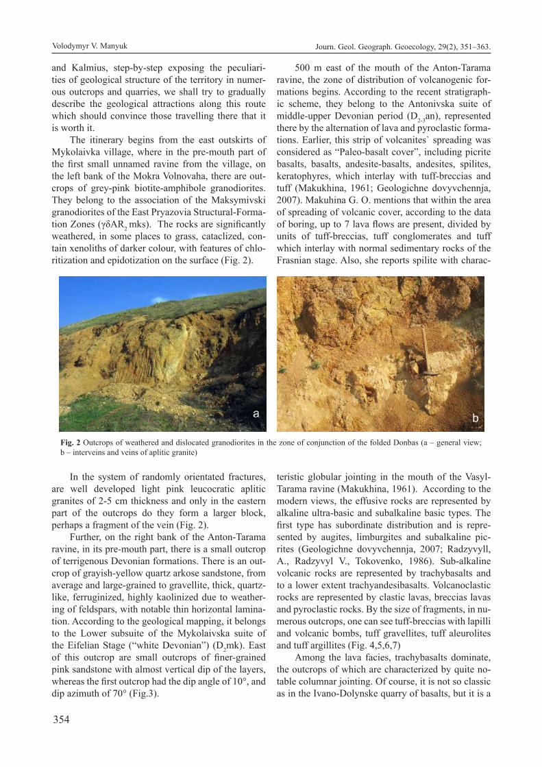
354
and Kalmius, step-by-step exposing the peculiari-ties of geological structure of the territory in numer-ous outcrops and quarries, we shall try to gradually describe the geological attractions along this route which should convince those travelling there that it is worth it.
The itinerary begins from the east outskirts of Mykolaivka village, where in the pre-mouth part of the first small unnamed ravine from the village, on the left bank of the Mokra Volnovaha, there are out-crops of grey-pink biotite-amphibole granodiorites. They belong to the association of the Maksymivski granodiorites of the East Pryazovia Structural-Forma-tion Zones (γδAR2 mks). The rocks are significantly weathered, in some places to grass, cataclized, con-tain xenoliths of darker colour, with features of chlo-ritization and epidotization on the surface (Fig. 2).
In the system of randomly orientated fractures, are well developed light pink leucocratic aplitic granites of 2-5 cm thickness and only in the eastern part of the outcrops do they form a larger block, perhaps a fragment of the vein (Fig. 2).
Further, on the right bank of the Anton-Tarama ravine, in its pre-mouth part, there is a small outcrop of terrigenous Devonian formations. There is an out-crop of grayish-yellow quartz arkose sandstone, from average and large-grained to gravellite, thick, quartz-like, ferruginized, highly kaolinized due to weather-ing of feldspars, with notable thin horizontal lamina-tion. According to the geological mapping, it belongs to the Lower subsuite of the Mykolaivska suite of the Eifelian Stage (“white Devonian”) (D2mk). East of this outcrop are small outcrops of finer-grained pink sandstone with almost vertical dip of the layers, whereas the first outcrop had the dip angle of 10°, and dip azimuth of 70° (Fig.3).
500 m east of the mouth of the Anton-Tarama ravine, the zone of distribution of volcanogenic for-mations begins. According to the recent stratigraph-ic scheme, they belong to the Antonivska suite of middle-upper Devonian period (D2-3an), represented there by the alternation of lava and pyroclastic forma-tions. Earlier, this strip of volcanites` spreading was considered as “Paleo-basalt cover”, including picrite basalts, basalts, andesite-basalts, andesites, spilites, keratophyres, which interlay with tuff-breccias and tuff (Makukhina, 1961; Geologіchne dovyvchennja, 2007). Makuhina G. O. mentions that within the area of spreading of volcanic cover, according to the data of boring, up to 7 lava flows are present, divided by units of tuff-breccias, tuff conglomerates and tuff which interlay with normal sedimentary rocks of the Frasnian stage. Also, she reports spilite with charac-
teristic globular jointing in the mouth of the Vasyl-Tarama ravine (Makukhina, 1961). According to the modern views, the effusive rocks are represented by alkaline ultra-basic and subalkaline basic types. The first type has subordinate distribution and is repre-sented by augites, limburgites and subalkaline pic-rites (Geologіchne dovyvchennja, 2007; Radzyvyll, A., Radzyvyl V., Tokovenko, 1986). Sub-alkaline volcanic rocks are represented by trachybasalts and to a lower extent trachyandesibasalts. Volcanoclastic rocks are represented by clastic lavas, breccias lavas and pyroclastic rocks. By the size of fragments, in nu-merous outcrops, one can see tuff-breccias with lapilli and volcanic bombs, tuff gravellites, tuff aleurolites and tuff argillites (Fig. 4,5,6,7)
Among the lava facies, trachybasalts dominate, the outcrops of which are characterized by quite no-table columnar jointing. Of course, it is not so classic as in the Ivano-Dolynske quarry of basalts, but it is a
Fig. 2 Outcrops of weathered and dislocated granodiorites in the zone of conjunction of the folded Donbas (a – general view; b – interveins and veins of aplitic granite)
Volodymyr V. Manyuk Journ. Geol. Geograph. Geoecology, 29(2), 351–363.

355
unique phenomenon for the folded Donbas. Massive cryptocrystalline and porphyritic types are common, rarer almond-shaped. Less distributed are augites and limburgites form lava flows of observable thickness of 1-22 m, which interlay with the currents of subal-
kaline effusive rocks. Quite often, one can see globu-lar jointing of basalts with the diameter of separate globes of up to 0.5 m (Fig. 6). The conditions of the embedding of the effusive rocks and peculiarities of their relations with other rocks of the cross-section
Fig. 3. Outcrops of polymictic sandstones of the middle Devonian Mykolaivska suite on the left slope of the Mokra Volnovaha river.
Fig. 6 Tuff argillite (Antonivska suite)
Fig. 4. Volcanic bomb from the layer of pyroclastic rocks Fig. 5. Tuff gravellite (Antonivska suite)
Fig. 7 Globular jointing of the basalts of the Antonivska suite
Volodymyr V. Manyuk Journ. Geol. Geograph. Geoecology, 29(2), 351–363.

356
of the subsuite indicate the simultaneity of their for-mation and horizon of tuff sedimentary (complex) breccia, limestones and their breccia, sandstones, argillites. Alternation of volcanic rocks and sedimen-tary rocks in the cross section of volcanic rocks, their variability, domination of ferrous iron over ferric iron indicates the formation of volcanites of the subsuite in the underwater conditions. An important evidence of this is the development of ferrous-chlorite oolites with concentrated ash content in tuff or breccias of similar compound.
Besides the covering basalts in the basin of the Mokra Volnovaha, dyke basalts are distributed, which by the compound are close to the covering basalts, but differ by better level of crystallization (Alokhin, Korchemagin, 2008). They are represented by fine-grained dolerites which earlier belonged to anames-ites. Shatalov M. M. identifies them to the Anton-Taramsky dyke belt (Shatalov, 2015).
The area of the distribution of the Antonivska suite (from the indicated border with the Mykolaivska suite to the western border of the Styla water reser-voir, where it borders with the rocks of the Dovhints-ka suite of the Upper Devonian rocks) is considered by V. V. Yudin as the largest mélange in Donbas – the Rozdolensky mélange (Fig. 8). He thinks that by the content of the clastolites it is a magmatogenic mixtite related to the detachment (decollement of the layers on the surface of the sedimentary dome) of northern sloping dip. The mélange pattern of the chaotic com-plex is indicated by the tectonic pattern of its border and hydrothermal ore manifestations in the matrix (Yudin, 2006).
Downstream, according to the data of geological mapping, the valley of the Mokra Volnovaha crosses a narrow strip of the distribution of the Dovhunska suite of the Frasnian stage of the Upper Devonian
period (D3dw), but terrigenous deposits of the suite in this area of the valley are overlaid and have small outcrops only in the area of the Rozdolne village. Moreover, its cross section represented by alternation of alevrolites, argillites, conglomerates and gravelites is exposed and studied layer by layer in the Dalny quarry below the place where the Mokra Volnovaha flows into its right tributary the Komyshuvaha.
Near the place where the Mokra Volhovaha flows into the Havaleis-Tarama (Buzynova) ravine, on the left bank of the Styla water reservoir there is a low rocky hill Maf Haia (or Chorna mountain accord-ing to the more recent sources) of volcanic origin. Together with cross section of carbonate limestones located near, it is a geological relic of nature of na-tional significance, taken under protection in 1975 (Alokhin, Volkova, 2011). On the slopes and in ad-jacent ravines, there are outcrops of terrigenous-effu-sive layer of the Rozdolnenska suite of the Famennian stage of the Upper Devonian period and terrigenous-carbonate formations of the Novotroitska suite of the Upper Devonian period. The Rozdolenska suite is represented by green and brown polymictic sand-stones, which interlay with argillites and aleurolites and contain high amount of pyroclastic material. East of the Maf Haia hill in the Havaleis-Tarama gully, 20-25 m below the top of the deposits of the Rozdolen-ska suite, there are outcrops of green jasper-like shists with numerous plant remains of Lepidodendropsis flora (Lepidodendropsishirmeri, L. cyclostigmatoides, L. vandergrachti). (Flora i fauna, 2020). (Fig. 9).
Higher in the ravine, arkosic sandstones with layers of argillites, aleurolites and low-lime sand-stones are exposed. In the head of the gully and further along the Mokra Volnovaha River, there were found fine-grained light gray limestones of the upper part of the Novotroitska suite of the Up-
Fig. 8. Tectonic scheme of the Northern Donbas (Yudin, 2006).
Volodymyr V. Manyuk Journ. Geol. Geograph. Geoecology, 29(2), 351–363.
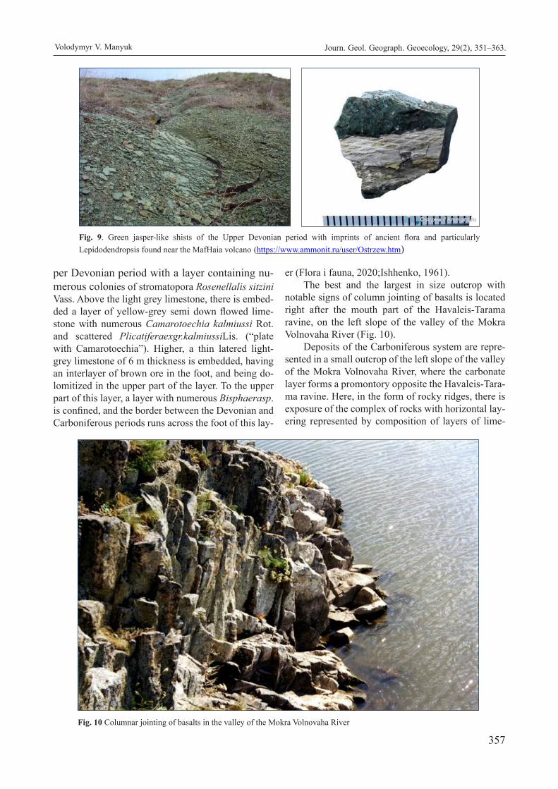
357
per Devonian period with a layer containing nu-merous colonies of stromatopora Rosenellalis sitzini Vass. Above the light grey limestone, there is embed-ded a layer of yellow-grey semi down flowed lime-stone with numerous Camarotoechia kalmiussi Rot. and scattered Plicatiferaexgr.kalmiussiLis. (“plate with Camarotoechia”). Higher, a thin latered light-grey limestone of 6 m thickness is embedded, having an interlayer of brown ore in the foot, and being do-lomitized in the upper part of the layer. To the upper part of this layer, a layer with numerous Bisphaerasp.is confined, and the border between the Devonian and Carboniferous periods runs across the foot of this lay-
er (Flora i fauna, 2020;Ishhenko, 1961).The best and the largest in size outcrop with
notable signs of column jointing of basalts is located right after the mouth part of the Havaleis-Tarama ravine, on the left slope of the valley of the Mokra Volnovaha River (Fig. 10).
Deposits of the Carboniferous system are repre-sented in a small outcrop of the left slope of the valley of the Mokra Volnovaha River, where the carbonate layer forms a promontory opposite the Havaleis-Tara-ma ravine. Here, in the form of rocky ridges, there is exposure of the complex of rocks with horizontal lay-ering represented by composition of layers of lime-
Fig. 9. Green jasper-like shists of the Upper Devonian period with imprints of ancient flora and particularly Lepidodendropsis found near the MafHaia volcano (https://www.ammonit.ru/user/Ostrzew.htm)
Fig. 10 Columnar jointing of basalts in the valley of the Mokra Volnovaha River
Volodymyr V. Manyuk Journ. Geol. Geograph. Geoecology, 29(2), 351–363.

358
stones, dolomitized limestones and dolomites (Fig. 10). They belong to the Volnovaska series on the di-vided Tournaisian and Visean stages. Often, remains of the fossil fauna are found, including Productus corrugatus M’Coy, Spirifermedius Leb., Ortotetesar-achoides Phill., Eomphalus pentangulatus Sow. and others (Geologicheskaja karta, 1961).
V. V. Yudin considers the strip of the distribution of the rocks of the Mokrovolhovaska series of the Tournaisian and Visean stages of carbon from the contact with Devonian rocks to Styla village as separate parts in the series of duplexes of Northern
Donbas (Fig. 7) and that it constitutes the continuation of the North-Dokuchaievsk mélange in the area of the Buzynova ravine and further to Styla village. The outcrops contain fractured and alkaline shists of the Visean stage with boulders- clastolith rocks below the limestones of the Visean stage and with fragments of the pre-overthrust folds. This is evidenced in the
manifestations of the pre-overthrust dislocations and clastoliths rocks in the mouth of the Havaleis-Tarama ravine (Fig. 12, 13).
Therefore, this allows the author to draw a con-clusion that by geological-structural data, the normal cross section or large masses of undisturbed rocks of the Mokrovolnovaska series of the Lower Carbon were not observed there in any way (Yudin, 2006).
The next attractive and informative object of the geological heritage is the Styla quarry which has not operated for about 9 years and is accessible for visits (Fig. 14).
During the revision monitoring of geological relics in 2003 it could not be visited, and therefore we present some its peculiarities from the study by Victor Yudin, which today is the most comprehensive. In the west wall of the quarry, one can see the tectonic type of the Styla mélange and its contact in the lower part of the wall with almost non-affected limestones of
Fig. 11. Exposure of limestones and dolomites of the Volnovaska suite of the Devonian period (Tournaisian-Visean stages) on the left slope of the Styla reservoir.
Fig. 12. Pre-overthrust fault dislocations with signs of disintegration and ferruginization in the Havaleis-Tarama ravine (Yudin, 2006)
Volodymyr V. Manyuk Journ. Geol. Geograph. Geoecology, 29(2), 351–363.

359
the Lower Carboniferous. In the boulders among the schistosity matrix, limestones and dolomites of the Visean stage are present. A distinctive peculiarity of the quarry is the subvertical dyke of trachyandesites, in the contact zones of which increased amounts of pyrite, marcasite and chalcopyrite were determined, which made the quarry well known among collectors of minerals. Apart from druses of pyrites, in different years, druses of dolomite, minerals of sanjuanite, fulgurite, almandine, quartz, etc have been found in the quarry. Very interesting are small cavities in the Tournaisian limestones and dolomites, filled with entire incrusted formations and pseudo-stalactites of hydrothermal pyrite. The photos show findings in the rocks of the Styla quarry by Evhen Naumenko (Fig. 15).
Therefore, in the Styla quarry, one can not only enjoy the geological attraction, but, if lucky, add to one’s collection. In carbonate layers, processes of the development of karst are seen and even quite large karst springs in one of the walls of the quarry (Yudin, 2006).
In the outcrops north of Styla village, a stratotype of the Stylska suite of the Lower Carbon period was determined. However, V. V. Yudin thinks that actually there is a lower, smaller part of the suite section. The rocks are disintegrated to jasper, highly ferruginized with formation of ferruginized boulders, with
interveins of chalcedony, small druses of quartz. The area of the valley of the Mokra Volnovaha
from the Styla village to the Rozdolne village remains so far unsurveyed by us due to lack of time during inventorisation of the geological heritage of Ukraine. Nonetheless, it is not less attractive or informative from the perspective of presence of natural and artificial outcrops on the route around the Kypucha, Krynytsia and Rodnykove villages and downstream. Below the place where the Komyshuvaha flows into the Mokra Volnovaha, on the right slope of the valley, the Dalny quarry is located, which was closed in 2014 and flooded. It is currently a great place for recreation and geological tourism (Fig. 16).
The real pearl of the geotouristic iteanary is the Rozdolensky Geological Reserve of National significance established in 1974 by the decision of the Council of Ministers of the Ukrainian SSR , covering an area of 100 ha. The main object of the Reserve is the Devonian volcanic structure, which is an elongated hill above the right bank of the Mokra Volnovaha River near the place where it falls into the Kalmius River and near Rozdolne village (Fig. 17).
In the northern part of the hill, the tectonic con-tact of granites and migmatites of the Antonivska suite of the Devonian period was determined. The lat-ter is an extremely complicated complex of the layers of pyroclastic rocks, volcanic (lava) and sedimentary
Fig. 13. Clastoliths of limestones of the Visean stage (С1v) in the ferruginized matrix of the North-Dokuchaievsk mélange (mouth of the Havaleis-Tarama ravine) (Yudin, 2006).
Volodymyr V. Manyuk Journ. Geol. Geograph. Geoecology, 29(2), 351–363.

360
terrigenous rocks. Among them, one can find volca-nomictous gravellites, sandstones and aleurolites; pi-crite, basalt and andesibasalt porphyritic rocks, light-green albitophyre, almond rocky basalts; limestones, clayey densed shists, etc. Particularly in the latter rocks, in far off 1894 I. O. Shmal’gauzen for the first time determined the unique Devonian flora of global significance in Velyka Karakuba village (Rozdolne). The village was founded in 1779 by the settlers from
Greece in accordance with the Treaty of Kuchuk-Kainarji. The flora determined by I. O. Shmal’gauzen included Archaeopteris archaetypus Schm., Archae-opteris Fissilis Schm., Lepidodendron karakubense Schm., Demeripteris fasciculate Schm. Therefore, this discovery of trees from the most ancient times of the Earth could alone be sufficient reason for the recognition of the Rozdolensky Reserve as an ob-ject of global significance. The famous discovery of
Fig. 16 Flooded Dalny quarry (https://webmineral.ru/deposits/item.php?id=2343
Volodymyr V. Manyuk Journ. Geol. Geograph. Geoecology, 29(2), 351–363.
Fig. 15. Minerals of the Styla quarry from the collection of Naumenko Y. (https://webmineral.ru/deposits/item.php?id=274)
Fig. 14. The Styla quarry for extraction of flux limestones and dolomites

361
the Earth’s oldest known forest in Cairo (New York, USA) is at least of the same age, or even younger. The absolute age of the Archaeopteris in Cairo, according to the data of the Current Biology Journal, 386 M years, is the Givetian stage, when the formation of the volcanic-sedimentary layer of the Rozdolensky vol-cano took place (Uchjonye nashli, 2020). Fragments of fossil trees which even today could be found on the slopes of the volcano are not that representative as in New York, but the fact of their discovery is extremely important (Trypilska, 1958).Conclusions. The data about the geological component of the itinerary in the valley of the Mokra Volnovaha River are not determined entirely, insufficient, and also obviously require further studies. Furthermore, the significance of this territory of distribution of Devonian and Carboniferous deposits in the basin of the Volnovaha and Kalmius is increased because of the numerous rare and collactable minerals, fossil fauna and flora. Selection of samples must obviously be regulated, limited, and for some of them completely restricted, as in any protected territories. In different years, in the outcrops and quarries of this territory, findings have included crystals and druses of amethyst, smoky quartz, quartz, druses of pyrite, pseudomorphoses on corals, chalcedony, pseudo-stalactites with marcasite, small agates, pink quartz, sanjuanite, fulgurite and others. Regarding the perspective of creating a geopark, the considerable geodiversity of the territory could be well supported by the large biodiversity. In the valleys of the rivers and adjoining slopes of the Volnovaha, Kalmius and their tributaries, there are well preserved picturesque
steppe landscapes with large number of rare and endangered species of plants and animals. The territory adjacent to the future geopark has possibilities for the development of the cultural-educational, religious and pilgrimage tourisms. For example, in Nikolske village, the Ukraine`s largest monastery with a large temple complex is located.
References
Alokhin, V.I., Korchemagin, V.A.,2008. Polja naprjazhenij I deformacij subvulkanicheskih tel I daek perm’-triasovogo vozrasta Priazovskogo bloka UShh i ego sochlenenija s Donbassom. [Fields of stresses and deformations of subvolcanic bodies and dikes of thePermian-Triassic age of the Priazovsky block of the Ukrainian Shield and its articulation with the Donbass]. Tectonophysics and topical is-sues of Earth sciences. On the 40th anniversary of the creation of M.V. Gzovskyi laboratory ofTec-tonophysics in the IPE RAS, V.1, Moskow, 197-199(In Russian).
Alokhin, V.I., Volkova, T.P., 2011. Znachenie, sostojanie I perspektivy razvitija geologicheskih pamjatnikov Doneckoj oblasti.[Importance, condition and de-velopment prospects of geological monuments of Donetsk region].Geological monuments - vivid evidence of the Evolution of the Earth.Collection of materials ІІ science-practical conference. Kiev, Logos, 10-12(In Russian).
Domger, V. A., 1881. Kratkij ocherk istorii geologii Do-neckogo kamennougol’nogo bassejna. [A brief outline of the history of geology of the Donetsk
Volodymyr V. Manyuk Journ. Geol. Geograph. Geoecology, 29(2), 351–363.
Fig. 17. Picturesque landscape near the place where the Mokra Volnovaha falls into the Kalmius River

362
coal basin]. Kharkov: type. K.P. Schasni, 142 p., Addendum to the journal. “South.Russian. Moun-tain Leaf.”(In Russian).
Flora i fauna famenskogo jarusa v s. Styla. Donpaleo. Devonskij paleovulkan. Pogranichnye otlozhenija devona i karbona. 2020. [Flora and fauna of the Famennian stag ein Styla village. Donpaleo. Devonian paleovolcano. Boundary deposits of the Devonian and Carboniferous.Retrieved from:http:/ /www.donpaleo.ru/D/styla/(In Russian).
Geologicheskaja karta SSSR masshtaba 1:200000. Serija Donbasskaja, list L-37-ІІ. 1961. [Geological map of the USSR on a scale of 1: 200000. Series Donbass, sheet L-37-ІІ]. Explanatory note. Gosnauktekhizdat, Moscow, 15-25(InRussian).
Geologіchne dovivchennja ploshh masshtabu 1:200 000 pіvdennihpolovinarkushіv L-37-II (Donec’k), L-37-III (Іlovajs’k) v mezhah Ukraїni ta arkushіv L-37-VIII (Marіupol’) і L-37-IX (Taganrog) v mezhah Ukraїni za vinjatkom akvatorії Azovs’kogo morja (Shіdnopriazovs’kaploshha). 2007. [Geologica lsurvey of areas of scale 1: 200 000 southern parts of sheets L-37-II (Donetsk), L-37-III (Ilovaysk) within Ukraine and sheets L-37-VIII (Mariupol) and L-37-IX (Taganrog) within Ukraine except the water area of the Azov Sea (EastPriazovskaya Square)]. 2007. Volnova-ha, 334 p (In Ukrainian).
Gmelin, S. G., 1768. Reise von St. Petersburg bißnachTscherkask, der Haupstadt der Donisch-enKosacken in den jahren 1768 und 1769.182 p., 34 gef.Bl., Ill, 334 p.
Grytsenko, V.V., 2004. Geoparky novyj naprjamok zapovidnoi’ spravy v Ukrai’ni. [Geoparks a new direction of nature conservation in Ukraine.] Nature diversity of Khmelnytsky region. Collection of articles on materials of the All-Ukrainian scientific-practical conference “Landscape and biological diversity of Khmelnytsky region: research, conservation and reproduction”; Kamianets-Podilskyi, December 17-18, 2003. Kamianets-Podilskyi: Nova ABC, 151-158 (In Ukrainian).
Guldenstadt, J. A., 1791. Reise durch Russland und im Gaucasischen Gebirge, auf Befehl der Kuss. Kays. Ak. d. Wissensch, 511 p.
Heolohyia SSSR. Donetskyibassein. 1944. [Geology of the USSR. Donetsk basin]. V.VII, M.-L., 21-29 (In Russian).
Ishhenko, T.A., 1961. Lepiodendropsisovaja florana juzhnoj okraine Donbassa. [Lepidodendropsis flora on the southern outskirts of Donbass]. Paleontol. Journal., 3(In Russian).
Ivanytskyi, A.B., 1833. Geognosticheskoe opisanie Mariupol’skogo okruga. [Geognostic description of Mariupol district]. Mountain Journal, 10, 49-90(In Russian).
Kravchuk, Ja., Zin’ko, Ju., Homyn, A., Shevchuk, O.,
2012. Proektovanyj geopark “Vulkanichni Kar-paty” [Geopark “Volcanic Carpathians” designed Visnyk of Lviv University.] Geography Series. Issue 40, Part 2. 30–43 (In Ukrainian).
Judin, V.V., 2006. Tektonika Juzhnogo Donbassa I rudo-genez.Monograph. [Tectonics of the South Don-bass and ore genesis]. Kiev, UkrGRI, 108 p. (In Russian).
Klemm, M., 1874. Otchet o geologicheskih issledovani-jah na ploshhadi mezhdu Samaroju, Dneprom, Konkoju, Kal’miusom I Torcom. [Report on geological research on the area between Samara, Dnieper, Konka, Kalmius and Toretst].Proceed-ings Kharkiv Society of Naturalists, vol. VIII (In Russian).
Klemm, M., 1877. Issledovanija nad kristallicheskimi porodami mezhdu rr. Dneprom I Kal’miusom. [Studies on crystalline rocks between Dnieper and Kalmius rivers]. Proceedings Kharkiv Society of Naturalists, vol. X, 22. (In Russian).
Le-Play, F., 1842. Exploration des terrains carboniferes du Donetzexecutee de 1837 a 1839 sous la direction de M. A. Demidoff. Voyage dans la Russiemeri-dionaleet la Crimee sous la direction de M. Ana-tole de Demidoff. Paris. V. IV.
Machulina, S. O., Kvasnytsia, I. V., Halaburda, Yu. A., 2006. Novi dani pro krystalomorfolohiiu pirytu iz karbonatnykh pored Stylskoho kareru pivdenno-zakhidnoi chastyny Donbasu. [New data on crys-talline morphology of pyrite from the carbonate rocks of the Stilsky Quarry in the southwestern part of the Donbass]. Reports of Nat. Academy of Sciences of Ukraine, 10, 128-131 (In Ukrainian).
Machulina, S., Shemiakina, T., Kvasnytsia, V., 2007. Ksenokrystaly khromshpinelidu y almandyn-piropu iz daiky trakhi-andezytovoho porfirytu v Stylskomu karieri (Prazovia). [Xenocrystals of chrompinelide-andalmandine-pyrope from the trachyte and andesitic porphyrite dike in the Styrian Quarry]. Geologist of Ukraine. 3, 28-34 (In Ukrainian).
Machulyna, S., 2007. Nakhodka redkykh stalaktytovykh y stalahmytovykh form pyryta v Donbasse.[Finding of rare stalactite and stalagmite pyrite forms in the Donbass]. Geologist of Ukraine.1, 86-87 (In Rus-sian).
Makukhina, H.O., 1961. Petrohrafiia daikovo-efuzyvnoho kompleksu pivdenno-zakhidnoho Donbasu. [Petrography of the dyke-effusive complex of southwest Donbass]. USSR Academy of Sciences, 213-214 (In Ukrainian).
Manyuk, V., 2006. Potential objects for creation of a network national geopakrs in Ukraine. Volume of abstracts: ProGEO Symposium “Safeguarding our Geological Heritage”. Kyiv, Kamianets-Podil’sky, 2006, 30–32.
Manyuk, V., 2007. The problem of creation of Network National Geoparks in Ukraine. Dnipropetrovsk, DNU Bulletin, 63-67.
Volodymyr V. Manyuk Journ. Geol. Geograph. Geoecology, 29(2), 351–363.

363
Manyuk, V., 2008a. The problem of creation of a Network National Geoparks in Ukraine. Proceeding 33 th International Geological Congress, Norway, Oslo, 6-14 August, 2008.
Morozevich, Ju.A., 1898. Geologicheskie issledovanija, proizvedennye v Mariupol’skom uezde letom 1898. [Geological studies carried out in the Mariupol district in the summer of 1898]. Proceedings of the Geological Committee. St. Petersburg. V. XVII, 6, 287-295 (In Russian).
Murray, Gray, 2013. Geodiversity: Valuing and Conserving Abiotic Nature.2nd Edition.Willay-Blackwell, 508 p.
Muгchisоn, Pr. I., 1845. The Geology of Russia in Europe and the Ural mountains. V.1, Geology, 700 p.
Ormont, N.P., 1956. Pirokseny bazal’tovyh porod bassejna r. Mokraja Volnovaha i raspredelenie zheleza v jetih porodah. [Pyroxenes of basalt rocks of the river basin Mokra Volnovakha and the distribution of iron in these rocks].Bulletin of Moskow Uni-versity, 1, 42-65(In Russian).
Pallas, P.S., 1773. Reisedurchver-schiedene Provinzen des russischen Reichs.Th. 1—3, 371 p.
Radzyvyll, A.Ya., Radzyvyl, V.Ya., Tokovenko, B.C., 1986. Tektono-mahmatycheskye struktury neoheia: Rehyonalnaia tektonyka Ukrainy. [Tectonic-magmatic structures of the Neogei: Regional tectonics of Ukraine]. Kiev, 39-40 (In Russian).
Rotai, A.P., 1934. Geologicheskie raboty v Doneckom bassejne letom 1928—29. [Geological work in the Donetsk basin in the summer of 1928-29]. Proceedings of the All-Union Geological Exploration Association, V. 356 (In Russian).
Shatalov, N.N., 1986. Daiky Pryazovia. [Dikes of the Pri-azovia]. Kiev, Naukova Dumka. 192 p.(In Rus-sian).
Shevchuk, O., 2010. Jevropejs’ki geoparky: zberezhennja geospadshhyny i rozvytok geoturyzmu. [European geoparks: conservation of the geo-heritage and the development of geotourism.] Scientific notes of Ternopil National Pedagogical University. Series: Geography. Spec. Issue: Sustainable
Environmental Management: Approaches, Issues, Prospects. – Ternopil, 1 (Issue 27), 369-378. (In Ukrainian).
Shmal’gauzen, I. F., 1894. O devonskih rastenijah Do-neckogo kamennougol’nogo bassejna. [On the Devonian plants of the Donetsk coal basin]. Pro-ceedings of Geol. com., vol. VIII, 3, 43 - 52.(In Russian).
Stylskyikarer, Stylaposiolok, Yuzhnyi Donbass, Donetskaia oblast, Ukraina. 2020. [Stylskyi quarry, Stylasettlement, SouthDonbass, Donetsk region, Ukraine].Retrieved from: https://webmineral.ru/deposits/item.php?id=274 (In Russian).
Trypilska, M.I., 1958. Heolohichna budova zony zchlenuvannia Donetskoho kriazhu z Pryazovskym krystalichnym masyvom. [The geological structure of the articulation zone of the Donetsk Ridgewith the AzovCrystal Massif]. ASUkr. SSR, Kiev, 12-15. (In Ukrainian).
Uchjonye nashli drevnejshij iskopaemyj les na planete. 2020. [Scientists have found the oldest fossil forest on the planet]. Retrieved from: https://no-vostipmr.com/ru/news/19-12-23/uchenye-nash-li-drevneyshiy-iskopaemyy-les-na-planete (In Russian).
Yudin, V.V., Artemenko, V.M., 1996. Nova zbalansovana model SkladchastohoDonbasu. Suchasnyi metalohenichnyi prohnoz. [New balanced model of the Folded Donbass. Modern metallogenic forecast]. Mineral resources of Ukraine. 2, 14-16. (In Ukrainian).
Yudin, V.V., 2004. Shariazhnoe stroenye Yuzhnoho Don-bassa. [The overthrusted structure of the South Donbass]. Collection of scientific works of UkrS-GPI, scientific journal.2,108-115.(In Russian).
Yudin, V.V., 2006. TektonykaYuzhnoho Donbasa y rudo-henez. [Tectonics of the South Donbas and ore genesis]. Monograph. UkrSGPI, 108р.
Zinko, Ju. V., Shevchuk, O.M. 2011. Proektovani geoparky Zahidnoi’ Ukrai’ny. [Projected geopa-rks of Western Ukraine]. Physical geography and geomorphology. Kyiv, VGL “Obrii”, Issue. 3 (64), 41–55.
Volodymyr V. Manyuk Journ. Geol. Geograph. Geoecology, 29(2), 351–363.

364
Murals as the newest tourist resources: the case of Kyiv
Yulia A. Olishevska
Taras Shevchenko National University of Kyiv, Kyiv, Ukraine, [email protected]
Abstract. The relevance of studying the murals is that the murals allow to diversify the tourist offer of the capital. The purpose of this publication is to analize the development of the murals and the opportunity of using them as a new type of tourism resource. One of the subjects of the study is to carry out a retrospective analysis of the existing collection of Kyiv’s murals and to substantiate their use in the organization of excursion routes in order
to inform tourists. During the study of the murals, the creation of the route allows to track the change in the image of the urban envi-ronment under the influence of street art. In the process of researching the murals as a tourist resources of cities, we have introduced the term “conceptual tourist resources”, which in our opinion most accurately reflects their semantic charge. Murals are the alternative resources towards traditional tourism resources (natural, historical, cultural, socio-economical or socio-historical) that are widely used in the classifications of leading researchers in the tourism industry (Kvartal’nov V., Smal’ I., Beidyk O., Mal’s’ka M., Kuzyk S., Liubit-seva O., Pankova Ye., Stafiichuk V., etc.). The study identified the 32 biggest murals in Kyiv and found that the murals are the relevant forms of street art that focuses on social, cultural, and historical topics. Mural paintings have been found to be motivating objects to visit and affect the formation of city’s new symbols. In the route we have developed, we have selected 24 representative murals made in different styles, dedicated to several topics: milestones of Ukrainian history, the fight between good and evil, friendship and devotion, freedom and equality. Thus, the involvement of murals in excursion routes allows residents and guests of the capital city to track the change in the image of the urban environment under the influence of street art. In the course of the study, it was found that murals are ambiguously perceived in society. The analysis showed that the appearance of modern murals on the streets of the capital began in the mid-2000s, a sharp increase in their number occurred during 2015 - 2017. It was determined that the main factors that influenced the development of muralism in Ukraine were the demands of society and the organization of art festivals, including Muralissimo, City Art, Dynamic Urban Culture Kyiv, Mural Social Club, Art United Us, Mural Social Club Back to school! Ukraine, French Spring, etc. The largest art festivals include City Art 2015, Dynamic Urban Culture Kyiv 2015, Mural Social Club 2016, 2017, Art United Us 2016, 2017, within which 88 works were created. The results of the study identified the trend in the development of muralism in Ukraine, which consists of the gradual change from spontaneous, anonymous street art to the development of concerted and commissioned by state bodies paintings, which are spread not only on the walls of industrial sites, residential buildings, but also on the walls of educa-tional institutions, government institutions and the police department. Kyiv is the first city in the world where a mural was created on the walls of the police department. The study found that since the mid-2010, the murals began to establish in the central part of the city, and since 2014 they have spread to the so-called “gray” residential areas of Sviatoshyno, Darnytskyi, Desnyanskiy and Solomianskyi districts and Obolon’, etc. Today, the total number of murals in the capital is 160.
Keywords: mural, urban habitat, tourism, tourist resources, street-art
Мурали як новітні туристичні ресуриси (на прикладі міста Києва)
Ю.А. Олішевська
Київський національний університет імені Тараса Шевченка, Київ, Україна, [email protected]
Анотація. Поряд із загальноприйнятими туристичними ресурсами інтенсивно відбувається пошук альтернативних, до яких належать сучасні арт-об’єкти, зокрема мурали, що дозволяють урізноманітнити туристичну пропозицію. Об’єктом дослідження є мурали міста Києва. На сьогодні мурали викликають протиріччя у наукових колах та є виявом емоційних настроїв. Метою дослідження є характеристика розвитку муралів та можливість їх використання як альтернативного виду туристичних ресурсів. Основне завдання роботи – ретроспективний аналіз муралів Києва та обґрунтування їх використання для організації пізнавального туризму на основі розробленого екскурсійного маршруту, що дозволяє прослідкувати зміну образу міського середовища під впливом стріт-арту. Ретроспективний аналіз муралів міста Києва дозволив встановити, що поява сучасних муралів на вулицях столиці розпочалася з середини 2000-х років, різке зростання кількості муралів у Києві відбулося у період з 2015 по 2017 рр. Визначено, що головним чинником, який зумовив розвиток муралізму в Україн, стали
Yulia A. Olishevska Journ. Geol. Geograph. Geoecology, 29(2), 364–376.
Journal of Geology, Geography and
Geoecology
Journal home page: geology-dnu-dp.ua
ISSN 2617-2909 (print)ISSN 2617-2119 (online)
Journ. Geol. Geograph.Geology,
29(2), 364–376.doi: 10.15421/112032
Received: 03.12.2019Received in revised form: 19.11.2019Accepted: 17.01.2020

365
мистецькі проекти, організовані з середини 2010 року. Найбільш масштабні арт-фестивалі, організовані в Україні це Mu-ralissimo, City Art, Dynamic Urban Culture Kyiv, Mural Social Club, Art United Us, Mural Social Club Back to school! Ukraine. З усього різноманіття стінописів можна виділити мурали, створені у вигляді портретів відомих людей та діячів культури і мистецтва; присвячені актуальним проблемам людства: екологічній, боротьбі за свободу, рівність, любов, вмінню цінити людські стосунки та внутрішній світ кожного, умінню мріяти та цінувати життя і т. д. Художня креативність митців вуличного мистецтва змінює сучасний образ міст. Візуалізація соціально значущих проблем стає своєрідною візитівкою не лише столиці, але й інших українських міст.
Ключові слова: мурал, стріт-арт, туризм, туристичні ресурси, місто
Introduction. Nowadays, the forms of tourism re-sources are being diversified. Along with the com-mon cultural, historical, natural, socio- economical resources, there is an intensive search for alternative resources for the diversification of tourist proposal. Some of these resources include various festivals, per-formances, modern art objects, in particular, murals.
Street art is often identified with graffiti, which may be considered as the origin of this art form. However, street art today covers much more varieties: graffiti, murals, mosaics, LED art, etc. The main feature of street art is content rather than form. The works of street art may be individual inscriptions or artists’ initials, or they may have large sizes, such for example, as wall paintings called murals. Over the recent years, new applications are found for street art objects as alternative tourism resources.
Murals and street art itself mainly cause contradictory reactions in society and academia. Part of society treat them as works of art (Tylik, 2016), others as a spontaneous process of emotional manifestation. In particular, this opinion is shared by (Hrytsiuk, 2018), pointing to the origin of the first murals in Mexico as propaganda leaflets created by activists in the form of wall paintings in 1910-1917. Diego Rivera, David Alfaro Siqueiros, Jose Orozco, who are now considered to be muralism classics, created at that time.
It is impossible to imagine modern cities without murals. In Western Europe, muralism flourished in the 1980s, and it is now in its prime in Eastern Europe. Artists from different parts of the world actively paint Polish, Ukrainian, Slovak and Romanian buildings. While street art was in temporary decline in America in the 1980s, this movement started spreading almost in all European countries. The Berlin Wall became one of the largest art canvases in Europe. The Western side of the wall was all painted by German and international artists in the ’80s with most of the works having political and social implications (Bodnar, 2016), while the other side remained empty. Now there are several Ukrainian murals that are candidates for the largest ones in Europe. In January 2019, a series of murals with a total area of 560 sq.m. were created by Ukrainian artists at the “KLO” gas stations
in Velyka Okruzhna street; they are candidates for the largest mural created at a gas station. Another large-scale project was created in 2016 on the wall of a 26-story building at the address: Maiakovskyy avenue, building 1v. The author is an Italian artist working under the pseudonym “2501”. The main focus of the work is the encoded word “liberty”.
Scientific sources mostly study historical aspects of the emergence and development of murals (Gastman, Neelon, 2011, Ganz, 2011, Bacharach 2015, Bodnar, 2016, Topol, 2016) and the influence of graffiti and murals on contemporary culture and art (Nguyen, Мackenzie, 2010, Shtep, 2010, Waclawek, 2011, Kuzova, 2015, Tylik, 2016, Havrylash, 2018. Havryliuk, 2018, Guinard, Margier, 2018, etc.); only few studies examine the influence of street art on the image of a city (Riggle, 2010, Moldoveanu, Franc, 2014, Omar, Sakip, Akhir, 2016, Guinard, Margier, 2018). Besides, there are discussions concerning the differentiation between the notions of street art, public art, monumental art, etc. (Bacharach 2015, Pilikin, 2018, Havrylash, 2018). The issue of using murals in tourism is understudied. However, there are examples of creating catalogues of street art works both for individual countries and individual artists (Shakter, 2018).
In Ukraine, the main source of information about the creation of new murals in different cities are messages in mass media, in particular, in TSN and “Vechirnii Kyiv” news outlets, an interactive map of Kyiv murals and the e-resource of the ZeFt.in.ua website; however, the scientific community does not pay enough attention to the study of murals and their use as tourism resources. Individual articles and media messages are mostly related to art projects Muralissimo, French Spring, Dynamic Urban Culture Kyiv, Mural Social Club, Best Street Art 2017, Mural Social Club. Back to school! Ukraine etc. It can be stated that nowadays the issue of street art development and the use of modern art objects in tourism is underexposed in the scientific literature, which contributes to the relevance of the present research.The aim of the study is to describe mural development process and the potential of using murals as a new type of tourism resources.
Yulia A. Olishevska Journ. Geol. Geograph. Geoecology, 29(2), 364–376.

366
The main objective of the study is to conduct retrospective analysis of Kyiv murals and justify their use for the organization of educational tourism based on the designed excursion itinerary that would trace changes in the urban environment under the influence of street art.
Murals are alternative resources related to traditional tourism resources (natural, historical, cultural, socio-economical or socio-historical) which are commonly used in the classifications of prominent tourism researchers (Kvartal’nov І, Smal’ І, Beidyk О, Mal’s’ka М, Kuzyk S, Liubitseva О, Pankova Ye, Stafiichuk V., etc.). The complexity is also due to the varied perception of murals in society and in the scientific community. Up to now, there is a scientific discussion concerning the definition of the notions of street art, monumental art, etc., which complicated the process of the identification of mural as a separate art form and its differentiation as a tourism resource. We believe that it is worth using murals as new alternative attractions during city excursions.
Thus, the use of such objects complements the existing classifications of tourism resources. It is reasonable to ascribe murals to conceptual resources, which best reflects their essence. Disputable issues concerning the differentiation between the notions of street art, monumental art, public art and mural proper cannot influence the fact that murals do exist and their number in the world and in Ukraine is increasing every year.Materials and methods. Research on murals is mainly situated in the culturological plane, and there have not been many studies of murals from the geographical perspectives; therefore, in this study we operate the retrospective analysis toolkit and the method of Kyiv mural inventory by using an information resource, an interactive map of Kyiv, the ZeFt website of Ukraine’s landmarks, and Ukrainian online mass media (ukrinform, tsn.ua, kiev.informator, vechirnij.kyiv, ukranews).
The informational resource of this study is the collection of street art works created between 2010 and 2019. The collection of murals includes 160 works. This study used retrospective analysis of the history of graffiti and murals in the world and in Ukraine based on (Gastman, Neelon, 2011, Nguyen, Mackenzie, 2010, Ganz 2011, Alden, 2010, Bodnar, 2016, Kuzova, 2015, Havrylash, 2018).
In this study, we have analyzed art festivals and art projects that promote the development of modern muralism in Ukraine and, in particular, in the capital, and have found that one of the first art festivals held in the capital was Muralissimo timed to EURO 2012
football championship. Within the art festival that lasted from October 2010 to October 2011, some of the first Kyiv murals were created; they had bright colors and no proper names. The main idea of the project was to create vivid pieces of art that would liven up the capital. In total, 7 works, which are listed in Table 1, were created during the art festival.
Over the next years, the following art projects were organized: French Spring (2013), City Art (2015), Mural Social Club (2016), Art United Us (2016, 2017), Mural Social Club. Back to school! Ukraine 2017 and French Art 2019. Between 2014 and 2018, a series of murals were created within various art projects. In particular, these include the following: City Art Festival in 2015 – 13 works created, Dynamic Urban Culture Kyiv (2015) – 10 works, Mural Social Club 2016 – 16 works, Art United Us in 2016 – 27 works and Art United Us in 2017 – 11 works, respectively, Mural Social Club. Back to school! Ukraine 2017 – 4 works, French Spring 2019 – 1 mural.
As of 2019, there are 160 murals in Kyiv created by more than 35 artists from different countries. Most of the murals are in the city center, but there are some in all city districts.
There are murals created in the form of famous people’s and artists’ portraits and those dedicated to relevant global matters: environmental issues, fight for freedom, equality, love, appreciation of human relationships and everybody’s inner world, ability to dream and appreciate life, etc. The issue of mural identification as tourism resources has been studied based on the findings of tourism studies, theoretical and methodological consideration (Liubitseva, Pankova, Stafiichuk, 2007, Kuzyk, 2010, Smal’, 2010, Mal’s’ka, 2012, Kvartal’nov, 2002, 2003), etc.Results and analysis. Murals are pieces of monumental painting that are most frequently created on house walls and less frequently on the walls or roofs of industrial buildings or fencing.
The Ukrainian tradition of painting house walls with different ornaments, flowers and animals has national origins. The traditional Ukrainian 18th-century village was notable for brightly painted huts. Obviously, modern street art objects go far beyond traditional art, but they more often cause admiration than disapproval among the public. Some bright works with attractive images of animals or fairy-tale characters can raise the mood and diversify old city yards, add colors and contribute to a positive impression from the surroundings.
In many people’s opinion, muralism emerged in the ancient times and is associated with the creation of first paintings. However, modern murals on
Yulia A. Olishevska Journ. Geol. Geograph. Geoecology, 29(2), 364–376.

367
residential houses and even on educational institutions have somewhat different features. The emergence of graffiti and murals was due to the appearance of images or inscriptions by an unknown author. Graffiti and muralism were flourishing in the 1970s–80s. Nicolas Riggle (2010) calls the 1970s the “rock-n-roll years of visual art”.
Graffiti (from Greek grapho – means “I write”) are words or texts scribbled with a sharp object or painted on stone, wood or brick. Modern graffiti mainly include chaotic inscriptions, caricatures, unintelligible images that can figure out by artists who are engaged in their creation. This type of street art cannot be a decoration of the urban environment and rather serves as a certain challenge to society. In Ukraine, there are different types of graffiti: tags, artistic works and stenciled paintings. Graffiti are mostly percepted extremely negatively by society and do not concern our research subject. Architects often consider graffiti to be vandalic and illegal. Murals, if created without prior approval of location and theme and without agreement with the owners of building, on whose walls they are then created, are mainly treated negatively, too.
“Mural” is translated as “wall” from Spanish. Modern murals can be created using any technique and various materials. It should be noted that a type of monumental art called mosaic became widely spread in the 1960s-70s. In Ukraine, walls of houses, educational institutions and hospitals were commonly decorated with mosaic pictures. Examples include mosaics “Water is the Source of Life” in Bortnychi (34 Kharchenko St.), “Movement” on the wall of “Nauka” sports center swimming pool (32 Akademik Vernadskyy Blvd.), “Victory” on the wall of the administrative building of the National Cancer Institute (33 Lomonosova St.), mosaic “Kyi, Shchek, Khoryv and Lybid” (1 Myropolska St.), “The Triumph of Cyberneticists” on the wall of the building 6 of Glushkov Institute of Cybernetics of the National Academy of Sciences of Ukraine, etc.
Some murals in Kyiv created by the Ukrainian street artist Kostiantyn Stretutskyi also adopt the mosaic technique. These include the mosaic mural “Happy Childhood” on the crossroads of Striletska and Stritenska Streets depicting 8 child portraits (this work was one of the first that was created in the capital in 2010), the mural “Mosaic” created in 2015 at 23 Velyka Zhytomyrska St., and the mosaic mural “Chatting Dinosaur” at 118 Saksahanskyy St. in 2017. Thus, various modern street art objects, such as graffiti, murals and installations, have been appearing in Ukraine since the mid-2000s, but there is still
no established definition of the notion of street art. Currently, there is a scientific discussion concerning the definition of the street art phenomenon and distinction between the notions of street art and urban art (Tylik, 2016, Grytsiuk, 2018, Havrylash, 2018, etc.). Street art (Ponosov, 2016) covers material art in the form of graffiti, installations, sculptures, murals and procedural practices (action, performance). He emphasizes that street art should only include creative projects and practices that interact with space and express the conceptualization of street processes and systems and not only use the city as media space. Some researchers suggest that the term of urban art should represent a general notion that includes various objects, projects and practices created in the urban space without distinctions by ideological, esthetic or technical aspects (Street-art aesthetics, 2018). The term of public art is close to urban art and means art in public space.
According to (Havrylash, 2018), typical features of murals are their plot character of composition and complicated technique. As a rule, they cover the entire wall surface and are created with the permission of municipal authorities and sometimes even to their order. Muralism is a type of modern socially oriented art shaping the urban environment. However, wall paintings are not always treated as pieces of art, but rather as a challenge to society and sometimes even as an act of vandalism. As a rule, works of art are exhibited in picture galleries and museums and are traditionally considred as world culture heritage. It can be said that they tend towards the elitist space (galleries, museums). Murals cardinally differ from paintings in terms of artistic value, technique and size. The author of street art works often remains unknown. Street artists seek to convey their ideas to society without intermediaries or spatial obstacles and not limit themselves to gallery spaces. World famous paintings are exhibited to tourists and incite strong interest in society. Most of street art works have not reached this level of recognition, so it is not correct to describe them as this type of tourism resources. Up to now, there is no unified definition of the notions of street art, monumental art, etc., which makes it more difficult to identify murals as a form of art and distinguish it as a tourism resource.
According to the Law of Ukraine “On Tourism” dated 15.09.1995, “tourism resources are tourism offers that are or can be proposed on the basis of or using state, municipal or private property.” The currently applicable classifications of tourism resources most often distinguish between: natural tourism resources and socio-economical,
Yulia A. Olishevska Journ. Geol. Geograph. Geoecology, 29(2), 364–376.
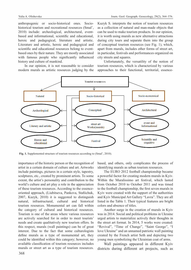
368
anthropogenic or socio-historical ones. Socio-historical tourism and recreational resources (Smal’, 2010) include: archeological, architectural, event-based and informational, scientific and educational, heroic and pedagogical, literature and artistic. Literature and artistic, heroic and pedagogical and scientific and educational resources belong to event-based ones by their nature. They are mostly associated with famous people who significantly influenced history and culture of mankind.
In our opinion, it is not reasonable to consider modern murals as artistic resources judging by the
importance of the historic person or the recognition of artist in a certain domain of culture and art. Artworks include paintings, pictures in a certain style, tapestry, sculptures, etc., created by prominent artists. To some extent, the artist’s personality and contribution to the world’s culture and art play a role in the appreciation of these tourism resources. According to the essence-oriented approach, (Liubitseva, Pankova, Stafiichuk, 2007, Kuzyk, 2010) it is suggested to distinguish natural, infrastructural, cultural and historical tourism resources. Monumental art can fall within the category of cultural and historical resources. Tourism is one of the areas where various resources are actively searched for in order to meet tourists’ needs and create qualitatively new tourism offers. In this respect, murals (wall paintings) can be of great interest. Due to the fact that some culturologists define murals as a type of monumental art, they could be identified within this category; however, no available classification of tourism resources includes murals or street art as a type of tourism resources.
Kuzyk S. interprets the notion of tourism resources as a collection of natural and man-made objects that can be used to make tourism products. In our opinion, it is worth using murals as new alternative attractions during city tours and separate them into the group of conceptual tourism resources (see Fig. 1), which, apart from murals, includes other forms of street art, in particular, festivals and performances organized on city streets and squares.
Unfortunately, the versatility of the notion of tourism resources, which is characterized by various approaches to their functional, territorial, essence-
based, and others, only complicates the process of identifying murals as urban tourism resources.
The EURO 2012 football championship became a powerful factor for creating modern murals in Kyiv. Within the Muralissimo art festival, which lasted from October 2010 to October 2011 and was timed to the football championship, the first seven murals in Kyiv were created with the support of the authorities and Kyiv Municipal Art Gallery “Lavra”. They are all listed in the Table 1. Their typical features are bright colors and absence of titles.
Another surge in the creation of murals in Kyiv was in 2014. Social and political problems in Ukraine urged artists to materialize actively their thoughts in the street art format. In 2014, 5 works were created: “Revival”, “Time of Change”, “Saint George”, “I love Ukraine” and an unnamed patriotic wall painting created by the French artist Seth and depicting two young men symbolizing the Ukrainian coat of arms.
Wall paintings appeared in different Kyiv districts during different art projects, such as
Fig. 1. Supplemented structure of tourism resources according to (Smal’, 2010).
Yulia A. Olishevska Journ. Geol. Geograph. Geoecology, 29(2), 364–376.

369
French Spring and City Art in 2015, Dynamic Urban Culture Kyiv also in 2015, Mural Social Club in 2016, Art United Us 2016-2017, Mural Social Club. Back to school! Ukraine 2017. It became popular to create murals upon the orders of different public associations and with the support of Kyiv Municipal State Administration. Over the last 5 years, the number of murals in Kyiv increased to 160 works created by more than 35 artists from different countries.
A large number of murals were created in 2015 within the City Art and Dynamic Urban Culture Kyiv art projects initiated by the director and artist Geo Leros (see the Table 2).
The Sky Art Foundation was established in 2014; it actively supports the development of a new generation of Ukrainian modern artists and often organizes various art projects in Ukraine. Within the Mural Social Club festival held between 12 of May and 30 of July 2016 with the support of the Sky Art Foundation, several murals were created that were dedicated to different aspects of human relationships. They were mainly created in distant districts of the city. In particular, it is the mural “Fragment of Hope” located at 33/44 Petra Hryhorenka Ave., dedicated to the problem of violence and cruelty. It depicts two hands breaking a sword, which symbolizes opposition to violence and cruelty. A text in Braille script is encoded in this mural (hope). The mural “Love Rules the World” (8 Arkhitektor Verbytskyy St.) by the Italian artist Francesco Giorgino working under the nickname Millo, “A Girl and Sunflowers” created by the Wallstreet company and “The Earth and the Sky” by Fikos Antonios (Greece) on the walls of the house in 4 Anna Akhmatova St., the mural “The Visionary” at 1/2 Mykola Zakrevskyy St. by Fintan Magee,
“The Evolution of Life” by Oleksandr Hrebeniuk (Ukraine) at 1 Sribnokilska St., “Violinist” at 9A Zoya Haidai St. by Oleksandr Korban, etc. Some of these works are among the largest Kyiv murals listed in the Table 3. This list includes the works of both foreign and Ukrainian street artists.
In the same 2016 year, the Art United Us art project was also organized that brought about 27 murals in the capital. Among them are “Now” and “Kharkiv Area” created on the walls of a building at 158 Kharkivske shose, “The Cossacks” and “Shelter” are also painted in black and white on the walls of a building, murals “Bird” and “Treasury” in Mykola Bazhan Ave., and “Brotherhood” and “Freedom”, which are among Kyiv’s largest murals (see the Table 3).
Quite unusual are murals dedicated to religious aspects of life, such as “Portals” by the Spanish artist Gonzalo Borondo, who created a mural dedicated to the Ukrainian sanctuary – St. Sophia’s Cathedral (16D Heroyi Stalingrad Ave.), the mural “Archangel Michael” was created by the artist Gaia (9 Mykola Bazhan Ave.), and a mural depicting Virgin Mary with little Jesus on the hands at 73/1 Peremoha Ave. The authors are the UpTown team (Ukraine).
Murals often decorate dull bedroom city districts making them more attractive. Creation of eye-catching bright paintings on the facades of multi-story buildings gives a new, more modern look to these buildings. They contribute to a better visual reception of the surroundings. Combined with landscape improvement and gardening, wall paintings create a new image of districts and make them more comfortable for leisure. All these attract more people coming to these districts in order to see art objects and have a rest and make them esthetically attractive both for locals and for tourists.
Thus, a series of murals that expose relevant issues of our times: freedom, the value of life, justice,
Table 1. Murals of Kyiv that were created during “Muralissimo” art festival
Author Year Address Theme
Interesni Kazki, (Ukraine)
Lodek (Ukraine)
2010 Lavrskyi Lane, 9 Human running with cones in hands. Created in surrealism style
2Shy (France) 2010 Hoholivska St., 32А. Optical illusion
Remed (France) 2010 Zlatoustivska St., 20 Woman on boat as symbiosis of Motherland and “Kiy, Shchek, Choriv and Lybid” monument
Interesni Kazki (Ukraine)
ZonenKinder (Germany)
2011 Dehtiarivska St., 23 Woman on a boat as symbiosis of Motherland and “Kiy, Shchek, Choriv and Lybid” monument
Zbiok (Poland) 2011 Honchara St., 9 Problems of human relations: domination, hierarchy, etc.
33ttman (France) 2011 Lypkivskoho St., 16 Relations between women and men
M-city (Mariusz Waras) (Poland) 2011 Lavrska St., 1 Industrial style (different mechanisms are shown)
Yulia A. Olishevska Journ. Geol. Geograph. Geoecology, 29(2), 364–376.

370
equality, and love were created in Kyiv in Darnytskyi, Desnianskyi, Sviatoshynskyi Districts and in Obolon. Most of them were created within the Art United Us art project in 2016 and 2017 and Mural Social Club 2016. These are five murals created on buildings situated in Mykola Bazhan Street and several more in Kharkivske shosse Street, which are among the largest in Kyiv and listed in the Table 3.
The brightest works in Sviatoshynskyi District are: mural “Swift” at 40 Akademic Bulakhovskyy St., “Position” at 22 Klavdiivska St., “Violinist” at 4B
Zholudev St., “Chester Bennington” at 22 Akademic Palladin Ave., and works at 3 Akademik Tupolev St. and 7B Horskyy St., “Dog” at 9 Vidpochynok St., “Swallows” at 95 Peremoha Ave., “Abstraction” at 114/2 Peremoha Ave., etc.
The large-scale works in Desnianskyi District are “The visionary” by Fintan Magee created on the wall of a sixteen-story building, and a mural at 16 Sholom-Aleikhem St. by Taras Makar. The mural encodes the lyrics of the song “High Voltage” by the Australian band AC/DC which are written in a circle, which
Table 2. Murals created during City-Art and Dynamic Urban Culture Kyiv art projects in 2015
Name Author Address Project/Theme
Lesia Ukrainka Guido van Helten Striletska St., 28 City Art / Dedicated to Lesya Ukrainka
Gymnast Fintan Magee (Australia) Striletska St., 12 City Art / Gymnast while performing a somersault. Dedicated to world champion Anna Rizatdinova
Grushevsky Kailas-V (Ukraine) Sichovykh striltsiv St.,75 City Art / Portrait of the first president of Ukraine
Carousal M-city (Poland) Striletska St. 20b. City Art / Industrial-mechanical motives were used. There is a carousel of 6 cars and various parts
The man in the shirt Aryz (Spain) Velyka Zhytomyrska St., 6А City Art / Man in unbuttoned shirt with a stick in his hands
Journalist Oleksandr Hrebeniuk (Ukraine)
Honchara St., 24 А City Art / Depicts a man working on a typewriter with many pieces of paper around
Calligraphy VikaVita (Ukraine) Sichovykh striltsiv St., 7 City Art/ The inscription “Don’t tell us when you stand aside”. The importance of friendship and support.
Girl in embroidery Guido van Helten (Australia) Lesi Ukrainky Blvd., 36 B City Art / A girl who puts embroidery on herself and looks thoughtfully into the distance
Storks Taras Arm (Ukraine) Heorhiivskyi Lane, 9 City Art/ The flight of majestic birds is depicted
Cossack Francisco Rodrigues da Silva «Nunca» (Brazil).
Spaska St., 6А. City Art/ The Cossack is depicted in Ukrainian-Brazilian style, the faces of which are painted by the hands of the aborigines
The Rebuild Fintan Magee (Australia) Husovskoho St., 10/8 City Art / Environmental topics. The problem of global warming
Crossing Fintan Magee (Australia) Voloshska St., 19 City Art / Environental topics. A man with a deer in the water
Instruction to the sons of Yaroslav
Dmytro Fatum (Ukraine) Velyka Zhytomyrska St., 196 City Art/ Symbolic composition dedicated to Yaroslav the Wise. The painting “Instruction to the sons of Yaroslav” in 1054 was used as a basis
Girl and bird Тaras Arm, Oleksandr Korban (Ukraine)
Synoozerna St., 2А Dynamic Urban Culture Kyiv/ Baby dreams
Virgin Mary Up Town (Ukraine) Peremohy Ave., 73/1 Dynamic Urban Culture Kyiv/ Religious topics
Swallows Pantonio (Portugal) Peremohy Ave., 95 Dynamic Urban Culture Kyiv/ Birds
Little fashionista Oleksandr Korban (Ukraine) Tupoleva St., 3 Dynamic Urban Culture Kyiv/ Symbolic reminder of children who have lack of parental attention.
Swift Alex Maksiov (Ukraine) Akad. Bulakhovskoho St., 40 Dynamic Urban Culture Kyiv/ Giant bird
Abstraction Kenor Martinez Vanbergen (Spain)
Peremohy Ave., 114/2 Dynamic Urban Culture Kyiv / Abstraction
Elephant with balls Oleksandr Korban (Ukraine) Tupoleva St., 7B Dynamic Urban Culture Kyiv/ The importance of dreaming and moving towards its realization
No Name Zosen Bandido (Spain) Tupoleva St., 7B Dynamic Urban Culture Kyiv / Motives from the works of Ukrainian master Maria Primachenko
Funny animals Viacheslav Shum (Ukraine) Tupoleva St., 13А Dynamic Urban Culture Kyiv/ Depicts a ball with funny animals
Animals-aliens Viacheslav Shum, Anastasiia Merkulova (Ukraine)
Klavdiivska St., 22 Dynamic Urban Culture Kyiv/ Images of unrealistic alien beasts on the wall of a higher vocational college of construction and architecture
Yulia A. Olishevska Journ. Geol. Geograph. Geoecology, 29(2), 364–376.

371
symbolizes the process of infinite energy spreading.In Obolon, a series of two murals: “Portal” and
“Dancers” was created in Heroyi Stalingrad Ave. One wall depicts a dancer and the other wall depicts his partner. Both murals are executed in black and white by the Ukrainian artist Oleksandr Korban. He is also the author of “Young Violinist”. One of the brightest murals in the district is “Wall-Curtain” at 29A Mar-shal Tymoshenko St. and “Cartoon Characters” at 33 Heroyi Dnipra St.
Ukrainian street art aims to draw public attention to crucial issues of our times and at the same time change the appearance of buildings constructed dur-ing the Soviet period that featured no architectural decorations or variety of shapes. The creation of wall paintings on such buildings adds an esthetic effect to the reception of homogenous buildings. The artistic creativity of street artists consistently changes the modern image of cities. The visualization of socially significant issues becomes a trademark not only of the capital but also of other Ukrainian cities.
In 2017 within the project Mural Social Club: Back to school! Ukraine project, several murals were created on educational institutions of the capital and other Ukrainian cities, in particular, Kremenchuk, Popasna, Cherkasy, Volnovakha and Chernihiv. The main goal is to develop children’s and adults’ cre-ativity and not to stop dreaming. The motto of the festival is “A World without Clichés and Limits”. 4 works were created in the capital within the project: “A Girl’s Imagination” by Mono Gonzalez and Seth on the walls of Gymnasium No. 274, “Dialogue” on the walls of Gymnasium No. 267. The author of the mural is the Argentinian artist Franco Fasoli, known under the nickname JAZ. The picture represents two big cats that are standing in the middle of a forest and talking. Stripes on their bodies represent communica-tion and signals they are sending to each other. The mural “Maturation” on the wall of the Building 7 of Kyiv Polytechnic Institute depicts how Serhiy Koro-lov was changing from a boy to an adult researcher. The author is Marat Morika. The diptych mural “We are together in this” by the Israeli artist KLONE was created on the wall of Kindergarten (nurcery school) No. 130 in Shevchenkisvkyi District of the capital. Murals “Dialogue” and “Mind, Body and Soul” are listed in the Best Street Art 2017, a list compiled by the website “I Support Street”. The mural “Dialogue” is situated at 7 Arkhitektor Verbytskyy Street, and the mural “Mind, Body and Soul” is at 44 Verkhniy Val Street. This prestigious list of world murals includes 3 Ukrainian murals, two of which, as we have men-tioned, are in Kyiv and one is in Kharkiv.
In 2018, the Ukrainian artist Vitalii Hidevan cre-ated several murals depicting animals, which is his style. These are murals “Wise Owl” at 7 Kruhlouni-versytetska Str., “A Girl with a Racoon”, and “Piglet”. In 2019, the mural “Turtle” appeared on the walls of a kindergarten in Sofiivska Borshchahivka.
Quite unusual is the creation of murals on the walls of public institutions and organizations. There are such works in Kyiv. In 2017, the world’s first mu-ral on a police station appeared in Pechersk District at 30 Moskovska St. “Rise up in the dirt” was cre-ated by an artist from New York having nickname ВKFox within the Art United Us project. The mural represents hands that help a flower grow from under a pile of waste. The mural of Darnytsia District Ad-ministration in Kyiv symbolizes that the authorities must serve their people and public officials must be humane and open.
Murals dedicated to historical figures, prominent musicians and important events in the form of portraits are of great interest. They include the murals made by Andrii Palval: the portraits of Mykhailo Hrushevskyi (75 Sichovych Striltsiv St.) and Pavlo Skoropadskyi (12 Starovokzalna St.), “Kruty” (111/113 Velyka Vasylkivska St.), and Serhii Nihoian’s portrait (22b Mykhailivska St.) executed by the Portuguese artist VHILS, a cinema mural at 22/17 Kostiantynivska St. depicting 8 portraits of prominent cinema celebrities and a picture of a camera, in particular portraits of Serhii Paradzhanov, Leonid Bykov, Bohdan Stupka, Quentin Tarantino, actors Jack Nicholson, director Martin Scorsese, actresses Ada Rohovtseva and Mer-yl Streep, and a mural with John Paul II, etc.
Works dedicated to the environmental issues, in particular climate change, are also of great in-terest: these are murals by Fintan Magee “The Re-build” (10/8 Serhiy Husovskyy St.) and “Crossing” (19 Voloshska St.), “Time of Change” by the art duet Interesni Kazki (4 Striletska St.), “Sperm Whale” at 147/5 Saksahanskyy St. by the art duet Nevercrew (Switzerland) and “The Lynx of Zakarpattia” (16/1 Azerbaidzhanska St.) by the Ukrainian artist Vitalii Hidevan working under the nickname Gide1, as well as two murals in surrealistic style on the facilities of the Kyivvodokanal company (on Vinohradar) by Dima Fatum (Ukraine).
The large-scale art project of national unity “MoreThanUs” was presented at Osokorky metro sta-tion in Kyiv in 2018. Artists from seven countries and Ukraine created eight murals. All paintings were de-voted to the national unity of Ukraine. The Brazilian artist Apollo Tores created the mural “Universal Lan-guage”. Music is a universal language that united dif-
Yulia A. Olishevska Journ. Geol. Geograph. Geoecology, 29(2), 364–376.

372
Table 3. The largest murals in Kyiv
Name Year Author Address Project/Theme Renaissance 2014 Julien Malland “Seth” (France),
Oleksii Kyslov (Ukraine)Borychiv Tik St., 33/6A French Spring / The process of national
identity of UkraineProtectress 2016 Mata Ruda (Costa Rica) Tarasa Shevchenka Lane, 1 Art United Us/ Shore - Goddess of goodLife without science is death (Vita Sine Litteris Mors Est)
2013 Volodymyr Manzhos (Ukraine), Julien Malland «Seth» (France)
Illinska St., 4А French Spring / The world of inventions is depicted.
Mosaic 2015 Kostiantyn Strytutskyi (Ukraine) Velyka Zhytomyrska St., 23 Theme is love for your hometown. Depicts children drawing Kiev in the form of a female face.
Earth and sky 2016 Ficos Antonios (Greece) Akhmatova St.,4 Mural Social Club/ Byzantine fresco style image. Man and woman symbolizing Earth and Sky
Little girl in sunflowers 2016 Wall street (Ukraine) Akhmatova St., 4 Mural Social Club/ Patriotic topicsMaze of problems 2016 Rustam QBic (Russia) Dmytrivska St., 62/20 Art United Us/ The problem of choosing the
path to solve life’s problemsSwallows 2015 Pantonio (Portugal) Peremohy Ave., 95 Dynamic Urban Culture Kyiv/ AbstractionBird 2016 Ernesto Maranje (USA) Mykola Bazhan Ave., 5 Е Art United Us/ AbstractionTreasury 2016 Ernesto Maranje (USA) Mykola Bazhan Ave., 5 Art United Us/ The inner world of man is
symbolically shown.Bird of flowers 2016 Ernesto Maranje (USA) Lesya Ukrainka Blvd., 5 Art United Us/ AbstractionFreedom 2016 Aleks Maksiov (Ukraine) Ivan Franko St., 12 Art United Us/ The problem of human choiceThe visionary 2016 Fintan Magee (Australia) Mykola Zakrevskyy St., 1/2 Mural Social Club/ Environmental topicsTime of changes 2014 Interesni Kazki (Ukraine) Striletska St.,4-6 Struggle for freedom and independence of
UkraineLove rules the world 2016 Millo (Francesco Giorgino)
(Italy)Arkhitektor Verbytskyy St., 8
Mural Social Club/ the symbolic image of the young man who controls the key to a heart
Instability 2016 INO (Greece) Mykola Bazhan Ave., 7 Art United Us/ Problems of instability of the modern world
Archangel Michael 2016 Gaia (USA) Mykola Bazhan Ave., 9 Art United Us / Problems of military aggression and informational war
Mother and daughter 2016 James Reka (RekaOne) (Aus-tralia)
Mykola Bazhan Ave., 93 Art United Us/ mural diptych (mother’s love for daughter)
Care «El Cuidado» 2016 Liqen (Spain) Bratyslavska St,12 Art United Us/ Protection and care of men.Bicyclist 2016 Emmanuel Jarus (Kanada) Viacheslav Lypynskyy St.,
13 The importance of sport in people’s lives
Liberty 2016 2501 (Italy) Maiakovskyy Ave., 1V Art United Us/ the word “Liberty” is encrypted
Herald of life 2015 Oleksandr Brits (Ukraine) Reitarska St., 7B It shows a flock of black crows and one white who represents dissimilarity to others and is a symbol of good news.
Brotherhood 2016 Dourone Kharkivske shose St.,180/21 Art United Us/ Respect, freedom, diversityNow 2016 Innerfields (German) Kharkivske shose St., 158 Art United Us / girl hugs the ghost of a loved
one with an arrow in the backSurrealistic drawing about the Kharkov massif
2016 Dima Fatum (Ukraine) Kharkivske shose St., 158 Art United Us/The history of the Kharkiv residential area of the capital is depicted
The world – Love is Ours 2015 San Miguel «Okuda» (Spain) Akademic Vernadskyy St., 87
Dynamic Urban Culture / The struggle of nature and man-made load
Shelter 2016 Paola Delfin (Mexico) Kharkivske shose St., 170 Art United Us/ Despite the difficulties in life, everyone has a shelter, a home to return to
Cossacks 2016 Oliver Bonnard (Kanada) Kharkivske shose St., 170 Art United Us/ The role of Cossacks in the development of Ukraine and anthropogenic impact on the Black Sea
Wall curtain 2014 Anozer studio (Ukraine) Marshal Tymoshenko St., 29-А
3D Mural. Shown is a curtain with windows and balconies and a boy opening this curtain that shows the boundless world outside the house
The impact of Discovery 2016 Li-Hill (Kanada) Peremohy Ave.,37
CCA КPІ
Mural Social Club/ Depicts the great discoveries of humanity by the Higgs boson and chronography
Mind, body and soul 2017 Kraser (Italy) Verkhnii Val St., 44 Art United Us/ Confrontation of the inner world of man with the outside world
Yulia A. Olishevska Journ. Geol. Geograph. Geoecology, 29(2), 364–376.

373
ferent sides of the conflict during the events on Maid-an in February 2014. The mural depicts a piano that was standing in front of police officers. The Spanish artist Kraser in his work “Motherland” used images of animals from the Red Book of Ukraine – a bear from Western Ukraine and a kite from the east of the country. At the background of the animals there are silhouettes of Lviv Townhall and Donetsk Airport and there is the Ukrainian coat of arms in the form of traf-fic lights between them. The Belgian artist Sper cre-ated the painting “Knowledge is a Treasure”, which depicts the schoolteacher and ATO hero Volodymyr Donos. The Swiss artist Jasm One created a mural with Bohdan Stupka’s portrait at the background of the Carpathian Mountains and Donetsk spoil tips with the inscription “United”, which symbolizes culture uniting all of us. The American artist BKFoxx in his work “Unfinished” created a stained-glass image of a girl who allegedly puts herself together from pieces. This image personifies Ukraine’s path to self-identifi-cation. The Belgian artist Metthew Down used a real photo of Avdiivka as a basis for his work – this town was ruined due to war actions. There is a child’s paint-ing in red color over the photo, which symbolizes dif-ferent reality when future generations will have to re-cover from the consequences of war. The Costa Rican artist Mata Ruda in his mural “Autonomy” depicted a young Crimean Tatar woman in traditional apparel, who symbolizes the past and the present of the Crime-an Peninsula. The Ukrainian Oleksandr Britsev in his work “Self-Woven” depicted a girl weaving a carpet with an outline of Ukraine. This large-scale piece of art deserves the attention not only of city locals but also of numerous tourists. The involvement of foreign artists to numerous projects in Ukraine contributes to their popularization at the international level.
In March 2019, the Ukraine’s first mural with augmented reality appeared in Kyiv on the façade of Boarding School No. 13 (106B Novopolov St.). The author of this work is Vitalii Hidevan. The 12-meter mural depicts a house with a hummingbird. Using the JiliviAr app for smartphones, the image on the wall comes to life.
In April 2019, a mural on two walls of School No. 106 in Kyiv was created within the French Spring art festival. The work was executed by the French art-ist GooddoG. It is dedicated to instability and fragility of the world.
Now, the interactive map shows almost all Kyiv murals, but it is quite overwhelming and does not group murals by topics.
In the 21st century, thanks to the development of mass media and the use of Internet and social
networks, the boundaries between mass culture and elitist art are disappearing, which makes the last one available for general public. However, murals are not always considered to be works of art in the traditional understanding because, unlike artists who are the main motivation for people to get to see his works and are well-known as representatives of certain styles, such as classicism, modernism, etc., the creators of murals often remain anonymous. Some works of street art may exist without any information about the time of their appearance or an author.
In order to trace the change of urban environment under the influence of street art, we propose a route for visiting Kyiv murals. In developing of our route, we selected representative murals executed in differ-ent styles and dedicated to several topics: landmarks of the Ukrainian history, competition between the good and the evil, friendship and devotion, freedom and equality. The aim of the tour is to see murals that reflect important interaction problems in modern so-ciety and alter the architectural and cultural image of the city. The tour is called “Kyiv’s modern street art”.
The excursion mainly focuses on familiarization with the works of modern street artists that raise such important social needs as relationships in family and between people, events on Maidan in 2014, environ-mental issues, social values: freedom, equality, and life. The tour is intended for people who are interest-ed in alternative tourist attractions of the capital that help trace the changes in the urban environment under the influence of street art. The main target group are people above 16 years of age. Our tour starts from the mural “Hrushevskyi” at 75 Sichovych Striltsiv St. and finishes with the mural “Protectress” at 1 Taras Shevchenko Lane. The total length of the route is 7.1 km. It includes 24 spots. This is a walking route. The estimated time of the tour is 2 hours.
Optionally, the excursion may also include vis-iting the murals at the Osokorky metro station after passing the main part of the route.
Observation point No. 1 – 75 Sichovych Striltsiv St. Name – “Hrushevskyi”, author – Ukrainian team Kailas-V. The mural is dedicated to 150th anniversa-ry of the prominent Ukrainian historian and the first President of Ukraine Mykhailo Hrushevskyi and was created within the City Art project in 2015.
No. 2 – 7 Sichovykh Striltsiv St. “Calligraphy” created by Ukrainian female artists working under the nickname VikaVita. These are sisters Viktoriia and Vitalina Lopukhina. The mural shows inscrip-tions “Don’t say we if you stand aside…” in three languages. The main idea of the mural is to show that letters turn into ornaments and a certain texture that is
Yulia A. Olishevska Journ. Geol. Geograph. Geoecology, 29(2), 364–376.

374
a continuation of the sound of city streets, rhythm and pulse. The main aim is to show that, in order to see the text and understand its meaning, one should stop for a couple of minutes and thus interrupt the usual rhythm of city life.
No. 3 – 38 Velyka Zhytomyrska St. “Saint George”. Authors – Ukrainian duet “Interesni Kazki”. The work was created in 2014 under the influence of such events as the annexation of the Crimea and war actions in Donbass. Saint George is depicted as a Ukrainian Cossack, with a falcon face, holding a mace in his left hand and a sword in his right hand that cuts off the hands of an evil dragon that encroaches on foreign lands.
No. 4 – 23 Velyka Zhytomyrska St. “Mosaic”. Author is Kostiantyn Skrytutskyi. Year of creation is 2015. The mural portrays children using crayons to draw a woman’s face associated with Kyiv. The au-thor wanted to show that the new generation of Kyiv citizens has a careful and loving attitude to their city. The top of the mural shows a girl in a “vyshyvan-ka” and two psalms and 10 commandments that can be read only in the dark – they are not visible in the daylight. The work has a very profound meaning and complicated technique.
No. 5 – 24B Velyka Zhytomyrska St. “Wall’na soul”. Author is O’Prіme. (Oleksii Pryimak, Ukraine). The work is dedicated to the issue of street art legal-ization. The main focus of the work is that artists exist and walls don’t. It is based on the Renaissance style; there are “angels” – beginner artists – on the left and “gods” – professional artists on the right; there is a fight between artists and the authorities, which are shown as a stronger person (more power, so feeling stronger). Artists who cannot fulfil themselves, “lose their wings”.
No. 6 – 9 Olesia Honchara St., author – Zbiok (Slawomir Czajkowski, Poland). It is one of the first murals in the capital created in 2011 within the Mura-lissimo festival.
No. 7 – 13/4 Stritenska St. On the crossroads of Stritenska and Oles Honchar Streets, there is the mural “Ukraine Forever”, author – O’Prіme (Oleksii Pryimak, Ukraine). The mural was executed in the Petrykivka painting style in 2014.
No. 8 – 24A Oles Honchar St. “Journalist”, au-thor – Oleksandr Hrebeniuk (Ukraine). The mural is dedicated to the journalists’ work. It shows a person working at the typing machine with a lot of papers around. The work was created in 2015 within the City Art project.
No. 9 – 36A Olesia Honchara St. Untitled, author – Sebastian Velasko (Spain). The foreground of the
mural shows a person, the background shows a city at night. The author was impressed with the Ukrai-nian capital at night, so he decided to portray it in his work. It was created in 2016 within the Art United Us project.
No. 10 – 147/5 Saksahanskyy St. “Sperm Whale”. Author – art duet Nevercrew: Christian Rebecchi and Pablo Togni (Switzerland). The work is dedicated to the environmental protection, in particular to the dis-appearance of sperm whales. The mural was created in 2017 within the Art United Us project.
No. 11 – 12 Starovokzalna St. “Skoropadskyi”. Authors – Kailas-V group (Ukraine). The work is dedicated to the Ukrainian public, political and civic figure, Hetman P.P. Skoropadskyi. The mural was cre-ated in 2015 not far from the railway station in order to emphasize historical events that took place there in 1918 and were associated with Hetman Skoropadskyi.
No. 12 – 1/90 Turhenievska St. “El Abrazo de Sosiego”, author – Anna Maria (Puerto Rico), a girl and two pelicans are showm.
No. 13 – 13 Viacheslav Lypynskyy St. “Bicy-clist”, author – Emmanuel Jarus (Canada). A self-portrait of the artist created in 2016 not far from a cycle track. The mural is among the largest ones in the capital (see the Table 3).
No. 14 –2/16 Viacheslav Lypynskyy St. The un-titled mural shows several playgrounds with carefree children playing on them. The playgrounds are among small houses on green hills. The image is very posi-tive and perfectly reflects the topic of happy child-hood.
No. 15 – 12 Ivan Franko St. “Freedom”, author – Alex Maksiov (Ukraine). The 18-meter-high mural shows a tomtit hanging on a lamp. A lamp with a win-dow is a conventional portal between mere mortals and freedom. The mural is among the largest ones in the capital.
No. 16 – 28 Striletska St. “Lesia Ukrainka”, author – Guido van Helten (Australia). The mural shows the poetess with lilies of the valley at the bottom. The mural was inspired by the poetess’ works, in particular by her poem “Lilies of the valley”.
No. 17 – 20 B Striletska St. “Carousal”, author – Mariusz Varas. The mural was created within the City Art project in 2015 in the industrial style.
No. 18 – 9 Heorhiivskyi Lane. “Storks”, author is Taras Arm (Taras Dovhaliuk, Ukraine). It was created within the City Art project in 2015.
No. 19 – 12 Striletska St. “Gymnast”, author – Fintan Magee (Australia). It shows a gymnast when she is doing a somersault. The work is dedicated to the world champion Hanna Rizatdinova.
Yulia A. Olishevska Journ. Geol. Geograph. Geoecology, 29(2), 364–376.
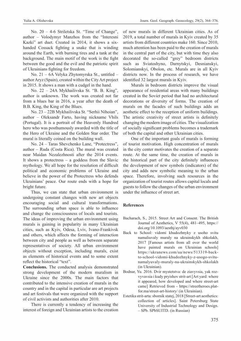
375
No. 20 – 4-6 Striletska St. “Time of Change”, author – Volodymyr Manzhos from the “Interesni Kazki” art duet. Created in 2014, it shows a six-handed Cossack fighting a snake that is winding around the Earth, with burning tires and a tank at the background. The main motif of the work is the fight between the good and the evil and the patriotic spirit of Ukrainians fighting for freedom.
No. 21 – 6A Velyka Zhytomyrska St., untitled – author Aryz (Spain), created within the City Art project in 2015. It shows a man with a cudgel in the hand.
No. 22 – 24A Mykhailivska St. “B. B. King”, author is unknown. The work was created not far from a blues bar in 2016, a year after the death of B.B. King, the King of the Blues.
No. 23 – 22B Mykhailivska St. “Serhii Nihoian”, author – Oleksandr Farto, having nickname Vhils (Portugal). It is a portrait of the Heavenly Hundred hero who was posthumously awarded with the title of the Hero of Ukraine and the Golden Star order. The mural is literally coined on the building wall.
No. 24 – Taras Shevchenko Lane, “Protectress”, author – Ruda (Costa Rica). The mural was created near Maidan Nezalezhnosti after the 2014 events. It shows a protectress – a goddess from the Slavic mythology. We all hope for the resolution of difficult political and economic problems of Ukraine and believe in the power of the Protectress who defends Ukrainians’ peace. Our route ends with a hope for bright future.
Thus, we can state that urban environment is undergoing constant changes with new art objects encouraging social and cultural transformations. The surrounding urban space is able to influence and change the consciousness of locals and tourists. The ideas of improving the urban environment using murals is gaining in popularity in many Ukrainian cities, such as Kyiv, Odesa, Lviv, Ivano-Frankivsk and others, which affects the forming of interaction between city and people as well as between separate representatives of society. All urban environment objects without exception, including murals, exist as elements of historical events and to some extent reflect the historical “text”.Conclusions. The conducted analysis demonstrated strong development of the modern muralism in Ukraine since the 2000s. The main factors that contributed to the intensive creation of murals in the country and in the capital in particular are art projects and art festivals that were organized with the support of civil activists and authorities after 2010.
There is currently a tendency of increasing the interest of foreign and Ukrainian artists to the creation
of new murals in different Ukrainian cities. As of 2019, a total number of murals in Kyiv created by 35 artists from different countries make 160. Since 2010, much attention has been paid to the creation of murals in the central part of the city, but with time they also decorated the so-called “grey” bedroom districts such as Sviatoshyno, Darnytskyi, Desnianskyi, Solomianskyi, Obolon, etc. Murals are in all Kyiv districts now. In the process of research, we have identified 32 largest murals in Kyiv.
Murals in bedroom districts improve the visual appearance of residential areas with many buildings created in the Soviet period that had no architectural decorations or diversity of forms. The creation of murals on the facades of such buildings adds an aesthetic effect to the reception of uniform buildings. The artistic creativity of street artists is definitely changing the modern image of cities. The visualization of socially significant problems becomes a trademark of both the capital and other Ukrainian cities.
One of the important goals of murals is forming of tourist motivation. High concentration of murals in the city center motivates the creation of a separate route. At the same time, the creation of murals in the historical part of the city definitely influences the development of new symbols (indicators) of the city and adds new symbolic meaning to the urban space. Therefore, involving such resources in the organization of tourist routes allows capital locals and guests to follow the changes of the urban environment under the influence of street art.
References
Bacharach, S., 2015. Street Art and Consent. The British Journal of Aesthetics, V 55(4), 481–495, https://doi.org/10.1093/aesthj/ayv030
Back to School: vidomi khudozhnyky z usoho svitu namaliuvaly muraly na ukrainskykh shkolakh, 2017 [Famous artists from all over the world have painted murals on Ukrainian schools] https://ukranews.com/ua/news/513319-back-to-school-vidomi-khudozhnyky-z-usogo-svitu-namalyuvaly-muraly-na-ukrainskykh-shkolakh (in Ukrainian).
Bodnar, Yu. 2016. Dvir mystetstva: de ziavyvsia, yak roz-vyvavsia i kudy pryishov strit-art [Art yard: where it appeared, how developed and where street-art came] Retrieved from - https://streetheroes.plat-for.ma/street-art-history/ (in Ukrainian).
Estetika strit-arta: sbornik statej, 2018 [Street-art aesthetics: collection of articles]. Saint Petersburg State University of Industrial Technology and Design. – SPb. SPbSUITD. (in Russian)
Yulia A. Olishevska Journ. Geol. Geograph. Geoecology, 29(2), 364–376.
376
Gastman, R., Neelon, C. 2011. The history of American graffiti - Harper Design.
Gastman, R., Neelon, C., Smyrski, A. 2007. Street world: Urban Art and Culture from Five Continents. -Harry N. Abrams.
Gavryliuk, B. 2018. Ukrainskyi mural-art u konteksti svitovoho mystetstva [Ukrainian mural in terms of global art] Bulletin of the Lviv National Academy of Arts. (37). 241-254. (in Ukrainian)
Guinard, P., Margier, A. 2018. Art as a new urban norm: Between normalization of the City through art and normalization of art through the City in Montreal and Johannesburg. Cities (77) 13-20 doi.org/10.1016/j.cities.2017.04.018
Havrylash, I. 2018. Mural-art u konteksti masovoi kultury XXI stolittia [Mural art in the context of the mass culture of the 21st century] Issues in Cultural studies. (34) 133-142. doi.org/10.31866/2410-1311.34.2018.154059 (in Ukrainian)
Havrylash, I. 2018. Muraly ta hrafiti v suchasnii Ukraini: osoblyvosti ta vidminnosti [Murals and graf-fiti in modern Ukraine: features and differ-ences]. Culture of Ukraine (62). 235-244. doi.org/10.31516/2410-5325.062.23 (in Ukrainian)
Hrytsiuk K. 2018. Muraly: novyi pidkhid do staroho mystet-stva [Murals: New approach to the old] Retrieved from https://theoutlook.com.ua/article/5056/murali-novij-pidxid-do-starogo-mistetstva.html (in Ukrainian)
Kosova, O. 2019. Istoriia z tryvymirnym efektom: mural «Kruty» zaversheno. [History with 3-dientional effect: mural “Kruty” is done.] Vechirnii Kyiv 18. 01. 2019. Retrieved from https://vechirniy.kyiv.ua/news/istoriya-z-tryvymirnym-efektom-mural-kruty-zaversheno (in Ukrainian)
Kuzyk, S. 2010. Teoretychni problemy turyzmu: suspilno-heohrafichnyi pidkhid. [Theoretical prob-lems of tourism: socio-geographical approach] Monohrafiia. Lviv: LNU im. Franka. (in Ukrai-nian)
Liubitseva, O.O. Pankova, Ye.V., Stafiichuk, V.I. 2007.Tu-rystychni resursy Ukrainy [Tourist resources of Ukraine] Navchalnyi posibnyk. K.: Alterpres (in Ukrainian)
Moldoveanu, M. and Franc, V. 2014. Urban regeneration and more opportunities for artistic expression and cultural consumption. Procedia Economics and Finance (8), 490 – 496.
Muraly Kyieva. Interaktyvna karta [The murals of Kyiv] Interactive map. Retrieved from: http://kyivmural.com/uk/index
Omar S.S, Dr. Sakip SRM, Akhir N.M. 2016. Bringing the New to the Old: Urban Regeneration through Public Arts. Procedia- Social and Behavioral Sci-ences. (234). 515-524.
Pamiatky Ukrainy [Sights of Ukraine] Retrieved from: https://zeft.in.ua/filter/?_sft_category=murali (in Ukrainian)
Pilikin D.G. 2018. Terminologija ulichnogo iskusstva. Opyt slovarnyh definicij. [Street art Terminology. Experience vocabulary definitions] Aesthetics of street art: a collection of articles. St. Peterburg: SPb. SPbSUITD. 4-9 (in Russian)
Riggle, N. A. 2010. Street Art: The Transfiguration of the Commonplaces. The Journal of Aesthetics and Art Criticism. Vol. 6. 248-257 https://doi/abs/10.1111/j.1540-6245.2010.01416.x
Sakip, SRM, Bahaluddin, A., Hassan, K. 2016. The Effect of Mural on Personal Crime and Fear of Crime. Procedia - Social and Behavioral Sciences (234). 407–415.
Shakter, R. 2018. Svitovyi atlas vulychnoho mystetstva i hrafiti [World Atlas of Street Art and Graffiti]. Kyiv: Magenta Art Books (in Ukrainian)
Smal,’ I.V. (2010). Turystychni resursy svitu [Tourist re-sources of the word] Nizhyn: Publisher of Nizhyn Mykola Gogol State University. (in Ukrainian)
Tylik, A. 2016. Ulichnoe isskustvo: opyt jesteticheskogo analiza [Street art: the experience of esthetic anal-ysis] Avtoreferat dissertacii na soiskanie uchenoj stepeni kand. filosof. nauk special’nost’ 09.00.04- Aesthetics. St. Petersburg State Un-t. SPb. (in Russian)
U Kyivskomu metro prezentuvaly visim muraliv 2018. [Eight murals presented in the Kyiv subway]. Retrieved from: https://www.ukrinform.ua/rubric-kyiv/2603820-u-kiivskomu-metro-prezentuvali-visim-muraliv.html (in Ukrainian)
V Kieve poyavilsya edinstvennyj v mire oficialnyj mural na policejskom uchastke 2017 [The only one official mural in the world appeared on the police-station In Kyiv]. Retrieved from: https://kiev.informator.ua/2017/11/21/v-kieve-poyavilsya-edinstvennyj-v-mire-ofitsialnyj-mural-na-politsejskom-uchastke (in Russian)
Waclawek, A. 2011. Graffiti and Street Art.- London. Thames & Hudson
Zakon Ukrainy Pro turyzm vid 15.09.1995 № 324/95-VR [The law of Ukraine on tourism]. Retrieved from: https://kodeksy.com.ua/pro_turizm/statja-3.htm (in Ukrainian)
Yulia A. Olishevska Journ. Geol. Geograph. Geoecology, 29(2), 364–376.

377
O. L. Popova, V. V. Koval, I. S. Mikhno, I. V. Tarasov, N.V. Asaulenko, L.M. Filipishyna Journ. Geol. Geograph. Geoecology, 29(2), 377–386.
Assessments of national tourism development in terms of sustainability and inclusiveness
Olga L. Popova1, Viktor V. Koval2, Inesa S. Mikhno3, Igor V. Tarasov4, Natalya V. Asaulenko5 , Liliya M.
Filipishyna4
1 Institute of Economy and Forecasting, Kiyv, Ukraine 2 Odessa Institute of Trade and Economics of Kyiv National University of Trade and Economics, Odessa, Ukraine, [email protected] 3 Private Higher Educational Institution “European University”, Kiyv, Ukraine 4 Pervomaisk branch of the National University of Shipbuilding named after Admiral Makarov, Pervomaisk, Ukraine 5 National Academy of Food Technologies, Odessa, Ukraine
Received: 03.11.2019 Received in revised form: 10.12.2019 Accepted: 04.01.2020
Abstract. The increase in global population movement and the development of tourism
are connected with the development of transport and other infrastructures. Therefore, funds
flow and capital migration increase, while it is possible to accumulate funds with the help of
tourism, as well as to increase the GDP of countries, infrastructure and climate of which are
attractive for tourists. Two hypotheses about the impact of tourisms on the environment are
confirmed: positive and negative effects. A new approach of a “solidarity tourism” as a specific type of inclusive tourism, which is a
process of cooperation between various participants of a tourism industry, is proposed. Solidarity tourism means that rural households,
which are not fully involved in tourism services once get the opportunity to intensify their activities in this industry by focusing their
service on people with special needs. In this case, a “double benefit” in a context of inclusiveness is achieved: on the one hand, an
employment and income from tourism are provided in the rural households as a continuation and diversification of agricultural activ-
ity, and, on the other hand, quality tourism services are provided for those with special needs. The inclusiveness of tourism services
in Ukraine is more connected with the inclusion of a wide range of rural households in the tourism field than with an accessibility
of such services for those with special needs and disabilities. Institutional household sector exceeded the non –financial corporation
sector in temporary accommodation and catering provision. Rural tourism becomes more widespread as a kind of economic activit y
mostly for households, located in environmentally friendly areas. However, Ukraine is among outsiders in terms of tourism due to a
range of recent events that creates not very attractive image of the country, imperfection of legislation, the lack of effect ive actions of
the government and insufficient desire to invest in tourism development. This article analyzes macroeconomic performances of rural
tourism in the country, the level of the interest of population and communities in creation of a favorable tourism atmosphere. Several
recreation points are estimated according to the proposed indicator of the investment attractiveness for tourism and the relevant conclu-
sions are grounded. It was found that there is an ecological depletion of natural resources in Ukraine and no proper funds are invested
in their recovery. This situation threatens the ecosystem, preservation of ethno cultural values and the development of tourism potential.
At the same time, the meaning of environmental protection and the creation of environmentally friendly places for tourism become
more important in the developed countries. There is no government support for the environmentally friendly tourism in Ukraine. Rural
households provide hospitality services and improve environmental quality of them by investing their own funds.
Key words: rural tourism, inclusive tourism, rural households, ecology, wastes, ecological burden, tourist area
Оцінка розвитку національного туризму з точки зору стійкості та інклюзивності
О.Л. Попова1, В.В. Коваль2, І.С. Міхно3, І.В. Тарасов4, Н.В. Асауленко5, Л.М. Філіпішина4
1 Інститут економіки та прогнозування, Київ, Україна 2 Одеський торговельно-економічний інститут Київського національного торговельно-економічного університету, Одеса, Україна, [email protected] 3 Міжнародний європейський університет, Київ, Україна 4 Первомайська філія Національного університету кораблебудування імені адмірала Макарова, м. Первомайськ, Україна 5 Одеська національна академія харчових технологій, Одеса, Україна
Journ.Geol.Geograph.
Geology,
29(2), 377–386.
doi: 10.15421/112033
ISSN 2617-2909 (print)
ISSN 2617-2119 (online) JOURNAL of Geology,
GEOGRAPHY And
Geoecology
Journal home page: geology-dnu-dp.ua

378
O. L. Popova, V. V. Koval, I. S. Mikhno, I. V. Tarasov, N.V. Asaulenko, L.M. Filipishina
Filipishyna Journ. Geol. Geograph. Geoecology, 29(2), 377–386.
Анотація. Зростання глобального руху населення та розвиток туризму пов’язані з розвитком транспортної та іншої інфра-
структури. Тому припливи коштів та міграція капіталу збільшуються, тоді як можна акумулювати кошти за допомогою туриз-
му, а також збільшити ВВП країн, інфраструктуру та клімат, які привабливі для туристів. Підтверджено дві гіпотези про вплив
туризму на навколишнє середовище: позитивний та негативний вплив. Запропоновано новий підхід «солідарного туризму»
як специфічного виду інклюзивного туризму, який є процесом співпраці між різними учасниками туристичної галузі. Солі-
дарний туризм означає, що сільські домогосподарства, які не повністю залучені до туристичних послуг, як тільки отримують
можливість активізувати свою діяльність у цій галузі, зосереджуючи свою послугу на людях із особливими потребами. У
цьому випадку досягається «подвійна вигода» в умовах інклюзивності: з одного боку, працевлаштування та доходи від ту-
ризму забезпечуються в сільських домогосподарствах як продовження та диверсифікація сільськогосподарської діяльності,
а з іншого - якість туристичні послуги надаються особам з особливими потребами. Інклюзивність туристичних послуг в
Україні більше пов’язана з включенням широкого кола сільських домогосподарств до сфери туризму, ніж із доступністю таких
послуг для осіб з особливими потребами та обмеженими можливостями. Інституційний сектор домогосподарств перевищив
сектор нефінансової корпорації у наданні тимчасового проживання та харчування. Сільський туризм набуває все більшого
поширення як вид економічної діяльності здебільшого для домогосподарств, розташованих в екологічно чистих районах.
Однак Україна є одним з аутсайдерів за рівнем туризму через цілий ряд останніх подій, що створює не дуже привабливий
імідж країни, недосконалість законодавства, відсутність ефективних дій влади та недостатнє бажання інвестувати в розвиток
туризму. У цій статті проаналізовано макроекономічні показники сільського туризму в країні, рівень зацікавленості населення
та громад у створенні сприятливої атмосфери туризму. Оцінено декілька точок відпочинку відповідно до запропонованого
показника інвестиційної привабливості для туризму, а відповідні висновки обґрунтовані. Було встановлено, що в Україні
спостерігається екологічне виснаження природних ресурсів, а на їх відновлення не вкладаються належні кошти. Така ситуація
загрожує екосистемі, збереженню етнокультурних цінностей та розвитку туристичного потенціалу. У той же час значення
охорони навколишнього середовища та створення екологічно чистих місць для туризму набувають більшого значення в
розвинених країнах. Урядової підтримки екологічно чистого туризму в Україні немає. Сільські домогосподарства надають
послуги гостинності та покращують екологічну якість їх, вкладаючи власні кошти.
Ключові слова: сільський туризм, екологія, відходи, екологічне навантаження, антропогенний вплив, туристичні зони
Intoduction. Tourism as a kind of economic activ-
ity mostly develops in the areas that have natural re-
sources with a positive impact on population health,
as well as in the areas of cultural and historical in-
terest. This process was chaotic for small Ukrainian
localities, where human impact on the environment
was offset. The strategies of local economy creation
are not fully identified and are not formed in terms
of rural environment attractiveness for tourists. De-
mographers use the facts that rural areas, where the
source of work places is entertainment and recreation,
have higher level of immigration than small locali-
ties, economy of which depends on agricultural pro-
duction. Therefore, the aim of the article is to analyze
the tendencies of rural tourism development in terms
of inclusiveness, to determine the investment attrac-
tiveness factors of recreation areas, to examine the
impact of tourist flows on the ecological state of the
recreation area.
Literature review. Monitoring of tourist flows is im-
portant for the analysis of the attractiveness of such
recreation and depends on various factors. Andraz
et al. (2016) found that a large number of tourists in
Europe belongs to Germany, as their movement is
accompanied by the delays of tourist flows in other
countries and shows the greater resistance to shocks.
Tourism in Spain has less regular, but seasonal behav-
ior, than in other territories. Dind Du et al (2016) state
that the contribution of tourism into long-term eco-
nomic grow was implemented with financial flows,
as an integral part of a broader development strategy,
which is focused on standard income determinants.
Investment in tourism in itself seems not enough for
economic growth, but facilitates it (Yankovyi et al.,
2020). There are other factors, such as ecology or
an exclusiveness of a tourism product, that have an
impact on tourists’ decisions. Asrin (2015) came to
the conclusion in his study that generalized Poisson
regression is the best one in estimating a long-term
international demand for tourism. Besides, it was
found that inflationary pressures and real exchange
rate fluctuations have negative correlation with inter-
national demand for tourism. However, foreign direct
investments and trade openness have positive relation
with international demand for tourism. The result of
co-integrated test shows that there is a correlation be-
tween variables (Asrin et al., 2015).
Chatziantoniou et al. (2016) indicate that the analysis of macroeconomic indicators in tourism
industry depends on economic situation of a country,
strategic planning quality, national and cultural
specifics of a country that have an impact on the
purpose and timeframes of tourists’ migration.
Gao J. et al. (2017) emphasizes that rural areas
and lifestyle got over global crisis in recent years,
especially in developing countries; traditional
agriculture and rural culture disappear or suffer
from assimilation because of urbanization and
modernization. The case study of Yuanjia village
shows that three levels of model (material, social
and spiritual) are effective ways for successful
revitalization of a village. Development with the

379
O. L. Popova, V. V. Koval, I. S. Mikhno, I. V. Tarasov, N.V. Asaulenko, L.M. Filipishyna Journ. Geol. Geograph. Geoecology, 29(2), 377–386.
guidance of rural leaders or elite will implement an endogenic bottom-up development instead of
downward agreement. (Yong-chang et al., 2016)
states, that the development of ethnic rural tourism
is a unique kind of income, which is an incentive to
preserve the beauty of rural area and culture and, at
the same time, it is an ideal destination in modern
tourism.
The data in the table 1 show that a share of such economic activity as “temporary accommodation and
catering provision” in the GDP of Ukraine is at the
level of 0.7% and remains stable during the past seven
years. At the same time, there has been a tendency
of growing GDP and gross value added (GVA)
according to this kind of activity, since 2015, and with
the increase of 20-30% in 2016 - 2017 (2018).
Table 1. Performance indicators of such economic activity as “temporary accommodation and catering provision”
2010 2011 2012 2013 2014 2015 2016 2017
Output in basic prices, million, UAH 19910 22234 22024 21917 21438 25458 32637 37737
A share % from the total output, accord-
ing to the types of economic activity 0.8 0.8 0.7 0.7 0.6 0.6 0.6 0.6
Output in the constant prices in 2010,
million UAH 19910 20782 19569 18903 17915 17726 18843 18894
chain index 114.2 104.4 94.2 96.6 94.8 98.9 106.3 100.3
Gross domestic product according to
the given kind of activity, million UAH 8932 10256 10122 10150 9927 11946 15551 18727
% 0.8 0.8 0.7 0.7 0.6 0.6 0.7 0.6
Gross value added in the post price ac-
cording to the given kind of activity,
million UAH
8932
9591
9000
8526
8049
8224
8683
9051
Сhain indexes, % 117.4 107.4 93.8 94.7 94.4 102.2 105.6 104.2
Chinese scientists have noted that the correlations
between the sense of place for residents and perception
of common and personal benefits, perception
of personal expenses and support of tourism
development are important. Besides, the residents’
notion of a potential for tourism development had
a great impact on the perception and support of a
tourism development, except for personal benefits
(Zhu et al., 2017).
Such methods as analysis, comparison, induction
and deduction, economic-mathematical modeling,
mapping and formalization were used according to
the aim of the study.
Results of the study. Performance indicators of such
economic activity as “temporary accommodation
and catering provision” in Ukraine (in fact, it reflects
tourism) and the contribution of this kind to the gross
domestic product (GDP) of the country are of a great
interest in the analysis of tourism potential of the areas.
However, in order to separate commercial tourism
from agro tourism or a rural tourism, which has its
own specifics and is a continuation and diversification
of agriculture, the last one is more often determined
as “providing of rural hospitality services”. Most of
such households are not subjects of economic activity.
The fact that in Ukraine such institutional sector
as rural households in terms of the absolute scope of
service rendered in the field of temporary accommo-
dation and catering providing became equal with non-
profit corporations in 2016 and exceed them in 2017,
is gaining the attention. According to official statis-
tical data, the output of sectoral composition of this
economic activity was divided in such a way: 42%
of the output are provided by non-profit corporations
and 58% are provided by rural households. It means
that the hospitality services provided by families be-
come more widespread, especially in the rural areas.
Taking into account the fact that a share of interme-
diate consumption in the rural households is lower
(at the level of 40%) than in the sector of non- profit
corporations (at the level of 65%), rural households
are characterized as those with bigger GDP (70%) and
with bigger gross profit from this kind of economic
activity (Table 2).
It’s necessary to pay an attention to the fact that
there is a subsector in the segment of rural households,
which consists of self-employed people (besides
employers, employees and income beneficiaries from
property and transfers). The last ones have smaller
output shares (in the basic price) in this kind of

380
O. L. Popova, V. V. Koval, I. S. Mikhno, I. V. Tarasov, N.V. Asaulenko, L.M. Filipishina
Filipishyna Journ. Geol. Geograph. Geoecology, 29(2), 377–386.
Table 2. Performance indicators of such economic activity as “temporary accommodation and catering provision” according to
institutional sectors
2010 2011 2012 2013 2014 2015 2016 2017
Output of sectors in the basic prices,
million UAH:
-non-profit corporations,
-rural households
12382
7528
13451
8783
12919
9105
12148
9769
12325
9113
13252
12206
16253
16384
15840
21897
Output sectoral composition accord-
ing to the given kind of activity,%
-non-profit corporations,
-rural households
62.2
37.8
60.5
39.5
58.7
41.3
55.4
44.6
57.5
42.5
52.1
47.9
49.8
50.2
42
58
Intermediate consumption, million
UAH
-non-profit corporations;
-rural households
8090
2888
8627
3351
8430
3472
8095
3672
8030
3481
8606
4906
10498
6588
10244
8766
Output of sectoral composition ac-
cording to the given kind of activ-
ity,%
-non-profit corporations,
-rural households
73.7
26.3
72.0
28.0
70.8
29.2
68.8
31.2
69.8
30.2
63.7
36.3
61.4
38.6
53.9
46.1
A share of an output intermediate
consumption %
- non-profit corporations,
- rural households
65.3
38.4
64.1
38.2
65.3
38.1
66.6
37.6
65.2
38.2
64.9
40.2
64.6
40.2
64.7
40
linked index 114.2 104.4 94.2 96.6 94.8 98.9 106.3 100.3
Gross value added, million UAH
- non-profit corporations,
- rural households
4292
4640
4824
5432
4489
5633
4053
6097
4295
5632
4646
7300
5755
9796
5596
13131
GDP sectoral composition according
to this kind of activity, %
-non-profit corporations,
- rural households
48.1
51.9
47.0
53.0
44.3
55.7
39.9
60.1
43.3
56.7
38.9
61.1
37.0
63.0
29.9
70.1
Compensation of employees, million
UAH:
-non-profit corporations ,
- rural households
4159
211
4773
364
5327
743
4393
1602
4956
903
4867
991
4997
1727
6558
1247
Gross profit, million UAH:
- non-profit corporations,
- rural households
27
4348
-79
4054
-989
4682
-413
4160
-726
4367
-294
6072
724
7826
-1001
11498
economic activity (temporary accommodation and
catering provision), which are at the level of 4 - 24%,
while self-employed people provided 47.8% of the
total output in 2016.
Figure 1 shows the increase of product output in
both sectors since 2010 till 2017.The changes are par-
ticularly evident in the household sector, which shows
the trend with a determination index of 0.76. How-
ever, if we analyze the dynamic pattern of changing
the chain index, which characterizes the total output
of both sectors in the prices of the year 2010, the
situation will not have any positive results, and the
performance indicators of the next year will be not ac-
curately predicted and will not have a stable growth.
It shows the slow development of rural tourism, es-
pecially by non-profit corporations because of the ab-

381
O. L. Popova, V. V. Koval, I. S. Mikhno, I. V. Tarasov, N.V. Asaulenko, L.M. Filipishyna Journ. Geol. Geograph. Geoecology, 29(2), 377–386.
Fig. 1. Gross product of such economic activity as “temporary accommodation and catering provision” according
to institutional sectors (output by sectors at basic prices, million hryvnias)
Source: compiled by the authors
sence of government support for this kind of activity.
The attractions (sights) can be determined as places
or objects that deserve special attention be- cause of
their qualities; these are specific assets of a certain
area, that attracts not only local residents, that choose
these places for life, but also for external tour- ists,
that want to visit them. For example, in rural ar- eas
there are special landscapes – terraces, cultivated
fields, together with natural fields of tulips and daf-
fodils, nature reserves or parks, lakes and ponds with
swans or other poultry. Historical buildings, embank-
ments, mounds and heritage railway in the mountains
are also attractions for tourists. Landscapes are domi-
nant in Ukrainian countryside’s; there are fields, pas-
tures, wood lines and forests, hilly areas and village
settlements with ranges of households that perform
agriculture (Koval, V., Popova, O. Et al., 2019). Most
rural communities have some natural and historical
attractions (sights).
According to the observations, it’s seems cat-
egorically different sights and places are likely to be
attractive for tourists:
those with especially attractive conditions
(recreation areas, unique objects);
those with rough conditions (critical, abandoned
places and objects), including the extreme conditions
for a certain categories of tourists. A depressive
Chernobyl zone, which also is an active tourist area,
is an example of that last ones.
There should by different types of “tourist prod-
ucts” in accordance with the preferences of different
categories of tourism: expensive products (so–called
VIP –products), medium –priced products (affordable
for a wide range of consumers) and low – cost tour-
ist products. It is important to note that in the cases
when the improvement of the area and infrastructure
is much more expensive than the price of tourist ser-
vices, the expectations of a tourist flow cannot be met
and the tourist flow is decreased.
The United Nations World Tourism Organization
(UNWTO) defines another kind of a tourism, an in-
clusive one as such a form of tourism, that includes
the process of collaboration between different par-
ticipants of tourism industry, gives those with spe-
cial needs the accessibility (including mobile, visual,
acoustic and cognitive elements of an accessibility)
to function on equal terms and with dignity, which
is possible with a help of universal tourist products,
services and areas.
The given definition fairly emphasizes the pro-
cess of collaboration between different participants
of a tourism industry, but the only participants, those
with special needs are specified as consumers of tour-
ist products and services.
This article shows another side of participants of
the inclusive tourism. These are rural households as
suppliers of tourist products and services. It’s needed
to create the most appropriate accessibility conditions
to this industry for them. They consider rural tour-
ism as a continuation and diversification of agricul-
ture. It’s important to create a favorable climate for
such households in order to involve them into tour-
ism industry, unlike bigger operators, which have
better economic possibilities and the effects of scaled

382
O. L. Popova, V. V. Koval, I. S. Mikhno, I. V. Tarasov, N.V. Asaulenko, L.M. Filipishina
Filipishyna Journ. Geol. Geograph. Geoecology, 29(2), 377–386.
economies. It’s particularly concerned with such ru- ral households that do farming, produce agricultural
products according to traditional methods and bring it
to the table for tourists. Thus food corresponds to cul-
tural traditions, and this provides national food sover-
eignty (unlike the food safety, when food can be im-
ported). In such a way, an inclusive tourism does not
only concern the inclusiveness of demand that means
providing conditions for those with special needs. It’s
also important to provide the inclusiveness of supply,
which means providing the abilities to offer hospital-
ity services for small operators, such as rural house-
holds, especially for those, which consider tourism as
diversification of their agriculture.
The accessibility of tourism services providing
for rural households is also about human labor right.
Such opportunities of rural households are in the base
of solidarity tourism creation.
Solidarity tourism means that rural households,
which are not fully involved in tourism services once
get the opportunity to intensify their activities in this
industry by focusing their service on people with spe-
cial needs. In this case, a “double benefit” is achieved
for both, rural households and tourists with special
needs.
Nowadays there are up to 11% of global tourist
flows in the inclusive tourism and it is predicted to
reach 22% of all the expenses for tourism in the world
in 2020 (according to UNWTO).
In this case, striving to provide such shares for
the institutional sector of households as small tourism
operators in tourist flows seems logical.
In the promoting of development, which is based
on the attractions for tourists, the issue of the estima-
tion of the tourism influence on the ecology of tourist
spots and their environment is very important (Koval
et al., 2019). Besides, there has been a growing in-
terest to the role of attractions in the development of
rural areas in 1990.
Scientists had almost the same opinion about the
paradigmatically shift in the consideration of the exis-
tent determinants (assets) of the development of those
rural areas, which are full of attractions. (Green G.
P. et al., 2005). This shift is about the fact that com-
munities from the areas, that have many sights, more
often prefer to create the activity, based on promo-
tion of the environmental quality, moving away from
the extracting of natural resources for foreign markets
and for the foreign trade development (Prystupa et al.,
2019).
However, the amount of wastes and a general
impact on the ecosystem increase when the area be-
comes more popular. That is why it is important to
analyze the indicators of the social welfare of popula- tion in this area (Skripnik et al., 2016).
It’s possible to formulate two hypotheses about
the impact of tourism on ecology. The first one is
about positive influence, as tourism can cause the
creation and adherence of favorable ecological condi-
tions by the local community in order to attract more
tourists. The second one is about negative influence
of a big tourist flow on a natural resource as a tourist
attraction that appears in the depletion of this resource
and to the environmental pollution in general.
The explanations of the hypothesis of the nega-
tive impact of tourism on the environment are similar
to the “environmental” Kuznets curve, according to
which the stages of development outline the existence
of a clear and predictable pattern between the growth
of a sight and its value.
In the initial situation, the quality of the sight re-
mains due to the insignificant level of its use. Howev-
er, when the economy and the rent obtaining from the
sight are activated, the pressure on it and on the envi-
ronment increases. Depletion and degradation of the
resource and environment increase together with the
economic growth. On the certain level the growth of
income is connected with the necessity to protect the
sight and environment. The growth of the sight value
as a tourist product, and the restoration of custody and
investments into this tourist object are possible.
In calculating of the investment attractiveness
of an object (I) of the recreational value (formula 1)
for n periods such factors as a decrease in profits due
to environmental degradation or the environmental
restoration to a zero state cost, human-induced burden
factor (Ka, formula 2) and the cost of recreation
complex or tourist sight maintenance cost should be
taken into account.
(1)
In means a total income of the recreation area for
the period n; Out means the cost of maintenance and
function of recreation area; , r – discount rate, s – rec-
reation land area.
(2)
Р – a number of visitors for the certain period;
Pn – specified number of visitors that is settled and
effects the ecosystem of the recreation area.
Let’s analyze the investment attractiveness of a
private household per 1 month (formula 3), which is
located in Solotvino, has 800 m2 with an average visi-
tor rate of 50 people per 1 month and a total monthly

383
O. L. Popova, V. V. Koval, I. S. Mikhno, I. V. Tarasov, N.V. Asaulenko, L.M. Filipishyna Journ. Geol. Geograph. Geoecology, 29(2), 377–386.
income of 1250 USD. The cost of the recreation area
maintenance is 100 USD.
A contribution into the recreation area restoration
(such as saline lakes and other non-private natural
sites) was absent. The cost of the environmental res-
toration is considered to be equal to the cost of house-
hold maintenance, as it does not cause any excessive
loads. Tourist fee (at the level of European countries)
is 5% of a hotel cost per 1 person. In the situation,
when a recreation area has a big tourist flow and there
is a significant impact on the ecological aspect of the
sight, the cost of area reset restoration is added to this
amount.
І = (1250-100-(400+0.05*25*50)-((50/59)*800))/(1+0.17)=8.1
(3)
The indicator value obtained is positive, so the
household functioning is not a factor of environmental
degradation but also does not contribute to the
development of rural tourism (less than 50) and
investments into environment restoration in the
recreation areas of non-private sector. The solution
is the government support of the rural households and
tourists crowds, the increase of penalties for violation
the norms of ecological legislation, the increase of
expenses for the environment improvement and
preservation of natural and cultural sights, control
for the use of funds on the local level together with
greater responsibility of the local communities and
agricultural enterprises (Popova et al., 2019).
The indicator value of an investment attractiveness
of the recreation areas at the coast of Black sea near
Odessa is below zero, which shows the increase of
human impact on ecology, despite the increasing
income. It’s also typical for non-private territories in
Western Ukraine (for example, non-private lands near
Hoverla (Lazeshchyna)), where a large accumulation
of people and pollution of the areas is observed.
A correlation between the amount of recreation
areas and waste dumps is shown using interaction
maps (figures 2a and 2b)
The correlation between the number of recreation
areas and waste dumps has been studied using
the example of Odessa region (from Primorske to
Fontanka) with a radius of 20 km from the coastline.
Such a distance was chosen because of a big number
of resorts and significant influence of wastes on the
coast. There is a significant direct correlation between
the amount of resorts and wastes. A correlation
coefficient is 0.52. That means that the number of
waste dumps in the studied area increases along with
an increase in the amount of resorts and visitors.
Ukrainian communities don’t fully realize the opportunities of households formation (local
economy) based on the promotion of natural sights
and with deviation from modern practice of natural
resources depletion for foreign markets. Nevertheless,
such deviation is already notable in many countries,
especially in Europe. There are several reasons for not
to perceive the sights as economic assets.
Firstly, in the most cases sights that attract tourist
and contribute to tourism development are such assets
that are not effectively regulated by market tools, as
there are some problems in their nature identification
(Vdovenko, Nakonechna, Samsonova, 2017). They
are often public assets and it’s difficult to force the us-
ers to pay for the goods they get from them. It leads to
a “free-rider issue”. Taking into consideration the fact
that the tourism development activation often leads
to the environmental degradation of the objects and
places that eventually turn into polluted areas (Koval
& Mihno, 2019; Popova et al., 2019).
A counteraction of local communities to the nega-
tive effects of tourism (“tourists – action”) on a physi-
cal condition and ecology of tourism sights (“local
communities – counteraction”) is important in order
to avoid such effects. However, the most important
is the perception of certain unique objects not only as
assets for tourism development, but also as assets of
the development of local communities.
Then the management of common resources is
formed, which has features of institution and that or-
ganizes this process and the use of these resources as
well (Kostetska et al., 2020). An acceptance of tourist
sights as assets of social and economic development
of communities will motivate local population to
make efforts in order to control the use and improve-
ment of common wealth (Bukanov et al., 2019).
Secondly, an interest to the increasing income of
private entrepreneurs puts on the back plan the inter-
est of community and the desire to maximize the fi-
nancial assets prevails the will desire to increase the
expenses on the environment and eco-system protec-
tion. Funds are accumulated for the resort building ac-
celeration, the increase in tourism flows by reducing
costs on environmental restoration.
Thirdly, imperfect legislation slows down
the implementation of waste recycling, and small
penalties and ecological taxes cause negligence of
population and business to this issue (Skripnik et al.,
2015; Ciuła et al., 2019; Gubanova et al., 2019).
The experience of rural tourism development
shows that tourism is much more stable in the rural
areas, where communities, agricultural and other
enterprises allocate money for local market (from

384
O. L. Popova, V. V. Koval, I. S. Mikhno, I. V. Tarasov, N.V. Asaulenko, L.M. Filipishina
Filipishyna Journ. Geol. Geograph. Geoecology, 29(2), 377–386.
Fig. 2a. Resorts and recreation areas on an interactive map of Ukraine. Source: igotoworld.com
Fig. 2b. Waste dumps on an interactive map of Ukraine. Source: ecomapa.gov.ua
the local budgets, accumulate financial resources
independently by creating funds to support recreation
potential of the areas). Tourism in such areas
facilitates the improving of economic potential by
providing workplaces for local population, increase
in production and people’s lives improvement in
general. The ecological stability of natural systems
is not disturbed, biological variety remains and the
waste and environmental pollution are minimized
because of a low density of tourists, which is provided
by a huge number of households. The ethnographical
peculiarities of receiving side ideally fit in the rural
tourism, local communities, customs and traditions
remain and develop, historical heritage is involved
into tourism industry in such a way.
A group of territories is distinguished in the
total number of resorts, where the key aspect of the
choice of tourists is bad ecology and places that are
inappropriate for life (Koval et al., 2019a). “Chernobyl
zone” is among such places in Ukraine. According to
official data, tourism in Chernobyl zone brought 39
million UAH to the state budget in 2018. In 2014, more
than 8 thousands of tourist visited it, approximately 36
thousands in 2016 and 63 thousands in 2017. Despite
the positive dynamics of the number of visitors,
their attendance in this territory is strictly limited in
comparison with ecologically friendly areas.
In 2017 Ukraine was ranked 88th out of 136
countries according to the Travel and Tourism
Competitiveness Index (CCI), which is based on
385
O. L. Popova, V. V. Koval, I. S. Mikhno, I. V. Tarasov, N.V. Asaulenko, L.M. Filipishyna Journ. Geol. Geograph. Geoecology, 29(2), 377–386.
80 indicators, grouped into 14 components, that are
summarized into 3 sub-indexes such as the regulatory
environment in the tourism sector; business
environment and infrastructure; human, cultural and
natural resources in the travel and tourism industry.
In terms of security, in 2018 Ukraine was in the
top-10 countries-outsiders (it was ranked 127th; the
presence of military conflicts on the territory of the
state, crime rate and terrorist threat were taken into
account). As for other positions, Ukraine was also at
low levels: in terms of favorable business environment,
investments in tourism industry it was ranked 124th, as
for international openness – 78th, 79th as for aviation
infrastructure, as for port and ground infrastructure
– 81st, and 71stin terms of tourist services. However,
the experts noted the high level of Ukrainian sanitary
standards, for which our country was in the top-10.
As for the price for tourist services, Ukraine is not the
most expensive, and it was ranked 45th. Although, in
terms of cultural resources it was ranked 51st.
The limiting factors of tourism development in
Ukraine (according to CCI, despite of low security
level and unfavorable business environment) are
poor ratings in terms of such criteria: the existence
of natural resources – 115th place; unfavorable
ecological condition and ecological stability (97 th
place; it’s caused by Chernobyl disaster), the level
of focusing on tourism (90th place). However, the
country is quite “friendly” for tourists in terms of
human and cultural resources, sanitary condition and
price competitiveness.
It was offered to apply a systematic approach
with the participation of population, business and state
in order to improve tourism potential of a country.
Firstly, it should be based on creation infrastructure in
the recreation areas, creation of appropriate economic
environment and creation of effective legislation
that could be a basis for the preservation of the
environment.
It is clear, therefore, that there is a necessity to
promote the rich natural resources and to improve the
ecological image of Ukraine.
Conclusion. The amount of households, that provide
a rural hospitality services, has significantly increased
during the past 10 years. The largest part of a rural
population, which works in this industry, is not a
subject of economic activity but is self-employed.
This fact makes an accounting and an analysis of their
economic activity in this industry more complicated.
According to the data of Statistics Service,
in 2016 the total gross product of the commercial
enterprises and rural households in the sphere of
temporary accommodation and catering provision
for tourists was 15.6 billion UAH, which almost by
2 times exceeded this performance indicator in 2010.
Taking into account the fact that The United Nations
World Tourism Organization defines an inclusive
tourism as such a form that includes the process
of collaboration between different participants of
tourism industry, the authors consider that it’s
necessary to implement the approach of a “solidarity
tourism”. It concerns the creation of appropriate
conditions for those rural households, that are not fully
involved in the sphere of rural hospitality services in
order to intensify their activities and to focus their
service on those with special needs.
Both participants of this collaboration, rural
households and tourists with special needs will get
a “double benefit” from it. The aim should be to
provide a higher share of the households institutional
sector participation as small tour operators in tourist
flows. Moreover, in Ukraine, an institutional sector of
rural households has already become equal an even
exceed the sector of non-profit corporations in terms
of temporary accommodation and catering provision,
with the shares of 58% and 42% correspondently
(2017). Depletion and degradation of natural resources
are observed in Ukraine because of the tourist flow
increase and the improvement of economic indicators.
However, at the certain level of development there is
a tendency to connect the increase of income with the
necessity of protection of sights and the environment
itself. The examples may be found in the luxury
health complexes. A significant direct relationship
between the amount of recreation spots (such of
ecological burden) and the number of waste dumps at
the coast of Odessa region was found. It’s important
for the population to recognize and understand certain
unique objects not only as assets for the rural tourism
development, but also for the local development, in
order to improve the situation in Ukraine. It’s also
important to make the role of local communities more
significant. Such communities should control the use
of natural resources in the certain areas, where the
ecological burden appears because of the increase in
the number of tourists.
It’s necessary to regulate the impact of tourism
services on the eco-system in terms of legislation, to
increase penalties and to tighten control of the activity
of private enterprises and households. Besides, an
important factor of tourism development is the control
of the designated use of government funds, which are
directed on the restoration of natural resources, and
the inspiration of private enterprises to invest their
own funds in the maintaining and improving of the
natural potential of the country.
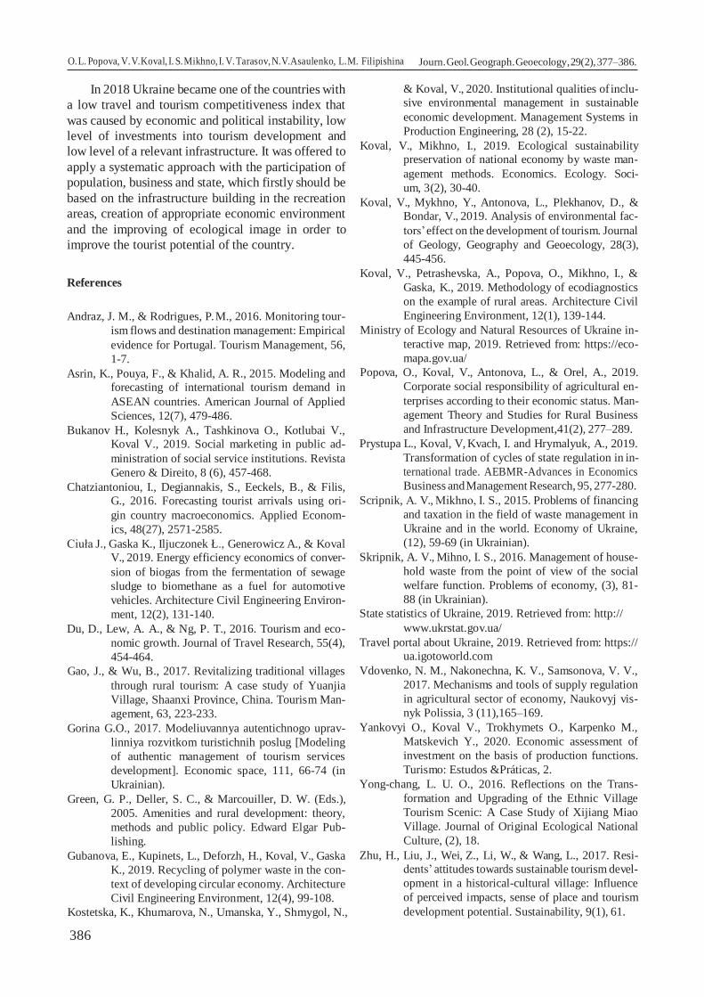
386
O. L. Popova, V. V. Koval, I. S. Mikhno, I. V. Tarasov, N.V. Asaulenko, L.M. Filipishina
Filipishyna Journ. Geol. Geograph. Geoecology, 29(2), 377–386.
In 2018 Ukraine became one of the countries with
a low travel and tourism competitiveness index that
was caused by economic and political instability, low
level of investments into tourism development and
low level of a relevant infrastructure. It was offered to
apply a systematic approach with the participation of
population, business and state, which firstly should be
based on the infrastructure building in the recreation
areas, creation of appropriate economic environment
and the improving of ecological image in order to
improve the tourist potential of the country.
References
Andraz, J. M., & Rodrigues, P. M., 2016. Monitoring tour-
ism flows and destination management: Empirical
evidence for Portugal. Tourism Management, 56,
1-7.
Asrin, K., Pouya, F., & Khalid, A. R., 2015. Modeling and
forecasting of international tourism demand in
ASEAN countries. American Journal of Applied
Sciences, 12(7), 479-486.
Bukanov H., Kolesnyk A., Tashkinova O., Kotlubai V.,
Koval V., 2019. Social marketing in public ad-
ministration of social service institutions. Revista
Genero & Direito, 8 (6), 457-468.
Chatziantoniou, I., Degiannakis, S., Eeckels, B., & Filis,
G., 2016. Forecasting tourist arrivals using ori-
gin country macroeconomics. Applied Econom-
ics, 48(27), 2571-2585.
Ciuła J., Gaska K., Iljuczonek Ł., Generowicz A., & Koval
V., 2019. Energy efficiency economics of conver-
sion of biogas from the fermentation of sewage
sludge to biomethane as a fuel for automotive
vehicles. Architecture Civil Engineering Environ-
ment, 12(2), 131-140.
Du, D., Lew, A. A., & Ng, P. T., 2016. Tourism and eco-
nomic growth. Journal of Travel Research, 55(4),
454-464.
Gao, J., & Wu, B., 2017. Revitalizing traditional villages
through rural tourism: A case study of Yuanjia
Village, Shaanxi Province, China. Tourism Man-
agement, 63, 223-233.
Gorina G.O., 2017. Modeliuvannya autentichnogo uprav-
linniya rozvitkom turistichnih poslug [Modeling
of authentic management of tourism services
development]. Economic space, 111, 66-74 (in
Ukrainian).
Green, G. P., Deller, S. C., & Marcouiller, D. W. (Eds.),
2005. Amenities and rural development: theory,
methods and public policy. Edward Elgar Pub-
lishing.
Gubanova, E., Kupinets, L., Deforzh, H., Koval, V., Gaska
K., 2019. Recycling of polymer waste in the con-
text of developing circular economy. Architecture
Civil Engineering Environment, 12(4), 99-108.
Kostetska, K., Khumarova, N., Umanska, Y., Shmygol, N.,
& Koval, V., 2020. Institutional qualities of inclu-
sive environmental management in sustainable
economic development. Management Systems in
Production Engineering, 28 (2), 15-22.
Koval, V., Mikhno, I., 2019. Ecological sustainability
preservation of national economy by waste man-
agement methods. Economics. Ecology. Soci-
um, 3(2), 30-40.
Koval, V., Mykhno, Y., Antonova, L., Plekhanov, D., &
Bondar, V., 2019. Analysis of environmental fac-
tors’ effect on the development of tourism. Journal
of Geology, Geography and Geoecology, 28(3),
445-456.
Koval, V., Petrashevska, A., Popova, O., Mikhno, I., &
Gaska, K., 2019. Methodology of ecodiagnostics
on the example of rural areas. Architecture Civil
Engineering Environment, 12(1), 139-144.
Ministry of Ecology and Natural Resources of Ukraine in-
teractive map, 2019. Retrieved from: https://eco-
mapa.gov.ua/
Popova, O., Koval, V., Antonova, L., & Orel, A., 2019.
Corporate social responsibility of agricultural en-
terprises according to their economic status. Man-
agement Theory and Studies for Rural Business
and Infrastructure Development,41(2), 277–289.
Prystupa L., Koval, V, Kvach, I. and Hrymalyuk, A., 2019.
Transformation of cycles of state regulation in in-
ternational trade. AEBMR-Advances in Economics
Business and Management Research, 95, 277-280.
Scripnik, А. V., Mikhnо, І. S., 2015. Problems of financing
and taxation in the field of waste management in
Ukraine and in the world. Economy of Ukraine,
(12), 59-69 (in Ukrainian).
Skripnik, A. V., Mihno, I. S., 2016. Management of house-
hold waste from the point of view of the social
welfare function. Problems of economy, (3), 81-
88 (in Ukrainian).
State statistics of Ukraine, 2019. Retrieved from: http://
www.ukrstat.gov.ua/
Travel portal about Ukraine, 2019. Retrieved from: https://
ua.igotoworld.com
Vdovenko, N. M., Nakonechna, K. V., Samsonova, V. V.,
2017. Mechanisms and tools of supply regulation
in agricultural sector of economy, Naukovyj vis-
nyk Polissia, 3 (11),165–169.
Yankovyi O., Koval V., Trokhymets O., Karpenko M.,
Matskevich Y., 2020. Economic assessment of
investment on the basis of production functions.
Turismo: Estudos &Práticas, 2.
Yong-chang, L. U. O., 2016. Reflections on the Trans-
formation and Upgrading of the Ethnic Village
Tourism Scenic: A Case Study of Xijiang Miao
Village. Journal of Original Ecological National
Culture, (2), 18.
Zhu, H., Liu, J., Wei, Z., Li, W., & Wang, L., 2017. Resi-
dents’ attitudes towards sustainable tourism devel-
opment in a historical-cultural village: Influence
of perceived impacts, sense of place and tourism
development potential. Sustainability, 9(1), 61.

387
Concept of ecosystem services and its implementation in Ukraine
Mykola M. Prykhodko1, Liudmyla M. Arkhypova1, Liliana T. Horal1, Svitlana P. Kozhushko2
1 Ivano-Frankivsk National Technical University of Oil and Gas, Ivano-Frankivsk, Ukraine2 Alfred Nobel University, Dnipro, [email protected], [email protected], [email protected], [email protected]
Abstract. Development in harmony with nature is a fundamental social paradigm, the realisation of which depends on fulfilment of basic conditions, namely preservation and restoration of the the natural environment as well as ensuring the ecologically safe functioning of ecosystems. There is a need to find a compromise between the social and
economic needs of mankind and the potential of the biosphere to satisfy them. At the present stage of development of society, the tools based on economic interest are the most efficient for the effective use, preservation and restoration of ecosystem functions. The economic contributions of ecosystems are not fully taken into account in the modern economy. This is largely explained by the lack of a coherent scientific approach to defining their nature and lack of methodological tools for their economic evaluation. In this regard, the need arises for undertaking appropriate scientific research and the inclusion of ecosystem services in the activities of business entities. The concept of ecosystem services is based on the need for co-evolutionary development of environmental and economic components. There is no single approach to implementing the concept of ecosystem services that would meet the environmental conditions of every geographical site. Generalisation and systematisation of the provisions of the concept of ecosystem services, verification of the basic mechanisms and their adaptation to the legal and regulatory framework in Ukraine, examination of the conditions of ecosystems and their economic value are necessary for the implementation of the ecosystem approach in the sectors of the Ukrainian economy. The objective of the study is to characterise the progress of development and implementation of the concept of ecosystem services in Ukraine; to define and characterise the ecosystems in Ukraine that are particularly important for the provision of ecosystem services. Scientific principles and consistent patterns in the field of ecology, geography and landscape science provided the methodological basis of the study, which was based on a systematic approach. The cartographic method (based on GIS-technologies), the method of expert estimations and the statistical method were used. ArcGis and Mapinfo Professional software products as well as Google satellite images and electronic vector layers of a topographic map of Ukraine with a scale of 1:200,000 were used to calculate the area of ecosystems within landscapes and create cartographic material. Statistical and cartographic materials, reports from research institutions, regulatory and reference materials, scientific papers written by domestic and foreign scholars provided the information basis of the study. Scientific papers on the classification of ecosystems, ecosystem services and the implementation of the concept of ecosystem services in Ukraine have been analysed. The categories, size and area of ecosystems in Ukraine that are of particular importance for the provision of ecosystem services have been defined, their ecological condition has been assessed and the prevailing ecosystem services have been identified.
Keywords: concept, ecosystem services, ecosystem, landscape, natural capital, ecosystems in Ukraine, landscapes in Ukraine
Концепція екосистемних послуг та її реалізація в Україні
М. М. Приходько1, Л. М. Архипова1, Л. Т. Гораль1, С. П. Кожушко2
1Івано-Франківський національний технічний університет нафти і газу, Івано-Франківськ, Україна2Університет імені Альфреда Нобеля, Дніпро, Україна[email protected], [email protected], [email protected], [email protected]
Анотація. Збереження і відновлення природного середовища, забезпечення екологічно безпечного функціонування екосистем є пріоритетними умовами реалізації панівної суспільної парадигми – розвитку у гармонії з природою. Виникає необхідність пошуку компромісу між соціальними і економічними потребами людства та можливостями біосфери їх задовільняти. У сучасній економіці не повністю враховуються економічні внески цінностей екосистем, що значною мірою пояснюється відсутністю узгодженого наукового підходу до визначення їх сутності та змісту, методичного інструментарію їх економічної оцінки. У зв’язку з цим, виникає необхідність відповідних наукових досліджень та включення екосистемних послуг у діяльність суб’єктів господарювання. Концепція екосистемних послуг заснована на необхідності коеволюційного розвитку екологічної
Mykola M. Prykhodko, Liudmyla M. Arkhypova, Liliana T. Horal, Svitlana P. Kozhushko Journ. Geol. Geograph. Geoecology, 29(2), 387–397.
Journal of Geology, Geography and
Geoecology
Journal home page: geology-dnu-dp.ua
ISSN 2617-2909 (print)ISSN 2617-2119 (online)
Journ. Geol. Geograph.Geology,
29(2), 387–397.doi: 10.15421/112034
Received: 18.10.2019Received in revised form: 04.11.2019Accepted: 04.02.2020

388
та економічної складових. Єдиного підходу щодо реалізапції концепції екосистемних послуг, який відповідав би природним умовам конкретних територіальних об’єктів, не існує. Для впровадження екосистемного підходу в сектори економіки України необхідні узагальнення та систематизація положень концепції екосистемних послуг, верифікація основних механізмів та їх адаптація до нормативно-правового поля України, дослідження стану екосистем та їх економічної цінності. Мета дослідження: охарактеризувати стан розроблення та реалізації концепції екосистемних послуг в Україні; виділити та охарактеризувати екосистеми України, що мають особливо важливе значення для надання екосистемних послуг. Методологічною основою дослідження, яке базувалося на системному підході, були наукові принципи і закономірності в галузі екології, географії, ландшафтознавства та ін. Використовувалися картографічний (на основі GIS-технологій), експертних оцінок та статистичний методи. Проаналізовано наукові праці щодо класифікації екосистем, екосистемних послуг та реалізації концепції екосистемних послуг в Україні. Визначено категорії, обсяги, площі екосистем України, що мають особливо важливе значення для надання екосистемних послуг, оцінено їх екологічний стан та визначено переважаючі екосистемні послуги.
Ключові слова: концепція, екосистемні послуги, екосистема, ландшафт, екосистеми України, ландшафти України
Introduction. Development in harmony with nature is a fundamental social paradigm, the realisation of which depends on fulfilment of basic conditions, namely preservation and restoration of the natural environment as well as ensuring the ecologically safe functioning of ecosystems. There is a need to find a compromise between the social and economic needs of mankind and the potential of the biosphere to satisfy them. (Korchemlyuk, Arkhypova, 2016; Prykhodko, 2017; Prykhodko et al, 2019).
At the present stage of development of society, the tools based on economic interest are the most efficient for the effective use, preservation and restoration of ecosystem functions. The economic contributions of ecosystems are not fully taken into account in the modern economy. This is largely explained by the lack of a coherent scientific approach to defining their nature and lack of methodological tools for their economic evaluation (Mishenin et al, 2015). In this regard, the need arises for undertaking appropriate scientific research and the inclusion of ecosystem services in the activities of business entities.
The concept of ecosystem services is based on the need for co-evolutionary development of environ-mental and economic components. It is introduced in the national policies and legal systems of many coun-tries, has become the basis of a number of internation-al treaties and is presented in the outcome documents of the UN Conference on Continuous Development “Rio+20”. The European Biodiversity Strategy re-quires all EU member states to establish and evalu-ate ecosystems and ecosystem services at the national level, as well as integrate the results into an overall system of environmental and economic calculations by 2020 (Cili rozvytku tysjacholittja Ukrai’na: 2000-2015, 2015). The ecosystem approach should be implemented in territorial management in Ukraine by 2020, and Ukrainian legislation in this area must harmonise with European legislation.
Works of many foreign and domestic scholars have provided new insights into the theoretical foundations of harmonisation of relations between
society and nature, the classification of ecosystems, the standardisation of ecosystem functions, the theory of natural capital and its assessment, the classification of ecosystem services (Didukh, 2005; Brown et al., 2007; Nykyforov et al., 2011; Chan et al., 2012; Costanza, 2012; Daniel et al., 2012; Egoh et al., 2012; Roche, Campagne, 2012; Burkynskyi, Horiachuk, 2013; Plieninger et al., 2014; Förster et al., 2015; Malinga et al., 2015; Martinez-Harms et al., 2015; McDonough et al., 2015; Polasky et al., 2015; Bobylev et al., 2016; Landers et al., 2016; Onyshchenko, 2016; Solovii, 2016; Englund et al., 2017; Jiang, 2017; Olander et al., 2017; Pascual et al., 2017; Wright et al., 2017; HainesYoung, Potschin, 2018; Maes et al., 2018; Holubchak et al., 2019).
There is no single approach to implementing the concept of ecosystem services that would meet the environmental conditions of every specific geographical site. Generalisation and systematisation of the provisions of the concept of ecosystem services, verification of the basic mechanisms and their adaptation to the legal and regulatory framework in Ukraine, examination of the conditions of ecosystems and their economic value are necessary for the implementation of the ecosystem approach in the sectors of the Ukrainian economy.
The objective of the study is to characterise the progress of development and implementation of the concept of ecosystem services in Ukraine; to define and characterise the ecosystems in Ukraine that are particularly important for the provision of ecosystem services.Research material and research methods. Scientific principles and consistent patterns in the field of ecology, geography and landscape science provided the methodological basis of the study, which was based on a systematic approach. The cartographic method (based on GIS-technologies), the method of expert assessment and the statistical method were used. Statistical and cartographic data, reports from research institutions, regulatory and reference materials, scientific papers written by domestic and
Mykola M. Prykhodko, Liudmyla M. Arkhypova, Liliana T. Horal, Svitlana P. Kozhushko Journ. Geol. Geograph. Geoecology, 29(2), 387–397.

389
foreign scholars formed the information basis of the study.Results obtained and their analysis. In the classical sense, an ecosystem is a rankless unit of various dimensions, which is not characterized by territorial restrictions (its size is determined systematically). Therefore, the identification of ecosystems at the territorial level is important for the scientific substantiation and implementation of the concept of ecosystem services. Western European scholars consider the smallest unit of such ecosystems to be “habitat”, which is close to “ecotope”. According to the definition adopted in the European classification EUNIS (European Nature Information System), an ecotope is a group of plants and animals that forms a biotic environment together with abiotic factors and interacts with other groups in a certain area (Davies, Moss, 2002). In this sense, the concept of “ecotope” is close to that of “biogeocenosis” (Didukh, 2005). When investigating within the landscape, it is advisable to take the “facies” as the smallest ecosystem at the territorial level (Hrodzynskyi, 1993).
The European classification of ecosystems EUNIS has incorporated the advantages of various classifications (Emerald, NATURA 2000, CORINE, Palearctic Habitats), is based on the assessment of ecotope similarity, has a hierarchical structure and includes 11 main types, within which levels of II-VII degree are distinguished. A detailed classification is developed for the western regions of Europe; a less detailed classification is developed for Eastern Europe.
In Ukraine, Y. P. Didukh, T. L. Andriienko, D. M. Hrodzynskyi, A. V. Klimov, A. A. Kuzemko, V. V. Nykyforov, V. A. Onyshchenko, M. A. Son, Y. R. Sheliah-Sosonko and other scholars have focused their research and scientific works on the development of the classification of ecosystems.
In accordance with the pan-European principles of EUNIS, Y. P. Didukh and A. A. Kuzemko have developed a classification of ecosystems for the Halytsko-Slobozhanska Eco-Network (Didukh, Kuzemko, 2005), Y. P. Didukh, T. V. Fitsailo, Y. P. Korotchenko and others have developed a classification of forest biotopes (excluding the Carpathians) and forest-steppe zones of Ukraine (Didukh et al, 2011). The emphasis was placed on the natural biotopes that need to be protected and can form the basis for the scientific substantiation for the creation of new protected sites. A. V. Klimov and others (Klimov et al, 2014) have developed a classification of ecosystems of wetlands in Ukraine. It is based on the physical-geographical and geobotanical
zoning of Ukraine (2003), taking into account the typology of natural landscapes of the lowland part of Ukraine (1999). V. A. Onyshchenko has developed a Ukraine-adapted guidebook for the identification of the habitats of I-III levels of the EUNIS classification and the existing habitats in Ukraine under Resolution No. 4 (1996) of the Standing Committee of the Bern Convention as of July 1, 2016 (Onyshchenko, 2016). Also, the classifications have been developed for the individual objects of the Nature Reserve Fund of Ukraine, basin and anthropogenic ecosystems (Aloshkina, 2011; Didukh, Aloshkina, 2012; Kozak, Didukh, 2015).
The definition of ecosystem services as the benefits and values derived from the ecosystem, as well as the entire list of material, energy and information flows created by natural capital reserves, which in combination with physical, human and social capital ensure the well-being of society, is the most common in the scientific literature (Brown et al, 2007).
The basics of the standardisation of ecosystem functions, goods and services are outlined in the article by R. de Groot et al. (De Groot et al, 2002). Ecosystem services and goods provided were considered as the result of their functions evaluated from a human perspective.
Currently, three international classifications of ecosystem services have been developed (Bobylev et al, 2016): 1) Millennium Ecosystem Assessment (MA); 2) The Economics of Ecosystems and Biodiversity (TEEB); 3) Common International Classification of Ecosystem Services (CICES). The CICES classification is based on the two aforementioned classifications, but is more focused on the accounting and economic evaluation of ecosystems at the national, regional and local levels. These classifications are substantially similar and include three main categories of ecosystem services: provisioning – providing people with material goods and resources that they use; regulating – various mechanisms of ecosystems that regulate the environmental indicators that are important for human well-being; cultural – the non-material meeting the cultural, spiritual and scientific needs of people (Bobylev et al, 2016). Work on standardisation and agreement on the list of ecosystem services is in progress (HainesYoung, Potschin, 2018).
To date, there are no general criteria for quantitative assessment of various impacts on ecosystems. Each impact on an ecosystem is determined according to its own rating scale. To assess the condition of ecosystems, the following actions are undertaken: the qualitative composition
Mykola M. Prykhodko, Liudmyla M. Arkhypova, Liliana T. Horal, Svitlana P. Kozhushko Journ. Geol. Geograph. Geoecology, 29(2), 387–397.

390
and quantitative characteristics of the impacts are determined, the chemical composition of substances and their concentration in ecosystem components are evaluated in order to compare the obtained results with a given standard and evaluate the results from the standpoint of benefit or harm to biota.
The assessment of the value of the ecosystem services depends on the comprehension of these services. It is very difficult to perceive, analyse and evaluate all ecosystem services, as well as forecast how they can change as a result of human activity. Lack of this information results in the underestimation of the value of ecosystem services. Various methods are used to assess the value of ecosystem services depending on what is being considered, how stringent the data requirements are and the limitations that are permissible. (Dykson et al, 2000). It is advisable to use several evaluation methods in parallel to obtain more reliable results.
In Ukraine, B. V. Burkynskyi, V. F. Horiachuk, N. V. Dehtiar, E. V. Mishenin, A. A. Osaul, I. P. Solovii, M. A. Fedorenko and other scholars have written their scientific works on the theory of natural capital and its assessment as well as on research conducted on ecosystem services (as a component of natural capital). In their works, they placed emphasis on the fact that it is especially relevant to solve the problem of the adequate assessment of natural capital while determining the directions of the socio-economic development of the country under the conditions of increasing anthropogenic impact on the natural environment and the need to ensure continuous development of society (Burkynskyi, Horiachuk 2013; Solovii, 2016).
Summing up, it should be noted that the classification of ecosystems in Ukraine and the ecosystem services that they provide are in the process of formation. In order to introduce the concept of ecosystem services in the sectors of the Ukrainian economy, it is necessary to scientifically substantiate, improve and generalise the conceptual and terminological apparatus, classification of ecosystems and ecosystem services, methods for assessing the condition of ecosystems and calculating the cost of ecosystem services; to develop and adopt relevant regulatory legal acts.
According to M. A. Holubets, a landscape ecosystem is a combination of biogeocenotic ecosystems interconnected by genetic relationships, historical connections, geochemical bonds and biotic ties, related by a certain type of economic use according to geological, geomorphological, soil-hydrological and climate indicators and located
on a homogeneous area of the earth›s surface. As for spatial boundaries, this category includes any natural-territorial complex (natural boundary, terrain, massif, river basin, etc.) that can be considered as a functional, self-organised and self-regulated energy system (Holubets, 2000).
Such ecosystems provide various priority ecosystem services (for example, forest ecosystems provide regulation and maintenance in mountain landscapes and provisioning in plain landscapes) in different natural environments. Based on this, we have generalised the landscape map of Ukraine in order to link ecosystems to particular territories (Rudenko et al, 2007). As a result, a landscape map at the level of landscape categories has been created. There are 34 landscape categories in Ukraine (Fig. 3).
The research on ecosystems and the ecosystem services that they provide was conducted taking into account the distribution of ecosystems in landscape ecosystems (landscapes) in Ukraine.
According to the EUNIS classification, there are 7 ecosystems (habitats) of the 1st level (Onyshchenko, 2016) that provide basic ecosystem services in Ukraine: B – Coastal habitats; C –Inland surface waters; D – Mires, bogs and fens; E – Grasslands and lands dominated by forbs, mosses or lichens; G – Woodland, forest and other wooded land; I – Regularly or recently cultivated agricultural, horticultural and domestic habitats; J – Constructed, industrial and other artificial habitats.
ArcGis and Mapinfo Professional software products as well as Google satellite images and electronic vector layers of a topographic map of Ukraine with a scale of 1:200,000 were used to determine and calculate the area of ecosystems within landscapes and create cartographic material.
The distribution and percentage share of ecosystems in landscape categories in Ukraine is shown in Table 1 and Figures 1, 2.
Dangerous exogenic processes, technogenic loading, anthropogenic changes in the geological and geomorphological structure as well as the ecological condition of soils, surface water and groundwater, atmospheric air and vegetation cover were analysed to assess the ecological condition of landscape ecosystems in each of the 34 categories of landscapes. The integral indicators of the ecological condition are shown in Figure 3.
According to the CICES V 5.1 classification, ecosystems provide three main types of ecosystem services: 1 – Provisioning; 2 – Cultural; 3 – Regulation and Maintenance. Due to the fact that there is no common method for determining the economic value
Mykola M. Prykhodko, Liudmyla M. Arkhypova, Liliana T. Horal, Svitlana P. Kozhushko Journ. Geol. Geograph. Geoecology, 29(2), 387–397.

391
Таbl
e 1.
Dis
tribu
tion
and
perc
enta
ge sh
are
of e
cosy
stem
s acc
ordi
ng to
the
land
scap
e ca
tego
ries i
n U
krai
ne
№ o
n th
e m
ap
(see
Fi
g.
3.1)
Are
as o
f lan
dsca
pe
cate
gori
es
Eco
syst
em a
reas
in la
ndsc
apes
(Eco
syst
em c
ode
acco
rdin
g to
the
EUN
IS c
lass
ifica
tion:
B –
Coa
stal
hab
itats
; C –
Inla
nd su
rfac
e w
ater
s; D
– M
ires,
bogs
and
fens
; E –
Gra
ssla
nds a
nd la
nds d
omin
ated
by
forb
s, m
osse
s or l
iche
ns; G
– W
oodl
and,
fore
st a
nd o
ther
woo
ded
land
; I –
Reg
ular
ly o
r rec
ently
cul
tivat
ed a
gric
ultu
ral,
horti
cultu
ral a
nd d
omes
tic h
abita
ts;
J – C
onst
ruct
ed, i
ndus
trial
and
oth
er a
rtific
ial h
abita
ts)
km2
% o
f the
ar
ea o
f U
krai
ne
ВС
DE
GI
J
km2
% o
f the
ar
ea o
f the
la
ndsc
ape
cate
gory
km2
% o
f the
ar
ea o
f the
la
ndsc
ape
cate
gory
km2
% o
f the
ar
ea o
f the
la
ndsc
ape
cate
gory
km2
% o
f the
ar
ea o
f the
la
ndsc
ape
cate
gory
km2
% o
f the
ar
ea o
f the
la
ndsc
ape
cate
gory
km2
% o
f the
ar
ea o
f the
la
ndsc
ape
cate
gory
km2
% o
f the
ar
ea o
f the
la
ndsc
ape
cate
gory
12
34
56
78
910
1112
1314
1516
17C
LA
SS :
LO
WL
AN
D L
AN
DSC
APE
STY
PE :
CO
NIF
ERO
US
AN
D T
EMPE
RAT
E D
ECID
UO
US
FOR
EST
LAN
DSC
APE
S1
2112
0,6
3,5
––
213,
51,
014
06,4
6,7
4253
,720
,182
90,9
39,3
6113
,928
,984
2,1
4,0
225
018,
74,
1–
–15
4,3
0,6
731,
62,
931
20,1
12,5
1042
5,1
41,7
9511
,438
,010
76,1
4,3
330
110,
25,
0–
–14
58,4
4,8
1203
,74,
053
56,2
17,8
1151
3,1
38,2
9578
,631
,810
00,1
3,3
464
33,0
1,1
––
28,2
0,4
318,
24,
995
3,7
14,8
2029
,231
,528
79,9
44,8
223,
93,
5to
tal:
8268
2,5
13,7
––
1854
,42,
236
59,9
4,4
1368
3,7
16,5
3225
8,3
39,0
2808
3,8
34,0
3142
,23,
8TY
PE :
TEM
PER
ATE
DEC
IDU
OU
S FO
RES
T LA
ND
SCA
PES
554
710,
79,
1–
–50
3,3
0,9
357,
00,
773
29,4
13,4
8646
,615
,835
026,
364
,028
48,0
5,2
tota
l:54
710,
79,
1–
–50
3,3
0,9
357,
00,
773
29,4
13,4
8646
,615
,835
026,
364
,028
48,0
5,2
TYPE
: FO
RES
T-ST
EPPE
LA
ND
SCA
PES
669
790,
611
,6–
–14
60,2
2,1
170,
30,
250
25,7
7,2
7599
,29
10,9
5212
7,3
74,7
3407
,94,
97
2792
,30,
5–
–24
7,4
8,9
11,6
0,4
125,
74,
572
1,4
25,8
1495
,153
,519
1,2
6,8
872
905,
712
,1–
–49
72,9
6,8
1151
,11,
689
36,7
12,3
6405
,28,
848
086,
166
,033
53,6
4,6
918
911,
63,
1–
–21
2,7
1,1
138,
40,
743
28,3
22,9
2955
,215
,610
383,
054
,989
4,1
4,7
tota
l:16
4400
,227
,3–
–68
93,2
4,2
1471
,40,
918
416,
411
,217
681,
110
,811
2091
,568
,278
46,8
4,8
TYPE
: ST
EPPE
LA
ND
SCA
PES
SUBT
YPE
: NO
RTH
ERN
STE
PPE
FORB
-FES
CU
E-FE
ATH
ER G
RASS
LAN
DSC
APES
WIT
H R
AVIN
E O
AK G
ROVE
S10
5472
4,4
9,1
––
2801
,25,
129
,00,
186
58,3
15,8
860,
71,
640
333,
573
,720
41,8
3,7
1142
37,1
0,7
50,3
1,2
429,
510
,13,
30,
121
3,9
5,0
36,5
0,9
3320
,378
,418
3,4
4,3
1218
025,
83,
0–
–20
2,1
1,1
4,4
0,0
4129
,522
,939
5,9
2,2
1291
4,7
71,6
379,
12,
113
2330
9,6
3,9
––
974,
14,
214
4,6
0,6
3541
,415
,255
5,8
2,4
1710
7,3
73,4
986,
54,
214
1344
0,6
2,2
––
229,
71,
74,
90,
027
50,6
20,5
531,
34,
090
15,4
67,1
908,
66,
815
1090
2,5
1,8
––
103,
71,
03,
90,
011
25,1
10,3
816,
17,
582
41,6
75,6
612,
15,
616
2012
1,8
3,3
––
166,
60,
873
,50,
429
54,8
14,7
2126
,010
,614
163,
070
,463
7,9
3,2
tota
l:14
4761
,824
,050
,30,
049
06,9
3,4
263,
60,
223
373,
616
,153
22,3
3,7
1050
95,8
72,6
5749
,44,
0SU
BTYP
E : M
ID-L
ATIT
UD
E ST
EPPE
FES
CU
E-FE
ATH
ER G
RASS
LAN
DSC
APES
1751
67,1
0,9
24,0
0,5
308,
66,
00,
60,
012
5,8
2,4
28,4
0,5
4531
,087
,714
8,9
2,9
1825
936,
14,
312
,20,
020
96,4
8,1
109,
80,
415
40,9
5,9
262,
61,
021
414,
882
,649
9,3
1,9
tota
l:31
103,
25,
236
,20,
124
057,
711
0,4
0,4
1666
,75,
429
10,
925
945,
883
,464
8,2
2,1
SUBT
YPE
: SO
UTH
ERN
STE
PPE
WO
RMW
OO
D-G
RASS
LAN
DSC
APES
1929
077,
84,
816
40,0
5,6
3559
,312
,213
22,7
4,5
628,
42,
212
63,8
4,3
1994
6,8
68,6
716,
82,
5to
tal:
2907
7,8
4,8
1640
,05,
635
59,3
12,2
1322
,74,
562
8,4
2,2
1263
,84,
319
946,
868
,671
6,8
2,5
Mykola M. Prykhodko, Liudmyla M. Arkhypova, Liliana T. Horal, Svitlana P. Kozhushko Journ. Geol. Geograph. Geoecology, 29(2), 387–397.

392
Tabl
e 1.
(con
tinue
d)
№ o
n th
e m
ap (s
ee
Fig.
3.1
)
Are
as o
f lan
dsca
pe
cate
gori
es
Eco
syst
em a
reas
in la
ndsc
apes
(Eco
syst
em c
ode
acco
rdin
g to
the
EUN
IS c
lass
ifica
tion:
B –
Coa
stal
hab
itats
; C –
Inla
nd su
rfac
e w
ater
s; D
– M
ires,
bogs
and
fens
; E –
Gra
ssla
nds a
nd la
nds d
omin
ated
by
forb
s, m
osse
s or l
iche
ns; G
– W
oodl
and,
fore
st a
nd o
ther
woo
ded
land
; I –
Reg
ular
ly o
r rec
ently
cul
tivat
ed a
gric
ultu
ral,
horti
cultu
ral a
nd d
omes
tic h
abita
ts;
J – C
onst
ruct
ed, i
ndus
trial
and
oth
er a
rtific
ial h
abita
ts)
km2
% o
f the
ar
ea o
f U
krai
ne
ВС
DE
GI
J
km2
% o
f the
ar
ea o
f U
krai
nekm
2%
of t
he a
rea
of U
krai
nekm
2%
of t
he a
rea
of U
krai
nekm
2%
of t
he
area
of
Ukr
aine
km2
% o
f the
are
a of
Ukr
aine
km2
% o
f the
are
a of
Ukr
aine
km2
% o
f the
ar
ea o
f U
krai
ne1
23
45
67
89
1011
1213
1415
1617
SUBT
YPE
: STE
PPE
CRI
MEA
N L
AND
SCAP
ES20
4752
,00,
821
9,6
4,6
61,6
1,3
237,
35,
010
2,1
2,1
32,1
0,7
3986
,583
,911
2,8
2,4
2122
47,3
0,4
76,0
3,4
162,
67,
29,
50,
452
,22,
318
,80,
819
02,7
84,7
25,7
1,1
2239
66,5
0,7
43,7
1,1
141,
33,
63,
40,
163
,91,
615
,40,
436
09,4
91,0
89,5
2,3
2349
59,3
0,8
83,9
1,7
153,
53,
11,
40,
076
,71,
50,
50,
045
93,5
92,6
49,8
1,0
tota
l:15
925,
12,
742
3,2
2,7
519,
03,
325
1,6
1,6
294,
91,
966
,80,
414
092,
188
,527
7,8
1,7
FLO
OD
PLA
IN L
AN
DSC
APE
S O
F PL
AIN
S24
3589
8,0
5,9
32,5
0,1
3198
,58,
922
31,4
6,2
2678
,37,
553
65,7
14,9
1995
1,3
55,6
2440
,46,
8to
tal:
3589
8,0
5,9
32,5
0,1
3198
,58,
922
31,4
6,2
2678
,37,
553
65,7
14,9
1995
1,3
55,6
2440
,46,
8C
LA
SS :
MO
UN
TAIN
CA
RPA
TH
IAN
LA
ND
SCA
PES
TYPE
: F
OR
EST-
MEA
DO
W L
AN
DSC
APE
S W
ITH
SU
BA
LPIN
E M
EAD
OW
S ( P
OLO
NY
NA
S)25
1287
9,0
2,1
––
77,8
0,6
54,5
0,4
2557
,419
,934
54,7
26,8
5930
,146
,080
4,5
6,2
2679
95,7
1,3
––
3,3
0,0
0,0
0,0
453,
25,
753
60,4
67,0
1914
,523
,926
4,4
3,3
2722
01,0
0,4
––
5,4
0,2
1,2
0,1
43,7
2,0
1311
,759
,676
1,9
34,6
77,1
3,5
2875
29,4
1,2
––
1,7
0,0
0,0
0,0
184,
42,
465
16,0
86,5
742,
19,
985
,21,
129
267,
40,
0–
–0,
00,
00,
00,
016
,86,
324
1,1
90,1
8,9
3,3
0,8
0,3
3054
6,1
0,1
––
0,1
0,0
0,0
0,0
194,
135
,534
9,8
64,1
0,4
0,1
1,7
0,3
tota
l:31
418,
65,
1–
–88
,30,
355
,70,
234
49,6
11,0
1723
3,7
54,9
9357
,929
,812
33,7
3,9
CL
ASS
: M
OU
NTA
IN C
RIM
EA
N L
AN
DSC
APE
STY
PE :
FOR
EST-
MEA
DO
W L
AN
DSC
APE
S W
ITH
MO
UN
TAIN
PA
STU
RES
(YA
ILA
S)31
1283
,20,
2–
–2,
30,
21,
00,
115
,81,
221
5,6
16,8
1023
,279
,725
,42,
032
5181
,00,
915
,10,
338
,00,
70,
00,
015
86,4
30,6
2436
,547
,010
16,6
19,6
88,4
1,7
3386
1,0
0,1
131,
415
,31,
90,
20,
00,
03,
90,
533
6,1
39,0
354,
741
,233
,03,
8to
tal:
7325
,21,
214
6,5
2,0
42,2
0,6
10,
016
06,1
21,9
2988
,240
,823
94,5
32,7
146,
82,
0F
LOO
DPL
AIN
LA
ND
SCA
PES
OF
MO
UN
TAIN
S34
6246
,11,
0–
–29
3,9
4,7
18,6
0,3
1835
,829
,419
37,9
31,0
1681
,126
,947
8,9
7,7
tota
l:62
46,1
1,0
––
293,
94,
718
,60,
318
35,8
29,4
1937
,931
,016
81,1
26,9
478,
97,
7in
to
tal
6035
49,2
100,
023
28,7
0,4
2426
4,0
4,0
9743
,31,
674
962,
912
,493
055,
415
,437
3666
,961
,925
529,
04,
2
Mykola M. Prykhodko, Liudmyla M. Arkhypova, Liliana T. Horal, Svitlana P. Kozhushko Journ. Geol. Geograph. Geoecology, 29(2), 387–397.
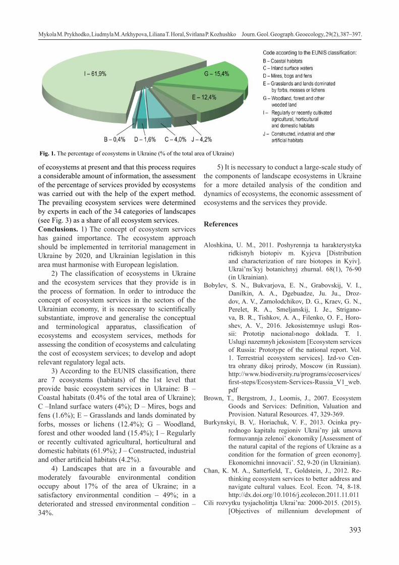
393
of ecosystems at present and that this process requires a considerable amount of information, the assessment of the percentage of services provided by ecosystems was carried out with the help of the expert method. The prevailing ecosystem services were determined by experts in each of the 34 categories of landscapes (see Fig. 3) as a share of all ecosystem services.Conclusions. 1) The concept of ecosystem services has gained importance. The ecosystem approach should be implemented in territorial management in Ukraine by 2020, and Ukrainian legislation in this area must harmonise with European legislation.
2) The classification of ecosystems in Ukraine and the ecosystem services that they provide is in the process of formation. In order to introduce the concept of ecosystem services in the sectors of the Ukrainian economy, it is necessary to scientifically substantiate, improve and generalise the conceptual and terminological apparatus, classification of ecosystems and ecosystem services, methods for assessing the condition of ecosystems and calculating the cost of ecosystem services; to develop and adopt relevant regulatory legal acts.
3) According to the EUNIS classification, there are 7 ecosystems (habitats) of the 1st level that provide basic ecosystem services in Ukraine: B – Coastal habitats (0.4% of the total area of Ukraine); C –Inland surface waters (4%); D – Mires, bogs and fens (1.6%); E – Grasslands and lands dominated by forbs, mosses or lichens (12.4%); G – Woodland, forest and other wooded land (15.4%); I – Regularly or recently cultivated agricultural, horticultural and domestic habitats (61.9%); J – Constructed, industrial and other artificial habitats (4.2%).
4) Landscapes that are in a favourable and moderately favourable environmental condition occupy about 17% of the area of Ukraine; in a satisfactory environmental condition – 49%; in a deteriorated and stressed environmental condition – 34%.
5) It is necessary to conduct a large-scale study of the components of landscape ecosystems in Ukraine for a more detailed analysis of the condition and dynamics of ecosystems, the economic assessment of ecosystems and the services they provide.
References
Aloshkina, U. M., 2011. Poshyrennja ta harakterystyka ridkisnyh biotopiv m. Kyjeva [Distribution and characterization of rare biotopes in Kyiv]. Ukrai’ns’kyj botanichnyj zhurnal. 68(1), 76-90 (in Ukrainian).
Bobylev, S. N., Bukvarjova, E. N., Grabovskij, V. I., Danilkin, A. A., Dgebuadze, Ju. Ju., Droz-dov, A. V., Zamolodchikov, D. G., Kraev, G. N., Perelet, R. A., Smeljanskij, I. Je., Strigano-va, B. R., Tishkov, A. A., Filenko, O. F., Horo-shev, A. V., 2016. Jekosistemnye uslugi Ros-sii: Prototip nacional›nogo doklada. T. 1. Uslugi nazemnyh jekosistem [Ecosystem services of Russia: Prototype of the national report. Vol. 1. Terrestrial ecosystem services]. Izd-vo Cen-tra ohrany dikoj prirody, Moscow (in Russian). http://www.biodiversity.ru/programs/ecoservices/first-steps/Ecosystem-Services-Russia_V1_web.pdf
Brown, T., Веrgstrom, J., Loomis, J., 2007. Ecosystem Goods and Services: Definition, Valuation and Provision. Natural Resources. 47, 329-369.
Burkynskyi, B. V,. Horiachuk, V. F., 2013. Ocinka pry-rodnogo kapitalu regioniv Ukrai’ny jak umova formuvannja zelenoi’ ekonomiky [Assessment of the natural capital of the regions of Ukraine as a condition for the formation of green economy]. Ekonomichni innovacii’. 52, 9-20 (in Ukrainian).
Chan, K. M. A., Satterfield, T., Goldstein, J., 2012. Re-thinking ecosystem services to better address and navigate cultural values. Ecol. Econ. 74, 8-18. http://dx.doi.org/10.1016/j.ecolecon.2011.11.011
Cili rozvytku tysjacholittja Ukrai’na: 2000-2015. (2015). [Objectives of millennium development of
Fig. 1. The percentage of ecosystems in Ukraine (% of the total area of Ukraine)
Mykola M. Prykhodko, Liudmyla M. Arkhypova, Liliana T. Horal, Svitlana P. Kozhushko Journ. Geol. Geograph. Geoecology, 29(2), 387–397.

394
Fig. 2. The distribution of ecosystems in the landscapes of Ukraine
Mykola M. Prykhodko, Liudmyla M. Arkhypova, Liliana T. Horal, Svitlana P. Kozhushko Journ. Geol. Geograph. Geoecology, 29(2), 387–397.
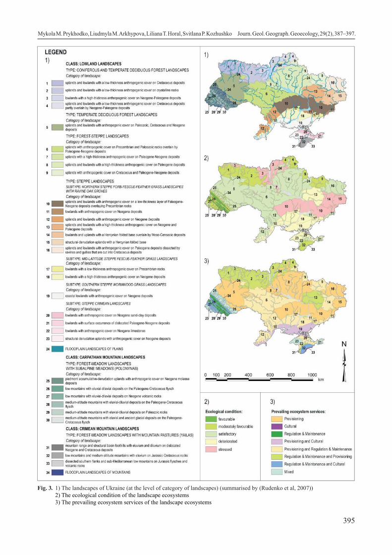
395
Fig. 3. 1) The landscapes of Ukraine (at the level of category of landscapes) (summarised by (Rudenko et al, 2007)) 2) The ecological condition of the landscape ecosystems 3) The prevailing ecosystem services of the landscape ecosystems
Mykola M. Prykhodko, Liudmyla M. Arkhypova, Liliana T. Horal, Svitlana P. Kozhushko Journ. Geol. Geograph. Geoecology, 29(2), 387–397.

396
Ukraine: 2000-2015] (in Ukrainian). Retrieved from http://un.org.ua/images/stories/docs/2015_MDGs_Ukraine_Report_ukr.pdf
Costanza, R., 2012. Ecosystem health and ecological en-gineering. Ecol. Eng. 45, 24-29. https://doi.org/10.1016/j.ecoleng.2012.03.023
Daniel, T. C., Muhar, A., Arnberger, A., Aznar, O., Boyd, J. W., Chan, K. M. A., 2012. Contribu-tions of cultural services to the ecosystem ser-vices agenda. Proceedings of the National Acad-emy of of the United States of America Sciences 109 (23), 8812-8819. http://dx.doi.org/10.1073/pnas.1114773109.
Davies C. E., Moss D., 2002. EUNIS Habitat Classification. Final Report to the European Topic Centre on Nature Protection and Biodiversity.
De Groot, R. S., Wilson, M. A., Boumans, R. M. J., 2002. A typology for the classification, description and valuation of ecosystem functions, goods and services. Ecological Economics. 41, 393-408.
Didukh, Ya. P., 2005. Teoretychni pidhody do stvorennja klasyfikacii’ ekosystem [Theoretical approaches to the development of ecosystems classification]. Ukrai’ns’kyj fitocenotychnyj zbirnyk, Ser. C. 1(23), 3-14 (in Ukrainian).
Didukh, Ya. P., Aloshkina, U. M., 2012. Biotopy m. Kyje-va [Biotopes in Kyiv]. NaUKMA, Agrar Media Grup, Kyiv (in Ukrainian).
Didukh, Ya. P., Fitsailo, T. V., Korotchenko, I. A., Yakushenko, D. M., Pashkevych, N. A., Aloshkina, U. M., 2011. Biotopy lisovoi’ ta liso-stepovoi’ zon Ukrai’ny [Biotopes of forest and forest-steppe zones of Ukraine]. TOV «Makros», Kyiv (in Ukrainian).
Didukh, Ya. P., Kuzemko, A. A., 2005. Klasyfikacija ekosys-tem Galyc’ko-Slobozhans’koi’ ekomerezhi [Clas-sification of ecosystems of Halych-Slobozhan-shchyna econet]. Ukrai’ns’kyj fitocenotychnyj zbirnyk, Ser. C. 1(23), 38-61 (in Ukrainian).
Dykson, D., Skura, L., Karpenter, R., Sherman, P., 2000. Jekosistemnye uslugi Rossii: Prototip nacional’nogo doklada. T. 1. Jekonomicheskij analiz vozdejstvij na okruzhajushhuju sredu [Economic analysis of environmental impacts]. Vita-Press, Moscow (in Russian).
Egoh, B., Drakou, G., Dunbar, M. B., Maes, J., Wille-men, L., 2012. Indicators for Mapping Ecosystem Services: A Review. EU Publications Office, Lux-embourg. http://dx.doi.org/10.2788/41823
Englund, O., Berndes, G., Cederberg, C., 2017. How to analyse ecosystem services in landscapes – a systematic review. Ecol. Indic. 73 (Supple-ment C), 492-504. https://doi.org/10.1016/j.ecolind.2016.10.009
Förster, J., Barkmann, J., Fricke, R., Hotes, S., Kleyer, M., Kobbe, S., Wittmer, H., 2015. Assessing ecosys-tem services for informing land-use decisions: a problemoriented approach. Ecol. Soc. 20(3):31.
https://doi.org/10.5751/ES-07804-200331Haines-Young, R. H., Potschin, M. B., 2018. Common In-
ternational Classification of Ecosystem Services (CICES) V5.1 and Guidance on the Application of the Revised Structure. Fabis Consulting Ltd. Retrieved from https://cices.eu/content/uploads/sites/8/2018/01/Guidance-V51-01012018.pdf
Holubchak, O., Korol S., Melnychuk I., Prykhodko M., 2019. Optimization of forest ecosystem recre-ational services formation in conditions of decen-tralization in Ukraine. Advances in Economics, Business and Management Research: 2019 7th International Conference on Modeling, Develop-ment and Strategic Management of Economic Sys-tem (MDSMES 2019). Ivano-Frankivsk, Ukraine, 5 p. https://doi.org/10.2991/mdsmes-19.2019.43
Holubets, M. A., 2000. Ekosystemologija [Ecosystemol-ogy]. Polli, Lviv (in Ukrainian).
Hrodzynskyi, D. M., 1993. Osnovy landshaftnoi› ekologii› [Fundamentals of landscape ecology]. Lybid›, Kyiv (in Ukrainian).
Jiang, W., 2017. Ecosystem services research in China: a critical review. Ecosyst. Serv. 26 (Part A), 10-16. https://doi.org/10.1016/j.ecoser.2017.05.012
Klimov, O. V., Klimov, D. O., Haidrikh, I. M., 2014. Vod-no-bolotni ugiddja ta klasyfikacija ekologichnyh system Ukrai’ny [Problems of environmental protection and ecological safety]. Problemy ohorony navkolyshn’ogo pryrodnogo sere-dovyshha ta ekologichnoi’ bezpeky. 36, 67-82 (in Ukrainian).
Korchemlyuk, M., Arkhypova, L., 2016. Environmental au-dit of Ukrainian basin ecosystem of the Prut River. Scientific bulletin of National Mining University. 5, 98-106. URL: http://nvngu.in.ua/index.php/en/component/jdownloads/finish/63-05/8551-05-2016-korchemlyuk/0
Kozak, O. M., Didukh, Ya. P., 2015. Klasyfikacija ta so-zologichna ocinka biotopiv basejnu r. Lato-rycja (Zakarpats’ka obl.) [Classification and sootological assessment of biotopes of the basin of river Latorytsia (Zakarpattia region)]. Naukovi zapysky NaUKMA. Biologija ta ekologija. 171, 38-46 (in Ukrainian).
Landers, D., Nahlik, A. M., Rhodes, C. R., 2016. The ben-eficiary perspective – benefits and beyond. In: Potschin, M., Haines-Young, R., Fish, R., Turner, R.K. (Eds.), Routledge Handbook of Ecosystem Services. Routledge, London and New York. 74-88. https://doi.org/10.4324/9781315775302-4
Maes, J., Teller, A., Erhard, M., Grizzetti, B., Barredo, J. I., Paracchini, M. L., Condé, S., Somma, F., Orgi-azzi, A., Jones, A., Zulian, A., Petersen, J. E., Marquardt, D., Kovacevic, V., Abdul Malak, D., Marin, A. I., Czúcz, B., Mauri, A., Loffler, P., Bastrup-Birk, A., Biala, K., Christiansen, T., Werner, B., 2018. Mapping and Assessment of Ecosystems and their Services: An Analytical
Mykola M. Prykhodko, Liudmyla M. Arkhypova, Liliana T. Horal, Svitlana P. Kozhushko Journ. Geol. Geograph. Geoecology, 29(2), 387–397.

397
Framework for Ecosystem Condition. Publica-tions office of the European Union, Luxembourg. https://doi.org/10.2779/055584
Malinga, R., Gordon, L. J., Jewitt, G., Lindborg, R., 2015. Mapping ecosystem services across scales and continents – a review. Ecosyst. Serv. 13, 57-63. https://doi.org/10.1016/j.ecoser.2015.01.006
Martinez-Harms, M. J., Bryan, B. A., Balvanera, P., Law, E. A., Rhodes, J. R., Possingham, H. P., Wil-son, K. A., 2015. Making decisions for managing ecosystem services. Biol. Conserv. 184 (Supple-ment C), 229-238. https://doi.org/10.1016/j.bio-con.2015.01.024
McDonough, K., Hutchinson, S., Moore, T., Hutchin-son, J. M. S., 2017. Analysis of publication trends in ecosystem services research. Ecosyst. Serv. 25, 82-88. https://doi.org/10.1016/j.eco-ser.2017.03.022
Mishenin, Ye. V., Dehtiar N. V., 2015. Ekonomika ekosys-temnyh poslug: teoretyko-metodologichni osnovy [Economics of ecosystem services: theoretical and methodological fundamentals]. Marketyng i menedzhment innovacij. 2, 243-257 62 (in Ukrai-nian).
Nykyforov, V. V., Nykyforova, O. O., Sakun, O. A., 2011. Ogljad suchasnyh klasyfikacij ekosystem [Overview of modern ecosystem classifications]. Ekologichna bezpeka. 1, 44-49 (in Ukrainian).
Olander, L., Polasky, S., Kagan, J.S., Johnston, R. J., Wainger, L., Saah, D., Maguire, L., Boyd, J., Yos-kowitz, D., 2017. So you want your research to be relevant? Building the bridge between ecosystem services research and practice. Ecosyst. Serv. 26 (Part A), 170-182. https://doi.org/10.1016/j.eco-ser.2017.06.003
Onyshchenko, V. A., 2016. Oselyshha Ukrai’ny za klasyfi-kacijeju EUNIS [Settlements of Ukraine accord-ing to EUNIS classification]. Fitosociocentr, Kyiv (in Ukrainian).
Pascual, U., Balvanera, P., Díaz, S., Pataki, Gy., Roth, E., Stenseke, M., Watson, R. T., Dessane, E. B., Islar, M., Kelemen, E., Maris, V., Quaas, M., Subramanian, S. M., Wittmer, H., Adlan, A., Ahn, S., Al-Hafedh, Y. S., Amankwah, E., Asah, S. T., Berry, P., Bilgin, A., Breslow, S. J., Bullock, C., Cáceres, D., Daly-Hassen, H., Figueroa, E., Golden, C. D., Gómez-Baggethun, E., González-Jiménez, D., Houdet, J., Keune, H., Kumar, R., Ma, K., May, P. H., Mead, A., O’Farrell, P., Pandit, R., Pengue, W., Pichis-Mdruga, R., Ppopa, F., Preston, S., Pacheco-Balanza, D., Saarikoski, H., Strassburg, B. B., Van den Belt, M., Verma, M., Wickson, F., Yagi, N., 2017. Valuing nature’s contributions to people: the IPBES approach.
Curr. Opin. Environ. Sustainability. 26-27, 7-16. https://doi.org/10.1016/j.cosust.2016.12.006
Plieninger, T., van der Horst, D., Schleyer, C., Bieling, C., 2014. Sustaining ecosystem services in cultural landscapes. Ecology and Society 19(2):59. http://dx.doi.org/10.5751/ES-06159-190259
Polasky, S., Tallis, H., Reyers, B., 2015. Setting the bar: standards for ecosystem services. Proc. Natl. Acad. Sci. 112 (24), 7356-7361. https://doi.org/10.1073/pnas.1406490112
Prykhodko, M., Havadzyn, N., Horal, L., Melnychuk, I., Berlous, M., 2019. Ecosystem Services in the Management System of Ecological Safety of Territorial Units. Advances in Economics, Busi-ness and Management Research: 2019 7th Inter-national Conference on Modeling, Development and Strategic Management of Economic System (MDSMES 2019). Ivano-Frankivsk, Ukraine, 6 p. https://doi.org/10.2991/mdsmes-19.2019.18
Prykhodko, M. M., Romaniuk, V. V., Kukhtar, D. V., Bod-naruk, I. L., Khmil, N. L., 2019. Application of the geographic information system technologies in the geosystem planning process. 18th Inter-national Conference on Geoinformatics - Theo-retical and Applied Aspects. Kiev, Ukraine, 5 p. https://doi.org/10.3997/2214-4609.201902041
Prykhodko, M. M., 2017. Floods and their management in the Carpathian region of Ukraine. Scientific bulletin of National Mining University. 2, 113-117. URL: http://www.nvngu.in.ua/index.php/uk/component/jdownloads/finish/67-02/8627-02-2017-prykhodko/0
Roche, P. K., Campagne, C. S., 2017. From ecosystem integrity to ecosystem condition: a continuity of concepts supporting different aspects of ecosys-tem sustainability. Curr. Opin. Environ. Sustain (Current Opinion in Environmental Sustain-ability). 29, 63-68. https://doi.org/10.1016/j.co-sust.2017.12.009
Rudenko, L. H. at al., 2007. Nacional›nyj atlas Ukrai›ny [National Atlas of Ukraine]. DNVP «Kartografi-ja», Kyiv (in Ukrainian).
Solovii, I., 2016. Ocinka poslug ekosystem, zabezpechu-vanyh lisamy Ukrai’ny, ta propozycii’ shhodo mehanizmiv platy za poslugy ekosystem. Zvit. [Assessment of ecosystem services provided by Ukraine’s forests and proposals for ecosys-tem services payment mechanisms. Report.] (in Ukrainian). Retrieved from http://sfmu.org.ua/files/Soloviy_2016b.pdf
Wright, W. C. C., Eppink, F. V., Greenhalgh, S., 2017. Are ecosystem service studies presenting the right information for decision making? Ecosyst. Serv. 25, 128-139. https://doi.org/10.1016/j.eco-ser.2017.03.002
Mykola M. Prykhodko, Liudmyla M. Arkhypova, Liliana T. Horal, Svitlana P. Kozhushko Journ. Geol. Geograph. Geoecology, 29(2), 387–397.

398
Geospatial distribution of gas storage facilities within the East European gas hub
Ivan I. Rovenchak, Mariia A. Yaroshevych
Ivan Franko National University of Lviv, Lviv, Ukraine, [email protected]
Abstract.The purpose of this article is to elucidate the existing surplus of underground gas storage facilities of the Western region of Ukraine and to substantiate the possibilities of using gas storages not only for the state domestic needs but also for the needs of foreign importers. The gas storage system of the Western region of Ukraine consists of five gas
storage facilities and is the basis for forming the future Eastern European gas hub. To better understand the impact of the geographical factor on the formation of the hub, a mapping method is used, which not only depicts the primary information on the position of the main gas storages but also provides an opportunity to analyze the effect of the location of an individual gas storage as it is used during a particular gas year. In order to evaluate the occupation degree of gas storage facilities, as well as to evaluate the possibilities of maximal use, the article analyzes each gas storage facility separately. There were used such methods as the comparative-geographical method, the idealization method, and the principle of causality in this article. The last is an important tool in the study because it allows the cause-and-effect relationship to be traced between the position of the gas storage and its fullness. Using the comparative-geographical method, two principles are taken into account: the similarity principle and the distinction principle. Using the principle of similarity, the article reveals similar characteristics of individual gas storage facilities, and using the distinction principle - on the contrary, highlights the differences. The core of the gas storage system of the Western region is the Bilche-Volyzko-Uherske gas storage facility - the largest gas storage with the total capacity of 17.050 million m³. It should be the core of the future Eastern European gas hub, as its capacity allows to pump the largest volumes of imported gas. The region’s second-largest gas storage facility, Bohorodchanske, at the time of peak gas pumping for the past gas year, was filled by 65% of its total capacity. The third-largest gas storage facility – Dashawske had the highest percentage of usage for the last gas year. If necessary, this gas storage could be filled up by another 207 million m³ (about 10% of the total capacity) according to the conditions of the previous gas year. Oparske and Uherske gas storage facilities were hardly used for the domestic needs of the previous gas year. The total capacity of these gas storage facilities amounted to 2857 million m³ (1710 million m³ Uherske and 1117 million m³ Oparske) in the past gas year.
Key words: gas hub, gas storage, gas pipeline, natural gas market
Геопросторовий розподіл потужностей зберігання газу в межах Східноєвропейського газового хабу
Ровенчак І.І., Ярошевич М.А.
Львівський національний університет ім. І.Франка, Львів, Україна, [email protected]
Анотація. Метою даної статті є висвітлення наявного профіциту потужностей підземних сховищ газу (ПСГ) Західного регіону України (ЗРУ) та обгрунтування можливостей використання ПСГ не тільки для внутрішніх потреб держави, але й для потреб іноземних імпортерів. Система ПСГ ЗРУ складається із п’яти газових сховищ і є базою для формування майбутнього Східноєвропейського газового хабу (СЄГХ). Для кращого розуміння впливу географічного фактора на формування хабу використовується картографічний метод, який дозволяє не тільки зобразити первинну інформацію про положення головних ПСГ, але й дає можливість проаналізувати вплив розташування окремого ПСГ на міру його використання протягом окремого газового року. Для того, щоб оцінити ступінь наповненості газових сховищ, а також оцінити можливості максимального використання, у статті проаналізовано кожне газове сховище окремо. При цьому використовуються такі методи, як порівняльно-географічний метод, метод ідеалізації, а також застосовується принцип причинності. Останній є важливим інструментом у дослідженні, оскільки дозволяє відслідковувати причинно-наслідковий зв’язок між положенням газового сховища та його наповненістю. Із застосуванням порівняльно-географічного методу беруться під увагу два принципи: принцип подібності та принцип розрізнення. За допомогою принципу подібності у статті розкриваються подібні характеристики окремих газових сховищ, а за допомогою принципу розрізнення – навпаки, висвітлюються відмінності. Ядром системи ПСГ ЗРУ є Більче-Волицько-Угерське газосховище – найбільше газосховище із загальною потужністю 17 050 млн м³. Саме воно повинно стати
Ivan I. Rovenchak, Mariia A. Yaroshevych Journ. Geol. Geograph. Geoecology, 29(2), 398–405.
Journal of Geology, Geography and
Geoecology
Journal home page: geology-dnu-dp.ua
ISSN 2617-2909 (print)ISSN 2617-2119 (online)
Journ. Geol. Geograph.Geology,
29(2), 398–405.doi: 10.15421/112035
Received: 10.10.2019Received in revised form: 04.11.2019Accepted: 24.02.2020

399
ядром майбутнього СЄГХ, оскільки його потужності дозволяють закачувати у перспективі найбільші об’єми імпортованого газу. Друге за величиною газове сховище регіону – Богородчанське на момент пікового закачування за минулий газовий рік було заповнено на 65% від своєї загальної потужності. Найбільший відсоток використання за минулий газовий рік у третьо-го за величиною газового сховища – Дашавського. При необхідності дане газове сховище можна було б наповнити ще на 207 млн м³ (близько 10% від загальної потужності) відповідно до умов попереднього газового року. Опарське та Угерське газові сховища у попередньому газовому році практично не використовувались для внутрішніх потреб країни. Сумарно вільні по-тужності даних газових сховищ становили у минулому газовому році становили 2857 млн м³ (1710 млн м³ Угерського та 1117 млн м³ Опарського).
Ключові слова: газовий хаб, підземне сховище газу, газопровід, ринок природного газу
Introduction. The problem of gas storage and trans-portation is mainly studied in economics and ge-ography. Scientific articles of national and foreign scientists in transport and energy fields became the information base for this research. This article elabo-rates and generalizes research on specialized econom-ic publications as well as the author’s own research. It is based on data from information systems in en-ergy as well as the work of scientists from the Oxford Institute for Energy Research. They are engaged in research gas hubs formation and operation problems. The purpose of this work is to characterize the surplus of underground gas storage facilities, to identify regu-larities of the spatial distribution of underground gas reserves, and to find out the possibilities of maximiz-ing the use of underground gas storage facilities.Materials and methods of research. The method-ological basis of this article is the general scientific and special methods, which were selected based on the purpose and objectives of this study. In particular, induction and deduction methods are used to char-acterize the operation of underground gas storage facilities and the prospects for systematic storage of natural gas; graphical and tabular methods - for vi-sual presentation of research results, for statistical in-formation, for theoretical and methodological provi-sions, which are substantiated in the work. The article uses a cartographic method to describe the influence of the geographical factor on the formation of a gas hub. It is not only possible to represent the available information on the location of gas storage facilities, but also to analyze the impact of localization on its occupation and subsequent use. The information ob-tained through the cartographic method overlaps with the results obtained by applying the comparative geo-graphical method. Using the comparative-geographi-cal method, two principles are taken into account: the similarity principle and the distinction principle. Us-ing the principle of similarity, the article reveals simi-lar characteristics of individual gas storage facilities, and using the principle of distinction - on the contrary, highlights the differences The method of idealization is also among the methods used in the article. This method is used to describe each gas storage facility.
Its application makes it possible to compare the maxi-mal (ideal) occupation of the gas storage with the available indicators of occupation. Results and their analysis. The European Union has traditionally paid great attention to the development of the underground gas storage sector, assessing it as one of the key contributors to its energy security in a highly import-dependent environment. To date, there are 124 gas storage facilities across the EU with a to-tal capacity of over 98 billion m³ (Heather, 2012). It is sufficient to cover about 35-40% of total daily con-sumption over 10 days to cover peak demand for un-derground gas storage or 43 days in the conditions of high demand taking into account the maximum tech-nical possibilities of gas extraction (Formuwannja ta wykorystannja strateghicnych zapasiw, 2012).
In recent years, there has been a trend of chang-ing the structure of natural gas imports from the European side. In 2013-2017, the import of natural gas to Ukraine decreased significantly (by almost 50%): from 28 billion to 14 billion m3, the segment was opened to more importers. In 2017, there were more than 60 natural gas suppliers, and the market continues increasing in the share of leading European companies in the import structure. It is important to note that there is a surplus of underground gas stor-age facilities (UGS) in the region. Despite this, in times of cold snaps, European storage facilities may not fully fulfill their direct purpose - regulating the unevenness of gas consumption and covering peak demand levels. This is caused by the relatively low technical level of possible daily takeoff. According to the Gas Infrastructure Europe (GIE) platform, the level of gas reserves in gas storages across Europe has fallen by more than a half over the last period - up to 49.5 billion m3 as of January 22, 2016 (UGS occupa-tion level is 48.9%). (Hazowa Infrastruktura Jewropy, 2019). According to the GIE, this level is the lowest in the current decade. Increasing gas consumption from storage facilities increases the importance of supply-ing gas from the outside to the European market. Be-sides, high gas costs create additional gas demand in summer - the season of pumping gas into UGS to re-store gas used during the winter. Ukraine has the most
Ivan I. Rovenchak, Mariia A. Yaroshevych Journ. Geol. Geograph. Geoecology, 29(2), 398–405.

400
powerful underground gas storage network in Europe. Today, the total UGS capacity of Ukraine is over 30 billion m3, or almost a third of the EU UGS volume.
Taking into account the data on the functioning of recent gas years, it is possible to trace certain regu-larities of gas storage (Yaroshevych, 2019). First, the maximal daily extraction of gas from underground storage facilities is steadily shifting annually by one calendar month: if in 2014-2015 the maximal daily extraction was at the beginning of December, then in the current gas year the maximum was reached at the beginning of March 2018. Secondly, the dynamics of pumping gas into the UGSs in summer becomes more stable and uniform every year. This could es-pecially bee seen between the beginning of May and the end of September 2017, as well as from the begin-ning of May to the end of July 2018. In the previous
two years, the dynamics of gas pumping was more variable - frequent changes in daily quantities are ob-served. Third, there is a clear tendency to reduce the maximal values of daily gas extraction from gas stor-age facilities. In winter of 2014-2015 gas year during the day more than 130 million m³ of natural gas could be extracted from underground storage facilities, in the same period of the gas year 2016-2017 the daily
selection did not exceed 92 million m³ within the day. Considering the gas year 2017-2018, the maximal daily value reached 116 million m³ (Pryrodnij gas u pidzemnych showyshcach Ukrainy, Skat trade, 2018).
Ukraine’s gas storage potential significantly ex-ceeds the country’s domestic needs: only about a half of the gas tank facilities is used annually. The idea of gas storage for foreign traders has been existing for a long time. The gas storage facilities of the Western region of Ukraine are best suited for such purposes, as their geographical distance from other underground gas storage facilities not only strengthens logistical positions but also makes it possible to consider the ag-gregate of gas reservoirs as a European-style gas hub. As noted above, the potential of gas storage facilities is not fully utilized. Western region gas storage facili-ties are no exception (Fig. 1).
The total capacity of five gas storage facilities is 25.32 billion m³. This is almost 80% of the total ca-pacity of all gas storage facilities in Ukraine (includ-ing the Glibove gas storage facility in the territory of the temporarily occupied Crimea). As stated in the Energy Strategy of Ukraine until 2035, gas produc-tion will have the following dynamics: 2020 - 22.9 billion m³, 2025 - 27.5 billion m³, 2030 - 33.8 billion
Fig. 1 Occupancy of gas storage facilities in the Western Region
Ivan I. Rovenchak, Mariia A. Yaroshevych Journ. Geol. Geograph. Geoecology, 29(2), 398–405.

401
m³, 2035 - 42.1 billion m³ (Nowa enerhetychna strate-hija Ukrainy do 2035 roku, 2017).
This means that for the next 10-15 years, the capacity of underground gas storage will be sufficient to store both our own and European gas. According to the Naftogaz annual report for 2017, the volume of gas pumped by third parties in UGS was 1.5 billion m³. This is 15% of the total gas amount in gas storage facilities. The volume of gas extraction by third parties was 1 billion m³. This is 13% of the total UGS gas extracted. These are very low indicators, given the characteristics of gas storage facilities. The largest
gas storage facilities are located in Western Ukraine at the intersection of key gas pipelines connecting the gas pipelines of Belarus, Poland, Slovakia, Hungary and Romania (Fig. 2).
The major volumes of transit gas from Russia also pass through this gas transit route. The core of the future Eastern European Gas Hub is to become the largest gas storage facility in the region - Bilche-Volyzko-Uherske, with the capacity of 17 050 million m³. UGS is connected to the gas pipeline system of Ivatsevichi - Dolyna III, Kyiv - West of Ukraine-II, Bilche- Volyzko - Dolyna, which through its continu-
Fig. 2. Arrangement of gas storage facilities concerning the main gas pipelines
Ivan I. Rovenchak, Mariia A. Yaroshevych Journ. Geol. Geograph. Geoecology, 29(2), 398–405.

402
ation (gas pipeline Dolyna - Bohorodchany) connects with the “Soyuz” and Urenhoy - Pomary - Uzhgorod gas pipelines. The second-largest UGS in the region is Borohodchansk. The total storage capacity is 2 300 million m³. The Bohorodchan underground storage facility is connected to the “Soyuz”, Urenhoy - Pom-ary - Uzhgorod, Ananyev - Chernivtsi - Borodchany gas pipeline systems and the Bilche - Volyzko - Doly-na gas pipeline. Dashawske, Oparske, and Uherske underground storage facilities are connected to the Ivatsevichi - Dolyna, Kyiv - Western Ukraine gas pipeline systems and to each other. Also, they are con-nected to the highly productive gas pipeline Bilche- Volyzko-Dolyna (1420 mm diameter, 84 km long), which, taking gas from the Bilche-Volyzko-Uherske UGS and the three gas storage facilities mentioned above, is essentially a gas pipeline-collector. The total capacity of the Dashawske gas storage facility is 2 150 million m³, Oparske - 1920 million m³, and Uher-ske - 1900 million m³. Due to the technological fea-tures of the storage facilities, the complex creates fa-vourable conditions for manoeuvring volumes of gas pumping and its selection over a wide range. In order to understand better the potential of gas storage, it is worth considering the characteristics of each UGS in the Western Region separately for the last gas year (Pryrodnij gas u pidzemnych showyshcach Ukrainy: dynamika zapasiw protjahom chervnja 2014 - lypnja 2018, 2018). As noted earlier, the largest gas storage facility in Ukraine in general and in the Western region, in particular, is Bilche-Volyzko-Uherske. The total capacity of the gas storage facility, as noted
earlier, is 17 050 million m³. Figure 3 shows actual PSG use, total capacity, and potential usage.
In the previous gas year, the Bilche- Volyzko -Uherske gas storage wa used by 51% of the total capacity at the beginning of the extraction period. If we leave 10% of the UGS volume for gas balancing purposes, 6 575 million m³ of gas volume could be allocated for storage by third parties only within this gas storage facility. The second-largest gas storage fa-cility in the West region of Bohorodchanske, with a total capacity of 2300 million m³, was used slightly more during the past gas year: the volume of pumped gas is 65% of the total UGS capacity (Fig. 4).
If we leave 10% of the “free” volume, Bohorodchanske UGS could store additional 566 million m³ in the current gas year. The third-largest gas storage – Dashawske has the highest usage percentage. The total UGS capacity is 2 150 million m³ (Fig. 5).
Without taking into account 10% of the gas storage volume, additional 207 million m³ of gas could be used by third parties in the current gas year. One of the least used in the current gas year was the fourth largest gas storage facility – Oparske (Fig. 6).
The total capacity of the gas storage facility is 1920 million m³. As of the 18th of November, 2017 the volume of gas stored in the UGS made 611 million m³. That means the gas storage was filled by 32% of its total capacity. The gas pumping period for the UGS also started relatively late: if the increase in gas in the Bilche-Volyzko-Uherske, Bohorodchanske, Uherske gas
Fig. 3. Capacity of the Bilche-Volyzko-Uhersky gas storage facility
Ivan I. Rovenchak, Mariia A. Yaroshevych Journ. Geol. Geograph. Geoecology, 29(2), 398–405.
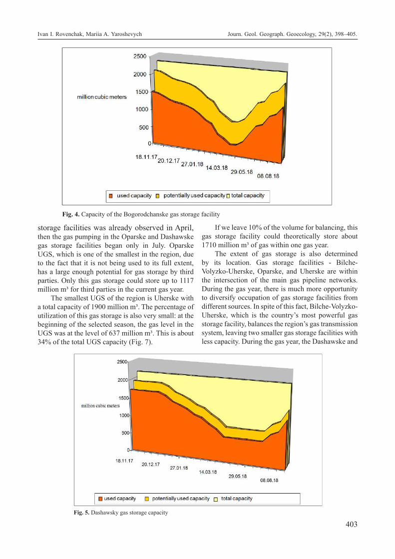
403
storage facilities was already observed in April, then the gas pumping in the Oparske and Dashawske gas storage facilities began only in July. Oparske UGS, which is one of the smallest in the region, due to the fact that it is not being used to its full extent, has a large enough potential for gas storage by third parties. Only this gas storage could store up to 1117 million m³ for third parties in the current gas year.
The smallest UGS of the region is Uherske with a total capacity of 1900 million m³. The percentage of utilization of this gas storage is also very small: at the beginning of the selected season, the gas level in the UGS was at the level of 637 million m³. This is about 34% of the total UGS capacity (Fig. 7).
If we leave 10% of the volume for balancing, this gas storage facility could theoretically store about 1710 million m³ of gas within one gas year.
The extent of gas storage is also determined by its location. Gas storage facilities - Bilche-Volyzko-Uherske, Oparske, and Uherske are within the intersection of the main gas pipeline networks. During the gas year, there is much more opportunity to diversify occupation of gas storage facilities from different sources. In spite of this fact, Bilche-Volyzko-Uherske, which is the country’s most powerful gas storage facility, balances the region’s gas transmission system, leaving two smaller gas storage facilities with less capacity. During the gas year, the Dashawske and
Fig. 4. Capacity of the Bogorodchanske gas storage facility
Fig. 5. Dashawsky gas storage capacity
Ivan I. Rovenchak, Mariia A. Yaroshevych Journ. Geol. Geograph. Geoecology, 29(2), 398–405.

404
Bohorodchanske gas storage facilities are occupied sufficiently as they have some autonomy.
The value of underground gas storage is quite significant for the entire gas transportation system of the country. In terms of key features, Ukrainian gas storage facilities take the first place in the world after American and Russian. Underground storage facilities guarantee the reliability of natural resource transportation for both internal and external needs (Yaroshevych, 2018). The underground gas storage network can be considered as a liquid asset of the country, which is a component of its energy stability. The UGSs of Ukraine have great potential that can be used for internal and external directions of the
development of the whole gas transportation system of the country and Middle East Europe.Conclusions. The use of underground gas storage facilities allows reducing peak loads in a single gas supply system, to provide flexibility and security of gas supply. Underground gas storage facilities in Ukraine are intended primarily to regulate seasonal irregularities in gas consumption; additional gas supply to consumers with extreme temperature reductions, both in separate days and during abnormally cold winters; creation of long-term gas reserves in case of unforeseen emergency situations, such as long-term interruption of gas supplies due to major accidents, natural disasters, etc .; gas backup in the event of
Fig.6. Capacity of Oparske UGS
Fig.7. Uherske gas storage capacity
Ivan I. Rovenchak, Mariia A. Yaroshevych Journ. Geol. Geograph. Geoecology, 29(2), 398–405.

405
short-term emergencies in the gas supply system. Studying the problems of the Eastern European Gas Hub and justifying the need for its formation is an important area of socio-geographical, in particular, economic and geographical research.
References
Derzawna nacionalna kompanija Ukrenerho, 2017. For-muwannja ta wykorystannja stratehicnych zapa-siw palywno-enerhetycnych resursiw u zarubi-znych krainach [National company Urkenerho, Formation and use of strategic fuel stocks and energy resources in foreign countries, offi-cial website] Retrieved from https://ua.energy/wp-content/uploads/2018/01/1.-Formuvannya-strategichnyh-zapasiv.pdf (in Ukrainian);
Gas infrastructure Europe, 2019. Retrieved from https://agsi.gie.eu/#/ ;
Heather P., 2012. Continental European Gas Hubs: Are They Fit for Purpose?, The Oxford university of energy studies Retrieved from https://www.oxforden-ergy.org/publications/continental-european-gas-hubs-are-they-fit-for-purpose/?v=9b7d173b068d
Ministerstwo enerhetyky ta wuhilnoi promyslowosti (2017) Nowa enerhetychna stratehija Ukrainy do 2035 roku: bezpeka, enerhoefektywnist, konkurento-spromoznist [New energy strategy till year 2035:
security, efficiency, competitiveness, State of En-ergy and Coal Industry] Retrieved from http://mpe.kmu.gov.ua/minugol/control/uk/doccatalog/list?currDir=50358 (in Ukrainian)
Skat trade, 2018. Pryrodnij gas u pidzemnych showyshcach Ukrainy: dynamika zapasiw protjahom chervnja 2014 – lypnja 2018 [Natural gas in undeground storages of Ukraine: dynamic of inventoris during June 2014- July 2018, Skat trade, official website] Retrieved from https://skat-trade.com/analityka/pryrodnyj-gaz-u-pidzemnyh-shovyshchah-ukrainy-dynamika-zapasiv-protyagom-chervnya-2014-lypnya-2018/ (in Ukrainian).
Yaroshevych, M., 2018. Schidno-Euwropejskyj gasowyj hab w systemi gasowych habiw Europy [Eastern European Gas Hub in European gas hubs system`s] social`no-ekonomichnoyi geografiyi Charkivskoho nazionalnoho universytetu imeni V.N.Karazina [Human geograhy journal of V.N. Karazin Kharkiv National University.], (24), 83-89 (in English, abstr. in Ukrainian).
Yaroshevych, M., 2019. Transportno geografichne polozennja jak faktor formuwannja Schidno-Euwropejskoho hasowoho habu [Transport and geographical location as a factor of Easter European gas hubs formation] Visnyk Kyivs-kogo nacionalnogo universytetu imeni Tarasa Shevchenka, Geografiya [Bulletin of Taras Shevchenko National University of Kyiv, Geography], 1 (73), 68-72 (in Ukranian).
Ivan I. Rovenchak, Mariia A. Yaroshevych Journ. Geol. Geograph. Geoecology, 29(2), 398–405.

406
Sergii E. Sardak, Oleksandr P. Krupskyi, Vladimir Dzhyndzhoian, Margarita Sardak, Yuriy Naboka Journ. Geol. Geograph. Geoecology, 29(2), 406–414.
Development of historical and cultural tourist destinations
Sergii E. Sardak1, Oleksandr P. Krupskyi2, Vladimir Dzhyndzhoian1, Margarita Sardak3, Yuriy Naboka1
1 Dniprovskii University of the Humanities, Dnipro, Ukraine, [email protected], [email protected], [email protected] 2 Oles Honchar Dnipro National University, Dnipro, Ukraine, [email protected] 3 University of Cologne, Köln, Germany, [email protected]
Abstract. The aim of the study is to develop theoretic and methodological recommendations and practical activities for the positive social, managerial, organizational and economic development of historical and cultural tourist destinations. In theoretical terms: the role of historical and cultural tourist destination in the development of the region has been
established; the historical and cultural tourist destinations have been identified; the author’s classification of historical and cultural tourist destinations has been developed basing tourist visiting activeness; the author’s methodological approach to the diagnosis and creating tools for development of historical and cultural tourist destinations, comprehensively taking into account resource and factor components, has been presented. In practical terms: variations of the activities aimed at the positive development of historical and cultural tourist destinations have been proposed; the description of measures aimed at the creation of a historical and cultural complex on the example of the designed historical and cultural complex “Stara Samar” has been given. The results of the study are applicable for a wide range of historical and cultural tourist attractions: territories, landscapes and elements of landscapes, historical settlements, parks, film studios, historical and cultural heritage sites, history and culture monuments, burial sites, places of worship, sites of social cultural infrastructure. The author’s recommendations provide obtaining commercial results and ensuring a social and cultural effect for businessmen, managers, local communities in the management of existing or in the creation of new historical and cultural tourist destinations.
Keywords: historical and cultural site, tourism, national park, tourist park, monument, factors, resources, activities, Stara Samar
Розвиток історико-культурних об’єктів туристичного призначення
С. Е. Сардак1, О. П. Крупський2, В .В. Джинджоян1, М. О. Сардак3, Ю. В. Набока1
1 Дніпровський гуманітарний університет, Дніпро, Україна, [email protected], [email protected], [email protected] 2 Дніпровський національний університет імені Олеся Гончара, Дніпро, Україна, [email protected] 3 Кельнський університет, Кельн, Німеччина, [email protected]
Анотація. Завданням дослідження є розробка теоретико-методологічних рекомендацій та практичних заходів позитивного соціального, управлінського, організаційного та економічного розвитку історико-культурних об’єктів туристичного призначення. У теоретичній площині: визначена роль історико-культурних об’єктів туристичного призначення для розвитку регіону; здійснено ідентифікацію історико-культурних об’єктів туристичного призначення; розроблена авторська класифікація історико-культурних об’єктів туристичного призначення, з позиції активності відвідування туристами; представлений авторський методологічний підхід щодо діагностики та розробці заходів розвитку історико-культурних об’єктів туристичного призначення який комплексно враховує ресурсні та факторні складові. У практичній площині: запропоновано варіації заходів спрямованих на позитивний розвиток історико-культурних об’єктів туристичного призначення; наведено характеристику заходів щодо створення історико-культурного комплексу, на прикладі запроектованого історико-культурного комплексу «Стара Самарь». Результати дослідження можуть застосовуватися для широкого кола історико-культурних об’єктів туристичного призначення: території, ландшафти і елементи ландшафтів, історичні поселення, парки, кіностудії, об’єкти історико-культурної спадщини, пам’ятники історії та культури, місця поховань, культові споруди, об’єкти соціокультурної інфраструктури. Авторські рекомендації передбачають отримання комерційних результатів і забезпечення соціально-культурного ефекту для бізнесменів, менеджерів, місцевіх громад при управлінні діючими або при створенні нових історико-культурних об’єктів туристичного призначення.
Ключові слова: історико-культурний об’єкт, туризм, національний парк, туристичний парк, пам’ятник, фактори, ресурси, заходи, Стара Самарь
Journal of Geology, Geography and
Geoecology
Journal home page: geology-dnu-dp.ua
ISSN 2617-2909 (print)ISSN 2617-2119 (online)
Journ. Geol. Geograph.Geology,
29(2), 406–414.doi: 10.15421/112036
Received: 25.09.2019Received in revised form: 14.11.2019Accepted: 24.04.2020

407
Problem statement. Historical and cultural sites are important for society in general and for regions in particular. Firstly, they are an integral organic component of cities, villages and territories, which have already been established and requires permanent maintenance. Secondly, these sites play the role of historical and cultural heritage, which forms the image of the region, its brand and status, as well as serves as an important component in the formation of cultural and national identity of the population. Thirdly, these sites allow the formation of spiritual, cultural and recreational centres of attraction for the local population, migrants and tourists, which leads to the inflow of capital through investment, trade and donations. Thus, historical and cultural sites prolong the life cycle of settlements, countries and civilizations, which is a notable contribution to the social development (Sardak et all, 2019).
In addition, the number of historical and cultural tourist destinations is significant. For example, by the beginning of 2019, UNESCO had registered 1121 World Heritage sites, 869 of which are cultural, 213 are natural and 39 are combined (World Heritage List Statistics).
In the USA, 417 park sites, historical and cultural monuments (60 of which are national parks) make 3.6 % of the national land, the National Park Service (NPS) budget in 2018 was 3.2 billion USD, with the annual visit by more than 277 million people. In ad-dition, there are more than 600 thematic parks and 2100 aqueous entertainment complexes in the United States.
The UNESCO World Heritage List in Canada lists 18 names (as of 2016), what made 1.6 % from the total number of objects. 8 sites are included in the list by the cultural criteria, 1 of them was recognized as a masterpiece of mankind, 10 – by natural indica-tors, 7 of them were recognized as natural phenomena of exceptional beauty and aesthetic importance. In ad-dition, as of 2016, 6 sites in the territory of the state are among the candidates to be included in the World Heritage List, consisting of 2 – by cultural, and 4 – by mixed criteria (World Heritage List Statistics).
Mexico has 34 UNESCO World Heritage Sites (as of 2016), what makes 3.0 % from the total number. The list includes: 27 cultural sites (13 Pre-Columbian and 15 Post-Colonial era), 6 natural sites, 1 mixed site. 10 of these sites were recognized as masterpieces of human genius and 5 are natural phenomena of ex-ceptional beauty and aesthetic importance. In addi-tion, as of 2016, 22 sites in the state are among the candidates to be included in the World Heritage List, including 11 – by cultural, 5 – by natural and 6 – by
mixed criteria (World Heritage List Statistics).In Ukraine, there are more than 130 000 fixed
monuments of history and culture, 63 historical and cultural reserves (of which are national ones) are in operation, there are 401 historical settlements, 437 state and municipal museums.
In the Russian Federation, the total area of more than 1000 especially protected natural territories makes 7.58 % of the country’s territory, 35 of which are national parks, which are visited annually by about 2 million people.
The List of UNESCO World Heritage Sites in In-dia includes 36 items (as of 2017), which is 3.2 % of the total number. 28 sites are included in the List by cultural criteria, 7 objects – by natural, 1 – by mixed criteria. 12 sites were recognized as masterpieces of human creative genius, 3 were recognized as natural phenomena or spaces of exceptional natural beauty and aesthetic importance. In addition, as of 2017, 42 sites in the territory of the state are among the candi-dates to be included in the World Heritage List Sta-tistics.Analysis of scientific research and publications. The study of publications shows that the development of historical and cultural tourist destinations is being actively explored by scientists, international organizations and national services.
For example, the “Global Code of Ethics for Tourism” states that heritage sites should receive funding to maintain, protect, improve and restore them in order to preserve the cultural identity of the nations and nationalities of the Earth, as well as for universal tourist use (Global Code of Ethics for Tourism, 1999).
Floyd (2001) explored the prospects of development parks regarding the racial and ethnic approaches to visiting them. He came to the conclusion that the development of tourism in certain territories (historical and cultural centres) directly depends on multiculturalism and multinationalism of the society. Putrik (2008) in his study considered tourism as a factor in the preservation of historical heritage and the development of the traditions of regions, noting that about 40 % of tourist flows are caused by cultural motivations. Tortora, Randelli and Romei (2014) comprehensively considered the conceptual basis of the study of the region’s tourism potential and determined its composition and components.
The New South Wales Government’s Report “Cultural landscapes and park management: a literature snapshot” considered the issues of cultural heritage management (Cultural landscapes and park management, 2008). The Report “Cultural Landscapes. A practical guide for park management”

408
contains the designed guide for park managers to help identify, evaluate, manage and interpret cultural values. Particular attention is paid to the identification and mapping of cultural sites and values (Cultural Landscapes, 2010).
Gonzalez (2011) in his work raised the problem of the lack of any theoretical justification for the creation of cultural parks, taking into account the need for their harmonization between cultural heritage and landscape. He proposed a new theoretical conceptualization of functioning of cultural parks, which serves as the basis of the methodology for empirical research. In the subsequent publication, Gonzalez (2013) considered cultural parks as positive and constructive tools, the effectiveness of which is related to the preservation of heritage, bridging the gap between nature and culture, strengthening identity and memory, and strengthening social cohesion and economic development.
Polyvach (2012) considered the role of cultural heritage and identified its connection with the development of regions. Savranchuk (2013) studied the functional activities and identified the development prospects of the world’s leading thematic parks. Düzgüneş and Demirel (2014) studied the potential of national parks for entertainment and tourism events and noted that as a result of their intensive use by visitors, many of them are under threat of destruction. Melgarejo and Gimenez (2015) analyzed the value of the heritage of non-movable and intangible cultural values. A legal analysis of the concept of “cultural park” was performed and it was decided whether it could be applied in the region under consideration. They concluded that the concept of a cultural park was suitable for legal, cultural and environmental purposes. Yang and Chen (2015) in their article addressed the integration of regional culture and urban park to transform the landscape and proposed regional cultural functions that improve strategies for the reconstruction of the landscape of urban parks. Faraci (2017) described the process of forming a sustainable design, social innovation and integration, which was initiated in the restoration and reuse of the abandoned historical centre, which ensured a sustainable identical transformation of this site in a dynamic creative park.
Franch-Pardo, Cancer-Pomar and Napoletano (2017) in their article evaluated the visibility, quality and fragility as the features for determining the protective ability based on both biophysical and visual elements of the landscape. The resulting protection maps can be used to prioritize landscapes for their protection based on their levels of quality and fragility.
Dorofieieva (2017) studied the impact of the existence of cultural and historical heritage sites on the tourist attractiveness of the region. Palinchak, Diachenko and Roshko (2017) reviewed the composition of natural protected areas and sites and focused on the need for their preservation. Biscione, Danese and Masini (2018) demonstrated the need for clear fixation of cultural monuments using the geo-information system (GIS). Such digital cultural heritage map formed the basis for the development of plans to protect, develop and maintain historical and cultural sites. Shafik and El-Husseiny (2019) considered the structure and some guidelines to improve the social support of the area by paraphrasing the park’s role in response to the changing needs of the community.
However, the reviewed publications note the following aspects that necessitate further research: an unclear identification of historical and cultural sites; uncertainty of the effective functions of management and economic functions of historical and cultural sites; lack of classification for historical and cultural sites from the point of view of tourists’ activeness of visiting them; lack of analysis of the consequences of tourists’ visiting historical and cultural tourist destinations; lack of methodological basis for diagnosing the state and development of activities of historical and cultural tourist destinations.The task of the study. The task of the study is to develop theoretic and methodological recommendations and practical measures for the positive social, managerial, organizational and economic development of historical and cultural tourist destinations.
The study applied the systematic approach, the matrix method, the methods of analysis, synthesis, analogies, abstraction, observation, comparison, grouping, and generalization.Presentation of the basic material. The considered term “historical and cultural site” is a common name for a very wide range of categories. Thus, in the scientific literature, the legal field of states and the acts of international organizations, historical and cultural sites may imply:
• territory (environmentally guarded territory, natural reserve, natural reserve area, a site of natural reserve fund, historical and cultural reserve, reserve, territorial complex, archaeological territory, etc.);
• landscapes and elements of landscapes (natural territories: coastal zone, spit, beach, lake, river, island and other sites of historical and cultural value);
• historical settlements (areals, cities, villages, set-tlements, ethnic settlements, etc.);
Sergii Sardak, O. Krupskyi, V. Dzhyndzhoian, M. Sardak, Y. Naboka Journ. Geol. Geograph. Geoecology, 29(2), 406–414.

409
• parks (cultural park, historical park, historical and cultural park, dendrological park, sites of garden and park art, natural park, memorial park, national park, as well as variations of thematic parks: mega-park, historical park, geographical park, oceanarium, aquapark park of entertain-ments, safari park, amusement park, space park);
• film studios (Media conglomerates, Majors, Mini-majors, The Studios, Instant major studios, other significant, past independent entities);
• historical and cultural heritage (historical and/or cultural heritage sites: buildings, structures, for-tresses, palaces, castles, complexes, ensembles, memorial places, etc.);
• monuments of history and culture (concrete el-ements: buildings, various architectural forms, neighborhoods, squares, streets, land areas, open undeveloped spaces, memorial signs, etc.);
• burial sites (operating cemeteries, inactive cem-eteries, necropolises, mass graves, mounds, graves);
• religious buildings (monasteries, churches, ritual places, mystical structures);
• socio-cultural infrastructure (museums, libraries, archives, etc.). As it can be seen from the above list, historical
and cultural tourist destinations can vary greatly in form, purpose, scale, significance, etc. Accordingly, in the context of the research problem, we will note that an invention of activities on positive development of historical and cultural tourist destinations should be targeted, that is, for each specific site individually.
Therefore, in order to ensure the positive devel-opment of historical and cultural tourist destinations, it is advisable to perform their classification. From the point of view of activeness of visiting tourists, histori-cal and cultural sites can be divided into three groups.
The first one includes the sites that are actively protected from tourists (tourists are completely forbid-den to visit them and access is allowed only to a lim-ited contingent of persons). For example, according to the International Union for Conservation of Nature and Natural Resources (IUCN) classification, it is a “strictly natural reserve” – an area with pristine nature and full protection (IUCN, 2019) or the term “reserve” is used. The world has an estimated 651 biosphere re-serves in 120 countries, the largest of which is Panta-nal (Brazil) with the area of 195 000 sq. km.
The second one is passively accessible sites (tourists are not forbidden to visit such sites, but spe-cial events are not organized for their visits). National and natural parks are included in this category. For example, there are currently 55 national parks in Rus-
sia, their total area of the territory is about 30 million hectares and they are mostly located in the north-west and south of the country. National parks in Europe occupy more than 11 % of the entire area of the conti-nent and their number exceeds 6 000.
The third one is actively accessible sites (tourists are actively involved, the production of tourist recep-tion was created and tourist infrastructure was formed, fees for visits or indirect fees are charged, tours are held, tourist services are rendered). These are the ter-ritories where states and private businesses fully or partially fund the use of sites for financial gain (the-matic parks, entertainment, cultural, historical cen-tres, etc.). For example, in Germany, the archaeologi-cal park, which contains both original and recreated architectural monuments of the Roman town Colonia Ulpia Traiana, operates in the town of Xanten. This is a clear example of how an archaeological reserve, which is an undeniably important historical and cul-tural monument, but initially not including particular-ly spectacular objects that can attract both scientists, and tourists, was turned into the largest open-air mu-seum and attracts about half a million visitors annu-ally. Thanks to the regional funding, private investors and philanthropists, large-scale work on experimental archaeology and scientific reconstruction, where his-tory can be touched, tasted and relived by itself were carried out and are still being carried out (LVR-Ar-cheologisch Park Xanten).
Considering the consequences of visiting histori-cal and cultural destinations by tourists and the con-nection between such sites and the development of the region, we can note three vectors.
The first is the positive consequences: restoration and support of this destination by tourists (tourists physically do the clearing or repairing on a volun-teer basis, allocate targeted funds), the attractions of funds for the development of the tourism infrastruc-ture, employment of the workforce, popularization of the region. Thus, the result of the development of the volunteer movement in the world was the emergence of a new variety in tourism – volunteer tourism. More than 2.5 million people participate in it every year, and revenues are estimated in billions.
The second one is neutral consequences: visit-ing a historical and cultural site by tourists has any impact neither on the site, nor on the inhabitants of the region of its location. These are mostly the sites that are included in tourist routes as transit (historical buildings and cultural structures visited within long tours, the sites located along the traffic flows between settlements).
The third one is the negative consequences: the
Sergii Sardak, O. Krupskyi, V. Dzhyndzhoian, M. Sardak, Y. Naboka Journ. Geol. Geograph. Geoecology, 29(2), 406–414.

410
destruction of a site by tourists (physical wear, pollu-tion, breakdowns, theft of structural elements). Thus, in the north of England, the defensive fortification of Adrian Wall (it has been a UNESCO World Heritage Site since 1987). It is the part of the popular tourist route, but due to the intensive tourist activity, rains and winds, it is being destroyed and requires urgent recovery. Machu Picchu (Peru) is a mystic town of ancient Indians every year attracts more and more tourists and is gradually taken apart for souvenirs. Cosumel (Mexico) is under the risk to be turned into a real dump because of the desire of tourists to see its beauty. Mogao Grotto (China) is a village that is no longer happy to have tourists, so the local authorities have restricted the access of tourists to prevent the collapse of the existing infrastructure around the at-traction.
Based on the consideration of the proposed classification of historical and cultural sites and the consequences of their being visited by tourists, hav-ing used the matrix method, we can conceptually outline the scope of activities aimed at the positive development of historical and cultural tourist desti-nations.
Thus, it should be noted that the development of historical and cultural tourist destinations does not always prioritize an increase in the volume of tourist flows. The measures of the owners of such sites or service organizations should be aimed at forming rational routes, tourists groups, forms of service that correspond to local conditions. This implies increased entrepreneurial activity and cooperation with a wide range of organizations, including: private guides, tour bureaus, travel agencies, tour operators,
museums, hotels, restaurants, service companies, local communities, town halls, university centres, IT companies, advertising agencies, rescue services, TV and radio companies, film industry and other structures.
Having determined the scope of activities aimed at positive development of historical and cultural tourist destination, authorized state authorities, local governments or owners can design the complex of specific actions in relation to the site they service. Methodologically, this may have the following sequence of actions: diagnosis of the factor and resource components; identification of missing resources and necessary changes; development of legally permitted solutions; taking actions; assessments of the result.
Table 2 shows the graphic visualization of the methodological approach to the diagnosis and development of activities on the development of historical and cultural tourist destinations.
The application of this methodological approach involves the identification of systemic factors and resources, and their visual combination in the application of the matrix method, allows inventing the activities for the development of historical and cultural tourist destinations.
Thus, the system factors can be identified as the elements of the environment of the site’s location. Therefore, within the natural system, structure-forming elements are natural resources – land, water, and climate. In the format of the biological system, the structure-forming elements are people, animals and plant world. In the technical system, the structure-forming elements are constructions,
Table 1. The scope of activities aimed at positive development of historical and cultural tourist destinations*
Consequences of visiting
Group of sitesPositive Neutral Negative
Actively protectedAttraction of volunteers. Creation of real and virtual reconstructions
Reviewing the categories of the tourists who have the right to visit the sites
Restoration of a site. Time limit or complete denial of access for tourists
Passively accessible
Expansion of the geography of tourists. Installation of informa-tion stands with schemes and routes of convenient and safe visit of sites. Allocation of funds for creation (improvement) of the infrastructure
Monitoring tourists’ visits to the site and controlling possible damage. Introduc-tion of a price policy in the “demand-price-quality” mode
Search and allocation of ad-ditional funds to eliminate the negative consequences of visiting sites by tourists (complete or partial repair, restoration)
Actively accessible
Popularization of sites by means of modern methods and tools with the extensive use of social networks, information sources, etc.
Improvement of tourist ser-vicing. Creation of the site’s infrastructure
Restriction of the tourists’ access to individual objects and facili-ties. Installation of prohibitive and warning signs (notices), rules of visiting sites. Increased control
* developed by the authors.
Sergii Sardak, O. Krupskyi, V. Dzhyndzhoian, M. Sardak, Y. Naboka Journ. Geol. Geograph. Geoecology, 29(2), 406–414.
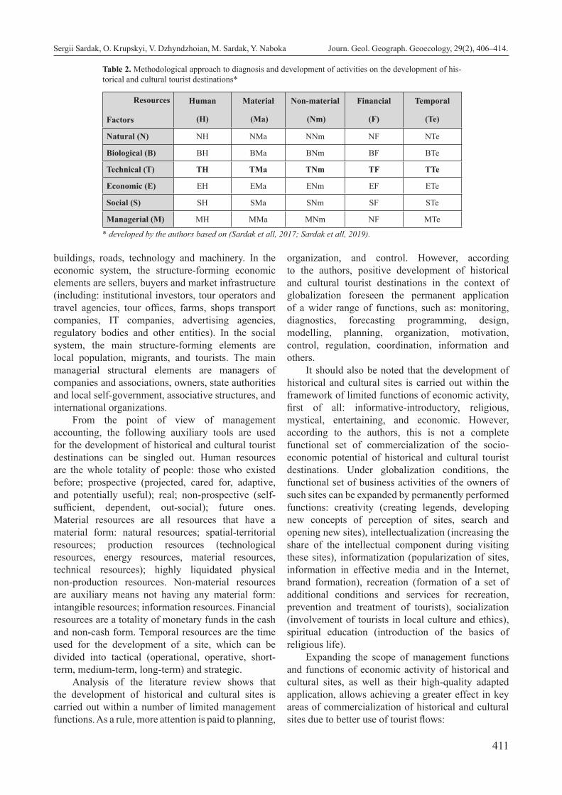
411
buildings, roads, technology and machinery. In the economic system, the structure-forming economic elements are sellers, buyers and market infrastructure (including: institutional investors, tour operators and travel agencies, tour offices, farms, shops transport companies, IT companies, advertising agencies, regulatory bodies and other entities). In the social system, the main structure-forming elements are local population, migrants, and tourists. The main managerial structural elements are managers of companies and associations, owners, state authorities and local self-government, associative structures, and international organizations.
From the point of view of management accounting, the following auxiliary tools are used for the development of historical and cultural tourist destinations can be singled out. Human resources are the whole totality of people: those who existed before; prospective (projected, cared for, adaptive, and potentially useful); real; non-prospective (self-sufficient, dependent, out-social); future ones. Material resources are all resources that have a material form: natural resources; spatial-territorial resources; production resources (technological resources, energy resources, material resources, technical resources); highly liquidated physical non-production resources. Non-material resources are auxiliary means not having any material form: intangible resources; information resources. Financial resources are a totality of monetary funds in the cash and non-cash form. Temporal resources are the time used for the development of a site, which can be divided into tactical (operational, operative, short-term, medium-term, long-term) and strategic.
Analysis of the literature review shows that the development of historical and cultural sites is carried out within a number of limited management functions. As a rule, more attention is paid to planning,
organization, and control. However, according to the authors, positive development of historical and cultural tourist destinations in the context of globalization foreseen the permanent application of a wider range of functions, such as: monitoring, diagnostics, forecasting programming, design, modelling, planning, organization, motivation, control, regulation, coordination, information and others.
It should also be noted that the development of historical and cultural sites is carried out within the framework of limited functions of economic activity, first of all: informative-introductory, religious, mystical, entertaining, and economic. However, according to the authors, this is not a complete functional set of commercialization of the socio-economic potential of historical and cultural tourist destinations. Under globalization conditions, the functional set of business activities of the owners of such sites can be expanded by permanently performed functions: creativity (creating legends, developing new concepts of perception of sites, search and opening new sites), intellectualization (increasing the share of the intellectual component during visiting these sites), informatization (popularization of sites, information in effective media and in the Internet, brand formation), recreation (formation of a set of additional conditions and services for recreation, prevention and treatment of tourists), socialization (involvement of tourists in local culture and ethics), spiritual education (introduction of the basics of religious life).
Expanding the scope of management functions and functions of economic activity of historical and cultural sites, as well as their high-quality adapted application, allows achieving a greater effect in key areas of commercialization of historical and cultural sites due to better use of tourist flows:
Table 2. Methodological approach to diagnosis and development of activities on the development of his-torical and cultural tourist destinations*
Resources
Factors
Human
(H)
Material
(Ma)
Non-material
(Nm)
Financial
(F)
Temporal
(Te)
Natural (N) NH NMa NNm NF NTe
Biological (B) BH BMa BNm BF BTe
Technical (Т) ТH ТMa ТNm ТF ТTe
Economic (E) EH EMa ENm EF ETe
Social (S) SH SMa SNm SF STe
Managerial (M) MH MMa MNm NF MTe
* developed by the authors based on (Sardak et all, 2017; Sardak et all, 2019).
Sergii Sardak, O. Krupskyi, V. Dzhyndzhoian, M. Sardak, Y. Naboka Journ. Geol. Geograph. Geoecology, 29(2), 406–414.

412
Table 3. Characteristic of activities on creation the historical and cultural complex “Stara Samar”*
No Indicator Characteristic1 Natural factors (N) Moderate continental climate, proximity of Dnipro and Samara river basins 2 Biological factors (B) Limited existence of wild animals not bearing a threat to humans, existence of vegetation (forests,
meadows)3 Technical factors (Т) Remains of a fortress, lack of infrastructure and production enterprises 4 Economic factors (E) Visiting site for tourists is free of charge 5 Social factors (S) The site is known among the local population and people interested in historical and cultural monu-
ments6 Managerial factors (M) Location on the municipal land 7 Human resources (H) Targeted labour resources for cleaning and guarding are not allocated 8 Material resources (Ma) Elements of an old fortress, church, gates, wall, forgery, Kuren (Cossack’s hut)9 Non-material resources (Nm) Advertising in social networks, in the Internet, catalogues
10 Financial resources (F) The site is not funded 11 Temporal resources (Te) Belongs to the period of 14-17 century A.D., excavation works have been held since 2002 12 Activities NH Attraction of specialists in archeology, history, geography, geodesics, water and natural resources13 Activities NВ Control of natural environment state, water resources, green spaces and organizing activities on their
optimization 14 Activities NН Entering information on natural factors of the site into the register, maps and systems 15 Activities NF Funding of landscaping and keeping the surrounding areas clean16 Activities NTe Permanently17 Activities BH Attraction of biologists, zoologists, ichtiologists, other specialists 18 Activities BMa Mounting protective fences, spraying aerosols on the sites and surrounding areas19 Activities BNm Entering information on flora and fauna objects in information systems 20 Activities BF Funding the works on instalment of protective structures and protective activities 21 Activities BTe Entire period of funding the site 22 Activities ТH Attraction of specialists in construction, architecture, restoration, conservation, reconstruction and
landscaping23 Activities ТMa Fortification of ravines, banks and slopes, reconstruction of structural elements, construction of new
structural elements, decoration, construction of technical premises for ensuring the infrastructure operation
24 Activities ТNm Formation of corporative information system 25 Activities ТF Funding of productions and infrastructure development 26 Activities ТTe Site commissioning and operation periods 27 Activities EH Attraction of specialists to study economic feasibility of investments for construction, restoration,
archaeological and recovery works28 Activities EMa The development of business plan, receiving and distributing funds. Formation of commodity, price
and sales policy. Organization of reception of tourists.29 Activities ENm Keeping accounting, tax and statistic records 30 Activities EF Determining the volume of funding and directions of their distribution 31 Activities ETe Site commissioning and operation periods 32 Activities SH Attraction of specialists in history, archaeology, restoration, tour guides, museum teachers, media
representatives33 Activities SMa Creation of zones for recreation, leisure, entertainment, hygienic premises 34 Activities SNm Activities on promotion the site in the media, popularization of site. Taking care of cultural heritage
and formation of national unity, promoting scientific research and promoting the results of these stud-ies. Organization of tours and field classes in History for children and young people
35 Activities SF Socialization of the price police for different categories of tourists 36 Activities STe Permanently 37 Activities MH Administration of the site and staffing, signing contracts 38 Activities MMa Development of strategy and tactics. Registration of the site. Administration. 39 Activities MNm Management, communications, formation of knowledge bases, staff development 40 Activities MF Staff salary 41 Activities MTe Site commissioning and operation periods
* developed by the authors
Sergii Sardak, O. Krupskyi, V. Dzhyndzhoian, M. Sardak, Y. Naboka Journ. Geol. Geograph. Geoecology, 29(2), 406–414.

413
• functional activities (to expand the scope of targets of a site);
• manufacturing activities (transformation of technology for tourist services, application of new equipment, activation of innovatory work of the staff);
• commodity policy (expanding the range of goods and services for tourists: excursions, events, shows, role plays games, quests, sale of souvenirs, photos and videos, accommodation and catering, tasting, attractions, etc.);
• financial policy (redistribution of financing and the structure of financial resources);
• investment policy (change of investment policy, intensification of the search for national and international investors, attraction of loans, attraction of sponsorship, crowdfunding, attrac-ting subsidized financial funds from government agencies and international organizations);
• price policy (change or combination of existing pricing methods and pricing strategies);
• marketing policy (change or expansion of forms of wholesale and retail trade, change of direct marketing forms, use of contractual goods distribution systems (network marketing, franchising, leasing), organization of special forms of market presentation and sale of goods (fairs, exhibitions, commodity exchanges, trading houses, auctions, competitions, tenders), rental provision, online trading;
• promotion (expansion and activation of advertising, public relations activities, marketing promotion and personal actions of staff);
• management and ownership (determining the feasibility of attracting partners, selling part of the shares, establishment of joint ventures);
• management and organization (optimization of the management system, staff replacement, staff development, optimization of the site administration, ensuring staff occupational health and the safety of tourists);
• information support (optimization monitoring, analysis and storage of information storage systems, optimization of paperwork);
• interaction with state authorities and local self-government bodies (establishing long-term contacts, concluding contractual obligations, participation in associating structures, lobbying interests, representation) (Sardak et all, 2019). For example, the use of the author’s methodological
approach to the diagnosis and development of historical and cultural tourist destinations, visualized in Table. 2, was carried out during the development of
pre-project proposals for the creation of the historical and cultural complex “Stara Samar” in the city of Dnipro (Ukraine) in 2018. Table 3 provides a brief description of the author’s developments.
The data of the studies were considered in the pre-project proposals for the creation of the historical and cultural complex “Stara Samar” on the territory of the national history monument “Novoborogoditska Fortress” and are the basis of the drafted business plan.Conclusions. The study presents the developed methodology for the positive social, managerial, organizational and economic development of historical and cultural tourist destinations, ensuring: outlining the scope of activities, diagnostics of the factor and resource components, identification of missing resources and necessary changes, making legally allowed decisions, taking actions and assessing the outcome.
The proposed methodological solutions, based on the expansion of the volume of managerial functions and functions of economic activity, are applicable to a wide range of historical and cultural sites and are considered on the example of designing historical and cultural complex “Stara Samar”.Acknowledgement. The article was prepared as a part of the study of pre-project proposals for the creation of the historical and cultural complex “Stara Samar” on the territory of the national historical monument “Novoborogoditska Fortress” commissioned by the Dnipro City Council of the city of Dnipro in Ukraine (Dzhyndzhoian, 2017).
References
Biscione, M., Danese, M., & Masini, N., 2018. A framework for cultural heritage management and research: the Cancellara case study. Journal of Maps 14(2), 576–582. doi: 10.1080/17445647.2018.1517699.
Cultural Landscapes. A practical guide for park management, 2010. Retrieved from: https://www.environment.nsw.gov.au/resources/cultureheritage/20100052CulturalLandscapes.pdf.
Cultural landscapes and park management: a literature snap-shot, 2008. Retrieved from: https://www.environment.nsw.gov.au/resources/cultureheritage/07137cultlandresearch.pdf.
Dorofieieva, K. M., 2017. Analiz vplyvu nayavnosti obʺyektiv kulʹturno-istorychnoyi spadshchyny na turystychnu pryvablyvistʹ rehionu [Analysis of the impact of the cultural and historical heritage objects availability on the touristic attraction of the region]. Economy and Society, 13, 184-190 (in Ukrainian).
Sergii Sardak, O. Krupskyi, V. Dzhyndzhoian, M. Sardak, Y. Naboka Journ. Geol. Geograph. Geoecology, 29(2), 406–414.

414
Düzgüneş, E. & Demirel, Ö., 2014. Determining the tourism potential of Altındere Valley National Park with respect to its cultural resource values. International Journal of Biodiversity Science, Ecosystem Services & Management, 10:4, 322-333. doi: 10.1080/21513732.2014.954143.
Dzhyndzhoian, V., Repan, O., Teslenko, D., & Ivanytska, O., 2017. Peredproektni propozytsiyi shchodo stvoren-nya istoryko-kulʹturnoho kompleksu “Stara Samara” na terytoriyi “Novoborodetsʹkoyi fortetsi”, pam’yatky vitchyznyanoyi istoriyi [Pre-project proposals for the creation of the historical and cultural complex of “Stara Samar” on the territory of the “Novoborodetsky For-tress”, a monument of national history]. Dniprovskii University of the Humanities, - 180 p. (with drawings) (in Ukrainian).
Faraci, G., 2017. Farm Cultural Park: an experience of social innovation in the recovery of the historical centre of Favara. Procedia Environmental Sciences, 37, 676-688. doi: 10.1016/j.proenv.2017.03.054.
Floyd, M. F., 2001. Managing National Parks in a Multi-cultural Society: Searching for Common Ground. The George Wright FORUM, 18(3), 41-51.
Franch-Pardo, I., Cancer-Pomar, L., & Napoletano, B. M., 2017. Visibility analysis and landscape evaluation in Martin river cultural park (Aragon, Spain) integrating biophysical and visual units. Journal of Maps, 13(2), 415-424, doi: 10.1080/17445647.2017.1319881.
Global Code of Ethics for Tourism, 1999. Retrieved from: http://ethics.unwto.org/en/content/global-code-ethics-tourism.
Gonzаlez, P. A., 2011. Preserving the future, Projecting the past. What is a Cultural Park? Cambridge: Peterhouse.
Gonzаlez, P. A., 2013. Cultural Parks and National Heritage Areas: Assembling Cultural Heritage, Development and Spatial Planning. Newcastle: Cambridge Scholars Publishing.
International Union for Conservation of Nature, 2019. Re-trieved from: https://www.iucn.org/.
LVR-Archeologisch Park Xanten, 2019. Retrieved from: https://apx.lvr.de/en/willkommen/willkommen_1.html.
Melgarejo, J., & Gimenez, A. M., 2015. The Cultural and Environmental Enhancement of the Upper Basin of the River Vinalopo in Alicante (Spain). Historical Industrial Uses of Water: Weirs, Ancient Channels and Water Mills. e-Phaїstos, IV-2, 1-17. doi: 10.4000/ephaistos.771.
Palinchak, М. М., Diachenko, І. B., & Roshko, S. M., 2017. Klasyfikatsiya pryrodnykh zapovidnykiv ta obʺyektiv u konteksti konventsiyi MSOP ta zakonodavchykh aktiv Ukrayiny [Classification of nature reserves and objects in
the context of the IUCN convention and legislative acts of Ukraine]. Scientific Bulletin of Uzhhorod University. Series “Economics”, 16(2), 56-60 (in Ukrainian).
Polyvach, К. А., 2012. Kulʹturna spadshchyna ta yiyi vplyv na rozvytok rehioniv Ukrayiny [Cultural heritage and its influence on the development of regions of Ukraine]. Institute of Geography of the National Academy of Sci-ences of Ukraine (in Ukrainian).
Putrik, Y. S., 2008. Turizm kak faktor sokhraneniya naslediya: istoricheskiy opyt i traditsii [Tourism as a factor of heritage conservation: historical experience and tradi-tions]. Tomsk State University Journal, 311, 95-101 (in Russian).
Sardak, S., 2016. Zhyttyevyy tsykl sotsialʹnoyi ta ekonomi-chnoyi system [The life cycle of social and economic systems]. Marketing and Management of Innovations, 1, 157-169 (in Ukrainian).
Sardak, S., Korneyev, M., Simakhova, A., & Bilskaya, O., 2017. Global factors which influence the directions of social development. Problems and Perspectives in Management, 15(3), 323-333. doi: 10.21511/ppm.15(3-2).2017.02.
Sardak, S. E., Krupskyi, O. P., Korotun, S. I., & Reshetniak, D. E., 2019. Commercialization of the nature-resource potential of anthropogenic objects (on the example of exhausted mines and quarries). Journal of Geology, Geography and Geoecology, 28(1), 180-187. doi: 10.15421/111919.
Savranchuk, L., 2013. Sutnistʹ, hrupuvannya ta perspektyvy svitovoho tematychnoho parku [Essence, grouping and prospects of the world theme park]. Visnyk of the Lviv University. series geography, 43(1), 82-91 (in Ukrainian).
Shafik, Z., & El-Husseiny, M.-A., 2019. Re-visiting the Park: Reviving the “Cultural Park for Children” in Sayyeda Zeinab in the shadows of Social Sustainability. Journal of contemporary urban affairs, 3(2), 84-94. doi: 10.25034/ijcua.2018.4704.
Tortora, M., Randelli, F., & Romei, P., 2014. A Conceptual Framework for Tourism Transition Areas Based on Ter-ritorial Capital: a Case Study of Vinci. J Tourism Hospit 3, 135. doi:10.4172/2167-0269.1000135
Yang, X., & Chen, Q., 2015. Study on Relationship between Regional Cultural Heritage and Urban Park Reconstruc-tion. International Conference on Advances in Energy, Environment and Chemical Engineering (AEECE-2015), 541-544.
World Heritage List Statistics, 2019. Retrieved from: http://whc.unesco.org/en/list/stat.
Sergii Sardak, O. Krupskyi, V. Dzhyndzhoian, M. Sardak, Y. Naboka Journ. Geol. Geograph. Geoecology, 29(2), 406–414.

415
Cottage settlements in capital region of Ukraine
Ivan G. Savchuk1, Sergii P. Zapototskyi2
1 Institute of Geography of the National Academy of Sciences of Ukraine, Kyiv, [email protected] 2 Faculty of Geography, Taras Shevchenko National University of Kyiv, Kyiv, [email protected]
Abstract. In this paper, the phenomenon of suburbanization in Ukraine is considered for the first time on the example of cottage settlements of the capital region. The issue of cottage settlements has not been studied specifically in Ukrainian human geography. A review of the achievements of foreign colleagues has revealed that they are mainly being studied
as a new stage in the development of former summer cooperatives (dacha). In our opinion, it is rather one of the forms of pseudo-urbanization and imitation of Western European standards and forms of life. The cottage settlements have a higher quality of life than the surrounding villages and this causes social polarization within the urban agglomeration of the Ukrainian capital. It was revealed that the transport accessibility to Kyiv, the capital of the country, as well as the presence of natural attractors – the river, pond or forest plays an important role in their location. Conflicts have arisen over access to former public beaches and recreation areas. Currently, only residents of the respective cottage settlements have access to them, which causes social conflict with the local rural population. With the exception of four villages within the administrative boundaries of the capital, the rest are 10 to 30 kilometers away from the main motorways. The social stratification of cottage settlements has great importance. The most prestigious of them arose on the south direction 10 km from Kyiv. They are located in Koncha-Zaspa along the Dnieper river. Here their greatest concentration is revealed. Cottage settlements in the Koncha Zaspa area have become the main residence of the richest citizens of Ukraine. This led to the complete transformation of this settlement into a network of gated communities. Thus, a new structure of population distribution in the city agglomeration is gradually forming. It is presented on the map of accommodation of cottage settlements among traditional urban and rural settlements.
Keywords: suburbanization, cottage settlement, Kyiv, Ukraine.
Котеджні поселення столичної області України
І.Г. Савчук1, С.П. Запотоцький2
1 Інститут географії Національної академії наук України, Київ, [email protected] 2 Географічний факультет Київського національного університету імені Тараса Шевченка, Київ, [email protected]
Анотація. У даній роботі феномен субурбанізації в Україні вперше розглядається на прикладі котеджних поселень столичного регіону. Питання котеджних поселень не вивчалось спеціально в український суспільній географії. Огляд напрацювань іноземних колег дозволив встановити, що переважно їх вивчають як новий етап у розвитку колишніх дачних кооперативів. На нашу думку це швидше одна з форм псевдоурбанізації та імітації західноєвропейских стандартів і форм життя. Котеджні поселення мають вищий рівень якості життя, аніж прилеглі села і це зумовлює соціальну полярізацію у межах міської агломерації столиці України. Виявлено, що важливу роль в їхньому розташуванні відіграє транспортна доступність до Києва, столиці країни, а також наявність природних атракторів – річки, іншої природної водойми або лісу. Виникли конфлікти щодо можливості доступу до колишніх громадських пляжів та місць відпочинку. Нині переважно доступ до них мають лише мешканці відповідних котеджних поселень, що зумовлює соціальний конфлікт з місцевим сільським населенням. За винятком чотирьох котеджних поселень у межах адміністративних кордонів столиці, решта – знаходиться на відстані від 10 до 30 кілометрів від головних автомагістралей. Велике значення має соціальне розшарування котеджних поселень. Найпрестижніші з них виникли на південному напрямку в 10 км від Києва. Вони розташовані у місцевості Конча-Заспі вздовж Дніпра. Тут виявляється їх найбільша концентрація. Котеджні поселення у місцевості Конча-Заспа стали нині основним місцем проживання найбагатіших громадян України. Це призвело до повної трансформації цього селища у мережу закритих спільнот. Таким чином, поступово формується нова структура розподілу населення у міській агломерації. Вона представлена на карті розміщення котеджних поселень серед традиційних міських і сільських поселень.
Ключові слова: субурбанізація, котеджне поселення, Київ, Україна
Ivan G. Savchuk, Sergii P. Zapototskyi Journ. Geol. Geograph. Geoecology, 29(2), 415–421.
Journal of Geology, Geography and
Geoecology
Journal home page: geology-dnu-dp.ua
ISSN 2617-2909 (print)ISSN 2617-2119 (online)
Journ. Geol. Geograph.Geology,
29(2), 415–421.doi: 10.15421/112037
Received: 04.11.2019Received in revised form: 04.04.2020Accepted: 02.05.2020

416
Introduction. Suburbanization of post-Soviet countries is a new phenomenon of urban development. In a number of countries in Eastern Europe, such studies are quite active. A debatable question is whether this suburbanization is a manifestation of the specific features of post-socialist transformations or is it a universal phenomenon of urbanization? To study this, it is necessary to analyze the current trends in the development of not only post-socialist cities, but also cities in other countries that are experiencing a period of rapid development of suburbanization and changes in the territory adjacent to the large city.Theoretical background. Suburbanisation deve-lopment in socialist and post-socialist cities. A detailed overview of the different views on this issue is provided in (Hesse, 2015; Hirt, 2007; Kovacs, Farkas, Egedy, Kondor, Szabó, Lennert, Baka, Kohán, 2019; Kurek, Wojtowicz, Galka, 2015; Nefeedova & Savchuk, 2014; Makhrova, 2015; Leetmaa, Brade, Anniste, Nuga, 2012; Piron, Mesclier, Lortic, 2015; Reux, 2018). Therefore, we focus on the Ukrainian specificity of the suburbanization development:
- First, Ukraine is among the countries of the world with a steadily declining population and a negative natural balance.
- Secondly, a large part of the able-bodied population regularly travels to work in other European countries.
- Thirdly, in the country there are still old town-planning norms and rules that do not take into account the new economic conditions of the country’s development.
- Fourthly, in Ukraine there is still no full-fledged land market and most of the land fund of settlements still belongs to local and state authorities. Much of them do not have clear physical boundaries. Only homestead plots of land that were privatized by the population have clear physical boundaries and are included in the state register of real estate objects.
- Fifthly, the country has a difficult economic situation, which led to a sharp restriction on the number of solvent segments of the population that can purchase or build their own homes for their own or borrowed funds. All this leads to a specific manifestation of suburbanization.
Existing types of individual development in the suburbs of large cities are very diverse – from gated communities and villas, surrounded by a park of the richest Ukrainian citizens to modest small houses on small plots of former dachas. In this case, they can coexist with each other. If the rich stratums of the population literally produce space, erecting for themselves copies of luxury villas of Western
European strongest, then representatives of the middle and lower middle classes include only new elements of the global style of the pavilion building of the suburbs of Berlin, London or Paris, into new or reconstructed houses. Mostly they introduce technical innovations – the use of aerated concrete, metal roofing, the makings of lawns and flower beds. It is important to note that if the rich are free in the location of their country estates, then most of the middle and poor stratums of society mainly transform former dacha cooperatives and partly existing rural residential development in the suburbs into the pavilion building. This is largely due to the need for guaranteed access to everyday services, such as the purchase of food. This directly depends on the condition of the transport and social infrastructure and its accessibility. A separate group of suburbia in the country consists of a “second dwelling”, intended for recreation at sea or in the mountains. In this case, they really live only in the period of rest, whereas they mostly live all year round in the cottage settlements. This, in our opinion, is the reproduction of a typical model of the vital activity of the middle class of developed countries.
In Ukraine, from the perspective of geography, suburbanization has not been studied, with the exception of the research (Brade & Savchuk, 2012; Nefedova & Savchuk, 2014). This is largely due to the fact that there is no official suburbanization statistics, and the last census was carried out in 2001. Thus, to study modern forms of resettlement, it is necessary to collect and process a large number of primary data on each developer and each cottage settlement.Methodology. In the absence of official statistics on cottage settlements, we used materials of free access from the Internet, from official websites of real estate agencies, building companies, and analytical centers. The basis of this study is the database created by the author on cottage settlements based on primary information posted in the Internet.The goal of the study is to identify the main geographical patterns of housing cottage settlements within the city of Kyiv and the Kyiv region (the capital region of Ukraine). The task is to reveal the spatial patterns of location and the features of the formation of cottage settlements in the capital region of Ukraine.Results and discussion. T h e d e v e l o p m e n t o f c o t t a g e s e t t l e m e n t s i n U k r a i n e . The first cottage settlement “Zoloti Vorota” was built in 1993 in the immediate vicinity of the government dacha complex in Koncha Zaspa. It became a kind of standard of gated communities in Ukraine. In 2000, the development of the area of the Great Dam, which separates the Kozinka river from the Dnieper river
Ivan G. Savchuk, Sergii P. Zapototskyi Journ. Geol. Geograph. Geoecology, 29(2), 415–421.

417
– “Svitanok” cottage settlement (the former dacha cooperative of the Cabinet of Ministers of Ukraine). Now there are a number of cottage settlements built on washed sand (Figure 1). They created all the necessary infrastructure for a comfortable stay. In many respects this area resembles gated communities on the Rublyovskoye highway (Moscow region of Russia). Now cottage villages offer all kinds of suburban real estate: townhouses, duplexes, cottages, villas, residences.
There is a spontaneous territorial-social segrega-tion of cottage settlements between different social classes. The basis of this process is the price of the
plot with the cottage. As can be seen from Table 1, mostly cottage villages are present in the regions where the richest citizens of the state live. In addition, the effect of the sea has great importance. The second and third place in the country by the number of cot-tage towns are occupied by regions directly adjacent to the Black Sea (Table 2). In this case, the effect of capitalness has a direct effect on the hyperconcentra-tion of cottage communities in the Kyiv region (see Figure 1). In this region, more than half of all houses of cottage settlements are concentrated; of the total land area under them and their number in the country (see Table 1). Based on these data, we believe that a
Fig. 1. Cottage settlements in the capital region of Ukraine (as for 2018.01.01) Compiled according to official websites of developer companies and realtor data bases. Base of mape is DNVP Kartographia.
Ivan G. Savchuk, Sergii P. Zapototskyi Journ. Geol. Geograph. Geoecology, 29(2), 415–421.

418
detailed study of the cottage settlements proper in the capital region of Ukraine will reveal common trends typical for the whole country.
It should be noted that most of the cottage com-munities are built outside the administrative boundar-ies of cities (see Tables 2 and 3). These settlements are built only in four administrative centers of the regions of the country (see Table 2). Kyiv occupies the second place by their number (see Table 2). The impossibility of constructing a large cottage settlement in the capi-tal of Ukraine forces developers to bring under the administrative units of the Kyiv region directly adja-cent to the city (Figure 1). Under the existing cottage development in the capital of Ukraine, only 0.05% of the total area of the city is occupied.
All built up cottage settlements in Kyiv are located on its periphery (Figure 1). They are located in the most comfortable, from the point of view of ecology and transport accessibility, parts of the city. With the exception of the largest in terms of the number of houses in the village – “Sovski stavky”, the rest is dominated by houses with an area of 300 m2 and more (analyzed by (Cottage villages, cottage townships)).
The development of cottage settlements in the most administrative borders of the capital of Ukraine is largely constrained by the existing master plan for
the development of the city of Kyiv, in which their construction is not envisaged. It is for this reason that they are created in the areas of private development, as well as in the forest-park zone (see Figure 1). It should be noted that similar problems exist in other large cities of Ukraine.
This leads to numerous scandals in the sphere of land use in the main cities of the country. Indicative in this regard is the scandal with a free allocation on March 16, 2006 of 23.45 hectares of land on the ter-ritory of the Pushcha-Vodytsia reserve for individual construction of the cooperative “Society of Individual Builders ”Chornobylets-2005’” (44 Bogatyrska St., Pushcha-Vodytsia). For this, the land plots were trans-ferred from the reserve to the homestead dwelling area with the right to privatization. This became possible due to the fact that the majority of the members of this cooperative are responsible officials of the Kyiv city state administration or their relatives (Return of the noble farmers). The situation is similar to the land-scape reserve of local significance “Zhukiv Ostriv” on the eponymous island of the Dnieper river (Golo-siivskyi district of Kyiv). The Kyiv City Council, by decision No. 162/26 of 2007.08.22, назвиspecified the boundaries of the reserve, that its area was reduced from 1,794 to 196 hectares, transferring most of its territory for individual housing construction to vari-
Table 1. The main characteristics of the constructed, under construction and projected cottage settlements in the regions of Ukraine (2018.01.01)
Region
Cottage settlements
Number of houses Area, ha Total number of settlements
Vinnytsia region 40 12,00 1
Dnipropetrovsk region 1607 337,00 4
Zhytomyr region 33 5,00 1
Zaporizhzhia region 184 25,60 2
Ivano-Frankivsk region 143 9,30 3
Kyiv region 12407 3535,48 115
Kirovohrad region 18 4,50 1
Lviv region 100 4,60 3
Mykolaiv region 22 8,00 1
Odesa region 1428 153,26 18
Poltava region 16 1,60 1
Ternopil region 234 7,50 1
Kharkiv region 20 5,00 1
Chernihiv region 90 46,00 1
City of Kyiv 314 40,44 9Compiled according to official websites of developer companies and realtor data bases.
Ivan G. Savchuk, Sergii P. Zapototskyi Journ. Geol. Geograph. Geoecology, 29(2), 415–421.

419
ous organizations (Correspondent...; On Building…).Deficiency of free land, suitable for residential
development, is forcing the use the former residential areas for cottage development. So, for example, the elite residential complex «Vozdvyzhenka» in the historical area of Honchary is designed as a partnership of owners and has its own necessary infrastructure connected to city communications. This gated community is located at the bottom of Honchary and Kozhemiaky tracts, surrounded by steep hills. Access to it is possible only on a secondary road from the Khrestovozdvyzhenska Church of the Ukrainian Orthodox Church (Moscow Patriarchate). This gated community arose on the site of the private quarter of potters that had been demolished for the Olympics in 1981. There is a gated mini-settlement of residential buildings with 3-4 floors and various shops, boutiques and service companies. The prestige of this closed community is due to its unique location – in the heart of the historic core of the city near the Starokyivska hill.
The number of cottage settlements in the Kyiv region exceeds their total number in other regions of the country (see Table 1). This superconcentration is
caused by the effect of capitalness, since most of the cottage towns within this region are concentrated in the immediate zone of influence of Kyiv (Figure 1). According to our calculations, 140 cottage settlements are located in it and there are 12 more such settlements in the country’s capital (see Figure 1). In the region, according to our data, 30 of them were built and put into operation, while within Kyiv there are only four such settlements (see Figure 1). In many respects this is due to the lack of necessary land plots for building in its administrative limits and the high cost of land.
As a result of political turmoil and military actions in part of the territory of Ukraine, most of the plans for the construction of new cottage settlements planned for the implementation of the plans have not begun
construction. In fact, construction is completed only in the settlements that are located in areas directly adjacent to the capital. Really populated such recently handed cottage settlements as: “Alpiiska derevnia”, “Zelenyi hayi”, “Zolotye Vorota”, “Kantry”, “Romanovo”, “Sosnovyi Bir”. They are mostly located in the Obukhiv district of the city agglomeration (see Figure 1).
In the Kyiv region, cottage settlements are located in administrative areas directly adjacent to the capital of Ukraine (see Figure 1). In the western direction, adjacent to them are cottage villages located in the Makariv and Fastiv districts (see Figure 1). Virtually all of them are in the zone of intensive ties in Kyiv as the center of the local settlement system. This explains the linear dependence of the rank of the cottage community on its distance from the capital of Ukraine (Figure 2), expressed by the formula:
y = 0,7667x + 1,9947where у – rank of a cottage settlement; х – the
distance on which the cottage settlement is located from Kyiv (km). The magnitude of the reliability of the approximation is R2=0,95.
The most closely to the capital of Ukraine (up to 5 km from the city) are three cottage settlements
in the administrative boundaries of Kyiv-Sviatoshyn (Hatne, Dmytrivka and Petropavlivska Borshchahivka villages), one in Obukhiv district (Lisnyky village) and one in Hostomel town subordinate Irpin City Council (see Figure 1). All of them are located outside the main roads near the forest.
All built cottage settlements are located at a distance of 30 km from Kiev. More than half of them are located in the range from 10 to 19 km from the city (mainly in Kozyn village). This settlement, located in the historic area of Koncha-Zaspa, is the leader in the Kyiv region in terms of the number of cottage settlements built (38.46% of all built cottage settlements in the region). It was the start point of such construction in the country.
Table 2. The main characteristics of the constructed, under construction and projected cottage townships in the regional centers of Ukraine (2018.01.01)
City council Area1, ha
Cottage settlements
Number of houses Area, ha Total number of settlements
Vinnytsia 7000 40 12,00 1
Kyiv 83600 314 40,44 9
Odesa 16300 846 63,23 11
Poltava 7700 16 1,60 1
Compiled according to official websites of developer companies and realtor data bases.
Ivan G. Savchuk, Sergii P. Zapototskyi Journ. Geol. Geograph. Geoecology, 29(2), 415–421.

420
The area under the cottage settlements sharply increases in the range from 12 to 18 km from Kyiv, which is caused by the location of most villages of this type in Kozyn village (Figure 2). The area of the house and the local area is also maximized in cottage settlements located within the administrative boundaries of the given locality. This is less apparent when comparing the number of houses in a cottage community and its distance from the capital of Ukraine. At the same time, their number drops sharply when they reach the 23rd km from the capital (the maximum value falls on “Severinovka” – 310 houses).
The root cause of the boom in the cottage construction in Koncha-Zaspa area is the placement of a government suburban town in which all the city infrastructure is laid and a road to Kyiv has been built. An important role is played by the picturesque local landscape of pine forests along the coasts of various hydrographic objects on the sandy coast with wonderful views on the Dnieper river. It was
the contrast of land and water that was the basis for choosing the location for the construction of the most expensive cottage settlements (“Zolotye Vorota”, “Leonardo”, “Soby”, etc.). All of them have the status of gated communities and do not particularly advertise their activities. They do not have their own official sites, and information about the device of the village can be found only from ads about selling a house in it or in the analytical materials of real estate agencies.
In Kozin village, 34.89% of all houses are occupied, occupying 47.19% of the total area under the built cottage settlements of the Kyiv region (see fig. 1). In fact, in the area of the Great Dam, their maximum concentration is observed in the Kyiv region (see Figure 1). Such a hyperconcentration of cottage settlements led to the fact that almost all locals work in the village of Kozyn, serving as maintenance personnel in them and at the expense of the owners of elite cottages in gated communities in the village, modern roads have been built, streets are regularly
Fig. 2. The remoteness of the constructed cottage settlements in the Kyiv region from the capital of Ukraine by road to the checkpoint (by 2018.01.01). Compiled according to official websites of developer companies and realtor data bases.
Ivan G. Savchuk, Sergii P. Zapototskyi Journ. Geol. Geograph. Geoecology, 29(2), 415–421.

421
cleaned and private security is introduced. At the same time, constant deposition of sand from the river. The Dnieper in the swampy floodplain of this main river of Ukraine leads to a sharp change in the local natural ecosystem (Ecology sets in).
In the immediate vicinity of Kozyn village there are cottage villages in the administrative boundaries of Velyki Dmytrovychi and Pliuty villages, which are inferior to it in their appeal. They do not have access to the Dnieper river, which significantly reduces the interest of potential buyers of cottages in these settlements.
It should be noted that on the left bank thereare only three built up cottage villages – “Vyshneviy gorodok” and “Zoloche” in the administrative limits of Vyshenky village and “Ivankovo” in Ivankiv village, Borispol district. The first two of them are on the opposite side of the Kozyn shore of the Kanivskyi Reservoir (Figure 1). In fact, their construction is an attempt to create a second Koncha-Zaspa in the area of the floodplain of the Dnieper river with numerous oxbows.Conclusion. The analysis of the location of cottage settlements in Kyiv and in the Kyiv region allowed us to come to such conclusions:
The Kyiv region is the leader in Ukraine in terms of the number of cottage settlements;
The main part of them was erected within the Kyiv city agglomeration in the territory of the Kyiv region;
All built up cottage settlements are located at the distance of 30 km from Kyiv;
The largest number of built up cottage settlements is concentrated in the area of the Great Dam between Koncha-Zaspa and Kozyn in the interval from 12 to 18 km from Kyiv;
Political upheavals and fighting led to a sharp reduction in the volume of construction of cottage settlements in the Kyiv region.
References
Brade, I. & Savchuk, I.G., 2012. Retrospective of the development of cottage-cottage building in the metropolitan region of Ukraine. Social and economic geography. Bulletin of the Association of Russian Social Geographers, 1, 149-165 (In Russian)
Building started on Zhukov Island in Kyiv. Retrieved from http://korrespondent.net/kyiv/1091756-na-
zhukovom-ostrove-v-kieve-nachalas-zastrojka (In Russian)
Ecology is coming. Retrieved from http://domindex.com.ua/article/139 (In Russian)
Hesse, M., 2015. Suburbs: the next slum? Explorations into the contested terrain of social construction and political discourse. Articulo - revue de sciences humaines [En ligne] Retrieved from http://articulo.revues.org/1552
Hirt, S., 2007. Suburbanizing Sofia: Characteristics of Post-Socialist Peri-Urban Change. Urban Geography, 28(8), 755-780.
Korrespondent: Promised Land. Retrieved from http://korrespondent.net/kyiv/1124559-korrespondet-zemlya-obetovannaya (In Russian)
Kovacs, Z., Farkas, J., Egedy, T., Kondor, A., Szabó, B., Lennert, J., Baka, D., Kohán, B. 2019. Urban sprawl and land conversion in post-socialist cities: The case of metropolitan Budapest. Cities. 92. 71-81.
Kurek, S., Wojtowicz, M., Galka, J., 2015. The changing role of migration and natural increase in suburban population growth: The case of a non-capital post-socialist city (the Krakow Metropolitan Area, Poland). Moravian Geographical Reports, 23(4), 59–70.
Makhrova, A.G., 2015. Seasonal suburbanization in the regions of Russia. Moscow University Bulletin. Series 5. Geography, 4, 60-68 (In Russian)
Makhrova, A.G., Medvedev, A.A. Nefedova, T.G., 2016. Gardening and dacha communities of urban dwellers in the settlement system. Moscow University Bulletin. Series 5. Geography. 2016. № 2. С. 64-74 (In Russian)
Leetmaa, K., Brade, I., Anniste, K., and Nuga, M. 2012. Socialist summer-home settlements in post-socialist suburbanization. Urban Studies 49(1): 3–21.
Nefedova, T.G. & Savchuk, I.G., 2014. Second exurban residences of citizens in Russia and Ukraine: Evolution of dachas and trends of their post-soviet changes. Reg. Res. Russ.: 4, 22–32.
Piron, M., Mesclier, É. & Lortic, B., 2015. Expansion de l’agglomération de Lima et différenciation de l’espace résidentiel analyse exploratoire d’un corpus de données diversifié. Cybergeo: European Journal of Geography [En ligne], Dossiers, document 732, Retrieved from http://journals.openedition.org/cybergeo/27102 ; (In French)
Reux, S., 2017. Trajectoires résidentielles et morphologiques des franges périurbaines : une méthode appliquée au Limousin. Cybergeo : European Journal of Geography [En ligne], Aménagement, Urbanisme, document 810. Retrieved from http://journals.openedition.org/cybergeo/27985; (In French)
Ivan G. Savchuk, Sergii P. Zapototskyi Journ. Geol. Geograph. Geoecology, 29(2), 415–421.
422
Specifics of bulk chemical composition of virgin forest cambisols within the Ukrainian Car-pathians
Petro S. Voitkiv, Yevhen A. Ivanov
Ivan Franko National University of Lviv, Lviv, Ukraine, [email protected]; [email protected]
Abstract. Material composition is one of the most vital components of soil analysis and it which allows to determine the bulk or elemental composition, to get an insight into the total content of chemical elements per the genetic horizons of a soil profile against the soil-forming rock, and to identify the direction of soil formation processes, that is, to establish
the genesis of soils. The study objective supposed both the identification of bulk chemical composition (BCC) specifics peculiar to cambisols (acc. the WRB) located beneath different virgin forest ecosystems and the change caused by the composition of soil-forming rock, specifics of mountainous terrain and climatic conditions. The study subject is cambisol of virgin (beech and coniferous) ecosys-tems formed at the eluvium-deluvium flysch with prevailing sandstones, argillites and siltstones. The study scope is bulk chemical com-position of beech and coniferous forest cambisols within the Ukrainian Carpathians and its transformation. Comparative-geographical, comparative-profile, analytical and statistical methods have been used accounting for the above objective. The bulk chemical compo-sition has been determined under the method devised by E.V. Arinushkina. Recalculations and ratios have been used to analyse data on the bulk chemical composition of soils. Our article provides the results of the study of bulk chemical composition of cambisols located beneath beech and the coniferous virgin forests. Changes occurred in this, one of the most conservative, soil substance, under the influence of phytocenotic diversity of virgin forest ecosystems and soil species, are analysed, the nature and direction of changes as well as their main regularities are identified. Molecular ratios for the genetic soil horizons are calculated since they testify the removal of elements outside the soil profile boundaries and are the main factor used to assess the direction of cambisols soil-forming process. The article considers the content of constitutional water and the ratio of change in the siliceous soil part. Results obtained allow suggesting intrinsic weathering in the soils under study. Major reasons of changes in the bulk chemical composition of virgin forest cambisols are caused by the character of vegetation, its aggressiveness with respect to the soil mineral content, by climatic features that affect pro-cesses of soil formation in mountainous areas depending on the vertical zonality, and by the composition of soil-forming rocks being the substrate for the studied soils. SiO2, Al2O3, Fe2O3 oxides form the predominant bulk chemical composition of virgin forest cambisols in the Ukrainian Carpathians. Their total content ranges from 65.59 to 87.56 %. The mineral base of virgin forest cambisols is SiO2 and its content in virgin forest cambisols amounts up to 63.46 - 75.03 %, Al2O3 sesquioxide content is 13.16 - 17.14 %, Fe2O3 content is 4.25 - 6.83 %. Molecular ratios in cambisols located beneath the beech virgin forests postulate the removal of sesquioxides out from a soil profile. For instance, the ratios of SiO2/Fe2O3 in beech virgin forests cambisols are 42.8 - 44.61 and they decrease sharply at the soil profile bottom to 26.35, i.e. the removal of Fe2O3 sesquioxide out from a soil profile is observed. The molar ratio of SiO2/R2O3 in cambisols located beneath coniferous virgin forests is narrower than in beech virgin forest cambisols and amounts up to 5.64 - 5.81, which is due to the lower content of SiO2 oxide and higher number of Fe2O3 and Al2O3 sesquioxides. The analysis of leach factor indices shows that leaching of Calcium and Magnesium oxides is observed in these soils. However, leaching in cambisols located beneath the beech virgin forests is less intense than in cambisols located beneath the coniferous virgin forests. Leaching of Sodium and Potassium oxides in cambisols located beneath the beech virgin forests is minor, and in cambisols located beneath the coniferous virgin forests is weakly expressed.
Keywords: bulk chemical composition, cambisols, virgin forests, sesquioxides, leach factor, constitutional water, ratio of change in the siliceous soil part, intra-soil weathering.
Особливості валового хімічного складу буроземів (Cambisols) пралісів Українських Карпат
Войтків П.С., Іванов Є.А.
Львівський національний університет імені Івана Франка, Львів, [email protected]; [email protected]
Petro S. Voitkiv, Yevhen A. Ivanov Journ. Geol. Geograph. Geoecology, 29(2), 422–430.
Journal of Geology, Geography and
Geoecology
Journal home page: geology-dnu-dp.ua
ISSN 2617-2909 (print)ISSN 2617-2119 (online)
Journ. Geol. Geograph.Geology,
29(2), 422–430.doi: 10.15421/112038
Received: 25.11.2019Received in revised form: 11.12.2019Accepted: 10.05.2020
423
Анотація. Речовинний склад є однією з найважливіших складових аналізу ґрунтів, який дозволяє встановити валовий або елементний склад, отримати уявлення про загальний вміст хімічних елементів по генетичних горизонтах ґрунтового профілю порівняно з ґрунтотвірною породою, виявити напрямки процесів ґрунтотворення, тобто, встановити генезис ґрунтів. Метою до-слідження було вивчення особливостей валового хімічного складу (ВХС) буроземів (cambisols за WRB) під різними пралісовими екосистемами та їх зміни, спричинені складом ґрунтотвірних порід, особливостями гірського рельєфу і кліматичних умов. Об’єктом дослідження є буроземи пралісових (букових і смерекових) екосистем, які сформовані на елювії-делювії флішу з переважанням пісковиків, аргілітів та алевролітів. Предметом дослідження є валовий хімічний склад буроземів букових та смерекових пралісів Українських Карпат та його трансформація. Використано порівняльно-географічний, порівняльно-профільний, аналітичний та статистичний методи. Валовий хімічних склад визначено за методом Е. В. Арінушкіної. Для ана-лізу даних валового хімічного складу ґрунтів використовують перерахунки і коефіцієнти. Наведено результати дослідження валового хімічного складу буроземів під смерековими і буковими пралісами. Проаналізовано зміни, які відбулися в цій, одній з найконсервативніших субстанцій ґрунтів, під впливом фітоценотичної різноманітності пралісових екосистем та ґрунтотвірних порід, встановлено характер і напрямок цих змін, а також їхні головні закономірності. Розраховано молекулярні відношення для генетичних горизонтів ґрунтів, які свідчать про винесення елементів за межі ґрунтового профілю, що є основним для оцінки напряму буроземного процесу ґрунтотворення. Проаналізовано вміст конституційної води і коефіцієнт зміни силікатної час-тини ґрунту, які дають можливість говорити про протікання процесу внутрішньоґрунтового вивітрювання в досліджуваних ґрунтах. Головні причини змін валового хімічного складу буроземів пралісів спричинені характером рослинного покриву, його агресивності відносно мінеральної частини ґрунту, кліматичними особливостями, які по-різному впливають відносно висотної поясності, на процеси ґрунтотворення в гірських місцевостях та самим складом ґрунтотвірних порід, на яких утворилися досліджувані ґрунти. Основу валового хімічного складу буроземів пралісів Українських Карпат становлять оксиди SiO2, Al2O3, Fe2O3. Сумарний їх вміст коливається в межах 65,59‒87,56%. Основу мінеральної частини буроземів пралісів ста-новить SiO2, вміст якого становить 63,46‒75,03%, вміст півтораоксиду Al2O3 становить 13,16‒17,14%, а Fe2O3 – 4,25‒6,83%. Молекулярні відношення в буроземах під буковими пралісами констатують винесення півтораоксидів з ґрунтового профілю. Зокрема, відношення SiO2/Fe2O3 у буроземах букових пралісів становлять 42,89‒44,61, з різким зменшенням у нижній частині ґрунтового профілю до 26,35, тобто простежується винесення півтораоксиду Fe2O3 з ґрунтового профілю. У буроземах під смерековими пралісами молярне відношення SiO2/R2O3 вужче, ніж у буроземах під буковими пралісами – 5,64‒5,81, що пов’язано з меншою кількістю оксиду SiO2 і більшою кількістю півтораоксидів Fe2O3 та Al2O3. Аналіз показників фактору вилуговування засвідчує, що в даних ґрунтах спостерігається вилуговування оксидів кальцію і магнію. Однак в буроземах під буковим пралісом вилуговування відбувається менш інтенсивно, ніж в буроземах під смерековими пралісами. Вилуговування оксидів натрію і калію в буроземі під буковим пралісом незначне, у ґрунтах під смерековим пралісом – слабовиражене.
Ключові слова: валовий хімічний склад, буроземи, праліси, півтораоксиди, фактор вилуговування, конституційна вода, коефіцієнт зміни силікатної частини ґрунту, внутрішньоґрунтове вивітрювання.
Introduction. In a process of soil formation, the soil undergoes constant changes reflected in changes in its morphological characteristics, physical and physical-chemical properties as well as in changes in its bulk chemical composition. Material composition is one of the most vital components of soil analysis, which al-lows to determine the bulk or chemical composition, to get an insight of the total content of chemical elements by the genetic horizons of a soil profile against the soil-forming rock, and to identify the direction of soil formation processes, that is, to establish the genesis of soils. In addition, the analysis results allow the estab-lishment of reserves of certain elements found in the genetic horizons of a soil profile (Arinushkina, 1970; Gerasimov, Glazovskaya, 1960).
The study objective was to identify bulk chemi-cal composition specifics peculiar to cambisols lo-cated beneath different virgin forest ecosystems as well as its change caused by various climatic features affecting the processes of soil formation in mountain-ous areas depending on the vertical zonality and by the composition of soil-forming rocks being the sub-strate for the studied soils. The problem is partially revealed in the works of American scientists (Glei-xner et al., 2009; Perry et al., 2012). The study sub-
ject is cambisol of virgin (beech and coniferous) eco-systems formed at the eluvium-deluvium flysch with prevailing sandstones, argillites and siltstones. The study scope is bulk chemical composition of beech and coniferous forest cambisols within the Ukrainian Carpathians and its transformation. The results of the study will contribute to the comparison of cambisols of virgin forest (undisturbed) phytocenoses with cam-bisols of anthropogenically disturbed ones. Changes in the content of chemical elements have been estab-lished to improve the composition and forest cultiva-tion properties of disturbed soils.Material and methods. Data on bulk chemical com-position of cambisols located beneath the beech (the Uzhanskyi National Nature Park (NNP)) and conifer-ous virgin forests (the Carpathian Biosphere Reserve (CBR)) have been considered (Fig. 1). Comparative-geographical, comparative-profile, analytical and statistical methods have been used accounting for the above objective. The problems of identification of virgin forests in the Ukrainian Carpathians have been studied (Volosyanchuk et al., 2018). The actu-al issue is the mapping of virgin forests (Spracklen, Spracklen, 2019) and analysis of forest cover changes using remote methods (Kuemmerle et al., 2009).
Petro S. Voitkiv, Yevhen A. Ivanov Journ. Geol. Geograph. Geoecology, 29(2), 422–430.

424
The bulk chemical composition has been deter-mined under the method devised by E. Arinushkina. Recalculations and ratios have been used to anal-yse data on the bulk chemical composition of soils. They pose the base for assessing processes capable to trigger changes in chemical composition of soils mineral part in terms of soils genesis. The underlying mode used for re-calculating of data of bulk chemical analysis is recalculation by the dry soil basis. Data are submitted in percentage form, i.e. relatively to con-tent of various elements and their compounds. Upon re-calculating, the obtained data are correlated with the results of the bulk chemical composition of a soil-forming rock to determine changes in soils chemical composition occurred during the soil formation pro-cess. However, it is possible to do so only if these soils form on a uniform rock. Some limitations are present due to the fact that changes in chemical com-position of the certain horizons should be testified by a soil-forming process itself rather than attributed to the rock uniformity (Myakina, Arinushkina, 1979).
Results and their analysis. The results of bulk chemi-cal composition of cambisols found within the study territory do not essentially differ from the results pre-sented in literature (Gogolev, 1965, 1986; Kanivets, 1991; Pasternak, 1967, 1968). Typically, research-ers engaged in studying the Carpathian cambisols believe that in the process of cambisols formation sesquioxides, including Ferrum, are accumulated in
the upper soil horizons. According to the research by I. Gogolev, a bulk analysis mostly states the event of removing of sesquioxides not only from the upper ho-rizons but also out from the soil profile in general. The constant down-section decrease in SiO2:R2O3 mo-lecular ratio right to the parent rock stratum testify the above. Usually, the value of SiO2:R2O3 ratio in the up-per soil horizons is circa 6.0 with occasional increase up to 10 - 11. According to the data by I. Gogolev, this ratio is circa 4.0 in a parent rock. Downwards the soil profile, the value of SiO2:R2O3 and SiO2:Fe2O3 ra-tios decreases confirming the removal of Ferrum and Aluminium during cambisols formation process. The grade of sesquioxides removal is uneven. Besides, within the Carpathians it is sometimes possible to lo-cate cambisols, which bulk analysis does not show the removal of R2O3. In the coniferous forest cambisols the molecular ratio of SiO2:R2O3 = 11 and in general it remains constant throughout the entire profile, i.e. sesquioxides seem to be stable. However, no such common brown mountain-forest soil sections featur-
ing sesquioxides accumulation in the upper horizons have been identified yet (Gogolev, 1986).
The correlation of bulk chemical analysis data to a morphological description of soil profiles allows for the conclusion that the more a soil is gradually devel-oped, less gravelly, and that the thicker a soil profile is, the more expressed the process of sesquioxides removal is demonstrated in it. Cambisols character-
Fig. 1. Data on bulk chemical composition of cambisols of the Transcarpathian virgin forest
Petro S. Voitkiv, Yevhen A. Ivanov Journ. Geol. Geograph. Geoecology, 29(2), 422–430.

425
ised by a high gravel contents throughout the entire profile are young. The bulk analyses justify that dur-ing cambisols formation process under the Carpathian conditions sesquioxides do not accumulate, but rather remove out from a soil profile. Moreover, the removal grade in most common cobbly gravelly cambisols is relatively low; it far less than in podzolic soils (Rode, 1937).
The research of bulk chemical composition by P. Pasternak has not testified significant differences in the content of Silicium in a soil profile. In soil sections the varying accumulation of Silicium in the upper ho-rizons is observed as compared to the parent rock, which illustrates the presence of phenomena similar to podzolisation (Pasternak, 1967). The soil beneath a wet coniferous ramen demonstrates an increased Si-licium content by 2 - 4 % as compared to schist. Fer-rum sesquioxide composition can be used to identify soils, in which a soil profile including an upper part of the parent rock decreases downwards. In different downstream profile sections the content of Fe2O3 sig-nificantly increases. Certain removal of Al2O3 is ob-served; its highest content is identified in the illuvial horizon (Pasternak, 1968). P. Pasternak believes that there is no distinct regularity of CaO distribution in a soil profile. In general, СаO is accumulated in the upper horizons while in other horizons it gradually migrates downwards a soil profile. This applies to the soils occurred in smooth slopes conditions. Perhaps, such irrelevant distribution of CaO is explained by a varied composition of soil-forming rocks. In several sections the content of МgО decreases in horizon А2(Нр) and increases in the illuvial horizon, which is typical for podzolic soils. As P. Pasternak affirms, the content of К2О in soil profiles varies insignificantly.
So, if we consider a bulk composition, the pro-moted distribution of Silicium and sesquioxides by the type representative of podzolisation process is observed only in some sections. These sections show a clear evidence of SiO2 accumulation and decrease in Ferrum and Aluminium contents in the illuvial ho-rizon (Pasternak, 1968). Upon correlating chemical composition of soils located beneath different forest types P. Pasternak states that there are no traces of redistribution of oxides typical for podzolisation pro-cesses in soils of pure and beech forests. These soils are characterised by Fe2O3 expressed accumulation in horizons А1 and А2 as compared to horizon В (Pas-ternak, 1968).
The results of bulk chemical composition analy-sis conducted for all cambisols located beneath the beech forests testify that soil horizons, as compared to soil-forming rock, are enriched with Silicium. In a
humus horizon, the content of Silicium amounts up to 105 - 110% from its content in the parent rock (Paster-nak, 1968). P. Pasternak explains a possible increase of SiO2 in a humus horizon by its accumulation due to plant litter decomposition. Several authors point to the possibility of Silicium biological accumulation in the upper horizons. B. Polynov conducted a study to define biological accumulation of Silicium in soils covered with beeches, hornbeams, chinquapin trees in the Ajaria region. He showed that plants absorb alumina somewhat more intensively than it returns to the soil thus explaining the fact of Silicium rela-tive accumulation in soil horizons containing plant roots (Polynov, 1944). Data on bulk chemical analy-sis received by V. Kanivets justify the uniformity of mountain-meadow and mountain-forest cambisols. Despite the fact that these soils are formed on differ-ent rocks, their chemical composition is almost the same. Bulk analyses of cambisols conducted for all climatic zones including mountain-forest ones illus-trate that humus-accumulative horizon poor on Calci-um and Magnesium are simultaneously the most elu-viated in respect of R2O3 (Ferrum above all) as well as Calcium, Sodium and other alkaline earth elements (Kanivets, 1991).
The results of bulk chemical composition analy-sis completed for cambisols located beneath the beech and the coniferous virgin forests are shown in a form of percentage from the dry soil basis and roasted soil basis, presented in the Tables 1 and 2.
The bulk chemical composition of the beech virgin forests soils in the Ukrainian Carpathians shown in a form of percentage from the dry soil basis is as follows: oxides of Silicium (SiO2), Aluminum (Al2O3), Ferrum (Fe2O3) (Table 1). Their content ranges from 77.23 to 87.56% in cambisols of the beech virgin forests within the Uzhanskyi NNP. In the coniferous virgin forests cambisols within the Chornohora massif their content ranges from 65.59 to 84.98%. Silicium oxide prevails in all studied cambisols. In the beech virgin forests cambisols its content is 62.05 - 72.30% while in the coniferous virgin forests cambisols it amounts up to 49.76 - 63.69%, which is associated with the increased content of “aggressive” fractions of fulvic acids in the cambisols under coniferous virgin forests as opposed to beech virgin forests.
However, BCC data shown in a form of percentage from the dry soil basis do not completely reflect changes in chemical composition of soils occurred subsequently to the formation of the last one. In order to make more detailed reflection of changes in both chemical composition and profile differentiation of elements constituting mineral part of studied soils,
Petro S. Voitkiv, Yevhen A. Ivanov Journ. Geol. Geograph. Geoecology, 29(2), 422–430.

426
Ta
ble
1. B
ulk
chem
ical
com
posi
tion
of v
irgin
fore
st c
ambi
sols
(Ukr
aini
an C
arpa
thia
ns),
% fr
om th
e dr
y so
il ba
sis (
Voitk
iv, P
ozni
ak, 2
009)
Cross-sec-tion,
location
Horizons
Sampling depth, cm
Hygroscopic moisture, %
Loss on igni-tion, %
SiO2
TiO2
AI2O3
Fe2O3
FeO
CaO
MgO
MnO
K2O
Na2O
P2O5
SО3
Total
Cam
biso
ls: m
id-d
eep,
mid
-loam
y at
the
flysc
h el
uviu
m-d
eluv
ium
with
pre
vaili
ng sa
ndst
one
(bee
ch v
irgin
fore
st (2
00 -
250
year
s))
Uzh
ansk
yi N
NP,
Land
scap
e un
it
Solia
nske
,
rang
e Yav
orny
k
Н(t)
5 - 1
54.
3313
.95
62.0
50.
6611
.32
3.86
0.53
0.19
0.04
0.05
1.95
1.16
0.20
0.11
100.
40Н
р(t)
15 -
313.
027.
3267
.64
0.83
12.4
64.
120.
420.
150.
050.
052.
151.
160.
130.
1899
.68
НРt
31 -
512.
586.
0070
.53
0.76
12.8
74.
160.
350.
230.
080.
091.
610.
910.
110.
1610
0.44
Рht
51 -
882.
154.
7868
.59
0.82
14.4
24.
050.
570.
200.
050.
082.
361.
280.
100.
1499
.59
Р(h)
t88
- 10
82.
005.
0764
.58
0.82
16.2
76.
480.
410.
190.
040.
602.
411.
080.
070.
1599
.63
Cam
biso
ls: s
hallo
w, m
id-lo
amy,
mid
-gra
velly
at t
he e
luvi
um-d
eluv
ium
flys
ch w
ith p
reva
iling
arg
illite
s and
silts
tone
s (co
nife
rous
fore
st (a
ge: 1
50 -
200
year
s))
Car
path
ian
Bio
-sp
here
Res
erve
,
Cho
rnoh
ora
mas
sif
Н(t)
3 - 8
7.92
21.5
949
.76
0.46
12.3
3.53
0.69
0.14
0.04
0.03
2.07
0.9
0.14
0.16
99.7
3Н
р(t)
8 - 2
13.
788.
6862
.37
0.55
15.1
25.
50.
450.
180.
080.
072.
350.
940.
150.
2010
0.42
НРt
21 -
333.
407.
2563
.44
0.60
15.0
45.
470.
440.
100.
020.
082.
690.
940.
140.
1699
.77
Рht
33 -
464.
276.
5462
.94
0.59
15.1
86.
110.
380.
180.
080.
082.
300.
710.
120.
0899
.56
Р(h)
t46
- 66
3.33
6.49
63.6
90.
5015
.57
5.72
0.37
0.25
0.02
0.07
2.74
0.88
0.12
0.27
100.
02
Ta
ble
2. B
ulk
chem
ical
com
posi
tion
of v
irgin
fore
st c
ambi
sols
(Ukr
aini
an C
arpa
thia
ns),
% fr
om th
e dr
y so
il ba
sis (
Voitk
iv, P
ozni
ak, 2
009)
Loca
tion
Hor
izon
sSa
mpl
ing
dept
h, c
mSi
O2
TiO
2A
I 2O3
Fe2O
3Fe
OC
aOM
gOM
nOK
2ON
a 2OP 2O
5SО
3
Cam
biso
ls: m
id-d
eep,
har
d-lo
amy,
ligh
t-gra
velly
at t
he e
luvi
um-d
eluv
ium
flys
ch w
ith p
reva
iling
sand
ston
e (b
eech
virg
in fo
rest
(200
- 25
0 ye
ars)
)
Uzh
ansk
yi N
NP,
Land
scap
e un
it So
lians
ke,
rang
e Yav
orny
k
Н(t)
5 - 1
572
.11
0.77
13.1
64.
490.
620.
220.
050.
062.
271.
350.
230.
13Н
р(t)
15 -
3172
.98
0.90
13.4
44.
450.
450.
160.
050.
052.
321.
250.
140.
19Н
Рt31
- 51
75.0
30.
8113
.69
4.43
0.37
0.25
0.09
0.10
1.71
0.97
0.12
0.17
Рht
51 -
8872
.03
0.86
15.1
44.
250.
600.
210.
050.
082.
481.
340.
110.
15Р(
h)t
88 -
108
68.0
30.
8617
.14
6.83
0.43
0.20
0.04
0.63
2.54
1.14
0.07
0.16
Cam
biso
ls: s
hallo
w, m
id-lo
amy,
mid
-gra
velly
at t
he e
luvi
um-d
eluv
ium
flys
ch w
ith p
reva
iling
arg
illite
s and
silts
tone
s (co
nife
rous
fore
sts (
age:
150
- 20
0 ye
ars)
)
Car
path
ian
Bio
sphe
re R
eser
ve
(CB
R),
Cho
rnoh
ora
mas
sif
Н(t)
3 - 8
63.4
60.
5915
.69
4.50
0.88
0.18
0.05
0.04
2.64
1.15
0.18
0.20
Нр(
t)8
- 21
68.3
00.
6016
.56
6.02
0.49
30.
200.
090.
082.
571.
030.
160.
22Н
Рt21
- 33
68.4
00.
6516
.22
5.90
0.47
0.11
0.02
0.09
2.90
1.01
0.15
0.17
Рht
33 -
4667
.34
0.63
16.2
46.
540.
410.
190.
090.
092.
460.
760.
130.
09Р(
h)t
46 -
6668
.11
0.54
16.6
56.
120.
400.
270.
020.
082.
930.
940.
130.
29
Petro S. Voitkiv, Yevhen A. Ivanov Journ. Geol. Geograph. Geoecology, 29(2), 422–430.

427
the BCC results have been re-calculated basing on roasted soil (Table 2).
SiO2 is considered to be the base of mineral part of virgin forest cambisols. For instance, in the beech virgin forests cambisols within the Uzhanskyi NNP at the depths of 51 - 88 cm the content of SiO2 ranges from 72.03 to 75.03%. Downwards a profile the relative content of Silicium decreases up to 68.03%. The decrease of SiO2 relative content towards a soil-forming rock is caused by the concurrent increase in the relative content of sesquioxides, Aluminium sesquioxide (Al2O3) in particular.
As data in Table 2 suggest, the bulk content of Al2O3 in the upper horizons is 13.16 - 13.69% and reaches its maximum at 31 - 51 cm depth, where it ranges from 15.14 to 17.14%. The content of Fe2O3 sesquioxide in this soil is somewhat low. It ranges from 4.25 to 6.83% and increases towards a soil-forming rock. The distribution of sesquioxides in the coniferous virgin forest cambisols is marginally different. In the upper humus horizon the content of SiO2 amounts up to 63.46%, it slightly increases up to 67.34 - 68.40% with depth. The content of Al2O3 sesquioxide is 15.69 - 16.65%, the content of Fe2O3 is 4.50 - 6.54%. The volume of FeO in these soils is almost the same. The results of the data see, its highest content, i.e. 0.40 - 0.88%, is detected in cambisols located beneath the coniferous virgin forests; in beech virgin forest cambisols it is lower and ranges from 0.43 to 0.46%.
The content of Calcium and Magnesium in most studied soils can be characterized as low with some exceptions. In cambisols of beech and coniferous virgin forests the content of MgО is 0.02 - 0.09%, which is rather low. The content of Calcium contained in beech virgin forest cambisols, namely in the up-per profile part, is 0.22% (low) and it increases up to 0.25% with depth. In coniferous virgin forest cambi-sols the content of Calcium oxide in the upper humus horizons ranges from 0.18 to 0.20% whilst in the mid-dle profile part it decreases up to 0.11%. At the depth of 33 - 46 cm a moderate increase in СаО content up to 0.19 - 0.27% is observed.
The content of МnO is very low. In cambisols be-neath the beech and coniferous virgin forests it ranges from 0.04 to 0.10 (except horizon Р(h)t - 0.63%). The content of ТiО2 in these soils is almost the same; val-ues vary from 0.52 to 0.90%. The content of К2О in beech virgin forests cambisols ranges from 1.71 to 2.54%. In the upper horizons of beech virgin forests cambisols values are 2.27 - 2.32%. At the depth of 31 - 51 cm they decrease up to 1.71% with the subsequent increase up to 2.54% with depth. The bulk content of
Sodium oxide (Na2O) in beech virgin forests cambi-sols is 0.97 - 1.35% with minimal values in the middle soil profile part. In coniferous virgin forest cambisols the bulk content of К2О is 2.46–2.93%, the content of Na2O is 0.76 - 1.15%. The profile distribution of К2О is uneven. In the upper horizons the bulk content is 2.57 - 2.64%; at the depth of 21 - 33 cm it increas-es up to 2.90%. Downwards a profile the content of Potassium oxide decreases and sharply increases up to 2.93%. The distribution of Na2O is characterised by a gradual decrease of the bulk content with depth. The content of Р2О5 in beech virgin forest cambisols is 0.07 - 0.23%. In coniferous virgin forest cambisols the content of Р2О5 is rather low and ranges from 0.13 to 0.27%. In these profiles the distribution is charac-terised by a gradual decrease in the content towards a soil-forming rock. The bulk content of ЅО3 in studied soils is uneven and in beech virgin forest cambisols it ranges from 0.13 to 0.32 while in coniferous vir-gin forest cambisols it varies from 0.09 to 0.29%. The profile distribution of Sulphur oxide is uneven (Table 2). In beech virgin forest cambisols within the Uzhan-skyi NNP the content of ЅО3 decreases gradually but in coniferous virgin forest cambisols it reaches 0.20 - 0.22% in the upper humus horizons with stepwise decrease with depth. Starting from the depth of 46 - 66 cm an increase in ЅО3 content up to 0.29% is ob-served (Voitkiv, Pozniak, 2009).
Molecular ratios calculated for genetic soil ho-rizons suggest the removal and accumulation of el-ements, which is essential to assess the direction of soil-forming processes (Boul, Whole, McCracken, 1977). We have calculated molecular ratios for SiO2/R2O3, SiO2/Al2O3 і SiO2/Fe2O3 and they testify un-evenness of chemical composition of the soil mineral part (Table 3).
As for cambisols located beneath the beech virgin forests within the Uzhanskyi NNP the bulk analyses state that sesquioxides are removed from a soil profile. In the upper soil horizons the ratio of SiO2:R2O3 is 7.59 - 7.71, in the lower part it decreases to 5.37 - 6.81. The ratio of SiO2/Fe2O3 in beech virgin forest cambisols is almost equal, i.e. 42.89 - 44.61, and it sharply increases in the lower horizon Р(h)t up to 26.35, which means that Ferrum sesquioxide is removed from a soil profile. The molecular ratio of Al2O3/Fe2O3 testifies that Aluminium sesquiox-ide prevails in the soil and it is regularly distributed throughout a profile. In cambisols located beneath the coniferous virgin forests within the Chornohora massif the molar ratio of SiO2/R2O3 is narrower than in beech virgin forest cambisols and it ranges from 5.64 to 5.81. This is mainly due to the lower amount
Petro S. Voitkiv, Yevhen A. Ivanov Journ. Geol. Geograph. Geoecology, 29(2), 422–430.

428
of Silicium oxide and greater amount of Ferrum and Aluminum sesquioxides (Table 3).
Except for the molar sesquioxides ratio, we have calculated molar ratios for the alkaline earth metals in soils: Na2O+K2O/Al2O3, CaO+MgO/Al2O3. Their values served the base to calculate a “leach factor” proposed by H. Jenny (1931). The received indices testify on Calcium and Magnesium leach in relation to Al2O3 found in beech virgin forest cambisols within the Uzhanskyi NNP (Voitkiv, Pozniak, 2009). Leach factor values indicate an insignificant increase in the middle profile part, i.e. leaching occurs starting from the upper horizons. Leach factor values of Calcium and Magnesium in coniferous virgin forest cambi-sols within the Chornohora massif indicate the fact of leaching from the middle soil part, which is caused by intensive processes of intra-soil weathering. Leach factor values for Na+ and К+ in relation to Al2O3 found in beech virgin forest cambisols testify insignificant leaching, in coniferous virgin forest cambisols leach-ing is expressed weakly (Table 3).
An analysis of the scientific literature on the bulk chemical composition of cambisols indicates that in most cases authors do not provide data on the con-tent of constitutional water in soils (Andrushchenko, 1970; Pasternak, 1967). According to O. Rode (1984),
it is obligatory to determine chemically bound water parameters in the course of a bulk chemical analysis of soils. The content of constitutional water has been calculated by the difference between the amount of loss as a result of ignition and humus percentage com-position. The received constitutional water content has been converted into a molecular amount (Table 4). Table 4 shows the change indicator in respect of a soil siliceous part, obtained by dividing the molecular amount of constitutional water in one or another soil horizon by its content in the rock. As it is seen, the content of constitutional water in the most upper hu-mus horizon of studied cambisols located beneath the beech and coniferous virgin forests are characterised by a high content, in particular its values range from 6.82 to 8.50%. The change ratio of siliceous part is 1.73 - 2.01% (Voitkiv, Pozniak, 2009).
It worth to note that the content of constitutional water downstream a cambisols profile in the conifer-ous virgin forests is somewhat higher and thus the change ratio for a soil siliceous part is greater than 1, which testify the escalation of intra-soil weather-ing processes throughout the whole profile. In beech virgin forest cambisols the content of constitutional water reaches its height in humus horizon Н(t). The change ratio value for a soil siliceous part is 1.73,
Table 3. Profile differentiation indicators of virgin forest cambisols (Ukrainian Carpathians)
Loca
tion
Gen
etic
hor
izon
Sam
plin
g de
pth,
cm
SiO
2
R2O
3
SiO
2
Al 2O
3
SiO
2
Fe2O
3
Al 2O
3
Fe2O
3
СаО
+MgO
+Na 2O
+К2О
AI 2O
3
Na 2O
+К2О
AI 2O
3
Leac
h Fa
ctor
MgO
+СаО
AI 2O
3
Leac
h Fa
ctor
Cambisols: mid-deep, hard-loamy, light-gravelly at the eluvium-deluvium flysch
with prevailing sandstone (beech virgin forest (age: 200 - 250 years))Uzhanskyi NNP, Landscape unit
Solianske,
range Yavornyk
Н(t) 5 - 15 7.65 9.31 42.89 4.61 0.30 0.27 1.28 0.02 1.44Нр(t) 15 - 31 7.59 9.20 43.39 4.71 0.28 0.27 1.28 0.02 1.41НРt 31 - 51 7.71 9.32 44.61 4.79 0.22 0.20 0.95 0.02 1.71Рht 51 - 88 6.81 8.05 44.41 5.52 0.27 0.25 1.19 0.02 1.23
Р(h)t 88 - 108
5.37 6.74 26.35 3.91 0.23 0.21 1.00 0.01 1.00
Cambisols: shallow, mid-loamy, mid-gravelly at the eluvium-deluvium flysch
with prevailing argillites and siltstones (coniferous forest (age: 150 - 200 years))Carpathian Bio-sphere Reserve,
Chornohora massif
Н(t) 3 - 8 5.81 6.86 37.75 5.50 0.26 0.24 1.04 0.01 0.84Нр(t) 8 - 21 5.69 7.02 29.92 4.26 0.23 0.22 0.95 0.02 0.99НРt 21 - 33 5.81 7.16 30.78 4.30 0.25 0.24 1.04 0.01 0.46Рht 33 - 46 5.61 7.05 27.34 3.88 0.22 0.20 0.87 0.02 0.99
Р(h)t 46 - 66 5.64 6.96 29.84 4.29 0.25 0.23 1.00 0.02 1.00
Petro S. Voitkiv, Yevhen A. Ivanov Journ. Geol. Geograph. Geoecology, 29(2), 422–430.

429
which testify the escalation of intra-soil weathering processes; downstream a profile the content of con-stitutional water is almost constant, the coefficient is less than one.Conclusions. The analysis of study results of bulk chemical composition of beech and coniferous virgin forests cambisols located within the Ukrainian Carpathians allows to make conclusions as follows:
1. Bulk chemical composition reflects the conditions of soil formation within the study territory and manifestation of both past and present soil-forming processes.
2. Silicium oxide (SiO2), Aluminium oxide (Al2O3) and Ferrum oxide (Fe2O3) are the base for bulk chemical composition of virgin forest cambisols within the Ukrainian Carpathians. Their total content ranges from 77.23 to 87.56% in beech virgin forest cambisols and from 65.59 to 84.98% in coniferous virgin forest cambisols. The base for the mineral part of virgin forest cambisols is SiO2, which content in beech virgin forest cambisols is 68.03 - 75.03%; the bulk content of Al2O3 sesquioxide is 13.16 - 17.14% and for Ferrum (Fe2O3) - 4.25-6.83%. In coniferous virgin forest cambisols the content of SiO2 is 63.46 - 68.40%, for Al2O3 sesquioxide is 15.69 - 16.65% and for Fe2O3 is 4.50 - 6.54%.
3. The calculated molecular ratios in cambisols located beneath the beech virgin forests confirm the removal of sesquioxide out from a soil profile. The ratio of SiO2/Fe2O3 in the beech virgin forests
is 42.89 - 44.61 and it sharply increases in the lower part of a soil profile up to 26.35 testifying the removal of Ferrum sesquioxide out from a soil profile. The molecular ratio of Al2O3/Fe2O3 indicates the prevalence of Aluminium sesquioxide over Ferrum in soil and its even distribution throughout a profile.
4. Leach factor indicators testify that Calcium and Magnesium oxides leaching is observed in study soils. However, in beech virgin forest cambisols leach-ing is less intensive than in coniferous virgin forests cambisols. Leaching of Sodium and Potassium oxides in cambisols located beneath the beech virgin forests is insignificant, and in cambisols located beneath the coniferous virgin forests is expressed weakly.
5. The escalation of intra-soil weathering pro-cesses is observed in the upper part of a humus hori-zon of beech virgin forest cambisols and throughout the whole profile of coniferous virgin forest cam-bisols, which is testified by an increased content of constitutional water and change ratio of siliceous soil part. In particular, the content of constitutional water in the most upper humus horizon of studied cambi-sols located beneath the beech and coniferous virgin forests is characterized by a high content, i.e. 6.82 - 8.50%. The change ratio of siliceous part is 1.73 - 2.01%. Downstream a profile the content of consti-tutional water in cambisols beneath the beech virgin forests is somewhat higher and thus the change ra-tio for a soil siliceous part is greater than 1. In beech virgin forests cambisols the content of constitutional
Table 4. Content of constitutional water in cambisols of virgin forests (Ukrainian Carpathians) (Voitkiv, Pozniak, 2009)
Cross-section,
location Hor
izon
s
Sam
plin
g de
pth,
cm
Hyg
rosc
opic
m
oistu
re, %
Loss
on
igni
tion,
%
Hum
us, %
Cons
titut
iona
l w
ater
, %
Mol
ecul
ar q
uan-
tity
Н2О
Rat
io o
f cha
nge
in th
e si
liceo
us
part
Cambisols: mid-deep mid-loamy at the eluvium-deluvium flysch with prevailing sandstone
(beech virgin forest (age: 200 - 250 years))Uzhanskyi NNP, Land-scape unit Solianske,
range Yavornyk
Н(t) 5 - 15 4.33 13.95 7.13 6.82 379 1.73Нр(t) 15 - 31 3.02 7.32 4.00 3.32 184 0.84НРt 31 - 51 2.58 6.00 2.61 3.39 188 0.86Рht 51 - 88 2.15 4.78 1.35 3.43 191 0.87Р(h)t 88 - 108 2.00 5.07 1.12 3.95 219 1.00
Cambisols: shallow, mid-loamy, mid-gravelly at the eluvium-deluvium flysch
with prevailing argillites and siltstones (coniferous forests (age: 150 - 200 years)) Carpathian Biosphere
Reserve,
Chornohora massif
Н(t) 3 - 8 7.92 21.59 13.09 8.50 472 2.01Н(t) 8 - 21 3.78 8.68 3.90 4.78 266 1.13Нрt 21 - 33 3.40 7.25 2.89 4.36 242 1.03Рht 33 - 45 4.27 6.54 2.38 4.28 238 1.01Р(h)t 45 - 66 3.33 6.49 2.26 4.23 235 1.00
Petro S. Voitkiv, Yevhen A. Ivanov Journ. Geol. Geograph. Geoecology, 29(2), 422–430.

430
water reaches its height in a humus horizon where the change ratio of a siliceous part is 1.73. The purpose of the study was achieved. The results of the study will contribute to the comparison of cambisols of vir-gin forest phytocenoses with cambisols of anthropo-genically disturbed ones. Changes in the content of chemical elements have been established to improve the composition and forest cultivation properties of disturbed soils.
References
Andrushchenko, G.O., 1970. Grunty Zakhidnykh oblastei URSR [Soils of the Western regions of the Ukrai-nian SSR]. Lviv‒Dublyany (in Ukrainian).
Arinushkina, Е.V., 1970. Rukovodstvo po himicheskomu analizu pochv [Guidelines for Chemical Analysis of Soils]. Moscow University Press, Moscow (in Russian).
Boul, S.W., Whole, F.D., & McCracken, R.J., 1977. Gene-zis i klassifikacija pochv [Soil Genesis and Classi-fication] / translation from English by M.I. Gera-simova. Progress, Moscow (in Russian).
Gerasimov, I.P., & Glazovskaya, M.A., 1960. Osnovy po-chvovedenija i geografija pochv [Fundamentals of Soil Science and Geography of Soils]. Geogra-phiz, Moscow (in Russian).
Gleixner, G., Tefs C., Jordan A., Hammer, M., Wirth, C., Nueske, A., Telz, A., Schmidt, U.E., & Glat-zel S., 2009. Soil Carbon Accumulation in Old-Growth Forests. Old-Growth Forests. Springer, Berlin-Heidelberg, 231-266. doi: https://doi.org/10.1007/978-3-540-92706-8
Gogolev, I.N., 1965. Burye gorno-lesnye pochvy Sovetskih Karpat [Brown mountain forest soils of the Soviet Carpathians] Doctoral Thesis in Agricultural Sci-ences, Lviv (in Russian).
Gogolev, I.N., 1986. Pochvy Ukrainskih Karpat. Priroda Ukrainskoj SSR [Soils of the Ukrainian Car-pathians. Nature of the Ukrainian SSR]. Kiev (in Russian).
Jenny, H., 1931. Behavior of potassium and sodium during the process of soil formation. Missouri Agric. Exp. Sta. Res. Bull., 162.
Kanivets, V.I., 1991. Burozemoobrazovanie v lesnyh po-chvah Ukrainskih Karpatah [Cambisols formation in Forest Soils of the Ukrainian Carpathians] Soil Science, 4, 19-28 (in Russian).
Kuemmerle, T., Chaskovskyy, O., Knorn, J., Radeloff, V.C., Kruhlov, I., Keeton, W.S., & Hostert, P., 2009. Forest cover change and illegal logging
in the Ukrainian Carpathians in the transition period from 1988 to 2007. Remote Sensing of Environment, 113(6),1194-1207. doi: https://doi.org/10.1016/j.rse.2009.02.006
Myakina, N.B., & Arinushkina, Е.V., 1979. Metodiches-koe posobie dlja chtenija rezul’tatov himicheskih analizov pochv [Study Guide for Reading Results of Soils Chemical Analyses] Moscow University Press, Moscow (in Russian).
Pasternak, P.S., 1967. Lisovi grunty Ukrainskykh Karpat [Forest Soils of the Ukrainian Carpathians] Uzh-horod (in Ukrainian).
Pasternak, P.S., 1967. Vzaimodejstvie mezhdu lesom i pochvoj v bukovyh nasazhdenijah [Interaction Between Forest and Soil in Beech Stands] For-estry and Agricultural Afforestation, 12, 3-11 (in Russian).
Pasternak, P.S., 1968. Vzaimodejstvie mezhdu lesom i pochvoj v osnovnyh tipah lesa Ukrainskih Kar-pat [Interaction Between Forest and Soil in Main Types of Forests of the Ukrainian Carpathians] Doctoral dissertation in Agricultural Sciences. Ivano-Frankivsk, P. 2, 390-560 (in Russian).
Perry, D.A., Griffiths, R.P., Moldenke, A.R., Madson, S.L., 2012. Abiotic and Biotic Soil Characteristics in Old Growth Forests and Thinned or Unthinned Mature Stands in Three Regions of Oregon. Diversity, 4, 334-362. doi: https://doi.org/10.3390/d4030334
Polynov, B.B., 1944. Valovoj pochvennyj analiz i ego tolkovanie [Bulk Soil Analysis and Its Interpreta-tion] Soil Science. 10. 482-490 (in Russian).
Rode, А.А., 1937. Podzoloobrazovatel’nyj process [Podzol Formation Process] AS of the USSR, Moscow (in Russian).
Rode, А.А., 1984. Sistema metodov issledovanija v poch-vovedenii [System of Research Methods in Soil Science] Nauka, Novosibirsk (in Russian).
Spracklen, B.D., & Spracklen, D.V., 2019. Identifying European Old-Growth Forests using Remote Sensing: A Study in the Ukrainian Carpathians. Forests, 10, 127-145. doi: https://doi.org/10.3390/f10020127
Voitkiv, P.S., & Pozniak S.P., 2009. Burozemy pralisiv Ukrainskykh Karpat [Cambisols of Virgin Forests in Ukrainian Carpathians]. Lviv Ivan Franko Na-tional University Press, Lviv (in Ukrainian).
Volosyanchuk, R., Prots, B., Shparyk, Y., Cherniavskyi, M., Kagalo, A., & Savchyn, V., 2018. Old Growth Forests in the Ukrainian Carpathians: Criteria and Indicators, identification methodology, and results up-to date. 5th European Congress of Conservation Biology. doi: 10.17011/conference/eccb2018/107781
Petro S. Voitkiv, Yevhen A. Ivanov Journ. Geol. Geograph. Geoecology, 29(2), 422–430.

431
2.5 dimensional model of mantle heterogeneities under the Ukrainian shield according to the gradients of the velocities of seismic waves
Liudmyla О. Shumlianska, Yurii I. Dubovenko, Petro H. Pigulevskyy
Institute of Geophysics, National Academy of Sciences of Ukraine, Kyiv, Ukraine, [email protected], [email protected]
Abstract. We analyze the basic techniques for the investigation of the deep structure of the mantle and the shortcomings of the models of mantle structures derived from them. Thus, we reveal that there is no analysis of the velocity field by means of analytical transformants. Therefore, we developed and tested a new approach to define the mantle boundaries based
on the calculations of the sequence of P-waves velocity derivatives. As a result, we obtain some new set of velocity gradient distributions for the principal tectonic structures of the Ukrainian Shield along the composite profile. The boundaries of the mantle discontinuities according to the velocity gradient we define in a special manner to eliminate the false anomalies and the fluctuations of the velocity curves that occur due to the conversion of the hodograph into the mean velocities. The smoothing of the velocity curve we perform with a previously defined wavelength step being equal to 50 km. We treat the calculated velocity gradient anomalies as the useful signal response above the appropriate sections, which have different velocity accelerations levels inside the upper mantle. We assume that the mantle anomalies have the same physical background (density/viscosity distributions, temperature gradients etc.) within each range with the equal acceleration value. However, the singular points determined by the inflections of the gradient curve could be the possible boundaries of additional inhomogeneities within the mantle. We calculate both the 1st and the 2nd derivatives for the velocity curves obtained. The excesses 2.5-D model of the 1-th and 2-th gradient curves (the acceleration of the gradvp itself) determine the position of the max / min anomalies of gradvp at the consolidated seismic profile within the Ukrainian Shield. Finally, we analyze in detail the distribution of velocity gradients of P-waves within the upper mantle in the depth range of 50–750 km. It results in the identification of a series of additional gradient velocity boundaries within three principal structural horizons of the upper mantle (under ~ 200–300 km, ~ 410–500 km, and ~ 600–650 km respectively).
Keywords: mantle discontinuities, 2,5D model, directional derivatives, velocity inversion, gradient analysis, mosaic pattern, depth correction, tectonic structures, gradient-like change, seismic P-waves, curve inflection, Ukrainian Shield
2.5-вимірна модель мантийних неоднорідностей під Українським щитом за даними градієнтів швидкостей сейсмічних швиль
Шумлянська Л.О., Дубовенко Ю.І., Пігулевський П.Г.
Інститут геофізики НАН України, м. Київ, Україна, [email protected], [email protected], [email protected]
Анотація. Проаналізовано основні методи вивчення глибинної будови мантії та недоліки отриманих за їх допомогою моделей мантійних структур. Виявлено, що відсутній аналіз поля швидкості за допомогою аналітичних трансформант. Випробувано новий підхід до визначення меж мантії, заснований на розрахунках послідовності похідних швидкості Р-хвиль. Отримано 2.5-D модель розподілу першого та другого градієнтів швидкості для основних тектонічних структур Українського щита вздовж зведеного профілю. Межі мантійних неоднорідностей за даними градієнта швидкості визначені таким чином, щоб усунути помилкові аномалії і коливання швидкісних кривих, що виникають при перетворенні годографа у середні швидкості. Згладжування кривої швидкості проводилося із визначеним наперед кроком довжини хвилі, що дорівнює 50 км. Обчислені аномалії градієнта швидкості трактуються як відгуки корисного сигналу над ділянками, що мають різні рівні прискорення швидкості у верхній мантії. У межах кожного інтервалу з однаковим значенням прискорення ми припускаємо наявність аномалій речовини мантії однакової природи (розподіл густини / в’язкості, градієнти температури і т.п.). Проте особливі точки, які визначаються за перегинами градієнтної кривої, є можливими межами додаткових неоднорідностей у мантії. Ми обчислили як першу так і другу похідні для отриманих кривих швидкості. Перевищення градієнтної кривої (а саме прискорення gradvp) визначають положення максимуму/мінімуму аномалій gradvp із зведеного сейсмічного профілю на Українському щиті. Проведено детальний аналіз розподілу градієнтів швидкості Р-хвиль у верхній мантії для глибин 50-750 км. Виявлено ряд до-
Liudmyla О. Shumlianska, Yurii I. Dubovenko, Petro H. Pigulevskyy Journ. Geol. Geograph. Geoecology, 29(2), 431–441.
Journal of Geology, Geography and
Geoecology
Journal home page: geology-dnu-dp.ua
ISSN 2617-2909 (print)ISSN 2617-2119 (online)
Journ. Geol. Geograph.Geology,
29(2), 431–441.doi: 10.15421/112039
Received: 19.12.2019Received in revised form: 15.02.2020Accepted: 15.05.2020

432
даткових градієнтних швидкісних меж в рамках трьох основних структурних горизонтів верхньої мантії (до ~ 200-300 км, ~ 410-500 км і ~ 600-650 км відповідно).
Ключові слова: мантійні межі, 2,5D модель, похідні за напрямом, інверсія швидкості, градієнтний аналіз, мозаїчна схема, по-правка за глибину, тектонічна структура, градієнтні зміни, сейсмічні Р-хвилі, вигин кривої, Український щит
Introduction. The question of the internal structure and tectonic evolution of Earth are a fundamental task for geophysics in general and seismology in particular. The search for the answers appears to be possible after obtaining the geophysical models with a detailed de-scription of various physical properties of the Earth’s crust and a mantle. For the crust itself, the construc-tion of such models is most often associated with the various techniques of seismic inversion. For the most part, the solutions of these problems are based on the data of deep seismic sounding (DSS) methods, when studying the velocity parameters of the Earth’s crust, or the common deep point (CDP) when determining the sharp changes in the physical properties of the Earth’s crust or reflecting boundaries.
In addition to seismometry, since the 1980s many researchers have started to actively use the methods of magnetotelluric sounding (MTS) and magnetovari-ational profiling (MVP) to study the deep structure of the lithosphere. These two approaches allowed them to explore the heterogeneity of the distribution of the geoelectric properties of the geological medium (the effective resistance and the conductivity). A compre-hensive solution of the inverse problems of geophys-ics, using the data from the DSS / CDP and MTS / MVP, as well as 3D modelling of gravity and mag-netic fields is based on the above-mentioned seismic and electromagnetic studies. It allows one to obtain the additional information about the structure of the Earth’s crust and the upper mantle and the features of deep tectonics (Pigulevsky, 2011).
In addition to seismic methods, for the construc-tion of a physical and mathematical model of the in-ternal structure of the crust and the upper mantle of the Earth, the solutions of direct and inverse problems of gravity and magnetic prospecting derived from the data of relevant measurements are widely used (Ku-priyenko et al., 2007). Based on the complex of the established physical parameters of the geological me-dium (such as velocity, density, magnetic susceptibil-ity, etc.), one can form the basis for the transition to a general physicochemical model of the medium.
To study the mantle as a whole, the possibilities of gravity and magnetic methods are restricted by the degree of stability of the recalculation of poten-tial fields only to certain depths. Another limitation is the loss of the magnetic properties due to the increase of the mantle temperature with a depth reaching the
Curie point where the rock magnetic properties dis-appear. Therefore, to obtain the correct physical and chemical models of the mantle, researchers are left with only seismological and, to a lesser extent, deep electrometry methods.A review of methods for studying the mantle. The modern seismology methods that map the mantle inhomogeneities according to changes in the seismic wave velocity are a combination of traditional high-resolution tomography methods and seismological methods that analyse the reflection or scattering of the acoustic waves at the boundaries with sharp changes in the seismic properties of the mantle. One of these methods, for example, is a combination of long-period normal seismic modes and the surface waves with the observations of bulk waves with the shorter periods (Lawrence and Shearer, 2006).
The boundaries obtained by seismological meth-ods (the intervals of a sharp change in the seismic prop-erties of the mantle) can significantly supplement the information collected by seismic tomography meth-ods. With the help of these, it is possible to receive only a bare image of the structural levels of the man-tle. The sharp discontinuities within the mantle can be detected using the seismic bulk waves that are reflect-ed, transformed, or refracted at these boundaries. To map the mantle boundaries, various combinations of scattered and reflected waves are used: S-P scattering; P-P scattering in front of the PP waves; P-P scattering before P-waves, and P-P scattering before PKP ones (Kaneshima, 2016; Jenkins et al., 2017).
Other tomographic studies, which addition-nally take into account the effect of temperature on changes in velocity within the studied area, helped to identify the changes in the chemical composition and phase transitions in the lower mantle. Applying these methods, some geodynamic features were revealed , such as the sinking lithospheric plates, the ascending plumes (Trampert and Fichtner, 2013). Over the past decades, global seismology has achieved a signifi-cant success in mapping the deep heterogeneities of the mantle.
So far, numerous attempts to establish a correla-tion between seismic inhomogeneities of the mantle and the main mineral and phase transitions, as well as the spin transition, are associated with numerous dif-ficulties (Irifune et al., 2010). Given this, the main as-sumptions about the origin of mantle inhomogeneities
Liudmyla О. Shumlianska, Yurii I. Dubovenko, Petro H. Pigulevskyy Journ. Geol. Geograph. Geoecology, 29(2), 431–441.

433
are associated generally with the local and regional chemical anomalies within the mantle (Liu, 1974). Also, a series of chemical anomalies and phase transi-tions in the upper and lower mantle have been identi-fied (Deuss et al. 2013; Trampert and Fichtner, 2013; Muirhead and Hales, 1980; Petersen et al., 1993).
The development of the seismological methods that allow data to be obtained on the inhomogene-ities in the mantle has been laid down since the 1970s when the generalised 1-D velocity models were ob-tained (Johnson, 1969; Dziewonski and Anderson, 1981; Kennett et al., 1995). In 1969, Johnson (John-son, 1969) identified the main mantle zones using a gradient analysis of a 1-D velocity curve. With the further development of the seismological methods, this approach has been forgotten for a long time. We show in this article that the application of the P-wave velocity gradient analysis can successfully produce new data on the allocation of mantle heterogeneities.
In our opinion, one of the reasons that hinder the complete extraction of useful information from the available data on the seismic velocities mapping is the lack of the researches that use various linear trans-formants from the source traveltime data. At the same time, their application in the potential fields (most often in gravity and magnetic exploration) allows construction of the new models of the geological me-dium, and obtaining new information about its struc-ture. Thus, for example, gravity tomography is used for bulk density modelling of the complex geological structures where density varies with the depth ambig-uously. The approach performs an iterative procedure of averaging the observed gravity field Δgobs by the multiple bandpass filtering with a gradual decrease in filter parameters towards to lower frequencies. But the possibilities of filtration in assessing the depth h of anomalous bodies are restricted by the dependence of the spectral characteristics of the observed grav-ity field Δgobs on the depth h and the geometry (a, b) of the sources of the anomalies, as well as the low resolution (accuracy) of the reconstruction of studied structures.
The application of the ideas of the gravity to-mography can also be useful for processing the data from the seismic tomography. In particular, as trans-formants for the velocity field, one can propose the calculation of their gradients for the specific horizons (lateral layers) in the mantle. Indeed, in general, a gra-dient analysis of the P-wave velocity field represents simply some gauge transformation (for example, gravity and its potential).
Because of this, in our study, we propose to use an analysis of the behaviour of the gradients of 1-D
velocity curves, which show the peculiarities of the velocity change with depth. We define the inflections of the velocity curves as boundaries of mantle inho-mogeneities , similarly to the approach used in (John-son, 1969). Based on the preceding, the main goal of the paper is to study the inhomogeneities of the upper mantle within the Ukrainian Shield in the depth range from 50 to 750 km, according to the data of previ-ously calculated P-wave velocity gradients.Modern ideas about the mantle structure. The number of observed heterogeneities indicates a signif-icant stratification of the mantle, in which three prin-cipal zones can be allocated . The upper mantle (up to 660 km) is the most heterogeneous part of it, and in-cludes most studied discontinuities: the Mohorovičič boundary, the base of the lithosphere, discontinuities at the depths of 420 km and 660 km. The middle man-tle includes a zone from 660 km down to 1300 km, which has heterogeneities under the subduction zones and tectonic plates, and a zone extending from 1300 km down to 1900 km, in which the inhomogeneities are mostly observed near the subduction zones. The lower mantle is a zone extending from 1900 down to 2700 km (to the boundaries of known layer D»), and it includes a small number of large inhomogeneities (Simmons et al., 2010).
The following boundaries are distinguished in the upper mantle.
The Lehman boundary (220 km) was for the first time discovered in North America (Lehmann, 1961). The PREM model (Dziewonski and Anderson, 1981) contains a strong heterogeneity at a depth of 220 km. The presence of this boundary in the PREM model suggests that it represents a global discontinuity. However, it is not clearly defined on the global scale and does not have clear precursors of SS waves; pre-cursors of PP waves have regionally linked phases. Therefore, this boundary has a regional significance. This boundary is associated not with an increase in the melt fraction in the mantle but with the physical structure of the mantle which signifies a change from anisotropic structure above to isotropic one below.
The X-boundary (350 km) was revealed (Reve-naugh and Jordan, 1991) at a depth of 300–360 km as a discontinuity in ScS reverberations. Revenaugh and Williams (2000) primarily find an X-discontinuity in areas of active or ancient subduction under the con-tinental crust. It could arise due to phase transitions.
The 410 km boundary is characteristic of 1-D Earth reference models such as PREM (Dziewonski and Anderson, 1981). It is identified in all regions where there are enough data and can be consistently seen in the precursor waves SS and PP. This discon-
Liudmyla О. Shumlianska, Yurii I. Dubovenko, Petro H. Pigulevskyy Journ. Geol. Geograph. Geoecology, 29(2), 431–441.
434
tinuity is observed through other datasets, including the global studies of reception functions (Chevrot et al., 1999; Lawrence and Shearer, 2006; Andrews and Deuss, 2008), and ScS reverb (Revenaugh and Jor-dan, 1991). It could be due to the partial rock melting, presence of water or other chemical heterogeneities in the transition zone.
The 520 km boundary was for the first time dis-covered using SS precursor waves (Shearer, 1990, 1991). Using synthetic seismograms with velocity gradients in the transition zone, Bock (1994) revealed that due to phase transitions this boundary can be seen in seismograms for models without a 520 km bound-ary. Most of the modern studies of SS precursors in-dicate that they are related to this boundary. It occurs only in certain regions, mainly the oceans.
The 660 km boundary has been known for a long time, but its nature is still debated. There is a hypothesis that the physical properties of minerals (the transition from ringwoodite to perovskite and magnesio-wüstite) predict the opposite behavior of the topography of the 660 km discontinuity compared to that of the 410 km: it deepens in the cold regions of the mantle and rises within hot regions. These predictions have been compared to the tomographic velocities. In contrast to the 410 km boundary, the tomography of the 660 km boundary correlates with tomographic shear wave velocities (Flanagan and Shearer, 1998; Houser et al., 2008) and is depressed in the subduction zones.
The approach to the analysis of velocity curves. The method of the gradient analysis of velocity curves arose in the 1970s from the method of interpretation of 1-D velocity models when the main mantle zones were identified. The first study was conducted by Johnson (1969) in the late 1960s, while examining 212 deep earthquakes. He revealed the global anomalies of vp gradients at the depths of 830, 1230, 1540, 1910 and 2370 km and suggested that these anomalies could be caused by changes in the composition and density of the mantle.
The method for the gradient analysis of curves itself is well known from the mathematical function analysis and it is widely used in both geophysics and other disciplines. Let’s recall the theoretical founda-tions of the gradient analysis (Fichtenholtz, 1964), determining its analytical content.
The mathematical meaning of the gradient is based on the fact that the gradient is a result of dif-ferentiation of the complex function v in the direction e⃗ = (e1, … , en) of the elementary vector basis: ∂v/∂e⃗ = ∂v/∂x1·e1 + ⋯ + ∂v/∂xn·en = (∇v,e⃗). To calculate the directional derivative, it is sufficient to know the gradient of the function (a set of partial derivatives).
The gradient ∇ = ∂/∂x∙ex + ∂/∂y∙ey + ∂/∂z∙ez of the sca-lar function (such as the potential, the strength, the tension) v(xi) is the vector ∇v(x), whose components are the partial derivatives (projections on the appro-priate coordinate axis) of the scalar function v(xi). It describes the scalar field of the given function v(xi) through its directional derivative. Determining at each point of the functional space R(3) the routine di-rection and the rate of the maximum change in the scalar field, the gradient sets the measure of change within the certain functional space of this scalar field per unit of length.
The geometric meaning of the gradient coincides with the directional derivative, as the projection (a scalar product) of the gradient vector onto the direc-tion vector
( )vllv
grad,=∂∂ ; if it is true vvl gradgrad =⋅ ,
then it follows
( ) vQllv
gradgrad, ==∂∂ .
That is, it is a measure of the slope of the tan-gent plane to the surface of the function at a given point (Kudryavtsev, 1981). If a surface is given by a regular equation, its gradient is a vector in a tan-gent plane passing through a given point on the sur-face and directed toward the surface maximum. For a surface broken by level lines (the intersection of planes being perpendicular to the axis of v(xi) with this surface), the gradient is simply the perpendicu-lar to the level contour passing through this point. Numerically, gradv(x) equals to the surface growth rate (in units of measurement) in the direction of the gradient and is expressed by the maximum value of all directional derivatives.
The last property of the gradient is the most use-ful for the analysis of the boundary features of the above mentioned P-wave velocity curves. We will use it as a criterion for distinguishing the boundaries of sections of an abnormal change in seismic wave ve-locity by the values of the maximum of its gradient along a linear profile. We use this comprehensive and straightforward analysis tool to map the mantle dis-continuities that are identified on the interface within the mantle by the kinks of P-velocity curves. These curves constitute the mantle velocity model beneath of the Ukrainian Shield.Raw data and their preprocessing. As the initial data, we used the 3D P-velocity model of the mantle beneath the Ukrainian Shield, presented in papers (Geyko, Shumlianska et al., 2006; Shumlianska et
Liudmyla О. Shumlianska, Yurii I. Dubovenko, Petro H. Pigulevskyy Journ. Geol. Geograph. Geoecology, 29(2), 431–441.

435
al., 2014). This model was built using the Taylor approximation calculation technique for seismic tomography, developed by V.S. Geyko in the Institute of Geophysics of the National Academy of Sciences of Ukraine (Geyko, 2004). It represents a set of 1-D velocity curves, obtained by the hodograph reversal. The combination of these curves makes up a kind of quasi-3-D model of the studied geological medium.
To construct the hodographs using the Taylor ap-proximation technique, we used the initial data on the times of the first P-wave arrivals from earthquakes with magnitudes M ≥ 4.5. The data on the first ar-rivals of P-waves were taken from the seismological bulletins of the International Seismological Center, ISC (http://www.isc.ac.uk/) since 1970. One-dimen-sional hodographs are formed for the selected region by sampling the values of time-to-the-distance from the common time arrivals field. The last is presented in the format of a midpoint over a given rectangular area, covering each individual tectonic structure of the Ukrainian Shield.
The collected hodographs were subjected to an inversion procedure to convert them into velocity curves vp. For the mantle beneath the Ukrainian Shield, two modifications of the seismic-tomographic model were obtained. In the first model (Geyko, Shumlian-ska, 2006), the fixed velocities in the crust were re-ceived from the Jeffreys-Bullen model (Dziewonski, Anderson, 1981). For the second seismic-tomograph-ic model (Shumlianska et al., 2014), the velocities are taken from the average velocity model for the crust, calculated according to the data from the DSS carried out in 1960-80s (Tripolsky, Kaluzhnaya, 2001).
The set of velocity curves (quasi-3D model) is such that each velocity curve characterises some vol-ume of the geological medium, assigning velocity values vp to each point inside this volume. The 1-D velocity curves that constitute the seismic tomograph-ic model of the mantle of the Ukrainian Shield are obtained by the inversion of seismic hodographs of refracted P-waves. That imposes certain restrictions on the obtained velocity solutions. Indeed, all the existing methods of solving of the inverse kinematic seismic tasks, including the Taylor approximation ap-proach, are based on concepttions of a geometric seis-mic (Artemiev, 2012).
Under its provisions, the conditions for applica-bility of seismic methods and their resolution range are defined by the strict limitations that elastic media must satisfy. First, this is the ratio of the perturbation wavelength to the characteristic dimensions of the medium inhomogeneities under the study. Consider-ation of sufficient conditions is carried out based on
ideas about Fresnel volumes. These conditions are as follows: the parameters of the geological medium, as well as the parameters of the wave (the amplitude and the phase gradient) should not noticeably change in the cross-section of the Fresnel volume. It means that the minimum size of the distinguished features of me-dia cannot be less than the Fresnel volume (Kravtsov and Orlov, 1980). Therefore, based on this principle restriction we selected the initial approaches for pri-mary processing materials.
For most earthquakes, the periods Тр of longitu-dinal waves are within the range of 5–10 s (Savarens-kiy, 1952). The approximate perturbation wavelength λ is calculated as λ=v*Тр, where v is the wave ve-locity, Тр is the wave period. Its graph depending on the depth in the mantle beneath the Earth›s surface is shown in Fig. 1 for the IASP91 velocity model (Ken-nett et al., 1995).
Keeping this in mind, we will consider the prob-lem of the determination of the boundaries of the mantle discontinuities by the anomalies of the gradi-ent vp of the velocity curve. The first stage of such an analysis consists in the elimination of the possible artificial anomalies and fluctuations in the velocity curve that occurred due to the iteration of the algo-rithm of numerical inversion of the hodograph into the velocity curve. We call this procedure the smooth-ing of the several curve with a step that commensu-rates the wavelength λ. It equals to 50 km for a depth range of 200-700 km and 30 km for a depth range of 0-200 km (within the lithosphere).
As can be seen from Fig. 1, at depths of 0-700 km, the wavelength ranges from 30 to 50 km. This gives us a rough estimate of the resolution of the ray-tracing approach of seismic tomography, including the Taylor approximation.
Thus, at the first stage, before the analyses of the curvature of the velocity curves by the values of their gradients, the smoothing by the corresponding wave-lengths is performed. The boundaries of mantle dis-continuities are determined by the extrema of the first level gradient (Fig. 2). Studying the anomalies of the gradient of the vp curve, we identify the areas with the different velocity acceleration of seismic P-waves (in accordance with the physical meaning of the gradi-ent) at the certain sections of the whole upper mantle within 0-700 km.
Within each interval with the same velocity ac-celeration value, we assume the presence of anoma-lies of the mantle substance (the disturbing layer of a certain thickness) of supposedly the same physical background. The inflection points of the second level gradient vp, which we determine by the extrema of
Liudmyla О. Shumlianska, Yurii I. Dubovenko, Petro H. Pigulevskyy Journ. Geol. Geograph. Geoecology, 29(2), 431–441.

436
the gradient curve grad(gradvp), show the maximum and minimum points of that gradient curve gradvp. It gives us valuable additional information about the lo-cal vertical and lateral variations of velocities in the mantle. The physical meaning of the second-level gradient can be interpreted as zonal distribution of the mantle anomalies, and the maximum and minimum points of the second gradient indicate the depth of the maximum and/or the minimum of the mantle anoma-lies that are established inside the mantle boundaries identified by the first gradient (Fig. 2).Results of the study. Using the indicated technique, the velocity curves vp and the velocity gradients were
calculated for the principal tectonic structures of the Ukrainian Shield along the composite profile A-A1 (Fig. 3). This profile crosses the Podillya and the Bug blocks, the Holovanivsk suture zone, the Inhul block, the Kryvyi-Rih-Kremenchuh suture zone, the Middle-Dnieper block, the Orikhovo-Pavlohrad suture zone and the Azov block. Each vertical column within the selected block is associated with geographical coordinates of the central point of the block (Fig. 4). Moreover, each selected block is represented by a 1-D velocity curve vp. Each such curve was transformed for subsequent gradient analysis according to the described above procedure.
Fig. 1. Wavelength graph for earthquakes with a longitudinal wave period of 5 sec shows the velocity distribution for depth range 0-1000 km given for the IASP91 model. This chart provides a rough estimate of the resolution both of the ray tracing for seismic tomography and the method of Taylor approximation
Fig. 2. Velocity curve vp and its gradients, the anomalies of which determine the possible boundaries in the upper mantle under the Azov block of the Ukrainian Shield
Liudmyla О. Shumlianska, Yurii I. Dubovenko, Petro H. Pigulevskyy Journ. Geol. Geograph. Geoecology, 29(2), 431–441.

437
The boundaries of the blocks (Fig. 3) are defined in course of the analysis of the average velocity field which was collected from the DSS (deep seismic sounding) data (Shumlianska et al., 2007; Shumlianska et al., 2014).
The lines of the delimitation of the red and blue areas determine the position of the extrema of the gradvp anomalies down to a depth of 700 km. The maximum and minimum of the extreme points of the second level gradient of the velocity curves are shown in red and blue, respectively. Detailed analysis of the mantle gradient velocity pattern revealed several features. For instance, a wide zone of lowered values of the second level velocity gradient grad(gradvp) extends from the the Holovanivsk suture zone to the Orikhovo-Pavlohrad suture zone down to a depth of 100 km.
The Podillya block is clearly divided into western and eastern geostructural parts, and Azov block is divided into three similar parts. All of the suture zones are characterized by a mosaic (keyboard-like) alternation of the layers with maximum and minimum values of the second level velocity gradient grad(gradvp) within the upper mantle. The common disposition of the boundaries of the high velocity
“levels” does not deviate significantly from the known velocity models of the mantle beneath the Ukrainian Shield in the lateral direction, but the depth varies considerably. So, which known model of the mantle can serve as the reference model ? An explanation of the localisation of the structural and the prediction of the material composition of the mantle require a further study.
A qualitative analysis of the calculated velocity transformations (Fig. 4) for the upper part of the upper mantle section down to a depth of 200 km has shown some similarity between the obtained model of the upper mantle and the model earlier proposed by O. Gintov and I. Pashkevich. In particular, the depth of the lithosphere base obtainned by Gintov and Pashkevich (2010) in the Inhul and Middle-Dnieper blocks, according to thermal data (200-220 km), coincides with the depth of the first, starting from the crust, boundary according to the first velocity gradient. It is painted in blue (the gradvp minimum) in concordance with the value of the second level velocity gradient (Fig. 4).
At the same time, according to the previous lithosphere model (Gintov and Pashkevich, 2010), the base of the lithosphere in the eastern part of the
Fig. 3. The layout of the profile A-A1 along the principal tectonic structures of the Ukrainian Shield. The division of structures and a description of their velocity characteristics are detailed in (Shumlianska et al., 2014). The average Earth core model of the Ukrainian Shield with the Moho depths (in km) and the mean velocities (km/s) within the Moho discontinuity. The tectonic structures are numbered as follows: I – Volynskyi megablock, II – Podilskyi megablock, III – Rosynskyi megablock, IV – Bugskyi megablock, V – Golovanivska suture zone, VI – Inguletskyi megablock, VII – Kryvyy-Rih-Kremenchug suture zone, VIII – Middle-Dnieper megablock, IX — Orikhovo-Pavlogradska suture zone, X – Priazovskyi megablock.
Liudmyla О. Shumlianska, Yurii I. Dubovenko, Petro H. Pigulevskyy Journ. Geol. Geograph. Geoecology, 29(2), 431–441.

438
Ukrainian Shield (Azov block) rises relative to the central part of the shield up to the depth of 160-180 km. In our model there is no layer with maximum values of the acceleration of the velocity gradient (the second level velocity gradient), and this area is shown in blue colour.
Thus, two independently obtained models resulted in the qualitatively comparable picture with a deflection of the lithospheric layer in the central part of the Ukrainian Shield. In our opinion, it additionally testifies the physically determined reasons for the existence of the gradient boundaries which we obtained in the principal tectonic structures of the Ukrainian Shield.
During consideration of the velocity distribution patterns, it is necessary to pay special attention to the following features.Analysis of the mantle velocity gradient anomalies. A qualitative study of the graphic visualisation of the seismic P-waves velocity gradients vertical distribution in the upper mantle beneath the principal tectonic structures of the Ukrainian Shield revealed the following clear image. According to the preliminary qualitative interpretation of the field of the first and second gradients (the velocity derivatives), at least 4 “refracting horizons” (by the inflections of the first gradient) were identified at the depths of 200-220 km, 400-410 km, 510-525 km and 640-660 km. Moreover, these narrow horizons generally coincide with the
critical intervals at which the mantle transition zones are distinguished (Deuss, 2009). Taken together, the obtained boundaries are combined into layers characterising the lithospheric and asthenospheric layers in general, with the depths inherent to the mantle under the continental platforms (Gavrilov, 2005). The layers generally corresponding to the commonly recognized division of the upper mantle are also allocated below these conditional boundaries.
However, the extent and horizontal localization of zones along the studied profile A-A1 is noticeably variable (Fig. 3). In particular, according to the field of the P-wave velocities first gradients, the following areas were distinguished:
Three sections of the velocity gradient boundary transitions in the depth range of 200-220 km: from 31 Е, 49 N to 32 Е, 48.5 N there is the transition from the Holovanivsk suture zone to the Inhul block; from 33 Е, 48 N to 34 Е, 48.5 N there is the transition from the Inhul block to the Kryvyi-Rih-Kremenchuh suture zone; from 36.5 Е, 47.75 N to 39 Е, 47.75 N there is the Azov block;
One section occurs in the depth range of 400-410 km (from 29.5 E, 48.5 N to 32 E, 48.5 N, a transition between the centres of the Bug and Inhul blocks);
Two sections are located in the depth range of 510-525 km (from 33 E, 48 N to 34 E, 48.5 N, a transition from the Inhul block to the Kryvyi-Rih-Kremenchuh suture zone; and from 35 E, 48 N to
Fig. 4. The distribution pattern of mantle discontinuities along the A–A1 profile obtained from the first derivatives of the velocity gradients vp of P waves (boundaries of the inhomogeneities); red and blue colour indicate the maximum and minimum value of the gradient of the second level grad(gradvp), respectively. The literal indices for tectonic units above the graph are as follows: Podil stands for the Podillya block; Bug is for the Bug block; HSZ is for the Holovanivsk suture zone; Inhul is for the Inhul block; KKSZ is for the Kryvyi-Rih-Kremenchuh suture zone; Middle-Dnieper is for the Middle-Dnieper block; OPSZ is for the Orikhovo-Pavlohrad suture zone and Azov is for the Azov block (after Pigulevskiy et al., 2019)
Liudmyla О. Shumlianska, Yurii I. Dubovenko, Petro H. Pigulevskyy Journ. Geol. Geograph. Geoecology, 29(2), 431–441.
439
38.75 E, 47.75 N, a transition between the centres of the Middle-Dnieper and Azov blocks).
At the same time, according to the field of the second derivatives for the P-wave velocities, the following stand out:
Two sections of the boundary transitions of the velocity gradient in the depth range of 200-220 km: from 30 E, 48.5 N to 32 E, 48.5 N, from the centre of the Bug block to the western part of Inhul block; and from 36.2 Е, 47.75 N to 38 Е, 47.75 N, in the western part of the Azov block;
Four sections located within the depths range of 400-410 km: from 27 E, 47 N to 29.25 E, 49 N in the Podillya block; from 32.5 Е, 48 N to 34.6 Е, 48 N, in the eastern part of the Inhul block and the entire Kryvyi-Rih-Kremenchuh suture zone; from 36 Е, 47.75 N to 37 Е, 47.75 N in the transition zone between the Orikhovo-Pavlohrad suture zone and the Azov block; and from 38 Е, 47.75 N to 39.5 Е, 47.75 N in the eastern part of the Azov block;
Two sections occur in the depths range of 510-525 km: from 26.5 Е, 49 N to 31 Е, 48.5 N in the Podillya and Bug blocks and in the western part of the Holovanivsk suture zone; from 34.1 Е, 48 N to 39 Е, 47.75 N, from the centre of the Kryvyi-Rih-Kremenchuh suture zone to the eastern edge of the Azov block.
Both velocity derivatives unambiguously determine a thick transition zone of the medium physical properties according to the data of the P-waves velocity gradients in the depth range of 640-660 km. The horizontal boundaries of the transitional zone practically coincide and extend beneath the most part of the Ukrainian Shield from 32 E, 48.5 N, the western part of the Inhul block to 39 E, 47.75 N, the eastern edge of the Azov block).
Each of the selected finite sections (zones) implies a sharp (gradient-like) change in the velocity properties of the upper mantle, caused by a corresponding proportional change in its physical properties such as rheology, density, permeability, phase state, etc. We assume that the material of the upper mantle forms a continuous solid medium (layer) within the general seismic discontinuities, with the same physical properties. Therefore, in the subsequent interpretation, we will focus on the effective density of this medium, as a characteristic that is convenient to compare with the results of the analysis of data from other geophysical methods, and, in particular, the potential fields.
It should be noted that the mantle anomalies boundaries which we have identified generally correspond to the location of the known mantle
boundaries previously obtained using seismological and tomographic methods.Conclusions. We analysed first and second gradients of 1-D velocity curves taken from the seismic tomographic P-velocity model of the mantle beneath the Ukrainian Shield. The obtained boundaries of mantle discontinuities fit the generally accepted division of the mantle proposed by other researchers. We received additional information on the distribution of the velocity curves concerning their second derivatives.
In particular, we collected the data set on the depth zi of the allocation of the mantle discontinui-ties boundaries for the first derivatives (gradients) of velocity gradvp accompanied by the data set on the depths ζi of distribution of the maximum and mini-mum of the second velocity gradient (derivative) grad(gradvp). These parameters, as well as their nu-merical values, allow us to conclude that we have ob-tained a combinatorial set (a set enclosed into a set) of the mantle velocity parameters beneath the Ukrainian Shield. Therefore, it meets the requirements to 2.5-D models (being the orthonormal projection of a 3D source in a 2D medium). Thus, the 2.5D model de-fines a series of isolated 2D objects and shows them at different depths and/or encodes different layers with various colours, as in our case (Fig. 4).
Thus, the obtained 2.5-D model of the velocity gradients (Pigulevskiy et al., 2019) complements the seismic P-velocity model of the upper mantle of the Ukrainian Shield (Shumlianska et al. 2014). The latter was produced taking into account corrections to the velocity model of the Earth’s crust for the Ukrainian Shield, as well as the other well-known models (Pigu-levskiy, 2011; Pigulevskiy, Svystun, 2014).
We distinguish the concepts of method accuracy and resolution. The resolution of the gradient analy-sis depends on the reference length of the seismic P-wave, which serves as an explicit criterion for the recognition of the Fresnel zone. The vertical accuracy of the velocity boundaries recognition in the upper mantle by inflections of the velocity curve gradient does not depend on the Fresnel zone, since we anal-yse a mathematically idealised velocity curve that is transformed (smoothed) taking into account the wavelength λ.
With this restriction, the boundaries identified by the extreme points of the gradients are uniquely deter-mined. At the same time, the linking of each analysed velocity curve gradvp to the middle point of the block with the established geographic coordinates allows us to obtain an accurate geographical lateral reference of the velocity boundaries of the blocks. Thus, the
Liudmyla О. Shumlianska, Yurii I. Dubovenko, Petro H. Pigulevskyy Journ. Geol. Geograph. Geoecology, 29(2), 431–441.

440
accuracy of the determination of the lateral velocity boundaries along a composite profile depends only on the block size.
An exact geographical reference, in turn, allows one to obtain the topology of the mantle boundaries, and to link them for the first time to the location of the tectonic structures on the surface. Other methods con-sidered in the above review, allow geo-referencing only at the regional scale. It is because most of the techniques that analyse seismograms for the presence of reflected phases or wave amplitudes do not imply any precise geographic location as these methods have a generalised character.
Further studies will be devoted to the analysis of the characteristic features of the spatial distribution of the discontinuities at the upper mantle and their pos-sible physical background.
References
Pigulevskiy, P.I., 2011. Stroyeniye verkhney mantii yugo-vostochnoy chasti Ukrainskogo shchita po geologo-geofizicheskim dannym [The structure of the upper mantle of the southeastern part of the Ukrainian Shield according to geological and geophysical data]. Vestnik of the Voronezh State University. Geologiya. No 1. 93-200. (in Russian).
Kupriyenko, P.Y., Makarenko I.B., Starostenko V.I., Legostayeva О.V., 2007. Trokhmernaya plotnostnaya model zemnoy kory i verkhney mantii Ukrainskogo shchita [Three-dimensional density model of the earth’s crust and upper man-tle of the Ukrainian Shield]. Geophysical Journal. Vol 29. No 5. 3-27. (in Russian).
Lawrence, J.F., Shearer P.M., 2006. A global study of transition zone thickness using receiver functions. J. Geophys. Res. Vol. 111. Issue B06307. 10 p. DOI: 10.1029/2005JB003973.
Kaneshima, S., 2016. Seismic scatterers in the mid-lower mantle. Physics of the Earth and Planetary Interiors. 257. 105-114. https://doi.org/10.1016/j.pepi.2016.05.004
Jenkins, J., Deuss, A., & Cottaar S., 2017. Converted phases from sharp 1000 km depth mid-mantle heterogeneity beneath Western Europe. Earth and Planetary Science Letters. 459. 196–207. DOI: 10.1016/j.epsl.2016.11.031
Trampert, J., & Fishtner A., 2013. Global imaging of the Earth’s deep interior seismic constrains on anisotropy, density and attenuation. In: S.-I. Karato, (Ed.), Physics and Chemistry of Deep Earth. Рp. 324–351. USA: Wiley.
Deuss, A., Andrews, J., Day E., 2013. Seismic observations of mantle discontinuities and their mineralogical
and dynamical interpretation. In: S.-I. Karato, (Ed.), Physics and Chemistry of Deep Earth. Рp. 287–323. USA: Wiley.
Muirhead, K. J., & Hales A. L., 1980. Evidence for P wave velocity discontinuities at depths greater than 650 km in the mantle. Physics of the Earth and Planetary Interiors. 23. 304–313.
Petersen, N., Gossler, J., Kind, R, Stammler, K., & Vinnik L., 1993. Precursors to SS and the structure of transition zone of the northwestern Pacific. Geophys. Res. Letters. 20(4). 281–284.
Irifune,T., Shinmei, T., McCammon, C. A., Miyajima, N., Rubie D. C., & Frost D. J., 2010. Iron partitioning and density changes of pyrolite in Earth’s lower mantle. Science. 327(5962). 193–195.
Liu, L.-G., 1974. Silicate perovskite from phase transformations of pyrope-garnet at high pressure and temperature. Geophys. Res. Letters. 1. 277–280.
Johnson, L. R., 1969. Array measurements of P velocities in the lower mantle. Bull. of Seismol. Soc. of America. 59(2). 973–1008.
Dziewonski, A.M., & Anderson D.L., 1981. Preliminary reference Earth model. Physics of the Earth and Planetary Interiors. 25(4). 297–356.
Kennett, B., Engdahl, E., & Buland R., 1995. Constraints on seismic velocities in the Earth from traveltimes. Geophys. J. Int. 122. 108–124.
Simmons N. A., Forte, A. M., Boschi, L., & Grand, S. P., 2010. GyPSuM: A joint tomographic model of mantle density and seismic wave speeds. J. Geophys. Res. 115. B12310. DOI: 10.1029/2010JB007631
Lehmann, I., 1961. S and the structure of the upper mantle. Geophys. J. R. Astron. Soc. 4. 124–138.
Revenaugh, J., Jordan, T.H., 1991. Mantle layering from ScS reverberations 3. The upper mantle. J. Geophys. Res. 96 (B12). 19781–19810.
Revenaugh, J., Williams Q., 2000. The seismic X discontinuity: observation and modeling. EOS Trans. AGU. 81. F922.
Andrews. J., Deuss. A., 2008. Detailed nature of the 660 km region of the mantle from global receiver function data. J. Geophys. Res. Vol. 113. Issue B005. doi:10.1029/2007JB005111
Shearer, P.M., 1990. Seismic imaging of upper-mantle structure with new evidence for a 520-km discontinuity. Nature. 344. 121–126.
Shearer. P.M., 1991. Constraints on upper mantle discontinuities from observations of long-period reflected and converted phases. J. Geophys. Res. 96. 18147–18182.
Bock. G., 1994. Synthetic seismogram images of upper mantle structure: no evidence for a 520-km discontinuity. J. Geophys. Res. 99 (B8). 15843–15851.
Flanagan. M.P., Shearer P.M., 1998. Global mapping of topography on transition zone velocity
Liudmyla О. Shumlianska, Yurii I. Dubovenko, Petro H. Pigulevskyy Journ. Geol. Geograph. Geoecology, 29(2), 431–441.

441
discontinuities by stacking of SS precursors. J. Geophys. Res. 103 (B2). 2673–2692.
Houser. C., Masters G., Flanagan M.P, Shearer P.M., 2008. Determination and analysis of long-wavelength transition zone structure using SS precursors. Geophys. J. Int. 174. 178–194.
Fichtenholtz. G. М., 1964. Kurs differetsial’nogo i integral’nogo ischisleniya [Course of differential and integral calculus]. Vol 2. Moscow: Gostehizdat. 566. (in Russian).
Kudriavtsev. L. D., 1981. Kurs matematicheskogo analiza [Course of mathematical analysis]. Vol. 1. Moscow: Mir. 648. (in Russian).
Geyko. V. S., Shumlianskaya L.А., Tsvetkova Т.А., Bugayenko I.V., Zayets L.N. Trokhmernaya model’ verkhney mantii Ukrainy po vremenam prikhoda R-voln [Three-dimensional model of the upper mantle of Ukraine according to the times of the arrival of P-waves]. Geophysical Journal. 2006. Vol. 28, 1. 3-16. (in Russian).
Shumlianskaya. L.А., Tripolskiy. А.А., Tsvetkova.Т.А., 2014. Vliyaniye skorostnoy struktury kory na rezul’taty seysmicheskoy tomografii Ukrainskogo shchita [The influence of the velocity structure of the crust on the results of seismic tomography of the Ukrainian Shield]. Geophysical Journal. Vol. 36, 4. 95-117. (in Russian).
Geyko,V.S., 2004. A general theory of the seismic travel-time tomography. Geophysical Journal. Vol. 26, 2. 3–32.
Tripolsky, O., Kaluzhnaya. L., 2001. Deep structure of the Ukrainian shield plutons on the basis of seismic data. Acta Geophys. Pol. 49(4). 497–507.
Artemyev, А.Е., 2012. Fizicheskiye osnovy seysmorazvedki [Physical fundamentals of seismic exploration]. Tutorial. Saratov: Nauka. 56 p. (in Russian).
Kravtsov, Yu.А., Оrlov. Yu.I., 1980. Geometricheskaya optika neodnorodnykh sred [Geometric optics of inhomogeneous media]. Moscow: Naukа, 304 p. (in Russian).
Savarenskiy, Е.Ph., 1952. Ob uglakh vykhoda seysmiches-
koy radiatsii i nekotorykh smezhnykh voprosakh [On angles of seismic radiation exit and some re-lated issues]. Proceedings of Geophysics. Inst. АS of USSR. No. 15(142). 1-109. (in Russian).
Gintov, О.B., Pashkevich, I.К., 2010. Tektonofizicheskiy analiz i geodinamicheskaya interpretatsiya trokhmernoy geofizicheskoy modeli Ukrainskogo shchita [Tectonophysical analysis and geody-namic interpretation of the three-dimensional geophysical model of the Ukrainian Shield]. Geophysical Journal. Vol. 32. No. 2. 6–27. (in Russian).
Deuss Arwen, 2009. Global Observations of Mantle Discontinuities Using SS and PP Precursors. Surv. Geophys. Vol. 30, pp. 301–326. DOI 10.1007/s10712-009-9078-y.
Gavrilov, V.P., 2005. Geotektonika [Geotectonics]. Text-book. Moscow: Neft’ i Gaz. 368 p. (in Russian).
Pigulevskiy P.I., Shumlianska L.A., Dubovenko Yu.I., Svystun V.K., 2019. The mantle disruptions by P-waves velocity gradients analysis under East of Ukrainian Shield. 18th Int. Conference on Geoinformatics: Theoretical and Applied Aspects, Kyiv, Ukraine, May 13–16 2019. DOI: 10.3997/2214-4609.201902151. 688-693. http://www.earthdoc.org/publication/publicationdetails/?publication=98574
Pigulevskiy, P.I., 2011. Veshchestvennyy sostav verkhney mantii yugo-vostochnoy chasti UaShch po geologo-geofizicheskim dannym [The material composition of the upper mantle of the south-eastern part of the Ukrainian Shield according to geological and geophysical data]. Nauk. Visnyk NGU Ukrayiny. No. 1. 5-10. (in Russian).
Pigulevskiy, P.I., Svystun V.К., 2014. Geologo-geofizicheskaya model’ Priazovskogo megabloka Ukrainskogo shchita (analiz, modelirovaniye, rezul’taty) [Geological and geophysical model of the Priazovsky megablock of the Ukrainian Shield (analysis, modeling, results)]. Donetsk: Knowledge (Don. dept.), 207 p. (in Russian).
Liudmyla О. Shumlianska, Yurii I. Dubovenko, Petro H. Pigulevskyy Journ. Geol. Geograph. Geoecology, 29(2), 431–441.

CONTENTS
Bordun Oresta Y., Romaniv Pavlo V., Monasryrskyy Wolodymyr R. Tourism geography: functional structure
and role in tourismology ........................................................................................................................................
Bricks Andriy L., Gavryliuk Ruslan B., Negoda Yuriy O. Hazard of petrochemical pollution of ponds of the
“Olexandria” arboretum (Bila Tserkva) ......................................................................................................
Buynevich Ilya V. Detection of mineralogically accentuated biogenic structures with high-resolution
geophysics: implications for ichnology and geoecology .......................................................................................
Chepurnyi Ihor V., Bagriy Serhii M., Kuzmenko Eduard D., Chepurna Tetiana B. Time analysis of formation of karst manifestations within the potassium salt deposit areas of the Precarpathian region .................................
Halahan Oleksandr O., Kovtoniuk Olha V., Korohoda Natalia P., Braychevskyy Yulian S. Military landscapes
of the Pryvododilni Gorgany as a premise for increasing tourist attractiveness of the area (the case of the
Chorna Klyva mountain) ............................................................................................................................. ..........
Hrushka Viktor V., Horozhankina Natalia A., Horb Constantin M. Tourist potential of Cherkasy region ......
Imamverdiyev Nazim A., Gasanguliyeva Minakhanym Y., Kerimov Vagif M., Ulker I. Kerimli. Issues of
origin of neogenous volcanism of the Lesser Caucasus (Azerbaijan) ..................................................................
Khilchevskyi Valentyn K., Sherstyuk Natalia P., Zabokrytska Myroslava R. Review of Research of the
chemical composition of surface waters of Ukraine (1920-2020) ........................................................................
Kyselov Yuriy O. On some methodological and metatheoretical issues of geosophy ..........................................
Lozynskyy Roman M., Kushniruk Halina V. Dynamics and geographical structure of inbound tourism in
political transit countries: case of Ukraine ............................................................................................................
Manyuk Volodymyr V. Hercinian folded structures of the valley of the Mokra Volnovakha River as the basis of a Geological park at the border of Donbass and the Ukrainian Shield ...................................................................
Olishevska Yulia A. Murals as the newest tourist resources: the case of Kyiv ....................................................
Popova Olga L., Koval Viktor V., Mikhno Inesa S., Tarasov Igor V., Asaulenko Natalya V., Filipishyna Liliya
M. Assessments of Ukrainian rural tourism development in terms of sustainability and inclusion ......................
Prykhodko Mykola M., Arkhypova Liudmyla M., Hora Liliana T., Kozhushko Svitlana P. Concept of
ecosystem services and its implementation in Ukraine .........................................................................................
Rovenchak Ivan I., Yaroshevych Mariia A. Geospatial distribution of gas storage capacities within the East
European gas hub ..................................................................................................................................................
233
243
252
258
269
279
289
304
327
335
351
364
377
387
398
442
Journ.Geol.Geograph.
Geology,
29(1)
doi: 10.15421/11203901
ISSN 2617-2909 (print)
ISSN 2617-2119 (online) JOURNAL of Geology,
GEOGRAPHY And
Geoecology
Journal home page: geology-dnu-dp.ua

Contents Journ. Geol. Geograph. Geoecology, 29(1), 228–229.
Sardak Sergii E., Krupskyi Oleksandr P., Dzhyndzhoian Vladimir V., Sardak Margarita O., Naboka Yuriy V.
Development of historical and cultural tourist destinations ...................................................................................
Savchuk Ivan G., Zapototskyi Sergii P. Cottage settlements in capital region of Ukraine ..................................
Voitkiv Petro S., Ivanov Yevhen A. Specifics of bulk chemical composition of virgin forest cambisols within
the Ukrainian Carpathians ............................................................................................................................. .......
Shumlianska Liudmyla О., Dubovenko Yurii I., Pigulevskiy Petro H. 2.5 dimensional model of mantle heterogeneities under the Ukrainian shield according to the gradients of the velocities of seismic waves ..........
406
415
422
431
443

JOURNAL OF GEOLOGY, GEOGRAPHY AND GEOECOLOGY
The Journal was founded in 1993 under the title«Dnipropetrovsk University Bulletin. Series: Geology»
The journal, beginning in June 2018, is published under the title «Journal of Geology, Geography and Geoecology».
Volume 29 (2)
English
Certificate of state registration of a series of KV № 23167-13007 dated February 26, 2018 in accordance with the order of the Ministry of Education and Science of Ukraine dated 24.05.2018 №527
(Annex 5), a printed (electronic) publication “Journal of Geology, Geography and Geoecology” is included in the List of Scientific Specialized Publications of Ukraine in the Field of Geological Sciences
(included in professional editions since 2003).The international level of the Journal obtained recognition in 2017 when it was included in the
Web of Science and over 20 well-known scientific citation databases
Literary editors: Paul W. Bradbeer, Michael O. Tikhomyrov Text Layout: Volodymyr V. Manyuk, Vadym V. Manyuk
Cover design: Vadym V. Manyuk
______________________________________________________________________________Підписано до друку Формат 60x84 1/8. Папір друкарський. Друк плоский.
Ум. друк. арк. Тираж 100 пр. Зам. №______________________________________________________________________________
РВВ ДНУ, просп. Гагаріна, 72, м. Дніпро, 49010.ПП «Ліра ЛТД», вул. Наукова, 5, м. Дніпро, 49107.
Свідоцтво про внесення до Державного реєстру серія ДК №6042, від 26.02.2018 р.