edings of the - CiteSeerX
150
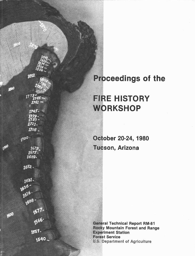
Proce IISTORY General Technical Report RM.81 Rocky Mountain Forest and Range Experiment Station Forest Service edings of the FIRE HISTORY WORKSHOP October 20-24, 1980 Tucson, Arizona U.S. Department of Agriculture
-
Upload
khangminh22 -
Category
Documents
-
view
0 -
download
0
Transcript of edings of the - CiteSeerX
Proce
IISTORY
General Technical Report RM.81Rocky Mountain Forest and RangeExperiment StationForest Service
edings of the
FIRE HISTORYWORKSHOP
October 20-24, 1980
Tucson, Arizona
U.S. Department of Agriculture

Stokes, Marvin A., and John H. Dieterich, tech. coord. 1980.
Proceedings of the fire history workshop. October 20-24, 1980,Tucson, Arizona. USDA Forest Service General Technical ReportRM-81, 142 p. Rocky Mountain Forest and Range Experiment Station,Fort Collins, Cob.
The purpose of the workshop was to exchange information onsampling procedures, research methodologies, preparation andinterpretation of specimen material, terminology, and the appli-cation and significance of findings, emphasizing the relationshipof dendrochronology procedures to fire history interpretations.
DedicationThe attendees of The Fire History Workshop
wish to dedicate these proceedings to Mr. HaroldWeaver in recognition of his early work inapplying the science of dendrochronology in thedetermination of forest fire histories; for hispioneering leadership in the use of prescribedfire in ponderosa pine management; and for hiscontinued interest in the effects of fire onvarious ecosystems.

Proceedings of theFIRE HISTORY WORKSHOP
October 20.24, 1980Tucson, Arizona
Marvin A. Stokes and John H. DieterichTechnical Coordinators
Sponsored By:
Rocky Mountain Forest and Range Experiment StationForest Service, U.S. Department of Agriculture
and
Laboratory of Tree.Ring ResearchUniversity of Arizona
General Technical Report RM-81 Forest ServiceRocky Mountain Forest and Range U.S. Department of Agriculture
Experiment Station Fort Collins, Colorado
the process of identifying and describing the
incidence of historical fires, the establishedguidelines and procedures for analyzing the material
and expressing the results should be carefully ad-
hered to Personnel at the Laboratory of Tree-RingResearch willingly provided this assistance and those
attending the workshop benefited directly from this
held in the future to provide an opportunity to re-
port on completed studies and propose new work relat-
ing to dendrochronolog-y and fire history. Our work-
shop provided only limited opportunity for reporting
on fire effects and plant succession and on paleo-
ecological studies. We anticipate that this will
not change much in the immediate future because of
the need to continue to resolve problems in utiliz-
Fire has played a role in shaping many of theplant communities found in the world today. Just
how important this role has been can only be de-termined after we know more about the frequency,extent, and intensity of these historical fires.The Fire History Workshop, first of its kind heldanywhere in the world, held as its primary objec-tive the exchange of information on techniquesand methodologies for determining fire historiesbased on tree-ring evidence. In addition, theworkshop provided a forum for reporting on current,or recently completed fire history studies; made
facilities and expertise available through theLaboratory of Tree-Ring Research for inspectingfire-scarred specimens and answering specificquestions concerning dating and interpretationof the fire-scarred material; and helped resolveproblems in terminologies which so frequentlyaccompany developing sciences.
The study of fire scars as reflected in theradial growth patterns of both softwoods and hard-wood tree species provides an important means ofsecuring information on the precise years inwhich fires occurred during centuries past. The
fire-scarred material collected and studied re-presents a form of "natural resource artifact"--much as the pot-sherd or spear point representcultural artifacts of past civilization. These
natural resource artifacts are disappearing andone day will be totally absent from forested areasdue to the influence of logging, fire, naturalmortality and deterioration. Even the materialholding historical fire evidence currently beingprotected In National Parks, Natural Areas, andother reserves will eventually be returned tothe soil through natural processes. For this
reason, it seems imperative that those collectingfire-scarred material for study insure that re-presentative specimens are properly described,cataloged, preserved, and protected so that theywill be available for future studies if needed.
Since the early 1970's there has been a re-newed interest in the use of tree. rings and firescars as a means of describing historical fires.Both living and dead material have been represent-
ed. This renewed interest has been generated inpart by the general recognition that fire effectsare not always destructive, and that in fact thereare many beneficial aspects of fire when it burnsunder prescribed conditions of fuel, weather, and
topography. The increased awareness of the needto return fire to its natural role in various eco-systems has also prompted this renewed interestfor without knowing what the natural fire cycleshave been in the past, it will be impossible torealistically reintroduce fire into these same eco-
systems.
The Laboratory of Tree-Ring Research playedan extremely important role in this workshop. If
the science of dendrochronology is to be used in
Foreword
store of knowledge and experience.
There was a consensus that a similar forum be
ing dendrochronological techniques in determiningfire histories; and the fact that ample opportunitieswill be available through other outlets to report
on immediate and long-term effects of single and
multiple burns. Additional subjects that might be
covered in a future workshop include the mechanicsof fire-scarring and physiology of the recoveryprocess, statistical sampling problems related to
fire history studies, and application of fire his-tory studies in management situations.
Workshop proceedings are notoriously late inreaching the hands of workshop attendees and ultimateusers of the information. To speed up publicationof these proceedings Robert Hamre, Editor, RockyMountain Forest and Range Experiment Station, con-tacted each author asking them to assume full re-sponsibility for submitting manuscripts in camera-ready format by the time the workshop convened. Bob
was largely successful in this effort and we appre-ciate his efforts in getting the proceedings process-ed and published.
Many individuals assisted in making the workshop
a success. Dr. Bryant Bannister, Director, andmembers of his staff at the Laboratory of Tree-RingResearch were most cooperative in providing supportfor the workshop. Mama Thompson, Terry Mazany, and
Tom Harlan handled many of the arrangement andorganizing details for the workshop.
Special thanks to Phyllis West, Rocky Mountain
Forest and Range Experiment Station, Tempe, AZ. for
her clerical and manuscript assistance during the
workshop, and to John McKelvy, Fire ManagementOfficer, Santa Catalina District, Coronado National
Forest for his efforts in hosting the field trip to
Mount Lemmon.
Marvin Stokes J. H. Dieterich

ContentsPage
Foreword i
The Dendrochronology of Fire HistoryM.A. StoIes
Fire History of a Mixed Conifer Forest In Guadalupe Mountains National ParkGa/ty M. AhLo.t'Land 4
The Composite Fire Interval -- A Tool for More Accurate Interpretation of Fire HistoryJ.H. VLeteiLch 8
Sonoran Desert Fire EcologyGcvvty F. Roge.it and Je SteL 15
Some Questions about Fire Ecology in Southwestern Canyon WoodlandsWA2Lam H. MoL't 20
Fire History of Western Redcedar/Hemlock Forests In Northern IdahoSte.phe.n F. M.no and Van II. Vavi. 21
Fire Frequency in Subalpine Forests of Yellowstone National ParkWAjLqam H. Rormie. 27
Interpreting Fire History in Jasper National Park, AlbertaGeiwld F. Tande. 31
Indian Fires In the Pre-Settlement Forests of Western MontanaS.tepheji (U. Ba4'r.e.tt 35
Fire History of Kananaskis Provincial Park -- Mean Fire Return Intervals&rad C. HawleA 42
Interpretation of Fire Scar Data from a Ponderosa Pine Ecosystem in the CentralRocky Mountains, Colorado
R.V. Laven, P.W. Orn, J.G. Wya.vt, and A.S. Pi..nkexton 46
Fire History of Two Montane Forest Areas of Zion National ParkMzihzeL H. Madany and WeU E. We.t 50
The Use of Land Survey Records In Estimating Presettlement Fire FrequencyCMLg G. Lo'rijneA 57
Fire History and Man-Induced Fire Problems in Subtropical South FloridaVa2e L. Tayo 63
Fire History of a Western Larch/Douglas-Fir Forest Type in Northwestern MontanaKahLee.n M. Va.VJ 69
Fire History -- Blue Mountains, OregonFnedeLcJz C. HaLt 75
Fire History, Junipero Sierra Peak, Central Coastal CaliforniaJame R. GiuLn and Steveii W. TaUe.y 82
Land Use and Fire History in the Mountains of Southern CaliforniaJoe R. Mc8de and VLana F. Jac.ob4 85
Fire History in the Yellow Pine Forest of Kings Canyon National ParkThoma4 E. Waxne. 89
The Influence of Fire in Coast Redwood ForestsS.tephen V. VLeJt4, J. 93

Forest Fire History Research in Ontario: A Problem Analysis
Mai.tn E. Mxande& 96
Fire Recurrence and Vegetation in the Lichen Woodlands of the Northwest
Territories, CanadaE.A. John4oi 110
Hunter-Gatherers and Problems for Fire HistoryHeivLy T. Lw6 115
Forest Fire History: Ecological Significance and Dating Problems
in the North Swedish Boreal Forest
Olie. Zac1zA44on 120
Fire History at the Treeline In Northern Quebec: A Paleocliinatic Tool
SeA9e Pa.ye..tte.126
Bibliography on Fire History: A SupplementMa.kLLn E. A&xandeA.
Fire History Terminology: Report of the Ad Hoc Committee
WLWam Rorzine
Workshop Summary: Who Cares about Fire History?Robet W. Mwtc.h
Workshop Participants
132
135
138
141

The Dendrochronology of Fire History1H. A. STOKES2
Abstract.--Dendrochronology, the study of annual ringsin woody plants, has developed into a useful tool for anumber of different fields of study. Based on the inter-action of trees and the climate, it is possible to use tree-rings as proxy data in reconstruction of past climates andriver runoff. It has been a dating tool of archeologists.The value of dendrochronology in fire history research hasthe potential of providing important data over and beyondthe dating of fire scars.
The principles and practices of dendrochrono-logy were developed in the American southwest byDr. A. E. Douglass, an astronomer. When he firstbegan his study of tree-rings, he was looking fora tool to be used in the study of sunspot cyclesand their relationship to the earth's climate.From the late 1890's to his death in 1962, thisremarkable scientist developed the science ofdendrochronology and applied his keen mind to thevarious applications of tree-ring studies. Thefirst application was to the climatic record con-tained in tree-ring series. In the 1920's, theuse of tree-rings as an archeological dating toolbegan, culminating in 1929 in the establishmentof a precisely dated archeological tree-ringchronology. This is a continuing viable aspectof dendrochronological research. During the 1930'sand 1940's, Douglass continued to expand the timeseries boundaries in his search for old age trees.This work, carried on by Dr. E. Schulman, re-sulted in the establishment, on a sound basis, oftree-rings as a valid estimate of past climates(Douglass, 1919), leading to the application nowcalled dendroclimatology (Schulman, 1956). Thisperiod in the history of tree-ring research alsosaw the application of tree-ring time series to thestudy of fluctuations of river runoff (Schulnan,1945), another very active line of continuingresearch (Stockton, 1975).
The interaction of tree growth and theclimatic environment in which the tree grows isthe basis of all tree-ring research, the unifyingelement of all applications. The basic principlesgoverning dendrochronology are summarized below(Fritts, 1976):
'Paper presented at the Fire History Workshop,Laboratory of Tree-Ring Research, University ofArizoa, Tucson, October 20-24, 1980.
H. A. Stokes is Professor of Dendrochronology,Laboratory of Tree-Ring Research, University ofArizona, Tucson, Ariz.
Limiting factor: The biological processof ring growth cannot occur at a faster rate thanallowed by the most limiting factor affecting thatprocess. In the southwest, the most limitingfactor is that of precipitation (available soilmoisture) acting in combination with temperatureIn other areas, different agents may be more
limiting.
Well defined growth layer: The expressionof growth in the tree must be well defined (a tree-ring) and the duration of growth must be known,
such as the annual ring.
Site selection: While all trees areaffected by the climatic environment, as well asthe biotic, certain trees will reflect thelimiting factor more than others. Thus trees
growing at the lower forest borders, In semi-arid environments, will show the greatest effectsof the limiting factor to the maximum extent.
Sensitivity: Because the limiting factorvaries through time, the widths of the annual ringswill reflect such a variation. Trees that have ahighly variable ring width series are consideredto be sensitive; those that show little variationin ring width from year to year are considered to
be complacent.
Cross dateability: Cross dating is thematching of a ring pattern of wide and narrow ringsfrom one specimen to another, such matching estab-lishing the synchronity of the rings. Since
trees in a given area are influenced by a commonfluctuating limiting factor, similar ring patternswill be produced in the trees. This cross datingis what makes the precision of tree-ring dating areality, and is an absolute essential in order to"date" a tree-ring or a series of tree-rings.Starting with the known date of the most recentlyformed growth layer, the previously formed rings,in sequence, can be correlated with the calendaryear of formation. Several problems can be present,
however. Absent rings in a given specimen must be

identified by comparing with ring patterns of other
specimens. "False rings", anomalous growth bandswhich do not represent total growth for any oneseason, must also be identified in the cross datingprocedure.
6. Verification: So that complete confidencemay be placed upon the cross dating procedure, asufficient number of specimens must be studied toinsure that all problems have been eliminated fromthe dated tree-ring series. For those trees witha greater frequency of absent rings, a largersample size is required. In our research in theLaboratory of Tree-Ring Researth, a minimumnumber of two cores per tree from at least tentrees which are dateable and sensitive has beenestablished as basic for developing our tree-ringchronologies. Hundreds of chronologies have beendeveloped in the past two decades, and are publishedin a series of Laboratory publications (Stokes,et al, 1973;' Drew, 1976). These chronologies coverthe western United States, some parts of the mid-west, parts of Canada and northern Mexico. Theyconstitute a very valuable library of basic dataavailable for many different types of research,including the study of fire history in forest com-munities.
The techniques of the actual process of tree-ring dating will not be covered here. The prepar-
ation of specimens for dating, skeleton plotting,cross dating, and verifying cross dating aretechniques best learned by actual practice (Stokesand Smiley, 1968).
As was stated previously, the interaction oftree growth and the climatic environment and itsexpression of that interaction in the varying ringwidths is the basis for dendrochronology. Otherfactors, however, are superimposed upon thatinteraction. One of the factors, the one we areinterested in here, is that of fire. The mostobvious evidence, of course, is that of the scarresulting from fire. Our immediate interest isto date the fire scars in order to determine somefrequency of the fire events, prior to the appli-cation of management practices in our forests.Such information is of the utmost importance ifwe are to incorporate fire as a management tool,and if we wish to determine whether fire is animportant part of the total picture of forestecology. I will cover, briefly, some aspects ofdating fire scars and then discuss some furtherimplications.
Dating a fire scar would seem to be relativelysimple: it "dates" according to the ring it is in.The dating of the ring(s) is not done along thetwo radii of a fire scar, however. To insure theprecision of dating, a radius must be selectedthat is far enough removed from the distortion ofring widths caused by either the fire itself orthe subsequent healing process. Therefore, I feela cross section of the tree stem is necessary forfire scar dating, and the radius selected shouldbe approximately at right angles to the face of the
scar. Any discontinuity of the ring series due to"absent rings" can best be worked out along thatrelatively undistorted radius. Even though thesample may represent a compacent ring series,absent rings along the fire scar face may resultin the loss of the precision you seek (seeillustration in Fritts, 1976). If working withspecies of trees that has not been extensivelystudied by dendrochronological techniques, theabsent ring problem is again a real risk (Jordan,
1966).
I think we all recognize the importance ofsampling both sides of a fire scar. The dis-crepancy of dates between two sides of a scarcan be very great and any frequency estimatebased on only one scar radius can be very
leading.
The definition of a fire caused scar issomething that bothers us here in the Tree-
Ring Laboratory. The criteria we have been
using are somewhat uncertain. The presence of
charcoal in the wound is the first criterion.The observation of subsequent healing over thearea of wounding is the second criterion, andthe presence of vertical lines representingthe healing from the sides of the scar is the
third criterion. But a succession of fires mayvery well eliminate or obscure evidence of
earlier fires and make it difficult to deter-mine whether a "scar" is actual evidence of anearlier and separate fire event. Any of acombination of two of the above criteria isprobably accurate, but an element of doubt
remains. 4 fourth criterion may be used but
we have not quantified this, as yet. In some
cases we have observed a band of what appearsto be disrupted cells, within the growth ring,at right angles to the scar face. When the
origin of the scar is uncertain, this conditionmay indicate the presence of heat causingeither a disrupt'd.on of cellular tissue or some
change in cellular constituents.
A discrepancy in dates between the two sidesof a fire scar has been observed. Where thediscrepancy between two opposite scars is adifference of one year, the error may very wellbe in determining in which ring the scars occur.However, do differences of two, three or evenfour years represent specific fire occurrences?The elminiation of theseslight differences naymean quite a change in the frequency intervalobtained. Some caution must be used, until this
question is resolved. In summary, all scarswhich show the curved growth of lateral healingare the most positive indicators of fire events.All others, while they may have certain character-istics which seem to indicate a fire origin, have
an element of doubt.
To establish fire frequency, based on datingof fire scars, is a first step in a potentiallyrewarding line of tree-ring research. If we
might, let us speculate a bit. Assuming that fire

3
was part of the forest ecosystem in the past,and occurred at some frequency, what moreinformation may be contained in the tree-ringsthat would allow you to refine the results nowobtained through fire scar dates? Arno andSneck (1977) pose a question, among others, ofwhat ate the effects of past fires on theforests. In growth response studies done inthe Laboratory by Fritts and his workers, theclimatic parameters of rainfall and temperatureare used as independent variables in studyingthe relationship of tree growth and seasonalchanges of the climate. The tree response tofire occurrences may very well be revealed byusing fire history data as another "independent"set of nonclimatic variables to plug into growthresponse studies. Using response functionanalysis, reconstruction of past fire histories,In terms of Increased growth or decreasedgrowth, may be possible. Fire, of course, isnot independent of climate, and the character-istics of fire are not independent from thecharacteristics of the forest community Itoccurs in. Further research will allow us tobetter define the relationships involved inthe tripart system of
Climate
Tree growth Fire
LITERATURE CITED
Arno, S. F., and K. N. Sneck. 1977. A methodof determining fire history In coniferousforests of the mountain west. U. S. Depart-ment of Agriculture Forest Service GeneralTechnical Report IVT-42.
Douglass, 1919. Climatic Cycles and TreeGrowth, Vol. 1. CarnegIe Institute Publi-cation 289. Washington, D. C.
Drew, Linda C., EdItor. 1976. Tree-Ring Chronol-ogies for Dendrocilmatic Analysis. AnExpanded Western North American Grid.Chronology Series II, Laboratory of Tree-Rimg Research, University of Arizona, Tucson,Ariz.
Fritts, H. C. 1976. Tree-Rings and Climate.Academic Press, London.
Jordan, Carl F. 1966. Fire produced discontinuousgrowth rings in oak. Bulletin of the TorreyBotanical Club, Vol. 93, No. 2, pp. 114-116.
Schulman, H. 1956. Dendroclimatic Change inSemi-arid America. University of ArizonaPress, Tucson, Ariz.
1945. Tree-Ring Hydrology of theColorado River Basin. University of ArizonaBulletin, Vol. 16, No. 4. Tucson, Ariz.
Stockton, C. W. 1975. Long term streamf low recordsreconstructed from tree-rings. Papers ofthe Laboratory of Tree-Ring Research, No. 5,University of Arizona Press, Tucson, ArIz.
Stokes, 14. A., Linda G. Drew and C. W. Stockton,
EdItors. 1973. Tree-Ring Chronologies ofWestern America. Vol. 1. Selected Tree-Ring
Stations. Chronology Series 1, Laboratoryof Tree-Ring Research, University ofArizona, Tucson, Ariz.
Stokes, 14. A. and T. L. Smiley. 1968. Introductionto Tree-Ring Dating. University of ChicagoPress, Chicago, Ill.
4
2
Fire History of a Mixed Conifer Forest in Guadalupe
Mountains National Park1Gary M. Ahlstrand2
Pibstract.--Fire scarred southwestern white pine (PLrUL6
4ObLofl1nA4) cross sections from a 1700 ha study site inthe Guadalupe Mountains were examined to determine thehistoric role of fire in the forest. At least 71 fires have
occurred on the site since 1554. The mean interval between
major fires was 17.4 years for the period 1696-1922. No
samples were scarred after 1922. Reduced incidence of fire
during the past century coincides with changes in occupancyand use patterns in the mountains.
INTRODUCTION
Tree stems with multiple fire scars are evi-dence that fire has been aignificant ecologicalfactor operating in the past on a relict mixedconifer forest in the high country of GuadalupeMountains National Park, Texas. The historic roleof fire in this ecosystem was little understood,however. The absence of fire in the recent pasthas permitted thickets of conifers to become estab-lished in the understory throughout the high country.It was not known If this represents a natural phasein the life cycle of the forest, or if it resultedfrom European man's activities in the area duringthe past century.
Little information concerning fires in theforest was readily available. Robinson (1969)reported that fires occurred in the forest inapproximately 1858 and again in 1908 or 1909. Anative that has resided west of the park since 1906recalled having seen flaming trees fall from highcliffs In the mountains in about 1909 and smokefrom another fire in the high country in about 1922(E. Hammock, personal communication). No fires ofany consequence have been reported for the forestsince 1922.
This study was conducted to determine the firehistory for a portion of the relict mixed coniferforest. Cross sections from fire scarred tree stemswere studied in an attempt to identify specific fireyears, the incidence of fire in the study area, thefire free interval for specific small areas withinthe study area, and a general indication of pastfire intensities. Changes in the role of fireresulting from shifting patterns of use in theforest are also addressed.
1Paper presented at the Fire History Workshop,Laboratory of Tree-Ring Research, University ofArizona, Tucson, October 20-24, 1980.
2Ecologist, Carlsbad Caverns and GuadalupeMountains National Parks, Carlsbad, New Mexico
STUDY AREA
The study area consists of approximately 1700ha in the upper portion of the South McKittrick
Canyon watershed in Guadalupe Mountains National
Park (fig. 1). The area sampled ranged in elevationfrom 2150 to 2550 m and included the most heavilyvisited portion of the park's high country.
The semiarid, continental climate of the area
is characterized by mild winters, warm summers and
summer showers. Lightning ignited fires occur
mainly during spring or early summer before theonset of showers that accompany summer monsoons.
Associates in the mixed conifer forest include
Douglas-fir (P4eUdO.t4LLga meJLZiLQALL), southwestern
white pine (PLnLL6 4obAoflnvL6), and ponderosa pine
(Pthu4 ponde'w4ct). Dry, south-facing slopessupport an open woodland of ponderosa pine, alli-
Intermittentstream
Figure 1.--Map of the Guadalupe Mountains high
country study area showing locations of
sampled live cut (S) and dead (0) fire
scarred stems.

LC)
gator juniper (Jui'vLpew.s dppectna) and pinyon pine(PLnu4 e4LLU6). Where soil moisture is more avail-able, as on slopes with some northerly aspect,Douglas-fir and southwestern white pine dominate,with ponderosa pine and pinyon pine included inthe association.
Indians are known to have occupied the area,at least seasonally, until about 1870. By themiddle of the 19th century, parties of soldiers,surveyors, settlers and gold seekers were passingthrough the area on a trail just south of theGuadalupe Mountains. European settlers were inthe area by the 1870's. By the turn of the cen-tury, cattle, horses, sheep and goats were beingrun on rangeland surrounding the mountains, andeven in the high country (E. Hammock, personalcommunication). Use of the high forested countryfor summer range continued into the 1960's, butwas phased out between 1966 and 1970 after Congressauthorized the area to become a national park. Thearea was officially dedicated and established as anational park in September 1972.
METhODS
Knowledge of the fire history for the relictforest was considered important enough to justifycutting cross sections from a number of fire scarredstems. Transects were laid out in the study areaas described by Arno and Sneck (1977). Forty-eightstems, all southwestern white pine, have been sam-pled to date (fig. 1). The cross sections camefrom 3 liviflg stems, 36 standing dead stems, 3fallen dead stems, and 6 stumps left when a trailwas widened through a portion of the study area.The location of each sample was noted on a 7.5minute topographic map.
A master tree ring chronology was constructedfrom indices calculated from measurements of annualrings in two increment cores from each of 19 Douglas-fir trees (Fritts 1974). The master chronology wasused to cross date the fire scarred sections. Whena sample section predated 1668, the earliest dateof the master chronology, a ponderosa pine chronol-ogy from Cloudcroft, New Mexico dating to 1515 wasused (Drew 1972).
annual rings in the samples were measured under30-90X magnification on a sliding stage micrometerto the nearest 0.01 turn. Widths of annual rings wereplotted chronologically with fire scarred ringsnoted. The sample plot was then cross dated with aplot of the master chronology.
Some fire scars were so distinct that it waspossible to identify the fire as having occurredduring the early, middle or late portion of thegrowing season for a particular year from thenumber and size of xylem cells formed prior toinjury of carnbium. When scars appeared to haveformed between growing seasons, it was assumed thatthe fire occurred during the dry, winter-springseason unless a scar on a sample from a more shel-tered site indicated that the fire burned late inthe previous year's growing season. Occasionallya fire scarred ring was obscured by partial loss ofthe ring in a subsequent fire, or decay. Such ringswere included only when they could be cross dated
with reasonable certainty within one year of anotherscarred stem from the vicinity.
When feasible, two or more fire scarred stemswere sampled in a small area as in similar studies(Houston 1973, Arno and Sneck 1977, Kilgore andTaylor 1979). The occurrence of fire was determinedfor two approximately one hectare sites. Sevenstems located within 100 m of each other were sam-pled on a west-facing slope near the crest of aridge, and three cross sections from stems that hadgrown within 100 m of one another were taken from anorth-facing slope near the bottom of a small ravine.
A fire year was defined as any year in which atleast one sample was scarred by fire. Major fireswere defined as those in which 20 percent or moreof the samples alive at the time of the fire werescarred, and at least two of the scarred samplesmust have been separated by a minimum of 2 km.
All trees in fifteen 25 X 15 m plots were re-corded by species and to the nearest diameter atbreast height (dbh) size class. Size class 1
included all stems less than 1 m tall; size class 2included stems less than 5 cm dbh; size class 3consisted of stems 5-10 cm dbh; and successive sizeclasses increased in 10 cm dbh increments. Incre-
ment cores were taken from representative stems ofDouglas-fir and southwestern white pine so thateach size class could be correlated with tree age.
RESULTS AND DISCUSSION
Data from 305 fire scarred annual rings con-tained in 48 southwestern white pine cross sectionsindicate that fires of various sizes have occurredin the study area in at least 71 of the years between1554 and 1980 (fig. 2). Sixty-three of the firesoccurred before 1850 and none of the cross sectionswere scarred by fire after 1922. The number of firesper cross section ranged from 2-14 and the mean
70
60
InIii50
U.
40I--j 30
Do 20
10
1600 1700 1800 1900 2000YE AR
Figure 2.--Incidence of fire in the study area asdetermined from fire scarred sample stems.Parameters for the regression line are: 1554-
1842 segment, y 0.251x - 399.8, r = 0.986;1842-1922 segment, 7 = 0.0995x - 120.2, r =0.993.

400
200
50
25
6
2000
6
interval between scars for individual cross sec-tions varied from 11.5-68.3 years.
Because no stems were scarred by every fire,the occurrence of fire is undoubtedly more fre-quent than indicated by the data. For example, 19fires were represented by 35 scars that occurredin seven cross sections taken from one of thehectare sampling sites. Eleven of the fires wererepresented by only a single scar in the sample.Two fires each scarred four stems and the maximumnumber of stems scarred by any fire was four. The19 fires occurred between 1673 and 1922. Duringthis period the interval between fires ranged from3-45 years and the mean fire free interval was 13.8years. Fires scarred the three sample stems fromthe other hectare site in 21 of the years between1643-1879. The fire free period ranged from 2-37years during this period and the mean intervalbetween fires was 11.8 years.
The mean interval for the incidence of allfires detected in the study area for the period1554-1842 was 4.7 years (fig. 2). Between 1842and 1922 the fire free interval more than doubled.None of the sample stems were scarred by fireduring the last 58 years.
Between 1696 and 1922, 14 major fires occurredin the study area (fig. 3). The interval betweenmajor fires ranged from 6-30 years, and the meaninterval was 17.4 years.
The reduced incidence of fire apparent after1842 coincides with the ever increasing impact ofEuropean man and the decreasing presence of Mesca-lero Apache Indians in the area. By 1880 most ofthe Indians had been driven from the GuadalupeMountains. This suggests that many ignitions inthe forest prior to the mid-1800's were associatedwith the use of fire by Indians. The high countrymost likely received limited use between 1880 andthe early 1900's as European man settled in thearea.
Until this century, 30 years appear to havebeen the maximum interval between major fires inthe study area. Thirty years elapsed between majorfires that occurred in 1879 and 1909. The lastmajor fire to occur in the study area was in 1922.Increased use of the high country after 1930 assummer range for livestock probably prevented curedgrasses from accumulating in quantities sufficientto carry a fire any great distance. Longtime resi-dents recall that although the forest understory
was open and park-like as recently as the early1950's, large numbers of conifer seedlings werebecoming apparent about this time, nearly 30 yearsafter the last major fire.
A fire suppression policy has been in effectfor the area since coming under the stewardship ofthe National Park Service. One ignition burnedundetected in 1974 on an open, southwest-facingslope in the study area. Less than two hectareswere burned before the fire died, and no treeswere found to have been scarred as a result of thefire. Other fires originating outside the studyarea might have spread into the area had they notbeen contained by fire suppression crews whilestill small.
Most of the fires in the relict forest appearto have been relatively low intensity ground fires.Scarred stems in the forest are predominately thoseof southwestern white pine. Fire scarred stems ofthe more heavily barked Douglas-fir and ponderosapine were seldom encountered. Fire damaged stemsof young southwestern white pine usually die, andolder trees remain susceptible to scarring for manyyears. Only three of the samples were scarred whenless than 15 years old. Nearly half the samplestems were more than 50 years old when first scarredby fire.
Pooled size class density data for south-western white pine showed fewer trees present insize class 3 than would normally be expected (fig.
4). Southwestern white pines of this size classin the study area are ordinarily 50-100 years old.A similar pattern was noted with Douglas-fir, ex-cept that both size classes 3 and 4 contained fevertrees t1an would be expected in a regular distri-bution (fig. 5). Comparison of age data from
STEMS! HA
Pinus Strobjformjs
234SIZE
Figure 4.--Density of southwestern white pine bysize class in the mixed conifer forest,Guadalupe Mountains National Park, Texas.Size classes are: 1 = stems < 1 m tall; 2 =stems to 5 cm dbh; 3= stems 5-10 cm dbh;and successive classes increase in 10 cm dbhincrements.
1700 1800 1900YE AR
Figure 3.--Occurrence of major fires in the studyarea, 1696-1922. Parameters for the regressionline are: y 0.0566x - 94.55, r = 0.996.

6000
4500
3000
50
25
7
increment cores with diameter data for both speciesindicate that growth rates for Douglas-fir inthese size classes slightly exceed those for south-western white pine in the study area. Many of thetrees expected in these size classes in a normaldistribution were apparently destroyed by the 1909fire. During the 30 year interval since the lastmajor fire in 1879, fuels probably accumulated tolevels that supported a more intense than usualfire. Most of the trees in size classes 1 and 2became established after the last major fire tooccur on the study site in 1922. Dense thicketsof Douglas-fir have become apparent in the last25-30 years (fig. 5).
STEMS I HA
Pseudotsuga menziesii
1 2 3 4 5 6 7 8 9 10SIZE CLASS
Figure 5.--Density of Douglas-fir by size class inthe mixed conifer forest, Guadalupe MountainsNational Park, Texas. Size classes are thesame as for figure 4.
Data from this study indicate that the mixed coni-fer forest was overdue for another major fire by
the mid-1950's. Many of the stems that now con-tribute to the dense understory thickets would havebeen destroyed had a fire occurred. A criticalsituation exists in the forest today. Ignitionunder certain weather conditions with the presentdead and living fuel accumulation could result ina devastating fire. Perpetuation of mixed coniferforest is dependent upon finding an effective meansto reduce fuel loads while saving most of the trees
in the canopy.
LITERATURE CITED
Arno, Stephen F., and Kathy M. Sneck. 1977. Amethod for determining fire history in coni-ferous forests of the mountain west. USDAForest Service General Technical ReportINT-42, 28 p. Intertuountain Forest and Range
Experiment Station, Ogden, Utah.
Drew, Linda G. 1972. Tree-ring chronologies of
western America. II. Arizona, New Mexico,
Texas. Chronology Series I, 46 p. Laboratoryof Tree-Ring Research, University of Arizona,
Tucson.
Fritts, H. C. 1976. Tree rings and climate.
567 p. Academic Press, London.
Uouston, Douglas B. 1973. Wildfires in northernYellowstone National Park. Ecology 54:1111-
1117.
Kilgore, Bruce M., and Dan Taylor. 1979. Fire
history of a sequoia-mixed conifer forest.Ecology 60:129-142.
Robinson, James L. 1969. Forest survey ofGuadalupe Mountains, Texas. M. S. Thesis
71 p. University of New Mexico, Albuquerque.

8
The Composite Fire Interval -A Tool for More Accurate Interpretation of Fire History1
J. H. Dieterich2
Abstract.--Use of the Composite Fire Interval (CFI) asa means of expressing historical fire frequency for a partic-ular area is discussed. Four examples are presented thatsummarize historical fire intervals on areas ranging in sizefrom 100 to several thousand acres.
INTRODUCTION
A wide range of methodologies is availablefor documenting fire histories in various timbertypes using fire scars and dendrochronology tech-niques (pyro-dendrochronology). Early work byClements (1910) described a method of determiningfire history in the lodgepole pine (Pinus contorta)forest of Colorado. Weaver (1951) studied firehistory in the White Mountains of Arizona andidentified individual tree average fire intervalsranging from 4.8 to 6.9 years. He was perhapsthe first student of fire history to establishcontact with the Laboratory of Tree-Ring Research,University of Arizona, for the purpose of cross-dating and verifying the dates of fire-scarredmaterial from ponderosa pine (Pinus ponderosa).
More recent pyro-dendrochronology studies byHeinselman (1973), McBride and Laven (1976), Arnoand Sneck (1977), Alexander (1977), Wein and Moore(1979), Zackrisson (1977), Rowdabaugh (1978),Kilgore and Taylor (1979), Tande (1979), andDieterich (1980) have utilized a variety ofapproaches to analyzing fire history in specificforest types. Most of these studies further de-scribed the ecological changes that have resultedfrom the elimination of natural fires through im-proved fire suppression organization.
In 1975 we were preparing plans for a long-term prescribed burning study designed to evaluatethe effects of using fire at various intervals onfuel accumulation and consumption. We knew thatfire had been an integral part of the southwestern
'Paper presented at the Fire History Workshop,Tucson, Arizona, October 20-24, 1980.
H. Dieterich is Research Forester at theRocky Mountain Forest and Range Experiment Station,USDA Forest Service, Forestry Sciences Laboratory-ASU Campus, Tempe, Arizona 85281.
ponderosa pine ecosystem for centuries but we weresearching for scientific information that wouldsuggest what burning intervals would be reasonablefor us to incorporate into the studies. The work
by Weaver (1951) was the only information availableon fire history in southwestern ponderosa pine. To
expand Weaver's findings, and establish a basis forinterval burning, we collected fire-scarred materialfrom the site we had selected for our long-term pre-scribed burning study, and, started a regional col-lection of fire-scarred material fom the nationalforests of Arizona and New Mexico. The ForestService, Region 3, Division of Timber Managementsent Out instructions for severing cross sectionsfrom fire-scarred trees taken from current or re-cently active timber sales. The cross sectionswere sent to the Laboratory of Tree-Ring Researchfor dating and verification.
Site cards were prepared for each sample, andthe location of each specimen was plotted on a map.In an effort to detect a pattern in the data, firedates from each specimen were plotted on a commonchart. This "composite" as it came to be calledwasn't as useful as we had hoped because it coveredsuch a large area. However, it did reveal someperiods of years when fires appeared to be morecommon, and mmre importantly, it suggested a meth-odology that could be used to look at fire historyon smaller land units.
The collection for the Chimney Spring studysite and the preparation of the Composite Fire In-terval (CFI) for the site is described in a recentresearch paper (Dieterlch 1980).
Before proceeding further, the Composite FireInterval concept and some of the criteria involvedin its development should be discussed. A CFI is
a means of more accurately expressing historical
3Fire histories in southwestern ponderosa pine.
1975. Study plan on file, Rocky Mountain Forestand Range Experiment Station, Tempe, RN-2108.
fire frequency for a particular area. It involvescollecting at least two (preferably more) f ire-scarred cross sections, and determining dates offire scars by cross-dating and verification ofthe tree-ring material using an established tree-ring chronology.
Size of the area represented by a CFI is im-portant but difficult to specify. The conceptseems more appropriate for describing fire historyon relatively small areas (such as historicalsites, research plots, experimental watersheds),and seems more useful when there is a uniformlyhigh level of fire occurrence. We have used theprocedure to develop fire histories in southwest-ern ponderosa pine and mixed conifer types.
To determine a CFI, dates are plotted on achart that spans the total number of years repre-sented by the collection of fire-scarred specimens.This visual display of "fire years," along withcenter-ring dates and dates of outermost rings,makes it possible to identify dates from thevarious specimens that are common to one another,inspect for gaps in the fire sequence data, andidentify periods of years having maximum firefrequencies.
Use of the CFI for describing fire historieson four different areas in northern Arizona andsouthern Colorado is discussed in this paper. Inaddition to preserving valuable historical infor-mation the CFI provides a scientific basis forspeculating on the types and extent of plant andanimal, communities that existed in centuries past,and an opportunity to evaluate present day fueland vegetative conditions in terms of past firehistory.
EXAMPLES OF COMPOSITE FIRE INTERVALS
Chimney Spring
In reviewing the Chimney Spring fire history,it is appropriate to restate some basic assumptionsregarding fire behavior and fire spread (Dieterich1980).
A fire starting within the general areawhere the samples were taken would havehad a good chance of spreading over theentire area.
A fire spreading into the area from out-side would also have spread over theentire area.
These fires would not necessarily haveburned every square foot of surface areabecause of fuel discontinuity, thusleaving some trees unscarred with eachpassing fire.
These assumptions also appear valid for theLimestone Flats study area but probably do notapply to the Thomas Creek fire history study areato be discussed later in this paper.
9
Significant results from the Chimney Springfire history study are:
The most recent fire on the area, con-firmed by scars on five of the sevenspecimens, was in 1876.
The oldest fire scar was recorded in 1540(Tree 7).
Fires occurring at 2-year intervals wererecorded five tines on Tree 6 and onceon Tree 7. There were no instances wherefires were recorded in successive years.
The CFI for the 122-year period, 1754-1876, was 2.4 years. All seven specimenswere represented in this CFI.
The most intense CFI (1.25 years) wasrecorded for the 15-year period (1850-
1865).
Adjacent trees (6 m) revealed a numberof common fire scars (11) and nearly anequal number of fire scars (12) that werenot in common.
Results from the Chimney Spring fire historystudy assure us that the prescribed burning inter-vals we chose (1, 2, 4, 6, 8, and 10 years) areappropriate and represent a realistic range ofintervals for using prescribed fire. This fall wewill be applying fire for the fifth consecutiveyear on the Chimney Spring annual-burn plots; wewill be burning the 2-year interval plots for thesecond time; and we will be burning the 4-yearplots for the first time since the initial fuelreduction burn in 1976.
Limestone Flats
This is a companion study to the Chimney Springprescribed interval study. Objectives of the study,plot design, timber type, and burning intervalsor the two areas are the same. The primary dif-
ference between the two areas is the soil type,although there is also a small difference in eleva-tion (500 feet ±). Chimney Spring parent materialis basaltic; Limestone study site is limestone-sandstone. The Limestone plots are located 50 milessouth of Flagstaff, 8 miles from the southern edgeof the Mogollon plateau. Lightning fires arecommon in the area, there have already been twolightning fires on the 100-acre study site in thepast 3 years.
Figure 1 shows the approximate location offire-scarred material being used to construct theCFI for the Limestone Flats study site. Treeswith fire scars are reasonably well distributedon the area. Specimens 4 and 12 have been col-lected but as yet have not been dated. Fire datesfrom these specimens will be added to the CFI whenthey become available.
0
0
0
0
0
9- S 9-i p
G
)i
/
/ 3 S p-j P P t Oti
0 3 I
o ala c -a P -O S S a I
)-)c p-P /
1
0
9-I c vs s-s c ovs S S I
t9 5 19 P 19 S V I
I 3 chains
Figure 1.--Limestone Flats prescribed burninginterval study plots showing approximatelocation of fire-scarred trees used forreconstructing fire history for the area.A narrow access road divides the plots butphysiographic conditions are similar onboth sides.
Figure 2 is the CFI for the 110-year period(1790-1900) on the Limestone study site. The totaltime-span represented by all the fire scar materialcovers more than 300 years but only the centralportion has been used. Prior to 1790, 21 fire-yearswere identif led on available fire-scarred materialdating back to 1722. Only five fire-years havebeen recorded on the area since 1900. Furtherinterpretation of the fire history from the CFIfor the 110-year period indicates the following:
Nine out of the 10 specimens were availableto contribute to the CFI for the area begin-ning in 1790. Specimen 7 was available in1851. The CFI for the 110-year period 1790-1900 is 1.8 years (61 fires; 110 years). Forthe 50-year period 1810-1860, the CFI was 1.3years. There were 25 fire-years on the areabetween 1810 and 1841 for a CFI of 1.2 years.
If it had been possible through some priorknowledge to select the "best" trees for fire his-tory analysis purposes a relatively few sampleswould have been needed. For example, if only speci-men 2 had been used the average fire interval wouldhave been identified as 4.1 years. If only trees2, 3, and 5 had been used to prepare the CFI forthe 110-year period 1790-1900 the interval would
PRESCEJIED BURNING INTERVAL STUDY
LIMESTONE FLATS UNIT
LONG VALLEY EXPERIMENTAL FOREST
10
be 2.4 years--only slightly longer than the CFI,,based on all 10 specimens for the sane period.
In an effort to gain a somewhat differentperspective of the fire history on the LimestoneFlats study area, a short movie has been assembledto show the area as it looked both before andafter the initial fuel reduction burn in 1977,and provide a visual display of fire activity onthe area during the 110-year period from 1790-1900.
Located at an elevation of about 6,900 feetthe stand is typical of old-growth undisturbedponderosa pine--essentially uneven-aged with smalleven-aged groups. There are patches of stagnatedsaplings, small and large pole stands, and groupsof old-growth yellow pine scattered throughout thearea. A light sanitation cut was made on the areaabout 15 years ago. One or two large trees peracre were removed and scattered snags were dropped.Basal area averages 121 square feet per acre withindividual plots ranging from 91 to 169 square
feet. Site index averages about 72.
Before burning, fuel loading of materialunder 1-inch diameter (needles, twigs, litter, etc.)averaged 16 tons per acre; woody material over 1inch in diameter averaged 16.5 tons per acre fora total fuel loading of 32 tons per acre (Sackett1980). The last fire to burn over the area wasin 1898; fire scars from 1928 and 1930 were foundon two specimens.
The first fire occurrence display (1790)shows the location of nine of the specimens usedto compute the CFI. During that year, two of thetrees (5 and 10) were scarred by fire.
The succeeding years show the number of treesthat were scarred and their location. I have arbi-
trarily (but conservatively) estimated that if twoor more of the trees sustained scars, there was agood chance that the entire area burned over,although not necessarily every square foot withinthe area. If this estimate appears reasonable,it is likely that the area burned over at least32 times during the 110-year period. However, ifwe accept the basic assumption as stated for theChimney Spring site, the entire area would haveburned over 61 times or each time one of the speci-men trees was scarred.
To summarize for the Limestone Flats studyarea, inspection of the CFI data leads to thefollowing conclusions:
- The prescribed burning intervals selectedfor the study appear to be realistic interms of past fire occurrence;
- The fuel loading on the area in 1900 wasvastly different from what was presentwhen the plots were burned in 1977.
- Fine fuels (grass and needles) would havebeen the medium through which these his-torical fires spread because most largefuels would have been consumed by thefrequent fires;

COMPOSITEFIRE
INTERVAL
x
-x x
xx
x
x
x
averages 28 inches per year. Tree species include
ponderosa pine, Douglas-fir (Pseudotsuga menziesii),white fir (Abies concolor), southwestern white pine(Pinus strobiformis), corkbark fir (Abieslasiocarpa var. arizonica), Engelniann spruce (Piceaengelmannii), and aspen (Populus tremuloides).Douglas-fir and white fir are the main understoryspecies and make up about 50% of the trees and 55%of the basal area, which averages about 190 square
10 20 70 80 90 1900
x
x
1800 1850 1900
Thomas Creek
In contrast to the ponderosa pine historiesfor Chimney Spring and Limestone Flats, fire his-tory findings on the Thomas Creek experimentalwatershed reflect differences in elevation, standtype, and species composition.
Thomas Creek is part of a water yield improve-ment study located on the Apche-Sitgreaves NationalForest near Alpine, Arizona. Elevations range from8,300 to 9,200 feet; the stand is typical of un-disturbed southwest mixed conifer. Precipitation
4Core Study Plan, Thomas Creek ResourceEvaluation Project. April 25, 1975. RockyMountain Forest and Range Experiment Station,Tempe, RN-2108.
YEARS
FIRST ANNUAL 1790 1800 30 40 1850 60RING
1.1788 X x
2.1739 X XX XX X X X X
3.1655 X XX
4. - COLLECTED, NOT DATED
5.171 x x x
6.1764 X X XX
1851
1774 x
1760 x xx
10.1724 X X X X
1775 x x X
- COLLECTED. NOT DATED
Figure 2.Composite Fire Interval for Limestone Flatsprescribed burning study plots. Time span: 110 years;"Fire-Years": 61; Composite Fire Interval: 1.8 years.
- The dense thickets of stagnated pinesaplings would not have been presentprior to 1900 due to the frequent occur-rence of surface fires;
- And, while many seedlings and young treeswould have been destroyed by these fre-quent low-intensity fires, enough wouldhave remained to maintain stocking withinthe stand. feet.
X XX X X
X XX X XXX X XXX X X X X
X XXX X XX XXXXX XX X X XX
XX XX XXX XXX X X
X X X
X X X X
XX X X X X X X
11
xx x
X X
XXX X X
The watershed was scheduled for a treatmentin 1976 and a cut was prescribed designed to in-crease water yield while protecting wildlife and
recreational values. Marking guides limited volume
removal to about 30% of the basal area--mostly inindividual trees or small groups.
Fire scars were present on a large number ofold-growth trees of nearly all species. Arrange-
ments were made prior to cutting to have specific
trees designated as "fire history" trees. The
loggers were asked to "high-stump" these trees sothat a slab could be removed later for study.Fire history trees were selected on the basis of
location with respect to other fire-scarred treesto insure a good sampling distribution over the
area. Trees with numerous scars evident on the"catface" were also favored in the selection
process. Fire-scarred specimens taken on Thomas

Creek were principally ponderosa pine, but anumber of white pine cross sections were alsoremoved for study. These two species scar readilyand resisted decay better than other speciesscarred by fire. Six "pairs" of specimens werechosen (ponderosa pine-white pine), for comparingthe incidence of scarring in the two species todetermine if one species scarred more readily thanthe other. This analysis is as yet incomplete.
A total of 34 specimens were collected fromthis area of approximately 420 acres (170 ha).Cross-dating and verification is being done bythe Laboratory of Tree-Ring Research. Resultsof the study are incomplete and will be publishedat a later date, but preliminary findings indicatethe following:
The most recent fire scar recorded wasin 1911. There have been few firessince 1900.
The preliminary CFI chart revealed wide-spread scarring on the watershed in 1748,1819, 1847, 1873, and 1893. Further anal-
ysis of data should confirm these yearsand may reveal additional years whenfires apparently covered the entirewatershed.
The CFI is longer on Thomas Creek thanon the Chimney Spring or Limestone areas.During normal years in the mixed conifertype fire weather is not as extreme and,although lightning may cause frequentfires, they spread slowly in the dampfuels and frequently go Out. This typeof fire created scars on some of thetrees, as indicated in the CFI, butprobably did not spread over a largearea.
Perhaps the most significant finding isthat, in spite of frequent fires, someextensive enough to cover the entirewatershed, the area remains as a mixedconifer type. This is an important con-cept because to date silviculturists havemaintained that fire and the mixed con-ifer type are not compatible.
San Juan National Forest
In 1975, 10 fire-scarred cross sections werecollected from scattered stands of ponderosa pineon the San Juan National Forest in southern Colorado.Forest personnel were starting on a prescribed burn-ing program to reduce natural fuel buildup, stimu-late natural regeneration, and hold back invasionby Gambel oak (Quercus gambelii), a competing under-story species. They therefore needed to know aboutthe frequency of historical fires.
12
The 10 specimens used for this CFI came fromthree different Ranger Districts on the Forest.They were forwarded to the Tree-Ring Lab in Tucsonfor cross-dating and verification. Results are as
follows:
Individual tree average fire intervalsranged from 7 to 35 years.
The most useful fire history data camefrom the 150-year period 1750-1900.There were 38 fire-years during thisperiod for a CFI of 3.9 years.
Within the above period the 85-yearspan 1815-1900 yielded 25 fires fora CFI of 3.4 years; and for the 50-yearperiod 1840-1890, 22 fire-years wererecorded for a CYI of 2.3 years.
Because of the widespread location of thesample trees, the Cu was not necessarily repre-sentative of any particular site. However the
range of CFI's (2.3, 3.4, 3.9 years) computed for22, 50, and 150 years respectively provided theForest with useful information for expanding theirprescribed burning program.
DISCUSSION
An important limitation of the CFI is thelack of statistical control resulting from anindeterminate number of samples taken from anarea of unspecified size. On undisturbed areasof old growth trees there is usually ample materialavailable for developing good composite firehistories. On cutover areas where fire damagedtrees have been removed, available material maybe limited to old stumps or fire-scarred materialscattered over the area.
The CFI provides an indirect measure of fireintensity. Knowing fuel type, loading, and arrange-ment, and knowing the natural fire frequency as in-dicated by the CFI, a reasonable estimate can bemade of fire intensity--at least in relative terms.Low intensity fires must have been common, and highintensity fires unlikely, because frequent firesmaintained fuel volumes at low levels.
While not necessarily a limitation of the CFIsystem, it is difficult, if not impossible, toreconstruct fire size and perimeter for historicalfires in southwestern ponderosa pine because of theuneven-age character of the stand, and the factthat fires occurred so frequently. For example,the fact that two trees located "X" miles apartshow fire scars for the same year does not meanthat the entire area between the sites burned.In fact, the character of the fuels present atthat time (mostly grass and fresh litter) wouldhave precluded extended spread over a severalday period. Light fuels would respond to slightincreases in fuel moisture, thereby limitingspread over large areas.
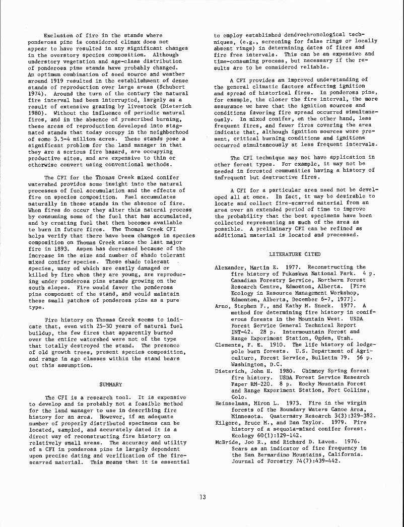
Exclusion of fire in the stands whereponderosa pine is considered climax does notappear to have resulted in any significant changesin the overstory species composition. Althoughunderstory vegetation and age-class distributionof ponderosa pine stands have probably changed.An optimum combination of seed source and weatheraround 1919 resulted in the establishment of densestands of reproduction over large areas (Schubert1974). Around the turn of the century the naturalfire interval had been interrupted, largely as aresult of extensive grazing by livestock (Dieterich1980). Without the influence of periodic naturalfires, and in the absence of prescribed burning,these areas of reproduction developed into stag-nated stands that today occupy in the neighborhoodof some 3.5-4 million acres. These stands pose asignificant problem for the land manager in thatthey are a serious fire hazard, are occupyingproductive sites, and are expensive to thin orotherwise convert using conventional methods.
The CFI for the Thomas Creek mixed coniferwatershed provides some insight into the naturalprocesses of fuel accumulation and the effects offire on species composition. Fuel accumulatesnaturally in these stands in the absence of fire.When fires do occur they alter this natural processby consuming some of the fuel that has accumulated,and by creating fuel that then becomes availableto burn in future fires. The Thomas Creek CFIhelps verify that there have been changes in speciescomposition on Thomas Creek since the last majorfire in 1893. Aspen has decreased because of theincrease in the size and number of shade tolerantmixed conifer species. These shade tolerantspecies, many of which are easily damaged orkilled by fire when they are young, are reproduc-ing under ponderosa pine stands growing on thesouth slopes. Fire would favor the ponderosapine component of the stand, and would maintainthese small patches of ponderosa pine as a puretype.
Fire history on Thomas Creek seems to indi-cate that, even with 25-30 years of natural fuelbuildup, the few fires that apparently burnedover the entire watershed were not of the typethat totally destroyed the stand. The presenceof old growth trees, present species composition,and range in age classes within the stand bearsout this assumption.
SUMMARY
The CFI is a research tool. It is expensiveto develop and is probably not a feasible methodfor the land manager to use in describing firehistory for an area. However, if an adequatenumber of properly distributed specimens can belocated, sampled, and accurately dated it is adirect way of reconstructing fire history onrelatively small areas. The accuracy and utilityof a CFI in ponderosa pine is largely dependentupon precise dating and verification of the f ire-scarred material. This means that it is essential
to employ established dendrochronological tech-niques, (e.g., screening for false rings or locallyabsent rings) in determining dates of fires andfire free intervals. This can be an expensive andtime-consuming process, but necessary If the re-
suits are to be considered reliable.
A CFI provides an improved understanding ofthe general climatic factors affecting ignitionand spread of historical fires. In ponderosa pine,for example, the closer the fire interval, the moreassurance we have that the ignition sources andconditions favoring fire spread occurred simultane-ously. In mixed conifer, on the other hand, lessfrequent fires, and fewer fires covering the areaindicate that, although ignition sources were pre-sent, critical burning conditions and ignitionsoccurred simultaneously at less frequent intervals.
The CFI technique may not have application inother forest types. For example, it may not be
needed in forested communities having a history ofInfrequent but destructive fires.
A CFI for a particular area need not be devel-
oped all at once. In fact, it may be desirable tolocate and collect fire-scarred material from anarea over an extended period of time to improvethe probability that the best specimens have beencollected representing as much of the area aspossible. A preliminary CFI can be refined asadditional material is located and processed.
LITERATURE CITED
Alexander, Martin E. 1977. Reconstructing thefire history of Pukaskwa National Park. 4 p.Canadian Forestry Service, Northern ForestResearch Centre, Edmonton, Alberta. [Fire
Ecology in Resource Management Workshop,Edmonton, Alberta, December 6-7, 1977].
Arno, Stephen F., and Kathy M. Sneck. 1977. Amethod for determining fire history in conif-erous forests in the Mountain West. USDAForest Service General Technical ReportINT-42. 28 p. Intermountaln Forest andRange Experiment Station, Ogden, Utah.
Clenents, F. E. 1910. The life history of lodge-pole burn forests. U.S. Department of Agri-
culture, Forest Service, Bulletin 79. 56 p.Washington, D.C.
Dieterich, John H. 1980. Chimney Spring forestfire history. USDA Forest Service ResearchPaper 814-220. 8 p. Rocky Mountain Forestand Range Experiment Station, Fort Collins,Cob.
Heinselman, Miron L. 1973. Fire in the virginforests of the Boundary Waters Canoe Area,Minnesota. Quaternary Research 3(3):329-382.
Kilgore, Bruce N., and Dan Taylor. 1979. Firehistory of a sequoia-mixed conifer forest.Ecology 6O(1):129-142.
McBride, Joe R., and Richard D. Laven. 1976.
Scars as an indicator of fire frequency inthe San Bernardino Mountains, California.Journal of Forestry 74(7):439-442.
Rowdabaugh, Kirk N. 1978. The role of fire inthe ponderosa pine-mixed conifer ecosystems.M.S. Thesis. 121 p. Colorado State Univer-sity, Fort Collins.
Schubert, Gilbert H. 1974. Silviculture of south-western ponderosa pine: The status of ourknowledge. USDA Forest Service ResearchPaper R14-123. 71 p. Rocky Mountain Forestand Range Experiment Station, Fort Collins,Cob.
Sackett, Stephen S. 1980. Reducing natural pon-derosa pine fuels using prescribed fire:Two case studies. USDA Forest Service ResearchNote RM-392. 6 p. Rocky Mountain Forest andRange Experiment Station, Fort Collins, Cob.
14
Tande, Gerald F. 1979. Fire history and vegeta-tion pattern of coniferous forests in JasperNational Park. Canadian Journal of Botany57:1912-1931.
Weaver, Harold. 1951. Fire as an ecological fac-tor in the southwestern ponderosa pine forests.Journal of Forestry 49(2):93-98.
Wein, Ross W., and Janice H. Moore. 1979. Firehistory and recent fire rotation periods inthe Nova Scotia Acadian Forest. CanadianJournal of Forestry Research 9:166-178.
Zackrisson, 0. 1977. Influence of forest fires
on the North Swedish boreal forest.Oikos 29(1):22-32.

Sonoran Desert Fire Ecology1
Garry F. Rogers2 and Jeff Steele3
Abstract.--Repeated observations of permanent plots andtransects are used to evaluate adaptive responses ofindividual species and communities of perennial plantsfollowing fires that occurred in 1974. Positive adaptationsare common, but are weakly developed. Recovery is takingplace, but at a very slow rate. Several decades, at least,will be required for full recovery.
INTRODUCTION
An important objective of fire-ecologyresearch is determination of natural firefrequencies (yogi 1977). In most vegetation,fires leave dateable evidence such as scars ontree rings (Ahigren and Ahlgren 1960). In theSonoran Desert, however, growth is not restrictedto a single period, and growth rings are notreliable indicators of age (e.g., Judd et al.1971). An alternative approach to fire historydetermination using fire-related adaptations isexplored in this report. Separate analyses ofthe interrelationship of climate, fine fuels, andsurvival, as well as individual species responses,are being prepared.
Plant species of some vegetation have beenshown to have evolved characteristics that favorsurvival of fire (Gill 1977). In this paper weevaluate post-fire responses of perennial plants,measured for three to five years, to determinewhether or not positive adaptations to fire aresufficiently common to suggest an evolutionaryhistory of repeated burning.
Little is known of the ecological role offire in the deserts of western North America.Most studies of desert fire have actually deltwith the semiarid fringe of the desert--the foot-hill shrubland and woodland of the Great BasinDesert (Wright et al. 1979), the desert grasslandof the Southwest (Humphrey 1958), and upperaltitude sites in the Chihuahuan Desert (Ahlstrand1979). One reviewer (Humphrey 1974) regardsdesert fire to be uncommon, except in areas
i-Paper presented at the Fire History WorkshopLaboratory of Tree-Ring Research, University ofArizona, Tucson, October 20-24, 1980.
2Assistant Professor of Geography, ColumbiaUniversity, New York, NY 10027.
3Natural Resource Specialist, Bureau of LandManagement, U. S. Department of Interior,Washington, DC 20240.
15
dominated by native perennial grasses. Studies inthe Mojave Desert (Beatley 1966) and the GreatBasin Desert (Rogers 1980), however, indicate thatsufficient fuel can be supplied by introduced
annuals. Similar species of annuals are abundantat times in the Sonoran Desert (Franz 1977).
During recent years fires have occurredthroughout the Desert. Arizona Bureau of LandManagement (BLM) records show that during theseven-year periOd 1973-1979, 210 fires burned36,621 ha in the Arizona Upland and Lower Coloradosubdivisions (Shreve 1951) of the Desert. Mo8tfires occur in the Arizona Upland, and it isprobable that local topographic and climaticconditions, as well as behavior patterns ofprehistoric and modern peoples, could result inmuch higher frequencies at some locations than atothers. The above figures suggest that fire couldoccur in cycles shorter than the life span oflonger-lived Desert species (Shreve 1951), andcould be a significant selective force in shapingthe life-history traits of individual species.
METHODS
Following fires that occurred in 1974,permanent plots and transects were established inburned, and adjacent unburned, vegetation at twosites in south-central Arizona. One site (Dead
Man Wash) is about 45 km north of Phoenix (SE¼sec. 27, T. 6 N., R. 2 E., Gila and Salt RiverMeridian), and consists of a 65 ha burn that beganat the side of Interstate Highway 17, and wasprobably man-caused. The other site (Saguaro) isabout 50 km east of Phoenix (T. 3 N., R. 8 E.,Gila and Salt River Meridian), 105 ha in size, and
was also man-caused. Both fires occurred in June.
At each site, two to three chart quadrats(100 to 300 m2) were established on each of threeexposures. Total plot area is 600 m2 at Dead ManWash, and 900 m2 at Saguaro. To supplement plot
information, six point-quarter transects (250 to500 m) were located in predominantly burnedvegetation at Dead Man Wash, and four burned

(500 m) and four unburned (250 m) transects wereestablished at Saguaro. Transects were sampled at10 m intervals.
Percent kill (proportion of photosyntheticsurface scorched or consumed by fire), percentconsumption (reduction of total biomass), andresprouting (shoot or leaf growth from roots orscorched stems) were estimated and recorded forall perennial plants during the initial survey.Position of all plants in plots was recorded ongraph paper. Identities of mostly consumed plantswere determined by comparing remaining stem orroot tissues with that of living plants. Errorsin identification are most likely for rarerspecies, and do not greatly influence most resultsof the study, except the values for speciesrichness and diversity. Presence and resproutingof living plants was recorded during resurveysafter four years (51-58 months) at Dead Man Wash,and after three years (34-40 months) at Saguaro.
Data from both surveys are used for mostlyqualitative judgements of species and communityadaptations to fire (Gill 1977, Mutch 1970). Theanalysis is limited to perennial plant species,and to the following species traits: 1) budprotection and resprouting, 2) seedling establish-ment, 3) resistance to fire, and 4) flammability.Bud protection and resprouting are reviewed byGill (1977). Seedling establishment may have beenfrom seeds surviving fire in the soil, seedsremaining on burned plants, or seeds dispersedfrom resistant plants within the burn, or fromunburned areas.
Resistance to fire, for the purposes of thisstudy, is defined as survival without resprout-ing or seedling establishment. Survival mightthus result from physical resistance to kill andconsumption, might be a chance event due tooccurrence of a skip (area of unburned vegetationwithin the larger area of the burn), or might bedue to habitat characteristics that decrease fireprobability through fuel reduction.
The last trait considered, flammability, isassumed to be closely related to consumption.Whether or not greater consumption is a consequenceof greater flammability of one or another speciesin the way that Mutch (1970) found the litter offire-prone vegetation to be more easily burned isuncertain. Other characteristics such as canopyheight and shape, or interspecific relations withunderstory species, might also be important.
Community characteristics considered includeplant density, species richness (number of species),species diversity (Brillouin index, Pielou 1975),and adaptive characteristics (Grime 1979) typicalof early ecological succession.
SPECIES ADAPTATIONS
Resprouting, seedling establishment, andresistance were observed in 13 of 19 species
16
present in all burned plots (Tables 1 and 3).Resprouting was observed in 15 of the originalspecies present in all plots and transects (Tables1 and 3). Although frequent among the speciespresent, resprouting replaced only seven percentof combined plot and transect numbers, and onlytwo percent of the plants in all burned plots.Resprouting species were more common in Saguaroplots than in Dead Man Wash plots. Mostresprouting was by woody shrubs, and least by cacti.
Seedling establishment was more abundant thanresprouting, and resulted in replacement of 22% ofthe original plants in all burned plots. Most(82%) seedlings were AmbroBia deltoid.ea. Seedlingestablishment was greatest at Saguaro, partlybecause of colonization by two species not recordedduring the original survey (CasBia ooVOBii and anunidentified species of Castilieja), but alsobecause of the greater success of A. deltaideaseedlings. At the time of the original survey,seedlings were abundant in the north-facing plotsat Dead Man Wash, but few survived until theresurvey. Seedling establismuent accounted for52% of all plants present in burned plots at thetime of the resurvey.
Resistance to burning occurred in 9 of theoriginal 19 species in all burned plots. These
plants represent 9% of the original number. Most(75%) of the survivors were either A. deltoideaor Larrea tridentata. Unburned skips were common
at both sites, and A. deltoidea usually survivedby being entirely skipped. In contrast, L.tridentata usually survived because of incomplete
kill of stems and leaves.
Flammability varied from 95% (A. deitcildea,Table 3) to 1% (8 species, Tables 1 and 3). Anattempt was made to identify correlation betweenflammability and survival, but scattergram plotsof flammability and resprouting, and other formsof survival, showed no relationship. Most cactusspecies were only slightly consumed, but A.deitoidea was usually 100% consumed unless skipped.
COMMUNITY ADAPTATIONS
Total species densities declined in allburned plots, with greatest decline at Dead ManWash (Table 2). Transect densities also declinedat Dead Man Wash, but no change occurred onSaguaro transects. Resurvey density at Dead ManWash ranged from 21% to 36% of pre-f ire density.At Saguaro, post-fire density ranged from 70% to100% of pre-f ire. This was due both to skips, andto the reproductive success of Encelia farinosa, A.
deltoidea, C. oovesii, Casteileja, Acaciaconatrvata, Acacia gregii, and Lyciwn spp. A.deitoidea decreased in burned plots at both sites,but increased on transects. E. farinosa made thegreatest relative increase. Cactus speciesdecreased at Saguaro, and on burned plots at DeadMan Wash. E. farinosa appears to qualify, atleast in a relative sense, as a ruderial. Its
increase while cactus species declined tends to

med plots d plots and transects
RS1 Seedlings 1 '%Kill 2%Consump.
Table l.--Dead Man Wash. Data include numbers of plants onboth surveys (Ni and N2), numbers of plants resprouting(RS1 and RS2) on each survey, numbers of seedlings andresistant plants, and mean percent kill and consumption.
support Grime's hypothesis that succession instressful environments will progress from ruderialto tolerant strategies among the species presentin the community (Grime 1979). Species richnesschanged very little at either site, and diversitydecreases on transects were balanced by increasesin plots (Table 2).
Changes in community composition were greatestat Saguaro where seven species disappeared and eightspecies appeared between surveys (Tables 1 and 3).Added species accounted for 9% of the total number
Table 2. Community values for the survey (A) andresurvey (B) for both Saguaro, and Dead ManWash.
3Plants per 100 m22Number of species.3Evenness, the ratio of the Brillouin index to
H(maximum). Natural logs were used.
1Species represented by only one or two plants were omitted. They include Bricks 7-7-ia coultri,CastiLl'ja, and Zizip.'iva obtusifolia all of which were present only on the resurvey, and Opuntiaphaeca;tha which ws present only on the original .3urvey.
2The mean values were often accompanied by large standard errors. R'liability increases with Nl, buteven with large Nl and small stsndard error, multiple populations may be present. A. de7-toidea for example,was almost always 100% consumed unless completely skipped. Rather than indicating that indlvidttal plantswere usually only partially consumed, the value of 73% indicates that about 27% of the plants were skipped.
17
of plants recorded on the Saguaro resurvey. Fiveadded species accounted for 29% of the resurveynumber of plants in Saguaro plots. Most of theadded plants were of two species, C. covesii andCaste ileja, both of which exhibit some ruderialcharacteristics, including rapid dispersal andgrowth, and presumably relatively short lifespans. Three new species were recorded at DeadMan Wash during the resurvey, and two formerspecies disappeared. Numbers of these plantswere quite low, however, and most represented lessthan one percent of the total pre-f ire density.
Recovery of the Dead Man Wash site is pro-ceeding much more slowly than recovery at Saguaro.The reason for this is uncertain. Buriingintensity might have been responsible, but thisseems unlikely, because kill and consumption weregenerally higher at Saguaro, and resistance washigher at Dead Man Wash. It seems likely thatnon-fire factors such as pre- or post-fire droughtare responsible for the differences.
CONCLUSIONS AND RESEARCH NEEDS
Although it appears that adaptations to fireare present, they are not strongly developed, andthe time for return to pre-fire conditions will belong. At the rate of development observed so far,the Saguaro site would reach original total densityafter about 5 years, but Dead Man Wash wouldrequire 20 years. Original species composition ofthe sites, assuming this to be a realistic goal(see White 1979), would require many decades to
-Secies Ni N2Bu
RS2 ResistantBurne
Ni N2 RS RS2
Ambrosia de itoidea 275 49 0 0 35 14 298 178 5 0 84 73
Cereus gigcmteus 2 1 0 0 0 1 5 1 0 0 65 1
Cercidium microphy 7-7-wv 1250 0 0 5 28293 5 78 1
Echinocereus enge lmwii 0 1 0 0 1 0 14 2 0 0 97 1
Ence 7-ia farinosa 630 0 3 0 10270 0 79 15
Ferrocactus acanthoides 1 0 0 0 0 0 21 3 1 0 92 1
Krcvneria grayi 2 1 0 1 0 0 2819 3 12 95 20Larrea tridentata 44 18 2 1 2 15 173 64 9 15 99 23
Lyciwn app.Mw-nina 7-aria microcarpa
24 0
100
00
10
00
910 028 3 0
20
5095
101
Opuntia accinthacarpa 56 3 0 2 0 1 126 69 5 5 89 1
Opuntia big lovii 0 0 0 0 0 0 5216 2 0 88 1
07-nsa tesota 0 0 0 0 0 0 1 3 0 0 100 1
Opuntia leptocau 7-is 1 0 0 0 0 0 5 2 0 2 100 15
Prosopis .iuliflora 1 0 0 0 0 0 3 6 2 0 100 73
1Density ZRichness 3DiversityA B A B A B
Dead Man WashPlots 68 14 16 17 .44 .56Transects 11 4 12 10 .78 .71
SaguaroPlots 33 23 14 13 .51 .64Transects 25 25 24 25 .69 .56
Both SitesPlots - - 19 17 - -Combined 26 31 - -

Table 3.--Saguaro observations of numbers of plants on bothsurveys (Nl and N2), numbers of plants resprouting (RS1and RS2) on each survey, numbers of seedlings andresistant plants, and mean kill and consumption percents.
develop. Obviously, no community can be adapted tofires that occur more frequently than the periodrequired for the community to replace the majorityof its original species in their former proportions.In 1979 Dead Man Wash reburned, again from anignition point near the highway. The new burn islarger, and contains fewer skips than the 1974burn. Depending on the relative importance ofdispersal of seeds from surrounding, unburned sites,and upon the general success of reproduction,recovery may be slower than after the 1974 fire.Opportunity for soil loss and site degradation(yogi 1977) is high.
We consider the data made available by thisstudy to be too limited in scope and quantity toyield firm conclusions about natural fire frequency.Too much variability exists between sites toconsider the data representative of much of theDesert, and observation time has been too brief forgeneralizations about recovery rates. Based on theslow recovery rate observed at Dead Man Wash,however, a recommendation for conservative attitudestoward Desert fire management may be appropriate.
18
Lro save space, species represented by only one or two plants were omitted from this table. They
include one unknown species present on the original survey, Cereus giganteu8., Celti8 pallida, and Olneatesota, also present only on the original survey, Dyssodia porophylloides, Ferrocactus acanthoides,Mullenbergia porteri, Thainnosma montana, present only on the resurvey, and Cutierrezia sarothrae which was
present on both surveys.2See the second footnote to Table 1.
In this exploratory analysis a qualitativejudgement was made regarding the adaptivecharacteristics of individual species. Furtheranalysis to define life history traits, includinglongevity, reproduction, seed sources, phenology,and others, would assist in predicting the progressof succession (Slatyer 1977, Catellino et al.
1979).
The relationship between annual plants andfire requires analysis. At Dead Man Wash the post-fire annual community was diverse, but wasgenerally dominated by introduced species,especially Erodium cicutaniurn. At Saguaro, anotherintroduced annual, Brornus rubens, appeared dominant.
Does fire lend a competitive advantage to somespecies, and, as in the Great Basin Desert, dothese species support increased fire frequency(Young and Evans 1973)? Do native annuals alonereach densities great enough to carry fire, ormust introduced species be present? Perhaps nofire in the Sonoran Desert has been natural sincethe introduction and spread of exotic annuals.Both frequency and intensity may have increased.
1SpeciesBurned plots Burned plots and transects
Nl N2 RS1 RS2 Seedlings Resistant Nl N2 RS1 RS2 2Kill %Consump.
Acacia cons tricta 12 5 7 3 0 2 191913 6 94 20
Acacia gregii 433 3 0 0 45 3 4 100 47
Ambrosia deltoidea 209 103 0 0 88 15 535 509 0 1 90 90
Argy thcunnia neomexicanna O 0 0 0 0 0 0 3 0 0
Be loperone californica 040 0 4 0 040 0
Bricks llia coulteri O 0 0 0 0 0 4 1 0 0 50 39
Cassia covesii 039 0 0 39 0 0630 0
Callicindra eriophylla 0 0 0 0 0 0 22 12 15 12 100 74
Canotia holocantha 000 0 0 0 410 0 0 0
Casti lieja 010 0 0 10 0 016 0 0
Cercidium microphyllwn 4 5 0 0 5 0 2410 4 1 92 11
Echinocereus enge imcznii 200 0 0 0 6 10 0 100 1
Encelia farinosa 0 11 0 0 11 0 18133 0 1 61 8
Ephedra 11 10 0 1 0 5219 1 5 98 53
Fouquerria sp lendens 10 0 0 0 0 5 1 0 0 100 1
Krczmeria grayi 9 5 3 3 0 2 865417 29 97 67
Larrea tridentata 9 7 5 0 1 6 76589 6 93 45
Lycium 1210 7 3 2 5 33369 21 100 51
Mamma 1 lana microcarpa 0 0 0 0 0 0 3 0 0 0 67 1
Opuntia acanthacarpa 23 0 0 0 0 0 65 9 0 0 97 3
Opuntia biglovii 3 0 0 0 0 0 5618 0 0 98 1
Opuntia leptoccn lie 10 1 0 0 0 1 28 4 0 0 96 6
Pros opis julifiora 0 0 0 0 0 0 36 0 0 0 97 34
Simmondsia chinninsis 0 0 0 0 0 0 2714 4 12 96 42

LITERATURE CITED
Ahlgren, I. F. and C. E. Ahigren. 1960. Ecologicaleffects of forest fires. Bot. Rev. 26: 483-535.
Ahistrand, Gary M. 1979. Preliminary report on theecology of fire study, Guadalupe Mountainsand Carlsbad Caverns National Parks. NationalPark Service Proceedings and TransactionsSeries 4: 31-44.
Beatley, Janice C. 1966. Ecological status ofintroduced brome grasses (Bronrus cpp.) in
desert vegetation of southern Nevada. Ecology47: 548-554.
Cattelino, Peter J., Ian R. Noble, Ralph 0. Slatyer,and Stephen P. Kessell. 1979. Predictingthe multiple pathways of plant succession.Environmental Management : 41-50.
Franz, Clark E. 1977. Seasonal dynamics ofselected annuals of the Sonoran Desert. Ph. D.dissertation, Northern Arizona University.100 pp.
Gill, A. Malcolm. 1977. Plant traits adaptive tofires in Mediterranean land ecosystems. U. S.Forest Service General Technical Report W0-3:17-26.
Grime, J. P. 1979. Plant strategies and vegetationprocesses. Wiley, Somerset, New Jersey. 222 pp.
Humphrey, R. R. 1958. The desert grassland, ahistory of vegetational change and an analysisof causes. Bot. Rev. 24: 193-252.
Humphrey, R. R. 1974. Fire in the deserts anddesert grassland of North America. Pages 365-
19
400 in T. T. Kozlowski and C. E. Ahlgren, eds.,Fire and ecosystems. Academic Press, New York.
Judd, B. I. et al. 1971. The lethal decline ofmesquite on the Casa Grande National Monument.Great Basin Naturalist 31: 153-159.
Mutch, R. W. 1970. Wildland fires and ecosystems--a hypothesis. Ecology 51: 1046-1050.
Pielou, E. C. 1975. Ecological Diversity. Wiley-Interscience, New York.
Rogers, Garry F. 1980. Photographic documentationof vegetation change in the Great BasinDesert. Ph. D. dissertation, University ofUtah. 160 pp.
Shreve, Forrest. 1951. Vegetation of the SonoranDesert. Cam. Inst. Wash. Pub. 591. 192 pp.
Slatyer, R. 0., ed. 1977. Dynamic changes interrestrial ecosystems: patterns of change,techniques for study and applications tomanagement. MAB Technical Notes 4: 1-30.
Vogl, Richard J. 1977. Fire frequency and sitedegradation. U. S. Forest Service GeneralTechnical Report W0-3: 193-201.
White, Peter S. 1979. Pattern, process, andnatural disturbance in vegetation. Bot. Rev.45: 229-299.
Wright, Henry A. et al. 1979. The role and use offire in sagebrush-grass and pinyon-juniperplant communities: a state-of-the-art
review. U. S. Forest Service GeneralTechnical Report INT-58. 48 pp.
Young, James A. and Raymond A. Evans. 1973.Downy brome--intruder in the plant successionof big sagebrush communities in the GreatBasin. Journal of Range Management 26: 410-
415.

Southwestern canyon woodlands, for purposesof this paper, are vegetation types along canyonbottoms for mostly third and fourth order drainageswhose streams may be permanent or intermittent.These include habitat types within blue spruce,white fir, ponderosa pine, narrowleaf cottonwood,Arizona cypress, and evergreen oak series (Layserand Schubert 1979). Nearly everywhere the canyonwoodlands are subject to fire suppression and in-tense utilization such as commodity harvests,recreation, or development.
Can studies in fire ecology from one canyonwoodland at a certain location be extended orgeneralized to another location? At present I be-lieve not. Fires in the ecological sense are partof the environment, and we have not yet been ableto sufficiently particularize these canyon woodlandenvironments in a classificatory sense. For ex-ample, my studies (Moir 1981) in Boot Canyon,Chisos Mountains cannot be very relevant to RhyoliteCanyon, Chiricahua Mountains although the vegeta-tion of both areas is in the Arizona cypress series.A habitat type classification provides a tool forgeneralization, but is not yet available.
I have often seen dense conifer thicketsdevelop in a wide variety of disturbed upland orslope forests in the Southwest, but these thicketsare usually absent, despite fire suppression, alongcanyon streamside environments. How important,then, is fire in maintenance and succession ofcanyon vegetation? The Bandolier fire of June,1977 is instructive. A holocaustic fire thatravaged forests of mesa tops scarcely had anyimportant effect along forests of Frijoles Canyonextending through the burn area. Along mesiccanyon bottoms fires may be very local, and perhaps
'Paper presented at the Fire History Workshop.(Laboratory of Tree-Ring Research, University ofArizona, Tucson, October 20-24, 1980).
2Rodeo, N.M.
Some Questions about Fire Ecology
in Southwestern Canyon WoodlandsWilliam H. Moir2
20
other factors of microsuccession are more critical
for determining vegetation composition. To under-
stand the role of fire in canyon woodlands we needinformation on the autecology and fire tolerancesof the many dominant species that comprise thevegetation.
Fire management plans for canyon environmentsmay not require fire history knowledge. Such his-
tories can be irrelevant if intense utilizationduring the last hundred years has markedly changedthe vegetation or if management goals are notdirected to any kind of natural maintenance process.However, if Southwestern canyon woodlands are en-visioned as natural or scenic areas, refuges, pre-serves, or wilderness, then the historic role of
fire in bringing about or maintaining biotic diver-sity should be known if possible. In the absence
of such knowledge I see little reason why localized,prescribed fires cannot be substituted for naturally
occurring fires. And fires may not be needed at allalong third and fourth order drainages where flashfloods or other natural channel and fluvial geo-morphic processes set the stage for local succes-sion and perpetuate the diversity of these canyon
environments.
LITERATURE CITED
Layser, Earle F., and Gilbert H. Schubert. 1979.
Preliminary classification for the coniferousforest and woodland series of Arizona andNew Mexico. USDA Forest Service Research
Paper 814-208, 27 p. Rocky Mountain Forestand Range Experiment Station, Fort Collins,Cob.
Moir, William H. 1981. Fire history of the Chisos
Mountains. Texas. The Southwestern Naturalist27: in press.

Fire History of Western RedcedarlHemlock Forests in Northern Idaho12
Abstract.--Evidence of fire history over the past fewcenturies was gathered in two areas (totaling 30,000 acres;6000 ha) for fire management planning. Findings are some
of the first detailed data for western redcedar-hemlockforests. On upland habitat types fires of variable intensitiesgenerally occurred at 50-to-l50-year intervals, often havinga major effect on forest succession. On wet and subalpinehabitat types fires were infrequent and generally small.
INTRODUCTION
Prior to the development of modern firesuppression, forest fires, caused largely bylightning, had a major influence in the ecologyof Northern Rocky Mountain forests (Leiberg 1898,Larsen 1929, Weliner 1970, Habeck and Mutch 1973).Periodic fires killed varying amounts of treesand undergrowth and consumed duff and litter,allowing shade-intolerant species to perpetuatethrough seeding or sprouting in what would other-wise have become climax forests (Davis et al. 1980).The history of fires occurring prior to the adventof organized fire suppression in the early 1900'shas been studied in many of the major forest types(Arno 1980), but not in. the western redcedar(Thuja plicata)-western hemlock (Tsugaheterophylla) potential climax forest types, whichare abundant in northern Idaho.
In 1979, L. A. White and D. H. Davis of thePriest Lake Ranger District, Idaho PanhandleNational Forests, sought to obtain fire historyinformation to be used as a basis for writingfire management plans for two planning units,Salmo/Priest and Goose Creek, in the redcedar-hemlock forests. In consultation with the seniorauthor, they set up the fire history samplingapproach outlined here. Although the approachwas not designed for a comprehensive fire
1Paper presented at the Fire History Work-
shop, University of Arizona, Tucson, October 20-24, 1980.
2Stephen F. Arno is plant ecologist at theNorthern Forest Fire Laboratory, IntermountainForest and Range Experiment Station, USDA ForestService, Missoula, Montana
3Dan H. Davis is forestry technician at the
Priest Lake Ranger District, Idaho PanhandleNational Forests, USDA Forest Service, PriestRiver, Idaho.
Stephen F. Arno
Dan H. Davis3
21
history study, the information gathered providesa preliminary overview of fire history in someof the redcedar-hemlock forests.
STUDY AREAS
The Salmo/Priest and Goose Creek planningunits are each about 15,000 acres (6000 ha) andare located north and southwest of Priest Lake(fig. 1). Both units are dominated by redcedar
PUIEST LARE
Figure l.--Location of study areas.

and hemlock habitat types (as described byDaubenmire and Daubenniire 1968) on all but thehighest elevations. In addition to these shade-tolerant, potential-climax species, however,burned sites support numerous seral trees (shade-intolerant) particularly western white pine(Pinus monticola), western larch (Larixoccidentalis), and Douglas-fir (Pseudotsu_g_menziesii). The composition of seral forestsvaries with site conditions and stand history.Early accounts (Leiberg 1898), 1930's aerialphotography, timber type maps, and modern fieldreconnaissance all suggest that most of thecirca 1900 landscape in both planning units wascovered with forest stands 100 to 500 years old.Both areas are mountainous and have a cool, inland-maritime climate, with heavy annual precipi-tation (about 35 to 50 inches in the redcedar-hemlock type). Winters are long and snowy; thashort summers have periods of warm, dry weather.
There are some marked differences betweenthe planning units. The Salmo/Priest unit isremote, essentially without roads, development,or timber cutting, and is part of a proposedWilderness. It has steep, rocky, and ruggedterrain with elevations ranging from about 2750feet (840 m) in the Upper Priest River Valley towell over 6000 feet (1830 m) on major ridges.The fire management plan for this area will beconcerned with perpetuating unique wildernessvalues, including ancient redcedar groves andhabitat for the woodland caribou, grizzly bear,and certain bird species considered to bethreatened or endangered in the contiguousUnited States.
In contrast, the Goose Creek unit is less-rugged commercial forest land (mostly between2500 and 5000 feet (760 to 1520 in) in elevationthat has been logged since the early 1920's.Human occupation of the Goose Creek area datesback into the late 1800's and Leiberg (1898)reported that white men (mostly prospectors)set numerous forest fires during that period. TheGoose Creek fire management plan will be concernedwith protecting and enhancing timber values.
METHODS
In both study areas data on fire history,fuel inventory, timber inventory, habitat types,and soils were collected to provide basic inputsto the fire management plan. Each study areawas divided into topographic subunits, small drain-ages of 150 to 300 acres (60 to 120 ha). In
each area nine or ten subunits representative ofthe terrain and forest conditions were thenselected for intensive field sampling. Activecutting units and previously clearcut/burnedunits in the Goose Creek area were avoided.
Two to three miles of transects were thenlaid out on a map across elevational gradientsin each subunit. Thus, a total of about 25 miles
22
(40 lan) of transects were laid out in each of the
two study areas.
Field crews gathered fire scar evidencecontinuously along each transect and good speci-mens of fire scarred trees were wedge-sectionedwith a chainsaw (Arno and Sneck 1977). Inventory
plots for dead and down fuel (Brown 1974) weretaken at 20 chain (1/4 mile; 402 in) intervals
along each transect. A 100-foot-long (30 in)sampling plane was used for inventory of largefuels to minimize error related to variability ofthe fuel bed. Habitat type (Daubenmire andDaubenmire 1968) and topographic data were re-corded at each fuel inventory site.
Two sampling teams (three technicians each)did the sampling over a period of 15 weeks in 1979.Over 100 fuel inventory plots were taken in eachstudy area.
RESULTS AND DISCUSSIONField Application
To simplify field work crews were directedto select and cross-section a few of the f ire-scarred trees as they were encountered along thetransects, rather than making an initialreconnaissance and then revisiting and samplingthe best specimens (as recommended by Arno andSnack 1977). The extensive bole rot associatedwith most old fire-scarred trees (essentiallyall species) made it difficult for field crewsto obtain good quality samples necessary fordating early fires. Many partial cross-sectioncuts collected were subsequently rejected becauseof extensive rot or because stems were not sectioneddeeply enough to identify the year of the fire.We now recommend that in studies of redcedar-hemlock forests many of the trees be felled sothat full cross-sections can be taken at the bestlocation along the lower trunk (unnecessary portionsof cross sections could be cut off and discardedin the field). Studies might be made in con-
junction with logging.
In retrospect, the field crews could havegathered more complete fire scar and stand age-class data if they had been given more training,time, and supervision in the field. Our initial
aim of obtaining large numbers of incrementborings to identify all age classes of intoleranttrees in sample stands was only accomplished ina few revisited stands in the Goose Creek unit.
These data were useful for identifying probablefire years based upon vigorous regeneration ofshade-intolerant trees such as western larch,Douglas-fir, lodgepole pine (Pinus contorta var.latifolia), and ponderosa pine (Pinus ponderosa).In most stands a thorough investigator couldextend the fire history record back to the 1600'susing full cross sections of scarred trees andage classes of veteran intolerant trees. A special
increment borer at least 24 inches (61 cm) longwould be necessary for the latter work.

SUBUNITSPECIES
21 15 91032333 5140LI ILLCCAIGFWIICCCCCCCC1,111 III! '1 I-1 I I I
L S-
.
0
0
2
l0
0
0
0 17201 -
38 1 25 24 I 23 5 I 6 I 16
c!cdc dc cI I3II ('III 1cIti. III I I 11
S
oo 58
op S 0,0
U
S
0-SR
0
Il
SAL MO/PRIEST GOOSE CREEK
tO
1730
10
'70
'80
750
SUBUNITSPECiES
1300
10
'30
'20
10
'30
'80
'70
'80
'50
820
ESTIMATEDFIRE YEAR
19541948
18911885
1874
- 1883
1851
1799
1753
A confounding problem for field work in red-cedar-hemlock forests is that root-rotting fungi,notably Armillaria mellea, scar the bases of trees,sometimes in association with fire scars. However,most root-rot scars are easily differentiated fromfire scars. Root-rot scars are associated withroot buttresses; whereas fire scars usually arefound in hollows between roots on the uphill sideof the trunk. Externally, fire scars are usuallytriangular, while root-rot scars have irregularshapes.
Cross-sections from sample trees were takento Dr. Arthur Partridge, forest pathologist atthe University of Idaho, Moscow, for determinationof which scas were caused by pathogens and whichby fire. Partridge was able to identify the patho-genic scars by the marked slowdown in radial growthpreceding the scar and the evidence of rotassociated with the growth rings formed prior tothe scar. In most cases, the growth-ring healingpattern associated with pathogen scars was obscureand indefinite in contrast with the relativelyclear and simple patterns associated with mechanicalscars, including fire scars. Presence of charcoalon the outer bark is often associated with a firescar as much as 100 years old. Interestingly, wefound that although fires had often burned throughthe bark and cambium of western redcedars andcharred areas of the sapwood, the trees continued
ESTIMATEDFIREYEAR
-1933-1924
1920
-1899
-1885
-1874
-1861
-1835
Figure 2.--Master chronology of fire-scar records.different tree. Each dot represents the yearcounts. uRtt (regeneration) indicates that anyear. "L" indicates a lightning-strike scar.
C = western redcedarL western larch
AF = subalpine fir
Each column represents fire scar records from aof the fire scar. Solid dots indicate clearest ringage class of intolerant trees was traced to that fireTree species are coded as follows:
CF = grand firWH = western hemlockPP ponderosa pine
23
to live. Similar damage from wildfires usuallykills other species of conifers in the NorthernRockies.
Fire History Interpretations
Figure 2 shows the fire scar dates found onindividual trees in all subunits.
The "R" symbols in some of the Goose Creek sub-units identify age classes of intolerant treespecies evidently regenerating within a decadeof a given fire year in the stand. This evidenceof fire can be viewed as conservative, sincefield reconnaissance undoubtedly failed to detectand document all evidences of fire. Fire evidencefrom 1880's and 1890's at Goose Creek probablyincluded some burns caused by European man. Buton most subunits the period 1750 to 1900 probablyreflects the general lightning fire frequencies,prior to settlement by European man. The frequencyof Indian-caused fires in these forests Is un-known, but evidently such fires were of minorimportance.
As shown In figure 2, one to four fires weredetected between 1750 and 1900 in each of the red-cedar-hemlock subunits. This suggests averagefrequencies of about 50 to 150 years for signif i-
SUBUNIT 4 3LOCATIONS
1790
-1784'8U
-1771 '70
-1700 '90
1750-(1700)

cant fires occurring in small stands.
Our reconnaissance data suggest the followinginterpretations of pre-settlement fire history byhabitat types (Daubenmire and Daubenmire 1968).Figure 3 shows the distribution of habitat typesin the SalmotPriest unit.
Upland Redcedar-Hemlock (Tsuga/Pachistiina andThuja/Pachistima h.t.$)
Areas having large expanses of unbrokenforest (pre-1900 condition) are represented bythe Goose Creek Unit and to a lesser extent bythe southern portion of the Saimo/Priest unit.Fire scars and age classes of shade-intoleranttrees presumably resulting after fire suggestthat significant fires occurred in most subunitsonce or twice a century since the 1600's. Thisfire frequency coincides with findings by Marshall(1928) for five stands in the Priest Lake area.
Fires in upland redcedar-hemlock habitatsburned under variable intensities, ranging fromlight ground fires that did little direct damageeven to thin-barked overstory trees, to crownfires that covered hundreds of acres in a majorrun. Overall, fires left a patchy pattern of (1)
complete stan4 replacement, (2) partially killed
Montane Tsugal Pachistima H. 1. S.
Wet Thuja! Oplopanax H. T. and! Athyrium
Subalpine Abies lasiocarpa H.T. S.
Avalanche Chutes Alnus sinuata Communities
Figure 3.Habitat type map of Salmo/Priest unit.
24
overstory (resistant species surviving), (3) under-burning with little overstory mortality, and (4)
unburned forest.
Certain topographic situations were evidentlypre-disposed to hot, stand-replacing fires. In
the Salmo/Priest unit, field sampling and inspectionof aerial photos and an old fire map identified amid-slope "thermal belt" that burned hot in the
late 1800's. Hayes (1941) documented and describeda similar thermal belt on mountainsides south ofPriest Lake. These wind-exposed slopes are in-
herently warmer and drier, and their steep topo-graphy would allow pre-heating of live fuels tooccur from below. Subunits 5 and 6 at Goose Creekare dense forest habitats on southwest-facing slopesexposed to prevailing winds. They were the onlysubunits on which stands were almost entirely burnedand replaced in late 1800's, evidently from a doubleburn in about 1863 and 1885 (fig. 2).
The field data suggest that stands on shelterednorth-facing slopes burned less severely, probablybecause of moist site conditions and less wind ex-
posure. Stands in more rugged terrain (Salmo/Priestunit) apparently burned less often. Natural barriers
in these areas would tend to limit fire spread. The
northernmost study subunits (Salmo/Priest 3, 5, and40) burned less often and apparently less intensely.The subunits are dominated by old-growth redcedar-hemlock stands (older than 300 years) divided aboutevery half-mile by large alder-filled snow-avalancheswaths. Wet bottomland forests occur below, androcky subalpine terrain lies above these redcedar-
hemlock stands.
Wet Site Redcedar-Hemlock (Thuja/Oplopanax andThuja/Athyrium h.t.$)
These poorly drained sites occur along themajor streams and in seepage areas. They generally
support groves of large (> 500-year-old) westernredcedar, except in logged areas. Fires were in-frequent other than lightning-strike spot firesand usually had little impact upon these stands.Only rarely a major fire would spread throughportions of these communities and cause overstorymortality.
Subalpine Fir Habitat Types (Abies lasiocarpa series)
These sites occur above about 4700 feet (1430 m)elevation in the Salino/Priest unit, where they arecovered with patchy stands primarily of subalpinefir along with Menziesia shrubs and low growingXerophylluni. The terrain is very rocky and steep,and forest vegetation forms a mosaic with shrub orherb communities and rockland. The map of 1921through 1978 fires (fig. 4) shows that lightningfires are frequent. However, field data and districtexperience suggest that even without suppressionthe vast majority of fires would remain small. In
nearby areas where high elevation forest is morecontiguous on wind-exposed ridges, fires haveoccasionally spread over sizeable acreages as stand
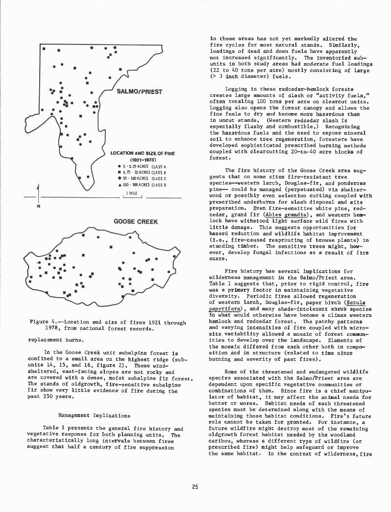
GOOSE CREEK
SAL MO! PRIEST
LOCATION AND SIZE OF FIRE
(1921-1978)0 - t 25 ACRES CLASS A
t25 - 1OACRES CLASS B
10- 100ACRES CLASS C
a 100- 300ACRES CLASS 0
Figure 4.--Location and size of fires 1921 through1978, from national forest records.
replacement burns.
In the Goose Creek unit subalpine forest isconfined to a small area on the highest ridge (sub-units 14, 15, and 16, figure 2). These wind-sheltered, east-facing slopes are not rocky andare covered with a dense, moist subalpine fir forest.The stands of oldgrowth, fire-sensitive subalpinefir show very little evidence of fire during thepast 250 years.
Management Imp licat ions
Table 1 presents the general fire history andvegetative response for both planning units. Thecharacteristically long intervals between firessuggest that half a century of fire suppression
25
in these areas has not yet markedly altered thefire cycles for most natural stands. Similarly,loadings of dead and down fuels have apparentlynot increased significantly. The inventoried sub-units in both study areas had moderate fuel loadings(22 to 40 tons per acre) mostly consisting of large(> 3 inch diameter) fuels.
Logging in these redcedar-hemlock forestscreates large amounts of slash or "activity fuels,"often totaling 100 tons per acre on clearcut units.Logging also opens the forest canopy and allows thefine fuels to dry and become more hazardous thanin uncut stands. (Western redcedar slash isespecially flashy and combustible.) Recognizingthe hazardous fuels and the need to expose mineralsoil to enhance tree regeneration, foresters havedeveloped sophisticated prescribed burning methodscoupled with clearcutting 20-to-40 acre blocks offorest.
The fire history of the Goose Creek area sug-gests that on some sites fire-resistant treespecies--western larch, Douglas-fir, and ponderosapine-- could be managed (perpetuated) via shelter-wood or possibly even selection cutting coupled withprescribed underburns for slash disposal and sitepreparation. Even fire-sensitive white pine, red-cedar, grand fir (Abies graadis), and western hem-lock have withstood light surface wild fires withlittle damage. This suggests opportunities forhazard reduction and wildlife habitat improvement(i.e., fire-caused resprouting of browse plants) instanding timber. The sensitive trees might, how-ever, develop fungal infections as a result of firescars.
Fire history has several implications forwilderness management in the Salmo/Priest area.Table 1 suggests that, prior to rigid control, firewas a primary factor in maintaining vegetativediversity. Periodic fires allowed regenerationof western larch, Douglas-fir, paper birch (Betulapapyrif era), and many shade-intolerant shrub speciesin what would otherwise have become a climax westernhemlock and redcedar forest. The patchy patternsand varying intensities of fire coupled with micro-site variability allowed a mosaic of forest commun-ities to develop over the landscape. Elements ofthe mosaic differed from each other both in compo-sition and in structure (related to time sinceburning and severity of past fires).
Some of the threatened and endangered wildlifespecies associated with the Salmo/Priest area aredependent upon specific vegetative communities orcombinations of them. Since fire is a chief manipu-lator of habitat, it may affect the animal needs fobetter or worse. Habitat needs of each threatenedspecies must be determined along with the means ofmaintaining those habitat conditions. Fire's futurerole cannot be taken for granted. For instance, afuture wildfire might destroy most of the remainingoldgrowth forest habitat needed by the woodlandcaribou, whereas a different type of wildfire (orprescribed fire) might help safeguard or improvethe sane habitat. In the context of wilderness, fire

Table 1. Some fire chaiacteristics and effects by habitat type in the Salmo/Priest and Goose Creek
units.
Thuja/Athyrium streamside & 2500-3500Thuja/Oplopanax seepage areas
Tsuga/Pachistlina lower and 2500-5000
Thuja/Pachistima middle slopes
Abies lasiocarpa upper slopes 4700-7000
Tree species abbreviations:
PP ponderosa pineWBP - whitebark pineWil western hemlockWL = western larchWP = western white pine
WRC western redcedar
management provides opportunities fot maintainingprimeval conditions, and the fire management planis the vehicle for allowing the appropriate useof fire.
PUBLICATIONS CITED
Arno, S. F. 1980. Forest fire history in theNorthern Rockies. Jour. For. 78(8):46O-465.
Arno, S. F. and K. H. Sneck. 1977. A method fordetermining fire history in coniferous forestsof the Mountain West, USDA For. Serv. Gen.Tech. Rep, INT-42, 28 p.
Brown, J. K. 1974. Handbook for inventoryingdowned woody material. USDA For. Serv. Gen.Tech. Rep. INT-16, 24 p.
Daubenmire, R., and J. B. Daubenmire. 1968. Forestvegetation of eastern Washington and northernIdaho, Wash, Agric. Exp. Stn. Tech. Bull.60, 104 p.
Davis, K, M., B. D. Clayton, and W. C. Fischer.
Dominant trees Mean f ire-
with fire In pre- free
exclusion 1900 intervals,
& no sil- forests years
viculturaltreatments
WRC, Wil
WH, WRC
26
Character-istic fireintensities
1980. Fire ecology of Lob National Forest
habitat types. USDA For. Serv. Gem, Tech.Rep. INT-79, 77 p.
Habeck, J. R. and R. W. Mutch. 1973. Fire-dependent forests in the northern Rockymountains. Quat. Res. 3(3):408-424.
Hayes, G. L. 1941. Influence of altitude andaspect on daily variation in factors offorest-fire danger. USDA Circ. 591, 38 p.
Larson, J. A. 1929. Fires and forest successionin the Bitterroot Mountains of northernIdaho. Ecol. 10:67-76.
Leiberg, J. B. 1898. The Priest River ForestReserve. U.S. Geol. Surv. 19th Ann. Rep.,
Part 5:217-252.Marshall, R. 1928. The life history of some
western white pine stands on the KaniksuNational Forest. Northwest Sd. 2(2):48-53.
Wellner, C,A. 1970. Fire history in the north-ern Rocky Mountains. P. 42-64. In: The
role of fire in the Intermountain West.,Proc. Sch. For., Univ Montana, Missoula, MT
WRC, WH > 200 low
WP, WL, DF, 50-150 quite
RC, If!, GF, variableLP, PB, ES,PP
AF - subalpine firDF Douglas-firES Engelmann spruceGF - grand firLP lodgepole pinePB paper birch
Habitat Types Topography Generalelevations,feet
AF, ES WL, LP > 150 low to
AF, ES, medium
WBP

Fire Frequency in Subalpine Forests of Yellowstone National Park1William H. Ror,me2
Abstract.--Dead woody fuels were sampled in 16 uplandforest stands representing a chronosequence of forest sac-cessiona]. stages. Different fuel components show differenttemporal patterns, but adequate levels of all componentsnecessary for an intense crown fire are not present simul-taneously until stand age 300-400 yr. Therefore, the aver-age interval between successive fires is estimated to be
3O0 yr.
INTRODUCTION
There are two different aspects of firehistory that must be distinguished if fire regimesare to be compared in different ecosystems. Thefirst can be called fireincidence, or the numberof fires occurring within a study area during aperiod of time. The second is fire frequency, orthe average interval between successive fires on asingle site. I determined the incidence of fireon a 73-km2 subalpine watershed in YellowstoneNational Park using fire-scar analysis (Roinme
1979). I found evidence of 15 fires since 1600,of which seven were malor fires that covered4 ha,destroyed the existing vegetation, and initiatedsecondary succession. The other eight fires ap-parently covered very small areas and caused lit-tle change in the vegetation. Two large fires in1739 and 1795 each burned about 25% of the water-shed, with the other fires together burning another10%. These were destructive, stand-replacingburns. Less than 10% of the watershed appears tohave burned more than once in the last 350 years,mainly along the boundaries between two burns wherethe second fire apparently burned a short distanceinto the area burned earlier before going out. Thisis indicated by the fact that most fire-scarredtrees contain only one scar and are found mainlyin clumps that appear to represent the margins ofburns. In addition, most forest stands either are
1Paper presented at the Fire History Workshop(Laboratory of Tree-Ring Research, University ofArizona, Tucson, October 20-24, 1980).
2William H. Romme is Assistant Professorof Natural Science, Eastern Kentucky University,Richmond, Ky. This work was done as partof a doctoral dissertation at the University ofWyoming, Laremie, and was supported by a grantfrom the University of Wyoming--National ParkService Research center.
27
dominated by a single age class, representingpost-fire establishment, or have an all-agedstructure representing 350+ yr without fire.
Because so little of the watershed showsevidence of more than one fire, it was not pos-sible to estimate fire frequency using fire scaranalysis alone. Despain and Sellers (1977)hypothesized thot fire frequency in this area iscontrolled by changes in the fuel complex during
succession. To test this hypothesis, I sampleddead woody fuels in a chronosequence of standsranging from early to late successional stages.I then combined these data with the fire incidencedata to develop a model for fire frequency in theYellowstone subalpine e-cmsystem.
STUDY AREA AND METUODS
The study was conducted?on the Little FireholeRiver watershed located on the Madison Plateau, alarge rhyolite lava flow in west-central Yellow-stone National Park. Most of the watershed hasrelatively little topographic relief, with an aver-age elevation of 2500 in. Forests cover 90% of the
watershed, with early and uiddle successionalstages dominated by lodgepole pine (Pinus contortavar. latifolia Engelm.). Lodgepole pine also doini-mates late successional stages on drier sites, butshares dominance with subalpine fir (Abieslasiocarpa (hook.) Nutt.), Engletnann spruce (Piceaengelinannii Parry), and whitebark pine (Pinus
albicaulis Engelin.) on more mesic sites. Groundcover is generally low and often sparse, dominatedby Carex geyeri Boott on dry sites and by Vacciniumscoparium Leiberg on more niesic sites.
I sampled dead woody fuels with the planarintersect method (Brown 1974) in 16 upland standsranging from age 29 to 550+ years. Al] stands werelocated on similar soils and substrata, with moston flat or gently sloping terrain. I counted
intersections along 20 transects ii, each stand,

2 -
20 -
10
0
S
.. S
SS
I I I I I 1 I I -I I
00 200 300 400 500 600
S
S
SS
600 -
500
400-
0
resulting in percent errors (standard errordivided by times 100) of about 10-20 for duffand needle litter, 10-35 for small particles (upto 7.5 cm diameter), and 15-60 for large material(7.5 cm). I plotted each fuel component againststand age and looked for apparent temporal pat-
terns. For time periods where an apparent changein a fuel component coincided with events in thedevelopment of a forest stand that could be ex-pected to produce such a change, I applied linearregression to determine whether the pattern wasstatistically significant.
RESULTS
Figures 1-3 show temporal patterns in threedifferent fuel categories, each of which has animportant influence on fire behavior. Fire ig-nition and initial spread occur in the needle lit-ter (undecomposed needles, twigs, cone scales,and other small particles on the ground) and 1-hour timelag fuels (1-HR-TL; dead woody pieces
0.635 cm diameter) (Brown 1974, Deeming et al.
1977). These small fuels are low in very youngstands, but increase to a maximum after 150-200yr due to litterfall, self-pruning, and suppres-sion mortality in the maturing, even-aged lodge-pole pine forest (fig. 1). Small fuels remainconstant or decrease slightly in older stands asproduction of small materials declines and isbalanced by decomposition. Even maximum accumula-tions of fine fuels are relatively low, andprobably are not adequate to carry a fast-movingsurface fire. With the assistance of the U.S.Forest Service, Northern Forest Fire Laboratory,I applied my fuels data from representative350-yr-old and 450-yr-old stands to Rothermel's(1972) fire simulation model. Even under highwind and low moisture conditions, the model pre-dicted maximum fire spread rates of 3.0-3.6 in/mmand maximum fire intensities of 60-87 kcal/sec/mof fireline, values that are in the same range asthose reported for controlled, prescribed fires(Romme 1979).
Potential fire intensity (heat release) andflame height are functions of the total fuel mass
(Byram 1959). This is high immediately after afire, consisting mainly of large, fire-killedstems (fig. 2). The developing even-aged pineforest subsequently contributes primarily smallfuels, and decomposition of large fire-killedmaterial results in a net decline in total fuelsto a minimum between 70-200 yr. Extensive mor-tality usually begins to occur in the even-agedpine canopy after 250-300 yr, resulting in anincrease in total dead fuels which reaches a peakat ca. 350 yr. In recent uncontrolled fires inYellowstone Park, D. G. Despain (personal com-munication) has observed that usually only thepartially decomposed ("rotten") wood and thesound material up to about 7.5 cm diameter areactually combusted. However, the larger soundmaterial (1000-HR TL sound fuels) constitutes amajor portion of the total fuel mass in stands
200 yr old. Therefore, I also examined changes
28
30
700
0)-JUi
300
200
100 r .85 r
STAND AGE
Figure l.--Temporal changes in small fuelscapable of supporting ignition and initialfire spread. The regression line and cor-relation coefficient are shown for intervalswhere the slope is significantly non-zero(** = 95% significance level).
in total fuels excluding the 1000-HR TL soundfuels (i.e., including all rotten material plus
sound pieces 7.5 cm diameter), observing thesame general pattern except that maximum fuelaccumulations occur later, around 450 yr (fig. 2).
An important factor controlling initiationof'a 'crown fire is the vertical continuity be-tween a surface fire and the canopy (Van Wagner
1977). The patterns shown In figure 3 are based
on qualitative observations. Vertical continuity
Is high in very young stands where the small treeshave living branches close to the ground. Sub-
sequent self-pruning by maturing lodgepole pineeventually creates a gap between the lowermostbranches and the ground. In a 200-yr old pine
forest this space may be 3 m or more, and filledonly by relatively non-flammable large tree trunks.Around stand age 250-300 yr a well-developed under-story usually begins to appear and vertical con-
tinuity increases. However, at this time the
even-aged pine canopy is usually breaking up, andhorizontal continuity appears inadequate for afire to move through the canopy (although mdi-viclual crowns may ignite). With maturation ofthe understory (ca. 400 yr), both vertical andhorizontal canopy continuity appear adequate tosupport a crown fire (fig. 3).
. S
S. . . S.S .

The fuels data support Despain and Sellers'(1977) hypothesis that fire frequency in thisarea is controlled by the slow development duringsuccession of a fuel complex capable of supportingan intense crown fire. Less intense surface firesdo occur, but because even the maximum accumula-tions of fine fuels are comparatively low and be-cause the small needles tend to form a relativelycompact litter layer, light surface fires general-ly spread slowly and cover only small areas.Thus they have a minor impact on overall vegeta-tion structure and dynamics.
The very small quantity of easily ignitedfine fuels in early successional stages (fig. 1)makes a second fire unlikely during the firstseveral decades following a destructive crown fire.By stand age 150-200 yr fine fuels have accumulatedto maximum levels, but total fuel mass and canopycontinuity are by this time very low (figs. 2 and3). This means that a surface fire is unlikelyto generate sufficient heat to ignite the tree
DISCUSSION
l.J
r.99* r 74300K
STAND AGE
Figure 2.--Temporal changes in total dead woodyfuels and in total fuels excluding 1000-HR TLsound fuels. The regression line and corre-lation coefficient are shown for intervalswhere the slope is significantly non-zero(*90z significance level; **95%; ***99%).
29
wDL.>-
-J
,.I0UJZ
_o IX<C0
o
60P00
40.000
20.000
0
4000
30,000
20,000
10,000
r.86*
S
r .823K
0 00 200 300 400 500 600STAND AGE
Figure 3. --Qualitative temporal changes in canopyfuel continuity.
crowns, and will probably go out before it burnsa large area. Observations of recent uncon-trolled fires in Yellowstone Park support thisprediction. An intense crown fire burning rapidlythrough an old-growth spruce-fir forest (35Oyr old) stopped when it reached a 97-yr oldlodgepole pine forest, despite the fact that wind,temperature, and humidity all remained favorableand the pine forest was showered with fire brands(Despain and Sellers 1977).
Total fuel mass and canopy continuity reachhigh levels around stand age 250-300 yr and 350-400 yr, respectively (figs. 2 and 3). Fine fuelsremain high (fig. 1), having by this time becomemore heterogeneously distributed with locallylarge accumulations (Ronnie 1979). Duff and par-tially decomposed wood in which a fire can per-sist during periods of humid or rainy weather(Despain and Sellers 1977) also have reached nearmaximum levels by this time (Roimne 1979). Thusall of the fuel conditions necessary for an in-tense crown fire are not present simultaneouslyuntil stand age 300-400 yr. Once the fuel com-plex has developed, the actual occurrence of fireis probabilistic, depending on when an ignitionsouce and hot, dry, windy weather occur together(Despain end Sellers 1977). Therefore, I con-cluded that the usual fire frequency or intervalbetween successive destructive fires on a sin-gle site in subalpine forests of Yellowstonepark jiust be a minimum of 300-400 yr, and itmay be much longer.
Fire history studies in subalpine forests ofMontana and Alberta have reported fire frequen-cies (mean fire-return intervals) ranging from63-153 yr (Arno 1980). These are strikingly dif-ferent from my estimate of 300-400 yr for firefreauency in subalpine forests of YellowstonePark. The difference probably results from twofactors, the first being the high elevation(2500 m) and comparatively poor growing conditions(average site index 50-60) of my study area. On
more productive sites at lower elevations in theNorthern Rockies, tree growth and fuel accumula-tion probably occur more rapidly between fires,making more frequent fires possible (Arno 1980).The mountain pine beetle, which hastens fuel
0 100 200 300 400 500 600
accumulation, is also generally more abundant atlower elevations. Bevins et al. (1977), usingdata from a large area in southwestern Montana,found patterns of fuel accumulation in relationto stand age that are very s1ilar to the patternsin figures 1-3, except that major changes in fuelquantities generally occur 50-100 yr earlier inMontana. The second factor is related to thetypes of fires being considered. My est:imate forYellowstone applies only to the frequency ofdestructive, stand-replacing burns; whereas theestimates from the Northern Rockies include arange of fires from low intensity, non-stand-replacing burns through high intensity, stand-replacing burns. Apparently the low intensityfires are more coimnon and cover larger areas inthe Northern Rockies, where they consume a por-tion of the accumulated fuel and delay the oc-currence of high intensity, destructive fires(Arno 1980).
LITERATUR! CITED
Arno, S. F. 1980. Forest fire history in theNorthern Rockies. Journal of Forestry78(8) :460-465.
Bevins, C. B., B. W. .Jeske, L. Bradshaw, M. W.Potter, and D. B. Dwyer. 1977. Firemanagement information integration system(GANDALF): final report to USDA Forest
30
Service. Systems for Environmental Manage-ment, P. 0. Box 3776, Nissoula, MT, 59806.
Brown, J. K. 1974. }Iandbook for inventoryingdowned woody material. USDA Forest ServiceGeneral Technical Report INT-16.
flyram, C. H. 1959. Forest fire behavior. p.90-123. In K. P. Davis, Forest fire con-trol and use. McGraw-Hill, New York.
Deeming, J. E., R. H. Burgan, and J. D. Cohen.1977. The national fire-danger ratingsystem--i978. USDA Forest Service GeneralTechnical Report INT-39.
Despain, B. G., and R. E. Sellers. 1977. Naturalfire in Yellowstone National Park. WesternVildlands 4:20-24.
Ronnie, H. H. 1970. Fire and landscape diversityin subalpine forests of Yellowstone NationalPark. Ph.D. Dissertation, University ofWyoming, Laramie.
Rothermel, R. C. 1972. A mathematical model forpredicting fire spread in wildland fuels.USDA Forest Service Research Paper INT-1l5.
Van Wagner, C. E. 1977. Conditions for the startand spread of crown fire. Canadian Journalof Forest Research 7:23-34.

Interpreting Fire History in Jasper National Park, Alberta'Gerald F. Tande'
Abstract.--Fire history in coniferous forests (1665-1975) was related to cultural history and past climate.Fire periodicity increased significantly after European manarrived in the early 1800's. In contrast, extent of fireswas not consistently correlated with cultural history periods,but was correlated with climate. The fire regime must becautiously interpreted in relation to these factors.
INTRODUCTION
In the past decade, historic fire regimes forvarious coniferous forest ecosystems have beendescribed using dendrochronological techniques.Such studies were lacking for the Canadian RockyMountains until 1977 when this study was completed.
The 43,200 ha study area occupies the Athabasca,Maligne, and Miette River valleys which converge nearJasper townsite, Jasper National Park, Alberta.Complex topographic relief varies from gentle slopingterraces and flat valley bottoms to cliffs and ridgesof exposed bedrock.
The area represents the extreme northern limitof the eastern Rocky Mountain montane forest zone.Valley bottoms and slopes are predominantly coveredby lodgepole pine (Pinus contorta). Douglas-fir(Pseudotsuga menziesii), white spruce (Picea glauca),trembling aspen (Populus tremuloides), and balsampoplar (P. balsamifera) also occur over a moistureand elevational gradient. Grassland-savanna areasare frequently found in valley bottoms. Higher eleva-tions are dominated by englemann spruce and subalpinefir (Picea engelmannii-Abies lasiocarpa) forest.Lodgepole pine, however, occurs where portions ofthese forests have been burned by past fires.
The study area lies in a marked rain shadowof the continental divide. As a result, seasonaltotal precipitation is lower, and mean daily temp-erature for May-September warmer than any other partof west-central Alberta. Jasper lies in an area oflow lightning frequency, experiencing less than twolightning fires per million hectares per year.
'Paper presented at the Fire History Workshop.[Laboratory of Tree-Ring Research, University ofArizona, Tucson, October 20-24, 1980].
2Gerald F. Tande is a fire ecologist with theDivision of Resources, Bureau of Land ManagementAlaska State Office, Anchorage, Alaska.
31
METHODS
Airphoto interpretation was used to distinguishvegetation pattern across the study area. A totalof 889 stands were visited and sampled. Vegetationwas systematically studied enroute to and withineach stand, and fire margins were located andcharacterized. Changes in species composition, sizeclasses of trees, and remnant stands that had survivedprevious fires were recorded. Fire scars were collec-ted to document fire dates and increment cores weretaken from post-fire trees.
Age data were used to determine areal extentof past fires. The scar dates were used to estab-lish a fire chronology and verify dates of originfor forest stands wherever possible. The firechronology was based upon 664 fire scars from 435trees. Airphoto interpretation, field notes, andstand origin dates from 3,388 lodgepole pine and110 Douglas-fir were verified with the fire-scarrecord. All of this information was used to con-struct a stand origin map depicting differentforest stands and the fire or fires from whichelements of the stand originated. A series offire year maps was prepared from the stand originmap and field evidence. Details of these techni-ques are discussed by Tande (1979).
Historical sources from regional museums andarchives were reviewed to reconstruct historicalgeography, check for fire occurrences, and verifyfire dates if possible. Incomplete fire statisticsfor the Park were examined but all fire records from1907-1968 have been lost or destroyed. As a conse-quence, the periodicity and pattern of past firesmust be based on the fire-scar record and standorigin data.
RESULTS AND DISCUSSION
Fire Regime
The fire history chronology for the 311-yearperiod, 1665-1975, encompassed 72 fires (table 1).Lodgepole pine yielded scar dates back to 1758,and stand origin dates to 1714. Douglas-fir wasused to extend the chronology back to 1665. No

4*,*. *44
a..a..
variations in dates due to false or missing ringswere encountered for lodgepole pine. However,Douglas-fir dates varied by +2 years because ofinsect damage, resin deposits, and charring bysubsequent fires.
The fire scars show that there was a fire inthe area every year between 1894 and 1908 (table 1).Fires occurred at 1-9 year intervals from 1837-1971.Intervals were much wider from 1665-1834, varyingfrom 1-36 years. There was a notable decline in theportion of area burned after 1908, corresponding witheffective fire suppression in 1913.
There was a fire in the area on an average ofonce every 4.4 years from 1665-1975. Before effec-tive fire suppression, 46 fires occurred with amean fire return interval (MFRI) of 5.5 years.Those covering more than 500 ha had a MFRI of 13ranging from 1-27 years. Fires covering more than50 tarcent of the valleys had a MFRI of 65.5 rangingfrora 42-89 years. Thus, the area experienced recurringfires of widely differing size, with larger firesoccurring at much longer intervals.
The stand origin map depicts the presentvegetation of the area in terms of its past firehistory. It and individual fire year maps havepreviously been published (Tande 1979). Inter-actions of fire periodicity, intensity, and arealextent were evident in the diverse pattern ofstand age structures. These patterns and fieldevidence were used to infer the corresoondimt fireintensities (Tande 1979).
The Jasper fire regime was characterized byfrequent and extensive low- to medium-intensity firesand occasional, medium- to high-intensity fires forthe period 1665-1913. This fire disturbance regimewas responsible for a landscape in all stages ofsecondary succession. Four major types of vegetationpattern are described in Tande (1979).
Influence of Man on Fire Regime
Archaeological evidence indicates that man hasbeen in the Jasper region for at least 10,000 years.The Athabasca and Miette River valleys have beenmajor corridors through the mountains for all ofrecorded history and were probably used earlier.European man used these valleys since ca. 1800.Because man has been an integral part of the Jasperenvironment, his role must be examined when inter-preting fire history. One could assume that withgreater numbers of people there would be a corres-ponding increase in fire periodicity. During theperiod of record, we must consider not only thispossible increase in human activity, but also thetype of human activity. This is because nativeuse of the area overlapped with use by European man.These cultural distinctions may have resulted indifferent uses of fire.
The human history of the Jasper Park regionhas been divided into six major periods (Tande 1977)as follows: The Pre-European Period (ca. 10,000 B.P.-
32
Table 1. Fire scar dates, intervals between fires,and areal extent of individual fires inJasper National Park, Alta.
IntervalInterval since last Portion of Known area No. of
Date of since last Major major fire, study area of burn, fire acars
fire fire, years fir& years burned, % km' found
All scar dates are from lodgepote pine unless otherwise noted.'A major fire constitutes a fire burning more than 500 ha (I .2% of the total area).'Tentative dates based on two Douglas fir fire sections. Fire dates of Douglas fir have been foand to vary
by ± 2 years when compared to known dates of the area they were collected in.
1971 6 0.03 0.221965 1
1964 5
1959 3
1956 21954 219521951 1
1950 41946 2 0.02 0.0919441943 41941 4
1940 1
1939 1
1936 0.2 0.68 5
1934 1
1933 2
1932 1
19291928 2
1925 1
1923 1
19181915 9
1914 2
1910 8
1908 2 1.4 5.98 17
1907 0.8 3.52 7
1906 8.1 34.19 34
1905 1 4.8 20.47 36
1904 ** 15 1.2 5.29 41903 2
1902 04 1.71 3
1901 03 1.17 41900 0.2 0.85 2
899 1
898 0.1 0.21 4
897 0.1 0.21896 0.3 1.07895 0.1 0.32894 01 0.16892889 I 78.5 338.39 287
888 4 2.7 11.64 16
884 I 1.8 7.90 7
883 3 20 8.64 13
880 2 II 12 5.29 5
1878 2 2
1876 71869 6 6 19 8.00 7
1863 2 2 5 5 23.59 12
1861 3 3 1 8 7.79 2
1858 7 II 8.7 37.68 13
1851 4 01 0.32 3
1847 1 1 52.3 225 45 34
1846 9 9 5.3 22.74 18
1837 3 3 18 5 79.74 14
1834 13 27 5.6 24.23 13
1821 10 0.2 0.64 2
1811 11
1810 3
1807 10 10 8.2 35.44 3
1797 17 17 6.7 28.71 10
1780 9 22 2 4 10.14 2
1771' 13 0.4 1.49 I
1758 21 21 50.9 219.42 6
1737' 10 ** 10 15.5 67 04 2
1727' 13 13 12.8 55.08 2
1714' 36 2.8 11.961678° 13 0 8 2.921665° ' 0.9 4.05
Total 664

(1665-1975) 311 72 24 300.5 0.98
Ca. 1800) was a period of low population density.Small nomadic groups of forest Indians passedthrough the area but were never permanent residents,owing to harsh mountain environments and sparse gamepopulations.
The Fur Trade Period (ca. 1800-ca. 1830) wasan exploration period of major mountain passes asearly as 1770-1802. Trading posts north of thestudy area were sporadically occupied until 1884,and small populations of Indians resided in thevalley near these posts. The entire Jasper regionwas probably penetrated by trappers by 1825.
Trappers, travellers, and explorers passedthrough the area especially during the first 35years of the Presettlement Period (ca. 1830-1892).Accounts suggest that there were few, if any, areainhabitants. Continuous local activity was probablyless pronounced than during the fur trade.
Approximately 100 natives and homesteaders livedin the area during the Settlement Period (1892-1910).All but one were evicted by 1910. The area was alsovisited by mountain climbers and scientists, butactivity was generally low.
Jasper National Park was established in 1907,before the Railroad Period (1909-1912). Fire con-trol followed rapidly when the railroad companyrecognized the tourism potential of the Park. ThePark had its first three wardens in 1909 as railroadfire hazards and game poaching increased.
In 1913, the railroad began bringing peopletp Jasper for scenery and recreation, thus beginningthe Park Period (1913 to present). The study areahas had effective fire control since 1913 becausethe valley is a major transportation corridor as wellas recreation center.
The total number of fires by historicalperiods increased from past to present, with theexception of the Railroad Period when number offires was less (table 2). Fire periodicity short-ened from 15.1 years in the Pre-European Period to1.2 years during the Settlement Period. This in-crease in fire may be related to increased human
Table 2. Mean fire return intervals (MFRI) and burned areasfor cultural history periods.
*Fjres burning more than 500 ha are termed "major fires" in this study.
33
activity with time, however, it is partially aresult of erasure of older fire sign by subsequentfires. With the establishment of active firesuppression in the Park Period, average fire fre-quency decreased to one fire every 2.4 years.Since 1908, there have been no major fires and only0.004% of the area has been burned per year.
The only fire year recorded in the RailroadPeriod was 1910. Scattered locations of fire scarssuggests a number of fires within the year but onlya negligible area burned (table 2). Locations are inclose proximity to the railroad (Tande 1979), andtherefore may have been caused by man. The long MFRIfor this period is attributed to wet weather duringfire seasons, better patrols on railroad right-of-ways,and mandatory spark arrestors on locomotives (Tande197). These results contrast with other major cor-ridors through the Rockies where fire frequency andextent increased during railroad periods.
The Settlement Period had the shortest MFRIith a fire occurring every 1.2 years. The total
area burned per year, however, was only 0.99%,whereas 3.0% burned per year in the previous period.While most fires were small, three fires covered15.5% of the total area. This increase in frequencycould have been caused by increasing numbers ofpeople. However, the increase is not necessarilyrelated to an increase in extent of fires. In
fact, periodicity appears negatively correlatedwith extent. This would happen if climate werenot conducive to large fires during the period.It could also reiiit partly froia etlpprsionefforts and prescribed use of fire by settlers.
Fires of the Presettlement Period account formost of the area burned from 1665-1975. Three per-
cent burned per year, and 13 of the 16 fires were
of major extent. The MFRI was 3.9 years, or threetimes that of the Settlement Period. This decreasein frequency is particularly interesting becausethere were more people through the area compared tothe Settlement Period. In comparing these two periods,we again see that there may not be a causal relation-ship between fire frequency and extent. If therewere, we would expect reduced frequency to have re-sulted in a reduction of total fire extent.
Number ofmajorfires*
MFRI for Area coveredmajor fires* by major
(range) fires* (70)
Forestburned peryear (70)
13.0 (1-2)
0.004
3 6.3 (1-2) 15.5 0.99
13 4.8 (1-11) 185.8 3.001 31.0 8.2 0.28
6 22.7 (10-22) 91.1 0.69
Length Number HFRIof of (range)
Cultural Period record fires
Total Period 4.3 (1-36)
Park Period (1913-1975) 63 26 2.4 (1-6)Railroad Period (1909-1912) 4 1 4.0Settlement Period (1892-1910) 19 16 1.2 (1-2)Presettlement Period (1830-
1892) 63 16 3.9 (1-9)Fur Trade Period (1800-1830) 31 4 7.8 (1-10)Pre-European Period (1665-
1800) 136 9 15.1 (9-36)

part of the Jasper environment for over half the
tree-ring record of fire. This means that we must
rely more on the portion of the record before 1800 to
interpret a more "natural role of fire." Unfortu-
nately, this portion of the fire history data hassuffered the greatest loss of information over
wise, further anthropological and historicalgeography studies would clarify man's use of fire
in the Jasper region. These data are needed beforethe tree-ring record can be accepted or rejected asthe typical forest fire situation in the study area.
As expected, the decrease of activity in theFur Trade Period resulted in a decrease in firefrequency. In fact, the MFRI was almost doublethat of the Presettlement Period. Only four firesare recorded, of which one major fire is responsiblefor most of the total area burned. The cooler, wetterclimate of this period apparently inhibited fire igni-tion, or large extent of fires (Tande 1978). In
addition, trappers may have been more careful withfire due in part to a Hudson Bay Company's edict onthis subject.
The total area burned per year in the Pre-European Period was more than double that in theFur Trade Period, although MFRI also doubled. Thisstrongly suggests that man's later influx may haveinfluenced periodicity, but did not necessarilyaffect total area burned. In fact, the largerextent of fires before 1800 may indicate anotherfactor which governs areal extent and periodicity.
In contrast with fire periodicity, the extentof area burned per year in Jasper fluctuated erratic-ally and is not consistently correlated with human-use patterns. This is especially true of the largerarea burned per year before the arrival of thewhite man in the early 1800's. Other workers haveobtained estimates of forest burned per year after1830 for different regiorts in the Canadian Rockies.These figures indicate that frequency and areal extentof forest fires were similar throughout the region,even though the areas did not experience equivalenthuman-use patterns (Tande 1977). Based on these ob-servations, climate may have been the principal factorwhich controlled the extent of past fires.
Climate
To test the influence of climate, environmentalindicators were sought for periods which might corre-pond to fire years. Since no precipitation recordsexist for Jasper before 1918, the below-average growthrates of trees in the area were used as indicators ofmajor drought years (Tande 1978).
When all fires between 1700-1913 were plottedagainst below-mean precipitation periods, 76% ofthe fires and 92% of the total area burned wereaccounted for. The 1758, 1847, and 1889 firesoccurred during pronounced droughts and accountedfor 61% of the total area burned. Only 8% of the
area was covered by fires during above-mean pre-cipitation periods. Since the probability of fireis greater during such below-mean precipitationperiods, climate was the major environmentalfactor controlling the extent of past forest fires
CONCLUSIONS
Man and lightning are only sources of Ignition,and whether a forest burns or not is dependent onvegetation and climatic conditions at the time of
ignition (Tande 1978). Regardless of ignitionsource, a climatic change can result in an increaseor a decrease in fire extent which will be reflectedin annual burn figures. The problem, however, is
34
that the number of fires and their extent may also
be affected when man is present. In this study, it
appears that European man has increased fire periodi-
city in certain time periods since 1800, while havingvariable effect on fire extent. Data from historical
sources, fire history, and climate strongly suggest
that native man's impact was negligible. These fac-
tors affect the fire history chronology and henceour interpretation of fire regime.
Although the tree-ring record shows that fire
has been an important environmental factor shapingthe vegetation of Jasper from 1665-1913, cautionmust be exerted in interpreting this fire historyas a "natural fire regime." European man has been
time due to erasure by subsequent fires.
For these Pre-European fires (1665-1800) there
is insufficient evidence to characterize the fire
seventies. Thus we cannot compare a fire regime
of this period with that which has been determined
for the total period of record 1665-1913. Without
a comparison we cannot determine how representative
the fire regime Is after the early 1800's.
Even though we may never know the actualsources of historic fires, we must attempt torefine our understanding of past fires 1n Jasper
National Park. Management decisions depend on thebest possible interpretation of such Information.It will be important to determine the Incidence and
extent of fire before 1665 to test whether the tree-
ring record of historic fires is representative of
the Jasper ecosystem.
I recommend that a paleoecological investiga-tion be carried out to document the frequency of
fire over a longer time period and allow compari-son with the more recent tree-ring record. Like-
LITERATURE CITED
Tande, G. F., 1977. Forest fire history aroundJasper townsite, Jasper National Park, Alberta.
M.Sc. thesis. Dept. of Bot., Univ. of Alberta,
Edmonton, Alta.
1978. Management implications of historicfire periodicity in relation to changing climate.
p. 17-19. In Fire ecology In resource manage-
ment: workshop proceedings. [December 6-7, 1977].
Can. For. Serv. Inf. Rep. NOR-X--210. Northern
Forest Research Centre, Edmonton.
1979. Fire history and vegetation patternof coniferous forests In Jasper National Park,
Alberta. Can. J. Bot. 57:1912-1931.

Indian Fires in the PreSettlement Forests of Western Montana1Stephen W. Barrett2
Abstract.--Presents preliminary results of a two-yearstudy examining the pattern of Indian fires in westernMontana's lower elevation forests. Interviews and historicjournals were used to reconstruct the characteristics ofaboriginal burning. Fire scar data from paired standsindicate substantial differences in fire frequency betweenIndian habitation zones and remote areas before 1860. Fire
frequency between the paited stands varied during thesettlement period (1861-1910), and fire frequency has beenmarkedly reduced in most stands since the advent of organizedfire suppression after 1910.
INTRODUCTION
The influence of Indian-caused fires on theecology of Northern Rocky Mountain forests has notbeen investigated, even though such fires are knownto have occurred. Schaeffer (1940), Malouf (1969),and Arno (1976) all cite individuals who believedIndian fires occurred before the start of Europeansettlement around 1860. Arno's (1976) fire historystudy in the Bitterroot Valley documented firesback to about the year 1500. He speculated thatIndian fires may have been a factor in severalstands having notably high fire frequencies.Mehringer et al. (1977) examined pollen coresfrom Lost Trail Pass Bog at the head of the Bitter-root Valley. A 12,000-year sample showed a markedIncrease in airborne charcoal deposits during thepast 2,000 years, suggesting a substantial increasein low-intensity fires. However, the mesic climateof that period was not conducive to increasedlightning fire occurrence and the researchersconsidered Indian fires a plausible explanationfor the phenomenon.
In 1979 I began a two-year study of Indianfire practices in western Montana. The objectivewas to determine the ecological effects of Indian-caused fires on Ponderosa pine (Pinus ponderosa)/
1Paper presented at the Proceedings of theFire History Workshop, University of Arizona,Tucson, October 20-24, 1980. Research discussedis supported by Cooperative Agreement between theUniversity of Montana, School of Forestry, andthe Intermountain Forest and Range ExperimentStation, USDA Forest Service.
2Stephen W. Barrett is a graduate student inthe School of Forestry, University of Montana,Missoula, Mont. 59812.
35
Douglas-fir (Pseudotsuga menziesii) forests westof the Continental Divide. This report describesthe pattern of Indian fires in the region; finalresults and conclusions are expected by June 1981.
INTERVIEWS AND JOURNALS
Human habitation of present-day westernMontana began at least 6,000 years ago (Malouf
1969). The Flatheads and Pend d'Oreilles (collec-tively kndwn as Salish), and Kootenais were theprincipal tribes occupying the area when the Lewisand Clark Expedition entered the region in 1805.
The main objective of the 1979 field seasonwas to determine whether Indians set purposeful orunplanned fires in western Montana before intensivesettlement by Europeans after about 1860. I also
attempted to document details of Indian burning,such as reasons for fire use, seasons of burning,periodlcities, and locations and vegetative typeswhere fires occurred. I interviewed descendentsof Indians and homesteaders and researched historicjournals. Of 60 persons interviewed 24 said Indianspurposely set fires, 7 denied this, and 29 did not
know. For example, one informant said that in thel880s his father saw Flatheads burning meadowsevery few years when they passed through the Nine-mile Valley west of Nissoula. Journals also oftenidentify Indian fire locations and, as figure 1indicates, Indian-caused fires were both geographi-cally and temporally widespread.
Most Indian fires occurred in valley grasslandsand lower-elevation forests dominated by ponderosapine, Douglas-fir, or western larch (Larix occiden-
talis). Ignitions such as signal fires alsooccurred in high-elevation forests but were rela-
tively rare. According to informants, Salish andKoøtenais purposely set fires during fall and springwhen climate and fuel conditions are often condu-cive to low-intensity fires. Journals indicate

1. Tobacco Plains(1880 5)
2.Tenmile Creek(1880's- 1900's)
Wolf Creek
(1880's)
West Fisher Creek
(1900 - 1920's)
Thompson River(1880's- 1900)
Hog Heaven
(1900 - 1920's)
Ninemile Valley(1880's)
Vicinity of Missoula(1860)
Vicinity of Lob Pass
(1806)
Vicinity of Deer Lodge(1832)
1L Vicinity of Stevensville(date unknown)
Locations:
t) 0 INFORMANTS
KOOTENAI 0 HISTORICAl. SOURCES4 1H4 SAMPlE SITES
( PEND 0 OREILLE
5'
IDAHO '\_ MONTANA
Vicinity of Hamilton(1833)
West Fork, Bitterroot River
(1880's)
West Fork, Bitterroot River
(1888)
Vicinity of Lemhi River(1805)
Vicinity of Bannock Pass
(1832)
N. Fork., St. Joe River
(1860)
1&Lake Coeur dAlene(1858)
Figure l.--Known Salish or Kootenai ignitions inthe region (ca. 1805-1920) and 1980 sample standdistribution. Solid lines indicate tribal distri-butions as of 1855 (after: Malouf 1974).
Indians also set fires during summer months, usuallyby accident (Mullan 1861; Phillips 1940; Schaeffer1940). Summer fires might well have burned hotenough to kill overstory trees.
Although some persons may have been aware ofonly one purpose for burning, most intentionalfires probably were set to achieve more than oneobjective simultaneously. For example, severalinformants said fires were commonly set to "burnout the old, dense underbrush" and stimulate newgrowth of big game browse. Some said Indians setthese fires to enhance berry production or to aidfood gathering and travel. Others claimed theIndians burned understories to protect the forestfrom crown fires by reducing fuel accumulations.These statements and certain journals (Jacquette1888; Elrod 1906) suggest Indians knw such firescould produce many ecological benefits. It ispossible, however, that some informants' percep-tions of Indian fire practices were inaccurate.For example, several people said the Salish andKootenais set fires in order to maintain open,
36
healthy timber stands. Although such stands mayhave resulted from frequent man-caused and ligntningfires, it does not seem likely Indians set firesto benefit the forest. Similarly, one Salishinformant said her mother-in-law and others burnedlichens that hang from trees to reduce the threatof wildfires spreading to the forest canopy. If
this actually happened, such burning probably wasnot widespread. Some persons portray the Salishand Kootenais as having been "wise ecologists" butthis was not always the case. Journals show Indians
also caused careless, destructive fires (Phillips1940; Johnson 1969; Malouf 1969).
Six informants said the Salish and Kootenaisburned to improve forage for horses. The tribes
acquired large herds after about 1730 (Roe 1955).Twelve persons said Indians used fire in variousways to improve hunting. Fires were set to favorbig game browse, in addition to being used fordrives and surrounds. In the winter of 1858 FatherPierre DeSmet wrote about Salish Indians near LakeCoeur d'Alene in present-day northern Idaho:
On both ends of their line they light fires,some distance apart... The frightened deerrush to right and left to escape. As soonas they smell the smoke of fires, they turnand run back. Having the fires on both sidesof them and the hunters in the rear, theydash toward the lake, ... they jump intothe water as the only refuge left for them
(the hunters) let the animals get awayfrom the shore, then pursue them in theirlight bark canoes and kill them withouttrouble or danger. (Chittendon and Richard-son 1969:1021-22)
Apparently most purposeful fires were set to improvehorse grazing (after 1730) or hunting. These andcareless fires probably affected the most acres and,
thus, are of most interest to ecologists.
Six informants said Indians burned forest under-stories to encourage food plants, mostly berry-pro-
ducing species. A Kootenai informant claimed firealso was used to protect medicine plants. His
father was a shaman ("medicine man") and told himsmall ground fires were set to burn unwantedvegetation and to fireproof the area from wildfires.Similarly, six people said Indians often set smallfires in and around campsites to clear the tallgrasses, weeds, and brush that could conceal enemies.Campsites also were cleared for protection fromnatural fires or enemy-caused fires. Other studies
(Stewart 1954; Lewis 1977) have found that Indiansin other regions practiced such burning to createsupplies of small firewood or to eliminate insects.Small strip fires may not have affected forestecosystems to any considerable degree.
The Salish and Kootenais often set fires forcommunication. In August 1805, members of theLewis and Clark Expedition saw large signal firesnear the Lemhi River in north-central Idaho:
This day warm and Sultry, Prairies or openValies on fire in Several Places. The

countrey is set on fire for the purposeof collecting the different bands (ofPend d'Oreille), and a band of Flat Headsto go to the Missouri (River) where theyintend passing the winter near theEuffalow ... (Thwaites 1969:49)
Salish and Kootenai signal fires were built largeso as to be seen from afar. Small campfires withsophisticated blanket-signaling are a myth. Thus,communication fires had considerable potential toto influence forest ecosystems.
One Salish informant said Indians sometimescleared overgrown trails with fire. Severalhistoric sources corroborate this statement (Ayers1899; Johnson 1969). Such fires could affectforest development because they apparently wereset in dense vegetation at lower elevations.
Journals indicate Indians often caused acciden-tal fires in the region, although informants didnot verify it. For example, in 1832 a trappernamed Ferris saw the following incident nearpresent-day Deer Lodge, Montana:
.1 discovered the burrow of a speciesof beautiful small spotted fox, andsent a (Flathead) Indian boy to campfor a brand of fire... The carelessboy scattered a few sparks in theprairie, which, the grass almost instantlyigniting, was soon wrapped in a mantle offlame. A light breeze from the southcarried it with great rapidity down thevalley, sweeping everything before it,and filling the air with black cloudsof smoke. ... It however occasioned usno inconsiderable degree of uneasinessas we were now on the borders of theBlackfoot country, and had frequentlyseen traces of small (war) parties,(which) might be collected by the smoke
Clouds of smoke were observed onthe following day curling up from thesummit of a mountain ... probably raisedby the Blackfeet to gather theirscattered bands, though the truth wasnever more clearly ascertained(Phillips 1940:106-07)
In contrast to findings in other studies(Reynolds 1959; Lewis 1977), tribes in westernMontana apparently did not set purposeful fireswith much sophistication. Except when used toclear campsites, or during dry weather, firesprobably were set arbitrarily and unsystematically.Historical references indicate haphazard ignitionswere characteristic (Ayers 1899; Phillips 1940;Johnson 1969; Malouf 1969). Most informants saidintentional fires were set and allowed to burnfreely because the Indians often were passingthrough or leaving an area and did not intend toreturn for long periods. Informants could not givedetailed information on fire periodicities, furtherindicating systematic burning did not occur. TheSalish and Kootenais roamed a vast territory and
37
there apparently was little need to plan or managefires.
FIRE HISTORY INVESTIGATIONS
Methods
I used several methods to determine Indian fireinfluence on lower-elevation forests dominated byponderosa pine, Douglas-fir, or western larch. Themajor approach was to compare fire history in 10pairs of old-growth stands, one of each pair locatedin an area of past Salish and Kootenal habitation(hereafter, "heavy-use" stands), the other in anarea remote from concentrated use ("remote" stands).Heavy-use stands were usually located in forestsbordering large intermountain valleys and remotestands were usually in secondary canyons stemmingfrom valley tributary canyons. Stand size rangedfrom about 200 to 600 acres (81 to 243 ha.) andstands were paired on the basis of similar vegeta-tion potential (habitat types as per Pfister et al.1977), elevation, and aspect. Figure 1 showssample stand distribution.
In each stand, five to seven of the oldest treeswith the most basal fire scars were sectioned witha chain saw (Arno and Sneck 1977). This samplenumber was usually sufficient to document mostfires of appreciable size, provided sample treeswere well distributed in the stand. I determinedfire years from each cross-section in a laboratoryand correlated fire years among the sample treesin order to develop a master fire chronology foreach stand. A fire chronology was considered tobegin when at least two sample trees started torecord fires.
I calculated mean fire-free intervals (MFFI)for each stand as follows. Three identical periodsfor comparing fire frequencies were assigned eachpair-of stands. The beginning date of the firstperiod was defined as the latest beginning dateamong the two stands' chronologies (for example,if stand A's chronology began in 1500 and standB's began in 1600, then 1600 is the mutual beginningdate). Two ending dates, 1860 and 1910, wereassigned all stands in order to examine fire historyfor these important periods: 1) the pre-1860 (pre-settlement) era, 2) 1861-1910 (settlement period),and 3) 1911-1980 (fire suppression period).
A secondary study approach was to closelyexamine each fire scar with a microscope to seeif the season of fire occurrence could be deter-mined. Informants said Indians set most purposefulfires in spring and fall, whereas USDA ForestService regional data show that nearly 80 percentof lightning fires occur in July and August (Barrowset al. 1977). It was hypothesized that the positionof clearly-initiated scars relative to ring struc-ture might show that fires occurred either duringearlywood (approximately May 1 to July 1) or late-wood (July 1 to September 15) formation, or duringthe dormant period (September 15 to May 1) inwestern Montana CE. Burke, Wood Technologist,

4
University of Montana, Missoula, personal communi-cation). This investigation in progress andresults will be reported at a later date.
I used a third method to characterize theextent to which Indian fires augmented lightningfires. This approach involves uncontrollablevariables and may be the least promising of themethods used. Two sites were intensively sampledin the Bitterroot Valley, the ancestral territoryof the Salish as early as 6,000 years ago (Malouf1974). The objective was to compare MFFI duringtwo time periods in the same stand to see if theMFFI are similar. I assumed lightning fire fre-quency to be relatively similar during bothperiods. The periods considered were: 1) thepre-settlement (pre-1860) era--when lightningand Indians were the only ignition sources; and2) 1931-1980--when lightning is the major causalfactor and detailed records of all caused firesare available. The two sites, Goat Mountain andOnehorse Ridge, are especially suited to this ap-proach because: 1) informants and journals indicateIndian fires often occurred in the BitterrootValley before 1860; 2) fire suppression recordsare complete back to 1931; this allows bothestimation of mean lightning fire frequencies for50 years and elimination of man-caused fires fromthe calculations; and 3) both sites are triangularfaces of ridges that slope downward into theBitterroot Valley and are topographically isolatedby large, cliffy, glacial canyons; the possibilityof lateral fire spread from other locations, whichwould tend to increase pre-1860 mean frequencies,is thus markedly reduced.
Twelve or more samples each were collectedfrom Goat Mountain (about 300 acres [122 ha.]) andOnehorse Ridge (about 600 acres [243 ha.]).Pre-1860 MFFI were determined according to themethods described by Arno and Sneck (l977).3Modern mean lightning frequencies were estimatedby first examining Bitterroot National Forestmaps and documenting total ignitions per standsince 1931. Both sites are fully visible from thevalley and Forest Service ranger stations, makingrecords very accurate. It was then necessary tosubjectively determine which fire-starts mightlogically have developed into spreading fires ifthere had been no suppression. I did this byexamining Forest Service Individual Fire Reports(Form 5100 series), using date of ignition, fueltypes, slope, aspect, position on slope, fireweather data, and nature and duration of each "fire"as decision criteria. I also examined NationalWeather Service daily temperature and precipitationdata for one week before and two weeks after eachignition (weather stations are within ten milesof each sample site). After estimating the totalnumber of potential fires I calculated expectedMFFI by dividing the number of fire intervalsinto 50 years.
3The Onehorse Ridge sample site and data forthe pre-1860 period are from Arno (1976).
38
Results/Discussion
Nine hundred forty-six scars from 120 samplesrevealed 472 individual fires. Ponderosa pine wasby far the superior species for high quality scarsamples (95 of 120 cross-sections were from thisspecies). I was often able to date unbroken firesequences from about 1600--the earliest recordedfire was 1443. However, 1700 was the most commonapproximate beginning date for comparison ofpaired stand chronologies.
Paired Stand Comparisons
Pre-1860 Fire Frequencies. --Lightning or In-dians were essentially the only ignition factorsin western Montana before 1860. MFFI for theperiod were substantially shorter for nine of tenheavy use stands than their remote mates (table 1).Six of the nine heavy-use stands had about twicethe incidence of fire (fig. 2). Other studies(Buck 1973; Arno 1976; Dorey 1979; Gruell et all98O) document similarly short, usually singledigit, MYFI for the same forest types in pastSalish and Kootenai "heavy-use" areas. I have notfound any studies that examine fire history inwhat can be considered "remote" areas.
I also calculated median fire-free intervals(not listed in table 1). In this case four of thenine heavy-use stands with higher frequencies hadabout twice as many fires.
In general, the maximum individual fire inter-vals for most stands did not exceed 35 years althoughthree remote sites had intervals of 59, 62, and 64years. I interpreted the shortest fire Intervalto be one year, but such short intervals are dif-ficult to identify.
One possible reason heavy-use stands hadshorter MFFI than remote sites is that stands inopen valleys may have been prone to record bothstand-specific fires and fires which spread infrom other locations. Side canyon (remote) standsmay have been more likely to only record firesignited in the immediate vicinity because thesesites are often bordered by fire barriers such asstreams and inflammable vegetation. However, itseems doubtful that such large MFFI differencescould be entirely attributable to this factor. Theevidence suggests Indians were a major contributingfactor in these differential frequencies. Later inthe analysis, I will examine the feasibility ofstatistical testing to determine the probability
4The only remote stand with a higher incidenceof fire than its heavy-use mate may be a functionof poor site selection. Hot springs in thevicinity of the remote stand are known to havebeen attractive to the Salish (of. Two Bear andMcCartney Creeks).
5cruell, G.E., W. Schmidt, and S. Arno. 1980.Seventy years of vegetation change in a ponderosapine forest in western Montana. (Review Draft).USDA For. Service INT.

I,pfllSt*,,d'un
420 MFFI
- lEAN FIK(-FREE INTERVALSNFFI)'E-186O
I I I.
4I2021
17001(171 2757)
I I I I
20
- 20
10
tI
r
11 I Ii#C MC NC 045 4$C SC 11$ IT MIC
140 rITES
ONE FInE
32
78
2'
20
I,
a
4
45*8 *00 *901
I1930
LI
I
FE MC SC GM I ((GE
I
(9 stands) (5 stands)
General date of beginning of white settlement in western MontanaGeneI date of beginning of modern fire suppression in western Montana"+" indicates interval length to 1980; numbr is either shortest or longest interval in periodno fires occurred in the period; date in parentheses indicates last fire year
tonly one fire occurred in the period; date in parentheses indicates fire year
Sample Stand Key:
FC - Fivemile Cr. SC - Sixmjle Cr. F - Fairview IIC - Hughes Cr. IT - Indian Trees
RAC - Rainy Cr. ROC - Rock Cr. DC - Doak Cr. lIT - Hog Trough Cr. RC - Railroad Cr.
MC - McCalla Cr. GM - Goat Mountain HAC - Hay Cr. HH - Hog Heaven McC - McCartney Cr.
CG - Cutoff Gulch SLC - Sleeping Child Cr. TC - Thompson Cr. NB - North Bassoo Cr. TB - Two Bear Cr.
MEAN FIRE-FREA INTERVALS(MFFI),1911-1980
MEAN FIRE-FREE INTERVALS, 1881-1910
FC MC SC GM F HAC BC 55 1 USC BC NH IT McC
RAC CD ROC SLC DC IC HI NB BC TB MC CD MC SLC DC IC HT NB BC TB RAC CD ROC SIC DC TC NT NB BC TB
MIRED STANDS MIRED STANDS MIRED STANDS
Figure 2.--Time period comparisons of Mean Fire-Free Intervalsfor 10 paired stands in western Montana
(Heavy-use stands:1 Remote stands:fl)
Table l.--Mean fire-free intervals (MFFI) and fire intervalranges for 10 paired stands in western Montana, according to3 time periods.
39
Mutual
(X)_1860a
Heavy Use Remote
1861-1910b
Heavy Use Remote
1911-1980
Heavy Use Remote
Paired Beginningc
Stands Date MFFI Range MFFI Range NFFI Range MFFI Range MFFI Range NFFI Range
FC/RAC 1776 8.4 2-13 42.0 5-59 8.3 3-15 10.0 4-11 35.0 7-35 17.5933+
Mdcc 1697 8.6 2-19 23.3 6-38 25.0 3-21 12.5 2-16 *(1889) 69+ 11.9 2_18+
SC/ROC 1704 7.4 3-12 17.3 6-64 8.3 1-9 16.6 10-20 233 6_26+ *(l890\ 69+.
GM/SLC 1737 6.8 3-11 15.3 3-22 5.5 1-6 25.0 9-30 17.5 5_36+ 35.0 lT-51F/Dc 1797 7.0 3-11 15.7 4-20 8.3 4-12 10.0 4-21 35.0 7-32k t(1939) 28_41+
HAC/TC 1700 8.4 3-15 16.0 4-62 16.6 2-35 16.6 4-25 23.3 15_33+ *(1901) 69+
BC/lIT 1722 10.6 5-19 19.7 5-43 10.0 4-19 16.6 5-31 23.3 4-26 35.0 4-3l
1111/NB 1710 8.3 2-32 13.6 5-23 6.2 3-14 16.6 7-16 17.5 7_27+ 35.0 449+
IT/RC 1695 12.7 3-35 16.5 6-36 12.5 6-16 16.6 6-30 35.0 8_36+ t(1918) 7_62+
McC/TB 1729 13.1 5-26 10.1 5-26 7.1 3-15 10.0 5-18 23.3 9_48+ *(1896) 69+
Mean (all stands) 9.1 +2 18.9 +9 10.8 +6 15.0 +5 25.9 ±7 26.9 +11

of any chance differences between heavy-use andremote stand MFFI.
The Period l861-19l0.--Informants and journalsindicate Indian fires still occurred In westernMontana until the beginning of the 20th Centurybut presumably to a much lesser degree. However,prospectors and others caused many fires in theregion in the late 1800s (Ayers 1899; Lieberg1899). This apparently occurred up until at least1910, when organized fire suppression aimed ateliminating all fires in the region. MFFI werehighly variable for this 50 year period (table 1).Fire occurrence decreased in 40 percent of theheavy-use stands and increased in 50 percent ofthe remote stands. Eight of ten heavy-use standshad shorter MFFI than remote sites, however, dif-ferences are smaller compared with pre-1860 figures.Three of the eight heavy-use stands with shorterMFFI burned more than twice as often as remotestands, one stand pair had equal amounts of fire,and one remote stand received twice as much fireas its heavy-use mate (fig. 2). Median intervalsdo not differ markedly from means for this period.
Several explanations are possible for suchhigh variability. First, the shortness of the 50year period may be conducive to variable means--longer time periods usually allow better character-ization of fire history. Second, stands in openvalleys probably were still subjected to more man-caused and unobstructed lightning fires. However,man-caused fires came into disfavor by settlerstoward the end of the period, so some frequencyreduction might be expected in heavy-use stands.Conversely, the increase in remote stand firesnay have been due to prospectors frequenting back-country areas where these stands are located.Apparently prospectors set fires with the goal ofdestroying vegetation to expose mineral outcrops(Lieberg 1899).
Although the data indicate a shift in MFFIbetween heavy-use stands and remote stands comparedwith the previous period, there was little changein overall fire occurrence in the region. Thesedata do not support Wellner's (1970) hypothesisthat high man-caused and lightning fire frequenciesfrom 1860 to 1935 were unprecedented in NorthernRocky Mountain forests.
The Period 19l1-l980.--The data show a substan-tial increase in MPFI for most stands following theadvent of modern fire suppression (fig. 2). Suppres-
sion practices became well organized and quiteeffective throughout the region in the 1930s.Twelve of the 20 stands had NFFI of 35 years ormore (table 1). Median calculations are notmeaningful for this period due to infrequent fires.In general, heavy-use stands still received slightlymore fire than remote sites, perhaps reflectingmodern man-caused fires (shorter MFFI from unob-structed lightning fires is no longer a plausibleexplanation due to efficient suppression). Meanintervals in the 12 stands now equal or exceed thelongest individual fire intervals before 1910 formost stands. These results are similar to thoseof other fire history analyses done in the region
40
(Wellner 1970; Buck 1973; Habeck and Mutch 1973;Loope and Gruell 1973; Arno 1976; Gabriel 1976;Dore 1979; Tande 1979; Arno 1980; Gruell et al.l980), however, several of my stands still showrelatively short MFFI since 1911. The general reduc-tion in fire frequency is illustrated most dramati-cally by the McCalla Creek heavy-use stand. Before1860, fires occurred on an average of every 8.6years but sample trees have not recorded a fire forthe last 91 years.
Goat Mountain/Onehorse Ridge Period Comparisons
Six lightning ignitions occurred on Goat Mountainfrom 1931 to 1980. After examining fire reports andweather data, I concluded that three or four fire-starts had the potential to spread. This wouldresult in an expected FI of 16.6 to 12.5 years.The MFFI from 1700 to 1860 for the same stand was6.7 years.
Seven lightning ignitions occurred on the OnehorseRidge site during the modern period. The data suggestthat as many as five of these might have becomespreading fires, for an expected MFFI of 10.0 years.Arno's (1976) data show a NFFI of 5.1 years from1700 to 1860.
One inherent weakness of this approach is thatan "error" in judgement of just one or two potentialfires can result in large discrepancies in expectedMFFI because the 50-year period is relatively short.However, my estimates of potential fires are conser-vative, and, if anything, represent an over-estimationof the number of expected fires for both sites. Datafrom wilderness fire management areas in USDA ForestService Region One indicate that fewer than 50 per-cent of lightning ignitions have potential to developinto spreading fires (Division of Aviation and FireManagement, Missoula). Thus, the differentialsbetween pre-1860 MPFI and modern possible NYFI forthe two sites may actually be larger than indicated.
CONCLUSION
The paired stand method appears to have the mostpotential for characterizing the Indian role in anarea's fire history. Each approach has limitations.Nevertheless, the combination of informant, histori-cal, and biological data may present the best currentmeans of research into this difficult problem.
This study revealed substantial fire frequencydifferences in pre-settlement ponderosa pine/Douglas-fir forests in western Montana. The data suggestthat the Salish and Kootenai Indians were largelyresponsible for causing the high frequencies charac-teristic of stands in habitation zones. After fur-ther analysis, I will report on the ecologicaleffects and possible management implications of suchfrequent fires in this forest type. Perhaps futurestudies will examine, in detail, what these differentfrequencies can mean in terms of such managementconcerns as forest productivity, composition, andprotection.

LITERATURE CITED
Arno, S.F. 1976. The historical role of fire onthe Bitterroot National Forest. USDA For.Ser. Res. Paper INT-l87, Intermt. For, andRange Exper. Sta., Ogden, UT. 29 pp.
1980. Forest Fire History in theNorthern Rockies. J. For. 78:460-465.
and K.M. Sneck. 1977. A method fordetermining fire history in coniferous forestsof the mountain west. USDA For. Ser. Gen.Tech. Rep. INT-42, 28 pp.
Ayers, H.B. 1899. Lewis and Clarke Forest Reserve.pp. 35-80 in 21st Ann. Rep. U.S.G.S. 1899-1900part V, Forest Reserves. 711 pp.
Barrows, J.S., D.V. Sandberg, and J.D. Hart. 1977.Lightning fires in Northern Rocky MountainForests. Co-op Agreement 16-440 CA betweenUSDA For. Ser. Internt. For, and Range Exper.Sta. and Dept. of For, and Wood Sciences,Cob. State Univ., Fort Collins, 181 pp.
Buck, D. 1973. Fire history of a small portionof Lubrecht Experimental Forest. B.S. Thesis,Univ. Montana, Missoula.
Chittendon, H.M. and A.T. Richardson (editors).1969. Life, letters, and travels of FatherPierre-Jean DeSmet, 1801-1873. NY, ArnoPress, Inc.
Dorey, R.J. 1979. A fire history investigationand the effects of fire exclusion on a pon-derosa pine forest in southeastern BritishColumbia. B.S. Thesis. Univ. British Columbia,Vancouver.
Elrod, M.J. 1906. An attempt on Mount St. Nicholas.Unpub. Manu., Univ. of Montana Archives,Missoula.
Gabriel, H.W. III. 1976. Wilderness ecology:The Danaher Creek drainage, Bob MarshallWilderness, Montana. Ph.D. diss., Univ.Montana, Missoula. 224 pp.
Habeck, J.R. and R.W. Mutch. 1973. Fire-dependentforests in the northern Rocky Mountains. Quat.Res. 3(3):408-424.
Jacquette, F. 1888. Murder of J. Rombo. Memoirspublished in Ravalli Republic, Vol. LXXXIV,No. 138, 7/14/72.
Johnson, 0. 1969. Flathead and Kootenal. ArthurH. Clark Pub. Co., N.Y.
Lewis, H.T. 1977. Maskuta: The ecology of Indianfires in northern Alberta. W. Canadian Jour.of Anthropology VII (1) :15-52.
41
Leiberg, J.B. 1899. Bitterroot Forest Reserve.In 19th Ann. Rep. U.S.G.S. For 1897-98.
Part V, Forest Reserves: 253-282.
Loope, L.L. and G.E. Gruell. 1973. The ecologicalrole of fire in the Jackson Hole area, north-western Wyoming. Quat. Res. 3(3):425-443.
Malouf, C. 1969. The coniferous forests and theiruse in the northern Rocky Mountains through9000 years of prehistory. In ConiferousForests of the Northern Rocky Mountains.
pp. 271-290. Proc. Center for Nat. Res.,Univ. Montana, Missoula.
1974. Economy and land use by theIndians of western Montana. Garland Pub.
Inc., NY.
Mehringer, P., S. Arno, and K. Peterson. 1977.
Postglacial history of Lost Trail Pass Bog,Bitterroot Mountains, Montana. Arctic andAlpine Res. 9(4):345-368.
Pfister, R., B. Kovalchik, S. Arno, and R. Preeby.
1977. Forest habitat types of Montana. USDA
For. Ser. Gen. Tech. Rep. INT-34, 174 p.
Phillips, P.C. (ed.) 1940. W.A. Ferris; Life inthe Rocky Mountains (diary of the wanderingsof a trapper in the years 1831-32). The OldWest Pub. Co., Denver, Cob.
Reynolds, R.D. 1959. Effect of natural fires andaboriginal burning upon the forests of thecentral Sierra Nevada. M.A. Thesis, Univ.
Calif., Berkeley.
Roe, F.G. 1955. The Indian and the horse. Norman,
Univ. Okla. Press.
Schaeffer, C.D. 1940. The subsistence quest of theKootenal. Ph.D. diss., Univ. Penn.
Stewart, O.C. 1954. Forest fires with a purpose.Southwestern Lore XX (4) :59-64.
Tande, G.F. 1979. Fire history and vegetationpattern of coniferous forests in JasperNational Park, Alberta. Can. J. Bot. 57:
1912-1931.
Twaites, R.G. (ed.) Original journals of the Lewisand Clark expedition, 1804-06. NY, Arno Press,
Inc.
Weliner, C.A. 1970. Fire history in the northernRocky Mountains. pp. 42-64 In The Role ofFire in the Intermountain West, Proc. Sch.For., Univ. Montana, Missoula.

Elk
Fire History of Kananaskis Provincial ParkMean Fire Return Intervals'
Brad C. Hawkes2
Abstract. --Mean fire return intervals for different ecolog-ical subzones, aspects and elevations in KananaskisProvincial Park were described. Comparison of the resultsfrom this study with others was not practical because of anumber of constraints. A discussion of the mean firereturn interval results and park resource management waspresented.
INTRODUCT ION
Fire has played an important role in theecology of northern Rocky Mountain forests(Habeck and Mutch 1973). Fire history studies inAlberta have indicated that fire return inter-vals, sizes and intensities have varied in dif-ferent forest ecosystems (Byrne 1968; MacKenzie1973; Tande 1979). Fire history information isan essential element in describing forestecosystems, development of resource managementalternatives, and implementation of programs infire management planning and operations (Arno1976).
Kananaskis Provincial Park (KPP) was select-ed for this study because intervals, sizes andintensities of fires in high elevation (>1500metres) forests of the Canadian Rocky Mountainshave not been investigated in detail. In addi-tion, the recent creation of KPP provided anopportunity to include the collection of firehistory information as part of the overallresource inventory of the Park.
In this paper, I will present only part ofthe results of this study. The paper will focuson the mean fire return intervals (MFRI) of highelevation forests in KPP. A fire chronology,fire-year maps and a stand origin map arepresented in an earlier paper (Hawkes 1979).
The purpose of this paper is to describe theMFRI for different ecological subzones, aspectsand elevations in KPP. A discussion will alsobe included on how this information on MFRI mightbe utilized by park resource planners in KPP.
Paper presented at the Fire HistoryWorkshop, Laboratory of Tree-Ring Research,University of Arizona, Tucson, Ariz., October20-24, 1980.
2 Brad C. Hawkes, Fire Research Officer,Pacific Forest Research Centre, Victoria, B.C.
42
THE RESEARCH AREA
The research area is located approximately120 kilometres southwest of Calgary, Alberta atthe head of the Kananaskis Valley (Figure 1).KPP, in which this study was conducted, encompas-ses 508 square kiloinetres, of which 236 sq km is
forested. Elevation of the forested land rangesfrom 1525 metres at the valley bottom to 2300metres, the approximate treeline.
KANANASKIS PROVINCIAL PARK
Figure 1.--Location of study area.

Summer (June to Septenber) temperature andprecipitation records are available forKananaskis Fire Lookout (elev 2072 m), operatedby the Alberta Forest Service for the period 1966to 1975. Figure 2 illustrates the monthly meantemperature and precipitation for the summer atKananaskis Fire Lookout. Jaques (1977) indicatedthat the climate within the Park represents afairly narrow range of the total Rocky Mountaineast slopes climatic regime, being skewed towardthe moist-cool end of the gradient.
C02'I82
June July Aug Sept.
Month
Figure 2.--Monthly mean temperature and preci-pitation for the summer at Kananaskis FireLookout (based on data for the period
1966-1975).
The vegetation of KPP is classified in thesubalpine ecological zone according to the eco-system classification described in Walker etal.(1978). This zone is divided into upper andlower subalpine subzones based on the occurrenceof certain vegetation types and differences invegetation physiognomy which reflect macrocli-mate. The lower subalpine subzone occurs gener-ally below 2000 metres' elevation. The uppersubalpine subzone ranges from 2000 to 3000metres.
Mature Engelmann-white spruce hybrid3(Picea engelmannii Parry x P. glauca (Moench)Voss.) - subalpine fir (Abies lasiocarpa (Hook.)Nutt.) forests occur in the higher elevationalareas of the lower subalpine subzone.Successional lodgepole pine (Pinus contortaLoudon var. latifolia Engelm.) forests dominatethe rest of the lower subalpine subzone.
The upper subzone is transitional betweenthe lower subalpine subzone and the treelessalpine zone. Engelnann spruce, subalpine fir andalpine larch (Larix lyallii Parl.) are common inthis subzone. Closed forests are common at the
3 Called Engelmann spruce in this paper.
0
E
C0V2
82
43
lower elevational areas of the subzome. Tree
islands are common, with heather (Phyllodoce sp.)meadows occurring between them at the higherelevatlonal areas of the subzone.
For at least 8,000 years man has occupied theKananaskis Lakes area, with most early use concen-trated between 5,000 B.C. and 200 A.D. (Aresco
Ltd. 1977). The Stoney Indians moved to theKootenay Plains and Morley area in the early1800s. They travelled through the KananaskisValley on hunting trips to British Columbia.
The Kananaskis Lakes area had seen relativelylight use by man and had escaped extensive devel-opment until the recent construction of the facil-
ities for KPP. Recreation use was limited until12 the improvement of the Kananaskis trail to facil-
itate the construction of dams in the 1940s at the0 ..!. lakes. Paved access to the Park (completed in
1978) resulted in a marked increase in the numberof visitors to the lakes area.
METhODS
The fire history of I(PP was documented, usinga fire-scar analysis, a stand age-class inventory,examination of historical and Alberta ForestService fire records, and interpretation of aerial
photographs.
The approach used in the field to documentthe fire history of KPP varied from that suggested
by Ammo and Sneck (1977). A network of reconnais-
sance transects ware not used. Sample points forthe fire history study were established along thestand edge and within remnant stands which provid-ed the best source of fire history information.Many stands which contained fire history informa-tion were a hectare or less in size, perhapsbecause of the high intensity of past fires.
Snags provided a secondary source of informa-tion which extended the fire chronology to earlier
fires than could be dated from fire scars on liv-
ing trees. Data were collected from standingsnags and dead down logs on the forest floor.Four problems were encountered when snags wereused to obtain fire history data.
These were:
Weathering of the tree's exterior caused firedates to be incorrect up to 10 years.Determining which fire killed the snag wassometimes difficult; cross-dating to otherliving and dead fire scar information was
necessary.Sometimes the snag died a number of yearsafter a fire scorched its crown.Trunk rot added to aging problems.
The large expanse of young, even-aged stands inKPP made it necessary to use snags if historic
fire years were to be determined.
90 /E
60C00
C,
0. 30
8
6
4
2

A "master fire chronology" of KPP was devel-oped from fire-scarred tree wedges, age-classdata and Alberta Forest Service records accordingto the procedure in Arno and Sneck (1977). Atotal of 142 fire scars and 705 increment coreswere taken on 117 fire history plots to establishthe fire chronology. This information was usedto estimate the MFRI for each fire history samplesite in KPP.
RESULTS AND DISCUSSION
Mean fire return interval (the average num-ber of years between fires) has been expressed inthe literature in two different ways. The firstis based on the average number of years betweenfires for a given study area (e.g. KPP, JasperNational Park or a particular watershed). Thesecond is based on the average number of yearsbetween fires for a given point or stand (usuallyless than 100 ha) within a study area. The firstexpression of MFRI is area-dependent, because itwill shorten if the size of the study area isincreased. The point expression of MFRI is moreuseful for comparing results from one study areato another.
MFRI was calculated on a point basis todetermine the effect of elevation, aspect andecological subzone on MFRI. A two-way analysisof variance was done for elevation and aspect(Table 1). Twelve plots were randomly pickedfor each cell for the analysis of variance. Theelevational differences were significant at the95% probability level. The MFRI for the northaspect was significantly different at the 95%probability level from the south, west and eastaspect (Table 1). Fire history plots were stra-tified according to their location (lower (n=88)or upper subalpine (n13) subzones). A "t" testof the means indicated that the two ecologicalsubzones had significantly different MFRI at the95% probability level (Table 1). The results forelevation, aspect and ecological subzone were:
*significant according to the confidence level set in this study (95Z)
Scheffe multiple comparison (95% confidence level) indicated that the difference between aspect meanshad to be >83.9 to be sientfiea,t
°t" Test Results
Value of t 6.101
CrticaI I is '1.645 at 95% confidence level therefore t is significant.
44
Elevation MFRI (years)
1525-1830 in 90
183O-treeline 153
(Approx. 2300 in)
Aspect MFRI (years)
North 187
South 104
West 101
East 93
Ecological Subzone MFRI (years)
Lower Subalpine 101
Upper Subalpine 304
Comparison of MFRI results from differentstudies is possible if the following conditionsare met:
MFRI is calculated on a point or stand basis(usually 41-81 ha (100-200 ac) in size).
The study areas have the same vegetationcommunities (e.g. habitat types as describedby Pfister etal. (1977) for Montana) not justthe same vegetation zone or subzone (e.g.forest series as described by Pfister etal.(1977)).
Arno (1980) mentions the importance of thedistribution of forest series on the land-scape. Small isolated forest series which aresurrounded by a major forest series may have aMFRI similar to the major forest series.
The length of record of fires and the studyapproach are similar for the different studies(Arno 1980).
Each area had a similar man-caused firehistory (e.g. Indian fires).
Table 1.--MfOVA table for two-way analysi, of variance ( elevation and aspect vs SPRI ), Scheffemultiple comparison result, for aspect mean, and t' test results ( ecological subsone vsMFRI).
Source Sum of Squares Degree. of Freedom Mean Square Computed F ProbabilityE1evition 96610.50 1 96610.50 6.38 .025*
Aspect 140989.30 3 46996.43 3.10*
.050
Interaction 94147.00 3 31382.33 2.07 '.100Error 1332866.75 88 15147.35
Mean Variance (S2) No. of Observations
Upper Subalpine Subzone 304 5768.8 13
Lower Subalpine Subzone 101 13329.6 88
Common Variance (S2p) . 12539.52

Comparison of my MFRI results with other studyareas will not be made because of theseconstraints.
Most fires in the lower e1evation sectionsof KPP (<2000 in) seemed to have been large (>1000ha), stand-destroying fires of medium to highfire intensities, with low to moderate fireintensities on the edge and backing sections.Development of recreation facilities in the LowerKananaskis Valley of KPP has led to a policy oftotal suppression on all fires. To re-introducethe same type of fire to KPP would not bepossible now. Prescribed burning on a smallscale might be a possible alternative. If so,
how large an area of forest and which areasshould be burned each year? The reciprocal ofthe point estimate of MFRI will give the averageproportion of the whole area burned annually (VanWagner 1978). This proportion would give along-range average to work toward if the MFRI isaccepted as the optimum fire cycle. Van Wagner(1978) describes the optimum fire cycle as thatwhich "maintains the forest in question in thebest possible ecological state, from the variousviewpoints of production, health, and competitionwith other vegetation types that would tend tosupplant it in the absence of fire."
To answer the question of where to burn isalso difficult. The historic age-class mosaicwould be difficult to maintain because of theconstraint on large fires. From the theoreticalviewpoint of the fire return interval, the actualnumber of fires and their individual sizes areunimportant; only the total burned area per yearcounts (Van Wagner 1978). Many small sized fireswill still maintain the age-class distribution.Only after a detailed study of the ecosystems inquestion throughout their entire age range can westart to answer the question of where to burn andhow much (Van Wagner 1978).
These questions on when, where and how muchfire will be allowed or can be logistically han-dled by the resource staff will have to beanswered. Only 20 lightning fires Out of 126were allowed to burn in the Seiway BitterrootWilderness in 1979k because of the commitmentof fire suppression forces and the prescriptionlimits of fire weather outlined in the firemanagement plan. This does not allow for thenatural fire regime to be totally re-introducedbecause the fire agency cannot handle the fireload. Perhaps the historic average burned areaper year might be set as a long-range goal.
4 Mutch, Bob. 1979. Personal conversa-
tion. USDA Forest Service, Lob National Forest,Missoula, Montana.
45
LITERATURE CITED
Aresco Ltd. 1977. Archeological and historicalresources inventory. Resource Assessmentand Management Section, Planning and DesignBranch, Parks Division, Alberta Recreation,Parks and Wildlife, Volume 1., 172 p.
Arno, S.F. 1976. The historical role of fire inthe Bitterroot National Forest. USDA For.
Serv. Res. Pap. INT-187, 29 p. Intermt. For.and Range Exp. Stn., Ogden, Utah.
Arno, S.F. 1980. Forest fire history in the
Northern Rockies. J. For. 78(8):460-465.Arno, S.F., and Kathy M. Sneck. 1977. A method
for determining fire history in coniferousforests In the Mountain West. USDA For.
Serv. Gem. Tech. Rep. INT-42, 28 p. Intermt.For. and Range Exp. Stn., Ogden Utah.
Byrne, A.R. 1968. Man and landscape change inthe Banff National Park area before 1911.Studies in Land Use History and LandscapeChange, 173 p. National Park Series No. 1.
Univ. of Calgary, Calgary, Alberta.Habeck, J.R., and R.W. Mutch. 1973. Fire
dependent forests in the northern RockyMountains. J. Ciaternary Research,3:408-424.
Hawkes, B.C. 1979. Fire history and fuelappraisal study of Kananaskis ProvincialPark, Alberta. M.Sc. Thesis, 172 p. Univ. of
Alta., Edmonton, Alberta.Jaques, Dennis. 1977. A preliminary checklist
vascular plants in the Kananaskis LakesProvincial Park with special reference torare or disjunct species and plantassociations. Environmental Sciences Centre,
Univ. of Calgary, Calgary, Alberta, 59 p.Submitted to Parks Planning and DesignBranch. Dept. of Recreation, Parks andWildlife, Edmonton, Alberta.
MacKenzie, G.A. 1973. The fire ecology of theforests of Waterton Lakes National Park.M.Sc. Thesis, 199 p., UnIv. of Calgary, Dept.of Geogr., Calgary, Alberta.
Pfister, R.D., B.L. Kovaichik, S.F. Arno, and R.0
Presby. 1977. Forest habitat types of
Montana. USDA For. Serv. Gen. Tech. Rep.INT-34, 174 p. Intermt. For. and Range Exp.Stn., Ogden, Utah.
Tande, G.F. 1979. Fire history and vegetationpatterns of coniferous forests in JasperNational Park, Alberta. Can. J. Bot. 57:
1912-1931.
Van Wagner, C.E. 1978. Age-class distribution
and the forest fire cycle. Can. 3. For. Res
8: 220-227.Walker, B.D., P.L. Achuff, W.S. Taylor, and J.R.
Dyck. 1978. BIophysical land classificationof Banff National Park. Progress Report No.
4. 1977-78, 112 p. Edited by G.M. Coen
and W.D. Holland. Northern For. Res.Centre, Can. For. Serv., Edmonton, Alberta.

Interpretation of Fire Scar Data from a Ponderosa Pine Ecosystem
in the Central Rocky Mountains, Colorado1
R. D. Laven, P. N. Omi, J. G. Wyant and A. S. Pinkerton2
Abstract.--Fire scar data from twenty ponderosa pinetrees located in the Central Rocky Mountains, Colorado, wereused to determine fire frequencies by historical era, firesize, topàgraphic position and slope aspect. The average
mean interval between fires is somewhat larger than in otherparts of ponderosa pine's range.
INTRODUCTION
Prior to the arrival of European man to NorthAmerica, creeping surface fires were a commonoccurrence in ponderosa pine (Pinus ponderosaLaws.) forests (Kotok 1.934, Wagener 1961, Biswell
1972). These fires had a significant effect onstand structure and composition by eliminatingunderstory reproduction and enhancing regener-tion within forest openings. The result was anuneven-aged forest with trees growing in even-aged groups (Biswell 1972, Gartner and Thompson1972, Wright 1978). Previous studies indicatethat fire frequency varies in these forests de-pending on study area location. Weaver (1951)found the frequency in Arizona and New Mexico tobe between 5 and 12 years. Show and Kotok (1924)and Wagener (1961) determined an average fre-quency of 8 to 10 years in California. Arno(1976) reported an average frequency of 6 to 11years for mature ponderosa pine in western Montanaand eastern Idaho.
Little is known, however, about natural firefrequencies in the ponderosa pine forests of thecentral Rocky Mountains. Daubenmire (1943) in-dicates that slow spreading surface fires werequite common but does not attempt to quantifytheir frequency. Wright (1978) speculates thatfire may be less frequent in this region since
1Paper presented at the Fire History Work-shop, University of Arizona, Tucson, October 20-24, 1980. The research reported here was approvedand financially supported by the Eisenhower Con-sortium for Western Environmental Forestry Re-search.
2Assistant Professor, Associate Professor,Graduate Research Assistant and Forestry Techni-cian, respectively, Dept. of Forest & Wood Sci-ences, Colorado State University, Fort Collins ,CO.
46
litter Is usually meager, canopy coverage isgenerally no more than 25% (Daubenmire 1943),
and fine fuels appear to be less than in otherparts of its range. In the only quantitativestudy to date, Rowdabaugh (1978) indicates anaverage fire frequency of 84 years prior to theinitiation of fire suppression, and 110 years forthe entire fire chronology.
In this study we have determined the meantime interval between fires in several ways asour data tend to support Kilgore and Taylor's
(1979) viewpoint that a single mean time inter-
val is misleading. We calculated fire frequenciesbased on the historical time period, the size ofthe fire, the topographic position, and the slope
aspect.
Study Area
The study area is a 50 ha ponderosa pineforest located In Winters teen Park in the FrontRange of the Colorado Rocky Mountains, approxi-mately 2 km northeast of Rustic, Colorado in theRoosevelt National Forest. Lying in a level tosteeply sloping tertiary drainage of the Cachela Poudre River, the study area ranges from 2500m to 2800 m in elevation. Numerous outcroppingsof Precambrian granite occur throughout the area.The soils are rocky loans of the Wetman-Boyle-Moen complex. These are shallow, well-drainedsoils of steep to gentle mountain slopes (USDASoil Conservation Service, unpublished).
METHODS
The primary objective was to determine site-specific fire history for the study area. For
this reason, all intact fire-scarred trees in thelocation were sampled. Lightning-scarred trees,
and trees that showed evidence of previous scar-ring but were healed over, were not included In

the sample. As a result, we examined 20 treesthat encircled the study area.
Wood sections were removed from the base ofeach scarred tree using the method described byMcBride and Laven (1976). Each tree was agedand its location was recorded on a topographicmap. Fire dates were determined for each treeby counting the number of annual growth ringsfrom the sampling year (1980) to the last (mostrecent) scar, and between previous scars on eachwood section.
Cross-dating techniques were used to re-duce the possibility of dating errors and toaccount for potential complications such as miss-ing rings, double or false rings or anomalousrings associated with fire scarring. Skeletonplots (Stokes and Smiley 1968) were constructedfor each specimen and used to develop the masterfire chronology. Since scars, however, are notcaused by every fire and more recent fires canconsume the evidence of earlier fires, the re-corded scars represent a conservative estimateof the number of previous fires.
For each individual tree the mean Intervalbetween scars was determined. These values wereused to calculate the average mean interval forall of the trees as a function of aspect, topo-graphic position, historical era and fire size.Additionally, we compared the average mean in-tervals using our formulation with the resultsgenerated using Houston's (1973) formulation.
Ring widths for each individual for threeyears prior to each scar were compared to themean ring width of the previous ten years to in-vestigate the supposition that fires in this re-gion are preceded by several years of drought.An optical micrometer mounted to the eyepiece ofa dissecting microscope was used to measure thering widths to .0005 mm.
Finally, a stand-age analysis was performedto determine if the age-class destribution foundon our study site was a typical ponderosa pinemosaic of even-aged groups. Two increment corestaken at ground level were prepared in the laband examined under a dissecting microscope to de-termine tree age; tree ages were compared to firescar dates to assess the degree of correspondence.
RESULTS AND DISCUSSION
Fire Chronology
The range in fire scar dates covered a periodfrom 1708 to 1973. Because the mean age of thesampled trees was 248 years and the mean age ofthe trees when initial scarring occurred was 81years, relatively few scars (21.1%) occurred priorto the mid-1800's. Mortality, and consumption ofscars by subsequent fires would also contributeto this low percentage. Between the beginning ofthe settlement in the mId-1800's until the
47
inception of fire suppression at the turn of thecentury, 65.4% of the scarring occurred. The re-maining 13.5% of the scars were recorded duringthe suppression era.
Fire Frequencies
Table 1 presents a summary of our determina-tions of fire frequency. The average mean intervalbetween fire scars for all sampled trees through-out the entire chronology is 45.8 years. Thisfrequency compares to Rowdabaugh's (1978) figureof 110 years. The apparent disparity in resultsis considerably lessened if the data are uniformlyanalyzed. For example, if we use Houston's (1973)formula for fire frequency (used by Rowdabaugh)our frequency becomes 129.9 years. On the otherhand, if we use Rowdabaugh's data and calculatethe frequency as the mean interval between firescars (our method), his frequency becomes 37.9years. Rowdabaugh's pre-suppression figure of84.0 years likewise becomes 38.9 years. Eitherway, the results are much closer. Houston (1973)incorporates the entire age of the tree In de-termining the frequency, whereas we consider onlythe intervals between fire scars. The difference,then, is that Houston's (1973) formula includes thetime it takes for initial scarring and the time
Table 1. Average Interval Between Fire Scars inYears (Wintersteen Park, Colorado)
x(iitin-max)
Entire Chronology (n 20) 45.8
( 3-161)
Slope AspectSouth (n 18) 34.9
( 3-161)North (n 2) 64.3
C 5-157)
Topographic PositionLower Third Cm 5) 37.5
( 5-157)Middle Third (n 5) 35.7
3-105)
Upper Third Cm 5) 37.9
( 5-114)
Historical EraPre-1840 (n 6) 66.0
C 5-157)
1840-1905 (n 12) 17.8( 3-161)
Post-1905 (n 3) 27.3
( 8-46 )
Fire SizeSmall Cm 9) 20.9
(11-145)
Large (n 12) 41.7
( 5-63 )

since last scarring (in our case an average of81.3 and 91.6 years, respectively). Since un-scarred trees are not as sensitive to scarringby low intensity fires as previously scarred trees(Kilgore and Taylor 1979, Gill 1974, Lachmund1921), including this relatively insensitiveperiod when calculating fire frequency may bemisleading.
As previously suggested, we feel that asingle mean interval is not an appropriate repre-sentation of fire frequency. We therefore calcu-lated the mean interval for a variety of circum-stances. We emphasize, however, that by so doingwe reduce an already small sample size with con-siderable inherent variability. Consequently theresults should be viewed as only indications oftrends.
The mean fire frequency for trees occurringon south-facing slopes is 34.9 years which com-pares to 64.3 years for north-facing slopes. Thenorth-facing interval is based on a sample ofonly two trees; the dearth of sample trees initself is indicative of the variation in fre-quency associated with slope orientation.
In spite of a 300 m elevational change, firefrequencies are essentially the same (less than 2years difference) for the lower third, middlethird, and upper third of the slope. Analysis offire sizes (discussed subsequently) indicates thatthese similarities are not due to individual firesburning entire slopes.
Based on the history of land use in the gen-eral area (Swanson 1975), three eras were dis-tinguished which provide a more realistic indi-cation of past fire frequency. The pre-settle-ment era (pre-1840) revealed a mean interval of66.0 years; the settlement era (1840-1905) had amean interval of 17.8 years; and the suppressionera (post-1905) has a mean interval of 27.3 years.Since these eras encompass different spans oftime, another approach is to compare the numberof fire scars per 100 annual rings of growth(Kilgore and Taylor 1979). For these three his-torical eras, the respective figures are 8.3,52.3, and 9.3. The large differences in fre-quencies associated with these historical erasonly serve to underscore the need to interpretaverage fire frequencies with caution.
In order to compare frequencies by fire size,two general size categories were distinguished.The "small" fire size category represented firesthat scarred single or small groups of trees inclose proximity. Such fires were on the order of1 ha in size. The "large" fire size categoryrepresented fires that scarred trees on at leasttwo opposing slopes, and were approximately 25 hain size. Approximately half of the fires fellinto each category. There is no evidence to sug-gest that a single fire burned the entire studyarea. Using fire incidence as our measure offrequency in this case, the small fires occurredon the average of every 20.9 years and the large
48
fires every 41.7 years. It is noteworthy thatduring the settlement era, the mean incidence oflarge fire occurrence was 16.3 years.
Tree Ring Widths
Analysis of average tree ring widths threeyears prior to a fire scar did not reveal anysignificant narrowing. If a prolonged droughtperiod is a precursor to fire occurrence in thisregion, the narrower ring widths would most likelyprecede large fires prior to the influence ofsettlement. However, regardless of historicalera or fire size, ring width narrowing was notexhibited.
Stand-Age Analysis
Analysis of age-class distribution does notsupport the classic concept that ponderosa pineis found in small even-aged groups that are partof a larger uneven-aged forest. Our study areais indeed uneven-aged, but the suspected corres-pondence of stand age with time elapsed since fireis not found. Because of the open nature of thisforest, successful seedling establishment may notbe as strongly tied to the exposure of mineralsoil (as a result of fire) as ponderosa pineforests with heavy litter loadings.
CONCLUSIONS
Fire history studies are often conducted toprovide guidelines for fire management planning.We assume that the resultant fire frequenciesreflect the 'natural role of fire' that helpedshape the structure and composition of the areabeing studied. This assumption may not be validand we are therefore compelled to interpret ourresults with caution.
Each historical era of our fire chronologyis confounded to such an extent that interpreta-tion is difficult. The pre-1840 portion of thechronology is not complete; the data become lessreliable as you move back in time, and the rolethat Indians played cannot be adequately quan-tified. The settlement era is confounded by theimpact of settlers, lumbermen, cattlemen, andothers, and obviously the fire suppression era isimpacted by our control technologies. Averaging
over these time periods is not the solution; infact averaging tends to further obscure the re-sults.
Since most studies of this kind are fraughtwith similar difficulties, inter-study comparisonsof results may be the most valuable aspect of thiswork. Our results indicate that the average meaninterval between fires is somewhat longer in pon-derosa pine forests of the central Rockies thanin other geographical regions. Additionally, the
fire regime is variable: longer interval "large"fires are superimposed on more frequent "small"

fires. Finally, successful regeneration of pon-derosa pine does not appear to be correlated withpast fire occurrence.
LITERATURE CITED
Arno, S. F. 1976. The historical role of fireon the Bitterroot National Forest. USDAForest Service Res. Pap. INT-l87, 29 p.Intermt. For, and Range Exp. Stn., Ogden,Utah.
Biswell, H. H. 1972. Fire ecology in ponderosapine-grassland. Proc. Tall Timbers FireEcol. Conf. 12:69-96.
Daubenmire, R. F. 1943. Vegetational zonationin the Rocky Mountains. Bot. Rev. 9:325-393.
Gartner, F. R. and W. W. Thompson. 1972. Firein the Black Hills forest-grass ecotone.Proc. Tall Timbers Fire Ecol. Conf. 12:37-68.
Gill, A. M. 1974. Toward an understanding offire-scar formation: field observation andlaboratory simulation. For. Sci. 20:198-207.
Houston, D. B. 1973. Wildfires in northernYellowstone National Park. Ecol. 54:1111-1117.
Kilgore, B. N. and D. Taylor. 1979. Fire historyof a Sequoia forest. Ecol. 6O(l):l29-l42.
Kotok, E. I. 1934. FiTe as a major ecologicalfactor in the pine region of California.Proc. Fifth Pacific Sd. Cong. :21-37.
Lachmund, H. G. 1921. Some phases in the for-mation of fire scars. J. of For. 19:638-640.
49
McBride, J. R. and R. D. Laven. 1976. Scars as
an indicator of fire frequency in the SanBernardino Mountains, California. J. of
For. 74(7):439-442.
Rowdabaugh, K. N. 1978. The role of fire inthe ponderosa pine-mixed conifer ecosystems.Unpublished M.S. Thesis, Dept. of Forestand Wood Sciences, Cob. State. Univ., FortCollins. 121 p.
Show, S. B. and E. I. Kotok. 1924. The role of
fire in the California pine forests. USDA
Bull. 1294.
Stokes, M.A. and T. L. Smiley. 1968. An Intro-
duction to Tree-ring Dating. U. of Chicago
Press. 73 p.
Swanson, E. B. 1975. Fort Collins Yesterdays.Evadene Burns Swanson, Publisher. Fort
Collins, Colorado.
USDA Soil Conservation Service. 1975. Unpub-
lished Soil Interpretations. Larimer County,
Colorado.
Wagener, W. W. 1961. Past fire incidence in
Sierra Nevada forests. J. of For. 59:739-
748.
I.
Weaver, H. 1951. Fire as an ecological hctorin south-western ponderosa pine forests.
J. of For. 49:93-98.
Wright, H. A. 1978. The effect of fire onvegetation in ponderosa pine forests. A
state-of-the-art review. Texas Tech. Univ.
Range and Wildlife Info. Series. No. 2.College of Agr. Sci. Pub. No. T-9-l99.

Fire History of Two Montane Forest Areas of Zion National Park'Michael H. Madany and Neil E. West2
Abstract. A fire chronology for the last 480 yearswas developed from 119 partial cross sections of firescarred ponderosa pine on a large plateau and a small, isolatedmesa. Large fires (burning more than 400 ha) occurred nearlyevery three years prior to 1881 on the plateau. A sharpdecline in fire frequency began thereafter, some forty yearsbefore the area was obtained by the National Park Service.The fire frequency of the relict mesa near the plateaufeatured an interval of 69 years. Changes in land usetriggered the decline in fires on the plateau.
INTRODUCTION
Many researchers have documented a drasticdecline in fire frequency in western coniferousforests in the last century. Ponderosa pine andmixed conifer forests have received considerableattention (Wright 1978). Reports of presettlementfire intervals range from almost yearly in northernArizona (Dieterlch 1980) to 17.8 years In certainsituations in the Sierra Nevada (Kilgore and
Taylor 1979).
Prior to this study, no detailed researchhad been conducted regarding the fire history ofmontane ecosystems in either Utah or the northernhalf of the Colorado Plateau. A survey by Westand Loope (1979) found that fire was significantonly at upper elevations within Zion NationalPark. Our project was funded by the NationalPark Service (NPS) as an extension of that prior
work. The specific aim was to investigatehistorical changes in the fire regime of the upper
elevation ecosystems in the park, and providedata to aid in the development of a fire manage-ment plan.
1Paper presented at the Fire History Work-shop (Laboratory of Tree Ring Research, Univ-ersity of Arizona, Tucson, October 20-24, 1980).
2Authors are, respectively, GraduateResearch Assistant and Professor, Department ofRange Science, Utah State University, Logan.
50
STUDY AREA
Research was focused on the 3640 ha (9000 ac)
Horse Pasture Plateau (HP?). This rectangular3 km (2 miles) by 13 km (8 miles) land mass issharply demarcated on nearly all sides by sheer150-300 m (500-1000') cliffs. The undulatingsurface of the plateau is dissected by 15 inter-mittent streams. Elevation ranges from 1980 m(6500') to 2380 m (7800'). A pristine, isolatedmesa (Church Mesa) near the plateau was includedIn the study area to provide an analog that had notbeen logged or grazed by livestock. Church Mesahas soil , elevation, and topographical character-istics that are identical to the HPP which lies2 km (1.5 miles) to the north. The interveningland is a barren expanse of sandstone cliffs andslickrock.
Most of the landscape of the two study areasIs covered by either ponderosa pine forest or Gambeloak woodland. Mesic locales are occasionallydominated by mixed conifer forests or aspen groves.Dry ridge crests and south-facing slopes arecovered by pinyon-oak-junlper woodlands or service-berry-manzanIta shrublands. Meadows are found Insome of the major valley bottoms.
A range of past land use intensities wasfound on the HPP. The northernmost section wasmoderately logged in the 1950's. The northernhalf of the plateau was lightly logged from 1905until 1922 in the vicinity of a road along thecentral ridge. The entire plateau was grazed byhorses and cattle from 1863 until the 1920's. In
the 1930's, the southern third of the plateau wasfenced3 and escaped much of the heavy sheep grazing
3Beatty, Reid. 1979. Interview.
Toquervllle, Utah.

Unit N
that occurred throughout the rest of the region(Rinton 1961). It Is unlikely that Church Mesawas scaled by humans before the last decade.However, this mesa does support populations ofmule deer and cougar, thus providing the sameungulate-predator dynamics as the malnland"plateau.
METHODS
Data Collection
Catfaces were chosen for sampling on thebasis of information value (number of scars) andwood quality (absence of ant infestations orvisible rot). Since research was carried out ina de facto wilderness area within a national park,cutting was kept at a minimum. Therefore, whenpresented by a grove of pine, the tree withthe most scars was chosen. Usually, the majorityof trees were unscarred and only a few were multi-scarred, indicating the insensitivity of mostponderosa pine to fire. Even though scarred treesare more prone to subsequent scarring, only aminority of catfaces had more than a couple scars.Thus, less than 35Z of all catfaces observedwere cut.
Usable partial cross sections were takenfrom 119 fire-scared ponderosa pine, two whitefirs, one Douglas-fir and one Rocky Mountainjuniper. Several cross sections were cut fromGambel oak, but were not datable due to heart rot.Cross sections were cut using the methodsdescribed by Arno and Sneck (1977). Physicalsite factors and plant community type wererecorded for each sample tree and their locationplotted on an aerial photograph. Permanentvegetation sampling plots with 15 x 20 ndimensions were established at 95 locations in aregular .4 km (.25 mile) grid pattern. Vegeta-tion cover, tree density, and fuel load weremeasured in addition to physical site factors.Increment cores were taken from representativetrees in various size classes within the plot(Madany 1981). Access to Church Mesa was gainedby helicopter. Partial cross sections were cutand vegetation sampling plots were located insites analogous to those in the main studyarea.
Each section was planed and carefullycounted with the aid of a dissecting microscopeon two separate occasions. The date of each fireand the pith (or oldest ring in cases wherepith was not reached) were recorded, and thenorganized into a master chronology. Raw dates werenot assumed to be immediately accurate due to theproblem of missing rings. Sooeriaatmadja (1966)reported that in an area of ponderosa pine inOregon known to be burned In 1938, 10 stumpsshowed a 1938 date, while 17 indicated 1939, and8 Indicated 1940. Sections from Church Mesa
51
showed a similar pattern of clusters of two tofour "f ire years" separated by wide intervals offifty to seventy years with no scar dates. There-fore, cross dating had to be employed to minimizethis inherent source of error. Cross-dating andsubsequent adjustment of dates were done as cons-ervatively as possible with an emphasis on back-dating Isolated fire years to be in accordancewith neighboring trees.
The terminology of Kilgore and Taylor (1979)was used to express the occurrence of fire."Frequency" refers to the interval between firesfor small areas of land, while "incidence" denotesthe interval between fires over larger geographicunits. Frequency was determined from both individ-ual trees and clusters of trees that were assumedto have had identical fire histories because theywere adjacent to each other. Each of the 26clusters covered an area of .5-2.0 ha (1-5 ac) andwas homogeneous with respect to physical sitefactors. Two larger clusters, termed groves, werealso used to compute composite frequencies. Theywere 12 ha (30 ac) and 40 ha (100 ac), respec-tively, and provide the most accurate of all fre-quency values. The rationale behind the use ofclusters is that a single tree rarely, if ever,records all the fires that burn around it. Thus,a composite frequency gives a more accurate anduseful expression of frequency than values fromlone trees (Kilgore and Taylor 1979).
Incidence was tabulated for 12 "watersheds" of240 to 400 ha (600 to 1000 ac) in size, and four"plateau subdivisions" of 810 to 1220 ha (2000to 3000 ac). The latter were comprised of two tofour watersheds (fig. 1). Thus, the occurrenceof fires through time was assessed at each of thesix levels in this areal hierarchy (table 1).Sixty fires were extensive enough to scar atleast five trees. The probable area of each ofthese burns was mapped using natural fire breaks(cliffs, sparsely vegetated ridgetops) asboundaries around each constellation of scarredtrees.
Table 1.Geographic units used to compute fireincidence and frequency on the HPP.
Incidence Plateau (or nesa) 2
Plateau subdivision 4
Data Analysis Watershed 12
Frequency Grove 2
Cluster 2b
Individual tree 123
RESULTS AND DISCUSSION
A precipitous decline in fires occurred onthe HPP after 1881 (fig. 2). Records from the16th and early 17th centuries are scanty due toa scarcity of trees that were alive then. By theend of the 18th century, virtually all sample

ml1
I km
CHURCH MESA
3
5
2
Li
0LJ
z
16W 17W I
DECADE
HORSE PASTUREPLATEAU
PLATEAU SUBDIVISIONS
WATERSHEDS 3
Figure 1. Map of the Horse Pasture Plateau andChurch Mesa showing plateau subdivisionsand watersheds.
trees had been established. The graph of "firesusceptible" trees in figure 2 is the cumulativerepresentation of the initial scar dates of thesample population (sensu Arno 1976).
The following time periods will be used toorganize the results. The Pre-European Periodbegan in 1751 and ends in 1863 with subunits of50 and 63 years. The time between 1864 and 1882was deemed the Transition Period, when settlersbegan to graze livestock on the plateau, and thePaiute Indians were forced onto their reservation.The Grazing Period lasted from 1883 until 1925 ancwas the time when horse, cattle, and sheepnumbers were at their highest. The National ParkService Period extended from 1926 until thepresent, and featured a phasing out of livestockgrazing and the implementation of a total firesuppression policy (Madany 1981).
52
Figure 2. Histogram of fire scars per decade onthe HPP. The curve records the recruitmentof susceptible trees (a tree is consideredsusceptible after its first scar) to thesample population.
Fire Incidence
Plateau incidence
Starting with the most general situation ofthe total plateau, the fire scar record reveals asteadily Increasing incidence of tire until thebeginning of the Grazing Period (table 2). The
last unit of the Pre-European Period is most rep-resentative and shows that in nearly every year, alarge enough fire occurred to have scarred one ofthe 123 sample trees. There was no essentialchange during the Transition Period. Theseemingly high incidence of fire In the NPSPeriod is misleading. This figure incorporates
Table 2.--Fire incidence of the HPP.
Time Periods
Number ofFires 29 48 14 16 32
Incidence 1.7 1.3 1.4 2.7 1.7
1751- 1801- 1864- 1883- 1926-
1800 1863 1882 1925 1980

Table 3.--Incidence of fires larger than 400 ha (1000 ac) on the HPP.
Time Periods1651- 1701- 1751- 1801- 1864- l8'3- 1926-1700 1750 1800 1863 1882 1925 1980
28 recorded fires from the last 30 years) inaddltipn to three fires that caused scarring ontrees." Only one of these 31 fires burned morethan 4 hectares (10 ac).
in amount of area burned. The area of each ofthe 60 major fires was estimated and tabulatedby year and historical period. Table 3 displaysincidence of large (greater than 400 ha [1000 ac])fires in the various periods. Overall, 26% ofscar dates were from moderate to large sizedburns. This estimate is quite conservativesince many older dates from the 16th and 17thcenturies probably represent larger conflagrationsbut natural mortality) and removal by logging,have reduced the data available. Table 4 presentsthe acreage of each of the 60 major fires.Figure 3 illustrates the estimates of totalacreage burned per decade In the last 300 years.
Table 4. --Acreage of major fires on the HP?(scars from at least 5 trees).
progress report to Zion National Park and USU-NPSCoop. Studies Unit regarding studies of frequencyand role of fire in ecosystems of Zion NationalPark. Zion National Park, Springdale, Utah.
53
Plateau subdivision incidence
Pre-settlement fire Incidence values forplateau subdivisions parallel the sequence ofvalued for the entire plateau. The decline infires during the Grazing and NPS Periods is vis-ible, albeit muted due to the prevalence of small,scattered burns in the last 50 years. From
table 5 one can see that, for the portion of thepre-European Period where all recording trees werepresent (1801-1863), a fire occurred somewhere ina plateau subdivision every second or third year.The seemingly higher incidence of fire in the NPSPeriod, when compared to the Grazing Period, is
misleading. As previously noted, fire recordsfrom the last thirty years have been incorporatedalong with the existing scar dates. Small firesprior to 1950 that did not result In scarring oneof the sample trees are not represented in theincidence calculations.
OECflDE
Figure 3. --Estimated amount of land burned perdecade on the HPP
Year Size Year Size
1907 640 1841 18401881 2580 1839 2501881 840 1838 13001879 2220 1835 2701875 2650 1834 3201872 3710 1832 10201868 570 1826 19601866 3930 1824 5301864 5870 1824 15501861 240 1821 19701860 1140 1820 25201860 1540 1817 15501859 1620 1817 13301856 1720 1812 25301856 1300 1809 8601853 590 1808 17701846 230 1805 7901844 800 1805 5101843 2710 1803 27701841 630 1798 1600
4West, N. E. and W. L. Loope.
Year
178817841782177617761772176917691764
17511742173017291723171817061692167916761669
1977.
C
C.,
(JLILI
1650 1700 1750 1600 1650 1900 1950
Size
1390309013101460290
174016801560164014103000129016702150347021302700327023202100
Annual
Number of Fires 4 6 10Incidence 12.0 8.3 5.0
18 6 0 0
3.4 3.0

N
Table 5.--Fire incidence of HPP subdivisions(intervals between fires in years).
Table 6. --Fire incidence of HPP watersheds(intervals between fires in years).
Watershed incidence
Table 6 summarizes values for fire incidenceorganized by watershed. The small and scatterednature of modern fires is illustrated by theextremely variable range in the NPS Period; fromnone in Watershed 5 to every 7.7 years InWatershed 9. The latter watershed is the largestsuch unit and contains within it the spring andformer cabin site at Potato Hollow. Heavy humanusage by both ranchers and campers has probablycontributed to the higher amount of fires there.
Fire Frequency
Grove frequency
Two groves were used to evaluate changes infire frequency over the last 230 years. A strikingsimilarity is visible between the Pre-Europeanvalues for the two groves (table 7), despiteseparation by 9 km (5.5 miles). The 4 fires thatoccurred in Grove 2 during the Crazing Period wereall apparently local, consuming less than 40 ha(100 ac). The larger size of Grove 2 increasesthe risk that certain of the fires recorded withinits confines might not have extended throughoutthe entire grove. Thus, the values presented
54
Table 7.-Fire frequency(intervals between
might, in some cases, befrequency, as defined byNevertheless, the valuesfairly close to the morecalculations of Grove 1.
Cluster frequency
Data from small clusters of two to fivetrees are shown In table 8. Clusters of two areonly Included if they have at least 10 differentscar dates. While this may appear to be preju-dicing the results, the inclusion of all clustersof two adjacent sampled trees, regardless of totalnumber of scars, would have mingled inaccurateand misleading data with more accurate figures.Standards for accuracy for based on the examinationof the composite scores for Groves 1 and 2. Most
clusters not included above are located in thenorthern part of the HPP. Here the scarcity of
older trees in the logged areas necessitated thesampling of trees with only a few individual scars.
Cluster fire frequency values are higher,indicating longer intervals between fires. Some
of this is because certain fires did not burn an
entire watershed or subdivision. Therefore, they
are represented In incidence calculations but notin all possible cluster frequencies within a given
unit. The small sample size of the clusters makesthem err on the conservative side.
of groves on the HPPfires in years).
Table 8.-Fire frequency from clusters on the HPP(intervals between fires in years).
closer to incidence thanKilgore and Taylor (1979).presented in table 7 aredefinite frequency
Unit
12
3
45
6
7
8
9
10
11
1213Mean
4
2
2
3
3
4
2
2
3
4
2
2
5
1751-1800
25.025.025.025.012.5
12.516.716.712.525.050.0-
10.0--
1801-1863
21.015.812.631.512.612.615.815.86.3
15.89.09.05.3
12.0
Time Periods1864- 1883-1882 1925
9.5 43 09.56.3 43.0
19.0 43.06.39.5
19.09.5 21.5
19.04.8 43 0
19.019.0 43 06.3 14.3
12.1
1926-1980
54.0
Unit1751-1800
1801-1863
Time Periods1864- 1883-1882 1925
1926-1980
1 8.3 7.0 9.5 43.0 27.0
2 7.1 7.9 3.8 43.0 54.0
3 25.0 7.9 9.5 43.0 54.0
4 7.1 7.9 4.8 21.5 27.0
5 4.2 4.8 4.8 21.5 --
6 3.6 7.9 4.8 14.3 18.0
7 7.1 6.3 3.8 14.3 18.0
8 8.3 4.2 4.8 21.5 27.0
9 12.5 4.8 2.7 10.8 7.7
10 7.1 7.0 4.8 21.5 13.5
11 10.0 4.2 6.3 43.0 54.0
12 5.0 4.2 3.8 10.8 27.0
Mean 8.8 6.2 5.3 25.7 --
Unit Time Periods1751- 1801- 1864- 1883- 1926-1800 1863 1882 1925 1980
A 4.5 3.7 3.8 14.3 13.5
B 2.6 2.3 1.9 5.4 6.8
C 5.6 2.7 2.1 10.8 6.0
D 3.6 2.7 2.7 6.1 4.9
Mean 4.1 2.9 2.6 9.2 7.8
Unit Acreage N Time Periods1751- 1801- 1864- 1883- 1926-1800 1863 1882 1925 1980
1 30 7 8.3 7.0 6.3 -- --
2 100 8 8.3 4.2 6.3 10.7 54.0

=76.8 S54.5RANGE: 13--259
Individual frequencies
Frequencies amongst individual trees variedtremendously. There was a range from severalsingle-scarred specimens (cut for practice or inareas with few potential samples) to one ponderosapine with 20 scars. This exceptional treeprovided frequency values comparable with those ofthe cluster data. In all, 22% of the sectionsCut had more than five scars. Had an averagebeen calculated based on the sum of all individualtrees (even with only those with more than fivescars), the results would have been extremelymisleading, either on the plateau subdivision orthe watershed scale.
Church Mesa Chronology
The data obtained from the nine sample treeson Church Mesa gave intervals that contrastedwith those from the HPP. Four fires wererecorded--1757, 1813, 1892, and 1964. In additionthe NPS reached the mesa by helicopter in July,1976 to put out a small fire on a steep, east-facing slope covered by oak woodland. Whetherthis fire would have covered the entire mesawithout human intervention is subjectto conjec-ture. If it had, it would have departed drama-tically from the pattern of the previous 200 yearsFrom the scar dates, an average interval of 69years was obtained, with a range from 56 to 79years. Incidence approximates frequency on the150 ha (370 ac) mesa, since nearly all of thesample trees show the same dates. Human activityhas had essentially no impact (until the recentNPS fire control effort), so the historical timeperiods used on the plateau are irrelevant.However, two of the four fires recorded fromChurch Mesa in the last 225 years occurred afterthe sharp decline in fires on the HPP in 1882.Anthropogenic phenomenon, rather than climaticshifts are thus implicated.
A marked difference in vegetation structurewas observed on the mesa. In contrast to thedense shrub and sapling strata found throughoutthe forests of the plateau, a uniform groundlayerof grasses dominated under widely spaced ponderosapine on Church Mesa. Oak woodlands were alsodifferent from the plateau, and often featureda patchier structure with grass-dominated inter-spaces (Madany 1981).
Age-Class Relationships
Age at first scar
Sixty-seven of the 123 sample sections con-tained the pith and could be used to calculatethe age at which a tree was first scarred. Sixty-four of the trees were ponderosa pine with theremainder including one each of white fir,Douglas fir, and Rocky Mountain juniper.Figure 4 illustrates the range in values forponderosa pine. The period when a pine is most
0 20 60 90 120 150 180 210 240 V0YERRS
Figure 4. Age at the first scar from 64 ponderosapine.
susceptible to scarring seems to be between theages of 10 and 80. Scars can still be initiatedafter the tree has reached great age and girth.Probably few pines survive fires when they areless than 10 years old unless the immediate fuelload is scanty and/or moist. Thus, at the pre-European frequencies displayed above, regenerationdensity could have been largely controlled byfire. Trees that survived their first 10 yearswere either those in patches of land that escapedburning or places with little fuel accumulation.The three values for the non-pine sections are allat or below the mean age for ponderosa pine.
Age-size class distribution
Dates from increment cores taken from 134trees at the 95 vegetation sampling plots on theHPP support the conclusions based on the firescar record. All major tree species (ponderosapine, Gambel oak, Rocky Mountain juniper) show adramatic increase in the early years of thiscentury following the cessation of burning.Ponderosa pine and juniper establishment wasgreatest in the 192O's, while Cambel oak numberspeak around 1900 (Madany 1981).

CONCLUSION
The incidence of large wildfires on the HPP
decreased markedly at a point in history whengreat ecological changes were taking place
(Madany 1981). The introduction of large numbersof livestock resulted in overgrazed conditions atleast as early as the 1890's. Te range was des-
cribed as fully stocked by 1875. Between these
two dates, fires declined sharply. This gives
strong circumstantial evidence that the reductionof grass from the pine and oak savannas eliminateda critical fuel component (Madany 1981). Subse-
quent shifts in vegetation structure (i.e., theformation of the dense understory of saplings andshrubs) solidified the initial change. A new fuelenvironment prevailed in which fires could not
burn as readily. As grazing was phased out, the
NPS began it fire suppression activity andsuccessfully prevented any major conflagrationsfrom occurring. However, in June of 1980, a camper-ignited blaze consumed 65 ha (160 ac). This was
not only the largest fire since 1907, but wasprobably the most severe fire the 200 to 600 yearold ponderosa pines it killed had experienced.Thus, land use changes, especially grazing, havedrastically altered the fire regime from frequent,light surface fires to infrequent, severe crownfires. Without further human intervention, areturn to either pristine vegetation or fireregime Is probably impossible on the HPP.
5Mason, L. R. and V. Mortensen. 1977. Veg-
etation and soils of Zion National Park. Unpub-
listed report. Soil Conservation Service. Salt
Lake City, Utah.
56
LITERATURE CITED
Armo, Stephen F. 1976. The historical role of
fire on the Bitterroot National Forest.USDA For. Serv. Rca. Pap. INT187, 29 p.Intermountain Forest and Range Experiment
Station, Ogden, Utah.Arno, Stephen F. and Kathy M. Sneck. 1977. A
methodfor determining fire history inconiferous forests in the Mountain West.USDA For. Serv. Gen. Tech. Rep. INT-42,
28 p. Intermountain Forest and RangeExperiment Station, Ogden, Utah.
Dieterich, John H. 1980. Chimney Spring forest
fire history. USDA For. Serv. Research
Paper RN-220, 8 p. Rocky Mountain Forest
and Range Experiment Station, Ft. Collins,
Cob.Hinton, Wayne H. 1961. Soil and water conserva-
tion in Washington County. M.Sci. thesis.
105 p. University of Utah, Salt Lake City.
Kilgore, Bruce M. and D. Taylor. 1979. Fire his-
tory of a sequoia-mixed conifer forest.Ecology 60:129-142.
Madany, Michael H. 1981. Land use--fire regimeinteractions with vegetation structure ofseveral montane forest areas of Zion National
Park. M.Sci. thesis. 103 p. Utah State
University, Logan.
Soeriaatcnadja, Roehajat E. 1966. Fire history of
the ponderosa pine forests of the Warm Springs
Indian Reservation, Oregon. Ph.D. dissertation
132 p. Oregon State University, Corvallis.
West, 4eil E. and Walter L. Loope. Occurrence ofwild fires in Zion National Park in relationto ecosystem and record-taking variables.Second conference on scientific research in
the National Parks. 1979 November 26-30, SanFrancisco, Cal. NPS, Washington, D.C.
Wright, Henry A. 1978. The effect of fire onvegetation in ponderosa pine forests. TexasTech. Univ. Range and Wildlife InformationSeries No. 2. 21 p. Lubbock, Texas.

The Use of Land Survey Recordsin Estimating Presettlement Fire Frequency1
Abstract.--Records from early government land surveyscan be used to estimate the proportion of stands killed byfire in a 15-25 yr period preceding the survey for vastareas of presettlement forest. Identification of post-f ire stands is possible in some regions. Assumptions andproblems of interpretation are discussed.
The determination of natural fire frequencyin many of the forest types of eastern NorthAmerica is beset with difficult problems. Someof the standard techniques of fire historyanalysis that are so useful in the West have onlylimited application in the East. Virgin forestremnants are so rare in most areas that oppor-tunities for on-site research are geographicallyvery limited in scope, These analyses generallymust rely on a limited number of increment coresrather than stem cross-sections, and the recordof disturbance seldom extends further back than350 years, the usual maximum lifespan in mostspecies. Moreover, trees of many species areeasily killed by moderate or severe fires, oreven smoldering ground fires in duff. Especiallyin hardwoods, any fire scars that do form areoften obscured by decay, obliterating valuableinformation.
An alternative approach that is potentiallyuseful for analysis of fire history over largeareas in the East is the study of early governmentland survey records. This paper will focus on themethodology, with particular emphasis on the under-lying requirements and assumptions for valid inter-pretation. Examples will be drawn largely fromsurveys in the hemlock-northern hardwood andspruce-northern hardwood region extending fromWisconsin to Maine, which seems to be particularlysuited to the method. Possibly it will be founduseful in some other parts of the country aswell.
1Paper presented at the Fire HistoryWorkshop, Laboratory of Tree-Ring Research,University of Arizona, Tucson, October 20-24,1980.
2Craig G. Lorimer is Assistant Professor ofForestry, University of Wisconsin, Madison,Wisc.
Craig G. Lorimer
57
2
NATURE OF THE DATA
The primary purpose of the surveys was toestablish boundaries for a grid of square town-ships. But the field books contain systematicdescriptions of many natural features includingforest species composition, recorded in orderthat the supervisors of the survey could judgethe relative value of each township for farmingand timber production (see Bourdo 1956 for fulldocumentation). Surveyors were required todescribe the species of trees along each mile oftownship line in order of their predominance,and in most surveys, the species and diameters of4 "witness trees" facing each section corner wererecorded. Of even greater interest to fireecologists is that the surveyors recorded theextent of burned lands and windfalls that inter-cepted the township lines. It was not uncommonfor surveyors to encounter burned land, or evenforests actually on fire. There seems littledoubt that this record of burned land was madeconsistently. Virtually every mile of survey hasa forest description, and it is unlikely that asurveyor would pass through a mile of burned landand simply record the species as if the treeswere alive. The notes, in fact, are sufficientlycomplete that it is possible to map the boundariesof the large burns solely from the field notes(fig. 1). The surveys thus provide a "snapshot"of the fire-mosaic over a vast area at a givenpoint in time. From this information, theaverage recurrence interval of moderate and severefires can be calculated for the region.
Light surface fires are ordinarily excludedfrom this type of analysis. We can probably assumethat any fire that did not cause heavy mortality ofoverstory trees remained unrecorded unless itoccurred within a year or two before the survey.
ANALYSIS OF RECENT BURNS
One approach in estimating fire frequencysimply involves a tally of the total area of"recently" burned forest and an estimate of the
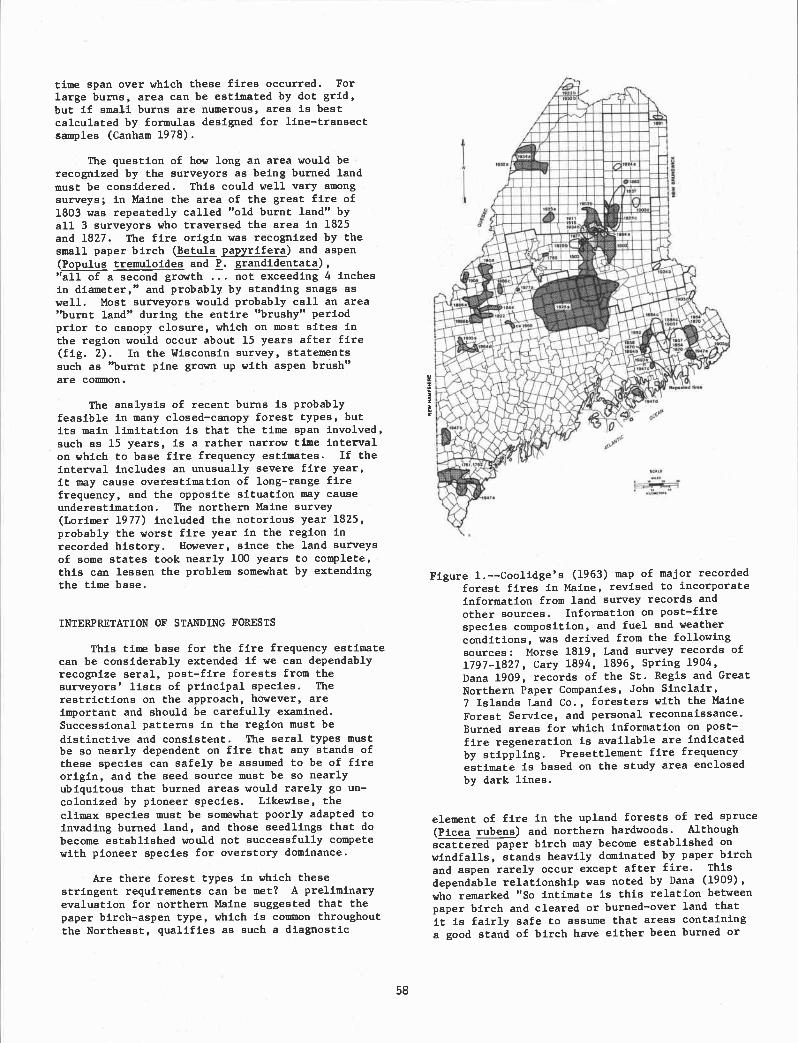
a.
nnn::mb'Juu..UuUUUUU ui.uusuwi u
)puusr .iu.iui cuu'$ "2 :IuIm*
time span over which these fires occurred. Forlarge burns, area can be estimated by dot grid,but if smail burns are numerous, area is bestcalculated by formulas designed for line-transectsamples (Canham 1978).
The question of how long an area would berecognized by the surveyors as being burned landmust be considered. This could well vary amongsurveys; in Maine the area of the great fire of1803 was repeatedly called "old burnt land" byall 3 surveyors who traversed the area in 1825and 1827. The fire origin was recognized by thesmall paper birch (Betula papyrifera) and aspen(Populus tremuloides and P. grandidentata),"all of a second growth ... not exceeding 4 inchesin diameter," and probably by standing snags aswell. Most surveyors would probably call an area"burnt land" during the entire "brushy" periodprior to canopy closure, which on most sites inthe region would occur about 15 years after fire(fig. 2). In the Wisconsin survey, statementssuch as "burnt pine grown up with aspen brush"are coimnon.
The analysis of recent burns is probablyfeasible in many closed-canopy forest types, butits main limitation is that the time span involved,such as 15 years, is a rather narrow time intervalon which to base fire frequency estimates. If theinterval includes an unusually severe fire year,it may cause overestimation of long-range firefrequency, and the opposite situation may causeunderestimation. The northern Maine survey(Lorimer 1977) included the notorious year 1825,probably the worst fire year in the region inrecorded history. However, since the land surveysof some states took nearly 100 years to complete,this can lessen the problem somewhat by extendingthe time base.
INTERPRETATION OF STMDING FORESTS
This time base for the fire frequency estimatecan be considerably extended if we can dependablyrecognize seral, post-fire forests from thesurveyors' lists of principal species. The
restrictions on the approach, however, areimportant and should be carefully examined.Successional patterns in the region must be
distinctive and consistent. The seral types mustbe so nearly dependent on fire that any stands ofthese species can safely be assumed to be of fireorigin, and the seed source must be so nearlyubiquitous that burned areas would rarely go un-colonized by pioneer species. Likewise, theclimax species must be somewhat poorly adapted toinvading burned land, and those seedlings that dobecome established would not successfully competewith pioneer species for overstory dominance.
Are there forest types in which thesestringent requirements can be met? A preliminaryevaluation for northern Maine suggested that thepaper birch-aspen type, which is couon throughoutthe Northeast, qualifies as such a diagnostic
58
Figure 1.--Coolidge's (1963) map of major recorded
forest fires in Maine, revised to incorporateinformation from land survey records and
other sources. Information on post-firespecies composition, and fuel and weatherconditions, was derived from the following
sources: Morse 1819, Land survey records of1797-1827, Cary 1894, 1896, Spring 1904,Dana 1909, records of the St. Regis and GreatNorthern Paper Companies, John Sinclair,7 Islands Land Co., foresters with the MaineForest Service, and personal reconnaissance.Burned areas for which information on post-f ire regeneration is available are indicated
by stippling. Presettlement fire frequencyestimate is based on the study area enclosedby dark lines.
element of fire in the upland forests of red spruce(Picea rubens) and northern hardwoods. Although
scattered paper birch may become established onwindfalls, stands heavily dominated by paper birchand aspen rarely occur except after fire. This
dependable relationship was noted by Dana (1909),who remarked "So intimate is this relation betweenpaper birch and cleared or burned-over land that
it is fairly safe to assume that areas containinga good stand of birch have either been burned or
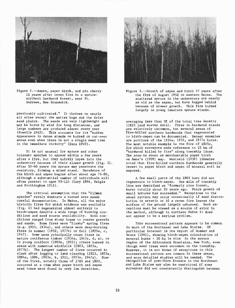
Figure 2.--Aspen, paper birch, and pin cherry11 years after crown fire in a spruce-northern hardwood forest, near St.Andrews, New Brunswick.
previously cultivated." It thrives on nearlyall sites except the wetter bogs and the driersand plains. The seeds are very lightweight andmay be borne by wind for long distances, andlarge numbers are produced almost every year(Fowells 1965). This accounts for its "suddenappearance in dense stands on burned or cut-overareas even when there is not a single seed treein the immediate vicinity" (Dana 1909).
It is not unusual for spruce and othertolerant species to appear within a few yearsafter a fire, but they quickly lapse into theunderstory because of their slower growth (fig. 3).After 50-60 years the spruce may penetrate theoverstory, forming a mixed stand. Decadence ofthe birch and aspen begins after about age 75-80,although a substantial number of individuals willoften persist to ages 95-110 (Cary 1896, Weigleand Frothingham 1911).
The critical asstnnption that the "climaxspecies" rarely dominate a burned area needscareful documentation. In Maine, all the majorhistoric fires for which evidence was available(fig. 1) had regenerated almost entirely tobirch-aspen despite a wide range of burning con-ditions and seed source availability. Soil con-ditions ranged from stony loans to coarse gravelsand sands. Some fires were "flashy" spring fires(e.g. 1903, l934a), and others were deep-burningfires in suiimier (1952, l977b) or fall (l825a, c,1947). Some were principally crown fires inmature coniferous timber (l934a, l947c, d, e), orin young conifers (1903e, 1952); others burned inareas with numerous windfalls (1803, 1825a,1977b). The largest number of fires occurred inslash after logging or land clearing (1822, 1825a,l884a, 1886, 1903a, b, 1911, l923a, l947a). Someof the fires, notably those of 1785 and 1803,occurred at a time when paper birch and aspenseed trees were found in very low densities,
59
Figure 3.--Growth of aspen and birch 27 years afterthe fire of August 1952 in eastern Maine. Thescattered spruce In the understory are nearlyas old as the aspen, but have lagged behindbecause of slower growth. This fire burnedlargely in young immature spruce stands.
averaging less than 5% of the total tree density(1825 land survey data). Fires in hardwood standsare relatively uncommon, but several areas offire-killed northern hardwoods that regeneratedto birch-aspen can be documented. Recent examplesare portions of the 1934a, 1952, and l977a burns.The most notable example is the fire of l825c,for which surveyors made reference to 25 km of"hardwood killed by fire" along township lines.The areais shown as merchantable paper birchon Dana's (1909) map. Westveld (1939) likewisenoted that fire-killed northern hardwoods generallyrevert to paper birch and aspen if mineral soil isexposed.
A few small parts of the 1803 burn did notregenerate to birch-aspen. One mile of townshipline was described as "formerly pine forest,burnt totally about 20 years ago. Thick growth ofsmall spruces has succeeded." Exceptions to theusual pattern nay occur occasionally if seed distri-bution is erratic or if a crown fire leaves thesurface of the ground largely unburned. Such ex-ceptions must be viewed as a source of error inthe method, although in northern Maine it doenot appear to be a serious problem.
This successional pattern appears to be commonin much of the Northeast and Lake States. Of
particular interest is the report of Hosmer andBruce (1901), showing birch-aspen colonization ofseveral burns < 30 ha in size In the spruceregion of the Adirondack Mountains, New York, eventhough seed trees were uncommon on the township.However, it is not known if exceptions to thissuccessional pattern are common In these areas,and more detailed studies will be needed. Therecognition of post-fire forests In the Northeastand Lake States may also be restricted if somesurveyors did not consistently distinguish between

paper birch and yellow birch (Betula lutea),since the latter is not a reliable indicator ofprevious fire. Much of the "green timber" re-ported in the Wisconsin survey cannot be ana-lyzed for this reason.
SCALE OF FIRES REPORTED
An important methodological question con-,cerns the size of the burned areas reported.Would small burns intercepting only a fractionalpart of a surveyed mile go unreported, and mightnot the cumulative effect of this under-representation have a major effect on calculatedfire frequency? In the survey notes, however,it Is common for burned areas to be reportedalong distances as short as 0.4 km. A circulararea of such dimensions covers only 13 ha, so Itcan be seen that fairly small burned areas werereported by surveyors.
Evidence on older burns of small to mediumsize (20-150 ha) can be obtained In some casesfrom a tabulation of species of witness trees.If small Intense fires were common and had a ma-jor influence on forest composition, we mightexpect a reasonable proportion of witness treesof seral species in the green standing timberoutside the areas formally recognized as burnedland, provided that successional patterns aresimilar after fires of this size range. Thiscould be a useful analysis in some parts of thecountry, especially where trees of seral speciesare long-lived. In the Northeast It may be lessuseful because paper birch and aspen in olderstands may have been avoided for witness treesbecause of the poor risk. For post-fire standsless than about 50 years old, however, the sur-veyors In most cases would have had no other al-ternative but to use paper birch or aspen, as Inthe stand shown in figure 3. In Maine the pro-portion of witness trees of these species in thegreen standing timber was quite low (3.0% and0.3%, respectively), and some of these may havegerminated on windfalls rather than burned land.This line of evidence does not seem to support amajor role for fires of this size range in north-ern Maine, but in regions where this is not thecase, approximate correction factors for firefrequency estimates could perhaps be derivedfrom the witness tree counts.
FIRE FREQUENCY IN THE NORTHEAST:PRELIMINARY F INDINGS
Analysis of the northeastern Maine land sur-vey data indicated that 3.9% of the landscape hadbeen recently burned (within about 15 years ofthe survey), mostly in 1825; 5.1% was young birch-aspen forest, mostly from the fire of 1803; and
only 0.6% of the area had older paper birch andaspen, either alone or mixed with other species.
The lack of extensive areas of mature birch-aspen implies that no fires of great size oc-curred between 1750 and 1800, an inference thatis consistent with the low incidence of charcoal
60
in lake sediments prior to the 19th century.3It is possible, however, that smaller areas ofmature birch-aspen were not recorded or occurredas mixed stands that might not always be apparentfrom the surveyors' descriptions.
The apparent fire frequency Indicated by themosaic of burns for this time period is rather lowdespite the three extensive fires. Even the short-
er 15-yr interval that included the severe 1825
season yields a calculated recurrence interval ofabout 400 years for moderate or severe fire In agiven stand of trees, while the entire 75-yr in-terval (1750-1825) yields an estimate of about800 years. There may be considerable temporalvariability among successive time intervals, al-though the inclusion of an unusually severe fireyear makes It less likely that the fire frequencyfrom 1750-1825 was abnormally low. In fact theproportion of total area burned by large firesduring this interval actually exceeded the propor-tion burned during the subsequent logging era of1835-1910, which also included a severe fire year
(1903). By comparison, the calculated recurrenceinterval for the 20th century, based on fire re-ports for fires of all intensities, is 260 yearsfor the period 1903-1912 and 710 years for theperiod 1913-1960 (Coolidge 1963).
Evidence from other areas is still fragmen-tary, but apparently few areas of fire-killed tim-ber were present at the time of the land surveysin parts of New York (McIntosh 1962), Vermont(Slccama 1971), and Pennsylvania (Lutz 1930).Hosmer and Bruce (1901), in a detailed investiga-tion of a township of virgin spruce in theAdirondacks, reported that only 1% of the town-ship was occupied by burns up to 50 years old,suggesting a surprisingly low fire frequency.
A generally low fire frequency in sizableareas of the Northeast seems to be indicated byother evidence independent of the land surveys.Many of the early foresters who were aware of thefire situation before the advent of organizedfire suppression stressed the low fire hazard instanding green timber, even for the spruce-firtype in severe fire weather. Ayres (1909) statedthat for northern New Hampshire "fire seldomsweeps through virgin forest; the slash left bylumbering is a chief promoting cause of fire, andit is in the slash that nearly all fires origi-nate. A map of the fires in the White Mountainregion shows that they have closely followed thecut-over areas." Similar statements were made bySpring (1904) and Chittenden (1905), althoughsome cases of slash fires sweeping into virgintimber were noted. Even in the extremely severeseason of 1903, Spring (1904) noted that "in nota single case over the entire area in this regiondid the fire penetrate into a virgin stand formore than 10 rods." Some large fires wouldsurely occur in the absence of man, but they do
3Swain, Albert M. 1980. Unpublished dataon file, Center for Climatic Research, Universityof Wisconsin-Madison.

not appear to have been frequent except in wind-falls and other concentrations of dead trees.
Even more important evidence deals with theage structures of virgin stands. If the recurrenceinterval of severe fire were less than 300 years,most virgin stands should have been even-aged ornearly so. Yet most remnants that have beenstudied, from Wisconsin to New Hampshire, werebroadly uneven-aged or all-aged (e.g. Zon andScholz 1929, Gates and Nichols 1930, Westveld1933, Hough and Forbes 1943, Leak 1975). Thisconcurs with the opinions of early foresters whowere able to examine logging operations in vir-gin forests of the Northeast (Graves 1899,Hawley and Hawes 1912, Dana 1930). Hawley andHawes (1912) noted that "exceptions to this[uneven-aged) character occur; for sonetimes apart of the forest is found where the trees areall of one age over considerable areas . . . butsuch cases are in the minority." Even if firescausing heavy tree mortality recurred on mostsites only once in 500 years on the average, atleast 40% of the landscape should have had even-aged stands (up to 200 years old) of fire originalone, without even taking into account those re-sulting from windthrow and insect infestations.
A broader perspective on fire frequency inthe Northeast and Lake States will develop as ad-ditional evidence is obtained. Undoubtedly thereis much variation within a region due to vegeta-five, soil, topographic, and climatic differ-ences. The pattern of burnsin figure 1, forexample, reveals at least two areas of relativelyhigh fire hazard that have been burned repeatedly.Perhaps the land survey records will be of fur-ther use in analyzing regional variations. Ap-proaches other than land survey analysis, such asthe study of charcoal in lake sediments, will beneeded to provide evidence on the frequency oflower intensity fires and smaller fires.
LITERATURE CITED
Ayres, Philip W. 1909. Commercial importance ofthe White Mountain forests. USDA ForestService Circular 168, 32 p. Washington, D.C.
Bourdo, E. A. 1956. A review of the GeneralLand Office Survey and of its use in quanti-tative studies of forner forests. Ecology37: 754-768.
Canham, Charles D. 1978. Catastrophic windthrowin the hemlock-hardwood forest of Wisconsin.M.S. Thesis, University of Wisconsin. 94 p.Madison, Wisconsin.
Cary, Austin. 1894. Early forest fires inMaine. p. 37-59. In Second Annual Reportof the Forest Commissioner of the State ofMaine. Augusta, Maine.
Cary, Austin. 1896. Report of Austin Cary.p. 15-203. In Third Annual Report of theForest Commissioner of the State of Maine.Augusta, Maine.
Chittenden, Alfred K. 1905. Forest conditionsof northern New Hampshire. USDA Bureau of
61
Forestry Bulletin 55, 100 p. Washington, D.C.Coolidge, Philip T. 1963. History of the Maine
woods. 805 p. Furbush-Roberts Co., Bangor,Maine.
Dana, Samuel T. 1909. Paper birch in theNortheast. USDA Forest Service Circular163, 37 p. Washington, D.C.
Dana, Samuel T. 1930. Timber growing and loggingpractice in the Northeast. U.S. Departmentof Agriculture Technical Bulletin 166,
112 p. Washington, D.C.Fowells, H. A., editor. 1965. Silvics of forest
trees of the United States. USDA ForestService Agriculture Handbook 271, 762 p.Washington, D.C.
Gates, F. C., and G. E. Nichols. 1930. Relationbetween age and diameter in trees of theprimeval northern hardwood forest. Journalof Forestry 28: 395-398.
Graves, Henry S. 1899. Practical forestry in theAdirondacks. USDA Division of ForestryBulletin 26, 85 p. Washington, D.C.
Hawley, Ralph C., and Austin F. Hawes. 1912.
Forestry in New England. 479 p. JohnWiley and Sons, New York, N.Y.
Hosmer, Ralph S., and Eugene S. Bruce. 1901. Aforest working plan for Township 40, Tottenand Crossfield Purchase, Hamilton County,New York State Forest Preserve. USDADivision of Forestry Bulletin 30, 64 p.Washington, D.C.
Bough, A. F., and R. D. Forbes. 1943. The ecologyand silvics of forests in the high plateausof Pennsylvania. Ecological Monographs 13:29 9-320.
Leak, William B. 1975. Age distribution in virginred spruce and northern hardwoods. Ecology56: 1451-1454.
Lorimer, Craig G. 1977. The presettlement forestand natural disturbance cycle of northeasternMaine. Ecology 58: 139-148.
Lutz, H. J. 1930. Original forest compositionin northwestern Pennsylvania as indicatedby early land survey notes. Journal ofForestry 28: 1098-1103.
McIntosh, Robert P. 1962. The forest cover ofthe Catskill Mountain region, New York, asindicated by land survey records. AmericanMidland Naturalist 68: 409-423.
Morse, Jedediah. 1819. The American universalgeography. Volume 1. 898 p. Charlestown,Massachusetts.
Siccama, Thomas G. 1971. Presettlement and presentforest vegetation in northern Vermont withspecial reference to Chittenden County.American Midland Naturalist 85: 153-172.
Spring, S. N. 1904. The control and preventionof forest fires in Maine. p. 58-130. In
Fifth Report of the Forest Commissioner ofthe State of Maine. Augusta, Maine.
Weigle, W. C., and E. H. Frothingham. 1911. Theaspens: their growth and management. USDAForest Service Bulletin 93, 35 p. Washington,D.C.
Westveld, R. H. 1933. The relation of certainsoil characteristics to forest growth andcomposition in the northern hardwood forest

of northern Michigan. Michigan StateCollege Agricultural Experiment Station,Technical Bulletin 135, 52 p. East Lansing,
Michigan.
Westveld, R. H. 1939. Applied silviculture in
62
the United States. 567 p. John Wiley and
Sons, New York, N.Y.Zon, Raphael, and Harold F. Scholz. How fast
do northern hardwoods grow? WisconsinAgricultural Experiment Station ResearchBulletin 88, 34p. Madison, Wisconsin.

Fire History and Man-Induced Fire Problemsin Subtropical South Florida1
2Dale L. Taylor
Abstract.Historic fires, indicated by charcoal deposits,endemic plants, and lightning-caused fires, probably occurred duringdrought cycles of about 8 years, were several thousand acres inextent, and probably burned most of the fire-adapted vegetationevery two cycles.
Environmental perturbation has created a critical fire situationwith extreme years occurring at 5.8 to 7.5 year intervals, andmoderate years at 3.2 to 4.3 year intervals.
INTRODUCTION
South Florida is an area with a high number offires, but also where fire intensity, fire frequency, andfire type may be changing. Benign wet season fires nowrarely occur, being replaced by man-caused and man-induced dry season fires that may burn more frequentlyand burn larger areas. Newly established exotics, suchas the cajaput (Melaleuca quinquenervia), may permitcrown fire for the first time, whereas Schinus tere-binthifolius, forms a low, but dense, fire retardantforest.
Two areas in south Florida which this paper isconcerned with are the 1.4 million acre EvergladesNational Park, established in 1947, and the 570,000 acreBig Cypress National Preserve established in 1974(fig. 1). These two areas may be the most fire proneunits within the National Park Service system. The1948-1979 Everglades National Park fire records con-tain 682 fire reports that cover 451,082 burned acres.The first 21 months of Big Cypress fire records showthat 131 reported fires have burned 40,370 acres. Bothparks have been disturbed by drainage, lumbering,farming, off-road vehicle use (Big Cypress), and inva-sion by exotic plant species. Other federal and statelands also have extensive fire problems (fig. 1).
The climate in south Florida is subtropical withalternating wet and dry seasons. Rainfall for 1979totaled 51.7 inches in Big Cypress and 52.8 inches atRoyal Palm in Everglades National Park, but wideannual fluctuations between 30 and 100 inches mayoccur (Leach et al. 1972). June to October is the wetseason when water covers the soil of most communitytypes, except hammocks and pinelands, and when mostcloud-to-ground lightning occurs. November into Mayis the dry season, and the time when most man-causedfires occur.
'Paper presented at the Fire History Workshop.(Laboratory of Tree-Ring Research, Forestry SciencesLaboratory, University of Arizona, Tucson, Arizona,Octobr 20-24, 1980).
Dale L. Taylor is a Research Biologist, SouthFlorida Research Center, Everglades National Park,Homestead, Florida 33030.
63
Wade et al. (1980) describe fire impact on thediverse mosaic of at least 10 major vegetation types:sawgrass; wet prairie and slough; marsh and marlprairie; saltmarsh; pine flatwoods; Miami rock ridgepineland; tree islands and hammocks; cypress; mixed-hardwood swamps; and mangrove. Long (1974) ha5concluded that the south Florida flora is the youngestflora in North America, about 3,000 to 5,000 years oldat most, and therefore one of the most modern florasknown. Because of its youth many niches may not befilled, allowing exotic vegetation to become established(Wade in press). The pinelands may be much older thansuggested by Long, as Robertson et al. (1974) feel theMiami Rock Ridge, the Florida Keys, and other highspots may have persisted as islands through interglacialperiods.
The following evidence strongly suggests thatnatural fire has been a constant factor affecting thelocal distribution of vegetation types, and that arrange-ment of plant cover types probably has been similar tothat seen today.
Pre-aboriginal Period
Charcoal deposits
Studies of peat soils indicate they could haveaccumulated only in a wet, boggy environment begin-ning about 5500 years ago (Parker 1974).
Peats from the Everglades and coastal swamps ofsouthern Florida contain numerous charcoal-rich lenseswhich represent ancient fires (Cohen 1974, Parker1974). Peat from sawgrass (Cladium jamaicensis), andAcrostrichum-Cladium peats tended to have consis-tently high charcoal contents compared to mangrove(Rhizophora, Rhizophora-Avicennia) peat, Conocarpus(buttonwood) peat, or bay hammocks (Myrica-Persea-Salix) peat. Cohen (1974) felt that the inability to findcharcoal layers at the same levels in any cores indi-cated fires, although common, were probably restrictedto environments with the greatest fire potential. Heconcluded there was no evidence to support thecontention that there ever have been prolonged dry

EVERGLADES NATIONAL PARK
Lk.
f.
striking proof of the relatively short time required forthe evolution of highly complex ecosystems. Heconcludes the presence of numerous endemic speciesand subspecies, plants found nowhere else in the world,may also constitute circumstantial evidence that highlyspecialized organisms can evolve in far less time thanhas been postulated for the development of new forms.
role of lightning understood. It is now reasonable toassume lightning fires have been a factor throughoutthe geological existence of the region and that f ire-maintained cover types have been a constant feature ofthe south Florida vegetation (Robertson 1953).
Florida has 70 to 90 thunderstorm days per year,more than any other place in the nation (Maier 1977).Most cloud-to-ground lightning strikes occur from Junethrough September (Taylor and Maier unpublished data).Tentative data show probable mean annual gro2nd flashdensity varies from 4 to 12 flashes per km (fig. 2).Fewer strikes occur in Everglades National Park com-pared to the Big Cypress National Preserve (fig. 2), butfor unknown reasons more lightning fires occur in
periods which resulted in widespread burning of peat(and resultant widespread, observable charcoal layers)in the Everglades. Parker (1974), on the other hand,stated that there were times of alternating drought andflood, with some droughts of several years durationwhen fires in the glades ravaged the vegetation andburned the organic soils to the water table, producingash layers several inches thick.
BCN PRESERVE(J/Z/'//// ENP BOJNDARY
OTHER STATE ANDFEDERAL LANDS
* TAYLOR SLOUGH BRIDGE
Figure 1. The south Florida region is the area south ofLake Okeechobee. Two National Park Serviceunits, the Big Cypress National Preserve andEverglades National Park make up a large part ofthe region. Note the location of canal L-31(W)and Taylor Slough Bridge.
Endemic plants
Avery and Loope (1980) list 65 plant taxa as beingendemic to south Florida. Well over half are limited topine forests and 70% are herbs or low shrub plantsmaintained by fire (Robertson 1953). Robertson (1953)states that evolution of these low-growing plantsrequired that their sub-climax habitats exist for a longperiod of time, and this in turn required recurringnatural fire. Almost all endemic and other low shruband herbaceous plants are shaded out by hardwoodsinvading pine forests that are fire free for as little asfive years (Robertson 1953). Robertson concluded thattheir existence as distinct species is inescapable proofof regularly recurring natural fire sufficient to main-tain large areas of sub-climax vegetation. Pine islandsmay have persisted through interglacial periods(Robertson et al. 1974) allowing plant evolution tocontinue for long periods. In contrast Long (1974)
64
states that the existence of the south Florida flora is
Lightning
The assumption by early authorities that naturalfires were too infrequent to be of consequence hinderedunderstanding of the role of fire in south Florida(Robertson 1953). Not until 1951, when lightning-caused fires were observed from a fire tower, was the
SOUTH FLORIDA REGION
BIG CYPRESS NATIONAL PRESERVE& Everglades than occur in Big Cypress.
PROBABLE MEANANNUAL GROUNDFLASH DENSITY
(per km2)
a Menitoing Station
Figure 2. Probable mean annual ground flash densityfor cloud-to-ground lightning in south Florida.The trapazoid represents the primary target areain the National Oceanic and Atmospheric Admin-istration lightning monitoring experiment (Taylorand Maier, unpublished data).

40
30
20-
10
and 62% of the acreage burned from 1948 through 1979in Everglades National Park (Taylor in press), but in BigCypress National Preserve, man-caused fires made up89% of the total fires, 89% of the acreage burned and99% of the suppression cost for 1979 (Taylor 1980).Man-caused fires may occur every month of the year
A M J A 0
100- kghtning h,.
90-
The lightning fire season is May through Augustwhen 87% of all lightning-caused fires occur, butlightning fires have been recorded for all months exceptJanuary and February (Taylor in press). June is whenmost acreage burns and when the largest lightning-caused fires occur. In Everglades National Park light-ning fires account for 28% of all fires and 18% of theacreage burned. An average 2540 acres will burn due tolightning ignition each year. An exceptional year was1951 when nine lightning-caused fires burned 43,155acres which constitutes 53% of the acreage burned dueto lightning, and 10% of all acreage burned. The 1951wet season was late in arriving and water levels werestill low in June, creating an exceptional fire year inmodern records. Such conditions may have been therule in pre-man times when lightning was the majorignition source.
Aboriginal Period
Griffin (1974) states that the earliest datedarcheological materials are from B.P. 3400 + 100 or1400 B.C. This places Indians in south Florida a fewhundred years after the flora became established.Robertson (1954) did not see the need to invoke Indianfires as a major factor in the origin of fire maintainedvegetation types. He felt natural fires must have beensufficiently frequent from earliest times to maintainlarge areas of sub-climax vegetation.
Indian use of fire may have been careless and thewildfires they caused probably were frequent. Thisaddition of Indian fires to recurring natural fires musthave caused fire incidence to increase sharply asIndians became established.
Post-settiement Fires
When white people first arrived in south Florida,they found Indians using fire for a variety of purposes,and they quickly adopted the practices themselves(Wade et al. 1980). Robertson (1953) believed thefrequency of fires increased sharply as whites replacedaborigines in the area. Fires set accidentally as aresult of farming or lumbering operations, and fromincendiary activities, create an imposing picture of fireoccurrence for the period of European settlement insouth Florida (Robertson 1953). Incendiary fires wereset to kill mosquitoes and rattlesnakes, clear brush,drive game, and to create fresh pasture for cattle ordeer. Burning to locate gator holes in sawgrass was acommon practice of commercial hide hunters.
As European whites became established, drainageof the everglades began. With the lowering of waterlevels the greater frequency of fires caused increa-singly severe damage by consuming organic soils anddestroying hardwood vegetation (Robertson 1954).Water levels were lowered by local drainage at variouspoints, and by cutting off north to south water flowfrom Lake Okeechobee. Drainage was partially effec-tive by about 1918 (Robertson 1954). Parker (1974)used the 1940-1946 hydrologic conditions as those mostrepresentative of the pre-drainage period. Dataobtained since 1948 were felt to be unduly influencedby huge drainage projects, pumping and storage works,and by explosive urbanization.
65
Man-caused fires accounted for 36% of all fires
but fires during July through September are of littleconsequence.
The man-caused fire season is from Novemberthrough May, with January through May being monthswhen most fires occur. The largest average fire sizeand the most acreage burned is by man-caused firesduring May.
There is a low correlation between the number ofpark visitors and the number of man-caused fires(coefficient of -.273 on number of fires and -.034 onnumber of acres burned). The fire records suggest thatthose who set fires fit the pattern of woods burnersdescribed by Doolittle and Lightsey (1979). They foundactive woods burners in southern states to be young,white males whose activities are supported by theirpeers. An older, less active group has probably retiredfrom active participation but act as patriarchs of theburning community.
Fire Season
Two fire seasons have been documented for southFlorida: (1) The summer wet season (May throughAugust) when fires are caused by lightning; and, (2) thewinter dry season (November into May) when man-caused fires occur. Winter dry season fires include 246known prescribed management fires that have burned89,167 acres in Everglades National Park (Taylor inpress). Most prescribed fires (88%) have been set fromOctober through April, burning 95% of the acreageburned by prescribed fire (fig. 3).
If Everglades National Park and Big CypressNational Preserve were in strict adherence to NationalPark Service policies (NPS-18), all man-caused fireswould be aggressively attacked, a formidable task.
MONTH
Figure 3. Monthly distribution of acres burned byprescribed fire and lightning-caused fire (fromTaylor in press).

accounts (Robertson 1953); (2) The total number ofacres burned each year in Everglades National Parkfrom 1948 through 1979 (Taylor in press); (3) Thenumber of tires that burned each year in EvergladesNational Park from 1948 through 1979 (Taylor in press);(4) A regression equation, based on the relationship ofman-caused fires to water levels and precipitation, was
1947 (Taylor in press); (5) By counting the number ofyears when the annual mean acreage burned by man-caused fires, and the annual mean total acres burnedexceeded the five-year mean that had exceeded themean for the period of record (fig. 4). These methodsresulted in an estimated 5.8 to 7.5 years between
Today most lightning caused fires have littlechance to spread because of roads, canals, and artif i-daIly high water levels maintained in Shark Sloughduring the dry season. The annual average of 2540acres burned by lightning caused tire would result in aburning cycle of more than 200 years for the burnableparts of Everglades National Park. This is too low alevel for fire dependent plants to evolve under, conse-quently, large lightning-caused fires must have been the
European settlement will continue, and with increaseddrainage, urbanization, and further spread of exotics,fire frequency and fire severity will increase.
Drainage and subsequent shortening of the hydro-period probably have influenced fire even during normalyears. Longer periods with reduced water levels wouldallow more fires to occur at the transition from dry towet, or wet to dry seasons (Taylor in press). As anexample of water level change, Rose et al. (in press)report the highest water level at Taylor Slough bridgewas during October before construction of canalL-31(W) (fig. 1). After canal construction highestwater level was a month earlier, with October and
Some man-caused fires are allowed to burn if they meeta previously defined prescription in the approvedEverglades National Park Fire Management Plan(1979). Many fires in Big Cypress burn out before theyare discovered, but all others are manned at highexpense.
Service policies require prescribed managementfires to simulate, to the fullest extent, the influence ofnatural fires on the ecosystem. Prescribed manage-ment fires and natural lightning fires are out ofsequence in Everglades National Park (fig. 3).Attempts now being made to conduct prescribed burnsduring the summer wet season have been successful,and a research program to evaluate summer versuswinter season fires has been instituted (Taylor 1980).
Fire Frequency
Subtropical south Florida ecosystems do notpermit fire frequency documentation as described byArno and Sneck (1974). Graminoid communities recoverquickly following fire, and they leave little evidence toshow they were burned. Only three tree species thatform annual rings, the south Florida slash pine (Pinuselliottii var. densa) and cypress (Taxodium distichumand 1. ascendens) (Tomlinson and Craighead 1972), aresufficiently widespread to be useful for fire historydocumentation. However, bald cypress (1. distichum)trees usually are killed when organic soils are burnedout, and any fire record disappears with the trees.Dwarf pond cypress (T. ascendens), present in cypressprairies, show fire scars and they may reveal firefrequency for one community type. Their slow growth,however, will make interpretation of rings difficult.
Slash pines are not useful for documenting firehistory in Everglades National Park because the forestswere cut-over about 1940. Some virgin pines do remainin Big Cypress, and many are fire scarred, but contraryto Tomlinson and Craighead (1972), we questionwhether the rings represent annual growth increments.Our reasons are as follows: (1) Langdon (1963) reporteddiameter growth throughout the year in slash pinegrowing on sandy soils on the west coast of Florida.(2) Ongoing studies of trees growing on limestone rockon the east coast show growth can occur every monthof the year, depending upon the year (Taylor unpub-lished data). (3) In addition, an attempt to correlatefire scars on a tree cut July 28, 1979 with known firesin 1975, 1972, and 1968, proved erroneous for two ofthe three years.
Lacking biological documentation for fire fre-quency, fire records were used. Robertson (1953)pointed out south Florida is unique in that it has hadmore fires and kept less account of them than any othersector of the country, consequently, the study waslimited to Everglades National Park fire records (Taylorin press).
Fire frequency was estimated by attempting todetermine periods between extreme fire years andperiods between moderate fire years. An extreme fireyear was defined as a year when, before fire records,fire conditions received considerable discussion in thepopular press, or when fire records showed unusuallylarge numbers of fires and/or acres burned.
Frequency between extreme fire years was esti-mated from several sources. (1) A list of extreme yearsfrom 1910 to 1953 was gleaned from newspaper
66
used to estimate number of fires from 1933 through
extreme fire years.Moderate fire frequency was estimated by count-
ing the number of years when total acres burnedexceeded the mean for the period of record. Amoderate fire season will occur every 3.2 years if totalacres are used in the calculations, or 4.3 years if onlynumber of man-caused fires is used. Moderate firefrequency estimated from total acres burned is higherdue to the influence of prescribed management fires.
William B. Robertson, Jr. and this author contendthat historic natural fires were lightning-caused,occurred during the summer months, and burned severalthousand acres during drought intervals of about eightyears. Some droughts would have been more severethan others, and not all areas would have burned everyinterval. Few areas would have escaped two cycles insuccession, however.
rule in historic times.
The Future
There is little question that fire frequency hasincreased with the advent of Indians and white man, butthe era of the Indian is over. The impact since
November levels showing a decrease of 0.58 and 0.69feet respectively. The greatest overall decreaseoccurred during June when mean surface water levelsdecreased by 1.03 feet, a decline of 28.6%. Meanannual discharge through the bridge was reduced 40%.Reduced overland sheet flow (from 80% of the time to59% of the time), and lowered water levels would allow

S
S S
S S S
S S
.
S
S
S
p
. S
3
55 60 65 7. 80YEAR
100
10
.
S
S
more fires to burn more acres each month of the year.Urbanization, which is continuing at an explosive
rate (Wade et al. 1980), will require land and water, endwill continue to change natural ecosystems. Keepingsmoke from urban areas will be more and more diffi-cult. Man-caused winter and spring dry season firesburn large areas, consume organic soil, and can contri-
67
\.Mean- period of Record Burned
Figure 4. Semi-log graph of acres burned by man-caused fires.
Annual Acreage
I -* Five Year Mean
bute to the spread of exotics. These exotics arecolonizing large areas at the expense of native vege-tation, and crown fire is now possible for the first timein south Florida (Wade in press). According to Wadeet al. (1980) the situation has become critical in southFlorida, and the future will require decisions made uponrealistic goals for resource protection.

Everglades National Park has an extensive pre-scribed fire program to control fuel, and a researchprogram has been started which will document fre-quency and season for fire in the Big Cypress NationalPreserve. Prescribed fire is used on other state andfederal lands (fig. 1). New legislation allows prescribedburning in hazardous accumulations of wildland fuel onprivate holdings, provided the owner does not object(Wade and Long 1979). Whether these activities willallow restoration of a natural fire regime in the face ofextreme environmental perturbations remains to beseen.
ACKNOWLEDGEMENTS
I thank Betty Curl for typing this manuscript andfor her editorial assistance. William B. Robertson, 3r.is acknowledged for the many hours spent discussingfire in south Florida with me. He, 3ames Snyder, TonyCaprio and Lewis Sharman made constructive criticismson this manuscript.
LITERATURE CITED
Arno, Stephen and K. Sneck. 1977. A method fordetermining fire history in coniferous forests in themountain west. Intermountain Forest and RangeExperiment Station. USDA, Forest Service, Odgen,Utah. 28 p.
Avery, George and Lloyd Loope. 1980. Endemic taxa inthe flora of south Florida. South Florida ResearchCenter Report T-558. Everglades National Park,Fl. 39 p.
Cohen, Arthur D. 1974. Evidence of fires in the ancienteverglades and coastal swamps of southern Florida.In Environments of south Florida: present andpast. Patrick Gleason editor. Memoir 2, MiamiGeological Society, Miami, Fla. p. 213-218.
Doolittle, M. L. and M. L. Lightsey. 1979. Southernwoods-burners: A descriptive analysis. USDASouthern Forest Experiment Station, Starksville,Miss. Forest Service Research Paper 50-151.6 p.
Everglades National Park. 1979. Fire Management Planfor Everglades National Park.
Griffin, 3ohn W. 1974. Archeology and environments insouth Florida. In Environments of south Florida:present and past. Patrick Gleason editor.Memoir 2, Miami Geolbgical Society, Miami, Fla.p. 342-346.
Langdon, 0. G. 1963. Growth patterns of Pinus elliottiivar. densa. Ecology 44(4):825-827.
Leach, S. D., H. Klein, and E. Hampton. 1972. Hydro-logic effects of water control and management ofsoutheastern Florida. U.S. Geol. Surv. Rep.
68
Invest. 60, Tallahassee, Fla. 115 p.Long, Robert W. 1974. Origin of the vascular flora of
south Florida. In Environments of south Florida:present and past. Patrick Gleason editor.Memoir 2, Miami Geological Society, Miami, Fla.p. 28-34.
Maier, M. W. 1977. Distribution of mean annualthunderstorm days in Florida. National Oceanicand Atmospheric Administration, National Hurri-cane Center. Coral Gables, Fla. Mimeo. Reportlop.
Parker, G. G. 1974. Hydrology of the pre-drainagesystem of the everglades in southern Florida. InEnvironments of south Florida: past and present.Patrick Gleason editor. Memoir 2, Miami Geolog-ical Society, Miami, Fla. p. 18-27.
Robertson, William B., 3r. 1953. A survey of the effectsof fire in Everglades National Park. Mimeo.Report. USD1 National Park Service. 169 p.
Robertson, William B., 3r. 1954. Everglades fires-past,present and future. Everglades Natural History(1):9-16.
Robertson, William B., Jr. and 3. A. Kushlan. 1974. Thesouthern Florida avifauna. In Environments ofsouth Florida: present and past. Patrick Gleasoneditor. Memoir 2, Miami Geological Society,Miami, Fla. p. 414-452.
Rose, P., M. Flora, and P. R. Rosendahl. In press.Hydrologic impacts of L-31W on Taylor Slough,Everglades National Park. South Florida ResearchCenter, Everglades National Park.
Taylor, Dale L. In press. Fire history and fire recordsfor Everglades National Park 1948-1979. SouthFlorida Research Center, Everglades NationalPark, FL.
Taylor, Dale L. 1980. Summary of fires in EvergladesNational Park and Big Cypress National Preserve,1979. South Florida Research Center Report1-595, Everglades National Park, FL. 23 pp.
Tomlinson, P. B. and F. C. Craighead. 1972. Growthring studies on the native trees of sub-tropicalFlorida. In Research trends in plant anatomyA. K. M. Ghouse and Mohn Yumus editors. TetaMcGraw-Hill, New Delhi, India. p. 39-51.
Wade, Dale. In press. Some Melaleuca-f ire relationshipsincluding recommendations for homesite protec-tion. In Proceedings of Melaleuca Symposium.Fort Myers, Fla. September 23 and 24, 1980.
Wade, Dale and M. C. Long. 1979. New legislation aidshazard-reduction burning in Florida. 3. Forestry77(1 l):725-726.
Wade, Dale, 3. Ewel, and R. Hofstetter. 1980. Fire insouth Florida ecosystems. USDA Forest ServiceGeneral Technical Report SE-17. SoutheasternForest Experiment Station, Asheville, NorthCarolina. 125 p.

Fire History of a Western LarchlDouglasFir Forest Typein Northwestern Montana1
Kathleen M. Davis2
Abstract.--Mean frequencies were about 120 years forvalleys and montane slopes and 150 years for subalpine slopesin this western larch/Douglas-fir forest from 1735 to 1976.Fires were small and moderately intense with occasional highintensity runs. Single burns thinned the overstory favoring
mixed conifer regeneration. Multiple burns created homogeneous
stands or shrubfields.
INTRODUCTION
In coniferous forests of North America fire isrecognized as an ecological agent of change that,in some cases, is essential for continuation ofcertain biotic communities (Muir 1901, IntermountainFire Research Council 1970, Kilgore 1973, Wright
and Heinselmam 1973). Acknowledging this as anintegral factor of some environments, Mutch (1970)hypothesized that floral species in a f ire-dependent community have flammable characteristicsthat promote fire. Features such as volatile oils,high resin content, serotinous cones, and fibrousbark perpetuate fire as a major ecological influence.However, in a community-that is not fire dependent,species do not display flammable characteristics.
As an environmental factor, fire has directand indirect effects on all resources; soil, water,air, animals, vegetation, etc. Provided with firehistory information, land managers have an ecologicalbasis on which to suppress fires, develop fire pre-criptions, and evaluate planning alternatives inorder to maintain and restore natural resources.Knowledge of the pattern, behavior, and effects ofhistoric fires gives facts to develop logical re-source programs.
PURPOSE
This study was undertaken to refine samplingtechniques and extend fire history investigationsin western Montana into a more mesic forest typeand climate than encountered by Arno (1976) in theBitterroot Valley of the Bitterroot National
1Paper presented at the Fire History Workshop.(University of Arizona, Tucson, October 20-24,
1980).
2Kathleen M. Davis is Plant/Fire Ecologist,Western Region, National Park Service, San Fran-cisco, California.
69
Forest.3 Coram provided a contiguous study unit withdocumented history of logging operations and fires
since the 1920's. A fire history investigationwould be a continuation of research in this Bio-
shpere Reserve. Specific objectives of the study
were:l.--Field test the fire methodology that was
being prepared by Arno and Sneck and develop tech-niques for sampling logged areas and inesic forest
types.2.--Determine and describe fire history through
scar analysis and stand age class structure.3.--Interpret the role of fire using the study
results and historical information from surrounding
areas.
GENERAL DESCRIPTION
Corain Experimental Forest was established bythe US Forest Service on June 21, 1933, for the pur-pose of studying the ecology and silviculture of
western larch (Larix occidentalis) forests. In re-
cent years, research projects have included other
forest resources and ecological influences such aswatershed, soils, pathogens, insects, and fire.The forest is located on the Hungry Horse RangerDistrict of the Flathead National Forest in north-western Montana about 11 km (7 mi) south of Glacier
National Park and 34 km (21 mi) northeast of Kalispell,Montana.
Corain encompasses 2984 ha (7460 ft) of thewestern slopes of Desert Mountain drained by Abbott
Creek. The landform was created by glacial activity.Elevations rise from 1006 m (3300 ft) on Abbott Flats
3Fire history of Coram Experimental Forest
was studied as partial fulfillment of a Master of
Science degree in 1977. The study was supportedwith a cooperative agreement between the Research,Development, and Application Project, Northern ForestFire Laboratory, US Forest Service, and School of
Forestry, University of Montana, Missoula.

to 1911 in (6370 ft) on the mountain top. Slopesvary up to 80%. Soils are loamy-skeletal, and muchof the area has a thin layer of volcanic ash justbelow the soil surface.
Coram has a mean temperature of l6C (61F) insummer and -7C (l9F) in winter, and annual pre-cipitation is about 760 mm (30 in). Seasons aredistinct. Snow may fall in early October and lastuntil May in the high elevations. Summers areshort and cool with the most favorable fire weatheroccurring during the driest months, July and August.Summer thunderstorms approach in the late afternoonfrom the southwest and are usually weakened by thetime they reach the forest since they have travelledover several mountain ranges. It has been notedthat fewer lightning fires occur in forests ofnorthern Idaho and Montana than in forests to thesouth (Barrows 1951).
This is a western larch/Douglas-fir foresttype (SAP 212). Habitat types according toPfister et a].. (1977) are Abies lasiocarpa/Clintoniauniflora h.t. (subalpine fir/queen cup beadlily);Abies lasiocarpa/Menziesia ferruginea h.t. (sub-
alpine fir/menziesia); Abies lasiocarpa/Linnaeaborealis h.t. (subalpine fir/twinflower); Ahieslasiocarpa/Xerophyllum tenax h.t. (subalpine fir!beargrass); Pseudotsuga nenziesii/Physocarpusmalvaceus h.t. (Douglas-fir/ninebark); Tsugaheterophylla/Clintonia uniflora h.t. (westernhemlock/queen cup beadlily); and Abies lasiocarpa/Oplopanax horridum h.t. (subalpine fir/devil'sclub).
The forest canopy becomes open at high elevationsand there are very few trees on the top of DesertMountain. Here where local climate is cold, soilsare poorly developed, and snow lingers, vegetationcover is hardy perennial herbs. On lower slopesthe forest is dense and continuous. Mixed con-ifer stands are common but small pockets of larch,lodgepole pine (Pinus contorta), Douglas-fir, sub-alpine fir, and hemlock do occur. Spruce (Piceaglauca x Picea engelmannii) is found in mixed standsmainly with Douglas-fir and subalpine fir. Ponderosapine (Pinus ponderosa), western white pine (Pinusmonticola), and whitebark pine (Pinus albicaulis)are scarce.
Light to medium fuel loadings prevail through-out. Undergrowth, litter, and debris less than8 cm (3 in) diameter constitite the bulk of theground fuels. Heavy accumulations occur as down-fall where intense fires have burned or Douglas-firbark beetle have occurred. Fuel model H is appro-priate and depicts a situation where fires aretypically slow spreading becoming intense only inscattered areas where the downed woody material isconcentrated (Deeming et al. 1978).
METHODS
The methodology used to investigate fire historyin forested and logged areas is described by Arnoand Sneck (1977). The techniques were a simple pro-
70
cess of aging and correlating dates of scars andidentifying age classes of fire-initiated regen-eration.
Transects were laid out in a network to coverall elevations and aspects. They were subjectivelyplaced to maximize sampling obvious burns and otherareas likely to have scarred trees and regeneration,such as ridges. Trees that were sampled were locatedon or adjacent to the route. When a transect crosseda logged unit, the area was intensively and system-atically examined in a zigzag pattern that coveredthe cut.
The method suggested by Arno and Sneck is areconnaissance walk of the network to identify andlocate the best scarred trees then a second walk tocollect samples. However, since trees with externalscars were scarce and since most trees had only onescar, the plan was changed to sample from scarredtrees and stumps on the first walk.
Sampling procedures entailed:l.--Describing habitat types and existing
vegetation.2.--Cutting cross sections with a chainsaw from
scarred trees and stumps (or making field countson stumps when unable to get a sound cut).
3.--Coring fire-initiated regeneration to agestands.
4.--Describing in detail all trees, stumps, andregeneration sampled.
Adjacent logged areas of the Flathead NationalForest were selectively studied when it became obviousthat Corain's history was different from the extensive,stand-replacing fires reported for surrounding forests.The purpose of examining outlying areas was to lookfor evidence of past fires in order to better under-stand the history of the region and draw a comparisonfor Coram.
Attempts were made to document each fire yearwith a combination of cross sections, stump ringcounts, or stand age classes. For some years thiswas not possible because of limited evidence. Crosssections were cut from lower tree trunks at a positionto obtain the best scar and pith record. Annual ringson unsound stumps were counted enough times to obtaina good estimate of fire scar and pith dates. Coresto age regeneration were mainly taken from seraltrees, usually larch, lodgepole, and Douglas-fir.In a few cases the climax species were used to agestands when it was obvious they represented the im-mediate post fire sere. All sampling was done atapproximately 0.3 m (1 ft) height to obtain moreaccurate dates and standardize the information.
Total age for each sample was determined byadding to the pith count the estimated number ofyears for each species to reach 0.3 m. Throughoutthe study area, several seedlings of all speciesabout 0.3 m tall were aged. This resulted in a growthfactor by species for the period between germinationand attaining O.3m in height. Factor for larch,lodgepole, ponderosa, and white pine was four years,for Douglas-fir five years, and subalpine fir,

whitebark pine, and spruce was six years. A tenyear span was allowed as the maximum time forestablishment after fire because of the many factorsinfluencing seed germination and development.
In the laboratory, cross sections and incre-ment cores were air dried, sanded or shaved, andexamined with a binocular microscope. Ringcounting proceeded from the cambium to the pithand was taken on at least three separate occasionsto verify the dates. When the pith was not included,the number of additional rings to the pith was es-tlinated by projecting the curvature and thicknessof the innermost rings.
To aid analysis of fire frequencies, tree andstump data were arranged into stands based on habitattype, geographic locale, species, fire chronology,and regeneration information. Fire history wasdetermined from individual chronologies of eachstand member. The largest amount of evidence fora certain date, particularly from samples withclear ring formations, indicated the probable fireyear. Dates were synchronized by moving scattereddates ahead in time (false rings) or back (missingrings) towards the fire year. Minor ring errorsdo not allow for precise detection of fire yearsso It was hypothesized that two separate scarringIntensity fires did not occur within three to fouryears of each other in one stand. This span wasselected since the scattering of dates around ayear was usually within this range. Chronologiesfor all stands were compiled to develop a masterchronology.
RESULTS MD DISCUSSION
Techniques to sample logged units and an areaof infrequent fires were added to the methodologydeveloped by Arno in a drier forest type. The suc-cessful application of the basic methodologywith slight variations indicated it is generallyapplicable to inland coniferous forests of westernNorth america in locations where ring counts furnishreliable data.
Vast areas of seral forest communities, mosaicvegetation patterns, fire-scarred trees, and char-coal verify the prevalence and ecological Importanceof fire in forests of the northern Rocky Mountains.Coram Experimental Forest is no exception. Histor-ical evidence showed that fire has been a regularand widely occurring ecological factor.
A total of 136 scars were examined on 130 treesand stumps. Only one-fifth of the data was obtainedfrom live trees because open scars (catfaces) wereuncommon. They were generally found on thin-barkedlodgepole pine, subalpine fir, spruce, and white-bark pine. Fire resistant, thick-barked westernlarch and Douglas-fir usually had healed scars(buried). These were undetectable on the trunkbut readily could be Identified on cut stumps.Consequently, information found in logged areaswas essential to determining fire occurrence.
Thirty-five fire years were documented from
71
1602 to 1976. Fire years from 1602 to 1718 shouldbe considered as approximate because sample sizeswere small and accuracy diminishes with time. From1718 to 1976 they are probably within a year of theactual date because more evidence was available.When dates are based solely on stand age classesthey were felt to be within three to five years ofthe actual date. It is difficult to pinpoint fireyears by age classes because of factors which candelay seedling establishment and development.
The master fire chronology undoubtly does notInclude all fires occurring during the record periodsince some small area burns would have been missedby the transect network. Moreover, it Is extremelydifficult If not impossible to record low Intensityfires which do not leave long-termed evidence, suchas scars, regeneration, or vegetation moasics. This
was confirmed by the difficulity of relocating sup-pressed lightning fires that had been mapped.
The term "fire frequency" as used here denotesthe number of years between fires or the fire-free
interval. To calculate frequency, logical timeperiods were established. Prior to 1735 the chron-ological information became too sparse and frequencycould not be accurately determined. From 1735 to
1910 was designated the "historical fire" periodwhen lightning was the principal cause. The periodfrom 1911 to 1976 was the "fire suppression" periodwhen concerted efforts were made to contain firessince extensive control forces were organized afterthe notorious fires of 1910.
Average frequency was calculated for the his-torical fire period (1735-1910) in order to determinethe occurrence of lightning fires. This was donefor topographic units by computing frequency foreach stand then obtaining the average of the standsin each habitat type (table 1). Thus, mean f ire-
free interval represents the average reoccurrenceof fire on a particular site. Since fire may killtrees in a stand or, conversely, leave little evi-dence, frequency is referred to the site. Minimumand maximum fire-free intervals are the range ofactual frequencies.
Mean fire-free intervals displayed In thetable may seem long, but most stands had just onefire recorded for the historical fire period. The
exceptions were three stands that had up to six fires.Long intervals are also substantiated by the factthat most trees had only one scar, because once atree is scarred it is more susceptible to Injurydue to exposed, dry wood and resin accumulationsaround the wound. Although differences were notlarge, there was a trend of decreasing mean fre-quency with increasing elevation. On north aspects,fires were least frequent and most Intense. As
would be expected, multiple burns occurred pri-marily on south facing slopes.
Between 1602 and 1976, fire occurred somewherein Coram on an average of every 11 years, and forthe historical period it was every 12 years. During
the suppression years (1910 to 1976) frequencyaveraged 7 years, but most burns occurred between1910 and 1930. This may be due in part to extended

Table 1.-- Fire frequency between 1735 and 1910 by habitat type for Corani Experimental Forest, Flathead National Forest.Frequencies are based on all fire years identified within stands.
.-,. D... 1 1fl77CL a.... ±711.The maximum interval was the longest fire-free interval within the period 1735 to 1910. For example, 175 means no
fire between 1735 and 1910. The minimum interval was the shortest interval between fires during the period. The meaninterval is the average frequency.
3The 'greater than" sign denotes some stands had no fires between 1735 and 1910, so frequency was stated as 175 yearsfor computation.
4ABLA/CLUN h.t., PHMA phase was a locally occurring variation of ABLA/CLUN h.t. only found in a small area of CoramExperimental Forest dentified by Pfister (1976 personal communication).
drought conditions between 1916 and 1940 (Weliner1970) and increased settlement. It is interestingto note that 20 lightning fires have been suppressedsince 1920. Thirteen of these were extinguishedbetween 1920 and 1940.
Fires were small and usually stopped alongridges, ravines, and creeks which suggested thatfuel availability and local weather influencescontrolled spread and intensity. Cloudy, rainydays that typically follow thunderstorms wouldcontribute to moderate behavior. The threelargest fires that occurred in 1832, 1854, and1892 each covered only 100 to 190 ha (250 to 475ac). No evidence of extensive, stand-replacingfires anywhere indicated that such fires are nottypical of Coram. Fragments of charcoal in thesoil, however, showed that past fires occurredwidely throughout the forest.
Low to moderate intensity fires were commonon montane slopes, but intensity increased atridgetops or on steep slopes with heavy fuels.Fire functioned primarily as an agent of changethat thinned stands, reduced fuels, rejuvenatedundergrowth, and prepared seedbeds. Seral species,particularly western larch, Douglas-fir, and lodge-pole pine, were promoted. In the high elevations,lodgepole pine and subalpine fir were the postfire sere under their own canopies. In the absenceof fire, shade tolerant species became dominant.
The effects on vegetation varied with fire
72
subalpine fir 3Douglas-fir (15)lodgepole pine
subalpine fir 3lodgepole pine (8)whitebark pine
146 years(47-132)
>146 years(4 7-175)
frequency, behavior, and intensity. Infrequent,moderately intense burns were most prevalent.They resulted in regeneration of mixed coniferstands commonly with small pockets dominated by aseral species. Severe burning created a more de-finite even-aged structure. Intense, multipleburns within a short time ((50 years) reducedthe original stand and modified the species com-position, generally favoring lodgepole pine orshrubfields.
Most of the perennial undergrowth species arecapable of sprouting as long as the regenerativetissue is not killed by high temperatures. Mod-erately intense fires rejuvenated plants byburning decadent parts and stimulating new growth.Multiple and intense fires that reduced the over-story and halted succession also created conditionswhich favored shrubs and grasses. Herbaceous plantspreferring shaded, cool microclimates decreased inabundance at least immediately after fire.
In logged units around Hungry Horse Reservoir,
24 stumps provided information for 18 fire years.Sampling confirmed fire years, areal spread, andmultiple burns that were mapped by the ForestService. It also gave evidence of older and lessobvious burns. Frequency was slightly greaterthan for Coram, which is in accordance with otherfire history studies.
Other investigators documented the characterand effects of past fires in the region (Ayres l900a,
Generalelevation
Dominant treeswith continuedfire exclusion
Dominant treesbefore 1910
No. ofstands
Topographic Habitat type1 range (most abundant (most abundant (no. ofdescription groups (meters seofes first soeiea ffratValleys ABLA/CLUN h. t., ARNU phase 1000-1140 Douglas-fir western larch 2
ABLA/CLUN h.t., VACA phase western larch Douglas-fir (15)
Montana PSME/PHMA h.t., CARU phase 1200-1650 Douglas-fir Douglas-fir 11slopes PSME/PHMA h.t., PHMA phase
ASLA/CLUN h.t., ARNU phasewestern larch western larch
lodgepole pine(88)
ABLA/CLUN h.t., VACA phaseABLA/CLUN h.t., XETE phaseABLA/CLUN h.t., PHNA phase4ABLA/CLUN h.t., CLUN phaseABLA/LIBO h.t., VACA phase
Lower ABLA/CLUN h.t., XETE phase 1575-1800 subalpine firsubalpineslopes
ABLA/XETE h.t. Douglas-fir
Uppersubalpineslopes
ABLA/XETE h.t. 1800-19 10 subalpine firDouglas-fir
Mean fire-freeinterval(sin-max
intervAl 2
>117 years3(2 1-175)
121 years(6-173)

1900b, Gabriel 1976, Antos 1977). All emphasizedthe severe, extensive fires and cited changes invegetation composition, especially replacement bydense stands of lodgepole pine. Shrubfields createdby multiple burns were also common. Furthermore,each mentioned the occurrence of low to moderateburns that thinned stands, primarily changing thestructure more than composition. These burnstypically occurred in small drainages on the sideof larger valleys or in mesic valley bottoms.
In 1929 the intense Half Noon Fire almost en-tered Coram when it burned just to the south onLion Hill and the present-day site of Hungry HorseDarn. A few days after the headf ire went up thedrainage of the Flathead River, the eastern flankbecame active and burned towards Coram resultingin an explosive fire on the steep north facingslopes of Belton Point on Desert Mountain (Gis-borne 1931). Strong, cold drafts pulled in by theconvection of the blow up subdued the flames alongthe ridges running south and west from the point.If winds had not stopped the flaming front, thefire would have burned into Coram.
In summary, information obtained from theexperimental forest was compiled with data fromthe extended study area, literature, and recordsto gain an understanding of fire regimes for andaround Corarn. Coram's fire history is not repre-sentative of most of the surrounding forested landsthat experienced extensive, stand-replacing fires.However, it is not atypical of the region. Severalaccounts and vegetative evidence of moderately in-tense fires proved these are widespread occurrences,esecially in moist valley bottoms, topographicallyisolated drainages, and high elevations. Coram isa small, mesic valley that has little lightningactivity except on top of Desert Mountain. Thevalley is topographically isolated, being protectedby high ridges of Desert MOuntain. Low to moderatefires are the history of Coram, but judging fromthe surrounding areas, it is conceiveable that in-tense fires could occur in the future.
MAI'TAGEMENT IMPLICATIONS
In this western larch/Douglas-fir forest type,fire is the primary ecological agent of disturbancethat creates mosaics of vegetation composition andstructure and, in turn, affects interrelated bioticand abiotic components. Mean frequencies range from120 to 150 years within different topographic loca-tions in an area where suppression has been carriedout for roughly 50 years. The effect control hashad depends when exclusion started in the fire cycle.The fact that 20 lightning fires have been suppressedsince 1920 is reason to believe changes that wouldhas occurred were prevented.
The management implications are straightforward.An important ecological factor is being successfullyexcluded, at least until now. If variety and stabil-ity of heterogeneous forest communities are desired,then fire ought to be restored. This can be done byincorporating prescribed burning into existing pro-grams for wildlife, silviculture, natural fuel re-
73
duction, insects, diseases, watershed, etc. It can
also be accomplished by establishing fire managementzones wherein fire (natural, prescribed, or accidental)
is allowed to burn during predetermined conditions.
When suppression is necessay, managers would dowell to examine areal spread, regeneration, frequency,and other signs of past fire behavior to tailorcontrol tactics when possible. In a location like
Coram, the best method may be indirect attack tocatch fires at topographic or vegetative breakswhere most historically stopped. In areas wherelarge, extensive fires are obvious, it would bewise to have strong control forces available or toget out of the way of the headf ire. By using know-
ledje gained from past fires, managers can evaluateeffective suppression methods beforehand and be
aware of safety hazards for firefighters.
Fire history studies are planning tools. They
are essential information for developing logical
fire management plans. Even if the plan is total
suppression it is important to know potentialfire behavior and fuel situations as well as eco-logical consequences of fire exclusion. In addition,
historical studies provide pertinent data for avariety of planning; such as wildlife management,watershed management, forest-wide planning, resourcesmanagement, recreation planning, and forest pest
control. Where fire is an integral factor, itmust be acknowledged and incorporated into planning
efforts.
LITERATURE CITED
Antos, J. J. 1977. Grand fir (Abies grandis (Dougl.)Forbes) forests of the Swan Valley, Montana. M.S.thesis University of Montana, Missoula. 220 p.
Arno, S. F. 1976. The historical role of fire onthe Bitterroot National Forest. USDA Forest
Service Research Paper INT-l87, 29 p. In-
termountain Forest and Range ExperimentStation, Ogden, Utah.
Arno, S. F. and K. M. Sneck. 1977. A method for
determining fire history in coniferous forestsof the mountain west. USDA Forest ServiceGeneral Technical Report INT-42, 28 p. Inter-mountain Forest and Range Experiment Station,Ogden, Utah.
Ayres, H. B. 1900a. Flathead Forest Reserve,
Montana. In 20th Annual Report USGS, 1898-1899, Part V--Forest Reserves. p. 245-316.
Ayres, H. B. l900b. Lewis and Clarke Fbrest Re-
serve, Montana. In 21st Annual Report USGS,1899-1900, Part V--Forest Reserves. p. 27-80.
Barrows, J. 5. 1951. Forest fires in the northern
Rocky Mountains. USDA Forest Service, NorthernRocky Mountain Forest and Range ExperimentStation, Paper 28. 251 p.
Deeming, .J. E., R. E. Burgan, and J. D. Cohen. 1978.
The National Fire Danger Rating System--1978.USDA Forest Service General Technical ReportIN'f-39. Internountain Forest and Range Exper-
iment Station, Ogden, Utah.Gabriel, H. W., III. 1976. Wilderness ecology:
The Danaher Creek Drainage, Bob Marshall Wild-
erness, Montana. Ph. D. dissertation Universityof Montana, Missoula. 244 p.
Gisborne, H. T. 1931. A forest fire explosion.The Frontier lO(1):13-16.
Intermountain Fire Research Council. 1970. TheRole of Fire in the Intermountain West. Sym-posium Proceedings, University of MontanaSchool of Forestry, Missoula. 229 p.
ICilgore, B. 1973. The ecological role of fire InSierran conifer forests: Its application tonational park management. Quaternary Research3(3) :496-513.
Muir, J. 1901. Our National Parks. HoughtonMifflln. 382 P.
Mutch, R. W. 1970. Wildland fires and ecosystems--a hypothesis. Ecology 51(6):1046-1051.
74
Pfister, R., B Kovaichik, S. Arno, and R. Presby.1977. Forest habitat types of Montana. USDAForest Service General Technical Report INT-34.Intermountain Forest and Range ExperimentStation, Ogden, Utah.
Weilner, C. A. 1970. Fire history in the NorthernRocky Mountains. Symposium Proceedings,The Role of Fire in the Intermountain West.p. 42-64. Intermountain Fire Research Council.
Wright, H. E., Jr. and M. L. Heinselman. 1973. Theecological role of fire in natural coniferforests of western and northern North America--Introduction. Quaternary Research 3(3):3l9-328.

Fire History
Interpretation of underburning effects in mixed conifer/pinegrassplant communities (Blue Mountains, Oregon) suggest: underburnsoccurred at 10-year intervals; ponderosa pine is being replaced bywhite fir; pine stands did not develop according to "normal standdevelopment"; pine stands require stocking level control to pre-vent stagnation; range condition must be rated on successionalvegetation not climax; range grasses show "downward range trend"due to increasing tree cover complicating trend interpretation;herbaceous plants can sustain livestock use since they developedgenetically under periodic 100 percent use by fire; livestockfill a major biotic niche not occupied by wildlife; some plantsare dependent upon fire for regeneration; some wildlife dependupon stocking level control and successional trees (pine andlarch) formerly provided by underburning; soils developed underfire and are brown forest rather than podzolic; fire hazard ischanging from light, flashy fuel under open tree cover to heavyfuels under dense tree cover.
INTRODUCTION
Fire in Western forests has been common. Itsinfluence on vegetation and soil was studied inconjunction with a comprehensive ecological eva-luation of the five-million-acre (two-million-hectare) Blue Mountain land mass in Eastern Oregonand Southeastern Washington. Both conflagrationfire and natural underburning have left their mark.Plant communities dominated by lodgepole pine orwestern larch are the result of conflagration fire.In contrast, underburning effect on vegetation isoften difficult to see. In this paper I will dealonly with underburning. Evidence will be presentedto document underburning frequency, the influencefire had on tree dominance, interaction effectbetween tree cover and ground vegetation, fireinfluence on genetic development of ground vegeta-tion, influence underburning had on soil develop-ment, and implications these have for landmanagement.
I will illustrate interactions of fire withvegetation in the ponderosa pine/pinegrassecosystem one of 18 kinds of forest communitiesin the Blue Mountains (Hall 1973). We name plant
Paper presented at the Fire HistoryWorkshop, University of Arizona, Tucson, Arizona,October 20-24, 1980.
Frederick C. Hall is Regional Ecologist,Pacific Northwest Region, U.S. Forest Service,Portland, Oregon.
Blue Mountains, OregonFrederick C. Hall2
75
communities by the dominant tree, shrub, and her-baceous species. In this case, shrubs are absent;therefore, we call it the ponderosa pine/pinegrasscommunity. It occupies nearly one-fifth of the totalacreage in the Blue Mountains.
EVIDENCE OF UNDERBURNING
Underburning has been common in the Blue Mountainsas shown by numerous fire-scarred trees. A fire scaris a storybook, a history of fire. The easiest way toopen the storybook is shown in Figure 1. When cut incross-section, a number of ripples or waves can beseen. Each one of these waves indicates the occur-rence of a fire.
The waves or ripples are formed as follows(Fig. 1). While the tree is young, lightning strikesthe ground and starts a fire in the easy-to-ignitepinegrass. Fire burns over the ground to the baseof the tree igniting an accumulation of pine needles.A hot fire will scorch part of the bark on the tree,resulting in death of the cambium. Eventually, thedead bark will fall away as the wound begins to heal.When this happens, the tree will usually producepitch at the point where new bark begins to growaround the wound. Some years later lightning strikesagain, burns through grass, into needles at the baseof the tree, and ignites the pitch. The pitch burnsup the side of the tree, killing bark at the edge of
the wound. This bark falls away as the tree againgrows around the wound. Later, lightning strikesagain, burns through the grass and ignites the pitch,
killing the bark.

Figure 1. Cross-section of a fire scar. Tick markat left indicates the tree center and the year1763. Numbers between tick marks indicate yearsbetween marks. Each tick mark locates the annualring of the year in which fire damaged the tree.
In Figure 1, the date was 1763 when this ponder-osa pine reached 18 inches tall (stump height). Fromthen, the tree grew for 26 years before under-burning damaged the bark and cambium, forming afirst fire scar. Each number on the tape betweenthe tick marks indicates the number of annual ringsbetween fire scars. Mter the first scar, the treewas damaged at yearly intervals of: 9, 10, 13, 8,
10, 10, 5, 9 , 6, 15, 9, 38, and 36 years. The firescar occurring between 6 and 38 was 1893. Tenyears later, the United States Forest Service beganfire prevention in this area. Therefore, the nextfire did not occur for 38 years. Since then, thetree grew for 36 years until it was cut in 1967.
This stump shows a fire scar being producedabout once every 10 years prior to the start ofprotection of forest lands from wildfire in 1904.The 10-year average is a maximum time betweenunderburnings. Lightning could have ignitedpinegrass and burned up to the tree without causinga fire scar if pitch or needles were not present.We have evidence here that fire burned at leastonce every 10 years. I feel that underburning hasbeen a normal part of the environment in the BlueMountains (Hanson 1942). In 1973, 220 fires werestarted by lightning in the Blue Mountains; anaverage of one fire for each 23,000 acres each year(Anon 1973).
FORESTRY
Recurrent underburning in the ponderosapine conifer/pinegrass plant community maintaineda very open stocking of trees by periodic thinning.Groups of young ponderosa pine under significantCompetition could not grow fast enough in diameteror height to escape the fires. This means that pon-derosa pine stands did not develop according to theclassical concept of "normal stand development"(Meyer 1961). Normal stand development suggeststhat thousands of seedlings become established,some seedlings grow faster than others, become
76
dominant, suppress their neighbors, and finallyeliminate the suppressed trees from the stand. Withfire control, hundreds and sometimes thousands ofyoung ponderosa have become established per acre.
These young trees have not grown according tonormal stand development theory; instead they havealmost universally become stagnated. We have foundlittle evidence in the Blue Mountains to indicatethat ponderosa pine can, within a 50- to 100-yeartimespan, break out of stagnation. Instead treespersist and grow in diameter at 50 to 70 rings perinch and in height at 4 to 6 inches per year to atleast age 80. Douglas-fir, white fir, lodgepolepine and western larch behave similarly.
Height and diameter growth of trees which devel-oped with recurrent underburning is entirely differ-en. Increment cores show diameter growth (BH) ofthree to five rings per inch at the center of atree. Rate of diameter growth gradually slowed asstand density increased. This suggests that initialstocking density of most nautral pine stands wasquite low. Low stocking density is further sup-ported. by presence of large dead limbs close to the
ground. Many old-growth ponderosa pine still retainlimbs two to four inches in diameter in the lowerthird of the bole which could only develop under
open stocking.
The relationship between underburning and treestocking has important land management implications.First, stocking level control is mandatory. Overly
dense young stands must be pre-commercially thinnedso tees can grow to commercial size. Once of com-mercial size, periodic thinning is desirable to pre-vent stand stagnation and reduced growth. A second
concern deals with estimating allowable cut volumes.Some methods accept "fully stocked stands" ascontributing a full share to harvestable volume.Small-diameter stagnated stands of pre-coinmercialsize will not furnish future scheduled harvestablevolume.
The typical stand is forty years old, eightfeet tall, two inches DBH and growing at 50 ringsper inch (0.4 inches diameter growth in 10 years).A land manager dealing with ponderosa pine, Douglas-fir or white fir in the Blue Mountains is not fatand happy with "well-stocked stands." Instead, hehas an economic liability on his hands requiringstand treatment prior to realizing an economicallysaleable product. The manager should be moresatisfied with "understocked stands' which will grow
rapidly to a suitable diameter.
Underburning has affected trees in another way.Fire has selectively killed white fir and Douglas-fir while favoring ponderosa pine due to highly dif-
ferent bark conditions. Pine develops fire-resistantbark containing a one-eighth-to one-fourth-inch-thick dead outer layer at about two inches diameter.Fir bark remains green and photosynthetically aliveup to four inches diameter. This bark is so sensitiveto heat that fire burning quickly through pinegrassis able to kill the bark and destroy the tree. In
fact, white fir bark is so sensitive to heat thatunderstory trees released by overstory removal often

suffer sunscald due to temperatures created bydirect sunlight. With the demonstrated success ofwildfire suppression, ponderosa pine is beingreplaced by white and Douglas-fir. By eliminatingunderburning, we have changed the environment tosuch an extent that a new "primary" succession istaking place. The ponderosa pine/pinegrass commun-ity is changing to a fir/pinegrass-heartleaf arnicaplant community "mixed conifer/pinegrass" ratherthan ponderosa pine/pinegrass. Our data indicatesthat cubic volume productivity of wood is about 20percent greater when the site is dominated by firsthan when it is dominated by ponderosa pine. (Hall1973).
Realizing that underburning has tended to favorponderosa and discourage white fir is significantinformation for the land manager. He has the oppor-tunity of growing at least three different treespecies on this site instead of just ponderosa. Hehas an opportunity of increased fiber production byconverting pine to fir. But he should note that fironly regenerates under a shelterwood often of port-derosa pine, whereas ponderosa can regenerate infull sunlight. This means silviculture for main-taining ponderosa pine is different from Douglas-fir or white fir.
Lack of underburning has apparently retardedgrowth of ponderosa pine trees. On several sites wecompared height and diameter growth between ponder-osa pine and white or Douglas-fir in full sunlightunder low stocking conditions. On one site, pen-derosa was 41 years old, 2 inches diameter, and 8feet tall. Within 10 feet of this tree in equallyfull sunlight was a white fir 20 years old, 3inches diameter, and 18 feet tall. Pine grew 6inches in height last year and the fir grew 20inches in height; Pine averaged 40 rings per inchdiameter growth and fir averaged 13 rings per inch.Old-growth ponderosa on this site, which developedwith periodic underburning, showed 3 to S rings perinch diameter growth at the tree center and 5 to 7rings per inch at 3 inches DBH. Something seems toinhibit growth of ponderosa pine while not adver-sely affecting white fir or Douglas-fir.
I suspect a selective inhibitory substance inponderosa pine litter that Is destroyed with peri-odic underburning. Without fire, this substance isfree to build up in the soil and reduce pine growth.Measurements on underburned stands have suggestedincreased diameter growth of pine compared tounburned controlled plots. A somewhat analogoussituation has been found In France with Norwayspruce. Under dry summers and buildup of treelitter, manganese reaches concentrations that pre-vent regeneration of spruce. It does not preventregeneration of beech and maple. Consequently, theland manager in France must grow alternate rota-tions of spruce and hardwoods or destroy the toxicmanganese In litter by scarification (Duchaufourand Rousseau 1959). In this country, pine litterhas been shown to influence root growth of various
grasses and forbs (Jameson 1968, McConnell andSmith 1971).
77
RANGE
Underburning has had both a direct and indirecteffect on ground vegetation; directly by burning andindirectly by permitting tree cover to increase.Fire-dependent ponderosa pine/pinegrass produces 500to 600 pounds of forage per acre in pinegrass andelk sedge under 50 percent tree crown cover. As pineis replaced by fir, tree crown cover increasessignificantly. This crown cover drastically reducesground vegetation under 100 percent tree cover,grass production is only 50 to 100 pounds per acreand heartleaf arnica becomes apparent. Clearly,control of underburning has not only caused anincrease in fir and a change in tree dominance butalso has caused a dramatic shift in ground vegetation.
This shift in ground vegetation has significantlivestock management impacts. In 1940, 64,000 animalunits grazed in the Blue Mountains for three months.By, 1970, 10,000 animal units were lost because ofincreasing fir cover, a 16 percent reduction. Ananimal unit is one cow and her calf or five to sevensheep. This reduction represents not only a signif I-cant financial impact on ranchers dependent uponNational Forest land but it also significantly redu-ces red meat for the consumer. In 1940, the BlueMountains supplied 64,000 people with their one-yearsupply of beef (114 pounds per person per year). By1970, only 54,000 people were supplied. Even thoughpopulation of the United States increased, the abi-lity to produce red meat was eliminated for 10,000people.
Changing ground vegetation due to tree coverposes a problem in evaluating condition of therangeland and trend in dominance of forage plants(Dyksterhuis 1949, Ellison 1951). In "typical"rangeland evaluation, good condition is equated withclimax vegetation dominance. If livestock are forcedto overgraze the range, they kill the most palatableforage plants, causing a downward trend in theirdominance. The range is then considered to be infair or poor condition. This very same situation isoccurring without livestock influence in the mixedconifer/pinegrass community. Pinegrass and elksedge, the most palatable plants, decrease withincreasing tree cover. Interpretation of range trendmust separate changes in ground vegetation caused bytree cover from those caused by livestock impacts.Interpretation of tread is our best means ofappraising current livestock management--we strivefor no downward trend In good range condition orupward trend in fair or poor condition.
On forest areas, condition of the rangelandmust be related to tree cover instead of climaxground vegetation dominance. The climax conditionunder 100 percent fir cover is not a suitable bench-mark for estimating how much pinegrass and elk sedgeshould occur under a 50 percent crown cover of pine.Range condition guides must relate tree cover tocomposition, density and productivity of groundvegetation.

Big-game animals, deer and Rocky Mountain elk,suffer the same reduction in forage as livestock.In addition, variety of palatable plants is signifi-cantly reduced. In the ponderosa pine/pinegrassfire community, five to eight plants contributesignificantly to deer and elk forage. In the densefir/pinegrass-arnica community, only three plantssignificantly contribute forage.
Underburning has had a direct effect on groundvegetation. Fire had to be carried by groundvegetation. Thus, pinegrass, elk sedge, balsamwoollyweed, vetch, arnica, strawberry, and allother ground vegetation plants in this communitydeveloped genetically under 100 percent utilizationevery few years. Those plants best able to competeand colonize the site became dominant. Natureselected these plants genetically in the same waywe breed and select pasture or hay grasses.Various species and varieties are mowed at two- orthree-inch stubble heights to evaluate their per-formance under use. Those which perform best areselected to produce pasture or hay. Periodicburning has endowed pinegrass and elk sedge withthe ability to withstand utilization by livestock.They can persist and increase under natural rangeconditions with 25 to 40 percent utilization everysingle year.
Some plants often found in this plant community,like the shrub ceanothus, need fire for continuedsurvival. Ceanothus seeds require heat treatment byunderburn or conflagration fire to triggergermination (Hickey and Leege 1970). With firesuppression, many stands of ceanothus have notregenerated. This shrub is desirable because itprovides cover and essential early spring, latefall and winter forage for game animals, and itadds nitrogen to the soil. The current means ofmaintaining ceanothus is logging and use of firefor residue reduction.
Use of prescribed fire in mixed conifer/pine-grass has produced other results. In no case has aspecies been eliminated by burning; instead fromone to three new species appear, particularlylegumes such as lupine and vetch. In all cases,herbage production has increased the year followingburning ranging from 20 to 35 percent and persist-ing for another 1 to 3 years. And palatability ofpinegrass is increased when fire is hot enough toburn at least half the duff layer. Cool fire, burn-ing the leaf litter and no duff, does not effec-tively stimulate legumes, herbage production orpalatability.
ECOLOGY
Effects of underburning on both trees andground vegetation has raised some interestingecological questions. For example, what is climax:pristine, fire maintained ponderosa pine/pinegrassor the newly developing white fir/pinegrass-arnicakind of plant community? Classification and studyof plant communities often uses climax as a pointof reference (Daubenmire and Daubenmire 1968, Odum1971, Oosting 1958). But how can "climax" withoutfire be estimated if most stands have never been in
78
climax? Fire suppression was initiated about eightyyears ago which hardly seems long enough for a cli-max to have developed.
Another implication of climax is that greatestspecies diversity occurs in this condition (Odum1971). Vegetational succession in the mixed conifer/pinegrass type clearly suggests decreasing speciesdiversity as climax status is approached. For example,under pine canopies of 50 percent, 15 ground vegeta-tion species constantly occur and three tree speciescan regularly be found. Under climax conditions,white fir clearly dominates to the exclusion of pond-erosa pine and generally Unuglas-fir, and only 7ground vegetation species constantly occur, none ofwhich are legumes or shrubs. As a result, wildlifediverity is also reduced. As noted earlier, 5 to 8species are palatable to deer and elk under openpine while only 3 contribute under dense fir.
Climax has also been described as a "stablestate" (Daubenmire and Daubenmire 1968, Odum 1971,Oosting 1958). This concept suggests that, barringsome natural disturbance, the plant community isstable. The tussock moth epidemic, which occurred inthe Blue Mountains in the early 1970's, indicates thatclimax is most unstable (Brooks, et.al. 1978). Totalstand death only occurred where white fir was thesole tree species -- climax. Total stand death neveroccurred with a mixture of species -- successionalpine-fir/pinegrass. A similar climax vs. successionalrelationship is occurring today with a wastern pinebeetle epidemic. Apparently climax is a conditionwhere plant succession is very slow but is it also acondition highly susceptable to disturbance. Aninteresting combination of successional "stablestate" with a disturbance "unstable state".
WILDLIFE
Underburning has affected wildlife in severalways: stocking level control of trees, encouragementof successional vegetation and high forage produc-tion. Previous discussions have pointed out thedecrease in both herbage production and plant speciesdiversity as mixed conifer/pinegrass changes formopen pine to dense fir. This change decreases foragefor wildlife and also changes wildlife habitat. Underfire, recently burned areas ware foraging spots dueto legumes and the stimulation of palatability, talltrees produced thermal cover, and occasional patchesof regeneration afforded hiding cover (Thomas 1979).Climax stands seem to have uneven-aged structurewhich provides cover but little forage.
Past fire has been particularly important to thepileated woodpecker. This 14-inch-long bird prefersa ponderosa pine or western larch tree about 24inches in diameter where It excavates its nest hole,usually over 40 feet above the ground which requiresa tree about 30 inches DBH. Large, tall, successionaltrees suitable for pileated use ware produced byunderburning which encouraged pine and larch and alsomaintained stocking level control necessary forgrowing large diameters. But these circumstanceswere not optimum because underburning that producedlarge trees also burned up snags housing carpenter

ants used as a staple winter forage supply. Andthe burning also tended to prevent an understoryof trees characteristic of most-used pileated wood-pecker nesting habitat. Optimum habitat is large,overstory pine or larch with an understory of treesless than 50 feet tall and a suitable supply ofheart-rotted snags housing carpenter ants (Thomas1979). This condition is presently common due to 80years of fire suppression and seems to representa mid-successional optimum for pileated woodpeckers.Climax without pine or larch is sub-optiomal as isfire maintained ponderosa pine/pinegrass.
Livestock grazing has suggested another specterof traditional thought. Wildlife are considered tohave developed concurrently with vegetation andclimate. In so doing, they have generally filledmost habitat niches by one or more species (Moen1973). Livestock currently fill a niche apparentlyunoccupied prior to white settlement. Historicalreports of elk and deer suggest current populationsare greater than under pristine conditions. Inaddition, livestock produce as much red -meat todayas all the deer and elk harvested in the BlueMountains. At 6.1 million pounds, one might con-sider this a significant niche.
SOIL
We have seen that underburning was common inmixed conifer/pinegrass. By deduction, it wouldseem that soils have developed under periodic under-burns in this plant community. For years, thesesoils caused consternation to soil scientiststrying to classify them by European or easternUnited States nomenclature. The mixed conifer/pine-grass plant community occurs in a northern type ofenvironment characterized by snow cover during thewinter (Montane Forest Formation) (Lutz and Chandler1946, Oosting 1958). In Europe and the easternUnited States, montane forests invariably grew on apodzol or podzolic soil. A podzol has a very darkA-i horizon one to three inches thick, a white A-2horizon three to six inches thick, and below that aB horizon of brown to dark brown. Mixedconifer/pinegrass soils do not show this sequence.Instead they gradually grade from dark to lightbrown. These have been referred to by Canadians asgray wooded or brown forest soils (Spilsbury 1963).They occur in the West under forest/grass plantcommunities that have been periodicallyünderburned. Underburns consumed litter contributingto podzol development. Abundant grass roots havecarried a brown to moderately dark brown color welldown into the soil profile. Brown forest soilsdeveloped under periodic burning and are capable ofwithstanding periodic burning. In fact, if our sup-position is correct that ponderosa pine litter inhi-bits ponderosa pine growth, it would seem desirableto consider periodic burning.
FIRE HAZARD
Fire hazard is directly correlated with changesin tree cover and ground vegetation. In openpine/pinegrass, about two tons of needle litter candevelop in ten years between fires while herbaceousflashy fuel is only about a third of a ton. Heat
79
from burning two tons per acre is easily dissipatedthrough the open crown cover of pine. With a changefrom pine to fir, pine trees die and fall to theground greatly increasing fuel and crown covercloses.
A near climax stand appears to have both over-story and understory fir with crown closure exceeding100 percent. Cover greater than 100 percent is poss-ible when cover of overstory and understory aremeasured separately. Up to 30 tons of moderate toheavy fuel cover the ground. When lightning strikesin this stand, the fire does not move quicklythrough light, flashy fuel but tends to burn hotterand slower in tree needles, twigs and old trees.This heavier fuel produces more heat and the closedcrown canopy does not permit heat to escape. Theresult, volatilization of flammable oils in treeneedles which suddenly ignite in an explosion tocreate a catastrophic crown fire. This phemonenonwas precisely the cause of conflagration fire inMitchell Creek during those terrible Wenatchee,Washington, fires of 1970. Mitchell Creek is pri-marily mixed conifer/pinegrass. It was totallyconsumed by fire.
SUMMARY
Interpreatation of underburning effects in mixedconifer/pinegrass vegetation of the Blue Mountainsin eastern Oregon suggest that: underhurning occurredat about 10-year intervals; ponderosa pine is beingreplaced by Thuglas-fir and white fir; ponderosapine stands did not develop according to the "normalstand development" concept; stocking level controlis required to avoid stagnation; range grassesdecrease with increasing tree cover as pine isreplaced by fir regardless of livestock use, therebycomplicating interpretation of range trend; rangecondition guides can not be based on climax, insteadthey must be tied to tree crown cover in suc-cessional stands; pinegrass is capable of sustaininglivestock use because it developed under periodic100 percent use by fire; livestock are filling alarge animal "niche" unoccupied by wildlife andaccount for as much animal production as all thedeer and elk in the Blue Mountains: some plants seemdependent on fire for their survival, such asceanothus and some legumes; species diversity, bothplant and animal, is greater in successional pin-fir/pinegrass that in climax; use of climax for eco-logical interpretation seems tenuous since moststands have never been in a mon-fire climax; soilsdeveloped under periodic fire and should be considered"brown forest" rather than "podzolic"; burningapparently does not damage soils since total herbageproduction is always greater following fire; under-burning has influenced wildlife, such as thepileated woodecker, in which successional treeswere encouraged and stocking level control was main-tained to produce large diameter trees; and firehazard is changing from light, flashy fuel underopen tree canopy to heavy fuels under a nearlyclosed canopy.
Control of underburning in the mixedconifer/pinegrass community has created anincreased fire hazard in a known fire environment.We have changed from a fire-resistant plant com-munity to a fire-susceptable plant community. Wemay NOT be able to manage for fir in this environ-ment due to fire hazard. We may not have a choiceabout burning -- only a choice of how to burn:prescribed fire or wildfire.
SPECIES LIST
PLANTS
Arnica Arnica corditolia
Balsam woollyweed Hieracium scouleri
Ceanothus Ceanothus species
Douglas-fir Pseudotsuga menziesii
Elk sedge Carex geyeri
Firs Abies grandis and Pseudotsugamenziesii
Heartleaf arnica Arnica cordifolia
Lodgepole pine Pinus contorta
Lupines Lupinus spp.
Mixed conifer Pimus ponderosa, Pseudotsugamemziesii, Abies grandis
Norway spruce
Pinegrass
Ponderosa pine
Strawberry
Vetch
Western larch
White fir
ANIMALS
Deer
Rock Mountain Elk
Picea excelsa
Calamagrostis rubescens
Pinus ponderosa
Frageria species
Vicia americana
Larix occidentalis
Abies grandis
Odocoileus hemionus
Cervus canadensis
Pileated woodpecker Dryocopus pileatus
80
LITERATURE CITATION
Anon. 1973. National Forests fire report. USDA,Forest Service.
Arno, Stephen F. 1980. Forest fire history in thenorthern Rockies. Jour. For. 78(8):46O-465.
Brooks, Martha H., R.W. Stark, and Robert W.Campbell. 1978. The Douglas-fir tussock moth; asynthesis. USDA, Forest Service, Tech. Bull.1578, Washington D.C. 331 pp. illustr.
Daubenmire, R. and Jean B. Daubenmire. 1968. Forestvegetation of eastern Washington and northernIdaho. Wash. Agr. Exp. Stat., Tech. Bull. 60,Wash. State Un., Pullman, WA 104 pp., illus.
Duchaufour, PH. and L.A. Rousseau. 1959. Phenomenaof Poisoning of Conifer Seedlings by Manganesein Forest Humus. Revue Forstiere Francaise,December, 1959.
Dyksterhuis, E.J. 1949. Condition and Management ofRange Lands Based on Quantitative Ecology.Jour. Range Mgmt. 2(3): 104-105.
Ellison, L. 1951. Indicators of Condition and Trendon High Range Watersheds of the Inter-mountainRegion. USDA, Agricultural Handbook No. 19. 66
pp. illust.
Hall, Frederick C. 1973. Plant Communities of theBlue Mountains in Eastern Oregon andSoutheastern Washington. USDA Forest Service,Pacific Northwest Region, R6 Area Guide 3-1. 62pp.; illust.
Hansen, Henry P. 1942. }bst-Mount Mazama ForestSuccession on the East Slope of the CentralCascades of Oregon. Amer. Midland Naturalist27(2): 523-534.
Hickey, William 0. and Thomas A. Leege. 1970.Ecology and Management of Redstem Ceanothus. AReview. Idaho Dept. Fish and Game, WildlifeBulletin No. 4. 18 pp. illustr.
Jameson, Donald A. 1968. Species Interactions ofGrowth Inhibitors in Native Plants of NorthernArizona. U.S.D.A., Forest Service, RockyMountain Forest and Range Experiment Stat. Res.Note RM-113.
Lutz, Harold J. and Robert F. Chandler, Jr. 1946.Forest Soils. John Wiley and Sons, New York,N.Y. 514 pp., illustr.
McConnell, Burt R. and Justin G. Smith. 1971. Effectof Ponderosa Pine Needle Litter on GrassSeedling Survival. U.S.D.A., Forest ServicePacific N.W. Forest and Range Hap. Stat. Res.
Note PNW-155.
Meyer, Walter H. 1961. Yield of Evenaged Stands ofPonderosa Pine. U.S.D.A., Technical BulletinNo. 630. 59 pp. illust.

1oen, Aaron N. 1973. Wildlife Ecology. V.11. Freemanand Co., San Francisco, 458 pp., illust.
Odum, Eugene P. 1971. Fundamentals of ecology, W.B.Saunders Co., Philadelphia. 574 pp., illust.
Oosting, Henry J. 1958. The Study of PlantCommunities. W.H. Freeman Co., San Francisco.440 pp., illustr.
Spilsbury, R.11. et. al. 1963. A Cooperative Studyof the Classification of Forest Land inBritish Columbia. In: Forest-SoilRelationships in N. America, edited by C.T.Youngburg, Oregon State U. Press, Corvallis.pp. 503-527.
LITERATURE CITED
81
Thomas, Jack Ward. 1979. Wildlife Habitats inManaged Forests. The Blue Mountains of Oregonand Washington. U.S.D.A., Forest Service, Agr.Hndbk. No. 553, 5lOpp. illustr.
Weaver, 11. 1957. Effects of Prescribed Burning inSecond Growth Ponderosa Pine. Jour. For.55(1): 823-826.
Weaver, 11. 1961. Ecological Changes in thePonderosa Pine Forest of Cedar Valley inSouthern Washington. Ecology 42(2): 416-420.
West, Neil E. 1969. Successional Changes in theMontane Forest of the Central Oregon Cascades.The Amer. Nidland Naturalist 81(1): 265-271.

4 2
Fire History, Junipero Serra Park, Central Coastal California1
INTRODUCTION
The highest point (1,788 m) in the Santa Lu-cia Range and adjacent mountains of central coastalCalifornia is Junipero Serra Peak (Griffin 1975).A small sugar pine (Pinus lanbertiana) forest cov-ers about 150 ha on the peak's north slope. TheJunipero Serra Peak forest and a larger sugar pineforest on nearby Cone Peak are separated from thenext sugar pine stands by 220 km (Griffin andCritchfield 1972). A large area of scrubby mixedhardwood forest and chaparral surrounds these dis-junct pine forests. The Junipero Serra Peak forestis within a small unit of the Ventana Wilderness,Los Padres National Forest.
As part of a general ecological survey, westarted floris tic, stand structure, and limitedfire scar dating studies on Junipero Serra Peak in1975. In 1977 a lightning fire burned through theforest, but the next year we relocated the plotsand continued work in the burn. Early results andsome management implications have been reported(Talley and Griffin 1980); here only the fire his-tory aspects of the study are given. Although thestudy was not designed for detailed fire frequencyanalysis, it does offer some information in a reg-ion where very little is known of fire history inmontane pine forests.
1Paper presented at the Fire History Work-shop. [Laboratory of Tree-Ring Research, Univer-sity of Arizona, Tucson, October 20-24, 1980].
2James R. Griffin is Research Ecologist,Hastings Reservation, University of California,Berkeley, Calif.; Steven N. Talley is Post GraduateResearcher, University of California, Davis, Calif.
James R. Griffin and Steven N. Talley2
Abstract.--Fire scars were analyzed on 11 trees from sixplots in a small disjunct Pinus lambertiana forest in theSanta Lucia Range. Between 1640 and 1907 the frequency offires hot enough to produce basal scars on the pines averaged21 years. Excepting two lightning fires that were quicklyextinguished, no fires occurred after 1907 until a lightningfire burned the entire forest in 1977. This was the mostintense burn recorded within the life of the present forest.
82
METHODS
Thirteen 0.07 ha stand structure plots werelocated in 1975 throughout the entire range of
pine forest diversity on the peak. Old sugar
pines with large catfaces grew on or immediatelyadjacent to six of the plots. Fire scars on these
trees were dated approximately in 1975. After the
1977 fire the same catfaces were studied in great-er detail and several trees were added for a total
of 11 catfaces.
Due to physical problems in using chain sawsin rugged terrain with poor access and also admin-istrative problems in using power tools within awilderness, only minimum-sized fire scar sectionswere removed by hand saw from these trees.
A helicopter fire crew fell three 1977 f ire-
killed sugar pines on the wilderness boundary for
us. Study of diameter growth rates and details offire scar patterns on these stumps helped us tointerpret the plot materials. Steven Talley devel-
oped the final fire scar chronology.
RESULTS AND DISCUSSION
Poverty of Cultural Records
Fires scarring old pines on Junipero SerraPeak span the Indian (before 1800), Spanish-Mexican (1800-1847), American settlement (1848-1906), and U.S. Forest Service (since 1907) land
management eras. Through all four periods bothhumans and lightning storms started fires on thepeak or close enough to reach the pine forest dur-ing hazardous fire periods.
We know little about Indian burning practicesin this region. Burcham (1959) doubted that the
local Indians burned chaparral or forest vegetationin the interior of the Santa Lucia Range. But

burning in grassland and oak woodland has beendocumented (Gordon 1977). Even if forest burningwere uncommon, Indian fires in grass or woodlandcould have traveled long distances to the peak.We do know that there was considerable historicand prehistoric Indian activity near the southernbase of the peak.
We have few additional facts on local burn-ing practices by either the Spanish, Mexican, orearly American ranchers. Conflicting view onwhether these settlers started more or less firesthan the Indians exist. By the 1890's a few re-liable reports of large fires in the Santa LuciaRange began to appear (Talley and Griffin 1980).During high danger periods, some uncontrolledfires burned for many weeks; an October, 1906fire covered some 55,000 ha.
Minimal Lightning Records
Lightning frequency is far lower in the SantaLucia Range than in the higher southern Californiaranges or the Sierra Nevada. For example, Mt.Pinos (260 km southeast, up to 900 m higher thanJunipero Serra Peak) may receive 100 lightningstrikes per storm, 600 strikes per season (Vogland Miller 1968). About one-third of the pineswhich Vogl and Miller ampled on Mt. Pinos hadlightning damage. That degree of damage is notapparent anywhere in the Santa Lucia Range. OnJunipero Serra Peak lightning-damaged pines areuncommon; only three were noticed near the plots.
Even though the lightning frequency is rela-tively low in the Santa Lucia Range, late summeror fall sub-tropical storms can start large numbersof fires across the region. But reliable recordsare too short-tern and too incomplete to suggestregional patterns or long-term trends in frequencyof lightning strikes. Only partial fire recordsexist for the Monterey District, Los Padres Nat-ional Forest before 1919. The 1919-1931 recordsare still rather incomplete, and even the 1931-1977 off ical count of 39 lightning fires does notreflect all the lightning fires actually suppressedin the Monterey District.
Historic Fires on the Peak
The first historic report3 of a fire on thesummit of Junipero Serra Peak was in 1901 when ablaze covered most of the mountain including thepine forest. No other fires started on the peakor traveled to the peak until September, 1939,when lightning started a fire in oak scrub on thenorthwest ridge. That fire was extinguished whilestill small. Lightning started a fire in pine
3Plummer, F. C., and H. G. Gowsell. 1905.Forest conditions in the Monterey Forest Reserve,California. Unpublished report. COn file LosPadres National Forest, Goleta, Calif ornia
83
forest on the north slope in September, 1959; itwas also quickly suppressed. Two man-caused firesburned up the south slope but were controlled be-fore reaching the pine forest: a 1,300-ha firestarted by a vehicle in June, 1968; and a 2,500-hafire started at a campground in May, 1976.
In August, 1977, following two seasons ofserious drought, four lightning fires started inthe Ventana Wilderness. They soon merged to formthe "Marble-Cone" conflagration, which covered72,000 ha. After burning for a week this firereached Junipero Serra Peak and burned the pineforest. This severe surface fire (locally a crownf ire) was probably the most intensive burn to occurwithin the life of the present forest. Numeroussugar pines that had received no serious fire dam-age during the preceeding 300 years were killed orseverely damaged. Some of the catfaces studied in1975 were burned so deeply that old fire scarswere removed.
Fire Scar Frequency
The extreme intervals between fire scars onindividual plots ranged from 4 to 108 years (table1). Eleven of these fires were either spot fires
Table 1.--Estimated dates of fires scarring sugarpines on or adjacent to the Junipero SerraPeak plots. Dates within a given row arebelieved to represent the same fire. Treesper plot shown under plot number.
Plot 3 Plot 5 Plot 6 Plot 8 Plot 10 Plot 12
(1) (2) (1) (3) (2) (2)
1977 1977 1977 1977 1977 1977
19591901 1901 1901 1901 1901 1901
1896 1896
1872 1872 1872 1872 1872
1852 1853 1852
1840 1842 1842 1845 1843
1820 1826 1826 1826 18251812
18091801
1793 1791 1795 1795 1795
17861758 1757 1759
1755
1743 17461740 1734 1739
1724 1717 1722
1707
17001688 1683
1668 1671
16641651
1640
scribed burning in this region will be controver-
sial, hazardous, and expensive. Prescribed burns
will be particularly difficult in the isolatedpine forests within chaparral regions that have
wilderness status. The pine forests on JuniperoSerra Peak, Cone Peak, and Big Pine Mountain well
illustrate the situation in which serious adminis-
trative and emotional problems will arise with
any fuel management program -- in addition to the
Implementation of effective prescribed burning pro-
grams in such areas will become more likely. It is
desirable that more definitive dating of pre-fire
control and especially pre-Spanlsh fire scars be
done on the Junipero Serra Peak sugar pines. It is
even more desirable that the abundant fire scars be
or else not hot enough to scar trees on several
plots. Over the entire time period the averageinterval between scars on a given plot ranged
from 19 to 78 years. We emphasize that our sam-
pling methods give us a conservative estimate ofthe total number of fires, particularly lightfires early in the history of the forest.
Primitive fire control started in 1907. Be-
fore that time 13 fires scarred trees on two ormore plots with an average interval between multi-
plot fires of 21 years (table 1). These firesprobably lightly burned sizeable portions of this
small forest.
Before fire control the study tree at plot 6was scarred at least 18 times with an average in-
terval of 15 years. Careful study of a completecatface section from this tree would probably re-veal additional scars (but even with permission touse a chain saw, a prudent researcher would notsaw very much on this hazardous snag).
A large proportion of the short fire intervals(10 years or less) occurred early in the record;eight before 1809, two after 1809. A decline inlightning frequency would help to explain such a
trend. But if the Indians started more fires thanthe Spanish or Mexican settlers, a more likelycause of less frequent fires could be the complete
destruction of the Indian culture near the peak
soon after 1800.
The only other study which approaches oursin terms of vegetation type, topographic setting,climate, and cultural history was a brief surveyon Big Pine Mountain, Los Padres National Forest
(230 km southeast, up to 250 m higher than Junipero
Serra Peak).4 Although sample sizes were small in
both studies, the results suggest similarities in
fire history. One tree in the Big Pine Mountainstudy (resembling the tree on plot 6, table 1)was very sensitive to fire and had burned 17 times
since 1651. This Big Pine Mountain tree averaged12 years between fire scars during the Indian era
prior to 1806. The shortest fire scar intervalon any Big Pine Mountain tree was six years. The
Big Pine Mountain forest last burned in a lightning
fire in 1921.
CONCLUSIONS
This study adds a central coast example tothe growing body of evidence that pre-Spanish
4sandberg, Nancy. 1977. Ecological processes
on Big Pine Mountain: a proposal for study by fire
scar dating. Senior thesis, University of Cali-
fornia, Santa Barbara. 71 p. 1979. Progress re-
port, fire age class study on Big Pine Mountain.Ion file Los Padres National Forest, Goleta,
California .1
84
fires were relatively frequent in California and
that fire control during this cetitury has contrib-
uted to less frequent but more severe fires. Al-
though prescribed burning is increasingly suggested
as a solution to fuel accumulation problems, pre-
normal difficulties.
As more data on fire history become available,
studied in the Cone Peak forest. Cone Peak has a
greater number of sugar pines of similar sizes
and ages in a more mesic habitat. Portions of the
Cone Peak forest are scheduled to become a Research
Natural area, making it a very appropriate site.
LITERATURE CITED
Burcham, L. T. 1959. Planned burning as a manage-
ment practice for California wild lands. 21 p.
Calif. Div. Forestry, Sacramento, Calif.
Gordon, Burton, L. 1977. Monterey Bay Area: nat-
ural history and cultural imprints. ed. 2.
321 p. Boxwood Press, Pacific Grove, Calif.
Griffin, James R. 1975. Plants of the highest
Santa Lucia and Diablo Range Peaks, Calif orn-
ia. USDA Forest Service Research Paper PSW-
110, 50 p. Pacific Southwest Forest and
Range Experiment Station, Berkeley, Calif.
Griffin, James R., and William B. Critchfield.
1972. The distribution of forest trees in
California. USDA Forest Service Research
Paper PSW-82, 114 p. Pacific Southwest For-
est and Range Experiment Station, Berkeley,
Calif.
Talley, Steven N., and James R. Griffin. 1980.
Fire ecology of a montane pine forest, Junip-
ero Serra Peak, California. l4adroIco 27:49-60.
yogi, Richard J., and Brian C. Miller. 1968. The
vegetational composition of the south slope
of Mt. Pinos, California. Madro?io 19:225-234.

The mountains of southern California haveexperienced recurring wild fire for a very longtime. The flora exhibits a variety adaptationsindicating an evolutionary history in which firewas a major selective force. Man has been prob-ably present in southern California for at least11,000 years. His use of fire during this periodhas influenced the frequency of wild fires.Knowledge of fire frequency and its relation toland use history is prerequisite to understandingand properly managing vegetation. The objectiveof this paper is to investigate the relationshipbetween land use and the frequencies of wild firesoccurring in four major vegetation types in themountains of southern California.
The Setting
The mountains of southern California occur infour landforni provinces: the Transverse Ranges,Peninsular Ranges, Mojave Desert, and ColoradoDesert. Only mountains in the Transverse andPeninsular Ranges support coniferous forests ofconmiercial value or dense scrub-dominated vege-tation which presents a significant fire hazard.This paper discusses studies made in the TransverseRanges.
The Transverse Ranges are oriented alongeast-west axes from Santa Barbara to San Bernardino.
1Paper presented at the Fire History Workshop.(Laboratory of Tree-Ring Research, University ofArizona, Tucson, Arizona. October 20-24, 1980).
2
Land Use and Fire History
in the Mountains of Southern California1
Joe R. McBride and Diana F. Jacobs2
Fire frequencies are related to periods of land use inthe mountains of Southern California. Differences in firefrequencies were found for coastal sage scrub, chaparral, andyellow pine forest types between various sets of the NativeAmerican, Spanish-Mexican, American Pioneer, and ModernAmerican land use periods. Analysis of fire maps was em-ployed in the scrub; ring counts were used between fire scarsin the forest types.
Joe R. McBride is Associate Professor of Forestryand Landscape Architecture and Diana Jacobs isResearch Assistant in Forestry, University ofCalifornia, Berkeley, CA. The work upon whichthis publication is based was performed in partpursuant to Contract No. 68-03-0273 with the U.S.Environmental Protection Agency.
85
The vegetation varies along altitudinal gradientswith the following sequence of types moving uponthe seaward side: coastal sage scrub, chaparral,oak woodland, yellow pine forest, fir forest. Onthe desert side the vegetation shows the influenceof lower precipitation with a pinyon-juniper wood-land followed by a high desert scrub communityoccurring at lower elevations in place of thecoastal sage scrub.
Fire history investigations were conductedin the coastal sage scrub, chaparral, and yellowpine forest types. These types were selectedbecause they present major problems of fire controland management.
The coastal sage scrub occurs from sea levelto about 1000 m. The type is common on sites thatare climatically or edaphically dry. Rainfall is40-80 cm annually. The dominants in this type areArtemisia californica (coast sagebrush), Salviaapiana (white sage), S. mellifera (black sage),S. leucophylla (purple sage), Eriogonum fascicu-latum (California buckwheat), Rhus integrifolia(lemonade-berry), and Encelia californica (Cali-fornia encelia). These soft shrubs form a gener-ally discontinuous cover .5 to 1.5 in tall.
Chaparral is found from 300 to 1500 in on themore rainy coastal sides of the mountains and from1000 to 1600 in on interior sides. Average annualrainfall ranges from 55 to 100 cm. Species compo-sition varies throughout the type. Adenostemafasciculatuni (chamise), is common and often domi-nant. Co-dominants may be species of Arctosto-phylos (manzanitas), Ceanothus (ceanothus),Heteromeles (toyon), Rhus (sumacs), and Quercus(oaks). These hard shrubs form a complete crowncanopy 1 to 3 m in height.
The yellow pine forest dominates above thechaparral on the higher mountains between 2000 and2700 m. On north-facing slopes it may be found in

cormuonly set fires in mountain meadows at the endof each grazing season to improve forage thefollowing year. It was common practice among theearly lumbermen to burn slash which interfered with
log extraction, and sawmill fires were anothercommon source of wild fire (Johanneck, 1975).
scrub and chaparral of the Santa Monica Mountains.Maps of areas burned in these mountains from 1909to 1977, compiled by the Division of Forestry of
the Los Angeles County Fire Department, were usedto determine fire frequencies. These maps recorded
all fires over 0.1 ha (Class B and larger).
favorable canyons below 1300 in; on south-facingslopes it is usually first encountered above1600 in. It occupies a variety sites and may belocally replaced by chaparral on shallow soil onsouth-facing slopes or by riparian species inareas of saturated soil. Species composition
varies with altitude. Pinus ponderosa (ponderosapine) and Quercus kelloggii (California black oak)dominate at lower elevations while Pinus Jeffreyi(Jeffrey pine) and Abies concolor (white fir)dominate higher up. The yellow pine forest typewas divided in this study into a ponderosa pinetype and a Jeffrey pine type.
History of Land Use
The history of land use in the TransverseRanges can be divided into four periods: NativeAmerican, Spanish-Mexican, American Pioneer, andModern American. Land use in the Native Americanperiod was characterized by hunting and gathering.Ethnographic Information indicates that NativeAmericans used fire as a management tool to facili-tate both hunting and gathering of certain plantmaterials (Lewis, 1973). Fires were set annuallyin lower elevation grasslands and some chaparralareas were periodically burned in the fall(Aschmann, 1959). The major concentrations ofNative Americans were along the coast and in lowerelevation valleys. They traveled into the mountainsannually to collect acorns and pine seeds in theautumn, and occasionally to hunt.
The Spanish-Mexican period can be character-ized as a period of livestock grazing. It began in
1769 with the establishment of the first mission.Spanish and later Mexican land grants divided upthe lower elevation into ranchos where large herdsof cattle were raised for hides. Conflicts arosebetween the early Spanish settlers and the NativeAmericans over burning of grassland at lower ele-vations. The Spanish were dependent upon thesegrasslands for winter range; the Native Americanswere dependent on these same grasslands for rootand bulb crops which they collected annually afterburning the grass. The Spanish stopped the burningand the Native Americans were removed from thegrasslands. The higher elevation coniferous forestswere generally not utilized by Spaniards or Mexicansfor grazing.
The Spanish-Mexican period ended in 1848 whenthe United States took possession of Californiafrom Mexico. In the same year gold was discoveredin California. American prospectors explored notonly the Sierra Nevada, but the mountains ofsouthern California too. Significant lodes werediscovered at higher elevations in the TransverseRanges. Mining towns sprang up overnight. Fire
was a constant threat to these crudely constructedtowns and many were burned to the ground more thanonce in their brief ifespans. Many of these fires
spread into adjacent forests. When the gold wasdepleted these towns were abandoned and much of themining population shifted to the lower elevationvalleys to farm. A few stayed behind to develop
86
sawmills and a timber industry. Others had ranches
at lower elevations and returned to the mountainsfor sumoer grazing of both sheep and cattle.Coniferous zones of the San Bernardino Mountainswere often used for suer grazing. Sheep herders
The exploitation of resources through mining,logging, and livestock grazing was curtailed in the1890's with the establishment of federal forest
reserves. The year 1905 was the beginning of a new
period in which conservation practices controlled
land use. In 1905 the Forest Reserves were trans-ferred from the Department of the Interior to the
newly formed U.S. Forest Service. In the same year,
California enacted the Forest Protection Act whichprovided for fire control on private lands. These
events resulted in the elimination of broadscale
burning for range and initiated a regulation offorest harvesting. Since 1905 land use has shiftedfrom logging and grazing to recreation and water-
shed protection.
Fire History in Coastal Sage Scruband Chaparral
The Santa Monica Mountains, west of LosAngeles, were selected for studying fire historyin the coastal sage scrub and chaparral. These
mountains lie near the western end of the Trans-verse Ranges and rise from sea level to an ele-
vation of 945. The vegetation is composed of(1) grassland occurring along coastal terraces andat lower elevations at the northern base of the
mountains, (2) coastal sage scrub extending fromsea level on mountain slopes, or at the base of
slopes behind the coastal terraces to elevations
of about 330 in on the seaward side (south) andfrom elevations of 150 to 350 in on the interior
(north) side of the mountains, and (3) chaparraloccurring at elevations above the coastal sage
scrub. Minor areas of oak woodland occur along
streams.
An analysis of historic fires was used todetermine frequencies of fire in the coastal sage
Two hundred eighty-one sample plots, eachwith an area of 4 ha, were located at random withinthe areas dominated by coastal sage scrub andchaparral on U.S.G.S. topographic maps. The plots
were divided between the two vegetation types togive a 3% sample of the area in each type. These
plot maps were compared with the fire history mapsand each fire which had burned at least one-half

of any plot was tallied as a fire event in thtplot. This procedure was adopted to minimize theerror associated with transferring fire boundariesfrom Los Angeles County Fire Department Maps(which had been drawn at various scales) to theU.S.G.S. maps. The number of fires on each plotwas divided into the time period covered by themaps (68 years) to determine the intervals betweenfires. Average intervals were determined for theplots in each vegetation type.
The average interval between fires was 14years for the coastal sage scrub and 16 years forthe chaparral. These averages are significantlydifferent at the .05% level. The difference infire frequencies between the two types may be dueto differences in access, temperature, and rateof recovery following fire of shrub species in thetwo types. Access to the coastal sage scrub isbetter than to the chaparral. There is a greaterdensity of roads and houses in the coastal sagescrub than chaparral. Opportunities for accidentalas well as arson fires are, therefore, consideredgreater. Temperature gradients result in highersummer and fall temperatures in the lower elevationcoastal sage scrub than in the chaparral. Thisdifference increases the number of days during theyear when fires can readily be ignited in thecoastal sage scrub. Recovery of crown canopiesfollowing burning is more rapid among the coastalsage scrub species than in the chaparral species.(Hanes, 1971). This more rapid rate of recoveryon the part of the coastal sage scrub may resultin an earlier reestablishment of the fuel con-tinuity necessary to carry fire.
The fire intervals of 14 and 16 years rep-resent the intervals occurring in the modernAmerican period of land use. An interval of from2 to 10 years has been suggested for coastal sagescrub in the San Gabriel and San BernardinoMountains for the same period by Hanes (1971).Philpot (1973) proposed intervals of 15 to 17 yearsfor chaparral iii the San Bernardino Mountains. Inthis modern American period man has acted both asthe principal agent of fire ignition and as thecontrol. In earlier periods of land use man wasalso the primary cause of fires at lower elevations,but it is unlikely that man's influence was asimportant in the higher elevation stands ofchaparral in the Santa Monica Mountains. Thesechaparral stands were of little value for grazingduring the American Pioneer and Spanish-Mexicanperiods. Sauer (1977) reports that unlike manyNative American tribes in southern California, theChumash living in the Santa Monica Mountains didnot burn vegetation in their management of theland. Fire ignition may have resulted as a resultof carelessness with campfires, but the major causeof fire during this period was from lightning.Lightning is infrequent in the Santa MonicaMountains but is the cause of occasional fires.Vogl (1976) has suggested a fire frequency of 20years for lightning caused fires in chaparral duringpre-historic times. A similar interval has beenproposed by Aschtnan (1976) for pre-historic chapar-ral fires in those regions where burning was not
87
practiced by Native Americans. This suggests thata reduction has occurred in the interval betweenfires in the Santa Monica Mountains, when onecontrasts the Native American period with the modernAmerican period. Information on the fire historyof both the Spanish-Mexican period and AmericanPioneer periods is unfortunately limited.
Fire History in Ponderosa andJeffrey Pine Forests
The San Bernardino Mountains, near the easternend of the Transverse Ranges, were used as a locationto study fire history in the ponderosa and Jeffreypine forest types. The San Bernardino Mountainsrange in elevation from about 400 m to 3,500 in.Coniferous forests found at elevations above 1500 m.Ponderosa pine dominates the somewhat lower eleva-tions of southern and western portions in this zone,while Jeffrey pine dominates the higher elevationsto the north and east. The ponderosa pine forestis contiguous with either chaparral or oak woodlandtypes at its lower edge. The lower elevations atthe northern and eastern boundaries of the Jeffreypine forest are bordered by pinyon-juniper woodlands.
Fire frequency was determined by countingannual rings between fire scars on wood sectionsremoved from the base of living trees. Twenty-nineponderosa and 38 Jeffrey pines were sampled. Treeswere selected over the entire range of each foresttype. A minimum distance of 1.6 kilometers wasmaintained between any two trees selected for samp-ling. A tree was considered for selection only ifone or more trees within 100 in had similar firescars. Some inaccuracy in dating by this methodcan be expected because of the possible occurrenceof missing rings. Cross dating of rings was notpossible because of the distortion of ring widthsin the healed over portions of the small woodsamples. Removal of larger wood sections would haveresulted tree mortality.
Average intervals between fires were determinedfor three periods in each forest type. Theseperiods were (1) prior to 1860, (2) 1860 to 1904,and (3) 1905 to 1974. They correspond to the NativeAmerican, American Pioneer, and Modern Americanperiods of land use. Those fires prior to 1860can be used to characterize the Native Ainercanperiod because neither the Spanish nor the Mexicansettlers used the ponderosa or Jeffrey pine forestsof the San Bernardino Mountains. However, thepopulation of the major tribe using the pine forestof the San Bernardino Mountains was reduced about50% during the Spanish/Mexican period (Bean, 1978).Use of these mountains by Native Americans wasfurther reduced in 1852 when American pioneers con-
structed a road into the mountains. By 1860 theAmerican pioneers had essentially eliminated theNative Americans.
The fire intervals for each period are shownin Table 1. Analysis of these data shows signifi-cant differences at the .05% level between theperiod from 1905 to 1974 and the earlier periodswithin each species. No significant differences

were found between the period prior to 1860 andthe period from 1860 to 1904 for either species.There was a significant difference between thetwo species for the modern period, 1905 to 1975.No significant difference occurred between thetwo types prior to 1905.
Table l.--Average interval between fires inponderosa and Jeffrey pine forests ofthe San Bernardino Mountains.
The fire frequencies determined in ponderosaand Jeffrey pine forests in the Native Americanperiod reflects ignitions by the Cahuillas and by
lightning. The Cahuilla-caused fires were usuallyset in meadows within the forests or in the chapar-
ral. Some of these fires burned into adjacentforest stands. Fires set in the chaparral mayhave played a significant role in igniting thelower elevation coniferous stands. The distributionof chaparral, oak woodland, and coniferous forestspecies at the interface between the chaparral andyellow pine forest in the San Bernardino Mountainshas been interpreted by Minnich (1977) as a patterncontrolled by fires moving up from the lower ele-vations of the chaparral. Lightning was the commoncause of fire ignition in the higher elevations ofthe Jeffrey pine forest. The Native Americans madelimited use of these higher elevation forest standsand a less frequent interface occurs between Jeffreypine stands and chaparral.
The fire frequencies calculated for theAmerican pioneer period in both the ponderosa pineand Jeffrey pine forest types do not differ sig-nificantly from frequencies in the Native Americanperiod. It is assumed that the pioneer miners,sheep herders, ranchers, and lumbermen replacedthe Native American as causal agents for wildfires.The elimination of the Native Americans from themountains did not result in a significant increasein the interval between fires as has been reportedfor the Sequoia-Kings Canyon region of the SierraNevada by Kilgore and Taylor (1979).
The activities of the American pioneers mayhave resulted in more fires actually having beenset, purposefully or by accident, in the foreststhemselves. The use of fire by stockmen, whichwas considered a serious threat to the forests,was a major impetus for the establishment 'of afederal forest reserve in the San BernardinoMountains.
The significant increase in the length ofinterval between fires in the Modern Americanperiod is a result of fire control activities bythe U.S. Forest Service and the California Division
88
of Forestry. These activities included the pre-
vention of burning by stockmen and the enforcementof fire safety regulations at sawmills and lumber
camps. Advancements in fire suppression technologyhave allowed for a more rapid control of fires,thus reducing the average extent of individual
fires. As the area of forest burned has decreasedsince fire records have been maintained, the number
of fires have increased (U.S.F.S., 1940-79).Lightning has accounted for about 33% of all fires
during the last twenty years. Fires initiated in
the chaparral continue to be a source of ignitionfor fires in the yellow pine forest. In the more
recent part of the Modern American period, recre-ation has replaced grazing and lumbering as the
principal land use in the conifer forests of the
San Bernardino Mountains. The long term impact of
this land use is yet to be determined.
Literature Cited
Aschmann, H. 1959. The evolution of a wild land-
scape and its persistence in southern California.
Ann. Assoc. Amer. Geographers 49:34-57.
Aschmann, H. 1976. Man's impact on the southern
California flora. Symposium Proceedings: Plant
Communities of Southern California. Special
Publ. No. 2. Calif. Nat. Plant Soc. Berkeley,
CA. pp. 40-48.Bean, L. J. 1978. Cahuilla. In R. F. Heizer (ed.)
Handbook of North American Indians: California.Smithsonian Institution. Washington, DC.
pp. 575-587.Hanes, T. L. 1971. Succession after fire in the
chaparral of southern California. Ecol.
Monogr. 41:27-52.Johannck, D. P. 1975. A history of lumbering in
the San Bernardino Mountains. San Bernardino
County Museum Assoc. 22:1-124.Kilgore, B. M. and D. Taylor. 1979. Fire history
of a Sequoia-mixed conifer forest. Ecology
60:129-142.Lewis, H. T. 1973. Patterns of Indian burning in
California: Ecology and Ethnohistory. Ballena
Press Anthropological Papers 1:1-101. Ramona,
CA.
Minnich, R. A. 1977. The geography of fire andbig cone-Douglas fir, Coulter pine, and westernconifer forests in the east Transverse Ranges,
Southern California. In Proc. Symp. on theenvironmental consequences of fire and fuel
management in Mediterranean ecosystems. August
1-5, 1977, Palo Alto, CA. USDA Forest Serv.
Gen. Tech. Rep. W0-3. pp. 443-450.
Philpot, C. W. 1973. The changing role of fire
on chaparral lands. In Proc. Symp. on living
with the chaparral. Univ. Calif., Riverside,
CA. March 30-31, 1973. pp. 131-150.
Sauer, J. D. 1977. Fire history, environmentalpatterns, and species patterns in Santa Monica
Mountain chaparral. In Proc. Symp. on theenvironmental consequences of fire and fuelmanagement in Mediterranean ecosystems.
August 1-5, 1977, Palo Alto, CA. USDA Forest
Serv. Gen. Tech. Rep. W0#. pp. 383-386
U.S.F.S. 1940-79. National Fire Report, 1940-79.
USDA. Washington DC.
Interval between fires (yrs)
Forest Prior to 1860 to 1905 to
Type 1860 1904 1974
Ponderosapine 10 14 32
Jeffreypine 14 19 66

INTRODUCTION
Cooper (1960), and Weaver (1951, 1959, 1961)have discussed fire in terms of its ecologicalrole in the ponderosa pine type. Other authors(Wagener, 1961; and McBride and Laven, 1976) havepresented fire frequency data for yellow pineforests in the central and northern Sierra Nevadaand San Bernardino mountains respectively.Kilgore and Taylor (1979) have reported on theresults of extensive fire scar analyses in asequoia-mixed conifer forest in the .outhernSierra Nevada. Their work was at elevations of5500-7000 feet (1675-2135 in) in mixed stands thatincluded a relatively small proportion of sampletrees in the ponderosa pine type. Other recentstudies (Parsons and Hedlund 1979; and Pitcher1980) have addressed the fire frequency questionin the foothill and upper montane zonesrespectively in Sequoia National Park, but nowork to date has been reported on fire frequencyin the lower montane pine type in the southernSierra Nevada.
The purpose of this paper is to presentpreliminary results of a study initiated in 1980to determine fire frequency in the lower montaneyellow pine forest of Kings Canyon National Park.The results of this study, will be utilized byPark Service resource managers in establishingthe periodicity of prescribed burning in thisvegetation type in the Parks.
1Paper presented at Fire History Workshop.(University of Arizona, Tucson Arizona, October2O-24 1980).
Thomas E. Warner is a Forestry Technicianat Sequoia-Kings Canyon National Park, ThreeRivers, CA.
Fire History in the Yellow Pine Forestof Kings Canyon National Park1
Thomas E. Warner2
Abstract.--Preliminary results of an on-going fire scarstudy in the yellow pine forest of Kings Canyon NationalPark indicate a mean fire frequency per individual tree ofapproximately 11 years for the period 1775 until 1909, thedate of the last recorded fire scar on sampled trees. Forthe entire area sampled (approximately 400 acres) there wasa fire on an average of once every 3.5 years.
89
STUDY AREA
The study area (fig. 1) is located at approxi-mately 37° latitude in the U-shaped glacial valleyof the South Fork of the Kings River in Kings Can-yon National Park. This area is about 7-3/4 miles(12 km) long by 1/4 to 1/2 (0.4-0.8 km) mile wideand encompasses about 1600 acres (650 ha), extendingfrom Lewis Creek on the west to Copper Creek on theeast. Elevations range from 4500 feet (1370 m) inthe west to 5000 feet (1525 m) in the east. Theresults reported in the paper are from approximately400 acres (160 ha) in the west end of the valley.
The western portion of the study area was lastglaciated during the Pleistocene epoch about 75,000years ago. The eastern portion from about 1000feet (350 in) east of the Cedar Grove Ranger Stationin Camp 3, was more recently glaciated about 45,000years ago (Birman 1962).
Soil in the study area is generally a sand orsandy loam of granitic origin, of medium, 13-32inches (33-81 cm) depth, and with a low waterholding capacity (Sellers 1970).
Climatic data for Cedar Grove is limited.Munz (1973) presents a general range of annualprecipitation for the yellow pine community inCalifornia of 25-80 inches (64-203 cm). GrantGrove, located at an elevation of 6600 feet (2010 m),15 miles from the study site, receives an averageof 42 inches (106 cm) precipitation annually. Mostof the precipitation in Cedar Grove is as rain fromOctober through April.
The vegetation is predominantly a ponderosapine forest comprised of ponderosa (Pinus ponderosa)and Jeffrey pine (P. jeffreyi) (Hammon, Jensen andWallen 1971). Two other important species in thistype are incense cedar (Calocedrus decurrens), whichis about co-equal with pine in abundance(Sellers 1970) and California black oak (.iercuskelloggii). Sugar pine (Pinus lainbertiana) is aless common associate. Most stands are uneven-aged

the valley floor. Where the pine type extends upthe south wall of the canyon the transects wereterminated at an arbitrary pre-deterinined distanceof 330 feet (100 m) from the road. All fire-scarred
trees encountered in a 66 foot (20 m) wide search
strip each side of the transect were tagged for
future reference, napped and recorded. Upon
completion of the transect the tree with thegreatest number of scars was selected for sampling.
Also included in the sample were three previously
collected fire-scarred cross sections from bark
beetle killed trees whose locations coincided with
The sampling method followed that of McBride
and Laven (1976). After drying for a week or two,
the wood sections were sanded with a belt sander,
first with coarse (40 grit) and then with a fine
(100 grit) belt. The rings were counted and every
tenth ring, starting from the cambium, and every
f ire scar were marked. Wetting the section
facilitated counting. For counting very closely
spaced annual rings a 7X to 30X variable powerbinocular microscope was used. The number of years
back to the first scar and the interval between each
previous fire was recorded. Then these dates were
plotted on graph paper and some of the years wereadjusted to correlate the chronology as described
by Arno and Sneck (1977). Finally a mean fire
frequency for the entire area was calculated. In
addition, a combined mean fire frequency perindividual tree was also calculated. The time
period under consideration was from 1775, the date
there was a minimum of 4 fire-scarred sample trees
in the area, until 1909, the date of the last
STaLl
9 112
____ *55* aASIA S
£ SAULI TREE
Fig. 1.-- Cedar Grove fire history study area, showing location of sample trees.
with total crown cover variable, from 10-100%.Sellers (l70) reports basal areas ranging from115-750 ft'/ácre (27-171 m2/ha), with a modalvalue of about 200 ft2/acre (46 m2/ha). Ages for36-48 inch (91-122 cm) diameter ponderosa pineare typically 250-300 years, while those for sugarpine greater than 48 inches (122 cm) diameter are350-400 years. Sellers (1970) found 24-36 inch(61-97 cm) incense cedar to be 155-240 years oldand 16-25 inch (41-64 cm) black oak to be 160-270years old.
The other main vegetation type is lowerelevation pine-fir (Haimnon, Jensen, and Wallen
1971). This is comprised of the same species asabove except with the replacement of black oak bywhite fir (Abies concolor). This type is mostcommonly associated with more mesic sites adjacent
to the river.
Another important species which occurs locallyon xeric glacial morraines in the valley andcomprises much of the hardwood type on the canyonwalls is canyon live oak (Quercus chrysolepis).Associated species in the latter type areArctostaphylos mariposa and Cercocarpus betuloides.
METH0S
This study was patterned after the guidelinesin Arno and Sneck (1977). Reconnaissance transectswere systemtically laid out at approximately 1/4mile (0.16 1cm) intervals beginning at the vest endof the study area. These transects are orientednorth-south and are confined to the pine type on
go
the sample area.
recorded fire scar on sample trees.

RESULTS
During the 134 year period from 1775 to 1909a fire burned somewhere within the approximately400 acre (160 ha) portion of the study area sampledon an average of once every 3.5 years. This iscompared to a mean frequency per individual treeof once every 11.4 years for pine after initialscarring. Incense cedar did not seem to be asreliable an indicator of fire, even after it wasinitially scarred, as was pine. For this reason,cedars were not included in the individual frequencydeterminations. The last recorded fire scar on anytree in the sample area was in 1909. These figuresare based on a very limited sample of only ten treeswhich recorded a total of sixty-five indivd.dualfires during this period. This corresponded toan estimated 38 separate fire-years after adjustmentof the master chronology. Several trees exhibitedmultiple scarring (fig. 2), four contained nineor more scars.
DISCUSSION
Two factors, soil moisture availability andfire have been cited as being the most importantin determining the composition and structure of theponderosa pine forest (Rundel et al. 1977). Sellers(1970) noted a correlation between height above theriver and species distribution. Black oak andponderosa pine tend to increase towards the xericend of the moisture gradient while the converse istrue for incense cedar and white fir. Sugar pineis intermediate in moisture stress tolerance, buttends to decrease with increasing elevation abovethe river.
Fire frequency affects stand density which inturn influences species composition (Rundel et al.1977). Ponderosa pine tends to increase withdecreasing stand density. The same is true forblack oak, which replaces pine on the more xericsites. Incense cedar shows the reverse tendencywhile the distribution of sugar pine tends to beunrelated to stand density (Sellers 1970).Frequent light ground fires tend to favor shadeintolerant species such as ponderosa pine and blackoak and disfavor shade tolerants such as incensecedar and white fir. Fire exclusion then would tendto increase these latter species relative to theformer. This is exactly what Sellers (1970)observed when he analyzed the size class distributionsfor these species. The ponderosa pine-incense cedar-black oak fire sub-climax is being replaced in theabsence of fire by one in which white fir and sugarpine are assuming greater relative importance atthe expense of black oak.
The results of this study, even thoughpreliminary in nature, tend to support thesuccessional observations by Sellers. Firefrequency apparently began to show a decreaseabout 1880 in the study area and came to an abrupthalt in 1909. This drastic alteration in the roleof fire has led to changes involving speciescomposition and stand structure in the climaxcommunity.
91
Fig. 2.-- Cross section of fire-scarred treekilled by bark beetles. This particular tree hadrecorded a total of 12 separate fires from 1721,when it was first scarred, until 1895. The treewas felled in 1977.
Exactly what influence aboriginal burninghad on the fire frequency of Kings Canyon isuncertain.. What is known, however, is thatintensive use of the Parks in general began about1000 A.D. with the ancestors of the Monachi, orWestern Mono Indians, and continued until shortlyafter white Intrusion around 1850 (Elsasser 1972).This use was seasonal in natune and the totalnumber of Indians in Kings Canyon during any oneyear was probably less than 100 (Sellers 1970).One particular village site, located in the studyarea, was apparently occupied from about 1350 to1700 A.D. (Elsasser 1972)
Reynolds (1959) has documented the use offire by Indians in the central Sierra Nevadato aid in acorn collection. While there is nopositive evidence that the Wobonuch MonachiIndians in Kings Canyon burned periodically, thepresence of bedrock mortars in the immediatevicinity indicates utilization of acorns as afood source and strongly suggests that theypossibly did (Seller 1970).
Kilgore and Taylor (1979) comparedcontemporary lightning-caused fire frequencywith that from fire scar records in their studyarea. They concluded that natural ignitionsalone were insufficient to account for theobserved historic fire frequency. This couldonly be explained by some other ignition source,namely Indians.
Apparently lightning caused fire ignitionson the valley floor of Kings Canyon are relativelyrare; only seven were recorded in a 40 year period.(1940-79). This does not take into account,however, ignitions on the walls of the canyon,nor those either up or down canyon, which, had

they not been suppressed, undoubtedly wouldhave influenced the fire frequency in the valley.It is unlikely, though, that even taking Intoconsideration the spread of some of these firesfrom outside into the area the resultant firefrequency would equal the historic fire frequencyas determined from am analysis of fire scars.This then, would support the tentative conclusionthat some other agent, most likely Indians, wasat least partly responsible for the observed
frequency.
Recognizing the effect of fire exclusion onvegetation and fuel conditions and realizing theneed to reintroduce fire into the Parks'ecosystems has led to a program of prescribedburning In Sequoia and Kings Canyon. Axi
intensification and extension of that programthroughout the mixed conifer zone of the Parkssince 1978 has resulted in approximately 300 acresbeing prescribe burned In Cedar Grove since that
date.
Hopefully, the conclusion of this study willfind us better able to describe present standconditions in the yellow pine forest In terms ofpast fire frequecy and allow us to extrapolatethat Information to our present management
programs.
LITERATURE CITED
Arno, Stephen P. and K.M. Sneck. 1977. Amethod for determining fire history Inconiferous forests of the mountain west.USDA Forest Service General Technical ReportINT-42, 28 p. Intermountain Forestry and
Range Experiment Station, Ogden, Utah.
Birman, J. H. 1962. Glaciation of parts ofSequoia and Kings Canyon National Parks,Sierra Nevada, California. Unpublishedcontract report for National Park Service.On file at Ash Mountain headquarters.
27 p.
Cooper, Charles F. 1960. Changes in vegetation,structure, and growth of southwestern pineforests since white settlement. Ecol. Monog.
30(2): 36-164 p.
Elsasser, A. B. 1972. Indians of Sequoia andKings Canyon National Parks, Sequoia NationalHistory Association, Three Rivers, California.
56 p.
Hanunon, Jensen, and Wallen. 1971. vegetationtype classification of Kings Canyon
National Park. Contract forest type mapping
for National Park Service.
92
Kilgore, Bruce M. and D. Taylor. 1979. Fire
history of a sequoia-mixed conifer forest.Ecology, 60(1): 129-142.
McBride, Joe R. and R. D. Laven. 1976. Scars
as an indicator of fire frequency in the
San Bernardino Mountains, California.J. For. 74: 439-442.
Munz, Phillip A. and D. D. Keck. 1959. A
California flora, Univ. of Calif. Press,
Berkeley. 1681 p.
Parsons, David J. and R. P. Hedlund. 1979. Fire
history in the foothill zone of Sequoia
National Park. Paper presented at SecondConference on Scientific Research in theNational Parks, San Francisco, CA. 12 p.
Pitcher, Donald C. 1980. Preliminary report:
fire ecology of red fir in Sequoia National
Park. Contract report for National Park
Service. 34 p.
Reynolds, Richard D. 1959. Effect of natural
fires and aboriginal burning upon the forests
of the central Sierra Nevada. M.A. thesis.
University of California, Berkeley. 273 p.
Rundel, Philip W., D. J. Parsons, and D. T. Gordon.
1977. Montane and subalpine vegetation ofthe Sierra Nevada and Cascade Ranges. In
Terrestrial Vegetation of California.M. Barbour and J. Major, eds. John Wiley
and Sons, Inc. New York. 1002 p.
Sellers, James A. 1970. Mixed conifer forestecology a quantitative study in KingsCanyon National Park, Fresno County
California. M.A. thesis. Fresno State
College. 65 p.
Wagener, Willis W. 1961. Past
in Sierra Nevada Forests.59(10): 739-748 p.
Weavar, Harold. 1951. Fire as
factor in the southwesternforests. J. For. 49(2):
fire incidenceJ. For.
an ecologicalponderosa pine93-98 p.
1959. Ecological changes in theponderosa pine forest of the Warm SpringsIndian Reservation in Oregon. J. For. 57(1):
15-20 p.
1961. Ecological changes in the
ponderosa pine forest of Cedar Valley in
southern Washington. Ecology 42(2):
416-420 p.
The Influence of Fire in Coast Redwood Forests'Stephen D. Veirs, Jr.
2
Abstract. --In its northern range redwood vegetation isinfluenced by fires of differing intensity. Relatively hotfires appear essential for the establishment of Douglas-fir(Psuedotenga menziesii) trees as discrete age classes. Coastredwood (Sequoia sempervirens) and several lesser associatesare successful with or without fires. The effects of twofires are described.
INTRODUCTION
The influence of natural fire in old growthredwood forest is poorly understood. Redwood(Sequoia sempervirens) stands have been describedas even-aged, (Cooper, 1965), and all-aged (Fritz,1929), a climax species (Weaver and Clements,1929) and as a subclimax, fire dependent species(Cooper, 1965, Stone et.al. 1969). Roy (1966)described fire as the worst enemy of redwood. Abetter understanding of the role of natural firein redwood forest vegetation is necessary to guidelong-term management of old growth redwood forestsnow largely confined to parkiands. Restoration orperpetuation of the natural processes which domin-ate this and related vegetation types, or artifi-cial management to mimic these processes dependsupon a better information base than is now avail-able. Research has been carried out in and nearRedwood National Park to gain needed informationfor management of this superlative natural eco-system. The results of part of this work (Veirs,1979) suggest that redwood maintains its dominantstatus in the northern portion of its range withor without the influence of fire. On the otherhand, Douglas-fir (Psuedotsuga menziesii), themajor canopy associate of redwood, appears tooccur only as discrete age classes of trees(Table 1.) established following fires.
In moist low elevation sites the returninterval for fires which open the redwood canopyenough to allow Douglas-fir seedling establishmentand survival may be as long as 500-600 years, onintermediate sites from 150-200 years, and on highelevation interior sites 33-50 year intervals.Redwood stands are best developed where fire
1Paper presented at the Fire History Workshop,(Laboratory of Tree Ring Research, University ofArizona, Tucson, Arizona, October 20-24, 1980).
2Stephen 0. Veirs, Jr. is Research Scientist,National Park Service, Redwood National Park,Arcata, CA.
93
frequency and intensity is low. Greater firefrequency and intensity along with difficultiesof seedling establishment appear to limit theinland development of redwood. Other lesserassociates of redwood and Douglas-fir occurringin these forests; western hemlock (Tsugaheteophyl1a), grand fir (Abies grandis), andtan oak (Lithocarpus densiflorus) all, likeredwood, appear to be successful in the presenceor absence of fire.
Here I examine the relative impact of twofires on old growth redwood vegetation andsubsequent tree establishment.
METHODS
Stand histories have been developed (Veirs,1972, 1979) for several hectare plots by samplingbefore and after timber harvest. Tree species,density and ages were obtained directly and firescars dated by growth ring counts. Data from onestand with a well-defined low intensity fire whichoccurred about 1880 is compared with data fromstand burned in October, 1974. Mortality andestablishment was determined by counting overstorytrees and by systematic sampling of seedlings.Tree ages on the latter site are inferred from dataavailable from a logged area nearby and fromsections removed from fallen trees.
DESCRIPTION OF THE STUDY SITES
The 1880 fire site was located east ofCrescent City, California in the Mill Creek basin.The area sampled (2.47 acres) was a moist west-facing slope, elevation 250-350 feet. The over-
story was largely redwood with a few Douglas-firand there was a dense understory of westernhemlock with few plants in the herb layer. Thisfire may have been intentionally set by aprospecting landowner to expose the soil surface,or it may have occurred naturally.

Location Aspect
( ion
(miles) (feet) slope faces)
Ag
Years
two Douglas-firs by burning up rifts and resin on
the bark, but damage to living portions appeared
limited. No crowning occurred. In spite of an
extremely dry summer, low wind conditions and a
slight inversion combined to yield a fire of
relatively low intensity. Rain a few days later
put out any smoldering materials including the
sample site. The fire caused no significantchanges in the canopy composition and the under-
story of hemlock may also have been essentially
unchanged. The stand bore approximately one-halffire scar per overstory tree with no well-definedpattern over an average life of about 800 years.
Clearly this mesic stand has had relatively little
impact from fires during the past several hundred
years. What will happen as the understoryhemlocks mature and senesce and when overstoryredwood and Douglas-fir mortality occurs remains
intensity caused complete mortality among thesmall and large hemlock alike, with relativelylittle mortality among all other tree species
(Table 2.). SImilarly, the strong establishment
of hemlock, redwood and Douglas-fir seedlings is
remarkably different from the 1880 fire. It is
possible that the very dry conditions permitted
more complete burning of duff and woody materials
in which the hemlock were rooted. Whether the
hemlock-redwood-Douglas-fir seedling establishment
was a fortuitous accident or was due to the condi-
tions of the burn is unknown. No estimates of
light intensity have been made on the 1974 burn,
however, the relatively high light requirement for
Douglas-fir appears to have been met. Basal
sprouting by tan oak and young redwood is typical
(Fri )
Table l,--Age classes of Douglasfir occurring incoastal redwood vegetation, Humboldt andDel Norte counties, California.
At the time of sampling the overstory redwoodsranged in age from 400 to 1200 years, all theDouglas-fir were approximately 550 years old. Theunderstory hemlocks comprised two distinct groups;a few older trees 180-220 years and many youngtrees all less than 93 years of age.
The 1974 fire site was located east of Orick,California in the Redwood Creek basin. The areaburned was 6.0 acres on a moderately dry slopebetween 600-800 feet in elevation. The overstory
was largely redwood with a few Douglas-fir; theredwoods ranging broadly in age from a few to
1450 years. The Douglas-fir are thought to be intwo age classes between 200 and 400 years of age.The subcanopy and understory was largely hemlockwith two probable age classes approximately 75years and 200 years old. Tam oak and grand fir
also occurred as associates. This fire wasprobably ignited accidently by forest workersfalling nearby timber.
FIRE BEHAVIOR
While the time of year the 1880 fire burnedis unknown, there is evidence to suggest that itoccurred under conditions which yielded a low
intensity fire. Hemlock, well-known for itssensitivity to fire, was not always killed. About
five hemlock per acre survived (Table 2.). Several
of these surviving hemlock displayed evidence ofrelease following the fire; increased diametergrowth rates were observed on survivors. Theabsence of deadfall, the presence of a largelyintact canopy of old redwood and Douglas-fir(cover approximately 90%) and the absence of awell-defined scar record of the fire alsosuggests low intensity.
The 1974 fire may have been ignited in theafternoon or evening during the first week ofOctober and was controlled after its discoverythe following day, burning six acres. I was able
to observe spread rates of approximately 2-3 ft.
per minute down hill and slightly faster up hillwith flame lengths of 0.5 to 2 feet. Flamesreached the canopies of two or three redwoods and
94
aerial fires in stems.
RESULTS AND DISCUSSION
Following the 1880 fire, hemlock seedlings
(Table 2.) became abundantly established forming
a dense subcanopy which has limited thereestablishment of herbs, shrubs and trees to the
present time. A few redwood also becameestablished but none of these occurred on the
to be seen.
The 1974 fire, in spite of its apparent low
Distance fromPacific Coast ElevatiOn
Drect
e Classes
Near Klamath RiverNear Klamath River
1.2
1.9
800300-500
RidgetopN
250250
High Prairie CreekMill Creek
2.8
3.01300-150025O35O
Swwsw
50,75,100,190575
Redwood CreekRedwood Creek
5.05.4
600-800600-800
SSWWNW
200,275,350,450,575400,550
Redwood CreekEel River tz,1929
5.9 700-900 w 300,400,500150.300

Table 2. --Tree survival, mortality, and establishmentfollowing two fires in redwood forest vegetation.
Trees sproutingper acre
for this site and may be of great importance inmaintenance of these species in sites whereregeneration from seed is strongly limited byclimate conditions.
CONCLUSIONS
It is clear that much additional informationis needed in order to clarify the role of fire inredwood vegetation. The infrequent establishmentof the Douglas-fir component of moist site redwoodstands is for now the most interesting aspect ofthe dynamics of old growth redwood vegetation.Additional observations of fires or experimentalburning in this vegetation type, and extensivemapping of Douglas-fir age classes and old firepatterns is needed to clarify the natural role offire in redwood vegetation. Once done, thisinformation can be used to develop sensitivelong-term management to ensure the perpetuationof dynamic old growth redwood forest ecosystems,in parks, if nowhere else.
LITERATURE CITED
Cooper, D. W. 1965. The Coast Redwood and itsecology. Agricultural Extension Service,University of California. 20 pp.
1
does not sproutdoes not sprout
1.5(all free stand'gtrees under 12" d.b.h.)(1.25 sprout groups/acre associated withoverstory trees alsosprouted again.)
does not sproutdoes not sprout
does not sprout7 (including treesless than 12" d.b.h.)
95
Fritz, Emanuel. l29. Some popular fallaciesconcerning CalifornIa redwood. Madrona 1:221 - 224.
Roy, Douglas F. 1966. Silvical characteristicsof redwood (Sequoia sempervirens (D. Don)
Endi.) U. S. Forest Service Res. PaperPSW-28. 20 pp.
Stone, Edward C. Rudolf F. Grah and Paul J.Zinke, 1969. An analysis of the buffers andthe watershed management required topreserve the redwood forest and associatedstreams in Redwood National Park. Preparedfor the U. S. National Park Service. 106 pp.
Veirs, Stephen D., Jr. 1972. Ecology of thecoast redwood, a progress report. Redwood
N. P. Crescent City, Cal. 6pp.
Veirs, Stephen D., Jr. 1979. The role of firein northern coast redwood forests, (SecondConference on Scientific Research in theNational Parks, Nov. 28, 1979, San Francisco,
CA) unpublished, 20 pp.Weaver, John E. and Frederick E. Clements. 1929.
"Plant Ecology", McGraw Hill Book Company,Inc., New York. (p 443).
Species Prefire trees/acregreater than 12"d.b.h.
Trees killedby fire/acre
Surviving trees orseedlings estab'dfollowing fire/acre
1880 FIRE
Redwood 20 probably none noneDouglas-fir 2 probably none noneWestern Hemlock 5 or more possibly many 607
1974 FIRE
Redwood 17 0.5 446
Douglas-fir 2.6 0.3 250
Grand fir 1.6 none present but did notoccur in sampleplots.
Western hemlock 5.16 all 473Tan oak 1.6 none none

Forest Fire History Research in Ontario: A Problem Analysis1
INTRODUCTION
Resource managers, recognizing that fireexclusion is often impractical and undesirable,atid that total relaxation of fire protectioncannot be tolerated, are faced with the for-midable challenge of coming to terms with forestfires in land management. The first and mostbasic question that must be considered is:"What was the natural fire regime prior to theinitiation of fire suppression?" An analysis ofavailable information and data sources and areview of fire history methodology are logicalsteps in formulating a research program.
Heinselman3 made the following statementabout fire regimes which has served as a guidingprinciple in the preparation of this paper:
there are a limited number of variablesthat determined the natural fire regimesof most regions, and of specific physio-graphic sites within regions. Once these
variables are understood, and we haveenough good fire histories to relate themto, it will become possible to estimatethe probable natural fire regimes of mostareas without additional fieldwork. Some
1Paper presented at the Fire History Work-shop, University of Arizona, Tucson, Arizona,October 20-24, 1980.
2Fire Research Officer, Canadian ForestryService, Great Lakes Forest Research Centre,P.O. Box 490, Sault Ste. Marie, Ontario P6A 3M7.
3Heinselman, M.L. 1975. The history andnatural role of forest fires in the lowerAthabasca Valley, Jasper National Park, Alberta.Unpublished report. 63 p. [Contract Report NOR5-980-1 on file with Canadian Forestry Service,Northern Forest Research Centre, Edmonton, Alta.].
Martin E. Alexander2
Abstract.--This paper surveys available information onfire regimes and methodology employed in elucidating theseregimes during the suppression, presuppression and post-
glacial periods, principally in the boreal and Great Lakes-St. Lawrence forest regions of Ontario. The presettlement
section reviews written accounts, tree-ring and fire scardating, mapping of fire patterns, and stand age-classdistribution. Research needs are suggested.
96
of these variables include the climate ofthe area, the electrical storm occurrencerate, the known lightning-fire occurrencerate, the natural vegetation of the area,the productivity of the area, the naturalbalance between fuel accumulation anddecay, the local soils and topographicsituation, and any special informationconcerning possible unusual use of fire
by man (in presettlement times).
Sharpe and Brodie (1931) remarked that"Throughout Ontario, with the exception ofswampy areas, there are probably few timber
stands without their fire history." The quilt-
work pattern of stand age-classes in northernOntario suggests that lethal, stand-replacing,high-intensity surface and/or crown fires arecharacteristic of the area. Further south the
effects of sublethal, low-intensity surface fires
are more pronounced. Hence, elucidation of the
fire regime requires that the temporal patternof burning be emphasized--area extent in theformer area and return intervals at point loca-tions in the latter.
The purpose of this paper is to explore thescope of our knowledge and ability to reconstructfire history in Ontario and, finally, to identifythe areas where future research efforts will be
most fruitful. It is based on a review of pub-lished literature and unpublished reports, per-sonal contacts with other workers, familiariza-tion with available written historical sourcesand five seasons of direct and related fieldexperiences in northern Ontario. This problem
analysis is especially timely for someone whohas taken on the task of "deciphering the histor-ical nature of wildfire in the Boreal and north-ern Great Lakes-St. Lawrence Forest Regions of
Onatrio." The paper is organized into threerecognizable time periods from the standpoint offire history--modern (since 1920), presettlement(1600-1920), and paleoecological (Holocenedeglaciation). Furthermore, the presettlement

fire record has been subdivided to cover thefollowing topics: written accounts, tree-ringand fire scar dating, mapping of fire patterns,and stand age-class distribution.
FOREST ECOSYSTEMS OF ONTARIO
Rowe's (1972) forest regions and sections ofCanada have been utilized in this paper partiallyas a synthesizing framework of available informa-tion (fig. 1). Where appropriate, forest sectiondesignations have been included. In addition,the latitude and longitude of place names havebeen Included for reader convenience and ref-erence. A forest region is a major geographicalbelt or zone, characterized vegetationally by abroad uniformity both in physiognomy and in thecomposition of the dominant tree species. Re-gional subdivisions, or forest sections, aregeographical areas possessing an individualitywhich is expressed relative to other sections ina distinctive patterning of vegetation and phys-iography. Rowe (1972) provides a brief descrip-tion of each forest section.
Three of Canada's eight major forest regionsoccur in Ontario. The Deciduous Forest Region,restricted to the southwestern part of the prov-ince, occurs only in Or4tario and is similar to
the deciduous forests of the eastern United States.The natural forest vegetation of this region hasbeen largely eliminated by settlement and ur-banization. The Great Lakes-St. Lawrence ForestRegion of Canada is composed of 16 sections.Three entire forest sections and portions of eightothers occur in Ontario. The most outstandingvegetational features of the region are theeastern white pines (Pinus strobus L.) and redpines (P. resinosa Alt.) although the forestscontain a number of other conifers and severaldeciduous species, resulting in many mixed stands.Much of the area has been influenced by settlementand logging has taken its toll; only portions ofthe original vegetation remain intact. The vastBoreal Forest Region of Canada is composed of 45forest sections, of which four entire sectionsand portions of six others are found in Ontario.The major tree species are jack pine (P. banksianaLamb.), black spruce (Picea mariana [Mill.] B.S.P.),white spruce (P. glauca [Moench] Voss), balsam fir(Abies balscijnea [L.] Mill.), trembling aspen(Populus treniuloides Michx.), and white birch(Betula papyrifera Marsh.). Unexploited forestsstill exist in large blocks. In reality, there isa continuum of various broadleaf deciduous forestsin southern Ontario to largely coniferous forestsin the north.
There are three major physiographic regionsin Ontario (Rowe 1972). The Hudson Bay Lowland(B.5 and B.32) is a poorly drained region abound-ing in bogs and shallow lakes. The CanadianShield, comprising the remainder of the borealforest and most of the Great Lakes-St. LawrenceForest Region, is characterized by Precambrianbedrock covered with a shallow layer of stony
97
sandy till with knob/ridge topography and anextensive network of streams, rivers, lakes andbogs. Southern Ontario, chiefly D.l, is prin-cipally a gently sloping plain.
Worth noting is that mean total annual pre-cipitation, a principal determinant of fireclimate, increases on a west to east gradient anddecreases from south to north (Brown et al. 1968,Chapman and Thomas 1968). Lightning fire den-sities in Ontario have recently been mapped forthe twelve-year period 1965-1976 (Stocks andHartley 1979). Lightning fire incidence decreasessignificantly as one moves eastward. The boreal(excluding B.5 and B.32) and Great Lakes-St.Lawrence forests experience between 0.5 and 3.0lightning fires per 1,000 km2 per year (2-12fires/l,000,000 acres/yr).
MODERN FIRE RECORD
Formal fire reporting by the provincial for-estry service (now Ontario Ministry of NaturalResources) began in 1917 and by the 1920s most ofOntario north to approximately latitude 52° wasbeing consistently covered. Data on B.32 and thenorthern portions of sections B.5 and B.22a priorto 1970 are incomplete. The first attempt tosummarize the areal extent of forest fires fromthese reports was the inclusion of Map No. 9(Reported Burned Areas of over 500 Acres) in thereport of the 1947 Ontario Royal Commission onForestry (Anonymous 1947b). Fire areas werecolor coded by two time periods (1920-1935 and1936-1946) on a single map sheet at a scale of1 inch to 50 miles (1 cm = 31.7 kin). Donnellyand Harrington (1978) have since produced an"atlas" comprising seven naps at a scale of1:500,000 for all fires 200 hectares (500 acres)and larger covering the period 1920-1976.Individual fires have been identified by year andRowe's (1972) forest section boundaries have beenincluded as well. It is thought that about 95percent of the total area burned is representedby these fires. Barrington and Donnelly (1978)subsequently compiled area burned data andcomputed the percentage of area burned annuallyby decade for several sections in northern Ontario.Their work has been updated only slightly in thispaper by including fire report information forthe period 1977-1979. On the basis of the av-erage annual rate of burning, over the relativelyshort period during which records have been kept(i.e., the past 60 years), the present fire cyclefor northern Ontario is calculated to be approx-imately 500 years (table 1), and this presumablyreflects increasing fire control effectiveness.
PRESETTLEMENT FIRE RECORD
Written Accounts
Two of the best known historic fires inOntario prior to 1920 are unfortunately associatedwith human disaster. An estimated 73 persons lost

98
0 Quetico Provincial Park
Pukaskwa National Park
Algonquin Provincial Park
C.)
100 0 100 200
MUES
100 C 100 200 300 400KILOMETRES
Figure 1.-- Map of forest regions and sections in Ontario according to Rowe (1972).
BOREAL FOREST REGION
B.4 Northern Clay
B.5 Hudson Bay Lowlands
B.7 Missinaibi-Cabonga
B.8 Central Plateau
B.9 SuperiorB.lO NipigonB.lI Upper English RiverB.14 Lower English RiverB.22a Northern ConiferousB.32 Forest-Tundra
DECIDUOUS FOREST REGION
D.l Niagara
GREAT LAKES-ST. LAWRENCE FOREST REGI
L.l Huron-OntarioL.2 Upper St. LawrenceL.1b Algonquin-PontiacL.4c Middle OttawaL.4d Georgian BayL.e Sudbury-North BayL.8 Haileybury Clay
L.9 Timagami
L.lO AlgomaL.11 QueticoL.12 Rainy River
50°

Table l.--Percentage of area burned annually (by decade) and calculated fire cycle for selected geographical re-glans in northern Ontario based on all fires greater than 200 ha (500 acres) in size that were reportedbetween 1920 and 1979 (adapted from Harrington and Donnelly 1978; includes data for period 1977-79).
their lives in a fire covering 864 mi2 (2,238 km2)in the newly opened mining country between Por-cupine (48°30'N, 8l°lO'W) and Cochrane (49°4'N,8l°Ol'W) in 1911. In 1916, 224 people perished ina fire that covered more than 1,000mi2 (2,590 km2)centered around the community of Matheson (48°32'N,80°28'W). Numerous accounts of forest fires priorto the initiation of province-wide reporting canbe found in several printed sources. The detailvaries considerably, from general observations ofcauses and major fire years in certain locales tospecific information on location and approximateareal extent of individual fires. Only a fewexamples can be given here to illustrate thewealth and value of fire history informationavailable in published and unpublished forms.
Some of the earliest written accounts offorest fires were by Jesuit priests serving atvarious missions throughout eastern North America.Father Jean Pierre Aulneau remakred that the smokefrom forest fires was so thick that it preventedhim from "even once catching a glimpse of the sun"as he travelled from Lake Superior to Fort St.Charles (Minnesota) on Lake of the Woods (49°18'N,94°52'W) in 1735 (Nute 1950). Many of the Jesuitwritings are recorded in several published volumes(Thwaites 1901). However, as Leslie1 rightlynotes, ". . . it is difficult to tie these records toan actual area."
teLeslie A.P. 1954. Large forest fires inOntario. Unpublished report. Ontario Departmentof Lands and Forests, Toronto. 16 p. [copy onfile with Aviation and Fire Management Centre,Ontario Ministry of Natural Resources, Sault Ste.Marie].
1Acres x 0.4047 = hectares.2The percentages were computed under the assumption that the portion of the surface covered by water within
the boundaries of the burned areas was equal to that in the region at large (Harrington and Donnelly 1978).3Based on the average rate of burning f or the period 1920-1979. The reciprocal of the calculated fire cycle
is the proportion of the whole region that burned annually (Van Wagner 1978)."Includes that area south of latitude 52°N within the section.
99
The chronicles of the first Europeans totraverse the country also served to document fireincidence. Alexander MacKenzie, a renownedexplorer of northern Canada, mentioned that largefires occurred north of Lake Superior in 1788 and1789 (Lesliete). Many diaries have been publishedand a considerable amount of unpublished materialcan be found in the Archives of Ontario in Torontoand the Public Archives of Canada in Ottawa.
Records associated with the fur tradingcompanies contain entries of forest fires nearestablished posts and in surrounding areas. Anexcellent map showing post locations and approx-imate length of operation is available (Anonymous
1973). The journals and reports of the Hudson'sBay Company (HBC) post traders are particularlyuseful and as Lesliete suggests ". . .would repay
further study." J.D. Cameron, the HBC trader atRainy Lake (48°50'N, 93°O5'W), wrote that 1803and 1804 were major fire years along the Minnesota/Ontario lakeland border country (Nute 1941, 1950).Charles McKenzie, the HBC trader at OsnaburghHouse (5l°08'N, 90°l6'W), noted that a large partof the country between the post and the WinnipegRiver in southern Manitoba was burned over in1825 (Bishop 1974). The original HBC records arelocated in the Company's archives in Winnipeg,Manitoba. Microfilm copies have been filed withthe Public Archives of Canada.
The field notes and maps of the Ontarioprovincial land surveyors (PLS) constitute aninvaluable record of forest fire history (Weaver
1968). An excellent example is the publishedaccount of an extensive exploratory survey ofsome 60 million acres (24 million ha) in northernOntario during 1900 (Anonymous 1901). The areawas divided into ten districts and one field party
Forest Region and Section
(after Rowe 1972')
Size of Area
(acres1') 1920-29 1930-39
% Mean Annual Burned Area2
1940-49 1950-59 1960-69 1970-79 1920-79
Fire
Cycle3(yr)
Boreal 82,319,220 0.30 0.28 0.14 0.07 0.15 0.20 0.19 526
Northern Clay (B.4) 13,327,909 .17 .03 .05 .08 .0 .03 .06 1,667
Missinaibi-Cabonga (B. 7) 10,763,952 .44 .16 .49 .19 .02 .02 .22 455
Central Plateau (B.8) 24,881,238 .42 l9 .03 .05 .03 .15 .15 667
Superior (8.19) 5,852,452 .08 .88 .25 .02 .0 .01 .21 476
Nipigon (B.lO) 1,200,965 .17 .02 .27 .69 .0 .0 .19 526
Upper English River (B.11) 10,189,529 .19 .46 .08 .0 .12 .13 .16 625
Lower English River (B.l4) 3,555,317 .58 .16 .05 .05 .04 .02 .15 667
Northern Coniferous (B.22a) 12,547,857 .23 .46 .16 .03 .81 .86 .43 233
Great Lakes-St. LawrenceQuetico (L.1l) 10,757,111 .51 .60 .03 .01 .01 .14 .22 455

was detailed to examine each district. Meridianand base line surveys which passed through milesof country afforded the opportunity to tie observa-tions of forest fires to specific locations witha high degree of accuracy (Richardson 1929,Leslie). For example, extensive portions of thecountry north and west of Lake Superior and as farwest as Rainy Lake (48°42'N, 93°l0'W) are knownto have been burned over in 1845. The easternparts of Algonquin Provincial Park were swept byfire in 1851. fires in 1855 covered an estimated2,000 mi2 (5,180 km2) between the west shore ofLake Timiskaming (46°52'N, 79°15'W) and Mich-ipicotn (47°57'N, 84°54'W) on Lake Superior. In1864, two separate fires joined, finally coveringa distance of approximately 170 miles (275 km)from the Thessalon River (46°15'N, 83°34'W) onLake Huron to Lake Nipissing (46°17'N, 80°00'W).Fires covered more than 2,000 mi2 (5,180 km2)north of Lake Huron in 1871 from Lake Nipissingto the Mississagi River (46°34'N, 83°22'W). Town-ship surveys are a very specific source of dataon past fire occurrence. For example, PLS HughWilson laid Out the 63,630 acre (25,751 ha) PicTownship (48°4l"N, 86°l7'W) on Lake Superior in1873 and determined that a large portion had beenoverrun by fire in 1869 (Kirkwood and Murphy 1878).Ontario is nearly covered by townships north toapproximately latitude 50° and west to longitude85° (Weaver 1968). In the remainder of the prov-ince, townships are clustered around existingpopulation centers. The unpublished documentsand maps associated with the various PLS surveysare on file with the Surveys and Mapping Branchof the Ontario Ministry of Natural Resources inToronto.
References to forest fires are also found inthe published reports and maps of the OntarioBureau of Mines and Geological Survey of Canada(e.g., Ferrier 1920, Nicolas 1921). For instance,during his travels in 1888 through the Hunter'sIsland area in what is now Quetico Provincial Park,Smith (1892) stated that there had been threerecent periods of fire: in 1870, 1879 and 1885-1886. He gives a long list of lakes whose shoresshowed evidence of those fire episodes. Bell(1904) describes an area of over 3,000 m12 (7,770kin2) that burned in 1901 south and west of LakeKesagami (50°23'N, 80°l5'W). Collins (1909)remarked that much of the country between the eastand west branches of the Montreal River (47°08'N,79°27'W) was swept by several fires in September,1908.
The relative roles of lightning and man asignition sources during the presettlement eraare known only qualitatively. As Wright andHeinselnian (1973) point out, though, "The keyquestion is whether lightning alone is an adequatesource of ignition to account for the observedextent of burning in given ecosystems." Lutz(1959), in his review of the various historicalcauses of fire in the boreal forest, was of theopinion that lightning was certainly responsiblefor starting fires but that man had been a moreimportant cause. There is little doubt that manhas been a factor in the proportion of area burned
100
(Richardson 1929, Sharpe and Brodie 1931, Les1ie),particularly through his carelessness with camp-fires. The white man's intentional use of firein those activities associated with prospectingand the railroad in the late l800s and earlyl900s is a case in point. For example, therewere two large fires in 1891 and 1896 along theCanadian Pacific Railroad line (Richardson 1929)between Pogamasing (46°55'N, 81°46'W) and WomanRiver (47°31'N, 82°38'W), a distance of some 80miles (129 kin).
The extent to which natives used "prescribed"fire in their culture is difficult to assess.Harnden5 related an interesting account of theuse of fire by Indians for wildlife habitatimprovement. In 1948, during a canoe trip onPoshokagan Lake (49°22'N, 90°20'W), 80 milesnorthwest of Thunder Bay, he met a Frenchimmigrant who had lived most of his life withthe native Indians of northwestern Ontario. Atthe time, the man was approximately 75 years ofage, having arrived in northwestern Ontario whenhe was about 17. The Indians were apparentlywell aware that young vigorous forests wereusually the most suitable habitat for a largevariety of animal and plant species. In orderto maintain sufficient areas suitable to theirneeds, Indian bands set fire to selected areasat appropriate times and thus manipulated theforests. Consequently, over the long term, per-haps a generation or more, most of northwesternOntario was burned by the Indians.
Assessing the influenceof man-caused fireson the regime may be immaterial, for man prob-ably served merely as an alternative ignitionsource in most areas. Fuels and weather deter-mined whether ecologically significant firesoccurred (Heinselman 1973). Any detrimentaleffects associated with a short-interval fireregime were probably localized and in most casesnot of great significance on a regional scaleexcept for those situations where repeated firesfollowed logging and land clearing (Howe 1915,Sharpe and Brodie 1931).
Tree-Ring And Fire Scar Dating
Some 50 years ago Richardson (1929) in hisbooklet on Ontario forestry wrote "...strange asit may seem, the magnificent pineries composedas they were of trees nearly all of the same age,were the result of forest fires which occurredsome time in the distant past." Richardson wasundoubtedly referring to red and white pinestands which are reasonably reliable as a sourceof fire dates, but there is a period between thetime fire occurs and the time natural regenera-tion begins, and this period must be taken into
5Harnden, A.A. 1978. Personal correspond-ence. Canadian Forestry Service, Great LakesForest Research Centre, Sault Ste. Marie, Ont.

account when one tries to determine exact firedates. Jack pine, and to some extent black spruce,are especially good colonizers following fire.Ring counts of aspen and birch are especiallydifficult. White spruce can be used to obtain"minimum" fire origin dates.
Red and white pine each have a maximum life-span of 400 years, although the latter is moreprone to decay. White and black spruce may livefor up to 250-300 years, but for the latter suchages are encountered only in rather large lowlandareas. Jack pine stands seldom exceed 200 years.The preceding estimates are based on values foundin the literature for Ontario and on personalexperience. For instance, one of the oldestknown intact jack pine stands in Ontario (ca. 1772fire origin) is found along the Aubinadong River(46°52'N, 82°24'W; L.9). No standard correctionfactors for increment boring height (in order toarrive at total age) are available although thesecould be developed from stem analysis data avail-able for large trees, by progressive measurementof seedling heights on recent wildfire sites, and!or by aging seedlings. Factors no doubt varyaccording to site conditions.
Jack and red pine constitute the most abun-dant source of live basal fire scar material inthe north and south, respectively. Double firescars are reasonably common on jack pine (fig. 2).For example, we were able to document the origin,1899, and previous fires, 1831 and ca. 1780(corrected pith year), for an experimental firestudy area in a mature jack pine stand near Ken-shoe Lake (48°56'N, 85°16'W; B.8). Triple scarsare exceedingly uncommon. In only one case duringa survey of over a hundred fire origin stands innorthwestern Ontario was a triple encountered.Approximately 12.5 miles (20 km) northeast of thetown of Pickle Lake (51°35'N, 90000t; B.22a) atriple fire scar cross-section collected in 1978revealed fires in 1929, 1863, 1835 and Ca. 1799(corrected pith year). Red pine has a greatresistance to decay resulting from fire scars, asis readily apparent in a cross-section taken in1980 from a specimen (ca. 1671 origin) onKwinkwaga Lake (48°49'N, 85°20'W; B.8) exhibitingevidence of fires in 1829 and 1818.
Dead fire scar material has been found to bean invaluable means of extending fire chronologiesback in time. As part of the survey referred toearlier, a double fire-scarred jack pine killedin a known fire (1932) area on Tackaberry Lake(5l°23'N, 93°O5'W; B.22a) was collected in 1976and showed evidence of fires in 1845, 1807 and Ca.1792 (corrected pith year). Fire scars on recentwildfire sites have proven useful in documentingstand history associated with permanent regenera-tion plots on these areas. Near the Allan Watertrain stop on the Canadian Pacific Railroad line(50°l4'N, 90°12'W; B.11) a 1976 fire-killed jackpine revealed previous fires on the site in 1910,1843, and Ca. 1797 (corrected pith year).
101
Figure 2.--Cros&-section of a double fire-scarredjack pine collected near Foch Lake (49°l5'N,85°20'W; B.8) in August, 1954 for stand agingpurposes during a timber cruising operation.The second scar date was inadvertently mis-labelled 1922 instead of 1923. The spceimenmeasures 10 inches (25 cm) in width. (Photo
courtesy of The Ontario Paper Company Limited,Manitouwadge, Ont.).
Rondeau Provincial Park, located on the northshore of Lake Erie (42°l7'N, 81°51'W; D.l), is a4,450 acre (1800 ha) remnant of the deciduousforest that once covered most of the southwesternpeninsula of Ontario before the days of the earlysettlers. Bartlett (1956) obtained the ages of610 trees from increment cores at DBH and freshlycut stumps during an extensive examination of age-class composition in 1954. Sixty saplings weresubjected to stem analysis and average correctionfactors were computed in- order to arrive at totalage (6 yr for DBH height and 2 yr for stump height).Bartlett concluded that fires were "common" inthe white pine-oak (Quercus sp.) forest typebetween 1664 and 1839. The oldest, even-agedgroups of white pine were regarded as havingoriginated following fire between Ca. 1749 and1758. The broad distribution of ages obtained inthe hardwood forest type suggested that the commu-nity had been relatively undisturbed by firessince at least 1664. Heinselman6 was forced torely almost soley on increment cores from whitespruce in estimating fire origin dates for theSlate Islands located along the north shore ofLake Superior (48°4O'N, 87°OO'W; B.9). During abrief 3-day field trip he was able to reconstructa major portion of the area's fire history whichwas required for an evaluation of woodland car-ibou habitat characteristics.
tHeinselman, M.L. 1978. Personal conversa-
tion. Department of Ecology and Behavioral Biol-ogy, University of Minnesota, Minneapolis, Minn.
The stand (fire) origin of a 367-acre (149ha) silvicultural experimental study area (49°O0'N,85°49'W; B.8) southeast of Manitouwadge was deter-mined as Ca. 1761 (Hughes 1967). A careful searchfor fire scars in the upland mixedwood stand failedto reveal any fire scars except for a small seg-ment that burned in 1850 and a 1922 fire thatpassed nearby.
Turner (1950) reconstructed the fire historyf or several of his spruce budworm-forest impactstudy areas using tee-ring counts and basal firescars. For example, in the Mississagi River area(47°OO'N, 83°O0'W; L.9) he found in 1946 that theages of most white, red and jack pine stands wereall between 160 and 165 years. This correspondsto Sharpe and Brodie's (1931) observation that"In parts of the Mississagi Provincial Forestwhite pine was found to be in the neighbourhoodof 350 years of age and carrying two fire scars,one about 150 years ago [1780] and the first oneabout 250 years ago [1680]." At his ManitowikLake-Michipoten River location (48°00'N, 84°30'W;B.7) he found scar evidence for fires in 1790,1828, 1845, 1875, 1878, 1891 and 1901.
Howe (1915) undertook a detailed survey offorest conditions in areas that had burned once,twice, three and several times within Methuen Town-ship, and a portion of urleigh Township (44°40'N,78°03'W; L.l). The total area involved amountedto 86,333 acres (34,939 ha). From tree-ringcounts of aspen and fire scar dating of red andwhite pine he documented fires in 1880, 1890,1895, 1897, 1899, 1905, 1907 and 1910. (I amassuming that "years" date from a reference yearof 1915). A cross-section from a single f ire-scarred red pine snag disclosed that it has beenscarred when it was 25, 43, 55, 64, 82, 88, 96and 100 years old. This corresponds to a returninterval of 12.5 years. The photo of a Ca. 1678origin triple fire-scarred red pine cross-sectionshowing fires in 1744, 1756, and 1766 from hisreport was reprinted in a short popularizedarticle (Anonymous 1923).
Bickerstaff (1942) reported that much of thePetawawa Forest Experiment Station (now PetawawaNational Forestry Institute) which shares AlgonquinPark's northeast boundary (46°00'N, 72°26'W; L.4c)has been repeatedly swept by fire since at least1647, with dated fires occurring in 1716, 1748,1832, 1862 and 1875. Six major fires were reportedto have occurred between 1860 and 1919 (Anonymous1947a). Brace (1972) found fire scar evidence forfires prior to 1920 in 1854, 1871, and 1892. Fromwritten and forest records Burgess (1976) was ableto document eight separate fire events during thelast 300 years for a mixed jack-red-white pinearea on the Station. The average fire intervalover this time was approximately 37 years (Burgessand Methven 1977).
A red pine fire-scarred cross-section takenfrom a mixed pine stand in the Parke Township(46°30'N, 84°30'W; L.l0) near Sault Ste. Marierevealed an average return interval of 30 years
102
with a range of 14-46 years on the basis of fivefire events for the period 1727-1877 (Alexanderet al. 1979). The cross-section and entire"cat face" have been developed into a displaylocated in the Great Lakes Forest ResearchCentre's (GLFRC) main entrance area. Approx-
imately 900 people visit the Centre during thesummer months. Further fire scar and tre-ringdating in the 5,300-acre (2,145 ha) townshipwas completed in 1979 and 1980. This work isbeing done by Stephen W.J. Dominy, a forestrystudent at Lakehead University in Thunder Baywho is supported in part by GLFRC. The resultsform the basis of a Bachelor of Science thesisdue to be completed in May 1981.
Cwynar (1975, 1977) developed a presettle-ment fire chronolgy, principally from wedges ofred pine fire scars, for the 45,960-acre (18,600ha) Barron Township which lies in the east halfof Algonquin Provincial Park (45°53'N, 77°54'W;L.4b). Sampling was carried out by foot andcanoe during the summer of 1974. Sixteen fireyears were identified as having occurred between1696 and 1920. Accuracy of the fire scar datingwas judged to be ± 2 or 3 years. Increment coreswere also taken from dominant trees at mast firescar sites.
Woods and Day (1976, 1977) reconstructedthe presettlement fire history of a 230,000acre (93,080 ha) portion of Quetico ProvincialPark, known as Hunter Island, by aging wedges ofbasal fire scars and increment cores of f ire-initiated stand age-classes. Because of possibleinaccuracies in age determinations, fire origindates were placed in 10-year periods going backto 1770. The sampling was carried out duringthe 1975 and 1976 field seasons and was confinedto areas along major waterways which affordedaccess by canoe.
A current study in the 460,000-acre (186,000ha) Pukaskwa National Park involves the use ofincrement cores from fire-initiated stands andbasal fire scar cross-sections of live residualsand snags to construct a chronology of majorfire years (Alexander 1978). Access and theshear size of the area posed a formidable chal-lenge. The shoreline area and adjacent islandsin Lake Superior were intensively sampled bymotorboat. Over 125 sample sites were selec-tively located in the interior of the park onthe basis of a careful review of existing forestinventory maps. Most of these areas were reachedwith a Hughes 500D helicopter. Sampling wascarried out during portions of the 1977-79 fieldseasons. The field data are being supplementedby stand aging information collected as part ofa biophysical resource inventory of the park.Where possible, fire origin dates are biengconfirmed by written accounts. The climatichistory of the park and its relation to fireotcurrence are also being investigated in acooperative study with dendroclimatologistsM.L. Parker and L.A. Jozsa of the ForintekCanada Corp.'s Western Forest Products Laboratory

in Vancouver, British Columbia. Red pine (theeastern Cousin of ponderosa pine) stands weresampled at four locations and the increment coreswere subjected to X-ray densitometry techniques.Analysis and interpretation of the data are stillin progress.
Mapping Fire Patterns
Fry7 notes that " .an age-class distributionmap for a management unit in northern Ontario islittle more than a mosaic that visually tells uswhere fires burned, when they burned and what theylooked like in terms of area covered." Recentburns were mapped (chiefly by aerial sketching)during province-wide forest surveys in the l920s(Sharpe and Brodie 1931). This represents theearliest mapping of fire patterns at such a largescale with reasonably accurate detail. Reconstruct-ing historic fire patterns is no doubt more readilyaccomplished In northern Ontario than further south.
Howe (1915) was able to produce a "fireincidence" map for Methuen and Burleigh Townshipsat a scale of 1 inch to 2 miles (1 cm 1.27 kin)
from the fire scar and tree-ring data gatheredalong cruise lines. Recent burn areas comprised51,334 acres (20,775 ha) of the total 84,333 acres(34,130 ha) of forested area under investigation.Areas burned once, twice, three and many times(since the present stand establishment) comprised33.8, 34.6, 13.6, and 18.0 Percent of the studyarea, respectively. Cwynar (1975, 1977) was notable to develop true fire history or stand originmaps (Heinselman 1973). Instead he reproduced mapsin which fire scar locations and fire-initiatedforest stands, presented separately, were used toshow the approximate areal extent of eight majorfire years between 1763 and 1914, five of whichcovered more than half the township (1763, 1780,1854, 1864, 1875).
Lynn and Zoltai (1965) developed a standorigin map at a scale of 0.75 inch to 1 mile (1 cm
1.18 kin) for a 21.0 mi2 (54.4 kin2) area (49°56'N,87°07'W; B.8) northwest of Geraldton from forestinventory maps and stand aging data. An area ofapproximately 12 mi2 (31 kin2) was delineated ashaving burned in 1880. An area of about 5 mi2(13 kin2) was swept by fire in 1920, 1922 and 1923while the remaining area was burned in 1830, 1852,1860, and 1870.
Woods and Day (1976) initially produced a"burn period" map at a scale of 1 inch to 1 mile(1 cm 1.58 kin) for approximately 100,000 acres(40,500 ha) of their Hunter Island study are fromdata collected in 1975, existing forest inventorymaps, and interpretation of 1948 and 1965 aerial
7Fry, R.D. 1976. Prescribed fire in theforest. Paper presented at the Ontario Ministryof Natural Resources Prescribed Burning Seminars(November 23-25, Quetico Centre and November 30 -December 2, L.M. Frost Natural Resources Centre).22 p.
103
photos. This was subsequently combined withfurther Information collected in 1976 and withphoto interpretation, and a final map was printedat a sale of 2 inches to 2.65 miles (1 cm 1.19
kin) with areas delineated by decade intervalsback to 1770 (Woods and Day 1977). Over 75 per-
cent of the study area was burned over between1860 and 1919.
Stand origin and fire history maps forPukaskwa National Park are being produced fromthe tree-ring/fire scar data tied to forestinventory maps from stereoscopially interpretedaerial photographs taken in 1949, 1963, and 1973.The northern half of the park also has 1937 photocoverage. The 1949 maps constitute the mostcompelte and reliable inforamtion on forest stand
mosaics. Stands were delineated by 20-year age-class groups up to 140+ yr. The entire projectwas supervised by S.T.B. Losee, a pioneer offorest aerial photo interpretation in eastern
Canada. Extrapolations of field data to adjacentareas are being made out of necessity.
Harringtom8 has illustrated the potential ofsatellite imagery in mapping fire patterns for apilot study area near Trout Lake in northwesternOntario (51°l2'N, 93°O7'; B.22a) that has a his-tory of large fires between 1932 and 1976. Recent
fire mosaics were readily identifiable andappeared as bright to progressively darker colors.Older age-classes (1915 and 1856) were very dark
blue. Remote sensing is a rapidly advancingtechnology in northern Canada. It will verylikely paly a major role in future fire historyinvestigtions.
Stand Age-Class Distribution
Brodie and Sharpe (1931), in their publica-tion on Ontario's forest resources stated that". . . fires have occurred periodically up to thepresent time, giving rise to series of age-classes,thus providing an opportunity for seeing thedevelopment of stands from youth to maturity."Germane to this section of the paper are someadditional statements and observations fromvarious surveys conducted in northern Ontarioduring the 195Os and l960s. MacLean and Bedell(1955) noted that most parts of the Northern Claybelt (B.4) had:
.burned at least once during the past 130or 140 years, and even-aged stands pre-dominate The age-class distributionindicates that widespread fires took placeabout 1820, between 1850 and 1865, about1895, and in 1923. It appears that dry condi-
8Harringtofl, J.B. 1976. LANDSAT imagery
applied to the ecology of the Canadian boreal
forest. Paper presented at the Fourth National
Conference Ofl Fire and Forest Meteorology (St.
Louis, Missouri, November 16-18). 4 p.

tions accompanied by high fire frequency, oc-cur at about 30-year -intervals. This conclu-sion is substantiated by similar findings tothe south and eastin Forest Section B.7.Owing to the flat nature of the topography,the fires burned over the whole landscape,from the driest sand plains to the wettestswamps. In this respect Forest SectionB.4 differs from Forest Section B.9 wherethe topogrpahy is much rougher, firesare usually confined to the higher ground,and great difficulty is encountered infinding swamps which have been burned inthe past 120 years. .. [Bedell and MacLean1952 were not able to find any stands >200 years in more than 600 examined in
B.9].
MacLean (1960) stated that most mixedwood standsin sections B.4, B.8, and B.9 had:
.originated from fires which took placesince the year 1800. Stands from earlierfires are infrequent and rarely extensive.However, a few of these very old standswere found in each of three sectionsunder consideration.
Zoltai (1965) made the following comment aboutnorthwestern Ontario (principally sections L.11,B.11 and B.14):
The fire disturbance is so widespreadthroughout the region that areas notburned within the last 100-150 yearsare exceedingly rare.
These statements indicate that the frequency ordistribution of stand age-class is a major fea-ture of northern Ontario's forest landscapestrongly associated with the area's fire historyand that differences in the geographical patternof burning do exist.
Heinselman (1973) referred to the averagetime required for fire to burn over an areaequivalent to the total area under considerationprior to fire suppression as the natural firerotation. Van Wagner (1978) used the term firecycle to mean the same thing. The definition isworded in this way to allow for the likelihoodthat some portions of the area will experienceshorter return intervals while others will bemissed by fire for fairly long periods. The firerotation or cycle is the appropriate yardstick offorest renewal in natural fire-dependent ecosystems.Cwynar (1975, 1977) deduced a presettlement firerotation of 70 years for Barron Township on thebasis of the conservative assumption that firesduring the five major fire years covered at leasthalf of the area and tha small fires in 1844,1889, and 1914 each burned a quarter of the town-ship. Wodds and Day (1977) calculated a naturalfire rotation, founded on the best period ofrecord prior to 1920 (i.e., 1860-1919), of 78years. An inherent problem in using a percentannual burn figure derived from reconstructedfire year naps in calculating fire rotations or
104
cycles is the loss of record of the exact areaburned by past fires because of succeeding fire
events.Van Wagner (1978) has illustrated that the
distribution of stand age-classes in naturalfire-dependent forest ecosystems experiencing astand renewing fire regime should, if we assume
a random ignition pattern and uniform flammabilityregardless of age, match a negative exponential
(NX) function. The assumptions used in the model
require clarification. Lightning fire ignitionsoccur in a more or less random fashion and anynon-uniformity in flammability throughout thefire cycle is not likely to affect the age-classdistribution (ACD) adversely. The NX model of
ACD predicts that about one-third of the forestis older and that two-thirds is younger than thefire cycle which is equal to the mean stand age.The average interval between fires at a givenpoint is theoretically the same quantity as the
fire cycle. Van Wagner (1978) has shown thatHeinselman's (1973) stand origin map data for the
remaining 415,000 acres (168,000 ha) of virginforest in the Boundary Waters Canoe Area, whichborders Quetico Provincial Park on the north, tofit a NX distribution approximating a presettle-ment fire cycle of 50 years. This differsconsiderably from the natural fire rotation of100 years derived earlier by Heinselman (1973)for his entire 1,000,000 acre (404,700 ha) study
area. Van Wagner's (1978) concept of fire cycleis also appropriate to a particular forest veteta-tion type that is intermingled on a regionalscale with other types that have different cycles.9Upland forest types no doubt have variable firecycles and are certainly shorter than those forlowland communities.
The NX model of ACD can be used to determinefire cycles for forests such as those found innorthern Ontario. Its main advantage over othermodel forms is its simplicity.9 The mathematicsis easy, the resulting graphic model is easilyvisualized, and a less than perfect fit may beinterpreted as mere roughness in the natural fire
process. One might suspect that fire cyclescould be estimated from stand data generated byOntario's forest inventory program (Anonymous1978) but it is doubtful that the classificationof stand age groups delineated almost wholly frominterpretation of aerial photographs is suffi-ciently precise to permit accurate determinations.Calculations must therefore depend on the dis-tribution of stand ages obtained by random
sampling. A large body of data is needed, bothon the area sampled and on the age of stands, toobtain a good statistical fit.9 A forest sectionmight be regarded as a sufficiently large area.An alternative to sampling would be stand origin
9Van Wagner, C.E. 1980. Personal
correspondence. Canadian Forestry Service,Petawawa National Forestry Institute, Chalk River,
Ont.

map data such as Heinsel.man's (1973). The oldage tail is an important aspect of the NX modeland must be carefully accounted for in the studyarea.9
Some mention should be made here of computermodelling of stand age-class distributions andrelated interactions. The simulations of ACDinfluenced by random fire and timber harvestingsuch as those presented by Van Wagner (1978) canprovide considerable information that will beuseful in planning fire and land management strat-egies. A further example of fire history-ecologymodelling is offered by Suf fling et al. (1980)who developed scenarios for projections in standACD, species composition and furbearer populationchanges over time, until the year 2017, as in-fluenced by fire control, fire control and logging,and a completely natural regime of fire and nologging.
PALEOECOLOGICAL FIRE RECORD
The oldest positive evidence of fire inOntario comes from charred wood remains, found200-300 feet (60-90 m) below the surface atScarborough Heights near Toronto (Penhallow 1904),which dated back to the Early Wisconsin glacialperiod (60,000-70,000 years ago). Terasmae (1967)attributed the consistently high percentages ofjack pLne and white birch pollen found in coresednents from Nungesser Lake in northwesternOntario (31028?1i, 930 30'W; B.22a) to frequenLforest fires in the region throughout postglacial(Holocene) time--more than 9,000 years. Charcoalfragmtrtts/depsoits have also been casually notedIn core samples of lake and peat bog sedimentstaken for palynological studies. For example,"charcoal bookmarks" at varying depths, datingback to deglaciation (8,000--l1,000 years ago)have been documented at Harrowsmith Bog (44°25'N,76°42'W; Ll) in southern Ontario (Teiasmae 1969)and in Thane Lake (48°20'N, 840 59'W; B.8) innorthern Ontario (Terasnae 1967).
The only charcoal stratigraphy studies oflake sediments (combined with pollen analysis)undertaken in Ontario are confined to AlgonquinProvincial Park and nearby areas. cwynar (1975,1978) analyzed a 500-year section of laminatedsedinent for charcoal influx from Greenleaf Lake(46°63'N, 77°57'W; L.4c) on the east side of thepark. Six distinct peaks documented between 770and 1270 A.D. resulted in a fire return intervalof approximately 80 years for the lake's drainagebasin. Terasmae and Weeks (1979) examined theextent of charcoal abundance and frequency ofoccurrence at Found Lake (45°31'N, 78°3l'W; L.4b)ir the southwesterr. portion of the park, and atPerch Lake (46°02'N, 72°21'W; L.4c) and BoulterLake (46°09'N, 79°02'W; L.4b) east and northwestof the park, respectively. An additional site,Lac Louis (47°l5'N, 79°07'W), approximately 16miles (26 km) east of the Ontario/Quebec borderand within section B.8, was also sampled. TheFound Lake sediment revealed a sparseness of
105
charcoal whereas the limited core sample fromBoulter Lake exhibited both a high frequency andan abundance of charcoal. For Perch Lake, thefire frequency was judged to be 140-150 years.The mean fire frequency in the Lac Louis area wascalculated to be 95-100 years for the past 9,000years but increased to 48-56 years approximately4,000-7,000 years ago. In support of this work(1976) developed a slide preparation techniquefor determining the presence of charcoal particlesthat could be used for continuous sampling of lakesediment cores. All the data reported in Terasmaeand Weeks (1979) can be found in Weeks' (1976)undergraduate thesis.
Site selection remains a major considerationin charcoal stratigraphy studies. Meromicticlakes (overturning does not extend to the bottom)are preferred sample locations, but they areexceedingly rare. The Experimental Lakes Area innorthwestern Ontario (49°3O'-45'N, 93°3O'-94°OO'W)is known to contain a number of meromictic lakes(Schindler 1971). Schindler10 has indicated thatprobably less than one percent of the lakes on theCanadian Precambrian Shield are meromicitc innature. The exact mechanisms of charcoal dispersalfrom source to deposition in lakes requires furtherinvestigation.
CONCLUSIONS AND RESEARCH NEEDS
Area burned maps on a provincewide scalehave been prepared from fire report informationfor the period since approximately 1920. Fire
cycles for the recent past, based on percentannual burn, have been calculated. Writtenaccounts are a potentially useful data source onfire incidence between Ca. 1700 and 1920. Tree-ring and fire scar dating has been widely used.Reconstructing fire patterns for presettlementtimes is limited to a few study areas. The
mosaic of even-aged forest stands in northernOntario lends itself well to mathematical deductionand modelling of natural fire cycles. Extensionof fire history back to the end of pleistoceneglaciation has been at least partially successfulbut is confined to a small number of concentratedsites.
A question that must be addressed here is:"How much do we need to know about the historicalrole of fire?" Management concerns and contribu-tions to ecological knowledge must be consideredjointly. Fire history information may also havesite specific and area specific uses, e.g., forfuel complex assessment, ecological surveys andinvestigations, insect and disease susceptibility,wildlife habitat evaluation, research study area
10Schindler, D.W. 1980. Personal conversa-tion. Department of Fisheries and Ocenas, WesternRegion, Freshwater Institute, Winnipeg, Man.

description, and natural history interpretation.Man has so greatly altered the natural fireregimes of southern Ontario that elucidationwould be virtually impossible if not academicin many areas. From a fire and land managementperspective, the needs in northern Ontario aregreat and the information currently available islimited. The complexity of the area coupled withits vastness dictates the neef for a comprehen-sive study of a single forest section initially.The following research needs represent a com-promise between these two interest groups.They should be the focus of a forest fire his-tory research program in Ontario over a 2-to-5-year period. In selecting these research needsI have considered the likelihood of problemsolution, the applicability of research results,available resources, and financial limitations.
The written accounts of fire historyshould be systematically assembled and catalogued,carefully synthesized, and made readily avail-able in the form of a single published compen-dium or a series of publications. Cooperationwith historical geographers would be beneficial.
A handbook similar to Arno and Sneck's(1977) should be developed for forest situationsfound in the boreal anti Great Lakes-St. Lawrenceregions of Ontario. It should be based onprevious local experience and written to coverthe perceived uses of fire history information.
The Northern Coniferous forest section(B.22a) is a likely candidate area for an in-tegrated study of fire hisotry. It is largelyunmodified by ]ogging and fire protectionalthough expansion of these activities isimminent. Fire periodicity is extraordinarilyhigh and so it should serve as a reference bywhich to gauge the fire regimes of other forestsections. Such a study should involve an in-tegrated team of scientists and consist of ran-dom age-class/fire scar sampling, stand originmapping at representative locations, and char-coal/pollen analysis of selected lakes andbogs. Forest section B.22a is sufficientlylarge for the application and further testingof Van Wagner's (1978) NX model. Charcoal frag-ments are known to be rather abundant in post-glacial lake and peat sediments in the area.1'
The relationship between past climaticcharacteristics and fire history utilizingdendroclimatological techniques needs furtherinvestigation but such work should await theresults of the pilot effort in PukaskwaNational Park. If red pine tree rings are in-deed a sufficiently sensitive barometer of
11Terasmae, J. 1978. Personal correspond-
ence. Department of Geological Sciences, BrockUniversity, St. Catharines, Ont.
106
climatic fluctuations then a network of samplesites would be necessary. A number of small red
pine stands are found across northern Ontario(Haddow 1948); the northernmost stand is located
at Nungesser Lake.
ACKNOWLEDGMENT
GLFRC fire research technician John A.Mason deserves special thanks for his continuingassistance in the field and office.
LITERATURE CITED
Alexander, Martin E. 1978. Reconstructing the
fire history of Pukaskwa National Park.
p. 4-11. In Proceedings Fire Ecology inResource Management Workshop [Edmonton,
Alta., Decenber 6-7, 1977]. Canadian For-estry Service Information Report NOR-X-2l0,
111 p. Northern Forest Research Centre,
Edmonton, Alta.
Alexander, Martin E., John A. Mason, and Brian
J. Stocks. 1979. Two and a half centuriesof recorded forest fire history. Canadian
Forestry Service, Great Lakes ForestResearch Centre Leaflet, 2 p. Sault Ste.
Marie, Ont. [also available in French as:Deux siècles et dent de feux de forêts
enregistrs].
Anonymous. 1901. Report of the survey andexploration of northern Ontario, 1900. 294
p. L.K. Cameron, Toronto, Ont.
Anonymous. 1923. How a tree tells the story of
forest fires. Scientific American 128: 183.
Anonymous. 1947a. The Petawawa Forest Exper-
iment Station. 25 p. Canada Department ofMines and Resources, Lands, Parks and For-ests Branch, Dominion Forest Service,Ottawa, Ont.
Anonymous. l947b. Report of the Ontario Royal
Commission on Forestry. 196 p. + maps.
Baptist Johnston, Toronto, Ont.
Anonymous. 1973. Posts of the Canadian furtrade, 1600 to 1870. p. 79-80. In The
National Atlas of Canada. 266 p. Canada
Department of Energy, Mines and Resources,Surveys and Mapping Branch, Ottawa, Ont.
Anonymous. 1978. Forest inventory procedurefor Ontario (third edition). 31 p. Ontario
Ministry of Natural Resources, Toronto, Ont.
Arno, Stephen F., and Kathy M. Sneck. 1977. Amethod for determining fire history inconiferous forests of the Mountain West.USDA Forest Service General TechnicalReport INT-42, 28 p. Intermountain Forest
and Range Experiment Station, Ogden, Utah.

Bartlett, Charles 0. 1956. A study of some deerand forest relationships in Rondeau ProvincialPark. M.S. thesis, University of Wisconsin,Madison. 172 p. [also available as: OntarioDepartment of Lands and Forests TechnicalBulletin-Wildlife Series No. 7. 1958].
Bedell, G.H.D., and D.W. MacLean. 1952. Nipigongrowth and yield survey. Canada Departmentof Resources and Development, Forestry BranchSilvicultural Research Note No. 101, 51 p.Ottawa, Ont.
Bell, James MacKintosh. 1904. Economic resourcesof Moose River Basin. Report of the [Ontario]Bureau of Nines XIII(I):135-l97.
Bickerstaff, A. 1942. Comparison of costs andsilvicultural results of various improvementcutting methods. Canada Department of For-estry Establishment Report Project 44, 18 p.Petawawa Forest Experiment Station, ChalkRiver, Ont.
Bishop, Charles A. 1974. The northern Ojibwa andthe fur trade: An historical and ecologicalstudy. 379 p. Bolt, Rinehart and Winston ofCanada, Ltd., Toronto, Ont.
Brace, L.G. 1972. Assessing silvicultural standimprovement alternatives in pine nixedwoods.1. Costs and effects of cutting treatments.Canadian Forestry Service Internal ReportPS-27, 31 p. Petawawa Forest ExperimentStation, Chalk River, Ont.
Brown, D.M., G.A. McKay, and L.J. Chapman. 1968.The climate of southern Ontario. CanadaDepartment of Transport, Meteorological Branch,Climatological Studies Number 5, 50 p.Toronto, Ont.
Burgess, DarwinM. 1976. Fire as a factor in thesuccession of northeastern pines. B.S.F.thesis, University of Toronto, Ont. 56 p. +Appendices.
Burgess, Darwin M., and Ian R. Methven. 1977.The historical interaction of fire, logging,and pine: A case study at Chalk River,Ontario. Canadian Forestry Service Informa-tion Report PS-X-66, 18 p. Petawawa ForestExperiment Station, Chalk River, Ont.
Chapman, L.J., and N.K. Thomas. 1968. The climateof northern Ontario. Canada Department ofTransport, Meteorological Branch, Climatol-ogical Studies Number 6, 58 p. Toronto, Ont.
Collins, W.H. 1909. Preliminary report onGowganda Mining Division, District of Nip-issing, Ontario. 47 p. Canada Department ofMines, Geological Survey Branch, Ottawa, Ont.
Cwynar, Les. 1975. The fire history of BarronTownship, Algonquin Park. M.S. thesis,University of Toronto, Ont. 119 p.
107
Cwynar, Les C. 1977. The recent fire history ofBarron Township, Algonquin Park. CanadianJournal of Botany 55: 1524-1538.
Cwynar, Les C. 1978. Recent history of fireand vegetation from laminated sediment ofGreenleaf Lake, Algonquin Park, Ontario.Canadian Journal of Botany 56: 10-21.
Donnelly, R.E., and J.B. Barrington. 1978. For-
est fire history maps of Ontario. Canadian
Forestry Service Miscellaneous Report FF-Y-6,1 p. + maps. Forest Fire Research Institure,Ottawa, Ont.
Ferrier, W.F. 1920. Annotated catalogue of andguide to the publications of the GeologicalSurvey Canada. Canada Department of Mines,Geological Survey Publication No. 1723, 544
p. Ottawa, Ont.
Haddow, W.R. 1948. Distribution and occurrenceof white pine (Pinus atrobus L.) and redpine (Pinus resinosa Ait.) at the northernlimit of their range in Ontario. Journal of
the Arnold Arboretum XXIX:226 plates.
Harrington, James B., and Robert E. Donnelly.1978. Fire probabilities in Ontario'sboreal forest. p. 1-4. In Preprint Vol-ume Fifth Joint American MeteorologicalSociety of American Foresters Fire and For-est Meteorology Conference [Atlantic City,N.J., March 14-16, 1978]. 99 p. AmericanMeteorological Society, Boston, Mess.[Abstract published in Bulletin of theAmerican Meteorological Society 58: 1351].
Heinselman, Niron L. 1973. Fire in the virginforests of the Boundary Waters Canoe Area,Minnesota. Quaternary Research 3: 329-382.
Howe, C.D. 1915. The effect of repeated forestfires upon the reproduction of commercialspecies in Peterborough County, Ontario.
p. 166-211. In Forest Protection in Canada:1913-1914. Canada Commission on Conserva-
tion. 317 p. W. Briggs, Toronto, Ont.
Hughes, E.L. 1967. Studies in stand and seed-bed treatment to obtain spruce and firreproduction on the mixedwood slope type ofnorthwestern Ontario. Canada Department ofForestry and Rural Development, ForestryBranch Departmental Publication No. 1189,
138 p. Ottawa, Ont.
Kirkwood, A., and J.J. Murphy. 1878. The un-developed lands in northern and westernOntario. 281 p. Hunter, Rose and Co.,Toronto, Ont.
Lutz, Harold J. 1959. Aboriginal man and whiteman as historical causes of fire in theboreal forest, with particular referenceto Alaska. Yale University, School of For-estry Bulletin No. 65, 49 p. New Haven,
Conn.

Woods, G.T., and R.J. Day. 1977. A fire historystudy of Quetico Provicial Park. OntarioMinistry of Natural Resources Quetico Provin-cial Park Fire Ecology Study Report No. 4,17 p. + map. North Central Region, Atikokan.
Lynn, R.J., and S.C. Zoltai. 1965. The Greta
Lake Road Reference Area, Geraldton SiteDistrict, Site Region 3W. Ontario Departmentof Lands and Forests Research Report No. 60,
72 p. Toronto, Ont.
MacLean, D.W. , and G.H.D. Bedell. 1955. North-
ern Clay Belt growth and yield survey.Canada Department of Northern Affairs andNational Resources, Forestry Branch, ForestResearch Division Technical Note No. 20, 31 p.
Ottawa, Ont.
MacLean, D.W. 1960. Some aspects of the aspen-birch-spruce-f ir type in Ontario. CanadaDepartment of Forestry, Forest Research Divi-sion Technical Note No. 94, 24 p. Ottawa, Ont.
ilicolas, Frank J. 1921. General index of thereports of the Ontario Bureau of Mines VolumesI to XXV (1891-1916). 871 p. Clarkson W.
James, Toronto, Ont.
Nute, Grace Lee. 1941. The voyageur's highway.
113 p. Minnesota Historical Society, St. Paul.
Nute, Grace Lee. 1950. Rainy River country.
143 p. Minnesota Historical Society, St.
Paul.
Penhallow, D.P. 1904. Notes on tertiary plantsfrom Canada and the United States. Proceed-ings and Transactions of the Royal Society ofCanada lO(4):57-76.
Richardson, Arthur H. 1929. Forestry In Ontario.
73 p. Ontario Department of Forestry Booklet,Toronto, Ont.
Rowe, J.S. 1972. Forest regions of Canada. Cana-dian Forestry Service Publication No. 1300,
172 p. + map. Ottawa, Ont.
Sharpe, J.R., and J.A. Brodie. 1931. The forest
resources of Ontario, 1930. 60 p. + charts
& maps. Ontario Department of Lands and For-ests, Forestry Branch, Toronto, Ont.
Schindler, D.W. 1971. Light, temperature, andoxygen regimes of selected lakes in theExperimental Lakes Area, northwestern Ontario.Jounal Fisheries Research Board of Canada 28:
157-169.
Smith, W.H.C. 1892. Report on the geology ofHunters Island and adjacent country. Geolog-
ical Survey of Canada Annual Report 1890-1891(Part G): 1-76.
Suffling, Roger, Joseph D. Molin, and Brian Smith.
1980. Trappers and the forest industry: the
case of northwestern Ontario. Final reportprepared for the Ontario Royal Commission on
108
the Northern Tnvironment under University ofWaterloo Research Institute Contract 903-03.
79 p. + Appendices.
Terasmae, J. 1967. Postglacial chronology andforest history in the northern Lake Huron
and Lake Superior regions. p. 45-58. In
Quaternary Paleoecology, Proceedings VIICongress of the International Association of
Quaternary Research [Cushing, E.J., and H.E.
Wright, Jr., eds.]. 433 p. Yale University
Press, New Haven, Connecticut.
Terasmae, J. 1969. A discussion of deglaciationand the boreal forest history in the north-ern Great Lakes region. Proceedings of the
Entomological Society of Ontario 99: 31-43.
Terasmae, J., and N.C. Weeks. 1979. Natural
fires as an Index of paleoclimate. Canadian
Field-Naturalist 93: 116-125.
Thwaites, Reuben Gold, editor. 1901. The Jesuit
Relations and Allied Documents: Travels and
explorations of the Jesuit missionaries inNew France, 1610-1791. Vols. I-LXXIII. The
Burrows Brothers Co., Cleveland, Ohio.
Turner, K.B. 1950. The relation of forest com-position to the mortality of balsam fir,Abies balsamea (L.) Mill., caused by the sprucebudworm, Choristoneura fumiferana (Clem.) in
the Algoma Forest of Ontario. M.S.F. thesis,
University of Toronto, Ont. 365 p. [con-
densed version available as: Canada Depart-
ment of Agriculture Publication No. 895.
107 p. 1952].
Van Wagner, C.E. 1978. Age-class distribution
and the forest fire cycle. Canadian Journal
of Forest Research 8: 220-227.
Weaver, W.F. 1968. Crown surveys in Ontario.
25 p. Ontario Department of Lands and For-
ests, Toronto, Ont.
Weeks, Nancy C. 1976. Wildfire cycling in thenatural environment: A key to paleoclimatic
reconstruction. B.S. thesis, Brock Univer-
sity, St. Catharines, Ont. 97 p.
Woods, G.T., and R.J. Day 1976. The present and
past role of fire in Quetico Provincial Park.
Ontario Ministry of Natural Resources QueticoProvincial Park Fire Ecology Study Report No.2, 9 p. + Appendices & map. North Central
Region, Atikokan District, Atikokan, Ont.
District, Atikokan, Ont.
Stocks, B.J., and G.R. Hartley. 1979. Forestfire occurrence in Ontario [map & report].Canadian Forestry Service, Great Lakes For-eat Research Centre, Sault Ste. Marie, Ont.

Wright, H.E., Jr., and M.L. Heinselman. 1973.
The ecological role of fire in naturalconifer forests of western and northernNorth America--introduction. QuaternaryResearch 3: 319-328.
109
Zoltai, S.C. 1965. Forest sites of5S and 4S, northwestern Ontario.Ontario Department of Lands andResearch Report No. 65, 121 p.Ont.
Site RegionsVolume 1.
ForestsToronto,

Fire Recurrence and Vegetation in the Lichen Woodlandsof the Northwest Territories, Canada1
E. A. Johnson2
Abstract - -Evidence from 10 years of fire records and300 years of tree ages and fire scars indicate that forestfires in a large area east of Great Slave Lake, N.W.T. arerecurrent over a short time interval (<125 years) and relatedto large scale air mass climate patterns and terrain rough-ness.
Reconstruction of fire recurrence for 3700 years frompaleoecological evidence of treeline position suggests twolevels of environmental dynamics. The shorter term changeis related to periods of stationary fire frequency and thelonger term change is related primarily to climatic change andsite conversion. These two levels of dynamics are also observedin the gradient analysis of the contemporary vegetation. The
gradients are fire frequency-intensity and topographic-nutrient-energy budget.
INTRODUCTION
First I must warn you that I am not primar-ily interested in fire history, but instead inexploring the implications of disturbance freq-uency on the concepts of plant community assemblyand dynamics. The arguments I will develop are
two: First, fire is a characteristic, frequentand recurrent part of the subarctic lichen wood-lands of western Canada. Second, incorporationof these three points requires significant changesin many existing ideas of plant community organ-ization and dynamics.
FIRE RECURRENCE
In northwestern Canada (N.W.T., Saskatchewanand Manitoba) the northern boreal forest forms atransition zone to the tundra. This transitionzone varies in width from 400 km in northern Man-itoba to less than 100 km south of the Mackenziedelta. The studies herein summarized are locatedin a 105,000 sq km area (approximately the size ofthe state of Ohio) east of Great Slave Lake andbetween 60°N and treeline. The area has about 250inhabitants mostly in one settlement. There are
1 Paper presented at the Fire History Workshop,Oct. 20-24, 1980, Tucson, Arizona.
2 E. A. Johnson is Assistant Professor of Biology,University of Calgary, Calgary, Alberta, Canada.Manuscript preparation was aided by grants from theNational Sciences and Engineering Research Councilof Canada and the Boreal Institute.
110
no roads; access is by float-plane, boat, dogteam and snowmobile.
The bedrock is precambrian igneous and met-
amorphic. The glacial till is generally thinwith much bedrock exposed. The region has a humidcontinental climate with short cool summers, longcold winters and with slightly more precipitationduring summer than winter. A characteristicwhich separates this region from the comparabletransition zone in the eastern boreal forest is
its low precipitation. For example, Fort Reliance,N.W.T. receives 21 cm precipitation while KnobLake, Quebec receives 70 cm. Permafrost is notcommon except in the few lacustrine soils and inpeatlands.
The upland canopy vegetation is an open,park-like mixture of jack pine (Pinus banksiana),black spruce (Picea mariana), white spruce (P.
gZauca) and paper birch (Betula papyrifra). The
ground cover is predominantly lichens (Stereo-caulon, Cetraria and Ciadonia) and ericaceous
shrubs (Ledum, Vaccinium, E)npetriwn). The peat-
land vegetation is generally dominated by openforests of black spruce with infrequent tamarack(Larix lai'icina). Treeless peat plateaus covered
with Cetraria axi Ciadonia are common. For a floraof the region see Jasieniuk and Johnson (1979).
Our knowlege of forest fires for this area
comes from three sources: actual records of for-est fires since 1966, forest ages and fire scarsfor the last 300 years and paleoecological recordsin peat stratigraphy for the last 4000 years.

The forest fire records kept by NorthwestLands and Forests for the decade 1966 to 1975 in-dicate that lightning caused 87% of the fires andburned 99% of the area burned Cfigure 1).
Figure 1.-- 51,000 hectare lightning fire inlichen woodland.
Lightning fire incidence follows a seasonal pat-tern advancing towards treeline from May toJuly and retreating from July to September. TheJuly boundary between presence and absence offires is approximately treeline (Johnson and Rowe1975). This seasonal pattern of forest firesseems to be related to conditions associated withthe maritime Pacific air mass either along frontswith the continental Arctic air mass or in iso-lated convective systems (see Bryson 1966 for airmasses and treeline). As a result fires decreasein frequency and size towards treeline (figure 2).
Years in which there are few fires are rel-ated to above-normal precipitation during thesummer fire season. This above-normal precip-itation keeps the duff moisture at a level whichwill not support fires. Meterologically theabove-normal precipitation results from ananomalous surface water temperature pattern inthe north Pacific. This anomaly gives rise toan amplified atmospheric long (Rossby) wave whichincreases the convergence along the contact be-tween the maritime Pacific and continental Arcticair masses in the N.W.T. In general the yearlyoscilations in fire numbers and area burned arecorrelated: severe fire years to low zonalindexes of westerly flow in the atmosphere andmild fire years to high zonal indexes.
Forest ages and fire scars can be used toextend our understanding of the frequency andpattern of forest fires back about 300 years(Johnson 1979). The method consists of determ-ining the burning "mortality" within each of four
111
Figure 2.--Isolines of fire size (acres) expectedto recur on the average every two years(For method of construction see Johnson andRowe 1975).
regions (25 to 100 km2). In each region, 15 to36 upland stands of approximately 10 ha werelocated on a map grid using random numbers. Allregions sampled had burned within the last fouror five years, so that the age intervals wouldrepresent fire-to-fire events. The intervalsbetween fires for each stand were determined froman investigation of fire scars and tree rings.There was a good fit (a .01) between theobserved intervals between fires (t) and thosepredicted by the "mortality" distribution:
f(t)dF(t)
= A(t) P(t) (1)
where P(t) = exp _(t/b)c is the site surviorshipand A(t) = c/b (t/b)c1 = -l/P(t) dP(t)/dt isthe hazard of burning. X(t)dt is the conditionalprobability of burning in the interval (t,t + dt).This "mortality" distribution has two parameters.The expected recurrence tine of fire (b) gives theinterval between fires which has the highest prob-ability of occurring. The shape of the mortalitydistribution (c) gives the variation around theexpected recurrence. If it is 3.6 the distribu-tion is normal, if it is < 3.6 the distribution ispositively skewed and if it is = 1 the distribu-tion is nonotonically decreasing (figure 3).
The expected recurrence time (b) is relatedto the regional aspects of the environment whichare related to fire ignition and spread. Figure 4shows that this parameter increases (time betweenfires increases) as the sampled regions get closerto treeline. This is similar to the patternfound in the 10 years of fire records as shown infigure 2.

150
0
0I UP.
100A
000
0
f (t)
Fire Intervals (t)
Figure 3.--The fire frequency "mortality" dist-ribution of equation (1) with differentvalues of the shape parameter c.
The burning of a population of sites isaffected not only by their shared regional envir-onment, such as the air mass climate, but alsoby individual differences between sites such asterrain, vegetation and topoclimate. The shapeparameter (c) indicates this variation. In
smooth terrain the variation in the fire environ-ment between sites in the population is duelargely to chance, and the variation around theexpected recurrence time is symmetrical (c - 3)
in the mortality distribution. In rough terrainthe variation around the expected recurrence ispositively skewed (c 1 to 3). The tail of theskew Indicates the existence of a few siteswhich survive fires much longer than most others.
UC! too
US
S
- 50VSUSa'Cw
100 200 300 400 kmOiitonce from 1,1.-li,.
Figure 4.--The expected fire recurrence interval(in years) decreases as one moves away fromtreeline. Compare this to the similar pat-tern in figure 2. Bars represent 90% con-fidence intervals.
112
It is possible to speculate about the firerecurrence for nearly 4000 years by using paleo-ecological evidence. Sorenson et al. (1971) andNichols (1976) present reconstructions of theforest/tundra boundary in this region from radio-carbon dates, paleosols and pollen analysis.These reconstructions give the age and distanceof the present forest/tundra boundary from itspositions in the past. By using this Informationand the relationship of fire recurrence to dist-ance from treeline (figure 4), a reconstruction(figure 5A) can be made of the fire recurrenceintervals for 3700 years in the Porter Lake region(see location in figure 2).
I
Firs NSOuirrtflCs IniSful
Figure 5A.--Tentative reconstruction of firerecurrence at Porter Lake, N.W.T. for 3700years. Based on paleoecological evidencefor position of forest/tundra boundary andthe contemporary relationship of fire fre-quency and treeline. The step changes inthe recurrence are due to the relativediscreteness of the climatic changes; thecurve would be smoothed if the lag responseof vegetation and soil were considered.
Figure 5B.--Frequency of fire recurrence intervalsfor 3700 years at Porter Lake.
Two levels of environmental dynamics can behypothesized from this reconstruction of firerecurrence at Porter Lake. First, a shorter termdynamic occurs during which the fire frequencyis stationary. This period may include one tomany fire-vegetation recovery couplets, with eachstationary period lasting from 300-1000 years.Between these stationary periods are transitionalIntervals during which the fire frequency andother environmental parameters change rapidly.These singularities are usually associated withchange in the atmospheric circulation. This
longer term dynamic seens to occur randonlybecause the density distribution (figure 5B) fol-lows a negative exponential.

iemonstration that forest fires arectharacteristc frequent and recurrent in thispart of the subarctic has some immediate cons-equences for the understanding of vegetationdynamics in the subarctic.
The survivorship of Sites indicate that 50%will have burned by the ages of 60 to 100 years.From the point of view of the major tree species(Picea mariana, P. glauca, Pinus banksiana), whichcan live to be 300 or 400 years old, death willprobably occur by fire well before this maximumage is reached.
The high fire recurrence creates real dif-ficulty for traditioxial arguments of successionand climax. Firstly, if 300 or more years arerequired to reach the postulated black spruce-feather moss climax (cf. Kershaw 1977) then thereis simply not enough time between fires for theclimax to develop except in very rare cases.Secondly, the evidence is convincing that thefire frequency is primarily determined by the airmass climate. Consequently it is difficult toargue that the fire frequency is for some reasonartifically (e.g. man caused fires) or abnormallyhigh and that this is preventing the "natural"succession.
VEGETATION ORGANIZATION & DYNANICS
The two environmental dynamics of figure 5are also reflected in a gradient analysis of thecontemporary vegetation as shown in figure 6, (cf.Johnson 1980).
The habitat gradient in figure 6 is assoc-iated with topographic - nutrient - energy budgetfactors. These factors remain relattvcly constantin influence because of the stability of aspect,slope and substrate types. A stand's environ-mental factors which locate it on the gradient,will change significantly only during the singularperiods usually associated with changes in clim-atic regimes and sometimes with geomorphicchanges, pedogenesis, species invasion or extinct-ion and introduction of pathogens. The habitatgradient is the longer term dynamic of figure 5.It represents the major changes in species comp-osition usually associated with changes in comm-unity type classifications.
The fire frequency and intensity gradientin figure 6 describes an environmental factor(fire) which is recurrent but acts quickly andthen stops. It interacts slightly with the habi-tat factors (as is indicated by the non-orthogomalrelation of the communities) because the destruct-ion of the vegetation canopy leads to a morenegative ("cooler") energy budget for 30 or 40years (Rouse 1976).
The fire frequency and intensity gradientis the shorter term dynamic of figure 5. Speciescan persist and/or recover from fires only whentheir life histories are in some manner correlated
113
low Radiationlower- mid-slop. up.., -
Concave convex
silt-loam sandmeslc uric
HABITAT GRADIENT
Figure 6.---Gradient Analysis of upland vegetationalong the two major environmental gradients.The habitat gradient is related to topo-graph ic-nutrient-energy budget factors whilethe fire gradient is related to fire fre-quency and severity. Community types arecharacterized by the most abundant canopyand understory species. The small graphsom the right indicate the predominate firerecovery pattern depending on the locationin the fire and habitat gradient.
to the recurrence iiiterval and severity of thefires (Johnson 1980). Since plant communitiesconsist of a spectrum of species with varied lifehistories, cbimnunity response in terms of struct-ure and composition will reflect the selection ofthose species adapted to the fire interval andseverity (see figure 6). Consequently as long asthe recurrence is short relative to the life spanof the species and stochasticly stable, mostspecies present before the fire are present short-ly afterwards. This is a result of vegetativereproduction from surviving parts and diasporese.g. spruces (seed), jack pine (seed) and lichens(fragments and soredia).
Changes in vegetation composition impliedin many fire recovery successions (e.g. Scotter1964) are due to differences in conspicuousnessresulting from different growth rates and size-density relationships (Harper and White 1974).The sequence often described of birch being re-placed by spruce is primarily due to differencesin growth rates, not age and establishment differ-ences; similarly for jack pine to spruce andCladonia graclis to C. mitis to C. rangiferina. Alsorecovery sequences often confuse the habitat gra-dient with the fire gradient.

CONCLUSION
The vegetation landscape of the westernsubarctic lichen woodland consists of two over-lain and interactive mosaics, one related to hab-itat differences and one related to fire. The
habitat mosaic is the maj or organizing force onvegetation composition and structure, accountingfor changes in the kinds of species adapted todifferent sites. Overlying this mosaic is thechange in vegetation abundance resulting from theselective influence of the interval between andseverity of fires. Both mosaics Interact. Thehabitat factors influence, for example, the amountof biomass accumulation (fuel) and fire climateof a site while fire influences the seed bed (fireintensity) and the site's energy budget (inten-sity and frequency).
The dynamics of these two sets of environ-mental factors does not lead to any developmentalsuccession of communities. Developmental success-ion, as usually conceived by ecologists, would not
lead to a reliable reconstruction of communities(with a maximum persistent biomass and relativelyclosed nutrient cycling) after disturbance by fire
or habitat changes. This reliability can only be
obtained by highly individualistic populations(varied life histories) which as units can be dis-integrated and reconstituted in a variety of com-binations without loss of the above mentionedstability.
LITERATURE CITED
Bryson, R.A. 1966. Airmass, streamlines and the
boreal forest. Geographical Bulletin
(Canada) 8: 228-269.Harper, J.L. and J. White. 1974. The demography
of plants. Annual Review of Ecology and
Systematics 5: 419-463.
114
Jasieniuk, LA. and E.A. Johnson. 1979. A vas-
cular flora of the Caribou Range, North-west Territories. Rhodora 81: 249-274.
Johnson, E.A. 1979. Fire recurrence in the sub-
arctic and its implications for vegetationcomposition. Canadian Journal of Botany
57: 1374-1379.
Johnson, E.A. 1980. Vegetation organization and
dynamics of lichen woodland communities inthe N.W.T., Canada. Ecology in press.
Johnson, E.A. and J.S. Rowe. 1975. Fire in the
wintering grounds of the Beverley Caribou
herd. American Midland Naturalist 94:
1-14.
Kershaw, K.A. 1977. Studies on lichen dominated
systems. XX. An examination of someaspects of northern boreal lichen woodlands
in Canada. Canadian Journal of Botany 55:
393-410.Nichols, H. 1975. Polynological and paleoclimatic
study of the late Quaternary displacementof the boreal forest-tundra ecotone inKeewatin and Mackenzie, N.W.T., Canada.Institute of Arctic and Alpine ResearchOccasional Papers Number 15., University of
Colorado.
Rouse, W.R. 1976. Microclimate change accompany-ing burning in subarctic lichen woodland.Arctic and Alpine Research 8: 357-376.
Scotter, G.W. 1964. Effects of forest fires on
the wintering range of barren-groundcaribou in northern Saskatchewan. Canadian
Wildlife Service. Wildlife ManagementBulleting Series 1, Number 18. Northern
Affairs and Natural Resources, Ottawa.Sorenson, C.L., J.C. Knox, J.A. Larsen and R.A.
Bryson. 1971. Paleosols and the forest
border in Keewatin, N.W.T. Quarternary
Research 1: 468-473.

Hunter-Gatherers and Problems for Fire HistoryHenry T. Lewis2
Abstract.--Reconstructing fire histories in regionswhere hunting-gathering peoples once used burning techniquesappears to present special problems of interpretation.Studies over the past two decades involving the reconstruc-tion of indigenous firing practices in western North Americaand observations of extant practices in northern Australiaindicate some of the major difficulties involved.
The tropical savanna region of northernAustralia is one of the few areas of the worldwhere indigenous peoples still use fire to modifylocal habitats to manipulate the distribution andrelative abundance of hunting and gathering resources.Recent studies in Arnhemland, Northern Territory,have shown the importance which these practiceshave for managing a range of subtropical ecosystems.3Though these practices apply to a markedly differentenvironmental zone than any of those which havebeen considered during recent years in western
1Paper presented at the Fire History Workshop.(Laboratory of Tree-Ring Research, University ofArizona, Tucson, October 20-24, 1980).
2Henry T. Lewis is Professor, Department ofAnthropology, University of Alberta, Edmonton,Albera, Canada.
Reports on contemporary uses of fire byAborigines in northern Australia are now beginningto appear in print and further studies are inprogress. The first to deal with the subject wasJones (1975) who, in a subsequent work (1978), hasincorporated the uses of fire into more generalpractices of hunting-gathering technology in north-ern Arnhemland. Three papers dealing specificallywith fire uses can be found in the work of Haynes(1978a, 1978b, 1978c); these are especially signif-icant papers regarding the practices and beliefsof Aborigines in central Arnhemland. The sub-stantive materials described in this paper derivefrom Haynes' work plus, on a more personal level,information and assistance that he provided theauthor while in the Northern Territory from mid-June to mid-August, 1980. A series of unediteddiscussion papers (Fox 1974) offer a range ofcomments by social scientists and biologists onAboriginal uses of fire in the north. Still otherwriters on the Northern Territory have commentedon the use and possible significance of Aboriginalpractice (Davidson m.d., Peterson 1971, and Stocker1966). Considering the dearth of materials onthe contextual employment of fire by hunter-gatherers in other parts of the world, thematerials on northern Australia are comparativelyrich.
115
North America, the overall strategies employed byAborigines and Indians are remarkably similar.4Of special 1nportance for understanding firehistories in the two regions, the argument is heremade that the variable ways by which Aboriginesand Indians employed fire resulted in difficult,in some instances insurmountable, problems ofinterpretation for studies of fire histories.
The problem essentially derives from the factthat hunters and gatherers employ patterns ofburning which are significantly different fromnatural patterns of ignition and, with both man-made and natural fire regimes occurring throughouta given region and range of micro-habitats, infor-mation derived from fire scars may provide littlereal insight into the chronology and frequency offires. The central problem can be seen with themajor technological considerations that hunting-gathering societies use in their respective firetechnologies: the seasonality and frequency ofburning, the intensity and size of fires, and theways in which fires are applied (or alternatelywithheld) in different habitats. Paradoxically,it is the very ways in which prescribed burning hasbeen used that accounts for its environmental im-portance and the paucity of fire scar evidence.
Indigenous fire practices in North Americahave been quite literally extinguished and ourinterpretations of the patterns once involved andthe impacts made are based on historical recordsor, in a very few cases, recall data provided byolder informants from isolated areas where burningtechnologies were employed until forty or moreyears ago (Lewis 1977, 1981b). Though oralhistories are potentially far more useful thandocumented source materials--which most frequentlydo little more than confirm the fact that Indiansdid burn--neither provides the empirical detailthat ongoing, contextual studies would reveal.
4Studies on Indian uses of fire have includedworks by Arthur (1975), Barrett (n.d.), Boyd (m.d.),Bean and Lawton (1973), Day (1953, Lewis (1973 etal.), Reynolds (1959),and Steward (1951 et al.).

Fortunately, important comparable data concerningextant fire technologies can still be derived fromareas like northern Australia and like situationsin isolated parts of Africa and Asia. In thisrespect the Arnhemland studies are especially sig-nificant because for the first tine we have fieldstudies on the uses of fire by hunting-gatheringpeoples. These examples are further important fotwhat they suggest about functionally similar con-ditions in North America.
The seasonality, frequency, intensity, scale,and type of Aboriginal fires in Arnhemland varysignificantly between vegetational communitiesand from one micro-habitat to another. Withinthe four major vegetational types of the NorthernTerritory's savanna region--monsoon forest, openfloodplains, tall-open forest, and eucalypt wood-lands--firing activity begins in mid-April withthe onset of the dry season, continues virtuallyon a day-to-day basis for approximately fourmonths, and then sporadically in some areas untilas late as mid-December and the return of monsoonalrains. Each area, however, is managed in distinctways.
For the monsoon forest stands (deciduous vinethickets and semi-evergreen vine forest areas whichare seldom more than 10 ha) particular care istaken to exclude fire, if at all possible. Because
monsoon forest vegetation can sustain severe damagefrom late, dry season fires (Stocker and Mott 1978),the surrounding drier grass margins of floodplainsand the grass and shrub understories of tall-openforests are burned early in the dry season tocreate firebreaks. Reasons for excluding firefrom monsoon forests include a combination ofpractical considerations (especially to protectthe vines of yams) and important totemic-religiousbeliefs.
In marked contrast, nearby floodplains arefired at virtually any time between mid-April andearly August with as much as 90% of these grass-lands burned in a given year. Mainly in growthto various species of Cyperaceae and Gramineaethese coastal floodplains are inundated for theseveral months of rainy season. Burned for boththe small animals killed in such fires and thesecondary green-up that follows, more animals are
5Except for observations noted in a recentreport to the Australian National Parks and WildlifeService (Hoare èt al. 1980:46), there are no pub-lished references on northern Australia concerningfire scarring. The interpretations made here derivefrom the author's own observations and, more sig-nificantly, the observations of individuals whohave worked for a number of nears on relatedproblems of fire effects in northern Australia.Among the people to whom the author is particularlyindebted are Chris Haynes (Australian Parks andWildlife Service, Darwin) and Dr. N. C. Ridpath(Division of Wildlife Research, Commonwealth Scienceand Industrial Research Organization, Darwin).
116
soon drawn from surrounding vegetation types tofeed there.
Further removed from the coasts, in areasreceiving 750 mm or more annual rainfall, thetall-open forests are dominated by evenly spacedeucalypts (esp. E. tetrodonta and E. miniata) of
from 18 to 24 in high and an understory of grasses(particularly Sorghum intrans) and shrubs, thedensities of which are largely determined by thefrequency of burning. Though sporadic burningbegins by mid-April, most burning within openforest areas takes place in the two-month periodof mid-June to mid-August. Though individual fires
are small (1-5 ha) and discontinuous, Haynes (1978b)
estimates that between 25% and 50% of the tall-openforests are burned in a given year. An importantfeature of controlling these fires involves makinguse of the relatively high winds (25-35 k.p.h.)
which occur during the two months. This condition
is important to Aboriginal burning technology inthat fires are more easily directed (e.g, burninginto previously fired patches or natural firebreaks)and scorch height is consequently lower, therebycausing less damage to the flowers and buds ofimportant fruiting trees. Related to this is the
added controlling factor that winds drop off latein the day and fires go out at night during this
cooler period.
The overall effect of this more-or-less
annual frequency of burning is to create a mosaic
of unevenly aged understory plants. Some areas are
fired every year, others less frequently, with manyburned portions overlapping from one season toanother dçpending upon the particular clusters ofplants and the actual extent and intensity of fires
in a particular place. The trees of tall-openforest are seldom killed by fires at this time(unless already aged, diseased, or termiteinfested) nor are they frequently or consistentlyscarred because of the relative low intensity of
the fires.
The fourth environmental zone is the eucalyptwoodland, a savanna forest with a lower diversityof plant and animal species than that found in tall-open forest areas. Usually dominated by E.dichromoploia, and with large numbers of E. miniataand E. tetrodonta, these drier (less than 750 mm
per annum) and more open regions (the trees morewidely spaced and usually less than 12 m high) arecharacterized by understory fires that are larger
and more intense. Though the overall floral andfaunal diversity is less than that of tall-openforests, eucalypt woodlands are the preferredcattle grazing areas of the north, supportingtwo-to-three times the number of stock foundin tall-open forest regions (Perry 1960).
However, partly related to the emphasis whichhunting-gathering societies place upon a widespectrum of plant and animal resources, the moreuniform eucalypt woodlands are viewed by Aboriginesin Arnhemland as "desert" or "rubbish country"(Haynes 1978b and personal communication), primarily

important for the animals taken when using firesas a direct hunting technique, and subsequentlyfor the macropods attracted by the "green pick,"or green-up that follows early season burning. As
with the tall-open forests, the pattern of burningis patchy but both burnt and unburnt areas arelarger. Also, fires are ignited in eucalypt wood-lands over a longer period of time than in otherareas: from the end of the wet season, throughAugust, and Into the weeks immediately prior tothe onset of monsoon rains in mid-December. Thus,as a less important zone for Aboriginal economies,burning practices within eucalypt woodlands arecarried out much more casually and with less concernfor local plant and animal associations. As withother areas, the time of year, frequency, andrelated conditions influencing the intensity ofburning have a considerable effect upon the extentand regularity of scarring.
For example, over the past hundred years thepastoral industry in the Northern Territory hasused fire extensively as an aid in musteringcattle--f or both clearing the 2-rn high grassesand initiating new, palatable growth, the "greenpick," to attract stock. Cattlemen, In contrastto Aborigines, attempt to burn eucalypt woodlandsas early as possible (between mid-April and mid-June)to obtain the maximum amount of new growth so thatstock will have at least a minimum amount ofnutritious feed until the return of the wet season.Though stockmen burn larger areas, and do so on amore regular-annual basis, trees are scarred lessfrequently, it was suggested, because fire inten-sities are reduced at this time and, in burningareas more regularly than do Aborigines, fuelloads are kept down.
The natural fire regime of the NorthernTerritory's "Top End" derives from thunderstormsoccurring in the months immediately preceedingmonsoon rains. However, given the effects ofman-made fires and the consequent reduction offuels, lightning fires rarely occur (Stocker 1966).With monsoon forests that are fire protected, tall-open forests of which up to 50% are burned in small,discontinuous patches over a two-month period,grasslands which are almost completely fired eachyear, and eucalypt woodlands which are fired moreor less Indiscriminately throughout the dry season,the results of Aboriginal fire management are highlyvariegated. Northern researchers were unanimousIn their agreement that the fire scar evidencefrom essentially man-made fire regimes was quiteinadequate for reconstructing the complex ofpyro-technical events--either Aboriginal orEuro-Australian in origin.
As Haynes' definitive studies show (1978a,1978b, 1978c), the pattern of Aboriginal burningis quite clear when examined firsthand. However,
it is a pattern that does not result In equivalent,discrete types of evidence. In fact, it is partlydesigned to avoid the kinds of perturbations thatresult from lightning fire regimes. The resultIs that in themselves fire scars provide no in-sights into the complex of man-made fire dynamicsin northern Australia.
117
In the case of North America we unfortunatelyhave no extant situations involving hunting-gathering burning practices. Though there arestill remote areas of Canada and Alaska withinwhich burning was carried out until recent times,and where some aged informants are still available,most of our information is derived from incidentalhistorical references. However, despite the lackof contextual studies, there are general patternswhich emerge (Lewis 1981a), and these suggestsimilar difficulties for interpreting fire scarevidence in regions where Indians once employedprescribed burning.
Like Aboriginal hunters and gatherers ofAustralia, North American Indians used fires inways that differed significantly from natural fire
patterns, especially in terms of the major consid-
erations involved: the seasonality and frequencyof burning, the intensity and scale of fires, andthe kinds of fires used. In the same ways thatthere are great variations in the regional usesof fire within Australia (Nicholson 1980),specific practices varied from one habitat and onezone to another given the importance of the re-sources involved.
In an area from which we have our most detailedinformation on North American Indian practice,northern Alberta, burning was mainly confined tograsslands and, according to informants, extendedareas of boreal forest were left unburned (Lewis1977, 1981b). Unlike those Indians of Californiawho set autumn ground fires within the ponderosa-sequoia forests, Indians of this subarctic regiondid not (could not) employ understory burningwithin the boreal forest. Except for the earlyspring burning of deadfall and windfall areas(Lewis 1977:40), fires within the boreal forestwere apparently the consequence of lightningstorms and human carelessness throughout latespring and sununer. Thus, unlike the savamnas ofnorthern Australia, lightning fires undoubtedlydid play a significant role in northern Canada.
However, it appears that the combination ofman-made and natural fires in the northern borealforest would have resulted in a greater diversityof variously aged communities than is now thecase. In the absence of light understory firesthe evidence from fire scars probably presents amore reasonable record of natural fire frequencieswithin forested areas than is the case for othervegetational types. However, It can tell us littleif anything about the effects and counter-effectswhich the Indian burning of Intervenimg grasslandsand shrub areas, resulting In a more pronouncedforest mosaic, might have had for limiting larger,more destructive fires.
In California's regions of prairies, oak-grasslands, chaparral, and montane forests, pre-scribed fires were carried out in variable waysthat related to the distribution and relativeabundance of plants and animals in each zone. Theoverall result, I have argued elsewhere (Lewis 1973),was to create a more diversified environment and one

that was less susceptible to the major disruptionswhich are now more characteristic of natural fireregimes.
The central prairies of California and Oregon(Boyd n.d.) were burned in late suunner of eachyear to initiate a second green-up of grasses, withthe frequency of burning acting as the primaryfactor for controlling fires.6 Chaparral areas wereburned so as to maintain grass openings, with olderchaparral being periodically fired to maintainclearings and ecotones between grasses and shrubs.Depending upon specific resource goals andvariations in habitat (e.g., south-facing chamiseand north-facing mixed chaparral), fires wereignited in both fall and spring. Within the con-iferous forests of the Sierra Nevadas, fires wereset underneath trees whenever sufficient fuelbuildups developed, a pattern very similar to thatcarried out by Aborigines in the tall-open forestsof northern Australia. The problems which existwith correlating fire scars from such an area may,in part at least, be attributed to the highfrequency with which Indians actually burned, afrequency higher than the "adjusted" fire scarevidence suggests.
The growing number of studies from Australiaand North America are now beginning to demonstratethe considerable importance which indigenous burn-ing practices had for environments in these twodifferent parts of the world. And, even though somuch information is now lost to us, the fact thatwe have technologically parallel examples from anumber of environmental zones in two continentsstrengthens the overall argument for the importanceof human interference in affecting fire histories.A failure to consider the major factors, the humanartifacts involved (the seasonality and frequencyof burning, the scale and intensity of firing,plus the ways in which fires were set or excluded)make conclusions drawn only from fire scar dataproblematic at the very least.
Over the past two decades anthropologists haveincreasingly moved away from the isolation ofconsidering only social and cultural questions toinclude a wide range of perspectives and infor-mation from environmental sciences in order tobroaden their interpretations of human adaptations.On the basis of questions raised here, I think itnot inappropriate to suggest that whenever possiblestudies of fire history must include all availableinfornation regarding known practices of huntersand gatherers as they influenced plant and animalcommunities with fire (e.g., Barrett (n.d.)). Thoughthis will enormously complicate interpretations,the pictures to emerge will provide much moretowards an understanding of the dynamics of environ-ments as they have been influenced by humans forpast millenia. It is not enough merely to notethat Indians or Aborigines set fires. It isespecially important that we begin to understand
6An exact parallel of this technique has beendescribed for Western Australia by Hallein (1975).
118
the variable but locally specific impacts whichthese fire technologies have had in the human
history of fire.
REFERENCES CITED
Arthur, C. W. 1975. An introduction to theecology of early historic communal bisonhunting among the Northern Plains Indians.National Museum of Man Mercury Series. No.
37. Ottawa.
Barrett, S. W. 1979. Ethnohistory of Indian fire
practices in western Montana. (Manuscript)
School of Forestry, University of Montana,
Missoula.Bean, L. J., and H. W. Lawton. 1973. Some explan-
ations for the rise of cultural complexity innative California with comments on proto-agriculture and agriculture. In Patterns of
Indian Burning in California: Ecology and
ethnohistory. H. T. Lewis. Ballena Press
Anthropological Papers. No. 1. Ramoma,
California. pp. v-xlvii.Boyd, R. n.d. Aboriginal burning practices in
the Willamette Valley of Oregon. (Manuscript)
Department of Anthropology, University ofWashington, Seattle.
Davidson, G. R. m.d. The use of fires for huntingin southern Arnhem Land. Report No. 1 to the
Australian Institute of Aboriginal Studies,Canberra, Australian Capital Territory.
Day, G. M. 1953. The Indian as an ecological
factor in the northeastern forest. Ecology
34(2) :329-346.
Fox, R. E. (ed.) 1974. Report on the use of firein national parks and reserves. Department of
the Northern Territory, Darwin.Hallam, S. J. 1975. Fire and Hearth: A study
of Aboriginal usage and European usurpationin south-western Australia. AustralianInstitute of Aboriginal Studies, Canberra,Australian Capital Territory.
Haynes, C. D. 1978a. Land, trees and man. Common-
wealth Forestry Review 57(2):99-1O6.
Haynes, C. D. 1978b. Fire in the mind: Aboriginalcognizance of fire use in the north centralAruhemland. M.S. Thesis. Australian NationalParks and Wildlife Service, Darwim, NorthernTerritory.
Haynes, C. D. 1978c. The pattern and ecology of
munwag: Traditional Aboriginal fire regimes
in north central Arnhemland. M.S. Thesis.Australian National Parks and Wildlife Service,Darwin, Northern Territory.
Hoare, J.R.L., R. J. Hooper, N. P. Cheney, andK.L.S. Jacobson. 1980. A report on theeffects of fire in tall open forest and wood-land with particular reference to fire manage-ment in Kakadu National Park in the Northern
Territory. Australian National Parks and Wild-
life Service. Darwin, Northern Territory.
Jones, R. 1975. The neolithic, palaeolithic andthe hunting gardners: Man and land in the
Antipodes. In Suggate, R. P. and Creswell,
M. M. (eds.). Quaternary Studies. The Royal
Society of New Zealand. Wellington, p. 21-34.

Jones, R. 1978. "Can't finish him up": hunters
in the Australian tropical savanna. Paper
presented at the Burg Wartenstein Symposium.No. 79 (Human Ecology in Savanna Environments).Wenner-Gren Foundation for AnthropologicalResearch. New York, N.Y.
Lewis, H. T. 1973. Patterns of Indian Burning in
California: Ecology and ethnohistory. Ballena
Press Anthropological Papers. No. 1.
Ramona, Calif.Lewis, H. T. 1977. Maskuta: The ecology of
Indian fires in northern Alberta. WesternCanadian Journal of Anthropology 7(l):15-52.
Lewis, H. T. 1980. Indian fires of spring.
Natural History 89(1):76-83.
Lewis, H. T. 1981a. Fire technology and resourcemanagement in aboriginal North America andAustralia. In The Regulation of EnvironmentalResources in Food Collecting Societies. E.
Hunn and N. Williams (eds.). American Associ-ation for the Advancement of Science Monographs(in press).
Lewis, H. T. 1981b. A Time for Burning. Boreal
Institute for Northern Studies. University
of Alberta. Edmonton, Alberta (in press).
Nicholson, P. H. 1980. Fire and the AustralianAborigine: An enigma. In A. M. Gill, R. A.
Groves, and I. R. Noble (eds.). Fire and
Australian Biota. Australian Academy of
Science. Canberra, Australian CapitalTerritory (in press).
Perry, R. A. 1960. Pasture lands of the Northern
Territory, Australia. Land Research Series
No. 5. Commonwealth Scientific and Industrial
Research Organization. Melbourne, Victoria.
Peterson, N. 1971. The structure of two AustralianAboriginal ecosystems. Unpublished Ph.D.
thesis. University of Sydney, Sydney, NewSouth Wales.
Reynolds, R. D. 1959. Effects of natural firesand Aboriginal burning upon the forests of
119
the Central Sierra Nevada. Unpublished M.A.
thesis. University of California, Berkeley.Stewart, 0. C. 1951. Burning and natural vege-
tation in the United States. Geographical
Review 41:317-320.Stewart, 0. C. 1954. The forgotten side of
ethnogeography. In R. F. Spencer (ed.).Method and Perspective in Anthropology.University of Minnesota Press, Minneapolis,
Mimi. p. 221-248.Stewart, 0. C. 1955a. Fire as the first great
force employed by man. In W. L. Thomas (ed.).Man's Role in Changing the Face of the Earth.University of Chicago Press. Chicago, Ill.
p. 115-133.Stewart, 0. C. 1955b. Forest fires with a purpose.
Southwestern Lore 20(3):42-46.Stewart, 0. C. 1955c. Why were the prairies
treeless? Southwestern Lore 20(4):59-64.Stewart 0. C. 1955d. Forest and grass burning in
the mountain west. Southwestern Lore 21(1):
5-9.
Stewart, 1963. Barriers to understanding the in-
fluence of use of fire by aborigines on vege-
tation. Annual Proceedings, Tall Timbers Fire
Ecology Conference 2:117-126.
Stocker, G. C. 1966. Effects of fire on vegetation
in the Northern Territory. Australia Forestry
30: 223-230.
Stocker, G. C. 1968. The vegetation of KarslakePeninsula, Melville Island, Northern Territory.Unpublished M.S. Thesis. University of New
England, Armidale, New South Wales.
Stocker, G. C., and J. J. Mott. 1978. Fire in
the tropical forests and woodlands of northern
Australia. (ms.) CSIRO, Division of ForestResearch, Atherton, Queensland; and CSIRO,Division of Tropical Crops and Pastures,Darwin, Northern Territory (respectively).

Forest Fire History: Ecological Significance and DatingProblems in the North Swedish Boreal Forest'
011e Zackrisson2
Abstract.--The past and present fire regimes are described,and the significance for the flora of this region is discussed.Methods used to reconstruct forest fire history are presented.The dating problems with false and absent rings in Scots pine,Norway spruce and two birch species are also dealt with.
INTRODUCTION
Descriptions of fire impact on the Swedishforest landscape are often found in literature fromthe 18th and 19th century. Already at that timefire was considered to have a purely negativeeffect, and fire prevention was considered desire-able. This opinion found expression in the legis-lative measures taken to stop or prevent any useof fire to modify the forest ecosystem for agricul-tural practice.
At the end of the 19th century and the begin-fling of the 20th century, when the first morecomprehensive forest biological research wascarried out in North Sweden, the importance offire for the origin and stability of the forest typeswas often discussed (Holmertz & Ortenblad 1886,Tamm 1920). The destructive influence of forestfires was very much stressed and a special forestorganization was founded with the aim or reducingthe impact of fire on the forests in the north ofSweden. Later, when the influence of uncontrolledfires was reduced, scientists tended to underratethe importance of fire as a natural ecological factorthroughout history. Forestry research appears tohave stressed man's role in causing forest fires,and often neglected or even denied the fact thatmany were caused by lightning.
Interest in fire ecology was greatly increasedby the extremely severe fire year of 1933, andsome very interesting work was consequently done(Hgbom 1934, Wretlind 1934, Tiren 1937). Sincethe close of the 1930's very little research hasbeen carried out on the natural importance of
'Paper presented at the fire history workshop(Laboratory of Tree-Ring Research, University ofArizona, Tucson, October 20-24, 1980).
2011e Zackrisson is professor of forest vegeta-tion ecology, Swedish University of AgriculturalSciences, Umea, Sweden.
120
forest fires. One exception is the study by Uggla(1958) of a burned forest area in the Muddusregion, North Sweeden. -Recently, a further seriesof papers on fire ecology of the whole circumpolararea has stimulated a fresh approach to, and re-newed interest in, reconstructing fire influence onthe boreal forest. The negative attitude towardthe use of fire as a suitable management methodfor virgin-forest reserves has very slowly begun tochange as knowledge of its actual function in eco-systems has increased. A more positive approachto the use of fire in modern forestry to improveregeneration by prescribed burning on soils with athick, raw humus layer is also now detectable.
It is not until now that we have begun torealize how frequently the North Swedish borealforests have been subjected to forest fires, andwhat effects they have had on the organisms foundthere.
CHANGES IN THE FIRE REGIMEAND ITS SIGNIFICANCE FOR
FOREST VEGETATION
Investigation of the forest region in theVindelâlven Valley, North Sweden has shown aforest fire rotation of about 100 years from the endof the medieval period up to the close of the 19thcentury (Zackrisson 1977). This figure includesdifferent types of forest found within the wholeriver valley.
The Scots pine (Pinus sylvestris) dominatedforest found on glaci-fiuvial sandy plains along theriver, has burned most frequently with a meanfire interval of about 46 years (fig. 1). In localstands, mean fire intervals of approximately 30years for the last 600 years are found in the mostfire-prone areas. Fire in this type of forest oftengave rise to very uneven-aged stands, wheresuccessful regeneration often occurred a shortperiod after the last fire.

for investigations describing different fire adapta-tions found among organisms in the boreal forest.By studying the strategies and mechanisms devel-oped by different species to survive the long-terminfluence of repeated fires, we probably also willimprove our understanding of floristic and faunistic
1274 1313 13701402 1475 1533 15% 1637 1887 715
4,394, 57 j,32j, 73
'j,
58
,
63 j,4)4,
FWr T I J I r I I T II
1250 1300 1400 1500 1600 1700 1800 900 1978
1702
Figure 1.--Local forest fire chronology of a lichen-pine forest stand in Harads, North Sweden.The fire years are marked with arrows andthe intervals between fires are shown byfigures between the arrows. The floatingchronology to the left goes into the Vikingage, but does not correspond exactly withthe absolute chronology because of problemswith absent rings in the oldest samples. Thechronology is built up from 81 crosssectionsof pine. A mean fire interval of about 50years is rather typical for most lichen-pineforests in the interior of North Sweden.
In mixed coniferous stands of the Vacciniumtype found on morainic soils, intervals betweenfires are usually longer. Mean fire intervals arecommonly 100 years. In this type of forest, Nor-way spruce (Picea abies) often forms the under-growth regenerated after each fire. Scots pineoften survives as overstory trees and can reachold ages (fig. 2).
In all these forest types previously influencedby frequent forest fires, fire impact has decreaseddrastically during the last 100 years (Zackrisson1977). This is partly a consequence of severerestrictions in the rights of burn-beating and ofburning for grazing improvement, as well as theintroduction of an active fire-prevention policy.The latter received active support from the bulkof the population as soon as the value of forestfor timber production was acknowledged.
Another very important factor in decreasingfire frequency was the passive fire eliminationcaused by extensive cutting out of dead standingtrees from the 19th century and onward. Dry snagsare of particular importance with regard to forestfires caused by lightning, since they catch firemuch more readily than living trees do (Kourtz1967).
In spruce forests on wet sites, fire has usu-ally been rare. Fire-free intervals of up to 500years can be found in exceptional cases. Normal-ly, thi type of long-term fire-free refuge seems tobe a rather rare phenomenon in most of the boreallandscape. The special environment found in thistype of late successional stage seems to be favor-able for some very rare arboreal lichen species(Essen et al in press). Some rare vascular speciescould also be expected in the very late succession-al stages. It is important that such naturalrefuges be found and protected from clear-cutting,because several threatened species may be adaptedto them.
1847 1888
1321,41
1
121
$
TD B.tolo4 Pic.o
Pinus
z
AD
Figure 2.--Reconstruction Of forest fires and suc-cessful regeneration in a mixed coniferousstand with overstory trees of Scots pine andundergrowth of Norway spruce. Spruce issensitive to fire and all regeneration of sprucehas come after the last fire. The regenerationduring the last 70 years is alo influenced byselective cutting of Scots pine. Sample plot50x 20m, Arvidsjaur, North Sweden. Treesunder breast height were not dated.
Unfortunately, we have the same lack of know-ledge concerning species dependent on frequentfire disturbance. There is therefore a great need
changes currently taking place.
Some of the dynamics found today could be adirect effect of the drastically reduced influence offorest fires in the landscape. Organisms adaptedto the special environment created by repeatedfires may not always have been able to find othersuitable sites for their survival, and so decreasedboth in number and distribution. To reduce theseeffects, a reintroduction of boreal pyro adaptions,as well as knowledge of the previous long-term in-
fluence of fire on different parts of the boreallandscape, is however very fragmentary. More de-tailed information is needed before fire can be

Figure 3.--Overhealing wood close to a fire scar inScots pine. A ring count made from a borecore in direction 1 would have given 24 ringsless than a count made in direction 2, becauseof partial absent rings. Disappearing ringsare a serious problem when bore cores areused for dating, but could in most cases beavoided when well-prepared cross sections areused from different levels of the scar.
reintroduced in full scale as a management tool innature conservation.
METHODS OF RECONSTRUCTING FIREINFLUENCE ON THE FOREST
Historical sources such as land survey maps,court records, records of land inquiries, annualreports from district forest officers, and traveldescriptions can be used to reconstruct the pre-vious influence of fire on the forest landscape ofNorth Sweden. These historical sources can beused to reconstruct burned areas and to check ifthe dating of a particular fire made by tree-ringcounts is correct. Forest fires from this centurycan be traced by fire registrations at each firefighting district.
For a detailed reconstruction of the fire his-tory on a particular forest site, fire scar-dating isthe easiest method to employ. In the forests ofNorth Sweden, Scots pine can reach ages close to1,000 years (Zackrisson 1979). Pine trees withmultiple fire scars are common in areas less in-fluenced by previous logging operations. Virginforest types with Scots pine are also mostly quite
122
uneven-aged, which is favorable when dendro-ecological methods are used to study the previousfire regime. In the interior of North Sweden, drystanding trees, and stumps and logs on the groundare often well-preserved from rot because of themore continental climate found in this region. Deadwood of this type can be used for fire dating pur-poses (Zackrisson 1976).
Scots pine has traditionally been believed toproduce annual rings even under very severe en-vironmental conditions. This is probably true inmost cases. The problem with partially absentrings, however, seems to be overlooked (fig. 3).When a cross section is taken, this problem can beeliminated in most cases, but when only a borecore is available, the problem is more serious un-less cross-dating techniques are used.
Partial rings seem to be rather common in old,low-vigor trees. Cross sections taken at differentlevels of a pine stem could give different dates forthe same fire scar. This phenomenon is describedin fig. 4. Cross sections were taken close to theroot neck and at breast height (1.3m). Dating byring counts from the two samples in this case gavetwo different dates for the fires. The differenceis no less than 13 to 19 years. The sample takenat the root neck level shows the accurate date ofthe last fire in 1758. This fire year has been veri-fied by an extensive reconstruction of the forestfire history of the area. It is uncertain if this is amore general phenomenon found in most tree species,but this should be studied more thoroughly.
Assymetrically developed rings, with sectionsof numerous rings missing, seem to be rather com-mon in cross sections of Norway spruce and birchfrom some types of forest sites. An investigationmade in a spruce stand in Arvidsjaur, NorthSweden, influenced by a well-documented fire in1831, will illustrate some of the dating problemscaused by missing rings. The spruce stand wasaffected by a surface fire that killed some sprucesbut left others alive with fire scars at the base ofthe stem. Due to the fire, the spruce stand iscomposed of two different age classes. Theyounger spruces, all belonging to a lower treelayer, regenerated shortly after the fire in 1831.
Spruces with fire scars were sampled to studyring formation in the wood produced after the fire.As a consequence of the extensive fungal infec-tions found in the older spruces previously dam-aged by fire, great problems arose in gettingenough material for this pilot investigation. Morethan 200 trees with fire scars were cut, but only24 could be used for ring counts. The crosssections accepted were taken out close to the rootneck of the trees. In each cross section thetree rings were counted from three directions(fig. 5) under a Wild M 8 stereomicroscope.
Of the 72 counts made from different direc-tions from the 24 cross sections, only 31 (43%)counts showed the accurate number of rings thatshould have been produced if one ring wasformed annually from the damage in 1831 until

1771 1777
Figure 4. ---Scots pine from Jokkmokk, NorthSweden, scarred by well-documented fires in1652 and 1758. The cross section taken at thebase shows the accurate number of rings,while 13 to 19 rings are missing in the sampletaken at breast height. These 13 to 19 rIngsare lost in the wood formation after the fire in1758. A date made by ring counts at 1.3mwould in this case have given quite incorrectdates for the fires. This is indicated in thefigure by the false fire years 1771, 1777, 1671,and 1665.
1980 (fig. 6). This pilot study also shows that66% of the error found lies with ±1 year. Fourpercent of the counts showed more than 10 absentrings. In one observation, 21 rings were absent.When considering the counts with the highest num-ber of rings found in each cross section, only 50%of the sampled cross sections could give an accu-rate number of rings in all three directions. OnlyIn these trees would it seem reasonable to assumethat a core taken out with an increment borerat the base of the stem would provide an accuratedate for the fire by counting the rings found inthe core.
In some cases, a false ring was producedclose to the scar margin (fig. 7). This is also thereason why one extra tree ring is found in some
123
Figure 5.;-Norway spruce scarred by a fire in 1831.Ring counts were made at three directions asdescribed in the text. Only one ring count(148 rings) made in the cross section takenout at the base of the stem could verify theactual fire year. The figure shows the ringsfound at different counts.
counts in fig. 6. In most cases, this type of ringcould rather easily be recognized as false ifstudied more closely. If studied at a higher mag-nitude, it mostly gives the impression of a frost-ring. How this type of false ring is formed isuncertain. One explanation is that heat from thefire could damage the xylem mother cells withoutlethally damaging the cambium. There are indica-tions that xylem mother cells and undifferentiatedtracheid cells are more sensitive to extreme tem-perature than the cambial cells (Aronson 1980).
The false ring formed close to the margin ofthe scar could, however, have a varying structureand could in some cases closely mimic a real late-wood formation with an abrupt transition to early-wood. It seems easy to recognize a false ring

Number ofobservotion
A
30
20-
10
0
5-
0
s4p- , " -.1
A
Birch
6 2
I
Norway spruce
0 -1 -2 -3 -4 -5 -6 -7-8 -9-10-11 -12-13-U-15-16-17-18-19-20-21Number of ringsithe accurate (0)
Figure 6.--The results of ring counts made in 24- spruce trees (Picea abies) scarred by fire in
1831. One cross section was taken out at thebase of each tree, and ring counts were madein three directions in the wood formed afterthe fire (compare fig. 5). A total of 72 countswere made. The different numbers of ringsfound in the 72 observations are plotted in thefigure.
(Fritts 1976), but in a specific case it could bevery difficult to identify such a ring, especiallyif only a bore core is available. Taking intoaccount all the problems involved in taking a coreexact to the margin of the scar, it seems highlyrecommendable to use destructive sampling tech-niques when a more exact dating is needed. Ifcross sections are taken from a lot of spruces andat different levels of the stems, error could prob-ably be minimized.
More severe dating problems arose when birch(Betula pubescens and B. verrucosa) from the samearea described above was sectioned for dating pur-poses. Fullgrown trees of both the birch speciesoften survive light surface fires and well-definedfire scars are formed. This was the case in theburned area from 1831. Because of a seriousproblem with decay, only 6 birches with fire scarscould be used, and in one cross section, counts
124
Figure 7.--A false ring formed close to the firescar margin to the right. In a cross sectionof the scarred area it is rather easy to identi-fy this type of false ring. If only a borecore is used, false rings can be a problem.
could only be done in two directions. As shown infig. 8, no dating by counting rings in the healed-over wood gave the accurate date of the fire in 1831.In one case, no less than 36 (25%) rings were miss-ing. Despite the lack of sample material, theresults at least indicate that the problems of datingfires by using birch could be more severe than ex-pected.
Rings in the birch species (B. pubescens andB. verucosa) have often been used for calculatingtree ages and reconstructing production capacitiesin birch stands (Fries 1964). However, the prob-lem with absent rings has never been studiedclosely, but is sometimes mentioned as a possibleerror (Elkington & Jones 1974). To use birch forexact dating of fires seems rather hazardous with-out using a cross-dating technique, at least whenvery old trees are used as in this case. Between253 and 369 rings were found at root neck level inthe birch trees investigated, which indicatesrather high actual ages for all of the stems. Someof the trees are probably around 400 years old.
Number ofobservations
Number of missing rings
Figure 8.--The results of ring counts made onbirch (Betula pubescens and B. verrucosa)scarred by fire in 1831. Ring counts weremade in cross sections from 6 birches. Ineach cross section, ring counts were made inthree directions in the wood formed after thefire. The number of missing rings in eachring count (observation) is plotted.

It is plausible that the difficulty with absentrings is closely connected with high ages, and thatthe problem of getting accurate dates by ringcounts increases with the age of the tree. Aspointed out by Kuilman (1979), the problem of dat-ing young stems of Betula pubescens by ring countsis probably very small. The impression receivedthrough previous investigations made by the authoris that younger trees are more useful for datingfires. However, an error of ±1 year seems to behard to avoid because of the special difficultiesfound in birch in determining whether the scarwas produced late one growing season or early thenext. This is a less severe problem in Scots pineor Norway spruce, where other wood structurescould be used to specify the fire season.
LITERATURE CITED
Aronsson, A. 1980. Frost hardiness in Scotspine. Studia Forestalia Suecica 15.
Elkington, T. T. and B. M. G. Jones. 1974.Biomass and primary production of birth(Betula pubescens s. lat.) in South-WestGreenland. J. Ecol. 62:821-830.
Essen, P. A., L. Ericson, H. Lindstrm, and 0.Zackrisson. Occurrence and ecology ofUsnea longissima in central Sweden. TheLichenologist (in press).
Fries, J. 1964. Vartbjrkens production iSvealand och sodra Norriand. - StudiaForestalia Suec. 14.
Fritts, H. C. 1976. Tree rings nd climate.Academic Press, New York.
Holmerz, C. C. and Th. Ortenblad. 1886. OmNorrbottens skogar. Bidrag till domnsty-relsens underdaniga berIttelse rörande skog-
125
svsendet ar 1885, Stockholm.
Hgbom, A. G. 1934. Cm skogseldarna frr ochnu och deras roll i skogarnas utveckling-historla. Norrländskt Handbibliotek 8.
Kourtz, E. 1967. Lightning fires and lightningbehavior in Canadian forests. Can. Dept. ofForestry Pubi. No. 1179.
Kuliman, L. 1979. Change and stability in thealtitude of the birch tree-line in the southernSwedish Scandes 1915-1975. Acta Phytogeo-graphica Suecica 65.
Tamm, 0. 1920. Markstudier i det nordsvenskabarrskogsomradet. Medd. fr. Statens Skogs-fórsóksanstalt 17.
Tiren, L. 1937. Skogshistoriska studier i traktenav Degerfors i Vsterbotten. Medd. fr.Statens Skogsfôrsôksanstalt 30.
Uggla, E. 1958. Skogsbrandfält i Muddus national-park. Acta Phytogeographica Suecica 41.
Wretlind, J. E. 1934. Naturbetingelserna fr denordsvenska jrnpodsolerade mornmarkernastallhedar och mossrika skogssamhâllen.Sveriges Skogsvardsfrbunds Tidskrift 32.
Zackrisson, 0. 1976. Vegetation dynamics andland use in the lower reaches of the riverUmelven. Early Norrland 9:7-74.
Zackrisson, 0. 1977. Influence of forest fireson the North Swedish boreal forest. Oikos29: 22-32.
Zackrisson, 0. 1979. Dendroekologiska metoderatt spara tidigare kulturinflytande i den norr-lândska barrskogen. Fornvnnen 74.

Fire History at the Treeline in Northern Quebec:A Paleoclimatic Tool1
Serge Payette2
Abstract.--The long term fire history at the treelinein Northern Quebec can be evaluated by ecological surveysof the major ecosystems. Available data suggest that firesare presently climate-controlled, and therefore may beused as paleoclimatic indicators. During a cold climaticinterval, postfire tree regeneration is hindered, and ashift from forest to barren conditions is recorded.Examples from specific environments are provided in orderto reconstruct significant ecological periods of the firehistory since 3,000 years B.P. (Before Present). A pre-liminary interpretation indicates that these periods ofclimatic cooling are centered around 2,800-2,500, 2,200-2,000, 1,600-1,400, 1,100-900, 700 ?, 500-100 years B.P.and Present.
INTRODUCTION
The northernmost part of the boreal forest,called the forest-tundra ecotone, is particularlyinfluenced by natural perturbations such as fires.Although of lower occurrence than in the borealforest proper, fire has always been reported inthe forest-tundra of Northern Quebec (Hare 1969;Rousseau 1968; Low 1896; Hustich 1939, 1951;Payette 1976), and is far more frequent than inthe shrub tundra, either in Arctic Quebec orelsewhere in the Arctic (Wein 1976). Fire occur-rence seems to be related to the importance ofshrub and forest covers, which are closely depen-dent on the cool subarctic or head-arctic climate.Fires are climate-controlled under certain conditions,i.e., when weather initiates lightning, and whenfuel is especially available through biomassproduction. Additionally, postfire tree regenerationis strongly influenced by climatic conditions pre-vailing during fire periods. Thus, fires nayserve as climatic indicators of present and pastecological conditions of the forest-tundra. Re-constitution of the fire history in an area ofadverse climatic conditions might help to detectpaleoclimatic fluctuations, major changes of theforest cover, and, ultimately, any relative dis-placement of the treeline. The purpose of thepresent paper is thus to stress the importance, ona space-time basis, of forest-tundra fires in
1Paper presented at the Fire History Workshop.(Laboratory of Tree-Ring Research, University ofArizoa, Tucson, October 20-24, 1980).
Serge Payette is Director of the Centred'études nordiques, Universit Laval, Qu4bec,Canada.
126
Northern Quebec, and to emphasize their paleo-climatic significance in ecological studies.
FIRES IN FLUCTUATING ENVIRONMENTS
A great diversity of habitats characterizesthe forest-tundra landscape. The northernmostforests are selectively located in valleys anddepressions protected from cold winds, and wherewater is available from snowmelt. In uplandlocations, but also in many lowland sites, theforests are replaced by shrubby and lichenic vege-tation, including shrubby tree species standscalled krummholz. Black spruce (Picea mariana(Mill.) BSP) is the most common krummholz-formingspecies. Krummholz are also found in the southernshrub tundra (or Low Arctic) in depressions, ongentle slopes, and on low summits. A more detailedaccount of the vegetation pattern in both plantzones has been published elsewhere (Payette 1976).It is generally assumed that the classical vege-tation pattern of the forest-tundra, the so-calledforest-and-barren landscape, can be viewed as aresponse to a set of ecological gradients relatedto wind and snow conditions, and also to soilproperties. In fact, these ecological conditionsare also expressing an underlying general climaticcontrol, restricting tree populations to specificand favourable sites. During a warm climatic in-terval, it is presumed that forest transgressionwould occur, whereas under adverse conditions thereverse situation would prevail. This is a verysimple and quite general model of the evolution ofthe forest cover and the migration of the treelinein relation to Holocene climatic fluctuations. Thereality is more complex, since forest cover changesderive also from conditions of plant succession,

of plant reproduction strategies, and also ofother environmental variables, where the tine-lagin the vegetation response to climatic changes ispoorly known. On the other hand, treeline dis-placements do not appear to be a mere expressionof major forest cover changes observed in southernareas, because they are not always geographicallyand ecologically linked. The shift from onevegetation type to another is more frequentlyachieved by a major perturbation of the environ-ment. Forest-tundra fires therefore appear to beimportant catalysts of ecological change operatingthrough time, under the control of fluctuatingclimate. The forest-tundra of Northern Quebecmight be defined as an assemblage of postf ireplant communities where forest regeneration generallyvaried on a space-time basis. In other words, theforest-tundra appears to be a vegetation zonecomposed of a fire ecological mosaic, where therotation period varies strongly between differentecosystems and geographic areas. It is worthwhile,in this context, to study the fire history indistinct parts and habitats of the forest-tundra,whose makeup is tightly associated with Holoceneclimatic fluctuations.
As pointed out by Wright and Heinselman (1973)and by Wein and Moore (1979), one can reconstructthe fire history of a particular region within theshort term by historical document analyses, f ire-scar and tree population age studies. Many pub-lished works concern this time perspective, forexample, in mixed hardwood-coniferous forestregions (Heinselman 1973, Cwynar 1977), and inboreal forest and forest-tundra regions (Rowe et al.1974, 1975; Johnson and Rowe 1975; Zackrisson 1977).A second perspective emphasized by Wright andHeinselman (1973) and by Wein and Moore (1979) isrelated to the long term environmental history, asrevealed by pollen analysis (Swain 1973, Terasmaeand Weeks 1979, Cwynar 1978) and where fire occur-rence is traced back to early Holocene forest bio-climates. In the forest-tundra and in the shrubtundra, the long term fire history can also beachieved by another approach related to ecologicalsurveys based on soil-plant investigations of themajor ecosystems.
Paleoecological studies were conducted northand south of the modern treeline in Keewatin(Northwest Territories) by Bryson et al. (1965),Nichols (1967, 1975) and Sorenson et al. (1971);Fossil charcoals were found in paleosols, radio-carbon dated, and assigned to previous displacementsof the treeline. In Northern Quebec, studies ontreeline dynamics related to paleoecological con-ditions have been undertaken recently (Payette andGagnon 1979), and research is focused on the evolu-tion of terrestrial and peatland systems, wherefire is most influential.
One of the main hypotheses that underliesthese studies is that major periods of fire areclimate-controlled, and depending on their occur-rence during warn or cold climatic intervals, actselectively on tree or forest regeneration. There-
fore any charcoal layer found in presently non-wooded sites is thought to represent the onset of
127
a cold climatic period; as it was pointed out(Payette and Gagnon 1979), the paleoclimatic sig-nificance of the charcoal layer is strengthenedif it belongs to a previous forest burn, butto a less extent if it is related to a black sprucekrummholz burn. Identification of charcoal remainsis necessary to prevent any misinterpretation, and,for example, the presence of charred cones oftamarack (Larix laricina (DuRoi) K. Koch) in thecharcoal layer suggests more strongly that it isin fact a forest burn, since this species does notproduce numerous and extensive eroded growth-formslike krummholz. We will briefly outline fireinfluence in the long term with examples fromspecific habitats whose development is thought tobe primarily controlled by the present climate:the forest-and-barren system, the snowpatch system,the peatland system, and the sand dune system.
The Forest-and-Barren System
Virtually all forest and krummholz stands inNortherp Quebec are of postfire origin. Forest
fires in presently wooded stands are generallyyounger than 300 years old, and range between 50and 250 years old. The oldest fofst fires yetrecorded in the forest-tundra by 'C dating andage structure studies are about 450-500 years oldin the white spruce (Picea glauca (Moench) Voss)fog belt along the Hudson Bay coast, and it ishighly probable that older white spruce standsmight be eventually found. Very small tamarackgroves 400-500 years old have also been located incontinental Northern Quebec (Payette and Gagnon1979) and some of them appear to be older (Godmairein prep.). As a general rule, charcoals found inforested soils of the forest-tundra are younger
than 500-600 '4C years B.P.
The fire history is quite different in krum-mholz stands of the forest-tundra and the shrubtundra. It is important to distinguish the Cladonia-krummholz sites of the southern forest-tundra fromthose of the northern forest-tundra and the south-ern shrub tundra. In the southern forest-tundra,fire frequency in Cladonia-krummholz stands seemsto be related more or less closely to the firefrequency in forest stands found nearby. These
krummholz are characterized by scattered erodedblack spruces established from seeds. Their age
may range from 10 to 250 years old. The wideoccurrence of Cladonia-krummholz sites suggeststhat wildfires, since the onset of the Little IceAge, are restricting forest regeneration to themost favourable habitats, and therefore causing ashift in the forest-barren cover ratio. The
present landscape of the southern forest-tundra,with rather disjunct forests and widely distributedCladonia-isolated black spruce trees, and Cladonia-krummholz stands, is a response to fire influenceprevailing during a cold interval.
The extent of the Cladonia-krunmholz habitatincreases significantly in the northern forest-tundra and in the southern shrub tundra. Those
located around tree groves are more or less closelylinked to their fire history. In areas of large

+ C - dld tsi
I I
r I I r
.',
I I
i.L11.I1
3000 2000 1000 Prfl.nt
krummholz cover, the forest cover is highly dis-junct or absent. In many regions of the moderntreeline in continental Northern Quebec, Cladonia-krummholz stands are characterized by scatteredblack spruces; this vegetation type eems to berelated to fires less than 500-600 "ic years old.In Cladonia-dense krummholz sites, fire dates aregenerally older, up to 1,500-1,600 years B.P.according to the available data, suggesting arather long fire rotation period. This situationdoes not seem unique, since it was observed througha wide area around the treeline in continentalNorthern Quebec (fig. 1). The main conclusion is
Psrmsfrost aggradatlon In mln.ral sediments(modifl.d aftsr Pay.tt. and Seguln 1979) Leaf Rlv.r Ursa
Permafrost sggrsdatlon In pest sediments(modified after Coulllsrd and P.1.tt. 1980) Leaf RIv.r aia
Snowp.tch devslopm.nt(modifl.d aftsr Payetts and Lajsuneses 1980) LSsf River area
Regrsssion of r.. population. n.ar tile treelin.(modified after Gagnon and Pay.tt. 1950) Leaf River arsa
claaoni,-d.nse krummhOlz. 14C dat.. (charcoals) of last flr.s rsgl.ter.d in these sitesL.af Rivsr and Bush Lake
Activation of eolian process., after firss(Filion in prsp. and Paystta St al. in prep.) Hud.on Bay coast
Development of n.oglacial morainse, Barnes Ice Cap(modified after Andrew. and Barnatt 1979)
l4 years B.P.
FIGURE 1 Preliminary correlation of fire chronology at the tr.eline in relation to Holocsne climaticfluctuations In Northern Quebec (from 3000 years B.P. to Present).
that fire conditions are less frequently met inthese sites because of adverse climate and, there-fore, of low biomass production since the last fireperiod that occurred apparently during the secondor later part of the Holocene climatic optimum (inthe sense of Nichols 1976). In other words, since1,600-1,500 years B.P. in some sites, and 1,100-1,000 years B.P. in others, fire frequency decreasedbecause of climatic cooling. Regression of treepopulations near the treeline in Leaf River area(58°15'N, 72'W) occurred also after these periods(fig. 1).
Is.
128

The Snowpatch System
This system is widely distributed in theforest-tundra and in the shrub tundra. In a recent
study, Payette and Lajeunesse (1980) showed thatsnowpatches near the treeline in continentalNorthern Quebec were previously forested. Theirlocation in depressions near forest stands favorssnow accumulation, and the short growing seasonprevents tree establishment. The nivation processesin this environment are producing geliturbationand gelifluction of the solum, and buried soilsare generally observed. The paleosols found inthese sites contain charcoals (including blackspruce and tamarack cones) and wood fragments.Radiocarbon-dated charcoals suggest that snow-patches were formed after forest fires, when treeregeneration was hindered by cold climatic condi-tions around 2,600, 2,200, 1,600-1,400, 1,000-900and 500-300 years B.P. Fires were acting ascatalysts in the deteriorating neoglacial climate(fig. 1).
The Peatland System
Charcoals are commonly found in northern peat-lands, often in ombrotrophic peat formed during aclimatic cooling. In minerotrophic or Len peat-lands, charcoals are also observed, although thedrainage conditions are poor and woody vegetationgenerally scarce. Under climatic cooling, perma-frost aggrades in the form of palsas and peatplateaus. The peat upheaving under permafrostgrowth gives way to ombrotrophication and relativedrying of the organic material. Forest and/orkrummholz establishment follows this environmentalchange, and is observed in the peat profile bycharcoal layers located above the f en peat.Couillard and Payette (1980) have provided aseries of '4C dates from charcoal samples collectedin peat plateaus of the Leaf River area. Theregistered fire periods match closely those obtainedfrom the snowpatch system, and are correlated withpermafrost aggradation since 2,600-2,700 years B.P.,under climatic cooling (fig. 1).
The Dune System
Dune landfortns are widely distributed alongthe Hudson Bay coast both in the forest-tundra andin the shrub tundra. They are more scattered in-land, where sand deposits are less extensive.Filion (in prep.) has sampled buried soils in dunesediments and observed that most of the time eolianprocesses were initiated by fires. In the northern-most sites, she observed between 4 and 6 buriedsoils with charcoal layers containing small woodyfragments; in southern sites, the number of charcoallayers may be up to 9, and even 16 in one particularsite. The dune inception and further evolution areclosely related to delay in forest and/or shrubregeneration after fire. Available data indicatethat fires dated around 3,000-2,800, 2,000, 1,400,1,000, 450-250 and present were characterized byactive sand deflation and sand accumulation processes
129
across the forest-tundra of Northern Quebec (fig. 1).
Present knowledge suggests that dune activity beganat least 3,000 years ago; similar trends were ob-served in the Northwest Territories (west of HudsonBay) since 3,500 years B.P. by Sorenson et al.
(1971) and Sorenson (1977). Buried charcoal layers
nay yield a complete fire history of unstable xeric
environments during cold intervals in differentbioclimatic zones; thus specific fire frequency canbe evaluated within the paleoclimatic framework.
DISCUSSION
Although palynology is providing an interestingformat for the long term fire history reconstruction,ecological surveys may be also useful in seekingsignificant fire periods of the Holocene climates,which have caused Important shifts in the vegetationlandscape of both the forest-tundra and the shrub
tundra. In order to evaluate the paleoclimaticsignificance of fires near the treeline in NorthernQuebec, fire data gathered from different ecosystemsare compared in figure 1; independent glacial
events reported by Andrews and Barnett (1979) fromthe Barnes Ice Cap (Baff in Island), many hundredsof kilometers north of Northern Quebec, are comparedto the fire chronology. The overall conclusion isthat Holocene fire chronology is detectable in theecological record, mainly during cold climaticintervals; the fire periods are synchronous betweenspecific ecosystems, but also with neoglacial
moraine development. At least for the past 3,000years, important reduction of the forest coveroccurred in the forest-tundra, due to directinfluence of wildfires during cold intervals. At
the present time, it is difficult to state whetherthe treeline regressed or not For example, the
1,600-1,500 and 1,100-1,000 1'c year-old burnsfound in Cladonia-dense krummholz sites of theshrub tundra cannot be assigned precisely to aforest or a krummholz fire. More data on plantmacrofossil identification are needed to reach
a firm conclusion. Nevertheless, it is possiblethat these fire periods correspond to differentforest burns, and therefore to former forest ortreeline positions north of the modern limits;the climatic cooling after these events did notprovide opportunities for forest reconstruction;the Cladonia-demse krummholz appears to be a ratherstable ecosystem, operating over many centuries.Clearly, these stands would become extinct if fireswere ignited in the near future. On the otherhand, charcoals found in non-forested habitats, asin the snowpatch environment, does not prove thatthe treeline has regressed; it points out that theforest cover retracted during the Neoglacial. The
same interpretation must be held for fossil char-
coals found in any periglacial landform of theforest-tundra, as in polygonal-patterned groundssouth of the modern treeline. These events may
not always be evidence of treeline displacements,as suggested by Sorenson et al. (1971) and Sorenson
(1977); for instance, periglacial landforms arepresently produced far south of the forest borderin open sites and also under tree covers; but theyindicate at least the incidence of a cold period,

and a subsequent regression of the forest cover.Evidence of treeline migrations based on macrofossilstudies of timber has been demonstrated mainly inmountain ranges (LaMarche 1973, Denton and Karldn1977, Kullmann 1979), and only at a few locationsin high latitude regions (Ritchie and Hare 1971).Buried soils with charcoals (without confirmationof tree growth-forms) in tundra regions suggestthe presence of former woody vegetation, but notnecessarily forest vegetation. So, the ultimateevidence of northward treeline migrations in theArctic is obtained from fossil tree stems and otherplant remains that belong to tree growth-forms.Such a proof has been recently presented by Gagnonand Payette (1980) from Arctic Quebec; a buriedtamarack forest made of several well-formed stemshas been discovered in a f en peatland, about 10kilometers north of the modçrn forest line; thispaleoforest is about 2,800 4C years old andrepresents, at the present time, the unique evidenceof Holocene forest line fluctuations in NorthernQuebec.
Fire occurrence in tundra and in forest-tundraof northern North merica has been more or lessused to reconstruct Holocene paleoclimates (Brysonet al. 1965, Sorenson et al. 1971, Nichols 1975,Payette and Gagnon 1979, Gagnon and Payette 1980).Because of its critical position in northern lands,the forest-tundra ecotone is highly sensitive toclimatic fluctuations. In this connection, wild-fires of the present and the past provide a rathercomplete record of significant events that haveaffected the major ecosystems. Fire history inpresently forested lands of the forest-tundra canbe obtained by classical methods including firescar and tree population age studies; this cannotbe the case for non-forested lands, although geo-graphically and ecologically linked to the forestdynamics. Ecological surveys based on soil-plantrelationships of the major ecosystems of the forest-tundra and the shrub tundra, supplemented by thespace-time framework, appear to be a useful approachin the reconstruction of fire history, or moreprecisely, in the reconstruction of significantecological periods of the fire history, revealingthe overwhelming influence of Holocene climates.A preliminary interpretation of all available datasuggests that cold intervals of the last 3,000years appeared around 2,800-2,500, 2,200-2,000,1,600-1,400, 1,100-900, 700 ?, 500-100 years B.P.,and present.
ACKNOWLEDGEMENTS
I wish to express my gratitude to Dr. HarveyNichols from the University of Colorado forreviewing the manuscript. This study has beenfinanced by the National Research Council of Canadaand the Ministre de l'éducation du Québec (FCACprogram).
LITERATURE CITED
Andrews, J. T., and D. M. Barnett. 1979. Holocene(Neoglacial) moraine and proglacial lake
130
chronology, Barnes Ice Cap, Canada. Boreas8:341-358.
Bryson, R. A., W. N. Irving, and J. A. Larsen.1965. Radiocarbon and soil evidence of formerforest in the Southern Canadian Tundra.Science 147 :46-48.
Couillard, L., and S. Payette. 1980. Chrono-stratigraphy of a palsa plateau peatland,Leaf River, Northern Quebec. 4th Symposiumon the Quaternary of Quebec. UniversitéLaval, Quebec.
Cwynar, L. C. 1977. The recent fire history ofBarron Township, Algonquin Park. Can. 3.
Bot. 55:1524-1538.Cwynar, L. C. 1978. Recent history of fire and
vegetation from laminated sediment of Green-Leaf Lake, Algonquin Park, Ontario. Can. J.
Bot. 56:10-21.Denton, G. H., and W. Karlén. 1977. Holocene
Glacial and Tree-Line Variations in theWhite River Valley and Skolai Pass, Alaska andYukon Territory. Quat. Res. 7:63-111.
Gagnon, R., and S. Payette. 1980. Treeline holo-cene fluctuations in Northern Quebec. 4th
Symposium on the Quaternary of Quebec. Uni-
versité Laval, Québec.Hare, F. K. 1959. A photo-reconnaissance survey
of Labrador-Ungava, Canada. Geogr. Branch,Dep. Mines Tech. Res. Mem. 6:1-83.
Heinselman, N. L. 1973. Fire in the virgin forestsof the Boundary Waters Canoe Area, Minnesota.Quat. Res. 3:329-382.
Hustich, I. 1939. Notes on the coniferous forestand tree limit on the east coast of Newfound-land-Labrador. Acta Geographica 7:1-77.
Hustich, I. 1951. Forest-botanical notes fromKnob Lake area in the interior of LabradorPeninsula. Nat. Mus. Can. Bull. 132:166-217.
Johnson, E. A., and J. S. Rowe. 1975. Fire inthe subarctic wintering ground of the BeverlyCaribou Herd. Am. Midl. Nat. 94:1-14.
Kullmann, L. 1979. Change and stability in thealtitude of the birch tree-limit in thesouthern Swedish Scandes 1915-1975. ActaPhytogeogr. Suecica 65 (Uppsala):1-121.
LaNarche, V. C. 1973. Holocene Climatic Variationsinferred from Treeline Fluctuations in theWhite Mountains, California. Quat. Res.
3:632-660.Low, A. P. 1896. Reports on Explorations in the
Labrador Peninsula along the East Main, Koksoak,Hamilton, Manicuagan and portions of otherrivers in 1892-95. Geological Survey ofCanada, Ottawa.
Nichols, H. 1967. The postglacial history ofvegetation and climate at Ennadai Lake,Keewatin, and Lynn Lake, Manitoba. Eiszeitalterund Gegenwart, 18:176-197.
Nichols, H. 1975. Palynology and paleoclimaticstudy of the Late Quaternary displacement ofthe boreal forest-tundra ecotone in Keewatinand Mackenzie, N.W.T. Canada. Occas. PaperNo. 15, INSTAAR, Univ. of Colorado. 1-87.
Nichols, H. 1976. Historical aspects of theNorthern Canadian Treeline. Arctic 29:38-47.
Payette, S. 1976. Les limites écologiquesde la zone hémi-arctique entre la mer d'Hudsonet la baie d'Ungava, Nouveau-Québec. Cah. Géogr.Qué. 20:347-364.

Payette, S., and R. Gagnon. 1979. Tree-linedynamics in Ungava Peninsula, NorthernQuebec. Holarctic Ecol. 2:239-248.
Payette, S., and R. Lajeunesse. 1980. Les combesa neige de la Rivière aux Feuilles, Nouveau-Québec: indicateurs paldoclimatiques holocènes.Gdogr. Phys. Quat. 34 (at the Press).
Payette, S., and 14.-K. Seguin. 1979. Lea buttesninérales cryogènes dams les basses terres dein Rivières aux Feuilles, Nouveau-Québec.Gdogr. phys. Quat. 33:339-358.
Ritchie, J. C., and F. K. Hare. 1971. LateQuaternary vegetation and climate near theArctic Tree-line of northwestern North America.Quat. Res. 1:331-342.
Rousseau, J. 1968. The vegetation of the Quebec-Labrador Peninsula between 550 and 600 N.Naturaliste Can. 95:469-563.
Rowe, J. S., J. L. Bergsteinsson, G. A. Padbury,and R. Hermish. 1974. Fire studies in theMackenzie Valley. ALTJR Program. tep. IndianNorth Aff., Ottawa, Canada.
Rowe, 3. S., D. Spittlehouse, E. A. Johnson, andM. Jasieniuk. 1975. Fire studies in theUpper Mackenzie Valley and adjacent PrecambrianUplands. ALUR Program. Dep. Indian NorthAff., Ottawa, Canada.
131
Sorenson, C. J. 1977. Reconstructed HoloceneBioclimates. Ann. Ass. Amer. Geogr.67:214-222.
Sorenson, C. J., J. C. Knox, J. A. Larsen, andR. A. Bryson. 1971. Paleosols and theForest Border in Keewatin, N.W.T. Quat.
Res. 1:468-473.Swain, A. N. 1973. A history of fire and vegeta-
tion in northeastern Minnesota as recorded inlake sediments. Quat. Res. 3:383-396.
Terasmae, 3., and N. C. Weeks. 1979. Naturalfires as an index of paleoclimate. Can.
Field Nat. 93:116-125.Wein, R. W. 1976. Frequency and characteristics
of Arctic Tundra Fires. Arctic 29:201-222.Wein, R. W., and J. H. Moore. 1979. Fire history
and recent fire rotation periods in the NovaScotia Acadian Forest. Can. J. For. Res.9:166-178.
Wright, H. E., Jr., and M. L. Heinselman. 1973.
The ecological role of fire in natural coniferforests of Western and Northern America. In-
troduction. Quat. Res. 3:319-328.
Zackrisson, 0. 1977. Influence of forest fireson the North Swedish boreal. Oikos 29:22-32.
Bibliography of Fire History: A Supplement1
Martin E. Alexander2
INTRODUCTION
A bibliography on forest and rangeland firehistory containing 307 references was completedduring the winter of 1979 and released in thespring of 1980 (Alexander 1979). Nearly five
hundred copies have been issued to date. I
have casually kept track of new and overlookedliterature since publication and included 26additional references (numbered 308 to 333) here.The citation form and abbreviations used in theoriginal document have been retained for continu-
ity. Subject and area indexes consistent withthose of the published bibliography, are provided
for user convenience. Worth noting is the ex-cellent review published recently (Maeglin 1979)on the methods, care, and use of increment borers.A number of minor errors in the original printinghave been discovered and a list of the relevantcorrections is provided here for completeness.This supplement has been prepared and includedin these proceedings for the benefit of workshopparticipants and others interested in keepingabreast of available fire history information.
SUPPLEMENTARY REFERENCES
Agee, J.K., and Huff, M.H. 1980. First
year ecological effects of the lobFire, Olympic Mountains, Washington.
p. 175-181 in Proc. Sfxth Conf-. Fire
and For. Meteorol. (Apr. 22-24,
Seattle, Wash.). Soc. tuner. For.,
Washington, D.C.
Ahlstrand, G.M. 1979. Fire history of a
relict mixed conifer forest. iighi.
Noxious Brush and Weed Contr. Rangeand Wildi. Manage. 10: 15-16.
Arno, S.F. 1980. Forest fire history inthe Northern Rockies. J. For. 78:
460-465.
Barrett, S.W. 1980. Indians & fire. West.
Wildlands 6(3) :17-21.
Coolidge, P.T. 1963. History of the Mainewoods. Furbush-Roberts Print. Co.,Inc., Bangor, Me. 806 p.
1Prepared for the Fire History Workshop,University of Arizona, Tucson, Arizona, October20-24, 1980.
2Fire Research Officer, Canadian ForestryService, Great Lakes Forest Research Centre, P.O.Box 490, Sault Ste. Marie, Ontario P6A 5M7.
132
Driver, C.H., Winston, V.A., and Goehle,
H.P. 1980. The fire ecology ofbitterbrush--a proposed hypothesis. p.
204-207 in Proc. Sixth Conf. Fire and
For. Meteorol. (Apr. 22-24, Seattle,
Wash.). Soc. Amer. For., Washington,
D.C.
Ferris, J.E. 1980. The fire and logginghistory of Voyageur's National Park:an ecological study. M.Sc. Thesis,
Mich. Tech. Univ., Houghton. 75 p.
Geiszler, D.R., Gara, R.I., Driver, C.H.,Gallucci, V.P., an'd Martin, R.E. 1980.
Fire, fungi, and beetle influences ona lodgepole pine ecosystem of south-
central Oregon. Oecologia 46: 239-243.
Guyette, R., McGinnes, E.A., Jr., Probasco,G.E., and Evans, K.E. 1980. A climate
history of Boone County, Missouri, fromtree-ring analysis of eastern red cedar.
Wood and Fiber 12: 17-28.
Hatcher, R.J. 1963. A study of black spruce
forests in northern Quebec. Can. Dep.
For., For. Res. Br., Ottawa, Oat. Dep.For. Pubi. 1018. 37 p.
Hughes, E.L. 1967. Studies in stand andseedbed treatment to obtain spruce andfir reproduction in the mixedwood slopetype of northwestern Ontario. Can.
Dep. For. and Rural Devel., Ottawa,Ont. For. Dep. Publ. 1189; 138 p.
Johnson, E.A. 1979. A quantitative modelof fire frequency in the subarcticand its implications for vegetationcomposition. Bull. Ecol. Soc. Amer.
60: 123.
Lamont, B.B., and Downes, S. 1979. The
longevity, flowering and fire history
of the grasstrees Xctnthorrhoea peisiiand Kingia australia. J. Appl. Ecol.
16: 893-899.
Madany, N.H., and West, N.E. 1980. Fire
regime and land use interactions inponderosa pine forests of Zion NationalPark, Utah. Bull. Ecol. Soc. Amer. 61:
122.
Moir, W.H. 1981. Fire history of the
Chisos Mountains, Texas. Southwest.
Nat. 26: [in press].
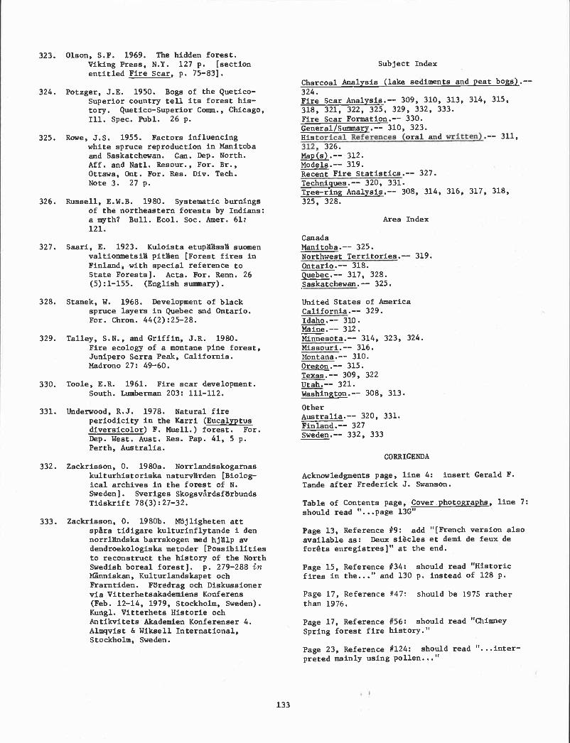
torical References ( written).312,
Olson, S.F. 1969. The hidden forest.Viking Press, N.Y. 127 p. [section
entitled Fire Scar, p. 75-831.
Potzger, J.E. 1950. Bogs of the Quetico-Superior country teli its forest his-tory. Quetico-Superior Comm., Chicago,Ill. Spec. Publ. 26 p.
Rowe, J.S. 1955. Factors influencingwhite spruce reproduction in Manitobaand Saskatchewan. Can. Dep. North.Aff. and Nati. Resour., For. Br.,Ottawa, Ont. For. Res. Div. Tech.Note 3. 27 p.
Russell, E.W.B. 1980. Systematic burningsof the northeastern forests by Indians:a myth? Bull. Ecol. Soc. Amer. 61:121.
Saari, E. 1923. Kuloista etupliäss suomenvaltionmetsi pitHen [Forest fires inFinland, with special reference toState Forests]. Acta. For. Reun. 26(5):l-l55. (English summary).
Stanek, W. 1968. Development of blackspruce layers in Quebec and Ontario.For. Chron. 44(2):25-28.
Talley, S.N., and Griffin, J.R. 1980.Fire ecology of a montane pine forest,Junipero Serra Peak, California.Madrono 27: 49-60.
Toole, E.R. 1961. Fire scar development.South. Lumberman 203: 111-112.
Underwood, R.J. 1978. Natural fireperiodicity in the Karri (Eucalyptusdiversicolor) F. Muell.) forest. For.
Dep. West. Aust. Res. Pap. 41, 5 p.Perth, Australia.
Zackrisson, 0. 1980a. Norrlandsskogarnaskulturhistoriska naturvHrden [Biolog-ical archives in the forest of N.Sweden]. Sveriges SkogsvPrdsförbundsTidskrift 78(3):27-32.
Zackrisson, 0. l98Ob. Mojligheten attsp&ra tidigare kulturinflytande I dennorrlHndska barrskogen med hjlp avdendroekologiska metoder [Possibilitiesto reconstruct the history of the NorthSwedish boreal forest]. p. 279-288 inMänniskan, Kulturlandskapet ochFrarntiden. F3redrag och Diskussionervia Vitterhetsakademiens Konferens(Feb. 12-14, 1979, Stockholm, Sweden).Kungl. Vitterhets Historie ochAntlkvitets Akademien Konferenser 4.Almqvist & Wiksell International,Stockholm, Sweden.
133
Subject Index
Charcoal Analysis (lake sediments and peat bogs) .--
324.Fire Scar Analysis.-- 309, 310, 313, 314, 315,318, 321, 322, 325, 329, 332, 333.Fire Scar Formation.-- 330.General/Summary.-- 310, 323.His oral and -- 311,
326.
Map(s).-- 312.Models.-- 319.Recent Fire Statistics.-- 327.Techni9ues.-- 320, 331.Tree-ring Analysis.-- 308, 314, 316, 317, 318,
325, 328.
Area Index
CanadaManitoba.-- 325.Northwest Territories.-- 319.Ontario.-- 318.Quebec.-- 317, 328.Saskatchewan.-- 325.
United States of AmericaCalifornia.-- 329.Idaho.-- 310.Maine.-- 312.Minnesota.-- 314, 323, 324.Missouri.-- 316.Montana.-- 310.Oregon.-- 315.Texas.-- 309, 322Utah.-- 321.Washington.-- 308, 313.
OtherAustralia.-- 320, 331.Finland.-- 327Sweden.-- 332, 333
CORRIGENDA
Acknowledgments page, line 4: insert Gerald F.
Tande after Frederick 3. Swanson.
Table of Contents page, Cover photographs, line 7:should read ". . .page l3G"
Page 13, Reference #9: add "[French version also
available as: Deux siècles et demi de feux defordts enregistres]" at the end.
Page 15, Reference #34: should read "Historicfires in the..." and 130 p. instead of 128 p.
Page 17, Reference #47: should be 1975 ratherthan 1976.
Page 17, Reference #56: should read "ChimneySpring forest fire history."
Page 23, Reference #124: should read ". . .Inter-
preted mainly using pollen..."

Cambridge, England) Abstrs. 5: 381.
Page 35, Reference #261: should be 1980 rather
than 1979.
Page 39, Reference #304: paper will not be
published.
Page 39, Reference #305: should be l979b ratherthan 1980 and note volume 10.
Page 41, Table 2, #1: Expected completion dateshould read June 1980.
Page 42, Table 2, #l4: should be Stephen [insteadof Steven] W.J. Dominy.
134
LITERATURE CITED
Alexander, Martin E. 1979. Bibliography and arésumé of current studies on fire history.Department of the Environment, CanadianForestry Service Report O-X-304, 43 p.Great Lakes Forest Research Centre, SaultSte. Marie, Ont.
Maeglin, Robert R. 1979. Increment cores--howto collect, handle, and use them. USDAForest Service, General Technical ReportFPL 25, 19 p. Forest Products Laboratory,
Madison, Wisc.
Page 30, Reference #200: should read "Plummer,
F.G."
The following references noted as "in press"in the bibliography have since been published:
Page 31, Reference #211: should be 152 p.
instead of 179 P.
8. Alexander (1980)434.
- Southwest. Nat. 25: 432-
Page 33, Reference #231: citation should read 56. Dieterich (1980) - Res. Pap. RM-220. 8 p.
Singh, C., Kershaw, A.P., and Clark, R. 1980.
Quaternary vegetational and fire history in 124. Huttunen (1980) - Acta Bot. Penn. 113: 1-
Australia in Fire in the Australia Biota. 45.
Australian Acad. Sci., Canberra, A.C.T. [in
press]. 211. Romme (1979) - (Diss. Abstr. mt. 41: 801-
B).
Page 34, Reference 246: citation should readInterl. Palynological Conf. (June 29-July 6, 261. Tolonen (1980) - Ann. Bot. Penn. 17: 15-25.

Fire History Terminology: Report of the Ad Hoc Committee2
It is often quite difficult to compare firehistory studies conducted by different investiga-tors because different terms may be used to referto the same concept and the sane tern may be usedto refer to different concepts. To help resolvethis difficulty, an ad hoc committee was formedearly in the course of the workshop with the taskof (1) listing the most confusing terms commonlyused in fire history studies, (2) determiningwhich terms are actually synonymous, (3) suggest-ing which of several synonyms is the best term touse in future fire history studies, and (4) pro-viding a definition for each of the preferredterms. The committee was composed of MartinAlexander, Stephen Arno, Kathleen Davis, H. WilliamGabriel, Edward Johnson, Michael Madany, WilliamRomme, Gerald Tande, and Dale Taylor. The commit-tee presented its preliminary report to all of theworkshop participants during the concluding session,and a concensus was reached on the meaning and pre-ferred use of several terms. Copies of the pre-liminary report were also distributed to severalother fire history researchers who could not attendthe workshop. Following a 3-week period duringwhich several people made additional comments, thisfinal version of the committee's report was writtenby William Romme. This is not meant to be an ex-haustive fire history glossary nor a complete docu-mentation of definitions as used in the literature.Rather it focuses on those terms that caused thegreatest confusion at this -workshop and are ingreatest need of clarification. The individualpapers in these proceedings do not necessarily usethe terminology recommended in this report, as theywere prepared before the committee was formed. How-ever, it is hoped that the recommendations belowwill help to improve communication in future papersdealing with fire history.
We must add that although terminology can bea serious source of confusion, another major prob-lem in comparing fire histories is related to dif-ferences in the size of our study areas. Conceptslike fire frequency and mean fire interval take onvery different meanings when applied to a 0.1-hastand as opposed to a 100,000-ha park. We empha-size the importance of clearly stating the size ofthe area referred to by these terms. But there arestill problems in comparison even if the sizes ofthe study areas are specified, especially when twostudy areas differ markedly in size. It may notbe appropriate to extrapolate findings based on asmall study area to a larger area, or vice versa.
1A product of the Fire History Workshop,Laboratory of Tree-Ring Research, Universityof Arizona, Tucson, October 20-24, 1980.
William Romme, Committee Chairman
135
Not only are there probably differences in samplingintensity in large and small study areas, but ex-trapolation by simple multiplication or divisionmay be quite misleading. For example, if there were10 fires in a particular area during some time periodof interest, it does not necessarily follow thatthere were 100 fires in an area 10 times as large.Similarly, if 107. of a 100,000-ha park burns eachyear, it is not necessarily true that 10% of every0.1-ha stand burns each year. At this time, wecan offer no solutions to these problems of studyarea size; we simply remind investigators of theproblems, and urge caution in making comparisonsor extrapolating results. Hopefully some futurefire history workshop can resolve this difficulty.
The following terms are those for which a con-census was reached by the participants at the work-shop. The preferred terms are given first, withother synonyms (if any) in parentheses:
1. FIRE OCCURRENCE (or FIRE INCIDENCE) = one fireevent taking place within a designated areaduring designated time (no units; either yes,a fire occurs, or no, a fire does not occur).
COMMENTS:
These terms have sometimes been used torefer to fire frequency (as defined be-low) with specific reference to somelarge study area, as opposed to firefrequency at a single point. This useis semantically inaccurate, however, as"occurrence" or "incidence" implies oneevent. Therefore, we recommend the termfire frequency (see below) for thismeaning.
Neither synonym is clearly superior tothe other, but only one term is needed.We recommend the term fire occurrence.
2. FIRE INTERVAL (or FIRE FREE INTERVAL or FIRERETURN INTERVAL) = the number of years betweentwo successive fires documented in a designatedarea (i.e., the interval between two successivefire occurrences); the size of the area mustbe clearly specified (units--years).
COMMENTS:
(1) These terms have been used to indicatemean fire interval, etc. (see below), butwe should distinguish between individualfire intervals and mean fire intervals.

None of these three synonyms is clearlysuperior to the others, but only one termis needed. For the sake of brevity, werecommend the term fire interval.
Writers should indicate whether a reportedfire interval has been corrected by cross-dating the individual fire occurrences(see below).
3. MEAN FIRE INTERVAL (or MEAN FIRE FREEINTERVAL or MEAN FIRE RETURN INTERVAL) =arithmetic average of all fire Intervalsdetermined in a designated area during adesignated time period; the size of the areaand the time period must be specified (units--years).
COMMENTS:
None of these three synonyms is clearlysuperior to the others, but only one isneeded. To be consistent with the termfire interval, recommended above, werecommend the term mean fire interval.
The frequency of distribution of fireintervals also should be examined.With highly skewed distributions, forexample, the median fire intervalor some other statistic may be moremeaningful ecologically than the mean.
Hypothetical Example--"Fire occurrencesin the years 1750, 1800, and 1900 weredocumented in a 10-ha study area, basedon fire scar analysis corrected bycross-dating. Fire intervals of 50and 100 years, respectively, were thusdetermined. Therefore, the mean fireinterval in a 10-ha stand between 1750and 1900 was 75 years."
Note that these fires may or maynot have burned the entire 10-ha stand.All we know for certain is that 3 firesoccurred somewhere within the standduring a 150-year period, and the averageinterval between successive fires in thestand was 75 years.
4. FIRE FREQUENCY the number of fires per
unit time in some designated area (which maybe as small as a single point); the size ofthe area must be specified (units--number!time/area).
COMMENTS:
(1) This tern has been used in a more re-strictive sense to indicate that thearea referred to is a single point ora very small stand, while some otherterm (e.g., fire incidence or fireoccurrence) is used in reference to alarger area. However, we recommendusing only the term fire frequency for
136
areas of all sizes (with the size ofthe area clearly specified) because(I) if two different terms are used,it may not be clear which is appropriatein study areas of borderline size, i.e.,bigger than a point but smaller than alarge area; (ii) there is no semanticreason why the term frequency must berestricted to au area of any particularsize; and (iii) it is semantically in-accurate to use terms like occurrenceand incidence to refer to multipleevents, as noted above.
Hypothetical example: "Intensive f ire-
scar sampling, corrected by cross-dating,produced evidence of 100 fire occurrencesduring the last 50 years in a 10,000-haNational Park. At one point within thePark (i.e., a single fire-scarred tree)there was evidence of 10 fires during thesame 50-year period. Therefore, the fire
frequency during the last 50 years in a10,000-ha study area was 100 fires/SO years/10,000 ha, or an average of 2 fires/year/
10,000 ha. The fire frequency at a single
point during the same time period was10 fires/50 years/point, or an average of0.2 fire/year at a point, or 1 fire/5 years
at a point."
Fire frequency in a large area indicatesonly the number of ignitions in that areaduring some time period; it reveals nothingabout the sizes of the fires or theirecological effects. When referring toa large area, therefore, the amount of
area burned per unit time may be moremeaningful than simply the number ofignitions per unit time. With very small
areas or single points, however, thenumber of fires per unit time is usefulinformation.
5. CROSS-DATING = correcting the chronology deter-mined from an individual tree-ring sample bycomparison with a master tree-ring chronologydeveloped for the area (no units).
COMMENTS:
This term has been used to refer to theprocess of correcting fire dates in amaster fire chronology by adjustingindividual sample dates to correspond todates obtained from nearby fire-scarredtrees. However, the term should not beused except in reference to a mastertree-ring chronology for the area.
When reporting fire dates determined bydendrochronologIcal methods, it is im-
portant to distinguish between fire datesthat have been corrected by cross-datingand fire dates that have been estimatedwithout cross-dating.
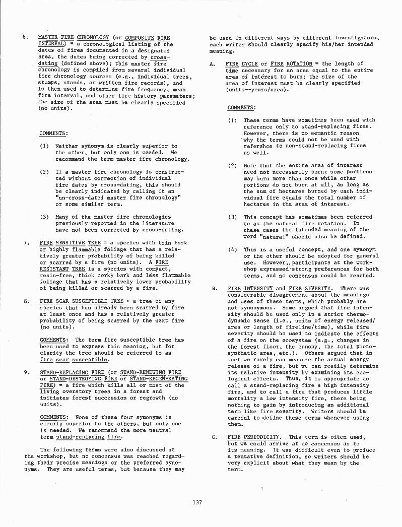
6. MASTER FIRE CHRONOLOGY (or COMPOSITE FIREINTERVAL) a chronological listing of thedates of fires documented in a designatedarea, the dates being corrected by cross-dating (defined above); this master firechronology is compiled from several individualfire chronology sources (e.g., individual trees,stumps, stands, or written fire records), andis then used to determine fire frequency, meanfire interval, and other fire history parameters;the size of the area must be clearly specified(no units).
COMMENTS:
Neither synonym is clearly superior tothe other, but only one is needed. Werecommend the term master fire chronology.
If a master fire chronology is construc-ted without correction of individualfire dates by cross-dating, this shouldbe clearly indicated by calling it an"un-cross-dated master fire chronology"or some similar term.
Many of the master fire chronologiespreviously reported in the literaturehave not been corrected by cross-dating.
7. FIRE SENSITIVE TREE = a species with thin barkor highly flammable foliage that has a rela-tively greater probability of being killedor scarred by a fire (no units). AFIRERESISTANT TREE is a species with compact,resin-free, thick corky bark and lss flammablefoliage that has a relatively lower probabilityof being killed or scarred by a fire.
8. FIRE SCAR SUSCEPTIBLE TREE = a tree of anyspecies that has already been scarred by fireat least once and has a relatively greaterprobability of being scarred by the next fire(no units).
COMMENTS: The term fire susceptible tree hasbeen used to express this meaning, but forclarity the tree should be referred to asfire scar susceptible.
9. STAND-REPLACING FIRE (or STAND-RENEWING FIREor STAND-DESTROYING FIRE or STAND-REGENERATINGFIRE) = a fire which kills all or most of theliving overstory trees in a forest andinitiates forest succession or regrowth (nounits).
COMMENTS: None of these four synonyms isclearly superior to the others, but only oneis needed. We recommend the more neutralterm stand-replacing fire.
The following terms were also discussed atthe workshop, but no concensus was reached regard-ing their precise meanings or the preferred syno-nyms. They are useful terms, but because they may
137
be used in different ways by different investigators,each writer should clearly specify his/her intendedmeaning.
A. FIRE CYCLE or FIRE ROTATION the length oftime necessary for an area equal to the entirearea of intrest to burn; the size of thearea of interest must be clearly specified(units--years/area).
COMMENTS:
These terms have sometimes been used withreference only to stand-replacing fires.However, there is no semantic reasonwhy the terms could not be used withreferehce to non-stand-replacing firesas well.
Note that the entire area of interestneed not necessarily burn; some portionsmay burn more than once while otherportions do not burn at all, as long asthe sum of hectares burned by each indi-vidual fire equals the total number ofhectares in the area of interest.
This concept has sometimes been referredto as the natural fire rotation. In
these cases the intended meaning of theword "natural" should also be defined.
This is a useful concept, and one synonymor ithe other should be adopted for generaluse. However, participants at the work-shop expressedstrong preferences for bothterms, and no concensus could be reached.
B. FIRE INTENSITY and FIRE SEVERITY. There wasconsiderable disagreement about the meaningsand uses of these terms, which probably arenot synonymous. Some argued that fire inten-sity should be used only in a strict thermo-dynamic sense (i.e., units of energy released/area or length of fireline/time), while fireseverity should be used to indicate the effectsof a fire on the ecosystem (e.g., changes inthe forest floor, the canopy, the total photo-synthetic area, etc.). Others argued that infact we rarely can measure the actual energyrelease of a fire, but we can readily determineits relative intensity by examining its eco-logical effects. Thus, it is appropriate tocall a stand-replacing fire a high intensityfire, and to call a fire that produces littlemortality a low intensity fire, there beingnothing to gain by introducing an additionalterm like fire severity. Writers should becareful to*define these terms whenever usingthem.
C. FIRE PERIODICITY. This term is often used,but we could arrive at no concensus as toits meaning. It was difficult even to producea tentative definition, so writers should bevery explicit about what they mean by theterm.

Workshop Summary: Who Cares About Fire History?'
INTRODUCTION
Threads of continuity ran through this excel-lent workshop. The workshop was characterized byan abiding interest in a common terminology, concernabout scale (how large, or small, an area can berepresented), the resolution of data required tomake effective management decisions, recognitionof the limitations of fire history information, thecultural, biological and environmental stratifi-cation of data, and animated discussions regardingdiffering methodologies. These threads wove a uni-fying strength into the workshop's fabric. But
some of the participants harbored reservationsabout the utility of fire history information;thus, the question: Who cares about fire history?This questioning remark was overheard during oneof the informal discussion periods, and it is anappropriate one to ask.
APPARENT LIMITING FACTORS
Certain factors limit the interpretation andapplication of fire history information and posepotential reasons for not caring:
Flammable exotic species tend to obscure"natural" fire frequencies (e.g., Bromusrubescens in Sonoran Desert, Bromustectorum in Great Basin, Melaleuca inEverglades).
Changing cultural activities over timeconfound the "natural" fire historyrecord (e.g., burning by aboriginals,miners, trappers, settlers).
Climatic changes occur.
Grazing patterns change.
Fire scars represent a conservativehistory (fires must be intense enoughto scar the cambium tissue).
1Prepared for the Fire History Workshop,Laboratory of Tree-Ring Research, University ofArizona, Tucson, Arizona, October 20-24, 1980.
2Fire Management Officer, Lob National
Forest, Missoula, Montana.
Robert W. Mutch2
138
Stratification of data is sometimes diff i-
cult.
It is difficult to date events in certainecosystems (for example, fires in theSonoran Desert leave few direct signs).
Fire chronologies that are not cross-datedmay impair the accuracy and amount of in-formation collected.
The importance of fire history informationto fire suppression, prescribed fire, andland management planning programs is notfully recognized.
For these reasons, and possibly others, itwould be easy to discount the importance of firehistory studies. Despite these limitations, work-shop participants did care about fire history infor-mation and its application to management programs.
Fire history results were reported from northernQuebec to the Northwest Territories, New Englandand Floiida o Oregon and California, and from
Sweden and Australia.
FIRE HISTORY METhODOLOGIES
Many methods were presented to determine thefire history of a point or area, including the di-rect dating of fire scars in the annual rings oftrees and numerous indirect procedures. Directdating techniques essentially followed the cross-dating methods developed by the Laboratory of Tree-Ring Research, University of Arizona, or utilizedan alternative method as described by Steve Arnoand Kathy Davis. Lake sediment analyses for pollenand charcoal provided additional direct, but lessprecise, estimates of fire intervals. Indirect
methods for determining fire history analysis in-cluded land survey records, informants, journals,and fire occurrence records, inferences derivedfrom the adaptive strategy of species, and ageclass distributions of fire originated stands.
QUESTIONS AND CONCEPTUAL CHALLENGES
Bill Moir questioned our ability to stratifyfire history information in meaningful ways, demon-strating that if you've seen one canyon woodlandyou haven't necessarily seen them all. The issue ofstratification came up repeatedly during the work-shop. Investigators subdivided time and space in

such as these should provide us with new insightsregarding the evolutionary adaptedness of plantcommunities to varying fire intervals. And althoughwe should never expect to acquire fire chronologiesthat rival the time span encompassed in WesFerguson's bristlecone work, more attention to cross-
terms of prehistoric and historic periods, environ-mental gradients, and plant communities. Firehistory information obviously will be more readilyextended and applied to resource management pro-grams, if it can be organized according to recog-nized classification systems. For example, theinterpretation of fire history data in differentenvironments (through habitat types) has facili-tated management applications in the northernRocky Mountains.
Fire history and fire ecology relationshipsin the east and northeast often have not beenaddressed with the detail devoted to our under-standing of western ecosystems. It was encour-aging to see Craig Lorimer and Serge Payette applyland survey records and paleoecological methodsto further the understanding of fire in easternecosystems. Lorimer's results suggested a 400- to800-year fire interval in his study area In thenortheast. Because such an event is Infrequent,does this imply that the effect of that event isinsignificant? Fred Hall tended to contrast under-story burning vs. crown fire regimes in a competi-tive sense, indicating that understory burning ismore important than crown fires. Is it appropriateto consider one type of fire regime as being moresignificant than another type? Or should we recog-nize that different plant communities are regulatedby different intervals, types, and intensities offires? Thus, infrequent crown fires are as normalto lodgepole pine forests as frequent surface firesare to ponderosa pine forests.
Is it possible to discuss fire history resultsin an objective manner? Words like degradation,disastrous, and damage crept into some of the dis-cussions during the week. Can our interpretationsof fire history be unbiased if we employ such valuejudgments in our assessment of fire intervals andtheir effects on ecosystems? Shouldn't resourcemanagement objectives provide the criteria fordetermining whether a given fire is beneficial orharmful?
Several investigators appreciated that treerings portrayed only a narrow slice out of the timesequence of a region's fire history. Examples ofpaleoecologica]. research were presented that dra-matically extended fire history information backto prehistoric periods. Gurdip Singh presentedsome tantalizing results regarding the pollen andcharcoal record in southeastern Australia. Results
dating would permit us to push fire history informa-tion further back in time.
Fire interval information, when coupled withthe knowledge of a site's productivity, can beinstrumental in evaluating the effects of attemptedfire exclusion actions. The effects of 50 yearsof fire suppression will be more readily discerniblein the Arizona ponderosa pine stands where fire
139
intervals are around 2 years than in the cedar-hemlock stands of northern Idaho where the returninterval can exceed 200 years. On the other hand,low productive sites characterized by warm-dry andcold-dry environments should not be as adverselyaffected by fire exclusion as moderately productivesites with frequent fire intervals. Thus, informa-tion about fire intervals and productivity is im-portant to the resolution and scheduling of pre-scribed fire activities.
An assumption that stands are uniformly flam-mable over time does not fit all plant communities.Contrast the frequent, sometimes almost annual, fireintervals in ponderosa pine with the more infrequentintervals in lodgepole pine. And we must recognize,too, that there is considerable variation In fireintervals within each of these types with more fre-quent intervals in western Montana lodgepole pineas compared to the Yellowstone National Park lodge-pole stands. We can use such fire history informa-tion to infer relationships about the presence orabsence of fuel-free periods in these plant communi-ties. Such fuel succession information is usefulin defining opportunities for prescribed naturalfire programs. If age class mosaics serve to regu-late fire size, this knowledge provides a measureof confidence that Yellowstone National Park Islarge enough to contain fires freely burning underprescription. Conversely, if we are losing the ex-pression of an age class mosaic as in the chaparraltype of southern California, we can expect an in-crease in high intensity, large fires (as the 16-to 18-year fire interval is dampened by suppressionefforts).
There may be a new opportunity for real-timefire history studies in the future, due to thenatural laboratory provided by long duration (up to5 months) prescribed fires in national parks andwildernesses. Tommorrow's fire historian has thechance to live with these fires on a day-to-daybasis, observing which trees are scarred, whenthey're scarred, and how they're scarred; and alsoobserving events that contribute to the nonscarringof trees. These observations, coupled with thedistribution of fire intensity classes and standmosaics associated with individual large fires, couldimprove our understanding of fire interactions withplant communities. Also, the seasonal collectionand analysis of fire-scarred specimens on prescribedfires might permit us to determine the seasonalityof historic fire occurrence, as well as the year ofoccurrence.
MANAGEMENT APPLICATIONS
The workshop described some land managers asnot always being careful, unenlightened, victimsof their own inadequate literature searches, andguilty of seemingly Irrational suppression decisionsin many instances. These perceptions of a managerneed to be interpreted in terms of his environment:
Subject to endless deadlines.
Accountability for hard targets andplanned accomplishments.

A daily schedule driven by phone callsand a steady stream of mail with duedates.
Often a crisis-oriented decisionmakingatmosphere.
Too little time to read and reflect.
A sincere desire to do better (whichmeans applying our current knowledgebase in the decision making process).
To the question, "Who cares about fire his-tory?," many managers today would respond with an"I care!" Fire Management policies today are moreclosely aligned with the resource objectives ofagencies like Parks Canada, National Park Service,Bureau of Land Management, and USDA Forest Service.As imprecise as fire history information may be,an increasing nuniber of enlightened land managersconsider it to be absolutely essential, not just"nice to know", data for land management planningpurposes. Researchers and m anagers need toacquire the necessary patience and perseveranceto work closely with each other. Just because astudy is published and distributed to library andoffice shelves is no guarantee that the informationwill be applied. Effective application will berealized only when the researcher and manageragree to meet each other more than half way. Inother words, each must have the desire to live alittle in the other's world.
Some of the pradjical applications of firehistory information g6 stated b. Kathy Davis andothers are:
A basis for silvicultural prescriptions.
A basis for fire behavior predictions onwildfires.
- A data base for land management planning.
A scheduling guide for prescribed burningactivities to simulate natural intervals(some warning signals to observe when weexclude fire for too long, or return ittoo frequently).
An aid in prescribed burning and pre-scribed natural fire planning (effectsof past fire exclusion related to differ-ent fire intervals, public understandingof prehistoric and historic role of fire,potential fire intervals and fire sizes,etc.). Steve Barrett provided evidenceto consider aboriginal burning as ameasurable element in natural ecosystems.
An example to gain homeowner's attentionto the fact that fires are inevitable inmost plant communities. The fire historyrecord indicates that although we maypostpone fires we will not eliminatethem from the urban/wildiand interface.
140
A backdrop to guide development of post-f ire rehabilitation programs. Fire his-
tory and fire effects information demon-strate that fire adapted plant communitieshave evolved mechanisms to rehabilitatethemselves; and that massive re-seedingprograms often can be avoided.
SUMMARY
The purpose of the workshop was to exchange in-formation on sampling procedures, research methodol-ogy, preparation and interpretation of specimenmaterial, terminology, and the application and sig-nificance of findings. That Mary Stokes and Jack
Dieterich were right on target in providing a pro-ductive forum for such discussions is best exempli-fied in the remarks of the participants themselves.Many felt that it was one of the most informativeworkshops they had ever attended. Those in attend-ance also agreed that the pace was quick, and thatenergy levels remained high. Challenging discus-sion punctuated the delivery of diverse and stimu-lating papers as people freely shared ideas witheach other. And the warm hospitality of the facul-ty and staff of the Laboratory of Tree-Ring Researchprovided a comfortable environment for communica-tions.
One of the objectives of the workshop was toemphasize the relationship of dendrochronologyprocedures to fire history studies and interpre-tations. Although his outward demeanor was calm,Mary Stokes must have been inwardly wincing at theabsence of cross-dating procedures in some of thetree-ring investigations. Lively debates ensuedregarding the need for cross-dated chronologies inall cases. And Tom Harlan provided the group amoment's pause when he indicated that it could takeup to a year for a person to develop competency indendrochronology procedures. Yet the participantswent away with a better appreciation for the in-creased accuracy and information content that re-sults when standard dendrochronology methods arefollowed. More than one individual indicated aninterest in developing cross-dated chronologiesin future studies.
Most tree-ring investigators stated that theywere essentially forced to take material whereverthey found it and were unable to follow a rigidsampling design. One saving point is that a fewtrees seem to capture most of a stand's fire his-tory story. But there's probably a need to betterinvolve biometricians to strengthen sampling pro-cedures where possible.
A final footnote is in order--and that has todo with the warm kinship the workshop participantsall felt towards Harold Weaver and his lovely wife,Billie. Having this grand gentleman of ponderosapine management with us all week added immeasurablyto the workshop's atmosphere. Thanks to both ofyou for joining with us and for giving us theopportunity to get to know you better.

Gary M. AhistrandCarlsbad Caverns and GuadalupeMountains National Parks
3225 National Parks HighwayCarlsbad, New Mexico 88220
Martin E. AlexanderCanadian Forestry ServiceGreat Lakes Forest Research CentreP. 0. Box 490Saulte Ste. Marie, OntarioP6A 5M7 CANADA
Stephen F. ArnoNorthern Forest Fire LabUSDA Forest ServiceMissoula, Montana 59806
Stephen W. BarrettSchool of ForestryUniversity of MontanaMissoula, Montana 59806
Trevor BirdLaboratory of Tree-Ring ResearchUniversity of ArizonaTucson, Arizona 85721
Jane BockResearch RanchElgin, Arizona 85611(University of Colorado)E.P.0. Biology, Box 334Boulder, Colorado 80304
Laura ConkeyLaboratory of Tree-Ring ResearchUniversity of ArizonaTucson, Arizona 85721
Edward CookLaboratory of Tree-Ring ResearchUniversity of ArizonaTucson, Arizona 85721
Kathleen M. DavisNational Park ServiceWestern Region450 Golden Gate Ave.Box 36063San Francisco, California 94102
J. H. DieterichForestry Sciences Lab-ASUUSDA Forest ServiceTempe, Arizona 85281
Workshop Participants
C. W. FergusonLaboratory of Tree-Ring ResearchUniversity of ArizonaTucson, Arizona 85721
Louise FilionCentre d'tudes nordiquesUniversit Laval, Sainte-FoyQndbec G1K 7P4, CANADA
Charles L. Foxx412 RoverLos Alamos, New Mexico 87544
Teralene S. Foxx412 RoverLos Alamos, New Mexico 87544
H. William GabrielUSD1-Bureau of Land Management701 C Street, Box 13Anchorage, Alaska 99513
James R. GriffinHastings ReservationStar Route Box 80Carmel Valley, California 93924
Richard GuyetteUniversity of Missouri1-30 Agriculture BuildingColumbia, MissourI 65211
Frederick C. HallUSDA Forest ServiceP. 0. Box 40225Portland, Oregon 97240
Robert Hamre, editorUSDA Forest ServiceRocky Mountain Station240 W. Prospect StreetFort Collins, Colorado 80526
Thomas HarlanLaboratory of Tree-Ring ResearchUniversity of ArizonaTucson, Arizona 85721
Brad C. HawkesPacific Forest Research Centre506 West BurnsIde Rd.Victoria, British ColumbiaV8Z 1M5 CANADA
Richard HolmesLaboratory of Tree-Ring ResearchUniversity of ArizonaTucson, Arizona 85721
Edward A. JohnsonDepartment of BiologyUniversity of CalgaryCalgary, AlbertaT2N 1N4 CANADA
Elaine KennedyLaboratory of Tree-Ring ResearchUniversity of ArizonaTucson, Arizona 85721
GeOrge LeechBureau of Indian AffairsP. 0. Box 7007Phoenix, Arizona 85013
Hehry T. LewisDepartment of AnthropologyUniversity of AlbertaEdmonton, AlbertaT66 2G9 CANADA
G. Robert LofgrenLaboratory of Tree-Ring ResearchUniversity of ArizonaTucson, Arizona 85721
Craig G. LorimerDepartment of ForestryUniversity of WisconsinMadison, WisconsIn 53706
Miëhael H. MadanyDepartment of Range ScienceUNC 52Utah State UniversityLogan, Utah 84322
Ron MastrogiuseppeP. 0. Box SSRedwood National ParkArcata, California 95521

Terry MazanyLaboratory of Tree-Ring ResearchUniversity of ArizonaTucson, Arizona 85721
Joe R. McBrideDepartment of ForestryUniversity of CaliforniaBerkeley, California 94720
Alex McCordLaboratory of Tree-Ring ResearchUniversity of ArizonaTucson, Arizona 85721
William H. MoirThorne Ecological Institute2336 Reare StreetBoulder, Colorado 80302
Bill MurrayChiricahua National MonumentDos Cabezas Star RouteWilicox, Arizona 85643
Bob MutchLob National ForestMissoula, Montana 59801
John ParminterProtection BranchMinistry of Forests1450 Government StreetVictoria, British ColumbiaV8W 3E7 CANADA
Serge PayetteCentre d'dtudes nordiquesUniversité Laval, Sainte-FoyQuébec G1K 7P4 CANADA
Carol RiceWildlands Resource Management134 Journeys EndWalnut Creek, California 94595
Garry F. RogersDepartment of Geography1028 International AffairsColumbia University420 W. 118th StreetNew York, New York 10027
William H. RommeDepartment of Natural ScienceEastern Kentucky UniversityRichmond, Kentucky 40475
Martin RoseLaboratory of Tree-Ring ResearchUniversity of ArizonaTucson, Arizona 85721
Paula SanchiniE. P. 0. Biology, Box 334University of ColoradoBoulder, Colorado 80304
Gurdip SinghPaloenvironmental LaboratoriesUniversity of ArizonaTucson, Arizona 85721
Marvin StokesLaboratory of Tree-Ring ResearchUniversity of ArizonaTucson, Arizona 85721
Thomas SwetnamLaboratory of Tree-Ring ResearchUniversity of ArizonaTucson, Arizona 85721
Gerald F. TandeBureau of Land Management701 C Street, Box 13Anchorage, Alaska 99513
Dale F. TaylorSouth Florida Research CenterEverglades National ParkHomestead, Florida 33030
Johnathan TaylorRenewable Natural ResourcesUniversity of ArizonaTucson, Arizona 85721
Mama Ares ThompsonLaboratory of Tree-Ring ResearchUniversity of ArizonaTucson, Arizona 85721
Ray TurnerU.S. Geological SurveyTumamoc HillTucson, Arizona 85705
Nicholas Van PeltUniversity of ArizonaTucson, Arizona 85721
Stephen D. Viers, Jr.USD1 National Park ServiceRedwood National ParkP. 0. Box SSArcata, California 95521
Thomas WarnerBox 22 Ash MountainThree Rivers, California 93271
(National Park ServiceSequoia-Kings Canyon National Park)
Harold WeaverJasper, Arkansas 72641
Phyllis WestUSDA Forest ServiceForestry Sciences Lab-ASUTempe, Arizona 85281
James WyantDept. of Forest and Wood SciencesColorado State UniversityFort Collins, Colorado 80523
011e ZackrissonThe Swedish University ofAgricultural Sciences
Department of Forest Site ResearchS-901 83 Umea, SWEDEN
Malcolm ZwolinskiSchool of Natural ResourcesUniversity of ArizonaTucson, Arizona 8521
U. S. GOVERNMENT PRINTING OFFICE 1980 - 778-282/183 Reg. 8142


RockyMountains
Southwest
GreatPlains
U.S. Department of AgricultureForest Service
Rocky Mountain Forest andRange Experiment Station
The Rocky Mountain Station is one of eightregional experiment stations, plus the ForestProducts Laboratory and the Washington OfficeStaff, that make up the Forest Service researchorganization.
RESEARCH FOCUS
Research programs at the Rocky MountainStation are coordinated with area universities andwith other institutions. Many studies areconducted on a cooperative basis to acceleratesolutions to problems involving range, water,wildlife and fish habitat, human and communitydevelopment, timber, recreation, protection, andmultiresource evaluation.
RESEARCH LOCATIONS
Research Work Units of the Rocky MountainStation are operated in cooperation withuniversities in the following cities:
Albuquerque, New MexicoBottineau, North DakotaFlagstaff, ArizonaFort Collins, ColoradoLaramie, WyomingLincoln, NebraskaLubbock, TexasRapid City, South DakotaTempe, Arizona
Station Headquarters: 240 W. Prospect St., Fort Collins, CO 80526