ebm plan hdbk_FINAL22mar04
88
Coast Information Team c/o Cortex Consultants Inc., 3A–1218 Langley St. Victoria, BC, V8W 1W2 Tel: 250-360-1492 / Fax: 250-360-1493 / Email: [email protected] Page 1 March 25, 2004 The Coast Information Team is pleased to deliver the final version of the CIT Ecosystem-Based Management Planning Handbook (March 2004). The Coast Information Team (CIT) was established to provide independent information for the central and north coasts of British Columbia and Haida Gwaii/Queen Charlotte Islands using the best available scientific, technical, traditional and local knowledge. The CIT was established by the Provincial Government of British Columbia, First Nations, environmental groups, the forest industry, and communities. It is led by a management committee consisting of representatives of these bodies; and is funded by the Provincial Government, the environmental groups and forest products companies, and the Federal Government of Canada. The technical team comprises nine project teams consisting of scientists, practitioners, and traditional and local experts. CIT information and analyses, which include this CIT Ecosystem-Based Management Planning Handbook, are intended to assist First Nations and the three ongoing sub-regional planning processes to make decisions that will achieve ecosystem-based management (as per the April 4th 2001 Coastal First Nations—Government Protocol and the CCLRMP Interim Agreement). In keeping with the CIT’s commitment to transparency and highly credible independent analysis, the CIT Ecosystem-Based Management Planning Handbook underwent an internal peer review and the CIT’s independent peer review process chaired by University of Victoria Professor Rod Dobell. Peer reviews of the draft document and the authors’ response are found at http://www.citbc.org/abostru-comm.html . The final document reflects changes made by the authors to address peer review comments. We encourage all stakeholders involved in land and resource management decision-making in the CIT area to use the information and recommendations/conclusions of the CIT Ecosystem-Based Management Planning Handbook in conjunction with other CIT products as they seek to implement EBM and develop EBM Land Use Plans. We are confident that the suite of CIT products provides valuable information and guidance on the key tenets of EBM: maintaining ecosystem integrity and improving human wellbeing. Sincerely, Robert Prescott-Allen, Executive Director on behalf of the CIT Management Committee: Ken Baker, Art Sterritt, Dallas Smith, Jody Holmes, Corby Lamb Graem Wells, Gary Reay, Hans Granander, Tom Green, Bill Beldessi
-
Upload
khangminh22 -
Category
Documents
-
view
1 -
download
0
Transcript of ebm plan hdbk_FINAL22mar04

Coast Information Team
c/o Cortex Consultants Inc., 3A–1218 Langley St. Victoria, BC, V8W 1W2 Tel: 250-360-1492 / Fax: 250-360-1493 / Email: [email protected]
Page 1
March 25, 2004
The Coast Information Team is pleased to deliver the final version of the CIT Ecosystem-Based Management Planning Handbook (March 2004).
The Coast Information Team (CIT) was established to provide independent information for the central and north coasts of British Columbia and Haida Gwaii/Queen Charlotte Islands using the best available scientific, technical, traditional and local knowledge. The CIT was established by the Provincial Government of British Columbia, First Nations, environmental groups, the forest industry, and communities. It is led by a management committee consisting of representatives of these bodies; and is funded by the Provincial Government, the environmental groups and forest products companies, and the Federal Government of Canada. The technical team comprises nine project teams consisting of scientists, practitioners, and traditional and local experts. CIT information and analyses, which include this CIT Ecosystem-Based Management Planning Handbook, are intended to assist First Nations and the three ongoing sub-regional planning processes to make decisions that will achieve ecosystem-based management (as per the April 4th 2001 Coastal First Nations—Government Protocol and the CCLRMP Interim Agreement).
In keeping with the CIT’s commitment to transparency and highly credible independent analysis, the CIT Ecosystem-Based Management Planning Handbook underwent an internal peer review and the CIT’s independent peer review process chaired by University of Victoria Professor Rod Dobell. Peer reviews of the draft document and the authors’ response are found at http://www.citbc.org/abostru-comm.html. The final document reflects changes made by the authors to address peer review comments.
We encourage all stakeholders involved in land and resource management decision-making in the CIT area to use the information and recommendations/conclusions of the CIT Ecosystem-Based Management Planning Handbook in conjunction with other CIT products as they seek to implement EBM and develop EBM Land Use Plans. We are confident that the suite of CIT products provides valuable information and guidance on the key tenets of EBM: maintaining ecosystem integrity and improving human wellbeing.
Sincerely,
Robert Prescott-Allen, Executive Director on behalf of the CIT Management Committee: Ken Baker, Art Sterritt, Dallas Smith, Jody Holmes, Corby Lamb Graem Wells, Gary Reay, Hans Granander, Tom Green, Bill Beldessi

Coast Information Team
EBMPH Ltr of Transmittal_mar04.doc Page 2

Coast Information Team
Ecosystem-Based Management
Planning Handbook
March 2004

Coast Information Team
Coast Information Team March 2004 EBM Planning Handbook
ii
Acknowledgements and Disclaimer
The idea for the Ecosystem-Based Management Planning Handbook (the Handbook) arose in a CIT workshop in December 2002. Workshop participants agreed on a general outline for the Handbook in January 2003. A working group consisting of Herb Hammond, Rachel Holt, Keith Moore, Bill Beese, and Dan Cardinall produced a first draft in April 2003. A smaller working group (Cardinall, Holt, and Beese) further developed the Handbook, producing several drafts from June through October 2003, with Dan Cardinall acting as lead author. Jack Ruitenbeek and Shelagh Huston added socio-economic material to the Handbook in August 2003. Many reviewers from government and LRMP planning tables provided thoughtful and useful comments on early drafts. A draft was submitted to the CIT Management Committee for peer review in early November 2003.
In parallel with development of the Handbook, other CIT working groups produced the Scientific Basis of Ecosystem-Based Management and the Hydroriparian Planning Guide. There was communication and discussion among the working groups, but timelines and resources prevented thorough review and integration of ideas and content among the various documents.
Readers of this Handbook should be aware that this is not a consensus document. The contributors did not have the time or resources to thoroughly discuss all issues, and there remains disagreement on some specific recommendations because of scientific uncertainty and differences of interpretation. The lead author attempted to combine the (sometimes conflicting) input of the working group into a document that reflects a majority viewpoint. In general the working group agrees the Handbook provides a useful starting point for implementing an ecosystem-based approach to land and resource management in the CIT planning area. We acknowledge that those charged with implementing EBM will need to refine and further develop recommended management objectives and targets based on consideration of traditional and local knowledge, expert opinion, additional research, input from land use planning processes and local planning participants, and adaptive management.
Dan Cardinall, lead author.

Coast Information Team
Coast Information Team March 2004 EBM Planning Handbook
iii
Executive Summary
This Ecosystem-based Management (EBM) Planning Handbook is part of an EBM Framework developed by the Coast Information Team (CIT). The EBM Framework identifies principles, goals, objectives, and key elements of EBM as they have been developed by the CIT. The CIT defines EBM as:
…an adaptive approach to managing human activities that seeks to ensure the coexistence of healthy, fully functioning ecosystems and human communities.
The intent is to maintain those spatial and temporal characteristics of ecosystems such that component species and ecological processes can be sustained, and human well-being supported and improved.1
The purpose of this Handbook is to provide guidance on implementing this definition of EBM across multiple scales — from First Nations territories or other planning subregions such as the Central and North Coast, through landscapes and watersheds to individual sites.
The challenge is not easy. The CIT planning region is characterized by globally significant old growth temperate rainforests and rare wildlife species, unique First Nations cultures, sparse population, small communities, long distances to markets, a recent history of fisheries overexploitation and general economic decline, and unresolved legal issues. Maintaining ecological integrity and promoting human well-being in this context will require new approaches and arrangements. To address this the approach to EBM described in this Handbook involves:
• Having a key objective to establish a system of protected areas and reserves at multiple scales that seeks to protect endangered, rare and representative examples of regional ecosystems; sustain sufficient habitat to support viable populations of all native species; and protect important cultural heritage values.
• Using traditional, local, and scientific knowledge of natural ecological patterns and processes and their historic variability to develop ecosystem-specific management targets. Risk assessment using local and expert knowledge informs the establishment of targets that guide management to varying levels of risk at different scales, the goal being to ensure a high probability that ecological integrity is being maintained overall.
• Recognizing and accommodating First Nations Rights and Title and interests. Federal and provincial governments have not reached treaty agreements with First Nations in the CIT region. Interim and protocol agreements between First Nations, governments, tenure holders, and interested groups and organizations can establish working arrangements for resource access, stewardship and economic development.
• Engaging local community representatives and stakeholders explicitly in developing locally relevant goals and objectives, in making land and resource decisions, and in formulating and implementing strategies and plans that seek to improve family and local community well-being and economic health.
1 This definition is a refinement of the EBM definition agreed to by the Central Coast Land and Resource Management planning
table in 2001.

Coast Information Team
Coast Information Team March 2004 EBM Planning Handbook
iv
• Establishment of new arrangements among First Nations, governments, and stakeholders that provide for improved information sharing and cooperation, equitable access to resources and development benefits, economic stability, and coordinated management and monitoring.
• Exploration of new policy instruments and management arrangements that seek to achieve the most effective and efficient ways to implement EBM while creating an enabling environment for community economic development and entrepreneurial business activity.
The CIT approach to EBM seeks to secure a high probability of maintaining ecological integrity overall at the subregional scale and in landscapes and watersheds with high conservation values, while providing for human well-being by allowing focus on economic development in landscapes and watersheds with greater economic values. Application of management targets ranging from precautionary to high risk at lower planning scales, within the overarching objective to maintain ecological integrity by managing to low risk at the subregional level, provides for operational flexibility and exploration of alternative management practices in different landscapes, watersheds and sites. The underlying assumption is that it is not necessary to sustain all species and processes everywhere all the time to maintain ecological integrity.
The CIT approach to EBM also seeks to create enabling institutional arrangements, land use zoning and management direction through which local and regional human well-being can be sustained and improved. Recognition of First Nations Rights and Title, coupled with collaborative planning, provides a means for First Nations, governments, and stakeholders to share information and develop mutually acceptable land and resource stewardship plans. Collaboration and negotiation across planning boundaries also provides a means for developing mutually beneficial regional and community economic development strategies and plans.
The guidance provided here for each planning scale assumes that objectives and targets at higher levels are in place and being achieved; watershed and site planning is only likely to maintain ecological integrity if landscape and territory/subregional requirements and targets are also met. Where higher level planning is not yet complete, precaution must guide management at lower scales.
Due to the high values and scientific uncertainties involved, adaptive co-management and monitoring will play a key role in implementation, the goal being to refine knowledge and understanding of how the Central and North Coast and Haida Gwaii can remain a unique and fully functioning ecosystem while supporting a high level of well-being for the people that live and work in the region.

Coast Information Team
Coast Information Team March 2004 EBM Planning Handbook
v
Table of Contents
Executive Summary ...................................................................................................... iii Table of Contents........................................................................................................... v
List of Figures.............................................................................................................................. vi List of Tables .............................................................................................................................. vi List of Examples .......................................................................................................................... vi
1 Introduction .......................................................................................................... 1 1.1 Purpose ............................................................................................................................. 1 1.2 Audience............................................................................................................................ 1 1.3 Scope ............................................................................................................................... 1 1.4 Linkages ............................................................................................................................ 2 1.5 Overview............................................................................................................................ 3
2 Principles, Goals, and Key Concepts ..................................................................... 4 2.1 Definition ........................................................................................................................... 4 2.2 Guiding Principles ............................................................................................................... 4 2.3 Goals and Objectives .......................................................................................................... 5 2.4 Key Concepts ..................................................................................................................... 5
3 Planning Framework ........................................................................................... 17 3.1 Planning Scales ................................................................................................................ 17 3.2 Planning across Scales ...................................................................................................... 18 3.3 Planning Functions............................................................................................................ 19 3.4 Adaptive Co-Management ................................................................................................. 24
4 Territories/Subregions........................................................................................ 28 4.1 Overview.......................................................................................................................... 28 4.2 Key Characteristics ........................................................................................................... 28 4.3 Key Planning Steps ........................................................................................................... 29 4.4 Territory/Subregional Planning and Management Recommendations.................................... 32
5 Landscapes and Watersheds............................................................................... 37 5.1 Overview.......................................................................................................................... 37 5.2 Key Characteristics ........................................................................................................... 37 5.3 Landscape Planning .......................................................................................................... 38 5.4 Watershed Planning......................................................................................................... 39 5.5 Landscape & Watershed Planning and Management Recommendations ............................... 41
6 Site/Stand........................................................................................................... 49 6.1 Overview.......................................................................................................................... 49 6.2 Key Characteristics ........................................................................................................... 49 6.3 Site/Stand Planning .......................................................................................................... 50 6.4 Site/Stand Management Planning and Management Recommendations................................ 52
7 Transition ........................................................................................................... 57 7.1 Getting There from Here: Planning for Change ................................................................... 57 7.2 Lower-Level Planning in the Absence of Higher-Level Plans ................................................. 57 7.3 Ecological Restoration ....................................................................................................... 58 7.4 Institutional Design........................................................................................................... 59 7.5 Trouble-Shooting.............................................................................................................. 61 7.6 Enabling Economic Diversification and Innovation............................................................... 65
Appendix 1 Glossary ............................................................................................. 69 Appendix 2 References and Recommended Reading ........................................... 79

Coast Information Team
Coast Information Team March 2004 EBM Planning Handbook
vi
List of Figures
Figure 2.1 Management direction across planning scales.....................................................................9 Figure 2.2 RONV and ecological risk. ............................................................................................... 10 Figure 2.3 Example risk thresholds. ................................................................................................. 10 Figure 2.4 Example allocation of risk management targets across scales............................................ 12 Figure 3.1 EBM planning functions................................................................................................... 19 Figure 3.2 Example territory, watershed, and site conservation planning............................................ 21 Figure 3.3 RONV, risk, and restoration............................................................................................. 21 Figure 3.4 Adaptive co-management cycle. ...................................................................................... 25 Figure 7.1 Restoration assessment. ................................................................................................. 58 Figure 7.2 Example of new arrangements from the Gitga’at-Kitasoo/Xaixais EBM Pilot. ....................... 60 Figure 7.3 Unacceptable trade-off.................................................................................................... 62 Figure 7.4 Acceptable trade-off. ......................................................................................................62
List of Tables
Table 2.1 Overarching EBM goals and core objectives........................................................................5 Table 2.2 Some constituencies and sectors of the CIT region .............................................................7 Table 2.3 EBM management direction...............................................................................................8 Table 2.4 Example RONV and old forest representation thresholds ................................................... 11 Table 3.1 Planning scales, areas, processes, and outputs................................................................. 17 Table 3.2 Illustrative set of goals, elements, and objectives for human well-being............................. 20 Table 3.3 EBM planning values and decision considerations ............................................................. 22 Table 3.4 Management targets and adaptive co-management commitments ..................................... 26 Table 4.1 Factors affecting tourism carrying capacity....................................................................... 30 Table 4.2 Territory/subregional land and resource management guidelines....................................... 32 Table 4.3 Territory/subregional socio-economic planning guidelines ................................................. 33 Table 5.1 Ecological reserve types and elements ............................................................................. 39 Table 5.2 Landscape and watershed land and resource management guidelines ............................... 41 Table 5.3 Landscape and watershed socio-economic planning guidelines .......................................... 43 Table 6.1 Site/stand environmental management guidelines ............................................................ 52 Table 6.2 Site/stand socio-economic planning guidelines ................................................................. 53 Table 7.1 Example policy impact assessment matrix ........................................................................ 59 Table 7.2 Characteristics of Gitga’at-Kitasoo/Xaixais new arrangements............................................ 60 Table 7.3 Institutional mechanisms to achieve EBM......................................................................... 61 Table 7.4 Assessing trade-offs within a vulnerability framework ....................................................... 63 Table 7.5 Management targets, approaches, and planning/troubleshooting commitments.................. 64
List of Examples
Example 1 Overview territory planning example (from Gitga’at EBM Pilot). ......................................... 35 Example 2 Overview landscape level planning example (from Gitga’at EBM Pilot. ................................ 45 Example 3 Overview watershed level planning example (from Gitga’at EBM Pilot) ............................... 47 Example 4 Overview site forestry planning example (from Gitga’at EBM Pilot) .................................... 55
Coast Information Team
Coast Information Team March 2004 EBM Planning Handbook
1
1 Introduction
1.1 Purpose
For several decades, land and resource decision-making regarding rural British Columbia in general and coastal areas in particular has been antagonistic. A number of agreements were struck in April 2001 between the Province of British Columbia, First Nations from the Central and North Coasts and Haida Gwaii, local governments, and non-government interests.2 Consensus was reached on a definition, principles, and goals of ecosystem-based management (EBM).3 Parties to the agreements made a commitment to implement EBM in coastal British Columbia as a means of achieving “healthy, fully functioning ecosystems and human communities.”
In support of this task, the Coast Information Team (CIT) was established as an independent advisory body to bring together the best available scientific, technical, traditional, and local knowledge. This Handbook is a key part of the work undertaken by the CIT to inform implementation of EBM.
The purpose of this Handbook is to provide guidance on implementing the CIT approach to EBM at scales ranging from territories/subregions down to watershed and site plans for forestry or tourism.
1.2 Audience
This Handbook has two principal audiences:
• People engaged in various land use planning processes, including First Nations land use plans (FNLUPs) and provincially sponsored land and resource management plans (LRMPs).
• Decision makers, resource professionals, businesses, and local people who use and manage land and natural resources in the Central/North Coast and Haida Gwaii.
1.3 Scope
This Handbook focuses on multiple-scale land and natural resource planning. The expectation is that decision makers, resource professionals, businesses, and local people engaged in land and resource management within the CIT region will use the Handbook to guide development of EBM plans that suit their particular circumstances.
This Handbook seeks to support implementation of EBM by:
• summarizing key principles, goals, and concepts underlying the CIT’s approach to EBM
• describing a general planning framework for implementing EBM at all scales
• describing key characteristics and planning steps
• recommending core objectives, assessments, targets, and indicators for each planning scale, and
• providing an overview of the important elements of a transition to EBM.
2 General Protocol between seven First Nations, the provincial government, and the Central Coast Framework Agreement. 3 Definition, Principles and Goals of Ecosystem-Based Management (excerpted from the CCLCRMP Framework Agreement/Draft Interim
Plan). The agreed definition, principles, and goals of EBM have been appended to the North Coast Land and Resource Management Plan (LRMP) Terms of Reference, and will be appended to the Haida Gwaii/Queen Charlotte Islands Land Use Plan (LUP) Terms of Reference.

Coast Information Team
Coast Information Team March 2004 EBM Planning Handbook
2
The guidance provided assumes that management guidelines are being implemented at all scales. Lower-level planning is only likely to maintain ecological integrity if territory/subregional and landscape planning and management objectives are being achieved.
The following caveats must be considered when reading the Handbook:
• The issues, objectives, targets and indicators in sections 4–6 are not comprehensive, but instead reflect a synthesis of work undertaken by the CIT and the Gitga’at-Kitasoo EBM Pilot to resolve issues identified by the Central Coast LRMP planning table and the Gitga’at and Kitasoo First Nations. Practitioners working to implement EBM in different areas will need to work with local people and relevant experts to develop objectives, targets, and indicators relevant to the issues at hand, particularly with respect to focal species, cultural values, and socio-economic issues.
• This Handbook does not fully cover the regional scale; regional assessments are described in detail elsewhere (see CIT well-being assessment, ecological spatial analysis, cultural spatial analysis, and economic gain spatial analysis). This Handbook does provide some guidance on the use of regional information within subregional and lower scale planning.
• Socio-economic planning methods and objectives described in this Handbook focus primarily on land and natural resource development activities, and secondarily on socio-economic development activities that rely on natural resource use and extraction. An effort is made to provide guidance on integrating social and economic objectives at each planning scale.
• Section 6 tends to focus on forestry site planning. This focus is in part due to the fact that forest development generally has broader impacts than other resource uses. Section 6 does contain guidance for tourism, mining, and other resource uses; however, detailed description of the regulatory requirements/best practices for these industries is beyond the scope of the Handbook.
• The Handbook has a terrestrial focus, and has not been developed to support marine and coastal planning. Ideally, all aspects of coastal planning would be considered, and the Handbook could be adapted to do so in the future.
1.4 Linkages
Accompanying this Handbook are the Hydroriparian Planning Guide (HPG) and the Scientific Basis of Ecosystem-based Management (Scientific Basis).4 The HPG provides more detailed discussion of the concepts and methods relating to aquatic ecosystems described in this Handbook. The Scientific Basis summarizes the ecological concepts and knowledge underpinning the thresholds and other requirements in this Handbook and the HPG.
The CIT has also undertaken several regional assessments that are intended to support and inform a more comprehensive and coordinated approach to territorial/subregional land and resource planning in the Central and North Coast and Haida Gwaii.5 These include:
• A well-being assessment, which uses a framework of environmental and socio-economic indicators to assess conditions and trends in the CIT analysis region; the goal is to inform land and resource decisions and establish baselines for monitoring implementation.
4 Coast Information Team. 2003. Hydroriparian Planning Guide and Coast Information Team. 2003. Scientific Basis for
Ecosystem-based Management 5 See http://www.citbc.org/ana.html

Coast Information Team
Coast Information Team March 2004 EBM Planning Handbook
3
• An ecosystem spatial analysis, which is analyzing a variety of biophysical and ecological data to identify priority areas for conservation.
• An economic gains spatial analysis, which is intended to provide an overview of development opportunities including forestry, fisheries, tourism, mining, and non-timber forest products.
• A cultural and social spatial analysis, which is working to identify areas with high cultural and social values.
• An institutional analysis, which is examining the institutional opportunities and barriers for implementing EBM in the CIT region.
The planning scales covered in this handbook have been organized for consistency with the current regulatory framework. The section on territory/subregional planning is intended to inform EBM implementation within First Nations and provincially sponsored LRMP land use planning processes. The section on landscape and watershed planning is geared toward EBM implementation within Sustainable Resource Management and Forest Stewardship planning.6 The section on site planning deals with operational planning for forestry, tourism and other resource uses.
This Handbook and related management objectives and targets, and any new objectives and targets that are developed through application of the methods described herein, should be seen as supplemental to the legislation that governs land and resource management in British Columbia. First Nations and stakeholders seeking to implement EBM should ensure that new EBM related management objectives and targets are secured in government-to-government agreements and/or translated into clear legal objectives as they are defined in the Land Act.7
1.5 Overview
The Handbook contains seven sections including this introduction, and several appendices.
Section 2 describes the principles, goals, and core objectives of EBM developed by the CIT as well as key concepts underlying EBM.
Section 3 provides an overview of the CIT EBM multi-scale planning framework including core planning functions and adaptive co-management.
Sections 4–6 contain provide an overview of key characteristics, planning steps, and management direction guidelines that should be considered when working to implement EBM at subregional, landscape, watershed, and site scales.
Section 7 describes some key concepts related to achieving a transition to EBM.
Appendices 1 and 2 contain a glossary and references.
6 See B.C. Ministry of Sustainable Resource Management. 2002. Sustainable resource management planning: A landscape-level
strategy for resource development. Resource Planning Branch, Victoria, B.C. 7 Throughout the Handbook the terms “participant” and “stakeholder” refer broadly to all the persons and entities who are
likely to be involved or impacted by management.

Coast Information Team
Coast Information Team March 2004 EBM Planning Handbook
4
2 Principles, Goals, and Key Concepts
2.1 Definition
The CIT defines EBM as:
…an adaptive approach to managing human activities that seeks to ensure the coexistence of healthy, fully functioning ecosystems and human communities.
The intent is to maintain those spatial and temporal characteristics of ecosystems such that component species and ecological processes can be sustained and human well-being supported and improved.
2.2 Guiding Principles
The CIT, building on the Central Coast Agreement reached in 2001, elaborated the following principles for EBM:
• Maintain ecological integrity — by sustaining the biological richness and services provided by natural terrestrial and marine processes, including the structure, function, and composition of natural terrestrial, hydroriparian, and coastal ecosystems at all scales through time.
• Recognize and accommodate aboriginal Rights and Title, and interests — by respecting First Nations governance and authority, and by working with First Nations to achieve mutually acceptable resource planning and stewardship, and fair distribution of economic benefits.
• Promote human well-being — by assessing risks and opportunities for communities, by facilitating and enabling a diversity of community economic and business activity, and by planning for local involvement in existing and future economic activities.
• Sustain cultures, communities, and economies within the context of healthy ecosystems — by sustaining the biological richness and ecological services provided by natural ecosystems while stimulating the social and economic health of the communities that depend on and are part of those ecosystems.
• Apply the precautionary principle — by recognizing uncertainty and by working to establish and implement management objectives and targets that err on the side of caution. The onus is on the proponent to show that management is meeting designated objectives and targets.
• Ensure planning and management is collaborative — by encouraging broad participation in planning; by clearly articulating collaborative decision-making procedures; by respecting the diverse values, traditions, and aspirations of local communities; and by incorporating the best of existing knowledge including traditional, local, and scientific knowledge.
• Distribute benefits fairly — by acknowledging the cultural and economic connections that local communities have to coastal ecosystems, and by ensuring that diverse and innovative initiatives increase the share of employment, economic development, and revenue flowing to local communities, and maintain cultural and environmental amenities and other local benefits derived from land and water resources. 8
8 Principles adapted from Coast Information Team. 2003. Ecosystem-based Management Framework

Coast Information Team
Coast Information Team March 2004 EBM Planning Handbook
5
2.3 Goals and Objectives
The CIT established core goals and objectives for EBM (Table 2.1):
• Maintain ecological integrity, where ecological integrity is a quality or state of an ecosystem in which it is considered complete or unimpaired; including the natural diversity of species and biological communities, ecosystem processes and functions, and both the ability to absorb disturbance (resistance) and to recover from disturbance (resilience).
• Achieve high levels of human well-being, where human well-being is a condition in which all members of society can determine and meet their needs and have a large range of choices and opportunities to fulfill their potential.
Table 2.1 Overarching EBM goals and core objectives
Goal EBM objective
Maintain the ecological integrity of terrestrial, marine, and freshwater ecosystems
• Maintain ecosystem functions and processes (e.g., streamflow, water quality, soil productivity, natural disturbance rates and patterns) across scales and through the long term.
• Maintain the natural diversity of species, genes, and habitat elements across scales and over time.
• Protect and where necessary restore under-represented, endandered or degraded ecosystems.
Achieve high levels of human well-being
• Recognize and accommodate aboriginal Rights and Title, and interests.
• Achieve the health, wealth, and education status required for a high quality and secure life for both aboriginal and non-aboriginal people.
• Build stable, resilient, well-serviced, and peaceful communities in coastal British Columbia.
• Create a strong, diverse economy and mix of businesses in communities and across the region.
• Create a strong and diverse mix of non-profit and voluntary organizations and a vibrant set of traditional, cultural, and non-market activities within communities and across the region.
• Ensure a fair distribution of benefits, costs, and risks across all parts of coastal British Columbia, including aboriginal and non-aboriginal people.
The goal to maintain ecological integrity defines an overarching context for achieving high levels of human well-being, primarily because it implies a commitment to sustainable, cautious resource use. However, this does not necessarily limit community and business development. EBM also implies negotiation of new arrangements through which First Nations, communities, and businesses collaborate to find innovative ways of implementing management and achieving development.
Conflicts between core ecological and human goals may arise because past development has reduced local or regional resource availability or because unexpected events undermine ecological resilience or economic viability (e.g., large scale forest fires, lumber tariffs). Under these circumstances, least-risk paths are sought and policy interventions or financial support may be required to balance or resolve conflicts.
2.4 Key Concepts
2.4.1 Conservation Planning
Achieving the core goals of EBM — protect ecological integrity and achieve high levels of human well-being — means engaging in conservation planning to develop a system of protected areas and reserves that will protect and help to sustain important ecological, cultural, and social values.

Coast Information Team
Coast Information Team March 2004 EBM Planning Handbook
6
Conservation planning involves four overlapping approaches:
1. Coarse filter strategies, which seek to identify and protect representative samples of different ecosystems and seral stages across their natural range, and/or habitat for focal, umbrella, or keystone species as needed at appropriate scales.9
2. Fine filter strategies, which seek to identify and protect specific elements and features (e.g., red-listed plant communities, biophysical features, and cultural heritage areas and sites) that are not adequately protected and/or maintained by the coarse filter.
3. Landscape reserve design, which seeks to ensure that key areas of natural connectivity are maintained and/or restored within regions, subregions, landscapes, and watersheds.
4. Maintaining, managing, and where necessary restoring biological legacies in the matrix (e.g., coarse woody debris, large snags, multiple canopy layers, wildlife habitats), to sustain ecological composition, structures, and functions in areas that have not been protected or reserved.
In practice these strategies are implemented by establishing:
• Protected areas – relatively large undeveloped areas designated for protection by First Nations and/or government under specific authority or legislation. Protected areas may be established to:
– protect representative samples of native ecosystems and seral stages, focusing on protecting examples of ecosystems that are rare or at-risk in the surrounding region
– provide critical and seasonal habitat to sustain viable populations of all native species – protect regionally rare and/or unique landforms and biophysical features – protect culturally and socially significant areas and values, and − provide a benchmark for evaluating and comparing managed landscapes.
• Landscape, watershed, and site reserves, which are areas where no, or very little, extractive resource use takes place, but the land is not formally designated under legislation. Reserves are established to:
– protect specific resource values or biophysical features (e.g., cultural heritage resources and features, unstable terrain, scenic areas, and recreation features), and
− achieve objectives to maintain ecosystem representation, wildlife habitat, movement corridors, riparian forest, and other landscape design elements.
• Site/stand retention and management, in which individual trees, groups of trees, plant communities, wildlife habitats, or other features are retained or managed on the site to sustain ecological structures in the unprotected landscape (e.g., wildlife habitat, old forest structure). Site planning and management should focus on:
– maintaining biological legacies (e.g., coarse woody debris, snags, understory plants) – maintaining connectivity between landscape and watershed reserves – providing for seasonal and critical wildlife habitat, and − protecting special ecological elements (e.g., bear dens, red-listed plants, small wetlands).
9 Expanded definitions of words in bold italics are in the Glossary in Appendix I.

Coast Information Team
Coast Information Team March 2004 EBM Planning Handbook
7
2.4.2 Socio-economic Planning
Socio-economic planning in an EBM context seeks to create and implement plans that will generate wealth, provide sustainable livelihoods, distribute benefits and burdens equitably, and enhance cultural, community and household well-being.10 This entails sustainable use and development of natural resources and creation of new arrangements through which communities and businesses can collaborate and find new ways of generating wealth.
Socio-economic planning is also most likely to be successful when it treats people and their communities as living systems; as communities, sectors, and constituencies whose relationships are as significant as their individual needs and interests; who behave and respond in creative and unpredictable ways; who need to learn and adapt in order to be successful (Table 2.2). Each person or group involved in planning will have difference roles and responsibilities, vulnerabilities (gender, age, livelihood) motives, and incentives. Constituencies and sectors will have interests at different scales, and may create impacts or be subject to influences or constraints within or outside the planning area.
Table 2.2 Some constituencies and sectors of the CIT region
‘Constituencies’ ‘Economic sectors’
• First Nations
• Local communities, residents and workers
• Businesses/workers who extract resources and livings out of the region but do not reside in it
• People who have a stake in the region (i.e., people in other areas who value wilderness)
• Senior governments
• Timber, including logging, wood processing, etc. (commercial and traditional)
• Tourism, including nature-based recreation, sport fishing, and sport hunting
• Informal sustenance economy, based on individual or household access to and use of natural resources (fish, non-timber forest products, wildlife etc.)
• Non-traditional modern sectors (e.g., information technology, conservation finance)
• Mining, oil, and gas, hydro and alternative energy production
• Fisheries, ocean ranching (commercial, traditional), and aquaculture (fish farming)
Key elements of effective socio-economic planning with respect to land and resource management within an EBM framework include:
• base development of cultural and socio-economic objectives on collaborative assessment of socio-economic conditions, and community, sectoral or organizational visions and goals
• design land and resource use plans that support a variety of economic activities (formal and informal), and provide for cultural and social use opportunities
• develop resource use objectives for the managed landscape that best meet socio-economic goals while recognizing ecosystem thresholds
• consider the trade-offs and complementarities involved in allocating the managed landscape to different sectors and identify opportunities to reconcile differing land uses, and
• fine-tune plans by assessing and considering the cultural and socio-economic implications of proposed land uses, and by developing new arrangements that will enable economic transitions.
Socio-economic planning under EBM also entails the development of new institutional and planning arrangements through which communities and businesses seek to innovate and find new ways of
10 See Prescott-Allen 2004, Wellbeing Assessment of North and Central Coast British Columbia. Draft report prepared for the
Coast Information Team.

Coast Information Team
Coast Information Team March 2004 EBM Planning Handbook
8
generating wealth. Creating an enabling environment — levelling the playing field and smoothing the path for business growth — is vital element of this planning. Examples of ways to do this include:
• reconciling legislative and regulatory regimes with EBM goals and objectives
• reducing barriers by sharing information and removing subsidies
• locating and accessing resources such as financing, expertise, information, and investment
• developing protocols and agreements between communities and businesses that define roles and benefits and provide stable access to resources
• building capacity by providing training and on-the-job learning
• supporting innovation through local means such as business incubators or government programs
• creating coalitions or associations to jointly undertake development activities, and/or
• using incentive-based mechanisms to encourage behavior that benefits local communities.
2.4.3 Management Direction
EBM management direction consists of a hierarchical set of goals, objectives, requirements, targets, and indicators (Table 2.3). The purpose is to provide clear guidance as to where people want to go, how they plan to get there, how they can tell if they’re on the right road, and how to tell when they arrive.
Table 2.3 EBM management direction
Element Definition Example
Goal An overarching purpose or commitment that guides planning and decision-making. • Protect ecological integrity.
Objective An explicit goal to be achieved with respect to a resource value or management issue. • Maintain ecosystem and seral stage representation.
Requirement A procedure or assessment that must be completed to achieve an objective. • Assess current distribution of ecosystem types & seral stages.
Target A numerical objective that specifies the management results to be achieved.
• Maintain 70% of the natural distribution of old forest in each ecosystem type.
Indicator A measure for assessing the state of ecological and human systems. • Seral distribution in each ecosystem type.
Well-chosen and specified management direction provide a number of benefits including:
• establishing practical guideposts for decision-making and reference points for monitoring
• promoting coordinated action among resource management initiatives operating in a territory/subregion, landscape, or watershed at any one time
• improving the consistency and defensibility of management decisions by drawing on scientific and local understanding of potential adverse impacts
• providing a more informative framework within which to consider the cumulative effects of multiple management decisions across the landscape or subregion, and
• focusing information gathering and assessment on the issues of most concern.
Coast Information Team
Coast Information Team March 2004 EBM Planning Handbook
9
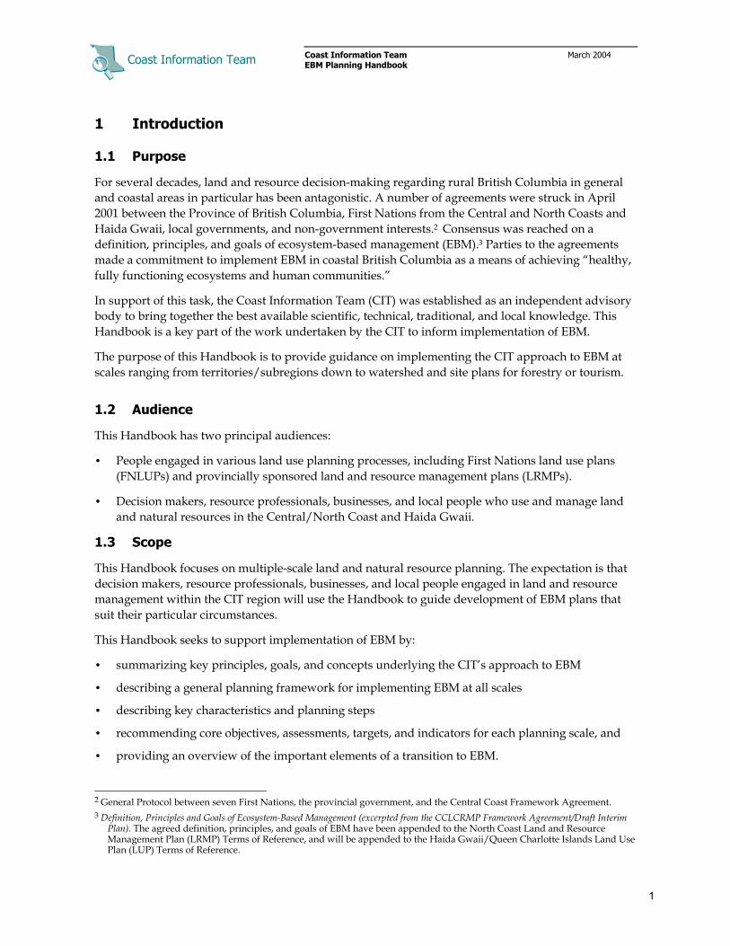
EBM management direction for particular planning areas should be developed through collaboration among relevant First Nations, governments, and stakeholders; the goal is to develop a framework that integrates management objectives, targets, and indicators across planning scales (Figure 2.1).
Figure 2.1 Management direction across planning scales.
Some guidelines for developing management objectives are:
• combine information from as many sources as possible, including:
– benchmarks derived from knowledge of ecological processes and their variability – laws, policies, and regulatory requirements (e.g., health standards) – research data and scientific reports, or – objectives set by local First Nations, communities or stakeholders (e.g., maintain visual
quality)
• set targets in reference to relevant and comparable values, such as previous performance
• choose objectives and targets that are relevant to the scale in which they will be applied
• coordinate and harmonize objectives, targets, and indicators across scales
• modify and adapt objectives and indicators to suit local conditions, and
• avoid setting unrealistically high targets that act merely as “wish lists.”11
2.4.4 Risk Management
The CIT approach to EBM draws on expert and professional opinion, traditional and local knowledge and risk assessment methods to develop explicit targets for particular management objectives.12 The goal is to evaluate the effects that resource management activity will have on conservation values and ecosystem functions, and to use this knowledge in identifying risk thresholds that guide development of management targets ranging up to the high risk threshold (see Figure 2.3).
11 For further discussion see Center for International Forestry Research (CIFOR) 1999. Guidelines for developing, testing and
selecting criteria and indicators for sustainable forest management. See also B.C. Ministry of Forests. 1998. Guide to writing resource objectives and strategies. Victoria, B.C.
12 See B.C. Ministry of Environment, Lands and Parks (2000).

Coast Information Team
Coast Information Team March 2004 EBM Planning Handbook
10
The approach involves three key steps:
1. Identify indicators for key management objectives (e.g., old forest representation is an indicator of coarse filter biodiversity). Good indicators respond to management, are related clearly to the objective, can be measured or described simply, are relatively insensitive to factors other than the management actions, and are appropriate for the purpose and scale.
2. Develop curves relating indicator values to risk (e.g., the amount of old forest in a landscape). Risk curves should combine information from as many sources as possible, including:
− natural reference points or benchmarks (e.g., natural streamflow rates)
− research reports and empirical data
− instances of collapse (e.g., local or expert knowledge of species extirpation).
Recent approaches use “range of natural variability” (RONV) — the range of dynamic change in natural systems over historic time periods — as a benchmark for risk assessment. The assumption is that risk increases in proportion to the amount that management causes patterns and processes to depart from their natural range (Figure 2.2)
3. Identify thresholds that aid risk interpretation, and use these to develop management targets. This involves dividing risk for each indicator into classes ranging from very low to high, where low risk begins at the threshold where adverse impacts begin to be detected, and the transition to high risk corresponds to where significant loss of ecological function is expected to occur. “Precautionary” management targets, reflecting a commitment to achieve a high probability of maintaining ecological integrity, should be equal to or below the low risk threshold. Management should not exceed the high risk threshold because there is a high probability that ecological and conservation values will not be sustained (Figure 2.3).14
13 The shape of the uncertainty around this curve indicates that low and high risk is more easily determined than the mid range. 14 The extent and duration of the impact will vary according to the resiliency of the ecosystem or ecological function and the
scale of the disturbance.
Figure 2.2 RONV and ecological risk.
Figure 2.3 Example risk thresholds.13
Coast Information Team
Coast Information Team March 2004 EBM Planning Handbook
11
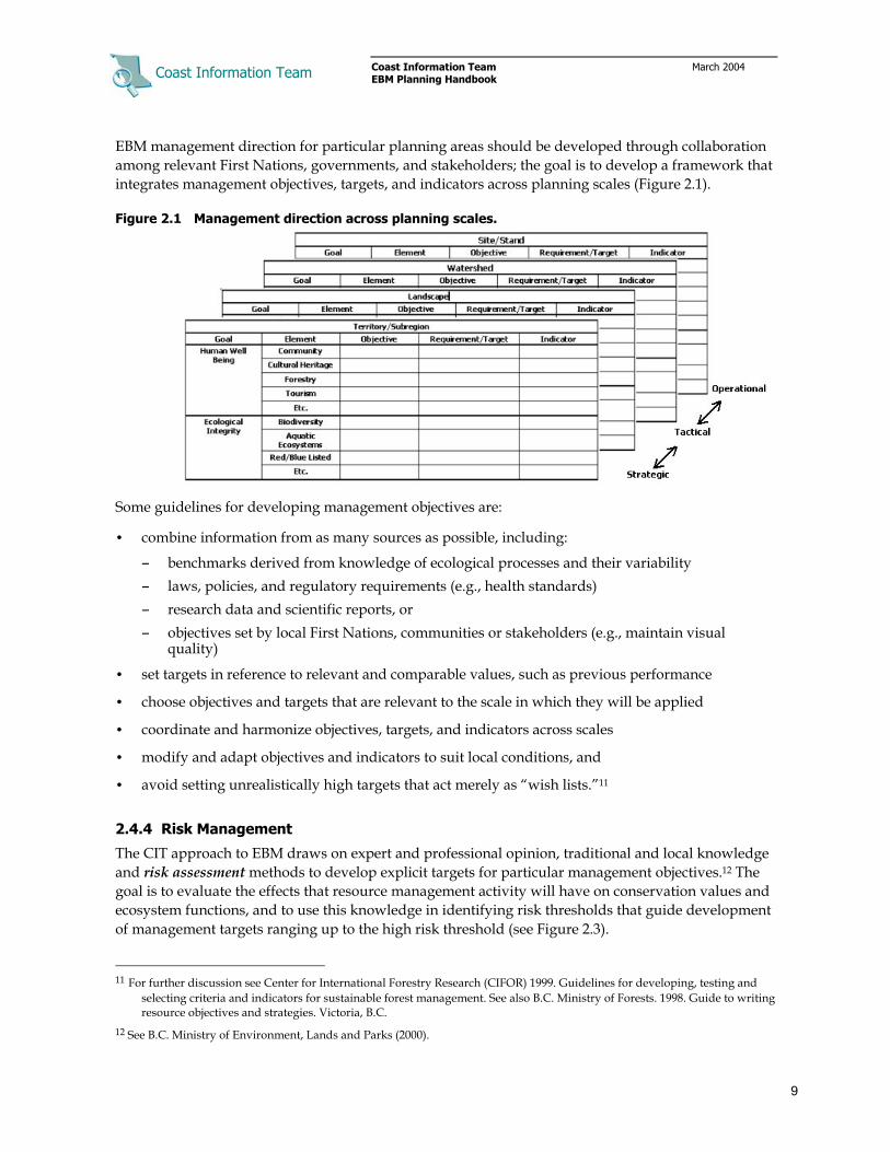
Table 2.4 illustrates how RONV analyses and risk thresholds can be used to develop management targets. In this case old forest representation targets to address coarse filter biodiversity objectives. Analysis of natural disturbance return intervals can be used to estimate the amount of old forest expected to occur under natural conditions in different biogeoclimatic ecological classification (BEC) variants. Multiplying these RONV estimates by the relevant risk thresholds yields precautionary and high risk management targets for old seral representation in each biogeoclimatic variant.
Table 2.4 Example RONV and old forest representation thresholds15
BEC variant
Estimated natural disturbance return
interval
Predicted range of old forest
abundance
Low risk threshold for old forest
representation
High risk threshold for old forest
representation
CWvh2 3000 ∀ 1300 85–93% 59–65% 25–28%
CWHws 900 ∀ 150 72–78% 50–55% 22–24%
MHmm1 850 ∀ 60 70–76% 49–53% 21–23%
MHmm2 3100 ∀ 1200 86–92% 60–64% 25–28%
CWHvm 900 ∀ 150 72–78% 50–54% 22–24%
2.4.5 Cumulative Risk Management
The goal of protecting ecological integrity suggests that planning should seek to develop and apply precautionary or low risk targets for all conservation objectives at all scales. However, ecological, cultural, and social values and resource development opportunities are not evenly distributed across the landscape. Application of precautionary targets everywhere may constrain pursuit of socio-economic objectives and tend to disperse resource development and use more broadly over the landscape at any point in time (assuming resource harvest or use levels remain constant).
Allowing management flexibility at lower scales, on the other hand, can enable:
• greater focus on economic gains in areas where ecological or cultural values are not as significant
• greater environmental protection in areas with significant ecological values, and
• exploration of alternative management practices and outcomes.
The CIT approach to EBM seeks to secure a high probability of maintaining ecological integrity overall at the subregional scale and in landscapes and watersheds with significant cultural and ecological values, while allowing for greater focus on economic activity in landscapes, watersheds and sites with lower conservation value. Application of management targets at lower planning scales ranging from precautionary to a maximum of the high risk threshold, within the overarching higher-level objective to manage to low risk at the subregional level, provides for operational flexibility and exploration of alternative management practices in different watersheds and sites (Figure 2.4). The underlying assumption is that it is not necessary to sustain all species and processes everywhere all the time in order to maintain ecological integrity, as long as lower risk management objectives and targets are being achieved at strategic subregional and landscape planning scales.
15 Example estimates and thresholds are based on analysis prepared by Holt and Sutherland (2003) for the North Coast LRMP;
further research is necessary to refine RONV estimates by BEC unit and geographic region within the Central and North Coasts and Haida Gwaii.

Coast Information Team
Coast Information Team March 2004 EBM Planning Handbook
12
The approach can be summarized as follows:
• The goal at regional and territory/subregional scales is to maintain ecological integrity by achieving management that does not exceed low risk for all environmental indicators.
• Landscape management targets may range up to moderate risk; however on average the risk across all landscapes within the territory/subregion should be within the low range. Protected areas are assumed to be within RONV or at very low risk.
• Watershed management targets may range up to the high risk threshold; however on average the risk across all watersheds within a landscape should be within the range of the landscape targets.
• Site-level management is contingent on watershed targets and the condition of the watershed relative to those targets. Site planning, for example, must consider watershed condition relative to watershed targets and develop site plans that protect and where necessary restore elements that are at risk (i.e., allocate stand retention to protect rare or at-risk ecosystems and cultural features).
• Different management targets may be allocated in a particular landscape or watershed for specific values. For example, low risk targets may be assigned for grizzly bear habitat management (i.e., maintain 70% of grizzly bear habitat in natural condition) in a watershed that will be managed to moderate risk to biodiversity (i.e., maintain only 30% of each site series in old seral condition).
• Adaptive co-management should be implemented to assess the effects of a full range of practices, with a focus on assessing the effects in areas managed to higher risk. However, adaptive co-management cannot be used to rationalize a higher risk approach for particular areas. Allocation
Figure 2.4 Example allocation of risk management targets across scales.

Coast Information Team
Coast Information Team March 2004 EBM Planning Handbook
13
of management targets to particular landscapes and watersheds should be achieved through coordinated multi-scale planning that includes collaborative assessment of relative ecological, cultural, and socio-economic values.
2.4.6 Human Vulnerability Mapping
Assessment and mapping of human vulnerability – a community or organization’s exposure to unexpected change or threats and their ability cope with those changes or threats – is an effective means of organizing information in a way that permits comparison of socio-economic and ecosystem concerns.16 A typical vulnerability assessment or map will present information about human well-being indicators in relation to communities or businesses that are within or depend on the natural resources and ecosystems in a particular territory/subregion, landscape or watershed.
Human vulnerability should generally be self-defined by affected communities and groups. A useful starting point is to draw on community well-being or business viability indicators such as:
• cash and non-cash income
• access to resources (e.g., land ownership, tenure)
• linkage to place (e.g., cultural or historical identity with territory or region)
• wealth and assets
• gross revenues, profits, and market security
• education and health
• safety nets and mutual aid networks
• historic factors,17 and
• environmental services availability (water, air, soil quality).
2.4.7 Monitoring
Monitoring involves developing a program to determine whether planning requirements are being met, to evaluate whether management is achieving objectives, or to assess and validate management assumptions. More specifically these three types of monitoring include:
• Implementation monitoring, which assesses whether management procedures and commitments are being followed. Correct implementation may at times be obvious, depending on the management action being explored, and require only a cursory check. Other elements of implementation will need more rigorous monitoring. Management systems in British Columbia have typically employed implementation monitoring.
16 For further discussion of human vulnerability assessing see Hossain, M. 2001. Assessing human vulnerability due to
environmental change: concepts and assessment methodologies. Stockholm Royal Institute of Technology. See also Risk and vulnerability assessment tool. NOAA Coastal Services Center. http://www.csc.noaa.gov/rvat/hazid.html
17 A community that has gone through two or more generations where local control over decisions was removed and local economic opportunities were marginal is likely to be particularly vulnerable due to the importance of transferring skills and values between generations. Communities where traditional cultural values are considerably different than the prevailing economic values of Canadian society are also vulnerable.

Coast Information Team
Coast Information Team March 2004 EBM Planning Handbook
14
• Effectiveness monitoring asks, “Did the prescription have the desired outcome?” This type of monitoring looks at whether the prescribed management action is attaining the objectives for each indicator. It is often the most important but least used type of monitoring.
• Validation monitoring tests the assumptions associated with management hypotheses or risk assessment models. This monitoring attempts to resolve key areas of uncertainty. Again, this type of monitoring has been applied only to a limited range of questions in management.
The steps in designing and implementing a monitoring program are:
• choose indicators as direct or proxy signals of the degree to which objectives are being met
• design the monitoring program, including consideration of validity, replicability, and reliability
• develop an agreed-on monitoring protocol that specifies all required “how-to” details such as: – units of measurement and the schedule by which measurements are to be taken or obtained – the source of the data, if secondary sources are used – the methodology of the measurement process, if primary sources are used, and – the method in which the information is to be recorded and reported
• specify roles and responsibilities for coordinating, reporting, and analyzing
• implement the monitoring program by taking or obtaining measurements according to protocols
• analyze monitoring results and assess the implications of the values found by comparing them to benchmarks, targets, thresholds, or measurements from previous time periods or other locations
• share monitoring results and analyses to enable learning across all participants, and
• collaborate to evaluate results and decide on new planning and management practices.
While monitoring often requires quantitative measurements, it also can involve tracking less tangible indicators such as degree of satisfaction. Human well-being indicators in particular need to go beyond simple measures of economic performance such as revenue or income, which only indirectly relate to key elements of human well-being such as community capacity.
2.4.8 Knowledge and Information Management
EBM seeks to incorporate the best of existing information including traditional, local, technical, and scientific knowledge. Doing this in a flexible, timely, and effective way goes beyond normal inventory and database exercises to developing and maintaining ways of sharing and using information to construct knowledge, the meaningful patterns and relationships people create out of information.
Knowledge management incorporates a variety of systems to keep track of the sources of knowledge rather than just its content — e.g., First Nations elders’ ecological knowledge — so that the sources are not lost or overlooked. Knowledge management systems should allow for efficient development, storage and dissemination of knowledge that is based on understanding of how information is used.
Keys to the success of a knowledge/information management system for the B.C. coast are to:
• ensure that responsibilities and resources are in place to maintain the knowledge system
• share information across boundaries, including scales, communities, sectors, and programs

Coast Information Team
Coast Information Team March 2004 EBM Planning Handbook
15
• treat knowledge in progress and “under construction” as potentially as valuable as knowledge considered to be final or correct
• recognize that managing and sharing information is frequently more critical than technical analysis, especially where the costs of undertaking research may be onerous, and
• link into existing resources from many sources wherever possible.18
2.4.9 Collaboration
EBM planning should engage people — First Nations, senior governments, resource users, tenure holders, local communities, and local people — meaningfully in developing and implementing plans as necessary at all scales. Collaboration provides a means for affected parties to establish interests, objectives, constraints, and incentives to ensure that land use and resource development supports community well-being.
Collaboration is not the exclusive territory of official bodies, but can be initiated and participated in by any interested group. However, any collaborative process will be more effective if it is networked with other processes and linked, formally or informally, to mandated planning and decision-making.
Collaboration does not necessarily imply decision-making. Legal and regulatory frameworks define to a great extent who will participate in planning (e.g., sector representatives in LRMPs) and who will make final decisions (i.e., statutory decision makers, judges, hereditary Chiefs) in different processes at various scales.
Collaborative processes can differ according to the issues, objectives, participants, scope, timelines, and linkages to official decision-making. They can be used to:
• identify issues, assess, and design alternative solutions and negotiate final plans
• inform decision-making through discussion and information-sharing
• develop agreements and commitments to action
• make recommendations or decisions
• conduct participatory monitoring and evaluation
• further the implementation of existing agreements and policies
• undertake components of joint implementation.19
Collaboration can occur at various stages and may not necessarily involve the same participants. Participants can delegate some or all planning functions to designated bodies or processes, or choose to enter the planning or decision-making process only when some triggering threshold is reached or when their interests are at stake.
Collaborative planning in the context of EBM, to be efficient and effective, should strive to: 18 See for example the Coastal Resource Information Management System (CRIMS) or the monitoring program being developed
by the province, supported by Fisheries and Oceans, Parks Canada, and Washington State, to assess environmental trends in the coastal zone.
19 See Hemmati, Minu. 2003. Multi-stakeholder processes for governance and sustainability: beyond deadlock and conflict. Earthscan Publications Ltd., London, Sterling, Vermont..
Coast Information Team
Coast Information Team March 2004 EBM Planning Handbook
16
• resolve management issues at the appropriate scale (e.g., work with First Nations at the territory or watershed scale to ensure that important cultural heritage areas are inventoried and protected before engaging in site planning)
• use the best available information at each scale to create lower-level planning efficiencies (e.g., draw on traditional, local, and expert knowledge, available inventory, research data and scientific literature to identify critical habitat for focal wildlife species at the landscape scale, then focus initial site development planning in areas that do not contain the critical habitat)
• pay attention to roles, responsibilities, incentives, and interests (i.e., who will do “it,” who will pay for it, who will benefit from it being done, who is able to influence how and whether it’s done)
• anticipate cross-scale impacts and involve all affected stakeholders or their designates
• work with and through existing mandated authorities and institutional frameworks wherever possible, improving communication and institutional design as required
• consider all relevant issues and possible outcomes, including not proceeding with development
• provide for knowledge sharing and transfer including sharing of sources and assumptions
• provide clear definition of lines of responsibility, accountability, and why decisions are made, and
• enable joint monitoring and evaluation.

Coast Information Team
Coast Information Team March 2004 EBM Planning Handbook
17
3 Planning Framework
3.1 Planning Scales
The CIT EBM Framework recognizes five planning and management scales defined for the CIT region as regions, territories/subregions, landscapes, watersheds, and sites (Table 3.1).
Table 3.1 Planning scales, areas, processes, and outputs
Scale Size (ha) Map scale Process Outputs
Region 10,000,000 +
1:1,000,000 + Policymaking Institutional design Strategic development
Regional agreements & policies Regional economic strategies Regional land use strategies
Territory/ Subregion
500,000 to 5,000,000
1:100,000 to 1:250,000
Strategic planning (First Nations LUPs) (LRMPs)
Strategic land use plans Timber supply determination/allocation Community socio-economic development plans Resource development planning First Nations/local community/business agreements
Landscape 30,000 to 100 000
1:50,000 Tactical planning (Sustainable Resource Management Plans, Forest Stewardship Plans)
Sustainable Resource Management Plans Forest Stewardship Plans Landscape reserves Business and project plans Community-business partnerships
Watershed 1 000 to 50,000
1:20,000 Tactical planning (Watershed planning)
Watershed reserves Resource use/development plans Business and project plans
Site Less than 250
1:5,000 Site planning Site ecosystem reserves Resource use or harvesting plans Business and project plans Site tenure/management plans
Planning at each of these scales tends to have its own focus and outputs either because of regulatory requirements (i.e., LRMPs are mandated to deliver strategic planning), or because available knowledge and planning tools lend themselves to certain planning outputs at particular scales.
Regional planning (i.e., for the CIT region as a whole) focuses on broad assessment, policymaking and strategy development (e.g., protected areas or market development strategies). At this scale First Nations, provincial agencies, and stakeholder organizations engage in discussions and negotiations relating to resource policies and cooperative management arrangements that will support EBM.
Territory/subregional planning — i.e., for a First Nations territory or the Central Coast subregion — is strategic. The focus is on developing land use allocations and resource management direction that will protect ecological integrity, and support cultural, social, and economic development opportunities that promote community health and business viability.
Landscape scale planning for particular landscape units or islands within a subregion has strategic and tactical elements. The strategic work involves allocating management targets to individual watershed planning units in the landscape based on their relative ecological, cultural, social and economic values. The tactical work is a process of initiating ecological and socio-economic design by
Coast Information Team
Coast Information Team March 2004 EBM Planning Handbook
18
mapping reserves and development interests. Design may also include development of community-business partnerships and other formal and informal arrangements (Section 5).
Watershed scale planning is tactical. Ecological and hydroriparian analysis informs the design of watershed reserves. Reconnaissance surveys of forestry, tourism and mineral values guide design of draft resource stewardship and development plans (Section 5).
Site-level planning operationalizes higher-level planning. Detailed field assessments are performed as the basis for preparing resource extraction and site use plans that will meet EBM targets and regulatory requirements and also enable resource use activity (Section 6).
Cultural, economic, or business planning usually relates to transportation, political, or administrative boundaries that rarely coincide with ecological boundaries, which typically relate to biophysical features. Overlapping jurisdictions and mandates make it difficult to generalize relationships between socio-economic and ecological planning boundaries within particular planning scales.
The ability to mesh ecological and socio-economic planning is also somewhat constrained by the different scales at which relevant social and economic information is gathered. Under these circumstances, ensuring compatibility between ecological and socio-economic planning units is a challenge. Some rules of thumb are:
• ensure that the boundaries of the various units being considered are clearly described, so that areas that overlap or have differing edges can be accounted for
• use socio-economic planning units relevant to the planning or analysis issues
• where available, use georeferenced information (GIS)
• use informal mapping techniques: simple hardcopy maps can be used to present existing information, and to solicit input from people by having them draw on the maps, and
• favour accuracy over precision: being roughly correct is preferable to being exactly wrong.
Harmonization and coordination of policies between adjacent planning areas can overcome many of the constraints associated with ecosystem boundaries that are not aligned with administrative, socio-economic, or cultural boundaries, while also enabling collaborative planning that may facilitate business and economic development within local communities.
3.2 Planning across Scales
EBM planning is not a rigid step-by-step process that starts with the subregion/territory scale and then proceeds through landscape and watershed scales to completion at the site scale. In practice EBM planning is ongoing at all scales and decisions at any one scale may influence, and be influenced by, decisions made at scales above and below. For example:
• Sustaining habitat for threatened wildlife involves establishing protection areas (regional, subregional, and territory), smaller habitat reserves (landscapes and watersheds), and habitat supply strategies (watersheds and stands) at lower scales. However, decisions at each scale influence the need to protect or manage habitat supply at other scales. Establishment of large protected areas containing important habitat, for example, can reduce the need for precautionary habitat supply strategies in other portions of a planning area (see Section 6 for guidance on how site-level retention contributes to targets at other scales).

Coast Information Team
Coast Information Team March 2004 EBM Planning Handbook
19
• Developing a sustainable local community economy or business may require broader collaboration with other communities and businesses to develop regional harvesting and marketing strategies for specific industries. Successful implementation of the strategy, on the other hand, may depend upon tenure acquisition and preparation of plans for specific sites.
3.3 Planning Functions
EBM is an interactive, ongoing cycle of four overlapping planning functions — assessment, design, integration and implementation — within and across scales (Figure 3.1). EBM is interactive because planning is rarely a sequential, step-by-step process; plan design and integration often requires new assessments and consideration of planning at other scales. EBM is ongoing in the sense that, even when plans are finalized and implemented, adaptive co-management and monitoring will yield new information that over time will be used to revise resource policies, management objectives and targets, adjust resource harvest levels, and where necessary modify existing land use plans.
3.3.1 Assessment
Assessment refers to the range of ecological, biophysical, cultural, and socio-economic inventory and analysis that is carried out to develop information needed to engage in design, integration, and implementation at various planning scales, and also to monitor the outcomes of management activity. Assessments may be categorized as:
• Context assessments — the variety of pre-planning inventory and analysis performed to assess the ecological, institutional and economic character of the planning area, evaluate current ecological and human conditions, assess and forecast the impact that management practices may have on identified resource values. Context assessments range in complexity from simple collaborative scoping of issues, to technical analysis of current or possible future conditions (e.g., environmental risk assessment or timber supply analysis).
• Planning assessments — the range of field assessments and technical analyses performed to fill information gaps at particular scales; the purpose being to develop information that is relevant to the management decisions at hand. Common planning assessments include cultural heritage impact assessment, ecosystem inventories, terrain stability assessments, and so on.
• Implementation and effectiveness assessments — the specific performance audits and research projects carried out to evaluate whether planning and management procedures are being followed, and also to monitor whether management practices achieving established objectives and targets.
Ecological assessment focuses on inventorying biophysical and ecosystem characteristics, patterns, and processes within ecological subregions, watersheds, and sites, and on assessing the distribution and abundance of endangered, rare, or focal plants and wildlife.
Assessment of about human well-being engages governments, communities, and stakeholders in developing and analyzing information; the goal being to enable participants to assess their well-being
Figure 3.1 EBM planning functions.

Coast Information Team
Coast Information Team March 2004 EBM Planning Handbook
20
from their own perspective, and also engage in broader collaborative assessment of regional and territorial/subregional cultural, social, and economic conditions.
The CIT approach to EBM emphasizes the need for communities and stakeholders to set their own objectives for, and do their own assessments of, indicators of well-being. An illustrative set of elements and objectives is shown in Table 3.2.
Table 3.2 Illustrative set of goals, elements, and objectives for human well-being
Goal Element Objective
Health andpopulation
• People enjoy long lives in good health.
Wealth
• Individuals and households meet their needs and to secure their material well-being.
• Businesses are profitable and competitive.
Knowledge and culture
• People have the knowledge to innovate and cope with change, live well and sustainably, and fulfill their potential.
• Education levels are high and the society has well-developed and widely shared systems for transmitting knowledge formally and informally through communication.
Community • The rights of all members of society are fully respected, and individuals are free to choose how decisions are made and who should make them.
• Decision-making bodies are open, clean, and effective.
Achieve high levels of human well-being
Equity • Benefits and burdens are shared equitably among societal groups.
(Source: Adapted from Assessing the Well-being of the Central and North Coast of British Columbia, by R. Prescott-Allen 2001) In principle, socio-economic assessments should encompass five key elements:
• institutional analysis — a strategic review that seeks to identify regulatory barriers, policy gaps gap, and capacity gaps.
• current conditions (base case) analysis — assesses the conditions and trends of the human population, and the resources on which it depends. It reflects a static snapshot and is often cast in terms of physical inventory, access rights or capital stocks (e.g., infrastructure).
• resource supply/use analysis — assesses the availability of resources and their use over time (e.g., timber supply analysis, fish stock assessment, tourism carrying capacity).
• distribution analysis — assesses the current and potential allocation of resources and benefits. Distribution analysis need not be comprehensive, but should focus on those distributions that local populations regard as relevant to their well-being.
• vulnerability analysis — identifies “vulnerable” communities or sectors, as well as the existing or potential mechanisms that might reduce vulnerability (e.g., income safety nets).20
3.3.2 Design
Design is a creative step in EBM planning in which inventories, traditional, local and scientific knowledge, and technical analysis are synthesized to develop initial, proposed plans. The goal is to develop draft plans that achieve ecological objectives on the one hand, and provide for cultural, social, and economic objectives on the other. These initial designs provide a reference point for assessing the risks and trade-offs of alternative plans. 20 Human vulnerability may be assessed using indicators such as the community health and well-being indicators in Table 4.2.
See also the indicators in the CIT Well-Being Assessment.

Coast Information Team
Coast Information Team March 2004 EBM Planning Handbook
21
Ecological design, particularly at the strategic level, has two interrelated components. The first involves use of coarse filter, fine filter, and landscape conservation planning approaches to develop initial plans for protected areas, ecosystem reserves, and management of site retention as appropriate at each scale (Figure 3.2). Ultimately, the goal is to develop an integrated system of protected areas, reserves, and site retention that will protect and sustain key ecosystems, habitats, habitat features, wildlife species, and cultural heritage values.
The second component involves developing management objectives and targets that will maintain the ecological integrity and cultural values within landscapes, watersheds, and sites in the unprotected landbase. When possible, ecological management targets should be based on benchmarks derived from knowledge of ecological patterns and processes and their historic variability. The focus is on synthesizing traditional, local, and scientific knowledge, expert opinion and risk assessment techniques to develop “precautionary” targets for key ecological values and objectives, and also to identify high risk thresholds which management should not exceed. Restoration is required when the pattern or process has been disturbed beyond established high risk thresholds (Figure 3.3).
Figure 3.2 Example territory, watershed, and site conservation planning.
Source: from Gitga’at EBM Pilot
Figure 3.3 RONV, risk, and restoration.

Coast Information Team
Coast Information Team March 2004 EBM Planning Handbook
22
Design to meet community and socio-economic objectives involves the development of draft land use allocations, management objectives, community and business economic development strategies, and transition plans. Five key elements of socio-economic planning include:
• Policy action, which is based on an institutional analysis and defines appropriate policy, institutional, and regulatory reforms.
• Resource allocation, the most common type of which involves designating areas for different types of resource use. Here the focus is on securing access to resources that are sufficient to meet cultural needs, social interests and community economic or business development objectives.
• Management direction, which specifies the objectives and conditions for using a given resource.
• Resource development protocols¸ which establish the entitlements and obligations of various stakeholders and partners in the ownership, management and use of the resource.
• Risk mitigation, which is geared toward reducing the ecological or human well-being risks associated with a given resource use or development proposal.
3.3.3 Integration
Integration is the process whereby planning participants and/or decision makers assess initial designs in relation to ecological, cultural, and socio-economic objectives and targets, and engage in consultation or negotiation to develop final plans that address core EBM principles and goals (i.e., promote human well-being within the context of maintaining ecosystem functions and processes), achieve a balance among competing uses, and secure commitments and arrangements to support plan implementation. EBM considers a broader range of values and solutions, and more comprehensive analysis of the cultural, social, and economic implications of plan alternatives, than conventional approaches to planning (Table 3.3).
Table 3.3 EBM planning values and decision considerations
• Ecological values and risks (coarse filter biodiversity, focal wildlife habitat, hydroriparian function, etc.)
• Cultural heritage (First Nations and local community)
• Informal economic activity (e.g., wild plant harvesting, sustenance hunting and fishing) and recreation
• Government revenues and subsidies (First Nations, municipal, provincial, and federal)
• Business revenues, costs, and net returns
• Revenue distribution (amongst governments, communities, and individuals)
• Resource requirements and dependencies (amongst different businesses and resource sectors)
• Employment (business, local, subregional, and regional; direct, indirect, and induced)
• Resource material flows (local, regional, and international)
• Local and regional economic activity (marketing, primary and value-added manufacturing)
• Training and capacity-building opportunities (local and regional)
• Infrastructure requirements and benefits
• Non-economic value (e.g., existence value of a unique feature)
Integration has procedural, analytical, and institutional elements. The efficacy and relevance of any one approach to these elements will vary with the scope and values at stake in the planning process.
The procedural element engages participants in a process of collaboration and/or negotiation geared toward identifying win–win solutions and resolving trade-offs among differing ecological and

Coast Information Team
Coast Information Team March 2004 EBM Planning Handbook
23
economic objectives, and among competing economic interests. This work may range in complexity from simple collaboration among planners at the site level, to interest-based negotiation in LRMP planning, or in contentious situations to legal proceedings between governments and/or tenure holders. Tools for collaboration include:
• multi-party processes from one-time information sharing meetings to established complex joint planning processes covering decision-making over a broad range of issues
• interest-based incentive structures (non-regulatory approaches) to support cooperation
• interest-based negotiation (as opposed to position-based)
• facilitation, and mediation where necessary and agreed to by all parties, and
• discussion and dialogue.21
The analytical element involves assessing the benefits and trade-offs among alternative planning solutions; the goal being to reduce conflict and achieve multiple ecological, cultural, social and economic objectives. This work may range in complexity from back-of-the-envelope estimation or mapping overlay exercises to highlight where compatible (or conflicting) planning objectives may occur, to complex decision analysis or computer modeling that uses inventory data and mathematical algorithms to explore optimal achievement of multiple objectives.
The institutional element involves the design and negotiation of new arrangements that will secure commitments and resources for implementation. Many cultural and socio-economic objectives will not be met by assigning land use zones (which deal mostly with conservation and resource access); rather they will require institutional and policy changes, funding and cooperative development agreements.
3.3.4 Implementation
Implementation is simply the process of ‘carrying out plans’. Implementation may include:
• establishing protected areas, reserves and retention and other land use zones
• pursuing social and cultural activities and business operations
• developing and engaging in adaptive co-management, monitoring and research, and
• pursuing transition strategies, capacity building, communication and public education.
Key elements of implementation at all scales include:
• Engaging in lower-level conservation and resource development planning – key activities will include identifying information gaps, conducting needed field surveys and site assessments.
• Developing and using resources (e.g., sustenance harvesting, timber harvesting, wildlife viewing, recreation, mineral development) in accordance with agreed upon higher-level objectives.
21 Not all communication is dialogue. Dialogue is “shared exploration towards greater understanding, connection, or
possibility” (The Co-Intelligence Institute).

Coast Information Team
Coast Information Team March 2004 EBM Planning Handbook
24
• Convening coordinating (e.g., co-management boards, LRMP implementation committees) and/or technical planning bodies (e.g., landscape planning teams) as appropriate at each scale to monitor implementation, provide technical support and work to resolve issues as they emerge.
• Promoting required policy reforms or new policies at higher planning levels.
• Building technical and organizational capacity by securing training and educational opportunities in support of EBM, with a focus on First Nation and local communities.
• Achieving clarity on the assignment of roles and responsibilities for implementation.
• Developing and applying adaptive co-management plans and projects that will engage First Nations, government agencies and stakeholders in identifying key uncertainties, prioritizing research goals and opportunities, and securing and coordinating funding.
• Coordinating information collection and monitoring indicator measurements over time to measure progress toward EBM goals and objectives and to ensure that planning and management commitments are being followed. Full documentation of procedures and decisions will help to improve planning procedures and management practices over time.
• Coordinating and harmonizing cross-scale and within-scale plans and strategies as far as this is beneficial, keeping in mind that diversity may be more useful than uniformity.
• Using monitoring and other new information to support ongoing evaluation and adaptation, thereby ‘closing the loop’ back into the next round of assessment and design.
3.4 Adaptive Co-Management
Adaptive management is a formal process of “learning by doing”, where management activities are designed as experiments to test different management assumptions and hypothesis.22 Adaptive co-management (ACM) is a collaborative approach to adaptive management that engages governments, proponents and planning participants explicitly in defining issues, developing management plans and monitoring outcomes.23
ACM provides a means for the responsibilities of rights-holders and stakeholders to be defined and shared (the “co” part of the definition), and a means for planning participants and managers to learn through actions in one period so that they may modify future decisions (the “adaptive” part).
An ACM approach does not assume that a single analytical method is always best, nor does it assume that information is commensurable or that decisions will always be made at the same level.
22 For practical examples of adaptive management implementation in British Columbia, see Kremsater. L et. al. 2003. Indicators
to assess biological diversity: Weyerhaeuser's coastal BC Forest project. Forestry Chronicle 79(3) 590–601. See also Bunnell, F et al. 2003. Learning to sustain biological diversity on Weyerhaeuser’s coastal tenure. Weyerhaeuser BCCG Internal Report. July 2003.
23 Ruitenbeek, J. and C. Cartier. 2001. The invisible wand: Adaptive co-management as an emergent strategy in complex bio-economic systems.

Coast Information Team
Coast Information Team March 2004 EBM Planning Handbook
25
From a process perspective, ACM requires that additional attention, resources and collaboration be allocated to the implementation and assessment phases of EBM (Figure 3.4). The modified planning cycle involves:
1. Assess by defining the management problem clearly in terms of stated objectives and assumptions, not preconceived solutions.
2. Design and integrate by identifying key knowledge and information gaps and developing planning procedures, management activities and monitoring plans to test alternative assumptions.
3. Implement by following the procedures and plans and documenting any changes.
4. Monitor by assessing implementation and the responses of key indicators over appropriate time frames and spatial scales.
5. Evaluate by comparing actual to predicted outcomes and assessing which assumptions are correct.
6. Adjust by revising assumptions and improving planning and management practices.
Adaptive co-management is not a panacea, and decisions to implement ACM should consider the uncertainties and risks associated with the proposed management activity as well as the costs associated with producing useful results.24 In practice three options are available:
1. Precautionary co-management, which involves implementing plans and decisions that are guided by precautionary objectives and management targets. Precautionary management is likely the best alternative when:
– management outcomes may be irreversible – uncertainties are significant and the result of an inherent randomness – the ecological, cultural, or social risks are considered unacceptable, and/or − it is not possible to design a management experiment to resolve uncertainties (e.g., long
response time, high variability).25
2. “Passive” adaptive co-management, which involves implementing decisions that appear “best” given current knowledge. Outcomes are monitored and compared to assumptions and pre-management conditions as the basis for improving planning and management. Passive adaptive management may be the best, or only, alternative where:
– it is impractical or too costly to design a powerful management experiment – the ecological risks of testing a range of management actions is unacceptably high
24 For a more thorough discussion see Taylor, B. 2000. Implementing adaptive management through the North Coast LRMP.
Background report prepared for B.C. Ministry of Sustainable Resource Management 25 Classical statistical tests often cannot detect ecologically significant impacts because of high variability and long response
times. To prevent incorrect inferences of “no impact,” all analyses should calculate and report statistical power.
Figure 3.4 Adaptive co-management cycle.

Coast Information Team
Coast Information Team March 2004 EBM Planning Handbook
26
– there is a high level of certainty and agreement regarding expected outcomes, and − analysis of past actions or natural disturbances provides reliable information about response
over a range of conditions.
3. “Active” adaptive co-management, which involves deliberately structuring planning and management as an experiment that will test alternate planning and management assumptions. Active adaptive management is the most powerful approach to use when:
– planning goals and/or management objectives are clearly defined
– there is uncertainty about the best course of action, and that uncertainty is due to lack of information
– different courses of action will lead to different outcomes
– management experiments are the best way to resolve the uncertainty (other options include: retrospective analysis of past actions, literature reviews, research trials, etc.), and
– it is possible, practical, and worthwhile to design a management experiment.
A precautionary approach to EBM implies that the commitment to ACM is proportional to the risk associated with proposed resource development plans and management activities; the onus is on the proponent to meet additional due diligence and adaptive co-management commitments (Table 3.4).
Table 3.4 Management targets and adaptive co-management commitments
Management objectives &
targets
Management implications
Adaptive co-management
commitment Planning & management requirements
High risk threshold
Moderate risk
Management has only a moderate probability of
maintaining the ecological value or
function.
Low risk
Management has a high probability of
maintaining the ecological value or
function.
Passive and/or Active Co-
Management
• Extend due diligence to assess risks & potential impacts
• Collaborative review of assessments
• Collaborative design of management experiment
• Documentation of assumptions & decisions
• Documentation of hypothesis and research design
• Cooperation on implementation and monitoring
• Management outcome and research reporting
• Indicators monitoring & reporting
Very low Management will likely have little or no impact on ecological values or
functions.
Precautionary Management
• Complete EBM inventory/assessment
• Complete mandatory due diligence
• Collaborative planning
• Documentation of assumptions & decisions
• Indicators monitoring & reporting
RONV
Implementation of “precautionary” management targets assumes that resource development activity will have little or no impact on important ecological, cultural, or social values. Proponents are only required to complete conventional planning assessments, meet regulatory due diligence requirements (i.e., complete all mandatory watershed and site field assessments), document key assumptions and decisions, and carry out monitoring and reporting.
Dep
artu
re f
rom
RO
NV
= I
ncre
asin
g Ris
k

Coast Information Team
Coast Information Team March 2004 EBM Planning Handbook
27
Implementation of higher risk management targets implies that proposed resource development activity will have greater impact on ecological functions and other conservation values. Proponents must collaborate with relevant governments (federal, provincial, and First Nations) and stakeholders to determine if it is possible to develop a passive or an active adaptive co-management program to reduce uncertainties and improve management practices and targets over time. This will involve performing extended due diligence to ensure risk management targets are not being exceeded, documenting assumptions and why decisions were made, and engaging with governments and stakeholders in reviewing assessments and in developing adaptive research programs geared toward improving the knowledge base and management practices.26
26 For detailed technical discussion of adaptive management see Sit and Taylor (editors, 1998), Taylor ( 2000), and Taylor et al.
(1997).

Coast Information Team
Coast Information Team March 2004 EBM Planning Handbook
28
4 Territories/Subregions
4.1 Overview
Territories and subregions are the focus of strategic land and resource planning — First Nations land use plans and provincial land and resource management plans — which typically cover areas 500,000 hectares and larger and encompass many landscapes and watersheds. The focus is on developing broad land use allocations and strategic management direction, on collaborating to develop community economic and business development strategies and transition plans, and on securing cooperative management agreements and implementation commitments from governments and relevant stakeholders.
4.2 Key Characteristics
Key characteristics of an ecosystem-based approach to land and resource planning at the territory/subregional scale include:
• Planning is fully collaborative, engaging First Nations, senior governments, local community representatives, and stakeholders explicitly in assessing issues and information, in making land and resource recommendations and decisions, and in formulating and implementing strategies and plans that seek to improve family and local community well-being and economic health.
• Conservation planning principles guides establishment of an system of protection areas and ecological reserves that will protect important cultural areas and endangered, rare, and representative examples of regional ecosystems, and provide critical and seasonal habitat to sustain viable populations of all native species.
• Knowledge of natural ecological patterns and processes is used to develop cautious objectives and targets for management of ecosystems and resources in the unprotected landbase; the goal is to sustain the ecological integrity of the landscapes, watersheds, and sites throughout the planning area through time.
• Recognizing and accommodating First Nations Rights and Title, and interests; government-to-government negotiations and collaboration with stakeholders gives First Nations the means to reach cooperative management agreements for protecting and sustaining lands and resources within their territories and for accessing the benefits of resource development.

Coast Information Team
Coast Information Team March 2004 EBM Planning Handbook
29
4.3 Key Planning Steps
Territory/subregional planning is collaborative, engaging First Nations, senior government agencies, local government, and stakeholders. Planning should consider regional inventories and assessments when they are available (e.g., CIT ecological spatial analysis, protected areas strategy, wood fibre flow analysis, tourism market analysis).
(Possible data and knowledge sources in italics)
Assessment
Ecological assessments:
• Collate/where needed refine available ecological inventory (e.g., forest cover, terrain and resource information mapping (TRIM), biogeoclimatic ecosystem classification (BEC) data, predictive ecosystem mapping (PEM), surficial geology) using traditional, local, and expert knowledge.
• Collate and review regional conservation planning information (e.g., protected areas strategy). (See CIT Ecosystem Spatial Analysis; BC Protected Areas Strategy, etc.)
• Assess natural disturbance regime and characteristics; develop guidelines for approximating natural disturbance patterns and characteristics at lower scales. (See for example Dorner and Wong 2003; use PEM, TEM, forest cover and air photos)
• Assess natural ecosystem representation/seral stage distribution within ecoregions; assess current distribution and representation gaps.27 (See Example 3; use PEM or TEM; if necessary use forest cover/BEC ecosystem surrogates)
• Assess sub-regional hydrological characteristics. (See HPG Background Paper #1; Use TRIM, BC Watershed Atlas, stream assessments, watershed assessments, streamflow data, precipitation data)
• Assemble existing inventory and local knowledge of red- and blue-listed and regionally rare ecosystems and red- and blue-listed species habitats. (Refer to CDC listings; consult local ecologists/wildlife biologists; use PEM, TEM, and/or forest cover; see Pojar 2000)
• Assess focal species habitat suitability, abundance and distribution. (See CIT ESA; use TRIM, forest cover, PEM, TEM, BEC, and provincial habitat models/tables)
• Assess aquatic ecosystems, fish habitat, and stock distribution and abundance. (See HPG; use TRIM, Forest Cover, TEM, PEM, terrain mapping, SinMap, FISS, SEDS, field surveys)
Cultural and socioeconomic assessments:
• Assess cultural heritage values. (Consult with relevant First Nations; use local knowledge, Provincial Archives, MSRM Arch. Branch)
• Inventory known/potential resource uses and resource development interests (e.g., recreation, timber, non-timber, tourism, mining)
27 Ecosystem types may be defined using the site series level in the BEC system, plant associations, or some equivalent ecosystem surrogate representing the full range of site conditions within a biogeoclimatic variant. Groupings of similar ecosystem types within a variant may be used to assess and meet representation targets when appropriate. Red- or blue-listed ecosystems cannot be grouped to meet targets.
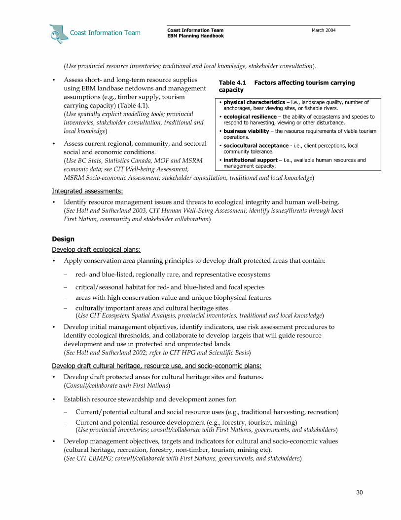
Coast Information Team
Coast Information Team March 2004 EBM Planning Handbook
30
(Use provincial resource inventories; traditional and local knowledge, stakeholder consultation).
• Assess short- and long-term resource supplies using EBM landbase netdowns and management assumptions (e.g., timber supply, tourism carrying capacity) (Table 4.1). (Use spatially explicit modelling tools; provincial inventories, stakeholder consultation, traditional and local knowledge)
• Assess current regional, community, and sectoral social and economic conditions. (Use BC Stats, Statistics Canada, MOF and MSRM economic data; see CIT Well-being Assessment, MSRM Socio-economic Assessment; stakeholder consultation, traditional and local knowledge)
Integrated assessments:
• Identify resource management issues and threats to ecological integrity and human well-being. (See Holt and Sutherland 2003, CIT Human Well-Being Assessment; identify issues/threats through local First Nation, community and stakeholder collaboration)
Design
Develop draft ecological plans:
• Apply conservation area planning principles to develop draft protected areas that contain:
− red- and blue-listed, regionally rare, and representative ecosystems
− critical/seasonal habitat for red- and blue-listed and focal species − areas with high conservation value and unique biophysical features − culturally important areas and cultural heritage sites.
(Use CIT Ecosystem Spatial Analysis, provincial inventories, traditional and local knowledge)
• Develop initial management objectives, identify indicators, use risk assessment procedures to identify ecological thresholds, and collaborate to develop targets that will guide resource development and use in protected and unprotected lands. (See Holt and Sutherland 2002; refer to CIT HPG and Scientific Basis)
Develop draft cultural heritage, resource use, and socio-economic plans:
• Develop draft protected areas for cultural heritage sites and features. (Consult/collaborate with First Nations)
• Establish resource stewardship and development zones for:
− Current/potential cultural and social resource uses (e.g., traditional harvesting, recreation) − Current and potential resource development (e.g., forestry, tourism, mining)
(Use provincial inventories; consult/collaborate with First Nations, governments, and stakeholders)
• Develop management objectives, targets and indicators for cultural and socio-economic values (cultural heritage, recreation, forestry, non-timber, tourism, mining etc). (See CIT EBMPG; consult/collaborate with First Nations, governments, and stakeholders)
Table 4.1 Factors affecting tourism carrying capacity
• physical characteristics – i.e., landscape quality, number of anchorages, bear viewing sites, or fishable rivers.
• ecological resilience – the ability of ecosystems and species to respond to harvesting, viewing or other disturbance.
• business viability – the resource requirements of viable tourism operations.
• sociocultural acceptance - i.e., client perceptions, local community tolerance.
• institutional support – i.e., available human resources and management capacity.

Coast Information Team
Coast Information Team March 2004 EBM Planning Handbook
31
• Develop draft socio-economic transition strategies, management institutions, etc.
Integration (iterative process of negotiation and assessment to finalize plans)
• Develop alternative land use zoning and management direction scenarios and for each assess:
− Risk to ecological integrity (coarse filter biodiversity, focal species, etc.). (See Holt and Sutherland 2003)
The extent to which draft land use designations capture areas with high conservation value, red- and blue-listed and focal species habitats, regionally rare ecosystems, etc. (Use CIT Ecosystem Spatial Analysis, provincial inventories, local knowledge)
– Timber harvest level and profile per EBM landbase netdowns and management targets (e.g., seral targets, stand retention).
(Use forest cover data and spatially explicit timber supply analysis package) − Carrying capacity/acceptable limits for tourism, wilderness recreation, sport fishing, etc. (Assess biophysical, ecological thresholds, local community acceptance, and management capacity) − Flow and distribution of natural resources and economic benefits. (See B.C. Ministry of Sustainable Resource Management 2003)
• Negotiate final land use plan that achieves ecological, cultural, and socio-economic objectives.
• Negotiate agreement with First Nations re: consultation, cultural heritage, and economic interests.
• Identify key management uncertainties and develop adaptive co-management programs that will engage planning participants in monitoring and assessment.
• Secure governmental and multi-party commitment to implement land use zoning, management direction and monitoring.
• Assess institutional arrangements (regulatory, policy, and management gaps and barriers). (Independent policy analysis, stakeholder consultation)
Implementation
• Establish a coordinating body (e.g., First Nations cooperative management boards, LRMP implementation committees), with representation from First Nations, government agencies, and stakeholders, to monitor plan implementation and work to resolve issues as they emerge.
• Develop and secure governmental and stakeholder commitments such as supportive policies, cooperative arrangements, and agreements and resourcing (human, technical, and financial).
• Engage in adaptive, collaborative research programs to reduce uncertainties and improve management practices over time.
• Resource capacity building, training, and educational opportunities in support of EBM, with a focus on First Nations and local communities, mobilizing and using public agencies, private organizations, and community-business and public–private partnerships.
• Coordinate information collection and indicator monitoring over time to measure progress toward EBM goals and objectives.

Coast Information Team
Coast Information Team March 2004 EBM Planning Handbook
32
4.4 Territory/Subregional Planning and Management Recommendations.
Note: The objectives, management requirements, targets, and indicators in Tables 4.2 and 4.3 are summarized from a number of sources including the CIT Scientific Basis, the CIT Hydroriparian Planning Guide , the Gitga’at-Kitasoo EBM pilot, and discussions among CIT EBM technical working groups. This work focused on issues related to biodiversity and aquatic habitat. Planning tables and practitioners working to implement EBM in different areas will need to develop additional or more refined objectives, targets and indicators relevant to the issues and values at hand, particularly with respect to focal species, cultural heritage, and socio-economic goals.
Table 4.2 Territory/subregional land and resource management guidelines
Element Objective Assessments Planning requirements & management targets* Indicators Potential data sources
Ecological representation (terrestrial & riparian)
• Maintain the natural diversity of species, ecosystems, seral stages.
• Establish protected areas and reserves that represent the biological diversity of the region.
• Assess natural disturbance regimes and characteristics by ecoregion.
• Assess natural forest age class distribution by BEC variant and site series; assess current distribution.
• Conduct representation/gap analysis to identify common and under-represented ecosystems/habitats.
• Secure representation of all ecosystem types in protected areas.
• Protect or reserve naturally occurring, regionally rare ecological features.
• Maintain 97% of the natural riparian forest next to estuaries and in karst landscapes.28
• Maintain 90% of the natural riparian forest next to floodplains, fans, forested swamps, and small steep streams/gullies with unique microclimate.29
• Maintain 70% of the natural riparian forest next to other aquatic ecosystems.
• Maintain 70% of the natural old seral distribution in each ecosystem type.
• Species, ecosystem and seral stage representation within reserves and outside reserves.
Satellite Photos, Air Photos, Forest Cover, PEM, TEM, Air Reconnaissance.
Endangered & rare ecosystems/ species and focal wildlife
• Protect known red- and blue-listed and regionally rare ecosystems.
• Protect known red- and blue-listed/regionally rare species and their habitats; if needed restore habitats.
• Maintain healthy, well-distributed populations/sub-populations of focal species
• Collate inventory of known red- and blue-listed and regionally rare ecosystem occurrences.
• Use current inventory to assess habitat capability/suitability for red- and blue-listed and focal species.
• Protect or reserve 100% of known red-listed plant communities and other non-listed naturally rare ecosystems. 30
• Protect or reserve 70% of known occurring blue-listed plant communities.
• Protect, and where needed restore, critical habitats for red- and blue-listed and focal wildlife species (including corridors).
• Establish habitat supply objectives for red- and blue-listed and focal wildlife species based on assessment of habitat capability, habitat suitability, carrying capacity and population estimates.
• Red- and blue-listed & focal species population trends & distributions.
• Amount and distribution of critical habitat protected for red- and blue-listed species.
Conservation Data Centre (CDC) Listings, TEM, PEM, Forest Cover, Air photos, Provincial Wildlife Tables, Local Knowledge, Field Surveys.
Aquatic ecosystems/fish habitat
• Protect and sustain freshwater and coastal zone aquatic ecosystems.
• Protect and sustain high value fish habitat.
• Collate available data to assess sub-regional hydrological characteristics
• Collate inventory of known aquatic ecosystems.
• Collate salmonid/freshwater fish habitat and escapement data.
• Apply low risk management targets to watersheds containing abundant salmon populations.
• Apply low risk management targets to watersheds containing significant Class V & IV Terrain.
• ECA in all watersheds.
• Salmon escapement.
• % removal of riparian forest by ecosystem type.
Stream Assessments, Streamflow/Precipitation Data, TEM, PEM, Forest Cover, terrain mapping, SinMap, FISS, SEDS, Field Surveys
* Protected areas contribute to territory/subregional management targets. 28 The Hydroriparian Planning Guide defines riparian forests as forests influenced by water (including high-bench floodplain) plus an area extending one and a half tree heights beyond. 29 Refer to the Hydroriparian Planning Guide and related background reports for definitions and descriptions of specific hydroriparian ecosystems. 30 Naturally rare ecosystems (i.e., regionally rare ecosystems with limited natural distribution, not made rare through human disturbance), that have been harvested should be reserved
from further harvesting or development.

Coast Information Team
Coast Information Team March 2004 EBM Planning Handbook
33
Table 4.2 Territory/subregional land and resource management guidelines (Continued)
Element Objective Assessments Planning requirements & management targets Indicators Potential Data Sources
Soils & terrain • Conserve soil productivity.
• Protect unstable slopes.
• Collate available geology, surficial geology and terrain mapping.
• Reserve Class V terrain.
• Number, size, origin and consequence of natural and development induced landslides.
Geological/Mineral Data, PEM, TEM, Forest Cover, Field Surveys, SinMap
Access & facilities.
• Public access and facilities minimize impacts to cultural & ecological values, and are consistent with objectives for these values
• Inventory transportation routes/infrastructure (known roads, flight lines, etc.)
• Inventory public/commercial resource access and infrastructure (log dumps, foreshore leases, trails, commercial recreation tenures)
• Establish no-access and facility development zones around significant cultural and ecological features.
• Appropriate access and facilities management strategies in place prior to development.
• % of landbase occupied by access structures inside and outside the timber harvesting landbase.
Air Photos, Forest Cover, TRIM, Air Reconnaissance, Local Knowledge.
Table 4.3 Territory/subregional socio-economic planning guidelines
Element EBM objective Assessments Planning requirements & management targets Indicators Potential data sources
First Nations • Recognize and accommodate aboriginal Rights and Title.
NA • Establish cooperative management of lands and resources.
• Governments and tenure holders have agreements with First Nations regarding consultation, resource management and use, and economic interests.
• Existence of co-management agreements.
• First Nations – Tenure Holder Agreements.
NA
Culture & heritage
• Protect cultural heritage sites and features.
• Protect and conserve cultural resources – cedar, plants, wildlife, etc.
• Inventory cultural heritage resources.
• Governments and resource tenure holders have agreements with First Nations regarding the protection and management of cultural heritage resources.
• Implementation of First Nations cultural heritage policies.
• Percentage of known cultural heritage sites protected.
• Known inventory and harvest levels of cultural resources.
MSRM Arch Branch, Provincial Archives, First Nations, local knowledge
Community health & economy
• Provide adequate opportunities for individuals and households to meet their needs.
• Community working population has opportunity to engage in meaningful employment.
• Community members can meet their financial needs and maintain a basiclifestyle as defined by community members themselves.
• Community has access to local resources for development.
• Protect vulnerable communities by enhancing livilihood opportunities in the formal and informal economies.
• Welll-being assessment
• Vulnerability assessment
• Distribution analysis
• Socio-economic assessment
• Local communities receive a fair share of benefits flowing from local resource extraction.
• Vulnerable sectors of the community are protected.
• Population demographics.
• Life expectancy at birth.
• Individual/family income; employment by sector.
• Low income population as % of total population.
• Individual/family dependence on social assistance.
• Local share of access to resources.
• Violent crime rate.
• Local involvement in resource decisions.
BC Stats, Statistics Canada, MOF, MSRM, regional health and education districts, etc.

Coast Information Team
Coast Information Team March 2004 EBM Planning Handbook
34
Table 4.3 Territory/subregional socio-economic planning guidelines (Continued)
Element EBM objective Assessments CIT planning & management targets Indicators Possible data sources
Fish & wildlife:
Sustenance, recreational & commercial,
• Maintain healthy populations/sub-populations of harvested fish and wildlife.
• Do not exceed sustainable harvest levels.
• First Nations have access to sustenance harvesting.
• Collate wildlife harvest and freshwater fish catch information
• Establish precautionary harvest levels for fish and wildlife.
• Fish and wildlife population censuses.
• Fish and wildlife harvest/trapping levels.
MSRM, MWLAP, industry associations, local outfitters,
First Nations
Tourism & recreation
• Maintain natural scenic quality.
• Conserve and/or enhance recreation resources.
• Ensure that tourism development minimizes impacts to cultural and ecological values.
• Develop and support viable tourism business opportunities.
• Inventory current and potential public recreation use.
• Assess tourism and commercial recreation features and uses.
• Assess visual or wilderness experience landscape.
• Assess tourism carrying capacity and acceptable limits.
• Establish visual quality zones, recreation resource and visitor management strategies, and protocols for cultural heritage access, wildlife viewing, etc.
• Visitor numbers and recreation use days.
• Integrity of areas used for recreation.
• Community support for tourism.
• Sector and business profitability.
Tourism BC, Land & Water BC, BC Stats, industry
associations, local operators
Forests & Forest Products
• Do not exceed sustainable harvest levels.
• Maintain forest productivity.
• Maintain a diversity of harvesting opportunities for timber and non-timber forest products.
• Inventory operable timber landbase, species profile and volume.
• Assess timber supply considering EBM objectives and targets.
• Assess current and potential timber supply requirements and options.
• Harvest levels over 10 year planning period are sustainable.
• Harvest profile over 10 year planning period reflects available inventory profile.
• First Nations, governments and Licensees coordinate and sustain viable forestry business opportunities.
• Volume, species, grade and area of timber and non-timber forest products harvested.
• Species, stocking and growth rate of regenerating stands.
• Sector and business profitability.
• Ministry of Forests, BC Stats, Statistics Canada, industry associations, licensees
Mining • Allow access for mineral, aggregate or energy activities outside of protected areas.
• Exploration and development is consistent with land use plans.
• Estimate resources and reserves.
• Inventory claims and ownership.
• Inventory capital inventory (roads, infrastructure, processing facilities, and abandoned sites).
• All applications for access are to be considered and evaluated for permitting requirements, in consideration of EBM requirements and targets, other resource values and public and First Nations interests.31
• Resource estimates.
• Production levels.
• Business profitability.
• Number of claims.
• Active prospects.
• Ministry of Energy & Mines, BC Stats, Statistics Canada, Industry Associations
31 For a discussion of planning best practices for the mineral sector see IISD. 2004. Out of respect: The Tahltan, mining and the seven questions to sustainability, Report of the Tahltan
Mining Symposium, April 4–6, 2003.

Coast Information Team
Coast Information Team March 2004 EBM Planning Handbook
35
Example 1 Overview territory planning example (from Gitga’at EBM Pilot)
Territories/subregions are the focus of strategic land and resource planning. The goal at this scale is to engage governments and stakeholders in a collaborative process of discussion and negotiation to:
• Develop broad land use zones that will protect important ecological and cultural areas and secure sufficient access to resources.
• Design resource management objectives, targets and indicators that will ensure sustainable resource management in unprotected landscapes.
• Negotiate arrangements/agreements that secure plan commitments, recognize and provide accommodation for First Nations Rights, Title and interests, provide benefits to local communities and support ongoing implementation and monitoring.
Step 1 Collate and refine available inventory and other information including:
• biophysical inventory (TRIM, geology, surficial geology, etc.)
• ecological inventory (BEC, TEM, ssPEM, forest cover, wildlife habitat models & tables, salmon escapement, etc.)
• cultural heritage inventory (elders knowledge, local knowledge, archeological records, historical records, etc.)
• traditional and local knowledge
• integrated regional priority/ranking analyses (e.g., watershed valuation, CIT ESA)
• economic inventory (timber landbase, tourism use and potential, mineral potential, etc.)
Step 2 Assess current/potential condition of ecosystems and natural resources:
• past development (forestry, mining, infrastructure, etc.)
• current forest inventory and long term harvest levels
• ecological trends and risks
• current/potential tourism use and carrying capacity
• current/potential mineral and hydro development,
Step 3 Assess current and potential socio-economic conditions including:
• institutional arrangements (policy barriers and management gaps)
• resource development tenures and opportunties (forestry, mining, infrastructure, etc.)
• community well-being (demographics, employment, education etc.)
• resource sector well-being (profitability, market access, etc.)
Step 4 Divide the planning area into landscape and watershed planning units based on cultural and biophysical criteria, and organize inventories and assessments by planning unit (Figure 1).
Step 5 Develop draft conservation plans informed by regional and subregional goals and targets that includes:
• candidate protected areas and cultural and ecological reserves
• management objectives for ecological and cultural resources
• cooperative management arrangements for protected areas
Figure 1. Gitga’at Territory landscape and watershed planning units.

Coast Information Team
Coast Information Team March 2004 EBM Planning Handbook
36
Example 1 Overview territory planning example (Continued)
Step 6 Develop draft socio-economic plans including:
• resource tenure and access arrangements (for First Nations, local communities, businesses, and public)
• management objectives for natural resources (sustenance, commercial and public)
• resource development agreements and partnerships (among First Nations, senior governments, and businesses)
Step 7 Assess ecological, cultural, social and economic implications of draft plans:
• natural resource access and long term resource supplies (timber, tourism, mininging, recreation)
• ecosystem representation and wildlife habitat supply
• informal and sustenance economic activities (hunting, trapping, traditional harvesting etc.)
•
Step 8 Negotiate and finalize land use that includes:
• land use allocations (for ecological protection; cultural, public and commercial resource use; cultural heritage sites, restoration, etc.)
• management direction (objectives, requirements, targets and indicators for ecological, cultural and natural resources)
• socio-economic development plans for local communties and affected sectors and businesses
• mechanisms for producing and sharing information
• adaptive co-management arrangements geared toward resolving key planning and mangement uncertainties
• interim agreements that secure access to, and benefits from, resource development for First Nations, and
• implementation commitments (resources for monitoring, arranagements for joint implementation or collaborative management at lower scales).
Figure 3. Example territory land use plan.
Figure 2. Example timber supply analysis of land use scenarios in Gitga’at Territory.

Coast Information Team
Coast Information Team March 2004 EBM Planning Handbook
37
5 Landscapes and Watersheds
5.1 Overview
Landscape and watershed EBM planning is the scale at which higher-level land use designations and resource management direction are translated into reserve designs and resource development and stewardship plans. Key objectives are to improve inventories, perform tactical assessments and develop initial landscape and watershed designs and plans using a mix of GIS analysis, air photo analysis, reconnaissance surveys, and the involvement of affected First Nations, communities, and businesses.
Landscape planning occurs over relatively uniform areas ranging in size from 25,000 to 100,000 hectares, and deals with broad ecological and economic assessments and strategic allocation of watershed management targets. Watershed planning focuses on tactical conservation and resource development planning within primary watersheds ranging in size from 1,000 to 50,000 hectares.
Landscape and watershed scale planning now occurs within the context of sustainable resource management and forest stewardship planning.32
In general, landscape and watershed plans should not be implemented before higher-level planning is complete (but see Section 7.2).
5.2 Key Characteristics
Key characteristics of EBM planning at landscape and watershed scales include:
• Planning is collaborative, engaging relevant First Nations, government agencies, local government, and affected stakeholders as necessary.
• Ecosystem and hydroriparian inventory data are explicitly integrated into the planning process. Ecosystem inventories, for example, are used to design initial landscape and watershed reserves and also to assess the impact that proposed development plans may have on biodiversity.
• Strategic direction in the form of cautious management targets and thresholds guides reserve design, resource development, and where necessary restoration planning. Comparison of the current old forest abundance in each site series in a watershed to established targets, for example, defines how much of each ecosystem type is available for harvesting. Or in heavily logged drainages such analysis may reveal how much of each ecosystem type must be reserved to allow recovery of old forest representation.
• Cooperative management arrangements and business partnerships between local First Nations and communities, businesses and government agencies can provide a framework for collaborative planning and management.
32 See B.C. Ministry of Sustainable Resource Management. 2002. Sustainable resource management planning: A landscape-level
strategy for resource development. Resource Planning Branch, Victoria, B.C. See also Province of British Columbia. 2004. BC’s new forest and range practices framework: FRPA training companion guide. Victoria, B.C.

Coast Information Team
Coast Information Team March 2004 EBM Planning Handbook
38
5.3 Landscape Planning
First Nations, government agencies, and stakeholders must be consulted and engaged as necessary in assessment, design, and integration phases.
(Possible Data and Knowledge Sources in italics)
Assess
• Estimate natural ecosystem/seral stage representation and assess current representation in relation to designated risk management targets. Estimate area available for harvest by ecosystem type. (Use TEM, PEM, and BEC-forest cover)
• Identify known red- and blue-listed and rare ecosystems; red- and blue-listed and focal wildlife habitat. (TEM, PEM, and BEC-forest cover, traditional and local knowledge)
• Reconnaissance inventory cultural and social uses and economic development interests including:
– cultural heritage sites and traditional harvesting areas – known and potential recreation sites and areas – known scenic values/visual quality objectives, and − resource development interests (timber, non-timber, tourism, mining, etc.)
(All available inventories, background reports, local and cultural knowledge, collaboration with local First Nations and user groups)
Design
• Identify initial ecological reserve elements including:
– known red- and blue-listed and rare ecosystems. – known critical habitats for red- and blue-listed and focal wildlife species, and – one-and-a-half tree height buffers next to known streams, wetlands, and active floodplains.
(CDC listings, TRIM, TEM, PEM, forest cover, terrain mapping)
• Identify initial resource development and use interests (cultural, tourism, forestry mining, etc.)
• Develop watershed planning units and catalogue ecological, cultural, social, and economic values.
Integrate
• Negotiate and allocate management objectives and targets to individual watersheds within the landscape.
• Secure multi-party commitment to implement watershed management targets.
Implement
• Engage in watershed planning, adaptive management, monitoring etc.

Coast Information Team
Coast Information Team March 2004 EBM Planning Handbook
39
5.4 Watershed Planning
Planning is primarily technical, but First Nations, government agencies, and stakeholders must be consulted and engaged as necessary in assessment, design, and integration phases.
Assess
• Map ecosystem types and age classes; assess natural ecosystem/seral class representation; assess current representation and estimate area available for harvest according to management targets. (Use TEM, PEM, and forest cover)
• Identify and map:
– Hydroriparian ecosystems and process zones. (See Hydroriparian Planning Guide; use TEM, PEM, forest cover and terrain mapping)
– Known red- and blue-listed and rare ecosystem occurrences. (Refer to CDC listings; consult regional/district ecologists; use PEM, TEM, and forest cover)
– Known red- and blue-listed and focal wildlife species habitats. (Refer to CDC listings; consult regional/district ecologists/wildlife biologists; use PEM, TEM, and/or forest cover and provincial habitat tables)
– Environmentally sensitive sites, poor growing sites, and unstable terrain (Class IV and V). (Use forest cover, terrain mapping, and SinMap)
• Reconnaissance inventory:
– Cultural heritage resources. (Work with relevant First Nations to conduct cultural heritage reconnaissance inventory)
– Tourism/recreation features and uses (Review provincial inventories; consult with local tourism operations and recreation groups)
• Assess scenic viewsheds. (GIS analysis using TRIM; Visual landscape modeling)
• Reconnaissance survey economic opportunities; map timber harvesting interests and other resource development interests.33 (Use forest cover, provincial geological inventories; licensee and tenure holder consultation)
Design
• Develop initial watershed reserve plan that contains fixed and variable reserve elements (Table 5.1):
– cultural heritage sites and features – known red- and blue-listed ecosystems and rare
ecosystem occurrences – ecologically sensitive and unstable areas (poor
growing sites, ESA 1, class V terrain) – wetlands, alluvial fans, and active floodplains, and – buffers around all streams within the
transportation and deposition zones. (See HPG; see Example 3; use TRIM, TEM, PEM, forest cover and terrain mapping)
33 Reconnaissance refers to a mix of GIS analysis, air photo interpretation, and subjective air/field surveys.
Table 5.1 Ecological reserve types and elements
Reserve type Reserve element Fixed • Red- and blue-listed ecosystems
• Habitat for red-listed species • Critical habitat for blue-listed species. • Critical habitat for focal species • Regionally rare ecosystems • Ecologically sensitive areas (ESA 1) • Unstable terrain (Class V) • Riparian forest next to transport zones
Variable • Landscape connections • Wildlife migration/movement corridors
Target • Site series/old forest representation • Hydroriparian process zone retention • Watershed equivalent clearcut area

Coast Information Team
Coast Information Team March 2004 EBM Planning Handbook
40
• Identify additional reserves and management areas needed to address:
– ecosystem type/old and mid-seral representation targets – source zone reserve/small stream reserve targets – equivalent clearcut area targets – landscape connectivity – visual quality, tourism/recreation and other resource objectives.
(See Hydroriparian Planning Guide; use TRIM, TEM, PEM, forest cover and terrain mapping)
• Develop initial resource development plan (roads, infrastructure, harvest blocks, mine, etc.).
Integrate
• Overlay draft resource harvesting/development plans on draft watershed reserve design to identify complementary/conflicting uses and refine potential site plan boundaries.
• Where necessary, and within established management objectives, and targets, adjust watershed reserve design boundaries to address economic and operational constraints. (See Example 1 in EBMPG; use TRIM, TEM, PEM, forest cover and terrain mapping)
• Assess environmental risk relative to watershed targets and if necessary redesign. (Use TRIM, TEM, PEM, forest cover, terrain mapping, and air photos)
• Finalize draft resource development and use plans.
• Secure multi-party commitment to watershed plan.
• Secure multi-party commitment to benefit sharing, local contracting, employment, training, etc.
Implement
• Engage in site planning, adaptive management, monitoring. etc. (For adaptive management see Taylor 2000; use TRIM, TEM, PEM, forest cover and terrain mapping)

Coast Information Team
Coast Information Team March 2004 EBM Planning Handbook
41
5.5 Landscape & Watershed Planning and Management Recommendations
Note: The objectives, management requirements, targets, and indicators in Tables 5.2 and 5.3 are summarized from a number of sources including the CIT Scientific Basis, the CIT Hydroriparian Planning Guide, the Gitga’at-Kitasoo EBM pilot, and discussions among the CIT EBM technical working groups. This work focused on developing management direction for key issues including biodiversity and hydroriparian ecosystems. Planning tables and practitioners working to implement EBM in different areas will need to develop additional objectives, targets and indicators relevant to the issues and values at hand, particularly with respect to focal species, cultural heritage, and socio-economic goals.
Table 5.2 Landscape and watershed land and resource management guidelines
Elements EBM objective Assessments Planning requirements & management targets 34 Indicators Possible Data Sources
• Landscape Scale • Maintain 50% to 70% of the natural old seral distribution in each ecosystem type;
maintain 70% average distribution across all landscapes.
• Maintain less than 50% of each ecosystem type in mid-seral.
• In developed landscapes with more than 50% mid seral in the timber harvesting landbase, harvest or reserve managed stands to prevent excessive mid-seral.
Ecological representation (terrestrial &
riparian)
• Design harvest to approximate natural disturbance pattern and distribution.
• Maintain site series/old seral representation in watershed reserves and harvested stands.
• Assess site series/age class distribution in relation to management targets.
• Estimate area available for harvest in each site series.
• Where necessary estimate old forest restoration requirements.
Watershed Scale • Harvest pattern is informed by natural disturbance guidelines.
• Maintain 70% to 30% of the natural old seral distribution in each ecosystem type; watershed targets should average to the landscape target.35
• Maintain less than 50% of each ecosystem type in mid-seral.
• In developed watersheds with more than 50% mid-seral in the harvesting landbase, harvest or reserve managed stands to prevent excessive mid seral representation.
• Maintain 97% (ACM trigger) to 90% (high risk threshold) of the natural riparian forest on estuaries and in karst landscapes. Across all watersheds meet the subregional target.36
• Maintain 90% (ACM trigger) to 50% (high risk threshold) of the natural riparian forest next to floodplains, fans, forested swamps and small steep streams/gullies with unique microclimate. Overall meet the subregional target.
• Maintain 70% (ACM trigger) to 30% (high risk threshold) of natural riparian forest around remaining hydroriparian ecosystems. Overall meet subregional target.
• Create small stream protection areas to include riparian corridors.
• Ecosystem type/seral stage distribution within and outside of reserves.
• % deviation from natural amount of old forest by ecosystem type.
Satellite Photos, Air Photos, Forest Cover, PEM, TEM, Air Reconnaissance.
34 Refer to the Hydroriparian Planning Guide and related background reports for definitions and descriptions of specific hydroriparian ecosystems. 35 Management should not exceed the 30% high risk threshold in any watershed. 36 Low risk management targets for hydroriparian objectives at the watershed scale represent triggers for adaptive management, not management caps.

Coast Information Team
Coast Information Team March 2004 EBM Planning Handbook
42
Table 5.2 Landscape and watershed land and resource management guidelines (Continued)
Elements EBM objective Assessments Planning requirements & management targets Indicators Possible data sources
Endangered & rare ecosystems/ species and focal wildlife
• Maintain adequate and sufficiently distributed habitat to maintain healthy populations and individuals of red- and blue-listed and focal species.
• Identify and reserve key wildlife migration/ movement corridors.
• Refine inventory of red- and blue-listed and regionally rare ecosystems (GIS, air photos, air reconnaissance).
• Refine inventory of red- and blue-listed wildlife species and their habitats (GIS, air photos, air reconnaissance)
• Reserve 100% of known and potentially occurring red-listed and other non-listed naturally rare ecosystems. 37
• Reserve 70% of known occurring blue-listed ecosystems.
• Design reserves to maintain representation of ecosystems that are rare in the landscape.
• Protect critical habitat and maintain connectivity for red- and blue-listed and focal wildlife species.
• Distribution of red- and blue-listed ecosystems.
• Amount of highly suitable habitat by sub-population area.
• Abundance and distribution of focal and red- and blue-listed species.
Conservation Data Centre (CDC) Listings, TEM, PEM, forest cover, air photos, provincial wildlife tables, local knowledge, field surveys.
Aquatic ecosystems/ fish habitat
• Protect critical and sensitive hydroriparian ecosystems.
• Maintain streamflow, channel characteristics & water quality within range of natural variability.
Watershed Only • Identify hydroriparian
process zones and hydroriparian ecosystems.
• Assess watershed condition in relation to management targets.
Watershed Only * • Reserve all wetlands, active floodplains, active fluvial
units and high value fish habitat including buffer.38
• Reserve riparian forest around streams in the transporation and deposition zones.39 Use windfirm buffers.
• Maintain 70% of the natural riparian forest in the source zone.
• Maintain less than 20% (roaded) to 30% (unroaded) ECA.
• ECA in watershed & initiation zone.
• Index of road density/ECA in initiation zone.
• % of riparian forest harvested in process zones.
• % deviation from natural riparian forest by hydroriparian ecosystem.
• Streamflow, channel morphology, and water quality.
• Aquatic invertebrate diversity and abundance.
stream assessments, streamflow/precipitation data, TEM, PEM, forest cover, terrain mapping, SinMap, FISS, SEDS, field surveys
Soil & Terrain • Conserve soil productivity.
• Protect unstable slopes
• Collate available bedrock geology and surficial geology data.
• Collate available terrain stability and terrain mapping; perform terrain mapping where needed.
• Identify and map environmentally sensitive sites, poor growing sites & Class IV and V terrain.
Watershed Only Reserve areas with class V slope stability.
• Number, size, origin, and consequence of natural and development induced landslides.
• Area of forest cleared in class IV and V terrain.
geological/mineral data, PEM, TEM, forest cover, field surveys, SinMap
*Watershed scale aquatic ecosystem targets are precautionary guidelines that can be exceeded if effective adaptive management commitments are in place.
37 Naturally rare ecosystems (regionally rare ecosystems with limited natural distribution, not made rare through human disturbance), that have been harvested should be reserved from further
harvesting or development. 38 Hydroriparian buffers are equal to 1.5 times the height of the dominant trees. 39 Buffers are established to maintain stream morphology and coarse woody debris inputs.
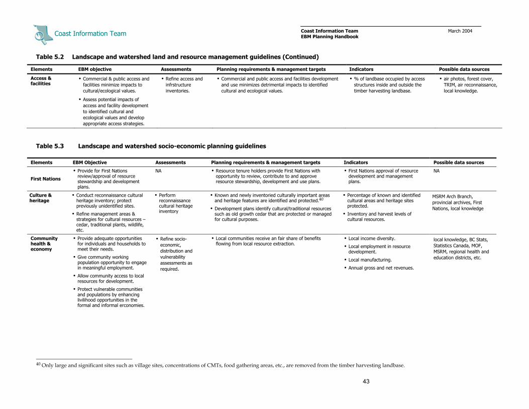
Coast Information Team
Coast Information Team March 2004 EBM Planning Handbook
43
Table 5.2 Landscape and watershed land and resource management guidelines (Continued)
Elements EBM objective Assessments Planning requirements & management targets Indicators Possible data sources
Access & facilities
• Commercial & public access and facilities minimize impacts to cultural/ecological values.
• Assess potential impacts of access and facility development to identified cultural and ecological values and develop appropriate access strategies.
• Refine access and infrstructure inventories.
• Commercial and public access and facilities development and use minimizes detrimental impacts to identified cultural and ecological values.
• % of landbase occupied by access structures inside and outside the timber harvesting landbase.
• air photos, forest cover, TRIM, air reconnaissance, local knowledge.
Table 5.3 Landscape and watershed socio-economic planning guidelines
Elements EBM Objective Assessments Planning requirements & management targets Indicators Possible data sources
First Nations
• Provide for First Nations review/approval of resource stewardship and development plans.
NA • Resource tenure holders provide First Nations with opportunity to review, contribute to and approve resource stewardship, development and use plans.
• First Nations approval of resource development and management plans.
NA
Culture & heritage
• Conduct reconnaissance cultural heritage inventory; protect previously unidentified sites.
• Refine management areas & strategies for cultural resources – cedar, traditional plants, wildlife, etc.
• Perform reconnaissance cultural heritage inventory
• Known and newly inventoried culturally important areas and heritage features are identified and protected.40
• Development plans identify cultural/traditional resources such as old growth cedar that are protected or managed for cultural purposes.
• Percentage of known and identified cultural areas and heritage sites protected.
• Inventory and harvest levels of cultural resources.
MSRM Arch Branch, provincial archives, First Nations, local knowledge
Community health & economy
• Provide adequate opportunities for individuals and households to meet their needs.
• Give community working population opportunity to engage in meaningful employment.
• Allow community access to local resources for development.
• Protect vulnerable communities and populations by enhancing livilihood opportunities in the formal and informal erconomies.
• Refine socio-economic, distribution and vulnerability assessments as required.
• Local communities receive an fair share of benefits flowing from local resource extraction.
• Local income diversity.
• Local employment in resource development.
• Local manufacturing.
• Annual gross and net revenues.
local knowledge, BC Stats, Statistics Canada, MOF, MSRM, regional health and education districts, etc.
40 Only large and significant sites such as village sites, concentrations of CMTs, food gathering areas, etc., are removed from the timber harvesting landbase.

Coast Information Team
Coast Information Team March 2004 EBM Planning Handbook
44
Table 5.3 Landscape and watershed planning guidelines (Continued)
Elements EBM objective Assessments Planning requirements & management targets Indicators Possible data sources
Fish & wildlife:
Sustenance, recreational & commercial
• Maintain sustenance and recreational, hunting, fishing, and trapping opportunities.
• Refine wildlife habitat inventories and sub-population estimates.
• Collate wildlife harvest and freshwater fish catch information
• Establish precautionary harvest levels for fish and wildlife.
• Amount and distribution of highly suitable habitat or winter range for wildlife.
• Fish and wildlife harvest levels.
MSRM, MWLAP, industry associations, local outfitters, First Nations
Tourism & recreation
• Conserve and enhance recreation resources.
• Refine visual quality objectives and special management area boundaries and strategies.
• Limit tourism and recreation impacts on cultural and ecological values.
• Refine public recreation inventory.
• Map known and newly identified recreation features, sites, and uses.
• Assess viewscapes.
• Develop access management strategies that minimize impacts to ecological and cultural resources.
• Visitor numbers and recreation use days.
• Integrity of recreation sites.
Tourism BC, Land & Water BC, BC Stats, industry associations, local operators
Forests & forest products
• Maintain viable, diversified, and profitable businesses in the timber and non-timber harvest sectors.
• Develop new markets for non-timber forest products.
• Refine timber and non-timber inventories.
• Refine operability and harvesting landbase definition.
• Assess harvest opportunities & profile.
• Inventory timber and non-timber harvesting interests.
• Refine operable timber landbase, species profile, and volume inventories as necessary.
• Inventory and map timber harvesting interests and non-timber harvesting potential.
• Maintain viable harvesting opportunities in operable watersheds.
• Volume, species, grade, and area of timber and non-timber forest products harvested.
• Species, stocking, and growth rate of regenerating stands.
Ministry of Forests, BC Stats, Statistics Canada, industry associations, licensees, local knowledge.
Mining & energy
• Develop viable, diversified, and profitable businesses in the mineral and energy sectors.
• Enhance human well-being.
• Mining, from exploration to post-closure, maintains ecological integrity.
• Estimate resources and reserves.
• Perform CEEA screening; full CEEA if necessary.
• All applications for access are to be considered and evaluated for permitting requirements, in consideration of EBM requirements and targets, other resource values, and public and First Nations interests.
• Project permitting in accordance with provincial EEA and CEEA screening review
• Compliance with industry best practices.41
• Volume, type, and grade of extraction.
• Business profitability.
Ministry of Energy & Mines, BC Stats, Statistics Canada, industry associations, local knowledge
41 For a discussion of planning best practices for the mineral sector see IISD. 2004. Out of respect: The Tahltan, mining and the seven questions to sustainability. Report of the Tahltan Mining
Symposium, April 4–6, 2003.

Coast Information Team
Coast Information Team March 2004 EBM Planning Handbook
45
Example 2 Overview landscape planning example (from Gitga’at EBM Pilot)
Territory/subregional land use decisions provide the context for landscape planning (i.e., land use allocations and whether the landscape will be managed to low or moderate risk targets)
Landscape planning has strategic and tactical elements. The tactical work involves developing watershed planning units and mapping known landbase reserves such as protection areas, cultural areas, and red-listed ecosystems. The strategic work involves assessing landscape character and condition, and assigning management targets to each watershed according to their relative value.
Step 1 Conduct landscape inventories/assessments; where needed work to fill inventory gaps.
Step 2 Map known reserves such as protection areas, red-listed ecosystems, regionally rare ecosystems, cultural heritage sites and other fixed reserve elements.
Step 3 Assess landscape condition relative to landscape-level objectives and targets.
As an example, consider the Whalen landscape on northern Princess Royal Island. Comparing TEM site series data (Figure 1) with forest age class data (Figure 2) to determine age class distribution in each ecosystem type reveals that the landscape is overall in good condition relative to landscape representation targets (Figure 3). Past harvesting targeted certain site series – CWvh2/06, CWHvm1/01, CWvm1/03 and CWHvm1/06 – but the amount of old forest in each of those site series is still above the low risk target of 30% departure from the natural range.
Figure 1. Whalen landscape TEM site series. Figure 2. Whalen landscape forest age class.
Figure 3. Whalen site series/seral stage distribution.
More detailed analysis of site series/age-class distribution in each watershed may reveal that certain drainages have been disturbed beyond targets or high risk thresholds (e.g., the watershed circled in red in Figure 2) highlighting the need to develop watershed reserve plans that will restore old forest representation in impacted site series.

Coast Information Team
Coast Information Team March 2004 EBM Planning Handbook
46
Example 2 Overview landscape planning example (Continued)
Step 4 Develop watershed planning units and assign management targets based on their relative ecological, cultural, and economic value.
Figure 4 shows the Whalen Landscape divided into 13 watershed planning units. From a forestry perspective they can be considered “woodsheds” because each will require its own road or helicopter access system. The watershed planning units range in size from about 1000 hectares (W6) to 9000 hectares (W4), reflecting a best effort to develop watershed planning units of a size recommended by the Hydroriparian Planning Guide.
Management targets have been negotiated and assigned to each of the watersheds using the following criteria:
• cultural heritage value
• salmon presence and abundance
• red- and blue-listed and rare ecosystem presence
• red- and blue-listed and focal species presence
• ecosystem diversity and abundance
• freshwater fish presence and abundance
• presence of unique natural features
• past development
• timber harvesting potential
• recreation and tourism use
• mineral development potential
Table 1 summarizes the values and the management targets that have been allocated to each watershed in the landscape. Valuation draws on technical analysis (e.g., ecosystem representation,timber inventory) as well as traditional, local, and cultural knowledge (e.g., presence of cultural heritage and recreation values). Management targets have been allocated to particular watersheds through a collaborative process of discussion and negotation among First Nations, tenure holders, and other relevant parties. The emphasis is on protecting or applying precautionary or low risk management targets to watersheds with important cultural and ecological values, while enabling greater focus on resource development in watersheds with economic opportunities through application of less stringent management objectives and targets.
Table 1. Summary of values and risk targets of Whalen Landscape watersheds
Watershed Summary of watershed values Management emphasis
W1 High cultural values, scenic route, wildlife, tourism, freshwater fishing, and timber Precautionary (cultural, tourism)
W2 Salmon, timber, wildlife, previously developed in 1980s–2002 Low risk (biodiversity, aquatic)
W3 High cultural values, wilderness, salmon, wildlife, tourism, and timber timber Protection (cultual, wilderness)
W4 Kermode bears, freshwater fishing, recreation and timber; previously developed Low risk (bear habitat,biodiversty)
W5 Cultural values, scenic, wildlife, and timber Moderate risk
W6 Cultural values, scenic, wildlife, and low timber Moderate risk
W7 Scenic corridor, wildlife, and low timber Moderate risk
W8 Scenic corridor, wildlife, high timber productivity; extensively developed in 1980s Moderate risk (restoration)
W9 Scenic corridor, wildlife, productive timber; extensively developed in 1980s Moderate risk (restoration)
W10 Scenic corridor, wildlife, timber harvesting potentional High risk
W11 Scenic corridor, wildlife, current timber harvesting potential High risk
W12 Scenic corridor, wildlife, current timber harvesting potential High risk
W13 Scenic corridor, wildlife, current timber harvesting potential Low risk
Planning within “low risk” watersheds must strive to develop reserve designs and resource management plans that are consistent with, or come close to achieving, the low risk threshold for established watershed indicators. The amount of old forest havested from each ecosystem type, for example, should not exceed 30% of the natural distribution.
Planning within watersheds designated for higher risk management, on the other hand, is less constrained. Resource managers have more flexibility to achieve economic gains from forestry, tourism, mining, or other development. Forest engineers, for example, can develop harvesting plans that draw old forest abundance in represented site series by as much as the high risk threshold 70%. Overall, the average risk incurred across all watersheds in a landscape should be within the range of the landscape target.
Figure 4. Watershed management targets within Whalen Landscape.

Coast Information Team
Coast Information Team March 2004 EBM Planning Handbook
47
Figure 2. Fraser Reach sensitive terrain.
Figure 1. Fraser Reach hydroriparian process zones.
Figure 3. Fraser Reach draft watershed reserves.
Example 3 Overview watershed-level planning example (from Gitga’at EBM Pilot) Watershed planning is a tactical exercise that translates strategic management objectives into draft watershed stewardship plans. The first step is to identify fixed and potential variable reserve elements such as existing protection areas, red-listed ecosystems and wildlife corridors. The initial design is then compared with watershed targets to determine further requirements for site series/old seral representation, hydroriparian process zone retention and other target-based reserve elements. Forested land in excess of watershed targets is available for harvesting (i.e., the timber harvesting landbase). Restoration requirements will be defined if watershed targets cannot be met because of past development.
Step 1 Conduct watershed inventories and assessments; identify and where needed work to fill inventory gaps. Develop additional inventories as necessary including:
• tradtional harvesting and cultural heritage sites
• sterrain stability
• hydroriparian ecosystems
• hydroriparian process zones (Figure 1)
Step 2 Map fixed and potential variable reserve elements including (Figures 2 and 3):
• red- and blue-listed site series
• ecologically sensitive areas (ESA 1) & unstable areas (class V terrain)
• hydroriparian ecosystems (wetlands, active alluvial fans, floodplains)
• buffers around streams in the deposition & transportation zones equal to 1.5 x site potential tree height
• buffers next to high value fish habitat (spawning & rearing habitat) equal to 1.5 x potential tree height
• wildlife migration corridors and landscape connections.
Step 3 Identify additional target reserve requirements including:
• site series/old forest representation
• hydroriparian process zone targets
• equivalent clearcut area

Coast Information Team
Coast Information Team March 2004 EBM Planning Handbook
48
Figure 4. Assessing conservation and development designs.
Example 3 Overview watershed-level planning example (Continued)
Step 4 Map forest harvesting and/or other resource development interests and compare to initial reserve designs and watershed-level targets to identify potential conflicts and to assess whether old forest representation, hydroriparian process zone retention and other watershed targets are met (Figure 4). Identify additional target reserve requirements.
Step 5 Final watershed planning is informed by site-level planning. Field inventories and site assessments are used to develop site and watershed specific information as the basis for refining resource use and development plans. Plan integration is an iterative process of development plan adjustment and ecological and economic assessment; the goal being to developing a system of watershed reserves, restoration plans and development plans that achieves management targets and also produces a viable flow of economic benefits (Figure 5).
Assess Ecological, Cultural & Other Impacts
Assess Community &
Business Benefits (Jobs, Revenue,
Sustenance Harvests, Products)
Figure 5. Final design is an interactive process using ecological and economic assessment and site-level information.

Coast Information Team
Coast Information Team March 2004EBM Planning Handbook
49
6 Site/Stand
6.1 Overview
EBM planning at the site scale engages First Nations, agency, and industry technical staff as well as other interested parties in operational planning for resource stewardship, harvesting and site use. Planning outputs include completion of field assessments, refined watershed reserve designs, site resource development and management plans, and financially viable operational plans for forestry, tourism and other resource development.
At the site level, specific values or features are protected, or management prescriptions are defined, so as to ensure that site plans address higher-level goals and objectives.
Site planning deals with areas ranging from 0.5 to 250 hectares; typically under 100 hectares and at a map scale of 1:5,000.
In general, no site plan should be implemented before higher-level planning is complete (but see Section 7.2).
6.2 Key Characteristics
Key characteristics of EBM planning at the site scale include:
• Site planning is guided by knowledge of local natural disturbance characteristics.
• Detailed ecosystem and hydroriparian field data are collected and used in the site design process (e.g., vegetation inventory and stream assessment data are used to design site-level ecological reserves and retention patches).
• Site plans are informed by assessment of landscape and watershed condition relative to designated management targets (e.g., analysis of the amount of old forest in each site series the surrounding watershed will indicate which site series are rare or at risk and need to be incorporated in stand-level reserves).
• Cooperation and joint planning between businesses and local First Nations and communities with respect to socio-economic objectives provides a mechanism for enhancing local employment, contracting and manufacturing opportunities, and other local spin-off benefits.

Coast Information Team
Coast Information Team March 2004EBM Planning Handbook
50
6.3 Site/Stand Planning
Work is primarily technical, but First Nations, government agencies, and relevant stakeholders must be engaged and/or consulted as necessary to meet regulatory and legal requirements.
(Possible data and knowledge sources in italics)
Assess
• Perform timber reconnaissance, timber cruises, ecosystem surveys, deflection survey, etc. (Refer to Resource Inventory Committee standards and other relevant guides)
• Perform terrain stability assessments where necessary (i.e., Class IV and V terrain). (Refer to Resource Inventory Committee standards and other relevant guides)
• Perform site hydroriparian assessment. (See Hydroriparian Planning Guide)
• Perform archaeological impact assessments where necessary. (Refer to First Nations cultural heritage policies; RIC standards, MSRM Archaeology Branch guides and other relevant guides)
• Inventory red- and blue-listed plant species and communities. (Refer to Resource Inventory Committee standards and other relevant guides)
Integrated Design for Non-Forestry Site Plans:
• Develop a preliminary site plan that considers:
– higher-level reserve boundaries, ecological requirements/targets, and economic objectives
– regulatory requirements specific to the resource development or tenure application (e.g., Land and Water BC tenure process, Canadian Environmental Assessment screening review)
– optimal access, infrastructure, and resource use locations, and – business and financial objectives and constraints
• Assess potential terrestrial, hydroriparian, and coastal zone ecological impacts.
• Identify site reserves (e.g., red-listed ecosystems, sensitive hydroriparian habitats, sensitive coastal zone and marine habitats).
• Identify and work to address additional ecological risks (e.g., intertidal impacts of log or waste dumping).
• Develop specific adaptive management projects to monitor impacts and change site use and operational practices if necessary.
Integrated Design for Forestry Site Plans:
• Develop a preliminary site plan that considers:
– higher-level reserve boundaries and management objectives – optimum road and infrastructure locations and yarding or forwarding patterns

Coast Information Team
Coast Information Team March 2004EBM Planning Handbook
51
– timber and non-timber forest products harvesting – silvicultural objectives, and – safety and other operational considerations.
(follow standard site planning procedures while considering watershed reserves and targets; use field survey and site assessment data)
• Design stand-level retention that:
– is informed by knowledge of local natural disturbance characteristics – protects site series that are rare or at-risk in the surrounding watershed and landscape – protects special ecological elements (e.g., bear dens, small wetlands) – maintains stand structural legacies and ecosystem connectivity, and – addresses watershed-level ecological representation and hydroriparian targets.
(stand-level retention that is permanent contributes to watershed and landscape ecosystem/seral stage representation targets. Aggregate retention patches must be greater than 1 hectare. Dispersed retention contributes depending on the level of retention and other factors [i.e., 70% dispersed retention with no roads or landings and a natural species mix contributes as an unaltered stand; stands with 15% dispersed retention do not contribute])
• Review preliminary site plans with engineers and operators and where necessary revise cutting unit and retention boundaries to address operational and economic considerations. (Use field survey and site assessment data)
• Re-assess landscape-/watershed-level risk and revise cutting unit boundaries if risk to particular values/indicators exceeds watershed targets.
• Identify uncertainties and, when appropriate, adjust adaptive co-management research and monitoring projects to develop needed information.
Implement
• Pursue resource harvesting, silvicultural treatments, site infrastructure projects, etc.
• Perform monitoring projects as applicable.

Coast Information Team
Coast Information Team March 2004 EBM Planning Handbook
52
6.4 Site/Stand Management Planning and Management Recommendations.
Note: The objectives, management requirements, targets and indicators in Tables 6.1 and 6.2 are summarized from a number of sources including the CIT Scientific Basis, the CIT Hydroriparian Planning Guide, the Gitga’at-Kitasoo EBM pilot, and discussions among the CIT EBM technical working groups. This work focused on key issues. Planning tables and practitioners working to implement EBM in different areas and in different planning processes will need to develop additional objectives, targets, and indicators relevant to the issues and values at hand, particularly with respect to focal species, cultural heritage, and socio-economic goals.
Table 6.1 Site/stand environmental management guidelines
Element EBM Objective Assessments Planning requirements & management targets Indicators Possible data sources
Ecological representation
• Maintain biological legacies (e.g., wildlife trees, snags, CWD, understory vegetation).
• Contribute to watershed targets for ecological representation.
• Conduct ecological classification inventory (site series)
• Inventory special ecological elements (e.g., bear dens, small wetlands).
• Assess site series representation.
• Harvest block shape and retention is informed by local natural disturbance characteristics.
• Maintain 15–70% retention depending on watershed risk targets and site objectives.
• Distribute reserves/stand-level retention to maintain representation of rare and at-risk ecosystems.
• Maintain biological legacies.
• Site series/old forest retention.
• CWD species, size and abundance.
Field surveys, air photos, forest cover, PEM, TEM.
Endangered & rare ecosystems/ species and focal wildlife
• Maintain stand-level habitat structures for red- and blue-listed and focal species.
• Protect seasonally critical microsites & habitat elements (e.g., bear dens, raptor nests).
• Field survey red- and blue-listed plant communities and wildlife habitat features
• Reserve 100% of red-listed and other non-listed rare plant communities unless site assessments and prescriptions demonstrate maintenance of the rare values.
• Allocate retention to maintain representaton of blue-listed and naturally rare plant communities.
• Maintain stand structure to provide habitat for red- and blue-listed focal wildlife species.
• Number and abundance of habitat elements and features.
• Site use by species.
Field surveys, air photos, Conservation Data Centre (CDC) listings, TEM, PEM, forest cover, provincial wildlife tables, local knowledge.
Aquatic ecosystems/ fish habitat
• Protect sensitive hydroriparian ecosystems.
• Distribute stand-level retention as needed to meet hydroriparian targets.
• Survey hydroriparian ecosystems and conduct stream assessments as needed.
• Map process zones, hydroriparian ecosystems and streams.
• Map sensitive sites and high value fish habitat
• Survey and map intertidal and subtidal habitats.
• Reserve windfirm buffers around small steep streams and gullies with high susceptibility for debris flow.
• Modify buffers to improve windfirmness as needed.
• Reserve windform buffers next to coastal zone.
• Process zone retention.
• Channel morphology. Field surveys, stream assessments, forest cover, terrain mapping, SinMap, FISS, SEDS, field surveys.

Coast Information Team
Coast Information Team March 2004 EBM Planning Handbook
53
Table 6.1 Site/stand land and resource management guidelines (Continued)
Element EBM objective Assessments Planning requirements & management targets Indicators Possible data sources
Soils & terrain • Protect unstable slopes.
• Minimize adverse soil disturbance and loss of productive sites.
• Survey and map terrain and assess terrain stability where needed.
• Employ harvesting systems and operational practices that minimize loss of soil productivity.
• Conduct terrain stability assessments in Class IV and V terrain; reserve areas with moderate to high risk of slope failure.
• Detrimental site disturbance, other than access structures, does not exceed 5% of the cutblock area.
• Permanent access structures do not exceed 7% of cutblock area, over average.
• Seed areas with potential for soil erosion with native plant species.
• Area of detrimental soil disturbance.
Field surveys, terrain stability assessments, PEM, TEM, forest cover.
Access & facilities
• Commercial & public access and facilities minimize impacts to cultural/ecological values.
• Site engineering assessments.
• Maintain best management practices re: location of infrastructure. • Area of site disturbance. Field surveys, air photos, forest cover, TRIM.
Table 6.2 Site/stand socio-economic planning guidelines
Element EBM objective Assessments Planning requirements & management targets Indicators Possible data sources
First Nations • Provide for First Nations review and approval of site plans.
NA • Resource tenure holders provide First Nations with opportunity to review, contribute to, and approve site plans.
• First Nations approval of site plans
NA
Culture & heritage
• Protect cultural heritage features.
• Sustain cultural resources.
• Perform cultural heritage impact assessment.
• Heritage resource sites and features are protected with a no-development buffer or special management provisions that maintains the site or feature as agreed to by First Nations.
• Percentage of known and identified cultural areas and heritage sites protected.
Cultural heritage assessments, First Nations, local knowledge, MSRM Arch Branch, provincial archives.
Fish & wildlife: Sustenance, recreational, commercial
• Maintain sustenance, commercial and recreational, hunting, fishing, and trapping opportunities.
• Inventory local hunting, fishiing and trapping sites
• Significant fishing, hunting, and trapping areas are protected with a no-development buffers or special management provisions that maintains areas as agreed to by local users.
• Sportfish catch levels in lakes and streams.
First Nations, local outfitters, tourism operators.
Tourism & recreation
• Develop and sustain tourism enterrprises that support both business and cultural objectives.
• Assess site carrying capacity for tourism (e.g., bear viewing, cultural interpretation)
• Maintain site integrity.
• Do not exceed site carrying capacity.
• Visitor numbers and recreation use days.
• Site integrity.
Field reconnaissance, local operators, local knowledge.

Coast Information Team
Coast Information Team March 2004 EBM Planning Handbook
54
Table 6.1 Site/Stand land and resource socio-economic planning guidelines (Continued)
Element EBM objective Assessments Planning requirements & management targets Indicators Possible Data Sources
Forests & forest products
• Maintain viable, diversified and profitable businesses in the timber harvesting, non-timber forest products and value added sectors.
• Maintain site productivity and natural species mix.
• Conduct timber recce and deflection surveys.
• Survey road and landing locations.
• Conduct timber cruise.
• Tenure holders and operators have sufficient access to resources.
• Meet silvicultural requirements for regeneration, forest health and growth.
• Volume, species, grade, and area of timber and non-timber forest products harvested.
• Species, stocking, and growth rate of regenerating stands.
Field surveys, local licencees, Ministry of Forests, local knowledge.
Mining & energy
• Develop viable, diversified and profitable businesses in mining and energy sectors.
• Enhance human well-being
• Mining, from exploration to post-closure maintains ecological integrity.
• Estimate resources and reserves.
• Perform CEEA screening; full CEEA if development is proposed.
• All applications for access are to be considered and evaluated for permitting requirements, in consideration of EBM requirements and targets, other resource values and public and First Nations interests.
• Project permitting complies with provincial EEA and federal CEEA screeing.
• Compliance with industry best practices.42
• Volume, type, and grade of extraction.
• Business profitability.
Field surveys, local operations, local knowledge, Ministry of Energy & Mines.
42 For a discussion of planning best practices for the mineral sector, see IISD. 2004. Out of respect: The Tahltan, mining and the seven questions to sustainability. Report of the Tahltan Mining
Symposium, April 4–6, 2003.

Coast Information Team
Coast Information Team March 2004 EBM Planning Handbook
55
Table 1. Site scale reserve elements
Reserve type
Reserve element
Fixed • Culturally modified trees; cultural heritage features • Red- and blue-listed site series • Habitat features for red-listed species • Critical habitat features for focal species • Rare plant communities • Unstable terrain, gullies likely to mobilize sediment
Variable • Coarse woody debris, • Veteran large trees and snags • Patches with diverse canopy and understory
Stream tributary junctions
Target • Site series/old forest representation • Hydroriparian forest • Hydroriparian process zone retention
Figure 1. Initial site plan with retention.
Example 4 Overview site forestry planning example (from Gitga’at EBM Pilot)
The goal of site/scale planning is to operationalize resource development, resource use, and where necessary, restoration objectives. Land use zoning and reserve design at territory/subregion, landscape, and watershed scales defines where and when site planning will occur. Management requirements and targets, considered in the context of surrounding watersheds and landscapes, provides the objectives.
Site-level forestry design is operational. The first step is to perform site inventories and assessments and refine watershed reserve designs as the basis for developing an initial site plan that is financially viable and meets regulatory requirements. Initial site plans are then modified to address ecological and cultural objectives and requirements while taking into account engineering constraints and safety.
Step 1 Conduct site inventories and assessments as required; refine watershed reserve boundaries based on local knowledge annd site data.
Step 2 Design initial harvest plan that meets regulatory requirements and considers:
• watershed reserves and management targets (i.e., location and contribution of site series reserves)
• silvicultural objectives and requirements (i.e., reforestation & forest health)
• optimum road locations, potential landing sites, yarding or forwarding patterns, and other engineering considerations
• harvest volume, species, and grade objectives
• terrain stability, and
• other operational considerations such as safety and windthrow.
Step 3 Identify, design, and map potential site
reserve and stand retention elements including:
• local natural disturbance characteristics
• fixed site reserve elements such as red- and blue-listed plant communities, unstable terrain, CTMs, habitat features, etc.
• variable site elements such as CWD, stream tributaries, veteran trees, and snags, etc. (Figure 1, Table 1).
Step 5 Review watershed condition in relation to management requirements targets and identify, design and map additional target retention objectives such as site series/old forest representation or hydroriparian process zone retention.

Coast Information Team
Coast Information Team March 2004 EBM Planning Handbook
56
Figure 2. Revised site plan with additional variable retention.
Example 4. Overview site forestry planning example (Continued)
Step 6 Overlay additional reserve corridors and retention patches on the site development plan (Figure 2). Reserve corridors and retention patches should be designed to address natural disturbance guidelines and encompass:
• confluences of small streams, gullies
• at-risk or rare site series
• stream tributary junctions
• special ecological elements (e.g., wetlands, bear dens)
• patches with diverse canopy, understory, snags, CWD, etc., and
• patches that are representative of the pre-harvest stand.
Step 7 Engage in an iterative process of ecological, economic, and operational design and assessment with the goal of developing a final site plan that achieves watershed and site management objectives and also produces a viable economic opportunity (Figure 3).
Figure 3. Final site plan that meets biophysical/ecological objectives and also addresses economic objectives.

Coast Information Team
Coast Information Team March 2004 EBM Planning Handbook
57
7 Transition
7.1 Getting There from Here: Planning for Change
The commitment to EBM is new to the Central and North Coast and Haida Gwaii. It will take time, effort, and goodwill to make needed changes. Local communities and businesses will face adjustment. Transition strategies must be developed and managed to take the people and the economy successfully from old to new ways in reasonable time frames.
The transition to EBM is not the only source of change on the B.C. coast. Stresses already exist including unfinished treaty negotiations, past resource overharvesting, global market responses to perceptions of rainforest management, and changes in the forestry and fishing industries. The move to EBM holds promise in addressing these issues.
EBM implementation will occur in phases. In the short term some initial issues must be resolved, and immediate impacts mitigated. In the medium term, EBM-compatible institutions, plans, and strategies will have to co-exist with those of the past, causing some difficulties. In the longer run, the challenge will be to facilitate and enable the many potential cultural, social and economic benefits of EBM. Transition plans should address immediate negative impacts, institute required changes in a timely fashion with a minimum of instability, and create enabling conditions for beneficial change.
7.2 Lower-Level Planning in the Absence of Higher-Level Plans
Regional or territory/subregional planning provides guidance and direction for EBM at lower scales. However, higher-level strategic plans and cooperative management arrangements take time to develop and implement, and even when complete are not set in stone. A commitment to adaptive co-management implies that land uses and resource management targets will change as planning procedures, inventories, knowledge, and relationships improve.
Meanwhile communities and businesses depend on access to, and the benefits that flow from, use of natural resources within watersheds and in specific sites. When higher-level planning is not complete, precaution must guide interim management. Resource dependencies can be met in the short term by focusing operations in areas that initial regional and subregional assessments and planning discussions indicate do not contain significant ecological or cultural values. Such non-contentious areas may be characterized as having:
• low cultural value as identified by First Nations
• no known occurring red- and blue-listed species and ecosystems
• relatively low biodiversity, and common ecosystems
• no or low presence of anadromous fish, and
• limited or no conflict with other resource uses.

Coast Information Team
Coast Information Team March 2004 EBM Planning Handbook
58
Key subregional inventories, assessments, and procedures should be completed before engaging in landscape-, watershed-, and site-level planning, including:
• First Nations consultation and accommodation — to reach agreement regarding protection of cultural heritage values, maintenance of sustenance uses, general resource stewardship, and accommodation of economic interests.
• Red- and blue-listed and focal species habitat inventories — as the basis for developing watershed reserves and site retention plans that will protect and sustain at-risk ecosystems and focal species habitat.
• Ecosystem representation and gap analysis — to identify ecosystems that are rare and/or unrepresented in the surrounding territory/subregion, landscape or watershed.
• Ecosystem/seral stage analysis — to assess landscape and watershed condition relative to management targets for site series/old forest representation.
• At the watershed scale, complete hydroriparian reserve design before developing site plans.
7.3 Ecological Restoration
Ecological restoration is an intentional activity that initiates the recovery of an ecosystem with respect to its integrity and health. It seeks to restore the plant and animal communities of a given area and the renewal of the ecosystem and cultural functions necessary to maintain these communities now and into the future. Where needed ecological restoration accelerates recovery by working to restore natural composition and structure. Restoration can be active (prescribing recovery of some elements, e.g., woody debris in riparian zones), or passive (reserving areas to allow recovery of old forest conditions).
Areas, sites, and habitats needing restoration are identified by assessing the condition of the landscape, watershed, site or species relative to established management objectives and targets (Figure 7.1). Analysis of the amount of old forest abundance on a particular site series in a watershed, for example, may indicate that old forest representation of that ecosystem type is at high risk. Watershed plans should seek to reserve sufficient area of the affected site series for a long enough period of time to allow recovery of old forest conditions.43
The need for future restoration can be avoided at the strategic planning level, by assessing whether development plans result in under-representation of ecosystems, and designing strategies to ensure ecosystems do not become high risk over time. 43 For further technical discussion of watershed restoration see E.R. Keely and C.J. Walters. 1994. The British Columbia
Watershed Restoration Program: Summary of the experimental design, monitoring and restoration techniques Workshop. Watershed Restoration Management Report No. 1. For a general overview on ecological restoration see A. Clewell, J. Reiger, and J. Munro. 2000. Guidelines for developing and managing ecological restoration projects.
Figure 7.1 Restoration assessment.
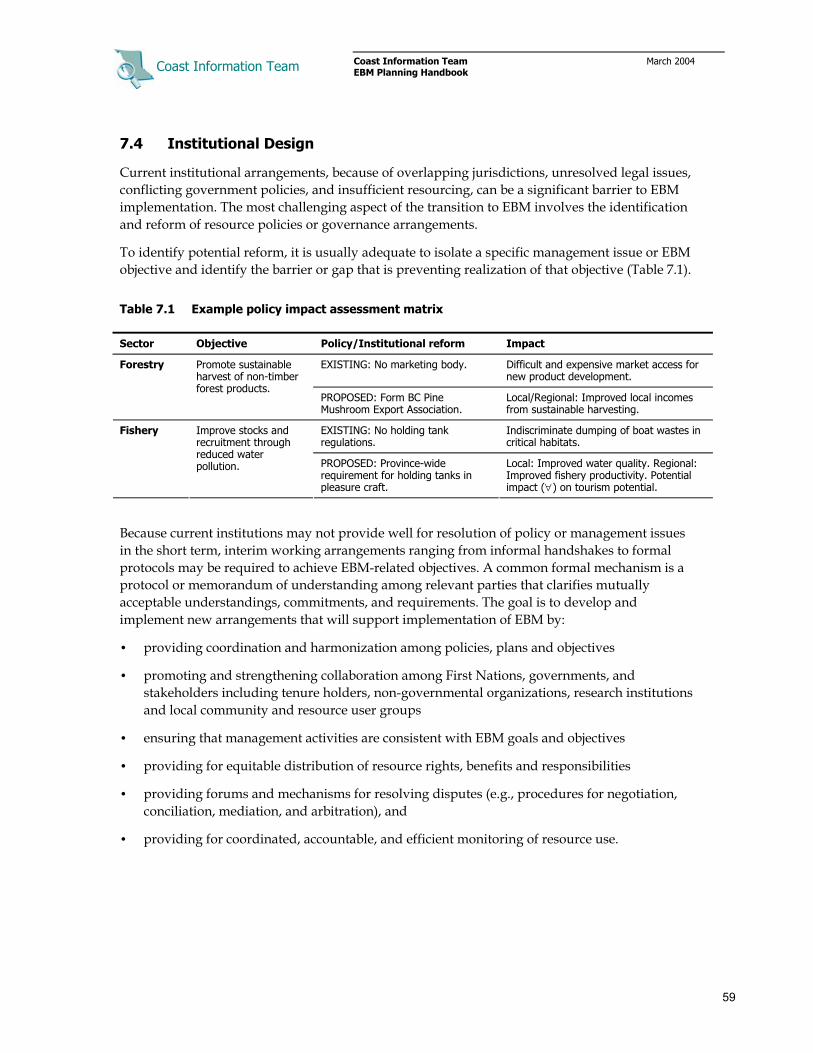
Coast Information Team
Coast Information Team March 2004 EBM Planning Handbook
59
7.4 Institutional Design
Current institutional arrangements, because of overlapping jurisdictions, unresolved legal issues, conflicting government policies, and insufficient resourcing, can be a significant barrier to EBM implementation. The most challenging aspect of the transition to EBM involves the identification and reform of resource policies or governance arrangements.
To identify potential reform, it is usually adequate to isolate a specific management issue or EBM objective and identify the barrier or gap that is preventing realization of that objective (Table 7.1).
Table 7.1 Example policy impact assessment matrix
Sector Objective Policy/Institutional reform Impact
EXISTING: No marketing body. Difficult and expensive market access for new product development.
Forestry Promote sustainable harvest of non-timber forest products.
PROPOSED: Form BC Pine Mushroom Export Association.
Local/Regional: Improved local incomes from sustainable harvesting.
EXISTING: No holding tank regulations.
Indiscriminate dumping of boat wastes in critical habitats.
Fishery Improve stocks and recruitment through reduced water pollution. PROPOSED: Province-wide
requirement for holding tanks in pleasure craft.
Local: Improved water quality. Regional: Improved fishery productivity. Potential impact (∀) on tourism potential.
Because current institutions may not provide well for resolution of policy or management issues in the short term, interim working arrangements ranging from informal handshakes to formal protocols may be required to achieve EBM-related objectives. A common formal mechanism is a protocol or memorandum of understanding among relevant parties that clarifies mutually acceptable understandings, commitments, and requirements. The goal is to develop and implement new arrangements that will support implementation of EBM by:
• providing coordination and harmonization among policies, plans and objectives
• promoting and strengthening collaboration among First Nations, governments, and stakeholders including tenure holders, non-governmental organizations, research institutions and local community and resource user groups
• ensuring that management activities are consistent with EBM goals and objectives
• providing for equitable distribution of resource rights, benefits and responsibilities
• providing forums and mechanisms for resolving disputes (e.g., procedures for negotiation, conciliation, mediation, and arbitration), and
• providing for coordinated, accountable, and efficient monitoring of resource use.

Coast Information Team
Coast Information Team March 2004 EBM Planning Handbook
60
Figure 7.2 and Table 7.2 describe an example set of institutional arrangements under development in the Gitga’at-Kitasoo/Xaixais EBM Pilot Project. New management bodies — an intergovernmental steering committee and a First Nations led resource board — provide a means for governments and stakeholders to collaborate in developing and implementing EBM-related policies and management objectives. A range of new legislation and interim agreements provide the enabling context and direction for the steering committee and resource boards to work effectively.
Figure 7.2 Example of new arrangements from the Gitga’at-Kitasoo/Xaixais EBM Pilot.
Table 7.2 Characteristics of Gitga’at-Kitasoo/Xaixais new arrangements
Steering Committee
Establishes and maintains government-to-government relationships.
Addresses policy and legislation issues.
Develops implementation protocols and oversees interim measures agreements.
Governed by enabling legislation, policies, and government-to-government protocols and interim measures agreements.
Land & Resource Management
Board
Coordinates development activities among First Nations, agencies and stakeholders.
Reviews/makes recommendations on lower-level plans (e.g., forest stewardship plans, foreshore tenures).
Coordinates adaptive co-management projects and research activities.
Enabled by First Nations-government and First Nations-stakeholder protocols.
First Nations Land & Resource
Management
Coordinated implementation of resource development activity and monitoring.
Partners collaborate to implement adaptive co-management projects.
Enabled by First Nations-stakeholder protocols.

Coast Information Team
Coast Information Team March 2004 EBM Planning Handbook
61
A mix of regulation and incentives should be considered in developing new institutional and policy arrangements for EBM (Table 7.3). The relevance and applicability of different mechanisms to specific resource sectors and planning scales will vary; however, experience has shown that any of these mechanisms can work in the correct institutional and information sharing setting. The goal is to create a mix of new planning and management arrangements and incentives that create an enabling environment for achieving cultural, ecological, and socio-economic objectives, while recognizing the commitment to maintain ecological integrity and the need to minimize planning and implementation costs.
Table 7.3 Institutional mechanisms to achieve EBM
<---- MAXIMUM GOVERNMENT INVOLVEMENT ----> <---- INCREASED PRIVATE/LOCAL INITIATIVE ---->
<-CONTROL-ORIENTED-> <----------------------MARKET-ORIENTED---------------------> <-LITIGATION-ORIENTED->
Regulations & sanctions
Charges, taxes, & fees
Market creation
Final demand intervention
Liability legislation
General examples
Standards:
Government restricts nature of resource use. Compliance is monitored
and sanctions made (fines, closure, jail
terms) for non-compliance.
User charges:
Government charges fee to individual
resource users (or polluters) based on amount of resource
use. Fee is high enough to create
incentive to reduce impacts.
Tradable permits:
Government establishes a system of tradable
conservation rights or resource use permits, auctions or distributes permits, and monitors
compliance. Conservationists or resource users trade
permits on the open market.
Performance rating:
A performance rating system that requires
disclosure of ecological information on the final
end-use product. Performance based on adoption of voluntary guidelines (e.g., ISO
14000, FSC Certification).
Strict liability legislation:
The resource user is required to pay any damages to those affected. Damaged
parties collect settlements through
litigation.
Specific examples of applications
• Standards & regulations.
• Acitivity licensing.
• Land-use restrictions.
• Fines for environmental infractions.
• Harvesting quotas
• Non-compliance fees.
• Compensation for natural resource exploitation.
• Performance bonds.
• Effluent charges.
• Property rights attached to resources potentially impacted by development (forests, lands, fish).
• Deposit-refund systems for solid and hazardous wastes.
• Tradable permits for fishing rights, forest use.
• Disclosure legislation requiring companies to publish waste information.
• Sustainable fishery, forestry, tourism labeling and marketing.
• Voluntary measures by private enterprises in market development.
• Damages compensation.
• Long-term performance bonds posted for uncertain hazards.
• “Zero Net Impact” requirements for new activities.
7.5 Trouble-Shooting
Things never work exactly as planned. This can be a fruitful source of learning and new direction, but it can also be frustrating and delay progress. Here are a few of the most likely things to require troubleshooting and some general guidance for dealing with each one.
1. Difficult trade-off decisions, where human systems are vulnerable, but the only available resource development opportunities that may improve human well-being pose unacceptable risk to ecological or conservation values.

Coast Information Team
Coast Information Team March 2004 EBM Planning Handbook
62
The first step is to carefully assess whether the trade-offs are real or whether other courses of action are available. There may be opportunities to improve human well-being that do not increase risk to ecosystems, or to reduce risk to high value ecosystems without reducing human well-being. For instance, if a community is vulnerable because resource extraction has provided few local benefits, a first step is to ensure that resource development provides for greater local retention of benefits. Means to improve the flow of local benefits include such measures as local tenures; local service contracting, resource processing or manufacturing; or revenue sharing arrangements. However, despite such measures, there may still be trade-off situations that need to be worked through.
Figures 7.3 and 7.4 illustrate potentially acceptable versus unacceptable outcomes. Clearly, a trade-off is unacceptable if it reduces human vulnerability now by making it worse later, or if it poses higher risk to ecological integrity over large areas, or if there are no clear, achievable plans that will enable ecological recovery. Acceptable trade-offs are those compromise ecological integrity in the short term at smaller scales to achieve more sustainable outcomes overall than would otherwise have been the case.
Figure 7.3 Unacceptable trade-off.
Figure 7.4 Acceptable trade-off.

Coast Information Team
Coast Information Team March 2004 EBM Planning Handbook
63
Some key principles should guide trade-off situations where communities and businesses are vulnerable and actions that increase ecological risk are being considered:
• First, options to improve human well-being without increasing risk to ecosystems have been explored and effective measures are being implemented (e.g., by local capture of benefits).
• The trade-off must enable a long-term solution whereby ecosystem integrity and human well-being are both better than if the short term decision not been made.
• The trade-off must be clearly linked to improved human well-being (i.e., trade-offs should not be made merely because there is a possible benefit through secondary economic impacts).
• The trade-off is implemented as a bridging solution to more sustainable outcomes.
• The trade-off is unlikely to cause ecological irreversibilities (e.g., loss of rare ecosystems).
• The trade-off is focused on improving prospects for the vulnerable human communities affected by the resource management decision (i.e., trade-offs that will improve local human well-being through trickle-down are not acceptable).
• The trade-off can be reversed (i.e., management reverts to precautionary targets if monitoring shows that human vulnerability is not improving or that ecological impacts are too high).
• The trade-off is compensated (e.g., if ecological risk must be increased in a landscape to improve prospects for local communities, risk should be reduced elsewhere).
• The trade-off is designed to provide the greatest possible gain for the least cost.
• The trade-off does not involve improving the well-being of one vulnerable human population at the expense of another.
• Trade off decisions that place ecosystems at risk in the short term should be focused in portions of the planning area with low conservation values, and avoided where conservation values are high.
Table 7.4 uses the concept of “human vulnerability” as a counterpart to ecological risk. Human well-being indicators can be used to assess the vulnerability of communities and groups. The relevant weighting of ecological and socio-economic factors in specific troubleshooting situation will generally be informed by collaborative review of ecosystem and human circumstances.
Table 7.4 Assessing trade-offs within a vulnerability framework
Human vulnerability Ecological value
Low Moderate High
High High priority to ecosystem. Restrict
human activity to maintain or restore ecological integrity.
Priority to ecosystem. Restrict human activity or manage to within low risk
thresholds to maintain or restore overall ecological integrity.
No priority - high conflict. Apply troubleshooting procedure &
criteria.
Moderate
Priority to ecosystem. Manage to moderate risk to maintain or restore ecological integrity and provide for
human well-being.
No priority - moderate conflict. Accept up to moderate risk to ecological integrity to
reduce human vulnerability.
Priority to human system. Accept up to moderate risk to ecological
integrity to reduce human vulnerability.
Low No priority - low conflict. Accept up to moderate risk to ecological integrity to
promote human well-being.
Priority to community well-being. Accept up to moderate risk to ecological integrity
to reduce human vulnerability.
High priority to human system. Accept up to high risk to
ecological integrity to reduce human vulnerability.

Coast Information Team
Coast Information Team March 2004 EBM Planning Handbook
64
Assessing trade-offs within a vulnerability framework provides guidance as to whether ecological integrity or human well-being goals would take precedence in certain short- or medium-term planning circumstances. The planning and management requirements related to such trade-offs can be summarized by extending the concept of due diligence to include collaborative review and assessment of whether proposed plans meet adaptive co-management and troubleshooting decision criteria (Table 7.5).
Table 7.5 Management targets, approaches, and planning/troubleshooting commitments
Management
targets Management assumptions
Management approach Planning requirements
High risk
Management will likely have significant impact on ecological values or
functions.
Troubleshooting
• Same as risk managed approach plus:
- plans must consider whether other economic development options have been fully explored
- plans ensure that vulnernable, local communities receive a fair share of the benefits of resource use
- management decisions can be reversed if outcomes do not improve human well-being or ecological impacts are too high
Moderate risk
Low risk
Management has a high to low probability
of maintaining ecological values or functions, depending on the established
targets.
Risk-managed
• Same as precautionary management plus:
- extend due diligence to assess risks & potential impacts
- collaborative review of assessments
- collaborative design of management experiment
- documentation of assumptions & decisions
- documentation of hypothesis and research design
- cooperation on implementation and monitoring
- management outcome and research reporting
- indicators monitoring & reporting
Very low risk
Management will likely have little or no impact on ecological values or
functions.
Precautionary management
• Complete EBM inventories/assessments
• Complete mandatory due diligence
• Collaborative planning
• Documentation of assumptions & decisions
• Indicators monitoring & reporting
Assessing trade-offs within a vulnerability framework provides guidance as to whether ecological integrity or human well-being goals would take precedence in certain short- or medium-term planning circumstances. As should be expected, giving one system precedence still requires that the consequences for the other system are acceptable and EBM consistent.
2. Radically changed ecosystem conditions. Slow environmental change can be more readily dealt with, but extremely fast change can require some form of disaster management. Single events such major fires or fisheries stock collapse may be related to longer, slower external impacts such as climate change, but can occur suddenly if ecological thresholds are passed.
Safety net provisions need to be in place to deal with such surprises. They need to be multi-scale and well linked to sources of assistance and information (e.g., employment insurance, retraining programs, emergency preparedness disaster relief, community support networks).

Coast Information Team
Coast Information Team March 2004 EBM Planning Handbook
65
On the ecological side, EBM requires that ecological resilience be built into plans so that there is redundancy to absorb unanticipated stresses or surprises. This is particularly relevant to addressing the potential for climate change, which can also have economic implications. For example, a plan to harness a glacial-fed river system for hydroelectric generation needs to consider the implications of glacial retreat induced by climate change on summer river flows and hence economic viability over the longer term.
3. Process failure. Failure of a planning, management, and/or decision-making process is more easily prevented than resolved. Some keys are to provide for broadly based involvement of multiple parties, including all who are impacted; this may allow for the brokering of resolutions, improve incentives for seeking solutions, and prevent “outside” friction. It is important, though difficult, to set up initial conditions so that the incentives to collaborate outweigh the incentives to stall or obstruct, and so that “end-run” strategies are unavailable.
7.6 Enabling Economic Diversification and Innovation
The best way to predict the future is to invent it. -Alan Kay, A Fellow of Apple Computer
Economic innovation is key to the success of EBM. Because the old-style focus on high levels of resource extraction is unsustainable in the long run and inconsistent with agreed upon EBM principles, the need for sustainable, livelihood-producing economic enterprises is a major challenge. Some coastal communities already have unsatisfactory levels of human well-being, and implementing EBM will in some cases reduce resource flows. A key transition challenge is to develop new opportunities arising from economic diversification and innovation.
A more diverse and innovative economy will be more resilient to external surprises, will multiply types of employment, and will provide new business opportunities and niches. Land use and resource development extraction that maintain ecosystem integrity also provides a solid basis for long-term investment and community security.
Institutional arrangements play a large role in enabling economic diversification. Governments, communities, and stakeholders can help to create an enabling environment in which innovation and diversification are supported and obstacles and barriers have been systematically reduced.
Some effective overall strategies, which are highly integrated and synergistic, are to support enterprise, promote education, attract investment, use comparative advantage to access markets, and look for the potential instead of the proven. Each of these is discussed below.
7.6.1 Support enterprise
One of the most important ways to support enterprise is to share information. Communities that can access and share information efficiently will be better able to assist local businesses to secure support (e.g., help small businesses compete for federal or provincial grants and awards, apply for assistance programs, and facilitate technology transfers). Workshops and tours that bring people together to learn from each other are highly valuable.
Another way to facilitate local enterprise is to build local capacity. Local communities need to understand the programs and support available to their companies so that they can serve a value added role. This early stage support can be critical to the growth of businesses and projects and

Coast Information Team
Coast Information Team March 2004 EBM Planning Handbook
66
to their long-term stability. This can be done through enterprise support programs such as business incubators as well as education and training.
A valuable way to enhance opportunity is to improve connectivity. One barrier that hampers small business development on the B.C. coast is its relative isolation. Telecommunications and the Internet may be the most valuable resource in overcoming this barrier — and transforming it into an asset, since isolated wilderness is, besides its intrinsic value, a highly sought-after commodity. Communities could look for new ways to bring more residents online, and to improve the home-based business climate.
A more resilient and thriving economy is often built by diversifying and clustering. Economies are something like ecosystems, even at smaller scales, in that organisms often present new niches for other species: ferns grow in the shade provided by trees, hermit crabs use recycled shells. In the same way, a tourist resort can provide economic niches, such as for food and transport suppliers, kayak rentals, guiding, or restaurants, which go beyond the direct employment provided. By taking advantage of the markets created by others, a “virtuous spiral” can sometimes be created.
Another closely-related tactic is to emphasize value-added enterprises, which build on the resources of the area by moving them further along the production chain before shipping. Value-added and diversification have the advantage that they can often utilize the resources of local entrepreneurs, which enhances local benefits.
7.6.2 Promote education
Workforce education is another economic development engine. Governments and communities must support education and training by subsidizing education and improving human resources. Local education should convey understanding of culture, geography, and history, and should also include business, entrepreneurial, and cross-cultural skills. Schools must promote and reward excellence in the sciences, commit to preparing students for new economic possibilities, work with companies to address curriculum, and offer practical courses in business skills.
Supporting education will involve a number of ways to bring people and education together. Workforce development training and programming can be delivered locally through formal institutions and through companies upgrading their human capital, or through distance education or partnerships with educational institutions. Many regional economic success stories have been based around universities and colleges because they can:
• nurture new and innovative thinking that could lead to the creation of new industries
• offer education programs and technology transfer to small business
• find ways that talented faculty and staff could better support the local economy (e.g., allow experienced employees to provide local assistance to start-up companies)
• partner with local participants to undertake applicable research,44 and
• set up local field research stations.45
44 For example, the POLIS Project on Ecological Governance at the University of Victoria is working to create a Centre as a
source of “best practice” research in the area of ecosystem- and community-based management in British Columbia.

Coast Information Team
Coast Information Team March 2004 EBM Planning Handbook
67
7.6.3 Attract investment
Real progress comes when communities are able to leverage new investment. A key benefit of commitment to EBM and resolution of land and resource issues, is increased stability. Stability is a prerequisite for investment, especially for sectors with high capital costs and long payout schedules, as firms are unwilling to invest when they may not be able to benefit from their investments.
Another source of investment funding will be to access assistance, by tapping into resources available to assist with transition such as conservation financing or beneficial tax regimes.
A strategy for rural areas to get credit for business financing is to improve access to financial services. This can be done by encouraging investment via the commercial financial system. Credit unions in British Columbia are looking for opportunities to partner with each other and with communities for mutual benefit, and also often return dividends to their local owners. Various innovative approaches can be undertaken for development.
Another key strategy is to reduce economic outflow by increasing circulation of money in the community. Local business-to-business transactions can be multiplied by community efforts to “play matchmaker” to suppliers, manufacturers, and distributors, increasing the opportunities for invention, innovation, and savings. Another way to reduce economic outflow is through import substitution, which refers to the local manufacture of previously imported goods or services.
7.6.4 Use comparative advantage to access global markets
Coastal communities will need to find new markets. This can present a depressing image of being forced by globalization into a “race for the bottom” toward low-wage, low-respect, low-prospect jobs. Competing with developing countries for unskilled labour, with lower-cost industries for exports, or with low-quality cheap goods for manufacturing could produce exactly those results. The vital ingredient in finding and keeping new markets is for each community to focus on its own potential. The region and its communities should build on its strengths, its comparative advantages, those goods or services it can provide better than any competitors.
Three major comparative advantages of the B.C. coast are its high-quality resources, especially its timber and specialty natural resources; its unique natural beauty; and its unique, diverse First Nations cultures.
EBM can bridge the gap between the local and the global by taking advantage of global changes toward sustainability. High-end tourists want a different experience of unspoiled wilderness and exotic cultures that have not been overexploited. Global purchasers of sustainable products will boycott unsustainable products. Reinvention of the forest and other industries into more ecologically sustainable industries that provide increased benefits to local communities will, with well-targeted marketing, take advantage of rising demand for sustainable products, and will avoid the hidden reefs that sink companies that fail to maintain their “social licence to operate.”
45 For example, the School for Field Studies, headquartered in the United States, has several centres around the world
devoted to teaching undergraduate students in community-based environmental research, including the Center for Coastal Rainforest and Fisheries Studies on Vancouver Island.

Coast Information Team
Coast Information Team March 2004 EBM Planning Handbook
68
Another form of attracting capital is to retain and attract intellectual capital, meaning skilled and creative people. The first way to do this is to ’grow your own’, by ensuring that youth and would-be entrepreneurs get the education and training they need, and that they have genuine and fulfilling opportunities within the region. They will have the inherent advantage over new residents of familiarity with the culture, resources, and problems of the region.
The second way is to attract new residents. When poorer communities try to recruit and retain doctors and teachers and plant managers, or talented men and women to attract new industry or to spawn new local businesses, they often find that these people demand amenities that may be lacking in such communities. The BC coast holds a comparative advantage here, in that it does provide some incomparable amenities that other regions cannot compete with; for example, outdoor recreation has been found to be a key component for creative capital location. The ‘right people’ are those who are drawn to the beauty, culture, and natural riches of the region.
7.6.5 Look for the potential instead of the proven
Innovation, an engine of socio-economic development, means searching out and experimenting with new ideas. A generation ago, no-one would have anticipated the success of bungee-jumping, even bird-watching as economic opportunities. Not every idea will succeed, but a culture that supports creativity and risk-taking will have a higher share of successes. Innovation means not only new ideas, but new applications of old ones; for example, the B.C. Coast has not yet tapped the potential for mid-level tourism. Innovation is assisted also by information and knowledge sharing among sectors and communities, so that useful “lessons learned” benefit to others.
Innovation is made more likely in conditions that reward innovation. Government policies need to be supportive of sustainable enterprises rather than of instant short-term rewards. Companies need to invent new products that will drive new economic sectors. Early adopters of new ideas will be the most likely to benefit, before the market is saturated. “Social marketing,” such as award programs or publicity for local success stories, can move culture in the direction of rewarding creativity and promoting a shift toward entrepreneurial self-sufficiency.
Innovation does not imply change across the board. It does not imply that cultural traditions need to change, or that businesses need to drop deeply held values (e.g., a business committed to progressive workplace policies does not innovate by cutting wages and eliminating benefits). It means looking for the new niches and opportunities that can improve life for workers, visitors, and communities, while preserving important cultural, social, and environmental values.

Coast Information Team
Coast Information Team March 2004 EBM Planning Handbook
69
Appendix 1 Glossary
Aboriginal Rights and Title: A unique interest in lands and resources. Aboriginal Rights and Title are recognized at law and enforceable by the courts. Existing aboriginal Rights and Title cannot be infringed by the Crown unless First Nations interests are accommodated. Accommodation must be negotiated with the affected First Nations through consultation.
Adaptive co-management (ACM): A long-term management structure that permits stakeholders to share resource management responsibility and to learn from their actions. It is a systematic approach to improving resource decision-making that involves structuring planning and management as a collaborative learning process.
Adaptive management: A formal process of “learning by doing,” where management practices are designed to increase understanding about the ecological or human system being managed. Adaptive management can be “active” where management is designed and implemented as an experiment, or “passive” where management follows a known best option.
Allowable annual cut (AAC): The allowable rate of timber harvest from a specified area of land. The chief forester sets AACs for timber supply areas (TSAs) and tree farm licences (TFLs) in accordance with Section 7 of the Forest Act.
Alluvial fan: Cone-like sediment accumulations that develop where streams reach the valley floor and deposit sediment and organic debris. From apex to toe, fans have a slope gradient up to 26%.
Analysis unit: The basic building blocks around which inventory data and other information are organized for use in forest planning models. Typically, these involve specific tree species or inventory type groups that are defined by site class, location, or management regime.
Benchmark: A standard against which planning and management outcomes are compared. Benchmarks may be based on knowledge of ecological processes and functions and their variability (e.g., RONV), on regulatory and legal requirements (e.g., health standards), or on objectives set by local communities and stakeholders (e.g., desired employment level).
Biodiversity: The diversity of organisms in all their forms and levels of organization, including genes, species, ecosystems, and the evolutionary and functional processes that link them.
Biogeoclimatic ecosystem classification (BEC): A system that groups ecosystems in a hierarchical classification system. For the purposes of BEC, an ecosystem is defined as a particular plant community and its associated topography, soil, and climate.
Biological legacies: Biological legacies maintain processes, habitats, and linkages within forest stands. Examples of biological legacies are coarse wood debris left on site after a harvest, large snags and overstory trees, patches of older forest, multiple canopy layers, and soil structural characteristics of the forest floor.
Blue-listed species: In British Columbia, the designation of an indigenous species, subspecies, or population as being vulnerable or at risk because of low or declining numbers or presence in vulnerable habitats. Included in this classification are populations generally suspected of being vulnerable, but for which information is too limited to allow designation in another category.

Coast Information Team
Coast Information Team March 2004 EBM Planning Handbook
70
Capability mapping: A habitat interpretation for a species that describes the greatest potential of a habitat to support that species. Habitat potential may not be reflected by the present habitat condition or succession stage.
Carrying capacity: The number of livestock, wildlife, and/or tourists that can be sustained on a management unit, compatible with management objectives for the unit. It is a function of site characteristics, management goals, and management capacity.
Coarse filter: An approach to sustaining biodiversity that strives to protect or reserve sufficient habitat to maintain most ecosystems, species, and genes through time.
Coarse woody debris (CWD): Sound and rotting logs, tree parts, and large branches that have fallen or been cut and left in the forest, and that provide habitat for plants, animals, and insects and a source of nutrients for soil development (generally >7.5 cm in diameter).
Collaboration: Working cooperatively in conjunction with others to achieve common ends.
Community: A body of people organized into a political, municipal, or social unity; can refer to a geographic or cultural community, and can also refer to an interest-based constituency (e.g., environmental NGOs) or a sector-based grouping (e.g., tourism operators).
CDC listings: The BC Conservation Data Centre (CDC) collects and disseminates information on rare and endangered plants, animals, and plant communities in British Columbia. CDC listings are a computerized database of information on the status, locations, and level of protection of these organisms and ecosystems.
Conservation planning: A broad-based ecosystem approach to planning for the protection and perpetuation of biological diversity. Conservation planning identifies and provides for the regional and smaller scale protection of plants, animals, and their habitats, while allowing compatible and appropriate economic activity.
Constituencies: Broad groupings of persons and/or organizations having some features and interests in common and which tend toward holding some common positions.
Cost–benefit analysis: A set of procedures for defining and comparing the quantified benefits and costs of a project or course of action; used as an aid to decision-making.
Cost-effectiveness analysis: An analysis which compares alternative input combinations on the basis of their overall cost; used as an aid to decision-making.
Critical habitat: An ecosystem or particular ecosystem element occupied or used by a species, or local population, that is essential for its health and/or long-term persistence.
Culturally modified tree (CMT): A tree that has been altered by First Nations people as part of their cultural and social use of the forest.
Decision analysis: A structured way of thinking about how the action taken in the current decision would lead to a result. The technique distinguishes the decision to be made, the chance and unknown events that can affect the result, and the result itself. Decision analysis then constructs logical or mathematical models of the relationships within and between these three features of the decision situation. The models are used to estimate the possible implications of each course of action in relation predetermined objectives.

Coast Information Team
Coast Information Team March 2004 EBM Planning Handbook
71
Deposition zone: Deposition zone channels receive material from source and transport zone channels as well as from adjacent riparian zones. Situated at drainage basin outlets, deposition zones include alluvial fans and deltas. Deposition zone channels are unconfined valley bottom rivers characterized by horizontal migration across floodplains and valley bottoms or channels on active alluvial fans. Depositions zones are identified as fluvial fans, floodplains, and active floodplains in terrain mapping datasets.
Detrimental soil disturbance: Soil degradation; any change in physical, chemical, or biological properties of the soil that reduces soil fertility or productivity or results in adverse impacts on other ecosystem components (e.g., compaction, surface soil displacement, pH changes).
Distribution analysis: A class of analysis that attempts to assess the social distribution of the economic or environmental impacts arising from land use or resource management decisions.
Disturbance regime: The type, extent, frequency, and intensity of events that disturb or displace ecological processes.
Ecological integrity: A quality or state of an ecosystem in which it is considered complete or unimpaired; including the natural diversity of species and biological communities, ecosystem processes and functions, and both the ability to absorb disturbance (resistance) and to recover from disturbance (resilience).
Ecological restoration: An intentional activity that initiates the recovery of an ecosystem with respect to its integrity and health. It seeks to protect and restore the plant and animal communities of a given area or region and the renewal of the ecosystem and cultural functions necessary to maintain these communities now and into the future.
Ecosystem-based management (EBM): An adaptive approach to managing human activities that seeks to ensure the coexistence of healthy, fully functioning ecosystems and human communities. The intent is to maintain those spatial and temporal characteristics of ecosystems such that component species and ecological processes can be sustained and human well-being supported and improved.
Ecosystem type: An ecosystem defined using the site series level in the BEC system, plant associations or some equivalent ecosystem surrogate representing the full range of site conditions within a biogeoclimatic variant. Groupings of similar ecosystem types within a variant may be used to assess and meet representation targets when appropriate. Red or blue listed ecosystems cannot be grouped to meet targets.
Environmental Impact Assessment (EIA): An activity designed to identify, predict, interpret, and communicate information about the impact of actions (legislative proposals, policies, programs, projects, and operational procedures) on human health and well-being, including the well-being of the ecosystems on which human survival depends.
Environmental risk assessment: A process for estimating the likelihood or probability of an adverse outcome or event due to pressures or changes in environmental conditions resulting from human activities.
Environmental services (ecosystem services): Valuable, ongoing streams of benefits provided by healthy ecosystems, such as air and water purification, biodiversity maintenance, climate

Coast Information Team
Coast Information Team March 2004 EBM Planning Handbook
72
stabilization, mitigation of floods and droughts, detoxification and decomposition of wastes, generation and renewal of soil and soil fertility.
Equivalent clearcut area (ECA): An index of potential watershed-level hydrologic impacts (e.g., increased peak runoff) due to forest cover removal, normally expressed as a percentage of the naturally forested area of a watershed; areas where forest cover has been completely removed by harvesting, fire, or other disturbances are assessed as full percentages (e.g., clearcuts, intensive burns), areas with partial stand removal are pro-rated according to the percentage of the crown cover removed (i.e., equivalent to clearcut); areas partially recovered through forest regeneration are pro-rated according to the degree of crown closure and tree height.
Estuary: The embayed mouth of a river where the tide meets the river flow, creating brackish water zones with a range of salinity. Extremely rich and productive ecosystems exist where tidal marine water and sediment mixes with freshwater and river sediment.
Fan: See alluvial fan.
Fine filter approach: An approach to maintaining biodiversity that is directed toward particular habitats or individual species that might fall through the coarse filter. These habitats may be critical in some way and the species threatened or endangered.
FISS (Fisheries Information Summary System): A provincial GIS database that provides spatially represented summary fish and fish habitat data for water bodies throughout British Columbia.
Focal species: Species that warrant special protection and stewardship. As such, they help determine area for protection and stewardship actions to sustain and improve known populations. May include keystone species or umbrella species.
Forested swamp: Wooded, nutrient-rich mineral wetland or a wooded peatland with standing or gently flowing water in pools and channels. The water table is usually at or near the surface.
Formal economy: The exchange-based part of the economy that is monetized and tracked in accounting systems.
Full cost accounting: A tool to identify, quantify, and allocate the direct and indirect environmental costs of an activity. Full cost accounting helps identify and qualify the direct costs, hidden costs, and less tangible costs of a product, process, or project.
Gap analysis: A technique that assesses conservation plans and identifies ecosystems, land formations or habitat types that are not currently adequately represented in the existing system of protected areas and reserves. Should be performed at regional, subregional, landscape, and watershed scales.
Goal: An overarching purpose or commitment that guides planning and decision-making.
High risk threshold: The point where science and expert opinion suggest that the extent of change from the range of natural variation is significant; beyond this threshold the probability of serious ecological degradation and significant loss of ecological function is high.
Human vulnerability: A community or organization’s exposure to environmental, social or economic threats and their ability cope with those threats.

Coast Information Team
Coast Information Team March 2004 EBM Planning Handbook
73
Human well-being (HWB): A condition in which all members of society are able to determine and meet their needs and have a range of choices and opportunities to fulfill their potential.
Hydrological regime: The pattern of occurrence in time of water at or near the surface of the Earth (e.g., temporal changes in streamflow, soil moisture, groundwater levels, precipitation).
Hydroriparian ecosystem: Aquatic ecosystems plus adjacent terrestrial ecosystems that are influenced by, or influence, the aquatic system. They extend vertically, below ground in the soil (especially in near-stream gravels), and above ground toward the vegetation canopy.
Hydroriparian functions: Hydroriparian ecosystems: (1) maintain environmental character (e.g., contain rare ecosystems); (2) move materials linking portions of the landscape (e.g., transport water downstream, above and below the ground); and (3) provide reciprocal influences of water and land (e.g., provide sediment, downed wood, shade).
Hydroriparian process zone: Discrete zone in a watershed where the movement of water, sediment, and organic material toward and through streams and standing water occurs in distinct ways. Hydroriparian process zones include source zone, consisting of upland and slope areas; transport zone, the trunk valley through which sediment is moved with storage in a floodplain; and deposition zone, where sediments are stored for a long term (typically alluvial fans, downstream floodplains, and deltas).
Hydroriparian zone: Area that extends to the edge of the influence of water on land defined by plant community (including high-bench or dry floodplain communities) or landform (e.g., gullies) plus one and a half site-specific tree heights (horizontal distance) beyond.
Indicators: Measures that index the state of complex functions that are difficult to assess. Good indicators respond to management actions, are related clearly to the function considered, can be measured or described simply, are relatively insensitive to factors beyond the management actions considered, and are appropriate for the purpose and scale considered.
Informal economy: The unmeasured economy, including direct production for household use, and exchange transactions which are non-tracked, such as subsistence, barter, volunteer work.
Institutional arrangements: The laws, regulations, policies, social norms, and organizations governing and participating in resource use. Institutional arrangements specify who has access to resources, guide resource development activities, and define who will monitor and enforce the rules.
Institutional analysis: An analysis of the structure, function, and dynamics of legislation, regulation, government agencies, and other institutions that have mandated authority or social influence in a region. An institutional analysis is generally undertaken to improve the functioning of the institutional framework and arrangements.
Interest-based negotiation: A form of negotiation that focuses on coming to agreement by reconciling the interests rather than the positions of persons or groups.
Karst: Pertains to landforms and processes associated with dissolution of soluble rocks such as limestone, marble, dolomite, or gypsum; characterized by underground drainage, caves, and sinkholes.

Coast Information Team
Coast Information Team March 2004 EBM Planning Handbook
74
Keystone species: Those species whose presence or activities support many other species in the community (e.g., salmon, primary cavity nesters, herbivorous insects that outbreak). Hence keystone species may also be good umbrella species.
Landscape: Interacting geographic areas that are bounded by physical features and that contain similar patterns of watersheds and vegetation cover. Ecological landscapes have no fixed size; practical sizes for landscapes in a forest planning context in British Columbia generally range from 25,000 to 100,000 hectares.
Landscape unit: A planning area ranging from 25,000 to 100,000 hectares delineated according to topographic or geologic features such as watersheds or groups of watersheds and formally established by a District Manager.
Low risk target: A numerical target derived from low risk thresholds (see Precautionary target).
Low risk threshold: The point where noticeable change from the natural range of variation begins to occur in an ecosystem.
Management direction: The goals, objectives, requirements, targets, and indicators that guide ecosystem-based management.
Management objective: A specific goal, related to ecosystems, ecosystem components, or natural resources, to be affected by an action or development; a specific defined goal to be achieved.
Management target: A numerical value to be achieved in relation to an management objective
Matrix: The largest or dominant part of a landscape mosaic. In the context of planning in British Columbia, the matrix is the managed portion of the landscape where forest harvesting or other extractive resource use may occur. It is the area outside of protected areas and reserves.
Memorandum of understanding (MOU): A commonly-used mechanism formalizing an agreement among stakeholders, particularly jurisdictional bodies, to provide guidelines for interactions and behaviour among the signatory parties.
Microterrain features: Small-scale terrain features not easily described using the range of surface expressions found in the B.C. Terrain Classification System (e.g., tree-throw mounds).
Monitoring: A process of periodic or continuous auditing, observation, or data collection. Three types of monitoring are associated with an EBM: implementation monitoring ensures that the management procedures are being followed; effectiveness monitoring assesses whether management is attaining the objectives for each indicator; and validation monitoring tests the assumptions associated with the risk assessment models.
Natural disturbance regime: The historic patterns (frequency, extent, and character) of fire, insects, wind, landslides, floods, and other natural processes in an area.
Natural riparian forest: The amount and type (deciduous, old growth coniferous, etc.) of riparian forest that would occur under natural disturbance regimes. The actual amount and type varies over time within the range of natural variability.
Objective: An explicit goal to be achieved with respect to a resource value or management issue.

Coast Information Team
Coast Information Team March 2004 EBM Planning Handbook
75
Off-channel habitat: In streams, minor channels and pools in the floodplain, wetlands, and low areas adjacent to the channel that provide refuge and habitat during flood flows.
Old growth forests: Old forests that are defined by a group of attributes, including age, multi-layered canopies, canopy gaps, high levels of decayed wood, and large trees. Due to a lack of inventory for these attributes, old growth forests are considered to be those stands identified as older than 250 years (note: current forest cover inventory tends to underestimate stand age, particularly stands located on moderate and poor growing sites).
Precautionary principle: Measures taken to reduce potential harm resulting from human activities or environmental change even if some cause and effect relationships are not fully established scientifically. It includes taking action in the face of uncertainty; shifting burdens of proof to those who create risks; analysis of alternatives to potentially harmful activities.
Precautionary target: A numerical target that is established to achieve low risk management. Precautionary management targets have a low probability of unacceptable consequence.
Predictive Ecosystem Mapping (PEM): Surrogate for terrestrial ecosystem mapping that does not require fieldwork, but instead uses mathematical formulas to predict ecosystem type using existing maps, data, and knowledge of ecological–landscape relationships.
Process zone: Watersheds can be split into three process zones (source, transport, and deposition), among which hydroriparian functions, processes, and risks vary.
Protected Area: General large areas set aside for a specific form of protection by government or First Nations under specific legislation or authority. They are generally established through strategic planning at regional or subregional scales.
Protocol: A formal statement of a transaction or agreement, to govern future actions by the signatories to the protocol.
Rare ecosystems: Uncommon ecosystems that require special consideration when determining acceptable levels of risk. The Conservation Data Centre compiles lists of rare ecosystems for British Columbia. Red-listed ecosystems typically have 20 or fewer good examples in British Columbia, blue-listed have fewer than 100. Not all rare ecosystems are listed by CDC.
Range of natural variability (RONV): The range of dynamic change in natural systems over historic time periods (~ 500 years before present). RONV is used as a benchmark to assess the degree of past change and to guide future management.
Red-listed species: In British Columbia, the designation of an indigenous species, subspecies, or population as endangered or threatened because of its low abundance and consequent danger of extirpation or extinction.
Representation analysis: A coarse filter conservation planning tool often used in parallel gap analysis. Representation analysis seeks to identify the ecosystems that are characteristics of an areas, and assess the relative distribution of those ecosystems.
Representative ecosystems: Ecosystems that are especially common, that define the character of a region (e.g., bogs in the Hecate Lowland).
Requirement: A procedure or assessment that must be completed to achieve an objective.

Coast Information Team
Coast Information Team March 2004 EBM Planning Handbook
76
Reserve: Areas where no, or very little, extractive resource use takes place, but the land has no formal protected status. They are generally established during tactical planning at landscape and watershed scales.
Resilience: Adaptive capacity to absorb disturbance; the amount of disturbance that can be sustained by a system before a change in its control or structure occurs.
Resource rent:: Amount paid for a specified amount of a resource that is excess to the costs of production.
Retention: Individual trees or groups of trees that are retained in harvested forest stands for varying lengths of time to provide for the maintenance of site scale structure and composition.
Retention system: A silvicultural system that is designed to retain individual trees or groups of trees to maintain structural diversity and forest influence over the majority area of the harvested area. Generally, retention is intended to be long term, with no intention of future removal.
Riparian corridor: An area composed of continuous riparian habitat (e.g., the land on either side of a river bank or around a lake).
Riparian forest: Forests influenced by water (including high-bench floodplain) plus an area extending one-and-a-half tree lengths beyond.
Risk: The possibility that attributes of ecological integrity or human well-being will be changed or lost — in effect, exposure to potential loss. In the context of land management, it is interpreted as the probability (i.e., relative exposure) that an undesired outcome (loss) will result from a particular management action.
Risk assessment: A process for estimating the likelihood or probability of an adverse outcome or event.
Sector: A grouping of producers in the economy according to their primary product; e.g., the tourism, mining, or forestry sector.
SEDS (Salmon Escapement Data System): A data system containing Fisheries and Oceans SEDS salmon escapement data. The SEDS database provides a geo-referenced list of salmon stocks.
Sensitive terrain: Terrain units with a stability class rating of IV (potentially unstable) or V (unstable). Class IV terrain is expected to contain areas with a moderate to high likelihood of landslide initiation following timber harvesting or road construction by conventional means. Class V terrain exhibits evidence of instability and is expected to contain areas with a high likelihood of landslide initiation following timber harvesting or road construction.
Seral stage: Any stage of development of an ecosystem from a disturbed, unvegetated state to a climax plant community. It defines the structural attributes and age of a plant community.
SinMap (Stability Index Mapping): A GIS extension that enables computation and mapping of a slope stability index based upon geographic information, primarily digital elevation data.
Site: One or more discrete units, typically one hectare to several tens of hectares in size. The appropriate mapping scale for site-level planning ranges from 1:2,000 to 1:5,000.

Coast Information Team
Coast Information Team March 2004 EBM Planning Handbook
77
Site series: Describes all land areas capable of producing the same late seral or climax plant community within a biogeoclimatic subzone or variant. Site series can usually be related to a specified range of soil moisture and nutrient regimes within a subzone or variant, but other factors, such as aspect or disturbance history may influence it as well.
Source zone: The upland area of the watershed, constituting the majority of channel length. Source zone channels will generally be small upland/headwater streams.
Stakeholders: The range of groups and individuals who have a formal or informal stake in resource planning and management decisions, including: tenure holders, local resource user and community groups, non-governmental organizations, research institutions.
Stand: A community of trees sufficiently uniform in species composition, age, and structure to be distinguishable from nearby forest communities and thus form a forest site management unit.
Statutory decision maker (SDM): A person given powers under provincial legislation to make administrative decisions and approve operational plans for harvesting, road building, silviculture activities, and range use. SDMs interpret and apply relevant provincial legislation, regulations, and policies.
Stream morphology: The characteristics of a stream channel including width, depth, gradient, substrate, and bank composition and shape.
Subregion: The area covered by a provincial LRMP process. Or in ecological terms, an area that is homogeneous with respect to the defining criterion (e.g., a biogeoclimatic ecoregion such as the Hecate Lowlands).
System: A set of interrelated elements that form a complex unity; an entity that maintains its existence through the mutual interaction of its parts.
Target: A numerical objective that specifies the management results to be achieved.
Terrain mapping: A method to categorize, describe, and delineate characteristics and attributes of surficial materials, landforms, and geological processes within the natural landscape.
Terrain resource inventory mapping (TRIM): The system of largest scale topographic maps and GIS data issued by the Province of British Columbia (scale 1:20 000). The complete mapping system includes overlays for elevation, freshwater, terrain, and cultural attributes.
Terrestrial ecosystem mapping (TEM): The division of a landscape into map units, showing biogeoclimatic site series, defined by a combination of ecological features, primarily climate, physiography, surficial material, bedrock geology, soil, and vegetation. It provides a biological and ecological framework for land management.
Territory: The lands and waters to which a First Nations asserts or holds their aboriginal Rights and Title.
Threshold: A level of an indicator that specifies that a significant or action-triggering condition has been reached.
Transition strategy: A broad design of plans and approaches to deal with a time of change between one state and another; in particular, overview planning for the B.C. coast during the period until EBM is fully established and implemented.

Coast Information Team
Coast Information Team March 2004 EBM Planning Handbook
78
Transport zone: Stream channels that receive material from source zone channels and directly from adjacent riparian zones. This zone is typically situated in major valleys, with a valley flat and channels of intermediate size. Transport zone channels may be confined by upland slopes, migrate across valley floors, or alternate between confined and unconfined. They are associated with a discontinuous or continuous floodplain. Transportation zones may be identified as floodplains, active floodplains, fluvial terraces and fans in terrain mapping.
Umbrella species: Species that are wide ranging so that the protection of their various habitats preserves numerous other species (e.g., fisher).
Uncertainty: A condition of being in doubt. The level of doubt can be described in terms of the knowledge that decision makers have about existing conditions and their belief that future events and outcomes will occur. Common sources of uncertainty include natural variability, statistical variation, lack of information or knowledge, subjective judgment, imperfect observation, or an inherent randomness.
Variable retention: Harvesting regime that preserves or permanently retains individual trees, groups of trees, other forest structures, or habitat elements within harvested stands. The emphasis on retaining structural elements of the original stand to maintain long-term ecological diversity and meet site and watershed management objectives.
Vulnerability mapping: A technique that maps information about human well-being indicators according to the location of the people or community within a planning area.
Watershed: The area drained by a river or stream and its tributaries. The size of the watershed will depend on the size of the stream or river considered. From a practical planning standpoint, a watershed generally ranges in size from 500 to 50,000 hectares. Equivalent to drainage basin.
Wet/low floodplain: Area adjacent to a stream channel that is flooded more frequently than once in five years and commonly exhibits wetland vegetation. Wet floodplains include old, filled channels and low floodplain surfaces. They form part or all of the active floodplain. Within the biogeoclimatic ecosystem classification, wet floodplains correspond to “low and middle fluvial benches.”
Wetlands: Sites where the water table is at, near, or above the soil surface and soils are water-saturated for a sufficient length of time that excess water and resulting low soil oxygen levels are principal determinants of vegetation and soils development. Wetlands have either plant communities characterized by species that normally grow in soils water-saturated for a major portion of the growing season (hydrophytes) or soils with surface peat horizons or gleyed mineral horizons within 30 cm of the soil surface.

Coast Information Team
Coast Information Team March 2004 EBM Planning Handbook
79
Appendix 2 References and Recommended Reading
Anielski, M. 2004. Genuine Wealth Accounting: Measuring the Sustainability of communities. Anielski Management.
B.C. Ministry of Environment, Lands and Parks. 2000. Environmental risk assessment (ERA): An approach for assessing and reporting environmental conditions. Habitat Branch, Victoria, B.C. Technical Bulletin 1.
B.C. Ministry of Forests. 1998. Guide to Writing Resource Objectives and Strategies. Province of British Columbia.
B.C. Ministry of Sustainable Resource Management. 2002. Sustainable resource management planning: A landscape-level strategy for resource development. Resource Planning Branch, Victoria, B.C.
B.C. Ministry of Sustainable Resource Management. 2003. Socio-economic and environmental impact assessment for land and resource management planning in British Columbia: Guiding principles.
Bunnell, F.L., G. Dunsworth,D. Huggard, and L. Kremsater. 2003. Learning to sustain biological diversity on Weyerhaeuser's Coastal tenure. Weyerhaeuser BCCG Internal Report. 280 p.
Center for International Forestry Research (CIFOR). 1999. Guidelines for developing, testing and selecting criteria and indicators for sustainable forest management. The Criteria and Indicators Toolbox Series No. 1. Jakarta, Indonesia.
Clayoquot Sound Scientific Panel. 1994. Report of the Scientific Panel for Sustainable Forest Practices in Clayoquot Sound.
Clayoquot Sound Scientific Panel. 1995. Sustainable ecosystem management in Clayoquot Sound: Planning and practices.
Clewell A., J. Reiger, and J. Munro. 2000. Guidelines for developing and managing ecological restoration projects. Society for Ecological Restoration.
Coast Information Team. 2003a. Ecosystem-based management framework. Draft 3.
Coast Information Team. 2003b. Hydroriparian planning guide. Review draft prepared for the Coast Information Team
Coast Information Team. 2003c. The Scientific Basis for Ecosystem-Based Management. Working draft prepared for the Coast Information Team.
Dorner, B. and C. Wong. 2003. Natural disturbance dynamics in coastal British Columbia. Report prepared for the Coast Information Team.
Gitga’at - Kitasoo EBM Pilot Project. 2002. Ecosystem-based management framework, Draft 12.
Hemmati, M., F. Dodds, J. Enayati, and J. McHarry. 2002. Multi-stakeholder processes for governance and sustainability: beyond deadlock and conflict. Earthscan Publications Ltd., London, Sterling, Vermont.

Coast Information Team
Coast Information Team March 2004 EBM Planning Handbook
80
Holt, R. and G. Sutherland. 2003. Environmental risk assessment: Base case, coarse filter biodiversity. Final report prepared for the North Coast LRMP.
Hossain, M. 2001. Assessing human vulnerability due to environmental change: concepts and assessment methodologies. Stockholm Royal Institute of Technology.
IISD. 2004. Out of respect: The Tahltan, mining, and the seven questions to sustainability. report of the Tahltan Mining Symposium, April 4–6, 2004. Report prepared for the Tahltan First Nation and the International Institute for Sustainable Development.
Keely, E.R. and C.J. Walters. 1994. The British Columbia Watershed Restoration Program: Summary of the experimental design, monitoring and restoration techniques workshop. Watershed Restoration Management Report No. 1.
Kremsater. L, F. Bunnell, D. Huggard, and G. Dunsworth. 2003. Indicators to assess biological diversity: Weyerhaeuser's coastal BC Forest project. Forestry Chronicle 79(3) 590–601.
Pojar, J. 2000. Rare ecosystems (of the CWHvh2). Unpublished report.
Prescott-Allen, R. 2004. Wellbeing Assessment of the North and Central Coast British Columbia. Draft report prepared for the Coast Information Team.
Province of British Columbia. 2004. BC’s new forest and range practices framework: FRPA training companion guide. Victoria, B.C.
Risk and vulnerability assessment tool. NOAA Coastal Services Center. http://www.csc.noaa.gov/rvat/hazid.html
Ruitenbeek, J. and C. Cartier. 2001. The invisible wand: Adaptive co-management as an emergent strategy in complex bio-economic systems.
Sit, V. and B. Taylor (editors.) 1998.: Statistical methods for adaptive management studies. B.C. Ministry of Forests, Research Program, Victoria, B.C. Land Management Handbook No. 42
Taylor, B. 2000. Implementing adaptive management through the North Coast LRMP. Background report prepared for the North Coast LRMP.
Taylor, B., L. Kremsater and R. Ellis. 1997. Adaptive management of forests in British Columbia. B.C. Ministry of Forests, Research Branch, Victoria, B.C.