
eanpg/51 - report of the fifty-first meeting of the european air ...
226
EANPG/51 - REPORT REPORT OF THE FIFTY-FIRST MEETING OF THE EUROPEAN AIR NAVIGATION PLANNING GROUP (Paris, 1 to 3 December 2009) PREPARED BY THE EUROPEAN AND NORTH ATLANTIC OFFICE OF ICAO DECEMBER 2009
-
Upload
khangminh22 -
Category
Documents
-
view
0 -
download
0
Transcript of eanpg/51 - report of the fifty-first meeting of the european air ...

EANPG/51 - REPORT
REPORT OF
THE FIFTY-FIRST MEETING OF
THE EUROPEAN AIR NAVIGATION PLANNING GROUP
(Paris, 1 to 3 December 2009)
PREPARED BY THE EUROPEAN AND NORTH ATLANTIC OFFICE OF ICAO DECEMBER 2009

THE DESIGNATIONS AND THE PRESENTATION OF MATERIAL IN THIS PUBLICATION DO NOT
IMPLY THE EXPRESSION OF ANY OPINION WHATSOEVER ON THE PART OF ICAO
CONCERNING THE LEGAL STATUS OF ANY COUNTRY, TERRITORY, CITY OR AREA OF ITS
AUTHORITIES, OR CONCERNING THE DELIMITATION OF ITS FRONTIERS OR BOUNDARIES.

i European Air Navigation Planning Group i
EANPG51 final Report.docx December 2009
TABLE OF CONTENTS
LIST OF CONCLUSIONS ........................................................................................................................................... iii
LIST OF DECISIONS ........................................................................................................................................... iv
LIST OF STATEMENTS ........................................................................................................................................... iv
0. INTRODUCTION ............................................................................................................................................ 1
Place and duration .............................................................................................................................................. 1 Attendance ......................................................................................................................................................... 1 Officers and Secretariat ..................................................................................................................................... 1 Conclusion, Decisions and Statements .............................................................................................................. 1 Agenda ............................................................................................................................................................... 1
1. REVIEW OF SIGNIFICANT INTERNATIONAL AVIATION DEVELOPMENTS .............................................. 3
Civil/Military Cooperation ................................................................................................................................ 3 Activities of NATMC ........................................................................................................................................ 3 Single European Sky .......................................................................................................................................... 3 ICAO Policy on Regional Cooperation ............................................................................................................. 3 ICAO High Level Safety Conference ................................................................................................................ 4 Preparations for the Assembly ........................................................................................................................... 4 Service Provision in Tbilisi Flight Information Region ..................................................................................... 4 Standardised lay-out for Air Operator Certificate .............................................................................................. 4 Implementation of RVSM in the Eastern part of the ICAO European Region (EURASIA RVSM) ................. 4
2. PREVIOUS EANPG FOLLOW UP .......................................................................................................................... 5
Review of the actions of the ANC on the Report of EANPG/50 ....................................................................... 5
3. AVIATION SAFETY ............................................................................................................................................ 6
ICAO ECAC States ATM Safety Framework Monitoring ................................................................................ 6 EUROCONTROL Development of ATM Safety Key Performance Indicators (KPIs) ..................................... 7 Review of other safety-related activities ............................................................................................................ 7
4. PLANNING AND IMPLEMENTATION ISSUES ................................................................................................... 8
4.1 Management of the European Air Navigation Plan ........................................................................................... 8 Establishment of FAB ........................................................................................................................................ 8
4.2 Proposals for amendments of ICAO provisions................................................................................................. 9 Flexible Use of Airspace .................................................................................................................................... 9
Activities of the Regional Director .............................................................................................................. 9 EUR/ANP Progress.......................................................................................................................................... 10 Aircraft identification ...................................................................................................................................... 14
4.3 Air Traffic Management .................................................................................................................................. 16 Limit of a vector .............................................................................................................................................. 16
4.4 Communication, Navigation and Surveillance ................................................................................................ 17 Aeronautical Frequency Spectrum Management ............................................................................................. 17
ICAO WRC-12 Position............................................................................................................................. 17 Data Link Frequency Spectrum .................................................................................................................. 18
8.33 kHz VHF channel spacing implementation programme .......................................................................... 19 Frequency Usage Improvements ...................................................................................................................... 19
Designated Operational Coverage (DOC) .................................................................................................. 20 Re-use of emergency channel guard bands ................................................................................................ 20 Best practices in frequency assignments usage at National aerodromes .................................................... 20 Review of the planning criteria with regards to the operational and QoS requirements ............................ 21 Economy in the use of the frequency spectrum .......................................................................................... 21
All Weather Operations ................................................................................................................................... 22

ii European Air Navigation Planning Group ii
EANPG51 final Report.docx December 2009
Application of Instrument Landing System (ILS) classification ................................................................ 23 All-Weather Operations Transition Roadmap. ........................................................................................... 24 Wind turbines impact on aeronautical systems .......................................................................................... 25
Proposal for Amendment to the ICAO EUR Regional Supplementary Procedures (SUPPS) (Doc 7030)
on Low Visibility Procedures ........................................................................................................................ 25 Aeronautical Fixed Service .............................................................................................................................. 25 Performance Based Navigation (PBN) Implementation .................................................................................. 25
4.5 Language Proficiency Requirements (LPR) .................................................................................................... 28 Implementation of Language Proficiency Requirements (LPR) in the ICAO EUR Region ............................ 28
4.6 Aeronautical Information Services - Aeronautical Information Management ................................................. 30 AIS/MAP activities in the Eastern Part of the European Region ..................................................................... 30 Electronic Terrain and Obstacle Data (eTOD)................................................................................................. 31 Aeronautical Information Management (AIM) ................................................................................................ 32
4.7 METEOROLOGY .......................................................................................................................................... 34 Outcome of the Nineteenth Meeting of the Meteorology Group of the EANPG ............................................. 34 Update to EUR SIGMET Guide (EUR Doc 014) ............................................................................................ 38 Activities of the meteorological/air traffic management task force of the EANPG COG (MET/ATM TF) .... 39 Activities of the EUR/NAT Volcanic Ash Exercises Steering Group of the EANPG COG (VOLCEX/SG) . 39 Update to EUR Doc 019 (EUR Volcanic Ash Contingency Plan)................................................................... 40
4.8 implementation of the new contents of the FPL in 2012 ................................................................................. 40 Inter-regional coordination on implementation of 2012 FPL format ............................................................... 40 Implementation of flight plan amendments for 2012 ....................................................................................... 40
5. MONITORING .......................................................................................................................................... 42
European Regional Monitoring Agency (EUR RMA) ..................................................................................... 42
6. DEFICIENCIES .......................................................................................................................................... 43
Review of the deficiencies ............................................................................................................................... 43 Updated List of Deficiencies ........................................................................................................................... 44
7. WORK PROGRAMME .......................................................................................................................................... 44
8. ANY OTHER BUSINESS ....................................................................................................................................... 44
Expected cooperation between SESAR and NEXGEN from the NAT Region perspective ............................ 44 Retirement of Regional Officer ATM Jacques Vanier..................................................................................... 45 Workshops and Seminars ................................................................................................................................. 45 Next meeting .................................................................................................................................................... 45
iii European Air Navigation Planning Group iii
EANPG51 final Report.docx December 2009
LIST OF CONCLUSIONS
EANPG Conclusion 51/ 1 – Framework ATM Safety Maturity study............................................................................. 6
EANPG Conclusion 51/2 – ATM Safety Key Performance Indicators .......................................................................... 7
EANPG Conclusion 51/3 – Amendment to ICAO Doc 7754 ....................................................................................... 10
EANPG Conclusion 51/4 – Update to Basic Operational Requirements and Planning Criteria (BORPC)................... 12
EANPG Conclusion 51/5 – Limit of a Vector clarification .......................................................................................... 17
EANPG Conclusion 51/6 – Preparation for WRC-12 ................................................................................................... 18
EANPG Conclusion 51/7 – ICAO EUR/NAT Support to WRC-12 Preparation .......................................................... 18
EANPG Conclusion 51/8 – Data Link Sub-Band reallocation programme .................................................................. 19
EANPG Conclusion 51/9 – Best practices in frequency assignments usage for national aerodromes .......................... 21
EANPG Conclusion 51/10 – Operational and quality of service requirements for the use of aeronautical frequency
spectrum ............................................................................................................................ 21
EANPG Conclusion 51/11 – Improve economy in the use of aeronautical frequency spectrum .................................... 22
EANPG Conclusion 51/12 – Harmonisation of LVP provisions .................................................................................... 23
EANPG Conclusion 51/13 – Harmonisation of ILS classification ................................................................................. 24
EANPG Conclusion 51/14 – Proposal for Amendment to Doc 7754 - Part IV regarding CNS ...................................... 26
EANPG Conclusion 51/15 - Proposal for Amendment to Doc 7030 regarding PBN ..................................................... 26
EANPG Conclusion 51/16 - APV procedures design workshop .................................................................................... 27
EANPG Conclusion 51/17 – Implementation of Assembly Resolution 36-23................................................................ 27
EANPG Conclusion 51/18 – Language Proficiency Testing and Training ..................................................................... 29
EANPG Conclusion 51/19 – LPR Implementation plans ............................................................................................... 29
EANPG Conclusion 51/20 – Recommended ICAO EUR Action Plan ........................................................................... 30
EANPG Conclusion 51/21 - QMS implementation in the Eastern Part of the EUR Region .......................................... 31
EANPG Conclusion 51/22 - Draft eTOD FASID Table ................................................................................................ 32
EANPG Conclusion 51/23 - National Plans for the Transition from AIS to AIM ......................................................... 33
EANPG Conclusion 51/24 - ANP Materials related to the Transition from AIS to AIM .............................................. 33
EANPG Conclusion 51/25 – Training on the intended use of new gridded WAFS forecasts for icing, turbulence and
CB clouds .......................................................................................................................... 34
EANPG Conclusion 51/26 – Information on recent and forthcoming developments to the WAFS and SADIS ............ 34
EANPG Conclusion 51/27 – Proposal for volcanic ash fall out present weather descriptor ........................................... 34
EANPG Conclusion 51/28 — Provision of TAF in the EUR region ................................................................................ 35
EANPG Conclusion 51/29 – Increase the frequency of issuance of long-TAF from 6-hours to 3-hours ....................... 35
EANPG Conclusion 51/30 – Definitions pertaining to the terms ‗vicinity‘ and ‗approach area‘ in meteorological
reports ............................................................................................................................... 36
EANPG Conclusion 51/31 – Volcanic Ash activity messages ........................................................................................ 37
EANPG Conclusion 51/32 – Proposal for amendment and update to the EUR ANP related to MET provision ............ 38
EANPG Conclusion 51/33 – Fostering the implementation of QMS for the provision of meteorological service for
international air navigation ............................................................................................... 38

iv European Air Navigation Planning Group iv
EANPG51 final Report.docx December 2009
EANPG Conclusion 51/34 – FPL 2012 Awareness Workshops ..................................................................................... 41
EANPG Conclusion 51/35 – EUR Region requests regarding FPL 2012 issues ............................................................ 42
EANPG Conclusion 51/36 – RVSM Safety Monitoring ................................................................................................. 42
EANPG Conclusion 51/37 – Provision of airspace safety monitoring data .................................................................... 43
LIST OF DECISIONS
EANPG Decision 51/1 – Dissolution of the EANPG FUA TF ................................................................................. 10
EANPG Decision 51/2 – Development of proposal for amendment to ICAO Doc 7754 regarding ORCAM and
Enhanced ORCAM ........................................................................................................... 15
EANPG Decision 51/3 – Dissolution of the EANPG FUI TF ................................................................................... 22
EANPG Decision 51/4 – Revised ICAO EUR Doc 017 ........................................................................................... 24
EANPG Decision 51/5 – Amendment to ICAO EUR Doc 015 on wind turbines impact on navigation systems ..... 25
EANPG Decision 51/6 – Revised ICAO EUR Doc 014 ........................................................................................... 38
EANPG Decision 51/7 – Update of Air Navigation Deficiencies Database in the EUR Region. ............................. 44
LIST OF STATEMENTS
EANPG Statement 51/1 – RVSM Safety objectives for 2008 .................................................................................... 42

1 European Air Navigation Planning Group 1
EANPG51 final Report.docx December 2009
0. INTRODUCTION
Place and duration
0.1 The 51st Meeting of the European Air Navigation Planning Group (EANPG) took place in the
premises of the European and North Atlantic (EUR/NAT) Office of ICAO from 1 to 3 December 2009.
Attendance
0.2 The Meeting was attended by 78 representatives of 28 member and non-member States and
by observers from 8 international organisations. A list of participants is at Appendix A.
Officers and Secretariat
0.3 Mr Phil Roberts, the Chairman of the EANPG, presided over the meeting throughout its
duration. Mr Karsten Theil, ICAO Regional Director, Europe and North Atlantic, was Secretary of the
meeting and was assisted by Mr George Firican, Deputy Director, Mrs Carole Green Stewart, Mr Gregory
Brock, Mr Victor Kourenkov, Mr Elkhan Nahmadov, Mr Jacques Vanier, Mr Léon Vonlanthen, from the
ICAO EUR/NAT Office, Mr Mohamed Smaoui from the MID Office and Mr Saulo Da Silva from
Headquarters. Additional assistance was provided by Mr J. Benoist, Mrs Patricia Cuff, Mrs Nikki
Goldschmid and Ms Leyla Suleymanova from the European and North Atlantic Office.
Conclusion, Decisions and Statements
0.4 The EANPG records its action in the form of Conclusions, Decisions and Statements with
the following significance:
Conclusions deal with matters which, in accordance with the Group's terms of reference, merit
directly the attention of States or on which further action will be initiated by ICAO in accordance
with established procedures.
Decisions deal with matters of concern only to the EANPG and its contributory bodies.
Note: in order to qualify as such, a Decision or a Conclusion shall be able to respond clearly to the
“4W” criterion (What, Why, Who and When)
Statements deal with a position reached by consensus regarding a subject without a requirement for
specific follow-up activities.
Agenda
0.5 The Group agreed to the following agenda for organising the work of the Meeting and the
structure of the report:
Agenda Item 1: Review of significant international aviation developments
Agenda Item 2: Previous EANPG follow up
Agenda Item 3: Aviation safety
Agenda Item 4: Planning and implementation issues
a) Management of the European Air Navigation Plan;
b) Proposals for amendments of ICAO provisions;

2 European Air Navigation Planning Group 2
EANPG51 final Report.docx December 2009
c) Air Traffic Management;
d) Communication, Navigation and Surveillance;
e) Language Proficiency Requirements;
f) Aeronautical Information Service;
g) Meteorology
h) The implementation of the new content of the FPL in 2012
Agenda Item 5: Monitoring
Agenda Item 6: Deficiencies
Agenda Item 7: Work programme
Agenda Item 8: Any Other Business

3 European Air Navigation Planning Group 3
EANPG51 final Report.docx December 2009
1. REVIEW OF SIGNIFICANT INTERNATIONAL AVIATION DEVELOPMENTS
Civil/Military Cooperation
1.1 The EANPG was informed about the regional seminar on civil/military cooperation
―Flexible Use of Airspace – Demystified‖ which was hosted in Chisinau by the Republic of Moldova on 4-6
August 2009. The seminar had made useful comments on the ICAO Guidance Material on Civil/Military
Cooperation that was under development. The seminar had also noted with appreciation the work done by
the EANPG Task Force to develop a proposal for amendment of the European Air Navigation Plan to
include material on Flexible Use of Airspace (FUA), including harmonised procedures for High Seas
airspace.
1.2 The EANPG was also informed about the Global Air Traffic Management Forum on
Civil/Military Cooperation which took place in ICAO Headquarters in Montréal on 19-21 October 2009. The
Forum had proposed amendment to the Assembly Resolution A36-13 Appendix O, Coordination of Civil
and Military Air Traffic, aimed at strengthening States commitments to enhance cooperation between civil
and military authorities. The Forum had highlighted that ICAO does not regulate military aviation but serves
as a global platform for cooperation and coordination. The Forum had also recommended that the ICAO
Regional Directors should promote civil and military cooperation through the Planning and Implementation
Regional Groups (PIRGs).
Activities of NATMC
1.3 The Representative of the NATO Air Traffic Management Committee (NATMC) informed
the EANPG about the contribution from military authorities to the Global Forum, in particular the
cooperation on integration of Unmanned Aerial Systems (UAS) in un-segregated airspace and on ATM and
Airspace security. The EANPG was also informed about the outcome of the NATMC Plenary Meeting on
4-6 November 2009, about NATO‘s involvement in ATM modernisation programmes and about the NATO
Russia Council – Cooperative Airspace Initiative.
Single European Sky
1.4 The Representative of the European Commission (EC) informed the EANPG that the Second
Legislative Package of the Single European Sky Regulations (SES II) would become directly applicable on
5 December 2009. SES II included provisions regarding Performance Regulations Framework; Network
Management; establishment of Functional Airspace Blocks (FABs) by 2012; expansion of the competency of
the European Aviation Safety Agency (EASA) to cover Air Traffic Management (ATM); and the
establishment of an Airport Observatory to advise the EC on airport capacity issues.
1.5 The EANPG was also informed that on 25-26 February 2010, under the Spanish presidency
of the European Union, a conference would be held to explain the detailed content of SES II and the
associated roadmap for its implementation.
ICAO Policy on Regional Cooperation
1.6 The EANPG was informed that the Council, on 23 October 2009, had endorsed the ICAO
Policy on Regional Cooperation. The main objective of this Policy was to avoid duplication and achieve
harmonisation on improvements in the technical and/or policy areas by strengthening cooperation between
ICAO, the regional civil aviation bodies and regional organisations.
1.7 The EANPG was informed that the European and North Atlantic Office already enjoyed the
positive and very fruitful cooperation with a number of regional bodies/organisations and that the Regional

4 European Air Navigation Planning Group 4
EANPG51 final Report.docx December 2009
Director would take steps to formalise this cooperation through Memorandums of Understanding with each
of them.
ICAO High Level Safety Conference
1.8 The EANPG was informed about the forthcoming ICAO High Level Safety Conference in
ICAO Headquarters in Montréal on 29 March – 1 April 2010. The main objective of the Conference would
be to discuss procedures for sharing of safety data and the protection of their sources as well as agreement
that the ICAO State Safety Programme (SSP) framework should form the basis for a Safety Management
Annex to the ICAO Convention. The Conference would also be invited to comment on a proposal from the
Secretariat on Continued Monitoring of the safety oversight performance of States after 2010 when the
Universal Safety Oversight Audit Programme (USOAP) comes to an end.
1.9 The EANPG was also informed that a regional workshop to prepare for the Conference
would take place in Baku, Azerbaijan on 9-11 February 2010. All the secretariat working documentation for
the Conference would be made available to the workshop which would present the participating States with
an opportunity to discuss and possibly coordinate their individual positions in advance of the Conference.
Preparations for the Assembly
1.10 The EANPG was informed about the preparation by the Council of the budget for the period
2011-13 to be presented to the 37th Session on the Assembly in September 2010. For the time being, two
scenarios were envisaged, namely Zero Nominal Growth (ZNG) and Zero Real Growth (ZRG). No matter
the outcome, reduction of staff – and resulting reduction of work programmes – was foreseen unless
voluntary contributions would be received from States. In this context, the Regional Director invited States
to consider secondment of experts to assist the European and North Atlantic Office in its key activities.
Service Provision in Tbilisi Flight Information Region
1.11 The Representative of Georgia informed the EANPG that on 30 November 2009 a letter had
been sent by the Deputy Minister of Economic Development of Georgia to the President of the Council of
ICAO concerning unauthorized flight operations within the Tbilisi FIR. In case of official request/inquiry
from the Council of ICAO, the Russian Federation would provide the necessary clarifications on the issue.
Standardised lay-out for Air Operator Certificate
1.12 The opportunity of the EANPG/51 meeting was used to remind State representatives about
the new requirements in Annex 6 Part I and Part III, becoming applicable on 1 January 2010, concerning a
standardised layout for the air operator certificate (AOC) and its associated operations specifications, and
copies of State letter AN 11/1.3.21 – 09/86 of 6 November 2009 were made available to the representatives.
Implementation of RVSM in the Eastern part of the ICAO European Region (EURASIA RVSM)
1.13 The EANPG was informed on the progress of the Eurasia RVSM implementation project
covering several States in the Eastern part of the ICAO European Region (Kazakhstan, Kyrgyzstan, the
Russian Federation, Tajikistan, Turkmenistan and Uzbekistan). Thanks to the kind acceptance of the
Russian Federation, the First Meeting of the EURASIA RVSM Task Force was held in Moscow, the Russian
Federation, from 1 to 3 September 2009.
1.14 Upon request from States, in addition to Kazakhstan, Kyrgyzstan, the Russian Federation,
Tajikistan, Turkmenistan and Uzbekistan two other States, one from the ICAO Asia/Pacific Region –
Mongolia, and one from the ICAO European Region - Belarus were invited to participate in this project. The

5 European Air Navigation Planning Group 5
EANPG51 final Report.docx December 2009
Task Force stressed the importance of including Afghanistan in the implementation planning and requested
ICAO to initiate the necessary coordination.
1.15 The EANPG noted the coordinated actions by all States concerned in order to ensure a safe
operational environment. Of particular importance was the commitment of all States involved in the project
to implement the internationally required RVSM Flight Level System as indicated in ICAO Annex 2 (Tenth
Edition), Appendix 3, Table 3-a, expressed in meters with equivalent feet, as of 17 November 2011. In order
to advance its work in a timely manner so as to complete all necessary preparatory arrangements, the Task
Force established two working groups to deal with ATM and monitoring issues.
1.16 The EANPG was informed that the ATM working group of the Eurasia RVSM Task Force
held its first meeting in Almaty, Kazakhstan, from 17 to 19 November 2009. One of the important outcomes
of this meeting was the draft proposal for amendment to ICAO Doc 7030. The working group also
reviewed the Master Plan for the RVSM implementation.
1.17 Ukraine raised the issue of the need for closer coordination regarding the transition
procedures related to the feet RVSM system already implemented in the Western part of the ICAO EUR
Region and the one to be implemented in the Eastern part. The Russian Federation invited Ukraine to
participate in the future meetings of the Task Force and its groups in order to achieve safe and fully
harmonised transition. Furthermore, it was pointed out that the ATM working group would organise its
work programme so that all interface States would be invited to participate in this activity during 2010.
1.18 The EANPG noted that States adjacent to the airspace in question would be consulted during
spring 2010. A proposal for amendment of the Air Navigation Plan to reflect the RVSM implementation
would be initiated by the Russian Federation on behalf of all States involved, and the go/no go decision
would have to be made in May 2011.
2. PREVIOUS EANPG FOLLOW UP
Review of the actions of the ANC on the Report of EANPG/50
2.1 The EANPG was informed on the actions taken by the Air Navigation Commission (ANC)
on the report of the fiftieth meeting of EANPG after its review. It was informed that the ANC and the
Council take specific action on those EANPG conclusions that would require approval by the ANC or the
Council.
2.2 In the case of the EANPG/50 Report, as there were no specific items that required Council
action, the report was not submitted to the Council.
2.3 The EANPG was informed that the ANC agreed with the EANPG that the Global Air
Navigation Plan and the Global Air Traffic Management Operational Concept would form the future basis
for planning and implementation activities in the ICAO regions.
2.4 The ANC also noted that consolidation of flight information regions in the Russian
Federation, as well as the defragmentation of airspace in the western part of the region through functional
airspace blocks, increased civil/military coordination and cooperation, harmonization of different transition
procedures between different flight level systems and ensuring interoperability and transparency across
borders between regions present some challenges.
2.5 The EANPG was informed that the ANC noted the continued efforts of EANPG towards
developing a concept for flexible use of airspace over the high seas, and encouraged the continuation of the

6 European Air Navigation Planning Group 6
EANPG51 final Report.docx December 2009
activity and recommended that the Secretariat monitor the progress for possible applicability in other
regions.
2.6 Finally the EANPG was informed that the ANC noted with concern the incomplete
implementation of WGS-84 and Quality Management Systems (QMS) for the AIS/MAP services within the
Eastern part of the European Region.
2.7 The EANPG noted the information and it was remarked that any follow-up action would be
incorporated in the EANPG work programme. It was also noted that some of the issues from the EANPG/50
were already advanced by the States.
3. AVIATION SAFETY
ICAO ECAC States ATM Safety Framework Monitoring
3.1 The EANPG reviewed the results of the 2009 ATM Safety Framework Maturity Study. The
EANPG recalled that this study had been conducted in 2002, 2004, 2006, 2007 and 2008 and had initially
included only the European Civil Aviation Conference (ECAC) States; since 2007, the additional 7 non-
ECAC States of the ICAO EUR Region had been invited to participate and three additional North African
States had been invited in 2008. The study methodology involved self-assessment surveys followed up by
interviews. The results for the 2009 survey showed an encouraging increase in overall implementation of
requirements. Within ECAC States the objective to get all ANSPs and Regulators above the 70% maturity
level by the end of 2009 had been met by approximately 88% of ANSPs and by 77% of Regulators.
3.2 Although five non-ECAC ICAO EUR Region States participated in this year‘s survey, the
EANPG was disappointed to note that Morocco, which had participated in 2008, did not submit a completed
survey in 2009 and that no contact could be established with Algeria on the subject. The EANPG noted the
lack of guidance material in Russian in relation to EUROCONTROL Safety Regulatory Requirements
(ESARR) as well as guidance on risk assessment and development of Key Performance Indicators. When
the non-ECAC States are included the overall scoring was lower than the ECAC only scores, however the
ANSP and Regulator maturity scores were much closer together.
3.3 With respect to future monitoring, the EANPG noted that a new methodology and process, to
be used from 2010 onwards, had been developed with stakeholders that would concentrate on assessing
Safety Key Performance Indicators, Single European Sky requirements and the ICAO 8 Critical Elements for
Safety Oversight. The EANPG agreed that, to increase and support States participation to the ATM Safety
Framework Maturity Study, a specific workshop should be organised to allow States to complete the
questionnaires and the follow up interviews. The EANPG was advised regarding a planned workshop to be
held in February 2010 in Baku, Azerbaijan to assist States to prepare for the High Level Safety Conference
which was planned to be held at ICAO Headquarters from 29 to 31 March 2010; a follow up workshop was
planned to take place in Ukraine in early June 2010. The EANPG noted as well the recent decision of the
Provisional Council of Eurocontrol to endorse these activities.
3.4 The EANPG therefore agreed to the following conclusion:
EANPG Conclusion 51/ 1 – Framework ATM Safety Maturity study
That the ICAO Regional Director, Europe and North Atlantic:
a) use the findings of the 2009 ATM Safety Framework Maturity Study as appropriate;

7 European Air Navigation Planning Group 7
EANPG51 final Report.docx December 2009
b) consider holding a workshop in Autumn 2010 to allow non- European Civil Aviation
Conference (ECAC) States in the ICAO European region, participating in the study, to
complete questionnaires and undertake face to face interviews;
c) encourage States to attend the High Level Safety Conference (HLSC) preparatory workshop
in Baku, Azerbaijan in February 2010 and the follow-up workshop in Ukraine in early June
2010; and
d) invite EUROCONTROL to provide appropriate assistance (i.e. through European Safety
Programme for ATM (ESP+)) to those States and Air Navigation Services Providers
experiencing difficulties in raising their overall Safety Maturity Level.
EUROCONTROL Development of ATM Safety Key Performance Indicators (KPIs)
3.5 The EANPG noted the work undertaken by EUROCONTROL on developing ATM safety
key performance indicators (KPIs), outlining a revised methodology and modus operandi for the ATM
Safety Framework Maturity Studies, and introducing a new methodology for performance measurement.
Populating a composite index or a limited set of safety KPIs with reliable, consistent and high-quality data is
key to monitoring the European ATM system‘s safety performance. The EANPG agreed on the following:
EANPG Conclusion 51/2 – ATM Safety Key Performance Indicators
That the ICAO Regional Director, Europe and North Atlantic:
a) advise all States in the ICAO European Region of the work being undertaken to develop
ATM Safety Key Performance Indicators and in particular the use of the ATM Safety
Maturity Studies as an example of a Leading Indicator; and
b) re-emphasise to all States in the ICAO European Region the importance of the self
assessment surveys and urge States and Air Navigation Services Providers to participate in
the first baseline ATM Safety Maturity survey in 2010/2011.
Review of other safety-related activities
3.6 The EANPG noted the information provided by the Secretariat concerning the safety related
activities conducted by ICAO in the EUR Region. The Regional Office continued to be involved in safety-
related activities supporting the implementation of Safety Management Systems (SMS), State Safety
programmes (SSP), Universal Safety Oversight Audit preparation and follow-up assistance, language
proficiency, expansion of single European sky to non-European Union member States in the south-east part
of the region as well as contribution to several EUROCONTROL safety-related initiatives such as the ATM
safety maturity survey for the non-European Union, non ECAC and non-EUROCONTROL States to which
the EUR/NAT office was accredited.
3.7 The EANPG was informed that, since November 2008 five SMS courses were given in
Azerbaijan, Romania, Estonia, Kyrgyzstan, Switzerland and Turkey with a total of about 160 participants.
Additionally, an SSP Implementation Course had taken place in June 2009 in the EUR/NAT Office of ICAO
with 25 participants from 15 States and in October in Poland involving 25 participants from two States.
3.8 The first training course on Safe Transport of Dangerous Goods by Air ever held in the EUR
Region was provided in Tashkent, Uzbekistan in March 2009 to more than 20 participants.
3.9 The EANPG noted that a workshop for Language Proficiency Raters had been organised by
the EUR/NAT Office of ICAO at the Ulyanovsk Higher Civil Aviation School in Russian Federation in
March 2009 assisting States towards the full implementation of the ICAO Language Proficiency
Requirements.

8 European Air Navigation Planning Group 8
EANPG51 final Report.docx December 2009
4. PLANNING AND IMPLEMENTATION ISSUES
4.1 MANAGEMENT OF THE EUROPEAN AIR NAVIGATION PLAN
Establishment of FAB
4.1.1 In accordance with European Union (EU) legislation, the EU Member States were required
to establish Functional Airspace Blocks (FAB). The European Commission (EC) had entered into or was
negotiating agreements with non-EU Member States on the so-called European Common Aviation Area
(ECAA). Under such an agreement, a non-EU Member State would accept to transpose, to the extent
possible, the Single European Sky Regulations and the associated implementing rules, including the
establishment of FABs, into nationally applicable legislation/regulation.
4.1.2 In order to comply with the EU Regulations, initiatives had been taken by all EU Member
States as well as by some non-EU Member States to establish FABs. Most of the States currently engaged in
the establishment of FABs were either members of or observers to the ICAO European Air Navigation
Planning Group (EANPG). In accordance with its Terms of Reference, as established by the Council of
ICAO, the EANPG should ensure the continuous and coherent development of the European Air Navigation
Plan (ANP) and develop amendment proposals for its update to satisfy any changes in the requirements.
4.1.3 In order to prevent misunderstandings with regard to establishment of FABs and the ICAO
air navigation planning process, the Secretariat had performed an analysis of the relevant EU legislation and
ICAO provisions. The examination of the EU Regulations regarding the Single European Sky in general and
of the implementation of FABs in particular had indicated that they seemed to be in conformance with and
meet the spirit of the ICAO provisions. The European Regulations explicitly had established their
relationship with the Convention on International Civil Aviation. Further, the definition of FABs was in line
with Assembly Resolution A36-13, and the establishment of FABs based on the EU Regulations was
considered to be in support of ICAO‘s stated objective of improving safety by reducing the potential for
errors that can arise because of the application of different rules in adjacent airspaces.
4.1.4 On the basis on the analysis performed, the Secretariat had concluded that the establishment
of FABs in accordance with the EU Regulations on the Single European Sky was not in itself subject to the
process for amendment of ANPs. However, it was stressed that should changes to the FIR boundaries or to
the facilities and services provided be required at a later stage, such changes might be subject to the ANP
amendment procedure and should therefore be examined on a case-by-case basis.
4.1.5 The Secretariat had also concluded that pursuant to Article 83 of the ICAO Convention,
agreements or arrangements for FABs were subject to registration with ICAO in accordance with the
applicable Rules in ICAO Doc 6685: Rules for Registration with ICAO of Aeronautical Agreements and
Arrangements. The Regional Director offered the good services of the EUR/NAT Office to assist States with
such registration.
4.1.6 The EANPG noted the conclusions of the Secretariat. It was, however, also noted that
activities related to implementation of some FABs included re-structuring of the ATS route network that
would affect adjacent States not part of the FAB in question. The Secretariat stressed that such changes
would be subject to the ICAO air navigation planning process and the procedure for amendment of the ANP.
4.1.7 The Group agreed that progress reports from all on-going FAB implementation projects
should be presented to the next meeting of the Programme Coordination Group (COG). On the basis of the
presentations, the COG would identify the necessary activities to ensure coherence at the region-wide level.

9 European Air Navigation Planning Group 9
EANPG51 final Report.docx December 2009
4.1.8 The Group invited the Regional Director to bring its considerations, including its concerns
with regard to the need for coordination between adjacent FABs and FABs and adjacent States, to the
attention of the Single Sky Committee of the European Commission.
4.2 PROPOSALS FOR AMENDMENTS OF ICAO PROVISIONS
Flexible Use of Airspace
4.2.1 The EANPG recalled that the Task Force on the Flexible Use of Airspace met twice in 2008
and provided an interim report to EANPG/50 in December 2008. The EANPG/50 agreed that, based on the
initial work of the Task Force, a form of the Eurocontrol FUA Concept could be implemented in high seas
airspace of the ICAO European Air Navigation Region and invited the Task Force to develop a proposal for
the amendment to the ICAO European Regional Air Navigation Plan regarding the expansion of the FUA
concept to airspace over the high seas (EANPG Decision 50/2 refers).
4.2.2 With this task in view, the FUA Task Force met twice since EANPG/50 in order to develop
the proposals for amendment to the ICAO Basic Air Navigation Plan (EUR ANP – ICAO Doc 7754 Vol I)
and to the Facilities and Services Implementation Document (EUR FASID – ICAO Doc 7754 Vol II). The
last meeting of the Task Force indicated:
a) that all participants in the Task Force agreed to the proposal for amendment to the EUR
Basic ANP;
b) that the participants from Greece and Turkey reserved their positions with regard to certain
parts of the proposal for amendment to the EUR FASID; and
c) that the Regional Director, through discussions with the authorities of Greece, would try to
obtain their agreement on the proposal for amendment to the EUR FASID.
4.2.3 The Task Force concluded that it had completed its work to the extent possible and agreed to
recommend to the EANPG that the Task Force be disbanded.
Activities of the Regional Director
4.2.4 The reservations expressed by Greece and Turkey referred to the highlighted text in the
following paragraph of the proposal for amendment:
“18 Access to high seas airspace cannot be denied nor can State aircraft be
“forced” to participate in the application of an FUA concept. Any procedure or agreement
developed must not give the operators of State aircraft the perception that their operations
would be restricted in any way. Therefore, the procedures and/or agreements must also
acknowledge that negotiating the use of the airspace was the ideal; however there would be
circumstances when only notification of operation would be possible or operational
considerations may preclude either negotiation or notification.”
4.2.5 Retention of the underlined text was considered as unacceptable to the Officials of Greece
due to the modus operandi of some state aircraft over the Aegean Sea (it should be noted that this sentence
was supported, with the exception of Greece, by most of the members of the FUA Task Force, including the
representative of NATO, as it was seen to reflected the spirit of international law, in particular Article 3 d) of
the Chicago Convention).
4.2.6 The EANPG noted that the reservations expressed by Greece and Turkey with regard to the
proposal for amendment to the EUR FASID were based on special circumstances that prevailed over the
Aegean Sea. Furthermore, the EANPG considered the material that had been developed by the Task Force to

10 European Air Navigation Planning Group 10
EANPG51 final Report.docx December 2009
be of high quality and very useful for other States in the EUR Region in their homogenous implementation
of a concept for the application of FUA, within airspaces over their territories as well as within airspaces
over the high seas.
4.2.7 The ICAO Regional Director, Europe and North Atlantic, visited Greece on 4 June 2009 and
Turkey from 25 to26 of November 2009 and discussed the proposal for amendment to the FASID with
representatives of the Civil Aviation Administration, of the Ministry of Foreign Affairs and of the Ministry
of Defence.
4.2.8 After a fruitful negotiation process that continued during the EANPG meeting, the following
amended text of the paragraph 18 was agreed by all parties concerned:
“18 Access to high seas airspace cannot be denied nor can State aircraft be
“forced” to participate in the application of an FUA concept. Any procedure or agreement
developed must not give the operators of State aircraft the perception that their operations
would be restricted in any way. Therefore, the procedures and/or agreements must also
acknowledge that negotiating the use of the airspace was the ideal; without prejudice to
Articles 3a and 3d of the Chicago Convention, there may be exceptional circumstances
when*:
- only notification of operation would be possible; or
- operational considerations may preclude either negotiation or notification.”
________________________________________________________________________
* Greece maintains that notification of operations must be secured under any circumstances.
4.2.9 Based on the above, the EANPG agreed to invite the ICAO Regional Director, Europe and
North Atlantic to process the proposal for amendment, in accordance with the established formal procedure,
with the understanding that no objections would be expected from EANPG Member States during the
circulation process. After due consideration of the issue, EANPG agreed the following EANPG Conclusion
and Decision:
EANPG Conclusion 51/3 – Amendment to ICAO Doc 7754
That the ICAO Regional Director, Europe and North Atlantic, process, on behalf of the EANPG,
the draft proposal for amendment to the ICAO Basic Air Navigation Plan (EUR ANP – ICAO
Doc 7754 Vol I) and to the Facilities and Services Implementation Document (EUR FASID –
ICAO Doc 7754 Vol II), regarding Flexible Use of Airspace (FUA) over the high seas, as
presented at Appendix B-1 and Appendix B-2 to this report.
EANPG Decision 51/1 – Dissolution of the EANPG FUA TF
That the ICAO Regional Director, Europe and North Atlantic, inform States and international
organisations on the completion of the work programme of the EANPG Flexible Use of Airspace
Task Force (FUA TF) and that the Task Force is disbanded.
EUR/ANP Progress
4.2.10 The EANPG was presented with a progress report on the task assigned to the COG by the
EANPG/48 (EANPG Decision 48/12 - Review the European Regional Air Navigation Plan refers) to revise

11 European Air Navigation Planning Group 11
EANPG51 final Report.docx December 2009
the current provisions of the Air Navigation Plan - European Region (EUR ANP) (Doc 7754) to reflect the
relevant elements of the Global ANP and the evolving ATM operational concept that would be necessary for
the entire ICAO European Region.
4.2.11 The EANPG recalled that it had been agreed that the new format of the EUR ANP would
comprise of:
a) a web-based air navigation planning tool containing all details currently listed in Table
ATS 1 and all FASID Tables (AOP, CNS, ATM, MET, SAR, AIS). This will be designed to
easily support the coordination, agreement and recording process between States and
international organisations, also through a user-friendly interface; and
b) Easy-to-use planning documents that would contain the relevant elements from the ATM
operational concept and the Global ANP for the agreed CNS/ATM systems infrastructure
necessary to support the implementation of the homogeneous ATM areas and major
international traffic flows.
4.2.12 Concerning progress on the web-based air navigation planning tool, the EANPG was
informed that the full globalisation of the five-letter name-code component of the ICAO Code and Route
Designator system (ICARD) would be completed by the first quarter of 2010 and that coordination on the
globalisation of the ATS route designator component of ICARD was underway. The EANPG noted that
discussions on other candidate areas for inclusion in the web-based planning tool would take place in the
future with ICAO Headquarters. The representative of Switzerland requested that the CNS related web-
based tools, such as the SBAS Channel Allocation Utility, be given priority in the studies for further
development of the web-based planning tool.
4.2.13 With respect to the progress on the drafting of the planning documentation, the EANPG
noted that the ICAO EUR/NAT Office obtained resources to fund a technical officer between 1st September
and 31st December 2009 to provide assistance in revising the EUR Air Navigation Plan in view of the fact
that support for a COG Task Force to conduct part of this task had not been possible. The EANPG noted
with satisfaction that this assistance has enabled good progress to be made in the drafting of the text of the
new EUR ANP.
4.2.14 The EANPG noted that the following principles behind the proposed layout of the Basic Plan
and how this was foreseen to relate to the FASID and Supporting material were adopted for the drafting
exercise:
i) a clear relationship between the Regional Plan (in this case the EUR ANP (Doc 7754)
and the ICAO Global Plan (Doc 9570) and ATM Concept (Doc 9854);
ii) Part One – the Basic ANP should be written to reflect the conceptual objectives for the
EUR Region whilst including the current to medium term requirements. Material
should be written to minimise the requirement for continual amendment. Dynamic lists
such as descriptions of ATS routes should be referenced to the FASID as appropriate or
flagged as candidates for the proposed web-based air navigation planning tool;
iii) Part Two – the FASID should provide sufficient detail of current and emerging
programmes to provide the reader with an overview and sufficient detail of the current
to short-term environment; and
iv) Guidance material on the detail of programmes or Concepts should be contained in
supplementary material referenced appropriately and consideration should be given to
adopting such material as ICAO EUR Documents.

12 European Air Navigation Planning Group 12
EANPG51 final Report.docx December 2009
4.2.15 The EANPG noted that the proposed layout and content of the EUR ANP had been revised
with the addition of a new chapter on environmental provisions. The EANPG received a comprehensive
presentation on the work that had been done so far and in particular, noted the specific elements that had
been revised or inserted. The ICAO Secretariat informed the EANPG that it would coordinate the first two
parts, i.e. Introduction and General Planning Aspects, informally with ICAO Headquarters and Regional
Offices to receive their comments. Additionally, the ICAO Secretariat would ensure that the appropriate
EANPG contributory bodies reviewed the sections as the drafts become mature as laid out in the work
programmes of these EANPG contributory bodies.
4.2.16 The specific elements that concerned the Introduction Section were:
a) a paragraph on performance based services to replace CNS/ATM developments;
b) the introduction of a diagram (from Global Plan) to reflect the relationship between global,
regional and national plans;
c) reformatting of the list of ICAO States to show their respective relationships with ICAO
Regional Offices, ANPs and PIRGs; and
d) inclusion of the Basic Operational Requirements and Planning Criteria (BORPC).
4.2.17 The EANPG noted that the BORPC material did not reflect properly new developments,
such as Performance Based Navigation (PBN) or new aircraft types such as the A380, and consequently
tasked the ICAO Regional Director, Europe and North Atlantic, to invite ICAO Headquarters to update the
BORPC to reflect the advancements in accordance with the Global Air Navigation Plan. The EANPG
agreed to the following Conclusion:
EANPG Conclusion 51/4 – Update to Basic Operational Requirements and Planning Criteria
(BORPC)
That the ICAO Regional Director, Europe and North Atlantic, invite ICAO Headquarters to
update the Basic Operational Requirements and Planning Criteria (BORPC) in the Regional Air
Navigation Plans to reflect new developments.
4.2.18 The EANPG was informed that the General Planning Aspects Section was completely
rewritten. The following points were highlighted:
a) Sub-regional groups have been reflected to show the areas where major EUR Region
programmes are being planned or implemented. It is considered a diagram reflecting group
compositions should sit in the FASID or electronic database as the dynamics of such groups
may change;
b) a paragraph concerning PBN has been introduced;
c) a paragraph on Global Planning Initiatives (GPI) has been introduced;
i) This in turn links to the EUR Regional Planning Initiatives. This data was extracted
from the EANPG/48 Report and it is considered it should be re-validated. Moreover,
the inclusion of un-validated time lines in the Basic Plan should be avoided to minimise
amendment;
ii) Consequently, it is considered that the Basic Plan should only reflect the status of the
GPI/RPI on the basis of being implemented, partially implemented, not
applicable/implemented, or planning underway with only validated target dates shown
in the Remarks column;
iii) More detail on time frames/target dates should be included in the FASID; and

13 European Air Navigation Planning Group 13
EANPG51 final Report.docx December 2009
iv) the Planning Process has been aligned with material in the Global Air Navigation Plan
whilst reflecting that there is a transition from existing programmes.
d) a paragraph on the relevance of human factors considerations has been included;
e) due account of safety management has been reflected, including that the EANPG should
endorse safety plans associated with pan and sub-regional programmes. Linkage to the
ICAO Global Aviation Safety Plan and associated Global Safety Initiatives has been
included. A short paragraph on deficiency management has been included in the Safety
Consideration section as it was considered this aspect should be included within the Plan;
f) a paragraph has been added to reflect the requirement to consider the environment;
Note: This has been accompanied by a statement that environmental considerations should
not compromise acceptable levels of safety.
g) a diagram showing the homogeneous areas of the EUR Region has been included with a
matrix detailing major traffic flows;
Note: This latter element is still to be updated as it contains a number of „tbd‟ within the
„FIRs Involved‟ column.
h) A short paragraph on the requirement for air traffic forecasts, system capacity and air traffic
demand has been included. More detail on the outputs of the forecasting sources should be
contained in the FASID; and
i) a high level paragraph on implementation strategy has been included.
4.2.19 The EANPG noted that the status of implementation of the GPI/RPI listed in the matrix
(paragraph 4.1.10 c) above refers) required verification and revalidation before the section could be
circulated as an amendment proposal.
4.2.20 With respect to the Air Traffic Management (ATM) section, the EANPG noted that it had
been completely revised. The following particular points were highlighted:
a) The first part had been based broadly on the NAT ANP ATM Section format and detailed
the ATM Operational Concept and its associated component requirements. It set out current
and developing requirements that would be required during transition to the ATM Concept.
It was noted that the ATM section was more detailed than envisaged, as it had been
necessary to include verbatum the amendment proposal from the FUA Task Force, which
influenced the overall style and level of detail;
b) Reference to ICAO Annexes and Documents where SARPS should be followed has been
shown at paragraph 2. Detailed references to listed annexes and documents has been omitted
thus removing information which becomes out of date following ICAO document
amendment; and
c) There was no reference to specific implementation programmes and it was intended to
include these in the corresponding ATM chapter in the FASID with electronic programme
links to enable the reader to access the level of detail required; this would facilitate the
ability to more easily keep the document up to date.
4.2.21 The EANPG commended and endorsed the work that had been completed so far and
confirmed that the style and content of the revised ATM Section as presented at the meeting was appropriate.
The EANPG advised that the remaining sections of the EUR ANP should be revised in accordance with the
model presented in the ATM section.

14 European Air Navigation Planning Group 14
EANPG51 final Report.docx December 2009
4.2.22 In view that the work to revise the EUR Air Navigation Plan would need to be continued in
2010, the EANPG supported the ICAO Secretariat‘s efforts in seeking resources to continue the funding of
the technical officer in the year 2010.
Aircraft identification
4.2.23 The EANPG Group was informed regarding the strategy for aircraft identification in the
European Civil Aviation Conference (ECAC) area that had been developed by the EUROCONTROL Air
Navigation Services Board (ANSB) and endorsed by the Provisional Council (PC). The long term goal of
the Aircraft Identification Strategy was to employ down-linked aircraft identification capabilities for all
Instrument Flight Rules (IFR) General Air Traffic (GAT) by the year 2020. The Aircraft Identification
Strategy also defined an Initial Operating Capability to be operational in the region by February 2012. The
Initial Operating Capability was necessary to address the current problems of managing Mode 3/A codes, to
bring Mode S enabled Elementary Surveillance (ELS) into operational service and to provide a solid basis
for a coordinated and integrated evolution to the long term goal.
4.2.24 The EANPG was advised that the Aircraft Identification Programme had been established in
order to achieve the Initial Operating Capability. The operational concept of the 2012 Initial Operating
Capability combined in a complimentary and integrated fashion three different regimes for aircraft
identification: ELS supported by improved Mode 3A code management; Centralised Codes Assignment and
Management System (CCAMS) and enhanced Originating Code Assignment Method (ORCAM). The
EANPG was advised of the Provisional Council decision to launch this program as of 1 January 2010.
4.2.25 The EANPG noted that the operational deployment of ELS was following an evolutionary
path, starting with city pair routes between a numbers of major airports. By 9 February 2012 it was expected
that States deploying Mode S ELS would have implemented a number of these city pairs but would still
require a significant amount of Mode 3/A codes. Code management in the ELS airspace would have to
operate seamlessly with adjacent non ELS airspace, so an optimisation of code assignment rules was
necessary to ensure the minimum amount of code changes at interfaces and also ensure that the unambiguous
identification of aircraft was maintained.
4.2.26 In airspace which was not planning to implement ELS operations by 9 February 2012,
ANSPs would be required to implement enhanced and flexible capabilities for assigning Mode 3/A codes. A
number of ANSP‘s had elected to meet this requirement through joining CCAMS. With CCAMS, code
assignment would be determined by a central server located at the EUROCONTROL Central Flow Management
Unit (CFMU) and the code to be used would be transmitted to the ANSP. The CCAMS Central Server
would assign codes dynamically based on the actual and predicted traffic situation and also respect the
ORCAM rules applying in non CCAMS airspace.
4.2.27 The EANPG was informed that the remaining group of ANSP‘s (non ELS and non CCAMS)
would be required to implement the enhanced ORCAM (eORCAM) functionalities within their Flight Data
Processing Systems (FDPS). These functionalities were similar to the capabilities of the CCAMS Central
Server but would be implemented locally. Compliance with assigning codes correctly in accordance with
ORCAM rules in airspace using eORCAM would be the responsibility of the ANSP. The EANPG noted the
results of a survey to determine which of the three regimes each State planned to implement. A map
depicting these results is provided at Appendix C.
4.2.28 The EANPG was advised that EUROCONTROL had created a dedicated Aircraft Identification
Programme to achieve the 2012 Initial Operating Capability: The programme integrated those elements of
the Mode S Programme, the original CCAMS programme and the necessary development of the ORCAM
arrangements to ensure an operationally viable mixed ELS, CCAMS and eORCAM environment.

15 European Air Navigation Planning Group 15
EANPG51 final Report.docx December 2009
4.2.29 In formulating the strategy for aircraft identification, the EANPG noted it had been
acknowledged that appropriate European regulation would be required to ensure that a harmonised and
coherent operational implementation of the strategy could be achieved within the required timescales. For
non European Community States this would be achieved by international agreement and through ICAO
regional planning activities and supporting Regional Air Navigation Agreements.
4.2.30 The EANPG was advised that the Single Sky Committee had accepted a proposal to extend
the scope of the draft implementing rule surveillance performance and interoperability requirements (SPI),
currently under development, in order to address the regulatory aspects related to the implementation of the
strategy. In line with the normal regulatory development, a preliminary impact assessment as well as an
interoperability analysis had already been carried out and an informal consultation process was underway. It
was expected that following the feedback from this consultation, the necessary regulatory material would be
developed and would be submitted to a formal consultation expected to start in January or February 2010.
4.2.31 The EANPG was informed regarding the proposed working arrangements for the Aircraft
Identification Programme, including the intent to establish a Programme Planning Group. In this regard, it
was proposed to merge the current Mode S Programme Steering Group, the SSR Code Steering Group
(SCSG) and the former CCAMS National Coordinators into the Programme Planning Group. Once formally
established this group would report principally via the Airspace and Navigation Team (ANT), but also via
the Operations and Development Sub-Group (ODSG) and the Operational Requirements and Data
Processing Team (ODT) to the Operations Coordination Group (OCG) and the EANPG COG.
4.2.32 The EANPG recalled that the SSR Code Steering Group currently supported the SSR Code
Secretariat provided by the EUROCONTROL Agency, in producing the Code Allocation List (CAL),
developing proposals for amendments to the EUR Air Navigation Plan and Facilities and Services
Implementation Document (FASID) and resolving operational problems related to code management.
Drawing on the same pool of National Experts, the Programme Planning Group would take on the tasks of
the current SSR Code Steering Group, in particular with respect to the review and approval of the twice
yearly Code Allocation List (CAL) and any proposed amendments to the EUR Air Navigation Plan and
FASID. Once approved by the Programme Planning Group, such proposals would then be submitted to the
EANPG and EANPG COG in the usual manner. The EANPG noted that management oversight of the
programme would be ensured by a dedicated ANSB Steering Group reporting through the ANSB to the
Provisional Council.
4.2.33 The EANPG was advised that it would be necessary to amend Doc 7754 Volumes I and II to
update the material related to ORCAM and to incorporate new material regarding eORCAM. Due to the
time scales involved, it was noted that it would not be possible for this material to be reviewed and approved
by the EANPG prior to being required within Doc 7754. Accordingly, the EANPG agreed to the following
Decision:
EANPG Decision 51/2 – Development of proposal for amendment to ICAO Doc 7754 regarding
ORCAM and Enhanced ORCAM
That the EANPG Programme Coordinating Group, be mandated to review and approve, as
appropriate, a proposal for amendment to the European Basic Air Navigation Plan (EUR ANP)
(Doc 7745 Volume I) and to the European Facilities and Services Implementation Document
(EUR FASID) (Doc 7754 Volume II) to:
a) update the material relating to the procedures and technical requirements for the Originating
Code Assignment Method (ORCAM); and
b) incorporate the material relating to the procedures and technical requirements for Enhanced
ORCAM.

16 European Air Navigation Planning Group 16
EANPG51 final Report.docx December 2009
4.3 AIR TRAFFIC MANAGEMENT
Limit of a vector
4.3.1 The EANPG recalled its discussion regarding the changed provisions of Procedures for Air
Navigation Services – Air Traffic Management (PANS-ATM) (Doc 4444) related to radar vectoring (Report
of the Fiftieth Meeting of the EANPG, paragraphs 5.2.19 to 5.2.22 refer).
4.3.2 Previously, PANS-ATM 8.6.5.1 b) read:
―when an aircraft is given a vector diverting it from a previously assigned route, the pilot should be
informed, unless it is self evident, what the vector it to accomplish and, when possible, the limit of
the vector should be specified (e.g. to … position, for … approach);‖
The current provisions of PANS-ATM 8.6.5.1 b) were:
―when an aircraft is given its initial vector diverting it from a previously assigned route, the pilot
shall be informed what the vector is to accomplish, and the limit of the vector shall be specified (e.g.
to … position, for … approach);‖
4.3.3 There were concerns because it appeared that some States did not intend to implement this
change and it was not clear whether such States would notify the difference in their national Aeronautical
Information Publications (AIP). Consequently, it had been determined that EANPG COG should further
examine the various issues and concerns that had been raised (EANPG Decision 50/3 refers).
4.3.4 The EANPG was advised that further information was sought from States via a State Letter
(MTG/PIRG/EANPG/50/FOL-09-0333.TEC) dated 6 July 2009. States were requested to indicate whether
or not the current provisions of PANS-ATM 8.6.5.1 b) were fully applied, and if they were not, whether or
not a difference had been notified in the national AIP. States were also invited to provide any additional
comments they felt were necessary.
4.3.5 Of the States that had not fully implemented the changed PANS-ATM provision, one
advised that a difference had already been published in the national AIP, some indicated that PANS-ATM
8.6.5.1 b) would be fully implemented by the end of 2009, one advised that the difference would be
published in the national AIP, one advised that the difference was published in the State‘s Air Traffic
Management Manual and the rest did not advise of an intention to publish a difference. The EANPG was
advised that a number of States had explained that it was not possible or operationally suitable, in every case
when an aircraft was given an initial vector diverting it from a previously assigned route, to specify the limit
of the vector. These reasons included:
a) it is not possible to specify a position if the purpose of the vector is to maintain spacing
between aircraft;
b) it is not possible for the initiating air traffic controller to know when/where a subsequent air
traffic controller will end a vector when the aircraft would remain on the vector after control
responsibility was transferred to another sector/unit; and/or
c) in very busy control environments, particularly terminal areas and adjacent sectors, it is not
possible to inform each individual aircraft of the purpose and limit of the vector without an
unacceptable increase in radio telephony.
4.3.6 The EANPG was informed that some States contended that specifying the limit of the vector
was not required to guard against the possibility of radio communication failure due to the existing Annex 2,
3.6.5.2.2 c) provisions. Additionally, some States contended that indicating the purpose of the vector

17 European Air Navigation Planning Group 17
EANPG51 final Report.docx December 2009
without also specifying the limit of the vector, in most operational circumstances, met the spirit of PANS-
ATM 8.6.5.1 b).
4.3.7 Considering all of the foregoing, it was agreed that it was possible that a variety of current
operational practices could indeed meet the intent of PANS-ATM 8.6.5.1 b), and that, if so, providing a
clarification or note in PANS-ATM might alleviate the current situation where it was not clear what would or
would not meet the intent of the provision. It was further noted that changing the provision to read ―…
should be specified…‖ would provide sufficient latitude that the current variety of operational practices,
where pilots were always informed of what the vector was to accomplish, would clearly be in full
compliance with the provision. To facilitate harmonised application of PANS ATM 8.6.5.1 b), the EANPG
agreed to seek clarification from ICAO Headquarters regarding the intent of the change and invite
consideration of amending PANS ATM to indicate that specifying the limit of the vector could be
discretionary and to include additional examples of practices that would constitute appropriate application of
the provision. After due consideration of the issue, EANPG agreed the following EANPG Conclusion:
EANPG Conclusion 51/5 – Limit of a Vector clarification
That the ICAO Regional Director, Europe and North Atlantic, invite ICAO Headquarters to:
a) clarify the intent of Procedures for Air Navigation Services – Air Traffic Management
(PANS-ATM) (Doc 4444) 8.6.5.1 b) with regard to the requirement to specify the limit of
the vector;
b) consider revising PANS-ATM 8.6.5.1 b) to read ― … and the limit of the vector shall should
be specified …‖; and
c) revise PANS-ATM 8.6.5.1 b) so as to provide additional examples of operational practices
that constitute appropriate application of the provision.
4.4 COMMUNICATION, NAVIGATION AND SURVEILLANCE
Aeronautical Frequency Spectrum Management
ICAO WRC-12 Position
4.4.1 The EANPG was informed regarding the ICAO Position on the issues of critical concern for
international civil aviation to be discussed at International Telecommunication Union (ITU) World
Radiocommunication Conference 2012 (WRC-12) which had been circulated via State Letter E 3/5-09/61
dated 30 June 2009. The ICAO Position was developed by the ICAO Air Navigation Commission (ANC) in
consultation with ICAO contracting States and had been approved by the ICAO Council. The foregoing State
Letter urged the ICAO contracting States to consider the ICAO Position when developing their positions for
WRC-12 and to support it at WRC-12.
4.4.2 The EANPG acknowledged that safety of international civil aviation could be seriously
jeopardized unless aviation radio frequency spectrum requirements were satisfied. Support from the
administrations of ITU members was required to ensure that the ICAO Position would be taken into account
by the WRC. Therefore, the EANPG agreed to urge States and international organisations to firmly support
the ICAO position. Such support should include providing for aviation interests to be fully integrated in the
development of national positions, supporting the ICAO policy at the ITU WRC, providing civil aviation
experts to participate in the development of national and regional positions and ensuring, to the maximum
extent possible, that their delegations to regional conferences, ITU study groups and WRC would include
aviation experts.

18 European Air Navigation Planning Group 18
EANPG51 final Report.docx December 2009
4.4.3 In addition, it was observed that there were several groups and international organisations in
the ICAO EUR Region that actively participate in preparations for WRC-12. The list included the
Aeronautical Spectrum and Frequency Consultation Group (ASFCG) sponsored by the European Civil
Aviation Conference (ECAC) and EUROCONTROL, International Air Transport Association (IATA), North
Atlantic Treaty Organisation (NATO) and the European Commission (EC) through the work of the
Conférence Européenne des Administrations des Postes et des Télécommunications (CEPT). The EANPG
emphasised the importance of ensuring that civil aviation needs, as consolidated in the ICAO WRC-12
Position, would be taken into account by these organisations.
4.4.4 In this respect, the role of ICAO Regional Offices participating in the meetings conducted by
the regional telecommunications groups in preparation for WRC-12 was highlighted. In particular,
participation of the EUR/NAT Office of ICAO in the work of the CEPT was seen as essential.
4.4.5 Therefore, the following Conclusions were endorsed by the EANPG:
EANPG Conclusion 51/6 – Preparation for WRC-12
That the ICAO Regional Director, Europe and North Atlantic:
a) urge States to:
i) ensure, via their National Telecommunication Agencies, that the ICAO position is
taken into account in the national and regional preparatory activities for World
Radiocommunication Conference 2012 (WRC-12) ; and
ii) provide civil aviation experts to assist in various national and regional WRC-12
preparatory activities.
b) invite International Organisations (IATA, NATO, EC, ECAC, EUROCONTROL) and other
organisations to ensure coherence with the ICAO position and support ICAO during various
regional WRC-12 preparatory activities
EANPG Conclusion 51/7 – ICAO EUR/NAT Support to WRC-12 Preparation
That the ICAO Regional Director, Europe and North Atlantic, make necessary arrangements to
ensure the participation of the EUR/NAT Office in the regional WRC-12 preparatory activities at
the level of the Conférence Européenne des Administrations des Postes et des
Télécommunications (CEPT) Conference Preparatory Group (CPG).
Data Link Frequency Spectrum
4.4.6 In furthering, the EANPG was presented with a status report of the ongoing ICAO EUR data
link frequency sub band reallocation programme that was proceeding to the second step whereby the
availability of two VHF Data Link Mode -2 (VDL 2) and one VHF Data Link Mode 4 (VDL 4) channels was
planned. This step would be rapidly followed by the third step which envisioned the deployment of three
VDL 2 and two VDL 4 channels.
4.4.7 In this regard, the EANPG was informed that in line with its previous decisions, the removal
of Airlines Operational Control (OPC) assignments from the data link frequency sub-band was progressing.
The few remaining assignments would need to be cleared as soon as possible (Appendix D refers),
effectively completing the third step of the data link frequency sub band reallocation programme. In
reviewing the progress of the programme, the EANPG agreed that there was a need to support the progress
of the programme by setting firm deadlines for the completion of the second and the third steps. The EANPG
noted that COG/45 endorsed September 2010 and September 2011 as the deadlines for the completion of the
second and the third steps. The EANPG emphasised the importance of the earliest possible reallocation of
the OPC assignments from the data link sub-band in order to enable the timely completion of the above-

19 European Air Navigation Planning Group 19
EANPG51 final Report.docx December 2009
mentioned steps and support safe and timely implementation of the CPDLC programme in the ICAO EUR
Region. Therefore, the EANPG agreed to the following Conclusion:
EANPG Conclusion 51/8 – Data Link Sub-Band reallocation programme
That the ICAO Regional Director, Europe and North Atlantic, urge States concerned to ensure the
earliest removal of the Airlines Operational Control (OPC) assignments as specified in
Appendix D to this report in order to enable the availability of the required frequency spectrum
capacity to support data link implementation.
8.33 kHz VHF channel spacing implementation programme
4.4.8 The EANPG was presented with a progress report of the 8.33 kHz channel spacing below
FL195 implementation programme. The EANPG was informed that the business and safety cases would be
updated after the completion of the detailed definition of the phased implementation approach. The EANPG
noted that the following milestones had been proposed by the 8.33kHz Programme Steering Group:
a) 8.33kHz equipment carriage forward-fit requirement for all aircraft operating in the EUR
Region as of 1 January 2012;
b) Retrofit for all Instrument Flight Rules (IFR) General Air Traffic (GAT) operating in A, B,C
and D class airspace as of 1 January 2014; and
c) Full implementation in all EUR airspace as of 1 January 2018.
4.4.9 In addition, the EANPG noted that the EUR/NAT office of ICAO in coordination with the
Frequency Management Group (FMG) had been tasked to start drafting an appropriate proposal for
amendment to ICAO Regional Supplementary Procedures (SUPPs) (Doc 7030) in connection with the
8.33 kHz channel spacing implementation below FL195 in the ICAO EUR region.
Frequency Usage Improvements
4.4.10 The EANPG was presented with the final report on the Study initiated in response to
EANPG Conclusion 50/16 – Follow-up to the frequency usage audit. The EANPG noted that a State letter
was circulated by the ICAO EUR/NAT Office in follow up to the foregoing Conclusion and a group of
volunteers was identified to advance this work. A Frequency Usage Improvement Task Force (FUI TF) was
therefore established and 26 experts from 15 States and 4 international organisations took part in its work.
4.4.11 It was recalled that the FUI TF work programme was based on the outcome of the
EUROCONTROL Frequency Usage Analysis Phase 1 that identified the following areas to be studied as soon
as possible in order to gain short-term frequency spectrum benefits:
a) Tailoring the Designated Operational Coverage (DOC) to the operational and
communication area;
b) Reuse some emergency guard band channels;
c) Best practices in ―National Aerodrome‖ and ―A/G‖ frequency assignment usage should be
identified and adopted;
d) Reviewing the frequency planning criteria with regards to the operational and Quality of
Service requirements; and
e) A number of assignments reserved for future use or simply unused by Phase 1 States should
be taken into account in overall VHF band capacity planning.

20 European Air Navigation Planning Group 20
EANPG51 final Report.docx December 2009
4.4.12 The FUI TF had produced the final report which was kept at high-level and broadly covered
issues listed in the Work Programme. The report described the expected impact and the approach to
achieving the related specific objective of each work item under consideration. The report included the steps
that would need to be undertaken to achieve the objectives of the study, any assumptions and external factors
that may have an impact, including the main barriers and foreseeable risk factors. The need for these steps
was substantiated on the basis of clearly articulated operational requirements and benefits.
4.4.13 It was noted that the FUI TF had coordinated its work with the ICAO Frequency
Management Group (FMG) on issues that required a technical peer review by experts in the field of
aeronautical frequency management. The outcome was coordinated with various international organisations
represented in the FUI TF, e.g. IFATCA, IFALPA, IATA and EUROCONTROL.
Designated Operational Coverage (DOC)
4.4.14 The EANPG noted the proposal to adopt a DOC definition that encompassed the area in
which it was intended to communicate with aircraft stations that included the communications at and
following handover. It was reported that, as an outcome of the FUI TF study, it appeared that such an
approach was supported by the operational experts involved in the FUI TF work and was in line with the
International Telecommunication Union (ITU) definition.
4.4.15 The EANPG noted that the adoption of an agreed DOC definition would minimise the
potential for aircraft to cause harmful interference to adjacent services as the number of aircraft transmitting
outside of the co-ordinated volume would also be minimised. This would also allow reviewing and
potentially tightening the regional aeronautical frequency planning criteria as described in the ICAO EUR
Frequency Management Manual (EUR Doc 013)
4.4.16 The EANPG was informed that the initial definition as proposed by the FUI TF had been
reviewed and commented on by the COG. It was noted that the Secretariat will consolidate the comments
received and circulate the revised DOC definition among the COG members for final approval. This step
would be followed by a wider consultation involving all EANPG member States and international
organisations, which was expected to lead to a regionally agreed common DOC definition. Such agreement
would in turn permit the FMG to start reviewing and potentially tightening the frequency planning criteria.
Re-use of emergency channel guard bands
4.4.17 In reviewing the outcome of the study on the subject of the re-use of the former VHF
emergency channel guard bands, the EANPG was informed that this action was being completed. The ICAO
Aeronautical Communications Panel would initiate appropriate amendments to Annex 10. Amendment of
EUR Doc 013 would be initiated by the FMG, which was also discussing measures to ensure the most
effective utilization of the released frequency channels for the benefits of the whole community.
Best practice in frequency assignments usage at National aerodromes
4.4.18 The EANPG was advised that the following activities had been recommended by the FUI TF
in order to identify best practice regarding frequency assignments usage at National aerodromes within the
ICAO EUR region on a per State basis:
a) the minimum required number of National Aerodrome channels necessary to fulfil the
operational requirements;
b) identify those channels in the VHF band which would best be suited for assignment
grouping;
c) identify the expected spectrum gain;

21 European Air Navigation Planning Group 21
EANPG51 final Report.docx December 2009
d) draft, in case a significant spectrum gain could be expected, an action plan to re-shuffle the
National Aerodrome assignments based on a) and b); and
e) implement all necessary assignment changes in a coordinated manner.
4.4.19 The EANPG noted that in order to gather necessary information in support of the foregoing
activities, operational inputs from different user groups such as general aviation, military, flight inspection
etc. would be required. Also there was a need to undertake an analysis of already assigned National
Aerodrome channels, in particular taking into account the number of current users per assignment. This
should provide the basis for generating a list of channels which could best be implemented while minimizing
the number of frequency shifts. It was noted that this work and the analysis in particular, would require a
significant resource commitment that was not available within the FUI TF, and therefore agreed that
EUROCONTROL should be invited to organise a workshop to share practices between States and to carry out
the necessary analysis regarding already assigned National Aerodrome frequency assignments and usage.
Therefore the following Conclusion was endorsed by the EANPG:
EANPG Conclusion 51/9 – Best practice in frequency assignments usage for national aerodromes
That the ICAO Regional Director, Europe and North Atlantic, invite EUROCONTROL to:
a) organise a workshop in coordination with the Frequency Management Group to share best
practice in frequency assignments usage for National Aerodromes in order to determine the
minimum required number of National Aerodrome channels necessary to fulfil operational
requirements; and
b) carry out an in-depth analysis of already assigned national aerodrome channels taking into
account the number of current users per assignment.
Review of the planning criteria with regards to the operational and QoS requirements
4.4.20 The EANPG was presented with the FUI TF recommendations concerning the review of the
frequency planning criteria with regards to the operational and Quality of Services (QoS) requirements.
4.4.21 The EANPG noted that a review of the planning criteria was not possible until the
operational and QoS requirements were clearly defined. The EANPG noted the FUI TF recommendation that
the ICAO Required Communications Performance (RCP) approach as laid down in the Manual on Required
Communication Performance (RCP) (Doc 9869) could be used to define the QoS requirements. The EANPG
noted that it was not possible to advance this work within the scope and deadlines of the FUI TF. Therefore
the following conclusion was endorsed by the EANPG:
EANPG Conclusion 51/10 – Operational and quality of service requirements for the use of
aeronautical frequency spectrum
That the ICAO Regional Director, Europe and North Atlantic, invite EUROCONTROL to undertake
a study to determine operational and Quality of Service (QoS) requirements in the ICAO EUR
Region taking into account the ICAO Required Communications Performance Concept as laid
down in the Manual on Required Communications Performance (RCP) (Doc 9869).
Economy in the use of the frequency spectrum
4.4.22 The EANPG was informed that the EUROCONTROL Frequency Usage Analysis Phase 1 had
identified that there were number of frequency assignments unused or reserved for future use. The EANPG
agreed with the FUI TF recommendation that, in order to improve economy in the use of the frequency
spectrum, the unused assignments need to be released. In order to identify similar cases in the scope of the

22 European Air Navigation Planning Group 22
EANPG51 final Report.docx December 2009
whole ICAO EUR Region, the EANPG agreed that the original frequency usage audit carried out by
EUROCONTROL should be repeated to cover all of the ICAO EUR Region. Therefore the following was
endorsed by the EANPG:
EANPG Conclusion 51/11 – Improve economy in the use of aeronautical frequency spectrum
That the ICAO Regional Director, Europe and North Atlantic:
a) urge States in the ICAO European region to release unused frequency assignments and
remove the assignments concerned from the international frequency registers; and
b) invite EUROCONTROL to conduct, in cooperation and coordination with the ICAO EUR/NAT
Office, the second phase of the frequency usage analysis in the scope of the ICAO European
Region.
4.4.23 In conclusion, the EANPG acknowledged that the work programme of the FUI TF had been
completed and the FUI TF could be disbanded. The EANPG also expressed its appreciation on the timeliness
and completeness of the report and thanked the FUI TF members for their dedicated and accurate work.
EANPG Decision 51/3 – Dissolution of the EANPG FUI TF
That the ICAO Regional Director, Europe and North Atlantic, inform States and international
organisations on the completion of the work programme of the EANPG Frequency Usage
Improvements Task Force (FUI TF) and that the Task Force is disbanded.
All Weather Operations
4.4.24 The EANPG was informed that in follow-up to EANPG Conclusion 50/8, an ICAO EUR
Low Visibility Procedures (LVP) Workshop had been conducted in Paris from 9 to10 June 2009. The
workshop was attended by approximately 100 participants and was a great success. The EANPG thanked the
States and international organisations that had contributed to the success of the Workshop by assisting in its
organisation and providing presentations.
4.4.25 The EANPG noted a list of key issues that were considered important by the Workshop to
ensure that LVP would continue to be developed to meet the needs of users. The following items were
identified by the Workshop as potential areas to be updated in European Guidance Material on Aerodrome
Operations under Low Visibility Conditions (EUR Doc 013):
a) The equipment failure table could be clearer;
b) The definition of Low Visibility Operations (LVO) needs to be corrected to align with
Procedures for Air Navigation Services - Air Traffic Management (PANS-ATM) (Doc 4444)
c) Procedures for CAT I/LVO should be included;
d) Include latest experience on Microwave Landing System (MLS) operations;
e) The use of ICAO visibility conditions for purposes other than Advanced-Surface Movement
Guidance and Control Systems (A-SMGCS) should be clarified;
f) The introduction and termination of LVP should be anticipated and information disseminated
to the (EUROCONTROL) Central Flow Management Unit (CFMU) and other stakeholders. The
CFMU was requested to provide structured information about their methods to airports and
users, in relation to Advanced- Collaborative Decision Making (A-CDM).
23 European Air Navigation Planning Group 23
EANPG51 final Report.docx December 2009
4.4.26 The EANPG noted that these points would be addressed by the All-Weather Operations
Group (AWOG) in order to amend EUR Doc 013.
4.4.27 The EANPG was also informed that the Workshop had identified a need to further
harmonise the LVP provisions on a global level. The following specific areas for global harmonisation were
identified:
a) The equipment failure table. There are differences in description of the effects of equipment
failure on aircraft operations between ICAO, European Aviation Safety Agency (EASA) and
the United States Federal Aviation Administration (FAA);
b) An LVP entry in the AIP. A standardised AIP entry for LVP is desirable;
Note: A standardised format has been recommended by EANPG Conclusion 44/19 but has not yet
been implemented.
c) The ground charts to include reference to LVP specific items (provision of lighting, location
of stopbars etc) and it is recommended to minimise the use of notes where possible;
d) As highlighted by airspace users, the LVP provisions should be simplified and globally
harmonised;
e) A-SMGCS procedures should be based on the latest ICAO EUR Regional Supplementary
Procedures (SUPPS) (Doc 7030) amendment (July 2009);
f) Standardised transponder operating procedures for A-SMGCS should be globally adopted;
g) The future PANS-Aerodromes needs to be harmonised for LVP; and
h) A global guidance material on the management of critical and sensitive areas is required.
4.4.28 Therefore and after due consideration of the issue, the following Conclusion was endorsed
by the EANPG:
EANPG Conclusion 51/12 – Harmonisation of LVP provisions
That the ICAO Regional Director, Europe and North Atlantic, initiate coordination involving all
parties concerned, with a view to ensuring the harmonisation of ICAO and European Union
Common technical requirements and administrative procedures applicable to commercial
transportation by airplane (EU-OPS) Low Visibility procedures (LVP) provisions in those areas
identified in Appendix E to this report.
Application of Instrument Landing System (ILS) classification
4.4.29 The EANPG was informed that two presentations at the Workshop were dedicated to Lower
Than Standard CAT I Operations (LTS) and Other Than Standard CAT II Operations (OTS) as defined in
EU OPS1. There was another presentation by the FAA on similar operations as defined by FAA Order
8400.13C. The LTS CAT I operation was defined as an operation using CAT I decision height (DH) with a
Runway Visual Range (RVR) lower than 550 m. The OTS CAT II operation was defined as a CAT II
operation where some or all elements of the lighting system do not meet applicable Annex 14 standards (e.g.
no Touchdown Zone (TDZ) lighting system).
4.4.30 The EANPG noted that there were differences between how EASA and the FAA specified
these similar operations. It was feared that this may lead to the divergent development across the regions
1 COMMISSION REGULATION (EC) No 859/2008 of 20 August 2008 amending Council Regulation (EEC) No 3922/91 as regards common
technical requirements and administrative procedures applicable to commercial transportation by aeroplane (OJ 2008 L
254/1)

24 European Air Navigation Planning Group 24
EANPG51 final Report.docx December 2009
which could impede global interoperability and operational seamlessness. In addition, the EANPG noted that
the way the ILS classification system was currently used in EU OPS to describe the requirements for ILS to
support LTS and OTS operations demonstrated the necessity to clarify the application of the ILS
classification system as contained in Annex 10. In the absence of the requirements for ILS integrity and
continuity of service, the ILS classification system presented in Attachment C to Annex 10 Volume I was
used to describe the performance of a particular ILS installation. These guidelines were seen as obsolete and
ambiguous.
4.4.31 In concluding this discussion the EANPG agreed to recommend that relevant parties should
be informed about this concern with a view to a possible amendment to Annex 10 and possible recognition
of LTS CAT I and OTS CAT II operations in ICAO documents. Therefore the following Conclusion was
endorsed by the EANPG
EANPG Conclusion 51/13 – Harmonisation of ILS classification
That the ICAO Regional Director, Europe and North Atlantic:
a) initiate coordination involving all parties concerned, with a view to ensuring the
harmonisation of global and regional provisions related to Instrument Landing System (ILS)
operations; and
b) invite ICAO Headquarters to:
i) consider inclusion of Lower Than Standard (LTS) Cat I and Other Than Standard (OTS)
Cat II operations in ICAO documentation; and
ii) Review the guidance material on ILS classification contained in Annex 10, Volume 1,
Attachment C.
All-Weather Operations Transition Roadmap.
4.4.32 An updated version of the ICAO European Transition Methodology for the Introduction and
Application of Non-visual Aids to All-weather Operations (EUR Doc 017) companion document (Transition
Key Issues) was presented to the EANPG.
4.4.33 The EANPG noted that EUR Doc 017 was first published in 2005 and had not been updated
since then. A number of AWO areas had made significant progress that should be reflected in the document.
Accordingly most sections of the document had been amended to reflect the progress of technology and
introduction of new operations. After due consideration of the issue, the EANPG endorsed the following
Decision:
EANPG Decision 51/4 – Revised ICAO EUR Doc 017
That the ICAO Regional Director, Europe and North Atlantic, take the necessary actions to
publish the revised ICAO EUR Transition Methodology for the Introduction and Application of
Non-visual Aids to All-weather Operations (EUR Doc 017) companion document (Transition
Key Issues) as provided at Appendix F to this report.
4.4.34 The EANPG noted that a number of new working areas were identified for further work to
be addressed by the AWOG, including:
a) An update of EUR Doc 013 to address the procedures for the new EASA operations namely
OTS CAT II and LTS CAT I;
b) Air Traffic Management (ATM) requirements identification to support Enhanced Visual
Systems (EVS/CVS) operations;
25 European Air Navigation Planning Group 25
EANPG51 final Report.docx December 2009
c) An update of EUR Doc 015 with refined Ground Based Augmentation System (GBAS)
protection areas definitions;
d) Progress feasibility of parallel operations based on Global Navigation Satellite Systems
(GNSS); and
e) Refinement of advanced X-Landing System (XLS) operations to reflect performance based
air navigation services development.
Wind turbines impact on aeronautical systems
4.4.35 A proposal for amendment to the ICAO European Guidance Material on Management of
Building Restricted Areas (EUR Doc 015) to take account of the impact of wind turbines on navigation aids
was presented. The EANPG noted that a parallel action had been undertaken by EUROCONTROL to study the
impact of wind turbines on surveillance systems. This work was planned to be completed in the first half of
2010 and would be used to produce a separate proposal for amendment to EUR Doc 015. Additionally
GBAS protection areas would need to be revisited and the affect of wind turbines on GBAS should be
investigated. Also the issue of prediction tools to assess wind turbines‘ impact on navigation systems would
be studied. It was noted that these actions were included on the AWOG work programme. After due
consideration of the issue, the following Decision was endorsed by the EANPG:
EANPG Decision 51/5 – Amendment to ICAO EUR Doc 015 on wind turbines impact on navigation
systems
That the ICAO Regional Director, Europe and North Atlantic, take the necessary actions to
publish the revised ICAO European guidance material on managing building restricted areas
(EUR Doc 015) as provided at Appendix G to this report.
Proposal for Amendment to the ICAO EUR Regional Supplementary Procedures (SUPPS) (Doc 7030) on Low
Visibility Procedures
4.4.36 The EANPG noted the status of the Proposal for Amendment (PFA) to EUR SUPPs (Serial
No.: EUR/NAT-S 08/09), circulated under cover of State letter: PFA/SUP/EUR/2008/S08-09 – 09-
0035.TEC dated 15 January 2009. The EANPG noted that the original PFA was amended to allay some
concerns that were brought up in the consultation process. It was highlighted that these changes did not
affect the intent and spirit of the PFA but only removed repetition of some global provisions contained in
Doc 4444. The EANPG agreed that the Secretariat would proceed to the next step in the formal PFA
approval process.
Aeronautical Fixed Service
4.4.37 The EANPG noted the progress of the Aeronautical Fixed Service Group (AFSG) work. It
was reported that in follow up of previous EANPG conclusions, ICAO Headquarters had adopted the use of
the EUR ATS Messaging Management Center as a global AMHS address register and change control
facility, thus enabling smooth transition to AMHS operations globally. Furthermore, significant progress in
the implementation of AMHS systems in the EUR and other Regions was noted.
Performance Based Navigation (PBN) Implementation
4.4.38 The EANPG was presented with the final report of the ICAO EUR PBN TF. It was recalled
that the PBN TF was established by COG Decision 41/2. A State Letter was circulated by the ICAO
EUR/NAT Office in response to this decision inviting the States to nominate their membership to the PBN
TF. 38 nominations were received from 20 States, 3 International organisations and Jeppesen. The PBN TF
had met 3 times and conducted most of the work through e-mail correspondence.

26 European Air Navigation Planning Group 26
EANPG51 final Report.docx December 2009
4.4.39 The EANPG recalled that the following tasks were assigned to the EUR PBN TF:
Action A - Develop a PBN Implementation & Harmonisation Strategy for the ICAO EUR Region in
support to and reinforcement of Assembly Resolution A36-23;
Action B - Develop an amendment to the ICAO EUR Regional Supplementary Procedures (SUPPS)
(Doc 7030);
Action C - Review the contents of the ICAO Air Navigation Plan - European Region (EUR ANP)
(Doc 7754) and develop an appropriate amendment proposal including a Regional PBN
Implementation Roadmap; and
Action D - Review the contents of the ICAO EUR RNAV Guidance material (EUR Doc 001).
4.4.40 The first action was completed by the 1st meeting of the PBN TF (15-16 October 2008) and
was presented to EANPG/50 for endorsement. Later, this Strategy was amended by COG/44 (Conclusion
44/8 refers) upon a recommendation of the 2nd
PBN TF meeting (15-16 April 2009). This was done in view
of Amendment 1 to Doc4444, introducing changes to the format of ICAO Flight Plan with applicability date
of 15 November 2012. The provisions of this Amendment necessitated the revision of the PBN Regional
Implementation and Harmonisation Strategy.
4.4.41 The outcome of the PBN TF work concerning Actions B and C was presented to the
EANPG. With regards to the amendment proposal to Doc 7030, it was noted that the section of the proposal
related to flight planning would still need to be revised by the Secretariat. However, it was agreed to endorse
the proposal as provided at Appendix I noting that there would be some changes to the flight planning
section of the proposal. It was emphasised that the proposal for amendment would proceed through the
normal consultation process which ensured that all parties concerned would have an opportunity to comment.
4.4.42 With regards to the proposal for amendment to the EUR ANP, it was highlighted that the
material presented was aligned with the European Civil Aviation Conference (ECAC) Navigation Strategy
and SESAR ATM Master Plan. It was also noted that the proposed amendment would be applicable in the
context of the whole ICAO EUR Region as it took into account the specificities pertaining to all areas within
the ICAO EUR area of responsibility. It was noted that the PBN Implementation Roadmap was included as
part of the overall revision of the CNS Part of the ANP and that the PBN TF would be responsible for the
revision of the PBN related parts of the ANP amendment. Other sections related to Communication,
Surveillance and approach and landing services were reviewed by other contributory bodies, i.e. All-Weather
Operations Group (AWOG), Aeronautical Fixed Services Group (AFSG) and Frequency Management Group
(FMG).
4.4.43 Considering all of the foregoing, the EANPG endorsed the following Conclusions:
EANPG Conclusion 51/14 – Proposal for Amendment to Doc 7754 - Part IV regarding CNS
That the ICAO Regional Director, Europe and North Atlantic, on behalf of the EANPG, process
the proposal for amendment to the ICAO Basic Air Navigation Plan (EUR ANP – ICAO Doc
7754 Vol I) and to the Facilities and Services Implementation Document (EUR FASID – ICAO
Doc 7754 Vol II), Part IV – CNS as contained at Appendix H.
EANPG Conclusion 51/15 - Proposal for Amendment to Doc 7030 regarding PBN
That the ICAO Regional Director, Europe and North Atlantic, on behalf of the EANPG, process
the proposal for amendment to the ICAO EUR Regional Supplementary Procedures (SUPPS)
(Doc 7030) as presented at Appendix I.

27 European Air Navigation Planning Group 27
EANPG51 final Report.docx December 2009
4.4.44 The EANPG recalled that in line with Action D of the work programme, the PBN TF
assessed the contents of EUR Doc 001 and identified items that needed to be reconsidered by virtue of the
ICAO PBN concept. In reviewing these items it was agreed that further updating and maintaining of this
document was a human resource intensive challenge. Furthermore, most of its content was already covered
by other ICAO Documents (e.g. Doc 9613, Doc 7754 and Doc 7030). For these reasons, it was agreed that
this document had served its purpose in enabling the implementation of pre-PBN concepts and in view of the
latest developments should be withdrawn (COG Decision 44/4 refers).
4.4.45 The EANPG was informed that, as part of its work programme, the PBN TF conducted an
Approach Procedures with Vertical Guidance (APV) Workshop on 11 June 2009 in Paris. The Workshop
was attended by about 100 participants and was a great success. As an outcome of the Workshop, there was a
recommendation to organise an ICAO EUR workshop to exchange information on APV procedures design
aspects and other interrelated issues. After due consideration of the issue, the following Conclusion was
endorsed by the EANPG:
EANPG Conclusion 51/16 - APV procedures design workshop
That the ICAO Regional Director, Europe and North Atlantic, organise an Approach Procedures
with Vertical guidance (APV) procedures design and inter-related issues workshop during 2010.
4.4.46 The EANPG noted that the following actions had been initiated by the PBN TF in order to
track the PBN implementation progress in the Region:
a) the State Letter (ref MTG/PIRG/EANPG/50/FLW/09-0222.SLG) was circulated on 28 April 2009
together with a questionnaire, intended to elicit information on the status and future plans related to
the PBN implementation in en-route and terminal airspace and APV; and
b) a new Supplement Table (CNS4b) was designed to track the status of planning and implementation
of approach and landing procedures and associated navigation aids and services, including APV.
This Table was circulated on 26 March 2009 (ref. State Letter DOC/ANP/EUR/SUP/CNS - 09-
0166.SLG).
4.4.47 The EANPG was informed that the number of responses to the Questionnaire on the status of
PBN implementation was limited. It was noted that the PBN TF attributed the lack of response to the
extensive scope of the Questionnaire, which had resulted from an attempt to align its content with the scope
of the EUROCONTROL LCIP (LSSIP) database. Similarly, it was noted that information on the status of
PBN implementation in the LCIP (LSSIP) database was also limited. In this regard it was agreed that a
renewed State Letter with a simplified response form could be a better solution and could alleviate the
foregoing concern. It was emphasised that such a Questionnaire would be timely since the deadline for the
completion of the National PBN implementation plans set by ICAO Assembly Resolution 36-23 was the end
of 2009.
4.4.48 Therefore, with the aim to assess the readiness of the States in the ICAO EUR Region to
comply with the provisions of Assembly Resolution 36-23 the following Conclusion was endorsed by the
EANPG:
EANPG Conclusion 51/17 – Implementation of Assembly Resolution 36-23
That the ICAO Regional Director, Europe and North Atlantic:
a) urge States to respond to the Questionnaire as provided at Appendix J to this report, by
1 March 2010; and
b) provide regular updates to the EANPG on the status of the PBN implementation.

28 European Air Navigation Planning Group 28
EANPG51 final Report.docx December 2009
4.4.49 The EANPG noted the COG decision to disband the EUR PBN TF as its Terms of Reference
were largely completed. The task of tracking the progress of PBN implementation was assigned to the
EANPG contributory bodies. It was noted that EUROCONTROL would be an essential element to enable
the effective implementation progress monitoring function. Therefore EUROCONTROL was invited to
provide regular updates on the status of PBN implementation in the ECAC area to the EANPG through its
contributory bodies.
4.4.50 In concluding the EANPG noted that there was one objective that the PBN TF had not
succeeded to achieve. The PBN implementation progress reports provided by the States indicated that there
were differences in the way regulators approached the same issue in different States within the same ICAO
Region. It was pointed out that principles for harmonisation had been developed in the course of the PBN TF
work and that harmonisation could be achieved by implementing these agreed principles. The following
potential hurdles to the progress of Assembly Resolution 36-23 were identified:
a) Some regulators still have not recognised GNSS as a valid means of navigation for approach
and landing;
b) Some regulators, while taking proactive approach to APV implementation, had limited
influence on business decisions of service providers and aerodrome operators to implement
APV;
c) Some types of airspace users preferred SBAS based APV, whereas others favoured Baro-
VNAV;
d) There was an urgent need to establish a global or regional SBAS channel number allocation
mechanism; and
e) The rate of operators‘ approvals was far behind the progress of implementation on the
ground and aircraft equipage.
4.4.51 The EANPG recalled that there were several previous EANPG Conclusions addressing some
of the foregoing issues and agreed that those conclusions remained extant. In regard to the SBAS channel
number allocation mechanism, the EANPG was informed that this issue was being investigated by the
Secretariat in order to establish such a mechanism as soon as possible.
4.4.52 In concluding, the EANPG thanked the PBN TF members for the timely and effective
completion of the tasks assigned.
4.5 LANGUAGE PROFICIENCY REQUIREMENTS (LPR)
Implementation of Language Proficiency Requirements (LPR) in the ICAO EUR Region
4.5.1 The EANPG recalled, that in order to support States‘ efforts to comply with the strengthened
ICAO language proficiency requirements, it was agreed that the ICAO EUR/NAT Office will continue to
provide assistance to those States that were not able to timely implement these requirements.
4.5.2 In this respect the EANPG was informed that in accordance with its Conclusion 50/24, the
ICAO Regional Director, Europe and North Atlantic, organised a special language proficiency requirements
(LPR) implementation workshop for raters and examiners. This workshop was held in Ulyanovsk, the
Russian Federation, from 27 to 29 May 2009.
4.5.3 Based on the outcome of the Ulyanovsk workshop, the EANPG was informed about some
areas of concern as identified by the workshop participants and related to training and testing issues:

29 European Air Navigation Planning Group 29
EANPG51 final Report.docx December 2009
a) there was a wide diversity in design and format among the tests presented during the
workshop; certain tests in addition to the ICAO requirement (proficiency in speaking and
listening) also test reading and writing skills which were not required by ICAO;
b) not all States applied general recommendations contained in ICAO Doc 9835 Manual on
Implementation of ICAO Language Proficiency Requirements and specified in ICAO
Circular 318 Language Testing Criteria for Global Harmonization;
c) the certification process for raters and examiners was not established properly in a number
of States;
d) in States with limited opportunities of usage and practice of the English language outside the
work context, the process of language erosion was faster thus laying ground for more
frequent recurrent training; and
e) there were several reports of students failing to reach the required ICAO Level 4 in tests
even after extensive training (sometimes in English-speaking countries). This raised
concerns regarding the quality of some of the training conditions.
4.5.4 There was a desire expressed by the workshop for more support in the area of aviation
English training and request was extended to ICAO to organise a regional workshop to this effect.
4.5.5 Based on the above the following Conclusion was adopted:
EANPG Conclusion 51/18 – Language Proficiency Testing and Training
That the ICAO Regional Director, Europe and North Atlantic:
a) encourage States to use recommendations specified in ICAO Circular 318 Language Testing
Criteria for Global Harmonization and ICAO Circular 323 Aviation English Language
Training Programmes by their organisations involved in testing and training to the greatest
extent possible; and
b) organise a Regional workshop on language proficiency training in the first half of 2010.
4.5.6 The EANPG recalled that the ICAO Assembly Resolution A36-11 urged Contracting States
that were not in a position to comply with these requirements by 5 March 2008 to post on the ICAO website
their language proficiency implementation plans including their interim measures to mitigate risk.
4.5.7 In this respect, the EANPG was informed that a number of States in the ICAO EUR Region
were still to publish their LPR Implementation plans at ICAO web-site. In addition to the question of non-
compliance with the conditions of Resolution A36/11, this is a potential source of complication when States
are studying reciprocal operating rights. It was also noted that only a certain number of States have submitted
their replies to the ICAO State Letter (SL) AN12/44.3-09/53 of 17 July 2009 on the status of implementation
of LPR.
4.5.8 Therefore the following Conclusion was adopted:
EANPG Conclusion 51/19 – LPR Implementation plans
That the ICAO Regional Director, Europe and North Atlantic, encourage States that have not
already done so, to submit:
a) their updated Language Proficiency Requirements (LPR) implementation plans to ICAO;
and
b) the status report as required in the ICAO State Letter AN12/44.6-09/53 of 17 July 2009.

30 European Air Navigation Planning Group 30
EANPG51 final Report.docx December 2009
4.5.9 The EANPG was also informed that the COG Training Task Force, mandated by the COG,
continued to review the Recommended ICAO European Region Action Plan for the language proficiency
requirements implementation on a regular basis. The updated version of this Recommended Action Plan is at
the Appendix K to this report. In this respect the following Conclusion was adopted:
EANPG Conclusion 51/20 – Recommended ICAO EUR Action Plan
That the ICAO Regional Director, Europe and North Atlantic:
a) ensure the continuous update of the Recommended ICAO European Region Action Plan for
the language proficiency requirements implementation based on the input from States;
b) encourage States to use the updated version of the Recommended ICAO European Region
Action Plan for the language proficiency requirements implementation and to report any
difficulties in implementation to the EUR/NAT Office of ICAO;
c) provide assistance to those States who unable to timely implement the language proficiency
requirements; and
d) monitor the implementation of the Recommended ICAO European Region Action Plan for
the language proficiency requirements implementation and provide regular updates to
EANPG.
4.6 AERONAUTICAL INFORMATION SERVICES - AERONAUTICAL INFORMATION MANAGEMENT
AIS/MAP activities in the Eastern Part of the European Region
4.6.1 The EANPG noted that the COG/AIM TF/17 meeting, which was held in Tallinn, Estonia,
from 13 to 15 May 2009, reviewed and updated the status of implementation of the required AIS/MAP
facilities and services in the States of the Eastern part of the European Region. The list of air navigation
deficiencies in the AIS/MAP field was updated accordingly.
4.6.2 With regard to WGS-84 implementation, it was noted with concern that no progress has been
achieved in the implementation of WGS-84 in Tajikistan, Turkmenistan and Uzbekistan. However, the
EANPG noted with satisfaction the progress achieved by the Russian Federation and Ukraine in the
implementation of WGS-84. The EANPG noted also that a WGS-84 Seminar was held in Minsk, 1-2 April
2009 with a view to provide a forum for the exchange of information and sharing of experience (best
practices) on WGS-84 implementation.
4.6.3 The EANPG re-iterated Conclusion 50/25 and urged those States that have not yet done so to
comply with this Conclusion, in order to complete the implementation of WGS-84 as soon as possible. It was
agreed that the ICAO EUR/NAT Office follow-up the subject with State letter, especially with those States
that do not attend regularly the COG/AIM TF Meetings. The EANPG noted that the COG/AIM TF/17
meeting further agreed to make a proposal to Interstate Aviation Committee (IAC), which is responsible for
the certification of aerodromes in some States of the East-European Region, to include the implementation of
WGS-84 in the list of minimum requirements for the certification of aerodromes.
4.6.4 The EANPG noted that the COG/AIM TF/17 meeting raised concern about the level of
implementation of ICAO Annex 4 and Doc 8168 (PANS-OPS) provisions in the Eastern Part of the EUR
Region. In this regard, it was highlighted that the SIDs, STARs and Instrument Approach Charts published
by Azerbaijan, Belarus, Georgia, Kazakhstan, Kyrgyzstan, Moldova, Russian Federation, Tajikistan,
Turkmenistan and Uzbekistan are not fully compliant with ICAO provisions. In addition, eight (8) States of
the Region (Armenia, Belarus, Kazakhstan, Kyrgyzstan, Moldova, Tajikistan, Turkmenistan and Uzbekistan)
have not yet published the required VFR charts. Accordingly, the EANPG noted that COG/45, through
Decision 45/13, agreed that the COG/AIM Task Force monitor the progress achieved by the States of the

31 European Air Navigation Planning Group 31
EANPG51 final Report.docx December 2009
Eastern Part of the European Region in the implementation of ICAO Annex 4 and Doc 8168 (PANS-OPS)
provisions related to aeronautical charts and flight instrument procedures and propose an update to the list of
air navigation deficiencies, accordingly.
4.6.5 The EANPG reviewed the status of implementation of Quality Management System (QMS)
for the AIS/MAP services, as updated by the COG/AIM TF/17 meeting. It was recalled that as a follow up
action to the EANPG Conclusion 50/26, the EUR/NAT Office sent a State Letter on 10 February 2009 to
concerned States requesting them to inform the Paris Office about their need for assistance in the
implementation of QMS for their AIS. The EANPG noted that six (6) States have replied to the State Letter
and that the Chairman of the COG/AIM TF has initiated coordination with EUROCONTROL in order to
conduct a QMS Workshop in the Eastern Part of the European Region. Accordingly, the EANPG agreed to
the following Conclusion:
EANPG Conclusion 51/21 - QMS implementation in the Eastern Part of the EUR Region
That, the ICAO Regional Director Europe and North Atlantic, in accordance with EANPG
Conclusion 50/26 and with a view to assist States of the Eastern Part of the EUR Region in the
implementation of Quality Management System (QMS) for their AISs, invite:
a) Eurocontrol to provide assistance in the conduct of a QMS Workshop in the Eastern Part of
EUR Region in 2010; and
b) States to participate actively in this Workshop.
Electronic Terrain and Obstacle Data (eTOD)
4.6.6 The EANPG noted the requirements and latest developments related to the provision of
electronic Terrain and Obstacle Data (eTOD), as well as the challenges States were facing to comply with
the requirements. In particular, reference was made to the Draft Amendment 36 to Annex 15 (para. 10.2.3) as
reflected in State Letter Ref.: AN 2/2.2-09/13 dated 23 April 2009, the EANPG noted with concern that
―Area 2 data shall be provided for all aerodromes regularly used by international civil aviation‖.
4.6.7 In this regard, the EANPG recalled that several comments received from States sought
clarification regarding the aerodromes for which Area 2 data needed to be provided. Taking into
consideration, the high cost associated with the provision of Area 2 data, the EANPG recognized that the
requirement for area 2 should not apply systematically to all international aerodromes but only to those that
are likely to benefit from this data, with a view to improve safety of air navigation, on the basis of a business
and safety case. The EANPG agreed that the determination of those aerodromes might be done in
coordination with other States and Users Organizations via the coordination process in place for the
maintenance of the ICAO Air Navigation Plan (PIRGs) using the eTOD FASID Table at Appendix L to the
Report. However, the EANPG noted that the applications listed in paragraph 10.1 of Annex 15 that could be
supported by the provision of eTOD could not be considered as the only criteria for the determination of
those aerodromes for which the provision of Area 2 data will be mandatory. Accordingly, it was recognized
that there‘s a need to develop more guidance material in this respect.
4.6.8 Based on the above and taking into account the date of the final review of Draft Amendment
36 to Annex 15 by the ANC (November 2009), the EANPG noted that COG/45 agreed to the following
Conclusion:
32 European Air Navigation Planning Group 32
EANPG51 final Report.docx December 2009
COG Conclusion 45/2 - Provision of eTOD Area 2 data
That, the ICAO Regional Director Europe and North Atlantic, invite ICAO HQ:
a) to consider the following proposal during the final review of Draft Amendment 36 to Annex
15:
“Area 2 data shall be provided only for all those aerodromes regularly used by international
civil aviation as determined by regional air navigation agreement and listed as such in the
ICAO Regional Air Navigation Plans”; and
b) based on a) above, to develop guidance material related to the criteria to be used for the
identification of aerodromes for which the provision of Area 2 data is mandatory.
4.6.9 The EANPG noted that on 19 November 2009, at the eleventh meeting of its 182nd Session,
the Air Navigation Commission reviewed AN-WP/8416 and related Addendum No.1 and Discussion Paper
No. 1, which presented the results of a consultation with States and international organizations on
Amendment 36 to Annex 15. It was highlighted that the ANC agreed to the proposed amendments to Annex
15 with minor editorial changes, except for the parts of the amendment related to eTOD, which would be
reconsidered after an eTOD briefing/presentation by the Secretariat and EUROCONTROL on 2 December
2009 and reviewed again for approval by the Commission at the beginning of its 183rd Session which starts
on 11 January 2010.
4.6.10 Therefore the EANPG agreed to the following Conclusion:
EANPG Conclusion 51/22 - Draft eTOD FASID Table
That, ICAO Regional Director Europe and North Atlantic, invite States to:
a) use the Draft FASID Table at Appendix L to this report as a planning tool setting the
requirements for the implementation of eTOD in the European Region; and
b) complete the Draft FASID Table and send it back to the ICAO EUR/NAT Office prior to 30
June 2010, with a view to consolidate a Draft Proposal for Amendment to the EUR FASID.
4.6.11 The EANPG noted that, in accordance with Conclusion 50/30, EUROCONTROL has
established an Institutional Focus Group (IFG) to help progress work on institutional issues. Two meetings
of the IFG have been held, so far. The EANPG noted that, taking into account that agreement has been
reached on the change proposals to Annex 15 related to eTOD in Europe, work on implementation has
begun, in particular for Areas 1 and 4, which have an effective date of 20 November 2008. The EANPG
further noted that EUROCONTROL is running three Awareness Workshops, the first one was held in
November 2009, and two are planned for 2010. Training Workshops have also been considered and will be
held, if required by States.
Aeronautical Information Management (AIM)
4.6.12 The EANPG was apprised of the latest developments related to AIM and reiterated the need
for a strategic and harmonized transition from AIS to AIM. It was recalled that the Air Navigation
Commission noted the Roadmap for the transition from AIS to AIM which is available at:
http://www.icao.int/anb/AIM/. In this regard, it was highlighted that the Roadmap is intended as a high-level
document to provide a framework for States in their evolution towards AIM, and to clarify the purpose and
scope of the transition. The Roadmap identifies the major milestones towards a uniform global evolution to
AIM and indicates specific steps and timelines for implementation. The EANPG noted the three phases of
the Roadmap with its 21 steps and associated timelines.

33 European Air Navigation Planning Group 33
EANPG51 final Report.docx December 2009
4.6.13 It was recalled that the EANPG/50 through Conclusion 50/27 invited States to follow-up
closely the activities of the AIS-AIMSG and to ensure that input be coordinated through the ICAO
EUR/NAT Regional Office. As a follow-up Action the ICAO EUR/NAT Office issued State Letter Ref.: 09-
0221 dated 28 April 2009 requesting States to provide their comments/inputs on the Roadmap for the
transition from AIS to AIM and associated deliverables as well as an indication about their national plan for
the transition from AIS to AIM. It was noted that six (6) replies were received from States showing general
support to the ICAO Roadmap.
4.6.14 The EANPG noted that the Roadmap should be seen as a structured framework for States to
plan and to monitor their progress with reference to other States in the same Region and across Regions and
supports regional and national plans to implement the transition to AIM. In this regard, the need for the
development of ANP materials related to the transition from AIS to AIM was underlined. Accordingly, the
EANPG agreed to the following Conclusions:
EANPG Conclusion 51/23 - National Plans for the Transition from AIS to AIM
That, the ICAO Regional Director Europe and North Atlantic invite States to provide the ICAO
EUR/NAT Office with their national plans related to the transition from AIS to AIM or, as a
minimum, a status report against the 21 steps of the ICAO Roadmap for the transition from AIS
to AIM, prior to 30 September 2010.
EANPG Conclusion 51/24 - ANP Materials related to the Transition from AIS to AIM
That, the ICAO Regional Director Europe and North Atlantic, on behalf of the EANPG, invite
Eurocontrol and the COG/AIM TF to develop necessary planning material related to the transition
from AIS to AIM for inclusion in the EUR Basic ANP and FASID.
4.6.15 The EANPG noted that, inter-alia, the AIS-AIM SG/1 meeting discussed the restructuring of
Annex 15 to accommodate the introduction of AIM. It was suggested that Annex 15 be divided into two
parts, one dealing with the existing provisions and the other with the future AIM provisions. This would
align with the consolidation phase of the Roadmap. Another option considered was to group all existing and
future data quality requirements into a new chapter while all current AIS documents would be regrouped into
a single chapter. A new chapter for AIM digital services would be developed. It was agreed that these
options be considered by an ad-hoc group.
4.6.16 The EANPG noted that the AIS-AIM SG/2 meeting was held in Montreal from 10 to 13
November 2009. It was highlighted that the AIS-AIM SG/2 meeting agreed, in particular, that:
a number of definitions should be included both in Annex 15 and in the Roadmap for the
transition from AIS to AIM in order to better define the differences between AIS and AIM and
to clearly define information management and system wide information management (SWIM)
and their relationship to AIM. Furthermore, it was agreed that the terms ―data‖, ―information‖,
―product‖, and ―service‖ needed to be further clarified in Annex 15;
guidance material on the aeronautical information exchange model (AIXM) would be included
in Doc 8126 through Amendment 3 along with a CD-ROM containing complete AIXM 5
documentation, but the AIXM 5 would be described as a possible means of compliance;
guidance material on eAIP would be included in Amendment No. 3 to Doc 8126;
draft proposals related to the restructuring of Annex 15 would be presented to the AIS-AIM
SG/3 meeting to introduce the notion of services and separate data from publication. In this
regard it was highlighted that the main objective of the MET/AIM Divisional Meeting planned
for 2014 would be to present a restructured Annex 15.

34 European Air Navigation Planning Group 34
EANPG51 final Report.docx December 2009
4.7 METEOROLOGY
Outcome of the Nineteenth Meeting of the Meteorology Group of the EANPG
4.7.1 The EANPG noted that the Nineteenth Meeting of the Meteorology Group of the European
Air Navigation Planning Group (METG/19) was held at the European and North Atlantic Office of ICAO,
Paris, from 21 to 25 September 2009. METG/19 was attended by 67 experts from 35 European States,
Iceland, the United States, and two international organizations (IATA and EUROCONTROL).
4.7.2 The EANPG was apprised of recent and planned developments of the World Area Forecast
System (WAFS) and the Satellite Distribution System for information related to air navigation (SADIS). In
view of the development of training material to foster the future implementation of the new gridded WAFS
forecasts for icing, turbulence and cumulonimbus (CB) clouds, the EANPG formulated the following
Conclusion:
EANPG Conclusion 51/25 – Training on the intended use of new gridded WAFS forecasts for icing,
turbulence and CB clouds
That the ICAO Regional Director, Europe and North Atlantic, in order to facilitate the
implementation of the new gridded World Area Forecast System (WAFS) forecasts for icing,
turbulence and cumulonimbus (CB) clouds, invite the WAFC Provider States, in
coordination with the World Meteorological Organisation (WMO), to organise cost effective
training (i.e. regional training seminars or distance-learning packages) in 2011 or 2012 for
WAFS users and States in the EUR Region on the intended use of these new forecasts.
4.7.3 In view of the importance of WAFS and SADIS developments for all WAFS users, and to
increase awareness, the EANPG agreed that the information provided by the WAFC London should be
circulated to all States in the EUR Region, and formulated the following Conclusion accordingly:
EANPG Conclusion 51/26 – Information on recent and forthcoming developments to the WAFS and
SADIS
That the ICAO Regional Director, Europe and North Atlantic, in order to increase the regional
awareness on the planned developments of the World Area Forecast System (WAFS) and the
Satellite Distribution System for Information Related to Air Navigation (SADIS), circulate to
EUR States the information provided by the WAFC Provider States and SADIS Provider State, as
shown in Appendix M to this report.
4.7.4 The EANPG noted discussions within METG/19 that, in the event of the presence of
runway(s) contaminated with volcanic ash, it was unclear whether the runway state group of an aerodrome
routine meteorological report (METAR) or aerodrome special meteorological report (SPECI) would
adequately represent the deposits, since it was not reported in World Meteorological Organisation (WMO)
Table 0919. The EANPG concurred with the view of METG that the matter required further consideration
by ICAO at a global level, since it may go beyond a pure coding issue – e.g. capability of automated weather
observing systems to report such deposits. Accordingly, the EANPG formulated the following Conclusion:
EANPG Conclusion 51/27 – Proposal for volcanic ash fall out present weather descriptor
That the ICAO Regional Director, Europe and North Atlantic, invite ICAO Headquarters to
consider:
a) the need to include in aerodrome routine and special meteorological reports (METAR and
SPECI) a new present weather descriptor:
35 European Air Navigation Planning Group 35
EANPG51 final Report.docx December 2009
i) ―VAFO‖ to identify volcanic ash fall out; and
ii) ―REVAFO‖ to identify recent volcanic ash fall out as supplementary information;
and, if needed,
b) an amendment to Annex 3 Table A3-2 to provide, as supplementary information, a runway
state group with the specific purpose of reporting volcanic ash deposition.
4.7.5 The attention of the EANPG was drawn to the fact that since the adoption of Amendment 74
to ICAO Annex 3 – Meteorological Service for International Air Navigation – only one type of aerodrome
forecast (TAF) was permissible per aerodrome at any one time. Accordingly, based on the user requirement,
each State would decide which type of TAF would be provided – a 9-hour validity short-TAF, or a 24- or 30-
hour validity long-TAF. EANPG noted views expressed by IATA at METG/19 that, since the adoption of
Amendment 74 to Annex 3, the current provision of 9-hour TAF did not meet the operational need in some
States. Accordingly, IATA invited the States concerned to consider revised requirements for 24-hour TAF
(for Aerodrome Operational Planning (AOP) and non-AOP aerodromes) and 30-hour TAF (for AOP-
aerodromes).
4.7.6 The EANPG recalled that the provision of TAF for AOP aerodromes was subject to regional
air navigation agreement, with consensus expected to be reached between IATA, IFALPA and States
concerned; whilst the provision of TAF for non-AOP aerodromes was entirely at the discretion of the State
concerned. Having noted the revised TAF requirements of IATA, and noting that it would be necessary for
States to consider the local user requirement and potential cost implications of providing long-TAF in place
of short-TAF, the EANPG agreed to formulate the following Conclusion:
EANPG Conclusion 51/28 — Provision of TAF in the EUR region
That the ICAO Regional Director, Europe and North Atlantic, invite the States in the ICAO
European Region to issue, where feasible after local consultations:
a) 24-hour aerodrome forecast (TAF) for all Aerodrome Operational Planning (AOP)
aerodromes and at a minimum for those aerodromes listed in Appendix N to this report;
and/or
b) 30-hour TAF for those aerodromes listed in Appendix N to this report.
4.7.7 The EANPG noted that METG/19 had reviewed a proposal calling for the need for i) TAF
issuance every 3 hours, including long-TAF; ii) elimination of TAF amendment provisions; and iii)
extension to trend forecast (TREND) provisions from 2 hours to 3 hours. Current Annex 3 provisions
(Amendment 74) caters for a short-TAF (9-hour validity) to be issued every 3 hours, and a long-TAF (24- or
30-hour validity) every 6 hours. In addition, current ICAO provisions state that TAF shall be amended, and
TREND were valid for 2 hours.
4.7.8 The EANPG supported the consensus of opinion expressed at METG/19, that only proposal
i) merited further consideration by ICAO at the global level. Proposals ii) and iii) could not be supported,
not least due to the implications on a States ability to operate an effective quality management system if such
measures were to be introduced. Accordingly, the EANPG formulated the following Conclusion:
EANPG Conclusion 51/29 – Increase the frequency of issuance of long-TAF from 6-hours to 3-hours
That the ICAO Regional Director, Europe and North Atlantic, invite ICAO Headquarters to
consider the need to increase the frequency of issuance of 24- and 30-hour validity aerodrome
forecasts (long-TAF) from 6-hours to 3-hours.

36 European Air Navigation Planning Group 36
EANPG51 final Report.docx December 2009
4.7.9 The EANPG noted METG/19 concerns that there appeared to be a lack of definitions
concerning the reporting of some elements in METAR and SPECI, and in local routine (MET REPORT) and
local special (SPECIAL) reports. In particular, terms such as ―vicinity‖ and ―approach area‖ appeared to
require clarification. The EANPG was informed that the issue had been raised within the Aerodrome
Meteorological Observation and Forecast Study Group (AMOF SG) as recently as 2008, and noted METG
reservations that there needed to be a degree of flexibility in any specifications proposed, since any
specification may apply at some aerodromes but not others. The Secretariat outlined that the term
―approximately‖ had been introduced in ICAO provisions for this very reason. In being advised that the
matter is expected to be considered further by AMOF SG, the EANPG nevertheless agreed that it merited
clarification, and accordingly formulated the following Conclusion:
EANPG Conclusion 51/30 – Definitions pertaining to the terms ‘vicinity’ and ‘approach area’ in
meteorological reports
That the ICAO Regional Director, Europe and North Atlantic, invite ICAO Headquarters to
consider the need to clarify the definition of the terms ―vicinity‖ and ―approach area‖ in the
context of aerodrome routine and special meteorological reports (METAR and SPECI), and local
routine and special reports (MET REPORT and SPECIAL), in consultation with the Aerodrome
Meteorological Observation and Forecast Study Group (AMOF SG).
4.7.10 In view of the above, the EANPG concurred that there was a need for ICAO to ensure
consistency in definitions and terminology across all Annexes and documents.
4.7.11 In returning to considering volcanic ash related matters, the EANPG was informed of recent
discussions within the EUR/NAT Volcanic Ash Exercises Steering Group (of the EANPG COG) related to
the generation and promulgation of volcanic ash activity messages such as ASHTAM and NOTAM. There
was a need to clarify which headers should be used to send NOTAM and which NOTAM series should be
used. In some publications, the identifier ―NW‖ should be used instead of ―NO‖ to send NOTAM to the
MET community. Following thorough review of ICAO and WMO documentation, as well as other guidance
material, a number of inconsistencies had been identified.
4.7.12 Also, there appeared to be a need to consider the introduction of an ASHTAM provision in
Annex 10 – Aeronautical Telecommunications – Volume II. An ASHTAM is a special series NOTAM
notifying, by means of a specific format, changes in activity of a volcano, a volcanic eruption and/or
volcanic ash cloud that is of significance to aircraft operations. Annex 15 – Aeronautical Information
Services – Appendix 5 outlined that ASHTAM can be used to differentiate between NOTAM (letter ―N‖),
SNOWTAM (letter ―S‖) and ASHTAM (letter ―V‖), when used as the fifth character of an addressee
indicator (e.g. LFZZVxxX); however, there was no such reference to ASHTAM in Annex 10 Volume II.
4.7.13 The EANPG considered a proposal put to METG/19 calling for the introduction of an
AIRMET provision related to the conveyance of information about ―weak‖ volcanic ash activity impacting
low-level traffic. It was considered that the presence of continuous SIGMET for such weaker events, such as
in the case of Mt Etna eruptions, could lead to inappropriate reaction by users, and therefore an AIRMET
may be more appropriate. The EANPG concurred with remarks made to METG/19 that all volcanic ash was
considered to be hazardous to aviation – i.e. there was no distinction between a weak volcanic event and a
more significant event. Nevertheless, the concerns expressed were understood when continuous SIGMETs
were in force for less significant volcanic events.
4.7.14 In view of the above discussion, the EANPG formulated the following Conclusion:

37 European Air Navigation Planning Group 37
EANPG51 final Report.docx December 2009
EANPG Conclusion 51/31 – Volcanic Ash activity messages
That the ICAO Regional Director, Europe and North Atlantic, invite the International Airways
Volcano Watch Operations Group (IAVWOPSG) to consider:
a) in coordination with the World Meteorological Organisation (WMO), whether:
i) in Annex 10, the ASHTAM and subsequent use of the letter ―V‖ should be indicated as
the fifth letter to be used in the predetermined AFTN addresses, in order to be consistent
with Annex 15; and
ii) in Annex 15, the use of a WMO header for ASHTAM and Volcanic Ash NOTAM
would be useful;
and,
b) the inclusion of a provision in Appendix 6 (Table A6-1) to Annex 3, permitting the use of
AIRMET to convey information about ―weak‖ volcanic ash activity.
4.7.15 Next, the EANPG reviewed three proposals for amendment to the EUR Air Navigation Plan
(Doc 7754), related to:
i) meteorological observations and reports from offshore structures;
ii) meteorological provisions for low-level flights; and
iii) reporting of the state of the runway.
4.7.16 The EANPG was informed that whilst the EUR Basic ANP stated clearly that the reporting
of sea surface temperature and the state of the sea should be included in the MET reports from offshore
structures (paragraph 11 of Part VI of the Basic Air Navigation Plan refers), no provisions currently existed
in the associated facilities and services implementation document (FASID). The EANPG recalled earlier
discussions when considering this oversight, and noted that a new Table MET 1C had been recommended for
inclusion on the EUR FASID. The EANPG agreed that a proposal for amendment to the EUR Basic ANP
and FASID was necessary in this regard and noted that the Secretariat was in the final stages of collating the
requisite information from all the States with responsibility for providing MET data from offshore structures
in the North Sea (namely Denmark, Netherlands, Norway and the United Kingdom).
4.7.17 In addition, the EANPG noted that the project team on regional harmonisation of the
provision of meteorological service for low-level flights (PT/LLF) of the METG, in undertaking an analysis
of responses to a regional questionnaire on MET service provision in the EUR region, had determined that
Part VI of the Basic ANP should be amended to better reflect regional practices. A proposal for amendment
to the EUR Basic ANP had been prepared accordingly.
4.7.18 The EANPG was informed of an inconsistency in the coding of runway state group in
regional provisions. EUR ANP Volume II (FASID) Part III (AOP) Attachment A appeared inconsistent with
ICAO global provisions. The reporting of the state of the runway group should be included in METAR and
SPECI as supplementary information, subject the regional air navigation agreement (Annex 3 Appendix 3
paragraph 4.8.1.5 b) refers). The EANPG concurred with the expressed views of METG/19 that the EUR
ANP should be updated in this regard.
4.7.19 In view of the foregoing, the EANPG formulated the following Conclusion:

38 European Air Navigation Planning Group 38
EANPG51 final Report.docx December 2009
EANPG Conclusion 51/32 – Proposal for amendment and update to the EUR ANP related to MET
provision
That the ICAO Regional Director, Europe and North Atlantic, undertake the necessary action to:
a) amend Part VI (MET) of the EUR Air Navigation Plan Volume I (Basic ANP) and Volume
II (FASID), as given in Appendix O to this report, to reflect MET observations and reports
from offshore structures;
b) amend Part VI (MET) of the EUR Basic ANP, as given in Appendix P to this report, to
better reflect MET provisions for low-level flights; and
c) update EUR ANP Volume II (FASID) Part III (AOP) Attachment A with regards to the
reporting of state of the runway to align with provisions in Annex 3, Annex 14 Volume I,
and World Meteorological Organisation Manual on Codes (No. 306).
4.7.20 The EANPG was informed that METG/19 had undertaken a review of the work programmes
of its sub-groups and proposed updates thereto, as necessary. The revised work programmes had been
included in the final report of METG/19. In view of the upgrading of quality management system principles
from a recommended practice to a Standard as part of Amendment 75 to Annex 3, and to foster the future
implementation of QMS, the EANPG noted a need had been identified for a training event to support
implementation of QMS for MET amongst States in the Eastern part of the EUR Region. The EANPG
supported this proposal, and formulated the following Conclusion accordingly:
EANPG Conclusion 51/33 – Fostering the implementation of QMS for the provision of
meteorological service for international air navigation
That the ICAO Regional Director, Europe and North Atlantic, invite ICAO Headquarters, in
coordination with the World Meteorological Organisation, to organise a training event on the
Quality Management System (QMS) for MET Service Providers in the Eastern part of the EUR
Region in 2010.
Update to EUR SIGMET Guide (EUR Doc 014)
4.7.21 The EANPG reviewed an amendment proposal to the EUR SIGMET Guide (EUR Doc 014)
and noted that the document now included rules for the preparation of AIRMET, consistency regarding the
availability and transmission of SIGMET and AIRMET to aircraft in flight with the provisions in the
BORPC, and the elimination of reference to SIGMET corrections.
4.7.22 In addition, the EANPG noted recently prepared material detailing further minor editorials to
the text and an update to Appendix B of the document. The changes to Appendix B were necessary in view
of recent re-organisation of meteorological services within the Russian Federation due to a consolidation of
flight information regions.
4.7.23 Having reviewed the material, the EANPG formulated the following Decision:
EANPG Decision 51/6 – Revised ICAO EUR Doc 014
That the ICAO Regional Director, Europe and North Atlantic, take the necessary actions to
publish the revised EUR Doc 014 (re-titled EUR SIGMET and AIRMET Guide) as provided at
Appendix Q to this report.

39 European Air Navigation Planning Group 39
EANPG51 final Report.docx December 2009
Activities of the meteorological/air traffic management task force of the EANPG COG (MET/ATM TF)
4.7.24 The EANPG noted that the first meeting of the Meteorological/Air Traffic Management
Task Force of the European Air Navigation Planning Group Coordinating Group (METATM TF/1) was held
at the European and North Atlantic Office of ICAO, Paris, from 26 to 28 August 2009. The meeting was
attended by 26 experts from 15 European States, one expert from EUROCONTROL and one expert from the
European Commission.
4.7.25 The EANPG was informed that the MET/ATM TF had completed an initial update to the
―MET Strategy in supporting the Global ATM Operation Concept in the EUR Region‖ to better reflect ATM
developments such as SESAR and NEXTGEN. It was noted that in order to increase the awareness of the
MET Strategy within the ATM community, the MET/ATM TF had published the latest version of the
document as a working draft on the ICAO Regional Office website via URL:
http://www.paris.icao.int/Met/Met_ATM/index.htm. The EANPG also noted that the MET/ATM TF had
reviewed and proposed an update the Terms of Reference of the Task Force, which had been consequently
endorsed by EANPG COG Decision 45/9.
4.7.26 The EANPG noted concerns expressed by the MET/ATM TF members that the Task Force
was lacking input from the ATM community. Whilst the MET/ATM TF had a MET view on what was
appropriate, it required ATM input to determine whether these views were accurate. The circulation
amongst the ATM community of the working draft of the MET Strategy should assist in this regard in order
to:
i) better reflect ATM requirements for MET information;
ii) identify omissions, and
iii) highlight current or planned MET contributions to ATM within States that may
contribute to the development of best practices and guidance material.
4.7.27 The EANPG was informed that two ―MET support for ATM‖ workshops had been organised
and hosted by EUROCONTROL during 2009, and that further activities in this context were expected in
2010. In addition, the EANPG noted that the next meeting of the MET/ATM TF was scheduled for 21 and
22 January 2010 at the ICAO EUR/NAT Office.
Activities of the EUR/NAT Volcanic Ash Exercises Steering Group of the EANPG COG (VOLCEX/SG)
4.7.28 The EANPG was informed of the recent activities of the VOLCEX/SG of the EANPG COG,
noting that it had conducted two international volcanic ash exercises, held two meetings of the Steering
Group, and convened a European Aviation Volcanic Ash Awareness Workshop during the past 12 months.
4.7.29 In addition, it was noted that the VOLCEX/SG had prepared revisions to the EUR and NAT
regional volcanic ash contingency plans. The revisions to both plans, with only minor further modification,
were endorsed by the Forty-Fifth meeting of the EANPG Programme Coordinating Group (EANPG
COG/45) and the Thirty-Fifth meeting of the NAT Implementation Management Group (NAT IMG/35)
respectively.
4.7.30 The EANPG noted the future work programme of the VOLCEX/SG (covering a period up to
and including 2011), and acknowledged that the programme included four regional volcanic ash exercises
(two in the EUR region and two in the NAT region) and two meetings of the VOLCEX/SG.
4.7.31 The EANPG was informed that the VOLCEX/SG intended to conduct the second volcanic
ash exercise of 2010 (VOLCEX10/02) across two days. The first day would afford stakeholders in north-
west Europe the opportunity to test their volcanic ash contingency measures based on an Icelandic eruption,
whilst the second day would be an opportunity for Central and Eastern European stakeholders to test their

40 European Air Navigation Planning Group 40
EANPG51 final Report.docx December 2009
contingency procedures as the simulated ash plume drifted south-eastwards from its point of origin. In an
attempt to increase the awareness of volcanic ash as a hazard to aviation amongst Central and Eastern
European States, the EANPG was informed that the VOLCEX/SG was considering hosting a further volcanic
ash awareness event in 2010 targeted at this part of Europe, and noted that the COG/45 meeting had
supported this proposal.
Update to EUR Doc 019 (EUR Volcanic Ash Contingency Plan)
4.7.32 The EANPG was informed that the third and fourth meetings of the VOLCEX/SG (held
January and June 2009 respectively) had concluded that amendments were necessary to the EUR volcanic
ash contingency plan (EUR Doc 019), to take into account:
i) editorial changes – for example, paragraph renumbering;
ii) factual changes – for example, referring to ―CFMU‖ instead of ―the appropriate ATFM
unit‖, and the fact that CFMU will only ever issue an AIM, not a NOTAM; and
iii) alignment with the NAT volcanic ask contingency plan during the alerting, reactive and
proactive phases.
4.7.33 The EANPG recognised that COG/45 had reviewed and endorsed the proposed amendment
to the EUR Doc 019, by way of COG Decision 45/10, and was informed that the revised document had
recently been published on the ICAO EUR/NAT website at http://www.paris.icao.int/documents_open/ and
http://www.paris.icao.int/Met/Volc_Ash/index.htm.
4.8 IMPLEMENTATION OF THE NEW CONTENTS OF THE FPL IN 2012
Inter-regional coordination on implementation of 2012 FPL format
4.8.1 The EANPG was informed that the ICAO Secretariat had undertaken coordination with other
ICAO Regional Offices in order to obtain a progress report on the status of implementation of the new ICAO
Flight Plan (FPL) form on 15 November 2012 in other ICAO regions. The EANPG reviewed summaries
highlighting he actions by the Asia Pacific, Middle East, South American, Caribbean, Eastern, Western and
Central African Regions to implement the new provisions as per Amendment 1 to PANS-ATM 15th Edition
by 15 November 2012. The EANPG noted the information and was informed that this coordination process
would continue. This information, and subsequent updates, would be provided to the 2012 FPL Task Force
to facilitate a harmonized and smooth implementation of the new provisions related to the ICAO FPL.
Implementation of flight plan amendments for 2012
4.8.2 The EANPG was informed on the steps being undertaken by EUROCONTROL to respond to
the invitation from the ICAO Regional Director, Europe and North Atlantic, for EUROCONTROL to develop
an ―Implementation Plan of the new contents to the ICAO FPL‖ (Plan) for the ICAO EUR Region, and to
monitor and coordinate the progress of the Plan to ensure its timely implementation (EANPG Conclusion
50/40 refers).
4.8.3 The EANPG was also informed that following COG44, the ICAO Regional Director, Europe
and North Atlantic, requested all States within the EUR Region to provide points of contact and impact
statements. EUROCONTROL had made the same request to its Member States, and there had been a frequent
and fruitful exchange of information between EUROCONTROL and the ICAO EUR/NAT Regional Office
concerning the results of these actions. Notwithstanding the foregoing, the EANPG noted with concern that
the current version of the EUR Region Implementation Plan contained many gaps, because information
which had not yet been received from a significant number of States. It was expected that the Plan would

41 European Air Navigation Planning Group 41
EANPG51 final Report.docx December 2009
evolve until at least mid-2010 and probably beyond as plans developed and further information became
available from States.
4.8.4 In order to ensure that States were aware of the urgent need to plan for the implementation of
the changes by 15 November 2012, the EANPG agreed to the following Conclusion:
EANPG Conclusion 51/34 – FPL 2012 Awareness Workshops
That the ICAO Regional Director, Europe and North Atlantic, organise joint
ICAO/EUROCONTROL Awareness Workshops by the second quarter of 2010 for States in the
Eastern part of the ICAO EUR Region and the North African States concerned with a view to
increase awareness of the urgency for implementation of the changes to the ICAO FPL format by
15 November 2012.
4.8.5 EUROCONTROL advised the EANPG that it was willing to provide a translation function in
the IFPS from new FPL contents to old FPL contents, up to April/May 2013, to assist any ANSPs who may
not be ready with the required changes to their Flight Data Processing Systems (FDPSs) by the Amendment
applicability date of 15 November 2012, bearing in mind that the translation function would inevitably
involve dilution of some information which was provided in the new FPL because the new FPL could carry
considerably more information about a flight than the current FPL.
4.8.6 The EANPG was informed that, according to the analysis done by EUROCONTROL on the
contents of Amendment 1 to PANS ATM, some of the detailed requirements were unclear, and may contain
inconsistencies. It was requested that these issues be raised with ICAO Headquarters for clarification and
resolution where necessary.
4.8.7 The EANPG discussed the possibility of making new changes to PANS-ATM to address
existing European requirements. On this subject the Secretariat explained that Amendment 1 stemmed from
the work of the Flight Plan Study Group and that the nature and scope of the amendment was to update the
ICAO model flight plan form in order to meet the needs of aircraft with advanced capabilities and the
evolving requirements of automated air traffic management (ATM) systems, while taking into account
compatibility with existing systems, human factors, training, cost and transition aspects.
4.8.8 The Secretariat also informed that any technical change to the amendment at this point in
time to address regional issues could jeopardize the implementation as planned for 2012 and would view
with considerable concern any proposal to change the amendment, considering that some Regions and States
had already started the roll out phase of the new provisions. However, the EANPG recognised that it has to
find appropriate solutions for these regional issues.
4.8.9 The EANPG was informed that to help to clarify any issues related to the new provisions and
at the same time to help States with the implementation, ICAO had developed the Flight Plan
Implementation Tracking System (FITS). It was explained that this is a web based tool where the entire
aviation community could track the implementation in all FIRs around the world; at the same time FITS
provided a place where issues could be discussed and solved by subject matter experts. The Secretariat
briefly introduced the tool, advising that updates to the information in the databases would be provided by
the respective Regional Offices. Once sufficient data had been introduced, the system would be made
available for public consultation and publicised via State Letter early in 2010.
4.8.10 Based on the foregoing the EANPG concluded that:
42 European Air Navigation Planning Group 42
EANPG51 final Report.docx December 2009
EANPG Conclusion 51/35 – EUR Region requests regarding FPL 2012 issues
That the ICAO Regional Director, Europe and North Atlantic:
a) urge States that have not yet provided their implementation plans, points of contact and
impact statements to provide them not later than 1 February 2010 in order for
EUROCONTROL to advance the regional implementation plan;
b) request ICAO Headquarters to provide clarifications concerning the issues arising from
Amendment 1 to the 15th Edition of PANS-ATM, as detailed in Appendix R to this report;
c) request ICAO Headquarters to provide information confirming the implementation and
purpose of a website showing the transition status of States to the new FPL format; and
d) request ICAO Headquarters to consider the inclusion of the transition status of the Initial
Flight Plan Processing System (IFPS) on the above-referenced ICAO website.
5. MONITORING
European Regional Monitoring Agency (EUR RMA)
5.1 The EANPG was presented with the 2009 Safety Monitoring Report prepared by the
European Regional Monitoring Agency (EUR RMA) for the reduced vertical separation minimum (RVSM)
airspace in the EUR Region. The EANPG was satisfied that the RVSM operations in the EUR Region met
the safety objectives for the year 2008. The EANPG agreed on the following statement and conclusion:
EANPG Statement 51/1 – RVSM Safety objectives for 2008
The EANPG, noting the report provided by the European Regional Monitoring Agency, is satisfied
that Reduced Vertical Separation Minimum (RVSM) operations in the ICAO European region met
the safety objectives for the year 2008.
EANPG Conclusion 51/36 – RVSM Safety Monitoring
That:
a) the European Regional Monitoring Agency, as a matter of priority,
i) provide assistance to Russian Federation and other States in the ICAO European region
in the creation of the EURASIA RVSM area;
ii) provide interim guidance on Altitude Deviation Reports in order to improve the
consistency of reporting within the EUR Region;
and
b) the ICAO Regional Director, Europe and North Atlantic invite ICAO Headquarters:
i) to provide information on the Altitude Deviation Reporting mechanisms that are in
place in other Regions; and
ii) in order to ensure consistent reporting, develop appropriate guidance material or
amendments to the relevant documentation (Annex 11, RVSM Manual (Doc 9574)
and/or the RMA handbook).

43 European Air Navigation Planning Group 43
EANPG51 final Report.docx December 2009
6. DEFICIENCIES
Review of the deficiencies
6.1 The EANPG noted the developments related to the air navigation deficiencies in EUR
Region that took place after the EANPG/50 meeting. On 18 May 2009, the ICAO Regional Director sent a
State letter to all States in the ICAO EUR/NAT area of accreditation requesting an update on the progress
with the corrective action undertaken to resolve the deficiencies listed. The EANPG noted the positive trend
towards a reduction of the total number of deficiencies.
6.2 With respect to the deficiencies related to non-provision of airspace safety monitoring data to
the RMA, replies to the State letter have been received from 6 States. Further, confirmation from the EUR
RMA has been received with a total of 21 States to be removed from the list and one State (Algeria) to be
added to the list. Ukraine indicated that they would be able to provide such data. The database has been
consolidated accordingly. Even though, the number of non-reporting States has now been reduced
significantly, the EANPG agreed that the ICAO Regional Director should write specifically to the States
concerned, pointing out the safety critical importance of providing the airspace safety monitoring data to the
EUR RMA and that States should now urgently fulfil their obligations in this respect. To this end, the
EANPG agreed on the following Conclusion:
EANPG Conclusion 51/37 – Provision of airspace safety monitoring data
That the ICAO Regional Director, Europe and North Atlantic, urge those States not providing
airspace safety monitoring data to report the required data to the European Regional Monitoring
Agency.
6.3 With respect to the Deficiencies related to non-implementation of WGS-84, Uzbekistan
reported a new target date for implementation of 2010 and the Russian Federation reported recent progress
achieved. Those elements were recorded in the Deficiencies database.
6.4 With respect to the deficiencies related to the implementation of QMS in AIS, 5 States have
been added to the list based on the review of the status of implementation of the required AIS/MAP facilities
and services in the ECAC member states (COG/45 – WP/04 refers).
6.5 With respect to the deficiencies related to a non-ICAO SARPS compliant flight level system,
6 States are concerned. Uzbekistan revised the CAP Target date from 2005 to ASAP. Further, the EANPG
noted the recent progress of the EURASIA RVSM Implementation Project and the corresponding note was
added in the CAP Description of all States concerned.
6.6 With respect to the deficiencies related to ATS coordination procedures in the Northern part
of Nicosia FIR, the EANPG noted the addition of a second note to the EUR-ATM-03-02 deficiency. Turkey,
in cooperation with Eurocontrol, the European Commission and ICAO, was working in order to find ways to
improve safety of air navigation in the north east part of the Mediterranean Sea. Turkey believd that
technical solutions could be found, without prejudice to the political and legal positions of the parties
concerned. In this spirit, in 2009, Turkey hosted four meetings on the subject and one meeting was held in
Brussels. Turkey tabled a technical solution regarding communications between neighbouring ACCs based
on a Eurocontrol draft. Additional solutions regarding emergencies had also been identified. The next
meeting on the issue was to be held in Ankara on 11 December 2009.
6.7 With respect to the deficiencies reported by IFALPA, the EANPG noted the good
cooperation from the States reacting exhaustively and positively to the requests made by the ICAO
EUR/NAT Office.
44 European Air Navigation Planning Group 44
EANPG51 final Report.docx December 2009
6.8 With respect to the future update of the List of Deficiencies, the EANPG recalled that it was
agreed to present to EANPG/51meeting, for its consideration, a proposal to enable COG to review and
approve the deletion from the List of those deficiencies considered as rectified. The additions of new
deficiencies to the List would still remain only within the EANPG‗s remits. Therefore, the EANPG agreed to
the following Decision:
EANPG Decision 51/7 – Update of Air Navigation Deficiencies Database in the EUR Region.
That, the EANPG Programme Coordinating Group, be mandated to
a) review and approve, as appropriate, deletions and/or updates to the Air Navigation
Deficiencies database in the EUR Region; and
b) review and propose to EANPG new entries to the Air Navigation Deficiencies database in
the EUR Region.
Updated List of Deficiencies
6.9 With respect to the updated List of Deficiencies, the EANPG endorsed the updated List of
Deficiencies as presented at Appendix S.
7. WORK PROGRAMME
7.1 The EANPG reviewed the proposed new working schedule for the second half of 2010 with
a view to accommodate EANPG/52 during the second half of November. This would enable enough time
for the ICAO Secretariat to complete follow up work from EANPG/52 in time to introduce the EANPG
Conclusions to the Air Navigation Commission at its first session of the year. If this was successful, the
same working arrangements would be used for future EANPG meetings.
8. ANY OTHER BUSINESS
Expected cooperation between SESAR and NEXGEN from the NAT Region perspective
8.1 The Chairman of the NAT SPG addressed the EANPG with respect to the expected
cooperation between SESAR and NextGen from the NAT Region perspective. It was highlighted that the
NAT Region, geographically positioned between Europe and North America, accommodates a significant
amount of traffic traversing between the two continents. In this respect, the NAT has identified the need to
pay particular attention to ensure the two programs (SESAR and NextGen), are appropriately coordinated
and harmonized to the maximum extent possible, in order to avoid unnecessary costs to the operators.
8.2 The Representative from the European Commission confirmed that discussions have been
underway between the European Commission and the United States of America in order to conclude a
memorandum of understanding on the cooperation between the two programs. The goal of the agreement is
to ensure interoperability between the European Region and the United States.
8.3 In addition, it was noted that all cooperative programs need to consider their impact in a
global perspective. The NAT, is encouraging the EUR to look towards their eastern regions to ensure that
these discussions and agreements are also carried to those parts. The United States, commented that they are
working closely with the ASIAPAC to harmonize oceanic requirements and technical capabilities.The
Chairman of the NAT SPG addressed the EANPG with respect to the Expected cooperation between SESAR
45 European Air Navigation Planning Group 45
EANPG51 final Report.docx December 2009
and NEXGEN from the NAT Region perspective. It was highlighted that the NAT Region was
geographically positioned between Europe and North America, accommodating a significant amount of
traffic linking the two continents. In this respect, due attention should be taken to ensure that the two
programmes (SESAR and NEXGEN) be coordinated and harmonised at the maximum extent possible in
order to avoid unnecessary costs to the operators.
Retirement of Regional Officer ATM Jacques Vanier
8.4 A fond farewell was bid to Mr Jacques Vanier, who would retire from the post of EUR/NAT
Regional ATM Officer as of 31 December 2009. Jacques had been well known within the European region
for his significant contributions to, among other initiatives, the implementation of RVSM and the work
required to realise the goal of Single European rules of the air. His many contributions, wisdom and
particular character will be missed.
Workshops and Seminars
8.5 Traditionally the Czech Republic informed the EANPG that the three international aviation
safety training events would take place in Prague in April and May 2010, namely Aircraft Accident
Investigation course (19 – 30 April 2010), Safety Management Systems workshop (3 – 7 May 2010) and
Human Factors in Aviation Maintenance course (10 – 12 May 2010). Detailed information for these events
can be found at the following website address www.scsi-inc.com.
8.6 It was noted by the EANPG Chairman that the aviation safety training events organised by
the Czech Republic in all fairness gained a very high reputation within the international aviation community.
Next meeting
8.7 The Group agreed to convene its Fifty-Second Meeting in the EUR/NAT Office of ICAO,
Paris from 23 to 25 November 2010.
------------------------
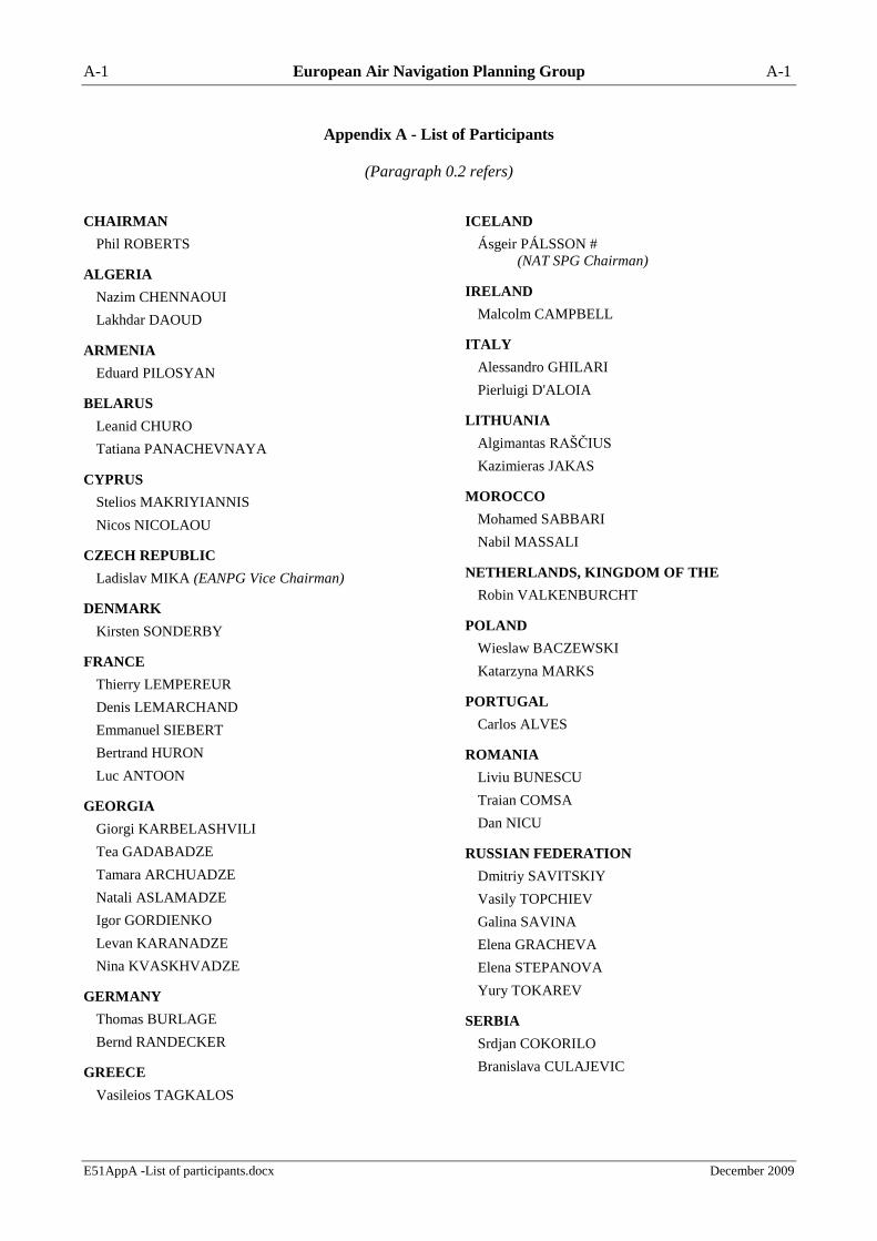
A-1 European Air Navigation Planning Group A-1
E51AppA -List of participants.docx December 2009
Appendix A - List of Participants
(Paragraph 0.2 refers)
CHAIRMAN
Phil ROBERTS
ALGERIA
Nazim CHENNAOUI
Lakhdar DAOUD
ARMENIA
Eduard PILOSYAN
BELARUS
Leanid CHURO
Tatiana PANACHEVNAYA
CYPRUS
Stelios MAKRIYIANNIS
Nicos NICOLAOU
CZECH REPUBLIC
Ladislav MIKA (EANPG Vice Chairman)
DENMARK
Kirsten SONDERBY
FRANCE
Thierry LEMPEREUR
Denis LEMARCHAND
Emmanuel SIEBERT
Bertrand HURON
Luc ANTOON
GEORGIA
Giorgi KARBELASHVILI
Tea GADABADZE
Tamara ARCHUADZE
Natali ASLAMADZE
Igor GORDIENKO
Levan KARANADZE
Nina KVASKHVADZE
GERMANY
Thomas BURLAGE
Bernd RANDECKER
GREECE
Vasileios TAGKALOS
ICELAND
Ásgeir PÁLSSON #
(NAT SPG Chairman)
IRELAND
Malcolm CAMPBELL
ITALY
Alessandro GHILARI
Pierluigi D'ALOIA
LITHUANIA
Algimantas RAŠČIUS
Kazimieras JAKAS
MOROCCO
Mohamed SABBARI
Nabil MASSALI
NETHERLANDS, KINGDOM OF THE
Robin VALKENBURCHT
POLAND
Wieslaw BACZEWSKI
Katarzyna MARKS
PORTUGAL
Carlos ALVES
ROMANIA
Liviu BUNESCU
Traian COMSA
Dan NICU
RUSSIAN FEDERATION
Dmitriy SAVITSKIY
Vasily TOPCHIEV
Galina SAVINA
Elena GRACHEVA
Elena STEPANOVA
Yury TOKAREV
SERBIA
Srdjan COKORILO
Branislava CULAJEVIC

A-2 European Air Navigation Planning Group A-2
E51AppA -List of participants.docx December 2009
SLOVAKIA
Ľudovít GÁBRIŠ
SPAIN
Ricardo ALONSO GONZALEZ
SWITZERLAND
Julien SUBILIA
Thomas BUCHANAN
TUNISIA
Somrani CHAHINE
Mohamed HJAIEJ
TURKEY
Kerem ALP
Yusuf BOZDOGAN
Gaye Betül DOGAN
Ayhan ÖZTEKİN
UKRAINE
Oleg NOVAK
Volodymyr CHALYK
Vitaliy SIMAK
UNITED KINGDOM
Gordon REID
UNITED STATES
Daniel VACA
INTERNATIONAL ORGANISATIONS
EUROCONTROL
Istvan BOZSA
Kim BREIVIK#
Richard FARNWORTH#
Andy LEWIS#
Tony LICU#
David MARTEN#
Gerry McAULEY#
EUROPEAN COMMISSION
Alfonso ARROYO
Sven HALLE
# part time
IAC
Oleg ERMOLOV
IATA
Peter SORENSEN
IBAC
Patrick EXPERTON
IFALPA
Heinz FRÜHWIRTH
IFATCA
Patrik PETERS
NATMC
Giorgio CIONI#
Istvan TALLA#

B1-1 European Air Navigation Planning Group B1-1
E51AppB1 - FUA PFA Basic ANP.docx December 2009
Appendix B1 - Proposal For Amendment To Doc 7754, EUR ANP, Volume I, Basic ANP
(Paragraph 4.2.9 refers)
Part V
AIR TRAFFIC MANAGEMENT (ATM) - Part V.I
AIRSPACE MANAGEMENT (ASM)
Editorial Note: Amendments are arranged to show deleted text using strikeout (text to be deleted), and
added text with grey shading (text to be inserted).
1. Controlled airspace should be established so as to encompass the climb to cruising level of
departing aircraft, the cruising levels on ATS routes normally used by IFR flights and the descent from
such levels of arriving aircraft, except in those cases where the type and density of traffic clearly do not
justify the establishment of controlled airspace. Provisions should be made to ensure that SST aircraft are
able to conduct the transonic and supersonic phases of their flights within controlled airspace, regardless
of density of traffic.
[Annex 11, Chapter 2]
Note.— Detailed provisions regarding the type of air traffic service required are highlighted in
1 to 7 of Part V.II — ATS.
2. The lower limit of controlled airspace should be established so that:
a) IFR flights requiring the provision of air traffic control service can remain within
controlled airspace during the entire duration of their flight; and
b) flights not requiring ATC services are not unnecessarily restricted.
In the vicinity of aerodromes, the establishment of the lower limit of controlled airspace should also take
into account those portions of the airspace which may be required by ATC in order to vector aircraft by
radar.
[Annex 11, 2.9.3]
3. Controlled airspace should be established in the upper airspace up to flight level 460 and
throughout the whole control area whenever area type air traffic control service is provided.
[EUM/VI, Rec 8/13]
4. Airspace restrictions and/or temporary airspace reservations for specific users or purposes should
only be imposed when the intended purpose cannot be met by other arrangements. If established, such
restrictions and/or reservations should be kept to the minimum, both in extent and duration consistent
with the purpose they serve and should be withdrawn as soon as possible. In addition, any restricted
and/or reserved airspace should be made available for general use whenever the activities having led to
their establishment are temporarily suspended, e.g. during weekends, at night, etc. (18, Part II — GEN
also refers).
[Annex 11, 2.17]
5. Where users have specific requirements in portions of the airspace extending over the territory of
a number of States and/or over the high seas, arrangements should be made between States concerned for
the coordinated use of airspace, facilities and procedures in order to ensure maximum uniformity.
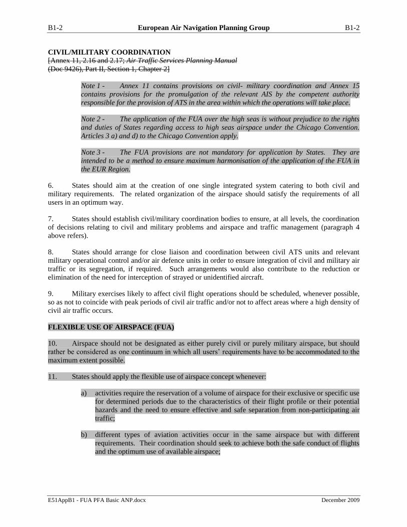
B1-2 European Air Navigation Planning Group B1-2
E51AppB1 - FUA PFA Basic ANP.docx December 2009
CIVIL/MILITARY COORDINATION
[Annex 11, 2.16 and 2.17; Air Traffic Services Planning Manual
(Doc 9426), Part II, Section 1, Chapter 2]
Note 1 - Annex 11 contains provisions on civil- military coordination and Annex 15
contains provisions for the promulgation of the relevant AIS by the competent authority
responsible for the provision of ATS in the area within which the operations will take place.
Note 2 - The application of the FUA over the high seas is without prejudice to the rights
and duties of States regarding access to high seas airspace under the Chicago Convention.
Articles 3 a) and d) to the Chicago Convention apply.
Note 3 - The FUA provisions are not mandatory for application by States. They are
intended to be a method to ensure maximum harmonisation of the application of the FUA in
the EUR Region.
6. States should aim at the creation of one single integrated system catering to both civil and
military requirements. The related organization of the airspace should satisfy the requirements of all
users in an optimum way.
7. States should establish civil/military coordination bodies to ensure, at all levels, the coordination
of decisions relating to civil and military problems and airspace and traffic management (paragraph 4
above refers).
8. States should arrange for close liaison and coordination between civil ATS units and relevant
military operational control and/or air defence units in order to ensure integration of civil and military air
traffic or its segregation, if required. Such arrangements would also contribute to the reduction or
elimination of the need for interception of strayed or unidentified aircraft.
9. Military exercises likely to affect civil flight operations should be scheduled, whenever possible,
so as not to coincide with peak periods of civil air traffic and/or not to affect areas where a high density of
civil air traffic occurs.
FLEXIBLE USE OF AIRSPACE (FUA)
10. Airspace should not be designated as either purely civil or purely military airspace, but should
rather be considered as one continuum in which all users’ requirements have to be accommodated to the
maximum extent possible.
11. States should apply the flexible use of airspace concept whenever:
a) activities require the reservation of a volume of airspace for their exclusive or specific use
for determined periods due to the characteristics of their flight profile or their potential
hazards and the need to ensure effective and safe separation from non-participating air
traffic;
b) different types of aviation activities occur in the same airspace but with different
requirements. Their coordination should seek to achieve both the safe conduct of flights
and the optimum use of available airspace;

B1-3 European Air Navigation Planning Group B1-3
E51AppB1 - FUA PFA Basic ANP.docx December 2009
c) accuracy of information on airspace status and on specific air traffic situations, and timely
distribution of this information to civil and military controllers and controlling military
units has a direct impact on the safety and efficiency of operations; and
d) timely access to up-to-date information on airspace status is essential for all parties
wishing to take advantage of airspace structures made available when planning their
flights.
FLEXIBLE USE OF AIRSPACE OVER THE HIGH SEAS
12. The flexible use of airspace concept also covers airspace over the high seas. Its application
should therefore be without prejudice to the rights and duties of States under the Convention on
International Civil Aviation (Chicago Convention) and its annexes, or the 1982 UN Convention on the
Law of the Sea (UNCLOS).1
10.13. Regulations governing flights of State aircraft over the high seas should, to the maximum extent
practicable, comply with the relevant provisions of Annex 2. Where this is not possible due to the nature
of the operations involved, measures should be taken to ensure that other aircraft are not endangered by
such operations. These should preferably be established in coordination with the State responsible for the
provision of air traffic services over that part of the high seas affected by such operations.
. . .
1 Turkey is not a signatory to the UNCLOS and their position is well known and remains unchanged.

B2-1 European Air Navigation Planning Group B2-1
E51AppB2 - FUA PFA FASID.docx December 2009
Appendix B2 - Proposal For Amendment To Doc 7754, EUR ANP, Volume II, FASID
(Paragraph 4.2.9 refers)
Part V
AIR TRAFFIC MANAGEMENT (ATM)
PART V.I - AIRSPACE MANAGEMENT (ASM)
Editorial Note: Amendments are arranged to show deleted text using strikeout (text to be deleted), and
added text with grey shading (text to be inserted).
INTRODUCTION
1. The material in this part complements that contained in Part I — BORPC and Part V.I — ASM of
the Basic ANP and should be taken into consideration in the overall planning processes for the EUR
region.
2. This part contains the details of the facilities and/or services to be provided to fulfil the basic
requirements of the plan and/or as agreed between the provider and user States concerned. Such
agreement indicates a commitment on the part of the State(s) concerned to implement the requirement(s)
specified. This element of the FASID, in conjunction with the EUR Basic ANP, is kept under constant
review by the EANPG in accordance with its schedule of management, in consultation with user and
provider States and with the assistance of the ICAO EUR/NAT Regional Office.
AIRSPACE MANAGEMENT
3. States requiring a vertical division in part or all of their airspace should select a level that:
a) would allow for maximum ATC flexibility and capacity;
b) would, to the greatest extent possible, allow for the use of optimum flight profiles;
c) keeps ATC coordination requirements and cockpit workload to a minimum; and
d) as much as possible, coincides with a level already used in any adjacent State or
elsewhere in the region by other States in a similar situation.
CIVIL/MILITARY COORDINATION
4. Prior to and during the conduct of military exercises, measures should be taken to ensure that
both civil and military aircraft are able to conduct their operations without risk of dangerous incidents and
without restricting each other unnecessarily. Particular attention should be given to the need for reducing
to the minimum the time periods during which civil flight operations will have to be restricted.
5. Penetration of controlled airspace by military aircraft not under the control of the appropriate civil
ATC unit should be avoided. If this is not possible, such penetrations should take place only on condition
that:

B2-2 European Air Navigation Planning Group B2-2
E51AppB2 - FUA PFA FASID.docx December 2009
a) they have been made the subject of a specific letter of agreement between the civil ATC
and the military units concerned;
b) direct speech communications exist between that civil ATC and the military units
concerned; and
c) they are carried out under radar surveillance by the military unit in question, applying at
least the applicable ICAO separation minima.
FLEXIBLE USE OF AIRSPACE (FUA)
6. Flexible use of airspace (FUA) in the EUR region should be provided, when applicable, in
accordance with the procedures outlined in Attachments A, B and C.
7. The flexible use of airspace should be governed by the following principles:
a) coordination between civil and military authorities should be organised at the strategic,
pre-tactical and tactical levels of airspace management. Agreements and procedures
should be established in order to increase safety and airspace capacity, and to improve the
efficiency and flexibility of aircraft operations;
b) consistency between airspace management, air traffic flow management and air traffic
services should be ensured and maintained at the three levels of airspace management
described below in order to ensure, for the benefit of all users, efficiency in airspace
planning, allocation and use; and
c) an airspace reservation for exclusive or specific use of categories of users should be of a
temporary nature, applied only during limited periods of time based on actual use, and
released as soon as the activity having caused its establishment ceases.
Strategic airspace management (level 1)
8. States should:
a) ensure the overall application of the flexible use of airspace at a strategic, pre-tactical and
tactical level;
b) regularly review users’ requirements;
c) approve the activities which require airspace reservation or restriction;
d) define temporary airspace structures and procedures to offer multiple airspace reservation
and route options;
e) establish criteria and procedures providing for the creation and use of adjustable lateral
and vertical limits of the airspace required for accommodating diverse variations of flight
paths and short-term changes of flights;
f) assess the national airspace structures and route network with the aim of planning for
flexible airspace structures and procedures;

B2-3 European Air Navigation Planning Group B2-3
E51AppB2 - FUA PFA FASID.docx December 2009
g) define the specific conditions under which the responsibility for separation between civil
and military flights rests on the ATS units or controlling military units;
h) develop cross-border airspace use with neighbouring States where needed to
accommodate traffic flows and users’ activities;
i) coordinate their airspace management policy with those of neighbouring States to jointly
address use of airspace across national borders and/or boundaries of flight information
regions;
j) establish and make airspace structures available to users in close cooperation and
coordination with neighbouring States where the airspace structures concerned have a
significant impact on the traffic across national borders and/or boundaries of flight
information regions, with a view to ensuring optimum use of airspace for all users;
k) establish with neighbouring States one common set of standards for separation between
civil and military flights engaged in cross-border activities;
l) set up consultation mechanisms between all relevant partners and organisations to ensure
that users’ requirements are properly addressed;
m) assess and review airspace procedures and performance of flexible use of airspace
operations; and
n) establish mechanisms to archive data on the requests, allocation and actual use of airspace
structures for further analysis and planning activities.
9. In those States where both civil and military authorities are responsible for or involved in airspace
management, the tasks set out in paragraph 8 should be performed through a joint civil-military process.
Pre-tactical airspace management (level 2)
10. States should establish an airspace management cell to allocate airspace in accordance with the
conditions and procedures defined in paragraph 8 above. In those States where both civil and military
authorities are responsible for, or involved in airspace management, this cell should take the form of a
joint civil/military cell.
Note.– Two or more States may establish a joint airspace management cell.
11. States should ensure that adequate supporting systems are put in place to enable the airspace
management cell to manage airspace allocation and to disseminate the information relating to airspace
apportionment to all affected in a timely fashion.
Tactical airspace management (level 3)
12. States should establish civil/military coordination procedures and communication facilities
between appropriate ATS units and controlling military units permitting mutual provision of airspace data
to allow real-time activation, deactivation or reallocation of the airspace allocated at pre-tactical level.

B2-4 European Air Navigation Planning Group B2-4
E51AppB2 - FUA PFA FASID.docx December 2009
13. States should ensure that the relevant controlling military units and ATS units exchange
information on any modifications to the planned activation of airspace in a timely and effective manner,
and notify all affected users of the current status of the airspace.
14. States should establish coordination procedures and supporting systems between ATS units and
controlling military units in order to ensure safety when managing interactions between civil and military
flights.
15. States should establish coordination procedures between civil and military ATS units so as to
permit direct communication of relevant information to resolve specific traffic situations where civil and
military controllers are providing services in the same airspace. This information should be made
available, in particular where it is required for safety reasons, to civil and military controllers and
controlling military units through a timely exchange of flight data, including the position and flight
intention of aircraft.
APPLICATION OF FLEXIBLE USE OF AIRSPACE (FUA) OVER THE HIGH SEAS
16. States which have accepted the responsibility to provide air traffic services over the high seas
should ensure that danger areas established over the high seas are of a temporary nature and should
include mechanisms which promote access by all airspace users to the fullest extent possible.
17. States which have accepted the responsibility to provide air traffic services over the high seas
should lay down the necessary guidelines to reflect the status of the airspace coordination process over the
high seas, and should ensure that, the airspace management cell established by the State which has
accepted the responsibility to provide air traffic services in airspace over the high seas is the focal point
for all airspace requests over that airspace.
18 Access to high seas airspace cannot be denied nor can State aircraft be ―forced‖ to participate in
the application of an FUA concept. Any procedure or agreement developed must not give the operators of
State aircraft the perception that their operations would be restricted in any way. Therefore, the
procedures and/or agreements must also acknowledge that negotiating the use of the airspace was the
ideal; without prejudice to Articles 3a and 3d of the Chicago Convention, there may be exceptional
circumstances when1:
- only notification of operation would be possible; or
- operational considerations may preclude either negotiation or notification.
19. Provider States should take into account the benefits of the establishment of joint AMCs, which
might enhance the cooperation among the user and provider States.
Note: - Guidelines regarding coordination between military authorities and ATS authorities are
contained in the ICAO Manual Concerning Safety Measures Relating to Military Activities
Potentially Hazardous to Civil Aircraft Operations (Doc 9554).
1 Greece maintains that notification of operations must be secured under any circumstances.

B2-5 European Air Navigation Planning Group B2-5
E51AppB2 - FUA PFA FASID.docx December 2009
Attachment A
EXPLANATION OF TERMS USED IN FLEXIBLE USE OF AIRSPACE (FUA)
Ad hoc structures. Airspace structures, whether routes or areas, required in order to meet operational
needs at shorter notice than Level 1 process. The establishment of such ad hoc structures at Level 2 or
Level 3 follows the general design and safety management criteria.
Airspace management. A planning function with the primary objective of maximising the utilisation of
available airspace by dynamic time-sharing and, at times, the segregation of airspace among various
categories of airspace users on the basis of short-term needs.
Airspace management cell (AMC). A cell responsible for the day-to-day management of the airspace
under the responsibility of one or more States.
Airspace reservation. A defined volume of airspace temporarily reserved for exclusive or specific use by
categories of users.
Air traffic control clearance. Authorization for an aircraft to proceed under the conditions specified by an
air traffic control Unit.
Air traffic flow management (ATFM). A service established with the objective of contributing to a safe,
orderly and expeditious flow of air traffic by ensuring that ATC capacity is utilised to the maximum
extent possible, and that the traffic volume is compatible with the capacities declared by the
appropriate ATS authority.
Civil-military coordination. The coordination between civil and military parties authorised to make
decisions and agree a course of action.
Conditional route (CDR). ATS route that is only available for use and flight planning under specified
conditions. A conditional route may be of more than one category, and those categories may change at
specified times:
Category 1 conditional route (CDR1)
CDR1 routes are available for flight planning during times published in the relevant
Aeronautical Information Publication (AIP).
Category 2 conditional route (CDR2)
CDR2 routes may be available for flight planning. Flights may only be planned on a CDR2
in accordance with conditions published daily in the conditional route availability message.
Category 3 conditional route (CDR3)
CDR3 routes are not available for flight planning. Flights must not be planned on these
routes but ATC units may issue tactical clearances on such route segments.

B2-6 European Air Navigation Planning Group B2-6
E51AppB2 - FUA PFA FASID.docx December 2009
Note: - Over the high seas, CDRs form part of the regional ATS route network and are therefore
subject to the Council approved procedure for the amendment of Council approved ANPs.
The designation of ATS routes as CDRs is the prerogative of the State concerned.
Conditional route availability message (CRAM). A special consolidated ASM message issued daily by
the centralised airspace data function (CADF) to promulgate in one message, on behalf of the States,
the AMC decisions on conditional routes availability notified by the airspace use plans for the ECAC
area. The CRAM is used by aircraft operators for flight planning purposes.
Controlling military unit. Any fixed or mobile military unit handling military air traffic and/or pursuing
other activities which, owing to their specific nature, may require an airspace reservation.
Cross border area (CBA). An airspace reservation established over international boundaries for specific
operational requirements. This may take the form of a temporary airspace reservation.
Cross border Operations (CBO). Cross border/FIR boundary operations is a process which encompasses
activities conducted by one or more States, within an area established across international boundaries
or entirely within the airspace under the jurisdiction of a State.
Danger area. An airspace of defined dimensions within which activities dangerous to the flight of aircraft
may exist at specified times.
Flight intention. The flight path and associated flight data describing the planned trajectory of a flight to
its destination, as updated at any moment.
Flight plan. Specified information provided to air traffic services units, relative to an intended flight or
portion of the flight of an aircraft.
Sector. Part of a control area and/or a flight information region/upper flight information region.

B2-7 European Air Navigation Planning Group B2-7
E51AppB2 - FUA PFA FASID.docx December 2009
Attachment B
OBJECTIVES, ORGANIZATION AND OPERATION OF THE FLEXIBLE USE OF AIRSPACE
GENERAL REQUIREMENTS
1. When applying the FUA, the States should:
a) maintain and actively seek to improve the safe and effective management of the airspace
and its supporting infrastructure;
b) exercise fair and effective regulation of the airspace organisation and management;
c) build confidence and respect between airspace regulators and all other stakeholders
through consultation and cooperation;
d) maintain and improve standards of service through effective planning and monitoring of
key processes and activities;
e) accommodate shared use of national airspace by all user groups;
f) harmonise airspace management procedures with neighbouring States;
g) conduct regular monitoring of compliance with the FUA regulations at each level.
2. In particular, States should:
a) ensure that a commonly agreed airspace policy is formulated (e.g. a national airspace
charter);
b) ensure that agreed priority rules and negotiation procedures for airspace allocation at
ASM Level 2 and ASM Level 3 are clearly defined and implemented;
c) ensure the ongoing (at least yearly) re-assessment of national airspace with regard to
effective application of FUA;
d) ensure the progressive establishment of new flexible airspace structures, where
appropriate;
e) establish framework agreements between civil and military authorities to facilitate the
application of FUA;
f) ensure the introduction of procedures for the allocation of flexible airspace structures on a
day-by-day basis;
g) ensure that appropriate national legislation is in place and amended as necessary;
h) ensure that coordination processes between all levels of ASM are established;
i) ensure that adequate real-time civil/military co-ordination facilities and procedures are
established;

B2-8 European Air Navigation Planning Group B2-8
E51AppB2 - FUA PFA FASID.docx December 2009
j) ensure that civil and military terms and definitions applicable to the principles governing
the FUA are harmonised;
k) ensure that at any one time the total volume of airspace reservations are kept to a
minimum while ensuring safety and satisfying national operational requirements;
l) ensure that a commonly agreed airspace policy for certain portions of airspace of two or
more States involved, is formulated; and
m) ensure the regular (at least yearly) re-assessment of the joint airspace of two or more
States where appropriate.
3. The State should ensure that a framework is established for effective coordination between ATS,
ASM and ATFM at the three ASM Levels in a collaborative manner, and ensure the establishment of
coordination agreements defining clear and unambiguous operational procedures at ASM Level 2 and 3.
4. States should ensure and monitor that any airspace reservations applicable to ASM are of a
temporary nature, and should ensure:
a) that rules are established for the timely activation and release of reserved airspace, based
on actual use;
b) that coordination and interaction procedures are established concerning the release and
extended activation of reserved airspace different from the reserved timeframe, where
appropriate; and
c) that written agreements are drawn up between parties involved.
5. States should establish consultation mechanisms with all relevant partners and organisations, and
should:
a) ensure that consultations with airspace users, service providers and other relevant bodies
are conducted with the aim of obtaining consensus, wherever possible, before making
changes in the planning or design of airspace arrangements; and
b) ensure that the functional responsibilities of the persons/authorities are defined.
6. States should define priority criteria for airspace allocation, and should:
a) ensure that the civil and military operational needs, without affording preferential
treatment to either, and ensure that airspace planning takes into account all users
requirements are reconciled;
b) ensure that the coordination procedures for joint civil-military airspace allocation and
review process are defined; and
c) approve and enforce national policies for an effective airspace allocation and review
process, taking into account:
i) the needs of all stakeholders;
ii) national security and defence needs;

B2-9 European Air Navigation Planning Group B2-9
E51AppB2 - FUA PFA FASID.docx December 2009
iii) environmental issues; and
iv) network effects.
7. States should ensure that civil and military systems are interoperable with respect to supporting
the timely sharing of correct and consistent information.
8. States should ensure that ASM supporting tools and data are available to facilitate airspace
planning and allocation. This should include:
a) exchange of airspace data and information;
b) civil/military airspace planning and ATS coordination and booking tool;
c) link between ASM, ATFM and ATS functions; and
d) automation of manual tasks.
9. States should ensure that communication means between all participating units at ASM Level 2
and 3 are available to facilitate timely transmission and receipt of airspace management cell decisions.
10. Direct and reliable communication facilities between all units involved should be established.
STRATEGIC AIRSPACE MANAGEMENT REQUIREMENTS (ASM Level 1)
11. When States apply airspace planning principles and criteria for ASM Level 1, they should ensure
that:
a) the effective sharing of airspace and its efficient use by civil and military users stemming
from the application of FUA is realised through joint civil/military strategic planning and
pre-tactical airspace allocation;
b) written agreements or arrangements are put in place between the competent civil and
military units, based on timely data processing for airspace allocation, to enable them to
take into account the activation and deactivation of temporary structures;
c) efficient operations at ASM Level 3 are put in place including the establishment of
coordination procedures between civil and military ATS units, and between them and
military controlling units to support a process exploiting the airspace capacity in a
dynamic manner;
d) in particular:
i) written agreements between the competent civil and military authorities should be in
place;
ii) clearly defined LoAs should be agreed and implemented, containing agreed priority
rules and coordination procedures for airspace allocation and use at ASM Levels 2
and 3;
iii) where required, airspace re-allocation, as close as practical to the time of operations
to accommodate short-term changes in traffic situation and/or users requirements
should be enabled.

B2-10 European Air Navigation Planning Group B2-10
E51AppB2 - FUA PFA FASID.docx December 2009
12. Where appropriate, States should conclude agreements with neighbouring States to enable cross
border/FIR boundary operations within agreed areas established across international borders or entirely
within airspace under the jurisdiction of a State, to include:
a) the allocation and shared use of common cross border areas (CBAs);
b) the allocation and shared use of national areas entirely established within the airspace
under the jurisdiction of one of the Contracting States;
c) delegation of responsibility for the provision of air traffic services in designated airspace
from one to the other Contracting State(s), if appropriate.
13. States should authorise their competent agencies such as military controlling units, approved
agencies, AMCs and ATS units to negotiate and conclude necessary written agreements that could
contain specific operational and technical aspects related to pre-tactical and tactical airspace management,
and arrangements for the provision of ATS, if and where applicable.
14. Such agreements should include all relevant legal, operational and technical issues for
cooperation and interaction covering all relevant civil and military issues (e.g. defence, operations,
environment and search and rescue), and the following;
a) designation of the responsibility for the provision of ATS;
b) designation of competent civil and military authorities involved in ASM activities;
c) determination of responsibility for allocation of the areas concerned based on the
principle of delegation of responsibility to a lead, co-located or integrated multinational
AMC as appropriate;
d) air defence coordination and notification procedures;
e) priority allocation rules, time based parameters and reservation assurance processes;
f) coordination procedures and interaction rules concerning the activation and release of the
cross-border airspace reservation;
g) services in the area(s) concerned following the principle of delegation of responsibility,
where applicable;
h) contingency procedures;
i) other operational issues pertinent to cross border/FIR boundary operations as appropriate;
and
j) compatibility of communication and flight data exchange systems between civil and
military parties, including usage of technical enablers (e.g. ASM/ATFM tool).
15. States should ensure the:
a) shared use of airspace in respect of all users;
b) establishment of working structures for ASM Levels 2 and 3, together with the
appropriate authority required to carry out the tasks; and
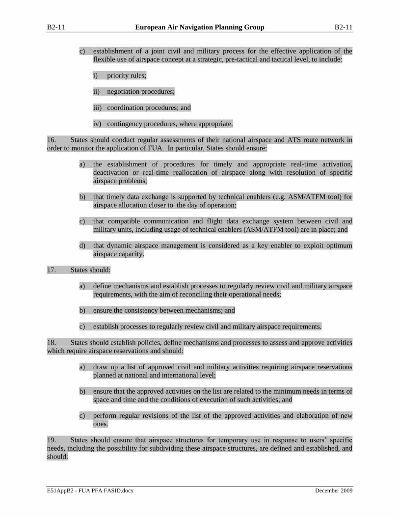
B2-11 European Air Navigation Planning Group B2-11
E51AppB2 - FUA PFA FASID.docx December 2009
c) establishment of a joint civil and military process for the effective application of the
flexible use of airspace concept at a strategic, pre-tactical and tactical level, to include:
i) priority rules;
ii) negotiation procedures;
iii) coordination procedures; and
iv) contingency procedures, where appropriate.
16. States should conduct regular assessments of their national airspace and ATS route network in
order to monitor the application of FUA. In particular, States should ensure:
a) the establishment of procedures for timely and appropriate real-time activation,
deactivation or real-time reallocation of airspace along with resolution of specific
airspace problems;
b) that timely data exchange is supported by technical enablers (e.g. ASM/ATFM tool) for
airspace allocation closer to the day of operation;
c) that compatible communication and flight data exchange system between civil and
military units, including usage of technical enablers (ASM/ATFM tool) are in place; and
d) that dynamic airspace management is considered as a key enabler to exploit optimum
airspace capacity.
17. States should:
a) define mechanisms and establish processes to regularly review civil and military airspace
requirements, with the aim of reconciling their operational needs;
b) ensure the consistency between mechanisms; and
c) establish processes to regularly review civil and military airspace requirements.
18. States should establish policies, define mechanisms and processes to assess and approve activities
which require airspace reservations and should:
a) draw up a list of approved civil and military activities requiring airspace reservations
planned at national and international level;
b) ensure that the approved activities on the list are related to the minimum needs in terms of
space and time and the conditions of execution of such activities; and
c) perform regular revisions of the list of the approved activities and elaboration of new
ones.
19. States should ensure that airspace structures for temporary use in response to users’ specific
needs, including the possibility for subdividing these airspace structures, are defined and established, and
should:

B2-12 European Air Navigation Planning Group B2-12
E51AppB2 - FUA PFA FASID.docx December 2009
a) establish and publish procedures for airspace allocation and use for activities which
require an airspace reservation;
b) ensure that these procedures provide for multiple choice of airspace reservations and
related route segments taking into account the network effect;
c) ensure that procedures are in place to promulgate airspace reservations;
d) make provisions for dynamic airspace management processes, at national ASM Level 2
and 3;
e) define and establish processes allowing ASM Levels 2 and 3 to create and operationally
use additional ad hoc structures; and
f) establish procedures for airspace allocation and use for activities which require a mobile
airspace reservation, where appropriate.
20. States should ensure that the principles for adjusting lateral and vertical limits of airspace
structures including the subdividing of airspace reservations into elementary modules on ASM Levels 2
& 3 are defined, and should:
a) define criteria for designing airspace to enable for adjustable lateral and vertical limits of
airspace structures, including the subdividing of airspace reservations into elementary
modules;
b) define criteria for adjusting the lateral and vertical dimensions of airspace structures
based on subdivided airspace reservations into elementary modules on ASM Levels 2 &
3; and
c) establish procedures for adjusting the lateral and vertical dimensions based on subdivided
airspace reservations into elementary modules on ASM Levels 2 & 3.
21. States should ensure that processes for periodic assessment and analysis of existing airspace
structures and ATS route network based on balanced consideration of civil and military requirements are
in place with the aim of planning for flexible airspace structures and procedures. The assessment
processes include:
a) identification of need;
b) analysis of the potential impact;
c) decision to proceed;
d) consultation;
e) approval; and
f) publication.
22. States should define the circumstances when an ATS unit or controlling military unit is
responsible for separation between civil and military flights, e.g. in case of a shared portion of airspace,
tactical crossing of ATS routes and tactical crossing of temporary reserved areas, and:

B2-13 European Air Navigation Planning Group B2-13
E51AppB2 - FUA PFA FASID.docx December 2009
a) determine the conditions under which the responsibility for separation between civil and
military flights may rest on the air traffic services units or controlling military units;
b) define the criteria for determining the responsibility for providing separation between
civil and military flights; and
c) ensure that the conditions and criteria for the responsibility for separation between civil
and military flights are contained in written agreements or other appropriate
arrangements.
PRE-TACTICAL AIRSPACE MANAGEMENT REQUIREMENTS (ASM Level 2)
23. When States apply airspace allocation at ASM Level 2, they should:
a) appoint a focal point, or establish and authorise airspace management cells, or joint civil
and military airspace management cells;
b) authorise AMC to conduct airspace allocation and management in a decisive, timely and
efficient manner and resolve conflicting airspace requirements;
c) ensure that staff is adequately trained in the knowledge and operation of the airspace
allocation process and use of supporting systems;
d) ensure that AMCs collect and analyse all airspace requests and decide the daily airspace
allocation taking into account user requirements, available capacity and the effect on the
network; and
e) make AMCs responsible for the conduct of day-to-day Level 2 airspace allocation and
management.
24. In particular, the airspace management cells should:
a) act as the day-to-day focal point for ASM Level 2 coordination;
b) collect and analyse all airspace requests which may require a temporary airspace
reservation , including airspace allocation decisions taken at ASM Level 1 in respect of
major military exercises, air shows etc;
c) analyse the CDR availability requests together with the traffic demand, anticipated ATC
capacity problems and expected delay information received from the FMP;
d) resolve conflicting requests for airspace reservations and CDRs utilising all relevant
information;
e) resolve conflicts between incompatible or conflicting airspace requests by the application
of approved priorities, re-negotiation and rescheduling;
f) coordinate with adjacent AMC the harmonised availability of ―cross-border‖ CDRs;
g) respond to any additional request for assistance by the CFMU, the ACC/FMPs and other
approved agencies on matters arising from inconsistencies in supplied data, decisions or
unexpected events;

B2-14 European Air Navigation Planning Group B2-14
E51AppB2 - FUA PFA FASID.docx December 2009
h) decide on the allocation of airspace reservations and CBAs, after completion of the
collation, coordination, analysis, negotiation and resolution process;
i) activate CDR 2 in accordance with established procedures and for a minimum time of two
hours, but with no limit when it concerns the extension of the availability of the same
route with CDR 1 status;
j) decide in accordance with criteria established at Level 1 on the provisional closure of
CDRs 1 to be handled in real-time at ASM Level 3 in conjunction with the notification of
activity in associated airspace reservations;
k) promulgate the airspace allocation by transmitting the Airspace Use Plan (AUP) to
adjacent AMCs and ATFM Unit(s);
l) after the AUP distribution, provide clarification to ATFM Unit(s), if needed, and cross-
check the ―Draft CRAM‖ upon reception;
m) collect and analyse more up-to-date information on the day of operations f concerning the
cancellation of airspace reservations already published in the current AUP;
n) promulgate on the day of operation, if necessary, Updated Airspace Use Plans (UUPs)
containing additional reservations a during the period of validity of the current AUP;
o) participate in a post analysis of airspace allocation;
p) develop a reporting process which will deliver a view on the optimisation of the
availability and utilisation of shared airspace; and
q) conduct, where authorised, some Level 3 coordination tasks.
TACTICAL AIRSPACE MANAGEMENT REQUIREMENTS (ASM Level 3)
25. When carrying out real time civil/military coordination, States should ensure:
a) the definition, agreement and enforcement of coordination procedures between civil and
military ATS units and between them and controlling military units, vested with
agreements, to facilitate real-time activation, de-activation, re-allocation or modification
of the airspace allocated at pre-tactical level;
b) that the determination of these coordination procedures and communication facilities
takes into account the network effect;
c) that the procedures for timely exchange of any modification of airspace status between all
affected civil and military units are properly addressed in written agreements;
d) that any modifications of planned activation of airspace are notified to users in a timely
and effective manner, in order to facilitate safe, efficient and economic operations; and
e) the provision of data at network level subject to national security requirements.
26. States should ensure that coordination procedures between civil and military ATS
units/controlling military units are defined and agreed and operated to ensure safety when managing
interactions between civil and military flights.
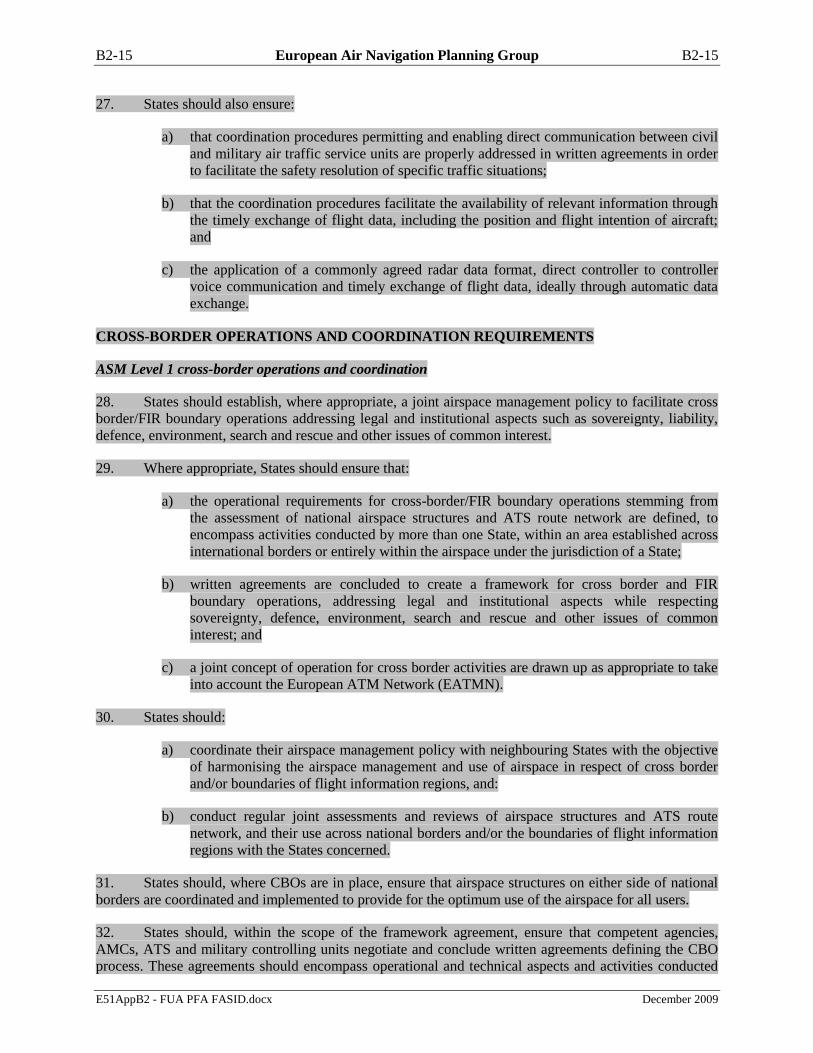
B2-15 European Air Navigation Planning Group B2-15
E51AppB2 - FUA PFA FASID.docx December 2009
27. States should also ensure:
a) that coordination procedures permitting and enabling direct communication between civil
and military air traffic service units are properly addressed in written agreements in order
to facilitate the safety resolution of specific traffic situations;
b) that the coordination procedures facilitate the availability of relevant information through
the timely exchange of flight data, including the position and flight intention of aircraft;
and
c) the application of a commonly agreed radar data format, direct controller to controller
voice communication and timely exchange of flight data, ideally through automatic data
exchange.
CROSS-BORDER OPERATIONS AND COORDINATION REQUIREMENTS
ASM Level 1 cross-border operations and coordination
28. States should establish, where appropriate, a joint airspace management policy to facilitate cross
border/FIR boundary operations addressing legal and institutional aspects such as sovereignty, liability,
defence, environment, search and rescue and other issues of common interest.
29. Where appropriate, States should ensure that:
a) the operational requirements for cross-border/FIR boundary operations stemming from
the assessment of national airspace structures and ATS route network are defined, to
encompass activities conducted by more than one State, within an area established across
international borders or entirely within the airspace under the jurisdiction of a State;
b) written agreements are concluded to create a framework for cross border and FIR
boundary operations, addressing legal and institutional aspects while respecting
sovereignty, defence, environment, search and rescue and other issues of common
interest; and
c) a joint concept of operation for cross border activities are drawn up as appropriate to take
into account the European ATM Network (EATMN).
30. States should:
a) coordinate their airspace management policy with neighbouring States with the objective
of harmonising the airspace management and use of airspace in respect of cross border
and/or boundaries of flight information regions, and:
b) conduct regular joint assessments and reviews of airspace structures and ATS route
network, and their use across national borders and/or the boundaries of flight information
regions with the States concerned.
31. States should, where CBOs are in place, ensure that airspace structures on either side of national
borders are coordinated and implemented to provide for the optimum use of the airspace for all users.
32. States should, within the scope of the framework agreement, ensure that competent agencies,
AMCs, ATS and military controlling units negotiate and conclude written agreements defining the CBO
process. These agreements should encompass operational and technical aspects and activities conducted

B2-16 European Air Navigation Planning Group B2-16
E51AppB2 - FUA PFA FASID.docx December 2009
by one or more than one State, within an area established across international boundaries or entirely
within the airspace under the jurisdiction of one State.
33. States should jointly define and approve one clear and unambiguous set of separation minima
and coordination procedures to be applied between civil and military flights, and
a) define the process for determining, in the case of shared portion of airspace, tactical
crossing of routes or tactical crossing of areas airspace reservations; and
b) appoint the unit responsible for separation between transit flights and the users of the
active airspace reservation.
ASM Level 2 cross-border operations and coordination
34. Where States have agreed on the establishment of CBOs, States should appoint a lead AMC and
ensure that the lead, joint or multi-national AMC has the responsibility for airspace management on ASM
Level 2 on both sides of the international border.
35. States should ensure that, where a joint or multinational AMC is established, written agreements
are concluded covering relevant operational, technical, procedures and personnel issues, taking into
account the following:
a) search and rescue responsibility;
b) ATS procedures and common language;
c) SSR code allocation;
d) type of flight (VFR or IFR);
e) maximum number of participating aircraft;
f) harmonised coordination procedures and flight plan data exchange;
g) communications;
h) air defence notification procedures;
i) common AMC procedures;
j) planning/scheduling procedures, relationship with AMC(s) concerned;
k) activation/de-activation procedures, relationship with ACC(s) concerned;
l) priority rules;
m) ATS occurrences reporting procedures; and
n) environmental issues.

B2-17 European Air Navigation Planning Group B2-17
E51AppB2 - FUA PFA FASID.docx December 2009
ASM Level 3 cross-border operations and coordination
36. States should ensure:
a) application of agreed separation minima between transit flights and the users of the active
airspace reservation; and
b) application of the agreed minima for spacing between aircraft inside and outside cross
border airspace reservations.
37. States should ensure:
a) that a common set of procedures to exchange information about real time airspace status
and its actual use are defined, agreed between ATS units involved, and between them and
controlling military units, where cross-border activities take place; and
b) that these common procedures address the safe management of specific traffic situations,
including:
i) responsibility and liability;
ii) ATC procedures;
iii) coordination and phraseology;
iv) air defence notification and related control procedures;
v) other operational issues;
vi) personnel issues including qualifications and training;
vii) technical issues; and
viii) contingency plans.
38. States should further ensure that these common sets of procedures are laid down in written
agreements.

B2-18 European Air Navigation Planning Group B2-18
E51AppB2 - FUA PFA FASID.docx December 2009
Attachment C
OBJECTIVES, ORGANIZATION AND OPERATION OF THE FLEXIBLE USE OF AIRSPACE
OVER THE HIGH SEAS
General requirements
1. In accordance with Annex 11, 2.1.2, the portions of airspace over the high seas where air traffic
services will be provided shall be determined on the basis of regional navigation agreements. A
Contracting State having accepted the responsibility to provide air traffic services in such portions of
airspace shall arrange for the services to be established and provided in accordance with the provisions of
Annex 11. Furthermore, in accordance with Annex 11, the Foreword and Note 2 to paragraph 2.1.2, a
State which has accepted such responsibility may apply the Standards and Recommended Practices in a
manner consistent with that adopted for airspace under its jurisdiction.
2. As regards airspace reservations, over the high seas only danger areas may be established in
accordance with Annex 2. In this context it should be noted that the establishment of such areas shall be
without prejudice to the rights and duties of States under the Convention on International Civil Aviation
(Chicago Convention) and its Annexes, or the 1982 UN Convention on the Law of the Sea2.
Principles
3. The flexible use of airspace may be employed over the high seas in accordance with the
principles used for airspace of sovereign territory, as described in Doc 7754 – V.I Basic ANP and V.I
FASID, which should be applied with the exception that State aircraft of all other States can exercise their
right to fly in any airspace over the high seas under the principle of ―due regard‖ as described in the
Chicago Convention, Article 3 a) and d). However, State aircraft should comply with the ICAO
provisions to the extent possible.
4. Civil aircraft and State aircraft operating in accordance with ICAO provisions are required to
apply the provisions of Annex 2 which apply without exception over the high seas. In particular, the
provisions of Annex 2, paragraph 3.6.1.1 regarding the requirement to obtain a clearance before operating
as a controlled flight and paragraph 3.6.5.1 regarding the requirement to establish two-way
communication with the unit providing air traffic control service are to be observed.
5. In order to provide added airspace capacity and to improve efficiency and flexibility of aircraft
operations, States should establish agreements and procedures providing for a flexible use of airspace
including that reserved for military or other special activities in accordance with the ICAO provisions.
The agreements and procedures should permit all airspace users to have safe access to such airspace.
When applicable, such agreements and procedures should be established on the basis of a regional air
navigation agreement.
2 Turkey is not a signatory to the UNCLOS and their position is well known and remains unchanged.

C-1 European Air Navigation Planning Group C-1
Appendix C - ORCAM/CCAMS/ eORCAM Areas
(paragraph 4.2.27 refers)
E51AppC - ORCAM-CCAMS-eORCAM.docx December 2009

D-1 European Air Navigation Planning Group D-1
E51AppD - Removal of OPC Channels.docx December 2009
Appendix D - Removal of OPC Channels
(Paragraph 4.4.7 refers)
------------------
STAT CTY ASGNBR FREQ LOCATION POLYGONSERVICE DOC COORD OP REMARKS
R F 845 136.975 NATIONAL AERODROMES OPC U-0/0 484300N 022300E NOP VDL 2 DEVELOPMENT UNTIL 2003
R IRL 1878 136.975 SHANNON ACC OPC U-0/0 524200N 085500W NOP SIT TEMP UNTIL END 2003
R IRL 1879 136.975 CORK/CORK OPC U-0/0 515000N 082900W NOP SIT TEMP UNTIL END 2003
R E 2171 136.975 MADRID/BARAJAS OPC U-0/0 402800N 033400W NOP VDL 2 UNTIL 31/12/03
R E 2173 136.975 BARCELONA/BARCELONA OPC U-0/0 411800N 020500E NOP VDL 2 UNTIL 31/12/03
R FIN 2727 136.950 HELSINKI/HEL. VANTAA AS U-0/0 602000N 245900E NOP VDL4 UNTIL 31/12/2004
R TUR 4034 136.950 DIYARBAKIR/UNAL ERKAN TWR C-25/40 375600N 401700E NOP
R E 2174 136.950 NATIONAL AERODROMES 37 A/G U-0/0 402800N 033400W NOP DATA LINK UNTIL 31/12/03
R AUT 2203 136.950 WIEN/SCHWECHAT A/G U-0/0 480700N 163400E NOP NUP TRIAL
R S 2729 136.950 NATIONAL AERODROMES A/G U-0/350 593500N 175600E NOP VDL4 UNTIL 31/12/2004
R AUT 2202 136.950 INNSBRUCK/INNSBRUCK A/G U-0/0 471600N 112100E NOP NUP TRIAL
R DNK 2833 136.925 KOBENHAVN/KASTRUP A/G U-0/350 553700N 123900E NOP VDL MODE 4 DATALINK FROM 01/10
R E 1866 136.925 BARCELONA/BARCELONA OPC U-0/0 411800N 020500E NOP ARINC UNTIL 31/12/03
R E 1867 136.925 MADRID/BARAJAS OPC U-0/0 402800N 033400W NOP ARINC UNTIL 31/12/03
R S 1565 136.925 MALMO OPC U-0/0 553500N 125600E NOP PETAL2 - ACARS -UNTIL 31/12/01
R S 41 136.925 NATIONAL AERODROMES 18 A/G A-450 600000N 150000E NOP $TBC(SECTOR) VDL4 ADS-B
R E 1868 136.925 PALMA DE MALLORCA OPC U-0/0 393300N 014400E NOP ARINC UNTIL 31/12/03
R E 1869 136.925 MALAGA/MALAGA OPC U-0/0 364000N 043000W NOP ARINC UNTIL 31/12/03
R AUT 43 136.925 NATIONAL AERODROMES 20 A/G A-450 480700N 163200E NOP $TBC(SECTOR) VDL 4
R POL 1358 136.925 KRAKOW/BALICE OPC U-0/0 500400N 194800E NOP TEMP. UNTIL 2003 NON-OPERATION
R MRC 1751 136.925 CASABLANCA/MOHAMED V OPC U-0/0 332200N 073400W NOP ARINC UNTIL 31/12/03
R MRC 1750 136.925 MARRAKECH/MENARA OPC U-0/0 313600N 080200W NOP ARINC UNTIL 31/12/03
R AUT 2888 136.925 WIEN/SCHWECHAT OPC U-0/0 480700N 163400E NOP ARINC UNTIL 30/09/04
R AUT 2886 136.925 INNSBRUCK/INNSBRUCK OPC U-0/0 471600N 112100E NOP ARINC UNTIL 30/09/04
R LVA 2988 136.925 RIGA A/G U-0/0 565500N 235800E OP IMPL ACCORDING TO EUR VDL FREQ
R POL 1359 136.925 SZCZECIN/GOLENIOW OPC U-0/0 533500N 145400E NOP TEMP. UNTILL 2003 NON-OPERATIO
R POL 1355 136.925 WARSZAWA/OKECIE OPC U-0/0 521000N 205800E NOP TEMP. UNTIL 2003 NON-OPERATION
R POL 1356 136.925 GDANSK/REBIECHOWO OPC U-0/0 542400N 183800E NOP TEMP. UNTIL 2003 NON-OPERATION
R POL 1357 136.925 POZNAN/LAWICA OPC U-0/0 522000N 165000E NOP TEMP. UNTIL 2003 NON-OPERATION
R E 1865 136.900 BARCELONA/BARCELONA OPC U-0/0 411800N 020500E NOP SITA UNTIL 31/12/03
R E 1863 136.900 MADRID/BARAJAS OPC U-0/0 402800N 033400W NOP SITA UNTIL 31/12/03
R D 12285 136.875 BRAUNSCHWEIG/BRAUNSC OPC U-0/0 521900N 103300E NOP VDL 2
R TUR 4729 136.825 ANTALYA OPC U-0/0 365300N 304800E NOP CAI
R TUR 11983 136.825 ISTANBUL/ATATURK OPC U-0/0 405900N 284900E NOP ANKAIR
R TUR 4728 136.800 ANTALYA OPC U-0/0 365400N 304700E NOP SXS
R G 1823 136.800 GATWICK OPC U-0/0 510800N 001100W NOP AIRTOURS
R F 10688 136.800 PARIS/CH.DE GAULLE OPC U-0/0 490100N 022300E NOP OPC AFR
R TUR 4730 136.800 IZMIR/ADNAN-MENDERES OPC U-0/0 381700N 270900E NOP SXS
R S 3310 136.800 TROLLHATTAN OPC U-0/0 581900N 122100E NOP
R IRL 1311 136.800 SHANNON/SHANNON OPC U-0/0 524200N 085500W NOP UPS
R IRL 1494 136.800 DUBLIN/DUBLIN OPC U-0/0 532600N 061500W NOP UPS
R RUS 2011 136.750 NATIONAL AERODROMES
423+
424 A/G A-450 444700N 384800E NOP
R - RUS 2660 136.750 SOCHI A/G C-80/450 435000N 394500E NOP
R - RUS 2659 136.700 KRASNODAR 594 ACC A-450 450200N 383900E NOP
R LBY 5976 136.700 SEBHA/SEBHA OPC U-0/0 270100N 142700E NOP

E-1 European Air Navigation Planning Group E-1
E51AppE - Harmonisation of LVP provisions.docx December 2009
Appendix E - Harmonisation of LVP provisions
(EANPG Conclusion 51/12)
(Paragraph 4.4.28 refers)
Specific areas for global LVP harmonisation:
a) The equipment failure table. There are differences in description of the effects of equipment
failure on aircraft operations between ICAO, European Aviation Safety Agency (EASA) and the
United States Federal Aviation Administration (FAA);
b) An LVP entry in the Aeronautical Information Publication (AIP). A standardised AIP entry for
LVP is desirable;
c) Note: A standardised format has been recommended by EANPG Conclusion 44/19 but has not yet
been implemented.
d) The ground charts to include reference to LVP specific items (provision of lighting, location of
stopbars etc) and it is recommended to minimise the use of notes where possible;
e) As highlighted by airspace users, the LVP provisions should be simplified and globally
harmonised;
f) Advanced - Surface Movement Guidance and Control Systems (A-SMGCS) procedures should be
based on the latest ICAO EUR Regional Supplementary Procedures (SUPPS) (Doc 7030)
amendment (July 2009);
g) Standardised transponder operating procedures for A-SMGCS should be globally adopted;
h) The future PANS-Aerodromes needs to be harmonised for LVP; and
i) A global guidance material on the management of critical and sensitive areas is required.
-------------------------

F-1 European Air Navigation Planning Group F-1
E51AppF - EUR Doc017-companion doc.docx December 2009
Appendix F -
Transition key issues for the introduction and application
of non-visual aids to AWO in EUR Region
(Paragraph 4.4.33 refers)
Companion Document to
ICAO EUR DOC 017
INTERNATIONAL CIVIL AVIATION ORGANIZATION
Identified Transition Key Issues
for the introduction and application of
non-visual aids to all-weather operations
in the European Region of ICAO
– First Second Edition –
20095
PREPARED BY THE EUROPEAN AND NORTH ATLANTIC OFFICE OF ICAO JANUARY JULY 20095

First Second Edition January July 20095
Draft Annex B - Von 2.0 - September 02.doc ANNEX B September 2002
The designations and the presentation of material in this publication do not imply the
expression of any opinion whatsoever on the part of ICAO concerning the legal status of
any country, territory, city or area of its authorities, or concerning the delimitation of its
frontiers or boundaries.
3 ICAO EUR Doc 017 3
First Second Edition January July 20095
Draft Annex B - Von 3.0 - September 02.doc ANNEX B September 2002
TABLE OF CONTENTS .
1. INTRODUCTION 10
1.1 Background 10
1.2 Scope 10
1.3 Format of the Transition Key Issues (TKIs) 10
1.4 Identification of the relation between the different tasks 11
1.5 Maintenance of the Transition Key Issues (TKIs) Companion Document 12
2. TRANSITION KEY ISSUES – MLS 13
2.1 Ground equipment 13
2.1.1 MLS frequency protection 13
2.1.2 Potential sources of interference likely to affect the MLS 13
2.1.3 Certification of MLS Ground Stations 15
2.2 Airborne equipment 16
2.2.1 Airborne certification process for MLS operations 16
2.3 ATS Procedures 17
2.3.1 Definition of ATS procedures for MLS straight-in operations 17
2.3.2 Evaluation of the extent to which traffic flow / longitudinal spacing / runway capacity can
be improved by MLS 18
2.3.3 Potential of MLS advanced operations 19
3. TRANSITION KEY ISSUES – GNSS 19
3.1 General issues 19
3.1.1 Institutional arrangements for provision of GNSS 19
3.1.2 Implementation of Galileo 21
3.1.3 Implement World Geodetic System 1984 (WGS-84) coordinates 22
3.1.4 Develop SARPs for the identified elements 23
3.1.5 GPS to support NPA 24
3.1.6 SBAS operations 25
3.1.7 GBAS to support CAT I operations 26
3.1.8 GBAS to support CAT II/III operations 27
3.1.9 GNSS frequency protection 28
3.1.10 Data collection objectives and related requirements for data collection programmes and
associated recording 30
3.2 Airborne equipment 30
3.2.1 Standardisation and certification of integrated/combined airborne receivers for GNSS
NPA operations 30
3.2.2 Standardisation and certification of integrated/combined airborne receivers for SBAS
operations 32
3.2.3 Standardisation and certification of integrated/combined airborne receivers for GBAS
CAT I operations 33
3.2.4 Standardisation and certification of integrated/combined airborne receivers for GBAS
CAT II/III operations 34
3.2.5 Ensure waypoint database integrity 35
3.3 ATS Procedures 36
3.3.1 Develop Instrument Flight Procedures using GNSS 36
3.3.2 Definition of ATS procedures for GNSS straight in operations 38
3.3.3 Revised requirements for visual aids related to the introduction of GNSS 38
3.3.4 Potential of advanced operations of GNSS 39
4. TRANSITION KEY ISSUES – AUXILIARY 40
4.1 Alternate navigation aids 40
4.1.1 Impact of new technologies on AOP 40
4.2 ATS Procedures 41

4 ICAO EUR Doc 017 4
First Second Edition January July 20095
Draft Annex B - Von 4.0 - September 02.doc ANNEX B September 2002
4.2.1 Inventory of optimum wake turbulence separation for use in Low Visibility Procedures
(LVP) 41
4.2.2 Aeronautical Information Service (AIS) issues specific to AWO, including units of
measurement 41
4.3 Mixed Mode operations 42
4.3.1 Procedures for aircraft in sequence using different types of landing aids 42
4.4 Aerodrome operations (AOP) 43
4.4.1 Specific AOP 43
4.4.2 Non-visual aids to support ground operations during low visibility conditions - ASMGCS
44
1. INTRODUCTION 1
1.1 Background 1
1.2 Scope 1
1.3 Format of the Transition Key Issues (TKIs) 1
1.4 Identification of the relation between the different tasks 2
1.5 Maintenance of the Transition Key Issues (TKIs) Companion Document 2
2. TRANSITION KEY ISSUES – MLS 3
2.1 Ground equipment 3
2.1.1 MLS frequency protection 3
2.1.2 Potential sources of interference likely to affect the MLS 3
2.1.3 Certification of MLS Ground Stations 4
2.2 Airborne equipment 4
2.1.4 Airborne certification process for MLS operations 4
2.3 ATS Procedures 5
2.1.5 Definition of ATS procedures for MLS straight-in operations 5
2.1.6 Evaluation of the extent to which traffic flow / longitudinal spacing / runway capacity can be
improved by MLS 6
2.1.7 Potential of MLS advanced operations 7
3. TRANSITION KEY ISSUES – GNSS 8
3.1 General issues 8
2.1.8 Institutional arrangements for provision of GNSS 8
2.1.9 Implementation of Galileo 9
2.1.10 Implement World Geodetic System 1984 (WGS-84) co-ordinates 9
2.1.11 Develop SARPs for the identified elements 10
2.1.12 GPS to support NPA 11
2.1.13 SBAS operations 12
2.1.14 GBAS to support CAT I operations 12
2.1.15 GBAS to support CAT II/III operations 13
2.1.16 GNSS frequency protection 14
2.1.17 Data collection objectives and related requirements for data collection programmes and
associated recording 15
3.2 Airborne equipment 16
2.1.18 Standardisation and certification of integrated/combined airborne receivers for GNSS NPA
operations 16
2.1.19 2.2.2.2 Standardisation and certification of integrated/combined airborne receivers for
SBAS operations 17
2.1.20 Standardisation and certification of integrated/combined airborne receivers for GBAS CAT I
operations 17
5 ICAO EUR Doc 017 5
First Second Edition January July 20095
Draft Annex B - Von 5.0 - September 02.doc ANNEX B September 2002
2.1.21 Standardisation and certification of integrated/combined airborne receivers for GBAS CAT
II/III operations 18
2.1.22 Ensure waypoint database integrity 18
3.3 ATS Procedures 20
2.1.23 Develop Instrument Flight Procedures using GNSS 20
2.1.24 Definition of ATS procedures for GNSS straight in operations 21
2.1.25 Revised requirements for visual aids related to the introduction of GNSS 21
2.1.26 Potential of advanced operations of GNSS 22
4. TRANSITION KEY ISSUES – AUXILIARY 23
4.1 Alternate navigation aids 23
2.1.27 Impact of new technologies on AOP 23
4.2 ATS Procedures 23
2.1.28 Inventory of optimum wake turbulence separation for use in Low Visibility Procedures
(LVP) 23
2.1.29 Aeronautical Information Service (AIS) issues specific to AWO, including units of
measurement 24
4.3 Mixed Mode operations 24
2.1.30 Procedures for aircraft in sequence using different types of landing aids 24
4.4 Aerodrome operations (AOP) 25
2.1.31 Specific AOP 25
2.1.32 Non-visual aids to support ground operations during low visibility conditions - ASMGCS 26

6 ICAO EUR Doc 017 6
First Second Edition January July 20095 E51AppF - EUR Doc017-companion doc.docx
Draft Annex B - Von 6.0 - September 02.doc ANNEX B September 2002
VERSION MANAGEMENT
Edition Comments Date
1.0 proposed for AWOG approval by correspondence April 2005
1.1 Update based on AWOG PT Road comments received
by correspondence
July 2009

7 ICAO EUR Doc 017 7
First Second Edition JanuaryJuly 20095 E51AppF - EUR Doc017-companion doc.docx
Draft Annex B - Von 7.0 - September 02.doc ANNEX B September 2002
ACRONYMS
AAIM Aircraft Autonomous Integrity Monitoring
ACP Aeronautical Communications Panel (ICAO)
ACP/WG-F Working Group F of ACP
AIP Aeronautical Information Publication
AIS Aeronautical Information Services
AIS/MAP Aeronautical Information Services/Aeronautical Maps and Charts
AMCP Former Aeronautical Mobile Communications Panel (ICAO)
AM((R)R)S Aeronautical Mobile (Route) System
ANC Air Navigation Commission (ICAO)
AOP Aerodrome Operations
AOPG Former Aerodrome Operations Group of the EANPG
APP Approach
APV Approach and Landing operations with vertical guidance
ARNS Aeronautical Radio Navigation Service
A-SMGCS Advanced SMGCS
ATC Air Traffic Control
ATFM Air Traffic Flow Management
ATS Air Traffic Services
AWO All-Weather Operations
AWOG All-Weather Operations Group of the EANPG
AWOP Former ICAO All-Weather Operations Panel
B-RNAV Basic Area Navigation
BRA Building Restricted Areas
CAT Category (of precision approach)
CNS/ATM Communications, Navigation, Surveillance / Air Traffic Management
CN&TSG Conventional Navaids and Testing Sub Group of ICAO NSP
CS AWO EASA Certification Specifications for All Weather Operations
COG EANPG Programme Coordinating Group
COM Communications
CRM Collision Risk Model
CVS Combined Vision System
DFS Deutsche Flugsicherung, (German Air Navigation Services)
DME Distance Measuring Equipment
DME/P Precision Distance Measuring Equipment
DO Document (in RTCA references)
EAD European Aeronautical Database
EASA European Aeronautical Safety Agency
EANPG European Air Navigation Planning Group
EC DGVII Former European Commission Directorate General VII
ECAC European Civil Aviation Conference
ED EUROCAE Document
EGNOS European Geostationary Navigation Overlay Service
ESA European Space Agency
ESDP EGNOS Signal and Data Provider
ESSP European Satellite Services Provider
EU OPS European Operational Specifications
EUR ICAO European Region
EUROCAE European Organisation for Civil Aviation Equipment
EUR RAN European Regional Air Navigation
EVS Enhanced Visual Displayion System
FAA Federal Aviation Administration of the United States
FM Frequency Modulation
FMG Frequency Management Group of the EANPG
GBAS Ground Based Augmentation System
GJU Galileo Joint Undertaking

8 ICAO EUR Doc 017 8
First Second Edition JanuaryJuly 20095 E51AppF - EUR Doc017-companion doc.docx
Draft Annex B - Von 8.0 - September 02.doc ANNEX B September 2002
GLONASS Global Orbiting Navigation Satellite System
GNSS Global Navigation Satellite System
GNSSP Former ICAO Global Navigation Satellite System Panel
GPS US Global Positioning System
GSA Galileo Supervisory Authority
HUD Head-Up Display
IAR Institutional Arrangements
ICAO International Civil Aviation Organization
ILS Instrument Landing System
IMTEG Instrument Landing System/Microwave Landing System Transition Group
IOP Initial Operational Phase
ITU International Telecommunications Union
JAA Joint Aviation Authorities
JAR Joint Aviation Requirements
JAR OPS Joint Aviation Requirements – Operations
LTEP ICAO Legal and Technical Experts Panel
LVP Low Visibility Procedures
MASPS Minimum Avionics System Performance Specification
MLS Microwave Landing System
MMR Multi-Mode Receiver
MOPS Minimum Operational Performance Specification Standards
MRD Mission Requirements Document
MTBO Mean Time Between Outages
NATS National Air Traffic Services (UK)
NOTAM Notice To Airmen: A notice distributed by means of telecommunication containing information
concerning the establishment, condition or change in any aeronautical facility, service, procedure
or hazard, the timely knowledge of which is essential to personnel concerned with flight
operations
NPA Non-Precision Approach
NSP Navigation Systems Panel (ICAO)
NSP/SSG NSP Spectrum Subgroup
OCP ICAO Obstacle Clearance Panel
OCR Operational and Certification Requirements (EUROCONTROL Task Force)
OFZ Obstacle Free Zone
OPS Operations
ORR Operational Readiness Review
PANS-ATM Procedures for Air Navigation Services, Air Traffic Management
PANS-OPS Procedures for Air Navigation Services, Design of Instrument Procedures and their Operations
PAR Precision Approach Radar
PT/BRA AWOG Project Team on the Building Restriction Areas
PT/LVP AWOG Project Team on the Low Visibility Procedures
PT/Road AWOG Project Team on the Road Map
Qn Quarter n (of a year)
R&D Research and Development
RAIM Receiver Autonomous Integrity Monitoring
RCM Operational Requirements, Criteria and Method of application
RNAV Area Navigation
RNP Required Navigation Performance
ROT Runway Occupancy Time
RTCA Radio Technical Commission for Aeronautical Telecommunication Committee
SARPs Standards and Recommended Practices
SBAS Satellite Based Augmentation System
SESAR Single European Sky ATM Research Programme
SIS Signal-in-Space
SMGCS Surface Movement Guidance and Control Systems
SOIRSG ICAO Study Group on Simultaneous Operations on parallel and Near Parallel Instrument
Runways
SUPPs Supplementary Procedures
SVS Synthetic Vision System

9 ICAO EUR Doc 017 9
First Second Edition JanuaryJuly 20095 E51AppF - EUR Doc017-companion doc.docx
Draft Annex B - Von 9.0 - September 02.doc ANNEX B September 2002
TBD To be determined
TKI Transition Key Issue
TMA Terminal Control Area
TRNSG ICAO Study Group for Testing of Radio Navigation Aids
TSO Technical Standard Order (FAA)
US United States of America
VAP ICAO Visual Aids Panel
VHF Very High Frequency
VOR VHF Omni-directional Radio Range
WG Working Group
WGS-84 World Geodetic System 1984
WRC ITU World Radio Conference
XLS Any Landing system (e.g; ILS, MLS, GLS…)

10 ICAO EUR Doc 017 10
First Second Edition January July 20095
E51AppF - EUR Doc017-companion doc.docx
1. INTRODUCTION
1.1 Background
1.1.1 The Transition Key Issues (TKIs) were developed during the initiation of the AWOG.
IMTEG, the predecessor of the AWOG had identified in an early stage which issues - technical, institutional
and operational - needed to be solved before a successful transition from ILS to new navigation aids for
approach and landing could be made. This information was forwarded to the EANPG during the preparation
of the EUR RAN Meeting of 1994. The EANPG endorsed this information and forwarded this to the
AWOG.
1.1.2 Based on the ICAO Global Strategy adopted by the 11th Air Navigation Conference in
September 2003, the purpose of the Transition Methodology described in ICAO Doc 017 is to enable a
smooth introduction and application of non-visual aids to AWO in the EUR Region. The identification of
critical obstacles to this process is essential to achieve this objective. Therefore, the AWOG developed an
extensive list of TKIs for the transition phase. The list is detailed in Section 2. This information is essential
for provider States and users when planning AWO based on current or new technologies. From this list of
TKIs, the obstacles for planning are identified as the critical planning issues.
1.1.3 The information provided hereafter is not static but dynamic. The status of the TKIs changes
when new information becomes available or technology evolves. Therefore, the list of TKIs and its
corresponding tasks will be reviewed by AWOG on a regular basis.
1.2 Scope
1.2.1 In order to provide a complete overview of the activities necessary to guarantee the
availability of AWO to the highest level of service (including safety aspects) in Europe, the possible
obstacles on the introduction of new or the maintainability of existing non-visual aids have been identified.
Therefore, TKIs have been defined in Section 2 for the following subjects with the accompanying objectives
according to the global strategy:
a) ILS, the planning aims to maintain ILS to the highest level of service as long as
economically beneficial and operationally acceptable;
b) MLS, the planning aims to enable introduction for precision approach operations where
operationally required and economically beneficial;
c) GNSS, the planning aims to enable introduction for non-precision and precision approach
operations where operationally required and economically beneficial;
d) Auxiliary, to identify TKIs on operational issues and the potential use of alternative
navigation aids.
1.3 Format of the Transition Key Issues (TKIs)
1.3.1 For each TKI, background and rationale are provided in order to explain the relation to other
developments. A clear and unambiguous statement of the objective of each TKI is provided. Also an action
programme has been developed, assigning different tasks which must be completed in order to solve the
overall TKI, which means removing the obstacle. The definition of the different tasks includes the
identification of the responsible bodies and appropriate target dates for completion. These target dates are
estimates based on publicly available information. Some of the responsible bodies have confirmed the tasks
assigned to them including the associated target date. The results of completed tasks will be referred to.
11 ICAO EUR Doc 017 11
First Second Edition January July 20095
E51AppF - EUR Doc017-companion doc.docx
1.3.2 Therefore, each TKI is structured in the following format:
title;
background and rationale (describing the current and expected situation, its magnitude and
impact);
objective;
milestones and tasks (with an associated action programme);
comments; and
reference documents.
1.4 Identification of the relation between the different tasks
1.4.1 It is essential for planning a transition for non-visual aids supporting AWO at an aerodrome
to identify the issues to be resolved before a certain navigation system may be approved for a specific type of
operation, e.g. the use of GNSS for CAT I operations. Therefore, each TKI is clearly defined., split into
dDifferent tasks to be performed are identified and these tasks are related in order to identify possible
dependencies. The identification of different relations between the tasks is important. Several tasks can be
performed sequentially (see Figure 1-4), e.g. Tasks B & C, however certain tasks may be performed in
parallel, e.g. Tasks A & B to meet the objective. When tasks are sequential, this means that e.g. Task C
cannot be performed without the result of Task B; for parallel tasks in the example the final objective is met
when both Task A and Task C have been taken into account.
1.4.2 Possible delays in the execution of a task may impact the estimated time of meeting a
specific objective. Therefore it is important that the target dates are confirmed by the responsible bodies to
enable the development of a detailed planning of the tasks showing the expected timelines and the end date
for meeting the objectives.
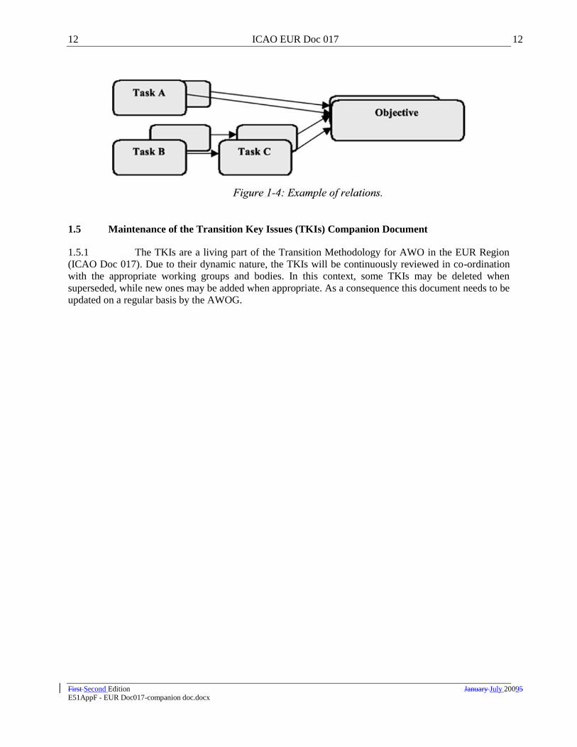
12 ICAO EUR Doc 017 12
First Second Edition January July 20095 E51AppF - EUR Doc017-companion doc.docx
1.5 Maintenance of the Transition Key Issues (TKIs) Companion Document
1.5.1 The TKIs are a living part of the Transition Methodology for AWO in the EUR Region
(ICAO Doc 017). Due to their dynamic nature, the TKIs will be continuously reviewed in co-ordination
with the appropriate working groups and bodies. In this context, some TKIs may be deleted when
superseded, while new ones may be added when appropriate. As a consequence this document needs to be
updated on a regular basis by the AWOG.
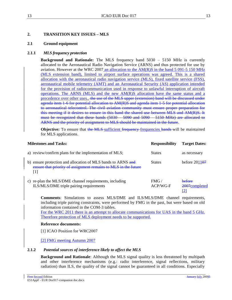
13 ICAO EUR Doc 017 13
First Second Edition January July 20095 E51AppF - EUR Doc017-companion doc.docx
2. TRANSITION KEY ISSUES – MLS
2.1 Ground equipment
2.1.1 MLS frequency protection
Background and Rationale: The MLS frequency band 5030 – 5150 MHz is currently
allocated to the Aeronautical Radio Navigation Service (ARNS) and thus protected for use by
aviation. However at the WRC 2007 an allocation to the AM(R)S in the band 5 091-5 150 MHz
(MLS extension band), limited to airport surface operations was agreed. This is a shared
allocation with the aeronautical radio navigation service (MLS), fixed satellite service (FSS),
aeronautical mobile telemetry (AMT) and an Aeronautical Security (AS) application intended
for the provision of radiocommunication used in response to unlawful interruption of aircraft
operations. The ARNS (MLS) and the new AM(R)S allocation have the same status and a
precedence over other uses.. the use of the MLS upper (extension) band will be discussed under
agenda item 1-6 for potential allocation to AM(R)S and agenda item 1-5 for potential allocation
to aeronautical telecontrol. The civil aviation community must ensure proper preparation for
this meeting if it desires to ensure in this band the shared use between MLS and AM(R)S. It
must be recognized that these bands (5030 – 5090 and 5090 – 5150 MHz) are allocated to
ARNS and the priority of assignment to MLS should be maintained in the future.
Objective: To ensure that the MLS sufficient frequency frequencies bands will be maintained
for MLS applications.
Milestones and Tasks: Responsibility Target Dates:
a) review/confirm plans for the implementation of MLS; States as necessary
b) ensure protection and allocation of MLS bands to ARNS and
ensure that priority of assignment remains to MLS in the future
[1]
States before 201107
c) re-plan the MLS/DME channel requirements, including
ILS/MLS/DME triple pairing requirements
FMG /
ACP/WG-F
before
2007completed
[2]
Comments: Simulations to assess MLS/DME and ILS/MLS/DME channel requirements,
including triple pairing constraints, were performed by FMG in the past, but were based on old
information contained in the COM-3 tables.
For the WRC 2011 there is an attempt to allocate communications for UAS in the band 5 GHz.
Therefore protection of MLS deployment needs to be supported.
Reference documents:
[1] ICAO Position for WRC2007
[2] FMG meeting Autumn 2007
2.1.2 Potential sources of interference likely to affect the MLS
Background and Rationale: Although the MLS signal quality is less threatened by multipath
and other interference mechanisms (e.g.: radio interference, signal reflections, military
radiation) than ILS, the quality of the signal cannot be guaranteed in all conditions. Especially

14 ICAO EUR Doc 017 14
First Second Edition January July 20095 E51AppF - EUR Doc017-companion doc.docx
during advanced procedures, the signal of both MLS and Distance Measuring Equipment
(DME) may suffer from multipath interference. Guidance material should be developed for the
proper identification of threats to the signal quality.
Objective: Operational Requirements, Criteria and Method of application (RCM) available to
detect and predict interference threats to MLS and DME signals and apply this information.

15 ICAO EUR Doc 017 15
First Second Edition January July 20095 E51AppF - EUR Doc017-companion doc.docx
Milestones and Tasks: Responsibility Target Dates:
a) identify the potential of interference mechanisms for straight-in
MLS operations .
PT/BRA completed [1]
b) develop harmonised provisions for BRA to protect for MLS
straight-in operations
PT/BRA completed [1]
c) identify the potential of interference mechanisms for advanced
MLS operations
PT/BRAAWOG As Necessaryas
necessary
Comments: ICAO has adopted propagation models. Although there is no plan to develop MLS
curved approaches there is still some provision in ANNEX 10 Attachment G 14.3 on MLS curved
path procedures.
Reference documents:
[1] ICAO EUR DOC015 – European Guidance Material on Managing the Building Restricted
Areas
2.1.3 Certification of MLS Ground Stations
Background and Rationale: Before a new landing aid is approved for operations, the
navigation-ground stations need to be certified by the appropriate authorities. This process
must be carried out for both CAT I and for CAT II/III operations.
Objective: Certification of MLS Ground stations for the full range of AWO.
Milestones and Tasks: Responsibility Target Dates:
a) MOPS for MLS ground stations EUROCAE completed [1], [2]
b) certification of MLS ground stations for CAT I States completed
c) certification of MLS ground stations for CAT II/III States cCompleted
[3];[4] - Q2/2005
Comments: Certification of the ground stations is a normal part of the implementation process.
The certification is a site specific issue that still needs to be carried out each time. ―completed‖
means here that at least one aerodrome in Europe has accomplished this task.The dates given
are valid for at least one aerodrome in Europe. Certification of MLS ground stations for CAT
III was achieved at London Heathrow in March 2009.
Reference documents:
[1] EUROCAE ED-53A MOPS for MLS Ground Stations
[2] ICAO Annex 10, Volume 1 - Radio-navigation Aids, MLS MTBO requirements
[3] ICAO EUR Doc 012: European Guidance Material on Continuity of Service Evaluation In
Support of the Certification of ILS & MLS Ground Systems
[4] ICAO EUR Doc 016: European Guidance Material on Integrity Demonstration In Support
of the Certification of ILS & MLS Systems

16 ICAO EUR Doc 017 16
First Second Edition January July 20095 E51AppF - EUR Doc017-companion doc.docx
2.2 Airborne equipment
2.2.1 Airborne certification process for MLS operations
Background and Rationale: The demand for CAT III operations is growing in Europe.
However, the continuation of ILS based CAT III operations can not be guaranteed at some
locations. Furthermore, at some aerodromes, GNSS based CAT III operations are not foreseen
to be available in the appropriate time frame, which leaves MLS as the only option for the safe
continuation of CAT III operations. Due to the necessity of interoperability between Regions
and States, the Global Strategy identified the ultimate need for a multi-modal airborne landing
capability. Therefore the availability of the MMR needs to be ensured.
If required, activities to support the implementation of advanced operations could be
undertaken after the certification for straight-in operations is completed.
Objective: To develop both MLS CAT III receivers and the appropriate certification criteria for
MLS operations as well as to ensure the availability of the MMR with MLS-capability.
Milestones and Tasks: Responsibility Target Dates:
a) MOPS for the MLS receiver EUROCAE completed
[1,4,5]
b) development of certification requirements for the MLS
installations (incl. MMR)
JAA completed [2]
c) certification for MLS/ MMR equipment avionics
manufacturers,
States
Completed
[1,4,5,6]Q2/20
05
d) develop operational certification requirements for MLS
operations
JAA completed [3]
e) operational approval of the aircraft for CAT I/II/III MLS
autoland operations
aircraft
manufacturers,
operators, States
completedQ4/2
005
f) develop certification requirements for MLS installations to
support advanced approach operations, when required;
EASA / States as necessary
g) certification of the MLS installation (incl. MMR) to support
advanced operations, when required.
aircraft
manufacturers,
operators, States
as necessary
h) operational approval of the aircraft for CAT I/II/III advanced
operations, when required
aircraft
manufacturers,
operators, States
as necessary
Comments: Certification MLS/MMR airborne equipment achieved October 2007 for straight in
approaches. Operational approval for CAT III MLS autoland operations achieved March 2009.
There is currently no plan to develop MLS curved approaches but there remains provisions in
ANNX10 for such operations.

17 ICAO EUR Doc 017 17
First Second Edition January July 20095 E51AppF - EUR Doc017-companion doc.docx
Reference documents:
[1] EUROCAE ED-36A 36B MOPS for MLS stand-alone airborne receiving equipment
[2] CS AWO - Certification Specifications for All Weather Operations –subpart 1 and AMC to
subpart 1
[3] EU OPS (Council Regulation (EEC) No. 3922/91 Annex III)
[4] EUROCAE ED-74 MOPS for Combined ILS and MLS Airborne Receiving Equipment
[5] EUROCAE ED-88 MOPS for MMR including ILS, MLS and GPS used for supplemental means
of navigationGNSS
[6] EASA list of ETSO authorisations 2nd
June 2009
2.3 ATS Procedures
2.3.1 Definition of ATS procedures for MLS straight-in operations
Background and Rationale: New technology prevents the use of new ATS procedures due to
the changed criteria for the operations. Enhanced capacity and new ATS techniques must be
based on ICAO SARPs and PANS. Potential new criteria for longitudinal spacing with MLS
and adequate separation need to be developed. Objective: To provide users, providers and
regulators a set of ATS procedures for the conduct of MLS operations.
Objective: To provide users, providers and regulators a set of ATS procedures for the conduct
of MLS operations.
Milestones and Tasks: Responsibility Target Dates:
a) define confirmation of MLS sensitive and critical areas for
straight-in operations;
AWOP completed [12]
b) elaborate EUR SUPPs (Doc. 7030) for development of MLS-
based ATS procedures for straight-in ILS look-alike operations
States TBD
c) develop ATS procedures for MLS CAT I straight-in operations States as necessary
[1]
d) develop ATS procedures for MLS CAT II/III straight-in
operations
States as necessary
[3]
Comments: The basis for the short term MLS operations are ILS look-alike procedures. It is
assumed that just a few airports will install MLS. These airports shall play a leading part in the
development of operational procedures. Initiatives with respect to this issue are already
foreseen. The results shall be forwarded to the AWOG for further initiatives with respect to the
development of SARPs. MLS CAT I and MLS CAT II/III operations are being undertaken at
London Heathrow and this experience has been used in the development of the guidance
material for MLS procedures [3]. The same applies for GNSS operations, however the
application of these operations is foreseen in a broader region.
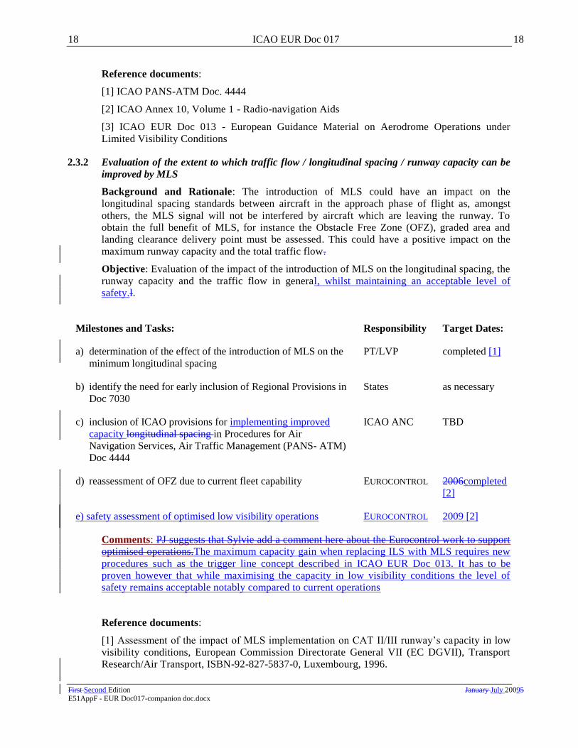
18 ICAO EUR Doc 017 18
First Second Edition January July 20095 E51AppF - EUR Doc017-companion doc.docx
Reference documents:
[1] ICAO PANS-ATM Doc. 4444
[2] ICAO Annex 10, Volume 1 - Radio-navigation Aids
[3] ICAO EUR Doc 013 - European Guidance Material on Aerodrome Operations under
Limited Visibility Conditions
2.3.2 Evaluation of the extent to which traffic flow / longitudinal spacing / runway capacity can be
improved by MLS
Background and Rationale: The introduction of MLS could have an impact on the
longitudinal spacing standards between aircraft in the approach phase of flight as, amongst
others, the MLS signal will not be interfered by aircraft which are leaving the runway. To
obtain the full benefit of MLS, for instance the Obstacle Free Zone (OFZ), graded area and
landing clearance delivery point must be assessed. This could have a positive impact on the
maximum runway capacity and the total traffic flow.
Objective: Evaluation of the impact of the introduction of MLS on the longitudinal spacing, the
runway capacity and the traffic flow in general, whilst maintaining an acceptable level of
safety.l.
Milestones and Tasks: Responsibility Target Dates:
a) determination of the effect of the introduction of MLS on the
minimum longitudinal spacing
PT/LVP completed [1]
b) identify the need for early inclusion of Regional Provisions in
Doc 7030
States as necessary
c) inclusion of ICAO provisions for implementing improved
capacity longitudinal spacing in Procedures for Air
Navigation Services, Air Traffic Management (PANS- ATM)
Doc 4444
ICAO ANC TBD
d) reassessment of OFZ due to current fleet capability EUROCONTROL 2006completed
[2]
e) safety assessment of optimised low visibility operations EUROCONTROL 2009 [2]
Comments: PJ suggests that Sylvie add a comment here about the Eurocontrol work to support
optimised operations.The maximum capacity gain when replacing ILS with MLS requires new
procedures such as the trigger line concept described in ICAO EUR Doc 013. It has to be
proven however that while maximising the capacity in low visibility conditions the level of
safety remains acceptable notably compared to current operations
Reference documents:
[1] Assessment of the impact of MLS implementation on CAT II/III runway‘s capacity in low
visibility conditions, European Commission Directorate General VII (EC DGVII), Transport
Research/Air Transport, ISBN-92-827-5837-0, Luxembourg, 1996.

19 ICAO EUR Doc 017 19
First Second Edition January July 20095 E51AppF - EUR Doc017-companion doc.docx
[2] Preliminary Safety Case for Optimised operations under Low Visibility conditions - Draft
2.3.3Potential of MLS advanced operations
Background and Rationale: With the introduction of MLS many additional advanced
operations arise which can not be provided by ILS (e.g. computed centre-line approaches,
interception techniques, airborne capability levels, curved approaches, and use of data link).
The purpose of this TKI is to identify these applications, the related benefits and the associated
ATS and airborne procedures to allow early usage of such applications.
Objective: Determine the advanced operations of MLS, their potential benefits and the
associated ATS and airborne procedures.
Milestones and Tasks: Responsibility Target Dates:
a) determine the potential MLS advanced operations AWOG as necessary
b) assess the related benefits of MLS advanced OPS; States as necessary
c) development of harmonised BRAs for MLS advanced
operations;
AWOG as necessary
d) confirmation of MLS sensitive and critical for advanced
procedures;
ICAO ANC as necessary
e) identify the need and consequently elaborate EUR SUPPs (Doc.
7030) for development of MLS-based ATS procedures for
advanced AWO during approach and landing
PT/LVP as necessary
f) develop ATS procedures for MLS CAT I advanced operations States as necessary
g) develop ATS procedures for MLS CAT II/III advanced
operations
States as necessary
h) develop regional provisions for minimum parallel runway
separation standards using MLS;
PT/LVP as necessary
Comments: AWOP did some work in this field., Hhowever the PT/LVP should identify any
relevant advanced application with MLS and the potential benefits. Thereafter inclusion of the
related ATS procedures into the PANS-ATM (Doc. 4444) must be initiated.
Reference documents:
[1] PANS-ATM (Doc. 4444)
3. TRANSITION KEY ISSUES – GNSS
3.1 General issues
3.1.1 Institutional arrangements for provision of GNSS
Background and Rationale: The introduction of satellite based technologies provoked a new
way of thinking about division of the responsibilities between users, providers and regulators.
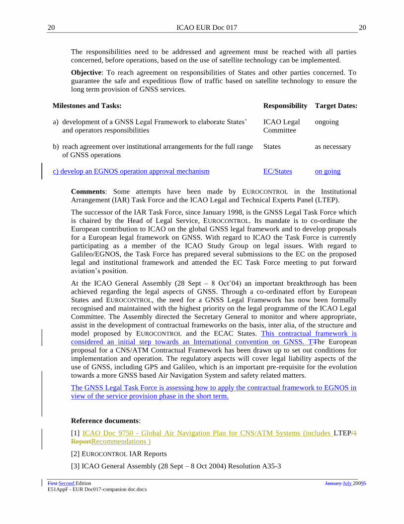
20 ICAO EUR Doc 017 20
First Second Edition January July 20095 E51AppF - EUR Doc017-companion doc.docx
The responsibilities need to be addressed and agreement must be reached with all parties
concerned, before operations, based on the use of satellite technology can be implemented.
Objective: To reach agreement on responsibilities of States and other parties concerned. To
guarantee the safe and expeditious flow of traffic based on satellite technology to ensure the
long term provision of GNSS services.
Milestones and Tasks: Responsibility Target Dates:
a) development of a GNSS Legal Framework to elaborate States‘
and operators responsibilities
ICAO Legal
Committee
ongoing
b) reach agreement over institutional arrangements for the full range
of GNSS operations
States as necessary
c) develop an EGNOS operation approval mechanism EC/States on going
Comments: Some attempts have been made by EUROCONTROL in the Institutional
Arrangement (IAR) Task Force and the ICAO Legal and Technical Experts Panel (LTEP).
The successor of the IAR Task Force, since January 1998, is the GNSS Legal Task Force which
is chaired by the Head of Legal Service, EUROCONTROL. Its mandate is to co-ordinate the
European contribution to ICAO on the global GNSS legal framework and to develop proposals
for a European legal framework on GNSS. With regard to ICAO the Task Force is currently
participating as a member of the ICAO Study Group on legal issues. With regard to
Galileo/EGNOS, the Task Force has prepared several submissions to the EC on the proposed
legal and institutional framework and attended the EC Task Force meeting to put forward
aviation‘s position.
At the ICAO General Assembly (28 Sept – 8 Oct‘04) an important breakthrough has been
achieved regarding the legal aspects of GNSS. Through a co-ordinated effort by European
States and EUROCONTROL, the need for a GNSS Legal Framework has now been formally
recognised and maintained with the highest priority on the legal programme of the ICAO Legal
Committee. The Assembly directed the Secretary General to monitor and where appropriate,
assist in the development of contractual frameworks on the basis, inter alia, of the structure and
model proposed by EUROCONTROL and the ECAC States. This contractual framework is
considered an initial step towards an International convention on GNSS. TThe European
proposal for a CNS/ATM Contractual Framework has been drawn up to set out conditions for
implementation and operation. The regulatory aspects will cover legal liability aspects of the
use of GNSS, including GPS and Galileo, which is an important pre-requisite for the evolution
towards a more GNSS based Air Navigation System and safety related matters.
The GNSS Legal Task Force is assessing how to apply the contractual framework to EGNOS in
view of the service provision phase in the short term.
Reference documents:
[1] ICAO Doc 9750 - Global Air Navigation Plan for CNS/ATM Systems (includes LTEP/1
ReportRecommendations )
[2] EUROCONTROL IAR Reports
[3] ICAO General Assembly (28 Sept – 8 Oct 2004) Resolution A35-3

21 ICAO EUR Doc 017 21
First Second Edition January July 20095 E51AppF - EUR Doc017-companion doc.docx
3.1.2 Implementation of Galileo
Background and Rationale: Currently the European Union, in co-operation with ESA, is
developing a European satellite navigation system (Galileo) independent from GPS. Galileo
will improve availability and continuity of service of current satellite based navigation system
by providing a European civil satellite system inter-operable with the US GPS and the Russian
GLONASS. Apart from the improved performance this may also solve some specific
institutional issues related with using GPS for operations in Europe. There are still many issues
to be solved such as the Galileo definition (service definition, the standardisation and
architecture definition), for which the Galileo Mission Requirements Document (MRD) is the
basis. An important issue is the integration of EGNOS in Galileo.
Objective: Development of Galileo to support improve overall GNSS sole-service
operationsperformance and robustness.
Milestones and Tasks: Responsibility Target Dates:
a) Galileo definition [MRD] EU 2005
b) Galileo frequency allocation EU / ITU completed
c) Galileo development and in-orbit validation EU / ESA 2005
d) Galileo full deployment EU / ESA 2008
e) Galileo operational EU / ESA 2008
f) Galileo operational validation States,
EUROCONTROL
2010
Milestones and Tasks: Responsibility Target Dates:
a)Galileo definition [MRD] EU/ESA completed [1]
b)Galileo frequency allocation EU / ITU completed [2]
c)Galileo development and in-orbit validation EU / ESA 2010
d)Galileo full deployment EU / ESA 2013
e)Galileo operational EU / ESA 2013
f)Galileo operational validation States, Eurocontrol 2015
Comments: The additional constellation provides the necessary availability for GNSS
precision approaches. At the ITU World Radio Conference in 2000 (WRC-2000) radio
frequencies have been allocated to Galileo.
The Galileo Mission Requirements Document (MRD) contains the functional and performance
requirements of the Galileo satellite navigation system.
During 2009 ESA and EC are negotiating with industry the Galileo FOC procurement in
parallel with a Galileo mission consolidation. It is expected that by early 2010, more

22 ICAO EUR Doc 017 22
First Second Edition January July 20095 E51AppF - EUR Doc017-companion doc.docx
consolidated information on the Galileo performances and dates will be available. , and is
developed and regularly updated by the Galileo Joint Undertaking (GJU). The GJU has
requested EUROCONTROL, as focal point for European aviation GNSS requirements, to provide
aviation community feedback on the document, so as to ensure that Galileo can support aviation
GNSS applications. Similar feedback is sought from other potential user communities (e.g.
maritime).
Reference documents:
[1] Resolution of the 2480th Council Meeting (Doc: 7282/02) – March‗02
[2] Council Regulation (EC) No 876/2002 – Joint Undertaking.
[31] Galileo Mission Requirements Document [MRD], EU/ESA version 6, 2005
[2] ITU World Radio Conference Report (WRC-2000)
3.1.3 Implement World Geodetic System 1984 (WGS-84) coordinatesData Quality
Background and Rationale: Operations based on GNSS will rely on a database of waypoints
identifying the flight path to be followed. All necessary position fixes to support GNSS
operations must be available in the WGS-84 standard reference frame. Relevant ICAO SARPs
require States to publish charts with inter-alia the locations of navigation aids and ground
facilities based on WGS-84 co-ordinates. In the ECAC area, EUROCONTROL coordinates the
implementation of WGS-84.
Additionally data integrity requirements remain a key issue.
Objective: States to publish waypoint information in the WGS-84 co-ordinate system.
Milestones and Tasks: Responsibility Target Dates:
a) implementation of horizontal component of WGS84 States completed
[1], [3]
b) implementation of vertical component of WGS84 States,
EUROCONTROL
TBD
[1], [2], [3]
c) verification of complete and proper implementation of
WGS-84
EUROCONTROL/
States
ongoing
d) Data Quality EC mandate EC 2013
e)Identify Terrain and Obstacle data requirements for annex 15
amendment
ICAO 2012
f)FAS data block support tool to implementation States/
EUROCONTROL
As Necessary
Comments: The implementation of the WGS-84 is formally completed since 1 January 1998.
However from the implementation and some database checks it appears to be necessary to
verify the complete and proper implementation of the WGS-84. Moreover some specific issues
remain with respect to the definition of future parking positions and taxiway in relation to
SMGCS.

23 ICAO EUR Doc 017 23
First Second Edition January July 20095 E51AppF - EUR Doc017-companion doc.docx
A survey of all ECAC AIP‘s by EUROCONTROL, shows that not all States comply to WGS-84
yet.
Annex 10 provides the FAS data block description; for APV approaches Annex 4 provides FAS
data block charting requirements. There remains the need to harmonise the FAS data block
production process and maintenance.
A survey of all ECAC AIP‘s by EUROCONTROL, shows that not all States comply to WGS-84
yet.
Reference documents:
[1] National AIP‘s.
[2] ICAO Annex 15 and Annex 4
[3] ICAO WGS-84 Manual Doc 9674
3.1.4 Develop SARPs for the identified elementsGNSS based approach systems
Background and Rationale: To ensure international interoperability and standardisation of
GNSS based approach systems SARPs must be developed.
Objective: To produce SARPs for GNSS
Milestones and Tasks: Responsibility Target Dates:
a) develop SARPs for GPS L1 GNSSP completed [1]
b) develop SARPs for GLONASS GNSSP completed [1]
c) develop SARPs for SBAS L1 GNSSP completed [1]
d) develop SARPs for GBAS for CAT. I GNSSP completed [1]
e) develop SARPs for GBAS for CAT. II/III based on L1 NSP 2010 7
f) applicability date of GNSS SARPs for all operations down to
CAT I
ICAO ANC completed [1]
g) Galileo standardisation (SARPS) NSP 2010/1112007
h) standardization of GPS L5 signal (SARPS) NSP 2010/112 2006 [2]
i) standardization of GLONASS L3 signal NSP TBD
j) standardization of SBAS L5 signal NSP TBD
k) standardization of combined used of GNSS signals NSP TBD
1This tentative date will be consolidated during NSP work plan update. These dates corresponds to
SARPS preparation process. Official publication in Annex 10 will depend on constellation deployment schedule and related SARPS validation activities. 2 As note 1

24 ICAO EUR Doc 017 24
First Second Edition January July 20095 E51AppF - EUR Doc017-companion doc.docx
e) develop SARPs for GBAS for CAT. II/III based on multi GNSS NSP 2018
Comments: After GNSSP/3 the standards for GNSS CAT I service have formally been
validated and recommended for inclusion in ICAO Annex 10, Volume 1 - Radio-navigation
Aids. Amendment 85 and 86 of the SARPS will contain few changes required following
notably GBAS CAT I initial implementation feedback.
The NSP decided to develop GNSS GBAS SARPs for CAT II/III operations initially based on
GPS/L1 only. Work is currently progressed in ICAO NSP CAT III Sub Group (CSG° , key
issues in current discussion are the integrity concept and Time To alert as well as continuity. A
conceptual framework document (technical concept) has been developed to help support the
understanding of the new concept proposed that diverts from ILS look alike.
For the long term perspective a multi GNSS GBAS CAT II/III SARPS is envisioned.
The implementation of Galileo (TKI 3.1.9) or another stable core constellation is a determining
factor to the availability of GBAS multi GNSS CAT II/III operations. are scheduled in the work
programme of NSP (successor of GNSSP). GNSS CAT II/III Standards should be available for
adoption by 2007.
Reference documents:
[1] ICAO Annex 10, Volume 1 - Radio-navigation Aids
[2] RTCA DO 261 NAVSTAR GPS L5 Signal Specification
3.1.5 GPS to support NPA
Background and Rationale: Non-Precision Approach (NPA) requirements may be supported
by ABAS [3] based on GPS, possibly including additional elements such as GLONASS, or
other aircraft sensors. RAIM and/or Aircraft Autonomous Integrity Monitoring (AAIM). If
States wish to develop approvals for the introduction of NPA, the proposed navigation system
elements must be identified.
Objective: Approval for GPS based NPA.
Milestones and Tasks: Responsibility Target Dates:
a) identify architectures to support GPS NPA operations AWOG completed
b) implement architecture to support GPS NPA operations States /
operators
completed [1];
[2]
c) safety case for GPS based NPA operations States continuous
d) GPS approved for non-precision operations States continuous
Comments: JAA established the baseline requirements for the application of GPS for NPA
operations [1]. In the near future EASA AMC 20-27 will be the basis for RNP APCH (i.e. GPS
NPA) approval. It is up to the States to apply sufficient safety management in their decision of
the application of GPS to support NPA operations.

25 ICAO EUR Doc 017 25
First Second Edition January July 20095 E51AppF - EUR Doc017-companion doc.docx
Reference documents:
[1] JAMC 20-5 AIRWORTHINESS APPROVAL AND OPERATIONAL CRITERIA FOR THE USE OF THE
NAVSTAR GLOBAL POSITIONING SYSTEM (GPS)
[2] AMC 20-27 AIRWORTHINESS APPROVAL AND OPERATIONAL CRITERIA FOR RNP Approach (RNP APCH) operations including APV Baro VNAV operations
[3] ICAO Annex 10, Volume 1 - Radio-navigation Aids
3.1.6 AA TGL – 3 Interim Guidance Material on Airworthiness Approval and Operational Criteria for
the Use of NAVSTAR GPS
3.1.73.1.6 SBAS operations
Background and Rationale: The European implementation of SBAS is covered in the EGNOS
programme. States need all relevant information on EGNOS based APV operations before they
can decide upon the best option (compared to Baro-based APV operations) for a transition from
NPA operations at aerodromes in the EUR Region. An operational validation of EGNOS will
need to take place after technical delivery of the SBAS system by the manufacturer.
Objective: To implement EGNOS for APV operations in the EUR-Region and to approve its
use.
Milestones and Tasks: Responsibility Target Dates:
a) identify GNSS architectures to support APV operations States completed [1]
b) EGNOS available (Signal in Space) * ESAEC / ESSP 201005
c) c) EGNOS Operational Validation * EC /
ESSPEUROCON
TROLStates
Q2/20062010
d) generic safety argument in support of APV operations based on
EGNOS
EUROCONTROL 20062009
e) EGNOS approved to support APV operations * EC /
ESSPStates
Q2/20072010
(*): as part of the ESSP certification by the French NSA and with the support of the other
European NSAs
Comments: In 2005 EUROCONTROL will started in 2005 the validation of the EGNOS signal
and data against the requirements for aviation applications. Since April 1st 2009 the EGNOS
System Service Provider (ESSP) In the meantime the EGNOS Signal and Data Provider
(ESDP) will be established by ESA the European Commission is gradually handing over for the
operations and maintenance of the systemEGNOS. The setting up of the ESDPESSP, the
EGNOS validation activities, and its certification according to the Single European Sky
legislation, including EGNOS validation activities and related work by EUROCONTROL on
EGNOS aviation applications such as EGNOS-based APV are expected to enable aviation use
of EGNOS for safety critical applications by mid 20072010.

26 ICAO EUR Doc 017 26
First Second Edition January July 20095 E51AppF - EUR Doc017-companion doc.docx
Reference documents:
[1] ICAO Annex 10, Volume 1 - Radio-navigation Aids
[2] Civil aviation requirements for EGNOS, OCR/DP/157, EUROCONTROL Operational and
Certification Requirements task force, October 15, 1999 (issue 3.0).
3.1.83.1.7 GBAS to support CAT I operations
Background and Rationale: States need all relevant information on GBAS CAT I operations
before they can decide upon the possible successor of ILS for AWO in the EUR Region.
The introduction of GBAS to support CAT I requires additional effort in terms of siting criteria
and frequency planning. If States wish to develop approvals for the introduction of CAT I
services, the proposed navigation system elements must be identified.
Objective: To decide upon the technical and operational options for the introduction of GBAS
CAT I operations in the EUR Region and to approve its use.
Milestones and Tasks: Responsibility Target Dates:
a) identify GBAS architectures to support CAT I operations GNSSP completed [1]
b) assess the availability of frequencies for GBAS uplink facilities GNSSP completed [2]
c) . develop siting criteria for locating GBAS ground stations for
CAT I operations
ICAO completed
[33], [4] [5]
d) generic safety argument for GBAS based CAT I operations EUROCONTROL ongoing2009
e) generic safety argument for GBAS based CAT I operations on
parallel runways for independent operation
EUROCONTROL ongoing
f) GBAS CAT I ground station certification States 2010 [3];
[7]TBD
g) GBAS approved to support CAT I operations; States as necessary
h) GBAS approved to support CAT I operations on parallel runways States as necessary
i) GBAS eligible to support lower than CAT I operations EASA 2009 [6]
j) Update of Doc 013 to include lower than Standard CAT I
operations
ICAO AWOG 2010??
Comments: Current ICAO EUR Doc 015 provides GBAS protection criteria for building
application; Doc 015 does not currently address new GBAS installation but only provides the
protections to be applied when building close to a GBAS Ground station. These criteria were
established on early GBAS installations and thus are very conservative. This leads to significant
GBAS siting constraints and thus can prevent GBAS installation at a number of Airports..
Nevertheless ICAO EUR Doc 015 is the only document that provides GBAS protection criteria;
as such it is currently used by regulators. Therefore there is a need to assess the GBAS
protection criteria when installing a new ground station based on GBAS Standards and taking

27 ICAO EUR Doc 017 27
First Second Edition January July 20095 E51AppF - EUR Doc017-companion doc.docx
account of the new antenna characteristics. EUROCAE WG28 should be tasked to assess the
required protection criteria.
Specific GBAS siting criteria need to be developed in relation with obstacle clearance criteria.
Reference documents:
[1 ICAO Annex 10, Volume 1 - Radio-navigation Aids
[2] ICAO GNSSP WG-B, WP12 June 2000; and GNSSP WG-D, WP50 Sept 1997
[3] ED-114 - MOPS for a GBAS ground facility to support CAT I approach and landing
[3] ICAO Annex 10, Volume 1 - Radio-navigation Aids
[4] ICAO EUR Doc 015 – European Guidance Material on Managing the Building Restricted
Areas
[5] FAA LAA Ground Facility Siting criteria
[6] EASA IR OPS
[7] ICAO Doc 8071: Manual on testing of radio navigation aids
3.1.93.1.8 GBAS to support CAT II/III operations
Background and Rationale: States need all relevant information on GBAS CAT II/III
operations before they can decide upon the possible successor of ILS CAT II/III operations in
the ICAO EUREUR Region. The CAT II/III requirements may be supported by a number of
possible architectures including a combination of GNSS elements. The addition of the GPS L5
frequency would greatly benefit the robustness of GNSS CAT II/III operations. If States wish
to develop approvals for the introduction of CAT II/III services, the proposed navigation
system elements must be identified.
Objective: To decide upon the technical and operational options for the introduction of GBAS
CAT II/III operations in the EUR Region and to approve its use.
Milestones and Tasks: Responsibility Target Dates:
a) identify architectures and requirements to support GBAS CAT
II/III operations
NSP 20072010
b) develop siting criteria for locating differential ground stations for
CAT II/III operations
NSP/SSG 2007TBD
c) consider the necessity and develop harmonised building
restriction areas for GBAS CAT II/III operations
AWOG 20082010
d) full availability of GPS L5 signal US 2008 (TBC2018)
e) safety case for GBAS L1 CAT II/III operations EUROCONTROL
States
2015
f) Implement architecture for GBAS L1 CAT II/III operations States 2015

28 ICAO EUR Doc 017 28
First Second Edition January July 20095 E51AppF - EUR Doc017-companion doc.docx
g) GNSS GBAS L1 approved as navigation aid for CAT II/III
operations
States 2015
h) Update GBAS CAT II/III safety case to include multi GNSS
capability
EUROCONTROL
States
2015
i) Implement GBAS ground subsystem to support CAT II/III
operations based on multi GNSS
States 2020
j) GBAS multi GNSS approved as navigation aid for CAT II/III
operations
States 2020
k)Investigate GBAS L1 in support to other than standard CAT II
operations
EASA As necessary
Comments: New operations named Other than Standard CAT II have been introduced recently
in EU OPS and have been proposed for inclusion in EASA IR OPS, but are not recognised so
far by ICAO. These operations offer more flexibility for the operators especially at airports
where full CAT I or CAT II lighting would not be available. However these new operations
identify a number of ATM requirements that would need to be captured and documented in
guidance material such as ICAO EUR Doc 013
j) includes maintenance, testing, operational concept and procedures.
The development of SARPs for GBAS CAT II/III operations will start after the validation of the
SARPs for CAT I operations have been completed. NSP expects to produce SARPs for CAT II/III
operations by 2007. Currently there are two different approaches with regard to CAT II/III GNSS: the
US position (RTCA) and the European position (EUROCAE). Coordination is on-going to achieve
harmonisation.
The implementation of Galileo (TKI 3.1.9) will contribute to the availability and continuity of GNSS
CAT II/III operations.
3.1.103.1.9 GNSS frequency interference protection
Background and Rationale: The potential interference mechanisms, both radio interference
and multipath risksatmospheric distortions for GNSS, need to be identified and assessed to
maintain the safety in AWO. Multipath vulnerabilities are considered to be mitigated through
the design of the GNSS augmentation service, in particular the GBAS ground facility. In
respect to the use of GNSS as a future means of navigation for all phases of flight (including
AWO) it is essential that the GNSS frequency band be adequately protected against
interference.
Objective: To define aviation requirements for the protection of the GNSS frequencies and to
get international acceptance of these maximum allowable interference levels.
Milestones and Tasks: Responsibility Target Dates:
a) identify potential radio frequency interference mechanisms for
GNSS
GNSSP Completed
[1??], [2], [3],
[4]

29 ICAO EUR Doc 017 29
First Second Edition January July 20095 E51AppF - EUR Doc017-companion doc.docx
b) develop protection levels against interference of the GNSS
frequency band
GNSSP completed [52],
[6]
c) international acceptance of the developed protection levels
against radio frequency interference
States/ITU completed
[37], [48]
d) define compatibility of DME – GNSS signals States/ICAO/
ITU
2003 completed
[3], [4], [5]
e) assess interference to GNSS from ionospheric distortions ICAO NSP Completed [9]
Comments: At the WRC 2000 international acceptance on the adequate protection of GNSS
satellite signals have been reached through co-ordination with regional frequency management
bodies, ICAO and States. One item left from the meeting that needs to be considered is the
mutual interference between GNSS and DME in the DME band (GPS L5 and Galileo E5
signals). The compatibility requirements between DME and GNSS signals have been defined
and were accepted at WRC 2003..
While not located in the GNSS frequency bands, the GBAS VHF Data Broadcast (VDB) forms
an integral part of GBAS augmentation. Currently, no allocations are foreseen in the lower part
of the navigation band, e.g., 108 to 112 MHz. However, should VDB allocations be extended to
this band, current criteria to protect ILS from FM Broadcast interference (primarily
intermodulation) may need to be revalidated for the GBAS VDB.
Reference documents:
[1] ICAO Doc 9849 – GNSS Manual
[2] RTCA DO235B – Assessment of Radio Frequency Interference Relevant to the GNSS L1
Frequency Band
[3] RTCA DO292 – Assessment of Radio Frequency Interference Relevant to the GNSS L5 /
E5A Frequency Band
[4] Protection of GNSS operating in the band 1559 to 1610 MHz against unwanted emissions
from Mobile Earth Stations operating in the band 1610 to 1626.5 MHz, ITU Attachment 9 to
the Report of the First Meeting of the 8D-SRG (see Addendum 2 to Circular Letter
8/LCCE/40), ICAO,
April 2 1997.
[5] ICAO Annex 10 Vol 1, Radio Navigation Aids
[62] ICAO GNSSP Report, 23rd April 1999, Montreal.
[73] EANPG conclusions 40/4, 40/56.
[84] ICAO Doc 9718 - Handbook of Radio frequency spectrum requirements for civil aviation,
including statement of approved ICAO policies.
[9] ICAO Navigation Systems Panel: Ionospheric Effects on GNSS Aviation Operations,
December 2006
[5] ICAO Doc 9750 - Global Air Navigation Plan for CNS/ATM Systems
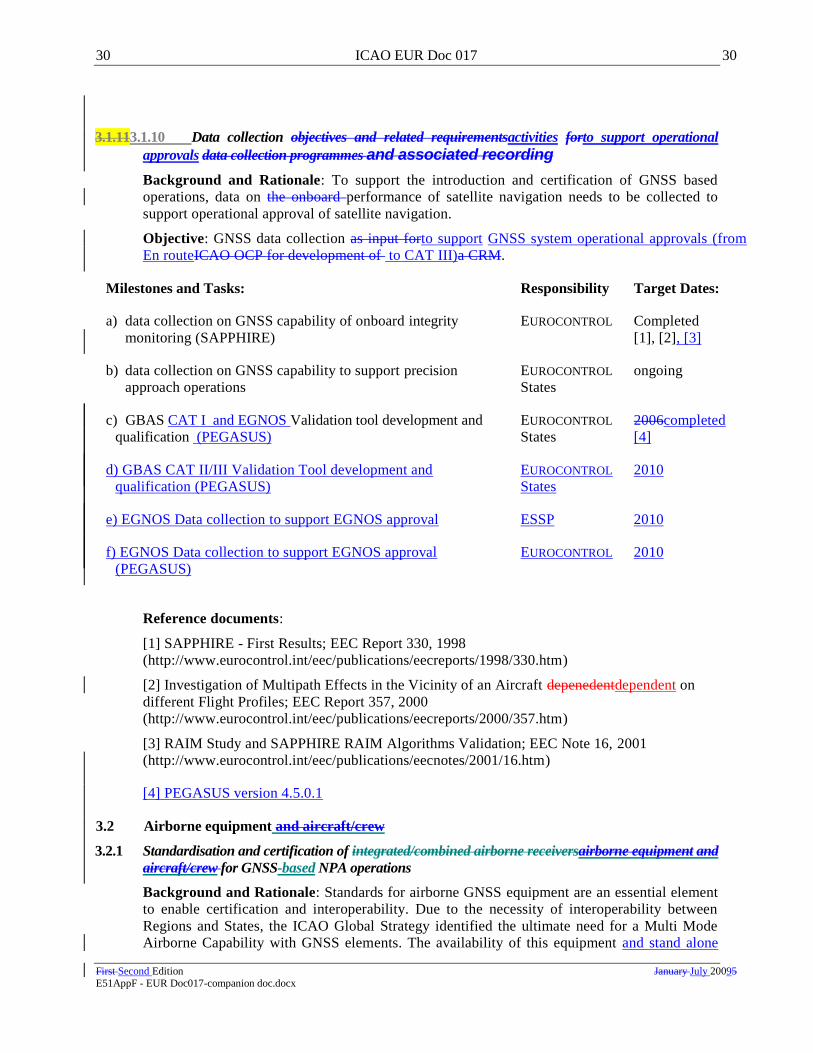
30 ICAO EUR Doc 017 30
First Second Edition January July 20095 E51AppF - EUR Doc017-companion doc.docx
3.1.113.1.10 Data collection objectives and related requirementsactivities forto support operational
approvals data collection programmes and associated recording
Background and Rationale: To support the introduction and certification of GNSS based
operations, data on the onboard performance of satellite navigation needs to be collected to
support operational approval of satellite navigation.
Objective: GNSS data collection as input forto support GNSS system operational approvals (from
En routeICAO OCP for development of to CAT III)a CRM.
Milestones and Tasks: Responsibility Target Dates:
a) data collection on GNSS capability of onboard integrity
monitoring (SAPPHIRE)
EUROCONTROL Completed
[1], [2], [3]
b) data collection on GNSS capability to support precision
approach operations
EUROCONTROL
States
ongoing
c) GBAS CAT I and EGNOS Validation tool development and
qualification (PEGASUS)
EUROCONTROL
States
2006completed
[4]
d) GBAS CAT II/III Validation Tool development and
qualification (PEGASUS)
EUROCONTROL
States
2010
e) EGNOS Data collection to support EGNOS approval ESSP 2010
f) EGNOS Data collection to support EGNOS approval
(PEGASUS)
EUROCONTROL 2010
Reference documents:
[1] SAPPHIRE - First Results; EEC Report 330, 1998
(http://www.eurocontrol.int/eec/publications/eecreports/1998/330.htm)
[2] Investigation of Multipath Effects in the Vicinity of an Aircraft depenedentdependent on
different Flight Profiles; EEC Report 357, 2000
(http://www.eurocontrol.int/eec/publications/eecreports/2000/357.htm)
[3] RAIM Study and SAPPHIRE RAIM Algorithms Validation; EEC Note 16, 2001
(http://www.eurocontrol.int/eec/publications/eecnotes/2001/16.htm)
[4] PEGASUS version 4.5.0.1
3.2 Airborne equipment and aircraft/crew
3.2.1 Standardisation and certification of integrated/combined airborne receiversairborne equipment and
aircraft/crew for GNSS-based NPA operations
Background and Rationale: Standards for airborne GNSS equipment are an essential element
to enable certification and interoperability. Due to the necessity of interoperability between
Regions and States, the ICAO Global Strategy identified the ultimate need for a Multi Mode
Airborne Capability with GNSS elements. The availability of this equipment and stand alone

31 ICAO EUR Doc 017 31
First Second Edition January July 20095 E51AppF - EUR Doc017-companion doc.docx
equipment and its their certification onboard aircraft needs to be ensured to support GNSS
based NPA operations.
Objective: Development of MOPS and Minimum Avionics System Performance Specification
(MASPS) for GNSS Avionics Equipment using the MMR or stand alone equipment with GNSS
NPA capability.
Milestones and Tasks: Responsibility Target Dates:
a) MOPS for GPS receiver for NPA EUROCAE completed [1]
b) MOPS for GPS element of MMR for NPA EUROCAE completed
[1], [2]
c) MOPS for SBAS for NPA RTCA /
EUROCAE
completed [4] , [5]
d) certification of GPS receivers for NPA JAA/ States completed [3]
e) certification of EGNOS receivers for NPA EASA/ States 20062010completed
[5]
f) certification of aircraft for GPS based NPA JAAEASA/
States
Completed [6]
2009 [7]
g) certification of aircraft for EGNOS based NPA EASA/ States 2005
Comments: It is assumed that the outcome of some tasks will possibly have an influence on
other tasks (i.e. MOPS for CAT I versus CAT II/III). This means that all the individual tasks
are possibly related.
However to maintain a total overview of tasks, NPA, APV, CAT I and CAT II/III are split in
individual tasks. For the application of GNSS based NPA operations critical question is
whether or not a satellite and/or aircraft based augmentation system needs to be available to
fulfil all the operational requirements.
Similar tasks will have to be repeated for receivers using GALILEO signals..
Reference documents:
[1] EUROCAE ED-72A MOPS for airborne GPS receiving equipment used for supplemental
means of navigation.
[2] EUROCAE ED88 MOPS for MMR including ILS, MLS and GPS used for Supplemental
Means of Navigation
[3] JAA TGL-3 (No : according to ETSO C129a)
[4] RTCA DO-229D, MOPS for Global Positioning System/Wide Area Augmentation System
Airborne Equipment
[4] RTCA DO-229C – MOPS for for global positioning system/wide area augmentation
system airborne equipment
[5] FAA TSO C-129B (No : according to ETSO C145/146)

32 ICAO EUR Doc 017 32
First Second Edition January July 20095 E51AppF - EUR Doc017-companion doc.docx
3.2.2 Standardisation and certification of airborne equipment for APV Baro operations
Background and Rationale: The implementation of APV Baro is now a solution to comply
with ICAO 36th assembly resolution on PBN implementation. Therefore standardisation of
airborne receiver requirements and subsequent certification should be undertaken.
Objective: Ensure certification of airborne equipments to support APV Baro operations
Milestones and Tasks: Responsibility Target Dates:
b) certification of airborne equipment for APV Baro EASA 2009 [1]
g) certification of aircraft for APV Baro operations EASA/ States 2010 [1]
Reference documents:
[1] EASA AMC 20-27 AIRWORTHINESS APPROVAL AND OPERATIONAL CRITERIA FOR RNP Approach (RNP APCH) operations including APV Baro VNAV operations
[6] according to national rules
[7] according to EASA AMC 20-27 when published by EASA in 2009. Draft AMC 20-27 is
available under NPA 2008-20 since 28th
May 2008
3.2.23.2.3 Standardisation and certification of integrated/combined airborne receivers equipment and
aircraft./crew for APV SBAS operations
Background and Rationale: The implementation of SBAS is ongoing. Therefore
standardisation of airborne receiver requirements and subsequent certification should be
undertaken. Moreover at the GNSSP/3 the APV has been introduced. For this reason, the
MOPS have to be adapted to accommodate this change.
Objective: Ensure certification of SBAS operations and adapt industry standards to incorporate
the APV operations.
Milestones and Tasks: Responsibility Target Dates:
a) adapt MOPS for SBAS to include APV and CAT I capability RTCA Completed [1] ,
b) certification of EGNOS receivers for APV EASA 20062010 [2]
Reference documents:
[1] RTCA DO-229D, MOPS for Global Positioning System/Wide Area Augmentation System
Airborne Equipment
RTCA DO-229C – MOPS for Global positioning system/wide area augmentation system
airborne equipment
[2] according to EASA AMC 20-28. EASA AMC 20-28 is planned to be published in Q2 2010.
Draft AMC 20-28 is available under NPA 2009-04 since 23rd
March 2009.
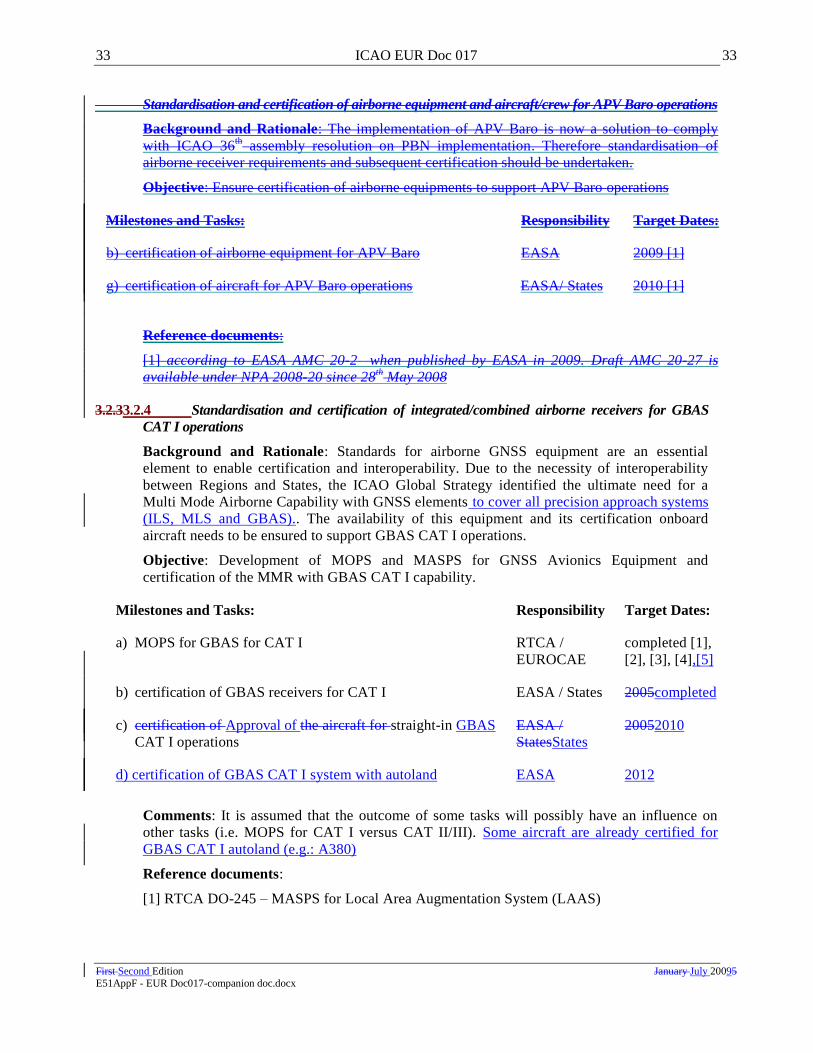
33 ICAO EUR Doc 017 33
First Second Edition January July 20095 E51AppF - EUR Doc017-companion doc.docx
Standardisation and certification of airborne equipment and aircraft/crew for APV Baro operations
Background and Rationale: The implementation of APV Baro is now a solution to comply
with ICAO 36th assembly resolution on PBN implementation. Therefore standardisation of
airborne receiver requirements and subsequent certification should be undertaken.
Objective: Ensure certification of airborne equipments to support APV Baro operations
Milestones and Tasks: Responsibility Target Dates:
b) certification of airborne equipment for APV Baro EASA 2009 [1]
g) certification of aircraft for APV Baro operations EASA/ States 2010 [1]
Reference documents:
[1] according to EASA AMC 20-2 when published by EASA in 2009. Draft AMC 20-27 is
available under NPA 2008-20 since 28th
May 2008
3.2.33.2.4 Standardisation and certification of integrated/combined airborne receivers for GBAS
CAT I operations
Background and Rationale: Standards for airborne GNSS equipment are an essential
element to enable certification and interoperability. Due to the necessity of interoperability
between Regions and States, the ICAO Global Strategy identified the ultimate need for a
Multi Mode Airborne Capability with GNSS elements to cover all precision approach systems
(ILS, MLS and GBAS).. The availability of this equipment and its certification onboard
aircraft needs to be ensured to support GBAS CAT I operations.
Objective: Development of MOPS and MASPS for GNSS Avionics Equipment and
certification of the MMR with GBAS CAT I capability.
Milestones and Tasks: Responsibility Target Dates:
a) MOPS for GBAS for CAT I RTCA /
EUROCAE
completed [1],
[2], [3], [4],[5]
b) certification of GBAS receivers for CAT I EASA / States 2005completed
c) certification of Approval of the aircraft for straight-in GBAS
CAT I operations
EASA /
StatesStates
20052010
d) certification of GBAS CAT I system with autoland EASA 2012
Comments: It is assumed that the outcome of some tasks will possibly have an influence on
other tasks (i.e. MOPS for CAT I versus CAT II/III). Some aircraft are already certified for
GBAS CAT I autoland (e.g.: A380)
Reference documents:
[1] RTCA DO-245 – MASPS for Local Area Augmentation System (LAAS)

34 ICAO EUR Doc 017 34
First Second Edition January July 20095 E51AppF - EUR Doc017-companion doc.docx
[2] EUROCAE ED--144 HIGH-LEVEL PERFORMANCE REQUIREMENTS FOR A
GLOBAL NAVIGATION SATELLITE SYSTEM / GROUND BASED AUGMENTATION
SYSTEM TO SUPPORT PRECISION APPROACH OPERATIONS, October 2007
95 – MASPS for a Global Navigation Satellite System GBAS to support CAT1 Operations
(1999)
[3] EUROCAE ED-88A Minimum Operational Performance Specification for Multi-Mode
Airborne Receiver (MMR) including ILS, MLS and GPS used for Supplemental Means of
Navigation; Note: ED-88A including GBAS CAT I is in final draft stage GNSS
[4] RTCA DO-253C3 Minimum Operational Performance Standards for GPS Local Area
Augmentation System Airborne Equipment
[5] ETSO-C161 Ground Based Augmentation System (GBAS) Positioning and Navigation
Equipment
[4] RTCA DO-253A Minimum Operational Performance Standards for GPS Local Area
Augmentation System Airborne Equipment
3.2.43.2.5 Standardisation and certification of integrated/combined airborne receivers for GBAS
CAT II/III operations
Background and rationale: Standards for GBAS equipment are an essential element to enable
certification and interoperability of CAT II/III operations. The availability of this equipment
and its certification onboard aircraft needs to be ensured to support GNSS based CAT II/III
operations.
Objective: Development of MOPS and MASPS for GNSS Avionics Equipment and
certification of the MMR with GNSS CAT II/III capability.
Milestones and Tasks: Responsibility Target Dates:
a) MOPS for GBAS L1 system for CAT II/III EUROCAERTCA 2012completed[3]
b) Update of MMR MOPS (ED-88) to include GBAS
L1element for CAT II/IIIMOPS for GBAS element of
MMR for CAT II/III
EUROCAE 2012
c) certification of GBAS for CAT II/III EASA/ States 2013
cd) certification of the MMR for GBAS L1 system for CAT
II/III straight in operations
EASA/ States 2013
e) certification of GNSS autoland EASA/ States 2015
df) certification of the aircraft for GBAS L1 CAT II/III for
straight-in operations
EASA/ States 2015
g) certification of GNSS receivers for CAT II/III advanced
approach
EASA/ States as necessary
3 B version is the one relevant for CAT I – use of C version is subject to restriction mentioned in its foreword.

35 ICAO EUR Doc 017 35
First Second Edition January July 20095 E51AppF - EUR Doc017-companion doc.docx
h) certification of the aircraft for CAT II/III advanced
operations
EASA/ States as necessary
e) MOPS for GBAS multi GNSS for CAT II/III EUROCAE TBD
f) Update of MMR MOPS (ED-88) to include multi-GNSS
CAT II/III
EUROCAE TBD
g) certification of GBAS multi GNSS for CAT II/III
operations
EASA/ States TBD
h) certification of the MMR for GBAS CAT II/III multi
GNSS straight in operations
EASA/ States TBD
i) certification of the aircraft for GBAS multi GNSS CAT
II/III for straight-in operations
EASA/ States TBD
Comments: SARPs are essential to complete these tasks (TKI 2.2.1.4 refers). It is assumed that
when SARPs are available, MASPS are not necessary (beyond the content of ED-144 or its
update) for the development of the GNSS receiver. It is also assumed that the outcome of some
tasks will possibly have an influence on other tasks (i.e. MOPS for CAT I versus CAT II/III).
GBAS multi GNSS CAT II/III operations development will depend strongly on multi frequency
and multi constellation availability.
EUROCAE is not planning to develop GBAS L1 CAT II/III MASPS – beyond the contents of
[2] - refer to [1] (obsolete) for LAAS MASPS if needed.
Reference documents:
[1] RTCA DO-245A – MASPS for Local Area Augmentation System (LAAS)
[2] EUROCAE ED-144 - High-Level Performance Requirements for a global Navigation
Satellite System/Ground Based Augmentation System to support Precision Approach
Operations
[3] RTCA DO 253C: LAAS MOPS
3.2.53.2.6 Ensure waypoint database integrity
Background and Rationale: Approach procedures making use of GNSS will require a
database of waypoints to define the approach path. The integrity of onboard databases can only
be assured to a certain level which may not be adequate for precision approach operations. The
actual integrity of information provided by onboard databases must be quantified and other
possibilities investigated such as up-linking waypoints from the ground. The latter leads to the
requirement to assess the integrity of the ground based database.
Objective: Quantify the integrity of information carried in onboard databases and assess the
performance of other methods of providing the waypoints to the aircraft.
Milestones and Tasks: Responsibility Target Dates:
a) publish the data integrity requirements in ICAO Annexes 4, 11, ICAO completed [1], [2]

36 ICAO EUR Doc 017 36
First Second Edition January July 20095 E51AppF - EUR Doc017-companion doc.docx
14 and 15
b) determine the integrity of airborne database information EUROCONTROL ongoing
c) determine the integrity of the GBAS Ground database
information
EUROCAE 2002 completed
[1], [2]
d) ensure the data integrity as specified in Annex 15 States,
aerodromes,
manufacturers,
operators
continuous [1], [2]
f) implementation of European Aeronautical Database (EAD) States,
EUROCONTROL
2004 [1], [2]
Comments: The quantification of the data integrity is the responsibility of States, database
providers, aircraft manufacturers and aircraft operators. Combined RTCA/EUROCAE WGs
have tackled the issues and the resulting requirements for database integrity are published in
RTCA DO-200A/EUROCAE ED-76 and DO-201A/ED-77. EUROCAE DO-201A specifies the
integrity and accuracy requirements for each waypoints. DO-200A describes the quality
assurance procedures required around the establishment and the updating process for the
database. Nevertheless the database integrity will have to be certified against these integrity
values and this task is not closed, specifically for precision approach operations.
Preliminary studies by EUROCONTROL demonstrated that the RNAV database integrity
requirements are not met. A comprehensive assessment has started to compare different
commercial databases, to verify national AIPs and compare AIPs with the databases.
The introduction of a European Aeronautical Database may prove an essential improvement in
maintaining the integrity of aeronautical data.
Reference documents:
[1] EUROCAE ED-76 / RTCA DO-200A Standards for Processing Aeronautical Data
[2] EUROCAE ED-77 / RTCA DO-201A Standards for Aeronautical Information
[3] ICAO Annex 4 – Aeronautical Charts
[4] ICAO Annex 11 – Air Traffic Services
[5] ICAO Annex 14 – Aerodromes
[6] ICAO Annex 15 – Aeronautical Information Services
3.3 ATS Procedures
3.3.1 Develop Instrument Flight Procedures using GNSS
Background and Rationale: Due to the foreseen pressure to continue ILS-based AWO and to
introduce new technologies for AWO at the same time, the proper, safe introduction of new
technology, based on known criteria, should be safeguarded. This is especially true for the most
critical operations known in aviation, (i. e. CAT II/III operations). Criteria to design aircraft
operations shall be developed and agreed.
Objective: Develop criteria to safeguard the continuation of safe AWO, based on new
technologies, in CAT I, II and III conditions.

37 ICAO EUR Doc 017 37
First Second Edition January July 20095 E51AppF - EUR Doc017-companion doc.docx
Milestones and Tasks: Responsibility Target Dates:
a) development of a specific CRM for GNSS operations OCPIFPP as necessary
b) develop criteria for designing GNSS NPA procedures OCP completed
c) develop criteria for designing APV-I procedures OCP 2005completed
[1]
d) develop criteria for designing APV-II procedures OCP 2005completed
[1]
e) develop criteria for designing SBAS CAT I procedures OCPIFPP TBD2010
f) develop criteria for designing GBAS CAT I procedures OCP completed
g) develop criteria for designing GBAS CAT II/III procedures OCPIFPP 200TBD7
h) design GNSS NPA procedures States ongoing
i) design GNSS APV procedures (either APV SBAS or APV Baro) States as necessary
j) design GNSS CAT I procedures States as necessary
k) design GNSS CAT II/III procedures States as necessary
Comments: In the GNSS SARPs requirements will be stated on the signal-in-space
performance. No guidance will be published in Annex 10 for the development of criteria for
ATS procedures. Most probably, the ILS CRM can be the basis for approval of GNSS
operations. However the ILS CRM might be more conservative than a GNSS CRM. Therefore
continuation of the development of a specific GNSS CRM is recommended, due to the specific
architecture and related safety requirements. For the purpose of GBAS CAT I criteria
a―Correlation study‖ was performed in 2003 showing that no separate CRM was needed for
GBAS CAT I. Such work needs to be reconducted for GBAS CAT II/III once prototype
systems are available
Depending on the progress of the GBAS CAT II/III SARPS the corresponding criteria are
currently considered for inclusion in IFPP future work programme.
Specific safety requirements for parallel approaches supported by GBAS are currently under
investigation in IFPP.
The development of a CRM can be initiated upon approval of GNSS CAT. I operations to
gather the relevant data. The same data will also be applicable for the CRM for CAT. II/III
operations.
EUROCONTROL has started a data collection programme which will provide input to the ICAO
OCP. The OCP has confirmed that it will accept the CRM task when required by the States.
Reference documents:
[1] ICAO Doc 8168 - PANS-OPS

38 ICAO EUR Doc 017 38
First Second Edition January July 20095 E51AppF - EUR Doc017-companion doc.docx
3.3.2 Definition of ATS procedures for GNSS
Background and Rationale: Introduction of new technology provokes a new way of operating
in the ATS environment. R&D and trials should focus on the operational aspects, especially for
issues such as SBAS/GBAS transition, range of Signal in Space (SIS) requirements for
availability and continuity, ATC and flight crew training, GNSS information by Notice to
Airmen (NOTAM))s, etc. This information should result in ICAO provisions for AWO based
on these technologies.
Objective: To gain knowledge for the safe and efficient AWO based on GNSS technologies.
Milestones and Tasks: Responsibility Target Dates:
a) ICAO global provisions including ATS procedures
supporting instrument approaches based on GNSS;
ICAO ANC ongoing [1], [2]
b) identify the need for and if necessary propose EUR SUPPs
(Doc.7030) for operations supported by GNSS
AWOG/States as necessary
c) APV SBAS and APV Baro Operational Concepts ICAO,
Eurocontrol
ongoing
d) GBAS CAT I Operational Concept ICAO,
Eurocontrol
Completed [3]
e) GBAS CAT II/III Operational Concept ICAO,
Eurocontrol
ongoingcompleted
[3]
Comments: Global provisions in PANS ATM are under review, in particular with regard to
NOTAM requirements (e.g.: predicted RAIM holes). Operational concepts have to be
developed in order to assess the impacts of GNSS technology on the existing operations and
new operations such as APV. On the basis that GNSS should be used globally, it is not
recommended to provide specific developments of Doc 7030.
Reference documents:
[1] ICAO Doc. 8168 – PANS-OPS
[2] ICAO Doc. 4444 – PANS-ATM
[3] EUROCONTROL GBAS Concept of Operation
3.3.3 Revised requirements for visual aids related to the introduction of GNSS
Background and Rationale: The provisions of visual aids (marking and lighting) on and
around aerodromes are governed by ICAO SARPs (Annex 14). The growing number of
operations, the implementation of Advanced Surface Movement Guidance and Control Systems
(A-SMGCS) and the use of new technologies (GNSS) may call for new or revised provisions.
Especially the minimum lighting requirements associated with the introduction of APV, needs
to be considered by ICAO.
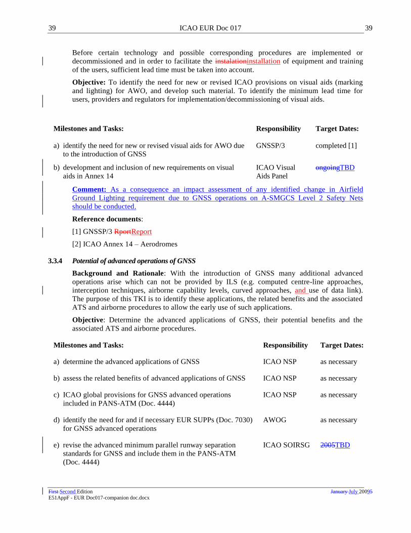
39 ICAO EUR Doc 017 39
First Second Edition January July 20095 E51AppF - EUR Doc017-companion doc.docx
Before certain technology and possible corresponding procedures are implemented or
decommissioned and in order to facilitate the instalationinstallation of equipment and training
of the users, sufficient lead time must be taken into account.
Objective: To identify the need for new or revised ICAO provisions on visual aids (marking
and lighting) for AWO, and develop such material. To identify the minimum lead time for
users, providers and regulators for implementation/decommissioning of visual aids.
Milestones and Tasks: Responsibility Target Dates:
a) identify the need for new or revised visual aids for AWO due
to the introduction of GNSS
GNSSP/3 completed [1]
b) development and inclusion of new requirements on visual
aids in Annex 14
ICAO Visual
Aids Panel
(VAP)
ongoingTBD
Comment: As a consequence an impact assessment of any identified change in Airfield
Ground Lighting requirement due to GNSS operations on A-SMGCS Level 2 Safety Nets
should be conducted.
Reference documents:
[1] GNSSP/3 RportReport
[2] ICAO Annex 14 – Aerodromes
3.3.4 Potential of advanced operations of GNSS
Background and Rationale: With the introduction of GNSS many additional advanced
operations arise which can not be provided by ILS (e.g. computed centre-line approaches,
interception techniques, airborne capability levels, curved approaches, and use of data link).
The purpose of this TKI is to identify these applications, the related benefits and the associated
ATS and airborne procedures to allow the early use of such applications.
Objective: Determine the advanced applications of GNSS, their potential benefits and the
associated ATS and airborne procedures.
Milestones and Tasks: Responsibility Target Dates:
a) determine the advanced applications of GNSS ICAO NSP as necessary
b) assess the related benefits of advanced applications of GNSS ICAO NSP as necessary
c) ICAO global provisions for GNSS advanced operations
included in PANS-ATM (Doc. 4444)
ICAO NSP as necessary
d) identify the need for and if necessary EUR SUPPs (Doc. 7030)
for GNSS advanced operations
AWOG as necessary
e) revise the advanced minimum parallel runway separation
standards for GNSS and include them in the PANS-ATM
(Doc. 4444)
ICAO SOIRSG 2005TBD

40 ICAO EUR Doc 017 40
First Second Edition January July 20095 E51AppF - EUR Doc017-companion doc.docx
f) develop criteria for RNP transition to XLS operations SESAR 2011
Comments: See also TKI 3.3.2
Specific safety assessment to address GNSS continuity risk when supporting parallel operations is
needed (ref to PANS OPS). An alternative would be to reassess the NTZ size taking full account of
multiple simultaneous missed approaches.
4. TRANSITION KEY ISSUES – AUXILIARY
4.1 Alternate navigation aids
4.1.1 Impact of new technologies on AOP
Background and Rationale: New technologies (other than MLS and GNSS e.g. Enhanced
Visual Display (EVS), Head-Up Display (HUD)) could have a certain impact on AOP. These
could have an effect on the approach and landing phase of a flight as well as for the ground
operations. For the development of AWO in the EUR Region it is essential to make an
inventory of these technical options and their potential impact on all operations, including
ground operations.
Objective: To obtain knowledge on the impact of new technologies (other than MLS and
GNSS) for the optimisation of AOP.
Milestones and Tasks: Responsibility Target Dates:
a) gain knowledge on the potential impact of new technologies
(other than MLS and GNSS) on AWO.
ICAO AWOG as necessary
b) EVS MASPs EUROCAE Completed [1]
c) EVS operations EASA Completed[3]
d) CVS MASPs EUROCAE 2010
Comments: This task is partly related to the development of A-SMGCS as it addresses notably
the onboard capability required for taxiing on the airport. There will be a need to ensure
compatibility/interoperability between on-board equipment and information/data received from
third (Aerodrome/ATS) systems e.g. automated lighting systems to provide guidance and/or
control. As far as development of technical and operational requirements for the approach and
landing phases of flights are concerned the AWOG is the appropriate body.
IR OPS introduces also EVS operation.RTCA SC213 and EUROCAE WG 79 have been
progressing EVS standard. EVS MASPs has been published in 2008 reflecting the current
existing system and taking due account of its limitations. The same working groups are
currently developing the CVS (combined Visual system) MASPS [2]. CVS is a system that
combines the information of the two systems:: EVS and SVS, thus providing increased integrity
and situation awareness for guiding the pilot. CVS would allow for AWO including CAT III C
and removing the need of autoland capability for such operations.
The operational approval of E(F)VS is still not published as some remaining key issues are still
pending.

41 ICAO EUR Doc 017 41
First Second Edition January July 20095 E51AppF - EUR Doc017-companion doc.docx
Reference document:
[1] ED-179: MASPS for Enhanced Vision Systems, Synthetic Vision Systems, Combined Vision
Systems and Enhanced Flight Vision Systems.
[2] ED-180: MASPS for Enhanced, Synthetic and Combined Vision Systems with operational
credit (other than NPA OPS 41) 41, reference ED-180 (due date: June 2010)
[3] IR OPS – NPA 02b
[4] EASA Temporary Guidance Leaflet (TGL) 42 has been created to support the operational
approval of E(F)VS (with airworthiness appendix) – (pending)
4.2 ATS Procedures
4.2.1 Inventory of optimum wake turbulence separation for use in Low Visibility Procedures (LVP)
Background and Rationale: According to ICAO provisions on separation capacity is
decreasing during LVP to ensure the required level of safety. Therefore, wake turbulences are
not an issue within current provisions. Safety and capacity in LVP are strongly related to wake
turbulence separation during approach and landing. Further refinement of the current criteria
may be necessary to manage the risks attached to LVP‘s, especially when new technologies
may improve the landing capacity based on other protection requirements of the ground
systems. In particular, the use of aAutoland during LVP may be affected by wake turbulence.
Wwith reduction of separation minima due to the use of new technologies it should be
considered if the existing wake turbulence criteria are still appropriate sufficient for LVP
conditions.
Objective: Determination of optimum wake turbulence separations in LVP.
Milestones and Tasks: Responsibility Target Dates:
a) assess, in consultation with States and international
organisations, if existing wake turbulence separations are
appropriate for use in LVP
AWOG,
PT/LVP
TBD
b) develop new wake turbulence separations and inclusion in
PANS-ATM (Doc. 4444) and in the AWO-Manual as
appropriate.
AWOG,
ICAO ANC
TBD
Comments: An R&D programme may be necessary. Wake Turbulence research is being
conducted by EUROCONTROL, which may contribute to this programme.
4.2.2 Aeronautical Information Service (AIS) issues specific to AWO, including units of measurement
Background and Rationale: Publication of Charts for AWO, and their contents, are governed
by ICAO provisions contained in Annex 4, 4 15 and Doc. 8168. The implementation of WGS-
84, as well as the advent of new Technologies and new Types of AWO procedures (e.g. Steep
final, curved APP, RNAV), may have called for the development of new/or revised ICAO
provisions.
Objective: To prepare provisions for Charts and Maps to allow operations based on new
technology.

42 ICAO EUR Doc 017 42
First Second Edition January July 20095 E51AppF - EUR Doc017-companion doc.docx
Milestones and Tasks: Responsibility Target Dates:
a) assess the current ICAO provisions ICAO ANC completed
b) identify the need for new revised provisions ICAO OCP Q4/2003Completed
c) include new provisions in Annex 415 and 4 ICAO ANC 2002Completed
[1][2]
d) identify the need for (Regional) Provisions on AIS/MAPs AWOG,
EUROCONTROL
2002As Necessary
Comments: States have identified the need for a new waypoint naming convention in the
TMA, which may be applied at a regional level. Other issues may be identified as experience
with new technologies increases. The MDA/DA charting and operational issue is still under
discussion. Annex 4 amendment 54 includes definitions and introduction of new provisions
concerning the Aerodrome Terrain and Obstacle Chart — ICAO (Electronic). Minimum en-
route altitudes, minimum obstacle clearance altitudes, logon address, ATS surveillance system
terminology, aeronautical database requirements, approach fixes and points, aeronautical data
quality requirements for gradients and angles, steep angle approach cautionary note, hot spot
and intermediate holding, position including new symbols.As a result of the AIS/MAP
Divisional Meeting in the spring of 1998, a proposal for amendment of Annex 4 is developed
and sent out to States for approval.
Reference documents:
[1] Proposal for amendment to Annex 4Annex 15 Amendment 33
[2] Annex 4 Amendment 54.
4.3 Mixed Mode operations
4.3.1 Procedures for aircraft in sequence using different types of landing aids
Background and Rationale: It is foreseen that ILS will co-exist for a long time beside MLS
and GNSS. This will urge the need for appropriate ATS procedures to enable early benefits in a
random mixture of ILS, MLS and GNSS traffic (e.g.: MLS-ILS-MLS to a single runway). A
random mixture of ILS and MLS/GNSS traffic may cause substantial effects on the stability of
the ATS operations. A new set of separation criteria could be the direct effect. R&D is
necessary to substantiate the effects and to suggest operational, acceptable solutions. The
immediate need is to manage a mix of ILS and MLS aircraft. Experience gained can later be
applied to other mixes of traffic (e.g. ILS/GNSS or MLS/GNSS) as well.
Objective: Provide ATS procedures for the optimisation of a random mixture of ILS and
MLS/GNSS traffic to a single runway.
Milestones and Tasks: Responsibility Target Dates:
a) development of ATS procedures to use in a random mixture of
ILS and MLS traffic to a single runway in LVP
AWOG,
PT/LVP
completed2005
[1]
b) inclusion of general provisions for mixed MLS/GNSS and ICAO ANC as necessary

43 ICAO EUR Doc 017 43
First Second Edition January July 20095 E51AppF - EUR Doc017-companion doc.docx
ILS/GNSS operations in PANS/ATM Doc. 4444
c) identify the need for and if necessary develop proposed Regional
Provisions (Doc. 7030) for mixed MLS/GNSS and ILS/GNSS
AWOG,
PT/LVP, States
as necessary
Comments: States have the obligation to start R&D to develop these procedures to allow early
benefits and forward the results to the ICAO ANC for incorporation in the relevant ICAO
documentation. The AWOG shall follow these developments and focus on Regional Provisions
in this field. There is a strong dependency between this issue and TKI 2.3.22.1.3.3. Additional
work on Optimised Operations will allow capacity benefits to be achieved following the
implementation of MLS and GNSS.
Currently material in mixed landing mode operations is only available in EUR DOC 013. ,
Reference documents:
[1] ICAO EUR Doc 013 – European Guidance Material on Aerodrome Operations under
Limited Visibility Conditions
4.4 Aerodrome operations (AOP)
4.4.1 Specific AOP
Background and Rationale: With the increasing demand for optimised runway(s) utilisation
and the increasing environmental constraints, providers, regulators and users should focus on
new techniques for approach and landing. These techniques could potentially improve the
capacity of aerodrome and reduce the negative impact on the environment (e.g. Intersection
Take-Off; Multiple Touch-Down points; Reduced TO/LDG distances; Mixed operations; Noise
alleviation; Operations on converging/intersecting runways).
Objective: Optimise AWO planning in the EUR Region by applying new ATS techniques for
approach and landing.
Milestones and Tasks: Responsibility Target Dates:
a) inclusion of PANS for improved runway operations on parallel
and near-parallel runways in PANS /RAC ATM Doc. 4444
SOIR SGICAO completed [1]
b) inclusion of PANS for advanced operations (e.g.: curved
approaches, computed centreline, continuous descent) using
MLS/GNSS in PANS-ATM Doc. 4444
ICAO ANC TBDas
necessary
c) development of SUPPs on improved RWY operations
(intersection take-offs, multiple line-ups, visual
approaches/departures)
EUROCONTROL
ADTMA
TBDCompleted
[2]
d) development of PANS / SUPPs on converging/ intersecting
RWYs
EUROCONTROL
ADTMA,
ICAO ANC
TBDCompleted
[2]
Comments: Several tasks related to the optimisation of AOP were identified in the
ECAC/APATSI programme. Some elements are being considered by the appropriate ICAO
bodies for approval. Other elements are already being taken care of within OCP IFPPand SOIR

44 ICAO EUR Doc 017 44
First Second Edition January July 20095 E51AppF - EUR Doc017-companion doc.docx
SG. It should nevertheless be emphasised that there is no appropriate ICAO body studying
these subjects. OCP and GNSSP stated that the separation aspects will not be taken into account
in their work programme. The EUROCONTROL Working Group on Aerodrome and TMA
operations is currently taking action in these directions.
Reference documents:
[1] ICAO Doc 4444 – PANS-RAC ATM
[2] ICAO EUR Doc 7030
4.4.2 Non-visual aids to support ground operations during low visibility conditions - ASMGCS
Background and Rationale: With the planning of AWO due account should be given to
navigation requirements (related to situational awareness and guidance) in support of A-
SMGCS. Special attention is necessary on the interface of landing and ground operations. This
could eventually be improved by the introduction of new non-visual aids. The coordination of
requirements for non-visual aids both for the approach and landing phase and for the guidance
functionality on the ground is strongly recommended.
Objective: Streamlining the developments in the approach and landing phase of a flight with
the developments in the field of Ground operations.
Milestones and Tasks: Responsibility Target Dates:
a) publication of initial ICAO operational requirements for
A-SMGCS
ICAO ANC completed [1]
b) determination of need for Regional Provisions for A-SMGCS in
Doc 7030
EANPG TBD
c) validation of operational requirements for A-SMGCS EUROCONTROL
States
TBD
d) identify the requirements on the navigation system from the A-
SMGCS operational requirements
EANPG,
EUROCONTROL
States
TBD
e) activities on Level 1/2 A-SMGCS EUROCONTROL 2006on going
Reference documents:
[1] ICAO Doc 9830 – Advanced Surface Movement Guidance and Control Systems (A-
SMGCS) Manual
[2] EUROCAE ED-116 MOPS for Surface Movement Radar Sensor Systems for Use in A-
SMGCS
[2] EUROCAE ED-117 MOPS for Mode S Multilateration Systems for Use in A-SMGCS
[3] EUROCAE ED-128 - Guidelines for Surveillance Data Fusion in Advanced Surface
Movement Guidance and Control Systems (A-SMGCS) Levels 1 and 2
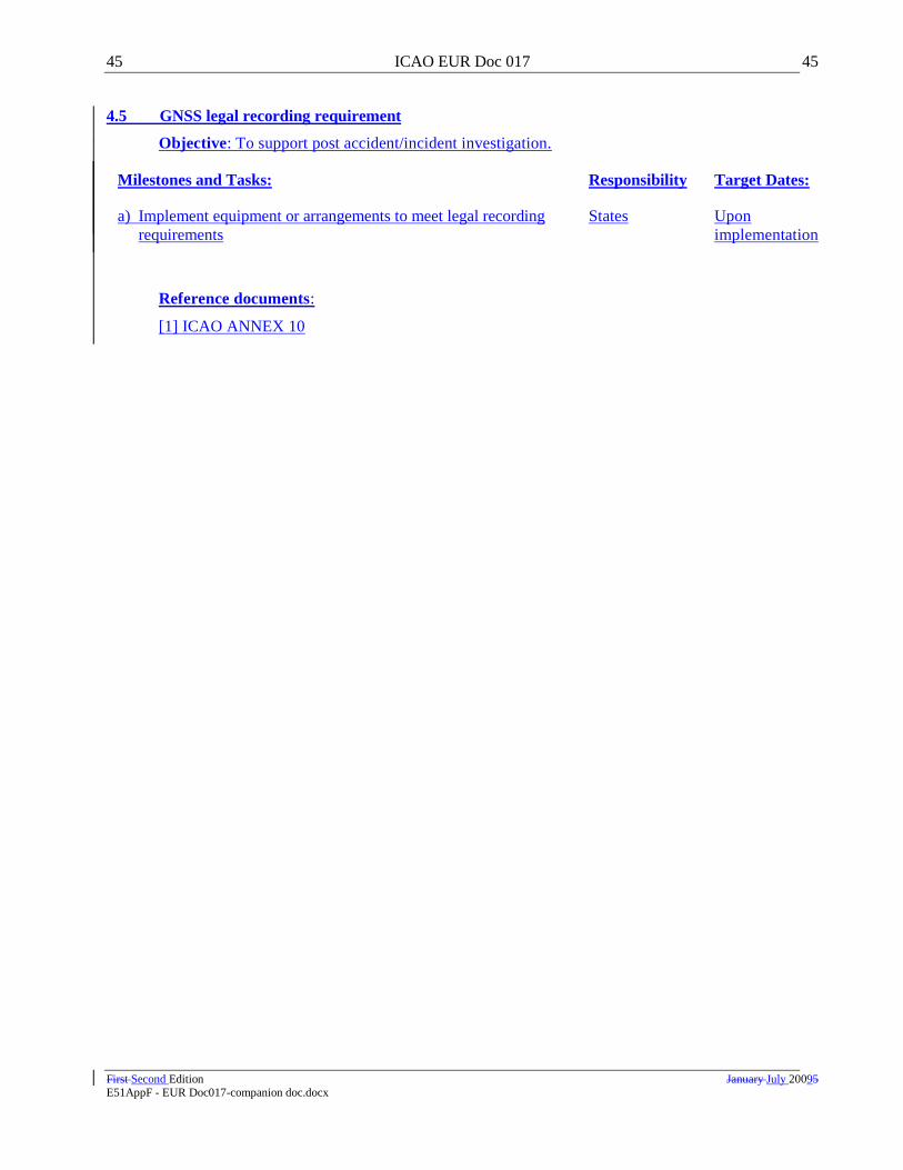
45 ICAO EUR Doc 017 45
First Second Edition January July 20095 E51AppF - EUR Doc017-companion doc.docx
4.5 GNSS legal recording requirement
Objective: To support post accident/incident investigation.
Milestones and Tasks: Responsibility Target Dates:
a) Implement equipment or arrangements to meet legal recording
requirements
States Upon
implementation
Reference documents:
[1] ICAO ANNEX 10
G-1 European Air Navigation Planning Group G-1
E51AppG - PFA wind turbines impact.docx December 2009
Appendix G -
Proposal for Amendment
of the EUR Guidance material on building restricted areas
ICAO EUR (Doc 015)
(paragraph 4.4.35 refers)
(Serial No.: Doc 015 09/01)
a) Regional Guidance Material:
ICAO EUR Doc 015
b) Proposed by:
All-Weather Operations Group (AWOG)
c) Proposed amendment:
Editorial Note: Amendments are arranged to show deleted text using strikeout (text to be deleted),
and added text with underlining (text to be inserted).
1.
Modify text as follows:
“6.4 It is recommended that buildings such as windmills, skyscrapers, large excavating works, TV towers
and other high towers should be assessed at all times even outside the BRA for omni-directional facilities.
Particular attention should be paid to clusters of buildings such as wind-farms and overhead power lines.
For surveillance and communication facilities it is recommended that wind turbine(s) should be assessed
at all times even outside the BRA for omni-directional facilities. Additional guidance on the assessment
of wind turbine developments for navigational facilities is given in Appendix 4.
”
End of modified text
2.
Modify text as follows:
[Delete the existing Figure 2 and replace it with Figure 2.1 and Figure 2.2 shown below.]
European and North
Atlantic Office

G-2 European Air Navigation Planning Group G-2
E51AppG - PFA wind turbines impact.docx December 2009
r
R
Parameters:
r (radius of first cylinder)
R (radius of cone)
α (angle of cone)
j (radius of second cylinder)
h (height of second cylinder)
Figure 2.1: Omni - Directional BRA Shape (three dimensional representation)
j
First cylinder
Second cylinder
Origin of cone
r
R
j
h
h
Figure 2.2: Omni - Directional BRA Shape (side elevation view)
First cylinder
Second
cylinder Cone
End of new text
3.
Modify text as follows:

G-3 European Air Navigation Planning Group G-3
E51AppG - PFA wind turbines impact.docx December 2009
“7.7 It is recommended that buildings such as windmills, skyscrapers, large excavating works, TV towers
and other high towers should be assessed at all times even outside the BRA for directional facilities.
Particular attention should be paid to clusters of buildings such as wind-farms and overhead power lines.
Additional guidance on the assessment of wind turbine developments for navigational facilities is given in
Appendix 4.”
End of modified text
4.
Modify text as follows:
“
APPENDIX 1 – Navigational facilities
Table 1: Harmonised guidance figures for the omni-directional
navigational facilities in accordance with Figure 2 Figures 2.1 and 2.2
Type of
navigation
facilities
Radius
(r –
Cylinder)
(m)
Alpha
(α – cone)
(°)
Radius
(R-Cone)
(m)
Radius
(j – Cylinder)
(m)
Wind turbine(s)
only
Height of
cylinder j
(h -height)
(m)
Wind
turbine(s)
only
Origin of
cone and
axis of
cylinders
DME N 300 1.0 3000 N/A N/A
Base of
antenna at
ground level
VOR 600 1.0 3000
15000
52
Centre of
antenna
system at
ground level
Direction
Finder (DF) 500 1.0 3000 10000 52
Base of
antenna at
ground level
Markers 50 20.0 200 N/A N/A
Base of
antenna at
ground level
NDB 200 5.0 1000 N/A N/A
Base of
antenna at
ground level
GBAS ground
Reference
receiver 400 3.0 3000 N/A N/A
Base of
antenna at
ground level
GBAS VDB
station 300 0.9 3000 N/A N/A
Base of
antenna at
ground level
VDB station
monitoring station 400 3.0 3000 N/A N/A
Base of
antenna at
ground level

G-4 European Air Navigation Planning Group G-4
E51AppG - PFA wind turbines impact.docx December 2009
The heights and surfaces specified for wind turbine(s) apply to the tip of the turbine blade when
vertical. Where the terrain cannot be considered to be flat, for example in the case of sloping terrain, then
all wind turbine proposals should be assessed out to the full radius of cylinder j or the BRA adapted to the
actual terrain.
”
End of modified text
5.
Add new text as follows:
“APPENDIX 4 – Wind-Turbine(s) Assessment for Navigational Facilities
The guidance figures given in Appendix 1 Table 2, together with the application of ICAO Annex 14
surfaces, should provide sufficient protection for all directional facilities. The guidance figures given in
Appendix 1 Table 1 should provide sufficient protection for all omni-directional facilities. The Step 2
“Specialist engineering analysis” process for VOR and Direction Finders (DF) is discussed in more detail
below:
VOR
The impact of wind turbine(s) on VOR is difficult to assess for several reasons, including:
a) the worst case errors may be experienced when the turbine blades are stationary (due to either
high or low wind speeds). The actual error is a function of the orientation of the turbine and position of
the turbine blades when stationary.
b) the worst case error is due to the cumulative effect of a number of turbines, each of which may be
acceptable individually. The cumulative effect at any position in the coverage volume is very sensitive to
the exact location and orientation of the individual turbines.
c) the largest errors are likely to be experienced at the limit of coverage and at low elevation angles.
d) it is unlikely that the worst case errors can be confirmed by flight inspection due to the factors
listed above.
Proposed wind turbine developments should be assessed to a distance of 15 km from the facility. Further
assessment is required for any turbines within 600 m, or if any turbines infringe a 1 degree slope from the
centre of the antenna at ground level to a distance of 3 km, or if they infringe a 52 m horizontal surface
from a distance of 3 km to 15 km. Where the terrain cannot be considered to be flat, for example in the
case of sloping terrain, then all wind turbine proposals should be assessed out to 15 km or the BRA
adapted to the actual terrain.
In most cases single wind turbine developments are acceptable at distances greater than 5 km from the
facility, and developments of less than 6 wind turbines are acceptable at distances greater than 10 km
from the facility. However if VOR performance is already marginal this may not be acceptable. In cases
where there are existing wind turbine(s) within the 15 km zone the assessment of new proposals needs to
consider the cumulative affect of all the turbines, bearing in mind that the worst case error due to the
existing wind turbine(s) is unlikely to have been measured by flight inspection.
G-5 European Air Navigation Planning Group G-5
E51AppG - PFA wind turbines impact.docx December 2009
Computer simulations can be used to assess the effect of wind turbine(s) on VOR using worst case
assumptions as outlined above. In determining the acceptability of proposed wind turbine developments
it is necessary to consider how much degradation of performance can be allowed. This requires
consideration of the VOR error budget. The VOR bearing error at the output of the airborne receiver is
made up of three main components. These are ground system errors, errors due to multipath, and airborne
receiver errors. The ground system error is specified in ICAO Annex 10 to be within plus or minus 2°.
The Annex 10 standards do not specify the other error components but the guidance material states that a
radial signal error of plus or minus 3° (95% probability) is achievable in practice. The material in ICAO
Annex 11 – Attachment A “Material relating to a method of establishing ATS routes defined by VOR”,
makes the assumption that the VOR accuracy is as stated in this Annex 10 guidance material. Further
guidance on flight inspection of VOR given in ICAO Doc 8071 states that the displacement of the course
by a bend should not exceed 3.5° from either the correct magnetic azimuth or on the course average as
provided by the facility. Since the 3.5° tolerance applies to the displacement from the correct magnetic
azimuth this tolerance includes ground system errors as well as multipath errors.
To determine an appropriate tolerance for wind turbine developments it is necessary to take account of the
flight inspection tolerances described above as well as the maximum radial alignment errors due to the
ground station, including any north alignment errors due to changes in the magnetic variation. The
existing bearing errors due to other sources of multipath, and the operational use of the facility in the
sector affected also need to be considered. In assessing simulation results it is also appropriate to include
a margin to allow for any uncertainty in the fidelity of the model. Taking all these factors into account it
is clear that it would not be appropriate to allow a proposed development to cause a bend as large as 3.5°.
For example some engineering authorities have used a tolerance of 1° when assessing the acceptability of
proposed developments using computer simulation. This is also consistent with the use of VOR to
support RNAV operations.
While the BRA is the same for conventional and Doppler VOR, the Doppler VOR is less susceptible to
multipath interference.
Direction Finders (DF)
The impact of wind turbine(s) on DF is difficult to assess for the reasons given above for VOR.
Proposed wind turbine developments should be assessed to a distance of 10 km from the facility. Further
assessment is required for any turbines within 500 m, or if any turbines infringe a 1 degree slope from the
base of the antenna at ground level to a distance of 3 km, or if they infringe a 52 m horizontal surface
from a distance of 3 km to 10 km. Where the terrain cannot be considered to be flat, for example in the
case of sloping terrain, then all wind turbine proposals should be assessed out to 10 km or the BRA
adapted to the actual terrain.
In most cases single wind turbine developments are acceptable at distances greater than 3 km from the
facility, and developments of less than 6 wind turbines are acceptable at distances greater than 6 km from
the facility. However if DF performance is already marginal this may not be acceptable. In cases where
there are existing wind turbine(s) within the 10 km zone the assessment of new proposals needs to
consider the cumulative effect of all the turbines, bearing in mind that the worst case error due to the
existing wind turbine(s) is unlikely to have been measured by flight inspection.

G-6 European Air Navigation Planning Group G-6
E51AppG - PFA wind turbines impact.docx December 2009
Computer simulations can be used to assess the effect of wind turbine(s) on DF using worst case
assumptions as outlined above. In determining the acceptability of proposed wind turbine developments
it is necessary to consider how much degradation of performance can be allowed. The existing bearing
errors due to other sources of multipath, and the operational use of the facility in the sector affected also
need to be considered. In assessing simulation results it is also appropriate to include a margin to allow
for any uncertainty in the fidelity of the model.
”
End of next text
d) Date when proposal received:
16 September 2009
------------------------------

H-1 European Air Navigation Planning Group H-1
EUR ANP – Part IV-CNS August 2007
Working Draft
E51AppH - PFA 7754 CNS.docx December 2009
Appendix H – Proposal for Amendment to Doc 7754 regarding CNS
(paragraph 4.4.43 refers)
WORKING DRAFT OF
EUR ANP, VOLUME I, BASIC ANP
PART IV
COMMUNICATIONS, NAVIGATION AND SURVEILLANCE (CNS)
RECORD OF AMENDMENTS
Note: A consolidated text of this section, containing the following approved amendments to the EUR ANP, will be officially disseminated on an annual basis. This document is produced solely as reference material to
assist States in the preparation of proposals for amendment to the EUR ANP.
AMENDMENTS
P. f. Amdt. Serial No.
Originator Date Approved
Date Entered
P. f. Amdt. Serial No.
Originator Date Approved
Date Entered
05/20-CNS EANPG 06/11/05 10/05/06
04/02-CNS EANPG 27/12/06 05/03/07
06/11-CNS EANPG 01/08/07 09/08/07

H-2
EUR ANP – Part IV-CNS August 2007
Working Draft
E51AppH - PFA 7754 CNS.docx
Part IV
COMMUNICATIONS, NAVIGATION AND SURVEILLANCE (CNS)
GENERAL
1. Communications, Navigation and Surveillance (CNS)The telecommunication facilities and
services should meet the requirements of those other components of the air navigation system which they are
intended to serve.
2. In planning for those other components, economy and efficiency should be taken into account in
order to ensure that the requirements for the provision of CNStelecommunication facilities and services can
be kept to a minimum.
3. CNS 3. Telecommunication facilities and services should fulfil multiple functions whenever this
is feasible.
COMMUNICATIONS
AERONAUTICAL FIXED SERVICE (AFS)
Basic requirements
4. The Aeronautical Fixed Serviceaeronautical fixed service (AFS) should satisfy the communication
requirements of Air Traffic Services (ATS), Air Traffic Flow Management (, ATFM), Aeronautical
Information Services (, AIS), Meteorology (, MET) and Search and Rescue (SAR),, including specific
requirements in terms of system reliability, message integrity and transit times, with respect to printed as
well as digital data and speech communications. If need be, it should, following agreement between
individual States and aircraft operators, satisfy the requirements for aeronauticalairline operational control.
[Annex 3, 11.1; Annex 11, 6.2; Annex 12, 2.4; Annex 15, Chapter 9; Annex 10, Volume II, Chapter 4]
5. To meet the data communication requirements, a uniform high-grade aeronautical network should
be provided, based on the aeronautical telecommunication network (ATN), taking into account the existence
and continuation of current networks. This network is hereafter referred as the EUR-ATN Network.
[Annex 10, Volume III, Part I]
Existing network
6. Pending future development of the EUR AFS, the current requirements should be met by the use
of:
a) the Aeronautical Fixed Telecommunication Networkaeronautical fixed telecommunication network
(AFTN);
b) the Common ICAO Data Interchange Network (CIDIN) and the CIDIN COM centres;
c) the ATS message handling systems (AMHS), the AMHS COM centres and the AMHS gateways;
d) the dedicated networks of ATS providers;
e) the operational meteorological information (OPMET) circuits and centres;

H-3
EUR ANP – Part IV-CNS August 2007
Working Draft
E51AppH - PFA 7754 CNS.docx
f) the ATS speech networks and circuits;
g) the ATS computer-to-computer data networks and circuits; and
h) The Satellitethe satellite distribution system for information relating to air navigation (SADIS).
7. All possible arrangements should be made to ensure that, in case of breakdown of a
communications centre or circuit, at least high-priority traffic continues to be handled by appropriate means.
8. Emergency procedures should be developed to ensure that, in case of a centre breakdown, all the
parties concerned are promptly informed of the prevailing situation.
9. AFS planning should permit flexibility in detailed development and implementation.
The EURTheEUR-ATN network
10. The EUR-ATN Network should have sufficient capacity to meet the basic requirements for data
communications for the services mentioned in 4. above.
11. The EUR-ATN Network should be able to:
a) support applications carried by the existing network as listed in 6 above;
b) support gateways enabling inter-operation with existing networks; and
c) support ground communications traffic associated with air-ground data link applications.
Note. — A requirement for the EUR-ATN Network to carry digital speech may have to be
considered as and when this becomes practicable and cost effective.
12. The EUR-ATN Network should make optimum use of dedicated bilateral aeronautical links and
other communication means commensurate with the operational quality of service (QoS) requirements.
13. The plan for the implementation of the EUR-ATN Network should take into account the need for
cost-effective evolution in terms of network capacity and allow for a progressive transition from existing
ground communication networks and services to a uniform, harmonised and integrated communications
infrastructure.
14. In case means other than dedicated bilateral links are used by the EUR-ATN Network,
implementation priority, high availability, priority in restoration of service and appropriate levels of security
should be ensured.
15. The EUR-ATN Network should provide for interregional connections to support data exchange
and mobile routing within the global ATN.
16. States in the EUR Region are responsible for ensuring interoperability of the EUR-ATN Network
with SARPs-compliant implementations in other States or Regions.
17. In planning the EUR-ATN Network, provisions should be made, where required, for interfacing
with other international networks.
Network services

H-4
EUR ANP – Part IV-CNS August 2007
Working Draft
E51AppH - PFA 7754 CNS.docx
18. The Transmission Control Protocol/Internet Protocol (TCP/IP) communication protocol should
be used for the initial implementation of AMHS.
[EANPG 44/45].
19. The migration of flight data exchange (OLDI) from X.25 to TCP/IP should be planned.
1.
20. The migration of international or regional ground networks to the EUR-ATN network based on
internet protocol (IP) to support AFS communication requirements, while reducing costs, should be planned.
Network management
21. A centralised off-line network management service is provided to participating
AFTN/CIDIN/AMHS centres in the EUR Region.
[EANPG 45/10].
Specific ATS requirements
22. Where ATS speech and data communication links between any two points are provided, the
engineering arrangements should be such as to avoid the simultaneous loss of both circuits.
23. Special provisions should be made to ensure a rapid restoration of ATS speech circuits in case of
outage.
24. The direct access speech capability provided between ATS units should permit contact to be
established as rapidly as necessary commensurate with the functions of the unit concerned.
[Annex 11, 6.2]
25. Data circuits between ATS systems should provide for both high capacity and message integrity.
26. The OLDI application, which provides functionalities equivalent to ATS Interfacility Data
Communication (AIDC), is used for automated exchange of flight data between ATS units.
Specific MET requirements
27. In the transmission of operational meteorological information on the EUR-ATN Network the
specified transit times should be met on at least 95 per cent of occasions.
[Annex 3, 11.1.11]
28. The increasing use of the GRIB and BUFR code forms for the dissemination of the upper wind
and temperature and significant weather forecasts and the planned transition to the BUFR code form (or table
driven code form) for the dissemination of OPMET data should be taken into account in the planning process
of the EUR-ATN Network.
29. In planning the EUR-ATN Network, account should be taken of changes in the current pattern of
distribution of meteorological information resulting from the increasing number of long-range direct flights
and the trend towards centralized flight planning.
Multinational System Addressing
30. The EU addressing indicator is reserved in ICAO Doc 7910 for use by multinational systems in
the European Region to allow multinational systems to retain the same addressing indicator, irrespective of
which State or States the service is operated from. This enables the physical location of the service to be
independent of the address used. The ICAO EUR/NAT Regional Director is the focal point for proposals for
changes to the EU entry in Doc 7910.
H-5
EUR ANP – Part IV-CNS August 2007
Working Draft
E51AppH - PFA 7754 CNS.docx
31. The use of the EU indicator needs to be carefully managed to ensure that the primary purpose of
the addressing indicator, which is to enable the AFTN addressing system, is not compromised. Therefore, the
following basic rules should be applied:
i) only State groupings within the EUR Region that are providing multinational services can be
considered as being eligible to use EU;
ii) there must be clear operational and/or institutional needs for an allocation;
iii) there must be an assessment of implications, and
iv) assignments are to be formulated in accordance with the requirements of Doc 7910. The 3rd and
4th letters of an EU allocation will identify the function of the system. The 5th to 8th letters will
be assigned in accordance with the requirements of Doc 8585, in close co-ordination with the
EANPG COG.
32. The ICAO Regional Director of the EUR/NAT Office should consider a request for an EU
allocation in ICAO Doc 7910 only when the above requirements are met.
Note. — Specific requirements concerning ATFM and AIS have still to be developed.
AERONAUTICAL MOBILE SERVICE (AMS)
33. Air-ground communications facilities should meet the agreed communication requirements of the
air traffic services, as well as all other types of communications which are acceptable on the AMS to the
extent that the latter types of communications can be accommodated.
34. To meet the air-ground data communication requirements, a high-grade aeronautical network
should be provided based on the ATN, recognising that other technologies may be used as part of the
transition. The network needs to integrate the various data links in a seamless fashion and provide for end-
to-end communications between airborne and ground-based facilities.
(Doc 9705)
35. Whenever required, use of suitable techniques on VHF or higher frequencies should be made.
36. Operation on HF should only be employed when use of VHF is not feasible. When HF is used,
the single side-band technique should be employed.
[Annex 10, Volume III, Part II, Chapter 2.]
37. Aerodromes having a significant volume of International General Aviation (IGA) traffic should
be provided with appropriate air-ground communication channels.
Air-ground communications for ATS
38. Air-ground communications for ATS purposes should be so designed that they require the least
number of frequency and channel changes for aircraft in flight compatible with the provision of the required
service. They should also provide for the minimum amount of coordination between ATS units and for
optimum economy in the frequency spectrum used for this purpose. Basic elements for the determination of
the need for air-ground communication channels and their economic use are given in Attachment A to Part
V.II – ATS of the EUR FASID.
[Annex 11, 6.1 and Attachment B]
H-6
EUR ANP – Part IV-CNS August 2007
Working Draft
E51AppH - PFA 7754 CNS.docx
3939. In addition, uniform values of designated operational range and height of VHF air-ground
communication channels should be used for identical ATS functions in accordance with the table contained
in Attachment B to Part V.I – ATS of the EUR FASID. Deviations from these values at specific locations or
for specific functions should only be made in those cases where adequate operational justification for such a
deviation is provided by the State(s) concerned.
[Annex 11, 6.1 and Attachment B]
40. In order to achieve optimum economy in the use of the radio frequency spectrum used
commonly for inter-national and national ATS air-ground communications (VHF), the above criteria should
also be applied to national planning in the field of VHF air-ground communications.
Air-Ground Data Link Communications
40. The following Strategy was developed for the harmonised implementation of the data link -
ground communications in the ICAO EUR Region (Conclusions EANPG 50/18 and 49/19 refer):for ATS
a) Any additional aircraft implementation of Automatic Dependent Surveillance - Contract
(ADS-C) should either;
i) utilise without change the existing DO-258A/ED-100A1 (FANS-1/A) ADS-C, or
ii) move to the full implementation of the internationally agreed common technical
definition that will be defined based on relevant provisions and guidance material
(Manual of Air Traffic Services Data Link Applications (Doc 9694)) developed by
ICAO and its technical bodies
1.1 Partial or divergent aircraft data link evolutions should not be pursued, as they will
continue to promote divergent paths to the detriment to the broader community. Interim
steps or phases toward full implementation of the common technical definition in ground
systems should only be pursued on a regional basis, after coordination between all States
concerned.
b) Any additional aircraft implementation of Controller-Pilot Data Link Communications
(CPDLC) should either;
i) utilise without change the existing DO-258A/ED-100A (FANS-1/A) or DO-280B/ED-
110B2 (ATN) CPDLC for ACM/ACL/AMC
3 data link services, or
ii) move to the full implementation of the internationally agreed common technical
definition, based on Procedures for Air Navigation Services — Air Traffic Management
(PANS-ATM, Doc 4444), and other operational material as appropriate
1.2 Partial or divergent aircraft data link evolutions that result in excluding messages
from aircraft systems should not be pursued, as they will continue to promote divergent
paths to the detriment to the broader community. Interim steps or phases toward full
implementation of the common technical definition in ground systems should only be
pursued on a regional basis, after coordination between all States concerned.
Harmonization of operational procedures for implementation of the above packages is considered essential.
States, planning and implementation regional groups, air navigation services providers and other ATS
coordinating groups should adopt common procedures to support seamless ATS provision across flight
1 RTCA/EUROCAE Interoperability Requirements for ATS Applications Using ARINC 622 Data
Communications (FANS 1/A INTEROP Standard) 2 RTCA/EUROCAE Interoperability Requirements Standard For ATN Baseline 1 (ATN B1 INTEROP
Standard) 3 Air traffic control communications management/Air traffic control clearances and information/Air traffic
control microphone check.

H-7
EUR ANP – Part IV-CNS August 2007
Working Draft
E51AppH - PFA 7754 CNS.docx
information region boundaries, rather than each State or Region developing and promulgating unique
procedures for common functions.
41. Controller Pilot Data Link Communications (CPDLC) based on ATN VDL2 implementation is
an agreed strategy for deployment of air-ground data link communications in the ICAO EUR Region.
Required Communication Performance (RCP)
2.
42. The RCP concept characterizing the performance required for communication capabilities that
support ATM functions without reference to any specific technology should be applied wherever possible.
43. The States should determine, prescribe and monitor the implementation of the RCP in line with the
provisions laid down in the ICAO RCP Manual (Doc 9869).
41. Ground-ground communications between ATS units, including ATS voice communication links
and computer-to-computer links, should be so designed that they provide for optimum coordination between
ATS units required to exchange flight data and execute coordination of air traffic directly between each
other. Where necessary, the voice communication links should also be designed to permit conference-type
communications between more than two ATS units if this is justified in order to resolve air traffic control
problems.
2.
Note. — Requirements for ground-ground communications between ATS units will be met by the
integrated aeronautical fixed services network currently being developed.‖
3.
4.
AERONAUTICAL RADIO NAVIGATION SERVICE
42. Radio navigation aids should meet, in a reliable manner, the agreed air navigation requirements
as outlined in Parts III (AOP) and IV (CNS) of the EUR FASID.
FREQUENCY ASSIGNMENT PLANNING
General
44. Planning of navigation services associated with the ATS route network should be done on a total
system basis, taking full account of the navigation capabilities as well as cost effectiveness. The total system
composed by station-referenced navigation aids, satellite based navigation systems and airborne capabilities
should meet the performance based requirements for navigation guidance of all aircraft using the system and
should form an adequate basis for the provision of positioning, guidance and air traffic services.
45. Account should be taken of the fact that certain aircraft may be able to meet their long-range and
short-range navigation needs by means of self-contained aids, thus eliminating the need for the provision of
station-referenced aids along routes used by such aircraft, as well as the need to carry on board excessive
redundancies.
46. The Global ATM Operational Concept, endorsed by ICAO 11th Air Navigation Conference
(AN-Conf/11) and published as ICAO Doc 9854, provides the framework for the development of all regional
ATM concepts. AN-Conf/11 also endorsed a number of technical recommendations affecting navigation,
including the harmonization of air navigation systems between regions, frequency planning, the transition to
satellite based air navigation, curved RNAV procedures, and the use of multiple GNSS signals and the rapid
implementation of approaches with vertical guidance.

H-8
EUR ANP – Part IV-CNS August 2007
Working Draft
E51AppH - PFA 7754 CNS.docx
47. The ICAO Performance Based Navigation (PBN) Manual was developed in direct response to an
AN-Conf/11 recommendation.
48. In September 2007, the ICAO 36th General Assembly issued Resolution 36-23 urging States to:
a) Complete PBN implementation plans by 2009,
b) Implement RNAV and RNP operations (where required) for en route and terminal areas and
c) Implement approach procedures with vertical guidance (APV) (Baro-VNAV and/or augmented
GNSS) for all instrument runway ends, either as the primary approach or as a back-up for precision
approaches, by 2016 (with 30 per cent by 2010 and 70 per cent by 2014).
49. The following PBN Implementation Roadmap addresses and supports this Resolution whereby
States and Planning and Implementation Regional Groups (PIRGs) should complete a PBN implementation
plan by 2009.
THE EUR PBN IMPLEMENTATION ROADMAP
50. Recognizing the benefits to be derived from PBN concept, the EUR Region States shall ensure
that all RNAV and RNP operations and procedures are in accordance with the PBN concept as detailed in
ICAO Doc 9613 thereby ensuring a globally harmonized and coordinated transition to PBN avoiding
unnecessary costs to operators in achieving certification and operational approvals for worldwide navigation
application.
51. The EUR PBN Regional Roadmap is designed to provide guidance to air navigation service
providers, airspace operators and users, regulating agencies, and international organizations, on the expected
evolution of navigation system in order to allow planning of airspace changes and the enabling ATM
systems and aircraft equipage.
52. The PBN Implementation Roadmap for the European Region exists within the context of the
EUR region operating environment. This includes the Navigation Application and Infrastructure Planning
Strategy for the EUR.
53. Given the requirement for interoperability this Roadmap represents the parent source of the
strategic regional planning context and strong links are forged at a Pan-European level with the SESAR
ATM Master Plan.
54. The following are key navigation enablers and driving factors to the development and further
evolution of the Roadmap:
a) SBAS (Satellite-Based Augmentation System) becomes available for suitably equipped aircraft to
enable increased access to medium and smaller airports in the time frame until about 2013;
b) GBAS (Ground-Based Augmentation System) becomes available using GPS L1 for some users in
particular operating environments in the time frame until about 2013;
c) 4D contract is foreseen beyond 2020;
d) The requirement for Advanced RNP with an initial Required Time of Arrival (RTA) capability is a
step towards 4D trajectory management;
e) Extended use of RNAV1/P-RNAV for approach as a means of transitioning from permanent routes
through Conditional Routes to 4D Business/Mission Trajectories;
f) Move towards GNSS becoming the prime positioning source for all phases of flight using
Galileo/GPS/GLONASS, GBAS and SBAS;
g) A mandate for the carriage of GNSS is envisioned for application in certain parts of the EUR in the
2015 period;

H-9
EUR ANP – Part IV-CNS August 2007
Working Draft
E51AppH - PFA 7754 CNS.docx
h) The continued provision of DME as a backup to GNSS is consistent with safety targets;
i) Replacement of Conventional Non-Precision Approaches by approaches with vertical guidance up to
2016;
j) Evolution of improved low visibility operations using GBAS to support CAT II and III operations
with GPS L1 then with multi constellation GNSS in the period up to 2015;43.
k) The progressive decommissioning of VORs and NDBs made possible by the use of GNSS;
Principles of PBN Implementation
55. The broad principles for PBN Implementation derived from the operational requirements of the
EUR Region and the concepts and strategies discussed above are:
a) The Navigation Application and Infrastructure Strategy are required to support the requirements
detailed in the ICAO Global ATM Operational Concept. As such, the Roadmap lays the foundations
for achieving the long term goals of User Preferred Trajectories (RNAV, 3D-RNP and 4D-RNP
applications) together with improved access, safety and all weather operations through application of
xLS;
b) GNSS will become the primary, and potentially a sole means of navigation, to the degree that this
can be demonstrated to be safe and cost effective;
c) Meet the environmental policies. In this context, it is necessary to coordinate the development of
navigation avionics; and
d) Given the need for satellite-based Navigation to increasingly co-exist with satellite-based
Surveillance and Communication services, the Roadmap takes due account of enablers that will be
required by communications and surveillance.
56. The application of these principles shall:
a) identify, and evolve from, the needs and priorities of both users and providers of the navigation
systems and/or services;
b) provide tangible and early benefits for the users;
c) safeguard capital investments, necessary to maintain the existing Infrastructure, in future
rationalisation plans;
d) take due account of sub-regional institutional arrangements and legal regulations;
e) accommodate geographical differences in capabilities, performance requirements, and in the
existing and required infrastructure;
f) enable coherent development plans to be made within EUR region and ensure an appropriate
interface to the adjacent regions; and
g) Accept the continued operations of aircraft with lower navigation capabilities for as long as
operationally feasible.
Benefits
57. The following are the benefits expected to be derived by implementation of PBN:

H-10
EUR ANP – Part IV-CNS August 2007
Working Draft
E51AppH - PFA 7754 CNS.docx
a) Improved safety through the implementation of continuous and stabilized descent procedures using
vertical guidance accompanied by the gradual elimination of Non-Precision Approaches by 2016
thereby reducing the potential for Controlled Flight into Terrain;
b) Implementation of more flexible and precise approach, departure, and arrival paths that will reduce
dispersion and will enable improved airspace design fostering increased capacity;
c) Flight efficiency by the extension of RNAV application where the existing route structure is defined
around ground based navigation aids and to all airspace by the use of optimised trajectories enabled
by RNP and 4D contract;
d) Increased capacity in those parts of the EUR region where RNAV carriage is not a requirement today
through the implementation of additional parallel routes and additional arrival and departure points
in terminal areas;
e) Increase capacity by the reduction of lateral and longitudinal separation enabled by RNAV and RNP;
f) Reduced environmental impact resulting from savings in fuel and through noise reduction by the
improved placement of routes using RNAV and RNP;
g) Mission effectiveness (improved through the accommodation of aircraft with lower navigation
capability for as long as operationally feasible);
h) Improved airport access through the more generalised availability of Cat I/II/III precision approach
(e.g. improved ILS operations, MLS and GBAS/GLS) and the provision of LPV and RNP APCH
giving lower weather minima;
i) Decrease ATC and pilot workload by utilizing RNAV/RNP procedures and airborne capability and
reduce the needs for ATC-Pilot communications and radar vectoring; and
j) Interoperability with other ICAO regions.
PBN APPLICATIONS
En-Route Operations
58. For En-Route operations the application of RNAV 5 is mandated in designated parts of the ICAO
EUR.
[ICAO EUR SUPPs Doc 7030 refers]
59. Considering the traffic characteristics and CNS/ATM capability in the EUR region that includes
both Continental and Remote continental operations, it is expected that a single RNAV or RNP navigation
specification will not be applicable throughout the region.
60. Therefore different implementations of RNAV and RNP navigation application and associated
specifications may be applied by different homogeneous ATM areas.
TMA Operations
61. Requirements for TMA operations have their own characteristics, taking into account the
applicable separation minima between aircraft and between aircraft and obstacles. It also involves the
diversity of aircraft, including low-performance aircraft flying in the lower airspace and conducting arrival
and departure procedures on the same path or close to the paths of high-performance aircraft.
62. The mix of traffic differs remarkably between airports. This together with airspace restrictions
which can prevent the introduction of special RNAV/RNP routes is likely to result in the capability of an
airport to introduce RNAV or RNP operations being constrained by the lower capability of aircraft using that
airport. It is consequently possible that airports within a single TMA could have differing capability for
introduction of PBN operations.

H-11
EUR ANP – Part IV-CNS August 2007
Working Draft
E51AppH - PFA 7754 CNS.docx
63. As a result, the States should develop their own national plans for the implementation of PBN in
TMAs, based on the PBN Manual, seeking the harmonization of the application of PBN and avoiding the
need for multiple operational approvals for intra- and inter-regional operations, and the applicable aircraft
separation criteria.
64. The following strategy was agreed for Performance Based Navigation Implementation
Harmonisation and Implementation in the ICAO EUR Region by ICAO EANPG/50:
a) Implementation of any RNAV or RNP application shall be in compliance with ICAO PBN
Manual (Doc 9613);
b) Recognizing that B-RNAV/P-RNAV can be regarded as equivalent to RNAV5/RNAV1, as
defined in the ICAO PBN Manual, their use will be continued for en-route and terminal
applications at least until 2015;
c) The target date for the completion of implementation for the Approach procedures with
vertical guidance (APV) (APV/Baro-VNAV and/or APV/SBAS) for all instrument runway
ends is 2016;
d) Replacement of RNAV5/RNAV1 (B-RNAV/P-RNAV) specification by RNP specifications
(e.g. Basic RNP-1 and advanced-RNP) for the use in the en-route and terminal airspace to
commence by 2015.
e) ICAO PBN Manual compliant terms, e.g. RNAV 1 and RNAV 5, shall be implemented for
all new aeronautical information publications and as an update to existing publications until
2014.
Instrument Approaches
65. States should introduce PBN approaches that provide Vertical Guidance to enhance safety. These
should be based on APV Baro-VNAV and Space Based augmentation Systems (SBAS) where possible.
Conventional approach procedures and conventional navigation aids should be maintained to support non-
equipped aircraft during the transitional period.
66. With the expected reduction and subsequent removal of VOR and NDB it is expected that
conventional NPAs will have to be withdrawn from 2015 to 2025. The States should make clear their own
individual plans in order ot assist operators in their planning for the transition to PBN.
NAVIGATION INFRASTRUCTURE
67. The Navigation Infrastructure requirements address all phases of flight from take off to final
approach and also the precision approach and landing.
En route and TMA
2010-2015
68. Transition to a total RNAV environment takes place that requires enhancing DME coverage
and/or ensuring the safety of GNSS signals in space and improving the quality of service for en route and
terminal operations. This should be achieved mainly by deploying additional DMEs and certifying GNSS
service providers in part of the Region. Repositioning some of the existing facilities might be required, as
enabled by decommissioning of VOR.
69. RNAV infrastructure assessment guidance material is available at
http://www.paris.icao.int/documents_open/subcategory.php?id=48 and can be used to aid in assessment of
DME-DME network requirements.

H-12
EUR ANP – Part IV-CNS August 2007
Working Draft
E51AppH - PFA 7754 CNS.docx
70. Decommissioning of NDBs and reduction of VOR takes place due to a progressive reduction of
conventional routes and procedures, while leaving a sufficient backbone of conventional navigation aids to
continue supporting a reducing non-RNAV route structure at lower flight levels and supporting remaining
conventional approach procedures and their associated missed approaches, and enable ATC to re-route
aircraft in the event of individual aircraft RNAV failure
71. In the European Union the European Aviation Safety Agency (EASA) is expected to become
competent for oversight of the providers of GNSS signals in space. Equipped aircraft will be authorized to
take advantage of European Geostationary Navigation Overlay Service (EGNOS), after the certification of the
relevant Navigation Service Provider (NSP), within its area of coverage and within the limits of its declared
performance.
2015-2020
72. The transition to a total RNAV environment requires generalised use of GNSS in those areas
where suitable DME coverage cannot be achieved, such as low flight levels in terrain constrained areas.
73. GNSS Sensors might be required for all General Air Traffic (GAT) operations. Dual RNAV with
DME/DME and GNSS sensors, or other solutions ensuring a level of safety commensurate to the type of
operations, may be foreseen to overcome loss of GNSS signal in order to meet the operational requirements
in respect of the risk of loss of navigation capability on Air Transport operations. Alternate equipage using
ground based navigation aids could be planned.
74. Galileo and enhanced GPS should start to become available in the 2015-2020 timeframe allowing
increased reliance on GNSS once dual constellation and dual frequency equipment is installed in aircraft and
experience is built up on Galileo operation.
75. The existence of a total RNAV environment should allow further removal of VOR and NDB, as
well as further removal of avionics no longer necessary.
Post 2020
76. In this time frame, it is expected to have a multi-constellation and multi frequency GNSS
environment that will provide an adequate level of GNSS service in terms of robustness and performance.
77. These GNSS enhancements should reduce significantly the probability of having a GNSS failure
and would reduce the extent of an alternative reversion, allowing for a reduced DME network to support the
back-up requirement.
78. The existence of a total RNAV environment should allow an almost total removal of any
remaining VOR.
Approach and Landing
2010-2015
79. Instrument Landing System (ILS) remains the prime source of guidance for precision approaches
and landings in the EUR and continue to support all categories of airspace users.
80. Cat I GLS (GBAS/GPS) may become available. ILS will probably remain the only means for Cat
II/III operations. However, toward the end of the period, depending on Research and Development results,
there may be a limited availability of Cat II/III GLS capability (using a GPS/GBAS capability augmented by
on-board systems) at runways with Cat II/III lighting. This might increase the rate of take up of GBAS based
landing as a back up to ILS to cater for maintenance/system failures.
81. The gradual elimination of NPAs (both conventional and RNAV) should take place in
accordance with the decisions of the 36th ICAO Assembly to be replaced by Approaches with Vertical
Guidance (APV) either based on SBAS or Baro-VNAV. This is expected to be completed early in the period
2015-2020 with the provision of APV to all IFR runway ends, including those mainly used by general
aviation.

H-13
EUR ANP – Part IV-CNS August 2007
Working Draft
E51AppH - PFA 7754 CNS.docx
82. Runways presently not equipped with Precision Approach and Landing system may consider
SBAS (e.g. LPV down to 200 ft DH) or Cat I GLS (GBAS/GPS) systems with airport lighting system
upgrades as needed.
83. Some CAT I ILSs may be replaced by SBAS APV or CAT I GLS. Business case for such
changes depends upon the certification of the EGNOS NSP, number of procedures published in AIP, nature
of traffic, capability of SBAS to serve multiple runway directions at a single aerodrome and availability of
aircraft with certified GNSS based approach and landing systems.
84. Where a business case can be made (e.g. improved capacity for Low visibility procedures (LVP)
or where the ILS modifications cannot overcome multipath) MLS Cat II/III may be equipped as a alternative
or replacement to ILS.
2015-2020
85. ILS remains the prime source of guidance for precision approaches and landings in the EUR.
MLS, Cat I GLS and LPV 200 continue to be introduced or maintained where required.
86. As Cat II/III GLS (GBAS/Multi-constellation Dual Frequency) becomes available and with the
increased equipage of aerodromes with GBAS ground station and aircraft with GLS capability, GLS
procedures should be increasingly used.
87. Users not approved for RNP APCH/LPV approaches, may suffer operational limitations when
conventional NPA procedures are removed and associated navigation aids are decommissioned. RNP AR
APCH should have increasing application where RNP operations cannot be undertaken using RNP APCH
procedures.
BEYOND 2020
88. ILS should remain a significant source of guidance for precision approaches and landings in Cat
II/III.
89. MLS, Cat I GLS and LPV 200 should continue to be introduced where required.
90. Increased equipage of GLS aircraft capability together with the provision of GLS GBAS
procedures (Cat I/II/III) at more airports should take place. This is expected to be accompanied by extensive
decommissioning of ILS CAT I systems, where the Business and Safety Case can be established.
91. ILS Cat II/III should be retained to provide backup to GLS to address GLS availability issues
(deliberate jamming and solar activity) where and when justified.
92. Requirement for RNP APCH/LPV/GBAS for RNAV approach should be established if ILS is not
available.
93. Increased equipage of aircraft with combined GPS/Galileo/SBAS reception will lead to the
introduction of LPV procedures to all IFR runway ends, including for use by general aviation.
94. RNP AR APCH should continue to have increasing application where RNP operations cannot be
undertaken with RNP APCH procedures.
Transition Strategy
95. During transition to PBN, sufficient ground infrastructure for conventional navigation systems
must remain available. Before existing ground infrastructure is considered for removal, users should be given
reasonable transition time to allow them to equip appropriately to attain equivalent PBN-based navigation
performance. States should approach removal of existing ground infrastructure with caution to ensure that
safety is not compromised, such as by performance of safety assessment, consultation with users through the
EANPG and other Regional and area planning process.
96. States should coordinate to ensure that harmonized separation standards and procedures are
developed and introduced concurrently in all flight information regions along major traffic flows to allow for
a seamless transition towards PBN.
H-14
EUR ANP – Part IV-CNS August 2007
Working Draft
E51AppH - PFA 7754 CNS.docx
97. States should cooperate on a multinational basis to implement PBN in order to facilitate seamless
and inter-operable systems and undertake coordinated R&D programs on PBN implementation and
operation.
98. States are encouraged to consider catering for traffic according to navigation capability and
granting benefits to aircraft with better navigation performance, taking due consideration of the needs of
State/Military aircraft.
99. States should encourage operators and other airspace users to equip with PBN-capable avionics.
This can be achieved through early introductions of RNP approaches, preferably those with vertical
guidance.
Safety Documentation & Monitoring Requirements
Need for a safety documentation
100. To ensure that the introduction of PBN applications are undertaken in a safe manner, in
accordance with relevant ICAO provisions, implementation shall only take place following conduct of a
safetydocumentation that would demonstrate that an acceptable level of safety will be met. Additionally,
ongoing periodic safety reviews should be undertaken where required in order to establish that operations
continue to meet the target levels of safety.
Undertaking a safety documentation
101. To demonstrate that the system is safe it will be necessary that the implementing State or group
of States - ensures that a safety documentation and, where required, ongoing monitoring of the PBN
implementation are undertaken.
Use of specific navigation aids
102. Where, within a given airspace, specific groups of users have been authorized by the competent
authorities to use special aids for navigation, the respective ground facilities should be located and aligned so
as to provide for full compatibility of navigational guidance with that derived from the internationally agreed
and ICAO Annex 10 compliant systems.
103. States should ensure and oversee that Navigation Service Providers (i.e. providers of the
navigation signals in space) take appropriate corrective measures promptly whenever a significant
degradation in the accuracy of navigation aids (either space based or ground based or both) is detected.
SURVEILLANCE
Planning Considerations
104. The ICAO European Region is currently characterized by the use of the following surveillance
systems:
a) • Secondary Surveillance Radars (SSR) Mode A, C and S in terminal and en-route continental airspace;
b) • Primary Surveillance Radars (PSR) primarily in terminal airspace;
c) • Automatic Dependent Surveillance – Broadcast (ADS-B) and Wide Area Multilateration (WAM) in
some parts.
Automatic Dependent Surveillance – Contract (ADS-C) in some parts of the oceanic and remote
continental airspace.
105. In order to meet the anticipated future operational requirements by 2020 in an evolutionary
manner, the following guiding principles to the development of surveillance infrastructure were agreed in the
EUR Region:

H-15
EUR ANP – Part IV-CNS August 2007
Working Draft
E51AppH - PFA 7754 CNS.docx
a) An independent surveillance system to track non-cooperative targets where and when
required. This will be provided by PSR unless and until an alternative solution is required
and developed.;
b) An independent surveillance system to track co-operative targets. This can be enabled by
SSR Mode A/C or SSR Mode S or Wide Area Multilateration.;
c) Dependant co-operative surveillance based upon ADS-B providing positional data of
suitable quality. The common, internationally agreed technical enabler for this type of
surveillance is 1090 MHz Extended Squitter based ADS-B data link;
d) Since aircraft will have the necessary Mode S and ADS-B equipage, the choice of
Cooperative surveillance technology (Mode S, ADS-B, Multilateration) remains flexible,
with the service provider determining the best solution for their particular operating
environment, based on cost and performance;
e) Usage of ADS-C in remote and oceanic areas only;
f) An increasing use of ADS-B and/or Airport Multilateration at aerodromes is also foreseen
and, particularly, the use of the Advanced Surface Movement Guidance and Control System
(A-SMGCS). Surface Movement Radars will provide the Independent Non-Cooperative
airport surveillance;
g) The increasing use of surveillance data onboard of ‗ADS-B In‘ equipped aircraft to support
Air Traffic Situational Awareness (ATSAW) and spacing applications and later separation
applications. This also allows for increased delegation of responsibility for separation to the
flight crew.
FREQUENCY MANAGEMENT
Planning Considerations
General
106. Frequency assignment planning in the EUR region should be carried out in accordance with the
provisions of Annex 10 supplemented, as necessary, by regional recommendations and technical criteria
developed for this purpose. Detailed guidance on frequency assignment planning for AMS and radio
navigation aids are contained in ICAO EUR Frequency Management Manual Doc 011Part IV (CNS) of the
EUR FASID.
AMS
107.44. Frequencies should be assigned to all VHF AMS facilities, taking into account:
a) a) agreed geographical separation criteria based on 8.33 kHz interleaving between
channels for the area where this channel spacing is applicable;
b) b) agreed geographical separation criteria based on 25 kHz interleaving between
channels;
c) agreed geogra[hical separation criteria for the implementation of VDL services;
d) c) the need for maximum economy in frequency demands and in radio spectrum
utilization; and
A
e) d) a deployment of frequencies which ensures that international services are planned to
be free of harmful interference from other services using the same band.
10845. The priority order to be followed in the assignment of frequencies to service is:
a) a) ATS channels serving international services (ACC, APP, TWR, FIS);
b) b) ATS channels serving national purposes;

H-16
EUR ANP – Part IV-CNS August 2007
Working Draft
E51AppH - PFA 7754 CNS.docx
c) c) channels serving international VOLMET services;
d) d) channels serving ATIS and PAR; and
National
e) e) national channels used for other than ATS purposes.
109. 46. The criteria used for frequency assignment planning for VHF AMS facilities serving
international requirements should, to the extent practicable, also be used to satisfy the need of national VHF
AMS facilities.
110. 47. A number of principles and criteria applicable to the practical conduct of frequency assignment
are given in Part IV — CNS of the EUR FASID.
48. Assignment of frequencies to satisfy airline operational control communication requirements
should be made in accordance with the criteria and method shown in Part IV — CNS of the EUR FASID.
49. Special provisions should be made, by agreement between the States concerned, for the
sharing and the application of reduced protection of non-ATC frequencies in the national sub-bands, so as to
obtain a more economical use of the available frequency spectrum consistent with operational requirements.
111. 50. It should be ensured that no air/ground frequency is utilized outside its designated
operational coverage.
112. 51. It should be ensured that the stated operational requirements for coverage of a given
frequency can be met for the transmission sites concerned, taking into account terrain configuration.
Radio navigation aids
113 52. Frequencies should be assigned to all radio navigation facilities taking into account:
a) a) agreed geographical separation criteria based on assignments of 50 kHz-spaced
frequencies to ILS localizer and VOR, and X and Y channels to DME and 25 KHz space
frequencies to GBAS;
b) b) the need for maximum economy in frequency demands and in radio spectrum
utilization; and
A
c) c) a deployment of frequencies which ensures that international services are planned to
be free of harmful interference from other services using the same band.
53. Principles and criteria applicable to the practical conduct of frequency assignment to VHF/UHF
aids are given in Part IV — CNS of the EUR FASID.
[Annex 10, Volume I, Attachment C]
55. Principles and criteria applicable to the practical conduct of frequency assignment to LF/MF aids
are given in Part IV — CNS of the EUR FASID.
[Annex 10, Volume V, Attachment B]
56. The principles used for frequency assignment planning for radio navigation aids serving
international requirements should, to the extent possible, also be used to satisfy the needs for national radio
aids to navigation.
H-17
EUR ANP – Part IV-CNS August 2007
Working Draft
E51AppH - PFA 7754 CNS.docx
116. 57. The following planning criteria for MLS frequency planning in the EUR region should
be applied, aimed at allowing the maximum number of MLS-associated DME frequencies on X and Y
channels so as to minimize the possible use of W and Z channels:
a) a) the height above which guidance signal need not be protected should be 10 000 feet;
Note —.— Signal protection to a height greater than 10 000 ft to meet special operational
requirements shall be met on a case-by-case basis through technical (frequency) coordination
among those States affected.
b) b) double channel pairing of ILS and MLS with the same DME channel (frequency
tripling) is not required; and
The
c) c) the same channel (frequency) may exceptionally be assigned to both approach
directions of a dually equipped runway in those cases where this is operationally acceptable.

H-18
EUR ANP – Part IV-CNS August 2007
Working Draft
E51AppH - PFA 7754 CNS.docx
.
PROVISION OF NAVIGATION MEANS
General
58. Planning of navigation aids associated with the ATS route network should be done on a system
basis, taking full account of the navigation capabilities as well as cost effectiveness. The system of station-
referenced navigation aids should meet the needs for navigation guidance of all aircraft using the system and
should form an adequate basis for the provision of air traffic services. The system should:
a) provide flight crews with information to enable them to maintain their planned or cleared track
with the required accuracy and to effect any corrections or changes required to complete the flight;
b) provide flight crews with information of sufficient accuracy to enable them to remain clear of areas
prohibited to all civil aircraft and areas in which civil flight is not permitted without special
authorization with the aim of reducing or eliminating the need for interception;
c) meet a level of availability and reliability of performance consistent with the requirement for safety
and efficiency; and
d) provide for reporting and transfer of control points commensurate with the justified requirements of
air traffic services units.
Account should be taken of the fact that certain aircraft may be able to meet their long-range and short-range
navigation needs by means of self-contained aids, thus eliminating the need for the provision of station-
referenced aids along routes used by such aircraft.
[Annex 6, Part I, Chapter 7; Annex 6, Part II, Chapter 7; Annex 6, Part III, Section II, Chapter 5 and Section
III, Chapter 5]
Note.— The radio navigation aids associated with the basic ATS route network and TMA procedures
are shown in Table CNS 4 of the EUR FASID.
59. Where, within a given airspace, specific groups of users have been authorized by the competent
authorities to use special aids for navigation, the respective ground facilities should, if possible, be located
and aligned so as to provide for full compatibility of navigational guidance with that derived from the
internationally agreed system. This applies particularly within controlled airspace. (Criteria No.1 and 2 in
Attachment J, Part IV — CNS of the EUR FASID refer.)
60. Individual station-referenced navigation aids should meet a level of accuracy and reliability
consistent with the role the aid concerned plays in the overall navigation system. (Criterion No. 3 in
Attachment J, Part IV — CNS of the EUR FASID refers.)
61. These aids should be operated continuously unless the frequency, type and nature of flight
operations using such aids make this clearly unnecessary.
62. States should take appropriate corrective measures promptly whenever a significant degradation
in the accuracy of navigation aids is detected.
H-19
EUR ANP – Part IV-CNS August 2007
Working Draft
E51AppH - PFA 7754 CNS.docx
VOR/DME
63. The primary station-referenced aid for en-route navigation on the agreed ATS route network
should be the VOR. (Criteria Nos. 4, 5 and 9 in Attachment J to Part IV — CNS of the EUR FASID refer.)
This should be supplemented by DME only where this additional aid is required to enhance the efficiency
and the accuracy of the navigation system. (Criteria Nos. 11 to 13 of Attachment J to Part IV — CNS of the
EUR FASID refer.)
[Annex 10, Volume I, 2.2.2]
64. Where DME is required it should, if practicable, be collocated with VOR.
65. Annex 11, Attachment A provides guidance on the airspace requirements for VOR defined
routes. Normally the 95 per cent criteria can be used. In specific cases, to ensure that a higher proportion of
traffic will remain within the boundaries prescribed, the width of the protected airspace should be increased
as indicated in that guidance material.
[Annex 10, Volume I, Attachment C, 3.7.3; Annex 11, Attachment A]
66. The use in specific cases of lower values for the width of protected airspace along VOR defined
ATS routes should be agreed between States and operators concerned. These can be based on an assessment
of the actual VOR performance instead of the 3 degree VOR radial signal error value assumed.
[Annex 10, Volume I, Attachment C, 3.7.3.7; Annex 11, Attachment A]
67. Where traffic, terrain and airspace considerations permit, it may also be helpful to consider
increasing the width of those portions of ATS routes where the distance from navigation aids and the overall
system accuracy would otherwise be incompatible.
68. The designated operational range and height for each aid should be determined taking into
account:
a) the navigation guidance required, including an overlap in coverage with adjacent aids; and
b) the need to make best use of the available frequency spectrum.
Because of the many factors influencing the practical day-to-day service of a particular aid, it should be
realised that its actual performance may not always correspond with the assigned designated operational
range and/or height. (Explanation of Terms and Criteria Nos. 6 to 8 of Attachment J to Part IV — CNS of the
EUR FASID refer.)
NDB
69. LF/MF en-route radio aids should only be provided where there is an operational requirement
which cannot otherwise be met.
70. NDB or locators may be provided for specific groups or categories of users (e.g. IGA,
helicopters) where it has been determined that this will meet their requirements for navigational guidance.
[Annex 10, Volume I, 2.3.1]
71. An NDB may be provided temporarily in place of a VOR, either because the VOR concerned has
not yet been implemented or because it has to be taken out of service for technical reasons and for a
substantial period of time.
72. A continuous review of the requirements for LF/MF radio aids should be undertaken in order to
plan the orderly withdrawal of those aids which are not required in accordance with 59 to 61.
H-20
EUR ANP – Part IV-CNS August 2007
Working Draft
E51AppH - PFA 7754 CNS.docx
Navigation aids in TMAs
73. Radio aids in terminal areas should permit navigation during departure, holding and approach,
with the required accuracy. VORs used for this purpose should be so located that they provide optimum
navigational guidance along those departure and approach routes most frequently used. A collocated DME
should be provided for such VOR when necessary to enhance ATC flexibility in the routing of air traffic and
when improved accuracy in navigation is required. NDB should only be installed when the provision of VOR
is not practicable.
[PANS-OPS, Volume II, Part III, Chapter 2]
74. Whenever possible, VORs should be located and operated so that they can serve the
requirements for both en-route and terminal navigation guidance. However, NDB provided specifically for
terminal navigation should not be planned to serve en-route navigation purposes except as specified in 59 to
62 above.
AREA NAVIGATION (RNAV)
75. Where practicable and when justified by the number of aircraft with area navigation (RNAV)
capability, RNAV routes should be provided.
Note.— RNAV is defined as a method of navigation which permits aircraft operation on any desired
flight path within the coverage of station-referenced navigation aids or within the limits of the capability of
self-contained aids, or a combination of these.
76. RNAV routes should normally be provided for aircraft meeting the basic RNAV level of
navigational accuracy. Where airspace and/or other requirements preclude such provision, consideration
should be given to the establishment of routes for use only by aircraft with the precision RNAV level of
navigational accuracy.
77. The introduction and use of RNAV routes should not disadvantage aircraft without RNAV
capability operating on ATS routes aligned on point source navigation aids.
78. The specific types of RNAV routes/routings for the EUR region are defined below.
Fixed RNAV routes
79. Fixed RNAV routes are permanent, published routes for use by aircraft with RNAV capability.
Note.— Fixed RNAV routes might typically be established in areas where the track guidance
provided by point source navigation aids is insufficient to establish the same route for aircraft without RNAV
capability.
Contingency RNAV routes
80. Contingency RNAV routes are published and established for specific, limited time periods
(hours, days, seasons) as necessary to meet unusual, temporary requirements arising at short notice.
Note.— One typical application of contingency RNAV routes might be in the case where the
unserviceability of a navigation aid on a conventional ATS route would otherwise require closure of a
segment of that route to all traffic due to insufficient navigational guidance. The establishment of a
H-21
EUR ANP – Part IV-CNS August 2007
Working Draft
E51AppH - PFA 7754 CNS.docx
contingency RNAV route in these circumstances would allow suitably equipped aircraft to continue to use
the affected route segment.
Random RNAV routings
81. Random RNAV routings are unpublished tracks, within designated and published areas (Random
RNAV areas, as described below) which can be flight planned by operators for use by aircraft with RNAV
capability.
Random RNAV areas
82. Wherever possible, random RNAV areas should be established, laterally defined by geographical
coordinates, within which random RNAV routings may be flight planned by operators and subsequently
flown under radar monitoring when required.
83. The availability of random RNAV areas may be limited to specific flight level bands and/or time
periods depending on ATC workload, traffic conditions and other related factors. Other relevant conditions
are as follows:
a) random RNAV areas should have adequate air/ground communications and, depending on traffic
density, ATS radar coverage;
b) flights operating through random RNAV areas should commence from and terminate at specified
significant points;
c) these points, as well as other significant points en-route within random RNAV areas, defined in
geographical co-ordinates or name-codes as appropriate, should be indicated in the flight plan as
required; and
d) the operator/pilot is responsible for ensuring that the flight is planned and operated clear of airspace
reservations and within the boundaries of the random RNAV area by at least 4.6 km (2.5 NM) (or
other margin specified by the State concerned) after making full allowance for the navigational
accuracy of the type of RNAV equipment carried.
Example
A basic RNAV aircraft (accuracy plus or minus 9.3 km (5NM)) should be planned to operate not closer than
14 km (7.5 NM) from the delineations given above. In this respect, reliance must not be placed upon radar
vectoring.
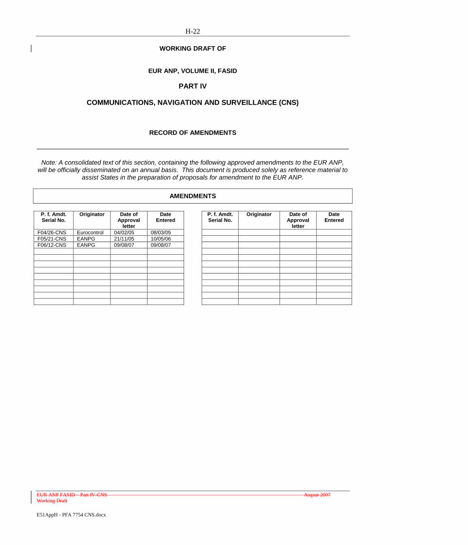
H-22
EUR ANP FASID – Part IV-CNS August 2007 Working Draft
E51AppH - PFA 7754 CNS.docx
WORKING DRAFT OF
EUR ANP, VOLUME II, FASID
PART IV
COMMUNICATIONS, NAVIGATION AND SURVEILLANCE (CNS)
RECORD OF AMENDMENTS
Note: A consolidated text of this section, containing the following approved amendments to the EUR ANP, will be officially disseminated on an annual basis. This document is produced solely as reference material to
assist States in the preparation of proposals for amendment to the EUR ANP.
AMENDMENTS
P. f. Amdt. Serial No.
Originator Date of Approval
letter
Date Entered
P. f. Amdt. Serial No.
Originator Date of Approval
letter
Date Entered
F04/26-CNS Eurocontrol 04/02/05 08/03/05
F05/21-CNS EANPG 21/11/05 10/05/06
F06/12-CNS EANPG 09/08/07 09/08/07

H-23
EUR ANP FASID – Part IV-CNS August 2007 Working Draft
E51AppH - PFA 7754 CNS.docx
INTRODUCTION
1. The material in this part complements that contained in Part I — BORPC and Part IV — CNS of
the Basic ANP and should be taken into consideration in the overall planning processes for the EUR
region.
2. This part contains the details of the facilities and/or services to be provided to fulfilfulfill the basic
requirements of the plan and/or as agreed between the provider and user States concerned. Such
agreement indicates a commitment on the part of the States concerned to implement the requirements
specified. This element of the FASID, in conjunction with the EUR Basic ANP, is kept under constant
review by the EANPG in accordance with its schedule of management, in consultation with user and
provider States and with the assistance of the ICAO EUR/NAT Regional Office.
OPERATIONAL CONDITIONS — RNAV
3. For the establishment of fixed and contingency RNAV routes, the availability of ATS radar should
not necessarily constitute a prerequisite. On such routes, separation minima applied by ATC would be in
accordance with the prevailing operational environment (i.e. radar or non-radar).
ROUTE WIDTH IN RELATION TO TRACK-KEEPING ACCURACY — RNAV
4. The assumed navigational performance of aircraft with RNAV capability is described in Part II —
GEN, 32 of the EUR Basic ANP and envisages two levels of navigational accuracy (basic and precision).
From these accuracy levels,the following values of RNAV route width are derived:
a) for the basic category of RNAV operations, aircraft will be contained in a total route width of
18.5 km (10 NM) for 95 per cent of the flight time of all aircraft using basic RNAV
equipment;
b) for the precision category of RNAV operations, the specific navigation accuracy is still under
evaluation but it is expected to be compatible with total route widths of less than 11 km (6
NM).
Note.— Trials are planned to validate the basic criteria and to develop the precision criteria into
a recommended route width. These criteria will then be expressed in terms similar to that used for basic
RNAV.
5. In both cases, aircraft operators should bear the responsibility for ensuring that the RNAV
equipment maintains the required level of accuracy by means of prescribed procedures on the part of
flight crews and, where the equipment is continuously updated automatically, by the provision in the
software of integrity/reliability checks which can detect and reject spurious fixing inputs before the
accuracy of the aircraft position can be degraded.
H-24
EUR ANP FASID – Part IV-CNS August 2007 Working Draft
E51AppH - PFA 7754 CNS.docx
DESIGNATORS FOR RNAV ROUTES
6. RNAV routes should be assigned suitable route designators in accordance with the provisions of
Annex 11 (L, M, N or P for those that form part of the regional network of ATS routes and Q, T, Y or Z
for those that are not part of the regional network). The designators ―P‖ and ―Q‖ should be reserved for
allocation of RNAV routes of the precision category. [Annex 11, Appendix 1]
STATION-REFERENCED NAVIGATION AIDS
7. To ensure compatibility in planning and to make the best use of the commonly shared frequency
spectrum, requirements for station-referenced aids serving national purposes only should be determined in
accordance with the provisions stated for aids serving international purposes.
8. It is the responsibility of pilots to inform ATS whenever they are unable to navigate in accordance
with the clearance or advice received. Having regard to all relevant factors, including those mentioned in
56 of Part IV — CNS of the EUR Basic ANP, ground services should not be held responsible for the
actual conduct of flights and more especially their navigation performance.
AERONAUTICAL FIXED SERVICE (AFS)
9.3. The Regional AFTN/CIDIN/AMHS Plan is maintained in the ATS Messaging Management Centre
(AMC). The plan is updated dynamically (AIRAC cycle) depending on network inventory data input in
the AMC database by the Co-operating COM Centre (CCC) operators. The CCC operators in the EUR
Region access the plan along with other AMC functions via Internet using the World-Wide Web. The
plan is also electronically disseminated to other interested users (e.g. Regional Offices, States outside
EUR) by the AMC operator, upon request.
Note1Note.- Further information on the ATS Messaging Management Centre (AMC) may be
found on the EUROCONTROL website at ―http://www.eurocontrol.int/amceatmp/cidin‖.
Note 2. - Connectivity details concerning AFTN/CIDIN/AMHS are shown in Supplement Table
AFS- 1 of Part IV CNS.
3.
4. Regional ATS On Line Data Interchange (OLDI) planning information is maintained in the
EUROCONTROL Flight Message Transport Protocol (FMTP) Database. The FMTP database may be
accessed through a web based user interface providing States with a comprehensive and secured tool for
updating and querying.
Note 1. - Further information on the FMTP database may be found on the EUROCONTROL website at
―http://www.eurocontrol.int/communications‖.
Note 2. - Connectivity details concerning OLDI are shown in Supplement Table AFS-2 of Part IV CNS.
5. Regional ATS Direct Speech planning information is maintained in the EUROCONTROL ATM
Ground Voice Network Database (AGVN) Database. The AGVN database may be accessed through a
web based user interface providing States with a comprehensive and secured tool for updating and
querying.
H-25
EUR ANP FASID – Part IV-CNS August 2007 Working Draft
E51AppH - PFA 7754 CNS.docx
Note 1. - Further information on the AGVN database may be found on the EUROCONTROL website at
―http://www.eurocontrol.int/communications‖.
Note 2. - Connectivity details concerning ATS Direct Speech are shown in Supplement Table AFS-3 of
Part IV CNS.‖
10. Use of means other than dedicated bilateral links may be made to meet data communication requirements in cases where performance, availability and cost effectiveness of such means are
demonstrably equivalent or superior.The use of means other than dedicated bilateral links to meet data
communication requirements should be limited to the following cases:
a) to overcome temporary disruption of dedicated circuits;
b) when the traffic does not justify the use of dedicated circuits; and
c) where performance, availability and cost effectiveness of the means other than dedicated
bilateral links are demonstrably equivalent or superior.
AERONAUTICAL MOBILE SERVICE (AMS)
Supplement [Tables CNS 1, CNS 2 and CNS 3]
6. Tables CNS 1, 2 and 3 contain detailed information on the provision of aeronautical mobile
services for HF and VHF general purpose (GP) requirements, aerodrome and approach control service
(VHF), and flight information and area control service (VHF) in the EUR region. Tables CNS1-3 are
regularly updated (usually semi-annually) and made available on the following URL -
http://www.paris.icao.int/documents_open/files.php?subcategory_id=36
11. SELCAL should be provided on GP communication channels using HF or VHF.
12.7. Considerations for reducing requirements for air-ground communications are found in Attachment
BF to this part.
AERONAUTICAL RADIO NAVIGATION SERVICE
Supplement [Table CNS 4]
13.8. Table CNS 4 lists, in alphabetical order by State, radio navigation aids that are required for
navigation on the ATS route network described in Part V.II — ATS of the Basic ANP and/or to support
terminal area in the EUR region..and/or instrument approach procedures in the EUR region. A more
detailed description of required NAVAID services is given in the explanation of Table CNS 4.
9. Supplement Table CNS 4b lists, in alphabetical order by State, procedures and associated facilities
that are required for non-precision and precision approaches in the EUR region. Tables CNS4a and 4b are
regularly updated (usually semi-annually) and made available on the following URL -
http://www.paris.icao.int/documents_open/files.php?subcategory_id=36

H-26
EUR ANP FASID – Part IV-CNS August 2007 Working Draft
E51AppH - PFA 7754 CNS.docx
14.10. States should publish information relating to the designated operational coverage of individual
radio navigation aids in the appropriate parts of their Aeronautical Information Publications (AIP) and
users should be requested not to use aids beyond the coverage specified in such publications.
15.11. States should accept that the designated operational coverage of en-route navigation aids published
in this part (Supplement Table CNS 4), while consistent with the stated operational requirements for
support of the ATS routes contained in Part V.II — ATS may, for national reasons, be different from that
indicated.
16. States should take necessary measures to ensure the continued reliable operation of radio
navigation aids once these have been accepted for operational use (30 to 32 refer).
FREQUENCY ASSIGNMENT PLANNING FOR AMS
17.12. In order to avoid restrictions on frequency assignment possibilities due to adjacent channel
interference on VHF, States that do not yet have a requirement to implement 8.3325 kHz channel spacing
in the VHF aeronautical mobile service but that are located within air-to-air interference range of another
State that has to employ that channel spacing, should provide their ground stations with equipment that,
even if it operates on channels spaced by 2550 or 100 kHz, nevertheless has frequency stability and
selectivity appropriate to 8.3325 kHz channel spacing operation. In addition, States should ensure that any
aircraft flying over or within air-to-air interference range of States where 8.3325 kHz channel spacing is
employed in the VHF aeronautical mobile service is fitted with airborne equipment having frequency
stability and selectivity appropriate to 8.33 kHz channel spacing operation. 25 kHz channel spacing
operation. Similar measures should be undertaken by those States that do not yet have a requirement to
implement 8.33 kHz channel spacing but that are located within air-to-air interference range of another
State that has to employ that channel spacing.
18.13. A number of principles and criteria applicable to the practical conduct of frequency assignment are
found in the EUR Frequency Management Manual (EUR Doc 011).
19.14. Assignment of frequencies to satisfy aeronauticalairline operational control communication
requirements should be made in accordance with the criteria and method shown in the EUR Frequency
Management Manual (EUR Doc 011).
15. Coordination of frequency assignments in the ICAO EUR Region is carried out via on-line
coordination and registration tool (ref www.paris.icao.int.safire). An outcome of this process is reflected
in the FASID Supplement COM2 Table.
20.16. To ensure adequate operational flexibility, the designated operational coverage of an air/ground
channel promulgated for specific ACC sectors should take into account any intended combination of
control sectors, notably during slack hours.
FREQUENCY ASSIGNMENT PLANNING FOR RADIO NAVIGATION AIDS
21.17. Principles and criteria applicable to the practical conduct of frequency assignment to
VHF/UHF/SHF aids are found in the EUR Frequency Management Manual (EUR Doc 011).

H-27
EUR ANP FASID – Part IV-CNS August 2007 Working Draft
E51AppH - PFA 7754 CNS.docx
22.18. Principles and criteria applicable to the practical conduct of frequency assignment to LF/MF aids
are found in the EUR Frequency Management Manual (EUR Doc 011).
23.19. Coordination of frequency assignments in the ICAO EUR Region is carried out via on-line
coordination and registration tool (ref www.paris.icao.int.safire). An outcome of this process is reflected
in the FASID Supplement COM3 and COM4 Tables .
20. Tables COM2, COM3 and COM4 are regularly updated (usually semi-annually) and made
available at the following URL - http://www.paris.icao.int/documents_open/files.php?subcategory_id=36
24. All possible measures should be taken, particularly in cases where frequency congestion exists, to
accelerate the replacement of existing VOR equipments that are not in conformity with Annex 10
specifications for the 10 kHz sub-carrier harmonics level, in order to facilitate the implementation of new
required 50 kHz-spaced VORs.
[Annex 10, Volume I, Chapter 3, 3.3.5.7 and Attachment C]
HOLDING
25. Procedure construction and obstacle clearance criteria for holding patterns should be in accordance
with the Procedures for Air Navigation Services — Aircraft Operations (PANS-OPS, Doc 8168), Volume
II, Part IV.
ESTABLISHMENT AND IDENTIFICATION OF SIGNIFICANT POINTS
26. Significant points should be established and identified in accordance with Annex 11. Particular
attention should be given to the difficulties that may arise in the spelling and pronouncing of the names
by those required to refer to these points whose mother tongue not that of the State that established and
named the point.
[Annex 11, Appendix 2]
SIGNIFICANT POINTS MARKED BY A RADIO NAVIGATION AID
27.21. Designators for significant points serving international and national purposes and marked by a
radio navigation aid should be coordinated with the ICAO EUR/NAT Regional Office in order to
facilitate selection of the appropriate designators in accordance with the criteria regarding their repetition.
[Annex 11, Appendix 2, 2]
22. On-line coordination tool for designators is provided via the following URL:
http://www.eurocontrol.int/icard/public/subsite_homepage/homepage.html
SIGNIFICANT POINTS NOT MARKED BY THE SITE OF A RADIO NAVIGATION AID
28.23. Significant points not marked by the site of a radio navigation aid and serving international and
national purposes should only be identified by a five-letter name-code if such points will be required in
flight plans or in air-ground communications in order to clearly identify the route to be followed by an

H-28
EUR ANP FASID – Part IV-CNS August 2007 Working Draft
E51AppH - PFA 7754 CNS.docx
aircraft. These name-codes should be coordinated with the ICAO EUR/NAT Regional Office in order to
facilitate the selection of appropriate designators in accordance with the criteria regarding their repetition.
[Annex 11, Appendix 2, 3]
24. On-line coordination tool for name-codes is provided via the following URL:
http://www.eurocontrol.int/icard/public/subsite_homepage/homepage.html
29.25. In all other cases, the identification chosen should only be subject to local, or if required, bilateral
coordination between the ATC units concerned.
FLIGHT TESTING AND MAINTENANCE OF RADIO NAVIGATION AIDS
30. Operational and technical ground services should ensure that flight testing and routine maintenance
of those elements of the radio navigation service that affect the safety and regularity of flight operations
are, to the extent possible, conducted outside those periods when air traffic depends more than usual on
the aids concerned. (See also Attachment E to Part III — AOP for Category I installations.)
31. To avoid duplication of effort and material and to keep costs within acceptable limits, cooperative
arrangements regarding flight testing of radio navigation aids should, whenever possible, be concluded
between interested States.
32. The frequency of flight testing should as far as possible be reduced by the use of suitable ground
monitoring techniques.
PRIMARY AND SECONDARY SURVEILLANCE SYSTEMSRADAR
26. Detailed information and guidance related to the provision of surveilance systemsprimary and
secondary radar may be found in Attachments C, D, E and G of this part.
33.27. Supplement TableChart CNS 5 provides information on surveillance systems used in4 shows the
requirements for primary and secondary radar coverage for the ICAO EUR region.
28. Supplement Table CNS 6 lists SSR Mode-S IC allocations for the ICAO EUR Region.
29. Supplement Table CNS 7 lists SSR Code Allocations for the ICAO EUR Region.
30. These Tables are regularly updated (usually semi-annually) and made available on the following
URL - http://www.paris.icao.int/documents_open/files.php?subcategory_id=36
- END -

I-1 European Air Navigation Planning Group I-1
E51AppI - PFA 7030 PBN.docx December 2009
Appendix I – Proposal for Amendment to Doc 7030 regarding PBN
(paragraph 4.4.43 refers)
PROPOSAL FOR AMENDMENT OF THE
REGIONAL SUPPLEMENTARY PROCEDURES,
NAT REGION (Doc 7030/5)
(Serial No.: )
a) Regional Supplementary Procedures:
Doc 7030/5 – EUR SUPPs
b) Proposed by:
EANPG
c) Proposed amendment:
Editorial Note: Amendments are arranged to show deleted text using strikeout (), and added text
with grey shading (text to be inserted).
1. Insert the following in EUR SUPPs, Glossary
Insert new text as follows:
B-RNAV basic area navigation, also referred to as RNAV 5
PBN Performance Based Navigation
P-RNAV precision area navigation, also referred to as RNAV 1
RNAV-5 Area navigation using a 95% containment of 5 NM, also referred to as B-RNAV in the EUR
RNAV-1 Area navigation using a 95% containment of 1 NM, also referred to as P-RNAV in the EUR
End of new text
2. Insert the following in EUR SUPPs, Chapter 1 – Flight Rules, paragraph 1.2 – Instrument Flight
Rules (IFR)
Insert new text as follows:
Note 1.— Throughout the entire document reference is made to RNAV-5 and to RNAV-1. RNAV-5 is
considered as requiring the same containments as B-RNAV and RNAV-1 as P-RNAV. It has to be noted that
with the implementation of PBN applications on a world-wide basis, the naming of all systems and
certification requirements will be harmonised.
End of new text
European and North
Atlantic Office

I - 2
3. Delete the following in NAT SUPPs, Chapter 2 – Flight plans, paragraph 2.1.2 – Area Navigation
(RNAV) Specification and replace by “Nil”.
4. Insert the following in EUR SUPPs, Chapter 4 – Navigation, paragraph 4.1.1.2. – RNAV 5
Insert new text as follows:
4.1.1.2.1 RNAV 5
Area of applicability
4.1.1.2.1.1 The following RNAV 5 provisions shall apply to operations conducted under IFR on designated
RNAV 5 routes within the following FIRs: Amman, Beirut, Cairo, Damascus and Tel Aviv.
Means of compliance
4.1.1.2.1.2 Within the FIRs specified in 4.1.1.2.1.1, only RNAV-equipped aircraft having a navigation
accuracy meeting RNAV 5 may plan for operations under IFR on those ATS routes and within those level
bands which have been specified as requiring RNAV 5 in the relevant State AIP or NOTAM.
4.1.1.2.1.3 Aircraft operating under IFR on designated RNAV 5 routes shall be equipped with, as a
minimum, RNAV equipment meeting the requirements laid down in EASA AMC 20-4, entitled Guidance
Material On Airworthiness Approval And Operational Criteria For The Use Of Navigation Systems In
European Airspace Designated For Basic RNAV Operations.
4.1.1.2.1.4 Conformance to the navigation requirement shall be verified by the State of Registry or the State
of the Operator, as appropriate.
Note.— Guidance material concerning navigation accuracy requirements is contained in the
Performance-based Navigation Manual (Doc 9613).*
Area of applicability
4.1.1.2.1.5 The provisions in respect of RNAV-5(B-RNAV) en-route operations shall apply to all such
operations conducted under IFR on the entire ATS route network as notified by the appropriate authorities in
the following flight information regions (FIRs)/upper flight information regions (UIRs):
Amsterdam, Ankara, Athinai, Baku, Barcelona, Bodø, Bordeaux, Bratislava, Bremen, Brest,
Brindisi, Bruxelles, Bucuresti, Budapest, Canarias (AFI area of applicability), Casablanca,
Chisinau, France, Hannover, Istanbul, Kharkiv, København, Kyiv, Langen, Lisboa, Ljubljana,
London, L’viv, Madrid, Malta, Marseille, Milano, München, Nicosia, Odessa, Oslo, Paris, Praha,
Reims, Rhein, Riga, Roma, Rovaniemi, Scottish, Shannon, Simferopol, Skopje, Sofia, Stavanger,
Sweden, Switzerland, Tallinn, Tampere, Tbilisi, Tirana, Trondheim, Tunis, Varna, Vilnius,
Warszawa, Wien, Yerevan, Zagreb.
Means of compliance
4.1.1.2.1.6 Conformance to the navigation requirement shall be verified by the State of Registry or the State
of the Operator, as appropriate.

I - 3
Note.— Guidance material concerning navigation requirements associated with RNAV-5 (B-RNAV)
operations is contained in EASA AMC 20-4, entitled Guidance Material On Airworthiness Approval And
Operational Criteria For The Use Of Navigation Systems In European Airspace Designated For Basic RNAV
Operations
End of new text
5. Insert the following in EUR SUPPs, Chapter 4 – Navigation, paragraph 4.1.1.4. – RNAV 1
Insert new text as follows:
Area of applicability
4.1.1.4.1 The provisions in respect of RNAV-1 (P-RNAV) may be applied whenever RNAV terminal
control area (TMA) procedures, excluding the final and missed approach segments, are used.
Note.— The carriage of RNAV-1 equipment has not been mandated in the EUR Region.
Means of compliance
4.1.1.4.2 Conformance to the navigation requirement shall be verified by the State of Registry or the State of
the Operator, as appropriate.
Note.— Guidance material concerning navigation requirements associated with RNAV-1 (P-RNAV)
operations are contained in the JAA Temporary Guidance Leaflet (TGL) No. 10rev1.
End of new text
6. Delete the following in EUR SUPPs, Chapter 4 – Navigation, paragraph 4.1.1.5. – pre-PBN
navigation specifications
4.1.1.5.1 and 4.1.1.5.2 with all sub-paragraphs and replace by “Nil”
d) Proposer's reason for amendment:
Harmonise the EUR SUPPs provisions with the ICAO PBN Manual (Doc 9613) and ICAO Assembly
Resolution 36-23.
e) Proposed implementation date of the amendment:
Upon approval by the Council.
f) Proposal circulated to the following States and international organizations:
The proposal has been circulated to the following States and International Organizations:
g) Secretariat comments:
None
- END -
J-1 European Air Navigation Planning Group J-1
E51AppJ - AssRes36-23 Questionnaire.docx December 2009
Appendix J -
Questionnaire on the progress of ICAO Assembly Resolution 36-23 implementation
(paragraph 4.4.48)
Please provide the status of implementation of ICAO Assembly Resolution 36-23on PBN objectives in your
State in the following areas:
- Implement RNAV/RNP operations in line with ICAO PBN Manual (Doc 9613)
Response – Implemented or Planned by XX/XX/201X
- Implement APV.
Response –
Percentage to be achieved by 2014 – XX%
Percentage to be achieved by 2016 – XX%
------------------------
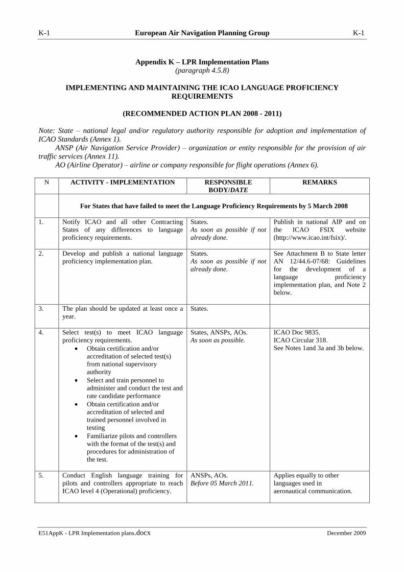
K-1 European Air Navigation Planning Group K-1
E51AppK - LPR Implementation plans.docx December 2009
Appendix K – LPR Implementation Plans
(paragraph 4.5.8)
IMPLEMENTING AND MAINTAINING THE ICAO LANGUAGE PROFICIENCY
REQUIREMENTS
(RECOMMENDED ACTION PLAN 2008 - 2011)
Note: State – national legal and/or regulatory authority responsible for adoption and implementation of
ICAO Standards (Annex 1).
ANSP (Air Navigation Service Provider) – organization or entity responsible for the provision of air
traffic services (Annex 11).
AO (Airline Operator) – airline or company responsible for flight operations (Annex 6).
N ACTIVITY - IMPLEMENTATION RESPONSIBLE
BODY/DATE
REMARKS
For States that have failed to meet the Language Proficiency Requirements by 5 March 2008
1. Notify ICAO and all other Contracting
States of any differences to language
proficiency requirements.
States.
As soon as possible if not
already done.
Publish in national AIP and on
the ICAO FSIX website
(http://www.icao.int/fsix)/.
2. Develop and publish a national language
proficiency implementation plan.
States.
As soon as possible if not
already done.
See Attachment B to State letter
AN 12/44.6-07/68: Guidelines
for the development of a
language proficiency
implementation plan, and Note 2
below.
3. The plan should be updated at least once a
year.
States.
4. Select test(s) to meet ICAO language
proficiency requirements.
Obtain certification and/or
accreditation of selected test(s)
from national supervisory
authority
Select and train personnel to
administer and conduct the test and
rate candidate performance
Obtain certification and/or
accreditation of selected and
trained personnel involved in
testing
Familiarize pilots and controllers
with the format of the test(s) and
procedures for administration of
the test.
States, ANSPs, AOs.
As soon as possible.
ICAO Doc 9835.
ICAO Circular 318.
See Notes 1and 3a and 3b below.
5.
Conduct English language training for
pilots and controllers appropriate to reach
ICAO level 4 (Operational) proficiency.
ANSPs, AOs.
Before 05 March 2011.
Applies equally to other
languages used in
aeronautical communication.

K-2
E51AppK - LPR Implementation plans.docx December 2009
N ACTIVITY - IMPLEMENTATION RESPONSIBLE
BODY/DATE
REMARKS
6. Implement a schedule of regular testing of
pilots and controllers.
States, ANSPs, AOs.
As soon as possible if not
already done
ICAO recommendations: at least
every 3 years for a level 4
proficiency and at least every 6
years for a level 5 proficiency.
7. Conduct qualification testing of pilots and
controllers.
States, ANSPs, AOs, test
providers.
On-going process.
The first round to be completed
by 05 March 2011 if not already
done.
8. Ensure annual refresher training for raters
and interlocutors.
States, test providers To maintain testing standards.
9. Develop and implement a schedule of
language refresher training to maintain
language proficiency
States, ANSPs, AOs.
As soon as possible if not
already done.
.
Ensure that current level 4 is
not eroded.
10. Implement procedures to deal with pilots
and controllers who fail to meet the ICAO
language proficiency requirements (Level 4
Operational)
States, ANSPs, AOs.
As soon as possible if not
already done.
.
Address social issues (e.g.
suspension/loss of license)
11. Implement language awareness
programmes to ensure that native and expert
speakers of English communicate in a
manner that is easily understandable to non-
native speakers of English proficient at
ICAO level 4.
States, ANSPs, AOs.
As soon as possible if not
already done.
Applies equally to other
languages used in
aeronautical communication.
For States that are in compliance with the Language Proficiency Requirements
12. Implement a schedule for regular testing of
pilots and controllers.
States, ANSPs, AOs.
As soon as possible if not
already done.
ICAO recommendations: at least
every 3 years for level 4
proficiency and at least every 6
years for level 5 proficiency.
13. Ensure annual refresher training for raters
and interlocutors.
States, test providers To maintain testing standards
14. Develop and implement a schedule of
language refresher training to maintain
language proficiency
States, ANSPs, AOs.
As soon as possible if not
already done.
Ensure that current level 4 is
not eroded.
15. Implement procedures to deal with pilots
and controllers who fail to meet level 4 of
the ICAO language proficiency
requirements
States, ANSPs, AOs.
As soon as possible if not
already done.
.
Address social issues (e.g.
suspension/loss of license).
16. Implement language awareness
programmes to ensure that native and expert
speakers of English communicate in a
manner that is easily understandable to non-
native speakers of English proficient at
ICAO level 4.
States, ANSPs, AOs.
As soon as possible if not
already done.
Applies equally to other
languages used in
aeronautical communication.
Note 1: ICAO Doc 9835 First Edition – “Manual on Implementation of ICAO Language Proficiency
Requirements” and ICAO Circular 318 – “Language Testing Criteria for Global Harmonization” provide
guideline material and valuable information on preparing training and testing programmes.

K-3
E51AppK - LPR Implementation plans.docx December 2009
Note 2: The national language proficiency implementation plan (referring to ICAO Resolution A36-11 –
Proficiency in the English Language used for radiotelephony communication) should include the following:
a)a timeline for adoption of the language proficiency requirements into national regulations;
b)a timeline for establishment of language training and assessment capabilities;
c) a description of a risk-based prioritization system;
d) a procedure for endorsing licences to indicate the holders’ language proficiency level;
e) designation of a national focal point on language proficiency requirements implementation.
Attachment B to State letter AN 12/44.6-07/68: Guidelines for the development of a language proficiency
implementation plan with some recommendations and instructions on how to work out a plan can be found
on the ICAO Flight Safety Information Exchange (FSIX) Website at http://www.icao.int/fsix/.
Note 3a: Recommended qualifications for raters and interlocutors (ref.: www.paris.icao.int)
Administrator – a person familiar with the preparation and conduct of tests/examinations e.g. logistics,
security, candidate briefing .
Rater – a person with a level of proficiency in the English language sufficient to evaluate performance up to
level 5 in compliance with the holistic descriptors and the ICAO Language Proficiency Rating Scale;
For details see the EANPG48 Report Appendix J – Recommended qualifications for raters of tests to meet
the ICAO language proficiency requirements.
Interlocutor - a person with a level of proficiency in the English language sufficient to conduct the selected
oral test (tests);
For details see the EANPG48 Report Appendix K – Recommended qualifications for interlocutors of tests to
meet the ICAO language proficiency
requirements.
Note 3b: Recommended practices to select (or develop) a language proficiency test to meet the ICAO
requirements (ref.: www.paris.icao.int)
– END –
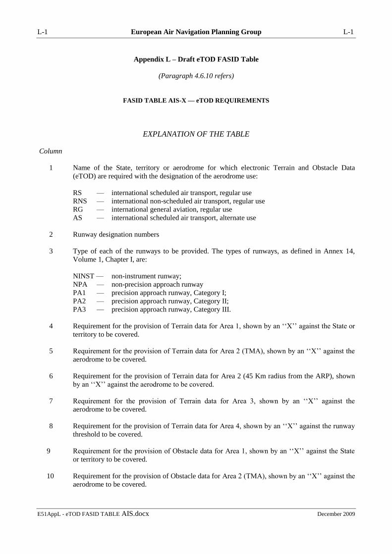
L-1 European Air Navigation Planning Group L-1
E51AppL - eTOD FASID TABLE AIS.docx December 2009
Appendix L – Draft eTOD FASID Table
(Paragraph 4.6.10 refers)
FASID TABLE AIS-X — eTOD REQUIREMENTS
EXPLANATION OF THE TABLE
Column
1 Name of the State, territory or aerodrome for which electronic Terrain and Obstacle Data
(eTOD) are required with the designation of the aerodrome use:
RS — international scheduled air transport, regular use
RNS — international non-scheduled air transport, regular use
RG — international general aviation, regular use
AS — international scheduled air transport, alternate use
2 Runway designation numbers
3 Type of each of the runways to be provided. The types of runways, as defined in Annex 14,
Volume 1, Chapter I, are:
NINST — non-instrument runway;
NPA — non-precision approach runway
PA1 — precision approach runway, Category I;
PA2 — precision approach runway, Category II;
PA3 — precision approach runway, Category III.
4 Requirement for the provision of Terrain data for Area 1, shown by an ‘‘X’’ against the State or
territory to be covered.
5 Requirement for the provision of Terrain data for Area 2 (TMA), shown by an ‘‘X’’ against the
aerodrome to be covered.
6 Requirement for the provision of Terrain data for Area 2 (45 Km radius from the ARP), shown
by an ‘‘X’’ against the aerodrome to be covered.
7 Requirement for the provision of Terrain data for Area 3, shown by an ‘‘X’’ against the
aerodrome to be covered.
8 Requirement for the provision of Terrain data for Area 4, shown by an ‘‘X’’ against the runway
threshold to be covered.
9 Requirement for the provision of Obstacle data for Area 1, shown by an ‘‘X’’ against the State
or territory to be covered.
10 Requirement for the provision of Obstacle data for Area 2 (TMA), shown by an ‘‘X’’ against the
aerodrome to be covered.
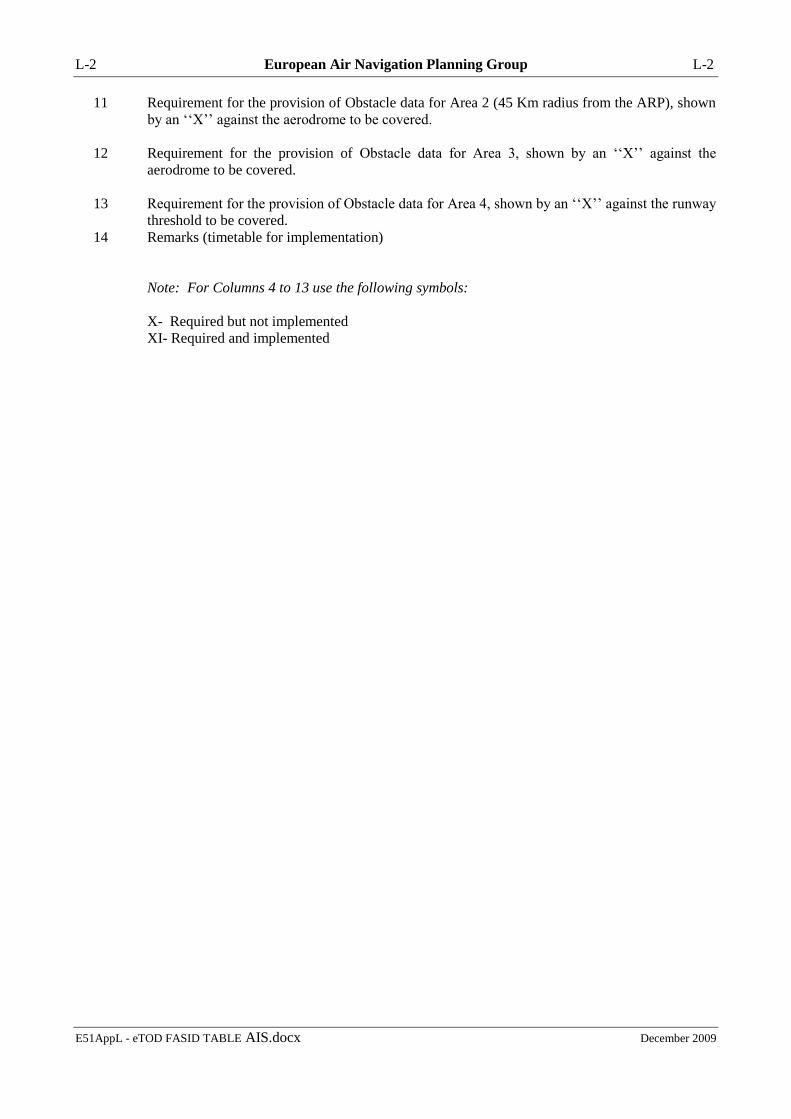
L-2 European Air Navigation Planning Group L-2
E51AppL - eTOD FASID TABLE AIS.docx December 2009
11 Requirement for the provision of Obstacle data for Area 2 (45 Km radius from the ARP), shown
by an ‘‘X’’ against the aerodrome to be covered.
12 Requirement for the provision of Obstacle data for Area 3, shown by an ‘‘X’’ against the
aerodrome to be covered.
13 Requirement for the provision of Obstacle data for Area 4, shown by an ‘‘X’’ against the runway
threshold to be covered.
14 Remarks (timetable for implementation)
Note: For Columns 4 to 13 use the following symbols:
X- Required but not implemented
XI- Required and implemented

L-3 European Air Navigation Planning Group L-3
E51AppL - eTOD FASID TABLE AIS.docx December 2009
eTOD Requirements (EUR FASID Table AIS-X)
STATE, TERRITORY OR AERODROME FOR
WHICH eTOD IS REQUIRED
TERRAIN DATA REQUIRED OBSTACLE DATA REQUIRED REMARKS
CITY/AERODROME RWY No
RWY
TYPE
Area 1 Area 2
Area 3 Area 4 Area 1 Area 2
Area 3 Area 4
TMA 45 Km TMA 45 Km
1 2 3 4 5 6 7 8 9 10 11 12 13 14
-END-
M-1 European Air Navigation Planning Group M-1
E51AppM - WAFS SADIS.docx December 2009
Appendix M – WAFS and SADIS developments
(Paragraph 4.7.3 refers)
WAFS AND SADIS DEVELOPMENTS
IMPORTANT NOTE: In view of the decisions and conclusions of WAFSOPSG/5 (held 16 to 18
September 2009), some of the forthcoming developments to the WAFS expressed below have been
modified or are no longer expected (notably paragraph 2.2 of section D.1 below). Users are
therefore encouraged to visit the WAFSOPSG website (www.icao.int/anb/wafsopsg/) for a full
transcript of the WAFSOPSG/5 report.
A.1 WAFS DEVELOPMENTS SINCE METG/18
1. Recent Developments
1.1 Development of WAFS upper-air data in the GRIB 2 code form
1.1.1 WAFSOPSG/4 endorsed the WAFC Provider States to continue with the development of
WAFS upper-air forecasts in the GRIB 2 code form, including new forecasts for icing, turbulence and
CB cloud. The two WAFCs have been coordinating their development efforts to ensure that these
gridded forecasts are harmonised with respect to content, encoding and compression algorithms.
Coordination activities have included a science co-ordination meeting in Washington DC in April
2009.
1.1.2 GRIB 2 WAFS data benefits from higher spatial and temporal resolution, and additional
fields, compared to its GRIB 1 predecessor – for example, the GRIB 2 WAFS data is based on a
regular 1.25*1.25 degree (unthinned) grid, T+6 to T+36 at 3-hourly time intervals, and includes
additional flight level information at FL270, FL320 and FL360 and icing, turbulence and CB cloud
forecasts.
1.1.3. The WAFCs have provided a progress report to the WAFSOPSG/5 meeting (September
2009) outlining the steps taken towards delivery of GRIB 2 WAFS data. The progress report includes
a summary of verification that both WAFCs have conducted with respect to icing, turbulence and CB
cloud forecasts. In addition, the WAFC Provider States have prepared a general guidance document
on the intended use of the gridded WAFS forecasts for icing, turbulence and CB cloud.
1.1.4. WAFSOPSG/5 will be expected to review the status of development of the GRIB 2 forecasts
and determine their future operational implementation.
Suggested action: Review discussions at WAFSOPSG and associated guidance material.
1.2 Coordination between the WAFCs and the TCACs
1.2.1 In response to WAFSOPSG Conclusion 4/8, the WAFC Provider States have conducted a
coordination trial with the Tropical Cyclone Advisory Centres, with a view to determining the
feasibility of, and benefits for the WAFS from, establishing and maintaining contact with the TCACs
in order the harmonise the information on TC in the WAFS SIGWX forecasts and the TCAC
advisories.
1.2.2 The findings from the web-based trial will be presented to the WAFSOPSG/5 meeting in
order to determine whether such coordination activities should become standard practice.
M-2 European Air Navigation Planning Group M-2
E51AppM - WAFS SADIS.docx December 2009
Suggested action: Note this information only.
1.3 WAFC backup tests
1.3.1 The WAFC Provider States have continued to test their SIGWX backup procedures in the
event that one WAFC was unable to produce SIGWX forecasts in the BUFR-code and PNG-chart
format. Routine backup tests are conducted quarterly, with the results posted on the WAFSOPSG
website at URL:
http://www.icao.int/anb/wafsopsg/Recent%20Chronology%20of%20WAFC%20Backup%20Tests.pdf
Tests over the last 12 months have been largely successful, and transparent for the overwhelming
majority of WAFS users.
1.3.2 Forthcoming backup tests are outlined at URL:
http://www.icao.int/anb/wafsopsg/Forthcoming%20WAFC%20Backup%20Tests.pdf.
Notification of WAFC backup tests is promulgated on the SADIS broadcasts in advance, by way of
administrative messages.
1.3.3. In addition, WAFC backup procedures are outlined at:
http://www.icao.int/anb/wafsopsg/backup.pdf.
Suggested action: Note this information and consider visiting the WAFSOPSG website to obtain
information pertaining to WAFC backup tests and procedures.
2. Forthcoming developments
2.1 Corrections to WAFS SIGWX forecasts
2.1.1 WAFSOPSG/4 endorsed the WAFC Provider States to introduce a practical and minimal
procedure to handle corrections to WAFS SIGWX forecasts (in BUFR code and/or PNG chart form).
The procedure would involve the issuance of a plain text administrative message drawing users
attention to the identified error. The BUFR data and/or PNG charts themselves, which contain
erroneous data, would not be re-issued due to downstream implications detailed in the WAFSOPSG/4
report.
2.1.2 In view of concerns expressed by the 12th meeting of the CNS/MET sub-group of the
APANPIRG, implementation of WAFS SIGWX corrections in 2008 was deferred. General guidance
on how an operator may wish to handle the receipt of such administrative messages has been drafted
by the WAFCs for WAFSOPSG/5. Subject to endorsement by WAFSOPSG/5, corrections to WAFS
SIGWX may be introduced before the end of 2009.
2.1.3 The WAFCs intend to use the following WMO bulletin headers to issue the plain text
administrative messages: FXUK65 EGRR (for corrections to WAFC London SIGWX) and FXUS65
KKCI (for corrections to WAFC Washington SIGWX). Implementation will be communicated via
the WAFS Change Implementation Notice Board at URL:
http://www.icao.int/anb/wafsopsg/WAFS%20change%20notice%20board.pdf.
Suggested action: Monitor the progress towards corrections to WAFS SIGWX through the
WAFSOPSG and WAFS Change Notice Board.
2.2 Development of WAFS web-based server
2.2.1 In addition to the endorsement of the development of GRIB 2 WAFS data, outlined above,
WAFSOPSG/4 also endorsed the development by the WAFC Provider States of a web-based
distribution of WAFS forecasts for the intended use in flight documentation for improved access and
visualisation of WAFS forecasts (WAFSOPSG Conclusion 4/20 refers).

M-3 European Air Navigation Planning Group M-3
E51AppM - WAFS SADIS.docx December 2009
2.2.2 This new offering from the WAFCs will deliver a minimum set of WAFS charts, providing
objective gridded forecasts of icing, turbulence and CB cloud derived from GRIB 2 formatted data.
The web service, one from each WAFC, will be targeted primarily at the least developed countries
which may not be in a position to convert the GRIB and/or BUFR coded SIGWX forecasts into chart
form.
2.2.3 A progress report on the development of the WAFC web services has been submitted to
WAFSOPSG/5. The WAFCs expect this new service offering to be available in 2010 or 2011.
Suggested action: Monitor the development of the web-based distribution of WAFS forecasts through
the WAFSOPSG.
2.3 Workshop on the gridded WAFS forecasts for icing, turbulence and CB cloud
2.3.1 In order to facilitate the implementation of the gridded forecasts for icing, turbulence and CB
cloud, the WAFC Provider States, in co-ordination with ICAO and WMO, convened a two-day
workshop on the intended use and visualisation of these new products.
2.3.2 The workshop took place at the ICAO Regional Office in Paris on 14 and 15 September 2009,
immediately prior to WAFSOPSG/5.
Suggested action: Consider participating in the workshop, where resources allow.
2.4 Training for States on the use and visualisation of new gridded WAFS forecasts
2.4.1 In addition to the WAFS workshop, outlined above, the WAFC Provider States have been
tasked to design training for States on the use and visualisation of the gridded forecasts for icing,
turbulence and CB cloud.
2.4.2 A training proposal in the form of web-based interactive tutorials will be presented by the
WAFCs at WAFSOPSG/5. Subject to endorsement, the training material should become available in
2010 or 2011.
Suggested action: Consider what training needs your State will have regarding the use and
visualisation the new gridded products.
2.5 Improved visualisation of WAFS forecasts
2.5.1 An ad-hoc group of the WAFSOPSG (China as Rapporteur) has been studying how the
visualisation of WAFS forecasts could be improved to ensure that the most relevant WAFS forecasts
be presented in terms of space and time in flight documentation. These improvements to visualisation
are expected to better serve the needs of the long-haul community.
2.5.2 Initial findings were presented to WAFSOPSG/4 (February 2008), with further proposals
made at WAFSOPSG/5 (September 2009). The proposals are likely to include the concatenation of
charts based on the gridded WAFS forecasts for icing, turbulence and CB cloud.
Suggested action: Monitor the progress of developing concatenated WAFS forecasts through the
WAFSOPSG.
2.6 WAFS output performance indicators
2.6.1 WAFSOPSG/4 invited the WAFC Provider States to assess the possibility of providing
additional WAFS output performance indicators. This invitation included wind and temperature

M-4 European Air Navigation Planning Group M-4
E51AppM - WAFS SADIS.docx December 2009
performance indicators for the WMO defined area covering Australia and New Zealand, as well as
globally for all standard forecast levels (in digital and chart form).
2.6.2 Wind and temperature performance indicators for Australia and New Zealand were added to
the WAFCs websites during 2008. WAFC London data can be viewed at
http://www.metoffice.gov.uk/icao/index.html and WAFC Washington data at
http://www.emc.ncep.noaa.gov/gmb/icao/ncep_scores.html.
2.6.3 WAFC Washington has added performance indicators for the 850, 700, 500, 400, 300, 275,
225, 200, 150 and 100hPa standard levels, whilst WAFSOPSG/5 will be expected to endorse
corresponding levels be added to the WAFC London web site.
2.6.4 The WAFCs have studied the cost and feasibility of providing global performance indicators
in digital and chart format. The findings of this study will be presented to WAFSOPSG/5 in order for
the group to determine whether such an undertaking should be pursued.
Suggested action: Access the output performance indicator websites of the two WAFCs and monitor
the further development of these products through the WAFSOPSG.
A.2 SADIS DEVELOPMENTS SINCE METG/18
1. Recent developments
1.1 Cessation of the SADIS 1G satellite broadcast
1.1.1 In accordance with SADISOPSG Conclusion 9/15 and 13/24, the SADIS first-generation
(SADIS 1G) satellite broadcast was withdrawn from service on 05 January 2009. Any SADIS 1G
user yet to migrate to a SADIS second-generation (SADIS 2G) VSAT reception system can obtain
procurement guidelines within the SADIS User Guide (URL: http://www.icao.int/anb/sadisopsg/sug/)
and via the Met Office SADIS homepage (URL: http://www.metoffice.gov.uk/sadis/index.html).
Suggested action: Note this information only.
1.2 Update to the SADIS User Guide
1.2.1 A Fourth Edition of the SADIS User Guide (SUG) was endorsed by SADISOPSG/13.
Extensive amendments to the SUG were necessary to take into account the phasing out of the SADIS
1G broadcast, Amendment 74 to Annex 3, and the agreement by the IAVWOPSG to use PNG chart
form instead of T4 charts for the volcanic ash advisories in graphical form. No paper copies of the
SUG will be distributed by ICAO. Instead, users are encouraged to visit URL:
http://www.icao.int/anb/sadisopsg/sug/ to obtain the latest version and associated Annexes 1 to 4.
Suggested action: Visit URL: http://www.icao.int/anb/sadisopsg/sug/ to obtain the latest SADIS User
Guide, Annexes 1 to 4.
1.3 Development of alternative SADIS 2G hardware
1.3.1 The SADIS Provider has completed acceptance tests of the NetSys SADIS Transcoder (NST)
as an alternative SADIS 2G reception unit. The NST is available only as part of a complete NetSys
SADIS 2G package, and presents data as a UDP-multicast output. Further information on the NST
can be obtained direct from the supplier via URL: http://www.netsys.co.za/ or email:
1.3.2 In addition, the SADIS Provider has completed acceptance tests of a VADOS VadEDGE
4100-series router for SADIS 2G. In view of a market trend away from the X.25 protocol, VADOS
M-5 European Air Navigation Planning Group M-5
E51AppM - WAFS SADIS.docx December 2009
Systems developed the 4100 as an entry-level IP-only router that is compatible with SADIS 2G
reception systems. The VadEDGE 4100 presents data as TCP/IP or UDP-multicast. Further
information on the VadEDGE 4100 can be obtained direct from the supplier at URL:
http://www.vados.com/new/index.php or email: [email protected].
1.3.3 Details of the NetSys SADIS Transcoder and the VADOS VadEDGE 4100 are contained
within the SADIS User Guide.
Suggested action: Consider whether your SADIS reception system could benefit from these new
service offerings and contact the vendors directly for further assistance.
1.4 Initial phase of enhancements to the SADIS FTP service
1.4.1 In April 2009, SADIS Provider implemented an initial phase of enhancements to the SADIS
FTP service. The SADIS FTP service now resides on virtual server hardware and benefits from cross-
hall IT resilience. These enhancements were transparent to users, with existing usernames,
passwords, IP/host address and directory/file structure remaining unchanged.
Suggested action: Note this information only.
1.5 Procurement of SADIS 2G data backup arrangement
1.5.1 The SADIS Provider State is continuing with the development of a SADIS 2G data backup
arrangement with the US NWS Telecommunications Gateway (NWSTG) and the SADIS OPMET
Gateway (NATS).
1.5.2 Once configured and tested, an ISDN data backup link would be instigated in the event that
the UK Met Office was unable to pass SADIS data from Exeter to the satellite uplink facility at
Whitehill. WAFS data would be routed from the NWSTG to the SADIS Gateway over ISDN, then
onward routed to Whitehill for dissemination across the SADIS 2G satellite broadcast.
1.5.3 The SADIS Provider State expects this data backup capability to be available operationally in
2009.
Suggested action: Note this information only.
1.6 SADIS workstation software evaluations
1.6.1 At the request of SADISOPSG/13, the SADIS Provider has conducted a third round of
SADIS workstation software evaluations. The assessments were necessary in light of changes to the
SADIS broadcast since the previous round of evaluations in 2005/2006, notably the adoption of
Amendment 74 to Annex 3 and the cessation of the SADIS 1G broadcast.
1.6.2 By May 2009, the SADIS Provider had conducted 8 SADIS workstation software evaluations,
with 7 of the packages available fulfilling the software requirements of SADISOPSG/13. The results
of these evaluations will be presented to SADISOPSG/14 and are also available to view at URL:
http://www.metoffice.gov.uk/sadis/software/index.html.
1.6.3 It remains the responsibility of the user to ensure that procured software meets their full
requirements. It is not intended that the software evaluations fulfil this task. The results from the
software evaluations may be used as one additional source of information to aid any procurement
process but should not be viewed in isolation of other important procurement requirements.

M-6 European Air Navigation Planning Group M-6
E51AppM - WAFS SADIS.docx December 2009
Suggested action: Consider whether your workstation software continues to fulfil your local user
needs and the requirements of the SADISOPSG. If not, consider consulting you workstation provider
directly.
1.7 GRIB 2 WAFS data trial on SADIS 2G
1.7.1 To facilitate the implementation of WAFS upper-air forecasts in GRIB 2 code form, the
SADIS Provider has conducted initial trials using test data on the SADIS 2G satellite broadcast aimed
at determining the likely transmission performance of this new data set.
1.7.2 In April 2009, the SADIS Provider disseminated two uncompressed GRIB 2 data volumes to
a small number of SADIS 2G users. These initial trials demonstrated that a 50MB data volume
(uncompressed GRIB 2 WAFS data) would take almost 2 hours to disseminate across the existing
SADIS 2G infrastructure. Compare this is an existing GRIB 1 WAFS data set, amounting to 10MB
(uncompressed), which takes in the region of 20-25 minutes to broadcast across SADIS 2G.
1.7.3 Further dissemination trials are planned in late 2009 pending availability of compressed
GRIB 2 trial data from WAFC London. The WAFCs expect to achieve a compression ratio of around
2:1, thus allowing the 50MB data volume to fall to around 25MB, with a envisaged fall in
transmission time on SADIS 2G to less than 1 hour. The results of the dissemination trials will be
discussed within the SADISOPSG and WAFSOPSG in order to determine the future implementation
of the GRIB 2 data, and any changes that may be necessary to accommodate the new data on the
SADIS 2G service.
Suggested action: Review discussions at SADISOPSG and WAFSOPSG.
2. Forthcoming developments
2.1 Further enhancements to the SADIS FTP service
2.1.1 The SADIS Provider has received endorsement from SADISOPSG/14 (July 2009) to progress
with the development of a second phase of SADIS FTP enhancements. This second phase will be
aimed at delivering a SADIS FTP Secure service in 2010. Some of the technology utilised to deliver
the initial phase of developments (outlined above) will be used to deliver the phase two enhancements
– e.g. virtual server environment.
2.1.2 Once operational, the SADIS FTP Secure service will be provided in parallel with the existing
SADIS FTP service for a period of at least 12 months, to allow users the opportunity to migrate to the
new (more secure) service. Existing usernames/passwords and IP/host address will change in order to
access the new SADIS FTP Secure service.
Suggested action: Monitor the development of a SADIS FTP Secure service through the SADISOPSG.
2.2 Distribution of GRIB 2 WAFS data on SADIS
2.2.1 Further to the discussion above relating to the development of GRIB 2 WAFS data and the
likely transmission performance of this data on the SADIS 2G satellite broadcast, the SADIS Provider
is expected to make the new data available (initially) on the SADIS FTP service in early 2010.
2.2.2 The SADISOPSG will be expected to determine whether any changes are necessary to the
existing SADIS 2G infrastructure in order to accommodate GRIB 2 WAFS data via satellite.
Suggested action: Access the GRIB 2 data on SADIS FTP (when available) and monitor discussions
at SADISOPSG relating to the availability of the gridded data via SADIS 2G.
-------------------------

N-1 European Air Navigation Planning Group N-1
E51AppN - 24hr 30hr TAF.docx December 2009
Appendix N - IATA requirements for TAF
(Paragraph 4.7.6 refers)
B.1 24-hour TAF requirements AOP aerodromes
EDHI FINKENWERDER Germany
EDHL LUEBECK-BLANKENSEE Germany
EDLP PADERBORN-LIPPSTADT Germany
EDLW DORTMUND/WICKEDE Germany
EDNY FRIEDRICHSHAFEN Germany
EDRZ ZWEIBRUECKEN Germany
EDSB KARLSRUHE/BADEN-BADEN Germany
EGPE INVERNESS United Kingdom
EPBY BYDGOSZCZ/SZWEREDOWO Poland
EPLL LODZ/LUBLINEK Poland
EPWR WROCLAW Poland
ESDF RONNEBY Sweden
ESOW VAESTERAS Sweden
ESSV VISBY Sweden
ETNL ROSTOCK-LAAGE Germany
LBBG BOURGAS Bulgaria
LDOS OSIJEK/KLISA Croatia
LDZA ZAGREB/PLESO Croatia
LEAM ALMERIA Spain
LEBB BILBAO Spain
LECO LA CORUNA Spain
LEGR GRANADA Spain
LEIB IBIZA Spain
LEJR JEREZ Spain
LELC MURCIA Spain
LEMH MENORCA Spain
LERS REUS Spain
LEVD VALLADOLID/VILLANUBLA Spain
LEVT VITORIA/FORONDA Spain
LEVX VIGO Spain
LEXJ SANTANDER Spain
LEZL SEVILLA/SAN PABLO Spain
LFMH SAINT ETIENNE France
LFTW NIMES France
LGAL ALEXANDROUPOLIS/DIMOKRITOS Greece
LGKP KARPATHOS Greece
LGKV KAVALA Greece
LGLM LIMNOS Greece
LGMK MIKONOS Greece
LGRX ARAXOS Greece
LGSR SANTORINI Greece
LGZA ZAKINTHOS Greece
LIBD BARI/PALESE MACCHIE Italy
LIBP PESCARA Italy
LIBR BRINDISI Italy
LICA LAMEZIA TERME Italy

N-2 European Air Navigation Planning Group N-2
E51AppN - 24hr 30hr TAF.docx December 2009
LICT TRAPANI Italy
LIEA ALGHERO Italy
LIEE CAGLIARI Italy
LIPH TREVISO Italy
LIPK FORLI Italy
LIPR RIMINI/MIRAMARE Italy
LIPX VERONA/VILLAFRANCA Italy
LJLJ LJUBLJANA Slovenia
LJMB MARIBOR Slovenia
LRBS BUCHAREST/BANEASA Romania
LRCK CONSTANTA/KOGALNICEANU Romania
LRSB SIBIU Romania
LRTR TIMISOARA/GIARMATA Romania
LTFJ ISTANBUL SABIHA GOEKCEN Turkey
LZKZ KOSICE Slovakia
UAKK KARAGANDA Kazakhstan
UKHH KHARKOV Ukraine
UKLR RIVNE Ukraine
B.2 24-hour TAF requirements non-AOP aerodromes
EGAC BELFAST CITY United Kingdom
EGBE COVENTRY United Kingdom
EGHH BOURNEMOUTH United Kingdom
EGNH BLACKPOOL United Kingdom
EGNM LEEDS BRADFORD United Kingdom
EGNV DURHAM TEES VALLEY United Kingdom
EGTE EXETER United Kingdom
EPKS POZNAN KRZESINY Poland
LBPD PLOVDIV Bulgaria
LEAS ASTURIAS Spain
LEBZ
BADAJOZ/TALAVERA LA
REAL Spain
LFSD DIJON/LONGVIC France
LHSM SARMELLEK/BALATON Hungary
B.3 30-hour TAF requirements AOP aerodromes
EDDL DUSSELDORF Germany
EGBB BIRMINGHAM United Kingdom
EGNT NEWCASTLE United Kingdom
LCLK LARNACA Cyprus
LGAV ATHENS Greece
LIMC MILAN Italy
LIPZ VENICE Italy
LIRF ROME FIUMICINO Italy
LMML MALTA Malta
LTBA ISTANBUL Turkey
UUDD MOSCOW DOMODEDOVO Russian Federation

O-1 European Air Navigation Planning Group O-1
E51AppO - PFA MET obs reports re offshore struct - .docx December 2009
Appendix O - Proposal for Amendment to EUR ANP –
Meteorological Reports from Offshore Structures
(Paragraph 4.7.19 refers)
C.1. Amendment proposal to the EUR Basic ANP (Part VI)
...
METEOROLOGICAL OBSERVATIONS AND REPORTS
[EANPG conclusion 49/14]
(FASID Table MET 1C)
[EANPG conclusion 51/..]
...
11. States under whose jurisdiction off-shore structure or other points of significance in support of off-
shore helicopter operations are located should, in consultation with the appropriate operators, establish or
arrange for the establishment of aeronautical meteorological observing stations at suitable locations.
Information of the state of the sea and sea surface temperature should be included in all METAR and SPECI
from those stations. The offshore structures providing information on the state of the sea and/or sea surface
temperature in METAR and SPECI are listed in FASID Table MET 1C.
C.2 Amendment proposal to the EUR FASID (Part VI)
...
FASID Table MET 1C. METEOROLOGICAL OBSERVATIONS AND REPORTS FROM
OFFSHORE STRUCTURES
EXPLANATION OF THE TABLE
Column
1 Name of State providing meteorological observations and reports from offshore
structure(s) in METAR and SPECI
2 Name of offshore structure
3 ICAO location indicator of offshore structure
4 Latitude of offshore structure (in the form nnnnN)
5 Longitude of offshore structure (in the form nnnnnE or nnnnnW)
6 State availability of sea surface temperature supplementary information (Y = yes or N
= no)
7 State availability of state of the sea supplementary information (Y = yes or N = no)

O-2 European Air Navigation Planning Group O-2
E51AppO - PFA MET obs reports re offshore struct - .docx December 2009
State
Offshore structure
Availability of supplementary
information in METAR and
SPECI
Installation
name
ICAO
location
indicator
Latitude Longitude Sea Surface
Temperature State of the Sea
1 2 3 4 5 7 8
... ... ... ... ... ... ...
-----------------------------------

P-1 European Air Navigation Planning Group P-1
E51AppP - PFA MET low level flights.docx December 2009
Appendix P - Proposal for Amendment to EUR ANP –
Meteorological Provisions for Low-Level Flights
(Paragraph 4.7.19 refers)
PROPOSAL FOR AMENDMENT TO EUR ANP –
METEOROLOGICAL PROVISIONS FOR LOW-LEVEL FLIGHTS
D.1. Amendment proposal to the EUR Basic ANP (Part VI)
...
19. When the area forecast for low-level flights is issued as a GAMET, the following regional procedures
should be followed:
a) the term "widespread" should be used to indicate a spatial coverage of more than 75 per cent of the
area concerned;
b) section II of the GAMET area forecast should include the following information in addition
to the provisions in Annex 3:
1) short description of air mass characteristics general weather situation in addition to the
description of pressure centres and fronts;
2) information about mean surface wind speed also for values less than 60 km/h (30kt);
3) upper wind and temperature in mountainous areas for altitude 15000ft, or higher if
necessary;
2)4) representative upper wind and temperature information for points not separated by
more than 500km;
3)5) information about widespread surface visibility of 5000 m or more together with
the weather phenomena (if any) causing a reduction of visibility and inserted between the
upper wind and cloud information; and
6) state of the sea and sea surface temperature (see note);
4)7) an outlook concerning expected hazardous weather phenomena during the
following validity period;
Note: With regards 19 b) 6) above, States under whose jurisdiction off-shore structure or
other points of significance in support of off-shore helicopter operations are located
should, in consultation with the appropriate operators, establish or arrange for the
information on the state of the sea and sea surface temperature to be included in all low-
level area forecasts.
c) the visibility and cloud base information in section II may be complemented in the form of
visibility/cloud base categories (paragraphs 18 and 19 refer).
...

P-2 European Air Navigation Planning Group P-2
E51AppP - PFA MET low level flights.docx December 2009
22. Area forecasts for low-level flights exchanged between meteorological offices in support of the
issuance of AIRMET information should be issued for 6 hour periods commencing at 0600 and 1200 UTC
with additional periods as necessary to cover the hours of operation and be available for pre-flight planning
purposes prepared as GAMET and issued at least one three hours prior to the beginning of their validity
period.
23. Low-level forecasts should be amended where and when required. The amended forecast should
also be supplied on automatic briefing facilities where these are available. In the case that the
AIRMET/GAMETlow-level forecast concept is not fully implemented, the criteria for amendments should
as a minimum include the weather phenomena hazardous for low-level flights, which constitute the criteria
for the issue of AIRMET. When visibility/cloud base categories are used, an amended forecast should be
issued when the forecasted change of visibility and/or cloud base means that the visibility/cloud base
category will change.
24. When low-level forecast is issued as a SIGWX chart or as a wind and temperature (W+T )chart, it
should, as appropriate, include the information as described in paragraph 19.
...
...
INFORMATION FOR OPERATORS AND FLIGHT CREW MEMBERS
[EANPG conclusion 46/26]
28. 29. As far as possible, English should be among the languages used in meteorological briefing and
consultation.
29.30. Meteorological information for pre-flight planning by operators of helicopters flying to offshore
structures should include data covering the layers from sea level to FL 100. Particular mention should be
made of the expected surface visibility, the amount, type (where available), base and tops of cloud below
FL 100, sea state and sea surface temperature, mean sea level pressure and the occurrence or expected
occurrence of turbulence and icing.
31. The low-level forecast prepared in support of AIRMET information should be part of pre-flight
documentation for low-level flights. The documentation prepared should include low-level SIGWX
forecasts and appropriate wind and temperature (W+T) forecasts for the entire route.
30. 32. Where feasible and cost-effective, automated MET/AIS systems should be used for the combined
provision of MET and AIS information for pre-flight planning, flight documentation, briefing and
consultation.
Note:- Further guidance is provided in the ICAO EUR Handbook "Harmonized Access to AIS and MET
Services related to pre-flight planning” (ICAO EUR Doc 010)

European Air Navigation Planning Group
Appendix Q - ICAO EUR DOC 014
(Paragraph 4.7.23 refers)
ICAO EUR DOC 014
INTERNATIONAL CIVIL AVIATION ORGANIZATION
EUR SIGMET AND AIRMET GUIDE
FIRST EDITION
2009
PREPARED BY THE EUROPEAN AND NORTH ATLANTIC OFFICE OF ICAO
EUR SIGMET and AIRMET Guide
First Edition
December 2009
The designations and the presentation of material in this publication do not imply the
expression of any opinion whatsoever on the part of ICAO concerning the legal status of
any country, territory, city or area of its authorities, or concerning the delimitation of its
frontiers or boundaries.

EUR SIGMET and AIRMET Guide i
First Edition
December 2009
RECORD OF AMENDMENTS AND CORRIGENDA
Amendments Corrigenda
No. Date of
issue
Date
entered Entered by No.
Date of
issue
Date
entered Entered by
EUR SIGMET and AIRMET Guide
First Edition
December 2009
TABLE OF CONTENTS
PART 1. INTRODUCTION ........................................................................................................................ 1
PART 2. RESPONSIBILITIES AND COORDINATION ........................................................................ 3 2.1 General .............................................................................................................................................. 3 2.2 Meteorological Watch Office - responsibilities and procedures related to SIGMET and AIRMET . 3 2.3 Responsibilities of ATS units ............................................................................................................ 5 2.4 Responsibilities of pilots ................................................................................................................... 5 2.5 Coordination between MWOs and the VAACs ................................................................................. 5
PART 3. RULES FOR PREPARATION OF SIGMET INFORMATION ............................................. 7 3.1 General .............................................................................................................................................. 7 3.2 Types of SIGMET ............................................................................................................................. 7 3.3 Structure of the SIGMET message .................................................................................................... 7 3.4 Format of SIGMET ........................................................................................................................... 8
PART 4. RULES FOR PREPARATION OF AIRMET INFORMATION ........................................... 16 4.1 General ............................................................................................................................................ 16 4.2 Structure of the AIRMET message ................................................................................................. 16 4.3 Format of AIRMET ......................................................................................................................... 17
APPENDIX A.................................................................................................................................................. 23 List of the abbreviations and decode used in SIGMET and AIRMET ........................................................ 23
APPENDIX B .................................................................................................................................................. 25 List of EUR SIGMET (WS, WV) and AIRMET (WA) headers ................................................................. 25
APPENDIX C.................................................................................................................................................. 33 Meteorological phenomena to be reported by SIGMET ............................................................................. 33
APPENDIX D.................................................................................................................................................. 34 Meteorological phenomena to be reported by AIRMET ............................................................................. 34
APPENDIX E .................................................................................................................................................. 37 Guidelines for reporting geographical coordinates in SIGMET and AIRMET ........................................... 37

EUR SIGMET and AIRMET Guide 1
First Edition
December 2009
PART 1. INTRODUCTION
1.1 The main purpose of this document is to provide guidance for standardization and harmonization of
the procedures and formats related to the occurrence or expected occurrence of specified hazardous en-route
weather conditions which may affect the safety of aircraft and low-level aircraft operations, known as
SIGMET and AIRMET information. The guidance is complementary to the Annex 3 standards and
recommended practices (SARPS) regarding SIGMET and AIRMET, and to the SIGMET and AIRMET
related provisions of the EUR ANP/FASID (ICAO Doc 7754).
1.2 In respect of SIGMET messages, this document only includes guidance concerning SIGMET
messages for significant en-route weather phenomena and volcanic ash SIGMET messages. The third type,
tropical cyclone SIGMET messages, are excluded as this phenomenon does not occur in the EUR Region.
1.3 ICAO provisions concerning the issuance and dissemination of SIGMET information are contained
in:
- Annex 3 - Meteorological Service for International Air Navigation, Part I, Chapter 3,
paragraphs 3.4 – 3.7, Chapter 7, paragraphs 7.1 – 7.2, and Part II, Appendix 6.
- EUR Basic ANP, Part VI and FASID Table MET 1B , MET 2B and MET 3B.
- Annex 11 - Air Traffic Services, Chapter 4, paragraph 4.2.1 and Chapter 7, paragraph
7.1.
- PANS – Air Traffic Management, Doc 4444, Chapter 9, paragraph 9.1.3.2.
- EUR Regional Supplementary Procedures, Doc 7030, Part 1, paragraph 2.2.
Additional guidance on the SIGMET procedures is contained in the Manual of Aeronautical Meteorological
Practice, Doc 8896, and Manual on Coordination between Air Traffic Services, Aeronautical Information
Services and Aeronautical Meteorological Services, Doc 9377.
1.4 AIRMET information is issued by a meteorological watch office (MWO) concerning the occurrence
or expected occurrence of specified en-route weather phenomena which may affect the safety of low-level
aircraft operations and which was not already included in the forecast issued for low-level flights in the flight
information region concerned or sub-area thereof.
1.5 ICAO provisions concerning the issuance and dissemination of AIRMET information are contained
in:
- Annex 3 - Meteorological Service for International Air Navigation, Part I, Chapter 3
paragraph 3.4, Chapter 6 paragraph 6.5, Chapter 7 paragraphs 7.2, and Part II,
Appendix 6.
- EUR Basic ANP, Part VI and FASID Table MET 1B, MET 2B and MET 3B.
- Annex 11 - Air Traffic Services, Chapter 4 paragraph 4.2.1.
- PANS – Air Traffic Management, Doc 4444, Chapter 9 paragraph 9.1.3.2.
Additional guidance on the SIGMET procedures is contained in the Manual of Aeronautical Meteorological
Practice, Doc 8896, and Manual on Coordination between Air Traffic Services, Aeronautical Information
Services and Aeronautical Meteorological Services, Doc 9377.
1.6 The SIGMET and AIRMET Guide is intended mainly to assist the meteorological watch offices
(MWOs) in the EUR Region in preparing and disseminating SIGMET and AIRMET information. It provides

2 EUR SIGMET and AIRMET Guide
First Edition
December 2009
detailed information on the format of SIGMET and AIRMET messages as specified by Annex 3. The
explanations of the format are accompanied by a number of examples based on region-specific
meteorological phenomena. The guide also provides information regarding the necessary coordination
between the MWOs, the ATS units and the pilots, and their respective responsibilities.
1.7 This document is prepared by the ICAO EUR/NAT Regional Office and is a successor to the EUR
SIGMET Guide. EUR Doc 014 is published on the website at URL:
http://www.paris.icao.int/documents_open/subcategory.php?id=48. It should be reviewed and updated
regularly in order to be kept in line with the ICAO SARPs and regional procedures.
EUR SIGMET and AIRMET Guide 3
First Edition
December 2009
PART 2. RESPONSIBILITIES AND COORDINATION
2.1 General
2.1.1 SIGMET and AIRMET are warning information, hence they are of highest priority among
other types of OPMET information provided to aviation users. The primary purpose of SIGMET and
AIRMET is for in-flight service, which requires timely transmission of the SIGMET and, where available,
AIRMET messages to pilots by the ATS units and/or through VOLMET and D-VOLMET.
2.1.2 Airlines are the main users of the SIGMET and AIRMET information. Pilots contribute to
the effectiveness of the SIGMET and AIRMET service through issuance of (routine and special) air-reports
to the ATS units. Such air-reports are among the most valuable sources of information for the Meteorological
Watch Offices (MWO) in the preparation of SIGMET and AIRMET. The ATS units receiving (routine and
special) air-reports should forward them to the associated MWOs without delay.
2.1.3 As seen from the above, the SIGMET and AIRMET service involves MET, ATS and pilots.
In order for the SIGMET and AIRMET service to be effective, close coordination between these parties, as
well as mutual understanding of the needs and responsibilities, should be maintained.
2.1.4 For the special case of SIGMET for volcanic ash, the MWOs are provided with advisories
from the volcanic ash advisory centres (VAAC) designated in the Regional ANP.
2.1.5 SIGMET is also used for the flight planning. This requires global dissemination of SIGMET
through the international OPMET data banks and the satellite broadcasts: ISCS and SADIS. SIGMET should
also be distributed to the World Area Forecast Centres (WAFC) London and Washington for use in the
preparation of the significant weather (SIGWX) forecasts.
2.1.6 AIRMET is used for pre-flight planning also. Such messages should be disseminated to
meteorological watch offices in adjacent flight information regions and to other meteorological offices, as
agreed by the meteorological authorities concerned. In addition, AIRMET messages should be transmitted
to international operational meteorological databanks and the centres designated by regional air navigation
agreement for the operation of aeronautical fixed service satellite distribution systems, in accordance with
regional air navigation agreement.
2.1.7 In the next paragraphs, the main responsibilities and coordination links between MET, ATS
and pilots are described.
2.2 Meteorological Watch Office - responsibilities and procedures related to SIGMET and
AIRMET
2.2.1 SIGMET and AIRMET information is issued by the MWO in order to provide timely
warning for the occurrence or expected occurrence of specified en-route weather phenomena, affecting the
safety of the flight operations in the MWO’s area of responsibility (AOR). SIGMET and AIRMET provides
information concerning the location, extent, intensity and expected evolution of the specified phenomena.
2.2.2 Information about the provision of SIGMET and AIRMET service, including details on the
designated MWO(s), should be included in the State’s Aeronautical Information Publication (AIP) as
specified in Annex 15, Aeronautical Information Service, Appendix 1, GEN 3.5.8.
2.2.3 All designated MWOs in the EUR Region are listed in the FASID Table MET 1B of the
EUR FASID.

4 EUR SIGMET and AIRMET Guide
First Edition
December 2009
2.2.4 If, for some reason, a MWO is not able to meet its obligations, including the provision of
SIGMET and AIRMET, arrangements have to be made by the meteorological authority concerned, that
another MWO takes over these responsibilities for a certain period of time. Such delegation of
responsibilities has to be notified by a NOTAM and a letter to the ICAO Regional Office.
2.2.5 Since the MWO is normally not a separate administrative unit, but part of the functions of an
aerodrome meteorological office or another meteorological office, the meteorological authority concerned
should ensure that the MWO obligations and responsibilities are clearly defined and assigned to the unit
designated to serve as MWO. The corresponding operational procedures have to be established and the
meteorological staff should be trained accordingly.
2.2.6 In preparing SIGMET and AIRMET information, the MWOs have to strictly follow the
format determined in Annex 3 (detailed format description is provided in Appendix 6, Table A6-1 of Annex
3). SIGMET and AIRMET should be issued only for those weather phenomena listed in Annex 3 and only
when specified criteria for intensity and spatial extent are met.
Note: MWOs should not issue SIGMET and AIRMET for weather phenomena of lower intensity or of such
transient nature or smaller scale, which do not affect significantly the flight safety, and their
transmission to users may lead to unnecessary precautionary measures.
2.2.7 The MWOs should be adequately equipped in order to identify, analyse and forecast (to the
extent required) those phenomena for which SIGMET and AIRMET is required. The MWO should make use
of all available sources of information, such as special air-reports, information from meteorological satellites
and weather radars, numerical predictions, etc.
2.2.8 On receipt of a special air-report from the associated ACC or FIC, the MWO should :
a) issue the corresponding SIGMET and AIRMET information; or
b) send the special air-report for on-ward transmission in case that the issuance of SIGMET
information is not warranted (e.g., the phenomenon reported is of transient nature).
2.2.9 Appropriate telecommunication means have to be available at the MWO in order to ensure
timely dissemination of SIGMET [and, subject to regional air navigation agreement, AIRMET] according to
a dissemination scheme, which includes transmission to:
- local ATS users;
- aeronautical MET offices within the AOR;
- other MWOs concerned (it should be ensured that SIGMET [AIRMET] is sent to all
MWOs whose AORs are, at least partly, within the 925 km (500 NM) range from the
reported phenomenon);
- centres designated for transmission of VOLMET or D-VOLMET where SIGMET
[AIRMET] is required for transmission;
- the responsible MOTNE centre and international EUR OPMET data banks (it should be
arranged through the MOTNE scheme, that SIGMET [AIRMET] are sent to the
designated OPMET data banks in other ICAO Regions, to the WAFCs and to the uplink
stations of SADIS and ISCS);
- responsible VAAC (if applicable); and
- Vienna MOTNE centre (LOZZMMSS), especially for WV SIGMETs, for further

EUR SIGMET and AIRMET Guide 5
First Edition
December 2009
dissemination within the EUR Region.
2.2.10 In issuing SIGMET for volcanic ash, the MWOs have to include as appropriate the advisory
information received from the responsible VAAC. In addition to the information received from the VAAC,
the MWOs may use available complementary information from other reliable sources. In such a case the
responsibility for this additional information would lie completely on the MWO concerned.
2.3 Responsibilities of ATS units
2.3.1 Close coordination should be established between the MWO and the corresponding ATS unit
(ACC or FIC), including arrangements in order to ensure:
- receipt without delay and display at the relevant ATS units of SIGMET [AIRMET]
issued by the associated MWO;
- receipt and display at the ATS unit of SIGMET [AIRMET] issued by MWOs
responsible for the neighbouring FIRs /ACCs if these SIGMET [AIRMET] are required
according to paragraph 2.3.4 below ; and
- transmission without delay of special air-reports received through voice communication
to the associated MWO.
2.3.2 SIGMET [AIRMET] information should be transmitted to aircraft with the least possible
delay on the initiative of the responsible ATS unit, by the preferred method of direct transmission followed
by acknowledgement or by a general call when the number of aircraft would render the preferred method
impracticable.
2.3.3 SIGMET [AIRMET] information passed to aircraft should cover a portion of the route up to
a flying time of two hours ahead of the aircraft.
2.3.4 Air traffic controllers should ascertain whether any of the currently valid SIGMETs may
affect any of the aircraft they are controlling, either within or outside their AOR up to a flying time of two
hours ahead of the current position of the aircraft. If this is the case, the controllers should transmit the
SIGMET promptly to the aircraft-in-flight likely to be affected.
2.3.5 The ATS units have to transmit to the concerned aircraft-in-flight the special air reports
received, for which SIGMET has not been issued. Once a SIGMET for the weather phenomenon reported in
the special air report is made available, this obligation of the ATS unit expires.
2.4 Responsibilities of pilots
2.4.1 Timely issuance of SIGMET [AIRMET] information is largely dependent on the prompt
receipt by MWOs of special air reports. That is why, it is essential that pilots prepare and transmit such
reports to the ATS units whenever any of the specified en-route conditions are encountered or observed.
2.4.2 It should be emphasized that, even when automatic dependent surveillance (ADS) is being
used for routine air reports, pilots should continue to make special air reports.
2.5 Coordination between MWOs and the VAACs
2.5.1 Amongst the phenomena for which SIGMET information is required, the volcanic ash clouds
are of particular importance for the planning of long-haul flights.

6 EUR SIGMET and AIRMET Guide
First Edition
December 2009
2.5.2 Since the identification, analysis and forecasting of volcanic ash require considerable
technical and human resources, normally not available at each MWO, a number of Volcanic Ash Advisory
Centres (VAACs) have been designated to provided VA advisories to the users and assist MWOs in the
preparation of the SIGMET for volcanic ash. Close coordination should be established between the MWO
and the responsible VAAC.
2.5.3 Information regarding the VAACs serving the EUR Region with their corresponding areas of
responsibility and lists of MWOs to which advisories are to be sent is provided in the EUR FASID Table
MET 3B.

EUR SIGMET and AIRMET Guide 7
First Edition
December 2009
PART 3. RULES FOR PREPARATION OF SIGMET INFORMATION
3.1 General
3.1.1 SIGMET information is prepared in abbreviated plain language using approved ICAO
abbreviations, a limited number of non-abbreviated words, geographical names and numerical values of self-
explanatory nature. All abbreviations and words to be used in SIGMET are given in Appendix A.
3.1.2 The increasing use of automated systems for handling MET information by the MET offices
and the aviation users makes it essential that all types of OPMET information, including SIGMET, are
prepared and transmitted in the prescribed standardized formats. Therefore, the structure and format of the
SIGMET message, as specified in Annex 3, Part II, Appendix 6, should be followed strictly by the MWOs.
Appendix 6 provides detailed information regarding the content and order of elements in the SIGMET
message.
3.1.3 SIGMET is intended for transmission to aircraft in flight either by ATC or by VOLMET or
D-VOLMET. Therefore, SIGMET messages should be kept short and clear, without additional descriptive
text other than that prescribed in Annex 3.
3.1.4 After issuing a SIGMET, the MWO maintain watch over the evolution of the phenomenon
for which the SIGMET has been issued and issue a new updated SIGMET when necessary. VA SIGMETs
have to be updated at least every 6 hours.
3.1.5 SIGMETs should be promptly cancelled when the phenomenon is no longer occurring or no
longer expected to occur in the MWO’s area of responsibility. The SIGMET is understood to cancel itself
automatically at the end of its validity period. If the phenomenon persists a new SIGMET message for a
further period of validity has to be issued.
3.2 Types of SIGMET
3.2.1 Although Annex 3 provides one general SIGMET format, which encompasses all weather
phenomena, it is convenient when describing the structure and format of the messages to distinguish between
three types of SIGMET, as follows:
- SIGMET for en-route weather phenomena other than volcanic ash or tropical cyclones
(this includes: TS, TURB, ICE, MTW, DS and SS); this SIGMET will be referred as
WS SIGMET;
- SIGMET for volcanic ash (VA SIGMET) (to be referred also as WV SIGMET)
- SIGMET for tropical cyclones (TC SIGMET), not described in this document.
3.2.2 The type of SIGMET can be identified through the data type designator included in the
WMO abbreviated heading of the SIGMET message, as explained in the following paragraphs.
3.3 Structure of the SIGMET message
3.3.1 A SIGMET message consists of:
- WMO heading – all SIGMETs are preceded by an appropriate WMO heading;
- First line, containing location indicators of the relevant ATS unit and MWO,
sequential number and period of validity;
- Meteorological part, containing meteorological information concerning the
phenomenon for which the SIGMET is issued;
8 EUR SIGMET and AIRMET Guide
First Edition
December 2009
3.3.2 The first two parts of the SIGMET message are common for all types of SIGMETs. The
content and format of the meteorological part is different depending on the type of SIGMET. Therefore, in
the following paragraphs, the meteorological part of the WS and WV types of SIGMET is described
separately.
3.4 Format of SIGMET
Note: In the following text, square brackets - [ ] - are used to indicate an optional or conditional element,
and angled brackets - < > - for symbolic representation of a variable element, which in the real SIGMETs
accepts concrete numerical values.
3.4.1 WMO Header
T1T2A1A2ii CCCC YYGGgg [CCx]
3.4.1.1 The group T1T2A1A2ii is the bulletin identification for the SIGMET message. It is
constructed in the following way:
T1T2 Data type designator WS – for SIGMET
WC – for SIGMET for tropical cyclone
WV – for SIGMET for volcanic ash
A1A2 Country or territory
designators
Assigned according to Table C1, Part II of Manual on the Global
Telecommunication System, Vol I – Global Aspects (WMO - No.
386)
ii Bulletin number Assigned on national level according to paragraph 2.3.2.2, Part II
of Manual on the Global Telecommunication System, Vol I –
Global Aspects (WMO - No. 386)
3.4.1.2 CCCC is the ICAO location indicator of the communication centre disseminating the
message (could be the same as the MWO).
3.4.1.3 YYGGgg is the date/time group, where YY is the date and GGgg is the time in hours and
minutes UTC, of the transmission of the SIGMET (normally this is the time assigned by the AFTN centre
which disseminates the message).
3.4.1.4 It is recommended to assign a unique WMO header for each SIGMET bulletin per FIR, CTA
or UIR. The distinction between different SIGMET bulletins issued by the State’s MWOs should be through
the respective data type designator (T1T2) and bulletin number (ii), as for example in Germany:
“WSDL31 EDZB” and “WVDL31 EDZB” for EDBB BERLIN FIR
“WSDL31 EDZE” and “WVDL31 EDZE” for EDLL DUSSELDORF FIR
“WSDL31 EDZF” and “WVDL31 EDZF” for EDFF FRANKFURT FIR
“WSDL31 EDZH” and “WVDL31 EDZH” for EDWW BREMEN FIR
“WSDL31 EDZM” and “WVDL31 EDZM” for EDMM MUNCHEN FIR
“WSDL32 EDZB” and “WVDL32 EDZB” for EDBB BERLIN UIR
“WSDL32 EDZF” and “WVDL32 EDZF” for EDUU RHEIN UIR
“WSDL32 EDZH” and “WVDL32 EDZH” for EDYY HANNOVER UIR
Examples:
WSDL32 EDZF 121200
WVJP01 RJTD 010230
WCNG21 AYPY 100600
EUR SIGMET and AIRMET Guide 9
First Edition
December 2009
Note: A table with WMO SIGMET headers used by the EUR Meteorological Watch Offices is included in
Appendix B
3.4.2 First line of SIGMET
CCCC SIGMET [nn]n VALID YYGGgg/YYGGgg CCCC-
3.4.2.1 The meaning of the groups in the first line of the SIGMET is as follows:
CCCC ICAO location indicator of the ATS unit serving the FIR or CTA to which the
SIGMET refers
SIGMET
Message identifier
[nn]n Daily sequence number (see paragraph 3.4.2.2)
VALID Period of validity indicator
YYGGgg/YYGGgg Validity period of the SIGMET given by date/time group of the beginning and
date/time group of the end of the period (see paragraph 3.4.2.3)
CCCC- ICAO location indicator of the MWO originating the message and – (hyphen,
without space, to separate the preamble from the text)
3.4.2.2 The numbering of SIGMETs should start every day at 0001 UTC. The sequence number
should consist of up to three symbols and may be a combination of letters and numbers, such as:
- 1, 2, …
- 01, 02, …
- A01, A02, …
Examples:
EDBB SIGMET 3 VALID 121100/121500 EDZB-
VHHK SIGMET A04 VALID 202230/210230 VHHH-
Note 1: No other combinations should be used, like “CHARLIE 05” or “NR7”.
Note 2: Correct numbering of SIGMET is very important since the number is used for reference in the
communication between ATC and pilots and in VOLMET and D-VOLMET.
3.4.2.3 The following has to be considered when determining the validity period:
- the period of validity of WS SIGMET should not exceed 4 hours;
- the period of validity of VA SIGMET should be up to 6 hours;
- in case of a SIGMET for an observed phenomenon the filing time (date/time group in
the WMO heading) should be same or close to the date/time group indicating the start of
the SIGMET validity period;
- when the SIGMET is issued for an expected phenomenon:
o the beginning of validity period should be the time of expected commencement
(occurrence) of the phenomenon;
o the lead time (the time of issuance of the SIGMET) should be not more than 4
hours before the start of validity period (i.e., expected time of occurrence of the
phenomenon); and
o for VA SIGMETs the lead time may be up to 12 hours.

10 EUR SIGMET and AIRMET Guide
First Edition
December 2009
3.4.2.4 The period of validity is the period during which the SIGMET is valid for transmission to
aircraft in flight.
Examples:
1. SIGMET for an observed phenomenon:
WSIE31 EIDB 241120
EIDB SIGMET 3 VALID 241120/241500 EINN-
2. SIGMET for a forecast phenomenon (expected time of occurrence 1530)
WSSG31 WSSC 251130
WSSA SIGMET 1 VALID 251530/251930 WSSM-
3.4.3 Format of the meteorological part of SIGMET messages for weather phenomena other than VA
3.4.3.1 The meteorological part of a SIGMET consists of eight elements as shown in the table
below.
Start of the second line of the message
1 2 3 4 5 6
Location
indicator of
the FIR/UIR
or CTA
Name of the
FIR or UIR or
FIR/UIR or
CTA
Description of
the phenomenon Observed or forecast Location
Level
<CCCC> <name> FIR
[UIR,
FIR/UIR,
CTA]
<Phenomenon> OBS [AT <GGggZ>]
FCST
Geographical location
of the phenomenon
given by coordinates,
or geographical objects,
or location indicators
FL<nnn>
FL<nnn/nnn>
[TOP, ABV,
BLW]
7 8
Movement or expected movement Changes in intensity
MOV <direction, speed>
KMH[KT], or
STNR
INTSF or WKN or NC
3.4.3.1.1 Location indicator and name of the FIR, UIR, FIR/UIR or CTA
location indicator <name> FIR
or
location indicator <name> UIR
or
location indictor <name> FIR/UIR
or
location indicator <name> CTA
Example:
EDBB BERLIN FIR
3.4.3.1.2 Phenomenon

EUR SIGMET and AIRMET Guide 11
First Edition
December 2009
The description of the phenomenon consists of a qualifier and a phenomenon abbreviation.
SIGMET shall be issued only for the following phenomena (with only one phenomenon in each SIGMET):
at cruising levels (irrespective of altitude):
thunderstorms – if they are OBSC, EMBD, FRQ or SQL with or without hail;
turbulence – only SEV
icing – only SEV with or without FZRA
mountain waves – only SEV
dust storm – only HVY
sand storm – only HVY
radioactive cloud – RDOACT CLD
The appropriate abbreviations and combinations thereof, and their meaning are given in Appendix C.
3.4.3.1.3 Indication if the phenomenon is observed or forecast
OBS [AT <GGggZ>]
or
FCST
The indication whether the information is observed or forecast is given by the abbreviations
OBS and FCST. OBS is optionally followed by a time group in the form AT GGggZ, where GGgg is the
time of the observation in hours and minutes UTC. If the exact time of the observation is not known the time
is not included. When FCST is used, it is assumed that the time of occurrence or commencement of the
phenomenon coincides with the beginning of the period of validity included in the first line of the SIGMET.
Examples:
OBS AT 0140Z
FCST
3.4.3.1.4 Location of the phenomenon
The location of the phenomenon is given with reference to geographical coordinates (latitude
and longitude) or with reference to geographical features well known internationally. The MWOs should try
to be as specific as possible in reporting the location of the phenomenon and, at the same time, to avoid
overwhelming geographical information, which may be difficult to process or perceive.
The following are the most common ways to describe the location of the phenomenon:
- Indication of a part of the FIR with reference to latitude:
N OF or S OF <Nnn[nn]> or <Snn[nn]>
- indication of a part of the FIR with reference to a longitude:
E OF or W OF <Ennn[nn]> or <Wnnn[nn]>
- indication of a part of the FIR with reference to a latitude and longitude:
any combination of the above two cases;
- with reference to a location with ICAO location indicator CCCC (normally, this
should be the case in a SIGMET based on a special air-report in which the reported
phenomenon is given with reference to an airport or another object with an ICAO
location indicator CCCC), or
12 EUR SIGMET and AIRMET Guide
First Edition
December 2009
- with reference to geographical features well known internationally.
More details on reporting of the location of the phenomenon are given in Appendix 6 to
Annex 3 and in Appendix E to this Guide.
3.4.3.1.5 Flight level and extent
FL<nnn>
or FL<nnn/nnn>
or TOP FL<nnn>
or [TOP] ABV FL<nnn>
or [TOP] BLW FL<nnn>
The location or extent of the phenomenon in the vertical is given by one or more of the
above abbreviations, as follows:
- reporting of single level – FL<nnn>
- reporting a layer – FL<nnn/nnn>, where the lower level is reported first; this is used
particularly in reporting turbulence and icing;
- reporting a level or layer with reference to one FL using ABV or BLW
- reporting the level of the tops of the TS clouds using the abbreviation TOP.
Examples:
EMBD TS … TOP ABV FL340
SEV TURB … FL180/210
SEV ICE … BLW FL150
SEV MTW … FL090
3.4.3.1.6 Movement
MOV <direction> <speed> KMH[KT]
or
STNR
Direction of movement is given with reference to one of the eight points of compass. Speed
is given in KMH or KT. The abbreviation STNR is used if no significant movement is expected.
Examples:
MOV NW 30KMH
MOV E 25KT
3.4.3.1.7 Expected changes in intensity
The expected evolution of the phenomenon’s intensity is indicated by one of the following
abbreviations:
INTSF – intensifying
WKN – weakening
NC – no change
3.4.4 Structure of the meteorological part of VA SIGMET
3.4.4.1 The general structure of the meteorological part of the SIGMET message is given in the table
below:
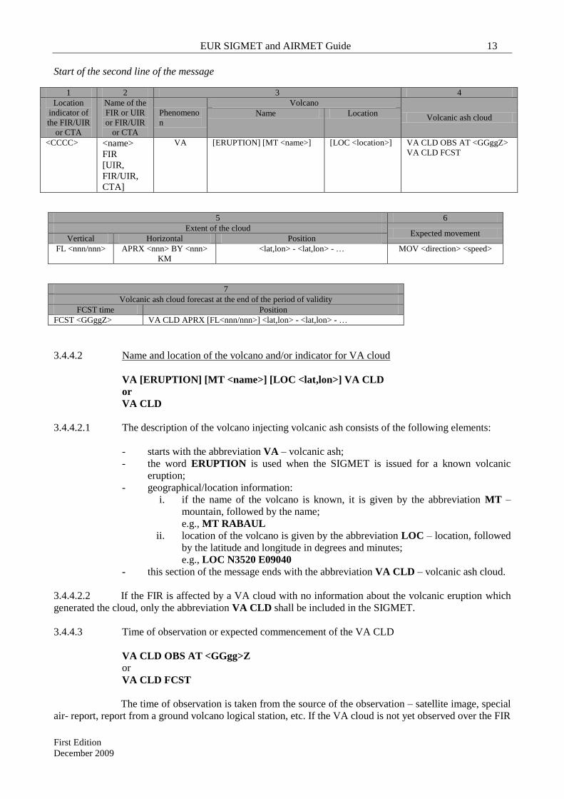
EUR SIGMET and AIRMET Guide 13
First Edition
December 2009
Start of the second line of the message
1 2 3 4
Location
indicator of
the FIR/UIR
or CTA
Name of the
FIR or UIR
or FIR/UIR
or CTA
Phenomeno
n
Volcano
Volcanic ash cloud Name Location
<CCCC> <name>
FIR
[UIR,
FIR/UIR,
CTA]
VA [ERUPTION] [MT <name>] [LOC <location>] VA CLD OBS AT <GGggZ>
VA CLD FCST
5 6
Extent of the cloud Expected movement
Vertical Horizontal Position
FL <nnn/nnn> APRX <nnn> BY <nnn>
KM
<lat,lon> - <lat,lon> - … MOV <direction> <speed>
7
Volcanic ash cloud forecast at the end of the period of validity
FCST time Position
FCST <GGggZ> VA CLD APRX [FL<nnn/nnn>] <lat,lon> - <lat,lon> - …
3.4.4.2 Name and location of the volcano and/or indicator for VA cloud
VA [ERUPTION] [MT <name>] [LOC <lat,lon>] VA CLD
or
VA CLD
3.4.4.2.1 The description of the volcano injecting volcanic ash consists of the following elements:
- starts with the abbreviation VA – volcanic ash;
- the word ERUPTION is used when the SIGMET is issued for a known volcanic
eruption;
- geographical/location information:
i. if the name of the volcano is known, it is given by the abbreviation MT –
mountain, followed by the name;
e.g., MT RABAUL
ii. location of the volcano is given by the abbreviation LOC – location, followed
by the latitude and longitude in degrees and minutes;
e.g., LOC N3520 E09040
- this section of the message ends with the abbreviation VA CLD – volcanic ash cloud.
3.4.4.2.2 If the FIR is affected by a VA cloud with no information about the volcanic eruption which
generated the cloud, only the abbreviation VA CLD shall be included in the SIGMET.
3.4.4.3 Time of observation or expected commencement of the VA CLD
VA CLD OBS AT <GGgg>Z
or
VA CLD FCST
The time of observation is taken from the source of the observation – satellite image, special
air- report, report from a ground volcano logical station, etc. If the VA cloud is not yet observed over the FIR

14 EUR SIGMET and AIRMET Guide
First Edition
December 2009
but the volcanic ash advisory received from the responsible VAAC indicates that the cloud is affecting the
FIR after certain time, SIGMET shall be issued, and the abbreviation VA CLD FCST shall be used.
Examples:
VA CLD OBS AT 0100Z
VA CLD FCST
3.4.4.4 Level and extent of the volcanic ash cloud
FL<nnn/nnn> [APRX <nnn>KM BY <nnn>KM] <P1(lat,lon) - P2(lat,lon) - … >
or
FL<nnn/nnn> [APRX <nnn>NM BY <nnn>NM] <P1(lat,lon) - P2(lat,lon) - … >
FL<nnn/nnn> The layer of the atmosphere where the VA cloud is situated,
given by two flight levels from the lower to the upper
boundary of the cloud
[APRX <nnn>KM BY <nnn>KM] or
[APRX <nnn>NM BY <nnn>NM]
Approximate horizontal extent of the VA cloud in KM or
NM
<P1(lat,lon) – P2(lat,lon) - … > Approximate description of the VA cloud by a number of
points given with their geographical coordinates1; the points
shall be separated by hyphen
If the VA cloud spreads over more than one FIR, separate SIGMETs shall be issued by all
MWOs whose FIRs are affected. In such a case, the description of the volcanic ash cloud by each MWO
should encompass the part of the cloud, which lies over the MWO’s area of responsibility. The MWOs
should try to keep the description of the volcanic ash clouds consistent by checking the SIGMET messages
received from the neighbouring MWOs.
Examples:
FL100/180 APRX 10KM BY 50KM N0100 E09530 – N1215 E11045
FL 150/210 S0530 E09300 – N0100 E09530 – N1215 E11045
3.4.4.5 Movement or expected movement of the VA cloud
MOV <direction> <speed>
The direction of movement is given by the abbreviation MOV – moving, followed by one of
compass: N, NE, E, SE, S, SW, W, NW. The speed of movement is given in KMH or KT.
Examples:
MOV E 35 KMH
MOV SW 20 KT
3.4.4.6 Forecast position of the VA cloud at the end of the validity period of the SIGMET message
FCST <GGggZ> VA CLD <P1(lat,lon) - P2(lat,lon) - … >
1 The format of geographical coordinates reporting in SIGMET is given in Appendix D.

EUR SIGMET and AIRMET Guide 15
First Edition
December 2009
3.4.4.6.1 The GGggZ group should indicate the end of the validity period given in the first line of the
SIGMET message. The description of the expected position of the volcanic ash cloud is given by a number
of points forming a simplified geometrical approximation of the cloud.
3.4.4.6.2 In describing the VA cloud, up to four different layers can be used, indicated by flight levels
in the form FL<nnn/nnn>. The use of more than one level is necessary when the wind direction changes with
height which causes the VA cloud to spread into different directions at different heights.
3.4.5 Cancellation of SIGMET
3.4.5.1 If, during the validity period of a SIGMET, the phenomenon for which the SIGMET had
been issued is no longer occurring or no longer expected, this SIGMET should be cancelled by the issuing
MWO.
Note – If it is expected (or confirmed from observation) that the phenomenon for which
SIGMET had been issued will change (or has changed) significantly from the original message content, the
current SIGMET message should be cancelled and a new SIGMET message should be issued as appropriate.
The cancellation is done by issuing the same type of SIGMET with the following structure:
- WMO heading with the same data type designator;
- first line, including the next sequence number followed by a new validity period, and
- second line, which contains the location indicator and name of the FIR or CTA, the
combination CNL SIGMET, followed by the sequential number of the original SIGMET
and its validity period.
Examples:
1. Cancellation of a SIGWX SIGMET with the following first line
WSXY31 YUSO 101200
YUDD SIGMET 5 VALID 101200/101600 YUSO-
YUDD SHANLON FIR …
Cancellation SIGMET:
WSXY31 YUSO 101430
YUDD SIGMET 6 VALID 101430/101600 YUSO-
YUDD SHANLON FIR CNL SIGMET 5 101200/101600=
2. Cancellation of a VA SIGMET
WVXY31 YUSO 131518
YUDD SIGMET 03 VALID 131515/132115 YUSO-
YUDD SHANLON FIR …
Cancellation SIGMET:
WVXY31 YUSO 132000
YUDD SIGMET 04 VALID 132000/132115 YUSO-
YUDD SHANLON FIR CNL SIGMET 03 13151500/132115 VA MOV TO YUDO FIR=

16 EUR SIGMET and AIRMET Guide
First Edition
December 2009
PART 4. RULES FOR PREPARATION OF AIRMET INFORMATION
Note: This guidance is developed as a follow-up of EANPG Conclusion 49/42.
4.1 General
4.1.1 AIRMET should be issued by MWOs in accordance with the regional air navigation agreement.
According to the EUR Air Navigation Plan, Volume I, Basic ANP (Doc 7754), AIRMET information should
be issued by a MWO if agreed on between the users and the meteorological authority concerned. The
requirement for the issuance of AIRMET should be reflected in FASID Table MET 1B. The decision of a
meteorological authority for issuance of AIRMET should also be based on an assessment of the density of air
traffic operating below flight level 100 (or flight level 150 or higher in mountainous areas).
4.1.2 AIRMET is issued for a flight information region (FIR); where necessary, the FIR should be divided
in sub-areas and separate AIRMET issued for each sub-area.
4.1.3 When issuing AIRMET information, MWOs should pay attention on the related products, such as,
GAMET and SIGMET, in order to avoid duplication.
4.1.4 AIRMET information is prepared in abbreviated plain language using approved ICAO abbreviations,
a limited number of non-abbreviated words, geographical names and numerical values of self-explanatory
nature. All abbreviations and words to be used in AIRMET are given in Appendix A.
4.1.5 The increasing use of automated systems for handling MET information by the MET offices and the
aviation users makes it essential that all types of OPMET information, including AIRMET, are prepared and
transmitted in the prescribed standardized formats. Therefore, the structure and format of the AIRMET
message, as specified in Annex 3, Part II, Appendix 6, should be followed strictly by the MWOs. Annex 3
Appendix 6 Table A6-1 provides detailed information regarding the content and order of elements in the
AIRMET message.
4.1.6 AIRMET messages should be kept short and clear, without additional descriptive text other than that
prescribed in Annex 3.
4.1.7 After issuing an AIRMET, the MWO should maintain watch over the evolution of the phenomenon
for which the AIRMET has been issued and issue a new updated AIRMET when necessary.
4.1.8 AIRMETs should be cancelled promptly when the phenomenon is no longer occurring or no longer
expected to occur in the MWO’s area of responsibility. The AIRMET is understood to cancel itself
automatically at the end of its validity period. If the phenomenon persists a new AIRMET message for a
further period of validity has to be issued.
4.2 Structure of the AIRMET message
4.2.1 An AIRMET message consists of:
- WMO heading – all AIRMETs are preceded by an appropriate WMO heading;
- First line, containing location indicators of the relevant ATS unit and MWO,
sequential number and period of validity;
- Meteorological part, containing meteorological information concerning the
phenomenon for which the AIRMET is issued.

EUR SIGMET and AIRMET Guide 17
First Edition
December 2009
4.3 Format of AIRMET
Note: In the following text, square brackets - [ ] - are used to indicate an optional or conditional element,
and angled brackets - < > - for symbolic representation of a variable element, which in the real AIRMETs
accepts concrete numerical values.
4.3.1 WMO Header
T1T2A1A2ii CCCC YYGGgg [CCx]
4.3.1.1 The group T1T2A1A2ii is the bulletin identification for the AIRMET message. It is
constructed in the following way:
T1T2 Data type designator WA
A1A2 Country or territory
designators
Assigned according to Table C1, Part II of Manual on the Global
Telecommunication System, Vol I – Global Aspects (WMO - No.
386)
ii Bulletin number Assigned on national level according to paragraph 2.3.2.2, Part II
of Manual on the Global Telecommunication System, Vol I –
Global Aspects (WMO - No. 386)
4.3.1.2 CCCC is the ICAO location indicator of the communication centre disseminating the
message (could be the same as the MWO).
4.3.1.3 YYGGgg is the date/time group, where YY is the date and GGgg is the time in hours and
minutes UTC, of the transmission of the AIRMET (normally this is the time assigned by the AFTN centre
which disseminates the message).
4.3.1.4 A unique WMO header should be assigned for each AIRMET bulletin issued for an FIR, or
part of an FIR. The distinction between different AIRMET bulletins issued by the State’s MWOs should be
through the bulletin number (ii) as, for example:
WABX31 EBBR 061752 [Example from Belgium]
WAPL31 EPWA 061534 [Example from Poland]
Note: A table with WMO SIGMET and AIRMET headers used by the EUR Meteorological Watch Offices is
included in Appendix B
4.3.2 First line of AIRMET
CCCC AIRMET [nn]n VALID YYGGgg/YYGGgg CCCC-
4.3.2.1 The meaning of the groups in the first line of the AIRMET is as follows:
CCCC ICAO location indicator of the ATS unit serving the FIR to which the AIRMET
refers
AIRMET
Message identifier
[nn]n Daily sequence number (see paragraph 3.4.2.2)
VALID Period of validity indicator
YYGGgg/YYGGgg Validity period of the AIRMET given by date/time group of the beginning and
date/time group of the end of the period (see paragraph 3.4.2.3)
CCCC- ICAO location indicator of the MWO originating the message and – (hyphen,
without space, to separate the preamble from the text)

18 EUR SIGMET and AIRMET Guide
First Edition
December 2009
4.3.2.2 The numbering of the AIRMETs should start every day at 0001 UTC. The sequence number
should consist of up to three symbols and may be a combination of letters and numbers, such as:
- 1, 2, …
- 01, 02, …
- A01, A02, …
Examples:
EDBB AIRMET 3 VALID 121100/121500 EDZB-
EPWW AIRMET 5 VALID 061535/061935 EPWA-
4.3.2.3 The following has to be considered when determining the validity period:
- the period of validity of AIRMET shall not exceed 4 hours;
- in case of a AIRMET for an observed phenomenon the filing time (date/time group in
the WMO heading) should be same or close to the date/time group indicating the start of
the AIRMET validity period;
- when the AIRMET is issued for an expected phenomenon:
o the beginning of validity period should be the time of
expected commencement (occurrence) of the
phenomenon;
o the lead time (the time of issuance of the AIRMET)
should be not more than 4 hours before the start of
validity period (i.e., expected time of occurrence of the
phenomenon); and
4.3.2.4 The period of validity is the period during which the AIRMET is valid for transmission to
aircraft in flight.
Examples:
1. AIRMET for an observed phenomenon:
WADL41 EDZF 070015
EDGG AIRMET 01 VALID 070015/070300 EDZF-
EDGG LANGEN FIR ISOL TS OBS N OF N49 TOP FL330 MOV E WKN=
2. AIRMET for a forecast phenomenon:
WASW41 LSSW 061758
LSAS AIRMET 5 VALID 061800/062100 LSZH-
LSAS SWITZERLAND FIR MOD TURB FCST ALPS BLW FL160 STNR NC=

EUR SIGMET and AIRMET Guide 19
First Edition
December 2009
4.3.3 Format of the meteorological part of AIRMET messages
4.3.3.1 The meteorological part of an AIRMET consists of eight elements as shown in the table
below.
Start of the second line of the message
1 2 3 4 5 6
Location
indicator of
the FIR or
CTA
Name of the
FIR or CTA
Description of
the phenomenon Observed or forecast Location
Level
<CCCC> <name> FIR
<Phenomenon> OBS [AT <GGggZ>]
FCST
Geographical location
of the phenomenon
given by coordinates,
or geographical
objects, or location
indicators
FL<nnn>
FL<nnn/nnn>
[TOP, ABV,
BLW]
7 8
Movement or expected movement Changes in intensity
MOV <direction, speed>
KMH[KT], or
STNR
INTSF or WKN or NC
4.3.3.1.1 Location indicator and name of the FIR
location indicator <name> FIR
Example:
EBBU BRUSSELS FIR
4.3.3.1.2 Phenomenon
The description of the phenomenon consists of a qualifier and a phenomenon abbreviation.
AIRMET shall be issued only for the following phenomena (with only one phenomenon in each AIRMET):
at cruising levels below FL100 (FL150 or higher for mountainous areas, where necessary):
surface wind speed
surface visibility
thunderstorms
mountain obscuration
cloud
icing
turbulence
mountain wave
The appropriate abbreviations and combinations thereof, and their meaning are given in Appendix D.
4.3.3.1.3 Indication if the phenomenon is observed or forecast
OBS [AT <GGggZ>]
or
FCST

20 EUR SIGMET and AIRMET Guide
First Edition
December 2009
The indication whether the information is observed or forecast is given by the abbreviations
OBS and FCST. OBS is optionally followed by a time group in the form AT GGggZ, where
GGgg is the time of the observation in hours and minutes UTC. If the exact time of the
observation is not known, the time is not included. When FCST is used, it is assumed that
the time of occurrence or commencement of the phenomenon coincides with the beginning
of the period of validity included in the first line of the AIRMET.
Examples:
OBS AT 0140Z
FCST
4.3.3.1.4 Location of the phenomenon
The location of the phenomenon is given with reference to geographical coordinates (latitude
and longitude) or with reference to geographical features well known internationally. The
MWOs should try to be as specific as possible in reporting the location of the phenomenon
and, at the same time, to avoid overwhelming geographical information, which may be
difficult to process or perceive.
The following are the most common ways to describe the location of the phenomenon:
- Indication of a part of the FIR with reference to latitude:
N OF or S OF <Nnn[nn]> or <Snn[nn]>
- indication of a part of the FIR with reference to a longitude:
E OF or W OF <Ennn[nn]> or <Wnnn[nn]>
- indication of a part of the FIR with reference to a latitude and longitude:
any combination of the above two cases;
- with reference to a location with ICAO location indicator CCCC (normally, this should be
the case in a SIGMET based on a special air-report in which the reported phenomenon is
given with reference to an airport or another object with an ICAO location indicator CCCC),
or
- with reference to geographical features well known internationally.
More details on reporting of the location of the phenomenon are given in Appendix 6 to
Annex 3 and in Appendix E to this Guide.
4.3.3.1.5 Flight level and extent
FL<nnn>
or FL<nnn/nnn>
or TOP FL<nnn>
or [TOP] ABV FL<nnn>
or [TOP] BLW FL<nnn>
The location or extent of the phenomenon in the vertical is given by one or more of the
above abbreviations, as follows :

EUR SIGMET and AIRMET Guide 21
First Edition
December 2009
- reporting of single level – FL<nnn>
- reporting a layer – FL<nnn/nnn>, where the lower level is reported first; this is used
particularly in reporting turbulence and icing;
- reporting a level or layer with reference to one FL using ABV or BLW
- reporting the level of the tops of the TS clouds using the abbreviation TOP.
Examples:
ISOL CB … TOP ABV FL100
MOD TURB … FL050/080
MOD ICE … BLW FL090
MOD MTW … FL060
Note that the flight levels reported should be up to FL100 (FL150 or higher for mountainous
areas, where necessary).
4.3.3.1.6 Movement
MOV <direction> <speed> KMH[KT]
or
STNR
Direction of movement is given with reference to one of the eight points of compass. Speed
is given in KMH or KT. The abbreviation STNR is used if no significant movement is
expected.
Examples:
MOV NW 30KMH
MOV E 25KT
4.3.3.1.7 Expected changes in intensity
The expected evolution of the phenomenon’s intensity is indicated by one of the following
abbreviations:
INTSF – intensifying
WKN – weakening
NC – no change
4.3.4 Cancellation of AIRMET
4.3.4.1 If, during the validity period of an AIRMET, the phenomenon for which the AIRMET had
been issued is no longer occurring or no longer expected, this AIRMET should be cancelled by the issuing
MWO.
Note – If it is expected (or confirmed from observation) that the phenomenon for which
AIRMET had been issued will change (or has changed) significantly from the original message content, the
current AIRMET message should be cancelled and a new AIRMET message should be issued as appropriate.
The cancellation is done by issuing the same type of AIRMET with the following structure:
- WMO heading with the same data type designator;

22 EUR SIGMET and AIRMET Guide
First Edition
December 2009
- first line, including the next sequence number followed by a
new validity period, and
second line, which contains the location indicator and name of the FIR, the combination
CNL AIRMET, followed by the sequential number of the original AIRMET and its validity
period.
Examples:
Cancellation of AIRMET with the following first line:
WAXY31 YUSO 151520
YUDD AIRMET 1 VALID 151520/151800 YUSO-
YUDD SHANLON FIR …
Cancellation AIRMET:
WAXY31 YUSO 151430
YUDD AIRMET 2 VALID 151650/151800 YUSO-
YUDD SHANLON FIR CNL AIRMET 1 151520/151800=

EUR SIGMET and AIRMET Guide 23
First Edition
December 2009
APPENDIX A
List of the abbreviations and decode used in SIGMET and AIRMET
Abbreviation Decode
ABV Above
AIRMET AIRMET Information
AND* And
APRX Approximate or approximately
AT At (followed by time)
BLW Below
BKN Broken
BR Mist
BY* By
CB Cumulonimbus
CENTRE* Centre (used to indicate tropical cyclone centre)
CLD Cloud
CNL Cancel or cancelled
CTA Control area
DS Duststorm
DU Dust
DZ Drizzle
E East or eastern longitude
ERUPTION* Eruption (used to indicate volcanic eruption)
EMBD Embedded in layer (to indicate CB embedded in layers of other clouds)
FCST Forecast
FG Fog
FIR Flight information region
FL Flight level
FRQ Frequent
FU Smoke
FZRA Freezing rain
GR Hail
GS Small hail and/or snow pellets
HVY Heavy (used to indicate intensity of weather phenomena)
HZ Haze
IC Ice crystals
ICE Icing
INTSF Intensify or intensifying
ISOL Isolated
KM Kilometres
KMH Kilometres per hour
KT Knots
LINE* Line
MOD Moderate (used to indicate intensity of weather phenomena)
MOV Move or moving or movement
MT Mountain
MTW Mountain waves
N North or northern latitude
NC No change
NE North-east
NM Nautical miles
NW North-west
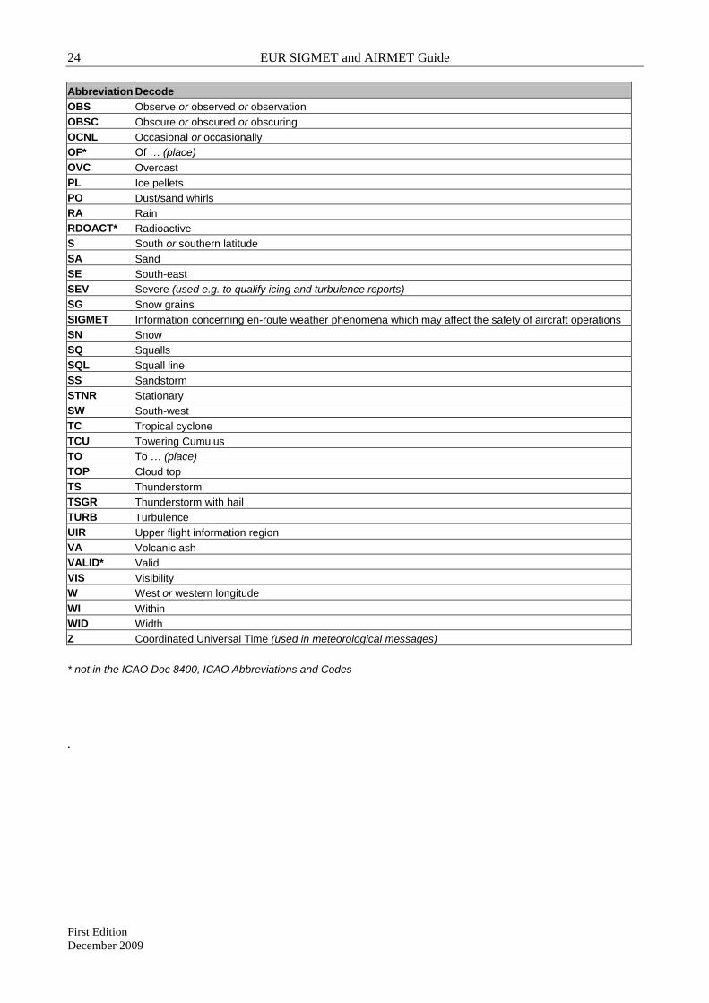
24 EUR SIGMET and AIRMET Guide
First Edition
December 2009
Abbreviation Decode
OBS Observe or observed or observation
OBSC Obscure or obscured or obscuring
OCNL Occasional or occasionally
OF* Of … (place)
OVC Overcast
PL Ice pellets
PO Dust/sand whirls
RA Rain
RDOACT* Radioactive
S South or southern latitude
SA Sand
SE South-east
SEV Severe (used e.g. to qualify icing and turbulence reports)
SG Snow grains
SIGMET Information concerning en-route weather phenomena which may affect the safety of aircraft operations
SN Snow
SQ Squalls
SQL Squall line
SS Sandstorm
STNR Stationary
SW South-west
TC Tropical cyclone
TCU Towering Cumulus
TO To … (place)
TOP Cloud top
TS Thunderstorm
TSGR Thunderstorm with hail
TURB Turbulence
UIR Upper flight information region
VA Volcanic ash
VALID* Valid
VIS Visibility
W West or western longitude
WI Within
WID Width
Z Coordinated Universal Time (used in meteorological messages)
* not in the ICAO Doc 8400, ICAO Abbreviations and Codes
.

EUR SIGMET and AIRMET Guide 25
First Edition
December 2009
APPENDIX B
List of EUR SIGMET (WS, WV) and AIRMET (WA) headers
State MWO Loc MWO name WS AHL WV AHL WA AHL ATSU
Ind
FIR Ind FIR Name
Albania LATI Tirana/Tirana WSAB31 LATI LATI LATI Tirana
Armenia UGEE Yerevan WSEE31 UGEE UGEZ UGEZ Yerevan
Austria LOWW Wien/Schwechat WSOS31 LOWW WVOS31 LOWW WAOS41 LOWW LOVV LOVV Wien
Azerbaijan UBBB Baku WAAJ31 UBBB UBBB Baku/Heydar Aliyev
Belarus UMMM Minsk WSBY31 UMMS UMMV UMMV Minsk
Belgium EBBR Brussels/National WSBX31 EBBR WVBX31 EBBR WABX31 EBBR EBBU EBBU Brussels(ACC-FIC)
Bosnia And
Herzegovina
LYBE Beograd/Surcin WSQB32 LYBM WVQB32 LYBM N/A LYBA LQSB Sarajevo (E)
Bosnia And
Herzegovina
LDZA Zagreb/Pleso WSQB31 LDZM WVQB31 LDZM N/A LDZO LQSB Sarajevo (W)
Bulgaria LBSF Sofia/Vrajbedebna WSBU31 LBSM WVBU31 LBSM N/A LBSR LBSR Sofia
Croatia LDZA Zagreb/Pleso WSRH31 LDZM WVRH31 LDZM WARH31 LDZM LDZO LDZO Zagreb
Cyprus LCLK Larnaca/Larnaca WSCY31 LCLK LCCC LCCC Nicosia
Czech Republic LKPW Praha/Ruzyne WSCZ31 LKPW WVCZ31 LKPW WACZ41 LKPW LKAA LKAA Praha
Denmark EKMI Kobenhavn WSDN31 EKCH WVDN31 EKCH N/A EKDK EKDK Kobenhavn
Estonia EEMH Tallinn WSEO31 EETN WVEO31 EETN EETT EETT Tallinn
Finland EFHK Helsinki-Vantaa WSFI31 EFHK WVFI31 EFHK EFES EFIN Finland (S part)
Finland EFRO Rovaniemi WSFI32 EFHK WVFI32 EFHK EFPS EFIN Finland (N part)
France LFML Aix WSFR34 LFPW WVFR34 LFPW LFMM LFMM Marseille
France LFBD Bordeaux WSFR32 LFPW WVFR32 LFPW LFBB LFBB Bordeaux
France LFPS Paris WSFR31 LFPW WVFR31 LFPW LFFF LFFF Paris
France LFRN Rennes WSFR35 LFPW WVFR35 LFPW LFRR LFRR Brest
France LFST Strasbourg WSFR33 LFPW WVFR33 LFPW LFEE LFEE Reims
France LFPW Toulouse WSFR31 LFPW WVFR31 LFPW LFEE LFEE France UIR
WSFR31 LFPW WVFR31 LFPW LFFF LFFF France UIR
WSFR31 LFPW WVFR31 LFPW LFMM LFMM France UIR
WSFR31 LFPW WVFR31 LFPW LFRR LFRR France UIR

26 EUR SIGMET and AIRMET Guide
First Edition
December 2009
State MWO Loc MWO name WS AHL WV AHL WA AHL ATSU
Ind
FIR Ind FIR Name
WSFR31 LFPW WVFR31 LFPW LFBB LFBB France UIR
Georgia UGTB Tbilisi WSGG31 UGTB UGGG UGGG Tblisi
Germany EDZB Berlin WSDL32 EDZB WVDL32 EDZB EDBB EDBB Berlin UIR
WSDL31 EDZB WVDL31 EDZB EDBB EDBB Berlin
Germany EDZE Essen WSDL31 EDZE WVDL31 EDZE EDLL EDLL Dusseldorf
Germany EDZH Hamburg WSDL32 EDZH WVDL32 EDZH EDYY EDYY Hannover UIR
WSDL31 EDZH WVDL31 EDZH WADL41 EDZH EDWW EDWW Bremen
Germany EDZM Munchen WSDL31 EDZM WVDL31 EDZM WADL41 EDZM EDMM EDMM Munchen
Germany EDZF Frankfurt WSDL32 EDZF WVDL32 EDZF EDUU EDUU Rhein UIR
WSDL31 EDZF WVDL31 EDZF WADL41 EDZF EDFF EDFF Frankfurt
Greece LGAT Athinai WSGR31 LGAT WVGR31 LGAT N/A LGGG LGGG Athinai
Hungary LHBP Budapest WSHU31 LHBM WVHU31 LHBM WAHU41 LHBM LHCC LHCC Budapest
WSHU41 LHBM LHCC LHCC Budapest
Ireland EINN Shannon WSIE31 EIDB WVIE31 EIDB N/A EIDB EISN Shannon
Italy LIBR Brindisi WSIY31 LIIB WVIY31 LIIB LIBB LIBB Brindisi
WSIY31 LIIB WVEU31 LIBB LIBB LIBB Italia UIR
Italy LIMM Milano WSIY31 LIIB LIMM LIMM Italia UIR
WSIY31 LIIB WVIY31 LIIB
WVEU31 LIBB
LIMM LIMM Milano
Italy LIIB Roma WSIY31 LIIB LIRR LIRR Italia UIR
WSIY31 LIIB WVIY31 LIIB
WVEU31 LIBB
LIRR LIRR Roma
Kazakhstan UATE Aktau UATE UATE Aktau
Kazakhstan UATT Aktyubinsk WSRA31 UAAA UATT UATT Aktyubinsk
Kazakhstan UAAA Almaty WSRA31 UAAA WVRA31 UAAA UAAA UAAA Almaty
Kazakhstan UACC Astana WSRA41 UACC UACC UACC Astana
Kazakhstan UATG Atyrau UATG UATG Atyrau
Kazakhstan UAUU Kostanay UAUU UAUU Kustanay/Kostanay
Kazakhstan UAOO Kyzylorda UAOO UAOO Kyzylorda
Kazakhstan UASS Semipalatinsk UASS UASS Semipalatinsk
Kazakhstan UAII Shymkent UAII UAII Shymkent
Kazakhstan UARR Uralsk UARR UARR Uralsk

EUR SIGMET and AIRMET Guide 27
First Edition
December 2009
State MWO Loc MWO name WS AHL WV AHL WA AHL ATSU
Ind
FIR Ind FIR Name
Kazakhstan UAKD Zhezkazgan UAKD UAKD Zhezkazgan
Kyrgyzstan UAFM Bishkek WSKG41 UAFM UAFM UAFM Bishkek/Manas
Latvia EVRA Riga WSLV31 EVRA WVLV31 EVRA WALV31 EVRA EVRR EVRR Riga
Lithuania EYVI Vilnuis WSLT31 EYVI WVLT31 EYVI EYVL EYVL Vilnius
Malta LMML Malta/Luqa WSMP31 LMMM WVMP31 LMMM LMMM LMMM Malta
Netherlands EHDB De Bilt WSNL31 EHDB WVNL31 EHDB WANL31 EHDB EHAA EHAA Amsterdam
Norway ENMI Oslo WSNO31 ENMI WVNO31 ENMI N/A ENOR ENOR Norway
Norway ENVN Tromsoe WSNO36 ENMI WVNO36 ENMI N/A ENOB ENOB Bodo Oceanic
Poland EPWA Warszawa/Okecie WSPL31 EPWA WVPL31 EPWA WAPL31 EPWA EPWW EPWW Waszawa
Portugal LPPT Lisboa WSAZ31 LPMG WVNT32 LPMG LPPO LPPO Santa Maria Oceanic
Portugal LPPT Lisboa WSPO31 LPMG WVPO31 LPMG LPPC LPPC Lisboa
Republic of
Moldova
LUKK Chisinau WSRM31 LUKK WVRM31 LUKK LUUU LUUU Chisinau
Romania LROM Bucresti/Otopeni WSRO31 LROM WVRO31 LROM LRBB LRBB Bucresti
Russian
Federation
ULDD Amderma WSRA31 RUAM WVRA31 RUAM N/A ULDD ULDD Amderma
Russian
Federation
UHMA Anadyr WSRA32 RUPV WVRA32 RUPV N/A UHMA UHMA Anadyr
WVRA33 RUPV UHMI UHMI Shmidta cape
Russian
Federation
ULAA Arkhangelsk/
Talagi
WSRS31 RUAA WVRS31 RUAA N/A ULAA ULAA Arkhangelsk/Talagi
WSRS37 RUAA WVRS37 RUAA ULAM ULAM Naryan-Mar
Russian
Federation
UHWW Artiom WSRA31 RUVV WVRA31 RUVV N/A UHWW UHWW Vladivostok
Russian
Federation
UNBB Barnaul WSRA33 RUNW UNBB UNBB Barnaul
Russian
Federation
UHBB Blagoveshchensk WSRA33 RUHB WVRA33 RUHB N/A UHBB UHBB Blagoveshchensk
Russian
Federation
USCC Chelyabinsk WSRA33 RUEK WVRA33 RUEK N/A USCC USCC Chelyabinsk
Russian
Federation
UESS Chersky WSRA34 RUYK WVRA34 RUYK N/A USCC UESS Chersky
Russian
Federation
UIAA Chita/Kadala WSRA31 RUCH WVRA31 RUCH N/A UIAA UIAA Chita
Russian
Federation
UESO Chokurdakh WSRA35 RUYK WVRA35 RUYK N/A UESO UESO Chokurdakh

28 EUR SIGMET and AIRMET Guide
First Edition
December 2009
State MWO Loc MWO name WS AHL WV AHL WA AHL ATSU
Ind
FIR Ind FIR Name
Russian
Federation
UELL Chulman/Neryungri WSRA32 RUYK WVRA32 RUYK N/A UELL UELL Chulman
Russian
Federation
UIII Irkutsk WSRA31 RUIR WVRA31 RUIR N/A UIII UIII Irkutsk
Russian
Federation
UMKK Kaliningrad WSRS31 RUKG WVRS31 RUKG N/A UMKK UMKK Kaliningrad
Russian
Federation
USDK Kamenny cape WSRA32 RUAM N/A USDK USDK Kamenny cape
Russian
Federation
UWKD Kazan WSRS31 RUKZ WVRS31 RUKZ N/A UWKD UWKD Kazan
Russian
Federation
UHHH Khabarovsk/Novy WSRA31 RUHB WVRA31 RUHB N/A UHHH UHHH Khabarovsk
Russian
Federation
USHH Khanty-Mansiysk WSRA33 RUOM N/A USHH USHH Khanty-Mansiysk
Russian
Federation
USKK Kirov WSRS31 RUNN WVRS31 RUNN N/A USKK USKK Kirov
Russian
Federation
ULKK Kotlas WSRA33 RUAA WVRA33 RUAA N/A ULKK ULKK Kotlas
Russian
Federation
UNKL Krasnoyarsk/
Yemelyanovo
WSRA31 RUKR N/A UNKL UNKL Krasnoyarsk
Russian
Federation
UHMM Magadan WSRA31 RUMG WVRA31 RUMG N/A UHMM UHMM Magadan
Russian
Federation
UERR Mirny WSRA33 RUYK N/A UERR UERR Mirny
Russian
Federation
UUWV Moscow
WSRS31 RUMA N/A UUWV UUWV Moskcow
Russian
Federation
ULMM Murmansk WSRS31 RUMU WVRS31 RUMU N/A ULMM ULMM Murmansk
Russian
Federation
UOOO Norilsk WSRA32 RUKR N/A UOOO UOOO Norilsk
Russian
Federation
UNNT Novosibirsk
WSRA31 RUNW N/A UNNT UNNT Novosibirsk
Russian
Federation
UNOO Omsk WSRA31 RUOM N/A UNOO UNOO Omsk
Russian
Federation
UWOO Orenburg/
Tsentralny
WSRS32 RUSM WVRS32 RUSM N/A UWOO UWOO Orenburg
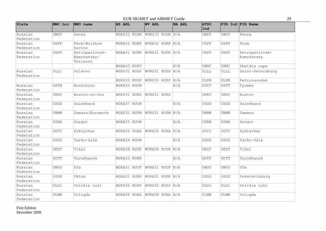
EUR SIGMET and AIRMET Guide 29
First Edition
December 2009
State MWO Loc MWO name WS AHL WV AHL WA AHL ATSU
Ind
FIR Ind FIR Name
Russian
Federation
UWPP Penza WSRS33 RUSM WVRS33 RUSM N/A UWPP UWPP Penza
Russian
Federation
USPP Perm/Bolshoe
Savino
WSRA32 RUEK WVRA32 RUEK N/A USPP USPP Perm
Russian
Federation
UHPP Petropavlovsk-
Kamchatsky/
Yelizovo
WSRA31 RUPK WVRA31 RUPK N/A UHPP UHPP Petropavlovsk-
Kamchatsky
WSRA33 RUPV N/A UHMI UHMI Shmidta cape
Russian
Federation
ULLI Pulkovo WSRS31 RUSP WVRS31 RUSP N/A ULLL ULLL Saint-Petersburg
WSRS33 RUSP WVRS33 RUSP N/A ULPB ULPB Petrozavodsk
Russian
Federation
USTR Roshchino WSRA32 RUOM N/A USTT USTT Tyumen
Russian
Federation
URRV Rostov-on-Don WSRS31 RURD WVRS31 RURD URRV URRV Rostov
Russian
Federation
USDD Salekhard WSRA37 RUOM N/A USDD USDD Salekhard
Russian
Federation
UWWW Samara/Kurumoch WSRS31 RUSM WVRS31 RUSM N/A UWWW UWWW Samara
Russian
Federation
USRR Surgut WSRA35 RUOM N/A USRR USRR Surgut
Russian
Federation
UUYY Syktyvkar WSRA32 RUAA WVRA32 RUAA N/A UUYY UUYY Syktyvkar
Russian
Federation
USDS Tarko-Sale WSRA34 RUOM N/A USDS USDS Tarko-Sale
Russian
Federation
UEST Tiksi WSRA38 RUYK WVRA38 RUYK N/A UEST UEST Tiksi
Russian
Federation
UOTT Turukhansk WSRA33 RUKR N/A UOTT UOTT Turukhansk
Russian
Federation
UWUU Ufa WSRA31 RUUF WVRA31 RUUF N/A UWUU UWUU Ufa
Russian
Federation
USSK Uktus WSRA31 RUEK WVRA31 RUEK N/A USSS USSS Yekaterinburg
Russian
Federation
ULOL Velikie Luki WSRS32 RUSP WVRS32 RUSP N/A ULOL ULOL Velikie Luki
Russian
Federation
ULWW Vologda WSRA34 RUAA WVRA34 RUAA N/A ULWW ULWW Vologda
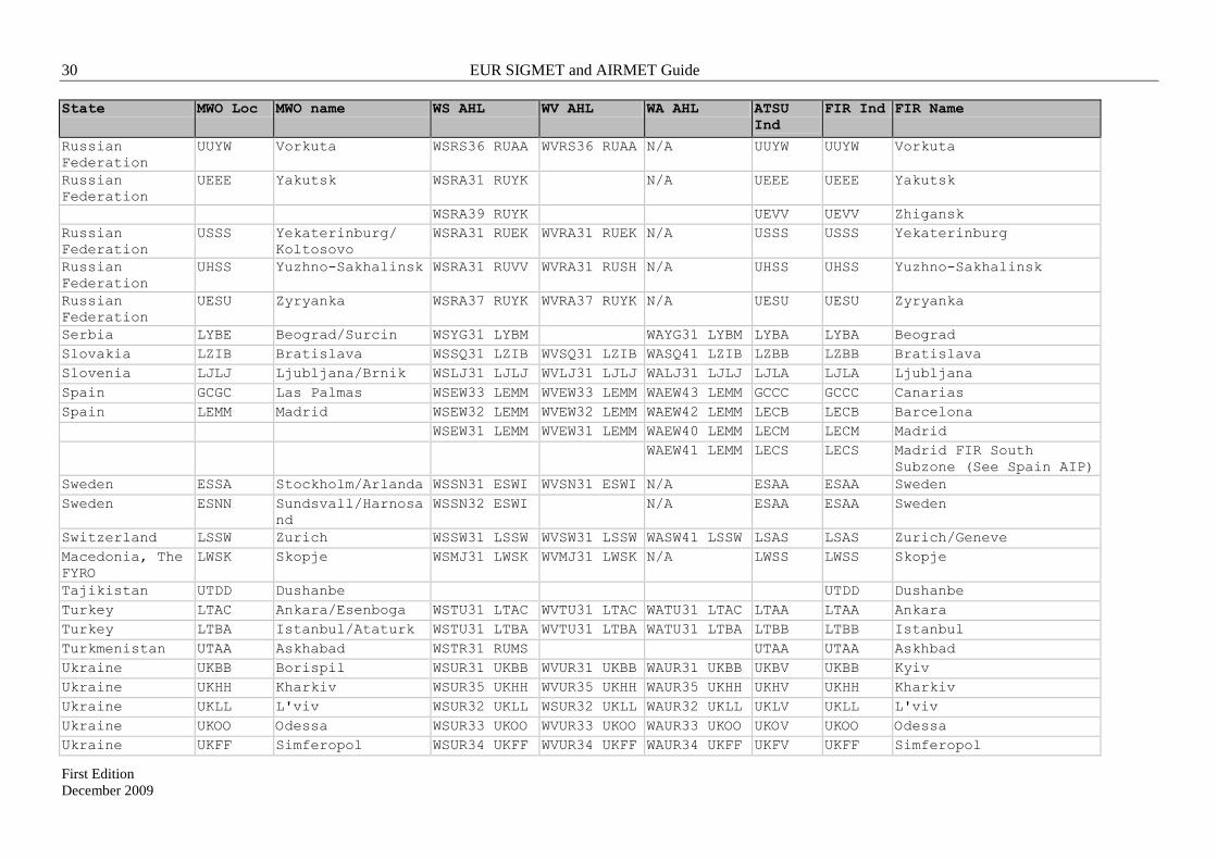
30 EUR SIGMET and AIRMET Guide
First Edition
December 2009
State MWO Loc MWO name WS AHL WV AHL WA AHL ATSU
Ind
FIR Ind FIR Name
Russian
Federation
UUYW Vorkuta WSRS36 RUAA WVRS36 RUAA N/A UUYW UUYW Vorkuta
Russian
Federation
UEEE Yakutsk WSRA31 RUYK N/A UEEE UEEE Yakutsk
WSRA39 RUYK UEVV UEVV Zhigansk
Russian
Federation
USSS Yekaterinburg/
Koltosovo
WSRA31 RUEK WVRA31 RUEK N/A USSS USSS Yekaterinburg
Russian
Federation
UHSS Yuzhno-Sakhalinsk WSRA31 RUVV WVRA31 RUSH N/A UHSS UHSS Yuzhno-Sakhalinsk
Russian
Federation
UESU Zyryanka WSRA37 RUYK WVRA37 RUYK N/A UESU UESU Zyryanka
Serbia LYBE Beograd/Surcin WSYG31 LYBM WAYG31 LYBM LYBA LYBA Beograd
Slovakia LZIB Bratislava WSSQ31 LZIB WVSQ31 LZIB WASQ41 LZIB LZBB LZBB Bratislava
Slovenia LJLJ Ljubljana/Brnik WSLJ31 LJLJ WVLJ31 LJLJ WALJ31 LJLJ LJLA LJLA Ljubljana
Spain GCGC Las Palmas WSEW33 LEMM WVEW33 LEMM WAEW43 LEMM GCCC GCCC Canarias
Spain LEMM Madrid WSEW32 LEMM WVEW32 LEMM WAEW42 LEMM LECB LECB Barcelona
WSEW31 LEMM WVEW31 LEMM WAEW40 LEMM LECM LECM Madrid
WAEW41 LEMM LECS LECS Madrid FIR South
Subzone (See Spain AIP)
Sweden ESSA Stockholm/Arlanda WSSN31 ESWI WVSN31 ESWI N/A ESAA ESAA Sweden
Sweden ESNN Sundsvall/Harnosa
nd
WSSN32 ESWI N/A ESAA ESAA Sweden
Switzerland LSSW Zurich WSSW31 LSSW WVSW31 LSSW WASW41 LSSW LSAS LSAS Zurich/Geneve
Macedonia, The
FYRO
LWSK Skopje WSMJ31 LWSK WVMJ31 LWSK N/A LWSS LWSS Skopje
Tajikistan UTDD Dushanbe UTDD Dushanbe
Turkey LTAC Ankara/Esenboga WSTU31 LTAC WVTU31 LTAC WATU31 LTAC LTAA LTAA Ankara
Turkey LTBA Istanbul/Ataturk WSTU31 LTBA WVTU31 LTBA WATU31 LTBA LTBB LTBB Istanbul
Turkmenistan UTAA Askhabad WSTR31 RUMS UTAA UTAA Askhbad
Ukraine UKBB Borispil WSUR31 UKBB WVUR31 UKBB WAUR31 UKBB UKBV UKBB Kyiv
Ukraine UKHH Kharkiv WSUR35 UKHH WVUR35 UKHH WAUR35 UKHH UKHV UKHH Kharkiv
Ukraine UKLL L'viv WSUR32 UKLL WSUR32 UKLL WAUR32 UKLL UKLV UKLL L'viv
Ukraine UKOO Odessa WSUR33 UKOO WVUR33 UKOO WAUR33 UKOO UKOV UKOO Odessa
Ukraine UKFF Simferopol WSUR34 UKFF WVUR34 UKFF WAUR34 UKFF UKFV UKFF Simferopol

EUR SIGMET and AIRMET Guide 31
First Edition
December 2009
State MWO Loc MWO name WS AHL WV AHL WA AHL ATSU
Ind
FIR Ind FIR Name
United Kingdom EGRR London/Exeter WSUK31 EGRR WVUK31 EGRR N/A EGTT EGTT London
WSUK33 EGGY WVUK33 EGRR EGPX EGPX Scottish
WSNT21 EGRR WVNT21 EGRR EGGX EGGX Shanwick Oceanic
United Kingdom EGJJ Jersey WSUK32 EGJJ WVUK32 EGJJ N/A EGJJ EGJJ Jersey
Uzbekistan UTSS Samarkand WSUZ31 UTNN N/A UTNN UTNN Nukus
WSUZ31 UTSS UTSS UTSS Samarkand
Uzbekistan UTTT Tashkent/Yuzhny WSUZ31 UTTT N/A UTTT UTTT Tashkent/Yuzhny

32 EUR SIGMET and AIRMET Guide
First Edition
December 2009
INTENTIONALLY LEFT BLANK

EUR SIGMET and AIRMET Guide 33
First Edition
December 2009
APPENDIX C
Meteorological phenomena to be reported by SIGMET
Phenomenon Description Meaning
Thunderstorm
(TS)
OBSC2 TS
EMBD3 TS
FRQ4 TS
SQL5 TS
OBSC TSGR
EMBD TSGR
FRQ TSGR
SQL TSGR
Obscured thunderstorm(s)
Embedded thunderstorm(s)
Frequent thunderstorm(s)
Squall line thunderstorm(s)
Obscured thunderstorm(s) with hail
Embedded thunderstorm(s) with hail
Frequent thunderstorm(s) with hail
Squall line thunderstorm(s) with hail
Tropical cyclone
(TC)
TC (+ TC name) Tropical cyclone (+ TC name)
Turbulence
(TURB)
SEV TURB6 Severe turbulence
Icing (ICE) SEV ICE
SEV ICE (FZRA)
Severe icing
Severe icing due to freezing rain
Mountain wave
(MTW)
SEV MTW7 Severe mountain wave
Duststorm (DS) HVY DS Heavy duststorm
Sandstorm (SS) HVY SS Heavy sandstorm
Volcanic ash
cloud (VA)
VA (+ volcano name,
if known)
Volcanic ash (+ volcano name)
Radioactive cloud RDOACT CLD Radioactive cloud
Notes:
1. Only one of the weather phenomena listed should be selected and included in each SIGMET
2. Obscured (OBSC) indicates that the thunderstorm is obscured by haze or smoke or cannot be readily seen
due to darkness
3. Embedded (EMBD) – indicates that the thunderstorm is embedded within cloud layers and cannot be
readily recognized
4. Frequent (FRQ) indicates an area of thunderstorms within which there is little or no separation between
adjacent thunderstorms with a maximum spatial coverage greater than 75% of the area affected, or forecasts
to be affected, by the phenomenon (at a fixed time or during the period of validity)
5. Squall line (SQL) indicates thunderstorms along a line with little or no space between individual clouds
6. Severe (SEV) turbulence (TURB) refers only to:
- low-level turbulence associated with strong surface winds;
- rotor streaming;
- turbulence whether in cloud or not in cloud (CAT) near to jet streams.
- Turbulence is considered severe whenever the peak value of the cube root of the eddy dissipation
rate (EDR) exceeds 0.7.
7. A mountain wave (MTW) is considered:
- severe – whenever an accompanying downdraft of 3.0 m/s (600 ft/min) or more and/or severe
turbulence is observed or forecasted..

34 EUR SIGMET and AIRMET Guide
First Edition
December 2009
APPENDIX D
Meteorological phenomena to be reported by AIRMET
Phenomenon1 Description Meaning
Surface wind
speed
SFC WIND
(+wind speed and
units)
Widespread mean surface wind speed
above 60 km/h (30 kt)
Surface visibility SFC VIS (+visibility)
(+ one of the weather
phenomena causing the
reduction of visibility)
Widespread areas affected by reduction of
visibility to less than 5 000 m, including
the weather phenomenon causing the
reduction of visibility
Thunderstorm ISOL2 TS
OCNL3 TS
ISOL2 TSGR
OCNL3 TSGR
Isolated thunderstorm(s)
Occasional thunderstorm(s)
Isolated thunderstorm(s) with hail
Occasional thunderstorm(s) with hail
Mountain
obscuration
MT OBSC Mountains obscured
Cloud BKN CLD (+height)
OVC CLD (+height)
ISOL2 CB
OCNL3 CB
FRQ4 CB
ISOL2 TCU
OCNL3 TCU
FRQ4 TCU
Broken cloud
Overcast cloud
Isolated CB
Occasional CB
Frequent CB
Isolated TCU
Occasional TCU
Frequent TCU
Icing MOD5 ICE
Moderate icing (except for icing in
convective clouds)
Turbulence MOD6 TURB Moderate turbulence
Mountain wave MOD7 MTW Moderate mountain wave
Notes:
1. Only one of the weather phenomena listed should be selected and included in each AIRMET
2. Isolated (ISOL) indicates that an area of thunderstorms, or cumulonimbus cloud, or towering cumulus
cloud, consists of individual features which affect, or are forecast to affect, an area with a maximum spatial
coverage less than 50 per cent of the area concerned (at a fixed time or during the period of validity)
3. Occasional (OCNL) indicates that an area of thunderstorms, or cumulonimbus cloud, or towering
cumulus cloud, consists of well-separated features which affect, or are forecast to affect, an area with a
maximum spatial coverage between 50 and 75 per cent of the area concerned (at a fixed time or during the
period of validity)
4. Frequent (FRQ) indicates an area of cumulonimbus cloud or towering cumulus cloud, within which there
is little or no separation between adjacent CB or TCU clouds, with a maximum spatial coverage greater
than 75% of the area affected, or forecasts to be affected, by the phenomenon (at a fixed time or during the
period of validity)
5. Moderate (MOD) icing (ICE) should refer to icing in other than convective clouds.

EUR SIGMET and AIRMET Guide 35
First Edition
December 2009
6. Moderate (MOD) turbulence (TURB) refers only to:
- low-level turbulence associated with strong surface winds;
- rotor streaming;
- turbulence whether in cloud or not in cloud (CAT);
- Turbulence is considered moderate whenever the peak value of the cube root of the eddy dissipation
rate (EDR) is above 0.4 and below or equal to 0.7.
7. A mountain wave (MTW) is considered moderate (MOD) whenever an accompanying downdraft of 1.75–
3.0 m/s (350–600 ft/min) and/or moderate turbulence is observed or forecast.

EUR SIGMET and AIRMET Guide 37
First Edition
December 2009
APPENDIX E
Guidelines for reporting geographical coordinates in SIGMET and AIRMET
When reporting geographical coordinates of points in SIGMET the following should apply:
1. Each point is represented by latitude/longitude coordinates in whole degrees or degrees and
minutes in the form:
N(S)nn[nn] W(E)nnn[nn]
Note: There is a space between the latitude and longitude value.
Examples: N3623 W04515
S1530 E12500
N42 E023
2. In describing lines or polygons, the latitude, longitude coordinates of the respective points
are separated by the combination space-hyphen-space, as in the following examples:
S0530 E09300 – N0100 E09530 – N1215 E11045 – S0820 E10330
S05 E093 – N01 E095 – N12 E110 – S08 E103
Note: It is not necessary to repeat the first point when describing a polygon.
3. When describing a volcanic ash cloud approximate form and position, a limited number of
points, which form a simplified geometric figure (a line, or a triangle, or quadrangle, etc.) should be used in
order to allow for a straightforward interpretation by the user.
– END –

R-1 European Air Navigation Planning Group R-1
E51AppR - Amdt 1 PANS ATM Ed15.docx December 2009
Appendix R - Issues arising from Amendment 1 to ICAO PANS-ATM (Doc 4444)
(Paragraph 4.7.23 refers)
1. Appendix 2, Item 15. The indication of a 'significant' point as 2 to 11 characters is misleading and
inconsistent with Annex 11, 2.14.2. Appendix 2 gives the impression that a point defined by
Latitude and Longitude in degrees and minutes, i.e. 11 characters or by bearing and distance, can be
considered as a 'significant' point. As a result, the modification to indicate that a bearing and
distance can be provided from a significant point would appear to introduce a cyclic description of
significant point, i.e. a bearing and distance from a significant point which can be provided by
bearing and distance!
2. Appendix 2, Item 10a, has no specified limit other than the total set of indicators prescribed i.e. a
theoretical 63 characters in total. As an indication containing every possibility is almost certainly
unrealistic and in an effort to reduce the length of message and clarify the data processing
requirements, a limit of 50 characters is proposed.
3. Appendix 3, Field 10b, definition - the indicator 'N' seems to have been removed which is
inconsistent with Appendix 2, Item 10.
4. Appendix 3, Field 17, definition is inconsistent. The Note would seem to suggest that part (c) has
been removed in favour of a Field 18 indication. However, Item 18 makes no reference to the
ability to indicate an arrival aerodrome. In addition, the example ARR message provided in 2.3.6.3
of Appendix 3 includes part (c) while omitting the 'ZZZZ' indication. It is suggested that part (c) be
re-instated, the note pointing to Field 18 be removed and ZZZZ inserted in the example in 2.3.6.3,
i.e. (ARR-HHE13-EHAM-ZZZZ1030 DEN HELDER).
5. In Appendix 3, Field 16 definition - the table showing previous and following fields is missing the
RQP message. This is applicable to the current document as well as the future changes.
6. In Appendix 3, Field 13b, the text refers to a list of messages 'transmitted before departure' which is
not logical for an ARR or RQS message. It is suggested to remove 'transmitted before departure'.
7. In Appendix 3, 2.3.6.2 and 2.3.6.3, the example messages do not include Field 13b.
8. More clarity is needed concerning the use of the DOF/. It needs to be made clear that the DOF is
related to the EOBT and therefore refers to the Estimated Off Block Date. Therefore, when
included within associated messages such as DLA, DEP, etc., it should contain the last specified Off
Block Date, not the new date in case of a delay over midnight and not the departure date for a
delayed departure over midnight.
9. The indication of a point via bearing and distance allows reference to degrees true in northern
latitudes where reference to magnetic is deemed by the appropriate authority to be impractical.
However, this ability to use degrees true is not consistently applied throughout the document.
Appendix 3, 1.6.3 e) and within the ‘Rules for the Composition of Messages’ there is no mention of
degrees true.
In addition, it is far from clear how an automated system (or a person!) is supposed to know that a
particular reference is given to degrees true rather than magnetic.

R-2 European Air Navigation Planning Group R-2
E51AppR - Amdt 1 PANS ATM Ed15.docx December 2009
Issues arising from ICAO Guidance Material
(State letter AN 13/2.1 – 09/9 on Guidance for implementation of flight plan information to support
Amendment 1 of the PANS-ATM)
1. In the table of conversion, the 'new' Field 18 DAT/ indicator can contain free text and therefore
cannot be converted into the 'current' DAT/ which is limited to the characters 'S', 'H', 'V', 'M'.
2. The translation of the Field 10a descriptors E1-E3 indicates use of the 'J' in Field 10a with a DAT/
indication in Field 18. As the 'current' DAT/ element is limited to 'S', 'H', 'V', 'M' this approach
doesn't seem appropriate.
------------------

REPORTING FORM ON AIR NAVIGATION DEFICIENCIES IN THE EUR REGION
EANPG/51 2 Dec 2009
DEF
ID
DEF
Prio
rity
Stat
e
DEF
Typ
e
DEF
Req
- IC
AO
D
oc
DEF
Req
- D
etai
l
DEF
Des
cr
Rep
orte
d by
Dat
e R
epor
ted
DEF
Rm
k
Cor
Act
Rec
om
ICA
O
CA
P Su
bmite
d
CA
P D
escr
iptio
n
CA
P Ex
ec B
ody
CA
P Ta
rget
Dat
e
EUR-AIS-01-02
A Kazakhstan WGS-84 An 15 Par. 3.7.1, 3.7.2
WGS-84 - Not Implemented
COG/ AIM TF
01/12/2004 The difficulties which impede CIS States to speed up and complete the implementation of WGS-84 are systematic and have legal and financial aspects.
Implement WGS-84
N Draft order for implementation of WGS-84 submitted for approval by the Ministry of Transport and Ministry of Defence
Kazakhstan CAA 2010
EUR-AIS-01-03
A Kyrgyzstan WGS-84 An 15 Par. 3.7.1, 3.7.2
WGS-84 - Not implemented
COG/ AIM TF
01/12/2004 The difficulties which impede CIS States to speed up and complete the implementation of WGS-84 are systematic and have legal and financial aspects.
Implement WGS-84
Y Government Resolution of 8 August 2007 on WGS-84 implementation; CAA developed national implementation programme which is being coordinated.
Kyrgyzstan CAA 2010
EUR-AIS-01-04
A Russian Federation
WGS-84 An 15 Par. 3.7.1, 3.7.2
PZ-90 - Not fully implemented
COG/ AIM TF
15/05/2009 The difficulties which impede CIS States to speed up and complete the implementation of WGS-84 are systematic and have legal and financial aspects.
Implement WGS-84 / PZ-90
N Implementation on-going up to 2012. Coordinate's conversion matrix PZ-90.02 <--> WGS-84 published in AIP.
Russian Federation CAA
2012
EUR-AIS-01-05
A Tajikistan WGS-84 An 15 Par. 3.7.1, 3.7.2
WGS-84 - Not implemented
COG/ AIM TF
01/12/2004 The difficulties which impede CIS States to speed up and complete the implementation of WGS-84 are systematic and have legal and financial aspects.
Implement WGS-84
N Tajikistan CAA ASAP
EUR-AIS-01-06
A Turkmenistan WGS-84 An 15 Par. 3.7.1, 3.7.2
WGS-84 - Not implemented
COG/ AIM TF
01/12/2004 The difficulties which impede CIS States to speed up and complete the implementation of WGS-84 are systematic and have legal and financial aspects.
Implement WGS-84
N Turkmenistan CAA ASAP
Remark: According to the Uniform Methodology, deficiencies are prioritized with regard to their implications on the safety or regularity and eficiency, as follows:U priority = Urgent requirements having a direct impact on safety and requiring immediate corrective actions. A priority = Top priority requirements necessary for air navigation safety.B priority = Intermediate requirements necessary for air navigation regularity and efficiency.
Page 1

REPORTING FORM ON AIR NAVIGATION DEFICIENCIES IN THE EUR REGION
EANPG/51 2 Dec 2009
DEF
ID
DEF
Prio
rity
Stat
e
DEF
Typ
e
DEF
Req
- IC
AO
D
oc
DEF
Req
- D
etai
l
DEF
Des
cr
Rep
orte
d by
Dat
e R
epor
ted
DEF
Rm
k
Cor
Act
Rec
om
ICA
O
CA
P Su
bmite
d
CA
P D
escr
iptio
n
CA
P Ex
ec B
ody
CA
P Ta
rget
Dat
e
EUR-AIS-01-07
A Uzbekistan WGS-84 An 15 Par. 3.7.1, 3.7.2
WGS-84 - Not implemented
COG/ AIM TF
01/12/2004 The difficulties which impede CIS States to speed up and complete the implementation of WGS-84 are systematic and have legal and financial aspects.
Implement WGS-84
N Uzbekistan CAA 2010
EUR-AIS-01-08
A Belarus WGS-84 An 15 Par. 3.7.1, 3.7.2
WGS-84 - Not implemented
COG/ AIM TF
15/05/2008 The difficulties which impede CIS States to speed up and complete the implementation of WGS-84 are systematic and have legal and financial aspects.
Implement WGS-84
N Belarus CAA 2009
EUR-AIS-01-09
A Azerbaijan WGS-84 An 15 Par. 3.7.1, 3.7.2
WGS-84 - Not fully implemented
COG/ AIM TF
15/05/2008 Complete implementation of WGS-84 (Baku Airport)
N The implementation of WGS-84 has been initiated and a plan has been established for the full implementation by 2010
Azerbaijan CAA 2010
EUR-AIS-01-10
A Ukraine WGS-84 An 15 Par. 3.7.1, 3.7.2
WGS-84 - Not fully implemented
COG/ AIM TF
15/05/2008 Complete implementation of WGS-84
Y WGS-84 implementation initiated in 1999 with a Government Resolution. WGS-84 has been implemented for 22 aerodromes
Ukraine CAA 2009
EUR-AIS-02-01
A Azerbaijan QMS for AIS An 15 Par. 3.2 QMS not implemented
COG/ AIM TF
15/05/2008 Implement QMS for AIS
N Azerbaijan CAA ASAP
EUR-AIS-02-02
A Belarus QMS for AIS An 15 Par. 3.2 QMS not implemented
COG/ AIM TF
15/05/2008 Implement QMS for AIS
N Belarus CAA ASAP
EUR-AIS-02-03
A Georgia QMS for AIS An 15 Par. 3.2 QMS not implemented
COG/ AIM TF
15/05/2008 Implement QMS for AIS
N Georgia CAA ASAP
EUR-AIS-02-04
A Kazakhstan QMS for AIS An 15 Par. 3.2 QMS not implemented
COG/ AIM TF
15/05/2008 Implement QMS for AIS
N Kazakhstan CAA ASAP
EUR-AIS-02-05
A Kyrgyzstan QMS for AIS An 15 Par. 3.2 QMS not implemented
COG/ AIM TF
15/05/2008 Implement QMS for AIS
N Kyrgyzstan CAA ASAP
EUR-AIS-02-06
A Moldova QMS for AIS An 15 Par. 3.2 QMS not implemented
COG/ AIM TF
15/05/2008 Implement QMS for AIS
N Moldova CAA ASAP
Page 2

REPORTING FORM ON AIR NAVIGATION DEFICIENCIES IN THE EUR REGION
EANPG/51 2 Dec 2009
DEF
ID
DEF
Prio
rity
Stat
e
DEF
Typ
e
DEF
Req
- IC
AO
D
oc
DEF
Req
- D
etai
l
DEF
Des
cr
Rep
orte
d by
Dat
e R
epor
ted
DEF
Rm
k
Cor
Act
Rec
om
ICA
O
CA
P Su
bmite
d
CA
P D
escr
iptio
n
CA
P Ex
ec B
ody
CA
P Ta
rget
Dat
e
EUR-AIS-02-08
A Tajikistan QMS for AIS An 15 Par. 3.2 QMS not implemented
COG/ AIM TF
15/05/2008 Implement QMS for AIS
N Tajikistan CAA ASAP
EUR-AIS-02-09
A Tukmenistan QMS for AIS An 15 Par. 3.2 QMS not implemented
COG/ AIM TF
15/05/2008 Implement QMS for AIS
N Tukmenistan CAA ASAP
EUR-AIS-02-10
A Uzbekistan QMS for AIS An 15 Par. 3.2 QMS not implemented
COG/ AIM TF
15/05/2008 Implement QMS for AIS
N Uzbekistan CAA 2011
EUR-AIS-02-11
A Bosnia&Herzegovina
QMS for AIS An 15 Par. 3.2 QMS not implemented
Eurocontrol / COG
20/10/2009 Implement QMS for AIS
N
EUR-AIS-02-12
A Greece QMS for AIS An 15 Par. 3.2 QMS not implemented
Eurocontrol / COG
20/10/2009 Implement QMS for AIS
N
EUR-AIS-02-13
A Malta QMS for AIS An 15 Par. 3.2 QMS not implemented
Eurocontrol / COG
20/10/2009 Implement QMS for AIS
N
EUR-AIS-02-14
A Serbia QMS for AIS An 15 Par. 3.2 QMS not implemented
Eurocontrol / COG
20/10/2009 Implement QMS for AIS
N
EUR-AIS-02-15
A FYROM QMS for AIS An 15 Par. 3.2 QMS not implemented
Eurocontrol / COG
20/10/2009 Implement QMS for AIS
N
EUR-ATM-02-01
A Kazakhstan Harmoni-zation of flight levels
An 15 Par. 3.6.4 Non-ICAO SARPS compliant flight level system
01/12/2003 The lack of harmonization of flight levels in accordance with ICAO SARPS slows down the implementation of ICAO strategic objectives and global initiatives.
Implement flight levels system in accordance with ICAO SARPs
N EURASIA RVSM Implementation Project on-going
Kazakhstan CAA Nov 2011
EUR-ATM-02-02
A Kyrgyzstan Harmoni-zation of flight levels
An 15 Par. 3.6.4 Non-ICAO SARPS compliant flight level system
01/12/2003 The lack of harmonization of flight levels in accordance with ICAO SARPS slows down the implementation of ICAO strategic objectives and global initiatives.
Implement flight levels system in accordance with ICAO SARPs
N EURASIA RVSM Implementation Project on-going
Kyrgyzstan CAA Nov 2011
EUR-ATM-02-03
A Russian Federation
Harmoni-zation of flight levels
ANP Part II, Table ATS 3D
Non-ICAO SARPS compliant flight level system
01/12/2003 The lack of harmonization of flight levels in accordance with ICAO SARPS slows down the implementation of ICAO strategic objectives and global initiatives.
Implement flight levels system in accordance with ICAO SARPs
N EURASIA RVSM Implementation Project on-going
Russian Federation CAA
Nov 2011
Page 3

REPORTING FORM ON AIR NAVIGATION DEFICIENCIES IN THE EUR REGION
EANPG/51 2 Dec 2009
DEF
ID
DEF
Prio
rity
Stat
e
DEF
Typ
e
DEF
Req
- IC
AO
D
oc
DEF
Req
- D
etai
l
DEF
Des
cr
Rep
orte
d by
Dat
e R
epor
ted
DEF
Rm
k
Cor
Act
Rec
om
ICA
O
CA
P Su
bmite
d
CA
P D
escr
iptio
n
CA
P Ex
ec B
ody
CA
P Ta
rget
Dat
e
EUR-ATM-02-04
A Tajikistan Harmoni-zation of flight levels
An 11 Par. 2.6 Non-ICAO SARPS compliant flight level system
01/12/2003 The lack of harmonization of flight levels in accordance with ICAO SARPS slows down the implementation of ICAO strategic objectives and global initiatives.
Implement flight levels system in accordance with ICAO SARPs
N EURASIA RVSM Implementation Project on-going
Tajikistan CAA Nov 2011
EUR-ATM-02-05
A Turkmenistan Harmoni-zation of flight levels
An 11 Par. 2.6 Non-ICAO SARPS compliant flight level system
01/12/2003 The lack of harmonization of flight levels in accordance with ICAO SARPS slows down the implementation of ICAO strategic objectives and global initiatives.
Implement flight levels system in accordance with ICAO SARPs
N EURASIA RVSM Implementation Project on-going
Turkmenistan CAA Nov 2011
EUR-ATM-02-06
A Uzbekistan Harmoni-zation of flight levels
An 11 Par. 2.6 Non-ICAO SARPS compliant flight level system
01/12/2003 The lack of harmonization of flight levels in accordance with ICAO SARPS slows down the implementation of ICAO strategic objectives and global initiatives.
Implement flight levels system in accordance with ICAO SARPs
N EURASIA RVSM Implementation Project on-going
Uzbekistan CAA Nov 2011
EUR-ATM-03-01
A Cyprus ATS coordination procedures
An 11, EUR ANP
SARPs and reg. procedures related to coordination between ACCs
Safety deficiencies in the N part of Nikosia FIR
Long lasting issue. Any solution envisaged requires political agreement between the parties involved
N Cyprus ASAP
EUR-ATM-03-02*,**
A Turkey ATS coordination procedures
An 11, EUR ANP
SARPs and reg. procedures related to coordination between ACCs
Safety deficiencies in the N part of Nikosia FIR
Long lasting issue. Any solution envisaged requires political agreement between the parties involved
N Turkey ASAP
*Note: Turkey expressed disagreement with deficiency (paragraph 6.12 of the EANPG/49 report refers). **Note: CAP under development. On-going negociations facilitated by EC, Eurocontrol and ICAO.
Page 4
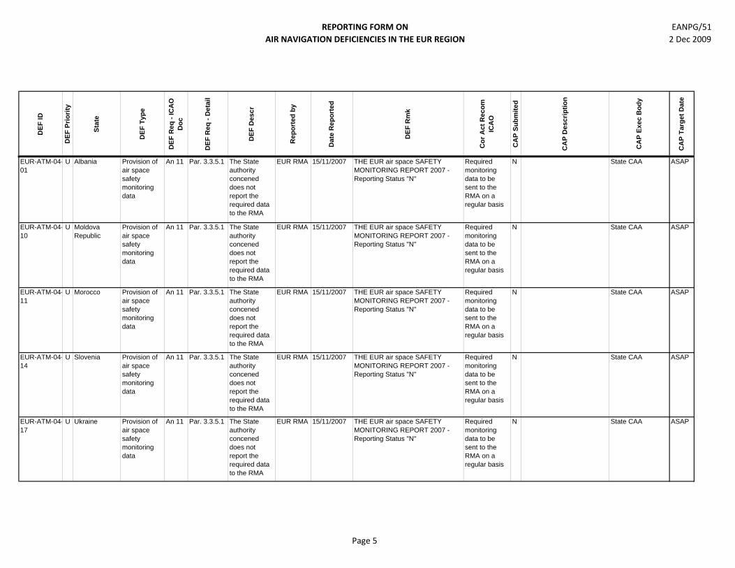
REPORTING FORM ON AIR NAVIGATION DEFICIENCIES IN THE EUR REGION
EANPG/51 2 Dec 2009
DEF
ID
DEF
Prio
rity
Stat
e
DEF
Typ
e
DEF
Req
- IC
AO
D
oc
DEF
Req
- D
etai
l
DEF
Des
cr
Rep
orte
d by
Dat
e R
epor
ted
DEF
Rm
k
Cor
Act
Rec
om
ICA
O
CA
P Su
bmite
d
CA
P D
escr
iptio
n
CA
P Ex
ec B
ody
CA
P Ta
rget
Dat
e
EUR-ATM-04-01
U Albania Provision of air space safety monitoring data
An 11 Par. 3.3.5.1 The State authority concened does not report the required data to the RMA
EUR RMA 15/11/2007 THE EUR air space SAFETY MONITORING REPORT 2007 - Reporting Status "N"
Required monitoring data to be sent to the RMA on a regular basis
N State CAA ASAP
EUR-ATM-04-10
U Moldova Republic
Provision of air space safety monitoring data
An 11 Par. 3.3.5.1 The State authority concened does not report the required data to the RMA
EUR RMA 15/11/2007 THE EUR air space SAFETY MONITORING REPORT 2007 - Reporting Status "N"
Required monitoring data to be sent to the RMA on a regular basis
N State CAA ASAP
EUR-ATM-04-11
U Morocco Provision of air space safety monitoring data
An 11 Par. 3.3.5.1 The State authority concened does not report the required data to the RMA
EUR RMA 15/11/2007 THE EUR air space SAFETY MONITORING REPORT 2007 - Reporting Status "N"
Required monitoring data to be sent to the RMA on a regular basis
N State CAA ASAP
EUR-ATM-04-14
U Slovenia Provision of air space safety monitoring data
An 11 Par. 3.3.5.1 The State authority concened does not report the required data to the RMA
EUR RMA 15/11/2007 THE EUR air space SAFETY MONITORING REPORT 2007 - Reporting Status "N"
Required monitoring data to be sent to the RMA on a regular basis
N State CAA ASAP
EUR-ATM-04-17
U Ukraine Provision of air space safety monitoring data
An 11 Par. 3.3.5.1 The State authority concened does not report the required data to the RMA
EUR RMA 15/11/2007 THE EUR air space SAFETY MONITORING REPORT 2007 - Reporting Status "N"
Required monitoring data to be sent to the RMA on a regular basis
N State CAA ASAP
Page 5

REPORTING FORM ON AIR NAVIGATION DEFICIENCIES IN THE EUR REGION
EANPG/51 2 Dec 2009
DEF
ID
DEF
Prio
rity
Stat
e
DEF
Typ
e
DEF
Req
- IC
AO
D
oc
DEF
Req
- D
etai
l
DEF
Des
cr
Rep
orte
d by
Dat
e R
epor
ted
DEF
Rm
k
Cor
Act
Rec
om
ICA
O
CA
P Su
bmite
d
CA
P D
escr
iptio
n
CA
P Ex
ec B
ody
CA
P Ta
rget
Dat
e
EUR-ATM-04-21
U Bulgaria Provision of air space safety monitoring data
An 11 Par. 3.3.5.1 The State authority concened does not report the required data to the RMA
EUR RMA 15/11/2007 THE EUR air space SAFETY MONITORING REPORT 2007 - Reporting Status "0" (applies to zero occurrence reports)
Required monitoring data to be sent to the RMA on a regular basis
N State CAA ASAP
EUR-ATM-04-26
U Hungary Provision of air space safety monitoring data
An 11 Par. 3.3.5.1 The State authority concened does not report the required data to the RMA
EUR RMA 15/11/2007 THE EUR air space SAFETY MONITORING REPORT 2007 - Reporting Status "0" (applies to zero occurrence reports)
Required monitoring data to be sent to the RMA on a regular basis
N State CAA ASAP
EUR-ATM-04-31
U Algeria Provision of air space safety monitoring data
An 11 Par. 3.3.5.1 The State authority concerned does not report the required data to the RMA
EUR RMA 12/10/2009 THE EUR air space SAFETY MONITORING REPORT 2007 - Reporting Status "0" (applies to zero occurrence reports)
Required monitoring data to be sent to the RMA on a regular basis
N State CAA ASAP
Page 6