Dunn, R. K. and Mazzullo, S. J., 1993, Holocene paleocoastal reconstruction and relationship to...
12
Maney Publishing Holocene Paleocoastal Reconstruction and Its Relationship to Marco Gonzalez, Ambergris Caye, Belize Author(s): Richard K. Dunn and S. J. Mazzullo Source: Journal of Field Archaeology, Vol. 20, No. 2 (Summer, 1993), pp. 121-131 Published by: Maney Publishing Stable URL: http://www.jstor.org/stable/529949 . Accessed: 18/09/2014 12:40 Your use of the JSTOR archive indicates your acceptance of the Terms & Conditions of Use, available at . http://www.jstor.org/page/info/about/policies/terms.jsp . JSTOR is a not-for-profit service that helps scholars, researchers, and students discover, use, and build upon a wide range of content in a trusted digital archive. We use information technology and tools to increase productivity and facilitate new forms of scholarship. For more information about JSTOR, please contact [email protected]. . Maney Publishing is collaborating with JSTOR to digitize, preserve and extend access to Journal of Field Archaeology. http://www.jstor.org This content downloaded from 192.149.109.224 on Thu, 18 Sep 2014 12:40:25 PM All use subject to JSTOR Terms and Conditions
Transcript of Dunn, R. K. and Mazzullo, S. J., 1993, Holocene paleocoastal reconstruction and relationship to...

Maney Publishing
Holocene Paleocoastal Reconstruction and Its Relationship to Marco Gonzalez, Ambergris Caye,BelizeAuthor(s): Richard K. Dunn and S. J. MazzulloSource: Journal of Field Archaeology, Vol. 20, No. 2 (Summer, 1993), pp. 121-131Published by: Maney PublishingStable URL: http://www.jstor.org/stable/529949 .
Accessed: 18/09/2014 12:40
Your use of the JSTOR archive indicates your acceptance of the Terms & Conditions of Use, available at .http://www.jstor.org/page/info/about/policies/terms.jsp
.JSTOR is a not-for-profit service that helps scholars, researchers, and students discover, use, and build upon a wide range ofcontent in a trusted digital archive. We use information technology and tools to increase productivity and facilitate new formsof scholarship. For more information about JSTOR, please contact [email protected].
.
Maney Publishing is collaborating with JSTOR to digitize, preserve and extend access to Journal of FieldArchaeology.
http://www.jstor.org
This content downloaded from 192.149.109.224 on Thu, 18 Sep 2014 12:40:25 PMAll use subject to JSTOR Terms and Conditions

121
Holocene Paleocoastal Reconstruction and its Relationship to Marco Gonzalez, Ambergris Caye, Belize
Richard K. Dunn S. J. Mazzullo Wichita State University Wichita, Kansas
Holocene stratigraphy on southern Ambergris Caye, Belize, records a sea-level rise over the last 6100 years, accompanied by major environmental changes and coastal reconfiguration that affected habitation at the Marco Gonzalez Maya site. At the time of initial occupation of the site at about 2100 B.P., sea level was about 30 cm below present stand, and the area was a relatively large, hospitable island surrounded by shallow lagoons open to the sea. Sea level reached present stand at about 1000 B.P., and by about 750-500 B.P. shoaling sedi- mentation and extensive colonization by mangroves had transformed the area into a dense swamp. Archaeological evidence suggests that population and construction decline, and virtual abandonment of the site by about the time of Spanish arrival in Belize about 1544 A. c., coincided with these adverse environmental changes. We suggest that sea-level rise and attendant environmental deterioration made the Marco Gonzalez site progressively more unsuitable for habitation, and forced the Maya to resettle to more favorable areas on Ambergris Caye.
Introduction Coastal sedimentological and environmental changes ac-
companying Holocene sea-level rise are documented around the world (Kraft 1971; Swift and Palmer 1978; DePratter and Howard 1981; Kraft and Belknap 1986; Nummedal, Pilkey, and Howard 1987; Parkinson 1989). Such changes are known to have influenced the locations of prehistoric coastal sites and commonly are reflected in the archaeological record (Shepard 1964; Kraft, Kayan, and Aschenbrenner, 1985; Bailey and Parkington 1988; Hoyt, Kraft, and Chrzastowski 1990).
Coastal sites of the precolumbian Maya civilization are common on offshore islands in lowland coastal Belize (Hammond 1982). Several archaeologically significant Maya sites are known on Ambergris Caye in northern Belize (FIG. 1A). Ambergris Caye is a large island whose Maya communities formed nodes in networks of trade that linked the coast to the mainland in varying degrees of economic intensity from at least the Early Classic to the early Colonial period (A.c. 250-1600) (Ester 1981; Guderjan 1988; Graham and Pendergast 1989). The site of Marco Gonzalez was one of these communities (FIGS. 1B, C), and it appears to have been continuously occupied from about 300 B.c. until the 16th century (Graham and Pendergast 1987, 1989; Pendergast and Graham 1987).
Holocene coastal sedimentary environments on Ambergris Caye, as well as throughout northern Belize, are known to have been modified greatly as a result of transgressive sedimentation; that is, marine onlapping of a previously exposed landmass accompanying Holocene sea-level rise over the last 6100 years (Ebanks 1975: 271; Pusey 1975: 214; Mazzullo and Reid 1987: 72; Dunn and Mazzullo 1989: 233; Mazzullo and Dunn 1990: 27). These events encompass Maya occupation at the Marco Gonzalez site. Recent archaeological studies have documented the pres- ence of artifacts in the subsurface, below present sea level, beneath recent mangrove swamp and Holocene deposits at many sites on Ambergris Caye (Guderjan 1988: 25; Graham and Pendergast 1987: 2, 1989: 1). Such occur- rences suggest site burial due to rising sea level and trans- gressive sedimentation. Despite such occurrences, how- ever, archaeologists have not yet related sea-level rise and accompanying coastal changes to the history of Maya oc- cupation in this area in other than a general manner (e.g., Graham and Pendergast 1989).
This study presents the results of detailed geologic in- vestigations of Holocene sediments and sedimentary en- vironments around the Marco Gonzalez site on southern Ambergris Caye. It documents the nature and extent of coastal changes in this area accompanying sea-level rise
This content downloaded from 192.149.109.224 on Thu, 18 Sep 2014 12:40:25 PMAll use subject to JSTOR Terms and Conditions
122 Paleocoastal Reconstruction and Marco Gonzalez/Dunn and Mazzullo
A
Ambergris B C
Beli Caye
EXPOSED PLEISTOCENE LIMESTONE
TRAVERSES
2 * CARIBBEAN SEA SOO -_,
5 km Boca Ciegav kmLeeward Lagoon
CC Washover _ _
CHETUMAL BAY - MARCO GONZALEZ (Inner Shelf)
.._.- - • SITE
" San
Pedro Pedro San Pedro WindwardBeach
Lagoon Town a & Washover
Intra-island B
STUDY AREA ':ayoon & swamp Q) 875 m
OUTER SHELF
SExposed " Pleistocene limestone
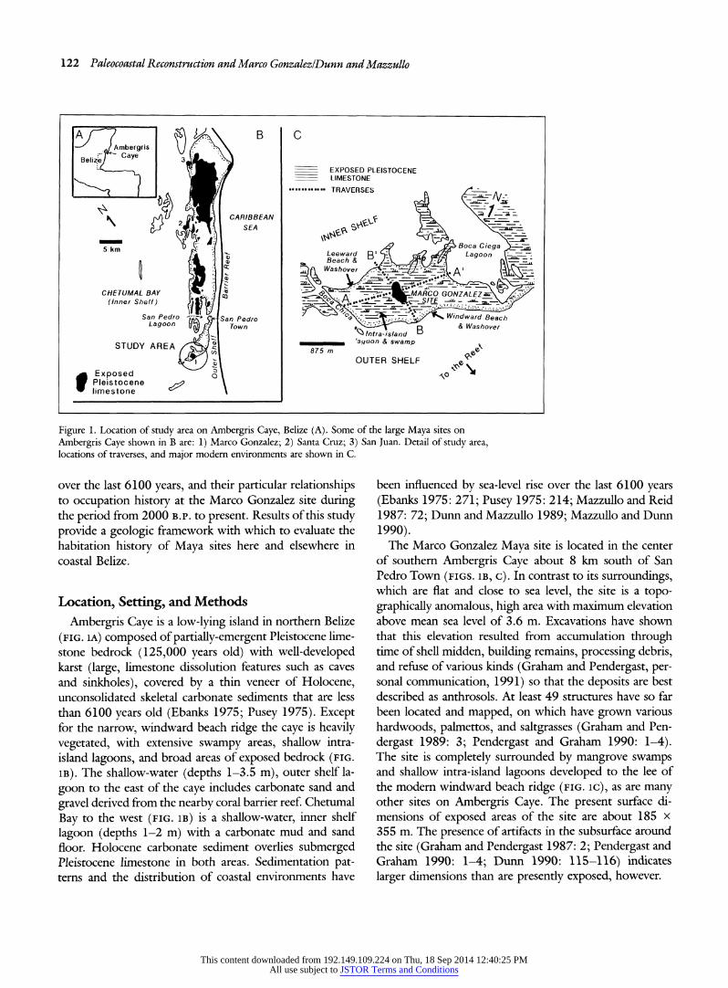
Figure 1. Location of study area on Ambergris Caye, Belize (A). Some of the large Maya sites on
Ambergris Caye shown in B are: 1) Marco Gonzalez; 2) Santa Cruz; 3) San Juan. Detail of study area, locations of traverses, and major modern environments are shown in C.
over the last 6100 years, and their particular relationships to occupation history at the Marco Gonzalez site during the period from 2000 B.P. to present. Results of this study provide a geologic framework with which to evaluate the habitation history of Maya sites here and elsewhere in coastal Belize.
Location, Setting, and Methods
Ambergris Caye is a low-lying island in northern Belize
(FIG. 1A) composed of partially-emergent Pleistocene lime- stone bedrock (125,000 years old) with well-developed karst (large, limestone dissolution features such as caves and sinkholes), covered by a thin veneer of Holocene, unconsolidated skeletal carbonate sediments that are less than 6100 years old (Ebanks 1975; Pusey 1975). Except for the narrow, windward beach ridge the caye is heavily vegetated, with extensive swampy areas, shallow intra- island lagoons, and broad areas of exposed bedrock (FIG. 1B). The shallow-water (depths 1-3.5 m), outer shelf la-
goon to the east of the caye includes carbonate sand and
gravel derived from the nearby coral barrier reef. Chetumal
Bay to the west (FIG. 1B) is a shallow-water, inner shelf
lagoon (depths 1-2 m) with a carbonate mud and sand floor. Holocene carbonate sediment overlies submerged Pleistocene limestone in both areas. Sedimentation pat- terns and the distribution of coastal environments have
been influenced by sea-level rise over the last 6100 years (Ebanks 1975: 271; Pusey 1975: 214; Mazzullo and Reid 1987: 72; Dunn and Mazzullo 1989; Mazzullo and Dunn
1990). The Marco Gonzalez Maya site is located in the center
of southern Ambergris Caye about 8 km south of San Pedro Town (FIGS. 1B, C). In contrast to its surroundings, which are flat and close to sea level, the site is a topo- graphically anomalous, high area with maximum elevation above mean sea level of 3.6 m. Excavations have shown that this elevation resulted from accumulation through time of shell midden, building remains, processing debris, and refuse of various kinds (Graham and Pendergast, per- sonal communication, 1991) so that the deposits are best described as anthrosols. At least 49 structures have so far been located and mapped, on which have grown various hardwoods, palmettos, and saltgrasses (Graham and Pen-
dergast 1989: 3; Pendergast and Graham 1990: 1-4). The site is completely surrounded by mangrove swamps and shallow intra-island lagoons developed to the lee of the modern windward beach ridge (FIG. IC), as are many other sites on Ambergris Caye. The present surface di- mensions of exposed areas of the site are about 185 x 355 m. The presence of artifacts in the subsurface around the site (Graham and Pendergast 1987: 2; Pendergast and Graham 1990: 1-4; Dunn 1990: 115-116) indicates
larger dimensions than are presently exposed, however.
This content downloaded from 192.149.109.224 on Thu, 18 Sep 2014 12:40:25 PMAll use subject to JSTOR Terms and Conditions

Journal of Field Archaeology/Vol. 20, 1993 123
For the purposes of this study we made two traverses across southern Ambergris Caye and the Marco Gonzalez site (FIG. IC), taking care not to disturb archaeological stratigraphy on the site proper. Thickness of Holocene sediment and depth to Pleistocene limestone bedrock be- low mean sea level were measured at closely-spaced points along these traverses by means of probing with steel "re- bars" (reinforcement bars). Similar data were obtained at more than 100 additional onshore and offshore locations in the study area (details in Dunn 1990). Twenty-six cores of the Holocene, unconsolidated sediment section above the Pleistocene limestone were collected from throughout the study area, mostly along the traverses. Cores were obtained with a 7.6 cm diameter, 1.5 m length of PVC
(polyvinylchloride) pipe within which was a rigid plastic liner that was split along its length. The core barrel was
pushed into the sediment, the top capped to provide suc- tion, and the barrel removed. The inner liner was removed and opened to expose the recovered core. Representative grab samples of unconsolidated sediments from surround-
ing marine environments also were collected. In the lab-
oratory the grain size distributions of the sediment sam-
ples were determined by wet-sieving, and sediment textures were classified. Biotic compositions of all sedi- ment size fractions except for carbonate mud (less than 62 microns) were determined by point-counting; these data, summarized in the following discussions, are tabu- lated in Dunn (1990). Eight carbonate sediment samples from selected cores were dated by the radiocarbon method by Geochron Laboratories in Cambridge, Massachusetts.
Holocene Sedimentary Framework
Pleistocene Topography and Sea Level History The areal distribution of modern and older (buried)
Holocene deposits in the study area is influenced by two inter-related factors: underlying bedrock topography, and sea-level rise during the Holocene. The Pleistocene bed- rock in northern Belize is an irregular karst-dissolution terrane characterized by topographic ridges, sinkholes, and
dissolution-enlarged joints and fractures. Ambergris Caye is located on and immediately next to a prominent NE-
trending bedrock ridge (FIG. 1B), and many of the larger intra-island lagoons on the caye, including Boca Ciega Lagoon, are drowned sinkholes. The Marco Gonzalez site is on a shallow, submerged, topographically high area of the Pleistocene limestone, away from which the limestone bedrock plunges deeper into the subsurface, particularly on the windward side of Ambergris Caye (FIG. 2A). Two low-relief, exposed Pleistocene bedrock ridges lie due
north of, and now are separated by swamps from, the Marco Gonzalez site (FIGS. IC, 2A). The surface of the ridge nearest to the site is littered with Maya artifacts. The Holocene section is relatively thin to absent on and to the west of the Marco Gonzalez site, respectively (FIG. 2B). Sediment thickness increases into Boca Ciega Lagoon and in a topographic low beneath and adjoining the modern beach ridge (FIG. 2B).
The sea level curve in Figure 3 is specific to offshore northern Belize. Its slope is similar to curves constructed for other areas of the Caribbean and western Atlantic (Shepard 1964; Scholl, Craighead, and Stuiver 1969; Neuman 1971; Lighty, Macintyre, and Stuckenrath 1982; Parkinson 1989). Initial transgression (inundation by ma- rine waters) of the northern Belize shelf occurred about 6100 years B.P. (Pusey 1975: 217). With continuing sea- level rise, present sea level stand was reached about 1000 years B.P. (Mazzullo and Reid 1987: 72). From 6100 B.P. to about 3000 B.P., the rate of sea-level rise here was about 13.5 cm/100 years. From 3000 B.P. to 1000 B.P. the rate of rise decreased to about 2.5 cm/100 years (FIG. 3). Such deceleration in the rate of sea level rise is also noted in other areas of the world (e.g., references cited above; Bloom 1983).
Modern Environments
Eight principal modern sedimentary environments are recognized by Ebanks (1975), Pusey (1975), and Maz- zullo and Reid (1987) in offshore and coastal northern Belize on the basis of sediment textures and particle com- position (TABLE i). The distribution of these environments in the study area is shown in Figure 1C. The modern reef, outer shelf, and windward beach and beach-washover en- vironments are of normal marine salinity (38 parts per thousand TDS, or total dissolved solids) and relatively high wave and current energy. Component sediment par- ticles characteristically consist of coarse, well winnowed (size-sorted), reef-derived skeletal sand and gravelly sand with high biotic diversity (TABLE 1). In contrast, all other modern environments around and on Ambergris Caye are of restricted marine aspect in that they are characterized by fluctuating salinities (19-41 parts per thousand TDS, depending on season) and low to moderate wave and current energy. Component skeletal particles are derived mostly from the inner shelf lagoon (Chetumal Bay) rather than from the barrier reef. Biotic diversity is low, and sediments typically are fine grained, poorly sorted, organic-rich mud and sandy mud, with local sandy and gravelly, leeward beach deposits and mangrove peat (TABLE 1).
This content downloaded from 192.149.109.224 on Thu, 18 Sep 2014 12:40:25 PMAll use subject to JSTOR Terms and Conditions

124 Paleocoastal Reconstruction and Marco Gonzalez/Dunn and Mazzullo
-180
BOCA CIEGA LAGOON
-260 Cl: 40 cm -260
875 m EXPOSED PLEISTOCENE LIMESTONE
MARCO GONZALEZ SITE
60B
20 ""•'"
w BOCA CIEGA
60
Cl" 40 cm
875 m
Figure 2. Topography on top of Pleistocene limestone below (negative numbers) and above (positive numbers) present mean sea level (A); thickness of Holocene sediment (B).
Older Holocene Environments The three-dimensional architecture of modern and older
Holocene sedimentary environments in the study area is shown in Figure 4. Subsurface Holocene deposits are sim- ilar lithologically, and in terms of contained biota, to mod- ern surficial deposits (TABLE i). Hence, they represent analogous depositional environments. Comparison of tex- tures and biotic compositions of modern and older, buried Holocene deposits provides the basis for the recognition of specific older environments and interpretation of coastal
sedimentologic changes through time in the study area (FIG. 5).
Coarse, gravelly sand dominated by molluscs and soritid
foraminifera, and sand composed mainly of soritids, occur in the subsurface on the leeside of the caye and along the shore of Boca Ciega Lagoon. They are interpreted as basal
transgressive lag (the initial deposits associated with sea- level rise) and associated nearshore marine, beach, and beach-washover deposits, respectively (FIG. 4). Sand and
gravelly sand dominated by coral and algal (mostly Hali-
This content downloaded from 192.149.109.224 on Thu, 18 Sep 2014 12:40:25 PMAll use subject to JSTOR Terms and Conditions

Journal of Field Archaeology/Vol. 20, 1993 125
_IC~o -?------ o m
-1.0
-2.0 r-
0 e--
A PERITIDAL DOLOMITE CRUSTS, -30 TOMAS SAVANNAH, AMBERGRIS CAY m
m O MANGROVE PEATS: -4.0
-1- Northern River Lagoon 2- Tomas Savannah 0
- 4
6000 5000 4000 3000 2000 1000 0 RADIOCARBON YEARS B.P.
Figure 3. Sea level curve for northern Belize during the last 6100 years (modified from Mazzullo and Reid 1987), based on radiocarbon dates of buried mangrove peats, and shallow- buried peritidal dolomite crusts.
meda) fragments occur in the subsurface on the windward side of the caye and along the northern shore of Boca Chica Channel. They are interpreted as outer shelf, basal
transgressive lag, beach, and beach-washover deposits. Or-
ganic-rich mud and sandy mud occur as lagoonal deposits in Boca Ciega and as local tidal channel deposits in Boca Chica. Muddy sand and sandy mud interpreted as shallow, intra-island lagoonal deposits are recognized throughout
the subsurface in the study area, and are mostly overlain
by mangrove swamp deposits which completely surround the Marco Gonzalez site (FIG. 4). Lagoonal facies generally are dominated by coral and algal fragments on the wind- ward side of the caye, and by soritid-miliolid-molluscan
fragments on the leeward side, although Halimeda frag- ments are common in both settings.
Evolution of Southern Ambergris Caye The oldest Holocene sediments deposited on the Pleis-
tocene limestone on the caye are at a subsea depth of 1.5 to 2.0 m (FIG. 4). According to the sea level curve (FIG. 3), the onset of deposition here should have occurred at about 4300-3800 B.P. Unfortunately, we were unable to verify this because of the lack of samples from these depths that were suitable for radiocarbon dating. The sediment sample that is dated at 20,850 years was deposited directly on the Pleistocene limestone which, at the sampling site, is 1.2 m below present sea level (FIG. 4B). This date is much too old to represent initial marine inundation here.
The oldest sediment samples on the caye that were radiocarbon dated, from basal transgressive lag deposits at 1.2 to 1.3 m below present sea level, are 2860 ? 75 B.P.
and 2860 + 80 B.P. (FIG. 4). According to the sea level curve (FIG. 3), deposition at this depth should actually
Table 1. Summary of characteristics of surficial Holocene sedimentary environments. Environment Characteristics Principal sediment textures Component particle types 1. Reef Normal salinity, Carbonate sands and Corals (Montastrea annularis, M. cavernosa, 2. Outer shelf open-marine, gravels derived from Diploria, Acropora palmata, A. cervicornis, 3. Windward beach high energy the reef and outer Millepora, Manicina, Porites, Agaricia),
and washover shelf calcareous algae (Lithothamnion, Neogonolithon, Amphiroa, Halimeda, Penicillus), foraminifera (abundant Homotrema rubrum and lesser soritids, peneroplids, miliolids), gastropods (i.e., Strombus gigas, Busycon), and various pelecypods
4. Leeward beach and Fluctuating salinity, Carbonate sands and Gastropods (dominated by cerithids and washover, and variable energy gravels derived from batallarids, accessory horse conch), adjoining shallow (low to the inner shelf pelecypods (notably Chione cancellata), near-shore (and moderate) region and soritid (Archaias angulatus), basal transgressive peneroplid (Peneroplis), and miliolid lag) foraminifera (i.e., Quinqueloculina,
Triloculina, Heterellina, etc.) 5. Foraminiferal shoal Fluctuating salinity, Carbonate sands; some Dominated by soritid foraminifera (Archaias
variable energy muddy sands angulatus), some peneroplid and miliolid (low to foraminifera (as above) and Chione moderate) cancellata
6. Inner shelf lagoon Fluctuating salinity, Carbonate muds, Dominated by soritid, peneroplid, and of Chetumal Bay low energy sandy muds, and miliolid foraminifera (as above), Chione
muddy sands cancellata, ostracodes, and micritized skeletal grains (peloids)
7. Intra island lagoons
8. Mangrove swamp Peat Debris from red mangrove (Rhizophora mangle), black mangrove (Avicennia nitida), and associated flora
This content downloaded from 192.149.109.224 on Thu, 18 Sep 2014 12:40:25 PMAll use subject to JSTOR Terms and Conditions

126 Paleocoastal Reconstruction and Marco Gonzalez/Dunn and Mazzullo
A A' MARCO GONZALEZ
A
S MSL
o 2000 0 00 ? • 300020 380 0 +. '0?I.?:
5 0
?.... -4 8 40 + 16 1. m>
VE 200x
B MS ___
_?? Ii ?? B'
300..i3000:: .1 -,]24 .:;
.2--LAG_
....V3 ....... BASAL G E
O1.0 ..tr. sef ba an LR
beacIw e sn c
000 Lesd offshore,
beach:
Mangrove
peat*:Buried
artifacts
MSL .........: ?
2000: : ....
oo, and beach-washover sands -nchrelm
ngrov peat
& basal transgressive lagAnhol
.......... W. *0L..;.
Intra-island lagoonal sandy ...... muds, muddy sands
........ ......
.........l
" Peistocene Limestone
100<Anthoso
& asl rasgesiv lg 'Y
Inr-sadlgoa ad mudsmuddysand
Figure 4. NE-SW (AA') and E-w (BB') cross-sections showing Holocene environments in study area
(locations shown in FIGS. iC and sc), with position of sea level stands at 2000, 3000, and 3800 B.P.; sea level reached present stand about 1000 B.P. Subsurface occurrence of artifacts in carbonate sedi-
ments shown; by definition, anthrosol also contains artifacts.
have started about 3700 B.P. The discrepancy between most of the radiocarbon ages from sediment samples in the study area (FIG. 4) and the sea level curve result from:
1) incorporation of younger sediments into older deposits as a result of bioturbation by roots, burrowing organisms, and, likely, human activities; and 2) incorporation of older sediments into younger deposits due to repeated erosion and redeposition of sediments (Ebanks 1975; Pusey 1975; Mazzullo and Reid 1987) as well as contamination with Pleistocene limestone fragments. For these reasons, radio- carbon dating of carbonate samples is much less reliable than dating of peat samples.
The sea level curve in Figure 3 is based largely on buried
peat samples from presumably undisturbed marine areas around northern Belize. Hence, these samples probably provide reliable dates for earlier sea levels. Undisturbed, buried peats were not available in the study area for ra- diocarbon dating. The possibility of minor subsidence, which could account for these age discrepancies, is con- sidered unlikely because several studies (Dillon and Ved- der 1973; Holcombe and Sharman 1983; Bonini, Har-
graves, and Shagam 1984) have indicated that the Yucatan Platform, including the northern Belize shelf, has not been affected by tectonism during the late Holocene.
This content downloaded from 192.149.109.224 on Thu, 18 Sep 2014 12:40:25 PMAll use subject to JSTOR Terms and Conditions

Journal of FieldArchaeology/Vol. 20, 1993 127
Thus Guderjan's (1988: 25) suggestion, for example, that the occurrence of archaeological sites below sea level on Ambergris Caye is due to subsidence is considered to be totally inaccurate; drowning of sites was solely the result of Holocene sea-level rise. The following discussions of sea level rise and sedimentation therefore rely on the data presented in Figures 2A and 3 rather than on the radio- carbon ages of samples collected in the study area.
Deposition on southern Ambergris Caye likely began about 4300-3800 B.P. Prior to that time the area was
exposed as land, and the Pleistocene bedrock limestone was extensively karsted as a result of limestone dissolution by rain and underground freshwater. At 3800 B.P. sea level was about 1.5 m below its present stand, and the study area was a relatively large, limestone bedrock island surrounded by a sandy and gravelly beach (FIG. 5A). This island adjoined a shallow (ca. 30 cm) and sandy, intra- island lagoonal shelf separated from the main part of Am-
bergris Caye to the NE by Boca Ciega Lagoon. Open circulation with the outer shelf through a low and discon- tinuous windward beach ridge is suggested by the pres- ence in subsurface lagoonal sediments of skeletal particles derived from the outer shelf. Boca Chica was a deep (ca. 2.5 m) tidal channel at this time.
By 2000 B.P. sea level had risen to 30 cm below present stand, but the area remained separated physically from
Ambergris Caye (FIG. 5B). The former island had been inundated by marine waters, forming two smaller, bedrock islands surrounded by narrow, sandy beaches and a shal- low, intra-island lagoon with a floor of muddy sands. The presence of Halimeda and coral fragments in these sedi- ments suggests that the windward beach ridge was still low and discontinuous, and afforded exchange of waters on the interior of the caye with open marine waters on the outer shelf. The earliest occupation remains thus far recovered at the Marco Gonzalez site date from this time (Graham and Pendergast 1987: 2, 1989: 1; Pendergast and Graham 1990: 1-4).
As sea level slowly reached its present stand between 2000 and 1000 years B.P., muddy sand deposited in the
intra-island lagoon began to build up to sea level, trans- gress onto, and partially bury the occupied site. The sub- surface presence of anthrosol and artifacts around the pres- ent site (shown in FIG. 4) is clear evidence of such transgression, and the greater extent of the site than at the present time (compare FIGS. 5B and sc; also noted by Graham and Pendergast 1989: 1). At 1000 B.P. the area around the Marco Gonzalez site was still an island sur- rounded by shallow, intra-island lagoons and isolated from mainland Ambergris Caye (FIG. 5C). As indicated by the relative abundance of sediments derived from the barrier reef and outer shelf (e.g., coral fragments and Halimeda),
A A :(-J . . . 3800 BP
Sea level -1.5 m << .
Boca leg
-ouT .sE?F 875 m
B
2000 BP Sea level -30 cm
!5-- -
-It
jsr -
875 m
1000-500 BP -. Present sea o~
.n level and uth
T ,. '
. . . .
" .
~- -
.. :..........
LAgoon
.". ...
875 m
\ Exposed Pleistocene 4 Tidal channels limestone (island) Marco Gonzalez Beach, washover, and site nearshore sands
s-:.
Inner-shelf and intra-island of southern
,',. lagoonal sandy muds, muddy Ambergris Caye sands Locations of
--•- Mangrove swamp cross sections MAA', BB'
Figure 5. Evolution of southern Ambergris Caye since 3800 B.P. The large arrow in C indicates direction of lateral encroachment of man- grove swamps through time; also shown are locations of cross sections AA' and BB' of Figure 4. The likely greatest extent of Maya occupa- tion includes the present Marco Gonzalez site and the sandy beach area around it (shown in B).
This content downloaded from 192.149.109.224 on Thu, 18 Sep 2014 12:40:25 PMAll use subject to JSTOR Terms and Conditions

128 Paleocoastal Reconstruction and Marco Gonzalez/Dunn and Mazzullo
SITE ABANDONMENT 500 1500
zt STATIC SEA LEVEL
1200 APOGEE LAGOONAL INFILLING & ISOLATION -1200 -
(c BEHIND WINDWARD BEACH 0
oo 1000 900
INTENSIVE SALT PROCESSING
-600 C(
1500 <
o Z 300
0 q
A.C. ,. 2000 0
B.C. o B.C. INITIAL OCCUPATION
0 o
RELATIVE OCCUPATION & 300 w c CONSTRUCTION INTENSITY
2500
600
3000
Figure 6. Archaeological history of Maya occupation at Marco Gon- zalez (from Graham and Pendergast 1989) and relationship to sea level
history and coastal evolution.
the lagoons still had a considerable degree of water ex-
change with the outer shelf, likely through narrow tidal channels along the beach (FIG. 5C). The expansion of man-
grove swamps had resulted in partial connection of the southern shore of Boca Ciega Lagoon to Ambergris Caye, although a narrow channel separating these two areas continued to exist until perhaps near-recent time.
By about 750-500 B.P. mangrove swamps began to surround the site as they extended laterally from NE to SW across southern Ambergris Caye (FIG. 5C). Such infilling likely coincided with the development of a continuous and
relatively high windward beach ridge that effectively iso- lated the intra-island lagoon from the outer shelf. Rapid expansion of mangrove swamp environments in such set-
tings is a common process of lagoonal infilling, especially during decelerating phases of sea-level rise (Parkinson 1989). Most of the sediment deposited in the study area at this time was derived from the inner shelf rather than from the outer shelf. Nearly complete connection of the site to the main part of Ambergris Caye, and establishment of inhospitable swampy environmental conditions like those of today (FIG. IC), probably occurred by about 500 B.P. Progressive infilling and colonization of restricted shallow intra-island lagoons by mangroves continue today along the southernmost tip of Ambergris Caye.
Coastal Changes and Human Habitation at Marco Gonzalez
The history of occupation of the Marco Gonzalez site
(FIG. 6) spans the period from Maya Late Preclassic to at least the end of the Postclassic, ca. 100 B.C. to 1544 A.C. or later (Graham and Pendergast 1987, 1989; Pendergast and Graham 1990). The first occupants took advantage of the favorable environmental conditions and probably also capitalized on the ready accessibility of the site to maritime trading routes via the shallow waters on the Chetumal Bay side (ca. 50-70 cm deep) and the deep (3.7 m) Boca Chica Channel. Throughout its history the site was a base for the exploitation of marine resources. From the 11th and 12th centuries and, possibly, as early as the 10th century, the range of artifacts from burials as well as the extent of construction suggest that the local
economy was boosted as a result of the involvement of the community in trade activities (Graham and Pendergast 1989; Pendergast and Graham 1990). Sometime between ca. 600 and 900 A.C. the site was a base for intensive
processing activity, probably saltworking (Graham and
Pendergast 1989: 6-7). In terms of its population and construction activity, its apogee appears to have been be- tween about 1100 and 1300 A.C. (600-800 B.P.), at which time the site was still a fairly open, ocean island
(FIG. 5C). Construction at the site involved the use of massive
quantities of marine shells and quarried blocks of Pleis- tocene limestone, the latter composed of rock types similar to those found immediately north of the site, on and around Ambergris Caye. We have not identified any areas on Ambergris Caye proper that appear to have been used as quarries by the Maya. It is possible, however, that several of the small "cenotes" (rock-cut pits) that exist around the site (e.g., Graham and Pendergast 1989: 5, fig. 4) may be limestone quarries that subsequently were inundated by Holocene sea-level rise and obscured by mangrove swamp. Today, local inhabitants of San Pedro Town remove limestone blocks for construction purposes from underwater (less than 1 m depths) quarries in San Pedro Lagoon (FIG. 1B). The Maya may have done like- wise.
Throughout the early history of habitation, perhaps at least up until 1000 B.P., burial of occupation areas beneath encroaching sediments deposited by slowly rising sea level (FIGS. 4, 5C) was a factor that argues for shifting settlement to higher ground on an island of continually shrinking dimensions.
Archaeological evidence suggests a sharp decline in pop- ulation and construction activity in the period 1300-
This content downloaded from 192.149.109.224 on Thu, 18 Sep 2014 12:40:25 PMAll use subject to JSTOR Terms and Conditions

Journal of Field ArchaeologylVol. 20, 1993 129
BARRIER REEF DRIVE
San Pedro Lagoon
SAN PEDRO TOWN
. ?3
1 SURFACE ANTHROSOL LAYER (ROSALITA SITE) 2 PIT AT PARADISE HOTEL
1.2 m 3 PIT AT SPINDRIFT HOTEL West
BURROW E,
OFFSHORE SA NSD
tIIIIIANTHROSOL
pPLEISTOCENE LIMESTONE -
WWW European artifacts OConch shell 750 BP ** Level of Maya artifacts
Figure 7. Composite schematic of older Holocene beach sands, the top surface of which is defined by a Maya artifact horizon (former excavation immediately north of Paradise Hotel) that is traced updip to surface exposures of anthrosol layer; associated conch shell dated by '4C at 750 B.P. Overlain by modern beach sands (section from Spindrift Hotel), the base of which contain European artifacts of the 18th or 19th century. Approximately 40 m of seaward shift of modem beach sands relative to older beach sands indicated.
1450 A.c. (500-650 B.P.), and virtual abandonment of the site by the time of Spanish arrival in Belize at about 1544 (Graham and Pendergast 1989: 1; Pendergast and Graham 1990: 1-4). Population decline and ensuing abandonment at Marco Gonzalez coincided with connec- tion of the area to mainland Ambergris Caye, restriction and rapid infilling of the intra-island lagoon, and expan- sion of mangrove swamps around the site (FIGS. 5C, 6). Evidence of middens and artifacts along the northern shore of Boca Chica Channel, southern Boca Ciega La- goon, and the bedrock ridge immediately north of the site (FIG. 5C) suggests that these areas were utilized as Marco Gonzalez became surrounded by swamps. Unfortunately, artifacts so far recovered from these areas are too worn for secure dating. Available evidence raises the possibility of some resettlement to the present site of San Pedro Town by about 1400 A.c., as environmental conditions worsened at Marco Gonzalez, where a community existed
since Classic times (David M. Pendergast, personal com- munication).
Other Evidence Relating Coastal Change and Habitation
On Ambergris Caye the relationships among Maya hab- itation, environmental change, and coastal modification are not unique to the Marco Gonzalez site. We have in fact found many small, probably temporary, habitation sites on and around Ambergris Caye that are either buried beneath younger sediment or which are now below sea level. Archaeologists have identified at least 17 large coastal Maya sites on Ambergris Caye, many of which also show evidence of subsequent burial beneath Holocene deposits (Guderjan 1988) both before and after sea level attained its present stand.
Figure 7, for example, illustrates the Holocene strati- graphic section compiled from two old foundation pits
This content downloaded from 192.149.109.224 on Thu, 18 Sep 2014 12:40:25 PMAll use subject to JSTOR Terms and Conditions

130 Paleocoastal Reconstruction and Marco Gonzalez/Dunn and Mazzullo
(now the sites of buildings) in San Pedro Town. In the center of town, at a locality referred to as the "Rosalita site," we traced a surface anthrosol layer, which contains abundant Maya artifacts, in a seaward direction to a pit due north of Paradise Hotel, where it was found to be beneath approximately 1 m of modern beach ridge sedi- ments. Here, the modern beach ridge had extended lat-
erally a distance of about 40 m seaward of the older beach
ridge (FIG. 7). Radiocarbon dating of an associated, min-
eralogically unaltered conch shell (Strombusgigas) suggests an age of 750 B.P. or younger for this horizon. The surface anthrosol horizon at the Rosalita site was partially exca- vated in 1991 by Pendergast and Graham (1991). The ceramics recovered from here indicate occupation from about 500 to 1300 A.C. (Pendergast and Graham 1991).
Directly above this older beach surface, in a pit at the
present site of the Spindrift Hotel, European artifacts with a probable 18th or 19th-century date are present at the base of the overlying 1 m-thick, modern beach sand sec- tion. These relationships indicate that vertical buildup of sediment and the burial beneath modern beach sands of the older, inhabited beach surface may have occurred even in the last 750 years, during a time of relative sea-level stillstand. The degree of burial of artifact-bearing horizons therefore provides a direct method of determining the amount of local vertical sediment buildup and lateral ex- tension of Holocene deposits in the last several hundred
years.
Conclusions The area around the Marco Gonzalez site was an island
surrounded by shallow intra-island lagoons open to cir- culation exchange with the sea from about 4000- 1000 B.P., but was slowly being drowned by rising sea level during this time. Initial Maya occupation of the island seems to have occurred about 2100 B.P., when sea level was 30 cm below present stand, and the site flour- ished economically and in terms of population over the
ensuing 1450 years. The decline of the site as a trading and habitation settlement coincided with a rapid change from an open, ocean island environment to a mangrove swamp about 750-500 B.P. Such environmental deterio- ration probably resulted in population resettlement to more hospitable areas on Ambergris Caye. Similar envi- ronmental changes likely affected many coastal Maya set- tlements in lowland Belize, and the record of such changes accompanying sea-level rise and subsequent coastal mod- ifications during sea level stillstand can be clearly docu- mented in the Holocene stratigraphic section.
Acknowledgments This study is based on a thesis by R. K. Dunn at Wichita
State University under the supervision of Mazzullo. Fund-
ing for Dunn was provided by grants from the Wichita State University Delano Maggard Graduate Student Loan
Program, the Geological Society of America, American Association of Petroleum Geologists, and A. M. Reid and S. T. Reid, Midland, Texas. Geochron Laboratories, a division of Krueger Enterprises Inc., provided eight free radiocarbon dates. These sources are gratefully acknowl-
edged. Field assistance was provided by W. D. Bischoff, J. C. Gries, J. N. Gundersen, C. D. Burke, A. M. Reid, R. L. Woods, T. H. Wiedemeier, Tomas Paz, and Elmer Paz. We thank Elizabeth Graham, David Pendergast, Rip Rapp, and an anonymous reviewer for their reviews of this manuscript. Elizabeth Graham and David Pendergast kindly provided us some new information regarding hab- itation at Marco Gonzalez and elsewhere on Ambergris Caye, information that has been incorporated into this
paper.
Richard K. Dunn is currently engaged in studying coastal evolution and in geoarchaeological research for his Ph.D. dis- sertation in the Department of Geology, University ofDela- ware, Newark, Delaware 19716.
S. J. Mazzullo is Professor of Geology, Wichita State Uni- versity, Wichita, Kansas 67208. Hisfields of research interest include coastal sedimentology and diagenesis in tropical ma- rine environments, and relationship ofHolocene sea level changes to Maya geoarchaeology in Belize.
Bailey, G., and J. Parkington, eds. 1988 The Archaeology of Prehistoric Coastlines. New York: Cam-
bridge University Press.
Bloom, Arthur L. 1983 "Sea Level and Coastal Changes," in H. E. Wright, ed.,
Late Quaternary Environments of the United States, Vol. 2, The Holocene. Minneapolis: University of Minnesota Press, 42-51.
Bonini, W. E., R. B. Hargraves, and R. Shagam, eds. 1984 The Caribbean-South American Plate Boundary and Re-
gional Tectonics. Geological Society ofAmerica Memoir 162. Boulder, CO.
DePratter, C. B., and James D. Howard 1981 "Evidence for a Sea Level Lowstand Between 4500 and
2400 Years B.P. on the Southeast Coast of the United States," Journal of Sedimentary Petrology 51: 1287-1295.
Dillon, W. P., and J. G. Vedder 1973 "Structure and Development of the Continental Margin
of British Honduras," Geological Society ofAmerica Bulletin 84: 2713-2732.
This content downloaded from 192.149.109.224 on Thu, 18 Sep 2014 12:40:25 PMAll use subject to JSTOR Terms and Conditions

Journal of Field Archaeology/Vol. 20, 1993 131
Dunn, Richard K. 1990 "Holocene Paleocoastal Reconstruction of Southern Am-
bergris Cay, Belize: and Archaeological Geology of the Marco Gonzalez Maya Site," unpublished M.S. thesis, Wichita State University, Wichita, Kansas.
Dunn, Richard K., and S. J. Mazzullo 1989 "Coastal Evolution and Relationship to Classic and Post-
Classic Mayan Occupation: Marco Gonzalez Site, Am- bergris Cay, Belize," Geological Society ofAmerica Annual Meeting, Abstracts with Program 21: 233.
Ebanks, William J. 1975 "Holocene Carbonate Sedimentation and Diagenesis,
Ambergris Cay, Belize," in Kenneth F. Wantland and Walter C. Pusey, eds., Belize Shelf-Carbonate Sediments, Clastic Sediments and Ecology. American Association of Pe- troleum Geologists Studies in Geology No. 2. Tulsa, 234- 296.
Ester, M. 1981 "The Cayes of Belize: An Archaeological Resource," Be-
lizean Studies 9: 10-17.
Graham, Elizabeth, and David M. Pendergast 1987 "Cays to the Kingdom," Archaeological Newsletter of the
Royal Ontario Museum, II, 18: 1-4.
1989 "Excavations at the Marco Gonzalez Site, Ambergris Cay, Belize, 1986,"Journal of Field Archaeology 16: 1-16.
Guderjan, Thomas H. 1988 "Maya Maritime Trade at San Juan, Ambergris Cay, Be-
lize," unpublished Ph.D. dissertation, Southern Meth- odist University, Dallas, Texas.
Hammond, Norman 1982 Ancient Mayan Civilization. New Brunswick, NJ: Rutgers
University Press.
Holcombe, T. L., and G. E. Sharman 1983 "Post-Miocene Cayman Trough Evolution: A Specula-
tive Model," Geology 11: 714-717.
Hoyt, W. H., John C. Kraft, and M. J. Chrzastowski 1990 "Prospectives for Submerged Archaeological Sites on the
Continental Shelf, Southern Mid-Atlantic Bight of North America," in N. P. Lasca and J. Donahue, eds., Archae- ological Geology of North America. Geological Society of America DNAG (Decade of North American Geology) Cen- tennial Special Volume 4. Boulder, CO, 147-160.
Kraft, John C. 1971 "Sedimentary Facies Patterns and Geologic History of a
Holocene Marine Transgression," Geological Society of America Bulletin 82: 2131-2158.
Kraft, John C., and Donald F. Belknap 1986 "Holocene Epoch Coastal Geomorphologies Based on
Local Relative Sea-level Data and Stratigraphic Interpre- tations of Paralic Sediments," Journal of Coastal Research 2: 53-59.
Kraft, John C., Ilhan Kayan, and Stanley E. Aschenbrenner 1985 "Geological Studies of Coastal Change Applied to Ar-
chaeological Settings," in G. Rapp and J. A. Gifford, eds., Archaeological Geology. New Haven: Yale University Press, 1-435.
Lighty, Robin G., Ian G. Macintyre, and R. Stuckenrath 1982 "Acroporapalmata Reef Framework: A Reliable Indicator
of Sea Level Rise in the Western Atlantic for the Past 10,000 years," Coral Reeft 1: 125-130.
Mazzullo, S. J., and Richard K. Dunn 1990 "Holocene Evolution of a Carbonate Barrier Island, Am-
bergris Cay, Northern Shelf of Belize," Geological Society of America South-central Meeting, Abstracts with Program 22: 27.
Mazzullo, S. J., and A. M. Reid 1987 Field Trip Guidebook to the Modern and Pleistocene Shelf
Facies (Carbonate and Siliciclastic) of Belize. Midland, TX: BelizeResearch.
Mazzullo, S. J., A. M. Reid, and J. M. Gregg 1987 "Dolomitization of Holocene Mg-calcite Supratidal De-
posits, Ambergris Cay, Belize," Geological Society ofAmer- ica Bulletin 98: 224-231.
Neumann, A. Conrad 1971 "Quaternary Sea-level Data from Bermuda," Quaternaria
15: 41-43.
Nummedal, Dag, Orrin H. Pilkey, and James D. Howard, eds. 1987 Sea-level Fluctuations and Coastal Evolution. Society of Eco-
nomic Paleontologists and Mineralogists Special Publication No. 41. Tulsa.
Parkinson, R. W. 1989 "Decelerating Holocene Sea-level Rise and its Influence
on Southwest Florida Coastal Evolution: A Transgres- sive/Regressive Stratigraphy," Journal of Sedimentary Pe- trology 59: 960-972.
Pendergast, David M., and Elizabeth Graham 1987 "No Site Too Small: The ROM's Marco Gonzalez Ex-
cavations in Belize," Rotunda 20: 34-40.
1990 "An Island Paradise (??): Marco Gonzalez 1990," Royal Ontario Museum Archaeological Newsletter II, 41: 1-4.
1991 "The Town Beneath the Town: 1991 Excavations at San Pedro, Ambergris Caye, Belize," Royal Ontario Museum Archaeological Newsletter II, 45: 1-4.
Pusey, Walter C. 1975 "Holocene Carbonate Sedimentation on Northern Belize
Shelf," in Kenneth F. Wantland and Walter C. Pusey, eds., Belize Shelf-Carbonate Sediments, Clastic Sediments and Ecology. American Association of Petroleum Geologists Studies in Geology No. 2. Tulsa, 131-233.
Scholl, David W., F. C. Craighead, and M. Stuiver 1969 "Florida Submergence Curve Revised: Its Relation to
Coastal Sedimentation Rates," Science 163: 562-564.
Shepard, Francis P. 1964 "Sea Level Changes in the Past 6000 Years: Possible
Archeological Significance," Science 143: 574-576.
Swift, D. J. P., and H. D. Palmer, eds. 1978 Coastal Sedimentation. Benchmark Papers in Geology 42.
Stroudsburg, PA: Dowden, Hutchinson and Ross.
This content downloaded from 192.149.109.224 on Thu, 18 Sep 2014 12:40:25 PMAll use subject to JSTOR Terms and Conditions


![Consumo Energético, Rivas-Nicaragua [Subcuenca Gil Gonzalez]](https://static.fdokumen.com/doc/165x107/632535c285efe380f30695c2/consumo-energetico-rivas-nicaragua-subcuenca-gil-gonzalez.jpg)