Draft Spatial Development Framework - Witzenberg ...
143
Witzenberg Municipality Spatial Development Framework Draft for Comment October 2019
-
Upload
khangminh22 -
Category
Documents
-
view
2 -
download
0
Transcript of Draft Spatial Development Framework - Witzenberg ...

Witzenberg MunicipalitySpatial Development Framework
Draft for Comment
October 2019

ContactWitzenberg Municipality Building Control and Spatial Planning
Hennie Taljaard – Manager: Town Planning & Building Control
email:[email protected]
call:+27 23 316 8554
visit:c/o Lyell Street and Voortrekker Street
Ceres
6835
Professional TeamBuilt Environment Partnership
Project Manager: Robin Koopman
Senior Strategic Spatial Planner: Stephen Boshoff
Professional Planner: Janine Loubser
Candidate Planner: Lesley-Anne Jonathan
email:[email protected]
call:+27 21 834 1600 / 83 273 3016
visit:Unit 497
3rd Floor, Old Warehouse Building
2 Fir Street
Black River Park
Observatory
GAPP Architects and Urban Designers
Urban Designer: Bobby Gould-Pratt (Urban Designer)
email: [email protected]
call: +27 21 424 2390
Infinity Environmental
Director: Jeremy Rose
email: [email protected]
call: +27 21 914 6211
Innovative Transport Solutions
Director: Lynne Pretorius
email: [email protected]
call: +27 21 914 6211

Glossary of Abbreviations
BNG - Breaking New Ground (national subsidised housing strategy)
CAOZ - Conservation Area Overlay Zone
CBA - Critical Biodiversity Area
CBD - Central Business District
CEF - Capital Expenditure Framework
CWDM - Cape Winelands District Municipality
DEADP - Department of Environmental Affairs and Development Planning
DOCG - Department of Cooperative Governance
DTPW - Department of Transport and Public Works
FLISP - Finance Linked Individual Subsidy Programme (a national government housing programme)
GAP - Government assisted housing in the affordability “gap” for home owners earning between R3 501 and R18 000 per month
GCM - Greater Cape Metro
GDP - Gross Domestic Produce
HA - Hectare
IDP - Integrated Development Plan
ISC - Integrated Steering Committee
IZS - Integrated Zoning Scheme
IUDF - Integrated Urban Development Framework
LM - Local Municipality
LSDF (s) - Local Spatial Development Framework (Frameworks)
LSU - Large Stock Unit
LUMS - Land Use Management System
LUPA - (Western Cape) Land Use Planning Act
Mayco - Mayoral Committee
MIG - Municipal Infrastructure Grant (national grant funds for infrastructure)
MSA - Municipal Systems Act, 32 of 2000
MSDF - Municipal Spatial Development Framework
MTREF - Medium Term Revenue and Expenditure Framework
NEMA - National Environmental Management Act
NDP - National Development Plan
NMT - Non-motorized transport
NSDF - National Spatial Development Framework
PSDF - Provincial Spatial Development Framework
REDZs - Renewable Energy Development Zones
RSIF - Regional Spatial Implementation Framework
SANBI - South African National Biodiversity Institute
SEMF - Strategic Environment Management Framework
SDF(s) - Spatial Development Framework (Frameworks)
SMME(s) - Small and Medium Enterprise (Enterprises)
SOE(s) - State Owned Enterprise (Enterprises)
SPCs - Spatial Planning Categories
SPLUMA - Spatial Planning and Land Use Management Act
UDS - Urban Development Strategy
WCBSP - Western Cape Biodiversity Spatial Plan
WCG - Western Cape Government
WM - Witzenberg Municipality
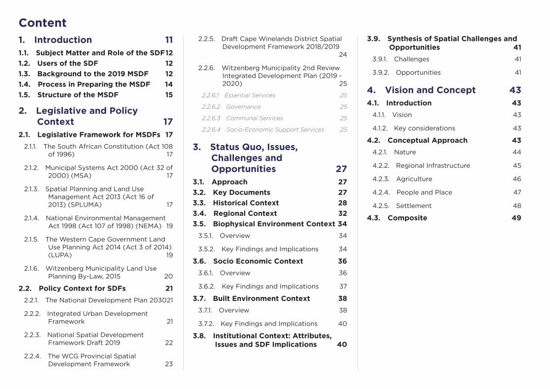
1. Introduction 111.1. Subject Matter and Role of the SDF 12
1.2. Users of the SDF 12
1.3. Background to the 2019 MSDF 12
1.4. Process in Preparing the MSDF 14
1.5. Structure of the MSDF 15
2. Legislative and Policy Context 17
2.1. Legislative Framework for MSDFs 17
2.1.1. The South African Constitution (Act 108 of 1996) 17
2.1.2. Municipal Systems Act 2000 (Act 32 of 2000) (MSA) 17
2.1.3. Spatial Planning and Land Use Management Act 2013 (Act 16 of 2013) (SPLUMA) 17
2.1.4. National Environmental Management Act 1998 (Act 107 of 1998) (NEMA) 19
2.1.5. The Western Cape Government Land Use Planning Act 2014 (Act 3 of 2014) (LUPA) 19
2.1.6. Witzenberg Municipality Land Use Planning By-Law, 2015 20
2.2. Policy Context for SDFs 21
2.2.1. The National Development Plan 2030 21
2.2.2. Integrated Urban Development Framework 21
2.2.3. National Spatial Development Framework Draft 2019 22
2.2.4. The WCG Provincial Spatial Development Framework 23
Content2.2.5. Draft Cape Winelands District Spatial
Development Framework 2018/2019 24
2.2.6. Witzenberg Municipality 2nd Review Integrated Development Plan (2019 - 2020) 25
2.2.6.1 Essential Services 25
2.2.6.2 Governance 25
2.2.6.3 Communal Services 25
2.2.6.4 Socio-Economic Support Services 25
3. Status Quo, Issues, Challenges and Opportunities 27
3.1. Approach 27
3.2. Key Documents 27
3.3. Historical Context 28
3.4. Regional Context 32
3.5. Biophysical Environment Context 34
3.5.1. Overview 34
3.5.2. Key Findings and Implications 34
3.6. Socio Economic Context 36
3.6.1. Overview 36
3.6.2. Key Findings and Implications 37
3.7. Built Environment Context 38
3.7.1. Overview 38
3.7.2. Key Findings and Implications 40
3.8. Institutional Context: Attributes, Issues and SDF Implications 40
3.9. Synthesis of Spatial Challenges and Opportunities 41
3.9.1. Challenges 41
3.9.2. Opportunities 41
4. Vision and Concept 434.1. Introduction 43
4.1.1. Vision 43
4.1.2. Key considerations 43
4.2. Conceptual Approach 43
4.2.1. Nature 44
4.2.2. Regional Infrastructure 45
4.2.3. Agriculture 46
4.2.4. People and Place 47
4.2.5. Settlement 48
4.3. Composite 49

5. Plans and Settlement Proposals 51
5.1. Introduction 51
5.2. Witzenberg Municipality as a Whole 51
5.2.1. Landscape-wide Spatial Planning Categories 51
5.2.2. Managing specific activities 55
5.2.3. Norms for the subdivision of agricultural land 60
5.2.4. Opportunities for emerging farmers and subsistence farming 61
5.2.5. Heritage, cultural and scenic resources 61
7.5.1. Municipal-wide infrastructure 63
7.5.1.1 Renewable Energy Development Corridors 64
5.2.6. Settlement hierarchy 65
5.2.7. Growth potential and socio-economic needs 68
5.2.8. General settlement guidelines 68
5.3. Individual settlement plans 71
5.3.1. Ceres 71
5.3.2. Wolseley 74
5.3.3. Tulbagh 77
5.3.4. Prince Alfred Hamlet 80
5.3.5. Op-die-berg 83
6. Implementation Framework 87
6.1. Introduction 87
6.2. Policy framework 87
6.3. Development guidelines 90
6.4. Core principles of land use management 90
6.5. The MSDF’s relationship with corporate and sector planning and decision-making 92
6.6. Prioritising development 95
6.7. Priority projects 95
6.8. Areas prioritised for more detailed spatial planning 95
6.9. Institutional arrangements 99
6.9.1. Municipal arrangements for spatial planning and land use management 99
6.9.2. Inter-government planning 99
6.9.3. Private sector partnerships 99
6.10. A checklist to enable consideration of the MSDF in deliberations and decision-making 100
6.11. A municipal leadership advocacy agenda related to spatial planning and land use management 101
7. Capital Expenditure Framework 103
7.1. Introduction 103
7.2. Capital Finance 103
7.3. Prioritisation of Capital Budget 105
7.4. Capital Expenditure Categorisation 106
7.5. Capital Expenditure Need 109
8. Monitoring and Review 1138.1. Monitoring 113
8.2. Review of the MSDF 113
List of Documents Reviewed 114
Appendices 116A. SPLUMA Requirements for SDFs 117
B. Witzenberg Municipality Land Use Planning By-Law requirements for SDF 118
C. The PSDF and the Cape Winelands District 119
D. Planned provincial expenditure in Witzenberg 121
E. Witzenberg housing plan and pipeline 122
F. Regional Socio-economic Programme (RSEP) 126
G. Infrastructure capacity and issues 128
H. Current major land development proposals 131
I. Land Demand 135
J. Policy Framework 138

Table 1. SPLUMA Principles unpacked according to their implications for SDF processes 18
Table 2. The PSDF Spatial Agenda 23
Table 3. Purpose and key informants of relevant documents produced by Witzenberg Municipality 27
Table 4. Landscape-wide Spatial Planning Categories 53
Table 5. Landscape-wide Spatial Planning Categories (continued) 54
Table 6. Guidelines for specific activities in rural areas 55
Table 7. Guidelines for specific activities in rural areas (continued) 56
Table 8. Guidelines for specific activities in rural areas (continued) 57
Table 9. Guidelines for specific activities in rural areas (continued) 58
Table 10. Guidelines for specific activities in rural areas (continued) 59
Table 11. Ideal farm size units 60
Table 12. Scenic routes and historic mountain passes 61
Table 13. Guidelines for managing heritage, cultural and scenic resources 62
Table 14. Municipal-wide infrastructure 63
Table 15. Settlement hierarchy and categorisation 65
Table 16. Settlement hierarchy and categorisation (continued) 66
Table 17. Other settlement groupings in Witzenberg Municipality 67
Table 18. Settlement growth potential and socio-economic need 68
Table 19. PSDF Settlement Toolkit guidelines for settlements 69
Table 20. PSDF Settlement Toolkit guidelines for settlements (continued) 70
Table 21. The Ceres plan expanded 73
Table 22. The Wolseley plan expanded 76
Table 23. The Tulbagh plan expanded 79
Table 24. The Prince Alfred Hamlet plan expanded 82
Table 25. The Op-die-berg plan expanded 85
Table 26. MSDF Policy Framework 87
Table 27. MSDF Policy Framework (continued) 88
Table 28. MSDF Policy Framework (continued) 89
Table 29. Key themes, principles, and regulations contained in the Municipal Land Use Planning By-Law 91
Table 30. Sector foci, plans, and the MSDF 92
Table 31. Sector foci, plans, and the MSDF (continued) 93
Table 32. Sector foci, plans, and the MSDF (continued) 94
Table 33. Priority Projects (Work in progress) 95
Table 34. Checklist for compliance with MSDF 100
Table 35. A municipal leadership advocacy agenda related to spatial planning and land use management 101
Table 36. Capital Funding Mix (Source: 2nd Reviewed IDP, 2019-2020) 104
Table 37. Allocation of capital budget to Key Performance Areas (KPA) 105
Table 38. Spatial allocation of budget 106
Table 39. Classification of infrastructure 107
Table 40. Infrastructure Grouping 107
Table 41. Capital Expenditure * (to be updated in accordance with Roads Master Plan and Infrastructure Master Plan) 110
Table 42. Capital Expenditure * (to be updated in accordance with Roads Master Plan and Infrastructure Master Plan) continued 111
Table 43. Planned WCG expenditure in Witzenberg 121
Table 44. Housing demand in Witzenberg Municipality 122
Table 45. Additional housing demand in Witzenberg Municipality 122
Table 46. Informal settlements in Witzenberg Municipality 123
Table 47. Settlement by settlement housing delivery plan 124
Table 48. Agreed housing delivery pipeline 125
Table 49. Infrastructure capacity and issues per theme and settlement 128
Table 50. Current major land development proposals in Witzenberg Municipality per settlement. 131
Table 51. 2012 developable land in Witzenberg 135
Table 52. DEADP Population projections 135
Table 53. Annual, five and ten-year housing need in Witzenberg 136
Table 54. Land required to meet new demand per settlement 137
Figure 1. The study area for this SDF - Witzenberg Municipality - within the regional context 9
Figure 2. The location of WM within the Western Cape and Cape Winelands District 11
Figure 3. The 2012 Approved Witzenberg SDF Spatial Vision diagram illustrating hierarchy of settlement, linkages and investment priorities 13
Figure 4. The SDF Process (from DRDLR’s PLUMA Guidelines, 2014) 14
Figure 5. Key Elements of the SPLUMA Principles (from DRDLR’s Booklet on Guidelines for the Application of the Development Principles of SPLUMA) 19
Figure 6. The National Development Plan Vision for 2030 21
Figure 8. The NSDF Desired Outcomes and Development Levers 22
Figure 7. The NSDF Vision 2050 22
Figure 9. Consolidated PSDF Framework for the Cape Winelands Region 2014 24
Figure 11. Roodesandkloof on the way to Tulbagh as Burchell drew it during his travels (Burchell, 1953) 28
Figure 10. William Burchell, a famous explorer and naturalist, travelled through Tulbagh en route to the interior in 1811. This is a sketch he made of the outspanned wagons in the shade of the Karoo trees (Burchell, 1953) 28
Figure 12. Mitchells Pass (Ceres van Gister en Eergister Facebook Page) 28
Figure 13. The old wagon route schematically mapped (Smuts, 1988) 29
Figure 14. Chronology of central Tulbagh mapped (Tulbagh Valley Heritage Foundation 2018) 29
Figure 15. Church Street views, North and South by W.J. Burchell, 1811 - displaying an early aesthetic interest with the street’s uniform standardised architecture (in Fransen, Old Towns and Villages of the Cape, 85) 30
Table 55. Review of high-level international “conventions”, resolutions or declarations 138
Table 56. Review of policy frameworks 140
List of Tables
List of Figures

Figure 16. Buildings along Church Street during reconstruction (Fagan Archives) 30
Figure 17. Voortrekker Street around 1956 (Ceres van Gister en Eergister Facebook Page) 31
Figure 18. A map of the original town layout of Ceres in 1849 (Ceres van Gister en Eergister Facebook Page) 31
Figure 19. The position of Ceres and Tulbagh in relation to the GCM area and the PSDF Rural Development Corridors (GCM RSIF, 2017) 32
Figure 20. The position of Ceres in relation to the proposed regional road freight network of the Province (GS RSIF, 2018) 32
Figure 21. The concentration of heritage resources in Witzenberg in relation to the surrounding regions (GS RSIF, 2018) 33
Figure 22. Synthesising Witzenberg’s position in the region in relation to tourism and agricultural areas. 33
Figure 23. A simple Google Earth snapshot of the municipal area (outlined in red) highlights the unique landscapes, transitioning from steep mountain ranges, to fertile valleys forming the basis for settlement and agriculture and ending in the more arid Karoo landscape as one moves toward the Northern Cape (Google Earth, 2019) 34
Figure 24. Impressive views of the mountain ranges from a hiking trail close to Wolseley 35
Figure 25. Views of the Tankwa Karoo and Gannaga Pass 35
Figure 26. A map of the concentration of agriculture and settlement in relation to the mountains and landscapes 35
Figure 27. Map showing the dispersed rural communities (smaller green dots and brown dots) in relation to service centres and access to opportunities (larger green dots) (based on Eskom dot counts) 36
Figure 28. Agricultural activities play a vital role in maintaining employment opportunities and economic viability for the Witzenberg region (Source) 37
Figure 29. Map showing the limited amount of business opportunities in Nduli (areas in blue) versus housing i.e. households living in this community - implying that most residents here either need to travel to work or take part in the informal economy. 38
Figure 30. Inadequate pedestrian infrastructure along the R46 between Ceres and Nduli (Google Earth) 38
Figure 31. The status of infrastructure for each main urban area in Witzenberg (Source) 39
Figure 32. Racial segregation patterns in Ceres as depicted in this dot map based on Census 2011 data (Dot Map of South Africa by Adrian Frith) 39
Figure 33. Nature Concept for Witzenberg - showing the key green infrastructure elements of the region, such as CBA networks, primary river corridors, mountains and protected areas 44
Figure 34. Regional Infrastructure Concept for Witzenberg - showing regional centres, settlement hierarchy and transport connections. The five main towns of Witzenberg are highlighted in red, with regional connections between Piketberg, Paarl and Worcester, as well as links to the N1 highlighted in grey. 45
Figure 35. Agricultural Concept for Witzenberg - showing key farming areas, production types and supporting infrastructure concentrated along the agricultural band along the western edge of the municipal area 46
Figure 36. People and Place Concept for Witzenberg - showing the primary regional scenic routes, spaces where gateways should be celebrated and towns characterised according to character and sense of place. 47
Figure 37. Settlement Concept for Witzenberg - showing priority growth areas in green, such as Ceres and Wolseley, and areas that need to be protected from inappropriate expansion in red, such as Tulbagh 48
Figure 38. Composite Concept for WItzenberg 49
Figure 39. Consolidated Municipal Framework Map for the Witzenberg Municipality as a whole 52
Figure 40. The 8 REDZs (CSIR) 64
Figure 41. The location of the Komsberg REDZ area within the Witzenberg Municipality 64
Figure 42. Development Concept for Ceres 71
Figure 43. Development Plan for Ceres 72
Figure 44. Development Concept for Wolseley 74
Figure 45. Development Plan for Wolseley 75
Figure 46. Development Concept for Tulbagh 77
Figure 47. Development Plan for Tulbagh 78
Figure 48. Development Concept for Prince Alfred Hamlet 80
Figure 49. Development Plan for Prince Alfred Hamlet 81
Figure 50. Development Concept for Op-die-berg 83
Figure 51. Development Plan for Op-die-berg 84
Figure 52. The cadastral area showing the location of the priority area between Ceres, Bella Vista, and Nduli 96
Figure 53. Concept development of the area between Ceres, Bella Vista, and Nduli (work in progress) 97
Figure 54. Examples of appropriate form of publicly assisted housing in central locations (add sources and names) 98
Figure 55. Ward allocation of budget 106
Figure 56. Capital Expenditure Type 107
Figure 57. Capital allocation to infrastructure 108
Figure 58. Capital allocation to infrastructure 108
Figure 59. RSEP Reconstruction Framework - Typical Town Morphology (based on Vredenburg) 126
Figure 60. RSEP Framework applied to Ceres 127

Executive Summary and Main Focus of the Witzenberg MSDFThe 2019 Witzenberg Municipal Spatial Development Framework (MSDF) – once approved by Council – will replace the current MSDF prepared in 2012. The 2019 MSDF has been prepared within the legislative and regulatory framework set by the national Spatial Planning and Land Use Management Act (ACT 16 of 2013), provincial Land Use Planning Act (2014), and Witzenberg Municipality Land Use Planning By-Law, 2015. It is also directed by a range of policy and guideline documents prepared by different spheres of government, including the Western Cape Government Provincial Spatial Development Framework (2014) and the Witzenberg Municipality Integrated Development Plan (IDP) 2017-2022 (and annual reviews).
Based on analysis of existing patterns of spatial development within the municipal areas, and expected need for different activities to be accommodated over the planning period, the MSDF sets outline spatial policy, plans, proposals, guidelines, and implementation measures for Witzenberg Municipality as a whole and individual settlements within the Municipality.
In its direction, the MSDF has five specific foci:
1. The first is to maintain and protect the integrity, authenticity and accessibility of Witzenberg’s natural environment and associated resources. Humanity depends on nature for physical and spiritual sustenance, livelihoods, and survival. Ecosystems provide numerous benefits or ecosystem services that underpin economic development and support human well-being. They include provisioning services such as food, freshwater, and fuel as well as an array of regulating services such as water purification, pollination, and climate regulation. Healthy ecosystems are a prerequisite to sustaining economic development and mitigating and adapting to climate change. The plan provides for
activities enabling access to nature in a manner which does not detract from the functionality and integrity of nature and farming areas and landscapes.
2. The second is to maintain and expand the Municipality’s key regional and intra-regional infrastructure. Appropriate infrastructure – whether in the form of transport routes or municipal services – is critical to support economic development, agriculture, and livelihoods.
3. The third is to maintain and grow the agricultural assets within the Municipality. Agriculture remains the mainstay of the regional economy and require on-going support. In a spatial sense, this specifically requires protecting high-value agricultural land from urban development. The opportunity also exists to diversify farm income in a manner which does not detract from the functionality and integrity of farming areas and landscapes, and to expand access to farming to smaller entrepreneurs and emerging farmers.
4. The fourth is to maintain and expand access to Witzenberg’s unique sense of people and place. Important is the recognition and maintenance of unique landscapes, and diverse expressions over time of peoples’ interaction with the landscape. Also critical is the SPLUMA principle of “spatial justice”; implying that past spatial and other development imbalances must be redressed through improved access to and use of land, as well as the inclusion of persons and areas that were previously excluded, with an emphasis on informal settlements, and areas characterised by widespread poverty and deprivation.
5. The fifth is to maintain and expand opportunity associated with Witzenberg’s key settlements. Settlements need to be managed and provide for expansion in a manner which enables efficiency in infrastructure provision, integration and compaction to enable better thresholds and more sustainable movement, and protection of surrounding assets of nature and agriculture.
It is anticipated that a major review of the MSDF will occur every five years, in parallel with the municipal IDP. Improvements, amendments, and refinements to the MSDF can occur annually.

Karoo Hooland
Laingsburg
Langeberg
Breede Valley
Drakenstein
Swartland
Bergrivier
Cederberg
Hantam
Saldanha Bay
City of Cape Town
NORTHERN CAPE
R355
R35
6R
30
3
R46
R43
R46
R399
R45
R27
N7
N1N1
N1
N7
Paarl
Montague
Worcester
Robertson
Ceres
MalmesburyWolseley
Wellington
Tulbagh
Piketberg
Citrusdal
Porterville
De Doorns
Touwsrivier
Inverdoorn
Gansfontein
Op die Berg
Prince Alfred Hamlet
Velddrif
Saron
Riebeek Kasteel
Laingsburg
Witzenberg
Local Municipality
District Municipality
Urban Areas
Mountains
REDZs
Main Roads
Secondary Roads
Railway Line
Rivers
Figure 1. The study area for this SDF - Witzenberg Municipality - within the regional context

Witzenberg Municipality / Spatial Development Framework / Draft for Comment / October 201910
Part 1.
Introduction

Witzenberg Municipality / Spatial Development Framework / Draft for Comment / October 2019
1. IntroductionThe Witzenberg Local Municipality (LM), founded in 2000, is classified as a Category B- municipality and is responsible for basic service provision to the demarcated municipal area that includes the towns of Ceres, Tulbagh, Prince Alfred Hamlet, Wolseley and Op-die-Berg. The rural areas within the municipal boundary are Ceres Valley, the Koue-Bokkeveld, the Tankwa Karoo, Achter- Witzenberg and the northern portion of the Breede River Valley area (see Figures 1 and 2).
Located in a picturesque series of valleys with fertile basins and plains, Witzenberg is best known for its fruit and wine products. The region is also well-known for producing other agriculture-linked products such as olives and grain, as well as for producing beef and pork products. Horse and cattle stud farms are also found within the municipal area.
Located merely an hour and a half’s drive away from Cape Town, Witzenberg has positioned itself as an accessible family tourist destination and adventure tourism hub offering historical and heritage tours, hiking, 4x4, abseiling, fresh water fishing, mountain bike trails, San Rock paintings, game and nature reserves, stargazing, birding, cherry and fig picking and winter snowfall.
It is generally recognized that Witzenberg Municipality is of significant international, national, regional and local value in scientific, economic, recreational, aesthetic and cultural terms. The area has a strong resource base that supports a variety of economic sectors, including agriculture, tourism, manufacturing, etc. Due to its attributes and values, Witzenberg is subject to increasing development demands and pressures, the potential impact of which should be considered in context of the global concern over the world’s ability to support its inhabitants under ever-increasing population pressure.
The need to utilise the resource base of the Witzenberg in order to grow both the local and the provincial economy poses a challenge to the Witzenberg Municipality. The core of the challenge is to implement innovative and best-practice
Figure 2. The location of WM within the Western Cape and Cape Winelands District
Local Municipality
District Municipality
Urban Areas
Mountains
REDZs
Main Roads
Secondary Roads
Railway Line
Rivers
strategies to create a ‘developmental state’ as is advocated by the South African Constitution whilst, simultaneously, giving effect to global obligations pertaining to social, economic and environmental sustainability.
11
Witzenberg Municipality / Spatial Development Framework / Draft for Comment / October 2019
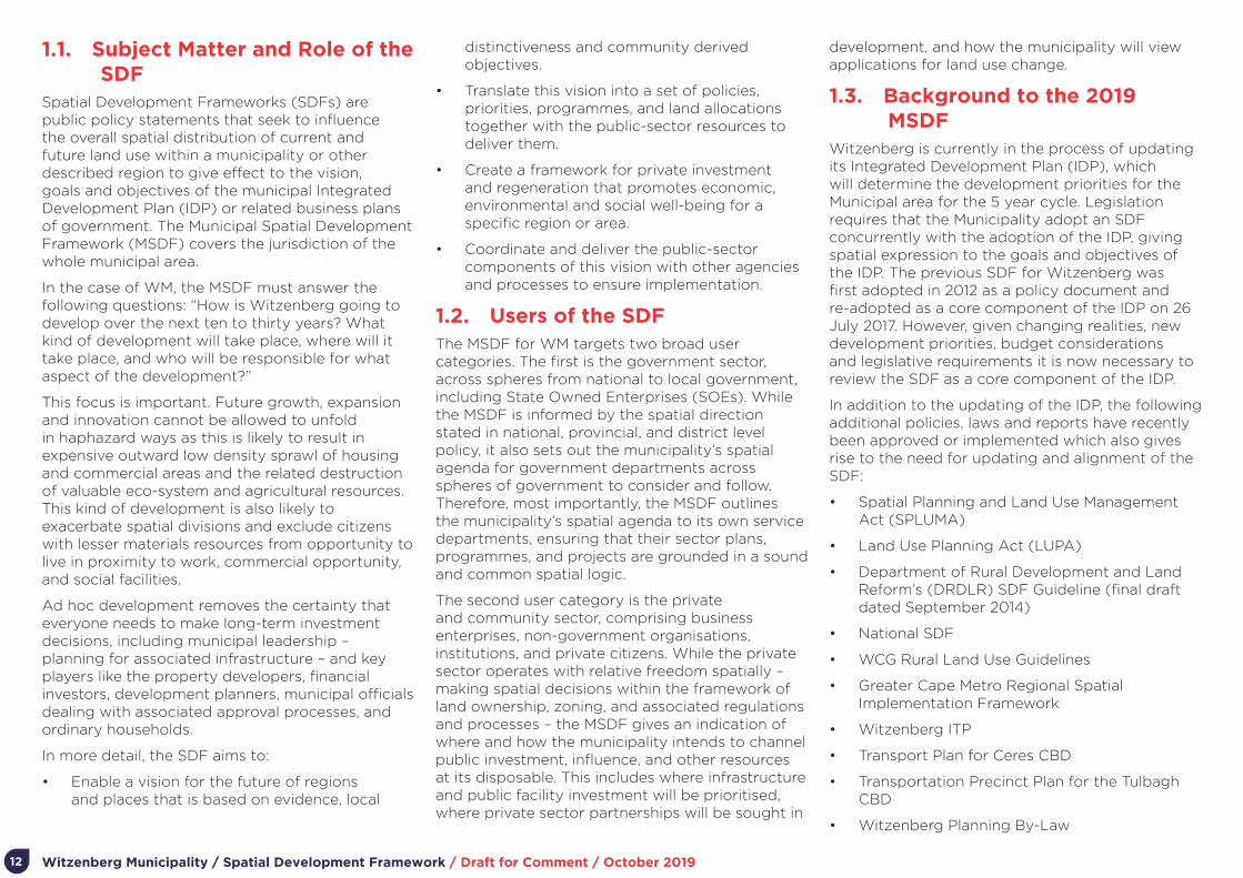
1.1. Subject Matter and Role of the SDF
Spatial Development Frameworks (SDFs) are public policy statements that seek to influence the overall spatial distribution of current and future land use within a municipality or other described region to give effect to the vision, goals and objectives of the municipal Integrated Development Plan (IDP) or related business plans of government. The Municipal Spatial Development Framework (MSDF) covers the jurisdiction of the whole municipal area.
In the case of WM, the MSDF must answer the following questions: “How is Witzenberg going to develop over the next ten to thirty years? What kind of development will take place, where will it take place, and who will be responsible for what aspect of the development?”
This focus is important. Future growth, expansion and innovation cannot be allowed to unfold in haphazard ways as this is likely to result in expensive outward low density sprawl of housing and commercial areas and the related destruction of valuable eco-system and agricultural resources. This kind of development is also likely to exacerbate spatial divisions and exclude citizens with lesser materials resources from opportunity to live in proximity to work, commercial opportunity, and social facilities.
Ad hoc development removes the certainty that everyone needs to make long-term investment decisions, including municipal leadership – planning for associated infrastructure – and key players like the property developers, financial investors, development planners, municipal officials dealing with associated approval processes, and ordinary households.
In more detail, the SDF aims to:
• Enable a vision for the future of regions and places that is based on evidence, local
distinctiveness and community derived objectives.
• Translate this vision into a set of policies, priorities, programmes, and land allocations together with the public-sector resources to deliver them.
• Create a framework for private investment and regeneration that promotes economic, environmental and social well-being for a specific region or area.
• Coordinate and deliver the public-sector components of this vision with other agencies and processes to ensure implementation.
1.2. Users of the SDFThe MSDF for WM targets two broad user categories. The first is the government sector, across spheres from national to local government, including State Owned Enterprises (SOEs). While the MSDF is informed by the spatial direction stated in national, provincial, and district level policy, it also sets out the municipality’s spatial agenda for government departments across spheres of government to consider and follow. Therefore, most importantly, the MSDF outlines the municipality’s spatial agenda to its own service departments, ensuring that their sector plans, programmes, and projects are grounded in a sound and common spatial logic.
The second user category is the private and community sector, comprising business enterprises, non-government organisations, institutions, and private citizens. While the private sector operates with relative freedom spatially – making spatial decisions within the framework of land ownership, zoning, and associated regulations and processes – the MSDF gives an indication of where and how the municipality intends to channel public investment, influence, and other resources at its disposable. This includes where infrastructure and public facility investment will be prioritised, where private sector partnerships will be sought in
development, and how the municipality will view applications for land use change.
1.3. Background to the 2019 MSDF
Witzenberg is currently in the process of updating its Integrated Development Plan (IDP), which will determine the development priorities for the Municipal area for the 5 year cycle. Legislation requires that the Municipality adopt an SDF concurrently with the adoption of the IDP, giving spatial expression to the goals and objectives of the IDP. The previous SDF for Witzenberg was first adopted in 2012 as a policy document and re-adopted as a core component of the IDP on 26 July 2017. However, given changing realities, new development priorities, budget considerations and legislative requirements it is now necessary to review the SDF as a core component of the IDP.
In addition to the updating of the IDP, the following additional policies, laws and reports have recently been approved or implemented which also gives rise to the need for updating and alignment of the SDF:
• Spatial Planning and Land Use Management Act (SPLUMA)
• Land Use Planning Act (LUPA)
• Department of Rural Development and Land Reform’s (DRDLR) SDF Guideline (final draft dated September 2014)
• National SDF
• WCG Rural Land Use Guidelines
• Greater Cape Metro Regional Spatial Implementation Framework
• Witzenberg ITP
• Transport Plan for Ceres CBD
• Transportation Precinct Plan for the Tulbagh CBD
• Witzenberg Planning By-Law
12

Witzenberg Municipality / Spatial Development Framework / Draft for Comment / October 2019
The 2019 SDF will therefore attend to the amendment of the Witzenberg SDF in order to ensure alignment between the IDP agenda and legislative requirements of applicable planning law, to ensure that the document is aligned with SPLUMA, LUPA and the Land Use Planning By-Law for Witzenberg Municipality.
Certain elements from the 2012 SDF will still be incorporated into the report, as starting points for the development of an updated spatial vision and direction for Witzenberg. This includes the detailed policies and guidelines, some of which are listed below and illustrated in Figure 3, as well as the conceptual approach to integrate the neighbourhoods of Wolseley and Ceres through directing urban expansion accordingly.
• Enhance the use of Ceres as an agri-industrial hub and portal to the export markets situated in the City of Cape Town.
• Promote development of tourism-related amenities and activities along the main routes through the municipality.
• Establish formal relationships with neighbouring municipalities regarding aspects of mutual relevance.
• Establish a freight depot at Wolseley to export fruit and other agricultural products via railway line to inland provinces and harbours
• Ensure the upkeep of major economic transport routes and scenic routes
Figure 3. The 2012 Approved Witzenberg SDF Spatial Vision diagram illustrating hierarchy of settlement, linkages and investment priorities
13
Witzenberg Municipality / Spatial Development Framework / Draft for Comment / October 2019
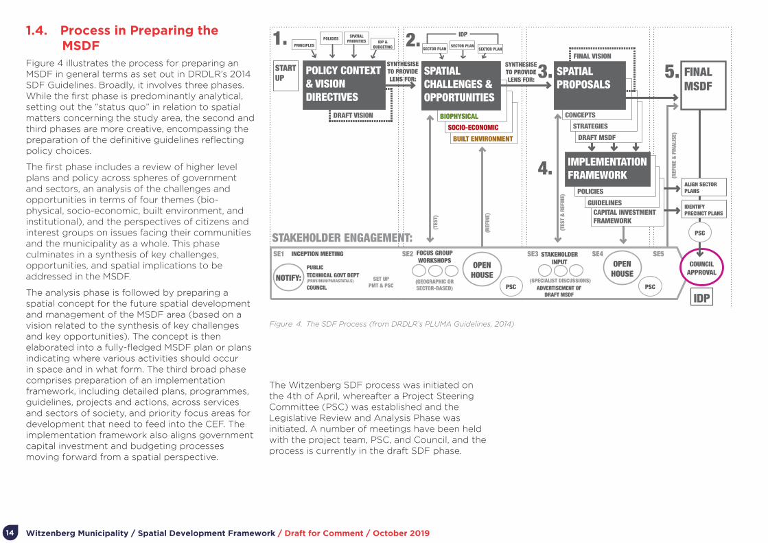
1.4. Process in Preparing the MSDF
Figure 4 illustrates the process for preparing an MSDF in general terms as set out in DRDLR’s 2014 SDF Guidelines. Broadly, it involves three phases. While the first phase is predominantly analytical, setting out the “status quo” in relation to spatial matters concerning the study area, the second and third phases are more creative, encompassing the preparation of the definitive guidelines reflecting policy choices.
The first phase includes a review of higher level plans and policy across spheres of government and sectors, an analysis of the challenges and opportunities in terms of four themes (bio- physical, socio-economic, built environment, and institutional), and the perspectives of citizens and interest groups on issues facing their communities and the municipality as a whole. This phase culminates in a synthesis of key challenges, opportunities, and spatial implications to be addressed in the MSDF.
The analysis phase is followed by preparing a spatial concept for the future spatial development and management of the MSDF area (based on a vision related to the synthesis of key challenges and key opportunities). The concept is then elaborated into a fully-fledged MSDF plan or plans indicating where various activities should occur in space and in what form. The third broad phase comprises preparation of an implementation framework, including detailed plans, programmes, guidelines, projects and actions, across services and sectors of society, and priority focus areas for development that need to feed into the CEF. The implementation framework also aligns government capital investment and budgeting processes moving forward from a spatial perspective.
70
DRDLR Spatial Development Framework Guidelines / Draft for Comment
COUNCIL APPROVAL
PRINCIPLESSECTOR PLAN
OPEN HOUSE
PSC PSC
PSC
NOTIFY:OPEN
HOUSE
SPATIAL PRIORITIES IDP &
BUDGETING SECTOR PLANPOLICIES
SECTOR PLAN
FOCUS GROUP WORKSHOPS
INCEPTION MEETING
PUBLICTECHNICAL GOVT DEPT (PROV/MUN/PARASTATALS)COUNCIL
ALIGN SECTOR PLANS
IDENTIFY PRECINCT PLANS
STAKEHOLDER INPUT
IDP
(GEOGRAPHIC OR SECTOR-BASED) ADVERTISEMENT OF
DRAFT MSDF
(SPECIALIST DISCUSSIONS)
(REF
INE
& FI
NALIS
E)
(TES
T)
(TES
T & R
EFIN
E)
(REF
INE)
SYNTHESISE TO PROVIDE LENS FOR:
SYNTHESISE TO PROVIDE LENS FOR:
SET UP PMT & PSC
DRAFT VISION
START UP
1.
SE1
ME1 ME2 ME3 ME4 ME5
SE2 SE3 SE5SE4
2.3.
4.
5.POLICY CONTEXT & VISION DIRECTIVES
BUILT ENVIRONMENT DRAFT MSDF
CAPITAL INVESTMENT FRAMEWORK
SOCIO-ECONOMIC STRATEGIES
GUIDELINES
BIOPHYSICAL CONCEPTS
POLICIES
FINAL VISION
SPATIAL CHALLENGES & OPPORTUNITIES
IDP
SPATIAL PROPOSALS
FINAL MSDF
IMPLEMENTATION FRAMEWORK
MONITORING & EVALUATION:BASELINE REVIEW: PREVIOUS SDF TARGETS VS. SPATIAL PLANNING OUTCOMES
TARGET DETERMINATION: GATHER UPDATED CENSUS DATA & OTHER RELEVANT, MEASURABLE DATA
TARGET ESTABLISHMENT: INDICATORS & TARGETS BASED ON SPATIAL STRATEGIES
TARGET ALIGNMENT: POLICIES, GUIDELINES & INSTITUTIONAL TARGETS MONITORING
AND REVIEW
STAKEHOLDER ENGAGEMENT:
MSDF PROCESS:Figure 17. Diagram illustrating the procedural steps required in the process of preparing a MSDF
Figure 4. The SDF Process (from DRDLR’s PLUMA Guidelines, 2014)
The Witzenberg SDF process was initiated on the 4th of April, whereafter a Project Steering Committee (PSC) was established and the Legislative Review and Analysis Phase was initiated. A number of meetings have been held with the project team, PSC, and Council, and the process is currently in the draft SDF phase.
14

Witzenberg Municipality / Spatial Development Framework / Draft for Comment / October 2019
1.5. Structure of the MSDFThe 2019 WM MSDF is set out in the following parts:
Part 1: Introduction.
Part 2: Legislative and Policy Context
Part 3: Status Quo, Challenges and Opportunities.
Part 4: Vision and Concept.
Part 5: Plans and Settlement Proposals.
Part 6: Implementation Framework.
Part 7: Capital Expenditure Framework.
Part 8: Monitoring and Review .
The diagram illustrates the structure of the document. Appendices related to the status quo, guidelines, and other relevant information are also attached to this document.
1. Introduction
2. Legislative and Policy Context
6. Implementation Framework
7. Capital Expenditure Framework
8. Monitoring and Review
3. Status Quo, Challenges and Opportunities
Synthesis
4. Vision and Concept
5. Plans and Settlement Proposals
Historical Context
Nature
Witzenberg Municipality as a
Whole
Regional Context
Regional Infrastructure
Individual Settlement Plans
Biophysical Context
Agriculture
Socio Economic Context
People and Place
Built Environment
Context
Settlement
Institutional Context
• Ceres
• Wolseley
• Tulbagh
• Prince Alfred Hamlet
• Op-die-berg
+
15

Witzenberg Municipality / Spatial Development Framework / Draft for Comment / October 201916
Part 2.
Legislative and Policy Context
Witzenberg Municipality / Spatial Development Framework / Draft for Comment / October 2019
2. Legislative and Policy Context • A vote for every adult citizen, one national
voters’ roll for all citizens, regular elections and a multi-party system of democratic government.
2.1.2. Municipal Systems Act 2000 (Act 32 of 2000) (MSA)
The Municipal Systems Act, 32 of 2000 (MSA) first introduced the concept of a Spatial Development Framework SDF as a component of the mandatory Integrated Development Plan (IDP) that every municipality must adopt to govern its allocation of resources. Chapter 5 of the Act deals with integrated development planning and provides the legislative framework for the compilation and adaption of IDPs by municipalities. Within the chapter, Section 26(e) specifically requires an SDF as a mandatory component of the municipal IDP.
2.1.3. Spatial Planning and Land Use Management Act 2013 (Act 16 of 2013) (SPLUMA)
SPLUMA directs spatial planning, land development and land use management in South Africa. Chapter 4 of SPLUMA provides requirements for the preparation of SDFs, which includes stipulations regarding the process of preparing an SDF and the contents of an SDF. All spheres of government must prepare SDFs that establish a clear vision for spatial development, based on a thorough inventory and analysis and underpinned by national spatial planning principles and local long-term development goals and plans. Sub-section 12(2) of SPLUMA requires that all three spheres must participate in each other’s processes of spatial planning and land use management and each sphere must be guided by its own SDF when taking decisions relating to land use and development.
Included, and as part of the MSDF are Local Spatial Development Frameworks (LSDFs) or Precinct Plans. These LSDFs/ Precinct Plans are incorporated into the MSDF and are a means of planning spatial implementation strategies for the municipality.
The SDF will inform and guide Land Use Management Systems (LUMS), which includes town planning or zoning schemes allocating development rights, and the procedures and processes for maintaining the maintenance of or changes in development rights. Consequently, SDFs are not rigid or prescriptive plans that predetermine or try to deal with all eventualities or sets out complete land use and development parameters for every land portion or cadastral entity. SDFs, are set to contain sufficient clarity and direction to provide guidance to land use management decisions while still allowing some flexibility and discretion. As such, MSDFs need to distinguish between critical non-negotiables and fixes and provides a guide that directs future detailed studies.
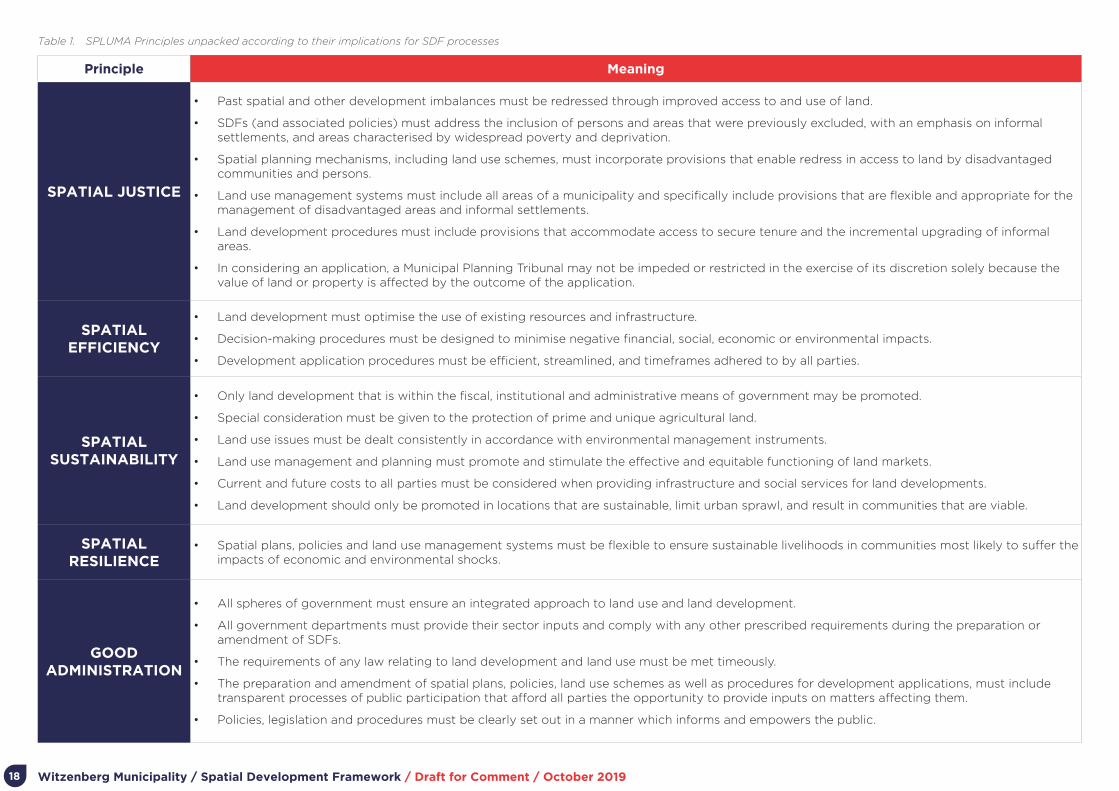
Chapter 2 of SPLUMA sets out the development principles that are to be used as guidance in preparation, adaption and implementation of any SDF, policy or by-law concerning spatial planning and the development or use of land. These principles are unpacked in Table 1 and further illustrated in Figure 5.
The Spatial Planning and Land Use Management Act 2013 (Act 16 of 2013) (SPLUMA) and Land Use Planning Act 2014 (Act 3 of 2014) (LUPA), form the core legislative frameworks used to enable plans set out in this MSDF. Prior to 2013, municipal planning had been carried out in accordance to the Development Facilitation Act 1995, (Act 67 of 1995) and the Land Use Planning Ordinance 1986 (15 of 1986) (LUPO).
2.1. Legislative Framework for MSDFs
2.1.1. The South African Constitution (Act 108 of 1996)
The South African Constitution is the highest law in the law in the country and everyone is bound by the Constitution. The Constitution contains the most important laws that govern and direct our political system. It protects the rights of the citizens of South Africa and defines the countries institutions, their powers and how these powers may be used. In being the highest law of the land, Parliament cannot pass law which goes against the Constitution. As part of the constitution the below values are included and have been used to provide guidance for this SDF.
• Human dignity, the achievement of equality, and the promotion of human rights and freedoms.
• Non-racialism and non-sexism - this means that there may be no discrimination on the grounds of race or sex.
• The rule of law and the Constitution as the supreme law - this means everything must be done according to the law, and the Constitution is the highest law.
17
Witzenberg Municipality / Spatial Development Framework / Draft for Comment / October 2019
Principle Meaning
SPATIAL JUSTICE
• Past spatial and other development imbalances must be redressed through improved access to and use of land.
• SDFs (and associated policies) must address the inclusion of persons and areas that were previously excluded, with an emphasis on informal settlements, and areas characterised by widespread poverty and deprivation.
• Spatial planning mechanisms, including land use schemes, must incorporate provisions that enable redress in access to land by disadvantaged communities and persons.
• Land use management systems must include all areas of a municipality and specifically include provisions that are flexible and appropriate for the management of disadvantaged areas and informal settlements.
• Land development procedures must include provisions that accommodate access to secure tenure and the incremental upgrading of informal areas.
• In considering an application, a Municipal Planning Tribunal may not be impeded or restricted in the exercise of its discretion solely because the value of land or property is affected by the outcome of the application.
SPATIAL EFFICIENCY
• Land development must optimise the use of existing resources and infrastructure.
• Decision-making procedures must be designed to minimise negative financial, social, economic or environmental impacts.
• Development application procedures must be efficient, streamlined, and timeframes adhered to by all parties.
SPATIAL SUSTAINABILITY
• Only land development that is within the fiscal, institutional and administrative means of government may be promoted.
• Special consideration must be given to the protection of prime and unique agricultural land.
• Land use issues must be dealt consistently in accordance with environmental management instruments.
• Land use management and planning must promote and stimulate the effective and equitable functioning of land markets.
• Current and future costs to all parties must be considered when providing infrastructure and social services for land developments.
• Land development should only be promoted in locations that are sustainable, limit urban sprawl, and result in communities that are viable.
SPATIAL RESILIENCE
• Spatial plans, policies and land use management systems must be flexible to ensure sustainable livelihoods in communities most likely to suffer the impacts of economic and environmental shocks.
GOOD ADMINISTRATION
• All spheres of government must ensure an integrated approach to land use and land development.
• All government departments must provide their sector inputs and comply with any other prescribed requirements during the preparation or amendment of SDFs.
• The requirements of any law relating to land development and land use must be met timeously.
• The preparation and amendment of spatial plans, policies, land use schemes as well as procedures for development applications, must include transparent processes of public participation that afford all parties the opportunity to provide inputs on matters affecting them.
• Policies, legislation and procedures must be clearly set out in a manner which informs and empowers the public.
Table 1. SPLUMA Principles unpacked according to their implications for SDF processes
18

Witzenberg Municipality / Spatial Development Framework / Draft for Comment / October 2019
11
Figure 3: Key Elements of the SPLUMA Principles
SPLUMA PRINCIPLES
JUSTICESPATIAL
Improve Access to Land
Facilitate Security of Tenure
Inclusion of Previously Disadvantaged
Incremental Upgrading of Informal Settlements
Facilitate Security of Tenure
Inclusion of Previously Disadvantaged
Incremental Upgrading of Informal Settlements
Value of Land/Development not Sole Deciding Factor
SPATIAL
SUSTAINABILITY
Develop Viable Comm
unities
Develop in Sustainable Locations
Protect & Manage Natural R
esources
Promote Equitable Functioning of Land Markets
Careful Management of Pubic Resources in D
evelopment
Envi
ronm
enta
l Sho
ck
Suffe
r Im
pact
of E
cono
mic
&
Prot
ect C
omm
uniti
es m
ost l
ikely
to
Polic
ies
& L
and
Use
Man
agem
ent S
ystem
s
Acc
omod
ate
Flex
ibili
ty in
Spa
tial P
lans,
SPAT
IAL
RES
ILIE
NCE
Transparent Public Participation
Timeously Meeting All Requirements
GOOD
Set out Clear Procedures and Policies
Provide Sector Inputs in SDF Deveopment Processes
Ensure Integrated Approach to Development
ADMINISTRATION EFFICIENCY
Optimize use of Exis
ting
Resources & Infra
struc
ture
Decision-making Procedures th
at Mini
mize N
egat
ive
Financial, Social, Economic & Environ
men
tal I
mpa
ct
Streamlined & Efficient Development Applic
ation
Pro
cedu
res
Figure 5. Key Elements of the SPLUMA Principles (from DRDLR’s Booklet on Guidelines for the Application of the Development Principles of SPLUMA)
2.1.4. National Environmental Management Act 1998 (Act 107 of 1998) (NEMA)
Similar to SPLUMA, the National Environmental Management Act, Act 107 of 1998 (NEMA), is defines overarching and generally applicable principles to guide related legislation as well as all activities integral to environmental management. NEMA places significant emphasis on environmental sustainability, resilience to climate change and wise use of the natural resource base. This is key to the current and future socio-economic wellbeing of residents in the municipal area, this especially given the contribution of our natural assets to the local economy. NEMA’s principles are important and are to be utilized and applied in conjunction to the development principles laid out in SPLUMA. Both these legislative documents provide spatial guidance to direct an integrated and coordinated approach towards planning for land use and land development processes.
2.1.5. The Western Cape Government Land Use Planning Act 2014 (Act 3 of 2014) (LUPA)
The Western Cape Government (WCG), through the Land Use Planning Act 3 of 2014 (LUPA), has adopted its own legislation to consolidate the legal requirements that relates to spatial planning and public investment in the Western Cape. There is some overlap between SPLUMA and LUPA with regard to aspects such as the content and process of preparing and adopting a MSDF. In terms of LUPA, a MSDF must:
• Comply with other applicable legislation.
• Promote predictability in the utilisation of land.
• Address development priorities.
• Where relevant, provide for specific spatial focus areas, including towns, other nodes,
19

Witzenberg Municipality / Spatial Development Framework / Draft for Comment / October 2019
sensitive areas, or areas experiencing specific development pressure.
• Consist of a report and maps covering the whole municipal area, reflecting municipal planning and the following structuring elements:
- Transportation routes.
- Open space systems and ecological corridors.
- Proposed major projects of organs of state with substantial spatial implications.
- Outer limits to lateral expansion.
- Densification of urban areas.
LUPA also sets out the minimum institutional arrangements for preparing SDFs, enabling participation across spheres of government and sectors.
2.1.6. Witzenberg Municipality Land Use Planning By-Law, 2015
The WM Planning By-Law 2015 applies to all land situated within the municipal area including land owned by the state and organs of the state. Chapter 3 of the By-Law outlines the intent and purpose of the MSDF as follows.
a) Providing a longer-term spatial depiction of the desired form and structure of the geographic area to which it applies.
b) Providing land use management guidelines regarding the appropriate nature, form, scale and location of development.
c) Contributing to spatial co-ordination.
d) Providing predictable land development.
e) Guiding investment and planning of municipal departments and where appropriate other spheres of government.
f) Guiding investment for the private sector.
g) Guiding decision making on applications.
h) Outlining specific arrangements for prioritising, mobilising, sequencing and implementing public and private infrastructural and land development investment in priority spatial structuring areas.
The MSDF should provide land use management guidelines that relate to:
• Capacity of engineering services;
• Community facility needs;
• Demographic conditions;
• Transportation and road network master planning;
• Urban and rural problems;
• Visual form;
• Biodiversity and heritage resources;
• Environmental opportunities and constraints;
• Current land use;
• Housing market;
• Agricultural resources;
• Land availability;
• Growth potential;
• Existing and anticipated private and public development.
The Witzenberg Municipal SDF will therefore be the primary means by which the above-mentioned land use management aspects will be addressed and which will provide appropriate guidance as necessary.
20

Witzenberg Municipality / Spatial Development Framework / Draft for Comment / October 2019
Figure 6. The National Development Plan Vision for 2030
2.2. Policy Context for SDFsNumerous policy frameworks, both focused the work of government holistically, the spatial arrangement of activities or specific sectors. These are explored fully in the approved SDF as well as the IDP. In the sections below, only the most specific policy informants are summarised, namely the National Development Plan (NDP), the Western Cape Government’s Provincial Spatial Development Framework (PSDF), the Greater CapeMetro (GCM) Regional Spatial Implementation Framework (RSIF), and the Witzenberg Municipality IDP.
A high-level summary outlining the key tenets of all applicable policy frameworks are included as Appendix J.
2.2.1. The National Development Plan 2030
The National Development Plan 2030 (NDP), developed by the National Planning Commission and adapted in 2012, serves as the strategic framework guiding and structuring the country’s development imperatives and is supported by the New Growth Path (NGP) and other national strategies. The vision set for 2030 is provided in figure 1, as taken from the NDP. The NDP provides governance with the platform to enable opportunities, conditions and capabilities conducive to sustainable and inclusive economic growth. The legacy of apartheid spatial settlement patterns that hindered inclusivity and access to economic opportunities, as well as the poor location and under-maintenance of major infrastructure, are two of the nine identified core challenges facing the country’s development. Aimed at facilitating a virtuous cycle of expanding opportunity for all, the NDP proposes a program of action that includes the spatial transformation of South Africa’s towns, cities and rural settlements given the “enormous social, environmental and financial costs imposed by spatial divides”.
Of particular relevance for the Witzenberg MSDF are the recommendations set out in Chapter 8:
Transforming Human Settlements and the National Space Economy, including the upgrading of all informal settlements on suitable, well-located land; increasing urban densities to support public transport and reduce sprawl; promoting mixed housing strategies and compact urban development in close proximity to services and livelihood opportunities; and investing in public transport infrastructure and systems (with a special focus on commuter rail) to ensure more affordable, safe, reliable and coordinated public transport.
2.2.2. Integrated Urban Development Framework
The Integrated Urban Development Framework (IUDF), approved by National Cabinet in 2016, aims to steer urban growth towards a sustainable growth model of compact, connected and coordinated cities and towns. Fueled by the NDP’S vision for South African urban spaces, the IUDF aims to guide the development of inclusive, resilient and livable urban settlements. In support of the NDP’s vision for spatial transportation, four overall strategic goals had been introduced in
21

Witzenberg Municipality / Spatial Development Framework / Draft for Comment / October 2019
focusing on integrated development within urban spaces:
• Spatial integration; to forge new spatial forms in settlements, transport, social and economic areas.
• Inclusion and Access; To ensure that people have access to social and economic services, opportunities and choices.
• Growth; To harness urban dynamism for inclusive, sustainable economic growth and development.
• Governance; To enhance the capacity of the state and its citizens to work together to achieve spatial and social integration.
These strategic goals inform the priority objectives of nine policy levers, premised on the understanding that integrated urban planning forms the basis for achieving integrated urban development, which follows a special sequence of urban policy actions. Integrated transport needs to inform targeted investments into integrated human settlements, underpinned by integrated infrastructure network systems and efficient land governance. The IUDF states that, taken all together, these levers can trigger economic diversification, inclusion and empowered communities, if supported by effective governance and financial reform.
2.2.3. National Spatial Development Framework Draft 2019
The National Spatial Development Framework (NSDF) is a strategic long-term spatial plan towards 2050. It is currently in the process of adoption by Cabinet, after which it becomes South Africa’s primary national spatial development policy. It aims to provide:
• A visual representation of the desired national spatial development pattern for the country.
• A set of national spatial directives for all forms of infrastructure investment and development spending in the country.
• A series of national strategic spatial areas for targeted investment by government and the private sector.
As the vision states, moving to the desired new, post-Apartheid national spatial development pattern requires targeted and sustainable interventions in accordance with a National Spatial Development Mission: “Making our common desired spatial future together through better planning, investment, delivery and monitoring”. The NSDF is based on a “National Transformation Logic” with a distinct spatial dimension. This logic as well as the development vision and desired outcomes are set out in Figures 7 and 8.
Although there is a strong focus on the development of Gauteng, eThekwini and Cape Town as “Strong Urban Regions”, the NSDF talks to “Strong Rural Regions” that address the development of productive, functional rural regions to ensure sustainable resource use and climate change adaption. This includes carefully chosen “rural service centres with clinics, police stations, schools, areas and culture academies and sport facilities, and lightning-fast communication networks”.
Figure 7. The NSDF Vision 2050
Figure 8. The NSDF Desired Outcomes and
Development Levers
22

Witzenberg Municipality / Spatial Development Framework / Draft for Comment / October 2019
Focus What it Involves
Growing the Western Cape economy in partnership with the private sector, non-governmental and community based organisations
Targeting public investment into the main driver of the Provincial economy (i.e. the Cape Metro functional region, the emerging Saldanha Bay/ Vredenburg and George/ Mossel Bay regional industrial centres, and the Overstrand and Southern Cape leisure and tourism regions).
Managing urban growth pressures to ensure more efficient, equitable and sustainable spatial performance.
Aligning, and coordinating public investments and leveraging private sector and community investment to restructure dysfunctional human settlements.
Supporting municipalities in managing urban informality, making urban land markets work for the poor, broadening access to accommodation options, and improving living conditions.
Promoting an urban rather than suburban approach to settlement development (i.e. diversification, integration and intensification of land uses).
Boosting land reform and rural development, securing the agricultural economy and the vulnerability of farm workers, and diversifying rural livelihood and income earning opportunities.
Using infrastructure investment as primary lever to bring about the required urban and rural spatial transitions
Aligning infrastructure, transport and spatial planning, the prioritisation of investment and on the ground delivery.
Using public transport and ICT networks to connect markets and communities.
Transitioning to sustainable technologies, as set out in the WCIF.
Maintaining existing infrastructure.
Improving oversight of the sustainable use of the Western Cape’s spatial assets
Safeguarding the biodiversity network and functionality of ecosystem services, a prerequisite for a sustainable future.
Prudent use of the Western Cape’s precious land, water and agricultural resources, all of which underpin the regional economy.
Safeguarding and celebrating the Western Cape’s unique cultural, scenic and coastal resources, on which the tourism economy depends.
Understanding the spatial implications of known risks (e.g. climate change and its economic impact, sea level rise associated with extreme climatic events) and introducing risk mitigation and/or adaptation measures.
Table 2. The PSDF Spatial Agenda2.2.4. The WCG Provincial Spatial Development Framework
The WCG’s Provincial Spatial Development Framework (PSDF) sets out to:
• Address the lingering spatial inequalities that persist because of apartheid’s legacy – inequalities that contribute both to current challenges (lack of jobs and skills, education and poverty, and unsustainable settlement patterns and resource use) and to future challenges (climate change, municipal fiscal stress, food insecurity, and water deficits).
• Provide a shared spatial development vision for both the public and private sectors and to guide to all sectoral considerations about space and place.
• Direct the location and form of public investment and to influence other investment decisions by establishing a coherent and logical spatial investment framework.
The spatial agenda advocated by the PSDF is summarised in Table 2.
The PSDF sets out the key strategic spatial transitions required to achieve a more sustainable use of provincial assets, the opening-up of opportunities in the space-economy and the development of integrated and sustainable settlements..
The PSDF includes a composite map (see Figure 9) which graphically portrays the Western Cape’s spatial agenda. In line with the Provincial spatial policies, the map shows what land use activities are suitable in different landscapes and highlights where efforts should be focused to grow the Provincial economy.
For the agglomeration of urban activity, the Cape Metro functional region, as well as the emerging regional centres of the Greater Saldanha functional region and the George/ Mossel Bay functional region, are prioritized. The priority tourism/ leisure corridors are the Overstrand and Garden Route
leisure corridors (the priority tourism routes are the N2-corridor, R62 between Worcester and Oudtshoorn, the N7 corridor and R43). Two priority rural development corridors – areas of agricultural and rural development opportunity – have been identified. The first is on the west coast – stretching from Lutzville in the north to Clanwilliam in the south. The second rural development corridor stretches from Tulbagh in the north-west to Swellendam in the southeast. This means that Provincial investment will focus on diversifying
the rural space economy of this area through broad based agrarian transformation, diversifying rural economic activities, tourism, government promotion of rural development and land reform programmes, and functional ecosystems. It also means that regional infrastructure investment will be utilised to leverage economic growth.
23

Witzenberg Municipality / Spatial Development Framework / Draft for Comment / October 2019
Figure 9. Consolidated PSDF Framework for the Cape Winelands Region 2014
Provincial Spatial Development Framework Ref:Prepared by: WCEA&DP
¯0 8 16 24 324
kmDISCLAIMER: Under no circumstances shall the Department of Environmental Affairs and Development Planning be held liable for any consequential damages or loss of profit resulting from accuracy or completeness of data here presented.
2013 / 800 / 002Cape Winelands
LegendSpatial Planning Categories
Core
Buffer
Intensive Agriculture
Settlement
Priority Urban Functional Regions
Cape Metro
Emerging Regional Centres
Leisure
Rural Development Corridor
Regional Centre
Service Centre
Secondary Settlement
Regional Connector Route
Tourism Route
! ! ! ! ! ! ! ! ! Major Railway Line
2.2.5. Draft Cape Winelands District Spatial Development Framework 2018/2019
The Cape Winelands District Municipality (CWDM) District Management Area (DMA) covers: Witzenberg, Langeberg, Breede Valley, Drakenstein and Stellenbosch. The full extent of this region is shown in figure 4. These municipalities cover the most remote rural areas in the Western Cape. The vision of the CWDM SDF is:
“A unified Cape Winelands of Excellence for sustainable development”, mission, “All structures
of the Cape Winelands cooperate together towards effective, efficient and economically
sustainable development”.
The objectives of the CWDM SDF are to:
• Improve the quality of life for the people of the region by ensuring principle led responses.
• Plan in advance by considering future population growth, economic and climatic changes.
• Manage the impact and exposure of external and internal threats to growth and development.
• Restructure urban settlements through compaction and densification.
• Promote sustainable resource use and responsible rural development.
• Improve and conserve the district’s natural environment.
Towards achieving these objectives the district SDF sets out key strategies and implementation proposals. In relation to WItzenberg directly, the CWDM emphasises that it must play a facilitative role and assist Commercial farmers in Witzenberg and Langeberg municipalities with the recruitment of local unemployed people registered on the database of the Department of Labor.
The report also acknowledges the fact that transportation of high-quality fresh fruit and vegetables for export purposes is critical to the economy of the Witzenberg local economy. Roads that are in a poor condition causes damage to the fruit which impacts negatively on grading and the selling price of the fruit. Important freight routes in this area such as the R301 to Op-die Berg and beyond, the R46 between Ceres and Gouda and the R46 between Ceres and Touws River are identified for upgrading and prioritisation. The R43 between Ceres and Worcester is also identified as important for transporting of packaging material for agri-processing in Witzenberg.
In addition to the quality of roads used to transport fresh produce, the fact that heavy vehicles en route between the N1 and the West Coast and other parts of the Western Cape pass through the town of Ceres on Main Road is highlighted as a concern. The introduction of a weighbridge in the area is
24

Witzenberg Municipality / Spatial Development Framework / Draft for Comment / October 2019
put forward as a solution to at least discourage heavy vehicles who try to avoid weighbridges on the N1 to use this route.
The report proposes small scale farming on municipal commonage - this project entails the establishment of farming opportunities for existing small scale livestock farmers.
2.2.6. Witzenberg Municipality 2nd Review Integrated Development Plan (2019 - 2020)
The Witzenberg Integrated Development Plan (IDO) is the 4th Generation IDP developed and drafted in consultation with the people of Witzenberg, provincial government and sector departments. The IDP allows the municipality to engage in continuous planning, monitoring and evaluation of all the sector plans that form part of the IDP.
The IDP focuses on the implementation of social housing programmes such as Vredebes and the upgrade of the informal settlement in N’Duli. These projects require major bulk infrastructure upgrading that will take up the largest portion of grant funding for the next five years.
The IDP identifies four key performance areas (KPAs) with identified projects for implementation as the main areas of focus for prioritisation:
2.2.6.1 Essential Services
Focus: The sustainable provision and maintenance of basic infrastructure as well as to provide for the needs of informal settlements through improved services.
Proposals and Identified Projects:
a) The provision of bulk electricity by Eskom has been identified as a major risk as existing Eskom bulk infrastructure currently cannot provide for the growth requirements of Witzenberg.
b) The development and implementation of a waste management strategy with the focus on decreasing waste through the implementation of a material recovery facility and drop-off points to replace the garden waste skips (with the support and cooperation of twinning municipality, Essen, in Belgium).
c) Funding has been allocated by the Department of Water Affairs for the construction of a storage dam over the next three years to decrease the impacts of the drought on the region.
2.2.6.2 Governance
Focus: To support institutional transformation and development, to ensure financial viability, and to maintain and strengthen relations with international and intergovernmental partners.
Proposals and Identified Projects
a) Debt management programmes to address non-payment.
b) Continue to support vulnerable communities through indigent and pro-poor policies.
2.2.6.3 Communal Services
Focus: Provide and maintain facilities that make citizens feel at home.
Proposals and Identified Projects
a) Due to the fact that the Witzenberg mountains are the source of four of the Western Cape’s major rivers and programmes, the focus will be on the conservation of the natural environment.
b) Programmes towards the eradication of aliens in rivers.
c) Ongoing awareness programmes that will be implemented in conjunction with various role- players.
2.2.6.4 Socio-Economic Support Services
Focus: Support the poor and vulnerable through programmes and policy, and create an enabled environment that attracts investment to support the local economy.
Proposals and Identified Projects
a) The construction of houses in Vredebes, making provision for “GAP” housing under the FLISP Programme of the Department of Human Settlements.
b) The continued support and implementation of the Agri-Park will create opportunities for investment, job creation and land reform as an enabling environment for local economic growth.
25

Witzenberg Municipality / Spatial Development Framework / Draft for Comment / October 201926
Part 3.
Status Quo, Issues, Challenges and
Opportunities

Witzenberg Municipality / Spatial Development Framework / Draft for Comment / October 2019
Document Title Purpose Key Informants
Witzenberg Municipality Integrated Development
Plan (2017-2022)
The Municipal IDP, a five year business plan setting out the needs, a vision and objectives.
• Municipal needs, vision, strategic objectives and priority programmes.
Witzenberg Municipality Draft Infrastructure Plan
(March 2014)
An overview of the infrastructure needs of Witzenberg Municipality.
• Status of infrastructure, along with perspective of projects over 3-10 year budgeting period.
WSDP-IDP Water Sector Input Report, 2017
Primary instrument of planning in the water services sector.
• Status of water infrastructure, needs and projects.
Western Cape Biodiversity Spatial Plan
(WCBSP) 2010
Represents the priority biodiversity areas and ecological infrastructure that need to be secured in the long-term
• Replaces all previously published biodiversity informants to strategic forward planning
• Spatial tool that comprises Biodiversity Spatial Plan Map (BSP Map) of biodiversity priority areas, accompanied by land use guidelines
Local Integrated Transport Plan 2016-2021
Prepared as part of the review of the Cape Winelands District Integrated Transport Plan (DITP) 2016- 2021 with the intent to provide the district and local municipalities with a planning guide to overcome the challenges identified within the transport system.
• Status of transportation needs, improvements proposals and programmes.
Master Planning and Status Reports on the 11kV Infrastructure in Ceres, Wolseley and
Tulbagh Period 2018 – 2028
Long term planning document that establishes the framework and key elements of a specific network with a clear vision of the required outcomes.
• Realistic plan for the implementation of short, medium and long term system betterment actions, with the purpose of ensuring a predictable and reliable electrical system.
Development of a Transport Plan for Ceres
CBD 2015
The Transport Plan is to address issues of parking, freight movement, public transport, business deliveries, and non-motorised transport in the Ceres CBD.
• The transportation status quo, implementation plan and stakeholder consultation feedback.
Table 3. Purpose and key informants of relevant documents produced by Witzenberg Municipality
27
3.1. ApproachSPLUMA promotes “evidence-based” spatial planning, where proposals and decisions are based on the best information available from research, project evaluations, and evidence gathered from relevant operations.
To enable consideration of all available evidence, and organize it appropriately, the SPLUMA Guidelines propose that analysis occurs through a lens of three themes: the biophysical, socio-economic, and built environments (including infrastructure services and provision). Given the significance of human resources considerations, financial resources, and ways of work in spatial planning, a fourth theme – the institutional context – could be added for a broader analysis. These themes are a means of providing a platform of analysis that inform the settlement plans, associated policy, the implementation framework, and capital expenditure framework of MSDFs.
The sections below analyses key considerations, issues, and MSDF implications for Witzenberg Municipality from these four perspectives. It sets out the “status quo” for settlement development and management in Witzenberg Municipality and culminates in a synthesis or summary statement of key considerations informing preparation of the MSDF.
In support of the MSDF preparation process, a separate document, Witzenberg Municipality MSDF: Status Quo report, was prepared. This document contains additional detail, data, maps, and statistics.
3.2. Key Documents Witzenberg Municipality has a legacy of spatial planning and related studies, frameworks, and plans prepared over a number of years, addressing various aspects of the four themes
3. Status Quo, Issues, Challenges and Opportunities
Witzenberg Municipality / Spatial Development Framework / Draft for Comment / October 201928
of analysis stated above for the Municipality as a whole and specific parts thereof. These studies and frameworks contain information relevant to preparing the SDF. Table 3 summarizes existing work, the stated purpose of each study, framework, or plan, and key informants contained in each document. In addition, the guiding documents from the Western Cape Provincial Government are also incorporated.
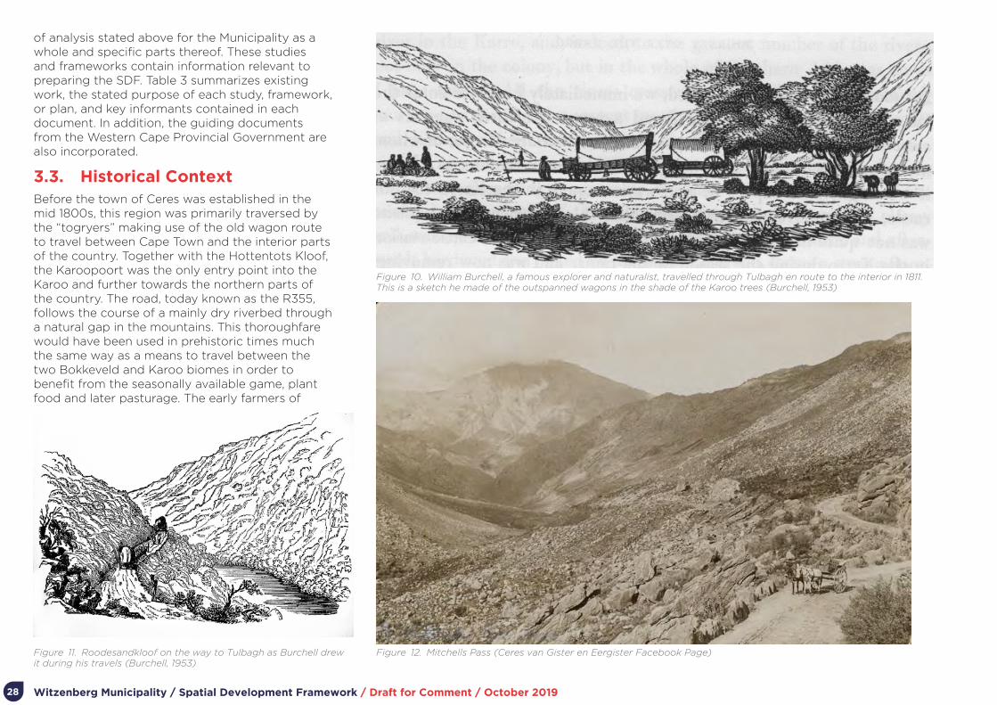
3.3. Historical ContextBefore the town of Ceres was established in the mid 1800s, this region was primarily traversed by the “togryers” making use of the old wagon route to travel between Cape Town and the interior parts of the country. Together with the Hottentots Kloof, the Karoopoort was the only entry point into the Karoo and further towards the northern parts of the country. The road, today known as the R355, follows the course of a mainly dry riverbed through a natural gap in the mountains. This thoroughfare would have been used in prehistoric times much the same way as a means to travel between the two Bokkeveld and Karoo biomes in order to benefit from the seasonally available game, plant food and later pasturage. The early farmers of
Figure 10. William Burchell, a famous explorer and naturalist, travelled through Tulbagh en route to the interior in 1811. This is a sketch he made of the outspanned wagons in the shade of the Karoo trees (Burchell, 1953)
Figure 11. Roodesandkloof on the way to Tulbagh as Burchell drew it during his travels (Burchell, 1953)
Figure 12. Mitchells Pass (Ceres van Gister en Eergister Facebook Page)

Witzenberg Municipality / Spatial Development Framework / Draft for Comment / October 2019 29
Figure 13. The old wagon route schematically mapped (Smuts, 1988)
the region lead their herds through the pass to escape the worst of the Koue Bokkeveld winters and to pasture their animals on the spring growth that followed. The route also provided passage to the hunting grounds of the north, well before the interior was settled.
In the early days of the Colony, the main road out of Cape Town led north along the impenetrable chain of mountains to the Roodezand Pass, which gave access to Tulbagh Valley, before turning south east and through the Breede River Valley. Thus, despite being relatively far from Cape Town, much traffic was directed via Karoopoort. After farming began in Tulbagh Valley in the early 1700s, the surrounding land was soon parcelled out for grazing. From this settlement, farming spread to the area over the Skurweberg and Witzenberg mountains east of Tulbagh, known as the Warm and Koue Bokkeveld.
However, travel over the Skurweberg and Witzenberg to the west – necessary to transport produce to Cape Town and attend to business and Church in Tulbagh – was difficult for these farmers. The road was impassable by wagon and wagons had to be dismantled and loaded on the oxen (Mossop 1927: 174). Later, the construction of the Michell’s Pass in 1848 by Andrew Geddes Bains and the extension of a hard road through Karoopoort made the area accessible to wagons, leading to an increase in settlement and thoroughfare. The town of Ceres was established the following year in 1849. The discovery of diamonds at Kimberley in 1866 led to a significant increase of movement through Ceres and the Poort, and an increase in the number of guests making use of the outspan at Karoopoort. The Karoopoort farm was declared a National Monument in 1981.
Tulbagh is the fourth oldest official town in South Africa dating back to the 1700s. The valley was discovered in 1658 by Pieter Potter, a surveyor who worked for Jan van Riebeeck. In 1699 14 farmers settled in the valley, and the town started developing around 1743. The town was proclaimed
Figure 14. Chronology of central Tulbagh mapped (Tulbagh Valley Heritage Foundation 2018)
Page | 17
MAP 5… CRONOLOGY OF CENTAL TULBAGH (Fold out version in appendix)
Of the 93 structures in the proposed HOZ & buffer:
25 appear as pre-industrial thatched /Cape Dutch buildings
9 appear as Victorianised old Cape houses, often double story with pitched tin roof
18 appear in the high Victorian or Edwardian form. Pre WWI
9 appear as Cape Revival buildings with some form of a gable and a few thatch roofs.
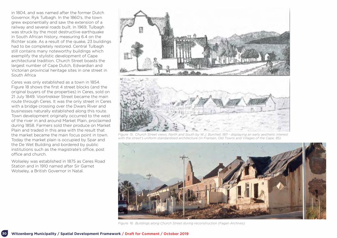
Witzenberg Municipality / Spatial Development Framework / Draft for Comment / October 201930
Figure 15. Church Street views, North and South by W.J. Burchell, 1811 - displaying an early aesthetic interest with the street’s uniform standardised architecture (in Fransen, Old Towns and Villages of the Cape, 85)
in 1804, and was named after the former Dutch Governor, Ryk Tulbagh. In the 1860’s, the town grew exponentially and saw the extension of a railway and several roads built. In 1969, Tulbagh was struck by the most destructive earthquake in South African history, measuring 6.4 on the Richter scale. As a result of the quake, 23 buildings had to be completely restored. Central Tulbagh still contains many noteworthy buildings which exemplify the stylistic development of Cape architectural tradition. Church Street boasts the largest number of Cape Dutch, Edwardian and Victorian provincial heritage sites in one street in South Africa
Ceres was only established as a town in 1854. Figure 18 shows the first 4 street blocks (and the original buyers of the properties) in Ceres, sold on 21 July 1849. Voortrekker Street became the main route through Ceres. It was the only street in Ceres with a bridge crossing over the Dwars River and businesses naturally established along this route. Town development originally occurred to the west of the river in and around Market Plain, proclaimed during 1858. Farmers sold their produce on Market Plain and traded in this area with the result that the market became the main focus point in town. Today the market plain is occupied by Spar and the De Wet Building and bordered by public institutions such as the magistrate’s office, post office and church.
Wolseley was established in 1875 as Ceres Road Station and in 1910 named after Sir Garnet Wolseley, a British Governor in Natal.
Figure 16. Buildings along Church Street during reconstruction (Fagan Archives)

Witzenberg Municipality / Spatial Development Framework / Draft for Comment / October 2019 31
Prince Alfred Hamlet village was founded on the farm Wagenboomsrivier belonging to Jan Goosen on 8th December 1861. It was named after Prince Alfred, the second son of Queen Victoria, who had visited South Africa the previous year. Further north, Op-die-Berg is a village established about 60 years ago as a business centre for the farmers of the Bokkeveld.
References:
https://ceresmuseum.co.za/history/ceres-history/
Pinto, H. & Smuts, K. (2011): Preliminary Archaeological Survey of Karoopoort Farm. Prepared for Cape Tanqua Tourism Services, 24 October 2011
Tulbagh Heritage Survey Report & Inventory: Part One – Heritage Survey Report for Central Tulbagh. October 2018
www.tulbaghtourism.co.za/home/info/historical
Figure 17. Voortrekker Street around 1956 (Ceres van Gister en Eergister Facebook Page)
Figure 18. A map of the original town layout of Ceres in 1849 (Ceres van Gister en Eergister Facebook Page)

Witzenberg Municipality / Spatial Development Framework / Draft for Comment / October 201932
3.4. Regional Context Witzenberg Municipality is situated within the Cape Winelands District (CWD), the largest non-metro district within the broader Western Cape Province economy, contributing 11,7 % towards provincial GDPR and 14.2 % to provincial employment (as per the 2015 statistics recorded in the IDP 2017-2022). CWD is also the biggest producer of stone fruit in the Province, and accounts for approximately 74% of all stone fruit production. The most economic functional areas for the production of stone fruits in this region are the Ceres-Tulbagh area (40%) and the Montagu-Robertson area (39%). Most processors and storage facilities are located in these areas. Finished products are sent from these areas to Stellenbosch, Paarl and Wellington from where it is distributed to retailers. Most of the produce is directly exported (Du Toit Group for example exports to 50 countries).
Ceres’s importance as a functional region within the broader agricultural space economy and its role as a primary regional service centre has been recognized through the identification of a possible Agri-park in Ceres, as well as the fact that Ceres and Tulbagh are situated within one of the PSDF’s identified Rural Development Corridors (see Figure 19).
Ceres is also strategically situated between the N1 and N7 national routes, forming part of the proposed regional road freight network as identified in the Greater Cape Metro and Greater Saldanha Regional Implementation frameworks (see Figure 20). These networks aim to improve
linkages from Piketberg via Gouda/ Tulbagh through to Ceres and then linking into the N1 either via Worcester or Touwsriver, placing Ceres at the centre of the regional network.
In addition to WItzenberg’s regional agricultural economic role, the area also hosts a high concentration of heritage resources, mountains, mountain passes and unique landscapes, as illustrated in Figure 21. Its position within the region as the primary gateway to the Warm and Koue Bokkeveld and Tanka Karoo also contributes to its strategic position and role in terms of tourism.
Figure 19. The position of Ceres and Tulbagh in relation to the GCM area and the PSDF Rural Development Corridors (GCM RSIF, 2017)
Figure 20. The position of Ceres in relation to the proposed regional road freight network of the Province (GS RSIF, 2018)
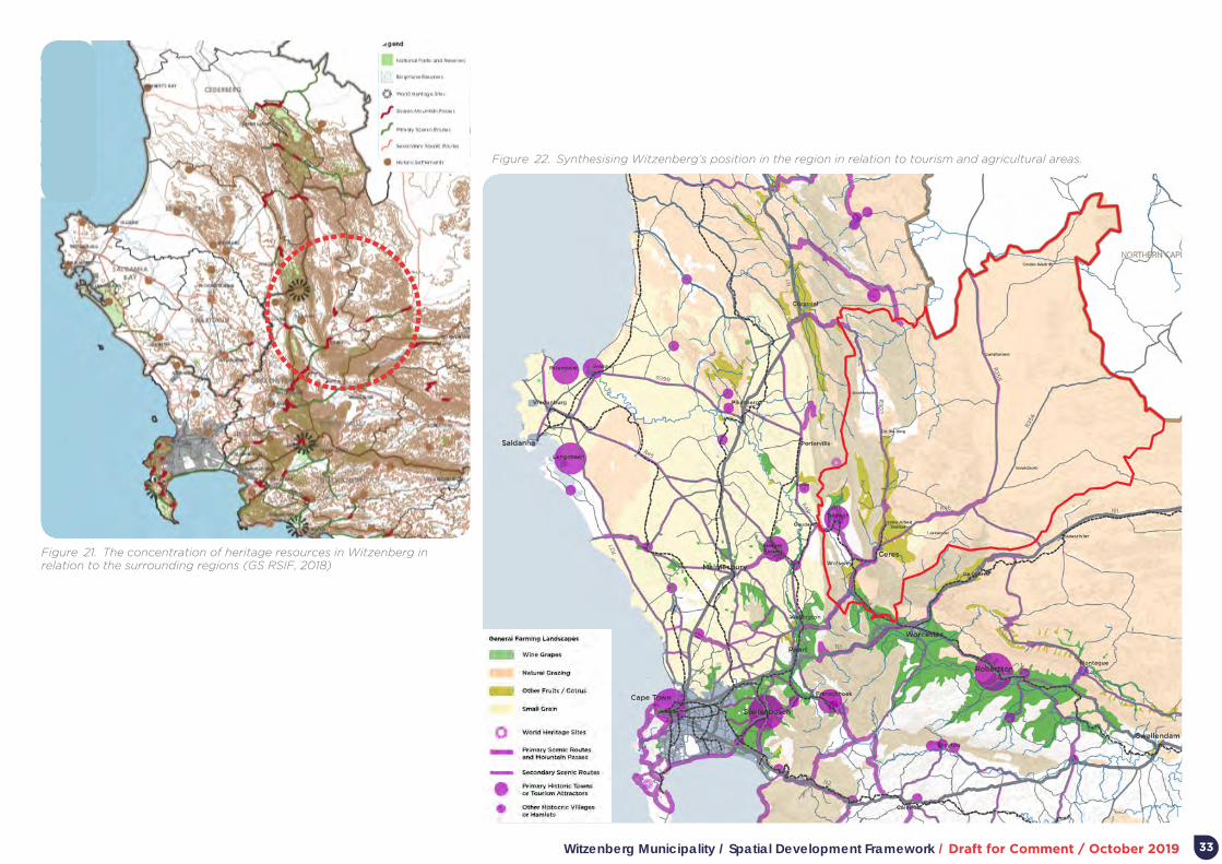
Witzenberg Municipality / Spatial Development Framework / Draft for Comment / October 2019 33
Figure 21. The concentration of heritage resources in Witzenberg in relation to the surrounding regions (GS RSIF, 2018)
Figure 22. Synthesising Witzenberg’s position in the region in relation to tourism and agricultural areas.

Witzenberg Municipality / Spatial Development Framework / Draft for Comment / October 201934
3.5. Biophysical Environment Context
3.5.1. OverviewThe Witzenberg Municipality’s biophysical environment functions within the larger Western Cape bioregion, an area endowed with world-renowned biodiversity and natural resources. The Witzenberg mountain ranges form part of the north-south axis of the Cape Fold Mountains, the most prominent topographic feature of the Western Cape. The unique natural environment of this valley, characterised by its mountains, vegetation, and agricultural resources, are the primary contributors to the formation and character of the landscape, while also having been the primary driver for areas of concentrated agricultural and settlement.
Agricultural land is located within the wetter valleys in the western parts of the municipal area, which is also the area under the most pressure for urban development (see Figure 26). The landscape transitions from this highly cultivated and irrigated farming landscape at the foothills of the mountain to the dry and arid Karoo, largely suitable for grazing.
3.5.2. Key Findings and ImplicationsFrom a spatial planning and land use management perspective, the following issues have been identified in relation to the biophysical context:
1. Biodiversity and habitat loss are occurring due to agriculture taking place in fertile lowland areas.
2. The southern and western parts of the municipal area are prone to wildfires (and hence classified as high risk areas).
3. Droughts and other climate-change related disasters are anticipated to occur with increased frequency.
4. The eastern part of the municipality is predicted to become less productive due to limited water availability and heat-related issues.
5. The match between land capacity and the potential of the land has been already been met within the municipality. Thus, the balance between conservation and agriculture is crucial to maintain the ecosystem and farming productivity of the region.
Figure 23. A simple Google Earth snapshot of the municipal area (outlined in red) highlights the unique landscapes, transitioning from steep mountain ranges, to fertile valleys forming the basis for settlement and agriculture and ending in the more arid Karoo landscape as one moves toward the Northern Cape (Google Earth, 2019)
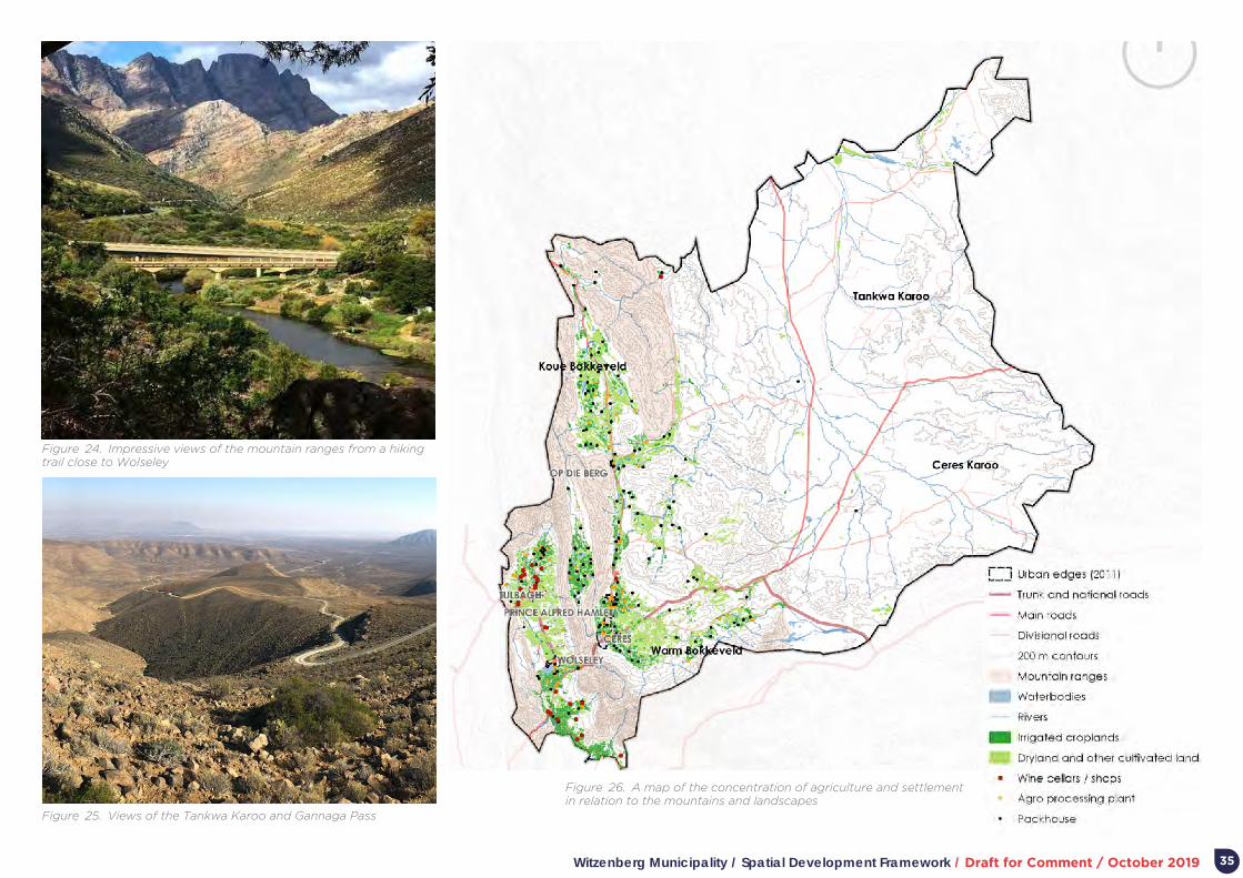
Witzenberg Municipality / Spatial Development Framework / Draft for Comment / October 2019 35
Figure 24. Impressive views of the mountain ranges from a hiking trail close to Wolseley
Figure 25. Views of the Tankwa Karoo and Gannaga Pass
Figure 26. A map of the concentration of agriculture and settlement in relation to the mountains and landscapes

Witzenberg Municipality / Spatial Development Framework / Draft for Comment / October 201936
3.6. Socio Economic Context
3.6.1. OverviewWith a population of 140 124 in 2018 and a growth of 7% since 2016, Witzenberg has the fastest growing population rates in CWD, and almost 60% of its population is under 30. More than half of the population is located in urban settlements, with the majority (58,3%) concentrated in Ceres (which includes Nduli and Bella Vista). Therefore, the municipality is home to a large rural community consisting of almost 50% of all municipal residents.
Within the CWD the agriculture, forestry and fishing sector contributed the most to employment in 2016 (22,6%), particularly in municipal areas that are more rural than Witzenberg. Despite this sector growing in 2017 at an estimated rate of 5,8%, the sector shed an estimated 2 308 jobs in 2017, following job losses in 2016 as well. Since this sector is a valuable source of employment, particularly in rural areas, these continued job losses can contribute to the increase in poverty and the need for support from government institutions.
The Witzenberg Municipality has a relatively small economy, contributing R8,2 billion to the economy of the CWD (13,5%) and provides employment for just over 60 000 people. The largest economic sectors in the Witzenberg economy in 2016 included the wholesale and retail trade, catering and accommodation sector (17,4%); the finance, insurance, real estate and business services sector (15,9%); and the agriculture, forestry and fishing sector (15,2%). Collectively, these sectors contributed R4 billion to the Witzenberg economy (48,5%), emphasising their importance locally and the impact of the sectoral performance on the overall stability of the Witzenberg economy.
Nationally, the pear industry has recorded a steady increase from R726 million in 2004/ 5 to R3 billion in 2013/ 14; which represents a 387% increase in the past ten years. Over half of the country’s pears are produced in the CWD, with the main
Figure 27. Map showing the dispersed rural communities (smaller green dots and brown dots) in relation to service centres and access to opportunities (larger green dots) (based on Eskom dot counts)

Witzenberg Municipality / Spatial Development Framework / Draft for Comment / October 2019 37
pear producing towns in the District situated in Witzenberg (Ceres, Tulbagh and Wolseley). The 2018 MERO observes that Witzenberg’s GDPR per capita exceeded that of Breede Valley from 2008 to 2017, whereas before the recession, Breede Valley had a higher GDPR per capita. Therefore, Witzenberg’s economy grew faster than that of Breede Valley between 2009 to 2017, which could be an indication of the region’s resilience to international financial crises.
Between 2015 and 2016 learner enrolment in Witzenberg decreased by 0,7% and the Grade 12 dropout rate decreased significantly. These high Grade 12 dropout rates and the decreasing Matric pass rates – together with low skill job losses – remain a concern in the Witzenberg municipal area.
3.6.2. Key Findings and ImplicationsFrom a spatial planning and land use management perspective, the following issues have been identified in relation to socio-economic context:
1. The marginalization of rural communities remains, exacerbated by a general lack of skills and access to opportunities/ services in these areas.
2. Relatively low economic growth and performance continues.
3. Agriculture remains the largest employer (50%), However, the sector is experiencing a high rate of net job losses, and often only provides seasonal opportunities.
4. While the areas’ population is set to increase, the provision of skills, training and employment opportunities have not been able to meet current demand.
5. Alternative models for farming and enabling economic growth such as eco-tourism or green agriculture, within the context of the Fourth Industrial Revolution towards future sustainability and resilience, have not been properly explored in this area.
Figure 28. Agricultural activities play a vital role in maintaining employment opportunities and economic viability for the Witzenberg region (Source)

Witzenberg Municipality / Spatial Development Framework / Draft for Comment / October 201938
3.7. Built Environment Context
3.7.1. Overview The key settlements in the Witzenberg Municipality are Ceres (which includes Bella Vista and Nduli), Wolseley, Tulbagh, Prince Alfred Hamlet, and and Op-die-Berg. Settlements act as places of residence and service centres to predominantly agricultural surrounding areas.
Historically, settlement have responded to landscape and set in more fertile areas, scenic and water resourced areas served by key movement routes. This, however, also implies settlement growth pressure on surrounding fertile agricultural land.
Settlements generally – perhaps excluding Tulbagh and Op-die-berg, remain relatively segregated (refer to Figure 32) with poorer citizens located furthest away from urban opportunity. Although much of the publicly assisted housing projects in Witzenberg Municipality has arguably reinforced this pattern, recent projects in Ceres (Vredebes) and Tulbagh has been located to reverse past spatial patterns.
Despite larger population numbers and higher densities than in old Ceres town, Bella Vista and Nduli lack significant formal commercial necessitating substantial movement of poorer citizens to access opportunity. Given a large rural population, the weekend influx of shoppers to town centres is significant, with inefficient provision of formal parking for taxis and other vehicles. Perceptions are that the public environment and facilities of town centres generally cope poorly with the weekend spikes of shoppers.
Witzenberg Municipality has seven informal settlements. These informal settlements with a population of some 4 600 people in approximately 1 560 structures. Housing demand in Witzenberg Municipality – as contained in the housing demand database – amounts to 5 671 units. Approximately
Figure 29. Map showing the limited amount of business opportunities in Nduli (areas in blue) versus housing i.e. households living in this community - implying that most residents here either need to travel to work or take part in the informal economy.
Figure 30. Inadequate pedestrian infrastructure along the R46 between Ceres and Nduli (Google Earth)

Witzenberg Municipality / Spatial Development Framework / Draft for Comment / October 2019 39
70% of those on the housing demand database were aged between 35 to 59 years at the date of registration and 12% older than 60.
In recent years, publicly assisted human settlement development and housing delivery in Witzenberg has generally focused on concluding housing projects in Bella Vista, the first phases of the major Vredebes housing project, and infill housing in Tulbagh. In the medium term, the Witzenberg Municipality will continue with the implementation of some 200 new housing opportunities in Tulbagh and in situ upgrading in Nduli (in parallel with Vredebes). Over the longer term the Municipality will focus on Wolseley where more than 1 200 new opportunities are planned over the next five to ten years. At current delivery rates – and given expected urbanisation – it is unlikely that the Municipality will meet housing demand fully.
Witzenberg Municipality is currently is assisted in its focus to restructure and integrate settlements through the WCG’s RSEP. The broad focus of the initiative is the integration of Ceres, Bella Vista and Nduli. Following community workshops, the focus has been on improving pedestrian and cycle access between Bella Vista (along the R303/ Vos Street) and Nduli (along the R46) and the main town of Ceres (where most employment and commercial opportunity is located). Detailed planning to ensure the optimum use of the area between Bella Vista, Ceres, and Nduli, has not progressed.
The 2012 Witzenberg MSDF provided for the inclusion of significant tracts of undeveloped and underdeveloped land (measuring some 896ha) within the urban edges of settlements. As indicated in Appendix H, summarising current major land development proposals, very little of the land identified for development in 2012 – with the exception of phases of Vredebes and infill development in Tulbagh – has been developed. A significant part of the land identified for future development therefore remains developable (even if, as outlined in Appendix I - addressing land demand – population growth is considered).
Figure 31. The status of infrastructure for each main urban area in Witzenberg (Source)
Figure 32. Racial segregation patterns in Ceres as depicted in this dot map based on Census 2011 data (Dot Map of South Africa by Adrian Frith)

Witzenberg Municipality / Spatial Development Framework / Draft for Comment / October 201940
A summary of infrastructure capacity constraints and issues in Witzenberg Municipality is attached as Appendix G. Wolseley, Tulbagh, and Op-die-berg have water storage capacity constraints, to be addressed through the construction of new storage dams.
Witzenberg Municipality is running at its NMD (Notified Maximum Demand) of 42,8 MVA. The current Eskom backbone network does not permit an increase of NMD until such time as their backbone network has been upgraded. The implications thereof are four years and R360m of investment, meaning that 2021 is the earliest that NMD can be upgraded.
A number of landfill site in the Municipality are under stress, and where closed or to be closed, resource constraints limit rehabilitation. To address solid waste issues, development of a regional landfill site at Worcester is currently in process with the purpose to accommodate the municipalities of Witzenberg, Breede Valley (Worcester) and Langeberg (Robertson, Ashton, Montagu).
In relation to public transport in Witzenberg Municipality, only minibus taxi and limited rail services are available (long-distance bus services offer an inter-municipal service). With 61% of people employed in agriculture, much of the travel in the district is difficult to serve with public transport as a result of the high cost of travel relative to income, seasonal variation in farming activity, and the wide spatial distribution of trip origins and destinations. Most frequent taxi operations take place between Ceres and Wolseley, Ceres and Nduli and Ceres and Bella Vista and Prince Alfred Hamlet, where it has been identified that a taxi rank is required. A taxi route between Ceres and the Koue-Bokkeveld area is also driven by large demand.
Despite Witzenberg Municipality having a rich source of historic and cultural assets, these are arguably under-recognised and exposed (except for historic assets in Tulbagh). From a historic space-economy perspective, the gateway location
of the area to the hinterland appears under-acknowledged and celebrated.
3.7.2. Key Findings and ImplicationsFrom a spatial planning and land use management perspective, the following issues have been identified in relation to the built environment:
1. Settlement growth requires careful management to prevent a loss of fertile agricultural land.
2. Integrating fragmented parts of settlements remains a priority to enable settlement efficiency and prevent sprawl into surrounding agricultural land.
3. At current delivery rates – and given expected urbanisation – it is unlikely that the Municipality will meet housing demand fully.
4. Progress has been made to locate new housing closer to existing opportunity (e.g. Vredebes).
5. Adequate land exists within current urban edges to accommodate anticipated future growth.
6. A lack of quality pedestrian/ NMT movement routes within and between neighbourhoods detracts from access to opportunity, especially for poorer communities.
7. Without significant bulk infrastructure upgrades – specifically related to electricity – Witzenberg Municipality will be unable to support any further growth.
8. Despite a rich source of historic and cultural assets, these are arguably under-recognised and exposed.
3.8. Institutional Context: Attributes, Issues and SDF Implications
The WM municipal budget is relatively small considering the depth, range and variability of citizen needs. There is also a general lack of funds to reverse backlogs or negative trends in shelter or infrastructure needs.
Only 28,6% of the capital budget for the medium term will be financed from municipal sources. The rest of the capital budget will be financed from external loans (1,4%) and grant funding (70%).
The Municipality also has limited human resources for planning and land use management (this is exacerbated by the large spatial extent of the Municipal area). Significant partnering is therefore required between the municipality, other spheres of government (and their agencies) and the private sector to address current needs and the restructuring of settlement.

Witzenberg Municipality / Spatial Development Framework / Draft for Comment / October 2019 41
3.9. Synthesis of Spatial Challenges and Opportunities
A synthesis of key challenges and opportunities related to spatial planning and management are summarised below.
3.9.2. Opportunities1. Meaningful inter-governmental initiatives and
public-private partnerships already exists which could be extended to assist in urban development and settlement management (e.g. RSEP, the Ceres Business Initiative, and the Twinning Agreement with Essen Municipality in Belgium).
2. RSEP Involvement in development of integrated communities – leverage funding and project implementation.
3. Sufficient undeveloped and underdeveloped land remain within the urban edges of settlements to accommodate anticipated demand for settlement development over the medium terms.
4. Provincial spatial planning and land use management policy provides opportunities for the diversification of the agricultural/ rural economy (especially through sensitive tourism initiatives).
3.9.1. Challenges1. Economic sectors which underly the local
economy and accommodate unskilled workers (especially manufacturing and agriculture) show slow growth.
2. There is significant demand for housing while further urbanisation and current delivery rates for serviced land top structures will proberly not be able to meet demand.
3. Historic approaches to settlement development – favouring lower density single unit on a plot development – will threaten valuable agricultural land and strain infrastructure provision and maintenance.
4. There are inadequate opportunities available for job creation and economic growth in settlements.
5. Inadequate public and NMT transport options limit access to available work and other opportunities.
6. Water and electricity supply and associated infrastructure may not be able to meet future demand adequately.

Witzenberg Municipality / Spatial Development Framework / Draft for Comment / October 201942
Part 4.
Vision and Concept

Witzenberg Municipality / Spatial Development Framework / Draft for Comment / October 2019 43
4. Vision and Conceptecosystem services that underpin economic development and support human well-being. They include provisioning services such as food, freshwater, and fuel as well as an array of regulating services such as water purification, pollination, and climate regulation. Healthy ecosystems are a prerequisite to sustaining economic development and mitigating and adapting to climate change. The plan provides for activities enabling access to nature in a manner which does not detract from the functionality and integrity of nature and farming areas and landscapes.
Second, maintain and expand the Municipality’s key regional and intra-regional infrastructure.
Appropriate infrastructure – whether in the form of transport routes or municipal services – is critical to support economic development, agriculture, and livelihoods.
Third, maintain and grow the agricultural assets within the Municipality.
Agriculture remains the mainstay of the regional economy and require on-going support. In a spatial sense, this specifically requires protecting high-value agricultural land from urban development. The opportunity also exists to diversify farm income in a manner which does not detract from the functionality and integrity of farming areas and landscapes, and to expand access to farming to smaller entrepreneurs and emerging farmers.
Fourth, maintain and expand access to Witzenberg’s unique sense of people and place.
Important is the recognition and maintenance of unique landscapes, and diverse expressions over time of peoples’ interaction with the landscape. Also critical is the SPLUMA principle of “spatial justice”; implying that past spatial and other
4.1. IntroductionThis section outlines a vision, key considerations, and spatial concept for the spatial planning and land use management of SM.
4.1.1. VisionThe Witzenberg Municipal IDP sets out the following vision to drive the agenda for integrated development and planning:
“A municipality that cares for its community, creating growth and opportunities.”
In line with this vision, the Municipality commits itself to improve the quality of life of its community by providing and maintaining affordable services, promoting social and economic development, ensuring for the effective and efficient use of available resources and facilitating effective stakeholder and community participation.
The working vision developed for directing preparation of the MSDF is:
“Managing spatial development and land use change in a manner that recognises and safeguards Witzenberg’s critical and diverse natural, agricultural, historic, cultural, commercial, and institutional assets while increasing livelihood opportunity for all its citizens.”
4.1.2. Key considerationsTo achieve the vision, five considerations are regarded as critical:
First, maintain and protect the integrity, authenticity and accessibility of Witzenberg’s natural environment and associated resources.
Humanity depends on nature for physical and spiritual sustenance, livelihoods, and survival. Ecosystems provide numerous benefits or
development imbalances must be redressed through improved access to and use of land, as well as the inclusion of persons and areas that were previously excluded, with an emphasis on informal settlements, and areas characterised by widespread poverty and deprivation.
Fifth, maintain and expand opportunity associated with Witzenberg’s key settlements.
Settlements need to be managed and provide for expansion in a manner which enables efficiency in infrastructure provision, integration and compaction to enable better thresholds and more sustainable movement, and protection of surrounding assets of nature and agriculture.
4.2. Conceptual ApproachThe following sections and associated diagrams outline the concept and key implications for the Witzenberg Municipality MSDF.
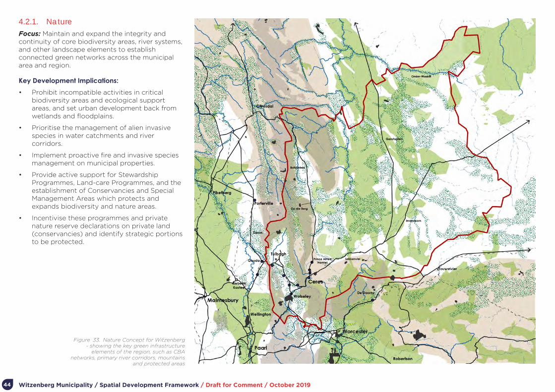
Witzenberg Municipality / Spatial Development Framework / Draft for Comment / October 201944
4.2.1. NatureFocus: Maintain and expand the integrity and continuity of core biodiversity areas, river systems, and other landscape elements to establish connected green networks across the municipal area and region.
Key Development Implications:
• Prohibit incompatible activities in critical biodiversity areas and ecological support areas, and set urban development back from wetlands and floodplains.
• Prioritise the management of alien invasive species in water catchments and river corridors.
• Implement proactive fire and invasive species management on municipal properties.
• Provide active support for Stewardship Programmes, Land-care Programmes, and the establishment of Conservancies and Special Management Areas which protects and expands biodiversity and nature areas.
• Incentivise these programmes and private nature reserve declarations on private land (conservancies) and identify strategic portions to be protected.
Figure 33. Nature Concept for Witzenberg - showing the key green infrastructure
elements of the region, such as CBA networks, primary river corridors, mountains
and protected areas

Witzenberg Municipality / Spatial Development Framework / Draft for Comment / October 2019 45
4.2.2. Regional InfrastructureFocus: Maintain and strengthen regional movement routes, rural-urban accessibility, and municipal services critical to support economic development, agriculture, and livelihoods.
Key Development Implications:
• Proactively maintain formal relationships with neighbouring municipalities and other spheres of government and government agencies regarding infrastructure development and management.
• Proactively explore new public transport opportunities for improved local and regional accessibility, including the use of rail infrastructure.
• Ensure the upkeep of the R43, R46, R303 and R355 as major economic transport and scenic routes.
• Prioritise infrastructure and public investment in settlements identified for growth and in a manner which supports the settlement hierarchy for Witzenberg.
• Support infill development and increased land uses in areas where existing infrastructure will be able to support additional capacities and as a means to improve efficiency and cost effectiveness in infrastructure provision.
Figure 34. Regional Infrastructure Concept for Witzenberg - showing regional centres,
settlement hierarchy and transport connections. The five main towns of Witzenberg are
highlighted in red, with regional connections between Piketberg, Paarl and Worcester, as well
as links to the N1 highlighted in grey.

Witzenberg Municipality / Spatial Development Framework / Draft for Comment / October 201946
4.2.3. AgricultureFocus: Protect food security while supporting sustainable diversification of the agricultural sector and encouraging more efficient methods and models.
Key Development Implications:
• Support private sector led institutional arrangements to enable joint planning and development of agriculture related activities.
• Avoid the subdivision of agricultural land or changes in land-use to minimise the loss of agricultural activities while also avoiding the creation of uneconomical agricultural units.
• Enable the diversification of farmer income through enabling complimentary uses on farms in a manner which does not detract from the functionality and integrity of farming areas and landscapes.
• Develop incentives for smarter/ green agricultural practices and technologies.
• Make municipal commonages and land on the edges of settlements close to communities available for small/ emerging farmers and/or community gardens.
• Support alternative farming models such as the possibility of transforming unused and uncontaminated industrial land into community gardens.
• Support private initiatives to provide in the housing needs of agri-workers and the provision and management of associated social services.
Figure 35. Agricultural Concept for Witzenberg - showing key farming
areas, production types and supporting infrastructure concentrated along the
agricultural band along the western edge of the municipal area
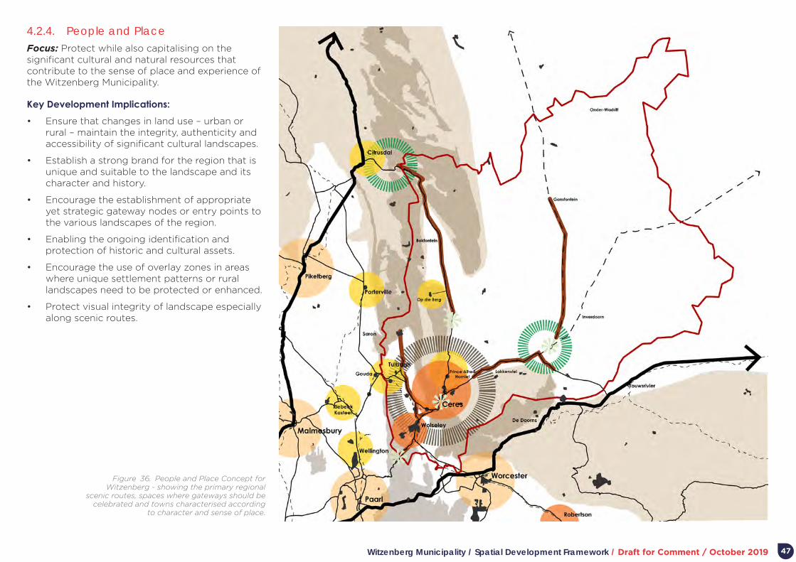
Witzenberg Municipality / Spatial Development Framework / Draft for Comment / October 2019 47
4.2.4. People and Place Focus: Protect while also capitalising on the significant cultural and natural resources that contribute to the sense of place and experience of the Witzenberg Municipality.
Key Development Implications:
• Ensure that changes in land use – urban or rural – maintain the integrity, authenticity and accessibility of significant cultural landscapes.
• Establish a strong brand for the region that is unique and suitable to the landscape and its character and history.
• Encourage the establishment of appropriate yet strategic gateway nodes or entry points to the various landscapes of the region.
• Enabling the ongoing identification and protection of historic and cultural assets.
• Encourage the use of overlay zones in areas where unique settlement patterns or rural landscapes need to be protected or enhanced.
• Protect visual integrity of landscape especially along scenic routes.
Figure 36. People and Place Concept for Witzenberg - showing the primary regional
scenic routes, spaces where gateways should be celebrated and towns characterised according
to character and sense of place.
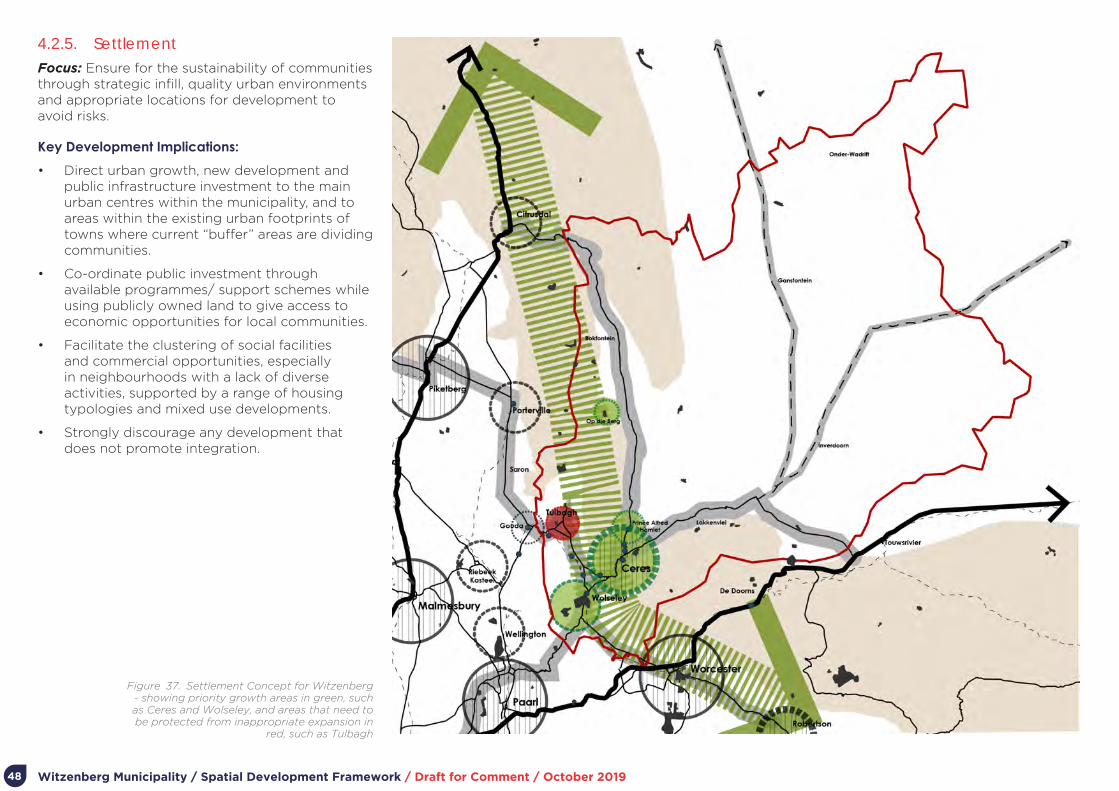
Witzenberg Municipality / Spatial Development Framework / Draft for Comment / October 201948
4.2.5. SettlementFocus: Ensure for the sustainability of communities through strategic infill, quality urban environments and appropriate locations for development to avoid risks.
Key Development Implications:
• Direct urban growth, new development and public infrastructure investment to the main urban centres within the municipality, and to areas within the existing urban footprints of towns where current “buffer” areas are dividing communities.
• Co-ordinate public investment through available programmes/ support schemes while using publicly owned land to give access to economic opportunities for local communities.
• Facilitate the clustering of social facilities and commercial opportunities, especially in neighbourhoods with a lack of diverse activities, supported by a range of housing typologies and mixed use developments.
• Strongly discourage any development that does not promote integration.
Figure 37. Settlement Concept for Witzenberg - showing priority growth areas in green, such as Ceres and Wolseley, and areas that need to be protected from inappropriate expansion in
red, such as Tulbagh

Witzenberg Municipality / Spatial Development Framework / Draft for Comment / October 2019 49
Figure 38. Composite Concept for WItzenberg
4.3. CompositeA composite concept for the Witzenberg MSDF is illustrated in Diagram …
Key to the concept is:
• The identification and protection of nature areas and assets of different kinds.
• Key regional and intra-regional infrastructure (including the movement routes).
• Areas of high value agricultural land.
• Key place and cultural assets, including scenic routes and gateways.
• A hierarchy of settlements, large and small and focus for non-rural development and services of various kinds.

Witzenberg Municipality / Spatial Development Framework / Draft for Comment / October 201950
Part 5.
Plans and Settlement Proposals

Witzenberg Municipality / Spatial Development Framework / Draft for Comment / October 2019 51
5. Plans and Settlement Proposals
5.1. IntroductionThe sections below outline plans and written proposals for:
• Witzenberg Municipality as a whole.
• Individual settlements within Witzenberg Municipality.
• Guidelines for managing specific activities landscape-wide and within settlements.
It is important to remember that the plans constitute one type of planning instrument. Not all of the MSDF objectives or intent can be readily illustrated two dimensionally on a plan. Therefore, the plans are accompanied by descriptions of plan elements and associated proposals. The plans should be read with the written information contained in the descriptions accompanying the plans as well as the policies and guidelines contained in the MSDF. Each settlement plan is introduced by a concept plan, an illustration of the core ideas related to spatial management and development of the settlement.
As indicated elsewhere in this document, spatial plans and proposals can seldomly be fully implemented without supportive actions in other functional areas or sectors. For example, it is doubtful whether the desired form of compact, diverse, inclusive, and walkable settlements will be achieved without parallel supportive initiatives to manage the unimpeded use of private vehicles. For this reason, the plan descriptions also include – where important – related non-spatial proposals.
Broadly – and aligned to the SPLUMA MSDF guidelines – the settlement plans entail three types of actions or initiatives:
• Protective actions – things to be protected and maintained to achieve the vision and spatial concept.
• Change actions – things that need to change, transformed, or enhanced to achieve the vision and spatial concept.
• New development actions – new development or initiatives to be undertaken to achieve the vision and spatial concept.
Under these broad types of actions, strategic focus areas and settlement elements are dealt with; for example, protective actions will broadly relate to
protecting elements of nature, agriculture, scenic landscapes, historically and culturally significant precincts and places, and so on.
5.2. Witzenberg Municipality as a Whole
The overall plan for Witzenberg Municipality essentially comprises of:
• Landscape-wide Spatial Planning Categories (SPCs) and associated land use guidelines.
• A settlement hierarchy and associated settlement development and management guidelines.
• Places of cultural and scenic significance.
• Municipal-wide infrastructure.
5.2.1. Landscape-wide Spatial Planning Categories
At the broadest level of municipal planning, desired land use patterns are reflected in the delineation of landscape-wide or municipal-wide Spatial Planning Categories (SPCs), namely Core, Buffer, Agriculture and Settlement categories. The definition of SPCs is based on the Western Cape Biodiversity Spatial Plan, 2017 (WCBSP) which delineates the Western Cape’s biodiversity network.
In general terms, the definition of SPCs is directed by the understanding that:
• The Western Cape’s biological diversity underpins livelihoods, the Province’s economy and the provision of ecosystem services. The spatial continuity and connectivity of the biodiversity network strengthens its resilience. Different categories of biodiversity areas indicated in the WCBSP Map and SPCs have specific management objectives, according to their biodiversity priority. In broad terms, the biodiversity priority areas need to be maintained in a healthy and functioning condition, whilst those that are less important for biodiversity can be used for a variety of other land uses.
• Cultivatable soils and mineral resources are non-renewable assets, important foundations of the Western Cape economy. As agricultural output is the basis of the Western Cape’s rural economy and an important input to the urban economy, safeguarding the Province’s agricultural resources, and productively using them without compromising biodiversity, heritage and scenic resources, remains a key challenge. There is limited suitable land available for extension of the Province’s agricultural footprint, and water availability limits the use of cultivatable soils.
• Settlements – of different sizes – support critical livelihood opportunity and economic exchange. A key concern is to maintain and grow the efficient functioning of settlements while preventing encroachment into priority biodiversity, agricultural, scenic areas.
Figure 39 and Table 4-5 indicate the landscape-wide SPCs for Witzenberg Municipality. The tables also list the names of key places which forms part of each SPC, what activities are broadly supported in each category, the activities not supported, and the overall desired form of development in each category.

Witzenberg Municipality / Spatial Development Framework / Draft for Comment / October 201952
Figure 39. Consolidated Municipal Framework Map for the Witzenberg Municipality as a whole
The activities supported and overall desired form of development in each SPC is based on the guidelines contained in the Western Cape Land Use Planning Guidelines Rural, March 2019. For a fuller explanation of each SPC, the full Rural Guidelines document should be consulted1.
The guidelines were prepared to establish norms and standards based on evidence and is aligned with international, national, and provincial policy related to the sustainable use of natural resources and agricultural land.
1 https://www.westerncape.gov.za/eadp/files/atoms/files/Rural%20Areas%20Guideline_web_0.pdf

Witzenberg Municipality / Spatial Development Framework / Draft for Comment / October 2019 53
SPC DESCRIPTIONKEY PLACES IN WITZENBERG
ACTIVITIES SUPPORTEDACTIVITIES NOT
SUPPORTEDOVERALL DESIRED FORM
OF DEVELOPMENT
Core 1
Areas that must be maintained in, or restored to, a natural state in order to sustain biodiversity patterns and processes and the functionality of eco-system services.
• Formal protected areas and Mountain Catchment Areas: Tankwa Karoo NP, Matroosberg MCA, Cederberg MCA, Kouebokkeveld MCA, Winterhoek MCA, Hawequas MCA.
• Private nature reserves.
• Areas designated by the WCBSP as CBA1.
• Essentially Core areas are “no-go” areas from a development perspective. Human impact must be restricted to ensure that there is no further loss of natural habitat.
• Conservation management activities should be encouraged.
• Subject to stringent controls biodiversity-compatible land uses that may be accommodated include non-consumptive low impact eco-tourism activities (e.g. hiking trails, bird and game watching, and visitor overnight accommodation); and harvesting of natural resources (e.g. wildflowers for medicinal, culinary or commercial use).
• Controlled livestock grazing and game farming must be informed by the habitat type, grazing potential and other site sensitivities. No further loss of natural habitat should occur and lower than standard stocking rates should be applied.
• Land consolidation
• Mining or prospecting.
• Extensive or intensive grazing.
• Conversion of natural habitat for cultivation or forestry.
• Large-scale eco-tourism.
• Subdivision.
• Expansion of settlements.
Small low-density footprints, and temporary structures are preferred with units carefully dispersed or clustered to achieve least impact. The use of alternative porous materials and innovative eco-friendly design concepts are encouraged.
Core 2
Areas in a degraded condition that must be rehabilitated in order to sustain biodiversity patterns and processes and the functionality of eco-system services. Includes areas that support the ecological functioning of critical biodiversity areas.
• Areas designated by the WCBSP as CBA2 or ESA1.
• Lower slopes and foothills in Land van Waveren and Warm Bokkeveld.
• Degraded reaches of the Groot and Doring Rivers in the Ceres and Tankwa Karoo.
• Watercourses and their buffers in the Ceres and Tankwa Karoo.
• As for Core 1 whilst allowing for a limited increase in scale of development in less sensitive areas (provided ecological processes are not disrupted).
• Where existing agricultural activities (e.g. extensive livestock or game farming) occur in Core 1 or Core 2 Areas, it needs to be subject to inter alia lower impact practices, lower than standard stocking rates, resting cycles wetland and riverbank protection, and avoiding areas containing red data species.
• Extension of intensive or extensive agriculture.
• Mining or prospecting.
• Large-scale cultivation.
• Urban or industrial development.
As for Core 1. Detailed site-level mapping of habitat conditions should inform the placement of essential buildings or structures in Core Areas. Disturbed footprints should preferably be utilised.
Buffer 1
Large intact portions and remnants of natural or near natural vegetation not designated as Core Areas but in proximity to them.
• Areas designated by the WCBSP as Other Natural Area, in proximity to or adjacent to Core Areas.
• Livestock farming areas in the Ceres and Tankwa Karoo.
• Conservation activities as per Core 1 and 2 Areas, including sustainable consumptive or non-consumptive uses.
• Extensive agriculture such as game or livestock farming, subject to lower impact practices, sustainable stocking rates, rotational grazing cycles, protection of watercourses, and avoidance of areas containing species of conservation concern.
• Development (e.g. structures) in support of both tourism and biodiversity conservation in Core Areas.
• Extensive agriculture comprising extensive game and livestock farming, subject to inter alia lower impact practices, lower than standard stocking rates, resting cycles wetland and riverbank protection, and avoiding areas containing red data species.
• Case-specific determination based on impact on biodiversity.
Development should reinforce existing farm precincts and reflect similar vernacular in terms of scale, form and design.
In the absence of existing farmsteads, development should reflect compact and unobtrusive characteristics, conforming to local vernacular in terms of scale, form and design.
The design of all proposed development should embrace the spatial form, movement patterns, building design and conservation and ecology of the local area.
Table 4. Landscape-wide Spatial Planning Categories
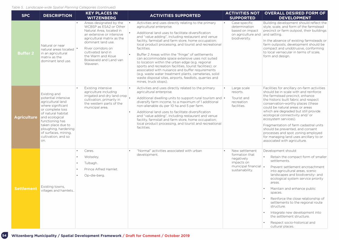
Witzenberg Municipality / Spatial Development Framework / Draft for Comment / October 201954
SPC DESCRIPTIONKEY PLACES IN WITZENBERG
ACTIVITIES SUPPORTEDACTIVITIES NOT
SUPPORTEDOVERALL DESIRED FORM OF
DEVELOPMENT
Buffer 2
Natural or near natural areas located in an agricultural matrix as the dominant land use.
• Areas designated by the WCBSP as ESA2 or Other Natural Area, located in an extensive or intensive agricultural matrix as the dominant land use.
• River corridors on cultivated land in the Warm and Koue Bokkeveld and Land van Waveren.
• Activities and uses directly relating to the primary agricultural enterprise.
• Additional land uses to facilitate diversification and “value adding”, including restaurant and venue facility, farmstall and farm store, home occupation; local product processing, and tourist and recreational facilities.
• Buffer 2 Areas within the “fringe” of settlements can accommodate space extensive uses not suited to location within the urban edge (e.g. regional sports and recreation facilities, tourist facilities); or associated with nuisance and buffer requirements (e.g. waste water treatment plants, cemeteries, solid waste disposal sites, airports, feedlots, quarries and mines, truck stops).
• Case-specific determination based on impact on agriculture and biodiversity.
Building development should reflect the style, scale, and form of the farmstead precinct or farm outpost, their buildings and setting.
In the absence of existing farmsteads or farm outposts, development should be compact and unobtrusive, conforming to local vernacular in terms of scale, form and design.
Agriculture
Existing and potential intensive agricultural land where significant or complete loss of natural habitat and ecological functioning has taken place due to ploughing, hardening of surfaces, mining, cultivation, and so on.
• Existing intensive agriculture including irrigated and dry land crop cultivation, primarily in the western parts of the municipal area.
• Activities and uses directly related to the primary agricultural enterprise.
• Additional dwelling units to support rural tourism and diversify farm income, to a maximum of 1 additional non-alienable du per 10 ha and 5 per farm.
• Additional land uses to facilitate diversification and “value adding”, including restaurant and venue facility, farmstall and farm store, home occupation; local product processing, and tourist and recreational facilities.
• Large scale resorts.
• Tourist and recreation facilities.
Facilities for ancillary on-farm activities should be in scale with and reinforce the farmstead precinct, enhance the historic built fabric and respect conservation-worthy places (these could be natural areas or areas which are degraded but still provide ecological connectivity and/ or ecosystem services).
Fragmentation of farm cadastral units should be prevented, and consent processes and spot zoning employed for managing land uses ancillary to or associated with agriculture.
SettlementExisting towns, villages and hamlets..
• Ceres.
• Wolseley.
• Tulbagh.
• Prince Alfred Hamlet.
• Op-die-berg.
• “Normal” activities associated with urban development.
• New settlement formation that negatively impacts on municipal financial sustainability.
Development should:
• Retain the compact form of smaller settlements.
• Prevent settlement encroachment into agricultural areas, scenic landscapes and biodiversity- and ecological system service priority areas.
• Maintain and enhance public spaces.
• Reinforce the close relationship of settlements to the regional route structure.
• Integrate new development into the settlement structure.
• Respect socio-historical and cultural places.
Table 5. Landscape-wide Spatial Planning Categories (continued)
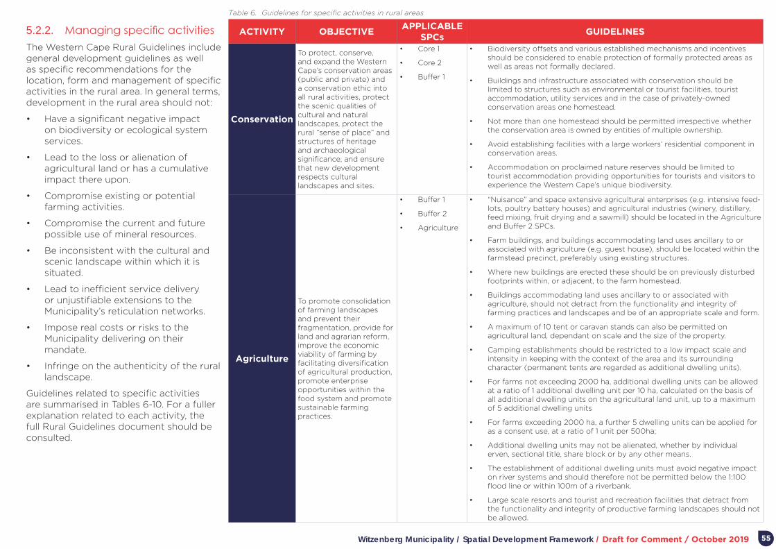
Witzenberg Municipality / Spatial Development Framework / Draft for Comment / October 2019 55
ACTIVITY OBJECTIVEAPPLICABLE
SPCsGUIDELINES
Conservation
To protect, conserve, and expand the Western Cape’s conservation areas (public and private) and a conservation ethic into all rural activities, protect the scenic qualities of cultural and natural landscapes, protect the rural “sense of place” and structures of heritage and archaeological significance, and ensure that new development respects cultural landscapes and sites.
• Core 1
• Core 2
• Buffer 1
• Biodiversity offsets and various established mechanisms and incentives should be considered to enable protection of formally protected areas as well as areas not formally declared.
• Buildings and infrastructure associated with conservation should be limited to structures such as environmental or tourist facilities, tourist accommodation, utility services and in the case of privately-owned conservation areas one homestead.
• Not more than one homestead should be permitted irrespective whether the conservation area is owned by entities of multiple ownership.
• Avoid establishing facilities with a large workers’ residential component in conservation areas.
• Accommodation on proclaimed nature reserves should be limited to tourist accommodation providing opportunities for tourists and visitors to experience the Western Cape’s unique biodiversity.
Agriculture
To promote consolidation of farming landscapes and prevent their fragmentation, provide for land and agrarian reform, improve the economic viability of farming by facilitating diversification of agricultural production, promote enterprise opportunities within the food system and promote sustainable farming practices.
• Buffer 1
• Buffer 2
• Agriculture
• “Nuisance” and space extensive agricultural enterprises (e.g. intensive feed-lots, poultry battery houses) and agricultural industries (winery, distillery, feed mixing, fruit drying and a sawmill) should be located in the Agriculture and Buffer 2 SPCs.
• Farm buildings, and buildings accommodating land uses ancillary to or associated with agriculture (e.g. guest house), should be located within the farmstead precinct, preferably using existing structures.
• Where new buildings are erected these should be on previously disturbed footprints within, or adjacent, to the farm homestead.
• Buildings accommodating land uses ancillary to or associated with agriculture, should not detract from the functionality and integrity of farming practices and landscapes and be of an appropriate scale and form.
• A maximum of 10 tent or caravan stands can also be permitted on agricultural land, dependant on scale and the size of the property.
• Camping establishments should be restricted to a low impact scale and intensity in keeping with the context of the area and its surrounding character (permanent tents are regarded as additional dwelling units).
• For farms not exceeding 2000 ha, additional dwelling units can be allowed at a ratio of 1 additional dwelling unit per 10 ha, calculated on the basis of all additional dwelling units on the agricultural land unit, up to a maximum of 5 additional dwelling units
• For farms exceeding 2000 ha, a further 5 dwelling units can be applied for as a consent use, at a ratio of 1 unit per 500ha;
• Additional dwelling units may not be alienated, whether by individual erven, sectional title, share block or by any other means.
• The establishment of additional dwelling units must avoid negative impact on river systems and should therefore not be permitted below the 1:100 flood line or within 100m of a riverbank.
• Large scale resorts and tourist and recreation facilities that detract from the functionality and integrity of productive farming landscapes should not be allowed.
Table 6. Guidelines for specific activities in rural areas
5.2.2. Managing specific activitiesThe Western Cape Rural Guidelines include general development guidelines as well as specific recommendations for the location, form and management of specific activities in the rural area. In general terms, development in the rural area should not:
• Have a significant negative impact on biodiversity or ecological system services.
• Lead to the loss or alienation of agricultural land or has a cumulative impact there upon.
• Compromise existing or potential farming activities.
• Compromise the current and future possible use of mineral resources.
• Be inconsistent with the cultural and scenic landscape within which it is situated.
• Lead to inefficient service delivery or unjustifiable extensions to the Municipality’s reticulation networks.
• Impose real costs or risks to the Municipality delivering on their mandate.
• Infringe on the authenticity of the rural landscape.
Guidelines related to specific activities are summarised in Tables 6-10. For a fuller explanation related to each activity, the full Rural Guidelines document should be consulted.

Witzenberg Municipality / Spatial Development Framework / Draft for Comment / October 201956
ACTIVITY OBJECTIVEAPPLICABLE
SPCsGUIDELINES
Land Reform
To support aspirant emerging farmers with access to land for commercial and subsistence farming purposes, create opportunities to develop agricultural holdings in the urban fringe, and support different settlement options to allow rural dwellers and their dependants to fully benefit from the various tenure, housing and subsidy benefits and rights which are availed to them.
• Buffer 1
• Buffer 2
• Agriculture
• Where an agricultural land reform project is implemented on a farm, the same rights apply as in “normal” areas. If a group of individuals collectively own the land, the provision of housing to all beneficiaries of the land reform project is discouraged as only one homestead for the owner is allowed. The remaining occupants on the farm could be accommodated as agri-workers, but settlement formation should be guarded against.
• New agricultural holdings (small agricultural properties) in the urban fringe within the Agriculture SPC are encouraged for cultivation and livestock purposes.
• Municipal commonage (which should not be alienated or fragmented) and state-owned land should be considered for the establishment of (community) food gardens and the entry of new farmers into the market.
• A minimum agricultural holding size of 8000m² is recommended and such properties should include an independent water source, or a secured water source for the intended agricultural or economic activities and purposes on the land.
• In order to prevent the urbanisation of the urban fringe and ensure that areas set aside for small scale farming do not lead to uncontrolled urban sprawl or settlement formation, authorities should restrict residential rights on agricultural holdings (but make provision for temporary structures on these properties for tool sheds, produce stores, security purposes, etc.).
• Municipalities should ensure that appropriate zoning or overlay zones are available and used for this purpose to differentiate from conventional agricultural areas, which accommodates multiple dwellings and ancillary uses.
• Land reform beneficiaries are encouraged to settle in nearby settlements. Only in exceptional cases, should authorities deviate from these guidelines and permit a maximum of one dwelling per agricultural holding for settlement of the owner or those who work the land.
• The subdivision of agricultural land in the rural landscape for individual title to provide security of tenure to agri-workers and rural dwellers are not supported.
• Agri-villages can be considered In a farming area where there is a concentration of agri-workers due to the type of agricultural activities (and a substantial demand for “off-the-farm” settlement), where there are no established settlements within practical commuting distance (approximately 30km), where the owners and workforce of a company farm (or a group of neighbouring farms) identify sufficient demand and the capacity for the establishment of a centrally located settlement where housing and communal facilities and services can be cost-effectively provided to the local agri-worker community.
• Security of tenure is afforded by way of a lease or notarial deed of servitude, as the land and housing remain the property of the institution/ legal entity.
Tourist and Recreational
Facilities
To offer a range of appropriate nature, cultural and agri-based rural tourism facilities and recreational opportunities across the rural landscape, enabling economic diversification and access to natural resources for citizens.
• All rural SPCs • Whilst tourist and recreation facilities should be accommodated across the rural landscape, the nature and scale of the facility provided needs to be closely aligned with the environmental characteristics of the local context.
• The development should have no adverse effects on society, natural systems and agricultural resources.
• Rural tourism and recreation facilities and activities should not compromise farm production and be located to reinforce the farmstead precinct.
• Existing structures or disturbed footprints should preferably be used, and adequate provision made for access and parking.
• A large-scale recreational facility which includes a residential component (e.g. golf courses, polo fields, horse racing) should be located on the urban edge, with such residential component located inside the edge.
Table 7. Guidelines for specific activities in rural areas (continued)
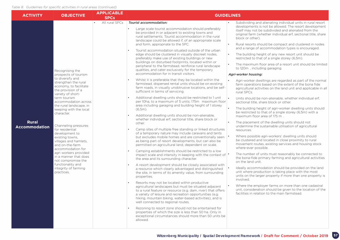
Witzenberg Municipality / Spatial Development Framework / Draft for Comment / October 2019 57
ACTIVITY OBJECTIVEAPPLICABLE
SPCsGUIDELINES
Rural Accommodation
Recognising the prospects of tourism to diversify and strengthen the rural economy, to facilitate the provision of a variety of short-term tourism accommodation across the rural landscape, in keeping with the local character.
Channeling pressures for residential development to existing towns, villages and hamlets, and on-the-farm accommodation for agri workers provided in a manner that does not compromise the functionality and integrity of farming practices.
• All rural SPCs Tourist accommodation:
• Large scale tourist accommodation should preferably be provided in or adjacent to existing towns and rural settlements. Tourist accommodation in the rural landscape could be allowed if, of an appropriate scale and form, appropriate to the SPC.
• Tourist accommodation situated outside of the urban edge should be clustered in visually discreet nodes, preferably make use of existing buildings or new buildings on disturbed footprints, located within or peripheral to the farmstead, reinforce rural landscape qualities, and cater exclusively for the temporary accommodation for in transit visitors.
• Whilst it is preferable that they be located within the farmstead, dispersed rental units should be on existing farm roads, in visually unobtrusive locations, and be self-sufficient in terms of servicing.
• Additional dwelling units should be restricted to 1 unit per 10ha, to a maximum of 5 units; 175m² maximum floor area including garaging and building height of 1 storey (6,5m).
• Additional dwelling units should be non-alienable, whether individual erf, sectional title, share block or other.
• Camp sites of multiple free standing or linked structures of a temporary nature may include caravans and tents but excludes mobile homes and are conventionally seen as being part of resort developments, but can also be permitted on agricultural land, dependent on scale.
• Camping establishments should be restricted to a low impact scale and intensity in keeping with the context of the area and its surrounding character.
• A resort development should be closely associated with a resource which clearly advantaged and distinguished the site, in terms of its amenity value, from surrounding properties.
• Resorts may not be located within productive agricultural landscapes but must be situated adjacent to a rural feature or resource (e.g. dam, river) that offers a variety of leisure and recreation opportunities (e.g. hiking, mountain biking, water-based activities), and is well connected to regional routes.
• Rezoning to resort zone should not be entertained for properties of which the size is less than 50 ha. Only in exceptional circumstances should more than 50 units be allowed.
• Subdividing and alienating individual units in rural resort developments is not be allowed. The resort development itself may not be subdivided and alienated from the original farm (whether individual erf, sectional title, share block or other).
• Rural resorts should be compact and clustered in nodes and a range of accommodation types is encouraged.
• The building height of any new resort unit should be restricted to that of a single storey (6,5m).
• The maximum floor area of a resort unit should be limited to 120m², including garaging.
Agri-worker housing:
• Agri-worker dwellings are regarded as part of the normal farm operations based on the extent of the bona fide agricultural activities on the land unit and applicable in all rural SPCs.
• Units should be non-alienable, whether individual erf, sectional title, share block or other.
• The building height of agri-worker dwelling units should be restricted to that of a single storey (6,5m) with a maximum floor area of 175 m².
• The placement of the dwelling units should not undermine the sustainable utilisation of agricultural resources.
• Where possible agri-workers’ dwelling units should be clustered and located in close proximity to rural movement routes, existing services and housing stock where-ever possible.
• The number of units must reasonably be connected to the bona-fide primary farming and agricultural activities on the land unit.
• Ideally accommodation should be provided on the land unit where production is taking place with the most units on the larger property if more than one property is involved.
• Where the employer farms on more than one cadastral unit, consideration should be given to the location of the facilities in relation to the main farmstead.
Table 8. Guidelines for specific activities in rural areas (continued)

Witzenberg Municipality / Spatial Development Framework / Draft for Comment / October 201958
ACTIVITY OBJECTIVEAPPLICABLE
SPCsGUIDELINES
Rural Business
To enable the development of businesses serving the needs of rural communities and tourists, as well as agricultural production.
• All rural SPCs • Appropriate rural businesses could be accommodated in all SPCs (e.g. curio-shop appropriate in a National Park) but with restrictions and subject to site attributes.
• Place-bound businesses (appropriate land uses ancillary to agriculture) include farm stalls and farm shops, restaurants and venue facilities (e.g. conferences and weddings) businesses should preferably be located on the farm to consolidate the farmstead precinct and complement the farm’s operations.
• Restaurants and venue facilities should be located within the farmstead precinct and be of appropriate scale and vernacular design, generate positive socio-economic returns and do not compromise the environment, agricultural sustainability, and the scenic, heritage and cultural landscape.
• A farm shop should be limited to selling of daily requisites to agri-workers and employees of the farm and farm stalls to selling products produced and processed on the farm to tourists and travelers. Each should be limited to a maximum floor space of 120m2 including storage facilities.
• Restaurant and venue facilities should be of a scale compatible with the farmstead precinct and/ or surrounding rural context.
Mining and industry in rural
areas
Strengthening the rural economy through enabling the development of rural industrial activity in suitable locations and at appropriate scale.
• Buffer 2
• Agriculture
• Settlement
• All non-place-bound industry (land uses not ancillary to agriculture e.g. transport contractors, dairy depots, fabricating pallets, bottling and canning plants, abattoirs and builder’s yards) should be located within urban areas.
• Extractive industry (i.e. quarrying and mining) and secondary beneficiation (e.g. cement block production, concrete batch plants, pre-mix asphalt plants) have to take place at the mineral or material source. If the mine will result in an impact on biodiversity a biodiversity offset must be implemented.
• All place-bound agricultural industry related to the processing of locally sourced (i.e. from own and/ or surrounding farms) products, should be located within the farmstead precinct in the agricultural area.
• Industry in rural areas should not adversely affect the agricultural potential of the property.
• Agricultural industry should be subservient or related to the dominant agricultural use of the property and/ or surrounding farms.
• All industries should exclude any permanent on-site accommodation for workers or labourers.
• The subdivision of agricultural land to accommodate industrial activities should be discouraged and only used as a last resort so as not to fragment the agricultural landscape.
Community Facilities and Institutions
Community facilities serving rural communities should be located within existing settlements, except when travel distances are too far, or rural population concentrations justify the location of community facilities in rural areas.
• Buffer 2
• Agriculture
• Settlement
• A location within the rural landscape may be required in exceptional circumstances when travel distances are too far, or rural population concentrations justifies the location of community facilities in rural areas.
• In extensive agricultural areas, it is preferable to locate rural community facilities and institutions in Buffer 2 SPCs, and along regional accessible roads.
• In instances where community facilities are justified “on-farm”, existing farm structures or existing footprints, disturbed areas and areas of low agricultural potential should be utilised, with local vernacular informing the scale, form and use of materials.
• The nodal clustering of community facilities in service points should be promoted, with these points accommodating both mobile services and fixed community facilities (e.g. health, pension payments).
• The subdivision of agricultural land to accommodate community facilities or institutions should be discouraged and lease agreements are preferred.
• Only activities that are appropriate in a rural context, generate positive socio-economic returns, and do not compromise the environment or ability of the municipality to deliver on its mandate should be accommodated.
Table 9. Guidelines for specific activities in rural areas (continued)
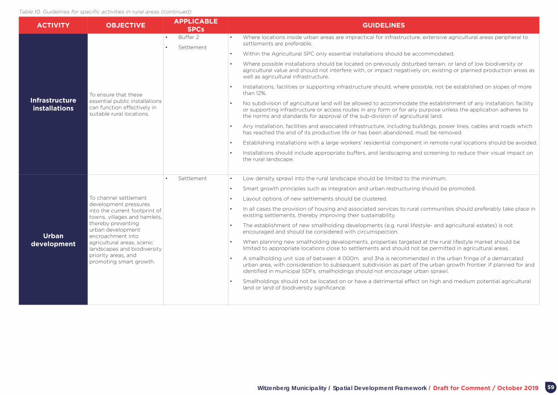
Witzenberg Municipality / Spatial Development Framework / Draft for Comment / October 2019 59
ACTIVITY OBJECTIVEAPPLICABLE
SPCsGUIDELINES
Infrastructure installations
To ensure that these essential public installations can function effectively in suitable rural locations.
• Buffer 2
• Settlement
• Where locations inside urban areas are impractical for infrastructure, extensive agricultural areas peripheral to settlements are preferable.
• Within the Agricultural SPC only essential installations should be accommodated.
• Where possible installations should be located on previously disturbed terrain, or land of low biodiversity or agricultural value and should not interfere with, or impact negatively on, existing or planned production areas as well as agricultural infrastructure.
• Installations, facilities or supporting infrastructure should, where possible, not be established on slopes of more than 12%.
• No subdivision of agricultural land will be allowed to accommodate the establishment of any installation, facility or supporting infrastructure or access routes in any form or for any purpose unless the application adheres to the norms and standards for approval of the sub-division of agricultural land.
• Any installation, facilities and associated infrastructure, including buildings, power lines, cables and roads which has reached the end of its productive life or has been abandoned, must be removed.
• Establishing installations with a large workers’ residential component in remote rural locations should be avoided.
• Installations should include appropriate buffers, and landscaping and screening to reduce their visual impact on the rural landscape.
Urban development
To channel settlement development pressures into the current footprint of towns, villages and hamlets, thereby preventing urban development encroachment into agricultural areas, scenic landscapes and biodiversity priority areas, and promoting smart growth.
• Settlement • Low density sprawl into the rural landscape should be limited to the minimum.
• Smart growth principles such as integration and urban restructuring should be promoted.
• Layout options of new settlements should be clustered.
• In all cases the provision of housing and associated services to rural communities should preferably take place in existing settlements, thereby improving their sustainability.
• The establishment of new smallholding developments (e.g. rural lifestyle- and agricultural estates) is not encouraged and should be considered with circumspection.
• When planning new smallholding developments, properties targeted at the rural lifestyle market should be limited to appropriate locations close to settlements and should not be permitted in agricultural areas.
• A smallholding unit size of between 4 000m² and 3ha is recommended in the urban fringe of a demarcated urban area, with consideration to subsequent subdivision as part of the urban growth frontier. If planned for and identified in municipal SDFs, smallholdings should not encourage urban sprawl.
• Smallholdings should not be located on or have a detrimental effect on high and medium potential agricultural land or land of biodiversity significance.
Table 10. Guidelines for specific activities in rural areas (continued)
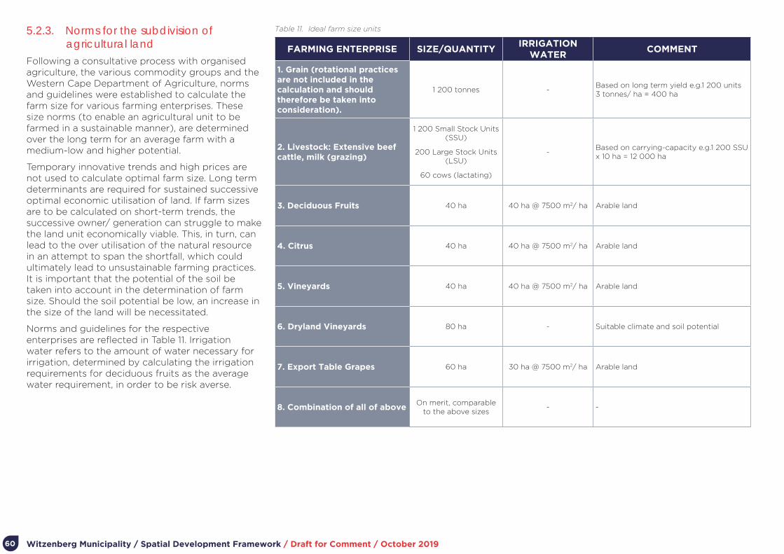
Witzenberg Municipality / Spatial Development Framework / Draft for Comment / October 201960
5.2.3. Norms for the subdivision of agricultural land
Following a consultative process with organised agriculture, the various commodity groups and the Western Cape Department of Agriculture, norms and guidelines were established to calculate the farm size for various farming enterprises. These size norms (to enable an agricultural unit to be farmed in a sustainable manner), are determined over the long term for an average farm with a medium-low and higher potential.
Temporary innovative trends and high prices are not used to calculate optimal farm size. Long term determinants are required for sustained successive optimal economic utilisation of land. If farm sizes are to be calculated on short-term trends, the successive owner/ generation can struggle to make the land unit economically viable. This, in turn, can lead to the over utilisation of the natural resource in an attempt to span the shortfall, which could ultimately lead to unsustainable farming practices. It is important that the potential of the soil be taken into account in the determination of farm size. Should the soil potential be low, an increase in the size of the land will be necessitated.
Norms and guidelines for the respective enterprises are reflected in Table 11. Irrigation water refers to the amount of water necessary for irrigation, determined by calculating the irrigation requirements for deciduous fruits as the average water requirement, in order to be risk averse.
FARMING ENTERPRISE SIZE/QUANTITYIRRIGATION
WATERCOMMENT
1. Grain (rotational practices are not included in the calculation and should therefore be taken into consideration).
1 200 tonnes -Based on long term yield e.g.1 200 units ² 3 tonnes/ ha = 400 ha
2. Livestock: Extensive beef cattle, milk (grazing)
1 200 Small Stock Units (SSU)
200 Large Stock Units (LSU)
60 cows (lactating)
-Based on carrying-capacity e.g.1 200 SSU x 10 ha = 12 000 ha
3. Deciduous Fruits 40 ha 40 ha @ 7500 m2/ ha Arable land
4. Citrus 40 ha 40 ha @ 7500 m2/ ha Arable land
5. Vineyards 40 ha 40 ha @ 7500 m2/ ha Arable land
6. Dryland Vineyards 80 ha - Suitable climate and soil potential
7. Export Table Grapes 60 ha 30 ha @ 7500 m2/ ha Arable land
8. Combination of all of aboveOn merit, comparable
to the above sizes - -
Table 11. Ideal farm size units

Witzenberg Municipality / Spatial Development Framework / Draft for Comment / October 2019 61
5.2.4. Opportunities for emerging farmers and subsistence farming
In terms of national and provincial policy, there is a commitment to support aspirant emerging farmers with access to land for commercial and subsistence farming purposes. Specifically, the focus is on creating opportunities to develop agricultural holdings in the urban fringe and support different settlement options to allow rural dwellers and their dependants to fully benefit from the various tenure, housing and subsidy benefits and rights which are availed to them. Municipal commonage (which should not be alienated or fragmented) and state-owned land is targeted for the establishment of (community) food gardens and the entry of new farmers into the market.
Specific options to be explored for emerging farmers and subsistence farming are presented as part of the individual settlement plans for Witzenberg.
5.2.5. Heritage, cultural and scenic resources
The palaeontology of Witzenberg Municipality is very complex. Numerous fossil-bearing shale bands and sandstones of the Cape Fold Belt are of particular significance and are the subject of ongoing scientific research. Areas where mountain passes cut through the fossil-bearing formations (e.g. the Gydo Pass at the northern entrance into Ceres through the Skurweberg), are particularly at risk of illegal collection of fossil material, and destruction by infrastructure development. The whole of the Cape Fold Belt Mountain Range has a high potential for rock art and associated sites. No systematic archaeological surveys have taken place in the Witzenberg Municipality and the more remote areas, such as the Ceres and Tankwa Karoo, are thus hugely underrepresented in literature regarding archaeology. It is conceivable that the whole area will have a high archaeological potential. Known archaeological sites ranging from the Early Stone Age right into the 19th century.
Human presence in the landscape is of great antiquity, extending back more than a million years. More recent evidence of human engagement with the area indicates core themes of South Africa’s cultural history, including 18th century expansion into the interior, European settlement, separate development and struggle. Key cultural landscapes include the Tulbagh Valley, Karoopoort “uitspan” and route to the interior, Hex River Valley, Wolseley Valley, and the Ceres Basin.
Owing to its topography the Witzenberg Municipality has a number of historic passes with outstanding scenic qualities, listed in Table 12.
No comprehensive local heritage inventory has as yet been prepared for the whole of the Municipality (especially for the Ceres and Tankwa Karoo). Heritage sites have however been listed by the South African Heritage Resource Agency (SAHRA) and recorded in a number of secondary sources. Most prevalent is historic buildings in Tulbagh.
The Witzenberg Zoning Scheme makes provision for overlay zones, aimed at appropriately addressing development and land use management issues in specific areas. The historic Church Street and environs in Tulbagh has been designated as an overlay zone.
The WCG’s Heritage and Scenic Resources: Inventory and Policy Framework (2013) provides an overview of cultural and scenic resources in the Western Cape and high-level guidance for the identification and conservation of these resources2. It also informs the PSDF’s Settlement Toolkit which provides spatial guidance on the PSDF’s proposals for key themes at municipal, rural, town and precinct scales3.
Table 13 outlines guidelines from the Settlement Toolkit relevant to heritage, cultural and scenic resources.
• 2 https://www.westerncape.gov.za/eadp/files/atoms/files/Heritage%20and%20Scenic%20Resource%20Specialist%20Study_2013.pdf3 https://www.westerncape.gov.za/eadp/files/atoms/files/2014%20PSDF%20Annexures.pdf
SCENIC ROUTES HISTORIC MOUNTAIN PASSES
R43 from Worcester to Ceres Roodezandt Pass/ Oudekloof Pass
R46 from the N1 via Ceres and Wolseley to Tulbagh
Nuwekloof
R303 from Ceres via Prince Alfred Hamlet and Op-die-Berg to Citrusdal
Witzenberg Pass
R355 the gravel road from Karoopoort to Calvinia
Mitchell’s Pass
Gydo Pass
Karoopoort, including the Hottentotskloof and Theronberg Pass)
Table 12. Scenic routes and historic mountain passes
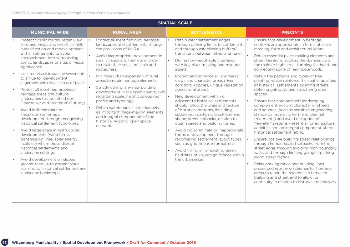
Witzenberg Municipality / Spatial Development Framework / Draft for Comment / October 201962
SPATIAL SCALE
MUNICIPAL WIDE RURAL AREA SETTLEMENTS PRECINTS
• Protect Scenic routes, retain view-lines and vistas and prioritise infill, intensification and redevelopment within settlements to avoid encroachment into surrounding scenic landscapes or sites of visual significance.
• Insist on visual impact assessments to argue for development alignment with local sense of place.
• Protect all identified provincial heritage areas and cultural landscapes (as identified per Oberholzer and Winter 2013 study).
• Avoid indiscriminate or inappropriate forms of development through recognising historical settlement typologies.
• Avoid large-scale infrastructural developments (wind farms, transmission lines, solar energy facilities) where these disrupt historical settlements and landscape settings.
• Avoid development on slopes greater than 1:4 to prevent visual scarring to historical settlement and landscape backdrops.
• Protect all identified rural heritage landscapes and settlements through the provisions of NHRA.
• Avoid inappropriate development in rural villages and hamlets in order to retain their sense of scale and rootedness.
• Minimise urban expansion of rural areas to retain heritage elements.
• Strictly control any new building development in the open countryside regarding scale, height, colour, roof profile and typology.
• Retain watercourses and channels as important place-making elements and integral components of the historical regional open space network.
• Retain clear settlement edges through defining limits to settlements and through establishing buffers/ transitions between urban and rural.
• Define non-negotiable interfaces with key place-making and resource assets.
• Protect and enhance all landmarks, views and character areas (river corridors, koppies, unique vegetation, agricultural areas).
• New development within or adjacent to historical settlements should follow the grain and texture of historical patterns, including subdivision patterns, block size and shape, street setbacks, relation to open spaces and building forms.
• Avoid indiscriminate or inappropriate forms of development through recognising settlement layout types such as grid, linear, informal, etc.
• Avoid “filling in” of existing green field sites of visual significance within the urban edge.
• Ensure that development in heritage contexts are appropriate in terms of scale, massing, form and architectural idiom.
• Retain essential place-making elements and street hierarchy, such as the dominance of the main or high street forming the heart and connecting spine of neighbourhoods.
• Retain the patterns and types of tree planting, which reinforce the spatial qualities of historical settlements by lining streets, defining gateways and structuring open spaces.
• Ensure that hard and soft landscaping complement existing character of streets and squares (such as sensitive engineering standards regarding kerb and channel treatments) and avoid disruption of “leiwater” systems - essential for agricultural activities and an integral component of the historical settlement fabric.
• Ensure positive building-street relationships through human-scaled setbacks from the street edge, through avoiding high boundary walls, and through limiting garages/parking along street façade.
• Relax parking ratios and building lines prescribed in zoning schemes for heritage areas to retain the relationship between building and street and to allow for continuity in relation to historic streetscapes.
Table 13. Guidelines for managing heritage, cultural and scenic resources

Witzenberg Municipality / Spatial Development Framework / Draft for Comment / October 2019 63
7.5.1. Municipal-wide infrastructureMunicipal-wide infrastructure is critical to support livelihood opportunities in Witzenberg Municipality. Key municipal-wide infrastructure to be maintained and enhanced is listed in Table 14.
General guidelines applicable to municipal-wide infrastructure are:
• Major infrastructure installations associated with nuisance and buffer requirements – e.g. waste-water treatment plants, cemeteries, solid waste disposal sites, airports, feedlots, quarries and mines, truck stops – can be accommodated within Buffer 2 Areas within the fringe of settlements.
• The provision or location of major infrastructure should not be used to attract significant development in a manner which takes away from the policy objective to prevent urban sprawl and consolidate existing settlements.
In relation to movement routes, two specific guidelines appear very significant in relation to Witzenberg:
• Major movement routes are the focus for significant development related “energy”, and land adjacent to key section of these routes within settlements should be exploited for economic development opportunity (particularly for emerging entrepreneurs).
• Major movement routes serve to provide access to people living in areas underprovided in commercial and job opportunity (e.g. Bella Vista and Nduli) to higher opportunity areas. As many people rely on walking and cycling to access opportunity, major routes connecting settlements which remain spatially segregated should provide for safe non-motorised transport.
INFRASTRUCTURE NAME SERVICE AREA
Provincial roads R44/R46/R303 Municipal wide and beyond
Primary freight network R44/R46Somerset West-Stellenbosch-Klapmuts-Wellington-Gouda-Ceres-Touwsriver (N1)
Secondary freight network
R303Ceres-Prince Alfred Hamlet/ Op-die-Berg/ Citrusdal
Rail network - Cape Town-Worcester service
Rail stations Tulbagh & Wolseley Cape Town-Worcester service
Water
Koekedouw Dam
Tierkloof Weir
Moordenaarskloof and Tierkloof
Wabooms River Weir
Supplies Ceres
Supplies Wolseley
Supplies Tulbagh
Supplies Prince Alfred Hamlet
Waste water treatment works
Ceres WWTW
Wolseley WWTW
Tulbagh WWTW
Op-die-berg WWTW
Ceres
Wolseley
Tulbagh
Op-die-berg
Electricity
Ceres power station
Bon Chretien substation
Wolseley substation
Tulbagh substation
Supplies Ceres
Supplies Ceres
Supplies Wolseley
Supplies Tulbagh
Landfill
1. Worcester
2. Ceres
3. Wolseley
4. Tulbagh
5. Prince Alfred Hamlet
6. Op-die-berg
1. A regional landfill site currently in process with the purpose to accommodate the municipalities of Witzenberg, Breederiver, and Langeberg.
2. Closed in 1999
3 & 4. General waste, builders’ rubble and garden refuse
5. Builders’ rubble and garden refuse only (also serves Ceres)
6. To be closed
Cemeteries
Table 14. Municipal-wide infrastructure

Witzenberg Municipality / Spatial Development Framework / Draft for Comment / October 201964
7.5.1.1 Renewable Energy Development Corridors
The Strategic Environmental Assessment for Wind and Solar Photo-voltaic Energy in South Africa identified 8 Renewable Energy Development Zones (REDZs) in 2015, that are of strategic importance for large scale wind and solar photo-voltaic energy development, including the roll-out of its supporting transmission and distribution infrastructure. New wind or PV projects located within one of the eight REDZ areas will now be subject to a Basic Assessment and not a full EIA process, as well as a shortened timeframe of 57 days for the processing of an Application for Environmental Authorisation.
The Council for Scientific and Industrial Research (CSIR) identified eight geographic areas for REDZ following a Strategic Environmental Assessment (SEA):
Witzenberg Municipality forms part of the Komsberg REDZ, and any application for renewable energy projects or developments outside of this boundary (shown in Figure 41) will not be considered or allowed.
Figure 40. The 8 REDZs (CSIR)
Figure 41. The location of the Komsberg REDZ area within the
Witzenberg Municipality
Karoo Hooland
Laingsburg
Langeberg
Cederberg
Hantam
NORTHERN CAPE
R355
R35
6
R3
03
R46
R43
R46
N7
N1
N7
Worcester
CeresWolseley
Wellington
Tulbagh
Piketberg
Citrusdal
Porterville
De Doorns
Touwsrivier
Inverdoorn
Gansfontein
Op die Berg
Prince Alfred Hamlet
Saron
Riebeek Kasteel
Witzenberg

Witzenberg Municipality / Spatial Development Framework / Draft for Comment / October 2019 65
5.2.6. Settlement hierarchyIn terms of the IUDF Spatial Considerations Research Paper, Ceres and other settlements in Witzenberg will be considered medium-sized towns or small urban centres with established infrastructure in the semi-periphery or periphery, whereas the Council for Scientific and Industrial Research (CSIR) typologies would categorise these settlements as service towns, small service towns, and rural settlement areas and villages4.
The major settlement in Witzenberg remains Ceres. In terms of the CSIR typology, Ceres could be described as a regional service centre (albeit its population probably somewhat smaller for this kind of centre). Wolseley, Tulbagh, and Prince Alfred Hamlet are small service towns, local niche towns, or local towns and Op-die-berg a rural settlement or village. Table 15 and 16 categorises settlements in Witzenberg in terms of the CSIR typology (the full range of typologies are given for comparative purposes).
Five other “settlement groupings” exist in Witzenberg Municipality, listed in Table 17. Excluding Kluitjieskraal, these are not foreseen to be included as part formal urban settlement areas in Witzenberg.
4 South African Functional Town Typology 2018 van Huyssteen, E. Green, C. Sogoni, Z., Maritz, J. and McKelly, D. (CSIR 2018 v2). Available at http://stepsa.org/socio_econ.html#Indicator
CATEGORYPOPULATION AND
ECONOMYEXAMPLES IN
COUNTRYWITZENBERG SETTLEMENTS
POPULATION MAIN FUNCTIONS
City Regions
• Population: > 1 million.
• Morphology: Large urban conurbations (functional regions).
• Economy: Diverse, economic output > R40 816m p/a (2013).
Gauteng, Cape Town city-region, eThekwini city-region, Nelson
Mandela Bay city-region.
- - -
Cities and very large regional centres
• Population: > 500 000 (cities), > 300 000 (Very large regional centers)
• Morphology: Dense urban areas with interconnected settlements in functional hinterland areas.
• Economy: Service related, economic output > R7 900m p/a (2013) (Cities); and > R4 000m p/a (Very large regional centers) (2013).
City Examples: Buffalo City, Polokwane, Mangaung.
Very large regional centers: Welkom, Tzaneen, Witbank,
New Castle.
- - -
Large regional centres
• Population: 100 000-300 000.
• Morphology: Regional node consisting of interconnected settlements, with significant reach in hinterland. Significant social and economic service role in region.
• Economy: Economic output above R1 400m p/a (2013).
Mokopane, George, Mthatha, Ladysmith.
- - -
Regional centres
• Population: < 100 000.
• Morphology: Regional node consisting of interconnected settlements, with significant reach in hinterland. Significant social and economic service role in sparsely populated region.
• Economy: Economic output above R1 100m p/a (2013).
Bela-Bela, Bethlehem,
Grahamstown, Mossel Bay.
- - -
Service towns
• Population: Variation between 15 000 and 100 000.
• Morphology: Providing an economic and social service anchor role in hinterland.
• Economy: Economic output above R670 p/a (2013).
Jane Furse, Harrismith, Jeffreys
Bay, Thabazimbi, Taung.
Ceres
Jane Furse, Harrismith, Jeffreys Bay, Thabazimbi, Taung.
• Centre of governance and administration.
• Centre of higher order community/ social facilities.
• Centre of commercial, financial, and cooperative services.
• Major agricultural support centre.
• Significant place of residence.
Table 15. Settlement hierarchy and categorisation

Witzenberg Municipality / Spatial Development Framework / Draft for Comment / October 201966
CATEGORY POPULATION AND ECONOMYEXAMPLES IN
COUNTRYWITZENBERG SETTLEMENTS
POPULATION MAIN FUNCTIONS
Small service towns
• Population: Less than 20 000 in town itself.
• Morphology: Monocentric small towns, often apartheid landscape double centre towns. Playing an anchor role as social service point, serving a large number of people within 30km from the town in denser areas and within 50km from the town in sparser areas.
• Economy: Government and community services significant in local economy.
Nkandla, Piketberg, Victoria West, Swartruggens.
Wolseley
1 528 (town)
6 263 (Montana)
4 341 (Pine Valley)
• Agricultural support centre
• Significant place of residence.
Tulbagh8 969 (town)
1 083 (Meulstroom)
• Recognised as of national historic interest (Church Street area).
• Popular week-end tourism destination.
• Agricultural support centre.
• Significant place of residence.
Prince Alfred Hamlet 6 809• Agricultural support centre
• Significant place of residence.
Rural service settlement
• Population: Varied in nodal settlement, large population in direct hinterland
• Morphology: Emerging nodes of consolidation in dense rural settlements local service role. Strategically located to play an anchor role as social service point, serving a large number of people within 30km from the town in denser areas and within 50km from the town in sparser areas.
Jozini, Port St Johns, Lady Frere, Highflats.
- - -
Rural settlement areas and villages
• This area incorporates both (i) Formal Rural settlement area (ii) Traditional Authority Rural Settlement Area. Both have very small formal service economy activities.
• Within such areas rural service settlements and smaller nodal settlements with limited population and economy but forming part of the South African group of towns can be identified for location of social services as applicable based on the population threshold and characteristics.
- Op-die-berg 1530• Place of residence.
• Small service centre to rural community.
Non-Urban 52 000
Total 115 946
Table 16. Settlement hierarchy and categorisation (continued)

Witzenberg Municipality / Spatial Development Framework / Draft for Comment / October 2019 67
SETTLEMENT DESCRIPTION
Kluitjieskraal
The residential area at the Kluitjieskraal Forestry Station, known as Swanenbergpark, is situated adjacent to the Pine Valley residential area to the east of Wolseley. Kluitjieskraal was one of the first forestry stations to be established as a labour and housing node for the then Department of Forestry and subsequently became the property of SAFCOL. The residential village grew over the years to some 80 units. The residents have always had lessee status only. Most of the existing residents have always lived at Kluitjieskraal and have expressed the wish to obtain ownership of housing units. An initiative is underway to transfer ownership to eligible participants. The area is incorporated as part of Wolseley.
Tulbagh RoadTulbagh Road was established around a former railway station. A few residential units exist south of the rail line while the area north of the rail line is used for agricultural use. Witzenberg Municipality do not provide services to residents.
Steinthal
Steinthal Estate, measuring some 860ha in extent, is located east of the town of Tulbagh. Steinthal has been used for farming activities since around the first half of the 18th century. Traditional farming activities included dairy cattle, the cultivation of fodder crops, small-scale commercial broiler farming, and the operation of a small poultry abattoir. Institutional uses date from the early 19th century (when the area was acquired by the Rhenish Missionary Society). Current institutional uses include a children’s home, school, and skills development centre. Some 15 households associated with the institutions and farming activities reside on the Estate.
DrosdyDrosdy is located 3km north of Tulbagh, adjacent to the Drosdy-hof winery. Some 20 properties exist, zoned for agricultural use. No municipal services are provided to Drosdy.
Waterval
Waterval is situated approximately 8,5 km southwest of Tulbagh and 4 km southeast of the Tulbaghweg railway station. This settlement was established as a housing area for then Cape Nature Conservation employees. The village consists of some 26 houses, a two-classroom school and a small clinic. The school is currently used as an office and training centre. The clinic has fallen into a state of disrepair. Mobile clinic services are rendered to the residents. Another house and church building are situated about 500m north of the core settlement. The residents have expressed a wish to obtain ownership of the housing units and some 93 ha of farming land (through the establishment of a trust)
Table 17. Other settlement groupings in Witzenberg Municipality

Witzenberg Municipality / Spatial Development Framework / Draft for Comment / October 201968
5.2.7. Growth potential and socio-economic needs
The composite growth potential and socio-economic needs of the various settlements in Witzenberg as determined by the WCG is as presented in Table 18 below. Ceres and Prince Alfred Hamlet is regarded as having the best growth potential of settlements in Witzenberg. The highest socio-economic need is also in Ceres.
Based on growth potential, following Provincial policy, Ceres is the primary focus in Witzenberg Municipality for accommodating new growth.
SOCIO-ECONOMIC NEEDS
VERY LOW LOW MEDIUM HIGH VERY HIGH
GROWTH POTENTIAL
VERY LOW
LOW
Op-die-berg
Tulbagh
Wolseley
MEDIUM Prince Alfred
HamletCeres
HIGH
VERY HIGH
Table 18. Settlement growth potential and socio-economic need
5.2.8. General settlement guidelines As part of the PSDF, a “Settlement Toolkit” has been prepared, providing spatial guidance on the PSDF’s proposals for key themes at municipal, rural, town and precinct scales. Table 19 and 20 summarises the core guidelines to be applied in managing development and land use in settlements generally (the guidelines outlined in Section 5.2.5 above under heritage, cultural and scenic resources are also applicable to settlements).

Witzenberg Municipality / Spatial Development Framework / Draft for Comment / October 2019 69
THEMESPATIAL SCALE
MUNICIPAL WIDE RURAL AREA SETTLEMENTS PRECINTS
Accessibility
• Improve linkages to existing regional transport infrastructure such as the rail network and primary regional transfer routes.
• Restructure road networks and encourage centralised, multi-modal municipal transport interchanges.
• Utilise public transport to promote economic activity in appropriate locations while at the same time enabling the clustering and integration of activities in proximate location of public transport interchanges.
• Ensure that all new developments are located at points of highest possible public and pedestrian accessibility.
• Align economic and social opportunities with accessibility and transport routes.
• Align rural development with rural public transport networks.
• Evaluate rural-urban commuter and shopping flows within functional regions – across municipal boundaries – to inform rural public transport networks.
• Prioritise infrastructural investment and allocation of funding for paving and landscaping of non-motorised pathways, bicycle lanes and walkways for travelling between and within rural areas
• Locate new development in accessible locations which prioritise pedestrian and public transport access, close to transport interchanges and routes.
• Provide a clearly defined hierarchy of streets and public spaces with varied roles and character that provide positive social, economic and environmental spaces.
• Support increased accessibility between fragmented parts of towns (towns and townships) especially for pedestrian, cycle and public transport routes and modes
• Ensure that settlement layouts provide clear and direct pedestrian linkages and routes.
• Avoid convoluted road networks which favour vehicular circulation.
• Promote streets as multi-purpose spaces designed to accommodate all modes of transport and a range of activities.
• Encourage walking and cycling by providing safe, legible and attractive environments free from traffic and ensure that these routes are edged by buildings that overlook space rather than blank walls and backs of buildings.
• Manage parking so that it is used more efficiently and does not dominate the streetscapes of the town by placing it behind or to the side of the building to avoid impeding pedestrian access.
• Minimise driveway widths so as to conflict as little as possible with pedestrian traffic.
• Encourage pedestrian access by placing buildings adjacent to the street with minimal setbacks (no more than 3-5 meters for commercial and mixed-use or 6-8 meters for residential), rather than behind large parking lots. Primary entrances should open to the street and be located as close as possible to transit stops.
Facilities and Social Services
• Strategically locate and align the provision of facilities and social services with access networks as well as settlement role and local needs to ultimately increase convenience, access and viability.
• Prioritise clustering of activities in key economic urban areas while prioritising mobile services to serve the wider region.
• Expand and coordinate periodic, mobile services to establish rural service centres. Primary community facilities serving rural communities should be located within or adjacent to existing settlements, but access must be increased via mobile service centers and must be linked to market spaces or transport interchanges.
• Upgrade degraded rural facilities.
• Locate social facilities so that they contribute to the social and economic life of towns rather than operate as spatial barriers.
• Optimise underutilized and excess land around facilities for other complementary land-uses or expansion of facilities (sport, crèches, housing, retail, urban agriculture, etc.).
• Cluster social facilities at accessible locations to optimise the catalytic potential of public services and buildings as instruments for urban regeneration and to define vibrant public spaces.
• Encourage multi-functionality, safety, legibility and access through well-designed community facilities.
• Edge community facilities with functional public spaces, housing or retail activities – not vast vacant land.
• Always consider positive edges and public interfaces, accessible & well-defined entrances when designing the form and layout of education and health facilities.
Table 19. PSDF Settlement Toolkit guidelines for settlements

Witzenberg Municipality / Spatial Development Framework / Draft for Comment / October 201970
THEMESPATIAL SCALE
MUNICIPAL WIDE RURAL AREA SETTLEMENTS PRECINTS
Activity Patterns and
Land Use
• Clarify the economic role and function of towns within a municipality or region to establish a clear settlement hierarchy to guide investment and planning decisions.
• Prioritise clustering of activities in key economic urban areas while prioritising mobile services to serve the wider region.
• Optimise the spatial allocation of activity patterns and clustering as a key tool for spatial integration.
• Diversify rural activities through optimising the potential of the green economy and its implications for rural development.
• Promote sustainable, ecologically responsible and equitable tourism and recreation activities to diversify rural economic activities (markets, historical tourism routes, hiking, camping, other eco-friendly activities).
• Facilitate the development of rural industrial activity, especially those promoting green technologies, in suitable locations and at appropriate scale.
• Create economic opportunities close to where people live to break down spatial barriers.
• Increase choice and convenience through increasing the range and number of high opportunity places throughout settlements.
• Create a system of community and activity destinations throughout settlements that promote clustering of services and opportunities.
• Cluster civic, business and community facilities so that they are accessible to public transport interchanges and routes and prioritise higher density mixed-use development in these areas.
• Local precincts within towns must be mixed use, with properly-scaled residential and commercial development to make transportation systems more efficient and affordable, to create economic opportunity and to enhance the community.
• Ensure that all communities and neighbourhoods have access to the full range of services, amenities and opportunities.
• Aim for “Neighbourhood completeness” through clustering to increase the liveability, accessibility and vitality of settlements.
• Group public facilities, services and government offices to increase convenience and efficiency and align this with higher densities.
• Ground floor uses facing the street should be “active” uses as much as possible (such as retail or community uses) and should be mostly transparent (e.g., windows, display cases) rather than blank walls facing the street.
Informality, housing delivery,
inclusion and urban land
markets
• Optimise state owned land and other resources through the implementation of integrated housing projects that are sustainable, viable and diversified to facilitate settlement restructuring.
• Align investment of housing with economic growth and infrastructure capacities.
• Channel pressures for residential development to existing towns, villages and hamlets while focussing housing investment in towns with stronger economic bases.
• Initiate and motivate the identification of restructuring zones at a municipal scale – aligned with functional regions and settlement roles – which promulgates infrastructure investment for housing and economic opportunities.
• Minimise urbanisation patterns through providing sustainable rural housing opportunities while aligning such projects with land reform (to only take place in commonage and urban fringe/ peri-urban areas given market and social facility proximity).
• Restrict rural residential rights to incentivise the consolidation of rural properties of high biodiversity value and their incorporation into conservation plans (Cape Nature stewardship programme).
• Promote sustainable and flexible rural housing opportunities for poorer rural communities and workers threatened by seasonal labour.
• Prevent further development of extensive residential lifestyle properties in the rural landscape; only to be established in suitable, degraded or non-scenic landscapes.
• Only allow for rural housing development through eco-housing projects that accommodates sustainable building standards and investment feasibility (e.g. dwelling extent, number of units).
• The allocation of peri-urban and commonage land must accommodate agri-models for semi-subsistence and semi-commercial emerging farmers.
• Coordinating the release of land with housing programmes and infrastructure provision.
• Develop smaller, integrated settlements within existing urban areas, through densification and infill before allowing urban expansion through new, peripheral settlements.
• Provide a range of housing typologies including incremental housing, public and private rental and GAP housing.
• Deal proactively with informality through prioritising incremental development and serviced land projects which focus attention on the collective elements such as social facilities, spaces and amenities while providing for emergency services and basic services (identify incremental overlay zones).
• Improve the spatial design qualities of new housing projects through improved layout and unit design and appropriate orientation of buildings.
• Consider sustainable urban systems and infrastructure through green building technologies and infrastructure options.
• Prioritise investment into community facilities, public infrastructure and public space rather than a single focus on housing or top structures.
• Encourage the development of new social housing stock and provide access to municipal rental stock, land and buildings for social housing development.
Table 20. PSDF Settlement Toolkit guidelines for settlements (continued)

Witzenberg Municipality / Spatial Development Framework / Draft for Comment / October 2019 71
5.3. Individual settlement plans
5.3.1. CeresCeres remains the most significant settlement in Witzenberg Municipality with the most diverse infrastructure, land use, and range of community facilities. It serves as a:
• Centre of governance and administration.
• Centre of higher order community/ social facilities.
• Centre of commercial, financial, and cooperative services.
• Major agricultural support centre.
• Significant place of residence.
The settlement is expected to retain and grow its share of some half of the urban population in Witzenburg Municipality. The key focus area for accommodating future development – both housing, industrial activity, and associated uses – over the planning period is the area between Ceres, Bella Vista, Vredebes, and Nduli. Except for this area, urban edge changes are not deemed necessary given the extent of land development on areas included within the urban edge and anticipated population growth. Areas allocated for higher income residential development in the 2012 MSDF have shown slow or no development.
The development concept for Ceres is illustrated in Figure 42 and the plan in Figure 43. The plan is expanded upon in Table 21.
• Containing the footprint of the town
• Integrating fragmented settlement areas
• Enhanced opportunity for settlement and industry in proximity to each other
Ceres Concept
Figure 42. Development Concept for Ceres
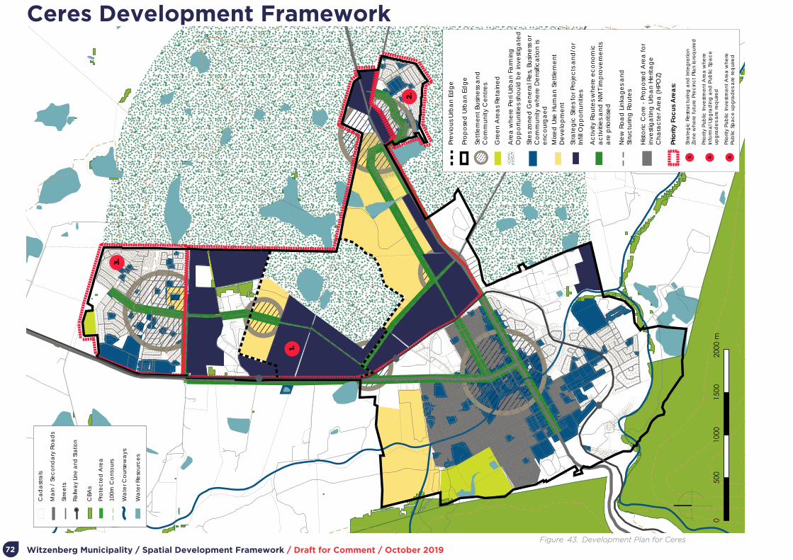
Witzenberg Municipality / Spatial Development Framework / Draft for Comment / October 201972
3.
1.
2.
Mix
ed
Use
Hu
ma
n S
ett
lem
en
t D
eve
lop
me
nt
Stra
teg
ic S
ites
for P
roje
cts
an
d/o
r In
fill O
pp
ort
un
itie
s
Prio
rity
Foc
us A
rea
s:
Stra
teg
ic R
est
ruc
turin
g a
nd
Inte
gra
tion
Zon
e w
he
re fu
ture
Pre
cin
ct
Pla
n is
req
uire
d
Prio
rity
Pub
lic In
vest
me
nt
Are
a w
he
reIn
form
al U
pg
rad
ing
an
d P
ub
lic S
pa
ce
u
pg
rad
es
are
req
uire
d
Prio
rity
Pub
lic In
vest
me
nt
Are
a w
he
rePu
blic
Sp
ac
e u
pg
rad
es
are
req
uire
d
Gre
en
Are
as
Re
tain
ed
Ne
w R
oa
d L
inka
ge
s a
nd
St
ruc
turin
g R
ou
tes
Ac
tivity
Ro
ute
s w
he
re e
co
no
mic
a
ctiv
itie
s a
nd
NM
T im
pro
vem
en
tsa
re p
riorit
ised
Pro
po
sed
Urb
an
Ed
ge
Pre
vio
us
Urb
an
Ed
ge
Site
s zo
ne
d G
en
era
l Re
s, B
usin
ess
or
Co
mm
un
ity w
he
re D
en
sific
atio
n is
e
nc
ou
rga
ed
Are
a w
he
re P
eri
Urb
an
Fa
rmin
g
Op
po
rtu
niti
es
sho
uld
be
inve
stig
ate
d
Sett
lem
en
t Bu
sine
ss a
nd
C
om
mu
nity
Ce
ntr
es
Hist
oric
Co
re -
Pro
po
sed
Are
a fo
r in
vest
iga
ting
Urb
an
He
rita
ge
C
ha
rac
ter A
rea
(H
POZ)
Ma
in /
Se
co
nd
ary
Ro
ad
s
Stre
ets
Railw
ay
Line
and
Sta
tion
CBA
s
100m
Co
nto
urs
Wa
ter C
ou
rse
wa
ys
Ca
da
stra
ls
Wa
ter R
eso
urc
es
Pro
tec
ted
Are
a
3.1. 2.
Ceres Development Framework
Figure 43. Development Plan for Ceres

Witzenberg Municipality / Spatial Development Framework / Draft for Comment / October 2019 73
PLAN ELEMENT EXPLANATION
Current Urban EdgeThe 2012 MSDF urban edge is largely retained as it is expected that anticipated growth over the planning period can be accommodated within this urban edge.
Urban Edge ChangeThe area south of Bella Vista and the Schoonvlei Industrial Area and north of Vredebes is proposed for inclusion within the urban edge. This provides for a larger area accommodating future growth (both housing, industrial activity, and associated uses). It is proposed that the detailed delineation of this edge be confirmed as part of more detailed planning to be undertaken for the area.
Settlement Business and Community Core
Ceres CBD remain the primary settlement centre, with secondary centres envisaged in Bella Vista and Nduli. Tertiary centres can occur at major cross routes, specifically in the area between Ceres, Bella Vista, and Nduli planned for future development.
Green Areas to be retained Major nature areas to be retained occur to the west of town and along river corridors.
Peri urban farming opportunity areas
The area east of Bella Vista and north and south of Vredebes/ Nduli should be explored for peri urban farming, also providing opportunity for emerging farmers and subsistence farming as supported by national and provincial policy.
Densification AreasIn addition to the identified strategic infill and mixed use human settlement sites, the areas zoned for business, general residential and community land uses allow for densification through mechanisms such as additional dwellings and should be encouraged strategically along activity routes and in settlement centres.
Strategic SitesStrategic sites are those previously enabled for previous development (through the 2012 MSDF) for the expansion of industry or housing. It also includes key land within the area between Ceres, Bella Vista, Vredebes, and Nduli earmarked for more detailed planning and accommodating major future growth.
Activity Routes
Activity routes carry the most significant movement of vehicles and people and should be prioritised for the intensification of economic opportunity, NMT improvements, and landscaping. The R303 and R46 are the most significant routes, with the opportunity to establish new activity routes linking communities and activity in the area between Ceres, Bella Vista, Vredebes, and Nduli. R303 and R46 are currently prioritised for NMT improvements.
New road linkages and structuring routes
The most critical new routes are envisaged in the area between Ceres, Bella Vista, Vredebes, and Nduli. These routes should integrate the area with surrounding opportunity and enable maximum exposure of the area for settlement and economic development.
Historic CoreThe historic core of Ceres town should be the focus of on-going public space improvement, identification and protection of historic places and assets, and sensitive redevelopment and infill. Densification sensitive to adjoining development – as enabled through the Zoning Scheme – can occur.
Priority Focus Area
Three areas are envisaged for concerted, priority intervention:
1. The area between Ceres, Bella Vista, Vredebes, and Nduli earmarked for strategic restructuring, integration and significant future development.
2. Ongoing informal settlement upgrading in Nduli, including the upgrade of public space and increased commercial opportunity on the R46.
3. The upgrading of public space in Bella Vista.
Table 21. The Ceres plan expanded

Witzenberg Municipality / Spatial Development Framework / Draft for Comment / October 201974
5.3.2. WolseleyWolseley remains as a secondary service town in Witzenberg Municipality, an agricultural support centre and significant place of residence for a sizable portion of the urban population. Given a favourable location on key movement routes, Wolseley is well-placed for further industrial/ manufacturing development. While further affordable housing is envisaged towards the west to accommodate known and expected demand, there is significant opportunity for infill residential and mixed-use development closer to the centre of town.
The development concept for Wolseley is illustrated in Figure 44 and the plan in Figure 45. The plan is expanded upon in Table 22.
• Containing the footprint of the town
• Extending settlement opportunity in well-located areas
• Infill development to improve the living environment of western areas
• On-going upgrading of informal settlements
Wolseley Concept
Figure 44. Development Concept for Wolseley

Witzenberg Municipality / Spatial Development Framework / Draft for Comment / October 2019 75
Wolseley Development Framework
Figure 45. Development Plan for Wolseley
3.
1.
2.
Priority Focus Areas:
Strategic Restructuring and IntegrationZone where future Precinct Plan is required
Strategic Restructuring and IntegrationZone where future Precinct Plan to identifiy new connections is required
Priority Public Investment Area whereInformal Upgrading is required
National Road / Freeway
Main / Secondary Roads
Streets
Railway Line and Station
CBAs
100m Contours
Water Courseways
Cadastrals
Water Resources
Protected Area
3.
1.
2.
Mixed Use Human Settlement Development
Strategic Sites for Projects and/or Infill Opportunities
Green Areas Retained
New Road Linkages and Structuring Routes
Activity Routes where economic activities and NMT improvementsare prioritised
Proposed Urban Edge
Previous Urban Edge
Sites zoned General Res, Business orCommunity where Densification is encourgaed
Area where Peri Urban Farming Opportunities should be investigated
Settlement Business and Community Centres
Historic Core - Proposed Area for investigating Conservation Area Overlay Zone (CAOZ)

Witzenberg Municipality / Spatial Development Framework / Draft for Comment / October 201976
PLAN ELEMENT EXPLANATION
Current Urban EdgeThe 2012 MSDF urban edge is largely retained as it is expected that anticipated growth over the planning period can be accommodated within this urban edge.
Urban Edge Change No urban edge changes are proposed.
Settlement Business and Community Core
The settlement centre is located on Voortrekker Road and concentrated around the historic gird of the town centre. Additional centres are encouraged to create alternative areas of concentrated activity to reach a broader range of communities in Wolseley.
Green Areas to be retained Major green areas to be retained occur to the south-west of the settlement.
Peri urban farming opportunity areas
The area east of Wolseley – adjacent to potential beneficiary communities – should be explored for peri urban farming, also providing opportunity for emerging farmers and subsistence farming as supported by national and provincial policy.
Densification AreasIn addition to the identified strategic infill and mixed use human settlement sites, the areas zoned for business, general residential and community land uses allow for densification through mechanisms such as additional dwellings and should be encouraged strategically along activity routes and in settlement centres.
Strategic SitesSignificant underdeveloped and undeveloped land occur east of Pine Valley, south of the rail line in the vicinity of Voortrekker Road, and east of Voortrekker Road south. Targeting these sites for infill development will improve the functioning of the town and livelihood opportunity.
Activity RoutesActivity routes carry the most significant movement of vehicles and people and should be prioritised for the intensification of economic opportunity, NMT improvements, and landscaping. The most significant route requiring reinforcement with development is the connection between Pine Valley and Voortrekker Road.
New road linkages and structuring routes
Strategic crossings of the railway line must be investigated to improve pedestrian permeability and access through the town. New routes are identified around the areas identified for strategic infill and development to create more accessible movement patterns.
Historic CoreThe historic core of Wolseley town should be the focus of on-going public space improvement, identification and protection of historic places and assets, and sensitive redevelopment and infill. Densification sensitive to adjoining development – as enabled through the Zoning Scheme – can occur.
Priority Focus Area
Three areas are envisaged for concerted, priority intervention:
1. The area south of the rail line in the vicinity of Voortrekker Road contains substantial tracks of well-located underdeveloped and undeveloped land.
2. Strategic infill in the area between Pine Valley to the west and the rail line to the east.
3. Upgrading and infill development in Pine Valley.
Table 22. The Wolseley plan expanded
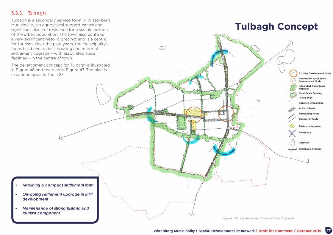
Witzenberg Municipality / Spatial Development Framework / Draft for Comment / October 2019 77
5.3.3. TulbaghTulbagh is a secondary service town in Witzenberg Municipality, an agricultural support centre and significant place of residence for a sizable portion of the urban population. The town also contains a very significant historic precinct and is a centre for tourism. Over the past years, the Municipality’s focus has been on infill housing and informal settlement upgrade – with associated social facilities – in the centre of town.
The development concept for Tulbagh is illustrated in Figure 46 and the plan in Figure 47. The plan is expanded upon in Table 23.
• Retaining a compact settlement form
• On-going settlement upgrade in infill development
• Maintenance of strong historic and tourism component
Tulbagh Concept
Figure 46. Development Concept for Tulbagh

Witzenberg Municipality / Spatial Development Framework / Draft for Comment / October 201978
1.
Mixed Use Human Settlement Development
Strategic Sites for Projects and/or Infill Opportunities
Priority Focus Areas:
Strategic area for Mixed Use Developmentwhere future Precinct plan is required to determine positive interface with river and settlement edge
Green Areas Retained
New Road Linkages and Structuring Routes
Activity Routes where economic activities and NMT improvementsare prioritised
Proposed Urban Edge
Previous Urban Edge
Sites zoned General Res, Business orCommunity where Densification is encourgaed
Area where Peri Urban Farming Opportunities should be investigated
Settlement Business and Community Centres
Historic Core - Approved Conservation Area Overlay Zone (CAOZ)
National Road / Freeway
Main / Secondary Roads
Streets
Railway Line and Station
CBAs
100m Contours
Water Courseways
Cadastrals
Water Resources
Protected Area
1.
Tulbagh Development Framework
Figure 47. Development Plan for Tulbagh

Witzenberg Municipality / Spatial Development Framework / Draft for Comment / October 2019 79
PLAN ELEMENT EXPLANATION
Current Urban EdgeThe 2012 MSDF urban edge is largely retained as it is expected that anticipated growth over the planning period can be accommodated within this urban edge.
Urban Edge Change
No urban edge changes are proposed. The 233ha Waverenskroon Country Estate and Dalskroon senior’s village, to comprise six villages and public facilities (1 350 units), was approved prior to the 2012 MSDF. This area is to be retained within the urban edge, but with specific urban design guidelines to ensure for a sustainable footprint that does not compromise the scenic value of this area.
Settlement Business and Community Core
The largely linear settlement centre remains Van der Stel Street, where the current low-rise form of buildings adjacent to tree line footways/ street space should be retained. Ne development should be encouraged to include active facades on the main street (as opposed to blank walls).
Green Areas to be retained The green/ institutional corridor along the river wets of the town is to be retained.
Peri urban farming opportunity areas
The area north and east of Tulbagh – adjacent to potential beneficiary communities – should be explored for peri urban farming, also providing opportunity for emerging farmers and subsistence farming as supported by national and provincial policy.
Densification AreasIn addition to the identified strategic infill and mixed use human settlement sites, the areas zoned for business, general residential and community land uses allow for densification through mechanisms such as additional dwellings and should be encouraged strategically along activity routes and in settlement centres.
Strategic SitesA number of sites strategically located adjoining or surrounded by existing development, and under- or undeveloped, exist. All can accommodate infill development, with special consideration to the nature and form of adjoining activities.
Activity RoutesRoutes to be emphasised for upgrading are Market Street, Waterkant Street, and Steinthal Street; all linked to Van der Stel/ Church Street.
New road linkages and structuring routes
Historic CoreThe historic core of the town is protected and managed as a Conservation Area Overlay Zone of the Zoning Scheme. The 2018 inventory that was completed for the town should be considered when applying for new development of refurbishment within the town centre to encourage the maintenance of the unique historic character of the town.
Priority Focus AreaThe area envisaged for concerted, priority intervention is situated north of the river and town’s current built edge. Opportunity for further housing and mixed-use development exists, with due consideration to making a positive edge to built development and sensitive river edge.
Table 23. The Tulbagh plan expanded

Witzenberg Municipality / Spatial Development Framework / Draft for Comment / October 201980
5.3.4. Prince Alfred HamletPrince Alfred Hamlet is a secondary service town in Witzenberg Municipality, an agricultural support centre and significant place of residence for a sizable portion of the urban population. The town also contains a very significant historic precinct and is a centre for tourism.
The development concept for Prince Alfred Hamlet is illustrated in Figure 48 and the plan in Figure 49. The plan is expanded upon in Table 24.
• Retaining a compact settlement form
• On-going settlement upgrade in infill development
• Maintenance of strong historic and tourism component
Prince Alfred Hamlet Concept
Figure 48. Development Concept for Prince Alfred Hamlet

Witzenberg Municipality / Spatial Development Framework / Draft for Comment / October 2019 81
Prince Alfred Hamlet Development Framework
Figure 49. Development Plan for Prince Alfred Hamlet
1.
Mixed Use Human Settlement Development
Strategic Sites for Projects and/or Infill Opportunities
Priority Focus Areas:
Strategic area for Mixed Use Developmentand Economic Opportunities where future Precinct Plan is required
Green Areas Retained
New Road Linkages and Structuring Routes
Activity Routes where economic activities and NMT improvementsare prioritised
Proposed Urban Edge
Previous Urban Edge
Sites zoned General Res, Business orCommunity where Densification is encourgaed
Area where Peri Urban Farming Opportunities should be investigated
Settlement Business and Community Centres
Historic Core - Proposed Area for investigating Conservation Area Overlay Zone (CAOZ)
National Road / Freeway
Main / Secondary Roads
Streets
Railway Line and Station
CBAs
100m Contours
Water Courseways
Cadastrals
Water Resources
Protected Area
1.

Witzenberg Municipality / Spatial Development Framework / Draft for Comment / October 201982
PLAN ELEMENT EXPLANATION
Current Urban EdgeThe 2012 MSDF urban edge is largely retained as it is expected that anticipated growth over the planning period can be accommodated within this urban edge.
Urban Edge Change No urban edge changes are proposed.
Settlement Business and Community Core
Areas to be prioritised for planting and street improvement are Voortrekker Road and Olienhout Avenue (specifically the western section linking to the Kliprug residential area.
Green Areas to be retainedLogical future extension to the town is to the north (both for the western and eastern sections of the town), in that way protecting valuable agricultural land to the west and south.
Peri urban farming opportunity areas
The area north of Prince Alfred Hamlet and area between the Kliprug residential area and old town lends itself to small scale farming and urban gardens.
Densification AreasIn addition to the identified strategic infill and mixed use human settlement sites, the areas zoned for business, general residential and community land uses allow for densification through mechanisms such as additional dwellings and should be encouraged strategically along activity routes and in settlement centres.
Strategic SitesA number of undeveloped or underdeveloped sites exist within the urban edge of the settlement that could be targeted for sensitive infill development.
Activity Routes The most important streets remain Voortrekker Road and Olienhout Avenue.
New road linkages and structuring routes
Should the area bounded by Voortrekker Road, Mill Street, Bree Street, and Olienhout Avenue be developed, consideration should be given to linking Reif Street and Hugo Street.
Historic Core
Priority Focus Area
The area envisaged for concerted, priority intervention is bounden by Voortrekker Road, Mill Street, Bree Street, and Olienhout Avenue possible expanded to include the area bounded by Voortrekker Road north of Olienhout Street. The 2012 MSDF identified this area for Social Housing. Locationally, it is ideally situated for higher density housing and associated public facilities.
Table 24. The Prince Alfred Hamlet plan expanded
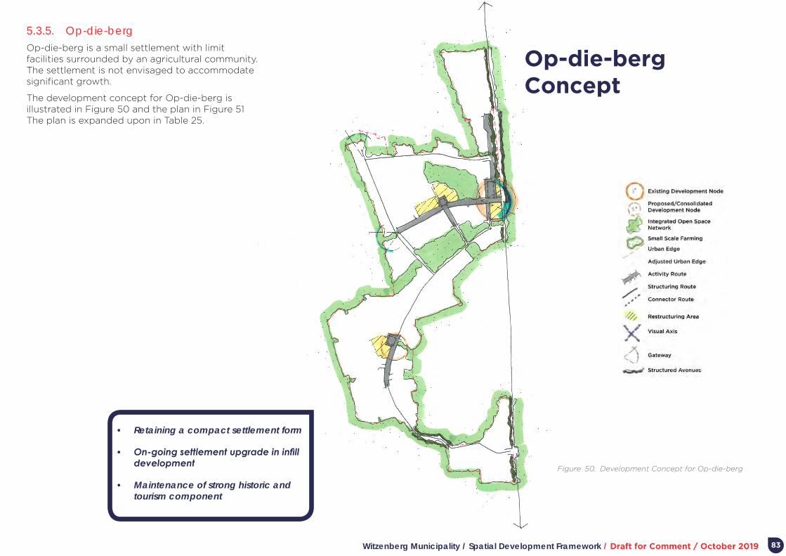
Witzenberg Municipality / Spatial Development Framework / Draft for Comment / October 2019 83
5.3.5. Op-die-berg Op-die-berg is a small settlement with limit facilities surrounded by an agricultural community. The settlement is not envisaged to accommodate significant growth.
The development concept for Op-die-berg is illustrated in Figure 50 and the plan in Figure 51 The plan is expanded upon in Table 25.
• Retaining a compact settlement form
• On-going settlement upgrade in infill development
• Maintenance of strong historic and tourism component
Op-die-berg Concept
Figure 50. Development Concept for Op-die-berg
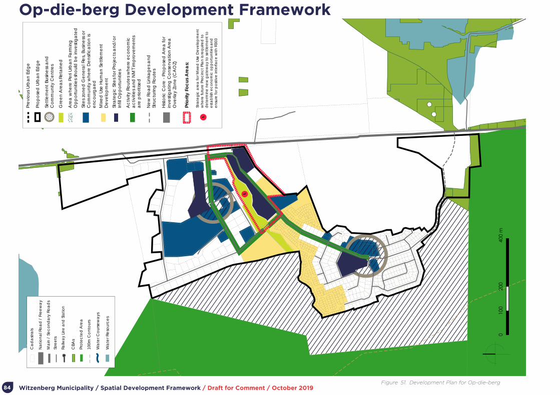
Witzenberg Municipality / Spatial Development Framework / Draft for Comment / October 201984
1.
Prio
rity
Foc
us A
rea
s:
Stra
teg
ic a
rea
for M
ixe
d U
se D
eve
lop
me
nt
wh
ere
futu
re P
rec
inc
t Pl
an
is re
qu
ired
to
d
ete
rmin
e n
ew
ga
tew
ay
to s
ett
lem
en
t to
est
ab
lish
ec
on
om
ic o
pp
ort
un
itie
s a
nd
e
nsu
re fo
r po
sitiv
e in
terf
ac
e w
ith R
303
Na
tion
al R
oa
d /
Fre
ew
ay
Ma
in /
Se
co
nd
ary
Ro
ad
s
Stre
ets
Railw
ay
Line
and
Sta
tion
CBA
s
100m
Co
nto
urs
Wa
ter C
ou
rse
wa
ys
Ca
da
stra
ls
Wa
ter R
eso
urc
es
Pro
tec
ted
Are
a
1.
Mix
ed
Use
Hu
ma
n S
ett
lem
en
t D
eve
lop
me
nt
Stra
teg
ic S
ites
for P
roje
cts
an
d/o
r In
fill O
pp
ort
un
itie
s
Gre
en
Are
as
Re
tain
ed
Ne
w R
oa
d L
inka
ge
s a
nd
St
ruc
turin
g R
ou
tes
Ac
tivity
Ro
ute
s w
he
re e
co
no
mic
a
ctiv
itie
s a
nd
NM
T im
pro
vem
en
tsa
re p
riorit
ised
Pro
po
sed
Urb
an
Ed
ge
Pre
vio
us
Urb
an
Ed
ge
Site
s zo
ne
d G
en
era
l Re
s, B
usin
ess
or
Co
mm
un
ity w
he
re D
en
sific
atio
n is
e
nc
ou
rga
ed
Are
a w
he
re P
eri
Urb
an
Fa
rmin
g
Op
po
rtu
niti
es
sho
uld
be
inve
stig
ate
d
Sett
lem
en
t Bu
sine
ss a
nd
C
om
mu
nity
Ce
ntr
es
Hist
oric
Co
re -
Pro
po
sed
Are
a fo
r in
vest
iga
ting
Co
nse
rva
tion
Are
a
Ove
rlay
Zon
e (
CA
OZ)
Op-die-berg Development Framework
Figure 51. Development Plan for Op-die-berg

Witzenberg Municipality / Spatial Development Framework / Draft for Comment / October 2019 85
PLAN ELEMENT EXPLANATION
Current Urban EdgeThe 2012 MSDF urban edge is largely retained as it is expected that anticipated growth over the planning period can be accommodated within this urban edge.
Urban Edge Change No urban edge changes are proposed.
Settlement Business and Community Core
Green Areas to be retainedThe village is hemmed in by mountainous terrain and agricultural land east of the R303. No change in this relationship is envisaged.
Peri urban farming opportunity areas
Densification AreasIn addition to the identified strategic infill and mixed use human settlement sites, the areas zoned for business, general residential and community land uses allow for densification through mechanisms such as additional dwellings and should be encouraged strategically along activity routes and in settlement centres.
Strategic SitesInfill development could occur on the site previously identified for a retirement village and the area between Kerk Street and development to the north.
Activity Routes
New road linkages and structuring routes
Historic Core
Priority Focus Area The area between Kerk Street and development to the north could be explored in more detailed planning.
Table 25. The Op-die-berg plan expanded
Witzenberg Municipality / Spatial Development Framework / Draft for Comment / October 201986
Part 6.
Implementation
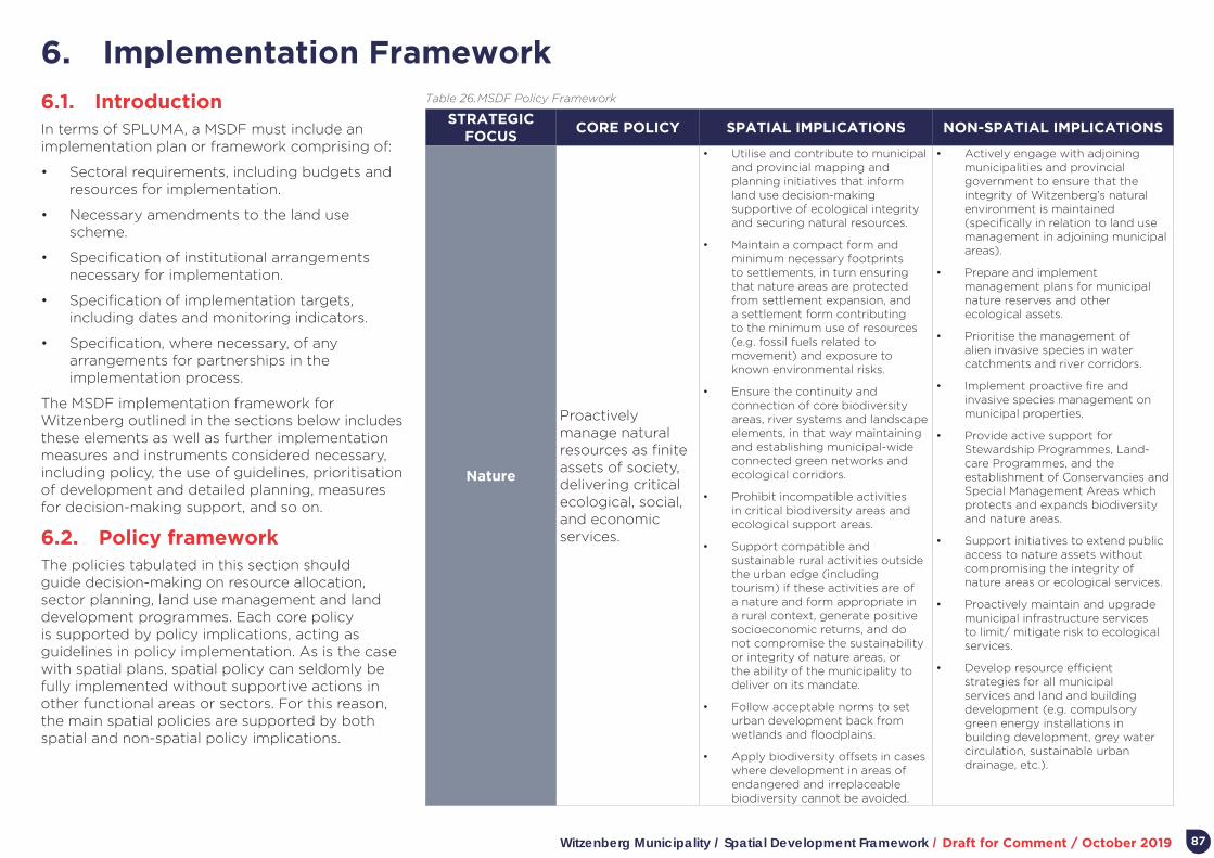
Witzenberg Municipality / Spatial Development Framework / Draft for Comment / October 2019 87
6. Implementation Framework
6.1. IntroductionIn terms of SPLUMA, a MSDF must include an implementation plan or framework comprising of:
• Sectoral requirements, including budgets and resources for implementation.
• Necessary amendments to the land use scheme.
• Specification of institutional arrangements necessary for implementation.
• Specification of implementation targets, including dates and monitoring indicators.
• Specification, where necessary, of any arrangements for partnerships in the implementation process.
The MSDF implementation framework for Witzenberg outlined in the sections below includes these elements as well as further implementation measures and instruments considered necessary, including policy, the use of guidelines, prioritisation of development and detailed planning, measures for decision-making support, and so on.
6.2. Policy framework The policies tabulated in this section should guide decision-making on resource allocation, sector planning, land use management and land development programmes. Each core policy is supported by policy implications, acting as guidelines in policy implementation. As is the case with spatial plans, spatial policy can seldomly be fully implemented without supportive actions in other functional areas or sectors. For this reason, the main spatial policies are supported by both spatial and non-spatial policy implications.
STRATEGIC FOCUS
CORE POLICY SPATIAL IMPLICATIONS NON-SPATIAL IMPLICATIONS
Nature
Proactively manage natural resources as finite assets of society, delivering critical ecological, social, and economic services.
• Utilise and contribute to municipal and provincial mapping and planning initiatives that inform land use decision-making supportive of ecological integrity and securing natural resources.
• Maintain a compact form and minimum necessary footprints to settlements, in turn ensuring that nature areas are protected from settlement expansion, and a settlement form contributing to the minimum use of resources (e.g. fossil fuels related to movement) and exposure to known environmental risks.
• Ensure the continuity and connection of core biodiversity areas, river systems and landscape elements, in that way maintaining and establishing municipal-wide connected green networks and ecological corridors.
• Prohibit incompatible activities in critical biodiversity areas and ecological support areas.
• Support compatible and sustainable rural activities outside the urban edge (including tourism) if these activities are of a nature and form appropriate in a rural context, generate positive socioeconomic returns, and do not compromise the sustainability or integrity of nature areas, or the ability of the municipality to deliver on its mandate.
• Follow acceptable norms to set urban development back from wetlands and floodplains.
• Apply biodiversity offsets in cases where development in areas of endangered and irreplaceable biodiversity cannot be avoided.
• Actively engage with adjoining municipalities and provincial government to ensure that the integrity of Witzenberg’s natural environment is maintained (specifically in relation to land use management in adjoining municipal areas).
• Prepare and implement management plans for municipal nature reserves and other ecological assets.
• Prioritise the management of alien invasive species in water catchments and river corridors.
• Implement proactive fire and invasive species management on municipal properties.
• Provide active support for Stewardship Programmes, Land-care Programmes, and the establishment of Conservancies and Special Management Areas which protects and expands biodiversity and nature areas.
• Support initiatives to extend public access to nature assets without compromising the integrity of nature areas or ecological services.
• Proactively maintain and upgrade municipal infrastructure services to limit/ mitigate risk to ecological services.
• Develop resource efficient strategies for all municipal services and land and building development (e.g. compulsory green energy installations in building development, grey water circulation, sustainable urban drainage, etc.).
Table 26. MSDF Policy Framework
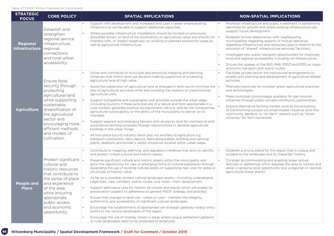
Witzenberg Municipality / Spatial Development Framework / Draft for Comment / October 201988
STRATEGIC FOCUS
CORE POLICY SPATIAL IMPLICATIONS NON-SPATIAL IMPLICATIONS
Regional Infrastructure
Establish and strengthen regional service infrastructure, regional connections, and rural-urban accessibility.
• Support infill development and increased land uses in areas where existing infrastructure will be able to support additional capacities.
• Where possible infrastructure installations should be located on previously disturbed terrain, or land of low biodiversity or agricultural value and should not interfere with, or impact negatively on, existing or planned production areas as well as agricultural infrastructure.
• Prioritise infrastructure and public investment in settlements identified for growth and where existing infrastructure can support future development.
• Establish formal relationships with neighbouring municipalities regarding aspects of mutual relevance regarding infrastructure and resources (also in relation to the provision of “shared” infrastructure services/ facilities).
• Investigate new public transport opportunities for improved local and regional accessibility, including rail infrastructure.
• Ensure the upkeep of the R43, R46, R303 and R355 as major economic transport and scenic routes.
Agriculture
Ensure food security through protecting agricultural land while supporting sustainable diversification of the agricultural sector and encouraging more efficient methods and models of cultivation.
• Utilise and contribute to municipal and provincial mapping and planning initiatives that inform land use decision-making supportive of protecting agricultural land of high value.
• Avoid the subdivision of agricultural land or changes in land-use to minimise the loss of agricultural activities while also avoiding the creation of uneconomical agricultural units.
• Support compatible and sustainable rural activities outside the urban edge (including tourism) if these activities are of a nature and form appropriate in a rural context, generate positive socioeconomic returns, and do not compromise agricultural sustainability, or the ability of the municipality to deliver on its mandate.
• Support aspirant and emerging farmers with access to land for commercial and subsistence farming purposes through opportunities to develop agricultural holdings in the urban fringe.
• All non-place-bound industry (land uses not ancillary to agriculture e.g. transport contractors, dairy depots, fabricating pallets, bottling and canning plants, abattoirs and builder’s yards) should be located within urban areas.
• Facilitate private sector led institutional arrangements to enable joint planning and development of agriculture related activities.
• Promote incentives for smarter/ green agricultural practices and technologies.
• Make municipal commonages available for agri-tourism initiatives through public-private-community partnerships.
• Explore alternative farming models such as the possibility of transforming unused uncontaminated industrial land into community gardens, or “on-farm” options such as “share-schemes” for farm ownership.
People and Place
Protect significant cultural and historic resources that contribute to the sense of place and experience of the area while ensuring appropriate public access and economic opportunity.
• Contribute to mapping, planning, and regulatory initiatives that aims to identify and protect critical cultural and historic assets.
• Preserve significant cultural and historic assets within the municipality and grow the opportunity for new or emerging forms of cultural expression through expanding the use of existing cultural assets or supporting new uses for areas or structures of historic value.
• As far as is possible, protect cultural landscape assets – including undeveloped ridge lines, view corridors, scenic routes, and vistas – from development.
• Support alternative uses for historic structures and places which will enable its preservation (subject to adherence to general MSDF strategy and policies).
• Ensure that changes in land use – urban or rural – maintain the integrity, authenticity and accessibility of significant cultural landscapes.
• Encourage the establishment of appropriate yet strategic gateway nodes/ entry points to the various landscapes of the region.
• Encourage the use of Overlay Zones in areas where unique settlement patterns or rural landscapes need to be protected or enhanced.
• Establish a strong brand for the region that is unique and suitable to the landscape and its character/ history.
• Consider accommodating and enabling larger annual festivals or gatherings which exposes the area to visitors and assist in growing local opportunity (e.g. a regional or national agricultural show/ event).
Table 27. MSDF Policy Framework (continued)
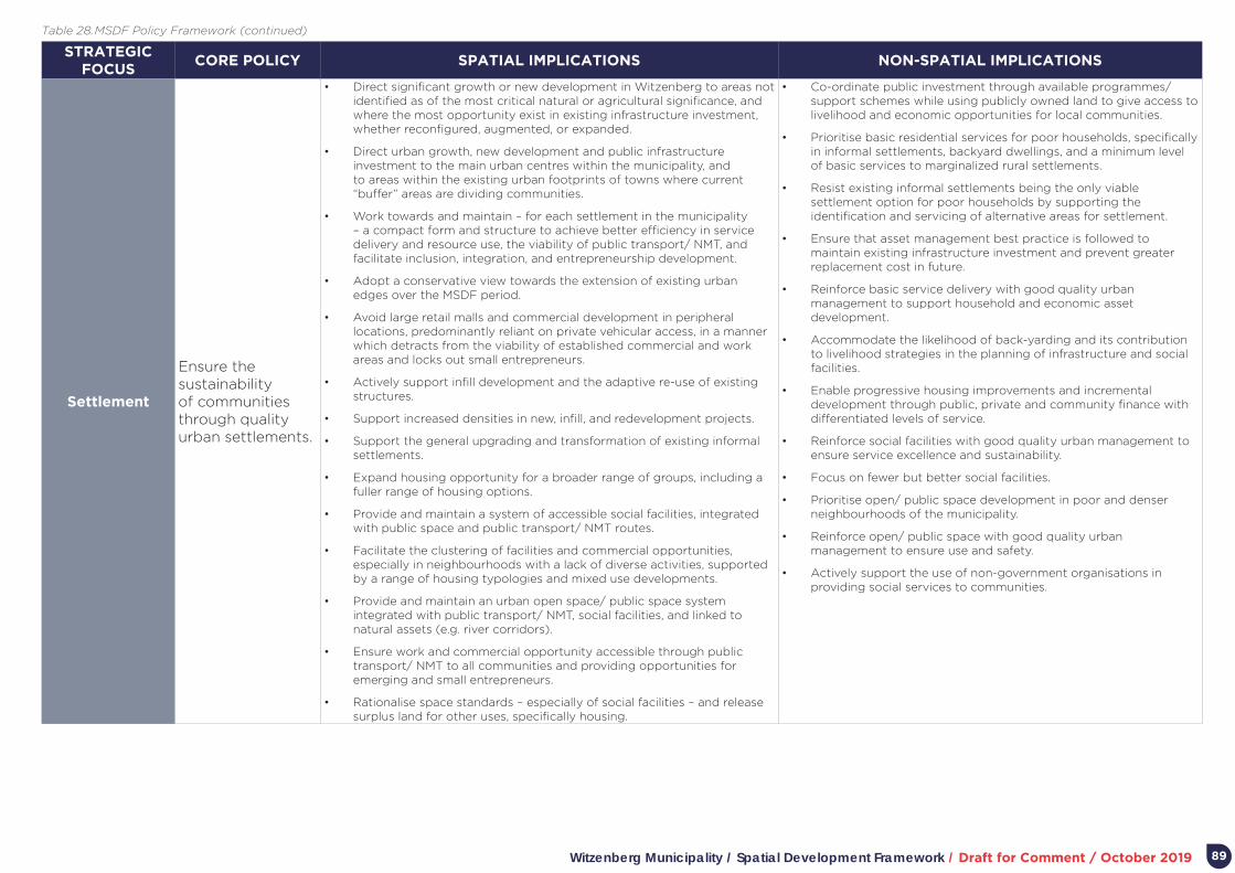
Witzenberg Municipality / Spatial Development Framework / Draft for Comment / October 2019 89
STRATEGIC FOCUS
CORE POLICY SPATIAL IMPLICATIONS NON-SPATIAL IMPLICATIONS
Settlement
Ensure the sustainability of communities through quality urban settlements.
• Direct significant growth or new development in Witzenberg to areas not identified as of the most critical natural or agricultural significance, and where the most opportunity exist in existing infrastructure investment, whether reconfigured, augmented, or expanded.
• Direct urban growth, new development and public infrastructure investment to the main urban centres within the municipality, and to areas within the existing urban footprints of towns where current “buffer” areas are dividing communities.
• Work towards and maintain – for each settlement in the municipality – a compact form and structure to achieve better efficiency in service delivery and resource use, the viability of public transport/ NMT, and facilitate inclusion, integration, and entrepreneurship development.
• Adopt a conservative view towards the extension of existing urban edges over the MSDF period.
• Avoid large retail malls and commercial development in peripheral locations, predominantly reliant on private vehicular access, in a manner which detracts from the viability of established commercial and work areas and locks out small entrepreneurs.
• Actively support infill development and the adaptive re-use of existing structures.
• Support increased densities in new, infill, and redevelopment projects.
• Support the general upgrading and transformation of existing informal settlements.
• Expand housing opportunity for a broader range of groups, including a fuller range of housing options.
• Provide and maintain a system of accessible social facilities, integrated with public space and public transport/ NMT routes.
• Facilitate the clustering of facilities and commercial opportunities, especially in neighbourhoods with a lack of diverse activities, supported by a range of housing typologies and mixed use developments.
• Provide and maintain an urban open space/ public space system integrated with public transport/ NMT, social facilities, and linked to natural assets (e.g. river corridors).
• Ensure work and commercial opportunity accessible through public transport/ NMT to all communities and providing opportunities for emerging and small entrepreneurs.
• Rationalise space standards – especially of social facilities – and release surplus land for other uses, specifically housing.
• Co-ordinate public investment through available programmes/ support schemes while using publicly owned land to give access to livelihood and economic opportunities for local communities.
• Prioritise basic residential services for poor households, specifically in informal settlements, backyard dwellings, and a minimum level of basic services to marginalized rural settlements.
• Resist existing informal settlements being the only viable settlement option for poor households by supporting the identification and servicing of alternative areas for settlement.
• Ensure that asset management best practice is followed to maintain existing infrastructure investment and prevent greater replacement cost in future.
• Reinforce basic service delivery with good quality urban management to support household and economic asset development.
• Accommodate the likelihood of back-yarding and its contribution to livelihood strategies in the planning of infrastructure and social facilities.
• Enable progressive housing improvements and incremental development through public, private and community finance with differentiated levels of service.
• Reinforce social facilities with good quality urban management to ensure service excellence and sustainability.
• Focus on fewer but better social facilities.
• Prioritise open/ public space development in poor and denser neighbourhoods of the municipality.
• Reinforce open/ public space with good quality urban management to ensure use and safety.
• Actively support the use of non-government organisations in providing social services to communities.
Table 28. MSDF Policy Framework (continued)

Witzenberg Municipality / Spatial Development Framework / Draft for Comment / October 201990
6.3. Development guidelines The WCG has prepared a number of general guidelines to assist in decision-making related to spatial development and management in rural and settlement areas. These include:
• Western Cape Land Use Planning Guidelines Rural (March 2019).
• Heritage and Scenic Resources: Inventory and Policy Framework (2013).
• PSDF Settlement Toolkit (2014).
• Commercial and Office Decentralisation: Specialist Study Prepared for the Western Cape Provincial Spatial Development Framework (this study inter alia assesses the impact of “large box” or mall type commercial development).
From the perspective of spatial planning, critical also is the CSIR’s Guidelines for the Provision of Social Facilities in South African Settlements (first addition August 2012). Apart from providing guidelines on different facilities needed to service population in terms of thresholds, the guidelines also emphasise aspect of social facility location and form included in this MSDF.
Although the guidelines do not convey development rights, they were prepared to establish norms and standards based on evidence and is aligned with international, national, and provincial policy related to the sustainable use of natural resources and agricultural land. Thus, they should be used in deliberations and decision-making related to the MSDF.
Aspects of the guidelines have been included in Part 5, Plans and Settlement Proposals, as well as the Policy framework presented in Section 6.2 above.
6.4. Core principles of land use management
The Witzenberg Municipality Land Use Planning By-Law (2015) has been adopted to regulate and control municipal land use planning. The preparation and adoption of the By-Law follows on and has occurred within the framework of:
• Section 156(1) of the Constitution conferring on municipalities the executive authority and right to administer local government matters as set out in Part B of Schedule 4 and Part B of Schedule 5 to the Constitution (and Part B of Schedule 4 to the Constitution listing municipal planning as a local government matter).
• SPLUMA requiring the executive authority of a municipality to oversee such responsibilities as it may designate to officials of such municipality and non-officials in the implementation of the Act.
• LUPA requiring a municipality to regulate inter alia the development, adoption, amendment and review of a zoning scheme for the municipal area, the procedures in terms of which the municipality receives, considers and decides on land use applications (including public participation and criteria for decision-making).
• Section 156 (2) of the Constitution empowers municipalities to make and administer laws for the effective administration of matters that it has the right to administer.
Key themes, principles, and regulations contained in the By-Law related to the status of the MSDF, its implementation as proposed, and land use management in relation to the MSDF, are listed in Table 29.
Four aspects of the By-Law appear key:
1. The significance of the MSDF and related provisions in decision-making, including a municipal obligation to ensure that these provisions are considered in the motivations submitted by applicants
2. The Municipality’s right to proactively zone land in order to enable achievement of municipal objectives.
3. The Municipality’s right to impose conditions of approval related to MSDF objectives.
4. Acknowledgment of the value of the package of plans approach as a means to ensure responsible planning and decision-making related to the development of large or strategic urban development areas.

Witzenberg Municipality / Spatial Development Framework / Draft for Comment / October 2019 91
THEMERELEVANT SECTION OF
THE BY-LAWPRINCIPLES OR SPECIFIC REGULATIONS
Status of the MSDF Section 7
• The Municipality may not make a decision in terms of the By-Law which is inconsistent with the MSDF.
• The Municipality may deviate from the provisions of the MSDF only if site specific circumstances justify the deviation.
• In determining whether the site-specific circumstances exist, the Municipality must have regard to the development application which has been submitted and any other relevant considerations, including whether the proposal would not defy the general aim of the MSDF.
• The MSDF does not confer or take away rights.
Rezoning of Land Section 17The Municipality may, on its own initiative or on application, create an overlay zone for land (while following the provisions of the Municipal Systems Act).
Pre-Application Consultation
Section 37
The Municipality may require an applicant to meet with the authorised employee prior to submitting an application to the Municipality, in order to determine the information that must be submitted together with the application, and other matters connected therewith. At these consultations, it can be expected that the Municipality can request of applicants to clearly motivate in formal applications how the provisions of the MSDF will be met (Section 38 of the By-Law – “Information require” – do not specify a motivation of this nature).
General criteria for consideration of
applicationsSection 68
When a Municipality considers an application, it must have regard to inter alia:
• The IDP and MSDF.
• The applicable policies of the Municipality that guide decision-making (this would include policies in support of the MSDF).
• The PSDF and, where applicable, the Regional SDF.
• The policies, principles, planning and development norms and criteria set by national and provincial government.
• The matters referred to in section 42 of SPLUMA (referring inter alia to the SPLUMA principles; norms, standards, measures designed to protect and promote the sustainable use of agricultural land; national and provincial government policies and the MSDF; the public interest; and the constitutional transformation imperatives and the related duties of the State).
Conditions of Approval
Section 69Conditions of approval related to an application may include inter alia conditions related to requirements of the MSDF, major land uses and the extent thereof, and density.
Package of Plans Section 97
• The Municipality may require a package of plans to be submitted for approval in respect of an application for rezoning of certain planning areas.
• The general purpose of a package of plans is to provide for a mechanism to plan and manage the development of large or strategic urban development areas. It is a phased process of negotiation, planning and approvals, whereby increasing levels of planning detail are approved together with conditions for such approvals.
• The Municipality may require that the area covered by a development framework shall extend beyond the land under consideration if, in its opinion, the proposed development will have a wider impact, and the municipality may determine the extent of such area.
Table 29. Key themes, principles, and regulations contained in the Municipal Land Use Planning By-Law

Witzenberg Municipality / Spatial Development Framework / Draft for Comment / October 201992
6.5. The MSDF’s relationship with corporate and sector planning and decision-making
The MSDF is a transversal planning instrument impacting on most, if not all, of the Witzenberg Municipality’s functional areas as well as the other spheres of government and state-owned entities. Institutional alignment of the MSDF, both in relation to the corporate and sector planning and decision-making, is essential to implementing the MSDF.
With regards to corporate planning and decision-making:
• The main argument and strategies of the MSDF must be incorporated into Annual Reports, annual IDP Reviews, and future IDPs.
• Any review of the MSDF must form part of the IDP review process.
• The main vision, strategies, proposals and policies of the MSDF must inform sector planning and resource allocation. In particular, the Municipality’s Human Settlement Plan and Comprehensive Integrated Transport Plan must be informed by and aligned to the vision, strategies, proposals and policies set out in the MSDF.
• The vision, strategies, proposals and policies of the MSDF must inform land use management decision-making.
• National and provincial plans, programmes and actions should consider the vision, strategies, proposals and policies of the MSDF.
While existing sector considerations and plans give context to the formulation of the MSDF, strategically and spatially, these should also be informed by the MSDF. To this end, the MSDF must be a key consideration when the Municipality makes sector specific decisions or when sector plans are reviewed. This is important to ensure alignment and for the different sectors to fully contribute as implementation tools of the MSDF.
SECTOR/FUNCTIONAL AREA
SECTOR PLAN STATUS SDF IMPLICATIONS
Infrastructure (generally)
Infrastructure Plan Witzenberg Municipality
Draft 2014
• Recognise the Witzenberg settlement hierarchy in planning infrastructure provision.
• Ensure that space extensive infrastructure is located in peripheral locations on the edges of human settlement.
• Ensure that the design of major infrastructure considers the rural and scenic qualities of landscape.
• Consider sustainable urban systems and infrastructure through green building technologies and infrastructure options.
Transport
Local Integrated Transport Plan for Witzenberg (2016-2021)
2016
• Prioritise the maintenance of existing intra-regional routes and infrastructure.
• Support increased accessibility between fragmented parts of towns (towns and townships) especially in relation to pedestrian, cycle and public transport routes and modes.
• Utilise public transport to promote economic activity in appropriate locations while at the same time enabling the clustering and integration of activities in proximate location of public transport interchanges.
• Prioritise infrastructure investment and allocation of funding for paving and landscaping of non-motorised pathways, bicycle lanes and walkways for travelling between and within rural and urban areas.
• Avoid convoluted road networks which favour vehicular circulation.
Pavement Management
Witzenberg Pavement Management System (PMS)
2010• Prioritise the maintenance of major regional and
urban routes (carrying the highest volumes).
Table 30. Sector foci, plans, and the MSDF
Table 30-32 summarises the Witzenberg Municipality’s sector foci, applicable plans (and their status), and implications of the MSDF for these sectors and plans.

Witzenberg Municipality / Spatial Development Framework / Draft for Comment / October 2019 93
SECTOR/FUNCTIONAL AREA
SECTOR PLAN STATUS SDF IMPLICATIONS
Water
• Protect catchment areas, river corridors, and wetlands from development.
• Proactively support water demand programmes.
• Proactively support water-wise practices in land development.
Wastewater • Proactively support the re-use of wastewater.
StormwaterPrince Alfred Hamlet Stormwater Management Plan
2017• Proactively support sustainable urban stormwater management systems which
replenishes natural water aquifers/ storage.
Solid Waste• Proactively support waste minimisation and recycling.
• Work with adjoining municipalities to find efficient regional waste collection solutions.
Electricity Electricity Master Plan
2018 (Master planning and status Reports on the 11KV Infrastructure in Ceres, Wolseley and Tulbagh: Period 2018-2028)
• Proactively work with Eskom to ensure timeous provision of infrastructure to meet expected demand in Witzenberg.
• Proactively support energy saving and alternative energy initiatives.
Human settlementsWitzenberg Human Settlements Plan
Draft 2016
• Channel pressures for residential development to existing towns, villages and hamlets while focussing housing investment in towns with stronger economic bases.
• Promote sustainable and flexible rural housing opportunities for poorer rural communities and workers threatened by seasonal labour.
• Prevent development of extensive residential lifestyle properties in the rural landscape.
• Coordinate the release of land with housing programmes and infrastructure provision.
• Develop smaller, integrated settlements within existing urban areas, through densification and infill before allowing urban expansion through new, peripheral settlements.
• Provide a range of housing typologies including incremental housing, public and private rental housing, and GAP housing.
• Deal proactively with informality through prioritising incremental development and serviced land projects which focus attention on the collective elements such as social facilities, spaces and amenities while providing for emergency services and basic services.
• Improve the spatial design qualities of new housing projects through improved layout and unit design and appropriate orientation of buildings.
• Actively support farmers to provide agri-worker housing (following the guidelines contained in “Western Cape Land Use Planning: Rural Guidelines”).
• Gated residential development is not favored. Public components of development should remain public, enabling integration of neighbourhoods and through movement. Security to private components of developments could be provided through other means than the fencing and access control of large development blocks or areas neighbourhoods.
Table 31. Sector foci, plans, and the MSDF (continued)

Witzenberg Municipality / Spatial Development Framework / Draft for Comment / October 201994
SECTOR/FUNCTIONAL AREA
SECTOR PLAN STATUS SDF IMPLICATIONS
Local Economic Development
• A precautionary approach to the Municipality’s assets of nature, agricultural land, scenic landscapes and routes, and historically and culturally significant precincts and places, which underlies critical livelihood processes, including a tourism economy.
• Promote sustainable, ecologically responsible and equitable tourism and recreation activities to diversify rural economic activities (markets, historical tourism routes, hiking, camping, other eco-friendly activities).
• Ensure that local precincts within towns are mixed use, with properly scaled residential and commercial development to make transportation systems more efficient and affordable, to create economic opportunity and to enhance the community.
• Create economic opportunities close to where people live to break down spatial barriers.
• Proactively enable small entrepreneur through providing land/ facilities in accessible locations.
• Guide against the location of “mall-type” commercial development in locations only accessible by car.
Social / Public Facilities
• Strategically locate and align the provision of facilities and social services with access networks as well as settlement role and local needs to ultimately increase convenience, access and viability (e.g. the highest order facilities – serving the region as a whole – should ideally be located in Ceres).
• Prioritise clustering of activities in key economic urban areas while prioritising mobile services to serve the wider region.
• Encourage the optimisation of underutilized and excess land around facilities for other complementary land-uses or expansion of facilities (sport, crèches, housing, retail, urban agriculture, etc.).
• Cluster social facilities at accessible locations to enable efficiency and optimise the catalytic potential of public services and buildings as instruments for urban regeneration and to define vibrant public spaces.
• Encourage multi-functionality, safety, legibility and access through well-designed community facilities.
• Edge community facilities with functional public spaces, housing or retail activities – not vast vacant land.
• Provide positive edges and public interfaces, and accessible and well-defined entrances to public facilities.
Environment
• Proactively support stewardship programmes.
• Support compatible and sustainable rural activities outside the urban edge (including tourism) if these activities are of a nature and form appropriate in a rural context, generate positive socioeconomic returns, and do not compromise the sustainability or integrity of nature areas, or the ability of the municipality to deliver on its mandate.
• Proactively support programmes to prevent fire and alien vegetation expansion/ removal.
Table 32. Sector foci, plans, and the MSDF (continued)

Witzenberg Municipality / Spatial Development Framework / Draft for Comment / October 2019 95
6.6. Prioritising development In terms of the MSDF concept and plan, prioritisation of development – at a broad level – are of two types. The first is spatial and targeted at significant future growth in specific places. The second is sectoral or thematic, focused on the kind of development to be prioritised.
Spatial areas for priority development over the MSDF planning period should consider:
• A settlement hierarchy where significant new growth and the highest order enterprises and facilities are located in Ceres, Wolseley, and Tulbagh (with Ceres the location for most growth and highest order enterprises and facilities).
• Accommodating growth within the agreed urban edges of settlements.
• The potential of the area located between Ceres, Bella Vista, and Nduli to accommodate significant growth and meet diverse needs, including economic development opportunity, a range of housing types, and integrated movement between largely fragmented settlement parts.
• Within Wolseley and Prince Alfred Hamlet, the preparation of opportunity for housing closer to main thoroughfares and commercial clusters within the towns.
• Within Tulbagh, continuation of programmes to upgrade settlements and provide new opportunity within the urban edges and proximate to other opportunity within the settlement.
In terms of sectoral or thematic focus, the spatial development priority in all settlements should be to:
• Upgrade services and enhance security of tenure in informal settlements.
• Enhance the integration of informal settlements and poorer areas with areas of higher opportunity.
• Provide housing for lower income groups in accessible locations (specifically through infill of vacant and underutilised land or redevelopment of existing building footprints).
• Expand and improve public and NMT routes.
• Improve public and community facilities and places (e.g. through clustering, framing them with infill development to improve edges and surveillance, prioritisation for landscaping, and so on).
• Expand the recognition, restoration, and exposure of historically and culturally significant precincts and places (both in the form and use of precincts and places).
6.7. Priority projects In terms of spatial planning and land use management, five priority projects have been identified for further discussion, described in more detail in Table 33.
6.8. Areas prioritised for more detailed spatial planning
The individual town plans identify priority areas where more detailed planning, such as precinct plans, are required. The Witzenberg Zoning Scheme allows for Special Planning Overlay Zones (SPOZ) to provide for a package of plans mechanism to plan and manage the development of large or strategic urban development areas with a greater degree of flexibility. An SPOZ is generally created in respect of an application that involves a mixed use development proposal or where the development does not generally comply with the development parameters of the applicable land uses of this zoning scheme. It is envisaged that the proposed priority areas identified below can be facilitated in future through the delineation of SPOZs.
The proposed priority areas for more detailed spatial planning in Witzenberg Municipality are:
• The area between Ceres, Bella Vista, and Nduli.
• Possible housing areas in central Wolseley and Prince Alfred Hamlet.
PROJECT PURPOSE KEY ACTIVITIES
The integration of Ceres, Bella Vista, and Nduli
A Koue Bokkeveld and Tankwa Gateway
Space for emerging and small entrepreneurs
Small scale farming
Public space programme
Table 33. Priority Projects (Work in progress)

Witzenberg Municipality / Spatial Development Framework / Draft for Comment / October 2019
Figure 52. The cadastral area showing the location of the priority area between Ceres, Bella Vista, and Nduli
96
• A housing area north of the main town in Tulbagh (and interface with a proposed “estate” development).
Planning of the area between Ceres, Bella Vista, and Nduli is the first priority for more detailed planning. The potential of the area to accommodate significant growth and meet diverse needs, including economic development opportunity, a range of housing types, and integrated movement between largely fragmented settlement parts has been acknowledged in various initiatives. To maximise the potential of the area, the need for more detailed “precinct” level planning was identified, building on previous work undertaken as part of the WCG RSEP.
Given the strategic nature of the area, it is recommended that the package of plans approach – incorporated in the Witzenberg Municipality Land Use Planning By-Law – is followed, enabling structured phases of negotiation, planning and approvals (including the approval of increasing levels of planning detail together with conditions for such approvals).
In focus, planning for the area should consider inter alia:
• Movement routes which integrate Ceres, Bella Vista, Vredebes, and Nduli (and attract higher order development and uses dependent on passing trade/ access).
• Activities and uses foreseen as part of an agri-park.
• Housing opportunity, including opportunity at higher density, a more urban form, and richer range of typology, than traditionally and currently provided with government assistance in Bella Vista and Vredebes.
• The possible reconfiguration of “buffer” strip industrial land south of Bella Vista to also accommodate other uses closer to Ceres.
• Opportunity for start-up or smaller industry/ workshop entrepreneurs.
• An area and facilities which could accommodate large events (e.g. an agricultural festival/ exhibition).
• Higher order institutions.
• Opportunity for small scale farming (to the east).
• A “truck stop” (with appropriate supporting facilities).
• A mixed-use area as part of Nduli with commercial opportunity and public space which can serve as a “gateway” attraction to the Koue Bokkeveld and Tankwa Karoo while providing livelihood opportunity for local residents.
In its location and focus, the project should fit the criteria for funding allocation of the Neighbourhood Development Partnership Grant of National Treasury.
Figure 52 outlines the focus area, and Figure 53 illustrates the potential of the area in concept form.
In relation to land use management, it could be beneficial to establish an overlay zone for this area in the municipal Zoning Scheme or make use of the SPOZ allocation.
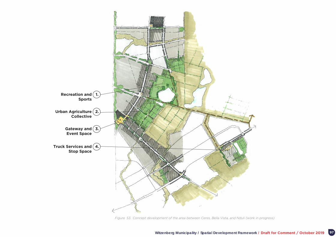
Witzenberg Municipality / Spatial Development Framework / Draft for Comment / October 2019
Figure 53. Concept development of the area between Ceres, Bella Vista, and Nduli (work in progress)
Recreation and Sports
Urban Agriculture Collective
Gateway and Event Space
Truck Services and Stop Space
1.
2.
3.
4.
97
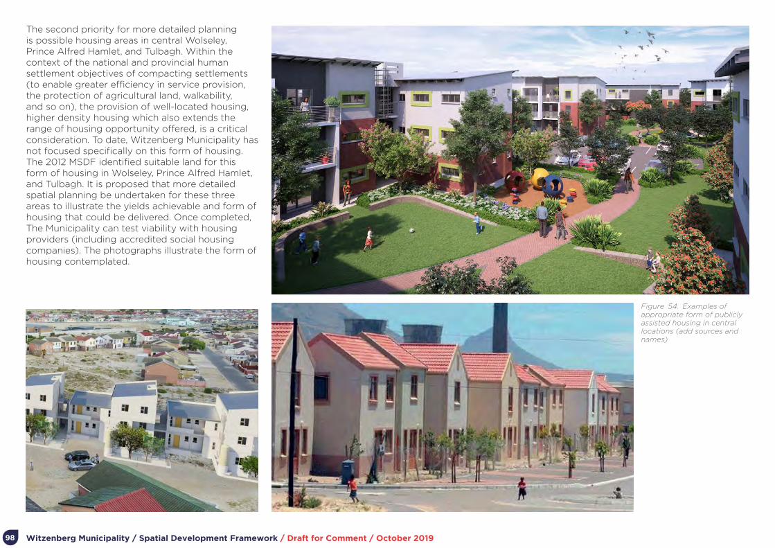
Witzenberg Municipality / Spatial Development Framework / Draft for Comment / October 2019
Figure 54. Examples of appropriate form of publicly assisted housing in central locations (add sources and names)
98
The second priority for more detailed planning is possible housing areas in central Wolseley, Prince Alfred Hamlet, and Tulbagh. Within the context of the national and provincial human settlement objectives of compacting settlements (to enable greater efficiency in service provision, the protection of agricultural land, walkability, and so on), the provision of well-located housing, higher density housing which also extends the range of housing opportunity offered, is a critical consideration. To date, Witzenberg Municipality has not focused specifically on this form of housing. The 2012 MSDF identified suitable land for this form of housing in Wolseley, Prince Alfred Hamlet, and Tulbagh. It is proposed that more detailed spatial planning be undertaken for these three areas to illustrate the yields achievable and form of housing that could be delivered. Once completed, The Municipality can test viability with housing providers (including accredited social housing companies). The photographs illustrate the form of housing contemplated.

Witzenberg Municipality / Spatial Development Framework / Draft for Comment / October 2019 99
6.9. Institutional arrangements
6.9.1. Municipal arrangements for spatial planning and land use management
The Witzenberg Municipality has dedicated staff resources for spatial planning and land use management structured as a division of the Technical Services Directorate. Work occurs within the framework set by annually approved Service Delivery and Budget Implementation Plans (aligned with the IDP), decision-making processes and procedures set by Council, and a suite of legislation and regulations guiding spatial planning, land use management, and environmental management (including SPLUMA, LUPA, the National Environmental Management Act, and the Witzenberg Municipality Land Use Planning By-Law).
The Technical Services Directorate will facilitate implementation of the MSDF in terms of institutional alignment, including:
• The extent to which the main argument and strategies of the MSDF are incorporated into Annual Reports, annual IDP Reviews, future municipal IDPs, and so on.
• The annual review of the MSDF as part of the IDP review process.
• The extent to which the main argument and strategies of the MSDF inform sector planning and resource allocation.
• The extent to which the main argument and strategies of the MSDF inform land use management decision-making.
• Alignment with and progress in implementing the Municipality’s Human Settlement Plan and Comprehensive Integrated Transport Plan.
• The mutual responsiveness of the MSDF and national, provincial and regional plans, programmes and actions (including the extent to which MSDF implementation can benefit
from national and provincial programmes and funding).
6.9.2. Inter-government planningInter-governmental planning and coordination within the framework of the MSDF will focus primarily on:
• Extracting resources – across spheres of government – for the planning and development of the area between Ceres, Bella Vista and Nduli (building on the work already completed under the RSEP programme).
• Ongoing negotiations and deliberations with higher levels of government (and their agencies) related to the upgrading and maintenance of regional infrastructure (e.g. regional routes and electricity).
• On-going joint work – especially with the WCG – related to the planning and funding of publicly assisted housing.
• On-going joint work with adjoining municipalities and the District Municipality related to the provision of shared infrastructure and/ or public facilities (e.g. infrastructure related to waste disposal).
6.9.3. Private sector partnershipsPartnerships with the private sectors are increasingly needed for a number of reasons:
• The municipal human and financial resource base are simply too small to achieve the vision of the MSDF or implement associated strategies and plans.
• Many matters critical to implementing the MSDF fall outside the direct control or core business of the municipality. For example, the Municipality does not necessarily own the land associated with projects critical to achieve MSDF objectives.
Three foci for private sector partners appear significant to implement the MSDF:
• Active ongoing support for Stewardship Programmes, Land-care Programmes, and the establishment of Conservancies and Special Management Areas which protects and expands biodiversity and nature areas.
• Proactive engagement and joint planning with land areas in the area between Ceres, Bella Vista, and Nduli to unlock the full development potential of the area.
Proactive engagement with the agricultural sector to explore opportunity for emerging and small-scale farmers in the urban fringe (proximate to residential areas).
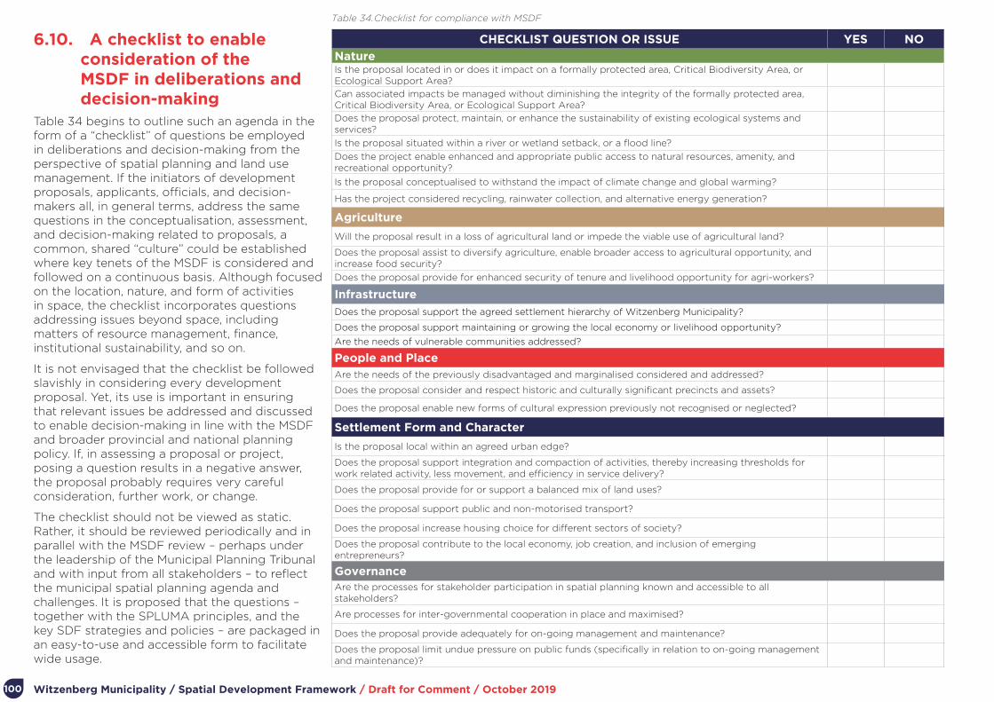
Witzenberg Municipality / Spatial Development Framework / Draft for Comment / October 2019100
6.10. A checklist to enable consideration of the MSDF in deliberations and decision-making
Table 34 begins to outline such an agenda in the form of a “checklist” of questions be employed in deliberations and decision-making from the perspective of spatial planning and land use management. If the initiators of development proposals, applicants, officials, and decision-makers all, in general terms, address the same questions in the conceptualisation, assessment, and decision-making related to proposals, a common, shared “culture” could be established where key tenets of the MSDF is considered and followed on a continuous basis. Although focused on the location, nature, and form of activities in space, the checklist incorporates questions addressing issues beyond space, including matters of resource management, finance, institutional sustainability, and so on.
It is not envisaged that the checklist be followed slavishly in considering every development proposal. Yet, its use is important in ensuring that relevant issues be addressed and discussed to enable decision-making in line with the MSDF and broader provincial and national planning policy. If, in assessing a proposal or project, posing a question results in a negative answer, the proposal probably requires very careful consideration, further work, or change.
The checklist should not be viewed as static. Rather, it should be reviewed periodically and in parallel with the MSDF review – perhaps under the leadership of the Municipal Planning Tribunal and with input from all stakeholders – to reflect the municipal spatial planning agenda and challenges. It is proposed that the questions – together with the SPLUMA principles, and the key SDF strategies and policies – are packaged in an easy-to-use and accessible form to facilitate wide usage.
CHECKLIST QUESTION OR ISSUE YES NO
NatureIs the proposal located in or does it impact on a formally protected area, Critical Biodiversity Area, or Ecological Support Area?
Can associated impacts be managed without diminishing the integrity of the formally protected area, Critical Biodiversity Area, or Ecological Support Area?
Does the proposal protect, maintain, or enhance the sustainability of existing ecological systems and services?
Is the proposal situated within a river or wetland setback, or a flood line?
Does the project enable enhanced and appropriate public access to natural resources, amenity, and recreational opportunity?
Is the proposal conceptualised to withstand the impact of climate change and global warming?
Has the project considered recycling, rainwater collection, and alternative energy generation?
Agriculture
Will the proposal result in a loss of agricultural land or impede the viable use of agricultural land?
Does the proposal assist to diversify agriculture, enable broader access to agricultural opportunity, and increase food security?
Does the proposal provide for enhanced security of tenure and livelihood opportunity for agri-workers?
Infrastructure
Does the proposal support the agreed settlement hierarchy of Witzenberg Municipality?
Does the proposal support maintaining or growing the local economy or livelihood opportunity?
Are the needs of vulnerable communities addressed?
People and PlaceAre the needs of the previously disadvantaged and marginalised considered and addressed?
Does the proposal consider and respect historic and culturally significant precincts and assets?
Does the proposal enable new forms of cultural expression previously not recognised or neglected?
Settlement Form and Character
Is the proposal local within an agreed urban edge?
Does the proposal support integration and compaction of activities, thereby increasing thresholds for work related activity, less movement, and efficiency in service delivery?
Does the proposal provide for or support a balanced mix of land uses?
Does the proposal support public and non-motorised transport?
Does the proposal increase housing choice for different sectors of society?
Does the proposal contribute to the local economy, job creation, and inclusion of emerging entrepreneurs?
GovernanceAre the processes for stakeholder participation in spatial planning known and accessible to all stakeholders?
Are processes for inter-governmental cooperation in place and maximised?
Does the proposal provide adequately for on-going management and maintenance?
Does the proposal limit undue pressure on public funds (specifically in relation to on-going management and maintenance)?
Table 34. Checklist for compliance with MSDF

Witzenberg Municipality / Spatial Development Framework / Draft for Comment / October 2019 101
6.11. A municipal leadership advocacy agenda related to spatial planning and land use management
In terms of the Constitution and associated legislation, local government in South Africa has far-reaching obligations and responsibilities. Key is to direct – within the context of national and provincial policy – the provision of services, promotion of a safe and healthy environment, and promotion social and economic development, in a manner which is sustainable. Determining and managing the direction, nature, and form of spatial development within the municipality, is a key function.
Elected representatives carry significant authority in relation to decision-making. Their task is a difficult one. While acting upon the technical work and inputs of officials, elected representatives are often required to deal with and mediate between different needs and requests on a daily basis, whether emanating from a specific sector (e.g. one functional area struggling from a lack of resources to fulfill its services), a community, individual citizen, or the corporate sector. Arguably, they are also not expected – or have the time – to fully comprehend the technical detail embodied in the work of officials. They should, however, lead at the level of principle, and direct, inspire, and monitor accordingly.
What can a municipal leadership and advocacy agenda look like? What should be foremost on the mind of leadership? What should they be particularly vigilant about, advocate for, and monitor in every initiative? Table 35 proposes a municipal leadership advocacy agenda related to spatial planning and land use management.
ISSUE SPECIFIC CONCERNS RELATED TO THE ISSUE
The critical role of the environment in providing ecological services, key to the economy and sustainability of life in general.
Activities, development, or ways of providing services which detract from the functioning of the natural environment or places.
The critical role of agricultural land – whatever its current use – in providing food security.
Activities, development, or ways of providing services which detracts from the current or future use of land for food production or related use.
The critical role of historic and cultural assets in the municipal economy.
• The loss of built or unbuilt cultural places and activities.
• Inadequate exposure of neglected cultural practices.
• Inadequate places and opportunity for practicing new forms of cultural expression.
The critical need to enable the gradual upgrading of informal settlements.
Inadequate forward planning for settlement and the resultant on-going accommodation of new residents in areas already limited in resources and opportunity.
The relationship between settlement form (e.g. its density, mix of uses, and extent to which it provides opportunity for different groups) and common-day challenges such as the prospect of all to find sustainable, dignified, livelihoods, traffic congestion, safety, and so on.
• The relationship between development density and municipal servicing costs.
• The relationship between development density and the viability of public/ NMT.
• The relationship between development density, inclusive and mixed activity, and entrepreneurship opportunity, mutual learning, and innovation.
• The relationship between 24/ 7 activity and safety.
The critical role of social facilities and public space in the lives of ordinary citizens.
• .The developmental role of social facilities and public space.
• The relationship between the clustering, exposure, and sharing of social facilities (and associated public space), and the quality and sustainability of social service delivery.
The critical role of NMT modes to access opportunity, specifically for ordinary citizens.
• .The very high costs of transport infrastructure as compared to other forms of municipal infrastructure services.
• The relatively small proportion of the population serviced by private vehicles and concomitant cost on the environment.
The long-terms resource impacts of spatial decisions today on the sustainability of government, communities and enterprises.
The long-term costs of urban sprawl and the outward growth of settlements in relation to environmental sustainability, agricultural potential, and the municipal infrastructure maintenance budget.
The limitations of municipal resources, and therefore the need to work with the private and community sectors to meet collective objectives.
The extent of private and community sector development energy available, and its possible contribution to address challenges if closer aligned to the municipal development agenda.
The interrelationship between settlements and need to work with adjoining municipalities and overarching government structures.
The resource constraints of Witzenberg Municipality, and its preparedness to accommodate impacts related to development pressure in adjoining municipalities.
Table 35. A municipal leadership advocacy agenda related to spatial planning and land use management
Witzenberg Municipality / Spatial Development Framework / Draft for Comment / October 2019102
Part 7.
Capital Expenditure Framework

Witzenberg Municipality / Spatial Development Framework / Draft for Comment / October 2019 103
7. Capital Expenditure Framework
7.1. IntroductionSPLUMA requires that MSDFs “determine a capital expenditure framework for the municipality’s development programmes, depicted spatially”. SPLUMA does not provide further detail on what this Capital Expenditure Framework (CEF) should include and there is currently no specification for a SPLUMA-compliant CEF. The intention appears to more effectively link the Municipality’s spatial development strategies to one of the primary means with which to implement these strategies, namely the Municipality’s budget and the budgets of other government stakeholders. By providing more specific guidance on what investments should be made where, in what order of priority, alignment between the Municipality’s strategies, plans and policies and development on the ground is better maintained and the risk that budget allocations undermine or contradict the MSDF are mitigated.
The Capital Expenditure Framework (CEF) has become a key tool supporting government’s initiatives to achieve national settlement development and management objectives. The Integrated Urban Development Framework (IUDF), approved by Cabinet in 2016, sets out the national policy framework for transforming and restructuring South Africa’s urban spaces, guided by the vision of creating “livable, safe, resource efficient cities and towns that are socially integrated, economically inclusive and globally competitive”. In addition, the IUDF proposes an urban growth model premised on compact and connected cities and towns. With the acceptance of the IUDF as policy, the emphasis has now shifted to implementation.
The IUDF is coordinated by the Department of Cooperative Governance (DOCG), which has set up the institutional arrangements for the coordination of activities across government
departments and agencies, under the overall management of an IUDF Working Group on which partner organizations such as National Treasury, organized local government and the World Bank are represented.
The purpose of the ICMs support strategy is to help translate IUDF policy into practical programmes, starting with larger cities and intermediate cities. In so doing the initiative aims to give impetus to achieve the main IUDF goals, which are forging new integrated forms of spatial development; ensuring that people have access to social economic services, opportunities and choices; harnessing urban dynamism to achieve inclusive and sustainable growth; and enhancing the governance capacity of the state and citizens in settlements.
One element of the implementation of the IUDF is the introduction of the CEF instrument. The DCOG recently prepared a “Guide to preparing a Capital Expenditure Framework (Draft Document)” to provide ICMs with guidance with regard to what a CEF is, what it should include for the purposes of the IUDG, and how to go about a CEF. The Guide defines a CEF as “a consolidated, high-level view of infrastructure investment needs in a municipality over the long term (10 years) that considers not only infrastructure needs but also how these needs can be financed and what impact the required investment in infrastructure will have on the financial viability of the municipality going forward.”
7.2. Capital Finance For the previous financial years, the Witzenberg Municipality’s capital investment spend focused on the bulk infrastructure projects required for the Vredebes housing project, the Tulbagh storage dam, upgrading of sports facilities and other upgrades to water, sanitation and electricity services. The allocation of the current three to five year budget continues with its commitment on upgrading of bulk resource and infrastructure (28%), implementation of the human settlements plan (24%), upgrade and maintenance of network infrastructure (12%) and transport management and road maintenance (12%).
The composition of the Witzenberg Capital Budget is shown in Table 36. The Municipality’s budget mainly comprises of the Capital Replacement Reserves (35%) and Municipal Infrastructure Grant (28.86%) funding. The sustainability of the reliance on the Capital Replacement Reserves is threatened by variances in the collection rates for the various services. Notably, the Municipality’s indigent population is increasing, general household affordability levels deteriorating which may in future, impact on the Municipality’s ability to sustain the high levels of revenue collection. The Municipality has relied heavily on grant funding during the previous financial years. Municipal Infrastructure Grant (MIG) funding is fairly constant with an annual increase approximately in line with annual escalation. Regional Bulk Infrastructure Grant (RBIG) funding for water and sanitation projects is granted as needed/requested and approved by the Department of Water Affairs.

Witzenberg Municipality / Spatial Development Framework / Draft for Comment / October 2019104
FUNDING SOURCE PURPOSEMTEF 2019/2020 - 2021/2022 (R)
MTEF 2019-2022
(%)
Estimated Budget
2022/2023 - 2023/2024
(R)
Budget %
2022/2023 - 2023/2024
Total Budget 2019/2020 - 2022/-2024
(R)
Budget % 2019/2020 to 2022/-2024
Capital Replacement Reserve (CRR) - Municipality
Upgrading and equipment 90,566,719 32.42% 42,410,000 42,99% 133, 006, 719 35.17%
Integrated Housing and Human Settlements Development Grant (IHHSDG) – Dept of Human Settlements
Capital funding for internal social housing developments’ infrastructure networks as well as related bulk infrastructure
46,956,520 16.80% - - 46, 956, 520 12.42%
Municipal Infrastructure Grant (MIG) – Dept of Cooperative Governance
Infrastructure that supports the poor, mainly bulk infrastructure related to social housing projects.
65,591,396 23.47% 43,550,000 44.14% 109,141,306 28.86%
Regional Bulk Infrastructure Grant (RBIG) – Dept of Water Affairs
Bulk water and sanitation related projects.
36,931,304 13.21% - - 36,931,304 9.77%
Integrated National Electrification Programme (INEP) – Dept of Energy
Electrical networks for social housing projects.
12,521,739 4.48% 7,000,000 7.10% 19,521,739 5.16%
Regional Socio-Economic Programme (RSEP) – Dept of Env Affairs and Development Planning
Socio-economic upgrading – non-motorised transport – walkways
3,478,000 1.24% - - 3,478,000 0.92%
Twinning agreement with Essen, Belgium (Begium) – Belgium Federal Government
Support in implementation of Waste Management Strategy
1,000,000 0.36% - - 1,000,000 0%
Provincial Government (Prov Grant) – WC Provincial Government
Various Grant related to upgrading of main roads (bridges), fire fighting vehicles, libraries
12,876,522 4.61% 5,700,000 5.78% 18,576,522 4.91%
TOTAL R269,952,110 R98,660,000 R368,612,110
Table 36. Capital Funding Mix (Source: 2nd Reviewed IDP, 2019-2020)
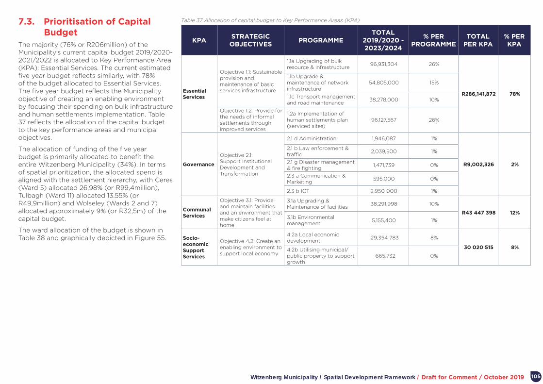
Witzenberg Municipality / Spatial Development Framework / Draft for Comment / October 2019 105
7.3. Prioritisation of Capital Budget
The majority (76% or R206million) of the Municipality’s current capital budget 2019/2020- 2021/2022 is allocated to Key Performance Area (KPA): Essential Services. The current estimated five year budget reflects similarly, with 78% of the budget allocated to Essential Services. The five year budget reflects the Municipality objective of creating an enabling environment by focusing their spending on bulk infrastructure and human settlements implementation. Table 37 reflects the allocation of the capital budget to the key performance areas and municipal objectives.
The allocation of funding of the five year budget is primarily allocated to benefit the entire Witzenberg Municipality (34%). In terms of spatial prioritization, the allocated spend is aligned with the settlement hierarchy, with Ceres (Ward 5) allocated 26,98% (or R99,4million), Tulbagh (Ward 11) allocated 13.55% (or R49,9million) and Wolseley (Wards 2 and 7) allocated approximately 9% (or R32,5m) of the capital budget.
The ward allocation of the budget is shown in Table 38 and graphically depicted in Figure 55.
KPASTRATEGIC
OBJECTIVESPROGRAMME
TOTAL 2019/2020 - 2023/2024
% PER PROGRAMME
TOTAL PER KPA
% PER KPA
Essential Services
Objective 1.1: Sustainable provision and maintenance of basic services infrastructure
1.1a Upgrading of bulk resource & infrastructure
96,931,304 26%
R286,141,872 78%
1.1b Upgrade & maintenance of network infrastructure
54,805,000 15%
1.1c Transport management and road maintenance
38,278,000 10%
Objective 1.2: Provide for the needs of informal settlements through improved services
1.2a Implementation of human settlements plan (serviced sites)
96,127,567 26%
Governance
Objective 2.1: Support Institutional Development and Transformation
2.1 d Administration 1,946,087 1%
R9,002,326 2%
2.1 b Law enforcement & traffic
2,039,500 1%
2.1 g Disaster management & fire fighting
1,471,739 0%
2.3 a Communication & Marketing
595,000 0%
2.3 b ICT 2,950 000 1%
Communal Services
Objective 3.1: Provide and maintain facilities and an environment that make citizens feel at home
3.1a Upgrading & Maintenance of facilities
38,291,998 10%
R43 447 398 12%3.1b Environmental management
5,155,400 1%
Socio-economic Support Services
Objective 4.2: Create an enabling environment to support local economy
4.2a Local economic development
29,354 783 8%
30 020 515 8%4.2b Utilising municipal/public property to support growth
665,732 0%
Table 37. Allocation of capital budget to Key Performance Areas (KPA)

Witzenberg Municipality / Spatial Development Framework / Draft for Comment / October 2019
Figure 55. Ward allocation of budget
106
WARDSBUDGET TOTAL (2019/2020 -
2023/2024)%
1 R870,000 0.24%
3 R16,843,515 4.57%
4 R850,000 0.23%
5 R99,429,047 26,98%
7 R12,000,000 3.26%
8 R8,400,000 2.28%
11 R49,931,304 13.55%
1,12 R13,056,520 3.54%
3,5 R21,354,783 5.79%
7,11 R19,260,870 5.23%
7,2 R1,245,040 0.34%
All R125,341,031 34.01%
R368, 582,111
Table 38. Spatial allocation of budget With Ceres (Ward 5), being the growth node of the Witzenberg Municipality, 24% of the total budget is allocated to supporting 1.2a: human settlements (Objective 1.2a – Implementation of human settlements). This allocation comprises of:
• 85% of the total IHHSDG funding
• 100% of the INEP
• 26% of the total MIG funding
The budget allocation to Tulbagh (comprising of Ward 7 and 11) is centred around water infrastructure projects relating to the Tulbagh dam (10% or R36m of total budget) and Tulbagh reservoir, with the next biggest funding allocation to road rehabilitation. The budget allocation for Wolseley is for sports facility upgrades and the Tierhokskloof Bulk Water Pipeline
7.4. Capital Expenditure Categorisation
The Municipality’s 5 year capital investment has been categorized in terms of its attending to the municipality’s growth, servicing the backlog infrastructure or renewal of infrastructure (to accommodate/maintain the status quo). The figure below shows that the current capital expenditure need is geared to servicing new growth. The Municipal focus does currently not attend to maintenance or their backlog, which, if not attended to or serviced in the foreseeable future, will lead to adverse impacts of the infrastructure asset’s lifespan, increased maintenance cost and/or an increasing backlog of service provision.
The classifications as shown in Tables 39 and 40 below was used to assess the Municipality’s capital expenditure over the 2019/2020 – 2023/2024 period.

Witzenberg Municipality / Spatial Development Framework / Draft for Comment / October 2019
Figure 56. Capital Expenditure Type
107
Capital Expenditure Type
Backlog Growth Renewal
CLASSIFICATION DESCRIPTION INFLUENCING FACTOR
Engineering Bulk Infrastructure
Bulk engineering infrastructure for macro or regional water supply, sanitation, electricity, solid waste, roads and public transport services.
Demand for bulk infrastructure is driven by the volume/need of downstream services
Engineering Distribution
Infrastructure
Engineering infrastructure for distribution or connection of bulk water supply, sanitation, electricity, solid waste, roads and public transport services within communities.
Demand for distribution infrastructure is driven by number of customers (although it should be noted that while connector infrastructure is primarily driven by number and location of customers served, the cost is also influenced by volume of water supplied to these customers).
Social InfrastructureConstruction and maintenance of facilities that support social services.
Demand for publicly accessed services is driven by population size or number of households.
Plot-based servicesWater supply, sanitation, electricity and solid waste (the trading services) linked to erven.
Demand for plot/stand/erven-based infrastructure is driven, as the name suggests, by numbers of plots/stands/erven provided with these services.
Publicly accessed services
Roads, public transport and the other social infrastructure services.
Demand for publicly accessed services is driven by population size or number of households.
GROUPING CATEGORY CATEGORY DESCRIPTION
Capacity
NewCapital projects to provide new assets to meet the current and future growth demands.
UpgradeUpgrade projects are generated according to the requirement for the replacement of a part of an asset component with the aim to increase the current capacity of the asset.
Functionality
Refurbishment/ Rehabilitation
Refurbishment projects are generated according to the requirement for the replacement of a part of an asset component, not increasing the capacity of the asset, therefore enhancing the Remaining Useful Life (RUL) of the asset.
RenewalDemand for plot/stand/erven-based infrastructure is driven, as the name suggests, by numbers of plots/stands/erven provided with these services.
ReplacementDemand for publicly accessed services is driven by population size or number of households.
Table 39. Classification of infrastructure
Table 40. Infrastructure Grouping

Witzenberg Municipality / Spatial Development Framework / Draft for Comment / October 2019
Figure 57. Capital allocation to infrastructure
Figure 58. Capital allocation to infrastructure
108
Figures 57 and 58 shows that Municipality’s allocation for new and upgrading of infrastructure 69% and 16% of the capital spend. This provides the municipality with the necessary infrastructure to support all types of growth, commercial, industrial and residential for, at the very least, the next 5 year period.With the Municipality’s focus on new and upgrading of infrastructure, the Municipal spend on refurbishment/rehabilitation and replacement is muted. The condition of infrastructure will deteriorate if not attended to, increasing the risk of infrastructure failure or compromising service delivery.

Witzenberg Municipality / Spatial Development Framework / Draft for Comment / October 2019 109
7.5. Capital Expenditure NeedA consolidated, high-level view of current/existing infrastructure investment needs for the municipality over the long term (10 years) is shown in Tables 41 and 42. With Witzenberg Municipality’s estimated population growth rate of 2.25 coupled with a strong growth rate in the working age category and current housing backlog, the demand for housing will remain, despite any and all attempts to eradicate the current housing backlog. With the spatial distribution of growth focused around Ceres, Wolseley and Tulbagh, the capital expenditure focus should continue as per the Municipality’s current implementation pipeline.
Work in progress
To be included:
• Roads Master Plan
• Human Settlement Plan Servicing pipeline
• Human settlement Plan Backlog
• Infrastructure Master Plan projections.
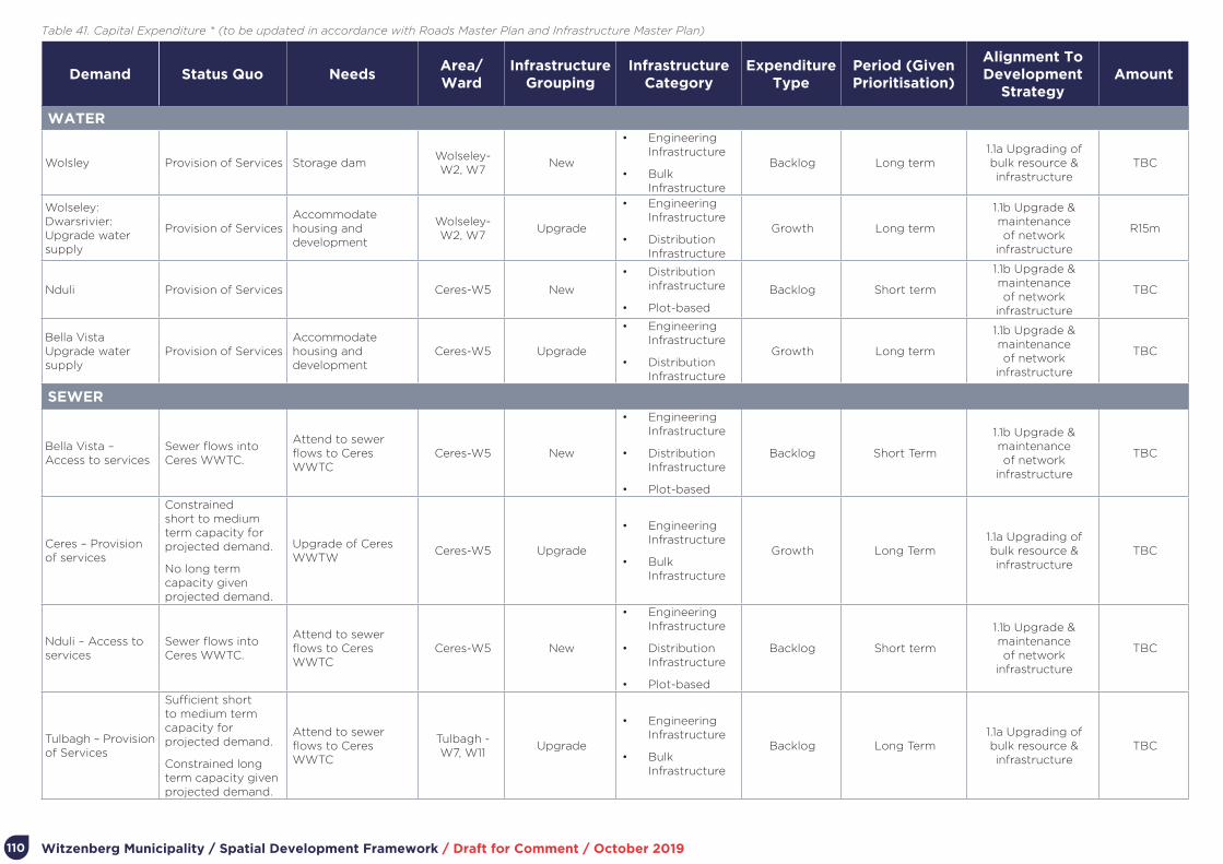
Witzenberg Municipality / Spatial Development Framework / Draft for Comment / October 2019110
Demand Status Quo NeedsArea/Ward
Infrastructure Grouping
Infrastructure Category
Expenditure Type
Period (Given Prioritisation)
Alignment To Development
StrategyAmount
WATER
Wolsley Provision of Services Storage damWolseley- W2, W7
New
• Engineering Infrastructure
• Bulk Infrastructure
Backlog Long term1.1a Upgrading of bulk resource & infrastructure
TBC
Wolseley: Dwarsrivier: Upgrade water supply
Provision of ServicesAccommodate housing and development
Wolseley- W2, W7
Upgrade
• Engineering Infrastructure
• Distribution Infrastructure
Growth Long term
1.1b Upgrade & maintenance of network
infrastructure
R15m
Nduli Provision of Services Ceres-W5 New
• Distribution infrastructure
• Plot-based
Backlog Short term
1.1b Upgrade & maintenance of network
infrastructure
TBC
Bella Vista Upgrade water supply
Provision of ServicesAccommodate housing and development
Ceres-W5 Upgrade
• Engineering Infrastructure
• Distribution Infrastructure
Growth Long term
1.1b Upgrade & maintenance of network
infrastructure
TBC
SEWER
Bella Vista – Access to services
Sewer flows into Ceres WWTC.
Attend to sewer flows to Ceres WWTC
Ceres-W5 New
• Engineering Infrastructure
• Distribution Infrastructure
• Plot-based
Backlog Short Term
1.1b Upgrade & maintenance of network
infrastructure
TBC
Ceres – Provision of services
Constrained short to medium term capacity for projected demand.
No long term capacity given projected demand.
Upgrade of Ceres WWTW
Ceres-W5 Upgrade
• Engineering Infrastructure
• Bulk Infrastructure
Growth Long Term1.1a Upgrading of bulk resource & infrastructure
TBC
Nduli – Access to services
Sewer flows into Ceres WWTC.
Attend to sewer flows to Ceres WWTC
Ceres-W5 New
• Engineering Infrastructure
• Distribution Infrastructure
• Plot-based
Backlog Short term
1.1b Upgrade & maintenance of network
infrastructure
TBC
Tulbagh – Provision of Services
Sufficient short to medium term capacity for projected demand.
Constrained long term capacity given projected demand.
Attend to sewer flows to Ceres WWTC
Tulbagh - W7, W11
Upgrade
• Engineering Infrastructure
• Bulk Infrastructure
Backlog Long Term 1.1a Upgrading of bulk resource & infrastructure
TBC
Table 41. Capital Expenditure * (to be updated in accordance with Roads Master Plan and Infrastructure Master Plan)
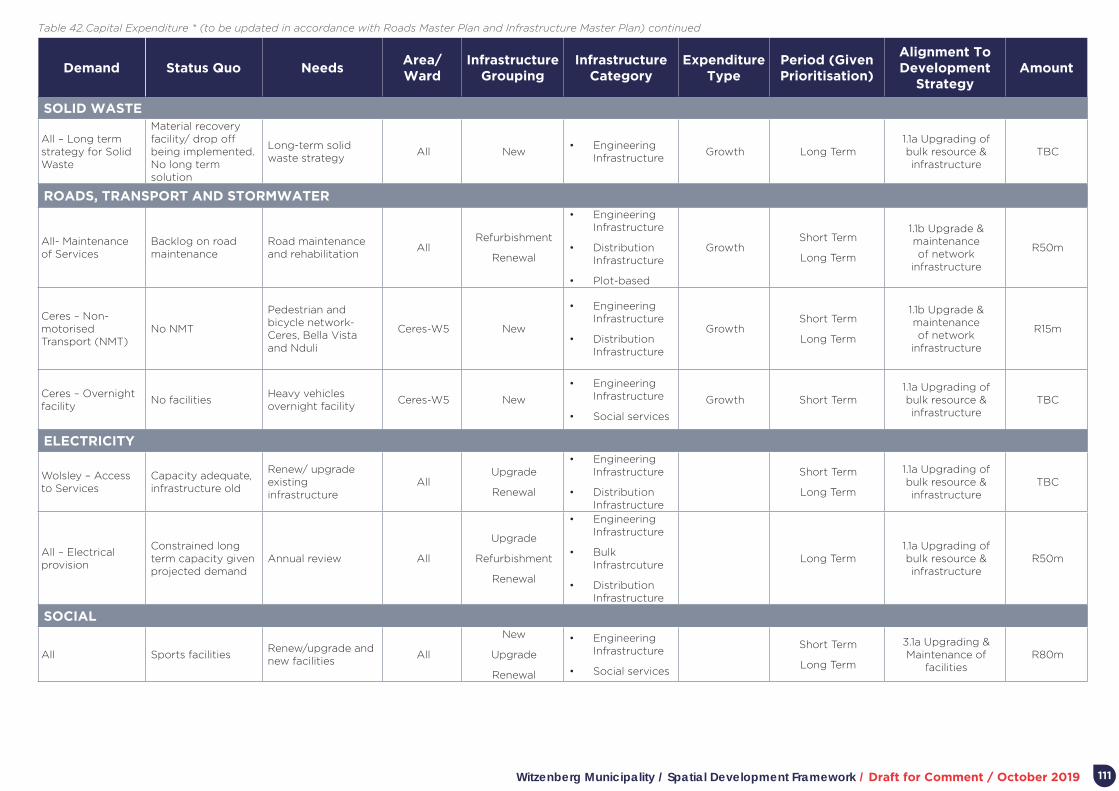
Witzenberg Municipality / Spatial Development Framework / Draft for Comment / October 2019 111
Demand Status Quo NeedsArea/Ward
Infrastructure Grouping
Infrastructure Category
Expenditure Type
Period (Given Prioritisation)
Alignment To Development
StrategyAmount
SOLID WASTE
All – Long term strategy for Solid Waste
Material recovery facility/ drop off being implemented. No long term solution
Long-term solid waste strategy
All New• Engineering
InfrastructureGrowth Long Term
1.1a Upgrading of bulk resource & infrastructure
TBC
ROADS, TRANSPORT AND STORMWATER
All- Maintenance of Services
Backlog on road maintenance
Road maintenance and rehabilitation
AllRefurbishment
Renewal
• Engineering Infrastructure
• Distribution Infrastructure
• Plot-based
GrowthShort Term
Long Term
1.1b Upgrade & maintenance of network
infrastructure
R50m
Ceres – Non-motorised Transport (NMT)
No NMT
Pedestrian and bicycle network- Ceres, Bella Vista and Nduli
Ceres-W5 New
• Engineering Infrastructure
• Distribution Infrastructure
GrowthShort Term
Long Term
1.1b Upgrade & maintenance of network
infrastructure
R15m
Ceres – Overnight facility
No facilitiesHeavy vehicles overnight facility
Ceres-W5 New
• Engineering Infrastructure
• Social services
Growth Short Term1.1a Upgrading of bulk resource & infrastructure
TBC
ELECTRICITY
Wolsley – Access to Services
Capacity adequate, infrastructure old
Renew/ upgrade existing infrastructure
AllUpgrade
Renewal
• Engineering Infrastructure
• Distribution Infrastructure
Short Term
Long Term
1.1a Upgrading of bulk resource & infrastructure
TBC
All – Electrical provision
Constrained long term capacity given projected demand
Annual review All
Upgrade
Refurbishment
Renewal
• Engineering Infrastructure
• Bulk Infrastrcuture
• Distribution Infrastructure
Long Term1.1a Upgrading of bulk resource & infrastructure
R50m
SOCIAL
All Sports facilitiesRenew/upgrade and new facilities
All
New
Upgrade
Renewal
• Engineering Infrastructure
• Social services
Short Term
Long Term
3.1a Upgrading & Maintenance of
facilitiesR80m
Table 42. Capital Expenditure * (to be updated in accordance with Roads Master Plan and Infrastructure Master Plan) continued
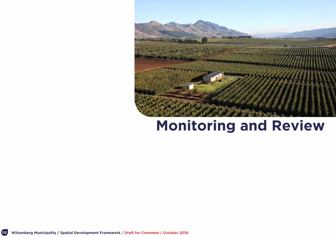
Witzenberg Municipality / Spatial Development Framework / Draft for Comment / October 2019112
Part 8.
Monitoring and Review

Witzenberg Municipality / Spatial Development Framework / Draft for Comment / October 2019 113
8. Monitoring and Review
8.1. MonitoringTowards the introduction of a planning performance, monitoring and evaluation system for the MSDF, a set of SMART (Specific, Measurable, Achievable, Relevant, Timebound) performance indicators need to be developed and applied. These should measure progress on delivering on the Municipal spatial agenda, including its substantive, spatial objectives.
In this regard, the Municipal Performance Management System (linked to the IDP) is important. It is proposed that the … development MSDF specific monitoring indicators during the 2019/ 20 business year for inclusion in the Municipal Performance Management System at the beginning of the 2020/ 21 business year.
Ideally, initial performance indicators should be limited to what is manageable by the administration while meaningfully tracking the achievement of stated spatial development objectives. Such criteria could include:
• The overall share of new development applications in the settlements identified for growth as compared to smaller settlements.
• Tracking the number of applications providing for increased density in settlements.
• Tracking the number of applications which entails “inclusive” development, specifically providing a range of housing types accommodating different income groups.
• The extent of agricultural land lost through redevelopment for alternative uses.
• The number of joint planning proposals initiated by landowners (with a view to integrate service improvements and agreed settlement benefits, specifically inclusive development.
8.2. Review of the MSDFProcesses, including public participation processes, associated with the review of an MSDF are prescribed by SPLUMA, the MSA (and associated regulations), LUPA, the Witzenberg Municipality Land Use Planning By-Law, and associated policies or regulations.
The purpose of the MSDF is to provide a medium to long term vision and associated strategies, policies, guidelines, implementation measures, and associated instruments to attain this vision progressively over time. As development – whether it be headed by the public sector or the private sector – takes multiple years to be achieved, it is not appropriate that the MSDF is substantially reviewed annually. A major review of the MSDF should therefore occur every five years. Improvements, amendments, and refinements to the MSDF can occur annually.
Five-year and annual reviews are to be aligned with the IDP and budget planning and approval process.

Witzenberg Municipality / Spatial Development Framework / Draft for Comment / October 2019
List of Documents Reviewed
114
Witzenberg Municipality / Spatial Development Framework / Draft for Comment / October 2019
Cape Winelands District Municipality, Local Integrated Transport Plan Witzenberg 2016-2021, 2018
CSIR, Guidelines for the Provision of Social Facilities in South African Settlements, 2012
CSIR, South African Functional Town Typology, 2018
Department of Cooperative Government and Traditional Affairs, Integrated Urban Development Framework: A New Deal for South African Cities and Towns, 2016
Department of Rural Development and Land Reform, AGRI-PARK: Your agri-park; Your future, 2015
Department of Rural Development and Land Reform, Guidelines for the Development of Provincial, Regional and Municipal Spatial Development Frameworks and Precinct Plans, 2017
National Planning Commission, National Development Plan 2030, 2012
Spatial Planning and Land Use Management Act (ACT 16 of 2013), 2013
Stellenbosch University and CSIR, A Revision of the 2004 Growth Potential of Towns in the Western Cape Study (Discussion Document), 2010
Stellenbosch University, Growth Potential of Towns in the Western Cape: Quantitative Analysis of Growth Potential At Settlement And Municipal Level, 2013
WCG DEADP, Provincial Spatial Development Framework, 2014
WCG DEADP, PSDF and the Cape Winelands District (Brochure), 2014
WCG DEADP, PSDF Creating Integrated and Sustainable Settlements (Brochure), 2014
WCG DEADP, PSDF Opening-up Opportunities in the Space Economy (Brochure), 2014
WCG DEADP, PSDF Settlement Toolkit, 2014
WCG, Western Cape Population Projections: 2011-2040, 2014
WCG, Provincial Strategic Plan: 2014 -2019, 2015
WCG Department of Transport and Public Works, Draft Provincial Land Transport Framework, 2016
WCG Department of Human Settlements, Western Cape Human Settlements Framework: Discussion Document, 2016
WCG DEADP, Feasibility Study for Alternative and Sustainable Infrastructure for Settlements, 2016
WCG, Western Cape Biodiversity Spatial Plan, 2017
WCG, RSEP/VPUU Programme: Feasibility Study for Witzenberg Local Municipality, 2018
WCG, RESP/VPUU Annual Review Report 2018/19
WCG, Overview of Provincial and Municipal Infrastructure Investment, 2019
WCG, Witzenberg Municipality LG MTEC Integrated Planning and Budgeting Assessment: Analysis of Municipal IDP, SDF And Budget, 2019
WCG, Western Cape Land Use Planning Guidelines Rural, 2019
Witzenberg Municipality, Witzenberg Spatial Development Framework, 2012
Witzenberg Municipality Land Use Planning By-Law, 2015
Witzenberg Municipality, Master Planning and Status Reports on the 11kv Infrastructure in Ceres, Wolseley And Tulbagh Period 2018-2028, 2018
Witzenberg Municipality Draft Human Settlement Plan, 2016
Witzenberg Municipality, WSDP: IDP Water Sector Input Report, 2017
Witzenberg Municipality, IDP 2017-2022, 2017
Witzenberg Municipality, Reviewed IDP 2018-2019, 2018
Witzenberg Municipality, Reviewed IDP 2019-2020, 2019
Winter, Sarah and Oberholzer, Bernard, Heritage and Scenic Heritage Study: Prepared as input into the Provincial Spatial Development Framework, 2013
115

Witzenberg Municipality / Spatial Development Framework / Draft for Comment / October 2019
Appendices
116

Witzenberg Municipality / Spatial Development Framework / Draft for Comment / October 2019
A. SPLUMA Requirements for SDFs
117
In terms of Section 21 of SPLUMA, a municipal spatial development framework must:
• Give effect to the development principles and applicable norms and standards set out in Chapter 2.
• Include a written and spatial representation of a five-year spatial development plan for the spatial form of the municipality.
• Include a longer term spatial development vision statement for the municipal area which indicates a desired spatial growth and development pattern for the next 10 to 20 years.
• Identify current and future significant structuring and restructuring elements of the spatial form of the municipality, including development corridors, activity spines and economic nodes where public and private investment will be prioritised and facilitated.
• Include population growth estimates for the next five years.
• Include estimates of the demand for housing units across different socio-economic categories and the planned location and density of future housing developments.
• Include estimates of economic activity and employment trends and locations in the municipal area for the next five years.
• Identify, quantify and provide location requirements of engineering infra-structure and services provision for existing and future development needs for the next five years.
• Identify the designated areas where a national or provincial inclusionary housing policy may be applicable.
• Include a strategic assessment of the environmental pressures and opportunities
within the municipal area, including the spatial location of environmental sensitivities, high potential agricultural land and coastal access strips, where applicable.
• Identify the designation of areas in the municipality where incremental upgrading approaches to development and regulation will be applicable.
• Identify the designation of areas in which more detailed local plans must be developed; and shortened land use development procedures may be applicable and land use schemes may be so amended.
• Provide the spatial expression of the coordination, alignment and integration of sectoral policies of all municipal departments.
• Determine a capital expenditure framework for the municipality’s development programmes, depicted spatially.
Include an implementation plan comprising of:
- Sectoral requirements, including budgets and resources for implementation.
- Necessary amendments to the land use scheme.
- Specification of institutional arrangements necessary for implementation.
- Specification of implementation targets, including dates and monitoring indicators.
- Specification, where necessary, of any arrangements for partnerships in the implementation process.

Witzenberg Municipality / Spatial Development Framework / Draft for Comment / October 2019
B. Witzenberg Municipality Land Use Planning By-Law requirements for SDF
118
In terms of Section 3 (1) of the Witzenberg Municipality Land Use Planning By-Law, 2015 (Province of the Western Cape: Provincial Gazette Extraordinary 7474 21 August 2015), the purpose of the MSDF includes:
• Providing a longer-term spatial depiction of the desired form and structure of the geographic area to which it applies.
• Providing land use management guidelines regarding the appropriate nature, form, scale and location of development.
• Contributing to spatial co-ordination.
• Providing predictable land development.
• Guiding investment and planning of municipal departments and where appropriate other spheres of government.
• Guiding investment for the private sector.
• Guiding decision making on applications.
• Utilising specific arrangements for prioritising, mobilising, sequencing and implementing public and private infrastructural and land development investment in priority spatial structuring areas.
In terms of Section 3 (2), the MSDF should provide land use management guidelines that relate to:
• Capacity of engineering services.
• Community facility needs.
• Demographic conditions.
• Transportation and road network master planning.
• Urban and rural problems.
• Visual form.
• Biodiversity.
• Environmental opportunities and constraints.
• Heritage resources.
• Current land use.
• Housing market.
• Agricultural resources.
• Land availability.
• Growth potential.
• Existing and anticipated private and public development.

Witzenberg Municipality / Spatial Development Framework / Draft for Comment / October 2019
C. The PSDF and the Cape Winelands District
119
See: https://www.westerncape.gov.za/eadp/files/atoms/files/07_Implementation%20of%20the%20PSDF_Cape%20Winelands.pdf
IMPLEMENTATION OF THE PSDF IN THE CAPE WINELANDS
OPENING UP OPPORTUNITIES IN THE SPACE ECONOMY
The demand for infrastructure in the Western Cape is determined by the rate of economic growth and
the nature thereof.
USE REGIONAL INFRASTRUCTURE INVESTMENT TO LEVERAGE ECONOMIC GROWTH
Integrate the spatial component of bulk infrastructure master plans, public transport plans
and housing/human settlement plans into a spatial development framework prepared at the
appropriate scale.
Prioritise developing the required bulk infrastructure capacity to serve the connection and
compaction of existing human settlements, over developing bulk infrastructure to serve the outward
growth of settlements.
Agriculture is going through a difficult transition period with its traditional export market in recession,
escalating pressure on operating margins, more stringent international and national compliance
requirements, and instability in the labour market.
The rural space-economy agenda is not only about agricultural development, it is also about broad based agrarian
transformation, diversifying rural economic activities, tourism, government promotion of rural development
and land reform programmes, and functional ecosystems.
DIVERSIFY AND STRENGTHEN THE RURAL ECONOMY
Compatible and sustainable rural activities of an appropriate scale and form can be accommodated
outside the urban edge.
Commonages should be safeguarded for their original purpose, and municipal spatial development
frameworks (SDFs) should give considerations to the establishment of new commonages.
DEVELOPING INTEGRATED AND SUSTAINABLE SETTLEMENTS
The Western Cape’s unique sense of place and
identity underpins its economy in numerous ways.
Scenic landscapes, historic settlements and the sense
of place which underpins their quality are being eroded
by inappropriate developments that detract from the
unique identity of towns. Causes include a lack of
adequate information and proactive management
systems.
PROTECT, MANAGE AND ENHANCE SENSE OF PLACE, CULTURAL AND SCENIC LANDSCAPES
Prevent settlement encroachment into
agricultural areas, scenic landscapes and
biodiversity priority areas, especially between
settlements, and along river corridors.
Conservation strategies, detailed place-
specific guidelines and explicit development
parameters must supplement urban edges to
ensure the effective management of settlement
and landscape quality and form.
THE SUSTAINABLE USE OF THE PROVINCE’S ASSETS
Water is a key determinant of future Provincial economic growth. Yet escalating demand and finite supply
means that protection and rehabilitation of river systems and ground water recharge areas is required.
There is growing competition for water between the agricultural and industrial sector and settlements. The
main agricultural users are located in the Breede agricultural valley areas and the Oliphants/Doorn agricultural
corridor. Key urban and industrial water users are located in the Cape Metro functional region.
SAFEGUARD INLAND WATER AND COASTAL WATER RESOURCES AND MANAGE THE SUSTAINABLE USE OF WATER
Develop agricultural water demand management programmes, focusing on the Breede Valley and
Oliphants/Doorn agricultural areas.
Develop water demand management programmes for the Province’s main industrial/settlement nodes.Provincial Spatial Development Framework Ref:Prepared by: WCEA&DP
¯0 8 16 24 324
kmDISCLAIMER: Under no circumstances shall the Department of Environmental Affairs and Development Planning be held liable for any consequential damages or loss of profit resulting from accuracy or completeness of data here presented.
2013 / 504 / 000Hydrology / Water Supply
LegendWater Supply
Rivers
Dams
Special Aquifer Regions
Mountain Catchment Areas
Drainage Regions
R2
E1
E2
S1
The Western Cape’s cultural and scenic landscapes are significant assets that underpin the tourism economy.
Yet these resources are being incrementally eroded and fragmented. Agriculture is being reduced to ‘islands’,
visual cluttering of the landscape by non-agricultural development is prevalent, and rural authenticity, character
and scenic value is being eroded.
SAFEGUARD CULTURAL AND SCENIC ASSETS
Ensure appropriate interface between urban development and significant landscapes. The delineation
of urban edges have significant implications for the protection of natural and cultural landscapes from
urban encroachment.
Priority focus areas for conservation or protection includes rural landscapes of scenic and cultural
significance situated on major urban edges and under increasing development pressures.
Provincial Spatial Development Framework Ref:Prepared by: WCEA&DP
¯0 8 16 24 324
kmDISCLAIMER: Under no circumstances shall the Department of Environmental Affairs and Development Planning be held liable for any consequential damages or loss of profit resulting from accuracy or completeness of data here presented.
2013 / 709 / 000Heritage
The Cape Winelands District consists of Stellenbosch, Drakenstein, Witzenberg, Breede Valley, and Langeberg Municipalities.
Situated between the rugged sandstone peaks of the Cape Fold Mountains, the District is an area of high scenic and heritage
significance. Its fertile valleys are home to some of the world’s famous vineyards which have been earmarked for declaration
as a World Heritage Site.
The diagram to the left depicts the three spatial
themes underlying the PSDF and their associated
elements, supported by spatial governance. Although
many of the policy statements are interrelated, the
statements reflected on this poster are deemed to
be the most relevant to the Cape Winelands District.
Provincial Spatial Development Framework Ref:Prepared by: WCEA&DP
¯0 8 16 24 324
kmDISCLAIMER: Under no circumstances shall the Department of Environmental Affairs and Development Planning be held liable for any consequential damages or loss of profit resulting from accuracy or completeness of data here presented.
2013 / 800 / 002Cape Winelands
LegendSpatial Planning Categories
Core
Buffer
Intensive Agriculture
Settlement
Priority Urban Functional Regions
Cape Metro
Emerging Regional Centres
Leisure
Rural Development Corridor
Regional Centre
Service Centre
Secondary Settlement
Regional Connector Route
Tourism Route
! ! ! ! ! ! ! ! ! Major Railway Line
Agriculture output is the foundation of the Western Cape’s rural economy and an important input to
the urban economy. Yet there is limited suitable land available for extension of the Province’s agricultural
footprint, and water availability limits the use of cultivated soils.
Land transformation is the primary cause of biodiversity loss and deteriorating ecosystem health. The main
threat is in the lowlands, particularly in areas intensively cultivated and subject to urban growth pressures.
SAFEGUARD THE WESTERN CAPE’S AGRICULTURAL AND MINERAL RESOURCES, AND MANAGE THEIR SUSTAINABLE USE
Record unique and high potential agricultural land in municipal SDFs, demarcate urban edges to
protect these assets, and adopt and apply policies to protect this resource.
Reconcile ecosystem requirements with conflicting land development pressures through proactive
spatial planning, and application of a land use management system that safeguards biodiversity,
protects resources and opens up opportunities for improved livelihoods and jobs. Provincial Spatial Development Framework Ref:
Prepared by: WCEA&DP
¯0 8 16 24 324
kmDISCLAIMER: Under no circumstances shall the Department of Environmental Affairs and Development Planning be held liable for any consequential damages or loss of profit resulting from accuracy or completeness of data here presented.
2013 / 708 / 001Agriculture & Forestry - Landcover
LegendLandcover
Cultivation
Degraded
Mines
Natural
Plantations
Urban Built-up
Waterbodies
R3
R5
The PROVINCIAL SPATIAL DEVELOPMENT FRAMEWORK, 2014 (PSDF) is the common spatial reference framework for delivering on the Province’s strategic development priorities, individually and collectively. It guides the
location and form of public investment of national and provincial departments as well as municipalities in the natural and built environment, ensuring that the returns on these investments are consistent with the Province’s
development objectives.
RESOURCES
LANDSCAPE AND SCENIC
ASSETS
BIODIVERSITY AND
ECOSYSTEM SERVICES
WATER
SOILS AND MINERAL
RESOURCES
RESOURCE CONSUMPTION AND DISPOSAL
SPACE ECONOMY
REGIONAL ECONOMIC
INFRASTRUCTURE
URBAN SPACE-ECONOMY
RURAL SPACE-
ECONOMY
SPATIAL GOVERNANCE
SENSE OF PLACE AND SETTLEMENT PATTERNS
INFORMALITY HOUSING,
INCLUSION AND LAND MARKET
ACCESSIBILITY
LAND USE AND DENSITY
FACILITIES AND SOCIAL
SERVICES
SETTLEMENT
R3
E1
E2
S1
R5
R2
Improving the Western Cape through Spatial Planning BETTER TOGETHER.
Western Cape Provincial Spatial Development Framework (PSDF)For more information and tips visit www.westerncape.gov.za/eadp
Witzenberg Municipality / Spatial Development Framework / Draft for Comment / October 2019120
IMPLEMENTATION OF THE PSDF IN THE CAPE WINELANDS
OPENING UP OPPORTUNITIES IN THE SPACE ECONOMY
The demand for infrastructure in the Western Cape is determined by the rate of economic growth and
the nature thereof.
USE REGIONAL INFRASTRUCTURE INVESTMENT TO LEVERAGE ECONOMIC GROWTH
Integrate the spatial component of bulk infrastructure master plans, public transport plans
and housing/human settlement plans into a spatial development framework prepared at the
appropriate scale.
Prioritise developing the required bulk infrastructure capacity to serve the connection and
compaction of existing human settlements, over developing bulk infrastructure to serve the outward
growth of settlements.
Agriculture is going through a difficult transition period with its traditional export market in recession,
escalating pressure on operating margins, more stringent international and national compliance
requirements, and instability in the labour market.
The rural space-economy agenda is not only about agricultural development, it is also about broad based agrarian
transformation, diversifying rural economic activities, tourism, government promotion of rural development
and land reform programmes, and functional ecosystems.
DIVERSIFY AND STRENGTHEN THE RURAL ECONOMY
Compatible and sustainable rural activities of an appropriate scale and form can be accommodated
outside the urban edge.
Commonages should be safeguarded for their original purpose, and municipal spatial development
frameworks (SDFs) should give considerations to the establishment of new commonages.
DEVELOPING INTEGRATED AND SUSTAINABLE SETTLEMENTS
The Western Cape’s unique sense of place and
identity underpins its economy in numerous ways.
Scenic landscapes, historic settlements and the sense
of place which underpins their quality are being eroded
by inappropriate developments that detract from the
unique identity of towns. Causes include a lack of
adequate information and proactive management
systems.
PROTECT, MANAGE AND ENHANCE SENSE OF PLACE, CULTURAL AND SCENIC LANDSCAPES
Prevent settlement encroachment into
agricultural areas, scenic landscapes and
biodiversity priority areas, especially between
settlements, and along river corridors.
Conservation strategies, detailed place-
specific guidelines and explicit development
parameters must supplement urban edges to
ensure the effective management of settlement
and landscape quality and form.
THE SUSTAINABLE USE OF THE PROVINCE’S ASSETS
Water is a key determinant of future Provincial economic growth. Yet escalating demand and finite supply
means that protection and rehabilitation of river systems and ground water recharge areas is required.
There is growing competition for water between the agricultural and industrial sector and settlements. The
main agricultural users are located in the Breede agricultural valley areas and the Oliphants/Doorn agricultural
corridor. Key urban and industrial water users are located in the Cape Metro functional region.
SAFEGUARD INLAND WATER AND COASTAL WATER RESOURCES AND MANAGE THE SUSTAINABLE USE OF WATER
Develop agricultural water demand management programmes, focusing on the Breede Valley and
Oliphants/Doorn agricultural areas.
Develop water demand management programmes for the Province’s main industrial/settlement nodes.Provincial Spatial Development Framework Ref:Prepared by: WCEA&DP
¯0 8 16 24 324
kmDISCLAIMER: Under no circumstances shall the Department of Environmental Affairs and Development Planning be held liable for any consequential damages or loss of profit resulting from accuracy or completeness of data here presented.
2013 / 504 / 000Hydrology / Water Supply
LegendWater Supply
Rivers
Dams
Special Aquifer Regions
Mountain Catchment Areas
Drainage Regions
R2
E1
E2
S1
The Western Cape’s cultural and scenic landscapes are significant assets that underpin the tourism economy.
Yet these resources are being incrementally eroded and fragmented. Agriculture is being reduced to ‘islands’,
visual cluttering of the landscape by non-agricultural development is prevalent, and rural authenticity, character
and scenic value is being eroded.
SAFEGUARD CULTURAL AND SCENIC ASSETS
Ensure appropriate interface between urban development and significant landscapes. The delineation
of urban edges have significant implications for the protection of natural and cultural landscapes from
urban encroachment.
Priority focus areas for conservation or protection includes rural landscapes of scenic and cultural
significance situated on major urban edges and under increasing development pressures.
Provincial Spatial Development Framework Ref:Prepared by: WCEA&DP
¯0 8 16 24 324
kmDISCLAIMER: Under no circumstances shall the Department of Environmental Affairs and Development Planning be held liable for any consequential damages or loss of profit resulting from accuracy or completeness of data here presented.
2013 / 709 / 000Heritage
The Cape Winelands District consists of Stellenbosch, Drakenstein, Witzenberg, Breede Valley, and Langeberg Municipalities.
Situated between the rugged sandstone peaks of the Cape Fold Mountains, the District is an area of high scenic and heritage
significance. Its fertile valleys are home to some of the world’s famous vineyards which have been earmarked for declaration
as a World Heritage Site.
The diagram to the left depicts the three spatial
themes underlying the PSDF and their associated
elements, supported by spatial governance. Although
many of the policy statements are interrelated, the
statements reflected on this poster are deemed to
be the most relevant to the Cape Winelands District.
Provincial Spatial Development Framework Ref:Prepared by: WCEA&DP
¯0 8 16 24 324
kmDISCLAIMER: Under no circumstances shall the Department of Environmental Affairs and Development Planning be held liable for any consequential damages or loss of profit resulting from accuracy or completeness of data here presented.
2013 / 800 / 002Cape Winelands
LegendSpatial Planning Categories
Core
Buffer
Intensive Agriculture
Settlement
Priority Urban Functional Regions
Cape Metro
Emerging Regional Centres
Leisure
Rural Development Corridor
Regional Centre
Service Centre
Secondary Settlement
Regional Connector Route
Tourism Route
! ! ! ! ! ! ! ! ! Major Railway Line
Agriculture output is the foundation of the Western Cape’s rural economy and an important input to
the urban economy. Yet there is limited suitable land available for extension of the Province’s agricultural
footprint, and water availability limits the use of cultivated soils.
Land transformation is the primary cause of biodiversity loss and deteriorating ecosystem health. The main
threat is in the lowlands, particularly in areas intensively cultivated and subject to urban growth pressures.
SAFEGUARD THE WESTERN CAPE’S AGRICULTURAL AND MINERAL RESOURCES, AND MANAGE THEIR SUSTAINABLE USE
Record unique and high potential agricultural land in municipal SDFs, demarcate urban edges to
protect these assets, and adopt and apply policies to protect this resource.
Reconcile ecosystem requirements with conflicting land development pressures through proactive
spatial planning, and application of a land use management system that safeguards biodiversity,
protects resources and opens up opportunities for improved livelihoods and jobs. Provincial Spatial Development Framework Ref:
Prepared by: WCEA&DP
¯0 8 16 24 324
kmDISCLAIMER: Under no circumstances shall the Department of Environmental Affairs and Development Planning be held liable for any consequential damages or loss of profit resulting from accuracy or completeness of data here presented.
2013 / 708 / 001Agriculture & Forestry - Landcover
LegendLandcover
Cultivation
Degraded
Mines
Natural
Plantations
Urban Built-up
Waterbodies
R3
R5
The PROVINCIAL SPATIAL DEVELOPMENT FRAMEWORK, 2014 (PSDF) is the common spatial reference framework for delivering on the Province’s strategic development priorities, individually and collectively. It guides the
location and form of public investment of national and provincial departments as well as municipalities in the natural and built environment, ensuring that the returns on these investments are consistent with the Province’s
development objectives.
RESOURCES
LANDSCAPE AND SCENIC
ASSETS
BIODIVERSITY AND
ECOSYSTEM SERVICES
WATER
SOILS AND MINERAL
RESOURCES
RESOURCE CONSUMPTION AND DISPOSAL
SPACE ECONOMY
REGIONAL ECONOMIC
INFRASTRUCTURE
URBAN SPACE-ECONOMY
RURAL SPACE-
ECONOMY
SPATIAL GOVERNANCE
SENSE OF PLACE AND SETTLEMENT PATTERNS
INFORMALITY HOUSING,
INCLUSION AND LAND MARKET
ACCESSIBILITY
LAND USE AND DENSITY
FACILITIES AND SOCIAL
SERVICES
SETTLEMENT
R3
E1
E2
S1
R5
R2
Improving the Western Cape through Spatial Planning BETTER TOGETHER.
Western Cape Provincial Spatial Development Framework (PSDF)For more information and tips visit www.westerncape.gov.za/eadp
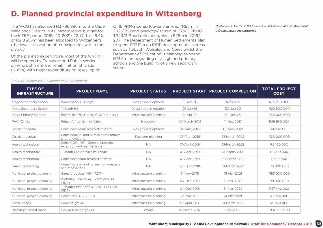
Witzenberg Municipality / Spatial Development Framework / Draft for Comment / October 2019
D. Planned provincial expenditure in Witzenberg
121
The WCG has allocated R3 796,996m to the Cape Winelands District in its infrastructure budget for the MTEF period 2019/ 20-2021/ 22. Of this, 8,4% or R318,355m has been allocated to Witzenberg (the lowest allocation of municipalities within the district).
Of the planned expenditure, most of the funding will be spend by Transport and Public Works on refurbishment and rehabilitation of roads (R119m) with major expenditure on resealing of
C1116 PRMG Ceres-Touwsrivier road (R85m in 2021/ 22) and blacktop/ tarred of C751.2 PRMG TR23/3 Gouda-Kleinbergrivier (R26m in 2019/ 20). The Department of Human Settlements plan to spent R97.13m on IRDP developments in areas such as Tulbagh, Wolseley and Ceres whilst the Department of Education is planning to spend R74,5m on upgrading of a high and primary schools and the building of a new secondary school.
TYPE OF INFRASTRUCTURE
PROJECT NAME PROJECT STATUS PROJECT START PROJECT COMPLETIONTOTAL PROJECT
COST
Mega Secondary School Waveren SS (Tulbagh) Design development 15-Apr-20 16-Sep-21 R55 250 000
Mega Secondary School Tulbagh HS Design documentation 01-Jun-19 30-Jun-20 R20 500 000
Mega Primary Schools Boy Muller PS (North of Op-die-berg) Infrastructure planning 01-Apr-22 01-Dec-23 R30 000 000
PHC (Clinic) Prince Alfred Hamlet Clinic Handover 20-March-2012 11-Dec-2017 R29 930 000
District hospital Ceres new acute psychiatric ward Design development 01-June-2016 01-April-2021 R4 200 000
District hospitalCeres hospital and nurses home repairs and renovations
Package planning 28-Febr-2018 31-March-2022 R20 000 000
Health technologyCeres CDC - HT - General upgrade, extension and maintenance
NA 01-April-2019 31-March-2022 R2 100 000
Health technology Tulbagh Clinic structural repair NA 01-April-2019 31-March-2021 R1 400 000
Health technology Ceres new acute psychiatric ward NA 01-April-2019 30-March-2021 R500 000
Health technology Ceres hospital and nurses home repairs and renovations
NA 28-Febr-2018 31-March-2022 R5 000 000
Municipal project: planning Ceres Vredebes (454 IRDP) Infrastructure planning 21-Nov-2019 31-Mar-2021 R83 000 000
Municipal project: planningWolseley Pine Valley Extention (560 IRDP)
Infrastructure planning 04-Dec-2018 31-Mar-2022 R9 000 000
Municipal project: planningTulbagh Erven 1366 & 1435-1443 (225 IRDP)
Infrastructure planning 04-Dec-2018 31-Mar-2022 R27 442 000
Municipal project: planning Ceres Nduli (188 UISP) Infrastructure planning 23-Mar-2017 31-Mar-2021 R12 124 000
Gravel roads Ceres re-gravel Infrastructure planning 30-April-2018 31-March-2022 R5 830 000
Blacktop/ tarred roads Gouda-Kleinbergrivier Works 15-March-2017 31/03/2021 R184 365 000
Table 43. Planned WCG expenditure in Witzenberg
(Reference: WCG, 2019 Overview of Provincial and Municipal
Infrastructure Investment.)

Witzenberg Municipality / Spatial Development Framework / Draft for Comment / October 2019
E. Witzenberg housing plan and pipeline
122
Housing demand1
Housing demand in Witzenberg Municipality – as contained in the housing demand database – is illustrated in Table 44.
Approximately 70% of those on the housing demand database were aged between 35 to 59 years at the date of registration and 12% older than 60.
Additional housing demand2
The WCG is busy with work to update population estimates and housing demand based on population growth. This work indicates a population for Witzenberg Municipality of 139 379 (slightly different from a STATS SA 2019 estimate of 142 466. Table 45 indicates the WCG’s estimate of housing opportunities required in 2018 based on population growth (in 2018 only).
The two columns relate to assumptions about urbanisation. If assumed no rural demand for housing (all demand absorbed in urban areas) the figure to the right is applicable. If assumed that the urbanisation rate is the same in 2018 as in 2016 (54,4%), the figure to the left applies.
SETTLEMENT HOUSING DEMAND PERCENTAGE OF OVERALL
Ceres 2 576 45%
Wolseley 1 133 20%
Prince Alfred Hamlet 858 15%
Tulbagh 768 14%
Op-die berg 330 6%
Other 6 0%
Total 5 671
SETTLEMENTDUs NEEDED IN 2018 IF
URBANISATION CONSISTENTDUs NEEDED IN 2018 IF ALL DEMAND IN SETTLEMENTS
Ceres 258 401
Ceres town 74 114
Bella Vista 78 122
Nduli 106 165
Wolseley 125 195
Wolseley town 20 31
Pine Valley 52 80
Montana 54 83
Tulbagh 83 129
Prince Alfred Hamlet 56 88
Op-die-berg 9 14
Total 531 827
Table 44. Housing demand in Witzenberg Municipality
Table 45. Additional housing demand in Witzenberg Municipality
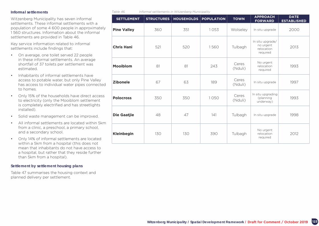
Witzenberg Municipality / Spatial Development Framework / Draft for Comment / October 2019 123
SETTLEMENT STRUCTURES HOUSEHOLDS POPULATION TOWNAPPROACH FORWARD
DATE ESTABLISHED
Pine Valley 360 351 1 053 Wolseley In situ upgrade 2000
Chris Hani 521 520 1 560 Tulbagh
In situ upgrade/ no urgent relocation required
2013
Mooiblom 81 81 243Ceres
(Nduli)
No urgent relocation required
1993
Zibonele 67 63 189Ceres
(Nduli)In situ upgrade 1997
Polocross 350 350 1 050Ceres
(Nduli)
In situ upgrading (planning
underway)1993
Die Gaatjie 48 47 141 Tulbagh In situ upgrade 1998
Kleinbegin 130 130 390 TulbaghNo urgent relocation required
2012
Table 46. Informal settlements in Witzenberg MunicipalityInformal settlements
Witzenberg Municipality has seven informal settlements. These informal settlements with a population of some 4 600 people in approximately 1 560 structures. Information about the informal settlements are provided in Table 46.
Key service information related to informal settlements include findings that:
• On average, one toilet served 22 people in these informal settlements. An average shortfall of 37 toilets per settlement was estimated.
• Inhabitants of informal settlements have access to potable water, but only Pine Valley has access to individual water pipes connected to homes.
• Only 15% of the households have direct access to electricity (only the Mooiblom settlement is completely electrified and has streetlights installed).
• Solid waste management can be improved.
• All informal settlements are located within 5km from a clinic, a preschool, a primary school, and a secondary school.
• Only 14% of informal settlements are located within a 5km from a hospital (this does not mean that inhabitants do not have access to a hospital, but rather that they reside further than 5km from a hospital).
Settlement by settlement housing plans
Table 47 summarises the housing context and planned delivery per settlement.

Witzenberg Municipality / Spatial Development Framework / Draft for Comment / October 2019124
SETTLEMENT OVERVIEW2012 MSDF
PROPOSALSPROJECT NAME
PLANNED DELIVERY
FUNDING REQUIREMENTS
PLANNED CONCLUSION
DATE
OTHER ASSOCIATED
NEEDS
Ceres
• 45% of housing demand in Witzenberg.
• New housing development focused on Bella Vista (largely completed) and Vredebes (2 700 opportunities underway in phases).
• Nduli is earmarked for upgrading.
• Vredebes will also accommodate decanting from Nduli.
• Kleinbegin PPP for agri workers (feasibility underway).
• Significant residential expansion indicated north-west of Ceres and north of Nduli.
• Delivery focus on Vredebes.
• Upgrading of six areas in Nduli.
• Need for detail planning of area between Ceres, Bella Vista, and Nduli.
Project 3209 Bella Vista IRDP.
209 top structures.
R13m (HSDG) 2017/ 18 • Upgrade of R46.
• Planning of area between Ceres, Bella Vista, and Nduli.
• Vredebes community facilities.
Project 3199 Vredebes IRDP.
600 serviced sites
(Phase 2) and 300 top structures in (Phase 1).
R76m (HSDG) Beyond 2020/21
Project 3463 Nduli UISP.
150 enhanced serviced sites.
R7,85m (HSDG) Beyond 2020/21
Wolseley• 20% of housing demand in
Witzenberg.
• Current focus on Pine Valley.
• Future focus on southern parts of Pine Valley.
• The Montana agri-worker housing project to the east will focus on agri-workers in and around Wolseley.
• Long term direction of housing development identified towards north.
Project 3238 Pine Valley Phase 2A UISP.
120 serviced sites. R360 000 (HSDG) To be determined
Pine Valley Extension IRDP.
560 serviced sites and 560 top structures.
R2,49m (HSDG) Beyond 2020/21
Montana agri-worker housing IRDP FLISP.
700 serviced sites and 700 top structures.
R3,12m (HSDG) Beyond 2020/21
Tulbagh
• 14% of housing demand in Witzenberg.
• Historical focus on Chris Hani settlement.
Indicates extensive expansion to the north and some to south (HSP questions extent of northern extension).
Project 3463 land acquisition Erven 1366-1435-1443.
Acquisition of private property.
R4m (HSDG) 2017/18
Project 3463 services and top structures Erven 1366-1435-1443.
225 serviced sites and 225 top structures IRDP.
R38,25m (HSDG) Beyond 2020/21
Project 3462 GAP units FLISP.
50 units. R6m (HSDG) Unknown
Prince Alfred Hamlet
• 15% of housing demand in Witzenberg.
• 240 units completed in 2014/15.
• No immediate projects planned.
Long term residential expansion is directed towards the north-west, the north-east and the south (completed development focused on north-west).
Op-die-berg
• 6% of housing demand in Witzenberg.
• 250 units completed in 2014/15.
• No immediate projects planned.
Completed development focused on area between two previously segregated parts of town.
Table 47. Settlement by settlement housing delivery plan
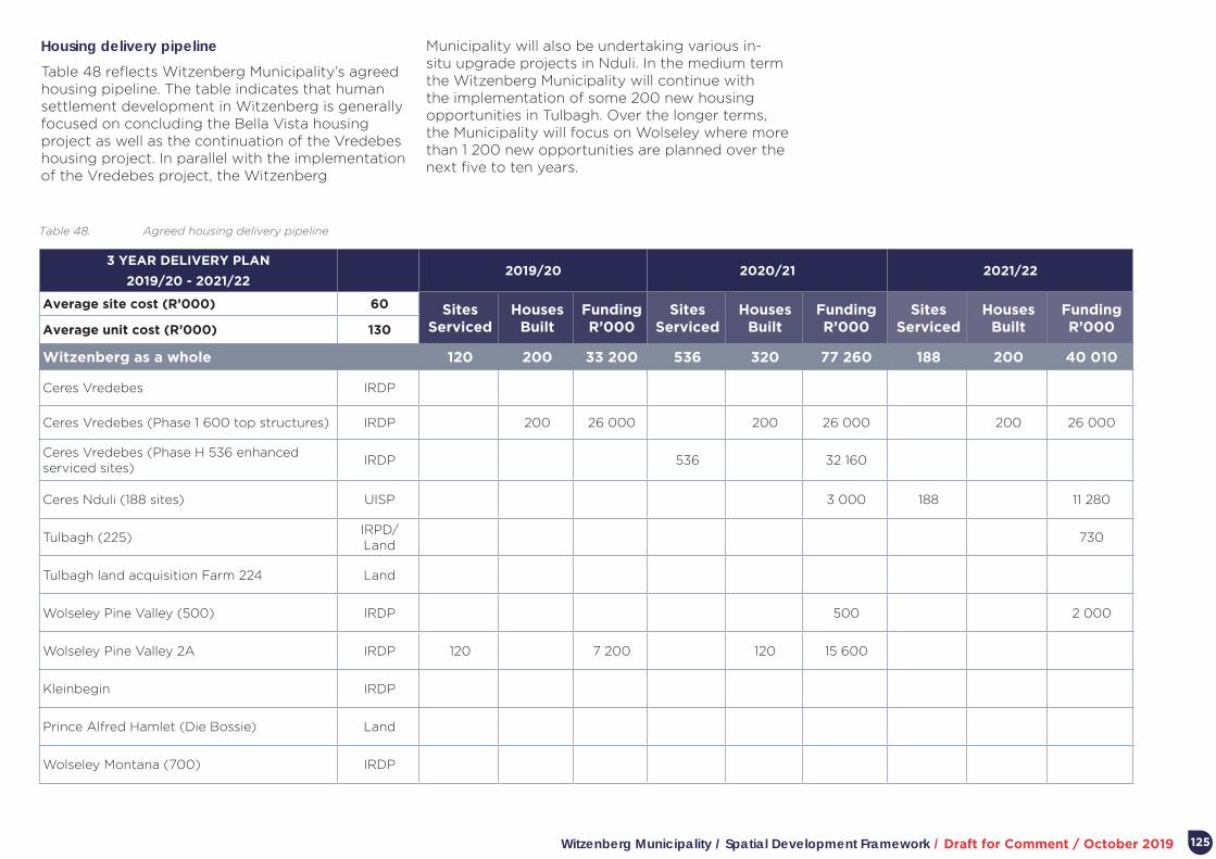
Witzenberg Municipality / Spatial Development Framework / Draft for Comment / October 2019 125
Housing delivery pipeline
Table 48 reflects Witzenberg Municipality’s agreed housing pipeline. The table indicates that human settlement development in Witzenberg is generally focused on concluding the Bella Vista housing project as well as the continuation of the Vredebes housing project. In parallel with the implementation of the Vredebes project, the Witzenberg
3 YEAR DELIVERY PLAN
2019/20 - 2021/222019/20 2020/21 2021/22
Average site cost (R’000) 60 Sites Serviced
Houses Built
Funding R’000
Sites Serviced
Houses Built
Funding R’000
Sites Serviced
Houses Built
Funding R’000Average unit cost (R’000) 130
Witzenberg as a whole 120 200 33 200 536 320 77 260 188 200 40 010
Ceres Vredebes IRDP
Ceres Vredebes (Phase 1 600 top structures) IRDP 200 26 000 200 26 000 200 26 000
Ceres Vredebes (Phase H 536 enhanced serviced sites)
IRDP 536 32 160
Ceres Nduli (188 sites) UISP 3 000 188 11 280
Tulbagh (225)IRPD/ Land
730
Tulbagh land acquisition Farm 224 Land
Wolseley Pine Valley (500) IRDP 500 2 000
Wolseley Pine Valley 2A IRDP 120 7 200 120 15 600
Kleinbegin IRDP
Prince Alfred Hamlet (Die Bossie) Land
Wolseley Montana (700) IRDP
Table 48. Agreed housing delivery pipeline
Municipality will also be undertaking various in-situ upgrade projects in Nduli. In the medium term the Witzenberg Municipality will continue with the implementation of some 200 new housing opportunities in Tulbagh. Over the longer terms, the Municipality will focus on Wolseley where more than 1 200 new opportunities are planned over the next five to ten years.

Witzenberg Municipality / Spatial Development Framework / Draft for Comment / October 2019
F. Regional Socio-economic Programme (RSEP)
Background and purpose
The Regional Socio-Economic Programme (RSEP) is an intergovernmental programme of the WCG. The primary goal of the programme is urban upgrading and renewal focusing on previously disadvantaged neighbourhoods through pro-poor and social upliftment interventions and to address the legacies of spatial segregation in South Africa.
This is done by implementing physical projects that will have an immediate impact and demonstrate “what can be done” in order for municipalities to mainstream this directive in their normal day-to-day work and future planning initiatives and budgeting processes. In addition, non-physical projects are also undertaken (e.g. precinct planning, urban design, and facilitating partnerships and collaboration).
The Programme also aims to promote a “whole-of-society” approach which envisions provincial and local government partnering with active citizens, communities and stakeholders to promote social and economic inclusion; and furthermore to establish a “whole-of-government” approach to enhance planning-led budgeting through coordinated multi-sector spending in the province. The programme is therefore focused on bringing together a range of stakeholders, both local, provincial, national and private, in order to achieve effective and efficient joint planning and implementation at the local level and to improve quality of life of citizens and in communities.
Reconstruction Framework
One of the key deliverables developed by the RSEP to be utilized and implemented as a new directive by the municipalities, is a “Reconstruction Framework” for their towns, which can be used as a “toolkit” for upgrading and integration. The framework comprises of a model that investigates the town structure in terms of the impact of apartheid planning, post-apartheid housing developments and the current location of poor communities and their relationship and interaction with the rest of the town. It is aligned to a number of policies such as the IUDF, the NDP and the PSDF.
The RSEP Reconstruction Framework aligns with National Treasury’s Urban Network Strategy, which attempts to align and crowd-in public spending
and unlock private investment in order to re-stitch fragmented spatial forms through catalytic interventions. Components of the framework include:
• Transition/ integration zones.
• Strategic vacant or underutilised land.
• Government facilities.
• Neighbourhood facilities and public spaces.
• Satellite nodes.
• Clustered social facilities/ hubs.
• Pedestrian routes and movement patterns.
The Reconstruction Framework and its components is illustrated in Figure 59.
Figure 59. RSEP Reconstruction Framework - Typical Town Morphology
(based on Vredenburg)
126

Witzenberg Municipality / Spatial Development Framework / Draft for Comment / October 2019
RSEP in Witzenberg Municipality
Witzenberg Municipality is currently in the planning stages of implementing the RSEP. The broad focus of the initiative is the integration of Ceres, Bella Vista and Nduli (see Figure 60). Initial work found that large areas between the three areas comprise valuable agricultural land. Following community workshops, the focus has therefore been on two projects.
The first is pedestrian and cycle access between Bella Vista (along the R303/ Vos Street) and Nduli (along the R46) and the main town of Ceres (where most employment and commercial opportunity is located). A budget of R5,61 m has been approved for the pedestrian ways (R1,61 m has been provided by Witzenberg and the remainder by the RSEP). Construction of pedestrian walkways is planned for 2019/ 20.
The second is focused on Vredebes (a large housing project) where it was found that social facilities will not be completed in parallel with housing development. It was agreed to establish a Collaboration Committee, tasked to assist with the coordinated and sustainable development of the area. A concept plan has been prepared to assist the work of the Collaboration Committee, to established during the 2019/ 20 financial year.
Information drawn from RESP/VPUU Annual Review Report 2018/ 19 and RSEP/VPUU Programme: Feasibility Study for Witzenberg Local Municipality, 2018.
Regional Socio-Economic Programme & Violence Prevention through Urban Upgrading Programme 45
However, final project proposals for Middelpos must still be workshopped
with the municipality and community, and may result in other more relevant
integration projects than the “LED/BOX Park” project.
Witzenberg Local Municipality: Ceres
RSEP Focus Areas: The neighbourhoods of Bella Vista and Nduli in Ceres.
Figure 39: RSEP Reconstruction Framework applied to Ceres, Witzenberg Municipality.
The problem:
Ceres is a historically fragmented town and is divided into 3 smaller ‘towns’
(Ceres, Nduli and Bella Vista). The land between the areas of Ceres, Nduli and
Bella Vista is vast and is made up of valuable agricultural land, thus limiting the
physical integration of these three areas. There is a lack of social and commercial
services in the previously disadvantaged areas of Nduli and Bella Vista;
Figure 60. RSEP Framework applied to Ceres
127

Witzenberg Municipality / Spatial Development Framework / Draft for Comment / October 2019
G. Infrastructure capacity and issuesInfrastructure needs and associated planning is addressed in numerous overarching and specific reports and studies completed over the last number of years. Table 49 summarises key issues and related investment and management actions.
128
THEME ACHIEVEMENTS SETTLEMENT STATUS QUOPLANNED CAPITAL
INVESTMENTBUDGET
PLANNED MANAGEMENT
ACTIONS
Water
Achieved BLUE DROP status for all water treatment works for past three years.
CeresCurrent supply from Koekedouw dam is sufficient for 10 years.
Bella Vista reservoir R7,2 (2017)
• Maintain drinking water quality.
• Water and sanitation network maintenance/ replacement programme.
Nduli reservoir R14,6 (2017/ 18)
Bulk water pipeline (Vos Street)
R6,2 (2017)
Wolseley
Absence of a storage dam places the town at risk during periods of severe drought.
The bulk supply line from the Tierkloof weir is at risk of collapsing due to age and is in need of replacement.
Bulk water pipeline from Tier Hok weir.
R11m (2021)
Tulbagh
Existing storage dam insufficient.
A new reservoir will have to be constructed when private residential housing projects are implemented.
Storage dam R40m (2017-19)
New reservoir R9m (2021/ 22)
Prince Alfred Hamlet
Op-die-berg
Absence of a storage dam places the town at risk during periods of severe drought.
A new reservoir is required with the recent construction of 250 RDP houses.
New reservoirR5,5m (2019/ 20)
Wastewater
Achieved GREEN DROP status for all wastewater treatment works for past three years.
CeresUpgrading of aerators. R2,1m (2017-20)
Rising bulk main. R7,6m (2017/18)
Wolseley Wastewater treatment plant was upgraded in 2014.
Tulbagh Wastewater treatment plant was upgraded in 2015.
Prince Alfred Hamlet
Op-die-bergWastewater treatment plant requires an upgrade of sand filters.
Table 49. Infrastructure capacity and issues per theme and settlement

Witzenberg Municipality / Spatial Development Framework / Draft for Comment / October 2019 129
THEME ACHIEVEMENTS SETTLEMENT STATUS QUOPLANNED CAPITAL
INVESTMENTBUDGET
PLANNED MANAGEMENT
ACTIONS
Electricity
Eskom increased the NMD for Ceres by 1,7 MVA and Wolseley by 1,7 MVA.
Power factor correction equipment have been installed at the Ceres main electrical substation, providing an additional 1 MVA of electricity.
Ceres
• Witzenberg Municipality is running at its NMD (Notified Maximum Demand) of 42,8 MVA.
• The current Eskom backbone network does not permit an increase of NMD until such time as their backbone network has been upgraded.
• The implications thereof are four years and R360m of investment, meaning that 2021 is the earliest that NMD can be upgraded.
• An MOU has been signed with PowerX (a renewable energy trader) to explore new options for power provision.
Wolseley
Tulbagh
Prince Alfred Hamlet
Op-die-berg
Landfill
Development of a regional landfill site at Worcester is currently in process with the purpose to accommodate the municipalities of Witzenberg, Breede Valley (Worcester) and Langeberg (Robertson, Ashton, Montagu).
Ceres
Site has been closed since 1999 as a permit was not issued due to the nature of soil conditions that could lead to underground water pollution.
Rehabilitation is still outstanding (at an estimated cost of R 3,5m).
• Transfer facility.
• 4 public drop-offs
R14,4m (2019)
R14,84m
Developing a long-term waste management strategy.
Wolseley
Site is licensed for general waste, garden refuse and builders’ rubble and have sufficient space up to 2026. Site was closed by the adjacent informal community and it is not foreseen that the site will be opened again in the near future.
Rehabilitation is still outstanding (at an estimated cost of cost of R20,5m).
Tulbagh
Sufficient airspace for one year and a variation to the licence was applied for.
Site needs to be upgraded to the value of R3,1m to comply with DEADP findings.
Rehabilitation is still outstanding (at an estimated cost of R14,5m).
Prince Alfred Hamlet
Site is licensed for builders’ rubble and garden refuse only, with the same geo-hydrological issues as the Ceres site.
All builders’ rubble and garden refuse from Ceres are dumped here. Vandalism and theft play a major role in the operation of the site as fences are stolen and infrastructure vandalised
Rehabilitation is still outstanding (at an estimated cost of R38,5m).
Op-die-berg
Site needs to be closed in the near future due to high operating costs.
Rehabilitation is still outstanding (at an estimated cost of R4,7m).
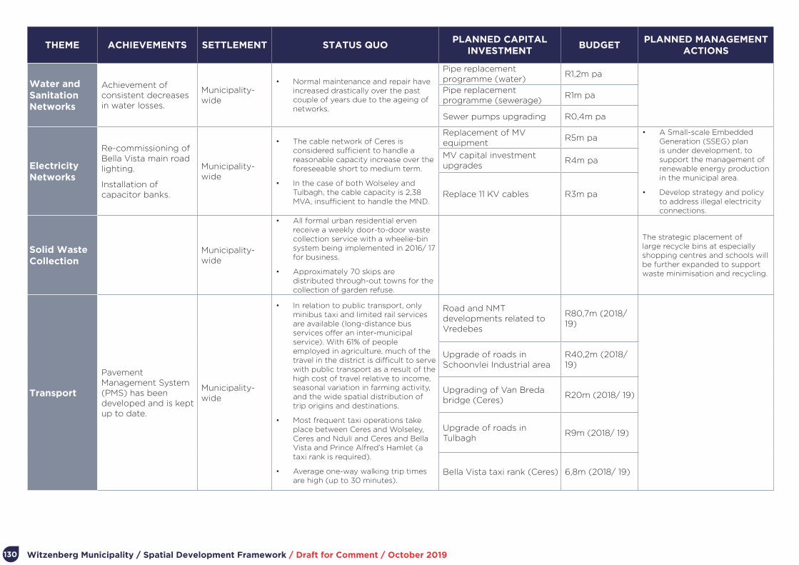
Witzenberg Municipality / Spatial Development Framework / Draft for Comment / October 2019130
THEME ACHIEVEMENTS SETTLEMENT STATUS QUOPLANNED CAPITAL
INVESTMENTBUDGET
PLANNED MANAGEMENT ACTIONS
Water and Sanitation Networks
Achievement of consistent decreases in water losses.
Municipality-wide
• Normal maintenance and repair have increased drastically over the past couple of years due to the ageing of networks.
Pipe replacement programme (water)
R1,2m pa
Pipe replacement programme (sewerage)
R1m pa
Sewer pumps upgrading R0,4m pa
Electricity Networks
Re-commissioning of Bella Vista main road lighting.
Installation of capacitor banks.
Municipality-wide
• The cable network of Ceres is considered sufficient to handle a reasonable capacity increase over the foreseeable short to medium term.
• In the case of both Wolseley and Tulbagh, the cable capacity is 2,38 MVA, insufficient to handle the MND.
Replacement of MV equipment
R5m pa• A Small-scale Embedded
Generation (SSEG) plan is under development, to support the management of renewable energy production in the municipal area.
• Develop strategy and policy to address illegal electricity connections.
MV capital investment upgrades
R4m pa
Replace 11 KV cables R3m pa
Solid Waste Collection
Municipality-wide
• All formal urban residential erven receive a weekly door-to-door waste collection service with a wheelie-bin system being implemented in 2016/ 17 for business.
• Approximately 70 skips are distributed through-out towns for the collection of garden refuse.
The strategic placement of large recycle bins at especially shopping centres and schools will be further expanded to support waste minimisation and recycling.
Transport
Pavement Management System (PMS) has been developed and is kept up to date.
Municipality-wide
• In relation to public transport, only minibus taxi and limited rail services are available (long-distance bus services offer an inter-municipal service). With 61% of people employed in agriculture, much of the travel in the district is difficult to serve with public transport as a result of the high cost of travel relative to income, seasonal variation in farming activity, and the wide spatial distribution of trip origins and destinations.
• Most frequent taxi operations take place between Ceres and Wolseley, Ceres and Nduli and Ceres and Bella Vista and Prince Alfred’s Hamlet (a taxi rank is required).
• Average one-way walking trip times are high (up to 30 minutes).
Road and NMT developments related to Vredebes
R80,7m (2018/ 19)
Upgrade of roads in Schoonvlei Industrial area
R40,2m (2018/ 19)
Upgrading of Van Breda bridge (Ceres)
R20m (2018/ 19)
Upgrade of roads in Tulbagh
R9m (2018/ 19)
Bella Vista taxi rank (Ceres) 6,8m (2018/ 19)

Witzenberg Municipality / Spatial Development Framework / Draft for Comment / October 2019
H. Current major land development proposals
131
TOWNINITIATING
SECTORLOCATION
ERF/ FARM No.
ID: 2012 MSDF
FOCUS DESCRIPTION SIZEDELIVERY
DATE COMMENTS
Ceres
Private Expansion area north of Ceres town.
1884, 7900, 1498, 1002
1AHousing/ mixed use
Joint initiative between Baumann’s Store, Ceres Fruit Processors and Crispy Farms to establish a “lifestyle” village.
50ha Not known
Development already included in bulk services planning. Not developed.
Private Expansion area north of Ceres town, adjacent to existing industrial area.
1880 1AHousing/ mixed use
350-unit mixed use (20 units p/ha). 21ha Not knownApproved. Not developed.
Private Expansion south of Ceres town.
8323, 8327 8/9L Golf estateGolf estate (289 single units and town houses)
90ha Not knownIn progress. Less than 10% of units developed.
PrivateExpansion west of Ceres town.
8126 10MSingle residential
Proposed single residential area. 2ha Not knownApproved. Not developed.
Public Vredebes.364/72, 364/18
RGSubsidy housing
Integrated human settlement, state supported.
100haBeyond 2020/1
Services completed for Phase 1 and 2 (adjoining R46).
Private Existing agri-worker settlement on 8048 and surrounding land.
3757, 8048,7916
3CAgri-worker housing
Expanded and formalised agri-worker settlement.
17ha Not known
No development yet beyond existing housing in centre of site (less than 30 units).
PrivateExtension to residential area west of Retief Street.
8047,7916, 8048
3EAgri-worker housing
Originally proposed for medium income housing, now agri-worker housing.
19ha Not known
Development already included in bulk services planning. Not developed.
Private Expansion north of existing industrial area on the R303.
7900 2B Industry Expansion of Ceres Fruit Processors 4ha Not known Not developed.
PublicUndeveloped land between Ceres town and Vredebes.
7916, 8048 3D IndustryIndustrial use close to poorer communities.
49ha Not known
Development already included in bulk services planning. Not developed.
Private Industrial expansion on R46. 8028 3F Industry Expansion of Crispy Coolers. 5ha Not known Not developed.
PrivateExpansion area south of Ceres town.
364/107, 364/132
7K Industry Expansion of Ceres Fruit Juices. 15ha Not known Not developed.
PublicSite east of correctional facility on R46.
368/10 3H Truck stop Truck stop. 4ha Not known Not developed.
Private Site east of Nduli on R46. 368/35 3I InstitutionProposal by Zionist Church to establish an institution.
5ha Not knownNot developed (used for grazing/ keeping of animals).
Public Area west of Nduli. 5959 4J InstitutionReinforcement of institutional node in Nduli.
1ha Not knownApproved. Not fully developed.
Private Expansion west of Ceres town.
- - Mall Proposed commercial mall. Not approved yet.
Table 50. Current major land development proposals in Witzenberg Municipality per settlement.

Witzenberg Municipality / Spatial Development Framework / Draft for Comment / October 2019132
TOWNINITIATING
SECTORLOCATION
ERF/ FARM No.
ID: 2012 MSDF
FOCUS DESCRIPTION SIZEDELIVERY
DATE COMMENTS
Ceres (Bella Vista)
Public Infill Bella Vista north (Buiten Street).
2919 1A Housing Infill housing. 4,3ha Not known Not developed.
Public Infill Bella Vista North-east. 7074 1BSubsidised housing
Implementation planned for 2015. 2,2ha - Completed.
Public Infill Bella Vista central-east. 2623 2CSubsidised housing
Implementation planned for 2015. 9,4ha - Completed.
Public Vacant land Bella Vista south 2613, 2614, 2615
2FAgri-worker housing
Expanded and formalised agri-worker settlement.
3,5ha Not knownNo development beyond existing housing.
Public Bella Vista central-east. 2622 2DCommunity gardens
Proposed for urban agriculture/ community gardens.
9ha Not knownNo development beyond Bella Frutta Packhouse.
Public Bella Vista south adjoining R303.
2616, 2613 2E IndustryProposed to be included in larger industrial precinct.
1,2ha Not known No development.
Wolseley
PrivateExpansion area north of Wolseley (Oak Street).
348/1 1A
Retirement village/ lifestyle estate
Heerenberg retirement village and lifestyle estate (2017 single erven, retirement erven, and associated facilities).
20ha Not known Approved in 2010.
Not developed.
Expansion north of existing industrial area on the R303.
7900 2B Industry Expansion of Ceres Fruit Processors 4ha Not known Not developed.
PublicExpansion area north of Wolseley (Oak Street/ Protea Street).
Rem. 496 1/2B HousingResidential infill (approximately 55 units).
5,5ha Not known Not developed.
Public Wolseley east (Albert Street).
Rem. 1 3CSubsidised housing
Residential infill (approximately 140 units).
5,4ha Not known Not developed.
PublicWolseley south (Raman Street/ Voortrekker Street).
Rem. 1 3DSubsidised housing
Residential infill (approximately 43 units).
2,9ha Not known Not developed.
PublicWolseley central-east (Angelier Street/ Malva Street).
Rem. 1 4ESocial housing
Well located and could assist in integration between Montana and the CBD.
5,7ha Not known Not developed.
PublicWolseley central-west (Afrika Street, Pine Valley).
Rem. 1 4/5HSubsidised housing
Pine Valley Phase 2A (120 single residential units).
3,4ha Not known Not developed.
Public Kluitjieskraal Forestry station. Rem. 312 JAgri-settlement
Inhabitants are former employees of SAFCOL or Department of Water Affairs and Forestry. Intended as agri-settlement with secure tenure.
28ha Not known
Not developed (a number of informal structures on southern part).
Public Wolseley north-west. Rem. 1 5/6K Waste site Domestic land fill site 22ha Not known Not developed.
Public Wolseley central-west. Rem. 1 4/5GCommunity gardens
Proposed for urban agriculture/ community gardens.
5,3ha Not known Not developed.
PublicWolseley central-east (Voortrekker Street/ Gardenia Street).
Rem. 1 4F IndustryExpansion of existing industrial area.
9,3ha Not known Not developed.
Public Wolseley west. 1564, Rem. 1 6L IndustryIndustrial development in proximity to poorer communities.
3,6ha Not known Not developed.
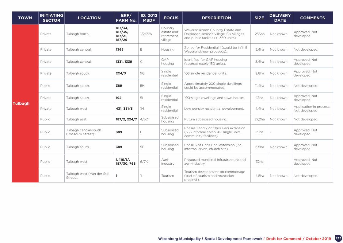
Witzenberg Municipality / Spatial Development Framework / Draft for Comment / October 2019 133
TOWNINITIATING
SECTORLOCATION
ERF/ FARM No.
ID: 2012 MSDF
FOCUS DESCRIPTION SIZEDELIVERY
DATE COMMENTS
Tulbagh
Private Tulbagh north.
187/34, 187/35, 187/21, 187/29
1/2/3/A
Country estate and retirement village
Waverenskroon Country Estate and Dalskroon senior’s village. Six villages and public facilities (1 350 units).
233ha Not knownApproved. Not developed.
Private Tulbagh central. 1365 B HousingZoned for Residential 1 (could be infill if Waverenskroon proceeds).
5,4ha Not known Not developed.
Private Tulbagh central. 1331, 1339 CGAP housing
Identified for GAP housing (approximately 150 units).
3,4ha Not knownApproved. Not developed.
Private Tulbagh south. 224/3 5GSingle residential
103 single residential units. 9,8ha Not knownApproved. Not developed.
Public Tulbagh south. 389 5HSingle residential
Approximately 200 single dwellings could be accommodated.
11,4ha Not known Not developed.
Private Tulbagh south. 192 5ISingle residential
100 single dwellings and town houses. 13ha Not knownApproved. Not developed.
Private Tulbagh west 431, 381/3 1MSingle residential
Low density residential development. 4,4ha Not knownApplication in process. Not developed
Public Tulbagh east. 187/2, 224/7 4/5DSubsidised housing
Future subsidised housing. 27,2ha Not known Not developed.
PublicTulbagh central-south (Rossouw Street).
389 ESubsidised housing
Phases 1 and 2 of Chris Hani extension (355 informal erven, 49 single units, community facilities).
15ha -Approved. Not developed.
Public Tulbagh south. 389 5FSubsidised housing
Phase 3 of Chris Hani extension (72 informal erven, church site).
6,5ha Not knownApproved. Not developed.
Public Tulbagh west1, 116/1/, 187/30, 768
6/7KAgri-industry
Proposed municipal infrastructure and agri-industry.
32haApproved. Not developed.
PublicTulbagh west (Van der Stel Street).
1 1L TourismTourism development on commonage (part of tourism and recreation precinct).
4,5ha Not known Not developed.

Witzenberg Municipality / Spatial Development Framework / Draft for Comment / October 2019134
TOWNINITIATING
SECTORLOCATION
ERF/ FARM No.
ID: 2012 MSDF
FOCUS DESCRIPTION SIZEDELIVERY
DATE COMMENTS
Prince Alfred Hamlet
PublicPrince Alfred Hamlet south (Sarel Cilliers Road).
232, 233, 251, 252, 260, 261, 263
2/3C Housing Infill residential. 3ha Not known Not developed.
PublicPrince Alfred Hamlet central, adjacent to R303/ Voortrekker Road.
Rem. 1 1BSocial housing
Proposed for social housing. 7,6ha Not known Not developed.
PublicPrince Alfred Hamlet north-west.
Rem. 1 5GSubsidised housing
Expansion of Kliprug settlement (approximately 300 units).
12,6ha Not knownNorthern half not developed.
PublicPrince Alfred Hamlet central, adjacent to R303.
Rem. 1 1A Truck stopTruck stop on R303 and opposite industrial area.
7.6ha Not known Not developed.
Public Prince Alfred Hamlet west. Rem. 1 4E InstitutionExpansion of institutional uses adjacent to Kliprug residential area.
4ha Not known Not developed.
Public Prince Alfred Hamlet west. Rem. 1 3DCommunity gardens
Urban agriculture and community gardens.
7ha Not known Not developed.
Public Prince Alfred Hamlet west. Rem. 1 4FCommunity gardens
Urban agriculture and community gardens.
4ha Not knownNot developed (row of structures south of Olienhout Avenue).
PublicPrince Alfred Hamlet north-west.
Rem. 1 5HRecreational use
Area in flood plain suitable for recreational development.
7.8ha Not known Not developed.
Op-die-berg
Public Op-die-berg central Rem. 417 2/3ASubsidised housing
Housing. 1,5ha Not known Not developed.
Public Op-die-berg central 14 6BSubsidised housing
Retirement village for agri-workers 1,3ha Not known Not developed.
Public Op-die-berg central 92, 103 3/5/6CSubsidised housing
281 single dwelling housing opportunities.
5,2ha - Approved. Developed
Public Op-die-berg central 103 3/5DSubsidised housing
Single dwelling houses. 0,3ha - Developed.
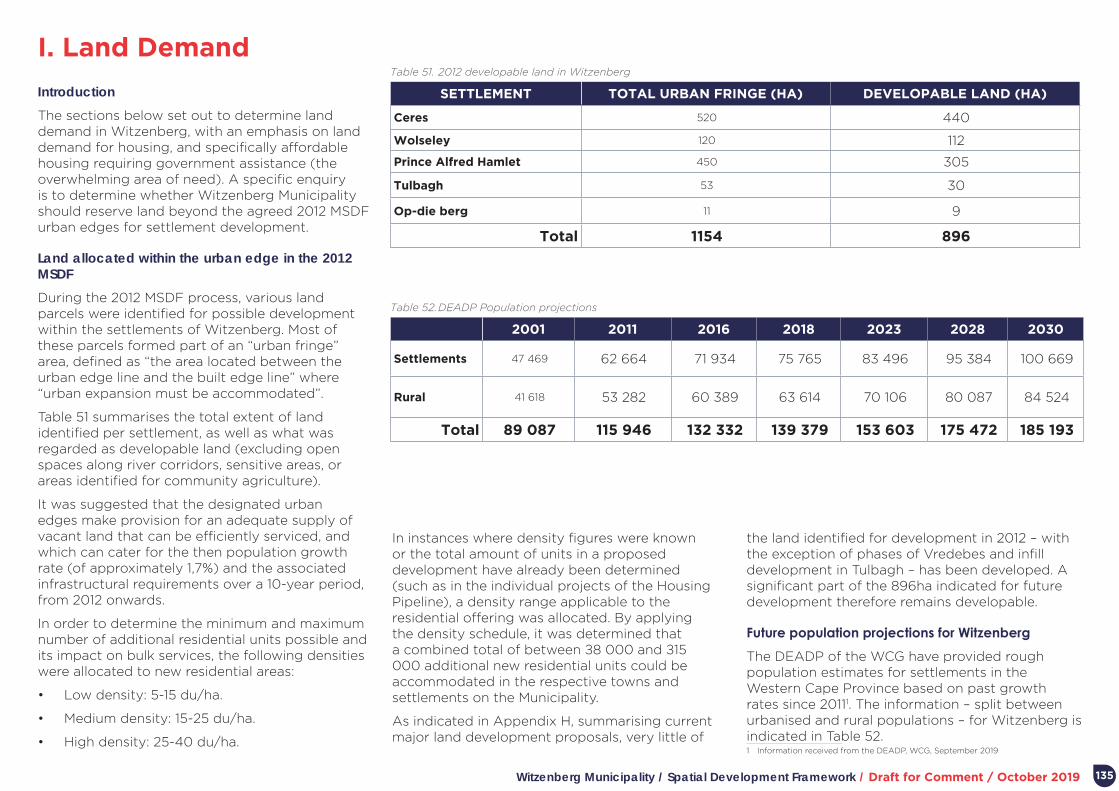
Witzenberg Municipality / Spatial Development Framework / Draft for Comment / October 2019
I. Land Demand
135
Introduction
The sections below set out to determine land demand in Witzenberg, with an emphasis on land demand for housing, and specifically affordable housing requiring government assistance (the overwhelming area of need). A specific enquiry is to determine whether Witzenberg Municipality should reserve land beyond the agreed 2012 MSDF urban edges for settlement development.
Land allocated within the urban edge in the 2012 MSDF
During the 2012 MSDF process, various land parcels were identified for possible development within the settlements of Witzenberg. Most of these parcels formed part of an “urban fringe” area, defined as “the area located between the urban edge line and the built edge line” where “urban expansion must be accommodated”.
Table 51 summarises the total extent of land identified per settlement, as well as what was regarded as developable land (excluding open spaces along river corridors, sensitive areas, or areas identified for community agriculture).
It was suggested that the designated urban edges make provision for an adequate supply of vacant land that can be efficiently serviced, and which can cater for the then population growth rate (of approximately 1,7%) and the associated infrastructural requirements over a 10-year period, from 2012 onwards.
In order to determine the minimum and maximum number of additional residential units possible and its impact on bulk services, the following densities were allocated to new residential areas:
• Low density: 5-15 du/ha.
• Medium density: 15-25 du/ha.
• High density: 25-40 du/ha.
SETTLEMENT TOTAL URBAN FRINGE (HA) DEVELOPABLE LAND (HA)
Ceres 520 440
Wolseley 120 112
Prince Alfred Hamlet 450 305
Tulbagh 53 30
Op-die berg 11 9
Total 1154 896
2001 2011 2016 2018 2023 2028 2030
Settlements 47 469 62 664 71 934 75 765 83 496 95 384 100 669
Rural 41 618 53 282 60 389 63 614 70 106 80 087 84 524
Total 89 087 115 946 132 332 139 379 153 603 175 472 185 193
Table 51. 2012 developable land in Witzenberg
Table 52. DEADP Population projections
In instances where density figures were known or the total amount of units in a proposed development have already been determined (such as in the individual projects of the Housing Pipeline), a density range applicable to the residential offering was allocated. By applying the density schedule, it was determined that a combined total of between ±8 000 and ±15 000 additional new residential units could be accommodated in the respective towns and settlements on the Municipality.
As indicated in Appendix H, summarising current major land development proposals, very little of
the land identified for development in 2012 – with the exception of phases of Vredebes and infill development in Tulbagh – has been developed. A significant part of the 896ha indicated for future development therefore remains developable.
Future population projections for Witzenberg
The DEADP of the WCG have provided rough population estimates for settlements in the Western Cape Province based on past growth rates since 20111. The information – split between urbanised and rural populations – for Witzenberg is indicated in Table 52.1 Information received from the DEADP, WCG, September 2019

Witzenberg Municipality / Spatial Development Framework / Draft for Comment / October 2019136
Housing demand
Based on estimated population numbers, the DEADP has estimated housing demand in Witzenberg. The first two columns in Table 53 below indicates the WCG’s estimate of housing opportunities required in 2018 based on population growth (in 2018 only). The two columns relate to assumptions about urbanisation. If assumed no rural demand for housing (all demand absorbed in urban areas) the figure to the right is applicable. If assumed that the urbanisation rate is the same in 2018 as in 2016 (54,4%), the figure to the left applies. The DEADP’s work excludes existing housing backlogs.
SETTLEMENT
DUs NEEDED IN 2018 IF
URBANISATION CONSISTENT
DUs NEEDED IN 2018 IF ALL
DEMAND MET IN SETTLEMENTS
DUs NEEDED IF URBANISATION
CONSISTENT
DUs NEEDED IF URBANISATION
CONSISTENT2016 HOUSING
BACKLOG
TOTAL NEED IF URBANISATION
CONSISTENT
TOTAL NEED IF ALL DEMAND MET IN SETTLEMENTS
2023 2028 2023 2028 2023 2028 2023 2028
Ceres 258 401 1 290 2 580 2 005 4 010 2 576 (45%)1 3 866 5 156 4 581 6 586
Ceres town 74 114
Bella Vista 78 122
Nduli 106 165
Wolseley 125 195 625 1 250 975 1 950 1 133 (20%) 1 758 2 383 2 108 3 083
Wolseley town 20 31
Pine Valley 52 80
Montana 54 83
Tulbagh 83 129 415 830 645 1 290 768 (14%) 1 183 1 598 1 413 2 058
Prince Alfred Hamlet
56 88 280 560 440 880 858 (15%) 1 138 1 418 1 298 1 738
Op-die-berg 9 14 45 90 70 140 330 (6%) 375 420 400 470
Total 531 827 2 655 5 310 4 135 8 270 5 671 8 320 10 975 9 800 13 935
1 Percentages refer to the overall percentage of the total housing backlog per settlement.
Table 53. Annual, five and ten-year housing need in Witzenberg
The table further extrapolate five and ten-year housing need in Witzenberg, with and without the estimated housing backlog added.
In interpreting the table, it is important to note that it is probably unrealistic to assume that all housing demand will be met in settlements (as opposed to rural areas) over the next five or ten years. Although urbanisation is expected to increase, a total turn-around towards accommodating all future demand for housing in settlements over five or ten years is unlikely. Furthermore, the approved 2019-2021 housing pipeline provides for 1 564 opportunities (a combination of serviced sites and top structures). Over the medium to longer term
(prior to 2028) the Municipality is planning some 1 400 opportunities in Tulbagh and Wolseley.
Arguably, therefore, Witzenberg’s housing programme prior 2028 will address at least 3 000 opportunities out of the 5 671 reflected on the housing list. Should the average envisaged delivery of 520 opportunities per annum envisaged for 2019-2021 be maintained2, some 5 200 opportunities can be delivered up to 2028. This would mean eradication of the existing housing backlog, or a “new” backlog of between 5 310 by 2028 if the current urbanisation rate is maintained.
2 As reflected in the 2019-2021 housing pipeline agreed by Council.

Witzenberg Municipality / Spatial Development Framework / Draft for Comment / October 2019 137
Land availability within the urban edge to meet demand
As indicated above, the 2012 MSDF provided for approximately 896ha developable land within the urban edge. Should two thirds of this land be developed for housing this land at a density of 25 units/ha, it would provide for approximately 14 930 opportunities. If the current backlog of approximately 5 670 is deducted from what could be provided, it leaves 9 260 opportunities (more
than the 5 310 opportunities required by 2028 if the current urbanisation rate is maintained).
At the highest level of generalisation, it would therefore appear that there is not a need to significantly change the urban edges to settlements in Witzenberg within the period of the new MSDF (and prior to a next major review around 2024).
To refine the assessment further, Table 54 assesses land required to meet new demand (over and
above the existing backlog) per settlement. For the purposes of the assessment, it is assumed that the new demand would total 7 000 opportunities in the period up to 2028 (a number of opportunities in-between estimates if urbanisation remains consistent and estimates if all demand is met in settlements). The possible land area per settlement required is provided for three density ranges and possible land areas within the urban edge indicated (identified in the 2012 MSDF and as yet undeveloped).
SETTLEMENT% OF
DEMAND NUMBER OF
OPPORTUNITIES
AREA REQUIRED AT 25 UNITS/Ha
AREA REQUIRED AT 35 UNITS/Ha
AREA REQUIRED AT 40 UNITS/Ha
POSSIBLE LAND AREAS WITHIN URBAN EDGE (IDENTIFIED IN THE 2012 MSDF AND AS YET UNDEVELOPED)
Ceres 45% 3 150 126 90 79
• Half of expansion area north of Ceres town (1A: 1884, 7900, 1498, 1002): 25ha.
• Half of expansion area north of Ceres town, adjacent to existing industrial area (1A: 1880): 10ha.
• Half of existing agri-worker settlement on 8048 and surrounding land (3C): 8ha.
• Extension to residential area west of Retief Street (3E: 8047,7916, 8048): 19ha.
• 25% of undeveloped land between Ceres town and Vredebes (3D: 7916, 8048): 13ha.
• Infill Bella Vista north, Buiten Street (1A: 2919): 4ha.
• Bella Vista central-east area proposed for community gardens (2D: 2622): 9ha.
Wolseley 20% 1 400 56 40 35
• Wolseley central-east, Angelier Street/ Malva Street (4E: Rem. 1): 5,7ha.
• Half of Wolseley central-east, Voortrekker Street/ Gardenia Street (4F: Rem. 1): 5ha.
• Wolseley central-west area proposed for community gardens (4/5G: Rem. 1): 5,3ha.
• Half of Kluitjieskraal Forestry station (J: Rem. 312): 14ha.
• Wolseley east, Albert Street (3C: Rem. 1): 5,4ha.
• Wolseley south, Raman Street/ Voortrekker Street (3D: Rem. 1): 3ha.
Prince Alfred Hamlet
14% 980 39 28 25 • Tulbagh east (4/5D: 187/2, 224/7): 27,2ha.
Tulbagh 15% 1 050 42 30 26
• Prince Alfred Hamlet central, adjacent to R303/ Voortrekker Road (1A: Rem.1): 7,6ha.
• Prince Alfred Hamlet central, adjacent to R303/ Voortrekker Road (1B: Rem.1): 7,6ha.
• Half of Kliprug extension (5G: Rem. 1): 6ha.
• Half of Prince Alfred Hamlet west (4E: Rem. 1): 2ha.
• Half of Prince Alfred Hamlet west (4F: Rem. 1): 2ha.
Op-die berg 6% 420 17 12 11• Op-die-berg central (2/3A: Rem. 417): 1,5ha
• Op-die-berg central (6B: 14): 1,3ha
Total 100% 7 000 280 200 176
Table 54. Land required to meet new demand per settlement

Witzenberg Municipality / Spatial Development Framework / Draft for Comment / October 2019
J. Policy Framework
138
This section provides an overview of international conventions and national and provincial policies that inform the formulation of the Witzenberg MSDF. A review of high level, international “conventions”, resolutions, or declarations – statements of intent or commitment often agreed to at international level with a view to inclusion in
CONVENTIONS, RESOLUTIONS, OR
DECLARATIONSFOCUS IMPLICATIONS
Johannesburg World Summit on Sustainable Development (2002)1.
The Summit recognised cultural diversity as the fourth pillar of sustainable development, alongside the economic, social and environment pillars. Peace, security, stability and respect for human rights and fundamental freedoms, including the right to development, as well as respect for cultural diversity, are essential for achieving sustainable development and ensuring that sustainable development benefits all.
The celebration of cultural diversity will require the creation of variety of development opportunities within the Municipal area and particularly its settlements. Such opportunities should include provision for different forms of cultural expression.
Québec Declaration on the preservation of the Spirit of Place (adopted by the ICOMOS General Assembly, October 2008)2.
The declaration recognizing that the spirit of place is made up of tangible (sites, buildings, landscapes, routes, objects) as well as intangible elements (memories, narratives, written documents, festivals, commemorations, rituals, traditional knowledge, values, textures, colors, odors, etc.), which all significantly contribute to making place and to giving it spirit.
It is argued that spirit of place is a continuously reconstructed process, which responds to the needs for change and continuity of communities, and can vary in time and from one culture to another according to their practices of memory, and that a place can have several spirits and be shared by different groups.
The celebration of cultural diversity will require the creation of variety of development opportunities within the Municipal area and particularly its settlements. Such opportunities should include provision for different forms of cultural expression.
United Nations General Assembly Resolution 65/166 on Culture and Development (adopted in 2011).
The resolution recognised that culture – of which heritage forms a part – is an essential component of human development, providing for economic growth and ownership of development processes.
Ensure that the management of heritage resource also optimizes its contribution to economic growth.
The Paris Declaration on heritage as a driver of development (adopted in Paris, UNESCO headquarters, December 2011)3.
The Declaration committed to integrate heritage in the context of sustainable development and to demonstrate that it plays a part in social cohesion, well-being, creativity and economic appeal, and is a factor in promoting understanding between communities.
The management and use of heritage resources in the municipal area should be aimed at creating opportunities for social interaction, rather than a just a narrow focus on preservation.
1 http://www.un-documents.net/aconf199-20.pdf2 https://www.icomos.org/images/DOCUMENTS/Charters/GA16_Quebec_Declaration_Final_EN.pdf3 https://www.icomos.org/images/DOCUMENTS/Charters/GA2011_Declaration_de_Paris_EN_20120109.pdf
Table 55. Review of high-level international “conventions”, resolutions or declarations
national policy frameworks and inform member country “behavior” – is included as most of these are related to the management and preservation of cultural and heritage resources, an important theme in developing a framework for the Witzenberg Municipality.

Witzenberg Municipality / Spatial Development Framework / Draft for Comment / October 2019 139
CONVENTIONS, RESOLUTIONS, OR
DECLARATIONSFOCUS IMPLICATIONS
The “Valletta Principles” towards the Safeguarding and Management of Historic Cities, Towns and Urban Areas (adopted by the ICOMOS General Assembly, April 2010)1.
Towns and urban areas are currently called to undertake the role of organizer for the economy and to evolve into centers of economic activity, innovation and culture. Connecting protection to economic and social development, within the context of sustainability, and adaptation of historical towns and urban areas to modern life is a key task. The challenge is to increase competitiveness without detracting from main qualities, including identity, integrity, and authenticity, which are the basic elements for their being designated cultural heritage and strict prerequisites for their preservation.
Key principles are:
• All interventions in historic towns and urban areas must respect and refer to their tangible and intangible cultural values.
• Every intervention in historic towns and urban areas must aim to improve the quality of life of the residents and the quality of the environment.
• The safeguarding of historic towns must include, as a mandatory condition, the preservation of fundamental spatial, environmental, social, cultural and economic balances. This requires actions that allow the urban structure to retain the original residents and to welcome new arrivals (either as residents or as users of the historic town), as well as to aid development, without causing congestion.
• Within the context of urban conservation planning, the cultural diversity of the different communities that have inhabited historic towns over the course of time must be respected and valued.
• When it is necessary to construct new buildings or to adapt existing ones, contemporary architecture must be coherent with the existing spatial layout in historic towns as in the rest of the urban environment.
• A historic town should encourage the creation of transport with a light footprint.
Appropriate development in the municipal settlements, which respects historic development patterns, and cultural diversity, should inter alia ensure that further congestion is avoided, and create opportunities for socio-economic diversity.
Delhi Declaration on Heritage and Democracy Adopted by the ICOMOS General Assembly, December 2017)2.
The concept of heritage has widened considerably from monuments, groups of buildings and sites to include larger and more complex areas, landscapes, settings, and their intangible dimensions, reflecting a more diverse approach. Heritage belongs to all people; men, women, and children; indigenous peoples; ethnic groups; people of different belief systems; and minority groups. It is evident in places ancient to modern; rural and urban; the small, every-day and utilitarian; as well as the monumental and elite. It includes value systems, beliefs, traditions and lifestyles, together with uses, customs, practices and traditional knowledge. There are associations and meanings; records, related places and objects. This is a more people-centred approach.
Key principles are:
• Conserving significance, integrity and authenticity must be fully considered in the management of heritage resources.
• Mutual understanding and tolerance of diverse cultural expressions add to quality of life and social cohesion. Heritage resources provide an opportunity for learning, impartial interaction and active engagement, and have the potential to reinforce diverse community bonds and reduce conflicts.
• The culture and dynamics of heritage and heritage places are primary resources for attracting creative industries, businesses, inhabitants and visitors, and foster economic growth and prosperity.
The large variety of heritage resources of the Witzenberg municipal area, ranging from individual buildings to landscapes should be used to attract economic growth and spreading prosperity to its inhabitants.
1 http://civvih.icomos.org/sites/default/files/Valletta%20Principles%20Book%20in%205%20languages.pdf2 https://www.icomos.org/images/DOCUMENTS/Charters/GA2017_Delhi-Declaration_20180117_EN.pdf
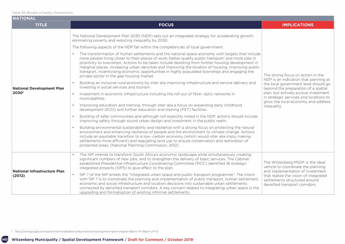
Witzenberg Municipality / Spatial Development Framework / Draft for Comment / October 2019140
NATIONAL
TITLE FOCUS IMPLICATIONS
National Development Plan 20301
The National Development Plan 2030 (NDP) sets out an integrated strategy for accelerating growth, eliminating poverty and reducing inequality by 2030.
The following aspects of the NDP fall within the competencies of local government:
• The transformation of human settlements and the national space economy with targets that include more people living closer to their places of work; better quality public transport; and more jobs in proximity to townships. Actions to be taken include desisting from further housing development in marginal places, increasing urban densities and improving the location of housing, improving public transport, incentivising economic opportunities in highly populated townships and engaging the private sector in the gap housing market.
• Building an inclusive rural economy by inter alia improving infrastructure and service delivery and investing in social services and tourism.
• Investment in economic infrastructure including the roll out of fibre- optic networks in municipalities.
• Improving education and training, through inter alia a focus on expanding early childhood development (ECD) and further education and training (FET) facilities.
• Building of safer communities and although not explicitly noted in the NDP, actions should include improving safety through sound urban design and investment in the public realm.
• Building environmental sustainability and resilience with a strong focus on protecting the natural environment and enhancing resilience of people and the environment to climate change. Actions include an equitable transition to a low- carbon economy (which would inter alia imply making settlements more efficient) and regulating land use to ensure conservation and restoration of protected areas. (National Planning Commission, 2012).
The strong focus on action in the NDP is an indication that planning at the local government level should go beyond the preparation of a spatial plan, but actively pursue investment in strategic services and locations to grow the local economy and address inequality.
National Infrastructure Plan (2012)
• The NIP intends to transform South Africa’s economic landscape while simultaneously creating significant numbers of new jobs, and to strengthen the delivery of basic services. The Cabinet-established Presidential Infrastructure Coordinating Committee (PICC) identified 18 strategic integrated projects (SIPS) to give effect to the plan.
• SIP 7 of the NIP entails the “Integrated urban space and public transport programme”. The intent with SIP 7 is to coordinate the planning and implementation of public transport, human settlement, economic and social infrastructure and location decisions into sustainable urban settlements connected by densified transport corridors. A key concern related to integrating urban space is the upgrading and formalisation of existing informal settlements.
The Witzenberg MSDF is the ideal vehicle to coordinate the planning and implementation of investment that realize the vision of integrated settlements structured around densified transport corridors.
1 https://www.google.com/search?client=safari&rls=en&q=national+development+plan+chapter+8&ie=UTF-8&oe=UTF-8
Table 56. Review of policy frameworks
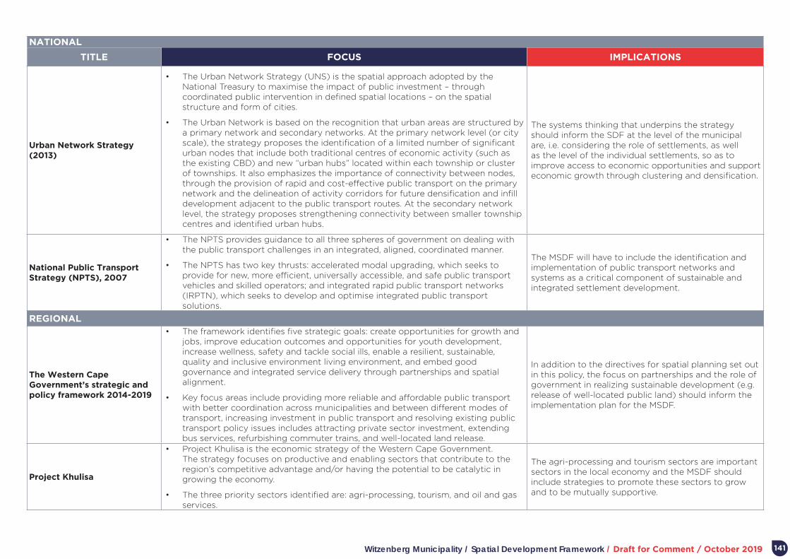
Witzenberg Municipality / Spatial Development Framework / Draft for Comment / October 2019 141
NATIONAL
TITLE FOCUS IMPLICATIONS
Urban Network Strategy (2013)
• The Urban Network Strategy (UNS) is the spatial approach adopted by the National Treasury to maximise the impact of public investment – through coordinated public intervention in defined spatial locations – on the spatial structure and form of cities.
• The Urban Network is based on the recognition that urban areas are structured by a primary network and secondary networks. At the primary network level (or city scale), the strategy proposes the identification of a limited number of significant urban nodes that include both traditional centres of economic activity (such as the existing CBD) and new “urban hubs” located within each township or cluster of townships. It also emphasizes the importance of connectivity between nodes, through the provision of rapid and cost-effective public transport on the primary network and the delineation of activity corridors for future densification and infill development adjacent to the public transport routes. At the secondary network level, the strategy proposes strengthening connectivity between smaller township centres and identified urban hubs.
The systems thinking that underpins the strategy should inform the SDF at the level of the municipal are, i.e. considering the role of settlements, as well as the level of the individual settlements, so as to improve access to economic opportunities and support economic growth through clustering and densification.
National Public Transport Strategy (NPTS), 2007
• The NPTS provides guidance to all three spheres of government on dealing with the public transport challenges in an integrated, aligned, coordinated manner.
• The NPTS has two key thrusts: accelerated modal upgrading, which seeks to provide for new, more efficient, universally accessible, and safe public transport vehicles and skilled operators; and integrated rapid public transport networks (IRPTN), which seeks to develop and optimise integrated public transport solutions.
The MSDF will have to include the identification and implementation of public transport networks and systems as a critical component of sustainable and integrated settlement development.
REGIONAL
The Western Cape Government’s strategic and policy framework 2014-2019
• The framework identifies five strategic goals: create opportunities for growth and jobs, improve education outcomes and opportunities for youth development, increase wellness, safety and tackle social ills, enable a resilient, sustainable, quality and inclusive environment living environment, and embed good governance and integrated service delivery through partnerships and spatial alignment.
• Key focus areas include providing more reliable and affordable public transport with better coordination across municipalities and between different modes of transport, increasing investment in public transport and resolving existing public transport policy issues includes attracting private sector investment, extending bus services, refurbishing commuter trains, and well-located land release.
In addition to the directives for spatial planning set out in this policy, the focus on partnerships and the role of government in realizing sustainable development (e.g. release of well-located public land) should inform the implementation plan for the MSDF.
Project Khulisa
• Project Khulisa is the economic strategy of the Western Cape Government. The strategy focuses on productive and enabling sectors that contribute to the region’s competitive advantage and/or having the potential to be catalytic in growing the economy.
• The three priority sectors identified are: agri-processing, tourism, and oil and gas services.
The agri-processing and tourism sectors are important sectors in the local economy and the MSDF should include strategies to promote these sectors to grow and to be mutually supportive.

Witzenberg Municipality / Spatial Development Framework / Draft for Comment / October 2019142
REGIONAL
TITLE FOCUS IMPLICATIONS
Western Cape Infrastructure Framework (WCIF), 2013.
• The WCIF aims to align the planning, delivery and management of infrastructure provided by all stakeholders (national, provincial and local governments, parastatals and the private sector) for the period to 2040.
• The WCIF prioritises “infrastructure-led growth” as a driver of growth and employment in the region.
• A major concern is the financial gap for municipal providers of infrastructure: municipalities have a central role to play in providing socially important services and creating a platform for economic development, but their limited access to capital is a major constraint.
• The WWCIF emphasizes that public and social services facility allocations must be aligned with infrastructure investment plans, growth areas and future development projects, and not planned in isolation.
The focus on infrastructure investment of the WCIF is another pointer to the importance of an implementation driven MSDF to achieve spatial transformation.
Western Cape Green Economy Strategic Framework (“Green is Smart”), 2013.
• The “Green is Smart” Strategic Framework positions the Western Cape as the leading green economic hub in Africa. The framework outlines the risks to the Province posed by climate change, as well as the economic opportunity presented by a paradigm shift in infrastructure provision.
• The framework focuses on six strategic objectives: become the lowest carbon Province, increase usage of low-carbon mobility, a diversified, climate-resilient agricultural sector and expanded value chain, a market leader in resilient, livable and smart built environment, high growth of green industries and services, and secure ecosystem infrastructure.
This framework points to the importance of understanding the impacts of climate change on physical development and the local economy and also of ensuring the MSDF is action-orientated, i.e. results in the implementation of strategies that will build resilience and facilitate economic growth in the face of environmental and resource challenges.
OneCape 2040.
• OneCape 2040 aims to direct a transition to a more inclusive society, through economic and social development, resulting in a more resilient economy.
• OneCape2040 seeks transition in several key areas to realise the vision of the Western Cape becoming a highly skilled, innovation-driven, resource-efficient, connected, high-opportunity and collaborative society.
• Key transitions focus on “cultural”, where communities should be socially inclusive; and “settlement” where neighbourhoods and towns should be quality environments, highly accessible in terms of public services and opportunities.
• The spatial focus is “connection” and “concentration”.
This strategy provides some content to the Stellenbosch Municipality’s goal to attract and foster innovation as a driver of economic growth, through its focus on creating conducive environments.
Provincial Spatial Development Framework, Public Draft for comment, October 20131.
• The PSDF sets out to put in place a coherent framework for the province’s urban and rural areas that gives spatial expression to the national (i.e. NDP) and provincial development agendas and communicates government’s spatial development intentions to the private sector and civil society.
• The PSDF is driven by three major themes, namely growing the economy, using infrastructure investment to effect change, and ensuring the sustainable use of the provincial resource base. The policies and strategies that flow from these themes focus on strategic investment in the space economy, settlement restructuring and the protecting the natural and cultural resource base.
Alignment of the Witzenberg MSDF with this plan is not only a legal requirement but a strategic imperative to ensure that the Municipality optimises provincial support for its development agenda. The key focus areas are all of particular relevance to the Witzenberg Municipality and its network of settlements.
1 https://www.westerncape.gov.za/eadp/sites/default/files/western-cape-provincial-spatial-developmemnt-framework-draft-for-comment_4.pdf
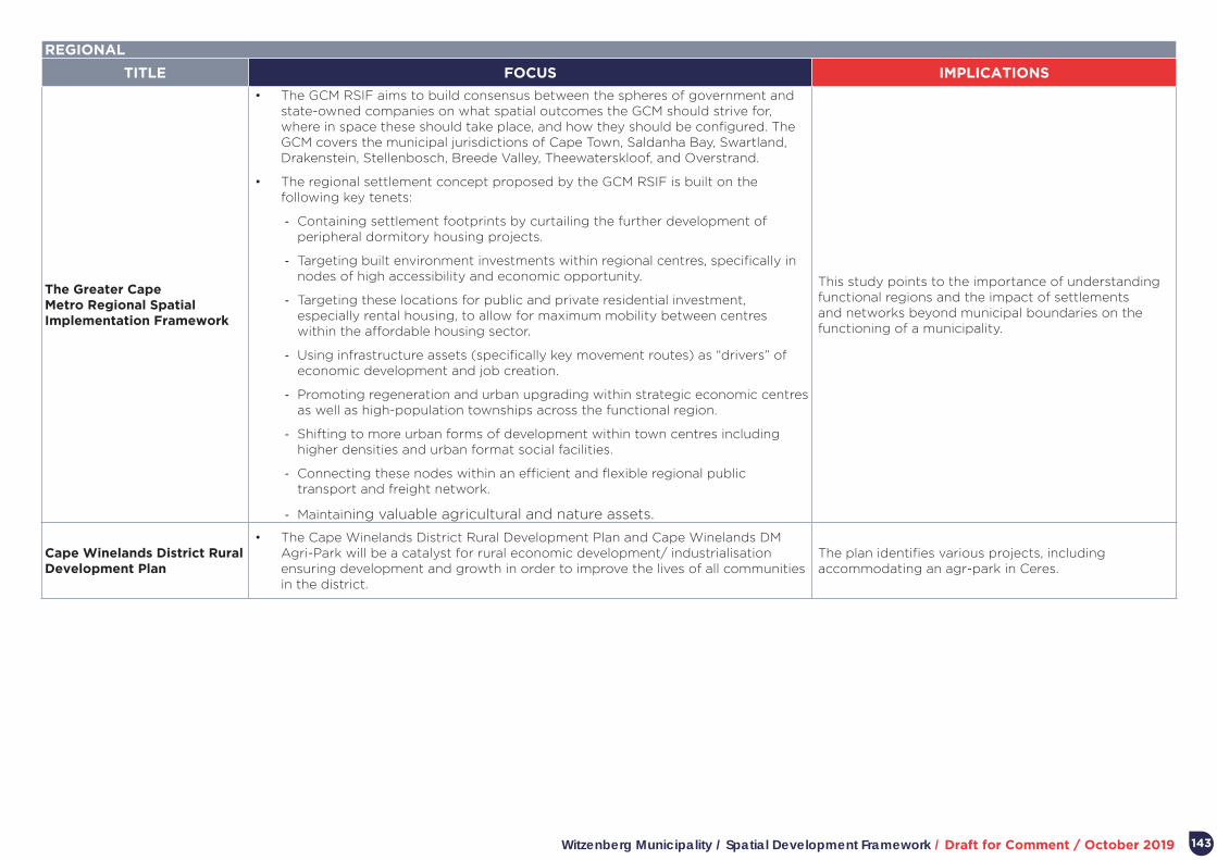
Witzenberg Municipality / Spatial Development Framework / Draft for Comment / October 2019 143
REGIONAL
TITLE FOCUS IMPLICATIONS
The Greater Cape Metro Regional Spatial Implementation Framework
• The GCM RSIF aims to build consensus between the spheres of government and state-owned companies on what spatial outcomes the GCM should strive for, where in space these should take place, and how they should be configured. The GCM covers the municipal jurisdictions of Cape Town, Saldanha Bay, Swartland, Drakenstein, Stellenbosch, Breede Valley, Theewaterskloof, and Overstrand.
• The regional settlement concept proposed by the GCM RSIF is built on the following key tenets:
- Containing settlement footprints by curtailing the further development of peripheral dormitory housing projects.
- Targeting built environment investments within regional centres, specifically in nodes of high accessibility and economic opportunity.
- Targeting these locations for public and private residential investment, especially rental housing, to allow for maximum mobility between centres within the affordable housing sector.
- Using infrastructure assets (specifically key movement routes) as “drivers” of economic development and job creation.
- Promoting regeneration and urban upgrading within strategic economic centres as well as high-population townships across the functional region.
- Shifting to more urban forms of development within town centres including higher densities and urban format social facilities.
- Connecting these nodes within an efficient and flexible regional public transport and freight network.
- Maintaining valuable agricultural and nature assets.
This study points to the importance of understanding functional regions and the impact of settlements and networks beyond municipal boundaries on the functioning of a municipality.
Cape Winelands District Rural Development Plan
• The Cape Winelands District Rural Development Plan and Cape Winelands DM Agri-Park will be a catalyst for rural economic development/ industrialisation ensuring development and growth in order to improve the lives of all communities in the district.
The plan identifies various projects, including accommodating an agr-park in Ceres.