DRAFT-SIAYA-County-Spatial-Plan-REVISED-MARCH-2019 ...
333
-
Upload
khangminh22 -
Category
Documents
-
view
5 -
download
0
Transcript of DRAFT-SIAYA-County-Spatial-Plan-REVISED-MARCH-2019 ...


PLAN APPROVAL
I certify that the plan has been prepared as per section 110 of the County Government Act 2012
and the physical planning standards and guidelines.
Signature…………………………...……… Date……………………………………….
Plan. Maurice Ochieng
County Director of Physical Planning
RECOMMENDED
Signature ………………………………... Date……………………………………
Dismas Omondi Odhiambo Wakla
Executive Committee Member Land, Physical Planning, Surveying and Housing
APPROVAL
Hansard No. Date
………………………………… …………………………………………………..
County Assembly
ENDORSED
Signature………………………………… Date………………………………………...
H.E Cornel Rasanga, The Governor Siaya County

ii
FOREWORD
The Siaya County Spatial Plan (SCSP) has been prepared by the Department of Lands, Physical
Planning, Housing and Survey in cooperation with all sectors of Siaya County Government and
other major stakeholders. The County Spatial Plan is prepared to guide the environment,
economic and social spatial development framework. It will guide all development activities
projects, programmes, budgets and investments in Siaya County. It also seeks to provide
geographical expression of Siaya County with regards to socio-economic wellbeing. All this
will be achieved through integrated sectoral coordination of policies affecting the spatial
organization and setting the direction for the human settlement as well related natural resource
management while taking cognizance of the seventeen sustainable development goals.
The Plan is by design a flexible, dynamic framework capable of responding to changing
circumstances and guaranteeing the future of Siaya County. It will provide a blueprint within
which the County can confidently address the challenges and deliver the exciting opportunities
that lie ahead. The approach adopted during the preparation of the County Spatial Plan was
highly participatory, collaborative and consultative and it brought on board participants from
diverse backgrounds including the community, County and other departments, agencies,
professionals, civil society, among others. This is not only in conformity with the Constitutional
requirements on public participation in policy making but a step towards providing the requisite
basis for the implementation of the Plan as provided for in Article 196 of the Constitution.
The County Spatial Plan provides a framework for the efficient, productive and sustainable use
of land as advocated for in both the Constitution and the National Land Policy. Further, it
provides strategies and policies to facilitate sustainable exploitation of the huge potentials the
county possesses in agriculture, tourism, energy, water and forestry. It is expected to reduce
inequalities within the County that have existed before devolution by ensuring that these areas
are no longer perceived as low potential but as differently endowed.
The county spatial plan supports the implementation of strategic county projects specifically the
flagship projects spelt out under Kenya Vision 2030 and the Kenya Government Agenda 4 by
indicating their spatial locations and providing a framework for absorbing the spatial impacts of
these projects. It provides a coordinating framework for sectoral planning which has been
inadequate in the county and it aims to address the disconnect that has existed for a long time
between physical and economic planning.
Challenges such as rapid and unregulated urbanization, environmental degradation of the
county’s diverse ecosystems, skewed/unbalanced development in favour of high potential
areas, poor economic performance in the areas of agriculture, tourism and industry due to sub-
optimal use of land and underutilization of the rich natural resource endowment will be
addressed through proper and coordinated implementation of this Plan. Other challenges it will
also mitigate include but are not limited to inadequate and poor-quality transport and
infrastructure, sub-optimal utilization of land and other natural resources and an inadequate
national policy framework for guiding spatial planning leading to uncoordinated development
planning. The Siaya County Spatial Plan provides a framework for dealing with these
challenges through the formulation of planning and development strategies, policies and
measures under which projects and other priority programs will be implemented for the next 10
years.
………………………………………………
H.E. CORNEL AMOTH RASANGA
GOVERNOR,
SIAYA COUNTY.

iii
ACKNOWLEDGEMENTS
The Siaya County spatial plan was prepared with support, contribution and efforts of many
actors in government and private sectors. We take this opportunity to acknowledge their role
and contribution towards the drafting of this plan both as individuals and departments.
Sincere appreciation to the residents Siaya County who through various stakeholder
participations foras gave their views, the partners, business community, religious institutions,
leaders of the various disciplines, the staff members of the County Government drawn from all
the departments, and County Executive Members.
Our Governor, H.E. Cornel Rasanga Amoth, Deputy Governor, H.E James Okumbe and the
members of the County Assembly, special appreciation for the invaluable input and support for
the Siaya County Spatial plan.
Special thanks to the Department of Lands, Physical Planning, Housing and Urban
Development, particularly the County Executive Member, Chief Officer, for the unparalleled
support they offered during the process of preparing the Siaya County Spatial Plan and for
ensuring that adequate resources were availed for the project. Equally, the Director Physical
Planning, Director Survey, Director Housing and Urban Development for playing important
role in providing technical guidance and oversight to the process. Many thanks to the various
heads of Departments within the county for collaborating with the Lands, Physical Planning,
Housing and Urban Development and for availing requisite information, maps, statistics and
expertise for the county spatial planning exercise.
Experts from various sectors including Health, Finance, Tourism, Agriculture, Environment
health, Education, Gender, transport and infrastructure, Socio-economic and Trade who
contributed their expertise and time in the plan-formulation process.
………………………………………………
JACKTONE NYAPOLA ONDIKO
CHIEF OFFICER LANDS, PHYSICAL PLANNING AND URBAN DEVELOMENT

iv
EXECUTIVE SUMMARY
This County Spatial Plan is the first of its kind for Siaya under the new Constitution of Kenya,
2010, which created the 47 county governments Siaya being one of them. The Plan is a
strategic vision that defines the general trend and direction of spatial development for the
county, covering the entire thirty Wards in the six Sub counties; Gem, Ugenya, Ugunja, Alego,
Bondo and Rarieda. It is a ten (10) years term Plan spanning the period from 2018 to 2028. The
preparation of the County Spatial Plan is a requirement under the County Government Act,
2012 which provides for all County Governments in Kenya to prepare and implement county
spatial plans.
The County Spatial Plan has been prepared within the existing legal and policy frameworks
and International treaties. The Sustainable Development Goals, County Government Act, the
Urban Areas & Cities Act & the Physical Planning Act (Cap 286) guided the preparation of the
Plan and give it requisite legitimacy. Policies that espouse the broad objectives of the National
Government and the County Government within given sectors provide the principles that put
them into effect. These are: Sustainable Development Goals, Kenya Vision 2030, National
Spatial Plan, The National Land Policy and the National Urban Development Policy.
The purpose of the Spatial Plan is to provide a county spatial structure that defines how its
space will be utilized to ensure optimal and sustainable use of land. This will facilitate the
achievement of the land policy principles of efficiency, equity, sustainability and productivity,
and promote the attainment of social, economic and environmental goals and objectives.
Further, the Plan provides strategies and policies to deal with challenges including
urbanization, regional imbalances/inequalities, rural underdevelopment, environmental
degradation, and underutilization of the massive resources available in the country.
The Siaya County Spatial Plan is organized into seven parts.
Part 1, Background and the Planning Context). The background covers the purpose of the
plan, vision, objectives and the scope of the County Spatial Plan. The planning context
includes the location and size, administrative units, approach used in plan preparation,
constitutional, policy and legal framework as well as linkage to other plans.
Part 2 Situation Analysis: Presents the base maps, physiographic characteristics, population
and demography, land, land tenure and categorization, environment and natural resources,
human settlement and urbanization, transport, infrastructure and services, and economic base
of Siaya County.
Part 3 Synthesis: This section presents the summary of planning issues including
opportunities, challenges and potentials, and scenario building.
Part 4 Plan Proposals: This part covers policies, strategies and actions and a spatial structure
that leads to actualization of the desired future state, spatial structure depicting the vision of the
county and land use zoning, system of green and open spaces as well as system of human
settlement.
Part 5 Spatial Development framework and action plans: Land use structure and plan,
future land requirement for the key sectors, land use zoning plan. This section also includes
policies, strategies and actions for the proposed land use zones.
Part 6 Plan Implementation strategy: This section highlights programmes and projects for
the development of land, areas for priority spending, capital investment framework and
monitoring and evaluation framework.

v
LIST OF ACRONYMS
CBD Central Business District
CIDP County Integrated Development Plan
CIP Capital Investments Plan
DFRD District Focus for Rural Development
ECD Early Childhood Development
ERSWEC Economic Recovery Strategy for Wealth and Employment Creation
FAO Food and Agricultural Organization
GDP Gross Domestic Product
GIS Geographic Information System
GPS Geographic Positioning System
ICT Information Communication Technology
JOOUST Jaramogi Oginga Odinga University of Science and Technology
SCSP Siaya County Spatial Plan
SME Small and Medium Enterprise
TOR Terms of Reference
KENHA Kenya National Highways Authority
KFS Kenya Forest Services
KNBS Kenya National Bureau of Statistics
KWS Kenya Wildlife Service
MDG Millennium Development Goals
MSE Medium Sector Enterprise
NGO Non-Governmental Organization
NDPs National Development Plans
NEMA National Environment Management Authority
NIB National Irrigation Board
NLC National Land Commission
NSP National Spatial Plan
PPA Physical Planning Act
RCMRD Regional Centre for Mapping of Resources for Development
RDAs Regional Development Authorities
RPDP Regional Physical Development Plans
RTPC Rural Trade and Production Centres
SEA Strategic Environmental Assessment
SDG Sustainable Development Goals
WARMA Water Resources Management Authority

vi
TABLE OF CONTENTS
PLAN APPROVAL ....................................................................................................................... i
FOREWORD................................................................................................................................. ii
ACKNOWLEDGEMENTS ........................................................................................................ iii
EXECUTIVE SUMMARY ......................................................................................................... iv
LIST OF ACRONYMS ................................................................................................................ v
LIST OF FIGURES ..................................................................................................................... xi
LIST OF TABLES ...................................................................................................................... xii
LIST OF MAPS.......................................................................................................................... xiv
LIST OF PLATES ...................................................................................................................... xv
PART I- INTRODUCTION ......................................................................................................... 1
CHAPTER 1: BACKGROUND .................................................................................................. 2
1.1 Purpose of the Plan ................................................................................................................... 2
1.2 Objectives ................................................................................................................................. 2
1.3 Vision ........................................................................................................................................ 2
1.4 Scope of the Plan ...................................................................................................................... 2
1.5 Organization of the Plan ........................................................................................................... 3
CHAPTER 2: PLANNING CONTEXT ..................................................................................... 4
2.1 Location and Size ...................................................................................................................... 4
2.2 Administrative Units ................................................................................................................. 4
2.3 Methodology ............................................................................................................................. 8
2.3.1 Plan Preparation Process ........................................................................................................ 8
2.3.2 Public Participation and Consultation .................................................................................... 9
2.4 Constitutional, Policy and Legal Framework ......................................................................... 10
2.4.1. The Kenya Constitution 2010 ............................................................................................. 10
2.4.2. The National Land Policy, 2009 ......................................................................................... 11
2.4.4. The National Land Use Policy 2017 ................................................................................... 11
2.4.5 Physical Planning Act, 1996 ................................................................................................ 12
2.4.6 County Governments Act, 2012 .......................................................................................... 12
2.4.7 Urban Areas and Cities Act, 2011 ....................................................................................... 12
2.4.7 National Land Commission Act, 2012................................................................................. 13
2.5 Linkage to other Plans ............................................................................................................ 13
2.5.1 The Sustainable Development Goals of 2015 ...................................................................... 13
2.5.2 The Sywnerton Plan of 1955................................................................................................ 14
2.5.3 Kenya's Vision, 2030 ........................................................................................................... 14
2.5.4 The National Spatial Plan 2015–2045 ................................................................................. 14
2.5.5 The Lake Region Development Block Economic Blueprint ............................................... 14
2.5.6 Siaya County Integrated Development Plan 2018-2022 ...................................................... 15
PART II: SITUATIONAL ANALYSIS .................................................................................... 16
CHAPTER 3: BASE MAP ......................................................................................................... 17
CHAPTER 4: PHYSIOGRAPHIC CHARACTERISTICS ................................................... 18
4.1 Introduction ............................................................................................................................. 18
4.3 Geology ................................................................................................................................... 18
4.4 Hydrology ............................................................................................................................... 20
4.4.1 Siaya County Water Resources ............................................................................................ 20
4.4.2 Siaya Drainage Basins ......................................................................................................... 20
4.4.3 Surface and Ground Water Resources in Siaya ................................................................... 22
4.5 Soils......................................................................................................................................... 24
4.6 Climate .................................................................................................................................... 26
4.6.1 Rainfall ................................................................................................................................. 26
4.6.2 Ecological Conditions .......................................................................................................... 29

vii
4.6.3 Agro Ecological Zones ........................................................................................................ 29
4.7 Emerging Planning Issues, Opportunities and Challenges ..................................................... 32
CHAPTER 5: POPULATION AND DEMOGRAPHY........................................................... 33
5.1 Population Size and Composition ........................................................................................... 33
5.2 Population Density and Distribution ....................................................................................... 33
5.3 Population Structure and Projection ....................................................................................... 35
5.4 Demographic Characteristics .................................................................................................. 39
5.4.1 Indicators of Well-being ...................................................................................................... 39
5.4.2 Literacy ................................................................................................................................ 39
5.4.3 Life Expectancy ................................................................................................................... 39
5.4.4 Morbidity and Mortality ...................................................................................................... 39
5.4.5 Fertility ................................................................................................................................. 39
5.4.6 Employment and Income Levels ......................................................................................... 40
5.5 Social Analysis........................................................................................................................ 40
5.5.1 Culture and Heritage ............................................................................................................ 40
5.5.2 Emerging Planning Issues, Opportunities and Challenges .................................................. 41
CHAPTER 6: LAND .................................................................................................................. 42
6.1.1 Mean Holding Size, Land Suitability, Use and Availability ............................................... 42
6.1.2 Percentage of Land with Title Deeds ................................................................................... 42
6.1.3 Incidence of Landlessness .................................................................................................... 43
6. 1.4 Land Conversion/Change of Use ........................................................................................ 43
6.2 Land Use ................................................................................................................................. 43
6.2.1 Land Use Patterns ................................................................................................................ 44
6.2.2 Land Capability and Suitability Analysis ............................................................................ 46
6.2.3 Emerging Planning Issues, Challenges and Opportunities .................................................. 48
CHAPTER 7: ENVIRONMENT AND NATURAL RESOURCES ....................................... 49
7.1 Environment ............................................................................................................................ 49
7.1.1 Appraisal of National Policies on Environment .................................................................. 49
7.1.2 Green and Open Spaces ....................................................................................................... 51
7.1.3 Pollution ............................................................................................................................... 54
7.1.4 Biodiversity .......................................................................................................................... 54
7.2 Climate Change and Disaster Management ............................................................................ 54
7.2.1 Flood and Erosion Endangered Areas.................................................................................. 54
7.3 Natural Resources ................................................................................................................... 55
7.4.4 Emerging Development Issues ............................................................................................ 55
CHAPTER 8: HUMAN SETTLEMENTS AND URBANIZATION ..................................... 58
8.1 Introduction ............................................................................................................................. 58
8.2 Patterns and Trends of Human Settlements ............................................................................ 58
8.3 Rural Settlements .................................................................................................................... 58
8.4 Housing ................................................................................................................................... 58
8.4.1 Flooring ................................................................................................................................ 59
8.4.2 Roofing ................................................................................................................................ 59
8.4.3 Walling ................................................................................................................................. 59
8.4.4 Housing Providers ................................................................................................................ 60
8.5 Urbanization and Evolution of Planned Settlements .............................................................. 60
8.5.1 Urban Settlements ................................................................................................................ 61
8.5.2 Hierarchy and Functionality of Towns ................................................................................ 61
8.5.3 Classification of Potential Growth Hubs and Drivers for Development ............................. 65
8.5.4 Urbanization Strategies in Kenya ........................................................................................ 65
8.6 Settlement Pattern Options for Developing Siaya County ..................................................... 66
8.6.1 Mono Centre ........................................................................................................................ 66

viii
8.6.2 Twin City Development ....................................................................................................... 67
8.6.3 Poly Nucleated Spatial Pattern............................................................................................. 67
8.6.4 Bi-polar Corridor Spatial Pattern ......................................................................................... 68
8.6.5 Transit Corridor Cum Ring Development ........................................................................... 68
8.6.6 Proposed Spatial Pattern for Siaya County .......................................................................... 68
8.7 Emerging Issues ...................................................................................................................... 69
8.7.1 Dispersed (rural) Settlements ............................................................................................... 69
8.7.2 Nucleated (urban) Settlements ............................................................................................. 69
CHAPTER 9: TRANSPORT, INFRASTRUCTURE AND SERVICES ............................... 72
9.0 Introduction ............................................................................................................................. 72
9.1 Transport Network and Distribution ....................................................................................... 72
9.1.1 Road Transport..................................................................................................................... 72
9.1.2 Air and Railway Transport ................................................................................................... 74
9.1.3 Water Transport ................................................................................................................... 74
9.2 Information and Communication Technology ........................................................................ 74
9.2.1 Modes of Communication.................................................................................................... 74
9.3 Water Infrastructure ................................................................................................................ 77
9.3.1 Water Sources ...................................................................................................................... 77
9.3.2 Distribution and Access ....................................................................................................... 77
9.3.3 Water Demand in Siaya County .......................................................................................... 78
9.4 Solid Waste Management ....................................................................................................... 78
9.5 Sanitation and Sewerage ......................................................................................................... 78
9.6 Social Infrastructure ................................................................................................................ 79
9.6.1 Education Facilities .............................................................................................................. 79
9.6.2 Health Facilities ................................................................................................................. 100
9.8.3 Emerging Planning Issues, Opportunities and Challenges ................................................ 104
CHAPTER 10: ECONOMIC BASE ....................................................................................... 105
10.1 Introduction ......................................................................................................................... 105
10.2 Poverty ................................................................................................................................ 105
10.2.1 Food Poverty .................................................................................................................... 105
10.2.2 Overall Poverty ................................................................................................................ 106
10.3 Agriculture Sector ............................................................................................................... 108
10.3.1 Food Expenditure by Source ............................................................................................ 114
10.2.1 Agriculture Emerging Planning Issues ............................................................................ 114
10.3 Fisheries Sector ................................................................................................................... 117
10.3.1 Capture Fisheries ............................................................................................................. 117
10.3.3 Culture Fisheries (Aquaculture) ....................................................................................... 120
10.4 Mining and Quarrying Sector ............................................................................................. 121
10.5 Tourism Sector .................................................................................................................... 121
10.5.1 Tourism Emerging Planning Issues ................................................................................. 125
10.6 Industrial Production ........................................................................................................... 125
10.7 Trade and Commerce .......................................................................................................... 126
10.7.1 Major Trading Centres ..................................................................................................... 126
10.7.2 Small and Medium Enterprise (SME) and Medium Sector Enterprises (MSE) .............. 128
10.8 Employment ........................................................................................................................ 128
10.8.1 Employment Typology .................................................................................................... 128
10.9 Financial Institutions ........................................................................................................... 129
10.10 Strategies to Revitalize Agricultural Production in the County........................................ 129
10. 11 Trade and Commerce Emerging Planning Isuues ............................................................ 129
10.12 Economic Sector Challenges ............................................................................................ 130
CHAPTER 11: GOVERNANCE ............................................................................................. 131

ix
11.1 Administrative Structure ..................................................................................................... 131
11.1.1 County Coordination Framework .................................................................................... 131
11.1.2 Project Implementation Framework ................................................................................ 131
11.2 Public Participation in Decision Making ............................................................................ 133
PART III - SYNTHESIS .......................................................................................................... 140
CHAPTER 12: SUMMARY OF PLANNING ISSUES ......................................................... 141
12.1 Situational Analysis ............................................................................................................ 145
12.2 Opportunities....................................................................................................................... 145
12.3 Challenges/Gaps ................................................................................................................. 145
CHAPTER 13: SCENARIO BUILDING ............................................................................... 147
13.1 Development of Alternative Scenarios ............................................................................... 147
13.1.1 No Action Alternative ...................................................................................................... 147
13.1.3 Full Implementation Alternative ...................................................................................... 147
13.2 Evaluation of the Alternative Scenarios ............................................................................. 149
PART IV – PLAN PROPOSAL............................................................................................... 150
CHAPTER 14: POLICIES, STRATEGIES AND ACTIONS .............................................. 151
14.1 SOCIAL DEVELOPMENT STRATEGY .......................................................................... 151
14.1.1 Background to Social Development Strategy .................................................................. 151
14.1.2 Desired Outcomes of the Social Development Strategy .................................................. 151
14.1.4 Approach to Social Development .................................................................................... 152
14.1.5 Development Proposals on Social Development ............................................................. 154
14.2 ENVIRONMENTAL AND NATURAL RESOURCES MANAGEMENT AND
CONSERVATION STRATEGY................................................................................................ 160
14.2.1 Wildlife Migratory Corridors ........................................................................................... 160
14.2.2 Water Resources Development Strategy ......................................................................... 162
14.3 SEWERAGE AND SANITATION DEVELOPMENT STRATEGY ............................... 169
14.3.1 Development Proposals on Sewerage and Sanitation ...................................................... 169
14.3.2 Sewerage and Sanitation Recommendations ................................................................... 169
14.4 ECONOMIC DEVELOPMENT STRATEGY ................................................................... 172
14.4.1 Tourism ............................................................................................................................ 172
14.4.2 Fishing.............................................................................................................................. 175
14.4.3 Agriculture and Rural Development ................................................................................ 175
14.4.4 Mining .............................................................................................................................. 176
14.4.5 Industrialization ............................................................................................................... 177
14.5 HUMAN SETTLEMENTS DEVELOPMENT STRATEGY ............................................ 180
14.5.1 Purpose of Human Settlement Development Framework ............................................... 180
14.5.2 Policies for Human Development Framework ................................................................ 180
14.5.3 What the Framework Covers ........................................................................................... 181
14.5.4 Principles for Human Development................................................................................. 181
14.5.5 Proposed growth areas and functionalities ...................................................................... 182
14.5.6 Criteria for delineating Urban Edges ............................................................................... 186
14.5.7 Proposed Growth Corridors ............................................................................................. 188
14.5.8 Proposed Developmental Guidelines for Rural Settlements ............................................ 190
14.6 TRANSPORT, COMMUNICATION AND INFRASTRUCTURE DEVELOPMENT
STRATEGY ................................................................................................................................ 191
14.6.1 Transport .......................................................................................................................... 191
14.6.2 Information Communication Technology........................................................................ 203
14.6.3 Energy .............................................................................................................................. 206
14.6.4 Storm Drainage ................................................................................................................ 208
14.6.5 Solid Waste Management ................................................................................................ 209
14.6.6 Social infrastructure ......................................................................................................... 209

x
14.7 GOVERNANCE STRATEGY ........................................................................................... 213
14.7.1 Open and Collaborative Leadership................................................................................. 213
14.7.2 Governance Framework ................................................................................................... 213
14.7.3 Purpose of the Governance Strategy ................................................................................ 213
14.7.4 Principles of Governance ................................................................................................. 213
14.7.5 Objectives of the Governance Strategy ............................................................................ 214
PART V- SPATIAL DEVELOPMENT FRAMEWORK ..................................................... 224
CHAPTER 15: SPATIAL DEVELOPMENT FRAMEWORK ........................................... 225
15.0 Introduction ......................................................................................................................... 225
15.1 Land use/ Zoning plan ........................................................................................................ 225
15.1.1 The Green Spatial Development Zone I .......................................................................... 225
15.1.2 The Brown Spatial Development Zone II ........................................................................ 228
15.1.3 The Blue Spatial Development Zone III: ......................................................................... 231
CHAPTER 16: ACTION PLANS............................................................................................ 236
16.1 Introduction ......................................................................................................................... 236
16.2 Green Economy Development Strategy: Action Plan 2018-2028 ...................................... 236
16.3 Brown Economy Development Strategy: Action Plan 2018-2028 ..................................... 238
16.4 Blue Economy Development strategy: Action Plan 2018-2028 ......................................... 241
CHAPTER 17: COUNTY SPATIAL PLAN IMPLEMENTATION STRATEGY ............ 244
17.0 Introduction ......................................................................................................................... 244
17.1 Land Use Planning, Administration and Management ....................................................... 244
17.2 Capital Investment Projects ................................................................................................ 246
17.3 Monitoring and Evaluation Matrix ..................................................................................... 252
17.4 Strategic Environmental Assessment .................................................................................. 257
REFERENCES .......................................................................................................................... 272
APPENDIX ................................................................................................................................ 274
Appendix 1: Population Density and Distribution per Ward ...................................................... 274
Appendix 2: Siaya County Water Demand Projection per Ward ............................................... 276
Appendix 3: Stakeholder Consultative Meetings (minutes) ...................................................... 281
Appendix 4: List of Participants ................................................................................................. 308

xi
LIST OF FIGURES
Figure 2. 1: Conceptual Framework Plan Development ................................................................ 3
Figure 2. 2: Planning Process and Methodology ........................................................................... 8
Figure 5. 1: Siaya County Population Structur………………………………………………….36
Figure 6. 1: A graph indicating land use percentage……………………………………………44
Figure 8. 1: Percentage Distribution of Households by Floor Material in Siaya County……....59
Figure 8. 2: Percentage Distribution of Households by Roof Material in Siaya County.......... ..59
Figure 8. 3: Percentage Distribution of Households by Wall Material in Siaya County ............ .60
Figure 8. 4: Monocentric spatial pattern ...................................................................................... 66
Figure 8. 5: Twin city development ........................................................................................... ..67
Figure 8. 6: Poly nucleated spatial pattern ................................................................................... 67
Figure 8. 7: Bi-polar corridor spatial pattern ............................................................................... 68
Figure 8. 8: Transit corridor cum ring development .................................................................... 68
Figure 8. 9: Proposed settlement patterns for Siaya County ........................................................ 69
Figure 10. 1: Trend of Cereal Crop Production (area under crop) 2013-2016………………...108
Figure 10. 2: Trend of Cereal Crop Production (Tonnes) 2013-2016 ...................................... .109
Figure 10. 3: Trend of Cereal Production (Value in KES) 2013-2016 ...................................... 109
Figure 10. 4: Percentage Value of Milk and Beef Production by Sub-county .......................... 111
Figure 10. 5: Fish Value in Kenya Shillings (KES) 2014-2015 ................................................ 119
Figure 10. 6: Value of Fish in Kenya Shillings in Million 2010-2015………………………..120
Figure 11. 1: Siaya County Administrative structure……………………………..…………...132
Figure 11. 2: Siaya County projects implementation structure.................................................. 133
Figure 14. 1: Standard buffer radius for Boreholes and Wells……………………………...…162
Figure 14. 2: standard buffer distance for wetlands ................................................................... 163
Figure 14. 3: Buffer radius for protection of rivers……………………………………………163
Figure 14. 4: Buffer radius for protection of Lakes ................................................................... 164
Figure 14. 5: Recommended Protection for water pans and ponds ........................................... 164
Figure 14. 6: Provision of Shade by Trees along Walkways and Driveways ............................ 198
Figure 14. 7: Provision of Cycle Lanes and Walkways ............................................................. 199

xii
LIST OF TABLES
Table 2. 1: County's administrative units ....................................................................................... 6
Table 2. 2: Linkage between County Spatial Plan and LREB ..................................................... 15
Table 4. 1: Siaya County annual Rainfall per station…………….………….………………….27
Table 5. 1: Population Projection by Age cohort…………………….………….……………...37
Table 6. 1: Land use percentages generated from a classified landsat-8 satellite image……….44
Table 7. 1: Size of Gazetted and Non-Gazetted Forests……………………………………..….51
Table 8. 1: Siaya County housing providers………………………………………………..…..60
Table 8. 2: Urban population and settlements in Siaya County, 2009 ......................................... 61
Table 9. 1: Postal Services……………….......…………………………………………………74
Table 9. 2: Connection per Customer Category 2014.................................................................. 75
Table 9. 3: Electricity Connection per Customer Entity 2014 ..................................................... 75
Table 9. 4: Petrol Consumption ................................................................................................... 75
Table 9. 5: Average Annual Pump Prices for Fuel by category .................................................. 75
Table 9. 6: Siaya County Water Demand Projection ................................................................... 78
Table 9. 7: Early Childhood Development Education ................................................................. 80
Table 9. 8: Pupil Enrolments in ECD Centers by Sex and Sub-County ...................................... 80
Table 9. 9: Primary School by Category and Sub-county ........................................................... 80
Table 9. 10: Primary School by Category and Sub-county ......................................................... 80
Table 9. 11: Primary School Enrolments by Sex and Sub-County .............................................. 80
Table 9. 12: Secondary School Enrolments by Sex and Sub-County .......................................... 81
Table 9. 13: Adult Education Centres by Sub-county ................................................................. 81
Table 9. 14: Teacher Training Colleges by Category .................................................................. 85
Table 9. 15: Universities and Technical Institutions by Category ............................................... 85
Table 9. 16: Results of Hexagonal Analysis for Early Childhood Education Centres ................ 87
Table 9. 17: Results of Hexagonal Analysis for Primary Schools ............................................... 88
Table 9. 18: Results of Hexagonal Analysis for Secondary Schools ........................................... 89
Table 9. 19: Results of Hexagonal Analysis for Universities (Campuses, Learning Centres) .... 90
Table 9. 20: Results of Hexagonal Analysis for Tertiary Institutions ......................................... 90
Table 9. 21: Results of Hexagonal Analysis for Village Polytechnics ........................................ 91
Table 9. 22: Results of Hexagonal Analysis for Primary Schools ............................................... 92
Table 9. 23: Results of Hexagonal Analysis for Secondary Schools ........................................... 93
Table 9. 24: Results of Hexagonal Analysis for Universities (Campuses, Learning Centres) .... 93
Table 9. 25: Results of Hexagonal Analysis for Tertiary Institutions ......................................... 94
Table 9. 26: Results of Hexagonal Analysis for Village Polytechnics ........................................ 95
Table 9. 27: Hexagonal Analysis for Health Facilities in Siaya County ................................... 102
Table 10. 1: Food Poverty Estimates (individual)……………………………………………..106
Table 10. 2: Overall Poverty Measures...................................................................................... 106
Table 10. 3: Cereal Crop Production (Area, Production, Value) 2013-2016 in Siaya County .. 108
Table 10. 4: Roots and Tuber Crop Production 2013-2016 ....................................................... 109
Table 10. 5: Fruit Crop Production 2013-2016 .......................................................................... 110
Table 10. 6: Vegetable and Nut Crop Production 2013-2016 ................................................... 110
Table 10. 7: Livestock Production in each Sub-county ............................................................. 110
Table 10. 8: Livestock Production ............................................................................................. 112
Table 10. 9: Feeding and Livestock Nutrition ........................................................................... 112
Table 10. 10: Animal Slaughtered in Number and Value (KES Million) ................................. 112
Table 10. 11: Quantity and Value of Hides and Skins Produced in 2014 ................................. 112
Table 10. 12: Percentage Distribution of Household Food Consumption by Source ................ 114
Table 10. 13: Mean Monthly Food and Non-Food Expenditure per Adult Equivalent ............. 114
Table 10. 14: Percentage Distribution of Households by Point of Purchased Food items ........ 114

xiii
Table 10. 15: Type, Quantity and Quality of Fish catch in Lake Victoria Siaya County the
Period 2014-2015 ....................................................................................................................... 119
Table 10. 16: Quantity and Value of Fish for Siaya County for the period 2010-2015 ............ 119
Table 10. 17: Aquaculture units and production by Sub-counties ............................................. 120
Table 10. 18: Overall Employment by Education and levels in Siaya County.......................... 128
Table 11. 1: Role of Stakeholders in Lands, Physical Planning, Housing and Urban
development……………………………………………………………………………….…..134
Table 11. 2: Role of Stakeholders in Agriculture, Livestock and Fisheries .............................. 134
Table 11. 3: Roles of Stakeholders in Education, Youth, Culture and Sports ........................... 135
Table 11. 4: Role of Stakeholders in Roads and Infrastructure ................................................. 135
Table 11. 5: Roles of stakeholders in Finance, Planning and Vision 2013 ............................... 136
Table 11. 6: Roles of stakeholders in Trade, Industry, Cooperatives &Labour ........................ 136
Table 11. 7: Roles of stakeholders in Stakeholders in Water, Irrigation and Environment ...... 137
Table 11. 8: Roles of Stakeholders in Governance and Administration .................................... 137
Table 11. 9: Roles of Stakeholders in Tourism, Culture, Sports and Arts ................................. 137
Table 11. 10: Role of Stakeholders in Health ............................................................................ 138
Table 12. 1: Summary of planning issues……………………………………....……………..144
Table 14. 1: Role of County Government in Social Development……………………………152
Table 14. 2: Guidance on Social Development Strategy Approach .......................................... 152
Table 14. 3: Social Development Strategy ................................................................................ 155
Table 14. 4: Recommended Protection Belts for water sources ................................................ 162
Table 14. 5: Environmental and Natural Resources management and conservation strategy ... 165
Table 14. 6: Sewerage and Sanitation development strategy .................................................... 171
Table 14. 7: Key Issues in Industrial Development Sector and Strategies for Intervention ...... 179
Table 14. 8: Principles and implications for human settlement development ........................... 182
Table 14. 9: Proposed first tier urban centres and their Functionalities .................................... 184
Table 14. 10: Proposed Hierarchy and size of human settlements ............................................ 185
Table 14. 11: Recommended road classification by the Kenya Roads Act, 2007 and Amendment
Bill, 2017.................................................................................................................................... 191
Table 14. 12: Key Issues in Transport Sector and Strategies for Intervention .......................... 201
Table 14. 13: Key Issues in ICT Sector and Strategies for Intervention ................................... 204
Table 14. 14: Key Issues in Energy Sector and Strategies for Intervention .............................. 208
Table 14. 15: Key Issues in Health Sector and Strategies for Intervention ............................... 210
Table 14. 16: Key Issues in the Education Sector and Strategies for Intervention .................... 211
Table 14. 17: Governance and policy implementation framework............................................ 215
Table 14. 18: Key strategies in Governance and Security Infrastructure .................................. 222
Table 16. 1: Green Economy Development Strategy: Action Plan 2018-2028……………….236
Table 16. 2: Brown Economy Development Strategy: Action Plan 2018-2028 ........................ 238
Table 16. 3: Blue Economy Development Strategy: Action Plan 2018-2028 ........................... 242
Table 17. 1: Monitoring and Evaluation Framework………………………………………….253
Table 17. 2: Strategic Impact Assessment ................................................................................. 257
Table 18. 1: Population Density and Distribution……………………………………………..274
Table 18. 2: Siaya County Water Demand Projection per Ward ............................................... 276
Table 18. 3: List of Stakeholders (Bondo Sub County) ............................................................. 308
Table 18. 4: List of Stakeholders (Ugunja Sub County) ............................................................ 310
Table 18. 5: List of Stakeholders Attendance (Gem Sub County) ............................................ 311
Table 18. 6: Stakeholder List (Rarieda Sub County) ................................................................. 313
Table 18. 7: List of Stakeholders (Ugenya Sub County) ........................................................... 315

xiv
LIST OF MAPS
Map 2. 1: Siaya County location in Kenya .................................................................................... 5
Map 2. 2: Administrative and Political Units ................................................................................ 7
Map 3. 1: Base map……………………………………………………………………………..17
Map 4. 1: Siaya County Geology……………………………………………………………….19
Map 4. 2: Siaya County Drainage Basins .................................................................................... 21
Map 4. 3: Siaya County Water Resources and Sources. .............................................................. 23
Map 4. 4: Siaya County Soils ...................................................................................................... 25
Map 4. 5: Siaya County Rainfall distribution .............................................................................. 28
Map 4. 6: Siaya County Agro-Ecological zones .......................................................................... 31
Map 5. 1: Siaya County Population Density 2016……………….……………………………..34
Map 5. 2: Siaya County Projected Population Density 2026 ...................................................... 38
Map 6. 1: Siaya County Land Use Classification and Distribution…………………………….45
Map 6. 2: Siaya County Land Capability and Suitability analysis .............................................. 47
Map 7. 1: Classification of Green and Open space……………………………………………..53
Map 7. 2: Siaya County Flood Risk Areas .................................................................................. 56
Map 7. 3: Distribution of Natural resources in Siaya County...................................................... 57
Map 8. 1: Hierarchy of Urban Centres in Siaya County………………………………………..64
Map 8. 2: Siaya County Urban Settlements and Connectivity .................................................... 71
Map 9. 1: Siaya County Roads classification…………………………………………………...73
Map 9. 2: Siaya County Solar Radiations from January to December, 2019 .............................. 76
Map 9. 3: Spatial Distribution of ECDE Centres in Siaya County .............................................. 82
Map 9. 4: Spatial Distribution of Primary Schools in Siaya County ........................................... 83
Map 9. 5: Spatial Distribution of Secondary Schools in Siaya County ....................................... 84
Map 9. 6: Spatial Distribution of Tertiary Institutions in Siaya County ...................................... 86
Map 9. 7: : Hexagon analysis for ECDE centres in Siaya County .............................................. 96
Map 9. 8: Hexagon analysis of Primary Schools in Siaya County .............................................. 97
Map 9. 9: Hexagon analysis for secondary schools in Siaya County .......................................... 98
Map 9. 10: Hexagon analysis of tertiary institutions in Siaya County ........................................ 99
Map 9. 11: Spatial Distribution of Health Facilities in Siaya County ....................................... 101
Map 9. 12: Hexagon analysis of Health Facilities in Siaya County .......................................... 103
Map 10. 1: Poverty Rate by Sub Counties as at 1999 …………………………………………107
Map 10. 2: Siaya County Cattle Density ................................................................................... 113
Map 10. 3: Siaya County Small-Scale Irrigation Schemes ........................................................ 116
Map 10. 4: Siaya County Fishing Areas (Landing Beaches) ..................................................... 118
Map 10. 5: Siaya County Tourism Sites .................................................................................... 124
Map 10. 6: Siaya County Location of Major Trading Centers .................................................. 127
Map 11. 1: Siaya County and Sub-County headquarters..…………………………………….139
Map 14. 1: Proposed wildlife migratory corridors………..………………………….………..161
Map 14. 2: Proposed Industrial Development Strategy .............................................................. 178
Map 14. 3: Human settlements development strategy ................................................................ 187
Map 14. 4: Siaya County proposed growth corridors ................................................................. 189
Map 14. 5: Proposed road classifications in Siaya County ......................................................... 193
Map 14. 6: Proposed Airstrips in Siaya County ......................................................................... 195
Map 14. 7: Proposed Waterways in Lake Victoria ..................................................................... 197
Map 14. 8: Proposed ICT network plan ...................................................................................... 205
Map 14. 9: Proposed Governance Centres in Siaya County ....................................................... 223
Map 15. 1: Siaya County Green Spatial Development Zones…..…………………...………...227
Map 15. 2: Siaya County Brown Spatial Development Strategy................................................ 230
Map 15. 3: Siaya County Blue Spatial Development Zones ...................................................... 234
Map 15. 4: Proposed Siaya County Spatial Development Framework ...................................... 235

xv
LIST OF PLATES
Plate 2. 1: Stakeholder participation and consultation ................................................................. 10
Plate 5. 1: Siaya County Food Culture and Artefacts……………………………...……………41
Plate 10. 1: Local use water to sort out gold at a mining site in Bondo, Siaya (Daily Nation, 9th
October, 2018)…………………………………………………………………………………121
Plate 14. 1: An example of a Solar Farm……………………………………………………...207
Plate 15. 1: Proposed lakefront development for ecotourism……………………………….. 232
Plate 15. 2: Proposed harbor development in the beaches of Lake Victoria ............................. 232

1
PART I- INTRODUCTION

2
CHAPTER 1: BACKGROUND
1.1 Purpose of the Plan
The purpose of a County Spatial Development Plan is to guide development for a period of
ten years and facilitate the transformation of the lives of citizens of the county through
interpreting national and regional policies, guiding use of land, integrating sectoral policies
and providing policies on which to anchor lower level plans.
1.2 Objectives
The main objective of the Siaya County Spatial Plan is to provide an overall Integrated
County Spatial Development of the County for the period 2018-2028. The specific objectives
of the Plan include:
I. To assess the available resources, their level of utilization and potential.
II. To indicate infrastructure and services levels and distribution and enable the County
Government prioritize investments in infrastructure development.
III. To provide strategic guidance in respect of the location and nature of development
within the county.
IV. To set out basic guidelines for a land use management system in the county taking into
account any guidelines, regulations or laws as provided for under Article 67(2) (h) of
the Constitution.
V. To set out a capital investment framework for the county’s development programs.
VI. To undertake a strategic assessment of the environmental impact of the spatial
development framework.
VII. To identify programs and projects for the development of land within the county.
VIII. To provide a framework for coordinating County development programmers and
strategies so as to avoid duplication of projects and wastage in use of both financial
and human resources.
IX. To form the basis for preparing sectoral programmes and projects.
X. To identify areas where strategic intervention is required.
XI. To indicate areas where priority spending is required.
XII. To form the basis for seeking donor funding and public/private partnership in
development of the county.
1.3 Vision
County integrated in Kenya and the East African Region; Siaya County with sustainable
socio-economic development, infrastructure and modern technology, education opportunities
for all and qualified labour force capacity; A County with a preserved environment, natural
and cultural heritage of its region and neighboring region; Open society that promotes
diversity and exchange
1.4 Scope of the Plan
The Siaya County Spatial Plan (CSP) covers a detailed analysis of the sectoral and spatial
structure of the County. It covers a land surface area of 2,530km² and the water surface (Lake
Victoria) area is 1,005 km2. The Plan is a medium-term spatial planning framework and
regional development strategy with a planning horizon of ten (10) years from 2019-2029 and
shall be subject to five (5) year reviews. It discusses the current situation in Siaya County
highlighting the sectoral and thematic constraints in the County that inhibit the economic
vibrancy, environmental sustainability and community development. It also appraises
significant spatial planning and development challenges in the County and proposes robust

3
strategies with pragmatic sectoral programmes and investments to solve the identified
constraints.
The Plan offers the Spatial Development Strategy for Siaya County that depicts all existing
physical features, spatially illustrates all national and regional development projects in the
county and guides physical development activities in Siaya County. It aims to address
pertinent issues such as human settlement patterns, urban and rural development, utilization
of natural resources, transport and infrastructural development and attracting suitable
investment in Siaya County. The Plan aims to comply with the strategies, policies and
objectives of the National Spatial Plan (NSP), complement the programmes identified in the
Siaya County Integrated Development Plan 2018-2022. It shall also seek to mainstream
contemporary issues of climate change adaptation, disaster risk reduction, utilization of green
renewable energy and gender parity. The Plan purposes to facilitate its full implementation
and therefore includes a comprehensive plan implementation strategy detailing realistic
programmes, their respective estimated costs and time frames and appropriately matched with
institutional responsibility with an applicable Monitoring and Evaluation (M&E) framework
for implementing the proposed programmes and investments.
Figure 2. 1: Conceptual Framework Plan Development
1.5 Organization of the Plan
This document is divided into seven parts: Part 1: Introduction- stating the background and
the scope of the plan; Part 2: Situation- analysis of the thematic areas; Part 3: Synthesis- of
emerging issues and scenario building; Part 4: Plan proposals; Part 5: Spatial Development
Framework and Action Plans; Part 6: Implementation Framework; and appendices

4
CHAPTER 2: PLANNING CONTEXT
2.1 Location and Size
Siaya County is one of the 47 counties in Kenya located in East Africa. It is one of the six
counties in the Nyanza region of the western Kenya forming the Lake Basin Economic block.
The land surface area of Siaya County is 2,530km² and the water surface (Lake Victoria) area
is 1,005 km2. It is bordered by Busia County to the North West, Vihiga and Kakamega
counties to the North East, Kisumu County to the South East and Homa Bay County across
the Winam Gulf to the South (figure 1.3). The water surface area forms part of Lake Victoria
(the third largest fresh water lake in the world). It approximately lies between latitude 0º 26´
South to 0º 18´ North and longitude 33º 58´ and 34º 33´ East. Mother nature has been kind to
Siaya County, giving it a potential advantage in terms of economy, culture, climate, tourism,
the World's second largest fresh water Lake Victoria gives the County a competitive
advantage in tourism, irrigation and supply of fresh water to its residents.
2.2 Administrative Units
The County landscape comprises land surface area of about 2,530km² and water surface area
of 1,005 km2, and sparsely dotted with highlands, wetlands and agricultural lands.
Administratively, the county is divided into six Sub-Counties and 30 Wards, both of which
are devolved planning units for resource allocation and service delivery (map 2.1). The
County is divided into six administrative sub-counties namely; Gem, Ugunja, Ugenya, Alego-
Usonga, Bondo and Rarieda. Alego-Usonga sub-County is the largest, covering an area of
605.8 km2 and has the most locations (Table 1.2 and 1.3). The sub counties are further
divided into wards with the county having a total of 30 wards.

5
Map 2. 1: Siaya County location in Kenya

6
Table 2. 1: County's administrative units
Sub-
County
No of
Wards
Ward Ward
Area
Sub Location Area
(Km2)
Alego
Usonga
6 Township
42.6 Mulaha, Nyandiwa, Karapul 605.8
Usonga 79.2 Sumba, Nyadorera A, Nyadorera B
North Alego 53.8 Hono, Nyalgunga, Ulafu, Nyamila, Umala, Olwa
South East Alego 191.5 Mur Ngiya, Bar Agulu, Bar Ding, Masumbi, Nyangoma,
Pap Oriang, Randago, Bar Osimbo, Pap Oriang,
Nyajuok, Murmalanga, Bar Olengo
Central Alego 139.8 Kadenge, Obambo, Ojuando A, Nyandiwa, Kochieng A,
Kochieng B, Ojuando B, Koyeyo, Kakumu kombewa,
Komolo
West Alego 98.9 Kaugagi Hawinga, Gangu, Kaugagiudenda,
Maholaulawe, Sigomauranga, Kaburauhuyi,
Kalkadauradi, Komenyakowala, Komenyakalaka,
Kodiere,
Gem 6 North Gem 86 Ndere, Nyabeda, Malanga, Got Regea, Maliera, Lundha,
Asayi, Sirembe
405
South Gem 63.3 Kaudha West, Kaudha East, Kanyadet, Ndori, Rera,
Kambare, Oyinyore, Gombe
East Gem 71.9 Ramula, Uranga, Lihanda, Marenyo
Central Gem 52.5 Siriwo, Kagilo, Gango, Nyandiwa, Nyawara
Yala Township 46.1 Nyamninia, Sauri, Anyiko, Jina
West Gem 85.2 Dienya West, Dienya East, Wagai West, Wagai East,
Nguge, Uriri, Malunga West, Malunga East, Malunga
Central
4 N. Ugenya 68 Kagonya, Sega, Jera, Nyamsenda, Ligala 322.3
East Ugenya 97.3 Anyiko, Sihay, Ramunde, Kathieno A, Kathieno B,
Kathieno C
Ukwala 55.9 Doho West, Doho East, Simur, Simur East, Yenga,
Siranga, Simurkondiek
West Ugenya 101.1 Sifuyo West, Sifuyo East, Masat West, Masat East,
Karadolo West, Karadolo East, Ndenga, Uyundo,
Nyalenya
Ugunja 3 Ugunja, 80.3 Magoya, Rambula South, Rambula North, Ugunja,
Ambira, Ngunya, Umala, Ligega
200.9
Sigomere, 68.4 Got Osimbo, Mungao, Sigomre, Madungu, Asango East,
Asango West, Tingare East, Tingare West
Sidindi 52.2 Simenya, Yiro East, Yiro West, Ruwe, Uhuyi
Bondo 6 North Sakwa 96 Bar Kowino, Ajigo, Bar Chando, Abom 593
South Sakwa 102.7 West Migwena, East Migwena, Got Abiero, Nyaguda
C. Sakwa 85.2 Ndeda/Oyamo, Uyawi, Nyang‟oma
W. Sakwa 109.8 Maranda, Kapiyo, Usire, Utonga, Nyawita
East Yimbo 159 Got Ramogi, Usigu, Nyamonye, Bar Kanyango, Pala,
Othatch
W. Yimbo 40.3 Got Agulu, Usenge, Mahanga, Mitundu
Rarieda 5 North Uyoma 73.9 Masala, East Katwenga, West Katwenga, Ragegni,
Ochieng‟a
403.4
S. Uyoma 57.8 Ndigwa, Lieta, Naya
East Asembo 78.5 Omiamalo, Omiadiere, South Ramba, North Ramba,
Omiamwalo
W. Asembo 101.1 Nyagoko, Siger, Memba, Mahaya, Akom
W. Uyoma 92.1 Nyabera, Kokwiri, Rachar, Kobengi, Kagwa

7
Map 2. 2: Administrative and Political Units

8
2.3 Methodology
2.3.1 Plan Preparation Process
The preparation of the Siaya County Spatial Plan entailed an inclusive, multi sectoral and
participatory approach involving all the county departments and external stakeholders through a
consultative process (figure 2.2). Thematic and targeted consultations were made and consensus
built in line with the constitutional requirements on participation of stakeholders in the planning
process. The preparation of the spatial plan was steered by a technical working committee which
drew representation from all the line departments in the county. Sensitization and public
awareness meetings were held across all the Sub Counties with representations across all the
wards in the county.
Figure 2. 2: Planning Process and Methodology
Stage 1: Project profiling and design: The project proposal contained the broad problem
statement, project Terms of Reference (TOR) and the project goals and objectives. The TOR
specify, among other things the client/employer, sources and disbursement of project funds, time
frame, specifications on professional staff requirements and project administration/management
structure.
Stage 2: Data Collection and Consolidation: This involved a detailed stakeholder engagement,
field surveys and studies. Geographic Positioning System (GPS) was used to collect spatial data.
The data from GPS was used to generate maps using Arc GIS version 10.1. Remote Sensing was
also being used to collect geospatial data.
Stage 3: Site Visits: This was for the purpose of familiarizing with the sites and general
direction on the scope of the work. The site visits covered the entire county. Photography and
observation were used during the site visits as complementary tools for data collection.
Stage 4: Data Analysis and interpretation: The activities here included linking the data collected
from the field with the already existing survey information. The main purpose was to produce
accurate and up to date maps for planning and infrastructure development in the county.
Stage 5: Preparation of Digital Topographical Maps: The activities here included: Production of
accurate maps using Arc GIS Version 10.1.
Digitization of cadastral information of all registered parcels of land.
Carrying out digital mapping for the whole county

9
2.3.2 Public Participation and Consultation
The planning process included the largest possible range of stakeholders into the preparation the
Spatial Plan, while promoting principles of inclusiveness, transparency, efficiency, equality and
sustainability. The Spatial Plan is a multi-sector plan, which includes sectoral programmes,
projects, interventions and strategies within the society. Involving all stakeholders that have
impact or are affected by the Plan is essential in implementing principles of public participation
and ensures transparency in preparing the CSP.
In all stages of the plan, public consultations have been held, where documents which represent
conclusions of different stages were presented: challenges and opportunities of Spatial
Development, the Vision and Strategic Goals, and the Spatial Development Strategy.
Discussions and comments from these meetings have served to enriching and supporting the
process of preparing the spatial plan. Public consultations on challenges and opportunities of
Spatial Development – in the period between March, 2016 to May 2016, the Department of
Physical Planning, Survey and Housing has organized public consultations on development
challenges and opportunities of Siaya County, in cooperation with Pre-Envero Consultants, local
and international NGO’s have participated in these public consultations including: citizens,
intellectuals, and businessmen. The purpose of organization of these consultative public
meetings, inviting participation for all national structures and citizen is to development a plan
that serves the interest of the stakeholders. Public participation acted as the launch and
inauguration of the work of the Spatial Plan for Siaya County.
Public meetings were of a one-day stakeholder workshop, usually with agendas divided in three
parts, the thematic presentation from planning team members, continuing with a session on
thematic area discussions and finally the plenary session in the afternoon. The consultation
process contributed to awareness of the stakeholder and other actors on importance of planning,
active participation in decision-making, guarantees obtaining support for the plan. In this way,
participants have gained experience in participation, providing opportunities to enhance these
experiences in the process of drafting other plans. The Consultation process, was realized
according to the projected framework of preparing process, and was successful, in the aspect of
democratization and transparency at decision-making. All the interested parties were given
opportunity to give comments and suggestions on County Spatial Plan preparation (Plate 2.1).

10
Plate 2. 1: Stakeholder participation and consultation
2.4 Constitutional, Policy and Legal Framework
This plan has been prepared within the context of: the provisions of Constitution of Kenya;
Kenya’s Vision 2030 national development blue print; Sustainable Development Goals; pertinent
sectoral policy frameworks; strategies of the National Spatial Plan; relevant legislative
provisions; Siaya County’s planning co-ordination; and stakeholder concerns. These are
discussed below:
2.4.1. The Kenya Constitution 2010
The Constitution of Kenya is Kenya’s supreme law and establishes the basis and principles for
planning and provides aspirations to be attained through county spatial planning. The
Constitution espouses county planning to be a concurrent function between the National and
County Governments. In the Fourth Schedule, Part 1 (21) it mandates to the National
Government to set the general principles of land planning and the co-ordination of planning by
the counties and in Fourth Schedule, Part 2 (8) its tasks County Governments to undertake
County planning and development. It further gives the National Land Commission the function
to monitor and have oversight responsibilities over land use planning throughout Kenya under
Article 67 (2)(h). In Article 66(1), the Constitution gives explicit powers to the National and
County governments to regulate the use of any land and property, in the interest of land use
planning.
The Constitution provides a package of environmental, economic and social rights which are
mandatory in Article 42 and compels state organs deliver on them. These rights include the right
to a clean and healthy environment and: (a) attainment of the highest standard of health which
include the right to health care services, including reproductive health care; (b) access to
adequate housing and to reasonable standards of sanitation; (c) freedom from hunger and access
to adequate food of acceptable quality, (d) access to clean and safe water in adequate quantities;
(e) access to social security; and (f) access to education as outlined in Article 43(1). Article 60

11
(1) states that land in Kenya shall be held, used and managed in a manner that is equitable,
efficient, productive and sustainable. It also requires state organs to ensure, equitable access to
land; sustainable and productive management of land resources; and sound conservation and
protection of ecologically sensitive areas. Finally, Article 61(1) states that all land in Kenya
belongs to the people of Kenya collectively as a nation, as communities and as individuals.
2.4.2. The National Land Policy, 2009
The National Land Policy serves as the overall framework that outlines key measures required to
address the critical issues of land administration, access to land, land use planning, restitution of
historical injustices, environmental degradation, conflicts, unplanned proliferation of informal
urban settlements, outdated legal framework, institutional framework and information
management. It also addresses constitutional issues, such as compulsory acquisition and
development control as well as tenure. It recognizes the need for security of tenure for all
Kenyans despite their socio-economic status and including women, pastoral communities,
informal settlement residents and other marginalized persons.
The National Land Policy inspires a multi-sectoral approach to land use and champions for the
provision of provide social, economic and other incentives that provide an enabling environment
for investment, agriculture, livestock development and the exploitation of natural resources. The
policy guides all government agencies to ensure that all land is put into productive use on a
sustainable basis by facilitating the implementation of key principles on land use, productivity
targets and guidelines as well as conservation.
The National Land policy demands for sound and sustainable environmental management of
land-based resources and thus requires that dealings in such land will be guided by conservation
and sustainable utilization principles. The policy, further, advocates for the formulation and
implementation of planning principles and guidelines for national, regional, urban, peri-urban
and spontaneous settlements in a transparent, accountable, sustainable, comprehensive and
participatory manner. This aspiration of the policy heavily influenced the preparation of the
Siaya County Spatial Plan.
2.4.4. The National Land Use Policy 2017
The national land use policy aims to guide optimal utilization and productivity of land related
resources (national, county and community) in a sustainable and desirable manner by providing
legal, administrative, institutional and technological framework. The Policy is premised on the
philosophy of economic productivity, social responsibility, environmental sustainability and
cultural conservation and is informed by principles of efficiency, access to land use information,
equity, elimination of discrimination and public benefit sharing.
The Policy notes several factors that affect land use in Kenya to include geographic and
ecological features, population distribution, social, historical, cultural and economic factors as
well as administrative, institutional and policy instruments, investment, urbanization and land
It identifies key measures to be taken by national and county governments, including Siaya
County, to ensure efficient, productive and sustainable use of land, and all land users. These
include: sound land use practices, conservation and enhancement of the quality of land and land-
based resources and the proper management of demographic and health parameters. The policy
bids County governments to institute mechanisms designed to induce productive land use and
encourage the application of efficient technology for the intensification of land use.
It identifies key measures to be taken by national and county governments, including Siaya
County, to ensure efficient, productive and sustainable use of land, and all land users. These
include: sound land use practices, conservation and enhancement of the quality of land and land-

12
based resources and the proper management of demographic and health parameters. The policy
bids County governments to institute mechanisms designed to induce productive land use and
encourage the application of efficient technology for the intensification of land use.
The National Land Use Policy recommends the preparation of Land use plans at both national
and county levels with full participation of all stakeholders and strict implementation strategies.
It recommends the mapping and documentation of all land uses in the country as well as
encourages the development of a framework for incentives to encourage maintenance of forest
cover, land banking for industrial, commercial, agricultural, residential and infrastructure
development.
2.4.5 Physical Planning Act, 1996
The Physical Planning Act, 1996 (PPA), vests in the National Director of Physical Planning the
responsibility for preparing urban and regional physical development plans in Kenya. It gives
power to local authorities (currently the County Governments) to regulate development within
their areas of jurisdiction and therefore charges them to prepare urban and regional physical
development plans for areas falling in their jurisdiction. It also stipulates the planning,
preparation and approval processes with the National Director providing policy, standards and
professional guidance to the counties. This is the planning process which has been adopted in
this project. This Act is outdated and is currently under review to conform to the Constitution of
Kenya, 2010 and other emerging enabling legislation.
2.4.6 County Governments Act, 2012
The County Government Act seeks to give effect to Chapter 11 of the Constitution and provide
for the powers, functions and responsibilities of county governments to deliver services and to
provide for other connected purposes. The County Governments Act, 2012 section 104 provides
for the County Government to plan for the county and that no funds shall be appropriated outside
a planning framework developed by the County Executive Committee and approved by the
County Assembly.
The planning framework to be prepared must integrate economic, physical, social, environmental
and spatial planning issues. It requires that the County Spatial Plan should set out basic
guidelines for a land use management system in the county considering any relevant guidelines,
regulations or laws. The law, further, provides for the establishment of a county planning units at
the county departments, urban areas, sub-counties and Wards. These planning units are the
responsible authorities mandated to coordinate integrated development planning, ensure
establishment of a GIS based database system and facilitate effective implementation of the
planning function within the county. It premises that approved County plans shall be binding on
all sub-county units for developmental activities within a County.
2.4.7 Urban Areas and Cities Act, 2011
This Act has been formulated in pursuit of Article 184 of the Constitution that calls for a
National legislation to provide for classification, governance and management of urban areas and
cities (UA&C). The Act covers among others the following: classification and establishment of
urban areas and cities; governance and management of urban areas and cities; delivery of
services; Integrated Development Planning; financial provisions; miscellaneous and transitional
provisions. There are also important provisions within the schedules including: Classification of
cities and towns by services; Rights of, and participation by residents in affairs of their city or
urban area; and Preparation of an Integrated Plan.

13
In accordance with this Act, every city, municipality and town are expected to operate within the
framework of an integrated development planning. This act has not been fully operationalized
and has been subjected to review.
2.4.7 National Land Commission Act, 2012
Section 5 (2) e gives the National Land Commission (NLC) the responsibility to manage and
administer all unregistered trust land and unregistered community land on behalf of the County
Governments in accordance with the principles of land policy set out in Article 60 of the
Constitution and the national land policy. It stipulates the operations, powers, responsibilities and
additional functions of the NLC and provides a linkage between the Commission, County
Governments and other institutions dealing with land and land related resources. It gives the
NLC powers to monitor and have oversight responsibilities over land use planning throughout
the Country. This means that the NLC will have active presence in every County and is thus an
important stakeholder in land use planning and all land related matters.
There are other laws that form the legal framework for this CSP. Some of these legislations
include but not limited to: Land Act No.6 of 2012, Land Registration Act No.3 of 2012,
Environmental Management and Co-ordination Act, 1999, Water Act, 2002, Public Health Act
(Cap 242), Agriculture Act (Cap 318), Rev.1986, Survey Act (Cap 299), The Building By-Laws
(Grade I &II), 1968, Housing Act (Cap 117), and Community Land Act.
2.5 Linkage to other Plans
Spatial planning responds to development issues related to growth of a region. Some major
challenges addressed by spatial planning include; disconnect between spatial planning and other
types of planning, unstructured stakeholder participation making it ineffective and development
initiatives that are not integrated into the county spatial planning framework.
2.5.1 The Sustainable Development Goals of 2015
The Sustainable Development Goals (SDGs)are at the core of the 2030 Agenda for Sustainable
Development, which was ratified by all UN member states at the 2015 United Nations General
Assembly. Their 17 goals and 169 targets address critical issues facing the world today, including
the eradication of extreme poverty, tackling global inequality and climate change, promoting
sustainable urbanization and industrial development, protecting natural ecosystems, and fostering
the growth of peaceful and inclusive communities and governing institutions. Through global
mobilization for action on sustainable development, the SGGs mark potential turning point in the
socio-economic and political priorities that shape development on our planet
Siaya County is a territory where women and men, girls and boys, live, where they work to create
their livelihoods and where dreams are made. This is where poverty and inequalities are tackled,
where health and education services are provided, where ecosystems are protected, and human
rights must be guaranteed, the CSP provide a roadmap for more balanced and equitable urban
development. The mounting challenges posed by climate change, environmental degradation, food
security, and civil unrest and violence, need different development solutions from those of the
previous century. The CSP offer a set of integrated objectives which can help to bring about a more
sustainable vision of urban development, one that provides equal opportunities to all inhabitants of
the County, promotes healthy living environments with access to green spaces, and is resilient in
the face of everyday disasters and climate risks.

14
2.5.2 The Sywnerton Plan of 1955
This pre-independence plan of Kenya aimed at intensifying the development of agricultural
practice in the colony of Kenya. The plan specifically targeted expanding native cash crop
production through improved markets and infrastructure, the provision of appropriate inputs and
consolidation of land. The post – independence planning included the preparation of Sessional
Paper No. 10 of 1965 on African Socialism and its application to planning in Kenya. The
objectives of the paper included; political and social justice, human dignity, freedom of
conscience, freedom from want, disease, exploitation, equal opportunities and equitable
distribution of high and growing per capita incomes. Intensification of agriculture and other
economic activities, poverty eradication, open and collaborative leadership, improved health
services and sustainable planning of human settlements are the key focus for the Siaya County
spatial plan.
2.5.3 Kenya's Vision, 2030
The Kenya Vision 2030 is the country’s current long-term development blueprint covering the
period 2008-2030. It aims at transforming Kenya into a globally competitive and newly
industrializing middle-income country by providing a high quality of life to all its citizens by
2030. The Vision is based on three “pillars”: the economic, the social and the political pillar. The
economic pillar aims to improve the prosperity of all Kenyans through an economic development
program, covering all the regions of Kenya, and aiming to achieve an average Gross Domestic
Product (GDP) growth rate of 10% per annum beginning in 2012. The social pillar seeks to
create just, cohesive and equitable social development in a clean and secure environment. The
political pillar aims to realize an issue-based, people-centred, result-oriented and accountable
democratic system. All planning initiatives in Kenya should therefore be guided and informed by
the national aspirations and goals as outlined by the Vision 2030 which is to be implemented in
successive five-year Medium-Term Plans.
The main aspirations of the Vision 2030 are that all development projects undertaken within the
state across the thematic sectors should all aim to achieve the objectives set under the vision. The
vision has “flagship” projects, which are expected to take the lead in generating rapid and widely
shared growth. The Vision identifies key thematic sectors which are to be given priority in acting
as key growth drivers in the journey to 2030. These include Infrastructure; Energy; Security;
Tourism; Agriculture; Wholesale/Retail Trade; Manufacturing; Financial Services; and Business
Process Outsourcing. The CSP is designed to align to the vision 2030 the strategies of provision
of infrastructure, enhanced governance approach, sustainable economic and environmental
growth as well as sustainable human settlement strategy.
2.5.4 The National Spatial Plan 2015–2045
The National Spatial Plan is prepared as a means of implementation of the Vision 2030, which
identifies the spatial plan as a foundation for transformation and an anchor for all the proposed
flagship projects. The Siaya county spatial plan is prepared as a guideline to ensure that the
county follows the similar planning standards in implementing development social,
demographic, environmental, economic and infrastructural projects within the county.
2.5.5 The Lake Region Development Block Economic Blueprint
The Economic Blueprint for the Lake Basin Region was born out of the understanding that
strategic connections between counties with shared interests seated in a desire for mutual benefit
can be an effective and intelligent means of increasing the possibility of creating notable
development impact across several counties. Additional reasons for a regional Blueprint are:

15
Access to New & Expanded Markets
Economies of Scale E.g. Large labour force
Comparative County strengths
Youth – The Demographic Dividend
Shared Resources I.e. Lake Victoria, River Yala, River Nzoia, Mt. Elgon etc.
Shared values i.e. economic growth as a vital Development Imperative to support t ailing
social sectors such as Education, Health etc.
The counties that constitute the Lake Region in this blueprint are Bungoma, Busia, Homa Bay,
Kakamega, Kisii, Kisumu, Migori, Nyamira, Siaya and Vihiga. They not only have similar
ecological zones and natural resources, they have analogous cultural histories that date back to
historical migrations and trading routes. Thus, a partnership between the counties is both
essential and timely and creates a practical framework through which county government efforts
can be pooled to harness the abundant natural resources, build on existing strengths and address
challenges. The proposed flagship projects substantively link to CSP strategies on improvement
of the well-being of the residents of Siaya as illustrated in Table 2.2.
Table 2. 2: Linkage between County Spatial Plan and LREB
NO LREB Flagship project CSP Objectives
1 Proposed Flagship Project for Agriculture:
Establishment of an Agricultural Commodities
Exchange
Improving Irrigation, Fish Auction, enhanced Value
Chains and Agro processing Factories
2 Proposed Flagship Project for Tourism: Creation of a
Lake Region Tourism Circuit
Conservation of Nature and Wildlife, Culture,
Heritage, Ecotourism
3 Proposed Flagship Project for Health: Establishment of
Specialist Hospitals in each county.
Planning for Centres of Excellence, Schools for
children with disabilities
4 Proposed Flagship Project for Education: Creation of
Centres of Excellence in each county.
ICT/Digitization of Health and enhancement of
County referral hospitals
5 Proposed Flagship Project for ICT: Improving service
delivery through ICT.
Regional Bank All ICT planning for ICT centres
6 Proposed flagship project for Financial Services:
Creation of a Regional Bank
Enhanced financial services
7 Proposed Flagship Project for Infrastructure: Creation
of a Lake Region Ring Road
Lake Victoria Ring Road • Road concessions •
Great Lake Basin Railways • Water Ways
2.5.6 Siaya County Integrated Development Plan 2018-2022
Siaya County Integrated Development Plan 2018-2022 is a policy blueprint that will guide
development in the county between 2018 and 2022. The document discusses county’s spatial
development framework, natural resource assessment, key county development priorities,
strategies and programmes to be implemented in the next five years. In each sector, the chapter
outlines the county sectoral introduction and sectoral project and programme priorities. The
Siaya CIDP advocates development of a sustainable spatial framework that supports sustainable
development in the County.

16
PART II: SITUATIONAL ANALYSIS

17
CHAPTER 3: BASE MAP
Map 3. 1: Base map

18
CHAPTER 4: PHYSIOGRAPHIC CHARACTERISTICS
4.1 Introduction
Siaya County is endowed with great potential of the physical and biological environment as natural
capital for growth and development. These factors include: Topography, Geology, Soils, agro-
ecological, climate (rainfall and temperature), water resources, and landscapes. The County has three
major geomorphological areas namely: Dissected Uplands, Moderate Lowlands and Yala Swamp.
These areas have different relief, soils and land use patterns. The altitude of the County rises from
1,140m on the shores of Lake Victoria to 1,400m above sea level on the North. There are few hills
found in the County namely: Mbaga and Akara in Alego Usonga; Odiado in Ugenya; Regea, Rawalo
and Nguge in Gem; Usenge, Ramogi hills, Got Abiero, Sirafuongo in Bondo and Rambugu and Naya
hills in Rarieda. Rivers Nzoia and Yala traverse the County and enter Lake Victoria through Yala
Swamp. The features have a bearing on the overall development potential of the County. High altitude
areas of Ugenya and Ugunja sub-counties and parts of Gem sub county experience higher rainfall hence
suitable for agriculture and livestock keeping. The low altitude areas of Bondo, Rarieda, parts of Alego
Usonga and part of Gem Sub Counties experience less rainfall and thus are suitable for cotton growing
and drought resistant crop varieties.
4.3 Geology
The geology of Siaya County is composed Nyanzian and Kavirondian systems, known as the Nyanza
Craton, considered as oldest rocks in the country (over 2,500 million years). The Nyanzian system is
mainly composed of lavas and pyroclastics with minor sediments and banded ironstones (Map 4.1). The
Kavirondian, which rests uncomfortably on the Nyanzian, consists of grits, sandstones, greywackes and
conglomerates. Both the Nyanzian and Kavirondian systems are isoclinally folded about axes that have
an east-westerly trend. Kavirondian, is only slightly younger than Nyanzian but folding in the two
systems has similar orientation. Numerous granitic bosses and batholiths have intruded the Nyanzian
and Kavirondian. The Kavirondian intrusions were more but the pre-Kavirondian are also widespread
and the two systems are discernible. The Archean Nyanzian Craton in Siaya County with metallic
mineralization of base and precious metals are known to occur: gold, copper and silver have been
mined in the past. These rocks include basalts, desites and rylites, that consist of coarse and fine
aggregates used in the construction industry. They are also potential for ferrous and no-ferrous metals.

19
Map 4. 1: Siaya County Geology
20
4.4 Hydrology
4.4.1 Siaya County Water Resources
Water resources is key element of the natural resource capital to facilitate socio-economic
development. Siaya County prides to host most of the water sources in the Republic of Kenya,
namely, Lake Victoria, Yala Swamp, and Rivers Yala and Nzoia and other smaller rivers
contributing to the main surface, sub-surface and ground water reserves. Lake Victoria is a dominant
water body in Siaya County covering a third to the total land area. Development of Siaya County
water resources is hinged on the lake and the two rivers and their tributaries. The Lake Victoria
offers greater opportunities in fishing industry, lake transport and trade, water utilization and
therefore high population within this environment.
4.4.2 Siaya Drainage Basins
Siaya County as a hydro-geological landscape is discerned into three sub-drainage basins all 3
draining into Lake Victoria (Map 4.2): Sub-drainage 1: as defined by River Nzoia, and its tributaries
to the North as represented by Basin ID 108, 118, 129 and 132; Sub-drainage 2 as: defined by River
Yala and its tributaries to the central areas as represented by Basin ID 131 and 139; and Sub-
drainage 3: a defined by smaller conglomeration of rivers to the south as represented by Basin ID
146 and 149. The two major rivers, Nzoia and Yala dominate the drainage basin of the county, and
are sources of Yala Swamp, other small lakes and groundwater resource to the North.

21
Map 4. 2: Siaya County Drainage Basins

22
4.4.3 Surface and Ground Water Resources in Siaya
About a third of Siaya County comprises surface water, mainly Lake Victoria and Other smaller lakes
and two big rivers. Siaya County has a total area of 3,535 square kilometers with a natural water mass
of 1,005 square kilometers. The surface water resources include: lakes, rivers, swamps (wetlands) and
water pans/dams. The major lakes are Lake Victoria, Lake Kanyaboli and Lake Sare to the West.
River Yala and Nzoia are major rivers that traverse the county characterized with a number of
tributaries that drain into Lake Victoria. The seven major tributaries (small rivers) are Huro, Akala
North, Nyamonye, Woroya, Dande and Seme Awach which have a combined discharge rate of
7.42m3/sec. They are potentially important sources of water needed for both farming and domestic
use. 18 wards out of 30 traversed with major rivers have irrigation potential with water sources from
River Nzoia and River Yala.
There are several swamps, wetlands, dams and pans. The major Swamp in the county is Yala Swamp
to the West. About 30 water pans, commonly known as dams by common public, exist is Siaya
County. They are used to collect run-off water, store and available for use by humans and watering
animals. This alternative is particularly suitable for drier parts of the County in Uyoma, Sakwa and
Usonga which have several suitable sites for small dams. In Water pans have been done to help boost
the water volume in the county, more specifically in Rairieda sub-county. Surface water in the County
should be used for human consumption, only 16 out of 30 wards have at least one water pan or earth
dams. The surface water resources are suffering from wide spread environmental contamination from
both man and livestock. Surface water in the County should be used for human consumption only after
treatment. Concentration for springs and boreholes to the Northern part, the regions traversed by the
two major rivers systems indicate higher ground water potential to the North. The same shows that
there seems to be low ground water potential to the South especially in Bondo and Rarieda Sub
Counties.
Ground water reserves are found in Nyanzian rock aquifer system and Kavirondian rock aquifer
system (CIDP 2013-2017). Ground water potential is guaranteed in the county; however, it diminishes
as one approaches the lake. There are several springs and shallow wells as underground waters and
some drawn through bore holes. Underground water potential is generally scarce and more so
pronounced in Bondo and some parts of Siaya. The northern parts of the county, especially in
Ugenya, and Ugunja sub-counties, have been realized abundant subsurface water resources, the same
to Alego-Usonga and parts of Gem, where shallow well are predominant.

23
Map 4. 3: Siaya County Water Resources and Sources.
24
4.5 Soils
Siaya County is mainly a peneplain of very old folding of great variety of bedrocks as the base for
many different soils but only a few are fertile by nature. The peneplain slopes very gently downward
from northeast to southwest of the Siaya County. The peninsula (Uyoma) in the south is covered by
old basic igneous rocks (basalts, andesites), where Phaeozems and Nitisols developed with high
fertility (Ul B1, Ul B5 and Ul B7) but the climate is semi-arid. The other part with Nitisol is in the
humid north east, with high leaching forming dystric soils (Um D 1) with moderate fertility.
Most of the soils of the on the lower level uplands are developed upon acid granites, sandstones or
conglomerates are of low fertility. The central southwestern part is formed by intermediate igneous
rocks. Most of these soils are of moderate fertility, over years has formed two different soil types: on
interfluves, shallow Ferralsols over petroplinthite (“murram cuirass soils”) with low fertility plus
other limitations, and fertile Nitisols on the valley sides. In the valley bottoms in the southern parts, the
soils are mainly poorly drained, often mottled and subject to flooding. Along the Yala river young
alluvial soils are found. They usually vary greatly in texture and colour over short distances, but may
have a relatively high natural fertility before the river enters the Yala Swamp where humic Gleysols
and dystric Histosols are found, and require special attention during cultivation (Map 4.4). This
illustrates the soil typology of Siaya County, indicating in Gem and Ugenya sub-counties have loamy
soils. While in Alego and most soils are clay and sandy in Ugunja sub-county and very sandy in parts
of Rarieda.

25
Map 4. 4: Siaya County Soils

26
4.6 Climate
4.6.1 Rainfall
Rainfall is not evenly distributed in Siaya County. There are three distinct regions with varied
annual rainfall amounts. The Northern part, covering Ugunja and small portions of Ugenya and
Gem Sub Counties experience the highest rainfall annually standing at between 1600-2000 mm.
The central region covering larger percentage of Lower Ugenya, and upper parts of Alego Usonga
and Gem-Sub Counties experience the second highest rainfall annually standing at 1200-1600 mm.
The southern region covering Bondo and Rarieda receive lowest rainfall annual at 800- 1200 mm
annually. Rainfall reliability for first and second rains is about 66% with most areas receiving less
700mm reliable amount.

27
Table 4. 1: Siaya County annual Rainfall per station No. and
altitude
Name of station Agro-Ecological
Zone and Sub-zone
Kind of records Annual Rainfall
mm
Monthly rainfall in mm
J F M A M J J A S O N D
8934031
1465 m
Yala, St. Mary’s School LM 1
l ^ m i
Average
66%
1838
1635
68 95 152 262 260 132 106 155 148 131 136 104
37 80 136 250 244 124 97 140 132 120 118 78
8934059
1219 m
Oholo Chief's Camp LM 1
l ^ m i
Av
66%
1718
1656
65 71 139 275 251 114 113 144 163 148 138 97
47 44 88 175 210 66 77 133 101 106 102 54
8934127
1256 m
Ukwala Dist. Office LM 2
l ^ (m/s) i
Av
66%
1527
1375
54 93 154 244 190 80 67 118 138 165 150 74
30 70 105 185 138 55 45 70 93 105 110 55
8934140
1167 m
Kadenge Yala Swamp LM 3
m ^ (s/vs)
Av
66%
1139
1081
70 49 124 186 146 45 50 65 82 103 145 73
40 43 81 124 91 26 33 40 52 73 91 54
8934141
1524 m
Malanga Chiefs Camp LM 1
l ^ m i
Av
66%
1735
1643
69 82 159 281 243 102 94 172 157 133 144 100
38 54 105 189 169 66 60 112 101 87 104 69
8934153
1524 m
Ujimbe Ochieng's Farm LM 1
l ^ m i
Av
66%
1596
1515
59 67 159 220 205 91 115 159 155 139 137 89
39 44 103 153 134 60 73 101 100 85 60 60
9034021
1234 m
Usigu Sub-Health Centre LM 4
(m/s) + vu
Av
66%
977
736
56 66 108 151 129 47 32 44 32 49 101 81
37 20 65 84 71 30 17 33 24 30 78 51
9034022
1137 m
Ongielo Asembo Disp. LM 3-4
(m/s) + (vs)
Av
66%
1079
957
42 62 125 196 132 67 55 65 72 64 116 83
9034036
1219 m
Bondo Water Supply LM 3
m ^ (s/vs)
Av
66%
1139
1063
54 52 119 176 130 64 59 76 89 114 125 83
42 27 87 108 90 41 39 48 56 81 102 52
9034037
1220 m
Akala Health Centre LM 2
l ^ (m/s) i
Av
66%
1248
990
57 72 142 239 205 87 66 104 116 126 150 83
37 51 87 147 149 51 32 61 70 56 111 47
9034104
1219 m
Nyangoma Catholic
Mission
LM 4
(m/s) + vu
Av
66%
993
935
59 58 116 177 133 51 35 63 55 68 124 54
41 39 79 114 92 40 24 43 37 47 85 35
NB: rainfall selected from typical stations with at least 15 years of record
Source: Farm Management Handbook

28
Map 4. 5: Siaya County Rainfall distribution

29
4.6.2 Ecological Conditions
The County spreads across agro-ecological zones LM1 to LM 5. According to the Kenya Soil
Survey and Integrated Regional Development plan for the Lake Basin Development Authority,
the lower part of the County and especially the shores of Lake Victoria can be categorized into
semi-humid, semi-dry Lower Midland zones (LM4 and LM5). These zones cover the whole of
Uyoma in Rarieda Sub-County and Yimbo in Bondo Sub-County. The lower central parts of the
County, covering the whole of Sakwa and Asembo in Bondo and Rarieda Sub-counties
respectively and the lower parts of Boro Division are classified as the midland zone LM3. The
northern part of the
4.6.3 Agro Ecological Zones
Siaya County shows the typical agro-ecological zoning of West Kenya: It is dry near Lake Victoria
and wet about 50 km northwards, with intermediate transition. There is marked increase of rainfall due
to local convergence of the daily lake winds with the South-east wards’ parts being in a generally low-
pressure area over the heated uplands. Thus, annual average rainfall increases from 800 mm at the lake
shore to 2000 mm near the border with Kakamega County. The agro-ecological zones extend from a
poor Livestock-Millet Zone (LM5) to a good Sugar Cane Zone (LM1).
4.6.3.1 Lower Midland Sugarcane Zone (Subzone LM 1 l^m i)
The Lower Midland Sugar Cane Zone with a long cropping season followed by a medium and
intermediate rains is common in Sigomere Sub-location in Siaya County, with predominant soil type of
chromic and Orthic Acrisols and Rhodic Ferralsols, partly petroferric phases, and Dystric phases, with
Dystric Nitisols, with variable and high rainfall. The first rainy season expected is 750 – 950 mm (SW-
NE) in 10 out of 15 seasons and the second rainy season > 600 – 800 mm. The 60% reliability of the
growing periods during the 1st and 2nd rainy seasons is more than 190 and 130-150 days respectively.
During the first rainy season, the following crops are prioritized as: maize and bean intercrop,
sorghum, cassava, groundnuts, cowpeas and sweet potatoes and second rainy season as: maize and
beans intercrop, sweet potatoes and cowpeas. In addition, we have: a few cooking bananas and
pawpaws, passion fruit, mangoes and avocadoes planted to improve on nutrition. Poor quality and
degrading soil, water resources and striga infections are identified as constraints on agriculture in
Siaya County. Other constraints include: lack of investment on environmental conservation: soil and
water technologies. The improvement of soil fertility in this subzone is very necessary, given that soil
nutrients have been severely depleted through continuous cropping of agricultural land without
replenishing the soil nutrients.
4.6.3.2 Marginal Sugarcane Zone Subzone LM 2 l^(m/s) i
The Lower Midland Marginal Sugar Cane Zone with a long cropping season followed by a (weak)
medium to short one and intermediate rains as is common in Umala Sub-location in Siaya County
(FMHB,2011). The predominant soil type in this subzone is Orthic Acrisol, with Orthic Ferralsols,
stony and partly petroferric phases, with rock outcrops. The rainfall variability is a factor, first rainy
season we expect >700 – 800 mm in 10 out of 15 seasons and the second rainy season > 500–680 mm.
The 60% reliability of the growing periods during the 1st and 2nd seasons is more than 180 and 110-
120 days, respectively. In this Subzone crops grown are prioritized as: maize and beans intercrop,
sorghum, cassava, sweet potatoes and sole maize. The same applies for during the second rainy season,
which has less rain and moisture. The permanent crops grown include: cooking bananas, avocados,
mangoes, pawpaws and passion fruits. Sugarcane is not grown because of transport problems to the
factory. Soil fertility improvement is necessary, given that soil nutrients have been severely depleted,
with continuous cropping of agricultural land without replenishing the soil nutrients to increase crop
yield particularly for the staple maize crop.

30
4.6.3.3 Lower Midland Cotton Zone Subzone LM 3 m^(s/vs)
The Lower Midland Cotton Zone with a medium cropping season followed by a (weak) short to very
short is common in Ajigo Sub-location in Bondo Sub-County (FMHB, 2011). The predominant soil
type in this subzone are Orthic Luvisols and Eutric Cambisols, petroferric and lithic phases, partly
stony phases, with Lithosols and rock outcrops. The rainfall variability is a problem, expectation
during the first rainy season is more than 480 – 600 mm (increasing from SW to NE) in 10 out of 15
seasons and the second rainy season more than 340 mm. The 60% reliability of the growing periods
during the 1st and 2nd seasons is 140-155 and 75–85 days, respectively. This subzone is associated
with the growing of cotton, but the cultivation is limited. In this subzone, crops grown during the first
rainy season, are prioritized as: are: maize and beans intercrop, sorghum, cassava, sole maize,
groundnuts, sole beans and sweet potatoes. During the second rainy season, the crops grown are
ranked as follows: maize and beans intercrop, sole maize, sole beans and sorghum. Mangoes is a
permanent crop grown by farmers in this Subzone, while chances of additional crops are: the pumpkin
butternut could replace the cotton (the seeds contain protein and fat), the physic nut (Jatropha contains
30% oil), Sunflowers and Desmodium (trap crops for Striga in rotation with the cereals). Soil fertility
improvement is necessary in this Subzone given low productivity. Technical approaches to overcome
low soil productivity include (i) mulching with crop residues, (ii) hand spreading of household wastes,
animal manure and compost, (iii) corralling of livestock on fields and (vi) intercropping. Hereby, the
proportion of yield increase varies with agro-ecological setting (soil types and rainfall) and the rates
and frequencies of applying these amendments.
4.6.3.4 Lower Midland Cotton Zone Subzone LM 3 m + (vs/s)
The Lower Midland Cotton Zone with a medium cropping season and a (weak) very short to short one
is common in Nyawita Sub-location in Bondo Sub-County (FMHB, 2011). The predominant soil type
in this subzone is a complex of chromic and Orthic Acrisols and dystric Cambisols, petroferric or lithic
phases and partly stony phases, and Lithosols, partly stony phase. The rainfall variability is a factor and
in the first rainy season, there is expectation of more than 420–540 (SW-NE) mm in 10 out of 15
seasons and the second rainy season > 200–330 mm. The 60% reliability of the growing periods during
the 1st and 2nd seasons is 135-145 and 60–75 days, respectively. In the subzone, during the first rainy
season, crops grown are prioritized as: maize and beans intercrop, sorghum, sole maize and
groundnuts, while the second rainy season as: maize and beans intercrop, sole maize. Mangoes is a
permanent crop grown by farmers. The soils are of low productivity and improvement mechanism are
recommended as in the neighboring subzone.
Food insecurity in this subzone is not only a factory of land shortage but mainly explained in terms of
low and declining crop yields. There is strong evidence that yields can be raised through applications
of external nutrient inputs, but specifically the Nitrates N and Phosphates P inputs added individually
or in combinations. Soil fertility replenishment options include: mulching with Tithonia or manuring
with Jatropha cake, at on-farm level, rated for further adoption by farmers as more extension work is
encouraged even through other dissemination media.

31
Map 4. 6: Siaya County Agro-Ecological zones

32
4.7 Emerging Planning Issues, Opportunities and Challenges
The livelihoods of most county residents depend natural resources that are highly vulnerable to
environmental degradation and the effects of climate change.
Erratic and unpredictable rainfall patterns: Rainfall potential is unevenly distributed leaving with
drier areas and causing challenge to access to water.
Drainage and Water resources: Fluctuation of water volumes, pollution of water courses from
urban and agro-activities and limited ground water resources
Some ground water sources are saline. Groundwater potential is high in the northern half of the
County.
Water resources based in Siaya county is sufficient for use but not adequately harnessed for use
as inadequate water supply persists.
Low lying planes encourage flooding
Areas with shallow soils are unsuitable for agriculture

33
CHAPTER 5: POPULATION AND DEMOGRAPHY
This chapter gives information on population size and composition; population density and
distribution, population projection for special age groups and demographic dividend potential. Kenya
in her implementation of United Nations principles and recommendations for census has been
undertaking decennial census since 1969. The 2009 Kenya Population Housing Census (KPHC) was
the latest census conducted premised on a theme “Counting our people for the implementation of the
Vision 2030”. The County has not undertaken census since 2013 but has relied on the figures in the
2009 KPHC reports by Kenya national Bureau of Statistics (KNBS) to project her population.
5.1 Population Size and Composition
Population size, structure and distribution against the county resource endowment are major
challenges to the setting of priorities for development and in implementing plans. In 2009, the
population of the county was 842,304 consisting of 398,986 males and 443,318 females. This figure
was projected to increase to 1,027,795 consisting of 488,077 males and 539,718 females in 2018. The
population has been further projected to rise to 1,114,735 comprising 529,646 males and 585,088
females and 1,285,971 comprising 610,179 males and 675,792 females in 2022 and 2030 respectively.
The population of the county is dominated by females at 53 percent against 47 per cent males due to
high mortality rate for males between ages 0 years to 19 years and high life expectancy for females.
The rapidly increasing population requires increased investments in basic social infrastructure and
utilities such as schools, health facilities, water, sanitation and services.
5.2 Population Density and Distribution
The county's population density increased from 333 people per square kilometer in 2009 to an estimate
of 388 people per square kilometer in 2018. It is further anticipated that with the increase in projected
population the population density will increase to 415 and 476 in 2022 and 2030 respectively. High
potential areas include South Alego, Ukwala, North Ugenya, Central Ugenya, Yala, Wagai, Central
Sakwa, Mageta Island and Asembo Central locations. Low potential areas include South West Alego,
Usonga, West Sakwa, Usigu and East Uyoma locations. There are large nuclear settlements along
major fish landing beaches such as Misori, Luanda Kotieno and Kamarigo in Rarieda Sub-County; and
WichLum, Usenge, Uhanya, Honge and Nangoo in Bondo sub-County.

34
Map 5. 1: Siaya County Population Density 2016

35
5.3 Population Structure and Projection
Under 1 year: The population of children under1 year is estimated as 34,905 (17,588 males and
17,317 females) in 2018 and accounts for 3.6 per cent of the total population. The population in
this category is projected to increase to 37,361 (18,826 males and 18,535 females) and 42,804
(21,568 males and 21,235 females) persons in 2022 and 2030 respectively. This population is
vulnerable to preventable illnesses hence specific health interventions should be focused on
immunization, nutrition and dietetics and provision of Long-Lasting Insecticides Treated Nets
(LLTINs) to reduce high incidences of morbidity and mortality.
Under 5 years: The population which includes pre-primary school age group (children between
3- 5years) is estimated at 165,619 (83,160 males and 82,460 females) in 2018 and accounts for
16.9 per cent of the total population. This category of population is projected to increase to
177,273 (89,011 males and 88,262 females) and 203,099 (101,979 males and 101,120 females)
persons in 2022 and 2030 respectively. This implies that measures have to be put in place to
ensure that under 5 years‟ mortality rate is reduced from the current 72 per 1000 live births
(according to KDHS 2014) to less than 70 per 1000 during the plan period. This population also
requires targeted interventions on sanitation, nutrition and dietetics, increase ECDE centres,
employment of more instructors so as to prepared and equipped early learners with requisite
knowledge and ensure high retention and transition rates to primary education.
Primary School Going (6-13 years): The population of the primary school age group is
estimated at 220,334 (111,334 males and 109,000 females) in 2018 accounting for 22.4 per cent
of the total population. This population is projected to increase to 235,838 (119,168 males and
116,670 females) and 270,195 (136,529 males and 133,666 females) persons in 2022 and 2030
respectively. There is need to increase primary school facilities and employment of more
teachers to cater for the growing numbers of pupils and enhancement of retention and transition
rates to secondary schools. This population also requires targeted interventions on sanitation,
nutrition and reproductive health and can serve as important change agents for adoption of
healthy behavioral practices within the community.
Secondary School Going (14-17 Years): The population of secondary school age group is
estimated at 98,324 (49,524 males and 48,800 females) in 2018 accounting for 10.0 per cent of
the total population. The population of this group is projected to increase to 105,243 (53,009
males and 52,234 females) and 120,575 (60,731 males and 59,844 females) persons in 2022 and
2030 respectively. This population calls for continued investment in socio-economic
infrastructure like schools, training institutions and a strategy to ensure high retention and
transition rates to colleges.
Youth Population (15-35): It is estimated that 264,680 (125,746 males and 138,943 females) are
young person’s accounting for 27.0 per cent of the total population. This population is projected
to increase to 283,313 (134, 594 males and 148,720 females) and 324,587 (154,202 males and
170,385 females) persons in 2022 and 2030 respectively. Due to the increasing youth population,
there will be need for more programmes that address youth issues such as training, health,
recreation facilities and employment opportunities. There is also need to increase the number of
sports and recreational facilities to engage youth in sports and various recreational activities. In
addition, this group is most affected by HIV and AIDS in the county. This calls for specific
interventions aimed at addressing the scourge.
Reproductive Age Group (15-49 years): The female reproductive population is estimated at
222,846 in 2018 representing 22.7 per cent of the population and is projected to increase to
238,527 and 273,276 persons in 2022 and 2030 respectively. The continued increase in
population of this age group will require more resources to meet the rising demand for family
planning, improvement of maternal and child health services. Furthermore, strategic
interventions must be put in place to increase: the percentage of skilled deliveries from 65 per
cent in 2018 to 90 per cent, 4th Ante Natal Clinic (ANC) from 50 per cent to 80 per cent and

36
percentage of women screened for cervical cancer from 20 per cent to 65 per cent within the plan
period. In addition, deliberate interventions will be directed towards reduction of maternal
mortality within the same period.
Labour Force (15-64 years): The labour force population is estimated at 476,485 (209,486
males and 266,999 females) in 2018 and this number is projected to increase to 510,013 (224,226
males and 285,787 females) and 584,313 (256,892 males and 327,421 females) persons in 2022
and 2030 respectively. These economically active people represent 48.5 per cent of the total
population therefore there is need for more resources to be channeled to employment driven
investments to reduce the burden of dependency and poverty. Besides there is need to maximize
on the availability of universities and set up appropriate tertiary training institutions to cater for
the primary and secondary school drop-outs to boost skills and competency within the county.
Aged Population (65 years and above): The aged population is estimated at 52,524 (21,275
males and 31,248 females) in 2018 accounting for 5.3 per cent of the total population. This
category of the population is projected to increase to 56,219 (22,772 males and 33,447 females)
and 64,410 (26,090 males and 38,320 females) persons in 2022 and 2030 respectively. The low
population of the aged can be attributed to low life expectancy rate of both males and females
which stands at 38.3 and 43.6 respectively. This group is mostly affected by non-communicable
conditions such as cardiovascular diseases, cancers, diabetes and mental health, which need to be
focused on during the plan period. There will be need for the expansion of social protection
initiatives targeting this group so as to reduce the dependency ratio while up-lifting the living
standards of this group.
Figure 5. 1: Siaya County Population Structure

37
Table 5. 1: Population Projection by Age cohort Age
cohort
Baseline 2009: Census Current Estimates:2018 Projections:2022 Projection:2030
Male Female Total Male Female Total Male Female Total Male Female Total
0-4 71,362 70,716 142,078 79,972 79,932 159,904 81,390 81,196 162,585 82,267 81,830 164,097
5-9 60,960 60,710 121,670 72,846 73,078 145,924 77,059 76,992 154,050 79,315 78,955 158,270
10-14 58,296 56,248 114,544 68,089 66,666 134,755 73,216 72,172 145,388 80,599 78,907 159,506
15-19 49,220 47,825 97,045 60,128 56,773 116,900 63,959 61,587 125,546 74,459 72,510 146,969
20-24 32,725 41,443 74,168 44,965 42,950 87,914 49,528 46,568 96,096 56,051 55,189 111,240
25-29 25,961 30,135 56,096 33,419 37,404 70,823 38,629 38,927 77,556 47,140 46,326 93,466
30-34 20,981 22,328 43,309 25,969 35,355 61,325 29,926 37,322 67,248 40,133 40,791 80,924
35-39 14,793 17,932 32,725 20,909 28,407 49,317 23,440 33,470 56,910 31,491 36,493 67,984
40-44 11,118 16,082 27,200 17,119 23,129 40,248 19,790 29,286 49,076 24,629 40,213 64,842
45-49 10,390 15,486 25,876 13,029 18,390 31,419 15,212 21,268 36,480 20,263 34,049 54,312
50-54 9,074 14,541 23,615 10,850 17,572 28,422 12,607 19,631 32,238 17,086 26,411 43,497
55-59 8,414 12,265 20,679 10,549 16,423 26,971 11,590 18,291 29,880 15,675 22,823 38,498
60-64 7,712 11,083 18,795 9,625 14,261 23,886 10,478 15,868 26,346 12,742 19,782 32,524
65-69 5,107 7,732 12,839 7,576 10,790 18,366 8,668 12,369 21,038 10,205 15,381 25,586
70-74 5,175 7,173 12,348 5,696 7,808 13,505 6,555 8,986 15,541 8,596 11,941 20,537
75-79 3,539 5,464 9,003 3,765 5,612 9,377 4,087 6,108 10,195 5,550 8,411 13,961
80+ 4,159 6,155 10,314 3,571 5,168 8,739 3,513 5,048 8,561 3,978 5,780 9,758
Total 398,986 443,318 842,304 488,077 539,718 1,027,795 529,646 585,088 1,114,735 610,179 675,792 1,285,971
Source: KNBS-2009 Kenya Population and Housing Census

38
Map 5. 2: Siaya County Projected Population Density 2026

39
5.4 Demographic Characteristics
5.4.1 Indicators of Well-being
over the past ten years, the welfare of the County citizens has shown significant
improvements. Further, the headcount poverty in Siaya has declined across the county since
2005/06. The notable poverty decline could be attributed to the fact that more resources have
been devolved to the county. There have also been many pro-poor programmes such as;
social protection programmes for the poor and vulnerable groups, initiatives for the less
privileges where both the incidence and depth of poverty are high, and affirmative action in
public procurement and access to credit in favor of the youth and women.
5.4.2 Literacy
Population aged over 15 years that can read and write is 79.75 per cent, while those who
cannot read and write is 18.25 per cent. Efforts will be made to ensure that more formal as
well as informal institutions are established to further improve on the county’s literacy level.
The county government plans to equip and staff the adult learning centres and establish
resource centres in all sub locations in the county.
5.4.3 Life Expectancy
The average lifespan in Siaya County is estimated to be 40 years under today social,
economic and health conditions, a staggering 16 years shorter than Kenya average of 56.6
years, and more than a quarter century shorter (Kenya Institute for Public Policy and
Research, 2014). It is reasonable to believe that the unfavorable conditions that prevailed
during the period of economic sabotage resulting in collapse of local industries had a negative
impact. These also resulted in greater level of poverty. The vast majority of population is
jobless, while employment opportunities are minimal. In all the six sub-counties areas,
agriculture is the only way to create incomes necessary for survival, often pawn to in safety
and risks associated with this activity. In search for safer income sources, a considerable
number of male families’ heads are inclined to abandon their homes, only to move towards
urban areas, which provide more opportunities for a better life. A considerable part of the
rural areas is disconnected from access to road and other infrastructures. Basic services like
schools and health facilities are often far from settlements, and represent one of the main
causes of life quality decline in the rural settlements
5.4.4 Morbidity and Mortality
Routine data collected at health facilities in the county indicates that the major causes of
morbidity in the county are: Malaria (54%) respiratory tract infections (15%) and diarrheal
diseases (4%). These 3 preventable illnesses are also the main causes of childhood morbidity
in the county. It is important to note that the burden of non-communicable conditions in the
county such as cardiovascular diseases, diabetes, cancers, mental health, has not been
quantified. The current child mortality rates for the county (NNMR 39/1000 live births, IMR
111/1000 live births, U5MR 159/1000 live births) are among the highest in the county.
Majority of these deaths are due to preventable and treatable illnesses. Of importance also is
the fact that majority of the childhood deaths are due to an underlying factor of HIV/AIDS
and malnutrition.
5.4.5 Fertility
This growth is largely a result of high fertility, which is currently 5.5 children per woman,
compared to a national average of 4.6 children per woman. This number has declined from
8.8 children per woman in 1998, mostly because of increasing demand for smaller families

40
and use of modern contraception. Addressing barriers to access and use of family planning
would further reduce fertility.
5.4.6 Employment and Income Levels
Wage employment in the county forms approximately 17% of the total employment
opportunities scattered across various sectors including agriculture, Non-Governmental
Organizations, the government and in the transport industry. Agriculture alone provides
approximately 61% of all employment opportunities in the county. The urban self-employed
comprise 14 percent of the total labour force while 8 percent is rural based. Most people in
the rural areas are self-employed and engaged in small scale businesses operating kiosks
selling grocery, foodstuffs, small hotels and ‘boda boda services and undertaking small scale
farming. The urban self-employment includes those in businesses like shop keeping, hotels,
chemists, hair dressing foodstuff trade, cottage industry among others. The County’s labour
force was projected to be 430,300 in 2012 out of which 189,181 were men and 241,119 were
women. It is projected that this will increase to 452,815 in 2015 and 468,497 in 2017. In view
of these dynamics, there will be need to invest in key sectors of the economy in order to
create employment opportunities for this force. It is estimated that approximately 40% which
translates to 172,120 persons in the counties labour force is unemployed. These high levels of
unemployment may be explained by low access to affordable credits, lack of collateral and
more often overreliance on white collar jobs with total disregard to self-employment. In this
regard, more opportunities need to be created with an aim of addressing the unemployment
problem. The county government has put in place various programmes that will expand
opportunities for the youth and women. Nonetheless, there is need for more interventions by
all stakeholders to complement government’s initiatives.
5.5 Social Analysis
5.5.1 Culture and Heritage
Siaya County is predominantly occupied by the luo community constituting 90% of the
county population. Siaya residents just like other communities in luo counties do not practice
traditional method of circumcision to initiate boys to manhood, instead their initiation
involved removal of six lower teeth that is no longer practiced today.
Wife inheritance is another luo custom, it is whereby, if a man dies, one of his brothers or
close relative inherits the widow and must meet all of her marital requirement. The luo
mourning ceremony (tero buru) widely practiced in Siaya county. It is a unique, elaborate and
dramatic ceremony that symbolizes the departure of a loved one.
Despite the fact that majority of county residents are Christians, many still uphold most of
their traditional cultural customs, especially in rural areas. The residents of Siaya county have
fish and ugali as the main food, this is usually accompanied by variety of vegetables that
includes; kunde, osuga, kales, cabbages, dek, Stories, legends, riddles and proverbs are an
important part of luo culture, the predominant group in Siaya County. They are traditionally
recited in siwindhe, the grandmothers house. In traditional belief, the ancestors continue to
play a significant role on the people’s daily lives and are therefore held in high esteem. The
Christianity has fused most notably with traditional beliefs and customs in independent
churches which have attracted large following. For example, Nomiya Luo Church and Legio
Maria Churches.
Traditionally, the luo residents of Siaya County wore minimal clothing. Animal hides were
used to cover private parts, but there was no stigma. The primary crops are maize (corn),
millet and sorghum. Sugarcane is also important crop in the county. Important animals
include sheep, goats, chicken, and cattle which are used for bride wealth. Siaya County
residents consider their entire traditional way of life to be an important community resource.

41
Plate 5. 1: Siaya County Food Culture and Artefacts
5.5.2 Emerging Planning Issues, Opportunities and Challenges
i. High population growth
ii. Increased unemployment rate among the young population
iii. Pressure on limited natural and economic resources
iv. High dependency rate
v. Increased aging population
vi. Increasing population of school going population
vii. Increasing poverty levels
viii. Erosion of local culture
ix. Unmapped cultural heritage sites
x. Unprotected cultural sites
xi. Low investment in cultural and heritage conservation
xii. Rich cultural heritage

42
CHAPTER 6: LAND
6.1 Land Tenure
Land ownership in Siaya county is categorized as either private land, public land and
community land as per the Kenyan regulations. Private land forms most of the land in the
county which is owned by private individuals. The rights and interests of this category of land
have been fully ascertained through the process of land adjudication and therefore relatively
easy to acquire for investment purposes. There however still exist sections whose rights and
interest have not been determined and the county government needs to intervene to have the
process finalized. Approximately 2059 square kilometers of land is arable and a major form
of land use is peasantry agriculture. Only small potion Siaya town has been set aside for
industrial use. There is need to demarcate more land for industrial use in major urban centres
in the county. Most of the lands in the rural areas are under general boundaries prone to a lot
of boundary disputes, while in urban centers there are fixed surveys which are free from
disputes. The first category requires that this general survey be geo-referenced to reduce the
number of disputes arising from the boundaries.
Land use in Siaya as defined by major categories as; Wetlands, Lakes, Shallow dams, Shrubs
and Grasses, Big Trees, Rivers/Streams, Settlements, Farm Lands, Mixed vegetation, Marshy
vegetation, Ponds, and Thick vegetation.
It is also categorized as Arable Area, Non-Arable Land, Water Mass, Rural Area and Urban.
Due to unsustainable resource utilization as a result of the increasing population and demand
for food, the county has experienced huge and unsustainable change to land use that if left
unchecked will set the county on a difficult path. The land use under settlement, farmland
land and degradation are in continuous increase, as land cover under forest and vegetation is
declining. Analysis of Land use in the county over period from 1984 to 2014 further reveal
serious decline in land cover under wetlands and another fragile ecosystem.
Table 6.1 Surface areas by Category Category Area (Km2)
Total Area 2530
Arable Area 2059
Non-Arable Land 471
Water Mass 1,005
Rural Area 2,105
Urban Area 425
Source: Department of Lands, County Government of Siaya
6.1.1 Mean Holding Size, Land Suitability, Use and Availability
The average farm size in the County varies from sub-County to sub-County, for instance the
average farm size for small scale farmers in Bondo sub-County is approximately 3.0 Ha
while in Alego Usonga sub-County is 1.02 Ha. The average farm size for large scale farm
stands at approximately 7.0 ha. Due to high cost of processing land transactions and
succession charges, there are a lot of informal land subdivisions in the County.
6.1.2 Percentage of Land with Title Deeds
As at 2012; 259,124 farmers had been issued with title deeds. Most of these titles however,
bear names of the forefathers while the current occupiers of the land are third generation
owners with no titles. This means that there is limited collateral for securing loans to
undertake different kind of business, hence reducing the possibility of micro-investments
within the County and the region at large. During the plan period, efforts are expected to be
made to formalize land ownership.
43
6.1.3 Incidence of Landlessness
Siaya County is majorly inhabited by families that trace their land ownership mostly based on
their ancestral lineage. The culture of land ownership is under threat following the emerging
trend of leasing or selling land for commercial endeavors. This trend is likely to lead to cases
of landlessness in the near future. In Ugunja, Gem and Ugenya there is limited land for
agriculture due to the high population densities. Following the 2007/2008 post-election
violence, a percentage of the residents of the County were displaced from various parts of the
County. Limited cases of landlessness in Siaya County.
6. 1.4 Land Conversion/Change of Use
Siaya county is has rapidly growing urban areas notably at Siaya and Bondo. The demand for
housing in the urban areas has put pressure on the available land for settlement. Agricultural
land in the rural areas are gradually getting fragmented as people constructs new homes.
Although majority of the rural land is predominantly used for crop farming, deforestation is
gradually making the land fallow. Climatic factors have also contributed to the decline in
forest cover. Demand for razing and agricultural land has made the farmers encroach
ecological sensitive and conservation land in search of pastures. This is particular to wetland
at Yala Swamp where large scale agricultural activities have been taking place. Local farmers
have continued to demand for land for cultivation as well as for grazing. In urban areas the
lands are getting smaller each and every day such that land acquisition for capital projects is
difficult. Examples are waste disposal sites in Siaya, Ugunja, Bond and Usenge. Efforts
should be put in place to control sub divisions of land parcels into smaller pieces that
prohibits farming. Land banking or land pooling for large scale farming is thus a necessity. It
can be summarized that there is high tendency of diverting land meant for agriculture to
settlements especially in both rural and urban areas. Similarly, there is a high rate of land sub
division due to sale of private lands in both urban and rural areas. Some lands have been
converted to quarries and landfills as a results of stone mining and gold mines. Land
encroachment by livestock is also a factor in ecologically sensitive areas.
Land conversion rates in Siaya is as follows: -
6.2 Land Use
There are major categories defining land use in Siaya. They are; Wetlands, Lakes, Shallow
dams, Shrubs and Grasses, Big Trees, Rivers/Streams, Settlements, Farm Lands, Mixed
vegetation, Marshy vegetation, Ponds, and Thick vegetation. Due to unsustainable resource
utilization as a result of the increasing population and demand for food, the county has
experienced huge and unsustainable change to land use that if left unchecked will set the
county on a difficult path. The land use under settlement, farmland and degradation is in
continuous increase, as land cover under forest and vegetation is declining. Analysis of land
use in the county over period from 1984 to 2014 reveals a decline in land cover especially on
the fragile ecosystems.
Siaya county land has been classified into the following uses;
Settlement- these entails the built environments for both residential and commercial
purposes. Some areas are purely for commercial settlements in urban areas and as
well rural areas. There are hardly industrial lands in Siaya.
Transportation- these covers lands under roads, rail and airstrips in Siaya County. Some
land has been reserved for Sega and Migwena airstrips.
Vegetation cover-these includes the forested areas especially along hilly grounds like in
Got Odima and Got Ramogi Hills. They also include green buffers in ecologically
sensitive areas classified as either dense forests, parks, shrubs, plantations and
conservation areas.

44
Water bodies -includes land occupied by rivers, lakes, streams, ponds, shallow wells
and wetlands. The water bodies are both perennial as well as non-perennial.
Agricultural lands- This category entails cultivated land, fallow land, farm houses,
horticultural, range land as well as crop fields. The main food crops include; maize,
sorghum, millet, beans, cowpeas, cassava, sweet potatoes, groundnuts and finger
millets while the main cash crop include cotton, rice, sugar cane and groundnuts.
Some of the emerging crops in the County include: irrigated rice, palm oil, chili,
passion fruits and grain amaranth. Vegetables produced in the County include:
tomatoes, onions and kales while fruits grown in the region are; mangoes, pawpaw,
bananas, oranges and watermelon. Food crops cover a total land area of 150,300 ha
while the cash crops occupy 2,500 ha. The average farm size for a small-scale farmer
is 1.5 ha and 7.0 ha for a large-scale farmer. Due to small farm holdings and the
resulting limited benefits economies of scale, the practice of mechanized agriculture is
heavily constrained.
6.2.1 Land Use Patterns Category of Land use Area in
Ha
Percentage of County (%)
1 Urban and Rural Settlements 6,645 5.85
2 Green Vegetation/Agricultural Land 135,097 24.25
3 Water Bodies (Lakes, Wetlands, Rivers, Ponds) 99,814 17.91
4 Wetlands 4253 0.76
5 Hills 1916 0.19
6. Bare Ground/Open spaces (Non-Vegetated) 100493.1 18.04
7. Others 33.0
Table 6. 1: Land use percentages generated from a classified landsat-8 satellite image
Source: United States Geological Society Earth Observation Research Satellites
Figure 6. 1: A graph indicating land use percentages

45
Map 6. 1: Siaya County Land Use Classification and Distribution

46
6.2.2 Land Capability and Suitability Analysis
Siaya land capability refers to the potential of land to be used in the context of arable land and
non-arable land. On arable land encompasses land used as forests and other plantations. The
purpose of land capability analysis is to help one understand how various land types fit to use for
crop production. The county land use viewed in this context refers to how county land is being
used currently for agriculture, pastures and forestry. It short we attempt to describe to what
extent the county land has been used to sustain the types of activities. Often a lot of factors that
deal with land quality/capability according to Food and Agricultural Organization (FAO)
revolves around the factors that influence soil quality and climate. Therefore, the nature of the
terrain is a critical determinant.
There are a number of factors under consideration in land capability classifications in Siaya
County. Some of the determinants of land capability includes areas prone to soil erosion hazards,
areas prone to flooding in Yimbo, Alego Usonga, and Ugenya. Other factors are dependent on
soil depth and type of soil. Many parts of the water front are loamy with occasional sandy
beaches, majority of the parts of the county have good deep loamy agricultural soils notable in
Gem Sub County, Ugenya and Alego Usonga and Ugunja. In certain instances, block and deep
cotton soils existing Uyoma. Several parts of Sakwa has limitation in soil in terms of its rocky
nature. Such areas the soil capability is limited as far as agricultural production is concerned.
Other factor related to climate plays critical role in determining the soil capability. The south
eastern coastlines of Siaya County in Bondo and Uyoma exhibit low soil capability as a result of
arid and semi-arid conditions.
In an attempt to establish land capability in Siaya County the following factors were assessed
during the situational analysis through participant discussions with various panels. Soil depth,
soil textures, soil permeability, general soil drainage conditions, soil salinity, soil alkalinity, soil
toxity and the availability of nutrients. Majority of Siaya County has good soils for agricultural
production. However, there exist some parts of the county in Uyoma and Sakwa with arid
climate. Lower parts of Alego Usonga are wet due to the presence of river deltas and Yala
wetlands. Many parts of Ugenya and Ugunja have good agricultural lands.

47
Map 6. 2: Siaya County Land Capability and Suitability analysis

48
6.2.3 Emerging Planning Issues, Challenges and Opportunities
Continuous land fragmentation in rural and urban areas. In rural areas this has led to
reduced acreage of farmlands under agricultural/food production. In urban areas, this
has resulted to underutilized parcels for development of settlements. County govern
finds it difficult to acquire land for various infrastructural development within urban
centers.
The land use under settlement, farmland land and degradation are in continuous
increase, as land cover under forest and vegetation is declining.
Analysis of Land use in the county over period from 1984 to 2014 further reveal
serious decline in land cover under wetlands and another fragile ecosystem.

49
CHAPTER 7: ENVIRONMENT AND NATURAL RESOURCES
7.1 Environment
The livelihoods of most county residents depend Natural resources that are highly vulnerable
to environmental degradation and the effects of climate change. Rapid population growth
places enormous pressure on natural and environmental resources such as fisheries, forests,
water, and land. Already scarce resources such as fisheries and farmland must be divided
among more people, resulting in overexploitation. Fish stocks are dwindling due to
overfishing and changing water temperatures, and people living in lowlands are frequently
displaced due to flooding. As the county’s population increases, these pressures on resources
will be magnified. Article 42 of the Constitution of Kenya states that every person has the
right to a clean and healthy environment, which includes the right to have the environment
protected for the benefit of present and future generations through legislative and other
measures. The Siaya County Spatial Plan identifies the entire county as an environmentally
fragile space and seeks to prioritize protection and conservation of the environmentally
sensitive areas.
7.1.1 Appraisal of National Policies on Environment
The promulgation of The Constitution of Kenya 2010 and other new developments like
climate change marked an important chapter in Kenya’s environmental policy development.
Hailed as a ‘Green’ Constitution, it embodies elaborate provisions with considerable
implications for sustainable development. These range from environmental principles and
implications of Multilateral Environmental Agreements (MEAs) to the right to a clean and
healthy environment as enshrined in the Bill of Rights. Chapter V is entirely dedicated to land
and environment. It also embodies a host of social and economic rights which are of
environmental character such as the right to water, food and shelter, among others. A number
of policies as outlined below have been formulated to help manage and conserve the
environment.
7.1.1.1 The National Environmental Policy, 2013
This Policy proposes a broad range of measures and actions responding to key environmental
issues and challenges. It seeks to provide the framework for an integrated approach to
planning and sustainable management of natural resources in the various policy measures not
only to mainstream sound environmental management practices in all sectors of society
throughout the country but also recommends strong institutional and governance measures to
support the achievement of the desired objectives and goal.
7.1.1.2 The National Land Policy
It provides a framework of policies and laws designed to address land management for
sustainable development. The National Land Policy provides a legal framework on land
policy implementation, Land Use Guidelines and preparation of Strategic Environmental
Assessment (SEA) Reports.
7.1.1.3 Wetlands Management and Coordination Policy, 2013
The goal of this policy is to ensure wise use and sustainable management of wetlands in order
to enhance sustenance of the ecological and socio‐economic functions of Kenya’s wetlands
for the benefit of present and future generations. This is based on the principles and values of,
among others, wise use, precautionary principle, public participation, devolution and
ecosystem-based management, taking cognizance of the national and international
cooperation. This policy therefore sets out policy statements on how the Government intends
to address wetland conservation and management challenges.

50
7.1.1.4 Wildlife Policy, 2007
This Policy proposes a broad range of measures and actions responding to the wildlife
conservation challenges. It seeks to balance the needs of the people of Kenya with
opportunities for sustainable wildlife conservation and management countrywide. Wildlife
resources in Kenya are valuable natural endowment that must be sustainably managed for
present and future generations. Wildlife resources offer a range of benefits and opportunities
for local and national economic development, improved livelihoods and provision of
environmental goods and services such as watershed protection and carbon sequestration.
7.1.1.5 Forest Policy, 2014
This Policy proposes a broad range of measures and actions responding to the challenges
faced by the forest sector. It is based upon the views and expert opinion of those participants
drawn from the public and private sector, and civil society organizations. A number of
strategic initiatives have been introduced to improve and develop the forest resource base;
integrate good governance, transparency, and accountability, equity and poverty reduction
into the forest. It also presents the issues and the policy recommendations that have been
identified, analyzed and debated by the stakeholders. It will provide the basis upon which the
on-going governance, administrative and legislative reform process will be continued. It
seeks to balance the needs of the people of Kenya with opportunities for sustainable forest
conservation, management and utilization. It is also particularly informed by the Constitution,
national land policy, Transition to Devolved Government Act, 2012, Inter-governmental
Relations Act, 2012, Land Act, 2012 as well as the National Climate Change Response
Strategy, which underscores forestry’s unique role in both climate change mitigation and
adaptation.
7.1.1.6 Sessional Paper No. 3 of 2016 on National Climate Change Framework Policy
This Policy’s focus is on the interlinkages between sustainable national development and
climate change. Climate change adversely impacts key sectors that are important to the
economy and society: Environment, Water and Forestry; Agriculture, Livestock and
Fisheries; Trade; Extractive industries; Energy; Physical Infrastructure; Tourism; and Health.
This Policy therefore elaborates intervention measures that can help to achieve the goal of
low carbon climate resilient development. This Policy was developed to facilitate a
coordinated, coherent and effective response to the local, national and global challenges and
opportunities presented by climate change. An overarching mainstreaming approach has been
adopted to ensure the integration of climate change considerations into development
planning, budgeting and implementation in all sectors and at all levels of government. This
Policy therefore aims to enhance adaptive capacity and build resilience to climate variability
and change, while promoting a low carbon development pathway.
7.1.1.7 Forest Policy, 2014
This Policy proposes a broad range of measures and actions responding to the challenges
faced by the forest sector. It is based upon the views and expert opinion of those participants
drawn from the public and private sector, and civil society organizations. A number of
strategic initiatives have been introduced to improve and develop the forest resource base;
integrate good governance, transparency, and accountability, equity and poverty reduction
into the forest. It also presents the issues and the policy recommendations that have been
identified, analyzed and debated by the stakeholders. It will provide the basis upon which the
on-going governance, administrative and legislative reform process will be continued. It
seeks to balance the needs of the people of Kenya with opportunities for sustainable forest
conservation, management and utilization. It is also particularly informed by the Constitution,
national land policy, Transition to Devolved Government Act, 2012, Inter-governmental

51
Relations Act, 2012, Land Act, 2012 as well as the National Climate Change Response
Strategy, which underscores forestry’s unique role in both climate change mitigation and
adaptation.
7.1.1.8 Siaya County Spatial Plan Policy Statements
All environmentally sensitive areas shall be protected and utilized in a sustainable manner.
These are wetlands, marine ecosystems, forest ecosystems and mountain ecosystems.
All environmentally fragile areas shall be conserved and utilized in a sustainable manner.
All Siaya county and national government agencies shall integrate environmental concerns
in policy formulation, resource planning and development processes.
The Siaya County Spatial Plan supports the mainstreaming of climate change into all the
planning processes.
7.1.2 Green and Open Spaces
Quality open space provision plays an important role in improving quality of life of residents.
It provides quiet, breathing space and acts as a clearing house allowing for a range of open-
air activities. It further contributes to health conditions, air quality as well as to pleasantness
of residents. All areas should be supplied with open space based on population density at an
average ratio of around 11 square meters per resident (international standard), or around 0.4
ha for 1,000 for residential neighborhoods (ISUD, 2013). Green and open spaces include
forests, hills and protected green areas.
7.1.2.1 Forests and Hills
Destruction of forests and hills in the county, and the resultant biodiversity loss is a key
environmental challenge. The environmental challenges are aggravated with increased
population growth, agricultural expansion, over-dependence on wood fuels, and low levels of
afforestation and accelerated deforestation in the county. The loss of forests and wetlands are
envisaged to increased loss of habitat, change micro-climate, loss integrity of ecosystem, crop
yields as well as decrease in food security. Wood fuel harvesting has been recognized as a
major reduction of forest cover. The following data provide information on the number and
size of gazetted forests and forest production.
Table 7. 1: Size of Gazetted and Non-Gazetted Forests
2013 2014
Number of gazetted forest 2 2
No. of Non-gazetted forest 20 20
Size of gazetted forest (ha) 345.00 345.00
Size of non-gazetted forest (ha) 1,290.70 1,290.70
Source: Kenya Forest Services, Siaya County
7.1.2.2 Protected Green Areas
There are seventeen (17) protected green areas and hills in Siaya county namely: Regeya,
Odiado, Aduwa, Mbaga, Akara, Onyanje, Nguge, Naya, Abom, Rambugu, Usire, Serawongo,
Utonga, Usenge, Rembo, Odidi, Ramogi and Abiero. The other category of protected areas
includes wetlands such as Yala swamp. It is Kenya’s largest papyrus swamp and freshwater
wetland covering 17,500 ha in Siaya, Bondo and Busia counties. Three smaller lakes lie
within the swamp: Kanyaboli, Nyamboyo and Sare. It is a crucial site for threatened papyrus
birds and endangered sitatunga and one of the last remnants of Lake Victoria's diminishing
cichlid population. It also hosts two native Lake Victoria tilapias virtually eliminated from
the lake due to Nile perch predation.

52
7.1.2.3 Classification of Green and Open Spaces in Siaya County
Green spaces in Siaya county can be classified as areas under vegetation (24.25%), open
spaces (18.03%) and green protected (0.95%) areas such as hills and Yala Swamp. Area
under vegetation comprises of hills and forests (Figure 7.1). Most of the green open spaces
are found in Gem, Alego Usonga and the eastern part of Rarieda sub counties. Open spaces
on the other hand are found mainly in Ugenya, Bondo and Ugunja sub counties. Settlements
in these areas are not so dense.

53
Map 7. 1: Classification of Green and Open space

54
7.1.3 Pollution
The major cause of pollution and other environmental damage is the increased population in
the Siaya County and the neighboring counties. It is clear that most human activities have
effects, which are negative and harmful, on the environment. Transport, agriculture and trade
in products for consumption are major components of pollution. Another issue which needs
to be attended to is waste management (solid and liquid) in the county. The protection of
biological diversity, natural resources, and remedying contaminated land are also issues
addressed by the County Spatial Plan. The most developmental challenge in the county is to
strike a balance between sustainable development and environmental management and
utilization. The main environmental problems in Siaya county are land and soil degradation,
loss of biodiversity and ecosystem, deforestation, overgrazing, decline of agricultural
productivity and water scarcity. Climate change and climate variabilities have been causing
grave socio-economic problems. Lack of proper waste collection and disposal systems from
urban domestic sources have become a real menace. Water and air pollutions have also
become major sources of public health problems. The Kenya Vision 2030 is the country’s
development plan to transform Kenya into a “middle-income country providing a high-
quality life to all its citizens by the year 2030” (Kenya Vision, 2030). The vision has put the
environmental conservation in its agenda. It also aspires to have clean, secure and sustainable
environment by 2030. The vision aims to improving pollution and waste management
through the design and application of economic incentives. In addition, the country will
harmonize environment-related laws for better environmental planning and governance.
7.1.4 Biodiversity
Biodiversity is the representation of the millions of different species on the earth and the
genetic diversity within these species. Biodiversity is important because humans depend on
animals and other species to live and grow and much as animals and other species depend on
humans to live and grow. Biodiversity is important because certain organisms have economic
value such as plants being made into medicine such as Aloe Vera which is found in less
densely populated areas of Bondo, Ukwala and Rarieda sub counties. These plants have value
to the ecosystem and are a source of natural beauty and recreation. Diseases or insects such as
army warms, crickets and grasshoppers which are part of the ecosystem have at times wiped
out a food crop in Siaya county. These insects which are almost becoming extinct are a good
source of food for human beings as well as animals. This has been as a result of clearing of
vegetation to pave way for farming and building of structures. This has drastically led to
change in land use in the county.
7.2 Climate Change and Disaster Management
Environmental degradation in Kenya and Siaya County in particular directly contributes to
impacts of climate change as is witnessed in the rising costs of water treatment, food imports
and health services. These are not only increasing human vulnerability and health insecurity
but also draining the county’s economic resources. The expansion of human activities into
marginal areas leading to clearance of natural habitats such as forests and wetlands has been a
major driving force behind land degradation throughout the country. The continuous loss of
biological resources due to flooding translates into loss of economic potential and options for
commercial development.
7.2.1 Flood and Erosion Endangered Areas
There are areas within Siaya county which are prone to flooding during the rainy seasons.
Usonga location in Alego Usonga sub county has been experiencing flooding in the months
of April and October. Flooding also occurs along river banks, beaches, down hills, plains and
market centres. The flooding at times forces the community to move to other areas for their

55
safety and that of their animals. With the aim of placing control over flood endangered areas,
the County Government of Siaya through the Department of Lands, Physical Planning,
Housing and Urban Development, Water Management, in cooperation with competent
authorities on economy, finance, agriculture, forestry, trade, industry, public services,
communications, transport, energy, rural development, housing, construction and
environmental protection, must compile a Plan on Flood Administration as the only means of
minimizing consequences or even minimize flooding. Mapping register and presentation of
flooding endangered areas (Figure 7.2), and coverage of the flooding wave is of utmost
importance.
7.3 Natural Resources
Siaya county is endowed with a number of natural resources ranging from minerals, water
bodies (Lake Victoria, Lake Kanyaboli, Lake Sare, River Yala, River Nzoia and their
tributaries namely Huro, Akala North, Nyamonye, Woroya, Dande and Seme Awach),
wetlands, forests, hills and mountains.
7.4.4 Emerging Development Issues
Sporadic flooding causing threat to life and property.
Erosion causing hazardous consequences to water flows, land, forests, objects and other
immovable properties.
Insufficient preservation, protection and rational exploitation of natural resources

56
Map 7. 2: Siaya County Flood Risk Areas

57
Map 7. 3: Distribution of Natural resources in Siaya County

58
CHAPTER 8: HUMAN SETTLEMENTS AND URBANIZATION
8.1 Introduction
Human settlements result from the concentration of people and activities in a region due to
population growth, the rapid transformations of space, social and cultural values and
aspirations of people, emerging technologies and economic systems. They can be categorized
as either rural or urban i.e. dispersed or nucleated and are characterized by a mosaic of built
and natural spaces for economic and social activities. Rural settlements are homogenous,
sparsely populated, and practice agriculture as the most predominant economic activity.
Urban settlements on the other hand are heterogeneous, densely populated, and primarily
contain non-agricultural aspects of the economy such as commerce, industry and services. A
settlement pattern of a region affects its overall economy, quality of lives, governance and
environmental integrity. In conceptualizing the Siaya County Spatial Plan, it is paramount to
select, adopt and promote a regional settlement pattern for its integrated, balanced and
sustainable development.
8.2 Patterns and Trends of Human Settlements
Settlement patterns in the County follow the agro-ecological zones where high potential areas
have the highest population density in the County. Such high potential areas include South
Alego, Ukwala, North Ugenya, Central Ugenya, Yala, Wagai, Central Sakwa, Mageta Island
and Asembo Central locations. The low areas include South West Alego, Usonga, West
Sakwa, Usigu and East Uyoma locations which have low population densities. Other factors
such as transportation corridors and fish landing bays equally define settlement patterns and
direction of growth in the County. There are large nuclear settlements along major fish
landing beaches such as Misori, Luanda Kotieno and Kamarigo in Rarieda Sub-County; and
WichLum, Usenge, Uhanya, Honge and Nangoo in Bondo sub-County.
8.3 Rural Settlements
Siaya County is characterized by dispersed rural settlements which constitutes for 89.2 %
(751,464) of the total County population based on the 2009 census. The rural is characterized
by large to small scale agriculture which contributes to 79% to the household incomes. The
level of infrastructure facilities in the rural areas in Siaya County is poor. The main issues in
the rural areas of the County are: high illiteracy levels, unemployment, poor electricity
connections, lack of sewer lines, and lack of piped water supply. Thus, it is important to
address these needs in the development of the County.
8.4 Housing
Housing typologies in Siaya County have been characterized based on construction materials
as permanent and semi-permanent1. Permanent buildings are constructed using materials that
have a lifespan of 2 decades and beyond such as tiles, iron sheets, ballast, cement, wood and
iron bars. Semi-permanent structures are constructed using materials that cannot maintain
stability for more than a decade such as clay, wood or grass. According to the Kenya Bureau
of Statistics (2013), the following findings have been documented about construction
materials2. 1 County Government of Siaya. (2013). The County Integrated Development Plan 2013 – 2017
2 Kenya National Bureau of Statistics. (2013). Exploring Kenya’s Inequality: Pooling Apart of Pooling
Together.

59
8.4.1 Flooring
It is approximated that earth floors constitute for 70.1 percent of the households, cement
floors (29.0 percent), tiles (0.40 per cent), and wooden floors (0.40 percent). Bondo Sub
County has the highest share of cement floors at 42%. That is twice Gem Sub County, which
has the lowest share of cement floors. Bondo constituency is 13 percentage points above the
county average. In regards to wards, Siaya Township tops with a share of 68% for cement
floors.
Figure 8. 1: Percentage Distribution of Households by Floor Material in Siaya County
8.4.2 Roofing
Less than 1% of the County residents live in homes with concrete roofs, while 66% have
corrugated iron sheet roofs. Makuti/grass roofs constitute for 32% and asbestos sheet 0.9 %.
Bondo Sub County has the highest share of corrugated iron sheet roofs at 78% while Ugunja
Sub County has the lowest. West Yimbo ward has the highest share of corrugated iron sheet
roofs at 87% while East Ugenya ward has the lowest share of corrugated iron sheet roofs.
Ugenya Sub-County with the highest share of grass/makuti roofs at 46% while East Ugenya
ward has the highest share of grass/makuti roofs at 57%.
Figure 8. 2: Percentage Distribution of Households by Roof Material in Siaya County
8.4.3 Walling
In Siaya County, 15% of homes have been built with brick or stone walls and 83% mud/wood
or mud/cement walls. Less than 1% has wood or corrugated iron sheet or grass/thatched walls

60
and 1% has tin or other walls. Alego Usonga Sub County has the highest share of brick/stone
walls at 18% while Gem Sub County, has the lowest share of brick/stone walls. Siaya
Township ward has the highest share of brick/stone walls at 56% while Central Alego ward
has the lowest share of brick/stone walls. Rarieda Sub County has the highest share of mud
with wood/cement walls at 86% while Alego Usonga Sub County has the lowest share of
mud with wood/cement. Central Alego ward has the highest share of mud with wood/ cement
walls at 93% while Siaya Township ward, which has the lowest share of mud with
wood/cement walls.
Figure 8. 3: Percentage Distribution of Households by Wall Material in Siaya County
8.4.4 Housing Providers
Housing providers in the rural areas is mainly by individual owners while in the urban areas,
provision is by private developers, National Housing Cooperation and Ministry of Housing
for civil servants. Government housing is mainly for administrative offices are 233; 15 units
of High Grade (HG) 104 units of Medium Grade (MG) and 139 units of Low Grades (LG). 3The distribution of these housing units in the County is as summarized below:
Table 8. 1: Siaya County housing providers Sub County Police line AP. Line Totals
HG MG LG MG LG MG LG
SIAYA 8 72 49 65 0 1 23 218
BONDO 3 6 2 2 28 0 15 56
GEM 0 15 52 0 16 0 4 87
UGENYA 3 7 14 2 22 0 6 54
UGUNJA 0 2 6 0 0 0 0 8
RARIEDA 1 2 16 0 0 0 0 19
TOTALS 15 104 139 69 66 1 48 442
Source: Siaya County Housing Office cited in the County Integrated Development Plan 2013
– 2017
8.5 Urbanization and Evolution of Planned Settlements
Over the years urban centres of Siaya County were planned and developed by preparation of
local physical development plans as mandated by the Town Planning Act of 1948 and the
Land Planning Act of 1961. These urban centres included: Bondo, Siaya, Yala, Ukwala,
3 County Government of Siaya. (2013). The County Integrated Development Plan 2013 – 2017

61
Ugunja, and Rarieda formerly division headquarters for original Siaya District. Later these
towns graduated as district headquarters and are the current sub-County headquarters. Other
towns have evolved due to strategic socio-economic activities: Usenge as a major fish
landing beach and Ugunja as strategic location on Kisumu-Busia Road. Ukwala is the oldest
major urban centre in Siaya County formerly hosting Nyanza colonial headquarter and Law
Courts. Asembo Bay (Kamito) was a port connecting Siaya County and Homabay and by
extension greater East Africa, however, it lost its port function due to decline in Lake
Transport compared to more convenient road transport.
8.5.1 Urban Settlements
Urban centres are the focal points for commerce, industrial development, scientific
innovations, recreation, governance, cultural transformation as well as service delivery
systems. Within Siaya County, there are 14 urban centers with a total urban population of
90,840 in 2009 which is about 10.8% of the total population. The most dominant urban
centres in the County include: Siaya, Bondo, Nyadorera, Ugunja, Sega, Yala, Aram, Akala,
Luanda Kotieno, Sigomere, Sidindi, Aboke, Usenge, and Ndori. These towns currently
perform specific strategic functions based on socio-economic and natural resource capital in
the neighborhood. Access to basic facilities and services such as; Water and sanitation is not
good in all the major urban centres within the County. Slums are upcoming especially along
the beaches. The existing settlements /build up is given in figure 8.1. The population share of
the urban centres is as summarized in the table below.
Table 8. 2: Urban population and settlements in Siaya County, 2009
Sr. No. Urban centre Urban Population % Urban Population to Total
Urban population
1. Bondo 33,468 36.8%
2. Siaya 22,586 24.9%
3. Usenge 10,098 11.1%
4. Ugunja 7,242 8.0%
5. Yala 6412 7.1%
6. Ukwala 5,187 5.7%
7. Others 5, 847 6.4%
Note: * - % indicates % of Urban population to the total urban population of Siaya County.
Source: KNBS, 2009
8.5.2 Hierarchy and Functionality of Towns
The hierarchy of towns is based on the percentage share of urban population and functionality
of towns which is as highlighted below: -
Bondo Town is ranked first among the six most populated towns with a percentage urban
population of 36.8%. The town was formerly a division and district and currently Bondo Sub-
County headquarter. It is emerging as an Education hub hosting a university (Jaramogi
Oginga Odinga University of Science and Technology), tertiary institutions (Bondo Medical
Training, and Bondo Technical Training Institute) and Maranda High (a national school),
other schools are Bar Kowino, Nyamira, Jaramogi, Bar Chando, Bondo Township, and
Nyawita). Bondo lies at the heart of a fishing zone (10km from the Lake) and major fish
landing beaches such as Usenge, Uhanya, Wichlum, Misori, Luanda Kotieno among others.
The strategic location from the lake generates a multiplier effect in infrastructural
development. Currently, the town hosts one of the largest open-air market in the County and
availability of financial institutions such as commercial banks (Kenya Commercial Bank,
Equity Bank, and Cooperative Bank); Hotels such as Pride, Kings, Switel, Legacy, Don,
Acacia Resort; commercial shops; and Bondo Cereal (silos). Other public institutions include:
Sub-County Hospital and Police Station, Post Office and Magistrate Court and other

62
Government Sub-County Departments (Agriculture, Education, National Administration,
Forestry, Lands, Culture, Fishing, etc.). The town also hosts Non-Governmental
Organizations (Red Cross, World Vision, Plan International, and Care Kenya). Bondo
Township in terms of infrastructure within the Central Business District (CBD) and other
peripheral area it has tarmacked roads, electricity and water reticulation system.
Siaya Town, is the second town in rank with 24.9% of urban population, and was formerly
the district headquarter from 1970 and currently is the County headquarter within the
devolved government structure. It is the Governance hub of the County as it hosts Governor's
Office and County Cabinet (County Executive Committee), Chief Officers, County Directors
of Department offices. The town also hosts the County Assembly (the Legislative) arm of the
County Government. As a commercial hub Siaya Town performs regional financial function:
Commercial banks (Kenya Commercial Bank, Equity Bank, and Cooperative Bank), Hotels
(Mwisho Mwisho, Siaya Central, County Club, Distinction Gardens, Villa, and White
Castle). As an Educational hub, the town hosts Siaya Medical Training College, Siaya
Technical Institute and Agricultural Training College. Others schools include Mbaga (Girls
and Mixed), Ng’iya, Siaya Township, Mulaha, Siaya Central, Hono, Ndere, Karapul, St.
Juliana, Barding, Holy Crossed, Christian). Other public institutions include: County Referral
Hospital (Level 5), Police Station, National Administration, Magistrate Court, Huduma
Centre, and Post Office. Other National Government and County Offices (and Sub-County)
are National Environmental Management Authority (NEMA), Kenya Forest Service, Kenya
Wild Life Service, Water Resource Management Authority (WRMA), Water Service Board
(WSB), Agriculture, Health, Lands, Fisheries, Industry, Trade, Culture, Sports). The
township also hosts Non-Governmental Organizations (Red Cross, World Vision, Plan
International, and Care Kenya). Siaya Township in terms of infrastructure within the Central
Business District (CBD) and other peripheral area it has tarmacked roads, electricity and
water reticulation system.
Usenge Town is ranked third urban centre in Siaya County (11.1% urban population), and
hosts a Chief's office as an administrative function. This town is unique in terms of natural
endowment, location on the shores of Lake Victoria which serves as a fish landing area. The
port handles traded goods and services as it is an entry point of most of the fish harvested
from Busia, Siaya, Kisumu County and also from Uganda and Tanzania which gives it an
international economic advantage. The town has a road connection to Bondo and Kisumu
City, therefore a transport hub connecting the County and Lake. As an ecotourism hub the
town is endowed with various tourist destination areas and Islands such as Mageta, Migingo,
Mfangano, Mbita and Rusinga and Located within Got Ramogi Forest Reserve and Yala
Swamp (Dominion Farms). Usenge Township in terms of infrastructure within the Central
Business District (CBD) and other peripheral area it has tarmacked roads, electricity and
water reticulation system
Ugunja Town, is fourth in rank with 8.0% share of urban population. It serves as the Ugunja
sub- county headquarter and is a major transportation hub traversed by a class B road
(Kisumu-Busia road). Due to its strategic position in the County, the town has been growing
both spatially and demographically over the years. As an Educational hub, Ugunja town has
various educational institutions.
Yala Town, is the fifth in rank and was formerly a divisional and district headquarter.
Currently, the town serves as the headquarter to Gem Sub-County which gives it an
administrative identity. Yala Town host the following urban functions: It is a transport hub
with a railway terminus (Kenya-Uganda Railway) and Kisumu-Busia Road (International

63
Road to Uganda) thus a strategic transport corridor. Yala Town as an Education hub hosts
Moi University Odera Akongo Campus, other schools (Yala High School, Ulumbi, and
Maliera). The town has potential to develop as an Industrial hub of the Siaya County as it has
sugar factory (Ulumbi Juggery) and transport connectivity as a location advantage and
located in agro-ecological sugar zone. In terms of commercial activities, it has no banking
services other than financial agents, but with several commercial shops and duka wallas,
Hotels (Yala Resort, Ndanu Falls Resort). As a communications hub the town serves as a
suitable location for installation of communication masts due to it high elevation compared to
other regions of the County. Its hosts various sub-regional stations such as Nyamninia Radio
Station, Safaricom and Air Tel masts. In terms of infrastructure within the Central Business
District (CBD) and other peripheral area it has tarmacked roads, electricity and water
reticulation system.
Ukwala town, has an urban population of 5.7% and serves as the Ugenya sub county
headquarters.

64
Map 8. 1: Hierarchy of Urban Centres in Siaya County
65
8.5.3 Classification of Potential Growth Hubs and Drivers for Development
Transport hubs: Siaya County is strategically positioned in relation to other regions and
especially to Uganda, Busia and Kisumu Counties through the Kisumu-Busia road, Usenge-
Bondo-Kisumu road, and Nyadorera-Siaya-Kisumu road and Lake Victoria connecting to
Kisumu, Homabay, Migori, Busia and Uganda. This gives it a regional advantage stimulating
growth and development that attracts growth centres and in itself forming a key growth
corridor.
Ecotourism and Fishing hubs: The County is predominantly recognized for its fishing
activities and ecotourism along the beaches of Lake Victoria and Kanyaboli, promoting
economic growth and development.
Education hubs: These institutions include Jaramogi Oginga Odinga University of Science and
Technology (Bondo), Proposed Barack Obama University (Siaya), Kenya Medical Training
Colleges (Bondo and Siaya) and Technical Institutes (Siaya and Bondo) which attract
population and infrastructural development making them key growth nodes.
Governance hubs: These are classified as towns due to their administrative functions and
include county headquarters (Siaya), Sub-county headquarter (Bondo, Ugunja, Ukwala, Yala,
Siaya, and Aram) Ward administrative centres, and priority towns (Yala, Ukwala and Ugunja).
Industrial hubs: These are regions that will serve as industrial centres of the county. They will
be developed with special packages and special focus for industrial development. An example
of this town is Yala which has potential for sugar processing industries.
Commercial and Agriculture hubs: These towns majorly serve as impetus for exchange of
goods and services.
Medical hubs: Include regions with highly specialized medical facilities in the county. These
hubs include Siaya (Siaya County referral hospital), Bondo (Bondo sub county hospital),
Usenge (Got Ambira sub county hospital), Yala (Yala sub county hospital), Ugunja (Ambira
sub county hospital), Ukwala (Ukwala sub county hospital), Madeya (Inuka sub county
hospital), and Madiany (Madiany sub county hospital).
8.5.4 Urbanization Strategies in Kenya
According to the National Human Settlement Strategy (1978), hierarchy of settlement centres
was enumerated for the country with the purpose of concentrating facilities and services
required by the populace living within towns and their hinterlands.4 As a result, urban
settlements were classified as functional levels based on their range and level of services and
scale of hinterland served. The five categories of centres are as follows5:
a. Growth Centres: are growth poles with potential for urban and industrial growth as well as
have the capability to induce growth in larger centres that offer one or more specialized growth
functions and which can accommodate major redistribution of the population. They will be
linked with national trunk road system.
b. Service Centres:
i. Urban Centre: This is the highest category of planned service centres. An urban centre is
expected to have a residential population in excess of 5,000, have a full range of services
associated with a town with treated piped water supply, a sewerage system and a disposal plant.
It should be able to serve a rural hinterland of 100,000-150,000 population, have a specialized
4 Nyandarua District Regional Development Plan, 2001-2030: An Integrated Plan for
Sustainable Regional Development (2003).
5 Human Settlements in Kenya, A Strategy for Urban and Rural Development, Physical
Planning department, Ministry of Lands and Settlement, 1978

66
hospital, secondary schools and other specialized services. They should function as reception
centres for rural migrants seeking employment and social amenities.
ii. Rural Centre: It is intended to serve about 40,000 population with a residential
population of between 2,000 and 10,000 inhabitants. The centre should have a secondary
school, a health centre, better shopping facilities and bigger markets. It is expected to eventually
have piped water supply, a sewerage disposal system, telephone services and full postal and
banking facilities
iii. Market Centre: It approximately serves 15,000 rural populations and a residential
population of less than 2,000 people. The centre is designated for the development of public
water supply, sub-post office, telephone facilities, a police post, a local bus service and other
social, commercial and local administrative services.
iv. Local Centre: It is at the lowest level of service centre designated to serve the local needs of
people within walking distance. It should contain a primary school, several shops, a dispensary,
a public water supply system and an open-air market. It should serve 5,000 populations from the
hinterland who are not residents in the centre.
8.6 Settlement Pattern Options for Developing Siaya County
This plan explores various options for development of regions of Siaya County. These options
and their implications are as discussed below:
8.6.1 Mono Centre
The spatial structure of human
settlements in this case is characterized
by only one strong nuclei (node) which
develops and there is no existence of
important function in other centres. In
case of Siaya County, Siaya has been
the central point of all development and
administration hence, such a model
would promote a stronger growth.
However, this would lead to stagnation
of other regional towns as well as
concentration of development at a
single area.
Figure 8. 4: Monocentric spatial pattern

67
8.6.2 Twin City Development
There is development of two strong nuclei
which serve as the primary focus for growth
and development. For example, in Siaya
County – Siaya with another node – possibly
Bondo – which can perform the function of
competing or supplementing each other. This
model enhances a vibrant transport
interconnectivity, growth and development
between the two nuclei. This however leads
into the retardation of other towns in the
region.
Figure 8. 5: Twin city development
8.6.3 Poly Nucleated Spatial Pattern
The concept promotes balanced
regional development by concentrating
development in various urban
settlements. In this model, all centres
have the same relevance and have the
right of “spatial participation” in
planning. The centres are strongly
interconnected transportation systems
– both public and private. In such a
scenario, planning considerations
should spatial equity in urban
development and sustainable urban-
rural linkages, development of
necessary infrastructure, ensure
prudent governance and protection of
natural and cultural heritage. This type
of model accelerates growth of
regional towns
Figure 8. 6: Poly nucleated spatial pattern
and if not well planned can result into the
deceleration of the core urban centre – in this case
Siaya town.

68
8.6.4 Bi-polar Corridor Spatial Pattern
In this case, minor settlements emerge
along transportation corridors
connecting strong nuclei. This promotes
vibrant development corridors with
strong interconnectivity core centre. In
Siaya County, Bondo to Siaya, Siaya to
Nyadorera, Siaya to Ugunja, Ugunja to
Yala. However, this type of spatial
structure may result into retardation of
other areas.
Figure 8. 7: Bi-polar corridor spatial pattern
8.6.5 Transit Corridor Cum Ring Development
This type of spatial structure allows for
the development of human settlements
along transportation corridor and ring.
This promotes high intensity of
development along the core centres with
strong transport connectivity which
require intense investments.
Figure 8. 8: Transit corridor cum ring development
8.6.6 Proposed Spatial Pattern for Siaya County
The proposed spatial pattern is an integration of various development and growth models. To
promote balanced regional development with a strong transport inter-connectivity of settlements
with transit-oriented developments in the County, the following spatial patterns are adopted:
1. Transit corridor cum ring development Strategy
2. Nodal-Oriented Development Strategy
3. Balanced Regional Development Strategy
This spatial pattern is perceived as an integration of Siaya with other urban areas in the County
to promote a balanced regional development.
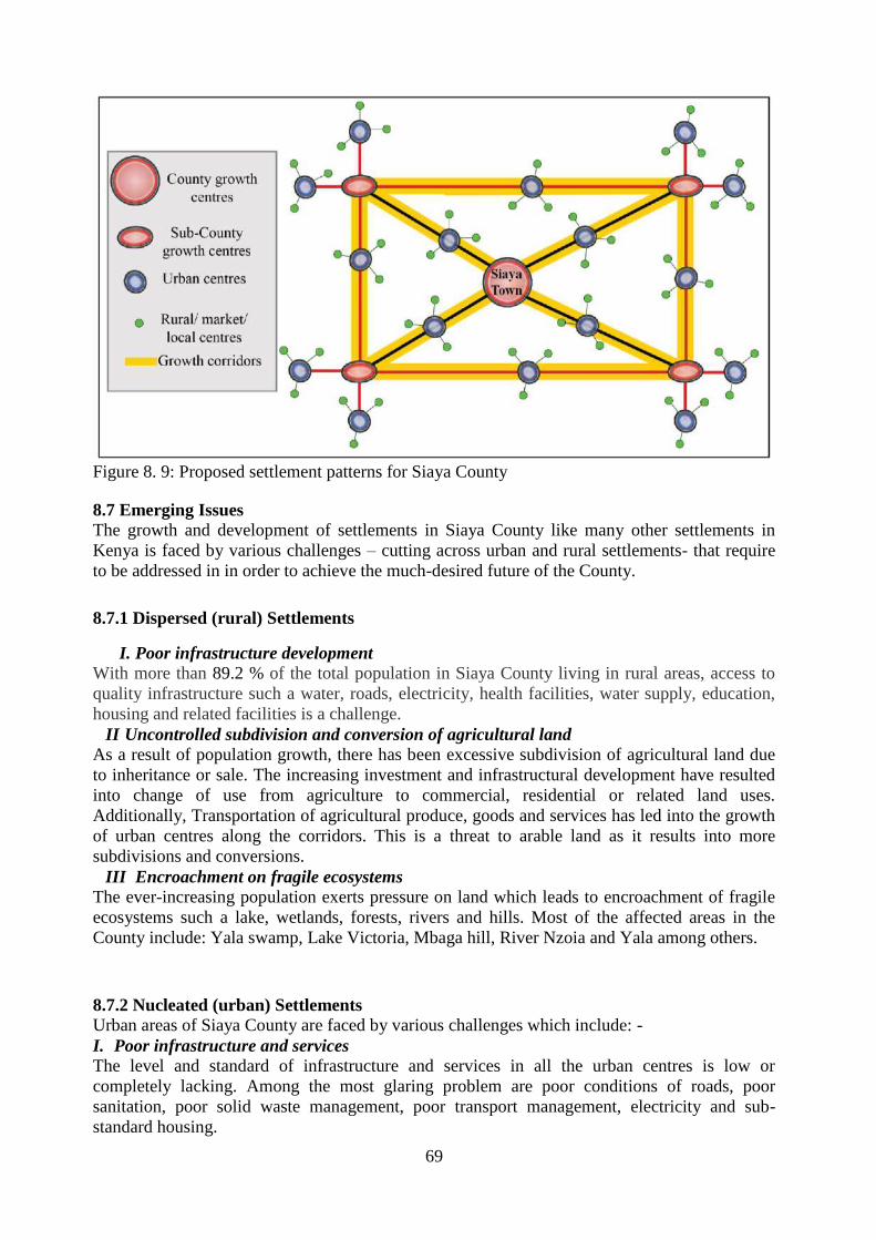
69
Figure 8. 9: Proposed settlement patterns for Siaya County
8.7 Emerging Issues
The growth and development of settlements in Siaya County like many other settlements in
Kenya is faced by various challenges – cutting across urban and rural settlements- that require
to be addressed in in order to achieve the much-desired future of the County.
8.7.1 Dispersed (rural) Settlements
I. Poor infrastructure development
With more than 89.2 % of the total population in Siaya County living in rural areas, access to
quality infrastructure such a water, roads, electricity, health facilities, water supply, education,
housing and related facilities is a challenge.
II Uncontrolled subdivision and conversion of agricultural land
As a result of population growth, there has been excessive subdivision of agricultural land due
to inheritance or sale. The increasing investment and infrastructural development have resulted
into change of use from agriculture to commercial, residential or related land uses.
Additionally, Transportation of agricultural produce, goods and services has led into the growth
of urban centres along the corridors. This is a threat to arable land as it results into more
subdivisions and conversions.
III Encroachment on fragile ecosystems
The ever-increasing population exerts pressure on land which leads to encroachment of fragile
ecosystems such a lake, wetlands, forests, rivers and hills. Most of the affected areas in the
County include: Yala swamp, Lake Victoria, Mbaga hill, River Nzoia and Yala among others.
8.7.2 Nucleated (urban) Settlements
Urban areas of Siaya County are faced by various challenges which include: -
I. Poor infrastructure and services
The level and standard of infrastructure and services in all the urban centres is low or
completely lacking. Among the most glaring problem are poor conditions of roads, poor
sanitation, poor solid waste management, poor transport management, electricity and sub-
standard housing.

70
II. Weak institutional support in planning, implementation and enforcement
This has led to uncoordinated urban development as well poor delivery of services. Most of the
urban centres lack a physical development plan to serve as a guide for infrastructure
development.
III. Growth of informal settlements
IV. Environmental degradation

71
Map 8. 2: Siaya County Urban Settlements and Connectivity

72
CHAPTER 9: TRANSPORT, INFRASTRUCTURE AND SERVICES
9.0 Introduction
Infrastructure services act as a fulcrum to facilitate socio-economic growth, and this situational
analysis provide information on existing facilities as opportunities and challenges as well as
their access by the people is paramount. In general, infrastructure deals with elements that keep
civilization together, such as: electric power production and distribution systems; dams and
water and irrigation systems; collection of the sewage, pipelines and processing; roads and
bridges; airports and public transport systems, things which we greatly depend on.
Infrastructure represents the foundations of the basic equipment and instruments, as well as
capital apparatus, which are needed to have the economic basis of a country function. It is a
common practice to put infrastructure as a sandwich between governance, which regulates it,
and trade (or commerce), which depends on it. Generally, infrastructure in the County has been
classified as economic infrastructure (shops, slaughter house, industries), Transport and
communication (Road transport, water transport, telephone masts, air transport), Environment
(Rivers, water points, sewerage systems, dumping sites), Water and sanitation (Water supply,
intake, water kiosks, treatment plants), Economic infrastructure (Markets and beaches), Social
infrastructure (Correctional unit, social halls, libraries, playgrounds, schools, health facilities),
Communication (Power lines, fiber optics, telephone masts), Energy (Wood fuel, electricity,
solar, biogas etc.), Security infrastructure (County administrators, police stations, prison) and
Human settlement: Urban and rural settlement. Analysis of infrastructure services in Siaya
county is in two-fold: physical infrastructure and social infrastructure. Physical infrastructure
includes: roads, railways, airports, water supply, power line, pipeline and cables. Social
Infrastructure includes: health, schools, community centre, police stations, post office and
administrative centres.
9.1 Transport Network and Distribution
The government of Kenya recognizes the vital role played by transport in enhancing economic
transformation. Transport is seen as an engine that steers faster economic growth and sectoral
development. Due to this critical role the county government must invest heavily in provision
of infrastructure to improve transportation services for both goods and passengers. The national
Government has established State Department in charge of Transport to regulate and control
transport services in the country.
9.1.1 Road Transport
Road transport is the most popular system of transport, providing transport to both goods and
passengers. Matatus, boda boda, bicycles and pedestrian movement constitute the bulk of road
transport in Siaya County. The County has roads classified as B, C, D and E as highlighted:
Class B- connecting Kisumu from Sega, Ugunja, Sidindi,
Class C- connecting Kisumu from Bondo then to Lwanda Kotieno where a ferry dock.
Class D – connecting Siaya district and Bondo
Class E- connecting important market centres within the county.
Rural access roads-connecting rural centres within the county.
The County had 283.2 Km of bitumen standard roads, 1,903 of marram roads, and 1,528.0 of
earth roads by December 2016. The County has witnessed an improvement in the road network
with several roads being tarmacked; these include the Rang’ala-Siaya-Bondo road which is
100% complete, Akala-Luanda Road and Siaya-Nyadorera Road which are 100% complete.
Ndori-Owimbi-Luanda Kotieno, Bondo -Misori –Mituri, Kisian- Bondo and Ngiya- Ndori
roads have all been tarmacked. 700 km of roads in the County have also been opened, graded
and graveled through the county government initiative. The poor road conditions in some parts
of the county hinder the growth of agriculture in the predominantly agricultural county of
Siaya. Over 70% of the road network in the county is in poor state. Proximity to tarmac road
analysis indicated that over 50% of the county are still not close to tarmac roads, that is an
average of 5 Km radius in terms of accessibility.

73
Map 9. 1: Siaya County Roads classification

74
9.1.2 Air and Railway Transport
There are three air strips in the County namely: Gombe, Dominion and Sega. These airstrips
are currently not in use, so there is need for the county government to rehabilitate them. The
airstrips should be used to promote tourism activities, enhancing sanity of local and
international tourists and provide space for emergency landing. The County has a railway line
from Nairobi at Yala Township connecting to Uganda though not operational.
9.1.3 Water Transport
The water transport in Siaya County (ferry and boats) is predominant and links people from
mainland to the islands as well as neighboring Counties of Migori and Homabay in the South
Nyanza.
9.2 Information and Communication Technology
This section assesses the means of communication in the area. These are telephone services,
postal, cell phone services, courier services, newspaper, radio and television coverage.
9.2.1 Modes of Communication
Telecommunication: Fixed line network covers the mainland but not the islands (Mageta,
Ndenda and Oyamo) while mobile phone network is county wide with some areas having both
or either of Safaricom or Airtel networks, 90 per cent mobile phones with main operators being
Safaricom and Airtel communication companies, 0.5 per cent landline and 1.2 per cent of the
household’s own computers. It is important to note that most of the government offices have
internet connection through modems. Radio coverage is county wide while postal network
covers the important business/market centres in the county. It is estimated that 75.2 per cent of
the households in the County own a radio, 13.7 per cent television sets
Postal services: The County has a total of 28 Post Offices and 21 sub-post offices spread
across the region (Table 9.1). The County is serviced by three private courier services which
include G4S, Wells Fargo and EMS. In addition to this, registered Public Service Vehicles also
offer courier services.
Table 9. 1: Postal Services Post Offices and Letter Boxes 2013 2014
Post Offices 23 28
Letter boxes Installed 6,350 6,350
Letter Boxes Rented 3,980 4,012
Letter Boxes Vacant 2,370 2,338
Source: Kenya National Bureau of Statistics
9.3 Energy
In Siaya County, currently there is no power plant for electricity generation. The energy
supply is currently derived from the national grid. However, there are potential for harnessing
other small scale hydro-power from available resources such as water falls (Ndanu falls), wind
power (along the lakeshore high potential) and solar energy (abundant sunshine) to start
generating energy for the local consumption (figure 9.2). The energy consumption statistics
were as follows: Paraffin lamps - 94% - of this, 73% used tin lamps. Total electricity usage was
only at 4.3%. Only 2.4% of rural households had access to electricity. Total urban electricity
access was at 20%. In 2014 the domestic customer connection represented 84% of total with
15.9% for small commercial and very limited industrial connection, an indication of low
industrialization in the county (Table 9.2). Connection per customer entity indicated most
secondary schools are connected to electricity compared to primary schools (Table 9.3). Most

75
trading centres are now connected to electric power under the rural electrification programme
and establishment of solar panels in most markets.
There are no gas sources in the County, which could be utilized. The County has no oil
resources and refineries and therefore relies on its strategic location on Kisumu- Busia road for
the supply through road transport.
Table 9. 2: Connection per Customer Category 2014 Category 2014 Percentage (%)
Domestic 22,606 84
Small Commercial 4,279 15.9
Industrial 2 0.0074
Total 26,887 100
Source: Kenya National Bureau of Statistics
Table 9. 3: Electricity Connection per Customer Entity 2014 Without Electricity Without Electricity Total
Trading Centres 126 37 163
Primary Schools 563 163 716
Secondary Schools 148 9 157
Health Centres 327 60 387
Category (in Litres) 2013 2014
Super Petrol 114.2 113.8
Diesel 106.2 104.4
Kerosene 85.9 83.5
Source: Kenya National Bureau of Statistics
Table 9. 4: Petrol Consumption Category (in Litres) 2013 2014
Super Petrol 114.2 113.8
Diesel 106.2 104.4
Kerosene 85.9 83.5
Source: Kenya National Bureau of Statistics
Table 9. 5: Average Annual Pump Prices for Fuel by category Category (in Litres) 2013 2014
Super Petrol 114.2 113.8
Diesel 106.2 104.4
Kerosene 85.9 83.5
Source: Kenya National Bureau of Statistics
9.7.1 Energy Strategy
Sustainable energy infrastructure is conspicuously missing and untapped in the County, focus
on wind power and solar energy need to be up-scaled towards achievement of Sustainable
Development Goals. Exploring the development of alternative energy potential such as wind
power, solar energy, biogas among others.

76
Map 9. 2: Siaya County Solar Radiations from January to December, 2019

77
9.3 Water Infrastructure
Adequate quantity and quality of water is a basic requirement for development of a county
owing to the fact that water is life. About 80 per cent of the water provided is disposed of as
effluent, meaning that there should be safe disposal of waste water and environmental
protection. There are about twenty-four existing water supply schemes (9 owned by GOK, 5
by institutions’, 10 Community based) in the County that are utilized to provide water
services to the people of the County. These schemes range from small community based to
large piped water suppliers. The facilities are managed by Community based management
water committees, semi- autonomous water service providers and institutions. These water
supply facilities provide water coverage of 42% serving about 396,000 people in the County.
The water facilities are dilapidated and pose operational challenges thereby not sustainable
and will require rehabilitation and expansion to bring them to operational status and cover the
ever-increasing water demand. It is important to note that all the water facilities are pump
based systems consuming high power for their operations, this calls for project re-design to
make the schemes gravity-based systems in-order to reduce the high energy cost incurred by
the facilities. One step the Government has taken is to undertake the upgrading of Sidindi-
Malanga water Supply to serve Siaya and Bondo Towns through gravity. Major water
sources are Lake Victoria, Rivers, Boreholes, kiosks, springs, streams, tap stands, pans dams
and wells. About 35% of the total population have access to portable and clean water, the rest
depend on water from pans, dams or from the lake.
9.3.1 Water Sources
A total of 292 water points was located and mapped. They include Boreholes, Dams/Water
pans, Water Kiosks, Lake Shores, River Points, Springs, Stream Points, Tap stand and Well.
Majority, at 43.5%, accessed water from Borehole that harnesses groundwater resources. The
boreholes are mainly located in the Northern half of the County due to its richness in ground
and sub-surface waters as well as traversed by two major rivers.
Table 3.3 Siaya County Water Sources S/N Category Number Percentage
1 Boreholes 127 43.5%
2 Dams 30 10.3%
3 Water Kiosks 56 19.2%
4 Lake Shores 12 4.1%
5 River Points 7 2.4%
6 Springs 7 2.4%
7 Stream Points 12 4.1%
8 Tap stand 33 11.3%
9 Wells 8 2.7%
Total 292 100.0%
9.3.2 Distribution and Access
Analysis of access and distribution of water services revealed that: Majority of Siaya County
access water point between 2 and 3 km away; Water access is generally beyond
recommended 200m in entire Siaya County; About 50% access water sources within 2km;
Mostly 2-3 kilometers to water point; West Alego to the North, central Sakwa, North Gem,
West Alego, Central Gem, North Sakwa, are most affected Wards as they access water as far
as 5km away.
This reaffirms CIDP 2013-2017 assertion that: The distribution of water sources, surface and
underground in the County are naturally widely spaced and make people walk long distances
to fetch water; In some parts of the county, especially Southern parts of Bondo and Rarieda,
have water point density of less than one per 2.5km2; Whereas while the north and north-
eastern parts have a water point density of more than 3 per km².

78
Time spent to access water especially in the rural areas is about one hour and this had the
greatest impact on the girl-child who is charged with such duties. It even gets worse during
droughts since most of the pans run dry.
The distribution of water sources, surface and underground in the County are naturally
widely spaced and make people walk long distances to fetch water. The Government
interventions were intended to reduce the long-distance coverage to about 500m distance.
The intervention measures the Ministry of water has put in place so far in terms of piped
schemes, point water sources like boreholes, shallow wells and spring protection has not met
the target. The rural population of the County depends on various types of water sources for
their domestic needs. The southern part (Bondo and Rarieda) have less than one water point
per 2.5km², while the north and north eastern parts have a water point density of more than 3
per km². Streams are the widest spread type of water points, but occur mainly in north-
eastern part of the County. Other sources of water in the County include; wells, boreholes,
roof catchment, rivers, Lake Victoria, water holes, dams, ground catchments and piped
supplies. A large number of water points cannot be used during the dry season because they
are seasonal. There will be need for expansion of water supply systems in addition to de-
silting the existing dams like Ouya, Anyuongi and Gologolo so as to reduce distance to water
source to less than 3 km.
9.3.3 Water Demand in Siaya County
Water utilization in Siaya county includes: Domestic use, Commercial use, Public purpose
use, Industrial use, Recreational use- water sports, hotels/lodges and golf courses and
Agriculture- irrigation and animal watering. Water demand projections helps planners, and
policy makers establish the amount of water that will be required in future for a community,
a settlement or a region, with population main parameter. Population growth for Siaya county
is estimated at 1.7%., between 2016 and 2046 at the interval of 10 years will be as shown:
2016 (947,797), 2026 (1,121,824), 2036 (1,327,805) and 2046 (1,571,607) respectively. The
water demand for year 2046 assuming per capita water consumption of 80 litres per person
per day on average in Siaya County, Total Water Demand, Q, by year will be Q = 365x80xp
litres per year. Total water demanded will be 458,890,942 M3 per year by 2046.
Table 9. 6: Siaya County Water Demand Projection Year Growth
rate
Projected
population
Per capita
water
consumption
Total water demand per
capita per year
(Q=365*80)
Projected water
demand (M3)
2016
1.7 %
947,797
80Litres
29,200 Litres
27,675,672
2026 1,121,824 32,757,261
2036 1,327,805 38,771,906
2046 1,571,607 45,890,924
9.4 Solid Waste Management
The county currently lacks a proper solid waste disposal system and there is need to improve
waste management in urban centres. There are no designated dumping sites in the county,
while in other places solid waste is managed through burning. These methods of solid waste
management may lead to groundwater pollution as the soils are pervious. There is need for
properly designated solid waste management to safeguard environmental degradation.
9.5 Sanitation and Sewerage
To safeguard against environmental degradation in the county, more so the urban settlement,
sanitation facility development is important. All the towns in the region lack sanitation
facilities. The main sources of water pollution include agro-chemicals, defecation in bushes
due to lack of pit latrines and waste water that end into water points during surface run off.

79
Sanitation continues to be a serious problem in the County with only 5.9 per cent of the
households with access to piped water while the latrine coverage stands at 75.3 per cent.
There are no planned sewerage systems in all urban centers in the County and this calls for
concerted efforts from all the stakeholders especially the County government to invest in
planned sewerage systems for improved liquid and solid waste disposal. Currently a major
water and sewerage system is underway developed in Bondo and Siaya Towns through a
joint venture between the Government of Kenya and African Development Bank.
9.6 Social Infrastructure
9.6.1 Education Facilities
Education plays an important role in the development of people by empowering them to
improve their well-being and participate in nation building. At the national level, the broad
objective is to achieve 100% net primary school enrolment rate and reduce the disparity in
access and quality of education. The Government also now proposes to achieve 100%
transition from primary to secondary schools as well as promote competency-based
curriculum that includes the integration Information, Communication and Technology (ICT)
learning processes, as some the radical proposals in the Education Sessional Paper, 2018
(GOK, 2018).
Education is a crucial predictor of professional success and future income levels. But
children who have completed primary education can only have a shot at higher education if
they get to join secondary education, stay and complete their studies. Quality education is
paramount in steering development, and thus education is a top priority in Siaya county. In
the 2009 census report the population of the age group (3-5 years) was 82,446 of whom
41,414 were boys and 41,032 were girls which represent 9.8% of the County’s total
population.
In the education sector, the county has one university; Jaramogi Oginga Odinga University of
Science and Technology and three colleges affiliated to other universities (Odera Akango,
Barrack Obama Memorial University College, and University of Nairobi Learning Centre,
Siaya. There are also emerging commercial colleges and branches of other established ones.
According to Siaya County Scorecard 2014, the sector had the following further statistics:
only 70% of children aged between 3 and 5 were attending pre-primary education in the
county at the time of inception of the county government. The net enrolment in primary
schools stood at 84.7%; with male standing at 84% and female at 85.7%. In secondary, only
43% of the population aged 14 - 17 years was joining secondary schools. The net enrolment
rate stood at 19.8% with male at 19.1% and female at 20.5%. Only 6.1% of those aged 18 -
24 were enrolled in universities. And of the students enrolled in secondary schools 19.6 of
were persons with disabilities.
9.6.1.1 Basic Education Services
The County has 744 public Early Childhood Development (ECD) schools and 293 private
totaling to 989 centres with an enrolment of 61,118. The ECD teachers are employed by both
the County Government and the Parents, a factor that has led to the high turnover of the
Teachers employed by parents which has comprised the quality of services in the Sector.
County Government, Communities and parents have been responsible for the investment in
ECD infrastructure. The number of primary schools in the County currently is 700, with a
total enrolment of 202,658 pupils of which 96,409 are males and 106,549 females and 4,949
teachers. Teacher to student ratio is 1:49. The total enrolment stands at 202,658 pupils with a
gross enrollment of 110 per cent. The average years of attendance stands at 6.4.
Understaffing remains a major challenge with most of the schools being understaffed. The
county had a total of 217 secondary schools with a total enrolment of 58,302 pupils by the
end of 2012 (Table 9.8.3 and figure 9.8.3). The enrolment consisted of 31,359 boys and

80
26,943 girls. There were a total of 1290 teachers in 2012 giving a teacher pupil ratio stood at
1:27 indicating need for hiring of more teachers. The gross enrolment rate was 53.4 per cent
while the net enrolment rate was 52.7 per cent. The average year of attendance in secondary
schools is 3.6 years.
Table 9. 7: Early Childhood Development Education Sub-County Public Private Total
Gem 126 19 145
Siaya 144 58 202
Ugunja 70 10 81
Ugenya 89 7 96
Bondo 191 32 223
Rarieda 124 24 148
Total 744 150 894
Source: Kenya National Bureau of Statistics 2014
Table 9. 8: Pupil Enrolments in ECD Centers by Sex and Sub-County Sub-County 2013 2014
Boys Girls Total Boys Girls Total
Ugenya 5,265 5,294 10,559 5,906 6,390 12,296
Siaya 7,663 6,998 14,661 8,307 8,340 16,647
Ugunja 2,872 2,694 5,566 2,753 2,914 5,667
Ugenya 2,499 2,295 4,794 2,673 2,698 5,371
Bondo 6,473 6,463 12,936 4,972 5,167 10,139
Rarieda 6,919 6,999 13,918 7,202 7,630 14,832
Total 31,691 30,743 62,434 31,813 33,139 64,952
Source: Department of Education, County Government of Siaya
Table 9. 9: Primary School by Category and Sub-county Sub-County 2013 2014
Public Private Public Private
Gem 112 4 119 5
Siaya 132 4 136 5
Ugunja 67 20 67 23
Ugenya 84 6 85 7
Bondo 128 17 127 19
Rarieda 116 10 117 11
Total 639 61 652 69
Source: Kenya National Bureau of Statistics 2014
Table 9. 10: Primary School by Category and Sub-county Sub-County 2013 2014
Public Private Public Private
Gem 42 0 43 --
Siaya 39 3 42 2
Ugunja 19 1 24 1
Ugenya 27 0 31 --
Bondo 36 2 37 1
Rarieda 34 0 39 -
Total 197 6 217 4
Source: Kenya National Bureau of Statistics 2014
Table 9. 11: Primary School Enrolments by Sex and Sub-County Class Sex Bondo Gem Rarieda Siaya Ugenya Ugunja Total
Standard 1 Boys 3,094 3,385 3,070 4,140 2,736 1,812 18,237
Girls 3,221 3,334 3,088 4,014 2,224 1,837 17,718
Standard 2 Boys 3,076 3,285 3,031 3,867 2,304 1,826 17,389

81
Source: Department of Education, County Government of Siaya
Table 9. 12: Secondary School Enrolments by Sex and Sub-County Class Gender Sub-County
Bondo Gem Rarieda Siaya Ugenya Ugunja Total
Form
1
Boys 1,896 2,139 1,960 1,711 1,255 1,055 10,016
Girls 1,563 1,607 1,532 1,830 1,087 1,193 8,812
Form
2
Boys 1,905 1,945 1,748 1,563 1,083 1,111 9,355
Girls 1,517 1,456 1,512 1,852 928 1,108 8,373
Form
3
Boys 1,622 1,829 1,568 1,332 977 1,002 8,330
Girls 1,194 1,215 1,264 1,422 750 866 6,711
Form
4
Boys 1,493 1,611 1,300 1,095 792 815 7.106
Girls 1,031 973 1,013 1,280 589 667 5,553
Grand Boys 6,916 7,524 6,576 5,701 4,107 3,983 34,807
Girls 5,305 5,251 5,321 12,085 7,461 7,817 29,449
Total 12,221 12,775 11,897 12,085 7,461 7,817 64,256
Source Ministry of Education Science and Technology
Table 9. 13: Adult Education Centres by Sub-county Sub-County 2013 2014
Rarieda 16 15
Bondo 28 28
Siaya 23 24
Ugunja 17 12
Ugenya 11 15
Gem 9 9
Total 184 183
Source: Department of Education, County Government of Siaya
Population aged over 15 years that can read and write is 79.75 per cent, while those who
cannot read and write is 18.25 per cent. Efforts will be made to ensure that more formal as
well as informal institutions are established to further improve on the county’s literacy level.
The county government plans to equip and staff the adult learning centres and establish
resource centres in all sub locations in the county.
Girls 3,030 3,219 2,938 3,907 2,223 1,794 17,111
Standard 3 Boys 3,112 3,301 2,968 3,784 2,245 1,779 17,189
Girls 2,980 3,197 2,869 3,732 2,164 1,717 16,659
Standard 4 Boys 3,117 3,282 2,972 3,805 2,363 1,758 17,297
Girls 3,092 3,405 2,882 3,859 2,334 1,698 17,270
Standard 5 Boys 2,902 3,290 2,822 3,656 2,308 1,658 16,636
Girls 2,983 3,177 2,949 3,799 2,260 1,598 16,766
Standard 6 Boys 2,829 3,143 2,713 3,638 2,097 1,593 16,0131
Girls 2,854 3,238 2,788 3,250 2,232 1,662 16,456
Standard 7 Boys 2,622 2,893 2,581 3,433 2,084 1,589 15,019
Girls 2,686 2,972 2,780 2,383 2,145 1,685 15,701
Standard 8 Boys 2,044 2,010 1,842 2,305 1,333 1,279 10,813
Girls 1,919 2,086 1,877 2,383 1,372 1,230 10,867
Grand
Total
Boys 22,796 24,589 21,999 28,445 17,470 13,294 128,593
Girls 22,765 24,628 22,171 28,809 16,954 13,221 128,548
Total 45,561 49, 217 44,170 57,254 34,424 26,515 257,141

82
Map 9. 3: Spatial Distribution of ECDE Centres in Siaya County

83
Map 9. 4: Spatial Distribution of Primary Schools in Siaya County

84
Map 9. 5: Spatial Distribution of Secondary Schools in Siaya County

85
9.6.1.2 Tertiary Institutions
The higher learning institutions in the county include: Siaya Medical College, Siaya Institute
of Technology, Jaramogi Oginga Odinga University of Science and Technology situated in
Bondo town, Moi University Odera Akang’o Campus in Yala, Bondo Teachers College,
Bondo Technical Institute, and Bondo Medical College and 14 youth polytechnics spread
across the County. In general, the county has one fully fledged university, three university
campuses, one institute of science and technology, one teacher training college, two medical
training colleges and 15 youth polytechnics. According to the 2009 population and housing
census, the youth population accounted for 27% of the County population which was
226,568 persons consisting of 119,234 females and 107,334 males. The youthful population
requires well developed tertiary institutions for technical skill enhancement as well
entrepreneurship and managerial skills to promote profitable employment and guarantee
future investments.
Table 9. 14: Teacher Training Colleges by Category Category 2013 2014
Public Private Public Private
Pre-Primary - 3 - 3
Primary 1 - 2 -
Secondary - - - -
Sub-Total 1 3 2 3
Total 4 5
Source: Department of Education, County Government of Siaya
Table 9. 15: Universities and Technical Institutions by Category Category 2013 2014
Public Private Public Private
Universities 1 - 1 -
University Campuses 3 - 3 -
Institute of Technology - - 3 -
Technical Training Institutes 1 1 - -
Total 5 1 7 -
Source: Department of Education, County Government of Siaya

86
Map 9. 6: Spatial Distribution of Tertiary Institutions in Siaya County

87
9.6.1.3 Hexagonal Analysis in Education Sector
The application of Central Place Model was used to assess the adequacy of schools in terms
of location, accessibility, and equity. The 5 Km radius was used as an equidistant standard to
create polygons and/or hexagons distributed in the entire county. The wards were therefore
used as the basic unit of resource allocation, while respecting the catchment population. The
deficient and/or underserved areas with public schools per ward was therefore projected for
10 years and 20 years assuming everything is held constant. Table 9.8.10, 9.8.11 and 9.8.12
illustrate the same for ECDE, Primary and Secondary Schools respectively.
Table 9. 16: Results of Hexagonal Analysis for Early Childhood Education Centres
ALEGO
USONGA
Population
Density
Area in Sq.
Km
Existing
Number
Deficiency
(10 years)
Deficiency
(20 Years)
Central
Alego
275.10 122 19 19 19
North Alego 383.47 59 07 09 09
Siaya
Township
872.03 39 18 08 08
South East
Alego
357.40 196 44 31 31
Usonga 178.24 91 11 12 12
West Alego 324.18 100 17 10 20
BONDO Population
Density
Area in Sq.
Km
Existing
Number
Deficiency
(10 years)
Deficiency
(20 Years)
Central
Sakwa
653.79 84 18 13 13
North Sakwa 331.55 94 16 15 14
South Sakwa 174.71 105 16 16 16
West Sakwa 204.80 112 18 16 16
West Yimbo 938.33 38 09 06 06
East Yimbo 170.30 155 10 20 20
GEM Population
Density
Area in Sq.
Km
Existing
Number
Deficiency
(10 years)
Deficiency
(20 Years)
Central Gem 484.57 52 14 08 08
East Gem 407.15 61 17 10 09
North Gem 420.16 85 24 12 12
South Gem 317.04 96 18 15 15
West Gem 347.55 75 26 12 12
Yala
Township
679.03 34 10 05 05
RARIEDA Population
Density
Area in Sq.
Km
Existing
Number
Deficiency
(10 years)
Deficiency
(20 Years)
East Asembo 416.32 77 26 12 12
North Uyoma 297.49 78 19 12 12
South Uyoma 351.22 54 12 12 12
West
Asembo
325.50 100 18 16 16
West Uyoma 325.50 89 20 16 16
GEM Population
Density
Area in Sq.
Km
Existing
Number
Deficiency
(10 years)
Deficiency
(20 Years)
UGENYA Population
Density
Area in Sq.
Km
Existing
Number
Deficiency
(10 years)
Deficiency
(20 Years)
East Ugenya 653.79 84 18 13 13
North
Ugenya
331.55 94 16 15 14

88
Ukwala 174.71 105 16 16 16
West Ugenya 204.80 112 18 16 16
UGUNJA Population
Density
Area in Sq.
Km
Existing
Number
Deficiency
(10 years)
Deficiency
(20 Years)
Sidindi 476.93 55 21 10 07
Sigomere 417.15 72 21 11 11
Ugunja 465.25 83 21 13 13
UGENYA Population
Density
Area in Sq.
Km
Existing
Number
Deficiency
(10 years)
Deficiency
(20 Years)
East Ugenya 340.75 94 19 16 16
North
Ugenya
406.73 69 14 08 08
Ukwala 401.74 52 15 08 08
UGENYA Population
Density
Area in Sq.
Km
Existing
Number
Deficiency
(10 years)
Deficiency
(20 Years)
West Ugenya 342.73 93 19 16 16
Table 9. 17: Results of Hexagonal Analysis for Primary Schools
ALEGO
USONGA
Population
Density
Area in Sq.
Km
Existing
Number
Deficiency
10 Years
Deficiency
20 Years
Central Alego 275.10 122 19 19 19
North Alego 383.47 59 07 09 09
Siaya Township 872.03 39 18 08 08
South East
Alego
357.40 196 44 31 31
Usonga 178.24 91 11 12 12
West Alego 324.18 100 17 10 20
BONDO Population
Density
Area in Sq.
Km
Existing
Number
Deficiency
10 Years
Deficiency
20 Years
Central Sakwa 653.79 84 18 13 13
North Sakwa 331.55 94 16 15 14
South Sakwa 174.71 105 16 16 16
West Sakwa 204.80 112 18 16 16
West Yimbo 938.33 38 09 06 06
East Yimbo 170.30 155 10 20 20
GEM Population
Density
Area in Sq.
Km
Existing
Number
Deficiency
10 Years
Deficiency
20 Years
Central Gem 484.57 52 14 08 08
East Gem 407.15 61 17 10 09
North Gem 420.16 85 24 12 12
South Gem 317.04 96 18 15 15
West Gem 347.55 75 26 12 12
Yala Township 679.03 34 10 05 05
RARIEDA Population
Density
Area in Sq.
Km
Existing
Number
Deficiency
10 Years
Deficiency
20 Years
East Asembo 416.32 77 26 12 12
North Uyoma 297.49 78 19 12 12
South Uyoma 351.22 54 12 12 12
West Asembo 325.50 100 18 16 16
West Uyoma 325.50 89 20 16 16
UGENYA Population
Density
Area in Sq.
Km
Existing
Number
Deficiency
10 Years
Deficiency
20 Years

89
East Ugenya 653.79 84 18 13 13
North Ugenya 331.55 94 16 15 14
Ukwala 174.71 105 16 16 16
West Ugenya 204.80 112 18 16 16
UGUNJA Population
Density
Area in Sq.
Km
Existing
Number
Deficiency
10 Years
Deficiency
20 Years
Sidindi 476.93 55 21 10 07
Sigomere 417.15 72 21 11 11
Ugunja 465.25 83 21 13 13
UGENYA Population
Density
Area in Sq.
Km
Existing
Number
Deficiency
10 Years
Deficiency
20 Years
East Ugenya 340.75 94 19 16 16
North Ugenya 406.73 69 14 08 08
Ukwala 401.74 52 15 08 08
West Ugenya 342.73 93 19 16 16
Table 9. 18: Results of Hexagonal Analysis for Secondary Schools
SIAYA COUNTY SCHOOLS DATA BY WARDS IN SECONDARY SCHOOLS BY CARTEGORY
WARD POP
DENSITY
AREA
KM2
NATIONAL EXTRA
COUNTY
COUNTY
SUBCOUNTY
DEFICIENCY
10YRS
ALEGO USONGA SUBCOUNTY
Central Alego 275.10 122 0 0 6
2 Extra County
2 County /Ward
North Alego 383.47 59 0 1 3
Siaya Township 872.03 39 0 0 7
South E. Alego 357.40 196 1 1 14
Usonga 178..24 91 0 0 4
West Alego 324.18 100 0 2 7
BONDO SUBCOUNTY
Central Sakwa 653.79 84 0 1 3
2 Extra County
2 County /Ward
North Sakwa 331.55 94 0 1 5
South Sakwa 174.21 105 0 0 9
West Sakwa 204.80 112 1 1 4
West Yimbo 938.33 38 0 4 2
East Yimbo 170.30 155 0 0 6
GEM SUBCOUNTY
Central Gem 484.57 52 0 2 4 2 Extra County
2 County /Ward
East Gem 407.15 61 0 1 7
North Gem 420.16 85 0 2 6
South Gem 317.04 96 0 0 9
West Gem 347.55 75 0 0 8
Yala Township 679.03 34 0 3 2
RARIEDA SUBCOUNTY
East Asembo 416.32 77 0 1 9 2 Extra County
2 County /Ward
North Uyoma 297.49 78 0 2 7
South Uyoma 351.22 54 0 1 2
West Asembo 325.50 100 0 0 9
West Uyoma 325.88 89 0 3 8
UGENYA SUBCOUNTY
East Ugenya 340.75 94 2 4
2 Extra County
2 County /Ward
North Ugenya 406.73 69 1 9
Ukwala 401.74 52 1 4
West Ugenya 342.73 93 0 8
UGUNJA SUBCOUNTY
Sidindi 476.93 55 2 5 2 Extra County
2 County /Ward

90
Table 9. 19: Results of Hexagonal Analysis for Universities (Campuses, Learning Centres)
SIAYA COUNTY UNIVERSITY CENTRES BY WARDS/SUBCOUNTIES
No. WARD POP
DENSITY
AREA IN
KM2
CURRENT
NO.
10YRS
ALEGO USONGA SUBCOUNTY
1 Central Alego 275.10 122 0 Create A
University at Siaya
County
Headquarters
2 North Alego 383.47 59 0
3 Siaya Township 872.03 39 0
4 South East Alego 357.40 196 0
5 Usonga 178..24 91 0
6 West Alego 324.18 100 0
BONDO SUBCOUNTY
7 Central Sakwa 653.79 84 0 Improvement of
Existing
University -
JOOUST
8 North Sakwa 331.55 94 0
9 South Sakwa 174.21 105 0
10 West Sakwa 204.80 112 1
11 West Yimbo 938.33 38 0
12 East Yimbo 170.30 155 0
GEM SUBCOUNTY
13 Central Gem 484.57 52 0 Improvement of
Existing
University
&Middle Level
Colleges
14 East Gem 407.15 61 0
15 North Gem 420.16 85 0
16 South Gem 317.04 96 0
17 West Gem 347.55 75 0
18 Yala Township 679.03 34 1
RARIEDA SUBCOUNTY
19 East Asembo 416.32 77 1 Improvement of
Existing
University
&Middle Level
Colleges
20 North Uyoma 297.49 78 0
21 South Uyoma 351.22 54 0
22 West Asembo 325.50 100 0
23 West Uyoma 325.88 89 0
UGENYA SUBCOUNTY
24 East Ugenya 340.75 94 0 Improvement of
Existing
University
&Middle Level
Colleges
25 North Ugenya 406.73 69 0
26 Ukwala 401.74 52 0
27 West Ugenya 342.73 93 0
UGUNJA SUBCOUNTY
29 Sidindi 476.93 55 0 Improvement
Middle Level
Colleges 29 Sigomere 417.15 72 0
30 Ugunja 465.25 83 0
Table 9. 20: Results of Hexagonal Analysis for Tertiary Institutions
SIAYA COUNTY SCHOOLS DATA BY WARDS IN TERTIARY COLLEGES/ NATIONAL
POLYTECHNICS/TTC/ KMTC
No. WARD POP
DENSITY
AREA NO. 10 YRS
ALEGO USONGA SUBCOUNTY
1 Central Alego 275.10 122 0 A Tertiary Institution
in each Sub county
(TTI, TTC, University
College, KMTC)
2 North Alego 383.47 59 0
3 Siaya township 872.03 39 2
4 South east Alego 357.40 196 0
5 Usonga 178..24 91 0
6 West Alego 324.18 100 0
BONDO SUBCOUNTY
7 Central Sakwa 653.79 84 0 A Tertiary Institution
in each Sub county
(TTI, TTC, University 8 North Sakwa 331.55 94 0
9 South Sakwa 174.21 105 1

91
10 West Sakwa 204.80 112 1 College, KMTC)
11 West Yimbo 938.33 38 0
12 East Yimbo 170.30 155 1
GEM SUBCOUNTY
13 Central Gem 484.57 52 0 A Tertiary Institution
in each Sub county
(TTI, TTC, University
College, KMTC)
14 East Gem 407.15 61 0
15 North Gem 420.16 85 0
16 South Gem 317.04 96 0
17 West Gem 347.55 75 0
18 Yala Township 679.03 34 1
RARIEDA SUBCOUNTY
19 East Asembo 416.32 77 1 A Tertiary Institution
in each Sub county
(TTI, TTC, University
College, KMTC)
20 North Uyoma 297.49 78 0
21 South Uyoma 351.22 54 0
22 West Asembo 325.50 100 0
23 West Uyoma 325.88 89 0
UGENYA SUBCOUNTY
24 EAST UGENYA 340.75 94 1 A Tertiary Institution
in each Sub county
(TTI, TTC, University
College, KMTC)
25 NORTH UGENYA 406.73 69 1
26 UKWALA 401.74 52 0
27 WEST UGENYA 342.73 93 1
UGUNJA SUBCOUNTY
29 SIDINDI 476.93 55 0 A Tertiary Institution
in each Sub county 29 SIGOMERE 417.15 72 0
30 UGUNJA 465.25 83 1
Table 9. 21: Results of Hexagonal Analysis for Village Polytechnics
SIAYA COUNTY SCHOOLS DATA BY WARDS IN VILLAGE POLYTECHNICS
No. WARD POP
DENSITY
AREA CURRENT
NO.
10 YRS
ALEGO USONGA SUBCOUNTY
1 Central Alego 275.10 122 1 Create a Village
Polytechnic
in each ward 2 North Alego 383.47 59 0
3 Siaya Township 872.03 39 0
4 South East Alego 357.40 196 5
5 Usonga 178..24 91 0
6 West Alego 324.18 100 0
BONDO SUBCOUNTY
7 Central Sakwa 653.79 84 1 Create a Village
Polytechnic
in each ward 8 North Sakwa 331.55 94 1
9 South Sakwa 174.21 105 0
10 West Sakwa 204.80 112 1
11 West Yimbo 938.33 38 0
12 East Yimbo 170.30 155 1
GEM SUBCOUNTY
13 Central Gem 484.57 52 1 Create a Village
Polytechnic
in each ward 14 East Gem 407.15 61 1
15 North Gem 420.16 85 1
16 South Gem 317.04 96 1
17 West Gem 347.55 75 2
18 Yala Township 679.03 34 0
RARIEDA SUBCOUNTY
19 East Asembo 416.32 77 1 Create a Village
Polytechnic
in each ward 20 North Uyoma 297.49 78 0
21 South Uyoma 351.22 54 1
22 West Asembo 325.50 100 2
23 West Uyoma 325.88 89 0
UGENYA SUBCOUNTY

92
24 East Ugenya 340.75 94 0 Create a Village
Polytechnic
in each ward 25 North Ugenya 406.73 69 2
26 Ukwala 401.74 52 1
27 West Ugenya 342.73 93 1
UGUNJA SUBCOUNTY
29 Sidindi 476.93 55 0 Create a Village
Polytechnic
in each ward 29 Sigomere 417.15 72 1
30 Ugunja 465.25 83 1
Table 9. 22: Results of Hexagonal Analysis for Primary Schools
ALEGO USONGA Population
Density
Area in Sq.
Km
Existing
Number
Deficiency
10 Years
Deficiency
20 Years
Central Alego 275.10 122 19 19 19
North Alego 383.47 59 07 09 09
Siaya Township 872.03 39 18 08 08
South East Alego 357.40 196 44 31 31
Usonga 178.24 91 11 12 12
West Alego 324.18 100 17 10 20
BONDO Population
Density
Area in Sq.
Km
Existing
Number
Deficiency
10 Years
Deficiency
20 Years
Central Sakwa 653.79 84 18 13 13
North Sakwa 331.55 94 16 15 14
South Sakwa 174.71 105 16 16 16
West Sakwa 204.80 112 18 16 16
West Yimbo 938.33 38 09 06 06
East Yimbo 170.30 155 10 20 20
GEM Population
Density
Area in Sq.
Km
Existing
Number
Deficiency
10 Years
Deficiency
20 Years
Central Gem 484.57 52 14 08 08
East Gem 407.15 61 17 10 09
North Gem 420.16 85 24 12 12
South Gem 317.04 96 18 15 15
West Gem 347.55 75 26 12 12
Yala Township 679.03 34 10 05 05
RARIEDA Population
Density
Area in Sq.
Km
Existing
Number
Deficiency
10 Years
Deficiency
20 Years
East Asembo 416.32 77 26 12 12
North Uyoma 297.49 78 19 12 12
South Uyoma 351.22 54 12 12 12
West Asembo 325.50 100 18 16 16
West Uyoma 325.50 89 20 16 16
UGENYA Population
Density
Area in Sq.
Km
Existing
Number
Deficiency
10 Years
Deficiency
20 Years
East Ugenya 653.79 84 18 13 13
North Ugenya 331.55 94 16 15 14
Ukwala 174.71 105 16 16 16
West Ugenya 204.80 112 18 16 16
UGUNJA Population
Density
Area in Sq.
Km
Existing
Number
Deficiency
10 Years
Deficiency
20 Years
Sidindi 476.93 55 21 10 07
Sigomere 417.15 72 21 11 11

93
Table 9. 23: Results of Hexagonal Analysis for Secondary Schools SIAYA COUNTY SCHOOLS DATA BY WARDS IN SECONDARY SCHOOLS BY CARTEGORY
Ward Pop
Density
Area
Km2
National Extra
County
County
Sub county
Deficiency
10yrs
ALEGO USONGA SUBCOUNTY
Central Alego 275.10 122 0 0 6 2 Extra
County
2 County
/Ward
North Alego 383.47 59 0 1 3
Siaya Township 872.03 39 0 0 7
South E. Alego 357.40 196 1 1 14
Usonga 178..24 91 0 0 4
West Alego 324.18 100 0 2 7
BONDO SUBCOUNTY
Central Sakwa 653.79 84 0 1 3 2 Extra
County
2 County
/Ward
North Sakwa 331.55 94 0 1 5
South Sakwa 174.21 105 0 0 9
West Sakwa 204.80 112 1 1 4
West Yimbo 938.33 38 0 4 2
East Yimbo 170.30 155 0 0 6
GEM SUBCOUNTY
Central Gem 484.57 52 0 2 4 2 Extra
County
2 County
/Ward
East Gem 407.15 61 0 1 7
North Gem 420.16 85 0 2 6
South Gem 317.04 96 0 0 9
West Gem 347.55 75 0 0 8
Yala Township 679.03 34 0 3 2
RARIEDA SUBCOUNTY
East Asembo 416.32 77 0 1 9 2 Extra
County
2 County
/Ward
North Uyoma 297.49 78 0 2 7
South Uyoma 351.22 54 0 1 2
West Asembo 325.50 100 0 0 9
West Uyoma 325.88 89 0 3 8
UGENYA SUBCOUNTY
East Ugenya 340.75 94 2 4 2 Extra
County
2 County
/Ward
North Ugenya 406.73 69 1 9
Ukwala 401.74 52 1 4
West Ugenya 342.73 93 0 8
UGUNJA SUBCOUNTY
Sidindi 476.93 55 2 5 2 Extra
County
2 County
/Ward
Table 9. 24: Results of Hexagonal Analysis for Universities (Campuses, Learning Centres) SIAYA COUNTY UNIVERSITY CENTRES BY WARDS/SUBCOUNTIES
No. WARD POP
DENSITY
AREA IN
KM2
CURRENT
NO.
10YRS
ALEGO USONGA SUBCOUNTY
1 Central Alego 275.10 122 0 Create A
University at Siaya 2 North Alego 383.47 59 0
Ugunja 465.25 83 21 13 13
UGENYA Population
Density
Area in Sq.
Km
Existing
Number
Deficiency
10 Years
Deficiency
20 Years
East Ugenya 340.75 94 19 16 16
North Ugenya 406.73 69 14 08 08
Ukwala 401.74 52 15 08 08
West Ugenya 342.73 93 19 16 16

94
3 Siaya Township 872.03 39 0 County
Headquarters 4 South East Alego 357.40 196 0
5 Usonga 178..24 91 0
6 West Alego 324.18 100 0
BONDO SUBCOUNTY
7 Central Sakwa 653.79 84 0 Improvement of
Existing
University -
JOOUST
8 North Sakwa 331.55 94 0
9 South Sakwa 174.21 105 0
10 West Sakwa 204.80 112 1
11 West Yimbo 938.33 38 0
12 East Yimbo 170.30 155 0
GEM SUBCOUNTY
13 Central Gem 484.57 52 0 Improvement of
Existing
University
&Middle Level
Colleges
14 East Gem 407.15 61 0
15 North Gem 420.16 85 0
16 South Gem 317.04 96 0
17 West Gem 347.55 75 0
18 Yala Township 679.03 34 1
RARIEDA SUBCOUNTY
19 East Asembo 416.32 77 1 Improvement of
Existing
University
&Middle Level
Colleges
20 North Uyoma 297.49 78 0
21 South Uyoma 351.22 54 0
22 West Asembo 325.50 100 0
23 West Uyoma 325.88 89 0
UGENYA SUBCOUNTY
24 East Ugenya 340.75 94 0 Improvement of
Existing
University
&Middle Level
Colleges
25 North Ugenya 406.73 69 0
26 Ukwala 401.74 52 0
27 West Ugenya 342.73 93 0
UGUNJA SUBCOUNTY
29 Sidindi 476.93 55 0 Improvement
Middle Level
Colleges 29 Sigomere 417.15 72 0
30 Ugunja 465.25 83 0
Table 9. 25: Results of Hexagonal Analysis for Tertiary Institutions SIAYA COUNTY SCHOOLS DATA BY WARDS IN TERTIARY COLLEGES/ NATIONAL
POLYTECHNICS/TTC/ KMTC
No. WARD POP
DENSITY
AREA NO. 10 YRS
ALEGO USONGA SUBCOUNTY
1 Central Alego 275.10 122 0 A Tertiary Institution
in each Sub county
(TTI, TTC, University
College, KMTC)
2 North Alego 383.47 59 0
3 Siaya township 872.03 39 2
4 South east Alego 357.40 196 0
5 Usonga 178..24 91 0
6 West Alego 324.18 100 0
BONDO SUBCOUNTY
7 Central Sakwa 653.79 84 0 A Tertiary Institution
in each Sub county
(TTI, TTC, University
College, KMTC)
8 North Sakwa 331.55 94 0
9 South Sakwa 174.21 105 1
10 West Sakwa 204.80 112 1
11 West Yimbo 938.33 38 0
12 East Yimbo 170.30 155 1
GEM SUBCOUNTY
13 Central Gem 484.57 52 0 A Tertiary Institution
in each Sub county
(TTI, TTC, University
College, KMTC)
14 East Gem 407.15 61 0
15 North Gem 420.16 85 0
16 South Gem 317.04 96 0

95
17 West Gem 347.55 75 0
18 Yala Township 679.03 34 1
RARIEDA SUBCOUNTY
19 East Asembo 416.32 77 1 A Tertiary Institution
in each Sub county
(TTI, TTC, University
College, KMTC)
20 North Uyoma 297.49 78 0
21 South Uyoma 351.22 54 0
22 West Asembo 325.50 100 0
23 West Uyoma 325.88 89 0
UGENYA SUBCOUNTY
24 EAST UGENYA 340.75 94 1 A Tertiary Institution
in each Sub county
(TTI, TTC, University
College, KMTC)
25 NORTH UGENYA 406.73 69 1
26 UKWALA 401.74 52 0
27 WEST UGENYA 342.73 93 1
UGUNJA SUBCOUNTY
29 SIDINDI 476.93 55 0 A Tertiary Institution
in each Sub county 29 SIGOMERE 417.15 72 0
30 UGUNJA 465.25 83 1
Table 9. 26: Results of Hexagonal Analysis for Village Polytechnics SIAYA COUNTY SCHOOLS DATA BY WARDS IN VILLAGE POLYTECHNICS
No. Ward Pop Density Area Current No. 10 Yrs
ALEGO USONGA SUBCOUNTY
1 Central Alego 275.10 122 1 Create a Village
Polytechnic
in each ward 2 North Alego 383.47 59 0
3 Siaya Township 872.03 39 0
4 South East Alego 357.40 196 5
5 Usonga 178..24 91 0
6 West Alego 324.18 100 0
BONDO SUBCOUNTY
7 Central Sakwa 653.79 84 1 Create a Village
Polytechnic
in each ward 8 North Sakwa 331.55 94 1
9 South Sakwa 174.21 105 0
10 West Sakwa 204.80 112 1
11 West Yimbo 938.33 38 0
12 East Yimbo 170.30 155 1
GEM SUBCOUNTY
13 Central Gem 484.57 52 1 Create a Village
Polytechnic
in each ward 14 East Gem 407.15 61 1
15 North Gem 420.16 85 1
16 South Gem 317.04 96 1
17 West Gem 347.55 75 2
18 Yala Township 679.03 34 0
RARIEDA SUBCOUNTY
19 East Asembo 416.32 77 1 Create a Village
Polytechnic
in each ward 20 North Uyoma 297.49 78 0
21 South Uyoma 351.22 54 1
22 West Asembo 325.50 100 2
23 West Uyoma 325.88 89 0
UGENYA SUBCOUNTY
24 East Ugenya 340.75 94 0 Create a Village
Polytechnic
in each ward 25 North Ugenya 406.73 69 2
26 Ukwala 401.74 52 1
27 West Ugenya 342.73 93 1
UGUNJA SUBCOUNTY
29 Sidindi 476.93 55 0 Create a Village
Polytechnic
in each ward 29 Sigomere 417.15 72 1
30 Ugunja 465.25 83 1

96
Map 9. 7: : Hexagon analysis for ECDE centres in Siaya County

97
Map 9. 8: Hexagon analysis of Primary Schools in Siaya County

98
Map 9. 9: Hexagon analysis for secondary schools in Siaya County

99
Map 9. 10: Hexagon analysis of tertiary institutions in Siaya County
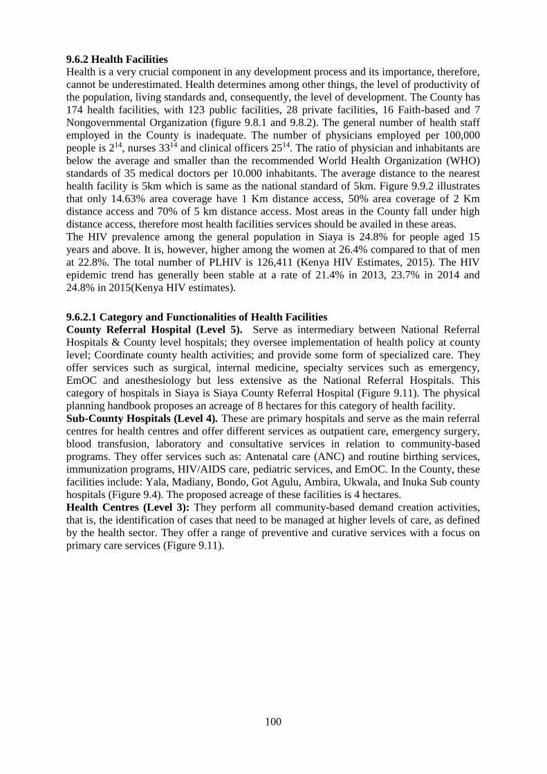
100
9.6.2 Health Facilities
Health is a very crucial component in any development process and its importance, therefore,
cannot be underestimated. Health determines among other things, the level of productivity of
the population, living standards and, consequently, the level of development. The County has
174 health facilities, with 123 public facilities, 28 private facilities, 16 Faith-based and 7
Nongovernmental Organization (figure 9.8.1 and 9.8.2). The general number of health staff
employed in the County is inadequate. The number of physicians employed per 100,000
people is 214, nurses 3314 and clinical officers 2514. The ratio of physician and inhabitants are
below the average and smaller than the recommended World Health Organization (WHO)
standards of 35 medical doctors per 10.000 inhabitants. The average distance to the nearest
health facility is 5km which is same as the national standard of 5km. Figure 9.9.2 illustrates
that only 14.63% area coverage have 1 Km distance access, 50% area coverage of 2 Km
distance access and 70% of 5 km distance access. Most areas in the County fall under high
distance access, therefore most health facilities services should be availed in these areas.
The HIV prevalence among the general population in Siaya is 24.8% for people aged 15
years and above. It is, however, higher among the women at 26.4% compared to that of men
at 22.8%. The total number of PLHIV is 126,411 (Kenya HIV Estimates, 2015). The HIV
epidemic trend has generally been stable at a rate of 21.4% in 2013, 23.7% in 2014 and
24.8% in 2015(Kenya HIV estimates).
9.6.2.1 Category and Functionalities of Health Facilities
County Referral Hospital (Level 5). Serve as intermediary between National Referral
Hospitals & County level hospitals; they oversee implementation of health policy at county
level; Coordinate county health activities; and provide some form of specialized care. They
offer services such as surgical, internal medicine, specialty services such as emergency,
EmOC and anesthesiology but less extensive as the National Referral Hospitals. This
category of hospitals in Siaya is Siaya County Referral Hospital (Figure 9.11). The physical
planning handbook proposes an acreage of 8 hectares for this category of health facility.
Sub-County Hospitals (Level 4). These are primary hospitals and serve as the main referral
centres for health centres and offer different services as outpatient care, emergency surgery,
blood transfusion, laboratory and consultative services in relation to community-based
programs. They offer services such as: Antenatal care (ANC) and routine birthing services,
immunization programs, HIV/AIDS care, pediatric services, and EmOC. In the County, these
facilities include: Yala, Madiany, Bondo, Got Agulu, Ambira, Ukwala, and Inuka Sub county
hospitals (Figure 9.4). The proposed acreage of these facilities is 4 hectares.
Health Centres (Level 3): They perform all community-based demand creation activities,
that is, the identification of cases that need to be managed at higher levels of care, as defined
by the health sector. They offer a range of preventive and curative services with a focus on
primary care services (Figure 9.11).

101
Map 9. 11: Spatial Distribution of Health Facilities in Siaya County

102
9.6.2.2 Hexagonal Analysis for Health Facilities
The application of Central Place Model was used to assess the adequacy of health facilities in
terms of location, accessibility, and equity. The 5 Km radius was used as an equidistant
standard to create polygons and/or hexagons distributed in the entire county. The wards were
therefore used as the basic unit of resource allocation, while respecting the catchment
population. The deficient and/or underserved areas with public health facilities per ward was
therefore projected for 10 years assuming all other factors are held constant. Table 9.22
illustrates the same for public health facilities.
Table 9. 27: Hexagonal Analysis for Health Facilities in Siaya County
ALEGO
USONGA
Population Density Area in Sq. Km Existing Number Deficiency 10 Yrs.
Central Alego 275.10 122 6 5
North Alego 383.47 59 1 2
Siaya Township 872.03 39 3 4
South East Alego 357.40 196 14 3
Usonga 178.24 91 3 2
West Alego 324.18 100 2 3
BONDO Population Density Area in Sq. Km Existing Number Deficiency 10 Yrs.
Central Sakwa 653.79 84 4 4
North Sakwa 331.55 94 2 4
South Sakwa 174.71 105 3 3
West Sakwa 204.80 112 4 4
West Yimbo 938.33 38 3 1
East Yimbo 170.30 155 3 5
GEM Population Density Area in Sq. Km Existing Number Deficiency 10 Yrs.
Central Gem 484.57 52 5 1
East Gem 407.15 61 4 1
North Gem 420.16 85 7 1
South Gem 317.04 96 7 0
West Gem 347.55 75 3 1
Yala Township 679.03 34 2 0
RARIEDA Population Density Area in Sq. Km Existing Number Deficiency
10 Years
East Asembo 416.32 77 5 1
North Uyoma 297.49 78 7 0
South Uyoma 351.22 54 4 1
West Asembo 325.50 100 4 2
West Uyoma 325.50 89 7 1
UGENYA Population Density Area in Sq. Km Existing Number Deficiency 10 Yrs.
East Ugenya 653.79 84 6 2
North Ugenya 331.55 94 5 1
Ukwala 174.71 105 2 1
West Ugenya 204.80 112 4 2
UGUNJA Population Density Area in Sq. Km Existing Number Deficiency 10 Yrs.
Sidindi 476.93 55 3 2
Sigomere 417.15 72 5 1
Ugunja 465.25 83 5 1

103
Map 9. 12: Hexagon analysis of Health Facilities in Siaya County

104
9.8.3 Emerging Planning Issues, Opportunities and Challenges
9.8.3.1 Opportunities
a) Road Transport: Suitable terrain for road development; Various funds e.g. CDF, fuel levy,
rural access road, County Government Budget; Available labour for road construction;
Availability of building materials
b) Railway: Mombasa-Uganda Railways through the county; and possibility of alternative
means of transport
c) Water Transport: Ferry transport between the county and other regions; Kisumu,
Homabay, and Migori; and water sports for tourism
d) Air Transport: potential for tourism industry in the region; existing potential for
horticulture and other agro-based products; and land available establish more air strips
e) Energy: Existing potential for solar energy; Existing potential for wind energy; and
potential for biogas exploration
f) Water and Sanitation: Unexploited water resources e.g. ground water, dams and
boreholes; Establishment of Water and Sewerage Company to provide water and sanitation
services; Availability of funds at the county level; Existence of urban centres that require
water and sanitation services e.g. Bondo, Siaya, Ugunja, Usenge, Yala and Ukwala;
Recycling of wastes
g) Health: Health facilities evenly spread across the county (average of 5 km radius); NGOs
doing capacity building in preventive Health e.g. hygiene, counselling, VCT etc.; Community
Health Programmes
h) Recreation: Presence of sites of historical significance, and beaches; untapped indigenous
forms of recreation e.g. traditional dances and acrobats, wrestling, teroburu (rich cultural
heritage); Lake front recreational sites (good sandy beaches), wetland ecosystems
i) Education: Availability of funding, NGOs, CDF, County Government Budget,
Infrastructure Fund; Unemployed graduates from Teacher Training Colleges and
Universities; and development funding from National Government
9.8.3.2 Challenges
a) Road Transport: Poor road condition -majority of rural access roads are in bad condition;
lack of tarmac coverage in northern Side-Gem, Ugunja, Ugenya and parts of Alego sub-
counties; blocked access to beaches; and encroachment on road reserves.
b) Water Transport: lack of commercial sustainability in Ferry services
c) Energy: Unreliable power supply; Destruction of vegetation; Loss of biodiversity; and
Undeveloped use of alternative energy sources
d) Water and sanitation: Inadequate water supply in all the urban centres; urban centres and
markets are not connected to sewerage line; and use of septic tanks and latrines poses danger
to the quality of ground and surface water
e) Solid Waste disposal: Lack of designated dumping sites; and Lack of proper solid waste
management
f) Health Care: Physical facilities inadequate; and inaccessibility because of poor road
network
g) Recreation: Undeveloped beaches to promote tourism; Lack of adequate stadia and play
fields; and inadequate social halls e.g. Ndori, Ugunja, Usenge, Yala
h) Education: Shortage of facilities e.g. classrooms, laboratories, libraries, toilets, playing
fields; low staffing levels; and land requirements for expansion of schools not met
i) Markets: Open air markets without sheds, public toilets or sanitation facilities; Insecurity:
goods are often lost; and poor road network

105
CHAPTER 10: ECONOMIC BASE
10.1 Introduction
Siaya County has posted fastest growth over the last 5 years according to a World Bank
Report Gross Domestic Product (GDP) grew by 10 per cent per annum. This accelerated
growth is attributed to the extended construction of roads, hospitals and sports facilities as
well as improvement in management of fish resource in Lake Victoria. There has been
increased stock of drugs at various hospitals, increased admission in local primary and
secondary schools, agricultural expansion through irrigation, and expansion of trading
activities. The GDP was recorded at $287 million with a wealth per capita of $340, about half
the Kenyan average. Accelerated growth is manifested in opening of over 592 Kilometers of
rural roads with another 40 kilometers tarmacked from Siaya Town to Nyadorera and on-
going is Musanda-Ugunja-Ruambwa Road being tarmacked. The same scenario has been
replicated in Siaya and Bondo Township which have gone through a transformation with
most strategic urban roads being tarmacked as well as developing the street lighting. Most
trading market now have solar lighting to enhance trading beyond day time. Expansion in
agricultural productivity followed interventions where at least 10,000 acres of smallholder
farms have been ploughed through subsidies in a tractor program, where farmers pay Kshs
1,850 per acre lower the commercial rate of Kshs3500. Maize productivity has increased
from 130,683 metric tons in 2012 to 160,638 metric tons in 2014. Over 200 solar powered
street lights were installed in trading centres as these increased security and business hours.
Jaramogi Oginga Odinga University of Science and Technology (JOOUST) has provided
impetus for growth of Bondo Town, an opportunity in real estate development. The county
has seen growth of the hotel industry being a re-birth of a destination of tourism business.
Lastly, the education experienced growth through bursary scheme disbursement of over Kshs.
80 million as more than 12,700 secondary and college students have benefited.
10.2 Poverty
This section focuses on poverty estimates based on three poverty lines; food poverty line,
overall poverty line, and hardcore or extreme poverty line defined as follows:
Food Poverty: households and individuals whose monthly adult equivalent food consumption
expenditure per person is less than Ksh 1,954 in rural and peri-urban areas and less than Ksh
2,551 in core-urban areas respectively are considered to be food poor or live in “food
poverty”.
Overall Poverty: households and individuals whose monthly adult equivalent total
consumption expenditure per person is less than Ksh 3,252 in rural and peri-urban areas and
less than Ksh 5,995 in core-urban areas are considered to be overall poor or live in “overall
poverty”.
Hardcore or Extreme Poverty: households and individuals whose monthly adult equivalent
total consumption expenditure per person is less than Ksh 1,954 in rural and peri-urban areas
and less than Ksh 2,551 in core-urban areas respectively are considered to be hardcore poor
or live in “hardcore or extreme poverty”.
10.2.1 Food Poverty
Table 10.1 summarizes food poverty measures for Siaya County and at National level.
Looking beyond the County and national average food poverty headcount rate for individuals
of 27% and 32% respectively reveals a gloom status of food poverty in the County. In terms
of numbers of individuals living in food poverty, Siaya County has a population of 17,730
accounting for 1.8% of the County total population.

106
Table 10. 1: Food Poverty Estimates (individual) Residence/County Headcount
rate %
Distribution of
the poor%
Poverty
Gap%
Severity of
Poverty%
Population
(''000)
Number of
poor ('000)
Siaya County 27..3 1.8 7.2 3.1 985 269
10.2.2 Overall Poverty
Table 10.2 summarizes the overall poverty measures for individuals in Siaya county and at
national level. The results reveal substantial and significant overall poverty incidence at the
county level with approximately 332,930 accounting for 33.8% of residents out of a total
population of 985,000 people (KIHBS 2015/2016).
Table 10. 2: Overall Poverty Measures Residence/County Headcount
rate %
Distribution of
the poor%
Poverty
Gap%
Severity of
Poverty%
Population
(''000)
Number of
poor ('000)
Siaya County 33.8 2.0 8.7 3.5 985 333
Most of the affected people are the Persons living with Disabilities (PWDS), People Living
with HIV and AIDS (PLWHA) and the youth who have negative attitude towards non-formal
employment. While the overall poverty level has reduced significantly, there are still many
locations in the county with high poverty ratings. Household poverty rate vary significantly
per ward with Siaya Township recording the least percentage of poor household (13-25%
against North Uyoma (25-50%). The causes of poverty in these areas are diverse and include
poor soil fertility leading to low yields, low income among households to afford farm inputs,
over-reliance on traditional methods of farming and lack of alternative sources of income. To
be able to address poverty there is need to enhance development efforts targeting food
production. This will not only ensure food security but also provide income through the sale
of surplus farm produce. In 1999 Poverty index indicated most population were below
poverty line (Map 10.1) earning a dollar a day. Over half of the wards were below poverty
(70-79%) in Alego-Usonga, Bondo and Gem. Few wards had average population with less
than 50% below poverty line. The County must put concerted efforts to develop the local
economy as well as reduce poverty through: revitalization of agriculture, tapping the fishing
resources, promoting industrial production, tourism, and trade and commercial activities.

107
Map 10. 1: Poverty Rate by Sub Counties as at 1999

108
10.3 Agriculture Sector
Agriculture is considered as a critical sector in the world economy. It contributes 24% of Gross
Domestic Product (GDP) and provides employment to 1.3 billion people or 22% of the world’s
population. According to Government of Kenya (2010) agriculture is the mainstay of the Kenyan
economy directly contributing 26 per cent of the Gross Domestic Product annually, and another 25
per cent indirectly. The sector accounts for 65 per cent of Kenya’s total exports and provides more
than 70 per cent of informal employment in the rural areas and 18 per cent of formal employment.
Over the years, agriculture production in Kenya has been facing challenges that have contributed to
reduced productivity.
The main food crops in Siaya County include; maize, sorghum, millet, beans, cowpeas, cassava,
sweet potatoes, groundnuts and finger millets while the main cash crops include cotton, rice, sugar
cane and groundnuts (figures 10.2, 10.3 and 10.4). There is marked in crop production in terms area
under crop, production in tonnes and value in Kenya Shillings (Table 10.1, 10.2, 10.3 and 10.4).
Some of the emerging crops in the county include: irrigated rice, palm oil, chili, passion fruits and
grain amaranth. Vegetables produced in the county are: tomatoes, onions and kales while fruits
grown in the region are; mangoes, pawpaw, bananas, oranges and watermelon.
Table 10. 3: Cereal Crop Production (Area, Production, Value) 2013-2016 in Siaya County Area Cropped (Ha) Production (Tonnes)
Cereals 2013 2014 2015 2016 2013 2014 2015 2016
Maize 89760 93732 84024 74160 81814.3 102385 137289.6 54429.3
Paddy Rice 15912 15720 15900 15096 42972 48576 48960 437223.2
Sorghum 36348 37434 34440 35034 36029 32006 36747 342223.0
Beans 70716 63870 63630 52128 596100 643809 584190 347544
Green Gram 2490 558 804 510 1008.5 305.64 274.64 322.11
Value (KES Million)
Cereals 2013 2014 2015 2016
Maize 2908.98 3299.1 3661.08 1814.3
Paddy Rice 1289.16 1943.0 1958.4 1748.9
Sorghum 1121 1066.8 898.26 1064.7
Beans 2384.4 3669.6 3505 2224.2
Green Gram 65.54 15.81 20.7 22.54
Source: Department of Agriculture, County Government of Siaya (2016)
Figure 10. 1: Trend of Cereal Crop Production (area under crop) 2013-2016

109
Figure 10. 2: Trend of Cereal Crop Production (Tonnes) 2013-2016
Figure 10. 3: Trend of Cereal Production (Value in KES) 2013-2016
Table 10. 4: Roots and Tuber Crop Production 2013-2016 Area Cropped (Ha) Production (Tonnes) Value (KES in Million)
2013 2014 2015 2016 2013 2014 2015 2016 2013 2014 2015 2016
Sweet
Potato
7686 7500 5490 3606 83610 76386 60390 23820 1672 1528 1209 603.9
Cassava 6900 5572 8328 6774 100140 696600 104100 59766 1502 1393 2082 1195.3
Source: Department of Agriculture, County Government of Siaya

110
Table 10. 5: Fruit Crop Production 2013-2016 Area Cropped (Ha) Production (Tonnes) Value (KES in Million)
Fruits 2013 2014 2015 2016 2013 2014 2015 2016 2013 2014 2015 2016
Avocado 270 300 228 300 1800 2394 1944 2868 27 14.364 12.636 21.51
Banana 1380 1632 1668 1680 8970 19260 19682.4 8532 180 337.008 393.648 213.3
Mango 990 2106 2160 2208 5400 10080 12960 39042 21.4 80.64 129.6 585.63
Passion 60 48 48 48 600 504 528 408 48 30.6 39.6 32.4
Oranges 30 30 30 24 150 150 150 120 3 3.75 3 3.6
Water
Melons
180 264 336 252 2700 3960 5040 2520 45 79.2 11.088 63
Source: Department of Agriculture, County Government of Siaya
Table 10. 6: Vegetable and Nut Crop Production 2013-2016 Area Cropped (Ha) Production (Tonnes) Value (KES in Million)
Vegetable
s
2013 201
4
201
5
201
6
2013 2014 2015 2016 2013 2014 2015 2016
Tomato 1080 141
0
126
0
129
6
1080
0
15510 13860 1276
2
279 387.75 346.5 382.8
6
Kales 2100 249
0
297
0
529
8
1050
0
14964 17820 2635
8
105 149.69 178.2 395.3
7
Cabbage 60 132 216 126 300 1254 2700 558 3 18.81 54 11.16
Onions
Springs
90 90 108 60 270 252 486 324 5.6
4
5.04 8.7 8.1
Bulb
Onion
720 780 930 216 1080
0
11700 14415 2184 702 760.5 432.3 76.4
Carrots 0 0 0 0 0 0 0 0 0 0 0 0
African
Nightshade
180 414 228 162 1863 1368 420 5.0
4
18.63 14.364 11.04
Area Cropped (Ha) Production (Tonnes) Value (KES in Million)
Nuts 2013 201
4
201
5
201
6
2013 201
4
2015 2016 2013 2014 2015 2016
Groundnut
s
1596
1
195
0
175
0
153
0
494.
1
132
3
1628.
1
613.98 39.54 105.8
4
130.24
8
67.32
Source: Department of Agriculture, County Government of Siaya (2016)
The 2009 Kenya Population and household census (KPHC) estimated that 90.5% farmers are
engaged in crop farming compared to 68.8% for the entire country while at the same time, 78.9%
of the household’s own livestock compared to 66% for the entire country. Table 10.5 shows the
quantities and estimated value of outputs from livestock in the county. There are several livestock
breeds in the county that include zebu cattle, crossbred dairy cows, dairy goats, local goats, sheep,
pigs, rabbits, donkeys and poultry. In terms of production and earnings milk and beef contributes
significantly to the local economy (Table 10.7 and figure 10.8). The county has a great potential
for the development of processing industries for both livestock products and by products.
Table 10. 7: Livestock Production in each Sub-county Alego
Usonga
Bondo Gem Ugunja Ugenya Rarieda
Total
Milk Quantity ( Kg) 10,994 1,147 6,681 3,995 1,793 3,345 27,956
Value (KES) 549,724 57,353 334,065 199,743 89,649 167,261 1,397,795
Beef Quantity (Kg) 461 844 988 426 317 651 3,686
Value (KES) 156,721 286,885 335,953 144,755 107,624 221,234 1,253,172
Mutton Quantity (Kg) 118 178 68 74 23 78 539
Value (KES) 44,879 67,640 26,000 27,949 8,889 29,522 204,861
Chevon Quantity (Kg) 40 48 82 52 13 17 251
Value (KES) 15,215 18,088 31,067 19,646 4,894 6,624 95,534
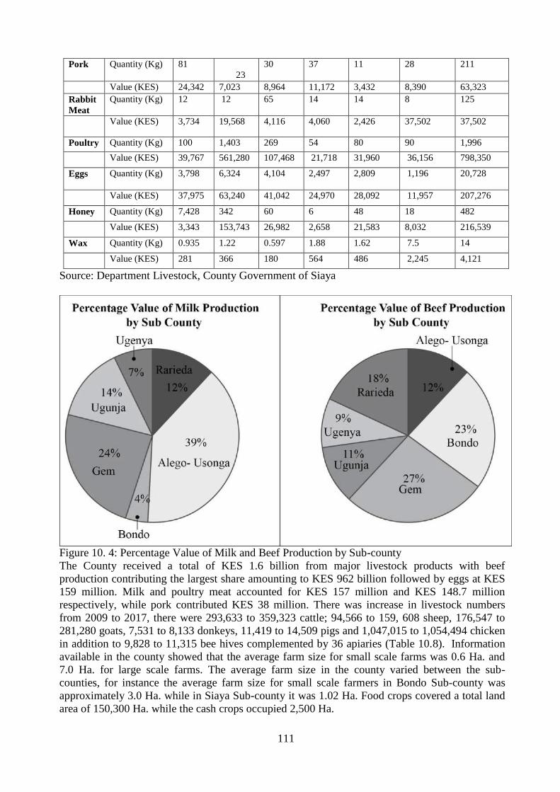
111
Pork Quantity (Kg) 81
23
30 37 11 28 211
Value (KES) 24,342 7,023 8,964 11,172 3,432 8,390 63,323
Rabbit
Meat
Quantity (Kg) 12 12 65 14 14 8 125
Value (KES) 3,734 19,568 4,116 4,060 2,426 37,502 37,502
Poultry Quantity (Kg) 100 1,403 269 54 80 90 1,996
Value (KES) 39,767 561,280 107,468 21,718 31,960 36,156 798,350
Eggs Quantity (Kg) 3,798 6,324 4,104 2,497 2,809 1,196
20,728
Value (KES) 37,975 63,240 41,042 24,970 28,092 11,957 207,276
Honey Quantity (Kg) 7,428 342 60 6 48 18 482
Value (KES) 3,343 153,743 26,982 2,658 21,583 8,032 216,539
Wax Quantity (Kg) 0.935 1.22 0.597 1.88 1.62 7.5 14
Value (KES) 281 366 180 564 486 2,245 4,121
Source: Department Livestock, County Government of Siaya
Figure 10. 4: Percentage Value of Milk and Beef Production by Sub-county
The County received a total of KES 1.6 billion from major livestock products with beef
production contributing the largest share amounting to KES 962 billion followed by eggs at KES
159 million. Milk and poultry meat accounted for KES 157 million and KES 148.7 million
respectively, while pork contributed KES 38 million. There was increase in livestock numbers
from 2009 to 2017, there were 293,633 to 359,323 cattle; 94,566 to 159, 608 sheep, 176,547 to
281,280 goats, 7,531 to 8,133 donkeys, 11,419 to 14,509 pigs and 1,047,015 to 1,054,494 chicken
in addition to 9,828 to 11,315 bee hives complemented by 36 apiaries (Table 10.8). Information
available in the county showed that the average farm size for small scale farms was 0.6 Ha. and
7.0 Ha. for large scale farms. The average farm size in the county varied between the sub-
counties, for instance the average farm size for small scale farmers in Bondo Sub-county was
approximately 3.0 Ha. while in Siaya Sub-county it was 1.02 Ha. Food crops covered a total land
area of 150,300 Ha. while the cash crops occupied 2,500 Ha.

112
Table 10. 8: Livestock Production Types 2013 2014 2015 2016 2017
Cattle Dairy 5,285 5,698 5,771 6071 7024
Beef Cattle 323,287 492,591 495,061 509,913 352,299
Poultry Broilers 64,498 63,688 71,500 87,063 98,469
Exotic layers 39,097 40,394 55,800 66,005 75,154
Quails 20,000 - - - -
Local/Indigenous Chicken 797,651 804,161 820,150 829,821
Goats Local 257,221 260,252 265,436 269,177 280,726
Dairy 3,630 4,656 4,717 5421 5,954
Sheep Local breeds 139,456 143,752 146,624 150,445 157,608
Wool/hair 0 0 0 0 0
Pigs Pigs breeds (All) 14,186 13,453 13,650 13,227 14,509
Bee KTBH 2,281 2,148 2,148 2,155 2,212
Hives Langstroth 7,282 8,310 8,316 8,310 8,864
Log Beehives 214 208 202 196 239
Rabbits Exotic breeds 12,170 12,324 12,470 13,111 13,351
Local breeds
Donkeys Donkeys breeds 7,577 7,719 7,754 7,861 8,133
Source: Department of Livestock, County Government of Siaya
Table 10. 9: Feeding and Livestock Nutrition Pasture/Fodder 2015 2016 2017
Napier grass 875 895 900
Sweet potato vines 63 60 83
Fodder Trees
Caliandra 23700 25576 26500
Sesbania 7500 7833 7846
Leucaena 53650 57000 58500
Pastures
Rhodes grass 120 120 133
Columbus grass 0.05 1.5 1.5
Kikuyu grass 0 0 0
Natural pastures 88,800 82,314 81,200
Browse material 48,250 47,680 45,600
Legumes
Lucerne 9.8 9.9 11.2
Desmodium 26 29 35
Brachiaria 2.5 3.1 34
Source: Department of Livestock, County Government of Siaya
Table 10. 10: Animal Slaughtered in Number and Value (KES Million) Animal Carcasses KES (Million)
Animal 2013 2014 2013 2014
Cattle and Calves 19,154 19,450 134,078 1361.5
Goats 1,250 1,378 5 5,512
Sheep 1,120 1,233 4.48 4.932
Pigs 2700 5360 64.8 144.45
Source: Department of Livestock, County Government of Siaya
Table 10. 11: Quantity and Value of Hides and Skins Produced in 2014 Animal Kg/Pcs Value (KES Million)
Cattle and Calves 69,164 38,075
Goats 96,803 9,594
Sheep 25,132 3,477
Source: Department of Livestock, County Government of Siaya
Cattle Density in the County changes according to Agro-Ecological subzones indicating higher
density in regions bordering Kakamega County due to increased rainfall reliability (figures 10.6).

113
Map 10. 2: Siaya County Cattle Density

114
10.3.1 Food Expenditure by Source
For each food item, the information is provided on four sources of consumption, namely,
purchases, own-production, own stock, and gifts. The expenditure on household purchases
made during the reference period utilized the actual quantity consumed from purchases, rather
than the entire purchases made during the period.
Table 10.12 presents the percentage share of total food consumed disaggregated by source. At
the county, food consumed from purchases accounted for 57.4% while own production accounts
for only 28.5 % (KIHBS 2015/16). Consumption from gifts and other sources accounts for only
9% in Siaya County.
Table 10. 12: Percentage Distribution of Household Food Consumption by Source Residence /
County
Purchases Stock Own production Gifts Total
Siaya County 57.4 5.2 28.5 9.0 100
The mean monthly food and non-food expenditure per adult equivalent are presented in Table
10.13 The Siaya County food expenditure per month per adult equivalent was Ksh5959 (KIHBS
2015/16).
Table 10. 13: Mean Monthly Food and Non-Food Expenditure per Adult Equivalent residence /
County
Expenditure Percentage share
Food Non-food Total Food Nonfood
Siaya
County
4,106 1,853 5,959 68.9 31.1
5.5.1.3 Percentage Distribution of Households by Point of Purchased Food items Information on household food purchases by point of purchase in Siaya County is presented in
Table 10.14. In the County, Open markets (49.1%,), General shops (28.1%), and Kiosks (8.2%)
were the preferred outlets, jointly accounting for more than 3/4 of all food purchases made.
Table 10. 14: Percentage Distribution of Households by Point of Purchased Food items Residence
/County
Supermarkets Open
Markets
Kiosk Genera
l shops
Specialized
shops
Informal
sources
Other
formal
points
Number of
observations
Siaya 1.7 49.1 8.2 28.1 5.4 7.4 0.1 6,951
10.2.1 Agriculture Emerging Planning Issues
a) Challenges
Crops
1. Poor market accessibility due to bad roads
2. Unreliable rainfall
3. Sentimental attachment to maize which does not do well in some areas of the county
4. Collapse of cotton and sugarcane industries
5. Poor marketing systems
6. Poor extension services
7. Low management skills for commercial farming
8. Lack of Mechanization only small-scale rain-fed agriculture
9. Inadequate irrigation services during season
10. High cost agricultural input: seeds. fertilizer animal feeds
11. Inadequate value Addition in agricultural products
Livestock

115
1. High incidence of tick-borne diseases
2. Collapsed dips
3. Poor animal husbandry
4. Harsh weather conditions in some parts of the county
5. High cost of good quality dairy cattle not affordable to farmers
b) Opportunities
Food crop farming (maize, sorghum, millet, beans, cowpeas, cassava, sweet potatoes,
groundnuts and finger millet)
Cash crop farming (cotton, rice, sugar cane and groundnuts)
Emerging crops (irrigated rice, palm oil, chilly, passion fruits and grain amaranth)
Livestock farming (zebu cattle, up-grade and pure dairy cows, dairy goats, poultry, local
goats, sheep, pigs, rabbits, donkeys)
Bee keeping
Fish farming in Lake Victoria, Lake Kanyaboli, dams and fish ponds
Agroforestry: Tree nurseries, fruit trees and establishment of woodlots
Rice production in Yala swamp

116
Map 10. 3: Siaya County Small-Scale Irrigation Schemes

117
10.3 Fisheries Sector
Kenya's fisheries resources are an important source of food, employment and foreign exchange
earning in Kenya. It is estimated that the fishing industry employs over 48,400 artisan fishermen and
that 5,000,000 persons are engaged directly or indirectly in fish processing and trade. Siaya County
is endowed with an estimate of 1000 km2 of water mass making fishing to be one of the major
economic activities in the County. However, it’s imperative to note that Over-fishing in breeding
grounds in bays along the lakeshore and trawler fishing has negatively impacted on sustainable
exploitation in the industry. Lake Victoria is the most important source of fish in East Africa and
largest source of freshwater fish on the African continent. The Lake is significant for biological
diversity of fish species as well contribution to the blue economy. The Lake Victoria, Lake
Kanyaboli, Rivers Yala and Nzoia and other surface water bodies in the County provide necessary
grounds for fishing activity (figure 10.8). Landing beaches under the authority of Beach
Management Units (BM(U) in coordination with Fisheries Department promotes sustainable
utilization of fishing resources. Fisheries in the County are two folds: capture fisheries from Lake
Victoria and Kanyaboli, and culture fisheries (aquaculture).
10.3.1 Capture Fisheries
The County has several species of fish, but the most popular ones are Nile Tilapia (Oreochromis
Niloticus (Ngege), Nile Perch (Mbuta) Lates Niloticus, Lung Fish (Monye-Kamongo) (Protopterus
Annectens), and Dagaa (Omena), Hatlochromines (Fulu). Tilapia and Perch have very high
commercial value as most of these catches are exported. There are 86 fish landing beaches in Lakes
Victoria and Kanyaboli, the main ones being Kadenge, Kombo, Ndayi, Kamariga, Usenge,
WichLum, Misori, Uyawi, Liunda, Lwanda Kotieno, Nyamnwa, Gul Min Ougo, Goye, Kowange,
Magarem Nyabera, Saga, Sifu, Oyamo, Port South Banga (Miyandhe), Wakawaka, Warianda,
Ulanda, Uhanya, Uhoma, Mahanga, Ndeda, Obenge, Kasiri among others (figure 10.8). In 2010
data collected from 69 beaches shows that Siaya County had a total catch of 9,000 tons valued at
Kshs 836 million. Table 10.3 and 10.4 indicate that there has been tremendous growth of fish catch
and by 2015 about Kshs. 3.7 Billon to the County economy (Map 10.4). Due to the proximity to the
Kisumu International Airport, the County need to export its fish products to international markets.
To facilitate this, access roads to beaches have been constructed and the County should improve the
support infrastructure of the beaches and landing sites to enable faster produce delivery to the
market. Bondo Sub-county had the highest number with 56 active fishing crafts per landing site
followed by Rarieda at 38 (GoK, 2015). During the 2014 Frame Survey, 1,432 monofilament gillnets
were enumerated in the Lake region with Siaya County accounting for 987 monofilament gillnets or
69%, Homa bay 238 or 17%, Busia 121 or 8%, Migori 68 or 5% and Kisumu County 18 or 1%.
Hand lines were 3,161 while traps/baskets were 1,083.

118
Map 10. 4: Siaya County Fishing Areas (Landing Beaches)

119
Table 10. 15: Type, Quantity and Quality of Fish catch in Lake Victoria Siaya County the Period
2014-2015 2014 2015
Species Wt. (Kgs) Value (Kshs) Wt. (Kgs) Value (Kshs)
Cat Fish 417,993 37,162,191 617,316 51,749,258
(Omena) 11,725,910 354,574,684 10,692.327 451,592,471
Nile Perch 9,128,589 2,086,036,655 10,000,208 2,560,876,840
Tilapines 1,663,051 305,231,696 1,711,676 305,763,145
Other fish species 3,135,424 1,048,584,774 6,074,505 254,926,101
TOTAL 26,070,967 3,831,590,000 29,996,032 3,624,907,817
Source: Department of Agriculture, Livestock and Fisheries Siaya County (2016)
Figure 10. 5: Fish Value in Kenya Shillings (KES) 2014-2015
Table 10. 16: Quantity and Value of Fish for Siaya County for the period 2010-2015 Year Quantity (Metric Tons) Value of Fish (Million Kshs)
2010 39154.00 3837.07
2011 33450.00 3679.50
2012 25582.00 2655.32
2013 28034.00 3540.00
2014 26070.00 3831.59
2015 29996.00 3624.91
Total 182287.60 21168.39
Source: Department of Agriculture, Livestock and Fisheries Siaya County (2016)

120
Figure 10. 6: Value of Fish in Kenya Shillings in Million 2010-2015
Siaya Waters of Lake Victoria directly employs 12,140 fishing crews operating 4,007 boats
accounting for about 30% of the number’s crews and 28% of fishing boats on the Kenyan side of
the Lake Victoria (Frame Survey, 2016). The fishing crews and crafts operating in Lake
Kanyaboli stands at 834 and 398 respectively.
In 2016, County produced about 28.3 thousand metric tons of fish from Lakes Victoria and
Kanyaboli valued at about 5.6 Billion Kenya Shillings on ex-vessel prices. The catch was
dominated by Rastrineobolaargentea (Omena 38%) and Nile perch (36%) with Tilapia and
catfish contributing 6% and 2% of total fish landings by volume respectively. Other species also
landed but in relatively smaller quantities. Over 80 % of Omena and Nile perch fish landed is
traded outside the County. Nile perch leads as an export and a foreign exchange earner among
the local landed fish. Fish catches from lakes have been declining (2010 to 2016) from 39 to 28
thousand metric tons respectively. Sustainable utilization of fisheries resources is therefore a
priority.
10.3.3 Culture Fisheries (Aquaculture)
Fish farming in the County is predominantly practiced in earthen ponds. However, there are
small scale fish cages in Bondo and Rarieda. Under the Economic Stimulus Programme, 300 fish
ponds each measuring 300 sq. metres were constructed in each constituency to boost
aquaculture. There were 467 fish farm families and 11,759 fishermen. Gem Sub-county has the
highest number of fish ponds (24%) due to existing streams and soil type that support earthen
ponds. Two species are dominant in fish farming, namely, Tilapia (Oreochromis Niloticus) and
African catfish (Clarius Gariepinus). In 2016, the County produced 137.3 metric tons from
earthen ponds worth KES 24.1 Million (Table 10.17). More potentials remain un-tapped both in
the lakes Victoria and Kanyaboli as well as in earthen ponds.
Table 10. 17: Aquaculture units and production by Sub-counties Rarieda Bondo Alego Usonga Gem Ugenya Ugunja Total
Metric Tonnes 22.0 15.4 21.0 32.5 19.8 26.6 137.3
% Contribution 16.0 11.2 15.3 23.7 14.4 19.4 100,0
Million KES 3.6 2.7 3.5 6.5 3.3 4/5 24.1
Area under Ponds (Ha) 75.3 38.1 96.2 106.9 45.1 52.4 413.9
Fish cages 53 1873 0 0 0 0 0

121
Overreliance on Lake Victoria for fishing is proving unsustainable. The County is encouraging
locals to undertake aquaculture since fish levels in Lake Victoria are dwindling. Farmers have
been given improved fish farming techniques through training of fisheries extension officers. In
2014, the County purchased and distributed about 1.7 metric tonnes of feeds as an incentive to
keeping fish in ponds. This has increased production of fish from 65.9 metric tonnes in 2012 to
1,070 metric tons by 2014.
10.4 Mining and Quarrying Sector
This is also generating income in number of households. This venture is however unregulated
and, in most cases, results to land degradation. Gold has been mined in the County for
considerable time on substance basis in shallow excavations in Bondo, Siaya, Rarieda, Ugunja
and Gem sub-counties. A study by Lake Basin Development Authority has shown that the whole
of the Lake Victoria Basin region of which Siaya County is included, has some minerals,
precious stones and rare earth elements. The best-known mineral in the County is gold. Gold
mining areas in the County include small scale artesian mining of: Central Sakwa (Wagusu,
Dago, Kopolo, Lenya, Luore, Nango, Nyangoma, Odao, Uyawi, Abimbo), South East Alego
(Ojalo Rambo-Kogello, Barding), and Asembo (Onyata, Magare) among others. Other minerals
include fluorite which occurs as a thin vein near Rata within the larger Asembo; granite and
black sand from Yala Valley which has weak radioactive quality, mining in Kogello, and sand
harvesting along the beaches and River Nzoia (Plate 10.1.
Plate 10. 1: Local use water to sort out gold at a mining site in Bondo, Siaya (Daily Nation, 9th
October, 2018)
10.5 Tourism Sector
The County has only one gazetted game reserve which is Lake Kanyaboli Game Reserve under
the Kenya Wildlife Services (KWS) and yet to be fully developed to attract more tourist, though
has high potential. The settlement patterns within the county coupled with the high population
density possess as a major constraint to large scale wildlife conservation. There have been
several investments in cultural heritage sites, hotels development, and attempts to link the
County with the Western Kenya Circuit tours and travel investments. Siaya County Tourist
Guide (2016) enumerates some of the destination sites with potential for tourist attractions
(sightseeing, Bird watching, picnics, camping, educational facilities, Nature Photography,

122
Fishing, Boat rides, Water sports, Canoeing, Nature walk, Nature drive, Biking, Wild life safaris,
Recreational sailing, cruise tourism, sport fishing, film tourism, hill hiking, cave camping.
Kayaking, Beach Volleyball) and cultural activities (traditional dances, Nyatiti players, Orutu
players, Dodo dancers, Dirges, Tero buru) in the County to include:
a) Natural Heritage Sites (Ecotourism): Got Ramogi Heritage Site (40km from Siaya Town),
Lake Victoria (Nam Lolwe), Yala Wetlands as covering 17,500 ha (Important Bird Area: Lakes-
Kanyaboli, Sare, Namboyo, Artificial Lake Bob), Dominion Farms Birds Sanctuary, fish caging,
Anyiko Wetland, Uwasi/Muluhwa Rice Scheme (agro-tourism), Rawalo Hills, Ndanu Falls
(Yala), Mahira Falls (Sidindi), GodHa the Islands of Mageta, Oyamo, Ndeda, Magare, Sifu,
Sirigombe, Nyalumba, Sika with spectacular natural sceneries. A number of spectacular hills
with good viewing: Got Ramogi, Got Rambugu Got Mbaga. Got Obiero, Got Usenge, Got
Nyangoe, Got Abom, Got Abuyu, Got Nyagoko, Got Anyango, Got Nyambare, Got Naya and
Got Akara.
b) Archeological, Cultural, Historical and Land of Heroes significance (Heritage Sites): Got
Ramogi, Jaramogi Oginga Odinga Mausoleum (8 km form Bondo Town), the Alego Nyang’oma
Kogelo Village, a place of international attention because it is the birth place of Barack Obama
Senior, the father of the United States’ first black President, Barack Obama). Achieng’ Oneko
Mausoleum, Justice Hayanga Mausoleum, Argwings Kodhek Mausoleum, Chief Odera Akang’o
Office and Cells (Yala), Grace Ogot Mausoleum, Amoth Owira Mausoleum, Mageta Island
(Colonial Prisons that include Ndeda and Oyamo), Colonial Courts in Ukwala, Olua Sacred
Trees, Bullock of Got Podhe, Nungu Shrines, Prehistoric sites: Iron Stone Age Sites of Got
Rambugu, Holy Got Adodi, Gangu-Nyalagi, Earthwalls (Gunda Buche), Cultural Festival
&Wrestling Sites (Migwena, Sumba-Nyambala, Karemo, Bar Olengo)
c) Landing Beaches: There exists 33 beaches, some of which are good sandy beaches for
leisure tourism (Siungu and Goye Beaches in Usenge) and 5 habited islands in the County
namely; Oyamo, Mageta, Ndeda, Magare and Sihu. The other beaches that have potential for
water front development, and leisure sport tourism include: Luanda Kotieno, Madudu, Kamariga,
Usenge, WichLum, Misori, Uyawi, Liunda, Lwanda Kotieno, Nyamnwa, Gul Min Ougo, Goye,
Kowange, Magarem Nyabera, Saga, Sifu, Oyamo, Port South Banga (Miyandhe), Wakawaka,
Warianda, Ulanda, Uhanya, Uhoma, Mahanga, Ndeda, Obenge, Kasiri Asembo bay, Kombo,
Gangu, Rabonde, Kadenge, Gudwa, Kunywa, Nambo, Honge, Nyenye, Anyanga, Mitundu,
Kabarua, Sika, among others.
d) Rich Biodiversity: The varieties of wild life found in the County include hippopotamus (Lake
Victoria, River Yala), crocodiles (Yala Swamp, parts of the Lake Victoria), Sitatunga antelope
(Yala Swamp) and monkeys and leopards. The County has several species of fish, but the most
popular ones are Nile perch, Rastrineobola argentea (Locally known as Omena),
Hatlochromines (locally known as Fulu or Wiu) and Nile Tilapia. The first species have a very
high commercial value and is responsible for the economic break through which has been
experienced along the shore of Lake Victoria. Others are bushpig (mainly in Yala Swamp),
Hyenas (Got Abiero, Utonga), various species of snakes e.g. pythons, cobras and various species
of birds (Papyrus Yellow Warbler, Papyrus Gonolek, Quelea, Egrets, Pelicans, Hammer kops,
Plovers, Hadada Ibises, African Jacanaamong).
e) Rich cultural diversity: 1. Traditional Music/Instruments: Nyatiti, Orutu, Ohangla, Peke,
Tung, Bul 2. Traditional Weapons: Orujie, Mbidho, Kuot, Luth, Okumba, Ligangla, Tong,
Atheno, Okot, Okol 3. Traditional Attire/Regalia: Pien gugru, Pien Nya diel, Akala, Kond Tigo,
Chieno, Olemo 4. Traditional Dishes: Aliya, Atururu, Atuago, Hariadho, Ogira, Atipa, Riga,
Rabuon. 5. Traditional Artifacts: Da pii, Pand Nyaluo, Mbir, Osero, Koo, Owes, Kom Nyaluo,
Oliho, Aguata, Haiga, Tao, Agul, Odheru, Nyiedh, Hamiero, Osieke, Ralung, Pong Nyatieng. 6.
Cultural festivals: Got Ramogi Festivals, Siaya County Festivals, Nyambala Wrestling Festivals
f) Hotels and Hospitality: The County currently does not have any classified hotel. However,
there are 89 unclassified hotels with a gross bed capacity of 1,780. In addition, there are 619 bars

123
and restaurants. Where international visitors can find accommodation include: Siaya County
Club, Summit, Distinction Gardens, Namsagali Gardens, White Hotel within Siaya Town as well
as Pride Hotel, Don Hotel and Annex, Kings Club, Rozella Hotel, Switel Hotel, Bondo County
Resort, Green Court Hotel, Care for the Earth within Bondo Town, Juliana County Hotel and
Tintoler within Ndori Town, Ndanu Falls Lodge, Yala Resort Roddy Eco-cover within Yala
Town, Yimbo Ber Nature Resort, Usenge Sunset Grill, Mombasa Raha, the Place, Dallas. Lake
Breeze Resort, Got Ramogi (Camping Site) within Usenge Town, Hawi's Paradise Tented Camp,
Swila Resort Guest House, Kogelo Village Resort, Edwin Ndayi Village Resort, The Villa
International Palace (VIP), ByKay Hotel (Sega), Camunya Hotel (Ugunja), Malo Cottages,
Mothers Guest House, Gevaam Hotel (Ukwala), and several Homestays. Other entertainment
spots include: County Club Annes, Mwisho, Tripple A, Rhumba Zone within Siaya, Kings Club,
Niloticus, Burudani, Hummer Lounge, Sponsoe Lounge within Bondo Town, Club Nebraska
(Ugunja), and Villa International Palace (Madeya).

124
Map 10. 5: Siaya County Tourism Sites

125
10.5.1 Tourism Emerging Planning Issues
a) Opportunities for Tourism in Siaya County
Natural Heritage Sites (Ecotourism): Nature and Wild life
Archeological, Cultural, Historical and Land of Heroes
Cultural Heritage, Community
Landing Beaches, The varieties of wild life, rich cultural diversity
Hotels and Hospitality
Establishment of cultural sites
Establishment of Adventure tourism
Development of World Class Hospitality
Conference Tourism
Agro-tourism and Ecotourism
Entertainment Sector
Health and Wellness
Lake Victoria Islands Golf Resorts
Water Sports
b) Challenges in Tourism in Siaya County
Cultural erosion
Undeveloped tourist sites
Infrastructure development (roads, electricity, communication channels)
Access to site destination
Human capital
Quality hotels (hospitality)
Marketing and Branding
Climate change (nature based)
Environmental degradation
Destruction of heritage sites (archeological and historical)
10.6 Industrial Production
Industrial production in the County is still low compared to other established counties with raw
materials, hence no major processing and/or manufacturing industries. There are a few firms that
use local raw material for industrial processing such as rice milling, sugar juggaries, bakeries and
jua kali industries. In terms of industrial potential, the County have available raw materials that
include fish, mangoes, hides and skins, cotton, sand and underlying rocks. These industrial
potentials can be harnessed with requisite human resource, available land, ready market,
infrastructural development, credit finance, and political goodwill. Revival of growing of cotton
and ginneries can boost the future textile industry in the County. Jua Kali Industry can be credited
to be the main driver of industrial development in the County as it provides as avenue for
industrial incubation and employment, especially in Jua Kali garages (mechanics), metal
fabrications, and carpentry (wood joinery).
The County host Kenya Industrial Estate site in Siaya Town, formerly established to act as
industrial incubation centres, though not actively busy as was expected. It is expected to establish
industrial incubation centres in each of the 30 wards and the same time revive the Jua kali Sheds.
The latest proposal for industrialization in Siaya County includes: 940 million Sugar Factory
(South Gem Sugar Factory) at Kanyilaji Village. It is expected to crash 1,000 metric tonnes of
cane per day and use about 8,000 Ha. of land area under sugar cane and to create about 300 jobs.
There is a proposal for Mango Fruit Processing in Ndori and Bondo Fishmeal factory whose
establishment are on-going. Other related projects proposed to fastrack manufacturing processing

126
in the County include establishment of rice mills, development of fish cold storage facilities in
landing beaches (Luanda Kotieno, Usenge, Wichlum among others), dairy processing (Mur
Malanga), fruit processing, animal feeds (in major Sub-county headquarters). The County is
partnering USIAD under the Kenya Agricultural Value Chains Enterprise to revive fruit
processing industry and will provide market for farmers of passion, mangoes and bananas.
10.7 Trade and Commerce
The following factors influence trade patterns in Siaya County: Proximity to Kisumu and Busia,
quality of service roads serving the market centres (accessibility), security, the economic viability,
availability of auxiliary services such as banking, credit facilities, general infrastructure in the
trading centres.
10.7.1 Major Trading Centres
Business activities in Siaya County are conducted within the fourteen major markets centres.
These centres are Siaya, Bondo, Yala, Usenge, Ugunja, Nyadorera, Aram, Akala, Luanda
Kotieno, Sigomere, Sidindi, Aboke, Ndori and other trading centres as well as periodic markets.
Bondo and Siaya enjoy functional influence and are seen to be growing faster than other centres.
(figure 10.6). Ugunja has a strategic advantage due to its location along the busy Kisumu -Busia-
Kampala Highway which has influenced its vibrancy, attracting more business and hence faster
growth. Wholesale, Retail, kiosks and transport are the most dominant and popular business
types. This clearly indicate that almost all higher order goods and services are sourced from
Kisumu, Nairobi and Busia. The scenario further shows a weak financial base for the County
Government in terms of revenues generated from the business entities in the County.
Supply centres are evenly distributed, poor road network, however, inhibits effective utilization of
the centres, business is confined along Luanda-Kotieno-Ndori- Ngiya, Bondo-Siaya-Rangala, -
Ugunja, and Siaya-Nyadorera transport corridors.

127
Map 10. 6: Siaya County Location of Major Trading Centers

128
10.7.2 Small and Medium Enterprise (SME) and Medium Sector Enterprises (MSE)
On average 9 out of 10 new jobs are created in the informal sector. Majority MSEs are in the
agriculture at 46. % followed by Trade at 41% and Small Manufacturing 9%. Services and
Transport form the 4%. Half of the MSEs collapse within the first three years of their
establishment; 65% their businesses are not registered and majority operate on temporary
structures/market stalls. There are 17 registered MSE associations in the County each with an
average of 300 members and 6 MSE SACCOs. Most of the products are made for local
markets since most operator’s lack creativity and innovation; they copy and replicate similar
products from their business colleagues with the resultant effect of market saturation.
The MSE Sector plays an important role towards the County’s economic growth, employment
creation, 'poverty reduction and development of an industrial base and therefore must be
prioritized. To effectively address these challenges, there is need to come up with a
disaggregated MSME’s Data Profile, Construct and Equip industrial development Centers,
promote creativity and innovation, Development of Business Information Center and creation
of a County Revolving Fund of which all these do not exist in the County. There is also need to
develop a County Industrial Development Policy to facilitate investment of industries with
much focus on provision of incentives.
10.8 Employment
The informal sector is one of the biggest employers of the majority of the County population.
Welding, furniture wares, vehicle mechanics, boda boda transport, footwear are common
undertakings in the market centres. The location of the activities within the trading centres is
an area of conflict that require planning intervention. Majority of the informal economic
activities are domiciled in key trading centres that include: Bondo, Siaya, Usenge and Ugunja
centres. In Siaya County, 11% of the residents with no formal education are working for pay,
13% of those with a primary education and 22% of those with a secondary or above level of
education. Work for pay for those with secondary or above level of education is highest in
Nairobi at 49% and this is twice the level in Siaya (Table 10.18)
Table 10. 18: Overall Employment by Education and levels in Siaya County Educatio
n Level
Wor
k for
pay
Family
Busines
s
Family
Agricultur
al
Holding
Interns
Volunte
er
Retired
Homemake
rs
Fulltim
e
student
Incapacitate
d
No
wor
k
Number
of
Individual
s
Total 15.4 13.5 44.1 1.2 0.7 13.1 0.9 5.2 413,673
None 10.5 10.1 62.5 2.0 0.4 0.5 3.3 4.7 38,443
Primary 13.2 14.4 47.1 1.0 7.0 11.6 0.7 5.0 263,720
Secondar
y
22.4 12.8 30.5 1.3 5.9 20.7 0.5 0.5 111,510
Source: Kenya National Bureau of Statistics and Society for International Development (2013)
10.8.1 Employment Typology
Formal Employment: People engaged under formal employment in County are approximately
17% in various sectors including: Agriculture, Non-Governmental Organizations, Government,
Transport industry. Where agriculture forms approximately 61% of total employment
opportunities.
Informal Employment: Self-employment which are classified as informal business comprise
of 14% for urban areas and 8% (percent) for rural areas total labour force in the County. In
rural areas the small-scale businesses include: operating kiosks selling grocery, foodstuffs,
small hotels and ‘boda boda services and undertaking small scale farming. In urban areas these
businesses include: shop keeping, hotels, chemists, hair dressing foodstuff trade, cottage
industry among others.

129
Labour Force: In 2012 the County’s labour force was projected to be 430,300 comprising of
189,181 and 241,119 women and women respectively. The labour force was to increase to
452,815 in 2015 and 468,497 in 2017. The number of populations to drive the economy is
gradually increasing where strategic interventions are required to provide gainful employment
in the key sectors of the economy.
Unemployment Levels: The CIDP (2013) reports that approximately 40% (172,120) people
are unemployed in the county. Unemployment in the County is due to low access to affordable
credits, lack of collateral, preference to white collar jobs, fear risk taking in self-employment.
In this regard, more opportunities need to be created with an aim of addressing the
unemployment problem. The county government has put in place various programmes that will
expand opportunities for the youth and women. Nonetheless, there is need for more
interventions by all stakeholders to complement government’s initiatives.
10.9 Financial Institutions
The County has a few banks. Most of the banking services are located in Bondo, Siaya and
Ugunja, which have Kenya Commercial Bank, Equity Bank, Co-operative Bank, Post Bank,
and Kenya Women Finance Trust. Their location and bias deny banking services to majority
of small-scale traders in the county. All trading centres host Bank Agents, M-pesa and M-
shwari as important financial services that has supported small-scale traders in financing their
businesses. Financial services from the main stream banks are limited and restricted to bias
lending terms. However, the prevalence of informal banking merry-go-rounds, Kenya Women
Finance Trust, Mshwari services is helping alleviate this problem.
10.10 Strategies to Revitalize Agricultural Production in the County
i) Mechanization strategy: The County have purchased 15 tractors with assorted
accessories at a cost of Sh66 million and hired eight others. This has improved locals’
access to mechanized services and expanded the hectares of land under production by 15
per cent. This has improved crop productivity as about 4,800 acres were ploughed at a
subsidized rate of Sh1,850 per acre, down from the commercial rate of Sh3,500.
ii) Irrigation Expansion Strategy: The county has increased land under irrigation, where
development of irrigation infrastructure in all sub counties has been accelerated, some of
the areas covered include Bunyala-Usonga Irrigation Scheme, funded by the World Bank
Lower River Nzoia Project. Irrigation demonstration sites have also been established at the
Siaya Agricultural Training Centre to ensure continuity of the projects. 132 acres is now
under irrigation.
iii) Farm input subsidies: To boost farming, in 2014, the County have purchased 26.8
metric tonnes of assorted seeds and 3,000 bags of subsidized fertilizer directly from
producers and distributed across the sub-counties.
iv) Strategic grain reserves: Has been established as a post-harvest losses management
initiative as well as a marketing strategy. The county buys maize from farmers at a market
price and stores so that when prices stabilize during shortage they released to the market.
This done during bumper harvest.
10. 11 Trade and Commerce Emerging Planning Isuues
Poor Roads in most parts of the county, Ugenya, Ugunja, Gem and Alego Sub-counties
Limited access to credit
Unplanned locations for informal economic activities
Limited capacity to diversify and keep trends with change of times and opportunities
Lack of planning interventions for trading centres
Limited banking services in most trading centres
Inadequate creativity and innovation in business entreprises

130
Most employment are in the informal sector (lack of formal employment)
Low agricultural and industrial productivity results in low traded goods and services
Opportunities
Develop a disaggregated MSME’s Data Profile
Construct and Equip industrial development Centers (Industrial incubation hubs and
parks) in each sub-county headquarter subsequently in ward centres.
Promote creativity and innovation in trade, business and industrial development through
capacity building
Establish Business Information Center and/or Business Outsourcing Centres
Creation of a County Revolving Fund to facilitate credit facilities to SME and MSE
Formulate a robust County Industrial Development Policy to facilitate investment of
industries focusing on provision of incentives.
Strengthen role County Chamber of Commerce and Kenya Manufacturing
Development of potential manufacturing and agro-processing industries based on
available raw materials (sugar, rice, fish, mangoes, dairy, hides & skins, cotton)
Facilitate spatial planning for informal activities, SME and MSE and subsequent trading
centres and landing beaches
Development of stall markets and auxiliary services to accommodate many small-scale
traders
10.12 Economic Sector Challenges
Some of the common economic base sector challenges that require interventions include (Lake
Basin Economic Blue Print, 2019):
Low domestic savings and investments
Low per capita income growth
High Levels of unemployment and poverty
High energy cost
Inefficiencies in rail and port (water and air) operations (including ferry services)
Poor business environment: inadequate entrepreneurial skills
Major economic and social disparities
Rapid population growth (rural -urban migration and urbanization)
High dependence on rain-fed agriculture (in arable land)
Declining fish resources (Lake)
Un-tapped tourism (ecotourism) potential
Slow structural transformation (agriculture to industry)
Narrow range of export products
Health services affect the population well-being perform productive services
Governance in economic sector: transparency and accountability
Environment: quality, impact of climate change

131
CHAPTER 11: GOVERNANCE
11.1 Administrative Structure
Projects and programmes in the County, including those by the National government, will be
implemented by the County government through the respective Ministries, Departments and
Agencies. Projects by the County government are implemented by the County Executive and
its decentralized structures up to the village level. For the implementation of projects, various
departments are expected to prepare budgets and thereafter develop work plans based on the
approved budgets. The CSP will form the basis for budgeting of County projects. Figure 11.1
illustrates the structure within the county government of Siaya.
11.1.1 County Coordination Framework The Sub-County Administrative units coordinate the implementation of government
projects/programmes/policies at the sub-county level while at the Ward level the function is
performed by the ward administrative units.
11.1.2 Project Implementation Framework
Projects and programmes are coordinated, implemented and monitored through various
development forums at the County, Sub-County and Ward levels from which new project
proposals and on-going projects are reviewed and final recommendations on the same
submitted to the County Executive Committee member in-charge of Finance and Planning for
implementation.

132
Figure 11. 1: Siaya County Administrative structure
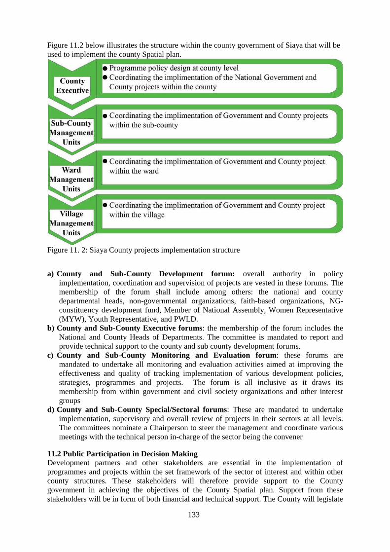
133
Figure 11.2 below illustrates the structure within the county government of Siaya that will be
used to implement the county Spatial plan.
Figure 11. 2: Siaya County projects implementation structure
a) County and Sub-County Development forum: overall authority in policy
implementation, coordination and supervision of projects are vested in these forums. The
membership of the forum shall include among others: the national and county
departmental heads, non-governmental organizations, faith-based organizations, NG-
constituency development fund, Member of National Assembly, Women Representative
(MYW), Youth Representative, and PWLD.
b) County and Sub-County Executive forums: the membership of the forum includes the
National and County Heads of Departments. The committee is mandated to report and
provide technical support to the county and sub county development forums.
c) County and Sub-County Monitoring and Evaluation forum: these forums are
mandated to undertake all monitoring and evaluation activities aimed at improving the
effectiveness and quality of tracking implementation of various development policies,
strategies, programmes and projects. The forum is all inclusive as it draws its
membership from within government and civil society organizations and other interest
groups
d) County and Sub-County Special/Sectoral forums: These are mandated to undertake
implementation, supervisory and overall review of projects in their sectors at all levels.
The committees nominate a Chairperson to steer the management and coordinate various
meetings with the technical person in-charge of the sector being the convener
11.2 Public Participation in Decision Making
Development partners and other stakeholders are essential in the implementation of
programmes and projects within the set framework of the sector of interest and within other
county structures. These stakeholders will therefore provide support to the County
government in achieving the objectives of the County Spatial plan. Support from these
stakeholders will be in form of both financial and technical support. The County will legislate
134
or formulate appropriate policies to guide operations of these stakeholders at all
administrative levels in view of streamlining their operations to avoid duplication of
interventions.
a. Role of Stakeholders in Lands, Physical Planning, Housing and Urban development
Table 11. 1: Role of Stakeholders in Lands, Physical Planning, Housing and Urban
development Stakeholder Role
World bank To establish and strengthen urban institutions to
deliver improved infrastructure and services
National Government (Department of Housing) Provide adequate, affordable and decent housing
units
National Government (Department of Lands and
Physical Planning)
Ensuring efficient administration and sustainable
management of land resources in the country
National Housing Corporation Implementation of government housing policies and
programmes
Land Control board To have jurisdiction over land control area
b. Role of Stakeholders in Agriculture, Livestock and Fisheries: Their role in this sector
is to establish a County stakeholder forum in addition to the existing quarterly ones at the sub
County level. They sensitize farmers on the existence of other stakeholders within the County
and beyond. The major stakeholders in this sector are shown in table 11.2 below:
Table 11. 2: Role of Stakeholders in Agriculture, Livestock and Fisheries Stakeholders Role
ICIPE Technology Development, capacity building
USAID Capacity building
Farmer/Processor Associations (KLPA, KFA, KENAF,
AKEFEEMA, AFIPEK, BMUs)
Farmer mobilization;
Advocacy and lobbying on agricultural issues;
Resource mobilization.
GIZ AND GIZ PARTNERS Food security interventions, Soil Protection &
Rehabilitation, Green Innovation
USAID KAVES Supports fruit, cereals and dairy value chains
ICRISAT (International Crops Research Institute for
Semi-Arid and Tropics)
Research for development sorghum, F/millet,
groundnuts
World Health Organization (WHO)/ OIE-International
Office for Animal Diseases
Vaccines provision
Disease surveillance
Export market for livestock products
Regulatory bodies (KVB, KDB, NACADA, KEBS,
KEPHIS, PPBK, WHO, NEMA, HCDA)
Capacity building, regulations, quality assurance
Farmers/ Producers Adopt and implement technologies,
Provide feedback
Faith based Organizations Community mobilization, Counselling,
Input Suppliers and manufacturers
(Pharmaceuticals, Seed Companies, Agrovets, Farm
machineries and equipment suppliers, Feed Millers)
Research, manufacture, supply of farm inputs and
training
AHADI Financial and Technical support in policy
development
NGOS/CBOS (Heifer International, send a cow, World
Vision, Red Cross, Plan International, Care Kenya, Vi-
Agroforestry, Farm Africa, Pathfinder International,
GOPA
Capacity building, Provision of farm inputs
Financial & Insurance Institutions (Banks, Micro
finances and Government Cooperation’s, insurance
Financial services (Loans, credit, insurance

135
Stakeholders Role
Cos.)
Private Sector (Dominion farms, Macro Fish Farm,
Jewlet fish farm, Investors in Fish Processing,
Agricultural Commodity processors
Investments, products value-addition and
marketing
Professional Bodies (KVA, APSK, KASPA, KVPA,
KALT, KMA, KESAP, EIK, AAE)
Capacity building, staff welfare, lobbying,
professional discipline
MEDIA Education, Publicity, Dissemination
Research Organizations (KALRO, ICRAF, KEMFRI
Educational Institutions (JOOUST, Maseno Egerton
Universities, Siaya Technical training Institute
Partnership and collaboration in training
c. Role of Stakeholders in Education, Youth, Gender, Children, Sports and Culture:
Major stakeholders in this sector include: Ministry of Education, National Youth Forum,
Constituency Development Fund, National Funds for People Living with Disabilities
(NFPLWD), Plan International, Child Fund, UNICEF, UNESCO World Bank, National
Gender and Equality Commission, National Youth Council, Athletics Kenya, National Fund
for the Disabled to replace National Funds for People Living with Disabilities, Department of
Culture, Children Services, Ministry of Devolution and Planning (Uwezo Fund), Disability
Council, Help Age Kenya, Faith Based Organizations.
Table 11. 3: Roles of Stakeholders in Education, Youth, Culture and Sports Stakeholder Role
Community Provision of resources: land, capital and labour Programme
beneficiaries
at as M&E agents
County government of Siaya Provision of technical human capacity and financial support.
Establishment of legal and policy framework for service delivery
M&E of sector development programmes
NGOs, CBOs, FBOs, CSOs Provision of human technical and financial support in implementation
of sector policies projects and programmes
National government Formulation of national policies that govern the sector.
Provision of Security
M& E of sector programmes
Technical support for County government
d. Role of Stakeholders in Roads and Public Works: The major stakeholders in this
sector include the Constituency Development Fund, Kenya Roads Board, KERRA,
KURA, KENHA, Ministry of Roads and Infrastructure, IEK, ERB, NCA, KABCSEC,
AAK and IQSK.
Table 11. 4: Role of Stakeholders in Roads and Infrastructure Stakeholder Role
KeRRA To construct and maintain rural roads
KeNHA To construct and maintain national trunk roads
KuRA To construct and maintain urban roads
County Government To construct and maintain County roads
Kenya Wildlife Service To construct and maintain roads within game parks and reserves
African Development Bank Major financier for road construction
World Bank Major financier for road construction
IEK, ERB, NCA, KABCSEC, AAK
and IQSK
Professional regulatory bodies in the sector

136
e. Roles of stakeholders in Finance, Planning and Vision 2013
Table 11. 5: Roles of stakeholders in Finance, Planning and Vision 2013 Stakeholders Role
Office of controller of budget To approve withdrawal from exchequer
To oversee implementation of the budget
The public To participate in the budget preparation
To oversee the implementation of the budget
Suppliers/creditors Interested in the debt repayment plans in the budget
Debtor Interested in financial bills and related financial legislation
National government Linkage of County government policies to national government policies
Capacity building, intergovernmental relations act
Kenya National Bureau of
Statistics
To provide policy guidelines on data collection, compilation, disseminations
and maintenance of the national statistical system
NCPD Provides policies on population and development
UNFPA Provides technical expertise and setting of international standards on
population
UNDP Provides technical and financial support on socio-economic development
UNICEF Provides technical and financial support on the social intelligence reporting
(SIR) and electronic project management information system (E-promis)
IFAD Provides technical and financial support in various sectors
AfDB Community empowerment and institutional support Programme (CEISP)
UNPF Promote and appreciate involvement in development activities
CRA Determine the proportion of revenue to be shared between the National and
County governments
SRC Review and determine salaries and remuneration to be paid out to state
officers and other public officers
KRA Collect taxes
KENAO To determine if proper books of accounts are being kept and reflect the true
picture of finances in the county
f. Roles of stakeholders in Trade, Industry, Cooperatives &Labour Table 11. 6: Roles of stakeholders in Trade, Industry, Cooperatives &Labour Stakeholders Role
Ministry of EAC Affairs, Commerce and Tourism Technical Support
Ministry of Roads and Infrastructure Technical Support, formulating national policies on
transport.
construction of national trunk roads
Saccos Technical Support
Ministry of Industry and Enterprise Development Technical Support. Formulating national policies on
trade and enterprise development.
Donors Financial and Technical Support
Parastatals (EPC, KENINVEST, KIRDI, KEBS,
MSEA, KIPI, Consumer Protection Board and Anti-
Counterfeit Agency)
Technical Support
Saccos Technical Support
Universities Technical Support
Siaya County Government Undertaking implementation of
programmes/policies/projects in the sector

137
g. Roles of stakeholders in Stakeholders in Water, Irrigation and Environment
Table 11. 7: Roles of stakeholders in Stakeholders in Water, Irrigation and Environment
Stake holder Role
Water Resources Management Authority
Ministry of agriculture Capacity building on appropriate agricultural practices
KFS Capacity building on type of trees and planting
spacing, and sourcing of seeds
NEMA Capacity building on protection of environment and
enforcement of Law.
Provincial administration Mobilization and enforcement of Law.
Meteorology
All government Departments whose activities are
sensitive to weather and climate.
First track climate and weather information into their
plans and activities
All NGO’S CBO’S With Climate and weather
programs.
First track climate and weather information into their
plans and activities
All users of climate and weather information. First track climate and weather information into their
plans and activities
Traditional Rain forecasters In-cooperated into identification of impacts and
enhancement of weather dissemination
h. Roles of Stakeholders in Governance and Administration
Table 11. 8: Roles of Stakeholders in Governance and Administration Stakeholder Role
Kenya Police Service Maintaining Law and Order
Kenya Wildlife Service To secure Wildlife resources
Ministry of Interior and Coordination of National
Government
To provide back stopping on National Government
Issues
The Judiciary Agent of dispute resolution
The general Public Consumers of government goods and services.
Council of governors Interpretation of external policies
Other county governments Intergovernmental engagements
Civil society players Facilitate citizen engagements on good governance
Donor community Are partners to augment county programmes
Media To provide communication platform
i. Roles of Stakeholders in Tourism, Culture, Sports and Arts
Table 11. 9: Roles of Stakeholders in Tourism, Culture, Sports and Arts
Stakeholder Role
Kenya Tourism Board To promote and market Kenya as a tourist destination
internationally and locally
Ministry of Tourism-National Government To promote development of tourism industry in Kenya
Kenya association of hotelkeepers and caterers To protect and represent the interest of hotels, lodges,
restaurant and membership clubs
Kenya Association of travel agency To champion and represent the interest of travel agent
industry
The Football Kenya Federation To run and manage football in Kenya
Schools Provide facilities for sporting activities
Betting companies They sponsor sporting tournaments and clubs
j) Roles of Stakeholders in Health Sector: The major stakeholders in the health sector are
the County government, National government, people of Siaya county and development
partners. The sector coordinates the stakeholders through quarterly forums at the sub County
and county levels, stakeholder participation in the preparation of the Annual Work Plans for
138
implementation of the County spatial projects related to health in the county. The key
development partners in the Health sector are indicated in the table below.
Table 11. 10: Role of Stakeholders in Health
S/no Partner Support
1 CHS HIV/TB, Nutrition, Staffing,
2 ICAP Quality Assurance in HIV program
3 UNICEF M$E, Child health, Immunization, Vitamin A supplementation,
Community Health Strategy, WASH
4 AMREF Maternal, reproductive and child health, nutrition Program
5 CARE KENYA Maternal, reproductive and child health, nutrition Program, Wash
6 FRED HOLLOWS Eye Care Support, Capacity Building and Equipment Support.
7 Red Cross Reproductive Health, Nutrition, Community Health Services, Waste
Management/WASH, Disaster management
8 Mild May HIV/AIDS care, community strategy
9 PATH(ECD), MACEPA Early Childhood Development, Malaria Prevention, Control and
management, Nutrition
10 IRDO HIV Testing, Malaria, Community TB
11 CMMB HIV Program,
12 Sane Landin (SLCC) HIV Program,
13 ACE AFRICA HIV Program, Reproductive health intervention, WASH/Jiggers
Control
14 WORLD VISION Reproductive Health, Community Health Strategy, OVC/ WASH,
HIV
15 KARP HIV Program,
16 MATIBABU Reproductive Health, Community Health Strategy, HIV/AIDS care
17 PLAN INT. Maternal, Reproductive and Child health, WASH, Advocacy
18 MAP nutrition Program
19 GAP TB Program
20 GIS TB Program
21 FHOK Reproductive Health/ Maternal and Adolescent Health Interventions,
PAC, Nutrition
22 KEMRI/CDC HIV/AIDs care, Malaria research and control, TB
23 KMET Family Planning/RH, Nutrition Program, Advocacy
24 PS Kenya HIV prevention, Malaria prevention, Social mobilization
25 Palladium Group HMIS
26 KSCSS Strengthening Supply Chain Management
27 IPAS Reproductive Health
28 OMEGA Family Planning
29 ESHE Family Planning
30 Network for Adolescent and
Youth in Africa (NAYA) Advocacy: Adolescents Care, Reproductive Health, HIV Care

139
Map 11. 1: Siaya County and Sub-County headquarters

140
PART III - SYNTHESIS

141
CHAPTER 12: SUMMARY OF PLANNING ISSUES
The Siaya County Spatial Plan, through a comprehensive and transparent process, is aimed at
creating conditions of providing the locations for capital investments of economic development, to
improve infrastructure services, and protect natural and cultural heritage. The framework of the
spatial planning process is provided in the Kenya Constitution 2010, and County Government Act
2012. These documents provide a broad process of participation of different stakeholders during
the preparation of the Spatial Plan. Under this framework the process of analyzing the situation is
divided into two namely challenges and opportunities of spatial development and the potentials
which are viewed along the thematic areas.
The following planning issues from all sectors emerged from the situational analysis. Sector Planning Issue Description of issues Where
Environment High rate of
environmental
pollution and
degradation.
Poor solid and liquid management.
Wetland encroachment due to human
settlement.
Environmental pollution e.g. River and
Lake pollution, especially car washing,
bathing, oil spills etc.
Environmental hazards such as floods
due to lack of disaster preparedness
Depletion of forest cover and extinction
of rare plant species
Loss of biodiversity in ecologically
fragile areas e.g. wetlands
Unprotected wildlife corridors
County wide, Major towns,
Market centres, River beds
Forests, Hills, Wetlands,
Wildlife corridors, Industrial
areas, Beaches
Air and land Increasing water, air and land pollution.
Forest encroachment.
Poor environmental quality
Reducing forest cover.
Land degradation.
Unsustainable utilization of natural
resources.
Countywide
Sand mines
Stone mines,
Forests
Agricultural lands
Rivers
Flood Sporadic flooding
causing threat to
life and property.
Homes and villages swept by floods.
Increased waterborne diseases.
Submerged farmlands and crops.
Hampered movement of goods, services
and people.
School programmes affected.
Loss of human and animals’ lives.
Countywide
River banks
Beaches
Down hills
Plains
Market centres
Erosion Causing hazardous
consequences to
water flows, land,
forests, objects and
other immovable
properties.
Threat to life and property.
Hampered agricultural activities.
Increased river siltation.
Degraded land.
Countywide, Market centres,
Riverbanks, Down hills,
Agricultural lands, Villages
Natural
Resources
Insufficient
preservation,
protection and
rational
exploitation of
natural resources
Illegal cutting of trees.
Indiscriminate waste disposal.
Increased water pollution.
Poor inventory and mapping of cultural
and natural heritage sites.
Countywide
Forests
Degraded areas
Cultural heritage areas
Schools
Public institutions
Agriculture Declining soil
fertility
Reduced productivity All agro ecological zones
Declined cotton
production
Collapsed cotton and textile industry Aboke, Alego Usonga,
Siranga

142
Sector Planning Issue Description of issues Where
Decrease in food
security
Over-reliance on rain fed agriculture
Unreliable rainfall
Poor crop husbandry
Use of local seeds and low usage of
fertilizer and manure
Use of traditional livestock breeds
High crop and livestock diseases
Whole county
Small farm
holdings and the
resulting limited
benefits of
economies of scale
Low management skills for commercial
farming
Whole county
Inadequate
extension services
High farmer to staff ratio
Extension personnel lack access to
emerging knowledge on modern farming
practices
All sub counties
Poor market access
Poor infrastructure
Low productivity
Poor access to accurate and timely
market information
Whole county
Poor quality of
livestock
Poor animal husbandry
High cost of good quality dairy cattle not
affordable to farmers
Whole county
High incidence of
tick-borne diseases
Collapsed dips
Whole county
Utilization of
fishing resources
Overfishing
Trawler fishing
Lake Victoria, Lake
Kanyaboli, Key Rivers (Yala
and Nzoia), Breeding grounds
in bays along the lakeshore
Industry Inadequate land for
industrial use
Inadequate industries
Hindrance in growth of industries
Siaya, Aram, Bondo, Ugunja,
Yala, Ukwala, Usenge
Small farm
holdings
Constrained mechanized agriculture All county
Collapse of cotton
industries
Inadequate incentives for cotton farmers
Importation of second-hand clothes
Alego Usonga
Collapse of
sugarcane
industries
Inadequate incentives for sugarcane
farmers
Unregulated sand
mining
Haphazard location of sand mining sites Along the beaches and river
Nzoia
Crude methods of
mining
Unsustainable exploitation of mineral
resources
Gold (wagusu) and Kogela
Fluorite (Rata)
Granite and black sand from
Yala valley
Poor access to
mining sites
Poor road conditions Wagusu, Kogelo, Rata, Yala
valley
Lack of an
industrial park
Low investments in the county All sub counties
Tourism Unmapped
boundaries
Encroachment by other human activities Olua Sacred Trees, Holy Got
Adodi, Bullock of Got, Podhe,
Rambugu hills, Got Ramogi,
Jaramogi Oginga Odinga
Mausoleum, Achieng’ Oneko
Mausoleum, Mageta Island,
Odera Akang’o office and
cells in Yala, Sare,
Nyamboyo, Oyamo, Mageta.

143
Sector Planning Issue Description of issues Where
Ndeda, Magare and Sihu.
Untapped potential
of tourist attraction
sites
Underutilized sites Olua Sacred Trees, Holy Got
Adodi, Bullock of Got, Podhe,
Rambugu hills, Got Ramogi.
Jaramogi Oginga Odinga
Mausoleum, Achieng’ Oneko
Mausoleum, Mageta Island.
Odera Akang’o office and
cells in Yala, Sare,
Nyamboyo, Oyamo, Mageta,
Ndeda, Magare and Sihu.
Poor
accessibility
of sites
Poor road conditions Olua Sacred Trees, Holy Got
Adodi, Bullock of Got, Podhe,
Rambugu hills, Got Ramogi,
Jaramogi Oginga Odinga
Mausoleum, Achieng’ Oneko
Mausoleum, Mageta Island,
Odera Akang’o office and
cells in Yala, Sare,
Nyamboyo, Oyamo, Mageta,
Ndeda, Magare and Sihu.
Unattractive sites Few tourists visiting the sites All sites
Unclassified hotels Few visitors All hotels
Water Poor access to
potable water
Unreliable, inadequate, unaffordable
water supply.
Unprotected water sources.
Long walking distances to access water
Polluted water sources
Countywide.
Major towns such as Bondo,
Siaya, Ugunja, Yalla, Usenge,
Akala, Aram, Luanda
K’otieno, water scarce rural
areas, health & educational
facilities & abattoirs
Sanitation Poor sanitation No operational sewerage systems
Poor solid and liquid waste management
Widespread use of ordinary pit latrines
in urban and peri-urban areas
Poor maintenance of sanitation
infrastructure
Countywide including Bondo,
Siaya, Ugunja, Ukwala, Sega
Usenge, Ndori, Akala,
Luanda-Kotieno, Yala,
Nyandorera, Sigomere,
Nyangueso
Transport Unclassified
priority county
roads
Roads serving key facilities including
industrial and commercial
areas and government institutions such
as school, hospital,
prisons and government housing.
Countywide
Road safety Unsafe roads characterised by frequent
accidents and insecurity
Countywide
Marine safety Unsafe water transport for fisher folks
and passengers
Lake Victoria, Lake
Kanyaboli, River Yala, River
Nzoia
Poor accessibility
to water fronts
Limited access to beaches, landing sites
and visual disconnection to water
scenery
Beaches e.g. Osieko, Usenge,
Nyenye, Usigu, Miyadhe,
Sirongo, Wagusu, Orengo,
Luanda-Kotieno
Encroachment of
road reserves
Informal structures, vending and other
activities within the road reserves
Countywide
Poor road
conditions
Pot holes, poor /inadequate bridges,
impassable roads during rainy seasons
Countywide
Poor drainage
infrastructure
Inadequate/ poor maintenance of storm
drains leading to flooding and erosion of
road surface
Countywide

144
Sector Planning Issue Description of issues Where
Undocumented/
unmapped water
ways
Connecting to islands, fishing grounds,
and mainland
Lake Victoria
Undeveloped
airstrips
The existing airstrips are in a state of
neglect, unused, encroached and
underdeveloped
No security of tenure
All Airstrips (Sega, Gombe,
Dominion, Migwena)
Energy Poor electricity
service
Poor Electricity
connectivity in the
county
Untapped alternative sources of energy Urban Centres
Beaches
Schools
Health Centres
Rural areas
Health Basic facilities Some not connected to electricity and
Water
Lack of specialised equipment (MRI
machines, Cancer screening, dialysis
machine)
Low bed capacity
Lack of specialised laboratories
Lack of mental health facility
Lack of elderly care homes
All health facilities (every
sub-county to have a level 4
hospital, elderly care home)
Access to health
services
Distance
Inadequate drugs/medicine
Low staffing of different cadres of
health personnel
Poor disposal of medical waste
Poor access of medical facilities by
residents at the Islands
All health facilities
Education Basic facilities Shortage of well-equipped laboratories
in secondary school
Poor drainage and waste disposal system
Lack of water in some schools
Inadequate green infrastructure
No defined footpaths.
Inadequate/poor play areas for students
due to inadequate land
Inadequate floor area for classrooms
Inadequate educational institutions in
some wards
Haphazard planning leading to poor
location of developments
All schools in the county
Access to schools Longer walking distance for students to
schools
Poor road conditions
Poor access to education by persons with
disabilities with regard to specialised
equipment, access roads
All Schools
Transition to
tertiary education
and training
Declining interest for village youth
polytechnics
Poor equipment
Inadequate personnel
Inability to afford education by students
especially those from humble
backgrounds
All village polytechnics
Table 12. 1: Summary of planning issues

145
12.1 Situational Analysis
This analysis was done so as to make it possible to understand and appreciate the opportunities to
be maximized on as well as challenges to be addressed by strategies and policies. The analysis
identified the rich and natural resource endowment due to the unique topography, climate, geology
and drainage. This makes Siaya County have a diversity in social and economic activities such as
farming, pastoralism, mining, tourism, fishing and water transport. Population analysis defined the
population projections, distribution, structure, densities and demographic trends which indicated
the current and future needs. The economic base was analysed and it provided indications on
patterns and trends of economic growth and development. This calls for diversification of the
county’s economic base and harnessing of the largely unexploited potential which will in turn lead
to stability and improvement of the general economic performance of Kenya in general and Siaya
county in particular. The Siaya County Spatial Plan development policies are aimed towards
developing functional human settlements, efficient and integrated transport and communication
networks and appropriate infrastructure in order to spur economic growth and improvement of
livelihoods. Land use was also analyzed and it indicated that land is owned inequitably. It also has
low productivity and is used inefficiently and unsustainably. The Siaya County Spatial Plan
advocates for the optimal utilization of land by reorganizing and adjusting the manner in which
land is utilized so as to achieve an overall efficiency and sustainability. Concerning transport and
infrastructure systems, there is an indication of uneven distribution, inadequacy in provision, poor
accessibility, unreliability and inefficiency. The County Spatial Plan is aimed at promoting
investments in the expansion, improvement and diversification in transport and infrastructure
systems to support the performance of the county's economy.
12.2 Opportunities
i. Availability of raw materials: The county is endowed with a number of resources which can
exploited. These are resources distributed across the county. They include livestock, fruits and
sand among others. Exploitation of these resources shall improve income levels, spur industrial
investment and revenue generation for the county.
ii. Readily available labour: Siaya county has large skilled and unskilled labor force. This is
attributed to the high population and improved education levels.
iii. Good working relations between county and national government: The good working
relationship between the county government and the national government institutions provide an
opportunity to secure land tenure through titling of urban land.
iv. Peace and tranquility: The county enjoys political stability and peaceful environment which
can spur growth of businesses and attract investors.
v. Existing institutions: There are a number of institutions in the county which can came in handy
to help in development. They include both governmental and non-governmental institutions. Some
of these institutions like Agricultural Training College (ATC) offer agricultural education to
farmers in the county.
vi. Tourism attraction sites: The county has a number of tourism attraction sites which can be
developed, mapped and branded to attract both local and international tourists. Beaches along Lake
Victoria can also be developed as tourist attraction sites apart from fishing.
12.3 Challenges/Gaps
Urbanization: The county faces challenges of an increasing population moving from the
predominantly rural areas to the urban areas from the rural areas. This is attributed to devolution
and opening up of urban areas. The increasing population consequently exerts pressure on the
existing social facilities and infrastructure due to the high demand. The county has inadequate
guiding policies and legal framework guiding urbanization in the county. Further, inadequate
infrastructural facilities in the county urban areas limit the growth and development prospects of
the urban areas. The infrastructural facilities include clean water, energy, efficient transport system

146
and network linking the major town and the agriculturally rich rural areas. Most of the urban areas
have scattered development/housing attributed to weak enforcement of the development plan and
development control policies in place.
Industrialization: The sector faces several challenges including; inadequate infrastructural
facilities, high cost of credit and limited access to credit. The rural based cottage industries face
low adoption of technology for value addition, price fluctuations, poor transport infrastructure
development and poor linkages to markets for agricultural products
Agricultural production: The sector faces several challenges including; low agricultural and
livestock productivity attributed to low adoption of technology and limited access to inputs;
inadequate extension services; high incidences of crop and livestock pests and diseases; low value
addition; land fragmentation into uneconomical sizes; weak and inappropriate land use policies
and erratic rainfall/frequent droughts and shortage of water to sustain agricultural development.
The sector however has a huge potential and opportunity to increase productivity through
irrigation, leveraging on modern technology in farming and intensifying extension services.
Infrastructure: The county has a fair coverage of the road network estimated which is distributed
across the administrative units. The road is majorly earthen and mostly become impassable during
the rainy season thus hindering provision of essential services to many citizens and the access to
market and other social amenities. The sector is equally faced with inadequate governance and
legislation framework on the water resources which greatly affects the sustainability of the water
developments. Degradation of the environment and the destruction of the water catchment areas
has affected the water supply in the county. Information, Communication Technology (ICT) has a
huge potential to drive growth in several sectors in the county economy. These include;
agribusiness, commerce and industry, revenue generation and procurement process. The
penetration of ICT in the county remains low due to inadequate infrastructural facilities to support
ICT development.

147
CHAPTER 13: SCENARIO BUILDING
Scenarios are assumptions of potential situations in future development. The key principle in
working with scenarios is the question "What If?".
13.1 Development of Alternative Scenarios
The strategy for the development of the Siaya County Spatial Plan is based on three scenarios.
These are the No Action Alternative, Mid Way Plan Alternative and Full Plan Implementation
Alternative.
13.1.1 No Action Alternative
The selection of the "No Action" alternative means the discontinuation of the Siaya County Spatial
Plan Proposal and result in the county being retained in its existing form. There are structural,
environmental, infrastructural, socio-cultural, economic, political, institutional and governance
implications of this alternative. Structurally, the county is unlikely to undergo any major changes
from its condition at present. Economically, the county is likely to have a very poor economic base
as a result of poor livestock productivity, outdated agricultural practices and lack of incentives and
resources such as adequate land set apart for industrial use to attract investors. Natural resources
such as lakes and forests or hills will also be affected because there will be no measures put in
place to conserve and manage them thus having a negative impact on the environment and the
social and economic wellbeing of the county residents. The health, nutrition and food security of
the area residents will greatly be affected hence it is likely to have the greatest implication on the
socio-economic environment of the county, the other neighboring counties and the whole nation at
large. The county will also face challenges in maintenance and development of infrastructure such
as roads which are drivers to economic growth and development. This will in turn affect marketing
of agricultural products as well as linking Siaya County to other regions. All the issues which have
been highlighted will in the end affect budgeting of projects as well as the governance system. If
this alternative was adopted, then the status quo will be maintained and county will face major
development challenges. There are so many reasons why a plan might end up not being implemented fully. These could be
as a result of setting up unrealistic expectations, poor methodology and requirements, inadequate
resources and so on. However, these can be avoided by adopting effective practices which will
help to establish a clear understanding of expectations and processes among all the stakeholders on
board. This alternative means that only mid-term projects will be implemented thus leaving out
major projects such as infrastructure development which are key in spurring development.
13.1.3 Full Implementation Alternative
Siaya County Spatial Plan Implementation is the phase where visions and plans become a reality.
This is the logical conclusion, after evaluating, deciding, visioning, planning, applying for funds
and finding the financial resources of the County Spatial Plan. With right planning, implementing
and monitoring there is the opportunity to implement the Siaya County Spatial Plan on time, on
budget and with high quality results, and fully meeting the key performance indicators as
highlighted in the plan implementation matrix. In case a clear idea of what is to be achieved and
what is required to be done to ensure that the plan is implemented fully, there is need to put in
place all the tasks on a timeline and make sure that all stakeholders are put on board with the
County Spatial Plan. A visual timeline will give a bird’s eye view of the entire project and
resources. On top of that, having a visual understanding of all the steps and tasks needed to be
completed can help in figuring out if overly optimistic deployment dates have been set. This can
keep the Siaya County Government who are in charge of the County Spatial Plan implementation
grounded and focused on delivering results by realistic schedules. In order to achieve the

148
objectives of the County Spatial Plan, a number of strategies need to be adopted as discussed
below.
13.1.3.1 Corridor Development Strategy
This is a planning strategy that concentrates spatial developments along transportation routes.
From a national corridor perspective, corridors throughout the world are developed for
development promotion purposes, to expand the development opportunities for a specific
economic sector and/or industry and increased access to public amenities and private investments
within the corridor area, as well as between the corridor and surrounding areas, markets or
economic activity nodes. This strategy is characterized by the application of a strategic integrated
development planning process, whereby a number of issues are incorporated, viz that of land use,
transportation, economic development and social development. Through this planning process, a
development framework and development concept framework are generated. This is an integrated
development framework which should be robust and dynamic to accommodate human choices as
when necessary. There are a number of benefits that can be identified through a formulated
theoretical framework development corridor framework, which can be summarized as follows: -
corridor development creates an opportunity for innovative and creative designs and problem-
solving opportunities
it necessitates the integration of land use and transport planning
it has a strong focus on attracting and promoting private sector investment and ventures
it establishes the opportunity for greater levels of economic efficiency and productivity due to
shorter travel distances and reduced travel time
sustainable environmental development and environmental protection are enhanced
it allows local and regional planning and development approach
it creates an opportunity to integrated fragmented spatial forms
it creates the opportunity for the more efficient use and allocation of urban and regional facilities
13.1.3.2 Nodal Oriented Development Strategy
Nodal Development involves concentrating development in existing or new centers and around
planned roadway and intersection improvements at a higher density than the surrounding area.
This allows the land between nodes to be used for lower density, lower traffic land uses. Nodal
development is generally found in more suburban/urban locations and provides a mix of
residential, commercial, and service opportunities in a compact walkable area. Nodes are often
located at existing intersections or community centers. The land between the nodes remains
relatively rural with limited commercial sites and access points. One of the key benefits of nodal
development is reduced automobile trips by providing bicycle and pedestrian amenities such as
sidewalks, visible crosswalks, streetscape improvements, and street furniture. Nodal development
can enhance community character and sense of place by minimizing the spread of generic sprawl
and unifying development, making it easier to achieve consistent design themes. Safety is also
improved by concentrating access points within the nodes and limiting them along major corridors
to minimize potential conflict points. These major urban centres act as nodes or hubs for both the
residents living in the centre itself and for people in nearby communities. Service delivery in nodal
development concept is economical since it promotes quality life by concentrating infrastructural
and service investments where they are most required. This concept has an advantage of helping to
preserve rural land for agricultural investment.
13.1.3.3 Balanced Regional Development Strategy
Balanced regional development is an important condition for the harmonious and smooth
development of Siaya county. It does not imply equal development of all the six sub counties,

149
rather it indicates utilization of development potential of all areas as per its capacity so that the
benefit of overall economic growth is shared by the inhabitants of all the different sub counties.
Thus, the regional balance implies uniform distribution pattern of the planned investment among
the six sub counties This is done up to the lowest location which is the village level for equal
distribution. It also ensures that no area is left lagging behind in development. Alternatively,
regional balance demands distribution of investment in such a way so that the regional rates of
growth in different parts of the county be equally attained, eliminating the regional disparities
prevailing in the county. So as to attain regional balance, it is quite important that the sub counties
which are lagging behind should try to attain higher rate of growth than that of developed areas.
Balanced regional development does not also indicate attainment of self-sufficiency of level of
industrialization or uniform economic pattern for each sub county rather it simply indicates wide
spread diffusion of industry in sub counties which are lagging behind in development. The
balanced regional development is broadly guided by the people in these areas which can be
attained simply through its development of agriculture, industry, infra-structure, trade and
commerce. Thus, by the term regional development, we mean economic development of all sub
counties simultaneously, raising their per capita income and living standards by exploiting their
natural and human resources fully.
13.2 Evaluation of the Alternative Scenarios
In order to come up with a well-informed Siaya County Spatial Plan, three alternatives have been
discussed. The preferred alternative is the Full Plan Implementation Alternative because it is an
integrated option taking into account the three strategies namely nodal, corridor and concentrated
development. Integrating the three strategies will guide development across the county for the
entire plan period i.e. 2018 - 2028. This preferred strategy can also be implemented in phases
(short term, mid-term and long term) according to pre-formulated development programmes and as
budgets permit implementation.

150
PART IV – PLAN PROPOSAL
151
CHAPTER 14: POLICIES, STRATEGIES AND ACTIONS
This chapter comprises of policies, strategies, actions and spatial structures necessary to achieve
the objectives of this plan for the next 10 years. The plan comprises of development proposals to
serve as a roadmap for integrated and sustainable development of Siaya County through five
interlinked strategies namely: social development strategy; economic development strategy; human
settlements strategy; transport, communication and infrastructure strategy; and governance
strategy.
14.1 SOCIAL DEVELOPMENT STRATEGY
Actions, activities for achieving social development goals are in view of achieving objectives
mainly related to population and demographics, HIV/AIDS, culture as well as improving the
quality of housing.
14.1.1 Background to Social Development Strategy
Like many other counties in Kenya, Siaya county faces high rates of poverty, inequality and other
social ills, such as substance abuse and crime. These problems affect the growth and development
of the County as a whole and restrict access to opportunities, preventing people from realizing
their potential. Both social and economic development interventions are necessary to address the
scale and impact of these social problems. Social development is the overall improvement and
enhancement in the quality of life of all people, especially people who are poor, vulnerable or
marginalized. At its core is a focus on addressing poverty, inequality and social ills while
providing for the participation of people in their own development.
Yet, the Kenya’s Constitution Mandates County government to ‘promote social and economic
development’. This is reiterated in the Country's and Siaya County Integrated Development Plan
2018-2022. The County has interpreted its mandate to mean that all service delivery, planning and
government activity is not an end in itself but rather strategic enablers for social and economic
development. In other words, all of the County’s work is designed to improve the quality of life for
all people living in the County as well as addressing poverty, inequality and social ills. However,
there is a lack of integration with regards to social development activity within the County.
Departments and directorates often view the challenges faced through the lens of their own sphere
of activity, providing isolated, sector-specific responses to broader social issues. This results in a
piecemeal approach that rarely adequately address the scale of social problems. Furthermore,
social development is often viewed as the domain of a specific directorate concerned with
relatively small, discrete projects, rather than viewed broadly as encompassing all of the County’s
work.
14.1.2 Desired Outcomes of the Social Development Strategy
The Social Development Strategy (SDS) articulates the role of the County Government of Siaya in
promoting and maximizing social development. This strategy sets out what the County is doing,
plans to do and articulates where external stakeholders, such as contracted service providers and
organizations receiving grants, shall contribute. The SDS recognizes that certain groups within
communities may require different levels of assistance in achieving their potential and hence it is
decidedly pro-poor and based on promoting an inclusive County. In order to maintain an
outcomes-driven approach, the SDS is structured around five broad high-level objectives. These
are:
i. Promote and foster social integration
ii. Support the most vulnerable through enhancing access to infrastructure and services
iii. Maximize income generating opportunities for people who are excluded or at risk of exclusion
iv. Build and promote safe households and communities
v. Mobilize resources for social development

152
The Social Development Strategy puts forward the actions needed to strengthen and improve these
levers so that they can best facilitate social development. The SDS is closely connected to the
Economic Growth Strategy (EGS) as social development interventions pro-mote people’s ability to
engage in economic productive activity, while economic growth is essential for facilitating social
development.
14.1.4 Approach to Social Development
The spatial plan adopts a transversal approach to social development, viewing the County as an
integrated whole, where each department and directorate has an important role to play in
facilitating social development. The plan considers all of the County’s work as geared towards
improving the well-being of all people in Siaya County. If the work of County government is
considered as a strategic enabler for social development, the various roles that the County plays are
opportunities to promote social development. These roles are summarized in the table 14.1 below.
Departments might fill several of these roles at one time.
Table 14. 1: Role of County Government in Social Development County Government of Siaya Role
Facilitates engagement through democratic structures service provider
Regulates and plans for public organization regulator
Manages its own corporate affairs Corporate employer
Fills the gaps or meet local, specific needs through interventions which are provided by
the County or by county-funded organizations
government of last
resort
Delivers services and maintains public infrastructure
service provider
At the heart of the SDS, is an approach to the City’s work. The way that departments provide
services, plan, regulate, employ people or directly intervene in communities shall be done in a
manner that promotes the social development of communities. the central principles of the Social
Development Strategy approach are to:
Facilitate partnership and community collaboration, which encourages initiative, self-help,
and mutual help.
Focus especially on individuals and groups that are vulnerable, marginalized or excluded,
such as women, people with disabilities, unemployed youth, elderly and very poor people
Use the County efforts, resources and assets as strategic enablers for creating environments,
which foster social development, where individuals are supported in improving the quality
of life for themselves and their communities.
Emphasize the sustainability of interventions by considering the environmental
consequences and promoting self-reliance.
Be priority driven, so that the County’s activity and resources are directed by relevant
evidence emphasizing the areas of greatest need.
Using these key principles of the County’s social development approach and the broad county
government roles indicated above, the following table 4.2 provides some guidance on the SDS
approach. These questions shall be used by County officials to guide their work and to aid in the
implementation of a social developmental approach to the County’s work.
Table 14. 2: Guidance on Social Development Strategy Approach County Government Work Guiding Questions (Application SDS principles)
Facilitates engagement through
democratic structures (Public
Engager)
Are opportunities for participation treated as a key aspect of a democratic
and accountable government?
Are democratic structures set up in a way to recognize the important

153
contribution of individuals, respect their views and facilitate a dialogue?
Are public engagement processes aware of the divisions within local
communities and seek to promote the participation of marginalized and
excluded groups in community and government processes through
specially designed plans?
Are leadership, encouragement and practical support provided to
organizations created by communities that build on the democratic
structures of the County?
Regulates and plans for public
organization (Regulator) Does the regulation and policing of bylaws respect the inherent human rights
of each person?
Does regulation act to promote and support the livelihood strategies of
people who are poor or vulnerable?
Does planning function take into consideration the needs of people who are
poor and vulnerable?
Is planning environmentally sustainable and informed by Local Agenda 21
aimed at creating and maintaining sustainable cities?
Does regulation engage communities and promote individual responsibility?
Are new areas of development designed using urban and spatial design
principals aimed to integrating economic and social infrastructure and
addressing or preventing the spatial and economic divides of the past?
Manages its own corporate
affairs (Corporate Employer) Is the County’s status as an employer used to develop the skills, knowledge
and potential of employees?
Are vulnerable people/groups supported in the corporate workplace?
Is diversity and mutual respect fostered in all interactions?
Is the County open to the views and opinions of employees and employee
representatives?
Are activities conducted in a way that promotes environmental
sustainability?
Fills the gaps or meet local,
specific needs through
interventions which are
provided by the County or by
County-funded organizations
(Government of last resort)
Are the services/programmes or interventions provided because of a lack of
such services in an area or a special need and thus avoid the duplication of
effort?
Do these quality interventions provide specifically further the social
development of an area?
Are these special provisions of programmes target vulnerable or excluded
groups?
Do these efforts build on the services, resources and assets of the County?
Are these interventions based on community engagement and collaboration?
Are these efforts sustainable?
Delivers services and maintains
public infra-structure (“service
provider”)
Are services delivered in a manner that provides for the basic needs of
communities or possibly defined by service levels and standards?
Are services delivered in a manner that meets the different needs of
communities?
Are services accessible, safe, culturally appropriate and affordable?
Are community facilities utilized to their maximum capacity in order to
provide opportunities for communities?
Does service delivery engage the community and promote participation,
initiative and collaboration?
Are services provided in a manner that recognizes the inherent dignity and
human rights of each person and facilitate the progressive realization of all
socioeconomic rights?
Is service provision sustainable in terms of the environment and promoting
self-reliance?
Is service provision guided by relevant statistics and provided in areas with
most need?
Is the priority setting informed by analysis of services and infrastructure and
balanced by need and

154
14.1.5 Development Proposals on Social Development
14.1.5.1 HIV/AIDS
The plan recognizes the impact of HIV/AIDs on the development of Siaya County. The National
government in collaboration with other agencies have worked to reduce its spread through the
voluntary counselling and testing centres (VCTs). The plan proposes that these centres should be
set up in all urban centres including local centres at village level.
14.1.5.2 Housing
The Siaya County Spatial Plan aims for all residents to have the possibility of ensuring an adequate
housing area, offering and providing a larger choice in housing and reducing social inequality.
Provision of housing should therefore be accompanied with adequate infrastructure and optimal
utilization of land. New housing design must be modern and enable regeneration of degraded
settlements. A legal framework must be established to provide different housing schemes in Siaya
County.
Below are proposed actions:
Institutional: Needs assessment and urban capacity for housing; Identification of areas and
locations; Allocation and clearance on land for housing development; and use of negotiated
purchase approach of land for consolidation
Social: Creation of mixed communities – impact on type and size of housing; provision of
affordable housing; and monitoring of affordable housing
Financial: Establishment of a constructive partnership between public and private sectors;
establishment of housing development funds; establishment of a housing fund at the Government
level; and promotion and provision of housing on subsidized and non-profit rents
Spatial: Creation of sustainable housing environments; sustainable land use; linking development
with public transport; re-designation of business and other functions onto housing; promotion of
mixed-use development; greenery in housing areas; and quality design.
14.1.5.3 Culture and heritage
The county government through should invest in the culture and heritage as a strategy by: -
Identifying avenues for turning culture and heritage into sought for ecotourism
Taking advantage of the county’s unique culture, history and heritage by generating local,
regional, national and international awareness (branding)
Ensuring a coordinated and systemized approach to promote cultural and heritage assets
Ensuring protection and conservation of cultural heritage sites
Table 14.3 further indicates proposals for the social development strategy of Siaya County.
155
Table 14. 3: Social Development Strategy Problem
Objective Action Internal Role-players External role-players Gaps/Way
forward
Lack of opportunities for
unskilled/low skilled/
unemployed people
To create job opportunities
through public work
programmes
Poor families receive business
training some monetary grant to
start business, work experience &
some skills training for job seekers
County Government Development partners,
National Government,
NGOs
Training, facilitate
further
employment, utilize
county
administrators’ and
focus on jobs for
women
Many poor people who lack
skills to be able to access
income generating activities
To develop the skills of people
excluded or at risk of
exclusion
Young people who are poor receive
skills development opportunities in
the County’s structure
County Government Development partners,
National Government,
NGOs
Increased number
of beneficiaries
who were
previously
disadvantage who
receive training
Provide people who are poor with
relevant skills that they can use to
access job opportunities
All directorate/
departments that provide
funding/ skills
development
opportunities for out-side
population in the county
Development partners,
National Government,
NGOs
Meet community
and private sector
demands, focus on
youth, combine
hard & soft skills,
follow-up support,
standardize and
accredit courses,
workshops
provided as part of
a set of
interventions
People who are poor often
engage in entrepreneurial
activities in order to sup-port
themselves and their families.
These are often not
recognised / inadvertently
affected by government
regulatory functions
To support entrepreneurial
activity in the formal and
informal sector
Provide people who are poor with
support services to create a viable
business in the formal sector
All
departments/Directorates
in the county
government
NGOs, National
Government,
Development partners
Move toward
incubator projects
and one-stop-
shops, maintain and
expand library
support services for
entrepreneurs
Enable and support people who are
poor to utilize informal trading as a
livelihood strategy to support
themselves and their families
All
departments/Directorates
in the county
government
NGOs, National
Government,
Development partners
Innovative support
services: Health
and Safety
information&

156
education,
strengthen the
participation of
informal traders in
governance,
intermediaries
Poor people live in high
densities on leftover land,
vulnerable to flooding, fire
and disease
To reorient services to create
& maintain a safe, healthy
environment
Balance resources so all residents
receive necessary services but
vulnerable people receive the
services that enable them to live in a
clean & safe environment
Health, Physical
Planning Public works,
Environment and all
relevant departments
Community members,
businesses contracted to
provide services, NGOs
contracted for animal
sterilization/
impoundment, education
campaigns
Balancing services
and regulation so
that adequate
services are
provided in poor
areas
People who are poor face
high levels of crime. The
causes of crime are multi-
faceted and complex
To Reduce levels of crime
through social & situational
crime prevention and
community participation
Situational Crime prevention
(“Designing-out crime”)
National security
agencies, County
Government,
communities, individuals,
NGOs
National security
agencies, communities,
individuals, NGOs
Mainstreaming
situational crime
prevention
initiatives and
thinking for
planning, cleansing,
community services
and surveillance of
streets
Social Crime Prevention National security
agencies, County
Government,
communities, individuals,
NGOs
National security
agencies, communities,
individuals, NGOs
Social Crime
Prevention strategy,
victim support
services
Community participation in safety
measures
National security
agencies, County
Government,
communities, individuals,
NGOs
National security
agencies, communities,
individuals, NGOs
Utilize democratic
county supported
structures for safety
initiatives, support
community safety
projects
Disadvantaged areas
especially in urban centres
To develop holistic strategies
to address gangs, substance
Gang strategy: suppression,
mobilization & social interventions
Urban development,
housing, Health, Public
National government,
security agencies, NGOs,
Develop
comprehensive

157
are more affected by gang
activity, crime and substance
abuse
abuse & youth development to deal with gang activity Health, Governance and
all relevant county
departments/directorates
communities. NACADA
strategy on gang
suppression,
community,
mobilization,
opportunity
provision and social
interventions
Substance Abuse strategy: address
supply, prevention, early
intervention and treatment
Urban development,
housing, Health, Public
Health, Governance and
all relevant county
departments/directorates
National government,
security agencies, NGOs,
communities, NACADA
Develop & expand
current activity,
develop a
comprehensive plan
and fast-track
through the work
group, monitor
effectiveness and
capacity of
treatment, build an
alternative youth
culture
Youth Development strategy:
coordinate activities of directorates
in specific disadvantaged areas
Urban development,
housing, Health, Public
Health, Governance and
all relevant county
departments/directorates
National government,
security agencies, NGOs,
communities, NACADA
County
Government
Agencies become
youth champion,
area-based
interventions as
part of a set of
services
Poor people are not able to
access services that improve
the quality of life
To reorient service delivery
for pro-poor
Targeted expenditure, free basic
services for people on indigent list
and in informal settlements, rate
rebates for poor households, pro-
poor NGOs, old age homes
Finance, Housing &
Urban Development,
legislature, social
services, all relevant
county departments
Development partners,
National Government,
NGOs, communities
Focus on the needs
of women, youth,
disabled indigent
relief and
innovative ways to
engage citizens in
service delivery
Poor health limits people's
abilities to access
opportunities and affects
quality of life. HIV/AIDS &
To Provide free primary
healthcare incl. HIV & TB
care
Prevention, care and treatment
services for all people in the County
which ensures that illness or
disability does not plunge poor
County Health,
Corporate Services
Private health service
providers, NHIF,
Medical insurance
providers
Improve quality of
healthcare,
continued focus on
HIV and AIDS,

158
TB disproportionally affect
poor people
households into destitution
People who are poor lack
access to physical assets such
as housing and land which
they can use as collateral for
income generation
To facilitate access to housing
opportunities
Provide various housing options to
people who are poor, transfer rental
units to identified beneficiaries and
informal settlement upgrades
Housing and urban
development, Physical
planning, health, public
works and all relevant
departments in the
county
National government,
National Housing
Corporation, Finance,
Private sector, NGOs,
Development partners
Focus on
urbanization,
continue to
recognize &
upgrade informal
settlements,
education of new
homeowners
Children who grow up in
poverty are at risk of a wide
range of adverse experiences
and disadvantages that persist
later in life
To focus on Early Childhood
Development
Provide poor children with access to
ECD services that meet their
developmental needs. The aim is to
increase the headcount of learners in
registered ECD facilities.
Department of
Education, Finance,
Governance and
Administration, all
relevant county
directorates
National government,
Education Ministry,
NGOs, Development
partners
Integrate services
for ECD (health,
education, social)
within the County
and other sectors,
use grants and
mentorship to help
unregistered
centres, ECD
provision in
informal settlement
projects, nutrition-
al programmes
Women, children, elderly and
people with disabilities are
most affected by poverty.
There is a preponderance of
vulnerable groups in the poor
population
To champion the issues of
vulnerable people across the
County
Ensure that vulnerable peoples’
issues are included in all
departments planning and services
All departments county
government
Civil society, Vulnerable
groups organization,
Churches, Mosques,
National government
Strengthened role
for county
government
agencies as a
champion and
coordinator of
vulnerable groups
Provide special interventions
targeted at vulnerable groups e.g.
Street people
All departments county
government
Civil society, Vulnerable
groups organization,
Churches, Mosques,
National government
Strengthened role
for county
government
agencies as a
champion and
coordinator of
vulnerable groups
Poor social interaction
between economic classes
To promote social interaction
through recreational and active
Enables interaction across race/class
barriers to build social capital,
Public participation
arenas, ward committees,
Civil Society, National
Government, community
Community centres
become centres of
159
prevents the development of
networks that promotes
access to opportunities
citizenship opportunities networks and cohesion that
facilitate access to opportunity and
address stereotypes and
discrimination
bunge la wanainchi,
County Government
groups, NGOs community
development, focus
on building social
capital & cohesion,
events and arts
bring people
together to examine
social norms,
To foster diversity and
inclusivity in the County's
governance structure
Promote the constructive
engagement between groups and
engage employees as agents in
building an inclusive county
HR department, all
relevant county
departments
Civil Society, National
Government, community
groups, NGOs
Utilizing the
County workspace
as a space for inter-
face/culture
interaction,
maintain a culture
of respect and
valuing diversity
People who are poor often
lack the voice to be able to
participate in planning
processed for their own
development
To facilitate public
participation and ensure that
marginalized voices are heard
Provide access to information,
opportunities to report problems or
provide feedback, special
mechanisms to improve access of
vulnerable groups to participation
opportunities, civic education
County government,
public participation
arenas, ward committees,
county assembly
Civil society groups,
NGOs, National
government agencies
Partnering with
county and national
government
agencies.,
promoting active
citizenship,
facilitating
marginalized
people’s access to
public participation,
utilizing points of
contact with com-
munities,
citizenship
education
initiatives

160
14.2 ENVIRONMENTAL AND NATURAL RESOURCES MANAGEMENT AND
CONSERVATION STRATEGY
The plan comprises a strategy for sustainable natural resources management of the County.
The strategy covers for: reforestation of gazetted forest areas; provision and protection of
wildlife migratory corridors; and protection of water catchment and environmentally fragile
ecosystems. Therefore, the plan proposes actions for the protection and conservation of
environmental resources for sustainable development. The plan proposes partnerships and
engagement with local communities in the ownership and management of environmentally
sensitive areas. Additionally, an environmental management plan and policy guidelines
mandating 10% increment of tree cover should be enforced on individual and public land
holdings in urban and rural areas.
14.2.1 Wildlife Migratory Corridors
Siaya County migratory corridors are areas connecting of habitat connecting wildlife
populations separated by human activities or structures such as road development or logging. It
allows an individual between populations which may prevent the negative effect of inbreeding
and reduced genetic diversity that often occur within isolated populations. The proposed
corridors within the county should help to facilitate the re-establishment of populations that
have been reduced or eliminated due to random events such as fires or diseases.
The proposed migratory corridors are intended to moderate some of the worst effects of habitat
fragmentation wherein urbanization can split up habitat areas, causing the animals to lose both
their natural habitats and the ability to move between regions to use all resources they need to
survive. Habitat fragmentation due to human development is an ever-increasing threat to
biodiversity in Siaya County and the proposed corridors are possible mitigations.
In Siaya County, wetlands along the Lake Victoria, Lake Kanyaboli and all the county rivers
have been identified and proposed as strategic migratory corridors for the wildlife in the
County. Common wildlife in Siaya County includes: Crocodiles, Warthogs, Monkeys, Birds,
Antelopes, Leopards, Hyenas, squirrels, and snakes. The proposed riparian areas along the
rivers, lakes and other water bodies have been identified and further proposed for utilization as
migratory corridors in Siaya County (Map 14.1).

161
Map 14. 1: Proposed wildlife migratory corridors

162
14.2.2 Water Resources Development Strategy
Water resources being limited, exploitation management of available resources against
various heads of consumption must be worked out with due care taking into consideration and
after analysis of various relevant factors such as expenses, sustainability and optimum
utilization of current provisions. In Siaya County, both surface water and ground water
resources are currently exploited to meet the diverse nature of demand scenario.
Water resources in the county are typically comprised of rivers (Yala, Nzoia and other small
rivers) and their tributaries, water pans, boreholes, lakes (Lake Victoria, Lake Kanyaboli),
wetlands (Yala Swamp), and dams. These resources should however be planned to ensure:
adequate quantity of water available to consumers and aesthetics and environmental safety. All
plans must therefore be developed to cater to goals of Vision 2030. A judicious assessment of
demand for water through various phases within the planning horizon is one of the key basics
which in turn is related to population size.
14.2.2.1 Development Proposals for Water Resources Development
Protection of water Intake/Sources: A protection belt (buffer) should be provided for
underground water intakes comprising both direct and indirect protection. In areas of direct
protection, a buffer of 10m wide should be provided surrounding well(s), boreholes, rivers,
wetlands, lakes, water pans and dam. The physical planning standards recommends the
following protection belts as indicated (Table 14.4):
Table 14. 4: Recommended Protection Belts for water sources
Boreholes and wells: should
be located 800m apart to
avoid drawdown
Figure 14. 1: Standard buffer radius for Boreholes and Wells
Wetlands: Wetlands are areas where water covers soil all or part of the time. Wetlands are
important because they protect and improve water quality, provide fish and wildlife habitats,
store floodwaters and maintain surface water flow during dry periods.
Protection belt Direct (Radius) protection Indirect (Radius) protection
Borehole 10m 50m
Well 10m 50m
River 10-50m 50m

163
In order to conserve such
ecosystems as Yala
swamp, a riparian reserve
of 50m is proposed. These
ecosystems shall be
preserved for the purposes
of recreation and
ecotourism development.
Figure 14. 2: standard buffer distance for wetlands
Rivers: Rivers should be protected as they help people and nature in many ways. These rivers
are home to some of the best fishing, boating, hiking and scenery anywhere. They naturally
filter and store clean water and reduce the impacts of floods, reserve some of the most
important ecosystems on the planet, noble native plants and animals to thrive, preserve the
cultures of communities who once lived by the river, provide amazing adventures, recreation
and wildlife viewing and contain fabulous rock and geologic formations that help in
understanding the evolution of our planet.
A protection buffer of 50m should
be provided to ensure maximum
conservation and protection of the
rivers and their riparian reserves.
The riparian reserves can be
developed further for ecotourism
and recreational purposes. These
would include provision of green
way parks and nature trails.
Figure 14. 3: Buffer radius for protection of rivers
Lakes: A lake is an ecosystem, a community of interaction among animals, plants,
microorganisms, and the physical and chemical environment in which they live. Critical to any
lake ecosystem is the lake's watershed, the surrounding land area that drains into that particular
lake. A complex interdependence has evolved among the organisms in a lake community. If
one part of the ecosystem is disturbed, it affects the other parts. Human developments or other
changes in the watershed can alter the delicate balance of the lake ecosystem. Therefore, these
obstructive activities should be regulated. A protection buffer of 50m is therefore proposed for
any developments taking place in Lake Victoria and Lake Kanyaboli.
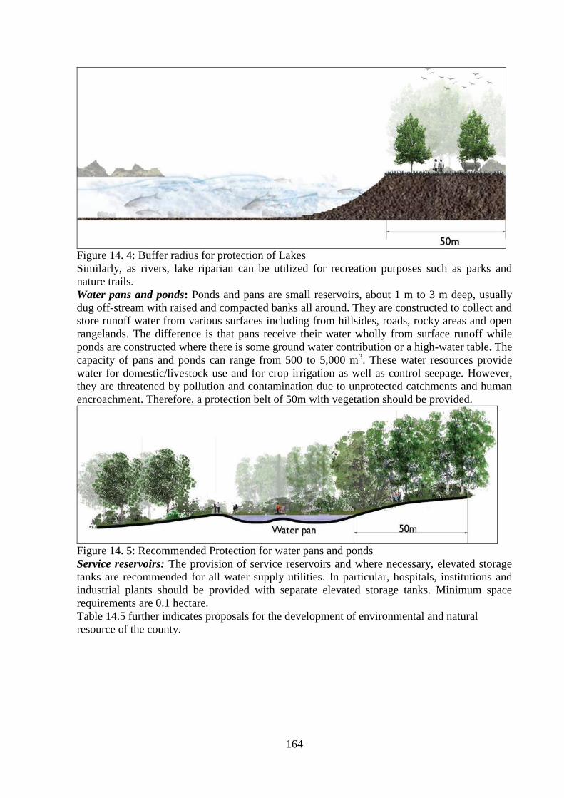
164
Figure 14. 4: Buffer radius for protection of Lakes
Similarly, as rivers, lake riparian can be utilized for recreation purposes such as parks and
nature trails.
Water pans and ponds: Ponds and pans are small reservoirs, about 1 m to 3 m deep, usually
dug off-stream with raised and compacted banks all around. They are constructed to collect and
store runoff water from various surfaces including from hillsides, roads, rocky areas and open
rangelands. The difference is that pans receive their water wholly from surface runoff while
ponds are constructed where there is some ground water contribution or a high-water table. The
capacity of pans and ponds can range from 500 to 5,000 m3. These water resources provide
water for domestic/livestock use and for crop irrigation as well as control seepage. However,
they are threatened by pollution and contamination due to unprotected catchments and human
encroachment. Therefore, a protection belt of 50m with vegetation should be provided.
Figure 14. 5: Recommended Protection for water pans and ponds
Service reservoirs: The provision of service reservoirs and where necessary, elevated storage
tanks are recommended for all water supply utilities. In particular, hospitals, institutions and
industrial plants should be provided with separate elevated storage tanks. Minimum space
requirements are 0.1 hectare.
Table 14.5 further indicates proposals for the development of environmental and natural
resource of the county.

165
Table 14. 5: Environmental and Natural Resources management and conservation strategy Sector Planning Issue Description of issues Objective Where Activities/Strategies
Environment Inadequacy of existing
legislation Environmental
degradation
To legislate additional Acts
of Parliament National Additional legislation is required to adequately effect
provisions of the Constitution.
High rate of
environmental pollution
and degradation.
Poor solid and liquid
management.
Wetland encroachment
due to human
settlement.
Environmental pollution
e.g. River and Lake
pollution, especially
car washing, bathing,
oil spills etc.
Environmental hazards
such as floods due to
lack of disaster
preparedness
Depletion of forest cover
and extinction of rare
plant species
Loss of biodiversity in
ecologically fragile
areas e.g. wetlands
Unprotected wildlife
corridors
To reduce environmental
pollution and degradation. County wide
Major towns
Market centres
River beds
Forests
Hills,
Wetlands
Wildlife corridors
Industrial areas
Beaches
Creating buffers and prohibition by law of inert
matter exploitation on river beds by unlicensed
operators.
Prohibition of waste discharges into river beds.
Landfill creation standardization.
Ensure more efficient locations and protection in
hazardous waste landfills which may cause
disasters in subterranean and superficial waters.
Each industrial facility or activity, mine, open-cut
mine, must construct industrial implants based on
economic activity, and undertake chemical and
biological cleaning of waters, and discharge clean
water into streams.
Construction of waste water treatment plants to clean
up waters by settlement sewage systems.
Reparation, and also construction of agile layers and
drainage channels of landfills, with the aim of
avoiding pollution of subterranean and superficial
waters.
Air and land Increasing water, air and
land pollution.
Forest encroachment.
Poor environmental
quality
Reducing forest cover.
Land degradation.
Unsustainable utilization
of natural resources.
To develop, protect and
conserve natural resources Countywide
Sand mines
Stone mines,
Forests
Agricultural lands
Rivers
Abeyance of the law on environmental protection.
Definition of allowed values of pollution in water, air,
land in accordance with international standards.
Addressing of the hazardous waste landfills.
Protection of environmental quality.
Protection against degradation.
Identification of erosion prone areas.
Recultivation of land after the exploitation of natural
resources.
Protection of quality agricultural land.
Rational utilization of natural resources, protection of
bio-diversity and natural values.
All investment projects should follow an
Environmental Impact Assessment.
Profiling, protection and preservation of forests and

166
Flood Sporadic flooding
causing threat to life
and property.
Homes and villages
swept by floods.
Increased waterborne
diseases.
Submerged farmlands
and crops.
Hampered movement
of goods, services
and people.
School programmes
affected.
Loss of human and
animals’ lives.
To place control over
flood endangered areas
in order to ensure
protection of lives and
property.
Countywide
River banks
Beaches
Down hills
Plains
Market centres
Establishment of a database of river flow
volumes.
Mapping overview of endangered areas along
riverbanks and the flooding wave of rivers,
with the aim of permanent monitoring.
Establishment of a central level staff on
forewarning, monitoring and alarming.
Drafting of emergency plans on flooding by
respective institutions for crisis management.
Prevention of negative effects from flooding by
preliminary technical measures. These
measures are to be undertaken on riverbanks,
or even riverbeds, to avoid natural barriers and
forestry assets’ integrity.
Prevention of illegal cutting and destruction of
forests.
Avoidance of economic activities harming
environment.
Location and placement of waste into landfills and
recycling.
Mapping and afforestation of treeless areas
Determination of virgin forest areas, forest reserves
and hunting reserves.
Protection of relict and endemic species of flora and
fauna.
Creation of green belts around areas with
environmental negative impacts.
Water Poor access to potable
water Unreliable, inadequate,
unaffordable water
supply.
Unprotected water
sources.
Long walking distances
to access water
Polluted water sources
To ensure access to potable
water by all Countywide.
Major towns such
as Bondo,
Siaya, Ugunja,
Yala, Usenge,
Akala, Aram,
Luanda
K’Otieno, water
scarce rural
areas, health &
educational
facilities &
abattoirs
Improve water supply and coverage to ensure
adequate access to portable water.
Water supply to all urban areas.
Harness rain water.
Enhance domestic water treatment before
consumption.
Intensify public education on water safety.
Protection of water sources

167
man-made barriers.
Construction of protection walls at areas where
riverbeds may not contain all flow, by
technical interventions (embankment by
natural materials and solid materials as well).
Maintenance of estuaries through natural
interventions.
Prohibition by law of agricultural land use along
riverbanks, which may affect flooding risks.
Prohibition of all construction activities in
proximity to river banks, apart from objects of
an economic character (bridges, dams,
drainage channels, etc.) which do not
endanger water streams with flooding.
Prevention of flora destruction along river banks,
apart from those that negatively impact on
them.
Prevention of flora destruction along river banks.
Planting of wood plants along river banks, with
the aim of erosion prevention and flooding.
Providing natural landscapes, according to
preliminary studies.
Prevention of inert matter exploitation on
riverbeds.
Restoration of the riverbanks to previous
situations.
Prevention of flow change to the riverbed.
Erosion Causing hazardous
consequences to water
flows, land, forests,
objects and other
immovable properties.
Threat to life and
property.
Hampered agricultural
activities.
Increased river
siltation.
Degraded land.
To determine, establish
and map erosion prone
areas and propose
mitigation measures.
Countywide
Market centres
Riverbanks
Down hills
Agricultural
lands
Villages
Prevention of forest cutting and degradation.
Prevention of overgrazing
Prevention of activities/materials causing
erosion.
Construction of embankments along river banks.
Planting of forest plants along riverbanks.
Prevention of inert exploitation in riverbed.
Agricultural land maintenance
Agricultural practices be applied fairly.
Utilization of irrigation and drainage systems be

168
made by expert instructions
Increased investment for land protection along
riverbanks.
Protection of existing forests against
uncontrolled cutting and fire.
Prevention of grazing in bare massive and flora-
deficient areas.
Forestation of bare and degraded areas.
Creation of green belts in regions where erosion
incidence is higher.
Planting along riverbeds, streams and flows
where erosion is active.
Natural
Resources
Insufficient
preservation, protection
and rational
exploitation of natural
resources
Illegal cutting of trees.
Indiscriminate waste
disposal.
Increased water
pollution.
Poor inventory and
mapping of cultural
and natural heritage
sites.
To preserve, protect and
rationally exploit natural
resources
Countywide
Forests
Degraded areas
Cultural heritage
areas
Schools
Public
institutions
To stop the illegal cutting of forests by
introduced under controlled and systematic
cutting.
Application of clause: "a tree felled to be
replaced with two other plants"
Zoning and classification of areas which are
considered endangered.
Drawing and implementation of renewal of the
old mining surface.
Renewal to be conditioned upon use of land for
new purposes.
The drafted plans for rational exploitation of
space should be promulgated as areas with
natural heritage values.
To formulate the rehabilitation plan of dumping
of waste and surface mining

169
14.3 SEWERAGE AND SANITATION DEVELOPMENT STRATEGY
Organized sewerage and sanitation facilities are available only in the selected urban centres
such as Bondo and Siaya but they aren’t working. Other areas have no access to sewerage
systems which requires installation and operationalization. Predominant dependence is on pit
latrine followed by septic tank. Open defecation is also in practice. Therefore, there is serious
deficiency in sewerage system in the county.
14.3.1 Development Proposals on Sewerage and Sanitation
In view of undulating topography and scattered urban centres, it is not considered
economically feasible to provide a centralized sewage treatment facility, which will involve
sewage pumping and sewerage system at larger depth involving huge cost, likely large length
of idle sewers etc. may make the system uneconomical. On techno-economical consideration,
decentralized treatment facilities at urban centre level as in the current practice is proposed.
Notably, installation of sewerage systems is land dependent, which is not a serious constraint
in Siaya County (especially in the rural areas). However, in case of urban centres with land
constraints, treatment process shall be selected based upon availability of land and associated
techno-economic consideration. For rural areas, septic tanks or ponds or low-cost sanitation
facilities may be provided as per local condition as an economical option. Some innovative
low-cost options may also be explored.
14.3.2 Sewerage and Sanitation Recommendations
• Operationalization of the existing sewerage system and treatment plant in Siaya and Bondo
town as well as installation in other towns of the county. It will cover deploying the sewer
network, pumping station and treatment facilities.
• Decentralized sewerage treatment facilities to be provided for each urban centre. Urban
areas will be provided with properly designed sewerage network and waste stabilization
pond technology, where availability of land is not a constraint.
• Rural areas will be provided with small bore sewerage system and on-site sanitation
schemes like septic tanks.
• The treatment plants shall be sited as far as is practicable from the boundaries of the urban
area, downwind of the prevailing wind direction. A surrounding tree buffer is desirable
both as protection against blows and for environmental purpose. The land requirement for
buffer zones for sewered areas is 75m2 whereas for unsewered areas are 110 m2.
• Each urban area shall have a garbage collection site located on the leeward side of the urban
area and have a 100m-protection belt.
• Provide toilet facilities at convenient sites in all types of centres, schools, hospitals and
parks.
• Sensitize the public on the installation and use of pit latrines in the rural areas.
3.2.3.3 The Reuse of Sewage
A large quantity of sewage will be generated within the urban centres and development
corridors and the same can be utilized for various other purposes after providing required
treatment to effluent to bring down its quality within prescribed standards of the National
Environmental Management Authority (NEMA). Exploitation of treated effluent for uses as
mentioned below could result in financial saving or even creation of revenue for Siaya
County. The re-use of sewage or treated sewage will help in conserving natural water
resources and reduce raw water demand which is already scarce. Probable uses of the treated
sewage as considered appropriate are:
• Irrigation of agriculture crops or forest: This form of reuse has been widely recognized
and used internationally. Treated waste-water has fertilizer values as it contains nitrogen
and other trace elements such as phosphorous and potassium. However, a disadvantage of

170
this form of reuse is that water for irrigation purpose is not normally required during the
rainy season. As an alternative, a bypass arrangement for discharging of treated effluent
should be made in every treatment facility. Aesthetic element should also be given due
consideration.
• Ground water recharge: This may be used to supplement underground water by
recharging. However, to prevent the clogging of aquifer, only good quality sewage
effluent may be utilized for recharging as many existing water supply schemes are based
on ground water.
• Fish Farming: Sewage ponds are used internationally for breeding fish for food.
Maturation ponds considered in secondary waste stabilization ponds (following primary
ponds) can be utilized for farming. However, aesthetic objection from public to consume
such a form of food production may have to be overcome.
• Industrial Reuse: Industrial demand can be met from the treated effluent. However,
additional treatment requires to be provided for making the effluent suitable to the need of
the water quality requirement of industries. This will lead to reduction in load on ground
water and surface water sources.

171
Table 14. 6: Sewerage and Sanitation development strategy
Issue Challenge Strategic objectives Location/Space Strategy
Poor sanitation • No operational
sewerage systems
• Poor solid and liquid
waste
management
• Widespread use of
ordinary pit
latrines in urban
and peri-urban
areas
• Poor
maintenance of
sanitation
infrastructure
To enhance access to
improved sanitation
Countywide
Bondo, Siaya, Ugunja,
Ukwala, Sega, Usenge,
Ndori, Akala, Luanda-
Kotieno, Yala,
Nyandorera, Sigomere,
Nyangueso
• To operationalize Bondo and Siaya sewerage systems.
• To plan and provide sewerage infrastructure in major
urban areas.
• Adopt septic tank technology in peri-urban areas not
served by conventional sewerage system.
• Adopt Ventilated Improved Pit (VIP) latrines for rural
areas.
• Public education and sensitization on sanitation.
• Enforce public health and planning regulations.
• Ensure proper waste management by adopting the 7Rs
(Recycle, reuse, reduce, rethink, respect/Recover,
refuse and repair).
• Provide resource
recovery estates/sites
• Commercialize waste management in the urban areas.
• Propose disposal sites per every two sub counties.
• Designate waste disposal sites/landfills.
• Generate biogas out of human and other organic waste
(pilot in markets and schools).

172
14.4 ECONOMIC DEVELOPMENT STRATEGY
The National and County Governments has put in place a number of interventions to promote
economic growth in the whole country. These include:
Formulation of the strategy for Revitalization of Agriculture (SRA) 2004-2014 that is
expected to contribute significantly towards attaining economic recovery strategies.
The National Food Policy to address the basic causes of malnutrition and improve food
security at the household and national levels.
Proposed increment in total government expenditure in the agricultural sector (strengthening
agricultural research and extension, credit to farmers, revival of farmers’ institutions and
control of crop and animals’ diseases) from 5.6% to almost 7% from 2005-2008.
Industrial development strategy: industrial incubation centres, agro-processing value
addition
Tapping of mining resources to increase revenue generation
Blue economy revitalization: fishing resources, sustainable tourism (and ecotourism)
Expand the role of SME and MSE contribution to the local economy
Infrastructure development in trading centres (markets): electricity (street lighting, solar
powered), water and sanitation, establishment of stall markets
Financial enhancement to local traders: credit facilities, revolving funds, banking facilities
Human resource development in economic sector: develop entrepreneurial skills, education
and health services to enhance participation productive sector
Resource mobilization strategy: public financing, private financing, and public-private
financing
Focusing on Foreign Direct Investments (FDI) as a driver of investment
14.4.1 Tourism
Tourism planning within a region provides for socio-economic development, environmental
protection and conservation. i) Tourist and Public Recreation: Beach tourism development is
contributing to the overall growth of tourism industry in Kenya. Development on the beach
require careful planning and supervision to ameliorate pressure on natural environment. The
following are planning considerations: Condition of the beach development of harbors should
focus on pollution control. No building is permitted within 30metre (100feet) of high-water
mark. The foreshore should support fairly dense vegetation to give a natural appearance.
Public access: there should be unlimited access of the beach by the general public. Placement
of sign-post is recommended to guide access points.
i) Encourage the attraction of various classes of resident tourists; medium cost tourist based
on beach cottage or cheaper beach hotel with family car. Economy tourist: that do have own
transport usually accommodated in low cost hotels. High cost tourist: the use private jets and
planes, cruise ships, and stay longer.
ii) Identify and map out public recreation spots as potential areas for development. Map out
oceans or lake front beaches or shorelines that have potential for tourism development. Map
out cultural sites: e.g. Rampon’go, Gunda Yiro, Gunda Buche, Got Romogi, Owiny Sigoma).
iii) Game reserves and areas of significant biodiversity should be included while identifying
other areas of endangered species, for purposes of protection (preservation) and conservation.
iv) Take cognizance of environmentally fragile/hazard areas. These are areas with significant
biodiversity in flora and fauna. They are of importance to life and development and are under
pressure from human activities. Environmentally hazard/risk areas where there is a danger to
human due to geological instability, hydrological phenomena and sometimes environmental
pollution (air, water, land).

173
v) To promote sustainable county development of these areas, require identification, mapping
and delineation: flood prone areas delineated using high water mark and creating a buffer zone
of a minimum of 10m from edge. Mass waste land (landslides areas) with management
strategies of soil-water conservation, afforestation and controlled settlement.
vi) Wetland conservation: areas that are permanently or seasonally flooded by water where
plants and animals have adapted e.g. swamps, areas of marsh, peat land, mountain bogs, banks
of impeded drainage or brackish, salt or alkaline.
vii) Tourism planning which nature based and referred as ecotourism is emerging as strategy
to integrate ecological concerns in development for purposes of sustainable development with
the County. Counties diverse natural resource and ecological diversity should therefore
prioritize tourism as key drivers for economic development.
Proposed and on-going projects to revamp tourism in Siaya County
Construction and equipping of cultural centers.
Undertake and develop a business and conference tourism initiative.
Fence Lake Kanyaboli conservation area.
Develop sports tourism (boat, racing, water skiing, swimming competitions and a floating
restaurant
Flagship projects: Development of a Lake Region Tourism Circuit within Siaya County
Development of high-end hotel and Conference facilities in Siaya County
Development of Community-Based Tourism activities and attractions at selected sites
Marketing Initiatives to enhance visibility of the Lake Region Tourism Circuit;
Development of Wildlife Conservancies to promote tourism and solve wildlife-human
conflict;
Establishment of standards for tourism products and services in the Lake Region Tourist
Circuit; and
Development of road network within Siaya County for rural and urban areas targeting
unique heritage facilities and sceneries around and within the County.
Potential Impact on investment in the Tourism Sector
The following are the potential impacts of investment in the tourism sector (Lake Region
Economic Block, 2018):
A 20% increase in tourism demand results in an increase in real GDP of 0.1%;
A 10% increase in tourist expenditure can lead to a 0.3% increase in rural household
consumption and in a 0.02% increase in welfare;
10% increase in tourism results in an increase in the domestic consumption of agricultural
commodities; tourism growth in Kenya is pro-agriculture;
Economic activity created by tourism expansion increases real wage rates by 0.8%;
Inbound tourism increases the output of agricultural products, decreases its prices and
increases employment. (Njoya);
Tourism can serve as a powerful incentive to protect natural resources (UNEP, 2011);
Tourism generates revenue to support conservation and management of natural
environments (UNEP, 2011); and
Tourism has larger multiplier effects, with revenue spreading from hotel accommodation,
food and beverages, shopping, entertainment and transport to income of hotel staff, taxi
operators, shopkeepers and suppliers of goods and services (UNEP, 2011).

174
Table 14.7: Key Issues in Tourism Development Sector and Strategies for Intervention
Planning Issue Description of Issue Objective Where Strategies
Poor access to
tourist attraction sites
Poor road network To enhance accessibility to tourist attraction sites Olua Sacred Trees, Holy
Got Adodi, Bullock of Got,
Podhe, Rambugu hills, Got
Ramogi, Jaramogi Oginga
Odinga Mausoleum,
Achieng’ Oneko
Mausoleum, Mageta Island,
Odera Akang’o office and
cells in Yala, Sare,
Nyamboyo, Oyamo,
Mageta. Ndeda, Magare
and Sihu.
Make all sites accessible to
weather roads.
Untapped potential
for tourism
Unattractive tourist circuit To establish an attractive tourist circuit that makes
Siaya County a destination of choice
As above Ensure that proper planning
is undertaken
Revamping the tourism
sector
To develop and improve products, mini-circuits and
source markets within a sustainability framework and
ensuring maintenance of standards
As above Create awareness on the
benefits of tourism
Unattractive tourist
facilities
To refurbish hotels and other accommodation
facilities
As above Active involvement of
members of the community
in developments
Poor marketing to attract
domestic tourists
To promote domestic tourism As above Provide incentives and
establish an information
dissemination system to
alert domestic tourist of
attractions, promotions and
deals
Poor service provision To provide skilled labor to establish excellent service
delivery dependent on informed policies, clear
tourism development plans, supportive legislation and
regulatory framework.
As above Training of personnel
Unmapped tourist
attraction sites
Poor planning and
management as a result of
encroachment
To map out cultural sites As above Mapping of sites
To identify and map out public recreation spots as
potential areas for development.
All formal public recreation
sites
Mapping of sites
To map out lake front beaches or shorelines that have
potential for tourism development.
All beaches and shore lines
along Lake Victoria
Mapping of sites

175
14.4.2 Fishing
The policy objective to increase fish production, marketing and processing focuses on
improving and strengthening fishing research, seed and feed production and extension
services. Fish farming need to be enhanced and fisheries infrastructure need to be developed.
The policy concerns are management, conservation, control, utilization of fishery resources,
promotion of aquaculture development to supplement fish marketing systems and sustainable
management of fishery resources.
Table 14.8: Key Issues in Fishing Sector and Strategies for Intervention
Planning
Issue
Description of Issue Objective Where Strategies
Declining
fish stock Overfishing
To increase fish
production
Whole county Strengthen fishing
research
Encourage the use fish
cages through
education to farmers
Utilization
of fishing
resources
Underutilization of fishing
resources
To identify,
manage and
conserve fish
breeding grounds
and resources
Whole county Identify suitable sites for
fish breeding
14.4.3 Agriculture and Rural Development
Table 14.9: Key Issues in Agriculture and Rural Development Sector and Strategies for
Intervention
Planning
Issue
Description of Issue Objective Where Strategies
Small farm
holdings and
the resulting
limited
benefits of
economies of
scale
Constrained
mechanized
agriculture
Low management
skills for commercial
matters
To increase food
security
Whole county Set minimum farm
holdings for mechanized
agriculture
Declining soil
fertility Reduced productivity To increase
food production
All agro
ecological
zones
Encourage the use of
farm yard manure and
fertilizers
Erect gabions to arrest
soil erosion
Declined
cotton
production
Collapsed cotton and
textile industry
To revamp the
cotton
industries
Aboke, Alego
Usonga,
Siranga
Revamp the cotton
industries
Sensitize farmers on
cotton production
Decrease in
food security Over-reliance on rain
fed agriculture
Unreliable rainfall
Poor crop husbandry
Use of local seeds
and low usage of
fertilizer and manure
Use of traditional
livestock breeds
To increase
food security
Whole county Encourage the use of
irrigation
Training on modern
farming and livestock
keeping practices
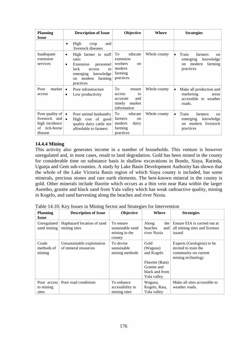
176
Planning
Issue
Description of Issue Objective Where Strategies
High crop and
livestock diseases
Inadequate
extension
services
High farmer to staff
ratio
Extension personnel
lack access to
emerging knowledge
on modern farming
practices
To educate
extension
workers on
modern
farming
practices
Whole county Train farmers on
emerging knowledge
on modern farming
practices
Poor market
access
Poor infrastructure
Low productivity
To ensure
access to
accurate and
timely market
information
Whole county Make all production and
marketing areas
accessible to weather
roads.
Poor quality of
livestock and
high incidence
of tick-borne
disease
Poor animal husbandry
High cost of good
quality dairy cattle not
affordable to farmers
To educate
farmers on
modern dairy
farming
practices
Whole county Train farmers on
emerging knowledge
on modern livestock
practices
14.4.4 Mining
This activity also generates income in a number of households. This venture is however
unregulated and, in most cases, result to land degradation. Gold has been mined in the county
for considerable time on substance basis in shallow excavations in Bondo, Siaya, Rarieda,
Ugunja and Gem sub-counties. A study by Lake Basin Development Authority has shown that
the whole of the Lake Victoria Basin region of which Siaya county is included, has some
minerals, precious stones and rare earth elements. The best-known mineral in the county is
gold. Other minerals include fluorite which occurs as a thin vein near Rata within the larger
Asembo, granite and black sand from Yala valley which has weak radioactive quality, mining
in Kogelo, and sand harvesting along the beaches and river Nzoia.
Table 14.10: Key Issues in Mining Sector and Strategies for Intervention
Planning
Issue
Description of Issue Objective Where Strategies
Unregulated
sand mining
Haphazard location of sand
mining sites
To ensure
sustainable sand
mining in the
county
Along the
beaches and
river Nzoia
Ensure EIA is carried out at
all mining sites and licenses
issued
Crude
methods of
mining
Unsustainable exploitation
of mineral resources
To devise
sustainable
mining methods
Gold
(Wagusu)
and Kogelo
Fluorite (Rata)
Granite and
black and from
Yala valley
Experts (Geologists) to be
invited to train the
community on current
mining technology
Poor access
to mining
sites
Poor road conditions To enhance
accessibility to
mining sites
Wagusu,
Kogelo, Rata,
Yala valley
Make all sites accessible to
weather roads.

177
14.4.5 Industrialization
There is need to develop cottage industries at various locations in Siaya County. Some of the
available opportunities for industrial development include fish processing industries at Wagusu,
Usigu, Usenge, Luanda Kotieno, Misori and Asembo Bay. All these are beach landing points that
should be supported with fish processing infrastructure/plants. Many of the available
opportunities are accessible at Bondo and Rarieda sub counties.
Other parts of the sub county like Ugenya are best placed to undertake Agro based enterprises in
honey, grain, groundnut and peanut butter processing. Value chain addition in agriculturally
based products would complement earnings for the residents. Areas on target extends to East
Ugenya, West Ugenya, North Ugenya and Ukwala wards which are potential for Agro based
industrial development. Brewery industrial plants in are suited in Ugenya at Ukwala or Sihay.
Sun flower oil production in Gen Sub County should also be intensified.
There is an opportunity for sugarcane industries at Yala Wetland in Alego Usonga Sub County.
There is also potential for sugarcane production at Yala in Gem Sub County. Other potential
areas include Uholo in East Ugenya. Ginnery and textile have a potential at Ndere in Alego
Usonga.
14.4.5.1 Industrial Development Strategy
In order to promote and accelerate sustainable industrial development in Siaya County, the vision
is to “establish a modern industrialized county.” The following objectives are recommended to
promote “Sustainable Industrial Development” in Siaya County:
Successful industrial diversification and upgrading based on both agriculture modernization
and higher value-addition and introduction of new technology in industries
Promotion of gradual integration into regional production network and global value-chain
Development of high-skilled human resources and creation of more employment opportunities
with quality jobs through industrialization
Reduction of rural poverty and disparities between rural and urban areas by promoting
industrial production with value-addition by rural areas
To achieve the above strategies, the county shall establish industries such as fishing processing
industry (Bondo, Usenge, Wichlum, and Luanda K’Otieno), Sugar processing industry (Uholo,
Yala), mining industry (Gold- Wagusu), groundnut industry (Diego), fruit/ juice processing
Industries (Akala and Ting’wang’i), honey processing plant (Ukwala), meat processing industry
(Usenge, Bondo, Siaya, and Ugunja), rice milling plant (Nyadorera), oil processing plant
(Sunflower-Gem), cotton and textile industry (Siaya) and a brewery in Ugunja

178
Map 14. 2: Proposed Industrial Development Strategy
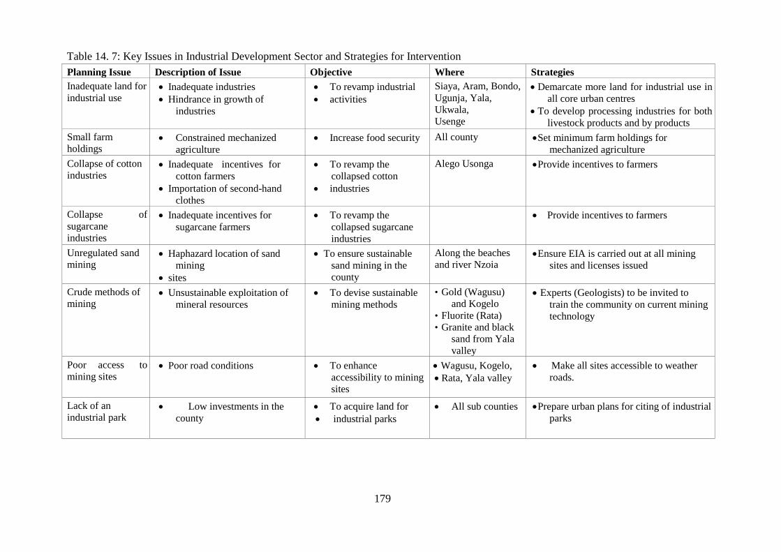
179
Table 14. 7: Key Issues in Industrial Development Sector and Strategies for Intervention
Planning Issue Description of Issue Objective Where Strategies
Inadequate land for
industrial use Inadequate industries
Hindrance in growth of
industries
To revamp industrial
activities
Siaya, Aram, Bondo,
Ugunja, Yala,
Ukwala,
Usenge
Demarcate more land for industrial use in
all core urban centres
To develop processing industries for both
livestock products and by products
Small farm
holdings Constrained mechanized
agriculture
Increase food security All county Set minimum farm holdings for
mechanized agriculture
Collapse of cotton
industries Inadequate incentives for
cotton farmers
Importation of second-hand
clothes
To revamp the
collapsed cotton
industries
Alego Usonga Provide incentives to farmers
Collapse of
sugarcane
industries
Inadequate incentives for
sugarcane farmers
To revamp the
collapsed sugarcane
industries
Provide incentives to farmers
Unregulated sand
mining Haphazard location of sand
mining
sites
To ensure sustainable
sand mining in the
county
Along the beaches
and river Nzoia Ensure EIA is carried out at all mining
sites and licenses issued
Crude methods of
mining Unsustainable exploitation of
mineral resources
To devise sustainable
mining methods
• Gold (Wagusu)
and Kogelo
• Fluorite (Rata)
• Granite and black
sand from Yala
valley
Experts (Geologists) to be invited to
train the community on current mining
technology
Poor access to
mining sites Poor road conditions To enhance
accessibility to mining
sites
Wagusu, Kogelo,
Rata, Yala valley
Make all sites accessible to weather
roads.
Lack of an
industrial park Low investments in the
county
To acquire land for
industrial parks
All sub counties Prepare urban plans for citing of industrial
parks

180
14.5 HUMAN SETTLEMENTS DEVELOPMENT STRATEGY
Siaya County continues to grow as more people make the urban areas their home, attracted by
proximity to work opportunities, lifestyle, culture, and high-quality services. Currently, the
county is accommodating approximately 950,000 inhabitants, of which the majority (80%)
live in rural areas, while the rest (20%) live in urban and peri-urban areas. 1/5 of the total
population live in Siaya, Bondo, Usenge, Yala, Ugunja and other small urban centres in Siaya
County, most of which are not responding to demands for expansion of housing, education,
employment, causing a general devolvement of the services’ quality. In this direction, the
drafting of the county and urban development policies must rationally and functionally plan
for these towns by assigning them functionalities, while establishing a sustainable growth
strategy for the next 10 years. This implies the need for:
• Maximum protection of land by densifying existing housing areas in the urban areas,
and new housing spaces should be assigned only when this is impossible.
• Protection of agricultural land by concentrating human settlements in the specified
growth corridors and urban areas.
• Provision of technical and social infrastructure, and sufficient services depending on the
specific urban functionality and growth corridor.
• Promoting equitable distribution, providing unique living conditions for the urban
growth centres and corridors, offering subsidies for an accelerated economic
development in under-developed areas, and thus creating an attractive and sufficing
environment.
• Ensuring access to quality infrastructure and services to the inhabitants.
14.5.1 Purpose of Human Settlement Development Framework
The overall objective of the human settlement strategy is to improve the social, economic and
environmental quality of settlements and the living and working environments of all people in
the urban and rural areas of Siaya County. This is meant to achieve sustainable urban and rural
development by achieving a balanced growth in all spatial units namely Sub-counties and
Wards as well as enhance spatial planning decisions that relate to urban growth, land use,
housing, and transport, guarantee equitable distribution of infrastructure and services, and
ensure optimal utilization of land as a scare resource in the county. The specific objectives are
to:
• Direct new growth to suitable areas to maintain sustainable growth of the county.
• Ensure development occurs close to employment, services, and transport links. This is so
as to encourage active modes and accessibility, and reduce pressure on resources and
infrastructure. The expectation is that newest developments will occur along the
proposed growth poles and corridors of the county.
• Ensure county growth contributes to the urban and rural areas’ economic, social and
environmental success.
14.5.2 Policies for Human Development Framework
The human settlement strategy is anchored on the following global and national legal
frameworks:
Sustainable Development Goals 2015: Goal eleven (11): Make cities and human settlements
inclusive, safe, resilient and sustainable. The target for 2030 is to ensure access to safe and
affordable housing. The indicator aims to measure progress toward this target is the proportion
of urban population living in slums or informal settlements. Movement from rural to urban areas
has accelerated as the population has grown and better housing alternatives are available.

181
The Urban Areas and Cities Act 2011: The Act classifies urban areas as cities, municipalities
and towns. These urban areas are differentiated largely in terms of population and minimally in
terms of capacity. Majority of the Act is dedicated to providing criteria for distinguishing the
classifications of urban areas and cities, and establishing the principles and structures for
governance and management of urban areas.
The Physical Planning Act CAP 286: Analysis of human settlements should include
distribution of services, growth and pattern of urbanization, cause of primary, and rural-urban
migration; provide for alternative development patterns including rural development, urban
development, and interrelations between urbanization, between urban and rural development
Strategies for human settlement in the area including development of service centres, growth
centres, transport and communication network and rural development; and implementation to be
based on a sectoral approach to development and measures for implementation and coordination
in these sectors, namely industrial development, housing, transportation, health services,
education, water supply, sewerage and electricity.
Sessional Paper No. 1 of 2017 on National Land Use Policy: The overall goal of the
national land use policy is to provide legal, administrative, institutional and technological
framework for optimal utilization and productivity of land and land related resources in a
sustainable and desirable manner at National, County and local level. Specifically, the policy
offers a framework of recommendations and principles designed to ensure the maintenance of a
land use system that will provide for: Land-use planning, resource allocation and resource
management for sustainable development to promote public good and general welfare;
environmental management and sustainable production initiatives in the utilization of land
resources; coordination and integration of institutional linkages in planning at sectoral and cross
sectoral levels to foster collaboration and decision making among different land users; optimum
utilization of land resources to meet governance, social economic, political and cultural
obligations of the people of Kenya; anchoring land development initiatives that will respond
positively to the market demands; Integrated framework for the preparation of a National
Spatial Plan and review of various land use plans; mainstreaming of gender and special interest
groups in land use planning and management; a comprehensive, efficient and affordable
computer based land use information management system; an appropriate, accountable and
democratic institution for land use conflicts resolution; and mitigating problems associated with
poor land use.
14.5.3 What the Framework Covers
This framework provides a series of methods and actions to achieve the objectives discussed
above and manage growth in a proactive manner. Growth creates a demand for appropriately
located and available land to provide for the expansion of infrastructure and services.
Assigning functionalities to growth areas creates an increase in demand for
services. Planning for this growth, and associated infrastructure, ultimately provides the
County Government of Siaya with the opportunity to direct how and where growth is
accommodated and provided for, and manage the effects and costs of it.
14.5.4 Principles for Human Development
These principles underpin this framework and outline the qualities to be achieved in Siaya
County. They are the key objectives for achieving this strategy and represent areas the
community may not wish to compromise on. These principles, and the implications of
applying them, are provided in the table below.

182
Table 14. 8: Principles and implications for human settlement development Principles Implications of application
Plan for high quality urban
growth and consolidated
developments.
This implies that future growth and development will have higher densities so as
to stimulate the relationships of workforce density, economic productivity and
public transport. It also means that within the higher density-built fabric, there are
more housing options e.g. townhouses, attached housing and apartments. Urban
consolidation on the other hand implies setting urban edges to control human
development.
Focus growth in existing
communities that have
capacity for expansion.
Encourage infill development in the urban areas and transportation routes of the
county. Ideally, growth will be focused around existing social infrastructure to
increase the thresholds of the existing and other facilities.
Plan for quality amenity in
the growth centres and
corridors
Structure planning for new areas will have to meet specific criteria set out in the
Urban Areas and Cities Act of 2011 and physical planning regulations. New
development areas will need to fit in with the rest of the urban areas rather than
being isolated on its own. Good connectivity implies high-quality urban
environment with increased densities along transport corridors.
Achieve quality
environments, places and
spaces.
Growth and development within the urban growth areas and corridors will ensure
that indigenous biodiversity is maintained and enhanced. Public spaces and
recreational facilities will respond to the community’s needs.
Plan for mixed use
development in suitable
locations.
Mixed land uses and higher development intensity can increase land value
without a corresponding increase in the cost of infrastructure and services. Mixed
uses can also provide greater choice, in terms of access to destinations for
residents and create conditions for clusters of different economic activities to be
located close together.
Encourage economic and
ecotourism development.
The County government must support a proactive role in the economic
development of the county. This may mean that the CoG facilitates groups to
work together on different issues or sets up public-private-partnerships. The CoG
to proactively create urban environments which attract economic and ecotourism
development.
Encourage community
collaboration in urban growth
decisions.
The CoG should always consult with different stakeholders in a collaborative
way before making final decisions. Development decisions will be based on the
stipulated growth strategies of this plan.
Protect and enhance green
open space, outstanding
landscapes and areas of
cultural, ecological, historic
and environmental
significance.
In expanding some areas, the CoG may need to weigh up the need to protect high
quality versatile soils, and sites of ecological value or other environmentally
significant areas. In expanding some areas, the CoG will need to consider how a
larger population will impact on the natural resources, e.g. access to the Lake
Victoria, the beaches, Rivers, Wetlands, Got Ramogi hills among other valuable
sites of the County.
Implement best practice and
integrated planning.
The CoG will need to work in a more collaborative way to establish effective
partnerships.
Consider natural hazards. Natural hazards and flood risk areas pose a significant constraint to growth for the
growth areas and corridors. In the long term, the CoG may need to consider
actively encouraging population growth away from natural hazard environments
in the County. For flood risk areas, these will have to be managed and re-
mediated prior to infrastructural development occurring.
14.5.5 Proposed growth areas and functionalities
Following the determination of responsibility and importance of each settlement, and its
position within Siaya County, spatial development proposals are hereby provided in order to
fulfil the criteria which characterize all settlements as such.
14.5.5.1 County Growth Centres
These are centres with potential for urban and industrial growth as well as have the capability to
induce growth in larger centres that offer one or more specialized growth functions and which
can accommodate major redistribution of the population. The proposed centres include Siaya,

183
Bondo and Usenge towns. These are the largest centres of the county in which 20-40,000
inhabitants or 5% of the whole population of Siaya live. Selection of these towns was based on
the following characteristics: Core administrative functions; Higher level infrastructure;
Secondary and tertiary activities; Strong industrial base; and existence of Specialized facilities.
a. Core functions of selected towns
• Siaya: Shall be developed as hub for Governance, Commerce, Education, Medicine, Sports,
Transportation, and Eco-tourism. This strengthen the position of Siaya town, as a County
headquarter, and be at functional service to all other centres in the County, as well as
strengthen its position as a key administrative centre, in which all county governance
institutions reside.
• Bondo: Shall be developed as a hub for Education, Fishing Industries, Commerce,
Governance, Medicine and Eco-tourism. This will enhance the development of Bondo town
in relation to the region, tending to achieve the level of national and regional towns, creating
a functional and efficient transport system; improved infrastructure for educational, industry
and ecotourism development.
• Usenge: Shall be developed as a Fishing zone in its Beaches, Eco-tourism, Commercial,
Governance, Medicine. This will promote ecotourism and the fishing industry development
of the town.
b. Strategic issues in developing growth centres
• Urban regeneration must be considered as a means for solving economic and social problems,
for improvement of built spaces in unplanned areas.
• Define precise boundaries (urban edges) of the centres.
• Superior functions in health care and education must not be an exclusivity for urban centres, it
is recommended that several units – faculties and clinics must be given space in other
centres, in the manner of helping migration and commuting fluxes, and also concentration in
major urban centres.
c. Spatial requirements for growth centres Proposed growth centres shall be entitled to the following spatial requirements: Planning and
development control, traffic control and parking, water and sanitation, street lighting, outdoor
advertising, cemeteries & crematoria, public transport, libraries, storm drainage, ambulance
services, health facilities, firefighting and disaster management, control of drugs, sports and
cultural activities, electricity and gas reticulation, abattoirs, refuse collection, solid waste
management, child care facilities, pre-primary education, local distributor roads, conference
facilities, community centres, five star hotel, guest houses, referral hospital, county hospital,
university, constituent university campuses, polytechnic, training institution, national school or
a county school, stadium, airport, airstrip, theatre, library service administrative seat, financial
hub, museum, historical monument, fire station, emergency postal services, national TV station,
national radio station, regional radio station, community radio, casinos, funeral parlour,
cemetery, recreational parks, management of markets, marine water front, animal control and
welfare, and religious institutions.
14.5.5.2 Sub-County Growth Centres
These centres shall serve administrative functions of the sub counties. Selection of these towns
was based on the increasing socio-economic activities, designed with specialized facilities and
higher-level infrastructure. Towns under this category include: Bondo, Siaya, Yala, Ugunja,
Ukwala, and Rarieda.
Spatial requirements: Planning and development control, traffic control and parking, water and
sanitation, street lighting, outdoor advertising, cemeteries and crematoria, public transport,
libraries, storm drainage, ambulance services, health facilities, firefighting and disaster

184
management, control of drugs, sports and cultural activities, electricity and gas, reticulation,
abattoirs, refuse collection, solid waste management, air, noise, child care facilities, pre-primary
education, local distributor roads, conference facilities, community centres, hotel homestays,
guest houses, county hospital, constituent university, campuses, polytechnic, training institution,
national school, county school, municipal stadium, stadium, airport, airstrip, national theatre,
theatre, library service.
14.5.5.3 Urban Centres
First tier urban centres: These towns are planned to decongest the sub-county centres and
developments in the surrounding regions. They shall be designed with specialized facilities and
planned as special packages with a focus for development. The towns and their functionalities
are as shown below (Table 14.2).
Table 14. 9: Proposed first tier urban centres and their Functionalities
Town Functionality
Usenge Fishing, Transport, Ecotourism, Commercial
Ugunja Fishing, Transport, Commercial
Yala Transport, Education, Governance, Industrial, Communications
Ukwala Commercial
Nyadorera Commercial, Transport
Luanda K’Otieno Commercial, Fishing
Ndori, Akala, Sega Commercial, Transport
Spatial requirements: Street lighting, cemeteries and crematoria, libraries, health facilities,
sports and cultural activities, abattoirs, refuse collection, solid waste management, air noise,
child care facilities, pre-primary education, community centres, guest houses, homestays,
polytechnic, training institution, county school, airstrip, unclassified roads, museum, historical
monument, postal services, regional radio station, community radio, funeral parlour, cemetery,
recreational parks, management of markets, marine water front, animal control and welfare,
religious institution.
Second tier urban centres: They serve as intermediary towns which shall play the role of
promoting rural development in order to achieve a balanced distribution of growth and
development. This shall provide functional linkages between the first tier urban centres and the
growth centres. In order to promote equitable share of resources and development, each ward
shall have a growth centre.
These centres shall include Sidundo, Boro, Kobare, Mwer, Nyangoma, Aboke, Sihayi, Sega,
Sigomere, Sididi, Kodiaga, Nyangueso, Apuoyo, Bar-Kalare, Nango, Bar-Chando, Wich Lum,
Kapuoyo, Usigu, Uhanya, Asembo Bay, Mahaya, Ragegni, Ndigwa, and Misori. Therefore,
these towns shall be provided with basic infrastructure and services such as street lighting,
health facility, abattoirs, sports/cultural centres, refuse collection, solid waste management,
child care facility, pre-primary education, community centre, homestays, unclassified roads,
postal services, cemetery, recreational parks, management markets, marine water, marine water
front, animal control and welfare.
14.5.5.4 Market Centres
This includes small towns having linkages with immediate rural hinterlands. They serve as
higher order villages having central location and potential for development within their
catchment area, with relatively better services, and facilities in terms of education, health,
communication, accessibility, growing socio-economic activities, and has the capacity to serve a

185
group of basic villages. These towns include: Nyadorera, Ugunja, Sega, Yala, Aram, Akala,
Luanda Kotieno, Sigomere, Sidindi, Aboke, Usenge, and Ndori, Ngiya, Kogelo, Ragegni, Wich
Lum, Wagusu, Yenga, Misori, Aram, Usigu, Ngiya, Boro, and Mandiany. Facilities and services
to be provided in these towns shall include: Street lighting, health facility, abattoirs,
sports/cultural centres, refuse collection, solid waste management, child care facility, pre-
primary education, community centre, homestays, unclassified roads, postal services, cemetery,
recreational parks, management markets, marine water, marine water front, animal control and
welfare
14.5.5.5 Rural Centres
These centres shall cater for the rural hinterland as agro service centres in the collection and
distribution of agricultural goods and services with processing, marketing, warehousing and
storage facilities. They shall be the lowest settlements for housing development as village
hamlets with core function of household shopping and shall have facilities such as street
lighting, community/village health centres, sports/cultural centres, child care facility, pre-
primary education, community centre, homestays, unclassified roads, cemetery, religious.
Centres under this category include: Sidundo, Bar Okwako, Lukhano, Nyaola, Rabango, Obet,
Awelo, Ngiya, Sidindi, Rwabwa, Nango, Nyalula, Manyuanda, Mahaya, Ratado, Ligega,
Kabare, Amoyo, Liganwa, Ndigwa, Wagai, and Sikalame.
14.5.5.6 Local Centres
This comprises of main village settlement which are predominantly agricultural with a lowest
threshold shopping centre. These centres shall be provided with services such as nursery
schools, community cemeteries, religious institutions, stall market, floodlights, access roads,
and electricity.
Table 14. 10: Proposed Hierarchy and size of human settlements Settlement
hierarchy
Settlements/ Town Selection criteria Proposed
Land size
Growth
Centres
Siaya, Bondo, Usenge Administrative functions / County
headquarters
Higher level infrastructure
Secondary and tertiary activities
Strong industrial base
Specialized facilities
Maximum
Radius 7Km
Radius, and
44 sq.km
(4400 ha)
Sub-County
centres
Bondo, Siaya, Yala, Ukwala, Ugunja,
Rarieda Host sub-county headquarters.
Increasing socio-economic
activities designed with
specialized facilities
Planned to decongest growth
centres
Higher level infrastructure
Maximum
Radius 5Km
Radius; 31.43
sq.km (3143
ha)
Urban Centres:
First tier
Nyadorera, Luanda Kotieno, Akala,
Sega Planned to decongest sub county
centres and developments in the
surrounding regions, designed
with specialized facilities.
To be planned as special packages
and special focus for
development.
Maximum
Radius 3Km
Radius; 18.86
sq.km (1866
ha)
Urban Centres:
Second tier
Boro, Kobare, Nyangoma, Aboke,
Sihayi, ndori, Sigomere, Sididi,
Kodiaga, Nyangueso, Apuoyo,
Kabare, Bar-Kalare, Nango, Bar-
Intermediary towns planned to
decongest first tier urban centres
Important role in promoting rural
development and in achieving a
Maximum 1
(One)Km
Radius, 6.29
sq.km (629

186
14.5.6 Criteria for delineating Urban Edges
An urban edge is defined as the line around an urban area which serves as a growth boundary.
The urban edge marks the transition between rural and urban land uses other than agriculture
and the rural, predominantly agricultural, conservation and nature areas. They are intended to
include an adequate supply of land that can be efficiently provided with urban services such as
roads, sewers, water, storm water systems, streetlights and other related infrastructure to
accommodate the expected growth of the urban area for a defined period. By providing land for
urban uses within the urban edge (growth boundary), the rural area can be protected for urban
growth. The process for drafting guidelines about the establishment and management of urban
edges should observe key elements such as:
I. The assessment of the impact of urban growth in the town’s physical, biophysical and socio-
economic environment
II. An analysis of the grounds of urban expansion and direction of growth
III.Formulation of strategies to mitigate urban growth impacts through establishment and
management of urban edges or growth boundaries.
IV. Delineation of Urban edges in the County’s towns would help in attaining a balanced and
mutually reinforcing system of central places and bringing a series of necessary functions to
the actual reach of the urban and rural population. To achieve this, the following guidelines
are proposed: -
a. Develop a settlement pattern for Siaya and other towns of the County to promote
growth within their carrying capacity
b. Assign dominant functionalities for the towns within the County and determine their
sizes based on urban population share. Development of sub-regional centres (small and
medium towns) to support socioeconomic development in their rural hinterland by
providing access services.
Chando, Wich Lum, Kapuoyo,
Usigu, Uhanya, Asembo Bay,
Mahaya, Ragegni, Ndigwa, Misori
balanced distribution of urban
population.
Provide functional linkages
between the smaller towns and
the County Core Centres:
Location advantage; centrality.
hectares)
Market
Centres
Aram, Aboke, Ragegni, Wich Lumu,
Wagusu, Yenga, Misori, Aram,
Usigu, Ngiya, Boro, Mandiany
Small town having linkages with
immediate rural hinterlands.
Is the higher order village having
central location and potential for
development within its
catchment area, with relatively
better services and facilities in
terms of education, health,
communication, accessibility and
has the capacity to serve a group
of Basic villages.
Has increasing socio-economic
activities
Maximum
Radius 0.5
KM;
3.14sq.km
(314 ha)
Rural and local
Centres
Sidundo, Bar Okwako, Lukhano,
Nyaola, Rabango, Obet, Awelo,
Rwabwa, Nango, Nyalula,
Manyuanda, Mahaya, Ratado,
Ligega, Kabare, Amoyo, Liganwa,
Ndigwa, Wagai, Sigalame, Bar-
Kalare, Yamo Oloko, Ramba, Ongao,
Nyawara, Malanga, Kambajo,
Kajohn, Yath Rateng, Rwamba,
Kamenga,
Would cater to the rural hinterland
as agro service centre in the
collection and distribution of
agricultural goods and services
with processing, marketing,
warehousing and storage
facilities.
Main settlement
Agricultural areas

187
Map 14. 3: Human settlements development strategy

188
14.5.7 Proposed Growth Corridors
The Growth Corridor provides a strategy for the development of Siaya county’s growth
human settlements for the next 10 years. This will guide the delivery of key housing,
employment and transport infrastructure and provide a clear strategy for the development of
the growth corridors. The plans also identify broad transport networks, industrial and
employment zones, residential areas and recreation precincts. These corridors are: -
14.5.6.1 Regional Corridors
These corridors will play a significant role of enhancing regional connection and economic
development. A buffer radius of 1KM is proposed for the regional growth corridors. These
corridors include:
1. Usenge-Bondo- Kisumu corridor: Growth drivers in this corridor includes education
facilities (JOOUST, KMTC, Technical colleges, National Schools) fishing and
ecotourism, direct connection to Kisumu city and the administrative functions of Bondo
and Usenge town.
2. Nyadorera-Siaya-Kisumu Corridor: Regional connection-direct connection to Kisumu
county, strong governance (County Headquarters in Siaya town) and ecotourism
activities.
3. Busia-Ugunja-Yala-Kisumu corridor: Regional connection to Kisumu County, Busia
county and Uganda, governance and ecotourism.
14.5.6.2 County Growth Corridors
The corridors will play a significant role of enhancing County, Sub County, Ward to village
connection to promote economic growth and development at respective areas. A buffer radius
of 500m is proposed along the County growth corridors
1. Luanda Kotieno-Bondo-Siaya corridor: The drivers of growth and development in
this corridor includes: Educational facilities - JOOUST, proposed Barack Obama
University, KMTCs’, technical colleges, national schools, fishing and ecotourism, strong
governance, and a strong political history (Jaramogi, Obama).
2. Nyandorera-Ukwala-Ugunja Corridor: This corridor shall develop as a result of
ecotourism activities and influence of Busia-Ugunja- Kisumu corridor.
3. Siaya-Kamenga-Luanda K’otieno Corridor: Development and growth of this
corridor shall be influenced by ecotourism and fishing in Lake Victoria, influence from
Usenge-Bondo- Kisumu corridor, and influence of the proposed ring road along Lake
Victoria.
4. Bondo-Amoyo-Wichlum Corridor: Growth stimulus in this corridor shall be as a
result of ecotourism and fishing in Lake Victoria, influence from Usenge-Bondo--
Kisumu corridor and tertiary education institutions.
5. Kodiaga- Ng’iya-Ndori-Asembo-Luanda Kotieno corridor: Growth in this corridor
is stimulated by ecotourism and fishing activities in Lake Victoria and influence from
Usenge-Bondo- Kisumu corridor.

189
Map 14. 4: Siaya County proposed growth corridors

190
14.5.8 Proposed Developmental Guidelines for Rural Settlements
Transformation of the rural sector requires policy reforms in several key areas including
agriculture and food security, access to input and commodity markets, industrialization, small
and microenterprises, and regional and global markets. Discussed below are strategies for the
development of rural areas of Siaya County.
Rural Connectivity: Rural Roads accelerate economic growth and poverty alleviation in the
villages. Therefore, Rural road connectivity programme should be taken to provide connectivity
by means of properly laid all-weather surfaced roads.
Access to Market: Markets are important in the livelihood strategy and serves as engine for
growth of rural areas. This plan proposes the following strategies to enhance access to markets:
Establishment of commercially oriented producer organizations (groups, associations,
cooperatives); Helping and training producers to identify new markets; Linking farmers with
traders and processors; constructing and improving rural roads; Building market information
systems
Housing: The lack of affordable housing is one of the most critical issues facing rural
communities not only in Siaya County but also Kenya but also outside. This plan proposes an
integrated approach to rural housing and improvement. Some of the approaches include: A
scheme to provide shelter for the rural poor living below poverty line (BPL); and a scheme for
provision of basic minimum services i.e. primary health, primary education, rural shelter, rural
drinking water, rural electrification and nutrition.
Employment: Provision of employment opportunities in the rural areas slows rural-urban
migrations. The following strategies are proposed to strengthen rural economies: Establishment
of Micro-Enterprises in Rural Areas; and promotion of formation of Co-operatives of Agriculture
and Allied Workers for Organized Processing and Value Addition.

191
14.6 TRANSPORT, COMMUNICATION AND INFRASTRUCTURE DEVELOPMENT
STRATEGY
14.6.1 Transport
With the targeted strong growth in the economy and population of Siaya County, rapid growth in
intra and inter-regional freight and passenger transportation demand is inevitable. Efficient
transport system will play a major role in improving the quality of life in the county.
Unregulated public transportation services represent a challenge that needs to be overcome as
their inefficiencies may lead to continuing dependency on private cars. Therefore, optimization
of mobility and accessibility through sustainable transportation systems is needed in order to
increase mode shares in public transport.
14.6.1.1 Road Transport
The development of road transport relies on overall system improvement to make it successful.
The improvement of network coverage and connectivity through route network planning and
expansion will encourage people to use public transport. In rural areas, many communities
should be served with public transport services in order to improve social and economic
connections. The Siaya County Spatial Plan, sets out the strategy and policy framework for
transport for the next 10 years. This will be used as a guide for transport investment in Siaya
County when determining planning or delivery decisions. The strategy is accompanied by an
implementation plan, setting out the measures to be delivered over this period. The vision of this
plan is to ensure an available, accessible and reliable infrastructure for sustainable
socioeconomic development and investment in Siaya County
Road classification: The plan proposes classification of County roads as per the
recommendations by the Kenya Roads Act, 2007 and Amendment Bill, 2017 as indicated in (Table 14.11).
Table 14. 11: Recommended road classification by the Kenya Roads Act, 2007 and Amendment
Bill, 2017 Roads Class Description
National roads A International trunk roads linking centres of international importance and crossing
international boundaries or terminating at international ports.
B National trunk roads linking nationally important centres.
C Primary roads linking provincially important centres to each other or two higher
class roads.
Urban roads UA Arterial roads
UC Urban collectors including primary distributors
UL Urban local roads including minor distributors, local streets, residential stand
accesses, commercial and industrial stand accesses, shopping streets
H Urban major arterials: highways meant to carry through traffic and relatively long-
distance traffic between widely separated parts of the city or municipality. They are
required to provide mobility within an urban area as opposed to access.
J Minor arterials meant to carry traffic between different zones of the urban area and
include the principal urban bus routes. They shall include, roads within economic
zones that are planned by the National Government and roads within State Houses
and Lodges including their access roads. They are required to provide mobility as
opposed to access.
County Roads D Secondary Roads linking locally important centres to each other, to more important
centres or to higher class roads.
E Major Feeder Roads linking important constituency centres to each other and meant
to carry local traffic and to channel it to class D roads.
F Minor Feeder Roads linking Market Centres to each other. Meant to carry and to

192
Roads Class Description
channel it to class E roads.
G Roads linking farms to markets and meant to carry farm produce and farm inputs
traffic to and from the markets.
R Roads accessing rural areas.
S Roads accessing sugar growing areas.
K Urban major collector roads meant to collect traffic from the local roads and
channel it to the major and minor arterial roads. The roads are meant to provide for
both mobility and access.
L Urban minor collector roads meant to perform a similar function as the class K
roads i.e. to collect traffic from the local roads and channel it to the arterial roads,
but in a smaller catchment's area meant to collect traffic from the local roads and
channel it to class K roads. The roads are meant to provide both mobility and
access.
M Main business and shopping streets in the urban areas meant to provide access to
commercial properties and residential areas and also cater for a high level of
pedestrian traffic.
N Provide direct access to individual or group of properties, and residential areas, or
to places of specific social or economic activity, including industrial and
commercial areas and government institutions such as schools, hospitals, prisons
and government housing.
P Provide direct access to groups of residential properties. This is the lowest class of
public roads and therefore Class P roads will provide all other public access (e.g.
access to social amenities such as schools, hospitals, etc.) not provided by higher
class roads.

193
Map 14. 5: Proposed road classifications in Siaya County

194
14.6.1.2 Air Transport
The County has 2 designated airstrips (Gombe and Sega) which are in poor status of operation.
These airstrips are intended to handle small aircrafts operating on the national and regional
routes. In order to promote international, national and regional growth, there is need to
operationalize and renovate these designated airstrips. More airstrips are proposed at Migwena
in Bondo sub-county and Yala in Gem sub-county.
Gombe Airstrip (Existing): Gombe Airstrip is located within Siaya Municipality to the North
and occupies a land area of 31.8 acres. The airstrip should be paved, fenced, equipped with a
lounge and weather monitoring equipment. Essential airport personnel should be employed and
the facility maintained regularly.
Sega Airstrip (Existing): The Airstrip is located at about 2 kilometers to the South of Sega town
and occupies a land area of 48.3 Acres. The same improvements as proposed for Gombe Airstrip
should be implemented.
Migwena (Proposed Airstrip): This site is proposed 7.5 kilometers South of Bondo town and has
a land area of 80 Acres.
Yala (Proposed Airstrip): This site is proposed in Yala town and should have a land area of 50
Acres.

195
Map 14. 6: Proposed Airstrips in Siaya County

196
14.6.1.3 Water Transport
Water transport (ferry and boats) is predominant and links people from the mainland of Siaya
County to the islands as well as neighboring counties of Migori and Homabay in the South
Nyanza. In order to enhance transportation, spatial interactions between the mainland and the
islands, ecotourism and socio-economic development, the plan proposes the following:
1. Identify and develop landing bays.
2. Linking the mainland to the islands.
3. Public-private partnerships to provide for more ferries.
4. Security patrols and rescue services.

197
Map 14. 7: Proposed Waterways in Lake Victoria

198
14.6.1.4 Non-Motorized Transport
With increasing attention towards low carbon societies, designing of walkable and a livable
county is therefore an important facet of a low carbon society. Its main purpose with respect to
Siaya County is to induce a voluntary modal shift from motorized means to walking and cycling
for short-to medium-distance trips while creating world class environments to live, work, learn
and play in. To achieve this, the following interrelated sub-actions and measures should be
implemented:
1. Providing comfortable walkways: The implementation of comfortable pedestrian walkways
should be emphasized in Siaya County. These include intensive efforts to plan and design for
pedestrian walkways in the urban areas and other iconic places of the county.
Street tree planting for shades: In a tropical climate such as Siaya County, weather is often cited
as the main reason people refuse to walk. Thus, providing shade along walkways is an important
element to encourage residents to walk. Trees provide natural shades while at the same time
increasing the aesthetic value of the surrounding. Although continuous maintenance is required
at the initial stage, mature trees require very minimal care other than pruning. To achieve the
proper shading effect, correct selection of trees must be emphasized. Trees providing good
shades are trees with large canopy that hangs relatively low but high enough not to endanger the
safety of the pedestrians (Figure 14.6).
Figure 14. 6: Provision of Shade by Trees along Walkways and Driveways
Appropriate street furniture: Pedestrians often require guidance to reach their destinations.
Guidance in the form of street names and signs helps pedestrians identify locations. The ability
to correctly determine locations and streets is beneficial not only for locals but especially so for
visitors as well as emergency workers. Street name signs are just one example of street furniture
that benefits pedestrians and increase their utility of walking. Siaya County aims to attract more
visitors and tourist to the region, the importance of providing adequate and properly placed street
name signs must not be overlooked. Other important street furniture that can increase
pedestrians’ comfort and safety are listed below.
• Benches along walkways to serve as a place for people to rest and admire the surrounding
view.
• Bollards at crossings to prevent illegal entrance into or movement along the walkways by
motorized vehicles, especially motorcycles.

199
• Street lamps provide illumination to the surrounding area at night. The illumination creates
a sense of safety to pedestrians and discourages criminal activities.
• Waste containers or litter bins in properly placed locations help to promote street
cleanliness as well as recycling activities.
Create Permeable street layouts: Streets should be planned and designed in a manner that
provides selectively high degree of pedestrian network connectivity and permeability, but
decreasingly permeable for motorized means. Achieving this will force some streets to be only
accessible by walking and not driving. Permeability and connectivity must be designed with
walking comfort in mind. Thus, maximum street block dimensions of 70m90m are encouraged to
achieve both permeability and comfort.
Identify gaps/disconnections of the street networks: When there are disconnected pedestrian
networks, permeability and connectivity can’t be achieved. Pedestrian network analysis must be
performed to identify gaps in the pedestrian network. Any gaps identified indicate discontinuity
in the pedestrian network. Therefore, based on any identified gaps, mitigation measures must be
planned to improved permeability of the network. Once permeability is improved, the walking
experience will also be improved, thus encouraging more people to walk to their destinations.
Create continuous active street frontages: Business and retail outlets that face walkways shall
create street frontage that encourages active participation from the people. Active street frontages
encourage economic/business activities as well as providing a sense of life, security and safety.
Therefore, all proposed growth corridors and centres shall ensure active street frontages as a
strategy for enhanced pedestrian movements.
Provide safe walking routes to schools: School children are the future of the county. The
success of the county depends on children’s access to quality education. Yet, school children are
among the most vulnerable group of pedestrians. Lack of understanding and appreciation of road
safety may lead to accidents. Therefore, the following strategies are necessary: Segregation
between pedestrian walkways and road; Fences along the pedestrian walkways; and Shelter for
pedestrians to protect the children.
2. Providing safe and comfortable cycling network: Cycling promotes a healthy way of
travelling compared to driving. Cycling can be promoted in Siaya County by giving some
priorities and in terms of development of infrastructure and facilities to encourage people to use
bicycles and replace cars or motorbikes as transportation modes
Figure 14. 7: Provision of Cycle Lanes and Walkways
200
Provide dedicated cycle tracks along major roads: The County Government shall provide cycle
tracks to encourage the use of bicycles in the county. This shall only be reserved only for
bicyclists, combined with pedestrian walkway.
Provide sufficient and secure bicycle parking facilities: To encourage cycling and to improve
management of bicycles, a proper parking facility should be provided at major destination points
such as transit stations, educational institutions, retail outlets, government offices and so on.
Provide safe cycling routes to school: When schools are located slightly further away from
home, cycling is a better choice than walking. In such a situation, if cycling routes are not
provided, school children who cycle will have to compete for the same road space with other
road users’ particularly motorized modes. The competition for the same road space plus different
handling characteristics between motorized modes will often result in conflicts leading to
accidents. Thus, to prevent this, dedicated cycling routes to schools should be provided. The
provision of the dedicated cycling routes will undoubtedly increase the safety confidence of
parents to allow their children to cycle to school.

201
Table 14. 12: Key Issues in Transport Sector and Strategies for Intervention
Sector Planning Issue Description Objective Where Strategies
Transport Unclassified priority county
roads
Roads serving key facilities
including industrial and
commercial areas and
government institutions such
as school, hospital, prisons
and government housing.
To classify priority
County roads
Countywide • Identify and classify prioritized county roads
according to Kenya Roads bill 2017.
• Impose a policy to classify prioritized rural
access roads
• Priorities certain rural access roads
Road safety Unsafe roads characterized
by frequent accidents and
insecurity
To improve road safety Countywide
• Improve safety by introducing bumps.
• Discourage illegal bumps.
• Enforcement of stringent traffic rules.
• Segregate roads for different users.
• Installation/ maintenance of more solar
powered streetlights.
• Road safety education.
• Ensure and maintain clear line of sight along
the roads.
Marine safety Unsafe water transport for
fisher folks and passengers
To improve safety in
water transport • Lake Victoria
• Lake
Kanyaboli
• River Yala
• River Nzoia
• Establish disaster response unit for Fishing.
• Enforcement of marine safety policy
(safety jackets
• Capacity maintenance
Poor accessibility to water
fronts
Limited access to beaches,
landing sites and visual
disconnection to water
scenery
To enhance physical and
visual access to water
fronts
Beaches e.g.
Osieko, Usenge,
Nyenye, Usigu,
Miyadhe, Sirongo,
Wagusu, Orengo,
Luanda-Kotieno
• Provide access to beaches
• Plan and Provide basic services to beaches
• Plan prioritized beaches.
• Identify and develop key viewing points
towards the lake,
Encroachment of road reserves Informal structures, vending
and other activities within
the road reserves
To protect road reserves
from encroachment
Countywide Enforce development control.
Sector Planning Issue Description Objective Where Strategies
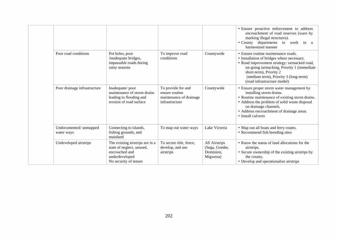
202
• Ensure proactive enforcement to address
encroachment of road reserves (warn by
marking illegal structures).
• County departments to work in a
harmonized manner
Poor road conditions Pot holes, poor
/inadequate bridges,
impassable roads during
rainy seasons
To improve road
conditions
Countywide • Ensure routine maintenance roads.
• Installation of bridges where necessary.
• Road improvement strategy: tarmacked road,
on-going tarmacking, Priority 1 (immediate
short-term), Priority 2
(medium term), Priority 3 (long-term)
(road infrastructure model)
Poor drainage infrastructure Inadequate/ poor
maintenance of storm drains
leading to flooding and
erosion of road surface
To provide for and
ensure routine
maintenance of drainage
infrastructure
Countywide • Ensure proper storm water management by
installing storm drains.
• Routine maintenance of existing storm drains.
• Address the problem of solid waste disposal
on drainage channels.
• Address encroachment of drainage areas.
• Install culverts
Undocumented/ unmapped
water ways
Connecting to islands,
fishing grounds, and
mainland
To map out water ways Lake Victoria • Map out all boats and ferry routes.
• Recommend fish breeding sites
Undeveloped airstrips The existing airstrips are in a
state of neglect, unused,
encroached and
underdeveloped
No security of tenure
To secure title, fence,
develop, and use
airstrips
All Airstrips
(Sega, Gombe,
Dominion,
Migwena)
• Know the status of land allocations for the
airstrips.
• Secure ownership of the existing airstrips by
the county.
• Develop and operationalize airstrips

203
14.6.2 Information Communication Technology
The county is planned to attract and support the growth of the ICT sector. Through this sector,
the county shall harness human and technological resources to ensure improved productivity,
cultural production and human interaction which are often the sites of socio-political growth.
Globally, ICT sector has been recognized as an enabler for growth and development in most
countries. This presents an opportunity to develop more economically, socially and
environmentally sustainable county. ICT is central in providing linkages between all levels of
government, the private sector and urban communities towards achieving sustainable
development. The Government of Kenya realized the role ICT plays in the socio- economic
development of the nation. This is evidenced by the National ICT Policy based on the Economic
Recovery Strategy for Wealth and Employment Creation of 2003-2007. The National ICT Sector
Master Plan (2008 – 2012) outlines the roadmap and implementation strategy for making ICTs
more accessible and affordable to the entire population. This is to enable the Republic of Kenya
to be a fully-fledged knowledge and information society by 2030 (GoK, 2007).
Digital Village Concept is an idea that has been identified by the Government as a solution to
internet access problems. A lot of resources are being put in place to bring government services
at closer proximity to the people through the digital villages concept (KICTB, 2012). Siaya
County is predominantly a rural county with a number of urban centres proposed for upgrading.
The Smart City concept is expected to open up opportunities and facilitate success through a
thoughtful environment and intelligent infrastructure with advanced support systems using ICT
(GoK, 2007). Marketplaces (meeting places) and Learning Institutions are in dire need of
internet hotspots and other affordable computerized services. This area priority for county spatial
planning for ICT enabled services. Sharing internet infrastructure remains the only solution for
schools and urban centres. The spatial locations of digital village facilities remain the sub-
counties and ward headquarters. All sub county headquarters should be fitted with strong
wireless internet links or optic Fibre networks that extends to ward offices in the next 10 years.
This plan proposes an ICT network plan that would ensure equitable access in most learning
institutions and community through urban centres, shopping centres and meeting places of Siaya
County. A wireless network plan is proposed to permeate all corners of the county through a
broadband technology. Aerial masts erected at different locations by wards or sub counties
would form a triangular set of antennae especially through a service provider such as Safaricom,
Airtel, among others. This should be fitted with microwave enabled point to point line of sight
access that would ensure an efficient and faster signal propagation in the county. The design and
spatial location details of the antennas would ensure reliable internet network access by all
potential marketplaces and learning institutions in the county. Radio antennae’s masts for the
internet network could be erected at locations highlighted to ensure maximum signal propagation
in all the learning institutions and market places.
At the backyard of the triangular set antennae, would be set of fully functioning
telecommunications infrastructure that would allow for internet service access. In terms of
implementation schedule, consultations with the relevant authorities and design engineers is
necessary such that donor funding and support can be secured for the purchase of the necessary
internet infrastructure. To effectively and efficiently manage both voice, text and video data
services, a team of qualified technical and maintenance staff would be required. Notable design
issues involving powering costs and location of the antennae altitudes would be put into
consideration. Selected locations must allow for maximum signal propagation in the county
through the sub county hubs into the ward offices.

204
Table 14. 13: Key Issues in ICT Sector and Strategies for Intervention
Sector priority Recommendations Duration Implementing agency
ICT
infrastructure
accessibility in
devolved units
A subsidized loaning scheme by the
government to interested parties (small
groupings/individuals) would help accelerate
the rate of ICT penetration in the rural areas.
5-10 Years. County Government of
Siaya
National Government
NGOs
Donors
County Government of Siaya through ICT
and Education Department needs to create a
funding kitty for learning institutions to
support ICT infrastructure projects. Learning
institutions should be supplied with
commercial connection kits containing basic
access facilities like a hub or a switch at some
subsidized cost that is affordable over time.
10 Years County Government of
Siaya
National Government
NGOs
Donors
Internet infrastructure in market places,
Urban centres of Sega, Ukwala, Ugunja,
Aram, Luanda Kotieno, Siaya, Bondo,
Nyadorera, Yala, Ndori, Akala, Usenge etc.
Through digital villages or Government
premises/offices
10 Years County Government of
Siaya
National Government
NGOs
Donors
Develop internet hot spots where community
members can log in freely through a public
Wi-Fi at Sub county HQs in major public
Parks at Bondo, Siaya, Ukwala, Ugunja, Yala
and Aram.
5-10Years County Government of
Siaya
National Government
NGOs
Donors
Socio Cultural
Strategy as an
opportunity to
promote ICT
awareness
Formation of ICT Clubs in all
wards/schools.
Competitions in ICT to create local content
and promote Siaya County
ICT conferences show casing internet
revolution
5-10 years County Government of
Siaya
National Government
NGOs
Donors

205
Map 14. 8: Proposed ICT network plan

206
14.6.3 Energy
Siaya County has immense opportunity for development of energy sector to meet the future power
demand. The efficient, reliable and sustainable energy services will provide the impulse for the
development of various sectors of the economy including agriculture, tourism, communication,
industries, trade and commerce among others. An integrated approach has been suggested for
power generation and planning in the county.
A rapid population growth and development will lead to increase in demand for power. The level of
energy consumption depends on the economic growth. The basic goal of development programme
in this sector is to decrease, first, the power shortage during normal and peak load and second
increase the power generation capacity up to the level of meeting the total future needs. The efforts
shall have to be made for implementation of an organized and coordinated planning for setting up
of additional new power plants along with up-gradation of regional and national grids.
Poor electricity connectivity and service experienced in the county is associated to untapped
alternative sources of energy and poverty. Therefore, the objective of this plan is to improve
reliability and access to power. In order to realize this objective, the county should exploit the
following strategies:
• Tap on green energy sources: Identify sites suitable for wind and solar energy plants
• Partner with developers of green energy
• Explore the possibility of hydropower generation (R. Nzoia and Yala, Dominion Farm)
• Improve connectivity to power
• Improve the service quality
14.6.3.1 Green Energy System and Renewable Energy
Renewable energy (RE) has been designated as a primary option to overcome the dependence on
fossil fuels and also as a solution towards energy crisis and global warming. Even so, due to the
intermittency of renewable energy systems cannot be achieved without detailed planning and
control. For that reason, the green energy system, built on the concept of renewability and
efficiency, has been introduced as a key factor of achieving sustainability in the energy sector.
14.6.3.2 Promotion of renewable/alternative energy
Renewable energy resources availability depends on geographic locations. The potential renewable
energy sources in Siaya County include solar, biogas, wind and municipal solid waste. The
following strategies can be applied in promoting renewable energy in the county.
a. Harnessing Solar Energy: Energy from the sun can be directly harnessed as electricity through
a solar photovoltaic (PV) system or as heat through solar thermal system. Since Siaya County is
located in a tropical climate, it becomes a good potential area for solar energy investments.
While solar PV system produces electricity directly by converting solar radiation, solar thermal
system works by using heat from radiation to produce high pressured steam to operate a turbine
to generate electricity (Becker et. al. 2000). Although solar energy appears to be a promising
source of energy, exploitation requires vast areas. The identification of a suitable location and
sites are important to prevent wastage of useful land space. In order to improve on energy
sources and supply, the county should endeavor to install solar farm(s) as well as encourage
rooftop catchment.

207
Plate 14. 1: An example of a Solar Farm
b. Utilization of energy from waste: In recent years, waste to wealth has been a hot topic discussed
globally. Instead of disposing of waste, it could in fact be utilized for other beneficial purposes,
such as energy. In Siaya County, the top potential resources for waste to energy, based on long
term availability and abundance, are agricultural waste, municipal solid waste and sewage
sludge.
14.6.3.3 Establishment of the Advanced Energy System
The advanced energy system is a comprehensive system for energy supply which is decentralized
and has several key technologies such as distributed energy generation, energy, demand response
technology and load management system with IT technologies. In the current energy system,
electricity is produced from several centralized power plants and then transmitted and subsequently
distributed to the end uses. However, due to several pressing issues related to the current system,
there is a call for a more advanced system based on the renewable energy. The smart grid that
contribute to the current scenario include the constraints on the construction of new transmission
lines (for centralized system), and increased customer demand for highly reliable electricity.
a. Employing distributed energy system: This system emphasizes on utilizing the local resources
to fulfil the energy demand. These systems produce and distribute networks without being
injected to the transmission network. Generally, the system consists of a cluster of small to
medium size (1-50 MW) power generators (Solar, Biomass, Wind etc.) and energy storage
devices which are optional that compliments one another for optimal operation (CIGRE, 2012).
b. Widespread use of energy storage: Generally, by storing extra energy at times of light loading
and supply energy at times of heavy loading, energy storage systems can provide the required
energy when the generation and loads do not match (Suryanarayanan et. al., 2010). Energy
storage can be performed at the power plant, in support of the transmission system, at various
points in the distribution system and on particular appliances and equipment on the customer’s
side of the meter.
c. Diffusion of demand response initiatives: Demand response is an initiative that involves
electricity consumption change at the demand side in response to the equipment of utility
company during critical periods, i.e., high price and peak hours. The energy saving capacity is
then served as the virtual power plant that supplies electricity to the peak demand load.

208
d. Incorporation of power management system (IT Technologies): A power management system
refers to a computer-aided tool for monitoring, controlling and optimization purposes. The
advantage of the system is such that it allows the plant to keep track of their energy utilization
for further analysis. In terms of control and optimization, the system aids the plant through
scheduling which will then shave energy peaks leading to lower cost of electricity. While in
terms of total energy consumption the system does not reduce and in fact might increase the
overall electricity consumption, with a constant of flat consumption of electricity, the cost of
electricity will generally reduce. In the case of Demand Respond, power management system
acts as an agent to dispatch the demand respond event. On the participant side, along with the
installed metering device, the power management system shall monitor the energy reduction of
participant during such events, which will then determine the payment received by the
participants. In order to ensure reliability and access to power, all urban centres, beaches,
schools, health facilities and households of rural areas shall be connected and serviced with
energy supply. The table below indicates the implementation strategies.
Table 14. 14: Key Issues in Energy Sector and Strategies for Intervention
Sector Planning issue Description Objective Where Strategies
Energy • Poor
electricity
service
• Poor
Electricity
connectivity
in the county
Untapped
alternative
sources of
energy
To improve
reliability
and access to
power
• Urban
Centres
• Beaches
• Schools
• Health
Centres
• Rural
areas
• Tap on Green energy
sources
• Identify sites suitable for
wind and solar energy
farms
• Partner with developers of
green energy
• Explore the possibility of
hydropower generation
(R. Nzoia and Yala,
Dominion Farm)
• Improve connectivity to
power
• Improve the service
quality
• Provide incentives for
installation of renewable
sources of energy
14.6.4 Storm Drainage
The natural undulating terrains with a large network of natural streams form an excellent
combination, which assists drainage evacuation immensely. Rainwater harvesting should be
practiced extensively and storm sewers installed to provide relief. In the county, there is no serious
drainage problem identified, though no organized system of drainage exists. Large scale
development activities as likely to be taken up through the plan period, may cause problem of water
logging, especially in low lying areas. A planned approach, therefore, is required to be initiated in
this regard.
14.6.4.1 County Storm Water Drainage
The County Government of Siaya should initiate a legislative process towards a structured policy or
strategy on storm water drainage. Stagnated storm water drainage in any locality has negative
environmental and health impacts, and causes inconveniences to the community. Undulating
topography with large network of natural channels, one of the characteristic features of Siaya
County, eases out storm runoff and no significant problems due to the storm water is reported
except in Alego-Usonga Sub-county. However, with the anticipated increase in developmental

209
activities, problems of storm water drainage are likely to increase, specifically in the urban areas
and development corridors. Therefore, adequate provision for storm water drainage has to be
implemented. Necessary policies, guidelines and by-laws may be formulated, enacted and
implemented covering all aspects of county storm water drainage. The following actions need to be
undertaken: -
• Comprehensive rainfall-runoff analysis to be carried out.
• Drainage plans for the urban areas and for future developments need to be developed in
consideration with the existing natural drainage channels, retaining, rehabilitating and
improving existing ones.
• Comprehensive catchment treatment programme comprising primarily afforestation and silt
prevention device is to be developed and executed.
• Install storm sewers and drainage channels at strategic areas of the county.
14.6.5 Solid Waste Management
All urban areas within Siaya County do not have any proper plans for solid waste management. The
county does not have any designated dumping. In Alego Usonga Sub County, solid waste dumping
is done in Awelo next to the designated cemetery. Solid waste is managed through burning in the
other sub counties or dumped in undesignated sites. These types of solid waste management are
likely to lead to groundwater pollution as the soils are pervious. There is, therefore, need for
properly designated solid waste disposal sites to safeguard against environmental degradation.
There is therefore need to zone specific areas in all the major towns for solid waste management
and sanitation. Adoption of new and appropriate technology such as land filling other than open
dumping is essential.
14.6.6 Social infrastructure
14.6.6.1 Health
Kenya Vision 2030 aims to provide an efficient and high-quality health care system with the best
standards. Additionally, Kenya aims to become the regional provider of choice for highly
specialized healthcare, thus opening the country to “health tourism” as an income generating
activity. To achieve this, specific strategies were formulated as follows: -
• Provision of robust health infrastructure network
• Improve the quality of health service delivery to the highest standards and promote partnerships
with the private sector
• Provide access to those excluded from healthcare due to financial reasons
The Kenya Constitution 2010 Article 43 (1a) provides for the right to the highest attainable
standard of health, which includes the right to health care services, including reproductive health
care. Additionally, Article 56 (1e) states that the government shall put in place affirmative action
programmes designed to ensure that minorities and marginalized groups have reasonable access to
water, health services and infrastructure. In its Forth Schedule, the Constitution highlights the
devolved health functions which include county health facilities and pharmacies; ambulance
services; promotion of primary health care; licensing and control of undertakings that sell food to
the public; veterinary services (excluding regulation of the profession); cemeteries, funeral parlours
and crematoria; and refuse removal, refuse dumps and solid waste disposal.
Sustainable Development Goal No. 3 of 2015 aims to ensure health and well-being for all ages by
improving reproductive, maternal and child health, ending the epidemics of major communicable
diseases, reducing non-communicable and environmental diseases; achieving universal health
coverage; and ensuring access to safe, affordable and effective medicines and vaccines for all.

210
14.6.6.1.1 Location and Land Requirements for health facilities
The preferred location for health services should be easily accessible by an ambulance and be
provided with basic infrastructural services. Dependent on the level of health service, it is necessary
to reserve adequate land for future expansion. It is recommended that applications for health
facilities be accompanied with details of site requirements to facilitate reservation of adequate land.
Table 14. 15: Key Issues in Health Sector and Strategies for Intervention Sector Planning
issue
Description of issue Objective Where Strategies
Health Basic
facilities Some not connected to
electricity and Water
Lack of specialised
equipment (MRI
machines, Cancer
screening, dialysis
machine)
Low bed capacity
Lack of specialised
laboratories
Lack of mental health
facility
Lack of elderly care
homes
To ensure
adequate access
to basic health
facilities and
services
All health
facilities
(every
sub-
county to
have a
level 4
hospital,
elderly
care
home)
Provide all basic facilities
in hospitals
Upgrade some health
facilities
Land Ownership- Acquire
title deeds for all public
health facilities
Ensure each class of health
facility meets the
recommended standards
Establish a mental health
facility at the county
headquarters
Establish elderly care
centres by sub-county
Access to
health
services
Distance
Inadequate
drugs/medicine
Low staffing of different
cadres of health
personnel
Poor disposal of medical
waste
Poor access of medical
facilities by residents
at the Islands
To enhance
accessibility to
quality health
services
All health
facilities
Make all hospitals
accessible to weather
roads.
Improve health personnel
to patient ratio
Provide health facilities in
areas not served
currently
Safe disposal of medical
waste
Have an emergency
motorboat to service the
islands
14.6.6.2 Education
Education is an important inducer of economic growth and development of any society. The most
important element for future economic and social success is development of inclusive and quality
education. This would have to be understood as an important part of the spatial development
strategy, aiming support in enhancing qualities of education for the whole county, and for all.
Findings indicated a strong link between poverty with reduced achievement in education. Efforts to
ensure education for all are of a special importance. Although the rate of inclusion to binding
education is almost universal, there are inequalities related to income levels. At this aspect,
secondary and higher education faces large inequalities. The trend of population increases and the
government policy on 100% transition has caused pressure on the available education facilities
which for a long period of time has been insufficient with enormous shortage of the teaching
personnel.
The specific strategies towards quality education as stipulated in the Kenya Vision 2030 include: -
Integration of early childhood into primary education
Reforming secondary curricula

211
Modernizing teacher training
Strengthening partnerships with the private sector
The flagship education and training projects for 2012 identified included:
Build and fully equip 560 new secondary schools to accommodate the increasing number of
students graduating from primary schools
Establish computer supply programme that will equip students with modern information
technology skills
Create centres of specialization for each vision 2030’s economic growth sectors.
14.6.6.2.1 Principles for Provision of Schools
To achieve access to quality education for all, the county ought to focus on the distribution of
schools, their accessibility and quality of infrastructure. Therefore, Location and access of
education facilities are important principles in planning. The goal is to ensure access to services in
areas underserved (administrative principle) through a hexagonal lattice analysis. On the other
hand, location serves as an important factor leading to the success of any educational facility
(Location-allocation principle). A strategic location provides high-quality service to the
community at a low cost.
14.6.6.2.2 Location and Land Requirements for the provision of schools
The Physical Planning Handbook (2008), provides the guidelines and minimum standards to be
used while planning for education services and facilities. The handbook cites the need for
educational institutions to have site layout plans prepared and submitted for approval to relevant
authorities so as to avoid haphazard developments. In its discussion, it also highlights standards
with regard to demand and distribution, Location, land, and space requirement for various levels of
education facilities as tabulated.
Table 14. 16: Key Issues in the Education Sector and Strategies for Intervention Planning issue Description of issue Objective Where Strategies/Actions
Basic facilities Shortage of well-
equipped laboratories
in secondary school
Poor drainage and waste
disposal system
Lack of water in some
schools
Inadequate green
infrastructure
No defined footpaths.
Inadequate/poor play
areas for students due
to inadequate land
Inadequate floor area
for classrooms
Inadequate educational
institutions in some
wards
Haphazard planning
leading to poor
location of
developments
To ensure
access to
basic
facilities
and services
All schools in
the county Provide well equipped
laboratories for all secondary
schools
All schools to be provided with
sanitation facilities
Schools to be connected to
SIBOWASCO.
Roof catchment to be
encouraged
Water and electricity
Ensure adequate green
infrastructure coverage in
schools (Landscaping)
Ensure adequate land for
expansion as per the spatial
planning standards.
Conduct an analysis of demand
for educational institutions
Increase educational institutions
in areas of inadequacy as
indicated in the polygon
analysis
Each school should have a site
layout plan

212
Planning issue Description of issue Objective Where Strategies/Actions
Access to
schools Longer walking distance
for students to
schools
Poor road conditions
Poor access to education
by persons with
disabilities with
regard to specialised
equipment, access
roads
To ensure
inclusive
and
adequate
access to
schools for
all
All Schools Provide an average of 1km for
primary schools
Provide an average of 2.5km for
secondary schools
Provide an average of 500m for
ECD
Make all schools accessible
through all-weather roads.
Ensure inclusive disability-
friendly learning
environment e.g. ramps,
toilets for persons with
disability, specialised
equipment, teachers
Transition to
tertiary
education and
training
Declining interest for
village youth
polytechnics
Poor equipment
Inadequate personnel
Inability to afford
education by students
especially those from
humble backgrounds
To promote
transition of
tertiary
education
and training
All village
polytechnics Branding and upgrading of
village youth polytechnics to
County Vocational training
centres
Provide adequate equipment for
training of students
Increase personnel to the
required student teacher ratio
Improve allocation of bursaries
to students

213
14.7 GOVERNANCE STRATEGY
The devolved government structure and resources of Siaya County creates an opportunity for
development of thirty (30) strong administrative centres. These centres will act as poles of growth
and offer an opportunity for implementation of a new hierarchy in each county. These centres will
be critical in not only servicing rural areas but also in absorbing populations from the rural areas
once opportunities for employment are created.
14.7.1 Open and Collaborative Leadership
Open and Collaborative Leadership is one of the key strategic directions for the Siaya County and
the basis of the strategy are:
Integrated sustainable long-term planning for Siaya County and the region
Considered decision making based on collaborative, transparent, open and accountable
leadership
active public engagement on local planning and decision-making processes and a shared
responsibility for achieving goal
county government as organization of excellence
14.7.2 Governance Framework
This framework is intended for the high-level processes and behaviors that ensure Siaya County
performs by achieving its purpose and conforms by complying with all relevant laws, codes of
ethics while meeting community expectations probity, accountability and transparency. Ensuring
County has a sound governance framework in place underpins open and collaborative leadership
and is essential to provide community with confidence that:
County is legally compliant and acts on ethical issues
county decision making processes are open and transparent and made in the best interest of
all stakeholders
County is and is seen to be a good corporate citizen
14.7.3 Purpose of the Governance Strategy
The purpose of this strategy is to inform action through Open and Collaborative Leadership through
governance framework which: members of County Assembly (MCAs)and county staff to ensure
that citizens have trust and confidence in the decisions made by the county, and ensure all processes
and decisions are made openly and transparently
14.7.4 Principles of Governance
The county commits itself to the following principles:
Equity: The County Government shall ensure fairness in decision making, prioritizing and
allocation of resources, particularly for those in need. Everybody should have a fair opportunity to
participate in the future of the community. The planning process should ensure to involve and
protect the interest of people in vulnerable circumstances.
Transparency: People should have access to the information they need to understand government
planning and decision-making processes in order to participate in an informed way.
Participation: Maximum opportunity to genuinely participate in decisions affecting people's lives.
Active Citizenship: People are able to exercise their rights and responsibilities in a balanced way
within our democratic society. Individuals and groups are encouraged to take a role in the
community and are empowered with the skills, support and opportunity to shape and influence
decisions that affects the community now and in the future.

214
14.7.5 Objectives of the Governance Strategy
i. To develop an Integrated, sustainable long-term governance plan for Siaya county
ii. To achieve a considered Decision-making based on collaborative, transparent and accountable
leadership
iii. To establish active public engagement on local planning and decision-making processes and
shared responsibility for achieving goals
iv. To build a County Government Organization of Excellence

215
Table 14. 17: Governance and policy implementation framework
Objective 1 Strategy Action
Developing Integrated,
sustainable long term
plan for Siaya county
Identify and document the main
priorities and aspirations of the
county
Develop and deliver a County Spatial Plan in partnerships with county and state agencies, community
groups and individuals
County must ensure social justice is achieved by:
Ensuring that broad range of community members have input into the development of the CSP
specifically consult with those groups whose voice is not often heard in community decision;
ensuring that CSP is adequately inform by sound social research and needs analysis
In communicating the CSP, the county needs to show how community engagement informed the goals,
priorities and strategies while demonstrating that CSP shared long term plan for community and the county
Develop a resourcing strategy which
must include provision for long term
financial planning, workforce
management planning and asset
management planning
CSP provides a vehicle for each stakeholder to express their long term aspirations. However, these
aspirations will not be achieved without resources- time, money, assets and people- to carry them out.
Resourcing strategy is critical in linking CSP objectives to actions.
The integrated nature of the spatial plan means that various projects will be implemented concurrently with
cross-referencing and adjustments as development of each plan progresses
The plan will identify that the county does not have full responsibility for implementing or resourcing for all
stakeholders aspirations identified in the County Spatial Plan
Maintaining long term financial
sustainability
Develop and adopt a long-term financial plan incorporating the county's current financial position, strategies
and assumptions that analyze potential financial impact of a number of alternate future planning scenarios to
assist in determining the most appropriate course of action
This course of action will support service delivery level required by the county residents while ensuring a
long term financial sustainability of the county
Ensure Asset Management strategy
and Plans capture residents
expectation for both service and
value and support inter-generational
principles
As the custodian, the County authority is responsible to effectively accounting for and managing these assets
and having regard for long-term and cumulative effect of the decisions.
County should establish goals and objectives for assets management in terms of providing platforms for
service delivery, integrate asset management with County Spatial planning and Integrated Development
Plans, maximize value for money by adoption of lifecycle costing, combined with performance
measurement, and promote sustainability to protect the needs of the future generation
County should ensure that its asset management planning has a service delivery focus. The assets that are
provided is necessary to meet the needs of the county residents as identified by the stakeholders
Asset management decisions should be informed by evaluation of alternative means of service provision,
full lifecycle costing and performance measurement and monitoring
Informed decision making recognizes the long-lived character of the infrastructure asset and the need to plan

216
and budget for them in full lifecycle basis beginning with identification of a service need and the means to
meet the need
Identify and predict workforce
issues in order to ensure resourcing
to meet the objectives of the County
Spatial Plan
Develop and adopt a workforce Management Plan to ensure County has planned for the unforeseeable future
(next 10 years) and is able to meet the objectives of the CSP
The workforce Management Plan is a continuous process of matching workforce requirement to county
objectives in delivering the CSP, as well analyzing and focusing the human resource implication when
undertaking strategic plan activities
In developing and maintaining the workforce Management plan, consideration has been given to both
internal and external factors that may affect the county's ability meet its current and future workforce needs.
This factors include an aging population, identified skills shortage, past recruiting experience, county's
financial position and stakeholder expectations.
Clearly detail and be accountable
for the actions taken to achieve the
objectives of the CSP
The County authority uses the CSP and resourcing options to prepare a 5-year delivery programme for its
term in Office
Develop and deliver a 5-year delivery programme detailing the actions the county government will prioritize
in 5-year period which are aligned with achieving the objectives of the County Spatial Plan
Each year, adopt an Operational Plan including a detailed annual budget and a statement on the County
Revenue Policy
The adoption of the above documents guides the Members of County Assembly and staff to ensure that the
decisions of the county are open, transparent and consistent with stakeholders’ aspirations during the
consultative forums in the CSP development process
To demonstrate accountability to the people, MCAs and county staff should at all times ensure that their
decisions are consistent with Delivery Plan and Operations Plan. The decision making process should
include appropriate analysis and documentation of all risks and financial implication
Account to the Public for
expenditure of public monies and
for efficient and effective operations
of the county
Develop an annual report detailing:
Progress on delivery of programmes
Financial Performance
Asset reporting
Legal proceedings
Contracts awarded
Private works and financial assistance
Details of external bodies, companies and partnerships
Details of overseas trips by MCAs and County staff
Details of County executive members, MCAs expenses and facilities
Total remuneration of the County Governor, Deputy Governor, Assembly speaker, and MCAs
Equal Employment Opportunity Management Plan

217
Objective 2 Strategy Action
Considered Decision-making
based on collaborative,
transparent and accountable
leadership
Maintain a strong ethical culture and high
standard of conduct
County adopts code of conduct based on model code of conduct developed by other devolved
units and organization
The code of conduct sets out ethical and behavioral standards to be complied with by MCAs,
County staff, administrators and conduct reviewers.
The County Governor, MCAs. all senior staff are expected to demonstrate through their words
and actions, commitment to the code of conduct. All staff are expected to comply with the code
of conduct
To improve workplace and organizational culture, county government to introduce training
programme which is designed to build awareness and understanding of how attitudes, behaviors
and mindset impact on the way people work together. The training programme should aim to
provide a common language through open communication across county so that county officials
to recognize, talk about and work towards a more constructive culture
Clearly defined roles and responsibilities
with independence as well as cooperation
between all parties
County Government Act 2012, clearly defines the role of County executive and Couny
Assemblies. Effective governance relies on acceptance and independence of the different roles of
the County Executive and Assembly
County adopts an interaction between MCAs and county staff Policy to support the Code of
Conduct and ensure appropriate level of independence MCAs and County staff
An effective relationship between the County Governor and Members of County Assembly
promotes the successful delivery of the County Spatial Plan as well as the reputation of the
County
Support and Commitment to Education
and training
Education and training to both the MCAs and County staff to ensure they appropriately
understand their governance obligation is important for the county
All MCAs should be required to complete an education and induction programme upon election,
usually after every 4-years regardless of whether you are new or re-elected, and an ongoing
professional training. This is to ensure MCAs have appropriate level of skills and experience
required to proper fulfill their responsibilities according to regulation.
County support continuous education and professional development programmes for MCAs. A
budget to allow MCAs to attend ongoing professional development training is provided for in the
County's Payment of Expenses and Provision of Facilities for MCAs Policy for the County
County is committed to educating all levels of staff through established formal training
programmes, including:
Senior management induction programmes covering governance matters that all senior
managers are required to attend on commencement of employment in the County
staff induction programmes covering governance issues that all staff are require to attend
upon commencement of employment in the county
provision of a training budget per staff to support them in ongoing training and education
relevant to their roles
County should have an established governance training programme at all levels endorsed by the

218
County executive management team. The adopted programme should to include all relevant
aspects. The adopted governance programme includes all relevant aspects of governance
depending on the level within organization
Clear and considered decision-making
process made by the county are in the best
interest of the county residents and in
consistent with the objectives of the CSP
Elected County Officials (Governor and MCAs) delegate to the senior management (County
secretary, CECMs, Chief Officers) functions of the County except those precluded from
delegation under County Government Act, 2012 or those functions the elected officials consider
should be done by themselves
The senior management in turn delegates the functions to staff at appropriate levels of the county
structure to ensure day to day work of the county can be carried out. This includes financial
delegation to ensure financial decisions are appropriately made and there is a system of
accountability
The delegation framework demonstrates the trust the county elected officials’ places on the
senior management and staff in decision-making. The county senior management are responsible
to ensure that delegation is done in line with appropriate policies. County policies provide
guidance to staff to enable appropriate decisions to be made.
MCAs should be entitled to put forward alternatives to the recommendations provided by the
county staff through executive. All decisions must be supported by reason and align with the
objectives of the County Spatial Plan
All decisions are made at appropriate levels and are supported by sound financial and risk
analysis, as well being consistent with CSP.
Clear and considered decision-making processes to ensure the decisions made by the county are
for the best interest of the county residents and consistent with objectives of the CSP
Objective 3 Strategy Action
Active Public Engagement on
local planning and decision-
making processes and shared
responsibility for achieving goals
Being open and transparent with regard to
county's public engagement activities
The county ensures significant public consultation and adoption of the County Spatial Plan. The
CSP is supported by specific public engagement strategy. Public engagement for the CSP is the
key way the citizens can become involved in setting the strategic direction for the county.
Once the CSP is adopted, the MCAs and the county staff are empowered to implement the
strategies and goals established in consultation with the stakeholders.
The county adopts the public engagement framework and public engagement policy to provide
for openness and transparency with the county's public engagement activities as well as being
accessible, inclusive and actively seeking input in decision-making.
MCAs and county staff recognize that decisions are improved by engaging the residents and
other stakeholder groups. Within county's ability to finance and resource, county commits to
conduct transparent and inclusive engagement process that are responsive and accountable.
County assigns high priority to appropriately involving residents and other stakeholders early on
and throughout the process, especially when decisions impact their lives. County recognizes and

219
complies with practices developed by International Association for Public Participation, Agenda
21, Constitution of Kenya 2010, Article 1(2), Article 10(2), Article 27, Article 33, Article 35,
Article 61, Article 69(1) and other related legislations.
Public participation is defined in many ways depending on context. For Siaya county, it's the
primary way we build public awareness and understanding, and gain better insights into the
public opinion. The information shared with the county residents is used to ensure services and
facilities meet the needs of the people.
The county should expand its stakeholder engagement program to empower residents to be
further involved in decision-making process. Methods to employ when engaging stakeholders to
include:
Facilitated workshops
Focus Group Discussions
Online Surveys
Geo Mapping tool surveys
Intercept surveys
Information sessions
There are constantly evolving tools being developed to in the stakeholder engagement space to
better target the hard to reach sections of stakeholders groups as well as make the engagement
experience as attractive and accessible as possible. The County staff will continue to review from
time to time these tools for potential use across county's planning and service provision
initiatives.
Diverse stakeholder engagement with a broad section of county residents and other stakeholders
is important as MCAs and county Executive and staff have a responsibility to act in the best
interest of the people of siaya county.
Provision of public access to County
meetings and business papers
All the ordinary assembly meeting, including assembly sub-committee meetings be open to
public unless required to be closed according to the relevant Act.
County makes its business papers available in the County website in advance of County
Assembly meetings as well as hard copies from the Assembly administration office
Minutes of all open county meetings be made available to public
Clear line of communication between the
MCAs and the members of public
MCAs contact details including email contacts and telephone numbers are listed in the County
website to allow members of the public to directly communicate with the leaders.
Senior County staff contact details including email contacts and telephone numbers listed in the
county website to allow members of the public to directly communicate with them
Members of the public can raise issues with their leaders at any time. As business papers are
released to the public in advance of the assembly deliberations, the public can email or speak
with MCAs on issues scheduled for deliberations at the Assembly.
Open and accessible government
information as well as commitment to
protection of privacy
Under article 35 of the Constitution of Kenya 2010 and Section 96 of the County Government
Act of 2012, there is provision for the right to access of information. Article 35 particularly
guarantees all Kenyan citizens the right access any information held by the state or county or
information held by another person and required for the exercise or protection of right or

220
fundamental freedom. For the County this includes
Making open access information that is required under article 35 of the Constitution of
Kenya 2010 and Section 96 of the County Government Act of 2012
Proactively publishing information in the county website than is legally required and
improve efficient release of information
processing all the formal and informal requests for information efficiently and effectively,
and
processing all formal access applications within the statutory timeframes and in
compliance the legal requirements
The County executive ensures provision of a timely and detailed information to MCAs relevant
to the discharge of the civic duty while still maintaining appropriate level of independence the
elected leaders and the county staff.
County will ensure it meets the highest level of disclosure regarding all dealings with county
officials while also meeting its obligation under the relevant privacy regulations and County
Privacy Management Plan
County will ensure that its procedures meet the highest level of transparency, accountability and
probity while complying with current legislative requirements
Whilst County is committed to releasing information, such disclosure will be done where there is
public interest to do so. This means that there some personal or commercial in confidence
business information that may not be disclosed if there is no public interest to do so.
Open and transparent disclosure A standing item in every Assembly and other county strategic meeting’s agenda should be
disclosure of conflict of interest requiring MCAs and All county staff to make disclosures in the
meetings about any conflict of interest they have in relation to any item in the agenda of
discussion. The officials conflict of interest is recorded in the minutes of the meeting.
County staff are also required to declare in writing to their managers any conflict of interest that
arise in the course of the conducting their duties
When MCAs and County Officials declare a pecuniary or significant nonpecuniary interest, they
must remove themselves from the decision making process.
MCAs, senior staff and other staff members with decision-making functions are required to
complete an annual pecuniary interest return disclosing to the County secretary:
Property
Income
Significant gifts
Significant contributions to travel
Shares and positions held in companies
Positions in trade unions or professional associations
Debts; and
Discretionary disclosures
Consideration of citizens advice on The County may establish advisory committees by a resolution of the County Assembly. The

221
County issues purpose of these committees is to provide guidance and make recommendation to elected and
other county officials within a particular area of expertise. The committees may have members
from key stakeholder groups and MCAs as members
The committees meet to discuss issues within their areas of expertise and make
recommendations back to County executive and County Assembly.
The assembly adopts a constituting document for each of the committees, setting out, including
and not limited to:
Responsibilities/terms of reference
membership
meeting frequencies and agenda items
committee authority, and
reporting obligation
Effective Complaints handling focused on
customer service improvement
County adopts Customer complaints handling Policy to ensure:
County responds to complaints in a timely, consistent and cost effective way;
The boosting of public confidence and perception on quality of services provided by the
county
Complaints information and statistics are used to deliver quality improvement in services
and the way in which it handles complaints
Objective 4 Strategy Action
County Government Organization of
Excellence
Accountable to actors and to
support strong governance
framework
County to establish a governance committee made up of County executive members and MCAs.
The purpose of the governance committee will be to:
Oversee the development of County governance policies and Policy framework
review county's code of conduct at regular intervals
review and endorse staff awareness programmes on Code of Conduct, fraud and corruption
prevention and public interest disclosure;
review and monitor county's effectiveness in handling customer complaints
review and monitor county's fraud and corruption management plan
review and monitor CSP and reporting framework
The governance committee will report periodically to the County Assembly and the County
Executive
Improve fraud and corruption
control
The County to adopt Fraud and Corruption strategy that provides:
An integrated and overarching strategy to control fraud and corruption risks in the county
Guidance on all fraud and corruption management activities and regular updated tracking
actions taken by the county to prevent fraud and corruption, and
A mechanism for evaluation and continuous improvement of fraud and corruption
management activities at the county through fraud and corruption management plan
County takes steps to ensure it County adopts an internal reporting policy from time to time. It should provide:

222
appropriately identifies and manage
serious wrong-doing
Procedures for reporting serious wrong-doing to appropriate levels of management or legal
department and governance team
The reporting of systemic and recurring governance problems to those with sufficient
authority to correct them
Promotes an organization that
eliminates or minimize risks
County supports and is committed to risk management. County adopts and maintains a risk
management framework and risk management committee to appropriately identify and manage:
Business and financial risks including fraud and corruption
Risk management plans for projects and undertakings
Project continuity planning, and
Emerging risks
The risk management committee reviews the risks and insurance related initiatives which provides
for risk awareness and mitigation strategies to be implemented where appropriate
Ensure accountability for Public
money, and high level of services,
governance, quality, professional
conduct and compliant with
professional standards and other
legislative requirements
The county is requiring to ensure that external audits of its financial reports are carried out in
accordance with accounting standards.
County adopts and maintain an audit committee in accordance with regulation and based on the
best practice. The audit committee reports periodically to the County Executive and County
Assembly
The objective of the audit committee is to provide independent assurance and assistance to the
county on risk management, fraud and corruption control, governance, financial and legal and
regulatory obligation.
Table 14. 18: Key strategies in Governance and Security Infrastructure
Proposal Number Location requirements Land requirements Space requirements
Sub-county
HQs
6 • Centrally located
Police Division
• Sub County
Administrator Office
• Library/Resource centre
• Social hall
• VCT centre
• Public telephone
• Amphitheatre (Cultural dances, cinema etc.)
At least 1Ha of land is required
• Recreation facilities i.e. park
• Space for
security offices
Ward HQs 30 • Centrally located
• Police Station in each ward headquarters
• Office of the Member of the County
Assembly
• Ward Administrators offices
• Library/Resource centre
• Social hall
• VCT centre
• Public telephone
• Amphitheatre (Cultural dances, cinema etc.)
A police station requires at least 2 Ha of land
• Recreation
facilities i.e. park
• Space for
security offices
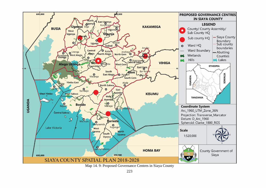
223
Map 14. 9: Proposed Governance Centres in Siaya County

224
PART V- SPATIAL DEVELOPMENT
FRAMEWORK

225
CHAPTER 15: SPATIAL DEVELOPMENT FRAMEWORK
15.0 Introduction
County Spatial Plan as per the provision of Physical Planning Bill 2017 and Physical
Planning Hand Book 2018 is supposed to detailed guidelines and planning standards for
zoning provisions as well as permitted functionality of the plan. This County Spatial Plan
therefore synthesis and scenario building and clear focus while embracing Sustainable
Development Principle recommends a balanced Spatial Framework in development activities
embedded in to three (3) broad spatial development structures or framework, namely the
Green Spatial Development Framework, the Brown Spatial Development Framework, and
Blue Spatial Development Framework herein referred as zones I, II, and III respectively.
15.1 Land use/ Zoning plan
15.1.1 The Green Spatial Development Zone I
The Green Spatial Development Zone I is created in recognition of the fact that Natural
Capital is the backbone of any socio-economic development. Natural resource as well as
environmental well-being are given prominence in this zone:
To ensure that ecological goods and services as well as natural capital available and
guaranteed for the present and future generations through the allocation of space for
conservation, preservation and protection of all environmentally significant areas in the
County.
To ensure that areas for productive engagement in agriculture for food production and
raw material through allocation of space at all times to realize food security and value
addition in manufacturing
There shall be a Green Spatial Development Zone 1: This zone therefore comprises of all
environmentally significant areas and habitat conservation areas as detailed in Environmental
Management and Coordination Act of 1999 (amendment 2016) and the Agriculture Act
(2003) (Figure 15.1).
15.1.1.1 Zone 1A (Ecological Integrity zone)
These areas first include: forests (gazetted and community forest, hill tops, migratory
corridors). The plan recommends establishment of buffer zones in these areas to reduce
encroachment to these important biological diversity areas. Minimal human activities are
allowed in these Zone 1A, and to extent human settlement shall be restricted and/or not
permitted in some extreme spaces that are susceptible to severe environmental degradation
and/or loss significant biological habitat due to human encroachment (steep slopes, unique
biodiversity areas, water catchment area, ground water reserve).
15.1.1.1.1 Strategies for ecological integrity zone (Zone 1A)
There shall be concerted efforts in collaboration between National and County Government
to gazette these areas of ecological integrity (environmental quality).
There shall be concerted efforts to create buffers zones through demarcation of these spaces.
There shall be elaborate efforts geared towards enhancing preservation, protection,
conservation of these spaces.
There shall be elaborate efforts to promote ecotourism venture (recreational) in these areas
in order to realize revenue generation.

226
From time to time the National and County Government shall progressive pronounce
policies, strategies, legislations, guidelines and standards to govern and manage these
areas for the benefit of humanity and environmental quality.
15.1.1.2 Zone 1B (Agricultural Integrity zone)
Secondly, all agricultural land for food production (maize, beans, cow peas, groundnut,
sorghum, finger millet, vegetables, fruit crops), cash crops (sugar cane, coffee, cotton) and
livestock production (cattle, cows, goats, sheep, poultry) just to mention some as detailed in
the Farm Management Hand Book 2011 in reference to Agro-Ecological Zones’ guidelines,
except the areas, delineated as Urban and Transport Corridors shall be designated as Green
Spatial Development Zone 1. Zone 1B, designated area for agricultural production (crops
and livestock), though designated as a Green Spatial Zone I, where human settlement
activities shall be permitted thus designated as rural areas and/or peri-urban, for housing
(home) development that are compatible and conform to the green agenda in housing
development. In general, 70% green cover shall be encouraged. Built homes shall maintain at
least 10% green cover of the appropriate (mirror natural habitat) biological species of flora
(preference to indigenous species).
15.1.1.2.1 Strategies for Agricultural Integrity (Zone 1B)
From time to time there shall be elaborate efforts in collaboration between National and
County Governments to pronounce policies, strategies, legislations, guidelines and
standards to govern and manage these areas to promote agricultural productivity to realize
food security and value addition in manufacturing in the County.
There shall be appropriate, affordable and reliable crop and livestock husbandry methods,
and technology applied and transferred to the populace to engage in profitable agriculture
and promote local economic growth.
There shall be concerted efforts made to encourage local populace to engage in agriculture,
especially the youth, to create employment and increase income as well as multiplier effect
in other related economic activities, through backward and forward linkages.
There shall be concerted efforts to expand land under agriculture, through small-holder
farmer participation and increased farmer extension services.
There shall be concerted efforts to expand land under agriculture through irrigation
programmes to cushion farmers from impact of unreliable rainfall (drought).
There shall be concerted efforts to increase agricultural productivity through improved
technology uptake, and mechanization (tractorization).
There shall be deliberate efforts in marketing, creativity, innovation, technology, to enhance
value addition in agricultural products to allow the economy to start shifting towards
industrialization.
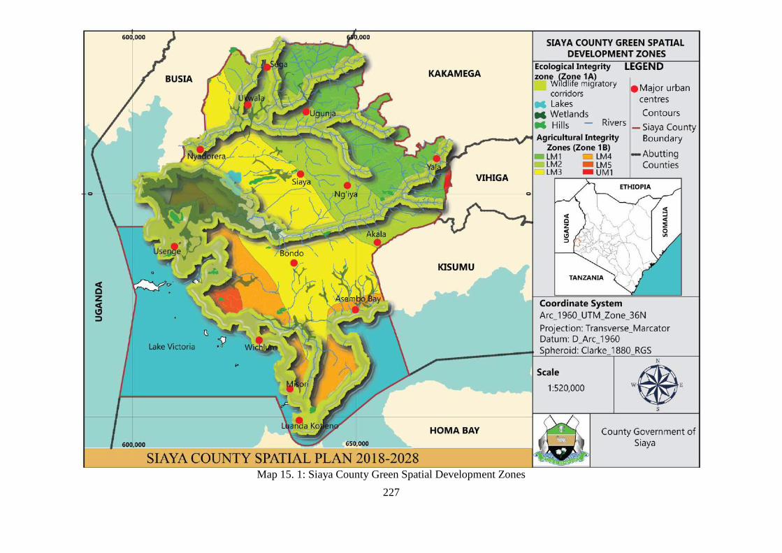
227
Map 15. 1: Siaya County Green Spatial Development Zones

228
15.1.2 The Brown Spatial Development Zone II
The Brown Spatial Development Zone II is created to allow human settlement and
infrastructure development for the well-being of social-economic transformation. This zone II
shall comprise of Urban and peri-urban areas as Zone IIA and Transport (growth) Corridors
Zone IIB, Nucleated Rural Settlement Zone IIC and Special Economic Zone IIC. Zoning
guidelines and planning standards are therefore pronounced to guide development in this
zone according to the Physical Planning Act Cap 286 (Amendment Physical Planning Bill
2018) and Urban Areas and Cities Act 2011 (Amendment 2016). The County Spatial Plan
pronounces that there shall a Brown Spatial Development Zone II, where human settlement
and infrastructure development activities shall be permitted, however, aspects of green spaces
shall be embedded in this zone to allow integration and balanced development to allow
enhanced environmental quality. Development in this zone shall embrace 30% green cover.
The 70% built environment shall comprise of residential, industrial, educational, recreation,
public purpose, commercial, public utilities, and transportation land uses, while embracing
mixed land use for county-wide functionality as per the provision the Physical Planning
Standards 2018. This zone therefore comprises of human settlement development areas
designated as settlement areas of: growth centres (7 Kilometre radius), sub-county growth
centres (5 Kilometre radius), urban centres (3 Kilometre radius), rural and local centres as
well as growth corridors (transport).
15.1.2.1 Objectives of the brown spatial development zone II
To enhance harmonious and sustainable urban development for livable towns and rural
settlements.
To promote sustainable human settlements with the growth corridor and special economic
zones transform the county local economy.
15.1.2.2 Strategies to promote permitted development in Zone IIA (Urban Development
Zone)
From time to time there shall be elaborate efforts in collaboration between National and
County Governments to pronounce policies, strategies, legislations, guidelines and
standards to govern and manage urban development and affordable, sustainable housing
within livable urban area in the County.
There shall be concerted effort to promote commercial development areas for sustained
local economic development as well as appropriate markets to promote small and
medium enterprises (SME).
There shall be elaborate programmes to promote industrialization through creativity,
innovation and technology as working environment for the urban population as well as
shift the labour market from agriculture to industrial development
There shall be concerted effort to develop affordable housing to enhance social inclusivity,
equity and livable environment for the urban population in the county
There shall be an elaborate programmes to improve social development in the County
through provision of education and health services while embracing and respecting the
catchment population and accessibility concepts.
There shall be concerted efforts to establish public purpose land uses to promote
governance, security, cultural and spiritual well-being of the population as well as
devolved service delivery to the local population.

229
There shall be elaborate endeavors to develop public utilities (electricity, energy, water
sanitation, sewer line, telephone, Information Communication and Technology (ICT)
hubs, dumping sites, cemeteries) county-wide to enhance livability of the urban
settlements.
The County Government in collaboration with private sector shall ensure development
control is exercised in this zone as provided in the Physical Planning Standards 2018
15.1.2.3 Zone IIB Growth Corridors (Transport)
The County Spatial Plan shall pronounce the existence of Growth Corridors in tandem with:
with major transport network in the county herein designated as settlement areas as i)
Regional Development Corridor of 1 Kilometre radius and ii) County Development of 0.5
Kilometre radius. The permitted development of Urban Development Zone shall apply
(mutatis mutandis) as well as the strategies where appropriate and applicable.
15.1.2.4 Zone IIC Rural Settlement Zone
The County Spatial Plan shall pronounce the existence of a Rural Settlement Zone, that acts a
transition between the Green Zone and the Brown Zone. The provision here is to have a
nucleated settlement in a rural and local centre of a radius of 0.5 of a Kilometre, well serviced
with socio-economic facilities to perform their designated functionality.
Strategies permitted to promote development in this zone shall include:
There shall be a resettlement programme to deepen nucleation while releasing land for
agricultural productivity.
There shall be other strategies on Urban Development Zone shall apply (mutatis mutandis)
15.1.2.5 Zone 11D Special Economic Zone
The County Spatial Plan shall pronounce the existence of Special Economic Zone to
accelerate socio-economic transformation in areas of industrialization, commercial hub, ICT
hub and smart city (techno-city).
There shall be a public-private partnership framework to develop a special economic zone
through effective infrastructure development to facilitate these areas as impetus for growth
while embracing the backward and forward linkages concepts.
There shall be other strategies on Urban Development Zone shall apply (mutatis mutandis).

230
Map 15. 2: Siaya County Brown Spatial Development Strategy

231
15.1.3 The Blue Spatial Development Zone III:
The Blue Economy is an emerging economic space with the lacustrine environments, namely:
water related (lakes, rivers and wetlands). The County Spatial Plan pronounces development
frameworks within this zone, of significance in terms activities related to fishing, tourism and
marine economy (ship building, boat making), water transport (shipping logistics, Port &
harbors), exploration energy (wind and solar power).
15.1.3.1 Objectives of the Blue Spatial Development Zone III
To explore, establish and promote tourism development in the Zone in order to shift labour
engagement new areas of economic transformation
To initiate and formulate policies, strategies, guidelines and standards that promote blue
economy development.
To enhance, strengthen the development of fisheries both capture and culture fisheries to
promote food security and value addition in manufacturing
15.1.3.1.1 Zone IIIA: Tourism Promotion Zone
The County Spatial shall pronounce the Tourism Promotion zone, herein referred as the
Lakefront of: Lake Victoria, Lake Kanyaboli, Lake Nyamboyo and Lake Sare. In addition,
the Yala Swamp Ecosystem is included in this zone as important wetland of international
importance (IBA) (Important Bird Area) as per UNESCO and WWF classification. The lake
Front 5km inland shall therefore have be permitted for development of the tourist industry
inform of marina, lodges, resorts, restaurants hotel development, water sport, leisure sport,
and marinas as detailed to conform and compatible in the Physical Planning Handbook 2018
as well as in line with Sustainable Tourism Development Strategy.
Strategies to promote tourism development include:
From time to time the National and County Government shall pronounce policies,
strategies, legislation, guidelines for sustainable tourism development
There shall be a designated the Lake Front, through legislation, as an exclusive tourism
development zone.
There shall be concerted efforts to mobilize land resources in the Lakefront, through
acquisition, purchase, compensation, and land banking to release this land for tourism
promotion.
There shall concerted effort to mobilize funds for capital investment to develop the area as a
Lakefront (infrastructure, building lodges, resorts). The Capital Investments shall be
through Public-Private Partnership, National and County Government, Foreign Direct
Investment and local investors.
There shall be to develop the County-Tourism to link to the regional circuit (Western
Kenya) and the national circuit synchronized (Branding, Marketing, Promote Visibility in
various channels).
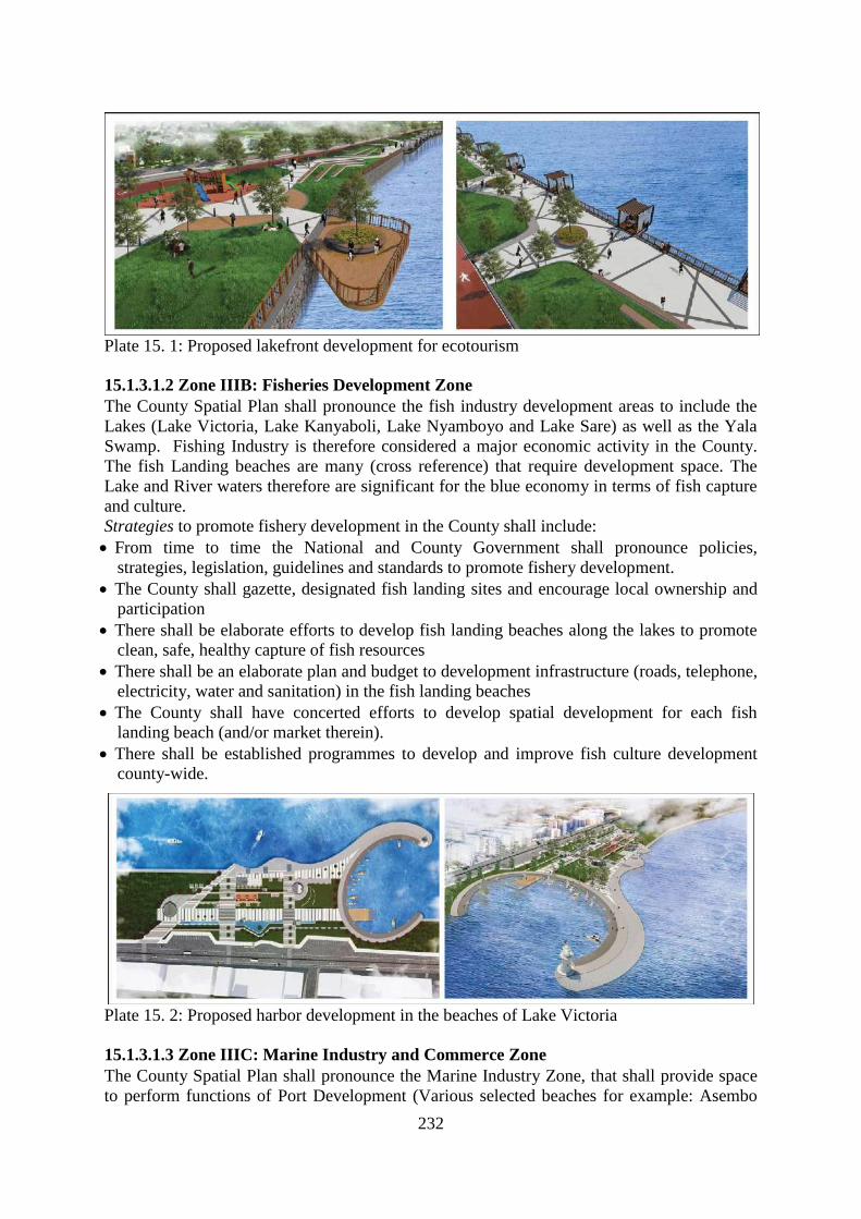
232
Plate 15. 1: Proposed lakefront development for ecotourism
15.1.3.1.2 Zone IIIB: Fisheries Development Zone
The County Spatial Plan shall pronounce the fish industry development areas to include the
Lakes (Lake Victoria, Lake Kanyaboli, Lake Nyamboyo and Lake Sare) as well as the Yala
Swamp. Fishing Industry is therefore considered a major economic activity in the County.
The fish Landing beaches are many (cross reference) that require development space. The
Lake and River waters therefore are significant for the blue economy in terms of fish capture
and culture.
Strategies to promote fishery development in the County shall include:
From time to time the National and County Government shall pronounce policies,
strategies, legislation, guidelines and standards to promote fishery development.
The County shall gazette, designated fish landing sites and encourage local ownership and
participation
There shall be elaborate efforts to develop fish landing beaches along the lakes to promote
clean, safe, healthy capture of fish resources
There shall be an elaborate plan and budget to development infrastructure (roads, telephone,
electricity, water and sanitation) in the fish landing beaches
The County shall have concerted efforts to develop spatial development for each fish
landing beach (and/or market therein).
There shall be established programmes to develop and improve fish culture development
county-wide.
Plate 15. 2: Proposed harbor development in the beaches of Lake Victoria
15.1.3.1.3 Zone IIIC: Marine Industry and Commerce Zone
The County Spatial Plan shall pronounce the Marine Industry Zone, that shall provide space
to perform functions of Port Development (Various selected beaches for example: Asembo

233
Bay, and Port South Bay), Ship Building, ferry services, boat building, boat racing, leisure
sport, water transport, hauling of traded goods and services, providing logistical support
(clearing and forwarding, warehousing, safety measures, security operations).
Strategies to promote marine industry and commerce shall include:
From time to time the National and County Government shall pronounce policies,
strategies, legislations, guidelines and standards to promote development of marine
industry and commerce.
The County Government shall designate and gazette suitable location for marine industry
and commercial development as well as develop special area plans (spatial) for
development of these selected marine environment that include landing beaches and
islands (for example Mageta, Oyamo, Ndeda).
There shall be elaborate intervention to establish and develop appropriate infrastructure and
social amenities in this selected area.

234
Map 15. 3: Siaya County Blue Spatial Development Zones

235
Map 15. 4: Proposed Siaya County Spatial Development Framework

236
CHAPTER 16: ACTION PLANS
16.1 Introduction
This Chapter details various action required to actualize the plan for effective
implementation. Each Spatial Development zone then is discussed in terms of strategies
pronounced in chapter 15 and various actions required to operationalize the plan in line with
Kenya Constitution 2010, the County Devolution Act 2012, the Physical Planning Act Cap
286 (Physical Planning Bill 2018), the Urban Areas and Cities Act 2011 (amendment 2016).
16.2 Green Economy Development Strategy: Action Plan 2018-2028
Table 16. 1: Green Economy Development Strategy: Action Plan 2018-2028
Zone 1A: Conservation Zone (Ecological Integrity)
Objective: To ensure that ecological goods and services as well as natural capital available are guaranteed for
the present and future generations through the allocation of space for conservation, preservation and protection
of all environmentally significant areas in the County
Strategy 1: There shall be concerted efforts in collaboration between National and County Government to
gazette these areas of ecological integrity (environmental quality).
ACTIVITY TIMEFRAME BUDGET RESPONSIBLE
1.1: Prepare a County Bill to
gazette the conservation zone
2019-2020 30M County Government
1.2: Stakeholders awareness
(public participation)
2019-2020 30M County Government
1.3: Gazette the Conservation in
County Gazette
2020 200M County Government
Strategy 2: There shall be concerted efforts to create buffers zones through demarcation of these spaces.
2.1 Stakeholders awareness (public
participation)
2019-2020 20M County Government
2.2 Survey to establish the buffer
zone
2019-2020 50M County Government
2.3 Demarcation of the buffer zone 2020-2022 County Government
Strategy 3: There shall be elaborate efforts geared towards enhancing preservation, protection, conservation of
these spaces.
3.1 Stakeholder engagement for
conservation measures between
community and Lead agencies
2019-2020 20M County Government
3.2 Mobilize resources for
conservation, preservation and
protection,
2019-2024 40M County Government
3.3 Restoration of degraded areas
& lost biological habitat
2020-2026 100M County Government
3.4 Afforestation and reforestation
programmes
2020-2028 80M County Government
Strategy 4: There shall be elaborate efforts to promote ecotourism venture, (recreational) in these areas in
order to realize revenue generation.
4.1 Stakeholder participation on
Eco ventures
2019-2020 30M
4.2 Establish Local Community
Eco-Ventures Institutions
2020-2022 100M
4.3 Capacity Building for Local
Community groups
2019-2024 30M
4.4 Establish Community
Management Plans (conservation,
Branding & Marketing)
2020-2026 200M

237
Strategy 5: From time to time the National and County Government shall progressive pronounce policies,
strategies, legislations, guidelines and standards to govern and manage these areas for the benefit of
humanity and environmental quality.
5.1 Stakeholder awareness on
environmental governance in
policy, strategies, legislations,
guidelines and standards for
conservation Zones
2018-2028 30M County Government
5.2 Drafting of Policies and County
Bills
2020-2024 50M County Government
5.3 Presentation of Policies and
Bills for ratification by County
Assembly
2022-2026 50M County Government
Zone 1B: Agricultural Productivity Zone
Objective 2: To ensure that areas for productive engagement in agriculture for food production and raw material
through allocation of space at all times to realize food security and value addition in manufacturing.
Strategy 6: From time to time there shall be elaborate efforts in collaboration between National and County
Governments to pronounce policies, strategies, legislations, guidelines and standards to govern and manage
these areas to promote agricultural productivity to realize food security and value addition in manufacturing
in the County.
6.1 Stakeholder awareness on to
formulate policies and legislations
on agricultural productivity to
realize food security and value
addition in manufacturing
2019-2022 30M County Government
6.2 Drafting of Policies and Bills of
Policies and Bills for ratification by
County Assembly
2020-2024 50M County Government
6.3 Presentation of Policies and
Bills for ratification by County
Assembly
2022-2026 50M County Government
Strategy 7: There shall be appropriate, affordable and reliable crop and livestock husbandry methods, and
technology applied and transferred to the populace to engage in profitable agriculture and promote local
economic growth.
Transfer of appropriate technology
in crop husbandry
2019-2018 20M County Government
Transfer of appropriate technology
in livestock husbandry
2019-2018 20M County Government
Provide effective linkages and
integration of agriculture
productivity (crop and livestock)
with local economy (SME)
2019-2028 100M County Government
Strategy 8: There shall be concerted efforts made to encourage local populace to engage in agriculture,
especially the youth, to create employment and increase income as well as multiplier effect in other related
economic activities, through backward and forward linkages.
8.1 Capacity building programme
for the youth in agronomy,
husbandry and agribusiness
2019-2028 30M County Government
8.2 Promote agribusiness
enterprises county-wide as part
Small-holder activities
2020-2026 50M County Government
8.3 Mobilize resources to establish
youth enterprises (revolving fund)
2022-2028 County Government
Strategy 9: There shall be concerted efforts to expand land under agriculture, through small-holder farmer
participation and increased farmer extension services.
9.1 Land suitability analysis
irrigation agriculture (crop
husbandry)
2019-2020 100M County Government
9.2 Surveying and mapping of 2019-2022 80M County Government

238
irrigation land
9.3 Feasibility study for various
irrigation projects
2020-2024 50M County Government
9.4 Proposal writing for funding 2022-2024 10M County Government
9.4 Mobilize resource for irrigation
development of different projects
2022-2026 50M County Government
9.5 Establish irrigation project after
securing funds
2022-2028 County Government
16.3 Brown Economy Development Strategy: Action Plan 2018-2028
Table 16. 2: Brown Economy Development Strategy: Action Plan 2018-2028
Zone 2A: Urban Development Zone
Objective 1: To enhance harmonious and sustainable urban development for livable towns and rural
settlements.
Strategy 1: There shall be elaborate efforts in collaboration between National and County Governments to
pronounce policies, strategies, legislations, guidelines and standards to govern and manage urban
development and affordable, sustainable housing within livable urban area in the County
ACTIVITY TIMEFRAME BUDGET RESPONSIBLE
1.1 Stakeholder awareness on to
formulate policies and legislations
on urban management and
sustainable housing productivity to
realize food security and value
addition in manufacturing
2019-2022 30M County Government
1.2 Drafting of Policies and Bills
for ratification by County
Assembly
2020-2024 50M County Government
1.3 Presentation of Policies and
Bills for ratification by County
Assembly
2022-2026 20M County Government
1.4: Prepare Strategic urban
development plans for all urban
centres
2019-2026 300M County Government
1.5: Develop new urban areas
using principles from livable
neighborhood and embedded in
development control policies
designed to achieve sustainable
community development
2019-2026 300M County Government
Strategy 2: There shall be concerted effort to promote commercial development areas for sustained local
economic development as well as appropriate markets to promote small and medium enterprises (SME).
2.1: Zone commercial nodes taking
into consideration their population
and accessibility in relation to the
CBDs
2019-2020 100M County Government
2.2: Intensify the use of existing
commercial land through better use
of existing infrastructure planned
densification
2019-2024 20M County Government
2.3 Open up all roads from
production and industrial to
commercial taking into
consideration road connectivity
2019-2024 200M County Government

239
hierarchy
Strategy 3: There shall be elaborate programmes to promote industrialization through creativity, innovation
and technology as working environment for the urban population as well as shift the labour market from
agriculture to industrial development.
3.1: Zone industrial areas taking
into consideration accessibility in
relation to the CBDs and
production areas
2019-2020 100M County Government
3.2: Revamp and establish Small
and Medium Enterprises (SME) in
the county
2019-2024 250M County Government
Strategy 4: There shall be concerted effort to develop affordable housing to enhance social inclusivity, equity
and livable environment for the urban population in the county
4.1 Put up housing development in
the service centers and use of local
materials for construction
2019-2026 5B County Government
Strategy 5: There shall be an elaborate programmes to improve social development in the County through
provision of education and health services while embracing and respecting the catchment population and
accessibility concepts.
5.1 Upgrade and equip all health
facilities
2019-2026 600M County Government
5.2 Improve access to schools and
health facilities
2019-2026 600M
Strategy 6: There shall be concerted efforts to establish public purpose land uses to promote governance,
security, cultural and spiritual well-being of the population as well as devolved service delivery to the local
population.
6.1: Set apart adequate land to plan
for public purpose
2019-2023 500M County Government
Strategy 7: There shall be elaborate endeavors to develop public utilities (electricity, energy, water sanitation,
sewer line, telephone, Information Communication and Technology (ICT) hubs, dumping sites, cemeteries)
county-wide to enhance livability of the urban settlements.
7.1: Provide street lights along all
major roads and urban centres
2019-2024 1B County Government
7.2: Acquire land for dumping sites
in all the major urban centres
2019-2024 200M County Government
7.3 Acquire land for cemeteries in
all major urban centres
2019-2024 200M County Government
7.4: Acquire land for liquid waste
disposal sites in all the major urban
centres
2019-2024 200M County Government
7.5: Improve electricity and
telephone connectivity
2019-2024 100M
Strategy 8: The County Government in collaboration with private sector shall ensure development control is
exercised in this zone as provided in the Physical Planning Standards 2018
8.1 Demolish all structures along
road reserves
2019-2022 100M County Government
8.2 Open up all roads taking into
consideration road connectivity
hierarchy
2019-2022 50M County Government
Zone I1B: Growth Corridors (Transport)
Objective 2: To promote sustainable human settlements with the growth corridor and special economic zones to
transform the county local economy
Strategy 9: From time to time there shall be elaborate efforts in collaboration between National and County
Governments to pronounce policies, strategies, legislations, guidelines and standards to govern and manage

240
these areas to promote agricultural productivity to realize food security and value addition in manufacturing
in the County.
9.1 Stakeholder awareness on to
formulate policies and legislations
on growth corridors to realize food
security and value addition in
manufacturing
2019-2022 30M County Government
9.2 Drafting of Policies and Bills
for ratification by County
Assembly
2020-2024 50M County Government
9.3 Presentation of Policies and
Bills for ratification by County
Assembly
2022-2026 20M County Government
9.4: Prepare Strategic urban
development plans for all urban
centres
2019-2029 600M County Government
9.5 Develop the public transport
network and complementary
infrastructure as key element in
supporting urban growth
2019-2026 900M County Government
9.6 Open up all storm water drains
along transport channels
2019-2021 20M County Government
9.7 Create parking spaces along
roads in the CBD
2019-2021 30M County Government
9.8 Widen narrow road reserves
within all CBDs
2019-2022 10M County Government
9.9 To construct walkways and
cycle paths on the main roads
2019-2026 20M County Government
Zone IIC: Rural Settlement Zone
Objective 3: To diversify the rural economy and exploit the potential for economic development in an
appropriate scale and manner for the benefit of the rural communities
Strategy 10: There shall be a resettlement programme to deepen nucleation while releasing land for
agricultural productivity.
10.1 Revamp agro-based industries
and collapsing industries like
cotton and sugar industry
2019-2024 300M County Government
10.2 Provide a full range of
infrastructure and services in the
various service centers
2019-2016 1B County Government
10.3 Provide entrepreneurial
training
2019-2026 3M County Government
10.4 Develop new tourist circuits
in the rural areas
2019-2024 5M County Government
10.5 Promote eco-tourism as a tool
for achieving rational utilization of
environmental and cultural resources
2019-2023 2M County Government
10.6 Promote souvenirs and locally
made products
2019-2022 1M County Government
Strategy 11: There shall be other strategies on Urban Development Zone shall apply (mutatis mutandis)
Zone 11D Special Economic Zone
Objective: To enhance trade, commerce and industry
Strategy 9: There shall be a public-private partnership framework to develop a special economic zone
through effective infrastructure development to facilitate these areas as impetus for growth while embracing
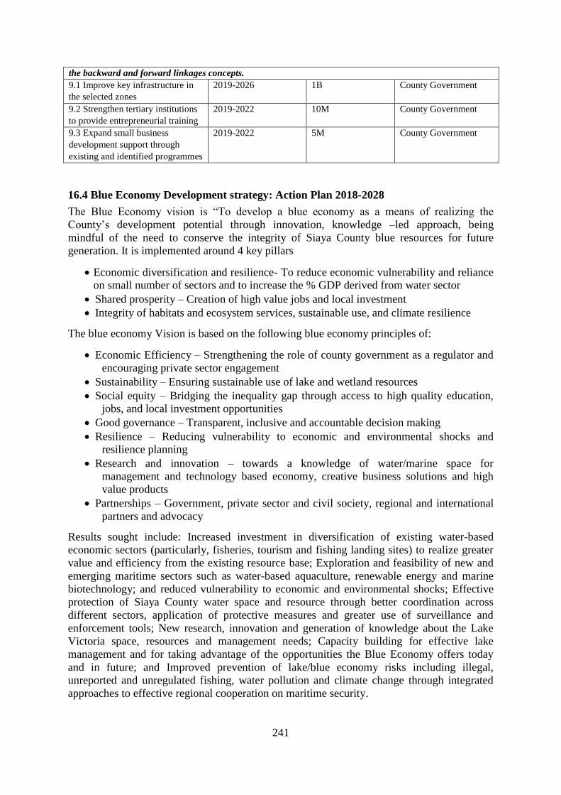
241
the backward and forward linkages concepts.
9.1 Improve key infrastructure in
the selected zones
2019-2026 1B County Government
9.2 Strengthen tertiary institutions
to provide entrepreneurial training
2019-2022 10M County Government
9.3 Expand small business
development support through
existing and identified programmes
2019-2022 5M County Government
16.4 Blue Economy Development strategy: Action Plan 2018-2028
The Blue Economy vision is “To develop a blue economy as a means of realizing the
County’s development potential through innovation, knowledge –led approach, being
mindful of the need to conserve the integrity of Siaya County blue resources for future
generation. It is implemented around 4 key pillars
Economic diversification and resilience- To reduce economic vulnerability and reliance
on small number of sectors and to increase the % GDP derived from water sector
Shared prosperity – Creation of high value jobs and local investment
Integrity of habitats and ecosystem services, sustainable use, and climate resilience
The blue economy Vision is based on the following blue economy principles of:
Economic Efficiency – Strengthening the role of county government as a regulator and
encouraging private sector engagement
Sustainability – Ensuring sustainable use of lake and wetland resources
Social equity – Bridging the inequality gap through access to high quality education,
jobs, and local investment opportunities
Good governance – Transparent, inclusive and accountable decision making
Resilience – Reducing vulnerability to economic and environmental shocks and
resilience planning
Research and innovation – towards a knowledge of water/marine space for
management and technology based economy, creative business solutions and high
value products
Partnerships – Government, private sector and civil society, regional and international
partners and advocacy
Results sought include: Increased investment in diversification of existing water-based
economic sectors (particularly, fisheries, tourism and fishing landing sites) to realize greater
value and efficiency from the existing resource base; Exploration and feasibility of new and
emerging maritime sectors such as water-based aquaculture, renewable energy and marine
biotechnology; and reduced vulnerability to economic and environmental shocks; Effective
protection of Siaya County water space and resource through better coordination across
different sectors, application of protective measures and greater use of surveillance and
enforcement tools; New research, innovation and generation of knowledge about the Lake
Victoria space, resources and management needs; Capacity building for effective lake
management and for taking advantage of the opportunities the Blue Economy offers today
and in future; and Improved prevention of lake/blue economy risks including illegal,
unreported and unregulated fishing, water pollution and climate change through integrated
approaches to effective regional cooperation on maritime security.

242
Table 16. 3: Blue Economy Development Strategy: Action Plan 2018-2028
STRATEGY OBJECTIVE ACTIVITY TIMEFRAME BUDGET RESPONSIBILITY
Strategic Priority 1 Creating sustainable
wealth
Diversification of existing water based sectors
(fisheries, ecotourism, Ports) focusing on value
addition, value chains, quality, sustainability
and good practice
Exploring new and emerging sectors such as
mariculture, renewable energy, biotechnology,
while focusing on establishing policy setting,
feasibility and pilot projects
2019-2020 300 M County Government,
National Government,
Private sector,
development partners
Strategic Priority 2 Sharing prosperity Ensuring food security and wellbeing focusing
on improving local production system and
markets, and promoting healthy lifestyles
Ensuring high quality education and
professional training, new jobs and
employment opportunities
Improving business environment, encouraging
local, regional and international investments,
innovation, small and medium enterprises and
culture of entrepreneurship
2020-2023 300 Million County Government,
National Government,
Private sector,
development partners
Strategic Priority 3 Strengthening the
enabling
environment
Finalizing the Blue Economy zoning plan of
Siaya County by 2020 which will help set the
rules to apply for water based development
across maritime sectors
Developing research and development and
innovation capabilities to inform responsible
management of lake and water resources and to
transform knowledge into development
opportunities and productive activities
As a high income county, financing blue
2020-2025 100 M County Government,
National Government,
Private sector,
development partners

243
economy through diversification of funding
opportunities, taking advantage of local and
international private sector investors’ appetite
to invest in sustainability; ensuring greater
efficiency of revenue raising mechanism
Incorporating blue economy risks in county
marine security strategies and regional
cooperation to address the impact of illegal
activities, resource degradation and improved
capacity for monitoring, control and
surveillance
International advocacy and partnerships to
attracts technical and financial resources and
keep blue economy issues at the forefront
county development and climate change
agendas
Strategic Priority 4 Securing healthy
and productive
Lake
Ensuring ecosystem service accounting is built
into economic measures such as GDP
Protecting marine and water assets and
addressing lake risks such as water pollution
and climate change
Implementing blue economy climate resilience
through mitigation and adaptation strategies
consistent with obligation under the United
Nation Framework Convention on Climate
Change (UNFCCO)
2022-2026 200 Million County Government,
National Government,
Private sector,
development partners

244
CHAPTER 17: COUNTY SPATIAL PLAN
IMPLEMENTATION STRATEGY
17.0 Introduction
Implementation Matrix of Siaya County Spatial is expected to cover 10-year period of
concrete development frameworks geared towards revitalizing the County's social-economic
transformation as well as guaranteeing social inclusivity, economic equity, ecological
integrity and heritage posterity. This implementation plan is envisaged to break ground in
innovative and transformative actions and strategies that will make the County contributes its
share in making Kenya a Middle Level Industrialized Country and prosperous. The Plan
therefore is a two-pronged approach to utilize the county resources for sustainable
development while establishing capital projects to catalyze the process. The two approaches
include: Land Use Planning, Administration, Management as one and second as development
of capital investment projects as justification for guide spatial development frameworks.
17.1 Land Use Planning, Administration and Management
Land use planning, administration and management is supposed to bring systematic order and
guaranteed ownership of land as a resource to facilitate spatial development. Land is a scarce
resource and all proposed development especially capital investment projects will be required
and acceptable, agreeable, suitable, and sustainable space for future development.
Information about land resources its value, location, appropriate use sinks well support spatial
development for social-economic transformation as well as environmental capability for the
future. Various proposals are therefore made in this county spatial plan implementation
matrix to cushion land as a resource for future development. County Spatial Plan is broad
guidelines of the future spatial structure of the county, a framework, however, its
implementation must mirror detail undertakings:
A1: implementation of the Plan: This require wide stakeholder consultation, capacity
building, sensitization and awareness creation of the local community, in every village,
market, urban, ward levels among others to internalize the plan as a legal document with its
ramifications, benefits, impacts, outcomes and constraints for future spatial development as
well as social- economic growth and environmental management. Several meetings, barazas
(community), public participation and training of champions to spearhead the ideals of the
county spatial plan. This include formation implementation sector technical and non-
technical committees in wards and sub-counties governance structure.
A2: Preparation of Integrated Urban Development Plans (IUDP): These are details plans to
guide area of concentrated human settlement activities especially urban centres, which are
intensive development enclaves that require systematic consideration of spatial order.
Preparation of these plan will deepen the implementation of county spatial plan, since some
of the principles, guidelines and standards proposed will only be realized if they are part and
parcel of these plans (IUDP) as per The Urban Areas and Cities Act 2011 (amendment 2016).
Thus, providing detailed urban spatial frameworks to social-economic development,
environmental (protection, restoration, conservation) as well guaranteed cultural heritage for
the future generations. Each urban centre will therefore initiate, conceptualize and prepare
an IUDP to guide development in the therein within the stipulated legal frameworks and in
tandem with the county spatial schema. There are six 6 designated Core and Growth Centres
with rapid population growth proposed as education hub, commercial hub, industrial hub,
and/or smart-techno cities for the future that require immediate attention while respecting the
county spatial plan designated functionality. Each urban centre will require about KES 30
million for preparation the IUDP as bear minimum and total of about KES 200 million

245
A3: Prepare Transport/Urban Corridor Zoning Guidelines: The County Spatial Plan as a
spatial structure proposes transport-urban corridors as zone for major human settlements
activities. The Zone will attract more socio-economic development hence requires detailed
planning guidelines and standards to bring systematic order. These transit corridors shall have
negotiated detailed spatial frameworks with stakeholders through a planning process as
advisory, subject area, and zoning plans. There are around six corridors and Lakefront area
that require special attention in planning. Each corridor would require at least KES 30
Million to facilitate this process.
A4: Prepare Urban and Peri-Urban Plans (Towns and Markets): There about 60 smaller
urban centres that act as distributary nodes for social and economic services, viewed as
hamlets for future human settlements. In addition, major urban centres (the core) have
attractions making their surrounding peri-urban area land speculations, intensive sub-division
that require development control and respective plan preparation.
A5: Prepare plans for fish landing beaches and Islands: Preparation of about 50 plans
prepared to express detailed order of land regulations along these important ecosystems
embedded in the Lacustrine (Blue) Economy, being the future of Siaya County. These
beautiful landing beaches and island when planned with resource base in mind to promote
tourism (eco-tourism) and fishing industry to guide future spatial development the County, is
expected to reap from Lake Front Development framework.
A6: Prepare Cadastral Plans (Urban Centres): Cadastral plans for major core urban centres
is paramount to qualify ownership and facilitate the ability of the owner to access credit in
financial institutions and develop the land resource to its full extent. To add value for most
urban land the cadastral referencing becomes a resource to reduce land conflicts, achieve
correct measurement and correct value. Land cadaster for the county is more than needed for
each title deed and or deed plan for all land parcels in the county.
A7. County Urban Development Policy: Urbanization in Africa has been described as
unprecedented and alarming meaning that we have to focus our future plans in urban centres.
This focus requires that urban development policy is prepared and implemented in the
county, spatial frameworks, infrastructural development and project implementation require a
policy to guide the future. The policy will be viewed to create confidence to investors both
foreign and local as impetus for future county growth.
A8: County Spatial Planning Bill/Law: County Spatial planning is devolved hence for
effective county spatial plan implementation will significant if a Bill and Law is promulgated
for wide dissemination and deepen the enforcement of the plan. The County Spatial enlists
specific guidelines which require to be translated into specific legislations for purposes of
implementation to ensure conformity to the plan. The 10-year period of implementing the
plan in terms of guidelines, plans, and budget requires legal backing. Drafting this Bill/Law
require wide public participation and stakeholder engagement as well as technical
consultative meeting to legislation that is unique to Siaya County.
A9: Development Control Enforcement: Development control is the key determinant in
realizing plan implementation. The implementation is realized when development control
principles are understood and constantly monitored. This process is therefore significant
effective realization of the intended plan.
A10: Valuation Roll for Core Towns and Sub-County Centres: Land valuing is a key
component of plan implementation, where planning adds value to existing land resource. The
Economic benefit of land use planning cannot be gain said. It envisaged that major land uses
assigned in the county spatial plan will increase the land prices, rent and rate charged as well
as auxiliary service charges. Areas therefore designated as function, peri-urban, transit
corridors, lake front will acquire new value. The planning gain is therefore useful tool, to
offset the planning loss in resource mobilization for development for example land rent, rates

246
and taxes. Siaya country riches is viewed from abundant land resource and untapped lake
environment (blue economy). County-wide valuation roll will therefore act as a catalyst for
county spatial plan implementation
A11: County Land Information System: The digital revolution has caught up in every aspect
of the society, quick response in service delivery has become effective with abundant data
converted to from analogue to digital. Land Information System, provides that all land
records, data, and information is computer-based and can accessed with a click of a button for
ease of prompt service delivery. These facilities therefore include a Geographic Information
System (GIS)-Based County Spatial Plan, Developing a Land Information County Portal,
Public User- Access Portal, Huduma Centre Portal, Web-based land records, among others.
The County Spatial Plan will be at reach everybody for purposes of interaction with the
interface, dissemination, awareness creation and capacity building. It envisaged that a county-
wide capacity building process among professional, practitioners, technical personnel and
general public will help in County Spatial Plan implementation.
A12: Mapping for Resources and Infrastructure: Detailed map generation for key resources
and embedded infrastructure enhances accountability, transparency, and integrity concerns, of
what is where, who owns it (public or private) as significant determinant of future capital
investments. Meaningful infrastructural development and further expansion and/or extension
require details of existing situation as part of feasibility study and background checks. The
county spatial plan implementation will further be deepened with more information and or
data bases of more accurate surveys.
17.2 Capital Investment Projects
It has been assumed that implementing a county spatial plan is not through capital investment
projects so in most cases they are proposed in Isolation. The capital investment projects
require the space (land) for construction, operation, maintenance and actual functionality. A
plan developed without the capital investment framework embedded on County Spatial Plan,
may not be realized. Planning without a budget is like operating a machine without an
operator. The Capital Investment Plan when mirrored in a County Spatial Plan provides the
budgeting process of major investment project envisaged to allow the plan actualized. The
plan is usually a five-plan details budget (funds) required and possible sources sometime
referred as the basket and or resource envelop. Most development partners want view the
county plan and budget and therefore pick one and or two items in the budget. Just to reflect
on the linkage of Spatial Plan and Investment Plan, is that one provides the space and one the
budget (funds) for implementation to bridge the gap of integration. These County Spatial Plan
therefore proposes several capital investment projects geared to help in the implementation of
the plan; main categories being land acquisition (banking), construction of social and
physical infrastructures (example public works of buildings, roads, water), environmental
restoration (conservation) among others.
B1: Urban Support Infrastructure in major towns (Growth Centres): The Urban Support
Infrastructure in the Core Centres of Siaya, Bondo, Aram, Yala, Ugunja, Usenge and others
growth centres will entail development of the following infrastructures: Storm Water
Drainage, Market, Street lights, Fire Station, Bus Station. This capital investment project has
undergone feasibility studies and proposals approved for funding approved by the World
Bank under the Kenya Municipal Reform Programme, currently budget at about KES 20
Billion. to offer facelift to most of the dilapidated infrastructure in these towns. This an on-
going Capital Investment Project that will facilitate and to re-engineer the urban functions as
envisaged in the County Spatial. The Core centres and growth centres are supposed to play a
major role in socio-economic transformation of the county. Core centres function to service
the hinterland, achieve agglomeration economies, and nucleated settlements; they require

247
basic services to propel them to have higher order goods and services as well attract
investments (local and foreign).
B2: Housing Development in Major Urban Centres (growth centres, sub-county growth
centres, market, rural and local centres): Housing is one of the core pillars of growth in the
Republic of Kenya. The BIG FOUR Agenda takes “affordable housing” as strategy to propel
social-economic growth. Though viewed from the lens of social inclusion but also local
economy transformation. These Core centres envisioned to be the future dormitories (shelter)
providers for proposed nucleated settlements. Everybody is moving to have an urban space,
with pull factors and/or many attractions, it is healthy for most population to become
urbanized to free the rural land for food production. However, moving to towns is not to
create slums but to achieve better living standards, Africa Cities, Siaya County included must
focus on housing as a priority concern, satisfying Sustainable Development Goal SDG 11)
11. The County Spatial Plan therefore prioritizes housing development in these Core Centres
as an implementation strategy. The situation indicates that no housing programme other than
Government and local authority houses for employees has been realized in the county since
independence in 1963. Construction of these houses will undergo feasibility studies, proposal
development and sourcing for funds under Public-Private Sector (PSP) arrangement and
Development Partner Support framework. The Housing Bonds, Housing Equity, Housing
Mortgage, are all geared to mobilize resources for housing development. However, private
person building owner occupier houses has been significant housing development in the
county and calling for housing subsidies to accelerate on these efforts. The County Spatial
Plan therefore proposes deliberate efforts to sensitize the populace to participate in the
national framework as well as initiate County-Specific Strategies. The County shall have
County Housing Bond through a legislation to elicit citizen participation including Jua Kali
artisans and Mama Mboga vendor.
B3: Urban Access Roads in growth centres, sub-county growth centres, market, rural and
local centres: Urban access roads in major centres are in pathetic conditions save for the
recent County Government intervention under devolved framework. However, implementing
the County Spatial Plan require increased accessibility, more networks and connectivity
enhanced to leverage these towns to perform their designated function in the plan. Over 50
Urban centres in county require facelift, and expansion on their urban access road to promote
faster growth, livability, safe and secure neighborhoods.
B4: Rural Access and Priority Roads County Wide Class G, N, P: The County Spatial Plan
provides for rural access and Priority roads totaling to about 1700 Km that require graveling
and/or tarmacking as county roads as per the Kenya Road Bill 2017. These rural access roads
are to enhance effective network, and connectivity to facilitate timely flow of goods, services
and labour in every part of the county. It is anticipated that these roads will open up parts of
the county to effectively participate in the local and national economy, reduce the use motor
cycle menace (accidents) as car and/or vehicular penetration is enhanced.
B5: Development of Urban Storm Drains of other Centres not Core Centres: Most parts of
Siaya County receive a lot of rainfall and sometimes in extreme situation these becomes flash
floods. Urbanization, however, brings with it more concrete and impervious state hence
reducing infiltration, it is therefore environmentally significant to channel this excess water to
join surface runoff. Most urban centres do not have urban storm drains though limited in
Siaya and Bondo Town. Establishing these storm drains geared to contribute to improving
environmental quality of these urban centres.
B6: Urban Water Supply and B7: Rural Water Supply: Urban water supply to meet to
increase demand due to high population growth. Urbanization and population growth have
increase demand whose management cannot be implemented without a spatial framework,
this County Spatial Plan therefore delving on water demand projection. This water demand
248
projection will only be met through protection and conservation of water resources,
availability for space for water infrastructure (reticulation system), and piping, bore-hole
development, water spring, dam construction for specific urban needs. A robust water supply
system that transverses that is county such as SIBO (Siaya-Bondo) water project shall be
sustained if the network pathways are reserved. Most urban water supply also serves the rural
water supply. Human settlement and/or nucleated settlements functionality will be sustained
and livable when water supply system is integrated and is in tandem with the County Spatial
Plan.
B8: Market Infrastructure for Small Towns (market, rural and local centres): One of the
core principles of sustainability planning is improvement of the local economy. Making
business environment possible for Mama Mboga, Street Vendors, Jua Kali artisans
comfortable, secure, safe and profitable investing in small market infrastructures. These
market infrastructures include: market stalls, street lighting, refrigeration services, market
furniture, shelter for production units (Jua kali, specialized commercial entities, saloons, shoe
shining, fish market, livestock markets).
B9: Industrial Development Infrastructure (Knowledge Hub, Innovation Hubs) in Growth
Centres and Ward Centres: Industrial development in the county is very low and require
stimulus. It is believed that agro-processing was the sure way of revitalizing industrialization,
however, this is said but may not be true. Emerging concern then is developing industrial
incubation centres which can be located in every ward headquarters and/or priority towns.
The incubation will allow participants to test ideas, innovation, creativity in product
development, while both entrepreneurial skills also delivered. Products which gain
prominence are slowly embraced in the market as a commercial process. Collectively,
participants generate conceptualization and build on each other strength. County Spatial Plan
has designated each ward to an industrial incubation centres to promote manufacturing
ventures.
B 10: Development of a Smart City (Techno-City): Big dreams can create reality through
public-private partnership, Siaya County proposes to develop a smart (techno-city) within the
Lakefront Development and Hillside Development. This can be realized if resource
mobilization among citizens, professional, technical are made to believe this reality and
henceforth contribute towards its inception, proposal, design, feasibility study, source for
funding and eventually implement the dream. Location of a smart city then has been provided
in the county spatial plan, as well as provide its functionality in the overall socio-economic
transformation of county.
B11: Economic Special Zones in each Sub-county: Industrialization growth in the county
must be driven basic industrial focus where space is provided for development of an
economic zone. The economic special zone is to provide a space for foreign and local
investors can come and established their factories or industry. This zone is planned designed,
and is provided with basic auxiliary services such as roads, electricity, warehousing, financial
services and other services. In each sub-county, an economic special zone is proposed that is
a total six needed.
B12: ICT Infrastructure (hubs, fiber network): Information, Communication and
Technology (ICT) infrastructure, cannot be gainsaid as significant as aspect of the digital
revolution. ICT connections county-wide is therefore a necessity, where each ward
headquarter and or priority urban centre should have an ICT Hub as well as connected to a
fiber network. The youth participation in local economy can be leveraged through ICT
infrastructure in the rural villages. The Digital economy therefore requires deepening in rural
villages that include participation business outsourcing. Over 30 ICT hubs will be established
and connected into the national network.

249
B13: Health Facilities (150 Hospitals of various hierarchies in wards/growth centre.
Affordable health for all and health coverage to ensure equity distribution county-wide is
challenge, county spatial plan details the deficits per ward through hexagonal analysis. To
ensure equity and access by distance and location, the proposed additional health facilities
must be established in each ward to meet the deficit and also ensure their equitable
distribution county-wide. Establishing of these health facilities will be through construction
and providing basic equipment in each location in each ward.
B14: Improving Education Facilities and Construction of Educational Infrastructure (400
Schools): Free Education for all in early childhood education development and primary
schools and 100% transition from primary to secondary require an increased investment in
the education infrastructure, through establishment of new schools to much the population
increase as well rehabilitation and expansion of existing facilities for basic education
services. The County Spatial Plan, through hexagonal analysis has provided the deficit
education sector institutions to be provided in the as new additional institutions. This
education sector investment must receive deliberate effort in resource mobilization from
National Government, County Government, Public-Private Sector Partnership (PPP) and
development partner support.
B15: Tertiary Educational Institutions (Universities and Colleges Infrastructural
Development): Tertiary education to cater for university, colleges and technical institutes and
polytechnics require large capital outlay for improvement and expansion and setting up of
new facilities. The County education sector require land foe expansion as well as funds
infrastructural development. The County has lagged behind in establishing these institutions
to leverage on man power skill development for the youth in terms of technical,
entrepreneurial as well as managerial skills.
B16: Tourism and Cultural Heritage Infrastructure: Siaya County fall under the Western
Kenya Tourist Circuit, which great potential for tourism, however, there are impediments due
inadequate infrastructure developed. These infrastructures include: access roads to place
destination of landing beaches, heritage sites, resorts, lodges. Secondly restoration and
improvement of heritage sites (fencing), development of bandas, camp sites, signage and
branding are significant for meaningful exploitation of these tourism potentials. The Lakes
(Victoria, Kanyaboli, Nyamboyo and Sare) are massive resources for tourism development,
however, Lakefronts are hardly developed for concrete tourism attraction, facilities such as
leisure sport, water sport, and marina are lacking. National and County Government, Public-
Private Sector Partnership as well private investments must be encouraged and fully exploited
to transformative tourism in the region.
B17: Protection, Conservation and Restoration of Environmentally Significant Areas: Environmental quality is a major component of the County Spatial Plan , under the Green
Economy Strategy to ensure ecological integrity of the natural resource capital and
sustainable development: These environmental significant areas include: Hill Tops,
Wetlands, Lake and River Riparian Reserves, Water Catchment & Ground Water Reserves,
Rural and Urban Green Parks that require protection, conservation and restoration. The
County must invest heavily in restoring the natural capital (mother nature) which is the
foundation for economic and social transformation. The environment cushions the economy,
to provide rains, cool temperature, reduce drought, famine, grow food, catch more fish,
provide raw materials for industries, reduce health risks and provide safe and quality living
human settlements and habitats for animals and plants (man included). The National and
County Governments, Public-Private Sector Partnership, Development Partner Support and
private initiatives are investment are encouraged secure mother nature in the county.

250
B 18: Agricultural Productivity: Land use & Irrigation Infrastructure: Mechanization
(Tractors): To ensure that the County is food secure (one of the BIG 4), products for trading
and able to produce raw materials for agro-processing investment in agricultural
infrastructure is paramount by expanding more arable land through irrigation and
mechanization (tractors). Land under irrigation schemes must expand, while the use tractors
to till more land promptly cannot be gain said. Small holder agriculture must embrace
technological change in terms new innovations, seed multiplication, farm dem0nstration,
value addition and varieties are prerequisite for growth. Agro-processing such in dairy
farming (milk processing), flour and rice milling, honey processing, sugar processing, hides
and skins for leather are new investment frontiers for county, that require huge capital outlay.
The National and County Governments, Public-Private Sector Partnership, Development
Partner Support and private initiatives, both foreign direct investment and domestic
investment is highly encouraged.
B 19: Telephone Lines: Communication is key to local economic growth; the County Spatial
Plan recognize the fact that some areas in the county not connected to telephone lines. The
detailed County Network systems proposed in all major, distributor and access roads. The
expansion of telephone lines becomes an investment area for this plan. The National and
County Governments, Public-Private Sector Partnership, Development Partner Support and
private initiatives, both foreign direct investment and domestic investment, in the
communication sector, is highly encouraged.
B 20: Energy Power Networks (Electric Power, Solar Energy and Wind Power): Energy
has been also being branded to be the engine of economic growth as well as social-wellbeing.
The County Spatial in same vein, applying the Network principle, opine that a county-wide
energy power connection is envisaged. Thee energy connection is from National Grid,
however, there are proposal to an energy secure County, that is develop own energy source,
that is safe and affordable. These potentials include solar and wind power energy, and
therefore investment in this direction is a great desire as well as expansion of the existing
National Grid under Rural Electrification Programme. The National and County
Governments, Public-Private Sector Partnership, Development Partner Support and private
initiatives, both foreign direct investment and domestic investment, in this energy, is highly
encouraged.
B21: Land Banking for future Growth centres and Growth Corridors including the
Lakefront: Land is a resource for revenue generation in terms of rent, rates, taxes, tax
rebates, subsidies, collateral to secure funds and among others. The County Spatial Plan
proposes new boundaries for urban areas (growth centres, sub-county growth centres, market,
rural and local centres and/or referred as the urban edges require space and land. Most of the
land proposed and in private and/or freehold. For development of the county it is prudent to
acquire land as a land banking strategy. The County Spatial Plan shall guide which areas are
critical and strategic for future land banking depending on the proposed functionality. The
County Government must set a side fund for land banking: of strategic areas: Lake Front,
Conservation areas, urban and peri-urban areas, areas for establishing Governance structures,
network systems (roads, water, electricity, energy) among others. The National and County
Governments, Public-Private Sector Partnership, Development Partner Support and private
initiatives, both foreign direct investment and domestic investment, in this Land Resource
Sector, is highly encouraged.
B22: Land Acquisition and Compensation for Conservation and Infrastructure
Development: Land is a resource for revenue generation in terms of rent, rates, taxes, tax
rebates, subsidies, collateral to secure funds and among others. The County Spatial Plan
proposes new areas for infrastructural development, construction facilities, housing and
conservation that require space and land. Most of the land proposed and in private and/or

251
freehold. For development of the county it is prudent to acquire land as a land banking
strategy. The County Spatial Plan shall guide which areas are critical and strategic for future
land banking depending on the proposed functionality. The County Government must set a
side fund for land banking: of strategic areas: Lake Front, Conservation areas, urban and peri-
urban areas, areas for establishing Governance structures, network systems (roads, water,
electricity, energy) among others. The National and County Governments, Public-Private
Sector Partnership, Development Partner Support and private initiatives, both foreign direct
investment and domestic investment, in this Land Resource Sector, is highly encouraged.
B23: Resettlement Programme: Implementation of the County Spatial Plan require that
optimum utilization of land as a resource is guaranteed or achieved, the Green, Blue and
Brown economy strategies in a balanced and sustained manner. The Green (environment-
agriculture nexus) and Blue (water bodies Lakes, Rivers and Wetlands) areas will preserved
county-wide, while Brown areas (Human Settlements) will be restricted in a proposed
resettlement programme. This resettlement programme wills permit most human settlements
and housing to be concentrated in nucleated settlements in the towns or urban centres to
allow most of the land for farming (agriculture): Maximum allowable urban centres land
sizes (A: Growth Centres: Maximum Radius 7Km Radius, and 44 sq.km (4400 hectares) B:
Sub-County growth Centres (Maximum Radius 5Km Radius, 31.43 sq.km (3143 hectares)
C: Urban centres (Maximum Radius 3Km Radius; 18.86 sq.km (1866 hectares) D: Market
Centres Maximum 1 (One)Km Radius; 6.29 sq.km (629 hectares) E: rural and local centres
(Maximum Radius 0.5 KM; 3.14sq.km (314 hectares). The National and County
Governments, Public-Private Sector Partnership, Development Partner Support and private
initiatives, both foreign direct investment and domestic investment, in this Land Resettlement
Programme, is highly encouraged. The Process of resettlement can be gradual through
awareness in more particular where irrigation projects are envisaged to take place as pilot
capital investment projects.
B24: Preparation of Integrated Sustainable Urban Development Plans (ISUD): Informality
problem shall be addressed during preparation of ISUDPs. Stimulus markets to be re-
designed and retrofitted to make them user-friendly, on-site sanitation facilities in market
places to be operated by organized and registered youth groups as sources of income. This
retrofitting qualifies these projects as capital investment projects.
B25: Plan and Implement Innovative Security Mechanisms: Innovative security
mechanisms including community policing would require installation of street lighting (urban
major roads), flood lights (open air markets) and CCTV (in major urban centres). This
installation is geared towards achieving 24 Hour Economy in most urban centres and increase
time for productive work.
B26: Establish Devolved Governance Structures County Wide: Construction of Governors’
House, Sub-county and Ward Administrators offices is paramount in re-enforcing the
devolved structures at grass root levels. These offices become the symbol for governance and
decentralized service delivery, this will go hand in hand with developing Huduma Centres,
police post and other sector departmental offices.
B 27: Establishment of Sports and Recreational Infrastructure: Strategies strengthen
Leisure, Recreational and Sports activities is paramount to increase job market in these
unexploited industry in the county. It is therefore prudent for Construction of Stadium,
Cultural Festival sites, Various Sport Grounds, Establish Green Parks, Amusement Centres,
Beach Recreation, and Marinas as emerging Capital Investment Projects to allow the County
explore new frontiers in socio-economic development.
B28: Fish Landing Beaches and Ponds Infrastructure: Fish capture and fish culture are
important local economic sector along the Lakes and fish ponds in the County and therefore
establishing these infrastructures is paramount. These structures include: Fish Banda,

252
Refrigeration, Fish Processing: value addition, Fish Ponds and Cage Fish. Capital investment
projects establish in this industry will spur growth, fish being greatest income and revenue
earner in Siaya County.
17.3 Monitoring and Evaluation Matrix
One of the key stages of all development projects is the progress tracking of the
implementation of the development projects and the continual feedback run shaped by an
elaborate monitoring and evaluation framework. In implementing the Siaya County Spatial
Plan, the when and how individual sectorial projects are being executed, together with
detailed monitoring indicators contribute to the overall success of the CSP. Monitoring and
evaluation provide a basis for adaptive management and continued improvement of
environmental condition and guides the continuous measurement of progress indicators
throughout the plan implementation. It guides the measurement of achievement of various
aspect of the proposed projects and assessment of project viability as projected in the plan.
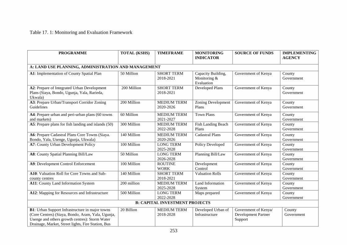
253
Table 17. 1: Monitoring and Evaluation Framework
PROGRAMME TOTAL (KSHS) TIMEFRAME MONITORING
INDICATOR
SOURCE OF FUNDS IMPLEMENTING
AGENCY
A: LAND USE PLANNING, ADMINISTRATION AND MANAGEMENT
A1: Implementation of County Spatial Plan 50 Million SHORT TERM
2018-2021
Capacity Building,
Monitoring &
Evaluation
Government of Kenya County
Government
A2: Prepare of Integrated Urban Development
Plans (Siaya, Bondo, Ugunja, Yala, Rarieda,
Ukwala)
200 Million SHORT TERM
2018-2021
Developed Plans Government of Kenya County
Government
A3: Prepare Urban/Transport Corridor Zoning
Guidelines
200 Million MEDIUM TERM
2020-2026
Zoning Development
Plans
Government of Kenya County
Government
A4: Prepare urban and peri-urban plans (60 towns
and markets)
60 Million MEDIUM TERM
2021-2027
Town Plans Government of Kenya County
Government
A5: Prepare plans for fish landing and islands (50) 300 Million MEDIUM TERM
2022-2028
Fish Landing Beach
Plans
Government of Kenya County
Government
A6: Prepare Cadastral Plans Core Towns (Siaya.
Bondo, Yala, Usenge, Ugunja, Ukwala)
140 Million MEDIUM TERM
2020-2026
Cadastral Plans Government of Kenya County
Government
A7: County Urban Development Policy 100 Million LONG TERM
2025-2028
Policy Developed Government of Kenya County
Government
A8: County Spatial Planning Bill/Law 50 Million LONG TERM
2026-2028
Planning Bill/Law Government of Kenya County
Government
A9: Development Control Enforcement 100 Million ROUTINE
WORK
Development
Control
Government of Kenya County
Government
A10: Valuation Roll for Core Towns and Sub-
county centres
140 Million SHORT TERM
2018-2021
Valuation Rolls Government of Kenya County
Government
A11: County Land Information System 200 million MEDIUM TERM
2025-2028
Land Information
System
Government of Kenya County
Government
A12: Mapping for Resources and Infrastructure 500 Million LONG TERM
2022-2028
Maps prepared Government of Kenya County
Government
B: CAPITAL INVESTMENT PROJECTS
B1: Urban Support Infrastructure in major towns
(Core Centres) (Siaya, Bondo, Aram, Yala, Ugunja,
Usenge and others growth centres): Storm Water
Drainage, Market, Street lights, Fire Station, Bus
20 Billion MEDIUM TERM
2018-2028
Developed Urban of
Infrastructure
Government of Kenya/
Development Partner
Support
County
Government

254
Station)
B2: Housing Development in Major Urban Centres
(core, sub-county and priority towns)
10 Billion LONG TERM
2022-2018
Houses Developed
(Housing Estates)
Government of Kenya
Public-Private Partnership
County
Government
B3: Urban Access Roads in Core, Sub-county and
Priority Towns
10 Billion MEDIUM TERM
2020-2016
Urban access roads
developed
Government of Kenya County
Government
B4: Rural Access and Priority Roads County Wide
Class G, N, P (1700 Km)
60 Billion LONG TERM
2018-2018
Rural access roads Government of Kenya County
Government
B5: Development of Urban Storm Drains of other
Centres not Core Centres
30 Billion MEDIUM TERM
2022-2028
Storm Drains
developed
Government of Kenya/
Development Partner
Support
County
Government
B6: Urban Water Supply 20 Billion MEDIUM TERM
2021-2025
Urban Water Supply
Developed
Government of Kenya County
Government
B7: Rural Water Supply 60 Billion LONG TERM
2018-2018
Rural Water Supply Government of Kenya County
Government
B8: Market Infrastructure for Small Towns (growth
and market centres)
10 Billion MEDIUM TERM
2021-2016
Market infrastructure Government of Kenya County
Government
B9: Industrial Development Infrastructure
(Knowledge Hub, Innovation Hubs) in Growth
Centres and Ward Centres
10 Billion 10 years Industrial Innovation
Hubs
Government of Kenya County
Government
B 10: Development of a Smart City (Techno-City):
Lakefront Development and Hillside Development
20 Billion LONG TERM
2022-2028
Smart City/Techno
City
Public-Private Partnership County
Government
B11: Economic Special Zones in each Sub-county 200 Million LONG-TERM
2022-2028
Economic Hubs Government of Kenya County
Government
B12: ICT Infrastructure (hubs, fiber networks) 2 Billion SHORT TERM
2018-2021
ICT hubs Government of Kenya County
Government
B 13: Health Facilities (150 Hospitals of various
ranks) in wards/growth centres
10 Billion LONG TERM
2018-2028
Health facilities
developed
Government of Kenya County
Government
B14: Improving Education Facilities and
Construction of Educational Infrastructure (400
Schools)
50 Billion LONG TERM
2018-2028
Educational facilities
(nursery, primary
and secondary)
Government of Kenya County
Government
B15: Tertiary Educational Institutions (Universities
and Colleges Infrastructural Development)
50 Billion LONG TERM
2018-2028
(University,
technical & medical,
educational colleges)
Government of Kenya County
Government
B16: Tourism & Cultural Heritage Infrastructure
(access roads, lodges, resort, restoration and
improvement of heritage sites, fencing, bandas,
camp sites, signage, branding)
5 Billion MEDIUM TERM
(2023-2028)
Heritage
Infrastructure
Government of Kenya
Public-Private Partnership
County
Government

255
B17: Protection, Conservation and Restoration of
Environmentally Significant Areas (Hill Tops,
Wetlands, Lake and River Riparian Reserves,
Water Catchment & Ground Water Reserves, Rural
and Urban Green Parks)
20 Billion LONG TERM
2018-2028
Environmental
Management &
Restorations
Government of Kenya County
Government
B 18: Agricultural Productivity: Land use &
Irrigation Infrastructure: Mechanization (Tractors)
50 Billion LONG TERM
2018-2028
Agriculture
development:
Irrigation
Infrastructure
developed, Tractors
Purchased
Government of Kenya
Development Partner
Support
County
Government
B19: Telephone Lines 10 Billion SHORT TERM
2018-2021
Telephone lines Government of Kenya County
Government
B20: Energy Power Networks (Electric Power,
Solar Energy and Wind Power)
50 Billion MEDIUM TERM
2018-2026
Power-lines, Solar
Installation, Wind
Power
Government of Kenya County
Government
B21: Land Banking for future Growth Poles and
Growth Corridors (Lakefront)
50 Billion LONG TERM
2018-2028
Land Bank (Lake
waterfront & Urban
development)
Government of Kenya County
Government
B22: Land Acquisition and Compensation for
Conservation and Infrastructure Development
50 Billion LONG TERM
2018-2028
Conservation areas,
wildlife corridors)
Government of Kenya County
Government
B23: Resettlement Programme: Most human
settlements and housing should be concentrated in
nucleated settlements in the towns or urban centres
to allow most of the land for farming (agriculture):
Maximum allowable urban centres land sizes (A:
growth centres: Maximum Radius 7Km Radius, and
44 sq.km (4400 hectares) B: Sub-County growth
Centres (Maximum Radius 5Km Radius, 31.43
sq.km (3143 hectares) C: Urban centres (Maximum
Radius 3Km Radius; 18.86 sq.km (1866 hectares)
D: Market Centres Maximum 1 (One)Km Radius;
6.29 sq.km (629 hectares) E: rural and local
centres (Maximum Radius 0.5 KM; 3.14sq.km (314
hectares)
60 Billion LONG TERM
2018-2028
Resettlement
Programmes & Land
use guidelines
implementation in
growth nodes (core
centres, sub-county
centres, Priority
centres, market
centres, central
village centres)
Government of Kenya
Public-Private Partnership
County
Government
B 24: Informality problem to be addressed during
preparation of ISUDPs Stimulus markets to be re-
designed so they are user-friendly, on-site sanitation
200 Million SHORT TERM
2018-2021
Regularize informal
activities: Modernize
stalls
Government of Kenya County
Government

256
NB Short term (3 years) Medium Term (5 years) and Long Term (Years)
facilities in market places to be operated by
organized and registered youth groups as sources of
income
B25: Plan and implement innovative security
mechanisms including community policing,
installation of street lighting, flood lights etc.
`100 Million SHORT TERM
2018-2021
Urban centres and
markets: Installation
of Market
infrastructures
Government of Kenya County
Government
B26: Establish Devolved Governance Structures
County Wide: (Construction of Governors House,
Sub-county and Ward Administrators offices)
500 Million MEDIUM TERM
2018-2024
House and Offices
Constructed
Government of Kenya County
Government
B 27: Establishment of Sports and Recreational
Infrastructure (Construction of Stadium, Cultural
Festival sites, Various Sport Grounds, Establish
Green Parks, Amusement Centres, Beach
Recreation, Marinas)
1 Billion LONG TERM
2018-2028
Sports, Culture,
Recreation Facilities
Established
Government of Kenya
Public-Private Sector
Partnership
County
Government
B28: Fish Landing Beaches and Ponds
Infrastructure (Fish Banda, Refrigeration, Fish
Processing: value addition, Fish Ponds and Cage
Fish)
20 Billion MEDIUM TERM
2018-2024
Fish Landing, Ponds,
Cages Infrastructure
developed)
Government of Kenya
Public-Private Sector
Partnership
Development Partner
Support
County
Government

257
17.4 Strategic Environmental Assessment
It is a requirement that every plan, programme, project and policy document is subjected to an Environmental Impact Assessment (EIA) study as
provided in the Environmental Coordination and Management Act (EMCA) No. 8 of 1999. In the case of a plan, such as the Siaya County
Spatial Plan, the report is known as Strategic Environmental Assessment (SEA). The SEA requires that all the proposals in a plan are subjected
to environmental assessment. This involves identification of the environmental impacts and their effects as well as proposing mitigation
measures.
Table 17. 2: Strategic Impact Assessment
Item
No
Environmental Issue Proposed Mitigation Measures/ Actions Remarks
Siaya County Spatial Plan and the Lower Level Plans
1 Waste Management in Siaya
County Waste to be properly disposed of
Quantify the various categories of wastes
Formalize solid waste disposal.
Involve external interested parties in establishing improved options for various
wastes recycling.
Enhance waste minimization and segregation.
All wastes are collected for proper disposal.
2 Water quality problems Drains that may carry solid wastes from the premises should be filled with
suitable interceptors or grit traps.
Liquid waste not to be released directly into the environment.
Installation of a water pumping system
Controlled discharges into the drainage
system will reduce health effects to the
surrounding communities
3 Compliance Aspects Develop an in-house environmental management regulation with enhanced
focus on health and safety.
Establish legal/ register with a focus on the critical environmental laws and
regulations.
Establish a schedule for annual environment audit as required by law.
This will ensure compliance with laid down
guidelines at all times on all relevant laws,
statutes and policies.
4 Capacity building
(documentation and
human resources capacity)
Document guidelines and procedures on environmental management.
Assess the carrying capacity of existing infrastructure (drainage sewers and
solid waste disposal site).
To provide necessary knowledge tools and
awareness on environment and safety to all
workers for effective human resource
capacity development.
Fish Landing Bays and Islands (50)
1 Waste Management in all
fish landing bays. Waste to be properly disposed of
Quantify the various categories of wastes
Formalize solid waste disposal.
Involve external interested parties in establishing improved options for various
wastes recycling.
Enhance waste minimization and segregation.
All wastes are collected for proper disposal.

258
Item
No
Environmental Issue Proposed Mitigation Measures/ Actions Remarks
2 Water quality problems Drains that may carry solid wastes from the premises should be filled with
suitable interceptors or grit traps.
Liquid waste not to be released directly into the environment.
Installation of a water pumping system
Controlled discharges into the drainage
system will reduce health effects to the
surrounding communities
3 Compliance Aspects Develop an in-house environmental management regulation with enhanced
focus on health and safety.
Establish legal/ register with a focus on the critical environmental laws and
regulations.
Establish a schedule for annual environment audit as required by law.
This will ensure compliance with laid down
guidelines at all times on all relevant laws,
statutes and policies.
4 Capacity building
(documentation and
human resources capacity)
Document guidelines and procedures on environmental management.
Assess the carrying capacity of existing infrastructure (drainage sewers and
solid waste disposal site).
To provide necessary knowledge tools and
awareness on environment and safety to all
workers for effective human resource
capacity development.
Urban Support Infrastructure (Siaya, Bondo, Aram, Yala , Ugunja, Usenge and others growth centres): Storm Water Drainage, Market, Street Lights, Fire
Station, Bus Station)
1 Increased water demand Harvest water from completed structures to ease strain on regular water sources
Provide for adequate storage during day time when other demands are high
Embrace water conservation techniques in all operations including timely repairs
of water lines
Make optimum use of water harvesting opportunities
Re-use treated waste water (recycling)
Controlled and sustainable water use will
ensure adequate supply and storage of water
2 Increased energy demand Utilize solar energy for lighting purposes
Use energy efficient gadgets
Sensitize stakeholders on energy saving strategies
Timely repairs and scheduled maintenance of machines and equipment
This will cut down on operation costs as well
as sustainable use of energy as a resource
3 Waste Management in all
urban and peri-urban areas. Waste to be properly disposed of
Quantify the various categories of wastes
Formalize solid waste disposal.
Involve external interested parties in establishing improved options for various
wastes recycling.
Enhance waste minimization and segregation.
All wastes are collected for proper disposal.
4 Water quality problems Drains that may carry solid wastes from the premises should be filled with
suitable interceptors or grit traps.
Liquid waste not to be released directly into the environment.
Installation of a water pumping system
Controlled discharges into the drainage
system will reduce health effects to the
surrounding communities

259
Item
No
Environmental Issue Proposed Mitigation Measures/ Actions Remarks
5 Compliance Aspects Develop an in-house environmental management regulation with enhanced
focus on health and safety.
Establish legal/ register with a focus on the critical environmental laws and
regulations.
Establish a schedule for annual environment audit as required by law.
This will ensure compliance with laid down
guidelines at all times on all relevant laws,
statutes and policies.
6 Capacity building
(documentation and
human resources capacity)
Document guidelines and procedures on environmental management.
Assess the carrying capacity of existing infrastructure (drainage sewers and
solid waste disposal site).
To provide necessary knowledge tools and
awareness on environment and safety to all
workers for effective human resource
capacity development.
Housing Development in Major Urban Centres (growth centres, sub county growth centres, urban centres, market centres, rural and local centres)
1 Increased extraction of raw
materials Source building materials from suppliers who use environmentally friendly
processes in their operations
Ensure accurate budgeting and estimation of actual construction material
requirements to ensure that the least amount of material necessary is ordered
Ensure that damage or loss of materials at the construction sites are kept
minimal through proper storage
Use at least 5% - 10% recycled, refurbished or salvaged materials to reduce the
use of raw materials and divert materials from landfills.
To minimize extraction site impacts and
ensure efficient use of raw materials in
construction
2 Ecosystem disturbance Ensure proper demarcation and delineation of the housing project areas to be
affected by construction workers
Specify locations for trailers and equipment and areas of the site which should
be kept free of traffic, equipment and storage
Designate access routes and parking within the sites
Preserve some individual trees within the sites
Design and implement an appropriate landscaping programme to help in
revegetation of part of the project areas after construction
To minimize vegetation and animal
disturbance at and around construction site
3 Run off and soil erosion Create storm water management practices, such as piping systems or retention
ponds or tanks, which can be carried after the housing projects are complete
Apply soil erosion control measures such as levelling of the project site to
reduce run-off velocity and increase infiltration of storm water into the soil
Ensure that construction vehicles are restricted to existing graded roads to avoid
soil compaction within the housing development sites
Ensure that any compacted areas are ripped to reduce run-off
To reduce runoff and soil erosion
4 Solid waste generation Through accurate estimation of the sizes and quantities of materials required,
order materials in the sizes and quantities they will be needed, rather than
To minimize solid waste generation and
ensure efficient solid waste management

260
Item
No
Environmental Issue Proposed Mitigation Measures/ Actions Remarks
cutting them to size, or having large quantities of residual materials
Ensure that construction materials left over at the end of construction will be
used in other projects rather than being disposed of
Use of durable, long lasting materials that will need to be replaced as often,
thereby reducing the amount of construction waste generated over time
Dispose waste more responsibly by dumping at designated dumping sites at
designated dumping sites or landfills only; the use of a registered waste
disposal company is encouraged
during construction
5 Utilization of water
resources Promote recycling and reuse of water as much as possible
Promptly detect and repair water pipe and tank leaks
To minimize water consumption and ensure
more efficient and safe water use
6 Approval of building plans Ensure that all building plans are approved by the approving authority and local
Occupational Health and Safety Office
To minimize occupational health and safety
risks
7 Fire protection Fire-fighting equipment such as fire extinguishers and hydrant systems should
be provided at strategic locations such as stores and construction areas
To minimize occupational health and safety
risks
Urban Access Roads in Core, Sub-County and Priority Towns
1 Changes in
hydrology/impeded
drainage
Install drainage structures properly
This will ensure efficiency of drainage
structures
2 Soil erosion Control earthworks
Install drainage structures properly
Install erosion control measures
Grouted stone pitching and rock fill gabion works will be necessary to protect
culvert inlets and outlets
Landscape embankments and re-vegetate gravel sites with grass (e.g. Tetrapogon
bidentatus or Chrysopogon ancheri) and indigenous shrubs
Ensure management of excavation activities
To minimize soil erosion
3 Air pollution Water should be sprayed during the construction phase on excavated areas
In filling sub grade water spraying is needed to solidify the material and assist
in compaction. After compaction, water spraying should be regular to
prevent dust
Plant trees along access roads and around settlements (e.g. Acacia sp. and
Commiphora sp.)
This will ensure that air pollution is
minimized to avert respiratory tract
infections
4 Water sources Management of water usage
Plan for harvesting and storage of water during rains for later use
Plan works schedule according to water availability
To minimize water consumption and ensure
more efficient and safe water use

261
Item
No
Environmental Issue Proposed Mitigation Measures/ Actions Remarks
Avoid abstraction of water
Abstraction not to be done during low flow
5 Waste Management Waste to be properly disposed of
Quantify the various categories of wastes
Formalize solid waste disposal.
Involve external interested parties in establishing improved options for various
wastes recycling.
Enhance waste minimization and segregation.
All wastes are collected for proper disposal.
Rural Access and Priority Roads County Wide Class G, N, P (1700 Km)
1 Changes in
hydrology/impeded
drainage
Install drainage structures properly
This will ensure efficiency of drainage
structures
2 Soil erosion Control earthworks
Install drainage structures properly
Install erosion control measures
Grouted stone pitching and rock fill gabion works will be necessary to protect
culvert inlets and outlets
Landscape embankments and re-vegetate gravel sites with grass (e.g. Tetrapogon
bidentatus or Chrysopogon ancheri) and indigenous shrubs
Ensure management of excavation activities
To minimize soil erosion
3 Air pollution Water should be sprayed during the construction phase on excavated areas
In filling sub grade water spraying is needed to solidify the material and assist
in compaction. After compaction, water spraying should be regular to
prevent dust
Plant trees along access roads and around settlements (e.g. Acacia sp. and
Commiphora sp.)
This will ensure that air pollution is
minimized to avert respiratory tract
infections
4 Water sources Management of water usage
Plan for harvesting and storage of water during rains for later use
Plan works schedule according to water availability
Avoid abstraction of water
Abstraction not to be done during low flow
To minimize water consumption and ensure
more efficient and safe water use
5 Waste Management Waste to be properly disposed of
Quantify the various categories of wastes
Formalize solid waste disposal.
Involve external interested parties in establishing improved options for various
All wastes are collected for proper disposal.

262
Item
No
Environmental Issue Proposed Mitigation Measures/ Actions Remarks
wastes recycling.
Enhance waste minimization and segregation.
Development of Urban Storm Drains
1 Waste Management in Siaya
County Storm water to be properly disposed of
Quantify the storm water
Involve external interested parties in establishing improved options for storm
water harvesting
All storm water is collected for proper
disposal.
2 Water quality problems Drains that may carry solid wastes from the premises should be filled with
suitable interceptors or grit traps.
Controlled discharges into the drainage
system will reduce health effects to the
surrounding communities
4 Capacity building
(documentation and
human resources capacity)
Document guidelines and procedures on environmental management.
Assess the carrying capacity of existing storm water drains.
To provide necessary knowledge tools and
awareness on environment and safety to all
for effective human resource capacity
development.
Urban Water Supply
1 Environmental pollution Build capacity and establish a Water Resource User's Association (WRUA's) to
ensure environmental conservation of the resource
To ensure water quality
2 Water quality problems Drains that may carry solid wastes from premises should be filled with suitable
interceptors or grit traps.
Liquid waste not to be released directly into the environment.
Installation of a water pumping system
Controlled discharges into the drainage
system will reduce health effects to the
surrounding communities
3 Waste water and surface
water pollution Conduct physical, chemical and bacteriological analysis of water before
utilization to have an initial water quality data that can be used to gauge any
pollution during operation
To ensure water quality
4 Water wastage and
shortage Train the urban society on proper utilization of water through formation of
WRUA's
Construct reservoir tanks to store adequate water for future use
All households and institutions should embrace rainwater harvesting by
constructing small water pans
To ensure adequate supply of water to all to
meet the demand
5 Reduction of aquifer
levels/lowering of the
water table
All households to construct small water pans to supplement borehole water
Train the society on efficient utilization of water
Develop alternative sources of water
To ensure adequate supply of water to meet
the demand
Rural Water Supply
1 Environmental pollution Build capacity and establish a Water Resource User's Association (WRUA's) to
ensure environmental conservation of the resource
To ensure water quality

263
Item
No
Environmental Issue Proposed Mitigation Measures/ Actions Remarks
2 Water quality problems Drains that may carry solid wastes from premises should be filled with suitable
interceptors or grit traps.
Liquid waste not to be released directly into the environment.
Installation of a water pumping system
Controlled discharges into the drainage
system will reduce health effects to the
surrounding communities
3 Waste water and surface
water pollution Conduct physical, chemical and bacteriological analysis of water before
utilization to have an initial water quality data that can be used to gauge any
pollution during operation
4 Water wastage and
shortage Train the rural community on proper utilization of water through formation of
WRUA's
Construct reservoir tanks to store adequate water for future use
All households and institutions should embrace rainwater harvesting by
constructing small water pans
5 Reduction of aquifer
levels/lowering of the
water table
All households to construct small water pans to supplement borehole water
Train the community on efficient utilization of water
Develop alternative sources of water
Reduce livestock numbers
Market Infrastructure for Small Towns (Market, rural and local centres)
1 Increased water demand Harvest water from completed structures to ease strain on regular water sources
Provide for adequate storage during day time when other demands are high
Embrace water conservation techniques in all operations including timely repairs
of water lines
Make optimum use of water harvesting opportunities
Re-use treated waste water (recycling)
Controlled and sustainable water use will
ensure adequate supply and storage of water
2 Increased energy demand Utilize solar energy for lighting purposes
Use energy efficient gadgets
Sensitize stakeholders on energy saving strategies
Timely repairs and scheduled maintenance of machines and equipment
This will cut down on operation costs as well
as sustainable use of energy as a resource
3 Waste Management. Waste to be properly disposed of
Quantify the various categories of wastes
Formalize solid waste disposal.
Involve external interested parties in establishing improved options for various
wastes recycling.
Enhance waste minimization and segregation.
All wastes are collected for proper disposal.
4 Water quality problems Drains that may carry solid wastes from the premises should be filled with
suitable interceptors or grit traps.
Controlled discharges into the drainage
system will reduce health effects to the

264
Item
No
Environmental Issue Proposed Mitigation Measures/ Actions Remarks
Liquid waste not to be released directly into the environment.
Installation of a water pumping system
surrounding communities
5 Compliance Aspects Develop an in-house environmental management regulation with enhanced
focus on health and safety.
Establish legal/ register with a focus on the critical environmental laws and
regulations.
Establish a schedule for annual environment audit as required by law.
This will ensure compliance with laid down
guidelines at all times on all relevant laws,
statutes and policies.
6 Capacity building
(documentation and
human resources capacity)
Document guidelines and procedures on environmental management.
Assess the carrying capacity of existing infrastructure (drainage sewers and
solid waste disposal site).
To provide necessary knowledge tools and
awareness on environment and safety to all
workers for effective human resource
capacity development.
Industrial Development Infrastructure (Knowledge Hub, Innovation Hubs) in Growth Centres
1 Increased water demand Harvest water from completed structures to ease strain on regular water sources
Provide for adequate storage during day time when other demands are high
Embrace water conservation techniques in all operations including timely repairs
of water lines
Make optimum use of water harvesting opportunities
Re-use treated waste water (recycling)
Controlled and sustainable water use will
ensure adequate supply and storage of water
2 Increased energy demand Utilize solar energy for lighting purposes
Use energy efficient gadgets
Sensitize stakeholders on energy saving strategies
Timely repairs and scheduled maintenance of machines and equipment
This will cut down on operation costs as well
as sustainable use of energy as a resource
3 Waste Management. Waste to be properly disposed of
Quantify the various categories of wastes
Formalize solid waste disposal.
Involve external interested parties in establishing improved options for various
wastes recycling.
Enhance waste minimization and segregation.
All wastes are collected for proper disposal.
4 Water quality problems Drains that may carry solid wastes from the premises should be filled with
suitable interceptors or grit traps.
Liquid waste not to be released directly into the environment.
Installation of a water pumping system
Controlled discharges into the drainage
system will reduce health effects to the
surrounding communities
5 Compliance Aspects Develop an in-house environmental management regulation with enhanced
focus on health and safety.
Establish legal/ register with a focus on the critical environmental laws and
This will ensure compliance with laid down
guidelines at all times on all relevant laws,
statutes and policies.

265
Item
No
Environmental Issue Proposed Mitigation Measures/ Actions Remarks
regulations.
Establish a schedule for annual environment audit as required by law.
6 Capacity building
(documentation and
human resources capacity)
Document guidelines and procedures on environmental management.
Assess the carrying capacity of existing infrastructure (drainage sewers and
solid waste disposal site).
To provide necessary knowledge tools and
awareness on environment and safety to all
workers for effective human resource
capacity development.
Economic Special Zones in Sub-county
1 Waste Management in Siaya
County Waste to be properly disposed of
Quantify the various categories of wastes
Formalize solid waste disposal.
Involve external interested parties in establishing improved options for various
wastes recycling.
Enhance waste minimization and segregation.
All wastes are collected for proper disposal.
2 Water quality problems Drains that may carry solid wastes should be filled with suitable interceptors or
grit traps.
Liquid waste not to be released directly into the environment.
Installation of a water pumping system
Controlled discharges into the drainage
system will reduce health effects to the
surrounding communities
3 Compliance Aspects Develop an in-house environmental management regulation with enhanced
focus on health and safety.
Establish legal/ register with a focus on the critical environmental laws and
regulations.
Establish a schedule for annual environment audit as required by law.
This will ensure compliance with laid down
guidelines at all times on all relevant laws,
statutes and policies.
4 Capacity building
(documentation and
human resources capacity)
Document guidelines and procedures on environmental management.
Assess the carrying capacity of existing infrastructure (drainage sewers and
solid waste disposal site).
To provide necessary knowledge tools and
awareness on environment and safety to all
workers for effective human resource
capacity development.
Health Facilities (150 Hospitals of various ranks) in wards/growth centres
1 Increased extraction of raw
materials Source building materials from suppliers who use environmentally friendly
processes in their operations
Ensure accurate budgeting and estimation of actual construction material
requirements to ensure that the least amount of material necessary is ordered
Ensure that damage or loss of materials at the construction sites are kept
minimal through proper storage
Use at least 5% - 10% recycled, refurbished or salvaged materials to reduce the
use of raw materials and divert materials from landfills.
To minimize extraction site impacts and
ensure efficient use of raw materials in
construction

266
Item
No
Environmental Issue Proposed Mitigation Measures/ Actions Remarks
2 Ecosystem disturbance Ensure proper demarcation and delineation of the housing project areas to be
affected by construction workers
Specify locations for trailers and equipment and areas of the site which should
be kept free of traffic, equipment and storage
Designate access routes and parking within the sites
Preserve some individual trees within the sites
Design and implement an appropriate landscaping programme to help in
revegetation of part of the project areas after construction
To minimize vegetation and animal
disturbance at and around construction site
3 Run off and soil erosion Create storm water management practices, such as piping systems or retention
ponds or tanks, which can be carried after the health facilities are complete
Apply soil erosion control measures such as levelling of the project site to
reduce run-off velocity and increase infiltration of storm water into the soil
Ensure that construction vehicles are restricted to existing graded roads to avoid
soil compaction within the health facilities development sites
Ensure that any compacted areas are ripped to reduce run-off
To reduce runoff and soil erosion
4 Solid waste generation Through accurate estimation of the sizes and quantities of materials required,
order materials in the sizes and quantities they will be needed, rather than
cutting them to size, or having large quantities of residual materials
Ensure that construction materials left over at the end of construction will be
used in other projects rather than being disposed of
Use of durable, long lasting materials that will need to be replaced as often,
thereby reducing the amount of construction waste generated over time
Dispose waste more responsibly by dumping at designated dumping sites at
designated dumping sites or landfills only; the use of a registered waste
disposal company is encouraged
Ensure that all facilities have incinerators
To minimize solid waste generation and
ensure efficient solid waste management
during construction
5 Utilization of water
resources Promote recycling and reuse of water as much as possible
Promptly detect and repair water pipe and tank leaks
To minimize water consumption and ensure
more efficient and safe water use
6 Approval of building plans Ensure that all building plans are approved by the approving authority and local
Occupational Health and Safety Office
To minimize occupational health and safety
risks
7 Fire protection Fire-fighting equipment such as fire extinguishers and hydrant systems should
be provided at strategic locations such as stores and construction areas
To minimize occupational health and safety
risks
Improving Education Facilities and Construction of Educational Infrastructure (400 Schools)
1 Increased extraction of raw
materials Source building materials from suppliers who use environmentally friendly
processes in their operations
To minimize extraction site impacts and
ensure efficient use of raw materials in

267
Item
No
Environmental Issue Proposed Mitigation Measures/ Actions Remarks
Ensure accurate budgeting and estimation of actual construction material
requirements to ensure that the least amount of material necessary is ordered
Ensure that damage or loss of materials at the construction sites are kept
minimal through proper storage
Use at least 5% - 10% recycled, refurbished or salvaged materials to reduce the
use of raw materials and divert materials from landfills.
construction
2 Ecosystem disturbance Ensure proper demarcation and delineation of the housing project areas to be
affected by construction workers
Specify locations for trailers and equipment and areas of the site which should
be kept free of traffic, equipment and storage
Designate access routes and parking within the sites
Preserve some individual trees within the sites
Design and implement an appropriate landscaping programme to help in
revegetation of part of the project areas after construction
To minimize vegetation and animal
disturbance at and around construction site
3 Run off and soil erosion Create storm water management practices, such as piping systems or retention
ponds or tanks, which can be carried after the housing projects are complete
Apply soil erosion control measures such as levelling of the project site to
reduce run-off velocity and increase infiltration of storm water into the soil
Ensure that construction vehicles are restricted to existing graded roads to avoid
soil compaction within the educational facilities development sites
Ensure that any compacted areas are ripped to reduce run-off
To reduce runoff and soil erosion
4 Solid waste generation Through accurate estimation of the sizes and quantities of materials required,
order materials in the sizes and quantities they will be needed, rather than
cutting them to size, or having large quantities of residual materials
Ensure that construction materials left over at the end of construction will be
used in other projects rather than being disposed of
Use of durable, long lasting materials that will need to be replaced as often,
thereby reducing the amount of construction waste generated over time
Dispose waste more responsibly by dumping at designated dumping sites at
designated dumping sites or landfills only; the use of a registered waste
disposal company is encouraged
To minimize solid waste generation and
ensure efficient solid waste management
during construction
5 Utilization of water
resources Promote recycling and reuse of water as much as possible
Promptly detect and repair water pipe and tank leaks
To minimize water consumption and ensure
more efficient and safe water use
6 Approval of building plans Ensure that all building plans are approved by the approving authority and local
Occupational Health and Safety Office
To minimize occupational health and safety
risks

268
Item
No
Environmental Issue Proposed Mitigation Measures/ Actions Remarks
7 Fire protection Fire-fighting equipment such as fire extinguishers and hydrant systems should
be provided at strategic locations such as stores and construction areas
To minimize occupational health and safety
risks
Tertiary Educational Institutions
1 Increased extraction of raw
materials Source building materials from suppliers who use environmentally friendly
processes in their operations
Ensure accurate budgeting and estimation of actual construction material
requirements to ensure that the least amount of material necessary is ordered
Ensure that damage or loss of materials at the construction sites are kept
minimal through proper storage
Use at least 5% - 10% recycled, refurbished or salvaged materials to reduce the
use of raw materials and divert materials from landfills.
To minimize extraction site impacts and
ensure efficient use of raw materials in
construction
2 Ecosystem disturbance Ensure proper demarcation and delineation of the housing project areas to be
affected by construction workers
Specify locations for trailers and equipment and areas of the site which should
be kept free of traffic, equipment and storage
Designate access routes and parking within the sites
Preserve some individual trees within the sites
Design and implement an appropriate landscaping programme to help in
revegetation of part of the project areas after construction
To minimize vegetation and animal
disturbance at and around construction site
3 Run off and soil erosion Create storm water management practices, such as piping systems or retention
ponds or tanks, which can be carried after the housing projects are complete
Apply soil erosion control measures such as levelling of the project site to
reduce run-off velocity and increase infiltration of storm water into the soil
Ensure that construction vehicles are restricted to existing graded roads to avoid
soil compaction within the housing development sites
Ensure that any compacted areas are ripped to reduce run-off
To reduce runoff and soil erosion
4 Solid waste generation Through accurate estimation of the sizes and quantities of materials required,
order materials in the sizes and quantities they will be needed, rather than
cutting them to size, or having large quantities of residual materials
Ensure that construction materials left over at the end of construction will be
used in other projects rather than being disposed of
Use of durable, long lasting materials that will need to be replaced as often,
thereby reducing the amount of construction waste generated over time
Dispose waste more responsibly by dumping at designated dumping sites at
designated dumping sites or landfills only; the use of a registered waste
To minimize solid waste generation and
ensure efficient solid waste management
during construction

269
Item
No
Environmental Issue Proposed Mitigation Measures/ Actions Remarks
disposal company is encouraged
5 Utilization of water
resources Promote recycling and reuse of water as much as possible
Promptly detect and repair water pipe and tank leaks
To minimize water consumption and ensure
more efficient and safe water use
6 Approval of building plans Ensure that all building plans are approved by the approving authority and local
Occupational Health and Safety Office
To minimize occupational health and safety
risks
7 Fire protection Fire-fighting equipment such as fire extinguishers and hydrant systems should
be provided at strategic locations such as stores and construction areas
To minimize occupational health and safety
risks
Tourism & Cultural Heritage Infrastructure
1 Increased water demand Harvest water from completed structures to ease strain on regular water sources
Provide for adequate storage during day time when other demands are high
Embrace water conservation techniques in all operations including timely repairs
of water lines
Make optimum use of water harvesting opportunities
Re-use treated waste water (recycling)
Controlled and sustainable water use will
ensure adequate supply and storage of water
2 Increased energy demand Utilize solar energy for lighting purposes
Use energy efficient gadgets
Sensitize stakeholders on energy saving strategies
Timely repairs and scheduled maintenance of machines and equipment
This will cut down on operation costs as well
as sustainable use of energy as a resource
3 Waste Management. Waste to be properly disposed of
Quantify the various categories of wastes
Formalize solid waste disposal.
Involve external interested parties in establishing improved options for various
wastes recycling.
Enhance waste minimization and segregation.
All wastes are collected for proper disposal.
4 Water quality problems Drains that may carry solid wastes should be filled with suitable interceptors or
grit traps.
Liquid waste not to be released directly into the environment.
Installation of a water pumping system
Controlled discharges into the drainage
system will reduce health effects to the
surrounding communities
5 Compliance Aspects Develop an in-house environmental management regulation with enhanced
focus on health and safety.
Establish legal/ register with a focus on the critical environmental laws and
regulations.
Establish a schedule for annual environment audit as required by law.
This will ensure compliance with laid down
guidelines at all times on all relevant laws,
statutes and policies.
6 Capacity building
(documentation and Document guidelines and procedures on environmental management.
Assess the carrying capacity of existing infrastructure (drainage sewers and
To provide necessary knowledge tools and
awareness on environment and safety to all

270
Item
No
Environmental Issue Proposed Mitigation Measures/ Actions Remarks
human resources capacity) solid waste disposal site). workers for effective human resource
capacity development.
Protection and Conservation of Environmentally Significant Areas (Hill Tops, Wetlands, Lake and River Riparian Reserves, Water Catchment & Ground Water
Reserves)
1 Soil erosion and pollution
due to destruction of
riparian vegetation
Educate, train and encourage the community to practice good methods of land
management including terracing to enhance soil conservation
To provide necessary knowledge and
awareness on environment.
2 Deforestation, firewood
fetching and charcoal
burning
Fence and protect the environmentally fragile areas from encroachment
Avoid disturbance of these areas as much as possible
Practice farm plantation to provide firewood energy
Introduce alternative sources of energy
To reduce loss of bio-diversification, change
of climate, reduction of carbon sinks thus
contributing towards global warming
3 Capacity building
(documentation and
human resources capacity)
Document guidelines and procedures on environmental management. To provide necessary knowledge and
awareness on environment.
4 Pollution of springs and
rivers Community to be educated on conservation of riparian reserves and shown
where not to cultivate
Surveyors to take into consideration riparian reserves
All water springs to be protected
Cattle drinking points to be constructed
To provide necessary knowledge and
awareness on environment.
Agricultural Productivity: Land use & Irrigation Development
1 Uneconomic land
subdivision in the county Put in place guidelines for minimum land subdivision for optimum agricultural
productivity
Provide education on management skills for commercial farming
To increase agricultural production in the
county
Over-reliance on rain fed
agriculture Irrigation activities to be enhanced and encouraged This leads to decrease in food security in
the county
1 Soil erosion and pollution
due to destruction of
riparian vegetation
Educate, train and encourage the community to practice good methods of land
management including terracing to enhance soil conservation
To provide necessary knowledge and
awareness on environment.
2 Deforestation, firewood
fetching and charcoal
burning
Fence and protect the environmentally fragile areas from encroachment
Avoid disturbance of these areas as much as possible
Practice farm plantation to provide firewood energy
Introduce alternative sources of energy
To reduce loss of bio-diversification, change
of climate, reduction of carbon sinks thus
contributing towards global warming
3 Compliance Aspects Develop an in-house environmental management regulation with enhanced
focus on health and safety.
Establish legal/ register with a focus on the critical environmental laws and
This will ensure compliance with laid down
guidelines at all times on all relevant laws,
statutes and policies.

271
Item
No
Environmental Issue Proposed Mitigation Measures/ Actions Remarks
regulations.
Establish a schedule for annual environment audit as required by law.
4 Capacity building
(documentation and
human resources capacity)
Document guidelines and procedures on environmental management.
Assess the carrying capacity of existing farm holdings.
To provide necessary knowledge tools and
awareness on environment and safety to all
workers for effective human resource
capacity development.

272
REFERENCES County Government of Siaya. (2013). The County Integrated Development Plan 2013 –
2017
Duggal K. N. (2010). Elements of Environmental Engineering. S. Chand & company Ltd.
New Delhi
ESRI Website. Manage our most precious resource. http://www.esri.com/industries/water-
resources
Ettarh, R. R. (2011). Spatial Analysis of Contraceptive Use and Unmet Need in Kenya.
Chapel Hill: MEASURE Evaluation PRH.
Farm Management Handbook, 2011
Hansen, M., Potapov, P., Moore, R., Hancher, M., Turubanova, S., Tyukavina, A., et al.
(2013). High-Resolution Global Maps of 21st-Century Forest Cover Change. Science,
850-53.
Human Settlements in Kenya, A Strategy for Urban and Rural Development, Physical
Planning department, Ministry of Lands and Settlement, 1978
Infotrack East Africa Ltd. (2014, January 15). Kenya Counties. Nairobi, Kenya.
Kenya Demographic and Health Survey, 2008/2009; counties where the small survey had not
been undertaken assumed provincial averages. Calculations and standard multipliers
were applied by the Division of Nutrition.
Kenya Demographic and Health Survey, 2014
Kenya HIS, Division of Child Health; facility delivery data were provided by the Division of
Child Health; total number of deliveries was estimated from 2009 census data
Kenya HIS, Division of Vaccines and Immunization
Kenya National Bureau of Statistics (KNBS) and ICF Macro. (2010). Kenya Demographic
and Health Survey 2008-09. Calverton: KNBS and ICF Macro.
Kenya National Bureau of Statistics (KNBS) and Society for International Development
(SID). (2013). Exploring Kenya’s Inequality: Pulling Apart or Pooling Together.
Nairobi: KNBS and SID.
Kenya National Bureau of Statistics (KNBS) and United Nations Children’s Fund (UNICEF).
(2013). Siaya County Multiple Indicator Cluster Survey 2011. Nairobi: KNBS and
UNICEF.
Kenya National Bureau of Statistics (KNBS). (2010). Kenya Economic Survey 2010
Highlights. Nairobi: KNBS.
Kenya National Bureau of Statistics (KNBS). (2011). 2009 Kenya Population and Housing
Census. Nairobi: KNBS.
Kenya National Bureau of Statistics (KNBS). (2012). Statistical Abstract 2011. Nairobi:
KNBS.
Kenya National Bureau of Statistics. (2013). Exploring Kenya’s Inequality: Pooling Apart of
Pooling Together.
Ministry of Health, Kenya Health Information System (HIS) statistical report, 2013;
projected from the 2009 Kenya Population and Housing Census
Nyandarua District Regional Development Plan, 2001-2030: An Integrated Plan for
Sustainable Regional Development (2003).
Republic of Kenya (2010). Constitution of Kenya 2010. Kenya Law Reform Commission,
Nairobi, Kenya
Siaya County Government (2013). Siaya County Draft First County Integrated Development
Plan 2013-2017. Siaya: Siaya County Government.
Terence J. McGhee (1991). Water Supply and Sewerage. 6th ed. McGraw-Hill, Inc. New
York

273
United Nations Development Programme, UNDP Kenya. (2010). Kenya National Human
Development Report 2009. Nairobi: UNDP Kenya.
United Nations. (2013). Millennium Development Goals Indicators. Rome: UN.
Upande Ltd. (2011). Kenya Human Population, 1999. Retrieved August 2, 2013, from Virtual
Kenya: http://maps.virtualkenya.org/data/geonode:KenPop99

274
APPENDIX
Appendix 1: Population Density and Distribution per Ward
Table 18. 1: Population Density and Distribution
Sub-County Ward 2009 Estimates 2018 Projections 2022 Projections 2030 Area
(KM2) Population Density Population Density Population Density Population Density
UGENYA West
Ugenya
30,325 300 35,338 350 37,825 374 43,336 429 101.1
Ukwala 21,270 381 24,786 443 26,531 475 30,396 544 55.9
North
Ugenya
27,081 398 31,558 464 33,779 497 38,700 569 68
East
Ugenya
30,258 311 35,260 362 37,742 388 43,240 444 97.3
Sub-Total 108,934 338 126,944 394 135,877 422 155,672 483 322.3
UGUNJA Sidindi 24,527 470 28,582 548 30,593 586 35,050 671 52.2
Sigomere 29,632 433 34,531 505 36,961 540 42,345 619 68.4
Ugunja 39,213 488 45,696 569 48,911 609 56,037 698 80.3
Sub-Total 93,372 465 108,809 542 116,465 580 133,432 664 200.9
ALEGO
USONGA
Usonga 13,601 172 15,850 200 16,965 214 19,436 245 79.2
West Alego 32,234 326 37,563 380 40,206 407 46,064 466 98.9
Central
Alego
30,993 222 36,117 258 38,658 277 44,290 317 139.8
Siaya
Township
32,252 757 37,584 882 40,229 944 46,089 1,082 42.6
North
Alego
21,710 404 25,299 470 27,079 503 31,024 577 53.8
South East
Alego
56,453 295 65,786 344 70,415 368 80,673 421 191.5
Sub-Total 187,243 309 218,199 360 233,552 386 267,576 442 605.8
GEM North Gem 35,004 407 40,791 474 43,661 508 50,022 582 86
West Gem 23,481 276 27,363 321 29,288 344 33,555 394 85.2
Central 23,854 454 27,798 529 29,754 567 34,088 649 52.5

275
Gem
Yala
Township
23,151 502 26,978 585 28,877 626 33,084 718 46.1
East Gem 24,764 344 28,858 401 30,889 430 35,389 492 71.9
South Gem 30,421 481 35,450 560 37,945 599 43,473 687 63.3
Sub-Total 160,675 397 187,239 462 200,414 495 229,611 567 405
BONDO Yimbo
West
28,503 707 33,215 824 35,552 882 40,732 1,011 40.3
Central
Sakwa
20,093 236 23,415 275 25,062 294 28,714 337 85.2
South
Sakwa
23,260 226 27,105 264 29,013 283 33,239 324 102.7
Yimbo East 27,189 171 31,684 199 33,913 213 38,854 244 159
West Sakwa 25,313 231 29,498 269 31,573 288 36,173 329 109.8
North
Sakwa
33,164 345 38,647 403 41,366 431 47,393 494 96
Sub-Total 157,522 266 183,564 310 196,479 331 225,105 380 593
RARIEDA East
Asembo
32,886 419 38,323 488 41,019 523 46,995 599 78.5
West
Asembo
33,072 327 38,540 381 41,251 408 47,261 467 101.1
North
Uyoma
21,245 287 24,757 335 26,499 359 30,360 411 73.9
South
Uyoma
19,536 338 22,766 394 24,368 422 27,918 483 57.8
West
Uyoma
27,819 302 32,418 352 34,699 377 39,754 432 92.1
Sub-Total 134,558 334 156,804 389 167,836 416 192,288 477 403.4
Grand Total 842,304 333 981,558 388 1,050,626 415 1,203,683 476 2,530.40
Source: KNBS-2009 Kenya Population and Housing Census

276
Appendix 2: Siaya County Water Demand Projection per Ward
Table 18. 2: Siaya County Water Demand Projection per Ward
Year Ward Projected population Projected water demand (M3)
2017
Central Alego
35467 1,035,636
2027 41979 1,225,787
2037 49687 1,450,860
2017
North Alego
24844 725,445
2027 29406 858,655
2037 34805 1,016,306
2017 Siaya Township 27470 802,124
2027 32514 949,409
2037 38484 1,123,733
2017 South East Alego 74040 2,161,968
2027 87635 2,558,942
2037 103726 3,028,800
2017 Usonga 15564 454,470
2027 18422 537,922
2037 21805 636,706
2017 West Alego 36887 1,077,100
2027 43660 1,274,872
2037 51677 1,508,968

277
Year Ward Projected population Projected water demand (M3)
2017 Central Sakwa 33432 976,214
2027 39571 1,155,473
2028 46837 1,367,640
2017 North Sakwa 37951 1,108,169
2027 44920 1,311,664
2037 53168 1,552,506
2017 South Sakwa 16179 472,427
2027 19149 559,150
2037 22665 661,818
2017 West Sakwa 28967 845,836
2027 34286 1,001,151
2037 40581 1,184,965
2017 West Yimbo 32618 952,446
2027 38607 1,127,324
2037 45695 1,334,294
2017 Yimbo East 31114 908,530
2027 36827 1,075,348
2037 43589 1,272,800
2017 Central Gem 27297 797,072
2027 31770 927,684
2037 38242 1,116,666

278
Year Ward Projected population Projected water demand (M3)
2017 East Gem 28339 827,500
2027 33542 979,426
2037 39701 1,159,270
2017 North Gem 40057 1,169,664
2027 47412 1,384,430
2037 56118 1,638,646
2017 South Gem 34812 1,016,510
2027 41205 1,203,186
2037 48770 1,424,084
2017 West Gem 26871 784,633
2027 31804 928,677
2037 37644 1,099,205
2017 Yala Township 26493 773,596
2027 31357 915,624
2037 37115 1,083,758
2017 East Asembo 37633 1,098,884
2018 44543 1,300,656
2020 52722 1,539,482
2017 North Uyoma 24312 709,910
2027 28776 840,260
2037 34059 994,523

279
Year Ward Projected population Projected water demand (M3)
2017 South Uyoma 22356 652,795
2027 26461 772,661
2037 31320 914,544
2017 West Asembo 37846 1,105,103
2027 44795 1,308,014
2037 53020 1,548,184
2017 West Uyoma 31835 929,582
2027 37680 1,100,256
2037 44599 1,302,291
2017 East Ugenya 40249 1,175,271
2027 47640 1,391,088
2037 56387 1,646,500
2017 North Ugenya 30990 904,908
2027 36681 1,071,085
2037 43416 1,267,747
2017 Ukwala 24340 710,728
2027 28810 841,252
2037 34099 995,691
2017 West Ugenya 34703 1,013,328
2027 41075 1,199,390
2037 48616 1,419,587

280
Year Ward Projected population Projected water demand (M3)
2017 Sidindi 28068 819,586
2027 33221 970,053
2037 39321 1,148,173
2017 Sigomere 33910 990,172
2027 40136 1,171,971
2037 47505 1,387,146
2017 Ugunja 39250 1,146,100
2027 46457 1,356,544
2037 54988 1,605,650

281
Appendix 3: Stakeholder Consultative Meetings (minutes)
MINUTES OF GEM SUB COUNTY STAKEHOLDERS MEETING HELD ON 3RD MAY,
2016 AT WAGAI CDF HALL
The meeting started by a word of prayer followed by a brief introduction. The representatives were from the following
wards.
1. North Gem
2. Central Gem
3. East Gem
4. West Gem
5. South Gem
6. Yala Township
The Facilitators
1. Dr. Patrick Hayombe
2. Mr. Joshua Wanga
3. Mr. Fredrick Owino
4. Mr. Isaac Nyamweno
5. Mr. Samuel Nyangweso
6. Mr. Bernard Odhiambo
7. Mr. Maurice Omondi
8. Dr. Christopher Gor
9. Dr. Michael Nyagol
10. Mr. Fredrick Odede
The Physical Planning Team, Siaya 11. Maurice Ochieng-County Director of Physical
Planning
12. Jeconiah Were-Director of Survey
National Departments
13. Administration Police Commander
14. Area Chief
Bondo Sub-County Administration Team
15. Sub-county Administrator
16. West Gem Ward Administrator
17. Central Gem Ward Administrator
18. North Gem Ward Administrator
19. East Gem Ward administrator
20. South Gem Ward Administrator
21. Yala Township Ward Administrator
Other Departments
22. I.C.T Office
23. Tourism Officer
24. Veterinary Officer
25. Agricultural Officer
26. Livestock Department Officer
27. CBOs
Rapporteurs
28. Mary Kiruri
29. Maureen Ounda
30. Lillian Mutangili
31. Martha Oduka
32. Eddah kageha
33. Sylvia Moraa
34. Irene Oduor
VISION: To be the most prosperous and habitable sub-county in the entire county.
MISSION: Striving to have a sub-county that is socially and economically stable, as well as, environmentally friendly
to enhance sustainable development for the well-being of its residents by 2030.
GENERAL OBJECTIVE: The overall objective was to identify the existing opportunities and challenges so as to
develop a spatial plan for Bondo sub-county.
SPECIFIC OBJECTIVES
To establish opportunities and challenges in the environment setting of the sub-county.
To outline opportunities and challenges in the socio-cultural setting of the sub-county.
To examine opportunities and challenges in the economic setting of the sub-county.
To identify opportunities and challenges in the infrastructure setting of the sub-county.
To come up with opportunities and challenges in the institutional setting of the sub-county.
METHODOLOGY: The stakeholder workshop started by presentations by facilitators on key planning areas to all
participants, that was a form of capacity building and guidance to assist in shaping the framework of the workshop. The
workshop involved group discussions based on thematic areas to come up with opportunities and challenges in each
sector of planning. Each group was headed by an expert in the relevant field of study and practice. The proceedings
were recorded by a panel of recorders through note taking, photography and video documentation.

282
WORKSHOP FINDINGS
CAPACITY BUILDING AND INTRODUCTORY REMARKS BY EXPERT
Ward Administrator-North West Gem: Mr. Abayo welcomed every stakeholder and mentioned that personally he
raised the initiation of Siaya County plan and blue print. He said that West Gem has done geospatial mapping in terms
of challenges and opportunities. He also encouraged the stakeholders especially the residents to open up and give out
what is expected. He then gave the floor officially to the facilitators.
Dr. Patrick Hayombe: Dr. Patrick then gave a brief introduction and history of spatial planning and the planning
process. He expounded on the program and the county spatial plan in relation to the Kenyan Constitution 2010. The
plan will cover the balanced development and sustainable source management.
History of planning in Kenya: Three regional plans were done early during the independence. They included regional
Plans for Rift Valley and Central Province. Other plans were also prepared the Nyandarua Regional Physical Plan,
Kwale-Mombasa Regional Physical Development Plan and Kisumu-Nyando Regional Physical Development Plan.
Thereafter came the 2010 Constitution which recommends the County Spatial Plans. About4 counties have advertised
for county spatial plan so far. These are Busia, Bungoma, Siaya and Kisumu
Mr. Bernard Odhiambo: Mr. Odhiambo said that planning is a legal process: Notice of intention to plan- this is
published in the Kenya gazette, Consultative meetings- sub county administrators, department of lands and base maps,
first stakeholders meeting, Data collection, coming up with draft plan- circulated departments, various administrations,
plan revision is then done, 2nd Stakeholders meeting, Plan advertisement in 3 gazettes, 60 days’ duration for comments,
rejection etc. Plan approval, and legal document
He added that stakeholders must be involved in the planning process from the first phase up to the end. The plan is a
30-year plan revised after every 10 years.
Dr. Christopher Gor: He said that he will guide people on matters of agriculture and economy.
Mr. George Onyiro: Chairman Siaya County Land Management Board
It requires planning so as to fit educational facilities, roads, all the infrastructures and the various institutions.
Mr. Wanga: He talked about Challenges and Opportunities, those factors that can propel the development in Gem as a
sub county e.g. type of soil. Challenges maybe in terms of environment, poor bridges and number of institutions. Dr.
Hayombe then released the stakeholders to move to respective thematic areas and come up with challenges and
opportunities in the area.
WORKSHOP FINDINGS BASED ON THEMATIC AREA
GROUP ONE: ENVIRONMENTAL SETTINGS These include land, soil, water, trees, wild animals, human beings, and form, soil gradient, soil type, topography e.g.
hills and valleys, minerals, atmosphere and water
Strengths: The soil is arable- two seasons a year, Good drainage system, Title deeds (landownership), Vegetation
cover, Good topography (hills, valleys and plains), and mineral reserves
Weaknesses: Soil is not fertile, Soil erosion due to deforestation, Scarcity of land (land carrying capacity,
overpopulation), Cultural practices (beating homes), and Unexploited mineral reserves.
Minerals: Stones (Rawalo), and Gold (Ramula) East Gem
Water
Strengths: Presence of perennial rivers and springs e.g. R. Yala, R. Mala, Homba, High water table, Ndanu falls which
can be used to provide electricity, Yala River which provides piped water, and adequate rainfall
Weaknesses: Water pollution, farming activities up to river banks, Poor water conservation and harvesting, and Lack of
trees along rivers/catchment areas
Trees
Strengths: Sustainability, Tree nurseries (45 groups) 130 farmers, Enhance favorable climate conditions, Enlightened
human resources, and Good forest cover (6.5%)
Weaknesses: Uncontrolled charcoal burning, Depletion of indigenous trees, Tree harvesting (timber), Weak
government regulations that are not reinforced, Creation of awareness not in place, Lack of civic education

283
Wild animals: Hippos at R. Yala, Birds, Monkeys, Monitor lizards, Crocodiles
Weaknesses: Crop destruction by hippos and monkeys, Poachers/hunters
Human beings
Strengths: Labour production, Improved governance
Weaknesses: Very destructive, Negative attitude on environment conservation, they cause pollution, Insecurity, Lack
of skills on environmental management
Environmental resources: Soil, water, trees, wild animals, human beings, land form, land, soil gradient, soil type,
topography- hills and valleys. Environment also includes minerals, atmosphere and water
Atmosphere: Carbon dioxide, rainfall, oxygen, sun
Soil
Strengths: The soil is arable- two seasons a year, Good drainage system, Title deeds (landownership), Vegetation
cover, Good topography (hills, valleys and plains), Mineral reserves
Weaknesses: Soil is not fertile, Soil erosion due to deforestation, Scarcity of land (land carrying capacity,
overpopulation), cultural practices (beating homes), and unexploited mineral reserves.
Minerals: Stones (Rawalo), Gold (Ramula) East Gem
Water
Strengths: Presence of perennial rivers and springs e.g. R. Yala, R. Mala, Homba, High water table, Ndanu falls which
can be used to provide electricity, Yala River which provides piped water, adequate rainfall
Weaknesses: Water pollution, farming activities up to river banks, Poor water conservation and harvesting, Lack of
trees along rivers/catchment areas
Trees Strengths: Sustainability, Tree nurseries (45 groups) 130 farmers, Enhance favorable climate conditions, Enlightened
human resources, Good forest cover (6.5%)
Weaknesses: Uncontrolled charcoal burning, Depletion of indigenous trees, Tree harvesting (timber), Weak
government regulations that are not reinforced, Creation of awareness not in place, Lack of civic education
Wild Animals: Hippos at R. Yala, Birds, Monkeys, Monitor lizards, Crocodiles
Weaknesses: Crop destruction by hippos and monkeys, poachers/hunters
Human Beings
Strengths: Labour production, and improved governance
Weaknesses: Very destructive, Negative attitude on environment conservation, they cause pollution, Insecurity, Lack
of skills on environmental management
GROUP TWO: SOCIO-CULTURAL SETTING
The meeting started by the members introducing themselves. In attendance were several stakeholders and two
facilitators, Dr. Christopher Gor and Mr. George Onyiro. There was one rapporteur, Mary Kiruri. After the introduction
the Dr. Gor, one gave the members a brief on what the socio-cultural aspect entailed. He mentioned factors such as age,
civil status, cultural practices and education. The group then chose a chairperson and a secretary from among the
stakeholders. The chairperson coordinated the discussion while the secretary took note of what was discussed. The
group discussed various opportunities and challenges in the area.
Opportunities: Presence of self-help groups, talented youth are an asset to the community, favorable climate,
availability of land, presence of tourist attraction sites, presence of financial institutions, well-structured leadership

284
Challenges
Education: School dropouts due to early marriages, few learning institutions, understaffing of the institutions and drug
abuse by school going children and even some parents
Housing: Poor housing structure and Poor roads
Health: Mistreatment of patients, few health facilities, understaffing, stealing of drugs and corruption
One of the participants then drew 2 maps of Gem; one showing the opportunities and the other one challenges. The
group meeting was then concluded.
GROUP THREE: SOCIO-ECONOMIC SETTING Social challenges: Drug abuse by youths, Lack employment, those with disabilities are hidden by their parents and
guardians, Insecurity, Food insecurity due to poor feeding habit, Widows being inherited resulting to spread of sexually
transmitted diseases, Land ownership: there are those who still own land communally. this leads to conflicts especially
where the widows are involved
Challenges: School dropouts, Early marriages, Understaffing, Inadequate recreational facilities, and poor housing
structures
Health: There are no homes for the old people, Mistreatment of the patients in the hospitals, few health facilities, few
doctors, Drug stealing in the public hospitals, and corruption in the health institutions
Economic challenges
Agriculture: Traditional methods for planting, Pests and diseases attack, Small lands, Deforestation, Lack of storage
facilities for the agricultural products, Lack of market for the agricultural products
Industries: Lack of industries
Opportunities: Presence of the cereal board, Man power, NGOs and the self-help groups, Talented youth, Rawalo
hills, River Yala, Favorable climate, Availability of the financial institutions, Availability of land, Presence of the
Odera Akango University
GROUP FOUR: INFRASTRUCTURAL SETTING Facilitated by Professor Nyadawa. He introduced the term infrastructure and gave an overview of what should be
captured under this setting. The group members randomly voted for a chair person and a secretary for the group.
Transport and communication: Roads, railways, mobile phones, radios, boosters, Fibre optics
Energy: Electricity, solar, wood fuel
Opportunities
Roads: Tarmacked roads e.g. Yala-Musalaba, Siaya-Luanda, Kisumu-Busia, Kisian-Bondo, Weathered roads e.g.
wagai-Onyinyore, Kodiaga-Nyangweso, Rabuor-Yala, Nyangweso-Muhanya and Kodiaga-Sirembe, Increased revenue
collection, Increased business opportunities, and easy communication
Housing: Access to medical care, Easy access to public facilities, Increased level of literacy, Secure markets e.g. Akala,
Increased revenues
Water: Easy access to clean water, piped water, there are boreholes, there are protected springs, available shallow
wells, bottled water is available, water fall i.e. Ndanu falls, low quality houses, lack of security, Encroachment of
settlements on the riparian reserve of the lake, there is no proper location of facilities like mortuaries
Human settlement: There are available building materials, Availability of land
Challenges
Roads: Lack of bridges on some roads e.g. Ndiru-Aluor, Ngiya-Akala, Busy roads are not tarmac for instance Kodiaga-
Wagai road, Roads are not passable especially during rainy seasons
Housing: Sub-county administrations are not centrally placed, inadequate modern ECD classrooms, Inadequate
medical equipment in health centers, Low quality houses, lack of security, encroachment of settlements on the riparian
reserve of the lake, there is no proper location of facilities like mortuaries

285
Water: Difficulty in getting the way-leaves for pipes, damages on the water pipes during road construction, poor
coverage of piped water, no sewer lines in big markets
GROUP FIVE: INFRASTRUCTURAL SETTING Opportunities: C.D.F and county bursary, well-wishers; and Students and pupils in school
Challenges: Understaffing, more children than the schools, most primary and secondary schools are not registered-
having no title deeds, Inadequate qualified personnel in schools, No staffrooms for education, Low performance due to
poverty in families, Drug and substance abuse, Gross mismanagement of school funds, Political interference, Lack of
inspection, Early teenage pregnancies, Illiteracy, Child sexual abuse, High rocketing school fees, and non-dedicated
teachers
Health
Challenges: Shortage of staff, drugs; The distance of the health facilities; Inadequate equipment’s-x ray, CT scan;
Retrogressive cultural beliefs and religious; Non-motivated CHWs; Non-motivated medical staffs
Security
Opportunities: Two patrol stations and police buses, Nyumbakumi initiative, Community policing
Challenges: Corruption, Few police patrol buses, Poor response on emergency, Few police offices, Laxity on patrols
Human resource personnel do not follow up on their staff i.e. police staff stays for too long in a station
Administration
Opportunities: Probation officers, Presence of chiefs, assistant chief, Nyumba kumi etc.
Challenges: Nepotism and Corruption
Non-Governmental Organizations
Opportunities: Sanitary towels by NGOs, Presence of a few NGOs
Challenges: Few NGOs in sub county, Uncompleted project, Squandering money meant for project
Community Based Organization (CBOs)
Opportunities: Empowerment of community
Challenges: Inadequate supervision, Lack of training for leaders, Negative attitude towards group development, Few
registered CBOs, Lack of transparency, Lack of resources
Faith Based Organizations (FBOs)
Opportunities: Spiritual nourishment, brings law and order in the society hence promotes peace
Challenges: Retrogressive religious beliefs, Lack of follow-ups on followers, Incitement of followers
Market Institutions
Opportunities: Presence of markets
Challenges: Lack of public toilets, Inadequate market for the whole community, Poor planning in the markets,
Unhealthy environment in the markets i.e. garbage management, Selling of hazard goods, Poor sanitation
Financial Institutions
Opportunities: Availability of Sacco’s
Challenges: Lack of financial institutions, Inadequate funds, Loan defaulting
After presentations the stakeholders took their lunch, were given some allowance fee and finally dispersed at their own
pleasure.

286
MINUTES OF ALEGO-USONGA STAKEHOLDER WORKSHOP HELD ON 4TH MAY,
2016 AT AGRICULTURAL TRAINING CENTRE (ATC) The meeting was convened by the facilitators on 4th May 2016 bringing together the Alego-Usonga sub-county
stakeholders to deliberate on the various opportunities and challenges that exist in the sub-county of Alego-Usonga. The
overall objective was to identify the existing opportunities and challenges so as to develop a spatial plan for the Alego-
Usonga sub-county as a whole.
Plate of Stakeholders
The introduction forum then followed. The meeting brought together;
Facilitators
1. Dr. Patrick Hayombe
2. Mr. Joshua Wanga
3. Mr. Fredrick Owino
4. Mr. Isaac Nyamweno
5. Mr. Samuel Nyangweso
6. Mr. BenardOdhiambo
7. Mr. Maurice Omondi
8. Dr. Christopher Gor
9. Dr. Michael Nyagol
The Physical Planning Team Siaya
1. Maurice Ochieng C.D.P
2. Jeconiah Were
3. Director, survey
Alego-Usonga Sub-County Administration Team
1. Usonga Sub-County Administrator-
2. West Alego Ward Administrator-
3. Central Alego Ward Administrator-
4. South East Alego Ward Administrator-
5. Siaya Township Ward Administrator-
Other Departments
1. I.C.T office
2. Tourism Office
3. Veterinary Officer
4. Agricultural Officer
5. Livestock Department
6. CBOs
National Departments
1. Police Officer
2. Area Chief
Remarks
Director of Physical Planning Siaya: He gave the importance of the county spatial plan. He mentioned one
importance to solving problems and challenges in Alego-Usonga sub-county.
The director went ahead and mentioned that the final output will be a policy document. He mentioned that all the towns
in Alego-Usonga have their various functions.
Dr. Patrick Hayombe: He is a facilitator in the exercise. He gave the overview of what the county spatial planning
entails. He mentioned the Constitution of Kenya 2010 which stipulates the need for county Spatial Plan. There will be a

287
plan to cover the whole of Alego-Usonga County with its sub counties incorporated in the plan. The need for this plan
is for a balanced development all over the region and also to have the resources.
History of Spatial Planning in Kenya: The facilitator Dr. Hayombe also went ahead and gave out a brief history of
spatial planning in Kenya since independence. There were three plans which were made. These were Regional Plans,
early during the independence. These were Nyanza Province, Rift Valley Province and Central Province Thereafter
came the 2010 Kenya Constitution which recommends the need for a County Spatial Plan. Also the new Physical
Planning 2014, County Spatial planning or Spatial Planning is a national process.
Mr. Bernard Odhiambo Planning Process: It is a legal process. In this process, various stages are undergone for the output to be realized. These
stages include: Notice of intention to plan (The notice of intention to plan is given. This is done by publishing the
intention in three newspapers. The Kenya Gazette, Kiswahili, English newspaper), Consultative meetings, Drafting the
base map, First Stakeholder’s Meeting, Data collection, Data analysis, Developing a draft plan, Second stakeholder’s
meeting, Plan circulation, Plan revision, Plan advertisement, Plan approval, and legal document
Samuel Nyangweso (Spatial Datasets and Topographical Mapping): There are many tools for mapping since
planning is a speed based process. Mr. Nyangweso mentioned the need of spatial datasets and topographic mapping. By
this he said planning starts by realization of what is on the ground. There is need to know the various opportunities and
challenges on the ground. He mentioned that spatial datasets and topographic maps help us know how we want to plan
the space so as to meet our future plans and needs. A plan should be provided in space for development to take place.
He went ahead and mentioned that in general, plans should address current problems.
Mr. Fredrick Owino (Participation): Mr. Fredrick started by giving additional remarks on planning Acts that were
mentioned earlier by Dr. Patrick Hayombe and also the planning process which was presented by Mr. Bernard
Odhiambo. He went ahead and stressed on public participation in the planning process since they are the owners of the
plan being made. He added that for the project to be owned by the community they must be involved from the initiation
of the project to its completion. He told the stakeholders that they are representatives and also assured that they will be
involved in the data collection process.
Mr. Isaac Nyamweno: He mentioned that planning is futuristic. He told the stakeholders that they need a shared vision
for the Alego-Usonga sub-county. He also said what a plan entails and how planning is visionary.
Mr. Joshua Wanga (Opportunities and Challenges): He mentioned that for good planning to take place, what is on
the ground must be known before taking any step. To come up with a better plan, we need identify clearly the existing
opportunities and challenges.
Mr. George Onyiro: He gave the overview of the land registration and its importance to the people of Alego-Usonga
sub-county.
THEMATIC AREAS
GROUP ONE: ENVIRONMENTAL SETTINGS
Vision: To make a sustainable development conducive for human, animal and plant habitation

288
Group Discussion
Challenges: Deforestation, Poverty, Inaccessibility of clean water, Poor gold mining technique, Pollution by use of
mercury and water pollution by bathing in the river, Poor soil conservation, Improper pit latrine construction, Land
degradation due to sand harvesting, communal grazing, Flooding- rise in the water level, Disease outbreak, Poor
farming techniques, Poaching-Sitatunga, Over-fishing at lake Kanyaboli, Human and animal conflicts, Encroachment
into riparian areas, Poor solid waste management, Poor land fragmentation and sub-division, Haphazard construction of
homes, and poor infrastructural development
Opportunities: Availability of herbal medicine, Reliable rainfall, Rain water harvesting, Availability of solar power,
Dam, Availability of fishing sites (cage fishing), Productive land available, Available land for building schools,
hospitals and housing, Sand harvesting- income generating activities (mining), Power generating activities, Tourism
attraction sites, Land tenure system, Availability of rare species like Sitatunga, Fish farming activities, Dairy farming,
Existence of rivers, availability of fair environment for investors
GROUP TWO: SOCIAL CULTURAL
Vision: Striving to have a population that is socially stable, physically fit and morally upright and motivated towards a
sustainable development by 2030.
Strengths
Education: Availability of basic primary, secondary, and tertiary education
Age: Active youthful population are the majority
Family Size: Manageable family sizes
Civil Status: Monogamy
Culture: Traditional herbalists, music, diet, hospitality, formation of more women groups.
Improved access to health services
Initiatives addressing challenges
Availability of land
Security: vigilantes
Increased communication channels
Weaknesses: Gender bias in development participation, Poor quality of water sources, Lack of proper equipment to tap
water, Increased lifestyle diseases, Majority of people are still below poverty line, Emerging and reemerging
communicable diseases like cholera/HIV, Industrial pollution of river waters (troubled aquatic life), Underutilized land,
Inadequate security personnel, High insecurity, Unemployment, Failing social life, Uncontrolled access to information,
Poor behavioral practices like drugs

289
GROUP THREE: ECONOMIC SETTINGS
Challenges
Housing: High cost of construction and building materials, Poverty levels, Land ownership, Cultural/customary
believes, Scarcity of land, and natural calamities for instance, floods
Commercial: Lack of urban plans, Lack of political will, High rate of land disputes, Lack of title deeds
Agriculture: Scarcity of good-based industries, Poor market structures, High cost of production of goods, Perennial
floods, Lack of commercial farming, Low absorption of current technology, Lack of cooperative societies, and Culture
Industrial Development: No urban plans for industrial development, Limited advocacy, Limited trade promotion,
Land barriers, Negative attitudes, Poor coordination, Placement of sub-county headquarters, Unemployment
Tourism: Lack of promotion of the tourism sector, Lack of accommodation facilities, Poor road network to the various
attraction sites
GROUP FOUR: INFRASTRUCTURE
Vision: In 30years time, Alego-Usonga sib-county to have adequate infrastructure that enable sustainable economic
development.
Education Opportunities: ECDs, primary, secondary and tertiary learning centers.
Challenges: Inadequate ECDs and co-curriculum facilities, overpopulated primary classrooms, Primary schools are not
enough and evenly distributed, no permanent buildings e.g. Udamai, Schools are not disability friendly, Lack of
adequate learning facilities like laboratories, books in secondary schools, Tertiary learning centers are not adequate,
boarding facilities in polytechnics are inadequate, poverty
Water Infrastructure
Opportunity: There are various water sources like swamps
Challenges: Inadequate water access points
Transport
Opportunities: We have roads (feeder and all-weathered roads), Available bridges, and air strips are available
Challenges: Roads are inadequate, Roads are not in good state, Airstrips are under-developed for instance Gombe
Health
Opportunities: Availability of referrals and dispensaries
Challenges: Inadequate and poor structures, Inadequacy in health equipment and personnel
Social Infrastructure Opportunity: One stadium (siaya)
Challenges: Not enough social infrastructures
Economic Infrastructure
Opportunities: There is adequate milk supply for dairy processing plant, Sugar processing factory, Rice milling
industry, there is a cotton industry in Ndere, and there are slaughter houses and available site for construction of a
slaughter house at Uranga
Challenges: Lacking modern slaughter houses, the cotton industry is not functioning
Environmental Infrastructure Opportunities: Litter bins available
Challenges: No recycling plant, Improper collection of solid wastes
Communication Infrastructure Opportunities: Available fiber optics

290
Challenges: Lack of reliable network connection, Radio frequencies are not reliable
Administration
Opportunities: Availability of land for construction
Challenges: lack of administrative buildings
Energy Infrastructure Opportunities: Enough sunlight for solar energy, Electricity is available
Challenges: Poor connectivity, Perennial blackouts
Human Settlements Opportunities: Availability of land
Challenges: Flooding
Market Infrastructure Opportunities: Availability of land
Challenges: Poor building structures, Encroachment into public land.
GROUP FOUR: INSTITUTIONAL FRAMEWORK
Vision: To have a professionally transparent effective, reliable and accountable institutions responsive to the social-
cultural economic and equitable empowerment of all by 2046.
Faith Based Institutions
Challenges: Leadership squabbles, Inadequate funds for social services
Strengths: Cooperative and supportive institutions, Effective spiritual nourishment
CBOs Challenges: Poor involvement of the locals and poor communication of their programmers
Strengths: Supportive to the education, health activities and nutrition programmers.
Market Institutions Challenges: Harassment of sellers by county Askaris, ineffective and unreliable lighting, Frequent theft and breakage
of stores, inadequate facilities
Strengths: Efforts on lighting the market and on provision of toilets

291
MINUTES OF UGENYA SUB-COUNTY STAKEHOLDERSWORKSHOP HELD AT
UKWALA COMMUNITY DEVELOPMENT FUND (CDF) HALL ON 6TH MAY 2016 The meeting was held on at Ugenya Sub County. The meeting started with an opening prayer led by one of the
stakeholders. The Sub County Administrator then welcomed everyone after which he introduced the Ward
Administrators.
1. West Ugenya Ward Administrator
2. East Ugenya Ward Administrator
3. North Ugenya Ward Administrator
4. Ukwala Ward Administrator
Facilitators
1. Dr. Patrick Hayombe
2. Plan. BenardOdhiambo
3. Plan. Samuel Nyangueso
4. Plan. Isaac Nyamweno
5. Mr. Joshua Wanga
6. Plan. Fredrick Owino
Rapporteurs
1. Mary Kiruri
2. Lillian Mutangili
3. Martha Oduka
4. Maureen Ounda
5. Edah Kageha
6. Sylvia Moraa
7. Irene Oduor
Remarks
Dr. Patrick Hayombe: He gave a brief history of Ukwala in terms of history and development.
Plan. BenardOdhiambo: He briefed the stakeholders on the planning process.
Plan. Samuel Nyangueso: He explained dataset and mapping.
Plan. Fredrick Owino: He explained the planning process as a participatory procedure.
Plan. Isaac Nyamweno: He explained planning as a visionary process. The participants then had a tea break after
which they resumed the meeting.
ENVIRONMENTAL SETTING They identified three main resources namely land, water and wild animals
Opportunities
Land: Fertile land for farming; Vast land for farming; Undulating terrain that allows for the flow of water
Water: Water fall (Maira water fall), River Wuoroya, Sand harvesting at R. Nzoia, Fresh spring harvesting at Tingare,
Water for domestic use, Water for irrigation, High water table
Wildlife: Hippos, wild birds, monkeys, pythons, squirrels and antelopes
Challenges
Land: Poor land management, Land pollution through solid and liquid waste, Land degradation, Problem in acquiring
title deeds, Cemented graves
Water: Surface water pollution, Emission of toxins and chemicals from sugar industries which kills fish (water
pollution), Planting of eucalyptus trees which are depleting the water sources, Contamination of water from agricultural
chemicals e.g. insecticides, River water causes death through accidents like drowning, Poor disposal of human waste
into the water sources, Human interference to natural water sources, Car wash activities pollute water sources
Wild Animals: Monitors feeding on crops, Human-wildlife conflict-hippos and human beings, Hunting/poaching
SOCIAL CULTURAL SETTING
The Socio-cultural group meeting started after all the members introduced themselves. The facilitators present were Dr.
Christopher Gor and Mr. George Onyiro. There were several stakeholders present and a rapporteur. The facilitators
gave an overview of what socio-culture entails. They mentioned factors such as education, health, age structure and
cultural practices. A group chairperson and secretary were chosen by the group members from among the stakeholders

292
present. The chairperson controlled the discussion while the secretary wrote down whatever the members discussed.
The participants mentioned various opportunities and challenges. They also formulated a vision statement.
Vision: A sub-county with socio-cultural values that support sustainable development.
Opportunities: Youthful population, Presence of Early Childhood Developments and primary schools which support
primary education, Availability of land, Cultural practices, Dodo dancers, Traditional music, Traditional foods such as
vegetables
Challenges: Numerous cases of school drop-out, I.T illiteracy, Lack of tertiary institutions such as universities,
Unemployment, Increased number of widows, High death rate, Poverty, Lack of structures to take care of the old, Food
insecurity, Population pressure on land, Large family sizes difficult to take care of, Gender imbalance, Inadequate
health facilities, Lack of clean water, Unfavorable cultural practices such as wife inheritance, Non-payment of dowry,
and lack of formal elders’ groups
ECONOMIC SETTING
Financial challenges: Lack of banks in the whole Sub County, Inadequate number of bank agents, and Poor market
standard
Transportation challenges: Poor road networks, and no tarmac roads
Industrial: No industries, there is man power, need investors, have land
Tourism: Very many sites, need to be developed, and build standard hotels for the tourists
Agriculture: No market for the produce like an agricultural industry, Have potential land, Crop pests and livestock
disease, Insecurity, and Poor farming methods
Opportunities: Land, Tourism sites, Roads, Manpower, and Bank agents/groups
INFRASTRUCTURAL SETTING
Vision: A holistic infrastructure that is empowering in all sectors of life. Infrastructure are facilities constructed to help
meet the need of human beings in terms of social, economic and environmental needs according to facilitator Mr.
Samuel Nyangweso.
Categories of infrastructural settings: Economic infrastructure- shops, slaughter house, industries; Transport and
communication: Road transport, water transport, telephone masts, air transport; Environment: Rivers, water points,
sewerage systems, dumping sites; Water and sanitation: Water supply, intake, water kiosks, treatment plants; Economic
infrastructure: Markets and beaches; Social infrastructure: Correctional unit, social halls, libraries, playgrounds,
schools, health facilities; Communication: Power lines, fiber optics, telephone masts; Energy: Wood fuel, electricity,
solar, biogas etc.; Security infrastructure: County administrators, police stations, prison; and Human settlement: Urban
and rural settlement
Transport and communication
Road transport
Opportunities: Bridges are available, there are weathered roads, Availability of access roads, and good road networks
Challenges: Some roads are not accessible during rainy seasons; and there is no tarmac road in Ugenya
Communication
Opportunities: There are communication masts, Phones are available
Challenges: There are few communication masts, Unreliable networks, there are no fiber optics, Inadequate skills and
personnel in the ICT sector
Energy infrastructure: There is electricity connection, biogas is generated due to adequate raw materials like cow
dung
Challenges: Perennial blackouts, under-utilization of solar energy, few transformers, poor management of the
electricity sector

293
Water and sanitation infrastructure
Strengths: Swamps are available, Underground water like boreholes and springs are available, and the terrain is good
for drainage system
Weaknesses: There is no drainage system in the area for storm water, Inadequate access water points, Swamps are
available
Sanitation
Weaknesses: There is no sewerage system in the whole sub-location, there are no proper dumping sites for slid wastes
Health infrastructure
Opportunities: Available health centers
Challenges: Mortuaries are lacking, there is no referral hospital
Education infrastructure
Opportunities: There are secondary, primary, ECDs
Challenges: There are no tertiary colleges for instance technical institute, Poor infrastructure development of the
learning centers, Inadequate ECD classrooms.
Social infrastructure Opportunities: There are police posts, there are police stations, Presence of sub-county headquarters, Chiefs offices,
Land is available for the construction.
Challenges: Poor infrastructural development of the administrative structures, there is no playground
Economic infrastructure Challenges: Poor planning of our markets, Shortage of land for allocation of markets, Poor road networks, Poor
management of revenue collection, Poor infrastructural development of the markets
Opportunities
Markets
Questions
Q1. Distance covered by a child to the nearest
ECD PRIMARY SECONDARY
Minimum 100m 100m 5km
Maximum 2km 2km 5km
Average 1.5km 1.5km 3km
Q2. Minimum distance covered to the nearest market= 3km
Q3. Average acreage of a school: Min 1acre, Max 6acres and Average 5acres
Q4. Minimum land a man owns: Min 1/4acres, Max 10 acres and Average 2acres
Q5. Average road size: Minimum 6
Q6. Nearest water points: 6-200m
Q7. Nearest hospital: 5km
INSTITUTIONAL SETTING
Opportunities
Educational institutions: Most of them are well managed by the Boards of Management, High transition rate, High
enrolment in schools, High performance index, Effective implementation of adult education, Effective management of
ECDs, Frequent capacitation of teachers, Effective management of school resources, and reliable bodies like KNUT and
NGOs
Administrative institutions: They are well structured from Governor to MCAs and Ward Administrators
Non-Governmental Organizations: Which provide social empowerment, poverty reduction and creating awareness

294
Health institutions: Availability of medical experts
Security institutions: Effective police posts, County police headquarters, Well-structured security to lower levels
Government institutions: Presence of operational government institutions, Presence of private owned institutions
Challenges
Education: Boards inability to provide electricity in all schools, overcrowded classrooms, Misappropriation of funds,
Poor time management, High cases of drop out, Staffing challenges, and unavailability of land for construction of
tertiary institutions
Administrative institutions: Poor supervision of projects e.g. roads, Inadequate funds to cater for social needs,
Nepotism is common, Stringent procurement procedures and bureaucracy, and poor leadership
Health: Drug shortage, Inadequate experts, Laxity to offer services, Poor use of funds, Corruption and mismanagement
Security: Poor coordination, High cases of corruption, Inadequate supervision, Harsh and unapproachable officials,
Police collaborate with criminals.
Non-Governmental Organizations: No sustainability of funding, Poor coordination of activities, Inflated budgets and
corruption, much of funding is on administration and seminars, Few NGOs in sub county, Uncompleted project, Non-
implementation of project, and squandering money meant for project
Community Based Organization (CBOs)
Challenges: Inadequate supervision, Poor leadership, Lack of training for leaders, Negative attitude towards group
development, Lack of supervision by social development officers, few registered CBOs, Lack of transparency, and lack
of resources
Faith Based Organizations (FBOs): Retrogressive religious beliefs, loud noise by crusade, lack of follow-ups on
followers, incitement of followers, and false worship
Market Institutions
Challenges: Lack of public toilets, Inadequate market for the whole community, Poor planning in the markets,
Unhealthy environment in the markets i.e. garbage management, Selling of hazard goods, and poor sanitation
Financial Institutions
Challenges: Lack of banks, Inadequate funds, Loan defaulting

295
MINUTES OF STAKEHOLDERS WORKSHOP HELD ON 9TH MAY 2016 AT UGUNJA
CONSTITUENCE DEVELOPMENT FUND (CDF) HALL The meeting was convened by the project facilitators on 9th May 2016 bringing together the Ugunja sub-county
stakeholders to deliberate on the various opportunities, challenges, strengths and weaknesses that exist in the sub-
county. There was the need to develop a sub-county spatial plan and a plan for Siaya county as a whole. The meeting
therefore started by prayers from one of the stakeholders thereby followed by remarks from Jared the land surveyor,
Siaya. He started by welcoming everyone to the meeting. This was followed by a brief introduction.
FACILITATORS
1. Fredrick Owino
2. Michael Nyagol
3. Bernard Odhiambo
4. George Onyiro
5. Isaac Nyamweno
6. Samuel Nyangueso
7. Joshua Wanga
ADMINISTRATORS
Mrs. Rebecca-Ugunja sub county administration
RAPPOURTEURS
1. Awino Irine
2. Lilian mutangili
3. Silvia Gesusu
4. Mary Kiruri
5. Maureen Ounda
6. Martha Oduka
7. Edavile Kageha
REMARKS
GEORGE ONYIRO: He talked about the importance of everyone having a land title deed. He also mentioned that the
public land in the Ugunja sub county will be issued deeds and hence anybody using any public land to vacate.
BENARD ODHIAMBO: He started by giving the overview of the county spatial plan whereby he talked about the
history of the spatial planning in Kenya since independence. He mentioned the first plans made were: Nyanza province
spatial plan; Rift valley province spatial plan; and the central province spatial plan
They were followed by the various acts which incorporated by: Nyandarua, Kwale- Mombasa and Kisumu Nyando.
The Kisumu Nyando act however did not succeed since wasn’t approved. Therefore, came the Kenya Constitution 2010
which mentioned the need of a county spatial plan.
He completed his remarks by giving the planning processes as follows: Notice of intention, Consultative meetings,
Drafting the base map, first stakeholder meeting, Data collection, Data analysis, Develop a draft plan, Second
stakeholder meeting, Plan circulation, Plan revision, Plan advertisement, and plan approval
SAMUEL NYANGUESO: He mentioned the use of datasets and photographic mapping. He said that map is a tool for
planning. He added that planning is a spaced based process and starts by what is in ground. He added that spatial
datasets and photographic mapping help planners to know how they want to plan the space so as to meet future needs.
He closed his remarks by saying that plan work on our current problem.
MICHAEL NYAGOL: He asked the following questions to the stakeholder so as to expound on what visioning entail
Where do you want to go? How do you reach there? What do you have to make you reach there? What do you lack that
will hinder you from reaching there?
ISAAC NYAMWENO: He talked about the public participation and its importance. participation influences the output
of the future. He mentioned that man is always at the center of any planning process. He added that the beneficiaries are
the primary stakeholders: Primary stakeholder- residents of county, Secondary stakeholder- professional(planners),
Tertiary stakeholders- NGO’s
JOSHUA WANGA: He lastly mentioned the identification of the existing opportunities and challenges in Ugunja Sub
County. He added that these are factors that propel the development in the sub county. He encouraged residents of
Ugunja Sub County to try and identify challenges and opportunities within the Sub County.
OTHER REMARKS
Four groups were dispersed for groups and after groups we went for lunch. After lunch each thematic groups presented
their work which was led by group’s chairperson and the secretary. There were 5 groups namely: Environmental
setting,
1. Socio-cultural setting
2. Economic setting
3. Infrastructural setting
4. Institutional setting

296
THEMATIC GROUPS
UGUNJA SUB-COUNTY: INFRASTRUCTURAL SETTING
VISION: by 2030, we want a sub-county that is economically, socially and environmentally sustainable through
infrastructural development. Infrastructure are physical things that makes us achieve something according to facilitator
Prof. Nyadawa and Mr. Samuel Nyangweso who took them through the various sectors of infrastructure.
Transport and communication: Roads transport, Water transport, Telephone masts, Air transport
Environment: Rivers, Water points, Sewerage systems, dumping sites
Economic infrastructure: Market, Beaches
Social infrastructure: Police station, Playgrounds, Schools, and Health facilities
Energy: Wood fuel, Electricity, Solar, and Biogas
Transport and communication
Road transport
Opportunities: International road (Kisumu-Busia road) that is inter-county, availability of access roads, and good road
networks
Challenges: Some roads are not accessible, there is no parking for buses and heavy tracks, Narrow roads, there are no
road signs, there are no bus stops, Roads lack bridges, Poor road maintenance
Communication
Challenges: Sidindi-Sigomere internet and phone and telephone networks is poor
Energy infrastructure
Strengths: Electricity is connected to Public institutions, Poles and wires are in the sub-county, river Nzoia can be used
to generate wind energy, Reliable electricity (power plant at Rangala kitrako),
Weaknesses: Connection fees are high to the common mwananchi, poor delivery of services, under-utilization of solar
energy
Water and sanitation infrastructure
Strengths: There is reliable water sources (rivers), and underground water like boreholes and springs are available
Weaknesses: Distribution and water treatment is poor, distribution network is poor, there is no sewerage system in the
whole sub-location, poor latrine structures, Lack of modern structures for health centers
Health infrastructure
Opportunities: Ambira sub-county hospital which is a level 5 health facility, available health centers, available private
hospitals like Home Ground, CFCs, and clinics
Challenges: Mortuaries are lacking, Inadequate health equipment and facilities, and incinerators are not adequate
Education infrastructure
Opportunities: There are secondary, primary, ECDs and higher learning institutions (JOOUST learning center)
Challenges: Poor infrastructure development of the learning centers, and inadequate ECD classrooms.
Administrative infrastructure Opportunities: There are police posts, there are police stations, presence of sub-county headquarters, chiefs Offices,
and land is available for the construction.
Challenges: Poor infrastructural development of the administrative structures, and there is still a lot of insecurity
Economic /financial infrastructure Opportunities: Available markets for instance Ugunja market, there are fish farming, availability of banks, micro-
finances and self-help groups

297
Challenges: Unplanned infrastructural development of the markets, Encroachment of the market to the road reserves,
High rates charged for the stalls
ENVIRONMENT GROUP: Environmental resources include land, rocks, favorable climate, surface water sources,
sand harvesting, forests, wetlands, wild animals, air, natural springs
Opportunities
Land: Fertile land for farming, Vast land for farming, undulating terrain that allows for the flow of water
Water: Water fall (Maira water fall), River Woroya, Sand harvesting at R. Nzoia, Fresh spring harvesting at Tingare,
Water for domestic use, Water for irrigation, High water table,
Wildlife: Hippos in R. Nzoia, wild birds, monkeys, pythons, squirrels and antelopes
Wetlands: Nyasanda
Air: Fresh air
Rocks: Sango-where Nzoia and R. Woroya meet
Challenges
Land: Poor land management, Land pollution through solid and liquid waste, Land degradation, Problem in acquiring
title deeds, Cemented graves
Water: Surface water pollution, Emission of toxins and chemicals from sugar industries which kills fish (water
pollution), Planting of eucalyptus trees which are depleting the water sources, Contamination of water from agricultural
chemicals e.g. insecticides, River water causes death through accidents like drowning, Poor disposal of human waste
into the water sources, Human interference to natural water sources. Car wash activities pollute water sources
Forests: Parasitic plants, Charcoal burning, Brick burning, Power saw- for building materials, Depletion of indigenous
trees (medicinal and plants), Deforestation
Wild Animals: Monitors feeding on crops, Human-wildlife conflict-hippos and human beings, Hunting/poaching
Rocks: Overharvesting of rocks
Wetlands: They are not fully utilized
Vision: By 2046 we need a sub-county that is well planned, evergreen and free from pollution for a healthy population.
SOCIO-CULTURAL SETTING: The Socio-cultural group meeting started after all the members introduced
themselves. The facilitators present were Dr. Christopher Gor and Mr. George Onyiro. There were several stakeholders
present and a rapporteur. The facilitators gave an overview of what socio-culture entails. They mentioned factors such
as education, health, age structure and cultural practices. Various opportunities and challenges were discussed by the
stakeholders. A vision statement was also formulated.
Vision: To be a county of socio-cultural values that is positive and supportive to the county’s sustainable development
in the next 30years.
Opportunities: Large family sizes that increase provision of labour, Proximity to learning institutions, Nyumba Kumi
initiative that promotes security, Food security as a result of diversification of agriculture, irrigation and supportive
organizations, Adequate water sources because of the presence of organizations helping the community access water,
Provision of waste disposal facilities.
Challenges: Unemployment, Poor transition from secondary school, level to tertiary level, Inaccessible learning
institutions, many school drop outs due to early pregnancies, Increased number of orphans, Understaffed police
workforce leading to poor security, Poor water supply, Poor waste disposal facilities, Land fragmentation, land conflicts
and poor documentation of land ownership. It was noted that women are still not allowed to own land.
Two maps were drawn by one of the stakeholders. One represented opportunities while the other represented
challenges.

298
ECONOMIC SETTING: Ugunja has three wards: Sidindi, Sigomere, Ugunja
Indicators: Agriculture, Housing-urban/rural, Financial institutions, Industrial development, and Tourism
Challenges
Agriculture: Inadequate tools/machinery, Inadequate agricultural inputs-fertilizers, pesticides, Unreliable rainfall, Lack
of extension officers, Inadequate land, Poor means of transport, Inadequate storage facilities-cereals, Lack of irrigation
schemes, Lack of market for agricultural products, and Outbreak of diseases
Housing: Lack of economic empowerment, Poor leadership, High cost of building materials, Improper management of
land, and Cultural norms
Urban Housing: Inadequate land, Negative attitude whereby people are not willing to sell their land, and land grabbing
Financial Institutions: Inadequate financial institutions particularly in Sigomere and Sidindi, Lack of commercial
houses, Lack of income, High interest rate, cultural response
Industries: Scarcity of land, Inadequate raw materials, poor road network
Tourism: Lack of identification of tourists sites
Opportunities: Reliable rainfall, Availability of land, Availability of market, Presence of R. Nzoia, Availability of
agricultural inputs-seeds, Availability of manpower, Presence of road network, Availability of raw material-mangoes,
avocados etc. Availability of building material-sand and bricks, Availability of electricity, and availability of
banks/agents
Vision
To achieve economic independence in all aspects by 2046: Agriculture, Housing/urban housing, Industries and
Financial institutions
INFRASTUCTURAL SETTING
Roads
Opportunities: International road, Inter county /intercountry – Busia-Kisumu road, Good road network, and
availability of access roads
Challenges: Inaccessible roads, no parking for buses and heavy trailers, accidents, narrow roads, no road signs, no bus
stops, some roads lack bridges i.e. Ruwe- Utende, and poor road maintenance
Communication
Challenges
Sidindi, Sigomere internet and telephone network is poor
Water and Sanitation
Strengths: Reliable water sources-rivers, and underground water- boreholes, springs
Weaknesses: Distribution, treatment and storage is poor in the area, distribution network is poor
Sanitation
Weaknesses: No sewerage systems
Energy Infrastructure
Strengths: Public institutions have been connected with electricity, and poles and wires are reliable in the sub-county
Weaknesses: High connection fees to the common mwananchi, and poor delivery of services
Education
Strengths: Well spread institutions and JOOUST campus
Weaknesses: ECDs centres are inadequate, poor quality classrooms at Ruwe, Tihiga primary schools, toilets and
bathrooms lacking in the schools, and most schools are day schools

299
Health
Strengths: Health facilities are well spread, there is a sub county referral hospital, health centers are available
Challenges: Lack of mortuaries
Social Facilities
Weaknesses: Lack of social facilities e.g. recreational centers, stadium
Administration
Weaknesses: Inadequate chiefs’, assistant chiefs’ offices and police posts, Poor police post buildings, and inadequate
police officers
Financial/ Economic Institutions
Strengths: Availability of banks-KCB, Micro-finances are available, and enough posho mills spread all over
Weaknesses: No storage facilities, Improper buildings, and no space for investors to invest in banking and marketing
Vision: By 2046, need to have a sub-county that is economically, socially and environmentally sustainable through
infrastructural development
INSTITUTIONAL SETTING
Opportunities: F.P.E A and F.S.E, C.D.F and county bursary, well-wishers, Students and pupils in school, and spiritual
guidance
Challenges: Understaffing, More children than the schools, Most primary and secondary schools are not registered-
having no title deeds, Inadequate qualified personnel in schools, No staffrooms for education, Low performance due to
poverty in families, HIV/AIDS leaving orphans/child headed families, Drug and substance abuse, Disco matangas’,
Gross mismanagement of school funds, Political interference, Lack of inspection, Lack of school levies, Non-
enforcement of Policies-F.P. E, Early teenage pregnancies, Negative cultural practices, Illiteracy, Child sexual abuse,
High rocketing school fees, and non-dedicated teachers
Health
Opportunities: Availability of ambulance, Presence of private hospitals, practitioners, Community Health Workers
Challenges: Shortage of staff, drugs, The distance of the health facilities, Inadequate equipment’s-x ray, CT scan,
Retrogressive cultural beliefs and religious, Non-motivated CHWs, Non-motivated medical staffs
Security
Opportunities: Two patrol stations and police buses, nyumba kumi initiative, community policing
Challenges: Corruption, few police patrol buses, Poor response on emergency, Collaboration with criminals,
Kangaroos courts in police stations and buses, few police offices, Frequent attacks by criminals, Laxity on patrols,
Human resource personnel do not follow up on their staff i.e. police staff stays for too long in a station, Changaa and
busaa, the main target of security officers at the expense of areas, Unmotivated nyumba kumi and community policing,
collusion by community through phones
Administration
Opportunities: Probation officers, presence of chiefs, assistant chief, nyumba kumi etc. sub-county DSS offices are
accessible
Challenges: Landlocked-no access road to the office, nepotism, corruption
Non-Governmental Organizations
Opportunities: Sanitary towels by NGOs, and presence of a few NGOs i.e. ICDEP, Rang’ala Helper Project
Challenges: Few NGOs in sub county, uncompleted project, non-implementation of project, and squandering money
meant for project

300
Community Based Organizations(CBOs)
Opportunities: Empowerment of community
Challenges: Inadequate supervision, poor leadership, lack of training for leaders, negative attitude towards group
development; lack of supervision by social development officers, few registered CBOs, lack of transparency, and lack
of resources
Faith Based Organizations (FBOs)
Opportunities: Spiritual nourishment, and brings law and order in the society hence promotes peace
Challenges: Retrogressive religious beliefs, loud noise by crusade, lack of follow-ups on followers, incitement of
followers, and false worship
Market Institutions
Opportunities: Presence of markets
Challenges: Lack of public toilets, Inadequate market for the whole community, poor planning in the markets,
unhealthy environment in the markets i.e. garbage management, selling of hazard goods, and poor sanitation
Financial Institutions
Opportunities: Availability of some financial institutions, Availability of Sacco’s, Availability of governmental
finances i.e. WEF, YF
Challenges: Few financial institutions i.e. KCB, Inadequate funds, Loan defaulting
Vision: To have efficient working institution.

301
MINUTES OF STAKEHOLDERS WORKSHOP FOR RARIEDA SUB COUNTY HELD ON 10TH MAY 2016
AT RARIEDA SECONDARY SCHOOL
The meeting started with an opening prayer which was led by one of the stakeholders.
The sub county has five wards namely
South Uyoma
West Uyoma
North Uyoma
West Asembo
East Asembo
The facilitators were:
Dr. Hayombe
Mr. Nyamweno
Mr. Nyadawa
Mr. Fred Owino
Dr. Nyagol
Dr. Gor
Mr. Nyangueso
Mr. BenardOdhiambo
Mr. George Onyiro
Mr. Frankline Otiende
The rapporteurs
Mary Kiruri
Maureen Ounda
Irene Oduor
Sylvia Moraa
Lillian Mutangili
Eddah Kageha
Martha Oduka
County officials present
Area M.C.A
Rarieda Sub County Administrator
South Uyoma Ward Administrator
Assistant Chief Lieta sub location
Assistant Chief North Uyoma
Assistant Chief Amia Malo
Remarks Dr. Patrick Hayombe: He started by giving the overview of the county spatial plan whereby he talked about the
history of the spatial planning in Kenya since independence.
History of spatial planning in Kenya: The facilitator, Dr. Hayombe also went ahead and gave out a brief history of
spatial planning in Kenya since independence. There were regional plans, early during the independence. These were
for Nyanza province, Rift Valley province and Central province. Various plans were also made after the enactment of
the Physical Planning Act Cap 286 namely Nyandarua, Kwale/Mombasa mainland and Kisumu Nyando. The Kisumu
Nyando plan was never approved. He mentioned The Kenya Constitution 2010 which recommends the need of a
County Spatial Plan. There will be a plan to cover the whole Siaya County with its sub counties incorporated in the
plan. The need for this plan is for a balanced development in the whole region and also to have resources.
Plan. George Onyiro: He talked about the importance of everyone having a land title deed. He also mentioned that the
public lands in the Ugunja sub county will be issued deeds and hence anybody using any public land to vacate.
Plan. Bernard Odhiambo: He explained the planning processes as follows: Notice of intention, Consultative meetings,
Drafting the base map, first stakeholder meeting, Data collection, Data analysis, Develop a draft plan, Second
stakeholder meeting, Plan circulation, Plan revision, Plan advertisement, Plan approval, and Legal document.
Plan. Samuel Nyangueso: He mentioned the use of datasets and photographic mapping. He said that map is a tool for
planning. He added that planning is a spaced based process and starts by what is in ground. He added that spatial
datasets and photographic mapping help planners to know how they want to plan the space so as to meet future needs.
He closed his remarks by saying that plan work on our current problem.
Dr. Michael Nyagol: He asked the following questions to the stakeholder so as to expound on what visioning entail
Where do you want to go? How do you reach there? What do you have to make you reach there? What do you lack that
will hinder you from reaching there?
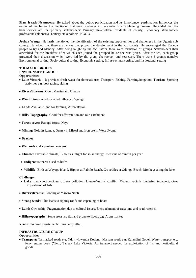
302
Plan. Isaack Nyamweno: He talked about the public participation and its importance. participation influences the
output of the future. He mentioned that man is always at the center of any planning process. He added that the
beneficiaries are the primary stakeholders: Primary stakeholder- residents of county, Secondary stakeholder-
professional(planners), Tertiary stakeholders- NGO’s
Joshua Wanga: He lastly mentioned the identification of the existing opportunities and challenges in the Ugunja sub
county. He added that these are factors that propel the development in the sub county. He encouraged the Rarieda
people to try and identify. After being taught by the facilitators, there were formation of groups. Stakeholders then
assembled for the breakfast after which each joined the grouped he or she was given. After the tea, each group
presented their discussion which were led by the group chairperson and secretary. There were 5 groups namely:
Environmental setting, Socio-cultural setting, Economic setting, Infrastructural setting, and Institutional setting
THEMATIC GROUPS
ENVIRONMENT GROUP
Opportunities
Lake Victoria: It provides fresh water for domestic use, Transport, Fishing, Farming/irrigation, Tourism, Sporting
activities e.g. boat racing, skiing
Rivers/Streams: Ober, Mawira and Omuga
Wind: Strong wind for windmills e.g. Ragengi
Land: Available land for farming, Afforestation
Hills/ Topography: Good for afforestation and rain catchment
Forest cover: Rabogo forest, Naya
Mining: Gold in Ramba, Quarry in Misori and Iron ore in West Uyoma
Beaches
Wetlands and riparian reserves
Climate: Favorable climate, 12hours sunlight for solar energy, 2seasons of rainfall per year
Indigenous trees: Used as herbs
Wildlife: Birds at Wayaga Island, Hippos at Rabolo Beach, Crocodiles at Odongo Beach, Monkeys along the lake
Challenges
Lake: Transport accidents, Lake pollution, Human/animal conflict, Water hyacinth hindering transport, Over
exploitation of fish
Rivers/streams: Flooding at Mawira Ndeti
Strong winds: This leads to ripping roofs and capsizing of boats
Land: Ownership, Fragmentation due to cultural issues, Encroachment of trust land and road reserves
Hills/topography: Some areas are flat and prone to floods e.g. Aram market
Vision: To have a sustainable Rarieda by 2046.
INFRASTRUCTURE GROUP
Opportunities
Transport: Tarmacked roads e.g. Ndori ~Lwanda Kotieno, Marram roads e.g. Kalandini Gobei, Water transport e.g.
ferry, engine boats (Yieth, Tanga), Lake Victoria, Air transport needed for exploitation of fish and horticultural
goods

303
Communication: Boosters, Phones, Post office (Misori, Madiany, Raganga, Nyihima and Ndori)
Administrative Areas: Police posts, Police stations, Sub county headquarters, Chiefs and assistant chiefs and their
offices, Availability
Education: There are secondary, primary, ECDs and polytechnics, Land for construction of tertiary institutions e.g.
Ndigwa Secondary
Health: Madiany Sub County Hospital, Ongielo Health Centre, Manyuanda, Pap Kodera, Ndori, Naya, Masala,
Obaga Dispensary
Energy: Electricity network, Solar energy, Rambugu, Naya Hills for windmills
Challenges
Transport: Poor infrastructural development of the market and the beaches, no ring roads connecting beaches, Stale
playing grounds
Administrative areas: Poor infrastructure of the offices, No ward and Sub County headquarters
Education: No tertiary institutions, Poor infrastructure of institutions, Inadequate ECD classrooms
Health: Poor infrastructure of the centers e.g. Maternity ward, Staff houses, incinerators, placenta pits, laboratories,
wards and x-ray machines are inadequate, Inadequate health facilities
Energy: No electricity in some beaches, markets and institutions, No wind mills, Shortage of solar energy
Vision: A better, holistic infrastructure that is empowering in all aspects of life in Rarieda Sub County in 30years to
come.
ECONOMIC SETTING
Opportunities
Agriculture: Irrigation, cage fishing, Land, Ginnery, Road network, Labour, Favorable climate, Dairy farming and
Market
Industrialization: Gold mining in East Asembo, Land, Building material, Ginnery and fruit processing in West
Uyoma
Housing: Land, Availability of building material, Urban housing in Madiany and Ndori
Tourism: Islands eg. Kogonga, Misori, Luanda Kotieno, Bird sanctuary in Luanda Kotieno, Crying Stone in
Ong’ielo, Archeological site in Arongo Beach, Got Naya, Modern accommodation, Road network making the areas
accessible
Financial institutions: Adequate commercial activities, Bankable population
Challenges
Agriculture: Lack of use of modern farming methods, Lack of storage facilities, Inadequate skilled labour, Market
challenges on cotton and tomatoes, Frequent flooding, Inadequate farming machinery, Legislation by the
government, Inadequate raw materials, and no startup funds due to high level of poverty
Housing: Cost of building materials is high, Population pressure on land, and poverty level
Tourism: Marketing the site is difficult
Vision: To be self-reliant and economically independent by 2046.
SOCIO - CULTURAL SETTING
Opportunities: Youthful population, Presence of primary and secondary education, Proximity to learning institutions,
Large family sizes which increase provision of labour, Stability in families as married people are more than singles,
Nyumba Kumi initiative which promotes security, Food security ( Diversification in agriculture, Irrigation, Supportive

304
organizations), Adequate water sources as a result of presence of organizations helping the community access water,
and provision of waste disposal facilities
Challenges: Unemployment, Poor transition from secondary to tertiary education institutions as a result of few tertiary
institutions, Learning institutions are inaccessible in rural areas, Large family sizes which are difficult to take care of,
Many girls dropping out of school due to early pregnancies, Increased number of orphans, More men dying, Poor health
facilities and services, Understaffed police stations and poor security equipment, Poor water supply from sources, Poor
waste disposal, Land fragmentation as a result of land conflicts, poor documentation of land ownership and women not
being allowed to own land, Inadequate participation of women and people with disabilities in development matters,
Inadequate opportunities for property ownership by women and the youth
Vision: To be a county of socio - cultural values that are supportive to the development of county in the next 30years.
INSTITUTIONAL SETTING
Opportunities
Educational institutions: Most of them are well managed by the Boards of Management, High transition rate, High
enrolment in schools, High performance index, Effective implementation of adult education, Effective management
of ECDs, Frequent capacitation of teachers, Effective management of school resources, and reliable bodies like
KNUT and NGOs
1. Administrative institutions: They are well structured from Governor to MCAs and Ward Administrators
NGOs which provide social empowerment, poverty reduction and creating awareness: World Vision, Care
Kenya, ICAP, Red Cross, Plan International, CDC/ KEMRI, and pendeza Africa
Health institutions: Availability of medical experts
Security institutions: Effective police posts, County police headquarters, and well-structured security to lower levels
Government institutions: Presence of operational government institutions
2. Presence of private owned institutions
Challenges
Education: Boards inability to provide electricity in all schools, overcrowded classrooms, Misappropriation of funds,
Poor time management, High cases of drop out, Staffing challenges, and Unavailability of land for construction of
tertiary institutions
Administrative institutions: Poor supervision of projects e.g. roads, Inadequate funds to cater for social needs,
Nepotism is common, and stringent procurement procedures and bureaucracy
NGOs: No sustainability of funding, Poor coordination of activities, Inflated budgets and corruption, and much of
funding is on administration and seminars
Health: Drug shortage, Inadequate experts, Laxity to offer services, Poor use of funds, Corruption and
mismanagement
Security: Poor coordination, High cases of corruption, Inadequate supervision, and harsh and unapproachable
officials
Private owned institutions: Unqualified personnel, Duplication of work, Poor supervision, Understaffing, Poor pay
of workers, and long hours of work

305
MINUTES OF THE TECHNICAL STAKEHOLDERS WORKSHOP HELD AT ATC SIAYA ON 5TH JULY,
2018
ATTENDANTS
1. Dr. Patrick Hayombe -PRE-ENVERO
2. Dr. Joshua Wanga - PRE-ENVERO
3. Dr. Michael Nyagol - PRE-ENVERO
4. Dr. Christopher Gor - PRE-ENVERO
5. Maurice Ochieng-PHYSICAL PLANNING
DEPT
6. Fredrick Akello-WELTHUNGER
7. Zipporah Mideva-KWS
8. Kokoth Sylvester-CGS
9. Phillipe Noel -NEMA
10. Ochieng Jackline-LANDS
11. Lavender Awino -LANDS
12. Sharley Akinyi- PRE-ENVERO
13. David Rugut -NLC SIAYA
14. Donald C. Avude-KFS
15. Leonard Ofula -NEMA
16. Hellen Adongo-WATER
17. Christine Otieno-LANDS
18. George Ouma Kumo -LANDS
19. Vitalis O. Oketch-ENTERPRISE COOP
20. Ruth Omoga -CGS
21. Julia Randiga -CGS
22. Irine Akinyi -CGS
23. Jenita Atieno -CGS
24. Diana E. Awuor -CGS ENVT
25. Onyango Austine-CGS ENVT
26. Benjamin Wambua-POLICE
27. Richard Kodindo-GOVERNANCE
28. Richard Odhiambo-GOVERNANCE
29. Mable Chanzu -HEALTH
30. Samson Okoth -LANDS
31. Philip Onyango-INFORMATION DEPT
32. Angela Sewe -CGS LANDS
33. Jared Oluoch -CGS WORKS
34. Emily Mateche-NATURE KENYA
35. Abongo Richard-CGS LANDS
36. Colmaus Odindi-WATER
37. Rodgers Otieno-LANDS
38. Paulo Akello-LANDS
39. Odhiambo Brian-LANDS
40. Vitalis Ochieng-CGS ADMIN
41. Benard Ayagah-FISHERIES
42. Steven Felix -ENTERPRISE
43. Thomas O. Omondi-FINANCE
44. Imelda Sylvia -GOVERNANCE
45. Irene Diet-CGS
46. Brian Cheruitich-GIZ
47. Vincent Oduor -CGS
48. Vincent Ochule-GOVERNANCE
49. Fredrick Ochieng-CGS
50. Millicent Odhiambo-SEC
51. George F. Aole-CGS
52. Jeconia Were-CGS
53. Jared Owin-CGS
54. Richard Kigan -NLC SIAYA
55. Awino Irine -JOOUST
56. Faith Awuor-CGS
57. Julia Omoga-CGS
OBJECTIVES OF THE WORKSHOP
Presentation of the Siaya County Draft Spatial Plan and documentation of the technical stakeholders’ feedback for draft
plan improvement
Welcoming notes: The meeting was foregathered by the consultants in consultation with the County Government of
Siaya which brought together various representatives from various departments of the County Government of Siaya.
Director Physical Planning Siaya County, Plan. Maurice Ochieng, opened the session by welcoming everyone to the
meeting, this was after the opening prayers by a volunteer.
“We are all here for county spatial draft plan presentations, we ought to have started at 9.00 am but we could not due to
circumstances we would therefore like your inputs on our draft plan so that they are incorporated in the final plan.”
DEPARTMENTS PRESENT: Lands, Survey, NEMA, Nature Kenya, KFS, Fisheries, Trade, Information, KWS, GIZ,
PRE-ENVERO- Consultancy, Environment, Finance, Education
A: INTRODUCTORY REMARKS
Remarks by Chief Officer Lands-Mr Jacktone Ondiko: Greetings, thanked the Almighty for the day, the strength.
Thanked everyone for attending the meeting. He noticed that the plan process has been a long journey but worth it since
it is a constitutional requirement. He stated that out of the 47 counties in Kenya, only about 3 have made their CSP.
“We are through with situation analysis. We had gathered here before so we are here to find out whether the proposals
have been captured in the draft plan. All departments will use this plan throughout the county. He then welcomed the
CECM.
Remarks by CECM LANDS- Mr Dismus Omondi Wakla: “Pleasure to officiate the workshop. The constitution
2010 is far most transformative item. Every county must develop a county spatial plan through the constitution and the
county government Act. A spatial plan is mandatory. He went further and stated that a county spatial plan is a legal tool
that is used to guide the development of the counties. He therefore urged people to appreciate the work of the plan since
it is a document that once prepared should harmonize, guide all the development process of the county. He added that
some of the planning issues were alien to him, before. He highlighted the purpose of the CSP according to subsection
2c, that the plan shall: Provide desired pattern of land use, addresses spatial plan, provide strategies, guidance on
location, set out basic guidance of land use, set out basic capital investment framework, set out basic strategic
environmental issues, identify projects for the development of land, Alien with spatial framework neighboring counties,

306
He said the consultant were contracted to prepare the CSP. The preparation was done in 4 phases:
Inception/conceptualization, Data collection, Situation analysis
Drafting – finalization of: He told the audience to check whether analysis was correctly done, also to raise questions
where needed. He urged his audience, not to falsify the plan but to enrich it instead. “This plan is not a document that
will be amended tomorrow. Today through the constitution, participatory inclusion is mandatory in every development
process. Therefore, today is your day to look at the document, panel beat it, elaborate on it so that it captures all the
issues you want. Give the session seriousness. Be patient and interrogate the document. He closed his remarks by a
statement that, land is a factor of production. Every form of development will require land. How we use and manage
land is very important hence comes spatial planning.
B: PRESENTATIONS
Dr. PATRICK HAYOMBE: Introduced his team (consultants; Dr. Gor, Dr. Nyagol, Dr. Owino, Dr. Wanga and Dr.
Hayombe). He then followed by appreciating The CEC of lands Mr. Dismus, for the opportunity given to them as
consultants of the project. He again Thanked Mr. J. Ondiko that signed with them the contract and lastly he appreciated
the implementer and Maurice Ochieng, the county physical planner. He went further by saying, producing plans is
never easy. “There are these questions that usually arise; Why? What? How? Etc. We used models, concepts, policies
etc. to come up with this.”
DR. FRED OWINO: Presented on the County government act, 2012 and other constitutional and legislative
requirement. He emphasized that all that is done in this planning process must be based on constitution. When doing the
plan stakeholders must be part of the process. Planning is multi-disciplinary and inclusive. He emphasized the New
Urban Agenda ,2030 sustainable goals –goal 30 make human settlement, must be sustainable.
Planning Process: Derived from spatial planning document, Notice of an intention to plan done in one of the dailies,
Consultative meetings, Inception report, Reconnaissance survey.
1st stakeholder meeting- was done in six sub counties. Data collection: Used Kobo collect, Residential, Public use.
Data Analysis: Situation Analysis report
2ndstakeholder meeting: Draft plan presentation to stakeholders: Technocrat, Wider stakeholder, Circulation of the
draft plan for comments, Revision to incorporate comments, Publication in 2 dailies and Kenya gazette, Presentation to
the county assembly, Approval (*only revised after 10 years).
DR. HAYOMBE: Land is a factor of production. Occupies a space. We guide the land into two broad areas: Natural
environment, Build environment. Planning is about beautifying. Most of the time we do interfere with this environment;
Fauna & Flora. We think of integration, then globally use the plan to give the plan itself. He emphasized on the
Ecosystem Theory and the need to protect wildlife corridors. On the Theoretical framework, he discussed the Growth
pole concept- In Siaya the areas are considered as growth centers e.g., Siaya, Bondo etc.1986 looked at the districts as
giving resources and then develop. Today we pick a county or stand as a Centre periphery model e.g. if we want Siaya
county to develop, do we put resources to Bondo or Usenge to realize faster growth.
Transit Oriented: Siaya is a major transport corridor to Uganda-Growth Corridor.
Network theories: Key focal points, growth centres create the network. E.g. water network, road, mobile etc.
Stakeholder Theory-Participation, Inclusion. e.g. CEC agriculture, land etc. to give suggestions, delete, input with
justification (clear planning consideration)
Goal Achievement Matrix
DR. JOSHUA WANGA: He told the audience that their views are very necessary in up scaling this document. From
the situation analysis there are number of environmental issues in Siaya county, but the intervention proposed are key to
address these challenges. The hills for example, have been highlighted are the size of coverage. The strategies, plan
specifies this where they are located. The tourism attraction areas and all the heritage sites in the county. A number of
people rely on agriculture. The county should know the type of crops, location and various agricultural activities. Agro-
ecological zones are still key to determining the agricultural activities in specific land use. Urban agriculture as we
think of sustainable development in the urban areas as well.
His presentation covered on: Implementation Matrix, Human settlement and infrastructure strategy: Urban areas and
cities act, Siaya county priorities town, Market centres, Proposed plans for growth corridors, Core centres-e.g. Siaya,
Bondo and Usenge, Priority Centres, Proposal of growth area, Usenge – Bondo to Kisumu corridor. This corridor
should offer education facilities, fishing and eco- tourism, Usenge – Bondo – Siaya, Ndori – Asembo – Luanda
Kotieno. Very touristic, Nyadorera – Ukwala – Ugunja, Ugunja – Busia, planning for Water Resources, we need to care
for our wetlands, Distances, sinking boreholes, Water security for the County, how close to build off the wetlands.
Siaya road proposed classification, Classified county roads. We have given justification on which roads to be done,
Proposed for tarmacking.
We have proposals on the needs per ward. Protection of these water points. Dangers associated to water storm & storm
drainage. We don’t want towns that will flood. We have proposals for these. Siaya county water ways proposed for
improvement (To enhance for water transport not utilized, not efficient according to the situation analysis). Other road
users, e.g. pedestrians, boda should be designed for in. Planning for infrastructure and communication, Digital villages
in specific areas in each ward, Planning for ECDs, primaries, health centers etc., Ward, population density, size, then
proposal for ECDs, health etc. Village polytechnics, if making proposals for university we must link with higher

307
education. Security, Proposals for security & administration infrastructure, we have made proposals e.g. wards close to
beaches, wards associated to fruits for proposed industries. For our industries we need resources.
DR. HAYOMBE: Overview of the implementation Matrix.
Three core nodes for development in the county: Bondo, Usenge, Siaya;
Growth centres: Akala, Ndori, Priority towns, Yala, Ukwala, Ugunja; Market center: Nyadorera, Luanda Kotieno;
Growth Corridors: Siaya – Bondo – Usenge. Areas that would be, they are not for Agriculture. We should check the
map in the documents. The urban corridor, the brown areas should just be left for built. People can even buy land in the
towns and build their homes and let the agricultural areas be specifically for agriculture. Distance is very critical in
decision making for putting up institutions like health, ECD etc. Ward headquarter, e.g. Bondo therefore cannot be a
headquarter being that it is already developed. The other areas be given priority for development. Once the plan is in
place, it must be implemented. Let funds be set aside for implementation so as to realize the goals stated in the plan. We
can even get donation to fund these plans. We need to have the urban strategies ready. Prepare at least 60 towns &
market. Prepare fish landing & urban. These corridors must be acquired through land acquisition. If you generate
money e.g. 1 billion in a year, then should have somewhere that this money will be used. Selling lands for industrial
development, leasing etc.
CEC AGRICULTURE: We are coming from urban to peri- urban, we are invading agriculture lands so now about.
Basic of planning is land and water; we have water but is not giving us enough fish. Make land economically viable.
Invite investors, create employment and secondary. We should face the water. Let’s invest in hotels and tourism. Let’s
put hotels near the waters.
FEEDBACK FROM STAKEHOLDERS: The stakeholders broke into two groups to discuss variety proposals,
strategies and actions presented for different thematic areas in the Draft County Spatial Plan
Presentations from group discussion
Group 1: Unmapped sites should be mapped. Tourism has not been captured. Cultural sites need to be branded. Should
include Nyagoma- Kogelo and Jaramogi Mausoleum. Fisheries, food security, soil erosion factors. Map fishing zones in
the map. Open grazing soil fertility. Bare farms erosion. Over exploitation of natural resources- having many fishermen
in one particular area. enhanced spatial development framework. clear strategies on governance and social
development. enhance economic and industrial strategy, updated situation reporting
Group 2: Transportation for those living with disability, Cemetery, Airstrips, Garbage collection, Informal business
sector, Public building for those living with disability, Surrounding lands with the urban setup are agricultural, for
industrial, the resources availability proximity and accessibility, Hotel industry- Ugunja, Agricultural industry- Yala,
Rarieda etc., Planning for drainage in major town, Kiosk and a toilet conformity, Clear guidelines on how culture and
plan would conform e.g. building 50 * 100 houses for the whole family.
Responses: There is plan for beaches- cages, Forest cover is captured, Waste is an urban issue so we might not have
designated point, Ndori is a priority town just an omission from the slides. Zoning captures all the location, Planning
which site you want to preserve e.g. Kogelo, Ramogi etc. are captured. Fisheries are captured under plan for beaches.
Landing beaches – purpose spatial interaction between water and. Fish breeding grounds- Yala. Research is being done
hence will come up with areas suitable for fisheries. The document will be circulated to various departments. Disability
line will be included. We just mentioned but it is captured also. Designated at an urban spatial plan. This is county
spatial plan- stadium. Storm water drainage map is there. Maintained storm water drainage. Urban kiosk is an urban
issue captured in the spatial plan.
VOTE OF THANKS FROM ANGELA SEWE: “To those who participated, those from county and national
government. The notice was short. Thanks for the consultants, you are educating us, as well. Thank you the CEC, CO.
thank you to the Almighty God.”
The CEO lands declared the workshop closed.

308
Appendix 4: List of Participants
Table 18. 3: List of Stakeholders (Bondo Sub County)
S/NO NAME ID
NUMBER
WARD ORGANIZATION
1. JOHN OMONDI OGANGO 13599396 W.SAKWA SPIRITUAL
2. ERICK ODHIAMBO
OMONDI
25902911 W.SAKWA YOUTH
REPRESENTATIVE
3. DOMINAH AKELLO OGOT 0986721 C.SAKWA COMMUNITY LEADER
4. MAUREEN GAYA OLOO 24353866 W.SAKWA CBO REPRESENTATIVE
5. MARTIN MAGINA OKOYO 1121821 YIMBO EAST COMMUNITY LEADER
6. CHARLES ORAW 23952542 YIMBO EAST POLITICAL AND
COMMUNITY LEADER
7. JOHN OMUNGI 459165 S.SAKWA POLITICAL AND
COMMUNITY LEADER
8. NELLY NDEDA 11300509 W.YIMBO WOMEN GROUP
9. ALEX MITTO 13043300 YIMBO WEST MOH
10. SUCCESS CLEMENT 24825956 YIMBO WEST MCAs OFFICE
11. GEORGE OYIER 5966889 S. SAKWA CHURCH
12. DANIEL ODERO 22092358 W. YIMBO B.M.U
13. MAURICE OWAGA 16039044 C.SAKWA CHURCH
14. ROSELYNE NAFULA
OCHIENG
9612782 WEST SAKWA
15. PATRICK OGARE 25166462 YIMBO EAST
16. JOYOLINE NAFULA
OGOLLAH
25866587 WEST SAKWA SIAYA COUNTY
17. VINCENT MITO OLU 22977070 YIMBO WEST SIAYA COUNTYS
18. DANIEL ODHIAMBO 29356999 YOUTH REP SIAYA COUNTY
19. JOHN ORACHA N. 0119770 WEST SAKWA SIAYA
20. BENARD O. MUGARE 8248483 SIAYA
TOWNSHIP
SIAYA
21. MARK OTIENO 12520901 BONDO S.C.V.O
22. RAPHAEL KITONGA 0314502 BONDO LIVESTOCK
23. BILL CLINTONN 30726206 BONDO KFS2
24. JOHANEES ANGELA 0263133 NORTH SAKWA BISHOP ACK DIOCESE OF
BONDO
25. JENNIFER MATINGI 24901803 BONDO MEDIA
26. JOSEPH KWANYA ADONGO 3521217 N. SAKWA DISABILITY NETWORK
27. NEREAH WASONGA
OSODO
7952377 W.SAKWA FAITH - BASED
28. STEPHEN OMORO OUNA 26262655 C.SAKWA UYAWI HEALTH CENTRE
29. JOHN I.O JAKOYO 0264437 S. SAKWA MINISTRY OF
AGRICULTURE
30. JACLIN A. ODONGO 4053784 S.SAKWA INCHARGE OF THE
MARKET
31. HENRY OYAMUKARENGU 12519326 W. YIMBO FAITH - BASED
32. GERALD A. WASONGA 2724230 S.SAKWA CHURCH BASED
ORGANIZATION
33. MICHAEL ONYANGO 20818756 S.SAKWA CHAIRMAN
34. GEORGE OKECH 24946559 N.SAKWA D.G's OFFICE
35. GEORGE MEENAS OWINO 0086276 EAST YIMBO OPINION LEADER
36. PORIAN OMDENG' 21434750 WEST SAKWA MEDIA
37. ERICK NYANYIGRA 23001457 W. SAKWA MEDIA
38. GEORGE OTIENO OBIERO 27162306 W.SAKWA VET OFFICER
39. JOSEPH OWUOR KONGORO 2829955 WEST YIMBO BUSINESSMAN
40. DEDAN OJWANG 1854060 WEST YIMBO TRADER
41. VITALIS OWUOR 13680015 WEST SAKWA F.B.O
42. LABAN HONGO ODONGO 20021664 EAST YIMBO VET OFFICER
43. JAMES OSENA 974454 WEST SAKWA CBO USIRE

309
44. ALFRED OBUNGA 10262012 C.SAKWA CBO NYAN'GOMA
45. ELIZABETH OLANGO 13371343 SOUTH SAKWA MOH BONDO
46. JENIPHER ABWAO 9498013 NORTH SAKWA BONDO TOWNSHIP SEC.
SCH
47. COLLINS O WASONGA 24778581 CENTRAL
SAKWA
YOUTH GROUP
48. WILLIAM OTIENO OKELLO 20484501 CENTRAL
SAKWA
B.M.U
49. PETER OCHIENG WAMBI 2719032 NORTH SAKWA DEV. COMMUNITY
CHAIRMAN
50. FREDRICK OLALE OGUTA 10973593 SOUTH SAKWA MCA REP
51. VINCENT OKOTH AWITI 6445719 CENTRAL
SAKWA
M.O.W
52. AYAMBA AINEAH 2869683 WEST SAKWA TRADE AND
COOPERATGHIVES
53. STEPHEN A. OYOLA 26120271 EAST YIMBO MCA REP
54. WILLIS OCHIENG NUNDU 20612553 EAST YIMBO BMU SECRETARY
55. COLLINS OJONYO 22952537 WEST SAKWA MPs OFFICE
56. JOHNPAUL WANYASA 21948372 WEST SAKWA COUNTY SIAYA
57. OLIVER OTIENO 23143072 WEST YIMBO COUNTY SIAYA
58. ABWAO JARED 24550983 N.SAKWA C.G.S
59. JULIET OWINO 22291514 N.SAKWA C.G.S
60. JOHN OWUOR 8914108 WEST YIMBO C.G.S
61. GONDI OLIMA 14666815 M.P.I REP
62. MORRIS OCHIENG 23011034 SIAYA PHYISCAL PLANNING
63. JECONIA WERE 22243486 SIAYA SURVEYOR
64. JARED ODIWUOR ARWA 12505132 WEST SAKWA WARD COUNCIL
65. BEN RODDY UMAYAH 13365740 WEST SAKWA S.C BONDO
66. BEN O. NYAMULO 22830695 NORTH SAKWA YOUTH BONDO
67. EVERLYNE A. OJZI 27208332 NORTH SAKWA ICT
68. NYAMBARA GEORGE 10262363 WEST SAKWA MCAs REP
69. PETER ADUWA 24299598 C. SAKWA CIVIL SOCIETY
70. GONDI DAVICE 5632025 SOUTH SAKWA MIGWENE
71. NICHOLAS OGITA 7309066 CENTRAL
SAKWA
MINISTRY OF
AGRICULTURE
72. MAXWEL AWUONDO 9223959 N.SAKWA M.O.H
73. ATIENO A. AUKO 32350273 WEST SAKWA Y. BONDO
74. JUSTUS A. ABONGO
ASINDO
2866038 EAST YIMBO SCODA
75. JAMES AKONDO 2866328 EAST YIMBO CHAIRMAN
76. COLLINS ANDUU 9942284 WEST YIMBO LAAC
77. GAUDANCIA A. SANDA 7128805 NORTH SAKWA WOMEN GROUP
78. EMMANUEL J.K OTIENO 9951192 BONDO FISHERIES
79. CHRISANTUS IMBALI 25251503 BONDO SECURITY
80. MOHAMED ALI 951441920 BONDO SECURITY
81. RASHID OWINO 3336117 BONDO SUPERM
82. PETER OKETCH 8351982 NORTH SAKWA MCAs OFFICE
83. MAURICE O. ARINGO 8211939 WEST SAKWA N. ADM
84. BONNY OYIEN 1712267 SOUTH SAKWA WARD DEV
85. SAMSON MORE 2243161 WEST YIMBO TRADER
86. JULIUS NYERERE 1449012 CENTRAL
SAKWA
C.SAKWA
87. PETER O MBEKA 10809439 NORTH SAKWA CATHOLIC CHURCH
88. ANTONEY A. OWUOR 6180860 SOUTH SAKWA COUNTY ENVIRONMENT
89. ENES RUONGO 3967657 BONDO TOWN
AREA
TRADE
90. JOSEPH OGOYE OLIECH 9287634 YIMBO EAST WDC
91. ANGELINE APONDI 6344689 CENTRAL
SAKWA

310
92. JAMES ODIPO 6440672 SOUTH SAKWA COMMUNITY
93. CHARLES J. OTOYO 0993077 WEST SAKWA COMMUNITY PWD
94. LAWRENCE OMONDI 22331204 WEST SAKWA IPAF/CSO
95. SUSAN MILONGO 21584887 CENTRAL
SAKWA
WARD ADM
96. ROSELYNE NGIGE 9123778 ]WEST SAKWA WARD ADMIN
97. BEATRICE A. OGOLA 23559172 N. SAKWA SECRETARY S.C
98. ASHA ALUOCH CHACHA 1378909 WEST SAKWA SOCIALSERVICES
99. LEONARD OKONO BULWE 23379911 WEST YIMBO COMMUNITY
100. WILBERFORCE W. OSANO 11194296 SOUTH SAKWA CIVIL SOCIETY
101. AMBROSE MAMBA 8217043 CENTRAL
SAKWA
MCA
102. ELIAZAR ONYANDO 2813774 CENTRAL
SAKWA
LAND ASSOCIATE
103. CAROLYNE JUMA 2866668 WEST YIMBO COMMUNITY
104. JACKTONE O. OUMA 26104919 EAST YIMBO FISHERMAN
105. AMOS AREMO 11417306 WEST YIMBO WARD DEV COMMUNITY
106. NEREAH AKOTH OCHIENG 23002413 SOUTH SAKWA WARD DEV COMMUNITY
107. SAMSON O. ORIA 11118072 EAST YIMBO BARKANYANGO
108. ROSE ANYANGO 10042202 SOUTH SAKWA GROUP
REPRESENTATIVE
109. MARK OWUOR 11450043 WEST YIMBO FISH FARMER
110. ESABWA A. MAMESA 11041155 WEST SAKWA AGRICULTURAL
OFFICER
111. DAVID O. GORO 23993179 NORTH SAKWA WARD D.E.O
COMMUNITY
112. NICHOLAS OTIENO 11195993 EAST YIMBO WORDIEC
113. MORRIS R. OMOLLO 7420173 NORTH SAKWA KFS
114. FRANCIS JOBITA 8912859 BONDO PLAN INTERNATIONAL
115. EVANS OKUMU 24231160 NORTH SAKWA YOUTH GROUP
Table 18. 4: List of Stakeholders (Ugunja Sub County)
NAME ID NUMBER WARD ORGANIZATION
1. EUNICE A. ODUOR 25832111 SIDINDI FARMER
2. ELIZABETH AUMA 4698174 SIGOMERE D.M CLEANER
3. EUNICE ANYANGO 23667299 SIGOMERE SOCIAL SERVICES
4. JOSEPHINE A.ADHIAMBO 26619250 SIGOMERE STAKEHOLDER
5. COLLINS A.OMONDI 23149052 UGUNJA PARTY OFFICIAL
6. SUSAN DEBORA ACHIENG 8917186 SIDINDI CEREAL DEALER
7. FREDRICK EVANS OCHIENG 25573737 UGUNJA ELITES Y.G
8. AGNES OWUOR 7840970 UGUNJA PRIMARY SCHOOL
9. PAUL OPONDO 20878885 UGUNJA SOCIAL SERVICES
10. CELESTINE J.OLOO 11301407 UGUNJA ADMINISTRATION
11. GAUDENCIA OLOO 4625001 SIGOMERE BUSINESS
12. VICTOR OTIENO MAURA 16005094 SIGOMERE STAKEHOLDER
13. ELIAS OREYO AKUMU 6098348 SIGOMERE STAKEHOLDER
14. PATRICK ODUOR ATHURA 0556025 SIGOMERE STAKEHOLDER
15. SIMON KACHERO 21276552 UGUNJA STAKEHOLDER
16. BARNABAS WANGA 2728723 SIDINDI STAKEHOLDER
17. PAUL SANDE 405159 SIDINDI STAKEHOLDER
18. JOHN ONGULE 1238020 UGUNJA OBSERVER
19. JEREMIAH KEVIN RAWA 27782522 SIDINDI STAKEHOLDER
20. COLLINS ODUOR OKELLO 28927797 SIDINDI STAKEHOLDER
21. SAMUEL INDAGWA 28221762 SIDINDI STAKEHOLDER
22. PASTOR PESA SIWOLO 8600675 UGUNJA NYATI/WACK
23. GEORGE ONYANGO 0119780 UGUNJA STAKEHOLDER
24. FAITH MILLICENT 31814665 SIAYA LANDS

311
25. JOSEPHINE OCHIENG 21729454 SIAYA LANDS
26. JOHN N. WASONGA 8833425 SIDINDI STAKEHOLDER
27. JERIM OKOTH OKOTH 1187733 SIDINDI STAKEHOLDER
28. PHOEBE A.OUMA 24000468 SIDINDI STAKEHOLDER
29. ALFRED O.OSINO 14080199 SIDINDI STAKEHOLDER
30. ROSELINE ATIENO OTIENO 12510972 SIGOMERE STAKEHOLDER
31. ENOCK ALIECH ONYANGO 2858553 SIGOMERE STAKEHOLDER
32. ROSE A.ODIPO 6876739 UGUNJA MCA’S OFFICE
33. VICTOR OYILLE 20077461 UGUNJA MCA’S OFFICE
34. SHADRACK OTIENO 29752349 UGUNJA SAHARA FM
35. BENEDICT A. NYANGAR 9952223 SIDINDI KEBSAA
36. BARACK ABIERO 8975221 SIDINDI CHIEF
37. WILFRED ANYIKO 1119635 SIGOMERE CHIEF
38. WINNIE MADIKIZELA AKINYI 2261421 SIGOMERE WOMEN REP
39. HELIDA ATIENO OMONDI 8916894 UGUNJA WOMEN REP
40. NORINE ATIENO OTIENO 31286018 UGUNJA WOMEN REP
41. SIMEON OJWANGA OBURA 7768659 SIDINDI SUB LOCATION DEV.COM
42. ALEX OKELLO ODIANYA 7159593 SIDINDI PWD’S
43. ANJELINE OMONDI 22591135 UGUNJA TOURISM
44. FRANK MOSES ABIERO 23846945 UGUNJA ROAD CLERKS SACCO
45. CHARLES ASWETO 8198247 TINGARE MOH
46. RICHARD H.OTIENO 22872527 UGUNJA ICT
47. JECONIA O.WERE 22243486 SIAYA LANDS
48. LUMUMBA NELLY ACHIENG 30863721 SIAYA LANDS
49. DOMACK APORE 8916803 UGUNJA ROAD CLERKS
50. CHARLES O.OTIENO 8227044 UGUNJA NATIONAL ADMIN.
51. JACOB ODHIAMBO ODIPO 8919540 SIDINDI RETIRED CIVIL SERVANT
52. REV.ALBERT OKANGA 3343117 SIGOMERE ASCA
53. BARRACK O.ODHIAMBO 10120504 SIGOMERE RTD EDUCATION
54. FELISTERS ALOO ABONYO 16059237 SIDINDI EDUCATION
55. AWICH NYAWADE 8014649 SIDINDI SCHOOL B.O.M
56. JOSEPH ONYANGO 803180 UGUNJA EDUCATION
57. MESHACK OJAL 22173044 SIGOMERE COUNTY ASSEMBLY
58. THOMAS OSUNDWA 13596149 SIGOMERE COUNTY OFFICE
59. PETER RADINGA 9463027 SIGOMERE EDUCATION
60. MARY NYANJOMS 20278280 SIGOMERE EDUCATION
61. JOEL OTIENO 7854008 SIDINDI STAKEHOLDER
62. JOASH YUGI YALA 08666 SIGOMERE TINGARE WEST CBO
63. PIUS AGGREY OMONDI 1681746 UGUNJA UGRC
64. JECTONE O. OTIENO 1168513 UGUNJA DACEO
65. MUMALASI KANUSI 11329405 UGUNJA SCSAO
66. FLORENCE A OKUMU 9462212 UGUNJA MYWO
67. ALLOICE OTIENO 9287169 UGUNJA CHAIRMAN
68. PASCALIA J, SHIKUKU 9373300 SIGOMERE SASA HARAMBEE
69. VICTOR ODUOR 6269676 UGUNJA YOUTH
70. ENOCK O. CHITERI 24227056 UGUNJA TALAUTA Y C
71. SYPROSE O.ABWAO 4069224 UGUNJA MYWO
72. FRANSISCA AUMA OYIERA 1161548 UGUNJA MYWO
73. ROSE ATIENO ODUOR 10973376 UGUNJA MYWO
74. PATRICIA OGUSO SIALA 8822936 SIGOMERE CHAIRPERSON
75. RHODAH WANYONYI 23214446 UGUNJA PROBATION
76. GERSHON OCHIENGE 1080966069 UGUNJA GOVERNANCE
Table 18. 5: List of Stakeholders Attendance (Gem Sub County)
NAME ID NO WARD ORGANIZATION
1 EDITOR OYA OMONDI WAGAI KAGOLA
2 JECINTER ATIENO 10808498 CENTRAL GEM COUNTY
3 STEPHEN ONUNGA 28492629 CENTRAL GEM COUNTY
312
4 PLANNER GEORGE ONYIRO 0259105 SIAYA NLC
5 WILLICE OCHIENG 2260788 NORTH GEM MP OFFICE
6 MOSES MUDENGO 21664390 NORTH GEM VETERINARY SERVICES
7 ANASTACIA A. ODIRO 8606376 WEST GEM POULTRY KEEPING
8 MANGO SL 924000R GEM MOALR
9 AGGREY ORUOCH AGAK 16069523 CENTRAL GEM MOH
10 GEDION A O ODONGO 1387766 NORTH GEM OOP
11 FLORENCE A NGESO 9612202 WEST GEM POULTRY KEEPING
12 CYNTHIA AKOTH 29152466 NORTH GEM MALIERA YOUTH
13 MARGARET OBONDO 7803486 SOUTH GEM COMMUNITY
DEVELOPMENT
14 FRANCIS OGUTU AREMO 3606343 EAST GEM
15 CALEB NGULU AMIMO 25582955 EAST GEM BUSINESSMAN
16 AMOS ODERO ODUOL 0647836 CENTRAL GEM ODM PARTY CHAIR
17 OYOO GEORGE FRANCO 4859909 NORTH GEM BUSINESSMAN
18 JUDITH ODHIAMBO
ODHAKO
147191991 SOUTH GEM MAENDELEO YA
WANAWAKE
19 JOHN ODHIAMBO ODUGE 14286474 EAST GEM WARD ADMIN
20 BISHOP MARTIN ARARA 10718074 SOUTH GEM FAITH BASED
ORGANIZATION
21 OKUMU P AGWAYO 00854116 NORTH GEM MALIERA DVE
22 REV. ANESTO KOLUOCH 7128452 CENTRAL GEM WARD MANAGER
23 HON. JARED ABAYO 9399320 WEST GEM COUNTY ASSEMBLY
24 CAROLYNE A AWINO 7137907 EAST GEM NGUIMBAKA WOMEN
GROUP
25 FREDERICK OUMA 1854864 EAST GEM WAGAI TEMPLOMENT
26 WALTER O AOL 25478931 SOUTH GEM PUBLIC HEALTH
OFFICER (MOH)
27 FLORENCE MHONIE 0994256 NORTH EAST
GEM
ACOBOS
28 JERRY EDWIN OMWAR 3913688 EAST GEM FARMER
29 PHOEBE ONYANGO 27378447 CENTRAL GEM WARD ADMIN
30 PAUL ABWONJI AJUOGA 24196556 WEST GEM AVIBE AGROVET
31 WILLIS JUKA 0120075 SOUTH GEM DAIRY
32 ROATA ATIENO 22408502 WEST GEM MOALF
33 VICTOR BONFACE
ONYWERA
21698891 CENTRAL GEM DCC OFFICE
34 PEREZ AKINYI OTIENO 23101627 WEST GEM POULTRY
35 BEATRICE A AMOLLO 9099775 YALA TOWN ADMIN ASSIST CHIEF
36 JOHN BARRACK OLOO 7581827 CENTRAL GEM NATIONAL
GOVERNMENT ADMIN
37 JOANESS AGOH ABONGO 4156760 EAST GEM MCDA
38 JOEL OTIENO OTIANG 2811820 CENTRAL GEM KOBAT CBO
39 MARTIN OCHIENG OTIENO 4441350 CENTRAL GEM SIRIWO CBO
40 PETER N GOIZI 8741738 CENTRAL GEM,
YALA
TOWNSHIP
KENYA FOREST SERVICE
41 ROSE SALOME AUMA 6596435 NORTH GEM LUNDHA CBO
42 BARRACK OWUOR
ODENYO
0303086 NORTH GEM SURVEY
43 HABAKUK OUDA 0328176 NORTH GEM SIFACOM
44 WILLIAM OWINO OKOTH 3621280 NORTH GEM SUB LOCATION CHAIR
45 RICHARD OWINO ONGOWO 11823856 WEST GEM TEACHER
46 VINCENT OCHIENG
OGUNDE
13597710 SOUTH GEM IT CONSULTANT
47 GEORGE O OTIENO 16004333 GEM SUB
COUNTY
COUNTY GOVERNMENT
SIAYA
48 PAMELA AUDI 16064496 WEST GEM WOMEN LEADER
49 SELINE A OKELLO 22283735 EAST GEM YOUTH

313
50 SIMEON OBIERO 8916410 CENTRAL GEM NATIONAL
GOVERNMENT
ADMINISTRATION
51 BENSON OKENO 13602322 YALA
TOWNSHIP
WARD ADMINISTRATOR
52 GEORGE OLANDO HEZRON 3482196 CENTRAL GEM BURSARY COUNTY
53 R AUMA ATINGA 2762357 WAGAI EAST POULTRY FARMER
54 RITA OGUTU ODUYU 6176090 WEST WAGAI BUSINESS
55 MARAGRET OTIENO 213484673 EAST WAGAI BUSINESS
56 MAGRET A MANGONGO 40729507 WEST WAGAI BUSINESS
57 LINET OYULI 25538995 GEM COUNTY GOVERNMENT
SIAYA
58 AMIMO JOHN 24926246 YALA COUNTY GOVERNMENT
SIAYA
59 JARED OWINO 20619613 GEM COUNTY
60 JONNES ANAM ADONGO 13372539 YALA NATIONAL
GOVERNMENT
ADMINISTRATION
61 JESSICA A ALUOCH 2762489 SOUTH GEM MYW
62 MARY GORRET RADING 300657 YALA EDUCATION
63 HASSAN ODHIAMBO 24102614 YALA KYDP
64 MAURICE A OKUKU 2701362 SOUTH GEM EDUCATION
65 NICHOLAS O OPONDO 6451036 SOUTH GEM WATER
66 SAMUEL OKETCH 8233807 NORTH GEM EDUCATION
67 OMONDI MOSES ADALO 28282428 CENTRAL GEM EDUCATION
68 NAHUM W OTIENO 1912505 NORTH GEM SEM SUB COMMITTEE
69 SAMUEL OUMA OMOLLO 406296 NORTH GEM FINANCE
70 FREDERICK ASETE 23755386 YALA COUNTY GOVERNMENT
71 JULIA A ODHIAMBO 06428818 EAST GEM PWD
72 BEATRICE A OGUTU 29031613 EAST GEM YOUTH
73 BERTHA AUMA ODHIAMBO 26115192 EAST GEM ENVIRONMENT
74 RACHEAL AKOTH 29457087 EAST GEM YOUTH
75 ABEL OMONDO OTIENG 24617568 EAST GEM YOUTH
76 ISAIAH OBIERO ONYANGO 8227245 CENTRAL GEM ENVIRONMENT
77 DAVID MARENYA OGOMA 9941758 CENTRAL GEM ECOTOURISM GROUP
78 WILLICE O OKELLO 16019016 NORTH GEM WARD
79 OGARA OKETCH 5295284 NORTH WEST
GEM
FARMER
80 PETER ODEA OWINI 25844345 SOUTH GEM YOUTH
81 SIPROSE ALANGO OPIYO 13199721 WEST GEM FARMER
82 SAMMY SINGUNI 1051734 NORTH GEM FARMER
83 ANJELINE WANGULU 9399321 NORTH GEM FARMER
84 EUNICE A GANDA 4053937 EAST GEM FARMER
85 AGAI OBIMA 514445 SOUTH GEM FARMER
86 MORRIS O ODING 2806246 EAST GEM ASST CHIEF
87 ONYALO OCHIDO 13039404 YALA BUSINESS
88 ELIJAH ODINGA 3967135 CENTRAL GEM CHAIRMAN
89 ELIZABETH OBIERO 29302006 SOUTH GEM YOUTH
Table 18. 6: Stakeholder List (Rarieda Sub County)
NAME ID
NUMBER
WARD ORGANIZATION
1 GRACE A. OBARA 13238172 S. UYOMA WOMEN GROUP
2 JENIPHER ALUOCH 9020572 S. ASEMBO CHW REP
3 EMMA AWUOR 0234689 E. ASEMBO WOMEN REP
4 THOMAS OUMA 9099592 DEPARTMETAL PUBLIC WORKS
5 EDNA CHEBET RUGUT 22613664 HOD NAIROBI
6 GEORGE AGANYO 1531034 HOD AGRICULTURE
314
7 MAURICE OTIENO ADIPO 24667672 W. UYOMA YOUTH REP
8 JAPHETH MANYALA 0988785 N.UYOMA DISABILITY
9 TOBIAS OPIYO 1319438 S.UYOMA WARD ADMIN
10 CHARLES OCHIENG 11302182 HOD RARIEDA
11 DANIEL OGAMBI 11671712 W. ASEMBO RARIEDA
12 PETER OTIENO NDEDA 12520949 RARIEDA LIVESTOCK RARIEDA
13 PATRICK WANDHE 3499939 RARIEDA VET VETERINARY
14 NO JUMA 8237203 N. UYOMA KNCCOI
15 OSCAR AWOLIA 6470615 W. UYOMA INTERIOR
COORDINATOR
16 ODIANGO WYCLIFE 13598040 W. ASEMBO OOD
17 ELIAZARO ODINGA ALAL 2701274 N. UYOMA RARIEDA PWD
18 CARILUS OKEYO 9702547 S. UYOMA PLWD S. UYOMA
19 JOHN OMEDO NGOLO 1194797 E. ASEMBO YOUTH REP
20 KEPHER A. OBAGO 7838950 N. UYOMA ASST. CHIEF
21 SAMUEL O. GUEGE 9943695 N. UYOMA INTERIOR
COORDINATOR
22 PETER O. ODONGO 13877896 N. UYOMA INTERIOR
COORDINATOR
23 ALFRED OYOYO 10537938 S. UYOMA ASST. CHIEF
24 WILBERFORCE O. OCHAR 1518756 N. UYOMA SENIOR ASST. CHIEF
25 MARTIN V JAKOYO 11302061 N.UYOMA ASST. CHIEF
26 OKONGO DANIEL 25002542 N. UYOMA WARD ADMIN
27 MAURICE AYANGA 0322880 WATER RARIEDA
28 DAVID O. NGOGE 0722302870 WARD MANAGER
29 CECILIA OCHOLA 4064659 W. UYOMA WOMEN REP
30 STEPHEN O. ATIENO 2874576 W. UYOMA ASST. CHIEF
31 JACK OOREY OYARO 23832493 W. UYOMA ASST. CHIEF
32 PST. SHADRACK OCHOLA 11577814 N. UYOMA CHAIR RAGENGNI
MARKET
33 PST. JAMES AGUNDA 13682115 E.ASEMBO NDORI MARKET
34 JAMES OTIENO NJAGAH 1226395 E. ASEMBO NORTH RAMBA CBO
35 ERICK OKAL 13890538 E. ASEMBO CHIEF
36 MAURICE OMONDI 9836472 E.ASEMBO ASST. CHIEF
37 HABIL OLOO OBOGO 7578774 E. ASEMBO ASST. CHIEF
38 DAVID OCHIENG MILANDO 24876758 S. UYOMA REP. FISHERMENT
39 HASSAN ODERO 9931062 W. UYOMA DISABILITY
40 ROBERT OUKO 21480134 W. ASEMBO RARIEDA SEC. SCHOOL
41 PROF. MAURICE NYADAWA 7494067 W. ASEMBO FACILITATOR
42 JAMES O. MUNDA 8016990 W. ASEMBO MCA
43 KODINDO RICHARD 8975816 RARIEDA SUB COUNTY ADMIN
44 GEORGE AREK 8546256 KNUT RARIEDA
45 BENARD OGETA 21481272 W. UYOMA C.G.S
46 OWENJE PHILIP 28335995 W. UYOMA JOOUST
47 GEORGE O. ONYANGO 3966058 N. UYOMA OOP
48 OJONYA DANCUN 9222185 W. ASEMBO PRINCIPAL RARIEDA
49 ALFRED ODHIAMBO
ANYANGO
20290313 W. UYOMA B.M.U
50 GORDON WAUMA 7579640 S.ASEMBO CHIEF
51 ROSE A. ONGONGA 983585 W. ASEMBO WOMEN REP
52 STEPHEN D. OLIECH 8248142 S.UYOMA CHIEF
53 RODAH CHERUS 23164582 MADIANY ACC
54 C. MISTISA MBITHI 7407635 RARIEDA ACC
55 COSMAS O. OKWAMA 8211937 W. UYOMA SENIOR CHIEF
56 BENTER WASONGA 989585 W. ASEMBO ASST. CHIEF
57 LUBANYA OSANYO 17583962 RARIEDA KFS
58 LEONARD O. MARANDA 1529259 S. UYOMA ASST. CHIEF
59 DOMINIC O RADOL 12519141 W. UYOMA NYABERA SUB
LOCATION

315
60 ANGELA SEWE 22686439 PHYSICAL PLANNING
DEPT
61 ALOYCE MOLLI OKOME 1711958 W. UYOMA MCA OFFICE
62 EPHRAIM OCHIENG 25996 W. UYOMA LIVESTOCK DEPT
63 MOSES OPIYO OKUMU 13467718 S. UYOMA HEALTH UNIT
64 CHARLES OTHAKO ORIMBA 9789142 W. UYOMA PLAN KENYA
65 AMOS OPIYO ODING 25002568 S. UYOMA YOUTH REP
66 ALEX OGAMBI 2854344 E. ASEMBO PEFA CHRIST CHURCH
67 APOLLO OBIDHA OCHOL 4053422 W. ASEMBO PWD SEC RARIEDA
68 GRACE AKINYI YALA 0792933 E. ASEMBO RARIEDA DISABLED
69 JJ OKUNGU 24538392 E. ASEMBO CGS
70 RODGERS OMONDI OCHURO 12518311 W. UYOMA SEC MANYWANDA
71 FRED OWINO 11197571 E. ASEMBO OOP
72 MARY AGIK 12506224 E. ASEMBO OOP
73 DEACONS O. OTUNGE 3491930 W. ASEMBO INTERIOR
COORDINATOR
Table 18. 7: List of Stakeholders (Ugenya Sub County)
S/NO NAME ID
NUMBER
WARD ORGANIZATION
1 WILTON O.
ODHIAMBO
9017601 UKWALA UKWALA
2 EVERLYNE ACHIENG 13680097 UKWALA UKWALA
3 MILLICENT SEWE 29888567 UKWALA UKWALA
4 PENINA ATIENO 13371801 UKWALA UKWALA
5 JOSEPH ODUOR
ODONGO
046083 UKWALA UKWALA
6 GEORGE ORUKA
NJEGA
2226083 NORTH UGENYA DEVELOPMISTS
7 CHARLES ODUOR
OYAMO
2868472 UKWALA UKWALA
8 CONSOLATA A.
OMONDI
8914574 UKWALA DEVELOPMISTS
9 JORAM AKUMU
MBALA
20735070 WEST UGENYA PMC CHAIR
10 SAMUEL OUMA
OKETCH
9222095 NORTH UGENYA COUNTY SIAYA
11 ROSEMARY OMUDHO 16117505 NORTH WEST UGENYA ASST. CHIEF
12 JAMES MESSO 1888343 WEST UGENYA STAKEHOLDER
13 JOSEPH OLOO
OPANGA
5966454 UKWALA PM COMMITTEE
14 DISMUS ONYANGO
OTHOTH
09272146 NORTH UGENYA SEGA STAKEHOLDER DEV.
PROJECT
15 JOSEPH OTIENO
OCHIENG
20410104 WEST UGENYA OVERSITE CHAIR
16 JOAB OKOTH OMOLLO 30997886 WEST UGENYA SUPERVISOR
17 PAUL OJWANG OBARE 14663969 WEST UGENYA SECRETARY WARD ADMIN
18 JULIUS ONYANGO
ONGONGO
10626231 WEST UGENYA SEDC
19 JUDITH APIYO OTIENO 11049582 NORTH UGENYA DEVELOPMENT COMMITTEE
20 JOHN OGUTU APONDI 0943706 NORTH UGENYA DEVELOPMENT COMMITTEE
21 OMONDI NASHON 27252411 UKWALA SIAYA COUNTY
GOVERNMENT
22 L.L.OKETCH 2836540 UKWALA CHAIR MATHIWA
23 NEWTON J. OMONDI 8060549 UKWALA SIMUR SECONDARY
24 IRENE ALUOCH
OWUOKO
23280659 UKWALA UKWALA

316
25 GEORGE O. WERE 4595452 UKWALA SIMUR KONDIEK
26 ZAKAYO AYIEKO 0723990460 UKWALA ICT OFFICER
27 BENARD ADALLA 235665555 NORTH UGENYA UCAHA YOUTH
ORGANIZATION
28 SIMON AGGREY
OCHIENG
9290861 EAST UGENYA ODM PARTY
29 SYLVESTER OWINO
ONYOLO
2728746 NORTH UGENYA KAGONYA V.V.D
30 MAURICE O. OMOLE 21537398 EAST UGENYA ODM PARTY
31 GEORGE ELVIS
OSOGO
8350008 EAST UGENYA ODM OFFICE
32 RAYMOND O.
NYAPOTO
11300224 WEST UGENYA OPINION LEADER
33 NELLY A. ONGOGE 10264951 WEST UGENYA OPINION LEADER
34 ALFRED ODUOR OTI 6474735 NORTH UGENYA OPINION LEADER
35 PETER OLOO OLANGO 1331715 EAST UGENYA NATIONAL ADMIN
36 GEORGE O. OTIENO 135597035 WEST UGENYA SIAYA COUNTY
37 CHRISPIN O.
ODHIAMBO
11436180 NORTH UGENYA NATIONAL ADMINISTRATOR
38 GRACE W. OWEGE 14667873 NORTH EAST UGENYA NATIONAL ADMINISTRATOR
39 DAMIAN OKONYA
OTIGO
8210651 WEST UGENYA STAKEHOLDER
40 STEPHEN O. AWUOR 14663974 WEST UGENYA STAKEHOLDER
41 JOHN O OPIL 2873370 WEST UGENYA CHAIR NYUNDO
42 HESBON OCHIENG
OMWADO
24460133 WEST UGENYA STAKEHOLDER
43 ROSE ATIENO
RAWAYO
21336722 WEST UGENYA COMMITTEE MEMBER
44 ABRAHAM
ODHIAMBO ODUOR
27334057 NORTH UGENYA JERA DISPENSARY
45 RAPHAEL ODERO
OGONDA
0282010 UKWALA UGENYA ECDE
46 THADEUS O. OKELLO 1161554 NORTH UGENYA OOP
47 MAURINE A. OTOR 22861567 WEST UGENYA OOP
48 AMOS ODHIAMBO
OTIENO
8201143 WEST UGENYA STAKEHOLDER
49 DAVID OMOLLO 66358440 UKWALA MOA
50 THOMAS OMBECHO 8239146 UKWALA CHAIRMAN
51 THOMAS DAVID
OMONDI
8553843 WEST UGENYA SECRETARY
52 ROSE A. OMBOGO 7113981 UKWALA COORDINATOR
53 JOHN J. ONYANGO 012323831 UKWALA DEVELOPMENT COMMITEE
54 CLEMENTINA A.
ODUOR
0982235 UKWALA COORDINATOR
55 MARY ADHIAMBO
OWINO
6951697 UKWALA DELEGATE
56 JANET ATIENO
OCHIENG
11825532 UKWALA TREASURER
57 MARTIN JUMA
AYUAYA
11195597 WEST UGENYA OPINION LEADER
58 JANE ATIENO OGUTU 79178465 WEST UGENYA CHAIRPERSON
59 JOSEPHINE ATIENO
JUMA
22454432 WEST UGENYA DELEGATE
60 JOSEPH OLIMA
OMONDI
2074200 WEST UGENYA CHAIRMAN
61 PETER CLAVER OJOW 1013042 UKWALA DEV. COMMITTEE
62 GEORGE OTIENO
OKINYO
2733678 EAST UGENYA OFFICER INFORMATION
63 BENARD ODONGO 0119802 UKWALA OGEDEG

317
WAMALA
64 ROSE MARIE OWINO 1867495 UKWALA MYWO
65 ALBERT OKOTH 0830748 UKWALA UKWALA HOSPITAL
66 GABRIEL OUMA
ALUOCH
13501658 WEST UGENYA KWDC
67 JOHN ONYANGO
OCHIENG
0681627 WEST UGENYA KWDC
68 GEORGE ODINGA
ODUOR
0462328 WEST UGENYA SLDC
69 ROSELIDA GOLA 8249794 EAST UGENYA ABEDO GROUP
70 JAMES AKETCH
AKETCH
8215371 UKWALA UGENYA COM. OFFICE
71 STEPHEN OMONDI
ONYANGO
9788446 EAST UGENYA WDC CHAIRPERSON
72 PAUL O. NDAGA 0651016 EAST UGENYA PMC SIHAY
73 DANIEL ODHIAMBO 29356999 EAST UGENYA COUNTY YOUTH REP
74 DANIEL ODUNGA 25924773 WEST UGENYA STAKEHOLDER
75 ALFRED JAJ
HANGALLA
10433550 NORTH UGENYA STAKEHOLDER
76 DOUGLAS ONYANGO 2263884 EAST UGENYA SLDC
77 LEONARD A.
MUGANDA
1012619 UKWALA STAKEHOLDER