Draft Moutere-Waimea Ward Reserve Management Plan
265
Draft Moutere-Waimea Ward Reserve Management Plan Te tuhinga hukihuki Mahere Whakahaere o Moutere-Waimea October 2021
-
Upload
khangminh22 -
Category
Documents
-
view
0 -
download
0
Transcript of Draft Moutere-Waimea Ward Reserve Management Plan

Draft Moutere-Waimea Ward
Reserve Management Plan
Te tuhinga hukihuki Mahere Whakahaere o Moutere-Waimea
October 2021

Draft Moutere-Waimea Ward Reserve Management Plan October 2021
Published by: Tasman District Council Private Bag 4 Richmond Nelson 7050 New Zealand As at 2021, Tasman District Council is the administering body for 140 park and reserve areas located within the Moutere-Waimea Ward. This Plan covers all 140 areas: 116 are existing reserves1 that are formally protected and classified under the Reserves Act 1977; while the other 24 areas are parks that are not subject to the Reserves Act but do form part of the open space network in Moutere-Waimea Ward.
Version status: Draft Plan publicly notified on 15 October 2021. The final Plan will be published on Council’s website: www.tasman.govt.nz. Check any printed copy against the latest online version.
Cover photography: Clockwise from top left: Waimea/Waimeha Inlet – Photo credit: Elspeth Collier Lee Valley Recreation Reserve, January 2021 – Photo credit: Anna Gerraty Kete – Photo credit: Beryl Wilkes Opening of ‘McGazzaland’ pump-track at Wakefield Recreation Reserve, May 2021 - Photo credit: McGazzaland Facebook page
1 The 116 reserve areas are made up of a total of 242 parcels of land (many reserves comprise of more than one land parcel).

1
WHAKATAUKĪ2 Ma pāngo ma whero, ka oti te mahi
With black and with red, the work is completed Usually refers to different peoples or groups cooperating and combining efforts to achieve their goals
In the Moutere-Waimea Ward reserves management plan area (see Figure 1) there are both tangata whenua iwi who hold manawhenua and iwi who are acknowledged by the Crown, under statute. The Moutere-Waimea rohe has an extensive and rich Māori history with numerous occupation and cultivation sites or māhinga kai sustaining whānau tūpuna for generations. Fertile plains, lowland forests, wetlands, freshwater and estuarine ecosystems, and sheltered bays provided an abundance of resources. Both the Moutere and Waimea/Waimeha Inlets were rich sources of mahinga kai and around 400 hectares on the western Waimea Plains were cultivated by Māori over hundreds of years. There were several significant Māori settlements and pā along the coastline from Kina Peninsula to Grossi Point, Māpua, another at Appleby, and another near the confluence of Wai-iti and Wairoa Rivers. The Claims Settlement Acts listed below enhance the relationship of Council and Crown with iwi, including requirements to act in accordance with statutory obligations to iwi:
• Ngāti Kōata, Ngāti Rārua, Ngāti Tama ki Te Tau Ihu, and Te Ātiawa o Te Waka-a-Māui Claims Settlement Act 2014;
• Ngāti Apa ki te Rā Tō, Ngāti Kuia, and Rangitāne o Wairau Claims Settlement Act 2014; and
• Ngati Toa Rangatira Claims Settlement Act 2014. Manawhenua iwi have provided guidance and input to the development of this Draft Plan, in conjunction with Council staff.
MOUTERE-WAIMEA WARD RESERVES 2021 – 2031 This draft Reserve Management Plan sets out the vision, objectives, policies, implementation and priorities for parks and reserves located within Moutere-Waimea Ward for the next ten years. Priorities for management are set carefully against Council’s role as guardian of these reserves and its commitment to ensuring the unique environmental and cultural heritage and natural attributes of the reserves are preserved and celebrated into the future.
ABOUT THIS DOCUMENT Tasman District Council (‘Council’) administers 140 park and reserve areas located within the boundaries of Moutere-Waimea Ward. This Plan covers all 140 areas: 116 are existing reserves3 that are formally protected and classified under the Reserves Act 1977 (‘the Act’); the other 24 areas, while not subject to the Act, form an integral part of the open space network. With the exception of Moturoa/Rabbit Island, Rough Island and Bird Island (which are governed by a separate reserve management plan) and the Waimea River Park (which also has a separate management plan), this Plan provides management guidance for both categories of land. Council adopted the first Moutere-Waimea Ward Reserve Management Plan in 2000. A complete review of this plan is underway. Over the summer of 2019/2020 Council invited suggestions and ideas from the public for inclusion in a Draft Plan. Consultation with Te Tau Ihu iwi during 2021 has also informed development of this Draft Moutere-Waimea Ward Reserve Management Plan (‘draft Plan’) document. The Draft Plan will be publicly notified on 15 October 2021, with submissions closing on 17 December 2021. Information about the public consultation process is available online at: www.tasman.govt.nz/feedback.
2 Whakataukī (proverbs and sayings) are important in Māori oral traditions. They often refer to important places, people, beings, events, histories, species or symbols. The whakataukī written at the top of this page is a placeholder. 3 The 116 reserve areas are made up of a total of 242 parcels of land (many reserves comprise of more than one land parcel).

2
A note on language: This draft Plan is deliberately bilingual. The official languages in te Tai o Aorere/Tasman District include Māori and English. Just as words in context are culturally defined, so our relationship with the environment is culturally mediated. While many technical terms and Māori terms are defined in the Glossary in this document, definitions can never convey the full contextual meaning of each words. These explanations should be received as a starting point for dialogue, rather than the sort of binding definitions that are found in rules and regulations. For example, the concept of “kaitiakitanga” will differ in place and time. You are invited to join this rich cultural and linguistic journey with your own context and understanding.

3
Council has prepared this draft ten-year Reserve Management Plan for Moutere-Waimea Ward. Te Tau Ihu iwi, as Council’s reserve management partner, have been involved in drafting this Plan, including objectives and policies for the various parks and reserves. Healthy nature is central to human health, wellbeing and the economy. Natural environments, and the plants and wildlife they support, are part of our identity. Nature provides us with green spaces and recreation for wellbeing, supports primary and tourism industries, and allows us to gather kai. When nature is thriving, people are thriving. This has long been recognised in Māori culture, where nature and people are interwoven through whakapapa. People are kaitiaki (guardians) of nature, and nature is kaitiaki of people. In order to protect and restore natural taonga of our parks and reserves, we need to ensure that all of our activities contribute more to restoring nature than they take from it. Effective management will require a culture of collaboration and care.
Toitū te marae a Tane-Mahuta, Toitū te marae a Tangaroa, Toitū te tangata. If the land is well and the sea is well, the people will thrive.
KEY CHANGES TO THE MANAGEMENT OF PARKS AND RESERVES IN MOUTERE-WAIMEA WARD Suggested improvements and changes to the management regime for parks and reserves in Moutere-Waimea Ward are summarised below. Improving environmental wellbeing
1. Te Oranga o Te Taiao (a concept intended to express the intergenerational importance to Māori of environmental health and wellbeing - see Glossary definition) is upheld by maintaining, restoring, protecting and enhancing the natural environment of parks and reserves in Moutere-Waimea Ward. Revegetation with eco-sourced native species, regular weed and humane animal pest control, and protection from incompatible activities, enhances the integrity of these areas – particularly those with Significant Native Habitats (see Part 1, Section 1.3).
2. Management of esplanade reserves and other parks and reserves that adjoin waterways/the coastline is aligned with the concept of Te Mana o te Wai (see Glossary definition) and aims to ensure that the health and wellbeing of water and freshwater/coastal ecosytems is protected. Riparian plantings contribute to improved water quality and increased native biomass. Signage includes educational material about how reserve management protects waterways.
3. Maintenance practices continue to improve and reduce the potential for environmental harm. For example, minimising use of sprays and implementing alternative methods of weed control reduces potential runoff into waterways and protects habitat. Knowledge of ecological domains is considered when ecosourcing native plant species for revegetation projects.
4. Many of the parks and reserves form part of a wider network of ecological corridors, creating and extending linkages ki uta ki tai/between the mountains and the sea.
Responding to climate change impacts
5. Reserve management and strategic purchase of reserve land provide opportunities for ecological retreat from climate change impacts.
6. Over the next century and beyond, sea-level rise and coastal inundation will inevitably impact many coastal reserves: this is accepted and management of these areas reflects this. Sustainable natural solutions are implemented to manage coastal hazards and vulnerabilities on coastal reserves, to minimise the impact on the natural environment and promote natural resilience. Coastal protection work on reserve land that is undertaken by adjacent landowners complies with the process outlined in the ‘Coastal erosion protection structures on Council reserve land Policy’.
7. A 'managed retreat' approach to sea level rise is implemented by ensuring that coastal hazards and climate change are taken into account in the location, design and construction of all buildings, facilities and improvements, and that facilities and structures in high-risk areas are designed to be removable or expendable.
Foreword

4
Building partnerships
8. Strengthened relationships and partnerships with iwi/Māori are based on mutual good faith, cooperation and respect.
9. Kaitiakitanga (guardianship) is reflected in the way that the parks, reserves and their values are managed.
10. There is increased understanding, respect and consideration of iwi/Māori worldview, tikanga (system of beliefs) and mātauranga Māori (knowledge) and this is incorporated into reserve management.
11. Council and Te Tau Ihu iwi work together with community groups, other organisations, neighbours and volunteers to implement the objectives and policies of this Plan.
Increasing benefits of parks and reserves
12. An appropriate mixture of native and exotic species are planted in urban parks and reserves, including for rongoā/medicinal or raranga/weaving purposes, urban food, water quality, greater amenity, shelter and shade. Harvesting produce from fruit trees, community gardens and rongoā and raranga materials on a sustainable basis is encouraged.
13. Pedestrian access (for example, to mahinga kai sites and the coastal environment) via the reserve network is enhanced. Walkway/cycleway linkages are progressively extended, as subdivision occurs.
14. Additional or replacement recreational amenities (e.g. signage, information panels, toilets, picnic tables, barbeques, shade sails, paths and other facilities) are progressively provided in recreation reserves over time.
15. Bicultural values are increasingly reflected in parks and reserves, for example through the provision of bicultural signage and interpretation panels, use of Te Reo Māori names, and installation of pouwhenua at reserve entrances.
16. Urban parks and reserves provide safe spaces for people. Crime Prevention Through Environmental Design (CPTED) principles are incorporated into reserve development. Where lighting is provided, consideration is given to solar and passive lighting. Lighting is purposefully absent from other reserves (e.g. Wai-iti Recreation Reserve), where management incorporates ‘Dark Sky’ principles.
17. Reserve design includes provision of spaces for social gatherings and informal recreation.
18. Development of Wakefield Recreation Reserve as a destination reserve, in line with the concept plan and policies set out in Section 5.11.7. Space for a new multi-use community recreation facility is provided for here (the final location of the new facility – which will service Wakefield, Brightwater and surrounds – has not yet been decided by Council).
19. Potential development of a new boat ramp at Māpua Waterfront Park (subject to the outcome of other authorisation processes that have yet to be initiated).
20. Enhancement of Grossi Point Recreation Reserve in line with Mātauranga Māori and a Cultural Heritage Management Plan (yet to be prepared at time draft Plan was publicly notified).
21. New play equipment and landscaping at Catherine Road Recreation Reserve.
22. New parking layout at Ngatimoti Recreation Reserve, Faulkner Bush and Lee Valley Recreation Reserve.
23. Upgrading carpark areas at Lord Rutherford Park (e.g. asphalting of gravel areas and line-marking parking spaces).
24. Resurface two tennis courts at Māpua Recreation Reserve and implement an improved booking system for their use.
25. Development of area between the playcentre and bowling club, and expansion of the scout den building, at Māpua Recreation Reserve.
26. Consolidate and upgrade/replace some of the toilet/shower block facilities McKee Recreation Reserve with relocatable buildings.
27. A review of existing toilet provision and the adequacy of their performance is undertaken, with new/replacement toilets (e.g. of Exceloos at Brightwater and Wakefield) and/or wastewater infrastructure/discharge fields provided in response.
The improvements, objectives and policies outlined in the draft Plan will not only protect the unique values and characteristics of parks and reserves in Moutere-Waimea Ward, but also provide improved amenities and opportunities for everyone to enjoy. Council is very grateful for the support, input and expertise of all who have contributed ideas for this draft Plan.

5
Foreword ............................................................................................................................................................................ 3
Table of Contents ............................................................................................................................................................... 5
PART 1 .............................................................................................................................................................................. 12
Aspirations & Key Outcomes Sought ................................................................................................................................ 13
Community Feedback ....................................................................................................................................................... 17
PART 2 .............................................................................................................................................................................. 19
1.0 Legislative Context .......................................................................................................................................... 20
1.1 RELATIONSHIP OF DRAFT PLAN TO THE RESERVES ACT AND COUNCIL’S RESERVES GENERAL POLICIES DOCUMENT ………………………………………………………………………………………………………………………………………………………………….20
1.2 TE TIRITI O WAITANGI/TREATY OF WAITANGI ................................................................................................ 20
1.3 NELSON TENTHS RESERVES – SUPREME COURT DECISION ............................................................................ 22
2.0 Historic Landscape .......................................................................................................................................... 24
2.1 PRE-HUMAN SETTLEMENT .............................................................................................................................. 24
2.2 MĀORI CULTURAL LANDSCAPE ....................................................................................................................... 24
2.2.1 OVERVIEW OF MĀORI HISTORY ............................................................................................................. 24
2.3 PAKEHA CULTURAL HISTORY .......................................................................................................................... 31
2.3.1 EUROPEAN SETTLEMENT ....................................................................................................................... 31
2.4 ESTABLISHMENT OF A NETWORK OF PARKS AND RESERVES ......................................................................... 32
PART 3 .............................................................................................................................................................................. 33
Interpretation of Objectives & Policies ........................................................................................................................ 34
1.0 Ki uta ki tai – Mountains to the sea ................................................................................................................ 35
1.1 TE AO MĀORI WORLDVIEW ............................................................................................................................ 35
1.2 OVERVIEW OF ECOLOGICAL VALUES .............................................................................................................. 38
1.3 SIGNIFICANT NATIVE HABITATS ...................................................................................................................... 40
2.0 Cultural and Historical Heritage ...................................................................................................................... 41
2.1 MĀORI CULTURAL HERITAGE .......................................................................................................................... 41
2.2 NAMING OF PARKS AND RESERVES ................................................................................................................ 42
3.0 Recreational Use of Parks and Reserves ......................................................................................................... 43
3.1 VISITOR USE & MANAGEMENT ....................................................................................................................... 43
3.2 ORGANISED EVENTS ....................................................................................................................................... 45
4.0 Other Management Issues .............................................................................................................................. 47
4.1 CLIMATE CHANGE ........................................................................................................................................... 47
4.2 EVALUATING NEW PROPOSALS ...................................................................................................................... 47
5.0 Individual Parks and Reserves ......................................................................................................................... 49
5.1 COASTAL RESERVES ........................................................................................................................................ 49
5.2 PEARSE VALLEY AND NGATIMOTI RESERVES .................................................................................................. 50
5.2.1 NGATIMOTI ESPLANADE RESERVE ......................................................................................................... 52
5.2.2 PEARSE VALLEY ESPLANADE RESERVE ................................................................................................... 52
Table of Contents

6
5.2.3 NGATIMOTI RECREATION RESERVE ....................................................................................................... 52
5.2.4 NGATIMOTI ESPLANADE RESERVE #2 .................................................................................................... 54
5.2.5 PENINSULA ROAD ESPLANADE RESERVE................................................................................................ 54
5.2.6 NGATIMOTI MEMORIAL HALL RESERVE ................................................................................................. 55
5.2.7 NGATIMOTI WAR MEMORIAL RESERVE ................................................................................................. 56
5.3 DOVEDALE RESERVES ...................................................................................................................................... 57
5.3.1 WOODSTOCK ESPLANADE RESERVE ....................................................................................................... 58
5.3.2 DOVEDALE RECREATION RESERVE ......................................................................................................... 58
5.3.3 DOVEDALE CHURCH LAND ..................................................................................................................... 59
5.4 UPPER MOUTERE RESERVES ........................................................................................................................... 62
5.4.1 OLD HOUSE ROAD ESPLANADE RESERVE ............................................................................................... 63
5.4.2 UPPER MOUTERE RECREATION AND WAR MEMORIAL RESERVE .......................................................... 63
5.4.3 KELLING ROAD ESPLANADE RESERVE ..................................................................................................... 65
5.5 TASMAN / KINA RESERVES .............................................................................................................................. 67
5.5.1 LEH BAIGENT MEMORIAL RESERVE ........................................................................................................ 70
5.5.2 KINA PENINSULA ESPLANADE RESERVE ................................................................................................ 73
5.5.3 HARLEY ROAD WALKWAY RESERVE ....................................................................................................... 73
5.5.4 TASMAN MEMORIAL RECREATION RESERVE ......................................................................................... 74
5.5.5 KINA ESPLANADE RESERVE..................................................................................................................... 76
5.5.6 KINA BEACH RECREATION RESERVE ....................................................................................................... 76
5.6 RUBY BAY RESERVES ....................................................................................................................................... 79
5.6.1 TASMAN BAY ESPLANADE RESERVE ...................................................................................................... 81
5.6.2 DECK ROAD RECREATION RESERVE & EASEMENT ................................................................................. 81
5.6.3 APORO ROAD ESPLANADE RESERVE ..................................................................................................... 82
5.6.4 MOUTERE BLUFF ESPLANADE RESERVE ................................................................................................ 82
5.6.5 MCKEE MEMORIAL RECREATION RESERVE ............................................................................................ 82
5.6.6 PINE HILL HEIGHTS SCENIC RESERVE ...................................................................................................... 84
5.6.7 PINE HILL HEIGHTS WALKWAY RESERVES .............................................................................................. 86
5.6.8 PINE HILL RECREATION RESERVE ........................................................................................................... 87
5.6.9 RUBY BAY ESPLANADE RESERVES .......................................................................................................... 88
5.6.10 WESTMERE DRIVE RECREATION RESERVE ......................................................................................... 89
5.6.11 STAGECOACH WALKWAY (EASEMENT) .............................................................................................. 89
5.6.12 PINE HILL ROAD TO PIPPIN LANE WALKWAY ..................................................................................... 89
5.7 MĀPUA RESERVES ........................................................................................................................................... 91
5.7.1 RUBY BAY ESPLANADE RESERVES .......................................................................................................... 97
5.7.2 CHAYTOR RECREATION RESERVE ........................................................................................................... 97
5.7.3 OLD MILL WALKWAY RESERVE ............................................................................................................... 98
5.7.4 ARANUI ROAD – MĀPUA SCHOOL WALKWAY RESERVE ........................................................................ 99
5.7.5 SEATON VALLEY ROAD RESERVE .......................................................................................................... 100
5.7.6 CATHERINE ROAD RECREATION RESERVE ............................................................................................ 100

7
5.7.7 ARANUI PARK SCENIC RESERVE ............................................................................................................ 101
5.7.8 STAFFORD DRIVE DRAIN WALKWAY .................................................................................................... 102
5.7.9 WARREN PLACE WALKWAY RESERVE................................................................................................... 103
5.7.10 ARANUI ROAD ESPLANADE RESERVE .............................................................................................. 103
5.7.11 MORELAND PLACE ESPLANADE RESERVE ........................................................................................ 104
5.7.12 MORELAND PLACE WALKWAY RESERVE .......................................................................................... 105
5.7.13 RANA PLACE ESPLANADE RESERVE ................................................................................................. 106
5.7.14 RANA PLACE WALKWAY RESERVE ................................................................................................... 106
5.7.15 SEATON VALLEY ROAD WALKWAY RESERVE ................................................................................... 106
5.7.16 MORLEY DRAIN RESERVE ................................................................................................................. 107
5.7.17 IWA STREET/MĀPUA RECREATION RESERVE WALKWAY ................................................................. 107
5.7.18 MĀPUA RECREATION RESERVE ........................................................................................................ 108
5.7.19 MĀPUA PLAYCENTRE RESERVE ........................................................................................................ 112
5.7.20 LIONEL PLACE TO TE AROHA PLACE WALKWAY RESERVE ............................................................... 113
5.7.21 JESSIE STREET RECREATION RESERVE .............................................................................................. 113
5.7.22 CITRUS GROVE TO LANGFORD DRIVE WALKWAY RESERVE ............................................................. 113
5.7.23 MOUTERE HILLS RSA MEMORIAL HALL AND LIBRARY RESERVE ...................................................... 114
5.7.24 TORU STREET ESPLANADE RESERVE ................................................................................................ 115
5.7.25 MĀPUA ESPLANADE RESERVE ......................................................................................................... 115
5.7.26 ARANUI ROAD TO LANGFORD DRIVE WALKWAY RESERVE ............................................................. 116
5.7.27 GROSSI POINT ESPLANADE RESERVE ............................................................................................... 116
5.7.28 GROSSI POINT RECREATION RESERVE ............................................................................................. 117
5.7.29 MĀPUA WATERFRONT PARK ........................................................................................................... 118
5.7.30 NGĀIO PARK ..................................................................................................................................... 121
5.7.31 TAHI ESPLANADE ............................................................................................................................. 122
5.7.32 DAWSON ROAD WALKWAY RESERVE .............................................................................................. 123
5.7.33 DOMINION FLATS WALKWAY RESERVE ........................................................................................... 123
5.7.34 DOMINION FLATS SCENIC RESERVE ................................................................................................. 124
5.8 WAIMEA/WAIMEHA INLET RESERVES .......................................................................................................... 126
5.8.1 HIGGS RESERVE .................................................................................................................................... 131
5.8.2 WAIMEA INLET ESPLANADE RESERVE .................................................................................................. 132
5.8.3 APPLE VALLEY ROAD ESPLANADE RESERVE ............................................................................................... 133
5.8.4 BRONTE ROAD EAST ESPLANADE RESERVES ........................................................................................ 134
5.8.5 BRONTE ROAD EAST WALKWAY RESERVE ........................................................................................... 135
5.8.6 MCINDOE SCENIC RESERVE .................................................................................................................. 135
5.8.7 BRONTE ROAD WEST TO TRAFALGAR ROAD WALKWAY RESERVE ...................................................... 136
5.8.8 STRINGER RECREATION RESERVE ......................................................................................................... 137
5.8.9 MOUTERE HIGHWAY LOOKOUT RECREATION RESERVE ...................................................................... 138
5.8.10 WESTDALE ROAD ESPLANADE RESERVES ........................................................................................ 138
5.8.11 HODDY ROAD ESPLANADE RESERVES .............................................................................................. 138

8
5.8.12 MAISEY ROAD ESPLANADE RESERVE ............................................................................................... 139
5.8.13 REDMILL ROAD WALKWAY RESERVE ............................................................................................... 140
5.8.14 WAIMEA ESTUARY ESPLANADE RESERVES ...................................................................................... 140
5.8.15 HODDY ESTUARY PARK .................................................................................................................... 141
5.8.16 RESEARCH ORCHARD ROAD ESPLANADE RESERVES ........................................................................ 142
5.8.17 O’CONNOR CREEK ESPLANADE RESERVES ....................................................................................... 144
5.8.18 RIDGEVIEW WALKWAY RESERVE ..................................................................................................... 144
5.9 APPLEBY RESERVES ....................................................................................................................................... 146
5.9.1 O’CONNOR CREEK ESPLANADE RESERVES ........................................................................................... 148
5.9.2 COTTERELL ROAD ESPLANADE RESERVE .............................................................................................. 148
5.9.3 PEARL CREEK ESPLANADE RESERVE ..................................................................................................... 148
5.9.4 PEARL CREEK RESERVE ......................................................................................................................... 149
5.9.5 WAIMEA RIVER PARK ........................................................................................................................... 151
5.9.6 APPLEBY BRIDGE RECREATION RESERVE.............................................................................................. 151
5.9.7 APPLEBY BRIDGE PLAYCENTRE RESERVE .............................................................................................. 152
5.9.8 RIVER ROAD RECREATION RESERVE ..................................................................................................... 153
5.10 WAIMEA WEST AND BRIGHWATER/SPRING GROVE RESERVES ................................................................... 154
5.10.1 WAIMEA WEST RECREATION RESERVE ............................................................................................ 158
5.10.2 PALMER ROAD ESPLANADE RESERVE .............................................................................................. 158
5.10.3 WAI-ITI RIVER BANK RESERVE .......................................................................................................... 159
5.10.4 TEAPOT VALLEY ROAD ESPLANADE RESERVES ................................................................................ 160
5.10.5 LORD RUTHERFORD PARK ................................................................................................................ 160
5.10.6 CLOVER ROAD WEST ESPLANADE RESERVE ..................................................................................... 162
5.10.7 WAI-ITI RIVER ESPLANADE RESERVES .............................................................................................. 163
5.10.8 ARNOLD LANE ESPLANADE RESERVE ............................................................................................... 163
5.10.9 SPRING GROVE HALL RESERVE AND SPRING GROVE SCHOOL RESERVE .......................................... 164
5.10.10 LIGHTBAND ROAD ESPLANADE RESERVE ......................................................................................... 165
5.10.11 WAIROA RIVER ESPLANADE RESERVE .............................................................................................. 165
5.10.12 COACH PLACE RECREATION RESERVE .............................................................................................. 166
5.10.13 SNOWDEN PLACE RECREATION RESERVE ........................................................................................ 167
5.10.14 LORD RUTHERFORD MEMORIAL HISTORIC RESERVE....................................................................... 167
5.10.15 BRIGHTWATER RAILWAY RESERVE WALKWAY ................................................................................ 169
5.10.16 BRIGHTWATER RECREATION RESERVE ............................................................................................ 170
5.10.17 BRIGHTWATER VILLAGE GREEN ....................................................................................................... 172
5.10.18 STARVEALL STREET RECREATION RESERVE ...................................................................................... 173
5.10.19 BRIGHTWATER SCHOOL RECREATION RESERVE .............................................................................. 173
5.11 WAKEFIELD RESERVES................................................................................................................................... 175
5.11.1 GEORGE FYFE WAY WALKWAY RESERVE ......................................................................................... 178
5.11.2 BAIGENT VALLEY ROAD – GOLF ROAD ESPLANADE RESERVE .......................................................... 178
5.11.3 EIGHTY EIGHT VALLEY ESPLANADE RESERVES ................................................................................. 179

9
5.11.4 ROBSON RESERVE ........................................................................................................................... 180
5.11.5 GENIA DRIVE RECREATION RESERVE ............................................................................................... 182
5.11.6 EDWARD BAIGENT MEMORIAL SCENIC RESERVE ............................................................................ 183
5.11.7 WAKEFIELD RECREATION RESERVE .................................................................................................. 185
5.11.8 COUNCIL-OWNED LAND ADJOINING WAKEFIELD RECREATION RESERVE ....................................... 189
5.11.9 FAULKNER BUSH RESERVE ............................................................................................................... 190
5.11.10 EDWARD STREET RECREATION RESERVE ......................................................................................... 193
5.11.11 KILKENNY PLACE WALKWAY ............................................................................................................ 194
5.11.12 SHUTTLEWORTH RECREATION RESERVE ......................................................................................... 194
5.11.13 ANSLOW PLACE RECREATION RESERVE ........................................................................................... 195
5.11.14 WAKEFIELD RAILWAY RESERVE WALKWAY ..................................................................................... 195
5.11.15 BELFIT LANE WALKWAY ................................................................................................................... 197
5.11.16 MARTIN POINT RECREATION RESERVE ............................................................................................ 197
5.11.17 WHITBY GREEN ................................................................................................................................ 198
5.11.18 WAKEFIELD LIBRARY MEMORIAL GARDENS .................................................................................... 199
5.11.19 WAKEFIELD HALL RESERVE .............................................................................................................. 200
5.12 WAI-ITI RESERVES ......................................................................................................................................... 202
5.12.1 TRASS VALLEY ESPLANADE RESERVE ............................................................................................... 203
5.12.2 WAI-ITI RECREATION RESERVE ........................................................................................................ 203
5.13 WAIROA GORGE AND LEE VALLEY RESERVES ............................................................................................... 206
5.13.1 WAIROA GORGE ESPLANADE RESERVES .......................................................................................... 209
5.13.2 FIRESTONES RESERVE ...................................................................................................................... 210
5.13.3 LEE VALLEY ESPLANADE RESERVES .................................................................................................. 211
5.13.4 LEE VALLEY RECREATION RESERVE .................................................................................................. 212
5.13.5 MEADS BRIDGE ESPLANADE RESERVES ........................................................................................... 213
5.13.6 MEADS BRIDGE RECREATION RESERVE ........................................................................................... 214
6.0 Review of this Reserve Management Plan ................................................................................................... 216
PART 4 ............................................................................................................................................................................ 217
Ngā Tikanga O Ngā Kupu Māori – Māori Glossary ......................................................................................................... 218
Abbreviations & Definitions of Terms ............................................................................................................................ 222
Appendices ..................................................................................................................................................................... 223
APPENDIX 1: ACCIDENTAL DISCOVERY PROTOCOL FOR PARKS AND RESERVES IN MOUTERE-WAIMEA WARD .. 223
APPENDIX 2: CONSISTENCY/RELATIONSHIP WITH RELATED LEGISLATION AND OTHER COUNCIL STRATEGIES, MANAGEMENT PLANS & POLICIES ............................................................................................................................. 227
APPENDIX 3: LIST OF LEASES/LICENCES RELATING TO MOUTERE-WAIMEA WARD RESERVES (AS AT SEPTEMBER 2021) ………………………………………………………………………………………………………………………………………………….…229
APPENDIX 4: LAND AT MĀPUA FORMERLY OWNED BY THE FRUITGROWERS CHEMICAL COMPANY (FCC) ........ 235
APPENDIX 5: SCHEDULE OF PARKS AND RESERVES COVERED BY THIS MOUTERE-WAIMEA WARD RESERVE MANAGEMENT PLAN ................................................................................................................................................. 236
References ...................................................................................................................................................................... 237

10
LIST OF FIGURES Figure 1: Moutere-Waimea Ward area……………………………………………………………………………………………………..……12
Figure 2: Archaeological evidence of Māori presence in Moutere-Waimea Ward…………………………………………..28
Figure 3: Archaeological evidence of Māori presence at Motueka Valley .………………………………………………………28
Figure 4: Archaeological evidence of Māori presence at Upper Moutere……..………………………….…..…………………29
Figure 5: Archaeological evidence of Māori presence at Tasman…..……………………………………………..…………………29
Figure 6: Archaeological evidence of Māori presence at the Waimea coastal wetland area………..……………………30
Figure 7: Archaeological evidence of Māori presence at Waimea….…………………………………………..……………………30
Figure 8: Archaeological evidence of Māori presence at the Wairoa Ranges……………………………..……………………31
LIST OF MAPS Map 1: Pearse Valley and Ngatimoti reserves………………………………………………………………………………………………50
Map 2: Ngatimoti reserves (b)………………………………………………………………………….………………………………………….51
Map 3: Dovedale reserves………………………….………………………………………….…………………………………………………….57
Map 4: Northern/Central part of Ward (overview map)……………….………………………………………………………………61
Map 5: Upper Moutere reserves …………..……………………………………………….………………..……………..…………………..62
Map 6: Kina reserves (overview map)……………………………………….…………….……………………………………………………67
Map 7: Kina Peninsula reserves ……………………………………………………………….…………………………….……………………68
Map 8: Tasman/Kina reserves…………………….……………………………………………….………………………………………………69
Map 9: Kina/Ruby Bay reserves (overview map)..………………….……………………….……..…………..…………………….….79
Map 10: Ruby Bay reserves……………………….………………………………………………………..……………..………………………….80
Map 11: Māpua/Ruby Bay reserves (overview map)…………………………………………..……………..………………………..…91
Map 12: Māpua/Ruby Bay reserves (a)………………………………………………………..……………..………………………..……….92
Map 13: Māpua reserves (b)………………………………………………….………………………………………………………………………93
Map 14: Māpua reserves (c)..…………………………………………..……………………………………………………………………………94
Map 15: Māpua reserves (d)……………………………………………………………………………………………………………………….…95
Map 16: Māpua reserves (e)….……………………………………………………………………………………..………………………….……96
Map 17: Waimea/Waimeha Inlet reserves (overview map)………..……………………………………………………….………126
Map 18: Bronte Road East reserves………………………….…………………………………………………………………………………127
Map 19: Stringer Road/Bronte Road West reserves………………………………….…………………………………………………128
Map 20: Westdale Road reserves……...……………..………………………..……………………………………………………………….129
Map 21: Maisey Road to Research Orchard Road reserves…………………………………………………………………………..130
Map 22: Appleby reserves (a)……………………………………………………………………….……………………………………………..146
Map 23: Appleby reserves (b)…………….………………………………………………………………………………………………………..147
Map 24: Waimea West reserves……………………………………………………………………………………..……………………………154
Map 25: Brightwater/Spring Grove reserves (overview map)………………………………..……………..………………………155
Map 26: Brightwater reserves (a)…………………………………………………………………..……………..………………………..…..156
Map 27: Brightwater reserves (b)…………………………………………………………………..……………..………………………..…..157

11
Map 28: Wakefield to Spring Grove reserves (overview map)……………………..……………..…………………………..……175
Map 29: Wakefield reserves (a)……………………………………………………………………..……………..………………………..……176
Map 30: Wakefield reserves (b)……………………………………………………………………..……………..………………………..…..177
Map 31: Wai-iti reserves (located within the Lakes-Murchison Ward)……..……………..…………………………..……….202
Map 32: Wairoa Gorge reserves…………………………………………………………………..……………..………………………..…….206
Map 33: Lee Valley reserves (overview map)……………………..……………..…………………………..……………………………207
Map 34: Lee Valley reserves……………………..……………..…………………………..…………………………..…………………………208

12
Aspirations & Key Outcomes
Figure 1: Moutere-Waimea Ward area.
PART 1

13
ASPIRATIONS
Council works collaboratively with Te Tau Ihu iwi and their hapū, local community groups, other organisations, neighbours and volunteers to maintain, restore and enhance the natural attributes, cultural values and recreational characteristics of parks and reserves in Moutere-Waimea Ward.
Strengthened relationships and partnerships with Te Tau Ihu iwi are based on mutual good faith, cooperation and respect. Kaitiakitanga (guardianship) is reflected in the way that the parks, reserves and their values are managed. There is an increased understanding, respect and consideration of iwi/Māori perspectives, tikanga (system of beliefs) and mātauranga Māori (knowledge) and this is incorporated into reserve management.
Local communities continue to provide valued assistance to Council in the achievement of the objectives and policies of this draft Plan.
Ngā Uara ki Te Tau Ihu – Manawhenua iwi values
Ngā Uara mō ngā iwi o Te Tai o Aorere - Māori values and principles guide the way we can approach protecting and restoring Te Taiao, including parks and reserves.
• Whakapapa ki te Taiao – connection to the environment through genealogy and the personification of Taiao e.g. Papatūānuku the earth mother and Ranginui is our sky father and we are the children. We connect to inanimate and animate things.
• Te Mana o te Taiao – the Taiao comes first. The concept that that we are tēina of te Taiao and that indigenous species are our tuākana.
• Ki Uta ki Tai – an holistic approach to viewing the Moutere-Waimea Taiao.
• Ngā Taonga Tuku Iho – the treasures handed down from our ancestors and our responsibility to ensure that these are sustained for the next generation.
• Rangatiratanga – ability to exercise kaitiakitanga and have self determination to make decisions over te Taiao and ngā taonga tuku iho.
• Mātauranga Māori – knowledge/Te Ao Māori worldview
• Kaitiakitanga – whānau, hapū and iwi intergenerational responsibility to protect, sustain and look after Te Taiao. Kaitiaki are individuals who have whakapapa and affiliate to iwi in the area.
• Manaakitanga – to care for each other, to be respectful, and an act of reciprocity of natural resources to be shared with others.
• Tauutuutu – Reciprocity.
• Rāhui and Aukati – customary protection and management mechanisms to protect, conserve and manage taonga.
• Mauri – restoration of the mauri of ngā taonga tuku iho and te Taiao. The mauri is the cultural measurement for ecosystem health.
• Ngā Atua – we acknowledge the atua for the different domains of te Taiao.
• All of this implies human activity must have a net restorative effect if we are not to degrade the world we live in.
For Te Tau Ihu iwi, tino rangatiratanga is shared decision-making with Council and resource users. Collaboration is promoted to enhance opportunities to achieve net enduring restorative outcomes. Kaitiakitanga is a shared responsibility with resource managers and users to actively protect natural and physical resources. Manawhenua seek to exercise kaitiakitanga in accordance with tikanga Māori (customs), kawa (protocol) and Mātauranga Māori (Māori knowledge). Manaakitanga refers to shared responsibilities to look after and respect all living things parks, reserves and open spaces.
Mana whenua say that if we do things according to tikanga (the customary way of correct action) we will heal our relationship with te Taiao (the natural world). Tikanga is rooted on long experience with Te Taiao and is founded on whakapapa connections, which adapts us all and adapts to fit current the reality. This means that living in the world must be based on reciprocal restoration and care as we meet our needs. Placing tikanga at the centre offers the whole community an approach that leads to outcome sustainable for the whole environment and for people. Living in in this place confers privilege and responsibility in a framework of authority and accountability. Manawhenua, traditional authority, is conferred from ahi kā roa, the long burning fires of occupation. Kāwanatanga, the role of governorship conferred on the British Crown by the Treaty of Waitangi, formed the basis for law and regulation. Each citizen has responsibility to care the environment.
Aspirations & Key Outcomes Sought

14
KEY OUTCOMES SOUGHT The following key outcome statements describe what parks and reserves in Moutere-Waimea Ward will ideally be like in 2031 or beyond. These statements will guide decisions about how Council and others will manage and use these areas over the next 10 years. Overall Outcomes
Parks and reserves in Moutere-Waimea Ward continue to be places for people to share and enjoy – places where the mauri (life force) is healthy, which means that the ecological, cultural and social integrity of these areas is enhanced and sustained. Kaitiaki (guardian) obligations of iwi/Māori and hapū, to protect their taonga tuku iho (treasures to be passed down) and wāhi tapu (sacred places), are actively acknowledged and protected. People’s connections with parks and reserves in Moutere-Waimea Ward continue to grow as they enjoy the range of open spaces and opportunities for relaxation, play and recreation.
Environmental Outcomes Parks and reserves in Moutere-Waimea Ward provide spaces where our extraordinary natural heritage is flourishing and several areas have been restored. Many of these areas form part of a wider network of ecological corridors, creating and extending linkages ki uta ki tai/ between the mountains and the sea. Te Oranga o Te Taiao (a concept intended to express the intergenerational importance to Māori of environmental health and wellbeing - see Glossary definition) is upheld by maintaining, restoring, protecting and enhancing the natural environment of parks and reserves in Moutere-Waimea Ward. Revegetation with eco-sourced native species, regular weed and humane animal pest control, and protection from incompatible activities, enhances the integrity of these areas – particularly those with Significant Native Habitats (see Part 3, Section 1.3). The precious remnants of lowland alluvial podocarp forest at Edward Baigent Memorial Scenic Reserve, Faulkner Bush Scenic Reserve, Robson Scenic Reserve and Genia Drive Recreation Reserve in Wakefield are sustained and encouraged to flourish. Coastal forest habitat at LEH Baigent Memorial Reserve, Higgs Reserve, Dominion Flats Scenic Reserve, Apple Valley Road Esplanade Reserve, Pine Hill Heights Scenic Reserve and McIndoe Scenic Reserve is maturing and thriving. Remnant saltmarsh habitats alongside coastal reserves and Waimea/Waimeha Inlet remain intact. Management of esplanade reserves and other parks and reserves that adjoin waterways/the coastline is aligned with the concept of Te Mana o te Wai (see Glossary
definition) and aims to ensure that the health and wellbeing of water and freshwater/coastal ecosytems is protected. At many esplanade reserves (e.g. Kelling Road Esplanade Reserve, Cotterell Road Esplanade Reserve and Wairoa Gorge Esplanade Reserve) riparian margins along rivers and the coastline are returning to a more natural state via restoration with native vegetation. Riparian plantings contribute to improved water quality and increased native biomass. These reserves provide valuable riparian buffer zones alongside rivers, streams and the coastline. They also provide important links/biodiversity corridors between inland areas and the sea. Signage includes educational material about how reserve management protects waterways.
Banded rail. Photo credit: Nina Fowler Resilience against climate change impacts has been enhanced through revegetation of esplanade reserves and strategic purchase of reserve land to facilitate ecological retreat in response to sea level rise and absorb storm events. Sea-level rise and coastal inundation continues to erode many coastal reserves: this is accepted and management reflects this. Sustainable natural solutions are implemented to manage coastal hazards and vulnerabilities on coastal reserves, to minimise the impact on the natural environment and promote natural resilience. Coastal protection work on reserve land that is undertaken by adjacent landowners complies with the process outlined in the ‘Coastal erosion protection structures on Council reserve land Policy’. A 'managed retreat' approach to sea level rise ensures that coastal hazards and climate change are taken into account in the location, design and construction of all buildings, facilities and improvements, and that facilities and structures in high-risk areas are designed to be removable or expendable. Management of parks and reserves ensures that the enhancement and maintenance of the mauri of all living things is upheld, native species can thrive, and that naturally functioning ecosystems, ecological connections and resilience are protected, restored and enhanced.

15
Maintenance practices continue to improve and reduce the potential for environmental harm. For example, minimising use of sprays and implementing alternative methods of weed control reduces potential runoff into waterways and protects habitat. Knowledge of ecological domains is considered when ecosourcing native plant species for revegetation projects. Reserve management also implements relevant ideas and principles from local and national policy documents, such as:
• Kotahitanga mō te Taiao Strategy
• Bio Strategy for Tasman District
• Tasman-Nelson Regional Pest Management Plan
• Te Mana o Te Wai
• Resource management reforms
• Proposed National Policy Statement for Indigenous Biodiversity
• Iwi Management Plans Cultural Outcomes People’s understanding and appreciation of the natural attributes, historical and cultural heritage values, and recreational opportunities of parks and reserves in Moutere-Waimea Ward is fostered and enhanced. People have an increased understanding of the Council’s reserve management obligations and Treaty of Waitangi responsibilities, Te Tau Ihu iwi values and the Council’s management approach. Bicultural values are increasingly reflected in parks and reserve, for example through the provision of bicultural signage and interpretation panels, use of Te Reo Māori names, and installation of pouwhenua at reserve entrances. Successful partnerships with iwi/Māori and local communities continue to be established/expand and assist in the management of specific parks and reserves. People actively engage in ecological restoration, historical and cultural heritage protection, interpretation, research and recreation projects. Increased participation leads to increases in the achievement of reserve management outcomes generally. All actively managed historic places in parks and reserves (such as the memorial to Lord Rutherford at Brightwater, war memorials, memorial halls, heritage buildings – including the old school buildings at Waimea West and Spring Grove) are maintained in their 2021 condition or better. Archaeological sites are monitored for any adverse effects, including cumulative effects, arising from visitation and appropriate mechanisms are in place to ensure their continued protection. More information is obtained on the range of historic heritage remaining.
People flourish in harmony with nature – they live, care for, and benefit from the environment in ways that bolster natural ecology together with the communities that live within them. Nature has come back into people’s lives in urban and rural landscapes and people are reconnected with nature. An appropriate mixture of native and exotic species are planted in urban parks and reserves, including for urban food, water quality, greater amenity, shelter and shade. Produce from fruit trees and community gardens is available for people to harvest. Native remnants and threatened natural ecosystems are restored and reconnected in ways that also connects the wellbeing of communities into the wellbeing of these ecosystems. Māori Cultural Outcomes The cultural and ecological integrity of parks and reserves is enhanced. Reserve management incorporates concepts such as rāhui, tapu vs noa (see Part 3, Section 1.1). Rongoā/medicinal species form part of the landscaping of parks and reserves and are sustainably harvested for rongoā use. Plantings also provide sustainable sources of materials that are actively used for raranga/weaving. Māhinga kai (food gathering places) sites are restored to a healthy state. Sites formerly used as pā, occupation/villages or gardens, along with archaeological sites, wāhi tapu (sacred places), urupā (burial grounds) and other taonga (treasures) are actively protected from incompatible uses. Sites of cultural significance to iwi that are located within parks and reserves remain free of unauthorised human disturbance. Council works in partnership with Te Tau Ihu iwi to: monitor and mitigate, where appropriate, threats to Māori cultural heritage and/or archaeological sites (e.g. at coastal sites under threat from natural coastal erosion processes, specifically enable/support iwi to manage the threat); to actively manage specific sites; to increase knowledge about the Māori history of the area; and to ensure that appropriate mechanisms are in place to protect wāhi tapu and wāhi taonga values. People can learn about the cultural association iwi/Māori have with park and reserve areas via accurate and appropriate cultural interpretation. The common names of parks and reserves include the original Māori name, or other relevant Māori name, as identified by Te Tau Ihu iwi or hapū. Māori cultural design and expression are integrated into reserve fabric. Recreational Outcomes People are attracted by the wide range of passive and active recreation opportunities available on many of the parks and reserves, along with opportunities to experience nature in their daily lives.

16
Management of parks and reserves reflects the concept of 'Healthy Nature Healthy People', which seeks to reinforce and encourage the connections between a healthy environment and a healthy society. The principles are:
• the wellbeing of all societies depends on healthy ecosystems, which in turn relies on responsible, respectful human behaviour;
• parks nurture healthy ecosystems; and
• contact with nature is essential for improving emotional, physical and spiritual health and wellbeing; and
• parks are fundamental to vibrant and healthy communities.
Pedestrian access (for example, to mahinga kai sites and the coastal environment) via the reserve network is enhanced. Walkway/cycleway linkages are progressively extended, as subdivision occurs. Urban parks and reserves provide safe spaces for people. Crime Prevention Through Environmental Design (CPTED) principles are incorporated into reserve development. Where lighting is provided, consideration is given to solar and passive lighting. Most of the recreation facilities available in 2021 have been maintained. Additional or replacement recreational amenities (e.g. signage, information panels, toilets, picnic tables, barbeques, shade sails, playgrounds, sports facilities etc) are progressively provided over time. A review of existing toilet provision and the adequacy of their performance is undertaken, with new/replacement toilets and/or wastewater infrastructure/discharge fields provided in response. Over the next 10 years, the following new facilities are added:
• Development of Wakefield Recreation Reserve as a destination reserve, in line with the concept plan and policies set out in Section 5.11.7. Space for a new multi-use community recreation facility is provided for here (the final location of the new facility – which will service Wakefield, Brightwater and surrounds – has not yet been decided by Council).
• Potential development of a new boat ramp at Māpua Waterfront Park (subject to the outcome of other authorisation processes that have yet to be initiated).
• Enhancement of Grossi Point Recreation Reserve in line with Mātauranga Māori and a Cultural Heritage Management Plan (yet to be prepared at time draft Plan was publicly notified).
• New play equipment and landscaping at Catherine Road Recreation Reserve.
• New parking layout at Ngatimoti Recreation Reserve, Faulkner Bush and Lee Valley Recreation Reserve.
• Upgrading carpark areas at Lord Rutherford Park (e.g. asphalting of gravel areas and line-marking parking spaces).
• Resurface two tennis courts at Māpua Recreation Reserve and implement an improved booking system for their use.
• Development of area between the playcentre and bowling club, and expansion of the scout den building, at Māpua Recreation Reserve.
• Consolidate and upgrade/replace some of the toilet/shower block facilities McKee Recreation Reserve with relocatable buildings.

17
During the summer of 2019/2020, we asked you what you'd like to see included in a draft reserve management plan for Moutere-Waimea Ward. We offered a range of ways for people to get involved and tell us their thoughts and ideas about parks and reserves. The options included:
• filling out a survey (either online or in hard copy);
• sending other written feedback (either via Council’s online submission database, email or letter); and
• booking a meeting with Council staff to discuss ideas. We heard from 138 individuals and groups by April 2019. A total of 70 people completed the survey and 68 people provided feedback via other methods. Most survey respondents (83%) and other people who provided feedback (57%) live locally in the Moutere-Waimea Ward. Survey Responses The survey asked people what they loved about parks and reserves in Moutere-Waimea Ward, whether they could be improved in any way and what their long-term vision was. It also asked a range of questions about their current use of, and satisfaction with, existing facilities and opportunities available in parks and reserves. One of the key findings from the survey is that people appreciate the range and diversity of existing parks and reserves and want to see these maintained, perhaps with some minor improvements where needed. The opportunities provided to interact with nature and access the coastline and Waimea/Waimeha Inlet are highly valued, as are the networks of walkways/cycleways available. Ideas for a vision for parks and reserves included: “They need to be protected for future generations.” “Flourishing native trees, plants and birdlife.” “That they remain unspoilt public spaces.” “I would like the parks to be places where people gather and there are things for them to do.” “A haven for both people and wildlife.” “Well maintained and safe for everyone to enjoy.” “Retain family camping at McKee which is not expensive.” “Larger trees in the reserves are stunning – there should be more of them.” Survey results indicate that locals visit parks and reserves for a range of reasons on a frequent basis. Most respondents (55%) visit at least once a week and about a third (31%) visit every day.
The most popular activity undertaken by survey respondents is spending time outdoors with family/ friends (91%), followed by walking (89%) and quiet enjoyment of open space, on my own (80%):
Other activities identified by survey respondents included: attending festivals and events; accessing the adjacent coastline; boating; fishing; geocaching; yoga; picking up rubbish; and walking or biking through parks on way to shops/school. We received many suggestions for potential improvements, most of which are generally in keeping with the existing nature of the parks and reserves. One of the questions asked was: “What (if anything) could Council do to improve parks and reserves in Moutere-Waimea Ward? Select the projects you think should be a priority and/or tell us your suggestions”. A summary of responses to this question is set out in the table on the following page.
Answer Options Response Percent
Add or upgrade paths / walkways/ cycleways (suggested locations included between Upper Moutere village and the Upper Moutere Recreation Reserve; linking existing walkways in Ruby Bay and Māpua together; connect Tahi Esplanade to walkway across stream; a Waimea/Waimeha Inlet walkway from Māpua to Rough Island).
30%
Community Feedback

18
Other ideas suggested included: a new boat ramp at Māpua Waterfront Park; provision of drinking fountains; water play features for summer; extra seating – including social seating areas where groups can gather; encourage more events to be held in parks and reserves; install shade sails near barbeques; more imaginative/modern playground equipment for all ages; adult exercise equipment; an all weather astroturf complex; more lighting; natural tracks through bush remnants (less gravel and fencing); more trees for shade and wildlife; community gardens or food forests; and banning dogs in reserves alongside the Waimea/Waimeha Inlet. One of the survey questions related to new reserves. The question asked was: “As the population of Tasman District grows, Council is likely to acquire new parks and reserves. Are there any locations within Moutere-Waimea Ward where you'd like to see new reserves, areas for sporting activities or walkways etc established?” Common themes were a desire for additional walkways/cycleways and better linkages between existing ones, and for neighbourhood parks to be provided within new subdivisions. In response to the survey question: “Would you like to see new or updated facilities provided at any of the parks or reserves in Moutere-Waimea Ward?” approximately three quarter of respondents (78%) agreed, while one quarter (22%) disagreed with this idea. Desired facilities included a boat ramp at Māpua Waterfront Park; toilets at various reserves; more rubbish bins; additional seating; upgraded
playgrounds; better signage; and a community recreation facility for Wakefield. One of the survey questions related to camping in reserves. The question asked was: “There are currently only two campgrounds on Council reserve land in Moutere-Waimea Ward: at Kina Beach Recreation Reserve and McKee Recreation Reserve (Ruby Bay). Do you think that any of the other park and reserve areas in the Ward should be opened to camping?” Respondents were divided on this, with 60% opposed to and 40% supportive of opening more areas to camping. There was strong opposition to camping near Edward Baigent Memorial Scenic Reserve, where camping was prohibited in 2017. One respondent suggested allowing NZMCA members to camp at Spring Grove School Reserve and another thought Hoddy Estuary Park could be a suitable site for camping. Most respondents supported short-stay camping continuing at Kina Beach Recreation Reserve and McKee Recreation Reserve. Another survey question asked: “Wakefield Recreation Reserve has recently increased in size, with Council's purchase of land between the existing sportsfields and Baigent Memorial Scenic Reserve. Staff have prepared an indicative concept plan showing a possible layout of the facilities and uses of this reserve. We would like your feedback on both the proposed uses and layout for this area.” Many respondents supported the concept and a few made specific suggestions for changes, including: provide more lighting for sportsfields; astroturf a field to provide an all-weather option; add a playground; have a designated off-leash dog area; reduce the amount of proposed vehicle access through the reserve; and shift the proposed community facility to a more central location on the reserve. The survey also asked: “Several parks and reserves have significant ecological values. What are your aspirations for restoring areas with significant ecological values? Do you have suggestions for additional restoration efforts that could be undertaken on parks and reserves in Moutere-Waimea Ward?” Respondents to this question were supportive of protecting and restoring these areas and expanding efforts into other reserves, such as Morley Drain Reserve in Māpua, Waimeha/Waimea Inlet coastline, wetland restoration, linking forest remnants, and planting more native species in all reserves. Ideas from Others In addition to survey responses, 68 people provided detailed feedback via our website/email/letter or in person. Their feedback is available online at: https://www.tasman.govt.nz/my-council/projects/moutere-waimea-reserves-project/ under the subheading: “Seeking ideas for inclusion in a draft RMP.” Many of the ideas and suggestions received have been incorporated into this draft Plan.
Answer Options Response Percent
Provide or upgrade playground equipment (suggested locations included Māpua Waterfront Park, Ngāio Park; new subdivisions in Māpua; Māpua Recreation Reserve; Faulkner Bush; Brightwater Recreation Reserve; Starveall Street Recreation Reserve).
25%
Provide more toilets and/or upgrade existing toilet facilities (suggested locations included Dominion Flats; Tasman Memorial Recreation Reserve; Māpua Recreation Reserve; alongside new pump track at Wakefield Recreation Reserve).
18%
Improve signs and information (suggestions included more “No freedom camping” signs; more information panels on natural heritage, restoration and maintenance initiatives and where to refer if interested in participating; a sign at road entrance to Moreland Place Esplanade Reserve; more signs about wildlife and fire danger).
15%
I like the parks and reserves just the way they are – please don’t change them!
12%

19
Legislative Context & Historical Overview
PART 2

20
1.1 RELATIONSHIP OF DRAFT PLAN TO THE RESERVES ACT AND COUNCIL’S RESERVES GENERAL POLICIES DOCUMENT
The first section of Council’s Reserve General Policies document sets out the legislative context for reserve management plans. Readers are referred to that document for an overview of the relevant national legislation and Council policies. Additional information is contained in Appendix 2 of this Plan, which briefly describes relevant Council strategies, plans and policies.
There is a hierarchical relationship between the Reserves Act 1977, Council’s Reserves General Policies document and this Reserve Management Plan. Both of the latter documents must be consistent with the Reserves Act. Reserve management plans must also be consistent with reserve classification. Classification determines the principal or primary purpose of a reserve and is used to guide the control, management, use and preservation of the reserve. Classification also guides decision-making during the management planning process (e.g. leasing). Most of the existing reserves in Moutere-Waimea Ward were classified in 2021. A notice to this effect was published in the NZ Gazette on 29 June 2021. Council’s Reserves General Policies document has been prepared to consolidate policies that apply to all reserves owned and/or administered by the Tasman District Council, including the 140 park and reserve areas in Moutere-Waimea Ward that are covered by this Plan. Reserve General Policies are policies that generally apply across all reserves, to avoid the need for them to be repeated in all reserve management plans. Most of the policies in this Plan are site specific, to meet the specific needs of individual parks and reserves. These policies, therefore, supersede the Reserves General Policies where there are any inconsistencies.
The relationship of reserve management plans to Council’s Reserves General Policies document and other relevant Council documents is discussed further in Appendix 2.
1.2 TE TIRITI O WAITANGI/TREATY OF WAITANGI
Te Tiriti o Waitangi/The Treaty of Waitangi is the founding document of Aotearoa/New Zealand and partnership relationship between the Crown and iwi. Council has specific responsibilities to implement Treaty obligations to
iwi in their activities. These include development and implementation of this draft Plan. The Māori text has a different emphasis to the English text, however, the preamble to Te Tiriti is important because it sets out the intentions that both parties act in a manner that is binding and enduring (Kingi 2016). There are three key articles. The first article refers to Māori tino-rangatiratanga and self-determination. The second article refers to Māori having full exclusive and undisturbed possession of their lands and estates, forests, fisheries and other taonga. The third article refers to protection of Māori and Pākehā. The Treaty partnership is a reciprocal relationship enhancing the ability of iwi to participate in Council activities, such as reserve management, and to work together for greater outcomes that will benefit Māori and the wider community. This draft Plan has been developed to foster good faith engagement at the highest level, collaborative relationships, and to create a platform for growing a shared vision into the future. Treaty responsibilities for Tasman District Council and Crown agencies come from:
• the Principles of the Treaty of Waitangi in Acts of Parliament;
• acknowledgements in subsidiary regulations and instruments such as statutory acknowledgements; and
• Government policy. For reserve management, the following Acts of Parliament are relevant: 1) The Reserves Act 1977 is one of the Acts contained in
the First Schedule to the Conservation Act 1987. Section 4 of the Conservation Act requires “This Act shall so be interpreted and administered as to give effect to the principles of the Treaty of Waitangi”. The Court of Appeal in Ngai Tahu Maori Trust Board v Director-General of Conservation [1995] 3 NZLR 553 held that the obligation in s.4 required each of the Acts in the First Schedule to be interpreted and administered as to give effect to the principles of the Treaty of Waitangi, at least to the extent that the provisions of those Acts were clearly not inconsistent with those principles.
2) The Local Government Act (LGA) 2002 governs the work of Council and it states that “In order to recognise and respect the Crown’s responsibility to take
1.0 Legislative Context

21
appropriate account of the principles of the Treaty of Waitangi and to maintain and improve opportunities for Māori to contribute to local government decision-making processes, Parts 2 and 6 provide principles and requirements for local authorities that are intended to facilitate participation by Māori in local authority decision-making processes.”
3) Heritage New Zealand (HNZ) has statutory responsibility for the identification, protection, preservation and conservation of historical and cultural heritage of New Zealand under the Heritage New Zealand Pouhere Taonga Act 2014. This includes managing any destruction, damage or modification of archaeological sites under the archaeological authority process. Archaeological sites are also protected under the Tasman Resource Management Plan, in which case an authority is required under the Heritage New Zealand Pouhere Taonga Act 2014.
4) The Resource Management Act (RMA) 1991 states in Section 8 that “In achieving the purpose of this Act, all persons exercising functions and powers under it, in relation to managing the use, development, and protection of natural and physical resources, shall take into account the principles of the Treaty of Waitangi (Te Tiriti o Waitangi).” In Section 6 the Act requires those exercising powers to recognise and provide for the relationship of Māori and their culture and traditions with their ancestral lands, water, sites, waahi tapu, and other taonga and in Section 7 to have regard to kaitiakitanga. This is further elaborated for the Top of the South in the Te Tau Ihu Statutory Acknowledgements, which insert provisions into the Tasman Resource Management Plan (TRMP).
Administering bodies under the Reserves Act derive their authority over reserves from the Act. Accordingly, in performing functions and duties under the Act, Council – as the administering body – has a duty similar to the Crown’s to interpret and administer the Act to give effect to the principles of the Treaty of Waitangi. As the obligation relates to the administration of the Act, all reserves administered under the Reserves Act – whether they derive from the Crown or otherwise – are subject to the s.4 of the Conservation Act obligation. As the administering body, Council cannot undertake actions or make decisions that are contrary to the purposes of the Reserves Act when meeting its responsibilities under the principles of the Treaty of Waitangi. Council also cannot do anything contrary to the trust under which the reserve in question is classified. As far as possible, however, both s.4 Conservation Act and Reserves Act requirements should be accommodated.
To summarise, the Reserves Act (via the First Schedule of the Conservation Act), LGA and RMA require local authorities to give effect to, or take into account, the principles of the Treaty of Waitangi. The draft Plan should be read with reference to the above. Treaty-related provisions in other plans, policies, and strategies are also relevant. These include iwi management plans and Council plans and strategies under these and related statutes.
TE TIRITI/TREATY SETTLEMENT LEGISLATION
There are eight iwi within the rohe of Te Tau Ihu and Moutere-Waimea Ward. They are represented by the following iwi authorities:
i. Ngāti Apa ki te Rā Tō Trust; ii. Ngāti Koata Trust;
iii. Te Rūnanga o Ngāti Kuia Trust; iv. Ngāti Rārua Iwi Trust; v. Ngāti Tama ki te Waipounamu Trust;
vi. Te Ātiawa o Te Waka-a-Māui Trust, represented by Te Ātiawa Manawhenua ki Te Tau Ihu;
vii. Te Rūnanga a Rangitāne o Wairau Trust; and viii. Toa Rangatira Trust.
Statutory responsibilities the Council enacts under the various Treaty Settlements relating to Moutere-Waimea Ward derive from the:
• Ngāti Kōata, Ngāti Rārua, Ngāti Tama ki Te Tau Ihu, and Te Ātiawa o Te Waka-a-Māui Claims Settlement Act 2014;
• Ngāti Apa ki te Rā Tō, Ngāti Kuia, and Rangitāne o Wairau Claims Settlement Act 2014; and
• Ngāti Toa Rangatira Claims Settlement Act 2014.
These Settlement Acts outline each area of interest – including statutory acknowledgements over land, water, sites, wāhi tapu, valued flora and fauna, and other taonga – for each of the eight iwi. Te Tau Ihu iwi work with Council and other local authorities to meet statutory obligations under the Deeds of Settlement for each iwi.
PRINCIPLES OF THE TREATY The principles of Te Tiriti o Waitangi, as articulated by the Courts and the Waitangi Tribunal, provide the framework for obligations that must be met under this draft Plan: Partnership, Active Protection and Redress: https://waitangitribunal.govt.nz/assets/Documents/Publications/WT-Principles-of-the-Treaty-of-Waitangi-as-expressed-by-the-Courts-and-the-Waitangi-Tribunal.pdf It is important that Te Tiriti o Waitangi and the Treaty partnership is recognised and acknowledged, to enable iwi and local authorities to work together to achieve outcomes that benefit Māoridom and New Zealanders (Kingi 2016).

22
For this draft Plan to succeed, reserve management practices should support Te Ao Māori and indigenous approaches to environmental management and ensure manawhenua kaitiakitanga needs and priorities are realised. Empowering whānau, hapū and iwi as Treaty Partners and Governors to be decision makers over ngā taonga tuku iho ki Moutere-Waimea parks and reserves is also key. This ensures iwi of the right to self-determination or Tino Rangatiratanga. Te Tau Ihu Deed of Settlements for Te Tau Ihu iwi provide a baseline for addressing iwi grievances. Manawhenua iwi and the Council are keen to actively promote an enduring Treaty partnership for shared decision-making and shared management for Te Taiao (the environment) based on goodwill, good faith and active protection. The draft Plan is an opportunity to ensure iwi/Māori values, traditions and aspirations are actively protected.
1.3 NELSON TENTHS RESERVES – SUPREME COURT DECISION
Supreme Court decision in Proprietors of Wakatū v Attorney-General [2017]4 On 28 February 2017, the Supreme Court released its decision in Proprietors of Wakatū & Rore Stafford v Attorney- General [2017] NZSC 17, allowing the appeal, and sending the case back to the High Court to determine matters of breach, loss and remedy.
Nelson Tenths Reserves (in red). Credit: Wakatū Incorporation
The case relates to the creation of the Nelson Tenths Reserves, in the early days of colonial New Zealand. It seeks to secure the return of land from the Crown to make up the full ‘tenth’ that was guaranteed to to the original Māori
4 Adapated from: https://static1.squarespace.com/static/55d5151be4b0fc2d9cec8c30/t/5
customary landowners of the Tenths and Occupation Reserves, within the Tasman and Nelson district, but which the Crown never reserved in full. Key findings by the Supreme Court in its decision: (1) The Crown owed legally enforceable fiduciary duties to: (1.1) reserve one tenth of the 151,000 acres of land purchased by the New Zealand Company (15,100 acres) for the benefit of the Māori customary owners; and to (1.2) exclude their pā, urupā and cultivations from the sale; (2) The Crown reserved only 5,100 acres of the Nelson Tenths, and failed to reserve the remaining 10,000 acres. Further, there were subsequent losses to the 5,100 acres, but the extent of loss is not yet clear; (3) Rore Stafford, as kaumātua and descendant of some of the customary owners of the land, has standing to continue the claims in the High Court as a representative for the descendants of the customary owners of the Tenths Reserves and Occupation Reserves; (4) The claims are not time barred by the Limitation Act 1950, to the extent that they seek to recover from the Crown trust property either in the possession of the Crown, or previously received by the Crown and converted to its use; (5) Nor are the claims barred by the Te Tau Ihu Treaty settlements, provided for in the Ngāti Koata, Ngāti Rārua, Ngāti Tama ki Te Tau Ihu and Te Ātiawa o te Waka-a-Maui Claims Settlement Act 2014, due to a provision within that Act specifically preserving Rore Stafford’s right to continue to advance the claims on a representative basis and to obtain remedies for the descendants of the customary owners of the land; (6) As the appeal was successful the Crown has to pay costs to Rore Stafford (to offset the cost of bringing the action). The Supreme Court did not finally decide the case, on the basis that the High Court still needs to make findings on the extent to which the Crown has acted in breach of its fiduciary duties, and on what remedies should be granted for those breaches. The case has been referred back to the High Court to decide these further points and these will be determined in due course. The Supreme Court’s decision is significant because it is the first time a New Zealand court has found that the Crown owes fiduciary duties to Māori landowners to protect their property rights. Accordingly the Crown has a legal
9005bebbebafb0b1423ddf6/1493195757056/User+friendly+summary+of+the+Supreme+Court+decision+Wakatu++Others+v+Attroney+General.pdf

23
obligation to protect those rights and fulfil the terms of the Trust relating to the Tenths Reserves and Occupation Lands. The Council acknowledges the importance of the case to the region and is working proactively with the claimants to ensure the protection of any lands that may be affected by the Supreme Court’s decision, which are under the control of the Council.

24
2.1 PRE-HUMAN SETTLEMENT Much of the area is now known as Moutere-Waimea Ward is rolling hill country founded on deeply weathered fluvio-glacial outwash gravels (Moutere Gravels), with a little limestone and granite in the west. The hills are drained by numerous valleys with flat alluvial floors. Major waterways include the Wairoa and Wai-iti Rivers, which come together to form the Waimea River before entering the bay, and the Moutere River and tributaries. The Waimea Plains area comprises of lowland and coastal alluvial plains and remnants of the Moutere Gravels. Soils from the Moutere Gravels are clayey and not very fertile, those on stony terraces and sand are shallow and prone to drought, and alluvial soils are generally well drained and fertile. The coastline includes Kina Peninsula, parts of the Moutere and Waimea/Waimeha Inlets, fertile deltas and a series of bluffs. Apart from the waterways, most of the Ward would have been almost entirely covered in forest. The alluvial valley floors supported towering podocarp forests of totara, matai, rimu, miro and kahikatea. On the hills, black beech was dominant near the coast, with hard beech prominent further inland, giving way further inland still to red beech with silver beech. In sheltered coastal gullies were pockets of lush broadleaved forest containing tawa, titoki, pukatea, nikau and tree ferns. Along the coastal bluffs and fringing the estuaries, ngaio, cabbage tree, kowhai and totara would have been common. The estuaries were alive with wetland birds, fish and invertebrates. They had vegetation sequences grading from eelgrass and saline turf into rushes, sedges, harakeke (lowland flax) and shrubs (mainly saltmarsh ribbonwood, mingimingi and manuka), and finally into forest. Freshwater wetlands occurred in the coastal and inland valleys and would have included fertile lowland swamps with kahikatea, harakeke, cabbage tree and tussock sedge/Carex secta. Rivers and streams, including riparian ecosystems (trees, shrubs, flaxes, toetoe, etc) and some braided riverbeds, would have made up an appreciable portion of the Ward. The Wairoa Gorge and Lee Valley part of Moutere-Waimea Ward is made up of steep hill country, rising to over 1600m and draining to the north-west. It has complex geology, including Permian sandstone and argillite, nationally important areas of ultramafic rocks, volcanic rocks, greywacke and fossil-bearing marine and non-marine sedimentary rocks spanning a considerable age range. Soils vary greatly in structure and fertility accordingly. Land below the bushline (about 1200-1300m) would have been
5 Text is Section 2.2.1 adapted from: Mitchell, Hilary and John (2008).
Cultural significance of Māori Archaeological Sites and Wāhi Tapu in the Tasman District. Mitchell Research.
almost entirely covered in forest, apart from the waterways. The alluvial valley flats and terraces supported towering podocarp forests of totara, matai, rimu, miro and kahikatea. On the hills was mixed beech-podocarp forest, in which black beech was dominant in drier sites and hard beech in wetter lowland places, whilst red beech and silver beech occupied most cooler and mid-altitude slopes. Mountain beech was dominant on upland slopes, along with southern rata, Hall’s totara and pahautea/mountain cedar. In sheltered coastal gullies were pockets of lush broadleaved forest containing tawa, titoki, pukatea, nikau, hinau and tree ferns, accompanied by large podocarps. Above the bushline were tussock grassland, subalpine shrubland, herbfield and fellfield.
2.2 MĀORI CULTURAL LANDSCAPE Eight iwi have overlapping interests in Te Tau Ihu (the prow of the canoe): Ngāti Koata, Ngāti Rārua, Ngāti Toa (Tainui Waka), Te Ātiawa, Ngāti Tama (Tokomaru Waka), Ngāti Kuia, Ngāti Apa, Rangitane o Wairau (Kurahaupō Waka). These iwi hold the manawhenua and tangata whenua kaitiaki roles for managing ngā taonga tuku iho within the Moutere-Waimea Ward. Areas of cultural significance to all eight Te Tau Ihu Iwi within the Moutere-Waimea Ward include, but are not limited to: historical reserve lands, wāhi tapu areas, numerous pā sites, cultivation grounds, waiora, urupā and papakāinga. Natural resources were harvested and included mahinga kai, native fisheries, pingao, pounamu and pakohe/argillite. There are also many traditional camp sites within the Ward. The following information highlights the cultural landscape of areas within the Moutere-Waimea Ward that are of significance to Te Tau Ihu iwi. An accompanying series of maps that visually depict the cultural and archaeological values of these areas has also been provided; these are included in Part 3, Section 5 of this Plan. Note that this brief overview is not the full history of Te Tau Ihu iwi presence in Moutere-Waimea Ward.
2.2.1 OVERVIEW OF MĀORI HISTORY5 The Moutere-Waimea rohe has an extensive and rich Māori history with numerous occupation and cultivation sites or māhinga kai sustaining whānau tūpuna for generations. Fertile plains, lowland forests, wetlands, freshwater and
2.0 Historic Landscape

25
estuarine ecosystems, and sheltered bays provided an abundance of resources. Both the Moutere and Waimea/Waimeha Inlets were rich sources of mahinga kai and around 400 hectares on the western Waimea Plains were cultivated by Māori over hundreds of years. The Wairoa Gorge and upper Motueka River areas were valued sources of pakohe/argillite. There were several significant Māori settlements and pā along the coastline from Kina Peninsula to Grossi Point, Māpua, and also at Appleby. The Tasman Resource Management Plan identifies ‘Archaeological Precincts’ at the northern end of Kina Peninsula and at Grossi Point peninsula, Māpua. Kina to Māpua Ngāti Apa had a substantial pā ‘Te Mamaku’ on Kina Peninsula. Its chief, Pakipaki, who was captured by Te Puoho's Ngāti Tama warriors during the Tainui-Taranaki invasion about 1830, asked to be put to death by his own mere pounamu, Te Kokopu, and Te Manu Toheroa of Te Ātiawa, after consultation with Te Puoho, obliged. The Kina Precinct cluster of middens, ovens and stone working area may be associated with the Te Mamaku pā. There are two recorded pā, one at Kina, and another with ditches, terraces and nearby midden/oven and burial sites on a cliff north of the Moutere Bluff.
The extensive Māpua Precinct, concentrated at Grossi Point, with many nearby find sites suggests a considerable population lived here over many years.
Western Waimea Plains Three recorded sites of hundreds of square metres of modified soils, working area and pā site near Appleby School provide evidence of Waimea Pā, of which stories and names of inhabitants exist. More than 400 hectares of soils were modified by Māori, with river sands, gravels, and organic materials dated from AD1460. This extensive agricultural and horticultural area is known as the Waimea Gardens complex. The Waimea Plains were cultivated by large numbers of Māori for hundreds of years, as evidenced by the more than 400 hectares of soils, on the western side of the Plains, between Eve's Valley and the mouth of the Waimea River, whose fertility has been enhanced by the addition of vegetable matter, wood ash, sand and fine gravel. Some of the organic materials date back to between AD1460 and 1650, probably during the time of Waitaha and Rapuwai tribes. The Waimea was home to a succession of tribes. One of the tribes is Ngai Tara, a Kurahaupo tribe who came from Hataitai in Whanganui-a-Tara (Wellington Harbour) in the mid-1500s; their pā site was located just behind Appleby School. When the New Zealand Company arrived in 1841, Māori do not appear to have been living on the Waimea Plains and no Occupation Reserves were laid out here, although the tribes of the Tainui-Taranaki alliance always maintained it was an important resource area for them. There were, however, many indications of their recent predecessors. In 1842, John Sylvanus Cotterell burnt off an area of fern to enable his survey to proceed, and in so doing uncovered a pā site. He was told by Māori — presumably those in his survey party — that it had been sacked by Te Rauparaha's men about ten years previously. The Nelson Examiner reported: “Mr Cotterell … came upon a pah, after burning the fern with which it was covered, which is described as being very similar to a Roman camp, one side being formed by the steep bank of a tributary stream of the Weiti, which joins the Waimea, and the remainder in an irregular circular form, being protected by a ditch and earthern rampart. This pah is called after a tribe or chief called Pohare — it does not seem vere clear to which the name belonged. About ten years ago Raupero almost annihilated the inhabitants of this part of the island, and the owners of this pah among others.” Remains of ancestral pā were still clearly evident in a number of localities at Waimea, but once these lands had been allocated to European ownership, farming practices soon obliterated most surface features of such sites. One settler, Thomas Magarey, spent some time working on a Waimea property belonging to his brother, James, on which stood the remnants of “… the old pah at Waimea” that “ ..

26
had once belonged to the Rangitane, whose chief was Poe”. Verco’s biography of Magarey describes this pā as it appeared in the early 1840s: “The old pah had a wooden house built on it, and was surrounded by a shallow ditch and a bank on which had been erected a rough grating, about satisfactory for a pig sty. At the back was a swamp, very deep, with plenty of eels; a little further back was the Waimea River … the land was very shingly and stoney, but did produce a good crop of potatoes.” F V Knapp notes that according to a letter he had received from Elsdon Best, there were three pā on the Waimea Plains near the coast at the time of the Tainui-Taranaki raids of 1828: ‘Te Korora’, whose chief was Hurunui; ‘Tapu-ae-nuku’, whose chief was Te Mau taranui; and ‘Tukerae-o-Maui’ which was on a headland near the sea and whose chief was Huriwaka. Other historical pā and refugee settlements referred to in early European records do not seem to be marked by recorded finds. Waimea/Waimeha Inlet The Waimea/Waimeha Inlet and catchments have been identified by iwi as an important māhinga kai area. Resources are harvested from the estuaries, river valleys, wetlands, from the river mouths and along the coastal margins. The Inlet is home to a variety of taonga, kai species and ecosystems of cultural significance to iwi. The Inlet ecosystems sustained whānau tūpuna for generations. Rivers and streams provided native fish, including the grayling (now extinct), inanga, koaro, kokopu, tuna/eel and koura. Tasman Bay/Te Tai-o-Aorere provided the opportunity for major fishing expeditions for species such as tāmure/snapper, mako/shark, and pātiki/flounder, requiring the use of sophisticated fishing nets. The estuaries provided extensive shellfish gathering areas, for species such as kūtai, tuangi, tio, tuatua, pipi, to name a few. In the past, coastal estuarine birds were also harvested, including the banded rail, dotterels, poaka, herons, kuaka, karuhiruhi and kotukungutupapa/royal spoonbills. Bulk supplies of young birds and fish were preserved for winter storage. Many birds are now threatened and protected such as the tuturiwhatu/banded dotterel and the banded rail, which are held in high esteem by iwi. The kotuku/white heron, which has a presence at the Islands, is a taonga species and regarded as tapu and an environmental indicator by iwi. Wetlands, which contained pockets of native vegetation such as tōtara, matai and kahikatea, provided productive sources of raw materials for building. These lowland forests and wetland habitats were also home to birds such as weka, kaka, falcon, kereru, parakeet that were also harvested for kai. The wetlands and lowland forests provided sites where
plants were collected historically for weaving and rongoā purposes. Inland Areas – upper reaches of Motueka River and Wairoa River catchment Two areas in the Moutere-Waimea Ward where pakohe/argillite resources abound are (i) the Wairoa River and ranges to the east of the Waimea Plains; and (ii) a second and more extensive area of pakohe/argillite sources and working areas embraces the upper reaches of the Motueka River and tributary valleys and watersheds. Māori traversed large areas of the hinterland either to travel to special resources such as pakohe and pounamu of Te Tau lhu, pounamu in Te Tai Poutini/the West Coast, or for seasonal harvest of bird or plant resources. In the early colonial period, Mary Anne Hodgkinson of Wakefield records frequent interactions with parties of Māori constantly passing through the area en route to and from fishing stations at the inland lakes, although she unfortunately does not identify them by personal or iwi names. The large number of pakohe/argillite sources and working sites along the upper Motueka River and Upper Wairoa River catchments indicate that those areas must have been well-used too, and although the identity of the stone workers is unknown, remains of whare at a Maitai Valley quarry were still in evidence during the 1840s. Some members of the Kurahaupo tribes who escaped the Tainui-Taranaki invaders sought refuge in the hills and secluded valleys on both sides of the Waimea Plains. The names of their settlements are lost, and none of the kainga or residents appears in any census or estimate of population in early colonial times, perhaps because the refugees were keeping a low profile. Knapp's notebooks include sketches and descriptions of a pā site on the northern slope of Mt. Heslington in the Wairoa River Valley and a temporary camp near Budge's Bush further upstream in the gorge. Another kainga was at Snowden's Bush. The Budge’s Bush camp (also described as near the bush at the head of a tributary valley of the Wairoa, later known as Pig Valley), where two Māori men – Tommy and Teapot – lived, was found in the early 1840s by surveyor Budge. Knapp said the inhabitants: “… had made their way to the inland camp when Rangihaeata's raiding party had swept down on the Blind Bay settlements. They were believed to have come from the Waimea Pā at Appleby and from settlers’ accounts this pā was never again occupied as a place of residence …” The survey party had trouble persuading the refugees that it was safe to return to the plains, as they were terrified of retribution.

27
It is surprising that few of these habitations or cultivations, some of which may be hundreds of years old, have been officially described in archaeological records in more recent times: Mary Anne Hodgkinson's accounts of life at Wakefield suggest that there must have been a reasonable Māori population in the district, although it is unclear whether they were Kurahaupo refugees or Tainui-Taranaki people who had ventured further inland. No Occupation Reserves were set aside for Māori in the inland area. Wairoa River Catchments and Environs There is no reported trace of the refugee Māori communities who occupied some inland locations in early colonial times. Traditional accounts of pakohe/argillite exploitation, attributed to Waitaha initially and continued by succeeding tribes, are illustrated by the quarries and working areas recorded in this area. Lenses of pounamu are believed to exist in some of these localities, evidenced by rare finds of grey-green nephrite boulders within the rivers and streams of the eastern ranges. The artefacts and flakes of argillite found in archaeological sites throughout Tasman District all originate from resource areas of the Nelson-Marlborough mineral belt, and Māori from the Nelson-Tasman region must have traded the resource far afield, given the presence of argillite tools, weapons and other implements in some of the earliest archaeological sites throughout Aotearoa. This cluster of source sites and working areas is extremely significant for the information it provides about quarrying and stoneworking. An archaeological site on Rocky Knob, originally recorded as an area of 0.2 hectares consisting of buried boulders and numerous hammerstones, has had all visible artefacts removed but may yet provide important information. Another site, an argillite quarry on a fairly steep slope, was described as triangular with the argillite outcrop at its apex and quarried chunks below and spreading out into a flaking area at the base; it too has had visible artefacts removed but may retain important information. A site with two worked argillite outcrops about thirty metres apart and associated reject adzes and hammerstones, along with another site, may also provide crucial elements of early stoneworking technology. Upper Motueka River Catchments and Environs Traditional accounts describe use of river valleys, seasonal travel for birding and other harvests, and exploitation of
pakohe/argillite resources in the Upper Motueka River Valley and its tributaries. Accounts of refugees from invasions fleeing to the hills may also be relevant. No archaeological precincts have been registered within this area, but the number, variety and different styles of adzes of nephrite, argillite and sandstone, finished, unfinished or merely roughed out, together with many working areas and source sites, and the presence of obsidian, hammerstones, chisels, abrasives and drill points at various sites, make this area extremely significant for the history of stoneworking technology. The fact that this resource area may have been used over centuries by different groups with diverse origins strengthens its significance. The pā site reported by local residents below Pokororo is significant and may reveal important information on investigation; the cluster of archaeological sites in the Ngatimoti-Waiwhero Road area may record a settlement and therefore be significant. Significance of archaeological sites The Kina and Māpua Precincts, and any pā or kainga sites which can be located, including the very important Waimea Pā site near Appleby School, are culturally significant for what they can reveal about Māori customs, habits and lifestyle in the distant past. The Waimea Gardens are especially significant for the information they provide about Māori horticulture methods. Individual archaeological sites which seem to be particularly significant include:
• The area where a totara canoe, a flax fishing net, five argillite adzes and a wooden whakapapa stick were found in a swamp between Seaton Valley Road and SH63 at Māpua.
• (If it still exists) — the large borrow pit near Golden Hills Road, approximately fifty metres in diameter and three metre deep, which could add to the horticultural information available from the Waimea Gardens.
• The dendroglyphs (tree carvings) found on trees in the Brightwater and Wakefield area.
The only Native Reserves set aside between Motueka and Moutere were a small number of New Zealand Company Tenths Reserves along the coast of the Moutere Inlet.

28
Figure 2: Archaeological evidence of Māori presence in Moutere-Waimea Ward.
Credit: D Horne, Te Ātiawa Iwi Trust.
Figure 3: Archaeological evidence of Māori presence at Motueka Valley.
Credit: D Horne, Te Ātiawa Iwi Trust

29
Figure 4: Archaeological evidence of Māori presence at Upper Moutere.
Credit: D Horne, Te Ātiawa Iwi Trust
Figure 5: Archaeological evidence of Māori presence at Tasman.
Credit: D Horne, Te Ātiawa Iwi Trust

30
Figure 6: Archaeological evidence of Māori presence at the Waimea coastal wetland area
Credit: D Horne, Te Ātiawa Iwi Trust
Figure 7: Archaeological evidence of Māori presence at Waimeha
Credit: D Horne, Te Ātiawa Iwi Trust

31
Figure 8: Archaeological evidence of Māori presence at the Wairoa Ranges.
Credit: D Horne, Te Ātiawa Iwi Trust
2.3 PAKEHA CULTURAL HISTORY
2.3.1 EUROPEAN SETTLEMENT6 Sealing gangs established seasonal camps at Toropuihi and Kahurangi on the west coast of Tasman District from the early 1800s until the 1820s. Whalers came next, until the 1840s. They killed seals in the whaling off-season. In October 1841 three small ships, the Arrow, Will Watch and Whitby, sailed from Wellington under Captain Arthur Wakefield to decide on the location of Nelson, which was to be the second New Zealand Company settlement, after Wellington. They anchored at Astrolabe Roadstead on the west coast of Tasman Bay/Te Tai-o-Aorere and explored Riwaka, Moutere and areas around the Motueka and Waimea rivers. Māori had told Wakefield of their fishing grounds at Te Whakatū (present-day Nelson city). On 19 October 1841 a party in a boat went over to the eastern shore of Tasman Bay/Te Tai-o-Aorere to investigate. Behind the Boulder Bank they saw the harbour that became known as Nelson Haven. Wakefield chose this as the settlement site, as the level land (the Maitai River flats) was both adjacent to a good harbour and close to the Waimea Plains.
6 Section 1.3.1 is adapted from: Walrond, Carl (2015). Nelson region. Te
Ara - the Encyclopedia of New Zealand. New Zealand Ministry for Culture
There was some haste to establish a settlement, as the immigrant ships had already left England and were expected in early February 1842. There were three months to survey town sections and farms and build shelter for the new arrivals. The first immigrant ship, the Fifeshire, was sighted on 1 February 1842. Ships continued to arrive, and within a few months the town had a population of several thousand. Settlers spread from Nelson Haven to land around the Waimea and Motueka rivers and to Motupipi in Golden Bay, setting up farms and sawmills. Organised immigration was suspended in 1843 as the company was running out of money. The scheme had been hastily conceived and poorly thought out. There was also a lot of space between buildings – the result of selling 1-acre (0.4-hectare) sections, many of which remained unsold. The settlement struggled, with too many labourers and not enough capital. There were also difficulties establishing rights to land acquired from Māori following the Wairau affray. The New Zealand Company was wound up in the early 1850s. When the Taranaki War broke out in 1860, influential Taranaki families such as the Richmonds and Atkinsons relocated to Nelson. While most settlers were from the United Kingdom, 140 Germans arrived on the St Pauli in 1843 and another 141 on the Skiold in 1844. The Skiold Germans, under their leader
and Heritage. Retrieved 4 August 2021: https://teara.govt.nz/en/nelson-region/print

32
Fedor Kelling, established the settlement of Ranzau (later called Hope). Germans also settled in the Moutere Hills at Sarau (now Upper Moutere), Rosental (Rosedale) and Neudorf. Germans were among the first to introduce commercial winemaking, and also specialised in growing fruit trees and hops. Churches were established in town, and by the end of the 1850s all major denominations had clergymen and churches. As much of the back country was isolated and transport was difficult, small communities also built their own wooden churches, which became a focus for community gatherings on Sundays. Ministers would walk to remote churches to preach.
2.4 ESTABLISHMENT OF A NETWORK OF PARKS AND RESERVES
The Moutere-Waimea Ward area was formerly part of the Nelson Province (between 1853 to 1876), then part of Waimea County from 1877 until 1989, when Tasman District was created via local government reform. The network of parks and reserves administered by Council within this Ward has grown over time to include 140 separate areas today. The Crown acquired 29 of these reserve and Council now has vested authority to administer them. Examples of Crown-derived reserves include: several recreation reserves (Appleby, Brightwater, Dovedale, Kina Beach, Lee Valley, Māpua, McKee Memorial, Tasman Memorial, Upper Moutere War Memorial, Wai-iti, Waimea West and Wakefield Recreation Reserves); Aranui Park Scenic Reserve and Dominion Flats Scenic Reserves; Māpua Playcentre Reserve; Martin Point Reserve and Spring Grove Hall Reserve. Several parks and reserves have been gifted to Council, some have been strategic purchases, while the majority have been acquired at time of subdivision.

33
Values, Issues & Opportunities, Objectives & Policies (by Management Theme)
Lee Valley Recreation Reserve
PART 3

34
Council has an existing ‘Reserves General Policies’ document that applies to all parks and reserves in the District, including those in Moutere-Waimea Ward. The Plan refers to that document, rather than repeating policies. Sections on individual reserves therefore only include additional policies, specific to that reserve. Both documents should be read together for a complete picture of reserve management. The objectives in this Plan, along with the expectations presented in Council’s Reserves General Policies document, establish the management philosophy for parks and reserves. Policies outline the proposed method for achieving those objectives and expectations. All decisions on future management and development of parks and reserves are to be consistent with these objectives, expectations and policies. Some of the objectives and policies in this Plan apply to all parks and reserves in Moutere-Waimea Ward. Others apply to individual parks or reserves, or to specific activities. Unless this Plan specifies otherwise, each of the policies within Council’s Reserves General Policies document also apply to all parks and reserves in Moutere-Waimea Ward. Where both documents contain policies on the same management theme, the policies in this Plan override those in the Reserves General Policies document.
Interpretation of the objectives and policies in this Reserve Management Plan will not deviate from the provisions of the relevant legislation. The words ‘will’, ‘should’ and ‘may’ have the following meanings: i. Policies where legislation provides no discretion
for decision-making, or a deliberate decision has been made by the Council to direct decision-makers, state that a particular action or actions ‘will’ be undertaken.
ii. Policies that carry with them a strong expectation
of outcome without diminishing the role of the Council and other decision-makers, state that a particular action or actions ‘should’ be undertaken.
iii. Policies intended to allow flexibility in decision-
making, state that a particular action or actions ‘may’ be undertaken.
Waimea West Recreation Reserve
Interpretation of Objectives & Policies

35
1.1 TE AO MĀORI WORLDVIEW The fundamental Te Ao Māori view pays homage to our parents Ranginui (Rangi) the Sky Father and Papatūānuku (Papa) the Earth Mother. This is the overarching korowai that protects us the children or the ‘teina’ and simply provides sustenance for the survival of humanity. The acknowledgment of these tūpuna or ancestors ensures that whatever we do is made accountable to them. We have a responsibility to ensure that we are respectful and look after our brothers and sisters, and their children. This philosophy is the personification of Rangi and Papa and all the atua of the Taiao and enables us to guide our behaviour as a society through a structure that ensures both our survival and the sustainability of the Taiao. It also captures the view that we are connected to the Taiao through whakapapa and we have an intrinsic relationship with natural ecosystems and species within those ecosystems and that we are not separate from the Taiao.
VALUES
Māori values are shaped by Te Ao Māori, the Māori worldview. Te Ao Māori is holistic and based on whakapapa (genealogy) to atua kaitiaki (deity gods) and tupuna, tikanga, kawa and the relationship between whanau, hapū and iwi and the natural world, flora and fauna and all living things. The history of ngā Atua kaitiaki is complex and requires learning and understanding of the Māori worldview. Mātauranga Māori Mātauranga Māori is a traditional knowledge system founded on cosmology of the universe and the creation of the world and all living things contained in the world. This reflects a Māori world view for Te Tau Ihu iwi. Core to mātauranga Māori is the interconnected relationship between the spiritual world, natural world, te Taiao, and people. Tangata whenua, the people of the land therefore share a whakapapa (ancestry) with Ngā Atua kaitiaki and te Taiao. Ngā Atua kaitiaki relate to the natural world, taonga (treasured resources), and management practices important to sustaining te Taiao. These Atua are the offspring of Papatūānuku (the Earth Mother) and Ranginui (the Sky Father) and are therefore siblings. They connect by whakapapa (ancestry), the people of the land and their natural environment and all living things on land and sea. Ngā Atua kaitiaki listed by Te Tau Ihu iwi are:
• Tawhirimatea – guardian of winds, air and clouds.
• Tangaroa – guardian of all fish, seas, ocean, rivers and waterways.
• Tūmatauengā – guardian of war, conflict, negotiations and people.
• Rongomaraeroa or Rongomātane – guardian of peace and cultivated foods.
• Tāne Mahuta – guardian of ngahere (forests), birds, and creator of light and people.
• Tutewehiwehi – guardian of reptiles and amphibians.
• Haumiatiketike – guardian of uncultivated foods and fern roots.
Tangata whenua are the physical representation of Ngā Atua kaitiaki and therefore kaitiaki of te Taiao, the environment. The physical elements of Ngā Atua kaitiaki require the elements of each other to coexist. Plants require water, water is replenished by rain and snow, and wind requires heat from the earth and vapours and moisture from the oceans. All animals and humans require all environments to exist and be healthy. Te Taiao is critical to the sustenance of life. The management of te Taiao is dependent on how natural attributes are managed and utilised, preserved and conserved, restored, and replenished for their own intrinsic worth against developments and impacts of pollution and natural disasters. Giving expression to this world view, and the inter-relatedness of people and all living and physical things is fundamental to this draft Plan. The core values that underpin the relationship of care and utilisation are the values that will govern implementation of the draft Plan. Whakapapa Iwi/Māori have a whakapapa link to whenua (land) including the park and reserve areas in Moutere-Waimea Ward. Ancestral relationships, knowledge and history associated with Moutere-Waimea Ward and Te Tau Ihu are shared through oral traditions such as pūrākau (stories), waiata (songs), karakia (prayer) and mihi (greetings). Māori have an inherited obligation and responsibility to look after natural resources, ngā taonga tuku iho, including park and reserve areas. For Māori, their spiritual and physical wellbeing is dependent on their ability to protect, enhance and maintain
1.0 Ki uta ki tai – Mountains to the sea

36
cultural landscapes, sites of significance, wāhi tapu and taonga as kaitiaki of the rohe7. Kaitiakitanga Kaitiakitanga is acknowledged in legislation and is defined as the exercise of guardianship by the tangata whenua of an area in accordance with tikanga Māori in relation to natural and physical resources, and includes the ethic of stewardship (section 2 RMA). Māori have a duty to their future generations to take care and protect natural resources and seek to exercise kaitiakitanga in accordance with tikanga Māori (customs), kawa (protocol) and mātauranga Māori (Māori knowledge). Mauri Mauri refers to the life force or energy that binds all physical and spiritual things together8 and can be measured as the overall health and wellbeing of the natural world and humans. Holistic management Ki uta ki tai is a metaphor for resource management based on a whole of landscape approach from the mountains to the sea management of natural resources. This value emphasises the interconnectedness of ecosystems, and that if something happens in one part of the system then it will impact on another part of the system. It is important that parks and reserves are managed as part of a whole ecosystem. Tapu vs noa Tapu is the strongest force in Māori life. It has numerous meanings and references. Tapu can be interpreted as ‘sacred’, or defined as ‘spiritual restriction’, containing a strong imposition of rules and prohibitions. A person, object or place that is tapu may not be touched or, in some cases, not even approached. Noa is the opposite of tapu and includes the concept of ‘common’. It lifts the ‘tapu’ from the person or the object. Noa also has the concept of a blessing in that it can lift the rules and restrictions of tapu. To associate something that is extremely tapu with something that is noa is offensive to Māori. The concepts of tapu and noa can be applied to reserve management when making decisions about appropriate
7 Tiakina te Taiao (2013). Cultural Impact Assessment – Nelson Tasman Cycleway Trust.
locations for barbeques, picnic tables and toilets, for example. Māhinga kai Mahinga kai refers to iwi/Māori interests in traditional food areas and other natural resources and the places where those resources are obtained. Many of the parks and reserves in Motueka are important māhinga kai areas. They include estuaries, river valleys, wetlands, river mouths and coastal margins. The spatial and temporal distribution of wāhi tapu in lowland/coastal areas of Moutere-Waimea Ward is evidence that these resources sustained whānau tūpuna for generations. Rivers and streams provided native fish, including the grayling (now extinct), inanga, koaro, kokopu, tuna/eel and koura. Tasman Bay/Te Tai-o-Aorere provided the opportunity for major fishing expeditions for species such as tāmure/snapper, mako/shark, and pātiki/flounder, requiring the use of sophisticated fishing nets. The estuaries provided extensive shellfish gathering areas, for species such as kūtai, tuangi, tio, tuatua, pipi, to name a few. In the past, coastal estuarine birds were also harvested, including the katatai/banded rail, tūturiwhatu/dotterel, poaka/pied stilt, matuku/herons, kuaka/bar-tailed godwit, kāruhiruhi/pied shag and kotuku-ngutupapa/royal spoonbills. Many birds are now threatened and protected such as the tūturiwhatu/banded dotterel and the katatai/banded rail. Lowland forests and wetlands provided productive sources of raw materials for building, such as tōtara, matai and kahikatea. These habitats were also home to birds such as weka, kaka, kārearea/falcon, kereru, kākāriki/parakeet and were also harvested for kai. The wetlands and lowland forests provided sites where plants were collected historically for weaving and rongoā purposes. Harakeke was harvested for kete, whariki, chords, net-making, muka, kākahu, tāniko and other garments and provided materials for housing and fishing.
ISSUES & OPPORTUNITIES
Management principles
The key principles for iwi/Māori that guide management of parks and reserves are explained in the ‘Aspirations and Key Outcomes’ section above.
For iwi/Māori, tino rangatiratanga is shared decision-making with Council and resource users. Collaboration is promoted to enhance opportunities to achieve outcomes. Kaitiakitanga is a shared responsibility with resource
8 Marsden RM (1975). God, Man & Universe: A Māori View in ‘Te Ao Hurihuri: The World Moves On’.

37
managers and users to actively protect natural and physical resources. Manawhenua seek to exercise kaitiakitanga in accordance with tikanga Māori (customs), kawa (protocol) and Mātauranga Māori (Māori knowledge). Manaakitanga refers to shared responsibilities to look after parks, reserves and open spaces. Loss of māhinga kai The loss of habitat, pollution, damage and destruction of māhinga kai areas impacts on the cultural values and interests of iwi/Māori. The inability for iwi/Māori to harvest traditional foods and to mānaaki manuhiri by providing local cuisine is a reflection on the mana and kaitaiki role of iwi/Māori to not be able to look after the environment and kai resources. It is therefore important for iwi/Māori and Council to identify opportunities to protect and enhance mahinga kai areas. Degradation of ecosystems The degradation and destruction of the mauri of ecosystems, water and taonga species has a detrimental impact on the health and wellbeing of all living things including people. It is important to enhance, protect and maintain the mauri of parks and reserves to contribute to the mauri of the whole ecosystem. Coastal erosion and climate change Coastal erosion and inundation is an ongoing issue that is exacerbated by climate change. Historical occupation and use of coastal locations means the likelihood of potential damage/destruction of Māori cultural values is high. For example, human bones, middens or other archaeological items may potentially be exposed.
OBJECTIVE
1 Te Tau Ihu iwi and Council work in partnership to manage parks and reserves in Moutere-Waimea Ward.
POLICIES
1 Acknowledge and support hapū and whanau of Te Tau Ihu iwi as kaitiaki of parks and reserves in Moutere-Waimea Ward.
2 Give recognition and effect to iwi/Māori values in
management of parks and reserves, where consistent with legislation.
3 Promote integrated management for parks and
reserves.
4 Enhance, protect and maintain the health and mauri of parks and reserves, associated ecosystems, species and waterbodies.
5 Te Tau Ihu iwi and Council work together to
enhance and restore native habitats and areas over time. Planting of eco-sourced indigenous species in appropriate areas will be encouraged, along with provision of habitat for threatened flora and fauna species, while restoring māhinga kai areas.
6 Te Tau Ihu iwi and Council work together to
integrate Te Ao Māori values and kaitiakitanga aspirations into the management of parks and reserves. Examples include (but are not limited to):
i. water quality issues; ii. wetland retention and enhancement,
including salt-marsh areas; iii. projects that involve the restoration of
indigenous vegetation and general vegetation management;
iv. enhancement of eco-corridor connections and habitat for threatened species, where this can be accomplished throughout the reserve network;
v. natural world matters, relating to issues of cultural importance (e.g. management of taonga species and materials for raranga and rongoā, scientific investigation of taonga species and species translocation programmes);
vi. project work from the conceptual stage onwards, to ensure maintenance and development work is sensitive to iwi/Māori issues of concern;
vii. management of infrastructure and wastewater services, to ensure the mauri of natural resources are enhanced/ restored to provide a positive net benefit to the environment;
viii. where natural processes (including erosion, slippage, inundation and sea level rise) present threats to Māori cultural sites along streams, rivers, lakes/ponds, coastlines and steep ground;
ix. provision of safe access to Māori cultural sites;
x. disposal of land covered by this Plan – work with iwi/Māori on cultural review and assessment prior to disposal; and
xi. implementation of tikanga practices as required.
7 Protect culturally significant sites, as identified by
Te Tau Ihu iwi, where practicable. Ensure public facilities and infrastructure are located in areas

38
away from archaeological, cultural or ecological sites of importance to Te Tau Ihu iwi.
8 Provide opportunities for expressions of tikanga
Māori, such as installation of pouwhenua, bilingual signage and interpretation panels at culturally significant sites, to enhance iwi/Māori visibility in the landscape. Te Tau Ihu iwi and Council work together on the signage/interpretation panels to ensure correct spelling of Māori names, use and location.
9 Enable cultural events/activities (e.g. wananga) to
take place on parks and reserves. 10 Promote signage for cultural sites of significance, to
discourage abuse of sensitive sites. 11 Work with Te Tau Ihu iwi to engage Iwi Monitors for
development involving land disturbance at culturally sensitive locations.
Also see Council’s ‘Reserves General Policies’ document.
1.2 OVERVIEW OF ECOLOGICAL VALUES This section provides an overview of the ecological values relating to several parks and reserves, which are located within the Motueka, Moutere or Bryant Ecological Districts. A description of the ecosystems that existed in Moutere-Waimea Ward prior to human settlement is included in Part 2, Section 2.1 of this Plan. Most of the natural terrestrial ecosystems have been lost from much of Moutere-Waimea Ward, particularly on the fertile lowland areas. What remains is mostly in small fragments of forest and freshwater wetland. The estuaries are still surprisingly intact, although natural vegetation sequences have largely gone from coastal and river margins. Lowland forest remnants are found in some Council-administered parks and reserves (e.g. at Edward Baigent Memorial Scenic Reserve, Faulkner Bush Scenic Reserve, Robson Scenic Reserve and Genia Drive Recreation Reserve in Wakefield) and at a number of esplanade reserves (e.g. Kelling Road, Wairoa Gorge, Firestones, and Mead Bridge reserves). Important coastal forest remnants are found at Pine Hill Heights Scenic Reserve, Higgs Reserve and McIndoe Scenic Reserve. Inanga spawning habitat is located at Morley Drain Reserve and Higgs Reserve. A sedgeland/herbfield remnant is located at Cotterell Creek Esplanade Reserve, near the Waimea River mouth. Important saltmarsh remnants survive alongside Council-administered land at Waimea/Waimeha Inlet. Land alongside coastal reserves is important shorebird habitat, particularly alongside LEH Baigent Memorial Reserve, McKee Memorial Reserve and
esplanade reserves adjoining the Waimea/Waimeha Inlet. Each of the 18 areas identified as ‘Significant Native Habitats’ under Council’s Native Habitats Tasman programme are listed in Section 1.3.
ISSUES & OPPORTUNITIES
Destruction of Māhinga Kai The loss, pollution, destruction and damage of māhinga kai resources is a concern for Iwi/Māori. This issue is explained in more detail in Part 3, Section 1.1 of this Plan. Protection of ecosystems and biodiversity “Ngā taonga tuku Iho” It is important to enhance, protect and maintain the ecological integrity of parks and reserves.
Edward Baigent Memorial Scenic Reserve Habitat restoration opportunities The potential exists for creation, maintenance and enhancement of indigenous habitats in some park and reserve areas. Restoration has inherent biodiversity value and would also provide ecosystem services. For example, a buffer of appropriate indigenous vegetation could be formed on some coastal and riparian margins held as Local Purpose (Esplanade) Reserves. Vegetated buffers would improve the aesthetic values of these reserves,

39
improve habitat for native species and assist with the filtering of sediment/stormwater/spray runoff. They would also contribute to the provision of wildlife corridors between remnant habitats. Note that one of the purposes of esplanade reserves is to provide public (walking) access along waterways and coastlines, meaning revegetation projects need to be designed to provide for walking access. Restoration needs long-term commitment, relevant knowledge, and hands-on attention, in the choice, placement and care of plants. Restoration projects should continue to be carried out progressively over time. Weed and pest control Exotic pest species may potentially displace native species, change ecosystem functioning and reduce amenity value. Weed and pest monitoring and control/eradication programmes evaluate the risks and set priorities for implementation, based on key biodiversity values at each site. Implementation needs to be adequately funded and accompanied by on-going pest monitoring, so that progress is recorded and potential issues are identified early. Recreational use, public access and protection of ecological values While Part 3, Section 3.1 of this Plan encourages a wide range of outdoor recreation activities, these activities should not compromise the natural values of parks and reserves. For example, nesting and/or roosting shore birds are easily disturbed by human activities. Seasonal restrictions may appropriately protect natural values, such as shore bird nesting. Council’s Dog Control Bylaw prohibits or restricts dog exercise in some of these areas. Simple signage that describes why people should stay away from some areas would also be helpful.
OBJECTIVES
1 To enhance and maintain māhinga kai areas for overall ecosystem health and cultural integrity.
2 To identify and establish partnerships to support
kaitiakitanga initiatives. 3 To protect ‘Significant Native Habitats’ (see Part 3,
Section 1.3 and relevant sections in Part 5) and other existing natural attributes.
4 To extend and restore habitat for indigenous
species over time. 5 To retain functioning, healthy coastal ecosystems
by proactively managing habitat retreat in areas
where parks and reserves are at risk of coastal inundation.
6 To manage indigenous biodiversity values of parks
and reserves in Moutere-Waimea Ward in accordance with the expectations, policies and methods outlined in Section 5.1 of Council’s Reserve General Policies document.
7 To provide information to the public about the
ecological, biodiversity and cultural values of parks and reserves via a range of channels (e.g. signage, online etc).
POLICIES
1 Actively protect and manage each of the 18 ‘Significant Native Habitat’ sites in accordance with the policies specified in the relevant sections of Part 5 of this Plan (refer to Part 3, Section 1.3, for a list of these 18 sites).
2 With Council oversight, work in partnership with Te
Tau Ihu iwi, community groups, other organisations, neighbours and volunteers to implement an ongoing programme of habitat restoration, including integrated weed and pest management and fire protection.
3 Ensure weed and pest management is seasonally
appropriate, to avoid damage to spawning and nesting areas.
4 Where practicable, utilise innovative, humane and
environmentally sensitive alternative weed and pest control methods (e.g. minimise the use of chemical sprays).
5 Plants used in restoration or revegetation projects
should be appropriate to the locality and eco-sourced wherever possible.
6 ‘Significant Native Habitat’ areas may provide seed
sources for restoration and revegetation projects. 7 Recognise and provide for the effects of sea level
rise and climate change, particularly in relation to native species whose habitat is the coastal margin, where sea level rise projections show that extensive inland migration will be required over the next few decades.
Also see Council’s ‘Reserves General Policies’ document.

40
1.3 SIGNIFICANT NATIVE HABITATS
Despite the large-scale modification that has taken place, remnants of 18 ‘Significant Native Habitats’ remain at Council-administered parks and reserves in Moutere-Waimea Ward. These sites have been assessed under the Native Habitats Tasman programme. Council initiated the Significant Native Habitats project to survey natural areas on private land and on public land outside public conservation lands. The project aims to survey the extent, type and values of natural vegetation, wetlands and wildlife habitat that remain. Detailed ecological assessment reports for each of these 18 sites have been prepared by either Michael North or Mike Hickford and are available online at: https://www.tasman.govt.nz/my-council/projects/moutere-waimea-reserves-project/. The following list notes the type of each significant native habitat and the park/reserve it is located within or alongside and identifies the Plan section to refer to for further details. Information about the ecological values and associated management issues, along with objectives and policies that apply to these significant sites, are presented in these Plan sections on individual parks and reserves:
• Lowland forest/treeland remnant at Kelling Road Esplanade Reserve, Upper Moutere (see Part 3, Section 5.4.3)
• Shorebird habitat alongside LEH Baigent Memorial Reserve, Kina Peninsula (see Part 3, Section 5.5.1)
• Shorebird habitat alongside McKee Memorial Recreation Reserve, Ruby Bay (see Part 3, Section 5.6.5)
• Coastal forest at Pine Hill Heights Scenic Reserve (see Part 3, Section 5.6.6)
• Inanga/whitebait spawning habitat at Morley Drain Reserve, Māpua (see Part 3, Section 5.7.16)
• Coastal forest, saltmarsh and inanga/whitebait spawning habitat at and alongside Higgs Reserve, near Māpua (see Part 3, Section 5.8.1)
• Saltmarsh habitat at Apple Valley Road Esplanade Reserve, Matahua Peninsula (see Part 3, Section 5.8.3)
• Coastal forest at McIndoe Scenic Reserve, Hoddy Peninsula (see Part 3, Section 5.8.6)
• Saltmarsh habitat alongside Hoddy Estuary Park (see Part 3, Section 5.8.15)
• Sedgeland/herbfield remnant at Cotterell Creek Esplanade Reserve, near the Waimea River mouth (see Part 3, Section 5.9.3)
• Lowland forest remnant at Robson Scenic Reserve, Wakefield (see Part 3, Section 5.11.4)
• Lowland forest remnant at Genia Drive Recreation Reserve, Wakefield (see Part 3, Section 5.11.5)
• Lowland forest remnant at Edward Baigent Memorial Scenic Reserve, Wakefield (see Part 3, Section 5.11.6)
• Lowland forest remnant at Faulkner Bush Scenic Reserve, Wakefield A (see Part 3, Section 5.11.9)
• Lowland forest remnant at Wairoa Gorge Esplanade Reserve (see Part 3, Section 5.13.1)
• Lowland forest remnant at Firestones Reserve, Lee Valley (see Part 3, Section 5.13.2)
• Lowland forest remnant at Meads Bridge Esplanade Reserve, Lee Valley (see Part 3, Section 5.13.5)
• Lowland forest remnant at Meads Bridge Recreation Reserve, Lee Valley (see Part 3, Section 5.13.6).

41
2.1 MĀORI CULTURAL HERITAGE
2.1.1 WĀHI TAPU, ARCHAEOLOGICAL SITES
AND TAONGA
VALUES
There are extensive cultural and archaeological values in the parks and reserves in Moutere-Waimea Ward, including many battle sites/places of conflict – particularly near the coastline. There are also extensive recorded archaeological sites on or near parks and reserves, particularly in lowland/coastal parts of the Ward. Many sites are considered wāhi tapu for iwi/Māori and are culturally sensitive areas. Many of the recorded archaeological sites include midden and oven finds, indicative of pre-European occupation and fishing activities. Some sites have been severely modified or destroyed (e.g. subdivision at pā sites etc). All archaeological sites (i.e. both recorded and unrecorded sites) are protected by the Heritage New Zealand Pouhere Taonga Act 2014, the Reserves Act 1977 and the Resource Management Act 1991.
ISSUES & OPPORTUNITIES
Loss and damage to cultural sites of significance and archaeological areas The loss and damage to cultural sites of significance and archaeological sites are a concern for iwi/Māori. Some of the factors that have contributed to the loss and or damage to sites includes natural processes, earthworks, construction of buildings, land use or other development. The risk is significant, particularly for unrecorded archaeological sites. Just because an archaeological site is recorded does not implicitly give it more value than an unrecorded site. Accordingly, it is important that both recorded and unrecorded archaeological sites are adequately protected. All activities undertaken on parks and reserves must comply with the requirements of the Heritage New Zealand Pouhere Taonga Act 2014, in relation to the protection of recorded and unrecorded archaeological sites. It is illegal to modify or destroy an archaeological site without obtaining an archaeological authority from Heritage New Zealand. An authority should be obtained where development may affect recorded archaeological sites or where there is reasonable cause to suspect unrecorded sites are present.
There is a need for further investigation, assessment and proactive protection of cultural sites and archaeological areas on parks and reserves.
Midden exposed by coastal erosion Accidental discovery There is a risk of accidental discovery of cultural material occurring on parks and reserves. An accidental find is when an unrecorded archaeological site, taonga, kōiwi or wāhi tapu is revealed (e.g. through earthworks or erosion). The discovery of cultural material at parks and reserves is a concern for iwi/Māori. It is important that iwi/Māori are involved in the cultural assessment and archaeological assessment undertaken prior to any earthworks, to determine the likelihood of cultural/archaeological material being uncovered and potential effects on known sites. Iwi/Māori are also included in the process when unrecorded archaeological sites are discovered. Archaeological assessments can provide information about whether there is reasonable cause to suspect unrecorded sites are present. To manage the risk of the accidental discovery and potential damage to recorded and unrecorded archaeological sites, works involving earthworks or the construction of buildings on parks and reserves may need to be accompanied by an archaeological assessment. This assessment would identify any new sites, assess effects on recorded sites and assess if there is reasonable cause to suspect unrecorded sites are present. Along with informing
2.0 Cultural and Historical Heritage

42
when an archaeological authority is required (where recorded sites are affected or unrecorded sites are suspected), the results of the assessment should be incorporated into project design. The Accidental Discovery Protocol included in Appendix 1 of this Plan is to be implemented to mitigate any damage to and/or fossicking of culturally sensitive sites. However, where an archaeological authority has been obtained, this takes precedence over the Accidental Discovery Protocol. Protection of wāhi tapu and taonga The protection of wāhi tapu sites, urupā and kōiwi and taonga from further disturbance and destruction, is a concern and high priority for iwi/Māori. The many recorded archaeological sites and other sites identified in the future are best protected by keeping the ground surface undisturbed. The Heritage New Zealand Pouhere Taonga Act 2014 also requires the protection of all archaeological sites, both recorded sites and unrecorded sites not yet revealed. To reduce damage by fossickers, new sites should not be publicly identified.
OBJECTIVES
1 To manage and protect wāhi tapu and other areas of significance to iwi/Māori in a culturally appropriate way.
2 To retain, protect and conserve recorded and
unrecorded archaeological sites.
POLICIES
1 Protect all recorded and unrecorded archaeological sites from damage, in accordance with the provisions of the Heritage New Zealand Pouhere Taonga Act (2014).
2 Where an archaeological authority is not required,
apply the Accidental Discovery Protocol (see Appendix 1) for all activities on parks and reserves and where archaeological sites are uncovered through natural processes.
3 Ensure any activities involving earthworks or the
construction of buildings are designed to minimise risks to recorded and unrecorded archaeological sites, including an archaeological assessment for these activities if required.
4 Provide information to the public on
archaeological requirements, including the illegality of damaging or modifying an archaeological site.
5 At each of the locations where archaeological sites have been recorded, the ground surface should be left undisturbed.
6 Iwi/Māori and Council should work together to
actively protect and restore recorded archaeological sites on parks and reserves, where practicable. Restoration planting can be a mechanism to protect wāhi tapu.
Also see Council’s ‘Reserves General Policies’ document.
2.2 NAMING OF PARKS AND RESERVES
ISSUES & OPPORTUNITIES
Names of parks and reserves in Moutere-Waimea Ward have not been formalised under the Reserves Act 1977. Where available, Council uses place names approved by the New Zealand Geographic Board (the Board). Council’s Reserves General Policies document includes a section (3.9) on naming reserves. The guidance provided by that document applies to all parks and reserves in Moutere-Waimea Ward, including any new reserves created after this Plan is adopted. Council is aware that a number of spellings of Māori names are likely to be changed by the Board in future. The additional policy below provides guidance on this matter.
POLICY
1 As place names are updated by the New Zealand Geographic Board, all relevant parks and reserves will be renamed using the newly approved name. Signage and other public information sources will be updated with the new park or reserve name, as time and resources allow.

43
3.1 VISITOR USE & MANAGEMENT Nearby residents tend to be the main users of most parks and reserves in Moutere-Waimea Ward. Passive and active outdoor recreation and enjoyment are common uses, particularly in urban areas. Many of the campgrounds, coastal reserves and riverside reserves are recreation destinations for both locals and visitors to Tasman District. Each of the following reserves is classified as Recreation Reserve:
• Anslow Place Recreation Reserve
• Appleby Bridge Recreation Reserve
• Brightwater School Recreation Reserve
• Brightwater Recreation Reserve
• Catherine Road Recreation Reserve
• Chaytor Recreation Reserve
• Coach Place Recreation Reserve
• Deck Road Recreation Reserve
• Dovedale Recreation Reserve
• Edward Street Recreation Reserve
• Genia Drive Recreation Reserve
• Grossi Point Recreation Reserve
• Hoddy Estuary Park
• Iwa Street / Māpua Recreation Reserve Walkway
• Jessie Street Recreation Reserve
• Kina Beach Recreation Reserve
• Lee Valley Recreation Reserve
• Lord Rutherford Park
• Māpua Recreation Reserve
• Martin Point Recreation Reserve
• McKee Memorial Recreation Reserve
• Meads Bridge Recreation Reserve
• Moutere Highway Lookout Recreation Reserve
• Ngatimoti Recreation Reserve
• Pine Hill Recreation Reserve
• River Road Recreation Reserve
• Robson Reserve (eastern part)
• Shuttleworth Recreation Reserve
• Snowden Place Recreation Reserve
• Starveall Street Recreation Reserve
• Stringer Recreation Reserve
• Tasman Memorial Recreation Reserve
• Upper Moutere Recreation and War Memorial Reserve
• Wai-iti Recreation Reserve
• Waimea West Recreation Reserve
• Wakefield Recreation Reserve
• Westmere Drive Recreation Reserve Other Council-administered land used primarily for recreation purposes in Moutere-Waimea Ward includes:
• Brightwater Village Green
• Dovedale Church Land (adjoins Dovedale Recreation Reserve)
• Firestones Reserve
• LEH Baigent Memorial Reserve
• Māpua Waterfront Park
• Moturoa/Rabbit Island (subject to a separate reserve management plan)
• Ngāio Park
• Part of Ngatimoti Recreation Reserve
• Whitby Green
Sports grounds are well used by a range of sports codes for organised sports, and also for more informal use. Sports grounds are located at:
• Moutere (Ngatimoti Recreation Reserve, Dovedale Recreation Reserve, Upper Moutere Recreation and War Memorial Reserve);
• Tasman (Tasman Memorial Recreation Reserve);
• Māpua (Māpua Recreation Reserve);
• Waimea West (Waimea West Recreation Reserve);
• Brightwater (Brightwater Recreation Reserve, Lord Rutherford Park); and
• Wakefield (Wakefield Recreation Reserve). Māpua Waterfront Park is a key destination for summertime visitors to the Nelson/Tasman Region. Other popular coastal reserves include LEH Baigent Reserve on Kina Peninsula, Grossi Point Recreation Reserve, and the campgrounds at Kina Beach Recreation Reserve and McKee Memorial Recreation Reserve. Reserves sited alongside rivers are also popular, including Appleby Bridge Recreation Reserve, Firestones Reserve, Lee Valley Recreation Reserve, Meads Bridge Recreation Reserve and Peninsula Road Recreation Reserve. Drawcards of coastal and riverside reserves include opportunities for swimming, relaxing on the beach/riverbank, BBQs, walking, running, kayaking, fishing and other water sports. Community buildings and memorials are located on several parks and reserves, including:
• Appleby Playcentre (at Appleby Bridge Playcentre Reserve)
• Brightwater Hall, Brightwater Scout Den, Brightwater Plunket Rooms, Pinegrove Kindergarten and Wanderers Clubrooms and Gym (at Brightwater Recreation Reserve)
• Dovedale Playgroup and cricket pavilion (at Dovedale Recreation Reserve)
• Wakefield Playcentre and Wakefield Scout Den (at Faulkner Bush)
• Lord Rutherford Park pavilion
3.0 Recreational Use of Parks and Reserves

44
• Lord Rutherford Memorial
• Māpua Library and Moutere Hills RSA Memorial
• Māpua Playcentre
• Māpua Scout Den and Māpua Bowling Club (at Māpua Recreation Reserve)
• Moutere Hills Community Centre (at Upper Moutere Recreation and War Memorial Reserve)
• Ngatimoti Fire Service/community building (at Ngatimoti Recreation Reserve)
• Ngatimoti Memorial Hall
• Ngatimoti War Memorial
• Spring Grove Hall
• Brightwater Playcentre (at Spring Grove School Reserve)
• Upper Moutere War Memorial
• Waimea West Hall
• Wakefield Hall
• Wakefield Library and Memorial Gardens
• Wakefield Rifle Club, Tennis and Football Club facilities (at Wakefield Recreation Reserve)
Walkways provide pedestrian access to parks, reserves, rivers and the coastline. Each of the following reserves is classified as Local Purpose (Walkway) Reserve):
• Aranui Road – Māpua School Walkway Reserve
• Aranui Road – Langford Drive Walkway Reserve
• Brightwater Railway Reserve Walkway (four parcels9)
• Bronte Road East Walkway Reserve
• Bronte Road West to Trafalgar Road Walkway Reserve (unformed)
• Citrus Grove to Langford Drive Walkway Reserve
• Dawson Road Walkway Reserve
• Dominion Flats Walkway Reserve
• Harley Road Walkway Reserve
• Kilkenny Place Walkway
• Lionel Place to Te Aroha Place Walkway Reserve
• Moreland Place Walkway Reserve
• Old Mill Walkway Reserve
• Pine Hill Heights Walkway Reserves
• Rana Place Walkway Reserve
• Ridgeview Walkway Reserve
• Rintoul Place Walkway Reserve
• Seaton Valley Road Walkway Reserve (unformed)
• Warren Place Walkway Reserve
• Wakefield Railway Reserve Walkway Each of the following reserves is classified as Local Purpose (Walkway & Utility) Reserve:
• George Fyfe Way Walkway Reserve
• Old Mill Walkway Reserve (three parcels)
• Redmill Road Walkway Reserve
9 Note, two land parcels in this walkway network remain unclassified, as they are not subject to the Reserves Act.
Other pedestrian access ways include:
• Belfit Lane Walkway
• Stafford Drive Drain Walkway
• various easements over private land (e.g. Stagecoach Walkway, Chaytor Road Walkway, part of Kilkenny Walkway).
ISSUES & OPPORTUNITIES
Some reserves have yet to be developed, having been more recently acquired through subdivision. However, most parks and reserves are already developed and require little further work other than ongoing maintenance and replacement of facilities and playground equipment over time. There is scope for limited further development and this Plan aims to provide clear guidance on: (a) what recreational activities are appropriate; (b) where such activities are appropriate; (c) how the activities will be managed; and (d) how proposals for new activities (not anticipated by the Plan) will be dealt with. The need for Recreation Reserve areas to continue to provide for recreation activities is recognised. This Plan also recognises the potential for conflict between different activities (e.g. between different types of recreational activity, and between recreational activities and the protection/enhancement of cultural and ecological values). Public access to parks and reserves Parks and reserves in Moutere-Waimea Ward are generally open to the public year-round, although access may be restricted at times (e.g. during times of extreme fire risk, when there are high winds, during storm events, etc). To prevent vehicle damage to grassed areas, many of the reserve areas in the Lee Valley are closed to vehicles between Easter and Labour weekend. Sports grounds are often closed during periods of high rainfall, to prevent unnecessary damage. Iwi/Māori values Management of recreational activities is required to ensure that sensitive archaeological sites, wāhi tapu and ecologically significant sites are protected. Iwi/Māori view many development activities as a threat to the mauri of lands and would be hesitant to support major developments in areas with sensitive cultural values. Concepts such as tapu and noa can inform appropriate placement of recreational facilities (e.g. picnic tables, barbeques, toilets) on reserves.

45
Signage Signs play a major part in establishing the image of a reserve. Sensitive design, together with careful selection of information, will increase users’ enjoyment of the reserve. Many of the existing signs are old and due for replacement. Iwi/Māori wish to be involved with the development of future signage, to ensure that values of cultural significance are interpreted in an appropriate way for visitors. Iwi/Māori also encourage the implementation of poupou (carved poles) representing the historical significance of parks and reserve. Recognition of the correct Māori names should be included on all future signage installed in parks and reserves. Planting for amenity, shade and revegetation opportunities There are many opportunities for improving the stability, ecological value and visitor enjoyment of park and reserve areas by undertaking revegetation projects of various scales. Revegetation projects are discussed in more detail in Part 3, Section 5 of this Plan.
OBJECTIVES
1 To manage Recreation Reserves, Local Purpose Reserves and other Council-administered land used primarily for recreation purposes in Moutere-Waimea Ward in accordance with the expectations, policies and methods outlined in Section 4.1 of Council’s Reserve General Policies document.
POLICIES
1 See Section 4.1 and Section 6 of Council’s Reserve General Policies document and the section in this Plan on individual reserves (i.e. Part 3, Section 5).
Also see Council’s ‘Reserves General Policies’ document.
3.2 ORGANISED EVENTS Organised events may be held on some of the parks and reserves in Moutere-Waimea Ward, provided that the following objective and policies are observed.
OBJECTIVES
1 To allow organised events to be held in parks and reserves in Moutere-Waimea Ward, subject to Council approval and in accordance with the expectations, policies and methods outlined in Section 4.2 of Council’s Reserve General Policies document.
POLICIES
1 Recreation reserves, urban parks, sports grounds and community facilities may be used for organised events, including (but not limited to) sporting, recreational, cultural, community and family events.
2 Members of the public should be permitted to use
parks and reserves, except at times when informal public use would disrupt specific events.
3 Applications to hold major organised events and
activities associated with such events (such as the provision of food and beverages, amplified sound, entry charges, overnight security, and portable sponsorship signs) will be considered by the Reserves and Facilities Manager on a case-bycase basis, in accordance with the following:
a) Sale of food and beverages will only be
permitted in accordance with a current lease/licence or with the prior approval of the Reserves and Facilities Manager. Where possible, non-profit groups should be engaged to sell food/beverages, in preference to commercial providers of these services.
b) A bond may be required to be paid to the Council.
c) Appropriate insurance for the event, including public liability and fire, must be carried by the organiser.
d) The area may be closed to the public and an entry fee charged by an organisation staging a special event (Council reserves the right to charge organisers a fee to hold events on a case-by-case basis). Notice of such a closure must appear in print/online media, one week in advance of the event. All costs of notification are to be met by the organiser.
e) Portable sponsorship signs may be erected for the duration of the event only.
f) Amplified sound at events shall be directed away from neighbouring houses.
g) Additional portable toilets, rubbish bins etc may be required to be provided by the event organiser, for large events.
h) Alternative parking areas may be required.

46
4 Applications must be forwarded to the Reserves and Facilities Manager at least six weeks prior to an event. Permits may be issued for approved events and activities associated with these events. Conditions may be placed on the permit.
5 The event organiser is responsible for the removal
of all rubbish and any temporary structures from the site.
6 Open fires in parks and reserves are prohibited at
all times. 7 The event organiser will be responsible for
ensuring that areas used for events (including all plantings, buildings and facilities) are returned to a tidy condition, to Council’s satisfaction, within one day of the event ending.
Also see Council’s ‘Reserves General Policies’ document.

47
4.1 CLIMATE CHANGE Management of parks and reserves needs to take into account the impacts of climate change. Over the next century and beyond, sea-level rise and coastal inundation will inevitably impact many coastal reserves: this is accepted and management of these areas reflects this. Sustainable natural solutions are implemented to manage coastal hazards and vulnerabilities on coastal reserves, to minimise the impact on the natural environment and promote natural resilience. Coastal protection work on reserve land that is undertaken by adjacent landowners complies with the process outlined in the ‘Coastal erosion protection structures on Council reserve land Policy’.
Coastal inundation at McKee Memorial Reserve, Nov 2017
OBJECTIVES
1 To provide an adaptive response to the effects of climate change (including continuing coastal erosion, tidal inundation, changes in rainfall patterns, drought and wildfires) and to plan use and development of parks and reserves accordingly.
POLICES
1 Recognise and provide for the effects of sea level rise and climate change in management of parks and reserves, including provision of options for habitat retreat.
2 Promote soft engineering and adaptation to
coastal erosion, rather than hard defences. 3 Coastal protection work on reserve land that is
undertaken by adjacent landowners complies with the process outlined in the ‘Coastal erosion protection structures on Council reserve land Policy’.
4 Take a ‘managed retreat’ approach to sea level rise
by ensuring that coastal hazards and climate
change are taken into account in the location, design and construction of all buildings, facilities and improvements, and that facilities and structures in high risk areas are designed to be removable or expendable.
5 Vegetation management along sandy beach fronts
should encourage deposition of windblown sand in the foredune area and minimise wind erosion of the dunes. Preference will be given to planting indigenous species.
6 Damage to vegetation on shoreline dunes shall be
avoided or otherwise minimised, by discouraging or controlling access to them by recreational users, vehicles and animals.
7 Consider options for increasing carbon
sequestration (e.g. planting more trees to increase biomass, re-instating wetland habitat) as part of ongoing management of parks and reserves.
Also see Council’s ‘Reserves General Policies’ document and Council’s policy on ‘Coastal erosion protection structures on Council Reserve Land’.
4.2 EVALUATING NEW PROPOSALS Proposals for new developments in parks and reserves each bring new opportunities, but may also foreclose other opportunities for recreation or restoration. It is impossible to predict what future developments may be proposed. Part 1 of this Plan articulates a clear vision for parks and reserves and describes the key outcomes against which all new proposals must be evaluated. Iwi provide cultural impact assessments (CIA) for activities in their rohe. The purpose of a CIA is to assess the potential impacts on cultural ecological values and ensure the spiritual and physical wellbeing of taonga important to iwi/Māori (including natural resources, people and sites) are enhanced, maintained or protected and kaitiaki responsibilities are upheld.
OBJECTIVES
1 To provide a process for assessment and consideration of unanticipated future development proposals for parks and reserves in Moutere-Waimea Ward.
4.0 Other Management Issues

48
POLICIES
1 Applications for all activities requiring authorisation from Council will be assessed against the vision and key outcomes described in Part 1 of this Plan. Consideration will be given to whether a proposed activity is consistent with the key outcomes and whether conditions should be applied in order to ensure the proposed activity does not detract from the values of parks and reserves.
2 Cultural impact assessments (CIA) should be
required as part of process for assessing and evaluating proposed new land uses or activities on parks and reserves.
3 Proposals for any significant new land use on a
park or reserve area will require a review of the management plan, including full public consultation (see Part 3, Section 6).
Also see Council’s ‘Reserves General Policies’ document.

49
5.1 COASTAL RESERVES The following policies apply to all parks and reserves Council administers that adjoin the coastline in Moutere-Waimea Ward, including alongside the Waimea/Waimeha Inlet.
POLICIES
1 Engage an iwi monitor for any activity involving land disturbance below original ground level, or the movement of beach material. The coastline is a culturally sensitive location; there is the potential for exposure of human bones and midden.
2 Facilitate opportunities for visual expressions of
tikanga Māori (e.g. installation of pouwhenua, bilingual signage and interpretation panels). Work with Te Tau Ihu iwi to ensure cultural integrity for the use and placement of Māori artwork.
3 Engage with Te Tau Ihu iwi early in the planning
process for any proposed upgrade/ development of coastal parks and reserves.
4 Work together with Te Tau Ihu iwi to ensure the mauri of natural resources are enhanced/restored (e.g. on projects to manage wastewater/other human waste), to provide a positive net benefit to the environment.
5 Work together with Te Tau Ihu iwi to address any
threats to Māori cultural sites arising from natural processes, including erosion and sea level rise.
6 As part of the Council’s next Dog Control Bylaw
review, consideration should be given to designating all parks and reserves bordering the Waimea/Waimeha Inlet (see Sections 5.8.1 to 5.9.4 of this Plan) as a dog prohibited areas, to protect vulnerable wildlife (e.g. shorebirds, banded rail etc) from dogs.
Herons at Matahua Saltmarsh, Waimea/Waimeha Inlet. Photo credit: Elspeth Collier
5.0 Individual Parks and Reserves

50
5.2 PEARSE VALLEY AND NGATIMOTI RESERVES

51

52
5.2.1 NGATIMOTI ESPLANADE RESERVE
Location
Ngatimoti Esplanade Reserve is comprised of five separate parcels of land adjoining the Motueka River, just west of Ngatimoti (see Map 1).
Classification, Legal Description and Size
• Classification: Local Purpose (Esplanade) Reserve
• Legal Description: (a) Lot 3 DP 370766 (b) Sec 5 SO 371045 (c) Sec 3 SO 371045 (d) Lot 1 DP 370766 (e) Sec 1 SO 371045
• Area: (a) 0.644 ha (b) 0.0379 ha (c) 0.0655 ha (d) 1.323 ha (e) 0.342 ha
History
Parcels (a) and (e) were created via subdivision in 2008, while parcels (b)-(d) were vested in Council in 2011 when the former road was stopped and declared to be esplanade reserve (GN 2011, p778). All five parcels were classified as Local Purpose (Esplanade) Reserve in 2021 (GN 2021-ln2599).
Values
A mixture of well-established, deciduous, and evergreen trees and shrubs line the riverbank and parts of the reserve area.
Issues and Options
Weed control is an ongoing management issue. There is scope to fence the reserve and revegetate with native species in future.
POLICIES
1 Work with neighbouring landowners to fence the reserve area and revegetate with native species.
2 Undertake plant pest control on the reserve area
as required. 3 Approach the owner of the land located between
parcels (b) and (c) about the possibility of either acquiring an esplanade reserve or securing an esplanade strip alongside the river, to provide a link these two reserve parcels.
Also see Council’s ‘Reserves General Policies’ document.
5.2.2 PEARSE VALLEY ESPLANADE RESERVE
Location
Pearse Valley Esplanade Reserve is located near the intersection of Pearse Valley Road and Pearse Valley Road South (see Map 1). The reserve is a small triangle of land between the confluence of the Pearse River and Granity Creek.
Classification, Legal Description and Size
• Classification: Local Purpose (Esplanade) Reserve
• Legal Description: Lot 2 DP 14140
• Area: 0.003 ha
History
This reserve was created via subdivision. It was classified as Local Purpose (Esplanade) Reserve in 2021 (GN 2021-ln2599).
Values
The reserve covers a gentle grassed spur with one or two mountain beech trees, and steeper riverbanks with dense shrubland including a range of native species. There is no formed foot access to the reserve, though the reserve is visible from the road-bridge across the Pearse River.
Issues and Options
Protection of native vegetation on the reserve and weed control.
POLICIES
1 Maintain the existing vegetation cover and undertake plant pest control on the reserve area as required.
Also see Council’s ‘Reserves General Policies’ document.
5.2.3 NGATIMOTI RECREATION RESERVE
Location
Ngatimoti Recreation Reserve comprises of three
parcels of land located at 1425 and 1429 Motueka
Valley Highway, adjacent to the Ngatimoti School (see
Map 2).
Classification, Legal Description and Size
• Classification: o Parcels (a) and (b) are classified as
Recreation Reserve.

53
o Parcel (c) is not subject to the Reserves Act, therefore not classified.
• Legal Description: (a) Lot 1 DP 17558 (b) Lot 5 DP 16565 (c) Lot 5 DP 457491
• Area: (a) 0.2544 ha (b) 0.966 ha (c) 1.1349 ha
History
Council purchased parcels (a) and (b) in 1996. Both were held in fee simple prior to being declared and classified as recreation reserve in 2005 (GN 2005, p4154). Parcel (c) was purchased by Council in 2013, when the land was being subdivided, to expand the overall area of the adjoining Ngatimoti Recreation Reserve for future use.
Values
All three parcels are located on Motueka Valley Highway in the heart of Ngatimoti. With two large, flat, mown grassed areas, the reserve provides an important area of open space for recreational activities. Informal recreation is the main public use of this reserve. It provides additional playing field space for the adjoining Ngatimoti School, who also use the reserve for their popular annual ‘Ngatimoti Festival’ fundraising event. The Ngatimoti Fire Station building is located near the northern boundary of the reserve, with a public toilet built on the side. A small gravel carpark services the reserve and the building, which is also available for community use. Nearby is a gas barbeque and a picnic area under a shade sail. A dirt pump track is located near the boundary with Ngatimoti School. A pā harakeke has been established by the community in the southwestern corner of the reserve, providing material for weaving. Some amenity plantings are established near the highway entrance and along the land parcel boundary dividing the two grassed areas.
Issues and Options
The locally elected Ngatimoti Recreation Reserve Management Committee is responsible for the day-to-day management of the reserve and its facilities. There is a right of way over part of the formed vehicle access at the reserve entrance, providing legal access to a neighbouring property. Fire and Emergency New Zealand (FENZ) lease the fire station building located near the reserve entrance. FENZ make available this facility for meeting of the Reserve Management Committee and for bookings for community use.
The existing carpark between the building and reserve entrance could be increased in size by expanding into the western land parcel that Council purchased in 2013. Ngatimoti School only has space for a ¾ size rugby field, meaning they benefit from being able to utilise the mown grassed area on the reserve for sports. There is potential to develop formal sportsfields on the reserve in future, although no current demand for this at present. The BMX bike track and pump track areas are becoming derelict and could be improved, or removed if a review of its use finds there is little demand for it. There is scope to provide facilities on the western part of the reserve (i.e. land parcel c).
Consultation question: Do you have ideas for how you’d like to see the western land parcel at Ngatimoti Recreation Reserve managed in future?
POLICIES
1 Manage the reserve primarily as open space for informal recreation and community use, with a view to undertaking further development as demand increases over time.
2 Support the Ngatimoti Recreation Reserve
Management Committee to manage the land and facilities.
3 Review use of the bike track areas and either
remove this facility or revamp the track and improve its maintenance regime.
4 Allow for extension of the car park into the
western land parcel. 5 Continue to lease the land used for the fire station
to FENZ, in accordance with the terms and conditions of the lease agreement (see Appendix 3, Table A).
6 Following the conclusion of the Nelson Tenths
Reserve claim process, initiate a public consultation process to declare parcel (c) as Recreation Reserve under the Reserves Act, in order to provide appropriate legal protection for the recreational values of this land.
Also see Council’s ‘Reserves General Policies’ document.

54
5.2.4 NGATIMOTI ESPLANADE RESERVE #2
Location
Ngatimoti Esplanade Reserve #2 is comprised of three separate parcels of land adjoining the Motueka River, at Ngatimoti (see Map 2).
Classification, Legal Description and Size
• Classification: Local Purpose (Esplanade) Reserve
• Legal Description: (a) Sec 1 SO 348951 (b) Lot 4 DP 15783 (c) Lot 3 DP 4898
• Area: (a) 1.6654 ha (b) 0.0325 ha (c) 0.0331 ha
History
Parcel (a) was vested in Council in 2011, when the former road was stopped and declared to be esplanade reserve (GN 2005, p2260). The other two parcels were created via subdivision: parcel (b) in 1993 and parcel (c) in 1954. All three parcels were classified as Local Purpose (Esplanade) Reserve in 2021 (GN 2021-ln2599).
Values
A mixture of well-established, deciduous and evergreen trees and shrubs line the riverbank and parts of parcel (a), which adjoins the Motueka River north of Ngatimoti School. Parcels (b) and (c) cover two narrow strips along both sides of lower Orinoco Creek, between the Motueka Valley Highway and the Motueka River, at Ngatimoti. Rough pasture and shrubs, along with several large willow trees, cover the latter two parcels.
Issues and Options
Management issues include the control of weeds, protection of the river margin and future provision of foot access to the river. Ngatimoti School has been undertaking some revegetation work on part of the reserve. There is scope to fence the reserve and continue restoration efforts by revegetating with native species.
POLICIES
1 Work with neighbouring landowners to fence the reserve area.
2 Continue working with Ngatimoti School and the
local community to revegetate the reserve with native species.
3 Undertake plant pest control on the reserve area
as required. Also see Council’s ‘Reserves General Policies’ document.
5.2.5 PENINSULA ROAD ESPLANADE RESERVE
Location
The Peninsula Road Esplanade Reserve is located at the southern end of Peninsula Road, on the northern bank of the Motueka River (see Map 2).
Classification, Legal Description and Size
• Classification: Local Purpose (Esplanade) Reserve
• Legal Description: Lot 2 DP 19247
• Area: 0.0477 ha
History
The reserve was created in 1998 via subdivision and classified as Local Purpose (Esplanade) Reserve in 2021 (GN 2021-ln2599).
Values
Peninsula Road Esplanade Reserve is a small reserve covering an area of riverbank with large willow trees and several totara trees.
The reserve provides good pedestrian access to the Motueka River and is a popular place for fishing and swimming. A small building on the reserve is used to store sand for the adjoining Ngatimoti Bowling Club. The road boundary of the reserve is well fenced.
The Peninsula Bridge, adjacent to the reserve, is listed as a Category II Heritage Structure in the Tasman Resource Management Plan.
Issues and Options
Management issues include control of pest weeds (e.g. old man’s beard and broom), protection of the totara trees, maintenance of public access to the river. A gravel drive runs through the reserve, providing vehicle access to several buildings on the adjacent private property, including the nearby bowling club building. There is no right of way over this vehicle access and no current lease over the small building on the reserve.
POLICIES
1 Maintain the existing vegetation cover and undertake plant pest control on the reserve area as required.
2 Approach the owners of the adjacent land and
work with them to investigate options for (i) establishing a legal right of way over the existing

55
vehicle access track that runs through the reserve; or (ii) relocating vehicle access.
3 Continue to allow the Ngatimoti Bowling Club to
use the small building on the reserve to store sand, in accordance with the terms and conditions of a new five-year lease agreement (see Appendix 3, Table A).
Also see Council’s ‘Reserves General Policies’ document.
5.2.6 NGATIMOTI MEMORIAL HALL RESERVE
Location
Ngatimoti Memorial Hall Reserve is comprised of two parcels of land located at 1297 Motueka Valley Highway, Ngatimoti (see Map 2).
Classification, Legal Description and Size
• Classification: Both parcels are not subject to the Reserves Act, therefore not classified.
• Legal Description: (a) Pt Sec 22 Sq 7 (b) Sec 114 Sq 7, Block X, Motueka S D
• Area: (a) 0.1843 ha (b) 0.0112 ha
History
Parcel (a) was gifted to Waimea County Council on 2 June 1949, for the purpose of a public reserve and recreation ground for the benefit and enjoyment of the inhabitants of the district of Ngatimoti and its surroundings. It had previously been gifted to Trustees for the same purpose in 1946, by Percy Tomlinson. Parcel (b) was originally acquired by the Waimea County Council on 20 Nov 1986 under Section 52 Land Act 1948 and then subsequently as an estate in fee simple on 12 Feb 1987.
Values
Ngatimoti Memorial Hall Reserve is located on the corner of Motueka Valley Highway and Waiwhero Road, in the
heart of Ngatimoti. Recently, a low road safety barrier has been installed along the road edge to define the parking area and improve safety for hall users at this intersection. The lower part of the reserve includes the hall building and a small car parking area. A large mural covers much of the southern wall of the hall. The land slopes upward towards the north-eastern reserve boundary; established native beech forest covers this hillside.
Issues and Options
The locally-elected Ngatimoti Hall Management Committee is responsible for the day-to-day management of the hall and land. There is scope to declare the land a reserve in future.
POLICIES
1 Manage the land primarily for the provision of a public hall.
2 Continue to support the Ngatimoti Hall
Management Committee to manage the land and building.
3 Following the conclusion of the Nelson Tenths
Reserve claim process, initiate a public consultation process to declare both parcels Local Purpose (Community Buildings) Reserve under the Reserves Act, in order to provide appropriate legal protection for this land.
Also see Council’s ‘Reserves General Policies’ document.

56
5.2.7 NGATIMOTI WAR MEMORIAL RESERVE
Location
Ngatimoti War Memorial Reserve is located on Waiwhero Road, near the intersection of Thorpe-Orinoco Road, Ngatimoti (see Map 2).
Classification, Legal Description and Size
• Classification: Not subject to the Reserves Act, therefore not classified.
• Legal Description: Lot 1 DP 2544
• Area: 0.0196 ha
History
The Waimea County Council was seised of an estate in fee simple on 27 April 1937, under Section 12 of the Counties Amendment Act 1927. This small parcel of land, containing a war memorial, lies between Waiwhero Road and a larger parcel of land owned by the Nelson Diocesan Trust Board (a church is located on the latter parcel).
Values
A war memorial is surrounded by a small parcel of mown grass. The War Memorial commemorates people from the local area who lost their lives in World War I.
Issues and Options
At present, Council contracts the Motueka Valley Association and the Ngatimoti War Memorial Committee to maintain the structure and mow this small reserve. There is scope to declare the land a reserve in future.
POLICIES
1 Manage the land primarily for the provision of a war memorial.
2 Continue to support the Ngatimoti War Memorial
Committee to mantain the land and war memorial.
3 Following the conclusion of the Nelson Tenths
Reserve claim process, initiate a public consultation process to declare this a Local Purpose (War Memorial) Reserve under the Reserves Act, in order to provide appropriate legal protection for this land.
Also see Council’s ‘Reserves General Policies’ document.

57
5.3 DOVEDALE RESERVES

58
5.3.1 WOODSTOCK ESPLANADE RESERVE
Location
Woodstock Esplanade Reserve is located on the true right (northern) side of the Dove River, near the western end of Dovedale Road (see Map 3).
Classification, Legal Description and Size
• Classification: Local Purpose (Esplanade) Reserve
• Legal Description: Lot 5 DP 13427
• Area: 0.051 ha
History
Created via subdivision in 1988, this reserve was classified as Local Purpose (Esplanade) Reserve in 2021 (GN 2021-ln2599).
Values
The reserve is not sign-posted, and its exact boundaries are difficult to discern. There is no formed access to the reserve, although it is relatively accessible from the road. Wattle, willow, blackberry and a range of other introduced species grow on the reserve. There appears to be no significant public use of the reserve.
Issues and Options
Important management issues include weed control, maintenance of the river floodway, encroachment and possibly public access. The adjacent landowner appears to use this reserve and adjoining hydroparcel; their house and a shed appear to be built across the reserve boundary:
POLICIES
1 Approach the neighbouring landowner to discuss rationalisation of the reserve boundaries.
2 Maintain the existing vegetation cover and
undertake plant pest control on the reserve area as required.
Also see Council’s ‘Reserves General Policies’ document.
5.3.2 DOVEDALE RECREATION RESERVE
Location
Dovedale Recreation Reserve is located at 1212 Dovedale Road adjacent to the Dovedale School (see Map 3).
Classification, Legal Description and Size
• Classification: Recreation Reserve
• Legal Description: All DP 1181, Part Sec 72 Sq 2 Blk II Wai-iti Survey District
• Area: 3.2451 ha
History
Council has vested authority over this reserve. In 1939, the Dovedale Domain was brought under Part II of the Public Reserves, Domains, and National Parks Act, 1928. It was classified as recreation reserve in 1980 (GN 1980, pp2566-2567) and vested in Waimea County Council in 1984.
Values
Dovedale Recreation Reserve comprises a large area of mown grass (including a cricket pitch) between the Dovedale School and Dovedale Church. An old building on the reserve is used informally as cricket clubrooms, and there are fenced tennis courts with an artificial surface near the southern end of the reserve. A small building alongside the courts is used to store tennis equipment. The Dovedale Playgroup is located at the northern end of the reserve.

59
Children from the school use the reserve as a play area – there is a playground on the reserve near the school boundary and a small dirt pump track south of the cricket pitch. Parents and school bus use the gravel carpark at the northern end of the reserve as the main drop off/pick up location for the school, or when using the Playcentre. The reserve is used for cricket and tennis in summer. The reserve is maintained jointly between the Council and the Dovedale Residents Committee. Local residents have planted native species, including cabbage trees and harakeke along the small stream and wetland area in the southern corner of the reserve, near the tennis courts and adjoining the Dovedale Church land. Large trees line the perimeter of the reserve and additional trees have been planted.
Issues and Options
The locally elected Dovedale Residents Committee is responsible for the day-to-day management of the reserve and its facilities. Overall, the reserve is maintained in good condition. However, the old cricket pavilion and attached toilet are in
poor condition and need upgrading. There is a need to formalise lease arrangements for the Playcentre.
POLICIES
1 Manage the reserve primarily as open space for informal recreation and community use.
2 Continue to support the Dovedale Residents
Committee to manage the land and facilities. 3 Maintain the playing fields, playground
equipment, tennis courts, cricket pavilion, public toilets and pump track and replace as required.
4 Encourage the continued planting of native
species beside the stream, and additional tree planting around the perimeter of the reserve.
5 Continue to allow the Dovedale Playgroup to use
the playcentre building and fenced playground area on the reserve, in accordance with the terms and conditions of a new five-year lease (see Appendix 3, Table A).
Also see Council’s ‘Reserves General Policies’ document.
5.3.3 DOVEDALE CHURCH LAND
Location
Dovedale Church land is comprised of three parcels of land located at 1186, 1188 and 1190 Dovedale Road (see Map 3).
Classification, Legal Description and Size
• Classification: All three parcels are not subject to the Reserves Act, therefore not classified.
• Legal Description: (a) Pt Sec 72 Sq 2 Blk II Wai-iti Survey District (b) Lot 1 DP 2000, Pt Sec 74 Sq 2 Blk II Wai-iti S D (c) Lot 2 DP 2000, Pt Sec 74 Sq 2 Blk II Wai-iti S D
• Area: (a) 0.4047 ha (b) 0.1252 ha (c) 0.2731 ha
History
The Methodist Church Board transferred all three parcels (including the parcel containing the Dovedale Church building) to Waimea County Council in 1986. The land is not subject to the Reserves Act 1977. The adjoining parcel of land to the south (1184 Dovedale Road), containing the Dovedale Cemetery, is administered by the Department of Conservation.

60
Values
The Dovedale Church land lies between Dovedale Recreation Reserve and Dovedale Cemetery. The historic Dovedale Church is located on parcel (a). There is a formed driveway, lined with mature oak trees, between the road and the church, and the remainder of the land comprises mown grass.
Issues and Options
The locally elected Dovedale Residents Committee is responsible for the day-to-day management of the reserve and its facilities. The land is mown by the Council. There is an old longdrop toilet behind the church in poor condition. This should be removed, and visitors directed to public toilet facilities on the adjoining Dovedale Recreation Reserve.
POLICIES
1 Manage the land for the dual purposes of maintaining the historic church building and providing open space for informal recreation and community use.
2 Continue to support the Dovedale Residents
Committee to manage the land and facilities. 3 Remove the old toilet behind the church and direct
visitors to the public toilets on the adjoining Dovedale Recreation Reserve via signage.
4 Following the conclusion of the Nelson Tenths
Reserve claim process, initiate a public consultation process to declare parcel (a) as Local Purpose (Community Buildings) Reserve and parcels (b) and (c) as Recreation Reserve under the Reserves Act, in order to provide appropriate legal protection for this land.
Also see Council’s ‘Reserves General Policies’ document.

61

62
5.4 UPPER MOUTERE RESERVES

63
5.4.1 OLD HOUSE ROAD ESPLANADE RESERVE
Location
Old House Road Esplanade Reserve is located between 27 and 43 Old House Road, Upper Moutere along the western stream bank (see Map 5).
Classification, Legal Description and Size
• Classification: Local Purpose (Esplanade) Reserve
• Legal Description: Lot 4 DP 9725, Block XV, Motueka S D
• Area: 0.0323 ha
History
Created via subdivision in 1977, this reserve was classified as Local Purpose (Esplanade) Reserve in 2021 (GN 2021-ln2599).
Values
Old House Road Reserve is a narrow strip of land alongside the lower reaches of Blackbird Valley Stream, just above its confluence with the Moutere River, near Upper Moutere. The exact boundaries of the reserve are difficult to discern, as there appears to be no boundary fencing between the reserve and adjoining properties. There are no facilities or structures on the reserve.
Issues and Options
The reserve appears to be dominated by willow, poplar, barberry and other introduced weed species.
POLICIES
1 Undertake plant pest control on the reserve area as required.
Also see Council’s ‘Reserves General Policies’ document.
5.4.2 UPPER MOUTERE RECREATION AND WAR MEMORIAL RESERVE
Location
Upper Moutere Recreation and War Memorial Reserve is located at 1539 Moutere Highway, Upper Moutere (see Map 5).
Classification, Legal Description and Size
• Classification: Recreation Reserve
• Legal Description: (a) Lot 1 DP 357455 (b) Lot 2 DP 357455 (c) Lot 1 DP 19230 (d) Lot 1 DP 3456
• Area: (a) 1.5726 ha (b) 0.122 ha (c) 1.1295 ha (d) 2.0205 ha
History
The original part of the reserve (i.e. parcel (d) – where the Moutere Hills Community Centre is located) was classified as Recreation Reserve in 1980 (GN 1980, p3766). Council has vested authority over this parcel; it was vested in Waimea County Council in trust for recreation purposes in 1984 (GN 1984, p5256). Prior to this time, parcel (d) was under the control of the Upper Moutere War Memorial Recreation Reserve Board. In 2005, Council purchased parcels (a) and (b) from Mr Best to add to the reserve for recreation purposes, in exchange for the nearby parcel formerly occupied by the Upper Moutere Hall (GN 2005, p4611). Parcel (c) was vested in Council as recreation reserve at time of subdivision in 1998. Parcels (a)-(c) were classified as Recreation Reserve in 2021 (GN 2021-ln2599).

64
Values
Upper Moutere Recreation and War Memorial Reserve is the home of the Moutere Hills Community Centre. This multi-purpose recreational facility comprises a 150-seat function centre, including a commercial kitchen, a 40-seat meeting room, changing facilities and a general purpose sports hall with a stage. It was built in 2005 to replace the old Upper Moutere Hall and to provide better facilities for the Upper Moutere Sportsground. In 2012 the facility was extended to provide space for a community gym. Another small clubroom building, with changing rooms and showers, was built by the original Reserve Management Committee in the mid 1990’s, which is still used as a changing room facility.
A war memorial and memorial gates are located at the reserve. The reserve also includes playing fields, four fenced tennis courts (three with artificial surfaces) and a large, sealed carpark. The reserve is used for football, athletics, rugby and tennis. The local community has undertaken a considerable amount of work at the reserve.
A hand-dug drainage ditch (known as ‘The Company Ditch’) alongside eastern boundary of the reserve is of historic
interest. A sign provides information about the history and significance of this feature.

65
Issues and Options
The Moutere Hills Community Centre Trust runs the facility under a management agreement with Council. The Trust also manages bookings for use of outdoor sports areas and events held on the reserve. Council maintains the grounds and buildings and contracts the Trust to run the facility and its activities. Replacement of the synthetic surface of the three tennis courts is underway. There have been two fires at the Moutere Hills Community Centre since 2005. Water supply for the facility is located underneath the main building. Firefighting water supply currently comprises of a single tank at the eastern end of the carpark, adjacent to the Company Ditch. It is planned to provide additional water tanks to supplement this supply. The capacity of the current onsite wastewater system is insufficient. Further land is needed for future wastewater disposal fields and sports fields. Ideally, any new land additions would include a water right, to allow irrigation and summer use of the sports fields.
POLICIES
1 Manage the reserve primarily for recreation purposes and community use.
2 Continue to support the Moutere Hills Community
Centre Trust to manage the multi-use recreational facility. Review the management agreement between the Council and the Trust at five-yearly intervals.
3 Maintain the facility, playing fields, tennis courts,
carpark, playground equipment, outdoor seating areas, war memorial and gates. Renew these assets as required.
4 Install additional water tanks to supplement the
firefighting water supply, if required. 5 Investigate opportunities to purchase additional
land (with a water right) to add to the reserve for future wastewater disposal fields and sports fields.
6 Ensure that the development of recreation
facilities does not conflict with the protection of the historic drainage ditch adjacent to the reserve.
Also see Council’s ‘Reserves General Policies’ document.
5.4.3 KELLING ROAD ESPLANADE RESERVE
Location
Kelling Road Esplanade Reserve is located at 11 Kelling Road, about one kilometre northwest of Upper Moutere (see Map 5).
Classification, Legal Description and Size
• Classification: Local Purpose (Esplanade) Reserve
• Legal Description: Lot 4 DP 508453
• Area: 1.3329 ha
History
Created via subdivision in 2017, this reserve was classified as Local Purpose (Esplanade) Reserve in 2021 (GN 2021-ln2599).
Values
Kelling Road Esplanade Reserve encompasses both banks of the Moutere River, south of Kelling Road near Upper Moutere. This fragmented treeland/forest site is largely riparian and was previously grazed. The reserve boundaries with neighbouring properties are now fenced and there is also a fenced stock crossing over the Moutere River. There are eight discrete pockets of largely mature podocarp and beech trees on alluvium and several tiny stands of black beech-dominated forest on riparian slopes.
The lower end of the site as seen from Kelling Road where it crosses the Moutere River, with formerly grazed treeland on the left and pockets of forest on the slopes to the right.

66
A Native Habitats Tasman report (North, 2009) determined that this site is ecologically significant for the following reasons:
• The small areas of black and silver beech forest have moderately high representativeness values with weeds yet to impact heavily on vegetation structure and diversity, and high rarity values due to the extreme depletion of such forest in the Moutere Ecological District. These are sufficient values to make this community significant. The remnants are tiny but collectively in association with the treelands are significant.
• The lowland totara dominated treelands, though poorly representative of the original forest condition, have moderately high rarity value due to the severe depletion of alluvial podocarp forest in the Moutere Ecological District. These values are just sufficient to cross the significance threshold.
Issues and Options
Overall, the site is in poor condition due to a long history of grazing in most of it prior to Council ownership, with old man’s beard impacting on vegetation in places. Drought has had a severe impact on some beech trees in recent years. Restoration plantings are needed, if the treeland areas are to survive in the longer term. Revegetation could link up the treeland areas into a continuous riparian corridor in places. Weed control, in particular old man’s beard, is becoming urgent. Other weed species include crack willow, hawthorn, barberry, holly, ivy and elder. The reserve is prone to flooding. Council has undertaken some rock armouring to reduce bank erosion along vulnerable sections of the river. In future, this reserve could potentially form part of a walking/cycling route between Upper Moutere village and the Moutere Hills Community Centre. However, access into the reserve from the Kelling Road end is physically difficult as there is a big drop down from the road. The road also curves to go over the bridge, which is another issue.
OBJECTIVE
1 To protect, maintain and enhance the significant biodiversity values of the beech and podocarp treeland at Kelling Road Esplanade Reserve.
POLICIES
1 Actively manage the reserve to protect the significant ecological values of this treeland remnant by controlling weeds and undertaking
restoration plantings using eco-sourced native species.
2 Investigate the potential for creating
walking/cycling access alongside the Moutere River between Kelling Road and Supplejack Valley Road. Construction of any shared path should be designed to avoid any impacts on mature canopy tree species in the reserve.
Also see Council’s ‘Reserves General Policies’ document.

67
5.5 TASMAN / KINA RESERVES

68

69

70
5.5.1 LEH BAIGENT MEMORIAL RESERVE
Location
LEH Baigent Memorial Reserve is located at 311 Kina Peninsula Road, near the northern end of Kina Peninsula (see Map 7).
Classification, Legal Description and Size
• Classification: Not subject to the Reserves Act, therefore not classified
• Legal Description: Pt Lot 76 DP 427
• Area: 10.7014 ha
History
Council and local community members jointly purchased this land from Carter Holt Harvey for recreation purposes in 2013. Prior to this, the land was owned by the Baigent family; a memorial to LEH Baigent is sited within the reserve. The land is of very high cultural significance to iwi, as a consequence of historic occupation.
Values
Much of the area once covered in plantation forest is now regenerating coastal vegetation, with some informal walking tracks throughout. A large area of mown grass near the northern end is roped off to prevent vehicles from driving on this area. The land provides many opportunities for passive recreation, including picnicking, beach access, boat launching and walking. Facilities include one gas barbeque under a roofed shelter, a shade sail over picnic tables, public toilets and a boat ramp. There is currently one contained, fully accessible toilet, located near the boat
ramp and another older toilet block (four pans) that is likely to be decommissioned at the end of its useful life.
Part of the sale and purchase agreement included provision for five boat sheds to be erected near the boat ramp (only one has been constructed to date). An ecological assessment report (North, 2012), completed for the Native Habitats Tasman programme, identifies an area adjacent to the reserve as a site of ecological significance, due to its high rarity values. The site’s location is outlined in red in the following image.
The site is an attractive and unusual feature of the Kina Peninsula coastline, composed of upper beach stone and sand deposits along the outer shore, with large areas bereft of vegetation, transitioning inland to increasing vegetation

71
cover. Plant species include estuary tussock, exotic iceplant, blinks, buck’s horn plantain, fleabane, lupin and shore bindweed. During the 2011/12 breeding season, the site supported up to 3-4 pairs of banded dotterel (a threatened species) and one pair of variable oystercatcher. Some 50 wrybill were also noted roosting at the site, and up to 39 variable oystercatcher had been recorded at a high tide roost just north-west of the site prior to shoreline erosion occuring. The small colony of breeding banded dotterel is the largest congregation in the Motueka Ecological District outside of the Motueka Sandspit (six pairs or so each year). In Tasman Bay/Te Tai-o-Aorere, only the Boulder Bank is likely to exceed these numbers. The site is regionally significant.
Such a deep expanse of suitable banded dotterel breeding habitat above mean high water springs is rare in Tasman Bay/Te Tai-o-Aorere.
Issues and Options
Vehicle usage and foot passage along the shore causes severe disturbance to nesting shorebirds, with limited if any breeding success likely. One of the major management issues at LEH Baigent Memorial Reserve is the ongoing practise of 4WD vehicle owners of bush-bashing at the fringes of the fenced off foreshore. Such action enables 4WD vehicles to then drive onto the beach area identified as a significant nesting site for the nationally vulnerable Banded dotterel. Fencing continues to be intentionally damaged in several places, despite signs requesting the area not be disturbed by vehicles and dogs. Stronger measures are needed to prevent, or at least seriously deter, further environmental damage. Examples of such measures could include: placement of large rocks/substantial posts at the several points already used for access; installing much stronger fencing (posts and wire) than that used so far; installing security cameras; and replacing existing signage with larger signs requesting people not to drive onto the foreshore and outlining action that will be taken if vehicles are observed wilfully damaging the area.
Vehicle use along the shoreline threatens successful breeding by nesting shorebirds.
Banded dotterel are extremely vulnerable to human disturbance when nesting and from eggs and chicks being crushed.
The land is low-lying and vulnerable to sea level rise, coastal inundation and erosion, particularly on the eastern side, although western side can be inundated by very high tides. Kina Peninsula Road provides access to the land, but a section of this road further south is at risk of damage from storm surges. If this section of road was destroyed and not replaced, there would no longer be any vehicle access to the land.
Other management issues include ongoing weed control and replanting of coastal vegetation, illegal freedom camping, dumping of rubbish, arson and vehicle damage to the mown grass area from burnouts. There is no potable freshwater available onsite. During summer, there is often a high fire risk. A gate across Kina Peninsula Road at the southern entrance can be locked to restrict public access if necessary (although access is retained for residents who live north of the reserve). Leases are in place for five boat sheds near the shoreline (see Appendix 3, Table B).

72
Tasman/Kina/Mariri residents with an interest in the wellbeing of LEH Baigent Memorial Reserve have formed a group to work together with Council to develop and action a long-term enhancement plan for the land. This group is closely allied to, and supported by, the Tasman Area Community Association. The primary focus of the group is to maintain the existing environmental and scenic character and amenity of the land, while encouraging greater public use – especially by families. Actions undertaken by the group on the land to date include:
• removal of weeds and dead trees and brush.
• provision of additional picnic tables to take advantage of views and shade.
• sourced external funding to build new toilet block.
• planting of native trees that will eventually provide shade and populating part of the open area with a variety of suitable plantings, while leaving enough space for games and passive recreation.
• planted areas have been designed to try to discourage damage from vehicle use and hooning (fencing will also be needed while plants establish).
• installation of information boards similar to those around Tasman village.
• trapping of animal pests commenced in November 2019, as part of a broader long-term volunteer project named ‘Moutere Inlet and Tasman Environmental Restoration’ (MITER).
These voluntary initiatives have developed out of the efforts of local residents to secure the LEH Baigent land as a reserve to be enjoyed by the public as a recreational amenity. The intention of purchasing this land was to preserve and enhance it in a natural state while promoting recreational usage. If demand increases, there is potential to add picknicking/ barbeque/seating/shade facilities. There is also scope to declare the land as reserve in future.
POLICIES
1 Continue to work together with Tasman community to manage the land for passive recreation, restoration of coastal vegetation, protection of shorebird habitat and boat launching.
2 Undertake plant pest control as required and
continue to revegetate areas beyond the mown grass spaces with native coastal species.
3 Work together with the Department of
Conservation to actively protect shorebird nesting sites along the eastern shoreline (e.g. by educating visitors about the fragile ecosystems, vulnerable nesting sites and threats posed by vehicles driving
on the beach and disturbance from walkers and dogs).
4 Actively discourage vehicles from driving onto the
beach by: i. placing large rocks/substantial posts at
the several points already used for vehicle access;
ii. installing strong post and wire fencing to prevent vehicle access;
iii. installing web cams; and iv. replacing existing signage with larger
signs requesting people not to drive onto the foreshore (to avoid disturbing threatened species) and outlining action that will be taken if vehicles are observed wilfully damaging the area.
5 Maintain the network of informal walkways
throughout the land. If opportunities arise, work with neighbouring landowners to extend the walkway to create a linkage with the Kina Peninsula Esplanade Reserve walkway.
6 Maintain the recreational facilities on the land and
upgrade the older four-pan toilet block. 7 If demand increases, provide additional
picknicking/barbeque/seating/shade facilities. 8 Continue to enforce a year-round ban on open
fires. 9 Restrict public access to the land during times of
high fire risk or when Kina Peninsula Road is threatened by coastal inundation/erosion, by locking the gate at the southern entrance (whilst providing access to neighbouring landowners to the north).
10 Allow the construction and use of five boat sheds
in the designated area near the boat ramp by specified landowners, in accordance with the terms and conditions of their existing leases (see Appendix 3, Table B).
11 Following the conclusion of the Nelson Tenths
Reserve claim process, initiate a public consultation process to declare this land as Recreation Reserve under the Reserves Act, in order to provide appropriate legal protection for this land.
Also see Council’s ‘Reserves General Policies’ document.

73
5.5.2 KINA PENINSULA ESPLANADE RESERVE
Location
Kina Peninsula Esplanade Reserve is located at Kina Peninsula Road, on the western side of Kina Peninsula (see Map 7).
Classification, Legal Description and Size
• Classification: Local Purpose (Esplanade) Reserve
• Legal Description: Lot 8 DP 20423
• Area: 1.2590 ha
History
Created via subdivision in 2001, this reserve was classified as Local Purpose (Esplanade) Reserve in 2021 (GN 2021-ln2599).
Values
Kina Peninsula Esplanade Reserve is a narrow strip of land bordering the Moutere Inlet and western edge of Kina Peninsula, towards the northern end of the peninsula. A walkway runs the length of the reserve, providing a pleasant short walk with good views across the Moutere Inlet to Mt Arthur/Tuao Wharepapa and the Kahurangi National Park.
Issues and Options
Management issues include coastal erosion impacts on the land and walking track, weed control and encroachment of activities from adjoining properties. The inland boundaries of the reserve are difficult to discern. As the northern end of the walkway ends at privately owned land, users currently have to return the same way. A linkage through to LEH Baigent Memorial Reserve to the north would likely increase usage, as it would enable people to make a circuit.
POLICIES
1 Maintain the walking track through the reserve repairing coastal erosion impacts as required (e.g. by bridging sections of track).
2 Approach neighbouring landowners to discuss the
potential of extending the walkway north to create a linkage with the LEH Baigent Memorial Reserve. This could be either via a legal easement over the land, or acquisition of land if the owners subdivide in future.
3 Undertake plant pest control as required. Also see Council’s ‘Reserves General Policies’ document.
5.5.3 HARLEY ROAD WALKWAY RESERVE
Location
Harley Road Walkway Reserve is located at Harley Road, Tasman-Upper Moutere (see Map 8).
Classification, Legal Description and Size
• Classification: Local Purpose (Walkway) Reserve
• Legal Description: (a) Sec 18 SO 440717 (b) Sec 20 SO 440717
• Area: (a) 0.2820 ha (b) 0.0016 ha
History
Vested authority. This land was acquired by the Crown under the Public Works Act for Local Purpose (Walkway) Reserve, and vested in Council in 2012 (GN 2012, p2174). Both land parcels were classified as Local Purpose (Walkway) Reserve in 2021 (GN 2021-ln2599).
Values
This walkway was created when the realignment of the Coastal Highway (State Highway 60) occurred in 2012, to provide walking access under the highway to provide a

74
connection to the Tasman village and school. It also now forms part of Tasman’s Great Taste Trail cycleway.
Highway underpass just east of the walkway.
Issues and Options
The walkway has a wide asphalt surface with plantings on one side.
POLICIES
1 Maintain the asphalt surface of the walkway and plantings.
2 Liaise with Waka Kotahi to ensure the underpass
underneath the Coastal Highway, connecting the walkway to Tasman Memorial Recreation Reserve, is maintained.
Also see Council’s ‘Reserves General Policies’ document.
5.5.4 TASMAN MEMORIAL RECREATION RESERVE
Location
Tasman Memorial Recreation Reserve is located at 11 Rush Lane, Tasman, on the corner of Rush Lane and the Coastal Highway (see Map 8).
Classification, Legal Description and Size
• Classification: Recreation Reserve
• Legal Description: (a) Sec 49 SO 440717 (b) Sec 48 SO 440717 (c) Sec 54 SO 440717 (d) Lot 5 DP 14638 (e) Sec 46 SO 440717 (f) Pt Sec 101 Moutere Hills
• Area: (a) 0.0244 ha (b) 0.1858 ha (c) 0.0779 ha (d) 0.0834 ha (e) 1.3905 ha (f) 0.2706 ha
• Total area: 2.0326 ha
History
Charles Field gifted the original part of the reserve to the Crown in 1948, and a further strip of adjoining land was gifted from the Greenhough family in 1950. Council was granted vested authority over these parts of the reserve in 1989. Further parcels of land were added to the reserve in 1990 (via subdivision) and in 2012 and 2013 as part of the Coastal Highway road upgrade. Details about each of the six land parcels that form the reserve follow. In 2012, pursuant to s119 of the Public Works Act 1981, parcels (a) and (b) were declared to be taken as severance, amalgamated with Sec 46 SO 440717 and vested in Her Majesty the Queen as a recreation reserve, as part of the Coastal Highway road upgrade. In 2013, pursuant to s119 of the Public Works Act 1981, parcel (c) was declared to be taken as severance and vested in Her Majesty the Queen as a recreation reserve, as part of the Coastal Highway road upgrade. Parcel (d) was vested in Council as local purpose reserve at time of subdivision in 1990 and classified as recreation reserve in 2021 (GN 2021-ln2599). In 1980, parcel (e) - a Crown-owned reserve - was classified as recreation reserve. In 2012, pursuant to s119 of the Public Works Act 1981 this parcel was declared to be amalgamated with Sec 48 & 49 SO 440717 (GN 2012, p4419), as part of the Coastal Highway road upgrade. In 1980, parcel (f) - a Crown-owned reserve - was classified as recreation reserve.
Values
The reserve is widely used by locals and visitors alike, mainly for recreation and sporting purposes, and is the hub of the Tasman community. The reserve is also highly valued by Tasman School as an additional space for them to use for events, including for their annual fundraising event ‘Muddy Buddy’ (the reserve has been utilised as a temporary vehicle parking area for this event). It is also used by Tasman Bay Christian School as the venue for its popular annual Christmas in the Domain carol singing event in December.

75
The Tasman Area Community Association (TACA) is actively involved in the management of this reserve and fundraise to provide facilities for the reserve. Notable contributions undertaken by TACA at the reserve to date include:
• designed and built a pump track in 2012, which is regularly used by young people.
• designed and built an extensive shade sail and several barbeque tables.
• progressively planting an edible orchard of fruit and nut trees within the reserve.
• removal of old playground equipment in the children’s playground and organising its replacement with more modern, child-safe equipment in conjunction with Council.
• organised several working bees to replace the picket fence at the reserve entrance, plant and landscape various parts of the reserve, as well as looking after the maintenance of the spinney near the entrance to the underpass.
A large part of the reserve is a flat, open space area maintained as mown grass. A portion of the reserve alongside the Rush Lane road boundary has been fenced and developed as a children’s play area, with some amenity plantings and a self-contained public toilet. Near the centre of the reserve is a dirt pump track, with seating, log picnic tables and shade sail nearby.
Tasman’s Great Taste Trail runs through the reserve, connecting Rush Lane to the Harley Road Walkway. The road frontage also includes a low concrete wall and memorial gates, commemorating those who lost their lives in World War II.
Several large gum trees are located at the southern end of the reserve. Plantings near the front of the reserve include titoki and kowhai trees. The reserve is bordered by residential property to the southeast, and the Coastal Highway and a small stream to the west. It is separated from Moutere Inlet by Rush Lane.
Issues and Options
Management issues include the extent to which any further development of the reserve should occur, and consideration of which activities are appropriate at the reserve. Demand for parking in the vicinity continues to rise, due to the increasing popularity of Tasman’s Great Taste Trail. Many people park on the adjacent Rush Lane and cycle for several hours before returning to their vehicle. If parking was to be provided within the reserve in future, ideally this should be for reserve users rather than a default park-and-ride facility, as open spaces for recreation in this area are limited. TACA would like to see an outdoor barbeque installed in the area near the shade sail.

76
POLICIES
1 Manage the reserve primarily as open space for passive recreation and community use.
2 Continue to work together with Tasman
community to maintain existing facilities, prepare a development plan and provide additional facilities (including a gas barbeque installed in the area near the shade sail).
3 Ensure that the provision of any vehicle parking
areas do not impinge on the reserve space and its users (i.e. parking should be for those visiting the reserve, not a park-and-ride facility for Tasman’s Great Taste Trail).
Also see Council’s ‘Reserves General Policies’ document.
5.5.5 KINA ESPLANADE RESERVE
Location
Kina Esplanade Reserve is located on the eastern side of Kina Peninsula (see Map 8). The reserve comprises five parcels of land forming a narrow strip along the coast, north of the eastern end of Kina Beach Road.
Classification, Legal Description and Size
• Classification: Local Purpose (Esplanade) Reserve
• Legal Description: (a) Lot 3 DP 13707 (b) Lot 4 DP 6547 (c) Lot 5 DP 6547 (d) Lot 6 DP 6547 (e) Lot 7 DP 6547
• Area: (a) 1.0760 ha (b) 0.0461 ha (c) 0.0115 ha (d) 0.0734 ha (e) 0.3026 ha
• Total area: ha
History
Three of the five land parcels were vested in Council as local purpose reserve (esplanade) at time of subdivision: parcel (a) in 1988; parcel (b) in 1963 and parcel (e) in 1957. The other two land parcels were vested in Council as recreation reserve at time of subdivision: parcel (c) in 1963 and parcel (d) in 1957. In 2021, all five parcels were classified as local purpose (esplanade) reserve (GN 2021-ln2599).
Values
The reserve covers undulating coastal country, separated from the sea by a coastal scarp at some places and gentler slopes at others. The reserve has no facilities, though the Tasman Area Community Association (TACA) has suggested viewing seats could be placed midway along the reserve. It has potential
for the development of a coastal walking track, especially if other land is acquired (or a right of way easement is obtained) along the coast north of the reserve. At low tide, the adjoining beach provides easy walking access. The popular Kina Beach Recreation Reserve lies just to the south of the reserve. Vegetation within the reserve appears to be a mixture of pasture, rough shrubland, and scattered introduced trees. In places, the activities on adjoining properties appear to be encroaching on the reserve.
Issues and Options
Management issues include coastal erosion impacts, lack of facilities, access difficulties, control of aggressive weeds, and encroachment of activities from adjoining properties.
POLICIES
1 Approach neighbouring landowners to discuss the potential of extending the walkway north along the coastal margin to create a linkage (via Kina Peninsula Road) with LEH Baigent Memorial Reserve. This could be either via a legal easement over the land or acquisition of land if the owners subdivide in future.
2 Work with the Tasman community to install a
viewing seat on the reserve. 3 Undertake plant pest control as required. Also see Council’s ‘Reserves General Policies’ document.
5.5.6 KINA BEACH RECREATION RESERVE
Location
Kina Beach Recreation Reserve is located alongside the foreshore at 11 Cliff Road, Kina Peninsula, approximately two kilometres east of Tasman village (see Map 8).
Classification, Legal Description and Size
• Classification: Recreation Reserve
• Legal Description: Lot 7 DP 564
• Area: 2.5168 ha
History
Council has vested authority over this reserve. Acquired in 1915, it was held under trusteeship until 1960, when it was transferred to the Crown. This parcel was administered by a Domain Board from 1960 until 1989, when Council became the administering body via the Local Government (Nelson-Marlborough Region) Reorganisation Order 1989

77
(GN 1989, p2377). It was classified as recreation reserve in 1980 (GN 1980, p3080).
Values
The reserve is a strip of land bordered to the west by Cliff Road, to the north by a residential section, and to the west by the sea. Once part of a wider area of early Māori settlement associated with Te Mamaku Pā, and consequently, the area now known as Kina Recreation Reserve is highly significant to iwi.
Much of the reserve is low lying, covering vegetated beach gravel, and a small part of the reserve covers a raised terrace (small remnants of mahoe-ngaio forest are present on this terrace). Other parts of the reserve are planted with ngaio, akeake, akiraho, and other native species, providing good shelter for recreation. The reserve boundary on Cliff Road has a low railing fence and a reserve sign. A gravel road provides vehicle access onto the reserve. Facilities within the reserve include several picnic tables and bench seats, two wood barbeques, two contained toilet units (each has two pans and are fully accessible), an outdoor bath heated by open wood burner, and water supply via a well. Since the 1980s, the reserve has been managed for recreation and public enjoyment, especially picnicking and
short-term camping. Camping continues to be permitted on the reserve, though stays are limited to four nights. A caretaker lives onsite year-round.
Issues and Options
Management issues include the protection and enhancement of native vegetation remnants, weed control (especially of blackberry), enforcement of camping restrictions to prevent long-term camping, and the maintenance of sufficient areas and facilities for picnicking and day use. Parts of the reserve are subject to flooding from stormwater runoff during high rainfall events, and to inundation and coastal erosion during storms. The current water supply (a well) is at risk of being inundated by saltwater. Currently, overnight camping in tents or either self-contained or non self-contained vehicles for a maximum stay of four nights is permitted on the reserve. Camping is restricted to a maximum period of four nights in any calendar month or consecutive four-week period. The name of the reserve could revert to the former Māori name for this location: Te Mamaku, in recognition of its cultural significance.
POLICIES
1 Manage the reserve for the primary purposes of informal recreation, picnicking and short-stay camping.
2 Continue to maintain and replace existing facilities
and install additional picnic facilities to reflect popularity of use.

78
3 Maintain and enhance the native vegetation on
the reserve. 4 Undertake weed control on a regular basis. 5 Restrict overnight camping at Kina Beach
Recreation Reserve to a maximum stay of four nights in any calendar month or consecutive four-week period.
6 Allow closure of the reserve, or parts of the
reserve, if required for public safety or protection of the reserve.
Explanation: Parts of the reserve flood after heavy rain and are subject to coastal inundation from storm surges from time to time. The reserve may also need to be closed at time of high fire risk.
Also see Council’s ‘Reserves General Policies’ document.

79
5.6 RUBY BAY RESERVES

80

81
5.6.1 TASMAN BAY ESPLANADE RESERVE
Location
Tasman Bay Esplanade Reserve comprise two separate reserves lying north and south of Permin Road, on the beachfront between Kina and Moutere Bluff (see Map 9).
Classification, Legal Description and Size
• Classification: Local Purpose (Esplanade) Reserve
• Legal Description: (a) Lot 3 DP 15091 (b) Lot 3 DP 10545
• Area: (a) 0.9870 ha (b) 0.2600 ha
History
Parcel (a) was vested in Council as Local Purpose Reserve (Esplanade) at time of subdivision in 1991 and parcel (b) was vested in Council as Local Purpose Reserve at time of subdivision in 1980. Both parcels were classified as Local Purpose (Esplanade) Reserve in 2021 (GN 2021-ln2599).
Values
The reserves cover areas of foreshore and coastal bluff. The reserves appear to support a mixture of rough pasture, low vegetation, and larger exotic trees.
Issues and Options
Management issues include coastal erosion impacts, the control of weeds, the provision of public access to the reserves, and the linking of the reserves to other public lands. Parcel (b) has eroded since 1980, with maybe 5-6m of land remaining. There is no easy foot access to the reserves from nearby roads.
POLICIES
1 Undertake weed control as required. Also see Council’s ‘Reserves General Policies’ document.
5.6.2 DECK ROAD RECREATION RESERVE & EASEMENT
Location
Deck Road Recreation Reserve is located at 49 Deck Road, Tasman (see Map 9). An easement over private land provides pedestrian access between the reserve and the beach.
Classification, Legal Description and Size
• Classification: Recreation Reserve
• Legal Description: Lot 702 DP 531767
• Area: 0.2654 ha
History
This reserve was vested in Council as recreation reserve at time of subdivision in 2019. It was classified as recreation reserve in 2021 (GN 2021-ln2599).
Values
This small reserve is located near a historic pā site. Recently developed, it has been largely planted with a range of native coastal species. A small recreational lawn area includes seating with good views of Tasman Bay/Te Tai-o-Aorere. A gravel path meanders through the reserve, providing part of a walkway connection from the end of the Deck Road cul-de-sac to the beach via an easement that adjoins the eastern edge of the reserve.
Issues and Options
As the easement runs alongside the Te Pa/Te Papa Pā site – iwi oversight of any maintenance along the easement is needed, particularly in relation to any land disturbance/erosion, to ensure correct tikanga is followed (whakanoa). The reserve is temporarily named after the road it is located on, but Council’s intention is to work with Te Tau Ihu iwi to find a name that reflects the historic significance of the area. There is scope to further develop the reserve by providing bollards along the road edge, to prevent vehicles from driving onto the reserve.
POLICIES
1 Manage the reserve primarily as open space for passive recreation and maintenance of views.
2 Rename the reserve with a Māori name provided
by Te Tau Ihu iwi, in recognition of the cultural significance of the wider area.
3 Install bollards along the road boundary to provide
a vehicle barrier.

82
4 Work together with iwi when maintaining the easement over private land that connects the reserve to the beach.
Also see Council’s ‘Reserves General Policies’ document.
5.6.3 APORO ROAD ESPLANADE RESERVE
Location
Aporo Road Esplanade Reserve lies between 90 Aporo Road and the Tasman Bay/Te Tai-o-Aorere coastline, just north of Ruby Bay (see Map 10).
Classification, Legal Description and Size
• Classification: Local Purpose (Esplanade) Reserve
• Legal Description: Lot 8 DP 439005
• Area: 0.0918 ha
History
Created via subdivision and vested in Council in 2011, this reserve was classified as Local Purpose (Esplanade) Reserve in 2021 (GN 2021-ln2599).
Values
The exact boundaries of the reserve are difficult to discern, as there appears to be no boundary fencing between the reserve and adjoining properties.
Issues and Options
This steep, narrow strip of land is isolated from other reserves and only accessible via the beach at low tide.
POLICIES
1 Undertake plant pest control on the reserve area as required.
Also see Council’s ‘Reserves General Policies’ document.
5.6.4 MOUTERE BLUFF ESPLANADE RESERVE
Location
Moutere Bluff Esplanade Reserve adjoins the Tasman Bay/Te Tai-o-Aorere coastline and the northern end of McKee Memorial Recreation Reserve, at Ruby Bay (see Map 10).
Classification, Legal Description and Size
• Classification: Local Purpose (Esplanade) Reserve
• Legal Description: Lot 2 DP 11134
• Area: 0.6070 ha
History
Created via subdivision and vested in Council in 1983, this reserve was classified as Local Purpose (Esplanade) Reserve in 2021 (GN 2021-ln2599).
Values
The reserve covers steep coastal bluffs, although the south eastern portion includes part of the beach area. Vegetation on the reserve comprises of scattered coastal shrubland and groups of large pine trees.
Issues and Options
There is no formed access to the reserve. Other issues include coastal erosion, control of weeds and management of ageing pine trees.
POLICIES
1 Undertake weed control on the reserve area as required.
Also see Council’s ‘Reserves General Policies’ document.
5.6.5 MCKEE MEMORIAL RECREATION RESERVE
Location
McKee Memorial Recreation Reserve is located at 312 Stafford Drive, approximately one kilometre north of Ruby Bay township (see Map 10). The reserve occupies a narrow strip of coastal plain at the northern end of Ruby Bay. It lies between the Tasman Bay/Te Tai-o-Aorere shoreline and the steep slopes of the adjoining McKee Memorial Scenic Reserve (the latter reserve is administered by the Department of Conservation).
Classification, Legal Description and Size
• Classification: Recreation Reserve
• Legal Description: (a) Pt Sec 134 Moutere Hills Dist (b) Pt Sec 134 Moutere Hills Dist (c) Pt Sec 134 Moutere Hills Dist
• Area: (a) 4.3344 ha (b) 1.0623 ha (c) 0.7125 ha
History
In 1979 all three parcels were classified as recreation reserve (GN 1979, p1394). Vested authority. In 1989, land was vested, in trust, in Tasman District Council. The late Arthur McKee reserved the forested part of the reserve (the existing scenic reserve) as McKee Bush. Ownership transferred to the Crown after his death in 1947

83
and the area was declared a Domain in 1948. Land owned by the Automobile Association was added to the reserve in 1956, to form the present McKee Memorial Scenic Reserve and Recreation Reserve.
Values
The land occupied by the reserve is mostly flat and grass covered, except for a narrow strip of planted native and exotic trees and shrubs along the coastal margin of the reserve. Scattered clumps of planted shrubs are present at other locations, providing shade and shelter in the reserve. Facilities on the reserve service the campground and include five separate toilet blocks (two have four shower/toilet cubicles), a water supply, picnic tables, five wood barbeques, signs, rubbish bins and limited recycling facilities, and children’s play equipment. A partially sealed road traverses the reserve from the main entrance at Stafford Drive to the northern end of the reserve at the Moutere Bluff. The reserve is a very popular camping and picnicking area. The extent and standard of camping facilities are in keeping with a low-key, non-commercial campsite. Camping continues to be permitted on the reserve, though stays are limited under the camp rules. A caretaker lives onsite year-round.
Roosting sites of variable oystercatcher along the Ruby Bay coastline. The northern-most site adjoins McKee Memorial Recreation Reserve. An ecological assessment report, completed for the Native Habitats Tasman programme (North, 2012), identifies the shoreline adjacent to the reserve as part of a site of ecological significance, due to its high rarity values. With nationally important numbers of roosting variable
oystercatcher, this site is significant. The site’s location is shown in red in the following image (see the northernmost arrow). The overall site comprises a number of locations along the upper shore at and above mean high water springs at Ruby Bay. The ecologically significant sites along the Ruby Bay coastline comprise of beach pebbles. Previously, 80 or more variable oystercatcher were regularly roosting at high tide, but 2012 numbers were closer to 65 or so. With an estimated population of 4000 birds, this represents over 1.5% of the total population, and is therefore considered a nationally significant roost site (>1%). This species is ranked nationally as ‘at risk, recovering’. The exact position of the roost varies depending on levels of human (and dog) disturbance, weather conditions, beach profile and possibly changes in food availability at offshore mussel reefs. The areas of main concentration are shown on the following image.
The central roost site of variable oystercatcher is located around this point – looking to it northward (above) and southward, but in fact can be located along 2km of shoreline north and south of here depending on disturbance and other factors. McKee Memorial Reserves are visible in the distance.
Issues and Options
This site is of considerable value for variable oystercatcher, and they continue to use it for roosting, despite the high level of disturbance from people and dogs. Signage would be of great benefit to inform people of the vulnerability of this species to disturbance. Coastal erosion and inundation of the reserve by storm surges, which are occurring with increasing frequency, are major management issues. This low-lying site is very vulnerable to flooding and the reserve has had to be closed for lengthy periods in recent years to repair damage inflicted by severe weather events. For example, the entire reserve area was flooded with sea water by Cyclone Fehi in 2018.

84
The southern half of the reserve’s coastal boundary has a natural gravel bank that acts as a partial bund/sea defence most of the time, but this does move and requires constant maintenance. The northern half has a low, man-made, clay bund offering some protection, but this has been breached by storm surges on several occasions. Near the northern tip of the reserve, another low man-made bund runs east to west, providing some protection from coastal inundation at this location. Maintenance of these bunds and the gravel bank is an ongoing issue. Wastewater from the toilet and shower facilities is pumped to Korepo Pump Station 2.5 km to the south. Regular maintenance is required to flush out this wastewater system and keep it operational. Four of the toilet/shower blocks are old and tired and do not meet today’s standards. The block closest to the entrance (furtherest from most camp sites) is slightly newer. As coastal inundation will continue to be an ongoing issue, any replacement toilet/shower block facilities should be built on a raised platform and designed to be relocated elsewhere in future, if needed, with ramps to maintain accessibility. Demand for campsites typically exceeds supply over the summer holiday period. Recently, increasing numbers of people have enquired about the ability to camp here longer term. However, the reserve was originally gifted as a recreation reserve for holiday makers, not as a place for people to live more permanently. Other management issues include waste disposal and maintenance of the larger introduced trees and playground equipment.
POLICIES
1 Manage the reserve for the primary purposes of informal recreation, picnicking and short-stay camping.
2 Work together with the Department of
Conservation to ensure that activities on the recreation reserve do not conflict with objectives for the management of the adjoining McKee Memorial Scenic Reserve.
3 Continue to provide and maintain camping and
picnicking facilities, including flush-toilets, showers and lighting, to the standard required by building, health, safety and camping regulations.
4 Consolidate and replace the ageing toilet/shower
block facilities. New facilities should be built on a raised platform and designed to be relocated elsewhere in future, if needed, with ramps to maintain accessibility.
5 Maintain and replace playground equipment. 6 Install signage to educate people about the
significance of the adjoining beach for variable oystercatchers and their vulnerability to disturbance.
7 Restrict overnight camping at McKee Memorial
Recreation Reserve to a maximum stay as outlined in the camp rules published on Council’s website.
8 Allow closure of the reserve, or parts of the
reserve, if required for public safety or protection of the reserve. Explanation: Parts of the reserve flood after heavy rain and are subject to coastal inundation from storm surges from time to time. The reserve may also need to be closed at time of high fire risk.
9 Trim or remove old exotic trees if required, to
mitigate known hazards to reserve visitors. 10 Maintain, and replace as required, the low-
growing trees and shrubs along the coastal edge of the reserve, using native species wherever possible.
11 Allow natural coastal processes adjacent to the
reserve to continue. Also see Council’s ‘Reserves General Policies’ document.
5.6.6 PINE HILL HEIGHTS SCENIC RESERVE
Location
Pine Hill Heights Scenic Reserve is located on the western side of Stafford Drive, Ruby Bay, just south of McKee Memorial Reserves (see Map 10). The reserve covers an area of dissected coastal bluff below the Pine Hill Heights subdivision and above Stafford Drive. It adjoins the Pine Hill Heights Walkway Reserves, which provide access to the reserve from Brabant Drive and van Beek Place.
Classification, Legal Description and Size
• Classification: Scenic Reserve for the purposes specified in Section 19(1)(b) of the Reserves Act 1977
• Legal Description: (a) Lot 24 DP 15280 (b) Lot 29 DP 13646
• Area: (a) 3.3982 ha (b) 1.7629 ha

85
History
Land parcel (a) was vested in Council as local purpose reserve (recreation) at time of subdivision in 1991. Land parcel (b) was vested in Council as local purpose reserve (native bush preservation) at time of subdivision in 1988. In 2021, both parcels were classified as Scenic Reserve under Section 19(1)(b) of the Act (GN 2021-ln2599).
Values
Pine Hill Heights Scenic Reserve is an important remnant of coastal forest. Although modified, it is regenerating strongly, and is one of the few significant areas of native vegetation in the Māpua-Ruby Bay area. It also provides good opportunities for walking, especially for the residents of Pine Hill Heights and Ruby Bay. The reserve is a rare coastal margin forest remnant within the Moutere Ecological District and is one of only three such outstanding examples of such forest in this context. It comprises gully, footslope and coastal flats titoki-mahoe forest, remnant patches of black beech forest on the bluff crests, and more extensive kanuka-mixed broadleaved forest on mid to upper gullies and crests. Although largely secondary vegetation, there are narrow tongues of likely primary vegetation within the lower ends of the gullies. An ecological assessment report (North, 2010), completed for the Native Habitats Tasman programme, identifies this reserve as a site of ecological significance, due to its high representativeness values and medium-high rarity and diversity values. The reserve is the only remaining example of deeply incised forested coastal gullies in the Moutere Ecological District. It contains an unusually large number of indigenous plant communities, plant species and habitat types. A reassessment of the site was undertaken in 2020, which noted that this maturing site is increasingly negatively impacted by weeds and drought. The reserve provides habitat for several native bird species, including tui, korimako/bellbird, piwakawaka/fantail and kereru/pigeon. Riroriro/grey warbler, kotare/kingfisher, and waxeye are also likely to occur at least seasonally. Glowworms are present in the incised gullies, notably at the ‘Glowworm Grotto’ on the Gully Track. Tracks traverse both of the main gullies in the reserve, linked by a track along the base of the cliff. Another track links ‘The Walkway’ with ‘The Luge’, between Brabant Drive and Van Beek Place. A further track leads from the end of Brabant Drive to a cliff top lookout at the northern end of the reserve. The track system through the site gives locals the opportunity to appreciate this unique reserve. Access along the gully tracks may be difficult after heavy rain. Tracks are
sign-posted at both ends, and link with the walkways discussed under ‘Pine Hill Heights Walkway Reserves’.
Issues and Options
In 2010, the site was assessed as being in good condition, with only localised weed issues and no apparent browse. Garden waste dumping from neighbouring properties had resulted in at least two unidentified species spreading into the reserve. A reassessment of site condition, undertaken in 2020, noted that drought, pest plant impacts and lack of recruitment for some species are the over-riding negative themes of change. Positive changes include a maturing of secondary vegetation and of revegetation plantings. The overall picture is sobering, with a maturing site that is increasingly assailed by weeds and drought impacts.
Black beech canopies were in good health during 2010 (to left) compared to 2020 (to right); several trees have also died at this site in the intervening time. Severe droughts occurred during the summers of 2011, 2018 and 2019. Due to climate change, summer droughts are predicted to become more common and more protracted – this trend is already believed to have been playing out for some decades. Drought impacts are difficult to manage, not least because re-established plants, through revegetation of species that are lost, declining or failing to reproduce, may simply be lost at the next serious drought. Pest weed impacts can be managed, given enough time and resources. Plant species held in check from rodent consumption of seed can be supplementary planted. Pest control would also help in this regard. The extent of old man’s beard, banana passionfruit, Tradescantia, North Island lacebark and Pseudopanax lessoniana hybrids have markedly increased since 2010.
By 2020 (photo to right), old man’s beard and banana passionfruit had established heavily in areas where little was recorded previously in 2010 (photo to the left).

86
2020: The pest plant Tradescantia has increased markedly over the last decade within the upper section of the southern gully. Management of the reserve over the past decade has mainly comprised seed bank control targeting aggressive weeds, such as banana passionfruit and Tradescantia. The cliffs are constantly eroding and weed species pop up quickly – usually from inaccessible parts of the cliffs. Weed control at this site is difficult due to the terrain; effective knock down and ongoing control would require substantial resources. Other management issues include control of rubbish disposal and storm-water discharges and the maintenance of walking tracks, structures (wooden steps and lookout), and signs.
OBJECTIVE
1 To protect, maintain and enhance the significant biodiversity values of the native forest remnant at Pine Hill Heights Scenic Reserve.
POLICIES
1 Manage the reserve for the primary purpose of protecting and restoring the native forest remnant.
2 Remove or contain plant and animal pest
infestations and as far as possible prevent the establishment of new infestations. Increase the frequency of ongoing weed control work.
3 Encourage adjoining landowners to control the
disposal of garden waste and storm-water flows, to limit the establishment of new weeds species and to prevent excessive scouring of streambeds and tracks.
4 Maintain most of the tramping tracks and
structures in the reserve, to continue to provide
opportunities for bush walking, but consider decommissioning the deep gully track in the centre of the reserve (located between van Beek Place and the cul-de-sace end of Brabant Drive), on the erosion prone cliffs.
Also see Council’s ‘Reserves General Policies’ document.
5.6.7 PINE HILL HEIGHTS WALKWAY RESERVES
Location
Pine Hill Heights Walkway Reserves are located at Ruby Bay: walkway (a) connects Pine Hill Road with Brabant Drive; walkway (b) connects van Beek Place with Pine Hill Heights Scenic Reserve; and walkway (c) connects Brabant Drive with Pine Hill Heights Scenic Reserve (see Map 10).
Classification, Legal Description and Size
• Classification: Local Purpose (Walkway) Reserve
• Legal Description: (a) Lot 5 DP 16139 (b) Lot 25 DP 15280 (c) Lot 27 DP 13646
• Area: (a) 0.0143 ha (b) 0.0193 ha (c) 0.0223 ha
History
Two of the walkways were vested in Council as local purpose (pedestrian access) reserve at time of subdivision: in 1993 for walkway (a); and in 1988 for walkway (c). Walkway (b) was vested in Council as local purpose reserve (recreation) at time of subdivision in 1991. All three reserves were classified as Local Purpose (Walkway) Reserve in 2021 (GN 2021-ln2599).
Values
This walkway reserve includes three separate paths within the Pine Hill Heights residential area. The paths link Brabant Drive with Pine Hills Road, and link Van Beek Place and Brabant Drive with the Pine Hill Heights Scenic Reserve. All three paths are sealed and are separated from adjoining properties by wooden paling fences. The paths were developed as part of the Pine Hill Heights subdivision in 1992 and are well sign-posted. Two of the paths provide foot access to the tracks within the Pine Hill Heights Scenic Reserve. The three paths are:
• Brabant Drive to Pine Hills Road; known locally as ‘The Ramp’ (Lot 5, 143 m2);
• Brabant Drive to the southern end of Pine Hill Heights Scenic Reserve (and the gully track); known locally as ‘The Luge’ (Lot 27, 223 m2); and
• Van Beek Place to Pine Hill Heights Scenic Reserve; known locally as ‘The Walkway’ (Lot 25, 193 m2).

87
Part of the adjacent Pine Hill Heights Scenic Reserve (at the northern end of Brabant Drive), including the lookout track, is known locally as ‘The Steps’. The area of regenerating native forest in the adjoining gullies, and the tracks within that area, are also part of the adjoining Pine Hill Heights Scenic Reserve.
Issues and Options
When the track network was first constructed, members of the Friends of the Walkway Mapua erected signs throughout the reserve, but these have not been maintained. Management issues include the continued maintenance of the fences and path surfaces, trimming of vegetation that encroaches on the paths from adjoining properties, and maintenance of signs.
POLICIES
1 Maintain the walkways and work with neighbours to maintain boundary fences.
2 Replace the ageing signage. Also see Council’s ‘Reserves General Policies’ document.
5.6.8 PINE HILL RECREATION RESERVE
Location
Pine Hill Recreation Reserve is located at 210 Stafford Drive, Ruby Bay, between Stafford Drive and the sea, at the northern end of the Ruby Bay residential area (see Map 10).
Classification, Legal Description and Size
• Classification: Recreation Reserve
• Legal Description: (a) Sec 129 SO 11036 Moutere Hills District (b) Pt Lot 13 DP 4955
• Area: (a) 0.1606 ha (b) 0.1198 ha
History
Vested authority. In 1958, the Minister of Lands declared parcel (a) to be a reserve for recreation, to form part of the Mapua Domain. In 1975, the Minister of Works proclaimed that parcel (b), which was a road parcel at the time, be closed and added to the adjoining reserve and form part of the Mapua Domain. Both parcels were administered by the Mapua Domain Board until 1989, when Council became the administering body via the Local Government (Nelson-Marlborough Region) Reorganisation Order 1989 (GN 1989, p2377). In 2021, both parcels were classified as recreation reserve (GN 2021-ln2599).
Values
The reserve is a triangular area with a gravel carpark, an open area with mown grass, large pine trees (although the trees near the coastline are actually part of the adjoining Ruby Bay Esplanade Reserve) and smaller ngaio trees. A low wooden barrier separates the car park area from the beach. A concrete-block toilet building, rubbish bins and picnic tables are located on the reserve.
The reserve is a popular rest and picnic area alongside the Tasman Bay/Te Tai-o-Aorere foreshore. The McKee Memorial Recreation Reserve is located approximately one kilometre to the north.

88
Issues and Options
Management issues include the continued maintenance of facilities at the reserve, coastal erosion, management of ageing pine trees, ongoing maintenance of open stormwater drain from Stafford Drive through to the beach and illegal overnight camping.
POLICIES
1 Manage the reserve primarily for passive recreation, beach access and as a roadside rest area.
2 Maintain and replace existing facilities as required. 3 Replace, over time, the large pine trees at the
reserve with more suitable coastal shade tree species.
Also see Council’s ‘Reserves General Policies’ document.
5.6.9 RUBY BAY ESPLANADE RESERVES
Location
Ruby Bay Esplanade Reserves comprise of four land parcels adjoining the foreshore at two separate locations in Ruby Bay. Two of the parcels are accessed via Stafford Drive and the other two via Broadsea Avenue (see Map 12). The former two parcels of land lie at the northern end of the Ruby Bay residential area, forming a narrow strip alongside the foreshore. Two narrow paths provide access from Stafford Drive to these land parcels. This part of the reserve adjoins Pine Hill Recreation Reserve to the north. The other two parcels of land lie alongside the foreshore further south, adjoining Chaytor Recreation Reserve.
Classification, Legal Description and Size
• Classification: Local Purpose (Esplanade) Reserve
• Legal Description: (a) Lot 14 DP 4955 (b) Lot 2 DP 7091 (c) Lot 4 DP 4849 (d) Lot 30 DP 6775
• Area: (a) 0.5094 ha (b) 0.0317 ha (c) 0.0855 ha (d) 1.1129 ha
History
Three of the land parcels were vested in Council as esplanade reserve at time of subdivision: in 1954 for parcel (a); in 1966 for parcel (b); and in 1953 for parcel (c). Parcel (d) was vested in Council as recreation reserve at time of subdivision in 1965. In 2021, all four parcels were classified as Local Purpose (Esplanade) Reserve (GN 2021-ln2599).
Values
Ruby Bay Esplanade Reserve comprises of four narrow strips of land bordering the Ruby Bay coastline, providing pedestrian access alongside the foreshore at these locations.
Issues and Options
Coastal erosion and inundation are major issues, with much of the reserve land having eroded over the past 70 years. A rock wall has been formed on the southern two lots, in an attempt to protect the reserve and private land behind it from coastal erosion. Public access along the foreshore is compromised at high tide due to this rock wall. Hard protection structures are not in keeping with the Council’s policy approach to erosion of reserve land. Encroachment onto reserve land by some neighbours is also an issue.
POLICIES
1 Manage the reserve primarily to provide pedestrian access alongside the foreshore at Ruby Bay.

89
2 Replace, over time, the large pine trees at the northern end of reserve with more suitable coastal species.
Also see Council’s ‘Reserves General Policies’ document.
5.6.10 WESTMERE DRIVE RECREATION RESERVE
Location
Westmere Drive Recreation Reserve is located at 40 Westmere Drive, Ruby Bay (see Map 10).
Classification, Legal Description and Size
• Classification: Recreation Reserve
• Legal Description: Lot 45 DP 497879
• Area: 0.2502 ha
History
This reserve was vested in Council as local purpose reserve (recreation) at time of subdivision in 2016. In 2021, it was classified as recreation reserve (GN 2021-ln2599).
Values
The reserve provides an area of open space near the Stagecoach Walkway easement. Approximately a third of the reserve area (alongside the road) is flat, and the remainder falls away down a gentle slope towards a neighbouring paddock and wetland. Most of the reserve is maintained as mown grass, although two small areas have been planted in native trees and shrubs, and three liquid ambers have been planted to provide future shade near the northern boundary.
Issues and Options
There are plans to install a picnic table, to increase amenity.
POLICIES
1 Manage as an area of open space for the primary purpose of passive recreation.
Also see Council’s ‘Reserves General Policies’ document.
5.6.11 STAGECOACH WALKWAY (EASEMENT)
Location
Stagecoach Walkway is an easement over private land connecting Stagecoach Road with Westmere Drive, Māpua (see Map 10).
Classification, Legal Description and Size
• Classification: Not subject to the Reserves Act, therefore not classified.
• Legal Description: Easement over part of Lot 42 DP 497879
Values
A formed shared path along the easement is popular with walkers, cyclists and horse riders. The well-formed gravel track is fenced on either side; wider areas are planted with natives. Step-over horse access provided at each end (this design is intended to restrict motorbikes, but enables horse riding).
Issues and Options
The only management issue to date has been occasional use of the track by motorbikers.
POLICIES
1 Maintain the shared path formation and fences. Also see Council’s ‘Reserves General Policies’ document.
5.6.12 PINE HILL ROAD TO PIPPIN LANE WALKWAY
Location
Pine Hill Road West Walkway connects Pine Hill Road with Pippin Lane, at Ruby Bay (see Map 10).
Classification, Legal Description and Size
• Classification: Not subject to the Reserves Act, therefore not classified.
• Legal Description: Lots 4-5 DP 424010 (unformed legal road)
• Area: 0.9508 ha
History
As at 2021, this section of legal road remains unformed for vehicle traffic, although a walk/cycleway has been formed.
Values
The sealed shared path linking Pippin Lane to Pine Hill Road forms part of Tasman’s Great Taste Trail cycle network and is well used by walkers and cyclists. Borders are planted with natives.

90
Issues and Options
Although Local Purpose (Road) Reserve, this area is currently managed by the Reserves & Facilities team. It is unlikely to be developed as a road within the next 10 years.
POLICIES
1 Maintain the shared path and plantings until such time as the land is required for roading purposes.
Also see Council’s ‘Reserves General Policies’ document.

91
5.7 MĀPUA RESERVES
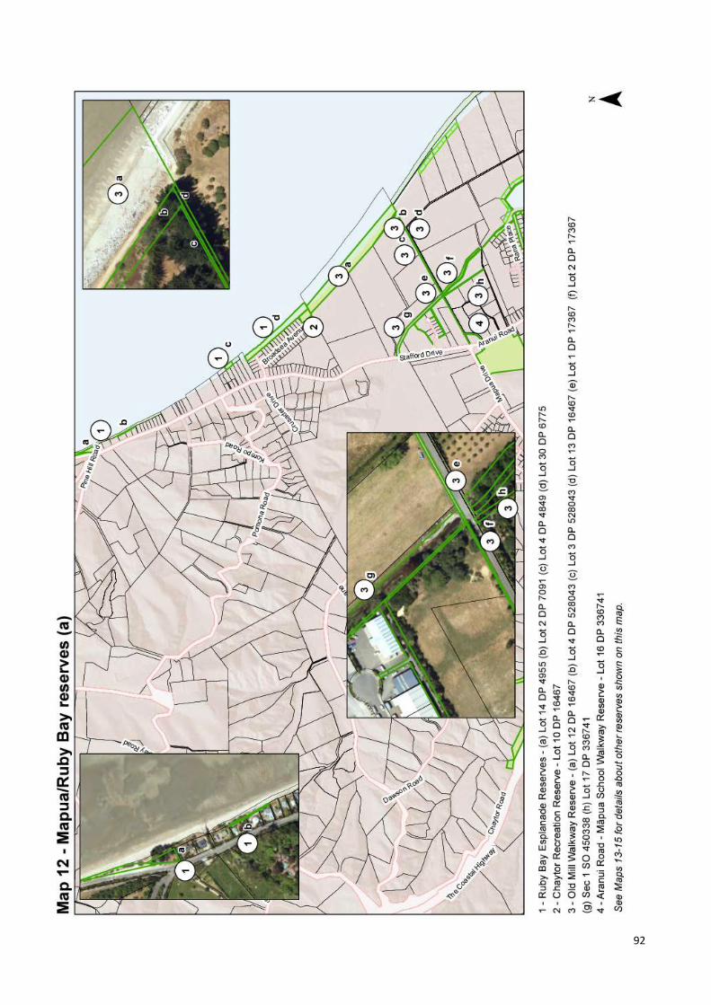
92

93

94

95

96

97
5.7.1 RUBY BAY ESPLANADE RESERVES See Section 5.6.9 above.
5.7.2 CHAYTOR RECREATION RESERVE
Location
Chaytor Recreation Reserve is located at 29 Broadsea Avenue, Ruby Bay (see Map 12).
Classification, Legal Description and Size
• Classification: Recreation Reserve
• Legal Description: Lot 10 DP 16467
• Area: 0.2327 ha
History
This reserve was vested in Council as recreation reserve at time of subdivision in 1994. In 2021, it was classified as recreation reserve (GN 2021-ln2599). The reserve is named after Arthur Chaytor, who farmed this area as the Seaton Estate between 1872 and 1906.
Values
Chaytor Recreation Reserve is located in the Ruby Bay urban area, at the end of Broadsea Avenue. It comprises an area of grassed open space between Broadsea Avenue and Ruby Bay Esplanade Reserve on the beachfront. A low sea wall has been constructed on this beach frontage in an attempt to limit sea erosion of the esplanade reserve. An opening in the seawall allows people to launch small non-powered watercraft from this location. Chaytor Recreation Reserve also adjoins, and forms the northern entrance to, the Old Mill Walkway Reserve.
The reserve is separated from Broadsea Avenue by a low wooden barrier with a vehicle entrance. There are no structures on the reserve apart from signs, rubbish bins and a picnic table. The reserve is mainly used as a carpark for beach and walking access. Horse riders occasionally ride through the reserve to access the beachfront and Old Mill Walkway.
Issues and Options
Management issues include coastal erosion, undefined vehicle parking, and the continued provision of access to the adjoining reserves that form part of the Māpua walkway system (including the Old Mill Walkway). A major stormwater pipe runs through the northern part of the reserve and out to sea. Vehicle access is required to enable maintenance of this stormwater infrastructure. There is scope to further develop the reserve by restricting parking to a smaller area and establishing grass and low plantings to increase amenity.
POLICIES
1 Manage this small open space area primarily for passive recreation and access to the coast.
2 Consolidate and formalise the carparking area so
that it no longer dominates the reserve. Install bollards to prevent vehicles driving on the remainder of the reserve, where grass and low-growing coastal species should be established to improve amenity values.
3 Allow horses to be ridden across the reserve to
access the beach and walkways.

98
4 Enable access for service vehicles to undertake maintenance of the stormwater infrastructure and existing rockwall.
Also see Council’s ‘Reserves General Policies’ document.
5.7.3 OLD MILL WALKWAY RESERVE
Location
Old Mill Walkway Reserve comprises of eight parcels of land that form a walkway connection between Aranui Road, Māpua and the Ruby Bay coastline (see Map 12).
Classification, Legal Description and Size
• Classification - various: o parcels (a) and (b) are classified as Local
Purpose (Esplanade) Reserve; o parcels (c) and (h) are classified as Local
Purpose (Walkway) Reserve; o parcels (d), (e) and (f) are classified as
Local Purpose (Walkway & Utility) Reserve;
o parcel (g) is classified as Local Purpose (Drainage) Reserve.
• Legal Description: (a) Lot 12 DP 16467 (b) Lot 4 DP 528043 (c) Lot 3 DP 528043 (d) Lot 13 DP 16467 (e) Lot 1 DP 17367 (f) Lot 2 DP 17367 (g) Sec 1 SO 450338 (h) Lot 17 DP 336741
• Area: (a) 2.8300 ha (b) 0.0940 ha (c) 0.0407 ha (d) 0.0838 ha (e) 0.0142 ha (f) 0.0015 ha (g) 0.0840 ha (h) 0.0978 ha
History
The name ‘Old Mill Walkway’ is derived from the flax mill established by Arthur Chaytor at Old Mill Creek in the late 1800s. Parcel (a) was vested in Council as local purpose (esplanade) reserve at time of subdivision in 1994. Parcel (b) was vested in Council as local purpose reserve
(esplanade) at time of subdivision in 2019. Parcel (c) was vested in Council as recreation reserve at time of subdivision in 2019. Parcel (d) was vested in Council as local purpose reserve at time of subdivision in 1994. Parcel (e) was vested in Council as local purpose reserve at time of subdivision in 1996. Parcel (f) was vested in Council as local purpose reserve at time of subdivision in 1996. Parcel (g) was vested in Council as local purpose (drainage) reserve when acquired under the Public Works Act in 2012. Parcel (h) was vested in Council as local purpose reserve (walkway) at time of subdivision in 2004.
In 2021, parcels (a) and (b) were classified as local purpose (esplanade) reserve; parcels (c) and (h) were classified as local purpose (walkway) reserve; parcels (d), (e) and (f) were classified as local purpose (walkway & utility) reserve; and parcel (g) was classified as Local Purpose (Drainage) Reserve (GN 2021-ln2599).
Values
The coastal section of the walkway starts at the boundary with Chaytor Recreation Reserve and heads south. A well-formed shared path runs along the esplanade reserve, through rough pasture and some pine trees, before heading inland alongside a formed right-of-way. At Stafford Drain the walkway branches off in several directions. One path leads west, connecting with the ‘Aranui Road – Māpua School Walkway Reserve’. Two paths lead north to Stafford Drive: one alongside Stafford Drain and then via the Warren

99
Place Walkway. Another part of the walkway reserve leads south. Much of the walkway is fenced from adjoining properties. The walkway has been developed and maintained with assistance from local community groups. It forms part of Tasman’s Great Taste Trail and provides a very useful walking/cycling link between Māpua and Ruby Bay, along with good access to the beachfront.
Issues and Options
Management issues include maintenance of the path surface, maintenance of signs and small bridges, and the use of parts of the walkway by horse riders to access the beach.
POLICIES
1 Manage for the primary purpose of providing walking, cycling and horse-riding access.
2 Maintain the surface of the shared path, bridge
structures and signage. 3 Establish plantings of native species where
practicable along the coastal section of the walkway for habitat improvement and amenity.
4 Allow the use of the walkway by horse riders,
providing plants and soil are not damaged and providing walking/cycling access is not compromised.
Also see Council’s ‘Reserves General Policies’ document.
5.7.4 ARANUI ROAD – MĀPUA SCHOOL WALKWAY RESERVE
Location
Aranui Road – Māpua School Walkway Reserve provides a walkway connection between Aranui Road and Māpua School (see Maps 12 and 13).
Classification, Legal Description and Size
• Classification: Local Purpose (Walkway) Reserve
• Legal Description: Lot 16 DP 336741
• Area: 0.0290
History
This reserve was vested in Council as local purpose reserve (walkway) at time of subdivision in 2004 and classified as Local Purpose (Walkway) Reserve in 2021 (GN 2021-ln2599).
Values
The reserve provides safe access for students and parents to walk/cycle to Māpua School from Aranui Road, without needing to negotiate the busy Māpua Drive/Stafford Drive/ Aranui Road intersection. The well-formed shared path is part of Tasman’s Great Taste Trail.
Issues and Options
Tasman’s Great Taste Trail continues from the northeastern end of the walkway, along a strip of Māpua School land near the southern boundary of Māpua School, linking with Old Mill Walkway. If Māpua School moves location in future, this linkage could potentially be broken if there is no legal easement in place over this land.
POLICIES
1 Manage for the primary purpose of providing safe walking/cycling access for Māpua School students.
2 Maintain the shared pathway and plantings.

100
3 Work together with Māpua School to investigate the possibility of securing an easement over the strip of school land currently occupied by Tasman’s Great Taste Trail, to ensure the existing linkage between Aranui Road-Māpua School Reserve and the Old Mill Walkway Reserve is protected in future.
Also see Council’s ‘Reserves General Policies’ document.
5.7.5 SEATON VALLEY ROAD RESERVE
Location
Seaton Valley Road Reserve is located between 29 and 53 Seaton Valley Road, Māpua (see Map 13).
Classification, Legal Description and Size
• Classification: Not subject to the Reserves Act, therefore not classified
• Legal Description: Sec 2-4 SO 493935
• Area: 1.6173 ha
History
Pursuant to Section 20(1) of the Public Works Act 1981, the land was acquired for stormwater detention and vested in the Tasman District Council in 2017 (Sections 3 and 4) and 2018 (Section 2).
Values
The primary purpose of this land is stormwater detention.
Issues and Options
During periods of dry weather, this stormwater detention area could potentially form part of the open space network in future, whilst also fulfilling its primary function. Adjacent land is likely to be subdivided in future; this area could potentially be linked to Catherine Recreation Reserve via land acquisition.
POLICIES
1 Maintain as a stormwater detention area as the primary purpose, that also potentially forms part
of Council’s open space network as a secondary function during periods of dry weather.
Also see Council’s ‘Reserves General Policies’ document.
5.7.6 CATHERINE ROAD RECREATION RESERVE
Location
Catherine Road Recreation Reserve is located at 18 Catherine Road, Māpua (see Map 13).
Classification, Legal Description and Size
• Classification: Recreation Reserve
• Legal Description: Lot 84 DP 498202
• Area: 0.1841 ha
History
This reserve was vested in Council as local purpose (recreation) reserve at time of subdivision in 2016. In 2021, it was classified as recreation reserve (GN 2021-ln2599).
Values
Only partially developed to date, the reserve has been grassed, a sign installed at the entrance and low plantings have been established near the reserve boundaries. This area of open space provides for passive recreation and a place for neighbourhood gatherings.
Issues and Options
There is potential to increase the size of this reserve when adjoining land is subdivided and possibly link it to the Seaton Valley Road Reserve. There is scope to construct a playground and install a picnic table.
POLICIES
1 Manage as an open space area for the primary purpose of passive recreation.
2 Maintain and enhance the reserve by constructing
a playground and installing a picnic table.

101
3 Consider opportunities for expanding the size of this reserve and/or linking it to Seaton Valley Road Reserve when the surrounding area is subdivided.
Also see Council’s ‘Reserves General Policies’ document.
5.7.7 ARANUI PARK SCENIC RESERVE
Location
Aranui Park Scenic Reserve is located at 125 Aranui Road, Māpua (see Map 13).
Classification, Legal Description and Size
• Classification: Scenic Reserve under s19(1)(b)
• Legal Description: Lot 1 DP 8474
• Area: 4.1265 ha
History
Council has vested authority over this reserve. In 1977, the Wells family gifted this parcel to the Crown for recreation purposes and as a ‘contribution to the preservation of New Zealand’s natural heritage’, subject to the Reserves and Domains Act 1953. Later that year it was declared to be a public domain and form part of the Mapua Domain (GN 1977, p3206). In 1984, the name of the reserve was changed to Aranui Park (GN 1984, p3530). This reserve was administered by the Mapua Domain Board from 1977 until 1989, when Council became the administering body via the Local Government (Nelson-Marlborough Region) Reorganisation Order 1989 (GN 1989, p2377). In 2021, it was classified as Scenic Reserve under s19(1)(b) (GN 2021-ln2599). A plaque commemorating Bernard Wells is located near the entrance to the reserve. The Department of Lands and Survey prepared a planting plan for the reserve in 1979, and in 1993 the first management plan for the reserve was approved.
Values
Part of a cluster of occupations around Korepo (a rare dune lagoon), Aranui Park is highly significant to iwi.
This reserve is treasured by the local community for its scenic and passive recreation values. Much of the revegetation (the ‘Tana’s Ark’ project) has been undertaken by volunteers, including neighbours and Māpua School students. The local gardening club has also undertaken maintenance and plantings, particularly around the front of the reserve, where exotic specimen trees have been underplanted with bulbs and flowering shrubs. Aranui Park has developed into a lovely place to walk the paths, stop and rest for a while and undertake peaceful contemplation. Picnicking is another popular use.
The portion of the reserve closest to the main entrance on Aranui Road is planted with a variety of native and introduced species, including some memorial trees. One of the larger trees has Protected status under the TRMP: a very impressive and Quercus Ilex (Holly or Holm Oak) with a canopy spanning over 20m. Facilities on the eastern half of the reserve include an entrance gateway, carpark, signage, picnic tables and rubbish bins. A shallow drainage ditch and two small ponds are also present on this part of the reserve. A low wooden barrier separates the reserve from Aranui Road. Much of the central portion is mown grass. An old cow shed remains as the only building on the reserve.

102
A network of well-formed gravel paths traverse the reserve. An open, wide stormwater drain runs through the reserve, mostly near the western boundary, then changing course near the northern boundary, where it runs east and out under Aranui Road. The margins of the drain have been revegetated, as has a wide strip of land along the western and southern boundaries. Established trees line the northern boundary with Māpua Drive.
Issues and Options
Management issues include balancing additional revegetation potential with the desire to retain open space within the reserve, the lack of toilet facilities, management of stormwater from upstream subdivision, and the degenerating state of the old cow shed building. Previous management plans for Aranui Park have included policies restricting the construction of buildings on the reserve. While the lack of toilet facilities may be perceived to be an issue, public toilets are provided at several locations around Māpua, including at the nearby Māpua Recreation Reserve. This draft Plan proposes that no permanent toilet facilities be provided at Aranui Park. The proposed subdivision of adjoining land may place greater pressure on the management and use of the reserve. Control of sedimentation from the proposed development on the uphill slope may be an issue and any stormwater control should be designed to ensure there is no drop in the water table, as many of the wetland species in the reserve rely on the current conditions. While the old cow shed is in a bad state of repair, it has some historic value. Additional picnic and seating facilities could be provided in the reserve. As Māpua township continues to grow, Aranui Park will become a central hub and use of the paths within the reserve is likely to increase. Community feedback has suggested that Aranui Park may be a suitable location for community gardens and/or a community food forest to be established. Aranui Park has recently been classified as Scenic Reserve under section 19(1)(b) of the Reserves Act; community gardens are not consistent with the primary purpose of this type of reserve. This draft Plan proposes that part of the undeveloped land at the northern end of Māpua Recreation Reserve is a more suitable location for establishment of community gardens, as it has better soils and drainage, adequate space and vehicle parking immediately adjacent to the site.
POLICIES
1 Manage the reserve primarily for the development, protection and preservation of the scenic qualities of its indigenous and exotic flora. Ensure that Aranui Park continues to make a
‘contribution to the preservation of New Zealand’s natural heritage’, as per the original intent of the Well’s family.
2 Maintain the established and recent plantings of
eco-sourced native species, whilst ensuring that a large area of open space is retained in the centre of the reserve.
3 Maintain the existing facilities and improve the
standard of the network of gravel paths through the reserve.
4 Continue to support community involvement in
reserve management, especially the maintenace of native vegetation.
5 No permanent toilet facilities should be provided
at Aranui Park. 6 Continue to ensure that the old cow shed is
maintained in a safe condition and install an interpretative sign at this site.
7 Provide additional picnic and seating facilities in
the reserve. 8 Continue to manage stormwater flows to benefit
vegetation and also maintain stormwater channels through the reserve.
Also see Council’s ‘Reserves General Policies’ document.
5.7.8 STAFFORD DRIVE DRAIN WALKWAY
Location
Stafford Drive Drain Walkway is located at 34A Stafford Drive, Māpua (see Map 13).
Classification, Legal Description and Size
• Classification: Not subject to the Reserves Act, therefore not classified
• Legal Description: Lot 2 DP 306472
• Area: 0.4921 ha

103
History
This reserve was acquired by Council in 2002.
Values
The land encompasses a section of Seaton Valley Stream and provides dual functions of stormwater drainage and walkway access. The walkway alongside the drain links to the Old Mill Walkway. Some planting has been undertaken along the boundaries with neighbouring private property, and low-growing Carex grass planted along the stream edge.
Issues and Options
During times of high flow through drain, the path can flood, preventing access.
POLICIES
1 Manage the land for the dual purposes of providing stormwater drainage and walking/ cycling access.
2 Maintain and improve the riparian vegetation
along this section of Seaton Valley Stream, ensuring that any plantings to not impede the stormwater management function.
3 Following the conclusion of the Nelson Tenths
Reserve claim process, initiate a public consultation process to declare as Local Purpose (Walkway & Utility) Reserve under the Reserves Act, in order to provide appropriate legal protection for this land.
Also see Council’s ‘Reserves General Policies’ document.
5.7.9 WARREN PLACE WALKWAY RESERVE
Location
Warren Place Walkway Reserve is located at Warren Place, Māpua (see Map 13).
Classification, Legal Description and Size
• Classification: Local Purpose (Walkway) Reserve
• Legal Description: Lot 12 DP 18043
• Area: 0.1629 ha
History
This reserve was vested in Council as recreation reserve at time of subdivision in 1998. In 2021, it was classified as Local Purpose (Walkway) Reserve (GN 2021-ln2599).
Values
Provides a short walkway linkage around the Warren Place industrial subdivision and through to the Old Mill Walkway (on the opposite side of the stream from the Stafford Drive Drain Walkway).
Issues and Options
There is a steep entrance to this rough track, meaning it is not easily accessible for all to walk on.
POLICIES
1 Manage for the primary purpose of providing walking access.
2 Maintain the rough track to the existing standard. Also see Council’s ‘Reserves General Policies’ document.
5.7.10 ARANUI ROAD ESPLANADE RESERVE
Location
Aranui Road Esplanade Reserve is located between 130 and 132 Aranui Road, Māpua (see Map 13).
Classification, Legal Description and Size
• Classification: Local Purpose (Esplanade) Reserve
• Legal Description: Lot 4 DP 432685
• Area: 0.3006 ha
History
Council purchased this reserve when the land was subdivided in 2012; it was vested in Council as local purpose reserve (esplanade) that same year. In 2021, it was classified as Local Purpose (Esplanade) Reserve (GN 2021-ln2599).
Values
This reserve forms a riparian margin to Seaton Valley Stream. At the northern end are several established deciduous trees.

104
Issues and Options
Management issues include encroachment of neighbouring landuse at the southern end, the boundary with the neighbouring property to the east has not yet been fenced and no walkway has yet been formed. Council is yet to secure legal access across private right-of-ways at either end of the reserve, which leaves this reserve isolated from nearby walkway reserves, albeit by just a few metres. Once easements across the right-of-ways are in place, there is scope to develop a walkway through this reserve to same standard as Old Mill Walkway. Tasman’s Great Taste Trail could be diverted from the busy Aranui Road to follow an alternative route, which includes this reserve. There is also much scope to revegetate the Seaton Valley Stream margin with native species, to improve habitat values and water quality.
POLICIES
1 Manage for the dual purposes of improving riparian margin habitat along the Seaton Valley Stream edge and providing walking/cycling access.
2 Work with neighouring to secure easements
across the private right-of-ways at either end of the reserve.
3 Fence the boundary between the reserve and
neighbouring property to the east. 4 Develop a shared path along the reserve, to the
same standard of the Old Mill Walkway. 5 Revegetate either side of the new walkway with
eco-sourced native species. Also see Council’s ‘Reserves General Policies’ document.
5.7.11 MORELAND PLACE ESPLANADE RESERVE
Location
Moreland Place Esplanade Reserve is located between Moreland Place and the Waimea/Waimeha Inlet, at Māpua (see Maps 12, 13 and 14).
Classification, Legal Description and Size
• Classification: Local Purpose (Esplanade) Reserve
• Legal Description: (a) Lot 6 DP 304288 (b) Lot 96 DP 504876 (c) Lot 21 DP 12594 (d) Lot 5 DP 304288 (e) Lot 4 DP 414200
• Area: (a) 0.0470 ha (b) 0.0450 ha (c) 0.4585 ha (d) 0.2360 ha (e) 0.1834 ha
History
All five parcels were vested in Council as local purpose reserve (esplanade) at time of subdivision: in 2002 for parcel (a); in 2017 for parcel (b); in 1986 for parcel (c); in 2002 for parcel (d); and in 2009 for parcel (e). In 2021, all five parcels were classified as Local Purpose (Esplanade) Reserve (GN 2021-ln2599).
Values
A large open area of mown grass covers much of the reserve. A few established deciduous trees are present, and restoration of the Inlet margin has begun.
Issues and Options There are no facilities on the reserve. There is scope to maintain and enhance the estuarine edge environment by expanding the revegetation project further inland. Another potential development opportunity could be to construct a boardwalk along the Inlet margin between the southern end of the esplanade reserve and the Māpua Causeway. A shared path could then be formed along the esplanade reserve, creating a link between the causeway to the south and the proposed new shared path along Aranui Road Esplanade Road Reserve to the north. Tasman’s Great Taste Trail could then potentially be diverted along this route, to avoid the busy Aranui Road.

105
POLICIES
1 Maintain the inland part of the esplanade reserve as open space for informal recreation and amenity, and the remainder for the protection and enhancement of the estuary margin.
2 Expand the revegetation project further inland
from edge of the Waimea/Waimeha Inlet, using eco-sourced coastal native species.
3 Investigate options to link the reserve with the
Māpua Causeway via a boardwalk. 4 Create a shared path along the inland part of the
reserve. Also see Council’s ‘Reserves General Policies’ document.
5.7.12 MORELAND PLACE WALKWAY RESERVE
Location
Moreland Place Walkway Reserve is located at Moreland Place, Māpua (see Maps 12,13 and 14).
Classification, Legal Description and Size
• Classification: Local Purpose (Walkway) Reserve
• Legal Description: (a) Lot 19 DP 12594 (b) Lot 20 DP 12594
• Area: (a) 0.0061 ha (b) 0.0149 ha
Parcel (b) – Main access through to Moreland Place Esplanade Reserve
Parcel (a) – mown strip of land providing access to a private right of way.
History
Both parcels were vested in Council as local purpose reserve (pedestrian access) at time of subdivision in 1986. In 2021, both were classified as Local Purpose (Walkway) Reserve (GN 2021-ln2599).
Values
A sealed driveway forms the main access to the reserve from Moreland Place (parcel (b)). Wayfinder signage has recently been installed here. A grassed pedestrian access way at the end of Moreland Place (parcel (a)), leading to privately owned land, is also part of this reserve.
Issues and Options
Parcel (a) was acquired before subdivision of land to the north took place, on the assumption it would form part of an extended walkway linkage in future. However, when subdivision occurred, no such linkage was created, meaning the walkway serves no purpose to the general public – it simply provides walking access to surrounding privately owned properties. Council may wish to consider the possibility of initiating the process of revoking reserve status, with the intention of selling this land to neighbours at some point in future. However, this is unlikely to be a priority within the next 10 years.
POLICIES
1 Maintain the walkway along parcel (b) as a sealed driveway.
2 Maintain parcel (a) as a mown grass strip.

106
Also see Council’s ‘Reserves General Policies’ document.
5.7.13 RANA PLACE ESPLANADE RESERVE
Location
Rana Place Esplanade Reserve is located at Rana Place, Māpua (see Map 13).
Classification, Legal Description and Size
• Classification: Local Purpose (Esplanade) Reserve
• Legal Description: Lot 98 DP 523762
• Area: 0.1689 ha
History
This reserve was vested in Council as local purpose reserve (esplanade) at time of subdivision in 2018. In 2021, it was classified as Local Purpose (Esplanade) Reserve (GN 2021-ln2599).
Values
A new gravel path has recently been installed, linking adjacent reserves. Extensive weed control and revegetation work was also undertaken on the reserve during 2020.
Issues and Options
The main management issue is ongoing weed control. There is scope to undertake more revegetation on the reserve.
POLICIES
1 Manage the esplanade reserve for the dual purposes of enhancing the riparian margin of Seaton Valley Stream and providing walking/ cycling access along the shared path.
2 Continue to expand the revegetated area and
undertake plant pest control on the reserve area as required.
3 Maintain the shared pathway. Also see Council’s ‘Reserves General Policies’ document.
5.7.14 RANA PLACE WALKWAY RESERVE
Location
Rana Place Walkway Reserve is located at Rana Place, Māpua (see Map 13).
Classification, Legal Description and Size
• Classification: Local Purpose (Walkway) Reserve
• Legal Description: Lot 97 DP 523762
• Area: 0.0217 ha
History
This reserve was vested in Council as local purpose reserve (pedestrian access) at time of subdivision in 1988. In 2021, it was classified as Local Purpose (Walkway) Reserve (GN 2021-ln2599).
Values
A well-formed, fully accessible gravel path connects Rana Place to the adjoining esplanade reserve.
Issues and Options
No issues.
POLICIES
1 Maintain the path to a high standard. Also see Council’s ‘Reserves General Policies’ document.
5.7.15 SEATON VALLEY ROAD WALKWAY RESERVE
Location
Seaton Valley Road Walkway Reserve is located between 71 and 75 Seaton Valley Road, Māpua (see Map 13).
Classification, Legal Description and Size
• Classification: Local Purpose (Walkway) Reserve
• Legal Description: Lot 5 DP 500024
• Area: 0.1969 ha
History
This reserve was vested in Council as local purpose reserve (walkway) at time of subdivision in 2017. In 2021, it was classified as Local Purpose (Walkway) Reserve (GN 2021-ln2599).
Values
This parcel may eventually form part of a walkway network, but currently does not connect to any roads, and therefore remains unformed at present.
Issues and Options

107
As surrounding land is subdivided, add linkages to this reserve, then form a path along the walkway.
POLICIES
1 As surrounding land is subdivided, take opportunities to expand the length of potential walkway.
2 Once linkages have been obtained, form a path
along the entire walkway network, including along this reserve.
Also see Council’s ‘Reserves General Policies’ document.
5.7.16 MORLEY DRAIN RESERVE
Location
The Morley Drain Reserve is located at Iwa Street, Māpua (see Map 14).
Classification, Legal Description and Size
• Classification: Local Purpose (Drainage) Reserve
• Legal Description: (a) Lot 94 DP 504876 (b) Lot 95 DP 504876
• Area: (a) 0.3103 ha (b) 0.3104 ha
History
Both parcels were vested in Council as local purpose reserve (drainage) at time of subdivision in 2017. In 2021, both were classified as Local Purpose (Drainage) Reserve (GN 2021-ln2599).
Values
When land in this area was subdivided in 2017, a large new stormwater drain was created at this location, to replace the older and smaller Morley Drain. While the main function of this reserve is to manage stormwater, it also provides useful pedestrian access to the Māpua Recreation Reserve. Recent planting has been undertaken along the lower half of the drain, to provide more shading for the low flow channel. An ecological assessment report (Hickford, 2012), completed for the Native Habitats Tasman programme, identifies parcel (b) as a site of local ecological significance, due to its value as a spawning area for inanga/whitebait. A small spawning area was discovered on the margin of the drain, just above its confluence with Seaton Valley Stream. The site comprised of tufts of tall fescue (the preferred vegetation) amongst a turf of creeping bent with all eggs found on the true left (north) bank of the drain.
Inanga spawning habitat near eastern end of parcel (b).
Issues and Options In relation to parcel (b), it is important that any native vegetation restoration undertaken near the eastern end of this land parcel ensures that sufficient light is retained for exotic grasses, which are favoured by inanga for spawning. Walking access is currently along the level strips of mown grass along the true left of the drain. Potentially, this access could be upgraded to a formed walkway – however, this would duplicate the walkway access provided by the Iwa Street/Māpua Recreation Reserve Walkway. Some further plantings to shade low-flow channel are possible, but other plantings not appropriate as they would compromise the stormwater function.
POLICIES
1 Manage for the primary purpose of stormwater drainage, whilst also protecting inanga spawning habitat near the estuary margin.
Also see Council’s ‘Reserves General Policies’ document.
5.7.17 IWA STREET/MĀPUA RECREATION RESERVE WALKWAY
Location
Iwa Street/Māpua Recreation Reserve is located at Iwa Street, Māpua (see Map 14).
Classification, Legal Description and Size
• Classification: Recreation Reserve
• Legal Description: Lot 92 DP 504876
• Area: 0.0734 ha

108
History
This reserve was vested in Council as recreation reserve at time of subdivision in 2017. In 2021, it was classified as recreation reserve (GN 2021-ln2599).
Values
This reserve forms a walkway linkage between Iwa Street and the Māpua Recreation Reserve. Mown grass borders both sides of the gravel path and bollards at the Iwa Street end restrict vehicle access.
Issues and Options
No issues.
POLICIES
1 Maintain the existing path and bollards. Also see Council’s ‘Reserves General Policies’ document.
5.7.18 MĀPUA RECREATION RESERVE
Location
Māpua Recreation Reserve is located at 84 Aranui Road, Māpua (see Map 14).
Classification, Legal Description and Size
• Classification: Recreation Reserve
• Legal Description: (a) Lot 93 DP 504876 (b) Lot 12 DP 9998 (c) Lot 1 DP 3840 (d) Lot 2 DP 3840
• Area: (a) 0.2218 ha (b) 1.9340 ha (c) 1.2135 ha (d) 0.8088 ha
History
Parcel (a) was vested in Council as recreation reserve at time of subdivision in 2017. Council has vested authority over parcels (b), (c) and (d). In 1948, the Crown declared that the reserve for recreation form part of the Māpua Domain (GN 1948, p1055). Parcels (b), (c) and (d) were administered by the Māpua Domain Board until 1989, when Council became the administering body via the Local Government (Nelson-Marlborough Region) Reorganisation Order 1989 (GN 1989, p2377). In 1988, parcel (b) was declared to be classified as recreation reserve and to form part of the Māpua Recreation Reserve (GN 1988, p2396). In 2021, parcels (a), (c) and (d) were classified as recreation reserve (GN 2021-ln2599).
Values
A wide range of facilities are provided at Māpua Recreation Reserve. The main access is from Aranui Road, but pedestrians can also access the reserve from three locations on Iwa Street. The reserve is used for organised sports, active and passive recreation and the highly popular annual Māpua Easter Fair.
Māpua Easter Fair 2018. Photo credit: Māpua School Much of the reserve area comprises of sportsfields, with rows of established trees at either end. Two of the trees in the copse near the northern edge of the reserve are listed as Protected Trees in the TRMP. This copse was planted at the time of Queen Elizabeth II’s coronation. Both the Māpua Hall and the small car parking area alongside Aranui Road are adjacent to, but not part of, the Māpua Recreation Reserve. Tennis courts, public toilets, a skate park, a drinking fountain, and a recently upgraded playground are located on the western side of the reserve. An informal dirt pump track is located near the tennis courts.

109
Facilities at the northern end of the reserve include a half basketball court, cricket nets, the Māpua Scout Den and Māpua Bowling Club clubrooms and bowling greens. Vehicle parking space is provided between the adjacent Māpua Playcentre Reserve and the Scout Den, and a separate parking area is located alongside the bowling facility.
Māpua Scout Den and parking area.
Māpua Bowling Club clubrooms, bowling green and carpark

110
Issues and Options
Key management issues include the provision and maintenance of facilities, sportsfield and tennis court allocation, vehicle parking, leases and licences, and how to develop the area of land recently acquired at the northern end of the reserve. Many of the facilities on the reserve have been well maintained or recently upgraded (e.g. the playground). The outer walls of the public toilets are covered in attractive mosaics, however the toilet interiors could be modernised and made more accessible. There are no/inadequate storage facilties for many of the clubs who utilise the reserve (including tennis, cricket, football and Scouts). There is scope to add a shared storage facility that can be used by clubs/groups/reserve users on parcel (a): an undeveloped area of land at the north of the reserve. Part of this shared facility is needed for the Tamaha Sea Scouts to store boats in, with space also required for boat maintenance work. Due to growth of the Māpua area, demand for use of the four tennis courts has continued to increase – to the point where additional courts may soon need to be provided somewhere in Māpua. The Māpua Tennis Club is experiencing the highest growth in Tasman District at present, with their membership reaching approximately 90 seniors and 90 juniors during the 2020/2021 season. There have been more family memberships and increased demand for courts on weekends and out of school hours. There is some tension between Tennis Club members and the wider community, due to difficulties in finding a balance between providing adequate Club facilities, while still allowing some possibility for casual players to also enjoy the courts. Currently there are two Astroturf courts that are locked and only available to club members (they are locked to protect the courts from damage and to avoid inappropriate use). The two asphalt courts are available to the public when not needed for coaching or club activities. The Māpua Tennis Club has requested that policies be included in this draft Plan addressing the following matters:
i. Although the Club has used the courts since 1927, there has never been a formal agreement between Council and the Club, formalising use of the tennis facilities. They seek a written agreement between the two parties, to provide future security for the Club.
ii. Provision of four courts for Club use and at least two courts for public use. They suggest that new courts be constructed for public use: either near the Bowling Club on the currently undeveloped part of the reserve, or elsewhere in Māpua.
iii. Improve facilities at the four existing courts. There is no power or drinking water available for the
courts and the shelter is very basic. It was constructed by Club members after the previous shed was destroyed by arson in 2011. Access to power would mean an automated electronic locking and booking system could be installed to give non-Club members access to the four existing courts, allowing anyone to book usage outside of coaching or club event times. It would also enable installation of lights in future, if the Club continues to grow and extend the use of the courts into the evenings. They suggest a water fountain be installed at the courts.
iv. Improvements to facilities. There is no storage for club coaching equipment or a ball machine, and better hitting walls are needed. The courts are used most nights for coaching and the practicalities of bringing equipment and taking it away again daily is challenging, especially with the large number of juniors attending coaching.
Consultation question: Do you support the proposal to implement a booking system for use of the tennis courts at Māpua Recreation Reserve?
Cricket and football are the main user groups of the sportsfield areas at present. The main sportsfield area and skatepark are prone to flooding. Now that a large drain has been constructed at the north end of the reserve (within the Morley Drain Reserve), there is scope to reduce the flooding impacts on these areas by installing a new drain running from the south to north, to discharge into the Morley Drain Reserve. There are only two formed vehicle parking areas, both in the northern part of the reserve. Both areas are gravelled. The driveway leading to these two parking areas is also gravelled rather than sealed, to protect the roots of the copse of established trees (including two Protected trees) on the south side of the driveway. Community feedback received included a suggestion that this driveway be sealed, due to frequent use and ongoing issues with potholes. Council does not plan to seal these areas in future but will increase the maintenance schedule for repairing the gravel driveway and carparking areas, to improve the condition of this access. Much of the fenced playground area used by the Māpua Playcentre extends beyond the Playcentre Reserve land parcel into the Māpua Recreation Reserve. A lease is required for this use. Leases are also required for the Māpua Bowling Club and Māpua Scout facilities. A narrow strip of land along the north-eastern side of the bowling green is maintained by the Bowling Club; this area is being planted with a row of low-growing shrubs. The Bowling Club also owns and is required to maintain the

111
wastewater pipe and pump and manhole servicing their building from Aranui Road; the Scout Hall also connects to this service. Leases with both groups should include reference to their ownership and maintenance responsibilities for these wastewater services. The eastern deck of the Māpua Hall encroaches into the reserve area; Council paid for half of the deck construction. No buildings can be constructed within 12m of the Hall as it lacks a firewall on the eastern side. Council plans to upgrade the interior of the public toilets and enhance their accessibility. Community feedback has suggested that Aranui Park would be a suitable location for community gardens and/or a community food forest to be established. However, Aranui Park has recently been classified as Scenic Reserve under section 19(1)(b) of the Reserves Act. This draft Plan proposes that part of parcel (a), the undeveloped land at the northern end of Māpua Recreation Reserve, is a more suitable location for this activity – as it has better soils and drainage, adequate space and vehicle parking immediately adjacent to the site.
Consultation question: Would you like to see a community gardens and/or community food forest established on part of the undeveloped land at the northern end of Māpua Recreation Reserve?
The most recented addition to Māpua Recreation Reserve (parcel (a)), located behind the Scout Den, remains undeveloped. Other community feedback received included the suggestion of allowing exercise stations to be installed in the reserve, if external funding could be obtained for this purpose. Possible locations for exercise stations could include the undeveloped northern parcel and along the southern and eastern reserve boundaries.
Consultation question: How would you like to see the northern end of Māpua Recreation Reserve developed?
POLICIES
1 Manage the reserve primarily for organised sports, informal recreation and community use.
2 Continue to allow the Māpua Bowling Club to use
their club building and bowling green area on the reserve, in accordance with the terms and conditions of the five-year lease (see Appendix 3, Table A).
3 Continue to allow the Māpua Scouts Group to use
their existing Scout Hall building on the reserve and provide for use of a new shared storage facility for boats and equipment from other reserve users (to be constructed alongside the existing Scout Hall, on the northern side of the building), in accordance with the terms and conditions of the five-year lease (see Appendix 3, Table A).
Explanation: There is a lack of adequate storage facilities on the reserve. The majority of this shared facility is likely to be used by the Tamaha Sea Scouts for boat storage and as space for undertaking boat maintenance work. Cricket teams require storage for their equipment, and other sports codes are likely to in future. If a community garden is developed on parcel (a), storage for this activity could also be accommodated within this shared facility.
4 Formalise use of the four tennis courts by Māpua
Tennis Club via a new five-year licence to occupy agreement and ensure use of the courts and related facilities is in accordance with the terms and conditions of this licence (see Appendix 3, Table A).
5 Improve facilities at the four tennis courts by
installing synthetic surfaces on the two asphalt courts. If the Māpua Tennis Club is able to secure adequate funding to pay for the following new facilities, also allow for: (i) construction of a small facility alongside the existing tennis shelter that has adequate storage space for coaching equipment and a ball machine; (ii) construction of a new playback wall; and/or (iii) power connection and lights to be installed at the courts in future.
Explanation: Access to power would mean an automated electronic locking and booking system could be installed to give non-Club members access to the four existing courts, allowing anyone to book usage outside of coaching or club event

112
times. It would also enable installation of lights in future, if the Club continues to grow.
6 Until such time as new tennis courts have been
constructed for public use in Māpua, continue to provide for public use of the tennis courts at the reserve, via a new automated electronic locking and booking system. Work together with Māpua Tennis Club to install and set up the booking system and enable the Club to administer the system, in accordance with the terms of their licence to occupy agreement.
7 Allow for the continued occupation of part of the
Māpua Recreation Reserve by the formed playground area, in accordance with the terms and conditions of, a new five-year lease with the Māpua Playcentre (see Appendix 3, Table A).
8 Install a drain from the southern to northern end
of the reserve, discharging into the Morley Drain Reserve, to reduce flooding impacts on the sportsfields and skatepark areas.
9 Allow a community garden and food forest to be
developed within the most recent addition to the reserve (i.e. parcel (a) at the northern end). Ensure that development of this area provides for stormwater from the southern part of Māpua Recreation Reserve to be directed north into the Morley Drain Reserve.
10 If the community is able to secure adequate
funding to purchase outdoor exercise stations, allow for these to be installed around the reserve (Council’s Reserves and Facilities Manager to approve locations before installation takes place).
Also see Council’s ‘Reserves General Policies’ document.
5.7.19 MĀPUA PLAYCENTRE RESERVE
Location
Māpua Playcentre Reserve is located at 84 Aranui Road, Māpua (see Map 14).
Classification, Legal Description and Size
• Classification: Local Purpose (Site for Playcentre) Reserve
• Legal Description: Lot 11 DP 9998
• Area: 0.0759 ha
History
Council has vested authority over this reserve. Originally forming part of the Māpua Recreation Reserve, in 1993 it was reclassified as Local Purpose (Site for Playcentre) Reserve (GN 1993, p194).
Values
This small reserve adjoins the Māpua Recreation Reserve and is accessed via a gravel drive off Aranui Road that is part of the latter reserve. The reserve is home to the Māpua Playcentre building and surrounded by a fully fenced outdoor play area. The Playcentre is well used.
Issues and Options
Much of the fenced playground area used by the Māpua Playcentre extends beyond the Playcentre Reserve land parcel into the Māpua Recreation Reserve. A lease is required for useof the Māpua Recreation Reserve land and the Māpua Playcentre Reserve area. The Playcentre own the building and playground and are responsible for their maintenance. Parents utilise the parking area alongside the Scout Den at Māpua Recreation Reserve when visiting the playcentre.
POLICIES
1 Manage for the primary purpose of providing a Playcentre facility and services to Māpua community and surrounds.
2 Māpua Playcentre should continue to maintain
their building, playground and fences. 3 Once the Māpua Playcentre lease expires, allow
for continued use of the Māpua Playcentre Reserve land in accordance with the terms and conditions of, a new five-year lease with the Māpua Playcentre (see Appendix 3, Table A).
Also see Council’s ‘Reserves General Policies’ document.

113
5.7.20 LIONEL PLACE TO TE AROHA PLACE WALKWAY RESERVE
Location
Lionel Place to Te Aroha Place Walkway Reserve is located at Lionel Place, Māpua (see Map 14).
Classification, Legal Description and Size
• Classification: Local Purpose (Walkway) Reserve
• Legal Description: Lot 28 DP 320579
• Area: 0.0201 ha
History
This reserve was vested in Council as local purpose (walkway) reserve at time of subdivision in 2003. In 2021, it was classified as Local Purpose (Walkway) Reserve (GN 2021-ln2599).
Values
Lionel Place to Te Aroha Place Walkway Reserve provides a connection between these two streets in Māpua along a well-formed, concrete path.
Issues and Options
No issues.
POLICIES
1 Maintain a high-standard path through the walkway reserve to provide pedestrian access between Lionel Place and Te Aroha Place.
Also see Council’s ‘Reserves General Policies’ document.
5.7.21 JESSIE STREET RECREATION RESERVE
Location
Jessie Street Recreation Reserve is located at 19 Jessie Street, in the urban area of Māpua (see Map 14).
Classification, Legal Description and Size
• Classification: Recreation Reserve
• Legal Description: Lot 24 DP 16541
• Area: 0.1624 ha
History
This reserve was vested in Council as local purpose reserve at time of subdivision in 1994. In 2021, it was classified as recreation reserve (GN 2021-ln2599).
Values
The reserve comprises of a small area of mown grass surrounded by a dense shrubbery of native species, predominantly akeake, lemonwood, kohuhu, toe toe, and flax. There are no structures or facilities on the reserve, but the shrubbery provides a natural playground area.
Issues and Options
No issues.
POLICIES
1 Manage for the primary purpose of passive recreation.
Also see Council’s ‘Reserves General Policies’ document.
5.7.22 CITRUS GROVE TO LANGFORD DRIVE WALKWAY RESERVE
Location
Citrus Grove to Langford Drive Walkway Reserve is located between 7 & 9 Citrus Grove, and 4 & 6 Langford Drive, Māpua (see Map 14).
Classification, Legal Description and Size
• Classification: Local Purpose (Walkway) Reserve
• Legal Description: Lot 13 DP 19637
• Area: 0.0398 ha
History
This reserve was vested in Council as local purpose walkway reserve at time of subdivision in 1999. In 2021, it was classified as Local Purpose (Walkway) Reserve (GN 2021-ln2599).

114
Values
Citrus Grove to Langford Drive Walkway Reserve provides a connection between these two streets in Māpua via a sealed concrete walkway with steps.
Issues and Options
No issues.
POLICIES
1 Maintain a high-standard path through the walkway reserve to provide pedestrian access between Citrus Grove and Aranui Road.
Also see Council’s ‘Reserves General Policies’ document.
5.7.23 MOUTERE HILLS RSA MEMORIAL HALL AND LIBRARY RESERVE
Location
The Moutere Hills Returned Servicemens Association (RSA) Memorial Hall and Library is located at 60 Aranui Road, on the corner of Toru Street, Māpua (see Map 14).
Classification, Legal Description and Size
• Classification: Local Purpose (War Memorial & Community Buildings) Reserve
• Legal Description: Pt Lot 6 DP 657
• Area: 0.1016 ha
History
The Moutere Hills Branch of the RSA originally acquired this land as a donation from Sam Busch in 1946, and then transferred it to the Nelson Returned Services’ Association in 1956. The Nelson RSA gifted the land to Council in 1996, for the purpose of a memorial reserve. In 1998, Council declared the land to be a local purpose (war memorial)
reserve (GN 1998, p1175). In 2021, it was classified as Local Purpose (War Memorial & Community Buildings) Reserve (GN 2021-ln2599).
Values
The Māpua Library building is located on this reserve. A small meeting room within the building is used by the RSA (others can also book this room) and information about the RSA is displayed in the entranceway.
A wood and iron fence and a short section of hedge separate the reserve from Aranui Road and Toru Street. A concrete path leads from the reserve entrance to the library, and there are amenity plantings at the entrance and around the library.

115
A memorial arch at the reserve entrance commemorates servicemen from the Moutere Hills area who lost their lives in the two World Wars. A flagpole is located on the lawn. The reserve is very tidy and well maintained.
Issues and Options
Management issues include ongoing maintenance of grounds, memorial facilities, and the need to authorise use of the building as the Māpua Library via a licence to occupy agreement.
POLICIES
1 Manage the reserve for the primary purpose of providing a war memorial and community buildings.
2 Continue to regularly maintain the building,
grounds and memorial facilities. 3 Continue to allow the Māpua Library to utilise the
building on the reserve, in accordance with the terms and conditions of a five-year licence to occupy agreement (see Appendix 3, Table A).
Also see Council’s ‘Reserves General Policies’ document.
5.7.24 TORU STREET ESPLANADE RESERVE
Location
Toru Street Esplanade Reserve is located at Tahi Street, Māpua, just south of the causeway (see Map 14).
Classification, Legal Description and Size
• Classification: Local Purpose (Esplanade) Reserve
• Legal Description: Lot 3 DP 331815
• Area: 0.0041 ha
History
This reserve was vested in Council as local purpose (esplanade) reserve at time of subdivision in 2004. In 2021, it was classified as Local Purpose (Esplanade) Reserve (GN 2021-ln2599).
Values
The reserve provides pedestrian access along estuary frontage below the causeway. People can also walk to the nearby Māpua Esplande Reserve at low tide.
Issues and Options
The reserve is subject to coastal inundation on occasion. Both neighbouring properties encroach onto this reserve by utilising it as part of their back lawn area.
POLICIES
1 Manage the reserve primarily to provide pedestrian access alongside the Waimea/ Waimeha Inlet margin.
2 Fence the inland boundaries of the reserve. Also see Council’s ‘Reserves General Policies’ document.
5.7.25 MĀPUA ESPLANADE RESERVE
Location
Māpua Esplanade Reserve is located at Iwa Street, Māpua (see Map 14).
Classification, Legal Description and Size
• Classification: Local Purpose (Esplanade) Reserve
• Legal Description: (a) Lot 2 DP 20152 (b) Lot 3 DP 330071
• Area: (a) 0.0040 ha (b) 0.0040 ha
History
Parcel (a) was vested in Council as local purpose esplanade reserve at time of subdivision in 2000, while parcel (b) was vested in Council as local purpose reserve (walkway) at time of subdivision in 2004. In 2021, both parcels were classified as Local Purpose (Esplanade) Reserve (GN 2021-ln2599).
Values
The reserve is isolated from other esplanade reserves on the coastline, but pedestrians can walk to this location at low tide.
Issues and Options
The reserve is subject to coastal inundation on occasion. Both neighbouring properties encroach onto this reserve by utilising the reserve space as part of their developed garden areas.
POLICIES
1 Manage the reserve primarily to provide pedestrian access alongside the Waimea/ Waimeha Inlet margin.

116
2 Once linkages have been established to other esplanade reserves on the peninsula, fence the inland boundaries of the reserve and remove encroachments.
Also see Council’s ‘Reserves General Policies’ document.
5.7.26 ARANUI ROAD TO LANGFORD DRIVE WALKWAY RESERVE
Location
Aranui Road to Langford Drive Walkway Reserve comprises of four parcels of land that link Aranui Road to the southern end of Langford Drive, at Māpua (see Map 15).
Classification, Legal Description and Size
• Classification: Local Purpose (Walkway) Reserve
• Legal Description: (a) Lot 1 DP 472570 (b) Lot 28 DP 17242 (c) Lot 29 DP 17242 (d) Lot 64 DP 18328
• Area: (a) 0.0184 ha (b) 0.3020 ha (c) 0.3050 ha (d) 0.0642 ha
History
Parcel (b) was vested in Council as local purpose reserve at time of subdivision in 1995. Council acquired parcel (a) in fee simple in 2015, via subdivision. That year, parcel (a) was declared a Local Purpose (Walkway) Reserve and united with parcel (b), to form one reserve. Parcels (a) and (b) were also classified as Local Purpose (Walkway) Reserve in 2015 (GN 2015, p63). Parcels (c) and (d) were vested in Council as local purpose reserve at time of subdivision in 1995 and 1997 respectively. In 2021, parcels (c) and (d) were classified as Local Purpose (Walkway) Reserve (GN 2021-ln2599).
Values
This walkway reserve comprises four parcels of land that link Aranui Road and Langford Drive, along the foreshore of the Waimea/Waimeha Inlet at Māpua, providing a linkage between these streets and easy pedestrian access to the Inlet. There is an existing gravel path along parcels (a), (b) and (c).
Issues and Options
Coastal inundation occurs at at high tide, and the low-lying areas are prone to damage from storm surges. There is scope to undertake more revegetation along the estuary edge, including saltmarsh restoration. A new gravel path could be formed to connect parcel (d) with (c). If a footbridge was installed across the stream mouth, there is also scope to divert the low-lying part of path on parcel (b)
onto Tahi Esplanade area, which is much higher and unlikely to flood. Part of parcel (b) – i.e. the west side of the creek opposite Tahi Esplanade (see Map 15) – forms part of the contaminated industrial site at Māpua. It is part of a larger area of land that was formerly owned by the Fruitgrowers Chemical Company (FCC), whose business included the manufacture of synthetic pesticides. The factory closed in 1988. Contaminated soil on part of the area was remediated in a $12 million cleanup project, over a 10-year period from 1997-2007, funded by the Council and the Ministry for the Environment. The soil on the west side of the creek is capping soil with residual pesticides from the former FCC landfill. For further details about this contaminated site, see Appendix 4 of this Plan.
POLICIES
1 Maintain gravel paths through the walkway reserve to provide pedestrian access between Aranui Road and Langford Drive.
2 Any earthworks undertaken on the west side of
the creek (within parcel (b)) should be carried out under the supervision of an archaeologist and iwi monitor and will comply with the ‘Former Fruit Growers Chemical Company Site, Māpua: FCC East and FCC Landfill Sites – Site Management Plan’.
3 Construct a new gravel path to connect parcel (d)
with (c). 4 Install a footbridge across the stream mouth and
divert the low-lying part of path on parcel (b) onto the adjoining Tahi Esplanade area.
5 Revegetate the estuary margin by planting species
propagated from plants native to the Waimea/Waimeha Inlet area. Limit planting to low-growing species, to maintain views of the Inlet from nearby houses.
Also see Council’s ‘Reserves General Policies’ document.
5.7.27 GROSSI POINT ESPLANADE RESERVE
Location
Grossi Point Esplanade Reserve comprises seven separate parcels of land on either side of the Grossi Point Peninsula at Māpua (see Map 14). One part of the reserve runs from the Grossi Point Recreation Reserve towards the Aranui Road – Langford Drive Walkway Reserve, and the other part runs from the recreation reserve towards Waterfront Park.

117
Classification, Legal Description and Size
• Classification: Local Purpose (Esplanade) Reserve
• Legal Description: (a) Lot 15 DP 6482 (b) Lot 11 DP 4524 (c) Lot 11 DP 5006 (d) Lot 9 DP 5006 (e) Lot 10 DP 4524 (f) Lot 4 DP 7570 (g) Lot 4 DP 491680
• Area: (a) 0.0516 ha (b) 0.0814 ha (c) 0.0381 ha (d) 0.0461 ha (e) 0.0690 ha (f) 0.0102 ha (g) 0.0101 ha
History
All parcels were vested in Council as local purpose esplanade reserve at time of subdivision: in 1952 for parcels (b) and (e); in 1954 for parcels (c) and (d); in 1963 for parcel (a); in 1970 for parcel (f); and in 2017 for parcel (g). In 2021, all seven parcels were classified as Local Purpose (Esplanade) Reserve (GN 2021-ln2599).
Values
All land parcels adjoin the Waimea/Waimeha Inlet margin on one side and residential housing on the other. Low vegetation, including ice plant and rank fescue grass, covers most of the reserve area.
Issues and Options
Most of the reserve parcels are affected by the encroachment of activities from adjoining residential properties, with gardens, fences and some buildings constructed on these strips of land, preventing pedestrian access through the reserve. Ideally, foot access across intervening areas of land without esplanade reserve should be formalised (e.g. via easements) to provide a future walkway link around the outer edge of the peninsula via the Grossi Point Recreation Reserve.
POLICIES
1 Control weed species such as ice plant. 2 Where no esplanade reserve has yet been set
aside, approach landowners about the possibility of creating easements along the coastal edge of their land for pedestrian access and potential development of a walkway around the outer edge of the peninsula.
Also see Council’s ‘Reserves General Policies’ document.
5.7.28 GROSSI POINT RECREATION RESERVE
Location
Grossi Point Recreation Reserve is located at 58 Tahi Street, Māpua (see Map 15).
Classification, Legal Description and Size
• Classification: Recreation Reserve
• Legal Description: Pt DP 417
• Area: 0.8981 ha
History
Once part of a wider site of early Māori occupation around Māpua, and consequently, the area now known as Grossi Point is highly significant to iwi. The earlier European name for this area was Thomas’s Point or Thomas’s Hole, named for J H Thomas who lived there for at least 23 years by 1889. The name continued in use until at least 1909. Mark Grossi, son of Austrian settler Baggio Grossi, was a fisherman whose family lived in tents at what we know now as Grossi Point in the early 1900s. In 1957, Grossi Point and the surrounding land was owned by Mr Cheyne and the Māpua Progress League was negotiating public access to the Point. Mr Cheyne offered the League the opportunity to purchase the Point for a public reserve and the purchase was completed in 1958 thanks to public subscription and business support. Over time, the Domain Board made improvements to the site and it became a popular picnic spot for locals and visitors alike. It was also popular for school visits. While it is believed that Mark Grossi may have planted some of the older trees, in 1965 a row of Macrocarpa, two Norfolk Pines, six Pohutukawa, along with a number of Buddleia and ngaio trees were planted by the Domain Board. Toilets were renewed in 1965 and changing sheds built in 1967.

118
Council has vested authority over this reserve. In 1958, the Crown declared that the recreation reserve be part of the Māpua Domain (GN 1958, p702). It was administered by the Māpua Domain Board from 1958 until 1989, when Council became the administering body via the Local Government (Nelson-Marlborough Region) Reorganisation Order 1989 (GN 1989, p2377). In 2021, it was classified as recreation reserve (GN 2021-ln2599).
Values
Grossi Point Recreation Reserve covers the end of a small peninsula extending into Waimea/Waimeha Inlet. The reserve provides excellent opportunities for picnicking, swimming, fishing, birdwatching and hand launching watercraft (kayaks and dinghies etc). The reserve includes an area of mown grass surrounded by mature trees, including large maritime pine (Pinus pinaster) and gum (Eucalyptus sp.) trees, and smaller pohutukawa (Metrosideros excelsa) and buddleia trees. Picnic tables, barbecue stands, rubbish bins, and toilet/changing building are present.
The reserve provides access to Waimea/Waimeha Inlet, especially to the water-ski area in the main channel between the reserve and No Mans Island. Pacific oysters are present in the area, and signs in the reserve warn of the hazard posed by their shells on the foreshore.
Issues and Options
The major management issue is ensuring that recreational use of the reserve is compatible with protection of the highly significant cultural heritage values, including the several archaeological sites located here. Council will prepare a separate Cultural Heritage Management Plan for Grossi Point during 2022. Future management of the reserve should be in accordance with this plan. The name of the reserve could revert to the former Māori name for this location, in recognition of its cultural significance.
POLICIES
1 Manage the reserve in accordance with the cultural heritage management plan (yet to be prepared).
Also see Council’s ‘Reserves General Policies’ document.
5.7.29 MĀPUA WATERFRONT PARK
Location
Māpua Waterfront Park is located at 1, 3 and 11 Aranui Road, and 11 Tahi Street, Māpua (see Map 15). The eastern edge of the park adjoins the Waimea/Waimeha Inlet.
Classification, Legal Description and Size
• Classification: Not subject to the Reserves Act, therefore not classified
• Legal Description: (a) Lot 2 DP 11106 (b) Lot 6 DP 11502 (c) Lot 5 DP 11502 (d) Lot 7 DP 11502 (e) Lot 1 DP 11502 (f) Lot 3 DP 11502 (g) Lot 4 DP 11502 (h) Lot 2 DP 11502
• Total area: 1.0256 ha
History
Once part of a wider site of early Māori occupation around Māpua, the area now known as Waterfront Park is highly significant to iwi. Waterfront Park is part of a larger area of land that was formerly owned by the Fruitgrowers Chemical Company (FCC), whose business included the manufacture of

119
synthetic pesticides. The factory closed in 1988. Toxic soil on part of the area was remediated in a $12 million cleanup project, over a 10-year period from 1997-2007, funded by the Council and the Ministry for the Environment. The agreement with the Crown for the cleanup included Council entering into a deed in 2004 that required at least 40% of the site to be retained in Council ownership for use as public space. The definition of public space under this deed is community, recreational, environmental, cultural, or spiritual purposes and includes roads and carparks. Māpua Waterfront Park was the part of the area identified for public space, other areas of the site were subsequently earmarked by the Council for eventual commercial and residential development. Council owns all eight land parcels comprising Waterfront Park in fee simple. The titles to three of the land parcels (those that adjoin the coastline) include the purpose “As endowment under the Nelson Harbour Act 1905”. The park is not subject to the Reserves Act, therefore is not classified.
Values
Post remediation, Council worked with landscape architects and developed the site into a recreational space. Waterfront Park has an ampitheatre, promenade, toilet block, petanque court, four picnic tables with seating, numerous walkways and car park – with complementary landscape planting.
Issues and Options
A cap of residential quality soil, 0.5m in depth, covers the contaminated soil at Waterfront Park. The material under the 0.5m cap is compacted commercial grade pesticide residue, which is 200-600 times too contaminated to be allowed to leach into the estuary. It is contained within engineered cells, thick clay walls and an engineered sea wall barrier. The most contaminated soil is closest to the top, to keep it away from the groundwater. Waterfront Park is legally covered by a Site Management Plan for the former FCC East and FCC Landfill sites (see location of both areas on image below) and an audit process including groundwater, sediment and biota monitoring. Management of the site rigorously restricts future usage, and all considerations need very strong planning and supervision to ensure the surrounding area, especially the estuary is not contaminated by chemicals that still exist in the site. Key requirements of this plan include (i) ensuring that the 0.5m soil cap is kept in place to protect the estuarine environment from the residual pesticides in the buried soil; and (ii) preparing an Earthworks Management Plan for moving the commercial grade soil around within Waterfront Park, or obtaining a resource consent for offsite disposal of commercial grade soil from Waterfront Park.

120
The ‘Māpua Waterfront Area Masterplan (2018-2028)’ sets out a strategic direction for the Māpua waterfront and adjacent areas, recognising the interconnectivity of the waterfront area. Actions from the Masterplan that relate to the Waterfront Park area have been incorporated into the policies below, including ideas for additional facilities and features. The Māpua Waterfront Masterplan Working Group (made up of iwi, community and Council stakeholders) has the role of implementing the actions within the Māpua Waterfront Masterplan. The Masterplan focuses on the waterfront area and provides a plan for its development and use, including the Māpua wharf area, Waterfront Park, Council-owned remediated land and Grossi Point Recreation Reserve. Community feedback identified that elevated aspects of the Park are often ‘windswept’ and underutilised. The community desires to increase use of Waterfront Park space via opportunities such as outdoor concerts and music events, twilight or farmers markets, and yoga or tai chi classes. Another idea put forward was to create an interconnected network of pathways - from Ngāio Park through Waterfront Park to Grossi Point and across to Langford Drive, and back into the village – that are accessible to all. The community is divided (either strongly in support or strongly opposed) about the proposal to construct a boat ramp at Waterfront Park. If construction of the boat ramp disturbed the pesticide residue that is at the site, this hazardous waste would need to be disposed of in a landfill, subject to special conditions. A new cap would have to be engineered, and monitoring established to test the groundwater and estuary sediment for pesticide residues. If the boat ramp was built over the top of the existing cap,
it would need to extend down the beach at a gentle angle, as the existing slope is quite steep. Vehicle movements to and from the boat ramp would need to be carefully managed, to minimise impacts on the open space values of Waterfront Park and other users. Parking for vehicles with boat trailers should not encroach on the open space areas of Waterfront Park and should be provided for elsewhere. As part of their deliberations on the Long Term Plan 2021-2031, Council resolved to bring forward some funding “for the purpose of providing a new boat ramp facility at Waterfront Park”. The resolution also stated that Council “acknowledges that the necessary statutory processes will need to be followed prior to the project proceeding”. The policies in this draft Plan provide for the option of constructing a boat ramp at this location, should all requirements and processes be met – including separate public consultation on this matter.
POLICIES
1 Manage Waterfront Park primarily as open space for informal recreation, and potentially boat launching.
2 Any earthworks undertaken at Waterfront Park
should be carried out under the supervision of an archaeologist and iwi monitor and will comply with the ‘Former Fruit Growers Chemical Company Site, Māpua: FCC East and FCC Landfill Sites – Site Management Plan’.
3 Any developments at Waterfront Park should be
consistent with the operative Māpua Waterfront Masterplan at that time.
4 The community, with support from Council, will
explore opportunities for improving and enhancing community facilities within Waterfront Park, e.g. by providing:
i. additional seating ii. gas barbeques
iii. rubbish and recycling facilities iv. trees for shelter/shade v. some low-key playground equipment
vi. exercise stations vii. interpretative panels
5 Council, with the local community, will explore
opportunities for increased use of Waterfront Park as a valued community space.
6 Provided all relevant processes are completed and
all required authorisations are obtained, allow for a community boat ramp to be constructed at Waterfront Park. Use of the boat ramp should be managed to ensure that:

121
i. no contaminants from the land are exposed or able to leach into the coastal environment;
ii. vehicle movements to and from the boat ramp minimise impacts on the open space values of Waterfront Park and other users; and
iii. parking for vehicles with boat trailers does not encroach on the open space areas of Waterfront Park and is provided for elsewhere.
7 Council will explore the construction of a walkway
connection between the Wharf and Waterfront Park.
Also see Council’s ‘Reserves General Policies’ document.
5.7.30 NGĀIO PARK
Location
Ngāio Park is located at 6 Aranui Road, Māpua (see Map 15). The eastern edge of the park adjoins the Waimea/Waimeha Inlet.
Classification, Legal Description and Size
• Classification: Not subject to the Reserves Act, therefore not classified
• Legal Description: Pt Sec 2 Moutere Hills District and defined on DP 495
• Area: Ngāio Park covers an area of approximately 0.0919 ha within a land parcel that has a total land area of 0.4047 ha.
History
The area known as Ngāio Park is part of a larger parcel of commercial land owned by Council in fee simple, that is also home to the ‘Shed 4’ development. The land was transferred to Waimea County Council from the Nelson Harbour Board in 1959, as part of a wider subdivision of land in the area. The park is not subject to the Reserves Act, therefore is not classified.
Values
Development of Ngāio Park was completed in July 2021. Named after the prominent ngāio tree on the site, this development has been a special project for Council and the community. In recognition of its cultural history and significant archaeological status, a sensitive approach was taken to development, ensuing as little digging as possible was done on the site. The primary objective was to build on top of the
land, rather than disturb it with earthworks. Much of the site is now paved.
Hard landscaping underway, June 2021 Ngāio Park now has tables, seats and bike racks, all made from recycled timber to fit in with the natural landscape of the wharf precinct. Landscaping includes plantings of coastal native plants and installation of realistic synthetic turf, to provide a durable surface in this high use environment.
This area of open space remains a significant archaeological site for iwi (including down to the water where waka were launched), and is highly valued by residents, locals and visitors alike. The park is also used by cyclists, embarking or disembarking on the ferry to Moturoa/Rabbit Island.
One of the most revered aspects of the space is the old ngāio tree, which accommodates innumerable small

122
children throughout the year who delight in its peaceful hiding shade.
Issues and Options
The ‘Māpua Waterfront Area Masterplan (2018-2028)’ sets out a strategic direction for the Māpua waterfront and adjacent areas, recognising the interconnectivity of the waterfront area. Most of the actions from the Masterplan that relate to the Ngāio Park area have been incorporated into the recent development of the park. There is scope to declare the land a reserve in future, and to rezone it from commercial to reserve zone.
POLICIES
1 Manage Ngāio Park primarily to ensure its preservation as an open green space.
2 Maintain Ngāio Park and its recreational
infrastructure to a high standard. 3 Following the conclusion of the Nelson Tenths
Reserve claim process, initiate a public consultation process to declare the Ngaio Park area as Recreation Reserve under the Reserves Act, in order to provide appropriate legal protection for the recreational values of this land.
Also see Council’s ‘Reserves General Policies’ document.
5.7.31 TAHI ESPLANADE
Location
Tahi Esplanade comprises of five land parcels, located at 16 Tahi Street, Māpua (see Map 15).
Classification, Legal Description and Size
• Classification: All five parcels are not subject to the Reserves Act, therefore not classified
• Legal Description: (a) Lot 1 DP 14311 (b) Sec 13 SO 496194 (c) Sec 14 SO 496194 (d) Sec 15 SO 496194 (e) Sec 16 SO 496194
History
Once part of a wider site of early Māori occupation around Māpua, the area now known as Tahi Esplanade is highly significant to iwi. Accessed via 16 Tahi Street, Tahi Esplanade is part of a larger area of land that was formerly owned by the Fruitgrowers Chemical Company (FCC). This area was used as a landfill by FCC. Contaminated soil on part of the area
was remediated in a $12 million cleanup project, over a 10-year period from 1997-2007, funded by the Council and the Ministry for the Environment (see Appendix 4 for further details). The agreement with the Crown for the cleanup included Council entering into a deed in 2004 that required at least 40% of the site to be retained in Council ownership for use as public space. The definition of public space under this deed is community, recreational, environmental, cultural, or spiritual purposes and includes roads and carparks. Tahi Esplanade was the part of the area identified for public space, other areas of the site were subsequently earmarked by the Council for eventual commercial and residential development. Council owns all five land parcels comprising Tahi Esplanade in fee simple. The land is not subject to the Reserves Act, therefore is not classified.
Values
The area is of archaeological significance and preservation of the cultural elements is crucial. Access will always be maintained via the formed 100m accessway at 16 Tahi Street (parcel (b)). Tahi Esplanade area is maintained as an open area of mown grass.
Issues and Options
Tahi Esplanade is legally covered by a Site Management Plan for the former FCC East and FCC Landfill sites (see location of both areas on image in Appendix 4) and an audit process including groundwater, sediment and biota monitoring. Management of the site rigorously restricts future usage, and all considerations need very strong planning and supervision to ensure the surrounding area, especially the estuary is not contaminated by chemicals that still exist in the site. Key requirements of this plan include: (i) ensuring that the 0.5m soil cap is kept in place to protect the estuarine environment from the residual pesticides in the buried soil; and (ii) preparing an Earthworks Management Plan for moving the commercial grade soil around within Tahi Esplanade (including on the west side of the creek, which is capping soil with residual pesticides), or obtaining a resource consent for offsite disposal of commercial grade soil from Tahi Esplanade or the west side of the creek. The contamination issue means it is difficult to plant this land. Protection of cultural values is another key management issue at this location.
POLICIES
1 Manage primarily as open space for informal recreation.

123
2 Any earthworks undertaken at Tahi Esplanade should be carried out under the supervision of an archaeologist and iwi monitor and will comply with the ‘Former Fruit Growers Chemical Company Site, Māpua: FCC East and FCC Landfill Sites – Site Management Plan’.
Also see Council’s ‘Reserves General Policies’ document.
5.7.32 DAWSON ROAD WALKWAY RESERVE
Location
Dawson Road Walkway Reserve is located between Dawson Road and Māpua Drive, at Māpua (see Map 16).
Classification, Legal Description and Size
• Classification: Local Purpose (Walkway) Reserve
• Legal Description: Lot 2 DP 20482
• Area: 0.9811 ha
History
This reserve was vested in Council as local purpose (walkway) reserve at time of subdivision in 2001 and classified as Local Purpose (Walkway) Reserve in 2021 (GN 2021-ln2599).
Values
This formed gravel track provides a linkage and pedestrian access between Dawson Road and Māpua Drive, down a tree-lined gully. The northern end is very steep.
Issues and Options
Management issues include weed infestation from neighbouring properties and track sections washing out after heavy rain. Recontouring the northern end of the walkway would make it accessible to more people.
POLICIES
1 Maintain a gravel track through the walkway reserve to provide pedestrian access between Dawson Road and Māpua Drive.
2 Recontour the northern end of the track to reduce
its gradient and make it more accessible. 3 Undertake weed control on the reserve area as
required. Also see Council’s ‘Reserves General Policies’ document.
5.7.33 DOMINION FLATS WALKWAY RESERVE
Location
Dominion Flats Walkway Reserve is located between Māpua Drive and the Coastal Highway, at Māpua (see Map 16). It adjoins Dominion Flats Scenic Reserve and Dawson Road Walkway Reserve at the eastern end. It also connects to Chaytor Road Walkway (an easement over private land) at the western end, which provides a linkage through to Chaytor Road further to the northwest.
Classification, Legal Description and Size
• Classification: Local Purpose (Walkway) Reserve
• Legal Description: Sec 1 SO 441669
• Area: 1.3531 ha
History
Council has vested authority over this reserve. This land was acquired by the Crown under the Public Works Act for Local Purpose (Walkway) Reserve, and vested in Council in 2011 (GN 2011, p3600) as part of the Coastal Highway upgrade. The reserve was classified as Local Purpose (Walkway) Reserve in 2021 (GN 2021-ln2599).

124
Values
This walkway reserve provides a linkage and pedestrian access between Māpua Drive and the Chaytor Road Walkway. Two formed gravel paths, with some boardwalk sections, run alongside the northern and southern boundaries of this reserve, with a connection across the reserve at its eastern end. The paths are surrounded with native revegetation that has been established over the past five years.
Issues and Options
Ongoing weed control will be required, but this is not a major issue at this reserve. There is scope to install improved way-finding signs and interpretation signs. The adjoining easement over private land provides a linkage and pedestrian access between Chaytor Road and the Dominion Flats Walkway Reserve. The 1.5m wide gravel track along the easement is steep in places and washes out occasionally after heavy rain. Ongoing maintenance of ditches and culverts is required.
POLICIES
1 Maintain the gravel pathways and boardwalks through the walkway reserve to provide pedestrian access between Māpua Drive and the Chaytor Road Walkway.
2 Install additional wayfinding and interpretation
signage. 3 Continue to work together with community
volunteers to manage the reserve for the primary purposes of protecting the regenerating native coastal forest and providing opportunities for bush walking.
4 Only eco-sourced plants should be planted in the
reserve. Also see Council’s ‘Reserves General Policies’ document.
5.7.34 DOMINION FLATS SCENIC RESERVE
Location
Dominion Flats Scenic Reserve is located on corner of the Coastal Highway and Māpua Drive (see Map 16). The reserve adjoins the Dawson Road and Dominon Flats Walkway Reserves, which provide access to the reserve from Dawson Road and Māpua Drive.
Classification, Legal Description and Size
• Classification: Scenic Reserve for the purposes specified in Section 19(1)(b) of the Reserves Act 1977
• Legal Description: (a) Sec 9 SO 445119 (b) Sec 2 SO 465263
• Area: (a) 0.3179 ha (b) 2.5170 ha
History
Council has vested authority over this reserve, which was created by the Crown as part of the Coastal Highway upgrade in 2013. Both parcels were vested in Council as recreation reserve (GN 2013, p3632). In 2021, both parcels were classified as Scenic Reserve under Section 19(1)(b) of the Act (GN 2021-ln2599).
Once the reserve was vested in Council, the community became actively involved in a project to restore the reserve, as near as possible, to its original state of lowland kahikatea forest. A sub-committee of the Māpua and Districts Community Association (MDCA) was formed for this purpose, who researched the type of trees that would be suitable and then applied for grants to fund the project. Since 2013, volunteers have planted over 60,000 plants, mostly paid for with money from grants. Many plants have also been donated, grown from locally sourced seeds.
Values
Dominion Flats Scenic Reserve is an important area of regenerating coastal forest. The restoration effort has largely been volunteer-driven, with Council support. Every Tuesday morning, a group of about 10 regular volunteers visit the reserve to undertake weed control and plant new eco-sourced plants. Several groups have also assisted with this work. Traps lines are monitored by volunteers to control animal pests. Council supports the volunteer effort by providing advice, materials and some funding.

125
Dominion Flats is beginning to look like a natural patch of bush, with a canopy starting to form in places. At least eight different native fish species have been recorded at this site. The track circuit through the reserve, which includes boardwalks and bridges, is used by walkers, runners, cyclists and school children and some lead further afield to connect with other communities. One connection is through an underpass (under the Coastal Highway) which has vibrant murals drawn by Māpua school pupils decorating the entrances. Volunteers have assisted with track construction and maintenance and donated three picnic tables and two seats.
Issues and Options
Management issues include protection of the native vegetation, ongoing weed control and maintenance of walking tracks and signs. OBJECTIVE 1 To restore and enhance the regenerating native
coastal forest and provide habitat for increased bird life and native fish.
POLICIES
1 Continue to work together with community volunteers to manage the reserve for the primary
purposes of protecting the regenerating native coastal forest and providing opportunities for bush walking.
2 Only eco-sourced plants should be planted in the
reserve. 3 Remove or contain weed and animal pest
infestations and as far as possible prevent the establishment of new infestations.
4 Maintain the walking tracks, picnic tables, seating
and signage in the reserve. Also see Council’s ‘Reserves General Policies’ document.

126
5.8 WAIMEA/WAIMEHA INLET RESERVES

127

128

129

130

131
5.8.1 HIGGS RESERVE
Location
Higgs Reserve is located on corner of the Coastal Highway and Māpua Drive (see Map 16). The land also borders the Waimea/Waimeha Inlet and is on the opposite side of Māpua Drive from the Dominon Flats Scenic Reserve.
Classification, Legal Description and Size
• Classification: Not subject to the Reserves Act, therefore not classified
• Legal Description: Sec 46 SO 442515
• Area: 3.0381
History
In 1978, the estate of Miss Constance Higgs gifted 4.0165 ha of land to Waimea County Council for recreational purposes. The Coastal Highway upgrade that took place in 2011 resulted in a slight modification to the size and shape of the land area – almost a hectare of land was taken by the Crown for roading purposes at that time.
Values
The western portion of Higgs Reserve is low lying and swampy and bisected by Dominion Stream. The northeastern portion comprises a steep bank and supports dense regenerating coastal margin forest – a significant remnant of vegetation in an area where almost all the original native vegetation has been removed. The estuary margin vegetation at this site is also significant, providing important habitat for estuary bird species such as banded rail and an effective buffer between the reserve and the estuary.
An ecological assessment report (North, 2010), completed for the Native Habitats Tasman programme, identifies two sites of significance within and adjacent to the reserve. The estuarine margin site (labelled ‘MU 304’ on the image above) is of considerable significance as a fine and rare
example in the context of the Moutere Ecological District (ED) of estuarine wetland vegetation sequences. The coastal margin forest (labelled ‘MU 305’ on the image above), secondary or otherwise, is notably rare in the Moutere ED and this example is in very good condition. For its rarity and representativeness values the site is very significant in the ED context.
Raupo and oioi grade extensively into each other on the estuary margin. Photo credit: Michael North. Forest on the coastal margin itself is now vanishingly rare. The adult beech trees in Higgs Reserve are some of the last remaining in this part of the ED. The original cover would probably have been of mixed beech-broadleaved-podocarp forest including much titoki which is now absent.
Several hard beech stand along the margins of the estuary – this is an exceptionally rare example of coastal margin native forest in the Moutere Ecological District. Another ecological assessment report (Hickford, 2012), completed for the Native Habitats Tasman programme, identified a small inanga spawning site on the reserve as a site of local note and worthy of nurturing. The spawning site is located on the true left bank of Dominion Stream, just upstream of its mouth with the Waimea/Waimeha Inlet. The site comprises tall fescue growing on a steep riparian bank, extending for up to 5m along the streambank.

132
Other values at Higgs Reserve include the vehicle layby alongside Māpua Drive, on the northern edge of the reserve, with parking space for several vehicles (additional parking is available across the road at the southern entrance to Dominion Flat Scenic Reserve). A tall art sculpture and interpretation panel have been erected alongside the vehicle layby. A gravel path winds through the forest from the layby to the eastern edge of the reserve, looping back to Māpua Drive.
Issues and Options
Management issues include protection of the native vegetation, weed control, protection of banded rail and other bird species from human-induced disturbance, and maintenance of walking tracks and signs. The native forest area is subject to invasion by the pest tree Robinia, which suckers from roots that extend 10-15m out from the trunks. Weeds are also an issue in the wetland area. The reserve offers potential for the restoration of native coastal vegetation and the creation of further wildlife habitat. The location of Higgs Reserve beside the busy Coastal Highway offers opportunities for the appreciation of native vegetation and wildlife by visitors. It is important that any native vegetation restoration near the mouth of Dominion Stream ensures that sufficient light is retained, to favour the tall fescue and other grassy vegetation that constitutes the preferred inanga spawning site. There are plans to construct a pedestrian bridge over Dominion Stream and create a formed pathway to the southwestern corner of the reserve, as part of a future linkage alongside the Coastal Highway to esplanade reserves/strips on the Matahua Peninsula and Apple Valley Road East. Walkways should be sited away from the Inlet edge and dogs prohibited or required to be on a leash, to avoid disturbing estuarine birds. There is scope to declare the land a reserve in future.
POLICIES
1 Continue to work together with community volunteers to manage Higgs Reserve for the primary purposes of protecting and restoring native coastal vegetation, especially coastal forest, estuary margin vegetation and inanga spawning habitat.
2 Maintain inanga spawning habitat near the mouth
of Dominion Stream, by ensuring tall grasses are not shaded by taller vegetation.
3 Remove or contain weed and animal pest infestations and as far as possible prevent the establishment of new infestations.
4 Maintain the walking tracks in the reserve and
extend them to create linkages with Matahua Peninsula and Māpua township.
5 Construct a pedestrian bridge across Dominion
Stream, as part of the shared path linkage through to Matahua Peninsula.
6 Maintain the art sculpture and interpretation
panels located near the vehicle layby. 7 Develop picnic facilities near the sculpture and
maintain opportunities to interpret the estuary margin vegetation and wildlife habitat. Explanation: Facilities will be kept away from the Inlet margin, to ensure that the habitat of banded rail and other estuary birds is not affected by public use.
8 Following the conclusion of the Nelson Tenths
Reserve claim process, initiate a public consultation process to declare as Scenic Reserve under the Reserves Act, in order to provide appropriate legal protection for the significant natural values of this land.
Also see Council’s ‘Reserves General Policies’ document.
5.8.2 WAIMEA INLET ESPLANADE RESERVE
Location
Waimea Inlet Esplanade Reserve lies between private land accessed via Apple Valley Road East and the Waimea/Waimeha Inlet, near Māpua (see Map 16). The western edge of the reserve borders the Coastal Highway.
Classification, Legal Description and Size
• Classification: Local Purpose (Esplanade) Reserve
• Legal Description: Lot 3 DP 411290
• Area: 0.2360 ha
History
This reserve was vested in Council as local purpose reserve (esplanade) at time of subdivision in 2011. In 2021, it was classified as Local Purpose (Esplanade) Reserve (GN 2021-ln2599).

133
Values
There is a formed gravel path along the reserve, which connects to Higgs Reserve via a path alongside the Coastal Highway. Over the past five years the entire reserve area has been revegetated using eco-sourced coastal species.
Issues and Options
Old man’s beard, pampas grass and bindweed are the main weed species present, requiring ongoing control. A pest trapping programme assists banded rail survival.
POLICIES
1 Manage the esplanade reserve primarily for conservation of the estuarine margin and pedestrian access along the edge of the Waimea/Waimeha Inlet.
2 Undertake ongoing weed control, pest trapping
and restoration plantings using eco-sourced native coastal species.
3 Maintain the gravel path through the reserve to
provide pedestrian access to the Inlet, as part of a walking track connection from Māpua Drive, through Higgs Reserve, along the eastern side of the Coastal Highway and through the Waimea Inlet Esplanade Reserve.
Also see Council’s ‘Reserves General Policies’ document.
5.8.3 APPLE VALLEY ROAD ESPLANADE RESERVE
Location
Apple Valley Road Esplanade Reserve lies between 42 Apple Valley Road East and the Waimea/Waimeha Inlet, near Māpua (see Map 16).
Classification, Legal Description and Size
• Classification: Local Purpose (Esplanade) Reserve
• Legal Description: Lot 8 DP 315786
• Area: 0.3755 ha
History
This reserve was vested in Council as local purpose (esplanade) reserve at time of subdivision in 2003. In 2021, it was classified as Local Purpose (Esplanade) Reserve (GN 2021-ln2599).
Values
An ecological assessment report (North, 2010), completed for the Native Habitats Tasman programme, identifies the estuary margin adjoining this reserve as a site of ecological significance (see image of Matahua Peninsula salt marsh below). The site has high representativeness values, being a largely unmodified salt marsh habitat and one of the better examples of its kind in the Moutere Ecological District, and high rarity values. Banded rail were recorded as breeding at this site in 1982, with their presence reconfirmed in 2010.
Matahua Peninsula salt marsh
Photo credit: Elspeth Collier

134
Saltmarsh ribbonwood forms narrow bands along parts of the landward margin of the site. Photo credit: Elspeth Collier Volunteers have undertaken extensive revegetation work on this esplanade reserve since 2008.
Extensive revegetation work undertaken since 2008 (left hand photo) has transformed the esplanade reserve, recreating intact vegetation sequences from land to sea (right hand photo taken in 2021). Photo credit: Elspeth Collier.
Issues and Options
The ecologically significant salt marsh site alongside the reserve is in very good condition, with no apparent obvious modification to its vegetation and no stop-banks on the adjoining land. Revegetated areas are flourishing and weed issues are very minor. A pest trapping programme assists banded rail survival.
OBJECTIVE
1 To protect, maintain and enhance the intact coastal vegetation sequences now regenerating on the reserve.
POLICIES
1 Actively manage the vegetation sequences on the reserve, to protect the significant ecological values of the adjoining saltmarsh remnant, and enable pedestrian access along the edge of the Waimea/Waimeha Inlet.
2 Undertake ongoing weed control, pest trapping
and restoration plantings using eco-sourced native coastal species.
3 Investigate the potential for constructing a gravel
path for pedestrians through the reserve, to
provide linkages with other esplanade reserves and strips around the Inlet.
Also see Council’s ‘Reserves General Policies’ document.
5.8.4 BRONTE ROAD EAST ESPLANADE RESERVES
Location
Bronte Road East Esplanade Reserves comprise of six separate parcels of land that all lie between privately owned land accessed via Bronte Road East and the Waimea/Waimeha Inlet, on the Bronte Peninsula near Māpua (see Map 18).
Classification, Legal Description and Size
• Classification: Local Purpose (Esplanade) Reserve
• Legal Description: (a) Lot 7 DP 431683 (b) Lot 4 DP 485078 (c) Lot 4 DP 304019 (d) Lot 4 DP 14727 (e) Lot 3 DP 464313 (f) Lot 5 DP 5201
• Area: (a) 1.2613 ha (b) 0.2835 ha (c) 0.6993 ha (d) 0.3380 ha (e) 0.2284 ha (f) 0.2084 ha
History
The reserves were vested in Council as local purpose reserve (esplanade) at time of subdivision: in 2010 for parcel (a); in 2016 for parcel (b); in 2002 for parcel (c); in 1990 for parcel (d); in 2014 for parcel (e); and in 1955 for parcel (f). In 2021, all six parcels were classified as Local Purpose (Esplanade) Reserve (GN 2021-ln2599).
Values
Over the past five years, most of the reserve areas have been revegetated. The few small sections remaining will be planted during 2022. Parcel (f) adjoins the Stringer Creek Esplanade Reserve, administered by the Department of Conservation.
Issues and Options
While parcel (a) can be accessed via Bronte Road East Walkway Reserve, and parcel (b) can be accessed via the end of Bronte Road East, parcels (c) to (e) are only accessible from the estuary or through private land. Parcel (f) can be accessed by the adjoining reserve that is administered by DOC. Ongoing weed control will be required on all reserves. A pest trapping programme assists banded rail survival.
POLICIES
1 Manage the esplanade reserve primarily for conservation of the estuarine margin and enable pedestrian access along the edge of the

135
Waimea/Waimeha Inlet once a contiguous and accessible link is achieved.
2 Undertake ongoing weed control, pest trapping
and restoration plantings using eco-sourced native coastal species.
3 Maintain the tracks through parcels (a) and (b) for
pedestrian access. 4 Investigate the potential for constructing a gravel
path for pedestrians through all reserve parcels, to provide linkages with other esplanade reserves and strips around the Inlet once these are in place.
Also see Council’s ‘Reserves General Policies’ document.
5.8.5 BRONTE ROAD EAST WALKWAY RESERVE
Location
Bronte Road East Walkway Reserve is located at 24 Cardno Way, on the Bronte Peninsula near Māpua (see Map 18).
Classification, Legal Description and Size
• Classification: Local Purpose (Walkway) Reserve
• Legal Description: (a) Lot 8 DP 431683 (b) Lot 8 DP 431757
• Area: (a) 0.0439 ha (b) 0.1514 ha
History
Both parcels were vested in Council as local purpose (walkway) reserve at time of subdivision in 2010 and classified as Local Purpose (Walkway) Reserve in 2021 (GN 2021-ln2599).
Values
Parcel (a) provides a linkage and pedestrian access between the Waimea/Waimeha Inlet and Cardno Way, while parcel (b) walkway links Cardno Way to Bronte Road East. Both are formed gravel walkways.
Issues and Options
Ongoing maintenance of the walkway will be required. The linkage to the estuary at the northern end of the walkway could be improved.
POLICIES
1 Maintain a gravel track through the walkway reserve to provide pedestrian access between Bronte Road East and the Waimea/Waimeha Inlet.
Also see Council’s ‘Reserves General Policies’ document.
5.8.6 MCINDOE SCENIC RESERVE
Location
McIndoe Scenic Reserve is located on Bronte Road East, near the intersection with the Coastal Highway (State Highway 60), on Bronte Peninsula near Māpua (see Map 18).
Classification, Legal Description and Size
• Classification: Scenic Reserve for the purposes specified in Section 19(1)(b) of the Reserves Act 1977
• Legal Description: (a) Lot 1 DP 17353 (b) Pt Lot 1 DP 14160
• Area: (a) 0.1420 ha (b) 2.1555 ha
History
Parcel (a) was vested in Council as local purpose reserve in 1995 when it was exchanged for Lot 2 DP 17353. Parcel (b) was vested in Council as local purpose reserve in 1995. In 2021, both parcels were classified as Scenic Reserve under Section 19(1)(b) of the Act (GN 2021-ln2599).
Values
McIndoe Scenic Reserve covers a moderately steep slope with a southeast aspect and supports dense regenerating native forest. An ecological assessment report (North, 2010), completed for the Native Habitats Tasman programme, identifies this reserve as a site with medium representativeness, rarity and diversity values. Overall it was not scored as being of high ecological significance under the assessment criteria. This site lies at 30-50m asl on an east-facing slope cut by two small gullies, at the base of Bronte Peninsula, close to (within 200m of) Waimea/Waimeha Inlet. As shown in the image below from 2010, much of the site was a pine plantation that had recently been harvested. Two gullies contained regenerating mixed broadleaved (putaputaweta-fivefinger-mahoe) forest. Today the entire reserve is covered by regenerating native forest.

136
Marbleleaf and fivefinger variably dominate the canopy with mahoe locally prominent, particularly in the upper ends of the gullies. Gully bottoms and lower side-slopes support extensive fern beds. Woody understories comprise canopy regeneration, much shining coprosma, large-leaved coprosma, occasional mingimingi and regenerating mapou and rare lowland totara.
In 2010, the site was rated as being in very good condition, with excellent regeneration.
A decade on, the entire reserve is now covered by regenerating native forest.
Native forest in the northern end of the Moutere Ecological District (north-east of the Inland Highway) is very rare and all such areas, even young regenerating stands such as here are important in this context. Additionally, it is of note for being located so close to the coast.
Issues and Options
Management issues include the protection of the maturing native vegetation and the monitoring and control of pest plants. Weed issues are minor at present. The reserve is not sign-posted and there are no walking tracks through the reserve.
OBJECTIVE
1 To protect, maintain and enhance the significant biodiversity values of the regenerating native coastal forest at McIndoe Scenic Reserve.
POLICIES
1 Manage the reserve for the primary purpose of protecting and restoring the significant ecological values of this regenerating native coastal forest.
2 Monitor and manage pest weed and animal pest
infestations and as far as possible prevent the establishment of new infestations.
Also see Council’s ‘Reserves General Policies’ document.
5.8.7 BRONTE ROAD WEST TO TRAFALGAR ROAD WALKWAY RESERVE
Location
Bronte Road West to Trafalgar Road Walkway Reserve is located at Bronte Road West, Mahana (see Map 19).
Classification, Legal Description and Size
• Classification: Local Purpose (Walkway) Reserve
• Legal Description: Lot 7 DP 448599
• Area: 0.5240 ha
History
The reserve was vested in Council as local purpose (walkway) reserve at time of subdivision in 2019 and classified as Local Purpose (Walkway) Reserve in 2021 (GN 2021-ln2599).
Values
The reserve provides a linkage between Bronte Road West and Trafalgar Road.

137
Issues and Options
There is scope to develop a gravel track along this recently acquired reserve, to provide walking/cycling access. The reserve could eventually be fenced, once this area becomes more developed and roads at either end are formed.
POLICIES
1 Form and maintain a gravel track through the reserve to provide walking/cycling access between Bronte Road West and Trafalgar Road.
2 In the longer term, fence the reserve. Also see Council’s ‘Reserves General Policies’ document.
5.8.8 STRINGER RECREATION RESERVE
Location
Stringer Recreation Reserve is located at 135 Stringer Road, Mahana (see Map 19).
Classification, Legal Description and Size
• Classification: Recreation Reserve
• Legal Description: Lot 44 DP 512075
• Area: 0.8471 ha
History
This reserve was vested in Council as recreation reserve at time of subdivision in 2017 and classified as Recreation Reserve in 2021 (GN 2021-ln2599).
Values
Half of the reserve covers the lower portion of a larger wetland that extends south into neighbouring private property. The remainder of the reserve is mown grass, with perimeter planting along neighbouring boundaries. A small car parking area is located alongside the road.
Issues and Options
The existing freshwater wetland is degraded and has restoration potential. Ongoing weed control is required, particularly blackberry. There is scope to increase the recreational amenity by installing a picnic table and shade tree near the car park and some play equipment in future.
POLICIES
1 Manage the reserve primarily for the purpose of providing open space for passive recreation and community gatherings, and protection and enhancement of the freshwater wetland remnant.
2 Undertake ongoing weed control and restoration
plantings within the wetland using eco-sourced native species.
3 Install a picnic table and play equipment and plant
some shade trees on the higher part of the reserve.
Also see Council’s ‘Reserves General Policies’ document

138
5.8.9 MOUTERE HIGHWAY LOOKOUT RECREATION RESERVE
Location
Moutere Highway Lookout Recreation Reserve is located alongside the Moutere Highway, near the intersection with Mahoe Close, Moutere (see Map 19).
Classification, Legal Descr iption and Size
• Classification: Recreation Reserve
• Legal Description: Lot 140 DP 540939
• Area: 0.2509 ha
History
This reserve was vested in Council as recreation reserve at time of subdivision in 2020 and classified as Recreation Reserve in 2021 (GN 2021-ln2599).
Values
A medium sized gravel car park, with wooden bollards and a vegetation strip, provides scenic views of Moturoa/Rabbit Island and Waimea/Waimeha Inlet. Part of the reserve, east of the formed car park, remains undeveloped.
Issues and Options
Potential issues at this reserve include unauthorised vehicle camping and dumping of rubbish. Ongoing weed control is required. There is potential to undertake some infill planting on undeveloped parts of the reserve; low-growing species should be planted to maintain the views.
POLICIES
1 Manage primarily as a roadside rest and viewing area.
2 Plant low-growing species on undeveloped parts
of the reserve and undertaken ongoing weed control.
Also see Council’s ‘Reserves General Policies’ document
5.8.10 WESTDALE ROAD ESPLANADE RESERVES
Location
Westdale Road Esplanade Reserves comprise of five separate parcels of land that all lie between the Waimea/Waimeha Inlet and privately owned land accessed via Westdale Road, Bronte (see Map 19).
Classification, Legal Description and Size
• Classification: Local Purpose (Esplanade) Reserve
• Legal Description: (a) Lot 4 DP 411705 (b) Lot 5 DP 411705 (c) Lot 6 DP 411705 (d) Lot 7 DP 411705 (e) Lot 7 DP 462487
• Area: (a) 0.0010 ha (b) 0.0297 ha (c) 0.0567 ha (d) 0.0459 ha (e) 0.9270 ha
History
The reserves were vested in Council as local purpose (esplanade) reserve at time of subdivision: in 2017 for parcels (a) to (d); and in 2013 for parcel (e). In 2021, all five parcels were classified as Local Purpose (Esplanade) Reserve (GN 2021-ln2599).
Values
Parcels (a) to (d) have been revegetated during the past five years. There is an unformed, worn track through these areas.
Issues and Options
There is potential scope to revegetate parcel (e). Ongoing weed control is required for all five parcels. A pest trapping programme assists banded rail survival.
POLICIES
1 Manage the esplanade reserve primarily for conservation of the estuarine margin and pedestrian access along the edge of the Waimea/Waimeha Inlet.
2 Undertake ongoing weed control and pest
trapping in all parcels, and restoration plantings using eco-sourced native coastal species in parcel (e).
3 Investigate the potential to install a gravel path
through the reserve parcels to provide pedestrian access.
Also see Council’s ‘Reserves General Policies’ document.
5.8.11 HODDY ROAD ESPLANADE RESERVES
Location
Hoddy Road Esplanade Reserves comprise of five separate parcels of land that all lie between the Waimea/Waimeha Inlet and privately owned land accessed via Hoddy Road, Bronte (see Map 20).

139
Classification, Legal Description and Size
• Classification: Local Purpose (Esplanade) Reserve
• Legal Description: (a) Lot 3 DP 491165 (b) Lot 6 DP 5074 (c) Lot 6 DP 513449 (d) Lot 5 DP 428094 (e) Lot 4 DP 20551
• Area: (a) 0.1450 ha (b) 0.2985 ha (c) 0.8400 ha (d) 0.6508 ha (e) 0.4187 ha
History
The reserves were vested in Council as local purpose reserve (esplanade) [or, in the case of parcel (b), as esplanade reserve] at time of subdivision: in 2016 for parcel (a); in 1954 for parcel (b); in 2018 for parcel (c); in 2013 for parcel (d); and in 2002 for parcel (e). In 2021, all five parcels were classified as Local Purpose (Esplanade) Reserve (GN 2021-ln2599).
Values
Parcels (a) and (b) contain a mix of exotic and native vegetation, interspersed with open grass areas. Existing vegetation includes large pine trees, willow, gorse, broom, karamu and pohuehue. Parcels (c) and (d) contain parts of a native bush remnant, although there are some weed species present and a number of oak trees. Restoration work is planned to take place on these parcels in the near future. Several of the neighbouring property owners have indicated they wish to extend the revegetated areas into their properties, which will provide an extended riparian buffer along the Inlet edge. An established plantation of Eucalyptus trees on one of the private properties adjoining parcel (e) extends into the reserve area.
Issues and Options
Future provision of pedestrian access to these reserves is one of the main management issues. Parcel (a) adjoins the eastern end of Hoddy Road, making it the easiest to access. There is a gap in the reserve network between parcels (b) and (c). Parcel (e) is isolated from other esplanade reserves. There is potential scope to revegetate parcels (a) to (d) and to undertake infill plantings within the existing bush remnant on parcels (c) and (d). Restoration of parcel (e) is not straightforward. The established plantation of Eucalyptus trees on this parcel would be very difficult to remove, as there is no road access to this area. The trees could be felled and left to rot, then revegetation work could begin. Ongoing weed control will be required on all reserves. A pest trapping programme assists banded rail survival.
POLICIES
1 Manage the esplanade reserves primarily for conservation of the estuarine margin and to enable pedestrian access along the edge of the Waimea/Waimeha Inlet.
2 Undertake ongoing weed control, pest trapping
and restoration plantings using eco-sourced native coastal species.
3 Fell the Eucalyptus trees in parcel (e) and leave
these to rot, before revegetating this area. 4 Investigate the potential for constructing a gravel
path for pedestrians through the reserves, to provide linkages with other esplanade reserves and strips around the Inlet.
Also see Council’s ‘Reserves General Policies’ document.
5.8.12 MAISEY ROAD ESPLANADE RESERVE
Location
Maisey Road Esplanade Reserve adjoins the Waimea/Waimeha Inlet near the intersection of Maisey Road and the Coastal Highway, Appleby-Motueka (see Map 20).
Classification, Legal Description and Size
• Classification: Local Purpose (Esplanade) Reserve
• Legal Description: Lot 1 DP 13658
• Area: 0.2394 ha
History
The reserve was vested in Council as local purpose (esplanade) reserve at time of subdivision in 1988 and classified as Local Purpose (Esplanade) Reserve in 2021 (GN 2021-ln2599).
Values
Revegetation work undertaken over the past four years has resulted in 80% of the reserve area being planted. The reserve forms part of a potential estuary margin walkway, but otherwise has no immediate recreational use.
Issues and Options
Management issues include the protection of estuary margin vegetation, and the eventual linking of the reserve to provide public access for pedestrians around the estuary margin. There is scope for some more planting to take place and development of a gravel path.

140
POLICIES
1 Manage the esplanade reserve primarily for conservation of the estuarine margin and to enable pedestrian access along the edge of the Waimea/Waimeha Inlet once a contiguous and accessible link is achieved.
2 Undertake ongoing weed control, pest trapping
and restoration plantings using eco-sourced native coastal species.
3 Investigate the potential for constructing a gravel
path for pedestrians through the reserve, to provide linkages with other esplanade reserves and strips around the Inlet once these are in place.
Also see Council’s ‘Reserves General Policies’ document.
5.8.13 REDMILL ROAD WALKWAY RESERVE
Location
Redmill Road Walkway Reserve is located between Redmill Road and Mount Arthur View Road, at Redwood Valley (see Map 21).
Classification, Legal Description and Size
• Classification: Local Purpose (Walkway) Reserve
• Legal Description: Lot 53 DP 488997
• Area: 0.0440 ha
History
The reserve was vested in Council as local purpose reserve (accessway) at time of subdivision in 2015 and classified as Local Purpose (Walkway & Utility) Reserve in 2021 (GN 2021-ln2599).
Values
A formed gravel path links Redmill Road to Mount Arthur View Road. This shared path provides walking/cycling access.
Issues and Options
No issues.
POLICIES
1 Maintain the gravel path through the walkway reserve to provide walking/cycling access between Redmill Road and Mount Arthur View Road.
Also see Council’s ‘Reserves General Policies’ document.
5.8.14 WAIMEA ESTUARY ESPLANADE RESERVES
Location
Waimea Estuary Esplanade Reserves adjoins the Waimea/Waimeha Inlet just west of Hoddy Estuary Park, near the Coastal Highway, Appleby-Motueka (see Map 21).
Classification, Legal Description and Size
• Classification: Local Purpose (Esplanade) Reserve
• Legal Description: (a) Lot 3 DP 13527 (b) Lot 4 DP 392320
• Area: (a) 0.3890 ha (b) 0.0519 ha
History
Parcel (a) was vested in Council as esplanade reserve at time of subdivision in 1988, while parcel (b) was vested in Council as local purpose reserve (esplanade) at time of subdivision in 2010. Both parcels were classified as Local Purpose (Esplanade) Reserve in 2021 (GN 2021-ln2599).
Values
The northern end of parcel (a) is covered in established Eucalyptus plantation. The remainder of the reserve areas are covered in rough pasture, scattered low vegetation and saltmarsh.
Issues and Options
There is scope to revegetate both parcels, however restoration of the northern end of parcel (a) is not straightforward. The established plantation of Eucalyptus trees at this location would be very difficult to remove, as there is no road access to this area. The trees could be felled and left to rot, then revegetation work could begin. Ongoing weed control will be required on all reserves. A pest trapping programme assists banded rail survival. The reserves could potentially provide pedestrian access alongside the Inlet if a gravel path was formed through them.
POLICIES
1 Manage the esplanade reserve primarily for conservation of the estuarine margin and to enable pedestrian access along the edge of the Waimea/Waimeha Inlet.
2 Undertake ongoing weed control, pest trapping
and restoration plantings using eco-sourced native coastal species.

141
3 Investigate the potential for constructing a gravel path for pedestrians through the reserve, to provide linkages with the esplanade strip to the north and Hoddy Estuary Park to the east. Ensure that the path’s location avoids banded rail nesting habitat.
Also see Council’s ‘Reserves General Policies’ document.
5.8.15 HODDY ESTUARY PARK
Location
Hoddy Estuary Park adjoins the Waimea/Waimeha Inlet and is located at 232 The Coastal Highway, Appleby-Motueka, just west of the intersection with Research Orchard Road and Ridgeview Road (see Map 21).
Classification, Legal Description and Size
• Classification: Recreation Reserve
• Legal Description: Lot 6 DP 20521
• Area: 4.5137 ha
History
The ‘Estuary Park Trust Board’ purchased this land in 2001 “to create a park land setting … as a public amenity for recreational and aesthetic purposes”, when the area was being subdivided, and gifted this reserve to Council in 2004. The Hoddy Estuary Park reserve is the site of the former DSIR Research Orchard. The reserve was classified as Recreation Reserve in 2021 (GN 2021-ln2599).
Values
A belt of tall Eucalyptus trees frames the southern boundary of Hoddy Estuary Park, at the top of the hill. The park slopes gently to the edge of the Waimea/Waimeha Inlet. A large irrigation dam is located on the eastern side; a swale has been formed beyond the north western tip of this pond. Much of the central grassed area (formerly
orchard) is maintained as open space. Several specimen exotic tree species are scattered throughout this area, to provide summer shade and interest. A toilet block (two-pan, accessible, containment toilets) and small car park are located near the centre of Hoddy Estuary Park. The Inlet edge has been revegetated with coastal species. The western side will eventually form coastal forest, whereas the northern Inlet edge has been planted in low growing species such as harakeke to maintain views over the Inlet.
An ecological assessment report (North, 2010), completed for the Native Habitats Tasman programme, identifies the 1.4 ha area of saltmarsh adjoining Hoddy Estuary Park and Waimea Estuary Esplanade Reserve (see image below) as a site of ecological significance due to its moderately high representativeness and high rarity values. The site forms an attractive margin to the Hoddy Estuary Park and is in good condition. It provides habitat for banded rail, which are listed as ‘at risk, naturally uncommon’ in the national threat classification list.
Vegetation communities include sea rush land, oioi sedgeland and saltmarsh ribbonwood with or without oioi shrub/sedgeland along margins. Sea rush dominates the site, with small areas of oioi in places where there is more pronounced freshwater seepage. The margins support a variable association of these species with tall fescue,

142
saltmarsh ribbonwood, and very locally, a patch of rare native umbrella sedge. A tiny lawn of the diminutive sedge Isolepis cernua (slender clubrush) occurs along the western margins of the site.
Issues and Options
Several of the Eucalyptus trees are dying from recent droughts and fungal infection. This belt of trees provides an effective sound barrier to the nearby Coastal Highway. There is scope to manage the remaining Eucalyptus trees out over time and replant with coastal forest tree species.
While the dam is a significant aesthetic feature, it is of limited ecological value due to its design and construction. It is deep, steep sided, and broadly triangular in shape. Wildlife prefer large areas of shallow water, with gentle edge gradients. There is little scope to achieve ideal shape, depth or gradient. However, the dam could be downgraded to a pond and edge habitat could be improved by planting Carex secta along the pond edges. The pond outlets require ongoing maintenance, to prevent overtopping. The northern edge of the pond needs to be maintained free of woody tree species, to protect the integrity of the dam wall. Restoration of the estuarine edge protects the adjoining saltmarsh, re-establishes coastal vegetation sequences and recreates suitable habitat for banded rail. Breeding and
roosting habitat should have sufficient depth to provide adequate shelter and protection from predation. There is potential for creating habitat sufficient for two breeding pairs of banded rail at Hoddy Estuary Park. Any walkway around the margins of Waimea/Waimeha Inlet would pose a very serious threat to breeding banded rail. This is because nest sites are nearly always located in the upper margins of saltmarshes, where there is sufficient elevation to place them above the highest tides. Bylaws or not, wandering dogs would be the inevitable consequence of any walkway, with consequent impacts on this species. The saltmarsh site is essentially self-sustaining. There is an opportunity to extend the natural margins back on to private land as the saltmarsh is not artificially stop-banked (at least not hard up to its margins), but much of the margins are steep with little scope for transitional vegetation sequences to establish – other than at the small stream inlets.
POLICIES
1 Manage primarily as open space for passive recreation, and also to restore the Inlet edge, provide habitat for banded rail and protect the adjacent significant saltmarsh.
2 Complete restoration plantings around the
estuarine margin, including enrichment and infill planting, using eco-sourced native coastal species.
3 Manage out the Eucalypt trees over time,
replacing them with native coastal tree species. 4 Undertake ongoing weed control and pest
trapping. 5 Downgrade the dam and manage as a smaller
pond. Improve the edge habitat of the pond edges by planting species such as Carex secta.
6 Construct a path through Hoddy Estuary Park,
connecting to adjacent esplanade reserves and strips, ensuring that it is set well back from Inlet margins to protect banded rail habitat from disturbance.
Also see Council’s ‘Reserves General Policies’ document.
5.8.16 RESEARCH ORCHARD ROAD ESPLANADE RESERVES
Location
Research Orchard Road Esplanade Reserves comprise of three parcels of land that adjoin the Waimea/Waimeha

143
Inlet at the northern end of Research Orchard Road, Appleby (see Map 21).
Classification, Legal Description and Size
• Classification: Local Purpose (Esplanade) Reserve
• Legal Description: (a) Lot 1 DP 18638 (b) Lot 18 DP 410968 (c) Lot 17 DP 410968
• Area: (a) 0.6164 ha (b) 1.2610 ha (c) 0.1440 ha
History
All three parcels were vested in Council as local purpose reserve (esplanade) at time of subdivision: in 1997 for parcel (a); and in 2009 for parcels (b) and (c). In 2021, all three parcels were classified as Local Purpose (Esplanade) Reserve (GN 2021-ln2599).
Values
Parcel (a) forms a narrow strip from the northern tip of Research Orchard Road around the Waimea/Waimeha Inlet to the northwest. Parcel (b) includes approximately 1 ha of land adjoining the north eastern end of Research Orchard Road and the Inlet, and then the reserve follows the Inlet edge to the northeast. An esplanade strip connects parcels (b) and (c); the latter parcel adjoins the Inlet further east.
The northern end of Research Orchard Road that provides access to parcel (b) and extends to the edge of the Inlet is
unformed. A small car parking area and track has been developed on this section of the unformed road, to provide access to the esplanade reserves. Over the past five years, initial revegetation work has been undertaken alongside the estuary margin in parcels (a) and (b). A winding gravel path provides pedestrian access through both these parcels. A large area of private land alongside parcel (a) is to be legally protected under a QEII covenant. Restoration of this land is underway – the area is being revegetated with native species, thereby expanding the width of the coastal vegetation sequence from the Inlet, through the esplanade reserve, and inland at this location. Much of the inland part of parcel (b) is maintained as mown grass, providing views of the Inlet and Moturoa/Rabbit Island.
Issues and Options
Some land at the eastern end of parcel (b) and parcel (c) has not yet been revegetated. There is scope for additional enrichment and infill planting in all reserves. Ongoing weed control will be required on all reserves. A pest trapping programme assists banded rail survival. There is scope to improve the pedestrian access through the reserves, provide additional signage, and install a picnic table and plant some shade trees (native species, such as titoki) in open space areas.
POLICIES
1 Manage the esplanade reserves primarily for conservation of the estuarine margin and pedestrian access along the edge of the Waimea/Waimeha Inlet.
2 Undertake ongoing weed control, pest trapping
and restoration plantings using eco-sourced native coastal species.
3 Upgrade and maintain the gravel path through the
reserve for pedestrian access.

144
4 Maintain inland areas of parcel (b) as mown grass open spaces for passive recreation, with native shade trees, picnic tables and signage.
5 Maintain the car park and path located on the
unformed section of Research Orchard Road, to provide access to the esplanade reserves.
Also see Council’s ‘Reserves General Policies’ document.
5.8.17 O’CONNOR CREEK ESPLANADE RESERVES
Location
O’Connor Creek Esplanade Reserves adjoin the Coastal Highway, Appleby-Motueka, at Appleby (see Maps 21-23).
Classification, Legal Description and Size
• Classification: Local Purpose (Esplanade) Reserve
• Legal Description: (a) Pt Lot 2 DP 16267 (b) Lot 4 DP 16267
• Area: (a) 0.3040 ha (b) 0.2690 ha
History
Both parcels were vested in Council as local purpose reserve (esplanade) at time of subdivision in 1993 and classified as Local Purpose (Esplanade) Reserve in 2021 (GN 2021-ln2599).
Values
The two esplanade reserves adjoin O’Connor Creek north of the Coastal Highway and are bordered by an established vineyard on both sides. The reserve is largely modified: a few large willow trees grow along the southern end, with rank grass underneath, and the vineyard encroaches into much of the reserve area.
Issues and Options
Management issues include definition of the reserve boundaries (these are not currently fenced), encroachment of adjoining land uses, and the extent to which vegetation should be restored. O’Connor Creek is a relatively large waterway, performing an important stormwater management function at this location. The vineyard owner maintains most of the reserve areas as mown grass, used by farm machinery as a turning area between rows. Small areas of grapevines also encroach into parcel (a).
There is scope to establish appropriate riparian vegetation, including flax, to complement the wildlife habitat downstream.
POLICIES
1 Manage the esplanade reserves primarily for restoration and conservation of the riparian margin.
2 Work with the neighbouring landowner to mark
the reserve boundaries and minimise encroachment of adjoining land uses into the reserves.
3 Undertake restoration plantings along parts of the
reserves, using eco-sourced native riparian species, and ongoing weed control.
Also see Council’s ‘Reserves General Policies’ document.
5.8.18 RIDGEVIEW WALKWAY RESERVE
Location
Ridgeview Walkway Reserve is located at Ridgeview Road, southeast of Kapuka Lane, Appleby (see Map 21).
Classification, Legal Description and Size
• Classification: Local Purpose (Walkway) Reserve
• Legal Description: Lot 22 DP 427937
• Area: 0.0880 ha
History
The reserve was vested in Council as local purpose reserve at time of subdivision in 2010 and classified as Local Purpose (Walkway) Reserve in 2021 (GN 2021-ln2599).
Values
The reserve provides views across the Waimea Plains to the Richmond Ranges and forms part of a loop that provides pedestrian access between one part of Ridgeview Road and another. A right of way easement over private land also provides access to the majority of this loop track (see parcel

145
(b) on Map 21). The entire loop has a formed gravel walkway along it.
Issues and Options
Within the easement area, parts of the walkway alongside the stream have previously washed away after heavy rain. Ongoing maintenance of culverts and ditches is the only management issue.
POLICIES
1 Maintain a gravel loop track through the walkway reserve and easement, to provide pedestrian access between one part of Ridgeview Road and another.
2 Undertake regular maintenance of culverts and
ditches alongside the stream, to prevent sections of the walkway from washing away.
Also see Council’s ‘Reserves General Policies’ document.

146
5.9 APPLEBY RESERVES

147

148
5.9.1 O’CONNOR CREEK ESPLANADE RESERVES
See Section 5.8.17 above.
5.9.2 COTTERELL ROAD ESPLANADE RESERVE
Location
Cotterell Road Esplanade Reserve covers an area of wetland and estuary margin between a tidal channel of the Waimea/Waimeha Inlet and a formed (but not public) extension of Cotterell Road, Appleby (see Map 22).
Classification, Legal Description and Size
• Classification: Local Purpose (Esplanade) Reserve
• Legal Description: Lot 9 DP 18160
• Area: 1.0950 ha
History
The reserve was vested in Council as local purpose (esplanade) reserve at time of subdivision in 1997 and classified as Local Purpose (Esplanade) Reserve in 2021 (GN 2021-ln2599). In 1842, John Cotterell and fellow surveyor H W Burt established a regular boat service from Nelson to what became known as Cotterell’s Landing (where the esplanade reserve is now located). The twice weekly ferry was Nelson’s first European run transport service and it meant people could avoid hours of negotiating the swampland between Waimea and Nelson. A small wharf allowed the boat to load and unload passengers and goods.
Values
The reserve supports characteristic estuary margin vegetation dominated by marsh ribbonwood and rushes. The dominant introduced species is tall fescue grass. The reserve forms part of a relatively unmodified and contiguous area of estuary margin vegetation. As such, it provides important habitat for wildlife of the Inlet area. Tasman’s Great Taste Trail runs through the reserve, near its inland boundary. There are no other facilities or structures on the reserve.
Issues and Options
Management issues include the need for ongoing weed surveillance and control and to protect undisturbed habitat for bird species.
POLICIES
1 Manage the esplanade reserve primarily for conservation of the estuarine margin and wildlife habitat.
2 Undertake ongoing weed surveillance and control
and pest trapping. Also see Council’s ‘Reserves General Policies’ document.
5.9.3 PEARL CREEK ESPLANADE RESERVE
Location
Pearl Creek Esplanade Reserve lies alongside Pearl Creek near the north end of Cotterell Road, Appleby (see Map 22).
Classification, Legal Description and Size
• Classification: Local Purpose (Esplanade) Reserve
• Legal Description: Lot 1 DP 500380
• Area: 0.8940 ha
History
The reserve was vested in Council as local purpose reserve (esplanade) at time of subdivision in 2016 and classified as Local Purpose (Esplanade) Reserve in 2021 (GN 2021-ln2599).
Values
Pearl Creek, which is two kilometres from its spring to the sea, traverses an environment of high water quality and high-value habitat for birds and fish. Neighbouring landowners have agreed to place protective covenants over nearby stream banks and Appleby School and other organisations have undertaken restoration plantings over recent decades. In 2000, the Tasman Environmental Trust adopted Pearl Creek as a flagship project. The reserve has regenerating riparian margin vegetation, providing important habitat for wildlife of the Inlet area. There are no facilities or structures on the esplanade reserve.
Issues and Options
Management issues include the need for ongoing control of weed species and protection of undisturbed habitat for bird species. There is scope for some further revegetation and enrichment plantings. Pest trapping is underway.

149
POLICIES
1 Manage the esplanade reserve primarily for conservation of the riparian margin and wildlife habitat.
2 Undertake ongoing weed control, pest trapping
and restoration plantings using eco-sourced native species.
Also see Council’s ‘Reserves General Policies’ document.
5.9.4 PEARL CREEK RESERVE
Location
Pearl Creek Reserve is located on the Waimea River delta, at Appleby (see Map 22).
Classification, Legal Description and Size
• Classification: All five parcels are not subject to the Reserves Act, therefore not classified
• Legal Description: (a) Pt Lot 3 DP 5472 (b) Pt Lot 1 DP 5472 (c) Lot 4 DP 5472 (d) Lot 5 DP 5472 (e) Pt Lot 2 DP 5472
• Area: (a) 8.6615 ha (b) 0.2900 ha (c) 0.1593 ha (d) 4.3888 ha (e) 0.2687 ha
• Total Area: 13.8660 ha
History
In 2016, Council purchased this land near the mouth of the Waimea River to protect its high conservation and environmental values. Construction of Tasman’s Great Taste Trail, which skirts around the southern and western boundaries, has led to an increase in people passing through the location and potential disturbance to wetland birds. Prior to this, the area was very quiet and had little use from walkers or cyclists. Members of the Ornithological Society and Tasman Environmental Trust advocated that Council should purchase the land to secure an area where birds can be protected from disturbance and their habitat can be enhanced. Prior to Council ownership, the area was lightly grazed by cattle.
Values
Pearl Creek is a rare and precious wetland. Once found right around the Waimea/Waimeha Inlet, habitats like this have been lost over the years to grazing, drainage and reclamation. Today Pearl Creek and its environs support a rich community of fish, insects, birds (including rare marshbird species) and rare native plants. This river delta area forms an important part of the Waimea River system and provides an overflow area for when the river is in flood. While there are no formed tracks or paths within the reserve, Tasman’s Great Taste Trail skirts along the southern and western boundaries, providing scenic views of this area.
An ecological assessment report (North, 2010), completed for the Native Habitats Tasman programme, identifies two sites of ecological significance at this reserve – identified as MO76 and MO77 on the following image.
Site MO 76 is of ecological significance as all freshwater wetlands are deemed significant in the Motueka Ecological District (ED) due to their extreme levels of depletion. This site is of particular note for being dominated by a community of kuawa/lake club rush and marsh arrowgrass that is very rare in the region. This site lies at sea level, forming part of a backwater and flood-channel of the Waimea River near to its mouth. A narrow band of kuawa grows along the margins of the channel in its lower reaches, and within the channel in its mid to upper reaches. A small

150
area of turf occurs in one area. Stands of kuawa are extremely rare in the Motueka ED, with this site and Pearl Creek constituting two of the three large stands (Nieman Creek is the third) in the ED. The site provides habitat for mataku/Australasian bittern and marsh and spotless crake and spawning habitat for inanga. The matuku/Australasian bittern is an important wetland bird species. It is highly endangered, with populations in New Zealand predicted to be under 900 birds. Much of the decline has been attributed to the destruction of its preferred wetland habitats. Bitterns nest on the ground and have specific foraging behaviours that make them highly susceptible to predators and changes in prey accessibility.
Herb turfs are scattered along site MO77 in discrete areas Site MO 77 is of ecological significance as all freshwater/brackish wetlands are deemed significant in the Motueka ED due to their extreme levels of depletion. This site is of particular note for its brackish turfs that are very rare in the ED. The site is a mix of freshwater and brackish water communities with associated stream margin vegetation that exist within a narrow spring-fed flood channel in its mid to lower reaches, down to where it enters the Waimea River. Raupo forms fairly discrete stands in a few pockets of the channel, separated by areas of incised stream bed and herb turfs. Tight low turfs grow in discrete areas, dominated by the native plants - marsh arrowgrass, slender clubrush, shore cotula, and the weedy creeping bent. Batchelor’s buttons and the sedge Isolepis prolifera are more occasional. The brackish turfs are an extremely rare community in the ED, being known elsewhere only from a few sites (including the Pearl Creek delta margins), all covering small areas. Raupo reedlands are also very rare in the ED. Vegetation reflecting the transition from freshwater to saltwater are now extremely depleted in the ED, highlighting the importance of all such areas as this.
Issues and Options
Matuku/bittern are shy and reclusive species that are highly susceptible to human disturbance. They can simply abandon sites because of human disturbance and are intolerant of visible or audible human activity within 100-200m. The Waimea River delta area can potentially provide habitat for one breeding pair of matuku. However, most of the site is dominated by the introduced grass tall fescue at present, which is unsuitable habitat for this bird species. There is scope to recreate more suitable habitat for a range of native fauna, including matuku, by re-instating native salt marsh vegetation (e.g. coastal ribbonwood and oioi) and brackish water vegetation (e.g. kapungawha and raupo) across different zones in the reserve. In 2020, Council received government funding to further enhance the Waimea/Waimeha Inlet over a five-year period. One of the key projects is to undertake ecological restoration of the Waimea River delta area, including the Pearl Creek Reserve area. The main objectives of the Waimea Delta restoration project are to:
• create marshbird habitat (especially for matuku/bittern) and a diverse marshbird fauna;
• recreate natural vegetation sequences that reflect the transitional zone between salt and freshwater ecosystems, providing habitat for a range of native fauna;
• restore natural hydrological processes to increase ecosystem resilience;
• increase resilience to climate change impacts; and
• provide for passive appreciation of this area. Recent control work has reduced the amount and range of weed species present, although some willows still need to be removed and ongoing weed surveillance will be needed. Public access to the reserve is difficult: this large wetland area is subject to flooding and there are no formed tracks within the reserve. The shared walking/cycling trail running alongside the reserve is very popular, allowing people to

151
appreciate the aesthetic qualities of this area. Occasional recreational activities undertaken include whitebaiting, fishing, duck hunting and bird watching. There is scope for community involvement in some aspects of the planned restoration project (e.g. planting, trapping). However, there are no plans to increase public access due to the difficult nature of the site and the ecological objectives of restoring natural habitat and avoiding disturbance of rare marshbird species who will hopefully begin breeding in this area. There is scope to protect this area under the Reserves Act.
The reserve is vulnerable to flooding. This section of boardwalk on Tasman’s Great Taste Trail (just south of the reserve area) was damaged after the July 2021 flood event. OBJECTIVES 1 To undertake ecological restoration of the Pearl
Creek Reserve area by: o creating marshbird habitat (especially for
matuku/bittern) and a diverse marshbird fauna;
o recreating natural vegetation sequences that reflect the transitional zone between salt and freshwater ecosystems, providing habitat for a range of native fauna;
o restoring natural hydrological processes to increase ecosystem resilience; and
o increasing resilience to climate change impacts.
POLICIES
1 Manage for the primary purpose of restoring ecological values and enhancing and protecting wildlife habitat (particularly for matuku/bittern), and for the secondary purpose of providing for passive appreciation of this area.
2 Once finalised, implement the ‘Waimea Delta
Concept Plan’, to achieve the project objectives outlined above.
3 Engage iwi monitors when undertaking any earthworks.
4 Undertake ongoing weed surveillance and control. 5 Following the conclusion of the Nelson Tenths
Reserve claim process, initiate a public consultation process to declare all five parcels as Nature Reserve under the Reserves Act, in order to provide appropriate legal protection for the significant ecological values of this land.
Also see Council’s ‘Reserves General Policies’ document.
5.9.5 WAIMEA RIVER PARK Waimea River Park borders both sides of the Waimea River at Appleby (see Maps 22-24). A separate management plan provides guidance for the management of these lands. See the ‘Waimea River Park Management Plan’, available online at: https://www.tasman.govt.nz/my-council/key-documents/more/environment-reserves-and-open-space/reserves-general-policies-and-management-plans/
5.9.6 APPLEBY BRIDGE RECREATION RESERVE
Location
Appleby Bridge Recreation Reserve is located at 538 Appleby Highway, Appleby, just north of the highway bridge over the Waimea River (see Map 23).
Classification, Legal Description and Size
• Classification: Recreation Reserve
• Legal Description: Pt Sec 2 Blk II Waimea SD
• Area: 2.3424 ha
History
The Crown acquired this land in 1906 and 1909 and classified it as recreation reserve in 1982 (GN 1982, p3122). It has previously been used for a range of activities, including camping. In 1991 a small part of the recreation reserve (1115 m2) was reclassified as a local purpose (site for playcentre) reserve. The Appleby Playcentre is now located on that reserve (see Section 5.9.8).
Values
The reserve provides opportunities for sport, walking and cycling, informal recreation and picnicking.

152
A raised stop bank bisects and is a prominent feature of the recreation reserve, protecting the sports fields on the north-western part of the reserve from flooding of the Waimea River. A shared walkway/ cycleway has recently been constructed along the top of the stop bank, providing part of a connection through to Tasman’s Great Taste Trail to the north and the Waimea West shared pathway to the south, that links through to Brightwater. Public toilets are located near the playcentre at the southern edge of the reserve. The sports field is used for Junior football. A post and rail fence prevents vehicles from driving onto the sports field. The south-eastern part of the reserve is also predominantly grassed, but with several shade trees, including large macrocarpa trees in the southern corner and scattered willow trees along the river. There are three picnic tables and a wooden barbecue in the area beside the river. A gravel road crosses the stop bank and provides access to the Waimea River.
Parking alongside the sportsfield, near the playcentre, is available on the adjoining road reserve. A cypress (Cupressus sp.) tree on this land is listed as a Protected Tree in the Tasman Resource Management Plan.
Issues and Options
Vehicle access to the Waimea River at this location continues to be an ongoing management issue. Motorbikes and 4WD vehicles often rip up turf on the eastern side of the stop bank, causing damage to the picnic area. As this area floods, it is impracticable to fence off the picnic area to prevent this damage. Vandalism and dumping of rubbish are also issues in this area. Vehicle access to the reserve off the busy highway is also difficult, as yellow lines prevent western-bound traffic from crossing the highway centre line and turning into the entrance.
POLICIES
1 Manage the reserve for the primary purpose of providing opportunities for recreation, including organised sports, walking, cycling and picnicking.
2 Maintain and replace facilities as required. 3 Ensure activities on the reserve are compatible
with the playcentre on the adjoining local purpose reserve.
Also see Council’s ‘Reserves General Policies’ document.
5.9.7 APPLEBY BRIDGE PLAYCENTRE RESERVE
Location
Appleby Bridge Playcentre Reserve is located at 538 Appleby Highway, Appleby, just north of the highway bridge over the Waimea River (see Map 23).
Classification, Legal Description and Size
• Classification: Local Purpose (Site for Playcentre) Reserve
• Legal Description: Pt Sec 2 SO 14797 Blk II Waimea SD
• Area: 0.1115 ha
History
Reclassified in 1991 as Local Purpose (Playcentre) Reserve (GN 1991, p2938), this parcel adjoins and was formerly part of the Appleby Bridge Recreation Reserve.
Values
This small reserve adjoins the Appleby Recreation Reserve and is accessed via a gravel road that runs parallel to the Coastal Highway. The reserve is home to the Appleby Playcentre building and surrounded by a fully fenced outdoor play area.
Issues and Options
A lease is required for use of the Appleby Playcentre Reserve area. The Playcentre own the building and playground and are responsible for their maintenance.
POLICIES
1 Manage for the primary purpose of providing a Playcentre facility and services to the Appleby community and surrounds.
2 Appleby Playcentre should continue to maintain
their building, playground and fences. 3 Upon expiry of the current lease, allow for
continued use of the Appleby Playcentre Reserve land in accordance with the terms and conditions of a new five-year lease with the Appleby Playcentre (see Appendix 3, Table A).
Also see Council’s ‘Reserves General Policies’ document

153
5.9.8 RIVER ROAD RECREATION RESERVE
Location
River Road Recreation Reserve is located on the corner of River Road and Waimea West Road, Appleby (see Map 23).
Classification, Legal Description and Size
• Classification: Recreation Reserve
• Legal Description: (a) Lot 2 DP 3504 (b) Lot 2 DP 302380
• Area: (a) 0.2378 ha (b) 0.3691 ha
• Total Area: 0.6069 ha
History
In 2002, Council was appointed to control and manage this reserve for recreation purposes (GN 2002, p2094). The land was originally set aside as a gravel reserve in 1903, but classified as a recreation reserve in 2002 (GN 2002, p2094).
Values
This area of open green space comprises of established deciduous trees (including some black walnut trees), with mown grass underneath. The trees create a closed canopy in summer. There are no facilities other than signage.
Issues and Options
There is no formed car parking area at the reserve, however there has been little demand for public use. There is scope to form a vehicle pull off area and install a picnic table in future, if demand arises.
POLICIES
1 Manage for the primary of purpose of passive recreation.
2 Continue to maintain the established trees and mow the grassed areas.
3 If demand for use increases, form a vehicle pull off
area on River Road and install a picnic table in the reserve.
Also see Council’s ‘Reserves General Policies’ document.

154
5.10 WAIMEA WEST AND BRIGHWATER/SPRING GROVE RESERVES

155

156

157

158
5.10.1 WAIMEA WEST RECREATION RESERVE
Location
Waimea West Recreation Reserve is located at 366 Waimea West Road, Waimea West, a few kilometres northwest of Brightwater (see Map 24).
Classification, Legal Description and Size
• Classification: Recreation Reserve
• Legal Description: (a) Lot 2 DP 401203 (b) Lot 4 DP 401203
• Area: (a) 0.1703 ha (b) 0.4038 ha
• Total Area: 0.5741 ha
History
Council has vested authority to control and manage this reserve (GN 1986, p4148). The land was originally reserved for a school site in 1900, but later reserved for recreation purposes and declared to be a domain in 1951. Both parcels were classified as Recreation Reserve in 1981 (GN 1981, p1132). The original reserve area was exchanged for parcels (a) and (b) in 2008.
Values
Waimea West Recreation Reserve includes four fenced tennis courts, an area of mown grass, an old school building and a small car parking area. Several large trees, including a grouping of old totara trees, are present on the reserve. The old school building is listed as a Category II Heritage Building in the Tasman Resource Management Plan.
Issues and Options
The Waimea West Recreation Reserve Committee manage this reserve. Ongoing maintenance of facilities is the only management issue, although the heritage listed building has a lot of deferred maintenance and may also require seismic strengthening work. The tennis courts will need resurfacing in future.
POLICIES
1 Manage the reserve primarily for recreation and community use.
2 Continue to support the Waimea West Recreation
Reserve Committee to manage the land and facilities.
3 Maintain the tennis courts, old school building and
car parking area. Also see Council’s ‘Reserves General Policies’ document.
5.10.2 PALMER ROAD ESPLANADE RESERVE
Location
Palmer Road Esplanade Reserve is located at Palmer Road, Waimea West (see Map 24).
Classification, Legal Description and Size
• Classification: Local Purpose (Esplanade) Reserve
• Legal Description: Lot 2 DP 19534
• Area: 0.0234 ha
History
This reserve was vested in Council as local purpose (esplanade) reserve at time of subdivision in 1999 and classified as Local Purpose (Esplanade) Reserve in 2021 (GN 2021-ln2599).
Values
The Waimea West walkway/cycleway runs through this esplanade reserve. Established mixed native and exotic trees grow on the reserve, while open areas are mown.

159
Issues and Options
The need for ongoing weed control is the main management issue. There is scope to upgrade the walkway/cycleway from the present mown strip to a formed gravel path, and to extend riverbank plantings using native species to revegetate the riparian margin.
POLICIES
1 Manage the esplanade reserve for the purposes of conserving riparian margin vegetation and providing public access to the Wai-iti River.
2 Undertake weed control on the reserve area as
required. 3 Extend riverbank plantings using native species to
revegetate the riparian margin. 4 Upgrade the walkway/cycleway to a formed gravel
path through the reserve. Also see Council’s ‘Reserves General Policies’ document.
5.10.3 WAI-ITI RIVER BANK RESERVE
Location
Wai-iti River Bank Reserve is located on the true right (southeastern) side of the Wai-iti River above the Waimea West Road bridge, just west of Brightwater township (see Map 24).
Classification, Legal Description and Size
• Classification: Not subject to the Reserves Act, therefore not classified
• Legal Description: Sec 5 Blk IX Waimea S D
• Area: 0.6440 ha
History
This land was acquired by Waimea County Council in 1944.
Values
Wai-iti River Bank Reserve provides pedestrian and vehicle access to the Wai-iti River, where a small swimming hole forms behind a rock weir in the river. A rough vehicle track provides 4WD access down to the riverbed and a small car parking area has been formed at the top of the bank. There is an expanse of mown grass inland of the stopbank, where a few fruiting chestnut trees provide shade in summer. The southern third of the reserve is covered in regenerating vegetation. One of the starting points of the Two-Rivers Walkway (the Waimea West branch) is from this reserve. Across the road is the well-maintained Tomlinson picnic area and Snowden’s Bush Scenic Reserve is close by.
Issues and Options
Management issues include ongoing weed control, preventing the dumping of rubbish (including hardfill) and illegal freedom camping. If the two neighbouring property owners were agreeable to creating an easement across their land, a pedestrian linkage could be provided through to Lord Rutherford Park in future.
POLICIES
1 Manage for the purposes of conserving riparian margin vegetation and providing public access to the Wai-iti River.
2 Undertake weed control on the reserve area as
required. 3 Following the conclusion of the Nelson Tenths
Reserve claim process, initiate a public consultation process to declare as Local Purpose (Esplanade) Reserve under the Reserves Act, in order to provide appropriate legal protection for this land.
Also see Council’s ‘Reserves General Policies’ document.

160
5.10.4 TEAPOT VALLEY ROAD ESPLANADE RESERVES
Location
Teapot Valley Road Esplanade Reserves include three parcels of land on the true left (western) side of the Wai-iti River, accessed via Teapot Valley Road, Waimea West (see Maps 24 and 25). Two of the reserves adjoin unformed sections of Bell Road, and the other adjoins the southernmost tip of Teapot Valley Road.
Classification, Legal Description and Size
• Classification: o Parcels (a) and (b): Local Purpose
(Esplanade) Reserve o Parcel (c): not yet classified
• Legal Description: (a) Lot 3 DP 18391 (b) Lot 3 DP 16373 (c) Lot 13 DP 554658
• Area: (a) 0.2000 ha (b) 0.6540 ha (c) 0.8616 ha
History
All three parcels were vested in Council as local purpose (esplanade) reserve at time of subdivision: in 1997 for parcel (a); in 1993 for parcel (b); and in 2021 for parcel (c). Both parcels (a) and (b) were classified as Local Purpose (Esplanade) Reserve in 2021 (GN 2021-ln2599).
Values
Approximately half of parcel (a) is currently grazed by the neighbouring landowner, with the other half fenced off and supporting rough vegetation. The vineyard adjoining parcel (b) encroaches into more than half of the esplanade reserve area, while rough vegetation including willow and broom grows along the river’s edge. A small stream runs through parcel (c), which is comprised of a mix of mature native and exotic trees and lower growing shrubs and weeds. It connects the southern tip of Teapot Valley Road with the Wai-iti River.
Parcel (c) contains several lowland totara.
Issues and Options
Management issues include encroachment of neighbouring land uses and weed control. All esplanade areas could be restored with native riparian margin vegetation. There is also scope to create a walkway linking all esplanade reserves along this section of the Wai-iti River via the existing network of legal roads, although there are small gaps in the network at a few locations. Parcel (c) is completely encircled by unformed legal roads, which could be managed for the same dual purpose of restoring the riparian margin and providing public access to the Wai-iti River.
POLICIES
1 Manage the three esplanade reserve areas for the purposes of enhancing riparian margin vegetation and providing public access to the Wai-iti River.
2 Undertake weed control on the reserve areas as
required. 3 Form a gravel path through parcel (c), to provide
pedestrian access between the southern tip of Teapot Valley Road and the Wai-iti River, establish a small grassed area with a picnic table and revegetate the reserve using native riparian species.
4 Investigate opportunities to establish a walkway
along the true left of the Wai-iti River between Waimea West Road and the southern tip of Teapot Valley Road, utilising the existing network of esplanade reserves and unformed legal road, along with easements over private property.
5 If a walkway is to be established, fence the inland
boundaries of parcels (a) and (b), form a path inland of the riverbank and revegetate all three parcels using native riparian species.
6 Classify parcel (c) as Local Purpose (Esplanade)
Reserve. Also see Council’s ‘Reserves General Policies’ document.
5.10.5 LORD RUTHERFORD PARK
Location
Lord Rutherford Park is located at 49A Malthouse Crescent, Brightwater (see Maps 24 and 26).
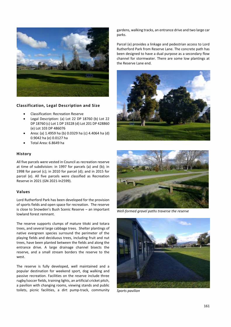
161
Classification, Legal Description and Size
• Classification: Recreation Reserve
• Legal Description: (a) Lot 22 DP 18760 (b) Lot 22 DP 18760 (c) Lot 1 DP 19228 (d) Lot 201 DP 428860 (e) Lot 103 DP 486076
• Area: (a) 1.4959 ha (b) 0.0329 ha (c) 4.4064 ha (d) 0.9042 ha (e) 0.0127 ha
• Total Area: 6.8649 ha
History
All five parcels were vested in Council as recreation reserve at time of subdivision: in 1997 for parcels (a) and (b); in 1998 for parcel (c); in 2010 for parcel (d); and in 2015 for parcel (e). All five parcels were classified as Recreation Reserve in 2021 (GN 2021-ln2599).
Values
Lord Rutherford Park has been developed for the provision of sports fields and open space for recreation. The reserve is close to Snowden’s Bush Scenic Reserve – an important lowland forest remnant. The reserve supports clumps of mature titoki and totara trees, and several large cabbage trees. Shelter plantings of native evergreen species surround the perimeter of the playing fields and deciduous trees, including fruit and nut trees, have been planted between the fields and along the entrance drive. A large drainage channel bisects the reserve, and a small stream borders the reserve to the west. The reserve is fully developed, well maintained and a popular destination for weekend sport, dog walking and passive recreation. Facilities on the reserve include three rugby/soccer fields, training lights, an artificial cricket pitch, a pavilion with changing rooms, viewing stands and public toilets, picnic facilities, a dirt pump-track, community
gardens, walking tracks, an entrance drive and two large car parks. Parcel (e) provides a linkage and pedestrian access to Lord Rutherford Park from Reserve Lane. The concrete path has been designed to have a dual purpose as a secondary flow channel for stormwater. There are some low plantings at the Reserve Lane end.
Well-formed gravel paths traverse the reserve
Sports pavilion

162
Issues and Options
The Brightwater Hall and Recreation Reserve Management Committee manage hire bookings and cleaning of the pavilion at Lord Rutherford Park. The public toilets are connected to a large containment tank with a pump system that pumps wastewater out to the reticulated wastewater network. The gravel car park areas are occasionally targeted by people doing burnouts. There is scope to upgrade and line-mark the two car parking areas as they are very busy at weekends. An asphalt drive runs from the entrance up to the first car park – this requires ongoing maintenance. There is also potential to develop a gravel path around the outer perimeter of the sports field to connect to Reserve Lane.
Entrance to Brightwater Allotments (a community garden)
Dirt pump-track
POLICIES
1 Manage for the primary purpose of providing opportunities for recreation and sporting activities, open space and enjoyment of the public.
2 Limit the extent of car parks to that provided in 2021. Seal and line-mark both of the existing car parks.
3 Maintain a high-standard path through parcel (e)
to provide pedestrian access between Reserve Lane and Lord Rutherford Park.
4 Extend the existing network of paths through the
reserve by developing a gravel path around the outer perimeter of the sports field to connect to Reserve Lane.
5 Retain, and replace, existing native trees, to
complement the habitat values of native forest remnants nearby.
6 Establish a corridor of native vegetation along the
northern arm of Lord Rutherford Park, to provide a connection to Snowden’s Bush Scenic Reserve. Explanation: The adjoining Snowden’s Bush Scenic Reserve is an important lowland forest remnant. The establishment of additional native trees is likely to increase the habitat available for native birds in the area.
Also see Council’s ‘Reserves General Policies’ document.
5.10.6 CLOVER ROAD WEST ESPLANADE RESERVE
Location
Clover Road West Esplanade Reserve adjoins the Wairoa River near Clover Road West, Hope (see Map 24).
Classification, Legal Description and Size
• Classification: Local Purpose (Esplanade) Reserve
• Legal Description: Sec 2 SO 355132
• Area: 0.2850 ha
History
This reserve comprises of land formed from accretion alongside the bank of the Wairoa River. It was vested in Council in 2014, when a survey was undertaken to create a legalisation plan and classified as Local Purpose (Esplanade) Reserve in 2021 (GN 2021-ln2599).
Values
An almost contiguous network of unformed paper roads and esplanade strips run alongside the Wairoa River from the end of Clover Road West, all the way back to Lightband

163
Road (State Highway 6). The esplanade reserve forms part of this network.
Issues and Options
The neighbouring landowner utilises part of the reserve as a vehicle track. The reserve is not fenced and is covered in weeds. If this landowner consented to an easement over the small section of land that creates a gap in the network of public land, there would be scope to create a walkway alongside the Wairoa River from Lightband Road through to the end of Clover Road West.
POLICIES
1 Manage the esplanade reserve for the purposes of enhancing riparian margin vegetation and providing public access to the Wairoa River.
2 Undertake weed control on the reserve areas as
required. 3 Investigate opportunities to establish a walkway
along the true right of the Wairoa River between Lightband Road and the end of Clover Road West, utilising the existing network of esplanade reserves and strips and unformed legal road, along with easements over private property.
4 If a walkway is to be established, fence the inland
boundary of the reserve, form a path inland of the riverbank and revegetate the reserve using native riparian species.
Also see Council’s ‘Reserves General Policies’ document.
5.10.7 WAI-ITI RIVER ESPLANADE RESERVES
Location
Wai-iti River Esplanade Reserves comprise of two parcels of land on the true left (western) side of the Wai-iti River, accessed via Teapot Valley Road, Waimea West (see Map 25). One parcel is located directly across the river from Simmonds Road and the other parcel is located across the river from Arnold Lane.
Classification, Legal Description and Size
• Classification: Local Purpose (Esplanade) Reserve
• Legal Description: (a) Lot 5 DP 16950 (b) Lot 6 DP 16950
• Area: (a) 0.2700 ha (b) 0.6520 ha
History
Both parcels were vested in Council as local purpose reserve (esplanade) at time of subdivision in 1994 and classified as Local Purpose (Esplanade) Reserve in 2021 (GN 2021-ln2599).
Values
Approximately half of parcel (a) is covered in willows, while the neighbouring landowner grazes the remaining half. Most of parcel (b) is used by the neighbouring landowner for cropping, although there are a few small shrubs near the riverbank. Both reserve areas form part of a network of public land that provides a potentially important part of any future walkway along the river edge.
Issues and Options
Management issues include encroachment of neighbouring land uses, weed control and provision of public access. Both esplanade areas could be restored with native riparian margin vegetation. There is also scope to create a walkway linking all esplanade reserves along this section of the Wai-iti River via the existing network of legal roads, although there are small gaps in the network at a few locations.
POLICIES
1 Manage the two esplanade reserve areas for the purposes of enhancing riparian margin vegetation and providing public access to the Wai-iti River.
2 Undertake weed control on the reserve areas as
required. 3 Investigate opportunities to establish a walkway
along the true left of the Wai-iti River between Waimea West Road and the southern tip of Teapot Valley Road, utilising the existing network of esplanade reserves and unformed legal road, along with easements over private property.
4 If a walkway is to be established, fence the inland
boundaries of both reserves, form a path inland of the riverbank and revegetate both reserves using native riparian species.
Also see Council’s ‘Reserves General Policies’ document.
5.10.8 ARNOLD LANE ESPLANADE RESERVE
Location
Arnold Lane Esplanade Reserve is located on the true right (eastern) side of the Wai-iti River downstream from Arnold Lane, between Wakefield and Brightwater (see Map 25).

164
Classification, Legal Description and Size
• Classification: Local Purpose (Esplanade) Reserve
• Legal Description: Lot 3 DP 16982
• Area: 0.2756 ha
History
This reserve was vested in Council as local purpose (esplanade) reserve at time of subdivision in 1994 and classified as Local Purpose (Esplanade) Reserve in 2021 (GN 2021-ln2599).
Values
Most of Arnold Lane Esplanade Reserve is grazed by the neigbouring landowner, although a few shrubs exist along the northern boundary.
Issues and Options
Encroachment is the main management issue. The inland boundary of the reserve is not fenced.
POLICIES
1 Manage the reserve for the purposes of enhancing riparian margin vegetation and providing public access to the Wai-iti River.
2 Investigate opportunities to establish a walkway
through the reserve, as part of a longer walkway along the banks of the Wai-iti River.
Also see Council’s ‘Reserves General Policies’ document.
5.10.9 SPRING GROVE HALL RESERVE AND SPRING GROVE SCHOOL RESERVE
Location
Parcel (a): Spring Grove Hall Reserve, and the adjoining parcel (b): Spring Grove School Reserve, are located at 244 Lord Rutherford Road South, Spring Grove (see Map 25).
Classification, Legal Description and Size
• Classification: o Parcel (a) Local Purpose (Site for a Public
Hall) Reserve o Parcel (b) Local Purpose (Community
Buildings) Reserve
• Legal Description: (a) Lot 1 DP 5978 (b) Lot 2 DP 14970
• Area: (a) 0.4034 ha (b) 1.1477 ha
History
Council has vested authority over the Spring Grove Hall Reserve (parcel (a)). This reserve was classified in 1980 as a Local Purpose (Site for a Public Hall) reserve (GN 1980, p3766). In 1989, this parcel was vested in the Tasman District Council in trust for this purpose (GN 1989, p5585). The Spring Grove School Reserve was vested in Council in 1991 and classified as Local Purpose (Community Buildings) Reserve in 2021 (GN 2021-ln2599). There is an unmarked grave on this reserve.
Values
Parcel (a) includes the Spring Grove Hall, car park and part of the open grassed area surrounding the hall. The hall roof has recently been upgraded. A corrugated iron building situated behind the hall provides storage area for equipment used by the Country Players Group. The hall is used for community functions, weddings and events such as the Spring Grove car boot sale. Parcel (b) includes the old Spring Grove School, a fenced tennis court, several large trees, and a large part of the open space between the school building and the hall. The old school building is listed as a Category II Heritage Building in the Tasman Resource Management Plan and is currently used as the Brightwater Playcentre. There are several large native trees on parcel (b), including totara and kowhai. A large coast redwood tree and large oak tree are also present on this reserve. The coast redwood tree is listed as Protected Tree in the Tasman Resource Management Plan.
Issues and Options
The Spring Grove Hall Committee assists with the management of both reserve areas. Management issues include maintenance of the school building and hall, leases of buildings, vehicle camping, and protection of trees. The water supply for the old school building presently comes from the hall. The Hall Committee has permitted NZMCA members to utilise the field behind the Playcentre for short-stay vehicle camping. This Plan formalises this activity. Income derived from this activity is used to offset some of the facility maintenance costs. There is an unmarked grave near the northern corner of this reserve, underneath the coast redwood tree.

165
POLICIES
1 Manage the Spring Grove Hall Reserve for the primary purpose of providing a public hall for community use.
2 Support the Spring Grove Hall Committee to
manage bookings for use of the Spring Grove Hall and maintain this facility.
3 Allow for continued use of the small building
located alongside the Spring Grove Hall as a storage facility, in accordance with the terms and conditions of a new five-year lease with the Country Players Group (see Appendix 3, Table A).
4 Manage the Spring Grove School Reserve for the
primary purpose of protecting the old school building and facilitating its use for community purposes, and manage the open space area for informal recreation.
5 Allow for continued use of the old Spring Grove
School building as the Brightwater Playcentre, in accordance with the terms and conditions of a new five-year lease with the Nelson Playcentre Association (see Appendix 3, Table A).
6 Allow the field behind the old school building to
continue to be used by fee-paying NZMCA members to camp in self-contained vehicles for up to two nights during any four-week period. A maximum of 10 vehicles may park overnight in this area. Income derived from this activity will be used to offset some of the facility maintenance costs.
7 Protect all trees on the reserve, including native
trees around the old school building and listed Protected Trees.
8 The grave is noted on Council records to ensure it
remains undisturbed. Also see Council’s ‘Reserves General Policies’ document.
5.10.10 LIGHTBAND ROAD ESPLANADE RESERVE
Location
Lightband Road Esplanade Reserve adjoins the Wairoa River and the highway bridge at 5 Lightband Road (State Highway 6), Brightwater (see Map 25).
Classification, Legal Description and Size
• Classification: Local Purpose (Esplanade) Reserve
• Legal Description: Lot 4 DP 358238
• Area: 0.1777 ha
History
This reserve was vested in Council as local purpose (esplanade) reserve at time of subdivision in 2005 and classified as Local Purpose (Esplanade) Reserve in 2021 (GN 2021-ln2599).
Values
This small esplanade reserve lies between two industrial properties and the Wairoa River, providing a linkage between the highway to the west and a longer esplanade strip to the east. Rank grass covers much of the reserve area and willows line the adjacent riverbank.
Issues and Options
Management issues include weed control and maintaining the potential for public access. The grass area is topped once per year to help suppress weeds and there is no formed access through the reserve. Both this reserve and the adjoining esplanade strip could potentially be revegetated in future.
POLICIES
1 Manage the esplanade reserve for the purposes of enhancing riparian margin vegetation and providing public access to the Wairoa River.
2 Undertake weed control on the reserve area as
required. Also see Council’s ‘Reserves General Policies’ document.
5.10.11 WAIROA RIVER ESPLANADE RESERVE
Location
Wairoa River Esplanade Reserve is located on the true right (northeastern) side of the Wairoa River just above Lightband Road (State Highway 6), Brightwater (see Map 25).

166
Classification, Legal Description and Size
• Classification: Local Purpose (Esplanade) Reserve
• Legal Description: Pt Lot 3 DP 16911
• Area: 2.5800 ha
History
This reserve was vested in Council as local purpose reserve at time of subdivision in 1994 and classified as Local Purpose (Esplanade) Reserve in 2021 (GN 2021-ln2599).
Values
The esplanade reserve provides a connection from Lightband Road (State Highway 6) alongside the Wairoa River through to a length of unformed legal road. The unformed road links through to a remnant of native forest known locally as Max’s Bush and Haycock Road. However, no walking track has been formed through either area.
Issues and Options
Farmland and a vineyard on neighbouring properties encroach into much of the reserve area. Part of the southern section has been eroded by the Wairoa River. The remainder of the reserve is covered in rank grass and weeds, with some willows also present. The main management issues are weed control, encroachment from neighbouring land use and maintaining the potential for public access. The riparian margin could potentially be revegetated at some point in future.
POLICIES
1 Manage the esplanade reserve for the purposes of enhancing riparian margin vegetation and providing public access to the Wairoa River.
2 Undertake weed control on the reserve areas as
required. 3 Investigate opportunities to establish a walkway
through the reserve, as part of a longer walkway along the banks of the Wairoa River.
Also see Council’s ‘Reserves General Policies’ document.
5.10.12 COACH PLACE RECREATION RESERVE
Location
Coach Place Recreation Reserve is located at 8 Coach Place, Brightwater (see Map 26).
Classification, Legal Description and Size
• Classification: Recreation Reserve
• Legal Description: (a) Lot 16 DP 15864 (b) Lot 8 DP 9795 (c) Lot 65 DP 328503
• Area: (a) 0.0068 ha (b) 0.2783 ha (c) 0.0224 ha
• Total Area: 0.3075 ha
History
All three parcels were vested in Council as recreation reserve at time of subdivision: in 1992 for parcel (a); in 1977 for parcel (b); and in 2004 for parcel (c). All three parcels were classified as Recreation Reserve in 2021 (GN 2021-ln2599).
Values
The main part of Coach Place Recreation Reserve (parcel b) includes an area of open grass, a large playground, a picnic table, rubbish bins and several trees. The reserve also forms part of a walkway link between Coach Place and Malthouse Crescent (via parcel a), and also between Coach Place and Holly Bush Drive (via parcel c).
Issues and Options
Management issues include ongoing maintenance of the two paths leading into the main reserve area, replacement/upgrade of some play equipment, and maintenance of trees and low vegetation on the reserve boundary.

167
POLICIES
1 Manage as an area of open space for the primary purpose of informal recreation.
2 Continue to maintain the paths, trees and low
vegetation on the reserve boundary. 3 Replace and/or upgrade playground equipment as
required. Also see Council’s ‘Reserves General Policies’ document.
5.10.13 SNOWDEN PLACE RECREATION RESERVE
Location
Snowden Place Recreation Reserve is located at 12 Snowden Place, Brightwater (see Map 26).
Classification, Legal Description and Size
• Classification: Recreation Reserve
• Legal Description: Lot 5 DP 10022
• Area: 0.0751 ha
History
This reserve was vested in Council as reserve at time of subdivision in 1978 and classified as Recreation Reserve in 2021 (GN 2021-ln2599).
Values
Snowden Place Reserve is a small open grassed area with a picnic table, three trees and a hedge on two sides.
Issues and Options
The old picnic table needs replacing and there is no signage on the reserve. If adjoining land is subdivided in future, adding additional area to this reserve would potentially make it more useable for recreation purposes. Conversely,
there may be alternative options for a larger recreation reserve nearby, that are more appropriate.
POLICIES
1 Manage as an area of open space for the primary purpose of passive recreation.
2 Install a reserve name sign and replace the picnic
table. 3 If adjacent land is to be subdivided, consider
opportunities to either increase the size of this reserve area, or alternatively create a larger recreation reserve elsewhere in the subdivision.
Also see Council’s ‘Reserves General Policies’ document.
5.10.14 LORD RUTHERFORD MEMORIAL HISTORIC RESERVE
Location
Lord Rutherford Memorial Historic Reserve is located at 91 and 93 Lord Rutherford Road North, at the junction of the Brightwater Deviation (State Highway 6), Brightwater (see Map 27).
Classification, Legal Description and Size
• Classification: o Parcels (b)-(d) Historic Reserve o Parcel (a) is not subject to the Reserves
Act, therefore not classified
• Legal Description: (a) Lot 2 DP 9151 (b) Lot 1 DP 9151 (c) Lot 1 DP 14795 (d) Lot 2 DP 5360
• Area: (a) 0.0938 ha (b) 0.1055 ha (c) 0.0196 ha (d) 0.0037 ha
History
Parcel (a) was previously owned by Her Majesty the Queen for the purposes of road. In 1993, Council purchased this parcel using funds received as compensation for the Brightwater Bypass. The land was acquired for the purpose of providing additional access and car parking/picnicking space alongside the Lord Rutherford Memorial Reserve. In 1975, the Waimea County Council purchased the land (i.e. parcels (b) and (d)) on which the house in which Lord Ernest Rutherford was born, with the objective of establishing a suitable memorial on the site. Council acquired parcel (c) in 1991 when the neighbouring land was subdivided and it was added to the same certificate of title as parcels (b) and (d), which Council purchased in 1975.

168
Parcels (b), (c) and (d) were all classified as Historic Reserve in 2021 (GN 2021-ln2599). Parcel (a) is not subject to the Reserves Act, therefore it is not classified.
Values
The memorial at the reserve commemorates the famous physicist, Lord Ernest Rutherford, who was born at this site in 1871. The memorial was designed and erected as part of the Rutherford Birthsite Project, and commemorates Lord Rutherford’s contribution to science. It includes display panels, an audio display, lighting and formal gardens.
A grassed area with garden seats serves as a picnic and roadside rest area. A small car parking area adjoins Lord Rutherford Road North. The reserve is an important and well-known visitor attraction.
Issues and Options
Management issues include prevention of vandalism, maintenance of the gardens within the memorial, and the maintenance, cleaning and replacement of the displays. The speaker system and signs are both outdated and could be replaced with QR codes linking to recorded histories and information.
Construction of a pedestrian haven on Lord Rutherford Road would provide a useful link to Tasman’s Great Taste Trail, located on the opposite side of the road. There is scope to protect parcel (a) under the Reserves Act.
POLICIES
1 Manage for the primary purpose of recognising the historic significance of this site: the birthplace of Lord Ernest Rutherford.
2 Continue to maintain the memorial in recognition
of Lord Rutherford and the formal gardens, in cooperation with community and interest groups.
3 Replace the outdated speaker system and signage
with fewer signs that include QR codes linking to recorded histories and other information of interest.
4 Construct a pedestrian haven on Lord Rutherford
Road to provide a safer linkage through to Tasman’s Great Taste Trail, located on the opposite side of the road.
5 Following the conclusion of the Nelson Tenths
Reserve claim process, initiate a public consultation process to declare parcel (a) as Historic Reserve under the Reserves Act, in order to provide appropriate legal protection for this land.
Also see Council’s ‘Reserves General Policies’ document.

169
5.10.15 BRIGHTWATER RAILWAY RESERVE WALKWAY
Location
Brightwater Railway Reserve Walkway comprises of seven parcels of land that link Starveall Street with State Highway 6 to the west and Brightwater Recreation Reserve to the east (see Map 27).
Classification, Legal Description and Size
• Classification: o Parcels (a), (c), (d), (f) and (g) are
classified as Local Purpose (Walkway) Reserve.
o Parcels (b) and (e) are not subject to the Reserves Act, therefore not classified.
• Legal Description: (a) Lot 24 DP 16254 (b) Lot 25 DP 14155 (c) Lot 10 DP 16254 (d) Lot 26 DP 16254 (e) Lot 1 DP 14155 (f) Lot 28 DP 9598 (g) Pt Lot 2 DP 10225
• Area: (a) 0.0552 ha (b) 0.2789 ha (c) 0.0476 ha (d) 0.0080 ha (e) 0.0267 ha (f) 0.0143 ha (g) 0.0197 ha
History
Parcels (a), (c) and (d) were vested in Council as local purpose reserve at time of subdivision in 1993. Parcel (f) was vested in Council as accessway reserve at time of subdivision in 1977 and parcel (g) was vested in Council as local purpose reserve (access way) at time of subdivision in 1979. Parcels (a), (c), (d), (f) and (g) were classified as Local Purpose (Walkway) Reserve in 2021 (GN 2021-ln2599). Parcels (b) and (e) were acquired by Council in 1989. Neither parcel is subject to the Reserves Act, therefore they are not classified.
Values
This walkway reserve runs through urban Brightwater and its shared path forms part of Tasman’s Great Taste Trail. Most of the land parcels were formerly railway reserve and parcel (c) provides a linkage through to Rintoul Place.
The eastern portion of the reserve, between Starveall Street and the Brightwater Recreation Reserve, has a sealed path and mown grass verge. The western part, between Starveall Street and the highway, is an open area with mown grass and some trees, fenced from adjoining properties.
The linkage through to Rintoul Place.
Issues and Options
Management issues include the need to regularly prune trees and maintain grassed areas as open space for informal recreation. There is scope to protect two of the land parcels under the Reserves Act. No further development is proposed for the reserve.

170
POLICIES
1 Maintain the path through the walkway reserve to provide walking/cycling access between Starveall Street and State Highway 6 to the west and Brightwater Recreation Reserve to the east.
2 Establish one feature tree on the Rintoul Place
portion of the reserve (parcel c).
3 Following the conclusion of the Nelson Tenths Reserve claim process, initiate a public consultation process to declare parcels (b) and (e) Local Purpose (Walkway) Reserve under the Reserves Act, in order to provide appropriate legal protection for this land.
Also see Council’s ‘Reserves General Policies’ document.
5.10.16 BRIGHTWATER RECREATION RESERVE
Location
Brightwater Recreation Reserve is located at 14 Lord Rutherford Road North, Brightwater (see Map 27). The reserve is located in the Brightwater urban area between Lord Rutherford Road, Ellis Street and Charlotte Lane.
Classification, Legal Description and Size
• Classification: o Parcels (a), (b), (d) and (e) are classified as
Recreation Reserve o Parcel (c) is classified as Local Purpose
(Community Buildings) Reserve
• Legal Description: (a) Pt Sec 18 Blk IX Waimea SD (b) Sec 2 SO 458932 (c) Sec 1 SO 458932 (d) Lot 1 DP 10225 (e) Pt Lot 2 DP 10225
• Area: (a) 0.1897 ha (b) 3.5046 ha (c) 0.1123 ha (d) 0.1089 ha (e) 0.0165 ha
• Total Area: 3.9321 ha
History
Council has vested authority over all five parcels. Parcel (a) (where the Brightwater Hall and car park are located) and parcel (b) (where the Wanderers Clubrooms, Wanderers Gym, Brightwater Plunket buildings, playground, tennis/netball courts and sports fields are located) were acquired in 1913 under s26 of the Public Reserves and Domains Act 1908. In 1984, both parcels were classified as Recreation Reserve and vested in the Waimea County Council in trust for Recreation Purposes (GN 1984, p4523).
In 2013, the classification of parcel (c) was changed from Recreation Reserve to Local Purpose (GN 2013, p2249). The Pinegrove Kindergarten Building is located on this parcel. In 1992, parcel (d) was classified as Recreation Reserve (GN 1992, p3822). The Brightwater Scout Den is located on this parcel. In 1993, parcel (e) was classified as Recreation Reserve (GN 1993, p592).
Values
The Brightwater Recreation Reserve is an important and well-used recreation facility catering for a wide range of activities.
Emergency services utilised the reserve, including the Wanderers Clubrooms, during the Pigeon Valley Fire in 2019. Photo credit: Wanderers Rugby Club Facebook page. A large part of the reserve comprises of floodlit playing fields, used for rugby in winter and as a cricket pitch in summer. Also located on the reserve is the Brightwater Hall, sealed car parks, the Wanderers Clubrooms, three fenced tennis courts (also used as two netball courts), a playground and skatepark, the old Plunket Rooms, the Wanderers Gym (in the old Bowling Club building) and squash court with viewing platform, cricket practice nets by the gym, an abandoned croquet clubrooms building, the Brightwater Scout Den, and the Pinegrove Kindergarten. The main entrance to the reserve is on Lord Rutherford Road beside the Brightwater Hall, where memorial gates commemorate lives lost in the two World Wars. A concrete wall and plantings of native species separate the reserve from Lord Rutherford Road. A large, sealed car park surrounds the hall, and public toilets are located at the rear of the hall. The Wanderers Clubrooms are also located behind the hall, overlooking the sports fields. The car park caters for use of the hall, clubrooms, tennis/netball courts and playing fields.

171
Photo credit: Wanderers Cricket Club Facebook page. The playground fencing was replaced in 2020 as part of the Ellis Street town centre upgrade.Trees are planted along the north-eastern boundary. Concrete gateposts at the pedestrian entrance on Ellis Street are inscribed ‘Brightwater Centennial Park; 1840 – 1940’. The tennis/netball courts, playground, skatepark and Brightwater Plunket Rooms are located on this part of the reserve. Charlotte Lane, at the south-eastern side of the reserve, also provides vehicle access to the reserve. The Wanderers Gym, Pinegrove Kindergarten, Brightwater Scout Den, and another sealed car parking area are located on this side of the reserve.
Wanderers Gym
Wanderers Clubrooms and Brightwater Hall to the left, Pinegrove Kindergarten to the right.
Brightwater Scout Den and grounds The part of the reserve containing the Brightwater Scout Den comprises an area of mown grass with the concrete block building at the rear of the section. A fire-pit is located behind the hall on a gentle bank planted with native shrubs. A shipping container has been placed in the northern corner of this land parcel. A corrugated iron fence separates the Scout Den from the Brightwater Gym, and a low paling wooden fence separates it from a sealed pathway that forms part of the walkway along the Brightwater Railway Reserve.
Issues and Options
Management issues include maintenance of the recreational facilities and buildings, ownership and leasing of facilities, multiple use of the playing fields, and the retention of adequate areas of open space. The tennis courts will need resurfacing, some boundary fences may need replacing and the abandoned croquet building should be removed. The Brightwater Hall and Recreation Reserve Management Committee assists with the management of the reserve, particularly the hall and former Plunket Rooms. The Wanderers Community Sports Club Inc (Club) manage the two facilities they own: their clubrooms and gym. The Wanderers clubrooms are open anytime a sporting fixture is on and is also available for hire. The clubrooms have a fully licensed bar and kitchen facilities. The Club recently made a request to purchase the Wanderers Gym, a Council-owned building that it has leased from the Council since 2019. The Club had previously subleased a significant area of the building from Tasman Beach Volleyball from 2014 to 2019. The Club use the building for a gymnasium and Health and Wellbeing Centre and have carried out some building improvements in recent years. They have also been planning further improvements

172
as part of the implementation of a Sportsville10 model for the delivery of sport and recreation in Brightwater. The Club have also recently developed an all-weather covered training surface on the old bowling green area to enable improved utilisation of the outdoor area. The green was used by Tasman Beach Volleyball for several years before they concentrated their activities elsewhere. The building was built by the Brightwater Bowling Club Inc. and was used by them up until the bowling club wound up in August 2001, when building ownership transferred to Council. If the Council agrees to transfer ownership of the building to the Club, the lease would be amended to a ground lease, plus any other applicable Council charges such as pan, water and refuse charges (see Appendix 3, Table A). The shipping container near the Brightwater Scout Den needs to be removed and replaced with a purpose-built storage building located elsewhere within the leased area.
POLICIES
1 Manage for the primary purpose of providing opportunities for recreation and sporting activities, open space and community use.
2 Continue to work together with the Brightwater
Hall and Recreation Reserve Management Committee to maintain and upgrade facilities (e.g. resurface the tennis courts and replace boundary fencing as required).
3 Remove the abandoned croquet building from the
reserve, but retain the pump shed and well located behind that building.
4 Support the Brightwater Hall and Recreation
Reserve Management Committee to manage bookings for use of the Brightwater Hall and Brightwater Plunket Rooms.
5 Allow for continued use of the land where the
Wanderers Clubrooms and Wanderers Gym buildings are located, in accordance with the terms and conditions of new five-year leases with the Wanderers Community Sports Club Inc (see Appendix 3, Table A).
10 A definition of a Sportsville includes: ‘A partnership between sports
clubs/codes and organisations who work in a strategic way with multiple internal and external stakeholders to develop their clubs and codes. This method of operation brings an economy of scale to the costs associated with providing facilities and/or opportunities to accommodate the needs
6 Allow for continued use of the Brightwater Scout Den and grounds, in accordance with the terms and conditions of a new five-year lease with the Scouts Association (see Appendix 3, Table A). As part of the new lease arrangement, require the removal of the shipping container and replacement with a purpose-built storage facility elsewhere within the leased area.
7 Upon expiry of the current lease, allow for
continued use of the Pinegrove Kindergarten building and grounds, in accordance with the terms and conditions of a new five-year lease with the Pinegrove Kindergarten (see Appendix 3, Table A).
Also see Council’s ‘Reserves General Policies’ document.
5.10.17 BRIGHTWATER VILLAGE GREEN
Location
Brightwater Village Green is located at 62 Ellis Street, Brightwater (see Map 77).
Classification, Legal Description and Size
• Classification: Not subject to the Reserves Act, therefore not classified
• Legal Description: Lot 1 DP 314047
• Area: 0.1034 ha
History
Council purchased parcel (a) from the previous landowner in 2012. The land is not subject to the Reserves Act, therefore it is not classified.
Values
Brightwater Village Green is a small area of open space at the town centre. A large lime tree near the middle of the green offers shade in summer. A Exceloo facilty is located in the southern corner of the green space, alongside Starveall Street. The Village Green was further developed as part of the Ellis Street upgrade in 2020. Improvements included additional seating, several amenity trees, garden borders, interpretative signage, a picnic table, a rubbish bin, and a new footpath linking the rear car park to the footpath on Ellis Street. A community book exchange is also located
of a community, such as leadership and sharing resources’. The ‘sportsville’ concept allows community and sporting groups to share facilities, e.g. changing rooms, fields, administration, social space, meeting rooms etc, which brings economies of scale to the cost of providing and maintaining these facilities.

173
here. Low vehicle stops and street-side gardens prevent vehicles from driving onto the green. The car parking area behind the green and the shops have recently been sealed and line-marked. This area, and the rear part of the green space (including the Exceloo) are located on a separate parcel of land, also owned and managed by Council.
Issues and Options
The Exceloo is now 20 years old and will need upgrading when the electronics fail. The intention is to provide a new unisex toilet, rather than a new Exceloo. The trees located near the toilet require regular trimming to maintain sightlines for users. The Village Green was occasionally used for small market day events, but there is less space available for this now the upgrade work is complete. There is scope to protect the land under the Reserves Act.
POLICIES
1 Manage the land for the primary purpose of providing open green space in the town centre.
2 Replace the public toilet facility. 3 Following the conclusion of the Nelson Tenths
Reserve claim process, initiate a public consultation process to declare as Recreation Reserve under the Reserves Act, in order to provide appropriate legal protection for the recreational values of this land.
Also see Council’s ‘Reserves General Policies’ document.
5.10.18 STARVEALL STREET RECREATION RESERVE
Location
Starveall Street Recreation Reserve is located on the corner of Starveall Street and Ben Nevis Crescent, Brightwater (see Map 27).
Classification, Legal Description and Size
• Classification: Recreation Reserve
• Legal Description: Lot 68 DP 20400
• Area: 0.2139 ha
History
This reserve was vested in Council as recreation reserve at time of subdivision in 2001 and classified as Recreation Reserve in 2021 (GN 2021-ln2599).
Values
A large, flat, open space area of mown grass, several established trees, a playground, picnic table and rubbish bin are provided at this neighbourhood reserve. There is a low bollard fence along the Starveall Street boundary.
Issues and Options
The only management issues are ongoing maintenance and the need to replace some playground equipment in future.
POLICIES
1 Manage as an area of open space for the primary purpose of informal recreation.
2 Replace and/or upgrade playground equipment as
required. Also see Council’s ‘Reserves General Policies’ document.
5.10.19 BRIGHTWATER SCHOOL RECREATION RESERVE
Location
Brightwater School Recreation Reserve is located on Ellis Street, Brightwater (see Map 27).
Classification, Legal Description and Size
• Classification: Recreation Reserve
• Legal Description: Lot 1 DP 19812
• Area: 0.2332 ha

174
History
Council purchased this reserve at the time the Brightwater Deviation was being developed. It was vested in Council as recreation reserve in 1999 and classified as Recreation Reserve in 2021 (GN 2021-ln2599).
Values
Brightwater School currently use this area as an extension to their back playing field. A small dirt pump track has been built around the perimeter of this reserve by the school.
Issues and Options
A lease with Brightwater School is required, to authorise their use of the reserve grounds. If surrounding land is subdivided, there may be scope to increase the size of the reserve area and/or secure a walkway through to this reserve from Longfields Road and/or William Palmer Place.
POLICIES
1 Manage as an area of open space for the primary purpose of recreation.
2 If surrounding land is subdivided, investigate
opportunities for securing a walkway link through to this reserve from Longfields Road and/or William Palmer Place.
3 Allow for continued use of the reserve grounds by
Brightwater School, in accordance with the terms and conditions of a new five-year lease with the Brightwater School (see Appendix 3, Table A).
Also see Council’s ‘Reserves General Policies’ document.

175
5.11 WAKEFIELD RESERVES

176

177

178
5.11.1 GEORGE FYFE WAY WALKWAY RESERVE
Location
George Fyfe Way Walkway Reserve is located at George Fyfe Way, Wakefield (see Maps 29 and 30).
Classification, Legal Description and Size
• Classification: Local Purpose (Walkway & Utility) Reserve
• Legal Description: Lot 100 DP 527106
• Area: 0.1699 ha
History
This reserve was vested in Council as local purpose (utility/walkway) reserve at time of subdivision in 2019 and classified as Local Purpose (Walkway & Utility) Reserve in 2021 (GN 2021-ln2599).
Values
A mown path provides pedestrian access to the edge of the Wai-iti River from George Fyfe Way. It also forms a secondary flow path for the adjoining subdivision.
Issues and Options
The river end of the walkway is vulnerable to flooding and will require repair after flood damage occurs. If further land is subdivided in this area and the walkway network extended (potentially back through to Pigeon Valley Road), this walkway could be upgraded to a gravel path.
POLICIES
1 Maintain the path through the walkway reserve to provide pedestrian access between George Fyfe Way and the Wai-iti River.
2 If surrounding land is subdivided, investigate
opportunities for extending the walkway network – potentially through to Pigeon Valley Road.
Also see Council’s ‘Reserves General Policies’ document.
5.11.2 BAIGENT VALLEY ROAD – GOLF ROAD ESPLANADE RESERVE
Location
Baigent Valley Road – Golf Road Esplanade Reserve comprises of four parcels of land alongside the Wai-iti River at the end of Baigent Valley Road, near Wakefield (see Map 29). Parcel (a) lies on the true left (western) side of the river south of Baigent Valley Road. Parcel (b) lies on the true right (eastern) side of the river just upstream from Baigent Valley
Road. Parcel (c) lies on the true left side of the river between Baigent Valley Road and an unformed portion of Golf Road. Parcel (d) lies on the true right side of the river downstream from Baigent Valley Road.
Classification, Legal Description and Size
• Classification: Local Purpose (Esplanade) Reserve
• Legal Description: (a) Lot 3 DP 438207 (b) Lot 4 DP 17895 (c) Lot 8 DP 16046 (d) Lot 6 DP 16046
• Area: (a) 0.3704 ha (b) 0.0360 ha (c) 0.1740 ha (d) 0.3860 ha
History
All four parcels were vested in Council as local purpose (esplanade) reserve at time of subdivision: in 2011 for parcel (a); in 1997 for parcel (b); and in 1993 for parcels (c) and (d). All four parcels were classified as Local Purpose (Esplanade) Reserve in 2021 (GN 2021-ln2599).
Values
Tasman’s Great Taste Trail runs alongside the Wai-iti River, on the true left side, passing through parcels (a) and (c). Parcel (a) has two picnic tables and gravelled rest area for cyclists. A small amount of planting has been undertaken between the river and the cycle trail, with the remainder of the area maintained as grass. The fence on parcel (c) does not align with the boundary and the neighbour grazes most of the reserve area. Weeds along the river boundary here include sycamore, gorse and broom. Parcels (b) and (d) are covered in wattle, sycamore, broom and gorse. Half of parcel (d) is grazed by the neighbouring properties. The boundaries of the four land parcels that make up this reserve are difficult to discern on the ground. However, all four areas adjoin the Wai-iti River and are contiguous with other riverbed areas. They function as river management areas and provide for public access along the Wai-iti River.
Issues and Options
Management issues include encroachment from neighbouring land uses and weed control.
POLICIES
1 Manage parcels (a) and (c) for the primary purpose of enhancing riparian margin vegetation and providing walking/cycling access alongside the Wai-iti River via Tasman’s Great Taste Trail.
2 Manage parcels (b) and (d) for the primary
purpose of enhancing riparian margin vegetation.

179
3 Undertake weed control on the reserve areas as required.
4 Revegetate the riparian margins of each reserve
parcel. 5 Maintain the picnic tables and rest area for cyclists
on parcel (a). Also see Council’s ‘Reserves General Policies’ document.
5.11.3 EIGHTY EIGHT VALLEY ESPLANADE RESERVES
Location
Eighty Eight Valley Esplanade Reserves comprise of two narrow parcels of land situated on a low terrace on the true right (eastern) side of Eighty Eight Valley Stream at Eighty Eight Valley Road, Wakefield (see Map 29).
Classification, Legal Description and Size
• Classification: o Parcel (b) is classified as Local Purpose
(Esplanade) Reserve o Parcel (a) is not subject to the Reserves
Act, therefore not classified
• Legal Description: (a) Lot 2 DP 12882 (b) Lot 2 DP 17067
• Area: (a) 0.1491 ha (b) 0.3650 ha
History
Council acquired parcel (a) via subdivision in 1987. Although parcel (b) vested as reserve at the time of subdivision, this one did not (most likely an error). Parcel (a) is not subject to the Reserves Act, therefore is not classified. Parcel (b) was vested in Council as local purpose (esplanade) reserve at time of subdivision in 1994 and classified as Local Purpose (Esplanade) Reserve in 2021 (GN 2021-ln2599).
Values
The reserve forms a significant part of a potential link between Robson Reserve and Edward Baigent Memorial Scenic Reserve. The reserve supports a scattered remnant of native forest (totara and kaikomako trees), willow trees, rough pasture and a range of other introduced species including barberry, hawthorn, gorse and old man’s beard.
Issues and Options
Management issues include erosion, encroachment, protection and restoration of native vegetation, control of weeds and public access. Erosion from stream is an ongoing issue and some rock armouring has been put in place to protect the stream banks. Neighbouring land use (grazing and a small building) encroaches into much of the reserve. Access is difficult. There is scope to enhance the native vegetation on the reserve through enrichment plantings, and also to create a biodiversity corridor between Robson Reserve and Edward Baigent Memorial Scenic Reserve along the Eighty Eight Valley Stream. If such a link were completed, it could provide part of future walkway between Robson Reserve and the reserves in Wakefield township (Edward Baigent Memorial Scenic Reserve, Wakefield Recreation Reserve, and Faulkner Bush). There is also scope to protect parcel (a) under the Reserves Act.
POLICIES
1 Manage both esplanade reserves for the primary purpose of enhancing riparian margin vegetation and providing walking access between forest remnants.
2 Fence the inland boundaries of both parcels to
protect the existing native vegetation and revegetate the reserves using eco-sourced native species.
3 Undertake weed control on the reserve areas as
required. 4 Investigate options for developing pedestrian
access through the reserve as part of a walkway and biodiversity corridor link between Robson Reserve and Edward Baigent Memorial Scenic Reserve.
5 Following the conclusion of the Nelson Tenths
Reserve claim process, initiate a public consultation process to declare parcel (a) as Local Purpose (Esplanade) Reserve under the Reserves Act, in order to provide appropriate legal protection for this land.
Also see Council’s ‘Reserves General Policies’ document.

180
5.11.4 ROBSON RESERVE
Location
Robson Reserve is located at Eighty Eight Valley Road, just south of Wakefield (see Map 29). The reserve covers two river terraces in the lower part of Eighty Eight Valley. It is bordered to the east by Eighty Eight Valley Road and to the west by a partly formed legal road. The reserve is separated from Eighty Eight Valley Stream and Eighty Eight Valley Esplanade Reserve by the legal road and a narrow strip of private land.
Classification, Legal Description and Size
• Classification: o Parcel (a) is classified as Recreation
Reserve o Parcel (b) is classified as Scenic Reserve
for the purposes specified in Section 19(1)(a)
• Legal Description: (a) Sec 1 SO 352066 (b) Sec 2 SO 352066
• Area: (a) 1.8910 ha (b) 3.3708 ha
History
The Robson family owned this land from 1932 to 1991, when it was transferred to Council. It was held in fee simple prior to 2005, when parcel (a) was declared a reserve for recreation purposes and classified as Recreation Reserve (GN 2005, p4844). In 2021, parcel (b) was classified as Scenic Reserve for the purposes specified in section 19(1)(a) of the Reserves Act (GN 2021-ln2599).
Values
The Scenic Reserve area comprises of mature primary and partly secondary treeland remnant of lowland totara, matai and kahikatea, most of which was grazed up until 2019. Totara and matai form dense stands on the upper terrace, while kahikatea is more prevalent on the lower terrace.
Other important trees include black beech, silver beech, narrow-leaved lacebark, and pokaka. Parts of the forest margins trail off into open treeland. Understorey species include Lophomyrtus obcordata, Coprosma crassifolia, Melicope simplex, scrub pohuehue, and ferns (Pellaea rotundifolia, Adiantum cunninghamii and Polystichum richardii). The remnant has been assessed as being of ecological significance under the Native Habitat Tasman programme, due to its high inherent resiliency values and medium-high rarity values and its stands of trees that provide a seasonally important benefits for forest birds (North, 2008). Alluvial podocarp forest is extremely rare in the Motueka Ecological District, with less than 1% of its original cover remaining.
The forest remnant areas are being underplanted to assist natural regeneration. There are some areas of open grassland in the Scenic Reserve area and the Recreation Reserve area is mown once per month, giving the area a parkland appearance.
A small car park has recently been formed alongside Eighty Eight Valley Road, within the top terrace part of the

181
Recreation Reserve. A picnic table and a seat are located nearby. A gravel path winds its way through both parts of the reserve along the top terrace and then down to the lower terrace part of the Scenic Reserve area. Robson Reserve provides an ideal and very attractive setting for passive recreation (e.g. picnicking and bush walks) and the recreation area is occasionally used for horse riding.
Issues and Options
Management issues include the protection and restoration of the forest remnants, pest control, ongoing weed control and removal of new weed species (the reserve is prone to infestation of weeds from neighbouring sources), maintenance of boundary fences, and the provision and maintenance of facilities for recreational activities. There is scope to install another picnic table in the Scenic Reserve area and some play equipment in the Recreation Reserve area. No toilets are intended to be provided, as there are other public toilets available nearby (e.g. at Faulkner Bush, Edward Baigent Memorial Scenic Reserve and Wakefield Recreation Reserve). A new entrance could be developed on the northwestern boundary, providing more direct access to the lower terrace for horse riders and other users of the large field in this part of the reserve.
A small shed at the northern end near the reserve entrance was previously used by the Waimea Pony Club but no longer serves any useful purpose and could be removed. The Scenic Reserve area has considerable potential for restoration. As described above, it supports a substantial remnant of lowland forest, including kahikatea forest in an old flood channel of Eighty Eight Valley Stream on the lower terrace. The proximity of the reserve to other native forest remnants in the Wakefield area, such as Faulkner Bush, enhances the potential of the reserve to provide important habitat for native birds. Pest trapping is underway. The forest understorey is substantially modified by many years of grazing, but the main forest canopy is – in parts – largely intact. While restoration of the understorey is
underway and ongoing plantings are planned over the next few years, within 10 years natural regeneration should be possible in the existing forest remnant area. Revegetation planting should be targeted to seal the forest edges with a buffering margin, to lower light levels under the trees that favours native regeneration over dense exotic ground cover, and to mitigate against edge effects, particularly drying air movement that has been heated by surrounding open conditions. Revegetation of approximately a third of the open space area in the Scenic Reserve is planned, with the remaining open space grassed areas to be maintained for scenic enjoyment. The forest is prone to drought; mature beech have died from drought effects in recent years. Significant gains in weed control have been made, however ongoing control will be required to keep these at low levels. The most common weed species are old man’s beard, barberry, Portuguese laurel and other garden escapees. The Wakefield Bush Restoration Society Inc. (established in March 2000), has worked with the Council for the past 20+ years and will continue to assist with management of the reserve and to raise community awareness of its natural values. This group has constructed temporary fences alongside walking tracks in the Scenic Reserve area, in an effort to protect the understorey while it is regenerating. The group is required to remove the fences in 2025, at their cost.
POLICIES
1 Manage the Scenic Reserve part of Robson Reserve for the primary purpose of conserving and restoring the native forest remnant.
2 Manage the Recreation Reserve part of Robson
Reserve for the primary purpose of providing opportunities for recreation.
3 Continue to work together with local community
groups, including the Wakefield Bush Restoration Society, to restore the forest understorey by planting eco-sourced native species, expand the revegetated area into one third of the open space area of the Scenic Reserve, and undertake ongoing pest control and weed surveillance and control throughout Robson Reserve.
4 Allow continued use of the open mown areas of
the Recreation Reserve area for horse riding and other informal recreation activities.

182
5 Create a new entrance on the northwestern boundary, providing more direct access to the lower terrace for horse riders and others.
6 Remove the small shed near the reserve entrance. 7 Install a picnic table in the Scenic Reserve area. 8 Install some play equipment in the Recreation
Reserve area. 9 Ensure that in 2025 the Wakefield Bush
Restoration Society removes all temporary fences they constructed within the Scenic Reserve area, at their cost.
Also see Council’s ‘Reserves General Policies’ document.
5.11.5 GENIA DRIVE RECREATION RESERVE
Location
Genia Drive Recreation Reserve is located at Genia Drive, Wakefield (see Map 29).
Classification, Legal Description and Size
• Classification: Recreation Reserve
• Legal Description: Lot 50 DP 343385
• Area: 0.5571 ha
History
This reserve was vested in Council as recreation reserve at time of subdivision in 2005 and classified as Recreation Reserve in 2021 (GN 2021-ln2599). The site had a long history of grazing prior to 2005.
Values
The small remnant of lowland totara-matai forest on the reserve may be secondary forest, as none of the trees are of great stature. Densely packed canopy podocarps have been underplanted with native species and the forest
remnant is now naturally regenerating to an extent. The remnant has been assessed as being of ecological significance under the Native Habitat Tasman programme, due to its medium-high rarity values and its high inherent resiliency values (North, 2008). Alluvial podocarp forest is extremely rare in the Motueka Ecological District, with less than 1% of its original cover remaining. An open grass area runs along the boundary with Genia Drive. Park seating has been provided by the local community, who have also installed a small community book exchange on site. A small group of volunteers help to care for the reserve (e.g. mulching and weeding).
Issues and Options
Drought-induced dieback of trees is an issue: the effects of a well-drained site, combined with edge effects that come with forest fragmentation exacerbate this problem. Restoration planting should aim to seal the edges of the forest with a buffering margin, to lower light levels within the forest that favours native regeneration over dense exotic ground cover, and to mitigate against edge effects – particularly drying air movement that has been heated by surrounding open conditions. Weed issues in the forest remnant are minor, but ongoing surveillance and control will be required. Pest control is underway. There is scope to install some timber/natural play equipment and/or adult exercise equipment at this reserve, and a picnic table.
POLICIES
1 Manage the open part of the reserve for the primary purpose of informal recreation and appreciation of the forest remnant.
2 Manage the forest remnant area for the primary
purpose of native forest protection and enhancement.
3 Install a picnic table and some timber/natural play
equipment and/or adult exercise equipment in the open space part of the reserve.
4 Undertake ongoing pest control and weed
surveillance and control. Also see Council’s ‘Reserves General Policies’ document.

183
5.11.6 EDWARD BAIGENT MEMORIAL SCENIC RESERVE
Location
Edward Baigent Memorial Scenic Reserve is located at 8 Wakefield-Kohatu Highway, just southwest of Wakefield (see Map 29). The reserve occupies an area of river floodplain alongside Eighty Eight Valley Stream, just above its confluence with the Wai-iti River. It is is approximately 250m distant from Faulkner Bush, across the highway, and adjoins Wakefield Recreation Reserve.
Classification, Legal Description and Size
• Classification: Scenic Reserve for the purposes specified in Section 19(1)(a)
• Legal Description: Lot 2 DP 4029
• Area: 1.2191 ha
History
Edward Baigent and his wife, Mary Ann, settled at Wakefield in 1843. Both are considered by many as the “founders” of Wakefield Village, were stalwarts of the community and protected this stand of original podocarp forest. The reserve was gifted as a fitting memorial from the children of Joseph and Charlotte Baigent, grandchildren of Edward and Mary Ann. The land was formally transferred to Waimea County Council on 23 January 1951. The Memorandum of Transfer, signed by Maurice Baigent, representing his family, and Lester Higgins as County Chairman, states that the land was gifted “for the health, amusement and instruction of the public”. In 2005, Council declared the land to be a reserve and it was classified for the purpose of Scenic Reserve under section 19 (1)(a) of the Reserves Act (GN 2005, p4154).
Values
Edward Baigent Memorial Scenic Reserve supports a small but important remnant of alluvial podocarp forest. Visible from the highway, the reserve forms part of the very attractive indigenous forest mosaic of podocarp forest remnants that dot the landscape around Wakefield. It is a popular picnic area, providing recreational opportunities that complement those provided by other reserves in the Wakefield area.
The small remnant of very mature kahikatea-lowland totara-matai forest on the reserve has been assessed as being of ecological significance under the Native Habitat Tasman programme, due to its high rarity values, connectivity between other nearby forest remnants, and its provision of seasonally important benefits for forest birds (North, 2008). As one of the few ungrazed remnants of alluvial podocarp forest, all of which are extremely rare in the Motueka Ecological District, this remnant is of the highest ecological value. Towering kahikatea rise amongst mature lowland totara and matai. One canopy silver beech is present, along with a large pokaka tree. The understorey of the forest remnant is dominated by mahoe, Coprosma rotundifolia, and a range of small-leaved native species. The forest remnant occupies approximately two-thirds of the area of the reserve and is separated from the remaining grassed area by a wire netting fence and low bollards. An informal dirt walking track forms a loop through the forest. The remainder of the reserve is maintained as mown grass with several large totara, kahikatea, and beech trees. This part of the reserve provides an attractive picnic area. Accessed via a path from the end of an old section of the Wakefield-Kohatu Highway, there is also a parking area for 8-10 vehicles adjoining the road end (after the bridge) at the front of the reserve. Facilities include three picnic tables, one gas barbeque, two rubbish bins and two toilets. The path through the reserve links to the walkway along the Wai-iti River.

184
Issues and Options
Management issues include protection and restoration of the native forest remnant, further buffering of the forest remnant to protect the forest understorey, ongoing pest and weed control, maintenance or enhancement of ground water levels in the reserve, removal of fencing once grazing of the adjacent reserve ceases, provision and maintenance of facilities and provision of interpretation about reserve values. The Wakefield Bush Restoration Society Inc. (established in March 2000), works with Council to assist with management of the reserve and to raise community awareness of its natural values. The site is a primary forest relic that was grazed until the late 1990s. Since then there has been a lush regeneration of understorey species. However, no kahikatea nor matai regeneration has occurred naturally and lowland totara regeneration is rare. This may be attributable to the impacts of rodents and a series of summer droughts. These podocarp species also tend to be out-competed when mahoe has a flush of regeneration, as at this site when grazing ceased. Several mature kahikatea have been affected by recent droughts and have died and will need to removed and these areas underplanted. Mahoe is also susceptible to drought induced dieback. The ‘edge effects’ of such a small site exacerbates this issue: warm drying air, created by the surrounding open conditions in summer, moves through the site. Enhancement of ground water levels and/or periodic flooding of the reserve would help to maintain the ecological integrity of the reserve, notably to sustain the large podocarps and to ensure continued regeneration of floodplain species. Due to ongoing weed control, weed issues are relatively minor, but a maintenance regime is needed to keep them under control – especially old man’s beard and garden
escapees. Volunteers control pests in this reserve via a network of traps. Now that Council owns the land adjoining the reserve (i.e. the recent addition to Wakefield Recreation Reserve) there is scope to almost double the size of the forested area, by planting buffer areas on the neighbouring reserve. The boundary fences separating the scenic reserve from the new recreation reserve area can also be removed once grazing ceases (the new addition to the recreation reserve is leased for grazing on a short-term basis, until development of this area is initiated). The two old vault toilets are due for replacement; their containment tanks are undersized. Camping is not permitted in the reserve.
POLICIES
1 Manage the forested part of the reserve for the primary purpose of conserving and restoring the native forest remnant.
2 Allow continued use of the open (non-forest) part
of the reserve for informal recreation, including picnicking and walking.
3 Continue to work together with the Wakefield
Bush Restoration Society to restore the forest understorey by planting eco-sourced native species, undertake ongoing pest control and weed surveillance and control, and to raise community awareness of its natural values.
4 Extend the forested area into parts of the
neighbouring Wakefield Recreation Reserve, as shown on the final concept plan for the latter reserve (see section 5.11.7 of this Plan), to buffer the forest remnant and enhance its resiliency.
5 Once the grazing licence on the adjacent
Wakefield Recreation Reserve is terminated, remove fencing between the two reserve areas and also along the internal walkway within the forest remnant.
6 Investigate options to maintain or enhance
ground-water levels in the reserve, to reduce drought-induced dieback.
Explanation: Options may include the diversion of storm-water into the reserve, or water from the Wai-iti River or Eighty Eight Valley Stream.
7 Maintain the loop track through the forest
remnant, and provide on-site interpretation outlining the ecological importance of the forest.

185
8 Replace the two old vault toilets with a single, accessible toilet with a larger containment tank.
9 Do not allow camping in the reserve. 10 Restrict vehicle traffic and parking to the southern
tip of the reserve (closest to the highway) and only allow reserve maintenance vehicles to drive north beyond the car park into the main Scenic Reserve area.
Also see Council’s ‘Reserves General Policies’ document.
5.11.7 WAKEFIELD RECREATION RESERVE
Location
Wakefield Recreation Reserve comprises of five parcels of land, accessed via Clifford Road (State Highway 6) and Pigeon Valley Road, Wakefield (see Map 29).
Classification, Legal Description and Size
• Classification: Recreation Reserve
• Legal Description: (a) Lot 7 DP 519610 (b) Lot 1 DP 10557 (c) Pt Sec 206 Waimea South District (d) Lot 1 DP 19250 (e) Lot 2 DP 19250
• Area: (a) 7.5620 ha (b) 0.0130 ha (c) 1.2627 ha + 2.1658 ha (d) 0.6000 ha (e) 0.0280 ha
• Total Area: 11.6315 ha
History
Parcel (a), the most recent addition to the reserve, vested in Council as recreation reserve at time of subdivision in 2018. Council has vested authority over parcels (b) and (c). In 1988, reserve parcels (b) and (c) were vested in the Waimea County Council, in trust for recreation purposes. Parcels (b) and (c) were classified as Recreation Reserve in 1985 (GN 1985, p535). In 1999, parcels (d) and (e) were transferred to Council from the Baigent family and vested as recreation reserve. Parcels (a), (d) and (e) were classified as Recreation Reserve in 2021 (GN 2021-ln2599).
Values
The established, eastern part of Wakefield Recreation Reserve comprises a large area of playing fields and other sports facilities, with many mature trees. Several of these trees, including English oak (Quercus robur), Himalayan cedar (Cedrus deodara), California redwood (Sequoia sempervirens), and totara (Podocarpus totara), are listed as
Protected Trees in the Tasman Resource Management Plan. Three of these trees – a totara, a cedar, and a redwood – are also listed as ‘Notable Trees’ by the Royal New Zealand Institute of Horticulture. One of the large totara trees on the reserve is the tree under which the early settler Edward Baigent slept in 1843 on his first night in the Wakefield area.
The reserve is separated from Faulkner Bush Reserve by Clifford Road (State Highway 6). A small stream runs through Faulkner Bush, under the highway and across Wakefield Recreation Reserve to the Wai-iti River. A small area of forest, dominated by large totara and lemonwood, exists on the riparian margins of this stream – between the tennis courts and the river.
On the part of the reserve located opposite the main vehicle entrance to Faulkner Bush are four tennis courts and the clubrooms of the Wakefield Tennis Club, an indoor shooting range, and clubrooms of the Wakefield Soccer Club. The playing fields have floodlights and some seating beneath the trees. Public toilets are located at the rear of the Soccer Clubrooms near the reserve entrance. Amenity plantings and a small car park are also sited at this entrance to the reserve.

186
A memorial gate, erected in recognition of the services of Surg. Lieut. Col. W.R. Pearless in the District and in war, is located at the eastern corner of the reserve.
An addition to the original reserve, linking it to Pigeon Valley Road in the northeast, provides walking access to the Wai-iti River and vehicle access to a carpark. In 2021, a new asphalt pump-track was constructed alongside the existing dirt pump-track on this part of the reserve. Named ‘McGazzaland’, the pump-track is a memorial to Kelly McGarry - a professional New Zealand freeride mountain biker and X-Games Athlete from Wakefield, who passed away in 2016. The pump-track has been designed to cater for any age and ability on bikes, scooters and skateboards.
Opening of McGazzaland pump-track, May 2021. Photo credit: McGazzaland Facebook page.
In 2018, the reserve area more than doubled in size, when Council purchased a block of farmland between Edward Baigent Memorial Scenic Reserve and the (then) existing Wakefield Recreation Reserve. As at 2021, this 7.56 ha area remains undeveloped – it is currently leased for grazing on a short-term basis. Most of the land is flat to gently undulating grassland, much of which is vulnerable to flooding from the Wai-iti River. Four clusters of mature totara trees are scattered across the paddocks.
Issues and Options
There is abundant scope to develop the recent addition to the reserve and integrate it with established facilities. Potential exists for Wakefield Recreation Reserve to become a destination reserve.
During the summer of 2019/2020 we asked for your feedback on an initial concept plan for the reserve. An updated version is included on the following page, incorporating ideas received during the initial consultation phase. We’d love to hear your thoughts on this, before deciding on a final concept to include in the Plan. Note that one of the main changes to the updated concept plan is removal of a proposed camping area from the reserve. Almost all submitters who commented on this topic strongly opposed camping on the reserve.
Native bush restoration is proposed at a range of locations, including as a buffer to the existing forest remnant at Edward Baigent Memorial Scenic Reserve and the smaller remnant alongside a stream that runs through the reserve. The concept plan has been amended to retain a view shaft from the central part of the reserve towards the Wai-iti River, along the northern border.
Looking east from the western road access point, across reserve land between the highway and Edward Baigent Memorial Scenic Reserve – proposed to form part of the native bush restoration area.

187
Concept plan for Wakefield Recreation Reserve

188
Amenity plantings are proposed along parts of the highway boundary, road entrances and proposed new road and car parking areas. Amenity plantings may include native and/or exotic species. Some areas are proposed to remain as informal open space grassed areas, including around a cluster of established totara trees. These trees offer valued shade for picnicking or viewing sports games. Cultural elements could be incorporated within the reserve – for example, pou whenua could be installed near an entranceway. A network of pedestrian paths is proposed throughout the reserve and near much of the perimeter. Linkage with Faulkner Bush could be improved by installing a pedestrian crossing on the highway near the existing vehicle entrance to the latter reserve (subject to approval from Waka Kotahi). The updated concept plan includes an altered layout for vehicle access through the reserve. It proposes that the newly developed ‘McGazzaland’ pump track (pictured below) remain a standalone destination accessed via the Pigeon Valley Road entrance, with parking spaces defined in the existing car park area. Additional amenity planting could be added near this entrance to the reserve. Due to the popularity of the pump track and conflict amongst users of different abilities, there is potential for a small toddler pump track to be developed in future – if the community wanted to raise funds for such a facility.
Pump track area and carpark at northeastern end of the reserve. Photo credit: McGazzaland Facebook page A new vehicle entrance is proposed just south of the existing highway pull off area (almost opposite the entrance to Faulkner Bush), with a new two-lane road proposed to run through the area currently occupied by the existing single tennis court to a new carpark area in the centre of the reserve. The single tennis court would need to be removed to make way for this road, but a replacement court could potentially be constructed along the southern edge of the other three existing courts. A large
new carpark could be formed west of the tennis courts, alongside a proposed new facility building. The new facility building shown on the concept plan has the same footprint as the Moutere Hills Community Centre. If Council decides to construct the proposed multi-use Community Recreation Facility for Brightwater, Wakefield and surrounding communities at Wakefield Recreation Reserve, it could be located at this site. However, if that multi-use facility ends up being constructed elsewhere, a smaller sports facility could be built at this same location instead. The proposed building site offers excellent views over the proposed new sportsfield area to the northwest and Wai-iti River beyond. It is also located beyond the flood path for a 1 in 50-year flood event, which would innundate much of the land between this site and the river. An additional vehicle access track is proposed to be constructed between the western vehicle entrance (which is also the entrance to Edward Baigent Memorial Scenic Reserve) and the proposed new carpark in the centre of the reserve. This vehicle access track would be constructed to a lesser standard than the main access roads and gated at each end, to restrict access most of the time. When large events are being held at the reserve, this access track could be opened to manage traffic flow through the reserve. It would also provide useful access for reserve maintenance vehicles. At the western edge of the reserve, the old grain silo and farm building will be removed, as the land will no longer be used for farming purposes. In addition to the above development opportunities, important management issues include: protection of the established trees, including remnant totara and protected exotic trees; tree trimming around the floodlights; weed control; and management of leases and licences to clubs and groups who utilise facilities on the reserve.
POLICIES
1 Manage as an iconic ‘destination reserve’ for the purpose of providing opportunities for recreation and sporting activities, enjoyment of the public and protection of the natural environment.
2 Develop the reserve in accordance with the final
concept plan and description outlined under ‘Issues and Options’ of section 5.11.7 of this Plan.
3 If Council decides that Wakefield Recreation
Reserve is the most suitable location for the planned new multi-purpose community facility to serve Wakefield, Brightwater and surrounds, allow this facility to be developed on the reserve in the

189
location shown on the final concept plan in section 5.11.7 of this Plan.
4 Allow for continued use of the Wakefield Rifle Club
building in accordance with the terms and conditions of a new five-year lease with the Wakefield Rifle Club (see Appendix 3, Table A).
5 Allow for continued use of the Wakefield Tennis
Club building and tennis courts in accordance with the terms and conditions of a new five-year lease with the Wakefield Tennis Club (see Appendix 3, Table A).
6 Allow for continued use of the Wakefield Football
Club clubrooms in accordance with the terms and conditions of a new five-year lease with the Wakefield Football Club (see Appendix 3, Table A).
7 Regarding the gravel road to be constructed
between the entrance to Edward Baigent Memorial Scenic Reserve and the new carpark at the centre of the reserve: restrict vehicle access via locked gates at either end. Allow reserve maintenance vehicles to utilise this track as needed for management purposes, and open to the public to manage traffic flow through the reserve at times of high use.
8 Do not allow camping in the reserve. Also see Council’s ‘Reserves General Policies’ document.
5.11.8 COUNCIL-OWNED LAND ADJOINING WAKEFIELD RECREATION RESERVE
Location
Three parcels of Council-owned land adjoin Wakefield Recreation Reserve, at Pigeon Valley Road, Wakefield (see Map 30).
Classification, Legal Description and Size
• Classification: all three parcels are not subject to the Reserves Act, therefore not classified
• Legal Description: (a) Lot 1 DP 6315 (b) Pt Sec VIIA, District of Waimea South (c) Pt Old River Bed, Waimea South District, SO11647
• Area: (a) 0.1948 ha (b) 0.0055 ha (c) 0.0567 ha
History
Records are unclear on when parcel (a) was acquired by Council. Most of the land forms part of the Wai-iti Riverbed and was previously owned by R.R. Martin in 1966.
A declaration made in the New Zealand Gazette in 1982 (p166) stated that, pursuant to s32 of the Public Works Act 1928, the land [i.e. parcel (b)] was “taken for water works and shall vest in Waimea County Council from and after 21 Jan 1982”. A proclamation made in the New Zealand Gazette in 1982 (p321) declared that “the land [i.e. parcel (c)] is hereby taken for water works and the said land shall vest in Waimea County Council from 4 Feb 1982”.
Values
Much of the land area within parcels (b) and (c) form part of the existing car park off the Pigeon Valley Road entrance to Wakefield Recreation Reserve (the new ‘McGazzaland’ pump-track adjoins the northern side of this parking area).
Issues and Options
The primary purpose of parcels (b) and (c) is “water works”, therefore activities carried out within these parcels should not impact on the water infrastructure, and the areas should not be built on for recreation reserve purposes. If the car park area was to be sealed in future, this may be able to occur without impacting water infrastructure. Similarly, the concept plan for Wakefield Recreation reserve (see Section 5.11.7) proposes that some additional amenity planting could be undertaken within small parts of parcels (b) and (c). If this idea is implemented, only low growing species should be used that can easily be removed if necessary. Alignment of the existing fence between the car park and neighbouring private land does not match the boundary: encroachments occur at both ends of the car park.
POLICIES
1 Manage parcel (a) as part of the Wai-iti River system and parcels (b) and (c) for the primary purpose of water works.
2 Activities carried out within parcels (b) and (c)
should not impact on the water infrastructure, and neither parcel should not be built on for recreation reserve purposes.
3 Realign the fence between the car park and
neighbouring private land to match the legal boundary and remove encroachments at either end.
Also see Council’s ‘Reserves General Policies’ document.

190
5.11.9 FAULKNER BUSH RESERVE
Location
Faulkner Bush Reserve comprises of six parcels of land located at 16 and 24 Treeton Place, Wakefield (see Map 29). Parcel (a) includes the area known as Waikari Reserve. Faulkner Bush Reserve is adjacent to State Highway 6 and near Edward Street, the commercial centre of Wakefield. The reserve occupies alluvial terraces and adjoining slopes on the southeastern side of the Wai-iti River Valley, near its confluence with Eighty Eight Valley Stream. It is separated from Wakefield Recreation Reserve by the highway and is approximately 250m distant from Edward Baigent Memorial Scenic Reserve.
Classification, Legal Description and Size
• Classification: o Parcels (a), (b) and (f) are classified as
Scenic Reserve for the purposes specified in Section 19(1)(a)
o Parcels (c), (d) and (e) are classified as Local Purpose (Community Buildings) Reserve
• Legal Description: (a) Sec 1 SO 348765 (b) Lot 2 DP 436177 (c) Lot 3 DP 436177 (d) Sec 2 SO 348765 (e) Sec 3 SO 348765 (f) Sec 4 SO 348765
• Area: (a) 14.5112 ha (b) 0.0844 ha (c) 0.0307 ha (d) 0.2855 ha (e) 0.6177 ha (f) 0.5207 ha
• Total Area: 16.0502 ha
History
In 1966, the Waimea County Council purchased 11 acres of land adjoining what is now State Highway 6. This land was held by Council in fee simple prior to declaration as a scenic reserve in 2005 (GN 2005, p4844). The area known as Waikari Reserve (encompassed within parcel (a)) was gifted to Council as an addition to Faulkner Bush Reserve. Today the scenic reserve area is comprised of parcels (a), (b) and (f).
The strip of land along the north western edge of the reserve (parcels (b) and (c)) originally provided walkway access between what is now Treeton Place and State Highway 6. In 2010, parcel (b) was added to the record of title (534856) along with two other parcels that form part of the scenic reserve. Also in 2010, parcel (c) was added to the record of title (534857) along with two other parcels that form part of the local purpose (community building) reserve. Parcels (d) and (e) were held by Council in fee simple prior to declaration as a reserve in 2005 (GN 2005, p4844). Parcel (f) was held by Council in fee simple prior to declaration as a reserve in 2005. The gazette notice (2005, p4844) listed this parcel as a Scenic Reserve, but did not state the type. Classification was therefore not completed. In 2021, parcels (a), (b) and (f) were classified as Scenic Reserve under s19(1)(a) and parcels (c), (d) and (e) were classified as Local Purpose (Community Buildings) Reserve (GN 2021-ln2599). Parcel (a) includes the Waikari Reserve, an area that was gifted to Council by the late Les Higgins. The purpose of the gifting was for, among other things, the protection of an area of native forest. Subsequent negotiations between Council and the beneficiaries of the LA Higgins Estate have enabled the present area to be protected as reserve land.
Values
Faulkner Bush Reserve is a destination reserve that continues to grow in popularity. With bushwalks through five hectares of lowland native forest leading up to a lookout point, large open spaces, picnic and barbeque facilities, a playground, toilets, Scout Den and Wakefield Playcentre and other facilities, the reserve offers a range of passive recreation opportunities in a scenic setting.
Photo credit: Julie Nevin

191
Faulkner Bush is a significant feature of the local landscape, forming part of the tapestry of native forest remnants that are characteristic of the Wakefield area.
View from lookout over Faulkner Bush and Pigeon Valley The reserve supports an important remnant of native forest, with varied vegetation communities growing on a range of landforms. The recent flood plain is largely dominated by densely packed kahikatea forest, with an area where lowland totara is dominant. Lowland totara also dominate the narrow scarp that rises to the terrace above and the terrace itself. Much of the hill-slope above the, terrace is dominated by younger second growth lowland totara. A small band of kanuka forest occurs along the uppermost margin. Matai is scattered throughout the canopy of the forest, with black beech locally. A sub-canopy and tall understorey is lacking through a long history of grazing that has now ceased. Consequently, low understories are quite dense with recent regeneration. Areas of restoration buffer plantings of a range of ages are extensive around forest margins.
Notable native plant species present include rare Alepis flavida, native germander, Coprosma obconica, narrow-leaved lacebark, pokaka, rimu, scrambling fuchsia, and native sedge, buttercup and hookgrass species. The forest also provides habitat for kereru and is part of a group of
scattered native forest remnants in the Wakefield area that collectively provide important habitat for native birds. The forest remnant occupies almost half of the reserve area and is noted in several studies as one of the most important lowland forest remnants in the Nelson area. Geoff Kelly observed in 1972 that the reserve protects a “rich fragment of the original vegetation of the Waimea Plains” and the kahikatea stand “offers the exciting possibility of a flood plain reserve”. The reserve was considered one of the best remnants in the Tasman Bay/Te Tai-o-Aorere lowlands in a study of lowland forest remnants in 1978, and highly ecologically significant in a report on the ecology of the reserve in 1998. The remnant has been assessed as being of great ecological significance under the Native Habitat Tasman programme, due to its moderately high representativeness values and high rarity/distinctiveness and diversity/patterning values (North, 2008). It supports a remarkable sequence of forest types associated with the varied landform that includes mature alluvial and terrace podocarp forest (albeit grazed until late last century). Alluvial podocarp forest is extremely rare in the Motueka Ecological District (ED), with less than 1% of its original cover remaining. Lowland hill-country podocarp forest is also now very rare in Bryant ED with an estimated 1% of its original cover remaining. More detailed descriptions of the forest communities and species present in the reserve can be found in the various ecological reports on Faulkner Bush. The non-forested part of Faulkner Bush Reserve includes large areas of mown grass on the lower terrace and on the upper terrace and slopes. An old wooden lookout facility on the upper terrace offers scenic views over Wakefield and Pigeon Valley. Scattered trees are present on the lower part of the reserve, including three trees listed as Protected Trees in the Tasman Resource Management Plan: an English oak (Quercus rubra) a coffin pine (Cunninghamia lanceolata) and a Mexican cypress (Cupressus lusitanica).

192
The part of the reserve on the lower terrace, including the edge of the forest remnant, is clearly visible from the highway and provides a very scenic entrance to Wakefield. A grassed strip of land (old railway reserve leased by Council) separates the reserve from the highway. Native shrubs and trees have been planted along the forest edge, and restoration of the forest floor has been undertaken in this area. A gravel drive currently provides vehicle access to the front area of the reserve, from the main reserve entrance on the highway through the playground. Facilities present on the lower terrace include a playground with a flying fox, a toilet block with two pans, seven picnic tables, a gas barbeque, a gazebo and rubbish bins. On the part of the terrace accessed via Treeton Place are the Wakefield Scout Group Hall and Wakefield Playcentre facilities.
Wakefield Scout Group Hall
Issues and Options
Protection of the forest remnant, and restoration of vegetation to buffer or extend the forest, are important management issues at Faulkner Bush. For the past two decades, the Wakefield Bush Restoration Society Inc. (established in March 2000) has been working with Council to restore the forest and to raise community awareness of its natural values. Overall, the remnant is in reasonable condition. Forest regeneration has been good since grazing ceased, however there is a marked lack of podocarp regeneration under mature podocarp canopies, and no black beech regeneration, with adult trees dying out – typical of most sites in the lower rainfall areas of the region. Most of the weed species have been contained, although minor infestations of Portuguese laurel, holly, yew and barberry need ongoing control. Droughts are causing mature kahikatea to die. Forest soils are at risk of drying out due to the diversion of stormwater flows away from the reserve by roads and land subdivision along and upstream of the reserve boundaries. It is vital that adequate water flow through the reserve from Eighty
Eight Valley Stream is maintained, via the small stream that runs through the reserve, under the highway and through Wakefield Recreation Reserve into the Wai-iti River. This small stream supplies water to the forest remnant. Upstream subdivision could potentially threaten this water supply in future, if stormwater is diverted elsewhere. The construction of weirs or barriers to enhance ground water levels in the southwestern part of the reserve may also help sustain the area of kahikatea forest on the lower terrace. The forest is much used by the community for recreation, which is fully compatible with forest restoration as people by and large keep to the formed tracks and so trampling damage is only very minimal. Some of the existing fences alongside tracks within forest remnant are now redundant, as the understorey is well established, and could be removed, whereas others along more well-used paths could remain in place for longer. Vehicle movement and parking in the mown area at the front of the reserve is causing issues, due to increasing popularity of the reserve. In winter, grass is often damaged, and in summer, the volume of vehicles is often very high.
Consultation question: Which of the following two options would you prefer Council implements to manage vehicle movement and parking issues at the front of Faulkner Bush Reserve (alongside the highway)? Option 1: Restrict vehicles year-round to an enlarged, landscaped car parking area near the existing toilets. The estimated capacity of this enlarged car park would be 30 vehicles. Option 2: Restrict vehicle access to all grassed areas at the front of the reserve over winter (and during long periods of wet weather) but open this area to vehicles over summer.
There is scope to add to and upgrade the existing playground, potentially by installing new equipment at various locations on the front lawn and/or by expanding the size of the existing playground. The terrace area accessed via Treeton Place is less developed, although native trees have been planted along the eastern boundary of the reserve between the vehicle track and Playcentre. The Scout Hall is situated here and restoration plantings are being established in this area. Hill slopes at the eastern edge of the reserve near Treeton Place support plantation Douglas fir forest and revegetated native forest. Recent droughts have affected some of the fir trees. Council intends to fell the Douglas fir trees, leave them to rot, then revegetate that area in natives. Public access to this area will need to be restricted for health and safety reasons.

193
The lookout building on the top terrace is getting old and tired and could be improved.
Consultation question: Which option would you prefer for improvement of the lookout area at Faulkner Bush Reserve? Option 1: Remove the old lookout structure and replace with a seat. Option 2: Retain and upgrade the existing lookout structure.
POLICIES
1 Manage the Scenic Reserve area for the primary purpose of native forest protection and restoration, scenic enjoyment of this area and also for informal recreation opportunities.
2 Manage the Local Purpose Reserve areas for the
primary purpose of providing facilities for community use.
3 Continue to undertake ongoing pest and weed
control, to enhance the ecological integrity of the forest.
4 Continue to undertake enrichment plantings (e.g.
of podocarps and black beech) within the existing forest remnant and extend, buffer and link forested areas (e.g. in the area below the lookout and where the Douglas fir plantation is) through revegetation plantings using eco-sourced native species.
5 Fell the exotic trees contained within the Douglas
fir plantation, leave these to rot (if practicable) and then re-establish native forest in this area. Restrict public access to this part of the reserve while trees are being felled.
6 Continue to encourage and assist community
groups and individuals to be actively involved with weed and pest control, forest restoration and planting, and the protection and restoration of threatened plant species.
7 Ensure that adequate water flow is maintained in
the small stream running through the reserve. Monitor ground-water levels and the effects of any water impoundment initiatives trialled.
8 Maintain the current network of tracks through
the forest remnant, and provide on-site interpretation outlining the ecological importance of the forest. Remove fences alongside the lesser used tracks, where the understorey is now well established.
9 Expand the amount of playground equipment, either by increasing the existing footprint or by adding additional equipment at various locations on the front lawn area.
10 Enhance the lookout area, either by upgrading the
existing wooden structure or removing it and replacing it with a new seat.
11 Manage vehicle movement and parking on the
front lawn area, either by restricting vehicles year-round to an enlarged car parking area alongside the public toilets, or by only allowing vehicles to drive on the grassed areas during summer.
12 Allow the continued use of the reserve for
organised recreational activities, providing such activities have no significant impact on the forest remnant and any new plantings.
13 Upon expiry of the current lease, allow for
continued use of the Wakefield Playcentre facilities and land area, in accordance with the terms and conditions of a new five-year lease with Playcentre Aotearoa - Wakefield (see Appendix 3, Table A).
14 Allow for continued use of the Wakefield Scout
Hall, in accordance with the terms and conditions of a new five-year lease with the Wakefield Scout Group (see Appendix 3, Table A).
Also see Council’s ‘Reserves General Policies’ document.
5.11.10 EDWARD STREET RECREATION RESERVE
Location
Edward Street Recreation Reserve is located at Edward Street, Wakefield (see Map 29).
Classification, Legal Description and Size
• Classification: Recreation Reserve
• Legal Description: Lot 3 DP 339820
• Area: 0.1982 ha
History
This reserve was vested in Council as recreation reserve at time of subdivision in 2007 and classified as Recreation Reserve in 2021 (GN 2021-ln2599).
Values

194
This reserve provides pedestrian access via a gravel path and short section of boardwalk, creating a linkage to Faulkner Bush from Edward Street. A grouping of mature native trees grow in the wider end of the reserve, alongside Faulkner Bush Reserve.
Issues and Options
This low-lying land is subject to occasional flooding and is prone to weed invasion from nearby properties.
POLICIES
1 Manage for the primary purpose of informal recreation and to provide pedestrian access between Edward Street and Faulkner Bush Reserve.
2 Undertake weed control as required. Also see Council’s ‘Reserves General Policies’ document.
5.11.11 KILKENNY PLACE WALKWAY
Location
Kilkenny Place Walkway Reserve is located at Totara View Road, Wakefield (see Map 29).
Classification, Legal Description and Size
• Classification: o Parcel (a) is classified as Local Purpose
(Walkway) Reserve. o Parcel (b) is a right of way easement over
private land.
• Legal Description: (a) Lot 9 DP 372973 (b)
• Area: 0.4404 ha
History
Parcel (a) was vested in Council as local purpose (walkway) reserve at time of subdivision in 2007 and classified as Local Purpose (Walkway) Reserve in 2021 (GN 2021-ln2599).
Values
This narrow walkway links Kilkenny Place to Treeton Place. The well-defined gravel track is fenced against road edge and along most of its length.
Issues and Options
The gravel track is prone to washing out. Signage could be improved at one end. Encroaching vegetation from neighbouring properties needs to be trimmed regularly.
POLICIES
1 Maintain the gravel path through the walkway reserve and along the easement, to provide pedestrian access between Kilkenny Place and Treeton Place.
Also see Council’s ‘Reserves General Policies’ document.
5.11.12 SHUTTLEWORTH RECREATION RESERVE
Location
Shuttleworth Recreation Reserve is located at 24 Lord Auckland Road, on the corner of Whiting Drive, in Wakefield (see Map 30).
Classification, Legal Description and Size
• Classification: Recreation Reserve
• Legal Description: (a) Lot 1 DP 20184 (b) Lot 2 DP 20184
• Area: (a) 0.3440 ha (b) 0.0809 ha
History
The reserve is named after the late Charlie Shuttleworth. Both parcels were vested in Council as recreation reserve at time of subdivision in 2000 and classified as Recreation Reserve in 2021 (GN 2021-ln2599).
Values
The reserve comprises of an open grassed area, playground and half basketball court. Several mature trees and shrubs line the reserve boundaries and low vegetation is established on the road corner.

195
Issues and Options
Ongoing maintenance and eventual replacement of play equipment are the only management issues.
POLICIES
1 Manage as an area of open space for informal recreation and community use.
2 Replace play equipment as needed. Also see Council’s ‘Reserves General Policies’ document.
5.11.13 ANSLOW PLACE RECREATION RESERVE
Location
Anslow Place Recreation Reserve is located at 8 Anslow Place, Wakefield (see Map 30).
Classification, Legal Description and Size
• Classification: Recreation Reserve
• Legal Description: (a) Lot 10 DP 305955 (b) Lot 18 DP 10001
• Area: (a) 0.0660 ha (b) 0.1221 ha
History
Parcel (a) was vested in Council as local purpose reserve at time of subdivision in 2002 and parcel (b) was vested in Council as recreation reserve at time of subdivision in 1978. Both parcels were classified as Recreation Reserve in 2021 (GN 2021-ln2599).
Values
This neighbourhood park has an open grassed area with play equipment and a picnic table. Low wooden rails separate the reserve from Anslow Place. Shrubs are present beside other reserve boundaries. The reserve includes a
narrow walkway, providing pedestrian access between Anslow Place and Lord Auckland Road.
Issues and Options
Ongoing maintenance and eventual replacement of play equipment are the only management issues. If in future there was demand for community gardens in Wakefield, there is scope to establish a small one on this reserve.
POLICIES
1 Manage as an area of open space for informal recreation and community use.
2 Replace play equipment as needed. 3 Allow a small community garden to be established
on the reserve. Also see Council’s ‘Reserves General Policies’ document.
5.11.14 WAKEFIELD RAILWAY RESERVE WALKWAY
Location
Wakefield Railway Reserve Walkway comprises of three parcels of land located at 63 Whitby Road in Wakefield (see Map 30). The walkway follows part of the old railway reserve between Martin Avenue and State Highway 6.
Classification, Legal Description and Size
• Classification: o Parcels (a) and (b) are classified as Local
Purpose (Walkway) Reserve o Parcel (c) is not subject to the Reserves
Act, therefore not classified
• Legal Description: (a) Lot 1 DP 16542 (b) Lot 3 DP 16542 (c) Lot 5 DP 16542
• Area: (a) 0.1643 ha (b) 0.1036 ha (c) 0.5695 ha
History
Parcels (a) and (b) were both vested in Council as local purpose reserve at time of subdivision in 1994 and classified as Local Purpose (Walkway) Reserve in 2021 (GN 2021-ln2599). Parcel (c) was acquired by Council in 1994. The survey plan noted that this parcel was 'to vest in council in Lieu of Reserve' (i.e. as fee simple). As this parcel is not subject to the Reserves Act, it is therefore not classified.

196
Values
A gravel path runs through the entire length of this walkway, which provides walking/cycling access between the centre of Wakefield and residential areas to the northeast. Parcel (a) is a strip of land that lies between the NPD Service Station and the Wakefield Bowling Club. This land is adjacent to State Highway 6 and opposite Whitby Green. It comprises an area of mown grass, several planted trees, and vehicle access and car parking for the Wakefield Bowling Club. Parcel (b) lies behind the Service Station, between parcels (a) and (c). It comprises an area of mown grass with some young trees. Although parcels (b) and (c) are contiguous, a sealed and fenced road divides the two lots.
Parcel (c) lies between parcel (b) and Martin Avenue. It comprises an area of mown grass with a raised embankment (the old railway formation) and a sealed path between Martins Avenue and the Belfit Lane part of the lot. It supports several kowhai trees and is surrounded on two sides by residential properties.
Side connection from Belfit Lane to Lord Auckland Road
Issues and Options Encroachment from neighbouring land uses is the main management issue. For example, industrial activity on the property at 65 Whitby Road currently occupies part of the reserve area. Neighbours occasionally dump green waste on the reserve. Traffic movements to and from Bowling Club create potential conflicts with pedestrians and cyclists using the walkway. The link through to Whitby Green could be improved. Construction of a concrete path from near the corner of Pigeon Valley Road to the end of the railway reserve would direct people to the existing pedestrian haven on the highway. There is scope to protect parcel (c) under the Reserves Act.
Encroachment into the reserve parcel that adjoins Wakefield Bowling Club
POLICIES
1 Maintain the path through the walkway reserve to provide walking/cycling access between the centre of Wakefield and residential areas to the northeast.
2 Work together with the Wakefield Bowling Club to
ensure vehicle movements to and from the car

197
park do not conflict with walkers and cyclists using parcel (a) of the reserve.
3 Work with neighbours to remove encroachments
from the reserve area. 4 Construct a concrete path from near the corner of
Pigeon Valley Road to the end of the railway reserve, to direct people to the existing pedestrian haven on the highway and improve the linkage through to Whitby Green.
5 Following the conclusion of the Nelson Tenths
Reserve claim process, initiate a public consultation process to declare parcel (c) as Local Purpose (Walkway) Reserve under the Reserves Act, in order to provide appropriate legal protection for this land.
Also see Council’s ‘Reserves General Policies’ document.
5.11.15 BELFIT LANE WALKWAY
Location
Belfit Lane Walkway is located alongside 87 Whitby Road, Wakefield (see Map 30).
Classification, Legal Description and Size
• Classification: not subject to the Reserves Act, therefore not classified
• Legal Description: Pt Lot 2A DP 280
• Area: 0.0417 ha
History
Council purchased this land in 2005 to use as a walkway linking Whitby Road to the railway reserve area. As this land is not subject to the Reserves Act, it is therefore not classified.
Values
Belfit Lane Walkway provides walking/cycling access between Whity Road/State Highway 6 and the Wakefield Railway Reserve and Lord Auckland Road.
Issues and Options
There is scope to protect this land under the Reserves Act.
POLICIES
1 Maintain the path through the land to provide walking/cycling access between Whitby Road and the Wakefield Railway Reserve Walkway.
2 Following the conclusion of the Nelson Tenths Reserve claim process, initiate a public consultation process to declare as Local Purpose (Walkway) Reserve under the Reserves Act, in order to provide appropriate legal protection for this land.
Also see Council’s ‘Reserves General Policies’ document.
5.11.16 MARTIN POINT RECREATION RESERVE
Location
Martin Point Recreation Reserve is a small triangular reserve located on the corner of Whitby Road (State Highway 6) and Pitfure Road, at the northern entrance to Wakefield (see Map 30).
Classification, Legal Description and Size
• Classification: Recreation Reserve
• Legal Description: Lot 1 DP 2327
• Area: 0.0814 ha
History
Council has vested authority over this reserve. In 1935, this reserve was brought under Part II of the Public Reserves, Domains, and National Parks Act, 1928 by an Order in Council (GN 1935, p3097). The reserve was classified as Recreation Reserve in 1985 (GN 1985, p535). In 1988, the reserve was vested in the Waimea County Council, in trust for recreation purposes. The reserve was originally managed by the same Domain Board that was formed to manage what is now Wakefield Recreation Reserve.

198
Values
The reserve includes an open grassed area with a ‘Village of Wakefield’ sign and another sign listing facilities in Wakefield. A footpath and raised garden with shrubs and trees are present along the back boundary.
Issues and Options
Management issues include the maintenance of signs, grassed areas, and trimming of the trees to prevent the obstruction of motorists’ views of the intersection and to limit shading of adjoining properties. The path alongside the garden is slightly undersized and could be widened.
POLICIES
1 Manage for the primary purpose of passive recreation.
2 Limit planting to low-growing species to maintain
motorists’ views of the intersection and to avoid shading adjoining properties.
3 Widen the footpath that runs alongside the
garden. Also see Council’s ‘Reserves General Policies’ document.
5.11.17 WHITBY GREEN
Location
Whitby Green is bounded by Whitby Road, Whitby Way and Edward Street, in the centre of Wakefield (see Map 30).
Classification, Legal Description and Size
• Classification: not subject to the Reserves Act, therefore not classified
• Legal Description: Sec 1 SO 14091
• Area: 0.2794 ha
History
This land was acquired by Council in 1990 under Section 54 Land Act 1948. As this land is not subject to the Reserves Act, it is therefore not classified.
Values
Whitby Green is a prominent land area serving as a village green in central Wakefield. There is an open grassed area, a sealed car park, an information kiosk, a sculpture, two picnic tables, an ‘Exceloo’ public toilet and several trees. Tasman’s Great Taste Trail winds through Whitby Green

199
from Edward Street, through the car park, and then across the highway via a pedestrian haven. The land serves as a roadside rest and information area, a car park for visitors to shops and amenities, and as an area of open space. Community events, such as the long-running annual Wakefield County Fete, are occasionally held at Whitby Green.
Issues and Options
The Exceloo is now 20 years old and will need upgrading when the electronics fail. The intention is to provide a conventional replacement toilet, rather than a new Exceloo. Part of the area presently developed as Whitby Green is state highway land leased from Waka Kotahi by Council. Lease conditions require the area to be well maintained and require the consent of Waka Kotahi prior to the planting of trees or erection of structures. There is scope to install a drinking fountain, but otherwise no further development is proposed. There is also scope to protect the land under the Reserves Act.
POLICIES
1 Manage as a ‘village green’ by maintaining the existing extent of grassed open space and limiting the car park to its existing extent.
2 Limit tree planting to the maintenance and
replacement of existing shade trees. 3 Maintain the existing facilities and replace the
Exceloo with a conventional toilet when required. 4 Install a drinking fountain at Whitby Green. 5 Continue to lease adjoining land from Waka Kotahi
and maintain as part of Whitby Green. 6 Following the conclusion of the Nelson Tenths
Reserve claim process, initiate a public consultation process to declare as reserve under the Reserves Act, in order to provide appropriate legal protection for this land.
Also see Council’s ‘Reserves General Policies’ document.
5.11.18 WAKEFIELD LIBRARY MEMORIAL GARDENS
Location
Wakefield Library Memorial Gardens is located at 2 Whitby Way at the corner of Edward Street in Wakefield (see Map 30).
Classification, Legal Description and Size
• Classification: not subject to the Reserves Act, therefore not classified
• Legal Description: Pt DP 200, Blk XII Wai-iti S D and Pt Sec 85 District of Waimea South
• Area: 0.0502 ha
History
This land was acquired by Waimea County Council in 1953 for the purpose of a public hall. As this land is not subject to the Reserves Act, it is therefore not classified.
Values
Wakefield Library Memorial Gardens Reserve includes a small area of formal gardens surrounding a war memorial, and the Wakefield Community Library Building.

200
The War Memorial statue commemorates people from the district who lost their lives in the two World Wars, and in the Korea, Malaya, Borneo, and South Vietnam conflicts. Three flagpoles, paths, seating and amenity plantings surround the war memorial.
The reserve is an attractive site in central Wakefield. It is used during Anzac Day services.
Issues and Options
The liquid amber trees need to be trimmed regularly to allow flagpoles to be used and will eventually need to be replaced when they outgrow the site. A licence to occupy agreement is required to authorise use the building as a
library. There is scope to protect this land under the Reserves Act.
POLICIES
1 Manage for the primary purpose of providing a war memorial and community building.
2 Continue to maintain the statue and gardens as a
memorial site. 3 Ensure that development or maintenance work
does not affect the historic character of the library building.
4 Allow for continued use of the Wakefield Library
building in accordance with the terms and conditions of a new five-year licence to occupy agreement with the Wakefield Library (see Appendix 3, Table B).
5 Following the conclusion of the Nelson Tenths
Reserve claim process, initiate a public consultation process to declare as Local Purpose (Community Buildings & War Memorial) Reserve under the Reserves Act, in order to provide appropriate legal protection for this land.
Also see Council’s ‘Reserves General Policies’ document.
5.11.19 WAKEFIELD HALL RESERVE
Location
Wakefield Hall Reserve is located at 10B Whitby Way, Wakefield (see Map 30).
Classification, Legal Description and Size
• Classification: Local Purpose (Community Buildings) Reserve
• Legal Description: Lot 2 DP 7510
• Area: 0.1053 ha
History
In 1988, this land was transferred to Waimea County Council in fee simple. In 1998, Council declared this parcel to be a local purpose (hall) reserve under s14 of the Reserves Act (GN 1998, p4069). It was classified as Local Purpose (Community Buildings) Reserve in 2021 (GN 2021-ln2599).
Values
The Wakefield Village Hall and a small asphalt car park are sited on the reserve.

201
Issues and Options
The Wakefield Hall Management Committee assists with the management of the hall reserve and organise all maintenance and bookings. Seismic strengthening work is required, but Council have deferred this work until a decision is made about whether to replace the hall with a modern multi-use community facility elsewhere, to service Wakefield, Brightwater and surrounds.
POLICIES
1 Manage the Wakefield Hall Reserve for the primary purpose of providing a public hall for community use.
2 Support the Wakefield Hall Management
Committee to manage bookings for use of the Wakefield Hall and maintain this facility.
3 Continue to investigate opportunities to replace
the hall with a modern multi-use community facility elsewhere, to service Wakefield, Brightwater and surrounds.
Also see Council’s ‘Reserves General Policies’ document.

202
5.12 WAI-ITI RESERVES

203
5.12.1 TRASS VALLEY ESPLANADE RESERVE
Location
Trass Valley Esplanade Reserve is located between Trass Valley Road and the Wai-iti River, at Wai-iti (see Map 31).
Classification, Legal Description and Size
• Classification: Local Purpose (Esplanade) Reserve
• Legal Description: Lot 4 DP 514199
• Area: 0.0689 ha
History
The reserve was vested in Council as local purpose (esplanade) reserve at time of subdivision in 2018 and classified as Local Purpose (Esplanade) Reserve in 2021 (GN 2021-ln2599).
Values
This small esplanade reserve on the Wai-iti riverbank is grassed.
Issues and Options
The reserve is unfenced and isolated from other esplanade reserves. There is scope to revegetate this area.
POLICIES
1 Manage for the primary purpose of enhancing riparian margin vegetation and providing pedestrian access alongside the Wai-iti River.
Also see Council’s ‘Reserves General Policies’ document.
5.12.2 WAI-ITI RECREATION RESERVE
Location
Wai-iti Recreation Reserve is located alongside the Wai-iti River on the Wakefield-Kohatu Highway at Wai-iti (see Map 31). The reserve entrance is located approximately 10m from the Nelson side of the Wai-iti River Bridge.
Classification, Legal Description and Size
• Classification: Recreation Reserve
• Legal Description: (a) Sec 195 Waimea South District (b) Sec 191 Waimea South District (c) Sec 189 Waimea South District (d) Sec 190 Waimea South District
• Area: (a) 0.2995 ha (b) 0.6024 ha (c) 0.0317 ha (d) 2.0725 ha
• Total Area: 2.9846 ha
History
Council has vested authority over this reserve. In 1981, all four parcels were classified as Recreation Reserve (GN 1981, p1132). In 1991, all four parcels were vested in Tasman District Council in trust for recreation purposes (GN 1991, p455).
Values
Parcel (d), the main part of the reserve, is a large open grassed area with large trees around the perimeter of the reserve. Facilities here include picnic tables, one wood barbeque, two containment toilets and rubbish bins. The main use of this part of the reserve is for picnics, barbecues, informal recreation and occasionally camping during summer. The large trees are spectacular feature of the reserve.
Vehicle access to parcel (d) is restricted during winter. Parcels (a) to (c) lie between the highway, the Wai-iti River and the reserve access road. This area has several large totara and two large kahikatea trees on an area of open mown grass. This area provides a roadside picnic area: picnic tables, a barbeque and rubbish bins are provided here. Road metal is also stockpiled in this area. Tasman’s Great Taste Trail runs alongside parcel (b) then cuts through the corner of parcel (d) before continuing south. Horse

204
riders and cyclists park in this part of the reserve and then go riding in the adjacent Tunicliffe Forest, which Council also owns. Parcels (a) and (b) have also been used by people camping overnight in vehicles.
Issues and Options
Management issues include the provision and maintenance of facilities, maintenance of dark sky values, management of camping activities, potential conflicts between horse riders and cyclists, management of access to the reserve during times of high fire risk, and the protection and maintenance (and eventual replacement) of the large trees. Bollards and a low gate enable access to parcel (d) to be restricted when required (e.g. during times of high fire risk). Both toilets need to be replaced and relocated to better service users of Tasman’s Great Taste Trail. One upgraded toilet would suffice, and ideally this would be located near the western corner of parcel (d), closer to the cycle trail. Previously, much of the reserve area has been used by people camping overnight in vehicles. This draft Plan proposes to restrict vehicle camping to defined areas within parcel (b) only, and to only allow organised groups to camp on parcel (d) after obtaining approval from the Reserves and Facilities Manager. In 2019, Council entered into a Memorandum of Understanding (MOU) with the Top of the South Dark Sky Committee regarding the (then proposed) Dark Sky Designation over Wai-iti Recreation Reserve and Tunnicliff Forest.
In 2020, the International Dark Sky Assocation (IDA) granted the designation over the area shown above, which includes the Wai-iti Recreation Reserve. The designation provides opportunities for the public to enjoy quality viewing of stars in an area close to urban centres. The MOU includes a requirement to include relevant policies in this draft Plan.
Now that the Dark Sky designation is in place, there is a potential conflict with campers. The northern triangular area of Tunicliffe Forest, adjoining the Recreation Reserve, contains a native bush remnant and trial forestry area. Council could potentially declare this area to be Recreation Reserve, to provide long-term protection under the Reserves Act.
POLICIES
1 Manage the reserve for the primary purpose of providing opportunities for informal recreation – including picnicking, camping and access to adjacent horse riding and cycling opportunities - and for the secondary purpose of protecting the large feature trees.
2 Replace trees as they decline or die, as far as
possible maintaining the present character of the reserve.
3 Ensure that existing trees are protected from
vehicle damage to the drip line/root zone by planting or fencing these areas.
4 Allow and contain informal camping to parcel (b),
and only within the areas specifically provided for this activity, for up to two nights in any four-week period.
5 Allow the occasional use of parcel (d) for organised
camping (e.g. Scouts, NZ Motor Caravan Association rallies etc) upon receiving approval from Council’s Reserves and Facilities Manager, but otherwise prohibit camping in this area of the reserve.
6 Maintain basic facilities to cater for informal use of
the reserve. 7 Replace the two existing toilets with one
accessible containment toilet near the western corner of parcel (d).
8 In relation to the Dark Sky Designation, Council
will:
a) Keep lighting to a minimum and only install lights when and where absolutely necessary for visitor safety, or on a short-term basis for night harvesting in the forest. Ensure that any lights installed are fitted with timers and/or curfews imposed.
b) Respect the natural nighttime environment by prohibiting illuminated signs, "light painting" and

205
the use of searchlights in non-emergency situations.
c) Only install lights that comply with the requirements of the designation, in consultation with the Dark Sky Committee. Approved lighting will be fully shielded so as not to emit light above the horizontal plan and be below 3000K correlated colour temperature.
d) Only allow the use of non-conforming lighting (i.e. searchlights etc) in emergency or temporary situations. Any such installations will to the greatest possible extent possible adhere to these operating principles and their use will be limited to the shortest possible time.
e) Manage visitor activities to ensure visitors are aware of the dark sky status and request that any lighting of camping equipment and recreational vehicles is fully shielded and glare is minimized.
f) Erect and maintain signs acknowledging the IDA Dark Sky designation at the entrances to the reserve and forest.
9 Allow the Top of the South Dark Sky Committee to fulfil the commitments they agreed to undertake in relation to the the Dark Sky designation over Wai-iti Recreation Reserve, as set out in the MOU, i.e. to:
a) Maintain a measurement programme to follow the evolution of light pollution in the area and assert that the night sky quality is not degrading.
b) Commit to public education by providing on-site
interpretation panels where the dark sky is the central theme, plus appropriate media releases and a website.
c) Host events at least four times a year that highlight the dark night sky in an appropriate way (e.g. cultural or historic value, importance to wildlife, astronomical or stargazing events).
d) Book for any significant event using the Council online reserve booking and approval process (one month notice is required for processing).
10 Close the main part of the reserve (parcel d) to
vehicles during winter by locking the entrance gate – however, consider allowing vehicle access upon request for events.
11 Public access to the reserve may be restricted:
a) When a community group is given consent to hold an event, which may also include overnight staying.
b) For public safety as the result of a natural hazard, e.g. wind storm, fire or flood etc.
c) When reserve maintenance is being carried out which requires the closure of the reserve for a period of time.
Also see Council’s ‘Reserves General Policies’ document.

206
5.13 WAIROA GORGE AND LEE VALLEY RESERVES

207

208

209
5.13.1 WAIROA GORGE ESPLANADE RESERVES
Location
Wairoa Gorge Esplanade Reserves comprise of eight parcels of land at Wairoa Gorge Road, Wairoa Gorge (see Map 32). All parcels form relatively narrow strips, five on the true left and three on the true right of the river.
Classification, Legal Description and Size
• Classification: Local Purpose (Esplanade) Reserve
• Legal Description: (a) Lot 3 DP 8124 (b) Lot 14 DP 19390 (c) Lot 15 DP 19390 (d) Lot 16 DP 19390 (e) Lot 3 DP 503414 (f) Lot 4 DP 503414 (g) Lot 3 DP 15136 (h) Lot 2 DP 17531
• Area: (a) 0.2605 ha (b) 0.2680 ha (c) 2.8460 ha (d) 0.6400 ha (e) 0.3440 ha (f) 0.2430 ha (g) 0.3660 ha (h) 0.9125 ha
History
Parcel (a) was vested in Council as esplanade reserve at time of subdivision in 1972. Parcels (b)-(g) were vested in Council as local purpose esplanade reserve at time of subdivision: in 1999 for parcels (b), (c) and (d); in 2017 for parcels (e) and (f); in 1991 for parcel (g); and in 1996 for parcel (h). All eight parcels were classified as Local Purpose (Esplanade) Reserve in 2021 (GN 2021-ln2599).
Values
Parcel (a) is located on the true left (western) side of the Wairoa River just above the confluence of Garden Valley Stream. It lies close to, but is not readily accessible from, the Wairoa Gorge Road. It covers an area of river terrace and the steep bank between the terrace and the river. The terrace supports large remnant matai, totara and cabbage trees, and other low vegetation. The steeper riverbank supports karamu, kanuka, Hebe parviflora, tutu and a range of other native and introduced species. The reserve’s boundaries are difficult to discern with certainty. The most practical foot access to the reserve is from the Wairoa River, but demand for public use of the reserve is likely to be low. Parcels (b) and (c) are located on the true left side of the Wairoa River approximately three kilometres up the Wairoa Valley Road (i.e. 3 km upstream from the Lee River confluence). Both parcels of land form relatively narrow strips along the river, though the northern half of parcel
(c) is wider and covers all the land between the river and the Wairoa Gorge Road. Neither of these parcels is sign-posted and there is no formed public access, although parcel (c) is readily accessible from the road. Both parcels support remnant native vegetation. Parcel (c) supports large matai, totara and Lophomyrtus obcordata, with some barberry and hawthorn. Parcel (c) covers a gentle rubble slope below the road, and steeper banks closer to the river. The wider part of the esplanade reserve supports a dense and relatively intact forest remnant dominated by matai, totara, and kahikatea. It has a diverse understorey dominated by mahoe, titoki, lemonwood, pigeonwood, and Lophomyrtus obcordata. Significant species include fierce lancewood and small-leaved mahoe. There is abundant regeneration of canopy species. This part of the reserve is contiguous with intact, though unprotected, native forest on the uphill side of the Wairoa Gorge Road. Parcels (b), (c) and (d) include some of the most significant forest remnants in this part of the Wairoa Valley. The proximity of a considerable area of native forest on the slopes above the road enhances the value of these reserves considerably. Several weed species are common in parcels (b) and (c), including barberry, hawthorn, blackberry, broom and old man’s beard. However, weed infestation of parcel (c) is limited to some barberry and blackberry in the understorey, and a few isolated old man’s beard seedlings. Public use of parcels (b) and (c) appears to be limited to peripheral use of the Wairoa River for swimming and picnicking and scenery appreciation from the Wairoa Gorge Road. Parcels (e) and (f), located just downstream and upstream of the bridge on Irvine Road on the true right of the Wairoa River, appear more modified and support some kanuka scrub and weeds. Parcel (g) is also on the true right, between the river and Andrews Road. This parcel is largely grazed by the neighbouring landowner, although there are clusters of trees and shrubs present. Parcel (h) on the true left of the river supports a scattered remnant of native forest with several large totara and kahikatea trees and associated native and introduced vegetation. Much of this land parcel now coincides with the river channel.

210
Parcel (h) is a 20m wide strip between the Wairoa River and secondary native forest vegetation on neighbouring private land. Photo credit: Michael North. The esplanade reserves appear to receive little public use, except some peripheral use of the river.
Issues and Options
The reserves are not marked and their precise boundaries are difficult to discern. Other management issues include the protection of remnant native vegetation, weed control, fly tipping, public access and encroachment of adjoining land uses into parcels (f) and (g).
POLICIES
1 Manage each of the esplanade reserves for the primary purpose of protecting riparian vegetation, and also to provide public access to the Wairoa River.
2 Undertake weed control to an extent that is
sufficient to maintain the ecological values of the reserves.
Also see Council’s ‘Reserves General Policies’ document.
5.13.2 FIRESTONES RESERVE
Location
Firestones Reserve is located at 411 Lee Valley Road, Lee Valley (see Map 32). The reserve covers a series of broad river terraces between the Lee Valley Road and Lee River a few hundred metres upstream from the Meads Road Bridge. It lies just upstream from, and on the opposite side of the river from, Meads Bridge Recreation Reserve. The main public access to the reserve is from the Lee Valley Road.
Classification, Legal Description and Size
• Classification: Not subject to the Reserves Act, therefore not classified
• Legal Description: Lot 1 DP 984
• Area: 2.7483 ha
History
The Waimea County Council purchased this land in 1976 from the Firestone family for recreation purposes. The first draft management plan for the land was prepared in 1985. It is not subject to the Reserves Act, therefore not classified.
Values
A large part of the reserve is maintained as mown grass, though there are some significant stands of native vegetation along the river edge and patches of kanuka and lowland totara scattered throughout the reserve. Mature secondary lowland totara-kanuka-black beech forest lines the Lee River along much of the reserve margin, with a moderately lush understorey and ground cover. Other less common adult canopy trees are pokaka, kaikomako, matai, turepo and kahikatea. A diverse range of native species is present in the understorey of this forest remnant. An ecological assessment report (North, 2012), completed for the Native Habitats Tasman programme, identifies Firestones Reserve as significant due to its moderately high representativeness and rarity values. Facilities at the reserve include vault toilets, picnic tables and platforms, barbeques and rubbish bins. A well-formed vehicle track provides access walking and vehicle access right through the reserve, including good access to

211
the river. The reserve is a very popular recreation area, especially for swimming and picnicking during the summer months. It borders an attractive section of the Lee River with several swimming holes.
Issues and Options
Management issues include protection and enhancement of the native forest remnants, weed control, rubbish disposal and vehicle damage to turf. Several weed species are present on the reserve, including old man’s beard, periwinkle, barberry, blackberry, broom and gorse.
The reserve has considerable potential as an important part of a corridor of native forest remnants in the Lee Valley, and for recreational use. Existing recreational use of the riverside is informal, with several rough tracks through the vegetation. Further planting of a grassy bank, leading down to the lower terrace is planned. During winter (Easter to Labour weekend), vehicle driving causing damage to the turf areas is a major issue. To avoid
this, a locked gate near the entrance restricts vehicle access to the remainder of the reserve. The gate may also be closed during times of high fire risk etc. There is scope to protect the land under the Reserves Act.
POLICIES
1 Manage the reserve primarily to provide recreational access to the Lee River, and to conserve and enhance riparian native forest.
2 Undertake ongoing weed surveillance and
control. 3 Restrict vehicle access to the reserve during
winter/wet weather conditions and when fire risk is high, by locking the gate near the reserve entrance.
4 Following the conclusion of the Nelson Tenths
Reserve claim process, initiate a public consultation process to declare as Recreation Reserve under the Reserves Act, in order to provide appropriate legal protection for the recreational values of this land.
Also see Council’s ‘Reserves General Policies’ document.
5.13.3 LEE VALLEY ESPLANADE RESERVES
Location
Lee Valley Esplanade Reserves comprise of four parcels of land at Lee Valley Road, Lee Valley (see Map 34).
Classification, Legal Description and Size
• Classification: Local Purpose (Esplanade) Reserve
• Legal Description: (a) Lot 4 DP 17556 (b) Lot 2 DP 17543 (c) Lot 8 DP 15699 (d) Lot 3 DP 17556
• Area: (a) 0.1300 ha (b) 0.3577 ha (c) 0.5510 ha (d) 0.5800 ha
History
Parcels (a) and (d) were vested in Council as local purpose reserve at time of subdivision in 1995. Parcel (b) was vested in Council as local purpose (esplanade) reserve at time of subdivision in 1995, while parcel (c) was vested in Council as recreation reserve at time of subdivision in 1993. All four parcels were classified as Local Purpose (Esplanade) Reserve in 2021 (GN 2021-ln2599).

212
Values
Lee Valley Esplanade Reserve consists of four separate parcels of land alongside the Lee River between the confluence of the Wairoa River and the Meads Road bridge. Parcels (a) and (b) are in the lower valley (below the Girl Guide Camp). Parcel (c) is a strip of land on the true left (southern) side of the Lee River at its confluence with the Roding River. Parcel (d) is further up the valley, above the confluence of the Roding River. All four parts of the reserve comprise narrow strips of land on the true left (south) side of the river. Vegetation present on each reserve parcel is similar and comprises a mixture of native and introduced shrubs and trees. Prominent native species include kanuka, karamu, kohuhu, mahoe, tutu, Hebe parviflora and occasional totara, pohuehue and Coprosma acerosa. Introduced species include willow, barberry, hawthorn, broom, gorse, blackberry, and old man’s beard. Most of the reserve areas consist of steep banks between the river and adjoining farmland. Most do not provide practical access along the river though may, in places, provide access to the river from the road. At parcel (c), an area of tall grass with a formed vehicle track is present beside the road, providing informal roadside parking for visitors to the reserve. A rough foot track provides access through the reserve from the road to the river. The reserve borders an attractive section of the Lee River with both deep and shallow pools, and a mixture of bedrock and stony beaches. This scenic part of the Lee Valley has many attractive picnicking and swimming areas, including those provided at nearby reserves. The Lee Valley Recreation Reserve lie between parcels (b) and (c). Meads Bridge Recreation Reserve and Firestones Reserve are located upriver from this reserve.
Issues and Options
Management issues include weed control, the future provision of access to the river if required, and the protection of regenerating native vegetation to provide better riparian protection. The undeveloped nature of parcel (c) complements the more formal recreation reserves in the Lee Valley. The reserve could easily be developed into a more formal riverside recreation area. The riverbank within the reserve is not steep, and there are several flat sunny sites that could be cleared to create picnic areas. The reserve
is too small to provide for vehicle access, but the area beside the road could be developed to provide a number of car parks.
POLICIES
1 Manage each of the esplanade reserves for the primary purpose of protecting riparian vegetation, and also to provide for recreational access to the Lee River.
2 Limit any future development to the
construction of foot tracks, picnic areas, and roadside parking.
3 Undertake sufficient weed control to enable the
continued regeneration of native species. Also see Council’s ‘Reserves General Policies’ document.
5.13.4 LEE VALLEY RECREATION RESERVE
Location
Lee Valley Recreation Reserve is located at 165 Lee Valley Road, Lee Valley (see Map 34).
Classification, Legal Description and Size
• Classification: Recreation Reserve
• Legal Description: Pt Lot 1 DP 7161
• Area: 0.7782 ha
History
Council has vested authority over this reserve, which was classified as Recreation Reserve in 1982 (GN 1982, p3122). In 2008, the Department of Conservation transferred powers to control and manage the reserve to Tasman District Council.
Values
This reserve is a popular and picturesque picnic and swimming spot on the Lee River. The water temperature can get up to the early 20s in the summer. During the peak periods from Christmas-February the reserve has between 400 and 500 visitors a day. The swimming hole on average attracts about 20-50 visitors a day and is also popular on warm summer week-day evenings after school or work.

213
The main recreational use is swimming, but kayaking is also popular at times with school and club groups.
Facilities at the reserve include a gravel entrance drive, a mown terrace area (most of which is used for parking), a toilet/changing room block, rubbish bins, picnic tables and some shade trees.
Issues and Options
Overcrowding is an issue on hot days during the peak summer period, with many visitors resorting to parking on the verge of the adjacent, narrow, Lee Valley Road. The parking area is not gravelled or well defined; it could be improved to better to cope with busy times of year. Fly tipping is occasionally an issue. When the river floods the toilets are inundated and flood debri covers most of the reserve area. During winter (Easter to Labour weekend), vehicle driving causing damage to the turf areas is a major issue. To avoid this, a gate is erected near the entrance, restricting vehicle access to the remainder of the reserve. The gate may also be closed during times of high fire risk etc.
POLICIES
1 Manage the reserve primarily to provide recreational access to the Lee River.
2 Undertake ongoing weed surveillance and
control. 3 Maintain and upgrade the facilities as required,
including gravelling and defining parking areas. 4 Restrict vehicle access to the reserve during
winter/wet weather conditions and when fire
risk is high, by locking the gate near the reserve entrance.
Also see Council’s ‘Reserves General Policies’ document.
5.13.5 MEADS BRIDGE ESPLANADE RESERVES
Location
Meads Bridge Esplanade Reserve is located on the true left (southern) bank of the Lee River, in the Lee Valley (see Map 34). The two parcels of land that make up the reserve lie either side of the Meads Road Bridge. The reserve adjoins part of the Lee Valley Esplanade Reserve to the south and is across the river from the Meads Bridge Recreation Reserve. Access to the reserve is from the Lee Valley Road.
Classification, Legal Description and Size
• Classification: Local Purpose (Esplanade) Reserve
• Legal Description: (a) Lot 7 DP 15210 (b) Lot 9 DP 15210
• Area: (a) 1.0116 ha (b) 0.2266 ha
History
Both parcels were vested in Council as recreation reserve at time of subdivision in 1992, pursuant to s306(4) of the Local Government Act 1974. Both parcels were classified as Local Purpose (Esplanade) Reserve in 2021 (GN 2021-ln2599).
Values
Parcel (a), located below the Meads Road Bridge, supports a substantial remnant of native forest. This reserve lies alongside the Lee River and is unique along this lower stretch for extending onto the river terrace away from the banks. Dominant species are kahikatea , matai and lowland totara. Other important canopy species include black beech, kanuka, rimu, white maire and pokaka. The forest understorey supports a diverse range of native species, including a rich fern flora. An ecological assessment report (North, 2012), completed for the Native Habitats Tasman programme, identifies parcel (a) as significant due to its high rarity and moderately high representativeness values.

214
Riparian mossy turfs hug the bedrock and trap silts, enabling a suite of small herbs, ferns and tree seedlings to establish. Photo credit: Michael North. Parcel (b), located above the Meads Road Bridge, forms a narrow strip along the river. It supports rough vegetation dominated by willow, kanuka, tutu, karamu, barberry, gorse, blackberry, and bracken. There are no facilities, tracks, or formed access to either parts of the reserve, though the reserve is readily accessible from the road.
Issues and Options
Management issues include the control of weeds (especially in the forest remnant) and protection of the remnant native vegetation. Several weeds are present in and around parcel (a), including old man’s beard, barberry, periwinkle, and blackberry. Today, air moves through the remnant heated and dried by the surrounding open environment, markedly changing the interior conditions, making regeneration problematic for some species and eliminating others such as some ferns. This issue could be mitigated by ensuring that dense vegetation is maintained or created around the margins, and by reintroducing species that are failing to regenerate through restoration plantings (e.g. white maire would benefit from the introduction of young saplings around its margins or in canopy gaps).
POLICIES
1 Manage the reserve primarily to conserve and enhance the native forest remnant, and also to provide recreational access to the Lee River.
2 Continue intensive weed control to protect the forest remnant.
3 Revegetate the forest margins with dense vegetation and carry out enrichment plantings within the remnant (e.g. of white maire), using eco-sourced plants.
Also see Council’s ‘Reserves General Policies’ document.
5.13.6 MEADS BRIDGE RECREATION RESERVE
Location
Meads Bridge Recreation Reserve is located on the true right (northern) bank of the Lee River just upstream from the Meads Road Bridge, in the Lee Valley (see Map 34).
Classification, Legal Description and Size
• Classification: Recreation Reserve
• Legal Description: Lot 1 DP 9798
• Area: 1.6374
History
This reserve was vested in Council as recreation reserve at time of subdivision in 1977 and classified as Recreation Reserve in 2021 (GN 2021-ln2599). The former Waimea County Council purchased this area for a recreation reserve in 1976, and the first draft management plan was prepared in 1985.
Values
Meads Bridge Recreation Reserve covers an undulating river terrace with prominent rock outcrops and hollows. A vehicle track traverses the reserve, providing easy access to several sheltered picnic areas and the river’s edge. A large part of the reserve is maintained as mown grass, with clumps of kanuka and smaller clumps of beech trees. Other important native species amongst the kanuka and beech are mahoe, lemonwood, karamu, and matipo. Isolated matai, totara and Lophomyrtus obcordata are also present. A small (0.2ha) remnant of lowland totara-black beech-kahikatea-matai forest is present at the south-eastern end of the reserve. An ecological assessment report (North, 2012), completed for the Native Habitats Tasman programme, identifies this remnant as having moderately high rarity values, but only moderate representativeness values and low diversity/pattern values, not quite

215
sufficient to be deemed significant in the context of the entire Bryant Ecological District. It does however have local significance.
The reserve is a very popular recreation area, especially for swimming and picnicking during the summer months. It borders an attractive section of the Lee River with several swimming holes. Facilities include a single containment toilet, picnic tables and platforms, and rubbish bins.
Issues and Options
Management issues include the continued control of weeds, further development of recreational facilities, and conservation of native vegetation – especially the forest remnant at the south-eastern end of the reserve, which is prone to drying of the forest interior and weed infestation. There are several large willow trees on the reserve and weed species include old man’s beard, barberry, gorse and broom.
The toilet is located on the lower terrace, where it is prone to flooding; it also has accessibility issues. A
replacement toilet could be provided on the upper terrace. There are currently no vehicle safety barriers between terraces, or gates to restrict access to the reserve to protect turf in winter, or during times of high fire risk etc. Gates could be installed at either end of vehicle track to better control access when required.
POLICIES
1 Manage the reserve primarily to provide recreational access to the Lee River and also to protect the small forest remnant at the south-eastern end.
2 Remove the existing toilet and replace with an
accessible toilet on the upper terrace. 3 Restrict vehicle access to the reserve during
winter/wet weather conditions and when fire risk is high, by installing and locking gates at both entrances to the reserve.
4 Undertake ongoing weed control, particularly
within the forest remnant. 5 Revegetate the margins of the forest remnant
with dense vegetation and carry out enrichment plantings within the remnant, using eco-sourced plants.
Also see Council’s ‘Reserves General Policies’ document.

216
The Reserve Management Plan is the strategic document which sets the direction for how parks and reserves in Moteuka Ward will be managed and is required to be reviewed at least every 10 years. Ten-yearly reviews of the Reserve Management Plan will ensure that changes in public needs and priorities are reflected in the Plan.
The management plan review process is prescribed by the Reserves Act 1977. Section 41(3) of the Act requires a reserve management plan to: ‘provide for and ensure the use, enjoyment, maintenance, protection, and preservation, as the case may require, and, to the extent that the administering body's resources permit, the development, as appropriate, of the reserve for the purposes for which it is classified …’ The Act makes extensive requirements for public participation in the preparation of this framework. Once the management plan has been commented on, amended if necessary, and subsequently adopted by Council, managers can use the Plan as a basis for decision-making, knowing that their decisions will reflect the views of the public.
Implementation of this Reserve Management Plan will be supported by the Reserves and Facilities Activity Management Plan (AMP). The AMP will allocate budgets to achieve implementation of the Reserve Management Plan.
POLICIES
1 The Reserve Management Plan will be reviewed at intervals of not more than ten years.
6.0 Review of this Reserve Management Plan

217
Glossary, Appendices & References
Waimea/Waimeha Inlet. Photo credit: Elspeth Collier
PART 4

218
Kupu Māori Kupu Pākehā/English translation
Aotearoa New Zealand
awa River, stream
hapū Sub-tribe
harakeke Flax
hoatu To give away, hand over (something), gift
hui Gathering, meeting, assembly, seminar, conference
hukihuki To be unfinished, incomplete
inanga Whitebait
iwi Tribe. There are eight iwi at the top of the South Island: Ngāti Rārua, Te Ātiawa, Ngāti Tama, Ngāti Kōata, Ngāti Toa Rangatira, Ngāti Kuia, Ngāti Apa and Rangitāne. Collectively, they are often referred to as ‘Te Tau Ihu iwi’.
kahikatea Dacrycarpus dacrydioides
kai 1. (verb) To eat, consume, feed oneself, devour
2. (noun) Food, meal
kaitiaki Trustee, minder, guard, custodian, guardian, keeper
kaitiakitanga Guardianship, stewardship, trustee
kākahu Cloak
kanuka Kunzea ericoides
kanga Curse
kereru Native pigeon
kete Flax baskets
koaro Native freshwater fish species
kōiwi Human remains
kokopu Native freshwater fish species
koura Freshwater crayfish
kupu Word, vocabulary, saying, talk, message, statement, utterance, lyric
Mahere whakahaere
Management plan
māhinga Place where work is done, activity, garden, fishery
māhinga kai Food gathering places
mako Shark
mana Prestige, authority, influence
mānaakitanga, mānaaki
Hospitality, kindness, caring, looking after another
manawhenua Authority over land
manuhiri Visitors
Ngā Tikanga O Ngā Kupu Māori – Māori Glossary

219
Kupu Māori Kupu Pākehā/English translation
manuka Leptospermum scoparium
matai Prumnopitys taxifolia
mātauranga Knowledge, wisdom, understanding, skill, education
mātauranga Māori
Māori knowledge – the body of knowledge originating from Māori worldview
mauri Life force, essence of all living things
muka Prepared flax fibre
ngā Plural
ngā taonga tuku iho
Treasures inherited from the ancestors
Ngāti Prefix for a tribal group, now written as a separate word, e.g. Ngāti Rārua
pā Fortified village, fort
pakohe Argillite
pipi Shellfish species
poupou Post, pole, pillar
pounamu Greenstone, nephrite, jade
rangatira Chief (male or female), chieftain, chieftainess
raranga Weaving
rohe Boundary, district, region, territory, area, border (of land)
rongoā Māori herbal medicine, remedy, cure, treatment, tonic
tāngata whenua Local people, hosts, indigenous people of the land - people born of the whenua, i.e. of the placenta and of the land where the people's ancestors have lived and where their placenta are buried
tāniko A uniquely Māori variation of twining, used to weave the colourful, intricate borders of cloaks
taonga Treasure, anything prized – applied to anything considered of value, things that hold special significance
taonga tuku iho Heirloom, treasure passed down, cultural property, heritage
tapu Be sacred, prohibited, restricted, set apart, forbidden, under atua protection
Te Ao Māori The Māori world view
Te Mana o te Wai
Te Mana o te Wai refers to the vital importance of water. When managing freshwater, it ensures the health and well-being of the water is protected and human health needs are provided for before enabling other uses of water. It expresses the special connection all New Zealanders have with freshwater. By protecting the health and well-being of our freshwater we protect the health and well-being of our people and environments. Through engagement and discussion, regional councils, communities and tangata whenua will determine how Te Mana o te Wai is applied locally in freshwater management.
Te Oranga o te Taiao
The concept of ‘Te Oranga o te Taiao’ reflects a Te Ao Māori approach to environmental management recognising:
• the health of the natural environment;
• the intrinsic relationship between iwi and hapū, and te Taiao;
• the interconnectedness of the natural environment; and

220
Kupu Māori Kupu Pākehā/English translation
• the essential relationship between the health of the natural environment and its life-sustaining capacity.
Te Tai-ō-Aorere The Tasman Bay
Te Taiao Te Taiao is the environment that contains and surrounds us. It has four major components:
• Whenua (soil and land)
• Wai (all freshwater bodies and their connections)
• Āhuarangi (climate across time)
• Koiora (all living communities: human, plant, animal) Thinking about the environment in this way encourages us to aspire to a future where humanity and the natural world sustain each other in an interconnected relationship of respect, and we all act as land stewards.
https://ourlandandwater.nz/news/why-te-taiao-matters-and-the-supporting-role-of-our-research/
Te Tau Ihu iwi A collective term for the eight iwi at the top of the South Island (see ‘iwi’ above).
Te Tauihu o te Waka ā Māui
The top of the South Island
Te Tiriti ō Waitangi
The Treaty of Waitangi (Māori version)
tekoteko Carved figure on the gable of a meeting house; figurehead (of a canoe).
ti kouka Cabbage tree
tikanga Protocol, correct procedure, custom
tino rangatiratanga
Self-determination, autonomy
tohunga Skilled person, chosen expert, priest, healer - a person chosen by the agent of an atua and the tribe as a leader in a particular field because of signs indicating talent for a particular vocation.
tōtara A native tree species
tuhinga Document, text, writing, script
tuna Eel
tūpuna Ancestors
urupā Burial ground
wāhanga Zones, section, part
wāhi tapu Sacred place
wai Water
wairua Spirit
waka Canoe
wānanga To meet and discuss, deliberate, consider
weka Native flightless bird
whakataukī Proverb, saying
whakapapa Genealogy, genealogical table, lineage, descent
whānau Family
whariki Mat

221
Kupu Māori Kupu Pākehā/English translation
whenua 1. Land – often used in the plural, ground, country, nation, state
2. Placenta, afterbirth

222
Biodiversity The variability among living organisms from all sources including, among other things, terrestrial, marine and other aquatic ecosystems and the ecological complexes of which they are part; this includes diversity within species, between species and of ecosystems (Article 2 of the Convention on Biological Diversity)
Council Tasman District Council
DOC Department of Conservation
Eco-sourced plants
Plants grown from seeds or propagules collected from naturally occurring vegetation, in a locality
close to where they are replanted as part of a restoration or revegetation project.
ED Ecological District
LGA Local Government Act 2002
Natural attributes
Refers to those parts of the specific ecosystems under management that define its characteristics and influence its responsible management.
NZAA New Zealand Archaeological Association
Parks Form part of the open space network, but not all are formally protected under the Reserves Act 1977
RMA Resource Management Act 1991
Reserves Reserves classified under the Reserves Act 1977 have a specific legal definition.
TDC Tasman District Council
TRMP Tasman Resource Management Plan
Treaty principles
The principles of the Treaty of Waitangi, identified from time to time by the Government of New Zealand.
TRMP Tasman Resource Management Plan
Abbreviations & Definitions of Terms

223
APPENDIX 1: ACCIDENTAL DISCOVERY PROTOCOL FOR PARKS AND RESERVES
IN MOUTERE-WAIMEA WARD
This protocol applies to any discoveries resulting from land disturbance not covered by a specific archaeological authority granted by Heritage New Zealand Pouhere Taonga or conditions on a specific resource consent.
This protocol covers any land disturbance activities at parks and reserves within Moutere-Waimea Ward that meet the permitted activity rules in the Tasman Resource Management Plan.
The protocol is current as at September 2021. Check with the Council’s Reserves & Facilities team to ensure that no later update applies.
There is a high risk of disturbance and accidental discovery of cultural material in many of the parks and reserves within Moutere-Waimea Ward resulting from earthworks and/or erosion. Cultural material includes: taonga (Māori artefacts), kōiwi (human bone) or wāhi tapu. Many potential permitted activity construction/land disturbance activities will be in areas that are not within identified cultural precincts or discovery ‘hotspot’ areas. Iwi/Māori generally do not support activities that require earthworks – due to the threat to, and risk of damage of, both taonga and wāhi tapu sites.
Where there is an archaeological authority granted by Heritage New Zealand Pouhere Taonga to modify or destroy a cultural site, any finds uncovered are to be recorded and given to iwi/Māori.
In the event of an accidental discovery, the following protocols will be implemented. These protocols aim to mitigate any damage to and/or fossicking of wāhi tapu, taonga and kōiwi. It is important that adequate measures are taken to protect the area and cultural material.
The diagrams on the following pages outline the processes to follow in the event of a taonga/kōiwi tangata find at parks and reserves within Moutere-Waimea Ward.
Taonga/Māori treasures Discovery Protocol Explanation
Taonga or ‘ngā taonga tuku iho’ (gifts handed down from the ancestors) are recognised, but not exclusive to, physical tangible heritage places that can be described as those land-based places created, formed or shaped by earlier inhabitants or tūpuna11. These are cultural sites, such as: urupā (burials); pā; hangi pits; terraces; oven stones; middens; stone/rock structures; rock art; waka; house sites; pounamu (greenstone); modified soils; gardens; pakohe (argillite); fishing nets; sinkers; toki (artefacts); tools; weapons; Māori built heritage places, such as marae buildings; wharenui (carved meeting house); pataka (food storage house); whare (house); post holes from remnant whare; occupation sites; carvings; artworks; and other structures such as waharoa (gateways) and various other taonga.
Taonga also reflects natural heritage sites such as natural features, with traditional activities (e.g. springs, trees, wetlands, caves) or a hapū and iwi landmark (e.g. mountain, river, lands, sea/lake, village, pā harakeke (flax harvesting area), taonga species) where no human activity is evident.
Taonga also includes intangible heritage, places where no visible feature or evidence is present but where a significant event or traditional activity may have occurred – such as a battlefield, waka landing sites, places of meeting, of learning, of ritual, fishing grounds, taniwha den – to name a few.
Various traditional activities have taken place across Tasman District, including at or within close proximity to several parks and reserves in Moutere-Waimea Ward. There is evidence of occupation (pa and village sites), warfare, burials, marakai (gardens), large māhinga kai sites where natural resources and kai species were harvested, and other taonga have been found.
Note that, under the Protected Objects Act12, all taonga tūturu found are in the first instance (prima facie) Crown owned, to allow claims for ownership to be heard by the Māori Land Court.
11Heritage New Zealand - Pouhere Taonga website, retrieved from: http://www.heritage.org.nz/protecting-heritage/maori-heritage. 12 Protected Objects Act: http://www.mch.govt.nz/nz-identity-heritage/protected-objects/taongatuturu
Appendices

224
Process to follow in the event of any Māori cultural site find:
Works can restart on location once the Iwi Trust/s and Heritage NZ have given approval to proceed. Approval for continued activity may require Iwi monitoring of all earth disturbance.
Discovery of Taonga - Accidental Discovery Protocol
The Iwi rep/monitor and Archaeologist will transfer taonga to an appropriate location to be determined by the Iwi Trust/s.
STOP WORK within 30m* of discovery of find
*The 30m buffer around find site is limited by property boundary or site works area
•
TDC will notify and contact the Iwi Trusts and Heritage NZ of the discovery. Organise an onsite meeting for the assessment.
Involve the Site Manager/Contractor, Iwi rep/monitor and an Archaeologist.
Whoever discovers Taonga is to immediately report the discovery to Tasman District Council (TDC) (03 543-8400)
The Archaeologist will inspect site.
Complete site records.
The Iwi rep/monitor will provide advice from the Iwi trust/s for protection/storage.
Will assist with site recording, lead tikanga onsite and secure the find.
Once secured the Iwi rep/monitor will finalise tikanga process for those involved with handling of the taonga e.g. Iwi monitor, archaeologist and any others involved.
On confirmation that discovery is a Taonga find

225
Koiwi Tāngata/Human Remains Discovery Protocol Explanation
Kōiwi tāngata are identified by iwi/Māori as the remains of deceased tūpuna. Kōiwi tāngata is highly tapu, requiring particular tikanga to facilitate the management of such discoveries. Heritage New Zealand - Pouhere Taonga refer to kōiwi tāngata as human remains, particularly referring to bones that have not been made or incorporated into an artefact. ‘Cultural items’ refers to any taonga/artefacts discovered with the kōiwi tāngata/human remains. Kōiwi tāngata are not considered an artefact13. Taonga that is found with kōiwi tāngata must be reinterred with the kōiwi. The process to follow if kōiwi tāngata are revealed is outlined in the diagram on the following page.
13 Heritage New Zealand - Pouhere Taonga ‘Guidelines for kōiwi tāngata/human remains’, retrieved from:
http://www.heritage.org.nz/protecting-heritage/archaeology/archaeological-guidelines-and-templates.

226
Once secured the Iwi rep/monitor will finalise tikanga process for those involved with handling of the Kōiwi tangata/taonga e.g. Iwi monitor, Archaeologist and any others involved.
Works can restart on location once the Police, Iwi Trust/s and Heritage NZ have given approval to proceed.
Approval for continued activity may require monitoring by iwi of all earth disturbance.
Discovery of Koiwi (Human remains) Accidental Discovery Protocol
STOP WORK within 100m* of discovery of find
*The 100m buffer around find site is limited by property boundary or site works area
•
TDC / NCC will notify and contact the Police, Iwi Trusts and Heritage NZ of the discovery. Organise onsite meeting for the assessment.
Involve Site Manager/Contractor, Iwi rep/monitor and an Archaeologist.
Whoever discovers koiwi tangata is to immediately report the discovery to Tasman District Council (TDC) ( 03 543-8400)
The Archaeologist will inspect site.
Complete site records.
The Iwi rep/monitor will provide advice from the Iwi trust/s for protection/storage.
Will assist with site recording, lead tikanga onsite and secure find.
The Iwi rep/monitor and Archaeologist will transfer Kōiwi tangata/taonga to an appropriate location, to be determined by the Iwi Trust/s.
On confirmation that discovery is a Koiwi find
Police conduct Inspection. Wait for clearance.
Process to follow in the event of discovery of koiwi tāngata/human remains:

227
APPENDIX 2: CONSISTENCY/RELATIONSHIP WITH RELATED LEGISLATION AND
OTHER COUNCIL STRATEGIES, MANAGEMENT PLANS & POLICIES
Relationship between reserve management plans and other planning documents (from Council’s Reserves General Policies).

228
This reserve management plan needs to recognise and be consistent with other strategies, plans and policies that have been developed by Council in recent years, including the following: Tasman District Council Reserves General Policies, September 2015 http://www.tasman.govt.nz/policy/plans/parks-and-reserves-management-plans/ The Reserves General Policies document has been prepared to consolidate policies that apply to all reserves owned and/or administered by the Tasman District Council. This allows a consistent approach to reserve management and removes the need for policies to be repeated in omnibus or site-specific management plans. Reserve General Policies are policies that generally apply across all reserves, to avoid the need for them to be repeated in all reserve management plans. The policies in this Plan are site specific, to meet the specific needs of parks and reserves in Moutere-Waimea Ward. These policies, therefore, supersede the Reserves General Policies where there are any inconsistencies. Tasman District Council Open Space Strategy 2015-2025 http://www.tasman.govt.nz/policy/strategies/open-space-strategy-2015-2025/ The intent of this Strategy is to help maximise the benefit the environment, residents and visitors gain from Council’s investment in the District’s open spaces – by responding to changes in demand resulting from population growth and age profiles, as well as seeking to better link existing areas of open space for improved ecological values and recreation access. The Strategy also aims to make the most of Council’s relationships with other providers and managers of open spaces (such as the Department of Conservation and Ministry of Education) and the many volunteer agencies that work to protect and enhance our natural resources and improve access to recreation settings. The Strategy is a companion document to the Tasman District Council Reserves General Policies. Management of Moutere-Waimea Ward reserves should contribute to achieving the Vision (section 6.1) and Desired Outcomes (section 6.2) of the Open Space Strategy. The reserve management plan should also give effect to Actions 18, 19 and 21-23 in section 7.3 (Natural Heritage); Action 27 in section 7.4 (Partnerships); Action 31 in section 7.5 (Landscape and Historic Heritage Values); and Action 32 in section 7.6 (Resilience). Tasman Resource Management Plan (TRMP) http://www.tasman.govt.nz/policy/plans/tasman-resource-management-plan/ Chapter 14 of the TRMP addresses reserves and open space issues. Reserves and open space provide for people's recreational interests, amenity values, protection of landscape and ecosystems; and recognise historic and cultural values. TRMP objectives for Reserves and Open Space are:
• Adequate area and distribution of a wide range of reserves and open spaces to maintain and enhance recreation, conservation, access and amenity values.
• Efficient and effective use of open space and reserves to meet community needs for recreation and amenity.
• The conservation of those areas in the District which have significant natural and scientific values such as landform, ecosystems, natural character and heritage values.
• The avoidance of significant adverse effects of activities and facilities on open space and recreational areas, and on the amenity values of surrounding areas.
Zone rules are outlined in Chapter 17 of the Tasman Resource Management Plan.

229
APPENDIX 3: LIST OF LEASES/LICENCES RELATING TO MOUTERE-WAIMEA WARD RESERVES (AS AT SEPTEMBER 2021)
Table A: Leases/licences on existing reserves in Moteuka Ward (i.e. those formally protected under Reserves Act 1977)
RESERVE KNOWN AS
LOCATION REF # LESEE TYPE USE EFFECTIVE DATE
EXPIRY DATE
PROPOSED TERM OF AGREEMENT
Ngatimoti Recreation Reserve
1425 and 1429 Motueka Valley Highway, Ngatimoti
31736L1 Fire and Emergency New Zealand (FENZ)
Lease Use of the Ngatimoti Fire Station building footprint on the reserve. Lease to require that the social room and kitchen facilities within the building are able to be booked for community use. FENZ to maintain their building.
01/07/2020 30/06/2023 Five years
Peninsula Road Esplanade Reserve
This reserve is located at the southern end of Peninsula Road, on the northern bank of the Motueka River
31738 Ngatimoti Bowling Club
Lease Use of the small building on the reserve to store sand for the nearby bowling facility.
--- --- Five years
Dovedale Recreation Reserve
1212 Dovedale Road, Dovedale
31933 Dovedale Playgroup
Lease Use the playgroup buildings and fenced playground area on the reserve.
--- --- Five years
Māpua Recreation Reserve
84 Aranui Road, Māpua
31939L2 Māpua Bowling Club
Lease Use the bowling club building and bowling green area on the reserve. Maintain the narrow strip of land along the north-eastern side of the bowling green planted with a row of low-growing shrubs. The Bowling Club also owns and is required to maintain the wastewater pipe and pump and manhole servicing their building from Aranui Road; (note that the Māpua Scout Hall also connects to this service).
01/12/2018 30/11/2023 Five years
Māpua Recreation Reserve
84 Aranui Road, Māpua
31939L4 Scouts New Zealand - Māpua Tamaha Sea Scouts
Lease Use the existing Scout Hall on the reserve. Construct and utilise a new shared storage facility for boats and equipment from other reserve users (to be constructed alongside
01/12/2018 30/11/2023 Five years

230
RESERVE KNOWN AS
LOCATION REF # LESEE TYPE USE EFFECTIVE DATE
EXPIRY DATE
PROPOSED TERM OF AGREEMENT
the existing Scout Hall, on the northern side of the building). The majority of this shared facility is likely to be used by the Tamaha Sea Scouts for boat storage and as space for undertaking boat maintenance work. Cricket teams require storage for their equipment, and other sports codes are likely to in future. If a community garden is developed on parcel (a), storage for this activity could also be accommodated within this shared facility. Note that wastewater from the Scout Hall connects to the wastewater infrastructure that is owned and maintained by the Māpua Bowling Club between their club building and Aranui Road.
Māpua Recreation Reserve
84 Aranui Road, Māpua
31939 Māpua Tennis Club Licence to occupy
Use of the four tennis courts and related facilities on the reserve by Māpua Tennis Club. If the Māpua Tennis Club is able to secure adequate funding to pay for the following new facilities, allow for: (i) construction of a small facility alongside the existing tennis shelter that has adequate storage space for coaching equipment and a ball machine; (ii) construction of a new playback wall; and/or (iii) lights to be installed at the courts in future. Until such time as new tennis courts have been constructed for public use in Māpua, continue to provide for public use of the tennis courts at the reserve, via a new automated electronic locking and booking
--- --- Five years

231
RESERVE KNOWN AS
LOCATION REF # LESEE TYPE USE EFFECTIVE DATE
EXPIRY DATE
PROPOSED TERM OF AGREEMENT
system. Council will work together with Māpua Tennis Club to install and set up the booking system and enable the Club to administer the system.
Māpua Playcentre Reserve
84 Aranui Road, Māpua
31939L1 Playcentre Aotearoa - Māpua Playcentre
Lease To use the Māpua Playcentre Reserve land and to continue to occupy part of the Māpua Recreation Reserve, where the Māpua Playcentre’s formed playground area and fence encroaches into this reserve. The Māpua Playcentre is required to maintain their Playcentre building, playground and fences on this reserve (note that part of the playground and a section of fence encroaches into the adjacent Māpua Recreation Reserve ).
01/06/2019 31/05/2024 Five years
Moutere Hills RSA Memorial Hall and Library Reserve
60 Aranui Road (on the corner of Toru Street), Māpua
31798 Māpua Library Licence to occupy
To continue to utilise the building on this reserve as the Māpua Library. Note that a small meeting room within the building is used by the RSA (others can also book this room) and information about the RSA is displayed in the entranceway.
--- --- Five years
Appleby Bridge Playcentre Reserve
538 Appleby Highway, Appleby
31930L1 Playcentre Aotearoa - Appleby Playcentre
Lease Use of the Appleby Playcentre Reserve land. The Appleby Playcentre is required to maintain their Playcentre building, playground and fences on this reserve.
01/12/2012 30/11/2033 Five years
Spring Grove Hall Reserve
244 Lord Rutherford Road South, Spring Grove
31943L1 Country Players Inc
Lease Use of the small building located alongside the Spring Grove Hall as a storage facility.
01/12/2019 30/11/2024 Five years

232
RESERVE KNOWN AS
LOCATION REF # LESEE TYPE USE EFFECTIVE DATE
EXPIRY DATE
PROPOSED TERM OF AGREEMENT
Spring Grove School Reserve
244 Lord Rutherford Road South, Spring Grove
31943L2 Playcentre Aotearoa - Brightwater Playcentre
Lease Use of the old Spring Grove School building and playground area as the Brightwater Playcentre. The Brightwater Playcentre is required to maintain their Playcentre building, playground and fences on this reserve.
08/11/2009 07/11/2024 Five years
Brightwater Recreation Reserve
14 Lord Rutherford Road North, Brightwater
31931L3 Wanderers Community Sports Club Inc
Lease Use of the land where the Wanderers Clubrooms building is located.
01/07/2013 30/06/2028 Five years
Brightwater Recreation Reserve
14 Lord Rutherford Road North, Brightwater
31931L2 Wanderers Community Sports Club Inc
Lease Use of the land where the Wanderers Gym building is located and grounds.
01/11/2021 31/10/2024 Five years
Brightwater Recreation Reserve
14 Lord Rutherford Road North, Brightwater
31932L1 Scouts New Zealand - Brightwater
Lease Use of the Brightwater Scout & Guide Hut and grounds. As part of the new lease arrangement, require the removal of the shipping container and replacement with a purpose-built storage facility elsewhere within the leased area.
01/12/2018 30/11/2023 Five years
Brightwater Recreation Reserve – Local Purpose (Community Buildings) Reserve
14 Lord Rutherford Road North, Brightwater
31931L1 Waimea Plains/Pinegrove Kindergarten
Lease Use of the Pinegrove Kindergarten building and grounds. The Pinegrove Kindergarten is required to maintain their building, playground and fences on this reserve.
01/07/1997 30/06/2037 Five years
Brightwater School Recreation Reserve
Ellis Street, Brightwater
31776 Brightwater School Lease Use of the reserve grounds by Brightwater School as an extension to their back playing field. Note that a small dirt pump track has been built around the perimeter of this reserve by the school.
--- --- Five years

233
RESERVE KNOWN AS
LOCATION REF # LESEE TYPE USE EFFECTIVE DATE
EXPIRY DATE
PROPOSED TERM OF AGREEMENT
Wakefield Recreation Reserve
Clifford Road, Wakefield
31788L1 Donald Ladley Licence to Occupy
Grazing licence over recent addition to reserve. Note – Council can provide one month’s notice prior to termination of this licence. It is likely that notice will be issued before the licence period ends, as the new land is soon to be developed as outlined in Section 5.11.7 of this Plan.
20/05/2019 19/05/2023 Not proposed to be extended.
Wakefield Recreation Reserve
Clifford Road, Wakefield
31788L Wakefield Rifle Club
Lease Use of the Wakefield Rifle Club building on the reserve.
--- --- Five years
Wakefield Recreation Reserve
Clifford Road, Wakefield
31788L Wakefield Tennis Club
Lease Use of the Wakefield Tennis Club building and tennis courts on the reserve.
--- --- Five years
Wakefield Recreation Reserve
Clifford Road, Wakefield
31788L Wakefield Football Club
Lease Use of the Wakefield Football Club clubrooms on the reserve.
--- --- Five years
Faulkner Bush - Local Purpose (Community Buildings) Reserve
16 and 24 Treeton Place, Wakefield
31724L3 Playcentre Aotearoa - Wakefield Playcentre
Lease Use of the Wakefield Playcentre facilities and land area. The Wakefield Playcentre is required to maintain their Playcentre building, playground and fences on this reserve.
01/05/2014 30/04/2035 Five years
Faulkner Bush - Local Purpose (Community Buildings) Reserve
16 and 24 Treeton Place, Wakefield
31724L2 Scouts New Zealand - Wakefield
Lease Use of the Wakefield Scout Hall. 01/12/2018 30/11/2023 Five years
Table B: Leases/licences in Moutere-Waimea Ward for park areas not formally protected under the Reserves Act 1977

234
PARK/LAND AREA KNOWN AS
LOCATION REF # LESEE TYPE USE EFFECTIVE DATE
EXPIRY DATE
PROPOSED TERM OF AGREEMENT
LEH Baigent Memorial Reserve
311 Kina Peninsula Road, Kina Peninsula
31737L1 Rhoades Lease Allow use of the existing boat shed located in the designated area near the boat ramp, in accordance with the existing lease.
01/04/2015 31/03/2050 At expiry, lesee is required to remove the building.
LEH Baigent Memorial Reserve
311 Kina Peninsula Road, Kina Peninsula
31737L2 Miller Lease Allow construction and use of one boat shed, to be located in the designated area near the boat ramp, in accordance with the existing lease.
01/04/2015 31/03/2050 At expiry, lesee is required to remove the building.
LEH Baigent Memorial Reserve
311 Kina Peninsula Road, Kina Peninsula
31737L3 Armstrong Lease Allow construction and use of one boat shed, to be located in the designated area near the boat ramp, in accordance with the existing lease.
01/04/2015 31/03/2050 At expiry, lesee is required to remove the building.
LEH Baigent Memorial Reserve
311 Kina Peninsula Road, Kina Peninsula
31737L4 Clark Lease Allow construction and use of one boat shed, to be located in the designated area near the boat ramp, in accordance with the existing lease.
01/04/2015 31/03/2050 At expiry, lesee is required to remove the building.
LEH Baigent Memorial Reserve
311 Kina Peninsula Road, Kina Peninsula
31737L5 Easton Lease Allow construction and use of one boat shed, to be located in the designated area near the boat ramp, in accordance with the existing lease.
01/04/2015 31/03/2050 At expiry, lesee is required to remove the building.
Wakefield Library Memorial Gardens
2 Whitby Way (at the corner of Edward Street), Wakefield.
31310 Wakefield Library
Licence to occupy
To continue to utilise the building on this land as the Wakefield Library.
--- --- Five years

235
APPENDIX 4: LAND AT MĀPUA FORMERLY OWNED BY THE
FRUITGROWERS CHEMICAL COMPANY (FCC)
Waterfront Park and Tahi Esplanade at Māpua are both part of a larger area of land that was formerly owned by the Fruitgrowers Chemical Company (FCC), whose business included the manufacture of synthetic pesticides. The factory closed in 1988. Toxic soil on part of the area was remediated in a $12 million cleanup project, over a 10-year period from 1997-2007, funded by the Council and the Ministry for the Environment. The agreement with the Crown for the cleanup included Council entering into a deed in 2004 that required at least 40% of the site to be retained in Council ownership for use as public space. The definition of public space under this deed is community, recreational, environmental, cultural, or spiritual purposes and includes roads and carparks. Waterfront Park and Tahi Esplanade were both identified for public space; other areas of the site were subsequently earmarked by the Council for eventual commercial and residential development. A cap of residential quality soil, 0.5m in depth, covers the contaminated soil at Waterfront Park and Tahi Esplanade. The material under the 0.5m cap is compacted commercial grade pesticide residue, which is 200-600 times too contaminated to be allowed to leach into the estuary. It is contained within engineered cells, thick clay walls and an engineered sea wall barrier. The most contaminated soil is closest to the top, to keep it away from the groundwater. Waterfront Park, Tahi Esplanade and the western side of the creek located within Lot 28 DP 17242 (part of Aranui Road to Langford Drive Walkway Reserve) are legally covered by a Site Management Plan for the former FCC East and FCC Landfill sites (see location of these areas on image below) and an audit process including groundwater, sediment and biota monitoring. Management of the site rigorously restricts future usage, and all considerations need very strong planning and supervision to ensure the surrounding area, especially the estuary is not contaminated by chemicals that still exist in the site. Key requirements of this plan include:
(i) ensuring that the 0.5m soil cap is kept in place to protect the estuarine environment from the residual pesticides in the buried soil; and
(ii) preparing an Earthworks Management Plan for moving the commercial grade soil around within Waterfront Park or Tahi Esplanade (including on the western side of the creek, which is capping soil with residual pesticides), or obtaining a resource consent for offsite disposal of commercial grade soil from Waterfront Park, Tahi Esplanade or the western side of the creek.
Tahi Esplanade is located at the area labelled ‘Landfill FCC (Recreational)’.
The western side of the creek lies within Aranui Road to Langford Drive Walkway Reserve. Waterfront Park is located within the area labelled ‘East FCC (Commercial/Open Space)’.

236
APPENDIX 5: SCHEDULE OF PARKS AND RESERVES COVERED BY THIS MOUTERE-WAIMEA WARD RESERVE
MANAGEMENT PLAN
Table A: Schedule of existing reserves, formally protected under the Reserves Act 1977
RESERVE IS KNOWN AS
STREET ADDRESS / LOCATION DESCRIPTION
LEGAL DESCRIPTION AREA (ha)
RESERVE CLASSIFICATION
NZ GAZETTE REFERENCE
YEAR CLASSIFIED
YEAR LAND ACQUIRED
HOW ACQUIRED RECORD OF TITLE REFERENCE
SCENIC RESERVES
Aranui Park Scenic Reserve
125 Aranui Road, Māpua
Lot 1 DP 8474 4.1265 Scenic Reserve, for the purposes specified in Section 19(1)(b) of the Reserves Act 1977
2021, ln2599
2021 1989 Vested authority. In 1977, the Wells family gifted this parcel to the Crown for recreation purposes, subject to the Reserves and Domains Act 1953. Later that year it was declared to be a public domain and form part of the Mapua Domain (GN 1977, p3206). In 1984, the name of the reserve was changed to Aranui Park (GN 1984, p3530). This reserve was administered by the Mapua Domain Board from 1977 until 1989, when Council became the administering body via the Local Government (Nelson-Marlborough Region) Reorganisation Order 1989 (GN 1989, p2377).
NL4A/609
Dominion Flats Scenic Reserve
Dawson Road, Māpua
Sec 9 SO 445119 0.3179 Scenic Reserve, for the purposes specified in Section 19(1)(b) of the Reserves Act 1977
2021, ln2599
2021 2013 Vested authority. In 2013, both parcels were vested in Council as recreation reserve (GN 2013, p3632).
631290
Dominion Flats Scenic Reserve
Dawson Road, Māpua
Sec 2 SO 465263 2.5170 Scenic Reserve, for the purposes specified in Section 19(1)(b) of the Reserves Act 1977
2021, ln2599
2021 2013 Vested authority. In 2013, both parcels were vested in Council as recreation reserve (GN 2013, p3632).
631290
Edward Baigent Memorial Scenic Reserve
8 Wakefield-Kohatu Highway, Wakefield-Kohatu
Lot 2 DP 4029
1.2191
Scenic Reserve s19(1)(a)
2005, p4154
2005 1951 This parcel was gifted to Waimea County Council by Maurice Baigent in 1951 “for the health, amusement and instruction of the public”. In 2005, Council declared the land to be a reserve, for the purpose of Scenic Reserve - 19 (1)(a) (GN 2005, p4154).
NL110/108
Faulkner Bush Reserve (including Waikari Reserve)
33 Clifford Road, Wakefield
Sec 1 SO 348765 14.5112 Scenic Reserve, for the purposes specified in Section 19(1)(a) of the Reserves Act 1977
2021, ln2599
2021 1966 In 1966, the Waimea County Council purchased 11 acres of land adjoining what is now State Highway 6. This land was held by Council in fee simple prior to declaration as a reserve in 2005 (GN 2005, p4844).
534856
Faulkner Bush Reserve
33 Clifford Road, Wakefield
Lot 2 DP 436177 0.0844 Scenic Reserve, for the purposes specified in Section
2021, ln2599
2021 This strip of land along the north western edge of the reserve originally provided walkway access between what is now Treeton Place and State Highway 6. In
534856

237
RESERVE IS KNOWN AS
STREET ADDRESS / LOCATION DESCRIPTION
LEGAL DESCRIPTION AREA (ha)
RESERVE CLASSIFICATION
NZ GAZETTE REFERENCE
YEAR CLASSIFIED
YEAR LAND ACQUIRED
HOW ACQUIRED RECORD OF TITLE REFERENCE
19(1)(a) of the Reserves Act 1977
2010, it was added to the record of title 534856 along with two other parcels that form part of the scenic reserve.
Faulkner Bush Reserve
Treeton Place, Wakefield
Sec 4 SO 348765 0.5207 Scenic Reserve, for the purposes specified in Section 19(1)(a) of the Reserves Act 1977
2021, ln2599
2021 Land held by Council in fee simple prior to declaration as a reserve in 2005 (GN 2005, p4844).
534856
McIndoe Scenic Reserve
Bronte Road East, Bronte
Lot 1 DP 17353 0.1420 Scenic Reserve, for the purposes specified in Section 19(1)(b) of the Reserves Act 1977
2021, ln2599
2021 1995 This parcel was vested in Council as local purpose reserve in 1995 when it was exchanged for Lot 2 DP 17353.
NL11B/950
McIndoe Scenic Reserve
Bronte Road East, Bronte
Pt Lot 1 DP 14160 2.1555 Scenic Reserve, for the purposes specified in Section 19(1)(b) of the Reserves Act 1977
2021, ln2599
2021 1995 This reserve was vested in Council as local purpose reserve in 1995.
NL11B/950
Pine Hill Heights Scenic Reserve
The Coastal Highway, Appleby-Motueka
Lot 24 DP 15280 3.3982 Scenic Reserve, for the purposes specified in Section 19(1)(b) of the Reserves Act 1977
2021, ln2599
2021 1991 This reserve was vested in Council as local purpose reserve (recreation) at time of subdivision in 1991.
Vest on Deposit
Pine Hill Heights Scenic Reserve
The Coastal Highway, Appleby-Motueka
Lot 29 DP 13646 1.7629 Scenic Reserve, for the purposes specified in Section 19(1)(b) of the Reserves Act 1977
2021, ln2599
2021 1988 This reserve was vested in Council as local purpose reserve (native bush preservation) at time of subdivision in 1988.
Vest on Deposit
Robson Reserve Eighty Eight Valley Road, Wakefield
Sec 2 SO 352066 3.3708 Scenic Reserve, for the purposes specified in Section 19(1)(a) of the Reserves Act 1977
2021, ln2599
2021 1991 The Robson family owned this land from 1932 to 1991, when it was transferred to Council. It was held in fee simple prior to being declared a reserve in 2005 (GN 2005, pp4843-4844).
263873
HISTORIC RESERVES
Lord Rutherford Memorial Historic Reserve
91 & 93 Lord Rutherford Road North, Brightwater
Lot 1 DP 9151 0.1055 Historic Reserve 2021, ln2599
2021 1975 In 1975, the Waimea County Council purchased the land (two parcels) on which the house in which Lord Ernest Rutherford was born, with the objective of establishing a suitable memorial on the site. The record of title issued in 1975 stated that Waimea County Council was "seised of an estate in fee simple
NL9C/250

238
RESERVE IS KNOWN AS
STREET ADDRESS / LOCATION DESCRIPTION
LEGAL DESCRIPTION AREA (ha)
RESERVE CLASSIFICATION
NZ GAZETTE REFERENCE
YEAR CLASSIFIED
YEAR LAND ACQUIRED
HOW ACQUIRED RECORD OF TITLE REFERENCE
as a public reserve under and for the purposes of Part II of the Reserves and Domains Act 1953".
Lord Rutherford Memorial Historic Reserve
91 & 93 Lord Rutherford Road North, Brightwater
Lot 1 DP 14795 0.0196 Historic Reserve 2021, ln2599
2021 1991 Council acquired this parcel in 1991 when the neighbouring land was subdivided and it was added to the same certificate of title as the other two parcels that Council purchased in 1975.
NL9C/250
Lord Rutherford Memorial Historic Reserve
91 & 93 Lord Rutherford Road North, Brightwater
Lot 2 DP 5360 0.0037 Historic Reserve 2021, ln2599
2021 1975 In 1975, the Waimea County Council purchased the land (two parcels) on which the house in which Lord Ernest Rutherford was born, with the objective of establishing a suitable memorial on the site.
NL9C/250
RECREATION RESERVES
Anslow Place Recreation Reserve
8 Anslow Place, Wakefield
Lot 10 DP 305955 0.0660 Recreation Reserve 2021, ln2599
2021 2002 This reserve was vested in Council as local purpose reserve at time of subdivision in 2002.
23570
Anslow Place Recreation Reserve
8 Anslow Place, Wakefield
Lot 18 DP 10001 0.1221 Recreation Reserve 2021, ln2599
2021 1978 This reserve was vested in Council as recreation reserve at time of subdivision in 1978.
Vest on Deposit
Appleby Bridge Recreation Reserve
538 Appleby Highway, Appleby
Pt Sec 2 Blk II Waimea SD
2.3424 Recreation Reserve 1982, p3122 1982 1989 Vested authority. The Crown acquired this land in 1906 and 1909 (GN 1909, p2389) and classified it as recreation reserve in 1982.
Not issued
Brightwater Recreation Reserve
14 Lord Rutherford Road North, Brightwater
Pt Sec 18 Blk IX Waimea SD
0.1897 Recreation Reserve 1984, p4523 1984 1984 Vested authority. The Crown acquired this land in 1913 under s26 of the Public Reserves and Domains Act 1908 (GN 1913, p2418)and vested it in the Waimea County Council in trust for Recreation Purposes in 1984 (GN 1984, p4888).
NL128/111
Brightwater Recreation Reserve
14 Lord Rutherford Road North, Brightwater
Sec 2 SO 458932 3.5046 Recreation Reserve 1984, p4523 1984 1984 Vested authority. The Crown acquired this land in 1913 under s26 of the Public Reserves and Domains Act 1908 (GN 1913, p2418) and vested it in the Waimea County Council in trust for Recreation Purposes in 1984 (GN 1984, p4888).
NL128/111
Brightwater Recreation Reserve
10 Charlotte Lane, Brightwater
Lot 1 DP 10225 0.1089 Recreation Reserve 1992, p3822 1992 1992 Vested authority. NL5B/194
Brightwater Recreation Reserve
10 Charlotte Lane, Brightwater
Pt Lot 2 DP 10225 0.0165 Recreation Reserve 1993, p592 1993 1993 Vested authority. NL5B/194
Brightwater School Recreation Reserve
Ellis Street, Brightwater
Lot 1 DP 19812 0.2332 Recreation Reserve 2021, ln2599
2021 1999 Council purchased this parcel at the time the Brightwater Deviation was being developed and this reserve was vested in Council as Recreation Reserve in 1999. Brightwater School currently use this area as an extension to their back playing field.
NL13B/12

239
RESERVE IS KNOWN AS
STREET ADDRESS / LOCATION DESCRIPTION
LEGAL DESCRIPTION AREA (ha)
RESERVE CLASSIFICATION
NZ GAZETTE REFERENCE
YEAR CLASSIFIED
YEAR LAND ACQUIRED
HOW ACQUIRED RECORD OF TITLE REFERENCE
Catherine Road Recreation Reserve
18 Catherine Road, Māpua
Lot 84 DP 498202 0.1841 Recreation Reserve 2021, ln2599
2021 2016 This reserve was vested in Council as local purpose (recreation) reserve at time of subdivision in 2016.
738108
Chaytor Recreation Reserve
29 Broadsea Avenue, Ruby Bay
Lot 10 DP 16467 0.2327 Recreation Reserve 2021, ln2599
2021 1994 This reserve was vested in Council as recreation reserve at time of subdivision in 1994.
NL10D/219
Coach Place Recreation Reserve
8 Coach Place, Brightwater
Lot 16 DP 15864 0.0068 Recreation Reserve 2021, ln2599
2021 1992 This reserve was vested in Council as local purpose (recreation) reserve at time of subdivision in 1992.
Vest on Deposit
Coach Place Recreation Reserve
8 Coach Place, Brightwater
Lot 8 DP 9795 0.2783 Recreation Reserve 2021, ln2599
2021 1977 This reserve was vested in Council as recreation reserve at time of subdivision in 1977.
Vest on Deposit
Coach Place Recreation Reserve
8 Coach Place, Brightwater
Lot 65 DP 328503 0.0224 Recreation Reserve 2021, ln2599
2021 2004 This reserve was vested in Council as recreation reserve at time of subdivision in 2004.
121617
Deck Road Recreation Reserve
49 Deck Road, Tasman
Lot 702 DP 531767 0.2654 Recreation Reserve 2021, ln2599
2021 2019 This reserve was vested in Council as recreation reserve at time of subdivision in 2019.
897969
Dovedale Recreation Reserve
Dovedale Road, Woodstock-Wakefield
All DP 1181, Part Sec 72 Sq 2 Blk II Wai-iti Survey District
3.2451 Recreation Reserve 1980, pp2566-2567
1980 1984 Vested authority. In 1939, the recreation reserve (Dovedale Domain) was brought under Part II of the Public Reserves, Domains, and National Parks Act, 1928 (GN 1939, p1899). Vested in Waimea County Council in 1984.
NL83/112
Edward Street Recreation Reserve
Edward Street, Wakefield
Lot 3 DP 339820 0.1982 Recreation Reserve 2021, ln2599
2021 2007 This reserve was vested in Council as recreation reserve at time of subdivision in 2007. It provides a linkage to Faulkner Bush from Edward Street.
333572
Genia Drive Recreation Reserve
Genia Drive, Wakefield
Lot 50 DP 343385 0.5571 Recreation Reserve 2021, ln2599
2021 2005 This reserve was vested in Council as recreation reserve at time of subdivision in 2005.
197961
Grossi Point Recreation Reserve
58 Tahi Street Pt DP 417 0.8981 Recreation Reserve 2021, ln2599
2021 1989 Vested authority. The Crown declared that the reserve for recreation to be a public domain, to form part of the Mapua Domain (GN 1958, p702). It was administered by the Mapua Domain Board from 1958 until 1989, when Council became the administering body via the Local Government (Nelson-Marlborough Region) Reorganisation Order 1989 (GN 1989, p2377).
NL139/99
Hoddy Estuary Park
232 The Coastal Highway, Appleby-Motueka
Lot 6 DP 20521 4.5137 Recreation Reserve 2021, ln2599
2021 2004 The ‘Estuary Park Trust Board’ purchased this land in 2001 for recreation purposes (when the area was being subdivided) and gifted this reserve to Council in 2004.
NL13C/825
Iwa Street / Māpua
Iwa Street, Māpua
Lot 92 DP 504876
0.0734 Recreation Reserve 2021, ln2599
2021 2017 This reserve was vested in Council as recreation reserve at time of subdivision in 2017.
765975

240
RESERVE IS KNOWN AS
STREET ADDRESS / LOCATION DESCRIPTION
LEGAL DESCRIPTION AREA (ha)
RESERVE CLASSIFICATION
NZ GAZETTE REFERENCE
YEAR CLASSIFIED
YEAR LAND ACQUIRED
HOW ACQUIRED RECORD OF TITLE REFERENCE
Recreation Reserve Walkway
Jessie Street Recreation Reserve
19 Jessie Street, Māpua
Lot 24 DP 16541 0.1624 Recreation Reserve 2021, ln2599
2021 1994 This reserve was vested in Council as local purpose reserve at time of subdivision in 1994.
NL10D/342
Kina Beach Recreation Reserve
11 Cliff Road, Kina Peninsula
Lot 7 DP 564 2.5168 Recreation Reserve 1980, p3080 1980 1989 Vested authority. This land parcel was previously known as Tasman Memorial Recreation Reserve. Acquired in 1915, it was held under trusteeship until 1960, when it was transferred to the Crown. This parcel was administered by a Domain Board from 1960 until 1989, when Council became the administering body via the Local Government (Nelson-Marlborough Region) Reorganisation Order 1989 (GN 1989, p2377).
NL39/181
Lee Valley Recreation Reserve
165 Lee Valley Road, Lee Valley
Pt Lot 1 DP 7161 0.7782 Recreation Reserve 1982, p3122 1982 2008 Vested authority. In 2008, DOC transferred powers to control and manage the reserve to Tasman District Council.
NL2A/66
Lord Rutherford Park
49A Malthouse Crescent, Brightwater
Lot 22 DP 18760
1.4960 Recreation Reserve 2021, ln2599
2021 1997 This reserve was vested in Council as recreation reserve at time of subdivision in 1997.
NL12C/40
Lord Rutherford Park
49A Malthouse Crescent, Brightwater
Lot 10 DP 18760
0.0329
Recreation Reserve 2021, ln2599
2021 1997 This reserve was vested in Council as recreation reserve at time of subdivision in 1997.
NL12C/28
Lord Rutherford Park
49A Malthouse Crescent, Brightwater
Lot 1 DP 19228 4.4064 Recreation Reserve 2021, ln2599
2021 1998 This reserve was vested in Council as recreation reserve at time of subdivision in 1998.
513179
Lord Rutherford Park
49A Malthouse Crescent, Brightwater
Lot 201 DP 428860 0.9042
Recreation Reserve 2021, ln2599
2021 2010 This reserve was vested in Council as recreation reserve at time of subdivision in 2010.
513179
Lord Rutherford Park
Reserve Lane, Brightwater
Lot 103 DP 486076 0.0127 Recreation Reserve 2021, ln2599
2021 2015 This reserve was vested in Council as recreation reserve at time of subdivision in 2015.
692536
Māpua Recreation Reserve
84 Aranui Road, Māpua
Lot 12 DP 9998 1.9340 Recreation Reserve 1988, p2396 1988 1989 Vested authority, control and manage. In 1988, this parcel was declared to be classified as recreation reserve and to form part of the Māpua Recreation Reserve.
NL6C/685
Māpua Recreation Reserve
84 Aranui Road, Māpua
Lot 93 DP 504876 0.2218 Recreation Reserve 2021, ln2599
2021 2017 This reserve was vested in Council as recreation reserve at time of subdivision in 2017.
765976
Māpua Recreation Reserve
84 Aranui Road, Māpua
Lot 1 DP 3840 1.2135 Recreation Reserve 2021, ln2599
2021 1989 Vested authority. This parcel was administered by the Mapua Domain Board until 1989, when Council became the administering body via the Local
NL102/134

241
RESERVE IS KNOWN AS
STREET ADDRESS / LOCATION DESCRIPTION
LEGAL DESCRIPTION AREA (ha)
RESERVE CLASSIFICATION
NZ GAZETTE REFERENCE
YEAR CLASSIFIED
YEAR LAND ACQUIRED
HOW ACQUIRED RECORD OF TITLE REFERENCE
Government (Nelson-Marlborough Region) Reorganisation Order 1989 (GN 1989, p2377).
Māpua Recreation Reserve
84 Aranui Road, Māpua
Lot 2 DP 3840 0.8088 Recreation Reserve 2021, ln2599
2021 1989 Vested authority. In 1948, the Crown declared that the reserve for recreation form part of the Mapua Domain (GN 1948, p1055). This parcel was administered by the Mapua Domain Board until 1989, when Council became the administering body via the Local Government (Nelson-Marlborough Region) Reorganisation Order 1989 (GN 1989, p2377).
NL102/134
Martin Point Recreation Reserve
Whitby Road, Wakefield
Lot 1 DP 2327 0.0814 Recreation Reserve 1985, p535 1985 1988 Vested authority. In 1935, this reserve was brought under Part II of the Public Reserves, Domains, and National Parks Act, 1928 by an Order in Council (1935, p3097). In 1988, DOC vested the reserve in the Waimea County Council, in trust for recreation purposes.
NL75/296
McKee Memorial Recreation Reserve
312 Stafford Drive, Ruby Bay
Pt Sec 134 Moutere Hills Dist
4.3344 Recreation Reserve 1979, p1394 1979 1989 Vested authority. In 1989, land was vested, in trust, in Tasman District Council (GN 1989, p6026).
NL103/107
McKee Memorial Recreation Reserve
312 Stafford Drive, Ruby Bay
Pt Sec 134 Moutere Hills Dist
1.0623 Recreation Reserve 1979, p1394 1979 1989 Vested authority. In 1989, land was vested, in trust, in Tasman District Council (GN 1989, p6026).
NL67/299
McKee Memorial Recreation Reserve
312 Stafford Drive, Ruby Bay
Pt Sec 134 Moutere Hills Dist
0.7125 Recreation Reserve 1979, p1394 1979 1989 Vested authority. In 1989, land was vested, in trust, in Tasman District Council (GN 1989, p6026).
NL67/148
Meads Bridge Recreation Reserve
Lee Valley Road, Lee Valley
Lot 1 DP 9798 1.6374 Recreation Reserve 2021, ln2599
2021 1977 This reserve was vested in Council as recreation reserve at time of subdivision in 1977.
Vest on Deposit
Moutere Highway Lookout Recreation Reserve
Moutere Highway, Moutere
Lot 140 DP 540939 0.2509 Recreation Reserve 2021, ln2599
2021 2020 This reserve was vested in Council as recreation reserve at time of subdivision in 2020.
907951
Ngatimoti Recreation Reserve
1425 Motueka Valley Highway, Motueka-Woodstock
Lot 1 DP 17558 0.2544
Recreation Reserve 2005, p4154 2005 1996 Council purchased this parcel in 1996. It was held in fee simple prior to being declared a recreation reserve in 2005.
NL11C/389
Ngatimoti Recreation Reserve
1425 Motueka Valley Highway,
Lot 5 DP 16565 0.9660
Recreation Reserve 2005, p4154 2005 1996 Council purchased this parcel in 1996. It was held in fee simple prior to being declared a recreation reserve in 2005.
NL11C/389

242
RESERVE IS KNOWN AS
STREET ADDRESS / LOCATION DESCRIPTION
LEGAL DESCRIPTION AREA (ha)
RESERVE CLASSIFICATION
NZ GAZETTE REFERENCE
YEAR CLASSIFIED
YEAR LAND ACQUIRED
HOW ACQUIRED RECORD OF TITLE REFERENCE
Motueka-Woodstock
Pine Hill Recreation Reserve
210 Stafford Drive, Ruby Bay
Sec 129 SO 11036 Moutere Hills District
0.1606 Recreation Reserve 2021, ln2599
2021 1989 Vested authority. In 1975 the Minister of Works proclaimed that this road parcel be closed and added to the adjoining reserve and form part of the Mapua Domain (GN 1975, p2884). This reserve was administered by the Mapua Domain Board until 1989, when Council became the administering body via the Local Government (Nelson-Marlborough Region) Reorganisation Order 1989 (GN 1989, p2377).
Not issued
Pine Hill Recreation Reserve
210 Stafford Drive, Ruby Bay
Pt Lot 13 DP 4955 0.1198 Recreation Reserve 2021, ln2599
2021 1989 Vested authority. In 1958, the Minister of Lands declared the reserve for recreation, to form part of the Mapua Domain (GN 1958, p1081). This reserve was administered by the Mapua Domain Board until 1989, when Council became the administering body via the Local Government (Nelson-Marlborough Region) Reorganisation Order 1989 (GN 1989, p2377).
Not issued
River Road Recreation Reserve
Cnr Waimea West Road and River Road, Appleby
Lot 2 DP 302380 and Lot 2 DP 3504
0.6069 Recreation Reserve 2002, p2094 2002 2002 Vested authority. In 2002, Council was granted authority to control and manage the reserve for recreation purposes (GN 2002, p2094). The land was originally reserved for a gravel reserve in 1903, but classified as a recreation reserve in 2002.
NL96/30
Robson Reserve Eighty Eight Valley Road, Wakefield
Sec 1 SO 352066 1.8910 Recreation Reserve 2005, p4844 2005 1991 The Robson family owned this land from 1932 to 1991, when it was transferred to Council. It was held in fee simple prior to being declared a reserve for recreation purposes in 2005.
263872
Shuttleworth Recreation Reserve
24 Lord Auckland Road, Wakefield
Lot 1 DP 20184 0.3440 Recreation Reserve 2021, ln2599
2021 2000 This reserve was vested in Council as recreation reserve at time of subdivision in 2000.
NL13B/1031
Shuttleworth Recreation Reserve
24 Lord Auckland Road, Wakefield
Lot 2 DP 20184 0.0809 Recreation Reserve 2021, ln2599
2021 2000 This reserve was vested in Council as recreation reserve at time of subdivision in 2000.
NL13B/1031
Snowden Place Recreation Reserve
12 Snowden Place, Brightwater
Lot 5 DP 10022 0.0751 Recreation Reserve 2021, ln2599
2021 1978 This reserve was vested in Council as reserve at time of subdivision in 1978.
Vest on Deposit
Starveall Street Recreation Reserve
Ben Nevis Crescent, Brightwater
Lot 68 DP 20400 0.2139 Recreation Reserve 2021, ln2599
2021 2001 This reserve was vested in Council as recreation reserve at time of subdivision in 2001.
NL13C/433
Stringer Recreation Reserve
135 Stringer Road, Bronte South
Lot 44 DP 512075 0.8471 Recreation Reserve 2021, ln2599
2021 2017 This reserve was vested in Council as recreation reserve at time of subdivision in 2017.
791566

243
RESERVE IS KNOWN AS
STREET ADDRESS / LOCATION DESCRIPTION
LEGAL DESCRIPTION AREA (ha)
RESERVE CLASSIFICATION
NZ GAZETTE REFERENCE
YEAR CLASSIFIED
YEAR LAND ACQUIRED
HOW ACQUIRED RECORD OF TITLE REFERENCE
Tasman Memorial Recreation Reserve
11 Rush Lane, Tasman
Sec 49 SO 440717 0.0244 Recreation Reserve 2012, p4419 2012 2012 Located on the corner of Aporo Road and the Coastal Highway. In 2012, pursuant to s119 of the Public Works Act 1981 this parcel was declared to be taken as severance, amalgamated with Sec 46 SO 440717 and vested in Her Majesty the Queen as a recreation reserve, as part of the Coastal Highway road upgrade.
611562
Tasman Memorial Recreation Reserve
11 Rush Lane, Tasman
Sec 48 SO 440717 0.1858 Recreation Reserve 2012, p4419 2012 2012 In 2012, pursuant to s119 of the Public Works Act 1981 this parcel was declared to be taken as severance, amalgamated with Sec 46 SO 440717 and vested in Her Majesty the Queen as a recreation reserve, as part of the Coastal Highway road upgrade.
611562
Tasman Memorial Recreation Reserve
11 Rush Lane, Tasman
Sec 54 SO 440717 0.0779 Recreation Reserve 2013, p586 2013 2013 In 2013, pursuant to s119 of the Public Works Act 1981 this parcel was declared to be taken as severance and vested in Her Majesty the Queen as a recreation reserve, as part of the Coastal Highway road upgrade.
611562
Tasman Memorial Recreation Reserve
11 Rush Lane, Tasman
Sec 46 SO 440717 1.3905 Recreation Reserve 1980, p3080-3081
1980 1989 Vested authority. In 1980, this Crown-owned reserve was classified as recreation reserve. In 1989, Council became the administering body of this reserve via the Local Government (Nelson-Marlborough Region) Reorganisation Order 1989 (GN 1989, p2385 & 2389). Interests listed on the records of title for these land parcels include certificates under Treaty legislation advising that Te Tau Ihu iwi have a right of first refusal over this land, which restricts disposal, including leasing, of the land. In 2012, pursuant to s119 of the Public Works Act 1981 this parcel was declared to be amalgamated with Sec 48 & 49 SO 440717 (GN 2012, p4419), as part of the Coastal Highway road upgrade.
611562
Tasman Memorial Recreation Reserve
11 Rush Lane, Tasman
Pt Sec 101 Moutere Hills Dist
0.2706 Recreation Reserve 1980, p3080-3081
1980 1989 Vested authority. In 1980, this Crown-owned reserve was classified as recreation reserve. In 1989, Council became the administering body of this reserve via the Local Government (Nelson-Marlborough Region) Reorganisation Order 1989 (GN 1989, pp2385 & 2389). Interests listed on the records of title for these land parcels include certificates under Treaty legislation advising that Te Tau Ihu iwi have a right of first refusal over this land, which restricts disposal, including leasing, of the land.
NL112/210
Tasman Memorial
11 Rush Lane, Tasman
Lot 5 DP 14638 0.0834 Recreation Reserve 2021, ln2599
2021 1990 This parcel was vested in Council as local purpose reserve at time of subdivision in 1990.
Vest on Deposit

244
RESERVE IS KNOWN AS
STREET ADDRESS / LOCATION DESCRIPTION
LEGAL DESCRIPTION AREA (ha)
RESERVE CLASSIFICATION
NZ GAZETTE REFERENCE
YEAR CLASSIFIED
YEAR LAND ACQUIRED
HOW ACQUIRED RECORD OF TITLE REFERENCE
Recreation Reserve
Upper Moutere Recreation and War Memorial Reserve
1539 Moutere Highway, Moutere
Lot 1 DP 3456 2.0205 Recreation Reserve 1980, p3766 1980 1984 Vested authority. In 1984, this reserve was vested in Waimea County Council in trust for recreation purposes (GN 1984, p5256).
NL99/113
Upper Moutere Recreation and War Memorial Reserve
1539 Moutere Highway, Moutere
Lot 1 DP 357455 1.5726 Recreation Reserve 2021, ln2599
2021 2005 In 2005, Council purchased this parcel to add to the reserve for recreation purposes, in exchange for the nearby parcel formerly occupied by the Upper Moutere Hall (GN 2005, p4611).
233482
Upper Moutere Recreation and War Memorial Reserve
1539 Moutere Highway, Moutere
Lot 2 DP 357455 0.1220 Recreation Reserve 2021, ln2599
2021 2005 In 2005, Council purchased this parcel to add to the reserve for recreation purposes, in exchange for the nearby parcel formerly occupied by the Upper Moutere Hall (GN 2005, p4611).
233483
Upper Moutere Recreation and War Memorial Reserve
1539 Moutere Highway, Moutere
Lot 1 DP 19230 1.1295 Recreation Reserve 2021, ln2599
2021 1998 This reserve was vested in Council as recreation reserve at time of subdivision in 1998.
NL12C/1120
Wai-iti Recreation Reserve
Wakefield-Kohatu Highway, Wakefield-Kohatu
Sec 195 Waimea South District
0.2995 Recreation Reserve 1981, p1132 1981 1991 Vested authority. In 1991, this reserve was vested in Tasman District Council in trust for recreation purposes (GN 1991, p455).
NL156/14
Wai-iti Recreation Reserve
Wakefield-Kohatu Highway, Wakefield-Kohatu
Sec 191 Waimea South District
0.6024 Recreation Reserve 1981, p1132 1981 1991 Vested authority. In 1991, this reserve was vested in Tasman District Council in trust for recreation purposes (GN 1991, p455).
NL156/14
Wai-iti Recreation Reserve
Wakefield-Kohatu Highway, Wakefield-Kohatu
Sec 189 Waimea South District
0.0317 Recreation Reserve 1981, p1132 1981 1991 Vested authority. In 1991, this reserve was vested in Tasman District Council in trust for recreation purposes (GN 1991, p455).
NL156/14
Wai-iti Recreation Reserve
Wakefield-Kohatu Highway, Wakefield-Kohatu
Sec 190 Waimea South District
2.0725 Recreation Reserve 1981, p1132 1981 1991 Vested authority. In 1991, this reserve was vested in Tasman District Council in trust for recreation purposes (GN 1991, p455).
NL156/14
Waimea West Recreation Reserve
366 Waimea West Road, Waimea West
Lot 2 DP 401203 0.1703 Recreation Reserve 1981, p1132 1981 1986 Vested authority – control and manage (GN 1986, p4148). The original reserve area was exchanged for this parcel in 2008. The land was originally reserved for a school site in 1900, but later reserved for recreation purposes and declared to be a domain in 1951.
403154

245
RESERVE IS KNOWN AS
STREET ADDRESS / LOCATION DESCRIPTION
LEGAL DESCRIPTION AREA (ha)
RESERVE CLASSIFICATION
NZ GAZETTE REFERENCE
YEAR CLASSIFIED
YEAR LAND ACQUIRED
HOW ACQUIRED RECORD OF TITLE REFERENCE
Waimea West Recreation Reserve
366 Waimea West Road, Waimea West
Lot 4 DP 401203 0.4038 Recreation Reserve 1981, p1132 1981 1986 Vested authority – control and manage (GN 1986, p4148). The original reserve area was exchanged for this parcel in 2008. The land was originally reserved for a school site in 1900, but later reserved for recreation purposes and declared to be a domain in 1951.
403154
Wakefield Recreation Reserve
Clifford Road, Wakefield
Lot 1 DP 10557 0.0130 Recreation Reserve 1985, p535 1985 1988 Vested authority. In 1988, DOC vested the reserve in the Waimea County Council, in trust for recreation purposes.
NL12C/1164
Wakefield Recreation Reserve
Clifford Road, Wakefield
Pt Sec 206 Waimea South District
1.2627 Recreation Reserve 1985, p535 1985 1988 Vested authority. In 1988, DOC vested the reserve in the Waimea County Council, in trust for recreation purposes.
NL1A/987
Wakefield Recreation Reserve
Clifford Road, Wakefield
Pt Sec 206 Waimea South District
2.1658 Recreation Reserve 1985, p535 1985 1988 Vested authority. In 1988, DOC vested the reserve in the Waimea County Council, in trust for recreation purposes.
NL5D/863
Wakefield Recreation Reserve
Clifford Road, Wakefield
Lot 7 DP 519610 7.5620 Recreation Reserve 2021, ln2599
2021 2018 This reserve was vested in Council as recreation reserve at time of subdivision in 2018.
845352
Wakefield Recreation Reserve
Clifford Road, Wakefield
Lot 1 DP 19250 0.6000 Recreation Reserve 2021, ln2599
2021 1999 In 1999, this parcel was transferred to Council from the Baigent family and vested as recreation reserve.
NL12C/1164
Wakefield Recreation Reserve
Clifford Road, Wakefield
Lot 2 DP 19250 0.0280 Recreation Reserve 2021, ln2599
2021 1999 In 1999, this parcel was transferred to Council from the Baigent family and vested as recreation reserve.
NL12C/1164
Westmere Drive Recreation Reserve
40 Westmere Drive, Ruby Bay
Lot 45 DP 497879 0.2502 Recreation Reserve 2021, ln2599
2021 2016 This reserve was vested in Council as local purpose reserve (recreation) at time of subdivision in 2016.
736305
LOCAL PURPOSE (COMMUNITY BUILDINGS) RESERVES
Brightwater Recreation Reserve
14 Lord Rutherford Road North, Brightwater
Sec 1 SO 458932 0.1123 Local Purpose (Community Buildings) Reserve
2013, p2249 2013 1984 Vested authority. The Crown acquired this land in 1913 under s26 of the Public Reserves and Domains Act 1908 (GN 1913, p2418) and vested it in the Waimea County Council in trust for Recreation Purposes in 1984 (GN 1984, p4888). In 2013, classification was changed from Recreation to Local Purpose (Community Buildings) Reserve.
NL128/111
Faulkner Bush Reserve
16 and 24 Treeton Place, Wakefield
Lot 3 DP 436177 0.0307 Local Purpose (Community Buildings) Reserve
2021, ln2599
2021 1966 This strip of land along the north western edge of the reserve originally provided walkway access between what is now Treeton Place and State Highway 6. In 2010, it was added to the record of title 534857 along with two other parcels that form part of the local purpose (community building) reserve.
534857

246
RESERVE IS KNOWN AS
STREET ADDRESS / LOCATION DESCRIPTION
LEGAL DESCRIPTION AREA (ha)
RESERVE CLASSIFICATION
NZ GAZETTE REFERENCE
YEAR CLASSIFIED
YEAR LAND ACQUIRED
HOW ACQUIRED RECORD OF TITLE REFERENCE
Faulkner Bush Reserve
16 and 24 Treeton Place, Wakefield
Sec 2 SO 348765 0.2855 Local Purpose (Community Buildings) Reserve
2021, ln2599
2021 1993 This land was held by Council in fee simple prior to declaration as a reserve in 2005 (GN 2005, p4844).
534857
Faulkner Bush Reserve
16 and 24 Treeton Place, Wakefield
Sec 3 SO 348765 0.6177 Local Purpose (Community Buildings) Reserve
2021, ln2599
2021 1993 This land was held by Council in fee simple prior to declaration as a reserve in 2005 (GN 2005, p4844).
534857
Spring Grove School Reserve
244 Lord Rutherford Road South, Brightwater
Lot 2 DP 14970 1.1477 Local Purpose (Community Buildings) Reserve
2021, ln2599
2021 1991 This reserve was vested in Council in 1991. NL9B/1121
Wakefield Hall Reserve
10B Whitby Way, Wakefield
Lot 2 DP 7510 0.1053 Local Purpose (Community Buildings) Reserve
2021, ln2599
2021 1988 In 1988, this land was transferred to Waimea County Council in fee simple. In 1998, Council declared this parcel to be a local purpose (hall) reserve under s14 of the Reserves Act (GN 1998, p4069).
NL3A/1113
LOCAL PURPOSE (SITE FOR PLAYCENTRE) RESERVES
Appleby Bridge Playcentre Reserve
538 Appleby Highway, Appleby
Pt Sec 2 SO 14797 Blk II Waimea SD
0.1115 Local Purpose (Site for Playcentre) Reserve
1991, p2938 1991 1989 Reclassified in 1991 as Local Purpose (Playcentre) Reserve, this parcel was formerly part of the Appleby Bridge Recreation Reserve.
NO/33
Māpua Playcentre Reserve
84 Aranui Road, Mapua
Lot 11 DP 9998 0.0759 Local Purpose (Site for Playcentre) Reserve
1993, p194 1993 1989 Vested authority. In 1993 this reserve was reclassified as local purpose reserve (was formerly part of the Māpua Recreation Reserve).
NL6C/684
LOCAL PURPOSE (SITE FOR A PUBLIC HALL) RESERVES
Spring Grove Hall Reserve
Lord Rutherford Road South, Brightwater
Lot 1 DP 5978 0.4034 Local Purpose (Site for a public hall) Reserve
1980, p3766 1980 1989 Vested authority. In 1989, this parcel was vested in the Tasman District Council in trust for local purpose (site for a public hall) reserve (GN 1989, p5585).
NL166/6
LOCAL PURPOSE (WAR MEMORIAL & COMMUNITY BUILDINGS) RESERVES
Moutere Hills RSA Memorial Hall and Library Reserve
60 Aranui Road, Māpua
Pt Lot 6 DP 657 0.1016 Local Purpose (War Memorial & Community Buildings) Reserve
2021, ln2599
2021 1996 The Moutere Hills Returned Servicemens Association originally acquired this land as a donation from Sam Busch in 1946, and then transferred it to the Nelson Returned Services’ Association in 1956. The Nelson RSA gifted the land to Council in 1996, for the purpose of a memorial reserve. In 1998, Council declared the land to be a local purpose (war memorial) reserve (GN 1998, p1175).
NL97/119
LOCAL PURPOSE (ESPLANADE) RESERVES
Aporo Road Esplanade Reserve
Aporo Road, Ruby Bay (behind 90 Aporo Road)
Lot 8 DP 439005 0.0918 Local Purpose (Esplanade) Reserve
2021, ln2599
2021 2011 This reserve was vested in Council as local purpose (esplanade) reserve at time of subdivision in 2011.
549815

247
RESERVE IS KNOWN AS
STREET ADDRESS / LOCATION DESCRIPTION
LEGAL DESCRIPTION AREA (ha)
RESERVE CLASSIFICATION
NZ GAZETTE REFERENCE
YEAR CLASSIFIED
YEAR LAND ACQUIRED
HOW ACQUIRED RECORD OF TITLE REFERENCE
Apple Valley Road Esplanade Reserve
42 Apple Valley Road East, Māpua
Lot 8 DP 315786 0.3755 Local Purpose (Esplanade) Reserve
2021, ln2599
2021 2003 This reserve was vested in Council as local purpose reserve (esplanade) at time of subdivision in 2003.
64038
Aranui Road Esplanade Reserve
Between 130 & 132 Aranui Road, Māpua
Lot 4 DP 432685 0.3006 Local Purpose (Esplanade) Reserve
2021, ln2599
2021 2012 This reserve was vested in Council as local purpose reserve (esplanade) at time of subdivision in 2012.
526372
Arnold Lane Esplanade Reserve
Arnold Lane, Spring Grove
Lot 3 DP 16982 0.2756 Local Purpose (Esplanade) Reserve
2021, ln2599
2021 1994 This reserve was vested in Council as local purpose (esplanade) reserve at time of subdivision in 1994.
NL11A/934
Baigent Valley Road - Golf Road Esplanade Reserve
Baigent Valley Road, Wakefield
Lot 3 DP 438207 0.3704 Local Purpose (Esplanade) Reserve
2021, ln2599
2021 2011 This reserve was vested in Council as local purpose (esplanade) reserve at time of subdivision in 2011.
540868
Baigent Valley Road - Golf Road Esplanade Reserve
Baigent Valley Road, Wakefield
Lot 4 DP 17895 0.0360 Local Purpose (Esplanade) Reserve
2021, ln2599
2021 1997 This reserve was vested in Council as local purpose (esplanade) reserve at time of subdivision in 1997.
NL12A/416
Baigent Valley Road - Golf Road Esplanade Reserve
Baigent Valley Road, Wakefield
Lot 8 DP 16046 0.1740 Local Purpose (Esplanade) Reserve
2021, ln2599
2021 1993 This reserve was vested in Council as local purpose reserve (esplanade) at time of subdivision in 1993.
NL10C/102
Baigent Valley Road - Golf Road Esplanade Reserve
Baigent Valley Road, Wakefield
Lot 6 DP 16046 0.3860 Local Purpose (Esplanade) Reserve
2021, ln2599
2021 1993 This reserve was vested in Council as local purpose reserve (esplanade) at time of subdivision in 1993.
NL10C/102
Bronte Road East Esplanade Reserve
Bronte Road East, Bronte
Lot 7 DP 431683 1.2613 Local Purpose (Esplanade) Reserve
2021, ln2599
2021 2010 This reserve was vested in Council as local purpose reserve (esplanade) at time of subdivision in 2010.
522245
Bronte Road East Esplanade Reserve
Bronte Road East, Bronte
Lot 4 DP 485078 0.2835 Local Purpose (Esplanade) Reserve
2021, ln2599
2021 2016 This reserve was vested in Council as local purpose reserve (esplanade) at time of subdivision in 2016.
688706
Bronte Road East Esplanade Reserve
Bronte Road East, Bronte
Lot 4 DP 304019 0.6993 Local Purpose (Esplanade) Reserve
2021, ln2599
2021 2002 This reserve was vested in Council as local purpose reserve (esplanade) at time of subdivision in 2002.
16135
Bronte Road East Esplanade Reserve
Bronte Road East, Bronte
Lot 4 DP 14727 0.3380 Local Purpose (Esplanade) Reserve
2021, ln2599
2021 1990 This reserve was vested in Council as local purpose esplanade reserve at time of subdivision in 1990.
Vest on Deposit
Bronte Road East Esplanade Reserve
Bronte Road East, Bronte
Lot 3 DP 464313 0.2284 Local Purpose (Esplanade) Reserve
2021, ln2599
2021 2014 This reserve was vested in Council as local purpose reserve (esplanade) at time of subdivision in 2014.
616422

248
RESERVE IS KNOWN AS
STREET ADDRESS / LOCATION DESCRIPTION
LEGAL DESCRIPTION AREA (ha)
RESERVE CLASSIFICATION
NZ GAZETTE REFERENCE
YEAR CLASSIFIED
YEAR LAND ACQUIRED
HOW ACQUIRED RECORD OF TITLE REFERENCE
Bronte Road East Esplanade Reserve
Bronte Road East, Bronte
Lot 5 DP 5201 0.2084 Local Purpose (Esplanade) Reserve
2021, ln2599
2021 1955 This reserve was vested in Council as esplanade reserve at time of subdivision in 1955.
Vest on Deposit
Clover Road West Esplanade Reserve
Clover Road West, Hope
Sec 2 SO 355132 0.2850 Local Purpose (Esplanade) Reserve
2021, ln2599
2021 2014 This reserve comprises of land formed from accretion alongside the bank of the Wairoa River. It was vested in Council in 2014, when a survey was undertaken to create a legalisation plan.
670699
Cotterell Road Esplanade Reserve
Cotterell Road, Appleby
Lot 9 DP 18160 1.0950 Local Purpose (Esplanade) Reserve
2021, ln2599
2021 1997 This reserve was vested in Council as local purpose (esplanade) reserve at time of subdivision in 1997.
NL12A/1158
Eighty Eight Valley Esplanade Reserve
Eighty Eight Valley Road, Wakefield
Lot 2 DP 17067 0.3650 Local Purpose (Esplanade) Reserve
2021, ln2599
2021 1994 This reserve was vested in Council as local purpose (esplanade) reserve at time of subdivision in 1994.
NL11A/1201
Grossi Point Esplanade Reserve
Tahi Street, Māpua
Lot 15 DP 6482 0.0516 Local Purpose (Esplanade) Reserve
2021, ln2599
2021 1963 This reserve was vested in Council as esplanade reserve at time of subdivision in 1963.
Vest on Deposit
Grossi Point Esplanade Reserve
Tahi Street, Māpua
Lot 11 DP 4524 0.0814 Local Purpose (Esplanade) Reserve
2021, ln2599
2021 1952 This reserve was vested in Council as esplanade reserve at time of subdivision in 1952.
Vest on Deposit
Grossi Point Esplanade Reserve
Tahi Street, Māpua
Lot 11 DP 5006 0.0381 Local Purpose (Esplanade) Reserve
2021, ln2599
2021 1954 This reserve was vested in Council as esplanade reserve at time of subdivision in 1954.
Vest on Deposit
Grossi Point Esplanade Reserve
Tahi Street, Māpua
Lot 9 DP 5006 0.0461 Local Purpose (Esplanade) Reserve
2021, ln2599
2021 1954 This reserve was vested in Council as esplanade reserve at time of subdivision in 1954.
Vest on Deposit
Grossi Point Esplanade Reserve
Tahi Street, Māpua
Lot 10 DP 4524 0.0690 Local Purpose (Esplanade) Reserve
2021, ln2599
2021 1952 This reserve was vested in Council as esplanade reserve at time of subdivision in 1952.
Vest on Deposit
Grossi Point Esplanade Reserve
Tahi Street, Māpua
Lot 4 DP 7570 0.0102 Local Purpose (Esplanade) Reserve
2021, ln2599
2021 1970 This reserve was vested in Council as esplanade reserve at time of subdivision in 1970.
Vest on Deposit
Grossi Point Esplanade Reserve
Tahi Street, Māpua
Lot 4 DP 491680 0.0101 Local Purpose (Esplanade) Reserve
2021, ln2599
2021 2017 This reserve was vested in Council as local purpose (esplanade) reserve at time of subdivision in 2017.
712837
Hoddy Road Esplanade Reserve
Hoddy Road, Bronte
Lot 3 DP 491165 0.1450 Local Purpose (Esplanade) Reserve
2021, ln2599
2021 2016 This reserve was vested in Council as local purpose (esplanade) reserve at time of subdivision in 2016.
711062
Hoddy Road Esplanade Reserve
Hoddy Road, Bronte
Lot 6 DP 5074 0.2985 Local Purpose (Esplanade) Reserve
2021, ln2599
2021 1954 This reserve was vested in Council as esplanade reserve at time of subdivision in 1954.
Vest on Deposit

249
RESERVE IS KNOWN AS
STREET ADDRESS / LOCATION DESCRIPTION
LEGAL DESCRIPTION AREA (ha)
RESERVE CLASSIFICATION
NZ GAZETTE REFERENCE
YEAR CLASSIFIED
YEAR LAND ACQUIRED
HOW ACQUIRED RECORD OF TITLE REFERENCE
Hoddy Road Esplanade Reserve
Hoddy Road, Bronte
Lot 6 DP 513449 0.8400 Local Purpose (Esplanade) Reserve
2021, ln2599
2021 2018 This reserve was vested in Council as local purpose (esplanade) reserve at time of subdivision in 2018.
851877
Hoddy Road Esplanade Reserve
Hoddy Road, Bronte
Lot 5 DP 428094 0.6508 Local Purpose (Esplanade) Reserve
2021, ln2599
2021 2013 This reserve was vested in Council as local purpose (esplanade) reserve at time of subdivision in 2013.
625150
Hoddy Road Esplanade Reserve
Hoddy Road, Bronte
Lot 4 DP 20551 0.4187 Local Purpose (Esplanade) Reserve
2021, ln2599
2021 2002 This reserve was vested in Council as local purpose reserve (esplanade) at time of subdivision in 2002.
NL13C/914
Kelling Road Esplanade Reserve
11 Kelling Road, Upper Moutere
Lot 4 DP 508453 1.3329 Local Purpose (Esplanade) Reserve
2021, ln2599
2021 2017 This reserve was vested in Council as local purpose (esplanade) reserve at time of subdivision in 2017.
780950
Kina Peninsula Esplanade Reserve
Kina Peninsula Road, Kina Peninsula
Lot 8 DP 20423 1.2590 Local Purpose (Esplanade) Reserve
2021, ln2599
2021 2001 This reserve was vested in Council as local purpose (esplanade) reserve at time of subdivision in 2001.
NL13C/501
Kina Esplanade Reserve
Kina Beach Road, Kina Peninsula
Lot 3 DP 13707 1.0760 Local Purpose (Esplanade) Reserve
2021, ln2599
2021 1988 This reserve was vested in Council as local purpose reserve (esplanade) at time of subdivision in 1988.
Vest on Deposit
Kina Esplanade Reserve
Kina Beach Road, Kina Peninsula
Lot 4 DP 6547 0.0461 Local Purpose (Esplanade) Reserve
2021, ln2599
2021 1963 This reserve was vested in Council as esplanade reserve at time of subdivision in 1963.
Vest on Deposit
Kina Esplanade Reserve
Kina Beach Road, Kina Peninsula
Lot 5 DP 6547 0.0115 Local Purpose (Esplanade) Reserve
2021, ln2599
2021 1963 This reserve was vested in Council as recreation reserve at time of subdivision in 1963.
Vest on Deposit
Kina Esplanade Reserve
Kina Beach Road, Kina Peninsula
Lot 6 DP 5524 0.0734 Local Purpose (Esplanade) Reserve
2021, ln2599
2021 1957 This reserve was vested in Council as recreation reserve at time of subdivision in 1957.
Vest on Deposit
Kina Esplanade Reserve
Kina Beach Road, Kina Peninsula
Lot 7 DP 5524 0.3026 Local Purpose (Esplanade) Reserve
2021, ln2599
2021 1957 This reserve was vested in Council as esplanade reserve at time of subdivision in 1957.
Vest on Deposit
Lee Valley Esplanade Reserve
Lee Valley Road, Lee Valley
Lot 4 DP 17556 0.1300 Local Purpose (Esplanade) Reserve
2021, ln2599
2021 1995 This reserve was vested in Council as local purpose reserve at time of subdivision in 1995.
NL11C/375
Lee Valley Esplanade Reserve
Lee Valley Road, Lee Valley
Lot 2 DP 17543 0.3577 Local Purpose (Esplanade) Reserve
2021, ln2599
2021 1995 This reserve was vested in Council as local purpose (esplanade) reserve at time of subdivision in 1995.
NL11C/338
Lee Valley Esplanade Reserve
Lee Valley Road, Lee Valley
Lot 8 DP 15699 0.5510 Local Purpose (Esplanade) Reserve
2021, ln2599
2021 1993 This reserve was vested in Council as recreation reserve at time of subdivision in 1993.
NL10B/1360
Lee Valley Esplanade Reserve
Lee Valley Road, Lee Valley
Lot 3 DP 17556 0.5800 Local Purpose (Esplanade) Reserve
2021, ln2599
2021 1995 This reserve was vested in Council as local purpose reserve at time of subdivision in 1995.
NL11C/374
Lightband Road Esplanade Reserve
5 Lightband Road, Brightwater
Lot 4 DP 358238 0.1777 Local Purpose (Esplanade) Reserve
2021, ln2599
2021 2005 This reserve was vested in Council as local purpose (esplanade) reserve at time of subdivision in 2005.
240161

250
RESERVE IS KNOWN AS
STREET ADDRESS / LOCATION DESCRIPTION
LEGAL DESCRIPTION AREA (ha)
RESERVE CLASSIFICATION
NZ GAZETTE REFERENCE
YEAR CLASSIFIED
YEAR LAND ACQUIRED
HOW ACQUIRED RECORD OF TITLE REFERENCE
Maisey Road Esplanade Reserve
The Coastal Highway, Appleby-Motueka
Lot 1 DP 13658 0.2394 Local Purpose (Esplanade) Reserve
2021, ln2599
2021 1988 This reserve was vested in Council as local purpose (esplanade) reserve at time of subdivision in 1988.
Vest on Deposit
Māpua Esplanade Reserve
Iwa Street, Māpua
Lot 2 DP 20152 0.0040 Local Purpose (Esplanade) Reserve
2021, ln2599
2021 2000 This reserve was vested in Council as local purpose esplanade reserve at time of subdivision in 2000.
NL13B/1020
Māpua Esplanade Reserve
Iwa Street, Māpua
Lot 3 DP 330071 0.0040 Local Purpose (Esplanade) Reserve
2021, ln2599
2021 2004 This reserve was vested in Council as local purpose reserve (walkway) at time of subdivision in 2004.
133859
Meads Bridge Esplanade Reserve
Lee Valley Road, Lee Valley
Lots 7 DP 15210 1.0116 Local Purpose (Esplanade) Reserve
2021, ln2599
2021 1992 In 1992, this parcel was vested in Council as recreation reserve, pursuant to s306(4) of the LGA 1974.
Vest on Deposit
Meads Bridge Esplanade Reserve
Lee Valley Road, Lee Valley
Lots 9 DP 15210 0.2266 Local Purpose (Esplanade) Reserve
2021, ln2599
2021 1992 In 1992, this parcel was vested in Council as recreation reserve, pursuant to s306(4) of the LGA 1974.
Vest on Deposit
Moreland Place Esplanade Reserve
Moreland Place, Māpua
Lot 6 DP 304288 0.0470 Local Purpose (Esplanade) Reserve
2021, ln2599
2021 2002 This reserve was vested in Council as local purpose reserve (esplanade) at time of subdivision in 2002.
26007
Moreland Place Esplanade Reserve
Moreland Place, Māpua
Lot 96 DP 504876 0.0450 Local Purpose (Esplanade) Reserve
2021, ln2599
2021 2017 This reserve was vested in Council as local purpose reserve (esplanade) at time of subdivision in 2017.
765979
Moreland Place Esplanade Reserve
Moreland Place, Māpua
Lot 21 DP 12594 0.4585 Local Purpose (Esplanade) Reserve
2021, ln2599
2021 1986 This reserve was vested in Council as local purpose reserve (esplanade) at time of subdivision in 1986.
Vest on Deposit
Moreland Place Esplanade Reserve
Moreland Place, Māpua
Lot 5 DP 304288 0.2360 Local Purpose (Esplanade) Reserve
2021, ln2599
2021 2002 This reserve was vested in Council as local purpose reserve (esplanade) at time of subdivision in 2002.
26006
Moreland Place Esplanade Reserve
Moreland Place, Māpua
Lot 4 DP 414200 0.1834 Local Purpose (Esplanade) Reserve
2021, ln2599
2021 2009 This reserve was vested in Council as local purpose (esplanade) reserve at time of subdivision in 2009.
488578
Moutere Bluff Esplanade Reserve
The Coastal Highway, Appleby-Motueka
Lot 2 DP 11134 0.6070 Local Purpose (Esplanade) Reserve
2021, ln2599
2021 1983 This reserve was vested in Council as local purpose reserve at time of subdivision in 1983.
Vest on Deposit
Ngatimoti Esplanade Reserve
Motueka Valley Highway, Motueka-Woodstock
Lot 3 DP 370766 0.6440 Local Purpose (Esplanade) Reserve
2021, ln2599
2021 2008 This reserve was vested in Council as esplanade reserve at time of subdivision in 2008.
286760
Ngatimoti Esplanade Reserve
Motueka Valley Highway,
Sec 5 SO 371045 0.0379 Local Purpose (Esplanade) Reserve
2021, ln2599
2021 2011 This parcel was vested in Council in 2011, when the former road was stopped and declared to be esplanade reserve (GN 2011, p778).
549871

251
RESERVE IS KNOWN AS
STREET ADDRESS / LOCATION DESCRIPTION
LEGAL DESCRIPTION AREA (ha)
RESERVE CLASSIFICATION
NZ GAZETTE REFERENCE
YEAR CLASSIFIED
YEAR LAND ACQUIRED
HOW ACQUIRED RECORD OF TITLE REFERENCE
Motueka-Woodstock
Ngatimoti Esplanade Reserve
Motueka Valley Highway, Motueka-Woodstock
Sec 3 SO 371045 0.0655 Local Purpose (Esplanade) Reserve
2021, ln2599
2021 2011 This parcel was vested in Council in 2011, when the former road was stopped and declared to be esplanade reserve (GN 2011, p778).
549871
Ngatimoti Esplanade Reserve
Motueka Valley Highway, Motueka-Woodstock
Lot 1 DP 370766 1.3230 Local Purpose (Esplanade) Reserve
2021, ln2599
2021 2008 This reserve was vested in Council as esplanade reserve at time of subdivision in 2008.
286760
Ngatimoti Esplanade Reserve
Motueka Valley Highway, Motueka-Woodstock
Sec 1 SO 371045 0.3420 Local Purpose (Esplanade) Reserve
2021, ln2599
2021 2011 This parcel was vested in Council in 2011, when the former road was stopped and declared to be esplanade reserve (GN 2011, p778).
549871
Ngatimoti Esplanade Reserve #2
Motueka Valley Highway, Motueka-Woodstock
Sec 1 SO 348951 1.6654 Local Purpose (Esplanade) Reserve
2021, ln2599
2021 2005 This parcel was vested in Council in 2005, when the former road was stopped and declared to be esplanade reserve (GN 2005, p2260).
228688
Ngatimoti Esplanade Reserve #2
Motueka Valley Highway, Motueka-Woodstock
Lot 4 DP 15783 0.0325 Local Purpose (Esplanade) Reserve
2021, ln2599
2021 1993 This reserve was vested in Council as local purpose reserve (esplanade) at time of subdivision in 1993.
Vest on Deposit
Ngatimoti Esplanade Reserve #2
Motueka Valley Highway, Motueka-Woodstock
Lot 3 DP 4898 0.0331 Local Purpose (Esplanade) Reserve
2021, ln2599
2021 1954 This reserve was vested in Council as esplanade reserve at time of subdivision in 1954.
Vest on Deposit
O'Connor Creek Esplanade Reserve
The Coastal Highway, Appleby-Motueka
Pt Lot 2 DP 16267 0.3040 Local Purpose (Esplanade) Reserve
2021, ln2599
2021 1993 This reserve was vested in Council as local purpose reserve (esplanade) at time of subdivision in 1993.
NL10C/432
O'Connor Creek Esplanade Reserve
The Coastal Highway, Appleby-Motueka
Lot 4 DP 16267 0.2690 Local Purpose (Esplanade) Reserve
2021, ln2599
2021 1993 This reserve was vested in Council as local purpose reserve (esplanade) at time of subdivision in 1993.
NL10C/433
Old House Road Esplanade Reserve
Between 27 & 43 Old House Road
Lot 4 DP 9725 0.0323 Local Purpose (Esplanade) Reserve
2021, ln2599
2021 1977 This reserve was vested in Council as esplanade reserve at time of subdivision in 1977.
Vest on Deposit
Old Mill Walkway Reserve
152 Aranui Road, Māpua
Lot 12 DP 16467 2.8300 Local Purpose (Esplanade) Reserve
2021, ln2599
2021 1994 This reserve was vested in Council as Local Purpose (Esplanade) Reserve at time of subdivision in 1994.
NL10D/220

252
RESERVE IS KNOWN AS
STREET ADDRESS / LOCATION DESCRIPTION
LEGAL DESCRIPTION AREA (ha)
RESERVE CLASSIFICATION
NZ GAZETTE REFERENCE
YEAR CLASSIFIED
YEAR LAND ACQUIRED
HOW ACQUIRED RECORD OF TITLE REFERENCE
Old Mill Walkway Reserve
152 Aranui Road, Māpua
Lot 4 DP 528043 0.0940 Local Purpose (Esplanade) Reserve
2021, ln2599
2021 2019 This reserve was vested in Council as local purpose reserve (esplanade) at time of subdivision in 2019.
852233
Palmer Road Esplanade Reserve
Palmer Road, Waimea West
Lot 2 DP 19534 0.0234 Local Purpose (Esplanade) Reserve
2021, ln2599
2021 1999 This reserve was vested in Council as Local Purpose Esplanade Reserve at time of subdivision in 1999.
NL13A/541
Pearl Creek Esplanade Reserve
Cotterell Road, Appleby
Lot 1 DP 500380 0.8940 Local Purpose (Esplanade) Reserve
2021, ln2599
2021 2016 This reserve was vested in Council as Local Purpose Reserve (Esplanade) at time of subdivision in 2016.
748605
Pearse Valley Esplanade Reserve
Pearse Valley Road, Woodstock
Lot 2 DP 14140 0.0030 Local Purpose (Esplanade) Reserve
2021, ln2599
2021 This reserve was vested in Council as Local Purpose (Esplanade) Reserve at time of subdivision.
Vest on Deposit
Peninsula Road Esplanade Reserve
Peninsular Road, Ngatimoti
Lot 2 DP 19247 0.0477 Local Purpose (Esplanade) Reserve
2021, ln2599
2021 1998 This reserve was vested in Council as recreation reserve at time of subdivision in 1998.
NL12C/1157
Rana Place Esplanade Reserve
Rana Place, Māpua
Lot 98 DP 523762 0.1689 Local Purpose (Esplanade) Reserve
2021, ln2599
2021 2018 This reserve was vested in Council as local purpose reserve (esplanade) at time of subdivision in 2018.
834685
Research Orchard Road Esplanade Reserve
Research Orchard Road, Appleby
Lot 1 DP 18638 0.6164 Local Purpose (Esplanade) Reserve
2021, ln2599
2021 1997 This reserve was vested in Council as local purpose (esplanade) reserve at time of subdivision in 1997.
NL12B/897
Research Orchard Road Esplanade Reserve
Research Orchard Road, Appleby
Lot 18 DP 410968 1.2610 Local Purpose (Esplanade) Reserve
2021, ln2599
2021 2009 This reserve was vested in Council as local purpose reserve (esplanade) at time of subdivision in 2009.
489208
Research Orchard Road Esplanade Reserve
Research Orchard Road, Appleby
Lot 17 DP 410968 0.1440 Local Purpose (Esplanade) Reserve
2021, ln2599
2021 2009 This reserve was vested in Council as local purpose reserve (esplanade) at time of subdivision in 2009.
489207
Ruby Bay Esplanade Reserve
The Coastal Highway, Appleby-Motueka
Lot 14 DP 4955 0.5094 Local Purpose (Esplanade) Reserve
2021, ln2599
2021 1954 This reserve was vested in Council as esplanade reserve at time of subdivision in 1954.
Vest on Deposit
Ruby Bay Esplanade Reserve
The Coastal Highway, Appleby-Motueka
Lot 2 DP 7091 0.0317 Local Purpose (Esplanade) Reserve
2021, ln2599
2021 1966 This reserve was vested in Council as esplanade reserve at time of subdivision in 1966.
Vest on Deposit
Ruby Bay Esplanade Reserve
The Coastal Highway, Appleby-Motueka
Lot 4 DP 4849 0.0855 Local Purpose (Esplanade) Reserve
2021, ln2599
2021 1953 This reserve was vested in Council as esplanade reserve at time of subdivision in 1953.
Vest on Deposit

253
RESERVE IS KNOWN AS
STREET ADDRESS / LOCATION DESCRIPTION
LEGAL DESCRIPTION AREA (ha)
RESERVE CLASSIFICATION
NZ GAZETTE REFERENCE
YEAR CLASSIFIED
YEAR LAND ACQUIRED
HOW ACQUIRED RECORD OF TITLE REFERENCE
Ruby Bay Esplanade Reserve
Adjoins 29 Broadsea Avenue, Ruby Bay
Lot 30 DP 6775 1.1129 Local Purpose (Esplanade) Reserve
2021, ln2599
2021 1965 This reserve was vested in Council as recreation reserve at time of subdivision in 1965.
Vest on Deposit
Tasman Bay Esplanade Reserves
Permin Road, Tasman
Lot 3 DP 15091 0.9870 Local Purpose (Esplanade) Reserve
2021, ln2599
2021 1991 This reserve was vested in Council as Local Purpose Reserve (Esplanade) at time of subdivision in 1991.
Vest on Deposit
Tasman Bay Esplanade Reserves
Permin Road, Tasman
Lot 3 DP 10545 0.2600 Local Purpose (Esplanade) Reserve
2021, ln2599
2021 1980 This reserve was vested in Council as Local Purpose Reserve at time of subdivision in 1980.
Vest on Deposit
Teapot Valley Road Esplanade Reserve
Teapot Valley Road, Waimea West
Lot 3 DP 18391 0.2000 Local Purpose (Esplanade) Reserve
2021, ln2599
2021 1997 This reserve was vested in Council as local purpose esplanade reserve at time of subdivision in 1997.
NL12B/376
Teapot Valley Road Esplanade Reserve
Teapot Valley Road, Waimea West
Lot 3 DP 16373 0.6540 Local Purpose (Esplanade) Reserve
2021, ln2599
2021 1993 This reserve was vested in Council as local purpose esplanade reserve at time of subdivision in 1993.
NL10C/805
Teapot Valley Road Esplanade Reserve
Teapot Valley Road, Waimea West
Lot 13 DP 554658 0.8616 Local Purpose (Esplanade) Reserve
Not yet classified
Not yet classified
2021 This reserve was vested in Council as local purpose esplanade reserve at time of subdivision in 2021.
964575
Trass Valley Road Esplanade Reserve
Trass Valley Road, Wai-iti
Lot 4 DP 514199 0.0689 Local Purpose (Esplanade) Reserve
2021, ln2599
2021 2018 This reserve was vested in Council as Local Purpose (Esplanade) Reserve at time of subdivision in 2018.
832436
Toru Street Esplanade Reserve
Tahi Street, Māpua
Lot 3 DP 331815 0.0041 Local Purpose (Esplanade) Reserve
2021, ln2599
2021 2004 This reserve was vested in Council as Local Purpose (Esplanade) Reserve at time of subdivision in 2004.
130593
Wai-iti River Esplanade Reserve
Teapot Valley Road, Waimea West
Lot 5 DP 16950 0.2700 Local Purpose (Esplanade) Reserve
2021, ln2599
2021 1994 This reserve was vested in Council as local purpose reserve (esplanade) at time of subdivision in 1994.
NL11A/834
Wai-iti River Esplanade Reserve
Teapot Valley Road, Waimea West
Lot 6 DP 16950 0.6520 Local Purpose (Esplanade) Reserve
2021, ln2599
2021 1994 This reserve was vested in Council as local purpose reserve (esplanade) at time of subdivision in 1994.
NL11A/835
Waimea Estuary Esplanade Reserve
The Coastal Highway, Appleby-Motueka
Lot 3 DP 13527 0.3890 Local Purpose (Esplanade) Reserve
2021, ln2599
2021 1988 This reserve was vested in Council as esplanade reserve at time of subdivision in 1988.
Vest on Deposit
Waimea Estuary Esplanade Reserve
The Coastal Highway, Appleby-Motueka
Lot 4 DP 392320 0.0519 Local Purpose (Esplanade) Reserve
2021, ln2599
2021 2010 This reserve was vested in Council as esplanade reserve at time of subdivision in 1988.
530608
Waimea Inlet Esplanade Reserve
The Coastal Highway,
Lot 3 DP 411290 0.2360 Local Purpose (Esplanade) Reserve
2021, ln2599
2021 2011 This reserve was vested in Council as Local Purpose Reserve (Esplanade) at time of subdivision in 2011.
442197

254
RESERVE IS KNOWN AS
STREET ADDRESS / LOCATION DESCRIPTION
LEGAL DESCRIPTION AREA (ha)
RESERVE CLASSIFICATION
NZ GAZETTE REFERENCE
YEAR CLASSIFIED
YEAR LAND ACQUIRED
HOW ACQUIRED RECORD OF TITLE REFERENCE
Appleby-Motueka
Wairoa Gorge Esplanade Reserve
Wairoa Gorge Road, Brightwater
Lot 3 DP 8124 0.2605 Local Purpose (Esplanade) Reserve
2021, ln2599
2021 1972 This reserve was vested in Council as esplanade reserve at time of subdivision in 1972.
Vest on Deposit
Wairoa Gorge Esplanade Reserve
Wairoa Gorge Road, Brightwater
Lot 14 DP 19390 0.2680 Local Purpose (Esplanade) Reserve
2021, ln2599
2021 1999 This reserve was vested in Council as local purpose esplanade reserve at time of subdivision in 1999.
NL13A/216
Wairoa Gorge Esplanade Reserve
Wairoa Gorge Road, Brightwater
Lot 15 DP 19390 2.8460 Local Purpose (Esplanade) Reserve
2021, ln2599
2021 1999 This reserve was vested in Council as local purpose esplanade reserve at time of subdivision in 1999.
NL13A/217
Wairoa Gorge Esplanade Reserve
Wairoa Gorge Road, Brightwater
Lot 16 DP 19390 0.6400 Local Purpose (Esplanade) Reserve
2021, ln2599
2021 1999 This reserve was vested in Council as local purpose esplanade reserve at time of subdivision in 1999.
NL13A/218
Wairoa Gorge Esplanade Reserve
Wairoa Gorge Road, Brightwater
Lot 3 DP 503414 0.3440 Local Purpose (Esplanade) Reserve
2021, ln2599
2021 2017 This reserve was vested in Council as local purpose reserve (esplanade) at time of subdivision in 2017.
759076
Wairoa Gorge Esplanade Reserve
Wairoa Gorge Road, Brightwater
Lot 4 DP 503414 0.2430 Local Purpose (Esplanade) Reserve
2021, ln2599
2021 2017 This reserve was vested in Council as local purpose reserve (esplanade) at time of subdivision in 2017.
759077
Wairoa Gorge Esplanade Reserve
Wairoa Gorge Road, Brightwater
Lot 3 DP 15136 0.3660 Local Purpose (Esplanade) Reserve
2021, ln2599
2021 1991 This reserve was vested in Council as local purpose reserve (esplanade) at time of subdivision in 1991.
Vest on Deposit
Wairoa Gorge Esplanade Reserve
Wairoa Gorge Road, Brightwater
Lot 2 DP 17531 0.9125 Local Purpose (Esplanade) Reserve
2021, ln2599
2021 1996 This reserve was vested in Council as Local Purpose Esplanade Reserve at time of subdivision in 1996.
NL11C/284
Wairoa River Esplanade Reserve
Lightband Road, Brightwater
Pt Lot 3 DP 16911 2.5800 Local Purpose (Esplanade) Reserve
2021, ln2599
2021 1994 This reserve was vested in Council as Local Purpose Reserve at time of subdivision in 1994.
NL11A/657
Westdale Road Esplanade Reserve
Westdale Road, Redwood Valley
Lot 4 DP 411705 0.0010 Local Purpose (Esplanade) Reserve
2021, ln2599
2021 2017 This reserve was vested in Council as Local Purpose (Esplanade) Reserve at time of subdivision in 2017.
781309
Westdale Road Esplanade Reserve
Westdale Road, Redwood Valley
Lot 5 DP 411705 0.0297 Local Purpose (Esplanade) Reserve
2021, ln2599
2021 2017 This reserve was vested in Council as Local Purpose (Esplanade) Reserve at time of subdivision in 2017.
781310
Westdale Road Esplanade Reserve
Westdale Road, Redwood Valley
Lot 6 DP 411705 0.0567 Local Purpose (Esplanade) Reserve
2021, ln2599
2021 2017 This reserve was vested in Council as Local Purpose (Esplanade) Reserve at time of subdivision in 2017.
781311
Westdale Road Esplanade Reserve
Westdale Road, Redwood Valley
Lot 7 DP 411705 0.0459 Local Purpose (Esplanade) Reserve
2021, ln2599
2021 2017 This reserve was vested in Council as Local Purpose (Esplanade) Reserve at time of subdivision in 2017.
781312

255
RESERVE IS KNOWN AS
STREET ADDRESS / LOCATION DESCRIPTION
LEGAL DESCRIPTION AREA (ha)
RESERVE CLASSIFICATION
NZ GAZETTE REFERENCE
YEAR CLASSIFIED
YEAR LAND ACQUIRED
HOW ACQUIRED RECORD OF TITLE REFERENCE
Westdale Road Esplanade Reserve
Westdale Road, Redwood Valley
Lot 7 DP 462487 0.9270 Local Purpose (Esplanade) Reserve
2021, ln2599
2021 2013 This reserve was vested in Council as Local Purpose (Esplanade) Reserve at time of subdivision in 2013.
610294
Woodstock Esplanade Reserve
Woodstock Road, Woodstock
Lot 5 DP 13427 0.0510 Local Purpose (Esplanade) Reserve
2021, ln2599
2021 1988 This reserve was vested in Council as local purpose reserve (esplanade) at time of subdivision in 1988.
Vest on Deposit
LOCAL PURPOSE (DRAINAGE) RESERVES
Old Mill Walkway Reserve
152 Aranui Road, Māpua
Sec 1 SO 450338 0.0840 Local Purpose (Drainage) Reserve
2021, ln2599
2021 2012 This reserve was vested in Council as Local Purpose (Drainage) Reserve when acquired under the Public Works Act in 2012.
596000
Morley Drain Reserve
Iwa Street, Māpua
Lot 94 DP 504876 0.3103 Local Purpose (Drainage) Reserve
2021, ln2599
2021 2017 This reserve was vested in Council as Local Purpose Reserve (Drainage) at time of subdivision in 2017.
765977
Morley Drain Reserve
Iwa Street, Māpua
Lot 95 DP 504876 0.3104 Local Purpose (Drainage) Reserve
2021, ln2599
2021 2017 This reserve was vested in Council as Local Purpose Reserve (Drainage) at time of subdivision in 2017.
765978
LOCAL PURPOSE (WALKWAY) RESERVES
Aranui Road - Māpua School Walkway Reserve
Aranui Road, Māpua
Lot 16 DP 336741 0.0290 Local Purpose (Walkway) Reserve
2021, ln2599
2021 2004 This reserve was vested in Council as local purpose reserve (walkway) at time of subdivision in 2004.
150872
Aranui Road-Langford Drive Walkway Reserve
Langford Drive, Mapua
Lot 1 DP 472570 0.0184 Local Purpose (Walkway) Reserve
2015, p63 2015 2015 Council acquired this parcel of land in fee simple in 2015, via subdivision. That year it was declared a Local Purpose (Walkway) Reserve and also united with another parcel in the walkway network (Lot 28 DP 17242), to form one reserve.
688848
Aranui Road-Langford Drive Walkway Reserve
Langford Drive, Mapua
Lot 28 DP 17242
0.3020 Local Purpose (Walkway) Reserve
2015, p63 2015 2015 This reserve was vested in Council at time of subdivision in 1995, and classified in 2015. In 2015, this land parcel was also united with another parcel in the walkway network (Lot 1 DP 472570), to form one reserve.
688848
Aranui Road-Langford Drive Walkway Reserve
Langford Drive, Māpua
Lot 29 DP 17242 0.3050 Local Purpose (Walkway) Reserve
2021, ln2599
2021 1995 This reserve was vested in Council as local purpose reserve at time of subdivision in 1995.
NL11B/549
Aranui Road-Langford Drive Walkway Reserve
Langford Drive, Māpua
Lot 64 DP 18328 0.0642 Local Purpose (Walkway) Reserve
2021, ln2599
2021 1997 This reserve was vested in Council as local purpose reserve at time of subdivision in 1997.
NL12B/238
Brightwater Railway Reserve Walkway
22 Starveall Street, Brightwater
Lot 24 DP 16254 0.0552 Local Purpose (Walkway) Reserve
2021, ln2599
2021 1993 This reserve was vested in Council as local purpose reserve at time of subdivision in 1993.
NL10C/526

256
RESERVE IS KNOWN AS
STREET ADDRESS / LOCATION DESCRIPTION
LEGAL DESCRIPTION AREA (ha)
RESERVE CLASSIFICATION
NZ GAZETTE REFERENCE
YEAR CLASSIFIED
YEAR LAND ACQUIRED
HOW ACQUIRED RECORD OF TITLE REFERENCE
Brightwater Railway Reserve Walkway
23 Rintoul Place, Brightwater
Lot 10 DP 16254 0.0476 Local Purpose (Walkway) Reserve
2021, ln2599
2021 1993 This reserve was vested in Council as local purpose reserve at time of subdivision in 1993.
NL10C/513
Brightwater Railway Reserve Walkway
22 Starveall Street, Brightwater
Lot 26 DP 16254 0.0080 Local Purpose (Walkway) Reserve
2021, ln2599
2021 1993 This reserve was vested in Council as local purpose reserve at time of subdivision in 1993.
NL10C/527
Brightwater Railway Reserve Walkway
22 Starveall Street, Brightwater
Lot 28 DP 9598 0.0143 Local Purpose (Walkway) Reserve
2021, ln2599
2021 1977 This reserve was vested in Council as accessway reserve at time of subdivision in 1977.
Vest on Deposit
Brightwater Railway Reserve Walkway
22 Starveall Street, Brightwater
Pt Lot 2 DP 10225 0.0197 Local Purpose (Walkway) Reserve
2021, ln2599
2021 1979 This reserve was vested in Council as local purpose reserve (access way) at time of subdivision in 1979.
Vest on Deposit
Bronte Road East Walkway Reserve
24 Cardno Way, Bronte Peninsula
Lot 8 DP 431683 0.0439 Local Purpose (Walkway) Reserve
2021, ln2599
2021 2010 This reserve was vested in Council as local purpose reserve (walkway) at time of subdivision in 2010.
522246
Bronte Road East Walkway Reserve
24 Cardno Way, Bronte Peninsula
Lot 8 DP 431757 0.1514 Local Purpose (Walkway) Reserve
2021, ln2599
2021 2010 This reserve was vested in Council as local purpose reserve (walkway) at time of subdivision in 2010.
522428
Bronte Road West to Trafalgar Road Walkway Reserve
Bronte Road West, Mahana
Lot 7 DP 448599 0.5240 Local Purpose (Walkway) Reserve
2021, ln2599
2021 2019 This reserve was vested in Council as local purpose (walkway) reserve at time of subdivision in 2019.
567584
Citrus Grove to Langford Drive Walkway Reserve
Between 7 & 9 Citrus Grove, and 4 & 6 Langford Drive, Māpua
Lot 13 DP 19637 0.0398 Local Purpose (Walkway) Reserve
2021, ln2599
2021 1999 This reserve was vested in Council as local purpose walkway reserve at time of subdivision in 1999.
NL13A/824
Dawson Road Walkway Reserve
Dawson Road, Māpua
Lot 2 DP 20482 0.9811 Local Purpose (Walkway) Reserve
2021, ln2599
2021 2001 This reserve was vested in Council as local purpose (walkway) reserve at time of subdivision in 2001.
NL13C/928
Dominion Flats Walkway Reserve
Māpua Drive, Māpua
Sec 1 SO 441669 1.3531 Local Purpose (Walkway) Reserve
2021, ln2599
2021 2011 Vested authority. This land was acquired by the Crown under the Public Works Act for Local Purpose (Walkway) Reserve, and vested in Council in 2011 (GN 2011, p3600).
563970
Harley Road Walkway Reserve
Harley Road, Tasman-Upper Moutere
Sec 18 SO 440717 0.2820 Local Purpose (Walkway) Reserve
2021, ln2599
2021 2012 Vested authority. This land was acquired by the Crown under the Public Works Act for Local Purpose (Walkway) Reserve, and vested in Council in 2012 (GN 2012, p2174).
589884
Harley Road Walkway Reserve
Harley Road, Tasman-Upper Moutere
Sec 20 SO 440717 0.0016 Local Purpose (Walkway) Reserve
2021, ln2599
2021 2012 Vested authority. This land was acquired by the Crown under the Public Works Act for Local Purpose (Walkway) Reserve, and vested in Council in 2012 (GN 2012, p2174).
589884

257
RESERVE IS KNOWN AS
STREET ADDRESS / LOCATION DESCRIPTION
LEGAL DESCRIPTION AREA (ha)
RESERVE CLASSIFICATION
NZ GAZETTE REFERENCE
YEAR CLASSIFIED
YEAR LAND ACQUIRED
HOW ACQUIRED RECORD OF TITLE REFERENCE
Kilkenny Place Walkway
Totara View Road, Wakefield
Lot 9 DP 372973 0.4404 Local Purpose (Walkway) Reserve
2021, ln2599
2021 2007 This reserve was vested in Council as local purpose (walkway) reserve at time of subdivision in 2007.
327048
Lionel Place to Te Aroha Place Walkway Reserve
Lionel Place, Māpua
Lot 28 DP 320579 0.0201 Local Purpose (Walkway) Reserve
2021, ln2599
2021 2003 This reserve was vested in Council as local purpose (walkway) reserve at time of subdivision in 2003.
81598
Moreland Place Walkway Reserve
Moreland Place, Māpua
Lot 19 DP 12594 0.0061 Local Purpose (Walkway) Reserve
2021, ln2599
2021 1986 This reserve was vested in Council as local purpose reserve (pedestrian access) at time of subdivision in 1986.
Vest on Deposit
Moreland Place Walkway Reserve
Moreland Place, Māpua
Lot 20 DP 12594 0.0149 Local Purpose (Walkway) Reserve
2021, ln2599
2021 1986 This reserve was vested in Council as local purpose reserve (pedestrian access) at time of subdivision in 1986.
Vest on Deposit
Old Mill Walkway Reserve
152 Aranui Road, Māpua
Lot 3 DP 528043 0.0407 Local Purpose (Walkway) Reserve
2021, ln2599
2021 2019 This reserve was vested in Council as Recreation Reserve at time of subdivision in 2019.
852232
Old Mill Walkway Reserve
Aranui Road, Māpua
Lot 17 DP 336741 0.0978 Local Purpose (Walkway) Reserve
2021, ln2599
2021 2004 This reserve was vested in Council as local purpose reserve (walkway) at time of subdivision in 2004.
150873
Pine Hill Heights Walkway Reserve (the luge)
The Coastal Highway, Appleby-Motueka
Lot 5 DP 16139 0.0143 Local Purpose (Walkway) Reserve
2021, ln2599
2021 1993 This reserve was vested in Council as local purpose (pedestrian access) reserve at time of subdivision in 1993.
NL10C/123
Pine Hill Heights Walkway Reserve
The Coastal Highway, Appleby-Motueka
Lot 25 DP 15280 0.0193 Local Purpose (Walkway) Reserve
2021, ln2599
2021 1991 This reserve was vested in Council as local purpose reserve (recreation) at time of subdivision in 1991.
Vest on Deposit
Pine Hill Heights Walkway Reserve
The Coastal Highway, Appleby-Motueka
Lot 27 DP 13646 0.0223 Local Purpose (Walkway) Reserve
2021, ln2599
2021 1988 This reserve was vested in Council as local purpose reserve (pedestrian access) at time of subdivision in 1988.
Vest on Deposit
Rana Place Walkway Reserve
Rana Place, Māpua
Lot 97 DP 523762 0.0217 Local Purpose (Walkway) Reserve
2021, ln2599
2021 2018 This reserve was vested in Council as local purpose reserve (access) at time of subdivision in 2018.
834684
Ridgeview Walkway Reserve
Ridgeview Road, Appleby
Lot 22 DP 427937 0.0880 Local Purpose (Walkway) Reserve
2021, ln2599
2021 2010 This reserve was vested in Council as local purpose reserve at time of subdivision in 2010.
510434
Seaton Valley Road Walkway Reserve
Between 71 and 75 Seaton Valley Road, Māpua
Lot 5 DP 500024 0.1969 Local Purpose (Walkway) Reserve
2021, ln2599
2021 2017 This reserve was vested in Council as local purpose reserve (walkway) at time of subdivision in 2017.
743216
Warren Place Walkway Reserve
Warren Place, Māpua
Lot 12 DP 18043 0.1629 Local Purpose (Walkway) Reserve
2021, ln2599
2021 1998 This reserve was vested in Council as recreation reserve at time of subdivision in 1998.
NL12A/862

258
RESERVE IS KNOWN AS
STREET ADDRESS / LOCATION DESCRIPTION
LEGAL DESCRIPTION AREA (ha)
RESERVE CLASSIFICATION
NZ GAZETTE REFERENCE
YEAR CLASSIFIED
YEAR LAND ACQUIRED
HOW ACQUIRED RECORD OF TITLE REFERENCE
Wakefield Railway Reserve Walkway
63 Whitby Road, Wakefield
Lot 1 DP 16542 0.1643 Local Purpose (Walkway) Reserve
2021, ln2599
2021 1994 This reserve was vested in Council as local purpose reserve at time of subdivision in 1994.
NL10D/411
Wakefield Railway Reserve Walkway
63 Whitby Road, Wakefield
Lot 3 DP 16542 0.1036 Local Purpose (Walkway) Reserve
2021, ln2599
2021 1994 This reserve was vested in Council as local purpose reserve at time of subdivision in 1994.
NL10D/413
LOCAL PURPOSE (WALKWAY & UTILITY) RESERVES
George Fyfe Way Walkway Reserve
George Fyfe Way, Wakefield
Lot 100 DP 527106 0.1699 Local Purpose (Walkway & Utility) Reserve
2021, ln2599
2021 2019 This reserve was vested in Council as local purpose (utility/walkway) reserve at time of subdivision in 2019.
849000
Old Mill Walkway Reserve
152 Aranui Road, Māpua
Lot 13 DP 16467 0.0838 Local Purpose (Walkway & Utility) Reserve
2021, ln2599
2021 1994 This reserve was vested in Council as local purpose reserve at time of subdivision in 1994.
NL10D/221
Old Mill Walkway Reserve
152 Aranui Road, Māpua
Lot 1 DP 17367 0.0142 Local Purpose (Walkway & Utility) Reserve
2021, ln2599
2021 1996 This reserve was vested in Council as local purpose reserve at time of subdivision in 1996.
NL11B/1022
Old Mill Walkway Reserve
152 Aranui Road, Māpua
Lot 2 DP 17367 0.0015 Local Purpose (Walkway & Utility) Reserve
2021, ln2599
2021 1996 This reserve was vested in Council as local purpose reserve at time of subdivision in 1996.
NL11B/1023
Redmill Road Walkway Reserve
Mount Arthur View, Redwood Valley
Lot 53 DP 488997 0.0440 Local Purpose (Walkway & Utility) Reserve
2021, ln2599
2021 2015 This reserve was vested in Council as local purpose reserve (accessway) at time of subdivision in 2015.
705242

259
Table B: Schedule of parks and ‘reserves’ that are not formally protected under the Reserves Act 1977
PARK/’RESERVE’ IS KNOWN AS
STREET ADDRESS / LOCATION DESCRIPTION
MAP, # LEGAL DESCRIPTION PARCEL DESCRIPTION SIZE (ha) ACQUISITION HISTORY
Belfit Lane Walkway 87 Whitby Road, Wakefield 30, #6 Pt Lot 2A DP 280
Pt Lot 2A DP 280 0.0417 Council purchased this land in 2005 to use as a walkway linking Whitby Road to the railway reserve area.
Brightwater Railway Reserve Walkway
22 Starveall Street, Brightwater 27, #2(b)
Lot 25 DP 14155 Blk IX Waimea SD
Lot 25 DP 14155 0.2789 Acquired by Council in 1989. Note that five of the other parcels in this walkway have been vested as reserves.
Brightwater Railway Reserve Walkway
23 Starveall Street, Brightwater 27, #2(e)
Lot 1 DP 14155 Blk IX Waimea SD
Lot 1 DP 14155 0.0267 Acquired by Council in 1989. Note that five of the other parcels in this walkway have been vested as reserves.
Brightwater Village Green 62 Ellis Street, Brightwater 27 #4 Lot 1 DP 314047 Lot 1 DP 314047 0.1034 Council purchased this land from Hugh Gourdie in 2012.
Dovedale Church land 1190 Dovedale Road, Woodstock-Wakefield
3, #3(a) Pt Sec 72 Sq 2 Blk II Wai-iti Survey District
Pt Sec 72 Sq 2 Blk II Wai-iti Survey District
0.4047 The Methodist Church Board transferred this land to Council in 1986.
Dovedale Church land 1188 Dovedale Road, Woodstock-Wakefield
3, #3(b) Lot 1 DP 2000, Pt Sec 74 Sq 2 Blk II Wai-iti Survey District
Lot 1 DP 2000
0.1252 The Methodist Church Board transferred this land to Council in 1986.
Dovedale Church land 1186 Dovedale Road, Woodstock-Wakefield
3, #3(c) Lot 2 DP 2000, Pt Sec 74 Sq 2 Blk II Wai-iti Survey District
Lot 2 DP 2000
0.2731 The Methodist Church Board transferred this land to Council in 1986.
Eighty Eight Valley Esplanade Reserve
Eighty Eight Valley Road, Wakefield 29, #3(a)
Lot 2 DP 12882 Lot 2 DP 12882 0.1491 Council acquired this land via subdivision in 1987. Although other land parcels in this esplanade reserve vested as reserve at the time of subdivision, this one did not (most likely an error).
Firestones Reserve 411 Lee Valley Road, Lee Valley 32, #2 Lot 1 DP 984 Lot 1 DP 984 2.7483 This land was transferred to Waimea County Council in 1976 from the Firestone family.
Higgs Reserve The Coastal Highway, Appleby-Motueka
16, #5 Sec 46 SO 442515
Sec 46 SO 442515 3.0381 Gifted to Waimea County Council in 1978 (endowment from Constance Higgs) for recreational purposes.
LEH Baigent Memorial Reserve
311 Kina Peninsula Road, Kina Peninsula
7, #1 Pt Lot 76 DP 427 Pt Lot 76 DP 427 10.7014
Council and local community members jointly purchased this land from Carter Holt Harvey for recreation purposes in 2013.

260
PARK/’RESERVE’ IS KNOWN AS
STREET ADDRESS / LOCATION DESCRIPTION
MAP, # LEGAL DESCRIPTION PARCEL DESCRIPTION SIZE (ha) ACQUISITION HISTORY
Lord Rutherford Memorial Historic Reserve
93 Lord Rutherford Road North, Brightwater
27, #1(a)
Lot 2 DP 9151
Lot 2 DP 9151 0.0938 This parcel was previously owned by Her Majesty the Queen for the purposes of road. In 1993, Tasman District Council purchased this parcel using funds Council received as compensation for the Brightwater Bypass. The land was acquired for the purpose of providing additional access and car parking/picnicking space alongside the Lord Rutherford Memorial reserve.
Māpua Waterfront Park and Tahi Esplanade area
11 & 12 Aranui Road, Mapua 15, #4 Lots 1-7 DP 11502, Lot 2 DP 11106, Lot 1 DP 14311 and Secs 13-16 SO 496194
All 13 parcels 1.6808 The area known as Waterfront Park is part of a larger area of land that was formerly owned by the Fruitgrowers Chemical Company. The site was remediated in a $12 million cleanup project, over a 10 year period from 1997-2007, funded by the Council and the Ministry for the Environment. The agreement with the Crown for the cleanup included Council entering in to a deed in 2004 that required at least 40% of the site to be retained in council ownership for use as public space. The definition of public space under this deed is community, recreational, environmental, cultural, or spiritual purposes and includes roads and carparks. Mapua Waterfront Park was the part of the area identified for public space, other areas of the site were subsequently earmarked by the Council for eventual commercial and residential development. Tasman District Council owns all eight land parcels in fee simple. The titles to three of the land parcels (those that adjoin the coastline) include the purpose “As endowment under the Nelson Harbour Act 1905”.
Ngāio Park 6 Aranui Road, Mapua 15, #5 Pt Sec 2 Moutere Hills District and defined on DP 495
Pt Sec 2 Moutere Hills District and defined on DP 495
0.0919 Land transferred to Waimea County Council from Nelson Harbour Board in 1959, as part of a wider subdivision of land in the area.
Ngatimoti Memorial Hall Reserve
1297 Motueka Valley Highway, Motueka-Woodstock
2, #5(a) Pt Sec 22 Sq 7 Pt Sec 22 Sq 7 0.1843 This parcel of land was gifted to Waimea County Council on 2 June 1949, for the purpose of a public reserve and recreation ground for the benefit and enjoyment of the inhabitants of the district of Ngatimoti and its surroundings. It had previously been gifted to Trustees for the same purpose in 1946, by Percy Tomlinson. Land to be known as "The Ngatimoti Public Hall Reserve".
Ngatimoti Memorial Hall Reserve
1297 Motueka Valley Highway, Motueka-Woodstock
2, #5(b) Sec 114 Sq 7, Blk X Motueka S D
Sec 114 Sq 7 0.0112 The Waimea County Council was seised of an estate in fee simple on 12 Feb 1987. The land was originally acquired by Council on 20 Nov 1986 under Section 52 Land Act 1948.
Ngatimoti Recreation Reserve
1429 Motueka Valley Highway, Motueka-Woodstock
2, #1 Lot 5 DP 457491
Lot 5 DP 457491
1.1349 Council purchased this land in 2013 to expand the overall area of Ngatimoti Recreation Reserve, for future use.
Ngatimoti War Memorial Reserve
Waiwhero Road, Ngatimoti (near intersection with Thorpe-Orinoco Road)
2, #6 Lot 1 DP 2544, Blk X Motueka S D
Lot 1 DP 2544 0.0196 The Waimea County Council was seised of an estate in fee simple on 27 April 1937, under Section 12 of the Counties Amendment Act 1927.
Pearl Creek Reserve Cotterell Road, Appleby 22, #5 Pt Lot 1-3 DP 5472 and Lot 4-5 DP 5472
All five parcels 13.8660 Council purchased this land near the mouth of the Waimea River in 2016.

261
PARK/’RESERVE’ IS KNOWN AS
STREET ADDRESS / LOCATION DESCRIPTION
MAP, # LEGAL DESCRIPTION PARCEL DESCRIPTION SIZE (ha) ACQUISITION HISTORY
Pine Hill Road to Pippin Lane Walkway
Between Pine Hill Road and the eastern end of Pippin Lane, Māpua
10 Lots 4 & 5 DP 424010 Both parcels 0.9321 & 0.0187
This land is unformed legal road.
Seaton Valley Road Reserve Between 29 and 53 Seaton Valley Road, Mapua
13, #1(a) & (b)
Sec 3 & 4 SO 493935
Both parcels 1.2172
Pursuant to Section 20(1) of the Public Works Act 1981, the land was acquired for stormwater detention and vested in the Tasman District Council in 2017.
Seaton Valley Road Reserve Between 29 and 53 Seaton Valley Road, Mapua
13, #1(c)
Sec 2 SO 493935
Sec 2 SO 493935 0.4001
Pursuant to Section 20(1) of the Public Works Act 1981, the land was acquired for stormwater detention and vested in the Tasman District Council in 2018.
Stafford Drive Drain Walkway
34A Stafford Drive, Ruby Bay 13, #4 Lot 2 DP 306472 Lot 2 DP 306472
0.4921
Acquired by Council at time of subdivision in 2002.
Wai-iti River Bank Esplanade Reserve
Waimea West Road, Waimea West 24, #3 Sec 5 Blk IX Waimea S D
Sec 5 Blk IX Waimea S D
0.6440 Acquired by Waimea County Council in 1944.
Wakefield Library Memorial Gardens
2 Whitby Way, Wakefield
30, #9 Pt DP 200, Blk XII Wai-iti S D and Pt Sec 85 District of Waimea South
Pt DP 200, Blk XII Wai-iti S D and Pt Sec 85 District of Waimea South
0.0502
Acquired by Waimea County Council in 1953 for the purpose of a public hall.
Wakefield Railway Reserve Walkway
63 Whitby Road, Wakefield 30, #5(c)
Lot 5 DP 16542
Lot 5 DP 16542 0.5695 Acquired by Council in 1994. The survey plan noted that this parcel was 'to vest in council in Lieu of Reserve' (i.e. as fee simple). Note that the other two parcels in this walkway have been vested as reserves.
Wakefield Recreation Reserve (adjoining land in Wai-iti riverbed)
Pigeon Valley Road, Wakefield 30, #1(a)
Lot 1 DP 6315
Lot 1 DP 6315
0.1948
Records unclear on when this parcel was acquired by Council. Most of the land forms part of the Wai-iti Riverbed and was previously owned by R.R. Martin in 1966.
Wakefield Recreation Reserve (adjoining land, also adjoins Pigeon Valley Road)
Pigeon Valley Road, Wakefield 30, #1(b)
Pt Sec VIIA, District of Waimea South
Pt Sec VIIA, District of Waimea South
0.0055
A declaration made in the New Zealand Gazette in 1982 (p166) stated that, pursuant to s32 of the Public Works Act 1928, the land was “taken for water works and shall vest in Waimea County Council from and after 21 Jan 1982…"
Wakefield Recreation Reserve (adjoining land, old Wai-iti riverbed)
Pigeon Valley Road, Wakefield 30, #1(c)
Pt Old River Bed, Waimea South District, SO11647
Pt Old River Bed, Waimea South District, SO11647
0.0567 A proclamation made in the New Zealand Gazette in 1982 (p321) declared that the land is hereby taken for water works and the said land shall vest in Waimea County Council from 4 Feb 1982.
Whitby Green Whitby Road, Wakefield 30, #8 Sec 1 SO 14091 Sec 1 SO 14091 0.2794
Acquired by Council in 1990 under Section 54 Land Act 1948.

262
Hickford M. (2012). Site Assessment Report for Site MO 90 (Morley Drain Reserve). Report prepared for Tasman District Council, Native Habitats Tasman (NHT) programme. Hickford M. (2012). Site Assessment Report for Site MU 375 (Dominion Creek, Higgs Reserve). Report prepared for Tasman District Council, Native Habitats Tasman (NHT) programme. Kingi T. (2016). Aotūroa Framework, Section 3: Te Tau Ihu Iwi Whakamahere Wakatū (document). Karewarewa Innovations Consultancy. Marsden R.M. (1975). God, Man & Universe: A Māori View in ‘Te Ao Hurihuri: The World Moves On’. Mitchell H. & M.J. (2004). History of Māori of Nelson and Marlborough. Volume 1 of Te Tau Ihu o te Waka: Te Tāngata me Te Whenua – The People and the Land. Huia Publishers, Wellington, NZ. Mitchell, Hilary and John (2008). Cultural significance of Māori Archaeological Sites and Wāhi Tapu in the Tasman District. Mitchell Research. North M. (2008). Site Assessment Report for Site MO 21 (Faulkner Bush). Report prepared for Tasman District Council, Native Habitats Tasman (NHT) programme. North M. (2008). Site Assessment Report for Site MO 32 (Edward Baigent Memorial Scenic Reserve). Report prepared for Tasman District Council, Native Habitats Tasman (NHT) programme. North M. (2008). Site Assessment Report for Site MO 34 (Genia Drive Recreation Reserve). Report prepared for Tasman District Council, Native Habitats Tasman (NHT) programme. North M. (2008). Site Assessment Report for Site MO 37 (Robson Reserve). Report prepared for Tasman District Council, Native Habitats Tasman (NHT) programme. North M. (2009). Ecological Assessment Report: Site MU 114 (Kelling Road Esplanade Reserve). Report prepared for Tasman District Council, Native Habitats Tasman (NHT) programme. North M. (2010). Ecological Assessment Report for Sites MO 76 & 77 (Pearl Creek Reserve). Report prepared for Tasman District Council, Native Habitats Tasman (NHT) programme. North M. (2010). Ecological Assessment Report: Site MU 92 (Pine Hill Heights Scenic Reserve). Report prepared for Tasman District Council, Native Habitats Tasman (NHT) programme. North M. (2010). Ecological Assessment Report for Sites MU 304 & 305 (Higgs Reserve). Report prepared for Tasman District Council, Native Habitats Tasman (NHT) programme. North M. (2010). Ecological Assessment Report for Site MU 318 (Hoddy Estuary Park saltmarsh). Report prepared for Tasman District Council, Native Habitats Tasman (NHT) programme. North M. (2010). Ecological Assessment Report for Site MU 319 (McIndoe Scenic Reserve). Report prepared for Tasman District Council, Native Habitats Tasman (NHT) programme. North M. (2010). Site Assessment Report for Site MU 320 (Matahua Peninsula Saltmarsh – alongside Apple Valley Road Esplanade Reserve). Report prepared for Tasman District Council, Native Habitats Tasman (NHT) programme. North M. (2012). Ecological Assessment Report: Site MO 94 (Kina Beach – alongside LEH Baigent Reserve). Report prepared for Tasman District Council, Native Habitats Tasman (NHT) programme.
References

263
North M. (2012). Site Assessment Report for Site MU 392 (Ruby Bay Beach – alongside McKee Memorial Recreation Reserve). Report prepared for Tasman District Council, Native Habitats Tasman (NHT) programme. North M. (2012). Ecological Assessment Report: Site B 26g (Wairoa Gorge Esplanade Reserve). Report prepared for Tasman District Council, Native Habitats Tasman (NHT) programme. North M. (2012). Ecological Assessment Report: Site B 86 (Firestones Reserve). Report prepared for Tasman District Council, Native Habitats Tasman (NHT) programme. North M. (2012). Ecological Assessment Report: Site B 88 (Meads Bridge Esplanade Reserve). Report prepared for Tasman District Council, Native Habitats Tasman (NHT) programme. North M. (2012). Ecological Assessment Report: Site B 87 (part of Meads Recreation Reserve). Report prepared for Tasman District Council, Native Habitats Tasman (NHT) programme. Tasman District Council (2015). Reserves General Policies. Available online at: www.tasman.govt.nz/policy/plans/parks-and-reserves-management-plans/ Tasman District Council (2001). Moutere-Waimea Ward Reserve Management Plan. Available online at: www.tasman.govt.nz/policy/plans/parks-and-reserves-management-plans/