Download - Research Repository UCD - University College ...
84
Provided by the author(s) and University College Dublin Library in accordance with publisher policies. Please cite the published version when available. Title Palawan Island Palaeohistoric Research Project: Report on the 2013 Season Authors(s) Paz, Victor; Lewis, Helen; Ronquillo, Wilfredo; et al. Publication date 2013-09 Publisher Archaeological Studies Program, University of the Philippines and National Museum of the Phillippines Item record/more information http://hdl.handle.net/10197/7224 Downloaded 2022-01-15T00:22:56Z The UCD community has made this article openly available. Please share how this access benefits you. Your story matters! (@ucd_oa) © Some rights reserved. For more information, please see the item record link above.
-
Upload
khangminh22 -
Category
Documents
-
view
1 -
download
0
Transcript of Download - Research Repository UCD - University College ...

Provided by the author(s) and University College Dublin Library in accordance with publisher
policies. Please cite the published version when available.
Title Palawan Island Palaeohistoric Research Project: Report on the 2013 Season
Authors(s) Paz, Victor; Lewis, Helen; Ronquillo, Wilfredo; et al.
Publication date 2013-09
Publisher Archaeological Studies Program, University of the Philippines and National Museum of the
Phillippines
Item record/more information http://hdl.handle.net/10197/7224
Downloaded 2022-01-15T00:22:56Z
The UCD community has made this article openly available. Please share how this access
benefits you. Your story matters! (@ucd_oa)
© Some rights reserved. For more information, please see the item record link above.

Victor Paz, Helen Lewis, Wilfredo Ronquillo, Jane Carlos, Janine Ochoa, Myra Lara,
Vito Hernandez, Deo Cuerdo, Mark Mabanag, Emil Robles, Rebecca Crozier, Shawn O’Donnel and
Wilhelm Solhiem II.
With contribution from
James Feathers on Luminescence Dating at Sibaltan
2013
Archaeological Studies Program University of the Philippines
National Museum of the
Philippines
Palawan Island Palaeohistoric Research Project Report on the 2013 Season

1
A project supported by
PCSD

2
ACKNOWLEDGMENT
Our team acknowledges the support and assistance from the Chancellor of UP in Diliman, Dr.
Cesar Saloma; Director Jeremy Barns of the National Museum of the Philippines; the Palawan
Council for Sustainable Development; Prof. Gerardo Agulto of the UP Foundation Inc.; Barangay
Captain Isaac Lim of Barangay New Ibajay, Barangay Captain Carmelita Lim Acosta of Sibaltan,
and Mayor Edna Gacot-Lim of El Nido, Palawan. The research team would like to thank the good
people of Barangay New Ibajay for their hospitality and for continuing to welcome us in their
community. The help of Roberto Toriente and the family of Remedios Cabral for facilitating the
Imorigue survey is much appreciated. Our thanks are especially due to the family of Mrs.
Herminia Libudan, the Finez Family, Carmelito Vallejo’s family, Romeo & Lenny Dellosa and
their children - Monica, Alvin and Lemuel. We also would like to thank Tessie Florendo, Noime
Gregorio, and Naly Delos Angeles for their hospitality during our Kulanga maliit survey.
Our gratitude to Arvin Acosta of the El Nido Tourism Office and Bong Acosta of the El Nido
Planning and Development Office; to Cely and Danny Dangan, as well as their family and their
staff at Laly and Abet. They have consistently supported our work.
The research team would also like to acknowledge its mother-unit, the UP-Archaeological
Studies Program, especially the administrative and support staff; Aida Tiama, Digna Jacar, Tess
Lubang, Arcadio Pagulayan and Ramil Mainot. The help of Danny Galang, and the support of Dr.
Beth Baluda are well recognized for this season. We are ever indebted to the consistent support
of Mr. Anthony Ferrer, who has opened many opportunities for the project to expand in the last
six years.
We also like to express our most heartfelt gratitude to the institutions and companies that have
supported the project this season, namely the Coral Bay and Rio Tuba Nickel Mining Companies,
Philodrill Corporation, Petro Energy Resources Corporation, Cybersoft Integrated
Geoinformatics, Leslie’s corporation, Philex Mining Corporation, University College Dublin and
the Wilhelm G. Solheim II Foundation for Philippine Archaeology, Inc..
Lastly, we continue to acknowledge the crucial support in previous seasons of the British
Academy, The Oxford University Dating Research Laboratory for Archaeology and the History of
Art, The University College Dublin Seed Funding, The Irish Research Council for the Humanities
and Social Sciences, Southeast Asian Airlines, the Luce Foundation, and the University of
Washington. In 2013 some members of our team benefited from support coming from the
University of Cambridge, and the UP-ASP European Union Erasmus Mundus fund.

3
CONTENTS Acknowledgment ................................................................................................................................................................. 2
List of Figures......................................................................................................................................................................... 4
List of Plates ............................................................................................................................................................................ 5
List of Appendices ............................................................................................................................................................... 5
2. Introduction ...................................................................................................................................................................... 6
3. Objectives ............................................................................................................................................................................ 7
5. Methods .............................................................................................................................................................................. 18
6. Results ................................................................................................................................................................................. 21
7. Discussion ......................................................................................................................................................................... 42
8. Summary and Recommendations ...................................................................................................................... 45
9. Project Participants for 2013 ............................................................................................................................... 46
10. Plates ................................................................................................................................................................................. 47
11. Appendices .................................................................................................................................................................... 60
12. References ...................................................................................................................................................................... 76

4
LIST OF FIGURES
Figure 1. General location map of project area
Figure 2. Map of the El Nido Landscape and the Dewil valley area
Figure 3. Airial view of New Ibajay indicating the location of archaeological sites
Figure 4. Plan of Ille site
Figure 5. Profile of WMWE Trench
Figure 6. Profile of East Chamber Trench
Figure 7. Plan of EWCT
Figure 8. List of flotation samples from Ille site
Figure 9. Plan of Pasimbahan-Magsanib site
Figure 10. Plan of last excavation surface at Trench A-B Pasimbahan-Magsanib
Figure 11. Lower section of north wall, Trench A & B, Pasimbahan-Magsanib
Figure 12. Plan of Idulot site
Figure 13. Profiles of the Idulot cave
Figure 14. View of Makangit survey with Dellosa site trenches
Figure 15. Archaeological Context descriptions of Dellosa Open Site
Figure 16. View and location of trenches at Kulanga river terrace
Figure 17. Profile of Kulanga river terrace 1 and 2
5
LIST OF PLATES
Plate 1. Landscape and Project
Plate 2. Images of Method
Plate 3. Examples of Ille Artefacts
Plate 4. Idulot Decorated Pottery
Plate 5. Idulot Pottery
Plate 6. Idulot Ceramics
Plate 7. Idulot Various Artefacts
Plate 8. Idulot Beads
Plate 9. Idulot Finds
Plate 10. Romie Finez Cave Site Pedestal Pot and Stone Pestle
Plate 11. The Daga Ritual Specialist’s wand
Plate 12. Heritage Work in El Nido
LIST OF APPENDICES
Appendix 1. Authorization to excavate from the National Museum of the Philippines
Appendix 2 Luminescence Dating at Sibaltan, Philippines by James Feathers

6
2. INTRODUCTION The Palawan Island Palaeohistoric Research Project (PIPRP) started operating in the
municipality of El Nido in 2004. The project, however, was already active in southern Palawan
since 2002. In its first two years the project concentrated work in the Rio Tuba-Bataraza area,
and around the Quezon district (Paz 2003a,b). The work done in the first years focused on
archaeological assessments in search for sites that may contribute to our knowledge of the deep
history of the main island of Palawan. The early years also concentrated on
palaeoenvironmental sampling in-line with our general objective of gathering proxy evidence
towards a better understanding of people-landscape relationships through time (see Paz et al.
2003; Lewis 2003; Lewis et al. 2007; Wurster et al. 2010).
For the most part, since 2004, the PIPRP has concentrated its efforts at the northern end of the
main island. In particular, research and heritage initiatives were mainly done within the
municipality of El Nido. At the same time, the nature of the work shifted towards relatively
larger-scale excavations anchored primarily in the Dewil Valley. Apart from excavations at the
two main Dewil sites - Ille and Pasimbahan-Magsanib - more archaeological sites were
discovered and studied within the valley and in other parts of the municipality, such as in
Sibaltan, and within the town proper of El Nido (see Paz et al. 2010).
This report narrates the work done for the year 2013, which is the latest addition to the
growing literature and data set associated with the PIPRP. Our field season for this year started
in March and ended in early May. Our continuing post-excavation work that draws from the
yearly accumulated data is reported in this volume within the appendices section.
The legal authorization to excavate archaeological sites was granted to Dr. Victor Paz by the
National Museum of the Philippines through Director Jeremy Barns; this is in behalf of the other
project proponents, namely Dr. Helen Lewis and Prof. Wilfredo Ronquillo (see Appendix A). The
field season team was, as always, composed of a mix of nationalities who are specialists or
graduate students, together with local members of the team mainly from New Ibajay, El Nido.
A standing clearance for the project from the Palawan Council for the Sustainable Development
is still in effect, and the close coordination with the Office of the Mayor of El Nido, especially
under the current leadership of Mayor Edna Gacot-Lim, continues. The support and cooperation
of the Barangay administration under the leadership of Barangay Captain Isaac Lim of New
Ibajay was also assured.

7
3. OBJECTIVES The field work objectives set for this year concentrated on excavation. Equally heritage
objectives were constantly pursued. The emphasis for this year is as follows:
1. Continue the excavation at Ille site, specifically, at the East Chamber Trench, East West
Connecting Trench and the West Mouth West Extension Trench.
2. Excavate sites in Makangit; specifically Idulto site, and look for and investigate a nearby
potential open site;
3. Attempt to complete the excavation at Trenches A & B in the Pasimbahan site.
4. Continue heritage initiatives within the barangay of New Ibajay.
4. BACKGROUNDER:
PALAEOHISTORIC WORK IN NORTHERN PALAWAN In reiteration, this project has focused on the northern part of the main island of Palawan,
specifically in the Municipality of El Nido. The center of our efforts is within the Dewil Valley.
This valley is nine kilometers northwest of the town of El Nido and lies between 11°00’ to
11°15’ North and 119°29’ East. The town of El Nido governs Barangay New Ibajay, which is a
settlement located inside the Dewil Valley. New Ibajay is approximately 235 km north of the
capital of Palawan province, Puerto Princesa. It takes about 45 minutes by land, under current
road conditions, to reach New Ibajay from El Nido. The Dewil Valley is approximately seven
kilometers long and four kilometers wide. From New Ibajay, Sibaltan Bay is approximately 4 km
to the east. The main Dewil River sits south of Ille and runs eastward towards Sibaltan Bay.
During the rainy season, as observed in at least five seasons, the water ways come to life and the
water table become very high (near surface in the floodplain), while in the dry season the water
table is normally quite low (sometimes very low - >5m). We have observed this pattern in all
the dry ponds and streams across the valley.
The Barangay of New Ibajay is located 11°11’46” North and 119°30’19” East. It has a population
mainly composed of recent settlers and their descendants, who came to the island in the late
20th century. Most of the families within the barangay originally came from the province of
Aklan in northern Panay Island. The Dewil area and most of the communities within the
Municipality of El Nido, however, are dominantly populated by people belonging to the Cuyon
ethnolinguistic group. It is a constant challenge to communicate our basic research results and
our heritage initiative goals in such a way that it is inclusive of all ethnolinguistic groupings
found in the study area.

8
Figure 1. General location map of project area.
Dewil Valley
Tabon

9
Figure 2.
Map of the El Nido Landscape
and the Dewil valley area
showing location of known
archaeological sites

10
More specifically, the current central area of concern for the project is the landscape around the
Ille site. The Ille karst tower is a short walk northwards from the main road of New Ibajay. It is
approximately 75 metres high from the base. A cave network hollows the tower with three main
mouths located at its base. The main entrance to the cave is composed of two mouths leading to
a single chamber. There is a large platform in front of the two adjoining cave mouths with an
overhang that extends to about ten metres. A narrow, thickly vegetated band of land surrounds
the karst tower, which creates a shaded and cool environment around the platform of the cave.
The other karst tower formations in the Dewil Valley are also within islands of thick vegetation,
which in turn are surrounded by rain-fed rice fields and vegetable gardens tended by people
living in New Ibajay.
While the history of systematic archaeological inquiry in northern Palawan started back in the
late 19th century (see Marche 1970), there has never been a sustained research effort matching
the current project. In the 1920s, the archaeologist Carl Guthe (1927, 1929, 1935, and 1938) led
a pan-Philippine material culture collecting expedition for the University of Michigan. Guthe
specifically explored northern Palawan as part of his objective to collect as much ethnographic
and archaeological materials from the Philippines. In the processes he recorded archaeological
sites in Bacuit Bay and around the vicinity of present-day El Nido town (see also Solheim 2002).
Figure 3. Airial view of New Ibajay indicating the location of archaeological sites studied

11
Guthe’s work, however, never went beyond recording and reporting what he surveyed and
collected. At best, he test-excavated a few sites within the islands in Bacuit Bay. There was no
attempt to earnestly do a synthesis of the data from the large collection of material culture he
gathered and brought back to the United States. Specifically, the Palawan data was not utilized
to better understand the nature of the transformation of human culture through time. It was not
used to articulate his views on the processes involved in the formation of the old culture(s) that
left the archaeological assemblages. Guthe’s level of work is not surprising if we situate it within
the work of Otley Beyer, the senior archaeologist in the Philippines at that time, who knew
much about the archaeology of Palawan through a network of informants, and not by actual
fieldwork. A significant amount of what he reported on Palawan archaeology, incidentally, came
from the work of Guthe (see Beyer 1947). Unfortunately, the information coming out of Palawan
was secondary in Beyer’s attempts to synthesize Philippine early history and culture (see Beyer
1921,1948; Beyer & De Veyra 1948).
The quality of research was further improved by the 1960s. Central to the knowledge
production coming from Palawan at that time was the work of the National Museum of the
Philippine under the leadership of Robert Fox. By the later 1950s, Fox (1970) used Guthe’s
work in northern Palawan as his lead in pursuing research in the island group. In the process,
his team recorded new sites from the area, adding to a growing list of places that Guthe had
initially already reported. A good number of these sites were also from the islands within Bacuit
Bay. Of the sites Fox surveyed within the bay islands, a few were excavated, including the well-
known site of Leta-leta Cave. This site is located on Lagen Island and is currently within a
luxury resort complex. Systematic excavations revealed a burial/votive site associated with the
“Metal Age”, or about 2000 to about 1500 years old. The excavations also recovered a well-
recognized jarlet with its rim fashioned to look like a yawning/shouting person, which is now
permanently displayed in the National Museum of the Filipino People.
During Fox’s stay in El Nido, Gloria Fernandez and her family assisted in the Museum’s research.
The keen interest of Mrs. Fernandez in archaeology was such an asset to the project that she
was deputized by the National Museum to continue the exploration of the area for new
archaeological sites. Long after active research ended in northern Palawan, Mrs. Fernandez
noted and reported to the National Museum new archaeological sites from El Nido, some of
which she personally located, and other locations were brought to her attention by people who
carried out or witnessed looting activities. Gloria Fernandez is likely the source for Fox’s
reference to “reliable reports of caves containing cultural materials in the Diwil (sic) and Taytay
areas...” (Fox 1970: 179). The information shared by Mrs. Fernandez played a significant role in
the 1998 El Nido archaeological survey by the National Museum, which was a precursor of the
current project. Although we later recorded an eyewitness account that Fox personally saw the
Makangit karst within Dewil valley, this was not known during the 1998 survey, when Mrs.
Fernandez encouraged the team to look at previously known sites in the Dewil Valley. This

12
survey led to the discovery of the Ille site. At that time, Ille was an unrecorded site near known
general site-locations within the valley, such as “Star” and “Makangit” (see Jago-on 1998; Paz
1998).
In the 1960s to the 1980s, after the initial interest in sites such as Leta-leta waned, northern
Palawan drifted to the sideline of archaeological research priorities. This was the case because
there were very few full-time field archaeologists in the Philippines, and interest in the island’s
archaeology was focused on central Palawan, where the recovery of human remains dating to
around 50,000 years ago from Tabon Cave on Lipuun Point, Quezon, showed early modern
human existence in the Philippine islands (Fox 1970; Dizon 2003). By the 1970s national
archaeological research priority was focused on the Cagayan valley in northern Luzon;
consistent with the research direction at the time to look for direct evidence for the existence of
pre-modern humans in the Philippines (see Fox & Peralta 1974).
The interest in antiquity, however, continued in an unfortunate way, in northern Palawan even
with the absence of systematic archaeological research. Looting activities were going on
throughout the 1970 until today, including “treasure hunting” in search of the fictional
“Yamashita treasure”. In the coastal barangay of Sibaltan, El Nido, the scale of looting was
extreme in 1976 to 1977. The finds of hoards of porcelain and trade goods were so spectacular,
that the National Museum responded by sending a team from the Cultural Properties Division to
nominally supervise excavation and collection of tradeware ceramics. The National Museum
team, however, focused on collecting ceramic samples and did not have the man-power or
resources to expand their objectives (see Fox 1970). Sibaltan was revisited during the 1998
survey (see Paz 1998), and the high potential of the area for further research reiterated in
subsequent reports (e.g. Paz et al. 2008, 2009). The area was finally integrated into the PIPRP
project with excavations at the Sibaltan elementary school and the Acosta Property sites in
2010. There was evidence of human burials not associated with tradeware ceramics excavated
from both sites; there was also evidence for the existence of older archaeology than these
burials in the Sibaltan elementary school site in the form of postholes (Paz et al. 2010).
In the midst of extensive looting during the decades from the 1970-90s there were a few
systematic archaeological surveys done in northern Palawan. A survey was initiated by the
National Museum in 1990 on the vast landscape of El Nido and Taytay (Aguilera 1990). It took a
few years after before a sustained archaeological interest returned to northern Palawan in the
late 1990s through the initiatives of Non-Government Organizations, such as, the Philippine
Rural Reconstruction Movement (PRRM), and the Southeast Asian Institute of Culture and
Environment, Inc. (SEAICE). These initiatives were closely coordinated with the National
Museum of the Philippines and Ten Knots – a private company that manages the luxury resorts
in El Nido. The survey done in 1998 resulted not only in improving the data on previously
reported sites (see Paz 1998; Jago-on 1998), as mentioned earlier, it also resulted in the

13
rediscovery of the high research potential of the Dewil valley. Within the same year of the
survey the Ille site was mapped (Mijares et al. 1998) and a test excavation initiated. The Ille
karst tower captured the imagination of archaeologist Wilhelm Solheim II, who was part of the
1998 survey team. From 1999 to 2002, Solheim headed the excavations at Ille with the help of a
veteran team of Museum-based archaeologists led by a series of team-leaders, namely, Amalia
de la Torre, Angel Bautista, and Clyde Jago-on.
Excavation at the Ille site started in 1998 with a 1.87m x 1m (site grid location N3W12) test pit
at the front of the West mouth; time, manpower constraints, the presence of human burials and
large buried boulders limited the depth of this excavation to less than a metre (Hara & Cayron
2001). More extensive excavations were conducted in 1999 (Solheim 1999; de la Torre 1999;
Bautista 1999) with four excavation areas opened; following the 1m x1m grid previously
established across the platform. The excavation concentrated on grid squares N3W12, N4W12,
N3W13, N2W12, and N2W12. Several human burials were excavated as well as a shell midden.
The nature of the archaeology effectively slowed down the work, preventing the excavation
from reaching deeper and older cultural deposits.
In 2000, the excavation continued at the Ille site with the previous West mouth trench reopened
(Jago-on 2000; SEAICE 2000a, 2000b). The excavation did not manage to go much deeper than
the previous season mainly due to boulders that occupied most of the space of the trench area.
In 2002 equal emphasis was given to excavating both West and East mouth fronts of the cave’s
platform (Szabό et al. 2004; Swete Kelly & Szabό 2002, Kress 2002). The season ended with
substantial progress in the understanding of the archaeology of Ille. The season also provided
better evidence for a shell midden layer in both the West and East mouth excavation trenches;
more burials and artefacts were uncovered, which were similar to the results of the previous
seasons. More importantly, a series of cohesive radiocarbon dates came out from the
stratigraphic sequences at the East mouth excavation area. The dates showed a clear c.10,000
b.p. cultural horizon on site. It also gave a clear understanding of the time-depth of the cultural
deposits from the excavated shell midden layer to around the depth of 125cm from the surface.
There was a consensus in the understanding of the archaeology that a strong case was made for
the possibility of more cultural remains existing below the earliest radiometric dated layer (see
Szabό et al. 2004).
Also in 2002, all previous excavations were further synthesized in a status report written by
Wilhelm G. Solheim II (2004) for the Solheim Foundation for Philippine Archaeology. In this
report, insights on the possible fate of Burials No. 1 to 4 at the West mouth were expanded. It
was postulated at this time that we may be looking at the remains of massacred individuals
hurriedly buried. The Solheim report also reiterated a call for the Philippine archaeology
community to commit to a long-term research initiative at Ille.

14
The PIPRP heeded the call of Prof. Solheim by refocusing its fieldwork from the southern part of
the main island of Palawan to the north. There was also a sense of urgency when reports
reached the archaeology community of sustained looting of archaeological sites taking place in
the Dewil valley after the end of each excavation season from 2000 to 2003.
At this latest season of the PIPRP it is appropriate to mention that so far, based on a robust
series of radiocarbon dates representing the stratified archaeology at Ille site and Pasimbahan-
Magsanib, we know that human cultures were flourishing in the El Nido area at least 14,000
years ago (see Lewis et al. 2006). The knowledge coming out of northern Palawan on the
complexities of cultures that flourished in the past continues to push the borders of what is
knowable from basic research.
4.1 CURRENT PRODUCTION OF KNOWLEDGE COMING FROM THE PROJECT
Since the start of the PIPRP the data collected and insights created were further disseminated
through various types of publications and graduate level thesis research. The project leaders
have always taken the view that access to our data should be available to all who are interested,
especially young scholars and researchers from related fields.
On several occasions, a field season experience has been summarized and published in the UP-
ASP publication Test Pit. In such publications, a short description of what was excavated for a
field season, and a few highlights in terms of finds and events were shared (Eusebio et al. 2006;
Canilao 2007; Wright 2009; Ostericher 2010).
There were studies done concerning the landscape and environmental associated with the
archaeological sites in El Nido. Pawlik (2004) narrated the challenge of initially mapping the Ille
site, which resulted in the creation of the first detailed digital map of the cave and rockshelter.
Since 2007, Emil Robles, as a key member of the PIPRP, continues to update and improved the
mapping of the two major sites in the valley, i.e., the Ille and Pasimbahan-Magsanib sites in
conjunction with his larger research interest in looking at the larger Palawan landscape.
The study of the landscape and associated ecologies were approached from the materials
recovered from the archaeological sites themselves. Animal and plant remains recovered may
inform us of human activity in manifold ways. The various shell remains excavated from Ille
were interpreted to species level through a preliminary study, and a discussion regarding the
nature of human subsistence strategies in the past (Faylona 2003, 2006). More basic taxonomic
work needs to continue on the numerous shell remains from the sites excavated. When it comes
to mammalian remains, the publications that have come out have changed the way we see the
15
Philippine archipelago since the arrival of humans. For instance, the recovery of tiger bones
from Ille (Piper et al. 2008) expanded the known range of this large carnivore and clarified our
view of the role of changes in the ancient landscape, such as, the impact of sea level rise in the
terminal Pleistocene on animal habitat. The loss of landmass and changes in the nature of the
ecosystem, likely led to the extinction of animals in Palawan such as the tiger. An article by
Ochoa (2005) analyzing the juvenile dog remains found at the West mouth trench at Ille,
situated this find within the larger discourse on the domestication of the dog in Asia. The Ille
faunal assemblage was the focus of Ochoa’s (2009) Master’s thesis, wherein she explained the
changing animal resource availability in the valley through arguments related to animal
exploitation patterns. A larger synthesis was made on the Palaeozoology of Palawan mainly
based on the PIPRP data (Piper et al. 2011).
These investigations are complemented by work on plant remains, such as done by Carlos
(2010), where the initial synthesis of data from Ille gave insights on ancient subsistence
patterns. The archaeobotanical information coming from the project has also been integrated
into a larger regional study, wherein the fusion of knowledge from the Niah site in Sarawak, and
Ille in Palawan, was used to infer the nature of the transition to farming in ancient island
Southeast Asia (Barker et al. 2011; Barker 2013).
The results of isotope dating initiatives are always first reported in the annual volumes of the
project. There have been two instances where the isotope dates produced by the project were
published for a wider academic audience. In the first instance, as a short report for the Ille
mineralized human bones that dated to c.3 to 6 thousand years (Paz 2006). The more significant
publication of isotope dates came from Ille with extensive discussions on their implications;
briefly, that the valley has clear time depth evidence for human occupation to around 14
thousand years ago (see Szabό et al. 2004; Lewis et al. 2008).
Regarding the human remains assemblage coming from the project, the production of
knowledge is centered on the Ille materials. The earliest work is on the human teeth from the
burials excavated in the first two seasons (Medrana 2002), which gave us insights into the age-
range and health condition of some of the individuals buried in the Ille platform. A Master’s
thesis was written on the first cremation burial excavated from Ille (Lara 2009), leading to a
clear understanding of how the individual was processed for interment. Lara’s work also
cautioned on the haste that scholars sometimes conclude, based purely on bone morphological
grounds, for the presence of cannibalistic behavior. A more recent publication situated the Ille
cremation cemetery with other known cremation sites in the region (Lara et al. 2013).
Concerning the work done on other artefacts and artefact assemblages recovered by the project,
stone and bone tool analysis was central in the study of the Makangit cave site (e.g. Teodosio in
Paz & Ronquillo 2004 ) . A limestone hand-axe recovered from the Ille rockshelter was
16
contextualized in at least two publications, drawing from the analysis done by Pawlik (see Paz
et al. 2010), which revisits the long standing discourse on the technological analysis of stone
tools in Southeast Asia (Pawlik 2009; Dizon and Pawlik 2010). Two polished stone adzes
analyzed by Pawlik (2007) from the stand point of use-wear analysis documented the high-level
of edge-sharpening skill that the makers of the tools had, and an initial study on use wear by
Barton (2006; see Lewis et al 2008) suggested Ille was a site of only limited stone-tool
production, and that many flaked tools found from Palaeolithic levels were used for processing
of plant materials. There were also publications that analyzed and situate the obsidian artefacts
found from the Dewil valley in the larger context of Southeast Asian archaeology (Reepmeyer et
al. 2011).
The early assemblage of shell artefacts from Ille was included in the dissertation research of
Szabó (2004). Inspired by Szabó’s work, Basilia (2012) conducted experimental studies on the
production of micro perforated shell beads for her masteral thesis, which led to new insights on
production and utilization of shells in the region. The only T-shape-profile shell bracelet found
so far in the Philippine islands was contextualized by Vitales (2006) by comparing it with the
literature from Mainland Southeast Asia where this type of artefact is more common. A cluster
of perforated shells from Ille burial context 727 was argued by Paz and Vitales (2009) as most
likely the remains of a meaningful adornment, perhaps slung over the shoulder of the person
buried. Vitales’s (2009) interest in shell artefacts from Ille brought him to study the context of a
specific shell artefact-type - Melo spp. shells, which he argues are significant in the cosmology of
the early inhabitants of Palawan Island.
The work done on pottery assemblages coming out of the project was equally represented in
post excavation work. Specific ceramic finds have been reported in publication, such as the first
whole jarlet recovered from Ille. This came from the West Mouth at the bottom of a deep filled-
in crevice within the rock-shelter (Eusebio 2006), which explains its recovery, along with other
pottery, at depths beyond the known pottery-laden layers of the site. A study of a large portion
of the collection of ceramic finds from the valley is on-going, with Balbaligo’s (2010, 2009) work
studied quantities, fabric type, and forms of pottery collected from the 2004 to 2008 at Ille site.
She also discusses the manufacture and decoration styles of this enigmatic assemblage. An
article by Carlos (2006) reports on earthenware sherds from Ille that have clear signs of rice
imprints or inclusions. The discovery of a terracotta turtle figurine from Pacaldero cave site in
the Sinilakan karst allowed for reflection on the significance of turtles in the cosmology of the
early inhabitants of the valley (Cayron 2004). Later investigations done at Pacaldero cave led to
the discovery of other parts of this figurine, which has been reinterpreted as representing a bird
(Paz et al. 2010). In all seasons of excavation since 1999, metal artefacts were recovered directly
associated with burials or found within archaeologically rich sediment layers. Most of these
artefacts were organized and initially analyzed by Carlos (2009).

17
Ongoing analyses that remain to be published include a study of landscape and site use/change
through the technique of soil micromorphology. Hernandez (2010) reported on the basic
characteristics of sediment monoliths from Ille, but the larger study by Lewis and Hernandez is
in preparation.
There is few reflective writings inspired by the project. Paz (2013) heavily relied on materials
from the PIPRP in his rethinking of the Philippine Neolithic. In a work that looked at the
archaeology of the Bicol region, the burial practices at Ille were used to support an argument for
ritual internment of skulls (Ragragio 2012). Medrana (2005) did an initial study of the modern
weekly butchery practice of pigs in New Ibajay, to look for ethnoarchaeological insights that
may be of used when looking at patterns observed in the archaeological remains. At a larger
scale, Kress (2006) looks at the work done by Robert Fox on the Negritos in the Philippines and
situates the potential of the current excavation work at Ille to elucidate modern human origins
in the Philippine archipelago. The PhD dissertation of Cayron (2012) at the National University
of Singapore used PIPRP data to discuss long-term and long-range trade and exchange patterns
in island Southeast Asia. More recently, Paz (2012) proposed a way to access past cosmologies
through material culture and landscape context; he heavily relied on the assemblage of material
and knowledge coming out of the PIPRP.
Several members of the project have given many talks in the Philippines and abroad in formal
conferences, seminars, and public lectures. An example of these presentations reported in-print
(see Ragragio 2010) is the regional pattern of finding Canarium nut remains in various
archaeological sites, which Carlos argues may be of significance beyond subsistence. Another
example is the argument of Paz that possible boat-shape markers found in both Ille and
Pasimbahan-Magsanib can be contextualized to have significance for the understanding of past
cosmologies based on a regional pattern. In just one more of many examples, Hernandez
queried the relevance of the Philippine Neolithic by questioning the actual nature of the
‘Neolithic’ remains at Ille.
The study of the Dewil valley has also benefitted from parallel research by colleagues working
on related concerns. A good example comes from Quaternary geologists, mostly based at the
National Institute of Geological Sciences at the UP (see Maeda et al. 2003). The combined
analysis of data collected from the study of uplifted tidal notches, sediment cores and coral reef
terraces may allow for an understanding of sea levels and possible climatic conditions at the
time the Ille tower was utilized as a burial and habitation site. Another example is the research
done by Reotita et al. (2008) from the UP Marine Science Institute ,on the palaeoenvironmental
reconstruction of the Dewil valley. There is also a pioneering study on the use of guano deposits
as proxy evidence for local and regional vegetation change. This work provided isotope dates
from guano deposits in the Makangit tower, and showed much potential for the use of guano as
dating material in other archaeological sites in the region (Bird et al. 2007). The same work was

18
further pursued by Wurster et al. (2010) in arguing for a regional palaeoecological
interpretation. At the time of writing there are many more collaborative research projects
focused on Palawan, the results of which will surely be published and shared in the coming
years.
5. METHODS A number of methods were utilized to address the research objectives of this project. These
methods have been consistently applied since the beginning of this research initiative.
5.1 EXCAVATION
The method of excavation is still primarily employed for this research. In this field season,
excavation work was done at the Ille site - both at the platform/rockshelter and inside the cave
of Ille. The work resumed at the West and East Mouth area (East Chamber, East Chamber Long
Trench, East-West Connection, and West Mouth West Extension). At Pasimbahan-Magsanib,
excavation concentrated at Trenches A and B. Excavation also took place inside the Idulot cave
(Trenches A and B), the open area in front of the Idulot tower called the Dellosa property site
(Test Pits 1 to 5), and along the Dewil valley river terraces.
A few days before actual excavation started, backfill was removed until the thick plastic lining
from the previous season was exposed. At the end of each season, all excavated areas were
again lined with tarp and plastic sacks before they were covered by back-fill. The practice is for
the protection of both the site’s archaeology and for the people and animals living in close
proximity to the sites. At Ille, backfill sediments had to be collected from other nearby areas.
This practice started in 2007 when it first became apparent that there was not enough dirt to fill
the trenches to their original levels due to the extraction and dispersal of original sediments in
the application of fine-resolution methods, e.g., flotation and wet sieving, as well as the removal
of archaeological remains for post-excavation study.
The excavation removed deposited sediments from the youngest to the oldest deposition,
guided by the approach of single context excavation and recording. This method is adopted by
many communities of archaeologists locally and internationally (see Harris 1989; MOLAS
1994). In this approach, all sediment types, features, structures, clusters of artefacts, and layers
are treated as a depositional unit and were given individual context numbers, which are then
organized in a matrix that illustrates the formation sequence of these deposits/features. A spit
excavation approach was utilized to systematically remove thick layers of sediments
encountered on a site – usually done at increments of 10 to 20 cm per spit.

19
The spatial relationships of the sediment deposits and archaeological features across an
excavation trench, and between excavation trenches within the archaeological site, were
plotted, recorded on excavation forms in plan, and profile measured drawings. Recovered
artefacts were bagged and recorded according to square, quadrant, context, depth (on a case-to-
case basis; exact values were used if these were recorded, ranges were used otherwise), and
type. Disarticulated animal and human bone artefacts were generally recovered with quadrant
data. Burials were recovered, wrapped in newspaper, and stored in separate boxes per burial.
Loose fragments per burial were placed in their own plastic zip bag before being stored with the
rest of the burial in its box. Small-finds artefacts, like beads and formal tools, were recovered
with three-dimensional location data if found in situ.
Each layer and feature was recorded in a Trench Context Notebook, and on a Context Recording
Form; with the exception of burials, which were instead generally recorded on Burial Forms.
Vertical profiles of previously unexcavated areas were drawn on new sheets of blue permatrace
paper, or tracing paper, while those of previously excavated areas were appended on to the
corresponding existing drawings. Layers, features, and special artefacts recovered in situ were
digitally photographed. All Context Recording Forms and Burial Forms were also digitally
recorded (scanned). Most of the activities during the excavation season were documented in
digital imaging.
5.2. SURVEY
There was only limited survey activity done this season. We revisited and resurveyed the Island
of Imorigue, Makangit towers, and Kulanga Maliit in the perchance we hear leads to new sites or
we chance upon previously covered archaeological deposits. The looted site of Maulohin at
Imorigue was revisited and re-surveyed. Significant archaeological deposits were still noticeable
just outside the cave (see Results section of report).
5.3 HIGH RESOLUTION RECOVERY OF FINDS
The excavations under this project have always practiced high resolution recovery of all
possible evidence of past human activity, especially human-plant and human-animal
interactions. We have a long-standing goal to understand both ecological and cultural patterns
within our research landscape. Many of the sediments coming from the deeper layers of the
excavations were subjected to water induced recovery, i.e., wet sieving or flotation. The method
of flotation was applied to all known surfaces and features, such as, shell layers and hearths.
Sediments coming from a hearth feature are completed processed through the flotation method.
All heavy fraction collected from flotation were sun-dried and sorted for biological remains and

20
artefacts while at the field base. The light fraction samples from the flotation were brought back
to the ASP laboratory for further sorting and analysis.
There is also interest given to the types of shell remains recovered from the sites. At Ille, all
sediments above the shell midden layers not associated with hearths and pits were dry sieved.
The shells from the site were also curated at a fairly high resolution. All shells recovered from
the site were collected and sorted by species/species type. The weight of each context was
taken and a count was made. This process covers all shell remains from Ille since 2007.
The sediments from the shell middens were completely floated and wet sieved. All contexts
from the shell middens down to the lowest levels that were not hearths, pits or combustion
features underwent wet sieving. Samples for phytolith analysis were also taken at Ille and
Pasimbahan-Magsanib, and targeted samples for soil micromorphological study were taken
from Ille trenches. These studies are still ongoing.
5.4 PUBLIC ARCHAEOLOGY/ HERITAGE INITIATIVES
There has always been an effort towards disseminating knowledge generated from the surveys
and excavations done within the framework of the PIPRP. In the early years of the project, the
research teams conducted dialogues and meetings with the Barangay Council, mostly to explain
the nature of the project’s archaeological work, its methods, and general objectives. Every now
and then these dialogues are still held, although now mostly in an informal manner. In 2007, an
exhibit on the scientific findings of the excavation in Ille was established within the Ille site,
consisting of a single back-to-back wooden panel and a framed time-line representation on
tarpaulin. This exhibit was updated last year, and tailored versions of the format replicated at El
Nido town, Sibaltan barangay hall, and in 2012 at Pasimbahan-Magsanib site. Our exhibits
contain images, texts/data, and casts / replicas of major artefacts found from various sites in
Palawan.
In 2012 the project hosted and linked up with a Luce Foundation funded initiative coming out of
the University of Washington headed by Dr. Peter Lape in where the heritage specialist, Lace
Thornberg continued the work as a Fulbright scholar. This initiative led to the development of a
community museum at Sibaltan village, which later led to a community-based Cuyonin heritage
initiative. We have also been involved in ongoing tourism initiatives with the El Nido Tourism
board, including establishing local guide training and certifying for tours of the Ille and
Pasimbahan sites, and we have had discussions regarding establishing a museum outpost at Ille.
Over the last few years we have been involved in documenting the theft of human remains from
the Imorigue site in the Dewil estuary, working with local and National Museum authorities to
help publicize heritage destruction issues in the El Nido area.

21
The materials from all the Dewil valley excavation seasons are mainly stored in dedicated
facilities in the Villadolid Hall, Archaeological Studies Program in UP Diliman. These facilities
serve as an extension of the National Museum storage system – the institution that manages the
archaeological heritage within the Philippines.
6. RESULTS The following are the results of our work from the sites of Ille, Pasimbahan-Magsanib, Idulot,
and the Kulanga terrace. It also includes a narrative of our surveys and heritage work done
within the year.
6.1. ILLE SITE (IV-1998-P)
This season’s excavations were limited to the West Mouth West Extension trench, the East
Chamber trench, and the East-West Connecting Trench. The specific objective for this season
was to improve our understanding of the depositional history of the shell deposits at the west
mouth area. In the process, we aim to further improve the contextual association of our pottery
deposits, retrieve more samples for isotope dating, and perhaps expose more examples of
burials with stone markers underneath the shell layer dating to over four thousand years ago.
We would also like to continue excavating the East West Connecting Trench to expose the extent
of the cremation cemetery, and the East Chamber Trench to further investigate the
environmental transformation, not only of the cave system, but of the whole Dewil valley.
WEST MOUTH WEST EXTENSION TRENCH (WMWE)
This trench was first opened in 2012. One of the key aims of re-opening this area was to
continue with the excavation of burials exposed at the end of the previous season. The main
objective for this trench was to look for more lower level burials that had stone markers, similar
to what was excavated in the West Mouth trench in 2005. This area was extended to include the
previously unexcavated southwest corner. By the end of the 2013 season the trench covered
the gird squares N5 W14 – N1 W14, and N5 W18 – N1 W18.
At the Southwest corner of the trench, comprising grids N1 W18 – N3 W18 (Western most Grid
line), and N1 W16 – N1 W18 (Southern most Grid line), excavation began by removing a layer

22
West Mouth
West
Extension
(WMWE)
East-West Connecting
Trench (EWCT)
N
Figure 4. Plan of Ille site
of modern trample overlying c. 705; a light, greyish brown silty sand with differential
compaction. This was done in 2 cm spits with all spoil being dry sieved. Context 705 included
animal bones and teeth, human bones and pottery, and was removed to reveal a layer, assigned
c.2331. However, in the area of square N2 W16, c.705 was found to overlay a layer containing
many shells (not a midden) later assigned c. 2343. Within this area, c. 2343 overlies c. 2346.
Layer c.2346 also underlies c.2331 in the rest of the southwest area. A possible pit was also
identified and assigned contexts c. 2341 (cut) and c. 2342 (fill). A large Tridacna spp. shell was
recovered, but does not appear to be associated with an inhumation.
Within N2 W16, the remains of a possible grave cut going through c. 2346 [cut 2352, fill c. 2348]
have been identified. The eastern and northern limits of this feature were not observed. The
hypothesis that this is a grave cut is based on the north-south orientation of this feature.
Another possible pit was recorded [fill c. 2350, cut c. 2355]. Although this may turn out to be a
layer, examination of the section (west wall) indicates there is indeed a cut. Further excavation

23
in the next season should resolve this issue. The layer assigned c. 2346 overlies c. 2357, which
appears to extend over most of the southwest quadrant.
The area of c.2349 is, at the final stage of excavation, thought to be a feature and should
therefore be treated as a cut and fill, however, no cut number has yet been assigned. The
remains of some very fragmentary juvenile cranial remains were recovered from N2 W16 and
may be from a child burial – this should be investigated further during the next season. Another
possible burial was noted in this are due to the presence of a mandible. This has been identified
on the final plan and a marker left before backfilling. However, this could also simply be isolated
fragments of bone.
At the area comprising grid squares N3 W17, N3 W 16, N4 W17, N4 W16, primary excavation
activity involved the removal of c.1838 which was overlying the shell midden [c. B912]. Within
N4 W16 a possible cut and fill for a post hole was identified. The fill, c. 2340, contained a large
number of fragmentary animal bones and was very clay/sticky; cut was c. 2339. However, this
could also be the result of root action. It was not possible to be definitive. The skeleton located
in N4 W17, c. 2320, was found to have been cut through the shell midden. In N5 W17 – N5 W15
section, a clear cut may be seen which was not on last season’s section drawing. The cut clearly
cuts through a dense layer of shells, possibly midden material. The previous season’s drawing
was amended to indicate this observation.
The human burials c. 2324, c. 2325 and c. 2327, exposed in 2012 but were not completely
excavated , were fully excavated for this season. Context 2324 and c. 2325 were located very
close together; c. 2327 was partly within the north section wall. Initially the surface area
around c. 2324 [c. 2325] was cleaned in order to try and identify two cuts, one for each
skeleton. However, cleaning of the section of square N3 W15 led to the identification of a single
cut [c. 2335] for both skeletons. A fill number was assigned to each skeleton in order to keep
associated beads and other associated artefacts separate. Fill of c. 2324, was c. 2332; fill of
c. 2325 was c. 2333. Excavation revealed that the two skeletons, c. 2324, c. 2325, are of a similar
age. Unfortunately, c. 2325 has been truncated on its right side. Based on tooth development
and eruption, c. 2324 is approximately aged 3-5 years.
Under these skeletons the fill is darker and contains burnt animal bone. Furthermore, the
presence of some human bone was noted, some of which may also be burnt (although it may
also be staining). Any burning was of a low temperature as indicated by the dark colour of the
bone. It would seem this darker fill, assigned c. 2351, was the primary fill, followed by the
juvenile remains, then the main fill. A similar deposit was noted under skeleton c. 2327, and
possible underlying c. 2320.
Skeleton c.2327 had very tightly flexed arms. The lower half of the body is situated within the
north section and will have to be retrieved in a later season. The orientation of these three
skeletons is not strictly North-South, and it is observed that they actually alight with the

24
Figure 5. Profile of WMWE Trench
entrance to the cave (West Mouth). In contrast, skeleton c. 2320 is at a very different
orientation, with the head approximately West, likely the feet to the East. Preservation is poor
and the lower half of this individual is situated within the north section, as with c. 2327.
The excavation of the WMWE ended at a depth of 62cm to 77cm from the Datum Point.
EAST CHAMBER
This trench is the only cave chamber trench studied this season. It was first opened in 2005 and
continued to be studied ever since. The N13W2, N14W2, N15W2, N14W1 and N14W3 grids
were excavated in 2013 as part of work done for the East Chamber excavation area. Seven
previously recorded contexts and five new contexts were excavated. The previously excavated
contexts include c.2154, c.2171, c.2172, c.2167, c.2168, c.2169 and c.2170, and the new contexts

25
Figure 6. Profile of East Chamber Trench

26
excavated include c.2173, c.2174, c.2175, c.2176 and c.2177. The previously recorded contexts,
recorded in the past two excavation seasons, comprise what we believe to be Terminal
Pleistocene fluvial and colluvial deposits that are characterised as reddish clays, gravels and
cobbles at different stages of weathering and with little to no archaeology recorded during
excavation. (See 2011 and 2012 report for context descriptions). These contexts were all
submitted for flotation and its recorded archaeology from the flotation analysis reported
separately. These already recorded contexts were excavated to create steps within the
excavation trench, which allowed the excavation to go deeper in safety. It has been observed in
previous seasons that the upper one metre sequence of dark brown silts has been eroding and
poses a safety hazard to excavators of the East Chamber excavation area.
Local datum for the 2013 excavation work at the East Chamber was set at +30cm. Like the 2012
excavation season archaeological picks, digging sticks and shovels were used to excavate
contexts as they were all either indurated (i.e. c.2173, c.2174 and c.2176) or hard to stiff (i.e.
c.2175 and c.2177). These contexts all represent layers within the N14W2 grid. Context 2173 is
an indurated clast supported layer of moderately sorted gravels and cobbles in a reddish brown
clayey silt matrix. It is 190cm DP and is c. 15-20cm thick. It overlies c. 2174, which is another
indurated clast supported layer with more matrix, this time of reddish brown silty clays. Its
gravels are rounded and with occasional cobbles. It was also excavated within N13W2. It begins
at a depth of 205cm at N14W2 and is approximately 10cm thick. Context 2176 is a speleothem
layer. It is hard, grayish and silty and underlies c.2174. Context 2176 is a hard matrix supported
layer of moderately sorted sub angular and sub rounded cobbles and large gravels. It begins at a
depth of 220cm at the N14W2 grid and is approximately. 10 to 15cm thick. It underlies c.2175
and c.2174 at the N14W2 grid. Context 2177 is a stiff massive layer of brownish and yellowish
green clays with poorly sorted gravels at various stages of weathering included in this layer. It
begins approximately 235cm and is – to the end of the excavation around 30cm thick.
The excavation sequence recorded in 2013 began at approximately 115cm from DP, and ended
at 280cm from DP. At the end of the excavation season the following excavation surface depths
were recorded with corresponding contexts. N13W1, 115cm DP, c.2154; N14W1, 115cm,
c.2154 and c.2161; N15W1, 115cm, c.2161; N13W2, 180cm, c.2172; N14W2, 280cm, c. 2177;
N15W2, 180cm, c.2168; N13W3, 115cm, c. 2154; N14W3, 185cm, c.2168; N15W3, 115cm,
c.2161.

27
EAST-WEST CONNECTING TRENCH (EWCT)
This trench was first opened in the 2009 season. The East-West Connecting Trench comprises
the grids within N2-N3, W6-W12. The trench is being excavated in sections, the eastern N2/N3
W6/W7 section and the western N2/N3 W8/W9 section. The N2/N3 W10-12 section is
dominated by a large boulder and only a narrow strip of deposit remains at the section’s
northern edge. For this reason, this section was not excavated. Excavation in N2/N3 W6/W7
continued the stripping of sedimentary and feature contexts in its southwestern corner
exposing the boulders underneath. These contexts are still part of the light-greyish white ashy
deposit that has light-reddish brown clayey silt deposit interdigitations that have been exposed
since 2010. The boulders, on the other hand, are deemed part of the rockfall that occurred in
antiquity, which have been noted already in the East Mouth Trench and the western part of
EWCT during previous seasons. It appears then that portions of c.769, and contexts similar to it,
were deposited directly on top of the fallen boulders.
Excavation of the western N2/N3 W8/W9 section terminated at about 100 cm DP, exposing
portions of the shell midden [c.2422], the mid-reddish clayey silt deposit [c.2419] and the ashy
deposit [c.2424 =769] in plan view. Stratigraphically, c.2422 is on top of c.2419 which in turn is
on top of c.2424=769. A cremation burial [c.2429], the seventh that was found since 2005, was
encountered on the eastern edge of the section cutting into c.2424=769. A large portion of the
burial had already been recovered this season.
Figure 7. Plan of EWCT

28
FLOTATION
For this season, the processing of
flotation sediments was only done
from Ille site samples. There were
sediments collected for flotation from
the sites of Pasimbahan-Magsanib
and Idulot. These samples, however,
have not yet been processed. A total
of 62 samples, mostly from the East
Chamber excavation were
processed. A total of 2,058.5 Liters
were processed at the creek near the
Ille karst using the bucket flotation.
The smallest samples were at 0.5
liters, and the singular largest
sample was at 206 liters from c.2167
at the East Chamber. The analyses of
the materials recovered from these
samples are still on-going.
Figure 8. List of flotation samples
from Ille site
Area Location Context Volume in Liters
East Chamber N12W2 2154 72
East Chamber N13W1 2166 36
East Chamber N2W2 2170 63
East Chamber N13-14W3 2170 18
East Chamber N12W2 2169/2172 43
East Chamber N12W2 2172 33
East Chamber N13W3 2161 12
East Chamber N13W1 2161 24
East Chamber N13-14W3 2166 30
East Chamber N13-14W1 2154 39
East Chamber N13W3 2154 91
East Chamber N13-14W1 2167 178
East Chamber N13W2 2167 206
East Chamber N13-14W3 2169 18
East Chamber N13-14W3 2167 156
East Chamber N13-14W3 2173 162
East Chamber N13W1 2172 82
East Chamber N14W2 2168 138
East Chamber N14W2 2174 165
East Chamber N14W2 2175 115
East Chamber N14W2 2433 2
East Chamber N14W2 2445 3
East Chamber N14W2 2431 3
East Chamber N14W2 2437/2438 5
East Chamber N14W2 2436 2
East Chamber N14W2 2441 2
East Chamber N14W2 2432 2
East Chamber N14W2 2435 1
East Chamber N14W2 2434 3
EWCT N2W8 2430 11
EWCT N2W8 2436 18
EWCT N2W7 2424 27
East Chamber N14W2 2175 72
East Chamber N14W2 2436 4
East Chamber N14W2 2449 1
East Chamber N14W2 2447 1
East Chamber N14W2 2436 0.5
East Chamber N14W2 2442 2
East Chamber N14W2 2443 0.5
East Chamber N14W2 2440 0.5
East Chamber N14W2 2436 42
East Chamber N14W2 2177 120
East Chamber N14W2 2458 9
East Chamber N14W2 2459 9
East Chamber N14W2 2455 6
East Chamber N14W2 2460 6
East Chamber N2W8-9 2425 4
East Chamber N2W8-9 2455 3
East Chamber N2W8-9 2456 3
East Chamber N2W8-9 2457 2
East Chamber N2W8-9 2454 2
East Chamber N2W8-9 2450 2
East Chamber N2W8-9 2461 2
East Chamber N2W8-9 2446 1.5
East Chamber N2W8-9 2448 1
EWCT N2W7 2429 1
EWCT N2W7 2458 0.5
EWCT N13W1 2171 3
Total 2058.5

29
6.2. PASIMBAHAN-MAGSANIB (IV-2007-Q1)
The site of Pasimbahan-Magsanib is located at N110 12”881’. E 1190 29’59 ’; within the
western shoulder of the large Istar karst formation. This limestone tower of Istar is within Sitio
Magsanib of Barangay New Ibajay. Only one trench was opened for this season: Trench A-B.
These two co-joined trenches have been consistently investigated since 2007 – the first season
of excavation on this site. The integrated Trenches A and B is irregularly shaped; with
dimensions of 442cm (N) x 384cm(S) x 365cm (E) x 279cm(W).
At the beginning of the season, after the removal of the backfill, the surfaces left exposed from
the previous season were c.446, a compact silty clay with clumps of ash; c.451, a lens of compact
dark greyish brown silty clay under c.446; c.452, a layer of silty clay with many angular rocks
and shells. Context 452 is dominated by gastropods in comparison to c.441, which covers a
small area next to sediments that were still part of c.441 at the middle of Trench B, next to the
East wall. Initially a exposed layer c.452 was labeled as c.441, but it was later on distinguished
from c.441, which is a layer also with many rocks and shells but it lies above, or younger than
c.446. Two main tasks were set at the beginning of the season; expose the extent of c.452 and
investigate the combustion features in the middle of the trench [c.44]. The goal set was to
remove all sedimentary deposits in the trench and exposed the surface of the known massive
rockfall underneath.
Context 444 was removed at the beginning of the season. At its southern tip, a pit was identified
and labeled c.455 (cut); c.456 (lower fill with concentration of gastropods). The pit was covered,
including its upper fill, with c.444 - reworked c.452 material. In the northern end of c.44,
another pit was uncovered below it [c.462], and a lens of ash [c.463]. In pit c.462, a distal
fragment of a human fibula was found. It is charred and mixed with other charred animal bones.
Underneath the known 9 kya layer of c.428 is c.452, which is characterized by many angular
rocks and gastropods; chert flakes were also found uncovered. This layer was further exposed,
revealing that it covers most of Trench A & B. The exceptions are areas that are currently
dominated by rockfall, which are mostly in the southern section of Trench A & B, and the west
edge of Trench A. The sediments and artefacts recovered here are all younger. At the end of the

30
Figure 9. Plan of Pasimbahan-Magsanib site
season c.452 was taken out in the western quadrants, but much of the context still remains in
Trench B (east section). Under c.452 is another layer with fragmented shells, but not too many
rocks, and also a darker greyish sediment matrix [c.466] compared to c.452.
In terms of finds, many gastropods and bivalves were recovered from various contexts. This is
particularly so from the midden layer c.452. Many animal bones were also found – a mixture of
various species, but mostly small to medium-sized mammals and reptiles. Large mammals were
few. As earlier mentioned, a human distal fibula fragment was found in c.462. Two human teeth
(premolar and an incisor with staining) were also found in the northwest corner of the trench.
This is at the level of c.452. However, we must be cautious about the intentionality of the
staining on the incisor knowing that it was found near a large root of the big tree called Atay ng
baboy, which is known to have red sap, growing at the edge of the trench. There was also an
adjacent pit [c.423], which contains c.57 matrix, a stoneware sherd, and several beads (glass,
clay, and carnelian). It is not certain if the human remains belong to the early Holocene, or if
they are reworked late Holocene associated with c.57 materials. Two Tridacna spp shells were
also found. One is a fragment in c.441 matrix. The other one is from c.453 – and this was not yet

31
Figure 10. Plan of last excavation surface at Trench A-B Pasimbahan-Magsanib
Figure 11. Lower section of north wall, Trench A & B, Pasimbahan-Magsanib

32
retrieved, and it is a near complete Tridacna valve, but with old breakages. Many chert flakes
were also found in most of the context/layers excavated.
There were also combustion/hearth features uncovered this season, namely, c.444, c.453, c.465,
and c.458. The combustion feature c.458 has not been completely recovered because it cuts
through c.452 matrix in the northeast part of Trench B. Two pits – c.462 and c.455/456 – were
also found and their vertical profiles were recorded. Another pit at the northeast quadrant of
Trench B, c.467, is a deep pit that was possibly naturally infilled.
This season also confirmed, and further clarified, the stratigraphic correlations of isotope dates
produced through the research grant awarded to Janine Ochoa by the Office of the Vice
Chancellor for Academic Affairs of UP Diliman. The charcoal samples that were dated all came
from the 2011 excavation season. The University of Waikato Radiocarbon Dating Laboratory
(WRDL) used Accelerator Mass Spectrometry (AMS) dating on these samples. The dates were as
follows: c.71 = circa 3 kya; c.425 = c. 7 kya; c.441 = c. 7 kya; c.428 = c. 9 kya (see Appendix 3
in 2012 report for details).
There were also two dates coming from Trench C, which came out to be around 4 kya; c.309 on
shell and c.309 on bone. There was no need to verify the stratigraphic relationship of c.425 and
c.441. However, there was some doubt about the stratigraphic location of c.428 and c.441. It
was clarified in this season that c.441 can be distinguished from c.452, which verified the
relationship of c.428 with c.441.
6.3 IDULOT (IV-2007-T)
The Idulot Cave and Rockshelter Site was the first identified archaeological site by the National
Museum. It was visited by Robert Fox, the head of the Museum team, in the 1960s (see Fox
1970). The Idulot site is located within the Makangit limestone karst formation, Barangay New
Ibajay, El Nido. The cave is rich in surface even in very recent times. It is probably for this
reason, the site was subjected to intensive looting. The cave was rediscovered for the
archaeological community in the 2007 season. There was a large circular looter’s pit at the
entrance of the cave with the spoils dumped out in the cave platform and the inside of the main
chamber.
During the 2010 field season a survey was conducted at Idulot, recording smaller chambers of
the cave and further inspecting the extent of the distribution of cultural materials (see 2010
report). For this season, a full-scale investigation was initiated at the site to follow up on the

33
Figure 13.
Profiles of the Idulot
cave
Figure 12.
Plan of Idulot site

34
survey studies of the past seasons. Two trenches (Trench A and Trench B) were excavated.
Furthermore, survey and mapping of the site were conducted as well.
A main trench (Trench A) was opened in the cave platform west of the cave opening. Trench A
was initially measured 2m x 2m in dimension but was extended twice, making it a 4m x 2m
square. The first two layers are made up of mid-yellowish brown loose silts. The surface
cleaning [c.0], and c.100 (mid-yellowish brown sandy silt layer) contained many cultural
materials such as earthenware and tradeware ceramic sherds, charcoal and animal bones and
teeth and shells within the matrices. There were some notable features found in Trench A. The
first of which was a combustion feature in the south end of the middle quadrants of the trench
(E1N1 and W1N1). The upper fill of the combustion feature was designated as Context 101. The
bottom part of this fill is comprised of loose white ash that has insect burrows [c.103]. The cut
of the feature was exposed after taking out c.103 at a base of 10cm below surface, and was
assigned as c.104.
After peeling off c.100, a thick layer of mid-reddish brown sandy silt [c.102] was observed. This
layer was excavated by spits of 5cm intervals until the extent of the layer was discerned.
Context 102 had many artefacts and faunal remains within the layer. The artefacts include
earthenware sherds, a terracotta ling-ling-o (found in sieving), and Melo spp. shell located
within E1N1; at W1N2 there was a small hammerstone and an earthenware sherd with appliqué
design made to look like human hands/feet (see Plate 9). A clay layer mixed with loose
sediments and clumps of grey, red, and highly weathered limestone was identified [c.105] in
E2N1. Two shell disk beads were also discovered in this layer. A dark greyish brown [c.106]
with angular rock fall cobbles with weathering rinds was directly underneath c. 105. At the end
of c.106, beginning in the NW quadrants of the trench (N1W2 and N2W2), a shell midden
[c.118] was exposed within c. 102. This was first identified in the square prior to another
feature—a concentration of bivalve shells [c.119] which overlies the midden. Another shell
midden [c.120] was discerned merging with c.118 from the south end of the trench. A probable
pit [c.121] was also exposed in the SW corner of N1W2 containing a few lithic pieces and faunal
remains, including shells.
A smaller test pit, called Trench B, was opened further inside the cave measuring 1m x 1m
square. The intention was to test the density of material buried inside the main chamber of the
cave that was not disturbed by treasure hunters. Trench B was located just north of a rock fall
area, east of the large treasure hunter’s pit. Throughout the stratigraphic sequence, limestone
cobbles were present along with a few crumbling limestone pieces. The stratigraphy is
composed primarily of loose silts interspersed with clayey sediment. Cultural materials were
abundant in this trench as well. A carnelian bead was found in the surface cleaning, however,
this may have been part of the spoil from the looter’s pit. Nonetheless, throughout the
stratigraphy, decorated and undecorated earthenware pottery sherds (including 2 rim pieces

35
that can be refitted) as well as faunal remains, specifically bivalve shells, animal skeletal
elements and dentition were observed.
A few features were exposed in Trench B as well. Specifically, a possible pit was observed which
contained animal bones and earthenware pottery sherds within the light grey ash fill [c.109; cut
is c.110]. Also, a concentration (of possible) human bones was also found in the west wall in c.
112, a grey silty layer with limestone cobbles. And finally, a combustion feature was exposed
with clear remains of burnt sediment within a grey silt with limestone cobbles layer [c.115].
Excavations were terminated at Trench B at about 70cm below surface. Even though the
location of Trench B is ringed by rock fall or stalagmite, extending the test pit to a larger square
to determine the extent and depth of the presence of cultural materials would be feasible for the
coming seasons.
The looter’s pit located east of the main trench, Trench A, was backfilled. This is to ensure safety
for locals and tourists alike from falling down the pit. Prior to being backfilled, samples for
macrobotanical studies as well as micromorphological analysis from c.22 and c.55 (black clay)
were collected from the stratigraphy. The spoil seemed to have been scattered extensively
throughout the cave mouth as well as the cave platform. For example, it has yet been
determined whether c.105 (clay mixed with soil) in Trench A is an in-situ layer or a re-
deposited layer from the looter’s pit spoil. The spoil itself contained copious amounts of
artefacts, from earthenware pottery sherds to a single piece of carnelian bead. Aside from these,
a metal bangle was also retrieved from the spoil heap. One of the more unique finds is the
discovery of what turn out to be a ritual specialist’s wooden, intricately engraved wand known
in the Aklan language as “Daga”. Elderly locals of New Ibajay when interviewed revealed that
the artefact would have been specifically used by a babaylan or a high level ritual
specialists/healer.
The chambers as well as the flow stones within the main cave were also surveyed. The
chambers are disturbed by rock fall. However, as Dr. Fox observed or presumed, there were
many jar burials within these. There were jar burial remains in the chambers that opened west
and east from the main chamber. A chamber with a sloping surface floor which terminates in a
rock fall area located in the west side, off the cave mouth, also contained jar burial remains.
There are three major flowstones recorded in the cave, with each surveyed for material
remains. The first one is located about 15 meters NE of the cave entrance. The back of the flow
stone connects to a stalactite/stalagmite set across a platform. A concentration of human teeth
and possible human bones were discovered in the surface. There were 4 incisors and 7 molars
counted and collected. The bones were not collected because they were crumbly and chalky
which might disintegrate upon collection. The second flow stone is located in the east chamber
with a dimension of about 2 to 2.5m in height. A piece of earthenware pottery was collected
from behind this flow stone feature. The third flow stone was found in the west chamber. This
crawlspace/chamber is littered with speleothem as well as bones and pottery sherds.

36
There is another opening east of the main cave that was observed. Entering this opening
precludes climbing down a sloping loose sediment matrix which terminated into another
chamber. This chamber was also surveyed and mapped. Cultural materials were also collected
and inventoried from the surface throughout the different chambers within the cave.
Earthenware sherds diagnostic of metal period pottery, and burial jar pottery, were ubiquitous
plus numerous faunal remains (shells and animal bones). Many of the earthenware pottery
sherds found and collected were located in a deep sloping chamber east of the rockfall area. This
chamber is also subjected to intrusive rock fall. It is assumed that more cultural materials may
be found underneath the cave floor. While no excavations were initiated, in the following field
seasons, plotting test pits, or possibly full-scale investigations may be conducted in this part of
the cave.
6.4 DELLOSA PROPERTY SITE (IV-2013-Q)
One of the goals of the PIPRP is to further understand the habitation patterns of human
communities within the Dewil Valley. Focus is given on the search for settlements/ habitation
areas that may be correlated with the archaeology coming out of the cave and rockshelter sites.
However, areas that represent possible settlement sites have not been located as of yet. This
year, the Dellosa Open Site was investigated, an area within the vegetable fields of Romeo and
Lenny Dellosa , where there were reports of accidental finds of pottery sherds.
The Dellosa Site is located just below Idulot Cave beside the Makangit limestone towers, in
Barangay New Ibajay. The site is ideal for locating possible settlement sites in the Makangit
range of limestone towers because of its location relative to Idulot where cultural materials
have already been discovered. During one of the first days of excavation at Idulot, Mrs. Lenny
Dellosa, along with her youngest daughter, Monica, came to visit the site. It was learned during
this time that their family, in recent times, moved to Dewil after buying a large portion of the
land fronting the entrance of the cave. Mrs. Dellosa also reported that they found some sherds of
ceramic pottery when they were tilling their land for the planting season. The sherds, it was
later identified, came from a Vietnamese stoneware plate.
There were five test pits opened. All of these test pits measured 1m x 1m. Test pitting was
conducted in order to evaluate economically the stratigraphy of the site as well as the depth of
the cultural deposits. Test Pit 1 was plotted in the same area that the Dellosa’s reported to have
found the Vietnamese stoneware sherd; it contained 4 stratigraphic layers (see stratigraphic
profiles). Context 1 is characterized as loose mid-yellowish brown sandy silt, which was
excavated to reveal a thin ashy lens [c. 2] on the NW corner of the test pit. In excavating a brown
silt layer below Contexts 1 and 2 [c.3], a piece of earthenware pottery was uncovered. Based on

37
Figure 14 View of Makangit survey with Dellosa site trenches
the rounded edges of the sherd, it was surmised that the artefact was highly weathered and may
have travelled some distance before finally being deposited in its current location. A feature was
revealed upon scraping off c.3—a concentration of rocks observed at around 20 cm below
surface [c.4].
Test Pit 2 was opened in an unploughed area of the vegetable farm NW of Test Pit 1; off the row
of mango trees surrounding the Dellosa property. The sedimentary composition of the pit was
of very compact clayey material. However, there were no cultural materials found, and
excavation was terminated at around 30cm below surface.
The location of the next square, Test Pit 3, was determined based on the recovery of a piece of
ceramic as reported by Mrs. Dellosa. It seems that while plotting holes into which their banana
trees were to be planted, one of Mrs. Dellosa’s sons discovered the sherd. Test Pit 3, along with
Test Pits 4 and 5, was established in the banana field east of Test Pits 1 and 2. Test Pit 3 was
plotted about a meter north of where the sherd was found. The sediment was composed of
mainly compact clay. No cultural materials were discovered, and excavations ended at around
30 cm below surface (at about the same depth as the sherd). Test Pit 5 was established east of

38
Test Pit 3, which also exhibited compact clay sediments. Excavations were terminated at
around 30cm below surface, as no artefacts or other archaeological features were uncovered.
Test Pit 4 was opened north of Test Pit 3. The sediment is made up of compact clay in the upper
layers. Upon peeling off the upper layers, a layer of clay with oxidized rock inclusions was
exposed, which was much so far unique from the stratigraphic layers exposed in the other test
pits at the site. The excavations of this test pit was terminated at 26cm below surface as there
were no features or archaeological materials found.
Figure 15. Archaeological Context descriptions of Dellosa Open Site
Context Description
TEST PIT 1
1 surface: loose brown silts, scraped off to expose context 2
2 ashy lens in northwest corner of test pit
3 Mid yellowish brown sandy silt , relatively more compact than context 1
4 feature: rock concentration starting around 20cm below surface
TEST PIT 2
20 surface: loose light yellowish brown sandy silt
21 layer below surface: dark yellowish brown compact silty clay
22 Mid orangey brown compact sandy clay layer
TEST PIT 3
30 surface cleaning: loose light yellowish brown sandy silt
31 loose dark yellowish brown sandy clay layer below context 1, starting at around 10 cm below surface
32 light yellowish brown sandy clay layer, excavation terminated at around 30 cm below surface
TEST PIT 4
40 surface cleaning: loose light yellowish brown sandy silt
41 layer below surface: dark yellowish brown compact sandy clay layer
42 dark yellowish brown compact sandy clay with oxidized rock inclusions
TEST PIT 5
50 surface: loose light yellowish brown sandy silt
51 Mid reddish brown clayey silt below context 1
52 Mid reddish brown clayey silt, more compact than context 51

39
6.5 KULANGA TERRACES
The Kulanga River terraces was first identified in the 2011 field season and mapped in 2012. It
was excavated in 2013 and given the National Museum of the Philippines site code IV-2013-R.
The work conducted at these river terraces is part of the on-going effort of the PIPRP to
understand the archaeological contexts of the open landscape and provide data for the smaller
PhD projects of some of its researchers. The approach is largely driven by environmental
archaeological methods.
The Dewil River valley (See Map) is comprised of three river terraces representing what we
believe are distinct archaeological, geological and/or climatic periods within the last few
thousand years (see Paz et al. 2012). Terrace 1 is the oldest and 3 is the youngest. Only Terrace
1 and 2 were excavated in 2013. Excavation was conducted with digging metal rod and shovel
and column sampling per layer was conducted. Both trenches had an excavation area of 1m x
2m metres oriented perpendicular to the river’s path. Both trenches were dug to 3metres below
surface. All deposits recorded were compact clast supported layers of well sorted cobbles and
small boulders with occasional inclusions of gravel matrices. Both trenches had four major
sedimentary sequences of the above-mentioned clasts that demonstrated the degree of erosion
and sedimentation in the last few thousand years. Trench 2 significantly had a thin lens of sands
at around 2.5 metres below surface. Sampling for OSL dating was attempted using a hallow
bamboo case, but was unsuccessful. No archaeology was recorded or observed during
excavation.
While the general objective of excavating the river terraces was to find a fine matrix with
archaeology – and possibly a buried soil – the layer/lens of sands within the sequences buried in
Terrace 2 provides great potential for dating. Excavation in this area was challenging because of
the terrain and climate, and more so because of the types of clasts being excavated – by manual
digging equipment. And though results yielded no observed archaeology the discovery of this
sand layer provides impetus for the research to get back at the site and find ways of properly
sampling sediments that can be dated and provide the first dates to anchor an archaeological
understanding of the Dewil valley’s open landscape.

40
Figure 16. View and location of trenches at Kulanga river terrace
Figure 17, Profile of Kulanga river terrace 1 (L); terrace 2 (R)

41
6.6 SURVEY
For this fieldwork season we re-surveyed places previously recorded with the hope that new
information from locals or unnoticed sites will be encountered. The areas visited were Kulanga
maliit karst, Makangit around the Idulot tower, and Imorigue island.
At Kulanga maliit, the site of Pasimbahan Uno (IV-2007-W) and Pasimbahan Dos (IV-2011-G4)
were revisited. There was a new small looters pit at the entrance end of the cave at Pasimbahan
Uno. Unfortunately, at Pasimbahan Dos, there was much more looting activity across the large
cave floor, with a few pottery sherds coming out of the spoil heaps of the diggings. No collection
was done, and all the materials observed were left inside the cave. This cave is worth further
investigation, however, there are logistic challenges that will confront any attempt of excavating
the cave from the distance of our current campsite at the base of the Ille tower.
At the Idulot tower within the Makangit karst formation, surveys were done to look for other
cave sites. Romie Finez remembered, when he was still an active birds nest collector, seeing a
small cave above Idulot that had pottery in it. However, after looking all over the tower he
could not relocate the cave. He went down to the base of the tower and instead chanced upon a
small cave at ground level. Inside this small cave, covered by a rock, was an almost complete
large earthenware shallow bowl with a flaring foot base. The cave was named Romeo Finez cave
(IV-2013-J1).
The visit to Imorigue island was limited to the inspection of Maulohin site (IV-2007-L). Since the
massive looting of the human remains from the cave within the site, we were glad to see that the
small dug-out coffin was still there. There were signs of movement in the cave, but no major
damage was done. Outside the cave, west of the entrance, a year of erosional action on the
ground surface revealed lithic working, with debitage scatter patterns associated with the
clustering. None of the artefacts were collected and it would be worth studying these clusters in
the future.
6.6 PUBLIC ARCHAEOLOGY
Our public archaeology work was relatively limited for this season. Beyond the usual active
engagement with drop-in tourists at Ille, we revisited our previous work, and hosted participant
in an on-going training sponsored by the tourism office of the municipal government of El Nido.
In 2013 our Ille log-book recorded 84 drop-in tourists’ visitors coming from 21 countries. Half
of these visitors came locally from El Nido and Filipinos coming from outside Palawan. This
data does not reflect the real total number of visits because not everyone who came to the site

42
was able to log-in. It was observed that there were several occasions during the year when
visitors came at times when there was no staff member to meet them at Ille, and they were just
noticed to have arrived on their way out of the valley.
We upgraded the exhibit on tarpaulin at the New Ibajay Elementary School (see Plate 12). An
“Archaeology Park” was designated at the front yard of the school in 2012 in where we placed
an impromptu information display. The replacement tarp exhibit installed this season had more
information and was made larger to better attract the attention of passersby.
At Ille, on another matter, we accommodated over night seven students from the Tourism
program of St. Josephs Institute of Technology in Butuan. They were in El Nido for a practicum
program hosted by the Tourism office of the municipality headed by Arvin Acosta. The students
observed a day of excavation within the Dewil valley. They were given lectures on archaeology;
at night, they watched a documentary at the Ille base camp, and bonded with team members.
This year we revisited Barangay Sibaltan to observe the extent of progress in the locally-based
heritage initiatives reported to us by our friends and colleagues. After the 2010 heritage
initiative of the PIPRP, Lace Thornberg further pursued heritage work with the community
through workshops and linkages with advocate groups based in Washington, USA. This was
more than enough input for the members of the Sibaltan community to realize the potential of
their own heritage. This led to their creation of their own heritage advocacy – celebrating Cuyon
culture. The current peak of this initiative was the construction of a Balay Cuyonon at the same
property where the Acosta Property site (IV-2010-F) is located. The construction of another
purpose-built structure for heritage work was on the way. We gladly conclude, based on what
we observed and heard, that the local initiative is indeed going strong.
7. DISCUSSION
For every PIPRP annual report discussion new insights are shared. For this year, we share our
insights on the excavations at Ille, and at the two open sites within the barangay of New Ibajay.
The following are added insights to existing views and conclusions integrated in various parts of
this report, e.g., at the end of each section, and the appendices.
Kulanga terrace: implications of the negative results
It was slightly surprising that after at least two seasons of serious investigation on the terraces
we still could not find any strong signal for a settlement site. We can appreciate this negative
result in at least two major ways. First, that the people who utilized the caves in the Dewil valley
were not living within the valley; though one may argue that they were living in the caves

43
themselves. This is perhaps unlikely. If we consider the shell layers as domestic middens, this
still limits the time period to only the middle portion of time the site was utilized; large periods
of time presents layers of archaeological deposits more associated with rituals and cosmological
meaning. In these large periods of time it is unlikely that the people were utilizing the space
during these periods as a space for habitation.
The second explanation suggests that we arrived too late for the purpose of looking for
settlement remains in the valley. Most of the materials were likely already washed away by
erosional activities connected to the river system. This was even made more drastic by the
radical change in the landscape’s vegetation in the last 50 years. Nevertheless, we have not yet
given up, and our new appreciation of the landscape’s condition, given the amount of time-lapse,
makes any trace of human activity in the landscape as a candidate for remains for a settlement
or habitation. This leads us to infer that a few pottery remains in an open site, such as the
Dellosa Site (which is within the Terrace 3 formation), may indicate not only human activity, but
the possibility of a settlement existed in the area of discovery. The future exposure of postholes
in the same general area will help this argument substantially.
On Ille and Pasimbahan-Magsanib
The more we excavated these two sites, the stronger the argument for their similarities of use
and their plausible value to cultures through the lapse of time. They cover the last ten thousand
years of human history in the area with very parallel cultural deposits, and one can argue,
cosmological meaning. We see this in the votive offerings the internment of the dead, and
associated combustion features that were more likely remains of rituals rather than solely food
processing for dietary purposes.
The continuing excavation and the results of added isotope dating to support current ones of
archaeological assemblages will further give us a clearer picture of how the use and
appreciation of these sites transformed through time.
Significance of finding the Daga wand
The chance find of a vintage wooden artefact that is ritually-charged is significant. The treasure
hunters who dug the hole in the middle of the entrance chamber of Idulot Site totally missed it,
perhaps because it was not really buried deep and was partially covered by rocks, and therefore
could have been easily missed. Equally, the treasure hunters saw the wooden artefact but did
not consider it of value. This is likely especially when it was caked in sediments – making it
look like a highly weathered rotting piece of wood.
Research on the existence of Daga-like objects for Cuyon or Tagbanwa ritual specialists has not
come out with a positive match. The strongest contextual explanation so far is that it belongs to
a known ritual specialist/babaylan coming from Aklan who lived next to Idulot cave until he
passed away in the 1980s. This is based on the following information:

44
There was a well known high level babaylan who lived next to Idulot called Matandang Paging
Paulino. Informant work led to the interview with Nanay Pisit, a highly respected healer and
mid-wife when shown the artefact confirmed that it was a Daga, and that it looked similar to the
one owned by Paging Paulino. When asked why she did not used a daga, she responded that her
powers not strong enough.
The significance of this find may be appreciated within the domain of our on-going heritage
work. We think that one major hurdle that slows down the progress of developing heritage
consciousness amongst the majority of the population of New Ibajay and El Nido revolves
around the appreciation of ownership of the archaeological resources and the all-important
narrative that is attached to these resources. To date we have difficulty to convince the
relatively recent migrant New Ibajay population and their descendants that the archaeological
resources around their community are theirs, too. We can now demonstrate that the Aklan
rooted sector of the community also gave significance to archaeological sites, especially caves,
within the Dewil valley.
The sense of ownership of the archaeological resource is further complicated by the fact that
national laws that allow government to claim these resources in behalf of the Filipino People are
further layered away by the strong role that private property/ownership of property by specific
families. Addressing these dynamics is a key to the future success of any heritage work in the
area.
On the Pasimbahan-Maligaya heritage initiative
An inspection of the Pasimbahan-Maligaya cave site in the center of El Nido town was made to
assess the condition of the site. Our signage placed within the lighted portion of the cave in 2010
was gone. The back-filled Trench 1 and 3 were partially dug-out with our tarp lining exposed.
Fortunately the people who dug it quickly gave-up and abandoned the trench open. This
indicates that the place is still being used as a venue by teenagers like in the past, and continues
not to be monitored by the barangay officials of Maligaya. Regarding our guano-rich silty paste
cover for graffiti on the cave walls, most of these are still in-tact and now blend better with the
rest of the cave’s colour tones. In some parts, however, where the wall experience water flows,
the cover has thinned considerably. There were very few new graffiti observed, which may be
seen as a positive sign considering that the place is still an active hang-out for young adults.

45
8. SUMMARY AND RECOMMENDATIONS
This year’s work managed to achieve most of the specific objectives that were set. We have
continued our excavation at Ille site at the designated areas of East Chamber Trench, East-West
Connecting Trench, and the West Mouth West Extension Trench. However, the objective of
reaching levels where we could possibly demonstrate the absence or presence of other stone-
marked burials below the shell dominated layers was not achieved. Excavation at the WMWE
was slow going due the number of burials encountered. Our objective of searching for open sites
in the Makangit area was substantial addressed. Beside the Idulot cave and rockshelter site, we
investigated the Dellosa property and confirmed the presence of archaeology. Though the
results are still inconclusive, more test pits will give us a better basis of concluding whether we
are looking at an area where there used to be human settlements or not. Regarding
Pasimbahan-Magsanib, we underestimated the amount of work left in the excavation of
Trenches A & B. Instead of encountering a thin layer of what was left of the archaeological
deposits already excavated in the previous seasons, we instead uncovered more compact, but
clearly defined layers of features and artefact scatters that demanded a slower and more precise
excavation cadence. As a result, we did not manage to complete this objective for the season.
Not having an ambitious objective for heritage work for this season, we are happy with the work
we’ve done, and how the team was flexible enough to respond to the needs of New Ibajay and
Sibaltan when demanded.
For the coming research season of the project we envision to complete the task left from this
year’s work and carry on with our overall investigation of the Dewil valley. A more proactive
heritage in put shall also be aimed at. Our post-excavation work continues with several Masteral
research projects in the process of being completed, as well as directed analysis of specific
assemblages of artefacts. We continue to struggle for a better system of curating all the finds
and data generated through the years of active fieldwork.

46
9. PROJECT PARTICIPANTS FOR 2013
Wilhelm G. Solheim II, PhD – Honorary Team Leader
Project Directors Victor Paz, PhD Helen Lewis, PhD Wilfredo Ronquillo, MSc. Researchers Noel Amano, MSc. (UP-ASP) Sebastian Barfoot (Independent Researcher) Megan Bebee (University College Dublin) Jane Carlos, MSc. (UP-ASP) Deyya Cosalan (UP-ASP) Rebecca Crozier, PhD (UP-ASP) Deo Cuerdo (PIPRP) Lucia Dallafior (Erasmus Mundus Student) Roel Flores (PIPRP) Vito Hernandez, MSc. (UP-ASP) Thomas Ingicco, PhD (UP-ASP) Jonathan Kress (Independent Researcher) Myra Lara, MSc. (UP-ASP) Mark Mabanag (University of Washington) Elizabeth Matthews (University College Dublin) Jusciana Molinari (Erasmus Mundus Student) Mario Muan (Geohazard Co.) Janine Ochoa, MSc. (UP-Anthropology) Shawn O’Donnell, MA (Cambridge University) Emil Robles, MS (UP-ASP) Sofia Taigale (Lieden Univerrsity) Harpy Valero (UP-ASP) Eliza Valtos, MA Gretchen Velarde (UP-ASP) Primary New Ibajay Team Members George Danay (Deputized by National Museum) Danilo Libudan (Deputized by National Museum) Romy Finez (Responsible for Pasimbahan) Joeluis Naranjo (Ille site)
New Ibajay Team Members
Dondon Abis Aljon Agon Vinson Agon Michelle Anastacio Joel Andecio Dante Bacaltos Froilan Barrientos Louie Barrientos Kim Barrientos Regie Cabral
Kelvin Cervantes Boy Danay Jay-Ar Danay Jayron Danay Jomer Danay Myrna Danay Rutit Danay Sofronio Danay Arthur Dela Cruz, Jr. Rose Ann Dionson Lorenzo Encad Jevy Evanghelio Jexie Evanghelio Rosie Finez Regie Florendo Petra Gabayan Spyrus Gabayan Dominador Gillang Edgardo Gillang Edmart Gillang Rex Guerrero Gerald Leuterio Dyna Libudan Edna Libudan Bebet Naranjo Jenix Naranjo Jic Naranjo Joel Naranjo Joey Naranjo Jonard Naranjo Jovenly Naranjo Ariel Paulino Felicito Paulino Joden Paulino Ador Reyes Potenciana Reyes Roel Sabino Roniel Sabino Emman Sarmiento Grimaldo Sugbo Joey Sugbo Edgar Tabangay Jancent Tanguiran Cesar Vetorin Mary Anne Vetorin Renante Vetorin Tom Vetorin Cyrix Vallejo Eric Vallejo Jomari Vallejo Vimar Vallejo

47
10. PLATES
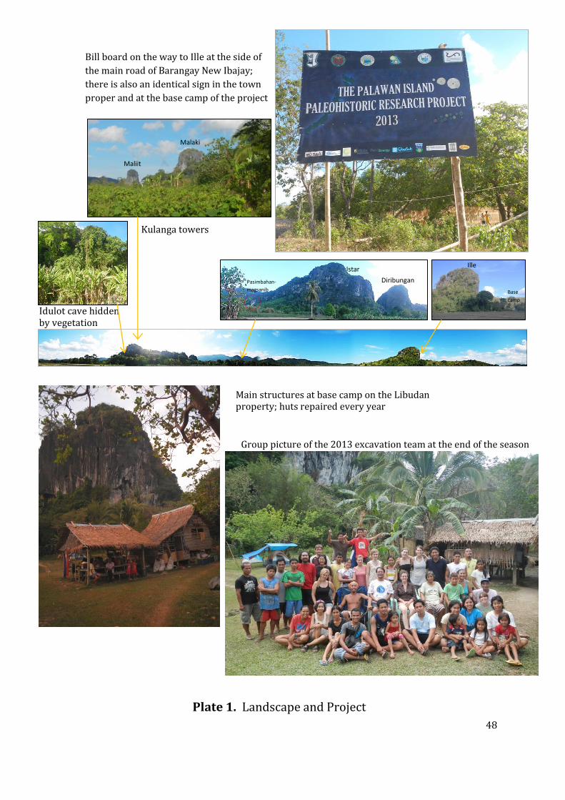
48
Plate 1. Landscape and Project
Bill board on the way to Ille at the side of
the main road of Barangay New Ibajay;
there is also an identical sign in the town
proper and at the base camp of the project
Kulanga towers
Maliit
Malaki
Idulot cave hidden by vegetation
Pasimbahan-
magsanib
Istar
Diribungan
Ille
Base
camp
Main structures at base camp on the Libudan property; huts repaired every year
Group picture of the 2013 excavation team at the end of the season

49
Approaching the
Kulanga river terrace
excavation area
Excavating Trench 1 at Kulanga
river terrace excavation site
Re-opening WMWE Trench at Ille at the
beginning of the excavation season Retrieving and recording cremation
from EWC Trench
The Pasimbahan-Magsanib site after
excavation; Trench A & B newly
backfilled
Inspecting Pasimbahan
Kulanga after reports of
small scale looting
Entrance to the Romie Finez
cave at the foot of the Idulot
tower, Makangit
Last exposed surface at Trench A & B,
Pasimbahan-Magsanib
Dry sieving all excavated sediments;
Ille site
Daily rounds around the site explaining
progress of excavation; Ille site
Curating small find artefacts in the
field using National Museum
accession system
Nightly lecture/discussion at the base
camp
Manual backfilling of the site –
WMWE trench at Ille
Plate 2: Images of method

50
cm
IV-1998-P-50003
cm
IV-1998-P-49639
cm
IV-2007-T-49846
cm
IV-2007-T-50000
cm IV-1998-P-49823
cm IV-1998-P-50070
Incised decorated earthenware sherd
(found under a Tridacna shell)
WMWE, N2W16; Context 2347
Possible lithic blade tool
WMWE, N2W16, Context 705
Stone bead, pos. carnelian
WMWE; Context 2330
Bone bead
WMWE Trench, N5W18,
Context 1838/1835
Worked bone, pos. bead, WMWE Trench, N2W17, Context 2343
Various shell beads
recovered from sieving
WMWE, N1W16;
Context 2331
Plate 3: Examples of Ille Artefacts

51
cm
IV-2007-T-2097
cm
IV-2007-T-1898
cm IV-2007-T-2259
cm IV-2007-T-2371
Incised decorated earthenware sherd Trench A, N2W1, Spit 5, Context 102
Incised and impressed decorated earthenware pedestal foot sherd Trench B, Spit 3, Context 102
Incised and possibly in-filled decorated earthenware sherd Trench B, Context 111
Decorated earthenware pottery sherds Trench A, Context 102, Spit 1
Decorated carinated base jarlet earthenware pottery sherd Trench A, N1W1, Context 102
Carinated, incised earthenware sherd Trench A, N1E2
Plate 4: Idulot Decorated Pottery

52
Incised decorated earthenware jar sherd Trench A
5 cm
Incised decorated earthenware sherd with upturned lip Looter’s Pit IV-2007-T-1988 - 1989
5 cm
5 cm
Plate 5: Idulot Pottery

53
cm
IV-2007-T-2349
cm
IV-2007-T-1017
Incised, impressed and painted earthenware jar sherd Trench A,
Perforated foot rim of earthenware pot
Looter’s pit, Context 10
Crackled green glazed stoneware tradeware ceramic sherd East cave, Surface IV-2007- T- 298
Melo spp. shell scoop Idulot, Trench A, N1E1, Context 102
Plate 6: Idulot Ceramics

54
cm
IV-2007-T-320
cm
IV-2007-T-2392
cm
IV-2007-T-2395
Hammerstone N2W1, Context 102
Decorated metal fragment Trench A, N1E2
5 cm
Andesitic Hammerstone Ante room, surface IV-2007-T-256
Worked civet cat tooth, pos. bead Trench A, N1W2, Context 102
3 cm
IV-2007-T-1797
Metal ring pos. bangle Looter’s pit spoil heap
Plate 7: Idulot Various Artefacts

55
cm
IV-2007-T-266
cm
IV-2007-T-267
cm
IV-2007-T-1836
cm IV-2007-T- 1850
Whole fired clay lingling-o ornament Trench A, Spit 1, Context 102
Hexagonial carnelian stone bead Trench B, Context 108 (surface cleaning)
carnelian stone bead from the spoil heap of the large looter’s pit
Conus Shell disk bead Trench A, Spit 2, Context 102
Broken fired clay lingling-o ornament Trench A, E1N1, Context 102
Plate 8: Idulot Beads

56
5 cm
IV-2007-T-631
3 cm
cm IV-2007-T-2357
Plate 9: Idulot Finds

57
10 cm 5
5 cm
A pedestal earthenware bowl
found curated with a
weathered stone pestle (as
shown) inside the small Finez
cave at the base of the Idulot
tower; this was discovered by
Romie Finez while looking for
other possible sites within the
limestone tower within the
Makangit karst complex
Plate 10: Romie Finez Cave Site Pedestal Pot and Stone Pestle

58
10 cm
Plate 11: The Daga Ritual Specialist’s Wand
An Ethnographic artefact from Idulot
recovered from the spoil mounds
coming from the Looter’s pit at Idulot
Site. Made from hard wood and
intricately carved. The older generations
of Panay settlers in New Ibajay recognize
the object and consistently confirmed it
was used by ritual specialists (Babaylan)
from Panay and called a “Daga”
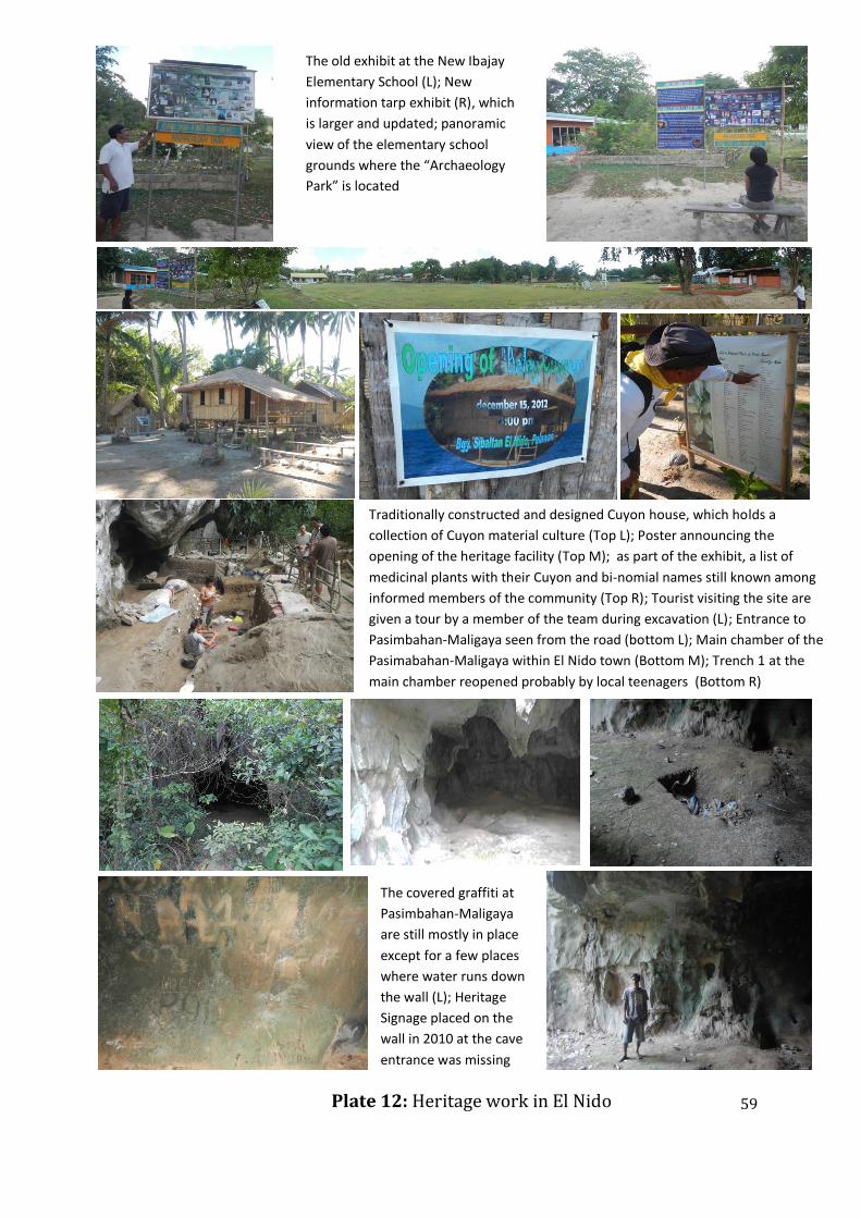
59
Traditionally constructed and designed Cuyon house, which holds a
collection of Cuyon material culture (Top L); Poster announcing the
opening of the heritage facility (Top M); as part of the exhibit, a list of
medicinal plants with their Cuyon and bi-nomial names still known among
informed members of the community (Top R); Tourist visiting the site are
given a tour by a member of the team during excavation (L); Entrance to
Pasimbahan-Maligaya seen from the road (bottom L); Main chamber of the
Pasimabahan-Maligaya within El Nido town (Bottom M); Trench 1 at the
main chamber reopened probably by local teenagers (Bottom R)
Plate 12: Heritage work in El Nido
The old exhibit at the New Ibajay
Elementary School (L); New
information tarp exhibit (R), which
is larger and updated; panoramic
view of the elementary school
grounds where the “Archaeology
Park” is located
The covered graffiti at
Pasimbahan-Maligaya
are still mostly in place
except for a few places
where water runs down
the wall (L); Heritage
Signage placed on the
wall in 2010 at the cave
entrance was missing

60
11. APPENDICES

61
APPENDIX 1
NATIONAL MUSEUM AUTHORIZATION

62
APPENDIX 2
LUMINESCENCE DATING AT SIBALTAN, PHILIPPINES
James Feathers, Ph.D. Luminescence Dating Laboratory
University of Washington Seattle, WA 98195-3412 [email protected]
Four ceramic and eight sediment samples from a coastal archaeological site in the Philippines were submitted for luminescence analysis by Peter Lape and Mark Mabanag, University of Washington. The site is named for the nearby elementary school, Sibaltan, in the municipality of El Nido, Palawan province. Table 1 gives the samples and provenience information. Laboratory procedures are given in the appendix. Table 1. Sibaltan samples UW lab # Sample type trench Field # Depth (cm) Other information
UW2543 Ceramic rim 4 IV-2010-G1-170 205 Context 126
UW2544 Ceramic rim 4 IV-2010-G1-174 205 Context 126
UW2545 Ceramic handle 4 IV-2010-G1-208 197 Context 126
UW2546 Ceramic rim 4 IV-2010-G1-220 205 Context 199
UW2547 Sediment 2 IV-2010-G1-573 206 Below lower post hole
UW2548 Sediment 4 IV-2010-G1-569 160-165 Context 211/220
UW2549 Sediment 4 IV-2010-G1-570 65-67 Context 217/219
UW2550 Sediment 4 IV-2010-G1-571 160-165 Context 222
UW2551 Sediment 4 IV-2010-G1-572 87-91 Context 215/208
UW2552 Sediment 2 IV-2010-G1-568 197 Below upper post hole
UW2553 Sediment 2 IV-2010-G1-574 218 Lower post hole level
UW2554 sediment 2 IV-2010-G1-575 165-175 Upper post hole level
Dose Rates Table 2 provides relevant concentrations, as determined by alpha counting and flame photometry. Also given is the beta dose rate, comparing the value obtained from beta counting with that obtained from the concentrations given in Table 2. Where there are differences of more than 1-sigma, because of disequilibrium in the U decay chain or other factors, the dose rate from beta counting, because it is a more direct measure, is used in age calculation. Differences (marked in bold) were found on only two sediment samples, UW2548 and UW2554,

63
and two ceramic sample, UW2543 and UW2546. Moisture content was assumed to be 80% of saturation value (varying from 16 to 26%) for the ceramics, reflecting moist climate, and 18 ± 6% for sediments, which was the average measured value for 5 of the sediment samples. Table 3 gives the dose rates. They were fairly low for the sediments, including the one collected in association with the ceramics, but this is not atypical of beach sands. Dose rates, for the ceramics, however, were quite high, reflecting the clay content. For the sediments, an internal beta dose from 40K from the K-feldspar grains must be considered. This was measured on single grains (which had also been used for De measurement) from two samples using an EDS attachment to a scanning electron microscope. The results showed %K of 8.5 ± 4.1 for 24 grains of UW2553, and 9.3 ± 3.6 for 15 grains from UW2552. A value of 9 ± 4% was used for all samples. Table 2. Radioactivity
Sample 238U
(ppm)
233Th
(ppm)
K
(%)
Beta dose rate (Gy/ka)
ß-counting α-counting/
flame photometry
UW2543 5.34±0.42 24.7±2.23 2.84±0.23 3.03±0.25 3.73±0.21
UW2544 2.35±0.24 17.8±1.68 2.76±0.20 2.86±0.23 3.05±0.17
UW2545 2.25±0.37 36.7±2.91 2.81±0.09 3.42±0.28 3.59±0.12
UW2546 3.37±0.27 14.4±1.64 2.04±0.11 2.93±0.25 2.52±0.10
Assoc. sed 0.72±0.06 0.98±0.35 0.33±0.03
UW2547 0.72±0.07 2.25±0.56 0.35±0.04 0.45±0.04 0.44±0.03
UW2548 0.75±0.06 0.62±0.30 0.40±0.02 0.52±0.05 0.44±0.02
UW2549 0.57±0.08 4.60±0.75 0.79±0.05 0.88±0.07 0.83±0.05
UW2550 0.63±0.06 2.03±0.49 0.29±0.02 0.42±0.04 0.38±0.02
UW2551 1.07±0.08 1.10±0.40 0.50±0.02 0.59±0.06 0.58±0.02
UW2552 0.87±0.08 2.58±0.62 0.43±0.04 0.52±0.05 0.53±0.04
UW2553 0.80±0.07 1.68±0.48 0.49±0.04 0.53±0.05 0.54±0.04
UW2554 0.75±0.07 1.42±0.45 0.38±0.02 0.58±0.10 0.44±0.02
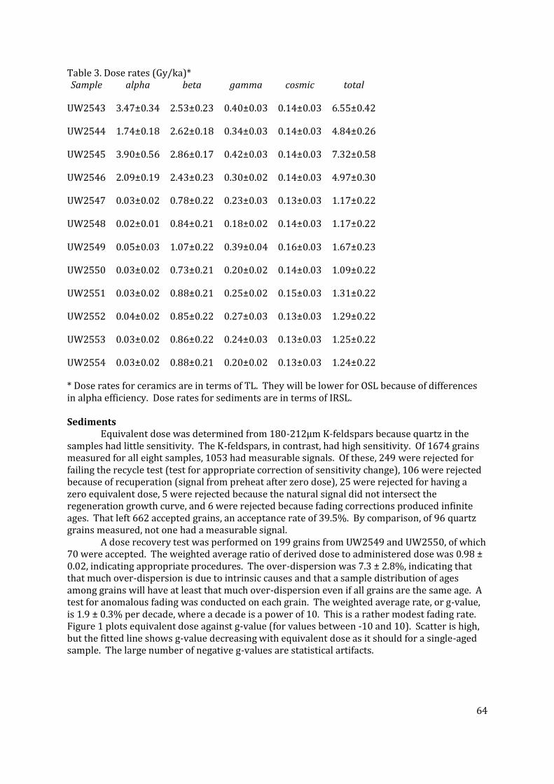
64
Table 3. Dose rates (Gy/ka)* Sample alpha beta gamma cosmic total
UW2543 3.47±0.34 2.53±0.23 0.40±0.03 0.14±0.03 6.55±0.42
UW2544 1.74±0.18 2.62±0.18 0.34±0.03 0.14±0.03 4.84±0.26
UW2545 3.90±0.56 2.86±0.17 0.42±0.03 0.14±0.03 7.32±0.58
UW2546 2.09±0.19 2.43±0.23 0.30±0.02 0.14±0.03 4.97±0.30
UW2547 0.03±0.02 0.78±0.22 0.23±0.03 0.13±0.03 1.17±0.22
UW2548 0.02±0.01 0.84±0.21 0.18±0.02 0.14±0.03 1.17±0.22
UW2549 0.05±0.03 1.07±0.22 0.39±0.04 0.16±0.03 1.67±0.23
UW2550 0.03±0.02 0.73±0.21 0.20±0.02 0.14±0.03 1.09±0.22
UW2551 0.03±0.02 0.88±0.21 0.25±0.02 0.15±0.03 1.31±0.22
UW2552 0.04±0.02 0.85±0.22 0.27±0.03 0.13±0.03 1.29±0.22
UW2553 0.03±0.02 0.86±0.22 0.24±0.03 0.13±0.03 1.25±0.22
UW2554 0.03±0.02 0.88±0.21 0.20±0.02 0.13±0.03 1.24±0.22
* Dose rates for ceramics are in terms of TL. They will be lower for OSL because of differences in alpha efficiency. Dose rates for sediments are in terms of IRSL. Sediments Equivalent dose was determined from 180-212µm K-feldspars because quartz in the samples had little sensitivity. The K-feldspars, in contrast, had high sensitivity. Of 1674 grains measured for all eight samples, 1053 had measurable signals. Of these, 249 were rejected for failing the recycle test (test for appropriate correction of sensitivity change), 106 were rejected because of recuperation (signal from preheat after zero dose), 25 were rejected for having a zero equivalent dose, 5 were rejected because the natural signal did not intersect the regeneration growth curve, and 6 were rejected because fading corrections produced infinite ages. That left 662 accepted grains, an acceptance rate of 39.5%. By comparison, of 96 quartz grains measured, not one had a measurable signal. A dose recovery test was performed on 199 grains from UW2549 and UW2550, of which 70 were accepted. The weighted average ratio of derived dose to administered dose was 0.98 ± 0.02, indicating appropriate procedures. The over-dispersion was 7.3 ± 2.8%, indicating that that much over-dispersion is due to intrinsic causes and that a sample distribution of ages among grains will have at least that much over-dispersion even if all grains are the same age. A test for anomalous fading was conducted on each grain. The weighted average rate, or g-value, is 1.9 ± 0.3% per decade, where a decade is a power of 10. This is a rather modest fading rate. Figure 1 plots equivalent dose against g-value (for values between -10 and 10). Scatter is high, but the fitted line shows g-value decreasing with equivalent dose as it should for a single-aged sample. The large number of negative g-values are statistical artifacts.

65
Figure 1. Table 3 gives the central tendency of the corrected age distributions for each sample, using the central age model (Galbraith and Roberts 2012). Also given is the over-dispersion. Note the over-dispersion is higher than the 7.3% from dose-recovery for all samples except UW2548, which remarkably had zero over-dispersion for 146 grains. To investigate the high over-dispersion and to incorporate the intrinsic variation, a finite mixture model (Galbraith and Roberts 2012) was applied. This model divides the distribution into single-age components, assuming a normalized distribution and a value for intrinsic over-dispersion. Because 7.3% is a minimum, 10% was chosen. For four samples, the distributions were consistent with a single-age. Thus the central age model could be used as the best estimate for depositional age. For one sample, UW2550, the distribution was nearly consistent with a single-age and would be if an over-dispersion of 11% was chosen. The central age model was also used for this sample. The other three samples divided into two components. For UW2553 and UW2554 more than 95% of the grains made up one component. A few older ages are present in both, probably the result of minor post-depositional mixing. The age of the largest component was taken as the best estimate of deposition (Table 3). For UW2551, only 67% of the grains made up the largest component, but I assume that this sample behaves like the others, just showing slightly more post-depositional disturbance. Overall, I conclude that the samples largely represent single depositional ages, with only minor evidence of mixing. The ages are given in bold in Table 3. The distributions are shown in Figure 2 as radial plots. These graphs plot a standardized age value against precision. The age is standardized by the number of standard errors the value is away from some reference point, in this case the age from either the central age model or the largest component of the finite mixture model. A second reference, indicating the second component, is shown on three samples. The graph is constructed such that a line drawn from the origin through any point will intersect the scale on the right at the measured value.

66
Table 3. Ages (rounded to nearest 10) Sample N Age (ka)
(central
age model)
Over-
dispersion
(%/decade)
Age (ka)
(Largest
component)
Proportion of
grains in
largest
component
(%)
Calendar
age (years
AD)
%
error
UW2547 55 1.15±0.07 22.2±7.1 1.15±0.07 100 860±70 5.9
UW2548 146 1.37±0.04 0 1.37±0.04 100 640±40 3.0
UW2549 30 1.49±0.15 28.8±10.3 1.49±0.15 100 520±150 9.9
UW2550 124 1.44±0.06 24.0±4.5 1.44±0.06 100 580±60 3.8
UW2551 86 1.67±0.08 27.9±4.7 1.38±0.08 66.9 630±80 5.8
UW2552 49 1.14±0.07 20.7±7.7 1.14±0.07 100 870±70 6.0
UW2553 68 1.21±0.09 44.4±6.0 1.12±0.05 96.0 900±50 4.5
UW2554 104 1.27±0.06 28.9±4.3 1.24±0.04 98.5 770±40 3.2
Best estimate, given in bold, is used to calculate calendar years, using 2011 as reference. Figure 2. Radial plots UW2547 UW2548
UW2549 UW2550

67
UW2551 UW2552
UW2553 UW2554
The ages form two clusters. All those from trench 4 cluster around AD 600. All those from trench 2 cluster around AD 880, although UW2554 is about 100 years later, in correct stratigraphic order. The various relationships to the post holes cannot be resolved, because the deposition appears quite rapid.

68
Ceramics Equivalent dose on the ceramics was measured by TL, IRSL and OSL as outlined in the appendix. The TL data were characterized by relatively low scatter and broad plateaus. There was sensitivity change between additive dose and regeneration, however, for all samples. Fading was evident for UW2543 and UW2546, but no evidence for fading for UW2545 was documented. No fading test was conducted on UW2544 due to insufficient material. Data are given in Table 4. The IRSL signal was weak in all samples, the OSL signal being 5 to 10 times more intense in magnitude. The IRSL signals also surely faded, so data from them are unreliable. For OSL from 4-6 aliquots were measured for each sample (Table 5). The OSL b-value, which is a measure of the efficiency of alpha irradiation at producing luminescence as compared to beta or gamma irradiation, was typical for quartz for UW2544, but somewhat higher for the other three samples, suggesting some feldspar influence and the possibility of fading. Equivalent dose and b-value results are given in Table 6. Table 4. TL parameters Sample Plateau (°C) 1st/2nd ratio* fit g-value**
UW2543 250-340 3.37±1.36 Linear 4.4±2.9
UW2544 250-380 2.32±0.40 Quadratic No test
UW2545 250-380 1.33±0.11 Linear Not evident
UW2546 260-370 1.57±0.16 Linear 8.0±1.5
*Refers to slope ratio between the first and second glow growth curves. A glow refers to luminescence as a function of temperature; a second glow comes after heating to 450°C. **g-value is the fading rate expressed as % per decade, where a decade is a power of 10. Table 5. OSL/IRSL data
Sample # aliquots* Over-dispersion (%) Dose Recovery (OSL) Approx.
OSL/IRSL
signal ratio
OSL IRSL OSL IRSL Given
Dose (sß)
Recovered
Dose (sß)
UW2543 6 6 15±7 27±11 100 106±10 6
UW2544 4 4 0 46±8 40 43±2 8
UW2545 6 6 0 11±20 80 82±16 10
UW2546 6 4 23±7 33±17 80 81±7 5
* Denotes number of aliquots with measurable signals.

69
Table 6. Equivalent dose Sample Equivalent dose (Gy) b-value (Gy µm2)
TL OSL TL OSL
UW2303 4.51±0.73 10.1±1.20 2.03±0.16 1.46±0.08
UW2304 6.56±1.02 9.19±0.20 1.65±0.14 0.70±0.03
UW2305 10.0±0.93 7.98±0.65 2.36±0.28 1.11±0.17
UW2306 6.95±0.77 7.70±0.76 2.04±0.14 1.24±0.06
In terms of age calculation, the most straightforward is UW2545. The TL signal did not show evidence of fading. The uncorrected age and the OSL age are in statistical agreement. The weighted age of AD 500 ± 120 is in agreement with the ages of sediment samples from Trench 4. For UW2544, no fading test was done on TL, so the age of AD650 ± 230, even though in agreement with other samples from Trench 4, must be considered a possible underestimate. The OSL data were of high quality. The b-value is typical for quartz, and the decays were rapid, indicative of the fast bleaching component. The age, however, is BC 340 ± 160. Technically, this is a good age but much older than the surrounding sediments. The other two samples are more of a puzzle. For UW2546, again the uncorrected TL age (AD 510 ± 190) is in agreement with Trench 4 sediments, but the TL signal shows strong fading, and a correction puts the age at BC 130 ± 370. Such a high fading rate may not have obtained over the life of the sample, so this age could be an overestimate. The OSL age is AD 440 ± 120. Although it could fade, because of a high b-value, it is not likely, given the weak IR signal. Again, this sample is older than the surrounding sediments. Finally, UW2543 gives a fading-corrected TL age of AD1160 ± 200. This is substantially younger than anything else at the site. The OSL age is again much older, AD 170±240, and again could have fading problems but not likely. In sum, one of the ceramics agrees in age with the Trench 4 sediments, but the other three seem to be older. Two of the ceramics, which have the least reliable data, are only slightly older, but UW2544, which has good data, is much older. The ceramic are located at greater depth than the sediment samples. Table 6 summarizes the best age estimates for ceramics and sediments. Sample Depth (cm) type Calendar age (years BC/AD)
Trench 4
UW2549 65-67 Sediment AD 520 ± 150
UW2551 87-91 Sediment AD 580 ± 60
UW2548 160-165 Sediment AD 640 ± 40
UW2550 160-165 Sediment AD 520 ± 150
UW2545 197 Ceramic AD 500 ± 120
UW2543 205 Ceramic AD 170 ± 240
UW2544 205 Ceramic BC 340 ± 160
UW2546 205 Ceramic AD 440 ± 120

70
Trench 2
UW2554 165-175 Sediment AD 770 ± 40
UW2552 197 Sediment AD 870 ± 70
UW2547 206 Sediment AD 860 ± 70
UW2553 218 Sediment AD 900 ± 50
Notes
Laboratory procedures for dating K-feldspar grains Samples were collected with opaque cylinders and capped in the field. The target
particles for dating were fine sand-sized (180-212 µm) potassium feldspars, after it was
determined that adequate signals could not be obtained from quartz grains because of poor
sensitivity. IRSL was used to determine equivalent dose (De), which is a measure of the dose
absorbed since the last zeroing event and is derived by calibrating the natural signal against
signals induced by laboratory irradiation. Dividing De (in Gy, the SI unit of absorbed dose) by
the time-averaged natural dose rate (Gy per unit time) produced each age estimate.
To determine the dose rate, sample radioactivity was first measured in the lab by alpha
counting in conjunction with atomic emission for 40K. Samples for alpha counting were crushed
in a mill to flour consistency, packed into plexiglass containers with ZnS:Ag screens, and sealed
for one month before counting. The pairs technique was used to separate the U and Th decay
series. For atomic emission measurements, samples were dissolved in HF and other acids and
analyzed by a Jenway flame photometer. K concentrations for each sample were determined by
bracketing between standards of known concentration. Conversion to 40K was by natural
atomic abundance. Radioactivity was also measured, as a check, by beta counting, using a Risø
low level beta GM multicounter system. About 0.5 g of crushed sample was placed on each of
four plastic sample holders. All were counted for 24 hours. The average was converted to dose
rate following Bøtter-Jensen and Mejdahl (1988) and compared with the beta dose rate
calculated from the alpha counting and flame photometer results. Cosmic radiation was
determined after Prescott and Hutton (1988). Radioactivity concentrations were translated into
dose rates following Adamiec and Aitken (1998).
To determine equivalent dose, unexposed portions of each sample were first wet-sieved
through a 90 µm screen. The >90 µm fraction was treated with HCl and H2O2, and then dry-
sieved to isolate the 180-212 µm fraction. A portion of 4 samples was etched with 48% HF for
40 min and density separated using a solution of lithium metatungstate set at 2.67 specific
gravity. The quartz obtained by this procedure produced no measurable ultra-violet
luminescence signals when excited by green or blue light. No further work was done with
quartz. Instead, sample preparation focused on feldspars. Non-etched 180-212 µm grains were
density separated using lithium metatungstate set at 2.58 specific gravity. Luminescence
measurements were made on the <2.58 fraction. With feldspars, correction for anomalous
fading, which is athermal loss of trapped charge through time, is required.

71
Single-grain dating was employed for all samples. Single-grain measurements were
made using Risø TL/OSL DA-20 reader, with an IR single-grain attachment. Stimulation used a
150 mW 830 nm IR laser, set at 30% power and passed through an RG 780 filter. Emission was
collected by the photomultiplier through a blue-filter pack, allowing transmission in the 350-
450nm range. IRSL measurements were made at 50°C, and a preheat of 250°C for 1 minute at
5°C/s proceeded each measurement. Exposure for single-grains was for 0.8 s, using the first
0.06 s for analysis and the last 0.15 s for background.
Equivalent dose (De) was determined using the single-aliquot regenerative dose (SAR)
protocol (Murray and Wintle 2000), and as applied to feldspars by Auclair et al. (2003). The
SAR method measures the natural signal and the signal from a series of regeneration doses on a
single aliquot. The method uses a small test dose to monitor and correct for sensitivity changes
brought about by preheating, irradiation or light stimulation. SAR consists of the following
steps: 1) preheat, 2) measurement of natural signal (OSL or IRSL), L(1), 3) test dose, 4) preheat,
5) measurement of test dose signal, T(1), 6) regeneration dose, 7) preheat, 8) measurement of
signal from regeneration, L(i), 9) test dose, 10) preheat, 11) measurement of test dose signal,
T(i), 12) repeat of steps 6 through 11 for i regeneration doses. A growth curve is constructed
from the L(i)/T(i) ratios and the equivalent dose is found by interpolation of L(1)/T(1). A zero
regeneration dose and a repeated regeneration dose are employed to insure the procedure is
working properly.
Test doses for the SAR were about 5-6 Gy. Doses were delivered by a 90Sr beta source,
which provides about 0.11 Gy/s to 180-212 µm grains, and which was calibrated using quartz
irradiated by a gamma source at Battelle Laboratory in Hanford, Washington. The dose
delivered to different grains in single-grain disks varied by an order of magnitude from one end
of the disk to the other. This variation was taken into account when determining doses to
individual grains.
An advantage of single-grain dating is the opportunity to remove from analysis grains
with unsuitable characteristics by establishing a set of criteria grains must meet. Grains are
eliminated from analysis if they (1) had poor signals (as judged from net natural signals not at
least three times above the background standard deviation), (2) did not produce, within 20
percent, the same signal ratio (often called recycle ratio) from identical regeneration doses
given at the beginning and end of the SAR sequence, suggesting inaccurate sensitivity
correction, (3) yielded natural signals that did not intersect saturating growth curves, or (4) had
a signal larger than 10 percent of the natural signal after a zero.
A dose recovery test was performed on some single grains. The luminescence was first
removed by exposure to 400 s of 875nm diodes (122 mW/cm2) and to 1 s of the laser. A dose of
known magnitude was then administered. The SAR procedure was then applied to see if the
known dose could be obtained. Successful recovery was an indication that the procedures were
appropriate.
Anomalous fading was measured using the procedures of Auclair et al. (2003) on single
grains. Age was corrected following Huntley and Lamothe (2001). Storage times after
irradiation of up to 3-5 days were employed.

72
A fading-corrected age was obtained for each suitable grain. Because of varying
precision and other factors, the same value is not obtained for each grain even if all are of the
same true age. Instead a distribution is produced. The common age model and central age
model of Galbraith (Galbraith and Roberts 2012) are statistical tools that were used in
evaluation of age distributions. The common age model controls for differential precision by
computing a weighted average using log values. The central age model is similar except rather
than assuming a single true value it assumes a natural distribution of estimated age values, even
for true single-aged samples, because of non-statistical sources of variation that are not
accounted for in the estimations, such as variation of luminescence properties among grains or
heterogeneity in dose rate. It computes an over-dispersion parameter (σb) interpreted as the
relative standard deviation (or coefficient of variance) of the true age estimates, or, in other
words, that deviation beyond what can be accounted for by measurement error. Empirical
evidence suggests that σb of between 10 to 20 percent for single-grains are typical. Over-
dispersion will be higher for samples that are not single-aged because of partial bleaching or
post-depositional mixing.
For the single-grain age distributions, a finite mixture model was employed for
evaluation. This model (Galbraith and Roberts 2012), which is appropriate for samples where
post-depositional processes have mixed grains of different depositional age, uses maximum
likelihood to separate the grains into single-aged components based on the input of a given σb
value and the assumption of a log normal distribution of each component. The model estimates
the number of components, the weighted average of each component, and the proportion of
grains assigned to each component. The model provides two statistics for estimating the most
likely number of components, maximum log likelihood (llik) and Bayes Information Criterion
(BIC). The finite mixture model is most useful for samples that have discrete rather than
continuous age populations due to mixing.
Ages are determined using a laboratory spread sheet based on Aitken (1995). Ages are
quoted with 1-sigma errors and using 2011 as the reference for before present designations.
Procedures for Thermoluminescence Analysis of Pottery Sample preparation -- fine grain
The sherd is broken to expose a fresh profile. Material is drilled from the center of the cross-section, more than 2 mm from either surface, using a tungsten carbide drill tip. The material retrieved is ground gently by an agate mortar and pestle, treated with HCl, and then settled in acetone for 2 and 20 minutes to separate the 1-8 µm fraction. This is settled onto a maximum of 72 stainless steel discs. Glow-outs
Thermoluminescence is measured by a Daybreak reader using a 9635Q photomultiplier with a Corning 7-59 blue filter, in N2 atmosphere at 1°C/s to 450°C. A preheat of 240°C with no hold time precedes each measurement. Artificial irradiation is given with a 241Am alpha source and a 90Sr beta source, the latter calibrated against a 137Cs gamma source. Discs are stored at room temperature for at least one week after irradiation before glow out. Data are processed by Daybreak TLApplic software.

73
Fading test
Several discs are used to test for anomalous fading. The natural luminescence is first measured by heating to 450°C. The discs are then given an equal alpha irradiation and stored at room temperature for varied times: 10 min, 2 hours, 1 day, 1 week and 8 weeks. The irradiations are staggered in time so that all of the second glows are performed on the same day. The second glows are normalized by the natural signal and then compared to determine any loss of signal with time (on a log scale). If the sample shows fading and the signal versus time values can be reasonably fit to a logarithmic function, an attempt is made to correct the age following procedures recommended by Huntley and Lamothe (2001). The fading rate is calculated as the g-value, which is given in percent per decade, where decade represents a power of 10. Equivalent dose
The equivalent dose is determined by a combination additive dose and regeneration (Aitken 1985). Additive dose involves administering incremental doses to natural material. A growth curve plotting dose against luminescence can be extrapolated to the dose axis to estimate an equivalent dose, but for pottery this estimate is usually inaccurate because of errors in extrapolation due to nonlinearity. Regeneration involves zeroing natural material by heating to 450°C and then rebuilding a growth curve with incremental doses. The problem here is sensitivity change caused by the heating. By constructing both curves, the regeneration curve can be used to define the extrapolated area and can be corrected for sensitivity change by comparing it with the additive dose curve. This works where the shapes of the curves differ only in scale (i.e., the sensitivity change is independent of dose). The curves are combined using the “Australian slide” method in a program developed by David Huntley of Simon Fraser University (Prescott et al. 1993). The equivalent dose is taken as the horizontal distance between the two curves after a scale adjustment for sensitivity change. Where the growth curves are not linear, they are fit to quadratic functions. Dose increments (usually five) are determined so that the maximum additive dose results in a signal about three times that of the natural and the maximum regeneration dose about five times the natural.
A plateau region is determined by calculating the equivalent dose at temperature increments between 240° and 450°C and determining over which temperature range the values do not differ significantly. This plateau region is compared with a similar one constructed for the b-value (alpha efficiency), and the overlap defines the integrated range for final analysis. Alpha effectiveness
Alpha efficiency is determined by comparing additive dose curves using alpha and beta irradiations. The slide program is also used in this regard, taking the scale factor (which is the ratio of the two slopes) as the b-value (Aitken 1985). Radioactivity
Radioactivity is measured by alpha counting in conjunction with atomic emission for 40K. Samples for alpha counting are crushed in a mill to flour consistency, packed into plexiglass containers with ZnS:Ag screens, and sealed for one month before counting. The pairs technique is used to separate the U and Th decay series. For atomic emission measurements, samples are dissolved in HF and other acids and analyzed by a Jenway flame photometer. K concentrations for each sample are determined by bracketing between standards of known concentration. Conversion to 40K is by natural atomic abundance. Radioactivity is also measured, as a check, by beta counting,

74
using a Risø low level beta GM multicounter system. About 0.5 g of crushed sample is placed on each of four plastic sample holders. All are counted for 24 hours. The average is converted to dose rate following Bøtter-Jensen and Mejdahl (1988) and compared with the beta dose rate calculated from the alpha counting and flame photometer results.
Both the sherd and an associated soil sample are measured for radioactivity. Additional soil samples are analyzed where the environment is complex, and gamma contributions determined by gradients (after Aitken 1985: appendix H). Cosmic radiation is determined after Prescott and Hutton (1988). Radioactivity concentrations are translated into dose rates following Adamiec and Aitken (1998).
Moisture Contents
Water absorption values for the sherds are determined by comparing the saturated and dried weights. For temperate climates, moisture in the pottery is taken to be 80 ± 20 percent of total absorption, unless otherwise indicated by the archaeologist. Again for temperate climates, soil moisture contents are taken from typical moisture retention quantities for different textured soils (Brady 1974: 196), unless otherwise measured. For drier climates, moisture values are determined in consultation with the archaeologist. Procedures for Optically Stimulated or Infrared Stimulated Luminescence of Fine-grained pottery.
Optically stimulated luminescence (OSL) and infrared stimulated luminescence (IRSL) on fine-grain (1-8µm) pottery samples are carried out on single aliquots following procedures adapted from Banerjee et al. (2001) and Roberts and Wintle (2001. Equivalent dose is determined by the single-aliquot regenerative dose (SAR) method (Murray and Wintle 2000). The SAR method measures the natural signal and the signal from a series of regeneration doses on a single aliquot. The method uses a small test dose to monitor and correct for sensitivity changes brought about by preheating, irradiation or light stimulation. SAR consists of the following steps: 1) preheat, 2) measurement of natural signal (OSL or IRSL), L(1), 3) test dose, 4) cut heat, 5) measurement of test dose signal, T(1), 6) regeneration dose, 7) preheat, 8) measurement of signal from regeneration, L(2), 9) test dose, 10) cut heat, 11) measurement of test dose signal, T(2), 12) repeat of steps 6 through 11 for various regeneration doses. A growth curve is constructed from the L(i)/T(i) ratios and the equivalent dose is found by interpolation of L(1)/T(1). Usually a zero regeneration dose and a repeated regeneration dose are employed to insure the procedure is working properly. For fine-grained ceramics, a preheat of 240°C for 10s, a test dose of 3.1 Gy, and a cut heat of 200°C are currently being used, although these parameters may be modified from sample to sample. The luminescence, L(i) and T(i), is measured on a Risø TL-DA-15 automated reader by a succession of two stimulations: first 100 s at 60°C of IRSL (880nm diodes), and then 100s at 125°C of OSL (470nm diodes). Detection is through 7.5mm of Hoya U340 (ultra-violet) filters. The two stimulations are used to construct IRSL and OSL growth curves, so that two estimations of equivalent dose are available. Anomalous fading usually involves feldspars and only feldspars are sensitive to IRSL stimulation. The rationale for the IRSL stimulation is to remove most of the feldspar signal, so that the subsequent OSL (post IR blue) signal is free from anomalous fading. However, feldspar is also sensitive to blue light (470nm), and it is possible that IRSL does not remove all the feldspar signal. Some preliminary tests in our laboratory have suggested that the OSL signal does not suffer from fading, but this may be sample specific. The procedure is still undergoing study.
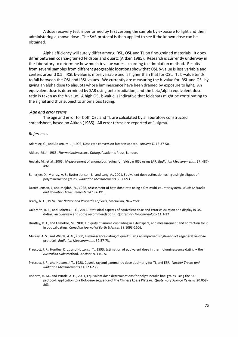
75
A dose recovery test is performed by first zeroing the sample by exposure to light and then administering a known dose. The SAR protocol is then applied to see if the known dose can be obtained. Alpha efficiency will surely differ among IRSL, OSL and TL on fine-grained materials. It does differ between coarse-grained feldspar and quartz (Aitken 1985). Research is currently underway in the laboratory to determine how much b-value varies according to stimulation method. Results from several samples from different geographic locations show that OSL b-value is less variable and centers around 0.5. IRSL b-value is more variable and is higher than that for OSL. TL b-value tends to fall between the OSL and IRSL values. We currently are measuring the b-value for IRSL and OSL by giving an alpha dose to aliquots whose luminescence have been drained by exposure to light. An equivalent dose is determined by SAR using beta irradiation, and the beta/alpha equivalent dose ratio is taken as the b-value. A high OSL b-value is indicative that feldspars might be contributing to the signal and thus subject to anomalous fading. .Age and error terms The age and error for both OSL and TL are calculated by a laboratory constructed spreadsheet, based on Aitken (1985). All error terms are reported at 1-sigma. References Adamiec, G., and Aitken, M. J., 1998, Dose rate conversion factors: update. Ancient TL 16:37-50. Aitken, M. J., 1985, Thermoluminescence Dating, Academic Press, London. Auclair, M., et al., 2003. Measurement of anomalous fading for feldspar IRSL using SAR. Radiation Measurements, 37: 487-
492. Banerjee, D., Murray, A. S., Bøtter-Jensen, L., and Lang, A., 2001, Equivalent dose estimation using a single aliquot of
polymineral fine grains. Radiation Measurements 33:73-93. Bøtter-Jensen, L, and Mejdahl, V., 1988, Assessment of beta dose-rate using a GM multi-counter system. Nuclear Tracks
and Radiation Measurements 14:187-191. Brady, N. C., 1974, The Nature and Properties of Soils, Macmillan, New York. Galbraith, R. F., and Roberts, R. G., 2012. Statistical aspects of equivalent dose and error calculation and display in OSL
dating: an overview and some recommendations. Quaternary Geochronology 11:1-27. Huntley, D. J., and Lamothe, M., 2001, Ubiquity of anomalous fading in K-feldspars, and measurement and correction for it
in optical dating. Canadian Journal of Earth Sciences 38:1093-1106. Murray, A. S., and Wintle, A. G., 2000, Luminescence dating of quartz using an improved single-aliquot regenerative-dose
protocol. Radiation Measurements 32:57-73. Prescott, J. R., Huntley, D. J., and Hutton, J. T., 1993, Estimation of equivalent dose in thermoluminescence dating – the
Australian slide method. Ancient TL 11:1-5. Prescott, J. R., and Hutton, J. T., 1988, Cosmic ray and gamma ray dose dosimetry for TL and ESR. Nuclear Tracks and
Radiation Measurements 14:223-235. Roberts, H. M., and Wintle, A. G., 2001, Equivalent dose determinations for polymineralic fine-grains using the SAR
protocol: application to a Holocene sequence of the Chinese Loess Plateau. Quaternary Science Reviews 20:859-863.

76
12. REFERENCES Aguilera, Melchor L., Jr. 1990. Archaeological survey of El Nido-TayTay, Palawan. Typescript.
Manila: National Museum of the Philippines. Archaeological Studies Program (ASP) 2005-2006. Report on the excavation at Dewil Valley, El
Nido Palawan. Unpublished report. Archaeological Studies Program, University of the Philippines.
Balbaligo, Y. 2009. 'Notes on the 2008 tradeware ceramics from Ille Cave, Palawan, the
Philippines '. In Test pit, 14: 15-16. Balbaligo, Y. 2010. Preliminary Report on the Earthenware Pottery from Ille Cave and
Rockshelter, Palawan, Philippines. Hukay 15:1-20. Barker, G., C. Hunt, and J. Carlos. 2011. "Transition to Farming in Island Southeast Asia:
Archaeological, Biomolecular and Palaeoecological Perspectives," in Why Cultivate? Anthropological and Archaeological Approaches to Foraging-Farming Transitions in Southeast Asia. Edited by G. Barker and M. Janowski, pp. 61-74. Cambridge: McDonald Institute for Archaeological Research.
Barker, G., Ed. (2013). Rainforest foraging and farming in Island Southeast Asia: The
Archaeology of the Niah Caves, Sarawak. Cambridge, McDonald Institute for Archaeological Research.
Barker, G., L. Llyod-Smith, H. Barton, F. Cole, C. Hunt, P. Piper, R. Rabett, V. Paz, and K. Szabó.
2011.Foraging-framing transition at the Niah Caves, Sarawak, Borneo. Antiquity 85:495-
509.
Barton, H. 2006. Ancient starch analysis and usewear studies. in Lewis et al. Early occupation at Ille Cave, New Ibajay, El Nido, Palawan, Philippines: report on the 2005 excavation season. ASP-Library, 48-50.
Basilla, P. G. A. (2012). Morphological and Technological Analysis of the Microperforated Cut
Shell Beads from Ille Site, El Nido, Palawan. MA Thesis, Archaeological Studies Program. Quezon City, University of the Philippines Diliman.
Bautista, Angel P. 1999. Analysis of human remains from Ille Cave, New Ibajay, El Nido, Palawan.
Typescript. Manila: National Museum of the Philippines. Bird, M., E. Boobyer, C. Bryant, H. Lewis, V. Paz, and W. E. Stephens. 2007. A long record of
environmental change from bat guano deposits in Makangit Cave, Palawan, Philippines. Transactions of the Royal Society of Edinburgh: Earth and Environmental Science 98:59-69.
Beyer, H. O. 1921. The Philippines before Magellan. Asia 21:861-866. Beyer, O. H. 1947. Outline review of Philippine archaeology by islands and provinces. Philippine
journal of science 77:205-374.

77
Beyer, H. O. 1948. Philippine and East Asian archaeology and its relation to the origin of the Pacific Islands population. Vol. 29. National Research Council of the Philippines Bulletin. Quezon City: National Research Council of the Philippines.
Beyer, O. H., and J. C. De Veyra. 1947. "Philippine Saga: a pictorial history of the Philippines since
time began," in The Evening News. Manila. Canilao, M. P. 2007. The Tower of Ille Season Eight. Test Pit 11:5. Carlos, J. 2006. ‘Exploring the ‘landscape’ of a pottery sherd: notes on the Ille Cave rice imprints’.
In Test pit, 8: 27-28. Carlos, J. 2009. The metal artifacts of Ille cave: an initial analysis. Test Pit 14:11-14. Carlos, J. 2010. Inferring Subsistence Patterns in the Ille site: The macrobotanical evidence, MS
Thesis, Archaeological Studies Program, University of the Philippines, Diliman. Cayron, J. 1999. Report on the archaeological survey and exploration in Barangay New Ibajay, Il
Nido, Palawan (Feb. 19-25, 1999). Hukay 2(1):47-53. Cayron, J. 2004. The Sinalakan Turtle-Shaped artefact. In Paz, V. (ed). Southeast Asian
Archaeology: Wilhelm G. Solheim Festschrift. Quezon City: University of the Philippines Press, pp. 276-291.
Cayron, J. 2012. Archaeology and Exchange in Palawan Island, Philippines, PhD Dissertation,
National University of Singapore. De la Torre, A.1999. Brief report. Archaeological exploration at Ille Cave site (IV-98-P), New
Ibajay (Formerly Dewil), El Nido, Palawan (January 19-Fehbruary 2 1999). Typescript. Manila: National Museum of the Philippines.
Dizon, E. Z. 2003. New direct dating of the human fossils from Tabon cave, Palawan, Philippines.
Proceedings of the Society of Philippine Archaeologists 1:63-67. Dizon, E., and A. Pawlik. 2010. The Lower Palaeolithic Record in the Philippines. Quaternary
International 223-224:444-450. Dizon, E. Z., Ronquillo, W. P. & Orogo, A. B. 2001. Recent field campaigns at Tabon Cave in
Lipuun Point, Quezon, Palawan, Philippines. Unpublished manuscript, National Museum of the Philippines.
Doherty, C., Beavitt, P. & Kurui, E. 2000. Recent observations of rice temper in pottery from Niah
and other sites in Sarawak. Bulletin of the Indo-Pacific Prehistory Association 20, 147-152. Eusebio, M. S. 2006. 'Notes on the Earthenware Jarlet from the West Mouth'. In Test Pit, 8: 28. Eusebio, M., D. Arriola, J. Carlos, F. Campos, N. de la Concepcion, V. Hernandez, and T. Vitales.
2006. The latest on the 2006 Excavation season at the Ille Rockshelter. Test Pit 8:13-16. Faylona, Marie Grace Pamela. 2006. Notes on the Shells of Ille Cave Eat Mouth (Excavation
Seasons 2004-2005). Test Pit November:32-34.

78
Faylona, Marie Grace Pamela G. 2002. An update on the recent fieldwork in Ille Cave, Palawan. Hukay 4(1):xii.
Faylona, Marie Grace Pamela G. 2003. A preliminary study on shells from Ille Rock Shelter.
Hukay 5:31-49. Paz, V., Lewis, H., W. Ronquillo, E. Robles, J. Carlos, M. Lara, O. Choa , A. Tiauzon, S. O’Donell, V.
Hernandez, D. Cuerdo, J. Cayron, G.Foster, G. Marciani, W. Solheim II. 2012, The Palawan
Island Palaeohistoric Research Project. Report on the 2012 Field Season.
Fox, R. B. 1970. The Tabon Caves: Archaeological explorations and excavations on Palawan Island, Philippines. Vol. 1. Monograph of the National Museum. Manila: National Museum of the Philippines.
Guthe, C. E. 1927. The University of Michigan Philippine Expedition. American Anthropologists
29:69-76. Guthe, C. E. 1929. Distribution of sites visited by the University of Michigan Philippine
Expedition, 1922-1925. Michigan Academy of Science, Arts and Letters 10:79-89. Guthe, C.E. 1935. Gold-decorated teeth from the Philippine Islands. Papers of the Michigan
Academy of Science, Arts, and Letters 20:7-22. Guthe, C.E. 1938. A burial site on the Island of Samar, Philippine Islands. Papers of the Michigan
Academy of Science, Arts, and Letters. 28:29-35. Hara, Yoshiyuki and Jun G. Cayron. 2001. A preliminary report on the excavation of Ille Cave, El
Nido, Palawan. Hukay 3(1):81-92. Harris, E. 1989. Principles of archaeological stratigraphy, 2nd edition. London: Academic Press. Hernandez, V. 2010. Preliminary notes on some thin sections from Ille cave, Palawan. Test Pit
15:12-13. Jago-on, Sheldon Clyde. 2000.Archaeological Program: Ille Rock Shelter 11 March-17 May 2000.
Typescript. Manila: National Museum of the Philippines. Jago-on, Sheldon Clyde. 1998. Field report on the archaeological exploration conducted in El
Nido, Palawan (May 3-9,1998). Typescript. Manila: National Museum of the Philippines. Kress, Jonathan H. 2006. Robert Fox, Negritos and Philippine Prehistory. Hukay 9:49-64. Kress, Jonathan H. 2004. The necrology of Sa’gung rockshelter and its place in Philippine
Prehistory. In V. Paz (ed.) Southeast Asian Archaeology: Wilhelm G. Solheim II Festschrift. Quezon City: UP Press, 239-275.
Kress, Jonathan H. 2002. Report to Wilfredo Ronquillo on excavations conducted at Ille Cave,
Barangay New Ibajay, El Nido Municipality, Palawan, from March 22 to April 10 2002. Lara, M.G.. (2010). A Critique of the current explanation of Human-Induced Modifications in
Human Skeletal Remains. Masters Thesis, University of the Philippines, Diliman.

79
Lara, M., V. Paz, H. Lewis, WG Solheim. (2013). "Bone Modificationsin an Early Holocene
Cremation Burial from Palawan, Philippines." International Journal of Osteoarchaeology DOI: 10.1002/oa.2326.
Lewis, H. 2003. The potential of soil micromorphology in Southeast Asian archaeology:
Preliminary work at Niah Cave, Sarawak, Malaysia, and Ille Cave, Palawan, Philippines. Hukay 5:60-72.
Lewis, H., K. Johnson, and W. Ronquillo. 2007. Preliminary Results of Speleothem Dating from
Tabon Cave, Palawan, Philippines: Moisture increase at the Last Glacial Maximum. Hukay 12:35-50.
Lewis, H., V. Paz, M. Lara, H. Barton, P. Piper, J. Ochoa, T. Vitales, J. Carlos, T. Higham, L. Neri, V.
Hernandez, J. Stevenson, E. Robles, A. Ragragio, R. Padilla, W. Solheim, and W. Ronquillo. 2008. Terminal Pleistocene to mid-Holocene occupation and an early cremation burial at Ille cave, Philippines. Antiquity 82(316): 318-335.
Lewis, H. A., Paz, V., Kress, J., Lara, M.G., Medrana, J. G. L., Carlos, A. J. Piper, P., Hernandez, V.,
Barton, H., Robles, E., Vitales, T. J., Ragragio, A. Solheim, W. G. II and Ronquillo, W. 2006. Early occupation at Ille Cave, New Ibajay, El Nido, Palawan, Philippines: Report on the 2005 excavation season. Unpublished report. British Academy, NERC/Orads & National Museum of the Philippines.
Maeda, Y., F. Siringan, A. Omura, R. Berdin, Y. Hosono, S. Atsumi & T. Nakamura. 2003. Higher-
than-present Holocene mean sea levels in Ilocos, Palawan and Samar, Philippines. Quaternary International, 115-116:15-26.
Marche, A. 1970 (1887). Luzon and Palawan. Manila: The Filipiniana Book Guild. Medrana. J.G.L. 2005. Notes on livestock butchery among the Ifugao and Visayan Migrants of
Palawan. Test Pit (7): 23-28. Medrana, Jack GI. 2002. A report on the human teeth from Ille Cave: An Exercise in Odontology.
Hukay 4(1):35-48. Mijares, Armand Salvador, Sheldon Clyde Jago-on and Jun Cayron. 1998. Report on the
archaeological survey of Lagen, Miniloc, Pangolasian and Cadlao Islands and archaeological mapping of Ille Cave, Dewil, El Nido, Palawan. Typescript. Manila: National Museum of the Philippines.
Munsell soil color charts 2000. New York: New Windsor. Ochoa, J.T. 2008. Terrestrial vertebrates from Ille cave, Northern Palawan, Philippines:
Subsistence and palaeoecology in the Terminal Pleistocene. Masters Thesis, Archaeological Studies Program, University of the Philippines, Diliman.
Ochoa, J. T. 2005. In Dogged Pursuit: A Reassessment of the Dog's Domestication and Social
Incorporation. Hukay 8:37-66.

80
Orogo, A. B. 2000. Archaeological re-investigation and re-excavation of Tabon Cave, Municipality of Quezon, Palawan Province. Unpublished manuscript, National Museum of the Philippines.
Orogo, A. B. 2001. Progress report: result of the archaeological re-investigation and re-
excavation of Tabon Cave, Municipality of Quezon, Palawan. Unpublished manuscript, National Museum of the Philippines.
Orton, C., Tyers, P. and Vince, A. 1993. Pottery in archaeology. Cambridge: Cambridge University
Press. Ostericher, I. 2010. Palawan 2010 Season. Test Pit 16:4-5. Paz, V. (2013). Rethinking the Philippine Neolithic. Philippines, an Archipelago of Exchange. C.
de Monbrison and C. S. Alvina. Paris, Actes Sud, Musée du quai Branly: 50-57. Paz, V. 2012. Accessing Past Cosmologies through Material Culture and the Landscape in the
Philippines. Rountree, K, C. Morris, A.A.D. Peatfield (eds). Archaeology of Spirituality. Springer: New York, 133-162.
Paz, V. 2003a. The Palawan Island Palaeohistoric research: a project proposal. Manuscript.
Archaeological Studies Program, UP-Diliman. Paz, V. 2003b. Annual Report of the Palawan Island Palaeohistoric Research Project. Manuscript.
Archaeological Studies Program. Paz, V. 1998. Participant Report, Archaeological Survey of El Nido, Palawan (with Ethnographic
notes). Typescript. Quezon City: Archaeological Studies Program Library. Paz, V., J. Cayron, and L. Lacsina. 2003. Archaeological Fieldwork Preliminary Report:, Bataraza,
Palawan, May-June 2003. Manuscript. Archaeological Studies Program, UP-Diliman. Paz, V. 2006. Uranium series direct dating of mineralized human bones from Ille site. Test Pit
8:26-27. Paz, V. and T. Vitales. 2008. Sinaunang Anting ? Isang pagtingin sa ilang mga artefak ng Burial
727 sa Ille. Test Pit 13: 30-34. Paz, V. and Ronquillo. W. 2004. Report on the Palawan Island Palaeohistoric Research Season for
2004. Manuscript. Archaeological Studies Program, UP-Diliman.
Pawlik, A. 2009. Is the Functional Approach helpful to overcome the Typology dilemma of Lithic Archaeology in Southeast Asia? Bulletin of the Indo Pacific Prehistory Association (BIPPA) 29:6-14.
Pawlik, A. 2007. Analysis of two polished stone adzes from Ille cave at El Nido, Palawan Island,
Philippines. Hukay 10: 38-59. Pawlik, A. (2004). A geodetic site catchment of the Ille Cave Platform with tilted theodolite and
vector graphics mapping. Southeast Asian Archaeology: Wilhelm G. Solheim II Festschrift. V. Paz. Quezon City, University of the Philippines Press: 225-238.

81
Piper, P., J. Ochoa, V. Paz, H. Lewis, W. Ronquillo. 2008. The first evidence for the past presence of the tiger Panthera tigris (L.) on the island of Palawan, Philippines: Extinction in an island population. Palaeogeography, Palaeoclimatology, Palaeoecology 264:123-127.
Piper, P., J. Ochoa J., Robles E., Lewis H., Paz V. (2011). "Palaeozoology of Palawan Island,
Philippines. ." Quaternary International 233: 142-158. Ragragio, A. M. M. 2012. Archaeology and Emerging Kabikolan. Quezon City: University of the
Philippines Press. Ragragio, A.M. (ed.) 2010. Test Pit 16:3 Reepmeyer, C., M. Spriggs, Anggraeni, P. Lape, L. Neri, W. Ronquillo, T. Simanjuntak, G.
Summerhayes, D. Tanudirjo, and A. Tiauzon. 2011. Obsidian sources and distribution systems in Island Southeast Asia: new results and implications from geochemical research using LA-ICPMAS. Journal of Archaeological Science 38:2995-3005.
Rice, P. M. 1987. Pottery analysis: A source book. Chicago: University of Chicago Press. SEAICE. 2000a Archaeological Study El Nido Community Based Conservation and Development
Program. Quezon City: Archaeological Studies Program Library. SEAICE. 2000b A Brief Summary of the Archaeological Exploration of Ille Cave and Rock Shelter.
Typescript. Archaeological Studies Program Library. Shepard, A. O. 1956. Ceramics for the archaeologist. Washington: Carnegie Institution of
Washington. Solheim, W. G. II. 2004. Excavations of Ille rock shelter, Palawan, Philippines: Preliminary
Report. Archaeological Studies Program. Solheim, W. G. II. 2002. The Archaeology of Central Philippines, Revised edition. Quezon City:
Archaeological Studies Program, University of the Philippines. Solheim, W. G. II. 1998. Palawan Fieldtrip 19-24 October 1998. Typescript. Manila: National
Museum. Solheim, W.G. II. 2000. Archaeological Program: Ille Rock shelter. Typescript. Manila: National
Museum of the Philippines. Solheim, W.G. II. 1999. Ille Rock Shelter field notes 19 January to 31 January 1999. Typescript.
Manila: National Museum of the Philippines. Southeast Asian Ceramics Society 1979. Chinese Celadons and other related wares in Southeast
Asia. Singapore: Southeast Asian Ceramic Society and Arts Orientalis. Stevenson, J., Bandong, R. and Hernandez, V. 2006. Palaeoenvironmental analyses at Ille Cave
and its surrounds. Unpublished specialists’ report on the 2005 field season of the Palawan Island Palaeohistoric Research Project. Archaeological Studies Program, University of the Philippines.

82
Swete Kelly, M.C. and Szabó, K. 2002. Archaeological excavation at Ille Cave, New Ibajay, El Nido, Palawan (April 2002-Eastern Trench). Test Pit 1(1):17-24.
Szabó, K., M.C. Swete Kelly & A. Peñalosa. 2004. Preliminary Results from excavations in the
eastern mouth of Ille cave, northern Palawan. In Paz, V. (ed.). Southeast Asian Archaeology: Wilhelm G. Solheim II Festschrift. Quezon City: University of the Philippines Press, pp. 209-224.
Szabó, K. (2004). Technique and Practice, Shell-working in the Western Pacific and Island
Southeast Asia. PhD Dissertation. Canberra, Australian National University. Teodosio, S. (2004). Preliminary Report of the Makangit Cave Investigation. in Paz, V. &
Ronquillo W. Report on the Palawan Island Palaeohistoric Research Project. Quezon City, Archaeological Studies Program, University of the Philippines Diliman: 30-39.
Wright, L. 2009. Experiencing Ille. Test Pit 14:6-7. Wurster, C. M., M. I. Bird, I. D. Bull, F. Creed, C. Bryant, J. A. J. Dungait, and V. Paz. 2010. Forest
contraction in north equatorial Southeast Asia during the Last Glacial Period Proceedings of the National Academy of Sciences of the United States of America 107:15508-15511.
Vitales, T. 2006. Pagsilip sa isang natatanging artefak ng Ille. Test Pit 8:29-30. Vitales, T. 2009. Form, Function, and Meaning: An Approach in Understanding Melo Shell
Artifacts in Philippine Sites. MA Archaeology, Archaeological Studies Program, University of the Philippines, Diliman.