“Dotting the joins”: a non-reconstructive use of Least Cost Paths to approach ancient roads. The...
27
Alejandro Güimil-Fariña * César Parcero-Oubiña ** § * Laboratorio de Patrimonio, Paleoambiente e Paisaxe (LPPP), Universidade de Santiago de Compostela (USC) Edificio Monte da Condesa, s/n; Campus Sur; 15782 Santiago de Compostela (Spain) [email protected] ** Instituto de Ciencias del Patrimonio (Incipit), Consejo Superior de Investigaciones Científicas (CSIC) San Roque, 2; 15704 Santiago de Compostela; Spain [email protected] § Corresponding author The use of GIS tools to explore questions related to movement in archaeological contexts has been common in the last years. Least Cost Paths (LCP) have been especially successful among them, most often with the objective of predicting or reconstructing the layout of ancient routes. In this paper we propose an alternate use of those tools, aimed at trying to identify the main locations taken into account when defining the routes, rather than at predicting or reconstructing them. Through a rather simple and straightforward methodological sequence, based on the successive testing of very explicit hypotheses, we show how this approach can produce significant new knowledge while dodging some typical issues of LCP analysis. We illustrate the approach with the case study of the Roman roads in the north-west Iberian Peninsula. GIS; Least Cost Paths; Ancient Roads; Route Layout Factors; Roman Roads; NW Iberian Peninsula The study of movement remains a major subject in the analysis of any archaeological context. In the recent years, the spreading of digital tools such as GIS has opened the way for new approaches that have proved fruitful (Llobera 2000, Posluschny 2010, Bevan 2011, Llobera et al 2012, Murrieta-Flores 2012, Verhagen 2013). Among these approaches, the use of least cost paths (LCP) has been especially widespread (Fairén 2004, Rahn 2005, Howey 2007, Fábrega-Álvarez and Parcero-Oubiña 2007, Newhard 2008, Ruestes 2008, Lock and Pouncett 2010, Taliaferro et al 2010, Herzog and Posluschny 2011, White and Barber 2012, White and Surface-Evans 2012, Herzog 2013). When archaeologically approaching the analysis of movement from a GIS-based perspective, the complexity and formality of the context under analysis have conditioned to a great extent the perspective taken. In the case of complex and highly formal
Transcript of “Dotting the joins”: a non-reconstructive use of Least Cost Paths to approach ancient roads. The...

Alejandro Güimil-Fariña *
César Parcero-Oubiña **§
* Laboratorio de Patrimonio, Paleoambiente e Paisaxe (LPPP), Universidade de Santiago
de Compostela (USC)
Edificio Monte da Condesa, s/n; Campus Sur; 15782 Santiago de Compostela (Spain)
** Instituto de Ciencias del Patrimonio (Incipit), Consejo Superior de Investigaciones
Científicas (CSIC)
San Roque, 2; 15704 Santiago de Compostela; Spain
Corresponding author
The use of GIS tools to explore questions related to movement in archaeological contexts
has been common in the last years. Least Cost Paths (LCP) have been especially
successful among them, most often with the objective of predicting or reconstructing the
layout of ancient routes. In this paper we propose an alternate use of those tools, aimed at
trying to identify the main locations taken into account when defining the routes, rather
than at predicting or reconstructing them. Through a rather simple and straightforward
methodological sequence, based on the successive testing of very explicit hypotheses, we
show how this approach can produce significant new knowledge while dodging some
typical issues of LCP analysis. We illustrate the approach with the case study of the
Roman roads in the north-west Iberian Peninsula.
GIS; Least Cost Paths; Ancient Roads; Route Layout Factors; Roman Roads; NW Iberian
Peninsula
The study of movement remains a major subject in the analysis of any archaeological
context. In the recent years, the spreading of digital tools such as GIS has opened the way
for new approaches that have proved fruitful (Llobera 2000, Posluschny 2010, Bevan
2011, Llobera et al 2012, Murrieta-Flores 2012, Verhagen 2013). Among these
approaches, the use of least cost paths (LCP) has been especially widespread (Fairén
2004, Rahn 2005, Howey 2007, Fábrega-Álvarez and Parcero-Oubiña 2007, Newhard
2008, Ruestes 2008, Lock and Pouncett 2010, Taliaferro et al 2010, Herzog and
Posluschny 2011, White and Barber 2012, White and Surface-Evans 2012, Herzog 2013).
When archaeologically approaching the analysis of movement from a GIS-based
perspective, the complexity and formality of the context under analysis have conditioned
to a great extent the perspective taken. In the case of complex and highly formal

archaeological contexts, where obvious material remains of road networks are preserved,
the most common approach has consisted of using LCP as a way to predict, and in some
cases reconstruct, the original route of ancient roads (Bell et al 2002, Ejstrud 2005, Batten
2007, Matsumoto 2008, Siart et al 2008, Stanish et al 2010, Bödőcs 2011, Contreras 2011,
Verhagen and Jeneson 2012, White and Barber 2012). Those can be described as “joining
the dots” approaches, where two or more places are joined with a LCP and the results
compared with the distribution of known nodes of the original road network in order to
assess the archaeological reliability of the predicted paths.
In contrast with those, in complex archaeological contexts there has been a limited use of
digital tools as a way to analytically explore the logics of mobility. Although good
examples exist of the use of digital simulations to explore the role of potential mobility in
Prehistoric contexts (Llobera 2000, Chapman 2003, Wheatley et al 2010), where traces of
actual paths or roads are typically scarce, few examples exist of similar approaches to
better understand the role of mobility in the shaping of politically complex landscapes
(see for instance Richards-Rissetto and Landau 2014). Although the availability of more
abundant data for those complex contexts would allow a fruitful exploration of the logics
behind the development of specific networks of paths and roads, such as identifying the
main nodes of the network, most of the focus has been put on where the roads may be, or
have been, rather than on why they are where they actually are.
In this paper we will explore the possibilities of an analytical, non-reconstructive use of
GIS for the analysis of formal and stable networks of roads, using the Roman roads in the
NW Iberian Peninsula as a case study. Rather than using LCP to “fill the voids” and
discovering the itineraries of the road sections we do not know about, we will focus on
understanding why the remains we do know about follow the routes we still see today.
Rather than asking where a road might have been, we propose asking why the known
remains of a road are where they are: how, in terms of mobility within the territory, we
can grasp the meaning of the known sections of ancient roads within a given geographic
area.
The study of Roman roads is a topic with a long tradition in archaeology. Most often they
have been studied from the formal perspective of the elements involved in their
construction, such as bridges or milestones, the construction techniques and tools, or their
economic use. On the other hand, the search for their remains and the reconstruction of
their likely routes has been a widespread field of research, where digital tools have proved
helpful (Tsokas et al. 2009), including LCP-based approaches, as was abovementioned
(Bödőcs 2008, Ejstrud 2005, Verhagen et al. 2012) or approaches based on network
analysis (Carreras and De Soto 2013).
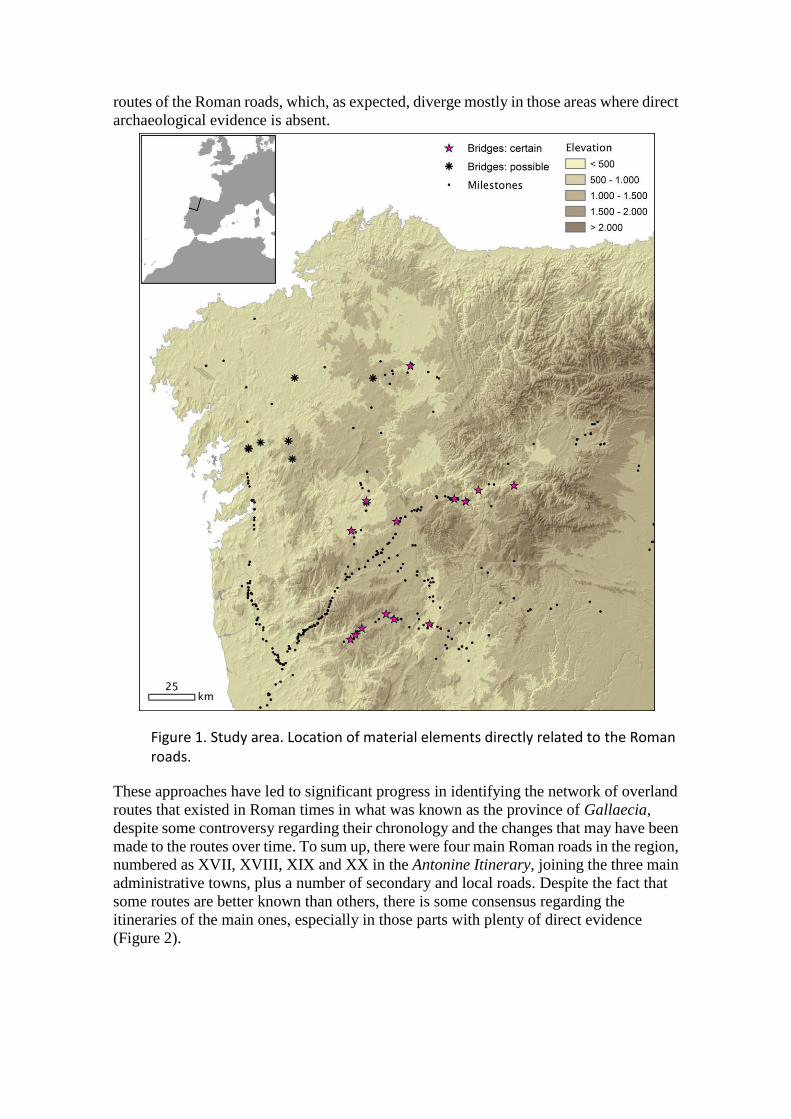
The selected study area, the north-west of the Iberian Peninsula, shows a rather
impressive number of archaeological elements related to Roman roads, essentially a large
number of milestones. To a great extent, their layout indicates quite obviously the original
route of the roads in many areas of the region (Figure 1), though some significant voids
also exist. For that reason, and as elsewhere, the study of Roman roads has focused
mostly on reconstructing the routes, using a combination of different data: classical
written sources, epigraphy and milestones, remains of sections of the roads in the
landscape, or place names (Roldán Hervás 1975, Caamaño Gesto 1984, Peña Santos
1990-1, Franco Maside 2000, 2001, Rodríguez Colmenero et al 2004, Pérez Losada 2002,
Moralejo Álvarez 2009). As a result, a number of proposals exist about the probable
routes of the Roman roads, which, as expected, diverge mostly in those areas where direct
archaeological evidence is absent.
Figure 1. Study area. Location of material elements directly related to the Roman roads.
These approaches have led to significant progress in identifying the network of overland
routes that existed in Roman times in what was known as the province of Gallaecia,
despite some controversy regarding their chronology and the changes that may have been
made to the routes over time. To sum up, there were four main Roman roads in the region,
numbered as XVII, XVIII, XIX and XX in the Antonine Itinerary, joining the three main
administrative towns, plus a number of secondary and local roads. Despite the fact that
some routes are better known than others, there is some consensus regarding the
itineraries of the main ones, especially in those parts with plenty of direct evidence
(Figure 2).
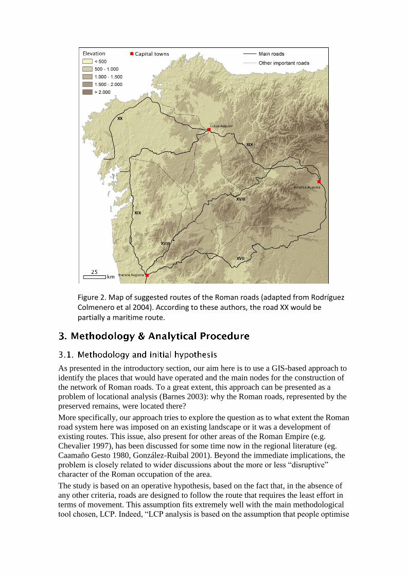
Figure 2. Map of suggested routes of the Roman roads (adapted from Rodríguez Colmenero et al 2004). According to these authors, the road XX would be partially a maritime route.
As presented in the introductory section, our aim here is to use a GIS-based approach to
identify the places that would have operated and the main nodes for the construction of
the network of Roman roads. To a great extent, this approach can be presented as a
problem of locational analysis (Barnes 2003): why the Roman roads, represented by the
preserved remains, were located there?
More specifically, our approach tries to explore the question as to what extent the Roman
road system here was imposed on an existing landscape or it was a development of
existing routes. This issue, also present for other areas of the Roman Empire (e.g.
Chevalier 1997), has been discussed for some time now in the regional literature (eg.
Caamaño Gesto 1980, González-Ruibal 2001). Beyond the immediate implications, the
problem is closely related to wider discussions about the more or less “disruptive”
character of the Roman occupation of the area.
The study is based on an operative hypothesis, based on the fact that, in the absence of
any other criteria, roads are designed to follow the route that requires the least effort in
terms of movement. This assumption fits extremely well with the main methodological
tool chosen, LCP. Indeed, “LCP analysis is based on the assumption that people optimise

the costs of routes which are taken frequently, and that, over time, this leads to the
development of the real-world equivalent of an LCP” (Herzog 2013). Of course, we are
well aware that this is usually a rather problematic assumption, since there are many other
conditioning factors that affect mobility, both of cultural and physical nature (e.g. Llobera
2000, Cameron 2013). Although this might be a major issue when trying to predict or
reconstruct ancient routes, our approach here minimizes those risks, since it considers
that as a hypothesis, and not as an expected behaviour. What we are trying to check is to
what extent it is possible to understand the Roman road network based on this hypothesis,
or not; and if not, to obtain additional information in order to understand which other
factors could have conditioned the network.
The selected case study is also very well suited to such an approach, since it consists of a
highly formalized network of paths, developed within the context of a complex social and
political formation such as the Roman state. We are not dealing here with fluid, unstable
and easily changing forms of mobility, but with a context where a strong discipline was
imposed over the landscape. This also produced a significant ensemble of material
remains that constitute a rich source of evidence.
Within this problem-oriented approach, the study follows an analytical sequence based
on the proposition of a series of hypotheses, from the simpler to the more complex,
related to a very basic idea: roads are intended to join places. So the sequence of analysis
consists of three very basic steps:
To define a series of locations that could have served as primary movement
‘nodes’ (starting or arrival points).
To model the different effort required to cross through the terrain, expressed in
terms of ‘cost’ and ‘accumulated cost’, that will be the basis to delineate the
optimal corridors to join those locations across the landscape.
To define a series of elements to compare the results provided by our hypothesis,
and the situation they represent. In this case, we require direct, spatially located
indicators of the actual route of the Roman roads.
Other issues could be argued regarding the calculation of movement costs and LCP
through the available GIS software, issues related to the imperfection of the GIS
representation of actual movement in a landscape (Herzog 2013, Kantner 2012).
However, considering the scale of our analysis (see next section), they can be regarded as
minor issues.
In terms of methodology and data, two critical questions must be addressed to perform a
LCP analysis: the selection of a procedure to theoretically model the costs of movement
across the terrain, and the selection of the data needed to implement that model (the
fundamentals of cost analysis are well explained elsewhere, for instance in Conolly and
Lake 2006 or Herzog 2013).
The theoretical modelling of human movement has been the subject of different proposals
(Pandolf et al. 1977, Tobler 1993, Llobera and Sluckin 2007, Herzog 2013 [based on
Minetti et al. 2002]). Most of them are designed to predict movement costs due to
variations in the terrain slope, and are aimed at modelling human walking movement. In
our case, considering the conditions and needs of the Roman road system, a cost function
designed to model wheeled movement (such as the one in Herzog 2013) could seem the
obvious choice. However, as was mentioned above, one of our main aims is to explore to
what extent the Roman roads may be related with pre-existent, pedestrian routes, so we
need to stick to walking costs.
Among the existing cost functions, perhaps the best-known and more widely used (at
least for archaeological purposes) is the ‘hiking function’ developed by W. Tobler (1993).
It was our first choice here, considering the good results it provided in previous research
developed in the same region (Fábrega-Álvarez and Parcero-Oubiña 2007). Besides that,
some experiments have proved that Tobler’s function produces reliable results when
tested on the field (Kondo and Seino 2010). However, a lively debate exists as to what
extent this might be the best option available. While it has been argued that other
proposals may be more accurate in the representation of how the slope affects human
walking (Llobera and Sluckin 2007, Kantner 2012, Herzog 2013), it has also been noted
that, in practical terms, differences are typically not very big (Verhagen and Jeneson 2012:
127) 1.
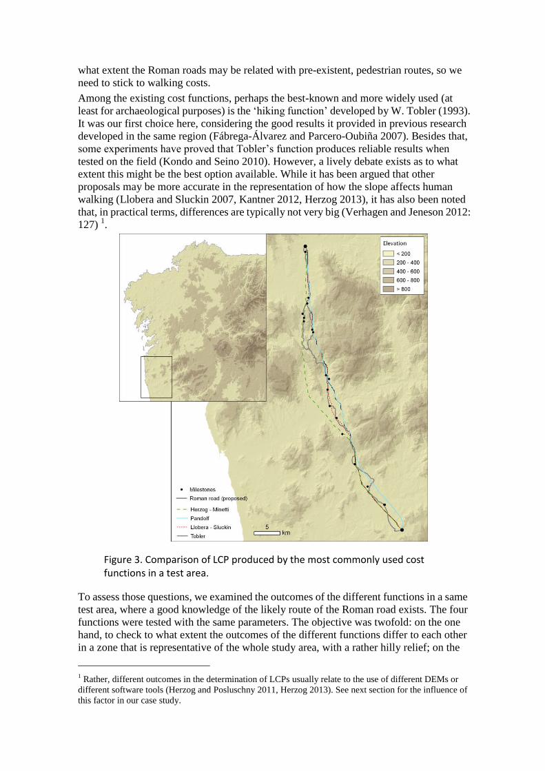
Figure 3. Comparison of LCP produced by the most commonly used cost functions in a test area.
To assess those questions, we examined the outcomes of the different functions in a same
test area, where a good knowledge of the likely route of the Roman road exists. The four
functions were tested with the same parameters. The objective was twofold: on the one
hand, to check to what extent the outcomes of the different functions differ to each other
in a zone that is representative of the whole study area, with a rather hilly relief; on the
1 Rather, different outcomes in the determination of LCPs usually relate to the use of different DEMs or
different software tools (Herzog and Posluschny 2011, Herzog 2013). See next section for the influence of
this factor in our case study.

other hand, to pragmatically evaluate the adequacy of each function for our specific
purpose by comparing their results with the most probable route of the Roman road.
The cost functions assessed were those by Pandolf et al. (1977), Tobler (1993), Llobera
and Sluckin (2007) and Herzog (2013, based on Minetti et al. 2002)2. The results (Figure
3) show that the derived LCP produce two basic layouts: while those based on Tobler,
Llobera-Sluckin and, to a great extent, Pandolf et al. follow a similar route well in line
with most of the known milestones, the one derived from Herzog shows a lower
correlation. It is especially remarkable the similarity between the LCP produced by
Tobler and Llobera-Sluckin functions.
For quantification, the similarity between these LCP and the most probable route of the
Roman road was measured in two ways. First, we directly measured the linear distance
between each LCP and all the known in situ milestones in this area. As seemed at first
sight, the histogram (Figure 4) shows that the first three functions are in general close to
the location of the known milestones. Second, we compared each LCP with the proposed
route of the Roman road in this area, following the procedure suggested by Goodchild and
Hunter (1997) to evaluate the similarity between two linear features: it is based on
determining the proportion of a linear feature (in our case each LCP) that lie within a
buffer distance from what are taken as the “true” linear features (the proposed
reconstruction of the Roman road). The results (Table 1), shown here for two buffers of
500 and 1,000 m, offer a complementary measure that reinforces the best performance of
the function by Llobera and Sluckin for this particular context and case.
Figure 4. Histogram of distance between known in situ milestones and different LCP in the test area.
Besides slope, water courses were the only other features considered in our determination
of walking costs, although in a very specific way. Water courses are problematic when
2 The parameters chosen for Pandolf’s formula were: speed = 5 km/h, load = 0, terrain factor = 1.

calculating movement costs, for two reasons. On the one hand, they are portions of the
terrain not suitable for most forms of movement: one cannot walk on the water. On the
other hand, they can be crossed but usually only in specific points, and this can impose
strict limitations on the ability of humans to move.
Table 1. Similarity between different LCP and the probable route of the Roman road between Bracara and Tude.
The first problem is purely operational: since river courses are areas with slopes gentler
than most of the surrounding terrain in this region, they typically may be regarded by the
software as theoretically good areas for movement (Figure 5). This might be a significant
problem in our area, due to the huge number of watercourses. To avoid that effect, to
prevent the optimal routes from following river courses, we assigned a single cost value
to every water course equivalent to move across a slope of 0.27 gradient (15º). That figure
was obtained after some experimentation in previous research (Fábrega-Álvarez and
Parcero-Oubiña 2007) and allows a good performance in avoiding the effect while
allowing LCP to cross any river.

Figure 5. Due to topographic reasons, LCP can follow water courses if only terrain slope is considered as a cost factor.
The second problem, the effects in movement of the existence of some specific places to
cross the rivers, is of a different nature. In our case, it is actually not a precondition of the
analysis but a part of what we want to explore. We actually know the location of some
Roman bridges (Figure 1). What we want to find out is to what extent those places,
spatially located indicators of the actual route of the Roman roads, match the routes
theoretically determined by the LCP analysis. Only in a later phase of the analysis we will
make a different use of one of those bridges (see section 4.3).
To sum up, after the tests performed, we selected for our analysis the functions by
Llobera-Sluckin and Tobler as a way to double check the significance of the LCP we will
produce. Both were implemented anisotropically with the modules PathDistance and
CostPath in ArcGIS 9.3. To include the correction factor for water courses, we set a
buffer zone of 50 m around every single river and assigned those areas the above
mentioned cost factor 3.
3 PathDistance allows the combination of anisotropic and isotropic factors into a single calculation.

The main input source needed to determine the costs of walking across the landscape is a
DEM representing the topography of the terrain. We needed a DEM covering uniformly
all the area of interest, a vast territory that includes portions of Spain and Portugal. This
posed some practical difficulties for using geographical data produced at the national
level. While for Spain a number of different DEM are available nowadays from the
Instituto Geografico Nacional (cell sizes of 5, 25 and 200 m) 4, for Portugal only a 50 m
DEM is available for public use so far 5. Besides differences in cell size, they are
heterogeneous both in origin (photogrammetry or lidar data for Spain, interpolation of
digitized contours for Portugal) and spatial reference systems used (ETRS89 for Spain,
Lisboa-Hayford datum for Portugal). That all makes very problematic to mosaic them
into a continuous, uniform surface that represents relief in a homogeneous and
comparable way across the whole area of interest.
Global models as SRTM or Aster GDEM are free of those problems, but their spatial
resolution and, in some cases, accuracy might be problematic. Despite its higher
resolution (ca. 30 m), it has been observed that Aster GDEM includes important
systematic errors (see for Spain Gómez-Gutierrez et al. 2011), while SRTM (ca. 80 m)
has proved an acceptable average accuracy for some areas of Portugal and Spain
(Gonçalves and Fernandes 2005, Gómez-Gutierrez et al. 2011), so we considered it as our
DEM of choice.
In order to evaluate its suitability, we used the same test zone to compare the outcomes of
two LCP calculated with the same parameters (cost functions) using the SRTM and a 10
m DEM produced by ourselves from the interpolation of contours from 1:5.000 maps.
The results (Figure 6) show a remarkable similarity in both LCP, indicating that the
SRTM is providing a sufficient representation of the topography, at least in terms of the
influence of the terrain slope on human movement and at the scale of our analysis.
4 http://centrodedescargas.cnig.es/CentroDescargas
5 http://www.igeo.pt/DadosAbertos/Listagem.aspx

Figure 6. Comparison of LCP calculated with the SRTM and a 10 m cell size DEM.
As we mentioned above, water courses are a second essential data layer for our analysis.
As was the case for topography, we discarded the combination of different existing river
layers for their lack of homogeneity, uniformity and consistency between Spanish and
Portuguese data. As an alternative, we produced our own representation of the water
courses in the area through a flow accumulation analysis of the selected DEM.
Regarding archaeological data, a selection of all the features related to the Roman road
network was made based on different bibliographic sources and inventories. Milestones
are the most numerous and appropriate element of the record directly associated with the
route of the ancient roads (Figure 1). The spatial location of those elements was taken
from Rodríguez Colmenero et al (2004). Only those with a well-known original in situ
location were considered in our study. Roman bridges were also considered, following
the studies of Alvarado Blanco et al (1990) and the Portuguese national monuments
record data available on-line 6.
6 http://arqueologia.igespar.pt/
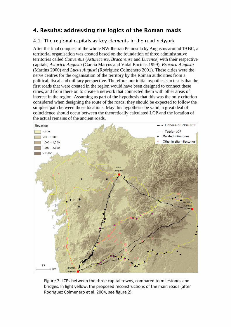
After the final conquest of the whole NW Iberian Peninsula by Augustus around 19 BC, a
territorial organisation was created based on the foundation of three administrative
territories called Conventus (Asturicense, Bracarense and Lucense) with their respective
capitals, Asturica Augusta (García Marcos and Vidal Encinas 1999), Bracara Augusta
(Martins 2000) and Lucus Augusti (Rodríguez Colmenero 2001). These cities were the
nerve centres for the organisation of the territory by the Roman authorities from a
political, fiscal and military perspective. Therefore, our initial hypothesis to test is that the
first roads that were created in the region would have been designed to connect these
cities, and from there on to create a network that connected them with other areas of
interest in the region. Assuming as part of the hypothesis that this was the only criterion
considered when designing the route of the roads, they should be expected to follow the
simplest path between those locations. May this hypothesis be valid, a great deal of
coincidence should occur between the theoretically calculated LCP and the location of
the actual remains of the ancient roads.
Figure 7. LCPs between the three capital towns, compared to milestones and bridges. In light yellow, the proposed reconstructions of the main roads (after Rodríguez Colmenero et al. 2004, see figure 2).
To test this first hypothesis, we only need to determine the LCP between the three capital
towns, and compare them with the known routes. Choosing an anisotropic approach, as
mentioned in section 3.2.1., implies the potential production of 2 routes for every
connection (A to B and B to A), which may differ considerably (Herzog 2013). In our
case, the nature of the archaeological evidence helps in deciding which route makes more
sense, since it has been documented that most of the Roman road network in the region
had its origin in Bracara, being Asturica the main destination (Rodríguez Colmenero et al
2004). The LCP shown in the figures and used in the following calculations were chosen
following that argument.
Despite that, we calculated all the possible LCP between these three main nodes, in order
to obtain a measure of their similarity. The results (Table 2), measured again following
the procedure suggested by Goodchild and Hunter (1997), show a remarkable
coincidence in all cases, even within such a small buffer distance as 100 m. Only the
Tobler-based LCP between Lucus and Bracara show two completely different routes for
the two directions, the one starting in Bracara (Figure 7) having a much higher
coincidence with the spatial distribution of milestones. The results of this test point
towards the existence of some remarkable topographic determinants for mobility in this
region at a general scale, which strengthens the potential value of the approach proposed
here.
Table 2. Similarity of the two possible anisotropic paths (A to B and B to A) between the three Roman capitals.
At first sight, if we compare the results with the general outline of the network (Figure 7,
see also Figure 2) we can see how the three LCP might be the theoretical equivalents of
road XVII (Bracara-Asturica), a section of road XIX (Lucus-Asturica) and a secondary
road between Bracara and Lucus. We can measure how close the theoretically
determined LCP are to their “true” equivalents in the same two ways previously defined
(see section 3.2.1): by comparing them with the location of the milestones belonging to
each particular road section (highlighted in black in Figure 7) and with the proposed route
of the roads (Figure 8, Table 3). We won’t consider here the road between Lucus and
Asturica because of the very few in situ indicators of the original route.
The results support the idea that the logic of LCP connecting the main towns in the region
allows us to understand only a small part of the road network: only the route between
Bracara and Lucus (Figure 2), which has been considered by some as a later road, maybe
built in the Late Empire, although an early origin has also been suggested (Pérez Losada
2002: 161). For that particular case, the LCP delineate a corridor that is significantly
coincident with the location of in situ milestones and bridges. Coincidence with the
proposed route of the road is not so high (Table 3), but it must be noted that the

reconstruction (taken from Rodríguez Colmenero et al. 2004) is quite speculative in those
sections where no direct evidence is available.
However, in the case of the road between Bracara and Asturica only a short section near
Bracara shows a good coincidence. For most of the road, both the in situ indicators and
the proposed reconstruction have a very different layout than those of the LCP.
Figure 8. Histograms of distances between in situ indicators of Roman roads (milestones and bridges) and corresponding LCP for routes between Bracara-Lucus (top) and Bracara-Asturica (bottom).
Table 3. Similarity between LCP and the proposed route of the Roman roads.
At this point two options exist. The first is that most of the roads followed a logic other
than that of the optimal pedestrian connection between places. The second is that other
positions in the landscape operated as primary nodes when building the road network.
Although the first might explain the differences between LCP and actual roads in the
areas examined in the previous section, it does not allow to understand the remaining
parts of the network.
Considering again that the organization and administration of the Roman province was
based on urban, or semi-urban, settlements, we decided to extend our hypothesis by
incorporating the secondary Roman settlements in the region, those on a scale
immediately below the regional capitals. In this stage, the nodes included are those
referred to by Pérez Losada as “secondary settlements”: Iria Flavia, Tude, Flavium
Brigantium and Aquae Flaviae (Figure 9, Pérez Losada 2002, Rodríguez Colmenero
1997). All of them are centres of population with an urban or semi-urban layout, some of
which contain remains of public architecture and a large number of Roman epigraphs,
associated with worship and official activities. Another characteristic feature, except in
the case of Aquae Flaviae, is their location as riverside ports (Tude and Iria) or sea ports
(Flavium Brigantium) which were of great importance for long-term navigation and trade.
Finally, they are all referred to in different classical sources as mansio (wayside inns),
although in these cases their urban development mean that they played a more significant
role than mere points on the road network.
Considering again the paucity of first hand information about the road network around
Flavium Brigantium (few milestones and, consequently, highly speculative
reconstructions of the roads), we will not include it in our analysis. Compared to the
results obtained in the previous analysis (section 4.1), now we have add up theoretical
equivalents for the full road XIX, and we have modified the route between Bracara and
Asturica by introducing the intermediate node of Aquae Flaviae.
When comparing these new results with the known evidence of the roads, a greater
understanding of the network is obtained, though still not full (Figure 10, Table 4). The
route of the road XIX is highly coincident with the newly calculated LCP, with most of
the in situ indicators located less than 2 km from the theoretical optimal routes. The
coincidence between the LCP and the reconstructed road is not so determinant, but it is
very much influenced by the strong disagreement in the section between Iria and Lucus,
where again we find just a couple of in situ elements and the reconstruction is highly
speculative (compare Figure 1 and Figure 2). If we evaluate only the best known section
between Bracara and Iria, the similarity increases significantly (Table 4).

Figure 9. LCP between the regional capitals and the secondary settlements. In light yellow, the proposed reconstructions of the main roads (after Rodríguez Colmenero et al. 2004, see figure 2).
The results suggest that when defining the layout of the road XIX, the town of Iria was
among the primary nodes chosen. This means that it was were probably a crossing point
that were necessary in order to establish the layout of the roads; in other words, when
defining the road sections, Iria was a primary node through which the roads had to pass, a
primary node within the Roman communications network. The case of Tude is not so
clear if we only take into account the analysis shown here, since Tude might have been
established as an intermediate point on the way to Iria.
As regards the road between Bracara-Aquae Flaviae-Asturica (via XVII), we find again
that the coincidence between LCP and the road is very low, no matter how we measure it.
It is obvious that in this case we are still far from understanding the logic of this particular
road.
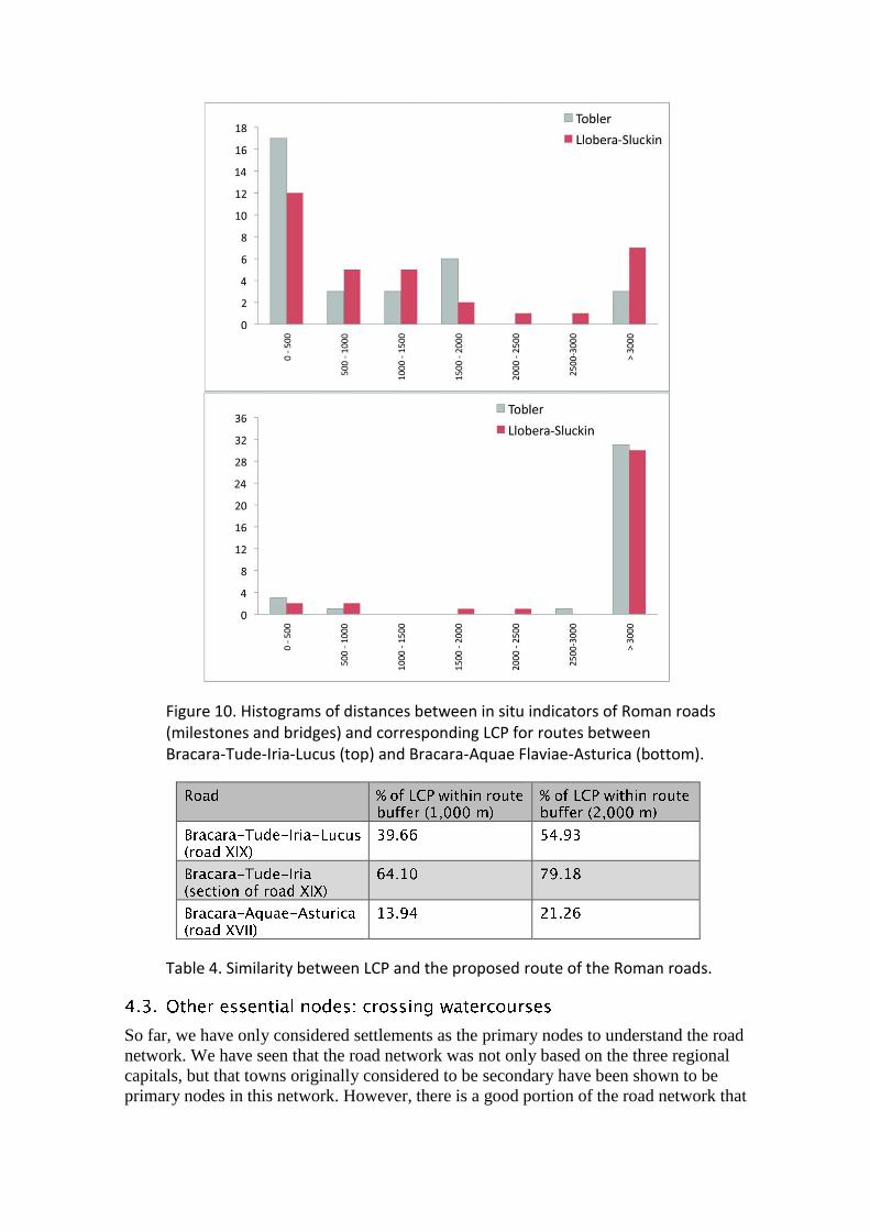
Figure 10. Histograms of distances between in situ indicators of Roman roads (milestones and bridges) and corresponding LCP for routes between Bracara-Tude-Iria-Lucus (top) and Bracara-Aquae Flaviae-Asturica (bottom).
Table 4. Similarity between LCP and the proposed route of the Roman roads.
So far, we have only considered settlements as the primary nodes to understand the road
network. We have seen that the road network was not only based on the three regional
capitals, but that towns originally considered to be secondary have been shown to be
primary nodes in this network. However, there is a good portion of the road network that

is still beyond our understanding. This applies especially to most of the via XVII and the
whole via XVIII (Figure 2).
Moving beyond the significance of settlements, we have looked for other types of spatial
features that could have acted as primary nodes. At this point, we could have involved
any type of geographical elements whose significance for mobility in the region we
wanted to test. Considering the geographical characteristics of the region, and the
available historical knowledge about it, we have proposed that crossing points of rivers
could have also played an essential role. Using these bridges as nodes in these analyses is
largely based a previous work (Fábrega-Álvarez and Parcero-Oubiña 2007) where the
key role of the crossing points for the main rivers as principal nodes in organising the
historical road network in this region was explored.
The location of a series of bridges of certain or likely Roman origin is known in the region
(see Figure 1). However, not all of them should be expected to have played an equivalent,
primary role. Actually, in principle a bridge is a device to allow the communication of
two external places, and not a place in itself to start from or arrive at. In fact, after some of
the analyses already made, the location of some of those bridges can be well understood
yet: crossing points placed within the LCP that were joining primary nodes (see for
instance the two bridges located in the LCP between Bracara and Lucus or the possible
Roman bridge in via XIX). The point here was to select which of those bridges could have
acted as primary nodes, which are in places that could be radically conditioning the
possibilities of movement.
Considering both the previous results (we are interested here in understanding those parts
of the network beyond explanation), the geographical characteristics of the region and the
material characteristics of the preserved bridges, we proposed to select one single bridge,
Ponte Bibei, as the new node to be explored. Ponte Bibei is one of the most monumental
Roman bridges in the region, and the only major one that is located out of a settlement
place.
The results allow to grasp a much better understanding of the network, especially of the
so far elusive via XVIII (Figure 11). Although there is still some divergence (as should be
expected and will be discussed in section 5), the new LCP route is rather coincident with
the alignment of the known remains of the road, as the quantification also show (Figure
12, Table 5). Although the coincidence between LCP and in situ indicators is rather high,
the comparison between LCP and the proposed original roads (Table 5) is not as high as
the map may suggest. Again, this is basically caused by the notable difference in the
section of the via XVIII near Asturica, where the reconstruction made by Rodriguez
Colmenero et al. (2004) proposes a noticeable, and debatable, detour.
Figure 11. LCP including Ponte Bibei (yellow star) as a primary node. In light yellow, the proposed reconstructions of the main roads (after Rodríguez Colmenero et al. 2004, see figure 2).
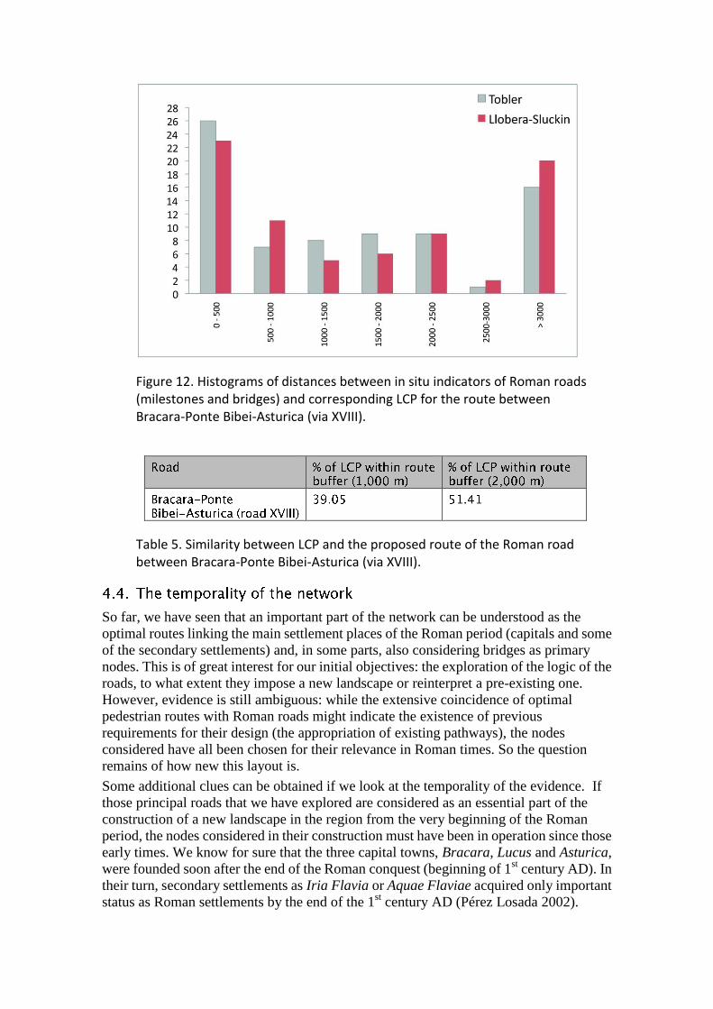
Figure 12. Histograms of distances between in situ indicators of Roman roads (milestones and bridges) and corresponding LCP for the route between Bracara-Ponte Bibei-Asturica (via XVIII).
Table 5. Similarity between LCP and the proposed route of the Roman road between Bracara-Ponte Bibei-Asturica (via XVIII).
So far, we have seen that an important part of the network can be understood as the
optimal routes linking the main settlement places of the Roman period (capitals and some
of the secondary settlements) and, in some parts, also considering bridges as primary
nodes. This is of great interest for our initial objectives: the exploration of the logic of the
roads, to what extent they impose a new landscape or reinterpret a pre-existing one.
However, evidence is still ambiguous: while the extensive coincidence of optimal
pedestrian routes with Roman roads might indicate the existence of previous
requirements for their design (the appropriation of existing pathways), the nodes
considered have all been chosen for their relevance in Roman times. So the question
remains of how new this layout is.
Some additional clues can be obtained if we look at the temporality of the evidence. If
those principal roads that we have explored are considered as an essential part of the
construction of a new landscape in the region from the very beginning of the Roman
period, the nodes considered in their construction must have been in operation since those
early times. We know for sure that the three capital towns, Bracara, Lucus and Asturica,
were founded soon after the end of the Roman conquest (beginning of 1st century AD). In
their turn, secondary settlements as Iria Flavia or Aquae Flaviae acquired only important
status as Roman settlements by the end of the 1st century AD (Pérez Losada 2002).
However, the analysis shown here illustrates that the geographical locations they occupy
must have been relevant places prior to that.
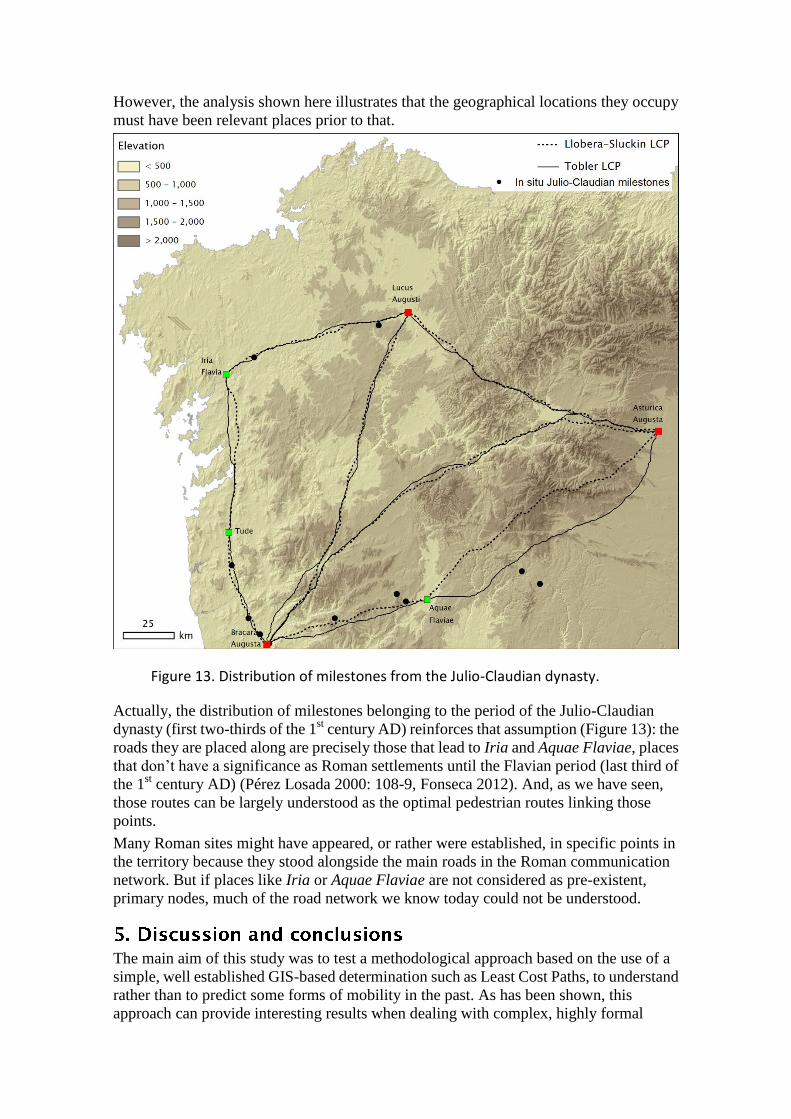
Figure 13. Distribution of milestones from the Julio-Claudian dynasty.
Actually, the distribution of milestones belonging to the period of the Julio-Claudian
dynasty (first two-thirds of the 1st century AD) reinforces that assumption (Figure 13): the
roads they are placed along are precisely those that lead to Iria and Aquae Flaviae, places
that don’t have a significance as Roman settlements until the Flavian period (last third of
the 1st century AD) (Pérez Losada 2000: 108-9, Fonseca 2012). And, as we have seen,
those routes can be largely understood as the optimal pedestrian routes linking those
points.
Many Roman sites might have appeared, or rather were established, in specific points in
the territory because they stood alongside the main roads in the Roman communication
network. But if places like Iria or Aquae Flaviae are not considered as pre-existent,
primary nodes, much of the road network we know today could not be understood.
The main aim of this study was to test a methodological approach based on the use of a
simple, well established GIS-based determination such as Least Cost Paths, to understand
rather than to predict some forms of mobility in the past. As has been shown, this
approach can provide interesting results when dealing with complex, highly formal
contexts for which a significant body of evidence is available, in the form of numerous
remains of ancient road networks.
It is important to remark that the proposed approach is not aimed at providing a
significant new knowledge (reconstructing) on the routes under analysis, in our case the
Roman roads of the NW Iberian Peninsula. In a different direction, it provides new clues
on what decisions could have been taken when constructing that network. The more
direct evidence we have about the actual route of the roads, the more significance we can
extract from such an approach.
In our case study, we have shown how a significant portion of the Roman road network in
this area can be understood in terms of least cost pedestrian routes joining a few key
nodes in the landscape. On the one hand, this suggests that the role of pedestrian mobility
was important when designing the road network. On the other hand, the results also
inform us about the significance as primary nodes of elements other than the settlement
sites. Specifically, the relevance of some crossing points over water has been detected.
This may be argued for some cases, while other are better understood as located along
pre-existing, or pre-designed, routes. Beyond the reconstruction of the possible routes of
the roads, our approach focuses on affordability, on the key, primary role for the
articulation of human mobility in this region of some specific geographical positions.
Even in such a complex and technologically advanced context as the Roman Empire, not
only political and administrative criteria would have operated when designing such a
crucial element in the construction of a new landscape as the road network. This is
probably not any different to what has been already concluded, proposed or sometimes
just assumed from different archaeological approaches, but our contribution here, based
on a totally different argumentation, helps to understand some of the logics behind that.
The analysis also provides relevant arguments for the discussion proposed at the
beginning, focused on the possible re-use of pre-Roman roads in designing this road
network in Roman times (Caamaño Gesto 1980, González Ruibal 2001), something that
has been argued for elsewhere in Europe (e.g. Chevalier 1997). In this case the primary
role of some settlement sites, such as Iria Flavia or Aquae Flaviae, seems rather obvious
from the very beginning of the construction of the network. However, this contrasts with
the apparently late development of these places as truly relevant settlement areas. All the
former suggests that those places were already significant nodes in terms of mobility in
this region well before their emergence as focal Roman sites, and supports the suggestion
that, to a great extent, the Roman road network was here the formalization of already
existing routes.
It is also evident that the approach presented here does not fully explain the road network,
and in full detail. Regarding the lack of detail, in most cases the divergence when
measuring the similarity between the LCP, the milestones and the proposed
reconstruction of the roads might be related to an issue of scale (see for instance the via
XVIII), but in a few specific cases it might also have to do with the proposals by our main
source (Rodríguez Colmenero et al. 2004) about the assignation of milestones to specific
roads or the suggested routes of the roads where little direct evidence is available. But in
other cases the divergence is more radical. The most obvious case is that of the via XVII,
which to a great extent cannot be “explained” with the evidence we presented here. It may
be the case that, as happened with the via XVIII and Ponte Bibei, some additional primary
nodes have existed in the region between Aquae Flaviae and Asturica that forced the road
to follow a route other than the optimal pedestrian least cost path. Or we could also
consider that maybe not all the roads were following the same logic. The search for
possible additional nodes in this area, or the testing of different cost functions (maybe
those designed to model optimal movement of wheeled vehicles) could shed some light
on this particular matter. For the specific case of the road between Bracara and Asturica it
is also possible that avoiding high altitude areas was a relevant factor. Although some
other sections of the network cut across mountain ranges (for instance, between Lucus
and Asturica), this factor could be relevant to find an alternate logic for this particular
case.
It must also be taken into account that our approach here was made on a very general
scale, and consequently the results are only valid at that regional scale. What we have
explored is the correspondence between roads and general corridors of least cost
movement. An analysis made on a much smaller scale and for specific parts of the
network could provide a more detailed understanding based on the determination of
theoretical paths rather than on broad-brush corridors.
In methodological terms, our experience here has also shown that, considered at this scale
and for this particular topographic conditions, the results produced by the two cost
functions are highly coincident for the most part, save for some specific areas, and even in
those cases the differences do not imply major changes in the general direction of the
paths (again, the area between Aquae Flaviae and Asturica Augusta is the one that shows
the greatest difference and the sole area where the two LCP are actually showing different
routes at our scale of analysis).
The approach presented here is technically and methodologically rather simple and
straightforward, and as such it may be easily extended to any equivalent archaeological
context. Instead of “joining the dots”, a focus on the opposite “dotting the joins” may be a
useful way to inject some meaning in the abundant remains of ancient roads.
We would like to thank the very useful comments and suggestions by the reviewers of the
paper, 2 anonymous colleagues and -very especially- Irmela Herzog, who waived her
anonymity, for her very thorough and constructive comments and suggestions. We would
also like to thank A. González Ruibal for providing useful comments on a previous
version of this paper. This research has been partially supported by an 'Isabel Barreto'
grant from the Galician regional government (Xunta de Galicia).
Alvarado Blanco, S., M. Durán Fuentes, and C. Nárdiz Ortiz. 1990. Puentes históricos de
Galicia. A Coruña: Colegio Oficial de Ingenieros de Caminos, Canales y Puertos.
Barnes, Trevor J. 2003. The place of locational analysis: a selective and interpretive
history. Progress in Human Geography 27:69-95.
Batten, D.C. 2007. "Least-Cost Pathways, Exchange Routs, And Settlement Patterns in
Late Prehistoric East-Central New Mexico," in Digital Discovery. Exploring New
Frontiers in Human Heritage, CAA 2006. Computer Applications and Quantitative
Methods in Archaeology. Proceedings of the 34th Conference, Fargo, United States,
April 2006. Edited by J. T. Clark and E. M. Hagemeister, pp. 151-158. Budapest:
Archaeolingua.
Bell, Tyler, Andrew Wilson, and Andrew Wickham. 2002. Tracking the Samnites:
Landscape and Communications Routes in the Sangro Valley, Italy. American Journal of
Archaeology 106:169-186.
Bevan, Andrew. 2011. "Computational models for understanding movement and
territory," in Tecnologías de Información Geográfica y Análisis Arqueológico del
Territorio, vol. LIX, Anejos de Archivo Español de Arqueología. Edited by V. Mayoral
Herrera and S. Celestino Pérez, pp. 383-394. Mérida.
Bödöcs, A. 2011. "“r.calc.ItinerariumAntonini” Raster Based GIS Survey on Pannonian
Mileage Data of Itinerarium Antonini," in Computer Application and Quantitative
Methods in Archaeology 2008. On the Road to Reconstructing the Past Edited by E.
Jerem, F. Redő, and V. Szeverényi, pp. 67-73. Budapest: Archeaeolingua.
Caamaño Gesto, J.M. 1980. Posible reutilización de caminos prerromanos en época
romana. Gallaecia 3-4:281-285.
Caamaño Gesto, J.M. 1984. As vías romanas. Santiago de Compostela: Museo do Pobo
Galego.
Cameron, Catherine M. 2013. How People Moved among Ancient Societies: Broadening
the View. American Anthropologist 115:218-231.
Carreras, César and De Soto, Pau, 2013, The Roman Transport Network: A Precedent for
the Integration of the European Mobility, Historical Methods: A Journal of Quantitative
and Interdisciplinary History 46-3:117-133.
Chapman, Henry P. 2003. Rudston ‘Cursus A’– Engaging with a Neolithic Monument in
Its Landscape Setting Using GIS. Oxford Journal of Archaeology 22:345-356.
Chevalier, R. 1997. Les Voies romaines. Paris: Picard.
Conolly, James, and Mark Lake. 2006. Spatial technology and archaeology: the
archaeological applications of GIS. London: Taylor & Francis.
Contreras, D. A. 2011. How far to conchucos? A GIS approach to assessing the
implications of exotic materials at Chavín de Huántar. World Archaeology 43:380-397.
Ejstrud, Bo. 2005. "Cost surface analysis and ancient roads: A comparison," in Temps et
espaces de l'homme en société. Analyses et modèles spatiaux en archéologie. Edited by F.
B. J.-F. Berger, F. Breamer, G. Davtian & M. Gazenbeck, pp. 135-140. Antibes: APDCA.
Fábrega-Álvarez, P., and C. Parcero-Oubiña. 2007. Proposals for an archaeological
analysis of pathways and movement. Archaeologia e Calcolatori 18:121-140.
Fairén Jiménez, S. 2004. ¿Se hace camino al andar? Influencia de las variables
medioambientales y culturales en el cálculo de caminos óptimos mediante SIG. Trabajos
de Prehistoria 61:25-40.
Fonseca Sorribas, D., 2012, El Municipium Romano de Aquae Flaviae y su problemática,
Antesteria 1:519-528
Franco Maside, R.M. 2000. Rutas naturais e vias romanas na provincia de A Coruña.
Gallaecia 19:143-170.
Franco Maside, R.M. 2001. La Vía per loca marítima: un estudio sobre vías romanas en la
mitad noroccidental de Galicia. Gallaecia 20:217-248.
García Marcos, V. , and J.M. Vidal Encinas. 1999. "Asturica Augusta: de asentamiento
militar a urbs magnífica," in Los orígenes de la ciudad en el noroeste hispánico: actas del
Congreso Internacional, Lugo 15-18 de mayo de 1996, vol. 2. Edited by A. Rodríguez
Colmenero, pp. 911-944. Lugo: Diputación Provincial de Lugo.
Goodchild, M.F., Hunter, G.J., 1997. A simple positional accuracy measure for linear
features, International Journal of Geographical Information Science 11: 299-306.
Gómez-Gutiérrez, Á., Schnabel, S., Lavado Contador, F., García Marín, R., 2011.
Testing the quality of open-access DEMs and their derived attributes in Spain: SRTM,
GDEM and PNOA DEM. Geomorphometry 2011; Five Days of Digital Terrain
Modelling, Redlands (CA).

Gonçalves, J., Fernandes, J.C., 2005. Assessment of SRTM-3 DEM in Portugal with
topographic map data, Proceedings of the EARSeL Workshop 3D-Remote Sensing, Porto,
Portugal.
González Ruibal, Alfredo. 2001. Camino del Tiempo. Orígenes protohistóricos de la vía
XIX. Larouco 3:157-167.
Herzog, Irmela. 2013. "The Potential and Limits of Optimal Path Analysis," in
Computational Approaches to Archaeological Spaces. Edited by A. Bevan and M. Lake,
pp. 179-211: Left Coast Press.
Herzog, I., and A. Posluschny. 2011. "Tilt – Slope-dependent Least Cost Path
Calculations Revisited," in On the Road to Reconstructing the Past. Computer
Applications and Quantitative Methods in Archaeology (CAA). Proceedings of the 36th
International Conference Budapest, April 2–6, 2008. Edited by E. Jerem, F. Redő, and V.
Szeverényi, pp. 236-242. Budapest
Howey, Meghan C. L. 2007. Using multi-criteria cost surface analysis to explore past
regional landscapes: a case study of ritual activity and social interaction in Michigan, AD
1200–1600. Journal of Archaeological Science 34:1830-1846.
Kantner, John. 2012. "Realism, Reality, and Routes. Evaluating Cost-Surface and
Cost-Path Algorithms," in Least Cost Analysis of Social Landscapes. Archaeological
Case Studies. Edited by D. A. White and S. L. Surface-Evans, pp. 225-238: The
University of Utah Press.
Kondo, Y., and Y. Seino. 2010. "GPS-aided Walking Experiments and Data-driven
Travel Cost Modeling on the Historical Road of Nakasendō-Kisoji (Central Highland
Japan)," in Making History Interactive. Computer Applications and Quantitative
Methods in Archaeology (CAA). Proceedings of the 37th International Conference,
Williamsburg, Virginia, United States of America, March 22-26, BAR International
Series Edited by B. Frischer, J. W. Crawford, and D. Koller, pp. 158-165. Oxford:
Archaeopress.
Llobera, Marcos. 2000. "Understanding Movement: a Pilot Model Towards the
Sociology of Movement," in Beyond the map: archaeology and spatial technologies.
Edited by G. R. Lock, pp. 65-84. Amsterdam: IOS Press.
Llobera, M., P. Fábrega-Álvarez, and C. Parcero-Oubiña. 2011. Order in movement: a
GIS approach to accessibility. Journal of Archaeological Science 38:843-851.
Llobera, M., and T.J. Sluckin. 2007. Zigzagging: Theoretical insights on climbing
strategies. Journal of Theoretical Biology 249:206-217.
Lock, G., and J. Pouncett. 2010. "Walking the Ridgeway Revisited: The Methodological
and Theoretical Implications of Scale Dependency for the Derivation of Slope and the
Calculation of Least-Cost Pathways," in Making History Interactive. Computer
Applications and Quantitative Methods in Archaeology (CAA). Proceedings of the 37th
International Conference, BAR International Series. Edited by B. Frischer, J. W.
Crawford, and D. Koller, pp. 192-203. Oxford.
Martins, Maria Manuela dos Reis. 2000. Bracara Augusta Cidade Romana. Braga:
Unidade de Arqueologia da Universidade do Minho.
Matsumoto, Go. 2008. "Availability of Least-Cost Pathway Analysis for the Study of
Inka Road System," in 36th Annual Midwest Conference on Andean and Amazonian
Archaeology and Ethnohistory. University of Wisconsin, Madison.

Mignone, Pablo. 2013. “El camino hacia el Santuario Incaico del Llullaillaco”: el
complejo arqueológico más alto del mundo analizado a través de un SIG. Virtual
Archaeology Review 4(8): 145-154.
Minetti, A.E., Moia, Ch., Roi, G.S., Susta, D. & G. Ferretti., 2002. Energy cost of walking
and running at extreme uphill and downhill slopes. Journal of Applied Physiology 93,
pp.1039-1046.
Moralejo Álvarez, J.J. 2009. Toponimia de las vías romanas de Galicia. Paleohispánica
9:189-202.
Murrieta-Flores, Patricia. 2012. Understanding human movement through spatial
technologies. The role of natural areas of transit in the Late Prehistory of South-western
Iberia. Trabajos de Prehistoria 69:103-122.
Newhard, James M. L., Norm Levine, and Allen Rutherford. 2008. Least-Cost Pathway
Analysis and Inter-Regional Interaction in the Göksu Valley, Turkey. Anatolian Studies
58:87-102.
Pandolf, K.B., Givoni, B., Goldman, R.F. 1977. Predicting energy expenditure with loads
while standing or walking very slowly, Journal of Applied Physiology 43-4: 577-581.
Pérez Losada, F. 2002. Entre a cidade e a aldea. Estudio arqueohistórico dos
“aglomerados secundarios” romanos en Galicia. Brigantium. A Coruña: Museo
Arqueolóxico e Histórico.
Peña Santos, A. de la. 1990-1. Consideraciones sobre las vías romanas de la Provincia de
Pontevedra. Castrelos III-IV:217-243.
Posluschny, A. 2010. "Over the hills and far away? - Cost Surface Based Models of
Prehistoric Settlement Hinterlands," in Making History Interactive. Computer
Applications and Quantitative Methods in Archaeology (CAA). Proceedings of the 37th
International Conference, Williamsburg/VA, United States of America, March 22–26,
2009, BAR Internat. Ser. Edited by B. Frischer, J. W. Crawford, and D. Koller, pp.
313-319. Oxford
Rahn, B. 2005. Cost Surface-Derived Least-Cost Paths: A Case Study from Iron Age
Orkney. Internet Archaeology 19.
Richards-Rissetto, Heather, and Kristin Landau. 2014. Movement as a means of social
(re)production: using GIS to measure social integration across urban landscapes. Journal
of Archaeological Science 41:365-375.
Rodriguez Colmenero, A. 1997. Aquae Flaviae: I. Fontes Epigráficas da Gallaecia
meridional interior. Chaves: Camara Municipal de Chaves.
Rodriguez Colmenero, A. 2001. Lucus Augusti. A Coruña: Fundación Pedro Barrié de la
Maza.
Rodriguez Colmenero, A., S. Ferrer Sierra, and R. Álvarez Asorey. 2004. Miliarios e
outras inscricións viarias romanas no Noroeste Hispánico (conventus Bracarense,
Lucense y Asturicense).Santiago de Compostela: Consello da Cultura Galega.
Roldán Hervás, J.M. 1975. Itineraria Hispana. Fuentes antiguas para el estudio de las
vías romanas en la Península Ibérica. Anejos de Hispania Antiqva. Madrid.
Ruestes, Carme. 2008. Social Organization and Human Space in North-Eastern Iberia
during the Third Century BC. Oxford Journal of Archaeology 27:359-386.
Siart, Christoph, Bernhard Eitel, and Diamantis Panagiotopoulos. 2008. Investigation of
past archaeological landscapes using remote sensing and GIS: a multi-method case study
from Mount Ida, Crete. Journal of Archaeological Science 35:2918-2926.

Stanish, Charles, Edmundo de la Vega, Michael Moseley, Patrick Ryan Williams, Cecilia
Chávez J, Benjamin Vining, and Karl LaFavre. 2010. Tiwanaku trade patterns in southern
Peru. Journal of Anthropological Archaeology 29:524-532.
Taliaferro, M. S., B. A. Schriever, and M. S. Shackley. 2010. Obsidian procurement, least
cost path analysis, and social interaction in the Mimbres area of southwestern New
Mexico. Journal of Archaeological Science 37:536-548.
Tobler, Waldo. 1993. Three presentations on geographical analysis and modelling. Santa
Barbara: National Center for Geographic Information and Analysis.
Tsokas, G. N., P. I. Tsourlos, A. Stampolidis, D. Katsonopoulou, and S. Soter. 2009.
Tracing a major roman road in the area of ancient Helike by resistivity tomography.
Archaeological Prospection 16:251-266.
Verhagen, P., and K. Jeneson. 2012. "A Roman Puzzle. Trying to Find the Via Belgica
with GIS," in Thinking Beyond the Tool. Archaeological Computing and the Interpretive
Process, BAR International Series. Edited by A. Chrysanthi, P. M. Flores, and C.
Papadopoulos, pp. 123-130. Oxford: Archaeopress.
Verhagen, P. 2013. "On the Road to Nowhere? Least Cost Paths, Accessibility and the
Predictive Modelling Perspective," in Proceedings of the 38th Annual Conference on
Computer Applications and Quantitative Methods in Archaeology, Granada, Spain, April
2010. Edited by F. Contreras, M. Farjas, and J. F. Melero. Oxford: Archaeopress.
Wheatley, David W., Leonardo García Sanjuán, Patricia A. Murrieta Flores, and Joaquín
Márquez Pérez. 2010. Approaching the Landscape Dimension of the Megalithic
Phenomenon in Southern Spain. Oxford Journal of Archaeology 29:387-405.
White, Devin A., and Sarah B. Barber. 2012. Geospatial modeling of pedestrian
transportation networks: a case study from precolumbian Oaxaca, Mexico. Journal of
Archaeological Science 39:2684-2696.
White, Devin A., and Sarah L. Surface-Evans. Editors. 2012. Least Cost Analysis of
Social Landscapes. Archaeological Case Studies: The University of Utah Press.