City of Fall River, MA Fiscal Year Ended June 30, 2020 Budget
Upload
cultureelerfgoedCategory
view
0download
0
the city and the river
Menne KosianResearcher spatial analysisLandscape department
Henk WeertsSenior researcher physical geographyLandscape department
Rowin van LanenPhD candidate Dark Age of the Lowlands in an Interdisciplinary LightCultural Heritage Agency / Utrecht University
Cultural Heritage AgencyMinistry of Education, Culture andScience

an age of myth and legendno high culture or organisation
or was there…

An early medieval port in its natural habitat
3/29
trade networks
Dorestad: the centre of the world
the natural habitat of a port
changing rivers

Early medieval trade networks
Northwest Europeanearly medievalemporia
4/29

Early medieval trade networks
Bead from Turkmenistan(Kaupang)
Staffordshire hoardBrooch(Dorestad)
Casket of Teuderic(Abbaye de Saint-Maurice)
Brooch(Hedeby)
Crown ofRecceswinth
(Guadamur)
5/29

Early medieval trade networkscommodities
IronTin, zinc and leadCopperSilverGoldSaltGarnet
[email protected]@[email protected]
6/29India

Dorestad; the centre of the world…
KaupangRibe
Eoforwic (Jorvic/York)
Dorestad
Hamwic (Southampton) Venice Byzantium
Dorestad:Strategically placed onthe crossroads ofEurope’s main waterways
8/29

Dorestad is mentioned as a Frisian town, between the Franks, the Saxons and the Normans in the ‘Geographia Ravennatis’ around 700AD.
Charlemagne grantsDorestad tollage in 775
Derostates
Dorstad vicus fa-mosus
Dorestad; the centre of the world…
9/29

Dorestad; the centre of the world…
Dorestad coinageDistribution ofDorestadcoinage over Europe
10/29

Dorestad; the centre of the world…
Reconstruction ofthe Netherlandsaround 800AD
DorestadUtrecht
Nijmegen
Vech
t
Vlie
RhineMeuse
Scheldt
Lek
IJssel
IJ
North
Sea
Rhine
Waal
11/29

Dorestads natural habitat
Palaeogeographicreconstruction ofthe Netherlandsaround 800AD
Atlas of the Netherlands in the Holocene era(P.C. Vos; J. Bazelmans; H.J.T. Weerts et.al.)
12/29

Dorestads natural habitat
1 Berendsen, H. (1982) The Geomorfogenetic map of the south of Utrecht
2 Berendsen, H. and Stouthamer, E. (2001) Palaeogeographic reconstructionof the Rhine-Meuse delta
3 Cohen, K. et. al. (2010) Map of sand deposits of the Dutch rivers
1 3
Mapping the Dutch rivers
213/29

Dorestads natural habitat
…reassessing oldresearch datainto a newuniform legend
15/29
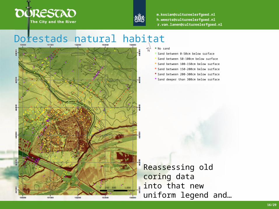
Dorestads natural habitat
Reassessing oldcoring datainto that newuniform legend and…
No sandSand between 0-50cm below surfaceSand between 50-100cm below surfaceSand between 100-150cm below surfaceSand between 150-200cm below surfaceSand between 200-300cm below surfaceSand deeper than 300cm below surface
16/29
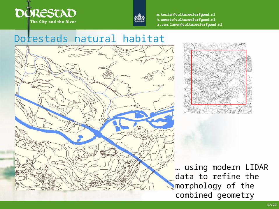
Dorestads natural habitat
… using modern LIDARdata to refine themorphology of thecombined geometry
17/29

Dorestads natural habitatSteur, R.J. (2011)Palaeogeographic reconstructionof the area of Dorestad around 800 AD
Gives a new insightAnd reconstruction ofThe landscape aroundDorestad in 800AD
18/29

Dorestads natural habitat
Gives a new insightAnd reconstruction ofThe landscape aroundDorestad in 800AD
Steur, R.J. (2011)Palaeogeographic reconstructionof the area of Dorestad around 800 AD
19/29

Rhine
Waal
Dorestad
Tiel
Dorestads natural habitatSteur, R.J. (2011)Palaeogeographic reconstructionof the area of Dorestad around 800 AD
Northern overseas tradeWestern and Southern overseas tradeGerman tradeFrench-German trade
Lek
Zoel
20/29

Changing rivers
4th and 5th century AD
harbour area
harbour area21/29

Changing rivers
6th and 7th century AD
harbour area
harbour area
22/29

Changing rivers…
Main drainage channels of the Rhine river6th century7th century8th century
silted up
silted up
Dorestad
24/29

New trade routes avoiding the Dorestad tollage…
Dorestad
Changing rivers, changing times
26/29

Changing rivers, changing times
… and a profound change in the socio-political landscape…
27/29

Dorestad
Dordrecht Tiel
Deventer
… lead to the rise of new trade centres and cities
Changing rivers, changing times
28/29

Cultural Heritage AgencyMinistry of Education, Culture andScience
Thank you for your attention
Copyright © 2022 FDOKUMEN