Diverse sauropod-, theropod-, and ornithopod-track assemblages and a new ichnotaxon Siamopodus xui...
19
Diverse sauropod-, theropod-, and ornithopod-track assemblages and a new ichnotaxon Siamopodus xui ichnosp. nov. from the Feitianshan Formation, Lower Cretaceous of Sichuan Province, southwest China Lida Xing a, ⁎, Martin G. Lockley b , Jianping Zhang a , Hendrik Klein c , W. Scott Persons IV d , Hui Dai a a School of the Earth Sciences and Resources, China University of Geosciences, Beijing 100083, China b Dinosaur Trackers Research Group, University of Colorado Denver, PO Box 173364, Denver, CO 80217, USA c Saurierwelt Paläontologisches Museum, Alte Richt 7, D-92318 Neumarkt, Germany d Department of Biological Sciences, University of Alberta, 11455 Saskatchewan Drive, Edmonton, Alberta T6G 2E9, Canada abstract article info Article history: Received 30 April 2014 Received in revised form 22 July 2014 Accepted 18 August 2014 Available online 27 August 2014 Keywords: Sauropod tracks Ornithopod tracks Theropod tracks Siamopodus xui Lower Cretaceous Feitianshan Formation Copper mining activities in a huge quarry in the fluvial–lacustrine Lower Cretaceous Feitianshan Formation near Zhaojue, Sichuan Province have temporarily exposed large track-bearing surfaces that require rapid documenta- tion before they are subject to erosion or damage from collapse or destruction by mining. Due to the urgent need to document these sites several preliminary studies of representative material have been completed, and more than 1000 tracks have been observed. Here we present maps of two large surfaces, with a combined area of ~1000 m 2 , representing the same stratigraphic level, and yielding multiple trackways of measurable quality, in- cluding at least 8 theropod, 7 sauropod, and 22 ornithopod trackways. Additional trackmakers of the two latter groups are also well-represented by natural casts derived from an overlying unit disturbed by quarrying. The sau- ropod tracks are assigned to the ubiquitous ichnogenus Brontopodus. The ornithopod tracks belong to the ichnogenera Caririchnium, attributed to quadrupeds or facultative bipeds, and Ornithopodichnus, corresponding to smaller bipeds. Based on size and morphology the theropod trackways appear to represent diverse morphotypes, including one attributed to the new ichnospecies Siamopodus xui. The Feitianshan Formation ichnofauna, which also includes pterosaur tracks from other nearby surfaces, is moderately diverse and indicates an abundant presence of archosaurs in the region during the Early Cretaceous. © 2014 Elsevier B.V. All rights reserved. 1. Introduction The Early Cretaceous dinosaur fauna of China is famous for its biolog- ical diversity. For example, the Jehol Biota of northeastern China con- tains a higher number of dinosaur species than any other known contemporaneous fauna (Zhou and Wang, 2010). The high diversity of Chinese Early Cretaceous dinosaurs is reflected in both the skeletal and ichnofossil record. Localities such as the Yanguoxia tracksites of Gansu Province (Zhang et al., 2006; Xing et al., 2013a), the Chabu tracksites of Inner Mongolia (Lockley et al., 2002; Li et al., 2011a), the Junan (Li et al., 2005, 2007) and Linshu tracksites (Xing et al., 2013b) of Shandong Province, the Qijiang Lotus tracksite of Chongqing Municipalities (Xing et al., 2007, 2013c), the Wuerhe (also “Urho”) tracksites of Xinjiang (Xing et al., 2011a, 2013d), all indicate a rich bio- diversity with at least three or more types of dinosaur, bird, pterosaur and turtle tracks. The abundant dinosaur tracks have also greatly con- tributed to the reconstruction of dinosaur faunas in areas where skeletal fossils have yet to be discovered. Historically, Zhaojue County, Sichuan Province is a traditional settle- ment region for the Yi people. Within Zhaojue County three major dino- saur tracksites have been recently discovered: The Zhaojue tracksite (Xing et al., 2013e; Xing and Lockley, in press; Xing et al., in press-a); the Jiefanggou tracksite (Xing et al., in press-b), and the Yangmozu tracksite (unpublished data). The Zhaojue site (ZJ) is the largest of the three (Fig. 1), and was discovered in September, 1991, after being exposed by large-scale quarrying at a copper mine. It is subdivided into several constituent tracksites. Tracksite ZJI preserved the largest number of tracks, but collapsed between 2006 and 2009, and the tracks were nearly all destroyed. Based on video recording made prior to 2006 and on surviving fragments, the lead author and colleagues described the footprints from ZJI (Xing et al., in press-a). These include theropod, sauropod and ornithopod tracks as well as pterosaur footprints. Zhaojue tracksites ZJII and ZJIIN show theropod, sauropod, and ornithopod tracks. Ornithopod tracks are the most abundant and pterosaur tracks have not been discovered at either of these. Xing et al. (2013e) prelim- inarily described the dinosaur track assemblage of ZJII, including the first definitive non-avian theropod swim trackway from China based on the lower part of the tracksite only. Adequate data were not obtained until the area was made accessible with the aid of professional rock Palaeogeography, Palaeoclimatology, Palaeoecology 414 (2014) 79–97 ⁎ Corresponding author. Tel./fax: +86 1 82321827. E-mail address: [email protected] (L. Xing). http://dx.doi.org/10.1016/j.palaeo.2014.08.011 0031-0182/© 2014 Elsevier B.V. All rights reserved. Contents lists available at ScienceDirect Palaeogeography, Palaeoclimatology, Palaeoecology journal homepage: www.elsevier.com/locate/palaeo
-
Upload
independent -
Category
Documents
-
view
4 -
download
0
Transcript of Diverse sauropod-, theropod-, and ornithopod-track assemblages and a new ichnotaxon Siamopodus xui...

Palaeogeography, Palaeoclimatology, Palaeoecology 414 (2014) 79–97
Contents lists available at ScienceDirect
Palaeogeography, Palaeoclimatology, Palaeoecology
j ourna l homepage: www.e lsev ie r .com/ locate /pa laeo
Diverse sauropod-, theropod-, and ornithopod-track assemblages and anew ichnotaxon Siamopodus xui ichnosp. nov. from the FeitianshanFormation, Lower Cretaceous of Sichuan Province, southwest China
Lida Xing a,⁎, Martin G. Lockley b, Jianping Zhang a, Hendrik Klein c, W. Scott Persons IV d, Hui Dai a
a School of the Earth Sciences and Resources, China University of Geosciences, Beijing 100083, Chinab Dinosaur Trackers Research Group, University of Colorado Denver, PO Box 173364, Denver, CO 80217, USAc Saurierwelt Paläontologisches Museum, Alte Richt 7, D-92318 Neumarkt, Germanyd Department of Biological Sciences, University of Alberta, 11455 Saskatchewan Drive, Edmonton, Alberta T6G 2E9, Canada
⁎ Corresponding author. Tel./fax: +86 1 82321827.E-mail address: [email protected] (L. Xing).
http://dx.doi.org/10.1016/j.palaeo.2014.08.0110031-0182/© 2014 Elsevier B.V. All rights reserved.
a b s t r a c t
a r t i c l e i n f oArticle history:Received 30 April 2014Received in revised form 22 July 2014Accepted 18 August 2014Available online 27 August 2014
Keywords:Sauropod tracksOrnithopod tracksTheropod tracksSiamopodus xuiLower CretaceousFeitianshan Formation
Copper mining activities in a huge quarry in the fluvial–lacustrine Lower Cretaceous Feitianshan Formation nearZhaojue, Sichuan Province have temporarily exposed large track-bearing surfaces that require rapid documenta-tion before they are subject to erosion or damage from collapse or destruction bymining. Due to the urgent needto document these sites several preliminary studies of representative material have been completed, and morethan 1000 tracks have been observed. Here we present maps of two large surfaces, with a combined area of~1000 m2, representing the same stratigraphic level, and yielding multiple trackways of measurable quality, in-cluding at least 8 theropod, 7 sauropod, and 22 ornithopod trackways. Additional trackmakers of the two lattergroups are alsowell-represented by natural casts derived from anoverlying unit disturbed byquarrying. The sau-ropod tracks are assigned to the ubiquitous ichnogenus Brontopodus. The ornithopod tracks belong to theichnogenera Caririchnium, attributed to quadrupeds or facultative bipeds, and Ornithopodichnus, correspondingto smaller bipeds. Based on size and morphology the theropod trackways appear to represent diversemorphotypes, including one attributed to the new ichnospecies Siamopodus xui. The Feitianshan Formationichnofauna, which also includes pterosaur tracks from other nearby surfaces, ismoderately diverse and indicatesan abundant presence of archosaurs in the region during the Early Cretaceous.
© 2014 Elsevier B.V. All rights reserved.
1. Introduction
The Early Cretaceous dinosaur fauna of China is famous for its biolog-ical diversity. For example, the Jehol Biota of northeastern China con-tains a higher number of dinosaur species than any other knowncontemporaneous fauna (Zhou and Wang, 2010). The high diversity ofChinese Early Cretaceous dinosaurs is reflected in both the skeletaland ichnofossil record. Localities such as the Yanguoxia tracksites ofGansu Province (Zhang et al., 2006; Xing et al., 2013a), the Chabutracksites of Inner Mongolia (Lockley et al., 2002; Li et al., 2011a), theJunan (Li et al., 2005, 2007) and Linshu tracksites (Xing et al., 2013b)of Shandong Province, the Qijiang Lotus tracksite of ChongqingMunicipalities (Xing et al., 2007, 2013c), the Wuerhe (also “Urho”)tracksites of Xinjiang (Xing et al., 2011a, 2013d), all indicate a rich bio-diversity with at least three or more types of dinosaur, bird, pterosaurand turtle tracks. The abundant dinosaur tracks have also greatly con-tributed to the reconstruction of dinosaur faunas in areaswhere skeletalfossils have yet to be discovered.
Historically, Zhaojue County, Sichuan Province is a traditional settle-ment region for the Yi people.Within Zhaojue County threemajor dino-saur tracksites have been recently discovered: The Zhaojue tracksite(Xing et al., 2013e; Xing and Lockley, in press; Xing et al., in press-a);the Jiefanggou tracksite (Xing et al., in press-b), and the Yangmozutracksite (unpublished data). The Zhaojue site (ZJ) is the largest of thethree (Fig. 1), and was discovered in September, 1991, after beingexposed by large-scale quarrying at a copper mine. It is subdividedinto several constituent tracksites. Tracksite ZJI preserved the largestnumber of tracks, but collapsed between 2006 and 2009, and the trackswere nearly all destroyed. Based on video recordingmade prior to 2006and on surviving fragments, the lead author and colleagues describedthe footprints from ZJI (Xing et al., in press-a). These include theropod,sauropod and ornithopod tracks aswell as pterosaur footprints. Zhaojuetracksites ZJII and ZJIIN show theropod, sauropod, and ornithopodtracks. Ornithopod tracks are the most abundant and pterosaur trackshave not been discovered at either of these. Xing et al. (2013e) prelim-inarily described the dinosaur track assemblage of ZJII, including thefirst definitive non-avian theropod swim trackway from China basedon the lower part of the tracksite only. Adequate datawere not obtaineduntil the area was made accessible with the aid of professional rock

Fig. 1.Geographic map indicating the location of the Zhaojue dinosaur tracksite localities in Liangshan Yi Autonomous Prefecture, Zhaojue County, Sichuan Province, China. ZJI = Zhaojuetracksite I; ZJII = Zhaojue tracksite II; ZJIIN = Zhaojue tracksite II North.
80 L. Xing et al. / Palaeogeography, Palaeoclimatology, Palaeoecology 414 (2014) 79–97
climbers. By these means it was possible to map, trace, and measurerepresentative tracks directly. Parallel trackways of small ornithopods,referable to the ichnogenus Ornithopodichnus, and with a walking gaitpattern similar to ornithopod tracks reported from South Korea werediscovered and described from ZJIIN, (Xing and Lockley, in press). Thedescriptions herein provide details of the track assemblages fromZhaojue tracksites ZJII and ZJIIN. Both sites represent large areas that be-long to the same surface. ZJII includes a mapped area of over 500 m2,while ZJIIN comprises a mapped area of over 400 m2. In Xing andLockley (in press), the three main outcrops ZJI, ZJII, and ZJIIN are desig-nated as tracksites I, II and IIN (N= north).
The aim of this study is to provide amore detailed documentationof tracksites ZJII and ZJIIN and the unique material in view of pro-gressive mining activity and erosion threatening a destruction andloss of valuable data. Here we describe and discuss a diverseichnoassemblage that moreover allows some conclusions about pa-leoecology, paleobiogeography and radiation of dinosaur faunas inEast Asia.
1.1. Institutional and location abbreviations
AMNH = American Museum of Natural History, New York, USA;CUGB = China University of Geosciences, Beijing, China; HDT =Huaxia Dinosaur Tracks Research and Development Center, Gansu,China; Muz. PIG = Geological Museum of the Polish Geological Insti-tute, Warsaw, Poland; NGMC = National Geological Museum ofChina, Beijing, China; UCM = University of Colorado Museum ofNatural History, Boulder, USA; ZDM = Zigong Dinosaur Museum,Sichuan, China.
1.2. Ichnological abbreviations
LM= left manus; LP= left pes; RM= right manus; RP= right pes;ML = maximum length; MW = maximum width; P′ML = maximumlength of pes; P′MW = maximum width of pes; M′ML = maximumlength of manus; M′MW = maximum width of manus; R = rotationof tracks relative to midline; SL = stride length; PL = pace length;PA = pace angulation; h = height at the hip; WAM = width ofthe manus angulation pattern; WAP = width of the pes angulationpattern. MPL = distance between center of manus to center of pes.
2. Geological setting
2.1. Feitianshan Formation
The Zhaojue site is a large active copper mine quarry in the uppermember of the Feitianshan Formation (Lower Cretaceous) of SichuanProvince. The Feitianshan Formation was originally considered to beLate Jurassic in age, but subsequently, due to the discovery of aMinheella–Pinnocypridea ostracod assemblage in the lower part, and aCypridea–Latonia assemblage in the upper part, only the former wasassigned to the Late Jurassic, whereas the upper member was assignedto the Early Cretaceous (Wei and Xie, 1987). When Tamai et al. (2004)discussed the paleomagnetics of the Chuan (=Sichuan) and Dian(=Yunnan) fragments of the Yangtze Block, they proposed a Berriasianto Barremian age for the Feitianshan Formation.
The outcrops in the area are dominated by alternating successions ofthick sandstones with minor siltstones and shale and successions ofthick brick red siltstones containing thin sandstone layers (Fig. 2). Thequarry sequence reveals tracks at several levels, including both truetracks and undertracks as concave epireliefs on the surfaces of sand-stone beds, and natural casts (convex hyporeliefs) on the underside ofshale or silt bedswhere sand has filled in tracks. The exposed sandstonesurfaces are extensive and revealmany tracks, ripplemarks, desiccationcracks and other biogenic and non-biogenic sedimentary features. Thepreservation quality of the tracks is variable, but generally good.
2.2. Paleoecology and sedimentary features
The common presence of ripple-marks and mud-cracks suggestshallowwater and intermittent desiccation. Invertebrate traces are pre-served in the argillaceous siltstone and include Beaconites and Scoyenia.The trace makers of Beaconites and Scoyenia are probably arthropods(Grahamand Pollard, 1982; Frey et al., 1984). Both of these ichnogenerapertain to Scoyenia ichnofacies (Yang et al., 2004) and both arefodinichnia type traces. In general, Scoyenia ichnofacies represents in-termittent emergence and shallow flooding in low-energy non-marinefacies, typical for river floodplains or lakeshore regions (Yang et al.,2004).
The surface of site ZSIIN (Figs. 3–4) exhibits a low, convex-up ordomed area about 8 m in diameter. This represents the remnant of anoverlying bed that was partially eroded. It was part of a sandstone bedthat filled a depression or paleochannel, and originally may have been

Fig. 2. Stratigraphic sections of dinosaur tracksites ZJI, ZJII and ZJIIN.
81L. Xing et al. / Palaeogeography, Palaeoclimatology, Palaeoecology 414 (2014) 79–97
thicker in this area. Subsequent erosion cut into both the filling of thedepression, and the underlying bed, leaving a rippled marked surfaceon which tracks were registered. Large linguloid and smaller currentripples indicate that the direction of the last flow. When the trackswere left, was towards the east around the domed area that may havebeen emergent during the waning stage. This would also explain whythis part was not eroded, thus remaining as a local topographic high.
3. Materials and methods
Tracksites ZJI and ZJII are about 450 m apart. According to Liu et al.(2009), before it collapsed, tracksite I initially revealed about 1000tracks. After our calculation, their number determined from photosand the video was at least 632 (Xing et al., 2013c, in press-a), althoughsome were too small to see or count confidently. After the collapse anadditional 90 tracks, not included in the count, were recorded in thesouthern corner of tracksite I (Xing et al., in press-a). This gives a mini-mum estimate of 722 tracks for ZJI. ZJII revealed 141 tracks on the sur-face and 15 more preserved on fallen blocks, while ZJIIN revealed 193tracks including fallen casts. Thus a total of at least 1071 tracks havebeen reported from the three quarry sites. ZJIIN is situated roughlyfifty meters north of ZJII, and an eight-meter widemine road intervenesbetween the two sites. In the areas where tracks have been discovered,quarrying has been shut down, but the tracks remain exposed and un-protected. Moreover, the area is mountainous with a relief around thequarry area up to 2800 m.
At the time they were studied, ZJII and ZJIIN displayed impressivetrack-rich surfaces. Due to being underlain by a massive sandstone
unit almost 30 m meters in thickness (Fig. 2) and with a dip of~45–50° the overlying layers which consist of alternations of siltstoneand sandstone, including a copper-rich unit, that was the target ofquarrying operations, were susceptible to easy removal by erosion andquarrying. As described below, the larger area (ZJII: Fig. 5) consisted ofseveral thousand square meters of surface, of which it was possibleto map ~500–525 m2. The smaller area (ZJIIN: Fig. 4) of about400–415m2was completely mapped. The total mapped are is thereforebetween ~900 and 940 m2.
The main exposures of track-rich bedding planes in Figs. 4–5 were,and in places still are, overlain by other layerswith tracks. This is partic-ularly significant in the case of site ZJIIN because immediately above themapped surface (Fig. 4), is a relatively thin (30–50 cm thick) siltstone–sandstone couplet in which tracks penetrated from the upper surface,impacting and penetrating the underlying silts almost as far as thesand of the main track layer. As this upper sandstone eroded, it pro-ducedmany natural casts, some of which are described here in conjunc-tion with the natural true tracks from the main track surface, whichrecords footprints made on much thicker sandstone, without soft silt-stone immediately below it (Fig. 2). Only a few shallow undertrackswere observed, penetrated from the upper sandstone, and deep enoughto make mappable impressions on the main surface. Nevertheless, suchcomplex multiple track-bearing units indicate the need for caution intrack interpretation. Although largely eroded, remnants of the uppertrack-bearing layer have yielded casts which give insight into some ofthe complexities of track formation noted below.
Due to the steepness of the bedding planes (40–50°) at tracksites ZJI,ZJII and ZJIIN, it was necessary to use safety ropes during the study of thetrack-bearing surfaces. In order to make accurate maps, especially inareas scheduled for destruction by quarry operations, tracks werephotographed, outlined with chalk, and traced on large sheets of trans-parent plastics. Videotapingwas employed to convert the full size, trac-ing maps into a digital format (Figs. 4–5). In addition, a representativearea of well-preserved tracks was mapped manually using a simplechalk grid. Several natural casts were collected from fallen rubble, andlatex molds of representative tracks weremade. Furthermore, more de-tailed tracings of selected tracks weremade on transparent acetate film,reposited at UCM. Latex molds, plaster replicas, and most tracings arereposited at HDT and UCM.
Maximum length (ML), maximum width (MW), divarication angle(II–IV), pace length (PL), stride length (SL), pace angulation (PA) and ro-tation of tracks (R) were measured according to the standard proce-dures of Leonardi (1987) and Lockley and Hunt (1995).
Mesaxony of tridactyl tracks was calculated according to themethods of Olsen (1980), Weems (1992), and Lockley (2009). This isthe degree to which the central digit (III) protrudes anteriorly beyondthe medial (II) and lateral (IV) digits. It can be measured as the ratioof the height of the anterior triangle (from base to apex at tip of digitIII) over base (=width between tips of digits II and IV): i.e., height/base (L/W).
The distance between centers of pes andmanus imprints (MPL)wascalculated in trackways of quadrupedal ornithischians. In sauropodtrackways, the distance between the proximal margin of the manusand the distal margin of the pes was measured due to difficulties in de-termining the centers of imprints.
For the trackways of quadrupeds, gauge (trackway width) wasquantified for pes and manus tracks using the ratios WAP/P′ML andWAM/M′ML (see Marty, 2008 and Marty et al., 2010). They werecalculated from pace and stride length, assuming that the width of theangulation pattern intersects the stride at a right angle and at the ap-proximate midpoint of the stride (Marty, 2008). If the (WAP/P′ML)-ratio equals 1.0, the pes tracks are likely to touch the trackwaymidline.If the ratio is smaller than 1.0, tracks intersect the trackwaymidline, andare considered to be narrow-gauge (see Farlow, 1992). Accordingly, avalue of 1.0 separates narrow-gauge from medium-gauge trackways,whereas the value 1.2 is arbitrarily fixed between medium-gauge and

Fig. 3.Map of track-bearing level at tracksite ZJII with trackways and isolated tracks of sauropods, ornithopods and theropods. O1–11= ornithopod trackways; S1= sauropod trackway;ST1 = swimming theropod trackway; T1 = theropod trackway.
82 L. Xing et al. / Palaeogeography, Palaeoclimatology, Palaeoecology 414 (2014) 79–97
wide-gauge trackways, and trackways with a value higher than 2.0 areconsidered to be very wide-gauge (Marty, 2008).
For calculation of hip heights and speed estimates of sauropods de-rived from the trackways, controversial methods of Alexander (1976),Thulborn (1990) and González Riga (2011) were adopted. Differentvalues from these were juxtaposed but left undiscussed.
4. Tracks and trackways
4.1. Ornithopod tracks
4.1.1. DescriptionZhaojue tracksite ZJII reveals eleven ornithopod trackways, cataloged
as ZJII-O1–O11; some isolated ornithopod tracks and partial trackwayswere also preserved on the collapsed rocks (Figs. 4–8, Table. 1). ZJII-O98–O99 are the best-preserved examples of Zhaojue ornithopod tracks,revealing the mostcomplete sequential manus-pes sets (Fig. 6). ZJIINpreserved nine ornithopod trackways, cataloged as ZJIIN-O1–O9 (Fig. 4).
Except for an isolated cast collected by the Zigong Dinosaur Museumfrom ZJIIN (cataloged as ZDM201306–4), all tracks remain in situ.
Ornithopods at ZJII and ZJIIN are divisible into two morphotypes.Morphotype A, is represented by thirteen trackways at ZJII (ZJII-O1–O11, O98–O99) and by a single trackway at ZJIIN (ZJIIN-O8).MorphotypeA pes traces are mesaxonic, functionally tridactyl and plantigrade with alength estimated at 20–30 cm, and the average and median ML/MW ra-tios are both of 1.3. The pes-manus association ZJII-O98-LP1 and LM1(Fig. 6A–B) is the best-preserved representative of morphotype A. Thepes trace shows quadripartite morphology, consisting of impressionsof three digits and a heel pad separated by pronounced ridges. TheML/MW ratio is 1.6 while the anterior triangle L/W ratio is 0.37. DigitII trace is the shortest, while traces of digits III and IV are almost equalin length. Each digit trace has a strong and blunt claw or ungual mark.The heel is triangular. There is a distinct border between the heel andthe three digits. The interdigital divarication II–IV is 47°. The manustrace is oval, with no discernable claw marks. The short axis of the ovalmanus trace aligns with the antero-lateral margins of the pes trace

Fig. 4.Map of track-bearing level at Zhaojue tracksite ZJIIN with trackways and isolated tracks of sauropods, ornithopods and theropods. Notice large circular area at center right (in gray)that represents a remnant of an eroded upper layer (see detail in Fig. 5).
83L. Xing et al. / Palaeogeography, Palaeoclimatology, Palaeoecology 414 (2014) 79–97
(i.e., opposite the line connecting the tips of digits III and IV). The ratio ofmanus center-pes center distance/pes trace length (MPL/P′ML) is 1.1. ZJII-O99 tracks (Fig. 6C) are basically consistent with ZJII-O98 morphology,with an average ML/MW ratio of 1.6 and average anterior triangle L/Wratio of 0.36 (ranging between 0.34 and 0.38). However, in ZJII-099, thepes ungual trace of digit III is blunter, the manus trace is much closer tothe pes trace, and the MPL/P′ML ratio is 0.6. ZJII-O99 PL is 3.1 × P′ML.
Tracks from ZJII show considerable morphological variation, whichis probably due to the original substrate being wet and slippery. Well-preserved tracks, such as ZJII-O2-L3, O9-R9, and ZJII-O98-LP1 are similarin most respects, but only ZJII-O2-L3 preserves distinct claw marks(Fig. 8). Except for ZJII-O98 and O99, all other ornithopod tracks at ZJIIare without manus traces, perhaps because the original tracks weretoo shallow to be preserved. In the trackway sample ZJII-O1–O11 track-ways O1–O3, O7, and O9 are well-preserved (Figs. 7A, 8). The average
PA of these well-preserved trackways is 155° (range between 134°and 166°). Based on trackways ZJII-O1–O3, the pes traces show consis-tent inward rotation mean 8°, 18° and 19° (Fig. 7A).
Morphotype B is only represented at ZJIIN by trackways ZJIIN-O1–O7 (Figs. 7B, 8). Pes tracks are mesaxonic, functionally tridactyl andplantigrade, with ML being 13–18 cm and with an average and medianML/MW ratio of 1.1. ZJIIN-O1-L3 (Fig. 6D) is the best-preserved repre-sentative. The ML/MW ratio is 1.1 while the anterior triangle L/Wratio is 0.21. Digit II is the shortest, while digit IV is the longest. Digitalpads are absent. Digit traces are deeply impressed distally. Clawmarks are round and blunt. There is no border between the heel andthe three digits. The interdigital divarication II–IV is 58°. ZJII-O1 PL is3.1 × P′ML. The average PA is 157°. Based on trackways ZJIIN-O1–O3,the pes traces show consistent inward rotation, respectively of 7°, 10°,and 14° (Fig. 7B).

Fig. 5. Large domed area at ZJIIN and mapped in Fig. 4. A. Photograph. B–D. Schematic drawings demonstrating formation of the structure by infilling of a channel and erosion of uppersandstone layer.
84 L. Xing et al. / Palaeogeography, Palaeoclimatology, Palaeoecology 414 (2014) 79–97
4.1.2. Comparisons and discussionLower Cretaceous ornithopod trackways are well-known from
Europe, North America, and East Asia. To date, six valid ornithopodichnogenera have been named from the Cretaceous: Amblydactylus(two ichnospecies), Caririchnium (three ichnospecies), Iguanodontipus,and Ornithopodichnus from the Lower Cretaceous and Hadrosauropodus(two ichnospecies) and Jiayinosauropus (Lockley et al., in press) fromthe Upper Cretaceous.
Morphotype A from ZJII and ZJIIN resembles Caririchnium, anichnogenus originally described from the Antenor Navarro Formation,Brazil, and defined by Leonardi (1984). Lockley et al. (in press) describedthe pes trace as possessing a sub symmetric, quadripartite morphologyconsisting of impressions of three digits, and a heel pad separated by pro-nounced ridges. Either, the pes was functionally plantigrade, or the im-pression of the heel pad is related to the softness of the substrate. In life,these ridges would have represented concave-up creases separated byconvex-down pads. The ungual traces reported in Leonardi (1984)occur within, not distal to, the traces of digits II–IV. The manus traces ofthe type ichnospecies C. magnificum from Brazil are irregular in size andshape (“L” shaped to oval or sub-circular). In two other ichnospecies,C. leonardii, from Colorado, USA (Lockley et al., 2001), and C. lotus, fromChina (Xing et al., 2007), the manus traces are irregular and sub-oval, re-spectively. The P′ML/P′MW ratio of C. magnificum is 1.4 and the anteriortriangle L/W ratio is 0.31 (based on Leonardi, 1984: Plate XI).
This distinctive morphology of Caririchnium (quadripartite pes andsmall oval manus) is also seen in the Zhaojue ornithopod morphotypeA. Both the P′ML/P′MW ratio and the anterior triangle L/W ratio of theholotype of Caririchniummagnificum are similar to those of morphotypeA. However, being limited to a small number of manus traces and lack-ing a well-preserved trackway, morphotype A is difficult to compare.
In 2009 Kim et al. named the ichnogenus Ornithopodichnus based onlarge footprints from the Lower Cretaceous of Korea which exhibit dis-tinctively weak mesaxonic and broad, transverse pes imprints that are
wider than long. Much smaller Ornithopodichnus trackways were laterdescribed from the Upper Cretaceous of Korea including several paralleltrackways of bipeds, assumed to have been gregarious ornithopods(Lockley et al., 2012). Ornithopodichnus type trackways are alsoknown from the Houzuoshan Dinosaur Park, Shandong Province,China (Matsukawa and Lockley, 2007; Lockley, 2009). At least threeparallel small ornithopod trackways (ZJIIN-O1–O3) from ZJIIN showthe same morphology and gait pattern as the small Ornithopodichnustrackways from South Korea (Xing and Lockley, in press). Similarto the trackways from South Korea, morphotype B from ZJIIN alsoexhibits a transverse shape and has a consistent tendency towardsthe inward rotation typical of ornithopods (Lockley et al., 2012;Xing and Lockley, in press). Therefore, we assign morphotype B fromZhaojue tracksite IIN to the ichnogenus Ornithopodichnus (Xing andLockley, in press).
In general, the Early Cretaceous ornithopod tracks from China aremorphologically similar. Traces of a quadripartite pes and small ovalmanus were observed in the sample of middle-sized tracks (20–30 cmin length), with only the degree of mesaxony differing. Morphotype Afrom the Zhaojue tracksites shows a strong mesaxony (0.37), close tospecimens from the Yanguoxia tracksite, Gansu Province (Zhang et al.,2006) that have a slightly stronger mesaxony (0.41, based on Zhanget al., 2006: Fig. 12) and a P′ML/P′MW ratio of 1.5. Other Chinese ornith-opod track types have weaker mesaxony. For example, the ornithopodtracks from Houzuoshan in Shandong Province have values of 0.20 and0.23 (Lockley, 2009). The footprint from the Luanping tracksite (HebeiProvince) is approximately 28 cm long, with a P′ML/P′MW ratio of 1.1, aweak mesaxony of 0.29, and the oval manus trace is situated anterior todigit III and digit IV of the pes (based on Matsukawa et al., 2006, Fig. 3).
4.1.3. Speed estimatesFor small ornithopods (P′ML b 25 cm), Thulborn (1990) suggests
that h = P′ML1.08 × 3.97. The relative stride length (SL/h) may be
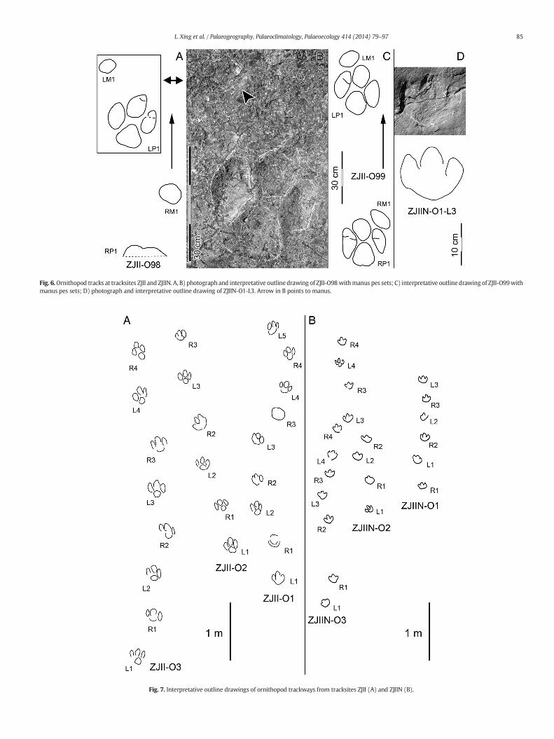
Fig. 6.Ornithopod tracks at tracksites ZJII and ZJIIN. A, B) photograph and interpretative outline drawing of ZJII-O98withmanus pes sets; C) interpretative outline drawing of ZJII-O99withmanus pes sets; D) photograph and interpretative outline drawing of ZJIIN-O1-L3. Arrow in B points to manus.
Fig. 7. Interpretative outline drawings of ornithopod trackways from tracksites ZJII (A) and ZJIIN (B).
85L. Xing et al. / Palaeogeography, Palaeoclimatology, Palaeoecology 414 (2014) 79–97

Fig. 8. Interpretative outline drawings of ornithopod tracks from tracksites ZJII and ZJIIN.
86 L. Xing et al. / Palaeogeography, Palaeoclimatology, Palaeoecology 414 (2014) 79–97
used to determine whether the animal is walking (SL/h ≤ 2.0), trotting(2 b SL/h b 2.9), or running (SL/h ≥ 2.9) (Alexander, 1976; Thulborn,1990). The SL/h ratios of the Zhaojue ornithopod trackwaysmorphotype A ZJII-O1–O3, O7, O9, O10 range 1.02–1.48 (Table. 2) andaccordingly suggest a walking gait. Using the formula of Alexander(1976), the speed of these six trackways ranges between an estimated3.02–6.01 km/s (Table. 2). Taking ZJIIN-O1 and O2 as examples,morphotype B indicates a walking speed of 3.31 and 3.56 km/s, respec-tively (Xing and Lockley, in press).
4.2. Theropod tracks
4.2.1. DescriptionZII and ZJIIN yielded eight theropod trackways, ZJII-T1, T2, ST1, ZJIIN-
T1, T2, T3, T4, T5 (Figs. 4, 5, 9–11). Several isolated theropod trackswerealso discovered in the collapsed debris. All other tracks remain in situ.
Ichnosite ZJII preserves three theropod trackways: ZJII-T1, T2, andST1 (swim trackway), respectivelymadeof 12, 3 and 8 individual tracks.ZJII-T1 is a typical tridactyl trackway, and it crisscrosses with an ornith-opod trackway (ZJII-O10). ZJII-T1-L6, R8 and L9 are well-preservedtracks. The most remarkable characteristics of these trackways are dif-ferent extramorphological variations, which are attributable to thewet and soft sediments. The phalangeal pad traces of each digit are in-distinct and shrink toward the footprint axis, which makes the digitslook more slender (dotted line in Fig. 9). A larger metatarso-phalangeal area and “heel” is preserved in L6, due to the softer sedi-ments, but is absent in R8 and L9.
ZJII-T2 is situated at a small outcrop at the northern extremity of theZJII; the distance between ZJII-T2 and ZJII-ST1 is about 17 m, so there isno display on Fig. 5. ZJII-T2 tracks are poorly-preserved, possibly a resultof long-termweathering. However, ZJII-T2 shows one of the largest the-ropod tracks from the two tracksites. ZJII-T2-R2 is the best-preserved,measures 28.4 cm in total length, and is similar to ZJII-T1-R8 in generalmorphology (Fig. 9). The interdigital divarication II–IV is wide (71°), abig heel trace is preserved, which probably retains a partial metatarsalpad that is 13 cm long. ZJII-TI1 is an isolated right track (Fig. 9). Abun-dant invertebrate traces surround ZJII-TI1. Digit II of ZJII-TI1 has twopreserved phalangeal pad traces, digit III has two or three preservedphalangeal pads, and the phalangeal pads of digit IV are indistinct. Ametatarso-phalangeal pad is visible close to the axis of digit III butmore developed laterally toward digit IV.
Ichnosite ZJIIN preserves five theropod trackways: ZJIIN-T1–T5,which consist of four, three, two, six, and two tracks, respectively(Fig. 4). ZJIIN-T1 and T2 resemble ZJII-T1 in morphology, but withoutthe influence of the wet and soft original substrate. ZJIIN-T1-L2(Fig. 9) is the best-preserved track. It has a P′ML/P′MW ratio of 1.3, allthree digits present sharp clawmarks, and the interdigital divaricationsare 32° of II-III, 24° of III-IV and 56° of II-IV. The metatarso-phalangealpad of digit IV is positioned near the axis of digit III but slightly moreclose to digit IV. The average PA of ZJIIN-T1 is 154°, slightly larger thanin ZJII-T1 (146°).
ZJIIN-T5 is a single pace trackway made of two poorly-preservedtracks. ZJIIN-T1-L1 is quite well-preserved, with a strong indentation be-hind digit II (Fig. 9). Themost significant difference between L1 and otherZhaojue theropod tracks is the very slender digits of the former, whichmay reflect partial collapse of the track wall in a relatively deep track.
4.2.2. Comparisons and discussionAmong Zhaojue theropod tracks, ZJIIN-T5 has moderate mesaxony
(0.71). It resembles the widely-discovered Grallator morphotype fromLiaoning, northern China. Early Cretaceous small theropod tracks fromChina are dominated by the Grallator morphotype, which includesJialingpus (a form with exceptionally large, sometimes compound,metatarso-phalangeal pads) (Xing et al., 2014). For the specimens atthe Sihetun site (NGMC V2115A and B), the anterior triangle L/W ratiois also approximately 0.7 (based on Xing et al., 2009, Fig. 3). The Sihetuntracks could have beenmade by an oviraptosaur (Xing et al., 2009), andthe trackmaker of ZJIIN-T5 was probably a small non-avian theropod,possibly belonging to the same group. However, as noted by Gierlińskiand Lockley (2013) some orviraptosaurs had tetradactyl feet andcould have left tetradactyl tracks, in which the trace of digit I, as wellas digits II–IV, was registered. However, as digit I is short inoviraptosaurs, its trace may not have registered in shallow tracks.
The average anterior triangle L/W ratio of ZJII-T1, T2, ZJII-TI1 andZJIIN-T1 is 0.37, which is typical of the values reported for themorphofamily Eubrontidae (Lull, 1953). These tracks are basically con-sistent in morphology with theropod tracks from Zhaojue tracksite ZJI(Xing et al., in press-a). In addition, ZJII-ST1 is the first definite non-avian theropod swim trackway (ichnogenus Characichnos) from China(Xing et al., 2013e). Based on similarity of the track widths (16.0 cmfrom ZJII-ST1 vs. 16.9 cm from ZJII-T1), ZJII-ST1 and ZJII-T1 wereprobably left by the same kind of trackmaker. ZJII-T1 is also comparableto Irenesauripus Sternberg, 1932, 1932 (Xing et al., 2011b; Xing et al.,2013e; Lockley et al., 2014a, b; McCrea et al., 2014) an ichnogenusin need of revision. Irenesauripus tracks are widespread in EarlyCretaceous (and early Late Cretaceous) assemblages (Currie, 1983;Gangloff and May, 2004; Gierliński et al., 2008; Xing et al., 2011b).Taking the best-preserved track, ZJIIN-T1-L2 (Fig. 9) as an example,its morphology is similar to Irenesauripus AMNH 3065 from Comancheseries (Aptian–Albian) of Dinosaur Valley State Park, Texas, to asimilar ichnite from the Cameros Basin, Enciso Group (Aptian) of LosCayos site, Spain, and to Irenesauripus sp., Muz. PIG 1704.II.2 fromMaastrichtian Gaizes of Potok, Roztocze, Poland (see Gierliński et al.,

Table 1Measurements (in cm) of ornithopod tracks from Zhaojue tracksite ZJII and ZJIIN, SichuanProvince, China.
Number ML MW II–IV PL SL PA ML/MW
ZJII-O1-L1 22.4 17.5 50° 63.1 126.0 159° 1.3ZJII-O1-R1 22.0 19.0 – 65.2 108.5 153° 1.2ZJII-O1-L2 23.6 17.6 45° 47.1 115.4 178° 1.3ZJII-O1-R2 20.2 13.5 43° 69.1 118.5 142° 1.5ZJII-O1-L3 19.3 14.7 48° 57.0 101.5 157° 1.3ZJII-O1-R3 20.0 22.8 – 47.6 104.9 172° 0.9ZJII-O1-L4 21.1 18.4 61° 57.9 106.0 139° 1.1ZJII-O1-R4 22.4 17.0 49° 52.4 – – 1.3ZJII-O1-L5 23.2 13.7 31° – – – 1.7Mean 21.6 17.1 47° 57.4 111.5 157° 1.3ZJII-O2-L1 27.5 17.7 46° 66.2 144.7 168° 1.6ZJII-O2-R1 20.5 14.6 50° 78.6 147.0 160° 1.4ZJII-O2-L2 22.3 19.4 55° 69.0 152.0 163° 1.1ZJII-O2-R2 24.5 20.5 57° 83.1 151.1 169° 1.2ZJII-O2-L3 23.0 17.8 51° 69.1 – – 1.3ZJII-O2-R3 18.0 11.0 39° – – – 1.6Mean 22.6 16.8 50° 73.2 148.7 165° 1.4ZJII-O3-L1 26.7 22.1 53° 72.7 143.5 161° 1.2ZJII-O3-R1 21.2 21.9 63° 73.3 145.9 164° 1.0ZJII-O3-L2 25.3 19.5 52° 73.9 144.7 148° 1.3ZJII-O3-R2 26.0 22.3 55° 75.5 148.5 163° 1.2ZJII-O3-L3 29.2 22.4 48° 73.6 162.6 159° 1.3ZJII-O3-R3 26.7 21.0 50° 91.4 165.6 164° 1.3ZJII-O3-L4 30.2 22.5 50° 76.2 – – 1.3ZJII-O3-R4 32.6 14.5 32° – – – 2.2Mean 27.2 20.8 53° 76.7 151.8 160° 1.4ZJII-O4-L1 22.3 19.2 – 65.0 – – 1.2ZJII-O4-R1 25.3 18.5 – – 131.7 – 1.4ZJII-O4-L2 – – – – – – –
ZJII-O4-R2 – – – 63.5 97.7 – –
ZJII-O4-L3 – – – 55.5 – – –
ZJII-O4-R3 20.5 17.5 54° – 10.4 – 1.2ZJII-O4-L4 – – – – – 131°ZJII-O4-R4 16.8 15.5 55° – 76.3 136° 1.1ZJII-O4-L5 – – – – – –
ZJII-O4-R5 18.0 14.5 50° 64.2 117.9 – 1.2ZJII-O4-L6 21.2 18.7 55° 65.2 – – 1.1ZJII-O4-R6 20.5 15.5 – – – – 1.3Mean 20.7 17.1 54° 62.7 86.8 134° 1.2ZJII-O5-L1 21.0 17.0 51° – – – 1.2ZJII-O6-R1 19.2 16.0 52° 72.2 140.0 173° 1.2ZJII-O6-L1 22.4 18.0 – 68.3 139.1 138° 1.2ZJII-O6-R2 22.5 14.0 43° 79.5 – – 1.6ZJII-O6-L2 20.9 16.6 54° – – – 1.3Mean 21.3 16.2 50° 73.3 139.6 156° 1.3ZJII-O7-L1 22.5 17.5 50° 74.8 133.2 137° 1.3ZJII-O7-R1 21.8 21.8 – 78.9 142.3 142° 1.0ZJII-O7-L2 29.8 19.8 53° 82.0 153.9 136° 1.5ZJII-O7-R2 24.7 24.5 – 81.7 138.3 146° 1.0ZJII-O7-L3 27.3 17.4 – 65.5 142.9 135° 1.6ZJII-O7-R3 24.0 17.2 52° 89.5 157.3 141° 1.4ZJII-O7-L4 24.6 17.8 53° 76.7 – 167° 1.4ZJII-O7-R4 23.0 19.4 63° 86.2 185.7 166° 1.2ZJII-O7-L5 24.2 20.8 53° 101.0 183.2 155° 1.2ZJII-O7-R5 25.8 19.7 48° 84.0 157.2 – 1.3ZJII-O7-L6 24.2 19.0 61° 78.4 – – 1.3ZJII-O7-R6 22.5 22.6 66° – 167.5 – 1.0ZJII-O7-L7 – – – – – –
ZJII-O7-R7 28.0 18.5 45° 65.2 – – 1.5ZJII-O7-L8 23.2 20.5 57° – – – 1.1Mean 24.7 19.8 55° 80.3 156.2 147° 1.3ZJII-O8-L1 18.4 19.7 – 50.9 80.4 110° 0.9ZJII-O8-R1 20.2 15.7 50° 50.9 – – 1.3ZJII-O8-L2 20.6 20.6 – – – – 1.0Mean 19.7 18.7 50° 50.9 80.4 110° 1.1ZJII-O9-R1 17.3 24.1 – 88.3 162.8 153° 0.7ZJII-O9-L1 21.9 25.9 – 78.3 – – 0.8ZJII-O9-R2 20.1 27.0 – – 171.2 – 0.7ZJII-O9-L2 – – – – – – –
ZJII-O9-R3 27.3 26.1 – 93.2 192.6 167° 1.0ZJII-O9-L3 26.4 28.6 – 100.0 187.1 165° 0.9ZJII-O9-R4 25.9 26.6 – 88.6 – 165° 1.0ZJII-O9-L4 24.9 17.0 64° 95.4 180.4 170° 1.5ZJII-O9-R5 29.0 17.2 44° 92.3 186.0 178° 1.7
(continued on next page)
Table 1 (continued)
Number ML MW II–IV PL SL PA ML/MW
ZJII-O9-L5 24.4 19.5 48° 93.3 – – 1.3ZJII-O9-R6 21.6 19.3 – – – – 1.1Mean 23.9 23.1 52° 91.2 180.0 166° 1.1ZJII-O10-R1 24.2 19.8 57° – – – 1.2ZJII-O10-R3 – 95.0 43° 148.4 – 138° –
ZJII-O10-L3 23.6 18.6 60° 59.0 151.0 133° 1.3ZJII-O10-R4 22.3 16.2 43° 99.0 – – 1.4ZJII-O10-L4 26.5 19.8 53° – – – 1.3ZJII-O10-R6 20.9 15.5 45° 94.4 189.5 158° 1.3ZJII-O10-L6 28.9 20.5 52° 95.4 186.0 169° 1.4ZJII-O10-R7 25.1 – – 90.0 – – –
ZJII-O10-L7 27.0 21.8 56° – – – 1.2Mean 24.8 18.9 51° 88.8 168.7 150° 1.3ZJII-O11-R1 – – – 87.8 145.3 – –
ZJII-O11-L1 22.5 18.6 66° 57.6 156.7 – 1.2ZJII-O11-R2 – – – 98.8 166.5 – –
ZJII-O11-L2 18.7 16.8 66° 74.4 – – 1.1ZJII-O11-R3 23.2 16.5 46° – – – 1.4Mean 21.5 17.3 59° 79.7 156.2 – 1.2ZJII-O98-RM1 11.1 13.7 – 84.5 – – 0.8ZJII-O98-LP1 32.1 20.4 47° 89.0 – – 1.6ZJII-O98-LM1 8.6 12.4 – – – – 0.7Mean 17.3 15.5 47° 86.8 – – 1.0ZJII-O99-RM1 7.4 13.2 – 89.0 – – 0.6ZJII-O99-RP1 26.0 18.0 46° 84.0 – – 1.4ZJII-O99-LM1 7.8 12.4 – – – – 0.6ZJII-O99-LP1 27.0 15.5 40° – – – 1.7Mean 17.1 14.8 43° 86.5 – – 1.1ZJIIN-O1-R1 11.0 12.5 75° 47.2 88.0 159° 0.9ZJIIN-O1-L1 13.5 13.1 59° 41.5 75.0 166° 1.0ZJIIN-O1-R2 12.5 12.9 63° 35.5 67.3 171° 1.0ZJIIN-O1-L2 13.0 12.5 – 34.0 66.3 162° 1.0ZJIIN-O1-R3 14.3 13.7 67° 32.0 – – 1.0ZJIIN-O1-L3 13.5 12.7 58° – – – 1.1ZJIIN-O1-L7 11.9 10.2 62° 39.6 87.4 157° 1.2ZJIIN-O1-R8 13.0 11.2 70° 49.0 80.4 158° 1.2ZJIIN-O1-L8 13.5 13.0 – 33.4 70.0 157° 1.0ZJIIN-O1-R9 14.9 13.0 – 38.0 61.0 – 1.1ZJIIN-O1-L9 14.4 14.0 – 30.0 69.5 – 1.0ZJIIN-O1-R10 – – – 44.0 99.6 – –
ZJIIN-O1-L10 13.0 14.0 – 60.0 – – 0.9ZJIIN-O1-R11 12.5 13.3 71° – 95.5 – 0.9ZJIIN-O1-L12 12.2 – – – 76.0 – –
ZJIIN-O1-L13 10.0 9.9 69° 38.5 79.8 141° 1.0ZJIIN-O1-R14 11.5 – – 45.0 76.0 146° –
ZJIIN-O1-L14 11.2 – – 35.3 81.1 – –
ZJIIN-O1-R15 14.9 12.3 58° 49.0 82.2 – 1.2ZJIIN-O1-L15 15.8 – – 36.6 – – –
ZJIIN-O1-R16 16.0 10.6 – – – – 1.5Mean 13.1 12.4 65° 40.5 78.4 157° 1.1ZJIIN-O2-L1 13.5 13.4 62° 52.0 95.0 156° 1.0ZJIIN-O2-R1 14.6 14.6 58° 46.0 72.1 128° 1.0ZJIIN-O2-L2 14.6 13.8 73° 35.0 69.1 110° 1.1ZJIIN-O2-R2 13.4 16.6 87° 50.0 97.7 138° 0.8ZJIIN-O2-L3 16.1 13.7 64° 56.0 98.0 155° 1.2ZJIIN-O2-R3 13.2 14.2 74° 44.0 79.5 152° 0.9ZJIIN-O2-L4 13.9 13.8 63° 38.0 – – 1.0ZJIIN-O2-R4 14.5 13.4 76° – – – 1.1ZJIIN-O2-L15 14.8 13.9 67° 45.0 81.4 135° 1.1ZJIIN-O2-R15 14.0 11.5 – 43.5 – – 1.2ZJIIN-O2-L16 14.0 15.5 – – – – 0.9Mean 14.2 14.0 69° 45.5 84.7 139° 1.0ZJIIN-O3-L1 13.3 14.8 70° 50.0 – – 0.9ZJIIN-O3-R1 14.7 15.7 74° – 104.4 – 0.9ZJIIN-O3-L2 – – – – – – –
ZJIIN-O3-R2 16.4 15.6 72° 44.0 81.0 151° 1.1ZJIIN-O3-L3 15.2 15.7 71° 41.0 75.5 171° 1.0ZJIIN-O3-R3 15.0 16.3 76° 34.8 81.2 180° 0.9ZJIIN-O3-L4 15.8 14.2 54° 47.4 – – 1.1ZJIIN-O3-R4 14.8 13.5 69° – – – 1.1ZJIIN-O3-R17 10.5 11.0 – 33.8 60.2 135° 1.0ZJIIN-O3-L18 12.5 – – 30.0 60.1 160° –
ZJIIN-O3-R18 13.1 12.0 – 30.2 – – 1.1ZJIIN-O3-L19 10.0 13.5 – – – – 0.7Mean 13.8 14.2 69° 38.9 77.1 159° 1.0
(continued on next page)
87L. Xing et al. / Palaeogeography, Palaeoclimatology, Palaeoecology 414 (2014) 79–97

Table 1 (continued)
Number ML MW II–IV PL SL PA ML/MW
ZJIIN-O4-R1 16.0 13.5 73° 45.1 – – 1.2ZJIIN-O4-L1 17.6 14.5 63° – – – 1.2Mean 16.8 14.0 68° 45.1 – – 1.2ZJIIN-O5-R1 16.4 16.5 69° 44.4 – – 1.0ZJIIN-O5-L1 19.9 16.7 68° – – – 1.2Mean 18.2 16.6 68° 44.4 – – 1.1ZJIIN-O6-L1 13.4 13.9 – – – – 1.0ZJIIN-O6-L3 13.5 12.9 69° – – – 1.0Mean 13.5 13.4 69° – – – 1.0ZJIIN-O7-R1 12.2 11.0 70° – – 171° 1.1ZJIIN-O7-L1 13.0 – – – – – –
ZJIIN-O7-R2 14.5 – – – – – –
Mean 13.2 11.0 70° – – 171° 1.1ZJIIN-O8-R1 25.1 19.3 55° 78.6 143.0 157° 1.3ZJIIN-O8-L1 22.2 19.0 52° 67.5 – – 1.2ZJIIN-O8-R2 25.4 19.0 – – – – 1.3Mean 24.2 19.1 54° 73.1 143.0 157° 1.3ZJIIN-OI1 25.2 16.1 41° – – – 1.6ZJIIN-OI2 18.5 16.1 59° – – – 1.2ZJIIN-OI3 20.4 14.9 47° – – – 1.4ZJIIN-OI4 19.8 14.5 52° – – – 1.4ZJIIN-OI5 19.0 14.0 51° – – – 1.4ZJIIN-OI6 30.5 20.2 47° – – – 1.5ZDM201306-4 23.9 15.0 40° – – – 1.6
Abbreviations: ML: maximum length; MW: maximum width (measured as the distancebetween the tips of digits II and IV); II–IV: angle between digits II and IV; PL: pace length;SL: stride length; PA: pace angulation; ML/MW is dimensionless.
Fig. 9. Photograph and interpretative outline drawings of well-preserved theropod tracksfrom tracksites ZJII and ZJIIN.
88 L. Xing et al. / Palaeogeography, Palaeoclimatology, Palaeoecology 414 (2014) 79–97
2008, Figs. 2, 4A–B). The trackmaker of Irenesauripuswaspotentially thecarcharodontosaurianAcrocanthosaurus (Langston, 1974; Farlow, 2001;Lockley et al., 2014a, b). However, the Zhaojue theropod specimens aresmaller (P′ML = 27.9 cm) than Irenesauripus (P′ML = 40.6 cm inI. mclearni Sternberg, 1932). The heel of the holotype of Irenesauripusis more developed than that of the Zhaojue specimens. In general,“Irenesauripus” from East Asia needs further comparison.
4.2.3. New ichnotaxonIn introducing the new ichnospecies of Siamopodus proposed below,
we note that the original description of Siamopodus khaoyaiensis(Lockley et al., 2006) involved a proof error as follows. The ichnospeciesname, while appearing in the abstract and figure captions, was omittedfrom the section on Systematic Ichnology (Lockley et al., 2006, p. 140).Thus, the ichnospecies description and ichnogenus diagnosis,while pre-sented as separate paragraphs, appear sequentially under the sameheading, without the ichnospecies name and etymology (meaningfrom Khao Yai National Park) inserted before the description.
Theropoda Marsh, 1881Ichnofamily indet.Genus Siamopodus Lockley et al., 2006Type ichnospecies: Siamopodus khaoyaiensis Lockley et al., 2006Siamopodus xui ichnosp. nov.(Fig. 11A–C)
Table 2Estimated data of the speed of Zhaojue ornithopod morphotype A trackmakers.
No. SL/h S(km/h)
ZJII-O1 1.02 3.02ZJII-O2 1.30 4.64ZJII-O3 1.10 3.89ZJII-O7 1.25 4.57ZJII-O9 1.48 6.01ZJII-O10 1.34 5.15
Abbreviations: SL/h, relative stride length; S = absolute speed.
Etymology: The specific name is in honor of Dr. Xing Xu, a distinguishedpaleontologist who contributed greatly to the study of dinosaurs inChina.
Fig. 10. Interpretative outline drawings of theropod trackways from tracksites ZJII andZJIIN.
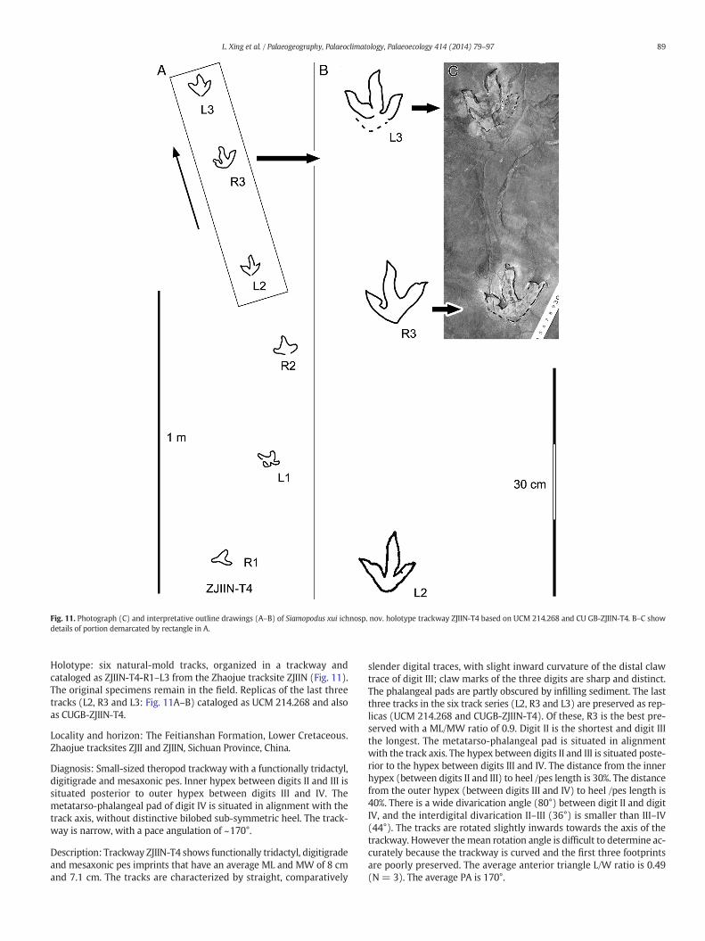
Fig. 11. Photograph (C) and interpretative outline drawings (A–B) of Siamopodus xui ichnosp. nov. holotype trackway ZJIIN-T4 based on UCM 214.268 and CU GB-ZJIIN-T4. B–C showdetails of portion demarcated by rectangle in A.
89L. Xing et al. / Palaeogeography, Palaeoclimatology, Palaeoecology 414 (2014) 79–97
Holotype: six natural-mold tracks, organized in a trackway andcataloged as ZJIIN-T4-R1–L3 from the Zhaojue tracksite ZJIIN (Fig. 11).The original specimens remain in the field. Replicas of the last threetracks (L2, R3 and L3: Fig. 11A–B) cataloged as UCM 214.268 and alsoas CUGB-ZJIIN-T4.
Locality and horizon: The Feitianshan Formation, Lower Cretaceous.Zhaojue tracksites ZJII and ZJIIN, Sichuan Province, China.
Diagnosis: Small-sized theropod trackway with a functionally tridactyl,digitigrade and mesaxonic pes. Inner hypex between digits II and III issituated posterior to outer hypex between digits III and IV. Themetatarso-phalangeal pad of digit IV is situated in alignment with thetrack axis, without distinctive bilobed sub-symmetric heel. The track-way is narrow, with a pace angulation of ~170°.
Description: Trackway ZJIIN-T4 shows functionally tridactyl, digitigradeand mesaxonic pes imprints that have an average ML and MW of 8 cmand 7.1 cm. The tracks are characterized by straight, comparatively
slender digital traces, with slight inward curvature of the distal clawtrace of digit III; claw marks of the three digits are sharp and distinct.The phalangeal pads are partly obscured by infilling sediment. The lastthree tracks in the six track series (L2, R3 and L3) are preserved as rep-licas (UCM 214.268 and CUGB-ZJIIN-T4). Of these, R3 is the best pre-served with a ML/MW ratio of 0.9. Digit II is the shortest and digit IIIthe longest. The metatarso-phalangeal pad is situated in alignmentwith the track axis. The hypex between digits II and III is situated poste-rior to the hypex between digits III and IV. The distance from the innerhypex (between digits II and III) to heel /pes length is 30%. The distancefrom the outer hypex (between digits III and IV) to heel /pes length is40%. There is a wide divarication angle (80°) between digit II and digitIV, and the interdigital divarication II–III (36°) is smaller than III–IV(44°). The tracks are rotated slightly inwards towards the axis of thetrackway. However themean rotation angle is difficult to determine ac-curately because the trackway is curved and the first three footprintsare poorly preserved. The average anterior triangle L/W ratio is 0.49(N= 3). The average PA is 170°.
Table 3Measurements (in cm) of the theropod tracks from Zhaojue tracksite ZJII and ZJIIN,Sichuan Province, China.
Number ML MW II-IV PL SL PA ML/MW
ZJII-T1-L1 21.4 18.8 75° 83.0 178.0 146° 1.1ZJII-T1-R1 23.3 18.7 67° 103.0 180.0 137° 1.3ZJII-T1-L2 24.1 14.5 61° 90.0 – – 1.7ZJII-T1-R2 26.2 17.5 51° – – – 1.5ZJII-T1-R4 20.3 16.2 – 69.8 – – 1.3ZJII-T1-L5 18.0 18.2 70° – 185.3 – 1.0ZJII-T1-L6 22.6 15.2 52° – – – 1.5ZJII-T1-L8 – 14.9 – 63.2 130.2 125° –
ZJII-T1-R8 20.3 19.6 62° 82.0 162.0 166° 1.0ZJII-T1-L9 23.5 17.8 64° 80.7 161.7 154° 1.3ZJII-T1-R9 22.0 14.5 – 85.5 – – 1.5ZJII-T1-L10 24.5 – – – – – –
Mean 22.5 16.9 63° 82.1 166.3 146° 1.3ZJII-ST1-L1 37.0 17.6 – 142.5 281.4 180° 2.1ZJII-ST1-R1 28.7 19.8 – 138.5 275.0 185° 1.4ZJII-ST1-L2 33.7 12.2 – 136.5 258.0 182° 2.8ZJII-ST1-R2 32.0 14.0 – 121.1 262.5 180° 2.3ZJII-ST1-L3 41.0 16.0 – 141.2 274.0 183° 2.6ZJII-ST1-R3 41.4 14.0 – 133.0 250.0 181° 3.0ZJII-ST1-L4 21.0 – – 117.0 – – –
ZJII-ST1-R4 33.5 18.3 – – – – 1.8Mean 33.5 16.0 – 132.8 266.8 182° 2.3ZJII-T2-R1 – – – 92 182 180° –
ZJII-T2-L1 – – – 92 – – –
ZJII-T2-R2 28.4 26.8 71° – – – 1.1ZJIIN-T1-L1 25.4 19.0 62° 96.5 187.0 153° 1.3ZJIIN-T1-R1 29.4 21.0 56° 97.4 187.5 155° 1.4ZJIIN-T1-L2 27.4 20.5 56° 95.5 – – 1.3ZJIIN-T1-R2 23.4 19.0 70° – – – 1.2Mean 26.4 19.9 61° 96.5 187.3 154° 1.3ZJIIN-T2-L1 20.6 19.2 78° 106.5 – – 1.1ZJIIN-T2-R1 22.0 22.6 – – 182.2 – 1.0ZJIIN-T2-R2 23.2 22.4 65° – – – 1.0Mean 21.9 21.4 72° 106.5 182.2 – 1.0ZJIIN-T3-R1 6.8 8.2 87° – – – 0.8ZJIIN-T3-L1 8.8 7.5 92° 45.7 – – 1.2Mean 7.8 7.9 90° 45.7 – – 1.0ZJIIN-T4-R1 5.2 7.0 – 37.2 75.0 152° 0.7ZJIIN-T4-L1 6.3 7.8 115° 39.0 70.0 175° 0.8ZJIIN-T4-R2 6.7 8.3 122° 32.3 74.9 173° 0.8ZJIIN-T4-L2 7.8 7.8 84° 42.7 69.6 180° 1.0ZJIIN-T4-R3 7.9 8.8 80° 26.6 – – 0.9ZJIIN-T4-L3 8.9 8.0 90° – – – 1.1Mean 7.1 8.0 98° 35.6 72.4 170° 0.9ZJII-TI1 24.0 19.0 54° – – – 1.3ZJIIN-T5-L1 16.8 11.6 65° – – – 1.4
Abbreviations: ML: maximum length; MW: maximum (measured as the distance be-tween the tips of digits II and IV); II–IV: angle between digits II and IV; PL: pace length;SL: stride length; PA: pace angulation; ML/MW is dimensionless.
90 L. Xing et al. / Palaeogeography, Palaeoclimatology, Palaeoecology 414 (2014) 79–97
Comparisons and discussion: theropod tracks and tridactyl tracks areoften difficult to assign to known ichnotaxa with confidence. This isalso the case with trackway ZJIIN-T4. However, it is distinctive byi) being significantly smaller than all the other 20–30 cm long theropodtracks at ichnosites ZJII and ZJIIN, an ii) having the hypex between digittraces II and III more posterior that between digit traces III and IV, asnoticeble by comparing ZJIIN-TI (Fig. 9) to ZJIIN-T4 (Fig. 11). This featurealone draws attention to the similarity with Siamopodus khaoyaiensis(Lockley et al., 2006) from the Cretaceous of Thailand. Other similaritiesinclude the comparatively low ML/MW ratio and wide interdigital di-varication angles, as well as the anterior triangle L/W ratio (0.49 vs.0.47) based on Lockley et al. (2006, fig. 5A). The large pes (P′ML =30 cmof the holotype of Siamopodus khaoyaiensis) hasmore or less par-allel sided digit traces, although the digit traces in the smaller paratypes(P′ML=14–17 cm) tapermore sharply. Differences include size, whichis not an important diagnostic factor for ichnotaxonomy (Lockley andHunt, 1995), and the lack of a bilobed heel trace in the Chinesespecimen. Other differences are of little obvious diagnostic utility. TheChinese specimen, herein named S. xui has a pace angulation of 170°.However, the possible trackway segments and the single, uncertain
pace angulation given for S. khaoyaiensis are insufficient to provide use-ful information for comparative analysis.
Thus, the trackway described here is readily distinguished from allother tracks preserved at the Zhaojue sites (ZJ I, ZJII, and ZJIIN) both insize and morphology, especially the configuration of the two hypices.As noted in a previous section, tracks of the Grallator morphotype arerelatively common in the Cretaceous of China (Lockley et al., 2013).However the morphotype described here (Fig. 11) reveals much lowerML/MW ratios than Grallator, both for the whole track and the anteriortriangle (see Table 3). Regarding the ML/MW ratio of ZJIIN-T4, theChinese specimen (here named S. xui) has a “proportionally shorterdigit III” (sensu Olsen and Rainforth, 2003, p. 314) making it more likeAnomoepus: i.e., with weak mesaxony (sensu Lockley, 2009). However,in most other diagnostic features, including the lack of a diagnosticmanus and hallux trace, or the configuration of the hypices, it is funda-mentally different from Anomoepus. It is pertinent to note that somesmall theropod tracks from China, including Corpulentapus (Li et al.,2011b) have very low ML/MW and anterior triangle L/W ratios (~1.1and 0.31 respectively: see Lockley, 2009). Thus, we argue that S. xui isdifferent from either the grallatorid and the anomoepid morphotypes,but nevertheless shows diagnostic theropodian attributes. Its most di-agnostic feature, the configuration of the hypices, allies it most closelywith Siamopodus. Differences are noteworthy, but it is premature toerect a new ichnogenus, especially in the light of recent efforts to reducethe number of indistinguishable theropodan ichnogenera reported fromthe ichnological literature on the Mesozoic of China (Lockley et al.,2013). In this regard however, it has been stated that Cretaceous thero-pod ichnotaxa aremore differentiated, distinct and diverse than those inthe Jurassic. This inference requires further testing by careful compara-tive study. The distinctive morphotype is assigned here to the newichnospecies Siamopodus xui.
4.3. Sauropod tracks
4.3.1. DescriptionTracksites ZJII and ZJIIN preserve six large quadruped trackways:
ZJII-S1, ZJIIN-S1, S2, S3, S4, and S5 (Figs. 4, 5, 12–14, Table 4). Several iso-lated tracks were also discovered in the collapsed debris. Except forZDM201306-1–3 (Fig. 11), which are housed at the Zigong DinosaurMuseum, all other tracks and trackways remain in situ.
Trackway ZJII-S1 is situated near the trackway of the swimmingtheropod,whichwas brieflydescribed inXing et al. (2013e). That descrip-tion focused on the tracks from the lower part of the tracksite. Themanusimpressions of ZJII-S1 (Fig. 12A) lie slightly anteromedially to the pesimpressions. The average length/width ratios of the manus and pes im-pressions are 0.6 and 1.3 respectively. Taking the best-preservedmanus-pes association RP5- RM5 (Fig. 11), the manus imprints showoval digit impressions, while the claws and the metacarpo-phalangealregion are indistinct. The pes impression is oval, digits I and II have in-complete clawmarks, and themetatarso-phalangeal region is smooth-ly curved. The manus impression is rotated approximately 19°outward from the trackway axis, which is smaller than the outwardrotation of the pes impressions (approximately 28°). The averagemanus PA is 119°, while the average pes PA is 120°.
The better-preserved trackways at tracksite ZJIIN are S1, S2, S3,and S5 (Fig. 12B–D), among which S1, S3, and S5 resemble the ZJII-S1trackway both in size and morphology (Table 4). Digits I, II and IIIof some of the best preserved pes traces of the Zhaojue quadrupedtrackways have well-developed claw marks. In some instances, digitsIV have small nail marks or depressions made by small unguals or footcallosities, as in ZJIIN-S1-RP4 and ZJIIN-S3-LP1 (Fig. 13). The manustraces are usually oval or U-shaped, partialwell-preservedmanus traceswith rounded marks of digits I and V, as in ZJIIN-S5-LM1 (Fig. 13). Theoutward rotation of ZJIIN-S1 is slightly larger than that of ZJII-S1,being 30° in the manus and 32° in the pes on average.

Fig. 12. Interpretative outline drawings of sauropod trackways from tracksites ZJII and ZJIIN. A–E share the same scale bar.
91L. Xing et al. / Palaeogeography, Palaeoclimatology, Palaeoecology 414 (2014) 79–97
Trackway ZJIIN-S2 is the most unusual (Fig. 12C). The manustraces are strongly rotated outwards from the trackway axis by 80° onaverage. The pes trace rotations are similar to those of other trackways,that is 28°. LM1 and LP1 (Fig. 13) are the best preserved. The LM1manus trace is oval, digit traces I and V are discernable, and the outwardrotation is up to 122°. The traces of digits I–IV of the pes LP1 are distinct,with that of digit I being the sharpest and digit IV being the weakest. InLP1, the metatarso-phalangeal has partially collapsed, likely due to thewet and soft sediments; the proximal end is smoothly curved; and theoutward rotation is 21°. Among all other sauropod tracks from Zhaojuetracksites II and IIN, the distance between themanus and the pes rangesbetween 6 and 24 cm, which is less than P′ML. Whereas, the distancebetween ZJIIN-S2-LM1 and ZJ-S2-LP1 is up to 61.7 cm, that is 1.7 timesthat of the length of the latter.
ZDM201306-1 is an incomplete specimen, other ZDM specimensand ZJIIN-SI1, 3–7 (Figs. 13–14) are well-preserved. All these pes printsare longer than wide, with many preserving large, outwardly directedclawmarks of digits I–III, the small clawmark of digit IV, and a small cal-losity or padmark of digit V. The “medial digit” of ZJIIN-SI1 is larger thanthe “outer digits”. The “medial digit” is probably caused by the lack of aborder between digit II and III.
4.3.2. Comparisons and discussionThe pes and manus morphology and trackway configuration of the
Zhaojue large quadruped trackways are typical of sauropods (Lockleyand Hunt, 1995; Lockley, 1999, 2001). Most sauropod trackways inChina are wide- (or medium-) gauge and are therefore referred to theichnogenus Brontopodus (Lockley et al., 2002). The Zhaojue sauropod
trackways are between medium-gauge and wide-gauge trackways,with a WAP/P′ML ratio of 1.0 to 1.3 (Marty, 2008).
The Zhaojue sauropod trackway configurations are also consistentwith the characteristics of Brontopodus type tracks from the UpperJurassic of Portugal and Switzerland (Meyer and Pittman, 1994; Santoset al., 2009) and from the Lower Cretaceous of the USA (Farlow et al.,1989; Lockley et al., 1994). These features are 1) wide-gauge; 2) pestracks that are longer than wide, and large and outwardly directed;3) U-shaped manus prints; and 4) a high degree of heteropody (ratioof manus to pes size). The mean heteropody of the well-preserved ZJIsauropod tracks is 1:2.3 (2.1, 2.3, and 2.5, n = 3). This is close toBrontopodus birdi (1:3) but significantly less than in the narrow-gaugeichnotaxa Breviparopus (1:3.6) or Parabrontopodus (1:4 or 1:5)(Lockley et al., 1994). The wide-gauge of the Brontopodus-type track-ways suggests that the tracks were left by titanosaurian sauropods(Wilson and Carrano, 1999; Lockley et al., 2002).
Because of the lack of significant detailswithin the tracks and the ab-sence of additional trackway data, the isolated pes tracks cannot beassigned to a distinct ichnogenus, nor can they be attributed accuratelyto a trackmaker. However, comparedwith the imprints of the sauropodtrackways from tracksites ZJII and ZJIIN, these isolated tracks probablypertain to Brontopodus, due to the digital morphology and ML/MWratios.
4.3.3. Speed estimatesFor sauropods, Alexander (1976) first suggested that hip height h=
4× foot length,whereas, later, Thulborn (1990) estimated h=5.9× footlength. González Riga (2011), proposed a formula for titanosaurid tracksbased on anatomical and ichnological evidences as h= 4.586× FL(ML).

Fig. 13. Interpretative outline drawings of well-preserved sauropod tracks from tracksites ZJII and ZJIIN.
92 L. Xing et al. / Palaeogeography, Palaeoclimatology, Palaeoecology 414 (2014) 79–97
The relative stride length (SL/h) may be used to determine whetherthe animal is walking (SL/h ≤ 2.0), trotting (2 b SL/h b 2.9), or running(SL/h ≥ 2.9) (Alexander, 1976; Thulborn, 1990). The SL/h ratios of theZhaojue sauropod trackways are between 0.51–0.74 and 0.75–1.09(Table 5) and accordingly suggest walking. Using the equation toestimate speed from trackways (Alexander, 1976), the mean locomotionspeed of the trackmaker is between 1.44–2.38 km/h and 2.27–3.74 km/h.
The unusually long distance between the pes and manus in ZJIIN-S2is difficult to understand. Although the estimated speed calculated fromZJIIN-S2 is the fastest (Table 5), the speed difference cannot explain theconsiderable distance between the pes and manus, in comparison withthe other trackways (S1, S3 & S5). The speed of the ZJIIN-S5 trackmakerwas only slightly slower, but the distances between its pes and manustracks are much shorter (Fig. 12). A more likely explanation is thatthe trackmaker of ZJIIN-S2 had longer limbs. For the super-largetitanosaur Argentinosaurus huinculensis (estimated to be 40 m long),the length of the forelimb and hindlimb is probably similar (based onSellers et al., 2013, Fig. 2). Computer simulations indicate that, at lowspeed, A. huinculensis created trackways similar to those of traditionaltitanosaurs, with short distances between the manus and pes (seeSellers et al., 2013, Fig. 12). Contrary, brachiosaurids, with their fore-limbs being longer than their hind limbs (Gunga et al., 1995), are ex-pected to place their manus and pes at a greater distance from eachother, while walking. Therefore, ZJIIN-S2 can possibly be attributed toa brachiosaur, while all other trackways might belong to titanosaurs.However, this cannot be proved with certainty.
4.3.4. Integument scratch lines and special preservationSome isolated sauropod tracks, such as ZDM201306-1 and ZJIIN-SI4,
preserve integument or skin scratch lines made when individual pedalskin tubercles or ‘scales’ dragged through the sediment (Fig. 13). Thescale scratch lines of typical tracks average 5–10 mm in width, and
there are 9–12 lines per 10 cm. The size of these scale scratches is slight-ly smaller than typical scales from sauropod skin impressions. For ex-ample, the sauropod skin impressions from the Lower CretaceousHaman Formation of Gainri and Sinsu Island, South Korea, reveal largepentagonal and heptagonal scale impressions (size 2.0–2.5 cm) (Kimet al., 2010). Another specimen from the Upper Jurassic MorrisonFormation, Wyoming, U.S.A., shows scales of 0.75–1.2 cm size (Plattand Hasiotis, 2006). However, while skin polygons can be 2.0–2.5 cmin diameter, this does not mean that the vertical striations or scratchmarks they create will also be separated by similar distances: differentirregularities in skin texture and relief will be superimposed by the dy-namics of the foot penetrating the sediment and creating a striated trackwall. In thismanner the striations cannot bemorewidely separated thatthe polygon widths but more closely spaced.
Track ZJIIN-SI3 (Figs. 13–14) is an unusual natural cast of a right pes,approximately 10 cm deep, and is divided into distinct upper and lowerparts, presumably representing different phases of track registration.There is no distinct border between digits I–III at either level, and atrace of digit II is not preserved. Distinct impressions of digits IV and Vare present laterally, at the lower level, but not at the upper level. Aslope to the wall of the track cast indicates the angle at which the footregistered on the substrate. Seen “upside down” the cast appears as apedestal and probably owes its preservation to having penetratedthrough and impacted on two layers of sediments of different hardnessand moisture content. The surface sediments were drier or firmer andthe claw marks were therefore preserved as they cut through theexposed layers, while sediments underneath may have been softer,yielding to the weight of the sauropod as it pushed the upper layerdownward. The sediment making up the floor of the footprint is likelyin part a “strip” of the upper layer pushed aside, while a certain amountof softer sediment flowed in above it. After the whole track was filled inby the next layer of sand “a sandwich effect” was created, which, after

Fig. 14. Photograph (A, C) and interpretative outline drawing (B) of the sauropod infill ZJIIN-SI3 from tracksite ZJIIN, showingpeculiarities of preservation. Black arrows in (C) indicate digitI and III impressions.
93L. Xing et al. / Palaeogeography, Palaeoclimatology, Palaeoecology 414 (2014) 79–97
exhumation and erosion, produced this pedestal feature. This inferenceis strongly supported by the fact that themain track layer is overlain bya thin silt layer that, in turn, is over-lain by a track-rich sandstone fromwhich most of the casts originate (see Fig. 2 and explanation above).
5. Lower Cretaceous dinosaur ichnoassociations from China andpaleoecological implications of the Feitianshan Formation
Remarkably, all ornithopod tracks at Zhaojue tracksite ZJII aresimilar in size and all conform to the Caririchnium morphotype. Thetrackways are generally parallel, consistent in direction, and all reflectwalking individuals. This suggests that the area was probably used asa common passage for ornithopods that probably lived in herds.
Most ornithopod tracks at Zhaojue tracksite ZJIIN are small-sizedOrnithopodichnus, only one larger Caririchnium morphotype trackwaywas discovered. This suggests that different ornithopods probablyassembled in different species groups of different sizes, and in locallydifferent areas.
The appearance of middle-large-sized theropod trackway amongthose of the ornithopods (Fig. 5) may suggest that theropod predatorswere active in the region where potential prey species (ornithopods)were common. Similar behavioral interpretations have been madebased on the Early Cretaceous (Aptian–Albian) Amblydactylus andIrenesauripus assemblages from Peace River Canyon, Canada (Currie,1983). However, trackway patterns and the estimated speeds of thetrackmakers showno evidence of direct confrontations, and it is difficult
to determine whether representatives of the two groups were both inthe tracked areas at precisely the same time.
The appearance of Grallator, Eubrontes or Irenesauripusmorphotypesand other theropod tracks such as Siamopodus xui at Zhaojue tracksitesZJII and ZJIIN suggests a high diversity of local theropods. Asianopodustracks have been reported from China and Thailand (Matsukawa et al.,2006), but this ichnogenus was not identified in the present study.The diversity and abundance of theropod tracks in the Lower Cretaceousof China is considerable (Matsukawa et al., 2006), with distinctive newichnotaxa such as Corpulentapus having been reported quite recently(Li et al., 2011b). However, as yet there has been no regional synthesiswith confident identification of a larger number of theropod tracks atthe ichnogenus level to demonstrate the relative abundance and distri-bution of the different types at a regional level.
The sauropod track sample from the Zhaojue tracksites is propor-tionally larger (more abundant) than any among the Early CretaceousSichuan Basin sites, and far exceeds the sauropod track sample fromthe Lotus tracksite near Qijiang, Chongqing City, where they are repre-sented by undertracks and isolated casts (unpublished data). Likewiseat the Jiefang tracksite from the Zhaojue area, only one trackway isknown (Xing et al., in press-b). These discoveries have altered the pre-vious interpretations by Xing et al. (2011b) that the dinosaur track re-cord from the Cretaceous Sichuan Basin is dominated by theropodsand ornithopods. It suggests that titanosaurian sauropods were alsoabundant.
In general, the three tracksites in Zhaojue (ZJI, ZJII and ZJIIN) docu-ment a high dinosaurian biodiversity, including sauropods, theropods,

Table 4Measurements (in cm) of the sauropod trackways from Zhaojue tracksites II and II N, Sichuan Province, China.
Number ML MW R PL SL PA ML/MW WAP WAP/P′ML WAM WAM/M′MW
ZJII-S1-LM1 10.3 20.0 – 95.0 – 105° 0.5 – – – –
ZJII-S1-LP1 40.9 32.5 31° 94.5 158.3 113° 1.3 – – – –
ZJII-S1-RM1 9.2 16.5 – – – – 0.6 – – – –
ZJII-S1-RP1 38.5 30.0 25° 93.1 168.7 122° 1.3 51.7 1.3 – –
ZJII-S1-LM2 – – – – – – – – – – –
ZJII-S1-LP2 46.0 33.5 37° 97.8 169.0 121° 1.4 47.6 1.0 – –
ZJII-S1-RM2 – – – – – – – – – – –
ZJII-S1-RP2 40.0 26.8 21° 93.3 162.2 125° 1.5 46.4 1.2 – –
ZJII-S1-LM3 13.2 21.6 16° 90.4 164.1 126° 0.6 – – – –
ZJII-S1-LP3 41.3 30.9 23° 87.5 168.9 124° 1.3 40.5 1.0 – –
ZJII-S1-RM3 11.7 22.4 5° 91.9 158.9 125° 0.5 – – 40.5 1.8ZJII-S1-RP3 41.3 32.0 18° 101.5 164.5 123° 1.3 44.2 1.1 – –
ZJII-S1-LM4 12.0 19.5 – 86.5 – – 0.6 – – 40.1 2.1ZJII-S1-LP4 39.5 30.0 16° 85.8 158.6 109° 1.3 44.8 1.1 – –
ZJII-S1-RM4 11.1 21.9 36° – 178.6 – 0.5 – – – –
ZJII-S1-RP4 37.5 32.6 49° 106.5 174.3 124° 1.2 57.4 1.5 – –
ZJII-S1-LM5 – – – – – – – – – – –
ZJII-S1-LP5 49.0 32.0 – 86.9 – – 1.5 45.0 0.9 – –
ZJII-S1-RM5 13.7 23.0 – – – – 0.6 – – – –
ZJII-S1-RP5 39.2 31.5 – 31.5 31.5 – 1.2 – – – –
Mean (M) 11.6 20.7 19° 91.0 167.2 119° 0.6 – – 40.3 2.0Mean (P) 41.3 31.2 28° 87.8 150.7 120° 1.3 47.2 1.3 – –
ZJIIN-S1-LM1 16.6 32.0 51° 108.5 152.4 108° 0.5 – – – –
ZJIIN-S1-LP1 45.7 31.5 36° 97.0 167.8 135° 1.5 – – – –
ZJIIN-S1-RM1 21.6 26.3 0° 70.7 139.4 95° 0.8 – – 30.0 1.1ZJIIN-S1-RP1 45.9 29.9 6° 81.5 140.2 115° 1.5 31.4 0.7 – –
ZJIIN-S1-LM2 22.8 25.2 18° 110.5 134.0 72° 0.9 – – 55.6 2.2ZJIIN-S1-LP2 40.5 27.5 24° 80.0 128.8 92° 1.5 41.9 1.0 – –
ZJIIN-S1-RM2 19.0 26.0 66° 109.5 – 84° 0.7 – – 86.1 3.3ZJIIN-S1-RP2 41.5 29.8 49° 87.0 139.8 115° 1.4 55.4 1.3 – –
ZJIIN-S1-LM3 19.5 19.5 14° 93.1 150.7 82° 1.0 – – 74.2 3.8ZJIIN-S1-LP3 41.8 27.2 31° 73.5 – 112° 1.5 41.4 1.0 – –
ZJIIN-S1-RM3 21.6 27.5 48° 127.3 147.8 76° 0.8 – – 79.5 2.9ZJIIN-S1-RP3 50.5 32.0 46° 96.6 144.8 115° 1.6 45.6 0.9 – –
ZJIIN-S1-LM4 29.2 24.5 12° 102.0 – – 1.2 – – 87.3 3.6ZJIIN-S1-LP4 38.0 23.5 – 65.7 – – 1.6 40.0 1.1 – –
ZJIIN-S1-RM4 19.8 23.1 – – – – 0.9 – – – –
ZJIIN-S1-RP4 44.8 30.2 – 97.0 – – 1.5 – – – –
ZJIIN-S1-LM5 – – – – – – – – – – –
ZJIIN-S1-LP5 36.0 36.0 – – – – 1.0 – – – –
Mean (M) 21.3 25.5 30° 103.1 144.9 86° 0.9 – – 68.8 2.8Mean (P) 42.7 29.7 32° 84.8 144.3 114° 1.5 42.6 1.0 – –
ZJIIN-S2-RM1 15.5 22.3 41° 82.0 145.0 126° 0.7 – – – –
ZJIIN-S2-RP1 – – – – – – – – – – –
ZJIIN-S2-LM1 16.2 29.9 122° 84.5 152.9 125° 0.5 – – 37.1 1.2ZJIIN-S2-LP1 37.2 27.5 21° 77.0 148.9 134° 1.4 – – – –
ZJIIN-S2-RM2 11.0 17.2 – 89.0 155.0 120° 0.6 – – 39.0 2.3ZJIIN-S2-RP2 40.6 17.5 – 86.5 150.5 – 2.3 32.0 0.8 – –
ZJIIN-S2-LM2 8.9 30.5 – 95.0 150.0 114° 0.3 – – – –
ZJIIN-S2-LP2 31.8 32.0 – 80.8 150.3 – 1.0 – – – –
ZJIIN-S2-RM3 12.1 28.0 – 86.0 – – 0.4 – – – –
ZJIIN-S2-RP3 – 100.0 – 151.6 – – – – – – –
ZJIIN-S2-LM3 9.5 26.3 – – 136.0 – 0.4 – – – –
ZJIIN-S2-LP3 31.0 28.5 – 79.5 – – 1.1 – – – –
ZJIIN-S2-RM4 – – – – – – – – – – –
ZJIIN-S2-RP4 27.0 25.0 – – – – 1.1 – – – –
ZJIIN-S2-LM4 13.3 29.3 73° – – 118° 0.5 – – – –
ZJIIN-S2-LP4 – – – – – – – – – – –
ZJIIN-S2-RM5 15.0 24.0 – 78.2 123.1 97° 0.6 – – 43.2 1.8ZJIIN-S2-RP5 – – – – – – – – – – –
ZJIIN-S2-LM5 20.0 28.5 84° 85.8 143.1 113° 0.7 – – – –
ZJIIN-S2-LP5 30.0 26.4 17° 90.2 147.8 132° 1.1 – – – –
ZJIIN-S2-RM6 14.5 – – 84.0 – – – – – 47.7 –
ZJIIN-S2-RP6 31.0 27.3 25° 89.0 125.7 133° 1.1 33.2 1.1 – –
ZJIIN-S2-LM6 12.6 30.0 78° – 145.3 – 0.4 – – – –
ZJIIN-S2-LP6 38.7 30.0 51° 75.3 136.5 113° 1.3 40.7 1.1 – –
ZJIIN-S2-RM7 – – – – – – – – – – –
ZJIIN-S2-RP7 32.5 28.0 5° 81.8 145.5 112° 1.2 45.2 1.4 – –
ZJIIN-S2-LM7 12.8 26.6 – – – 0.5 – – – –
ZJIIN-S2-LP7 29.8 26.2 27° 89.5 145.5 121° 1.1 – – – –
ZJIIN-S2-RM8 – – – – – – – – – – –
ZJIIN-S2-RP8 30.0 29.2 – 86.6 134.8 – 1.0 41.5 1.4 – –
ZJIIN-S2-LM8 – – – – – – – – – – –
ZJIIN-S2-LP8 32.6 28.0 – 75.2 142.4 – 1.2 – – – –
ZJIIN-S2-RM9 – – – – – – – – – – –
94 L. Xing et al. / Palaeogeography, Palaeoclimatology, Palaeoecology 414 (2014) 79–97

Table 4 (continued)
Number ML MW R PL SL PA ML/MW WAP WAP/P′ML WAM WAM/M′MW
ZJIIN-S2-RP9 36.9 30.5 – – – – 1.2 – – – –
ZJIIN-S2-LM9 – – – – – – – – – – –
ZJIIN-S2-LP9 32.5 23.5 – 76.8 – – 1.4 – – – –
Mean (M) 13.5 26.6 80° 85.6 143.8 116° 0.5 – – 41.8 1.8Mean (P) 33.0 27.1 28° 83.7 143.6 124° 1.2 38.5 1.2 – –
ZJIIN-S3-RM1 24.5 20.2 – 87.0 144.7 120° 1.2 – – – –
ZJIIN-S3-RP1 – – – – – – – – – – –
ZJIIN-S3-LM1 19.4 22.0 4° 78.8 148.3 111° 0.9 – – 40.0 1.8ZJIIN-S3-LP1 40.0 26.4 10° 83.7 143.8 115° 1.5 – – – –
ZJIIN-S3-RM2 21.9 33.0 7° 97.5 147.0 91° 0.7 – – 46.7 1.4ZJIIN-S3-RP2 42.6 30.6 11° 80.5 125.2 90° 1.4 44.9 1.1 – –
ZJIIN-S3-LM2 22.6 28.0 46° 100.5 142.0 107° 0.8 – – 68.1 2.4ZJIIN-S3-LP2 42.5 32.5 50° 78.0 141.0 108° 1.3 56.0 1.3 – –
ZJIIN-S3-RM3 23.1 24.0 25° 71.5 140.2 111° 1.0 – – 48.5 2.0ZJIIN-S3-RP3 38.0 34.0 33° 85.4 143.1 112° 1.1 49.5 1.3 – –
ZJIIN-S3-LM3 19.5 23.5 – 94.1 – – 0.8 – – 44.3 1.9ZJIIN-S3-LP3 40.4 28.1 – 79.0 – – 1.4 47.1 1.2 – –
ZJIIN-S3-RM4 20.0 20.0 – – – – 1.0 – – – –
ZJIIN-S3-RP4 36.3 29.0 – – – – 1.3 – – – –
Mean (M) 21.6 24.4 21° 88.2 144.4 108° 0.9 – – 49.5 1.9Mean (P) 40.0 29.7 26° 78.9 140.1 106° 1.4 49.4 1.2 – –
ZJIIN-S4-LP1 45.2 26.8 23° 75.0 116.2 105° 1.7 – – – –
ZJIIN-S4-RP1 40.6 29.5 16° 65.6 121.3 98° 1.4 42.7 1.1 – –
ZJIIN-S4-LP2 45.4 30.0 8° 89.0 137.5 108° 1.5 48.7 1.1 – –
ZJIIN-S4-RP2 44.8 34.3 19° 77.8 135.8 111° 1.3 47.6 1.1 – –
ZJIIN-S4-LP3 42.9 28.0 – 83.4 – – 1.5 46.1 1.1 – –
ZJIIN-S4-LM3 17.5 23.8 – – – – 0.7 – – – –
ZJIIN-S4-RP3 37.9 28.1 – – – – 1.3 – – – –
Mean (M) 17.5 23.8 – – – – 0.7 – – – –
Mean (P) 42.8 29.5 17° 78.2 127.7 106° 1.5 46.3 1.1 – –
ZJIIN-S5-RM1 18.0 25.1 7° 90.8 141.6 109° 0.7 – – – –
ZJIIN-S5-RP1 38.1 34.0 – 85.0 149.6 111° 1.1 – – – –
ZJIIN-S5-LM1 21.0 27.2 20° 80.2 137.9 109° 0.8 – – 46.4 1.7ZJIIN-S5-LP1 36.2 31.5 41° 91.8 153.4 110° 1.1 47.8 1.3 – –
ZJIIN-S5-RM2 18.5 25.3 32° 87.4 156.3 126° 0.7 – – 45.7 1.8ZJIIN-S5-RP2 37.3 28.0 42° 90.6 153.4 118° 1.3 50.4 1.4 – –
ZJIIN-S5-LM2 18.5 24.5 29° 87.8 162.8 114° 0.8 – – 37.2 1.5ZJIIN-S5-LP2 45.0 30.8 10° 84.3 152.0 114° 1.5 43.2 1.0 – –
ZJIIN-S5-RM3 15.2 23.9 28° 102.9 160.0 103° 0.6 – – 48.5 2.0ZJIIN-S5-RP3 38.0 29.8 27° 90.5 154.7 112° 1.3 45.9 1.2 – –
ZJIIN-S5-LM3 19.8 27.5 32° 95.0 129.4 95° 0.7 – – 59.2 2.2ZJIIN-S5-LP3 43.1 33.4 20° 88.2 131.8 97° 1.3 50.5 1.2 – –
ZJIIN-S5-RM4 17.5 22.0 – 74.5 – – 0.8 – – 54.5 2.5ZJIIN-S5-RP4 45.0 35.5 – 75.5 – – 1.3 54.2 1.2 – –
ZJIIN-S5-LM4 15.3 25.6 – – – – 0.6 – – – –
ZJIIN-S5-LP4 37.4 33.4 – – – – 1.1 – – – –
Mean (M) 18.0 25.1 25° 88.4 148.0 109° 0.7 – – 48.6 1.9Mean (P) 40.0 32.1 28° 86.6 149.2 110° 1.3 48.7 1.2 – –
ZDM201306-2 46.4 31.6 – – – – 1.5 – – – –
ZDM201306-3 34.9 27.1 – – – – 1.3 – – – –
ZJIIN-SI1 38.0 27.0 – – – – 1.4 – – – –
ZJIIN-SI3 47.2 38.3 – – – – 1.2 – – – –
ZJIIN-SI4 43.3 36.8 – – – – 1.2 – – – –
ZJIIN-SI5 45.4 35.0 – – – – 1.3 – – – –
ZJIIN-SI6 47.5 38.4 – – – – 1.2 – – – –
ZJIIN-SI7 44.7 37.9 – – – – 1.2 – – – –
Abbreviations: ML: maximum length; MW: maximum; R: rotation; PL: pace length; SL: stride length; PA: pace angulation; WAP: width of the angulation pattern of the pes (calculatedvalue); WAM: width of the angulation pattern of the manus (calculated value); ML/MW, WAP/P′ML and WAM/M′MW are dimensionless.
Table 5Estimated data of the speed of Zhaojue sauropod trackmakers.
No. F = 5.9 F = 4 F = 4.586
SL/h S(km/h)
SL/h S(km/h)
SL/h S(km/h)
ZJII-S1 0.62 1.98 0.91 3.10 0.80 2.66ZJIIN-S1 0.57 1.76 0.84 2.77 0.74 2.38ZJIIN-S2 0.74 2.38 1.09 3.74 0.95 3.17ZJIIN-S3 0.59 1.80 0.88 2.84 0.76 2.45ZJIIN-S4 0.51 1.44 0.75 2.27 0.65 1.94ZJIIN-S5 0.63 2.02 0.93 3.17 0.81 2.70
Abbreviations: F, hip height conversion factors; SL/h, relative stride length; S = absolutespeed.
95L. Xing et al. / Palaeogeography, Palaeoclimatology, Palaeoecology 414 (2014) 79–97
and ornithopods. The assemblage resembles that from the Lower Creta-ceous Hekou Group (Aptian–Albian) at the Yanguoxia site of northwestChina (Zhang et al., 2006), from the Lower Cretaceous Jiaguan Forma-tion (Barremian–Albian) at the Lotus site of Chongqing (Xing et al.,2007), and the Lower Cretaceous Tianjialou Formation (Aptian-Albian;Kuang et al., 2013) at Houzuoshan–Linsu sites. In contrast, the assem-blage from the Lower Cretaceous Jingchuan Formation at the Chabusite, InnerMongolia (Li et al., 2011a) lacks any confidently identified or-nithopod tracks. However the Zhaojue ichnofaunas differ from theYanguoxia assemblages in lacking evidence of didactyl dromaeosaursand avian theropods (birds). In this regard they also differ from manyof the Lower Cretaceous ichnofaunas from Shandong, which alsoyield dromaeosaur and bird tracks (Li et al., 2007; Xing et al., 2013b;

96 L. Xing et al. / Palaeogeography, Palaeoclimatology, Palaeoecology 414 (2014) 79–97
Li et al., in press). The Emei tracksite also yields dromaeosaur and birdtracks (Zhen et al., 1994).
The Zhaojue tracksite (Xing et al., 2013e, in press-a, in press-b; Xingand Lockley, in press, and this study) and the Qijiang tracksite (Xinget al., 2007, 2013c), are similar in revealing abundant ornithopod-richichnofaunas. However, other assemblages from the Lower Cretaceousare different. Thus overall, Early Cretaceous ichnofaunas of China still in-dicate a strong regional variation in composition and a certain provinci-ality (Lockley et al., in press). There are similarities in sedimentarygeology across the Early Cretaceous Sichuan–Yunnan Basin of South-west China, which pertains to inland basin fluvial–lacustrine deposits,however it remains to be shown how much this influences uniformityin the ichnofaunas.
The Qinling–Dabie Mountains (Wang, 1985) may have been a bio-geographic barrier to dinosaur migration. For example, south of themountain, within the Ordos Basin, neither tracks nor skeletons ofiguanodontids have been found up to date. However, at the Hexi Corri-dor Basin near the Ordos Basin (including Lanzhou–Minhe Basin) andthe Yishu fault zone areas from Shandong Province, eastern China, or-nithopod tracks are more abundant. In this regard, the Yanguoxiatrack assemblages from the Lanzhou–Minhe Basin resemble those ofthe Sichuan–Yunnan Basin, at least with respect to the tracks of largerdinosaurs that have a greater potential for preservation. The preserva-tion of the tracks of smaller animals, such as birds and pterosaurs,may also be biased by preservational factors, such as fine-grained sedi-ment and its plasticity. The basins north of the ancient Qinling–DabieMountains were closely related to the flourishing Jehol Biota, and thelocal dinosaur assemblages are basically consistent (Chen, 1988).Thus, the track assemblages from the Sichuan–Yunnan Basin indicatethat the relation between the Early Cretaceous dinosaur assemblagesand the radiation of the Jehol Biota is probably closer than expected.Thus, itmight infer that biogeographic obstacles created by themountainranges were not as severe as has been supposed. Because the EarlyCretaceous Sichuan–Yunnan Basin sediments lack fossil skeletons, thetrack record has played an important role in assessing the paleoecology,and will continue to do so.
Acknowledgments
The authors thank Bin HU (Henan Polytechnic University, China)and William I. Sellers (University of Manchester, United Kingdom) fortheir critical comments and suggestions on this paper; JieFang EBI(Zhaojue County Bureau of Culture, Multimedia, Press & Sport Tourism,Zhaojue, China), Jian LIU and Jun JIANG (Sichuan MountaineeringAssociation, China) for their participation in field research. The authorsalso thank Finn Surlyk for his services as editor and Marco Marzola(Universidade Nova de Lisboa, Museu da Lourinhã, Portugal) and ananonymous reviewer for their helpful and constructive feedback. Thiswork was supported by the special projects grants of Zhaojue CountyPeople's Government. We also thank Jose-Carlos Garcia Ramos andLaura Pinuela, Museumof the Jurassic, Asturias Spain, for helpful discus-sion which aided the interpretation of sauropod tracks of the typeshown in Fig. 14.
References
Alexander, R.M., 1976. Estimates of speeds of dinosaurs. Nature 26, 129–130.Chen, P.J., 1988. Distribution and migration of Jehol fauna with reference to nonmarine
Jurassic–Cretaceous boundary in China. Acta Palaeontol. Sin. 27, 659–683.Currie, P.J., 1983. Hadrosaur Trackways from the Lower Cretaceous of Canada. Acta
Palaeontologica Polonica 28 (1–2), 63–73.Farlow, J.O., 1992. Sauropod tracks and trackmakers: integrating the ichnological and
skeletal record. Zubia 10, 89–138.Farlow, J.O., 2001. Acrocanthosaurus and the maker of the Comanchean large theropod
footprints. In: Carpenter, K., Tanke, D. (Eds.), Mesozoic Vertebrate Life. Indiana Uni-versity Press, Bloomington, pp. 408–427.
Farlow, J.O., Pittman, J.G., Hawthorne, J.M., 1989. Brontopodus birdi. Lower Cretaceous sau-ropod footprints from the US Gulf coastal plain. In: Gillette, D.D., Lockley, M.G. (Eds.),Dinosaur Tracks and Traces, pp. 371–394.
Frey, R.W., Pemberton, S.G., Fagerstrom, J.A., 1984. Morphological, ethological and envi-ronmental significance of the ichnogenera Scoyenia and Anchorichnus. J. Paleontol.58, 511–528.
Gangloff, R.A., May, K.C., 2004. An early Late Cretaceous dinosaur tracksite in CentralYukon Territory, Canada. Ichnos 11, 299–309.
Gierliński, G., Lockley, M.G., 2013. A trackmaker for Saurexallopus: ichnological evidencefor oviraptosaurid tracks from the Upper Cretaceous of western North America. In:Titus, A., Lowen, M.A. (Eds.), Top of the Grand Staircase. The Late Cretaceous of South-ern Utah. Indiana University Press, Bloomington, pp. 526–529.
Gierliński, G.D., Ploch, I., Gawor-Biedowa, E., Niedzwiedzki, G., 2008. The first evidence ofdinosaur tracks in the Upper Cretaceous of Poland. Oryctos 8, 107–113.
González Riga, B.J., 2011. Speeds and stance of titanosaur sauropods: analysis ofTitanopodus tracks from the Late Cretaceous of Mendoza, Argentina. An. Acad. Bras.Cienc. 83 (1), 279–290.
Graham, J.R., Pollard, J.E., 1982. Occurrence of the trace fossil Beaconites antarcticus inthe Lower Carboniferous fluviatile rocks of County Mayo, Ireland. Palaeogeogr.Palaeoclimatol. Palaeoecol. 38, 257–268.
Gunga, H.C., Kirsch, K.A., Baartz, F., Rocker, L., Heinrich,W.D., Lisowski,W.,Wiedemann, A.,Albertz, J., 1995. New data on the dimensions of Brachiosaurus brancai and their phys-iological implications. Naturwissenschaften 82, 190–192.
Kim, J.Y., Lockley,M.G., Kim, H.M., Lim, J.D., Kim, S.H., Lee, S.J., Woo, J.O., Park, H.J., Kim, H.S.,Kim, K.S., 2009. New dinosaur tracks from Korea, Ornithopodichnus masanensisichnogen. et ichnosp. nov. (Jindong Formation, Lower Cretaceous): implications forpolarities in ornithopod foot morphology. Cretac. Res. 30, 1387–1397.
Kim, J.Y., Kim, K.S., Lockley, M.G., Seo, S.J., 2010. Dinosaur skin impressions from the Cre-taceous of Korea: new insights into modes of preservation. Palaeogeogr.Palaeoclimatol. Palaeoecol. 293, 167–174.
Kuang, H.W., Liu, Y.Q., Wu, Q.Z., Cheng, G.S., Xu, K.M., Liu, H., Peng, N., Xu, H., Chen, J.,Wang, B.H., Xu, J.L., Wang, M.W., Zhang, P., 2013. Dinosaur track sites andpalaeogeography of the late Early Cretaceous in Shuhe Rifting Zone of ShandongProvince. J. Palaeogeogr. 15 (4), 435–453.
Langston, W., 1974. Non-mammalian Comanchean tetrapods. Geosci. Man 8, 77–102.Leonardi, G., 1984. Le impronte fossili di dinosauri; in Sulle ormi de dinosaur. Venice,
Editio Editrice, 165–186.Leonardi, G., 1987. Glossary and manual of tetrapod footprint palaeoichnology:
Departamento Nacional de Producão Mineral. Brazil 75.Li, R.H., Liu, M.W., Lockley, M.G., 2005. Early Cretaceous dinosaur tracks from the
Houzuoshan Dinosaur Park in Junan County, Shandong Province, China. Geol. Bull.China 24, 277–280.
Li, R.H., Lockley, M.G., Makovicky, P.J., Matsukawa, M., Norell, M.A., Harris, J.D., Liu, M.W.,2007. Behavioral and faunal implications of Early Cretaceous deinonychosaur track-ways from China. Naturwissenschaften 95 (3), 185–191.
Li, J.J., Bai, Z.Q., Wei, Q.Y., 2011a. On the Dinosaur Tracks from the Lower Cretaceous ofOtog Qi, Inner Mongolia. Geological Publishing House, Beijing, (109 pp.).
Li, R.H., Lockley,M.G., Matsukawa,M.,Wang, K., Liu, M., 2011b. An unusual theropod trackassemblage from the Cretaceous of the Zhucheng area, Shandong Province, China.Cretac. Res. 32, 422–432.
Li, R.H., Lockley, M.G., Matsukawa, K., Liu, M., 2014w. Important dinosaur-dominatedfootprint assemblages from the Cretaceous Tianjialou Formation (Barremian–Aptian)at the Houzuoshan Dinosaur Park, Junan County, Shandong Province, China. Creta-ceous Research (in press).
Liu, J., Li, K., Yang, C.Y., Jiang, T., 2009. Research and significance of dinosaur tracks inZhaojue, Sichuan Province. Abstract Volume, The 10th National Congress ofPalaeontological Society of China (PSC). The 25th Annual Conference of PSC October2009, Nanjing, China.
Lockley, M.G., 1999. The Eternal Trail: A Tracker Looks at Evolution. Perseus Books,Cambridge, pp. 1–334.
Lockley, M.G., 2001. Trackways and dinosaur locomotion. In: Briggs, D.E.G., Crowther, P.(Eds.), Palaeobiology II: A Synthesis. Blackwell Science, Oxford, pp. 412–416.
Lockley, M.G., 2009. New perspectives on morphological variation in tridactyl footprints:clues to widespread convergence in developmental dynamics. Geol. Q. 53, 415–432.
Lockley, M.G., Hunt, A.P., 1995. Dinosaur tracks and other fossil footprints of the westernUnited States. Columbia University Press, New York, (360 pp.).
Lockley, M.G., Farlow, J.O., Meyer, C.A., 1994. Brontopodus and Parabrontopodus ichnogen.nov. and the significance of wide- and narrow-gauge sauropod trackways. Gaia 10,135–145.
Lockley, M.G., Hook, N., Taylor, A., 2001. A brief history of paleontological research andpublic education on dinosaur ridge. In: Lockley, M.G., Taylor, A. (Eds.), DinosaurRidge: Celebrating a Decade of Discovery. Mountain Geologist. 38, pp. 87–89.
Lockley, M.G., Wright, J., White, D., Li, J.J., Feng, L., Li, H., 2002. The first sauropod track-ways from China. Cretac. Res. 23, 363–381.
Lockley, M.G., Matsukawa, M., Sato, Y., Polahan, M., Daorerk, V., 2006. A distinctive newtheropod dinosaur track from the Cretaceous of Thailand: implications for theropodtrack diversity. Cretac. Res. 27, 139–145.
Lockley, M.G., Huh, M., Kim, B.S., 2012. Ornithopodichnus and pes-only sauropod track-ways from the Hwasun tracksite Cretaceous of Korea. Ichnos 19, 93–100.
Lockley, M.G., Li, J.J., Li, R.H., Matsukawa, M., Harris, J.D., Xing, L.D., 2013. A review of thetetrapod track record in China, with special reference to type ichnospecies: implica-tions for ichnotaxonomy and paleobiology. Acta Geol. Sin. (English edition) 87 (1),1–20.
Lockley, M.G., Gierlinski, G., Dubicka, Z., Breithaupt, B.H., Matthews, N.A., 2014a. A new dino-saur tracksites in the cedar mountain formation (Cretaceous) of Eastern Utah. N. M.Mus. Nat. Hist. Sci. Bull. 62, 279–286.
97L. Xing et al. / Palaeogeography, Palaeoclimatology, Palaeoecology 414 (2014) 79–97
Lockley, M.G., Gierlinski, G.D., Houck, K., Lim, J.D., Kim, K.S., Kim, D.Y., Kim, T.H., Kang, S.H.,Hunt Foster, R., Li, R., Chesser, C., Gay, R., Cart, K., Wright, C., 2014b. New excavationsat the Mill Canyon Dinosaur Tracksite (Cedar Mountain Formation, Lower Creta-ceous) of eastern Utah. N. M. Mus. Nat. Hist. Sci. Bull. 62, 287–300.
Lockley, M.G., Xing, L.D., Lockwood, J., Pond, S., 2014. A review of large Cretaceous ornith-opod tracks, with special reference to their ichnotaxonomy. Biol. J. Linn. Soc.(in press).
Lull, R.S., 1953. Triassic life of the Connecticut Valley. Bull. Connect. Geol. Nat. Hist. Surv.181, 1–331.
Marsh, O.C., 1881. Principal characters of American Jurassic dinosaurs. Part V. Am. J. Sci. 21(Series 3), 417–423.
Marty, D., 2008. Sedimentology, taphonomy, and ichnology of Late Jurassic dinosaurtracks from the Jura carbonate platform (Chevenez–Combe Ronde tracksite, NWSwitzerland): insights into the tidal-flat palaeoenvironment and dinosaur diversity,locomotion, and palaeoecology. GeoFocus. 21. University of Fribourg, Fribourg(278 pp. PhD Thesis).
Marty, D., Belvedere, M., Meyer, C.A., Mietto, P., Paratte, G., Lovis, C., Thüring, B., 2010.Comparative analysis of Late Jurassic sauropod trackways from the Jura Mountains(NW Switzerland) and the central High Atlas Mountains (Morocco): implicationsfor sauropod ichnotaxonomy. Hist. Biol. 22 (1–3), 109–133.
Matsukawa, M., Lockley, M.G., 2007. Speculations on Cretaceous ornithopod trackwaydistribution in East Asia: comparisons with extant ungulate migration patterns.Haenam-gun, Jeollanam-do, southwestern Korea. Proceedings of the HaenamUhangri International Dinosaur Symposium, pp. 177–206.
Matsukawa, M., Lockley, M.G., Li, J.J., 2006. Cretaceous terrestrial biotas of East Asia, withspecial reference to dinosaur-dominated ichnofaunas: towards a synthesis. Cretac.Res. 27, 3–21.
McCrea, R.T., Buckley, L.G., Plint, A.G., Currie, P.J., Haggart, J.W., Helm, C.W., Pemberton, S.G.,2014. A review of vertebrate track-bearing formations from the Mesozoic and earliestCenozoic of western Canada with a description of a new theropod ichnospecies andreassignment of an avian ichnogenus. N. M. Mus. Nat. Hist. Sci. Bull. 62, 5–94.
Meyer, C.A., Pittman, J.G., 1994. A comparison between the Brontopodus ichnofacies ofPortugal, Switzerland and Texas. Gaia 10, 125–133.
Olsen, P.E., 1980. Fossil great lakes of the Newark Supergroup in New Jersey. In:Manspeizer, W. (Ed.), Field Studies of New Jersey Geology and Guide to Field Trips.Rutgers University, New Brunswick, pp. 352–398.
Olsen, P.E., Rainforth, E.C., 2003. The Early Jurassic ornithischian dinosaurian ichnogenusAnomoepus. In: LeTourneau, P.M., Olsen, P.E. (Eds.), The Great Rift Valleys of Pangeain Eastern North AmericaSedimentology and Paleontology. 2. Columbia UniversityPress, New York, pp. 314–368.
Platt, B.F., Hasiotis, S.T., 2006. Newly discovered sauropod dinosaur tracks with skin andfoot-pad impressions from the Upper Jurassic Morrison Formation, Bighorn Basin,Wyoming, U.S.A. Palaios 21, 249–261.
Santos, V.F., Moratalla, J.J., Royo-Torres, R., 2009. New sauropod trackways from theMiddle Jurassic of Portugal. Acta Palaeontol. Pol. 54 (3), 409–422.
Sellers, W.I., Margetts, L., Coria, R.A., Manning, P.L., 2013. March of the Titans: the locomo-tor capabilities of sauropod dinosaurs. PLoS ONE 8 (10), e78733. http://dx.doi.org/10.1371/journal.pone.0078733.
Sternberg, C.M., 1932. Dinosaur tracks from Peace River British Columbia. National Muse-um of Canada, Annual Report 1930,pp. 59–85.
Tamai, M., Liu, Y., Lu, L.Z., Yokoyama, M., Halim, N., Zaman, H., 2004. Palaeomagnetic ev-idence for southward displacement of the Chuan Dian fragment of the Yangtze Block.Geophys. J. Int. 158 (1), 297–309.
Thulborn, R.A., 1990. Dinosaur Tracks. Chapman and Hall, London, (410 pp.).Wang, H. (Ed.), 1985. Chinese Palaeogeography Atlas. Sinomaps Press, Beijing (130 pp.).Weems, R.E., 1992. A re-evaluation of the taxonomy of Newark Supergroup saurischian
dinosaur tracks, using extensive statistical data from a recently exposed tracksitenear Culpeper, Virginia. In: Sweet, P.C. (Ed.), Proceedings 26th Forum on the Geology
of Industrial Minerals. Virginia Division of Mineral Resources Publication. 119,pp. 113–127.
Wei, M., Xie, S.J., 1987. Jurassic and Early Cretaceous ostracods from Xichang area, Si-chuan. Bull. Chengdu Inst. Geol. Miner. Resour. Chin. Acad. Geol. Sci. 8, 17–31.
Wilson, J.A., Carrano, M.T., 1999. Titanosaurs and the origin of “wide-gauge” trackways: abiomechanical and systematic perspective on sauropod locomotion. Paleobiology 25,252–267.
Xing, L.D., Lockley, M.G., 2014. First report of small Ornithopodichnus trackways from theLower Cretaceous of Sichuan, China. Ichnos (in press).
Xing, L.D., Wang, F.P., Pan, S.G., Chen, W., 2007. The discovery of Dinosaur Footprints inthe middle Cretaceous Jiaguan Formation of Qijiang County, Chongqing City. ActaGeol. Sin. (Chinese edition) 81 (11), 1591–1603.
Xing, L.D., Harris, J.D., Feng, X.Y., Zhang, Z.J., 2009. Theropod (Dinosauria: Saurischia)tracks from Lower Cretaceous Yixian Formation at Sihetun, Liaoning Province,China and possible trackmakers. Geol. Bull. China 28 (6), 705–712.
Xing, L.D., Harris, J.D., Jia, C.K., Luo, Z.J., Wang, S.N., An, J.F., 2011a. Early Cretaceous bird-dominated and dinosaur footprint assemblages from the northwestern margin ofthe Junggar Basin, Xinjiang, China. Palaeoworld 20, 308–321.
Xing, L.D., Harris, J.D., Gierliński, G.D., Wang,W.M.,Wang, Z.Y., Li, D.Q., 2011b. Middle Cre-taceous non-avian theropod trackways from the southern margin of the SichuanBasin, China. Acta Palaeontol. Sin. 50 (4), 470–480.
Xing, L.D., Li, D.Q., Harris, J.D., Bell, P.R., Azuma, Y., Fujita, M., Lee, Y., Currie, P.J., 2013a. Anew Dromaeosauripus (Dinosauria: Theropoda) ichnospecies from the Lower Creta-ceous Hekou Group, Gansu Province, China. Acta Palaeontol. Pol. 58 (4), 723–730.
Xing, L.D., Lockley, M.G., Marty, D., Klein, H., Buckley, L.G., McCrea, R.T., Zhang, J.P.,Gierliński, G.D., Divay, J.D., Wu, Q.Z., 2013b. Diverse dinosaur ichnoassemblagesfrom the Lower Cretaceous Dasheng Group in the Yishu fault zone, ShandongProvince, China. Cretac. Res. 45, 114–134.
Xing, L.D., Lockley, M.G., Piñuela, L., Zhang, J.P., Klein, H., Li, D.Q., Wang, F.P., 2013c. Ptero-saur trackways from the Lower Cretaceous Jiaguan Formation, Qijiang District,Chongqing Municipality, China. Palaeogeogr. Palaeoclimatol. Palaeoecol. 392,177–185.
Xing, L.D., Lockley, M.G., McCrea, R.T., Gierliński, G.D., Buckley, L.G., Zhang, J.P., Qi, L.Q., Jia,C.K., 2013d. First record of Deltapodus tracks from the Early Cretaceous of China.Cretac. Res. 42, 55–65.
Xing, L.D., Lockley,M.G., Zhang, J.P., Andrew, R.C.M., Klein, H., Li, D.Q., Persons IV, W.S., Ebi,J.F., 2013e. A new Early Cretaceous dinosaur track assemblage and the first definitenon-avian theropod swim trackway from China. Chin. Sci. Bull. (English version)58, 2370–2378.
Xing, L.D., Lockley, M.G., Marty, D., Piñuela, L., Klein, H., Persons IV, W.S., Peng, G.Z., Ye, Y.,Zhang, J.P., 2014. Re-description of the partially collapsed Early Cretaceous Zhaojuedinosaur tracksite (Sichuan Province, China) by using previously registered videocoverage. Cretac. Res. (in press-a).
Xing, L.D., Lockley, M.G., Yang, G., Mayor, A., Klein, H., Persons IV, W.S., Chen, Y., Peng, G.Z.,Ye, Y., Ebi, J.F., 2014. Tracking a legend: an Early Cretaceous sauropod trackway fromZhaojue County, Sichuan Province, southwestern China. Ichnos (in press-b).
Xing, L.D., Lockley, M.G., Gierliński, G.D., Klein, H., Hu, S.M., Zhang, J.P., Ye, Y., He, Y.P.,2014. The non-avian theropod track Jialingpus from the Cretaceous of the OrdosBasin, China, with a revision of the type material: implications for ichnotaxonomyand trackmaker morphology. Palaeoworld 23, 187–199.
Yang, S., Zhang, J., Yang, M., 2004. Trace Fossils of China. Science Press, Beijing, (353 pp.).Zhang, J., Li, D., Li, M., Lockley, M., Bai, Z., 2006. Diverse dinosaur, pterosaur and bird-track
assemblages from the Hakou Formation, Lower Cretaceous of Gansu Province, north-west China. Cretac. Res. 27, 44–55.
Zhen, S., Li, J., Zhang, B., 1994. Dinosaur and bird footprints from the Lower Cretaceous ofEmei County, Sichuan, China. Mem. Beijing Nat. Hist. Mus. 54, 105–120.
Zhou, Z., Wang, Y., 2010. Major features of the vertebrate diversity of the Early CretaceousJehol Biota and their paleoecological implications. J. Earth Sci. 21, 228–230.