District Census Handbook, Goa, Daman Diu, Part XIII-A&B ...
305
CENSUS OF INDIA 1981 SERIES 29 GOA. DAMAN & DIU I-IANDBOOK PART XIII-A AN!O XIII-B VILLAGE AND TOWN DIRECTORY AND VILLAGE AND TOWNWISE PRIMARY CENSUS ABSTRACT GOA DISTRICT DAMAN DISTRICT DIU DISTRICT s. K. GANDHE Of the Indian Economic Service of Census Operations Goa, Daman & Diu and Dadra & Nagar Havel1
-
Upload
khangminh22 -
Category
Documents
-
view
10 -
download
0
Transcript of District Census Handbook, Goa, Daman Diu, Part XIII-A&B ...
CENSUS OF INDIA 1981
SERIES 29
GOA. DAMAN & DIU
DIST~I(T (~NSUS I-IANDBOOK PART XIII-A AN!O XIII-B
VILLAGE AND TOWN DIRECTORY
AND
VILLAGE AND TOWNWISE PRIMARY CENSUS ABSTRACT
GOA DISTRICT
DAMAN DISTRICT
DIU DISTRICT
s. K. GANDHE
Of the Indian Economic Service
~tor of Census Operations Goa, Daman & Diu and Dadra & Nagar Havel1
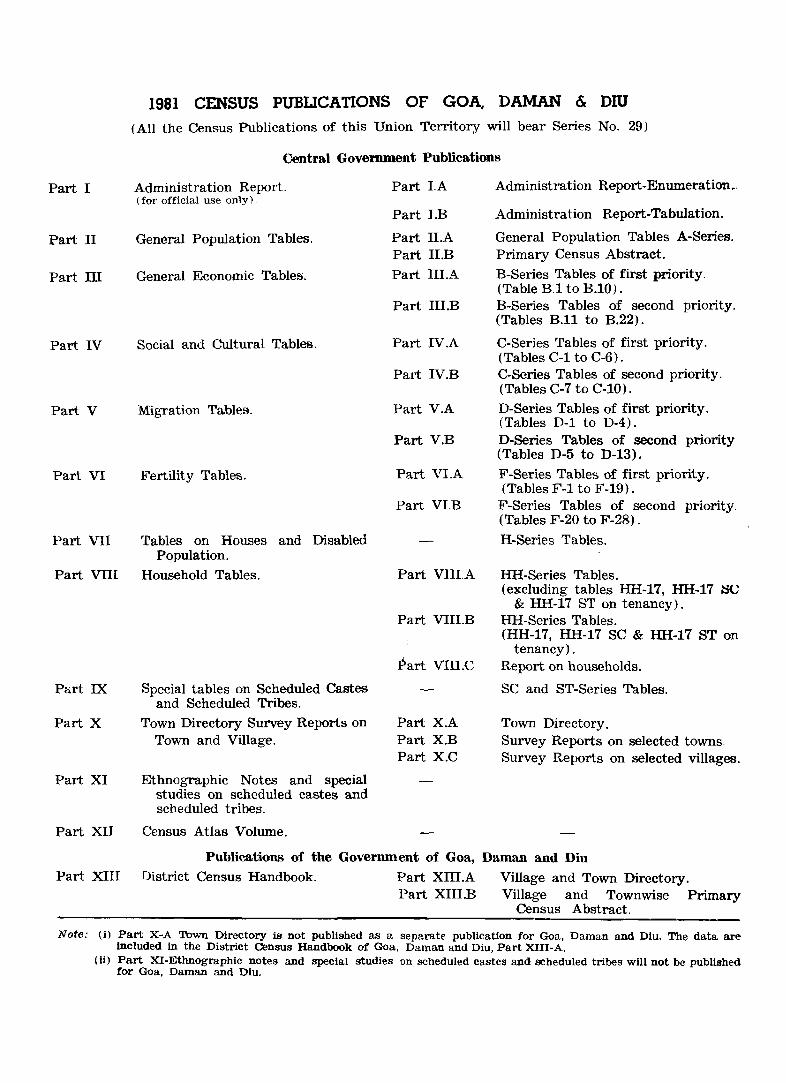
1981 CENSUS PUBlJCATIONS OF GOA, DAMAN & DIU (All the Census Publications of this Union Territory will bear Series No. 29)
Central Government Publications
Part I
Part II
Part ill
Part IV
Part V
Part VI
Administration Report. (for official USB only).
General Population Tables.
General Economic Table~.
Social and Cultural Tables.
Migration Tables.
Fertility Tables.
Part VII Tables on Houses and Disabled Population.
Part VIII Household Tables.
Part IX Special tables on Scheduled Castes and Scheduled Tribes.
Part X Town Directory Survey Reports on
Part XI
Part XII
Town and Village.
Ethnographic Notes and special studies on scheduled castes and scheduled tribes.
Census Atlas Volume.
Part I.A
Part I.B
Part II.A Part II.B Part lILA
Part III.B
Part IV.A
Part IV.B
Part V.A
Part V.B
Part VLA
Part VI.B
Part VIII.A
Part VilLB
Part VIII.C
Part X.A Part X.B Part X.C
Publications of the Government of Goa, Part XIII District Census Handbook. Part Xill.A
Part XIII.B
Administration Report-Enumeration ..
Administration Report-Tabulation.
General Population Tables A-Series. Primary Census Abstract.
B-Series Tables of first priority. (Table B.l to B.lO). B-Series Tables of second priority. (Tables B.ll to B.22).
C-Series 'fables of first priority. (Tables C-l to C-6) . C-Series Tables of second priority. (Tables C-7 to C-IO).
D-Series Tables of first priority. (Tables D-l to D-4). D-Series Tables of second priority (Tables D-5 to D-13).
F-Series Tables of first priority. (Tables F-l to F-19).
F-Series Tables of second priority. (Tables F-20 to F-28).
H-Series Tables.
HH-Series Tables. (excluding tables HH-l7, HH-17 SC
& HH-17 8T on tenancy). HH-Series Tables. (HH-l7, HH-17 SC & HH-17 ST on
tenancy). Report on households.
SC and ST-Series Tables.
Town Directory. Survey Reports on selected towns. Survey Reports on selected villages.
Daman and Diu
Village and Town Directory. Village and Townwise Primary
Census Abstract.
Note: (i) Part X-A Town Directory is not published as a separate publication for Goa, Daman and Diu. The data are Included in the District Census Handbook of Goa, Daman and Diu, Part XIII-A.
(ii) Part XI-Ethnographic notes and special studies on scheduled castes and scheduled tribes will not be published for Goa, Daman and Diu.
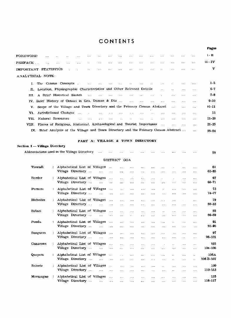
CONTENTS
FOREWORD
PRE,'FACE ..
IMPORTANT STATISTICS
ANALYTICAL NOTE:
I. The Census Concepts .
TI. Location, Physiographic Characteristics and Other Relevant Details
III. A Brief Historical Sketch
IV. Brief History of Census in Goa, Daman & Diu
V. Scope of the Village and Town Directory and the Primary Census Abstract
VI. Jurisdictional Changes
VII. Natural Resources
VIII. Places of Religious, Historical, Archaeological and Tourist Importance
IX. Brief Analysis of the Village and Town Directory and the Primary Census Abstract
PART A: VILLAGE & TOWN DIRECTORY
Section I - Village Directory
Abbreviations used in the Village Directory
Tiswadi
Bardez
Pernem
Bicholim
Satari
Ponda
Sanguem
Canacona
Quepem
Salcete
Mormugao
DISTRICT GOA
Alphabetical List of Villages Village Directory ...
Alphabetical List of Villages Village Directory ...
Alphabetical List of Villages Village Directory ...
Alphabetical List of Villages Village Directory . .
Alphabetical List of Villages Village Directory ...
Alphabetical List of Villages Village Directory ...
Alphabetical List of Villages Village Directory ...
Alphabetical List of Villages Village Directory ...
Alphabetical List of Villages Village Directory ...
Alphabetical List of Villages Village Directory ...
Alphabetical List of Villages Village Directory ...
Pages
i - ii
iii - IV
V
1-5
6-7
7-9
9-10
10-11
11
11-20
21-25
25-54
59
61 62-65
67 68-71
73 74-77
79 SO-83
85 86-89
91 92-85
97 98-101
103 104-105
106A 106B-I07
109 110-113
115 116-117
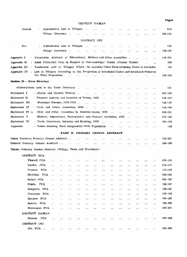
Daman
Diu
DISTRICT DAMAN
Alphabetical List of Villages
Village Direct()l!'Y ...
DISTRICT DIU
Alphabetical List of Villages
Village Directory ...
Appendix I
Appendix II
Appendix III
Appendix IV
Talukawise Abstract of Educational, Medical and Other Amenities ...
Land Utilization Data in Respect of Non-municipal Towns (Census Towns)
Talukawise List of Villages Where No Amenity Other Than Drinking Water is Available
List of Villages According to the Proportion of Scheduled Castes and Scheduled Tribes to the Total Population
Section II - Town Directory
Abbreviations used in the Town Directory ..
statement I - Status and Growth History
Statement II - Physical Aspects and Location of Towns, 1979
Statement III - MuniCipal Finance, 1978-1979 ..
Statement IV - Civic and Other Amenities, 1979
Statement IV A - Civic and Other Amenities In Notified Slums, 1979
Statement V - Medical, Educational, Recreational and Cultural Facilities, 1979
Statement VI -_ Trade, Commerce, Industry and Banking, 1979
Appendix - Towns Showing Their Outg.rowths With Population
PART B: PRIMARY CENSUS ABSTRACT
Union Territory Primary Census Abstract
District Primary Census Abstract ...
Taluka Primary Census Abstract (Village, Town and Wardwise):
DISTRICT GOA
Tiswadi PCA
Bardez PCA
Pernem PCA
Bicholim PCA
Satari PCA
Ponda PCA
Sanguem PCA
Canacona PCA
Quepem PCA
Salcete PCA
Mormugao PCA
DISTRICT DAMAN
Daman PCA
DISTRICT DIU
Diu PCA ...
I··
Pages-
119
120-123
125
126-127
128-131
133
134
135-140
141
142-143
144-145
146-147
148-149
150-151
152-153
154.-155
156
158-161
162-169
170-173
174-177
178-179
180-181
182-185
186-181
188-191
192-193
194-195
196-199
200-201
202-203-
204-20&
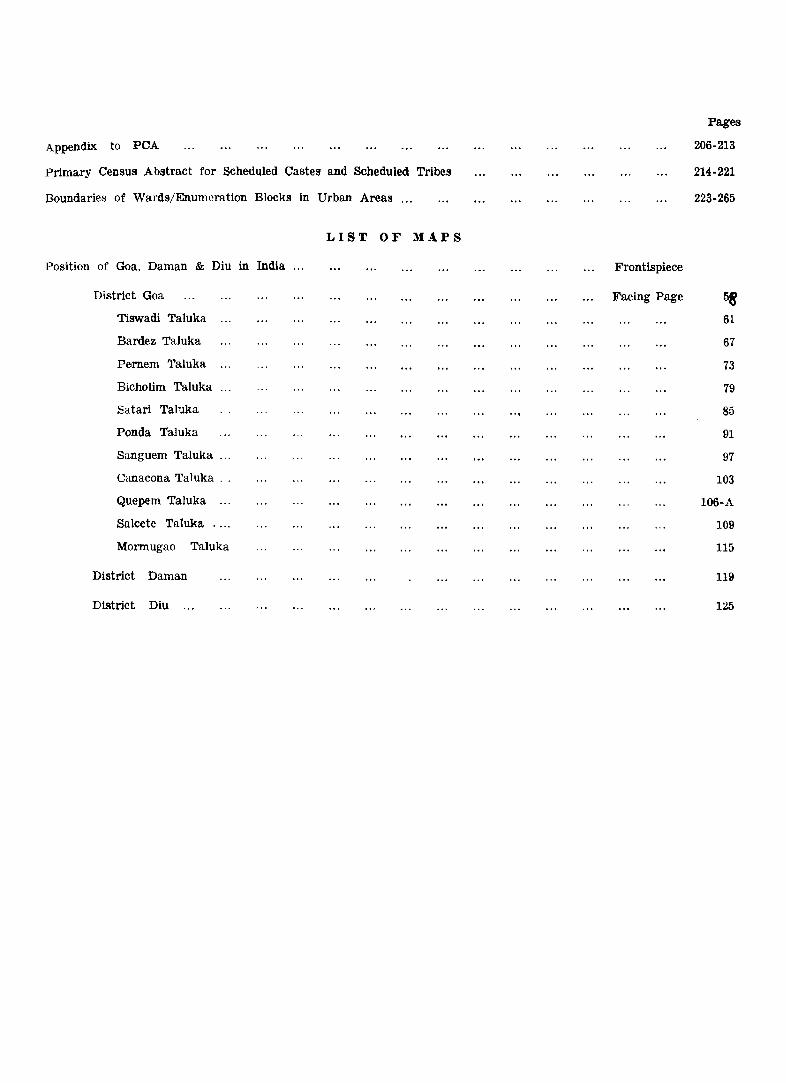
Appendix to peA
Primary Census Abstract for Scheduled Castes and Scheduled Tribes
Boundaries of Wards/Enumeration Blocks in Urban Areas ...
Position of Goa, Daman & Diu in India
District Goa
Tiswadi Taluka
Bardez Taluka
Pe.rnem Taluka
Bicholim Taluka
Eatari Taluka
Ponda Taluka
Sanguem Taluka
Canacona Taluka . .
Quepem Taluka
Salcete Taluka
Mormugao Taluka
District Daman
District Diu
LIST OF MAPS
Frontispiece
Facing Page
Pages
206-213
214-221
223-265
58 6L
67
73
79
85
91
97
103
106-A
109
115
lUI
125
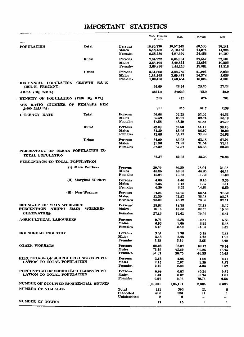
IMPORTANT STATISTICS
POPULATION Total
Itural
Urban
DECENNIAL POPULATION GROWTH RATE (1971-81 PERCENT)
AREA (SQ. KMS.)
, DENSITY OF POPULATION (PER SQ. KM.)
SEX K'\.TIO (NUMBER OF FEMALES PElt ~O MALES)
LITERACY RAT:F~ Total
Rura!
Urban
PERCENTAGE OF URBAN POPULATION TO TOTAL POPULATION
PERCENTAGE TO TOTAL POPULATION
(i) Main Workers
(ii) Marginal Workers
(iii) Non-Workers
BREAK-UP OF MAIN WORKERS: PERCENTAGE AMONG MAIN WORKERS
CULTIVATORS
AGRICULTURAL LABOURERS
HOUSEHOLD INDUSTRY
OTHER WORKERS
PERCENTAGE OF SCHEDULED CASTES POPULATION TO TOTAL POPULATION
PERCENTAGE OF SCHEDULED TRmES POPULATION TO TOTAL POPULATION
NUMBER OF OCCUPIED RESIDENTIAL HOUSES
NUMBER OF VILLAGES
NUMBER OF TOWNS
Persons Males Females
Persons Males Females
Persons Males Females
Persons Males Females
Persons Males Females
Persons Males Females
Persons Males Females
Persons Males Females
Persons Males Females
Persons Males r
Females
Persons Males Females
Persons Males Females
Persons Males Females
Persons Males Females
Persons Males Females
Total Inhabited Uninhabited
Goa, Daman & Diu
10,86,730 5,48,450 5,38,280
7,34,922 3,65,102 3,69,820
3,51,808 1,83,348 1,68,460
26.69
3814.0
285
981
56.66 65.59 47.56
52.68 62.89 43.08
64.99 71.96 57.39
32.87
30.59 45.85 15.04
4.60 2.35 6.89
64.81 51.80 78.07
18.82 16.15 27.10
9.74 6.98
18.48
3.41 3.43 3.35
68.03 73.49 51.07
2.16 2.15 2.16
0.99 1.01 0.97
1,99,531
421 412
9
17
Goa
10,07,749 5,10,152 4,97,597
6,84,964 3,40,821 3,44,148
3,22,785 1,69,331 1,53,454
26.74
3702.0
272
975
57.25 65.99 48.29
53.56 63.06 44.15
65.08 71.88 57.57
32.03
30.89 46.06 15.88
4.46 2.42 6.55
64.65 51.52 78.12
18.75 15.88 27.61
9.82 7.00
18.49
8.36 3.48 3.15
68.07 73.69 50.75
2.05 2.07 2.03
0.07 0.07 0.06
1,85,191
395 386
9
15
Daman
48,560 24,074 24,486
27,557 13,696 13,861
21,003 10,378 10,625
25.35
72.0
674
1017
52.05 62.74 41.55
44.11 56.07 32.28
62.48 71.54 53.63
43.25
28.04 44.85 11.52
8.15 1.57
14.62
63.81 53.58 73.86
22.13 22.52 20.60
10.51 6.95
24.14
5.19 4.28 8.68
62.17 66.25 46.58
1.99 2.89 4.04
20.24 20.74 19.74
8,305
21 21
1
Diu
80,421 14,224 16,197
22,401 10,585 11,816
8,020 3,639 4,381
27.22
40.9
761
1139
44.53 56.19 34.29
36.16 49.00 24.66
67.91 77.11 60.26
26.36
24.98 40.11 11.69
3.50 1.11 5.60
71.52 58.78 82.71
15.57 15.32 16.32
5.86 3.98 9.51
2.83 1.95 3.49
76.74 78.75 70.68
3.71 3.8'7 3.5'7
0.6'7 1.01 0.36
6,035
5 5
1

FOREWORD
The district census handbook (DOH);, compiled by the Oensus Organisation on behalf oj the State Governments, is one oj the most valuable products of the Census. The DOH is constantly referred to by planners, administrators~ academicians and researchers. It is inter alia used jor delimitation of constituencies~ formulation of local level and regional plans and as an aid to District administration. The district census handbook is the only publication which provides Primary Oensus Abstr'act (POA) data upto village level for the rural areas and wardwise for each city or town. It also provides data on infrastructure and amenities in villages and towns, etc.
The district census handbook series was initiated during the 1951 Oensus. It cont'ained important census tables and POA for each village and town ot the district. During 1961 Oensus the scope of the DOH was enlarged and it contained a descriptive acC'ount of the district, administrative statistics, census tables and a village and town directorY7 including PCA. The 1971 DCH series was planned in three parts. Part~A related to village and town directory, Part~B to village and town POA and Part~C comprised analytical report, administrative statistics, district census tables and certain analytical tables based on POA and ,amenity data in respect of villages. Hcnoever, ill some States it was confined to district census tables and in a few cases altogether given up due to delay in compilation and p7'inting.
While designing the format of 1981 DOH series some new features along with the restructuring of the formats of village and town directory have been attempted. At the same time) comparability with the 1971 data has also been kept in view. All the amenities except power supply in the village have been brought together in the village directory with the instruction that in case an amenity is not available in the referrent village the distance in broad ranges from the nearest place where the amenity is available may be given. The restructuring of the format of the village directory and incorporating more exhaustive data on infrastructure aspect particularly in relation to' amenities and land~use pattern is expected to further meet the need of micro level planning for rural areas. It is expected to help not only in local area planning but regulating the provision of goods and services as well so as to minimise the regional imbalances in the pTOcess of development. A few new items of information have also been introduced to meet some of the requirements of the Revised Minimum Needs Programme. Such new items of information as adult literacy centres, primary health sub centres, and community health workers in the village have been introduced in the village directory with this objective in mind, The new item on approach to the village is to have an idea about the villages in the district which are inaccessible. A new column, Utotal population and number ot households)) has been introduced to examine the correlation of the amenities with the population and number of households they serve. Addition of two more appendices listing the villages where no amenities are available and according to the proportion of scheduled caste and scheduled tribe population to the total population has also been made with this view in mind.
The formats of the town directory have also been modified to meet the requirements _of the Minimum Needs Programme by providing information on a few items. A new statement on civic and other amenities in slums in Olass-J and Olass~ll towns (Statement IV-A) has been introduced with this objective in mind. It is expected that this will help the planners to chalk out programmes on provision of civic amenities for the improvement of slums. The columns on Scheduled Castes and Scheduled Tribes population in statement IV relating to civic and other amenities and adult literacy classes/centres under educational facilities in statement V are also added inter alia with this view. A significant addition is class of town in all the seven statements ot the town directory. The infrastruct-ure
ii
oj amenities in urban areas of the country oon be best analysed by taking the class or towns into consideration. The addition of the columns on civic administration status and population in a Jew statements also serves this purpose.
The format of the primary censU8 abstract for the villages and towns has been formuZated in the light of changes in the economic and other questions canvassed through the individual slip Of 1981 Oensus.
In order to avoid delay in publication of 1981 DCH series it has been so designed that Part-A of the volume contains village and town directory and Part-B~ the PCA of villages and towns incuding the Scheduled Oastes and Scheduled Tribes POA upto Tahsil/ /Town levels. At the beginning of the DCB a detailed analytical note supported by a number 0/ inset tables based on POA and non Cen8U8 data in relation to the infrastructure has been introduced to enhance its value. The district and taluka level maps depicting the boundaries and other important features have been inserted at appropriate places) to further enhance the value of the publication.
This publication is a joint venture Of the State Government and the Oensus Organisation. The data have been collected and compiled in the State under the direction of Shri s. K. Gandhe) Director of Census Operations) Goa) Daman &; Diu) on behalf of the State Government which has borne the c.ost of printing. The task of planning) designing and coordination of this publication was carried out by Shri N. G. Nag) Deputy Registrar General (Social Studies) of my office. Dr. B. K. Roy) Deputy Registrar General) (Map) provided the technical guidance in the preparation of the maps. Data received from Oensus Directorates have been scrutinised in the Social Studies Division at the headquarters under the guidance of Shri M. M. Dua) Senior Research Officer. I am thankful to all who have: contributed in this project.
New Delhi the 26th April, 1982
P. PADMANABHA
REGISTRAR GENERAL, INDIA
iii
PREFACE
The provisional results of the 1981 Census were declared on 23rd March, 1981, i. e. just within three weeks of the conclusion of enumeration of population. These results were based on the block-wise totals made in the field and consolidated at the Charge-level and were essentially of a provisional nature. Thereafter all the census questionnaires and schedules were subjected to a thorough scrutiny in the Regional Tabulation Office specially set up at Panaji for the purpose, and the final population data were compiled. Fortunately, difference between the provisional and final data was found to be less than one per cent.
The present District Census Handbook (DCH) is the second in the series so far as this Union Territory is concerned. As a rule, three separate District Census Handbooks should have been brought out. But since two out of the three districts of this territory areonly uni-taluka districts having very small area and popUlation a separate volume for each of them was considered unnecessary. Hence, this combined volume presents data of all the three districts.
This volume presents data in two parts, viz. Part-A and Part-B. Part-A consists of the Village and Town Directories while Part-B consists of the Primary Census Abstracts (PCA). The Village Directory presents for each village, particulars of amenities and facilities available in regard to education, health, drinking water supply, post & telegraph, communications, power, approach to village, land-use pattern etc. Likewise the Town Directory presents similar data separately for each town of the territory. The PCA presents for each village, each town and each ward within the town, the basic data on population collected in the 1981 Census.
A special feature of the DCH this time is the detailed analytical note supported by a number of inset tables based on the data in the village and Town Directories and taluka maps depicting the village/town boundaries and other important features such as roads, railways, rivers, service facilities like post and telegraph offices, higher secondary schools, colleges, hospitals, dispensaries, primary health centres, maternity and child welfare centres, police stations etc. are also included in the DCH.
The non-census data given in the Village Directory and Town Directory were collected from the State Government Department such as, Education, Health, Planning, Statistics and Evaluation, Land Survey, Town and Country Planning, etc. and offices of the Taluka Mamlatdars, Municipalities and Village Panchayats. I am grateful to these departments/ / offices for supplying us the data.
The maps were prepared in my office but in technical consultations with the Departments of the Town and Country Planning and Land Survey of the Govt. of Goa, Daman & Diu.
This Handbook is the product of hard toil and labour of several persons in my office. In particular, I wish to place on record my grateful appreciation of the contributions of
_>Shri S. Rajendran, Dy. Director, Srot. Mala D. Kamat, Investigator, S/Shri M. R. Naik and P. R. Gaonkar, Statistical Assistants, Shri B. D. Subedar, Artist a~d S/Shri .Jose Veliath and A. Bhatkuly, Computors. Shri .Jose F. Fernandes, Stenographer and Shri S. R. Arlekar, L. D. C., ably typed out the final manuscripts.
My thanks are due to Shri M. K. Bhandare, Manager, Govt. Printing Press, Panaji, for the personal attention he paid to the printing of this book.
Shri N. G. Nag, Dy. Registrar General (Social Studies) and Dr. B. K. Roy, Dy. Registrar General (Map) of the Office of the Registrar General, India, New Delhi, provided technical guidance in this work which is gratefully acknowledged.
I shall be failing in my duty if I do not express my sincere gratitude to Shri P. Padmanabha, I. A. S., Registrar General, India, New Delhi, for his very valuable guidance in the preparation of the DCH.
Panaji,
June 23, 1982.
S.K.GANDHE
Director of Census Operations,
Goa, Daman & Diu, Pana,i
ANALYTICAL NOTE

AN,ALYTICAL 'NOTE
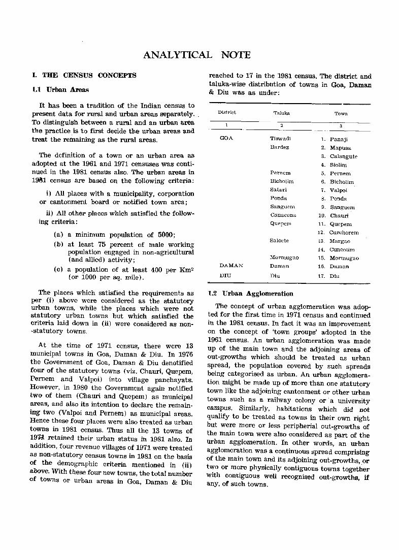
I. THE CENSUS CONCEPTS
1.1 Urban Area. ..
It has been a tradition of the Indian census to present data for rural and urban areas separately. , To distinguish between a rural and an urban area the practice is to first decide the urban areas and treat the retttaining as the rural areas.
The definition of a town or an urban area as adopted at the 1961 and 1971 censuses was con~inued in the 1981 census also. The urban areas m 1~1 census are based on the following criteria:
i) All place'S with a municipality, corporation or cantonment board or notified town area;
ti) All other places which satisfied the following criteria:
(a)
(b)
(c)
a minimum population of 5000;
at least 75 percent of male working population engaged in non-agricultural (and allied) activity;
a population of at least 400 per Km2 (or 1000 per sq. mile).
The places which satisfied the requirements as per (i) above were considered as the statutory urban towns, while the places which were not statutory urban towns but which satisfied the criteria laid down in (ii) were considered as non-statutory towns.
At the time of 1971 census, there were 13 municipal towns in Goa, Daman & Diu. In 1976 the Government of Goa, Daman & Diu denotified four of the statutory towns (viz. Chauri, Quepem, Pernem and Valpoi) into village panchayats. However, in 1980 the Government again notified two of them (Chauri and Quepem) as municipal areas, and also its intention to declare the remaining two (Valpoi and Pernem) as municipal areas. Hence these four places were also treated as urban towns in 1981 census. Thus all the 13 towns of 191-1 retained their urban status in 1981 also. In addition, four revenue villages of 1971 were treated as non-statutory census towns in 1981 on the basis
. of the demographic criteria mentioned in (ii) above. With these four new towns, the total number of towns or urban areas in Goa, Daman & Diu
reached to 17 in the 1981 census. The district and taluka-wise distribution of towns in Goa, Daman & Diu was as under:
District
1
GOA
DAMAN
DIU
Talukia
2
Tiswadi
Bardez
Pernem
Bicholim
Satari
Ponda
Sanguem
Canacona
Quel')em
Salcete
lIformugao
Daman
Diu
1.2 Urban Agglomeration
1.
2.
3.
4.
5.
6.
7.
8,
9.
1(}.
11.
12.
13.
14.
15.
16.
17.
Town
3
Panaji
Mapusa
Calangute
Siolirn
Pemem
Bicholim
Valpoi
Ponda
Sanguem
Chauri
Que!)€m
Curchorem
Margao
Cuncolim
Mormugao
Daman
Diu
The concept of urban agglomeration was adopted for the first time in 1971 census and continued in the 1981 census. In fact it was an improvement on the concept of 'town groups' adopted in the 1961 census. An urban agglomeration was made up of the main town and the adjoining areas of out-growths which should be treated as urban spread, the popu\ation covered by such spreads being categorised as urban. An urban agglomeration might be made up of more than one statutory town like the adjoining cantonment or other urban towns such as a railway colony or' a university campus. Similarly, habitations which did not qualify to be treated as towns in their own right but were more or less peripherial out-growths of the main town were also considered as part of the Urban agglomeration. In other words, an urban agglomeration was a continuous spread comprising of the main town and its adjoining out-growths, or two or more physically contiguous towns together with contiguous well recognised out-growths, if any, of such towns.
-2-
There were two urban agglomeration in Goa, Daman & Diu which were identified in 1971, viz. the Panaji Urban Agglomeration and the Margao Urban Agglomeration. These were continued in 1981 also. The constituent units of these two urban agglomerations were as under:
Panaji Urban Agglomeration:
1. Panaji Municipal Council
2. Panelim
3. Chimbel
4. Morambi-o-Grande (Merces)
5. Renovadi
6. Durgavado
7. Taleigao
8. Calapor
9. Cujira
10. Murda
11. Morambi-o-Pequeno (Merc~)
Mar'gao Urban Agglomeration:
1. Margao Municipal Council
2. Navelim
3. Aquem
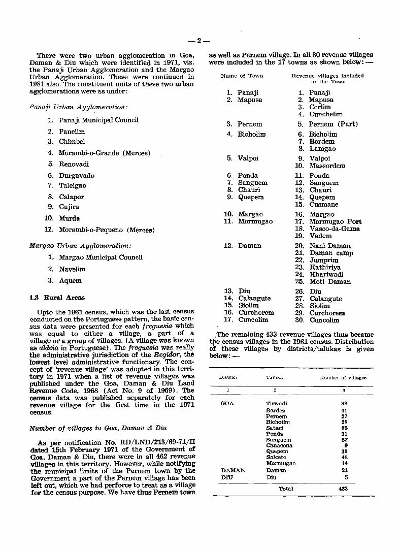
1.8 Rural Areas
Upto the 1961 census, which was the last census conducted on the Portuguese pattern, the basic census data were presented for each freguesia which was equal to either a village, a part of a village or a group of villages. (A village was known as aldeia in Portuguese). The freguesia was really the administrative jurisdiction of the Regidor, the lowest level administrative functionary. The concept of 'revenue village' was adopted in this territory in 1971 when a list of revenue villages was published under the Goa, Daman & Diu Land Revenue Code, 1968 (Act No. 9 of 1969). The census data was published separately for each revenue village for the first time in the 1971 census.
N~tmber of villages in Goa, Daman &; Diu
As per notification No. RD/LND/213/69-71/n dated 15th February 1971 of the Government of Goa, Daman & Diu, there were in all 462 revenue villages in this territory. However, while notifying the municipal limits of the Pernem town by the Government a part of the Pernem village has been left out, which we had perforce to treat as a village for the census purpose. We have thus Pemem town
as well as Pernem village. In all 30 revenue villages were included in the 17 towns as shown below: -
Name of Town Revenue villages included in the Town
1. Panaji 1. Panaji 2. Mapusa 2. Mapusa
3. Corlim 4. Cunchelim
3. Parnem 5. Pernem (Part)
4. Bicholim 6. Bicholim 7. Bordem 8. Lamgao
5. Valpoi 9. Valpoi 10. Massordem
6. Ponda 11. Panda 7. Sanguem 12. Sanguem 8. Chauri 13. Chauri 9. Quepem 14. Quepem
15. Cusmane 10. Margao 16. Margao 11. Mormugao 17. Mormugao Port
18. Vasco-da-Gama 19. Vadem
12. Daman 20. Nani Daman 21. Daman camp 22. Jumprim 23. Kathiriya 24. Khariwadi 25. Moti Daman
13. Diu 26. Diu 14. Calangute 27. Calangute 15. Siolim 28. Siolim 16. Curchorem 29. Curchorem 17. Cuncolim 30. Cuncolim
{rhe remaining 433 revenue villages thus became t~e census villages in the 1981 census. Distribution o these villages by districts/talukas is given below:-
Distrlcl
1
GOA
DAMAN DIU
Tal11k.a
::
Tiswadi Bardez Pemem Bicholim SataJrl Ponda Sanguem Canacona Quepem Salcete Monnugao Daman Diu
Total
Number of villagee
3
38 41 27 28 80 31 52
9 39 48 14 21
5
~3
-3-
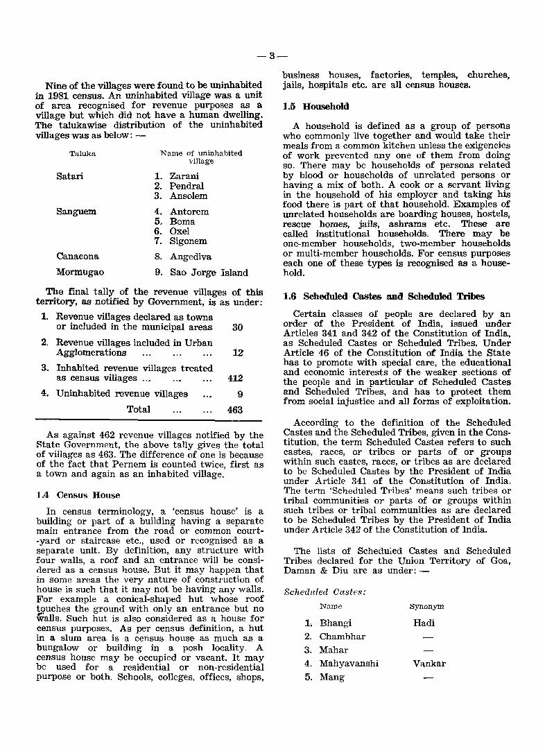
Nine of the villages were found to be uninhabited in 1981 census. An uninhabited village was a unit of area recognised for revenue purposes as a village but which did not have a human dwelling. The talukawise distribution of the uninhabited villages was as below: -
Taluka
Satari
Sanguem
Canacona
Mormugao
Name of uninhabited village
1. Zarani 2. Pendral 3. Ansolern
4. Antorern 5. Barna 6. Oxel 7. Sigonem
8. Angediva
9. Sao Jorge Island
The final tally of the revenue villages of this territory, as notified by Government, is as under:
1. Revenue villages declared as towns or included in the municipal areas 30
2. Revenue villages included in Urban Agglomerations 12
3. Inhabited revenue villages treated as census villages ... 412
4. Uninhabited revenue villages 9
Total 463
As against 462 revenue villages notified by the State Government, the above tally gives the total of villages as 463. The difference of one is because of the fact that Pernem is counted twice, first as a town and again as an inhabited village.
1.4 Census House
In census terminology, a 'census house' is a building or part of a building having a separate main entrance from the road or common court-yard or staircase etc., used or recognised as a separate unit. By definition, any structure with four walls, a roof and an entrance will be considered as a census house. But it may happen that in some areas the very nature of construction of house is such that it may not be having any walls. For example a conical-shaped hut whose roof t!?uches the ground with only an entrance but no ~ans. Such hut is also considered as a house for census purposes. As per census definition, a hut in a slum area is a census house as much as a bungalow or building in a posh locality. A census house may be occupied or vacant. It may be used for a residential or non-residential purpose or both. Schools, colleges, offices, shops,
business houses, factories, temples, churches, jails, hospitals etc. are all census houses.
1.5 Household
A household is defined as a group of persons who commonly live together and would take their meals from a common kitchen unless the exigencies of work prevented anyone of them from doing so. There may be households of persons related by blood or households of unrelated persons or having a mix of both. A cook or a servant living in the household of his employer and taking his food there is part of that household. Examples of unrelated households are boarding houses, hostels, rescue homes, jails, ashrams etc. These are called institutional households. There may be one-member households, two-member households or multi-member households. For census purposes each one of these types is recognised as a household.
1.6 Scheduled Castes and Scheduled Tribes
Certain classes of people are declared by an order of the President of India, issued under Articles 341 and 342 of the Constitution of India, as Scheduled Castes or Scheduled Tribes. Under Article 46 of the Constitution of India the State has to promote with special care, the educational and economic interests of the weaker sections of the people and in particular of Scheduled Castes and Scheduled Tribes, and has to protect them from social injustice and all forms of exploitation.
According to the definition of the Scheduled Castes and the Scheduled Tribes, given in the Constitution, the term Scheduled Castes refers to such castes, races, or tribes or parts of or groups within such castes, races, or tribes as are declared to be Scheduled Castes by the President of India under Article 341 of the Constitution of India. The term 'Scheduled Tribes' means such tribes or tribal communities or parts of or groups within such tribes or tribal communities as are declared to be Scheduled Tribes by the President of India under Article 342 of the Constitution of India.
The lists of Scheduled Castes and Scheduled Tribes declared for the Union Territory of Goa, Daman & Diu are as under:-
Scheduled Castes:
Name Synonym
1·, Bhangi Hadi 2. Chambhar
3. Mahar
4. Mahyavanshi Vankar 5. Mang
-t-·
Scheduled Tribes:
Name
1. Dhodia 2. Dubla
3. Naikda
4. Siddi
5. Varli
Synonym
Halpati, Talavia Nayaka
It may be mentioned here that the Scheduled Castes are found only among Hindus and Sikhs, while the Scheduled Tribes can be found in any religion.
1.7 Literate
A literate person is defined as one who can both read and write with understanding in any language. A person who can merely read but cannot write is not literate. Ability merely to sign one's name is not adequate to qualify a person as being able to write with understanding. It is not necessary that a person who is literate should have received any formal education or should have passed any minimum educational standard. All children of the age of 4 years or less were treated as illiterate even if any child of that age-group was going to school and had picked up reading and writing a few odd words.
1.8 Main Workers and Marginal Workers
In the 1981 census, a worker was defined as a person who had done any economically productive work during the last one year preceding the date of enumeration. According to this definition the term workers included all the full-time workers, seasonal workers, part-time workers and even those workers whose contribution to work would generally be considered insignificant. The workers were further classified into 'main workers' and 'marginal workers'. Main workers were those who worked for the major part of the year i. e. six months and more preceding the date of enumeration. Thus, all the workers who worked for six months and more were considered as main workers. Marginal workers were those who worked any time in the last one year preceding the date of enumeration, but for a period of less than six months.
1.9 Cultivators, Agricultural Labourers, HHI Workers and Other Workers
Main workers are further divided into fow broad categories, viz.· Cultivators,· Agriculturd.l Labourers, Householg. Industry Workers and.Other
Workers. These four categories are defined hereunder:
Oultivators: For purposes of the Census, a person is considered as cultivator if he or she is engaged either as employer, single worker or family worker in cultivation of land owned or held from Government or held from private persons or institutions for payment in money, kind or share of crop. Cultivation includes supervision or direction of cultivation.
A person who has given out his/her land to another person or persons for cultivation for money, kind or share of crop and who does not even supervise or direct cultivation of land is not treated as cultivator. Similarly, a person working in another person's land for wages in cash or kind or a combination of both is not treated as cultivator. Co.
Cultivation involves ploughing, sowing and harvesting and production of cereals and millet crops such as wheat, paddy, jowar, bajra, ragi etc., and other crops such as sugarcane, ground-nut, tapioca, etc. and pulses, raw jute and kindred fibre crop, cotton, etc., but does not include fruit growing, vegetable growing or keeping orchards or groves or working on plantation like tea, coffee, rubber, cinchona and other medicinal plantations.
Agricultural Labourer8: A person who works in another person's land for wages in money, kind or share of· crop is regarded as an agricultural labourer. Such person has no risk in cultivation but merely works in another person's land for wages. An agricultural labourer has no right of lease or contract on land on which he works.
Household Industry: Household industry is defined as an industry conducted by the head of the household himself/herself and or by the members of the household at home or within the village in rural areas, and only within the precincts of the house where the household lives in urban areas. A larger proportion of workers in a household industry should consist of members of the household including the Head. The industry should not be run on the scale of a registered factory.
The roain criterion of a household industry is the participation of one or more members of a household. This criterion applies in urban areas too. Even if the industry is not actually located at home in rural areas there is greater possibiliQc of the members of the household participating even if it is located anywhere within the village limits. In the urban areas where organised industry takes greater prominence, the household industry should be confined to the precincts ot the house where the participants live. In u.1imu areas even if the members of the household by
-5-
themselves run an industry but at a place away! from the precincts of their home, it is not considered a household industry.
A household industry relates to production, processing, servicing, repairing or making and selling (but not merely selling) of goods. It does not include professions such as those practised by pleader or doctor or barber, musician, dancer, dhobi, astrologer etc.
Other Workers: All those who work in any field of economic activity other than cultivation, agricultural labour or household industry are 'other workers'. The types of worker that come under this category include factory workers, plantation workers, those in trade, commerce, business, transport, mining, construction, political or social work,
-all Government servants, municipal employees, teachers, priests, entertainment artists, etc.
1.10 Non-workers
Persons who did not participate in any economically productive work were classified as non-workers. This category generally included persons doing household duties at homes, students, dependents, retired persons or rentiers, beggars, inmates of institutions and other non-workers like persons seeking job etc. who did not participate in any economically productive activity.
Household duties: This covers all persons who are engaged in unpaid home duties and who do not do other work or have not done any work at all during the last one year preceding the date of enumeration.
Students: This covers all full-time students ana children attending school.
Dependents: This category includes all dependents such as infants and children not attending scbool or persons permanently disabled from work because of illness or old age. It includes even able-bodied persons who cannot be categorised in any other category of non-worker but are dependent on others. If such persons who are dependent on others for subsistence are seeking work, they are categorised as other non-workers.
Retired perSfmS or rentiers: A person who has r.¥!tired from service and is doing no other work i. e. not employed again in some full-time work or not engaged in some other work such as cultivation, business, trade etc. or a person who is a rentier or living on agricultural royalty, rent or dividend or any other person of independent means for securing which he/she does not have to work, ~ome under this category.
Beggars, etc.: This covers beggars, vagrants or cases such as persons without indication of source of income and those with unspecified sources of subsistence who are not engaged in any economically productive work.
Inmates 0/ institutions: This covers convicts in jails or inmates of penal, mental or charitable institutions, even if such persons are compelled to do some work such as carpentry, carpet weaving, vegetable growing etc. in such institutions. But an undertrial prisoner enumerated in a jail is recorded for the work he/she was doing before he/she was apprehended. Similarly, a person temporarily in a hospital or similar institution is recorded for the kind of work he/she was doing before he/she was admitted into the hospital or institution. But for a long-term undertrial prisoner or convict in a prison or for long-term inmates of penal or charitable or mental institutions, the person's previous work is not recorded.
Other non-workers: This includes all non-workers who do not come under any of the above six categories but who are looking for work. A boy or girl who has completed education or stopped studying and is looking for work comes under this category. A person who is merely spending his/her time at home as a dependent and is not doing any work and is not seeking any work is not considered as other non-worker but covered under dependents. A person irrespective of age and whether educated or not, if he/she reports that he/she is not engaged in any other activity but is seeking work is covered under this category.
1.11 Two Phases of Census
The 1981 census was completed in two phases, the first being the House-numbering and Houselisting phase and the second being the Enumeration of population phase. The first phase was carried out in March-April, 1980 when two schedules viz. Houselist and the Enterprise list were canvassed for every household or enterprise. Canvassing of the enterprise list was in fact a part of the Economic Census which was combined with the population census at the instance of the Central Statistical Organisation, Ministry of Planning, Govt. of India, New Delhi. The enumeration of population was done during the period from 9th February to 28th February 1981, with the sunrise of 1st March, 1981, as the reference time/date. The revisional round was conducted between 1st March and 5th March, 1981. Two important schedules were canvassed during the enumeration phase viz. the Household Schedule (Part I and IT) and the Individual Slip. While the household schedule was canvassed for each and every household, the individual slip was canvassed for each and every living individual in the household.

-6-
IL LOCATION, TERISTICS DETAILS
PHISIOGRAPmC CHARACAND OTHER RELEVANT
Goa, Daman & Diu which forms an independent union territory within the Indian Union was under the erstwhile Portuguese regime for about 450 years. It was liberated from the foreign rule on 19th December, 1961 and was integrated with India vide the Constitution (Twelfth Amendment) Act, 1962, dated 27th March 1962. The union territory comprises of three distinct land blocks respectively named Goa, Daman and Diu, all situated on the western coast of the Indian peninsula but separated from one another by a distance of more than 500 kms. each. The main block of Goa, which has Panaji as the capital of the territory, is situated between the coastal borders of Karnataka and Maharashtra. Daman which lies about 168 kms. to the north of Bombay is situated on the Gujarat coast near the Valsad district, while Diu is a tiny island oftthe Saurashtra coast near the port of Veraval. Administratively too the territory is divided into three districts respectively called, Goa, Daman and Diu. There are 13 talukas in this territory, 11 in Goa district and one each in Daman and Diu districts.
There are 424 inhabited villages and 17 towns in this territory as per the 1981 census, of which 398 villages and 15 towns are in Goa district· 21 villages and one town in Daman district an'd 5 villages and one town in Diu district. Nine villages are uninhabited in the 1981 census all of which are in Goa district.
The geographical area of the union territory as per the Surveyor General India is 3814 km.2, of which 3702 km.2 (or 97.06%) is the area of the district of Goa alone. The geographical area of the district of Daman is 72 Km." (1.89%) and that of Diu is 40 Km! (1.05%).
The district of Goa is situated between the parallels 150-47'-59" and 14°-53'-57" of latitude north and between the meridians 73°-40'-54" and 74°-20'-11" of longitude east of Greenwich. Its length, north to south, measures 105 kms. and width, east to west, measures 60 kms. The altitudes of the towns of this district range between 20 and 62 metres above the sea level.
The boundaries of this district are well defined in the north by the river Tiracol which separates it from Sindhu Durg district of Maharashtra State, in the east and south by the Belgaum and Uttar Kannad districts of the Karnataka state, and in the west by the Arabian sea. The district has a hilly terrain especially on its eastern side where lies the southern ends of the Sahyadri range.
These mountains after skirting a considerable portion of the north eastern and south eastern boundaries branch off westwards across the territory with many spurs and ridges. The terrain is intersected by a number of rivers flowing westwards and meet the Arabian sea. These rivers provide a network of internal waterways. The important rivers are Mandavi, Zuari, Tiracol, Chapora and Betul which are navigable and as such most vital for the economy of this territory. The coast is full of creeks and estuaries formed by these rivers which provide a good shelter for the fishing crafts. Estuaries of these rivers are rich in marine fauna. The 100 kms. long coastal line of Goa is endowed with some of the loveliest beaches in the world which have earned international fame of bearing idyllic beauty spots.
The physiographic characteristics are ric~ and varied consisting of verdant hills, forests~ coconut groves and rich fields. The most picturesque region is located in the lower basin of the Mandovi and Zuari which join to form a bay. There are about half a dozen islets between the estuaries of these rivers, the largest of which is Goa from which the whole territory appears to have derived its name. The port of Mormugao situated on the southern side of Zuari river is one of the best natural harbours on the west coast of India and can shelter large ocean-liners.
The soil in general is laterite. The agricultural lowlands especially in the coastal tract, are alluvial flats formed through sedimentation along the principal rivers. About one fourth of the area of Goa is under forests and the same originates from archaean rock formation which are very thick. The soil is murum on the slopes. Many commercial tree species thrive in the well aerated soils at the foothills, where the murum is mixed with humus to form a loamy soil, wh(;lre the growth is ofteb. thick and high. In the valleys where perennial natural water springs occur, there are plantation of arecanut.
The climate is warm and humid. From June to September heavy rainfall is received from the south-west monsoons which ranges between 2500 to 4300 millimetres. The year round temperature ranges from 22°C to 32°C.
The district is divided into two sub-divisions for the administrative purposes viz. the north division consisting of five talukas and the south division consisting of six talukas. For the purposes of revenue administration each taluka is in char~ of a Mamlatdar. For development purposes the district of Goa is divided into 10 community development blocks (the Salcete and Mormugao talukas together form one development block), each being in charge of a Block Development Officer. There are 185 Village Panchayats in Goa district, a Panchayat comprising of one village or a
-7-
group of villages. Of the 15 towns in the district, ten have been formed into Municipal Councils. The remaining five towns are 'census towns' with the civic status of a Panchayat. Government has already notified its intention to declare one more town (Valpoi) as a statutory municipal area.
The district of Daman is situated on the westcoast of India between the parallels 20°-27'-58" and 20°-22'-00" of latitude north and between the meridians 72°-49'-42" and 72°-54'-43" of longitude east of Greenwich. Its length from the extreme north to south measures 11 km. and width from east to west, measures 8 kms. The altitude is 12 metres above the sea level. This district is bounded on the north by the Bhagwan river, on the east by the Valsad district of Gujarat state, on the south by the Kalem river and on the west
.... by the Arabian sea.
The district is divided by the Damanganga river into two parts. Three west flowing rivers p~ss through the terrain viz. the Bhagwan river runnmg along the northern boundary, the Kalem river forming the southern boundary and. the I?am8:n-ganga river lying in between. The cllmate IS mild and warm. The district receives an average annual rainfall of 1600 millimetres. The maximum and minimum temperature of Daman town is 31°C and 22°C respectively. The district of Daman is located at a distance of about 748 kms. from Goa, i. e. from the capital of this territory. It is a uni-taluka. district comprising of 21 villages and one town of the same name. There are six Village Panchayats in this district and one municipal town.
The district of Diu is situated between the parallels 20°-44'-34" and 20°--42'-00" of latitude north and between the meridians 71°-00'-24" and 70°-52'-26" of longitude east of Greenwich. Its length from the extremes north and south, measures 4.6 kms. and width from east to west measures 13.8 kms. It is a tiny inland in the Arabian Sea near the port of Veraval, separated from the southern extremity of the Saurashtra peninsula by a narrow channel running through a swamp. The channel is navigable only for fishing boats and small crafts. On the south of the inland, there is a sandstone cliff washed by the sea. Close-by the water is deep. The topography is generally plain, the hillocks attaining a maximum height of 30 metres. The climate is sultry. The altitude of Diu town is six metres above the sea level and it receives an average annual rainfall Ili 540 millimetres. The maximum and minimum temperature of Diu Town is 300 C and 22nC respectively. The soil is barren. It is also a uni-taluka district comprising of 5 villages and a municipal town of the same name. There are 3 Village Panchayats. This tiny island is 1542 kms. away from the capital of the union territory, viz. Panaji town in Goa district.
m. A BRIEF mSTORICAL SKETCH OF GOA, DAMAN & DIU
Goa
The name of the territory 'Goa' seems to have been derived from Gomanta which is referred to in the Bhishmaparva of the great epic Mahabharata and also the Harivamsa and Skandapurana. It is referred to in old inscriptions variously as Gomanchala, Gomanta, Gopakapura and Gove. The Madras glossary connects it with the sanskrit 'go' (a cow) in the sense of 'cowherds' country.
According to Puranic traditions, Parashurama, the Sixth incarnation of God Vishnu, is said to have reclaimed the land of Gomanta from the sea and the Aryans and Brahmins of different stocks were settled by him on the banks of the rivers Gomati and Aghanasini which are now popularly known as Mandovi and Zuari respectively.
Before the advent of the Portuguese early in the sixteenth century, the district covered very extensive areas which included towards the north part of the Ratnagiri district of Maharashtra then known as Kudal and Rajapur mahals upto the river Karepatan. The southern limits extended towards Ankola and comprised the ancient mahals of Supa, Halyal and Karwar now forming part of Uttar Kannad district of Karnataka. Towards the east it covered a large portion of Belgaum district.
The earliest known historical record of Goa belongs to the fourth century A. D. The Konkan Bhojas seem to have held their sway over Goa before Christian era. Later on it was under the rule of the Satavahanas of Kolhapur in the first century of the Christian era. The Bhojas continued 'to rule over Goa from their capital at Chandrapur
i (present Chandill' in Salcete taluka) upto the I seventh century A. D. The Bhojas were followed
by the Konkan Mauryas. The king Anirjitavaram belonging to the Konkan Mauryan dynasty ruled over the North Part of Goa from Kumaradvipa (present Cumbarjua in Tiswadi taluka) during the Sixth century. It formed part of the empire of Chalukyas of Badami from 580 to 750 A. D. The next important dynasty which dominated affairs in Goa for over two and a half centuries was th{' family of the south Konkan Silaharas who hailed from Goa itself. They were routed by the North Konkan Silaharas who were ruling from Sthanaka (Thana). They occupied Gopakapattana for some time till they were ousted by the Goa Kadambas who had established themselves at Chandra pur. The Kadamba ruled from about 980 A. D. to about 1355 A. D.
In the thirteenth century the territory passed under the rule of the Yadavas of Devagiri and the Kadambas ruled as their feudatories. The Kadambas of Goa seem to have become independent by
the early part of ~he' fourteenth century A. D. when Yadavas were defeated at the hands of the Delhi Sultans. The dynasty of the king Bhuma Bhupal seems to have ruled for sometime over Goa during the first half of the fourteenth century from the Gopakapathan. Later on the territory seems to have passed under the domination of Deccan Sultan during the reign of Muhammad Bin Tughlaq.
Goa became a part of the Vijayanagar kingdom by the fourteenth century. In 1469 Goa passed under the Bahamani Sultan of Deccan. With the break up of Bahamani dynasty it became a part of the kingdom of Adilshah of Bijapur in 1488 from whom the island of Goa was taken by the Portuguese in 1510. During the rule of Ac1ilshah of Bipajur, Ella or Old Goa (Velha Goa) became a prosperous city and was virtually the second. capital of the Bajapur Sultans.
Afonso de Albuquerque, a Portuguese general, is known as the founder of the Portuguese rule of Goa in India. He first captured Goa on 17th February, 1510. Yusuf Adilshah, King of Bijapur, retook it on 23 May, 1510 and Albuquerque recaptured it on 25th November, 1510. Albuquerque conquered the important port of Goa so as to maintain Portuguese supremacy over the seas and the neighbouring kingdoms. By and by he annexed new enclaves on the coast and made all possible efforts to consolidate them under one rule. The 'Concelhos' (talukas) of Bardez and Salcete were conquered in 1543. By the middle of the sixteenth century, the Portuguese were successful in establishing their rule in four 'cDnceIhos' (talukas) which are known as 'Velhas Conquistas' (old conquests) which comprised the island of Goa (Tiswadi) and the talukas of Salcete (inclusive of Mormugao) and Bardez.
The Marathas under Shivaji built up a strong fleet and harassed the Portuguese on the seas during the seventeenth century. While his army overran Bardez, Sambhaji, his son, threatened at the very gates of the city of Old Goa but had to give up the siege to meet the Mughals. After the decline of Maratha power by the end of the eighteenth century, the talukas of Pernem, Bicholim and Satari situated to the north and which were ruled by the Maratha vassals of the Sawantwadi were occupied by the Portuguese in 1788. Similarly talukas of Ponda, Sanguem, Canacona and Quepem forming part of the territory of Ma-ratha vassal Chief of Sonda were occupied by the Portuguese by the end of the eighteenth century. These annexations were called Novas Conquistas (new conquests).
The year 1787 witnessed a revolt against the Portuguese led by Fr. C. F. Pinto for the establishment of a Republic of Goa. This however
could not materialise. The Desais and Ranes of Satari were always against the Portuguese. A major revolt took place on 26 January, 1852 against Portuguese rule when Deepaji Rane directed the operations from the fort of Nanus in Satari. Many minor mutinies followed this, important among them being the Vonoi revolt of 1870 and the Sepoy mutiny of 1895. The Ranes made their last efforts in 1912 to overthrow Portuguese TIlle but they could not succeed. The nineteenth century was noted for bloodshed and political uprising in Goa. The Goans, however, kept the spirit of patriotism active and continued their struggle for freedom. A fresh Goan freedom movement was launched in 1930. The silent and non-violent revolution organised by Mahatma Gandhir in India had its effect on Goa too. Dr. Tristan Braganza Cunha, a brave Goan nationalist. established the Goa Congress Committee in 1930 and. got it affiliated to the Indian National Congress. From this time onwards, the Goan freedom movement took the shape of non-violent civil disobedience. After India got independence in 1947, the Government of India made all possible efforts to persuade Portugal to withdraw peacefully. But the Portuguese Government was reluctant to do so. The liberation of Dadra and Nagar Haveli on 21 July, 1954 gave a further fillip to the Goan freedom movement. The mass satyagraha organised on 15 August, 1954 and the ruthless killings bf the satyagrahis by the Portuguese army at that time led to strained relations between Portugal and India. Diplomatic relations were broken on 19 August, 1955. The Government of India tried once again to persuade the Portuguese Government to withdraw peacefully but the latter did not respond favourably. This adamant attitude of the Portuguese ultimately forced the Government of India to send an army to liberate Goa. The
. historic event, which marked the end of 450 years I of the Portuguese rule, took place on 19 Decem
ber, 1961 and Goa, Daman and Diu became free and a part and parcel of India on that day.
Daman:
The district of Daman is known to have formed part of the country known as Lata which was one of the seven divisions of the Aparant or Konkan Vishaya, between 2nd century B. C. to 13th century A. D. The Daman district is included in the intervening region and therefore must have formed part of the Mauryan empire at least at the time of Ashoka. After the Mauryan power was weakened, the district was under the rule of Satkarni :J. the Satavahana ruler in the end of 2nd century B. C. After that during the 1st century A. D. the district of Daman seemed to have been ruled by Kshaharatas who were the provincial governors i. e. Kshatrapas under the Kushana emperors. During A. D. 125 Satkarni drove away the Kshaharatas and ruled the district. But the Satavahana
-:.9.-·
rule was shortlived. The Kshatrapas of Ujjain reconquered the district by about A. D. 150 from the SatavahaIia ruler Satakarni and Daman district again passed under the rule of Kshatrapas of Ujjain till A. D. 249. After the Kshatrapa the district was ruled by the Abhir kings till A.D. 416.
After the rule of Abhir kings the district was under the rule of Traikutakas during the 5th century A. D. whq were the feudatories of the Abhiras. By A. D. 500, the Traikutaka power seems to have been destroyed by the Vakataka king Harishena. The district then was under the p.o~er of the Kalachuris. of Mahishmati king Krishnaraja and his successors till A. D. 609. King Mangales o:f Chalukyas of Badami routed out the last king Budharaja of Italachuris by about A. D. 609. The Chalukyas of Badami ruled the district tm A. D. iJ71 and their descendants known as Lab or N2.vasari Chalukyas ruled from Navasarika, modern Navasari, on the bank of the river Purna to the xwrth of Damall. They ruled independently as feudatories of we Badami Chalukyas of the Deccan. In the next eight centuries Daman came under the control of a large number of Hindu kings and chieftains.
Mahmud Shah Begada, Sultan of GUjarat. seems to have conquered fort Parnera on the river Par and port of Daman and levied tribute from Jagatshah in 1465. Naranshah who succeeded Jagatshah ruled from A. D. 1470 to 1500 and Dharmshah II from 1500 to 1531.
Daman was acquired by the Portuguese from the Shah of Gujarat. They noticed the port of Daman for the first time in 1523. They attacked it several times and finally obtained it in 1559 by means of a treaty with the Shah. Thereafter it was under the rule of Portuguese till its liberation in 1961.
Diu
The documented history of the district of Diu begins with the Maurya rule (c. 322-220 B. C.). Emperor Chandragupta Maurya had extended his supremacy over Saurashtra and had appointed Pushagupta as Governor of the province of Saurashtra with the Head-quarters in village Girnar near Junagadh. Yavanaraj Tushappa ruled over Saurashtra as Governor of Emperor Ashoka (c. 273-237 B. C.). Emperor Ashoka had sent Yavana Thero named Dhammarakhito as evange-
. list to the western sea board including Diu. His g:j8.ndson Samprati (c. 229-220 B. C.) seems to have ruled over Saurashtra from Ujjain. He propagated Jainism and erected many Jain temples. The Jain traditions from Diu seems to belong to this period.
The district seems to be under the rule of Indo-Greek kings Eukratides (c. 171-150 B. C.), Menan-
dar (c. 115 to 90 B. C.) and Appollodotes IT of the 1st century B. C. No historical information is available for the period of 150 years from the 1st century B. C. to. about A. D. 50. During the A. D. 1st century the district seems to have been ruled by Kshatrapas who had established their rule over western part of India including Saurashtra~ For more than the next thousand years, Diu fonned part of the kingdoms or dynasties that ruled over the western India including Gujarat. The last king of the Vaja dynasty ruler of Somnath Patan ruled over Diu in the first decade of the fifteenth century. Thereafter Diu came under the control of the Muslim Sultans of Gujarat who seem to have ruled Diu for the next one and a half centuries.
Early in 1535, the Portuguese Governor De Cunha had led his expedition for the capture of the town of Diu, but was defeated by the Sultan. However around that period the Gujarat Sultan Bahadur Shah's kingdom was overwhelmed by Mughal invasion. Pressed by Mughal king Humayun on one side and the Portuguese at the gates of Diu, Bahadur Shah entered into a treaty with Nuno da Cunha on October 25, 1535 who agreed to assist Bahadur Shah against his enemy by land and sea. In turn he received permission to construct a fortress at Diu and a site was granted for this purpose in the harbour. After the Mughal danger was receded, the Shah of Gujarat realised his mistake in allowing the Portuguese to construct the fort. Finally Diu was conquered by the Portuguese in 1546 who ruled there till December, 1961.
IV. BRIEF HISTORY OF CENSUS IN GOA, DAMAN & DIU
4.1 Census in Goa. Daman & Diu
Like the Indian Census, there was a long tradition of census taking in Goa, Daman & Diu too even though it was under the Portuguese rule. The first volume containing the details of population census which is now available relates to the census of 1881. This report revealed that at least three attempts prior to 1881 were made to hold censuses of population in this territory. The first official attempt to hold the census was made in 1850, but no report thereon is now available. However, table No. 142 appended to the census volume of 1881 gives the popUlation of Goa, Daman & Diu as 406,563 in 1850. A second attempt to hold· census appears to have been made in 1878. In this case also no data are available except for table No. 141 appearing in the census volume of 1881, which indicates that the population of Goa, Daman & Diu was 442,883 in 1878. The third attempt of population census was made in 1880 but that seems to have been left incomplete. Then a fresh census was ordered and was held on 17th February, 1881 (the date on which the population census
-10-
took place in the former British India). From tben onwards, regular censuses have been held in tlUs territory almost after every 10 years. Thus the census of 1881 was fol1owed by the censuses held in 1887, 1900, 1910, 1921, 1931, 1940, 1950 and 1960. The 1960 census was the last conducted by the erstwhile Portuguese regime in this telTitory, but the tabulation of data collected therein was done in the Office of the Registrar General, India, New Delhi, on the lines of the tabulation plan adopted for the rest of the country. The 1971 census of this territory was the first ever census organised and conducted on the all-India pattern. The following table indicates the reference dates of various censuses of Goa, Daman & Diu and of India.
Reference dates of various censuses in Goa, Daman 8/,
Dill and in India
Census Year Reference date in Goa, Reference date in India Daman and Diu
1 2 3
1881
188~
1891
1900/1901
1910/1911
1921
1931
1940/1941
1950/1951
1960/1961
17th February, 1881 17th February,
31st August, 1887
Night of 30th November - 1st Decem-
1881
26th February, 1891
ber, 1900 1st March, 1901
Night of 30th - 31st December, 1910 10th March, 1911
Night of 18th - 19th March, 1921 18th March, 1921
26th February, 1931 26th February, 1931
15th December, 1940 1st March, 1941
Night of 14th - 15th December, 1950 1st March, 1951
Night of 14th - 15th 1st March, 1961 December, 1960
4.2 The District Census Handbook
Among the series of census publications, the District Census Handbook (DCH) has come to be recognised as the most important and widely used publication. This valuable product of census made its first appearance in 1951. The presentation of Town and Village Directories covering important census and non-census data like amenities and facilities available in the villages and towns and the Primary Census Abstract (PCA) presenting the census data down to a village and ward of a town has enhanced the utility of this publication
so much so that since 1951 it has become a tradition to bring this publication as Soon after the census count as possible. In fact this publication now gets almost the top priority billing.
The Union Territory of Goa, Daman & Diu had the privilege to release its first District Census Handbook in 1971 only, this being the first Census organised on Indian pattern after the liberation of the territory from the erstwhile Portuguese regime. The District Census Handbook is actually a State Government publication but the data presented in it are compiled and processed by the Census Department of each state/union territory on behalf of the respective State Government. The District Census Handbook, as its very name suggests, is published for each district separately as a rule. But in the union territory of Goa, Daman & Diu considering the small size of all our dis .. tricts and in particular of Daman and Diu districts, a separate volume for each district was considered unnecessary. As such in 1971 a combined volume for all the three districts was published. The 1971 District Census Handbook was brought out in two parts, viz:
Part A: Town and Village Directory;
Part B: Village and Townwise Primary Census Abstract;
Both these parts were however published in one volume._
The present publication, viz. the District Census Handbook of 1981 census, follows the pattern of the 1971 publication and combines in one volume parts A and B of all the three districts.
v. SCOPE OF THE VILLAGE AND TOWN IDffiEOTORY STATEMENTS AND PRIMARY CENSUS ABSTRACT
Part A of this book contains the Village and Town Directories. The Village Directory presents for each village particulars of amenities available in the fields of education, health, drinking water, post and telegraph, communications and power supply which are of primary importance to ~he people in the villages. Besides, particulars relatmg to approach to the village, staple food, land use pattern, places of religious, hist~rical .and arc?aeological interest etc. are also furnlShe? In the Vlllage Directory. In addition, details regardIng the numb~ Off motor-cycles, scooters, jeeps, cars, tractors et? available in the village, copies of newspapers receIved in the village, etc. are also furnished. The format of the Village Directory is on the pattern adopted in 1971 census ~cepting the addition of a few columns which have been explained in the analysis of the Village Directory data.
-11-
The Town Directory contains six statements, giving important particulars of each town, such as status and growth history, physical aspeds and location, municipal finance, civic and other amenities; civic and other amenities in notified slums; medical, educational recreational and cultural facilities; trade, commerce, industry and banking etc. All these statements are similar to those adopted in 1971 Census. However, a few more columns have been added in the statements in order to enrich the utility of the data. These new additions are explained in the discussion of the contents of the Town Directory.
The information on amenities in Village and Town Direetories is presented with the help of different abbreviations which have been explained elsewhere in this volume.
;tJ Part B of this Handbook contains the Primary Census Abstract (PCA) of the villages and towns. The PCA presents for each village/town/ward the basic census data including area, occupied residential houses, number of households, total population and its break-up by sex, scheduled castel Ischeduled tribe population, literate population, working population by four categories (viz. cultivators, agricultural labourers, household industry and other workers) marginal workers and non-workers. The peA format has been sli~htly modified in 1981 Census. Part B also includes special PCAs for scheduled castes and scheduled tribes.
VI. JURISDICTIONAL CHANGES IN THE DISTRICTS DURING THE DECADE
There has been practically no change in the ,iurif;diction of the diqtricts of Goa, Daman & Diu during the decade 1971-81. In fact, so far as the districts of Goa and Diu are concerned, there has been no chllnge in their iurisdiction for more than a century. The case of Daman district is, however, different. Under the Portuguese rule the district of Darnan originally comprised of two talukas (CODcelhos) viz. Daman and Dadra & Nagar Haveli. In August 1954, the taluka of Dadra & Nagar Haveli was liberated by the people from the alien rule, and thus the jurisdiction of the district of Darnan was reduced to the single taluka of Daman only. No further change has since taken place in the jurisdiction of Daman district.
VII. NATURAL RESOURCES
_ Among the three districts of the territory, Goa is endowed with important natural resources such as ricb. forests, navigable rivers, valuable mineral ore deposits like iron, manganese, ferro-manganese etc., fertile agricultural land, beautiful and dust. -free coast line and an important natural harbour. During the erstwhile alien regime no attempt worth
name was made for the development of tt4e area or the people, and' the economy was essentially trade oriented relying almost entirely on the import of consumer goods to meet the domestic demand. The available natural resources were not tapped or developed to subserve the economic needs, excepting the exploitation of mineral ores, and that too during the last decade or so of its rule i. e during the fifties. Almost all the important ~tors of production like agriculture, animal husbandry, forestry, fishery, industry, etc. were more or less neglected. There were no large scale or medium scale industries in the territory during the Portuguese rule. The mlmber of small scale industries was also small. With the advent of liberation and the era of planned economic development, the entire situation underwent transformation. The territory launched its first plan in 1962-63 (when the country was going through its third five year plan). Since then planned economic development has become a regular feature of public administ.ration in this territory.
A brief account of the economic resources of this territory and the progress made in their e~Y\lnitation during the last two decades is given below:
7.1 Land use pattern
Until the release of the Cadastral Survey, 1977. provisional results, data on land use pattern which was made use of was based on a sort of measurement survey conducted by the Portuguese administration between 1904 and 1940. In 1904, the erstwhile Survey Department undertook a measurement survey of all lands and completed the same in the talukas of Tiswadi, Panda and Bicholim. . Thereafter, between 1911 and 1940 continued the survey of parts of Bardez, Pernem, Sanguem.
i Satari and Salcete.
In the absence of a complete cadastral survey of the area and the primary reporting of agricultural statistics, no detailed records on land use and cropping pattern could be built up in the district. However, some data on land use and crop pattern was compiled prior to liberation on tht basis of the old survey data and data of photographic survey carried out in 1961 (just before liberation) in othe·r unsurveyed parts. After liberation, an attempt was made to recast these available data in accordance with the land use classification followed in the rest of the country. The recast data was then taken as portraying tbe position in the year 1960. After ]jberation a fresh and complete cadastral survey was undertaken in 1965 and was completed in 1977. Till then the recast data was the only available data on land use and cropping pattern in this territory.
-12-
Based on the latest cadastral survey records, the talukawise land use pattern for Goa district has been compiled by the Country and Town Planning Department and the figures were released by the Department of Agriculture for the Eco-Development Plan of Goa, 1982. The land use data for Daman and Diu districts were supplied by the respective Mamlatdars. However the land use data of all the three districts are still considered to be provisional and subject to revision.
The total geographical area of the district of Goa as brought out by this Cadastral Survey (1977) is 365563.2 hectares. Forests occupy an area of 88903.3 hectares which forms 24.3 per cent of the total geographical area. The net cultivated area is 153572.4 hectares which works out to 42 per cent. The district's culturable waste is 51810.3 hectares i. e. 14.2 per cent. The remaining 61277.2 hectares i. e. 19.5 per cent is classified under area not available for cultivation.
The district's major forest areas lie in the talukas of Sanguem, Satari, Canacona, Quepem and Ponda. Sanguem alone has about 50 per cent land covered under forest.
The net cropped area of 153572.4 hectares is divided into two categories viz. paddy lanel which consists of 42712.4 hectares representing 27.8 per cent of the net cropped area; and cultivated land under non-paddy crops including land under horticulture which consists of 110860.0 hectares representing" 72.2 per cent of the net cropped area. The coastal talukas of Tiswadi, Bardez and Salcete have more share of paddy land when compared t,.., ,...H .. ",.. +<>11'k~R. 'J'hp maior area under horticultural crops is occupied by cashew plantation which is 70952.2 hectares i. e. 46.2 per cent, followed by coconut 21378.5 hectares or 13.9 per cent etc. The cropping pattern has been explained in more detail under 'Agriculture' in the next section.
As regards cultivable waste, there are large chunks of such land in the talukas of Sanguem, Quepem, Canacona, Satari, Pernem and Ponda, the bi~hest being in Sanguem (17301 hectares). This land can be brought under cultivation.
The area not available for cultivation is 61277.2 hectares or 19.5 per cent of the total. About 2.5 per cpnt of tbiR hmd is under hl1man settlements and allied activities such as commerce, industry, stOrftp.."e, transport, recreational and institutional spaces; 6.2 per cent under water bodies such as rivers, lakes, nallahs etc; 0.84 per cent of the area falls under major communication systems namely roads and railways; the remaining land is classified as rocky, quarry and under salt pan and uncultivable waste.
The district of Daman comprises of 5573 hectares of area of which 52 hectares (1 per cent) is covered under forest. Cultivated area is 3727 hectares (67 per cent). The area not available for cultivation is 1737 hectares (31 per cent), and the culturable waste is 57 hectares (1 per cent).
The area of Diu district is 4337 hectares, of which an area of 1959 hectares (45 per cent) is not available for cultivation and 1146 hectares of land (27 per cent) is classified as culturable waste. The total cultivated area is only 924 hectares (21 per cent) and the area occupied by forests is 308 hectares (7 per cent).
7.2 Agriculture
Agriculture is one of the important economic activities in this territory. The important crops grown are paddy, ragi, maize, jowar, bajra an~ pulses. Besides garden crops like coconut, cashewnut, arecanut, mango, jackfruit, banana, pineapples etc. are also grown in abundance. Sugarcane cultivation has been taken only recently and a sugar factory has also been set up in Goa.
During the Portuguese regime not much attention was paid for the development of agriculture though some measures were taken to boost the agricultural production after the visit of the Agricultural Mission to Goa in the year 1955. It is only after liberation that remarkable achievements have been made in this field through measures like use of improved varieties of seeds, use of fertilizers and manures, scientific methods of cultivation with improved types of agricultural implements for ploughing, crushing, levelling, taking appropriate plant protection measures etc. Credit facilities were also made available through ~overnment as well as cooperative societies.
In the district of Goa, the soils and the climatic conditions and an assured rainfall ranging between 2500 and 4300 mm are congenial to the development of most of the tropical crops like paddy, ragi, coconut, arecanut, cashewnut, mango, jackfruit, banana, pineapple etc. Most of the crops in the district are dependent on monsoons. The rainfall from south-west monsoons is received from June to September.
Paddy is the principal crop of Goa district. There are two paddy seasons, namely the kharif or 'sorod' and the rabi or 'vaingan'. The monsoon crops are called the kharif or sorod crops and the winter crops are called the rabi or vaingan crops. The main sources of irrigation for wintqc crops are the nallahs, rivers and streams, tanks, wells. canals etc. Crops grown in the kharif season consist of paddy, ragi (locally called nachani) and some pulses, while the crops grown in the rabi seasons are comprised of paddy, pulses like horse-gram (kulith), black-~ram (udid), a variety of beans and some vegetables.

-13-
The ilet cropped area of the district as per the cadastral survey (1977) is 153572.4 hect8;res which forms 42 per cent of the total geographIcal area. Out uf this net cultivated area, 42712.4 hectares i. e. 28 per cent is under paddy (kharif and rabi). The talukas lying in the coastal belt and particularly Tiswadi, Bardez and Salcete have relatively more area under paddy. Out of the total cultivated area of each of these talukas, 42 per cent, 50 per cent and 51 per cent respectively is under paddy. Rice is the staple food of the people of Goa. Yet Goa is not self-sufficient in the production of rice. To increase the rice production, use of high yielding varieties of paddy has already been taken up in the recent years. The high yielding varieties coupled with increasing use of inputs like fertilizers, pesticides etc. have brought a considerable increase in the productivity of agriculture.
Goa is an important producer of garden crops such as cashewnut, coconut, arecanut, pineapple, mango, etc. Cashew and coconut are grown all over the district. Out of the net cropped area, major part has been covered by cashew plantation which is 70952.2 hectares i. e. 46 per cent. Although cashewnut is grown in all the talukas of the districts, the coverage is on a higher side in the interior talukas of Satari, Bicholim, Ponda, Sanguem and Pernem. The taluka of Satari has 73 per cent of its net cultivated area under cashew plantation.
The area covered under coconut is 21378.5 hectares which forms 14 per cent of the net cropped area. Like cashew plantation, coconut is also found in all the talukas of the district but largely in the coastal talukas as the sandy and salty soils suit its growth. Coconut toddy and cashew juices are used for brewing country liquor ("Feni") for which Goa is very famous.
The area covered under arecanut is comparatively less, being 1304.3 hectares i. e. about one per cent of the district's net cultivated area.
Mango is the major export fruit, besides cashewnut. However, the area covered under mango plantation is very small. A variety of mangoes are grown in Goa. Some of the famous mango varieties of Goa are: mancurade, mussarade, fernandine, xavier, afonso, colaco etc. The other common fruits are pineapple, banana, jackfruit etc. There are two varieties of jackfruit grown here, namely 'Kapo' (hard) and 'Rasa!' (soft).
The kind of vegetables grown in the district are brinjals, lady's fingers, radish, cucumber, pumpkins, drumsticks, bread fruit and different varieties of gourds. Sweet potatoes, chillies, onions are also pronuced where adequate irrigation facilities are available.
Sugar-cane cultivation has also started in the district since the last decade. About 1091.9 hectares has been brought under sugar-cane cultivation. To process the sugar-cane, a cooperative sugar factory has been set up in Goa in 1973-74. But the locally produced sugar-cane is not sufficient to meet the demand of the sugar factory, and hence the factory has to import sugarcane from the neighbouring States for its operation.
As already mentioned, want of adequate irrigation facilities is an important bottleneck for the development of agriculture in the district. Several efforts have been made since liberation to create a number of minor irrigation sources like tanks, ponds, bandharas, wells etc. A number of lift irrigation schemes have been introduced in the last one decade. This problem will be solved to a large extent in the near future when three irrigation projects (Selaulim, Anjunem and Damanganga) will be ready and commissioned. The first two will serve the Goa district while the third will be benefitting the Daman district.
The Selaulim is the major irrigation project, being constructed near village Selaulim in Sanguem taluka, across Sanguem river. This project has a potential to irrigate 14500 hectares of land (net) in the tal uk as of Sanguem, Quepem and Salcete. It will also meet the requirements of water for domestic and industrial use. This project is expected to be completed by 1984-85.
The Anjunem irrigation project is being constructed on a small river called Guleli at Anjunem village in Satari taluka. This project will provide irrigation facility 'to about 1900 hectares of land in the talukas of Satari and Bicholim. This project is expected to be completed by 1984.
In the district of Daman the important field and garden crops grown are paddy, ragi, groundnut, pulses and beans, wheat, banana, sapota and mango. The net sown area is 3727 hectares which forms 67 per, cent of the district's geographical area.
The Damanganga project, located in the Dadra & Nagar Haveli, is a joint venture of the State of Gujarat and the Union Territories of Goa, Daman & Diu and Dadra & Nagar Haveli. The district of Daman will get benefit of irrigation of 2800 hectares from this project. This project is expected to be ready in 1983-84.
In the district of Diu the important crops grown are jowar, ragi, bajra, wheat, pulses and beans, banana and mango. The net sown area of this district is 924 hectares which forms 21 per cent of the geographical area. A large part of the area of this district is rocky and barrent not suitable for agriculture.
-14-
7.3 Tenancy
A sound legislation governing land matters, a healthy system of tenure, systematic, accurate and uptodate land records are the basic factors which contribute for rapid and allround development of agricultural economy. The important aspects covered under land legislation are tenancy legislation, succession law, ceiling law, revenue legislation etc. During the Portuguese rule, there was no comprehensive legislation in this territory to deal with the matters connected with the land. Small pieces of legislature in the form of "Decrees and Legislative Diploma" were formulated from time to time. In the erstwhile regime, the land in the territory was held primarily by three agencies viz. the Government, the village comunidade and the private individuals and institutions like temples and churches. The land laws existing then gave the Government direct control over its own lands and indirect control over comunidade lands but very little control over the private lands.
After the liberation of the territory, the Govt. of Goa, Daman & Diu appointed three Commissions, the first in 1963, the second in 1966 and the third in 1969 to study the problems connected with the land tenure systems. The Commission appointed in 1963 was to make a general survey of the entire land problems and to make recommendations designed to bring about a rapid improvement in the economic conditions of the tenants and a high level of efficiency in agricultural production. The second Commission appointed was to examine the problem in a broad perspective. The third Commission was appointed with detailed terms of reference for making definite recommendations on important aspecti on land reforms including abolition of intermediary tenures, payment of compensation, ceiling on land holdings, etc. These Commissions made several recommendations on the land problems.
The following are the important legislative and executive measures undertaken by the Govt. of Goa, Daman & Diu since liberation.
Agricultural Tenancy Act. - The Goa, Daman & Diu Agricultural Tenancy Act of 1964 was the first major step taken by the Government towards protecting the tenants in Goa. Under the Act, all tenants of paddy fields were declared protected tenants. Earlier, the lease of paddy fields used to be for a period of six years only. The Act conferred heritable permanent tenancy rights on the tenants. Further, under the Act, the rent payable by the tenants was reduced to one-sixth of the output 'and simultaneously with this the owners were divested of their responsibility towards maintenance of bunds and development of agriculture. In fact, repairs and maintenance of bunds were even earlier undertaken largely by Government
agencies. What the legislation has in fact me1\nt is that while earlier the owners were required to pay for the cost of maintenance of bunds, now the responsibilty was shifted to tenants.
The Agricultural Tenancy Rules framed undeI this Act, came into force from 11-3-1965. During 1969-70, these rules were amended to provide for the procedure for the tenants' rights of purchaSE. of lands cultivated by them.
The Act also prescribed that a person lawfully cultivating any land belonging to another person on or after 1st July, 1968, but before the commencement of this Act was deemed to be a tenant. The sub-tenants of comunidades had also been given status of deemed tenants.
Under the Fifth Amendment to the Agricultural Tenancy Act passed by the Goa Legislature i~ October 1976, the Government had sought to make some important amendments. For example the definition of the term 'agriculture' was expanded to include horticulture and of raising food crops, grass or garden produce etc. The amendment also provided that on the tillers' day every tenant would be deemed to have purchased from his landlord the land held by him as a tenant and such land would vest in his free from all encumbrances subsisting on the said day. The tenant-purchaser would be liable to pay to the former landlord the purchase price and to pay to thE Government the dues, if any, from the tillers' day. The method of arriving at the proper purchase price as well as the mode of its payment was also prescribed under the said amendment. If in any case the purchase of any land by the tenant became ineffective, powers were vested in the Mamlatdars (i. e. Government) to resume and dispose of such Janq.
the provision sought by the Fifth Amendment we~e no doubt very important and revolutionary in nature. However, the said amendment has been challenged in the Court of Law and the matter was subjudice at the time of drafting this report (i. e. May 1982).
Daman Abolition of Proprietorship of Villages Regulations 1962.: For the Daman area, Government has enacted the Daman (Abolition of Proprietorship of Villages) Regulation, 1962, under which the proprietary rights of lands in this area have been abolished and vested in the Government. Land revenue is to be charged in the district ~ Daman under Section 6 of this Regulation.
Goa) Daman and Diu (Abolition of Proprietorship of Lands in Diu) Act) 1970: This Act framed on the lines of Daman (Abolition of Proprietorship of Villages) Regulation has been brought
-15-
into force in the district of Diu with effect from 20th March, 1971.
Goa) Daman and Diu Land Revenue Code 1968: In order to bring the land Revenue Administration in this territory on par with that prevailing in other States, the Goa Legislati-ye Assembly passed the Land Revenue Code Bill in 1968. The Code attempts to regularise the relationship between the State and the landlords without disturbing the ownership rights. It provides for the survey of lands, introduction of settlement of land revenue and records of rights. The Code known as Goa, Daman and Diu Land Revenue Code, 1968. has been brought into effect from 1-3-1971.
Marnlatdar's Court Act) 1966: This Act has been enforced in all the three districts of the territory from 6th April, 1966. Under this Act, speedy remedy is available to agriculturists or 'Mundkars' in disputes relating to agricultural lands. easement etc.
The Goa, Dartl.an and Diu Protection of Rights of Tenants (Cashewnuts and Amcanuts) Act) 1971: To provide protection from eviction to tenants of cashewnut and arecanut gardens and for dealing with related matters, this Act has been passed by the Legislative Assembly during the year 1971 and has come into force with effect from 21-10-1971.
7.4 Animal Husbandry
The animal husbandry and the veterinary services, though formed an important sector of rural economy, was the most neglected sector during the erstwhile Portuguese regime. Cattle feed, milk products, meat etc. was imported on a large scale. There was one cattle farm at Dhat in Goa district having an important herd of 'Sindhi' cows and a small poultry farm at Tonca, Panaji.
After liberation, as a first step in the planned economy, a separate Directorate of Animal Husbandry and Veterinary Services was established in 1962. The main programmes taken up under this sector were qualitative and quantitative improvements in milk production, poultry and piggery, in addition to providing the over-all health care to the livestock popUlation.
.... The livestock population of this territory was very small in relation to human population and area of the territory. All the cattle and the buffaloes were of non-de script varieties with very poor production capacity. According to the livestock census carried out in this territory in 1977, the total livestock and poultry population recorded was 261,256 and 413,217 respectively. The livestock population
recorded in Goa District was 247,228 of which 112,925 were classified as cattle, 39218 as buffaloes a~d 95085 as other animals such as sheep, goats, pIgS etc. The poultry population was 387,447. In Daman the total livestock popUlation was 10,941 of which 7,185 were classified as cattle, 997 as buffaloes and 2759 as other animals like, sheep, goats etc. The livestock popUlation recorded in Diu was only 3087. This consisted of 2024 cattle, 107 buffaloes and 956 other animals. Under poultry the number recorded in Daman and Diu was 12417 and 13353 respectively.
To promote scientific practices of feeding, management of livestock and prevention and treatment of livestock diseases, all the talukas of Goa, Daman and Diu had been provided with facilities of veterinary dispensaries. The dispensary at Panaji in Goa District was upgraded to a full fledged veterinary hospital.
The cattle development programme was intensified to achieve good results to improve cattle and buffalo population for increased milk production through upgrading and cross breeding. Under the Key-Village Scheme, there were 47 sub-centres functioning at different villages of this territory, undertaking cross breeding of cattle and buffaloes.
To meet the ra pidly increasing demand of milk and other dairy products, the scheme of dairy development was initiated in the year 1963-64. One pilot pasteurisations plant was established in 1964 with a capacity to pasteurise 2,000 Htres of milk. A modern Government dairy plant was set up at Curti in Ponda taluka. Its original capacity of 10,000 litres a day was raised to 20,000 a day in 1981-82. .
Under poultry development a Govt. poulh'y farm was functioning at Ella in Goa District with
j the main objective of providing qualitative chicks to the farmers. A marketing organisation had also been set up whose main aim was to provide remunerative market for eggs and poultry produced by the farmers. A piggery farm was also functioning at Curti in Ponda taluka to produce qualitative pigs for the distribution to farmers for breeding. Large White-yorkshire and other improyed breeds of pigs were maintained at this farm.
A slaughter house known as 'The Goa Meat Complex' has been set up in Goa District with a capacity to slaughter 150 animals per day. This complex started operation in April, 1982.
7.5 Fisheries
Fishing formed an important economic activity of this territory and was carried out in all its three districts viz. Goa, Daman and Diu. Fish was an important part of the daily diet of a vast majority of people of this territory. The territory
-16-
was situated on the western sea-coast and had important inland waterways which were rich in different varieties of fish. The scope for development of fisheries was unlimited.
Nature had endowed the district of Goa with a considerable marine and inland fishing potentials. With a coastline extending over 100 kms. and inland waterways over 250 kms. the district abounded in rich marine and inland fisheries potential which consisted mainly of prawns, one of the most important foreign exchange earning commodity and commercially important shoaling fish like mackerels and sardines in addition to other varieties. Huge shoals of mackerels and sardines regularly visited the shores of Goa and yielded bumper catch. These two types of fish accounted for as much as 70 per cent of fish production of the territory_ In the case of Daman and Diu districts the important varieties of fish were pomfrets, 'hilsa', Bombay-duck and 'dara'.
Fishing activities were carried out in this territory in the off-shore sea waters as well as in the inland waterways. Marine fishery was a seasonal industry of about nine months (from September to June) while the inland fishing was done throughout the year and was very re~une~at.ive to fishermen during monsoon when marme fIshmg was closed.
During the erstwhile Portuguese regime, though fishing formed an important indust:y no~ much was done for its development. After lIberatIon, the Fisheries Department was set up in January, 1963. Consequent upon the establishment of the department, a survey of the fishery activities was conducted with a view to exploring and developing marine fisheries in the districts on scientific lines. The mechanisation of fishing craft was first initiated by the Fisheries Department in the year 1963. Government after realising the importance of this sector, introduced a number CJf schemes under the planned development programme. Financial assistance was provided to the fishermen in the form of loan and subsidy for the purchase of marine diesel engines, construction of hull, purchase of fishery requisites like nylon twine, cotton twine, hamp twine, diesel oil etc. Besides, various other facilities like fishing jetties, cold storage, ice plant, freezing facilities etc. were also provided to the fishing industry. The present volume of annual marine fish catch was about 30.000 tonnes a year, .whereas the inland fish production was only of the ordeT of 2000 tonnes a year. To increase the fish production, mechanisation has been introduced on a large scale and there were at present about 400 mechanised fishing crafts operating in this territory. The Department of Fisheries was a1qo operatiJ1~ a fli>pt of ~i~ fiqhincr ve~~el~ in off-shore area. In addition to fishing, these boats were also used for patrolling against prevention of fish-
ing by mechanised. boats in insh?~e/inla~d waters Which were earmarked for tradItIOnal fIshermen.
In order to provide marketing facilities a 'Fisheries Federation' had been established in Goa which looks after the marketing of fish from the coastal villages to the interior where fish was a rare commodity. The fishing industry had given a boost to the canning and freezing industries in this territory. There were at present 16 units in Goa district and one in Diu district where processing and canning of fish was being done. Over 96 % of the total fish and fishing products canned in Goa were that of mackerels and sardines. The territory had also now occupied a place on the fish export map of India, its main export variety being prawns.
7.6 Forestry
Forestry is one of the most important natural resources in this territory. Data on forests as collected and published in this report is based on the latest cadastral survey records available in the Land Survey Department. The area covered under forest was 89263.2 hectares, i. e. about 24 per cent of the total geographical area. This ratio compared well with the nationel ratio of 21 per cent though it was still less than the target of 33 per cent laid down under the National Forest Policy. Among the three districts, forests were mostlv sitll~.ted in Goa district. Of the total forest area of 89263.2 hectares in the territory, the area covered under forests in Goa was 88903.3 hectares, in Daman 51.8 hectares and in Diu, 308.1 hectares.
In Goa, forests are confined to the Western Ghat fbot-hill slones mainly in the talukas of Sanguem, Satari, Canacona and Quepem and to a lesser extent in the ta]ukas of Ponda, Pernem and Bicholim. The taluka-wise proportion of area unde'r forests WRS as fo]1{)w~: Sanguem (50%), Satari (~f) OJ" ), 0.RmtCona (R2%). Ouenem (31 % ), Ponda (1f)0J,,) , Pf"Mlpm (fi%), Bicholim (1%) and MormUl<RO (0 ~%). The coastal taJukas of Tiswadi, Bardez and Salcete had no forests worth the name.
During the erstwhile Portuguese regime very little attention WRS paid to the development orforest~. Exnlnitntion of forests was restricted to only the easilv accessible areas, while the interior forest areas lar~ely remained untanned for want of' proner tr~msport ~,nd communication facilities. As such t}le accessible forests were severely damage~ and degraded bv over-cutting and illegal fellings. It was only after the liberation of the territory that attention was paid to a proper development of the forests. The Indian Forest Act was extended' to this territory in 1965 and all the forests were treated as reserved, However, for want of contourmaps in the initial years, the development plans:
-17-
could not be carried. out. The maps were provided by the Surveyor General, India, only in 1968-69 after which a planned development of forests commenced. All the forest areas were not demarcated and settled. during the Portuguese regime, with the result that lot of disputes/claims in regard to forest lands came up. A scheme was, therefore, drawn to survey and demarcate the forest areas. Under this scheme a number of forest areas have since been demarcated, but they were yet to be surveyed, mapped and settled under the prOvisions of the Indian Forest Act, 1927.
With the setting up of an independent Forest Department in 1963, a systematic and regular conservation of forest wealth was taken up. Since then a considerable progress had been made in the sphere of planned development of the district forest wealth. The development of the forest roads which was the primary need to reach up to inaccessible areas for facilitating easy extraction of forest produce, was taken up soon after the liberation in 1963. Plantation of valuable industrial species of comparatively faster growing nature such as teak, eucalyptus, bamboo and a number of other miscellaneous species was taken up in 1963. Under the five year plans, emphasis was laid on the development of forests such as conservation of forests, protection of forests against illicit cutting and poaching, raising and maintenance of valuable species of industrial and economic importance such as timber, rubber, cashew etc., opening new forest roads with a view to achieving self sufficiency in meeting the demands of timber poles, firewood and other forest products for domestic, constructional and industrial purposes. Upto 1979-80 about 5231 ha. were brought under eucalyptus, 9175 ha. under teak, 9511 ha. under cashew and 528 ha. under rubber and casuarina plantation. The annual revenue collections from the forests of the district exceeded Rs. 2.50 crores. Goa was not self-sufficient in respect of firewood and therefore a scheme of social forestry was launched by the Government during 1980-81. Under this scheme the Government had decided to acquire barren hillslopes for the cultivation of cashew and other species under social forestry. During the pre-liberation period. there was no ban on killing of wild animals as a result of which most of the wild life had disappeared from Goan forests. After liberation, killing of wild life was stopped by putting a ban on it. Measures had been taken to protect and develop the wild life and its environment. For this purpose three wild life sanctuaries were esta, bliRhpd at Bondla. Molem and Cotigao in the (aJukas of Ponda, Sanguem and Canacona respectively. This, indirectly, was also a measure to protect the forest resources.
The forest develooment programmes have been providing considerable amount of wage employment to the poorer sections of the community.
When the forest estates which were now in the conservation stage were fully grown up for exploi· tation, quite a few forest-based industries can be taken up in this territory.
7.7 Minerals and Mining:
Mining was the backbone of the economic activity of this territory. Almost the entire mining was done in Goa district alone which was very well endowed with mineral resources. The important mineral ores found in Goa were iron, ferro manganese and manganese. Other minerals like lime-stone, bauxite, clay, quartz and silica were also found but in small quantities. Goa was very rich in iron ore, the deposits of which were concentrated in the northern and central parts in the talukas of Bicholim and Satari. The iron ore deposits were estimated at 150 million tonnes (50-60 per cent Fe content) of lumpy ore, and 250 million tonnes (60 per cent Fe content) of powdery ore. The annual iron-ore production in Goa was around 10 to 12 million tonnes and accounted for more than one-third of the country's production of iron ore. Excepting a very small part used for pelletisation, almost the entire production of iron ore of Goa was exported.
Manganese was the next important mineral found in this district, bulk deposits of which were located in the Sanguem, Quepem and Bicholim talukas. The total production of Manganese was rather meagre, but production of ferro-manganese was about 150,000 tonnes per year, all of which was exported. Bauxite ore deposits were recently discovered in the coastal belt of Betul in Salcete taluka.
The prospecting of iron ore and manganese ore started in Goa as early as 1905, but regular export of iron ore commenced only in 1947, and gained momentum from 1949 onwards. This was the only economic development worth mentioning during the erstwhile Portuguese regime. The areas under mining were leased to private parties for extraction of mineral ores during the Portuguese rule, and the same position held good at present too.
There wei'e more than 300 mines in operation in Goa, all of them being of the 'open-cast' type. The mining operations were carried out both manually and mechanically. Some of the mines in the northern and the central parts of Goa were highly mechanised pressing into service a variety of machinery commencing from the stage of stripping the overburden upto the stage of l.cading the ore into the barges. Large capacity drills, rippers, excavators, tractors, showels, etc. were used for mining and loading and tippers, dumpers, conveyor belts and aerial ropeways for houling. Transportation of exportable ore was generally
-18-
carried out by road-transport heavy vehicles upto the river jetties and from there by means of inland water transport upto the harbour. A large number of mechanised river barges of varying capacities upto 2000 tonnes were used for inland transportation of the metalliferrous ores.
Exports of Goan ores mainly comprised of iron-ore and Japan was the principal buyer of Goan ores. In the year 1979-80 about 12 million tonnes of iron ores were exported. In addition one million tonne of iron ore pellets were exported. The export of ferro manganese ore was of the order of one lakh tonnes. Goa brings considerable amounts of foreign exchange (about Rs. 200 crores worth) to the country by way of export of mineral ores. The export trade was carried out by private exporting companies and the Minerals & Metals Trading Corporation.
All the mineral products in Goa were exported through the port of Mormugao, which was now the largest exporting port in the country and the second largest (next to Bombay) in respect of all the total volume of trade. Mining was the biggest single industry in the district of Goa providing employment to a large number of workers. It provided direct employment in mining, road and river transport and dock and port work.
7.8 Power
In the absence of any major natural resource to generate power, the Union Territory of Goa, Daman and Diu does not have any power generating station of its own. The total requirements of power were met with through the purchase of power from the neighbouring States, viz. Kamataka, Maharashtra and Gujarat. While the district of Goa got its power requirement from Karnataka and Maharashtra, the two districts of Daman and Diu received power from Gujarat. In terms of contracted demand, power consumption in Goa from Karnataka was 63 MW and from Maharashtra it was 19 MW. The disricts of Daman and Diu received power at 11 KV from Gujarat with the contract demand of 1.6 MVA and 0.75 MVA respectively. The aggregate maximum demand for Goa, Dama nand Diu had already touched 92 MW during the year 1980-81. Since the power was purchased from the neighbouring States the work taken up by the territory was mainly of transmission and distribution.
During the Portuguese time electrical energy was produced through costly thermal installations using imported diesel oil. In the district of Goa there were six such public thermal installations whose total installed capacity was 2826 KW only and the total generation was 3.98 million Kwh. To meet the power demand of a few industries there were three more small units with an installed ca-
pacity of 600 KW. The electric power was prohibitively costly due to diesel generation and hence power supply was limited to urban areas only. The per capita consumption of power during pre-liberation period was 12.55 Kwh. Now it is more than 300 Kwh.
After liberation many developmental activities started in this territory. Many industrial units and commercial firms started as a result of which the demand for power was increasing steadily. It was not possible for the Government to cope up with the demand from the resources available and as such the territory had to purchase electricity from the neighbouring States. The earlier dieseJ generating sets being too costly, were closed down soon after liberation.
There was a tremendous increase in the sprea~ of electrification in this territory during the last two decades. The percentage of village electrification had reached nearly 86% as compared to the all-India average of 33clo_ The territory had a well-knit trasmission and distribution net work for supplying power at L.T. 11 KV, 33 KV and 110 KV supply to consumers, depending upon their load demands.
The growth in the power demand and the need to supply stable and uninterrupted power had now created an awareness that there was need to equip the entire electric system with the latest techniques and trained personnel. It was proposed by the Government to tap all the hydro-electric power resources available in Goa district, even though with small capacities, to have some power of its own. There was also a thinking to generate power by using a gas turbine, as abundant quantities of natural gas were likely to be available from the Bombay High and the Ratnagiri off-shf>re oil and gas deposits.
7.9 Industries
The Union Territory of Goa. Daman and Diu was relatively backward in respect of industrial development. A complete disinterest in this field on the part of the erstwhile Portuguese administration, a policy of meeting the consumer needs by import of goods rather than local production adopted by the former regime, lack of adequate infra-structural facilities, in particular shortage of electric power and potable water, were instrumental for the low profile of industrial development in this territory. In fact, it would not be wrong ~ say that attention towards development of industry was for the first time paid only after liberation of the territory, when the Union Territory could no longer afford to continue to depend on the trade-oriented economy. It was therefore necessary to create a suitable environment for industrialisation and to provide infra-structural
-19-
requirements such as transport, communication, power supply, water supply etc. for establishing new industrial units. Soon after liberation, efforts were started for building up the necessary infra-structural facilities to encourage the entrepreneurs to set up industrial units at various places in Goa. Daman and Diu. Financial assistance on liberal terms, supply of machinery on hire-purchase basis, supply of power at concessional rate, exemption from sales tax etc. were some of the incentives provided to set up industrial units, village and small scale as also large and medium scale units. These measures encouraged not only the existing entrepreneurs to expand their industrial units, but also attracted the prospective entrepreneurs. The territory came in for planned industrial development for the first time after liberation. There was a spurt in the growth in number as
.well as size of industries in the territory since liberation. From the trade oriented economy, the territory was slowly switching over to industrial economy. This was evident from the fact that many small, medium and large scale industries had come up during the last two decades. By the end of September, 1979, the size of the industrial base assumed broad dimensions. In the small scale industries sector there were 1945 units employing nearly 15070 persons with an investment around Rs. 22.30 crores. In Hl79-RO goods valued Rs. 4.54 crores were exported.
The number of large and medium emits had gone up to 28 with a capital investment of Rs. 138 crores, employing round 5000 persons. There were units manufacturing a variety of items like pesticides. fertiiizers, tyre::; and tubes, iron ore pellets, P.V.C. footwear, chemicals, pharmaceuticals, sugar, wheat products, steel rolling, fj.'uits 3.nd fish canning, cashew nuts. textile, brewery products etc. Besides the large and medium industries, there were also a large number of small-scale, village and other rural industries engaged in the production of a large variety of goods. There were alsc handicraft units mainly engaged in the manufacture of wood crafts, brass, pottery, handloom. leather and bamboo crafts etc.
The effort of industrial development oi.' chis territory was considerably fortified with the setting up of two institutions. The first one was the Goa, Daman & Diu Industrial Development Corporation set up about a decade back. This body undertook setting up of industrial estates by providing necessary infra-structural facilities. The
.. first industrial estate was set up in Goa district in 1967 at Corlim near Panaji. Since then, six more industrial estates were set up, 5 in Goa and one in Daman. The second institution was the Economic Development Corporation set up by the Govt. of Goa, Daman & Diu in March 1975 with the main objective of promotion of industrial development in the Territory. The Economic Deve-
lopment Corporation functioned as a development bank and attempted to mobilise natural resources, capital, skill etc. for productive effort. The Economic Development Corporation had successfully attempted diversification of industrial production in this Territory. The other agencies working for and assisting the entrepreneurs in promoting industri~J development in this Territory were the Small Industries Service Institute (Govt. of India), the Maharashtra State Finance Corporation and the Maharashtra Small Scale Industries Development Corporation. Only recently a new organisation called the Goa Handicrafts Rural and Small Scale Industries Development Corporation was set up mainly to serve the development needs of the handicraft and rural indu<;trial units.
7.10 Transport
The Union Territory of Goa, Daman & Diu could be considered to be well developed so far as tnmsport services were concerned. The road transport system in particular was well developed. HOV'fever, most of roads in the Territory were small in width 311d with many curvatures.
The G02. district has all modes of transport ::;uch as railway, road. inland and coastal navigation and air.
Road transport was an important means of communication and in the district of G.oa it served as ~: feeder to inland water transport in the movement of mineral ores. The roads were well integrated and connected with the neighbouring States of Mahnrashtra and Karnataka. The roads in the district were classified as national high~r.,,·ays, state highways. district roads and village '·oads.
Passenger road transport had so far not been mttionalised in the Union Territory and therefore V;,,-,; ::; monoroly of private operators till 1980. Hmvever, in that year. the Government of Goa, Da 1nan & Diu p,,+ab1ished its own road transport ccrpo!'2.ticn k!10· ... ·11 2_8 the "Kadamba Road Transi,crt Cc.rvyr[· tion". Tb(:' co~'pf)ration had a fleet of 72 bnses (at the end of May, 1982) plying on diffelcnt ~'o~ltes within the district of Goa and to the neighbouring States. viz. S~wantwadi, Poona and Bombay in Maharashtra and Sada~hi'!agad in Karnataka. The main object of this Corporation was to provide safe, efficient, reliable and reasonably fast bus transport system in the Territory.
There were about 200 bus routes within Goa district. Besides the Kadamba Road Transport Corporation, there were more than 700 buses run by private operators engaged in passenger transport. They plied buses connecting different places in the district and also some to important towns
-20-
in the neighbouring States. Because of the heavy tourist traffic in Goa, taxi-cabs were also making a good business in this sector.
As regards to railway transport, the district of Goa had only one metre-gauge railway line, extending from Castle-rock to Mormugao-Harbour, with a total rail mileage of only 79 kms. This facility was available only in four talukas of Goa district, viz. Sanguem, Quepem, Salcete and Mormugao.
The district had a fine net work of inland waterways. The important navigable rivers were Mandovi, Zuari, Sal and Chapora which were navigable all the year round. The total navigable mileage was about 250 km., more than half of which was accounted for by the two major rivers, Mandovi and Zuari. Inland water transport was found to be a very economical means of bulk transport of the mineral ores and was thus an important means of goods transport in Goa. Inland water transport of passengers also assumed an important place in the transport system of Goa. Operation of ferry service with mechanised crafts in the inland waterways of Goa was the monopoly of the Government and was looked after by the Navigation Department. This department had a fleet of 11 launches and 19 ferryboats. Goa was also connected with Bombay by a steamer service operating on six days a week. However the steamer service is suspended during the monsoon season i. e. June to September.
Goa was also served with air transport and had a well developed airport at Dabolim in Mormugao taluka. During the Portuguese regime air traffic was negligible. There was one air service that connected Goa with Daman and Diu. An air link existed between Goa and Portugal also. At present the air service operated from Goa to Bombay and Goa to Bangalore via Belgaum.
The important means of transport in Daman and Diu districts were roads and inland waterways. There was no air or rail transport in these districts.
7.11 Trade and Commerce
Among the three districts of this Territory, trade and commerce was well developed only in the district of Goa. Situated on the west-coast and having a very fine and developed harbour,
. Goa had a vantage location from the point of view of international trade. However, till late
- fifties, Goa's export trade was restricted to a few . agricultural commodities, notably coconut, mangoes, areca-nut and fish. Among these commodi
,ties, coconut was by far the most important item .exported from Goa till before the advent of mineral .()i"es on the trade list.
As stated elsewhere, the trade in metalliferrous ores (mainly iron ore, manganese ore and ferro manganese ore) started in the late forties, but got the real boost in the fifties and the sixties. Now among all the commodities exported from Goa, iron ore was the most important one both in respect of quantity as well as value. Iron ore pellets were also an important item of export from Goa. Among the imports in the post-liberation era, mention might be made of mineral oils. (petroleum products), fertilizers, lubricants, foodgrains etc. However, these imports were not for consumption in Goa alone, but for onward transport to the southern States of Karnataka, Andhra Pradesh etc. Since these commodities were landed at the port of Mormugao, they were accounted as imports in Goa but actually a large majority of them were further transported by surface route to other States.
Till before liberation most of the consumer goods required by the people of this Territory were being imported from various parts of the world and perhaps at the cost of development of local industry. Immediately after liberation, the large-scale imports from abroad were stopped, but the Territory was opened up for trade and commerce with other parts of the country. This gave a considerable boost to the trade oriented economy of this Territory, so much so that all the leading business houses of the country started exploring the consumer market of Goa. The other attendant services like banking, insurance, goods transport etc. also flourished in the wake of expanding internal trade and commerce. The present position was that a large variety of consumer goods, including perishable items like vegetables and milk, were being brought in Goa from the neigh
I bouring States of Karnataka and Maharashtra and in Daman and Diu from the neighbouring Gujarat. This was one important reason for a relatively high proportion of workers engaged in the tertiary sector of the economy in this Territory.
A further boost to the trade and commerce in this Territory and in particular the districts of Goa and Daman was given by the expanding tourist traffic. The number of tourists visiting this Territory increased from 85,000 in 1970-71 to about 4.00 lakhs in 1980-81. This rising tourist traffic resulted in a very fast expansion in the touristic industry, especially the hotel industry. Side by side, a large number of retail shops serving the consumption needs of the tourists also started functioning in the last one decade or so.
In short, this Territory was one of the few areas of the country where the tertiary sector had developed faster than the primary and the secondary sectors of econonay.
..::_21-
VIH. PLACES OF RELIGIOUS, mSTORICAL AND ARCHAEOWGICAL IMPORTANCE IN THE VILLAGES AND PLACES OF TOURIST INTEREST IN TOWNS.
Goa constitutes the major district of the Union Territory and is recognised world-wide as a prominent tourist destination. Picturesque Goa nestles in the lap of nature on the west coast of India. Sought by saints and sears as a place of retreat since ancient times, today it presents a happy blend of the eastern and western cultures. It is blessed with long beaches of golden sand. Nature has gifted Goa with 100 kms. of sea-shore and the most enchanting of scenic waterways. It is a place dotted with historical and cultural landmarks which together with beauty spots and fascinating customs and festivals constitute the
"main source of attraction for lakhs of visitors from all over the country and abroad every year.
The biggest advantage of Goa over other tourist destinations in the country is that it is a compact area situated with scenic beauty, historical monuments and places of religious significance. The Goan landscape with its evergreen valleys, silvery rivers cutting across the hills and dales, lovely golden beaches, picturesque villages amidst coconut groves offers a scenic kaleidoscope. Added to this are the imposing churches, the Hindu shrines, the mosques, the old but impressive forts etc.
Many places in Goa are identified with religious, historical and archaeological significance and are visited by thousands of tourists every year.
In Tiswadi taluka, the famous Old Goa is situated in the village of Ella. It is located on the bank of river Gomati, also known as the river Mandovi. Old Goa, known as "Rome of the East", was once a fabulous city where the traders between the East and the West met, leaving behind a . veritable treasure of art, cult and culture. Here stands amidst coconut groves a complex of Goa's most famous ancient churches of international fame, convents and monasteries unique in the whole East. The Basilica of Bom Jesus built in the 16th century and most popular and famous of all churches in Goa, is located here. The mortals of St. Francis Xavier, kept in a silver casket, are enshrined here. Se Cathedral is another ·church and most imposing of all churches in Goa is also located here. The Cathedral has five bells
-.of which one is the famous golden bell, the biggest in Goa and one of the best in the world. The ·other pieces of architecture are the church of St. Francis of Assisi, the St. Cajetan church built in the style of St. Peter's Basilica in Rome, the chapel of St. Catherine, erected in 1510 on the very spot where Afonso-de-Albuquerque
defeated Adil Shah. There is also convent of Santa Monica, the only nunnery in Goa, St. Augustine Tower and the viceroy's Arch being called as the Gateway of Goa for Portuguese Governor. There is an archaeological museum maintained by the Archeological Survey of India wherein sculptures collected from different places in Goa are kept. The temple of Shiva under the name of Gomanteshwar or Goveshwar is located in this village at a place called Brahmapuri. It is believed that this ancient holy place of worship was once destroyed by the Bahamani kings, but was rebuilt by Madhava Mantri of the Vijayanagar empire and hence the tank in front of the temple is still preserved and is known as Madhava Tirtha. The structure of the present temple is of simple style with a tile roof. The famous Hindu festival of Mahashivrathri is celebrated at this temple.
Pilar is another place of religious importance situated in this taluka at village called Goa Velha. It is an important religious and educational centre of the Christian missionaries.
In the Bardez taluka there are many forts, the famous one being the Reis Magos Fort situated in the village of the same name. This fort was constructed during the term of office of Viceroy Don Afonso de Noronha in 1551 and enlarged subsequently by Don Francisco da Gama. It was finally re-erected in 1704 by Caetano de Melo e de Castro, Portuguese Viceroy, as is visible from an inscription on its gate. Though small in size, the fortress commands a splendid view around. The fort is in a good state of preservation and is being utilised at present as a jail for short term criminal prisoners.
The fort of Aguada is located in the village called Candolim. The fort encloses the whole peninSUla at the south-western extremity of the taluka of Bardez and forms the northern extremity of the Goa bay. Aguada is an insulated and fortified rock and so called from the great plenty of excellent water which is found here. This fort is utilised as the Central Civil Jail where a number of prisoners are housed. A famous Taj-group hotel (the Aguada Beach Resort) has been set up here a few years back and has become the leading sea-resort for the tourists of very high income brackets.
Arvalem is a village in Bicholim taluka where is located the famous temple of Rudreshwar, at the foot of a waterfall called the Arvalem falls. This place has a unique location in palmy surroundings and comfortable approach roads from all sides. It is surrounded by areca-groves and the stream of water formed by the Arvalem falls passes by the stairs which give an access to the temple. The temple is a modest stone structure simple in its architecture and painting. The
-22-
inner part (Garbhagriha) of the temple contains a Shiva-linga, which is venerated as Rudreshwar. Mahashivratri is the important festival observed here. Arvalem is also famous in Goa as a place of archaeological interest. At a little distance from the Rudreshwar temple, are found the celebrated caves of Arvalem belonging to the remote era i. e. 6th to 7th century A. D. They are popularly known as "Pandavanchya Orya".
Naroa, another village of Bicholim taluka, is an important religious place with historical background. The temple dedicated to Saptakoteshwar is located in this village which is regarded to be the oldest temple in Goa and has an appearance of a traditionally built structure. Formerly situated in the locality of the same name near the islet of Diwar, the temple was exposed to many vicissitudes of the Portuguese. Saptakoteshwar is known to be the favoured deity of the Kadamba dynasty. This temple is famous for its Saptakoteshwar linga of the Mukhalinga type which is considered very sacred. The temple was renovated in 1668 A. D. by Chatrapati Shivaji during one of his campaigns to oust the Portuguese. Gokulastami and Mahashivratri are celebrated at the temple with great splendour when thousands of devotees from all over Goa gather to pay homage to the deity.
The magnificent temple dedicated to Lord Dattatriya is situated in the village of Sanquelim in this taluka. This temple constructed in 1882 is considered to be a sacred place of divinity, blessedness, peace and beauty. The temple is well maintained and is rich in design and sculptural beauty. Datta-jayanti is celebrated at the temple with all rituals. The second noteworthy temple in the village is the temple dedicated to Vithoba. It is a specimen of modern north-Indian temple architecture in Goa.
The temple of Goddess Lairai is an excellent temple situated in the village of Sirigao in Bicholim taluka. The deity is considered as "Jagrit devata" and the people all over Goa worship her with great veneration. There is a famous fail' (jatra-festival) held here when thousands of people from all over Goa come to pay their homage to the Goddess. The special feature of this jatra is walking on burning coals by certain devotees of the goddess popularly known as "Dhonds", which exhibits a unique scene and attracts a large crowd on this day of fair from all over Goa.
The hamlet known as Kansarpal in the revenue village called Latambarcem in this taluka is known allover Goa for the location of the temple dedicated to Goddess Kalikadevi. This temple is a massive structure and is said to be about eight hundred years old.
Carambolim-Brama (also known as "Brahama-Karmali"), a village in the taluka of Satari is known for the location of the famous temple of Lord Brahmadeva. It is reported that this place was formerly called Chandiwadi. The name of the village was changed into Carambolim-Brama when the idol of God Brahmadeva was brought here from a village called Carambolim near Old Goa in Tiswadi Taluka. The God Brahma is looked upon as the progenitor of the universe and placed first in 'pauranic' triad (Trimurti: Brahma, Vishnu and Mahesh). The idol of Brahma in the temple is a specimen of good art as it is carved in stone together with a surrounding frame. The idol in standing posture has four heads facing east, west, south and north. There is a stream flowing nearby which adds beauty to the temple. Brahmotsava is celebrated at the temple every year.
The centrally located taluka of Ponda is known for location of a large number of famous Hindu temples. These Hindu temples draw devotees from all over India. Most of the temples noted for their architectural design and distinctive 'stambh' or lamp tower at the gate and the sacred water tank, are located in this taluka, The 400-year old temple of Shri Manguesh dedicated to Shiva stands with its simple yet exquisitively elegant structure amidst the beautiful natural surroundings at a hamlet called Mangueshim in the village of Priol. This temple is considered to have been built in the middle of the 16th century. Regarding the origin of the temple, it is said that to save it from the religious persecution by the Portuguese, the deity was shifted to Priol around 1565 A. D. from Kushastali (now known as Cortalim in Mormugao taluka). Not far away from the temple of Shri Manguesh, the other noteworthy shrine in the vill~e Priol is the temple dedicated to Goddess MaI1alsa-Narayani. It is situated in a hamlet calied Mardol. The ancient temple of the Goddess was situated at village called Verna in Salcete taluka. The idol of the Goddess was shifted to its present temple at Mardol after destruction of the ancient temple at Verna by the Portuguese in 1567 A. D. Both Mangueshim and Mardol where the above temples are located lie on Panaji-Belgaum national highway and are thus easily accessible.
Bandora is another village in Ponda taluka known for location of a number of temples, the famous being the temple dedicated to Shri Naguesh and the temple dedicated to Goddess Mahalaxmi located in the hamlet called Nagueshim. The temple of Goddess Mahalaxmi is said to have been shifted to its present place from Colva in Salcete taluka during the 16th century to save its destruction at the hands of the Portuguese. The temple dedicated to Shri Ramnath is also located in the heart of the village Bandora at a hamlet called Ramnathim. The deity is said to have been shifted
-23-
from Loutolim in Salcete taluka to its present location in the year 1566 A. D. at the time of religious persecution. The temple is an expensive structure.
The temple dedicated to Shri Gopal Ganapati is also located in the village Bandora at a hamlet called Farmagudi. This temple is built on a hillock amidst beautiful natural surroundings. The stone image of lord Ganesh was discovered by herdsmen while grazing. cattle near the hill and later installed in a small shrine with a thatched roof. The present temple was built by the late Shri Dayanand B. Bandodkar, the first Chief Minister of the free Goa, Daman & Diu. It is a good specimen of Indian temple art and architecture both ancient and modern.
The hamlet Farmagudi commemorates the event of the Portuguese Viceroy attacking the fort of Ponda in October 1683 but beating a hasty retreat at the sudden appearance of the Maratha King Sambhaji with a large army.
The village Queula in Ponda taluka is known for the famous temple of Goddess Shantadurga. Set amidst beautiful surroundings the temple, dedicated to Goddess .Jagadamba known as the Goddess of peace in the Hindu Puranas, attracts. attention of the tourists. It is sumptuously built and is considered as an excellent piece of architectural design and sculptural beauty. At a short distance from the temple of Goddess Shantadurga is located the Gauda Padacharya Monastery (Math) revered mostly by Smarth Saraswat Brahmins. The prelate of Shivaites or Smarthas known as Swami or Lord has his main monastery (Math) at Queula where he usually resides.
Another famous temple in Queula village is the temple dedicated to Shri Kapileshwar. It is situated in a hamlet called Kapileshwari. The temple is said to be about 700 years old.
A temple dedicated to Lord Ganapati is located in the village called Candola in Ponda taluka. The Ganapati temple is reported to be of great antiquity which can be judged from the massivity of its architecture and the style of construction. In the hamlet known as Marcela in the village called Orgao are situated a number of temples the noteworthy among them being the temple dedicated to Devakikrishna. The temple is enclosed by a common compound and is a stone structure without much architectural beauty .The
·deity has been shifted to its present place during the days of the religious persecution by the Portuguese.
Siroda, the biggest village of Ponda taluka, is also known for its temples, the chief among them being the one dedicated to Goddess Ka-
makshi. A ·copper plate grant belonging to the 5th or 6th century A. D. and issued by the king of Chandravarman of Maurya Dynasty refers to a place Shivapur. It is surmised that the modern Siroda might have been known as Shivapur during ancient times. The beautiful and magnificent temple dedicated to Goddess Kamakshi draws a number of devotees and tourists. The temple is supposed to have been constructed about 400 years back.
Among the other interesting temples in this taluka mention could be made of the Goddess Navadurga temple at Marcaim; the temple dedicated to Goddess Vijayadurga in the midst of picturesque surroundings at the village of Querim; the temple dedicated to Lakshmi-Narasinha belonging to the 16th century A. D. in the village of Velinga the temple dedicated to Goddess Navadurga in the village of Borim, etc.
In Sanguem taluka, the village Rivona is known for two famous temples dedicated to Shri Damodar and Shri Vimaleshwar. According to local tradition, the word 'Rishivan' i. e. Rivona seems to have been derived from the dwelling place of sages. Lord Ramachandra, the hero of Ramayana, is said to have crossed the place Rivona on his way to Lanka. The place is known as Pandava's plateau and there are beautifully carved caves attributed to them. The magnificent temple dedicated to Lord Damodar stands in the hamlet of Zambaulim in the village Rivona and is considered to be a "jagrit devasthan" and is venerated by all castes from in and out of Goa. lt was originally founded in Margao town of Salcete Taluka. Due to -temple destruction campaign started by the Portuguese rulers in Salcete in the year 1567, Lord Damodar and other deities were shifted to the present place of Zambaulim.
Among the other interesting temples in this taluka, the structural stone temple dedicated to Lord Mahadeva is situated in the village called Surla, popularly known as Tambdi Surla. The temple is the only specimen of temple architecture of the Kadamba period in Goa and is well preserved. It is situated in the midst of dense forest on the bank of a river. Shivaratri is celebrated at this temple.
Poinguinim, a village of the Canacona taluka, is well known for the ancient temple of Shri Parashuram constructed in a simple style. Unlike other temples, there is no deity or idol of Parashuram but a round black stone which is venerated as a symbol of Shri Parashuram, the sixth incarnation of Lord Vishnu. The Gokarn Partagal Jevottam Monastery (Math) revered mostly by the Gauda Saraswat Vaishnava Brahmin sect is located amidst fascinating natural surroundings in a hamlet called Partagal in this
-2<4:-
village of Poinguinim. The Monastery has an appearance of a traditionally built structure and can be reached from the Canacona·Sadashivagad road by a narrow tarred road.
The temple dedicated to Shri Mallikarjun is situated in the village by name Canacona. The area where the temple stands at present is known as Shristhal meaning the abode of the God. As per the local tradition, the temple is said to have been constructed by Habhu Brahmins belonging to the Dravidian race.
In the Quepem taluka is situated the Fator~a village which is renowned for the temple dedIcated to Goddess Shantadurga, also known as Goddess of Fatorpa throughout Goa. The original place of the deity was at Cuncolim and. he~ce She is known as Shantadurga-Kunkalhikanll. The deity is worshipped by Hindus and Christians alike as the devotees believe that She asks in their dream anything She likes. It is reported that the Goddess demands a variety of things including clothes, new or old, from her devotees and they offer the things demanded by the Goddess with great veneration. Hence the temple has much religious sanctity. The things thus offered to the Goddess are auctioned at the time of the festivals and the income derived by this means is deposited in the funds of the temple.
In revenue village called Paroda of Salcete taluka there -is the ancient temple dedicated to Chandranath located on the flat topped hill known after Chandranath as Chandranath hill. The temple stands about 348 metres above the mean sea level and is a famous land mark of Goa. The elegant beauty of the hill adds to the glory of the temple which attracts a large number of worshippers. The pinnacle of the temple can be seen from a long distance from the Margao·Quepem road. No records are available as to when the deity of Chandranath was consecrated on the hill. It is believed that Chandranath was worshipped by the Bhoja rulers of south Goa at least from the beginning of the Christian era till the middle of the 8th century A. D. They had named their capital Chandrapur after the deity. Later on Kadambas came to power at this place in the 10th century. The Kadambas scaled this steep high mountain for meditation and spi. ritual solace, and in search of health or to enjoy its haunting scenic beauty. The Chandranath hill has' become a favourite picnic spot as it is enclosed with great scenic beauty.
Panaji is the capital of the Union Territory of Goa, Daman & Diu and the head-quarters of the district of Goa. It is a small but beautiful town located on the southern bank of the river Mandovi,
built round a hillock known as Altinho. The town in itself is a tourist attraction. From the hillock of Altinho can be observed a lovely panorama of the Panaji town situated below with the river Mandovi flowing towards the Arabian sea past the historic forts of Reis-Magos and Aguada. A lovely view of the sunset is observed from Altinho.
The Miramar (also known as Gaspar Dias) is a lovely beach facing the Arabian Sea and is another tourist attraction of Panaji town. The beach is a fovourite evening resort for the residents of the town as well as the visitors. From here one can have a view of Cabo Raj Niwas, the official residence ()f the Lt. Governor of the Union Territory of Goa, Daman & Diu, and also the historic fort of Aguada. A superb view of the sunset is also observed from here. Dona Paula is another tourist attraction of Panaji Town.Lying seven kilometres to the south-west of Panaji, Dona Paula is a pic~uresque land-rock projecting in the sea and facmg the Mormugao Harbour across the river Zuari. A regular bus service plies between Panaji and Dona Pau~a covering the beach of Miramar on the way. ThIS place is located on a rock specially developed as a tourist spot.
Margao is the next important town of the territory. It is the headquarters of the Salcete taluka as well as the sub· division of South Goa. It is a busy commercial town and linked by rail and road to Belgaum, Pune, Bombay and Bangalore. It is noted for its old palatial houses, imposing modern buildings, parks and gardens. Colva beach, the next famous beach after Calan· gute, is within a reach of six kilometres from Margao town. Margao is 33 kms. away from Panaji, the capital of the territory, via; AgasaiIll:tCortalim ferry crossing across the rlver Zuarl. Margao is also linked to Panaji by a direct route via Ponda town, the distance by this route being about 45 kilometres.
Mormugao (Vasco-da-Gama) is another important town in Goa and is the headquarters of Mormugao taluka. Located on the bank of river Zuari as well as the saa-coast, its importance lies in the location of the natural harbour, the Mormugao Port, which is the second largest port of India and plays a vital role in Goa's economy. Cargo ocean-liners call here from all over the world. The air-port of Goa, Dabolim, lies just on the outskirts of Mormugao town. It is also the rail terminus of Goa. Mormugao is 33 kilo.,. metres away from Panaji town. It is linked by road via Agasaim-Cortalim by a ferry crossing across the river Zuari. A launch service also operates from Dona·Paula (Near Panaji) to Mormugao Harbour and vice-versa. Mormugao and Margao are linked by road as well as by rail.
-25-
'The town of Calangute is a noted tourist attraction for all the visitors who come to Goa. The town is famous for its beach, known as the Calangute beach, and recognised as the "Queen of Goa beaches" for its scenic beauty, of grandeur and panoramic view. This is perhaps the most popular tourist spot of Goa, and has lately become a busy town with the spawning of a large number of hotels, motels, lodges, restaurants, bars and shops and stores serving the tourists of all sha(les and socio-economic groups.
The Somanath Mahadev temple is an important place of worship in Daman. Dedicated to Lord Shiva the temple is situated in the village Dabhel. It is believed that the Shivalinga was miraculously originated at its present place on the request of a monk who was the true devotee of
• Shiva. This miraculous incident is believed to have taken place in the 19th century, which induced people to hold this place as a holy place and they collected funds and built a small temple. It was rebuilt in the year 1972-73 with glass decoratives. It is a pleasant spot connected by pucca road. Every year there is a fair organised here known as 'Gangaji Fair' when people gather, 'take bath in the water tank and worship Lord Shiva.
Among the objects of interest in Diu is the fort .of Diu which occupies a very promient position. It is an expansive and imposing structure situated on the extreme coast of the island. The fort commands a magnificent view of the sea and its surrounding areas. The fort was constructed during 1535 to 1541 according to a defensive alliance concluded by Bahadur Shah, the Sultan of Gujarat (Cambay) and the Portuguese, when the Sultan was attacked by Humayun, the Mughal Emperor of Delhi. The fort was reconstructed with several improvements after 1545. This was the place where the Portuguese army took shelter. Towards the west of the fort lies the town of Diu.
IX. BRIEF ANALYSIS OF THE VILLAGE AND TOWN DffiECTORY AND PRIMARY CENSUS ABSTRACT.
Part A of this book contains the non-census data of each village and town presented in the form of 'Village Directory' and 'Town Directory', ~art B gives for each village and for each ward of a town the area and the 1981 census population statistics presented in the form of 'Primary Ceusus A~tract'. A b~ef not~ on the manner of presentation of da:ta ill the VIllage and Town Directories and the Primary Census Abstract is given below:
9.1 Village Directory
The Village Directory is presented in the form a! a statement containing 20 columns under the caption "Amenities and Land Use". The Village Directory as its very name suggests gives for each taluka the list of villages arranged according to their location code (col. 1 and 2). The total geographical area of the village in hectares (col. 3} is followed by 1981 Census population and number of households (col. 4). The households have been shown in brackets after the respective village. population. Information about the following important amenities and facilities is then given for each village (Col. 5 to 14) :
a) Amenities:
i) Educational .................... . ii) Medical ....................... .
iii) Drinking Water .............. . iv) Post and Telegraph ........ . v) Day or Days of the Market/
Hat ................................ . vi) Communication (bus stop,
railway statiqn, waterway ...
b) Approach to village .............. . c) Nearest town and distance (in
kms.) ................................. . d) Power supply ....................... . e) Staple food .......................... .
Col. 5 Col. 6 Col. 7· Col. 8
Col. 9
Col. 10
Col. 11
Col. 12
Col. 13
Col. 14
Columns 15 to 19 give the land use pattern of each village. The village area has been classified under the following haeads:
i) Forest .......................... . Ji) Cultivated area .............. .
'iii) Irrigated by source ........... . iv) Unirrigated .................... . v) Culturable waste .............. .
vi) Area not available for culti-
Col. 15 Col. 16 Col. 17(a) Col. 17(bl Col. 18
vation ...... ....................... Col. 19
Places of religious, historical and archaeological int~rest in the village and information regarding COpies of newspapers received in the village and also a?out the number of motorcycles, scooters, cars, Jeeps, tractors, available there are given in the last column~ .
Particulars of amenities and facilities available in the villages are indicated by means of abbreviati?ns and th~se. abbreviations have been explained m the begmnmg of the Village Directory. In case an amenity is not available in the village itself ~ht; dis~nce (~ .km.s.) of the nearest place whe~ It lS available IS mdlcated in broad ranges' i. e. less
·-26-
than 5 kIns; 5-10 kms. and 10+ kins. The non-census data for the Village Directory have been obtained from the relevant State Government departments.
: The 1981 Census Village Directory is more or less on the pattern of the 1971 census, except for one or two additional columns and some more information under the existing columns. For example, 'th,e column on 'total population and number of 'households' and the column on 'approach to villalge' are innovations of the 1981 census. In 1971 District Census Handbook while the term 'communication' was spelt olit in terms of the state of the road such as pucca road, kuccha road etc., this information has been transferred to a new column under the head 'approach to village' and the column on 'communication' has been spelt out in terms of the distance of the public transport system (such as bus or rail or waterway) available for the village. Thus while the column on communication gives the mode of the public transport in the village, the column on approach to village gives details about the type of road by which the village is accessible. \
The inclusion of adult literacy classes/centres (col. 5) and primary health sub-centres and community health workers (col. 6) has been done witq.:a vi~w to providing data required for the Minimum Needs Programme introduced by the Pla1:l.ning Commission in the Fifth Plan. Under ':poW'er sl1pplyt as against the term 'electrified' in 1971, the use of electricity for different purPoses like ,domestic, industrial & commercial, agricultural etc., has been specified in 1981. The number of copies of news papers coming in the village and the number of motorcycles, scooters, cars, jeeps and tractors available in the village (col. 20) are also new additions of the 1981 census. Again, a new feature in the presentation of the 1981 Village Directory is that in case any amenity is not available in the village itself, the distance in kms. of the nearest place where it is available is indicated tn broad distance ranges.
Under educational amenities data are presented separately for primary or elementary schools, junior secondary or middle schools, high schools or secondary schools, higher secondary, pre-university, junior colleges, degree and above levels of institutions. Industrial training institutes and adult literacy cla.qses/ centres are also covered under educational amenities. The number of instituitions in each category is shown in the brackets against the entry. Data presented include Government as well as private institutions.
Under medical amenities different types of institution have been covered such as hospitals, maternity homes, health centres, primary health centres, dispensaries, nursing homes, etc. Regis-
tered private practitioners and the community health workers are also covered. All the Government and private institutions existing in the village are covered under this column. The number of institutions in each category has been shown in brackets against the entry.
Data on land use pattern presented in the Village Directory has been compiled from the cadastral survey (1977) records available in the Land Survey Department. The land use data are provisional and subject to revision.
Four appendices have been presented at the end of the Village Directory which provide certain additional information. They are as follows:
i) Talukawise Abstract of educational, medical and other amenities.
ii) Land utilisation data in respect of non-municipal towns (Census Town).
iii) List of villages with no amenities. iv) List of villages according to the propor
tion of Scheduled Castes and Scheduled Tribes to the total population by ranges.
The Village Directory presents data for 412 inhabited villages of which 386 are in Goa, 21 in Daman and 5 in Diu. There are, however, nine un-inhabited villages (all in Goa district) for which only the location code number, name and the total area of the village are given, but no other data. are included in the Village Directory. The taluka-wise distribution of the number of inhabited villages is as under:
Taluka
DI~TRICT GOA
1. Tiswadi 2 Bardez 3. Pernem 4. Bicholim 5. , ~atari 6. Ponda 7. Sanguem 8. Canacona 9. Quepem '"
10. Salcete " . 11. Monnugao
DISTRICT DAMAN 1. Daman
DISTRICT Dm 1. Diu
GOA, DAMAN & Dm .,.
Numbel' of villages for whicb data is preS€nted in tbe Village Directory.
386
28 41 27 28 77 31 48
8 39 46 13
21 21
5 5
412
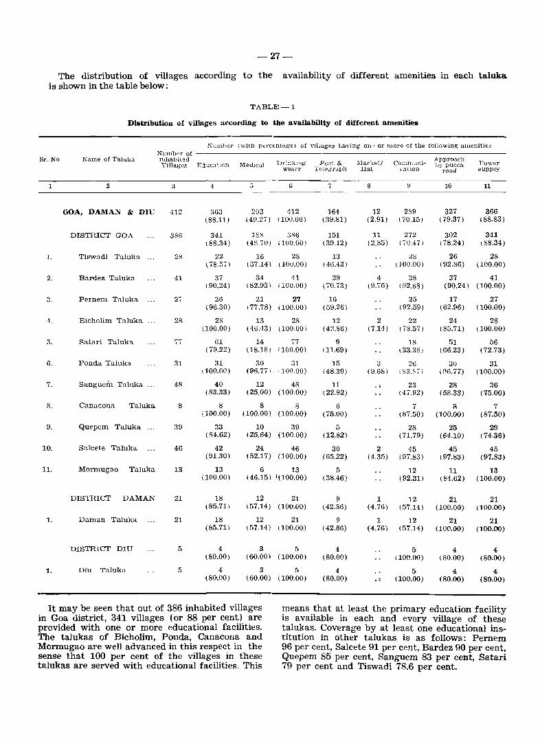
-27-
The distribution of villages according to the availability of different amenities in each taluka is shown in the table below:
Sr. No
1
1.
2.
4.
5.
6.
7.
8.
9.
10.
11.
1.
1.
TABLE-l
DiBtribution of villages according to the availability of different amenitie&
Name of Taluka
2
GOA, DAMA...~ & DIU
DISTRICT GOA
Tiswadi Taluka
Bardez Taluka
Pernem Taluka
Bicholim Taluka
Satari Taluka
Ponda Taluka
Sanguein Taluka ...
Canacona Taluka
Quepem Taluka
Salcete Taluka
Monnugao Taluka
DISTRICT DAMAN
Daman TaJuka
DISTRICT DIU
Diu TaJukn
",umber (with percentage) of VIllages having one or more of the following amenities Numbpr of mhabiled Yil]ag~s EducatIon ]\ledlcal Drinktng
VOral.<'r
3 ·1 6
412
3SG
28
41
27
28
77
31
48
8
39
46
13
21
21
5
5
363 (88.11)
341 ( 88.34)
22 ~78.57)
37 (90.24)
26 (96.30)
28 (100.00)
61 ( 79.22)
31 (100.00)
203 412 (49.27) 110'0.00)
188 386 (48 70) (lOU.OO)
16 28 (57.14) (10U.OO)
34 41 (82.93) (100.00)
21 27 177.78) (100.00)
13 28 (4\j.43) \ 100.00)
14 77 (18.18) 1100.00)
30 31 (96.7'11 '100.00)
40 12 48 (83.33) (25.00) (100.00)
888 (100.00) (100.00) (100.00)
33 10 39 (84.62) (25.64) (100.00)
42 (91.30)
13 (100.00)
18 (85.71 )
18 (85.71 )
4 (80.00)
4 (80.00)
24 46 (52.17) (100.00)
6 13 (46.15) 1(100.00)
12 21 (57.14) (100.00)
12 21 (57.14) <100.00)
3 5 (60.00) (100.00)
3 5 (60.00) (100.00)
Post & Tt'!f"gr4lph
7
164 (39.81)
151 (39.12)
13 (46.43 )
29 (70.73)
16 (59.26)
12 (42.86)
9 111.69)
15 (48.39)
11 (22.92)
6 (75.00)
5 (12.82)
30 (65.22)
5 (38.46)
9 ( 42.86)
9 ( 42.86)
4 (80.00)
4 (80.00)
,Ilarketj Hat
COlllmlHliullion
8
12 289 (2.91) (70.15)
11 272 (2.85) (';0.47)
28 ( 100.00)
4 38 (9.76) (92.68)
25 (92.59)
2 22 (7.14) (78.57)
18 ~23.38}
3 26 (9.68) :83.&,)
Appro.lch by pucea
road
10
327 ( 79.37)
302 ( 78.24)
Power Bupply
11
366 (88.83)
341 ( 88.34)
26 28 (92.86) (100.00)
37 11 (90.24) (10(}'oO)
17 27 (62.96) (100.00)
24 28 (85.71) (100.00)
51 (66.23)
56 (72.73)
30 31 (96.77) (100.00)
23 28 36 (75.00) (47.92) (58.33)
7 8 (87.50) (100.00)
28 25 (71.79) (64.10)
2 45 45 (4.35) (97.83) ( 97.83)
7 (87.50)
29 (74.36)
45 (97.83)
12 (92.31)
11 13 (84.62) (100.00)
1 12 21 21 (4.76) (57.14) (100.00) (100.00)
1 12 21 21 (4.76) (57.14) (100.00) (100.00)
5 ( 100.00)
5 (100.00)
4 (80.00)
4 (80.00)
4 (80.00)
4 (80.00)
It may be seen that out of 386 inhabited villages in Goa district, 341 villages (or 88 per cent) are provided with one or more educational facilities. The talukas of Bicholim, Ponda, Canacona and Mormugao are well advanced in this respect in the sense that 100 per cent of the villages in these talukas are served with educational facilities. This
means that at least the primary education facility is available in each and every village of these talukas. Coverage by at least one educational institution in other talukas is as follows: Pernem 96 per cent, Salcete 91 per cent, Bardez 90 per cent, Quepem 85 per cent, Sanguem 83 per cent, Satari 79 per cent and Tiswadi 78.6 per cent.
-28-
To study the various levels of schooling facility (from primary upto degree level and above), the talukawise abstract (Appendix I) may be seen. Primary education is not a problem in the district of Goa, as this basic facility is provided in most of the villages. At middle level, the talukas of Bardez, Pernem, Ponda, Canacona and Mormugao are placed in a relatively better position. At high-school and secondary levels, again the leading talukas are Bardez, Ponda, Salcete and Canacona. Facility for higher secondary education is available only in one village of Salcete tal uk a which is obviously because of the location of an Arts and Science College iJr the village of Nuvem. Actually this village is within a reach of only 4 kms. from Margao tmvn which is the headquarters of the taluka. The district's only Engineering College is also located in a village called Bandora (in the hamlet of Farmagudi) in Ponda taluka and is within an easy reach of about 5 kms. from Ponda town.
In the district of Daman, out of 21 inhabited villages 18 (86 per cent) are provided with educational facilities at primary level. There are 12 middle schools in 12 villages and only 3 secondary schools located in the villages of Bhimpore, Dunetha and Dabhel. There is only one Higher Secondary School in the village Dunetha. For collegiate education the rural pupils have to go to Daman town where an Arts and Science college is located
In the district of Diu, 4 out of 5 villages (80 per cent) are provided with educational facilities both at primary and middle level. High School or secondary schooling facility is available in two villages viz. Vanakbara and Goghla. Not a single village has facility for higher secondary education and there is also no college in this district.
In the process of expansion of various levels of educational facility like primary, middle, high school or secondary, in the rural areas, the Union Territory of Goa, Daman & Diu has indeed attained good progress since liberation, particularly so at the primary level. However there are some exceptional cases of primary schools, which existed in the villages in 1971, having been closed for want of the required number of pupils. Similarly some middle schools were also down-graded to primary level for the same reason.
Medical facility of one kind or the other is available in 49 per cent of the villages of Goa district. The talukas which are better served in this respect are Canacona (100 per cent), Ponda (97 per cent), Bardez (83 per cent) and Pernem (78 per cent). The talukas which require particular attention are Satari, Sanguem and Quepem Hospitals and family planning centres are also generally attached to the Primary Health Centres. There are 10 villages in this district with hospital
facility. These villages are situated in the talukas of Tiswadi, Bardez, Bicholim, Ponda, Sanguem, Quepem, Salcete and Mormugao, providing treatment for general ailments. For leprosy patients, there is a Leprosy hospital at Macasana in Salcete.
In Daman, 57 per cent of the villages are served with medical facilities. There is one hospital functioning in village Marwar for general treatment.
In the case of Du,.. 60 per cent of the villages are having medical fa:'cilities. The hospital facility for rural popUlation is available only in Diu town which is easily accessible.
As regards drinking water, almost all the villages of the Territory have this facility within the village itself, but, in some villages the water sources dry up in summer. The State Government has identified about 173 such "problem" villages at' the end of the Fifth Plan. The most common source of potable water is wells, followed by rivers and springs. Protected water supply, that is tap water, is provided in some villages of each tal uk a excepting Canacona. In fact, Ponda taluka has 48 per cent of the villages with tap water followed by Tiswadi with 39 per cent.
Postal facilities are provided in 39 per cent of the villages of Goa district, 43 per cent of Daman district and 80 per cent of Diu district.
Weekly markets are held in about 3 per cent villages of Goa district and in 5 per cent villages of Daman district. No such markets are held in Diu district. Although weekly markets are held in a few villages of the talukas of Bardez, Bichotim, Pond a and Salcete of Goa district, they are not really of the nature of markets periodically held in some other States where most of the conllumer articles are brought from distant places and sold in the village which has generally no regular market. In fact, regular established market facilities are available in most of the villages in this territory. Hence the concept of weekly or periodic market has not much relevance in this territory.
As regards approach by pucca road i. e. the road which can be used all the year round, all the three districts of Goa, Daman and Diu are well served, and more so in the smaller districts of Daman and Diu. In Goa district with the exception of some villages in the interior and hilly talukas of Satari and Sanguem, most of the villages are :lpproachable all the year round.
Power supply has been made available in 88 per cent villages of Goa district. The villages in Tiswadi, Bardez, Pernem, Bicholim, Ponda and Mormugao talukas are all electrified while in the taluka of Salcete the process of 100 per cent rural
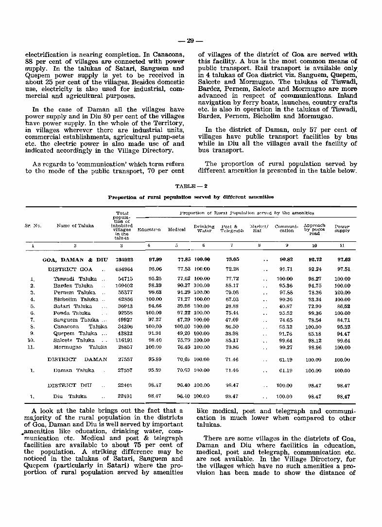
-29-
electrification is nearing completion. In Canacona, 88 per cent of villages are connected with power supply. In the talukas of Satari, Sanguem and Quepem power supply is yet to be received in about 25 per cent of the villages. Besides domestic use, electricity is also used for industrial, commercial and agricultural purposes.
In the case of Daman all the villages have power supply and in Diu 80 per cent of the villages have power supply. In the whole of the Territory, in villages wherever there are industrial units, commercial establishments, agricultural pump-sets etc. the electric power is also made use of and indicated accordingly in the Village Directory.
As regards to 'communication' which term refers to the mode of the public transport, 70 per cent
of villages of the district of Goa are sewed with this facility. A bus is the most common means of public transport. Rail transport is available only' in 4 talukas of Goa district viz. Sanguem, Quepem, Salcete and Mormugao. The talukas of Tiswadi, Bardez, Pernem, Salcete and Mormugao are more advanced in respect of communications. Inland navigation by ferry boats, launches, country crafts etc. is also in operation in the talukas of Tiswadi, Bardez, Pernem, Bicholim and Mormugao.
In the district of Daman, only 57 per cent of villages have public transport facilities by bus while in Diu all the villages avail the facility of bus transport.
The proportion of rural population served by different amenities is presented in the table below.
TABLE-2
Proportion of rural population served by different amenities
Total Proportion of Rural Population served by the amenities popula-tion of
Sl". :"<0. Name of Taluka inhabit!'d Drinking Post & Mark;,t/ Communi- Approach Powar villages EducatInn Medical Water Telegraph Hat cation by pucce. supply in the road talu.<a
1 2 3 4, 5 6 7 8 9 10 11
GOA, DAMAN & DIU 734922 97.99 77.85 100.00 73.05 90.82 92.72 97.63
DISTRICT GOA 684964 98.06 77.53 100.00 72.28 91.71 92.24 97.51
1. Tiswadi Taluka 54715 95.25 77.62 100.00 77.72 100.00 98.27 100.00 2. Bardez Taluka 109402 98.39 90.37 100.00 88.17 95.36 94.75 100.00 3. Pernem Taluka 55377 99.63 91.29 100.00 79.08 97.88 78.36 100.00 4. Bichoiim 'Taluka .. 62856 100.00 71.27 100.00 67.03 90.36 93.34 100.00 5. Satari Taluka 36943 94.66 39.98 100.00 28.88 40.87 72.90 86.52 6. Ponda Taluka 92558 100.00 97.22 10'0.00 75.44 95.52 99.36 100.00 7. Sanguem Taluka ... 49927 97.27 47.29 100.00 47.09 74.65 78.54 84.71 8. Canacona Taluka 34306 100.00 100.00 100.00 86.50 95.32 100.00 95.32 9. Quepem Taluka ... 43832 91.91 49.20 100.00 38.98 91.76 85.18 94.47
10. Salcete Taluka 116191 98.40 75.79 100.00 85.17 99.64 98.12 99.64 11. Mormugao Taluka 28857 100'.00 76.45 100.00 70.86 99.27 98.96 100.00
DISTRICT DAMAN 27557 95.89 70.6!; 100.00 71.46 61.19 100.00 100.00
1. Daman Taluka 27557 95.89 70.')9 100.00 71.46 61.19 100.0'0 100.00
DISTRICT DIU 22401 98.47 96.40 100.00 98.47 100.00 98.47 98.47
1. Diu Taluka 22401 98.47 96..tO 100.00 98.47 100.00 98.47 98.47
A look at the table brings out the fact that a majority of the rural population in the districts of Goa, Daman and Diu is well served by important
,.,amenities like education, drinking water, communication etc. Medical and post & telegraph facilities are available to about 75 per cent of the population. A striking difference may be noticed in the talukas of Satari, Sanguem and Quepem (particularly in Satari) where the proportion of rural population served by amenities
like medical, post and telegraph and communication is much lower when compared to other talukas.
There are some villages in the districts of Goa, Daman and Diu where facilities in education, medical, post and telegraph, communication etc. are not available. In the Village Directory, for the villages which have no such amenities a provision has been made to show the distance of
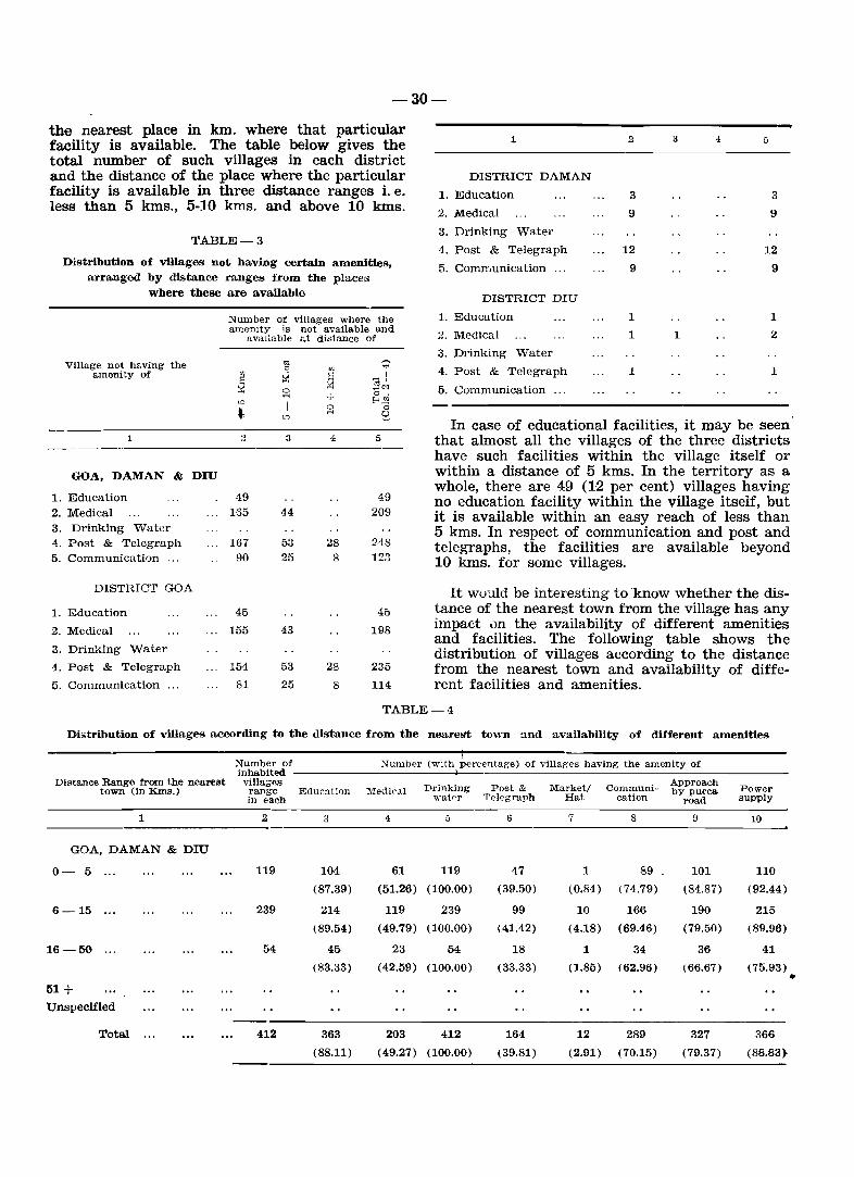
-30-
the nearest place in km. where that particular facility is available. The table below gives the total number of such villages in each district and the distance of the place where the particular facility is available in three distance ranges i. e. less than 5 kms., 5-10 kms. and above 10 kIns.
TABLE-3
Distribution of villages not having certain amenities, arranged by distance ranges from the places
where these are available
Village not having the amenity of
1
GOA, DAMAN & DIU
1. Education 2. Medical 3. Drinking W'ater 4. Post & Telegraph 5. Communication ...
DISTRICT GOA
1. Education
2. Medical
3. Drinking Water
4. Post & Telegraph
5. Communication ...
Number of villages where the amenity is not available and
avaIlable at distance of
19 165
167 90
45
155
154
81
3
44
53 25
43
53
25
28 8
28
8
5
49 209
248 123
45
198
235
114
1
DISTRICT DAMAN
1. Education
2. Medical
3. Drinking Water
4. Post & Telegraph
5. Communication ...
DISTRICT DIU
1. Education
2. Medical
3. Drinking Water
4. Post & Telegraph
5. Communication ...
2
3
9
12
9
1
1
1
3
1
4. 5
3
9
12
9
1
2
1
In case of educational facilities, it may be seen' that almost all the villages of the three districts have such facilities within the village itself or within a distance of 5 kms. In the territory as a whole, there are 49 (12 per cent) villages having no education facility within the village itseif, but it is available within an easy reach of less than 5 kms. In respect of communication and post and telegraphs, the facilities are available beyond 10 kms. for some villages.
It wuuld be interesting to 'know whether the distan<!e of the nearest town from the village has any impact un the availability of different amenities and facilities. The following table shows the distribution of villages according to the distance from the nearest town and availability of different facilities and amenities.
TABLE-4
Distribution of villages according to the distance from the nearest town and availability of different amenities
Number of inhabited
Numb<'r (with perc<'ntage) of villages having the amenity of
Distance Range from the nearest villa;;<ls Drinking Post & Market/ Communi-Approach
Pow"r town (in KIDs.) range Education Medic<ll by pucca in each wat~r T(>legra.ph Hat cation road supply
1 2 3 4. 5 6 7 8 9 10
GOA, DAMAN & DIU
0- 5 ... 119 104 61 119 47 1 89 101 110
(87.39) (51.26) (100.00) (39.50) (0.84) (74.79) (84.87) (92.44)
6-15 ... 239 214 119 239 99 10 166 190 215
(89.54) (49.79) (100.00) (41.42) (4.18) (69.46) (79.50) (89.96)
16-50 54 45 23 54 18 1 34 36 41
(83.33) (42.59) (100.00) (33.33) (1.85) (62.96) (66.67) (75.93) •
51+
Unspecified
Total 412 363 203 412 164 12 289 327 366
(88.11) (49.27) (100.00) (39.81) (2.91) (70.15) (79.37) (88.83)
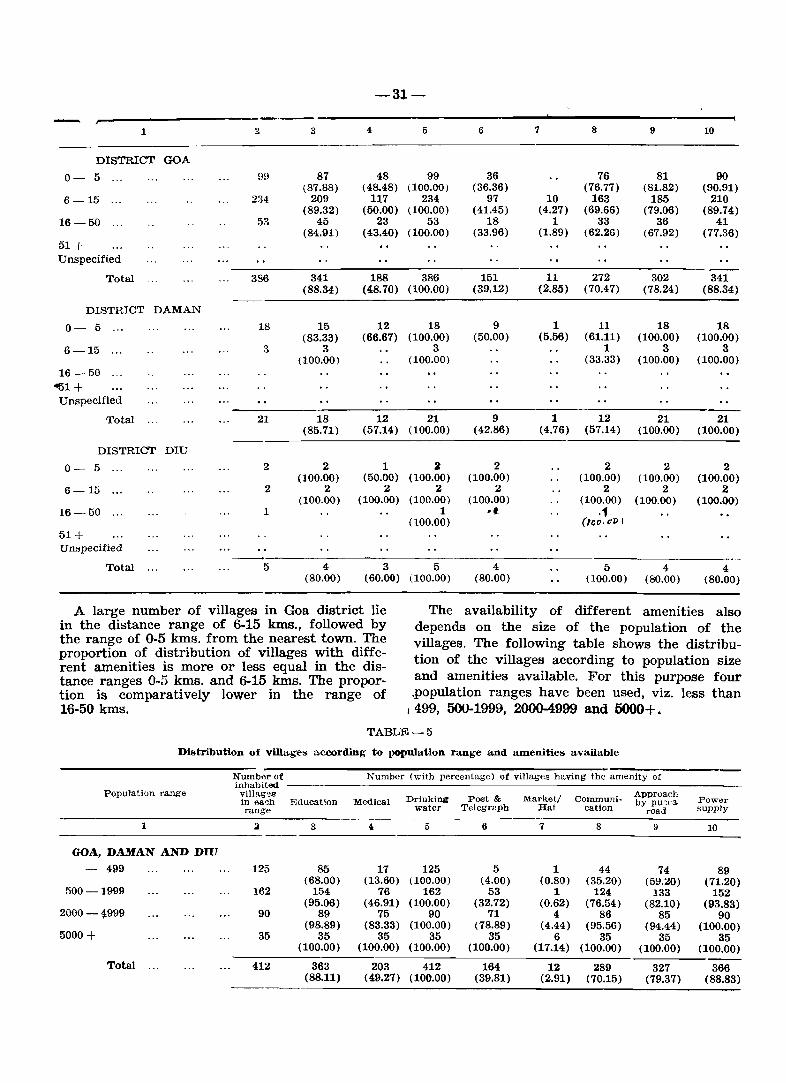
-31-
r------------------.----------------------------------------------~ 1
DISTRICT GOA
0- 5
6-15
16-50
51+ Unspecified
Total
DISTRICT DAMAN
0- 5
6-15
16-50
~1+
Unspecified
Total
DISTRICT DIU
0- 5
6-15
16-50
51 + UIlBpecified
Total
9H
234
53
386
18
21
2
2
1
5
3
87 (87.88)
209 (89.32)
45 (84.91)
341 (88.34)
15 (83.33)
3 (100.00)
18 (85.71)
2 (100.00)
2 (100.00)
4 (80.00)
4
48 ( 48.48)
117 (50.00)
23 (43.40)
5
99 (100.00)
234 (100.00)
53 (100.00)
188 386 (48.70) (100.00)
12 18 (66.67) (100.00)
3 (100.00)
12 21 (57.14) (100.00)
1 (50.00)
2 (100.00)
2 (100.00)
2 (100.00)
1 (100.00)
3 5 (60.00) (100.00)
6
36 (36.36)
97 (41.45)
18 (33.96)
151 (39.12)
9 (50.00)
9 ( 42.86)
2 (100.00)
2 (100.00)
-I
4 (80.00)
7
10 (4.27)
1 (1.89)
8
76 (76.77)
163 (69.66)
33 (62.26)
11 272 (2.85) (70.47)
1 11 (5.56) (61.11)
1 (33.33)
9
81 (81.82)
185 (79.06)
36 (67.92)
302 (78.24)
18 (100.00)
3 (100.00)
10
90 (90.91)
210 (89.74)
41 (77.36)
341 (88.34)
18 (100.00)
3 (100.00)
1 12 21 21 (4.76) (57.14) (100.00) (100.00)
2 (100.00)
2 (100.00)
.1 (l()o.(fP I
2 (100.00)
2 (100.00)
5 4 (100.00) (80.00)
2 (100.00)
2 (100.00)
4 (80.00)
A large number of villages in Goa district lie in the distance range of 6-15 kms., followed by the range of 0-5 kms. from the nearest town. The proportion of distribution of villages with different amenities is more or less equal in the distance ranges 0-5 kms. and 6-15 kms. The proportion is comparatively lower in the range of 16-50 kms.
The availability of different amenities also depends on the size of the population of the villages. The following table shows the distribution of the villages according to population size and amenities available. For this purpose four ,population ranges have been used, viz. less than
1499, 500-1999, 2000-4999 and 5000+.
TABLE-5
Distribution of villages according to population range and amenities available
Population range
1
GOA, DAMAN AND DIU
- 499
500-1999
2000-4999
5000+
Total
Numb.;r of Number (with percentage) of villages having the amenity of inhabiled ------------------------_:__------villag~s in ea~h Education range-
125
162
90
35
412
3
85 (68.00)
154 (95.06)
89 (98.89)
35 (100.00)
363 (88.11)
Medical
4
17 (13.60)
76 (46.91)
75 (83.33)
35 (100.00)
Drinking water
5
125 (100.00)
162 (100.00)
90 (100.00)
35 (100.00)
203 412 (49.27) (100.00)
Post & Telegr2ph
6
5 (4.00)
53 (32.72)
71 (78.89)
35 (100.00)
164 (39.81)
Market/ Hat
7
1 (0.80)
1 (0.62)
4 (4.44)
6 (17.14)
Communication
8
44 (35.20)
124 (76.54)
86 (95.56)
35 (100.00)
12 289 (2.91) (70.15)
Approach by pu~c3.
road
9
Power supply
10
74 89 (59.20) (71.20)
133 152 (82.10) (93.83)
85 90 (94.44) (100.00)
35 35 (100.00) (100.00) -----
327 366 (79.37) (88.83)
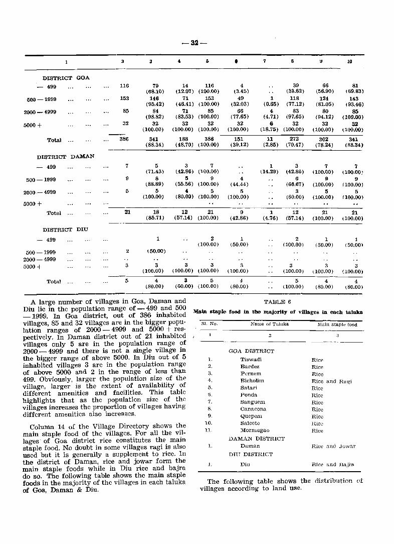
1
DISTRICT GOA
- 499
500-1999
2000-4999
5000+
Total
DISTRICT DAMAN
- 499
500-1999
2000-4999
5000 + Total
DISTRICT DIU
- 499
a
116
153
85
32
386
7
9
5
21
2
3
79 (68.10)
146 (95.42)
84 (98.82)
32 (100.00)
341 (88.34)
5 (71.43)
8 (88.89)
5 (100.00)
-32-
4
14 (12.07)
71 (46.41)
71 (83.53)
32 (100.00)
116 (100.00)
153 (100.00)
85 (100.00)
32 (100.00)
188 386 (48.70) (100.00)
3 (42.86)
5 (55.56)
4 (80.00)
7 (100.00)
9 (100.00)
5 (100.00)
18 12 21 (85.71) (57.14) (100.00)
1
(50.00)
2 (100.00)
• 4
(3.45) 49
(32.03) 66
(77.65) 32
(100.00)
151 (39.12)
4 (44.44)
5 (100.00)
9 (42.86)
1 (50.00)
7
1 (0.65)
4 (4.71)
6 (18.7:)
8
39 (33.62)
118 (77.12)
83 (97.65)
32 (100.00)
11 272 (2.85) (70.47)
1 114.29)
3 (42.86)
6 (66.67)
3 (60.00)
66 (56.90)
124 (81.05)
80 (94.12)
32 (100.00)
302 (78.24)
7 (100.00)
9 (100.00)
5 (100.00)
10
81 \69.83)
U3 (93.46)
85 (100.00)
32 ~100.(0)
341 (88.34)
7 IlOO.OO}
9 (100.00)
5 (100.00)
1 12 21 21 (4.76) (57.14) (100.00) (100.00)
2 (100.00)
1 (50.00)
1 (50.00)
500-1999 2000-4999 5000 + 3 333 3 3 3 3
(100.00) (100.00) (100.00) (100.00) (100.00) 1100.00) (100.00)
Total 5 435 4 544 (80.00) (60.00) (100.00) (80.00) (100.00) (80.00) (80.00)
TABLE 6 A large number of villages in Goa, Daman and Diu lie in the population range of - 499 and 500 -1999. In Goa district, out of 386 inhabited Main staple food in the majority of villages in each taluka
villages, 85 and 32 villages are in the bigger population ranges of 2000 - 4999 and 5000 + respectively. In Daman district out of 21 inhabited J
villages only 5 are in the population range of 2000 - 4!:}99 and there is not a single village in the bigger range of above 5000. In Diu out of 5 inhabited villages 3 are in the population range of above 5000 and 2 in the range of less than 499. Obviously, larger the population size of the village, larger is the extent of availability of different amenities and facilities. This table highlights that as the population size of the villages increases the proportion of villages having different amenities also increases.
Column 14 of the Village Directory shows the main staple food of the villages. For all the villages' of Goa district rice constitutes the main staple food. No doubt in some villages ragi is also used but it is generally a supplement to rice. In the district of Daman, rice and jowar form the main staple foods while in Diu rice and bajra do so. The following table shows the main staple foods in the majority of the villages in each taluka of Goa, Daman & Diu.
Sl. No.
1
1.
2.
3. 4.
5.
5.
7.
8.
9. 10.
11.
1.
1.
Name of Taluka
2
GOA DISTRICT
Tiswadi Bardez Pernem Bicholim Satari Ponda Sanguem Canacona Quepem Salcete Mormugao
DAMAN DISTRICT Daman
DIU DISTRICT
Diu
Main staple food
Rice Rice Rice Rice and Ragi Rice Rice Rice Rice Rice Rice Rice
Rice and Jowar
Rice Etnd Baji'a
The following table shows the distribution of villages according to land use.
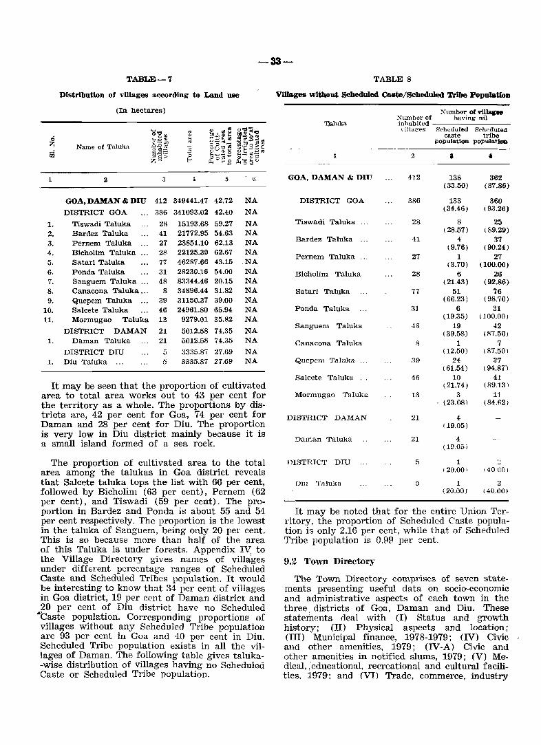
-33-TABLE-7
Distribution of villages a«lOrding to Land Ulle
(In hectares)
"O~{/J OJ ~ICIl~ ""'01'1:1 .; " r1~ ~ a ~';o~ ....... ., ;..
z ~-.- on " -a.~~ ~ ~ Name of Taluka ,::J..o" ~:; -~ ol_ :;; ~u~.s ~t-:;~; FiJ §,::::::: -0 ~ ..... +->g z 5> &;O~.8 4,) <lI~
E-< P.. ...... " Ool
1 2 3 ~ 5 6
GOA, DAMAN & DIU 412 349441.47 42.72 NA
DISTRICT GOA 386 341093.02 42.40 NA
1. Tiswadi Taluka 28 15193.68 59.27 NA 2. Bardez Taluka 41 21772.95 54.63 NA
3. Pernem Taluka 27 23851.10 62.13 NA
4. Bichollm Taluka 28 22125.39 62.67 NA
5. Satari Taluka 77 46287.66 43.15 .NA
6. Ponda Taluka 31 28230.1£ 54.00 NA
7. Sanguem Taluka ... 48 83344.46 20.15 NA 8. Canacona Taluka ... 8 34896.44 31.82 NA 9. Quepem Taluka ... 39 31150.37 39.00 NA
10. Salcete Taluka 46 24961.80 65.94 NA 11. Mormugao Taluka 13 9279.01 35.82 NA
DISTRICT DAMAN 21 5012.58 74.35 NA 1. Daman Taluka 21 5012.58 74.35 NA
DISTRICT DIU 5 3335.87 27.69 NA 1. Diu Taluka ... 5 3335.87 27.69 NA
It may be seen that the proportion of cultivated area to total area works out to 43 per cent for the territory as a whole. The proportions by dis-tricts are, 42 per cent for Goa, 74 per cent for Daman and 28 per cent for Diu. The proportion is very low in Diu district mainly because it is a small island formed of a sea rock.
The proportion of cultivated area to the total area among the talukas in Goa district reveals that Salcete taluka tops the list with 66 per cent, followed by Bicholim (63 per cent), Pernem (62 per cent), and Tiswadi (59 per cent). The proportion in Bardez and Ponda is about 55 and 54 per cent respectively. The proportion is the lowest in the taluka of Sanguem, being only 20 per cent. This is so because more than half of the area of this Taluka is under forests. Appendix IV to the Village Directory gives names of villages under different percentage ranges of Scheduled Caste and Scheduled Tribes popUlation. It would be interesting to know that 34 per cent of villages in Goa district, 19 per cent of Daman district and 20 per cent of Diu district have no Scheduled
"'Caste population. Corresponding proportions of villages without any Scheduled Tribe population are 93 per cent in Goa and 40 per cent in Diu. Scheduled Tribe population exists in all the villages of Daman. The following table gives taluka-wise distribution of villages having no Scheduled Caste or Scheduled Tribe popUlation.
TABLE S
Villages Without Scheduled cane/Scheduled Tribe Population
Xumber of ""umber of villa& ..
having nil ':Qaluka inhabited
"iIlag('s Scheduled Scheduled caste tribe
po<pulo.tion pOoPulo.Uon
1 2 a • GOA, DAMAN & DIU 412 138 362
(33.50) (S7.86)
DISTRICT GOA 386 133 360 (34.46) ( 93.26)
Tiswadi Taluka 28 S 25 (28.57) \89.29)
Bardez Taluka 41 4 37 (9.76) (90.24)
Pernem Taluka 27 1 27 (3.70) (100.00)
Bicholim Taluka 28 6 26 ( 21.43) (92.86)
Satari Taluka 77 51 76 (66.23) (98.70)
Ponda Taluka 31 6 31 (19.35) (100.00)
Sanguem Taluka 48 19 ,*2 (39.58) (87.50)
Canacona Taluka 8 1 7 (12.50) (87.50)
Qucpcm Taluka 39 24 37 ( 61.54) ( 94.87)
Salcete Taluka 46 10 41 (21.74) (89.13 )
Mormugao Taluka 13 3 11 (23.08) (84.621
DISTRICT DAMAN 21 4 (19.05)
Daman Taluka 21 4 (19.05)
DISTRICT DIU 5 1 -120.00) 140 eo)
Diu Taluka 5 1 2 (20.00, (40.00)
It may be noted that for the entire Union Territory, the proportion of Scheduled Caste population is only 2.16 per cent, while that of Scheduled Tribe population is 0.99 per ~ent.
9.2 Town Directory
The Town Directory comprises of seven statements presenting useful data on socia-economic and administrative aspects of each town in the three. districts of Goa, Daman and Diu. These statements deal with (I) Status and growth history; (II) Physical aspects and location; (III) Municipal finance, 1978-1979; (IV) Civic and other amenities, 1979; (IV-A) Civic and other amenities in notified slums, 1979; (V) Medical, ,'educational, recreational and cultural facilities, 1979; and (VI) Trade, commerce, industry
-34-
and banking, 1979 in each town. All the statements are similar to those adopted in 1971 census except the introduction of few new columns presenting some additional information. For example, the column on 'Class of Town' in every statement and the column on 'Civic administration status in 1980' in statements III and IV and population in statements IV and V have been newly introduced in 1981.
While designing the statements of the Town Directory, basic data required for the formulation of the national minimum needs programme has been kept in view. The statement IV-A is a new feature.
The non-census data for the Town Directory is collected from various State Government departments and local bodies and relate to the year 1979. In statements IV, IV-A and V data are presented by using abbreviations which have been explained in the beginning of the Town Directory. A brief analysis of the data presented is attempted below.
STATEMENT I
StatuS and Growth History
The statement contains 19 columns and presents information on such aspects as class, name and civic administration status of each town in 1980, the location code number of the town as per the 1981 census, the name of the taluka in which the town is located, area of the town in sq. kms., the basic census particulars relating to households, population and the rate of growth since 1900, the density of population in the 1981 census and the sex ratio for the censuses of 1961, 1971 and 1981.
Slight modifications have been made in this statement in the presentation pattern of data this time as compared to 1971 census. The columns on area (in sq. kms.), the number of households, density of population and sex ratio are the newly introduced columns in 1981. The growth rate of population is also newly introduced in 1981.
The 'class' of the town as indicated under column 2 is based on the size of the population. Towns are classified according to their population size into the following categories:
Population
100,000 and above 50,000 - 99,999 20,000 - 49,999 10,000 - 19,999 5,000 - 9,999
Below 5000
Class
I II ill IV V
VI
An urban area having one lakh poulation and above is classified as a class I town i. e. a city. In the union territory of Goa, Daman & Diu there is no urban area which can be called a city. Hence all the urban areas are termed as towns. The distribution of towns of this territory by their respective class is as under:
Class Name of Town
II 1. Margao Urban Agglomeration. 2. Mormugao. 3. Panaji Urban Agglomeration.
m 1. Daman. 2. Mapusa.
IV 1. Bicholim. 2. Cuncolim. 3. Ponda.
V 1. Calangute. 2. Curchorem. 3. Diu. 4. Sanguem. 5. Siolim.
VI 1. Chauri. 2. Pernem. 3. Quepem. 4. Valpoi.
The 'Civic administration status' of a town indicates the type of local administration operative there. This is denoted by using the code 'M.C1.' for Municipal Councils. As said earlier" there are 11 towns having the status of Municipal Council of which 9 are in Goa, and one each in Daman and Diu. However, there are 6 towns having no civic status, but are administered by the ,respective Gram Panchayat. All these six 'census' towns are in Goa district.
r 'li'he progress in the number of towns since
1900 is shown below:
Census Number of Year ToWlUl
1900 2 1910 2 1921 4 1931 4 1940 6
1950 7
1960 18
1971 13
1981 17
Name of Town
Panaji, Daman" Panaji, Daman. Panaji, Daman, Diu, Vasco-da-Gama. Panaji, Daman, Diu, Vasco-da-Gama. Panaji, Daman, Diu, Vasco-da-Gama,
Margao, Mapusa. Panaji, Daman, Diu, Vasco-da-Gama,
Margao, Mapusa, Ponda. Panaji, Mapusu, Pel'nem, Bicholim, Valpoi,
Ponda, Sanguem, Ohauri, Quepem, Margao, Vasco-cia-Gama, Daman, Diu .•
Panaji, Mapusa, Pernem, Bicholim, Valpoi, Ponda, Sanguem, Chauri, Quepem, Margao, Mormugao, Daman, Diu.
Panaji, Mapusa, Oalangute, Swlim, Pernem, Bicholim, Valpoi, Ponda, Sanguem, Margao, Ouncolim, Mormugao, Daman, Diu.
-35-
Note: 1) The places which were treated as towns for the first time in the relevant census year have been shown in italics in the above list.
2) As per Govt. notification of July, 1970, Vasco-da-Gama was included in the town of Mormugao.
The table below shows the new towns of 1981 along with their population. None of the 1971 census towns was declassified in the 1981 census.
TABLE 9
New towns added in 1981 census.
NdmeofTown Population
Calangute
Cuncolim
Curchorem
Siolim
9621
12706
7998
8892
On the basis of certain demographic tests (as explained earlier) the above places have been treated as non-statutory census towns in the 1981 census, as a result of which there is an increase in the number of towns from 13 in 1971 to 17 in 1981.
Though this union territory did have towns even in 1900, no separate population data on towns are available for the decadal censuses upto 1940. Hence town-wise population data have been presented from the 1950 census onwards. For a particular year when a place was not a town, population data are not presented.
The table below shows the growth rate, density and sex ratio in the urban areas in the three districts in 1951-1981 censuses.
TABLE-10
Growth, Density and Sex-ratio of Urban Population in the District in relation to the State
Census Year
1
<ffla, Daman & Diu
:) 3 b 7
596059 89411 15.00 1044
626667 100664 16.06 12.59 5210 1010
857771 226774 26.44 125.28 1654 885
1951
1961
1971
1981 . " ..... .. 1086730 351808 32.37 55.14 1824 919
1 2 3 -l 5 6 7
District Goa
1951 ............ 547448 70931 12.96 1017
1961 ............ 589997 87329 14.80 23.12 6759 980
1971 ............ 795120 203243 25.56 132.73 1673 864
1981 ............ 1007749 322785 32.03 58.82 1821 906
District Daman
1951 . ........... 27473 13265 48.28 1169
1961 ............ 22390 9197 41.08 30.67 18391138
1971 ............ 38739 17317 44.70 88.29 3092 997
1981 ............ 48560 21003 43.25 21.29 37511024
District Diu
1951 ............ 21138 5215 24.67 1105
1961 ............ 14280 4188 28.98 20.65 29561438
1971 ............ 23912 6214 25.99 50.17 6211401
1981 ............ 30421 8020 26.36 29.06 8011204
It may be seen from the table that the proportion of urban population in the union territory has steadily increased from 15 per cent in 1951 to 32 per cent in 1981. The proportion of urban population has more than doubled in the course of the last three decades. The rate of growth was very high during the decade 1961-71, but more or less normal during the decade 1971-81. The main reason for the high growth rate in 1961-71 was the liberation of the territory from the Portuguese rule in 1961, which opened up the economy of the territory giving rise to a sudden spurt in the socio-economic activity here which, in turn, resulted into a considerable in-migration of population from other parts of the country. The density of the population, however, shows fluctuations whereas the sex ratio has steadily. decreased till 1971 and increased in 1981.
STATEMENT - II
Physical Aspects and Location of Towns, 1979
This statement contains 12 columns and furnishes information regarding rainfall, maximum and minimum temperature, names and distances of the state, district, sub-divisional and taluka headquarters, name and distance of the nearest city with one lakh population, names and distances of the nearest railway station, bus routes, and navigable river/canal if within 10 kilometres.
The averages of rainfall and temperature have been worked out on the basis of period averages for ten years preceding 1978, i. e. from 1969· to 1978. The union territory of Goa, Daman & Diu is a coastal area. All the towns of Goa district receive SUbstantial rainfall during the monsoons .
-36-
The average rainfall varies from 2500 to 4300 millimetres. The towns of Curchorem, Quepem. and Valpoi receive very heavy rainfall exceeding 4000 mm., followed by Sanguem and Ponda exceed:i,ng 3500 mm. The average rainfall received in I;>aman is 1559 mm. while in Diu, the same is ~7mm.
Data on temperature are available in the case of four towns only viz. Panaji, Mormugao, Daman and Diu. Hence, temperature data of the nearest towns are repeated for the remaining 13 towns. Since the towns are situated verv near to the sea coast, the maximum average ¥ temperature is around 31°C while the minimum average temperature is around 23°C. In case of Daman town, the maximum and minimum average temperatures are 31°C and 220 0 respectively, and for Diu town the same are 30°C and 22cC.
Panaji, being the capital of the Union Territory, is the State headquarters for all the towns of Goa, Dllman & Diu. Goa constitutes the major district of the territory and has 15 towns. Panaji is the district headquarters for all the towns of Goa. Further, this district is divided into two sub-divisums for administrative purposes, viz. North Goa sub-division with Panaji as its headquarters and South Goa sub-division with Margao as its headquarters. There are seven towns falling under the jurisdiction of North Goa, viz. Panaji, Mapusa. Calangute, Siolim, Pernem, Bicholim and Valpoi and eight towns in the jurisdiction of South Goa viz. Ponda, Sanguem, Chauri, Quepem, Curchorem, Margao, Cuncolim and Mormugao.
As mentioned earlier, there is no city in Goa, Daman & Diu. Belgaum in Karnataka State is the nearest city for the towns of Goa district. Belgaum has also very close commercial links w,ith Goa. Navsari and Junagadh in Gujarat State are the nearest cities for Daman and Diu towns respectively.
For a majority of towns in Goa district, Margao is the. nearest railway station. In the whole of the district OJlly three towns are connected by rail viz. Curchorem, Margao and Mormugao. Vapi and Dilwada in Gujarat State are the nearest railway stations for Daman and Diu towns respectively. All the towns are connected by road and have a good frequency of bus transport. With the exception of Cuncolim, Valpoi and Diu, all other towns have navigable rivers within a distance of 10 kms. Zuari and Mandovi are the principal rivers of Goa which are perennial and play an important role ill the economy of this territory by serving as inland navigation routes for transportation of heavy metalliferrous ores, other goods as also passengers.
STATEMENT - m
Municipal FiDa.nce, 1978-79
This statement contains 17 columns and shows the finances of the statutory and non-statutory towns by presenting therein receipts and expenditure under different heads for the year 1978-79. For statutory towns, the finances relate to the municipal bodies, while for the non-statutory towns the same relate to the village panchayats. The items included under receipts and expenditure are as under:
Receipts
i) Receipt through taxes etc. H) Revenue derived from municipal prop2r-
ties and power apart from taxation. iii) Government grants. iv) Loans. v) Advances.
vi) Other sources.
Expenditure
i) General Administration. ii) Public Safety. iii) Public Health and Conveniences. iv) Public Works. v) Public Institutions.
vi) Others.
Under the receipt item 'other sources' are included interest from municipal/panchayat investments, copying and comparing fees, process fees and legal costs, sale proceeds of old stores, pension contributions, income on lending books from libraries, fines, emoluments and fees on birth and death registration, hiring of halls and vehicles etc. Likewise, the expenditure item 'other sources' includes interest on loans, expenses in connection with suits and prosecutions, numbering of houses, signalization of traffic, insurance of vehicles etc.
Items contributing to the total receipts differ from town to town. In the case of chiss II towns the contribution to total revenue is mostly through taxes, income from municipal properties and Governrilent.grants. In others, the major portion of revenue is made up of G.overnment grants. Loans have also been obtained by few councils to make up their revenues.
The expenditure items also differ from town to town. In some towns the amount spent on general administration is more while in others, there is more expenditure on public health & conveniences and public works. It may be seen from statement III that the total expenditure in most of the towns i~ within the bounds of the total receipts, though fIve towns (Mormugao, Sanguem, Quepem, Calangute and Pernem) are the exceptions. The following table shows the per capita receipt and expenditure in all the towns.
,....-37-
TABLE-ll
Per Capita receipt and expenditure in towns (in rupees)
Per Capita ----.--=---------~---=----------
Receipt Expenditure
Class, Name & Civil Status of the town
1
District Goa
IV Bicholim (M.CL.) ..... , ... V Calangute (G.P.) .........
VI Chauri (l\LCL.) ............ IV Cuncolim (G.P.) , ..........
V Curchorem (G.P.) ......... III Mapusa (M.CL.) ........... II Margao (lVLCL.) ........ ,. II Mormugao (M.CL.) ...... II Panaji (M.CL.) ............
VI Pernem (G.P.) ............. IV Ponda (M.CL.) ............. VI Quepem (l'vLCL. ) ........... V Sanguem (M.CL) .......... V Siolim (G.P.) ...............
VI Valpoi (G.P.) ............... District Daman
III Daman (M.CL.)
District Diu
V Diu (M.CL.) ................
S ""',<:1 e~rn - .e.:r ~ .. -1. ~ ..,
-0 ~b~ ~~ .... ~~S E-o <1) .... '" ,-,,..c......:l ,..,..., t -; J
p::'
2 3 1
56.13 7.46 48.67 7.17 1.84 5.33
128.91 6.57 122.31 3.76 0.93 2.83
25.38 7.63 17.75 75.14 9.41 65.73 56.66 17.38 39.2S 32.71 8.30 24.41 67.07 24.52 42.55
7.70 0.25 7.45 31.97 6.72 25.25 19.11 0.91 18.20 54.81 0.54 54.27
5.72 0.53 5.19 17.18 3.37 13.81
48.81 16.64 32.17
66.37 28.09 38.28
'" , ~ 'U~ co ~ .... '" ':::I (.) r t..' ... ::; -:...
-~ ,.,~ :!:3 2 ~ 0
",._ ~ . .:e ~ ~ ""'0 ~ ;::;~~ 0", ~,§:§ ~ E-o", 2. ~;; ~ (.!Ji:1 0. ~ 8 C,.i::: .!O
~ 'C ::: '" " ~'-..r:8 p..
5 (j 7 8 10
19.60. 6.60 5.18 3.24 0.00 4.58 8.H 1.16 0.73 1.86 4.39
128.91 43.28 5.28 66.48 3.19 10.68 2.39 0.88 0.00 1.31 0.05 0.15
20.48 4.70 1.13 13.70 0.02 0.93 73.77 15.51 20.10 24.18 1.26 12.72 54.39 11.09 19.53 11.46 0.69 11.62 33.03 9.08 10.26 10.31 0.10 3.28 62.26 12.43 14.95 9.62 0.14 25.12 11.67 7.45 3.55 0.30 0.38 23.fJ2 10.69 3.51 4.36 1.77 3.20 40.18 5.10 0.19 30.48 4.41 70.94 12.50 6.86 46.48 0.55 4.55
2.50 0.47 1.61 0.15 0.27 13.20 4.88 2.44 5.83 0.05
47.60 10.55 13.81 3.U 0.81 19.19
65.67 10.30 15.05 17.17 2.39 20.7"-______________ .~ _____ l ________________________________________________ __
It may be seen that the per c!lpita total rec~ipt and the per capita total expendmre .are t~e h!ghest in the Chauri Municipal CouncIl WhICh IS a class VI town, and lowest in Cuncolim which is a class IV Census town. Among the class II towns, the per capita total receipt an~ the per cap~~a tot~l expenditure are the highest m the PanaJI Mumcipal Council which is the capital town of the Union Territory, followed by Margao and Mormugao Municipal Councils. Mapusa, Bicholim and Diu Municipal Councils rank first among the respective class III, IV and V towns in the per capita total receipts and expenditure.
STATEMENT IV
Civic and other amenities, 1979
The statement has 19 columns and contains information on amenities such as road length. system of sewerage, number of latrines, method of disposal of night soil, protected water supply, fire fighting services, electrification etc. It also gives the scheduled caste and scheduled tribe ~population.
The. statement is almost similar to that prepared m the 1971 census except a few additional items. The new items appearing in this statement are class and civic administration status of the town, total population and population of scheduled
castes and scheduled tribes and number of latrines. So far as fire fighting services in the town are concerned provision has been made to indicate in case such services are not available in the to~ itself, the name of the nearest town if in the same district, or the names of the nearest town and the state if in other state where such facility is available. Distances in kms. from the relevant town are also given.
The road length (in kms.) is shown separately for 'pucca' road and 'kuccha' road. In towns where information on pucca and kuccha road is not available separately, total road length is presented. All the towns of this territory have a well developed net-work of roads. During the decade many new roa?s have bee? construct~d and the existing roads WIdened and Improved WIth a view to meet adequately the requirements of the fast increasing traffic.
~s regards syst~m of sewerage, the open surface dram age (OSD) IS the most common system in most of the towns of Goa with the only exception of P~naji where underground sewerage system is provIded. Such. a system in the remaining two class II towns VIZ. Margao and Mormugao is under construction. '
E!inc~ .data on public and private latrines is not mamtamed by the local bodies in this territory,
-38-
information on number of latrines is not presented and shown as data not available (NA) under the respective columns.
As regards method of disposal of night soil, with the exception of Panaji town where sewerage system is provided, the most common system is the septic tank.
There are also a few towns in Goa where in the absence of or in addition to septic tanks or sewerage, open spaces are made use of by a majority of population. There are al!'lo ordinary dry latrines where the human waste is eaten away by the pigs. This system is found to be pretty common in· the smaller towns like Chauri, Cuncolim, Pernem, Quepem, Siolim and Valpoi.
Protected water supply by tap is provided in a majority of the towns of Goa, Daman & Diu excepting Chauri, Cuncolim and Quepem. Fire fighting services are available only in four towns of Goa district viz. Mapusa, Margao, Mormugao and Panaji. For Daman and Diu this facility is available in Vapi and Veraval towns of Gujarat State respectively.
STATEMENT IV-A
Civic and other amenities in notified slums, 1979.
This statement contains 16 columns and provides information on civic and other amenities in slums, such as class and name of town in which the slum is located, the name of the slum, its area and popula'tion, paved roads (in kms.) , system of sewerage, number of private and community latrines, method of disposal of night soil, number of tap points installed for supply of protected water and electrification. This statement is presented for the first time in the 1981 census and relates to slums located in class I and II towns only. The statement not only covers notified slums but also all such localities which are officially recognised as slums. Such slums are found in two class IT towns (viz. Margao and Mormugao) of this Territory. The table below shows the proportion of slum population to total population and the density of the population.
TABLE-12
Proportion of slum population in towns
Proportion of til .. slums population to
Class. Name and Civic total population Density in slums status of town of the town. (per sq. km.'
(in percentage)
1 2 3
II Margao M. CI. 3.19 16940
II Mormugao M. Cl. 22.92 30142
STATEMENT V
Medical, educational, recreational and cultural' facilities, 1979.
This statement contains 20 columns and presents data on medical, educational, recreational and cultural facilities available in the towns in 1979. It also furnishes data on class and population of the towns. .
The term medical facilities (Col. 4) refer to the different types of medical institutions available in the town, like hospitals, dispensaries, health centres, family planning centres, nursing homes etc. Data presented include only the institutions run by Government, Government aided, and charitable institutions and exclude private institutions. If there are more than one institution of a type the number is shown in brackets against that entry. The number of beds in medical institutions is also shown in the statement (Col. 5).
Under educational facilities (Col. 6 to 15) information oa various levels of education has been provided, beginning from primary upto degree and above levels with further break-up of types of educational disciplines like arts, science, commerce, law, medical, engineering, etc. Recognised shorthand, typewriting and other vocational training institutions like Applied Art/Painting College, Pharmacy College, B. Ed. College, Nursing School, Industrial Training Institutions, Music/Dancing School etc. existing in the towns are also covered. The adult literacy classes/centres, if any, in the town are also shown separately under 'others' (Col. 10). Data presented include both government as well as private institutions.
DIlder recreational and cultural facilities (Co]. 17 to 20) the statement covers stadia, cinema theatres, auditoria/drama/community halls, libraries and reading rooms.
This statement is similar to the one presented in the 1971 District Census Handbook expecting the addition of a few items to enrich its utility like the class of town, population, adult literacy classes/ centres and working women's hostels with number of sets.
Medical facility of one sort or the other is seen to be available in almost all the towns including non-statutory towns of Goa, Daman and Diu. However, Mapusa, Margao, Mormugao, Panaji and. Ponda, which are the leading towns of the territory, are better served in this respect. There are seven general hospitals of which two are located in Panaji and one each in Mapusa, Margao, Mormugao, Siolim and Ponda. There are three T.B. hospitals located at Mapusa, Margao and Panaji
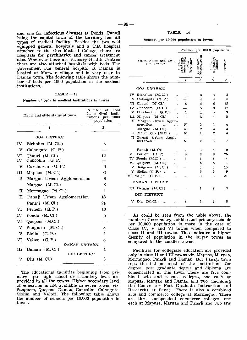
-39-
and one for infectious diseases at Ponda. Panaji being the capital town of the territory has all types of medical facility. Besides the two well equipped general hospitals and a T.B. hospital attached to the Goa Medical College, there are hospitals for psychiatrict and cancer treatment also. Wherever there are Primary Health Centres there are also attached hospitals with beds. The government run general hospital at Daman is located at Marwar village and is very near to Daman town. The following table shows the number of beds per 1000 population in the medical institutions.
TABLE-13
Number of beds in medical institutions in ton-ns
Number of 11eds
Name and civic status of town in mE'dical insti-tutions per 1000
population
1 2
GOA DISTRICT
IV Bicholim (M. Cl..) 3
V Calangute (G. P.)
VI Chauri (M. Cl.) 12 IV Cuncolim (G. P.)
V Curchorem (G. P.) 6
III Mapusa (M. Cl.) 6
II Margao Urban Agglomeration 6
Margao (M. Cl.) 8
II Mormugao (M. Cl.) 1
II. Panaji Urban Agglomeration 13 Panaji (M. Cl.) 24
VI Pernem (G. P.) 10
IV Ponda (M. Cl.) 5
VI Quepem (M.Cl.)
V Sanguem (M. Cl.) 3
V Siolim (G. P.) 1
VI Valpoi (G. P.) 3 DAMAN DISTRICT
III Daman (M. Cl.) 1 DIU DISTRICT
V Diu (M. Cl.) 3
The educational facilities beginning from primary upto high school or secondary level are provided in all the towns. Higher secondary level of education is not available in seven towns viz. Sanguem, Quepem, Daman, Cuncolim, Calangute, Siolim and Valpoi. The following table shows the number of schools per 10,000 population in towns.
TABLE-14
Schools per 10,000 population in towns
NUlllbf'r per 10,000 popula.tlon
, ..... .: , ..... 0 Cn;'(, ... t'O 1:' tj
:>, ;-. (~Ia~H. Name n.nd :;~~ ~tatus of to"~n 1l~~ .§~ -,;-
'a'g~ ;;
.~§I:; § 5 -0::1 S :=.;? ~p~ .;::
~?3E ~ k> 00.. "..., ;:,.. 00.5 rn ,,'" w w:g
1 3 3 4 ~
GOA DISTRICT
IV Bicholim (M. Cl.) 1 3 4 5 V Calangute (G. P.) 4 4 6
VI Chauri (M.C).) 6 6 6 18 IV Cuncolim (G. P.) 8 8 17
V Curchorem (G. P.) 1 4 4 13 III Mapusa (M. Cl.) 1 3 4 5 II Margao Urban Agglo-
meration N 2 3 4
Margao lM. Cl.) N 2 3 3 II Morm.ugao (M.Cl.) N 1 2 4 II Panaji Urban Agglo-
meration N 2 3 7
Panaji (M. CI) 1 3 4 9 VI Pernem (G.P) 3 8 8 25 IV Ponda (M.Cl.) ... 1 1 4 VI Quepem (M. Cl.) 5 5 V Sanguem (M. Cl.) 3 3 15 V Siolim (G. P.) .. 6 6 9
VI Valpoi (G. P.) ... 8 8 21
DAMAN DISTRICT
III Daman (M. CI.) 1 2 3
DIU DISTRICT
V Diu (M. Cl.) ... 1 2 4 6
As could be seen from the table above, the number of secondary, middle and primary schools per 10,000 population is more in the case of Class IV, V and VI towns when compared to class II and III towns. This indicates a higher density of population in the larger towns as compared to the smaller towns.
Facilities for collegiate education are provlded only in class II and III towns viz. Mapusa, Margao, Mormugao, Panaji and Daman. But Panaji town tops the list as most of the institutions for degree, post graduate degree and diploma are concentrated in this town. There are five combined arts and science colleges, one each at Mapusa, Margao and Daman and two (including the Centre for Post Graduate Instruction and Research) at Panaji. There is also a combined arts and commerce college at Mormugao. There are three independent commerce colleges, one each at Mapusa, Margao and Panaji and two law
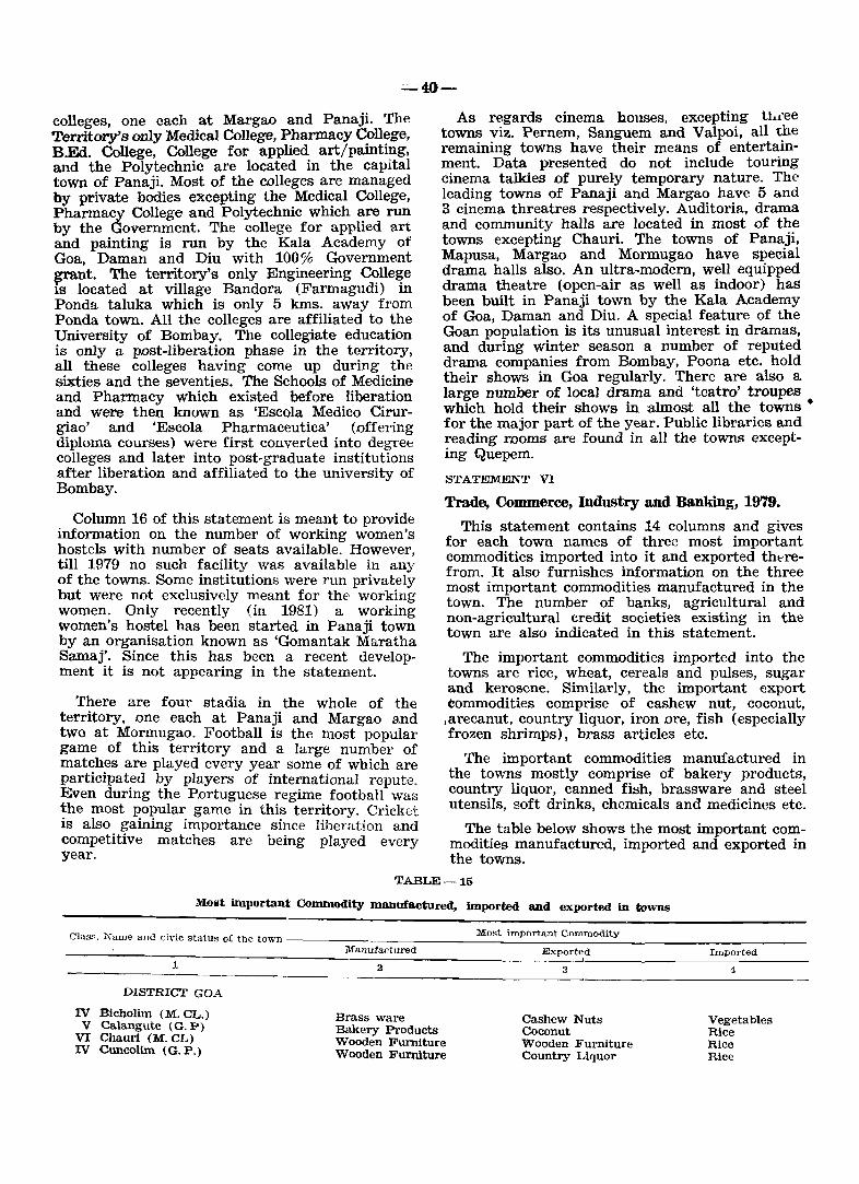
~40-
colleges, one each at Margao and Panaji. The Territory's only Medical College, Pharmacy College, B.Ed. College, College for applied art/painting, and the Polytechnic are located in the capital town of Panaji. Most of the colleges are managed by private bodies excepting the Medical College, Pharmacy College and Polytechnic which are run by the Government. The college for applied art and painting is run by the Kala Academy of Goa, Daman and Diu with 100% Government ~nt. The territory's only Engineering College IS located at village Bandora (Farmagudi) in Ponda taluka which is only 5 kms. away from Ponda town. All the colleges are affiliated to the University of Bombay. The collegiate education is only a post-liberation phase in the territory, all these colleges having come up during the sixties and the seventies. The Schools of Medicine and Pharmacy which existed before liberation and were then known as 'Escola Medico Cirurgiao' and 'Escola Pharmaceutica' (offering diploma courses) were first converted into degree colleges and later into post-graduate institutions after liberation and affiliated to the university of Bombay.
. Colum~ 16 of this statement is meant to provide mformatIOn on the number of working women's ~ostels with number of seats available. However, tIll 1979 no such facility was available in any of the towns. Some institutions were run privately but were not exclusively meant for the working women. Only recently (in 1981) a working women's hostel has been started in Panaji town by an organisation known as 'Gomantak Maratha Samaj'. Since this has been a recent development it is not appearing in the statement.
There are four stadia in the whole of the territory, one each at Panaji and Margao and two at Mormugao. Football is the most popular game of this territory and a large number of matches are played every year some of which are participat~d by players of international repute. Even durmg the Portuguese regime football was !he most popular game in this territory. Cricket IS also gaining importance since liberation and competitive matches are being played every year.
As regards cinema houses, excepting tidee towns viz. Pernem, Sanguem and Valpoi, all the remaining towns have their means of entertainment. Data presented do not include touring cinema talkies of purely temporary nature. The leading towns of Panaji and Margao have 5 and 3 cinema threatres respectively. Auditoria, drama and community halls are located in most of the towns excepting Chauri. The towns of Panaji, Mapusa, Margao and Mormugao have special drama halls also. An ultra~modern, well equipped drama theatre (open-air as well as indoor) has been built in Panaji town by the Kala Academy of Goa, Daman and Diu. A special feature of the Goan population is its unusual interest in dramas, and during winter season a number of reputed drama companies from Bombay, Poona etc. hold their shows in Goa regularly. There are also a large number of local drama and 'teatro' troupes which hold their shows in almost all the towns • for the major part of the year. Public libraries and reading rooms are found in all the towns excepting Quepem.
STATEMENT VI
Trade, Commerce, Industry and Banking, 1979.
This statement contains 14 columns and gives for each town names of three most important commodities imported into it and exported thtTefrom. It also furnishes information on the three most important commodities manufactured in the town. The number of banks, agricultural and non-agricultural credit societies existing in the town are also indicated in this statement.
The important commodities imported into the towns are rice, wheat, cereals and pulses, sugar and kerosene. Similarly, the important export commodities comprise of cashew nut, coconut, jarecanut, country liquor, iron ore, fish (especially frozen shrimps), brass articles etc.
The important commodities manufactured in the towns mostly comprise of bakery products, country liquor, canned fish, brassware and steel utensils, soft drinks, chemicals and medicines etc.
The table below shows the most important commodities manufactured, imported and exported in the towns.
TABLE-15
Most important Commodity manufactured, imported and exported in towns
~_,~=~c~~m~~~~ ___ ~~~=~ ___ ~M=M~t~~~~~rt;a;n~tc~o~=~~=tl~y __________ _ Manufactured Exported Imported
1
DISTRICT GOA
IV Bicholim (M. CL.) V Calangute (G. P)
VI Chaurl (M. CL) IV CuncoUm (G. P.)
Brass ware Bakery Products Wooden Furniture Wooden Furniture
3
Cashew Nuts Coconut Wooden It'urniture Country Liquor
4
Vegetables Rice Rice Rice
-41---
1
V Curchorem (G. P.) ITI Mapusa (M. CL.)
m Margao (M. CL.) II _Mormugao (M. CL.) II Panaji (M.CL)
VI Pernem (G. P.) IV Ponda (M. CL.) VI Quepem (M. CL)
V Sanguem (M. CL) V Siolim (G. P.)
VI Valpoi (G. P.)
DISTRICT DAMAN
III Daman (M. CL.)
DISTRICT DIU
V Diu (M. CL.)
2
Spectacle Frames Brass & Stainless Steel
Utensils Canned Fish Fertilizers Chemicals & Pesticides Country Liquor Soft Drinks Country Liquor Country Liquor Bakery Products Bakery Products
Liquor
Ground nut Oil
All the towns are served by banks. Panaji town has the largest number of banks, followed by Margao, Mormugao, and Mapus~. Obvi.ously, these are the four leading commerCIal and mdus~ trial towns of this territory.
The agricultural credit~societies are. mostly located in small towns. The non~agrIcultural credit societies are located in Panaji, Margao, Mormugao, Mapusa, Ponda, Sanguem, Daman and Diu.
9.3 Primary Census Abstract
The Primary Census Abstract (PCA) presents the basic data collected at the 1981 Census. It is presented in the form of a statement which contains information in respect of name and area of village and town, occupied residential houses, number of households, total population, literates, main workers (with a further break-up of main workers into cultivators, agricultural labourers, workers in household industry and other workers) , marginal workers and non-workers. The Primary Census Abstracts are separately presented for Union Territory, for the district of Goa, and for each taluka. Special peAs for the Scheduled Castes and the Scheduled Tribes are also presented.
The state PCA provides data at district level "while the district PCA provides data at the ta
luka/urban agglomeration/town levels. The taluka PCA provides the basic census data for each town and its wards and each village in the taluka. The District Census Handbook is the only source in the series of census publications which provides these basic data for each village and ward within
3
Spectacle Frames Garments
Coconut Iron Ore Frozen Shrimps Country Liquor Arecanut Cotton Yarn Arecanut Country Liquor Sugarcane
Foam mattresses
Salt
Rice Rice
Rice wheat Cereals & Pulses Sugar Rice Rice Rice Rice Rice
wheat
wheat
a town. The taluka peA contains 28 columns the contents of which are discussed in brief hereunder: -
Column 1: This shows the location code number of each village/town of the taluka. The location code is a device by which every village within a taluka and town within a district is identified. To distinguish between rural and urban areas the villages are allotted Arabic numbers and the towns, Roman numbers. While the villages are allotted location codes in a serial order within a taluka, the town location codes are in a serial order within a district.
-Column 2: This gives the name of the village/town.
Column 3: This column shows the area of the village and town. The area of the village is given in hectares and that of town in sq. kms. The village area presented is based on the latest cadastral survey (1977) records of the Land Survey Department.
Columns 4 and 5: These t.wo columns give for each unit the number of occupied residential houses and the number of households respectively.
Columns 6, 7 and 8: These three columns give the total p<?pulation with a break-up of males and females. As said earlier, the reference time and date of the 1981 census was the Sunrise of 1st March, 1981. The enumeration commenced on 9th February, 1981 and was completed on 28th February, 1981. The houseless persons were enumerated on the night of 28th February, 1981. A revisional round of five
-42-
days was held between 1st March, and 5th March, 1981, with a view to upto-dating the population by including new births and excluding deaths that had occured between the visit of the enumerator to the household and the sunrise of 1st March, 1981.
Columns 9, 10, 11 and 12: These columns give the population of the scheduled castes and the scheduled tribes by sex.
Columns 13 and 14: These columns give the literate population by sex.
Columns 15 and 16: These columns give the total main workers by sex. The definition of the term 'main worker' is explained under 'census concepts'.
Columns 17 to 24: These columns give the classification of workers into four broad categories viz. cultivators, agricultural labourers, workers in household industry, and other workers. Census definitions of these four categories of workers have been given earlier.
Columns 25 and 26: These columns give data for marginal workers. The term 'marginal worker' has been explained earlier under 'census concepts'.
Columns 27 and 28: These columns give data for non-workers.
The non-workers includes the following categories of persons (i) household duties, (ii) students (iii) dependents, (iv) retired persons or rentiers} (v) beggars etc., (vi) inmates of institutions and (vii) other non-workers.
When compared to the Primary Census Abstract presented in the 1971 Census, the 1981 Primary Census Abstract has undergone certain modifications. As against the nine-fold classification of workers adopted in the 1971 census viz. (I) cultivator, (II) agricultural labourer, (III)
livestock, forestry, fishing, hunting and planta-tions, orchards and allied activities, (IV) mining and quarrying (Va) manufacturing, processing, servicing and repair - household industry (Vb) manufacturing, processing, servicing and repair - other than household industry, (VI) construction, (VII) trade and commerce, (VIII) transport, storage and communication and (IX) other services, the 1981 Primary Census Abstract presents data only for four broad categories, of workers as mentioned earlier. The categories III, IV, V(b), and VI to IX of the 1971 Census have been combined and placed under category 'other workers' in 1981 for the purposes of the Primary Census Abstract.
'rhe data on marginal workers is a new feature of 1981 census.
In 1971 for urban areas data was presented for each enumerator's block within the ward. This pattern is not followed in 1981 and data is presented only wardwise within the town. However, an appendix giving the total population and the scheduled caste and scheduled tribe population is presented blockwise in each urban area. This appendix is expected to meet the requirements of the administrative and election authorities in urban areas.
Concept of worker 1961-1981
Relatively more detailed information regarding economic activity of the population is collected in the 1981 census, than what was done in the 1971 or the 1961 censuses. The 'work' concept of 1961 and 1971 censuses, as opposed to the 'income' or 'economic independence' concept of the censuses prior to 1961, is however retainedin the 1981 census also. But the criterion fOI" classification of persons as workers underwent changes. While in 1961 and 1971 cesuses different approaches, namely, usual status and current status, were adopted with a reference period of one year and one week for seasonal and fOI regular work respectively, at the 1981 census the usual Status approach was adopted uniformly for all work. In the 1961 and 1971 censuses classification as worker or non-worker was made through different criteria. In 1961 a person was qualified as a worker if he had worked regularly during the last season or if he had worked at least for a day in regular (non-seasonal) work during the preceding fortnight. At the 1971 census a person was treated as a worker only if he spent his time mainly in work or if he worked at least for a day in regular (non-sea~onal) work during the preceding week.
TJ:re dichotomy of worker and non-worker of 19(j1 and 1971 censuses was discarded at the 1981 census and instead a trichotomy as main worker, marginal worker and non-worker was adopted. For main worker the time criterion of engagement in work was the major part of the year i. e. at least 183 days in the preceding one year, while those who worked for some time during the last year but not for the major part of the year, were treated as marginal workers. Those who had never worked during the last one year were considered as non-workers. This trichotomy partially permits a comparability of 1981 census economic data with that of 1971 as well as 1961. It is expected that the term main worker of 1981, would correspond to the worker of 1971 and the main worker and marginal worker together of 1981 would correspond to the worker of 1961.
The following table shows the distribution of popUlation, number of villages and towns in the districts and the talukas of this union territory;
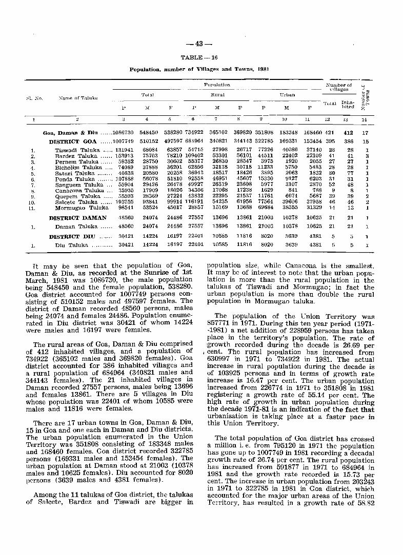
-43-
TABLE-16
Population, number of Villages and Towns, 1981
"I. :\0. "arne of Taluka Total
p l\[ !" P
1 2 3 4 5 6
Goa, Daman & Diu ...... 1086730 548450 538280 734922
DISTRICT GOA ...... 1007749 510152 497597 68-1964
1. Tiswadi Taluka ..... 131941 68084 63857 54715 2. Bardez Taluka ...... 153913 75703 78210 109402 3. Pernem Taluka ...... G9352 28750 30602 55377 4. Bicholim Taluka .... 74089 37888 36201 62856 5. Satari Taluka ........ ·10838 20580 20258 36943 6. Ponda Taluka ........ 107888 56078 51810 92558 7. Sanguem Taluka .. , 55904 29426 26478 49927 g. Canacona Taluka ... 35935 17909 18026 34306 9. Quepem Taluka ..... 55593 28369 27224 43832
10. Salcete Taluka ...... 193755 93841 99914 116191 11. Mormugao Taluka 98541 53524 45017 28857
DISTRICT DAMAN ·18560 24074 24486 27557
1. Daman Taluka ...... 48560 24074 24486 27557
DISTRICT DnJ ....... 30421 14224 16197 22401
1. Diu Taluka ........... 30421 14224 16197 22401
It may be seen that the population of Goa, Daman & Diu, as recorded at the Sunrise of lst March 1981 was 1086730, the male population being 548450 and the female population, 538280. Goa district accounted for 1007749 persons consisting of 510152 males and 497597 females. The district of Daman recorded 48560 persons, males being 24074 and females 24486. Population enumerated in Diu district was 30421 of whom 14224 were males and 16197 were females.
Population "umber of "5 Villages ... '" Rural Uruan .3~ ='" Total Illha- ::;b
1\1 F P 1\1 F bited %
7 8 V 10 11 12 Ii! 14
365102 369820 351808 183348 168460 421 412 17 340821 344143 322785 169331 153454 395 386 15 27998 26717 77226 40086 37140 28 28 1 53301 56101 44511 22402 22109 41 41 3 26830 28547 3975 1920 2055 27 27 1 32138 30718 11233 5750 5483 28 28 ] 18517 18426 3895 2063 1832 80 77 1 46951 45607 15330 9127 6203 31 31 ] 26319 23608 5977 3107 2870 52 48 1 17068 17238 1629 841 788 9 8 1 22295 21537 11761 6074 5687 39 39 2 54235 61956 77564 39606 37958 46 46 2 15169 13688 69684 38355 31329 14 13 1
13696 13861 21003 10378 10625 21 21 13696 13861 21003 10378 10625 21 21 1
10585 11816 8020 3639 4381 5 5 1
10585 11816 8020 3639 4381 5 5 1
population size, while Canacona is the smallest. It may be of interest to note that the urban population is more than the rural popUlation in the talukas of Tiswadi and Mormugao; in fact the urban population is more than double the rural population in Mormugao taluka.
The rural areas of Goa, Daman & Diu comprised of 412 inhabited villages, and a population of 734922 (365102 males and 369820 females). Goa district accounted for 386 inhabited villages and a rural population of 684964 (340821 males and 344143 females). The 21 inhabited villages in Daman recorded 27557 persons, males being 13696 and females 13861. There are 5 villages in Diu whose population was 22401 of whom 10585 were males and 11816 were females.
There are 17 urban towns in Goa, Daman & Diu, 15 in Goa and one each in Daman and Diu districts. The urban population enumerated in the Union Territory was 351808 consisting of 183348 males and 168460 females. Goa district recorded 322785 persons (169331 males and 153454 females). The urban popUlation at Daman stood at 21003 (10378 males and 10625 females). Diu accounted for 8020 persons (3639 males and 4381 females).
The popUlation of the Union Territory was 857771 in 1971. During this ten year period (1971--1981) a net addition of 228959 persons has taken place in the territory's population. The rate of 'growth recorded during the decade is 26.69 per
I cent. The rural population has increased from 630997 in 1971 to 734922 in 1981. The actual increase in rural population during the decade is of 103925 persons and in terms of growth rate increase is 16.47 per cent. The urban popUlation increased froll} 226774 in 1971 to 351808 in 1981 registering a growth rate of 55.14 per cent. The high rate of growth in urban population during the decade 1971-81 is an indication of the fact that urbanisation is taking place at a faster pace in this Union Territory.
Among the 11 talukas of Goa district, the talukas of SaJcete, Bardez and Tiswadi are bigger in
The total popUlation of Goa district has crossed a million i. e. from 795120 in 1971 the population has gone up to 1007749 in 1981 recording a decadal growth rate of 26.74 per cent. The rural population has increased from 591877 in 1971 to 684964 in 1981 and t.he growth rate recorded is 15.73 per cent. The increase in urban popUlation from 203243 in 1971 to 322785 in 1981 in Goa district, which accounted for the major urban areas of the Union Territory, has resulted in a growth rate of 58.82
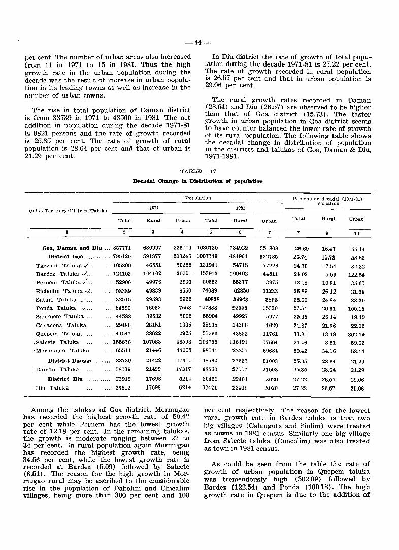
-44-
per cent. The number of urban areas also increased from 11 in 1971 to 15 in 1981. Thus the high growth rate in the urban population during the decade was the result of increase in urban population in its leading towns as well as increase in the number of urban towns.
The rise in total population of Daman district is from 38739 in 1971 to 48560 in 1981. The net addition in population during the decade 1971-81 is 9821 persons and the rate of growth recorded is 25.35 per cent. The rate of growth of rural population is 28.64 per cent and that of urban is 21.29 per cent.
In Diu district the rate of growth of total population during the decade 1971-81 is 27.22 per cent. The rate of growth recorded in rural popUlation is 26.57 per cent and that in urban population is 29.06 per cent.
The rural grqwth rates recorded in Daman (28.64) and Diu (26.57) are observed to be higher than that of Goa district (15.73). The faster growth in urban popUlation in Goa district seems to have counter balanced the lower rate of growth of its rural popUlation. The following table showsthe decadal change in distribution of population in the districts and tal uk as of Goa, Daman & Diu, 1971-1981.
1'ABLE-17
Decadal Change in Distribution of population
Population Pe~entage decadal (1971-81)
Un j')11 Terri tory IDistrictlTaluka 1971
Total Rural Urban
1 2 3 4
Goa, Daman and Diu ... 857771 630997 226774
District Goa ............ 795120 591877 203243
1'iswadi 1'aluka ./. ... 105809 46551 59258
Bardez Taluka ../." ... 124103 104102 20001
Pernem Taluka'/" 52906 49976 2930
Bicholim Taluka -..:. 58389 49839 8550
Satari Taluka _' ... 32515 29593 2922
Ponda Taluka .., ... 84590 76932 7658
Sanguem Taluka ... 44588 39582 5006
Canacona Taluka 29486 28151 1335
. Quepem Taluka ... 41547 38622 2925
,Salcete Taluka ... 155676 107083 48593
• Mormugao Taluka 65511 21446 44065
District Daman ......... 38739 21422 17317
Daman Taluka 38739 21422 17317
District Diu ............ 23912 17698 6214
Diu Taluka 23912 17698 6214
Among the talukas of Goa district, Mormugao has recorded the highest growth rate of 50.42 per cent while Pernem has the lowest growth rate of 12.18 per cent. In the remaining talukas, the growth is moderate ranging between 22 to 34 per' cent. In rural popUlation again Mormugao has recorded the highest growth rate, being 34.56 per cent, While the lowest growth rate is recorded at Bardez (5.09) followed by Salcete (8.51). The reason for the high growth in Mormugao rural may be ascribed to the considerable rise in the popUlation of Dabolim and Chicalim villages, being more than 300 per cent and 100
Variation 1981
Total RUI'al Urban Total Ruml Urban
5 6 7 7 ~ 10
1086730 734922 351808 26.69 16.47 55.14 1007749 684964 322785 26.74 15.73 58.82
131941 54715 77226 24.70 17.54 30.32 153913 109402 44511 24.02 5.09 122./')4
59352 55377 3975 12.18 10.81 35.67 74OS9 62856 11233 26.89 26.12 31.3S 40838 36943 3895 25.60 24.84 33.30
107888 92558 15330 27.54 20.31 100.18 55904 49927 5977 25.38 26.14 19.40
~5935 34306 1629 21.87 21.86 22.02 55593 43832 11761 33.81 13.49 302.09 ,
193755 116191 77564 24.46 8.51 59.62 98541 28857 69684 50.42 34.56 58.14
48560 27557 21003 25.35 28.64 21.29 48560 27557 21003 25.35 28.64 21.29
30421 22401 8020 27.22 26.57 29.06 30421 22401 8020 27.22 26.57 29.06
per cent respectively. The reason for the lowest rural growth rate in Bardez taluka is that two big villages (Calangute and Siolim) were treated as towns in 1981 census. Similarly one big village from Salcete taluka (Cuncolim) was also treated as town in 1981 census.
As could be seen from the table the rate of growth of urban popUlation in Quepem taluka was tremendously high (302.09) followed by Bardez (122.54) and Pond a (100.18). The high growth rate in Quepem is due to the addition of
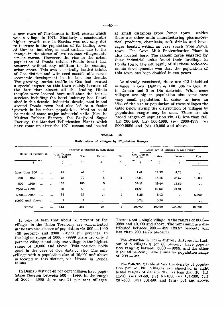
-45-
a new town of Curchorem in 1981 census which was a village in 1971. Similarly a considerable higher growth rate in Bardez was not only due to increase in the population of its leading town of Mapusa, but also, as said earlier, due to the change in the status of two revenue villages mto census towns. However, the rise in the urban population of Ponda taluka (ponda town) has occurred without any addition to the existing urban areas. This was a centrally located taluka of Goa district and witnessed considerable socio-economic development in the last one decade. The growing tourist traffic in Goa had created a special impact on this town mainly because of the fact that almost all the leading Hindu temples were located here and thus the tourist services including the hotel industry has flourished in this decade. Industrial development in and around Ponda town had also led to a faster
• growth in its urban population. Mention could be made of some major industrial units (like the Madras Rubber Factory, the Sanjivani Sugar Factory, the Mandovi Pelletisation Plant) which have come up after the 1971 census and located
at small distances from Ponda town. Besides there are other units manufacturing pharmaceutical products, chemicals, soft drinks and beve· rages located within an easy reach from Ponda town. The Govt. Milk Pasteurisation Plant is also located here. The labour force engaged by these industrial units found their dwellings in Ponda town. The net result of all these socio-economic developments was that the population of this town has been doubled in ten years.
As already mentioned, there are 412 inhabited villages in Goa, Daman & Diu, 386 in Goa, 21 in Daman and 5 in Diu districts. While some villages are big in population size some have very small population. In order to have an idea of the size of population of these villages the table below giving the distribution of villages by population ranges may be seen. There are six broad ranges of population viz. (i) less than 200, (ii) 200-499, (iii) 500-1999, (iv) 2000-4999, (v) 5000-9999 and (vi) 10,000 and above.
TABLE-18
Distribution of villages by Population Ranges
Number of villages in each range
Ra!H':~ of Population Goa. Daman & Diu Goo. Daman
1 2 3 4
Less than 200 47 46 1
200- 499 78 70 6
500-1999 162 153 9
2000-4999 90 85 5
5000-9999 34 31 .. 10000 and above 1 1
Total 412 386 21
It may be seen that about 61 percent of the villages in the Union Territory are concentrated in the two size-classes of population viz. 500 -1999 (39 percent) and 2000 - 4999 (22 percent). In the higher range of 5000 - 9999 there are only 8 percent villages and only one village in the highest range of 10,000 and above. This position holds good in the case of Goa district also. The only
4village with a population size of 10,000 and above is located in this district, viz. Siroda in Ponda taluka.
In Daman district 43 per cent villages have population ranging between 500 - 1999. In the range of 2000 - 4999 there are 24 per cent villages.
Percent.age of villages in each range
Goa. Daman Diu & Diu Goa Daman Diu
5 6 7 8 9
11.41 11.92 4.76
2 18.93 18.13 28.57 40.00
39.32 39.64 42.86
21.85 22.02 23.81 .. 3 8.25 8.03 60.00
0.24 0.26
5 100.00 100.00 100.00 100.00
There is not a single village in the ranges of 5000-9999 and 10,000 and above. The remaining are distributed between 200 - 499 (28.57 percent) and less than 200 (4.76 percent).
The situation in Diu is entirely different in that, out of 5 villages 3 (or 60 percent) have population ranging between 5000 - 9999, and the other 2 (or 40 percent) have a smaller population range of 200-499.
The following table shows the density of population per sq. km. Villages are classified in eight broad ranges of density viz. (i) less than 10, (ii) 11-20, (iii) 21-50, (iv) 51-100, (v) 101-200, (vi) 201-300, (vii) 301-500 and (viii) 501 and above.
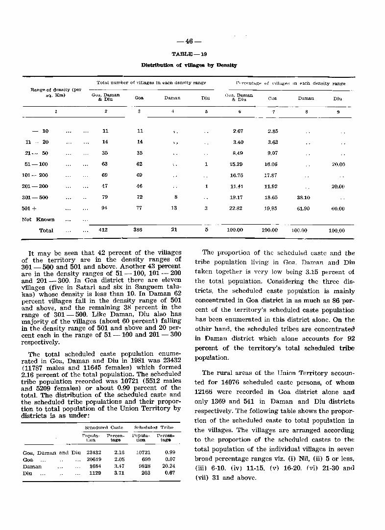
-46-
TABLE-19
Distribution of vWagea by Density
Total number of dllages in each denRity range P~r'('pntag-e of nllages III each density range
Range of density (per sq. KIn) Goa. Da.man
& Diu Goa Daman
1 2 3 4
10 11 11 .. 11- 20 14 14 ;; ..
21- 50 35 35
51-100 63 62
101-200 69 69
201-300 47 46
301-500 79 72 8
501+ 94 77 13
Not Known
Total 412 386 21
It may be seen that 42 percent of the villages of the territory are in the density ranges of 301- 500 and 501 and above. Another 43 percent are in the density ranges of 51 - 100, 101 - 200 and 201 - 300. In Goa district there are eleven villages (five in Satari and six in Sanguem talukas) whose density is less than 10. In Daman 62 percent villages fall in the density range of 501 and above, and the remaining 38 percent in the range of 301 - 500. Like Daman, Diu also has majority of the villages (about 60 percent) falling in the density range of 501 and above and 20 percent each in the range of 51 - 100 and 201 - 300 respectively.
The total scheduled caste population enumerated in Goa, Daman and Diu in 1981 was 23432 (11787 males and 11645 females) which formed 2.16 percent of the total population. The scheduled tribe population recorded was 10721 (5512 males and 5209 females) or about 0.99 percent of the total. The distribution of the scheduled caste and the scheduled tribe populations and their proportion to total population of the Union Territory by districts is as under:
Scheduled Caste Scheduled Tribe
Popula- Percen- Papula- Percen-tlon tage tion. tage
Goa, Daman and Diu 23432 Goa 20619 Daman 1684 Diu 1129
2.16 2.05 3.47 3.71
10721 690
9828 203
0.99 0.07
20.24 0.67
Diu
5
1
1
3
5
Goa, Daman & Diu
6
2.67
3.40
8.49
15.29
16.75
11.41
19.17
22.82
100.00
Goa Daman Diu
7 8 9
2.85
3.63
9.07
16.06 21).00
17.87
11.92 20.00
18.65 38.10
19.95 61.90 60.00
100.00 100.00 100.00
The proportion of the scheduled caste and the tribe population living· in Goa, Daman and Diu
taken together is very low being 3.15 percent of
the total population. Considering the three dis
tricts, the scheduled caste population is mainly concentrated in Goa district in as much as 86 per
cent of the territory's scheduled caste population
has been enumerated in this district alone. On the oth~r hand, the scheduled tribes are concentrated
in Daman district which alone accounts for 92
percent of the territory's total scheduled tribe population.
The rural areas of the Union Territory accoun
ted for 14076 scheduled caste persons, of whom
12166 were recorded in Goa district alone and
only 1369 and 541 in Daman and Diu districts respectively. The following table shows the propor
tion of the scheduled caste to total population in
the villages. The villages are arranged according . to the proportion of the scheduled castes to the
total popUlation of the individual villages in seven
broad percentage ranges viz. (i) Nil, (ii) 5 or less, (iii) 6-10, (iv) 11-15. (v) 16-20. (vi) 21-30 and
(vii) 31 and above.
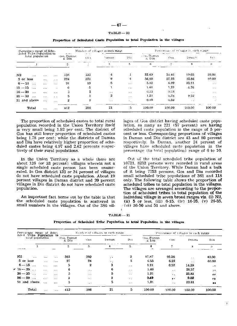
N
-47-
TABLE-20
Proportion of Scbeduled Caate Popula.tion to total Popula.tion in the villages
Percentage range of Sche- XnlIlhf'I' of Ylllag('p ln ea.ch rang(' ullled Tnbe Population to
total populallon ,_}ua, Dalnall & Diu l;(I,l 1 )dIna..!l
----1 2 .-
Nil 138 133 4
5 or less 234 221 9
6-10 24 19 5
11-15 6 5 1
16-20 3 3 21-30 5 :1 2
31 and above 2 2
Total 412 386 21
The proportion of scheduled castes to total rural population recorded in the Union Territory itself is very small being 1.92 per cent. The district of Goa has still lower proportion of scheduled castes being 1.78 per cent; while the districts of Daman and Diu have relatively higher proportion of scheduled castes being 4.97 and 2.42 percents respectively of their rural populations.
In the Union Territory as a whole there are about 138 (or 33 percent) villages wherein not a single scheduled caste person has been enumerated. In Goa district 133 or 34 percent of villages do not have scheduled caste popUlation. About 19 percent villages in Daman district and 20 percent villages in Diu district do not have scheduled caste popUlation.
An important fact borne out by the table is that the scheduled caste population is scattered in small numbers in the villages. Out of the 386 vil-
l)t:::'n'I'nta~t' uf Ylllage~ ill t'arh r::.ng." _---------_-----
Diu , I'a. D.tnlWl
C:'o,l.. ltdIll,lll l)'lll &. Diu
5 I; I 8 ~)
------_---
1 33.49 34.46 19.05 20.00 4 50.80 57.25 42.86 H!.OO
5.82 4.92 23.81 1.46 1.29 -1.76 \).73 0.78 1.21 (J.7S 9.52 0.49 0.52
- ---_-_. __ -_ --- -------_
5 100.00 100.00 100.00 100.00
lages of Goa district having scheduled caste population, as many as 221 (57 percent) are having scheduled caste popUlation in the range of 5 percent or less. Corresponding proportions of villages in Daman and Diu district are 43 and 80 percent respectively. In Daman. another 24 percent of villages have scheduled caste population in the percentage (to total population) range of 6 to 10.
O~t of the total scheduled tribe population of 10721, 8232 persons were recorded in rural areas of the Union Territory. While Daman had a bulk of it being 7753 persons, Goa and Diu recorded small scheduled tribe populations of 361 and 118 only. The following table shows the proportion of scheduled tribes to total population in the villages. The villages are arranged according to the proportion of scheduled tribes to total population of the individual village in seven broad ranges viz. (i) Nil, (ii) 5 or less, (iii) 6-15, (iv) 16-25, (v) 26-35,
'(vi) 36-50 and 51 and above.
TABLE-21
Proportion of Scheduled TrIbe- POllUlation to tota.!. Population in the villages
Per~("nt.age range of Sch~- X1lJnlwr {If, 1Ila:.:;t·,..., III t'a~h ran£(e r~'l'{''''ltagt' of \ llldg-t~~ in (_ uch range-tlul('d Tribe Population to
total population (;oa. Daman (~oa Vanlan Dill
t ;oa. Danl:l"n DaJlUlIl & Diu & Viu ';oa Diu
1 :I :1 4 G a 7 8 n
Nil 362 360 2 87.87 93.26 40.00 5 or less 27 24 -.. 3 6.55 6.22 60.00 6-15 5 2 3 1.21 0.52 14.29
16-25 6 6 1.46 28.57 !i
26-35 5 5 1.21 23.81 " 36-56 2 2 0.49 r· 9.52 ,. 51 and above 5 5 1.21 23.81 II
Total 412 386 21 5 100.00 100.00 100.00 100.00
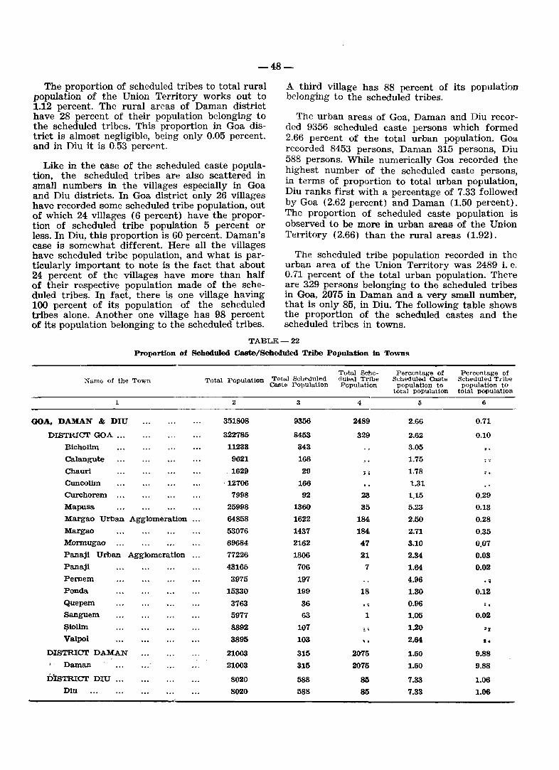
-48-
The proportion of scheduled tribes to total rural population of the Union Territory works out to 1.12 percent. The rural areas of Daman district have 28 percent of their population belonging to the scheduled tribes. This proportion in Goa district is almost negligible, being only 0.05 percent, and in Diu it is 0.53 percent.
Like in the case of the scheduled caste population, the scheduled tribes are also scattered in small numbers in the villages especially in Goa and Diu districts. In Goa district only 26 villages have recorded some scheduled tribe popUlation, out of which 24 villages (6 percent) have the proportion of scheduled tribe population 5 percent or less. In Diu, this proportion is 60 percent. Daman's case is somewhat different. Here all the villages have scheduled tribe population, and what is particularly important to note is the fact that about 24 percent of the villages have more than half of their respective population made of the scheduled tribes. In fact, there is one village having 100 percent of its population of the scheduled tribes alone. Another one village has 98 percent of its population belonging to the scheduled tribes.
A third village has 88 percent of its popUlation belonging to the scheduled tribes.
The urban areas of Goa, Daman and Diu recorded 9356 scheduled caste persons which formed 2.66 percent of the total urban population. Goa recorded 8453 persons, Daman 315 persons, Diu 588 persons. While numerically Goa recorded the highest number of the scheduled caste persons, in terms of proportion to total urban population, Diu ranks first with a percentage of 7.33 followed by Goa (2.62 percent) and Daman (1.50 percent). The proportion of scheduled caste population is observed to be more in urban areas of the Union Territory (2.66) than the rural areas (1.92).
The scheduled tribe population recorded in the urban area of the Union Territory was 2489 i. e. 0.71 percent of the total urban population. There are 329 persons belonging to the scheduled tribes in Goa, 2075 in Daman and a very small number, that is only 85, in Diu. The following table shows the proportion of the scheduled castes and the scheduled tribes in towns.
TABLE-22 Proportion of Scheduled Caste/Scheduled Tribe Population in Towns
Total Sche- Percentage of Percentage of :Name of the Town Total Population Total Scheduled duled Tribe Scheduled Caste Scheduled Tribe
Caste Population Population population to population to total population total population
1 2 3 4 5 6
GOA. DAMAN & DIU 351808 9356 2489 2.66 0.71
DISTRICT GOA ... 322785 8453 329 2.62 0.10 Bicholim 11238 343 3.05 · . Calangute 9621 168 1.75 .... Chauri . 1629 29 ~ i 1.78 · . Cuncolim ·12100 166 1.31 CUrchorem 7998 92 23 1.15 0.29 Mapusa 25998 1360 35 5.23 0.13 Margao Urban Agglomeration 64858 1622 184 2.50 0.28 Margao 53076 1437 184 2.71 0.35 Mormugao 69684 2162 47 3.10 0.07 Panaji Urban Agglomeration 77226 1806 21 2.34 0.03 Panaji 48165 706 7 1.64 0.02 Pemem 3975 197 4.96 · ~ Ponda 15330 199 18 1.30 0.12 Quepem 3763 36 . , 0.96 · . Sanguem 5977 63 1 1.05 0.02 ~iolim 8892 107 ,. 1.20 .1
Valpoi 3895 103 . . 2.64 •• DISTRICT DAMAN 21003 315 2075 1.50 9.88 , ' Daman 21003 315 2075 1.50 9.88
DIsTRICT DIU 8020 588 SIS 7.33 1.06 Diu 8020 588 SIS 7.33 1.06
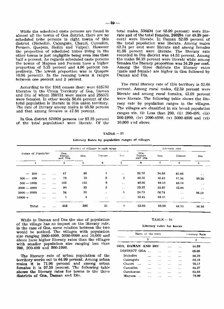
While the scheduled caste persons are found in almost all the towns of Goa district, there are no .scheduled tribe persons in eight towns of this district (Bicholim. Calangute, Chauri, Cuncolim, Pernem, Quepem, Siolim and Valpoi). However the proportion of scheduled tribes living in the other towns is just negligible being even less than half a. percent. As regards scheduled caste persons the towns of Mapusa and Pernem have a higher proportion of 5.23 percent and 4.96 percent respectively. The lowest proportion was in Quep-em (0.96 percent). In the remaing towns it ranges between one percent and 3 percent.
According to the 1981 census there were 615752 literates in the Union Territory of Goa, Daman and Diu of whom 359731 were males and 256021 were females. In other words 56.66 percent of the total population is literate in this union territory. The rate of literacy among: males is 65.59 percent and that among females IS 47.56 percent.
In Goa district 576928 persons (or 57.25 percent of the total population) were literate. Of the
total males, 336634 (or 65.99 percent) were literate and of the total females, 240294 (or 48.29 percent) were literate. In Daman 52.05 percent of the total population was literate. Among males 62.74 per cent were literate and among females 41.55 percent were literate. The literacy rate recorded in Diu district was 44.53 percent. Among the males 56.19 percent were literate while among females the literacy proportion was 34.29 per cent. Among the three districts the literacy rates (male and female) are higher in Goa followed by Daman and Diu.
The rural literacy rate of this territory is 52.68 percent. Among rural males, 62.39 percent were literate and among rural females, 43.08 percent were literate. The following table shows the literacy rate by popUlation ranges in the villages. The villages are classified in six broad popUlation ranges vi?. (i) Less than 200, (ii) 200-499, dii) 500-1999, (iv) 2000-4999, (v) 5000-4999 and (vi) 10,000 2 nd above.
TABLE-23
Literacy Rates by population ranges of villages
Range of Population <kIa. Daman
and Diu
1 2
200 47
200- 499 78
500-1999 162
2000 -4999 90
5000-9999 34
10000 + 1
Total 412
Numb<-r of villageR in each range
<kia,
3
46
70
153
85
31
1
386
DalIl8,n
4
1
6
9
5
21
While in Daman and Diu the size of population of the village has no impact on the literacy rate, in the case of Goa, some relation between the two would be noticed. The villages with population .size ranging 2000-4999, 5000-9999 and 10,000 and above have higher literacy rates than the villages with smaller population size ranging less than 200, 200-499 and 500-1999.
The literacy rate of urban population of the territory works out to 64.99 percent. Among urban males it is 71.96 percent and among urban females it is 57.39 percent. The following t&.ble shows the literacy rates for towns in the three districts of Goa, Daman and Diu.
Litf'racy rate
Goa. lJ1U Daman Goa. Daman Diu
5
2
3
and Diu
6
34.72
40.35
48.95
55.22
54.70
52.41
52.68
7
34.52
40.44
49.10
55.87
56.74
52.41
53.56
TABLE-24
8
40.46
41.04
46.34
42.95
44.11
Literacy rates for towns
9
35.36
36.19
36.16
Name of the town LIteracy Rate
1 2 ----------------------GO.-\, DAMAN AND DIU 64.99
DISTRICT GOA ... 65.08
Bicholim 66.22 Calangute 62.18 Chauri ... 70.17 Cuncolim 64.27 Curchorem 64.83 Mapusa ... 70.89
-50-
1
MARGAO URBAN AGGLOMERATION
Margao ...
- Mormugao
PANAJI URBAN AGGLOMERATION Panaji Pernem ... Ponda Quepem ... Sanguem Siolim Vulpoi
DISTRICT DAMAN
Daman ...
DISTRICT DIU
Diu
2
65.36
65.55
59.19
66.58 72.19 62.67 71.59 62.37 64.70 G9.~~D
71.96
62.48
62.48
67.91
67.91
Among the three districts of the Union Territory, Diu has a comparatively higher urban literacy rate being 67.91 percent followed by Goa
(65.08) and Daman (62.48). In most of the towns of Goa district excluding Mormugao, the literacy rate ranges between 62 and 72 percent, the highest being in Panaji Municipal Council (72.19), followed by Valpoi (71.96), Ponda (71.59), Mapusa (70.89) and Chauri (70.17). The literacy rates recorded in the smaller towns like Chauri and Valpoi are surprisingly high. In the newly formed census towns viz. Calangute, Cuncolim Curchorem and Siolim, more than 62 percent of population is literate. The town of Mormugao has recorded the lowest literacy rate among the towns of Goa district as well as of the Union Territory. But the low literacy rate in this town is not surprising. Mormugao being a port town a large number of illiterate persons have migrated from out-side the Territory to work as dock-labour which has brought down the literacy rate of this town.
The distribution of literates, workers, nonworkers. scheduled caste, scheduled tribe popUlation by rural/urban and by sex in the districts and talukas of Goa, Daman and Diu is shown in the following table

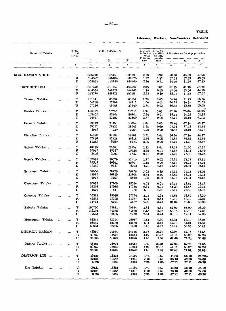
-52-
TABLE;
J"iterates, Workers, Non-Workers, Scheduled
Total Tutal pupu1a ti,\))_ S. C. Po- S. T. Po-Name of Talulm Rur .. l lmlation pulation Literates to total population
'Urban to total to total J'l'opula- popula-
p M F tlon tion P M F
1 :1 ::; '1 {) 6 7 8 \I 10 --~------
GOA, DAMAN & DIU T 1086730 548450 538280 2.16 0.99 56.66 65.59 47.56 R 734922 365102 36982Q 1.92 1.12 52.68 62.39 43.08 U 351808 183348 168460 2.66 0.71 64.99 71.96 57.39
DISTRICT GOA .,. T 1007749 iii10152 497597 2.05 0.Q7 57.25 65.99 48.29 R 684964 340821 344143 1.78 0.05 53.56 63.06 44.15 U 32278fi 169331 153454 2.62 0.10 65.08 71.88 57.57
Tiswadi Taluka T 131941 68084 63857 1.78 0.03 64.24 71.73 56.25 R 54715 27998 26717 1.00 0.03 60.92 70.34 51.05 U 77226 40086 37140 2.34 0.03 66.58 72.69 59.99
• Bardez Taluka .. , T 153913 15703 78210 2.94 0.03 67.10 75.06 59.3& R 109402 53301 56101 2.64 0.D1 66.44 74.92 58.38-U 44511 22402 22109 3.67 0.08 68.71 75.40 61.9~
Pernem Taluka T 59352 28750 30602 4.04 0.00 55.44 67.74 43.87 R 55377 26830 28547 3.98 0.00 54.92 67.42 43.16-U 3915 1920 205.") 4.96 0.00 62.67 72.19 53.77
Bicholim Taluka T 14089 37888 36201 2.72 0.04 56.60 67.70 44.97 R 62856 3213g 30718 2.66 0.05 54.88 66.65 42.56-U 11233 5750 5483 3.05 0.00 66.22 73.60 58.47
Satari Taluka ... T 40838 2058u 20258 2.32 0.01 39.28 51.10 27.27 R 36943 18517 18426 2.29 0.01 35.83 48.11 23.49-U 3895 2063 1832 2.64 0.00 71.96 77.90 65.28-
Ponda Taluka ." T 107888 56078 51810 1.17 0.02 57.70 68.78 45.71. R 92558 46951 45607 1.15 0.00 55.40 66.72 43.75-U 153W 9127 6203 1.30 0.12 71.59 79.37 60.13
Sanguem Taluka T 55904 29426 26478 2.02 0.15 45.16 55.18 34.02 R 49921 26319 23608 2.14 0.16 42.82 53.11 31.34 U 5971 3107 2870 1.05 0.02 64.70 72.64 56.10
Canacona Taluka T 35935 17909 18026 0.58 0.01 45.45 52.63 38.32 R 34306 11068 11238 0.52 0.01 44.28 51.45 37.11 U 1629 841 788 1.78 0.00 70.17 76.58 63.32
Quepem Taluka T 55593 ~8369 27224 1.15 0.31 45.68 53.83 37.2() R 43832 22295 21537 1.17 0.34 40.76 49.19 32.02 U 11761 6074 5687 1.09 0.20 64.04 70.83 56.8()
Salcete Taluka T 193755 93841 99914 1.31 0.11 57.97 64.99 51.39 R 116191 54235 61956 0.65 0.02 53.16 59.79 47.36 U 77564 39606 37958 2.31 0.24 65.18 72.11 57.96
Mormugao Taluka T 98541 53524 45017 2.64 0.09 57.31 65.10 48.05 R 28857 15169 13688 1.51 0.13 52.78 61.94 42.6Z U 69684 38355 31329 3.10 0.Q7 59.19 66.35 50,43
DISTRICT DAMAN T 48560 24074 24486 3.47 20.24 52.05 62.74 41.50 R 27557 13696 13861 4.97 28.13 44.11 56.07 32.28 U 21003 10378 10625 1.50 9.88 62.48 71.54 53.63
Daman Taluka ... T 48560 24074 24486 3.47 20.24 52.05 62.74 41.55-R 27557 13696 13861 4.97 28.13 44.11 56.07 32.28 U 21003 10378 10625 1.50 9.88 6U8 71.M 53.63
DISTRICT Dill ... T 30421 14224 16197 3.71 0.67 44.53 56.19 34.29. R 22401 10585 11816 2.42 0.53 36.16 49.00 24.6& U 8020 3639 4381 7.33 1.06 67.91 77.11 60.26
Diu Taluka T 30421 14224 16197 3.71 0.67 44.53 56.19 34.29 R 22401 10585 11816 2.42 0.53 36.16 49.00 24.66 U 8020 3639 4381 7.33 1.06 67.91 77.11 60.26
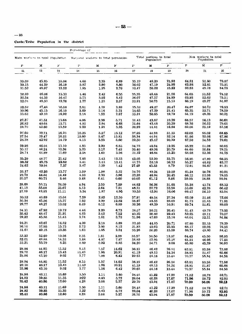
-53-
-25
Caste/Tribe Population in the district
Pt·r ..... pntage of
Main vl;or1.;:pr~ to total Population J.{ar~lflal v:orkerH to total population Total workers to total Non workers to total Population Population
P M F I' M F P M F P M F
11 12 13 1<1 15 16 17 18 19 20 21 22
30.59 45.85 15.04 4.60 2.35 6.89 35.19 48.20 21.93 64.81 51.80 78.07 30.15 44.29 16.19 5.87 2.90 8.80 36.02 47.19 24.99 63.98 52.81 75.01 31.52 48.97 12.52 1.95 1.25 2.70 33.47 50.22 15.22 66.53 49.78 84.78
30.89 46.06 15.33 4.46 2.42 6.55 35.35 48.48 21.88 64.65 51.52 78.12 30.34 44.35 16.47 5.73 3.02 8.42 36.07 47.37 24.89 63.93 52.63 75.11 32.04 49.50 12.76 1.77 1.23 2.37 33.81 50.73 15.13 66.19 49.27 84.B7
32.52 47.48 16.58 2.81 1.79 3.89 35.33 49.27 20.47 64.67 50.73 79.53 30.96 45.15 16.10 3.69 2.14 5.31 34.65 47.29 21.41 65.35 52.71 7B.59 33.63 49.10 16.92 2.18 1.55 2.B7 35.81 50.65 19.79 64.19 49.35 80.21
27.37 41.51 13.68 4.06 2.36 5.71 31.43 43.B7 19.39 68.57 56.13 BO.61 26.83 40.64 13.71 4.81 2.84 6.68 31.64 43.48 20.39 68.36 56.52 79.61 28.70 43.60 13.59 2.22 1.21 3.25 30.92 44.81 16.84 69.08 55.19 83.16
27.60 39.71 16.23 10.35 5.27 15.12 37.95 44.98 31.35 62.05 55.02 68.65 27.54 39.47 16.33 10.80 5.47 15.81 38.34 44.94 32.14 61.66 55.06 67.86 28.38 42.92 14.79 4.13 2.55 5.60 32.50 45.47 20.39 67.50 54.53 79.61
29.95 46.04 13.10 4.83 2.90 6.85 34.78 48.94 19.95 65.22 51.06 80.05 30.17 46.24 13.36 5.23 3.12 7.43 35.40 49.36 20.79 64.60 50.64 79.21 28.74 44.99 11.69 2.58 1.65 3.56 31.32 46.64 15.25 68.68 53.36 84.75
35.20 48.77 21.42 7.85 3.43 12.33 43.05 52.20 33.75 56.95 47.80 66.25 36.32 49.75 22.82 8.41 3.43 13.41 44.73 53.18 36.23 55.27 46.82 63.77 24.62 39.94 7.37 2.47 3.39 1.42 27.49 43.33 8.79 72.91 56.67 91.21
31.17 42.26 13.77 3.59 1.98 5.32 34.76 49.24 19.09 65.24 50.76 80.91 29.78 44.64 14.49 4.10 2.30 5.96 33.88 46.94 20.45 66.12 53.06 79.55 39.57 60.71 8.46 0.48 0.41 0.60 40.05 61.12 9.06 59.95 38.88 90.94
39.68 53.71 24.09 4.94 2.55 7.59 44.62 56.26 31.68 55.38 43.74 68.32 41.18 55.08 25.67 5.13 2.64 7.91 46.31 57.72 33.58 53.69 42.28 66.42 27.19 42.03 11.11 3.34 1.87 4.95 30.53 43.90 16.06 69.47 56.10 83.94
30.32 45.69 15.04 7.59 2.85 12.30 37.91 48.54 27.34 62.09 51.46 72.66 30.34 45.56 15.27 7.93 2.99 12.82 38.27 48.55 28.09 61.73 51.45 71.91 29.77 48.27 10.02 0.49 0.12 0.89 30.26 48.39 10.91 69.74 51.61 89.09
34.11 47.92 19.72 4.46 2.29 6.73 38.57 50.21 26.45 61.43 49.79 73.55 35.42 48.47 21.91 4.93 2.42 7.52 40.35 50.89 29.43 59.65 49.11 70.57 29.22 45.88 11.43 2.74 1.81 3.73 31.96 47.69 15.16 68.04 52.31 84.84
28.31 42.67 14.82 4.09 2.18 5.89 32.40 44.85 20.71 67.60 55.15 79.29 26.10 37.95 15.73 5.73 3.00 8.12 31.83 40.95 23.85 68.17 59.05 76.15 31.63 49.15 13.35 1.63 1.05 2.24 33.26 50.20 15.59 66.74 49.80 84.41
33.22 52.69 10.08 2.35 1.81 2.99 35.57 54.50 13.07 64.43 45.50 86.93 33.01 49.88 14.32 5.88 4.07 7.87 38.89 53.95 22.19" 61.11 46.05 77.81 33.31 53.79 8.23 0.89 0.92 0.85 34.20 54.71 9.08 65.80 45.29 90.92
28.04 44.85 11.52 8.15 1.57 14.62 36.19 46.42 26.14 63.81 53.58 73.86 29.70 46.17 13.43 11.49 1.96 20.91 41.19 48.13 34.34 58.81 51.87 65.66 25.86 43.10 9.02 3.77 1.06 6.42 29.63 44.16 15.44 70.37 55.84 84.56
28.04 44.85 11.52 8.15 1.57 14.62 36.19 46.42 26.14 63.81 53.58 73.86 29.70 46.17 13.43 11.49 1.96 20.91 41.19 48.13 34.34 58.81 51.87 65.66 25.86 43.10 9.02 3.77 1.06 6.42 29.63 44.16 15.44 70.37 55.84 84.56
24.98 40.11 11.69 3.50 1.11 5.60 28.48 41.22 17.29 71.52 58.78 82.71 24.82 39.85 11.35 :Y.22 0.43 5.72 28.04 40.28 17.07 71.96 59.72 82.93 25.42 40.86 12.60 4.28 3.08 5.27 29.70 43.94 17.87 70.30 56.06 82.13
24.98 40.11 11.69 3.50 1.11 5.60 28.48 41.22 17.29 71.52 58.78 82.71 24.82 39.85 11.35 3.22 0.43 5.72 28.04 40.28 17.07 71.96 59.72 82.93 25.42 40.86 12.60 4.28 3.08 5.27 29.70 43.94 17.87 70.30 56.06 82.13
-54-
In this census, 332463 were identified as main workers being engaged for the major part of the year in one or the other economic activity. Among them 251477 were males and 80986 were females. The work participation rate of the main workers comes tD 30.59 percent. The rate of male participation was 45.85 per cent and of female participation was 15.04 per cent.
In rural areas as many as 221579 persons were main workers engaged in different sectors of economy of whom 161693 were males and 59886 were females. The rural work participation rate works out to 30.15 per cent. The rural male partiCipation rate was 44.29 per cent while that of rural females was 16.19 per cent.
In urban areas of the Union Territory 110884 were classified as main workers of whom 89784 were males and 21100 were females. The urban work participation rate worked out to 31.52 per cent. The urban male and female work participation rates were 48.97 and 12.52 per cent.
Among the districts, Goa has the highest percentage of main workers being 30.89 per cent. followed by Daman (28.04 per cent) and Diu (24.98 per cent). As could be seen from the table the male and female work participation rates are also higher in Goa than in Daman and Diu. The female work participation rate is more or less equal in Daman and Diu being 11.52 and 11.6!1 per cent respectively. The rural male work participation rate is observed to be higher in Daman being 46.17 per cent followed by Goa (44.35) and Diu (39.85). The work participation rate of urban workers is observed to be higher in Goa than Daman and Diu which is true in the case of urban males also. The urban female work participation rate in Daman is lower than Goa and Diu.
Among the talukas of Goa distri~t, the highest proportion of main workers ~)Uld !?e observed in Sanguem taluka being 39:08 per cent, follo\yed by Satari (35.20), and- Ql1ep~m (3)1'.11). The lowest proportion of workers iIrr~orde1nn Bardez taluka being 27.37. In the case of'-ma:ies I also Sanguem has the highest propprtien of woitkers- being 53.71 per cent followed by,. Mor.mugao (52.69);· the lowest is in Pernem ·bein~9.71. per cent. "!'he female participation r!i'te_'is, also QbsQrved to be higher in Sanguem being 24.09 per cent followed by Satari (21.42), while the lowest is found in Mormugao (10.08). The rural work participation rate is again recorded to be highest in Sanguem taluka (41.18). In the case of urban work participation, Ponda has recorded the highest rate of 39.57 per cent. This position holds good for urban males also. Among the urban females the \\-ork participation rate is found to be highest in Tiswadi taluka (16.92) and lowest in Satari (7.37).
In all 49985 persons were recorded as marginal workers, i. e. those who worked for less than nalf the number of days in the year, of whom 1.2903 were males and 37082 were females. The percentage of marginal workers to total population comes to 4.60. Amongst males 2.35 per cent are recorded as marginal workers and among femaies 6.89 per cent. The percentage of marginal workers is found to be more in rural areas than urban areas. Participation of females is observed to be higher under marginal workers than males.
Among the three districts, Daman has. the highest percentage of marginal workers being 8.15 per cent followed by Goa (4.46) and Diu (3'.50). In the case of rural areas also Daman has
a higher percentage of marginal worker (11.49) when compared to Goa (5.73) and Diu (3.22). In the case of urban population, it is Diu which has recorded the highest percentage of marginal. workers being 4.28, followed by Daman (3.77) and Goa (1.77).
Among the taluka!; it is Pernem which hal:' recorded the highest proportion of marginal workers being 10.35 per cent. The lowest proportion of marginal workers is recorded in Mormugao (2.35). In rural population 3.69 percent is the lowest rate of marginal workers which is recorded in Tiswadi and 0.48 per cent in urban popUlation which is recorded in Panda closely fo.llowed by Canacona (0.49),
The main workers and marginal workers taken together give a combined work participation rate of 35.19 per cent. This proportion among males works out to 48.20 per cent and among females, 21.93 per cent. Similar proportions worked out for Daman and Goa are slightly higher than the Union Territory's average, being 36.19 and 35.35 respectively, and lower in Diu being 28.48 percent.
A larger portion of the population enumerated in ,the Union Territory was classified as non-workers. In this category were included such persons as housewives. stUdents, dependents, retired persons, rentiers, beggars, inmates of institutions and other non-workers mostly unemployed and seeking job. Thus out of 1086730 persons enumerated in the territory, 704282 were retunled as non-workers (284070 males and 420212 females). The proportion of non-workers to the total popUlation worked out to 64.81 per cent of which the males constituted 51.80 per cent and the females constituted 78.07 per cent.
In rural and urban areas of the Union Territory 63.98 per cent and 66.53 per cent respectively' were returned as non-workers. The proportions among male and female populations were 52.81 per cent and 75.01 per cent respectively in rural areas and 49.78 per cent and 84.78 per cent in urban areas.
PART A
VILLAGE AND TOWN DIRECTORY

SECTION I
VILLAGE DIRECTORY

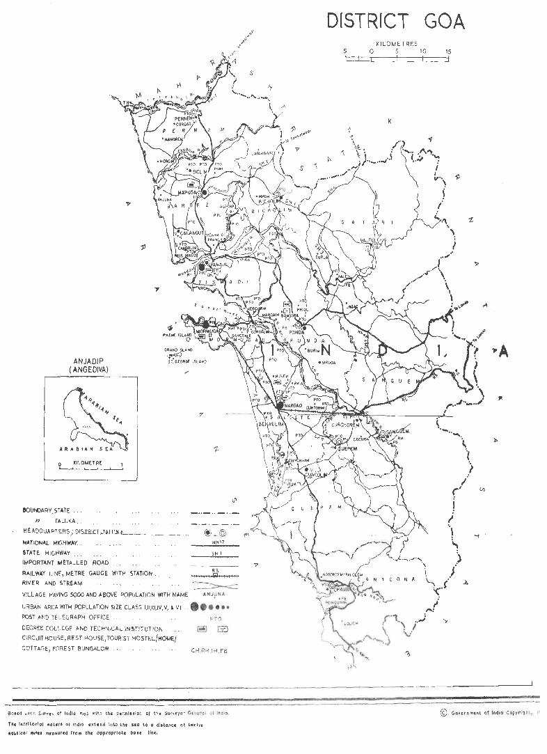
ANJADIP (ANGEDIVA)
o ~ILOMtiflE
&oUNOA~Y. STATE .. .
IJ TALUKA . .
j;EADilllA.RT J;'.RS ,: rus.:rrutT ... 11>11111 A
NATIONAL HIGHWAY.
STATE HIGHWAY
IMPORTANT t.4ETALLED ROAD
"
GRANO ISLAND
,."~ ST. G(OltG( tSlA~D
SH I
RS RAILWAY LI~, METRE GAUGE WITH STATION
RIVER AND STREAM I , (iij I I lit III
~ VILLAGE HAVING 5000 AND AeOVE POPULATiON WITH NAME ANJy~O.
URBAN AREA WiTH POPULATION SIZE CLA SS I,II,I:I,IV, V, & VI . •• • •••
POST AND TELEGRAPH OFFICE PTO
DEGREE COLLEGE AND TECHNICAL INSTITUTION
CIRCUIT HOUSE, REST HOUSE, TOURIST HOSTEL/HOtJE/
COTTAGE, FOREST BUNGALOW .. CH,RH,TH.FB
Saud UPOI1 SurveY of '"dla map wlll'l the pc;milaion of the Survtyot Gttlltrol 01 IndiO.
The tArrltorlal water' 01 Ind itl ext.end 111\0 tn~ SlQ to a dl.tancc ot tWtlq
aOUileGI fntfc. m,a.urc<t trom the approprlaCe bcr It IInc.
DISTRICT GOA 5 LI
KILOMETRES o 5 JO I I I
K
15 j
J I ""\
I
" ) l
\,'\ ,. ~"~
CO li A
tI ,..: ( "' : . ~\ .. ~ . I \ :,,:
© Gon r nmt!\t o~ fndio copyriqh l, j(
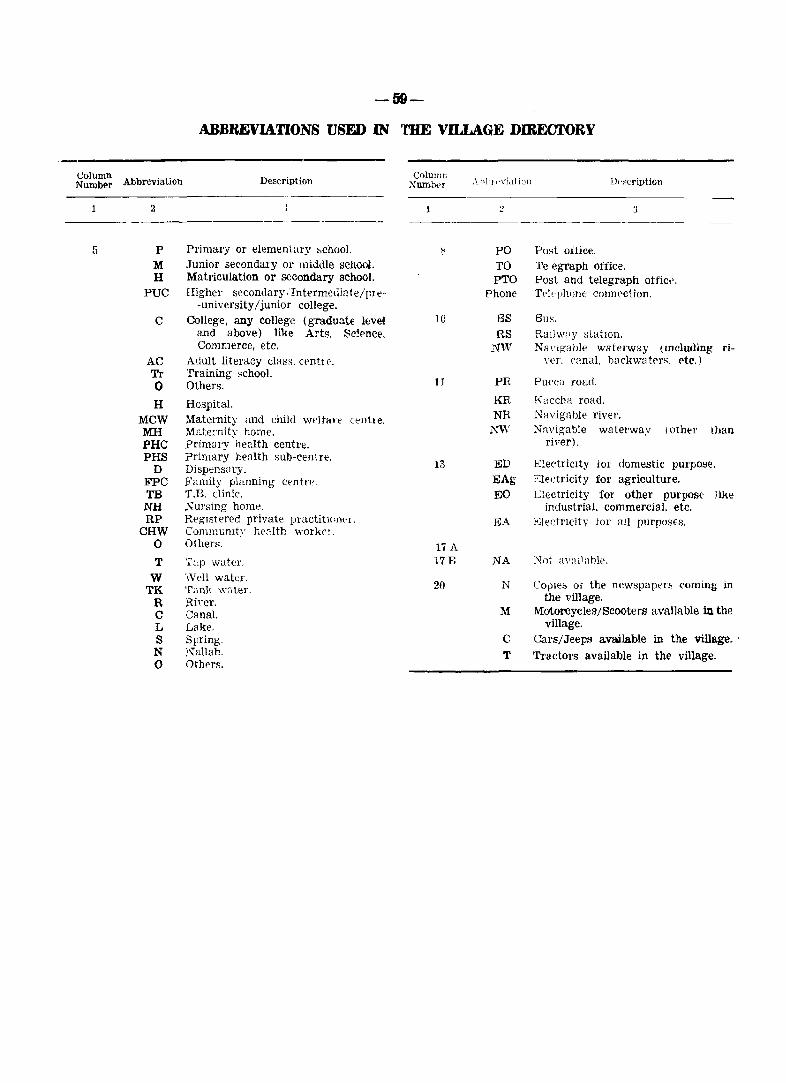
Column NumbE'r Abbreviation
5
2
P M H
PUC
C
AC Tr o H
MCW MIl PHC PHS
D FPC TB NH RP
CHW o T
W TK
R C L S N o
-59-
ABBREVIATIONS USED IN 'mE VILLAGE DIREUfORY
Description
Primary or elementary "chao!. Junior secondary or middle sChool. Matriculation or secondary school. Higher secondary ,Intermediate/pre-
-university/junior college. College, any college (gradua.te level
and above) like Arts, Sc!rnce, Commerce, etc,
Adult llteracy class, cenh e. Training school. Others.
Hospital. Matemity and child Wf'ltaH (enit e. Mate·nit;.: home. primary health centte. Primary health sub-cent reo Dispensary. Family planning centre. T.B. clinic. NUl'sing home. RegIstered private prLtctit!('Jit'I, Community health worker. Others.
T:,p water.
\\'ell water. Tank water. Rh'er. Canal. Lake. Spring. :'~allah. Oth!'rs.
Column ;\I'umlw-r
1
10
1 J
13
17 A 17B
20
PO TO PTO
Phone
BS RS
NW
PR
KR NR
NW
ED EAg EO
EA
NA
N
M
C
T
Post ofiice. Telegraph office. Post and telegraph aUict'. Telt-phone connection.
8u~.
Rm]w;'y statIOn. Na\'lFCable waterway (Including ri
ver. ('anal, barkwatrrs, ('te.)
Purea road.
Kaccba road. NRvigahle river. N:wigable waterway (other than
river).
b.:!eetriClty 101' domestic purpolOe. Electricity for agriculture. Gectricity for other purpos(' like
industrial. commercial. etc. )<~lectl'lcity tor all purposes.
:\Tnt aV:1l1ahle.
COllIe" ot the newspaper!'> c.oming in the village.
Motorcycles/Scooters available in the village.
Cars/Jeeps available in the village. ' '!'radors available in the village,

Taluka Tiswadi
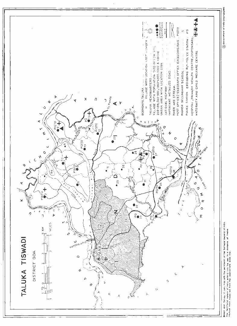
w _j
~ ~ :£
:~~ -0 <t
'I'-
~ ~
:~ 0 (/)' 0
~
" -t- f-I ~
'?
~ I a: « f-
~ (/)
~
is ;:) ..J
0 p., R A ~
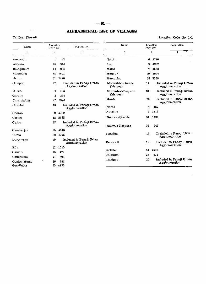
-61-
ALPHABETICAL UST OF VILLAGES
1'allika: Tiswadi Location Code No. 1/1
Name LO(,<1tion
I\,pu]ation Name Location Population
r::od~ No. Code No.
1 3 :J 1 2 3 ~-~-.------.
Ambarim 1 93 Goltim 6 1740
Azossim 28 910 Jua 9 4282
Bainguinim 14 205 Malar 7 1588
Bambolim 33 1601 Mandur 29 3594
Batim 31 1426 Mercurim 38 5326
·Calllpor 21 Included in Panaji Urban Morombi-.o-Grande 17 Included in Panaji Urban Agglomeration (Merces) Agglomeration
-Capao 4: 193 Morombl-o-Pequeno 24 Included in Panaji Urban
oCaraim 3 254 (Mercea) Agglomeration
Carambolim 21 3946 Murda 23 Included in Panajl Urban
oChimbel 16 Included in Panaji Urban Agglome!ation
Agglomeration Naroa 8 452
-Chorao 2 ·1709 Navelim 5 1113
-Corlim 12 2675 Neura-o-Grande 37 1429
.cujlra 22 Included in Panaji Urban Agglomeration Neura-o-Pequeno 36 347
Cumbarjua 10 ·1140
Curea 32 1725 Panelim 15 Included in Panaji Urban Agglomeration
Durgavado 19 Included in Panaji Urban Agglomeration Renoyadi 18 Included in Panaji Urban
Ella 13 1315 Agglomeration
Gancim 30 172 Siridao 34 2693
Gandaulim 11 303 Talaulim 25 472
GoaUm-Moula 26 282 Taleigao 20 Included in Panaji Urban
Agglomeration -Goa-Velha 35 H30
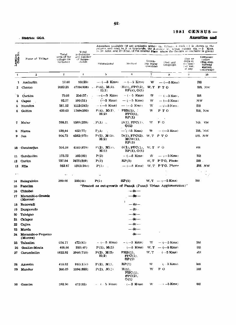
§2~
1981 CENSUS -, District: GOA. Amenities aDd
AmeniLles aVJ.ilable (It not available withl~ th~ \'llia~,>. a daFh 1-) is "hown in the "olumn and next to it m bra.cketls, the d .stanr" If. broa.d l'u.m;es viz. - 5 Kms.
,; Total :.- 10 Km~. a.nd 1O+Km8. of the nearest illace when> th<, facilitY IS availabl{' is given)
s::Z Total p{Jpulation ~., Name of Village
area of the dnd nwnber CormnWlI'
~~ nllage (in of house- l)3Y or ca.tion hectares) -llOld" Drink- Post and days of tBus stoP.
I~~ducutiunal .\1,ptlical ing water telEgraph 1 Ill' rnar- railway Ipolabla) I-e( ·hat.
.~tlon. If any waterway)
1 2 3 .\ 5 I) 7 S :1 10
1 Ambarim 17.60 93(28) ~ (-5 KInSI - (-5 Kms) W - (-SKms) BS
2 Chorao 2022.23 4709(956) P(S), M(3). . HU)._FPC(2), W,T PTO BS, N\·\' H(2) RP(4),O(1.1
'3 Carllim 70.06 254(57) - ~.(--J;_ KIDs) - (--5 KIDs) W -- (--5Km~! BS
4 Capao 92.77 193(51) - (':":""5 KIDfl) - (-·fl Kms) W -- (-5 Kmsl NW
5 Navellm 581.12 1113(243) - (-5 Kms) -',---5 Km::-, W - ~'-51{msl BS
6 GQltim 439.63 114()(395) P(4), M(2). ~HS(l). _. W PTO BS, NW H(2) FPC(l) ,
RP(l)
7 Malar 599..21 1588(328) P(l) " D(l). FPC( l'. w P 0 BS. ~w <?(l)
8 Naroa 128.44 452(71) P,l) -\-..:;.s KIns) W - (-JK.ms) BS, '.N~V
9 Jua 904.73 4282(91£1) P(5), M(:1). D(l), FPC(2), W,T PTO BS. NW H(2) MCW(l).
RP(5)
16 - Cumbwrjua 304.08 4140(679) P(2), M(l), -D(i),-FPC(l), \V,T PO BS H(I) RP(1},O(1)
11 Gandaullm 173.72 303(60) P(2) - (-5 Kms' W - 1-,,5Kmtl) BS
12 Corlim 727.84 2675(589) P(2) RP(2) W,T PTO. Phone BS .
13 Ella 932.81 1315{24:i) PCll - (-0 Krns) W,T PTO. Phonl> BS. NW
14 BaiDguinim 380.46 205(41) P(l) RP(l) W,T - 1-5 KIDs 1 BS
15 Panelim "Treated as out-growth of Panajl (Panaji Urban Agglome~a~iQn)"
16 Chimbel -00-
17 Morambi-o-Grande -do-(Merces)
18 Renovadi -do-
19 Durgavado -do-
W Taleigao -do-
21 Calapor -00-
22 Cujira -do-
28 Murda -do-
24 Morambi-o-Pequeno -do-(Merces)
25 Talaulim 674.77 472(8'0 - \--·5 Kms) - ("-J KIDs) IV - (--SKms) B8
26 GQalim-Moula 405.66 28Z(48) PIll. M(l) - (-5 Kms) W,T - (-5 KIDs) BS
27 Carambolim 1832.92 3946(713) P(2), M(2) PHS(I). W,T - (-5Kms) 138 H(2) FPC(1),
RP(l)
28 Azossim 418.82 910(1;·j) P(Z), M(), &P(l) IV -- {- 5Kms) 1:18
29 Mandur 260.6~ 3594(689) P(2), M(ll H(l). VIi' PO BS PHC(l} , FPC(Z), 0(1)
30 Gancim 382.96 472(82) - 1---5 l<ms) - (-5 K'TISI VIi' - t --5 Kms) BS
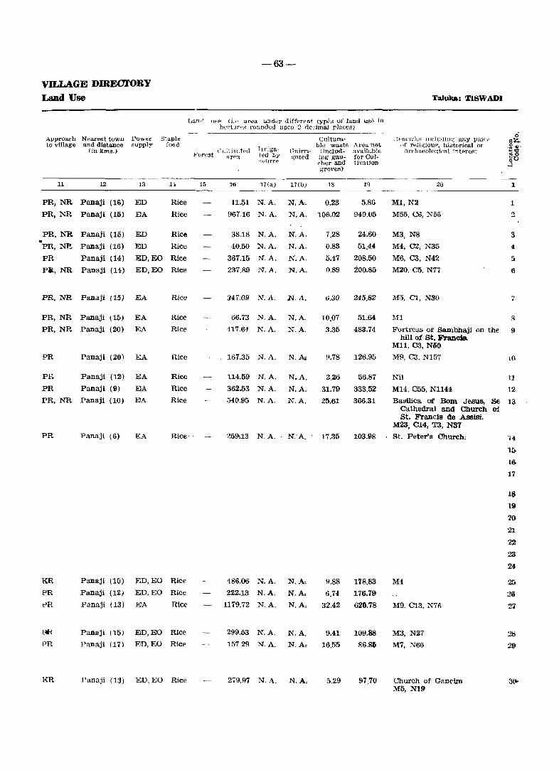
-63-
VILLAGE DmEOJ.'ORY Land Use Taluka: TISWADI
Land tl~P (i.f' area und"r different typ,;,; of land us~ in ))t'('i]I','s rounded upto j dec'imal places)
Approach Nearest town Power Staple Culturn.- H.t-"mark:-; n1<.:lu'li.ll~ any p}UI~f" 0 t:lZ-
to village and distance eupply food 1I1'iga~
ule wa.~t(, Area 110t ! If religiouf\ historical 01' ~~-(in km~.) Cl1itiv~~t(~d L~nirn- (includ- available ~1'(']laeolo;::ip"l intf'reAt Forest arPn, ted by ~ated illg gau- for CUl- ~o
'()1.1rre ~her and tiv~tion :sO groves)
11 12 13 H 15 16 17(a) 17(lJ) 18 19 20 1
PR,NR Panaji (16) ED Rice 11.51 N.A. N.A. 0.23 5.86 MI, N2 1
PR,NR Panaji (15) EA Rice 967.16 N.A. N.A. 100.02 949.05 M55, C6, N55 3
PR,NR Panaji (15) ED Rice 38.18 N.A. N.A. 7.28 24.60 M3, N8 3 • PR,NE Panaji (16) ED Rice 40.50 N.A. N.A. 0.83 51.44 M4, CZ, N35 4
PR Panaji (14) ED,EO Rice 367.15 N.A. N.A. 5.47 208.50 MS, ca, N42 5
Pit, NR Panaji (14) ED,EO Rice 237.89 N.A. N.A. 0.89 200.85 M20, C5. N7T 6
PR,NR Panaji (15) EA Rice 347.09 N.A. N.A. 0.30 245.82 M5, 01, N30 7
PR,NR Panaji (15-) EA Rice 66.73 N.A. N.A. 10.07 51.64 111 8
PR,NR Panaji (20) EA Rice 417.S4 N.A. N.A. 3.35 483.74 FOrtress of Sambhaji on the 9 hill of st. Francis.
M11, C3, N60
PR Panaji (20) EA Rice 167.35 N.A. N.Ao 9.78 12S.95 M9, C3, N157 10
PH. Panaji (12) IDA Rice 114.59 N.A. N.A. 2..26 56.87 Nil 11
PR Panaji (9) EA Rice 362.53 N.A. N.A. 31.79 333.52 M14, C55, N1144 12 PR, l'.'R Panaji (10) EA Rice 54().95 N.A. N.A. 25.61 366.31 Basilica of Bom Jesus, Be 13
Cathedral and Church of. St. Francis de Assisi.
M23, 014, Ta, NS7
PR Panaji (6) 1!:A Rice' 259.13 N. A. ~ N:A. 17.35 103.98 St. Peter's Church; 14
If)
1 ..
17
lS 19
20
21
22
23
24
KR Panaji {10) ED,EO Rice 486.00 N.A. N.A, 9.88 1'18.83 M4 25 PR Panaji (12) ED,EO Rice 222.13 N.A. N.A, 6.74 176.79 26 t>R Panaji (13) EA Rice 1179.72 N.A. N.A, 32.42 620.78 Mg. C13, N76 27
m panaji (15) ED,EO Rice 299.53 N.A. N.A. 9.41 109.88 M3, N27 28 PR Panaji (17) ED,EO Rice 157.29 N.A. N.A, 16.55 86.86 M7, N60 29
KR Panaji (13) ED. EO Rice 279.97 N.A. N.A; 5,29 97.70 Church of Gancim 3~ M5, N19
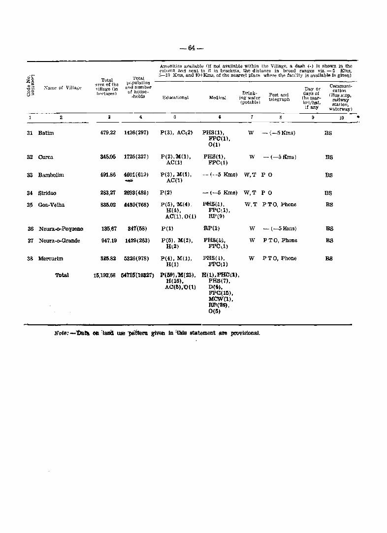
-64-
Amenities available (if not available within the Village, a dash (-) Is shown in the column and next to it in brackets, the distance in broad ranges viz. - 5 Kms.
o?; Total 5-10 Kms, and lO+Kms, of the nearest place where the faCility is available is given)
Total Zs area of the pc.pulation Communi-<lJ .... Name of Villag" and numbE>r '" ~. village (in Day or
00 of house- cation 0:0 hectares)
·holds Drink- Post and days of (Bus stop,
l!~ducati(}nal Medical ing water telegraph the mar- raHway (potable) ket/h.a.t. if !illY station,
waterway)
2 3 4 5 8 1 8 9 10 •
31 Batim 479.22 1426(297) P(3), AC~2) PHS(l), W - (-5 Kms) BS FPO(1) , 0(1)
32 Curca 345.05 1725(337) P(2),M(1), PHS(1), W -(-5Kms) BS AC(l) FPCl1)
33 Bambolim 491.86 4601 (6W) P(3), M(t), .. - (--5 Kms) W,T PO BS .... AC(l)
34 Siridao 283.27 2693(486) P(2) -(-5 Kms) W,T PO BS
31) Goa-Velha 835.02 44S()(768) P(l», M.(4). BHs;(iI.) , W,T PTO, Phone BS H(4" FPC',l" AC(1),0(1) RP(9)
36 Neura.-o-Pequeno 135.67 847'(58) P(l) 'RP(l) W - t-5Kms) '8S
37 Neura-o-Grande 947.19 1429(263) P(5), 1'4(2), PHS,(.l!} , W PTO, Phone BS Hl2) FPC~1)
38 Mercurim 825.82 5326{978) P{4),M(1), PHS(1). W PTO, Phone BS H(l) FPC\])
Total 15,193:68 ~'115'{lOS21) P(59'},'M{23), H(l),PHC(l), H(16" PHS(7). AC(5),IO(t) D(4),
FPC(15), MCW('1) , RP(~IJ), 0(5)
Not": -'Da~ C* ~Iarltl use 'l*t1em ~\Ieb in 'this statement ale proviSional.

-65-
lAll<i w4e (I." area. under different types of land use in hectare!' rounded upto 2 dedmal pla.c€S)
AplJl·oo..;h ~ear"sl town Puwer Staple Cui tum- Remarks including any place Q to ,.illage and distancl' ,upply food bIe waste Area not of religious. histol'ical Ol'
gil!'; (in km~.l Cultivated Irnga- Ulllrri- (in.clud- available archaeological interest ;:~
Forest urpa ted by gated iag gau- foreul- 80 source cher and tivation ...l groves)
11 12 13 14 15 16 17(a) 17(b) 18 19 20 1
PR Panaji (10 I ED,EO Rice 290.20 .N.A. N.A. 4.68 184.34 M16, C4, NaO 3t
PR Panaji (9) ED,EO Rice 215.38 N.A. N.A. 8.M 121.63 M7, C3 32
PR Panaji (6) ED,EO Rice 314.74 N.A. N.A. 27.47 149.65 M5 33
PR Panaji (1~) ED. EO Rice 170.85 N.A. N.A. 1m 111.35 Mll, Cl0, N39 34
PR Panaji (10) ED,EO Rice 529.62 N.A. N.A. 7.GS 298.32 Pillar Seminary 35 M30, ClO, N129
PR Panaji (15) ED, EO Rice 101.45 N,A. N.A. 2.01 32.21 M7, N35 36
PR Panaji (15) ED,EO Rice 602.24 N,A. N.A. 13.86 331.09 M7, C2, T6, N70 37
PR Panaji (16) EA Rice '-- 217.46 N.A. N.A, 8.03 100.33 M20, CSt N112 38
9000.04 N.A. N.A, 379.76 5808.88 M283, C140, 1'9, N2245

Taluka Bardez
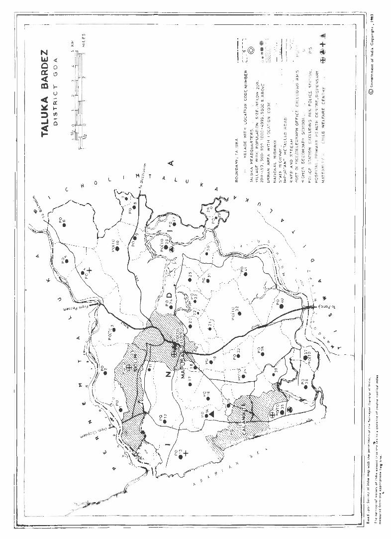
~ I
N W ~ Q 0 a: ~ 4: en l-
u 4( g: ~ ... ::) If)
..J 0
~
I L-_
c
I M
o
)
o
o
4.
L l u k
e
> no « o z ::J o CD
r-' 1 ' , I I@ '",, 0 I I 1 I L.J
a: oJ III ::t: ::J Z W Cl o u Z o >:: « u o _J
f)
::..;:::::===========:::::::::,-~ i 1 ---------- -,,_ --l
i I
_;:
~
~ i 3: I
" j I no « -' « z z « 0 <Il ... no « ::J Z
')
/
p
~
4.
II I ~
. I, --,---_j III
d~
... o V
. E
i .
-67-
ALPHABETIOAL LIST OF VILLAGES
Taluka: BARDEZ Location Code No. 1/2
Name Location Name
Location Population Code No. _. 'Population Code No.
1 2 3 1 2 3
,Aldona 26 5826 Neru! 36 3383
Anjuna 13 7175 Olaulim 30 502
Arpora 14 2385 Oxel 1 2561
Assagao 12 3060 paliem 21 874-
Assonora 8 2565 Parra 16 2695
Penha de Franca. 40 6862 Bastora 20 2609
Pilerna 38 1816 Calvim 29 483
Pirna 6 2020 Camurlim 2 2644
Pornburpa 31 2087 Canca 18 1796
ponolem 28 134 Candolim 35 5614
Punola 22 433
Colvale 3 3311 Reis Magos 37 5516
Corjuem 27 2564 Revora 4 1944
Guirirn 19 4253 SaUgao 34 4526
Marna 11 951 Salvador do Mundo 41 4605
Marra 39 698 Sangolda 33 1924
Moira 24 3171 Socorro (Serula) 32 4594
Moitern 7 916 Sircaim 9 1241
Nachinola 25 1324 Tivirn 10 5463
Nadora 5 1343 Ucassairn 23 830
Nagoa 15 1067 Verla 17 1639
-68-
1981 CENSUS-
District: GOA Amenities and
Amt'Jlities aVlUlable (if not available within the Village. a da&h(-) is shown in the column fIJld next to it in braketa. the dist.nce in broad ranges viz. - 5 Kill!!
~ Total Total 5-10 Kms. and lO+Kms. of the nearest place where the facility is available is given)
~~ Name of Village area of the population
gB village (in and number Day or Oommuni-hectares) of house- Drlnk- days of cation
-holds Post and (BUB stoP. .J Educational Medical ing water tolegraph the mar- railway (potabl€') ket/bat. station, if any waterway)
1 3 4 6 7 8 ~ 10
1 Oxel 292.30 2561(475) P(3). M(l) PHS(l), W PO -(-5KmIl) FPC(I)
2 Camuriim 789.74 2644(484) PH), M(2), CHW(3), W,T PO BS AC(l) RP(2)
3 Colvale 1018.81 3311(663) P(5), M(l), FPC(l), W,R PTO BS,NW H(l) CHW(3)
RP(l).O{l)
4 Revora 798.51 1944(340) P(3),)M(1), D(l), FPO{l) , W PO BS H(l),AC(l) CHW(2) ,
0(1)
5 Nadora 503.86 1343(257} P(2) CHW(2) W PO BS
6 Pirna 1008.66 2020(405) P(4), M(l), PHS(l). W PO • Friday BS H(l) FPC(l),
CHW(2)
7 Moitern 92.17 916(169) P(l) CHW(I) W,T -l-5'Kms) BS
8 Assonora 383.19 2565(518) P(l), M(l), CHW(2), W,T PO,Phone Tuesday BS H(l), AC(l) RP(2)
9 Sircaim 391.84 1241(264) pel) CHW(i!) W PO BS
10 Tivim 2010.53 5463(1167) P(3), M(2), PHS(l), W,T PTO,Phone Sunday BS H(l) FPC(l),
CHW(4), RP(2)
11 Marna 341.71 951(223) P(l} CHW(l) W,T -(-5 Krns) BS
12 Assagao 1001.90 3060(631) P(5), M(l), PHS(l), W PO BS H(l) FPC(l},
RP(3)
13 Anjuna 1158.24 7175(1520) P(8), M(3), 0(1), FPC(l) , W,T PO BS H(3) RP(l),O(l)
14 Arpora 437.04 2385(477) P(4), M(l), FPC(l), W,T PO BS H(l) MCW(l),
RP(2)
15 Nagoa 160.32 1067(243) P(l) - (-5 Kms) W -{-5Kms) BS
16 Parra 523.17 2695(554) P(2), M(l), H(l)
- (-5 Kms) W PO, Phone BS
17 Verla 368.06 1639(342) P(2), M(l), - (-5 Kms) W -\-5Kms) -(-5Kms) H(l), AC(!)
18 Canca 83.91 1796(341) pel) - (-5 Kms) W -1-5Kms) BS
19 Guirim 418.21 4253(725) P(3), M(2). RP(l) w PO BS H(l)
20 Bastora 335.05 2609(507) P(4), M(2), CHW(2) W -(-5Kms) BS H(l)
21 Paliem 141.20 874(154) pel) CHW(l) W -(-5Kms) -f-5Kmsf
22 Punola 72.17 433(90) - (-5 Kms) R]?(l) W -(-5Kms) BS
23 Ucassaim 273.93 830(173) pel), AC(l) -(-5 KIns) W PO BS
24 Moira 401.16 3171(718) P(3), M(2), CHW(4)RP(1) W PO, Phone BS H(11
-69-
V.ILL&GE DiREOTORY
Land use Taluka: BABDEZ
Approach NeaTest town Power to villll@'e and distance f1upply
(in kms.)
11 12 13
Staple food
KR Siolim (4) ED, EO Rice
PR Siolim (3) ED, EO Rice
PR, NR Mapusa (8) EA
PR
PR
PR
PR
PR
PR
PR
PR
PR
PR
PR
Mapusa (11) EA
Mapusa (11)
Mapusa (14)
Bicholim (6)
Bichollm(6)
Mapusa (10)
Mapusa (9)
Mapusa (8)
Mapusa (5)
EA
EA
EA
EA
EA
EA
EA
EA
Mapusa (10) EA
CaJangute (1) EA
PR, KR Calangute (2) EA
PR Mapusa (4) ED, EO
PR
PR
PR
PR
PR
PR
PR
PR
Mapusa (3)
Mapusa (1)
Mapusa (3)
Mapusa (2)
Mapusa (3)
Mapusa (3)
Mapusa (3)
Mapusa (3)
EA
EA
EA
EA
EA
EA
EA
EA
Rice
Rice
Rice
Rice
Rice
Rice
. Rice
Rice
Rice
Rice
Rice
Rice
Rice
Rice
Rice
Rice
Rice
Rice
Rice
Rice
Rice
Rice
I.and U~" (i.e area under diffprent typeS of land use in hect'lres rounded upto 2 decimal places)
Cult ivated Irriga-Forest area t('d by
E'ource
l.'"nirrigated
15 16 17(a) 17(b)
207.11 N. A. N. A.
556.09 N. A. N. A.
302.42 N. A. N. A.
627.86 N. A. N. A.
240.67 N. A.
720.40 N. A.
71.75 N. A.
120.03 N. A.
65.54 N.A.
639.09 N. A.
N.A.
N.A.
N.A.
N.A.
N.A.
N.A.
256.73 N. A. N. A.
687.35 N. A. N. A.
652.05 N. A. N. A.
344.81 N. A. N. A.
137.48 N. A.
447.23 N. A.
286.67 N. A.
59.97 N. A.
330.75 N. A.
217.26 N. A.
97.24 N. A.
26.64 N. A.
120.03 N. A.
153.20 N. A.
N.A.
N.A.
N.A.
N.A.
N.A.
N.A.
N.A.
N.A.
N.A.
N.A.
CUltum-ble waste Area not
(includ- available Ing gau- for CuI
"her and tinl.tion groves)
18 19
'{ .. marks induding a.ny place of religious, historical ar
arrh.a€ologic<'ll interf'st
20
0.84 84.35 Mll, C15
24.85 208.80 Shri Devprabhu Mandir, St. Rita Church. M11, C1
195.16 521.23 Fort situated on Colvale M27, Cll, N66
32.91 137.68 MI0, C4, N25
72.15
81.24
4.91
76.92
191.04
207.02
15.51
186.24
MS, C2. N45
M2. Tl
Ml M17, C7, N220
M9, C4
1
1
2
3
7
S
101.41
399.01
224.89
972.43 Church of Perpetual Socorro 10-do Deus, M36, C1G, ::"r99
20.03 64.~5 M7, C2
63.66 250.89 M44 .C9, N37 11
12
136.40 369.79 Chapora Fort, MI0!. cn, 13 T2, N735
7.91 84.32 M44. C13. N50 14
2.51
10.75
16.44
5.82
15.06
23.15
11.86
12.82
34.22
60.04
20.33
65.19
64.95
18.12
72.40
94.64
32.10
32.71
119.68
187.92
MI9, C6, NI0
M37. C9
M24, C19
M28, C13
M45, C8
M36, Cll
M2. C1
M6, C5
M8, C3
Roman Catholic Church, M42, C18
Hi
16
18
19
20
21
22
23
24
District: GOA
e Total Total I'1Z population g~ area of the
Xame of Village village (in and number ole of house-gc; hectare~)
-holds ...J
1 2 3 4
25 Nachinola 262.13 1324(271)
26 Aldona 835,32 5826(1311)
27 Corjuem 507.61 2564(481)
28 Ponolem 95.99 134(29)
29 Calyim 140.70 483(138)
.30 Olaulim 152.84 502(114)
31 Pomburpa 511.11 2087(436)
32 Socorro (Serula) 1301.42 4594(999)
33 Sangolda 352.34 1924(404)
34 Saligao 622.10 4526(965)
35 Candolim 653.90 5614(1186)
36 Nerul 463.36 3383(580)
37 Reis Magos 432.46 5516(961)
38 Pilerne 672.49 1816(348)
39 Marra 337.49 696(153)
40 Penha de Franca 464.42 6862(1448)
41 Salvador do Mundo 1133.66 4605(872)
Calangute
Siolim
Total 21945.02 109402(22136)
-10-
1981 OENSUS-· Amenities and'
Am;,nitiell available (If n<>t avaiLable within the Village. a dash(-) is shown in the c(Jiumn and next to it in bracke~. the distance in broad ranges viz. - 5 KIDs. 5-10 Kms. and lO-Kms. of the nearest plaw where the facility is available is given)
Communi-Day or cation Drink- Post and days of (Bus stoP. EdUcational Medical ing water telegraph the mar- railway (potable) ketlhB.t, station, if any waterway)
5 6 7 8 9 10
P(l), AC(2) CHW(1), RP(l) W -(-5 Kms) BS
P(7), M(4), PHC(l), W,T PTO, Phone Saturday BS,NW H(3), 0(1) FPC(l)
CHW(7), RP(2),O(2)
P(4), M(l), CHW(2l W PO NW H(l)
- (-{j Kms) CHW(11 W -(5-10 Kms) NW
pel) CHW(l) W PO NW - (-5 Kms) CHW(2) W -(-5Kms) BS
P(3), M(2), PHS(1), W PO BS H(l) FPe(l),
CHW(3), RP(2)
P(9), M(6), MH(1), W,T PTO,Phone BS H(2). 0(1) CHW(5),
RP(2)
P(l) RP(l) W PO BS
P(3), M(3). PHS (1), W,TW PTO,Phone BS H(3) FPC(l),
RP(2),0(1)
P(7), M(l), H(l), PHC(l), W, PTO.Phone BS H(l) FPC(l),
RP(5).0(2)
P(3), M(2), RP(3) W PO BS H(l)
P(3), M(2). PHC(l). W,T PTO,Phone BS,NW H(l) FPC(1),
;RP(3)
P(3), M(l) -(-5kms.) W PO BS
- (-5 Kms) -(-5luns.) W -(-5 Kms) BS
P(2). Tr(1) MH(l), RP(4) W,T PO BS,NW
P(1) CHW(3), W PO BS RP(l)
-Treated as Census Town-
- Treated as Census Town-
P(lll), M(44), H(l), MH(2), H(28), AC PHC(2), (7), Tr(l), PHS(7), 0(2) D(2),
FPC(13), CHW(M), MCW(l), RP(42), 0(8)
Xotp: Data on land use given in this statement are provisional.
--------__ ---'------------------------------------------------------------------------------
\'ILLAGE D]RtX~l'f )RY
Land use
Approa.ch Neal'€::t t()Wf'l T'tJ~.vf>r to village and distanel' '11r'Jlly
(in 1m);' )
11 12 13
PR Mapu~a (4) EA
PR, NW Mapusa (8) EA
NR Mapusa (8) ED,JW
NR Mapusa (10) ED
NR Mapusa (9) ED
PR Mapusa (9) EA
PR Mapusa (9) EA
PR,RR Panaji(7) EA
PR Mapusa (4) EA
PR Mapusa (6) EA
PR Calangute (4) EA
PR Panaji (14) EA
PR,NR Panaji (6) EA
PR Panaji (7) EA
PR Panaji (7) ED
PR,NR Panaji (4) ED,EO
PR Panaji(8) EA
~tuIJ'!' fnod
-71-
! J~" ,i \F"C lIt .,' .-a 1 (It-l (111 f.-l'etl~ typf'C:: of J:11j(1 UY. in rlt·(I_"Tt-~ )'1., ~! '1 up!!! 2 d .. cimal p];:(.C('<"::)
('ll(t}V;-l P/
art':1
] .• ~ 19a-1"<1 hy <..01]1 (>(1
Cnltura-Lk \1..raste A no-a. 1l(jt
t't1J:Tj- IlTH:lud- dva.llahle :._;attd 111:; gau- flJr CLll
dl<'l' :lncl I ''It'on ~;l'oves)
.. _-----_._--------------
Rice
Rice
Rice
Rice
Rice
Rice
Rice
Rice
Rice
Rice
Rice
Rice
Rice
Rice
Rice
Rice
Rice
15 16
~un
Z~6.(2
297.50
73.21
97,18
63.21
402.57
464.51
217.58
344.52
422.92
287.45
174.79
416.06
190.50
177.96
522.68
17\1» 17(tJ)
N.A N.A,
N.A. N.A
N A. N.A.
N.A. N.A,
N.A. N.A,
N.A. N.A.
N.A. N.A,
N,A, N.A.
N.A. N.A.
N.A. N.A.
N.A. N.A.
N.A. N.A.
N.A. N.A.
N.A. ,N.A.
N.A. N.A.
N.A. N.A.
N.A. N.A.
18 19
54.64 125.58
86.73 ?62.57
34.34 175.77
0.78 22.00
1.95 41.57
20.76 68.87
19.81 88.73
255.] 4 581.77
36.00 98.76
26.31 251.27
49.5.': 181.40
!).2Z, 166.68
59.23 198.44
6:3.58 192.85
27.93 119.06
82.~3 204.13
165.81 445.17
Truuka-: - BARDEZ
j~~ Iz!a,rk.s; including :l!1y plu(',e of rdigiou3. histcrical or
n.rchaeolog ic~ 1 intf\rest
20
1,1:<:8, C16, T2
St. Thomas Church. M35, C25, N173
(Jill Fort, M6
M1
M1
M19, C8, N335
M75, C45, N145
M31, C6, N50
M85, C42, N307
Aguada Fort. M7S, C25, T2, N77
M35, C13. Te, N6
Port of Reis Magos, M50. C37, N65
M40, C9, N55
M20, CIO. N36
M150, C25, N650
M45, C22. N20
11988.94 N. A. N. A. 2404.28 7551.80 M1280, C477, T12, N3206
1
25
26
27
28
21}
30 .
31
32
33
34
35
36
37
38
39
40
41

Taluka Pernem

,y
'" '" :> ." '" 'l:
:~" I I,
=
I I
/ ___ J:-i
;' I
I
/ ". /
Z / .'" I
r ,
I . I-~
:1' I' I I I . " i i j~ !© • :z • I _ _j 0
?
... r ,_ + ----o '" 0. '" "'- tl
I
.. c .. E ~ . ~
(Ql
-13-
ALPHABETICAL LIST OF VILLAGES
Taluka: Pernem Loca.tion (J()de No. 1/3
N.fl.lllt-~ Location
Population Coole No.
1 2 a
Agarvado 27 968
Alorna 16 2599 Amberem 7 207 Arambol 4 4218 Cansarvornem 18 1309 Casnem 8 326 Chaadel 15 726 Chopdem 26 633 Corgao 5 5308 Dargalim 20 4122 Ibrampur 17 992 Mandrem 24 6766 Mopa 14 850 Morgim 25 5905 Ozorim 19 1375 Paliem 3 2064 Parcem 23 3809 Pernem (Rural) 6 1778 Poroscodem 10 528 Querim 2 2789 Tamboxem 12 580 Tiracol 1 218 Torxem 13 1765 Tuem 22 1992 Uguem 11 934 Varconda 9 1599 Virnora 21 1017
DISTRIC'f: GOA
1 2
1 Tiracol
2 Querim
3 Paliem
4 Arambol
5 Corgao
6 Pernem (Rural)
7 Amberem
8 Casnem
9 Varconda
10 Poroscodem
11 Uguem
12 Tamboxem
13 Torxem
14 :Mopa
15 Chandel
16 Alorna
17 Ibrampur
18 cansarvornem
19 Ozorim
20 Dargalim
21 Virnora
-74-
198J CENSUS-
Amenities and
Total populaiion and number
of house-holds
Amenities available (if 110t available within the Village, a dash(-) is shown in the ",olumn and next to it in brakets, the distance in broad ranges viz. - 5 KIllS, 5-10 Kms, and 10+ Kms. of the nearest pla('e wh"I-e the facility is available is given)
'['()tal "rea uf thlo village (in hec13""~)
" 159.20 218_( 57 )
238.32 2789(521)
933,32 2064(409)
928,4~ 4218 (833)
~~(lucationaJ
5
P(l)
P(3), M(l), H(l)
P(4), M(2)
P(6), M(l), H(l)
2159.43 5308(1000) P(9), M(2), H(2) .
2340.84 1778;(31.1) P(6)
MedIcal Drink- Pust ani!
ing water telrgraph
6
CHW(l)
PHS(l), FPC(l), CHW(2), RP(1)
CHW(2)
(potable)
W
W
W,S
D(l), FPC(l), W, TK CHW(3), RP(2), 0(1)
CHW(5), W,S RP(2)·
8
-(-5 Kms)
PO
PO
PO
PO
Day or <lays of
the marKBt/hfl,t, If any
9
- (-5 Kms) W, T -(-5 Kms)
Communi~.ations
<Bus stop, railway station,
waterway)
10
NW
BS,NW
BS,N\OY
BS
BS,NW
BS
198,15 207(42) - (- 5 Kms) - (-5 Kma)' W, C -(-5~··.BS
127.25 326(60) P(l) - (-5 Kms) W, S, - (-5 Kms)
1138.08 1599(332) P(5), M(3) PHS(l), W, C PO FPC(l), RP(l)
, , 164.77 528(86) P(l), M(l), CHW(3) W PO
403.04 934(178) P(l), M(2), - (-5 Kms) W, S - (5---10 Kms) H(l)
145.74 580(105) P(l), AC(2) PHS(l), W - (-5 Kms) FPC(l), ;CHW(3)
I 973.83 1765(322) P(4) CHW(3) W, S PO
883,13 850(165) P(2), M(l) - (-5 Kms) W, C - (-5 Kms)
609.63 726(150) P(2), H(l) - (-5 Kms) W, S - (10+Kms)
2174,73 2599(179) P(5), M(3) CHW(3) ~$ - (10+Kms)
634.48 992(1811) P(l), M(l) PHS(l), W, S PO FPC(l), CHW(2)
1127.08 1309(247) P(3), M(l) PHS(l), W, S PO FPC(2), 0(1)
728.23 1375(266) P(2), M(l) CHW(4) W, S - (--5 Kms)
1989.39 4122(760) P(10), M(4), D(l), FPC(l), W PO H(2) CHW(4)
391.69 1017(197) P(l), M(l) MCW(l), W PO FPC(l), CHW(3), 0(1)
- (';_5 Kms>
BS
BS
BE-
BS
BS
- (-5Kms)
BS
NW
BS,NW
BS,NW
BS,NW
BS,NV-
BS
VILLAG~ I D~~C'['ORY
Land use TALt'KA PUtJ\lEl\f
Approach Nearest town to village and distance
(in'lens.)
11 12
Power supply
]3
Btapl(' food
Lll-lld \'"e, (i.e area \UHler dl1ierent typeS of land use in ,,,:, ,.1:' .bi'ctnr~'" ':'Ollnd~ ,,,~to '2 deejmal placE'S)
Cui tUM-tile waste Arpa not
Cultivatl"d Irrlga- l'nhTl- Ilndud- aWl.llable Fore't area ted by "atec] in,g gau- for Cul-
SOUI'f"f' chpl'" and Hvution gr01'pn
J[, lG 17' ,,', 17(\)) 18 ]9
RHltarks mduding WlY llJac€ ot reUgi{)uA. historical or
d:' iuchal'ologic,al InterMt
-----.-- ----,--,------------_----------KR, NW Pernem (26) ED, EO Rice
PR, NW Pernem t20) EA Rice
PR Pernem (16) EA Rice
PR Pernem (13) EA RiCe .' 0.02
PIt Pernem (9) EA Rice
PR, KR Pernem (1) EA Rit:e
PR Pernem (6) ED Rice
Kn Perne,m (5) ED, EO Rice
KR Pernem (13) EA Rice
PR Pernem (4) EA Rice
PR Pernem (8) EA Rice,
PR Pernem (9) ED Rice 32.32
PR Pernem (14) EA Rice 88.76
KR Pernem (15) ED Rice 147.40
KR Pernem (18) ED, EO Rice 194.62
KR, NW Mapusa (25)
KR Mapusa (26)
EA
EA
Rice 397.55
Rice
56.92 N. A N.A.
21p.90 N. A, N. A,
449.91 N. A. N. A,
791.,87 N. A. N. A.
1770.05 N. A. N. A.
'.1
1197.03 N. A. N. A.
132.66 N. A. N. A, 'I ;
.71.97 N. A: N. _A..
6ill.32 N. A. N. A.
130.36 N. A. N. A.
322.21 N. A. N. A.
70.62 N. A. N. A.
549.91 N. A. N. A.
328.05 N. A. N. A.
206.55 N. A. N. A.
919.99 N. A. N. A.
280.14 N. A. N. A.
KR, NW Pernem (16) EA Rice 205.85 573.82 N. A. N. A.
KR, NW Pernem (15) EA Rice 366.27 N. A, N. A.
PR, NW Pernem (8) ED, EO Rice 129.00 1413.13 N. A. N. A.
PR, KR Pernem (8) ED, EO Rice 281.25 N. A. N. A.
37Al Tlracol FaIt, Ml, N5
6.25 21.n M8, C3, N20
201.01 282.40 Bhumika Veta! Temple M6, N5
6993 1l6.1)'3 M16, N55
223.47 165.91 Kamleshwar Temple M24, C1, N35
:1
\
819.08 324.'i3
42,63 22.86 M2
42.41 12.87 Ml(l, C2
339.98 116.78 Shanta Durga Temple Ml, C1
10.13 24.28 M16, C4, N2
47.91 32.\)2 Ml
18.83 23.97
209.86 125.3(l Ml
171.19 236.49 Ml
143.37 65.09 N1
591.48 205.71. Devi Sateri Temple N2
152.56 201.78 Bhuicat Fort M2
240.46 106.95 Mahadeo Temple
240.21 116.75 Mahadeo Temple, Ml
319.59 127.67 Shanta Durga Temple M13, C4, N29
79.95 30.49 Ravalnath Temple, M3, N15
1
2
3
4
5
6
7.
8
9
10
11
12
13
14
15
16
17
Hs
19
20
21
0 J;:Z ~~ til 0 go
...:l
22
23
24
25
26
27
District: GOA
Name of Village
2
Tuem
Parcem
Mandrem
Morgim
Chopdem
Agarvado
Total
-76-
1981 CENSUS-
Amenities and
Amenities available (if not available within the Village. a dash(-) is shown in tlle column and next to it in braketa. the ~tance in broad ranges viz. - 5 Kms.
Total Total 5-10 Kms. and 10+Kms. of the nearest place where the facility is ava.llable is given)
area of the population Communi-village (in andnumbe!" Day or
hectares) ot house- Drink- days of cations -holds Post and the mar- (Bus stoP. Educational Medical ingwater telegraph ket/hat. railway. (potable)
if any station. waterway)
3 4 5 6 1 8 9 10
1213.93 1992(454) P(8). M(l) PHC(l). W.S - (!>-10Kms) BS,NW FPC(l), CHW(3)
1023.59 3809(683) P(5). 1'11(2) CHW(3) W.S PO BS.NW
1908.12 6166(1249) P(7). M(2), 0(1). FPC(1), W.S PO BS H(l). CHW(4). AC(2) RP(2).0(2)
864.02 5905(1201) P(7), M(3), 0(1). FPC(1), W PO BS,NW H(1) CHW(4).
RP(2)
174.28 633(102) P(l) CHW(l) W.T PO BS.NW
223.321 968(209) P(l). M(!), MCW(l), W PO BS.NW H(l) FPC(l).
CHW(l)
23851.10 55377(10606) P(97). M(33). PHC(l).PHS (5).0(4). MCW(2). FPC (l3), CHW(541. RP(10).
H(ll). AC(4)
0(5)
Note: Data on Land use given in this state-mont are provisional
-77-
VILLAGE DIRECTORY
Land use Taluka: PERNEM
Land u.,;e (I.e area under different tyPtlS of land use in hfoctare;'< rouru1oo upto 2 decimaJ places)
Approach Nearest town Power Staple il,'rnarks including any place ci
CultUl'd- >1)2; to village and distance ~llpply food
Imga- ble waste Area not of religious. historical. or .g d)
(in kms) Cultivuted Unir"i- (includ- uvailable arohB.eologlca.! lntermt. ~'8 1"0,.".."' [trea redby (,--ated ing' gau- iorCuI- go GOllfCe cher and tivation >-l
groves)
11 12 13 14 15 16 17(&) 17(b) 18 19 20 1
KR. NW Pernem (7} EA Rice 114.89 NA N.A, 306.96 192.08 Bhagavati Temple 22
PR, NW Pernem (9; EA Rice 797.60 NA N.A 57.43 168.56 Bhagavati Temple, MS, NIB 23
PR Siolim (6) lilA Rice 1617.11 N.A. N.A. 17861 112.34 M22, C5, N71 24
PR, NW Siolim (4) EA Rice 621.7S NA N.A. 7808 164.16 Morjai Temple, M17, N76 25
PR, NW Siolim (2) EA Rice U1.63 N.I\. N A. 3.36 33.29 Bhumika Temple, M3, C1 26
PR" NW Siolim (3) EA Rice 124.06 NA N,A, 19.59 19.67 Sateri Temple, M4, N15 27
119552 H818.06 N.A NA 4619.23 3158.?9 M160. 021, N349
Taluka Bicholim
~ I \ I 1 !
! \
L
_j
u.I
o
a /
4
BOUNDARY, STATE
" tAlUM
" YlLL "GE WiTt< lO CATIO ~ CODE NUIo'8ER
TACUKA HEADQUARTERS
VILLAGE WliH POPULATION SIZE: BELOW 100, 100-499,500-999; 1000-4999; 5000 & ARO VE.
URBA N AREA WITH LOCATION COD E .
STAi E HIG HW",,'
IMPORTAN T METALLEC ROAII ..
RIVER AND STREAM
POST OFFICE/iELEGRAPH OF F IC E EXC LUD ING RMS
HIGHER SECONDARY !CH OOl
POLICE STATION UCLUDING RlY . POLICE STAT ION
HOSPITAL , P RIMA~Y H EA LTH CENTRE ,DI SPEN S • . RY,
MATERNI TY AND CHILD WELFA RE' CENr~E
"._ft.. __
5H'
::=::::=:= PO I TO
PS
8 C!oif'd upon Sur vey af Inc:f'tcr tfilQP with the PUrTllssion of !t:r.- Surveyor Gene-rot 01 i;)dia.
-4
o
--::::::=l ,
------ II TAlUKA BICHOUM I' ll
D:STRICT GOA
1 '/, n, 3
~ l;::gj- -:--==--2 1'2 0
(
==3' 3 MILES
. .,
...
'~!~ __ To US9(l 0'
\j..
u
I I
1\
I I
, \
II I
t \
I
\ I
Ij I
Ii !j 'I l. 11 ! : Ii I!
. ______________ J ! © Government of lnd ia COt);n gi'-, 98)
-79-
ALPHABETIC.~L LIST O:F VILLAGES
Taluka: Bicholim
1
A!Vc~1erc
Aturli
Caralll'~
C,-[::;a1.[ -dt'-SRnquelim
Cotomr·i
CudncHJ.
Curcl-_,rem
Latanlr<U'CCDl
Jlll:aem
M::lulinguern South
MaulilJguem North
Mencurem
Mulgao
Naroa
Nave lim
Qna
Pale
Piliga~
Salem
Sarvona
Sirigao
Surla
Vainguinim
Velguem
Virdi
Locat.ion (_'.ode No. 1/4
L,of'nt!on } ~< ,rI{11u~ Ipl,
Cod., No,
~ :cJ --------
G 1275
23 262.
20 1291
14 544
17 389~
19 2584
25 733
21 2572
10 1403
2 304
4 50Q3
12 6659
18 2082
9 1005
1 1158
7 2302
15 1_810
24 1937
8 398
28 6589
16 2324
3 2202
11 1135
6 1659
26 5308
13 698
27 2214
22 1142
-80-
1981 CENSUS-
District: GOA Amenities and
Name of Village
2
1 Mencurem
2 Dwnacem
3 Salem
4 Latambarcem
5 Adwalpale
6 Sirigao
7 Mulgao
8 Ona
9 Maulinguem North
10 Curchirem
11 Sarvona
12 Maem
13 Valnguinim
14 Aturli
15 Nama
16 Piligao
17 Carapur
18 Maulinguem South
19 Cassabe-de-SaDque-11m
20 Arvalem
21 cudnem
Total al't'a of the vIllage (ID h"ctar<'")
3
Total pupulation
,end number of llouse
-holds
4
397.27 1158(227)
351.56 304(53,
1036.33 2202 (458)
3696.87 5f)03 (993)
643.95 1275(263)
375.23 1659 (293)
767.63 2302(427)
191.93 398(84)
744.90 1005(201)
779.95 1403(269)
794.62 1135(221)
2073.73 6659(1249)
69.26 698(126)
68.63 544(103)
724.03 1810(335)
775.44 2324(404)
872.09 3898(671)
406.71 2'082(402)
42.46 2584(484)
713.29 1291 (245)
985.24 2572(438)
AmenitIes availabli' (if not availqble within tIlE' Village, a dash(-) is shown in the <'olumn and. next to It in brakets, the distmce in hroad ranges viz. - 5 Kms, ;'-10 Kms, and 10+Kmc. of the nea,rest pIa'!' ,·:he·«' the facility is available is given)
Educat lOnal
5
P(l), M(1)
P(3), M{l), H(l)
P(4), M{l), H{l)
P(9), M(2)
P(l), M{l), AC(l)
P(2), M(l)
P(4), M(l), H(l)
P(l)
P(2), M{l), AC(l)
P(5), M(2), AC(l)
P(2), M(l), AC(I)
P(9), M(4), H(l)
pel), AC(l)
P(2), AC(1)
P(2)
P(S). M{l)
P(4)
P(2), AC(l)
P(2), M(3), H(2),0(1)
P(2)
P(3), M(l)
6
Dl'inklUg wuter (potable)
7
-(-5 Kms) W
-(-5 Kmsi \Y, S, N
PHS(l), W FPC(l), RP(l)
D(l), PHS(l), W FPC(2), RP(I),O(l)
-(-5 KIns) W,S, C,N
-(-5 Kms) W
-(-5 Kms) W
-(-5 Kms) W
MCW(l), W FPC(l)
-( -5 Kms) W, R
-(-5 Kms) W
PHS(l), W,S. FPC(l) L
-(-5 Kms) W
-(-5 KIns) W
MCW(l), W FPC(1)
FPC{l), 0(1) W
FPC(l),O(l) W, T, R
-( -5 Kms) W, T
H(l), MCW(1) , FPC(2), RP(4),0(2)
W,T
-(-5 Kms) W,O
FPC(l), 0(1) W
Post and telegraph
.3
Day or days of the market/hat, if any
-(10+Kms)
-_ (5--10 Kms)
PO
PO
- (5-10 Kms)
PO
PO
- (-5 Kms)
-(-5 Kms)
- (-5 Kms)
-(-5 Kms)
PO
- (5-10Kms)
-- (5-10 Kms)
- (5-10 Kms)
-(-5 Kms)
PO
- (-5 KIDS)
C()lnmnmcations
(Bus stop, raIlway station,
wMerway)
10
BS
-(-5Kms)
BS
BS
BS
BS
BS
-(-5KIns
BS
-(-5KIns)
BS
BS, NW
BS
BS
BS, NW
BS, NW
BS
-(-5Kms)
PTO, Phone Monday BS
- (-5 KIDS) .BS
PO as
-81-
VILLAGE DIRECTORY
Land Use Taluka: BICHOLIM
L[Uld use (I.e area unrrer different types of land uBe in hectares rouml.cd upto 2 decimal plac.';s)
He.llurks including any place 0 Approach Nearest town Pfnver "taple Cultura- ,;:Z to village amI distance supply food
CulU vated lITIga-ble waste Area not of religious. historical or g-3 (in kms.) Unirri- (mclud- available archaeological interest
Forest area ted by gated mg gau- for Cul- 50 source cher and tivation SO
groves) _ .. - ----
11 12 13 14 15 16 17(a) 17(b) 18 19 20 1
PR Bicholim (25) EA Rice 291.96 N.A; N.A. 23.03 82.28 1
KR Bicholim (23) EA Rice .302.94 N.A. N.A. 16.10 32.52 2
PR Bicholim (16) EA Rice 525.01 N.A. N.A. 239.00 292.32 M4 3
PR Bicholim (12) EA Rice 36.95 2073.56 N.A. N.A. 742.57 843.79 M8, C3, T1 4
PR Bicholim (10) EA Rice 377.81 N.A. N.A. 67.73 198.41 .M8, C4 5
PR Bicholim (6) EA Rice 210.67 N.A. N.A. 10.52 154.04 Lairai Temple M11, CZ i
PR Bicholim (4) EA Rice 429.92 N.A. N.A. 90.08 247.63 M12, Cl~ N2 7
KR Bicholim (4) EA Rice 138.76 N.A. N.A. 19.69 33.48 M1, Nl 8
PR Bicholim (4) EA Rice 583.36 N.A, N.A. 57.72 103.82 M2, N1 9
KR Bicholim (5) EA Rice 589.66 N.A. N.A. 76.35 113.94 M1, Cl, N1 10
PR Bicholim (2) EA Rice 630.24 N.A. N;A. 64.25 100.13 M4, N3 11
PR, Blcholim (5) EA Rice 1672.10 N.A. N.Ai 144.34 257.29 M15, C5, N3 12 NW
PR Bicholim (5) EA Rice 46.91 N.A. N.A. 4.17 18.18 M2 13
PR Bicholim (7) EA Rice 56.50 N.A. N.A. 4.51 7.62 M4 14
PR, Bicholim (5) EA Rice 650.36 N.A. N.A. 12.57 61.10 SaptakotelJbwar Temple 15 NR M2, T2
PR, Bicholim (5) EA Rice 571.87 N.A. N.A. 20.96 182.61 M16, C2 16 NR
PR Bicholim (4) EA Rice 514.64 N.A, N.A. 46.98 310.47 M10, 04, N8 17
KR Blcholim (7) EA Rice 123.00 N.A. N.A. 37.29 246.39 M11,C5 18
PR Bicholim (7) EA Rice 18.43 N.A. N.A. 6.23 17.80 Datta-Mandir. Vithoba 19 Temple M.25, C5, Tl, N780
PR Blcholim (9) EA Rice 421.93 N.A. N.A. 134.52 156.84 Rudreshwar Temple, 20 caves of Pandavas M14, Cl
PR Blcholim (11) EA Rice 636.85 N.A, N.A. 139.71 208.68 Mo, Tl, N28 21
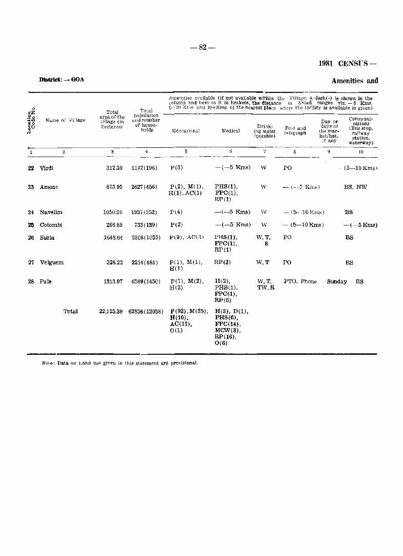
-82-
1981 CENSUS-
District: - GOA Amenities and
Arnelllties amilalJle (if not available within the VilJug-i'. a Jash(-) is shown in the column and next to it in brakets. the distance 1I1 b~oad ranges viz. -5 Kms.
ci Total 5-10 Kms find 10+Kms. of the nearest place when' the facility is available is given)
~~ Tvte.l ,gcP area of the pupulation
CCfmmuni-"'og Name of Village village (in and number Day or cations go hectares) of house- Drink- days of -holds Pc',! and (Bus stoP.
H Edl;cmir,nal Medical ing wate! t~l~graph the mar- railway (potable) ],et/hat. station. if any waterway) -------
1 2 3 4 5 0 7 8 9 10
22 Virdi 312,39 1142(196) P(3) -(-5 Kms) W PO -(5-10 Kmsl
23 Arnone 675.95 2627(456) P(2), M(l), PHS(l), w - (--G KIY,s) BS, NW H(l),AC(l) FPC(l),
RP(l)
24 Navelim 105D.20 1931(352) P(4) -(-5 Kms) w - (5- 10 Em,;) BS
25 Cotombi 266.89 733(139) P(Z) -(-5 Kms) W - (5-10 Kms) -(-5 Kms)
26 Surla 1648,64 5308(1035) P(9), AC(3) PHS(l), W,T, PO BS FPC(l), s RP(l)
27 Velguem 326.23 2214(484) pel), M(l), RP(3) W,T PO BS H(l)
28 Pale. 1313,97 6589(1450) P(7), M(2), H(2), W,T, PTO, Phone Sunday BS H(2) PHS(1), TW.R
FPC(l), RP(5)
Total 22,125,39 62856(12058) P(92),M(25), H(3), D(l), H(lO) , PHS(6), AC(ll), FPC(14), 0(1) MCW(S),
RP(16), 0(6)
Note: Data on Land use gh'en in this statement are provisional.
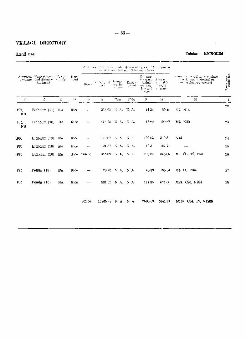
-83-
VILLAGE DJR],~C'l'()RY
Land use TuIuka: - moooLIM
LaLll ;1~1· (1 (, (Ina u1JdfT ddl'.-l. nt typ~-.~ , f 1~nd usC' :m }it-'(dal't-~ nil ,~Jpd npi():'~ d('-ritu.al pl:1n'.:-:)
----- ci Approach Nearest town Pov,(,l' Sta),i' C'l~' UJ1a- h"lll'" Its lJJ( JlidiJj,~ "l.Y place gZ 10 village ,lnd distanC(' -npilly 1000
ll'l'lgu-l>le wast, /U'I-::':1, 111,1 ,,' n1i~'ous, hiRtOlicai or gil>
(in kms.) \ .,11)\,,,,·,!j lJr:ll:rl- linclud- , "?i 1 ) l. ;,l ~ ; I .11'('ha,'c]o!;':t:l! 'Ttt"r~st ..,'t! }1-'C;! I ~ >
.. fE;": ted by C;iltp(l m.; gau- r,,!" Cdl- ~o oU --'11·n·t't") 'her aT'-] 1 i' :l.~.10!1 H
t'J'(rVfl'P-l
11 ]2 13 l,j If- Hi "t'Ii.J.) 17{h) IS 1\J 20 1
22 PR, Bicholim (11) EA RicE' 2388;'. N A. N,A; 1434 59.HI 1182, N16
1m
PR, B;cholim (16) EA Rice ,m:2~ N,A, NA 48 (I() 199,107 M~, mo 23 NR
i'R Eicholim (J 3) J<.JA Ricr ,1(l,('7 J\1 .I~ - ~-,r, A, 120~2 219,31 Nl3 24
PR Bicholim (18) EA Rice :124.il.7 :'l A, N.A, 19,31 1.21.71 25
PR Bicholim (16) EA Rke 264 1'3 84589 If,A. N,A 193,01} 345,(,,:> MR, Co, T2, N31 26
PR Ponda (18) EA Rice 1202(1 N A. N,A 40,39 165.64 M4. ca, N64 27
PR Ponda (15) EA Rice 53] 02 NA. N,A- :m,35 67U\(' M21, ~O, N284 28
361.58 13865,79 N A, N A. 2500.u9 5341.&1 M192, CM, '1'7, NIB
T aluka Satari
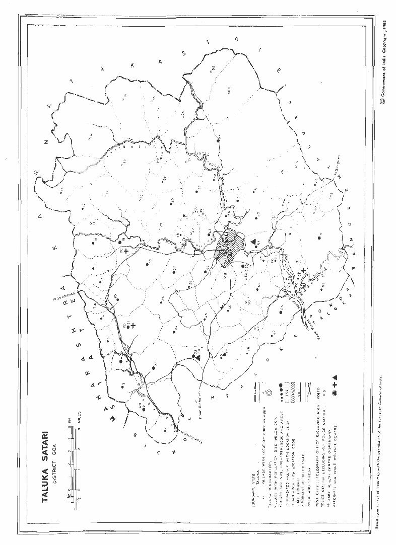
------- -.~--
I ~
\(.
,.. ......... ~ .. ('
.. -........ \ J ............... ;>-.,
« .. I' .' '<
z
( ')
< r" \ .... , ~
o
,
.\... .. -.. ~ (.
Y'
-:s:.Y'
\I'
44
<;f.-
A .....
1-
Oil
'" ~
-' ::.
-a: ~ <t
0 < c!)
(J) ~ U
< ~ ~ ~ (/)
j 0 ~ 0
< ~ I- r
o
C;
A
;; \-"
Iii
~ '=
C ~
/ '" / 0"' /
/ I
J
11
/ , )
o
'" "
1
\)
! ( :@ . I I : . "
q
"' III ~
" 0 z :::: \oJ 0 ~ 0 '3 U
UJ Z ., 2
w :; N
V iil :3 z
?C 0 Vl 3 j '" '."
UJ >- :J
" <> 0: ,_
w'" " .. '-' >- ::J -' " ~ '" -' " >-< ;: 0 "' ... ..
i w ". :z: 0: w .. .. '" ~ '" « :3 -' ::J -' 0 ;' ;: ..
• :--:1 ~ ' ,
. I~: > • I ~ I >.( .' , o ~ __ :
w
b aJ
'" '" 0 a 0 Z u ~ z
g 0 g UJ «
'" "' u 0 0 U '" -'
'" I Z
'" >- S' 0 ~ .. ,
~ ~ 0 0 0: g U
'" '3 " " UJ ~
"' -' ~ :i "' ~ " ::'" i..... ,
0 " < ~ 1 0 w w :r >-~ >- It ~ Z
m ~ :I: ;!! '" '" .. z
'''is " I « 0 :2: ., ~ "-7. It ;;: ~ :::: ~
r ~' , ) \
o , .. , o ';
I~ 0
'" .. f ~
'" ::E z '" S'
'" 0-Z ~ Ci '" 3 w ~ ~
"' -' 0
w "-u
~ ~
LL 0: 0
~ I "- Ci " 3 0: C> ~ :;: "' ., -' UJ w '" z
v' " u
" . lL >-Z
oJ> .. lL 0 w
0: ... ~ w '" > 0 0 i "- ..
<III .. ] + '0
(I j L1
f 0 ~ · w ~
,.' e: 0 0: Z c < Ui
~ " 'j
~ Ui '~ "- rr
'" if:. · Ci 0--' .' · w J -5 0:
>-.< % 0
Ui -' 'l W I u "-
E I
'" " · ,_, z
~ <
:?' ~ ~
(; i '" 0: · ~ > ~ , 'Ii .. '" Il. ~
~ ,
1 ..
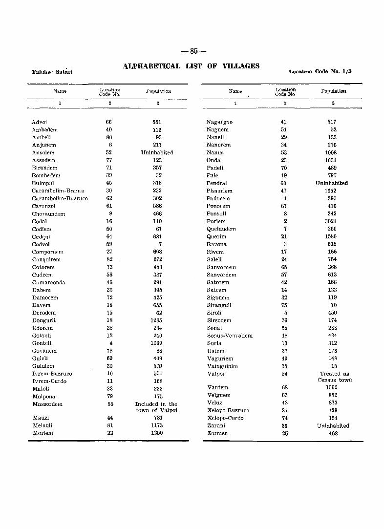
-85-
ALPHABETICAL LIST OF VILLAGES Taluka: Satari Location Code No. 1/5
Name Loeation .Population Name Loca.tion Population Code No, Code No
1 2 3 1 2 3
Advoi 66 551 Nagargao 41- 517 Ambedem 40 113 Naguem 51 52 Ambeli 80 93 Naneli 29 133 Anjunem 6 217 Nanorem 34 216 Ansolem 52 Uninhabited Nanus 53 1008 Assodem 77 123 Onda 23 1631 Birondem 71 357 Padeli 70 489 Bombedem 39 32 Pale 19 797 Buimpal 45 318 Pendral 60 Uninhabited Carambolim -Brama 30 232 Pissurlem 47 1652 Carambolim-Buzruco 62 302 Podocem 1 390 Carnnzol 61 586 Ponocem 67 416 Choraundem 9 466 Ponsuli 8 342 Codal 16 110 Poriem 2 3021 Co diem 50 61 Quelaudem 7 260 Codqui 64 681 Querim 21 1580 Codvol 59 7 Ravona 3 518 Compordem 27 608 Rivem 17 166 Conquirem 82 272 Saleli 24 754 Cotorem 73 483 S:mvorcem 65 268 Cudcem 56 387 Sanvordem 57 613 Cumarconda 46 291 Satorem 42 166 Dabem 26 395 Satrem 14 122 Damocem 72 425 Sigonem 32 119 Davem 38 655 Sirangu!i 75 70 Derodem 15 62 Siroli 5 450 Dongurli 18 1285 Sirsodem 76 174 Edorem 28 234 Sonal 58 288 Golauli 12 240 Sonus-Von \'oliem 18 494 Gonteli 4 1069 SurIa 13 312 Govanem 18 88 Ustem 37 173 Guleli 69 409 Vaguriem 49 148 Gululem 20 579 Vainguinim 35 15 I vrem -Buzruco 10 551 Valpoi 54 Treated as Ivrem-Curdo 11 168 Census town
Maloli 33 222 Vantem 68 1062
Malpona 79 175 Velguem 63 852
Massordem 55 Included in the Veluz 43 873 town of Valpoi Xelopo-Buzruco 31 129
Mauzi 44 781 Xelopo-Curdo 74 154 Melauli 81 1173 Zarani 36 Uninhabited Morlem 22 1250 Zormen 25 468
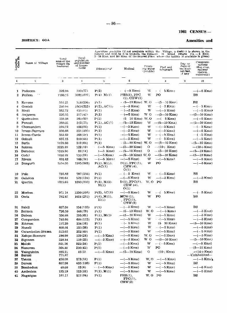
-:- .86-
1981 CENSUS-
DISTRICT: GOA Amenities and
Amenities ... "dable (if not available within thOJ Village, a dash(-) is shown in the ~olumn and next to it in brakets, the distance in broad ranges viz. -5 KIDs.
~ Total Total 5-10 Kms. an<110+Kms. of the nearest place wher .. the facility is available is given)
§" area of the pupulatlOn Communi-18 Name of Village village (in and number Day 01'
of house- cations heetares) -holds
Prinl<- Post and days of (Bus stop, .J Educati'-"lul Medical !Tlg water telegraph the mar- railway Ip<Aable) ket/hat, station,
If any waterway)
1 " 3 ·1 b 6 ~ 9 10
1 Podocem 392.98 2.90(77) P(2) .-- (-5 Kms) W -(-5 Kmf<) -(-5 Kms)
2 P-oriem 1160.18 3021(6{)7) P(4) Mn) PHS(l), FPC W PO BS (1), CHW(3)
3 Ravona 55~.21 ,)18(100; P(l) - (5-10 Kms) W.O --(5-10 KmF) BS 4 Gonteli 280.86 ]069(215) P(2), AC(1) --(-5 Kms) W -(-5Kms) -(-5 Km5)
5 Siroli 353.72 45tH 85) P(l) -(--5Kms) W -(-5 Kms) -(-5 KmsJ'
6 Anjunem 226,fJ3 217(471 pel) -_. (--5 Kms) W,O -(5-l0Kms) -(5-10 Kms)
7 Quelaudem 339.38 260(50) pel) -(5-10 Kms) W,O -(-5Kms) --(-5 Kms)
8 Ponsuli 360.0S 342(75) P(l), AC(l) -(5-10Kms) w --(5-10 Kms) --(5-10 Kms)
9 Choraundem 592.72 466(86) P(l) -(-5Kms) W -(-5 Kms) -(-5 Kms)
10 Ivrem-Buzruco 500.88 551(100) P(l) --(-5 Kms) W -(-5 Kms) -(-5Kms)
11 Ivrem-Curdo 36].69 168(28) pel) -(-5Kms) W -(-5 Kms) -(-5 Kms)
12 Golauli 657.15 240(48) P(l) -(-5Kms) W -(-5 Kms) -(-5 Kms)
13 Surla 1478.60 312(68) P(l) -(5-10 Kms) W,O -(5-10 Kms) -(5-10 Kms)
14 Satrem 2225.89 122(19) -(-5 Kms) -(5-10 Kms) 0 -(10+ Kms) -(lO+Kms)
15 Derodem 1335.90 62(14) -(-5 Kms) -(5-10 Kms) 0 -(5-10 Kms) -(5-10Kms)
16 Codal 1250.28 110(26) -(-5 Kms) -(5-10 Kms) W,O -(5-10Kms) -(5-10 Kms)
17 Rivem 891.62 166(34) -(-5 Kms) -(-SKms) W -(-5 Kms) -(-5Kms)
18 Dongurli 1016.35 1285(262) P(l), M(l), D(l), FPC(l), w PO -(--5 Kms) AC(l) CHW(4),
0(1)
19 Pale 793.82 797(158) P(l) -(-5 Kms) W -(-5Kms) BS
20 Gululem 790.64 579(124) P(l) -(--5 Kms) W -(-5Kms) -(-5Kms}
21 Querim 1240.93 1580(330) P(3), M(l). D(l), FPC(1). W,O PO BS H(l) CHW (4),
0(1)
22 Morlem 971.74 1250(246) P(2), AC(l) --:- ( -5 Kms) W -(-5Kms) -(-5Kms)
23 Onda 792.85 1631(291) P(4), M(l), MeW(l), W PO BS H(l) I FPC(l),
CHW(2)
24 Saleli 837.58 754(135) pel) -(-5 Kms) W -(-5 Kms) BS
25 Zormen 726.30 468(79) P(l) -(5-10 Kms) W,O -(-5Kms) -(-5 Kms)
26 Dabem 350.88 395(61) P(l), M(l) --(5-10 Kms) W -(-5 Kms) -(-5 Kms)
27 Compordem 745.66 608(115) P(l) -(-5 Kms) W -(-5 Kms) -(-5 Kms)
28 Edorem 137.25 234(36) P(l) -(--5 Kms) W -(5-10Kms) -(5-10 Kms)
29 Naneli 609.01 133(26) P(l) -(-5 Kms) W -(--5Kms) -(-5 Kms)
30 Carambolim-Brama 513.03 232(40) P(l) -(-5 Kms) W -(-5Kms) -(-5 Kms)
31 Xelopo-Buzruco 196.90 129(28) -(-5Kms) -(-5 Kms) W,O -(-5H:ms) -(-5 Kms)
32 Sigonem 328.84 119(23) -(-5 Kms) -(-5 Kms) W,O -(5-10Kms) -(5-10 Kms)
33 :M:aloli 561.76 222(38) P(l) -(-5 Kms) W -(-5 Kms) -(-5 Kms)
34 Nanorem 368.10 216(45) P(l) -(-5 Kms) W PO -(5-10 Kms)
35 Vainguinim 892.21 15(3) -(-5Kms) -(5-10 Kms) 0 -(10+Kms) -(lO+Kms) 38 Zarani 771.87 ---Uninhabited-
37 Ustem 456.08 173(33) P(l) -(-5 Kms) W,O -(-5 Kms) -(-5 Kms),
38 Davem 607.56 655(116) P(l) -(-5 Kms) W -(-5 Kms) BS
39 Bombedem 48.00 32(6) -(-5Kms) -(-5 Kms) W -(-5 Kms) -(-5 Kms)
40 Ambedem 125.19 113(23) P(l), M(l) -(-5 Kms) W -(-5 Kms) -(-SKms)
41 Nagargao 161.11 517(94) P(l) PHS(l), W,O PO BS FPC(l),
CHW(2)
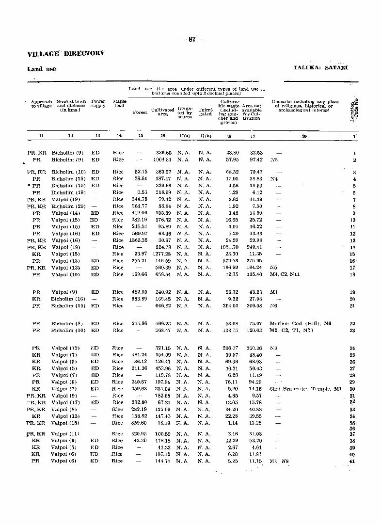
vILLAGE' . DIRECTORY
Land use
Approach Nearest town Power to village and distance supply
(in kms.)
11 12 13
PR, KR Bicholim (9) ED ED PR Bicholim (9)
PR, KR Bicholim (10) ED PR Bicholim (15) ED
.. PR
PR PR,KR PRKR
PR PR PR PR
PR,KR PR,KR
KR PR
PR,KR PR
PR KR PR
PR PR
PR KR KR KR PR PR KR
PR,KR ~'R,KR
PR,KR KR
PR,KR
fR,KR KR KR KR PR
Bicholim (15) ED Bicholim (19) Valpoi (19) Bicholim (20) Valpoi (14) ED Valpoi (15) ED Valpoi (15) ED Valpoi (16) ED Valpoi (16) Valpoi (19) Valpoi (15) Valpoi (13) ED Valpoi (13) ED Valpoi (10) ED
Valpoi (9) ED Bicholim (16) Bicholim (15) ED
Bicholim (8) ED Bicholim (10) ED
Valpoi (12) Valpoi (7) Valpoi (5) Valpoi (5) Valpoi (1) Valpoi (9) Valpoi (7) Valpoi (9) Valpoi (17) Valpoi (8) Valpoi (13) Valpoi (15)
Valpoi (11)
Valpoi (6) Valpoi (5) Valpoi (6) Valpoi (6)
ED ED ED ED ED ED ED
ED
ED ED ED biD
Staple food
Rice Rice
Rice Rice Rice Rice Rice Rice Rice Rice Rice Rice Rice Rice Rice Rice Rice Rice
~8'1-
Land USt' (i.e area under different types of land use .n
hectares rounded upto 2 decimal places)
Culti\'ated Irriga-Forest area ted by
source
15 16 17(a)
Cultura-ble waste Area not
Unirri- (includ- available gated ing gau- for Cul
cher and tivation groves)
17(b) 18 19
32.53
TALlTKA: SATARI
Remarks including any place of religious. historical or
archaeological interest
336.65 N. A. 1004.81 N. A.
N.A. N.A.
23.80 57.95 97.42 N5
52.15 363.27 N. A. N. A. 36.61 187.47 N. A. N. A.
0.53 244.75 264.77 419.06 282.19 245.51 569.97
1363.36
329.66 N. A_
218.99 N. A. 79.42 N. A. 85.84 N. A.
155.59 N. A.
176.32 N. A. 95.89 N.A. 68.46 N. A. 30.67 N.A.
224.78 N. A. 23.97 1277.28 N. A.
255.21 146.59 N. A.
560.39 N. A. 169.66 658.54 N. A.
N.A. N.A. N.A. N.A. N.A. N.A. N.A. N.A. N.A. N.A. N.A. N.A. N.A. N.A.
68.32 17.95
4.56 1.29 3.82 1.92 3.48
16.65 4.07 5.29
24.59 1051.70
23.30 572.53 166.99
72.75
70.47 38.83 Nt 19.50
6.12 11.39
7.50 14.59 25.72 16.22 13.43 59.98
949.41 11.35
275.95 164.24 115.40
N5 M4. C2,N11
Rice 482.95 240.92 N. A. N. A. 26.72 9.32
294.03
43.23 M1 27.98
300.08
Rice Rice
Rice Rice
Rice Rice Rice Rice Rice Rice Rice Rice Rice Rice Rice Rice
Rice Rice Rice Rice Rice
583.89
275.86
48-1.24 86.12
211.36
240.67 259.63
232.80 282.19 158.82 859.60
320.95 43.39
169.45 N. A. 646.82 N.A.
566.23 N. A. 568.47 N. A.
321.15 N. A. 154.09 N.A. 126.47 N. A. 453.96 N.A. 119.78 N. A. 197.94 N. A. 234.04 N.A. 182.68 N. A.
67.21 N. A. 125.99 N. A. 14i.-n N. A. 18.19 N. A.
100.59 N.A. 478.18 N.A.
41.32 N. A. 107.12 N. A. 144.71 N. A
N.A. N.A.
N.A. N.A.
N.A. N.A. N.A. N.A. N.A. N.A. N.A. N.A. N.A.
N.A. N.A. N.A.
N.A. N.A. N.A. N.A. N.A.
53.68 103.75
266.07 39.57 69.36 30.31 6.28
76.11 5.20 4.65
13.05 34.20 22.28
1.14
3.46 32.29
2.67 6.20 5.25
75.97 120.63
250.36 48.40 68.93
50.03 11.19 94.29 14.16
9.57 15.78 40.88 39.55 13.28
31.08 53.70 4.01
11.87 11.15
N6
Morlem God (Hill), N6 M2, C2, Tl, N~1
N3
Shri BramaLit"; Temple, Ml
M1. N8
1
1 2
3 4 5
6 7 8 9.
10:
11
12 13 14 15 16' 17 18
19 20 21
22 23
24 25 26 27 28 29 30 31 32 "
33 34. 35 36 37 38 39 40 4:1
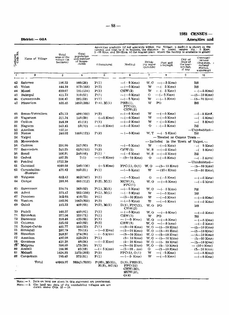
-88-
1981 CENSUS-Dl&trict: - GOA Amenities and
Amenities available (if not avaHable within the Village, a dash(-) is shown in the eolumn and next to it in brakets, the distance in broad ranges viz. - 5 Kms.
0 'rotal 5-10 Rms, and 10+Kms. of the near~t place where the facility is available is given)
gZ Total area. of the population Communi-
j~ Name of Villag~ VIllage (in and number Day or cations ·U hectares) of house- Drink- Post and days of (Bus stop, , -holds Educational Medical ing water tdpgraph llle mar- railway (potable) ket/hat, station,
if any waterwaY)
i' :.I 3 4 5 I) 7 8 9 10
42 Satorem 196.32 166(26) P(l) -(-5 Kms) W,O -(--5 Kms) BS '43 Veluz 444.10 873(168) P(2) -(-5 Kms) W -(--5 Kms) BS 44 Mauzi 629.07 781(134) P(l) CHW(2) W -(-5Kms) -(-5 KIDs) 45 Buimpal 411.73 318(57) P(l) -(-5 Kms) 0 -(-5 Kms) -(5-10 Kms) 46 Cumarconda 556.47 291(52) P(l) -(-5 Kms) W -(-5 Kms) -(5--10 Kms) 47 Pissurlem 835.45 1652(365) P(4), M(l) PHS(l), W PO BS
FPC(1), CHW(2)
48 Sonus-Vonvoliem 474.12 494(100) P(2) -(-5 Kms) W -(-5Kms) -(-5KID~i
49 Vaguriem 311.34 148(29) -(-5 Kms) -(-5Kms) W -(-5Kms) -(-5Kms) 50 Co diem 246.19 61(11) P(l) -(-5 Kms) W -(-5 Kms) -(-5 Kms) 51 Naguem 343.43 52(10) -(-5 Kms) -(-5 Kms) 0 -(-5Kms) BS 52 Ansolem 167.H -Uninhabited-53 Nanus 248.02 1008(171) P(2) -(-5 Kms) W,T -(-5 Kms) BS 54 Valpoi - Treated as Census Town-55 Massordem -Included in· the Town of Valpoi.-56 Cudcem 354.00 387(80) P(2) -(-5 Kms) W -(-5 Kms) ~(-:-5 Kms) 57 Sanvordem 340.25 613(113) P(2) CHW(3) W,S -(-5 Kms} -(-5Kms) 58 Sonal 306.91 288(46) P(l) -(-5 Kms) W, S -(-5 Kms) BS 59 Codvol 887.25 7(1) -(-5 Kms) -(5--10 Kms) 0 -(-5 Kms) -(-5 KIDs) 60 Pendral 1737.39 -Uninhabited-61 Caranzol 4048.64 586(100) -(-5 Kms) FPC(l),O(l) W,O -(5--10 Kms) -(5--10 Kms) 62 Carambolim- 470.42 302(51) P(l) -(-5 Kms) W -(10+Kms) -(5-10 Kms),
-Buzruco 6.3 Velguem 652.43 852(147} P(l) -(-5 Kms) 0 -(-5 Kms) -(-5Kms) 64 Codqui 288.16 681(112) P(2),M(1) MCW(l), W,O -(-5 Kms) -(-5 Kms)
FPC(l) 65 Sanvorcem 234.74 268(52) P(l},M(l) -(-5 Kms) W,O -(-5 Kms) BS 66 Advoi 575.47 551(108) P(l),M(l) -(-5 Kms) W -(-5 Kms) BS 67 Ponocem 302.68 416(73) pel) -(5-10 Kms) W -(-5 Kms} --(-5Kms) 68 Vantem 592.96 1062(203) P(3) -(-5 Kms) W -(-5 Kms} -(-5Kms) 69 Guleli 183.23 409(68) P(2), M(l) D(l), FPC(l), W,O PO BS
CHW(2) 70 Padeli 168.57 489(81) P(l) -(-5 KIDs) W,O -(-5 Kms) -(-5 Kms) 71 Birondem 277.56 357(71) P(l) CHW(3) W PO BS 72 Damocem 218.46 425(85) P(l) - (-5 Kms) W,O -(-5 Kms) -(-5 Kms) 73 Cotorem 525.02 483(92) P(2) CHW(3) W,O -(-5kms) -(-5 Kms) 7'4 Xelopo-Curdo 451.77 154(33) P(l) -(5-10 Kms) W,O -(5-10 Kms) -(5-10 Kms) 75 Siranguli 297.79 70(11} -(-5 Kms) -(5-10 Kms) W,O -(5--10 Kms) -(5-10 Kms) 76 Sirsodem 248.37 174(26) -(-5 Kmsl -(5--10 Kms) W,O -(5--10 Kms) -(5-10 Kms) 77 Assodem 497.08 123(21) P(l) -(5-10 Kms) W,O -(5-10 Kms) -(5--10 Kms) 78 Govanem 431.38 88(24) -(-5 Kms} -(5-10 Kms) W,O -(5-10 Kms) -(5-10 Kms) 1!J Malpona 398.09 175(39) P(l) -(5-10 Kms) W,O -(5-10 Kms) - (10+Kms) 80 Ambeli 194.96 93(19) -(-5 Kms) -(5-10 __ ms) 0 -(5--10 Kms) -(5-10 Kms) 81 Meluali 1624.93 1173(202) P(5) FPC (1),0 (1) W -(-5Kms) -(-5Kms) 82 Conquirem 785.49 272(51) P(l) - (-5 Kms) W -(-5 Kms) -(-5KIns)
Total 48963.97 36943(7030) P(89), M(l1), D(3), PHS (3), H(2), AC(4) FPC(10)
CHW(30), MCW(2), 0(4)
Note: -1. Data on land use given in this statement are proviSional. Note: -2. The land use data of the uninhal:>ited villages are not
shOwn under Cols. 15 - 19.
VILLAGE DIRECTORY
Land use
Approach Nearest town Power to village and distance supply
(inkms.)
Staple food
11
PR PR KR PR PR PR
PR PR
PR PR
PR
'KR
KR PR KR
12
Valpoi (7) Valpoi (2) Valpoi (4) Valpoi (10) Valpoi (8) Valpoi (12)
Valpoi (14) Valpoi (10) Valpoi (8) Valpoi (4)
Valpoi (1)
Valpoi (4) Valpoi (5) Valpoi (6) Valpoi (18)
13 14
ED Rict' ED Ricl' ED Rice
Rice ED. EO Rice ED Rice
ED ED ED
ED
ED
Ric" Rice Rice Ricl:'
Rice
Rice Riel' Rice
Rice
-89-
Taluka: - SATABI
Ln,nd use \ i.e n,rea under different tyj}\)s of land use in hectarp$ rounded upto :l dpdrnal plac~s)
F Cultivated Irriga-
orest <'rea too by ~ource
15 16 17(a)
17.03 144.60 N. A. 2.70 340.33 N. A.
':'0[1.18 N. A.
112.67 192.35 N. A.
233.5\1 277.63 ~'. A. 1.3.21 N. A.
38fi.77 N. A. 229.94 N. A.
90.00 b5.29 N. A. 117.19 N. A.
17(b)
N.A. N.A. N.A N.A. N.A. N.A.
N.A. N.A. N.A. N.A.
815.53 N. A. N. A.
223.28 N. A. 0.82 271.04 N. A.
128.93 N. A. 871.12 ~.09 N. A.
N.A. N.A. N.A. N.A.
Cultumble waete Imclud
mig gaucher and groves)
18
15.16 39.0fi 56.04 53.11 11l.33
224.17
12.65
23.36 34.5R
117.05
79.02
53.64 17.39 81.55
0.74
Area not available for Cul-1ivation
19
19.53 62.01
Hnnarks including any place of religious. hist1lrlcal or
:lTchaeological interest
63.85 ~5
53.60 25.92
438.07 Co 'rl. N150
74.70 N6
58.04 30.32
109.1!:!
80.47 Fort at Nanlls, M1
77.0R
51.00 N6 96.43 N4
13.30
KR KR
Valpoi (14) Valpoi (9)
Rice 3505.80 402.40 N. A. N. A. 29.94 2.19
110.50 8.08
KR PR
PR PR
PR,KR PR KR
PR,KR PR KR KR KR
PR,KR PR,KR
KR KR KR KR KR PR
Valpoi (6) Valpoi (3)
Valpoi (5) Valpoi (6) Valpoi (11) Valpoi (10) Valpoi (9)
Valpoi (8) Valpoi (6) Valpoi (8) Valpoi (7) Valpoi (10) Valpoi (10) Valpoi (11) Valpoi (12) Valpoi (12) Valpoi (13) Valpoi (9) Valpoi (10) Valpoi (10)
ED Rice 460.15 N. A. N. A.
ED, EO Rice ED, EO Rice
ED,EO EA,EAg
ED ED ED
ED ED ED ED ED
ED ED ED ED ED
Rice Rice Rice Rice Rice
Rice Rice Rice Rice Rice Rice Rice Rice Rice Rice Rice Rice Rice
261.76 265.07 N. A. 221.80 N. A.
9.82
47.08
0.52
6.13 78.85
129.71 156.48 394.24 289.99 241.23
4.60
455.55
142.98 N. A. 314.28 N.A. 223.04 N. A. 490.28 N. A. 103.23 N. A.
143.50 N. A. 196.47 N. A. 175.29 N.A. 493.46 N. A. 296.79 N. A.
54.00 N. A. 74.30 N. A. 73.60 N.A. 84.83 N. A. 98.59 N.A.
141.52 N. A. 877.89 N. A. 255.37 N. A.
N.A. N.A.
N.A. N.A. N.A. N.A. N.A.
N.A. N.A. N.A. N.A. N.A. N.A. N.A. N.A. N.A. N.A. N.A. N.A. N.A.
58.51 19.14
39.03 116.90
26.37 23.66 11.33
6.01 29.03 16.69
4.91 31.17 58.58
7.44 11.99 25.53 28.27 22.54
357.23 30.24
67.09 47.22 M2
42.91 144.29
53.27 79.02 21.59
19.06 51.54 26.48 20.52 44.96 55.50 10.15 17.25 31.03 30.00 26.30
389.81 44.33
M1 Ml, N5
MJ, N8
N5
C1
15438.40 19972.58 N. A. N. A. 5010.h) 5866.58 M15, N260, Cll, T2
1
42 43 44 45 46 47
48 49 50 51 52 53 54 55 56 57 58 59 60 61 62
63 64
65·
66 67 68 69
70 71 72 73 74 75 76 77 78 79 80 81 82
Taluka Pond a
'" ('
J " . "
- - --~"' ~ ~- ,
·7 / " , ,---- '~:)'-"
. 9 /?
BOWNI).~ ; · • TI" l UK ..
'.1 LAGE WITH LOCAT ION CO DE NtlMB£R
TALUKA HE'uQUARTERS VILLAGE WIT H POPULATION SI ZE BELOW 200, 200 - 499 ,50 0-999,1 000-49 99 5000 8. A3 0 VE ,
URBAN AP E" .~ W !TH LOCATION CODE
NATIONAL "'1 6HWAY
STATE' HIG~ ' WAV
IMPORTAN T META c LED RO AG
RIVER ANO srRE AM
POST OFFIC Er~',EG RAPH O~F I( E EX ," y~ i NG R M S, . PO/TO
HIGHER SE COt-.t)i>.RY SCHQOL . 5
POLICE STATioN DCLUDIN(i RcY POI ': E 5' iliON .
HOSPITAL : PRI""APY I1E.A I_T ~; CE NTR[,' ,I.,;. ~ , e.Iro1 SAA:Y,
MATERNIlV .A.ND ('H !I..D #~l~-f,,,, ::: C ~ JT~t'
~====::::=:-::-==-=--::_.::=:: ,~-------=-
p 5
'-J
I ( \ '---~ ....... (
\. _ ~ _,..
Bowd upon Survl'Y 01 !nrlk. !,,~ap ~ i't:!t r,,( t."'trllJl /.T. ir.'1 ,/ ' ft« Surveyor General 01 InK
o
<
"
£. (J
TALUKA PONDA DISTRICT GOA
I liz 0 I
~E4 1 112 0
• 7 6
. _.
1 3 E3
i
~
"'0 '.,."
V
A
r
c:.
QUEPEM
1-
TAL U K A
4 5 KM
H J MlUS
A
I"-
::I
"f
'V

-91-
ALPHABETICAL LIST OF VILLAGES
TaIuk.a: Ponda. Location CodeNo. 1/6
Name Location Population Code No.
1 2 3
_A_deolnu 7 1288
Bandora 20 7080
Betora 25 2027
Eetqui 4 1717
Boma 8 1604
Borim 29 6031
Candepar 14 3034
Candola 3 2576
Codar 26 731
Conxem 28 166
Cuncoliem 9 1304
Cundaim 18 3361
Curti 15 1352
Durbhat 21 3743
Gangenl 12 513
Marcaim 19 5878
Nirancal 27 1410
Orgao 2 2983
Ponchavadi 31 3946
Priol 16 6221
Querim 10 3057
Queula 24 3217
Savoi-Verem 6 3024
Siroda 30 11663
Telaulim 22 1690
Tivrem 1 942
Usgao 13 7295
Vadi 23 492 , Vagurbem :p 596
Velinga 17 1587
Volvoi 5 2030
-92-
1981 CENSUS-District: - GOA Amenities and
NUBnities available I if not available within the VIllage, a dash(-) is shown in the mlumn and next to it in brakets, the distance in broad ranges viz.-5 Krus,
0 Total Total 5-10 Kms. and 11H Kms. of the nearest pIal'" "he1'-> !be [ncllny is available is given)
:::Z .'2 ~ area of the population
Communi· ..,'tj ~; ~!ne of Village village (in and number Day or • roo of house· cations go hectares) Drink· 'Post and days of (Bus stop, ,J ·holds Educational Medwll mg water telegraph the mar- railway, (potable) ket/hat, station. if any ,\vaterway)
• 2 4 5 6 7 8 0 10
1 Tivrem 218.02 9-12(150) P(2), M(l). RP(l) W PO BS H(l)
2 Orgao 361.89 2953(549) P(5), M(l), RP(3) \'\',T,S PO BS • H(l), AC'.1)
3 Candola 494.63 25713(462) P(4), M(l), --:-5 Kmsl W,T -1-5Kms) BS H(l), AC(ZI •
4 Betqui 597.11 1717(298) P(4), M(2) PRC(l), \V,T,S -(5-10 Kmsi BS FPC{ll, 0(1)
5 Volvoi 112.84 2030(347) P(2), M(l), 0(1), FPC( 1 I. W,S .. ( -5 Kills) BS H(l) CHw(21,
0(1)
6 Savoi-Verem 904.62 3024(517) P(S), M(3), CHW(3) W.S PO BS H(2)
7 Adcolna 324.40 1288(216) P(3). M(li RP(2) W,T,S -(-5 Kms Friday BS
8 Boma 399.25 1604(275) PI;»~ FPC(I), Ot 1 J W,T,S -(5--10 Kmd) BS 9 Cuneo-liem 534.03 1304(2171 1"(1) CHW(2) \V,S,TK -(-5 Kms) -(-5 Kms)
10 Querim 1224.34 3057(532} P(5), M(l), MCW(l), W,O -(5-10 Kms) BS H(l),AC(1\ FPC(l).
CHW(31
11 Vagurbem 244.19 596(96) P(l) CHW(l) W,S -(-5 KillS) -(-5Kms)
12 Gangem 559.64 513(97) P(l) CHW(l) W,S,O -(5--10 KIm) BS
13 Usgao 2627.59 7295(1352) P(ll), l.I(:~), H(l), 0(11, W,T,O PO, Phone BS H(2) FPC(!),
CHW(5), RP(l), 0(1)
14 Candepar 1148.92 3034(503) P(9), M(l), PHS(l), W,T,S PO BS HI) FPC(l).
CHW(31
15 Curti 762.77 1352(233) P(3) CHW(l) W,S -\-5 Kms) BS
16 Priol 1414.00 6221 (10-1[;) Pill), M(2}, PHS(lJ, W,T,S PTO, Phone MOonday BS H(2\,0(21 FPC(ll.
CHW(5J. RP(6)
17 Velinga 326.73 1587(265) P(3) CHW(2) W,T.S -(-5 Kms -(-5 Kms)
18 Cundaim 758.32 3361(586) P(5), M(2), PHS(l). IS,S,TK PO BS H(l) FPC(l),
CRW\3,1
19 Marcaim 1082.02 5878(1059) P(7), M(l), 0(1), FPC(lI. W Po. BS H(l) CHW(7), ..
0(2)
20 BandOora 1247.32 7080(1165) P(9), M(2), PHS(l), \\',T,S Po, Phone BS H(2), AC(l), FPC(2), C(l) MCW(l),
CHW(~\,
RP(2)
-93-
VILLAGE DIRECTORY
Land use Taluka: - PONDA
• A:-lproach llJ vIllage
~e~LreE-\t tr,wn dnd uista.ncp'
(in 1m,,)
L'u\ver '~upply
staple food
Land U:4t" (i c area Ilndpr tillfe-rent types of l~nu use in h .. ~t"r~R I'olln(h·d apta 3 dH'imal place',
Ccllll\.lled :tl'ea.
IrrIgated by ~ourcoj
Unirri· f5 a tpd
Cultura~,lf' ,vdlste (mcludlllg gaur;her and g-ron'i')
Area. nor. available fol' Cult~v2tioll . ~-----------
•
..
•
•
11 I:! 13 14 15 ffi Dl~ 17(lJ) l~
------------------------- ---------
PR Ponda(161 ED Rice 153.60 N. A. N. A. 2.94
PR, KR Ponda (18) ED Rice 234.72 N. A. N. A. 12.21
PR Ponda(18) EA Rice 413.18 N. A. N. A. 21.79
PR Ponda(25) EA Rice 296.53 N. A N. A. 130.78
PRo KR Ponda(14) EA Rice 91.82 N. A, N. A. 4.84
,PR, KR Ponda(10) EA Rice 602.99 N. A. N. A. 111.03
PR
PR
PR
PR
KR
PR
PR
PR
PR
PR
PR
PR
Ponda(1!)I
Ponda(14)
Ponda(12)
Ponda(9)
Ponda(15)
Ponda(20)
Ponda(15)
Ponda(6)
Ponda(4)
Ponda(9)
Ponda(5)
Pondal9)
Rice
8A Rice
EA Rice
EA Rice 59.82
ED, EO Rlce
EA Rice 419.37
EA Rice 615.89
EA RiCe 49U17
260.09 N. A. N. A.
258.54 N. A. N. A.
462.46 N. A. N. A.
10.92
43.16
4.59
776.75 N. A. N. A. 143.29
111.81
38.29
1008.68
N.A. N.A.
N.A. N.A.
N.A. N.A.
53ll.85 N. A. N. A.
60.06
37.86
486.13
30.07
EA
EA
Rice 39.74 253.03 N. A. N. A. 124.98
Rice 169.68 10.31.25 N. A. N. A. 41).19
EA Rice 226.63 N. A. N. A. 22.60
EA Rice 522.32 N. A. N. A. '36.35
.. PR. NR Ponda(9) EA Rice 714.61 N. A. N. A. 84.27
PR, KR Ponda (5) EA Rice 75382 N.A. N.A. 136.46
l~
61.48
64.96
59.66
169.'30
i6.18
190.60
44.39
97.55
66.98
244.48
72.32
64.12
516.89
87.03
345.02
172.88
77.50
149.65
283.14
307.04
". 'marks including allY place of religious. hIstorical or
archaeolog'ical mterest
20 1
Shantadurga Temple, Devki 1 Krishna Temple, M18, C1, N164
N30 2
Ganapati Temple, MS, C3, N30 3
M.mdovira Temple, Mando- 4 .lari Temple, M2, N75
Shri Gajanath Laxmi Tem- 5 pIe, M3. N24
Snri Anantha Temple, M7, 6 CI, N90
7
~I4 8
Sh:lIltadurga & Ravalnath 9 Temple, MI0
Shri Vijayadurga & Betal 10 Temple, M13, Nll
Shantadurga Temple
Reserve forest & Park at Bondla. M1. N16
N180
Pancha Pandavas Caves
11
12
13
14
Hi
Shri Manguesh Temple, Shri 16 Mahalsa Temple. M59, C7
Laxmi Narshiv, Shantadurga 17 & Vetaleshwar Temple, M9. C2
M16. Cl. N65 18
Nm'adurga Devalaya, M20, 19 C2. N36
Naguesh, Mahalaxmi Tem~ 20 pIe and Nayamandir Ramnath Temple
-94-
1981 CENSUS-
District: - GOA Amenities and
Ameniucs avo-i!able (if not available within the Village, a dash(-) is shown in the column :md next to it in braketa, the distance li1 broad ranges viz. - 5 Kms,
ci Total 5-10 Krn~, a.nd 10+Kms, of the nearest place w]'N'e the fn.cility is available is given)
-3Z Tolal area of the population
Cornrnuni-.~..,
Name of Vi1lag~ and nurnbeT ...,"" village (in D.1Y or ~o hectares) of house- Drink- days of
cations • 0 0 -hold . ., Post alll! (Bus stop, H Educational MedlCal jng water telegraph the mar- railway (palable) ket/het, station,
If any waterway)
2 3 4 5 6 7 8 9 10 •
21 Durbhat 506.64 3743 (60() I P(l), M(l), D(l), FPC() ), W,T PO BS H(l) CHW(4),
RP(l)
22 Telaulim 254.84 1690(301) P(4), M(l), CHW(l) W,T -(-5 Kms) BS H(l) •
23 Vadi 152.83 492(86) P(l) CHW(l) W - (-5 Kms) -(--5 Kms)
24 Queula 554.64 3217(564, P(4), M(3), CHW(4), W,T,S Po, Phone BS H(2) RP(l) •
25 Betora 1437.23 2027(3601 P(7), M(l) CHW(2) W,S -(5-10 KillS) BS
26 Codar 1005.70 731(139) P(l) CHW(l) W,S -(5-10 Kms) BS
27 Nirancal 2055.07 1410(265) P(8), M(l), PHS(l), W,S PO BS H(l) FPC(l)
CHW(l)
28 Conxem 194.74 166(29) P(l) CHW(l) W,S -(-5 Kms) -(5-10 Kms)
29 Borim 1493.37 6031(1098) P(7), M(3) PHS(l), W,T,TK,O PO BS H(2) NH(l),
FPC(V, CHW(6), RP(3)
30 Siroda 3649.70 11663(2192) P(19), M(5), PHS(l), W,T,S PO Tuesday BS, NW H(3) AC(o) NH(l),
FPC(2), CHW(13), RP(2), 0(2)
• 31 Ponchavadi 1582.77 3946(721) P(9), M(l), FPC(l), W,S PO BS
H(l) CHW(4), RP(2), 0(1)
Total 28230.16 92558(16325) P(159), H.(l), PHC(l,) M(37), PHS(7), H(27), FPC(17}, AC(10), NH(2), C(l),O(~:) D(4),
MCW(2), CHW(81l, RP(24), 0(9)
Note: Data on Land u.~e given in this statement are ])rovisionaJ.
-95-
VILLAGE DIRECTORY
Land use
]-",:.,'..,: " \ :.e :.If<';1 "f;{kr Ihff"i cut typeR cf lanu use in J-,tClar"8 10u~ided upto 2 decin:aJ places)
Approach N' earest town Power :'1«.I.'J.' Caltura-to village and dist811ce "'Jpply foou en1t,· Jt'i"iga-
til!'! "i,v&stt: ; J"_a Eot (in kms,) Unl;T'- (indud- ~vailable li'.'r;-l yated 'c'd by c;ate,j jpg gau- fOr Cul-
<Ij-ea SOll!'f'e cher a.'1d tivation groves)
-_~-----
11 12 13 14 -'0 "" if: 17\<.\) l7d ) 18 19
PH NR Ponda(6) EA Rice i1t.:~'1 ~,A. N, ,L .. ~3,-;3 2G5JZ
PR Ponda~5) EA Rlce 12(1,~~ ~- p_- N. A. 38,13 86,86
PR,KR Pondat5J EA F.lCt ~: /''i 'T J-\' P... N, J-! 13.H! 62.69
PR Ponda (3) ED, EO Rl('f 72.20 27ft,f.'1 N.A. ~.A. 71.13 131,67
PH Ponda(6) ED, :r;O RICe :--47,7~ flZ4.7:; N.A. N.k :':1(1.39 254.:28
PR Ponda(10) l<JD Hlce ;i5S.09 4(1fl.11l H.A. N.A. 78.31 160.20
PRo liR Ponda (14 ) EA Hice 1044.24 753.vl} ::-;r.A. N.A. ~!),29 218.48
PR, KR Pondat15) EA Rlce 101.H 64.2~\ ;'1. it. N.A 9.47 19.90
PR.NR Ponda(6) l;JA Rice 298.67 731.75 XA. N.A. 11'2.02 280.93
PR, NR Ponda(12) EA Rice 666.68 2161.29 N. A. N. A. 287.55 534.18
PR Curchorem (5) EA Rice 984.62 N. A, N. A. 245.11 353.04
4685.30 15243.09 N. A. N. A. 2842.75 5459.02
TaJuka: - FONDA
RCl(,arkfl including Dny pJace ci
~Z of religious, historical or S(J)
arc!lafo!ogical interest +'''C ;-jo
~~ CJ >4
20 1
M24, Cl, N60 21
22
:23
Slumladurga ",fiU Kapilesh- 24 war Temrle, M:24, C8, N120
M4 25
M5 26
Bholanath Temple, M6 27
M1 28
Sidhanath Temple, Navadur- 29 ga Temple, M22, C6, N225
Kamakxi Temple, M59, CIO, 30 Tl, N175
Kalnath Temple, Vetal Tem- 31 pIe, Laximi Temple, MH, C4, N85
M330, C46, N1386, TI
Taluka Sanguem
,. 5
" ....
0
"" <)
.,..
""f
)10
r .,3
C.
?{
.,..
0
C F'rorn
It!
"Il'
~
< u K
IIOUNOIt.AY. STAT!: " .
TAL.UIC'A _.
VILLAC'H .. tTM L.OCATION coor NUWlI~.[~ _=I~-_-_- J
T4LUKA HI!ADOUAlliTIFlS .. .
VILLAGE WITH "O'ULATION SIZE: BELOW' 200 ;
£00· ..... eOO·I.9.,OOO· .. ea. i '000 • AIOVE: UNINHABITED "IL.LAGE WITH I.OCATION eOCE
UR.AN ARE'" WITH LOCATION CODE
NATIONAL KIGttWAY ...
.TATI[ HIGHWAY .
'MPORTANT METAL LID ROAD.
"AILWAY LIN«:" METRl OAUGI WITH ITAT10H .
RIVEA AND STRIA ... .
. 0 •••• :- -- -ii"2--~
.. :'EII_ .. --l1l;I.66.. ........1£I..I,.
l~t11' ~
POST Of""'leI!:1T~LIGAA'H Of"'CE: EXCLUDING . ... ..s. POL ler STATION EXCLUDINO RLY. POllef ~TAnON .
HO$PITAI., PR.MARY HEAt.. TH CENT"!. OI5 "'I.. ~SARY.
MATERNITY ANO CHILD WELFARE CENTRE:
PO/TO
.s
8ued ..,pon Sur ... ey of l"di.J. ,IU.p with ttote permiSSion o f the Sun'cyor Gtne,.~1 ~f Il'Idia.
I '" : ~ ,.r\ \) ,.J''- " . ,
,..I "
\
TALUKA SANGUEM DISTRICT GOA
..,
..,
",
© Govornm.nt 01 India Cop.yrilht, I,,)
-97-
ALPHABETICAL LIST O:F VILLAGES
Talnka: Sanguem Location Code No. 1/7
Nanl .. Locatlon Population Name Location PopulatiO'l1 Code No. Code No
1 2 3 1 2 3
Aglote 4 1663 Muguli 31 427
Antoriem 18 Uninhabited Naiquinim 42 320
Bandoli 15 649 Netorli 50 1752
Bati 38 1077 Nundem 51 352
Boma 22 Uninhabited Oxel 23 Uninhabited
Calem 20 2031 Patiem 25 214
Camarconda 13 650 Piliem 1 2191
Caranzol 7 106 Porteem 43 693
Codli 12 3244 Potrem 37 149
Colem 8 2852 Rlvona 46 3916
Colomba 45 1435 Rumbrem 16 74
Comproi 30 643 Salauli 34 845
Coranginim 29 49 Sancordem 3 1783
Cormonem 11 519 Sangod 10 732
Costi 28 860 Santona 19 866
Cotarli 32 849 Sanvordem 17 3432
Cumbari 39 149 Sigao 9 1781
Curdi 44 1949 Sigonem 49 Uninhabited
Curpem 47 1298 Sonauli 21 124 Darbandora 2 2315 Suria 5 781 Dongor 41 46 Tudou 36 639 Dongurli 24. 27 Uguem 35 2322 Dudal 27 328 Veriem 52 1178 Maulinguem 26 175 Vichundrem 48 642 Moissal 14 54 Viliena 40 423 Molem 6 1157 Xelpem 33 166
. ;
-98-
]981 CENSlTS-
DISTRICT: GOA Amenities and
Amenities available (if not available within the Village, a da"h (-) is ,hown m the column and next to It in brackets, the dIstance in broad ranges viz. - 5 KIns,
0 Total 5-10 Kms, and JO+Kms, of the nearetlt place where the facility is available is given) l'il<: Total population
:3'" Name of Villag. aroo of the andnumoor
Day or Communj~
~'8 village (in of hous€- cation hectares) -hoWs Dl1.nk- Post and da::.ra of (Bus stop, oU Educatic,nal Medical Ing' water the mar-...:l telegraph railway (potable) ket/hat, Htation,
If any waterway)
1 2 3 G 6 7 S :3 .i0
1 Pillem 1304.7(> 2191(577) P(4) -(-5 Km!", W,R,O -(5-10 Kms) BS
2 Darbandora 4459.U4 2315(461) P(7), M(l). HIl). W,R,O PO BS H(l).AC!l) :M:CW(l).
FPC(l), RP(l)
3 Sancordem 2103.23 1783(376) P(4) MIl), PHS(l), Vv,R.R PO BS H(l), AC!l) FPC(2),
RP(l),O(l)
4 Aglote 1704.71 1663(306) P(5), AC(l) -(5-l0Kms) W.S,R -(5-10 Kms) -(5-10 Kms)
5 Surla 6419."C 781(154) P(6) -(5-10 Kms) W,S,R -(10+Kms) -(10+Kms)
6 Molem 3673.64 1157(247) P(2), M(l). -(5-10 Kms) W,S PO BS AC(2)
7 Caranzol 2600.64 106(36 1 -(-5 Kms) -15-10 Kms) W,S -(10+Kms) RS
8 Colem 3569.45 2852(610) P(3), M(l), Dil), FPC(l), W,E'R PO BS,RS H(1). A.C(2) RP(l), 0(2)
~ Sigao 225P_34 1781(403\ P(6), :vI(i) -- (5-10 Kn .. s) W.S,R -(5-10 Kms) -(5-10 Kms)
10 San god 1603.03 732(143) P(2) -(5-10 Kms) W,S,R -(5-10 Kms) -(-5 Kms)
11 Corrnonem 616.81 519(96) P(l), M(l). -(5-10 Kms) W,R -(5-10 Kms) -(-5 Krns) AC(l)
12 Codli 2447.31 3244(612) P(6) PHS(l), D(l), W,S,R PO BS FPC(2), 0(1)
13 Crunarconda 799.76 650(114) P(2), AC(l) -(-5 Kms) W,S,N,L -(10+Kms) -(-5 Kms)
14 Moissal 301.03 54(8) -(-5 Kms) -(-5 Kms) S,N -(10+Kms) -(-5 Kms)
15 Bandoli 792.26 649(99) pel) -(-5 Kms) W,S,N -(5-10 Kms) BS
16 Rumbrem 382.00 74(18) -(-5 Kms) -i{-5Kms) W,O -(-5 Kms) -(-5 Kms)
17 Sanvordem 510.84 3432(624) P(3), M(l), J..(-5Kms) W,T -(-5Kms) BS H(l), AC(1)
18 Antoriem 232.69 - Uninhabited-
19 Santona 889.54 866(211) P(l) -(5-10 Kms) W -(-5 Kms) BS
20 Calern 2987.82 2031(431) P(2), M(l), PHS(l), W,S PO BS,RS H(l), AC(l) FPC(2),
RP(2),0(1)
21 Sonauli 2583.72 124(45) pel) -(5-10 Kms) W,S -(5-10 Kms) RS
22 Boma 787.95 - Uninhabited-
23 Oxel 1039.21 - Uninhabited-
24 Dongurli 1076.33 27(5) -(-5 KIDs) -(-5 Kms) R -(5-10 Rms) -(-5 Rms)
25 Patiern 1209.67 214(34) P(l) -(5-10 Krns) W -(5-10 Kms) -(-5 Kms)
26 Maulinguem 520.57 175(29) P(l) -(5-10 Krns) W,O -(-5 Kms) -(-5 Kms)
27 Dudal 768.40 328(63) P(l) -(-5 Kms) W -(-5 Kms) -(-5 Kms)
28 CosU 685.50 860(212) P(l) -(-5 Kms) W,S -(-5 KIDs) BS
29 Coranginim 419.72 49(9) P(l) FPC(l),O(l) W -(5-10 Kms) -(5-10 Kms)
30 Cornproi 119.89 643(125) P(2) -(-5 Kms) W,S -(-5 Kms) -(-5 Kms)
31 Muguli 763.50 427(78) P(l) -(-5 Kms) W,R -(-5 Kms) -(-5 Kms)
32 Cotarli 788.64 849(189) P(l) -(-5 Kms) W,S -(-5 KIDs) as

VILLAGE DmECl'ORY
Land use
Approach =""",rest town Power (0 villag(' and distancp ""pply
lin kms)
PR
PR
PR
KR
KR
PR
11 12
Ponda(9)
Ponda(15)
Ponda(23 I
Ponda(23)
Ponda(23)
Ponda(28)
13
ED.EO
ED
ED.EO
ED
ED.EO
KR
PR
Sanguem(21) ED
Curchorem(IP) ED,EO
KR Curchorem(16)
PR Ponda (12)
PR,KR Curchorem (9)
ED,EO
ED,EO
EO
-'99-~
TALUKA: SANGUEM
I,-unu us" (i.e area under different typeS of land usc in heclJares rounded upto 2 decimal places)
Staple tood
Cultivated Irriga-Forest urea ted by
BOUrce
14 15
Rice 278,34
Rice 2528,95
Rice 1347.96
Rice 710,91
Rice 5706.77
Rice 2825.73
16 17(a)
709.86 N.A.
1056,67 N.A.
283,99 N,A,
603,27 N,A.
78,26 N.A.
198,78 N,A,
Rice 2481.88 74.57 N.A.
Rice 2097.91 N,A.
Rice
Rice
Rice
1336.52
718,87
92.44
427,99 N.A.
195,70 N,A.
263,56 N,A.
Cultum-hie waste Area not
Unirri- (includ- available gated ing gau- for Cul
cher and tivation groves)
l{pmarks including any place of religious. historical or
arcilaeological interest
17(b)
N.A.
N.A.
N.A.
N.A.
N.A.
N.A.
N.A.
N.A.
N.A.
N.A.
N.A.
18
227.93
576.78
216,08
193,63
444,06
483.51
5,86
1089.83
322.61
655.89
187.12
19 20
88,57 M3
296.64 Dhareshwar 'l'emple M14, C6, N55
255.20 Shiva Temple M7. C3, T2. N55
196.90
190.31 Mahadev Temple
165.62 Wild Life Sanctuary MI. N19 .
38.33 T1
381.71 M8. C1, T1, N175
172.22 MI. C3, T2
32.57 M1
73.69 N5
1
1
2
3
4
5
6
7
8
9
10
11
PR,KR Curchorem(14) ED,EO Rice 165.90 1924,76 N.A. N.A. 85,70 270.95 Somnath Temple M13, C1, N23
12
KR
KR
Curchorem (12) ED
Curchorem(12)
PR,KR Curchorem(81 ED
KR Curchorem(3 \
Rice
Rice
Rice
Rice
49.71
42.03
108.23 N.A.
192.22 N.A.
N.A.
N.A.
PR Curchorem (1 ) ED.EO Rice
71.99 446,55 N.A. N.A.
50.17 88,81 N.A. N.A.
46,23 303,92 N.A. N.A.
KR
PR
Curchorem(5,l
Curchorem(ll} ED
pR.KR Curchorem(24i EA
KR Curchorem (16,
KR Sanguem(9)
PR,KR Sanguem(7)
,PR,KR Curchorem(ll)
PR.KR Sanguem(15)
KR CUI'charem (6)
KR Curchorem (3 I
KR Sanguem(3)
PR.KR 8anguem(3,1
ED
ED
ED.EO
ED
ED
ED
ED
Rice 105.85 195,72 N.A. N.A.
Rice 1972.26 272.30 N.A. N.A.
Rice
Rice
Rice
Rice
Rice
Rice
Rice
Rice
Rice
Rice
21,57
865.69
270,45
160,14
59.11
92.21
3.64
53.68 N.A. N.A,
5.62 N.A,
178.56 N.A.
226.38 N.A,
184.36 N.A.
399.68 N,A.
209.99 N.A.
101.99 N.A.
629.33 N.A.
493.22 N.A,
N.A.
N.A.
N.A.
N.A.
N.A.
N.A.
N.A.
N.A,
N.A.
504.39
49.33
183.91
189.63
95.22
137.43 Somnath Temple N2
17.45
89.81 M1, N3
53.39
13
14
15
16
65.47 Ravalnath & Saibaba Temple 17 and Datta Mandir M6, C2, N80 18
196.51 391,46 C2, N7 19
20 499.30 243.96 M4, C2, T1, N11
1796.05
846.32
80.48
6.83
282.22
134.14
92.79
1.35
47.88
195.42
712,42 Dudhsagar Falls
224,39
84,94
16.91
141,68
92.57 M2, C2, N25
24.73 C2, N5
16.55 N8
86.29
96.36 T1
21
22
23
24
25
26
27
28 29
30
31
32
-100-
1931 CENSUS-
Diatriet: - GOA Amenities and
Amenities available (if not available within the Village, a d3.9h(-) is shown in the column and next to it in bracketJl, the distance in broad rangeS viz. - 5 KmII,
ci Total 5--10 Kms, and It>>Kms, of the nearest place where the facility is available is given)
J::Z Total 0., area of the population Communi-jog ;'iame of Villag-e village (in and number Day or
of house- catiOil c U hectares)
-holds Drink- Post a.nd da~'s of (Bus stoP.
.) Educational Medical ing water telegraph the mar- railway (potable) ket/hat. station,
If any waterway) -------1 2 3 4 5 6 7 8 9 10
33 Xelpem 434,62 166(32) -(-5 Kms) -(-5Kms) 0 -(-5 KIns) -(-5 Kms)
34 Salauli 994,56 845(55) Pc!) -(-5 KIns) S,R -(-5 KIns) -(-5 Kms)
35 Uguem 1740,35 2322(539) P(2) RP(!) W,T,R -(-5 Kms) BS
36 Tudou 1433.83 639(101) -(-5 Kms) -(5-10Kros) W,S -(10+Kms) -(5-10 Kms)
37 Potrem 2225.39 149(35) -(-5 KIns) -(-5Kms) R -(10+Kms) -(10+Kms)
38 Bati 2996,52 1077(268) PC!) PHS(!), W,S PO BS FPC(2), 0(1)
39 Cumbari 2598,48 149(29) -(-5 Kms) -(-5KInS) W,S -(10+Kms) -(-5 Kms)
40 Viliena 405.00 423(86) P(l) -(-5Kms) S -(lO+Kms) BS
4! Dongor 788,94 46(9) Pc!) -(-5Kms) R,S -(10+Kms) -(5-10 KIns),
4Z Naiquinim 583,20 320(80) pel) PHS(l), s -(10+Kms) -(lO+Kms) FPC(l)
43 Porteem 1335,35 693(127) Pc!) -(-5Kms) W,S,R -(lO+Kms) -(-5 Kms}
44 Curdi 2689,94 194-9(397) P(8), M(l), PHS(!), W,R,Th PO BS H(!) FPC(l)
45 Colomb a 1828.97 1435(297) P(4), M(!) -(5-10Ktns) W,S,R PO BS
46 Rivona 3582.41 3916(811) P(2), M(2), D(!), FPC(l), W,S,R PO BS H(2), AC(2) RP(l).O(!)
47 Curpem 1043,80 1298(279) P(2) -(5-10KIns) W,S,R -(-5 KIns) BS
48 Vichundrem 1041.72 642(123) PC!), AC(!) -(5-10 Kms) W,S -(5-10 Kms) BS
49 Sigonem 1998.37 - Uninhabited-
50 Netorli 4071.34 1752(353) PC!), M(l), D(l), FPC(l), W,S PO BS H(!), AC(2) RP,l)
51 Nundem 779.25 352(68) Pc!) -(5-1(}Kms) N -(lO+Kms) -(-5Kms)
52 Verlem 4409.40 1118(282.) Pc!) -(5-1(}Kms) W -(10+Kms) -(10+Kms):
Total 87,402.68 49927(10286) P(9S), M(13), H(l), PHS(6), '" H(9), AC(16) FPC(l5), MCW(l), D(4), RP(8),0(8)
NOTE: l. Data on la.nd u"e given in this statement are provisional.
2, The land use data [}f the uninhabited villages are not I'lhown under Cols. 15-19,
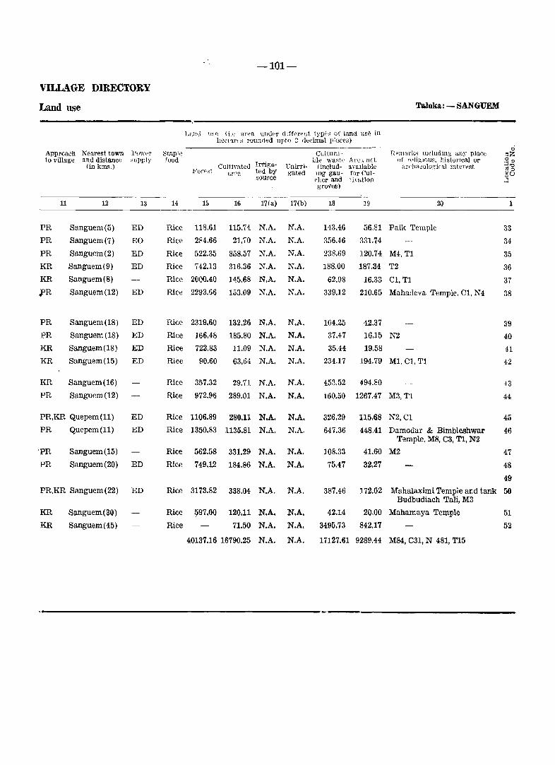
-101-
VILLAGE DIRECTORY
Land use Taluka.: - SANGUEM
L:111,1 lI~e (i." ar"a under dlff';l'"nt typ~,; of land use in llectar,'~ rounded upto ~ (kdmal place-s)
Appl'Dach Nearest town Pow"r Staple CultUl"J.- [lema r]i:s me ludin~' lilly place ci
~Z to village and distance cupply food
lrl"iga-LIe wa~t" Are.lllot of l'f>ligwus. historICal or .gll)
(ill kms.) Cultimted Unirri- (includ- avaIlable ardlaeolo.~ical il1ter~st ""''0 1)0 For">;! area ted by gated mg gau- for Cul- oU source rher and timtion ..:; groves)
11 12 13 14 15 16 17(a) 17(b) 18 19 20
PR Sanguem(5) ED Rice 118.61 115.74 N.A. N.A. 143.46 56.81 Paik Temple 33
PR Sanguem(7) EO Rice 284.66 21.70 N.A. N,A. 356.46 331.74 34
PR Sanguem(2) ED Rice 522.35 858.57 N.A. N.A. 238.69 120.74 M4,T1 35
KR Sanguem(9) ED Rice 742.13 316.36 N.A. N.A. 188.00 187.34 T2 36
KR Sanguem(8) Rice 2000.40 145.68 N.A. N.A. 62.98 16.33 Cl,T1 37
fR Sanguem(12) ED Rice 2293.66 153.09 N.A. N.A. 339.12 210.65 Mahadeva Temple, Cl, N4 38
PR Sanguem(18) ED Rice 2319.60 132.26 N.A. N.A. 104.25 42.37 39
PR Sanguem (18) ED Rice 166.48 185.80 N.A. N.A. 37.47 16.15 N2 40
KR Sanguem(18) ED Rice 722.83 11.09 N.A. N.A. 35.44 19.58 41
KR Sanguem(15) ED Rice 90.60 63.64 N.A. N.A. 234.17 194.79 MI. Cl, T1 42
KR Sanguem(16) Rice 357.32 29.71 N.A. N.A. 453.52 494.80 43
PR Sanguem(12) Rice 972.96 289.01 N.A. N.A. 160.50 1267.47 M3,T1 44
PR,KR Quepem(ll) ED Rice 1106.89 280.11 N.A. N.A. 326.29 115.68 N2,C1 45
PR Quepem(ll) ED Rice 1350.83 1135.81 N.A. N.A. 647.36 448.41 Damodar & Bimbleshwar 46 Temple, M8, C3, TI, N2
'PR Sanguem (15) Rice 562.58 331.29 N.A. N.A. 108.33 41.60 M2 47
PR Sanguem(20) ED Rice 749.12 184.86 N.A. N.A. 75.47 32.27 48
49
PR,KR Sanguem (22) ED Rice 3173.82 338.04 N.A. N.A. 387.46 172.02 Mahalaximi Temple and tank 50 Budbudiach Tali, M3
KR Sanguem( 30) Rice 597.00 120.11 N.A. N.A. 42.14 20.00 Mahamaya Temple 51
KR Sanguem(45) Rice 71.50 N.A. N.A. 3495.73 842.17 52
40137.16 16790.25 N.A. N.A. 17127.61 9289.44 M84, C31, N 481, T15

Taluka Canacona
.. . . - ~-'
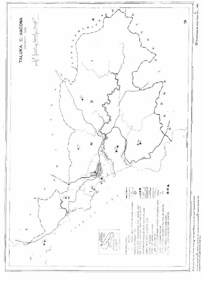
~- . . ... ---
I·~ ~--
oJ
( I , f \ \ \ \ '\ -' .
o a. " •
"',----_J-\ //
I i
o
z
. '--,
• '111 I ' I jH© • / 1_,.
I l o t ..... t:
• !- 1 x r. • I l< l o I_J
<411
I ~ ~ ~ ~ + ~
1 w C .. E c i §
@
e · · · ~
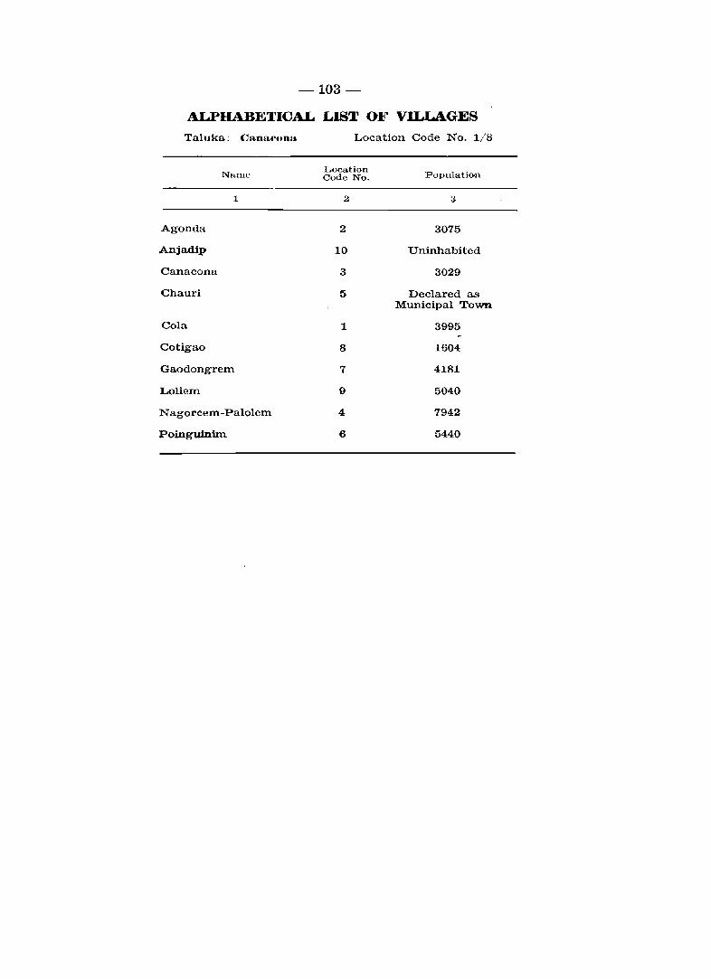
-103-
ALPHABETICAL LIST OF Vll..LAGES
Taluka: CanacQna Location Code No. 1/8
Location Populati()n Code No. NanlE'
~ .2 3
Agomla 2 3075
Anjadip 10 Uninhabited
Canacona 3 3029
Chauri 5 Declared as Municipal Town
Cola 1 3995
Cotigao 8 1604
Gaodongrem 7 4181
Loliem 9 5040
Nagorcem-Palolem 4 7942
Poinguinim 6 5440
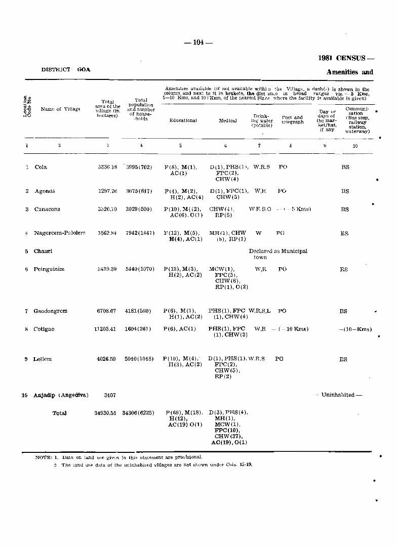
DlSTRIC'I' GOA
go Total Total :;:Z population 8] area of the Name of Villag{ Village (In undnumber
....10 hectares) of houl"e--holds
1 2 ~ 4
J Cola 333iU8 a!l95 (702)
2 Agonda 1297.26 3075(617)
" Canacona 3020.10 3029(500)
.; Nagorcem-P;l Jolem ]562.84 7942(1447)
5 Chauri
(j Poinguinim 3439.39 5440(1070)
7 Gaodongrem 6708.67 4181(580)
8 Cotigao 11205,41 1604(261)
9 Loliem 4026.59 5040(1048)
10 Anjadip (Angediva) 3407
Total 34930.51 34306 (6225)
-104-
198] CENSUS-
Amenities and
Amenilles available (if not available withi lJ 'lbe Village. a dash(-) is shown in the column and next to it in brakets, the dist an~e In broad ranges viz, - 5 KIDS, 5-10 Kms, and 10tKms, of the nearest place where the facility is available is given)
Day (Jr Communi-
Drink- days of cation Post and <Bus stoP. Educational Mooical ing water telE'graph the mar- railway (potable) ket/hat, station,
jf any waterway)
5 6 7 B 9 10
P(8), M(I), D(I), PHS (1 1, W,R.S PO BS AC(I) FPC(2),
CHW(4)
P(4), M(2), D(1), FPC(l), W,R PO BS H(2), AC(4) CHW(3)
• P(10), M( (2), CHW(4). W.RS,o -.-BKrm;) BS
AC(6),0(1) RP(5)
P(12), M(5), MH(l),CHW W FO ES H(4), AC(1) (8), RP(I)
Declared as Municipal town
P(13), M(3), MCW(I), W,R PO BS H(2), AC(2) FPC(3),
CHW(6), RP(I),0(2)
P(6), M(I), PHS(I), FPC W,R,S,L PO BS H(I), AC(2) (1), CHW(4)
P(6), AC(I) PHS(1), FPC W,R -(-10KmIl) --(1o+Kms).
P(10), M(4), H(3), AC(2)
P(69), M(18), H(12),
AC(19) 0(1)
(1), CHW(3)
D(I), PHS (1), W,R,S FPC(2), CHW(5), RP(2)
D(3), PHS(4), MH(I), MCW(I), FPC(10), CHW(37),
AC(19),0(1)
PO BS
-_ Uninhabited -
NOTE: 1. Data on land u~e giv€n in thi~ statement are provisionaL
. , The lund U8~ data of the uninhabited villages are not SllOwn under Cols. 15-19.
•
•
•
•
..
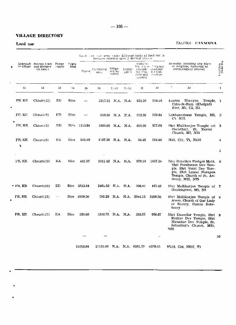
-105-
VILLAGE DIRECTORY
Land use TALlTKA· (':\!-\IACONA
•
•
•
Appr()ach Nearest to"'n to villagf' and distan~e
imkmA.l
11 12
PR KR Chauri(15)
PH.KP.. ChflllIi( 9)
PR,KR Chauri(3)
PR,KR Chauri(O)
"
PR,KR Chauri(10)
• PR,KR Chauri(10)
PR,KR Chauri(12) •
PR,KR Chauri(17)
•
..
..
P()wer ,'llpply
13
ED
ED
ED
EA
EA
ED
EA
Staple food
Lantl l,:-P \j_p aren. '_mdf:r difft'l'(:nt types of land uP,;' ~n }H"ri:.lI'PS rOlindt-d uI,to 2 dedrna.l pJ:-tCl:-·<.j)
Cllltivat0d F'OI'P~t are<l
Irrigated by S()Ur('(.l
UnirrigaU'd
CllltU"8-rIc y a· '" .' '-CCI not (indud- :tvallab]" h:~ [;''l,U- fo!' Culf'1wr and ;-i,r:lt~on
!'J l c,,"'es)
Rnnarks including any place of religious, historical or archal'ologiral interest
----... ----- .--------14 15 16 1;, a) J ~ \ iJ) 18 1!J 21)
Rice 2217.33 N,A. N.A 574.39 544.~6 Laximi Narayan Temple, Cabo-de-Ram (KhoJgad) Fort, Ml, C2, N3
Rice 548.36 N.A N.A. 372.26 :'.76.64 Lakhantshwal' Temple, M3, C1, N12 .
Rire 1113.94 1029.08 N.A. N.A. 600.00 577.08 Hhri Mallikarjun T~mple (at Shl'il,;thal), St. Xavier Church, M7, N11
Rice 246.49 1127.30 N.A. N.A. 54.45 134.60 ]\145, CII, T1, N439
RiCE 441.57 1011,42 N.A. N.A. 979.16 1007.24 Sim Sam;than Partgal Math, Shri Parshuram Dev Tem-ple. Shri Vetal Dev Tem-ple, Shri Laxmi Narayan Temple, Church of St. An-thony, M35, N79
Rice 3512.84 2461.62 N.A. N.A. 306.81 427.40 Shri Mallikarjun Temple of Gaodongrem, M5, N8
Rice 4909.50 793.20 N.A. N.A. 2944.15 2558.56 Shl'i Mallikarjun Temple of Avem, Church of Our Lady of Rosary, Games Sane-tuary
Rice 828.60 1916.75 N.A. N.A. 330.57 950.67 Shri Damodar Temple, Shri Keshav Dev Temple, Shri Nirankar Dev Temple, St. Sebastian's Church, M20,
N85
11052.94 11105.06 N.A. N.A. 6161.7!) 6576.65 MI16, C14, N637, T1
1
1
Z
3
4
::;
6
7
8
9
10

Taluka Quepem
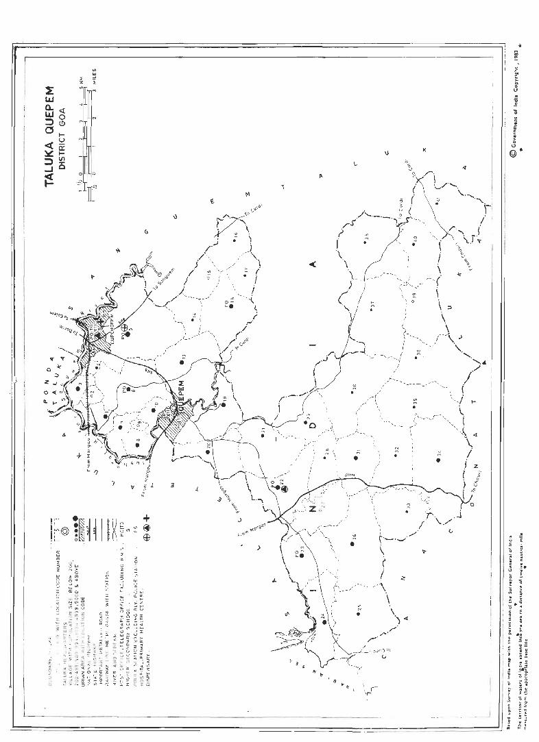
::z:
o (I.
A
! :--,
a 0
~
+ ~ 0
I')
')
1;1n:@ I" l~ ~, II ~ ~~ ' ' • L_,
. o z OJ
'" Cl
a:
"' '" :I ::J Z
UJ o u u Z G
o oW N>
o ;<'" 0" ~Oo!l alo
\0
~ a: l'J z is :::l ~
u >< w w U lL lL ~ 00 IO Cl. I «U a: <II l'J >
:I Wa: < -< 4. ", WO
~ ~ ~ ~~~ Z lL ~
<r~cr: tt .... ~ ~ ~:: a: :l. I
'V
<II a.
z o
S Vl
"' ~
\)
<>
3
+ ~ Gl
,. l'I
~
/
::: 0
'" 0-a..
J.
" /
---~,.. ....
, .-4-- ,
~./ \ '--- N
\ ~~ L.,
\,.\
>
, , /
M
ON a. .
<
,_
" , '- \ ,
~----------======~
•
\)
M M
•
: ./ t---._.-· \ (
I / \
-~.--
\
I I! ~J =======
. i
-106A-
ALPHABETICAL LIST OF VILLAGES
Tainka: - QUEPEM Location Code No. 1/9
LucatlOTI Pop<1]aticn N'lme
Locat\on POpl1lntlOn .:\'",lnlP Cod€' l\o. Cou€' No
---~--.
2 3 1 2 3 -------~---
Adnem 21 867 Molcarnem 18 1232
Ambaulim 20 2092 Molcopona 17 313
Amana 10 1015 Morpila 26 1930
Assolda 1 1389 Nagvem 14 459
Avedem 8 1537 Naquerim 25 743
Bali 2::; 2233 Odar 4 495
BarCeIYl 34 1503 Padi 32 299
Bendordem 2E 419 Pirla 37 379
Cacora >- 8033 Qu~dem 33 282 u
Cavorem 2£' 664 Quepem 11 Declared as MuniCipal Town
Cazur 4.0 318 Quisconda 36 246
Chaifi 9 73 Qaitol 2~ 1383
Cordem 31 1105 Sirvoi 13 1959
CorIa 3'" 140 Sulcorna 38 451
Cotombi 7 1080 THoi 27 76
Cusmane 12 Included in the Muni-cipal Town of Quepem. Undo rna 16 204
Deao 19 3126 Xeldem 6 4040
Fatorpa 23 1546 Xelvona 3 1163
Gocoldem 35 350 Xic-Xelvona 2 73
Maina 30 294 Zanodem 15 57
Mangal 41 264
-106B-
1981 CENSUS-DIS'.rRICT: GOA Amenities andi
Amenities available (if not available within the Village, a dash(-) is shown in the column and next to it in brackets. the distance in broad ranges viz. - 5 Kms.
Total 5-10 Krns. and lO+Kms, of the nearest place where the facility is aVailable is given) .:0 Total population $lZ area of the COilIlrnunl-"'"'dl Name of Village' village (in and number Day or cations '"'0 hectares) of house- Drink- days of " °0 -holds Post and (Bus stop, ,30 Educational Medical mg water telegraph the mar- railway
(potable) kat/hat. station. ifaIlY waterway)
1 2 3 4 5 6 7 8 II 10 •
1 Asssoida 322.36 1889(246) pel), M(l), -(-5 Kms) W -(-5 Kms) BS H(l), AC(2)
2 Xic-Xelvona 115.64 73(23) ·-(-5 Kms) -(-5 Kms) W -(5-10 Kms) BS.
3 Xelvona 214.10 1163(190) P(2), AC(2) • -(-5 Kms) W -(5-10 Kma) BS
4 Odar 80.04 495(89) P(l), AC(l) -(-5 Kms) W -(-5 Kms) BS
5 Cacora 1950.87 8033(1566) P(8), M(l). H(l), RP(3), W,T,S PO BS. • H(l) 0(1)
6 Xeldem 1008.23 4040(914) P(4), M(l) -(-5 Kms) W PO BS
7 Cotombi 310.65 1080(198) P(2) PHS(l), W,R,L -(-5Rms) BS FPC(1)
8 Avedem 223.78 1537(327) P(2), M(l), RP(2) W,R -(-5 Kms} BS H(l)
9 Chaifi 50.96 73(12) -(-5 Kms) -(-5 Kms) W -(-5 Kms) BS
10 Amona 174.93 1015(218) P(2) -(-5 Kms) W,R -(-5 Rms) BS
11 Quepem Declared as Municipal Town
12 Cusmane Included in the Municipal Town of
13 Sirvoi 1204.72 1959(389) P(4), M(ll, -(-5 Kms) W,R -(-5Rms) BS H(l)
14 Nagvem 361.26 459(103) P(l) -(-5 Kms) W -(-5 Kms) -{-5Kms}' • 15 Zanodem 367.95 57(8) -(-5 Rms) -(-5 Kms) W,S -(5-10 Rms) -(-5Rms}
16 Undorna 1;)29.70 204(35) P(l) . -(-5 Kms) W,S -(5-10 Rms) BS
17 Molcopona 228.88 313(54) P(2), M(l), AC(l)
-(-5 Kms) W,S -(-5 Rms) -(-5Kms~
18 Molcarnem 907.81 1232(226) P(4), M(2), PHS(l), W,S PO BS H(l), AC(l) FPC(1)
19 Deao 852.27 3126(612) -(-5 Kms) -(-5 Kms) W -(-5 Knls) BS
20 Ambaulim 645.84 2092(421) P(4), M(l) PHS(1), W -(-3 KmsJ BS FPC(1)
21 Adnem 969.75 867(124) P(2) -(-5 Kms) W -(-5 Kms) BS
22 Bali 935.77 2233 (407) P(3), M(l), PHC(l), W PO BS H(l), FPC(1), AC(2) 0(2)
23 Fatorpa 816.91 1546(315) P(5), M{l) PHS(l), W,R PO BS FPC(l) •
24 Quito} 740.31 1383(223) P(2), M(l) -(-5 Kms) W,R -(-5 Rms) BS
25 Naquerim 1255.76 743(141) P(4) -(5-10 Kms) W,S -(10+ Kms) 83
•

•
•
•
•
VILLAGE DIRECTORY
Land use
Approach Nearest town Power to village and distance supply
(in kms.)
11
PR
KR
PR
13
Quepem(9) EA
Curchorem (6 )
Curchorem (5) EA
PR, KR Curchorem(2) ED
• PR
PR
PR
PR
PR
PR
Curchorem (1 ) EA
Quepem(3) EA
Quepem(4) EAg
Quepem(3) EA
Quepem (1) EA
Quepem(l) EA
Quepem
PR
KR
KR
Quepem(lj EA
Sanguem(2)
Sanguem(5)
PR, KR Sanguem (5)
PR Sanguem(5)
PR Sanguem (5) EA
PR Curchorem (8) EA
PR Quepem(l) EA
PR Cuncolim (4) EA
PR Cuncolim(3) EA
Staple food
14
Rice
Rice
Rice
Rice
Rice
Rice
Rice
Rice
Rice
Rice
Rice
Rice
Rice
-106C-
Land use (i.e area under different types of land use in hectares rounded upto 2 decimal places)
CUltivate'; Irriga-Forest area ted by
source
16 17(a)
Cultura-ble waste Area not
Unirri- (lnclud- available gated ing gau- for Cul
cher and tivation groves)
17(b) 18 19
197.80 N. A. N. A. 108.30 16.26
80.90 N. A. N. A.
147.94 N.A. N.A.
30.80
14.70
1.74
3.94
51.46
17.92
Taluka: QUEPEM
Remarks including lUly place of religious, historical or
archaeological Interest
20
M9, Nll
1\14, N5
1\14, N8
1
1
2
S
4 60.38 N. A. N. A.
23.63 1101.21 N. A. N. A. 753.65 72.38 Maruti temple, Mahadev tem- 5 pIe, 1\160, C35, N320
659.24 N. A. N. A.
1.78 225.07 N. A. N. A.
184.28 N. A. N. A.
24.92 N. A. N. A.
114.92 N. A. N. A.
324.84 472.17 N. A. N. A.
73.95 171.84 N. A. N. A.
230.89 N. A. N. A.
312.50
70.58
31.02
25.08
57.39
359.10
106.19
132.02
36.49
13.22
8.48
0.96
2.62
48.61
9.28
M30, N34
1\14, N21
M15, C2, N29
Ml, N3
1\14, N12
MS, N34
T1, N3
6
7
8
9
10
II
12
13
14
15
Rice & 70.00 224.00 N. A. N. A. 223.77
5.04
11.93 1\12, N5 16 Rag!
Rice 88.02 86.10 N. A. N. A.
Rice 220.78 468.16 N. A. N. A.
Rice
Rice
Rice
Rice
462.23 N. A. N. A.
418.27 N. A. N. A.
477.72 N.A. N.A.
550.24 N. A. N. A.
44.58
195.67
369.34
209.43
468.99
353.41
10.18 N2 17
23.20 1\12, N8
20.70 Mo, N40 19
18.14 M8, N42 20
23.04 Mo, N20 21
32.12 Shri Shantadurga Devasthan, 22 M45, C2, N45
PR Cuncolim(5)ED EAg' Rice 442.24 N. A. N. A. 242.45 132.22 Temple of Shantadurga CUD- %1'
PR Cuncolim (8) EA Rice
KR Cuncolim(13 ) EA Rice
263.84 N. A. N. A. 151.73
380.73 289.33 N. A. N. A. 304.30
col carin, M9, N29
324.74 Shri Betal Devasthan. H2, 24 N7
281.40 Shri Bhumipurush Devasthan. M2, NI3
25
-106D--
1981 CENSUS-
District: - GOA Amenities and
Amenities available (if not available within the Village, a dash(-) is shown in the column and next to it in brllckets the olstanefl in broad ranges viz. - 5 KIns.
t". Total 5-10 Kms, and 10+Kms. of the nearest place where the facility is available is given) 0 0 Total ~Z area of tile population Commum-~'" Name of Village vIllage (in and number Day or -'0 cations °0 hpctares) of house- Drink- days of 1:1C,) -h'JJds Post and (Bus stop.
Educational niedical ing wateJ telegraph th~ mar- raIlway (potable) ket/hat, station, If any \'·aterway)
1 2 3 4 5 6 7 8 9 10
26 Morpila 1443.64 1930(260) P(2) PHS!!), W -(10+ Kms) BS FPC(l)
27 Tiloi 682.53 76(13) -(-5 Kms) -(-5 Kms) W -(-5Kms) -(-5Kms) •
28 Bendordem 523.81 419(61) P(l) -(-5 Kms) W,S -(-5 Kms) BS
29 Cavorem 866.83 664(111) Pill --(5-10 Kms) W, S -(5-10Kms) BS •
30 Maina 1466.26 294(54) P(2), M(l) -(5-10 Kms) W,S -(5-10 Kms) BS
31 Cordem 815.73 1105(171) P(l) -(-5 Kms) W,R -(5-10Kms) -(-5Km~)
32 Padi 1103.04 299(44) P(l) -(5-10 Kms) W -(-5 Kms) BS
33 Quedem 791.81 282(42) P(2) -(--5 Kms) W,S -(5-10Kms) -(-5Kms)
34 Barcem 1735.92 1503(164) Pi]), AC(l) PHS(l), W,S -(10+ Kms) BS FPC(l)
35 Gocoldem 1084.47 350(41) P(l) -(-5 Kms) R.S -(5 -10 Kms) _:__ (-5 Km»)
36 Quisconda 1168.48 246(33) P(l) -(-5 Kms) R,S -(10 + Kms) -(-5 Kms)
37 Pirla 1515.39 379(83) P(l), AC(l) PHS(l), W,S -(10+ Kms) BS FPC(2), 0(1)
38 Sulcorna 1142.98 451(96) P(l) -(-5 Kms) W, S -(10+ Kms) BS
39 CorIa 760.47 140(16) -(-5 Kms) -(--;-5 Kms) S -(10+ Kms) -(-5 Kms)
40 Cazur 704.29 318(55) P(l) -(5-10 Kms)W,S,TW -(10+ Kms) -(-5 Kms)
41 Mangal 1222.24 264(43) P(l) -(5-10 Kms) W,S -(10+ Kms) -(-5 Kms)
Curchorem Treated all
Total 31296.38 43832(8128) P(71), M(13), H(l), H(6), PHS(7), AC(ll) PHC(l),
FPC(9), RP(5),0(4)
Note: Data on Land use given in this statement are provisional.
•
-107-
VILLAGE nmEm'ORY
Land Use Taluka: QUEPEM
Land U::-"t' (1 e a,r("..l. under different types of land use in I'frhres "ounded npto 2 decimal plaees)
Approach Nearest town Pu\\'t'r Staple Cultura- i: t'1llarkR IIlcluding any place § 0
• Z to village and distance :-:iupply food Irriga- hIe waste Area not of rBligious, historical or :;:l .,
(inkms,) Cultivated Unirri- (includ- available ar('IJaeological mterest ~ '!:l F'UTe ..:t area ted by gated mg gau- for Cul- 0 0
f:ource cher and tIvatlon ..:l 0
groves) --~-- -~--------
11 12 13 14 15 16 17(a) 17(b) 18 19 20 1
KR Cuncolim(13) ED,EAg. Rice 986,55 N,A N A, 432.95 24.14 8hri Shantadurgadevi Tem- 26 pIe N4
.. KR Cuncollm ( 4 I ED Rice 522,67 N,A N,A 14279 17 07 M3, N20 27
PR, KR CUl1colim(5 I ED Rice 242.26 11';5,09 ~, A N.A 78 48 J7.Bb N10 :':8
.PR Quepem(12) ~D,EAg. Rice 601.45 143,,3 N, A, N.A 100.03 21.62 M2, N1 29
PR Quepem(121 DD,EAg, Rice 727.95 292,50 N.A. N,A 39i.04 47.77 Ml, N2 30
KR Cuncolim(6 ED Rice 534,47 N.A. N,A 2G3,31 17.95 N10 31
PR.KR Cuncolim (8 )ED,EAg. Rice 690.62 III ~8 N,A. N.A 272.64 28.29 N3 :::
KR Cuncolim(8) DD,EAg, Rice & 522,:H N,A. N. A. lS7.80 11.64 N9 :'13 Ragi
PR, KR Cuncolim(ll) DD.EAl','. Rice & 753.59 538.67 NA N.A :398,17 4549 N15 3~ Ragi
KR Cuncolim (12 Rice & 750,85 24942 N,A. N.A. GO,17 24.04 N·, 35 Ragi
KR Cuncolim (14 Rice & 965.21 146.14 N.A. NA 43.84 13.29 N2 36 Ragi
PR Quepem(12) ED.Eag, Rice 1080.23 158,63 N,A. N,A 241.65 34.88 N1 37
• KR Quepem(12) EA Rice 623.03 228.63 N.A. N.A. 247,99 43.33 M2, e1, T1, N1 38
KR Quepem(12) Rice & 569.23 49.75 N,A. N.A. 132.19 9.30 39 Ragi
KR Quepem(12) Rice & 505.06 70,39 N.A. N.A. 111.94 16.90 40 Ragi
KR Quepem(12) Rice 108609 62.84 N.A. N.A. 4794 25.37 41
'Census Town
9779,30 12207.02 N.A. N.A. 7726.67 1583.81 M222, C40, M778, T2
•
T aluka Salcete
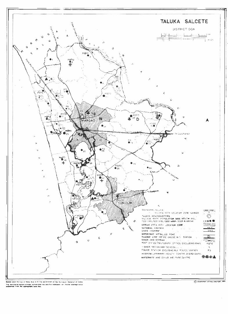
~
% " u ~ ~- f.
\) , A
...... u,>on. 5ur v.y of ~dla "op .It'" 1101. plrI,,, .. iOfl of tt.. Surveyo r a ........ t af ,,,dICl.
TM -.,,., • ....,.. _ ..... II ~ _'INII .. te tile ••• I. II ~_. or ~ w.l ..... _t..., .lI •• .,_._., r,_ ................ __ ......
o
()
T:~U~~~R,~~~~:C~T~," II q F L,~""" I II .
(
BOUNDARY.1AL UKA
VILLAGE WIT H LOCATION c eDE NUMBE R
TA LUKA HEADQUART ER S VILLAGE WITH POPUL ATIQOi 512E : BEL OW 200, 200-499.500-999, 1000- 4999 . 5000 LABOVE
URBAN AREA WITH LOCATI()IoO C()()I[
NATIONAL HI GH WAY STATE HIGHWAY
A
1 --5- -- -! - ©-- -
IMf'{)RTANT METAL LED ROAO
R,6.'LWAY L INE ME TR E G,6.UGE WIT H STAT ION ~ RIVER AND STREAM ~
POST OFFICE iTELEGRAP H OF FICE EX CL UDING R.M5 porro HI GHER SECOND ARY SCHOOL . S
POLICE STATION EXCL UDI NG RLV PO LICE STATION PS
HOSPITAL, PRIMAR Y HEALTH CE NTRE ,DISPENSARY.
,.."lERNlTv" AliO CHILO WELFARE CENT RE ~~+ •
I , I :
i j I I
I I
I
I
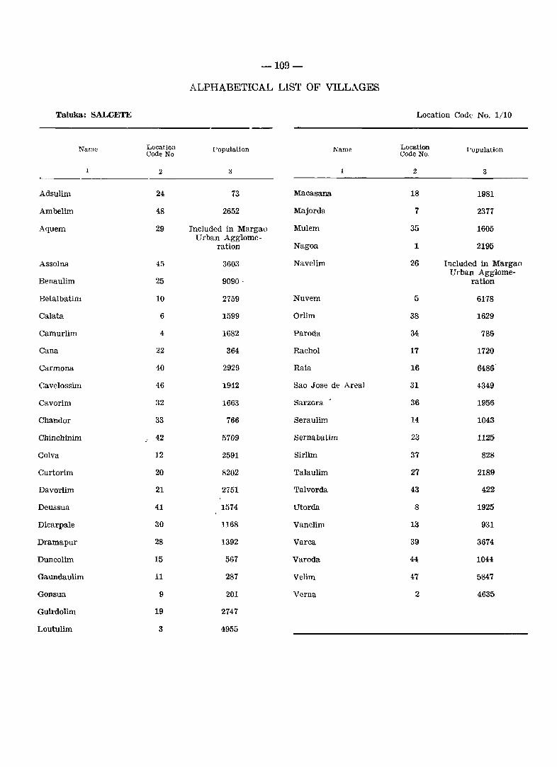
-109-
ALPHABETICAL LIST OF VILLAGES
Taluka: SALCETE Location Code No. 1/10
Name Location population Name Location Population Code No Code No·,
1 2 3 1 2 3
Adsulim 24 73 Maca sana 18 1981
Ambelim 48 2652 Majorda 7 2377
Aquem 29 Included in Margao Mulero 35 1605 Urban Agglome-
ration Nagoa 1 2195
Assolna 45 3603 Navelim 26 Included in Margao Urban Agglome-
Benaulim 25 9090· ration
Betalbatim 10 2759 Nuvem 5 6178
Calata 6 1599 Orlim 38 1629
Camurlim 4 1682 Paroda 34 786
Cana 22 364 Rachol 17 1720
Carmona 40 2929 Raia 16 6486
Cavelossim 46 1942 Sao Jose de Areal 31 4349
Cavorim 32 1663 Sarzora ,
36 1956
Chandor 33 766 Seraulim 14 1043
Chinchinim 42 5709 Sernabatim 23 1125
Colva 12 2591 Sirlim 37 828
Curtorim 20 8202 Talaulim 27 2189
Davorlim 21 2751 Talvorda 43 422
Deussua 41 1574 Utorda 8 1925
Dicarpale 30 1168 Vanelim 13 931
Dramapur 28 1392 Varca 39 3674
Duncolim 15 567 Varoda 44 1044
Gaundaulim 11 287 Velim 47 5847
Gonsua 9 201 Verna 2 4635
Guirdolim 19 2747
Loutulim 3 4955
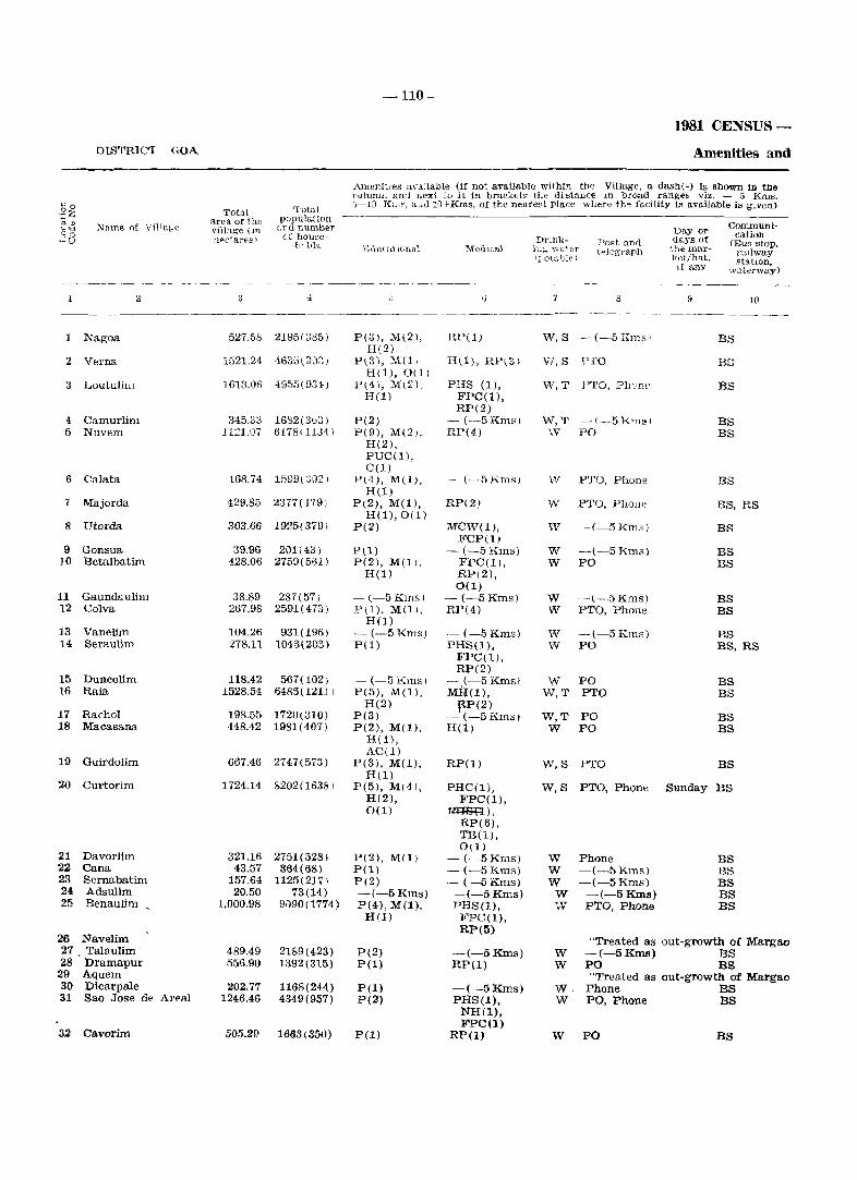
-110-
1981 CENSUS-
DISTRIC'I GOA Amenities and
AmenitIes available (if not available within the Village. a dash(-) is shown in the colunul awl next to it in bracket~ the di stance In broad ranges viz. - 5 KIllS.
f·:. 0 Tot,,[ G-IO K:.". a',d 10 f- Kms. of the nearest place where th~ facility is available is given) 3z Total
area of the population dt) Neme of Village anll number Day or Communi-"'''' village (m cation °0 of house---'U Ilpc1 ares) Drink- Po~t and days of IBus stop. -11' IrIs E(lLlr~-l'r J()TJrtl l\{edlcn.1 ir ..... "\vat81' telegraph 1 he 1n3.1"- rallway
~ 1IoLal)1E') ],et/hat. statIOn. If any ,;vaterway) - --~--~ -- _---- --__ -----
2 ;. tj 8 l) 1lI ---~--, -~----- -----
1 Nagoa 527.58 2195(385) P(3), M(2), UP(l) W, S --(-5 I,ms i BS H(2)
2 V81'na 1521.24 4635(8,)3) P\3), M(l, H(1), RP(3) W,S Fro BS H(l),O(1)
3 Loutulim 1613.05 4955(9340) P(4), M\2) PHS (1 ), W,T PTO, P11 r:'TIe BS H(l) FPC(l),
RP(2) 4 Camurlim 345,33 1682(3b;:;) P(2) - (-5 Km,,) W,T -\-5 I<m~) BS 5 Nuvem 1121.07 617S! 11J1) P(9), M(2), RP(4) W PO BS
H(2), PUC(l), C(l)
6 Calata 168,74 1599\;}02) P\4), M(l). '- (-5Rms) IN PTO, Phone BS H(l)
7 Majorda 429.85 2377(-1'791 P\2), M(l), RP(2) \V PTO, Phone BS, RS H(l),O(1)
8 Utorda 303.66 1925(379) P(2) MCW(l}, W ~-(-5 Km~) BS FCP(l)
9 Gonsua 39.96 201(43) Pel) -(-5Km~) W -(-5 Kms) BS 10 Betalbatim 428.06 2759(501) P(2), M(ll. FPC(l), W PO BS
H(l) RP(2), 0(1)
11 Gaundaulim 38.89 287(57) - (-5Kmsl - (--5 Kms) W -(-5 Kms) BS 12 Colva 267.98 2591(473) P\l). M(l), RP(4) W PTO, Phone BS
H(l) 13 Vanelim 104.26 931(196) - (-5 Krns) -(-5Kms) W -(-5Rms) BS 14 Seraulim 278.11 1043(203) P(l) PHS(l), W PO BS, RS
FPC(l), RP(2)
15 Duncolim 118.42 567(102) - (-5 Kms) -- (-5 KIDs 1 W PO BS 16 Raia 1528.54 6485(12U 1 P(5), M(l), MU(l), Vv, T PTO BS
H(2) 1i:P (2) 17 Rachol 198.55 1720\310) P(3) -(-5Kms) W,T PO BS 18 Macasana 448.42 1981(407) P(2), M(l). H(l) W PO BS
H(ll, AC(l)
19 Guirdolim 667.46 2747(573) P(3), M(l). RP(l) W,S PTO BS H(l)
~O Curto rim 1724.14 8202(16381 P(5), M(41, PHC(I), W,S PTO, Phone Sunday BS H(2), FPC(l), 0(1) tmSB),
RP(6). TB(l), 0(1)
21 Davorlim 321.16 2751(528) F(2), M(l; -(-5Kms) W Phone BS 22 Cana 43.57 364(68) pel) -(-5Kms) W -(-5 Kms) BS 23 Sernabatim 157.64 1125(2171 P(2) - (--5 Kms) W -(-5 Kms) BS 24 Adsulim 20.50 73(14) --(-5 Kms) -(-5 Kms) W -(-5Kms) BS 25 Benaulim 1.000.98 9090(1774) P(4), M(l), PHS(l), IV PTO, Phone BS
H(l) FPC(l), RP(5)
26 Navelim "Treated as out-growth of Margao 27 Talaulim 489.49 2189(423) P(2) -(-5Kms) W -(-5Kms) BS 28 Dramapur 556.90 1392(315) P(l) RP(I) W PO BS
29 Aquem "Treated as out-growth of Margao 30 Dicarpale 202.77 1168(244) P(l) -(-5 Kms) W, Phone BS 31 Sao Jose de Areal 1246,46 4349(957) P(2) PHS(l), W PO, Phone BS
NH(l), FPC(l)
32 Cavorim 505.2f> 1663(350) P(l) RP(l) W PO BS
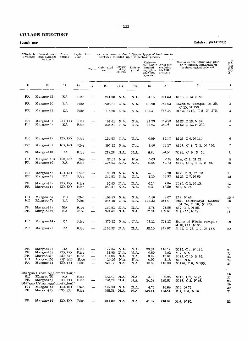
-111-
VILLAGE DIREOTORY
Land use Taluka: SALCETE
Approach Nearest town Power Staple Lanu use (1 e area under different types of land use in 10 village and distance supply food hect3res rounded upto 2 decimal places)
iinkms.) 0 Cultura- Hemarks including any place oZ
Irriga- ble waste Area not of religious. historIcal or ~~ Cultivated UnirrI- (mclud- avaIlable archaeological interest 010 Foreflt area ted by gated ing gau- for CUl- go ,Source cher and LhTatlon ~ groves)
-- ---- - - ---- -11 12 1;) 1J, 15 16 171a) Hill) 18 IU 20 1
PR Margao(12) EA Rice 241.90 N.A. N.A. 24.16 261.52 M 13, C 13, N 83. 1
PR Mal'gao(10) EA Rice 706.81 N.A. N.A. 69.,80 714.63 Mahalsa Temple, M 25, 2 C 15, N 159.
PR Margao(12) EA Rice 716.65 N.A. N,A. 153.37 743.04 M.3, CI9, T2 N 275. :1
PR Margao(S) ED,EO Rice 187.61 N,A. N.A. 37.79 119.&3 M22, C 13, N 39. 4 PR Margao(41 EA Rice 838.57 N.A. N,A. 33.83 248.67 M 62. C 13, N 230.
PR Margao(7) ED,EO Rice 153.53 N.A. N.A. 0.09 15.12 M 26, C 6, N 140. 6
PR Margao(Sl ED, EO Rice 395.22 N.A. N.A. 1.46 33,17 M28, C 8, T 2, N 150. 7
PR Margao(IO) EA Rice 278,29 N.A. N.A. 0.83 24.54 M26, C 9, N 50. 8
PR Mal'gao(10) ED, EO Rice 37.09 N.A. N.A. 0.09 2.78 M4, C 1, N 21. 9 PR Mar'gao(10) EA Rice 396.63 N.A. N.A. 0.68 30.7il M 12, C 6, T 1, N 65. 10
PR Margao(5J ED, EO Rice 36.19 N.A. N.A. 2.70 M7, C 3, N 12, 11 PR Margao(6) EA Rice 242.91 N.A. N.A. 1.15 23.92 M 25, C 7, N 65. 12
PR Margao(3) ED,EO Rice 95.05 N.A. N.A. 0.17 9.04 M 10, C 3, N 15. 13 PR Margao(4j l<JD,EO Rice 259,21 N.A. N,A. 0.31 18.59 M6, N 75. 14
PR Margao(5) ED Rice 108.89 N.A. N,A. 0.46 9.07 M4, N 40. 15 " PR Margao(7) EA Rice 845,25 N.A. N.A. 122.22 661.07 Shri Dattatraya Mandir, 16
M 24, C 10, N 225. PR Margao(9) EA Rice 160.91 N.A. N.A. 2.78 34.86 M 7, C 1, N 25. 17 PR Margao(14) EA Rice 321.40 N.A. N.A. 17.34 109.68 M 7, C 1, N 27. 18
PR Margao(14) EA Rice 376.22 N.A. , N.A. 53.11 238.13 Ruins of Hindu Temple: 19 M 15, C 1, N 95 ..
PR Margao(9l EA Rice 1196.88 N.A. N.A. 85.19 H·207 M 55, C 26, T I, N 187. 2<>
PR Margao(3) EA Rice 177.64 N.A. N,A. 33.34 110.18 M 15, C 1, N 115. 21 PR Margao(5) ED,EO Rice 37.95 N.A. N.A. 0.60 5.02 M7, N 5. 22 PR Margao\5) ED,EO Rice 137.98 N.A. N.A. 3.02 15.64 M 17, C 10, N 26 .. 2:1 PR Margao(5) ED,EO Rice 19.25· N.A. N.A. 0.07 1.18 M3, N5. 24 PR Margao(4) ED,EO Rice 876.17 N.A. N.A. 10.89 113.92 M 190, C 9, N 195. 2!)
\ Margao Urban Agglomeration)" 26 KR Margao(5) EA Rice 385.41 N.A. N.A. 4.10 99.98 M 10, C 2, N 95. 27 PR Margao(5) ED,EO Rice 396.78 N.A. N.A. 34.52 125.60 M16, C2, N16. 28
(Margao Urban Agglomeration)" 29 PR Margao(4) ED,EO Rice 127.98 N.A. N.A. 4.70 70.09 M5, N72. 30 PR Margao(8) ED,EO Rice 695.51 N.A. N.A. 138.11 412.84 M4, C3, N25. 31
PR Margao(14) ED,EO Rice 247.00 N.A. N.A. 41.62 216.67 M4, N80. 82
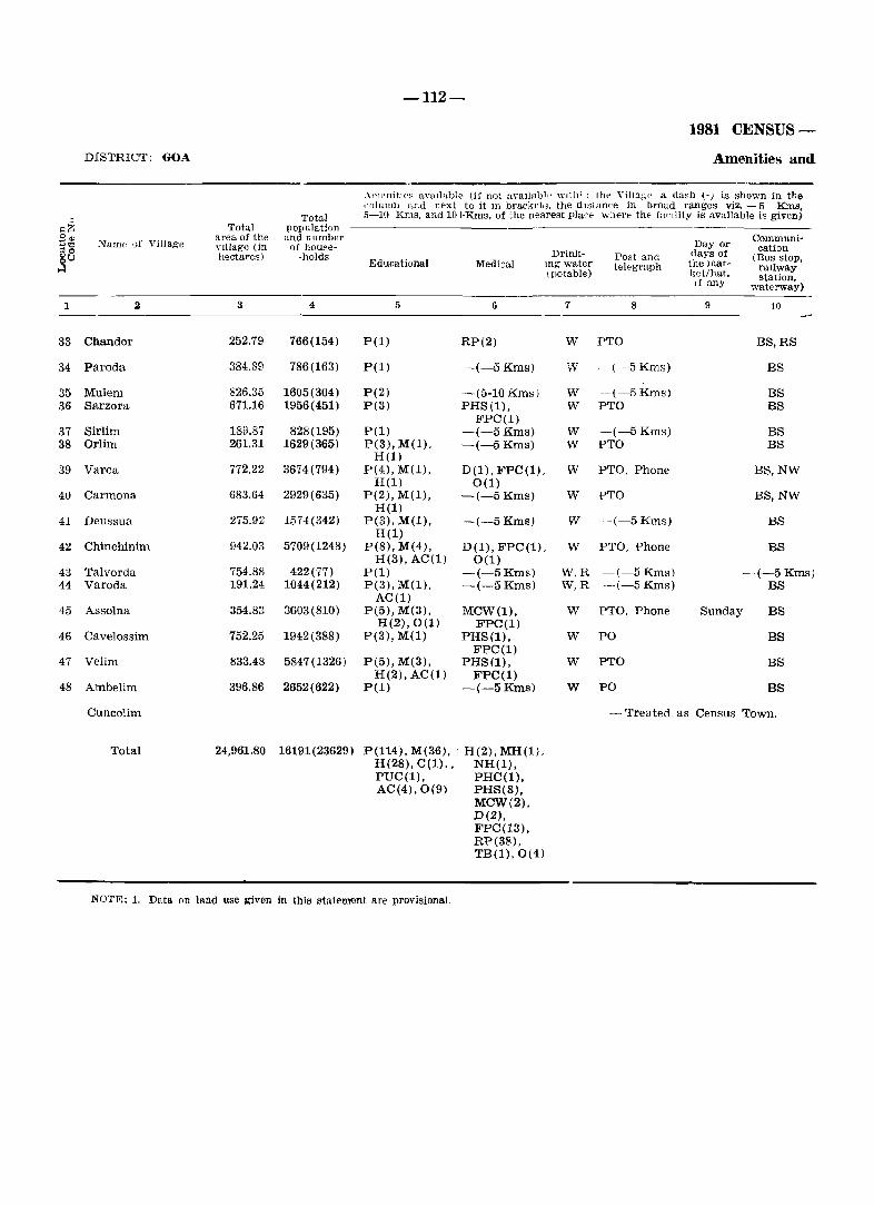
-112-
1981 CENSUS-
DISTRICT: GOA Amenities and
.11licnitIe" aVaIlable (if not available 'nth'~l the VilHl,~(' a clash (-) is shown in the ,'olullln and r.ext to it In bracketl~, the dl"tance in broad ranges viz, - 5 Kms,
Total 5-10 Kms, and 10+Kms, of the nearest place where the facIlity is available is given) .:ii< Total population _S'" Name of Village
area of the ancl number Day or Communi-
... "" nllage (in of house- cation '"0 Drinl<- (lays of .§U hectares) -holds Post ancl (Bus stop, Educational Medical Ing water telegraph the mar- raIlway (potable) ket/hat, station, If any waterway)
1 2 3 4 5 G 7 8 9 10
33 Chandor 252,79 766(154) P(l) RP(2) W PTO BS,RS
34 Paroda 384.89 786(163) P(l) ~(-5Kms) W ~(-5Kms) BS
35 Mulem 826.35 1605(304) P(2) ~(5-10 Kms) W -~(-5Kms) BS 36 Sarzora 671.16 1956(451) P(3) PHS(l), w PTO BS
FPC(l) 37 Sirlim 189.87 828(195) P(l) -(-5 Kms) W -(-5 Kms) BS 38 Orlim 261.31 1629(365) P(3), M(l), -(-5 Kms) W PTO BS
H(l) 39 Varca 772.22 3674(794) P(4), M(l), D(l), FPC(!), W PTO, Phone BS,NW
H(l) 0(1) 40 Carmona 683.64 2929(635) P(2), M(l), -(-5 Kms) W PTO BS,NW
H(l) 41 Deussua 275.92 1574 (342) peS), M(l), -(-5 Kms) \IV -(-5 Kms) BS
H(l) 42 Chinchinim 942.03 5709(1248) P(8), M(4), D(l), FPC(!). W PTO, Phone BS
H(3), AC(l) 0(1) 43 Talvorda 754.88 422(77) P(l) -(-5Kms) W,R -(-5 Kms) -(-5 Kms) 44 Varoda 191.24 1044(212) P(3), M(l). -(-5 Kms) W,R ~(-5Kms) BS
AC(l) 45 Assolna 354.83 3603(810) P(5), M(3), MCW(l), W PTO. Phone Sunday BS
H(2),0(1) FPC(l) 46 Cavelossim 752.25 1942(388) P(3), M(l) PHS(l), W PO BS
FPC(l) 47 Velim 833.48 5847(1326) P(5), M(3), PHS(I), W PTO BS
H(2), AC(l) FPC(I) 48 Ambelim 396.86 2652(622) P(l) -(-5 Kms) W PO BS
Cuncolim - Treated as Census Town.
Total 24,961.80 16191(23629) P(114). M(36), ' H(2). MH(l). R(28), C(l)" NH(l), PUC(l), PRC(l), AC(4),O(9) PHS(8),
MCW(2). D(2), FPC(13). RP(38), TB(1),0(4)
NOTE: 1. Data on land use given in this statemf,lnt are provisional.
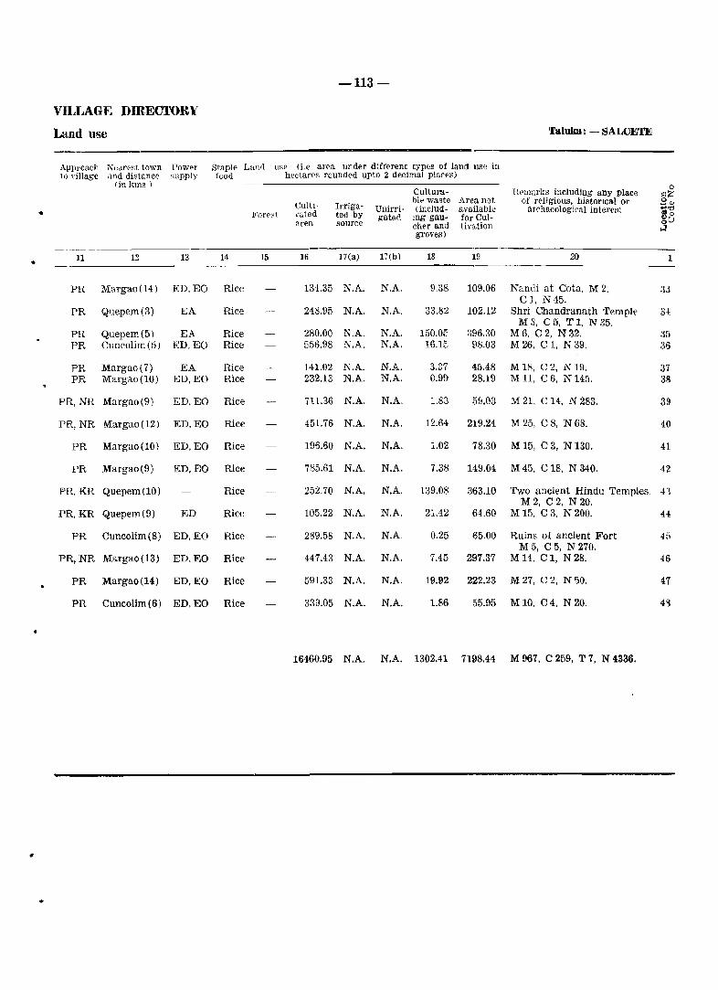
-113-
VILLAGE DIRECTORY
Land use 'I'aluka: - SAWETE
Approach NeJre~t town Power Staple Laml u~P (i.e area under different types of land use in to ,"illage and distance ~Upply f(Jod hectares rounded upto 2 decimal places)
(in kms ) 0 Cultura- Hpm~ll'J;s including any place .:?; CultJ- Irriga-
bit-' wa~te Area not of religious, histOflcal Of .9", Unirri- (includ- available archaeological interellt +''tj • Fore::t vated ted by 8 0
area source gated lIlg gau- for Cul- oU chef and th'ation ~ grove,s)
• 11 12 13 14 15 16 17(a) 17(b) 18 19 20 1
PR Margao(14) ED,EO Rice 134.35 N.A. N.A. 9.38 109.06 Nandi at Cota, M2. 33 Cl, N 45.
PR Quepem(3) EA Rice 248.95 N.A. N.A, 33.82 102.12 Shri Chandranath 'rempl~ 3{
M 3, C 5, T 1, N 35. PR Quepem(5) EA Rice 280.00 N.A. N.A. 150.05 396.30 M6, C2, N32. :35 PR Cuncolim (5 ) ED,EO Rice 556.98 N.A. N.A. 16.1E 98.03 M 26, C 1. N 39. 36
PR Margao(7) EA Rice 141.02 N.A. N.A. 3.37 45.48 M18, C2, N19. 37 PR Margao(10) ED,EO Rice 232.13 N.A. N.A. 0.99 28.19 M 11. C 6. N 145. 38
PR,NR Margao(9) ED,EO Rice 711.36 N.A. N.A. 1.83 59.03 M 21, C 14, N 283. 31}
PR,NR Margao(12) ED,EO Rice 451.76 N.A. N.A. 12.64 219.24 M 25. C 8, N 68. 40
PR Margao(10) ED,EO Rice 196.60 N.A. N.A. 1.02 78.30 M 15, C 3, N 130. 41
PR Margao(9) ED,EO Rice 785.61 N.A. N.A. 7.38 149.04 M 45, C 18, N 340. 42
PRo KR Quepem(10) Rice 252.70 N.A. N.A. 139.08 363.10 Two ancient Hindu Templ-es. 43 M2, C2, N20.
PR.KR Quepem(9) ED Rice 105.22 N.A. N.A. 21.42 64.60 M 15, C 3, N 200. H
PR Cuncolim (8) ED,EO Rice 289.58 N.A. N.A. 0.25 65.00 Ruins of ancient Fort 45 M 5, C 5, N 270.
PR,NR Margao(13) ED. EO Rice 447.43 N.A. N.A. 7.45 297.37 MH. Cl, N28. 46
PR Margao(14) ED,EO Rice 591.33 N.A. N.A. 19.92 222.23 M27, C2, N50. 47
PR Cuncolim(6) ED,EO Rice 339.05 N.A. N.A. 1.86 55.95 MI0, C4, N20. H
16460.95 N,A, N.A. 1302.41 7198.44 M 967, C 259, T 7, N 4336,
Taluka Mormugao
- ZiI t 7f@?:.-nA - -t --.. .'!
I
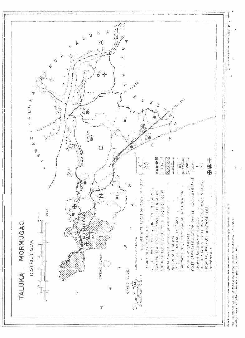
! I i ,
I I
i
I I
I , I , I
I i I ,
I
I
! I
I I i I I
\ I I
I I I
I
0 , <{ I I C> I :;:)
I ~ «
0 ex: 0 0 l-
I ~ u a: I-tJ)
~ 0
:::> ..J
~
<fl UJ
~ _J
:.: 2:
~~" I N
M
Q-.~
o z « ...J
'Ll Q Z « CI: (.')
<{
>CI: <t o Z ::J o m
CI: ill m :r ::J z ill a 0 u z 0 I« u o ...J
o lJJ W o > 0 N 0 0 !> m u o <J:. ~_ _; oil 0
0 <i.
. 0 a:
z 0 i= <t f-lfl
I f-
!> W .9 ::J <>: (.')
J
0
~ '0 "0 ~ • • > c .. • 1 <;:; L .... 0 c ~ t • u
" C II) .;> · 1 'ii
0 ~ .... ! 0 £
c: 0 : o • 0 : ".:1
'E 1 • L. - a ~ i. ·c
c .. • ,_ 0
£ ~ ~ E ~ " ~ .. · "" 0. 0 ~
o ~ E E .£ e .2' ~ ... _ u 0 C 1> - .. ~ ! ~ " 0 g ~ J E , II)
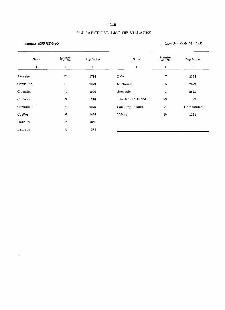
--115-
ALPHABETICAL LIST OF VILLAGES
Taluka: MORMUGAO Location Code No. 1/11
Location PopulatiOlI Name
Location Population Coue No Code No Nam~
1 2 3 1 2 II
Arossim 12 1784 Pale 7 1328
Cansaulim 11 1979 Quelossim 5 2029
.chicaUm 1 4936 Sancoale 3 5821
Chicolna 9 210 Sao Jacinto Island 13 89
Cortalim 4 6025 Sao Jorge Island 14 Uninhabited
.cuelim 6 1414 Velsao 10 1271
Dabolim 2 1688
Issorcim 8 283
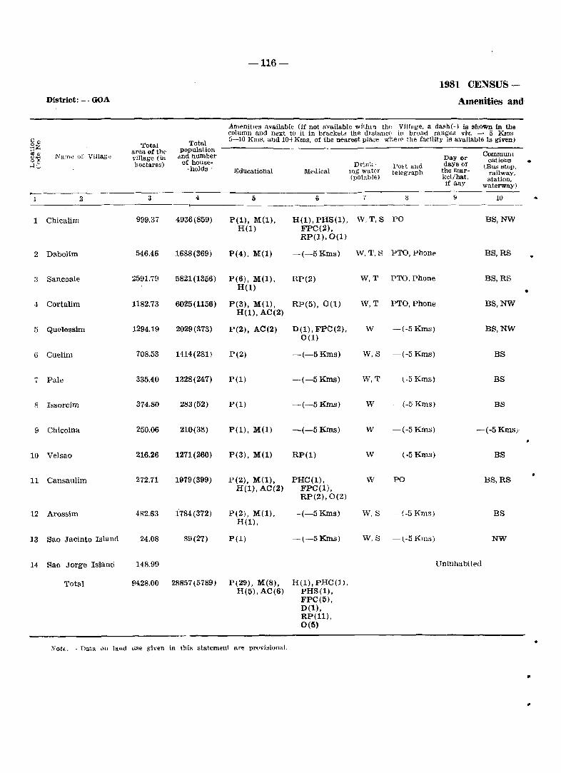
-116-
1981 CENSUS-
District: - GOA Amenities and
Amenities available (if not available withIn the Village, a dash(-) is shown in the column and next to it in brackets the dlstance in broad ranges viz. - 5 KIns
~ Total 5-10 Kms, and 10-+ Kms, of the nearest place wherE' the facility is available is given) oC Total :;Z area of the populatioll
cl", Name of ViIlag" d.ndnumber Communl-o"=' village (in Day or °c hectares) of house- Drink- days of cations .. HG -holds' Post and (Bus stop.
Educational Medical lllg water telegraph the mar- railway. (potable) ket/hat, station,
if any waterway)
2 3 4 I) 6 7 ~ \) 10
1 Chicalim 999,37 4936(859) P(l), M(l), H(l), pHS(l), W,T,S PO as,NW H(l) FPC(2),
RP(1).0(1)
2 Dabolim 546.46 1688(369) P(4), M(l) -(-5 Kms) W,T,S PTO, Phone BS,RS •
3 Sancoale 2591.79 5821(1356) P(6), M(l), RP(2) W,T PTO, Phone as,RS H(l) •
4 Cortalim 1182.73 6025(1156) P(3), M(l), RP(5), 0(1) W,T PTO, Phone BS,NW H(l), AC(2)
5 Quelossim 1294.19 2029(373) P(2), AC(2) D(l), FPC(2), w -(-5 Kms) BS,NW 0(1)
6 Cutlim 708,53 1414(281) P(2) -(-5 Kms) W,S -(-5 Kms) BS
7 Pale 335,40 1328(247) pel) -(-5 Kms) W,T -l-5 Kms} BS
8 Issorcim 374.80 283(52) P(l) -(-5 Kms) W -(-5 Kms) as
9 Chicolna 250.06 210(38) P(l), M(l) -(-5Kms) W -(-5 Kms) -(-5 Kms)'
10 Velsao 216.26 1271(260) P(3), M(l) RP(l) w -(-5 Kms) BS
11 Cansaulim 272.71 1979(399) P(2), M(l), PHC(l), w PO BS,RS H(l), AC(2) FPC(l),
RP(2),0(2)
12 Arossim 482.63 1784(372) P(2), M(l). -(-5 Kms) W.S -(-5 Kms) BS H(l),
13 Sao Jacinto Island 24.08 89(27) P(l) -(-5 Kms) W,S -(-5 Kms) NW
14 Sao Jorge Island 148.99 Uninhabited
Total 9428.00 28857(5789) P(29), M(8), H(l), PHC(l), H(5), AC(6) PHS(l),
FPC(5), D(l), RP(ll), 0(5)
• :Vote. - Data 011 land use given in thi~ statement are provisional.
•
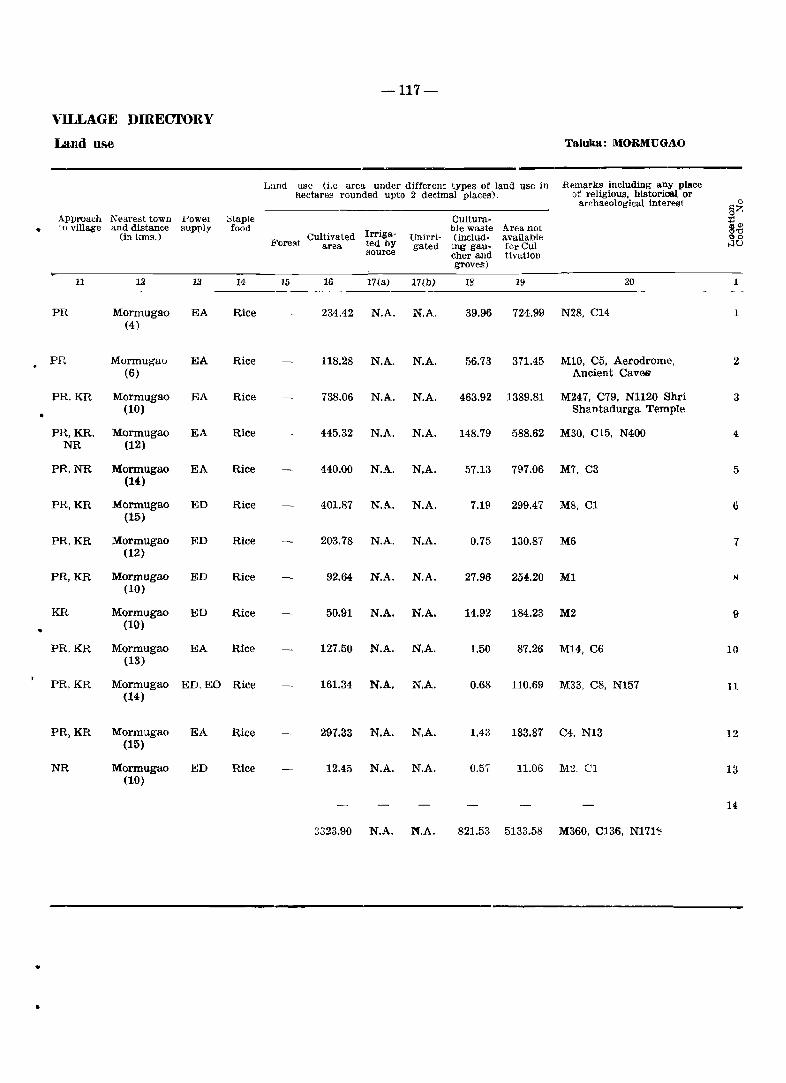
-117-
VILLAGE DffiECTORY
Land use Taluka: MORMUGAO
Land use (i.e area under different types of land use in Remarks including any place hectares rounded upto 3 decimal places). of religious. historical or
archaeological interest 0
Approach l\'earest town ::>taple Cultura-§I':
POWeI :::l • to village and distance supply food Irriga- hIe wa.ste Area not §~ (in ICIDs.) Cultivated Unirri- (includ- available
Fore~t area ted by gated ing gaU- fOr Cul- t-lu source cher and tivation
groves)
11 12 13 14 15 16 17(a) 17(b) 18 19 20 1
PR Mormugao EA Rice 234.42 N.A. N.A. 39.96 724.99 N28. C14 1 (4)
PR Mormugao EA Rice l1S.28 N.A. N.A. 56.73 371.45 M10. C5, Aerodrome. 2 (6) Ancient Caves
PR.KR Mormugao EA Rice 738.06 N.A. N.A. 463.92 1389.S1 M247, C79, N1120 Shri 3 (10) Shantadurga Temple
PR,KR, Mormugao EA Rice 445.32 N.A. N.A. 14S.79 588.62 M30, C15, N400 4 NR (12)
PR,NR Mormugao EA Rice 440.00 N.A. N.A. 57.13 797.06 M7, C3 5 (14)
PR,KR Mormugao ED Rice 401.87 N.A. N.A. 7.19 299.47 MS, Cl 6 (15)
PR,KR Mormugao ED Rice 203.78 N.A. N.A. 0.75 130.87 M6 7 (12)
PR,KR Mormugao ED Rice 92.64 N.A. N.A. 27.96 254.20 Ml x (10)
KR Mormugao ED Rice 50.91 N.A. N.A. 14.92 184.23 M2 9
- (10)
PR,KR Mormugao EA Rice 127.50 N.A. N.A. 1.50 87.26 M14, C6 10 (13)
PR,KR Mormugao ED. EO Rice 161.34 N.A. N.A. 0.68 110.69 M33, C8, N157 11 (14)
PR,KR Mormugao EA Rice 291.33 N.A. N.A. 1.43 183.81 C4, N13 12 (15)
NR Mormugao ED Rice 12.45 N.A. N.A. 0.57 11.06 M2, Cl 13 (10)
14
3323.90 N.A. M.A. 821.53 5133.58 M360, C136, N171~
..
•
DISTRICT DAMAN
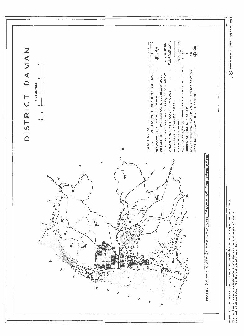
rr==::::::===::::::======::::::===::::::========::::~-- ... -. '-:;'_-._-. _:::::=:::====::;;-J r--------------------------.- ... -------~--.
z « ~ « o
..... U
o
'"
..
o
1
«
s /' ..... ,.. .. \
". , : -
(
/
o 0.'" •
J.
IT, I I I I
:II@
11.,1 ~ II~
i'll~ I I LJ
L-_______________________________________________________________________ ~
IIJ :I c( Z
.~ ~ :::> ..J
~ IIJ Z o
~ z o I/) c(
I ~ ,0: i!! I/)
(5
Z « ~ « o
w Io Z
~ .. .c
'" i ... o U
~ f .. o .. c: • • :: : o
" e
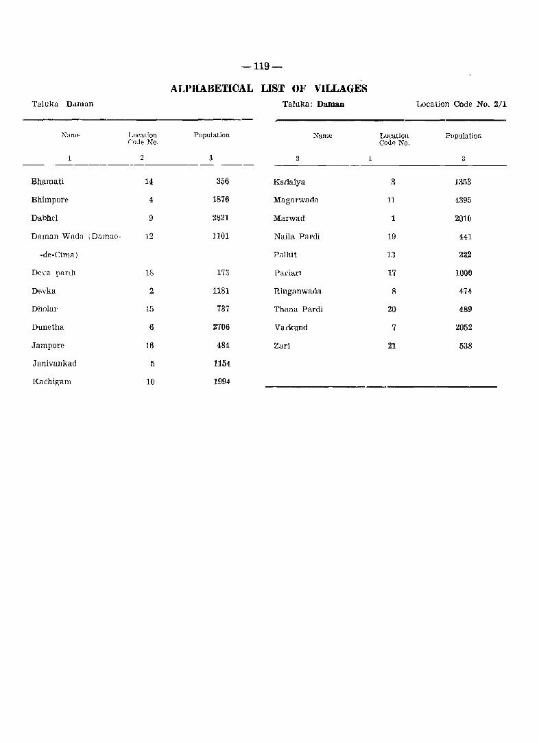
-119-
ALPHABETICAL LIST O}' VILLAGES Taluka Daman Taluka: Daman Location Code No. 2/1
Loeation Population Name Location Population Code No. CodA No.
Namp
1 :3 3 2 1 3
Bhamati 14 356 Kadaiya 3 1353
Bhimpore 4 1876 Magarwada 11 4395
Dabhel 9 2821 Marwad 1 2010
Daman Wada IDamao- 12 1101 Naila Pardi 19 441
-de-Cima) Pal hit 13 222
Deva parch 18 173 Parian 17 1000
Devka 2 1181 Ringanwada 8 474
Dholar 15 737 Thana Pardi 20 489
Dunetha 6 2706 Vatkund 7 2052
Jampore 16 484 Zari 21 538
.J anivankad 5 1154
Kachigam 10 1994
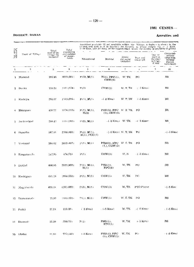
-120-
1981 CENSUS-
DISTRICT: DAMAl\' Amenities and
----------------------------------~------------------, ~
"a me of \'iila"",
1 2
1 Marwad
2 Devka
.3 Kadaiya
4 Bhimport>
6 Dunetha
i VClrkund
8 Rmganwada
fI Dabhel
10 Kachigam
12 Damanwa(l;>
13 Palhit
14 Bhamati
15 Dholal
Total area of tll~ ,"illage (in hectare'? I
3
297.85
138.28
293.07
426.77
,')67.38
264.62
147.9.5
606.05
641.:38
659.18
71.99
27.24
52.59
Sl.611
Total pU1-1ulu.twn
and number of house
-holds
4
2010(301)
1181(174)
1353(2191
lS76(3l31
1 L.34(181 I
2706(4631
2052(417)
474(75)
2821(493)
1994(333)
4395(6531
1101(1911
222(381
356 (7il 1
737(140)
Awt'nilies a\ dlj,lble (if not available within ti,,. Villagt·. n dash(-) is shoWJJ in the ~\._)ll1nln and 118Xt tu}t in bra('j.;:~L._; the du:;tanct" ill lJroad ranges n..::. - J Kms . . J~JO Kms, and 11)~ Kms. Of the nearest place wilt·],,, the facility is available is given)
Educational
5
P(2)',M(l)
P(2)
P(U, M(l)
P(l),M(ll, H(l)
P(2),M(l)
P(3),M(l), H(ll. PUC (1)
P(1I,M(ll
P(1)
P(1), M(l), H(l)
P(l), M(1)
P(3), M(ll
P(l), M(11
-(-5Kms)
P(11
\-5 Kmsl
MedIcal Drtnk
lng' water ( potable)
Po;;t and teit'g'l':tph
Day OJ' days 01
the Illarket/hat, if any
COlnmuni· cations
(Bus stop, railway station,
watt'rway)
6 7 S II 10 -------------------------
H(l), FPC(l). W, TK PO CHW(l)
CHW(l) W, T, TK -( -5 Kms)
-(-5Kmsl W,T,TK -/-5Kmsl
PHS(l), FPC v\'. T. TK PO (1), CHW(41
-(-5 Kms 1 W, TK -( 5 Kms)
-(-5Kms) "V. T, TK PO
PHS(l), FPC W. T, TK PO (1,), CHW(3)
CHW(l) W, N - (-5 Kms I
PHS(l). W. TK PO FPC(l)
CHW(l) IV. TK PO
CHW(3) W, TK PTO.Phone
CHW(l) W.T,TK PO
- (-5 Kms) W. TK --(-5 Kms!
PHS(l), W,TK (-5Kms) FPC(l)
PHS(1), FPC \V, TK PO (1), CHW(11
BS
BS
BS
BS
BS
-( -5 Kms)
BS
BS
BS
BS
--(-5 Km;
BS
-(-5 Kms)
BS
-(-5 Kmsl
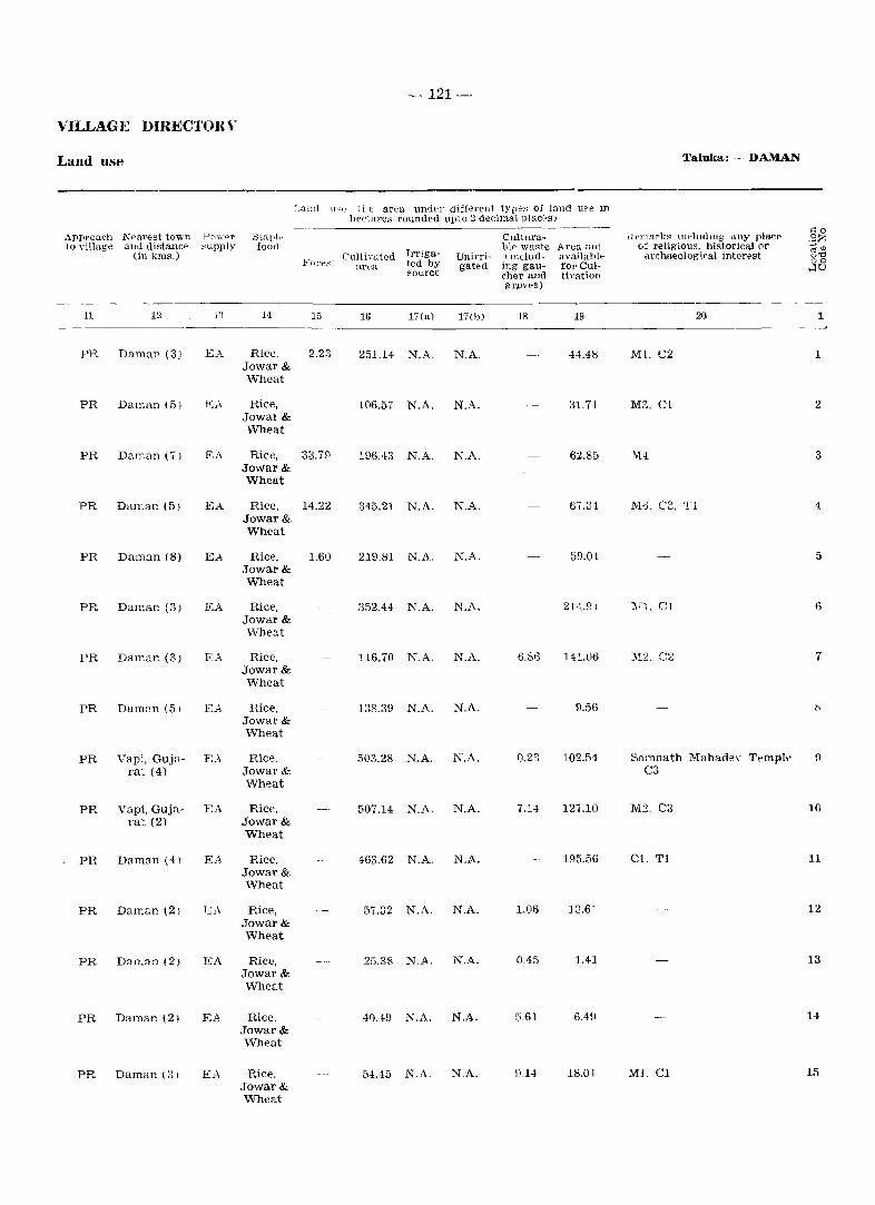
-- 121-
VILLAGE DIRECTOUY
Land use 1.'aluka: -- DMIAN
[_,unrl ll'-:e (i e area und~r different typeR of land u~e m hectares rounded uplo 2 decimal places)
---- >::0 APProach Nparest town Pnwf"t< StapL· Cultura- i~t'111nrks l1wludl1.tg any placp .2Z to village and distancp "upply food blp waste Are::. not of religiOUS, bistorical or ~~ (in kms.) Cultinlled Irriga- Unirri- ( ll1clud- available archaeological interest
Fon"-'0t ted by gated jng gau- for Cul-00
[tr€a ...:lU source eher and th'ation gr.oves)
----_ 11 12 18 14 15 16 17(a) 17(b) 18 19 20 1
PR Daman (3_) EA Rice. 2.23 251.14 N.A. N.A. 44.48 MI. C2 1 Jowar& Wheat
PR Daman (51 EA Rice, 106.57 N.A. N.A. 31.71 M3. C1 2 Jowa1' & Wheat
PR Daman (71 EA Rice, 33.7\1 196.'13 N.A. N.A. 62.85 M4 3 Jowar& Wheat
PR Daman (5) EA Rice, 14.22 345.21 N.A. N.A. 67.31 Mo. C3. Tl 4 Jowar& Wheat
PR Daman (8) EA Rice, 1.60 219.81 N.A. N.A. 59.01 5 Jowar& Wheat
PR Daman (3) EA Rice, 352.44 N.A. N.A. 21-±.9-1 l\Il. C1 6 Jowal' & Wheat
PR Daman (3) EA Rice, 116.70 N.A. N.A. 6.86 1n.06 1\12. C2 7 Jowa1' & Wheat
PR Daman (5) EA Rice, 138.39 N.A. N.A. 9.56 ~
Jowal' & Wheat
PR Vapi, Guju- EA Rice. 503.28 N.A. N.A. 0.23 102.54 Somnath Mahadev Temple !l rat (4) Jowa1' & C3
Wheat
PR Vapi, Guja- EA Rice, 507.14 N.A. N.A. 7.14 127.10 M') -. C3 10 rat (2) Jowal'&
Wheat
PR Daman (4) K" Rice, 463.62 N.A. N.A. 195.56 C1. Tl 11 Jowa1' & Wheat
PR Daman (2) EA Rice, 57.32 N.A. N.A. 1.06 ]3.61 12 Jowa1' & Wheat
PR Daman (2) EA Rice, 25.38 N.A. N.A. 0.45 ],41 13 Jowa1' & Wheat
PR Daman (2) EA Rice. 40.19 N.A. N.A. 5.61 6.49 H Jowar& Wheat
PR Daman (31 K~ Rice, 51.45 N.A. N.A. 9.14 18.01 M1. Cl 15 Jowar& Wheat
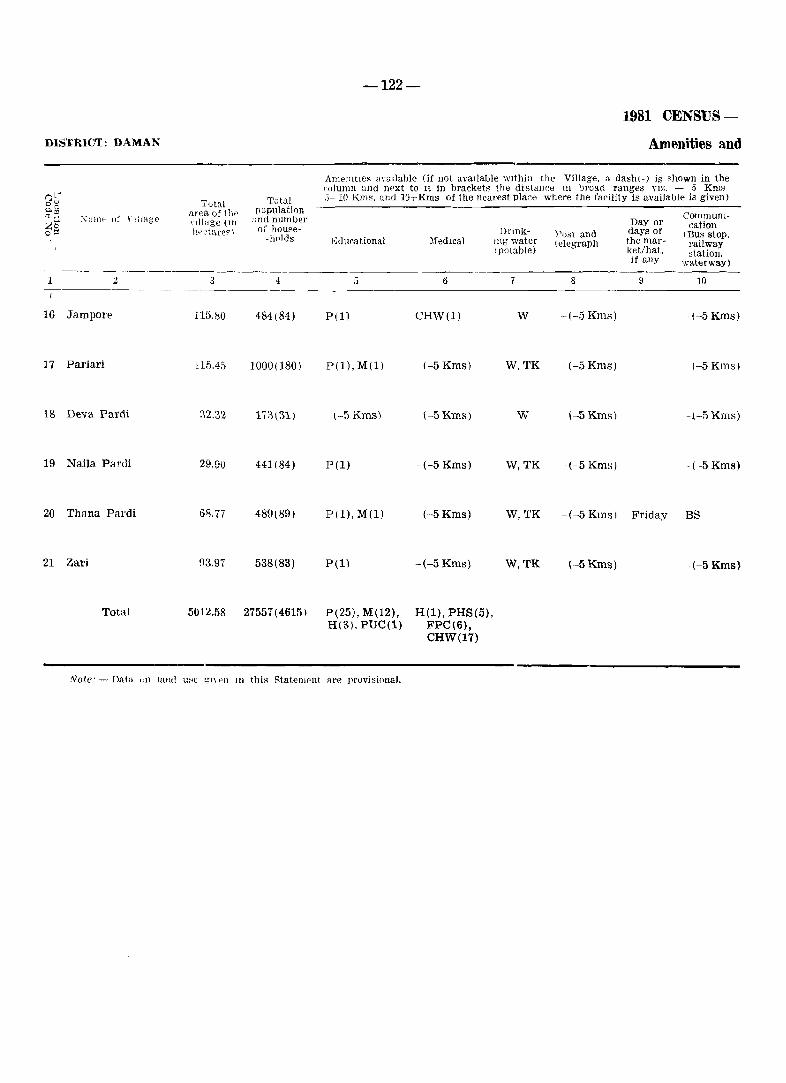
DIS'IinCT: DAMAN
1 2
16 Jampore
17 Pariari
18 Deva Pardi
19 Naila Pardi
20 Thana Pardi
21 Zari
Total
Total area of th" nlltlge (111 tV .. 'C't(H'€f' \
3
115.80
IHi,45
:)2.32
29,90
68.77
93.97
5012.58
Totul population '~nd number or house
-holds
4
484(84)
1000(180)
441(84)
489(89)
538(83)
27557(4615)
-122-
1981 CENSUS-
Amenities and
ArneDltlCR 'lY<lllable (if not available within the Village, a dash(-) is shown in the <'olu111ll nnd l}Pxt to Ii in bracket~ the distance III ]Jroad ranges YlYo. - 5 Kn18 3-10 KillS, and 10+Kms of the nearest place where the facility is available is given)
Educational l\1edlcal
5 6
P(1) CHW(l)
P(ll,M(l) (-5 Kms)
\-5 Kms) (-5 Kms)
P(l) - (-5 Kms)
P(l), M(l) -(-5 Kms)
P(l) -(-5 Kms)
P(25), M(l2), H(1), PHS(5), H(3). PUC(1) FPC(6),
CHW(17)
Dnnklug water (potable)
7
W
W.TK
w
W,TK
W,TK
W,TK
Post and telegraph
8
-(-5 Kms)
-(-5 Kms)
\-5 Kms)
-(--5 Kms)
-(-5 Kms)
-(-5 Kms)
Day or days of the market/hat. if any
9
Friday
CommUnIcation
(Bus stop, railway station,
waterway)
10
(-5 Kms)
(-5 Kms)
-~-5 Kms)
(-5 Kms)
BS
-(-5 Kms}
Note' - DflIa <In land u~e <;1\,,)) III this StatemC'llt are provisional.
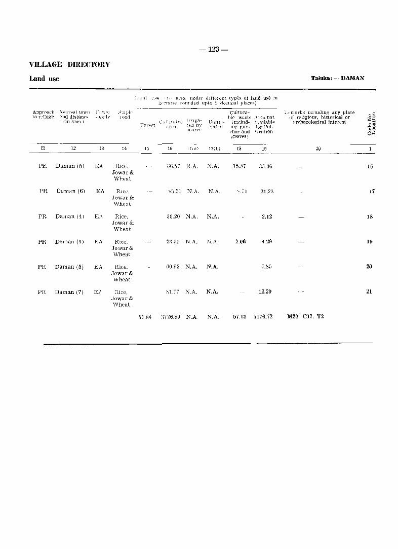
-123-
VILLAGE DIRECTORY
Land use Taluka: - DAMAN
Lanll U";E_> 11 t' an' a under dIffell'nt typi:s of land use in lH'l'T~"o~ rounded upto ;) declJual IJlaces)
Approach 1'\ earesl to,VIl I'U\\('l ~taplp CultUl'a- L"marks lllcludmg any place o§ to nllage and distancp cupply loof! hl<' waste A rea not of rP!igiollS, historical 01' lin km~) LllI11YateG Irnga- Vunn- (ll1Cllld- avallabl" ~rrhaeological intprest
Z·~ ..., FU)'P.-,t art':l ted by :,:-atel! mg gau- for Cul- "':g
-..: 011 l're I'her and tiviltion 8.3 groves)
11 12 13 H 13 10 lila) 17(b) 18 19 20 1
PR Daman (5) EA RIce. 66.57 N.A. ~.A. 15.87 3;i.36 16 Jowar& Wheat
PR Daman (6) EA RIce. 'l5.51 N.A. N.A. ~.'1 21.2::1 17 JO'vVal' & Wheut
PR Daman (4) E"\ Rice. 30.20 N.A. N.A. 2.12 18 Jowal' & Wheat
PR Daman (4) EA Rice. 23.55 N.A. N.A. 2.06 4.29 19 Jowar& Wheat
PR Daman (5) EA Rice, 60.92 N.A. N.A. 7.85 20 Jowal' & Wheat
PR Daman (7) E} ~ice, bl.17 N.A. N.A. 12.20 21 Jowar & Wheat
51.84 3726.89 N.A. N.A. 57.13 1176.72 M20, C17. T2
DISTRICT DIU
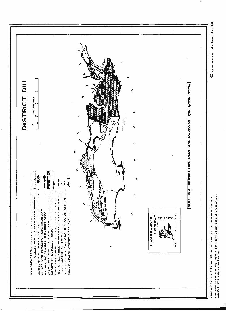
y
4-co ~
:> - ... 0 N
VI
~ II 101
U r '" .. .. ~ - J
Q: 0 ~
~ ¥
0
Z
(/J - '~ -
0 'I '(
'( r
-a: I
~ 0 'H "YI'Y~V :,
~; ~ ~ 1 ~iii ~~.,,·. _ . 0
It ,.. 0( ••
l Vi J •
"
~ o
..
~
,.. 11 . .. ~ .. . ~
'" ... o U
1
~ .. = .. ~ • < · \.l .. 0 >-· > .. ~ · £ ;;
..! E
~ , · < • > i ! '0 ~
~ ;;
·
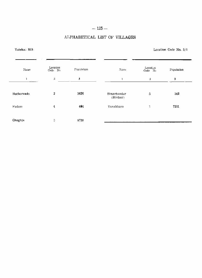
'fahtka: DIll
1
Bucharvada
Fudam
Ghoghla
Location Code Nrl
2
2
4
-125-
ALPHABETICAL LIST OF VILLAGES
PopulatlOll
.J
5626
4&4
8738
Ntune
Simarbandar (Simbor)
Vanakbara
Location Code No. 3/1
Locatiun Code Nu
5
1
Population
3
342
7231
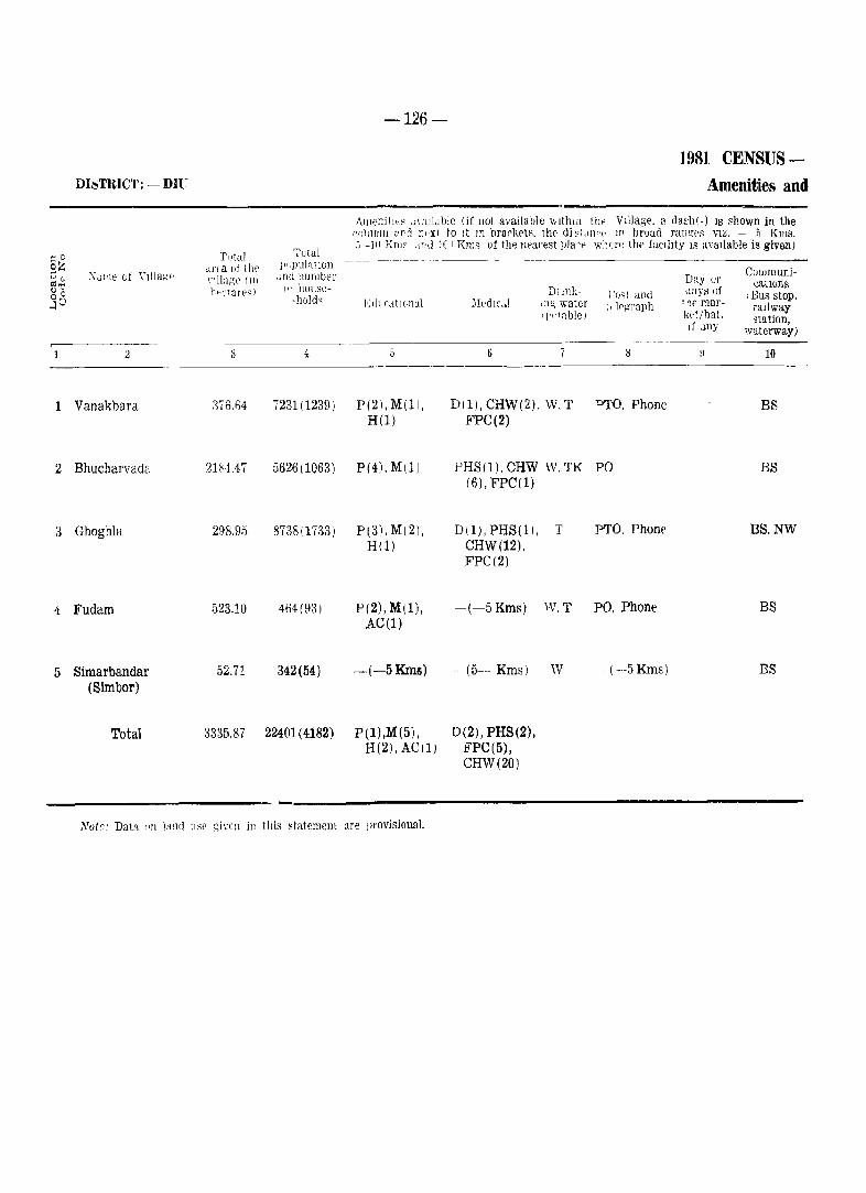
~ 0
§Z ._,~
Ol"j "c Su
1
2
3
4
5
-126-
DISTRICT: - DU;
AJllenitlt~ .1\ aIi.! hIe (if 110t avail a hIe wlthlll th,'
1981 CENSUS ~ Amenities and
VIllage. a da.sh(-) IS ~hown in the 1'1I1Unln ord nt'xl to It In brarketF. Iht' di ~1.1I11·P ll' broud ran[!,f'::: VI~. - 5 Kms.
'~utul .i--jll Kmo .n,d 10+ Kms of the lwarest pIa 'p wilen: the facIlIty IS avaIlable is given)
TIJtaI ,ll'l·a of thc' 1",puIntwll -- -~------------
:\dll1e of YJ]Iagp \'lllag\' (Ill .uHf number Day (;]' Communi-ilt home- eatlons
Il,,'.·rarp,,) D)!nli- j '()Ri ant] days of I Bus stop. -h(,Id~ EdllrdtlOnal :lIedlc,.] ,:J"i water :,lq;raph tne maJ'- raIlway
')'l' l n.blel I,d/hat. station, If .1ny waterway)
2 3 6 l:j 10
Vanakbara 376.64 7231(1239) P(2),M(11. D(1). CHW(2), w. T PTO. Phone BS H(l) FPC(2)
Bhucharvada 2184.47 5626(1063) P(4). Mil) PHS(1). CHW W, TK PO BS (6), FPC(l)
Ghoghla 298.95 8738(1733) P(3).MI2). DIl), PHS(l), T PTO. PhonE' BS,NW H(1) CHW(12).
FPC(2)
Fudam 523.10 464(93) P(2), M(l), -(-5Kms) W.T PO, Phone BS AC(l)
Simarbandar 52.71 342(54) -(-5Kms) -(5- Kms) W - (--5 Kms) BS (Simbor)
Total 3335.87 22401(4182) P(1),M(5), D(2), PHS(2), H(2), AC(l} FPC(5),
CHW(20)
l\'uir: Data lill 1Hl](j \l,W giH'1l in tItis statement are provisional.
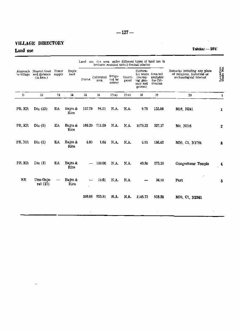
-127-
VILLAGE DIRECTORY
Land use TaJuka: - DIU
Land use (i.e area under different types of land use in hectares rounded upto 2 decimal places)
Remarks including any place go
Approach Nearest town Power Stnple Cultum- ... Z ... ~ to village and distance sup,ply food Irriga-
ble waste Area not of religious. historical or h (in kms.) Cultivated Unirri- (includ- available archaeological interest Forest area ted by gated ing' gau- for Cul- ~O
source cher and tivation groves)
11 12 13 14 15 16 17(a) 17(b} 18 19 2(1
PR,KR Diu (13) EA Bajra& 137.79 94.01 N.A. N.A. 9.78 135.06 Ml6, N241 1 Rice
PR,KR Diu (8) EA Bajra & 166.29 711.59 N.A. N.A. 1079.22 227.37 M4, N216 2 Rice
PR,NR Diu (1) EA Bajra& 4.00 1.60 N.A. N.A. 6.93 186.42 M50, CI, N1784 Rice
PR,KR Diu (3) EA Bajra& - 100.00 N.A. N.A. 49.80 373.30 Gangeshwar Temple Rice
KR Una-Guja- Bajra& 16.61 N.A. N.A. 36.10 Fort 5 rat (17) Rice
308.08 923.81 N.A. N.A. 1145.73 958.25 M70, el, N22U
Dilitriets! Goa, Daman and Diu
Sr. No. Name of Ta.luka
1
DISTRICT GOA
1 Tiswadi
2 Bardez
3 Pernern
4 Bicholim
5 Satari
6 Ponda
7 Sanguem
8 Canacona , , c'
9 Quepem
10 Salcete
11 Mormugao
DISTRICT TOTAL
DISTRICT DAMAN
1 Daman
DISTRICT DIU
1 Diu
-128-
Primary School Middle School
APPENDIX (1)
TALUKA WISE ABSTRACT OF EDUCATIONAL,
Educational
Matnculation/ S .. condary
School
Higher Secondary/PUC/Intermediate/Ju-
mor College
College (Graduate) and above)
Adult Literacy
class/Centres
ViI- Insti- ViI- Insti- ViI- lnsti- ViI- Insti- ViI- lnsti- ViI- Insti-lages tutioliS lages tutions lages tutions lages tutions lages tutions lages tutions
3
'22
37
26
,28
61
31
40
8
33
42
13
341
18
4
59
111
97
92
89
159
93
69
71
114
29
983
25
11
13
24
19
17
11
22
12
7 ,
12
23
8
168
12
1:
6 7
23 8
44 21
33 9
25 8
11 2
37 19
13 8
18 5
13 6
36 20
8 5
261 111
12 3
5 2
16 28
11
10
2
27
9
~2 "
6
28
5
154
3
2
11
1
1 1 1
1 1 2
1 1
12 1'3
4 5
6 7
2 1:
9 11
4. <1
1 5 ·10
12 16
8 19
8 11
1 4 4
3 5
2 65 97
1
VILLA.GE DIRECTORY
MEDICAL AND OTHER AMENITIES
others
ViI- Insti-
,ViJ,lages with no
Educational Amenities
lages tutions
Dispensary Hospital
ViI- Insti- ViI- lnsti-lages tutions lages tutions
-129-
Maternity and Child welfare Centre/Materndty Home/Child
welfare Centres
ViI'lages
Institutions
Medical
Primary Health Centre/Health
Centre
FamIly Planning Centre
Primary Health Sub-Centre
VII- lnsti- ViI- lnsti- ViI- Insti-lages tutions lages tutions lages tutions
--.-------------------------------------------~------------15 16 17 18 19 20 22 23 24 25 26 27 28 29
1 1 6 4 4 1 1 1 1 1 1 12 15 7 7
2 2 4 2 2 1 1 3 3 2 2 13 13 7 7
1 1 (Tr) 1
1 1 4 4 2 2 1 1 12 13 5 5
16 1 1 2 3 3 3 12 14 6 6
1 2 3 3 2 2 10 10 3 3
1 2 8 4 4 1 1 2 2 1 1 15 17 7 7
4 4 1 1 1 1 11 15 6 6
1 1 3 3 2 2 6 10 4 4
6 1 1 1 1 8 9 7 7
4 4 4 2 2 2 2 3 3 1 1 13 13 8 8
1 1 1 1 1 1 3 5 1 1 ,I,
11 12 45 2 2 3 ' , 5 2 2
3 28 28 10 11 19 19 8 8 115 134 63 63
. ~ . .. 1 1 1 6 .6 , {)
-130-
APPENDIX (I) -,
Districts: Goa, Daman and Diu TALUKAWISE ABSTRACT OF EDUCATIONAL,
Drinking water
Community Vll,iages
Others with no H~lth Worker Medical
Sr. No, Name of Taluka Facilities
Tap Well Tank Tube Riyer F(luu- Canal Others Well tain
ViJ- Nu:m- Vll- Instl-lages bers lages tutions
1 2 30 31 32 33 34 35 36 37 38 39 40 41 42
DISTRICT GOA
1 Tiswadi 13 31 12 11 28
2 Bardez 22 54 22 50 7 11 41 · . 1 1
3 Pernem 19 54 8 15 6 2 27 1 · . 3 13
4 Bicholim 10 22 15 6 28 · . 1 3 1 5
5 Satari 11 30 4 4 63 1 69 · . 35
6 Ponda 25 81 15 35 1 15 31 3 · . · . 25
7 Sanguem 10 16 36 2 39 1 .. 21 · . 36
8 Canacona 8 37 4 11 8 7 4
9 Quepem 4 9 29 1 36 · . 1 9 · . 19
10 Salcete 18 44 22 4 46 2 4
11 Mormugao 6 16 7 5 13 5
DISTRICT TOTAL 85 256 114 253 198 58 366 5 3 43 ,1 9tI
DISTRICT DAMAN
1 Daman 10 17 9 6 21 18 · . 1
DISTRICT DIU
1 Diu 3 20 2 3 4' 1 · .
-131-
\TLLAGE DIRECTORY - (oncld.
MEDICAL AND OTHER AMENITIES
COlllllllmicatJOn Power Supply
--------------------- ---- ---
Villages More with no NaVl-
than one drinking PO T. 0 P T.O P O. T 0 PT. O. l'hone Bus l.allway gable Avai- Not aval-Rou)'ce water fa- ,\. Phon!' Ie Phone & Phone Stop otation water lable lable
dlities of way any type
-------~----
~3 H i5 ·lb n 4& ~~i 30 51 52 53 54 54 56 ----
11 5 ,
~l 27 7 28 ,)
13 19 1 3 6 35 7 41
19 Ie 23 14 27
11 10 2 22 4 28
28 9 18 55 21
28 11 3 1 26 1 31 -'-
37 11 21 4 36 12
7 6 7 7 1
24 5 28 29 10
10 10 8 1 9 2 45 3 2 45 1
8 2 3 11 3 4 13
196 104 12 7 26 2 263 10 39 341 45
19 8 1 12 21
3 1 1 2 5 1 4: 1

-133-
APPENDIX (II) - VILLAGE DffiECTORY
LAND rTILlZATION DATA IN RESPECT OF NON-~IUNICiPAL TOWNS (CENSUS TOWNS)
Distrkt: GOA
-134-
APPENDIX (DI) - VILLAGE DIRECTORY
TAL{'KA WISE LIST OF VILLAGES WHERE NO AMENITY OTHER THAN THE DRINKING
WATER IS AVAILABLE
District: GOA'
Sl. No ;\Tame "f Taluka "'arne of VIllage P"pulatwn I'll 1'\u NamE' of Taluka Name of Village Population
----_--- - -_---_---- ---- -
1 2 8 4 1 ~ 3 4
1. Satari 1 ) Derodem 62 3. Quepem 1 ) Zanodem 57
21 Codvol 7 2) CorIa 140
2. Sanguem 1 ) Moissal 54
21 Rumbrem 74
3) Dongurli 2'7
4) Potrem 149
-135-
APPENDIX (IV) - VILLAGE DffiECTORY
LIST OF' VILLAGES ACOORDING TO THE PROPORTION OF SCHEDULED CASTES AND SCHEDULED TRfflES TO THE TOTAL POPULATION BY RANGES
~t:!llg'n (,1 Schec1ulf'oI \-'a~1e nODulatiop
( pPT'cpntages )
L ,_. Ku,,;~
hh'
A - SCHEDULED CASTES
L. l' :\Tun!-
1:,)(:'1'
Narn( j'~ Vil1a;-_l L.C Nli.1il
IH"1'
Nanl t_ u1 Ylllage
----------~~-----~---~-------------------------1
DiSTRICT GOA
T1SIl'O .• ili Taluka
0-5"
6 --10
11-15 16-20 21-30 31 +
Bardez Taluka
0-5'
6-10
11-15 16-20 21-30 31 +
Pernem Taluka
6-10
~ l _- 15 16 -- 20 21-30 31 +
Bic710lim Taluka
0-5':'
2 6 9
13 29 33 38
14
2 6
10 13 16 20 25 30 34 37 40 7
27
1 4 9
18 22 25
13
17
12 8
3 11 :16 19 23 26
3 ·1
Chorao Goltim Jua Ella Mandur Bambolim Mercurim
Bainguinim
CilElurlllll Pirna Tivim Anjuna Parra Bastora Nachinola Olaulim Saligao Reis Magos Penha~de-Franca
Moitem Corjuem
Tiracol Arambol Varconda Cansarvornem Tuem Morgim
Torxem
Ibram.pur
Tamboxem Casnem
Salem Sarvona Piligao Cassabe-de-Sanquclim Amonc Surla
3 7
10 26 31 34
3 8
11 14 18 21 26 31 35 38 41 17 32
2 5
11 19 23 27
14
21
26 10
4 12 17 20 24 27
Caraim Malar Cumbarjua Goalim-MouJa Batim Siridao
Colvale Assonora Marna Arpora Canca Paliem Aldona Pomburpa Candolim Pilerne Salvador-do-Mundo Verla Socorro (Serula )
Querim COI'gao Uguem Ozorim Parcem Agarvado
Mopa
Virnora
Chopdem Poroscodem
La tam bm'cem Maem Carapur Arvalem Navelim Vc·lguem
5 8
12 27 32 35
4 9
12 15 19 24 28 33 36 39
22
3 6
15 20 24
16
10 15 18 21 25 28
7
Navelim Naroa Corlim Carambolim Curca Goa-Velha
Revor-a Sircaim Assagao Nagoa Guirim Moira Ponolem Sangolda Nerul Marra
Punola
Paliem Pernem (Rural) Chandel Dargalim Mandrem
AlOl'na
Curchirem Naroa Mauiinguem-South Cudnem Cotombi Pale
-136-
APPENDIX (IV) - VILLAGE DffiECTORY
LIST OF VILLAGES ACCORDING TO THE PROPORTION OF SCHEDULED CASTES AND SCHEDULED TRmES TO THE TOTAL POPULATION BY RANGES (contd.)
Range uf ~~he<lule<l Caste population
(percentages)
6-10
11-15 16-20 21-30 31 +
Satari Taluka
0-5';
6~10
11-15 16-20 21-30 31 +
Ponda Taluka
0-5'··
6 --10 11-·15 16-20 21-30 31 +
Sanguem Taluka
0-5':'
6-10 11-15 16-20 21-30 31 +
Canacona Taluka
L. C. Num
lJer
2
1
9
2 13 23 38 48 78
20
18 51 49 80
1 6
11 14 17 20 25 28 31
1 5 9
15 20 28 38 46 50
37
7
1 4 9
A - SCHEDULED CASTES
Nan}£. or Villagl L.C.
NumlJer
Narue ut Vltlng., L C
"NunltJCl'
---------------------------------------------------------3
Mencurem
Maulinguem-North
Poriem Surla Onda Davern Sonus-vonvoliem Govanem
Gululem
Dongurli Naguem Vaguriem Ambeli
Tivrem Savoi-Verem Vagurbem Candepar Velinga Bandora Betora Conxem Ponchavadi
Piliem Surla Sigao Bandoli Calem CosU Bati Rlvona Netorli
Potrem
Caranzol
Cola Nagorcem-palolem Loliem
4
5
3 21 24 43 69 79
26
64
2 7
12 15 18 22 26 29
3 6
10 17 21 35 44 47 52
42
2 6
5
Adwalpale
Ravona Querim Saleli Veluz Guleli Malpona
Dabem
Codqui
Orga~
Adcolna Gangem Curti Cundaim Telaulim Codar Borim
Sancordcm Molem Sangod Sanvordem Sonauli Uguem Curdi Curpem Verlem
Naiquinim
Agonda Poinguinim
6
7
1] 22 27 47 71
57
73
4 10 13 16 19 24 27 30
4 8
12 19 27 36 45 48
3 7
7
Mulgao
Ivrem-curdo Morlem Compordem Pissurlem Birondem
Sanvordem
Cotorem
Betqui Querim Usgao Priol Marcaim Queula Nirancal Siroda
Aglote Colem Codli Santona Dudal Tudou Colomba Vichundrem
Canacona Gaodongrem
-137-
APPENDIX (IV) - VILLAGE DIRECTORY
LIST OF VILLAGES ACCORDING TO TIlE PROPORTION OF SCHEDULED CASTES AND SCHEDULED TRmES TO THE TOTAL POPULATION BY RANGES (oontd.)
Rang .. of Schedul9cl Caste population
(percentages)
6-10 11-15 16-20 21-30 31 _ _;_
1
Quepem Tuluka
0-5"
6-10 11-15 16- 20 21-30 31 +
Salcete Taluka
6-10 11-15 16-20 21-30
31 + Mormugao Taluka
6-10 11-15 16-20 21-30 31 +
A - SCHEDULED CASTES
L C, Num
her
5 10 19 23 33
7
1 4 7
11
14 19 25 30 35 39 43 46
1 4 7
Name of Village
3
Cacora Amona Deao Fatorpa Quedem
Cotombi
Nagoa Camurlim Majorda Gaundaulim Seraulim Guirdolim Benaulim Dicarpale Mulem Varca Talvorda Cavelossim
Chicalim Cortalim Pale
12 Arossim
L, C, Number
4
6 13 20 31 34
2 5 8
12 16 20 27 31 36 40 44 47
2 5
10
Name of Village"
5
Xeldem Sirvoi Ambaulim Cordem Barcem
Verna Nuvem Utorda Colva Raia Curtorim Talaulim Sao Jose-de-AreaJ Sarzora Carmona Varoda Velim
Dabolim Quelossim Velsao
L, C, Numher
6
8 18 22 32
3 6
10 13 18 21 28 32 38 42 45 48
3
6 11
N anlf" of Villag'~
7
Avedem Molcarnem Bali Padi
Loutulim Calata Betalbatim Vanelim Macasana Davorlim Dramapur Cavorim Orlim Chinchinim Assolna Ambelim
Sancoale Cuelim Cansaulim
-138-
APPENDIX (IV) - VILLAGE DIRECTORY
LIST OF VILLAGES ACCORDING TO THE PROPORTION OF SCHEDULED CASTES AND SCHEDULED TRIDES TO THE TOTAL POPULATION BY RANGES (cont.1.)
Range of Scheduled Caste population
(pel'l..:entage.~ )
DISTRICT DAMAN
0-5':'
6-10
11-15
16-20 21-30 31 +
DISTRICT DIU
6-10 11-15 16-20 21-30 31 +
L C Num
her
2
1 5
10
4 13
17
14
1 5
A - SCHEDULED CASTES
3
Marwad Janivankad Kachigam
Bhimpore Palhit
Pariari
Bhamati
Vanakb?!'a Simarbandar (Simbor)
L. C. Num
ber
2 6
11
7 18
20
2
Devka Dunetha Magarwada
Varkund Deva Pardi
Thana Pardi
Bucharvada
• ExcJude~ villages with 110 Scheduled Caste population.
f.. C Kl1ln
bpr
3 9
12
ti
3
Kadalya Dabhel Damanwada
Rmganwada
Ghoghla
-139-
APPENDIX (IV) - VILLAGE DIRECTORY
LIST OF VILLAGES ACCORDING TO THE PROPORTION OF SCHEDULED CASTES AND
~CHEDULED TIUBt~:s '1'0 'l'HI:: TO'l'AL POPULATION BY RANGES (contc/.)
Range of Schedult·(J Tnbe popuJatlo:J
(ppr'::tlltag0~)
1
DISTRICT GOA
Tiswac/i Taluku
0-5 6-15
16-25 26-35 36-50 51 +
Banle;; Talvka
6-15 16-25 26 -- 35 36-50 51 +
Per'l1ern Taluka
0-5';' 6-15
16-25 26-35 36-50 51 +
Bicholim Taluka
0-5':' 6.-15
16-25 26-35 36-50 51 +
Satari Taluka
0-5',' 6-15
16-25 26-35 36-50 51 +
Panda Taluka
0-5* 6-15
16-25 26-35 36 - 50 51 +
Sanguem Taluku
0-5:
6 - 15 16 -- 25 26 - 35
L C Xurl1-
b(,l
10 34
27
s 47
41
B - SCHEDIJLED 'fRffiES
I<;lla
TlVim Saligao
Salem
3
Compordem
Colem Curpem
Dongor
L. C X<1nJ
])e1"
4
14
19
28
12
42
:i
B;ilPguinim
GUlriID
Pale
Codli
;'i[aiquinim
L. C NurYl
hey
G
24
20
Naill(> ()! Village
7
Barnbolim
Moira
Calem
-140-
APPENDIX (IV) - VILLAGE DIRECTOJ~Y
LI~T OF VILLAGES ACCORDING '.cO THE PROPORTION OF SCHEDULED CASTES AND SCHEDULED TRIDES TO THI-l TOTAL POPULATION BY RANGES (ccJIl,C1l)
B - SCHEDULED TRIBES
Range of Scheduled TrIbe populutIon
(percentagE\~)
36 -,50 51 +
1
OallaC()lIa Talul;o
0-5':' 6-15
16-25 26-35 36-.50 51 +
Quepem Taluka
0-5':' 6-15
16-25 26- 35 36-50 51 +
SaZrete Taluka
6-15 16-25 26-35 36 --- 50 .')1 +
Monnugao Ta71tka
0-5* 6-15
16-25 26-35 36-50 51 +
DISTRICT DAMAN
0-5" 6-15
16-25
26-35
36 -.')0
.51 +
DISTRICT DIU
O-S" 6-15
16-25 26-35 36- 50 .'51 +
L. C Num
ber
5
7 38
1
3
1 8
'2 13
10
14 10
2
Loliem
Cacora
Majorda Orlim
Chicalim
Janivankad
Marwad Dabhel
Devka Palhit
Kachigam
Bhamati Naila-Pardl
Bhucharvada
.. Ex('jl.lrlf'l~ nllagp:-; v.'-it .. h no :-:cht:"llulf d lnbe population
L. C. Num
ber
4
6
10 46
4
"[
~ u
11
4 16
20
11 21
3
Xeldem
Bctalb3.tin1 Cavelossim
Cortalim
Varkund
Kad[dya Magarwad:J.
Bhimpore Jampore
Thana Pardi
Pariari Zari
Ghoghla
L G ~ ~ ,U).!I)pr
_---_.---------------
S'?raulim
15 Dholal'
8 IUnganwada 12 Damanwada
f) Dunetha
1:': Deva-Pardi
4 Fudam
SECTION II
TOWN DIRECTORY
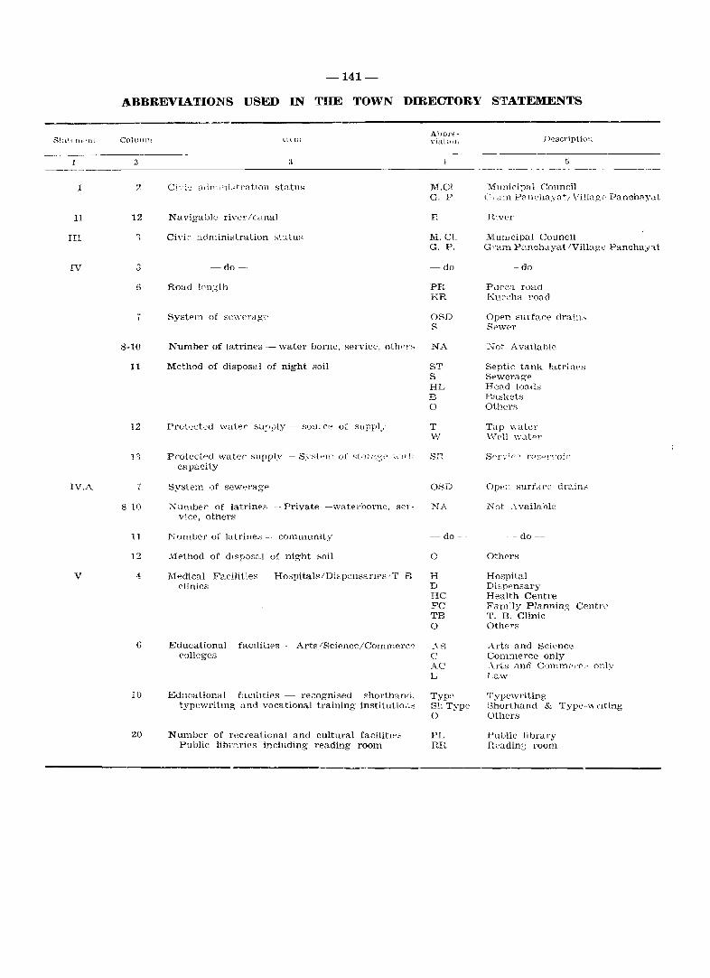
Statfm. Ht
I
II
III
IV
IV,A
V
-141-
ABBREVIATIONS USED IN THE TOWN DIRECTORY STATEMENTS
COIUIUIl llcrn
2 3
AllbrE'VluhlJlt Description
,5 --------------------------------------------------------------_._-.- _.--.
2
12
6
8-10
11
12
7
8-10
11
12
10
20
Civi2 Cl(lministration status
~do-
Road IC'n.:;th
Number of latrine" - water borne, sel'Vice, olhp],,,
Method of disposal of night soil
Proteci..pd Vv~ater supply·- Sy;..::tt->ltl of st!Jl ,'V::~t' \\-t l h capacity
Syste~n l)f sev.reragp
Xumber of latrines _- Private --watel'borne, sel'vice, others
Number of latrine:; - community
Method of dl"posal of night soil
l\1.;dical Facilities _ Hospitals IDispensanes . T B clinics
Educational facIlities colleges
Arts/Sciencc/Commerc r ,
Education'll facllities·- re20gnised shorthand. typewritmg and vocational training institutim->s
Number of recreational and cultural facilitw3 -Public libl'~rics including reading room
M.CI G. P
F.
M.C!' G. P.
-do-
PR KR
OBD S
NA
ST S HL B o
T W
SR
O~D
I'"L·\_
-- do-
o
H D HC E'C TB o
_' I~ C AC L
Typ,-, S11 Type o
PL RR
Mllnici~al Council (-;,'mn P8I1chaya' .. \Tillage' PanchaY<lt
RIver
Mun,clpal Council Gram P;:\nchayat IVillage Panchay~t
-do -
Pucca road Kuccha road
Open surface drat"" Se'wf'r
"'at Available
Septic tank latrines Sewcrage Head loaus Bas]{cts Others
Tap waler \"\l"cll v.Tat.r:-r
Ope;; surfdc2 drain,.;
Not ~\vailable
. - do--
Others
Hospital Dispensary Health Centre Fandy Plannin.<; Centre T. B. Clinic Others
Arts and Science Commerce only ~\.rts and COlnm(,l'f'l' only Law
Typewriting Shorthand & Typt'-wnting Others
Public library flea din::; room
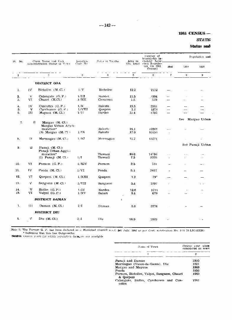
-142-
1981 CENSUS-
STATE Status and
Number of Population and housebolds ill-
S! No. Class. Name nnd CIvic LlIcatloll N,Ulll' ()1 Taluka Area ill duclmg hous-Administration Statu:.:: 01 Tp\\" Jl ('ode No (S'1. junA) eleBs househo-
lds (in 1981 Census)
1900 1910 1921
1 " :l 1 6 7 S 9
DISTRICT GOA
1. IV Bieholim (M.C]') l/V Bieholim 12.2 2112
2. V Calang'ute (G. P. ) lIIII Bardez 11.5 ;_994 3. VI Chauri (M.e!.) l/XII Canaeona 1.8 ::\39
4. IV Cuneo lim (G. P.) l/X Salcete 19.3 2581 5. V Curchorem (G. P I l/VIII Quepem 3.1 1578 6. III Mapusa (M. CL) lilT Bardez 11.4 1703
See Margao Urban 7. II Margao (M. Cl. )
Margao Urban Agglo-meration" Salcete 24.1 12261
(i) Margao 1M. (;].) I/IX Salcete 17.0 10150
8. II Monnugao (M. Cl. , l/XI Mormugao 11.7 15271
See Panaji Urb-ltn 9. II Panaji (M. Cl.)
Panaji Urban Aggh,-meration':' Tiswadi 46.0 1479ii
(i) Panaji (M. C]' J 1/1 Tiswadi 7.5 8398
10. VI Pernem (G.P.) l/XIV Pernem 2.5 791
11. IV Ponda (M. Cl.) l/VI Ponda 5.3 2697
12. VI Quepem (M. cr.) l/XIII Quepem 1.2 79'1
13. V Sanguem (M. Cl. ) l/VII Sanguem 5.4 10.9,
14. V Siolim (G.P.) l/IV Bardez 12.6 1744-11\. VI Valpoi (G.P.) I/XV satan 9.4 670
DISTRICT DAMAN
1. III Daman (M.el.l 2/1 Duman 5.6 3776
DISTRICT DIU
1. V Diu (M.Cl.) 3;1 Diu 10.0 1869
Not .. 1: The Pernem G. P. has been declared as " Municipal Council 'tV.p.L lst July. 1981 us per Govt. notlfica("'ll No. 3-1l-73-LSG(GENJ • Indicates that this has Outgrowths.
~ Cen:::5us years for which IJopulaii(111 dato...;Jl"C Hot avaIlable
Nanle of Town Census year wben "onsiderecl as town
2
Panaji and Daman 1900 Mormugao (Vasco-da-Gama), Diu 1921 Margao and Mapusa 1940 Ponda 1950 Pernem, Bicholim, Valpoi, Sanguem, Chauri 1960
& Quepem CaJangute, Siolim, Curchorem and Cun- 1981
colim
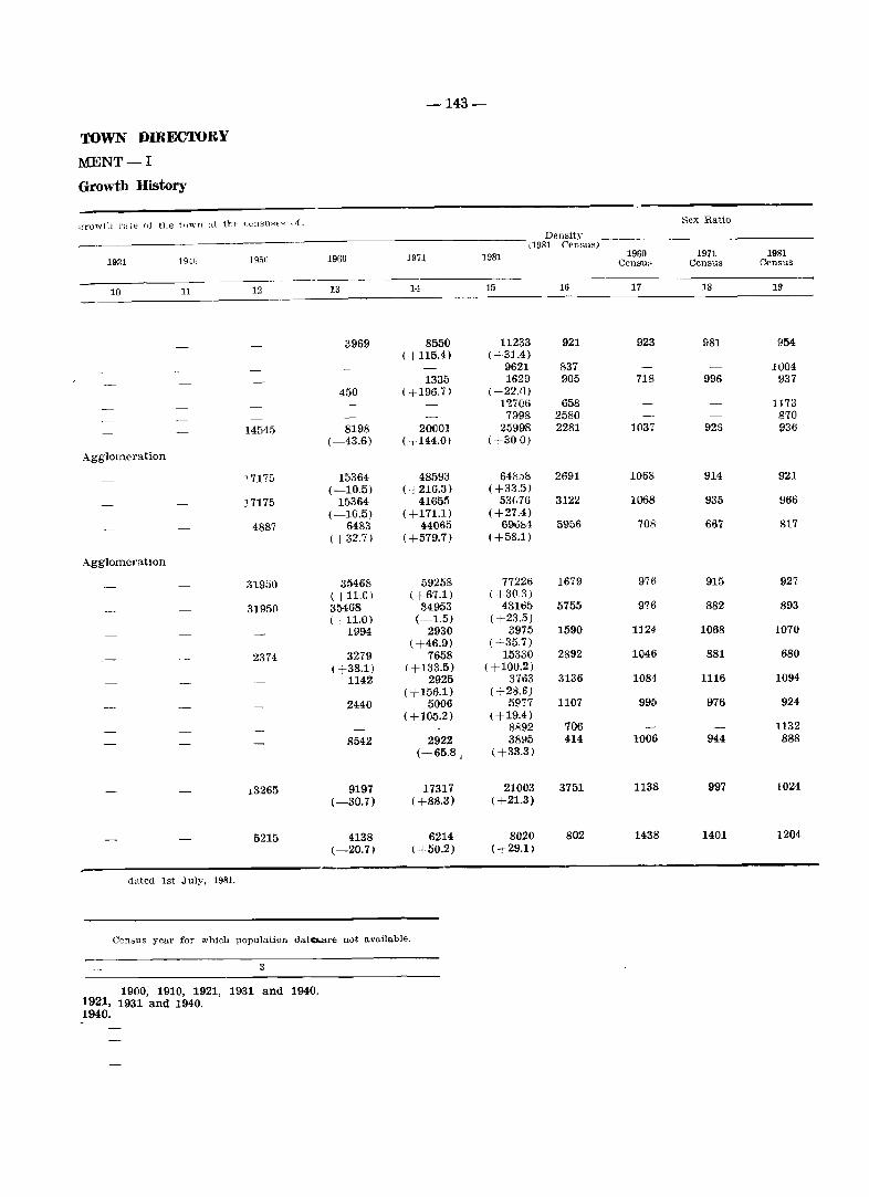
-143-
TOWN DffiECTORY
MENT-I
Growth History
g-rowtll r~lle (It Hie t\lwn ai 1ht: C(:I1SUH>'; ufo
Density (1981 CensuH)
1931 1940 1950 1960 1971 1981
10 11 12 13 11 15 16
3969 8550 11233 921 ( +115.4) ( +31.4)
9621 837 1335 1629 905
450 (+196.7 ) ( +22.1)) 1~706 658 7998 2580
14545 8198 20001 25998 2281 (-43.6) ( ,144.01 <+300)
Agglomeration
'717G 15364 48593 648f>ts 2691 (-10.5) ( +216.3) ( +33.5)
17175 15364 41655 53('7{j 3122 (--10.5) (+171.1) (+27A)
4887 6483 44065 696b·l 5956 (+32.7) (+579.7) (+58.1)
Agglomeration
31950 35468 59258 77226 1679 <+11.0) ( +67.1) ( +30.3)
31$15(1 35468 34953 431135 5755 (+11.0) (-1.5) (+23.5)
1994 2930 3975 1590 ( +46.9) (+35.7)
2374 3279 7658 15330 2892 ( +38.1) (+133.5) ( +100.2)
1142 2925 3703 3136 ( +156.1) ( +28.6)
2440 5006 5977 1107 ( +105.2) ( +19.4)
8892 706 8542 2922 311l1:., 414
(-65.8 1 ( +33.3)
J.3265 9197 17317 21003 3151 (-30.7) ( +88.3) ( +21.3)
5215 4138 6214 8020 802 (-20.7) ( +50.2) <+29.1)
dated 1st July. 1981.
Census year for which population dato.are not available.
3
1900; 1910. 1921, 1931 and 1940. 1921, 1931 and 1940. 1940.
Sex Ratio
1960 1971 1981 CensuK Census Census
17 18 19
923 981 954
1004 718 996 !J37
1173 870
1037 925 936
1068 914 921
1068 935 966
708 667 817
976 915 927
976 882 893
1124- 1068 1070
1046 881 680
1084 1116 1094
995 976 924
1132 1006 944 888
1138 997 1024
1438 1401 1204
81 No. ClaSH anrl llanw of tWNtl
1 2
DISTRICT GOA
1. IV Bicholim
2. V Calangute
3. VI Chauri
4. IV Cuncolim
5. V Curchorem
6. III Mapusa
7. II Margao
Margao Urban Agglomeration"
(i) Margao
8. II Mormugao
9. II Panaji
Panaji Urban Agglomeration"
(1) Panaji
10. VI Pernem
11. IV Ponda
12. VI Quepem
13. V Sanguem
14. V Siolim
15. VI Valpoi
DISTRICT DAMAN
1. III Daman
DISTRICT DIU
1. V Diu
-144-
Rainfall lin mm.)
3
2897
2897
2962
3269
4152
2897
3269
2519
2870
3151
3554
4152
3781
3151
4265
1559
537
PhysH'.ll asperw
Ten'perature (ill rellll~ralle)
Maxinlurn I\[<lXllnunl
5
31.2 23.2
31.2 23.2
31.0 24.0
31.0 24.0
31.0 24.0
31.2 23.2
31.0 24.0
31.0 2-1.0
31.2 23.2
31.2 23.2
:t1.Z 23.2
'31.0 24.0
31.0 24.0
31.2 23.2
31.2 23.2
30.7 21.7
30.1 22.3
1981 CENSUS
STATE
Physical Aspects and
6
P,maji (301
Panaji (16)
Panaji (70)
Panaji ~50)
Panaji (55)
f'anaji (12)
Panaji (33)
Pall:} ji (29)
Panaji (0)
Panaji (29)
Panaji (29)
.pana.ii (48)
Panaji (60)
Panaji (22)
Panaji (54)
Panaji (748 )
Panaji (1M2)
DL~tri('t Hq~
7
Panaji (30)
Panaji (16)
Panaji (70)
Panaji (50)
Panaji (55)
Panaji (12)
Panaji (33)'
Panaji (29},
Panaji (0)·
Panaji (29)'
Panaji (29»
Panaji (48)·
Panaji (60)
Panaji (22)'
Panaji (54).
Daman (0)'
Diu (0)
Note: (l) • Indicates that this has Outgrowths.
(2\ Data on rainfall and tempe<'ature in eols. 3, 4 and 5 we,.e ,mpl'liefl I»), th", 1l.f\diosoJlde observatt.ry, yile Pln!e, Boml",y, remaining towns the data were supplied by the Depart ment of Planning', Statistic3 am! Evaluation, Go,,_

-145-
TOWN DIRECTORY
ment II
Location of Towns, 1979
Nn.me of and rOB-d distance (in kms.) form.
Sub-DIvisiun/Talul,a Hq~ NG:lrest city with population of OI~e Railway StatIOn
lakh and more
8 9 10
Panaji (30),' Bicholim (Q) Belgaum (206) Margao (03)
panaji (15) (Map usa (7) Belgaum (177) Margao (49)
Margao (38) /Chauri (0) Belgaum (184) Margao (36)
Margao (15)/Margao (15) Belgaum (165) Marga 0 (15)
Margao (21)/Quepem (7) Belgaum (128) Sanvordem-Curchorem ; 'J J
Panaji (12)/Mapusa (0) Belgaum (172) Margao (45)
- See Margao Urban Agglomeration-
- See Constituent Unit-
Marga 0 (0) /Margao (0) Belgaum (148) Margao(O)
Margao (27) (Mormugao (0) Belgaum (175) Vasco-da-Gama (0)
-See Panaji Urban Agglomeration .-
-See Constituent Unit-
Panaji (O)/Panaji (0) Belgaum (161) Margao (33)
Panaji (29) (Pernem (0) Belgaum (148) Margao (62)
Margao (16)/Ponda (0) Belgaum (132) Margao (16)
Margao (15)/Quepem (01 Belgaum (135) Sanvordem-Curchorem (i)
Margao (29)/Sanguem (0) Belgaum (177) Sanvordem-Curchorem \ '7)
Panaji (22)/Mapusa (to} Belgaum (183) Margao (55)
Panaji (54)/Valpoi (O} Belgaum (155; Colem (30)
Daman (0) Navsari (78) Vapi (12)
Diu (0) Junagadh (179) Dilwada (26)
Bu::.; route
11
Bicholim (0)
Calangute «(\, Chauri (OJ
Cuncolim (0)
Curchorem (0;
Mapue]" (0)
Margao (0)
Mormugao (0,'
Panaji (0)
Pernem (0)
Ponda (0)
Quepem (0)
Sanguem (0)
Siolim (0)
Valpoi (O)
Diu (0)
Navigable river/canal (if withm 10 Kms)
12
Mandavi (R)-6
Chapora (R)-5
Talpona (R) -2
Zuari (R)-O
Chapora (R), 9
Sal (R)-2
Zuari (R)-O
Mandovi (R)-O
Terekol (R)-3
Zuari (R) -6
Zuari (R) -9
Zuarl (R) -7
Chapora (R) - 0
Damanganga (R) - 0
for Panaji, Margao and Mormugao, 'ThE' M(>teorolobica1 ('pnll<~. Ahm0<ial."d, ~lI"pli<,d th~hP datu for Daman and Diu, for t~
-146-
1981 CENSUS-
STATE
Municipal Finance,
Re~eipt (in R~. 00)
Civic adminis- Revenue den-Sl No. Class and Name of town Irati on status Receipt ved from mu-
(in 1980) through mcipal pro- Government
Loans perties and grant Advances taxes. etc. power apart
trom taKation - ----
I 2 3 4 I) (; 7 8 -~~--.---
DISTRICT GOA
1. IV Bicholim M. Cl. 838 373 1628 3000
2. V Calangute G. P. 177 155 64
3. VI Chauri M. Cl. 107 108 1167 588
4. IV Cuncolim G. P. 118 263 97
5. V Curchorem G. P. 610 6 375
6. III Mapusa M. Cl. 2446 6920 8878
7. II Margao M. Cl.
Margao Urban Agglomeration'"
0) Margao M. Cl. 9226 5248 6935 6000
8. II Mormugao M. CI. 5782 6851 4467
9. II Panaji M. CI.
Panaji Urban Agglomeration*
(i) Panaji M. Cl. 10586 11017 6018
10. VI Pernem G. P. 10 152 61
11. IV Ponda M. Cl. 1030 1256 603
12. VI Quepem M. Cl. ~4 288
13. V Sanguem M. Cl. 32 460 1511 600
14. V Siolim G. P. 47 N 123
15. VI Valpoi G. P. 131 435 50
DISTRICT DAMAN
1. III Daman M. Cl. 3494 1390 4121
DISTRICT DIU
1. V Diu M. Cl. 2253 446 1505 260
Nute: - Figures for Chunn relate to 1975-76. i.e. before the towD was declassified into G.P .. It was again notified as town in 1980.
• Indicates that thif; has Outgrowths.
TOWN DffiECTOBY
MENT-III
1978 -1979
Other sources Total (specify) receipts
_._---9 10
466 6305
294 690
130 2100
478
1039 2030
1292 19536
General admi-ndSitratiO'Ill
11
742
112
705
112
376
4031
- See Margao Urban Agglomeration -
- See Constituent Unit -
2662 30071 5885
5697 22797 6327
- See Panaji Urban Agglomeration -
- See Constituent Unit -
1330 28951 5363
83 306 296
2012 4901 1639
397 719 192
673 3276 747
339 509 42
53 669 190
1245 10250 2215
859 5323 826
-147-
Public Public health oofety and conve-
niesces
12 13 --_._--.-.
239 582
70
120 86
N
90
1325 5225
1379 10364
982 7149
2515 6454
N
490 538
7
141 4JO
1
95
680 2900
618 1207
Expenditure (m Rs. 00)
Public Ins- Others Total Public works titutio"9 (specify) expenditure
--------14 15 16 17
364 N 275 2202
179 422 783
1083 52 54 2100
167 6 19 304
1096 2 74 1638
6287 327 1983 19178
6080 368 4791 28867
7184 69 1305 23016
4153 61 8327 26873
141 12 15 464
668 271 3606
1147 166 1512
2778 33 131 4240
143 13 23 222
227 2 514
681 171 3350 9997
1377 192 1047 5267
-148-
1981 CENSUS-
STATE
Civic and Other
Number of latrines Civic ad- Scheduled
caste and System SI. No. Cla ~s and nallle of town ministra- Population Scheduled Road length of Sewe-tion status Tribes po- (Kms.) rage (iIlj 1980) pulatio'll Water Service Others Borne
1 2 tl 4 5- 6 7 8 9 10
DISTRICT: GOA
1. IV Bicholim M. Cl. 11233 343 PR (3.7) OSD NA NA NA KR (0.7)
2. V Calangute G. P. 9621 168 PR (11.0) OSD NA NA NA KR (4.5)
3. VI Chauri M. Cl. 1629 29 PR (2.5) OSD NA NA NA
4. IV Cuncolim G. P. 12706 166 PR (35.0) OSD NA NA NA KR (25.0)
5. V Curchorem G. P. 7998 115 PR (7.5) OSD NA NA NA KR (3.0)
6. III Mapusa M. Cl. 25998 1395 Total (30.9) OSD NA NA NA
See Margao Urban 7. II Margao
Margao Urban Agglo-meration" 64858 1806 Total (56.8) OSD NA NA NA
(i) Margao M. Cl. 53076 1621 Total (50.3) OSD NA NA NA
8. II Mormugao M. Cl. 69684 2209 PR (13.5) OSD NA NA NA KR (1.5)
See Panaji Urban" 9. II Panaji
Panaji Urban Agglo-mera.tion" 77226 1827 Total (68.0) S NA NA NA
(i) Panaji M. Cl. 43165 713 Total (54.5) S NA NA NA
10. VI Pernem G. P. 3975 197 Total (10.2) OSD NA NA NA
11. IV Ponda M. Cl. 15330 217 PR (7.6) OSD NA NA NA KR (6.5)
12. VI Quepem M. Cl. 3763 36 PR (11.4) OSD NA NA NA KR (2.3)
13. V Sanguem M. Cl. 5977 64 Total (8.0) OSD NA NA NA
14. V Siolim G. P. 8892 107 PR (11.3) OSD NA NA NA KR (13.8)
15. VI Valpoi G. P. 3895 103 PR (2.8) OSD NA NA NA KR (0.4)
DISTRICT: DAMAN
1. III Daman M. Cl. 21003 2390 Total (33.1) OSD NA NA NA
DISTRICT: DIU
1. V Diu M. Cl. 8020 673 Total (6.9) OSD NA NA NA
• Indi('utes that this has Outgrowths.
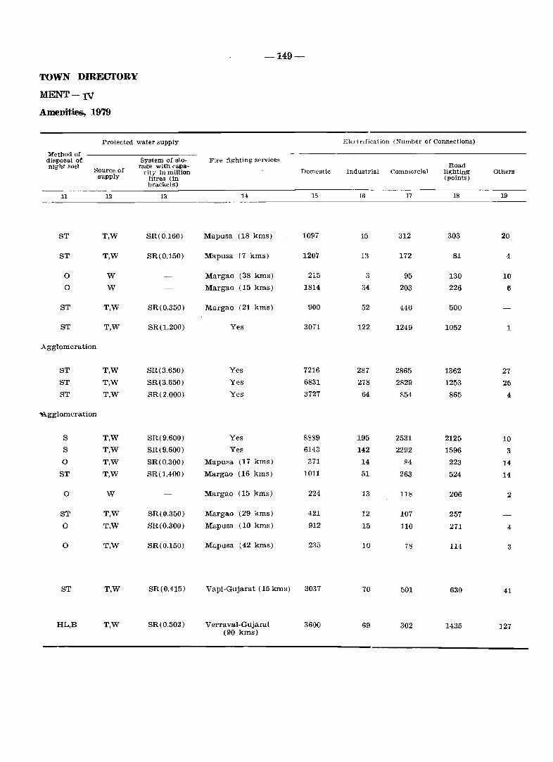
TOWN DffiECTORY
MENT-IV
Amenities, 1979
Protected water supply
Method of disposal of night soil
11
ST
ST
0
0
ST
ST
Source of supply
12
T,W
T,W
W
W
T,W
T,W
Agglomeration
ST T,W
ST T,W
ST T,W
~gglomeration
S T,W
S T,W
0 T,W
ST T,W
0 W
ST T,W
0 T,W
0 T,W
ST T,W
HL,B T,W
System of storage with capa
city in million litrels (in brackets)
13
SR(0.160)
SR(0.150)
SR(0.350)
SR(1.200)
SR(3.650)
SR(3.650)
SR(2.000)
SR(9.600)
SR(9.600)
SR(0.300)
SR(1.400)
SR(0.350)
SR(0.300)
SR(O.150)
SR(O.415)
SR(0.502)
-149-
Fire fighting services
14
Mapusa (18 kms)
Mapusa (7 kms)
Margao (38 kms)
Margao (15 kms)
Margao (21 kms)
Yes
Yes
Yes
Yes
Yes
Yes
Mapusa (17 kms)
Margao (16 kms)
Margao (15 kms)
Margao (29 kms)
Mapusa (10 kms)
Mapusa (42 kms)
Vapi-Gujarat (15 kms)
Verraval-Gujarat (90 kms)
Domestic
15
1097
1207
215
1814
900
3071
7216
6831
3727
8889
6143
371
1011
224
421
912
235
3037
3600
ElEctrification (Number of Connections)
Road Industrial Commercial lighting Others
(points)
---- -16 17 18 19
45 312 303 20
13 172 81 4
3 95 130 10
34 203 226 6
52 440 500
122 1249 1052 1
287 2865 1362 27
278 2829 1253 25
64 854 865 4
195 2531 2125 10
142 2292 1596 3
14 84 223 14 51 263 524 14
13 118 206 2
12 107 257
15 110 271 4
10 78 114 3
70 501 630 41
69 302 1435 127
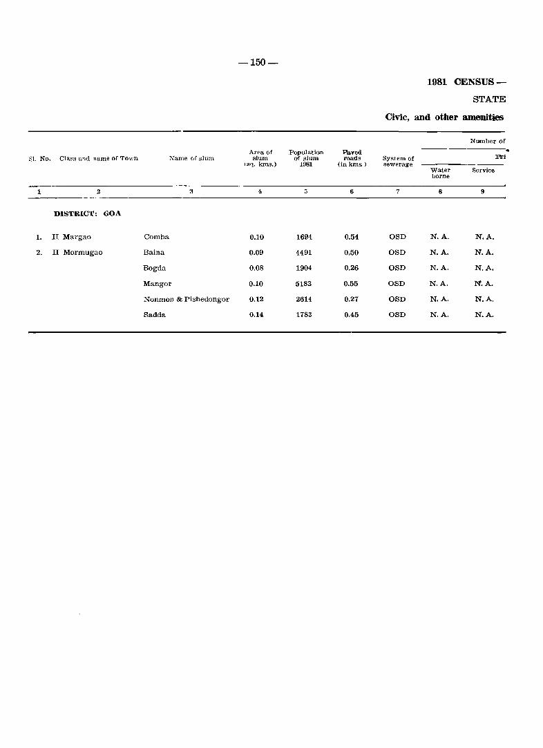
-150-
1981 CENSUS-
STATE
Civic, and other amenities
Number of
Area of Population Paved • SI. No. Class and name of Town Name of slum slum of slum roads System of Ftri
(sq. lo:ns.) 1981 (in km,,) sewerage Water Service borne
1 2 3 4 5 6 7 8 9
DISTRICT: GOA
1. II Margao Comba 0.10 1694 0.54 OSD N.A. N.A.
2. II Mormugao Baina 0.09 4491 0.50 OSD N.A. N.A.
Bogda 0.08 1904 0.26 OSD N.A. N.A.
Mangor 0.10 5183 0.55 OSD N.A. N.A.
Nonmon & Pishedongor 0.12 2614 0.27 OSD N.A. N.A.
Sadda 0.14 1783 0.45 OSD N.A. N.A.
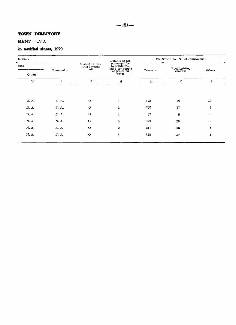
TOWN· DIBJ!XY.roBY
MENT-IV A
in notified· s1UDl8, 1979
'atrin('s .-----
vate Conlnluniiy
Other"
10 11
N.A. N.A.
N.A. N.A.
N.A. N.A.
N.A. N.A.
N.A. N.A.
N.A. N.A.
Method of dis-1 '(j~al of night
~()il
12
0
0
0
0
0
0
-15:1.-
:-;rum bel' of tap jluint,,/public hydm.I1 ts ms-
1 ailed for supply of prorected
water
13
1
2
3
5
2
6
Electrifiool ion (No. of cOImeetJon.s)
Domestic
125
257
37
323
211
325
Road lightl~ (pointf<)
10
37
6
29
36
39
Other",
16<
10
2
1
1
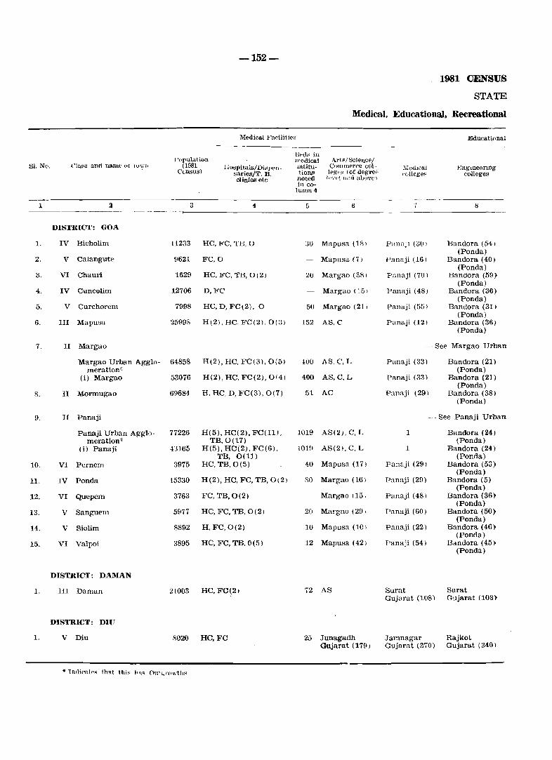
-152-
1981 CENSUS
STATE
Medical, Educationa.}. Recreational
Medical Facilitif's Educational -----
Hed~ in I 'opula.t ion medical Arts/Sdence/
81. No. C1ass and uaDle ot \I)\;'JI (1981 Ilvspitals/Di:;jlen- mtltu- COllunerce col ~ :\Ie(hcal j<~nglneerlDg Census) sariBS/T. B. tions lege~ (of degrei· "ollcget' colleges clinics etc noted {t.>.n·l alld aboy(')
in co-lumn4
------ -
1 3 3 4 5 6 7 8 ----- _---------
DISTRICT: GOA
1. IV Bicholim 11233 HC,FC,TE,0 :,0 Mapusa (18) PamlJi (30) Eandora (54) (Ponda)
2. V Calangute 9621 FC,O Mapusa (7) Panaji (161 Bandora (40) (Ponda)
3. VI Chauri 1629 HC, FC, TB, 0(2) 20 Margao (38) Panaji (70) Bandora (59; (Ponda)
4. IV Cuncolim 12706 D,FC Margao (15) Panaji (48) Bandora (36) (Ponda)
5. V Curchorem 7998 HC,D,FC(2), 0 50 Margao (21) Panaji (55) Bandora (31) (Ponda)
6. III Mupusa :35998 H(2), He, FC(2), 0(3) 152 AS,C Panaji (12) Bandora (36) (Ponda)
7. II Margao -See Margao Urban
Margao Urban Agglo- 64858 H(2), He, Fe(3), 0(51 -100 AS,C,L Panaji (33) Bandora (21) meration'; (Ponda)
(i) Margao 53076 H(2), HC, FC(2), 0(4) 400 AS,e,L Panaji (33) Bandora (21) (Ponda)
8. II Mormugao 69684 H, He, D, Fe(3), 0(7) 51 AC Panaji (29) Bandora (38) (Ponda)
9. II Panaji -See Panaji Urban
Panaji Urban Agglo- 77226 H(5), HC(2), FC(11), 1019 AS(2), e, L 1 Bandora (24) meration" TB,O(17) (Ponda)
(i) Panaji -13165 H(5), HC(2), FC(6). 1019 AS(2), C, L 1 Bandora (24) TE, 0(11) (Ponda)
10. VI Pernem 3975 HC, TB,0(5) 40 Mapusa (17) Panaji (291 Bandora (53) (Ponda)
11. IV Ponda 15330 H(2), HC, FC, TB, 0(2) SO Margao (16) Panaji (29) Bandora (5) (Ponda)
12. VI Quepem 3763 FC, TB,O(2) Margao (15. Panaji (48) Bandora (36) (Ponda)
13. V Sanguem 5977 HC, FC, TB, 0(2) 20 Margao (29) Panaji (60) Bandora (50) (Ponda)
14. V Siolim 8892 H,FC,0(2) 10 Mapusa (10) Panaji (22) Bandora (46) (Ponda)
15. VI Valpoi B895 HC, Fe, TE, 0(5) 12 Mapusa (42) Panaji (54) Bandora (45) (Ponda)
DISTRICT: DAMAN
1. HI Daman 21003 He, FC(2) 72 AS Surat Surat Gujarat (108) Gujarat (108)
DISTRICT: DIU
1. V Diu 8020 He,FC 25 Junagadh Jamnagar Rajkot Gujarat (179) Gujarat (370) Gujarat (340)
• Tndil:"alp'l that this h,,~ O\lI~ l'ow1.118
TOWN DIRECl'ORY
MENT-V
and Cultural Facilities, 1979
Facilities
PolytechmClS
Recognised 3horthalld. t~l>ewriting
,,00 vocational training insti
tutions
Higher Secondary /Intenne-
diate/PUC (Preunh-ersity College) Juni4",r (',ollege
level
&·con.daryl Matri
lulatioll
-153-
Junior !'(·c.(Jnd- Prlary and - mary middle ;;cl100l schoolS
!\.clult lIteracy dll..~SN'1 ('t"ntr~, ()thers (specify)
"'umber of recreational and cultural facilities Warl,- ________ _ ing wo-men't-; ltoHteb
willi munber of .c:pat~
_\.uUitork'l/Dra~
lila/community
halL<
Public libraries ,i1wluding
reading rooms
--9------1-0------1-1----1-a----l-S---14---1-G----1-6-~-17 ---IS - --I-{I ----- --20----
Pan3ji (301 Type
Panaji (16) Sh. Type (2)
Panaji (70) Type
Panaji (48) Sh. Type
Panaji 155) Sh. Type. 0
Panaji (121 Sh, Type Sh. Type, 0(2)
Agglomeration -
Panaji (33) Sh, Type Sh. Type. 0(4)
Panaji (33) Sh. Type, 0(4)
Type, SIl. Panaji (291 Type (2)
Agglomeration -
1 Type (2), Sh. Type (3),0 (Q)
1 Type, Sh. Type (3),0 (9)
Panaji (29) Type
Panaji (29) Sh. Type (2), 0
Panaji (48) Type
Panaji (60) Type
Paanji (22) Type
Panajl (54) Type
Valsad 0 (2) Gujarat (40)
Bhavanagar GUjarat (250)
1 3
Mapusa (7) 4
1 1
Margao(15) 10
1 :3
2 9
2 15
2 13
1 8
3 18
3 13
1 3
1 2
Curchorem 2 (7)
Curchorem 2 (8)
Mapusa(10) 5
Bicholim ~ .> (24)
Dunetha(3)
1 2
5 6 1 1 PL,RR
4 6 1 1 PL.RR
3 1 PL
IO 22 1 2 PLO)
3 10 2 ., PL(2), RR(3) ....
10 12 2 2 2 PL,RR
17 25 .J 1 ., S PL(3), RR(3) ....
15 18 :3 " s PL(3), RR(3) .J
15 25 5 2 2 PL(2), RR(2)
24 56 1 1 5 10 PL(7), RR(5)
19 38 1 5 9 PL(6), RR(S)
~ 10 1 1 PL,RR
2 6 1 PL(2), RR
2 3 1
2 9 2 1 PL(2)
:> 8 1 2 PL.RR
3 8 1 PL(2)
6 1 1 PL(2). RR(2)
5 1 1 PL(4), RR(2)
-
51. No. Class anti name (If town
1st
1 3
DISTRICT: GOA
1. IV Bicholim Vegetable
2. V Calangute Rice
3. VI Chauri Rice
4. IV Cuncolim Rice
5. V Curchorem Rice
6. III Mapusa Rice
7. II Margao Margao Urban Agglo:
meration'" (i) Margao Rice
8. II Mormugao Whe:.tt
9. II Panaji Panaji Urban Agglo·
-lM-
X ,un ~ of three most imp(lrtant commodities imported
2nd 3rd
Cereals & Pulses Wheat
Wheat Sugar
Wheat Kerosene
Sugar Kerosene
Wheat Sugar
Textile Cloth Sugar
Sugar Kerosene
Rice Sugar
meration* Cereals & Pulses Textile Cloth Drugs & (i) Panaji Medicine:.;
10. VI Pernem Sugar I
Wheat Kerosene
11. IV Panda Rice Rubber Sugar
12. VI Quepem Rice 'Yheat Sugnl'
13. V Sanguem Rice Wheat KerOS€lW
14. V Siolirn Rice Kerosene Sugar
15. VI Valpoi Rico Wheat Sugar
DISTRICT: DAMAN
1. III Daman Wheat Sugar Jaggery
DISTRICT: DIU
1. V Diu Wheat Bajari Sugar
* IndlCat(,R (ha( this has outgrowths.
1981 <JENSUS
STATE
Trade, CoJDDJ.el"Ce, lwIustry
Xame of tbree most important commodities exported
lat Znd 3rd
7
Cashew Nut Brasswarc Pineapples
Coconut Fish Coconut oil
Wooden Fumi- Coconut Dry Fish ture
Country Liquor Coconut Wooden FU1" niture
Spectacles Floor Tiles Barbed wires, Frames nuts &Bolts
Garments T. V. Sets 1 )l'ugs & M(c' dicines
- See Margao Urban -See oonsti
Coconut Carbon papers Canned Foed & Ribbom
Iron ore Gas-Oxygpn Fertilizers
- See Panaji Urban -See consti
Frozen Shrimps Soft drinks Power capa" citors
Country Liquor Dry Chillies Cashew Nul;s
Arecanut Rubber Tyre~ Drugs & Me·· dicines
Cotton Yarn Bauxite Laterite stones
Arecanut Cashew nuts Coconut
Country Liquor Mangoes Coconut
Sugarcane Arecanut Firewood
Foam Mattres- Plastic Pro- Textiles ses ducts
Salt Fish Groundnut Oil
-155-
TOWN DIRECTORY
MENT-VI
and Banking 1979
Name <If thr~e lIlost Im[>ortant commoditie" mallufadure<l
1st 2nd 3rd
Number of Banks
Nunlber or agricultural
credit HocietieH
Number of Non-agricultural credit
societies
------------9-----------------------10-----------------------11------------------1-2----------13-----------1-4 ---
Brassware
Bakery Products
Wooden Furniture
Wooden Furniture
Spectacle Frames
Brass and Brassware, Stainleess Steel {J rensils
Agglomeration -tuent unit-
Canned Fish
Fertilizers
Agglomeration -tuent unit-
Chemicals & Pesticides
Country Liquor
Soft Drinks
Country Liquor
Country Liquor
Bakery Products
Bakery Products
Country Liquor
Groundnut Oil
Soap
Country Liquor
Bakery Products
Country Liquor
Floor TIles (Mosaic)
T. V. Sets
Soap
Barges
Nylon Fish Nets
Bakery Products
Retreaded Tyres
Bakery Products
Bakery Products
Country Liquor
Country Liquor
Plastic Products
Salt
Retreaded Tyres
Salt
Country Liquor
Bakery Products
Cotton Yarn
Electrical bulbs & auto-lamps
P. V. C. Footwear
Ice
Paints & Varnishes
)Lerated-Waters
Drugs & Medicines
. Soft Drinks
)Lerated Waters
Cane Furniture
Ready made Garments
Tortoise-shell products
4
3
3
2
13
25
18
31
2
8
1
2
2
5
1
1
1
1
1
1
1
1
1
1
1
1
2
2
7
9
14
1
3
2
2
1
2
3
1
81. No.
1
1.
2.
Name of the town with location code
Margao l/IX
Panaji 1/1
-156-
APPENDIX
Town showing their outgrowths with population
Population of core town
3
53076
43165
I)
II)
I)
II)
III)
IV)
V)
VI)
VII)
VIII)
IX)
X)
Ou1growth
4
Aquem
Navelim
Calapor
Chimbel
Cujira
Durgavado
Morambi-O-Grande
Morambi-O-Pequeno
Murda
Panelim
Renovadi
Taleigao
Population of outgrowth
5
3004
8778
8595
5228
843
386
(Merees) 2668
(Merees) 1611
3180
813
191
10526
PART B
PRD4ARY CENSUS ABSTRACT

-158-
UNIGN TERRITORY
Total Occupied Number Total Population (includmg" Institutional
Area in Resi- and Houseless Population 81. No. Union Territory/District Rural Km' dentlal of House-
Urban HouseR -holds
p M F
1 :3 3 4 5 8 9
GOA, DAMAN & DIU
Total 3814.0 199531 210412 1086730 548450 538280
Rural 3621.1 134132 141336 734922 365102 369820
Urban 192.9 65399 69076 351808 183348 168460
1. District Goa
Total 3702.0 185191 195970 1007749 510152 497597
Rural 3524.7 125402 132539 684964 340821 344143
Urban 177.3 59789 63431 322785 169331 153454
2. District Daman
'fotal 72.0 8305 8391 48560 24074 24486
Rural 66.4 4552 4615 27557 13696 13861
Urban 5.6 3753 3776 21003 10378 10625
3. District Diu
Total 40.0 6035 6051 30421 14224 16197
Rural 30.0 4178 4182 22401 10585 1I816
Urban 10.0 1857 1869 8020 3639 4381
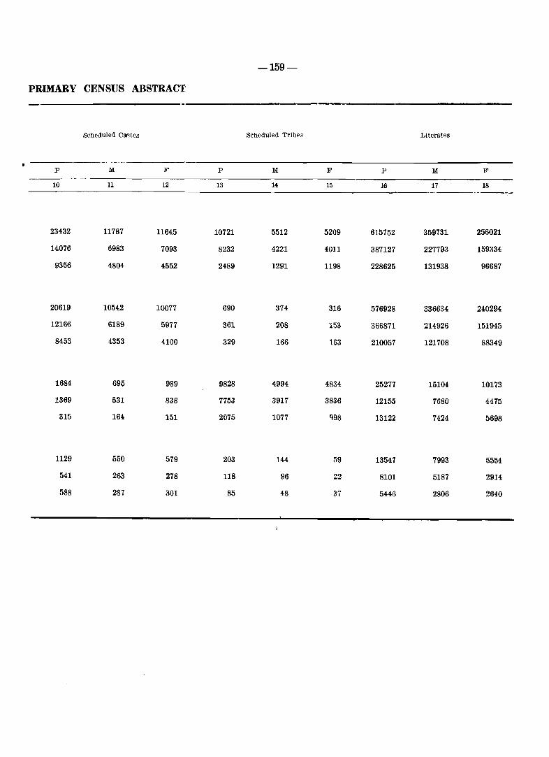
PRIMARY CENSUS ABSTRACT
p
10
23432
14076
9356
20619
12166
8453
1684
1369
315
1129
541
588
Scheduled Ca~tes
:1M:
11
11787
6983
4804
10542
6189
4353
695
531
164
550
263
287
F
12
11645
7093
4552
10077
5977
4100
989
838
151
579
278
301
p
13
10721
8232
2489
690
361
329
9828
7753
2075
203
118
85
-159-
Scheduled Tribps
:1M:
5512
4221
1291
374
208
166
4994
3917
1077
144
96
48
F
15
5209
4011
1198
316
153
163
4834
3836
998
59
22
37
p
16
615752
387127
228625
576928
366871
210057
25277
12155
13122
13547
8101
5446
Literates
:1M: F
17 18 .---------
359731
227793
131938
336634
214926
121708
15104
7680
7424
7993
5187
2806
256021
159334
96687
240294
151945
88349
10173
4475
5698
5554
2914
2640
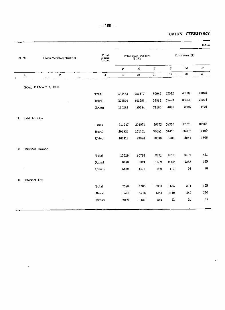
-160-
UNION TERRITORY
MAIN
Total Total main workers Cultivators (1) Sl. No. UIlJIon Territory/District Rural (I-IX)
Urball
p M F' P M F
1 2 3 19 2() 21 22 23 24 ---------
GOA, DAMAN & DIU
Total 332463 251477 80986 62572 40627 21945
Rural 221579 161693 59886 58486 38242 20244
Urban 110884 89784 21100 4086 2385 1701
1, District Goa
Total 311247 234975 76272 58376 37321 21055
Rural 207834 151151 '56683 54476 35067 19409
Urban 103413 83824 19589 3900 2254 1646
2. DistrIct Daman
Total 13618 10797 2821 3013 2432 581
Rural 8186 6324 1862 2900 2335 565
Urban 5432 4473 959 113 97 16
3. DistrIct Diu
Total 7598 5705 18915 1183 874 309
Rural 5559 4218 1311 1110 840 270
Urban 2039 1487 552 73 34 39
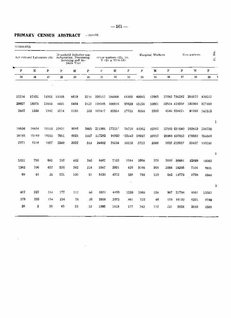
-161-
PRIMARY CENSUS ABSTRACT - concld.
WORKERS
Hcusehold Industry·maA;,:r.cultural Labourers (II) nufacturing. Processing.
--._--p M F
25 26 27
32394 17431 14963
29927 16071 13856
2467 1360 1107
!.lO556 16454 141(,~
28185 15140 13045
2371 1314 lO57
1431 750 681
1363 706 135"
68 44 24
407 227 IS0
379 225 154
28 2 26
Servicing and Repairs VIa)
P M F
28 29 30
11335 8619 271G
8621 6464 2157
2714 2155 559
10451 8046 2405
7911 6024 1887
2540 2022 51d
707 462 245
576 362 214
131 100 :U
177 111 G13
134 78 :36
43 33 10
Other workers (III. IV. V IB) & VI to IX)
P M F
31 32 33
2261G::l 184800 41362
124545 100916 23629
101617 83884 17733
211864 17315~ 38710
117262 94920 --22342
94602 78234 16358
8467 7153 1314
3347 2921 426
5120 4232 888
5831 4493 1338
3936 3075 861
1895 1418 177
Marginal Workers Non-worker>"
P M F p M
34 3;) 37 38
49985 12903 37082 704282 284070
43135 10601 32534 47020~ 192808
6850 2302 4548 2340H 91262
4-1962 12367 32595 651540 262810
39247 10287 28960 437883 179383
5715 2080 3635 213657 83427
3958 378 3580 30984 12899
3166 268 2898 16205 7104
792 110 682 14779 5795
1065 158 907 21758 8361
722 46 G76 16120 6321
343 112 231 5638 2040
F
39
420212
277400
142812
388730
250500
130230
18085
9101
8984
13397
9799
3598
o z
1
2
3
1
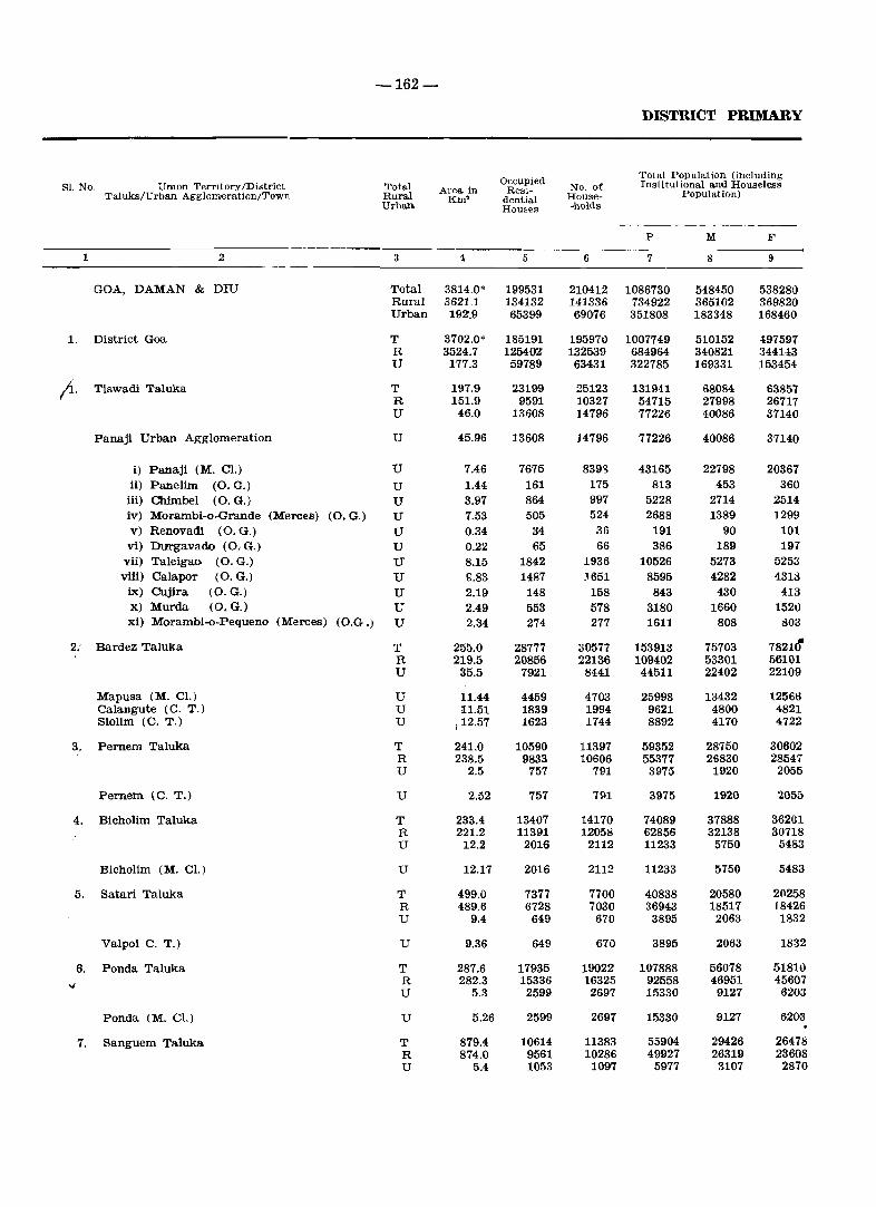
-162-
DISTRICT PRIMARY
Occupied Total Population (including
Sl. No. Umon Territory/District Total Area in Resl- No. of Institutionrul and Houseless TaJuka/Urban Agglomeration/Town Rural Km' dential House- Population)
Urban Houses -holds
-----_ P M F
1 .2 3 4 5 6 7 8 9
GOA, DAMAN & DIU Total 3814.0* 199531 210412 1086730 548450 538280 Rural 3621.1 134132 141336 734922 365102 369820 Urban 192.9 65399 69076 351808 183348 168460
1. District Goa T 3702.0* 185191 195970 1007749 510152 4,97597 R 3524.7 125402 132539 684964 340821 344143 U 177.3 59789 63431 322785 169331 153454
(1. Tiswadi Taluka T 197.9 23199 25123 131941 68084 63857 R 151.9 9591 10327 54715 27998 26717 U 46.0 13608 14796 77226 40086 37140
Panaji Urban Agglomeration U 45.96 13608 14796 77226 40086 37140
i) Panaji (M. Cl.) U 7.46 7675 839S 43165 22798 20367 ii) Panelim (0. G.) U 1.44 161 175 813 453 360 iii) ChimbeI (0. G.) U 3.97 864 997 5228 2714 2514 Iv) Morambi-o,-Grande (Merces) (0. G.) U 7.53 505 524 2688 1389 1299 v) Renovadi (0. G.) U 0.34 34 36 191 90 101 vi) Du~gavado (0. G.) U 0.22 65 66 386 189 197
vii) Taleigao (0. G.) U 8.15 1842 1936 10526 5273 5253 viii) Calapor (0. G.) U 9.83 1487 ~651 8595 4282 4313 ix) Cujira (0. G.) U 2.19 148 158 843 430 413 x) Murda (0. G.) U 2.49 553 578 3180 1660 152u xi) Morambi-o-Pequeno (Merces) (O.G.J U 2.34 274 277 1611 808 803
2: Bardez Taluka T 255.0 28777 30577 153913 75703 7821<1' R 219.5 20856 22136 109402 53301 56101 U 35.5 7921 8441 44511 22402 22109
Mapusa (M. Cl.) U 11.44 4459 4703 25998 13432 1.2566 Calangute (C. T.) U U.51 1839 1994 9621 4800 4821 Siolim (C. T.) U 112.57 1623 1744 8892 4170 4722
3, Pernem Taluka T 241.0 10590 11397 59352 28750 30602 R 238.5 9833 10606 55377 26830 28547 U 2.5 757 791 3975 1920 2055
Pernem (C. T.) U 2.52 757 791 3975 1920 '2055
4. Bicholim Taluka T 233.4 13407 14170 74089 37888 36201 R 221.2 11391 1205!S 62856 32138 30718 U 12.2 2016 2112 11233 5750 5483
Bicholim (M. Cl.) U 12.17 2016 2112 11233 5750 5483
5. Satari Taluka T 499.0 7377 7700 40838 20580 20258 R 489.6 6728 7030 36943 18517 18426 U 9.4 649 670 3895 2063 1832
Valpoi C. T.) U 9.36 649 670 3895 2063 1832
6. Panda Taluka T 287.6 17935 19022 107888 56078 51810
" R 282.3 15336 16325 92558 46951 45607 U 5.3 2599 2697 15330 9127 6203
Panda (M. CL) U 5.26 2599 2697 15330 9127 6203 . 7. Sanguem Taluka T 879.4 10614 11383 55904 29426 26478
R 874.0 9561 10286 49927 26319 23608 U 5.4 1053 1097 5977 3107 2870
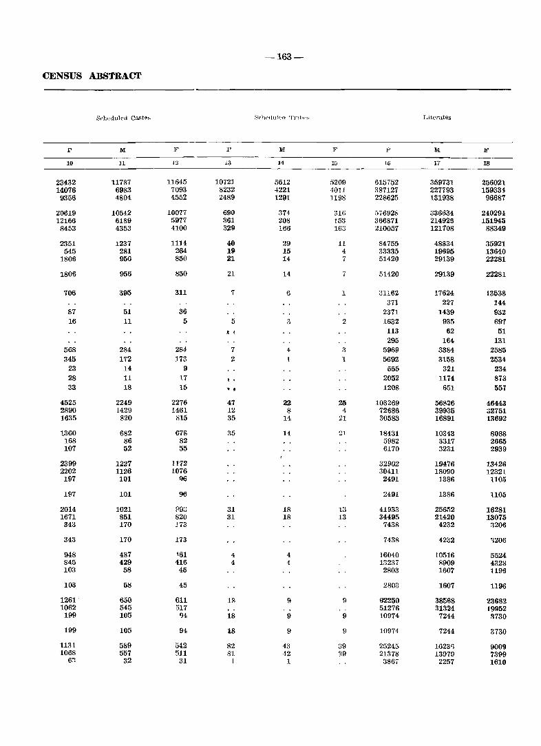
-163-
CENSUS ABSTRACT
S~hedulpd Cast~;, 3('hedulecl 'T'nlw.:-. Literates
p M F P M F P M F
10 11 13 13 14 15 16 17 18
23432 11787 11645 10721 5512 5209 615752 359731 256021 14076 6983 7093 8232 4221 4011 387127 227793 159331 9356 4804 4552 2489 1291 1198 228625 131938 96687
20619 10542 10077 690 374 316 576928 336634 240294 12166 6189 5977 361 208 153 366871 214925 151945
8453 4353 4100 329 166 163 210057 121708 88349
2351 1237 1114 40 29 11 84755 48834 35921 545 281 264 19 15 4 33335 19695 13640
1805 956 850 21 14 7 51420 29139 22281
1806 956 850 21 14 7 51420 29139 22281
706 395 311 7 6 1 31162 17624 t3538 371 227 144
87 51 36 2371 1439 932 16 11 5 5 3 2 1632 935 697
! ~ 113 62 51 295 164 131
568 284 284 7 4 3 5969 3384 2585 345 172 :173 2 1 1 5692 3158 2534
23 14 9 555 321 234 28 11 l7 f • 2052 1174 878 33 18 15 •• 1208 651 551
4525 2249 2276 47 22 26 103269 56826 46443 2890 1429 1461 12 8 4 72686 39935 ;;2751 1635 820 815 35 14 21 30583 16891 13692
1360 682 678 35 14 2! 18431 10343 8088 168 86 82 5982 3317 2665 107 52 55 6170 3231 2939
2399 1227 1172 32902 19476 13426 2202 1126 1076 30411 18090 12321 197 101 !)6 2491 1386 1105
197 101 96 2491 1386 1105
2014 1021 fl93 31 18 13 41933 25652 16281 1671 851 820 31 18 13 34495 21420 13075 343 170 J73 7438 4232 ~206
343 170 173 7438 4232 '1206
948 487 t61 4 4 16040 10516 5524 845 429 416 4 4 13237 8909 432S 103 58 45 2803 1607 1196
103 58 45 2803 1607 1196
1261' 650 611 18 9 9 6'2250 38568 23682 1062 545 517 51276 31324 19952
199 105 94 18 9 9 10974 7244 a730
199 105 94 18 9 9 10974 7244 3730
1131 589 542 82 43 39 25245 16231) 9009 1068 557 511 81 42 39 21378 13970 73P9
6:1 32 31 I 1 3867 2257 1610
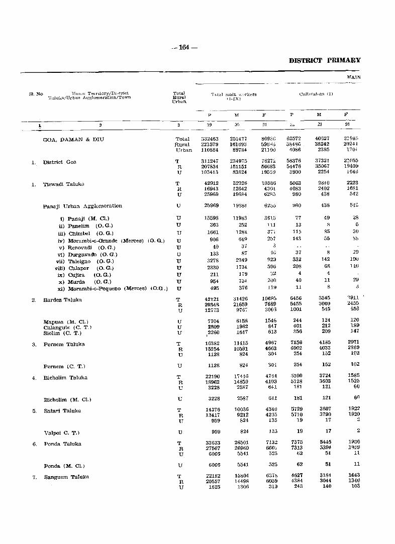
-164-
DISTRICT PRIMARY
MAIN
Sl. No UllI ()n T01'rltory /DIHtrict Total Tutal main wlIrl\.ers CultIvators (I) T"luka/Url>an Agglomeration/Town Rural
Urban. (I-IX)
p M F P M F
~ 2 3 19 20 :11 :.;~ 23 24
GOA, DAMAN & DIU Total 332463 251477 809Sa 62572 40627 21945 Rural 221579 161693 598-"'0 58486 . 38242 202H Urban 110884 89784 2UOi) 4086 2385 170i
1. District Goa T 311247 234975 7627:<' 58376 37321 21055 R 207834 151151 56683 54476 35067 1940!J U 103413 83824 HI5S::) 3900 2254 1640
1. Tiswadi Taluka T 42912 32326 10586 5063 2840 2223 R 16943 12642 4301 4083 2402 1681 U 25969 19684 62R5 980 438 542
Panaji Urban Agglomeration U 25969 19684 -622>0 \)80 438 54:':
i) Panaji (M. Cl.) U 15598 11983 3615 77 49 28
ii) Panelim (O.G.) U 363 252 111 13 8 5
iii) CIlimbel (0. G.) U 1661 1284 3T. 115 85 30
iv) Morambi-o-Grande CMerces) (0. G.) U 906 649 257 143 55 5b
v) Renovadi (0. G.) U 40 37 .3
vi) Duil'gavado (0. G.) U 133 87 1(; 37 8 29
vii) Taleigao (0. G.) U 3278 2349 923 332 142 190
viii) Calapor (0. G.) U 2330 1734 596 208 68 140
ix) Cujira (0. G.) U 211 179 ';2 4 4
x) Murda (0. G.) u 954 754 200 40 11 29
xi) Morambi-o-Pequeno (Merces) (O.G.) U 495 376 LUI 11 8 .3
2. Bardez Taluka T 42121 31426 106!'!5 6456 3545 ~911
R 29348 21659 7689 5455 3000 2455 U 12773 9767 3005 1001 545 456
Mapusa (M. Cl.) U 7704 6158 1546 244 124 120 Calangute (C. T.) U ~809 1962 847 401 212 189
Siolim (C. T.) U 2260 1647 613 356 209 147 I
3. Pernem Taluka T 16382 11415 4967 7156 4185 2971 R 15254 10591 4663 6902 4033 2869 U 1128 824 301 254 152 102
Pernem (C. T.) U 1128 824 304 254 152 102
4. Bicholim Taluka T 22190 17446 4744 5309 3724 1585 R 18962 14859 4103 5128 3603 1525 L' 3228 2587 641 181 121 60
Bicholim (M. CI.) U 3228 2587 641 181 121 60
5. Satari Taluka T 14376 10036 4340 5729 3807 1922 R 13417 9212 42()i) 5710 3790 1920 U 959 824 135 19 17 :!
Valpoi C. T.) U 959 824 13;) 19 17 2
6. Ponda Taluka T 33633 26501 7132 7375 5445 1f130 R 27567 20960 660', 7313 5394 1919 U 6066 5541 525 62 51 11
Ponda (M. e1.) U 6066 5541 325 62 51 11
7. Sanguem Taluka T 22182 15804 6371> 4627 3184 1443 R 20557 14498 6059 4384 3044 134.1) U 1625 1306 319 243 140 103
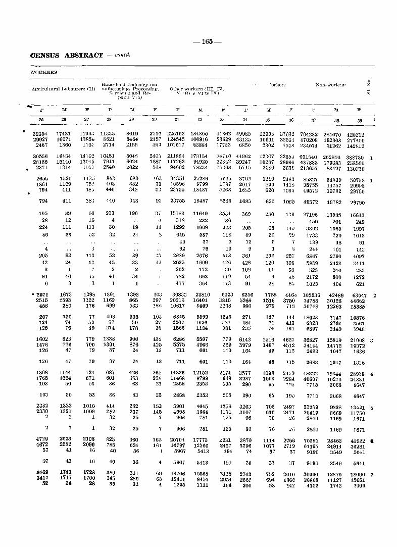
•
.cENSUS ABSTRACT - contd.
WORKERS
Agricultural Labourers (II) Houschol<l IndustrY-llianufactu.ring, Processing,
Sl2rvi('ing and Repall'S \'( a)
-165-
Other workers <III, IV, V IE) & VIto IX)
~:-----------------------------------------
•
a
p
32394 29927 2467
30556 28185
2371
2655 1861
794
794
105 28
224
86
4
205 42
3 91
6
• 2971 2515
456
207 124 125
1602 1476
126
126
1868 1765
103
103
2332 2330
2
2
4729 4672
57
57
3469 3417
52
M
26
17431 16071 1360
16454 15140 1314
1520 1109 411
411
89 12
111
33
92 24
1
46 3
1673 1393
280
130 74 76
823 776 47
47
1144 1094
50
50
1322 1321
1
1
2623 2582
41
41
1741 1717
24
F P M F P M
21
1495:1 13850 1101
1410~
1304f.i l(J57
In:5 75!! 38':;
38.3
16 16
113
53
4-113 12
-13 3
1293 1122
176
77 50 49
779 700
79
79
724 671
53
53
1010 1009
1
1
2]08 2090
1G
16
1728 1700
28
28
11335 8621 2714
104.51 7911 2540
843 403 440
440
233 4
30 32
52 45
2
41 1
1861 1162
699
408 77
214
1338 1301
37
37
687 601 86
86
414 282
32
32
825 785
40
40
380 345 35
29
8619 6464 2155
8045 6024 :.:;022
680 332 348
348
196
19 24
39 33
2
34 1
1398 865 533
305 50
178
900 876
24
24
426 363
63
63
262 237
25
25
660 624
36
36
311 280
31
31 32
2716 226162 184800 2157 124545 100916 351 101617 83884
2406 211854 173154 1887 117262 94920
518 94602 78234
163 34351 71 10596 fJ2 23755
11
7
163 29', ~fi';
103 27 36
13S 425 13
13
261 23S
23
23
152 145
7
7
165 161
-1
4
1J9 6::'
4
23755
15183 318
1292 645
40 92
2689 2035 202 782 477
30833 20216 10617
6845 2207 1565
6286 5575 711
711
14326 11468
2858
2858
5901 4995
906
906
20704 14797
5907
5907
13706 12411 1295
27286 8799
18487
18487
11649 232
1069
537 37 79
2076 1609 172 663 364
24810 16401
8409
5599 1626 1184
5507 4906
601
601
12152 9799 2353
2353
4645 3864
781
781
17773 12360
5413
5413
10568 9457 1111
F p
33 34
41302 49985 23629 43135 17'[33 6850
:187(0 44962 223'12 39247 16368 5715
70G5 3702 17CJ7 2017 3268 16c,5
',208
35J-1 86
223 108
3
13 613 4.26
::;0
n9 113
6023 3815 2208
1246 ';81 381
779 .359 11.0
110
21~40 1669
505
5(j5
1256 US1 125
125
~931 2137
194
W4
1138 29;)4
184
1685
369
205 49 12
9 361 426 109
54 91
6256 5266
990
271 484 235
6143 5979
164
164
3577 3287
290
290
3203 3107
96
96
3870 3796
74
74
2762 2562
200
"'orkers
M F p
36 37
M
38
F
39
o Z
12903 37032 704282 284070 420212 10601 32534 470208 192808 2774CO ~302 454S 234074 91262 142812
12367 325>1,; 651540 262810 388730 1 10287 28960 437883 179383 258500
2080 363f; 213657 83427 130230
1219 599 620
620
230
65 20
5 1
134 120
11 6
28
1788 1516 272
127 11 74
1516 1467
49
49
1098 1003
95
95
706 636
70
70
1114 1077
37
37
752 694 58
248:~ 141:; 1065
1065
LW '39
'I
:3 22, 306
93
63
4460 3750
718
144 413 J61
462,' 4512
115
Un
2473 2284
.,Q5
]9:5
2497 2471
J6
2756 2719
37
:J7
2010 1868
142
85327 35755 49572
49572
27198 450
3362 1733
139 244
6887 5839 523
2172 1025
105536 74788 30748
18023 6328 6397
36827 34144
2683
2683
48322 40607
7715
7715
23259 20419 2840
2840
70385 61195
9190
9190
30960 26808
4152
34539 14757 19782
19782
10585 201
1365 720
48 101
2790 2428 240 900 404
42489 30126 12363
7147 2761 2449
15819 14772
1047
1047
19344 16276
3068
3068
9838 8669 1169
1169
28463 24914
3549
3549
12870 11127
1743
507158 1 2091-18 297£;0
?9790
16613 249
1~[)7
1013 91
143 4{l97 3411 ~83
12',2 621
6304.7 Z 44662 18385
10876 35(H 194.8
210()S 3 19372
1636
IG':'6
289/S 4 243;;1
164.7
4647
13421 5 11750
1671
16;'1
41922 6 36281
S6-!1
5641
18090 7 15681
'Z409
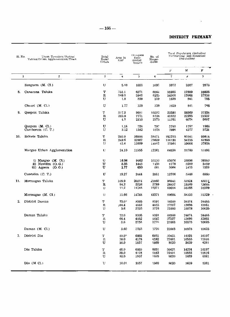
-166-
DISTRICT PRIMARY
Orcupied Total POlJulation (including Sl. No. Umon TeTl"ltol'Y /Dlstl'lCl Tota! No. of Institutional and Houseless Area in Resi- Population) Tuluka/LTrban Agglomeration/Town Rural Km' aentia! House-
Urban House>< -holds
-------" p M F
1 2 3 4 5 6 7 6 9
Sanguem (M. C1.) U 5.40 1053 109T 5977 3107 28m
8. Canacona Taluka T 351.1 6271 6564 35935 17909 1802S R 349.3 5942 622f> 34306 17068 17238 U 1.8 329 33~ 1629 841 78&
Chauri (M. C1.) U 1.77 329 339 1629 841 7~S
9. Quepem Taluka T 317.3 9881 10503 55593 28369 27224. R 313.0 7771 8128 43832 22295 21537 U 4.3 2110 2375 11761 6074 5687
Quepem (M. C1.) U 1.18 728 797 3763 1797 1966 Curchorem (c. T.) U 3.12 1382 1578 7998 4277 3721
10. Salcete Taluka T 293.0 36866 38471 193755 93841 99914 R 249.6 22867 23629 116191 54235 6195S U 43.4 13999 14842 77564 39606 37958
Margao Urban Agglomeration U 24.10 11555 12261 64858 33760 31098-
i) Margao (M. Cl.) U 16.98 9462 10150 53076 26996 26080' ii) Navelim (0. G.) U 5.35 1443 1450 8778 5289 3481} iii) Aquem (0 .. G.) U 1.77 650 661 3004 1475 1529
Cuncolim (C. T.) U 19.27 2444 2581 12706 5846 6860
11. Mormugao Taluka T 105.9 20274 21060 98541 53524 4501~ R 94.2 5526 5789 28857 15169 1.308l'> U 11.7 14748 15271 69684 38355 31329-
Mormugao (M. Cl.) U 11.66 14748 15271 69684 38355 31329 ,
2. District Daman T 12.0* 8305 8391 48560 24074 24486 R 166.4 4552 4615 27557 13696 13861 U 5.6 3753 3776 21003 10378 10625-
Daman Taluka T 72.0 8305 839J ·18560 24074 24486-R 66.4 4552 4615 27557 13696 13861 U 5.6 3753 377n 21003 10378 1062f>
Daman (M. el.) U 5.60 3753 377G 21003 10378 10625-
3. District Diu T 40.0':' 6035 6051 30421 14224 16197 R 30.0 4178 4182 22401 10585 11816 U 10.0 1857 1869 8020 3639 4381
Diu Taluka T 40.0 6035 6051 30421 14224 16197 R 30.0 4178 4182 22401 10585 11816 U 10.0 1857 1869 8020 3639 4381
Diu (M C1.) U 10.01 1857 1869 8020 3639 4381
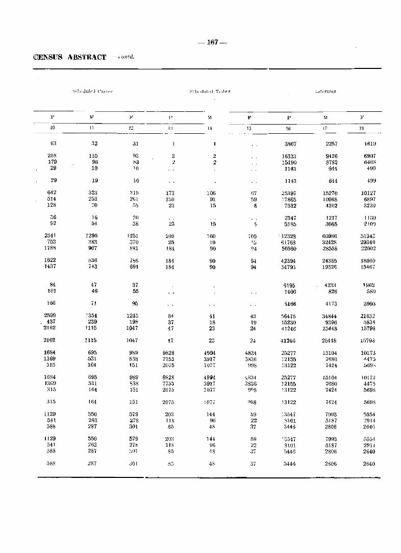
-167-
tDENSUS ,A'BSTRACT - I ont!!.
.'-'el', dttled T,·,}il S
p ]1.1 j<' l' .M: F P M It
10 11 12 1:~ 14 15 16 Ii 18
63 32 :n 1 1 3867 2257 1610
208 115 !"IS 2 2 16333 9426 6907 179 96 83 2 2 15190 8782 6408 29 19 10 1143 644 499
29 19 10 1143 644 ·199
642 323 :1l9 173 106 (i7 25397 15270 101:l7 514 253 261 150 91 fl9 17865 10968 68!H 128 70 !'is 23 15 8 7532 4302 3230
36 16 ?,(J 2347 1217 1130 92 54 38 23 15 S 5185 3085 210')
2541 1290 1251 209 100 -(09 -c12328 60986 51342 753 383 :no 25 10 ~f) 61768 32428 29340
1788 907 881 184 90 °4 50560 28558 :2200:!
1622 836 7~6 184 90 94 42394 24385 18009 1437 743 694 ]84 90 94 34793 19326 15467
84 <17 37 03195 4233 J!l6~ 101 46 55 1406 826 580
166 71 95 3166 4173 399iS
2599 1354 1245 84 41 43 56476 34844 21632 437 239 198 37 18 19 15230 9396 5834
2162 1115 1047 47 23 24 41246 25448 15798
2162 1115 1047 47 23 U 41246 25448 1579d
1684 695 989 9828 4994 4834 25277 15104 10173 1369 531 831:\ 7753 3917 3836 12155 7680 ·1475 315 164 151 2075 lOT. ~98 13122 7424 569;
1684 695 989 9828 49t4 48:H 25277 15104 .10173 1369 531 838 7753 3917 3836 12155 7680 4475 :n5 164 151 2075 1077 91)8 13122 7424 5698
315 164 151 2075 107, 998 ~3122 7424 5698
1129 550 579 203 144 ))9 ~3547 7993 5554 541 263 ~78 118 96 22 'HOI 5187 :?9l4. 588 287 301 85 48 37 3446 2806 264()
1129 550 579 203 144 1)9 ~3547 7993 5554 541 263 27i:1 118 96 22 glOl 5187 291-1 588 287 ,,0} 85 48 37 5446 2806 2640
588 287 301 :-55 48 37 5446 2806 2640
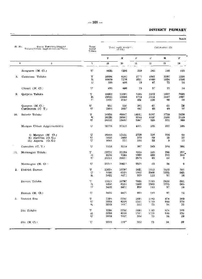
--"-168 -
DISTRICT PRIMARY
MAIN
81. No. Ulllon Tp<"I',!ol'y/Districi Tutai Total ]twin -WlIlkpl'-- Cultiv"toI'S (I) Tal ukajU rlJan Agg-lvtllf::'l'atJOn/To ,'In Rural II-IX)
erban
p M F P M F
1 2 > 19 20 21 22 ~3 24
Sanguem (M. Cl.) U 1625 1306 319 243 140 10:1
8. Canacona Talukll. T 10894 8182 2- 1 '; I _ 4947 3597 1350 R 10409 7776 263~~ 4860 3524 1336 U 485 406 ':9 87 73 1-1
Chaud (M. CL) U 485 4f}6 79 87 73 14
9. Quepem Taluka T 18962 1359Z 536\1 59i2 3931 2035 R 15525 10806 4719 5'lH 3847 1997 TJ 3437 2787 65G 128 90 38
Quepem (M. Cl.) U 953 750 203 63 41 22 Curchorem (C T.) U 2484 2037 447 65 49 If,
10. Salcete Taluka T 54858 4004;" 14811 5187 2759 2428 R 30326 2058::! 974.1 4307 2188 2119 U 24532 1946',5 506; 880 571 309
Margao Urban Agglomerati:::>l1 U 21716 1731;; 44C'_" 335 227 lOS
i) Margao (M Cl.) U 1684.0 13131 3709 254 186 68 ii) Navelim (0. G,) U 3835 346(}1 375- 59 32 27 iii) Aquem (O.G.) U 1041 72 15 316 22 9 13
Cuncolim (C. T,I U 2816 21H 667 545 344 201
11. Mormugao Taluk3 T 32737 28199 4536 555 298 257. R 9526 756" 1961] 490 242 248 U 23211 2063~ 2576 65 56 9
Mormugao (M, Cl I U 23211 20631 257S 65 56 9
2. District Daman T 1361& 10797 2821 3013 2432 fi81 U 8186 632-1 186'!! 2900 2335 565 R 5432 447:: 959 113 97 16
Daman Taluka T 13615 10797 ~821 3013 2432 581 R 8186 6324 1862 2900 2335 565 rr 5432 4473 95!' 113 97 Hi
Daman (M. CL) U 5432 44n 95~~ 113 97 16
., u. District Diu T 7598 5705 189'; 1183 874 309
U 5559 4218 1341 1110 840 270 R 2039 1487 55~ 73 34 3S
Diu Taluka T 7598 5705 ]89:': 1183 871 30S R 5559 4218 B4t 1110 840 27G U 2039 1487 552 73 34 39
Diu (M Cl.l U 2039 1487 552 73 34 39
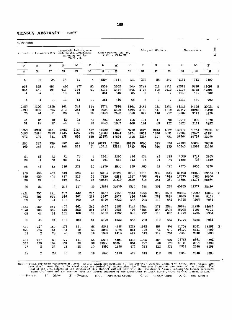
-169-
'CENSUS ABSTRACT - c01!cld.
v"}RKERS
Household Industry-rna· j,_ 'll'ultural Labourer~ (II) nufactuxing. Processing.
1I1al'gma\ Work('l'~
P
25
52
958 954-
4
4
2755 2680
75
44 31
6358 5686
672
586 469
94 23
86
859 829 30
:30
1431 1363
68
1431 13003
68
68
407 379
2'3
407 379
28
28
M
26
24
555 551
4
4
1399 1355
44
25 19
3204 2813 391
347 285
51 11
44
450 429
21
21
750 706 44
750 706 44
44
227 225
2
227 225
2
2
F
27
23
40:: 403
1356 132;')
:n
19 12
315-l 2873
281
239 181
43 '!2
,12
409 4(lu
9
681 65'j
:!1
681 65, 2,t
24
180 1M
26
180 154 26
2G
Servicing and Repairs V(a)
p
28
35
430 417
13
13
461 373
88
43 45
2593 1765 828
582 406
81 95
246
619 377 242
242
707 576 131
707 576 131
131
177 134
43
177 134 43
43
M
29
31
377 364
13
13
347 284
63
31 32
2156 1487 669
448 329
72 47
221
529 312 217
217
462 362 100
462 362 100
100
111 78 33
111 78 33
33
Other workers (III. IV. V (B) & VltoIXl
F
30
1U b9 23
P
31
1295
4559 4178 381
381
9774 6628 3146
12 803 13 2343
437 40720 278 18568 159 22152
13-1 20213 j" 15711
a 3601 48 901
25 1939
90 30704 35 7830 :l5 22874
25 22874
245 214
:\1
245 214
31
Gf 5G 10
66 56 10
10
8467 3347 5120
8467 3347 5120
5120
5831 3936 1895
5831 8936
1895
1895
1111
3653 3337
316
316
7910 5320 2590
653 1937
31928 14094 17834
16294 12331
3305 658
1540
26922 6583
20339
20339
7153 2921 4232
7153 2921 4232
4232
4493 3075 1418
4493 3075
1418
1418
F p
34
200
1)06 2728 841 2720 65 8
65
1864 1308
056
150 406
'3792 1474 1318
39119 3R!!O
296 243
399
3762 1247 2535
2535
1314 426 8!s8
l;:U ·126 8118
888
1338 861 477
8
2482 2160
322
131 191
7925 6657 1268
1003 591
334 78
265
2314 1696
618
618
3958 3166
792
3958 3166
792
792
1065 722 343
1338 1065 861 722 477 343
477 343
M F
36
58 142
511 221.'7 510 2210
1 7
1
651 541 110
41 69
2043 1626
417
375 266
85 24
42
969 618 351
351
378 268 110
378 268 110
110
158 46
112
158 46
112
112
7
1831 16lU
212
90 122
5882 fl03l
851
628 325
249 :>4
H45 1071l
267
267
358\) ?898
682
358U 2898
682
682
9fH 676 231
907 676 231
'~31
P
37
4152
22313 21177
1136
1136
34149 26147
8002
2679 5323
130972 79208 51764
42139 35645
4609 1885
9625
63490 17635 45855
45855
30984 16205 14779
30984 16205 14779
14779
21758 16120
5638
21758 16120 5638
5638
M
, 38
1743
9216 8782 434
434
14125 10948
3177
1006 2171
51751 32027 197240
16069 13599
1744 726
3655
24356 6985
17371
17371
12899 7104 5795
12899 7104 5795
5795
8361 6321 2040
8361 6321 2040
2040
F
1
24()9
13097 8 12395
702
71)2
20024 15199
1825
1673 'H52
9
79221 10 47181 32040
26070 22046
2865 1159
5970
39134 11 10650 28484,
28484
18085 2 9101 '3934
18085 9101 8984
8984
13391 3 q7119 8598
13397 9799 3598
3598
------------------------------------.------------------------------------------------------------------ ~ NL't,:: * Th,,"e repItBellt "Geographical Area" figUl'es which are supplied 1)~' the Surveyor GeneraL India The L:rball area fignres are
provisionaL Area figures for rural areas are derived by substractillg' the Urban area from the total area 01 the dif'trict. The total of the area figures of the talulms of Goa District will not tally with the Goa district figures llecause the former represent "Land Use" area and are derived from th" figures supplied by the Directorate of Land Survey. Govt. of Goa, Daman & Diu .
. - Persons M - Male" F - Fema\e~ M.CL - Municipa\ CounCil C. T. - CenBUs Town O. G. - Out Growth
-uo-District: Goa-Code No.1 PRIMARY CENSUS
... II)
.n
a Area of Total populatIOn (Including
S~heduled Schedul .. d .~ Institutional & Houseless Literates Cl
vJllage in Occupleil No. of ' population) Castes Tribes
'tI Name of vlllage/ h(·dares & residen-0 /town/ward uf townl tlal house-.'t,)
ward in hOUp"eR hold!' ~ Km' .S
~ P M F M F M F M F 0 ...:l
1 3 J 6 7 8 9 10 11 12 13 110
TOTAL 197.9 Kmc 23199 25123 131941 68084 63857 1237 1114 29 11 48834 35~~1.
RURAL 151.9 Km" 9581 10327 54715 27998 26717 281 264 15 4 19695 lSI)!,!)
URBAN 46.0 Kmc 13608 14796 77226 40086 37140 956 8c50 14 7 29139 2223:
RURAL
1 Ambarim 17.60 27 28 93 40 53 28 30 2 Chorao 2022.23 856 956 4709 2265 2444 26 36 1672 1369 3 Caraim 70.06 53 57 254 116 138 1 4, 80 S5 4 Capao 92.77 51 51 193 90 103 70 :18 5 Navelim 581.12 239 243 1113 543 570 8 7 350 291 6 Goltim 439.63 387 395 1740 819 921 9 6 606 ;529 7 Malar 599.21 313 328 1588 755 ·833 11 8 582 -riO 8 Naroa 128.44 73 77 452 219 233 2 4, 178 U2 9 .Jua 904.73 96] 979 4282 1885 2397 4 4 1343 H23
10 Cumbarjua 304.08 658 679 4140 2120 2020 13 . 16 1539 1100 11 Gandaulim 173.72 59 60 303 136 167 111 115 12 Corlim 727.84 555 589 2675 1372 1303 14 11 874 621 13 Ella 932.87 236 245 1315 603 712 9 3 1 385 4()~
14 Bainguinim 380.46 41 41 205 120 85 19 5 1 1 60 ~~ ,. 15 Panelim Treated as Out-growth of Pand.fi" 16 ChimbeJ -do-IT Morombi-O- -do-
Grande (Merces) 18' Renovadi -do-19 Durgavado -do--2()' Taleigao -do--21. Calapor -do-22 Cujira -do-23 Murda -do--24· . Morombi-O- -do-
: Pequeno (Merces) 25 Talaulim 674.77 87 87 472 218 254 142 92 26 Goalim-Moula 405.66 48 48 282 162 120 1 3 127 58 27 Carambolim 1832.92 633 713 3946 1952 1994 ' Z2 27 1163 6~2 28 Azossim 418.82 161 174 910 468 442 316 2:H 29 Mandur 260.69 612 689 3594 1679 1915 4 10 1251 1(1)7 30 Gancim 382.96 75 82 472 235 237 170 122 31 Batim 479.22 280 297' . 1426 714 712 25 29 456 36{ 32 Curca 345.05 243 337 1725 878 847 3 1 545 322 33' Bambolim 491.86 600 619 4601 3408 1193 55 36 13 3 2997 67S 34 Siridao 283.27 425 486' . 2693 1413 1280 5 5 804 4211 35 Goa-Velha 835.02 729 768 4430 2239 2191 31 23 1560 1170 36 Neura-O-Pequeno 135.67 52 58 347 171 176 104 '3(1
37 Neura-O-Grande 947.19 239 263 1429 668 761 468 411 38 Mercurim 325.82 898 978 5326 2710 2616 19 26 1714 1 ~'H) '}I oJ _ _.!
URBAN
I Panaji Urban 45.96 13608 14796 77226 40086 37140 956 850 14 7 29139 22281 Agglomera tion
Panaji Municipal 7.46 ,675 8398 43165 22798 20367 395 311 6 1 17624 135~3
Council
12 4 5 1 1 6 3 28 49 1 955 415 436 265 69 70 9 10 441 70 39 95 1271 1934 2 53 19 23 7 12 4 3 15 8 63 119 3 29 3 5 1 24 2 61 100 4
149 54 9 11 49 19 3 1 88 23 36 67 358 449 5 343 167 89 77 33 42 1 1 220 47 476 754 6-327 136 134 105 20 9 8 1 165 21 21 90 407 607 7 71 13 :l2 6 10 3 29 4 3 6 145 214 g
564 140 66 48 13 10 19 2 466 80 11 53 1310 2204 9 853 256 192 121 47 45 3 1 611 89 42 42 1225 1722 10-
46 5 8 1 1 37 4 2 17 88 145 11 672 210 47 22 105 38 5 6 515 144 33 28 667 1065 H 329 144 10 4 11 1 10 2 298 137 2 1 272 567 13
77 22 15 6 56 22 1 4 42 59 14 • (Panaji Urban Agglomeration) Hi -do- 16--do- 17
-do- 18 -do- 1~
-do- 2& -do- 21 -do- n -do- 23 -do- 24
95 28 66 15 29 13 123 226 25 67 26 36 20 8 3 1 2 22 1 95 94 2&
817 322 318 171 137 72 3 3 359 76 66 328 1069 1344 21 184 131 94 101 21 12 69 18 284 311 20 690 382 203 176 97 124 3 2 387 80 26 61 963 1472 2~ 119 4 18 24 1 17 60 3 1 116 232 30 283 162 88 91 20 19 19 8 156 44 32 54 399 496 31 373 58 68 24 77 12 228 22 48 167 457 622 32
2666 168 19 6 21 9 2626 153 47 34 695 991 33 592 291 69 18 63 63 15 2 445 208 72 107 749 882 34 871 372 69 30 60 60 119 15 623 267 31 122 1337 1697 35 66 24 39 20 1 2 1 1 25 1 11 11 94 141 36
236 110 51 52 17 16 2 166 42 35 57 397 594 37 1103 635 259 303 120 103 91 14 633 215 41 73 1566 1908 38
6285 438 542 411 383 348 92 18487 5268 620 1065 19182 29790 I
11983 3615 49 28 89 16 196 37 11649 3534 230 139 10585 16613
District: Goa ~ Code No.1·
1
Name of vIUUgej jtown/ward
2
Ward No.1
Ward No.2
Ward No.3
Ward No.4
Ward No.5
Ward No.6
Ward No.7
Ward No.8
Ward No.9
Ward No. 10
Ward No. 11
Ward No. 1:0
Ward No. 13
Ward No. 14
Ward No. 15
Out growths
15 Panelim
16 Chimbel
17 Morambi-OGrande (~erces)
18 Renovadi
19 Durgavado
20 Taleigao
21 Calapor
22 Cujira
23 Murda
24 Morambi-OPequeno (Merces)
Area of vIllage in hectares & O( townj ward in
Km2
3
N.A.
N.A.
N.A.
N.A.
N.A.
N.A.
N.A.
N.A.
N.A.
N.A.
N.A.
RA.
N.A.
N.A.
N.A.
1.44
3.97
7.53
0.34
0.22
8.15
9.83
2.19
2.49
2.34
Occupied n'siden- "'0 ot
hal house-houses holds
4
438
363
327
427
340
413
643
667
452
459
471
314
828
612
921
161
864
505
34
65
5
579
380
350
455
381
425
677
702
474
504
499
380
1005
635
952
175
997
524
36
66
-172-
Total populatioll (lI~cluding Institutional & Houseless
population)
p M
6 7
2483 1340
2004 1034
1814 870
2530 1272
2002 1016
2265 1178
3817 1975
4111 2116
2425 1227
2483 1338
2603 1394
1829 1048
5086 2967
3101 1564
4606 2459
813 453
5228 2714
2688 1389
191
386
90
189
F
8
1143
970
944
1258
986
1087
1842
1995
1198
1145
1209
781
2119
1543
2147
360
2514
1299
101
197
1842 19&6 10526 5213 5253
4313 1487 1651 8595 4282
148 !li8 843 430 413
553 578 3180 1660 1520
274 277 1611 808 803
Scheduled Castes
M F
9 10
26
12
18
25
55
109
61
4
1
17
5
9
29
24
51
11
284
172
14
11
18
15
5
18
23
43
95
53
3
IV
6
22
18
36
5
173
9
17
15
PRIMARY CENSUS
:-;,'heuuled Tribt's
M F
11 12
3
3
3
4
1
LltE'rates
M F
13
1002
847
712
1043
896
1000
1432
1607
1 1026
2
1113
1156
873
2166
1088
1663
227
1439
935
62
164
3 3384
1 3158
321
1174
651
14
799
688
661
870·
753.
845
1051
1365
843
834
897
609·
1315·
90lt
1099'
144
932
697
51
131
2585
2534
234
878
557
-173-
ABSTRACT - condd.
MAIN WORKERS
----------------------------~~~~---------' Hou.sehold In-
T< t~ll n1aln workers (I-IXI
]VI F
1(; 16
830
501
387
673
491
571
926
985
610
754
706
702
1742
771
1333
252
1284
649
37
87
2349
1734
179
754
376
354
141
136
264
169
157
231
374
194
191
164
159
532
253
296
111
377
257
3
-106
929
596
32
200
119
Cdltl\·"tors (I)
1\1 F
17 18
1 1
8 2
2 3
1
1
1
1
7 1
1 11
19 10
8 5
85 30
55 88
8 29
142 190
68 140
11 29
8 3
AgrIcultural Lahourers (II)
M F
19 20
2
5
1
7 5
1
4 1
1
5 3
6 3
57 4
12 16
111 113
33 53
4
92 113
24 18
1 2
46 45
3 3
dustry man.ufacturing, processing. servicing
and repairs [v(a)]
.M F
21 22
13 6
21 7
27 2
21 2
16 2
12
9 9
6 2
15 1
3
4
4 1
22 4
5 1
18
4
Other workers IIII. IV. V(b) &
VI to IX)
M F
23 24
816
470
353
648
474
558
907
978
595
750
698
696
1708
759
1239
232
347
132
131
262
167
157
217
372
193
191
163
158
524
238
282
86
19 11 1069 223
24
39
33
2
34
1
8 537
13
12
7
37
79
2076
1609
172
663
364
108.
3
13
613
426
30
119
113
'l'aluka: 'l'ISW ADI - Oode No. 1/1
Marglllaj work6rs
M F
25 26
4
3
19
23
5
18
14
4
16
6
15
13
13
27
50
65
2()
5
1
134
120
11
6
28
1
12
15
3
7
10
6
6
2
7
6
9
16
39
140
29
7
8
227
306
98
48
63
::-; un-workers
27 28
~06
530
464
576
520
589
1035
1126
601
578
673
333
1212
766
1076
201
1365
720
48
101
2790
2428
240
900
404
789
828
796
979
814
923
1601
1615
998
952
1038
616
1578
1274
1812
249
1997
1013
91
143
4097
3J~1
283
1272
621
15
16
17
18
]9
20
21
22
23
24
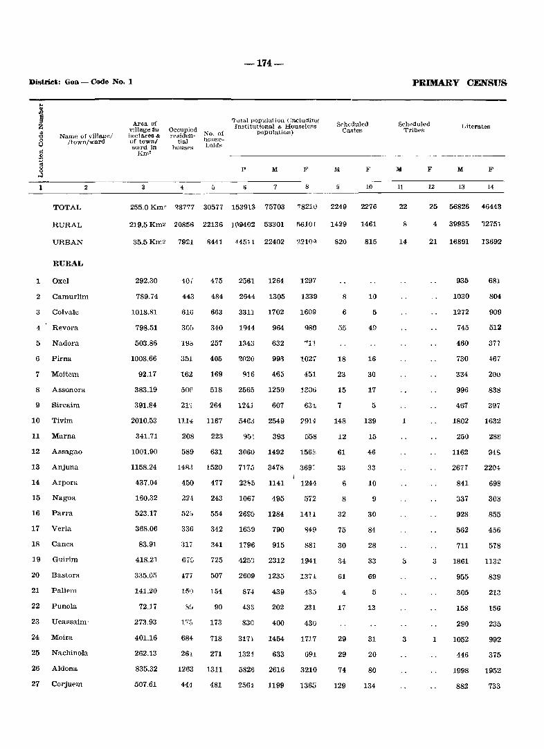
-174-
District: Goa - Code No. 1
.. I ~ o
1;)
Name of villagel flown/ward
::: .51
]
TOTAL
RURAL
URBAN
RURAL
1 Oxel
2
2 Camurlim
3 Colvale
4 Revora
5 Nadora
6 Pirna
7 Moitem
8 Assonora
9 Sircaim
10 Tivim
11 Marna
12 Assagao
13 Anjuna
14 Arpora
15 Nagoa
16 Parra
17 Verla
18 Canca
19 Guirim
20 Bastora
21 Paliem
22 Punola
23 Ucassaim'
24 Moira
25 Nachinola
26 Aldona
27 Corjuem
Area of village :in hcdares& of townl ward in
Km'
3
Occupied No. of rpsiden-
tial house-house~ holdR
4 5
Tutal population (including" Institutional & Houseless
population)
p M F
6 7 8
Srheduled Castes
M F
10
255.0 Km" ~8777 30577 153913 75703 7821u 2249 2276
219.5 Km2 20856 22136 1(1941)2 53301 M1D I 1429
35.5 Km2 7921 8441 ~4511 22402 ·.~21()'l
292.30
789.74
1018.81
798.51
503.86
1008.66
92.17
383.19
391.84
2010.53
341.71
1001.90
1158.24
437.04
160.32
523.17
368.06
83.91
418.21
335.05
141.20
72.17
273.93
401.16
262.13
835.32
507.61
40.
443
616
30E.
Ill':;
351
162
50('
21'j
HE
475
484
663
340
257
405
169
518
264
1167
208 223
589 631
14R.3 1520
450 477
22·1 243
52i. 554
336 342
il1i 341
67::;
17'i
684
26t
1263
441
725
507
154
90
173
718
271
1311
481
2561 1264
2644 1305
3311 1702
1944 964
1il43
2(l20
~16
2565
124J
546.:1
632
993
465
1259
607
2549
1297
1339
1609
980
1027
451
1200
631
29U
9fil 393 558
3060 1492 1562,
7173 3478 :369~
22~5 1141 1241
1067 495 572
2695 1284 1411
1630 790 'HU
1796 915 881
4253
2609
874
433
830
3171
132J
5826
2561
2312
1235
439
202
400
1454
633
2616
1199
1941
I37!
435
231
43U
1717
G91
3210
1365
820
8
6
55
18
23
15
7
148
12
61
33
6
8
32
75
30
34
61
4
17
29
29
74
129
1461
815
10
5
49
16
30
17
5
139
15
46
33
10
9
30
84
28
33
69
5
13
31
20
80
134
PRIMARY CENSUS
Scheduled Tribes
Literates
M
11
22
8
14
1
3
F M F
12 13 14
25 56826 46443
4 39935 12751
21 16891 13692
3
1
935
1030
1272
745
460
730
334
996
4S7
1802
250
1162
2677
841
337
928
562
711
1861
955
305
158
290
1052
446
1998
882
681
804
909
512
377
4067
201)
838
397
1632
288
::l1S
220~
698
308
855
456
578
1132
839
213
156
235
992
375
1952
733
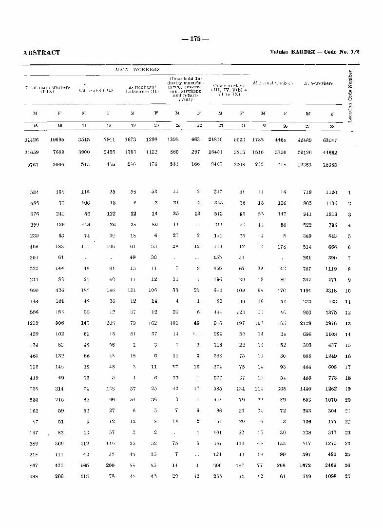
ABSTRACT
T ~d lllaill worlu~r~ IT-IX)
:'>1 F
15 16
31426 10695
21659 7689
8767 3006
534 161
485 77
676 24:::
399 129
233 63
406 183
20,1 61
144
241 83
990 426
144 101
556
1239 556
429 102
114
13~
332 14&
419 49
758 314
560 215
162 59
87 51
147 83
589 309
218 111
867
438 2013
CultIvattllS (1)
1\1
3545
3000
118
100
56
74
171
46
23
18']
5_5
14.')
65
48
66
38
16
135
53
9
112
42
165
115
F
18
2[.l1l
~455
459
25
15
122
26
106
61
4f)
186
56
-C) -1_
208
i5
')6
46
5
1:lS
99
27
12
57
1~f)
200
A~ricultural Labollrer~ I III
F
1673 1298
1393 1122
2S0 176
53
6 2
12 14
28 80
1& 6
61 53
49 30
15 11
11 12
131 106
12 14
12
79 102
51
1
18 6
11
4 6
57 25
51 36
6 ;)
13 s
2
35 52
4:1 35
83
-175-
HUlIN'huld Industry 1l1aD!UfaeturIng, proces~mg, servicing and rE'pairs
I,-(a)]
Oth\.,f' \\ urker~ IIII. IV, V(b) &
YI to IX)
1\1 F
1398 463 24810 6023
865
11
24
35
1-1
7
11
4
20
101
11
17
22
14
75
297 164()1
166 8409
2 347
355
12 573
21-1
2 120
12
155
2 455
1 HI6
25 6n
1 30
6
49 916
299
2
3
16 274
1
17 58:5
1 441
6 96
51
1 101
6
124
1
255
3815
:?2U/j
81
36
,31
67
30
109
123
197
50
T5
75
37
134
79
21
187
~.j
1788
1516
11
15
85
19
6S
16
It)
13
H
114
9
13
• j
1~
Taluka BARDEZ - Code No: 1/~
446"
3750
16
126
147
56
5
178
80
170
2i
40
165
34
52
30
93
5 ..
365
89
72
3
30
133
90
268
61
XL n-\"orker~
42489
30126
12.363
719
805
9H
522
.389
514
261
707
347
1491
903
2139
696
305
808
444
486
1440
653
243
106
238
'H7
397
1~72
719
F
28
63047
44662
18385
1120
1136
1219
795
643
666
390
1119
471
2318
1375
2976
1
3
5
6
-:
8
9
10
11
12
13
1108 14
437 15
1249 16
608 17
778 18
1262 19
1070 20
304 ~l
177 n
317 :!3
1275 24
490 25
2469 26
1098 21
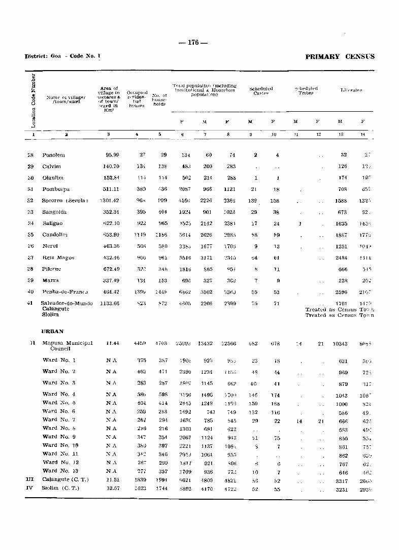
Vistriet: Goa - Code No.1
:\Camp 01 vlilag./ /Iown/ward
~,8 Ponolem
29 Calvim
;]0 Olaulim
32 Socorro (Serula)
23 Sangolda
84 Saligao
35 Candolim
36 Nerul
37 Reis Magos
38 Pilerne
39 Marra
40 Penha-de-Franc.1
Area of village an '"Acctares & o)f town! ward in
Km2
3
95.99
140.70
152.84
511.11
]:301.42
352.34
':)22.10
'-';53.90
463.36
432.46
672.49
337.49
464.42
41 Salvador-do-Mundo 1133.66 Calangute Siolim
URBAN
]I Mapusa Municipal Council
Ward No.1
Ward No. ?,
Ward No.3
Ward No.4
Ward No.5
Ward No.6
Ward No. '1
Ward No. b
Ward No.9
Ward No. 10
Ward No. 11
Ward No. ]2
Ward No. i3
HI Calangute (C. T. )
IV Siolim (C. T.)
11.44
NA
NA
NA
NA NA
NA NA
NA
NA NA
NA NA
NA.
11.51
12.57
OCCupied rd~iden- ~(). ot
tIal hOUllC-h(lu~ps hold~
4 5
29
13~ 138
n .... 114
38;} 436
999
39[> 404
922 965
lU9 1186
508 580
961
348
131 153
1448
:'<72
-176-
Tf)tal populati(Jll Imcluding ln~1 itutional & Hou8P]ess
p()pulation)
p
134
."II
7
60
200
502 214
').087 966
459':' 2226
192-1 901
452:) 2142
5614 2626
33b,; 167T
;;51(; 3111
181ti 865
5913 32 ..
1',8132 3502
4605 2206
F
8
74
283
288
H21
'l36:3
102.3
2381
17(11;)
3Gt)
03f>J
'<'399
445~t 4703 25911J 13432 12566
375
462
283
58\)
40!
:7.59
261
216
347
3SU 34:2
267
'27i
1839
1623
387
4i1
287
598
414
283
294
216
354
397
346
299
357
1994
1744
1905
239()
18(1',
'1190
244;)
14PZ
163C
1303
2067
2221
?I)!;)
1817
1709
9621
5892
923
1234
1145
1490
1249
743
785
681
1124
113 ..
1064
921
936
4800
4170
l150
66?
1700
1}<).j
,49
'145
022
9·13
108':0
'196
77J
482l
472:2
Scheduled Ca~lf>~
M F
9
2
1
21
139
29
17
~8
9
64
8
7
55
75
682
48
40
146
159
132
29
.,1 s
10
S6
52
10
4
1
18
158
38
24
89
13
61
11
9
53
71
678
18
44
41
174
168
]16
22
75
7
6
7
1<2
55
PRIMARY CENSuS
":"liedulpd TrIbes
Lit('ratf>~
M F
11
1
14
14
12 13
32
126
174
708
1588
673
1635
1887
1251
2484
666
228
2596
14
27
05~
13'2-,
14.)')
lE!
')45
20~
1701 14,[1 Treated as Censu~ To'_', n Treated as CensuH To'.', n
21 10343
21
631
969
879
1043
1000
586
666
583
850
861
862
767
646
3317
3231
72;
317
821
49~
62,)
4~)S
7.')-:-
413'::
266·)
2930
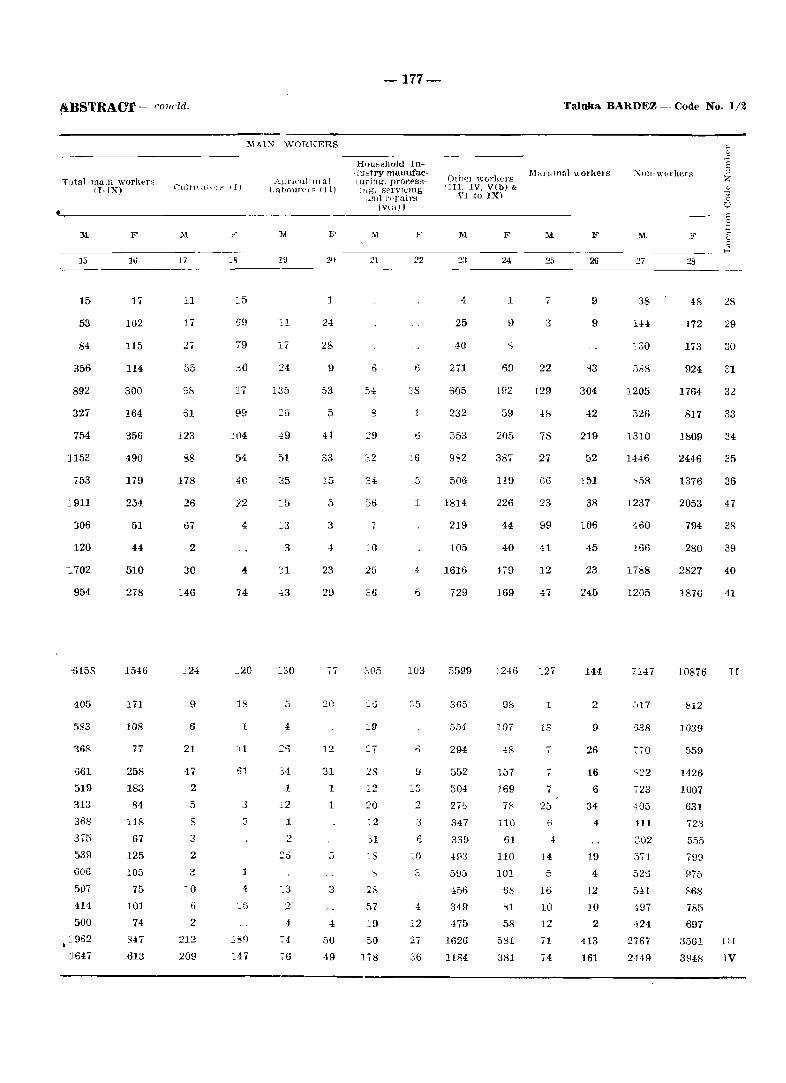
•
fiBSTRACT - coud<l.
~{Al2\i WOHKERS
Tutal Ina111 "vor}{,er:-3 (I-IX) Cultnal"]f II)
Agl'H'ul t UI al LrtbourPi:-:: (11)
•
]I[
13
15
53
84
356
892
327
754
:1153
753
J911
306
120
'1702
954
-t>158
405
583
168
1561
519
313
368
375
539
606
507
414
500
1962
J647
F
lti
17
102
115
114
300
164
356
490
179
254
51
44
510
278
1546
171
108
77
258
183
84
118
67
125
105
75
101
74
S47
613
]I[
17
11
17
,55
61
123
S8
178
26
07
2
30
146
124
9
6
21
2
5
S
3
2
3
10
6
2
212
209
79
.10
17
J.2
74
:::20
13
1
61
3
1
1
]I[
19
~1
17
24
135
49
51
35
i3
3
31
5
34
1
1
2
:..3
4
74
76
1
24
28
9
53
5
33
15
5
3
23
29
77
20
12
31
1
1
3
4
50
·19
-177-
HOU5ehold IIl·lu~try man.ufacluring'. proeess-JJjg. sprv1I..:ing
... nd l'c'I1airs I vul) 1
M
54 38
s 1
32
34
.56 1
7
0111el workers IIII. IV, V(b) &
YI to IX)
III
25
40
Zil
605
232
:553
9"Z
506
1814
219
105
F
1
1~2
59
21)5
387
119
226
44
40 20
25 4 1616 479
:06
19
28
12
20
:..2
31
~S
57
19
50
178
6 729
103 5599
:;5
13
2
3
:0
4
12
27
36
365
554
294
552
504
27&
347
339
493
595
349
475
1626
1184
169
1246
98
107
48
157
169
78
110
61
110
101
6s
~1
58
5tH
381
M
25
7
3
22
129
78
27
66
99
41
12
47
127
1
13
i
7
25
4
14
16
10
12
71
74
Taluka BARDl<~Z - Codt'" No. 1/2
26
9
9
304
42
219
52
151
38
106
45
23
245
144
2
9
26
16
6
34
4
19
4
12
10
2
413
361
:'\nn-w(lrl{crs
]I[
38
1+4
130
1205
326
1310
1446
"58
1237
460
l66
1788
1205
7147
.517
>338
770
723
-l05
HI
:;02
~tl
497
424
2767
2H9
:w
48
172
173
924
1764
817
1809
2446
1376
2053
794
280
28
29
30
1;1
32
33
34
35
36
47
38
39
2827 40
1876 41
10876 l[
S12
1039
559
1426
1007
631
723
555
79::1
975
S68
71',5
697
3501 1:1
3948 IV
-178-
District: Goa - Cout- No.1
X,HIIl' "1 \1l!,J.,!! !t(J\\"ll!WUl d
TOTAL
RURAL
URBAK
RlTRAL
Tiracol
2 Querim
3 Paliem
4 Arambol
5 Corgao
6 Pernem {Rural
7 Amberem
S Casnem
9 Varco11l1a
10 Poroscol1etr
11 Uguem
12 Tamhoxem
13 Torxem
14 Mopa
13 Chande!
16 Alorna
17 Ibrampur
13 Cansarvornel'-
19 Ozorim
20 Dargalim
21 Virn-:Jra
2'2 Tuem
23 Parcenl
'2-1 Mamlrellc
25 Morgim
26 Chopdem
27 Aganad0
{,RBA;\'
XIV Pemem (C. T ,
Area (I~'
villagE' 1n hp('.tarel'li< of town/ wnrd in
KlJJ~
Ot .. :cup!t·d 1l·;.:iuC'n
tiu1 hon8f'~
:\0 uf house)lnJ(L~
Tld,1i pOllu!at lull (IndudtllL', In--.tlttttioual & I1'lu:-:t'll,.!'l
I)Opulatlul\ I
p :\!
241.0 Kme 10590 11307 59352 2,,750 30602
25 {(m' T57 791 397) 1920 21)5,)
159.2:~
238.:}Z
933.32
928.·1"
2159.4::;
2340.81
198.15
127.2.'1
1138.0"
161.77
401.0-1
145.'71
883.1:;
60n.6.3
2174.7::>
1127.0"
1985.'}!)
391.6U
1218.9';
1023.3"
1908.12
864.02
174.2"
223.:]2
2.52
55
50u
3E>6
753
893
285
40
294
176
322
125
144
±49
171
'225
207
723
166
372
656
1171
1193
97
1S7
757
37
521
4U9
lUOfJ
311
3:jZ
105
322
165
150
47!)
247
261)
T60
197
454
12H)
1201
10'2
7!H
21',
2789
2064
4218
5306
17T>-,
207
1599
580
17t)
831)
259H
992
1309
1122
1017
1992
3809
6766
5905
6~1
96'>
3!Yi3
115
951
2121
H02
1').)
279
,~79
425
1225
4'34
621
626
2010
518
94 i
191')
32})O
2805
32~
1920
10:i
1437
1113
2097
2761'>
876
11,· 171
497
J01
SS6
125
.3ST
508
2112
499
1045
Ig91
3-176
3100
:)05
.525
2055
Scllt·uul,·c l!a,-.:t~ ...
122.
1126
101
43
7
2V
40
S.)
16
'" "!_,
25
101
~-01
71
Zl
101
lit
1172
1076
23
5
15
5-10
6 ·, oj
~" -J'_)
16
92
36
16
30
11)1
33
2G
;51
22
PRUlARY CENSUS-
~('hl'uuk,: TnbeH
M F
1~ Ie
]I;[ F
194;"6 13426
1809'_1 1232 L
138>] 1105
8-4
96~
665
142'::
1692
611
52
76
505
18~
287
514
25;;
307
366
37»
1414
4U
536
139'3
2283
2016
202
304
1:JS6
54
673
500
875
1159
417
42
41
331
103
221 #
126
314
144
15L
549
208
272
287
970
243
406
853
1532
1486
129
235
1105

.I\BSTRACT
T()ial nlaln workf'l's II-IX)
15
11415
10591
824
60
538
299
815
1052
439
42
73
281
141
150
120
359
190
138
500
205
194
215
'l09
213
379
808
]276
1051
87
193
824
F
16
4967
4663
304
13
198
90
151
424
355
32
·19
no 96
103
81
208
107
84
327
65
97
194
388
89
214
177
556
361
5
89
304
Cultn atl)1S 'I)
M
17
4185
4033
152
100
132
260
545
162
35
136
65
99
55
205
123
70
303
S5
138
1H
340
75
75
153
473
199
1
58
152
F
,8
:2971
2869
102
1
~tJo
47
62
288
244
24
39
74
66
82
'1.4
~42
S7
54
255
3"[
77
138
254
54
~04
82
S32
~42
40
102
MAlX WORKlmS
AgI'lCultlu'al LrtlJoUlHC; III)
i.6
23
IE
63
z
21
IS,
22
62
13
4
53
13
IS
51
24
14
16
:-9
46
41
-17
F
.79
.00
.9
2-
23
16
17
68
S8
7
3
18
8
1
19
44
6
4
32
16
10
89
51
14
20
S2
32
39
79
-179-
HotL~t'hold InJustry man.ufacTilnng, process
lUg, .sel vicing and repairs
IYlall
::1
24
15
57
12
135
105
3
10
3
5
4
13
25
7
2
13
40
29
33
1~0
126
19
7
22
438
425
13
5
27
30
7
3
2
11
s
16
I 7
"39
2
-,
18
96
96
1
1
13
Other workf'rs I Ill. IV. V(b) &
VI to IX)
M
5507
4906
601
43
353
132
402
339
205
11
28
114
50
25
40
87
50
51
115
57
41
70
378
106
261
606
544
644
6. 87
601
779
669
110
5
48
22
65
38
23
1
11
4
17
16
22
3
18
24
5
6
9
44
19
83
36
46
91
·1
9
110
Taluka: PER~EM - Code No. liS
Marginal workers
25
1516
H61
103
,1
57
101
17
2
3
76
9
6
41
42
14
116
52
77
82
117
6
81
69
237
37
48
26
4627
115
25
499
]62
277
416
19
19
20
290
3
12
17
113
113
101
279
]96
251
167
396
62
210
184
507
121
42
11
115
Xon-workers
27
15819
1047
30
711
581
1249
1387
440
44
79
401
124
283
153
479
193
187
609
227
350
329
1084
299
487
1041
1777
1751
204
247
1047
F
28
21008
19372
1636
65
740
861
1669
1928
502
68
102
1
2
3
4
~
7
441 !J
155 10
382 11
203 1!.l
565 13
205 14
202 ]5
768 16
247 17
340 18
388 19
1328 20
348 21
621 22
1530 23
2413 24
2618 23
258 26
425 27
1636
-180-
District: Goa ~ Colle No. 1 PRIMARY CENSUS
;:; -§
" Area of Tuta1 populatIon (II1cluutng Z In~titutiona1 & H')u~~1e~s Srheuul('d Sdlt"uult.~(l LlterateR "-
village in Ol'cupied No, of population \ C<.l .. ~t~c- Trlhe~
-0 Name of nil","" I hectares & resi!lPl1-0 jlown/want of town/ Ual hou~('_-U ward in honse3 hold~ ::: 1{m' .S
" <- P l\1 F ]\1 F 1I F M F j
1 :l a ,1 6 7 S 111 1t 12 13 14
TOTAL 233.4 Km~ 13407 14170 74089 37888 36201 1021 993 IS 13 2565~ 16281
RURAL 221.2 Km~ 11391 12058 62856 32138 30,18 851 820 IS 13 21420 13075
URBAN 12.2 Kmc 2016 2112 11233 5,50 5-183 170 173 4232 3206
RFRAL
1 Mencurem 397.27 223 227 1158 538 620 37 30 404 21'7 2 Dumacem 351.56 51 53 304 148 156 72 59 3 Salem 1056.33 37.3 458 2202 1059 1143 36 46 8 -1 65:3 468 4 Latambarcem 3696.87 948 993 5003 2555 2448 130 104 1228 598 5 Adwalpale 643.95 25L 263 1275 641 634 43 46 367 193 I) Sirigao 375.23 287 293 1659 867 792 679 421 'I Muigao 767.6;} 397 427 2302 1157 1145 71 80 885 514 8 Ona 191.93 84 84 ;)98 199 199 128 72 9 Maulinguem 744.90 191 201 1005 513 492 65 72 177 42
(North) lU Curchircl1l 77S.tJJ 269 269 1103 723 ,,SO 4 8 314 84 11 Sarvona 794.62 201 221 1135 599 536 1 411 237 12 Maem 2073.7:3 1220 1249 6650 3451 3208 33 20 2432 1410 13 Vaingumim 69.26 126 126 698 349 349 250 157 14 Aturli 68.63 95 103 544 260 284 152 123 15 Naroa 724.0.S .331 335 1810 874 936 27 28 595 407 16 Piligao 775.4! 373 404 2324 1165 1159 23 20 812 458 17 Carapur 872.09 636 671 :1898 1976 1922 45 50 144. 961 IS Maulingucm 406.'11 38, 402 2082 1046 1036 6 14 805 626.
(South) 19 Cassabe de 42.46 439 40;4 2584 1295 1289 21 16 1036 904
Sqnquelim 20 Arvalem 713.29 218 245 1291 649 642 21 31 329 147 21 Cudnem 985.24 426 ·138 2672 1334 1238 26 28 818 458 22 Virdi 312.:~9 159 196 1142 550 592 437 308 20
.> Arnone G75.9;"" 388 -156 2<327 1285 1342 53 43 1007 675 24 Navelim 1050.21) 326 352 1937 975 962 5 3 648 354 25 Cotomhi 2613 89 12,·', 139 'i3:3 372 361 5 8 277 188 26 Surla 164~.61 995 1035 5:lOS 2&13 2-!95 5u 42 1832 1064 27 Velguem 326.2 ~ 477 484 ~:.la 1183 1031 23 25 806 475 28 Pale 131:3.97 1392 H50 fl5<;O 3562 3027 12'lo 106 10 8 2416 1395
FRBAN
V Bicholim Muni- 12.17 2016 2112 1123:; 5750 5-1'33 170 173 4232 3206 cipal Council
Ward No.1 N.A. 181 184 95 1 460 -!\Jl 2 1 343 258 Ward No.2 N.A. 266 285 1412 70. 705 2 2 523 418 Ward No.3 N.A. 207 2113 120:3 607 596 12 12 505 439 Ward No. 4 N.A. 229 233 1211 606 1)05 76 79 382 327 Ward No. 5 N.A, 203 219 llGO 620 530 3 5 400 263 Ward No.6 N.A. 281 290 1606 818 788 33 32 584 439 Ward No.7 N.A 220 234 1296 659 637 8. 10 490 338 Ward No.8 N.A. 87 100 507 268 239 238 196 Ward No.9 N.A, 152 160 859 448 411 15 13 350 268 Ward No. 10 N.A. 185 189 1038 557 481 19 19 417 260
·4.BSTRACT
T ~ ~(l malll worker~ (I-IX)
M F
Cu](imtor~ (1)
MAIN WORKERS
A;;ricultural LalJnurerR (II)
1\[ F
-181-
Hou.,;ehold Industry manufacturing, processing. servicing
and repairs [v(a)]
F
Oth"r workers IIII. IV, VI») &
VI to IX,
F
Taluka: BIOHOLIM - Code No. 1/4
~rat'gll1,,1 workers ~un-vrorkers
M F F
-----.----------------~-------------------------------------------------------------17 18 19 2U 21 22 2:, 24 35 15
14&59
:587
199 58
482 ~166
294 375 558
PO 267
411 297
:619 136 128 :>24 503 840 536
67S
315 583 198 567 409 197
:324 542
= 75S
~587
230 319 288 268 266 339 298 130 212 237
l~
4744
4103
641
137 33
166 447
lSI 63
237 35
Hl6
161 76
419 102 47
183 272 128
82
130
93 166
70 59
152 53
247 53
215
641
95 127 46 91 41 59 61 29 55 37
3724
3603
121
87 29
210 398 115
94 147
19 110
236 90
434 79 82
160 163 151
7
5
75 126
37 233
94 19
280 19
104
121
44 19 10
4
7 9 3 1
24
1585
1525
60
84 16 36
183 31 19 89
6 83
94 15
178 95 29
110 144
9
2 74 30
9 12 24
132 11 10
60
28 15
2
6 4
5
1144
1094
50
26
64 114
54 9
56 16 53
28 19
193 1 8
39 83 34 14
2
77 93 2
15 16
2 44 5
21
50
7 & 1
16
5 6
1 8
724
671
53
30
44 77 20 21 83
6 29
26 14
111 1
10 19 54
6 2
2
43 12
4 13
4 28
2 10
53
17 4 4
16
9 2
1
426
363
63
6
11 48 12
8 32
4 30
9 2
28
1 12 13 31 10
17
15 6 1
20 4 1
2:3 5
14
63
9 6
2 12 15
7 4 1
261 12152
238 9799
23 2353
6
12 35 20
4 24
1 47
1 .. 15 12 16
2
6
19 2
2
1 1
2
23
1 6
2 3 4,
3 3 1
80 29
197 606 113 264 323
51 74
138 186 964
56 37
113 244 624 505
654
148 363 158 299 295 175 977 513
1613
23i.3
172 285 271 248 264 315 268 120 206 204
2174 1098
1669 100J
505 95
17 17 74
152 10 19 41 22 37
3>; 46
123 6 8
39 62 97 78
122
29 78 40 44
127 24 86 40
193
505
49 102
40 75 39 41 51 26 52 30
4 15 21
154 26
I " ,j
2 8
2 104
19 2
151 .Jc
16
1D
20 10j
16 04
1
~,
6
1'3
28 8 -.
26
2479
2284
195
18 24
209 146 126 10J
41 13 11
3.')
3iO 36 26
173 11 13 23
44
21 70
24!1 132 19!J
:2 56 19
121
195
66 34
7
5 10 60
3 10
27
19344
16276
3068
335 75
556 1235
321 457 586 107 238
:310 300
1728 194 130 399 658
1120· 507
607
3:J9 .26 249 702 502 174
1419 596
1716
3068
221 374 313 338 338 472 333 130 229 320
28978
24331
4647
46[; 99
768 1855 427 626 867 151 285
469 457
2449 211 211 580 876
1781 926
1115
528 1002
273 1151
611 306
2192 959
2691
4647
330 544 543 514 484 719 516 207 346 444
1 2 3 4 5 6 7 8 9
10 11 12 13 11 15 J6 17 18
19
20 21 2<! 23 24 25 26 27 28
v
-182-
U~trict: Goa - Code No. 1 PRIMARY CENSUS
.... a> .Q
is Total populatlOll oncludlllg ~ Area of Institlltional & Houselel's Scheduled Scheduled Literates a> vIllage in OccupIed :N'o. of population) CMtes Tribes "t1 Name of village! Dectares &; leBlden-0 /town/waro of town/ tinl house-0 ward in houseR hvldB l'l Km" 0 :l ~
M <.l P F M I<' M F M F .3 1. 3 4 :a 6 7 8 'J 10 11 12 13 14
TOTAL 499.0 Km2 7377 7700 40838 20580 20258 487 461 4 10516 5521,
RURAL 489.6 Km2 6728 7030 36943 18517 18426 429 416 4 8909 4328
URBAN 9.4 Km2 649 670 3895- 2063 1832 58 45 1607 1190
RURAL
1 Podocem 392.98 73 77 390 199 191 113 5: 2 Poriem ]160.18 580 607 3021 1553 1468 8 6 796 35:,} 3 Ravona 554.21 98 100 518 251 267 4 3 108 29 4 Gonteli 280.86 215 215 1069 508 561 231 13~)
5 Siroli 353.72 86 86 450 220 230 104 4',) 6 Anjunem 226.93 47 47 217 99 118 45 1'7,
7 Quelaudem 339.38 50 50 260 134 126 62 2!1 8 Ponsuli 360.03 71 75 342 182 160 54 23 9 Choraundem 592.72 86 86 466 226 240 110 H
10 Ivrem-Buzruco 500.88 100 100 551 268 283 114 e 11 Ivrem-Curdo 361.69 28 28 168 86 82 5 2 38 1'? 12 Golauli 657.15 48 48 240 114 126 42 l~
13 Surla 1478.60 68 68 312 135 177 5 5 43 1:,;, 14 Satrem 2225.89 19 19 122 64 58 19 S 15 Derodem 1335.90 14 14 62 31 01 7 16' Codal 1250.28 25 26 110 59 51 23 S 17 Rivem 891.62 34 34 166 79 87 31 12 18 Dongurli 1016.35 261 262 1285 641 644 ,'09 100 325 199 19 Pale 793.82 158 15E. 797 412 385 158 32 20 Gululem 790.64 124 12·1 579 28(} 299 26 22 129 4'= OJ'
21 Querim 1240.93 252 330 1580 789 791 40 37 453 292 22 Morlem 971.74 234 246 1250 605 645 19 2C' 219 111 23 Onda 792.85 283 281 1631 846 785 3 4 418 22tl 24 Saleli 837.58 107 135 754 387 367 7 7 95 10 25 Zormen 726.30 79 713 468 202 266 76 ·J:Z 26 Dabem 350.88 61 61 3915- 193 202 12 13 83 ;36 27 Compordem 745.66 108 111' 608 308 I 300 15 12 4 164 ~,,' 28 Edorem 137.25 36 36 234 113 121 71 5'-! 29 Naneli 609.01 26 26 133 71 62 26 '3 30 Carambolim- 513.03 40 40 232 119 11:3 91 6 15
Brama 31 Xelopo-Buzruco 196.90 28 28 129 74 55 33 Ie> 32 Sigonem 328.84 23 23 119 63 56 19 33 Maloli 561.76 32 38 222 111 III • i ,. 65 3'5 34 Nanorem 368.10 45 45 216 117 99 67 ~,-•• '." 35 Vainguinim 892.21 3 3 15 7 8 1 36 Zarani 771.78 Uninhabited 37 Ustem 456.08 33 33 173 95 78 40 9 38 Davem 607.56 116 116 655 324 331 2 2 186 11S 39 Bombedem 48.00 6 6 32 18 14 12 <}
40 Ambedem 125.19 21 23 112 65 48 47 2: 41 Nagargao 161.11 89 94 517 245 272 145 103 42 Satorem 196.32 26 26 166 76 90 43 3.0:. 43 Veluz 444.10 166 168 873 427 446 8 8 256 15H 44 Mauzi 629.07 134 134 781 406 . 375 171 3} 45 Buimpal 411.73 54 57 318 157 161 66 20 46 Cumarconda 556.47 51 52 291 154 137 65 2: 47 Pissurlem 835.45 346 365 1652 840 812 21 28 459 22~ 48 Sonus-Vonvoliem 474.12 98 100 494 252 242 1 1 126 j(r) 49 Vaguriem 311.34 24 29 148 70 78 16 15 38 25 50 Codiem 246.19 8 11 61 32 29 22 Hi 51 Naguem 343.43 10 10 52 23 29 5 4 4 52 Ansolem 167.14 Uninhabited 53 Nanull 248.02 161 171 1008 492 516 317 263 u .. ..
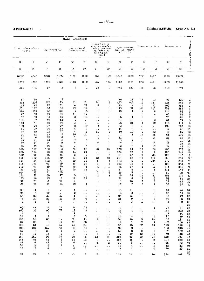
-183-
ABSTRACT Taluka: SATARI - Code No, 1/.5
MAIN WORKERS ... _--- '" ~ HOlmehold In- § d 1'" t ry man,ufac-
O~hel \vorkers "",1 drg ll.al ''i'orkel'~ X (In-\.\~orkers
Total main workers Ag ricu1tural turing, process- Z (I-IX) Cultn·ai G'fS (I) La boure~" Ill) lng, servicing 11II, IV, Vlb) &
~ anti repairs VI to IX) (0
[v(a)] U
§ 1\1 F 1\1 F M F M F 1\1 F M F 1\1 F j,
~ 15 16 17 18 l~ 20 21 22 23 21 .:35 26 27 28
10036 4340 3807 1922 1822 1010 262 152 4645 1256 70e 2497 9838 13421
9212 4205 3790 1920 1321 1009 237 145 3864 1131 63€ 2471 8669 11750
824 135 17 2 1 1 25 , 781 125 70 26 1169 1671
87 30 7 3 80 27 16 22 96 139 1 813 246 295 71 61 23 24 6 433 146 16 337 724 885 " 142 88 85 51 4 22 5 6 48 9 2 12 107 167 3 201 133 66 83 22 19 113 31 56 142 251 286 4 102 128 83 122 4 5 15 1 4 6 114 96 5 47 53 32 36 11 17 4 " 4 49 61 6 62 63 54 52 3 10 5 1 2 70 63 7
1'25 87 40 44 1 84 43 2 57 71 8 110 54 80 30 3 1 26 24 1 72 115 114 9 139 78 97 49 5 10 4 33 19 129 205 10
44 2,\ 26 18 4 e:. 14 6 42 53 11 5S 49 "., i)v 27 4 5 11 7 10 10 7 10 49 67 12 54 33 43 9 10 23 1 1 13 38 68 106 13 37 6 25 6 1 11 13 27 39 14 19 11 14 8 2 2 3 1 1 12 19 15 3~{ 11 21 2 'i' 6 2 7 ::; 12 22 28 16 39 32 19 15 ,.[ f- 16 12 7 12 33 43 17
338 197 130 93 26 33 56 37 126 34 17 72 286 375 18 225 134 76 58 45 24 104 52 1 2 186 249 19 132 96 38 56 2 5 1 2 91 33 10 66 129 137 20 360 172 106 69 31 24 12 ::n 211 58 71 114 358 505 2l . 321 55 162 31 40 11 6 4 113 9 12 204 272 386 22 .u8 171 92 69 23 27 1 2 302 73 2 426 614 23 212 97 89 20 35 21 4 81 53 1 12 174 258 24
88 123 51 81 10 36 27 6 1 114 142 25 104 123 71 109 7 9 26 5 89 79 26 131 77 50 47 9 5 2 1 70 24 23 52 154 171 27
53 20 13 1 18 13 22 6 2 13 58 88 28 37 28 17 17 2 1 18 10 2 2 32 32 29 60 20 31 14 12 4 17 2 2 1 57 92 30
38 11 16 4 18 11 36 44 31 24 3 19 2 3 3 39 53 32 58 29 33 13 1 1 24 15 1 10 52 72 33 76 30 29 12 16 9 31 9 1 41 68 34
3 6 3 4 2 1 3 2 35 36
60 44 34 18 21 25 5 1 3 35 31 37 160 39 95 27 18 8 47 4 164 292 38
9 3 1 5 1 8 14 39 38 7 14 6 3 18 4 2 27 39 40
135 33 60 12 20 11 2 53 10 3 68 107 171 41 37 36 8 12 20 23 9 1 2 4 37 50 42
196 64 49 12 52 34 95 18 32 64 199 318 43 220 127 152 41 46 84 22 2 186 248 44
87 8 33 6 2 52 2 3 1 67 152 45 59 12 11 2 1 47 10 43 79 52 46 46
441 161 90 57 10 11 21 11 320 82 20 124 379 527 47 148 40 12 9 31 15 105 16 2 104 200 48
44 6 12 1 9 3 2 20 3 26 72 49 20 5 5 1 4 11 4 1 12 23 50 13 3 4 5 2 4 1 4 10 22 51
52 166 39 8 1(1 .n 1, 3 114 12 10 326 ·167 53
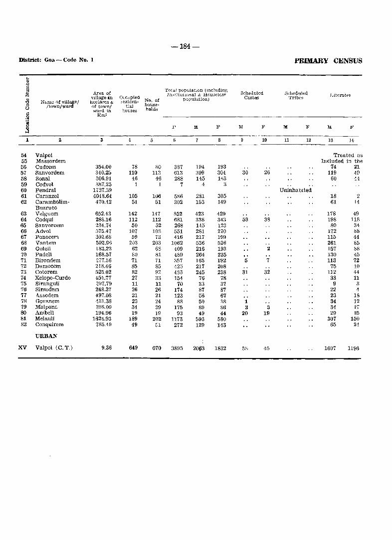
-184-
District: Goa - Code No. 1 PRIMARY CENSUS
.... '" .c §
Area of Total populatlGn (lllduding
Scheduled Scheduled Z Institut {(mal & Housel€ss Literates
'" VIllage in Occupied
No. of population) Castes Tribes 'C Name of villa,ge/ hectares & lesiden-0 /town/ward of town/ tial house-U ward in houses h()lds
.§ Rm"
~ p M F M F M F M F ~ 1 2 4 5 6 7 8 9 10 11 12 13 14
54 Valpoi Treated as 55 Massordem Included in the 56 Cudcem 354.00 78 80 387 194 193 74 21 57 Sanvordem 340.25 110 113 613 309 304 30 26 119 4£1 58 Sonal 306.91 46 46 288 145 143 60 '.4 59 Codvol 887.25 1 1 7 4 3 60 Pendral 1T37.39 Uninhabited 61 Caranzol 4048.64 105 106 586 281 305 18 2 62 Carambolim- 470.42 51 51 302 153 149 61 14
Buzruco 63 Velguem 652.43 142 147 852 423 429 178 49 64 Codqui 288.16 112 112 681 338 343 53 38 198 118 65 Sanvorcem 234.74 50 52 268 145 123 80 34 66 Advoi 575.47 107 108 551 281 270 172 !is 67 Ponocem 302.68 59 73 416 217 199 115 44 68 Vantem 592.96 203 203 1062 536 526 261 85 69 Guleli 183.23 62 6S 409 216 193 2 157 88 70 Padeli 168.57 80 81 489 264 225 130 45 71 Birondem 277.56 71 71 357 165 192 5 7 113 72 72 Damocem 218.46 85 85 ~25 217 208 75 10 73 Cotorem 525.02 82 92 483 245 238 31 32 112 44 74 Xelopo-Curdo 451.77 27 33 154 76 78 33 11 75 Siranguli 297.79 11 11 70 33 37 9 3 76 Sirsodem 248.37 26 26 174 87 87 22 4: 77 A.ssodem 497.08 21 21 123 56 67 23 18 78 Govanem 431.38 23 24 88 50 38 1 34 12 79 Malpona 398.09 34 39 175 89 86 3 3 34 17 80 Ambeli 194.96 19 19 93 49 44 20 19 29 15 81 Melauli 1624.93 189 202 1173 593 580 307 150 82 Conquirem 785.49 49 n 272 129 143 65 24
URBAN
XV Valpoi (C. T.) 9.36 649 670 3895 20ti3 1832 5f, 45 1607 1196
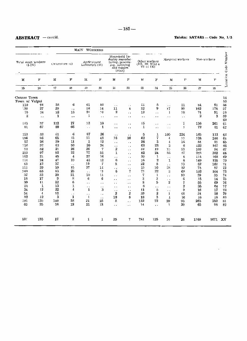
-185-
ABSTRACT -cOIlcld. Taluka.: SATARI - Code No, 1/5
MAIN WORKERS .. '" HOUlsehold In- ,Q
dustry manufac- _\'Larglllal workers Non-workers E Other workers :::<
Tolal main workers Agricultural turing. process- Z (I-IX) L'uiuY31ors (I) Labourers (II) lllg. servicing (III. IV, V(b) &
'" and repairs VI to IX) >d 0 lv(a)] U >:: .S
II{ F M F :r~f F M F M F M F M F c:§ <:J 0
15 16 17 18 19 20 21 22 23 24 25 2Q 2:7 2S H
·Census Town 54 Town of Valpoi 55
110 91 38 6 61 80 11 5 11 84 91 56 ·,30 27 29 58 14 11 4 32 9 17 99 162 178 57
70 34 32 18 24 16 2 12 1 18 74 91 58 2 1 1 2 3 59
60 145 37 112 27 18 10 15 7 136 261 61
81 67 80 66 1 1 1 72 81 62
153 33 61 6 87 26 5 1 105 224 165 172 63 196 86 65 15 51 48 18 16 62 7 4 11 138 246 61
57 26 29 11 2 12 26 3 4 16 84 81 65 156 97 63 50 30 24 63 23 3 6 122 167 66 93 52 21 26 26 7 2 44 19 15 53 109 94 67
252 97 92 22 77 51 1 82 24 3G 47 248 382 68 102 21 45 4 27 16 30 1 4 114 168 69 114 24 47 10 45 12 6 16 2 1 6 149 195 70 83 12 37 19 7 5 22 5 13 82 167 71
111 39 59 15 37 14 15 10 28 82 78 87 72 140 65 63 25 11 6 7 71 22 3 69 102 104 73
37 33 20 21 10 11 7 1 10 39 35 74 18 17 9 8 6 6 3 3 6 15 14 75 30 11 22 6 8 5 2 7 55 69 76 21 1 13 1 8 2 35 64 77 34 12 22 4 1 3 11 5 9 16 17 78 54 4 13 2 2 39 2 1 46 34 36 79 32 12 3 1 1 10 8 18 3 1 16 16 16 80
001 135 140 38 21 25 8 132 72 29 93 263 352 81 63 25 38 12 11 13 14 1 20 65 98 82
824 135 17 2 1 1 25 7 781 125 70 26 1169 1671 XV
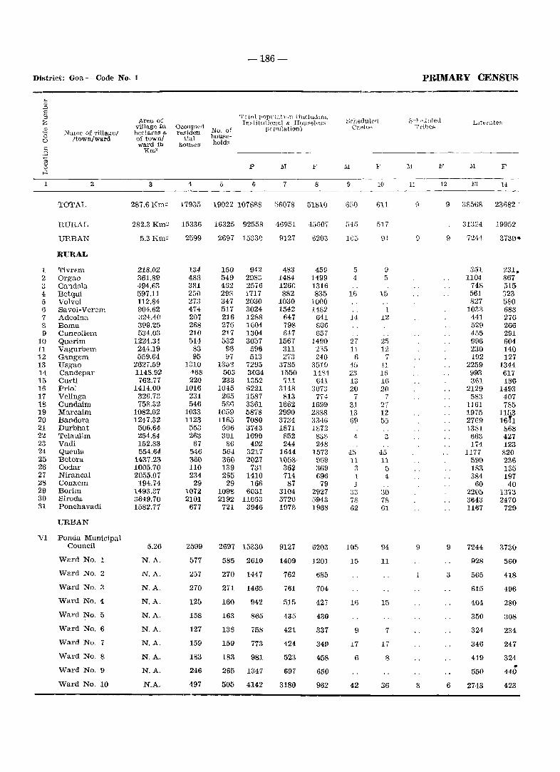
-186-
District: Goa - Code No. 1
1
1 2 3 4 5 6 7 8 9
10 11 12 13 14 15 16 17 18 19 20 21 22 23 24 25 26 27 28 29 30 31
)J "me of village/ ftown/ward
TOTAL
RURAL
URBAN
RURAL
Tivrem Orgao Candola Betqui Volvoi Savoi-Verem Adcolna Barna Cuncoliem Querim Vagurbem Gangem Usgao Candepar Curti Priol Velinga Cundaim Marcaim Bandora Durbhat Telaulim Vadi Queula Betora Codar Nirancal Conxem Borim Siroda Ponchavadi
URBAN
VI Ponda Municipal Council
Ward No.
Ward No.2
Ward NO.3
Ward No.4
Ward No.5
Ward No.6
Ward No.7
Ward No.8
Ward No.9
Ward No. 10
Area of village :in hectares & of townl ward in
Km'
3
Occupied residen
tial hou~es
4
No. of household~
5
Totfll popi1k~t1\ln (in.cludlng In~tituti(lnal & Hou~ele~s
pc pula lion)
P F
6 7 8
287.6 Em~ 17935 19022 107888 55078 51810
282.3 Km~ 15336 16325 92558 46951 45607
5.3 Km~
218.02 361.89 494.63 597.11 112.84 904.62 324.40 399.25 534.03
1224.34 244.19 559.64
2627.59 1148.92 762.77
1414.00 326.73 758.32
1082.02 1247.32
506.64 254.84 152.83 554.64
1437.23 1005.70 2055.07
194.74 1493.37 3649.70 1582.77
5.26
N.A.
N.A.
N.A.
N.A.
N.A.
N.A.
N.A.
N.A.
N.A.
N.A.
2599
134 488 381 250 273 474 207 268 210 514
83 95
1310 468 220
1016 231 546
1033 1123
553 263
67 546 360 110 234
29 1072 2101 677
2599
577
257
270
125
158
127
159
183
246
497
2697 15330
150 549 452 293 347 517 216 275 217 532
96 !J7
135'2 503 233
1045 265 58f)
10£>9 1165
606 301
86 564 361l 139 2g5
29 1098 2192
721
942 2983 2576 1717 2030 3024 1288 1604 1304 3057
596 513
7295 3034 1352 6221 1587 3361 5878 7080 3743 1690
492 3217 2027
731 1410 166
6031 11653
3946
2697 15330
585 2610
270 1447
271 1465
160
163
136
159
183
942
865
758
773
981
265 1347
505 4142
9127
483 1484 1260 882
1030 1542
647 798 64-7
1567 311 273
3785 1550 711
3148 1H3
1662 2990 3734 1871
852 244
1644 1058 36~ 714 87
3104 5720 1978
9127
1409
762
761
515
435
421
424
523
697
3180
6203
459 1499 1316 835
1000 1482
641 806 657
1490 235 240
3510 1481-641
3073 774
1699 2888 3346 1872
8S8 248
1573 969 369 696 79
2927 5943 1968
6203
1201
685
704
427
430
337
349
458
650
962
Schedulerl C""te-
l\I F
9
650
545
5 4
16
14
27 11
6 15 23 13 20
7 31 13 69
4
.15 11
:1 ·1 1
33 78 62
105
15
16
9
17
6
42
10
611
517
9 ..
9 5
15
1 12
25 12
7 41 l()
16 2(1
7 27 12 55
3
45 11
5 4
30 78 61
94
11
15
7
17
8
36
PRIMARY CENSUS
S!'h>?Juleu Trihef'
11 12
111 F
13 1-1
9 38568 23682 .
9
9 9
1 3
8 6
31324 19952
7244:
351 1104
748 561 827
1033 441 529 455 996 230 192
2259 993 361
2129 583
1161 1975 2769 1381
663 174
1177 590 183 384 60
2205 3643 1167
7244
928
565
615
404
350
324
346
419
550
2743
231. 867 515 323 580 688 276 266 291 604 140 127
1344 61"1 186-
1493 407 785
1153 16tl
868 427 123 820 236 135 197
40 1373 2470
729
3730
560
418
496-
280
308
234
247
324 • 440
423
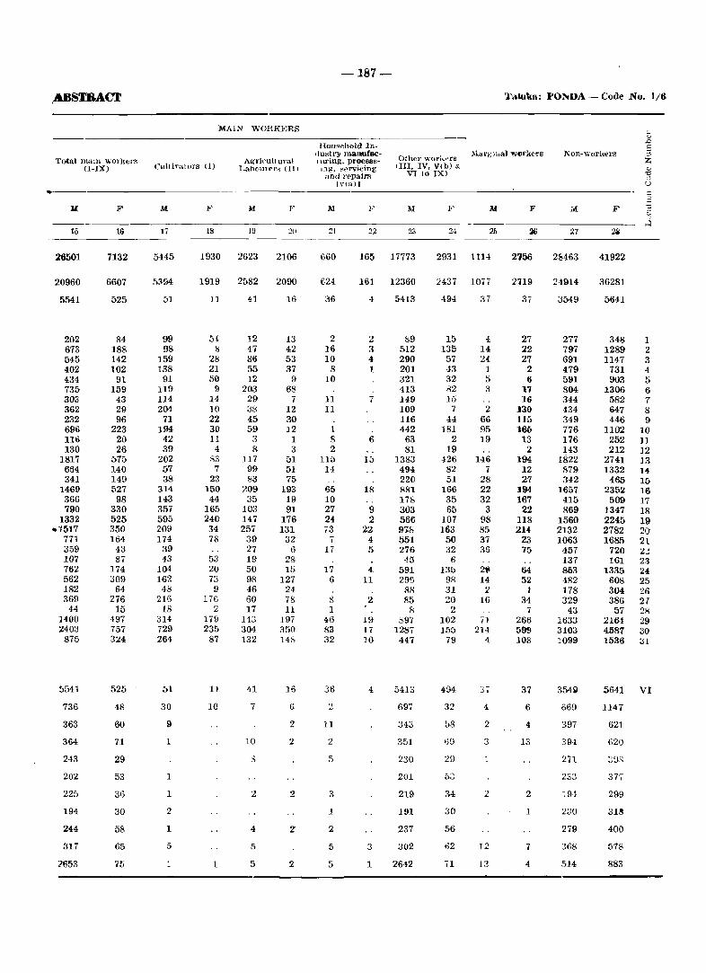
,.ABSTRACT
Total malll workers (I-IX)
15
26501
20960
5541
202 673 545 402 434 735 303 362 232 696 116 130
1817 654 341
1469 366 790
1332 .1517
771 359 107 762 562 182 369
44 ]400 2403
875
5541
736
363
364
243
202
225
194
244
317
:?S53
F
16
7132
6607
525
R4 188 142 102
91 159
43 29 96
223 20 26
575 140 149 527
98 330 525 350 164
43 87
174 309
64 276
15 497 757 3U
525
48
60
71
29
53
36
30
58
65
75
MAli\' WORK]<)RS
Cultiy"tors (1) A~ri('ult ural
Lahourers (II)
M
17
5445
51
99 98
159 138
91 119 114 204
71 194
42 39
202 57 38
314 143 357 595 209 174
39 43
104 162
48 216 18
314 729 264
51
30
9
1
1
1
2
1
5
1
M
18 ]9
1930 2623
1919 2582
11 41
54 8
28 21 50
9 14 10 22 30 11
4 83
7 23
150 44
165 240 34 78
53 20 73 9
176 2
179 235
87
11
10
1
12 47 86 55 12
203 29 38 45 59
3 8
J17 99 83
209 35
103 147 257
39 27 19 50 98 46 60 17
143 304 132
41
7
10
2
4
5
2U
2106
2090
16
13 42 53 37
9 68
7 12 30 12
1 3
51 M 75
193 19 91
176 131
32 6
28 15
127 U 78 11
197 350 148
J6
6
2
2
2
z
2
-187-
Taluka: PONDA - Code No. 1/6
Hot •• ehold 111-dustl>' manufacnU'ing, processIng, ~~rvicing ~lnd l't_~pai1"R
IV(Il) I
Other worl~'\l'g 1111, IV, V(b) &
VI to IX)
Non-worJ,ers
AI
::1
660
624
36
2 16 10
8 10
11 11
1 S 2
115 14
65 10 27 24 ,3
17
17 6
8 1
46 83 32
36
2
11
2
5
3
1
2
5
5
F M
22 23
165 17773
161 12360
4 5413
2 :> 4 1
7
6
15
18
9 2
22 4 5
4 11
2 I
19 17 10
4
3
1
f,9 512 290 201 321 413 149 109 116 442
63 81
1383 494 220 881 178 303 566 97-& 551 276
45 591 295
88 85
8 ~97
1287 447
5413
697
343
351
230
201
219
191
237
302
2642
M F
2,1 25 ~ 27
2931 1114 2156 2&463
2437 1077 2'l19 24914
494 37 37 3M9
15 135
57 -13 32 82 15
7 44
181 2
19 426 82 51
166 35 65
107 163
50 32
6 13b
9S 31 20
2 102 155
79
494
32
58
69
53
34
30
56
62
71
4 14 24
1 5 3
2 66 95 19
146 7
28 22 32
3 98 85 37 36
2~
14 2
16
71 214
4
37
4
2
3
1
2
J2
13
27 22 27
2 6
17 16
]30 115 ]6l)
13 2
194 12 27
]94 167
22 118 214
23 75
64 52
1 34
7 266 599 108
37
6
4
13
2
1
7
4
277 797 691 479 591 804 344 434 349 776 176 143
1822 879 342
1657 415 869
1560 2132 1063
457 137 863 482 178 329
43 1633 3103 1099
354~
&69
397
394
271
233
:1.94
230
279
368
514
F
41922
36281
5641
348 1 1289 2 1147 3
731 4 903 5
1306 6 582 7 647 8 446 9
1102 10 252 11 212 12
2741 Iii 1332 14
465 15 2352 16 509 17
1347 18 2245 19 2782 2(J 1681) 2t
720 2.: 161 23
1335 24 608 25 304 26 386 27 57 28
2164 29 4587 30 1536 3l
5641 VI
1147
621
G20
2GB
37.
299
3M
400
578
883
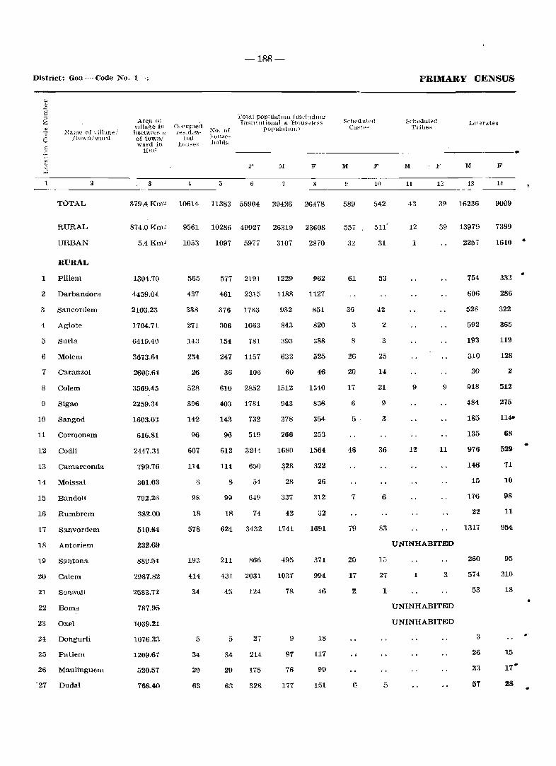
District: Goa-Code No.1·;.
NalHe of YiHage! /town/warll
An;1l ul vlllage in heclareg ~ of town! \vH.!'d in
O('(,llPlt_~;1 rt:::;ldcn
HaL ]H'll~e~
No. of huu}i('}loltl;;
-188-
Total pop:tlatIOll (mcLudmg InstItutional & J-IUU:3el{'~s
populatIOll) SclH'dllL~(l
Ca~tp...!
PRIMARY CENSUS
;3('hedulpd Tribe~
Lt1erdtes
I{tn~ --------------------------------------------------------------. <:: j
1
1
TOTAL
RURAL
URBAN
RURAL
Piliem
2 Darbandora
3 Sancordern
4 Aglote
5 Surla
6 Molem
7 Caranzol
8 Colem
9 Sigao
10 Sangod
11 Cormonem
12 Codli
13 Camarconda
14 Moissal
15 Bandoli
16 Rumbrem
17 Sanvordem
18 Antoriem
19 Santona
20 Calem
21 Sonauli
22 Barna
23 Oxel
24 Dongurli
25 Patiem
26 Maulinguem
'27 Dudal
p ::'.1 F
3 6 8
879.4 Km:! 10614 11383 55904 29426 26478
874.0Km.!
5.4Km.!
1304.70
4459.04
2103.23
1704.71
6419.4G
3673.64
2600.64
3569.45
2259.34
1603.03
616.81
2H7.31
799.76
301.03
792.26
382.00
510.84
232.69
88D.54
2987.82
2583.72
787.95
1039.21
1076.33
1209.67
520.51
768.40
9561 10286 49927 26319 23608
1053
565
437
338
271
143
234
26
528
396
142
96
607
114
8
98
18
578
193
414
34
5
34
29
63
1097 5977
577 2191
461 2315
376 1783
306 1663
154 781
247 1157
36 106
610 2852
403 1781
143 732
96 519
612 3244
114 650
8 54
99 649
18 74
624 3432
211 866
431 2031
45 124
5 27
34 214
29 175
63 328
3107
1229
1188
932
843
393
632
60
1512
943
378
266
1680
~28
28
337
42
1741
495
1037
78
9
97
76
171
2870
962
1127
851
820
~8B
525
46
1340
838
354
253
1564
322
26
312
32
1691
371
994
46
18
117
99
151
M
589
55,
61
36
3
8
26
20
17
6
5·
46
7
79
20
17
(5
If)
542
31
53
42
2
3
25
14
21
9
3
36
6
83
13
27
1
5
F M
11 11 13
39 16236
42 39 13979
1
9 9
11
UNINHABITED
1 3
UNINHABITED
UNINHABITED
2257
754
606
528
592
193
310
30
918
484
185
135
976
146
15
176
22
1317
260
574
53
3
26
33
57
F
14
9009
7399
1610
333
286
322
365
119
128
2
512
275
114"
68
52~
71
10
98
11
954
95
310
18
15
17"
Z8
•
•
.'
..
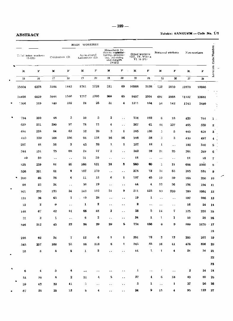
..
..
•
•
ABSTRACT
'=' L ~al maIn worker::' (I-IX)
F
15 16
Cultivators (I)
M F
17 18
MAIN WORKERS
Agricultural LalJoul'ers (II)
F
19 20
-189-
liou,ehold Indu~try maJW.facturjng, processing, 3ervic.ing
and repairs [v(a)]
M F
21
Other workers (III. IV. Vt]J) &
VI to IX)
M F
23 24
Taluka: SANGUEM - Code No. ii1
l\farglllul workers Non-workers
M F M F
25 26 27 28 -------------------------------------------------15804
14498
:306
794
639
484
410
207
344
49
825
526
.. 200
•
98
801
131
12
148
31
84~
288
545
53
6
51
39
~7
6378
6059
319
200
231
228
320
48
151
30
239
251
65
23
270
36
2
67
3
212
92
257
8
4
10
42
25
3184
3044
140
48
290
64
108
56
75
81
61
76
24
123
63
9
42
1
45
24
108
8
5
8
33
31}
1443
1340
103
3
97
63
108
3
68
25
9
6
34
7
14
22
7
53
2
1741
1717
24
10
78
32
98
43
24
31
166
187
11
30
143
49
1
66
6
38
12
88
1
., 11
8
1728
1700
28
5
73
28
138
26
21
30
151
170
13
19
102
28
2
48
2
29
6
118
2
4
4
311
280
31
2
4
3
16
1
3
18
6
2
29
1
69 10568
65 9457
4
1
16
1
1
5
1
1
1111
734
267
385
188
107
242
18
360
278
107
44
511
19
2
38
24
7340
251
343
44
1
27
3
3138 752
2954 69-1
184
192
61
136
58
18
56
60
12
45
4
125
1
5
1
156
78
85
1
4
1
9
58
6
3
1
1
34:
10
80
1
6
2
16
1
1
6
15
2010
1868
142
18
337
5
3
25
21
63
39
36
230
7
1
9
12
41
4
18
1
12870
11127
1743
429
465
445
430
185
254
11
686
383
168
136
799
191
16
175
10
889
205
476
21.
2
40
31
18090
15681
2409
744
559
618
497
340
349
16
1080
524
1
2
3
4
5
6
7
8
9
250 10
194 11
1064 12
286 13
24 14
238 15
28 16
1470 . 17
18
267 19
696 20
22
23
14, 24
89 25
56 26
122 21
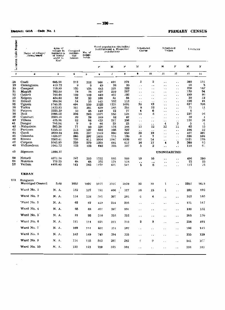
-110-
DMtriet: 60A - Cede No. 1 PRDIARY CENSUS
.. I Area of
Total population lindudin;; Scbeduled Scheduled Z Institutional & Hou~elt'.:;~ Literates ., Vlllage in OccupIed population) Castes Tribes
'Ill "'lame of vlllagel hectares & residen- No. nf co /townlward of town/ tial 110Qlle-Q
ward in houses holds § Km' :::1 ~ P M F M F M F M ¥ " ...:l
1 :.l 3 4 :; Ii 7 8 • H) 11 12 13 14
·28 Costi 685.50 212 212 860 481 379 3 2 300 151 29 Coranginim 419.72 9 9 49 26 23 18 ~
30 Comproi 119.89 125 125 643 321 322 239 16; 31 Mugull 763.50 78 78 427 210 211 120 54 32 Cotarli 788.64 189 189 849 457 392 199 90 33 Xelpem 434.62 32 32 166 81 85 30 12 34 Salauli 994.56 54 55 845 732 113 426 21 35 Uguem 1740.35 494 539 2322 1231 1091 20 12 617 308 36 Tudou 1433.83 101 101 639 388 251 8 12 71 Ll. 37 Potrem 2225.39 33 35 149 72 77 4 6 6 "-38 Bati 2996.52 226 268 1077 553 524 11 8 237 9 .. 39 Cumbari 2598.48 29 29 149 82 67 10 1 40 Viliena 405.90 82 86 423 217 206 132 56 41 Dongor 788.94 9 9 46 23 23 4 3 5 '1 42 . Naiquinim 583.20 77 80 320 176 144 15 ]2 ]2 11 62 1,5 43 Porteem 1335.35 113 127 693 366 327 106 3.3 44 Curdi 2689.94 385 397 1949 990 959 22 19 497 267 45 Colomba 1828.97 266 297 1435 71& 720 8 7 326 166 46 Rivona 3582.41 738 811 3916 1987 1929 62 54 1121 735 47 Curpem 1043.80 259 279 1298 681 617 16 17 4, 2 260 95 48 Vichundrem 1041.72 123 123 642 335 307 5 2 118 6:
49 Sigonem 1998.37 UNINHABITED
50 Netorli 4071.34 347 353 1752 883 869 19 10 496 330 51 Nundem 779.25 68 68 352 174 178 " .. , 73 25 52 Verlem 4409040 HI 282 117x 63. 541 5 5 117 15
URBAN
VlI Sanguem Municipal Council 5.40 1053 1097 5977 310T 2870 32 31 1 2257 161!)
Ward No. 1 N. A. 132 137 783 466 317 16 15 1 391 190
Ward No. 2 N. A. 114 118 591 307 28{ 6 '! 242 180
·Nard No.3 N. A. 62 67 419 214 205 171 14>
Ward No.4 N. A. 65 68 401 207 194 180 151
Ward No.5 N. A. 81 92 510 258 252 205 171}
Ward No.6 N. A. 111 114 621 311 310 2 8 238 19~
Ward No.7 N. A. 109 114 601 314. 287 196 145
Ward No. 8 N. A. 142 149 749 394 355 235 139
Ward No. 9 N. A. 114 115 543 261 282 0;;: 9- 141 HJ7
Ward No. 10 N. A. 123 123 759 375 384 258 183
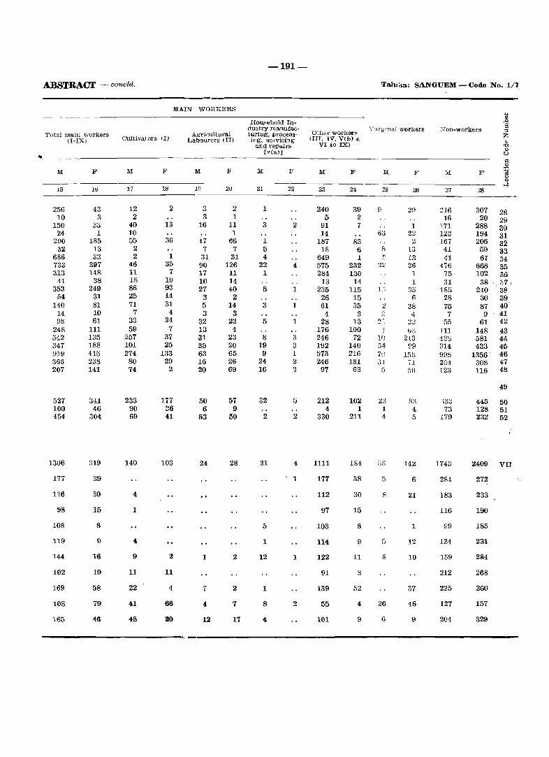
ABSTRACT - concld.
MAIN WORKERS
Total main workers (I-IX) Cultivators (1)
.----------------------------M:
15
256 10
150 24
290 32
686 733 313
41 353
54 140
14 98
248 542 347 919 366 207
527 100 454
1306
177
116
98
108
119
144
102
169
108
165
F
11>
43 3
33 1
185 13 33
397 148
38 249
31 81 10 61
111 135 188 415 238 141
341 46
304
319
39
30
15
8
9
16
19
58
79
46
17
12 2
40 10 55
2 2
46 11 18 86 25 71
7 33 59
257 101 274
80 74
233 90 69
140
4
1
4
9
11
22
41
48
F
18
2
13
36
1 35
7 10 93 14 31
4 24
7 37 25
133 29
2
177 36 41
103
2
11
4
66
2Q
Agricultural Labourers (II)
M:
19
3 3
16
47 7
31 90 17 10 27
3 5 3
32 13 31 35 63 16 20
50 6
53
24
1
7
4
12
F
20
2 1
11 1
66 7
31 126 11 14 40
2 14
3 23
4 23 20 65 26 69
57 9
50
28
2
2
7
17
-191-
Household Industry man.ufacturing, processing, servicing
and repairs [veal]
M:
21
1
3
1 5 4
22 1
5
3
5
8 19
9 24 16
32
2
31
5
1
12
1
8
4
F
22
2
4
1
1
1
3 3 1 2 2
5
2
4
1
1
2
Other worket'R fIll, IV, V(b) &
VI to IX)
M:
23
240 5
91 14
187 18
649 575 284 13
235 26 61
4 28
176 246 192 573 246 97
212 4
330
1111
177
112
97
103
114
122
91
139
55
101
F
24
39 2 7
83 6 1
232 130
14 115
15 35
3 13
100 72
140 216 181
68
102 1
211
184
38
30
15
8
9
11
8
52
4
9
Taluri:a: SANGUEM - Code No. 1/~
:D.larg IIlal \vorkers
M
25
63
8
22
1"'
2
T 11) 54 7U ':;1
5
23 1 4
53
5
8
5
8
26
6
F
26
29
1 22
2 13 13 26
1 1
35 6
38 4
22 tit:
243 99
158 ,I 50
83 4 5
142
6
21
1
12
10
37
46
9
:,c)fi-workers
27
216 16
171 123 167 41 41
476 75 31
185 28 75
7 55
111 433 314 998 284 123
elSS 73
179
1743
284
183
116
99
134
159
212
225
127
204
F
307 20
288 194 205 59 67
668 102
38 240
30 87
9 61
148 581 433
1356' 308 116
28 29 30 31 32 33 34 35 36
,37 i 38 39 40' 41 42 43 44 45 46 47 48
49 '
44.5 50 128 51 232 52
2409 VII
272
233
190
185
231
284
268
260
157
329
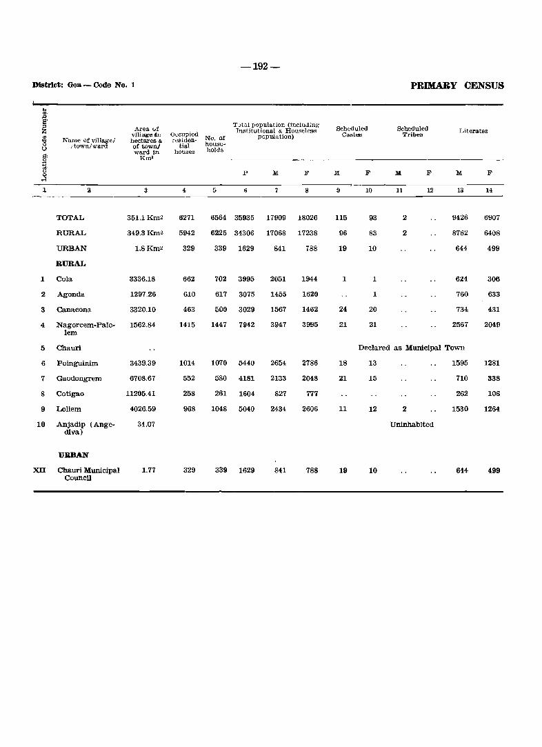
-192-
District: Goa - Qode No. 1 PRIMARY CENSUS
.. <I), ,c S' Totul population (induding ::> Area of Scheduled Scheduled Z Institutional & Hou~eless Literates
'" vHlagelin Occupied No. od' popuJation) Castes Tribes
"" Name of village/ hectares & residoo-0 /town/ward of town/ tial house-0 ward in houses holds §: Km' ~, c.> P M F M F M F M F
oS ~ 2 3 4 6 7 8 9 10 11 12 13 14
TOTAL 351.1Km2 6271 6564 35935 17909 18026 115 93 2 9426 6907
RURAL 349.3Km2 5942 6225 34306 17068 17238 96 83 2 8782 6408
URBAN 1.8Km2 329 339 1629 841 788 19 10 644 499
RURAL
1 Cola 3336.18 662 702 3995 2051 1944 1 1 624 306
2 Agonda 1297,26 610 617 3075 1455 1620 1 760 633
3 Canacona 3320.10 463 500 3029 1567 1462 24 20 734 431
4 Nagorcem-Palo- 1562.84 1415 1447 7942 3947 3995 21 21 2567 2049 lem
5 Chauri Declared as Municipal Town
6 Poinguinim 3439,39 1014 1070 5440 2654 2786 18 13 1595 1281
7 Gaodongrem 6708.67 552 580 4181 2133 2048 21 15 710 338
8 Cotigao 11205.41 258 261 1604 827 777 262 106
9 Loliem 4026,59 968 1048 5040 2434 2606 11 12 2 1530 1264
10 Anjadip (Ange- 34.07 Uninhabited diva)
UaBAN
XU Chauri Municipal 1.77 329 339 1629 841 788 19 10 644 499 CouncU
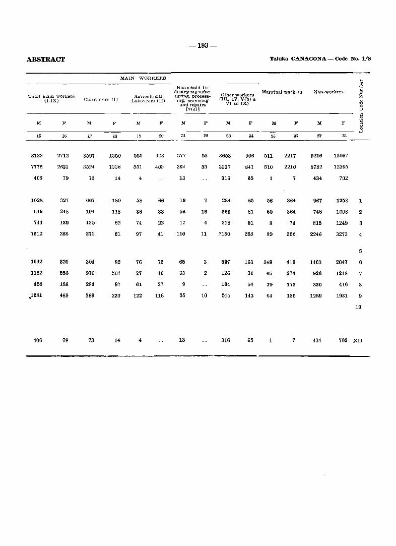
-193-
ABSTRACT Taluka CANACONA - Code No. 1/8
MAIN WORKERS ... Q)
HOUlSehold In- -§ dustry manufac-
Other workers Marginal workers Non-workers :>
Total main wOl'kers Agricultural turing, process- Z (I-IX) Cultiva(o,rs (1) Labourers (II) mg, servicing (lII, IV, V(b) '" " and repairs VI to IX) 't:l
0 [via)] 0
>1
M F M F M F M F M F M F M F :3 oj <J 0
>-1 16 16 17 18 19 20 21 22 23 24 26 26 Zl 28
8182 2712 3597 1350 555 403 377 53 3653 906 511 2217 9216 13097
7776 2633 3524 1336 551 403 364 53 3337 841 510 2210 8782 12395
406 79 73 14 4 13 316 65 1 7 434 702
1028 327 667 189 58 66 19 7 284 65 56 364 967 1253 1
649 248 194 118 36 33 56 16 363 81 60 364 746 1008 2
744 139 435 62 74 22 17 4 218 51 8 74 815 1249 3
1612 366 275 61 97 41 110 11 1130 253 89 356 2246 3273 4
5
1042 320 304 82 76 72 65 3 597 163 149 419 1463 2047 6
1162 556 976 507 27 16 33 2 126 31 45 274 926 1218 7
458 188 284 97 61 37 9 104 54 39 173 330 416 8
.. 1081 489 389 220 122 116 55 10 515 143 64 186 1289 1931 9
10
406 79 73 14 4 13 316 65 1 7 434 702 XII
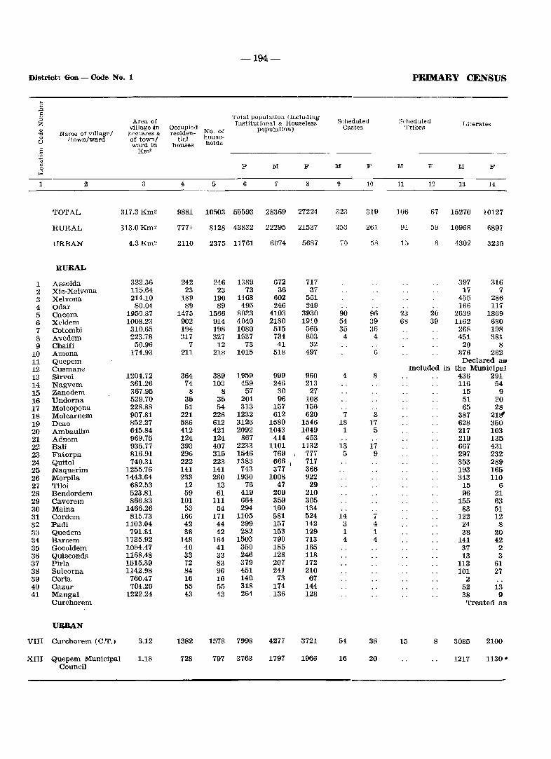
-194-
District: Goa - Code No. 1 PRIMARY CENSUS
... '" :::> I': Total population (indudino;-" Area of Scheduled Scheduled Z Institutional & Houselesg Literates
'" village in Occupied
No, of population) Castels Tribes
"" Name of vlllagl"; hectares & residen-0 /town/W<lrd of town/ tial house-u ward in houses holds :;:: Km' 0
~ P M F M F M F l\I F 0 ~
1 2 3 4 5 6 7 8 9 10 11 12 13 14
TOTAL 317.3 Km~ 9881 10503 55593 28369 27224 ~')n 031.;.) 319 106 67 15270 10127
RURAL H3.0Km~ 7771 8128 43832 22295 21537 253 261 91 59 10968 6897
URBAN 4.3Km~ 2110 2375 11761 6074 5687 70 58 1::; 8 4302 3230
RURAL
1 Assolda 322.36 242 246 1389 672 717 397 316 2 Xic-Xelvona 115.64 23 23 73 36 37 17 7 3 Xelvona 214.10 189 190 1163 602 561 455 286 4 Odar 80.04 89 89 495 246 249 166 117 5 Cacora 1950.37 1475 1566 8033 4103 3930 90 96 23 20 2639 1869 6 Xeldem 1008.23 902 914 4040 2130 1910 54 39 6'3 39 1162 680 7 Cotombi 310.65 194 198 1080 515 565 35 36 268 198 8 Avedem 223.78 317 327 1537 734 803 4 4 451 381 9 Chaifi 50.96 7 12 73 41 32 20 8
10 Amona 174.93 211 218 1015 518 497 6 376 262 11 Quepeln Declared as 12 Cusmane Included in the Municipal 13 Sirvoi 1204.72 364 389 1959 999 960 4 8 436 291 14 Nagvem 361.26 74 103 459 246 213 116 54 15 Zanodem 367.95 8 8 57 30 27 15 9 16 Undorna 529.70 35 35 204 96 108 51 20 17 Molcopona 228.88 51 54 313 157 156 65 28 18 Molcamem 907.81 221 226 1232 612 620 7 8 387 218' 19 Deao 852.27 586 612 3126 1580 1546 18 17 628 350 20 Ambaulim 645.84 412 421 2092 1043 1049 1 5 217 103 21 Adnem 969.75 124 124 867 414 453 219 135 22 Bali 935.77 393 407 2233 1101 1132 13 17 667 431 23 Fatorpa 816.91 296 315 1546 769 '\ 777 5 9 297 232 24 Quitol 740.31 222 223 1383 666 717 353 289 25 Naquerim 1255.76 141 141 743 377 366 193 165 26 Morpila 1443.64 233 260 1930 1008 922 343 110 27 Tiloi 682.53 12 13 76 47 29 15 6 28 Bendordem 523.81 59 61 419 209 210 96 21 29 Cavorem 866.83 101 111 664 359 305 155 63 30 Maina 1466.26 53 54 294 160 134 83 51 31 Cordem 815.73 166 171 1105 581 524 14 1 122 12 32 Padi 1103.04 42 44 299 157 142 3 4 24 8 33 Quedem 791.81 38 42 282 153 129 1 1 38 20 34 Barcem 1735.92 148 164 1503 790 713 4 4 141 42 35 Gocoldem 1084.47 40 41 350 185 165 37 2 36 Quisconda 1168.48 33 33 246 128 118 13 3 37 Pirla 1515.39 72 83 379 207 172 113 61 38 Sulcorna 1142.98 84 96 451 241 210 101 27 39 CorIa 760.47 16 16 140 73 67 2 40 Cazur 704.29 55 55 318 174 144 52 13 41 Mangal 1222.24 43 <i3 264 136 128 38 9
Curchorem Treated as
URBAN
VIII Curchorem (C.T,) 3.12 1382 1578 7998 4277 3721 54 38 15 8 3085 2100
XIII Quepem Municipal 1.18 728 797 3763 1797 1966 16 20 1217 1130' Council
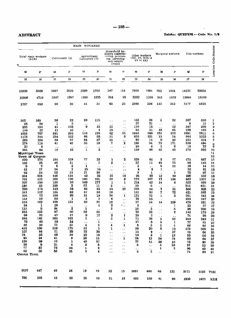
-195-
·ABSTBACT Taluka: QllEPEH - Code No. 1/9
MAIN WORKERS .. ., .0
HOUlsehold In-
~ dustry ma.n.ufac-Other workers
Marginal workers Non-workers Total main workers Agricultural turing, procMs-
(I-IX) Cultivators (1) Labourers (II) lng, servicing (III, IV, V(b) & '" '0 and repairs VI to IX) 0
[v(a)] \) .. ~ .9
1\.1 F M F M F M F M F M F M F g 0 ..:l
15 16 17 18 19 20 21 22 23 24 25 26 27 28
13593 5369 3937 2035 1399 1356 347 114 7910 1864 651 1831 14125 20024
10806 4719 3847 1997 1355 1325 284 89 5320 1308 541 1619 10948 15199
2787 650 90 38 44 31 63 25 2590 556 110 212 3177 4825
302 165 50 22 89 115 163 28 3 22 367 530 1 28 24 1 3 27 21 8 13 2
255 153 43 125 9 13 33 170 15 12 347 396 3 109 22 11 10 1 15 83 11 12 65 125 162 4
1959 707 341 206 110 128 62 33 1446 340 153 312 1991 2911 5 1173 344 234 132 98 55 11 6 830 151 13 34 944 1532 6 265 158 88 57 64 87 15 98 14 9 83 241 324 7 276 138 41 43 35 39 7 2 193 54 72 171 386 494 R
20 4 20 4 3 6 18 22 9 .208 64 18 16 1 2 189 46 40 43 270 390 10
Municipal Town 11 Town of Quepem 12
520 276 184 154 77 53 3 5 256 64 9 17 470 667 13 105 25 46 11 3 2 57 11 43 73 98 115 14
9 2 6 2 1 2 5 11 16 14 15 43 17 14 1 25 14 4 2 1 52 91 16 82 58 52 31 27 26 3 1 1 75 97 17
304 224 145 118 42 55 22 16 95 35 13 39 295 357 18 701 403 208 126 100 101 23 9 370 167 17 106 862 1037 19 507 350 103 30 169 277 1 1 234 42 14 6 522 693 20 198 22 109 5 57 11 2 30 6 216 431 21 508 178 149 39 66 83 15 12 278 44 7 31 586 923 22 341 112 104 62 87 30 19 131 .20 7 72 421 593 23 304 72 108 20 51 19 24 1 121 32 1 2 361 643 24 144 19 59 1 3 3 6 76 15 233 347 25 515 162 429 121 40 27 10 37 14 14 239 478 521 26
24 1 19 1 2 3 1 23 27 27 113 5 94 2 1 2 16 3 5 96 200 28 213 133 87 50 56 50 70 33 2 146 170 29
86 38 47 17 9 17 2 1 28 3 74 96 30 340 193 263 162 3 3 1 71 30 1 82 240 249 31
75 60 58 54 1 17 5 5 1 77 81 32 86 39 73 33 4 2 4 1 5 3 1 4 66 86 33
412 198 339 175 13 3 1 59 20 5 10 373 505 34 107 64 71 35 22 20 14 9 37 78 64 35 74 52 49 34 15 10 10 8 1 12 53 54 36
93 34 41 9 26 11 1 26 13 54 74 60 64 37 139 99 13 1 49 57 77 41 29 18 73 93 38
28 9 21 4 2 5 I) 8 26 37 32 39 77 57 76 55 1 2 1 2 96 85 40 62 38 53 31 3 4 6 3 74 90 41
-census Town
2037 447 49 16 19 12 32 13 1937 406 69 122 2171 3152 VIII
750 203 41 22 25 19 31 12 653 150 41 90 1006 1673 XlII
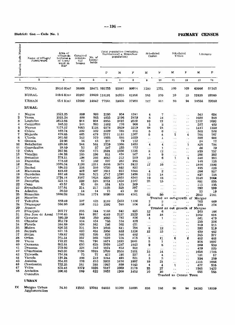
-196-
District: Goa - Code No. 1 PRIMARY CENSUS
... " ., S
Total population (iniCluding ;:s Area of Scheduled Scheduled Z Institutional & Houseless Literates
" village in Occupied
No. of population) Castes Tribes 'C Name of village/ hectares '" residen-0 /town/ward of town/ tial house-0
ward in houses holds .: 0 Km' ~ C)
P M F M B' M F M F 0
..:l
1 2 3 4 5 6 7 8 9 10 11 12 13 14
TOTAL 293.0Km2 36866 38471 193755 93841 99914 ] 290 1251 100 109 60986 51342
RURAL 249.6Km2 22867 23629 116191 54235 61956 383 370 10 15 32428 29340
URBAN 43.4Km2 13999 14842 77564 39606 37958 907 881 90 94 28558 22002
RURAL
1 Nagoa 1521.25 880 903 2195 954 1241 4 7 541 654 2 Verna 1521.24 880 903 4635 2196 2439 8 14 1038 848 3 Loutulim 1613.06 914 934 4955 2416 2539 10 12 1337 1092 4 Camurlim 345.33 344 363 1682 776 906 3 3 527 463 5 Nuvem 1121.07 1053 1134 6178 2859 3319 24 21 1417 135(), 6 Calata 168.74 302 302 1599 738 861 5 6 501 506 7 Majorda 429.85 465 479 2377 1110 1267 5 4 2 4 766 767 8 Utorda 303.66 343 379 1925 886 1039 1 592 600 9 Gonsua 39.96 36 43 201 79 122 58 77
10 Betalbatim 428.06 544 561 2759 1306 1453 4 4 1 839 798 11 Gaundaulim 38.89 52 57 287 135 152 1 66 79 12 Colva 267.98 453 473 2591 1256 1335 8 12 820 737 13 Vanelim 104.26 185 196 931 424 507 4 9 295 292 14 Seraulim 278.11 198 203 1043 513 530 10 6 1 4 346 285, 15 Duneolim 118.42 87 102 567 283 284 149 133 16 Raia 1528.54 1196 1211 6486 3074 3412 17 10 1846 1590 17 Rachol 198.55 308 310 1720 863 857 495 329 18 Macasana 448.42 402 407 1981 937 1044 4 2 596 517 19 GUirdolim 667.46 569 573 2747 1297 1450 12 14 827 718 20 Curtorim 1724.14 1567 1638 8202 3861 4341 19 18 2349 206@l 21 Davorlim 321.16 520 528 2751 1434 1317 23 15 881 535 22 Cana 43.57 65 68 364 155 209 113 131) 23 Sernabatim 157.64 214 217 1125 528 597 292 299 24 Adsulim 20.50 14 14 73 43 30 33 19 25 Benaulim 1000.98 1744 1774 9090 4389 4701 63 50 2553 2181 26 Navelim
i033 Treated as out-growth of Margao
27 Talaulim 489.49 397 423 2189 1156 2 3 703 660 28 Dramapur 556.90 306 315 1392 588 804 3 3 335 374 29 Aquem Treated as out growth of Margao 30 Dicarpale 202.77 235 244 1168 543 625 12 6 263 166 31 Sao Jose de Areal 1246.46 944 957 4349 2127 2222 18 18 1063 638 32 Cavorim 505.29 348 350 1663 787 876 4 1 561 479 33 Chandor 252.79 154 154 766 334 432 235 256 34 Paroda 384.89 158 163 786 365 421 249 213 35 Mulem 826.35 301 304 1605 811 794 8 12 392 219 36 Sarzora 671.16 440 451 1956 832 1124 12 15 450 462 37 Sirlim 189.87 192 195 828 346 482 245 277 38 Orlim 261.31 357 365 1629 754 875 8 11 6 6 482 463 39 Varca 772.22 761 794 3614 1633 2041 5 1 978 1007 40 Carmona 683.64 630 635 2929 1287 1642 9 8 869 930 41 DeuSBua 275.92 324 342 1574 653 921 439 525 42 Chinchinim 942.03 1196 1248 5709 2558 3151 15 14 1656 1715 43 Talvorda 754.88 75 77 422 195 227 5 4 101 57 44 Varoda 191.24 196 212 1044 493 551 3 3 324 239 45 Assolna 354.83 770 810 3603 1616 1987 19 21 1111 1066 46 Cavelossim 752.25 381 388 1942 899 1043 4 4 1 477 535 47 Velim 833.48 1279 1326 5847 2669 3178 23 27 1563 1422 48 Ambelim 396.86 599 622 2652 1200 1452 10 10 655 565
Cuncollm Treated as Census Town
U~BAN
]X Margao Urban 24.10 11555 12261 64858 33760 Agglomeration
31098 836 786 90 94 24385 18009
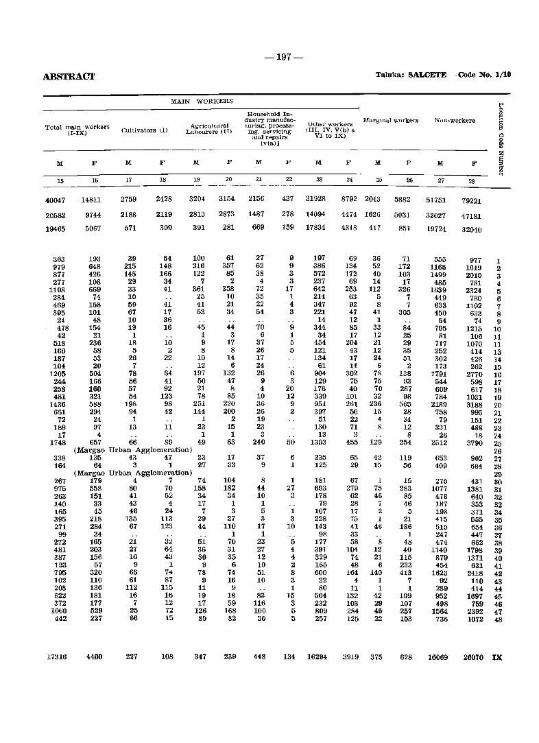
-197-
ABSTRACT Taluka: SALOETE - Code No. 1/10
MAIN WORKERS t' 0
Household In- g dustry manufac-Other workerrs
Margmai workers Kon-workers Total main workers Agricultural turing, process- §
(I-IX) Cultivators (I) Laboure,rs (II) ing, seII'vicing (III, IV, V(b) &
and repairs VI to IX) Q
[v(a)] ~ Z
M F M F M F M ]<' M F M F M F ~ '" ...
15 16 17 18 19 20 21 22 23 24 25 2ti Z7 28
40047 14811 2759 2428 3204 3154 2156 437 31928 8792 2043 5882 51751 79221
20582 9744 2188 2119 2813 2873 1487 278 14094 4474 1626 5031 32027 47181
19465 5067 571 309 391 281 669 159 17834 4318 417 851 19724 32040
363 193 39 54 100 61 27 9 197 69 36 71 555 977 1 979 648 215 148 316 357 62 9 386 134 52 172 1165 1619 2 877 426 145 166 122 85 38 3 572 172 40 103 1499 2010 3 277 108 29 34 7 2 4 3 237 69 14 17 485 781 4
1108 669 33 41 361 358 72 17 642 253 112 326 1639 2324 5 284 74 10 25 10 35 1 214 63 5 7 449 780 6 469 158 59 41 41 21 22 4 347 92 8 7 633 1102 7 395 101 67 17 53 34 54 3 221 47 41 305 450 633 8 24 48 10 36 14 12 1 54 74 9 478 154 19 16 45 44 70 9 344 85 33 84 795 1215 10 42 21 1 1 3 6 1 34 17 12 25 81 106 11
518 236 18 10 9 17 37 5 454 204 21 29 717 1070 11 160 58 5 2 8 8 26 5 121 43 12 35 252 414 13 187 53 26 22 10 14 17 134 17 24 51 302 426 14 104 20 7 12 6 24 61 14 6 2 173 262 15
1205 504 78 64 197 132 26 6 904 302 78 138 1791 2770 16 244 166 56 41 50 47 9 3 129 75 75 93 544 598 17 258 160 57 92 21 8 4 20 176 40 70 267 609 617 18 481 321 54 123 78 85 10 12 339 101 32 98 784 1031 19
1436 588 198 98 251 220 36 9 951 261 236 565 2189 3188 20 661 294 94 42 144 200 26 2 397 50 15 28 758 995 21
72 24 1 1 2 19 51 22 4 34 79 151 22 189 97 13 11 23 15 23 130 71 8 12 331 488 23 17 4 1 1 3 13 3 8 26 18 24
1748 657 66 89 49 63 240 50 1393 455 129 254 2512 3790 25 (Margao Urban Agglomeration) 26
338 135 43 47 23 17 37 6 235 65 42 119 653 902 27 164 64 3 1 27 33 9 1 125 29 15 56 409 684 28
(Margao Urban Agglomeration) 29 267 179 4 7 74 104 8 1 181 67 1 15 275 431 80 975 558 80 70 158 182 44 27 693 279 75 283 1077 1381 31 263 151 41 52 34 34 10 3 178 62 46 85 478 640 32 140 33 43 4 17 1 1 79 28 7 46 187 353 32 165 45 46 24 7 3 5 1 107 17 2 5 198 371 34 395 218 135 113 29 27 3 3 228 75 1 21 415 555 35 271 284 67 123 44 110 17 10 143 41 46 186 515 654 36 99 34 1 1 98 33 1 247 447 87
272 165 21 32 51 70 23 5 177 58 8 48 474 662 38 481 203 27 64 36 31 27 4 391 104 12 40 1140 1798 39 387 156 16 43 30 3f) 12 4 329 74 21 115 879 1371 40 193 57 9 1 9 6 10 2 165 48 6 233 454 631 41 795 320 66 74 78 74 51 8 600 164 140 413 1623 2418 42 102 110 61 87 9 16 10 3 22 4 1 7 92 110 43 203 136 112 115 11 !:J 1 80 11 1 1 289 414 44 622 181 16 16 19 18 83 15 504 132 42 109 952 1697 45 372 177 7 12 17 59 116 3 232 103 29 107 498 759 46
1060 529 2f) 72 126 168 100 5 809 284 45 257 1564 2392 47 442 227 66 15 89 82 30 5 257 125 22 153 736 1072 48
17316 4400 227 108 347 239 448 134 16294 3919 375 628 16069 26070 IX
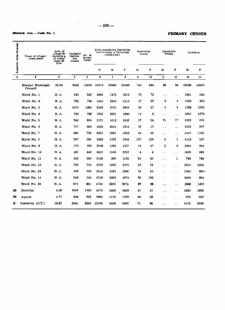
.J)Istrict: Goa - Code No. 1
1
Name of village I /town/WIU'd
Area of vlllage In hecta.rea & of toWD/ ward in
Km'
a
Margao Municipal 16.98 Council
Ward No.1
Ward No.2
Ward No.3
Ward No.4
Ward No.5
Ward No.6
Ward No.7
Ward No.8
Ward No.9
Ward No. 10
Ward No. 11
Ward No. 12
Ward No. 13
Ward No. 14
Ward No. 15
26 Navelim
aD Aquem
X Cuncolim (C.T.)
N.A.
N.A.
N.A.
N.A.
N.A.
N.A.
N.A.
N.A.
N.A.
N.A.
N.A.
N.A.
N.A.
N.A.
N.A.
5.35
1.77
19.27
-198-
Occupied residen- No. of
Total population (inl::luding Insti tutional & Houseless
popru.atioo) tIal house-
houses hohls
p M F
4 5 6 7 8
9462 10150 53076 26996 26080
540
791
1073
760
584
717
696
557
478
401
335
708
422
529
871
1443
650
2444
565 2994
798 4428
1098 5382
790 3921
604 3171
806 4055
720 3883
591 3302
491 2589
440 2412
360 2103
743 3752
460 2614
783 3736
901 4734
1450 8778
661 3004
2581 12706
1478
2216
2737
2021
1612
2141
1981
1757
1262
1180
980
1882
1324
2062
2363
1516
2212
2645
1900
1559
1914
1902
1545
1327
1232
1123
1870
1290
1674
2371
5289 . 3489
1475 1529
5846 6860
Scheduled Castes
M F
9
743
75
17
38
14
37
36
64
157
14
4
51
28
12
99
97
47
46
71
1(l
694
72
25
27
8
38
17
48
158
17
9
43
31
10
102
89
37
55
PRlHA.BY CENSUS
Soheduled Tribes
1\1 F
11 12
Literates
1\1 F
13 14
90 94 19326 15467
5
4
74
5
2
4
4
77
3
5
1
1041
1350
1792
1661
1122
1355
1447
1149
1081
1005
796
1434
1025
1408
1660
4233
826
4173
866
932
1353
1375
874
947
1101
827
984
892
784
1248
868'
985
1431
1962
580
3993
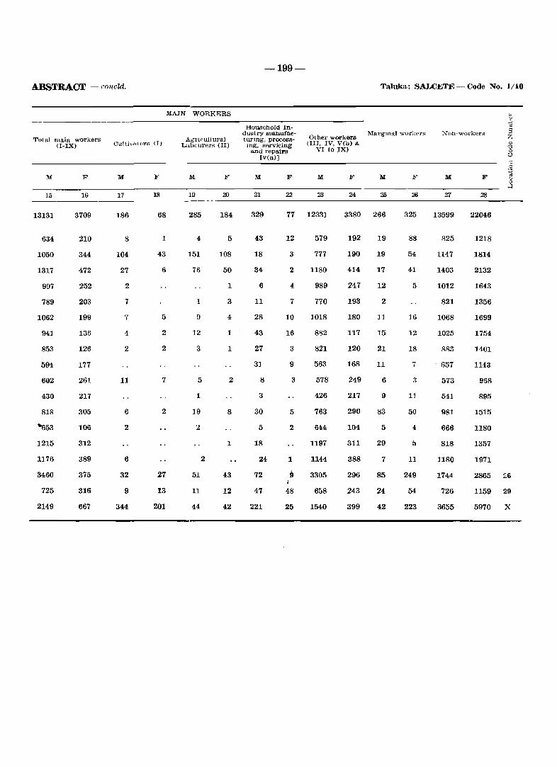
ABSTRACY.r - cOrleW.
Total main workers (I-IX)
M
15
13131
634
1050
1317
997
789
1062
941
853
594
602
430
818
"'653
1215
1176
3460
725
2149
F
16
3709
210
344
472
252
203
199
136
126
177
261
217
305
106
312
389
375
316
667
Culti"", ars (J)
M
17
186
8
104
27
2
7
7
4
2
11
6
2
6
32
9
344
F
18
68
1
43
6
5
2
2
7
2
27
13
201
MAIN WORKERS
Agricultural Labourers (II)
M
19
285
4
151
76
1
12
3
5
1
19
2
2
51
11
44
F
20
184
5
108
50
1
3
4
1
1
2
8
1
43
12
42
-199-
Taluka: SALCETE - Code No. 1/10
Hou.sehold Industry manufacturing. processmg, servicing
and repairs [v(a)]
Other workers (III. IV, V(b) &
VI to IX)
M
21
329
43
18
34
6
11
28
43
27
31
8
3
30
5
18
24
72
47
221
F M
22 23
77 12331
12 579
3 777
2 1180
4
7
10
16
3
9
3
5
2
1
{)
48
25
989
770
1018
882
821
563
578
426
763
644
1197
1144
3305
658
1540
F
24 25
3380 266
192 19
190 19
414 17
247
193
180
117
120
168
249
217
290
104
311
388
296
243
399
12
2
11
15
21
11
6
9
83
5
29
7
85
24
42
F
325
88
54
41
5
16
12
18
7
3
11
50
4
11
249
54
223
","on-workers
M
27
13599
825
1147
1403
1012
821
1068
1025
883
657
573
541
981
666
818
1180
1744
726
3655
F
28
22046
1218
1814
2132
1643
1356
1699
1754
1401
1143
968
895
1515
1180
1357
1971
2865 26
1159 29
5970 X
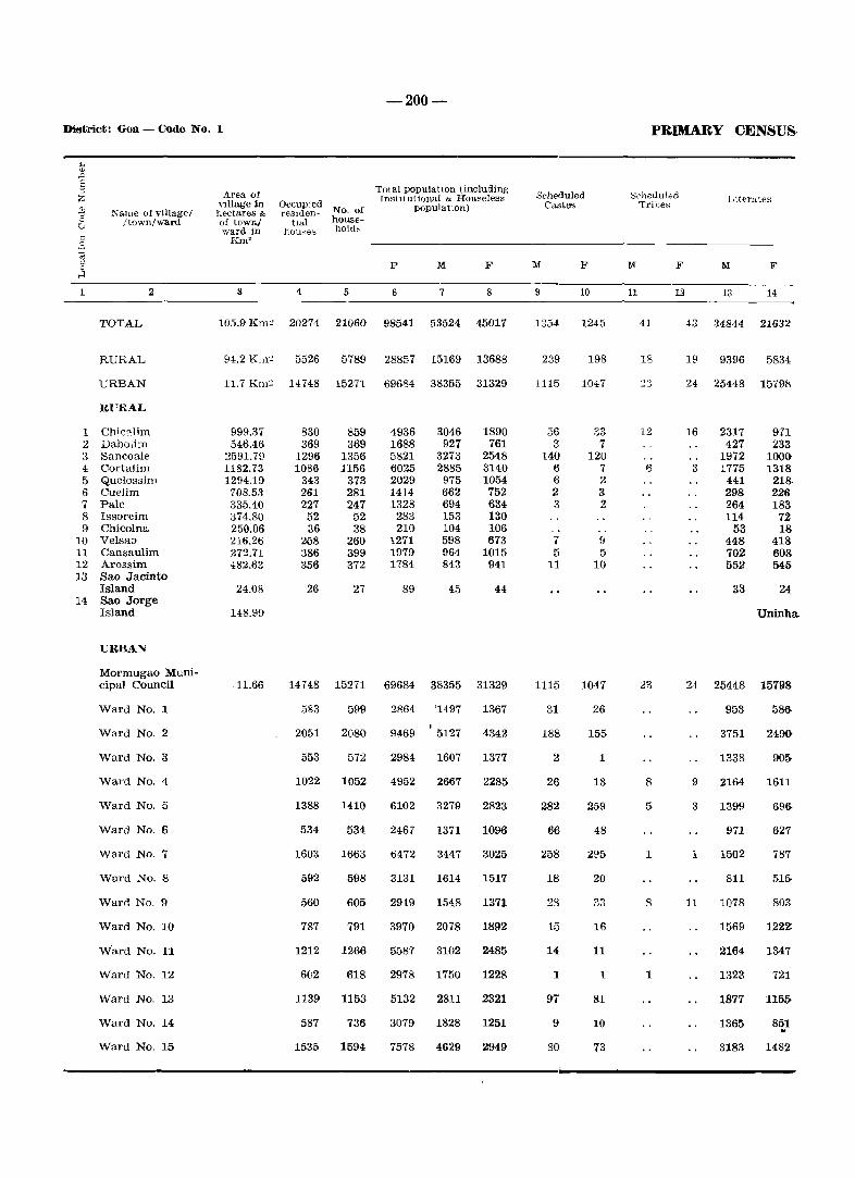
-200-
District: Goa - Code No. 1
1
NanlC of village! ftown/ward
2
TOTAL
RURAL
URBAN
Rl'RAL
1 Chic".lim 2 Dabolim 3 Sancoale 4 Cortalim 5 Quelossim 6 Cuelim 7 Pale 8 Issorcim 9 Chicolna
10 Velsao 11 Cansaulim 12 Arossim 13 Sao Jacinto
Island 14 Sao Jorge
Island
URBAN
Mormugao Municipal Council
Ward No.1
Ward No.2
Ward No.3
Ward No.4
Ward No.5
Ward No.6
Ward No.7
Ward No.8
Ward No.9
Ward No. 10
W'ard No. 11
Ward No. 12
Ward No. 13
Ward No. 14
Ward No. 15
Area of vIllage in hectares & of townJ ward in
Km2
3
~~~~f.:r~~ No. of tlal house-
huuses holds
4 5
Total populatIOn (including InstItutional & Houseless
DOPulatlOn)
p M F
6 7 8
105.9 Km~ 20274 21060 98541 53524 45017
94.2 Km~ 5526 5789 28857 15169 13688
11.7 Km~ 14748 15271 69684 38355 31329
999.37 546.46
2591.79 1182.73 1294.19
708.53 335.40 374.80 250.06 216.26 272.71 482.63
24.08
148.99
.11.66
830 369
1296 1086
343 261 227
52 36
268 386 356
26
859 369
1356 1156
373 281 247
52 38
260 399 372
27
4936 1688 5821 6025 2029 1414 1328
283 210
1271 1979 1784
89
3046 927
3273 2885 975 662 694 153 104 598 964 843
45
1890 761
2548 3140 1054 752 634 130 106 673
1015 941
44
14 748 15271 69684 38355 31329
583
2051
553
1022
1388
534
1603
592
560
787
1212
602
599
2080
572
1052
1410
534
1663
598
605
791
1266
618
1139 1153
587 736
1535 1594
2864 '1497
9469 5127
2984 1607
4952
6102
2467
6472
3131
2919
3970
5587
2978
2667
3279
1371
3447
1614
1548
2078
3102
1750
5132 2811
3079 1828
7578 4629
1367
4342
1377
2285
2823
1096
3025
1517
1371
1892
2485
1228
2321
1251
2949
Scheduled Castes
M :&'
9
1354
239
1115
56 3
140 6 6 2 3
7 5
11
1115
31
188
2
26
282
66
258
18
23
15
14
1
97
9
80
10
1245
198
1047
33 7
120 7 2 3 2
9 5
10
1047
26
155
1
18
259
48
2[l5
20
33
16
11
t
81
10
73
PRIMARY CENSUS
Scheduled 'Tribes
M F
11
41
18
12
6
23
8
5
1
8
1
12
Llterates
M F
13 14
43 34844 21632
19 9396 5834
24 25448 15791';
16
3
2317 427
1972 1775
441 298 264 114
53 448 702 552
33
971 233
1000-1318
218· 226 183
72 18
418 608 545
24
Uninha.
24 25448 15798
9
3
1
11
953
3751
1338
2164
1399
971
1502
811
1078
1569
2164
1323
1877
1365
3183
58&
2490.
90&
1611
69&
627
787
51&
803
1222
1347
721
115~
851 "
1482
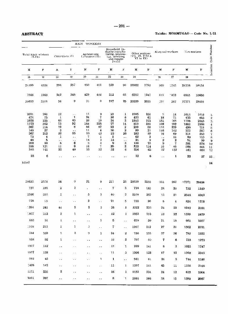
ABSTRACT
Total mam workers (I-IXI
M
15
28199
7566
20633
2031 474
1926 1173 367 14~
367 73 48
208 388 345
23
bited
20633
737
2566
778
1394
18G7
685
1918
784
808
1017
1517
982
1408
1171
3001
F
16
4538
1960
2578
260 75
335 562 114
27 212
4 5
88 131 141
6
2578
188
Z63
D5
241
312
51
213
159
92
142
128
45
142
235
267
MAIN WORKERS
Cuitimtul's III
18
298
242
56
12 1
60 73 19
3 32
1
8 11 22
56
2
H
2
1
1
1
1
2
F
19
257
248
9
1 40 92
6
55
6 8
40
2
2
1
1
3
Agncultural T Jabourer~ (11 I
M
20
450
429
21
11 24 39
164 86 11 11) 7
14 3
16 35
21
5
2
2
, oJ
F
21
409
400
9
9 7
19 225 47
4 42 1 3 4 7
32
9
3
3
1
1
1
-201-
Household Industry manufacturing, process-ing, servicing
and repail"l' [via)]
Other workers IIII, IV, V(b) &
VI to IX)
M
22
529
312
217
23 16 24 77 23 30 33 3
13 9
29 32
217
7
40
21
26
12
5
7
24
10
1~
11
1
11
16
8
F M
23 24
90 26922
65 6583
25 20339
1 6 3
14 2 2
26
3 2 6
1985 433
1803 859 239
99 283 62 21
188 332 256
23
25 20339
3
2
5
1
1
2
2
1
5
1
1
1
728
2519
755
1322
1853
679
1907
750
797
999
1506
981
1397
1153
2993
F
3782
1247
2535
250 61
273 231 59 21 89
3 :l
75 114
63
6
2535
183
263
90
235
310
50
212
153
90
141
123
44
141
234
266
Taluka: MORMlJGAO - Colle No. 1/11
lIIal'g mal workers
M
26
9G9
618
:351
2 18
151 109 118 146
16
2 9
10 37
351
28
13
5
24
13
21
27
37
7
8
17
24
65
24
38
F
27
1345
1078
267
14 71
168 192 229 142
69 11
2 7
40 132
1
267
30
31
4
23
32
18
31
36
6
3
12
3
11
12
15
M:
28
24356
6985
17371
1013 435
1196 1603
490 373 311
80 54
381 566 461
22
17371
732
2548
824
1249
1399
665
1502
793
733
1053
1568
744
1338
633
1590
F
39134
10650
28484
1616 615
2045 2386
711 583 353 115
99 57& 844 668
4 5 6
8 9
]0 11 12
37 13.
28484
1149
4043
1278
2021
2479
1027
2781
1322
1273
1747
2345
1180
2168
1004
2667
14.
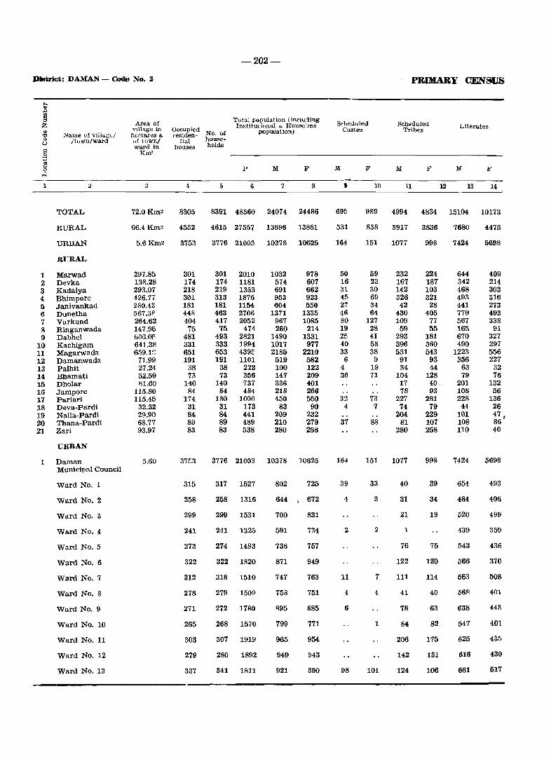
-202-
DJstrict: DAIUAN - Code No.2 PRlMARY CEN8IJ8
..... ., .Q
~ Area of Total population (illl'luding
Scheduled Scheduled Z Institutional & HOllseless Literates
'" vlllage in Occupied No. of poPll~ation) Castes Tribes
'"0 Name uf vIllagL/ h(.ctares & rt'siden-0 /town/ward of townl tial house-0
ward in houses holds 1'1 KIll' .~ 0; <.> P M F M F M F M F 0 H
1 2 3 4 5 6 7 8 t 10 11 12 13 14
TOTAL 72.0Km2 8305 8391 48560 24074 24486 695 989 4994 4834 15104 10173
RURAL 66.4Km~ 4552 4615 27557 13696 13861 531 838 3917 3836 7680 4475
URBAN 5.6Km2 3753 3776 21003 10378 10625 164 151 1077 998 74240 5698
RURAL
1 Marwad 297.85 301 301 2010 1032 978 50 59 232 224 644 409 2 Devka 138.28 174 174 1181 574 607 16 23 167 187 342 214 3 Kadaiya 293.07 218 219 1353 691 662 31 30 142 103 468 303 4 Bhimpore 426.77 301 313 1876 953 923 45 69 326 321 493 316 5 Janivankad 280.42 181 181 1154 604 550 27 34 42 28 441 273 6 Dunetba 567.38 448 463 2706 1371 1335 46 64 430 405 779 493 7 Varkund 264.62 404 417 2052 967 1085 80 127 109 77 567 338 8 Ringanwada 147.95 75 75 474 260 214, 19 28 59 55 165 91 9 Dabhel 606.01'· 481 493 2821 1490 1331 21'· 41 293 181 670 327
10 Kachigam 641.38 331 333 1994 1017 977 40 58 396 360 490 297 11 Magarwada 659.1E: 651 653 4395 2185 2210 33 38 531 543 1223 556 12 Damanwada 71.99 191 191 1101 519 582 6 9 91 93 356 227 13 Palhit 27.24 38 38 222 100 122 4 19 34 44 63 32 14 Bhamati 52.59 73 73 356 147 209 36 71 104 128 79 76 15 Dholar 81.60 140 140 737 336 401 17 40· 201 132 16 Jampore 115.80 84 84 484 218 266 78 93 108 56 17 Pariari 115.45 174 180 1000 450 550 32 73 227 281 228 136 18 Deva-Pardi 32.32 31 31 173 83 90 4 7 74 79 44 26 19 Naila-Pardi 29.90 84 84 441 209 232 204 229 101 47. 20 Thana-Pardi 68.77 89 89 489 210 279 37 88 81 107 108 86" 21 Zari 93.97 83 83 538 280 258 280 258 110 40
UlmAN
I Daman 5.60 37(;3 3776 21003 10378 10625 164 151 1077 998 7424 5698 Municipal Council
Ward No.1 315 317 1527 802 725 39 33 40 39 654 493
Ward No.2 258 258 1316 644 , 672 4 3 31 34 484 406
Ward No.3 299 299 1531 700 831 21 19 520 499
Ward No. Jl 241 241 1325 591 734 2 2 1 439 359-
Ward No.5 273 274 1493 736 757 76 75 543 436
Ward No.6 322 322 1820 871 949 122 120 566 370
Ward No.7 312 318 1510 747 763 11 7 111 114 563 508
Ward No.8 278 279 1509 758 751 4 4 41 40 568 401
Ward No.9 271 272 1780 895 885 6 78 63 638 443
Ward No. 10 265 268 1570 799 771 1 84 82 547 401
Ward No. 11 303 307 1919 965 954 206 175 625 435
Ward No. 12 279 280 1892 949 943 142 131 616 430
Ward No. 13 337 841 1811 921 890 98 101 124 106 661 517
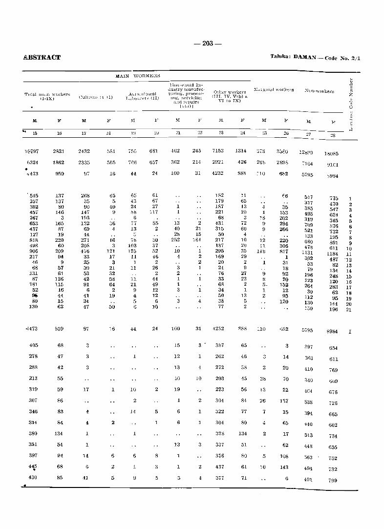
&BSTRACI'
Tota.l mad! workers II-IX)
'"
M
15
]&797
6324 .. ,)473
, 515 257 302 457 267 653 437 127 818 498 906 217
46 68
131 87
J81 52 !Ii 80
130
4473
405
278
288
213
319
307
346
314
380
351
397
445 • 430
F
16
2821
1862
959
137 137
80 146
3 165
87 19
220 60
209 94
9 57 61
126 115
16 44 15 62
959
68
47
42
55
59
86
83
84
134
54
94
68
85
M
17
2432
2335
268 35 90
147 193 132
69 44
271 208 476
33 25 30 53 42 91
6 41 34 47
97
3
3
17
4
4
1
1
14
6
41
MAIN WORKERS
F
18
581
565
16
ti5 5
40 9
36 4
16 3
121 17
3 21 32 58 64
2 19
50
16
1
2
6
2
5
Ac,nl'ultural L,tlJIJUJ't'1 ~ I II)
IV
750
706
65 43 24 :0.8
6 7T 13
,8 103 125
11 1
11
11 21
9 4 5 ()
1
10
2
14
1
6
1
9
F
20
681
657
24
61 67 27
117
55 2
30 37 52 46
2 26
2 44 49 12 12
6 10
24
2
5
1
8
3
5
-203-
Hou-phold IlJtlustry rnanufact llring, proce::;::;-
lUg'. sel'vicillg and l'el1uirs
I VI,l)]
:!1
-162
362
100
1 1
13 40 28
252
10 4
3 2 1 1 3
3
100
15
12
13
10
19
1
6
6
13
1
1
3
:22
245
214
31
2 21 15
164
1 2 2 1
1
1
4
31
s
1
10
2
1
1
3
2
Other workers OIL IV. VI b) &
VI to IX)
7153
2921
4232
182 179 187 221
68 431 315 50
217 187 295 169
20 24 76 33 68 34 50 38 77
4232
3&7
262
272
203
273
304
322
304
378
337
3.6
437
377
I."
24
1314
426
888
11 65 13 20
3 72 60
4 10 20 35 29
2 9
27 23
2 1
13 5 2
888
65
46
38
45
56
84
77
80
134
51
80
61
71
3i8
268
4 1
18 9 9
12 I,.l
148
1
9 8 5· 1 2
DO
3
2
38
13
26
7
4
2
5
10
Taluka: DA.1IAN - Code No. 2/1
I"
26
2898
682
35 153 202 294 266
220 306 817
1 31 18 92 20
152 12 93
120
1382
3
14
20
70
22
137
15
65
17
62
108
143
6
~()ll-\\·ol'kers
27
7104
5i95
517 317 385 495 319 709 521 133 660 478
1131 3.02 53 79
196 123 264
30 112 130 150
5795
397
363
no
340
404
538
394
440
513
448
563
494
491
28
18085
nOI
"984
775 1 470 2 547 3 624 4 345 5 876 6 732 7 195 8 891 9 611 10
1184 11 487 12
82 13 134 14 248 15 120 16 283 17
62 18 95 19
144 20 196 21
8984 I
654
611
769
676
726
665
602
734
655
752
732
799
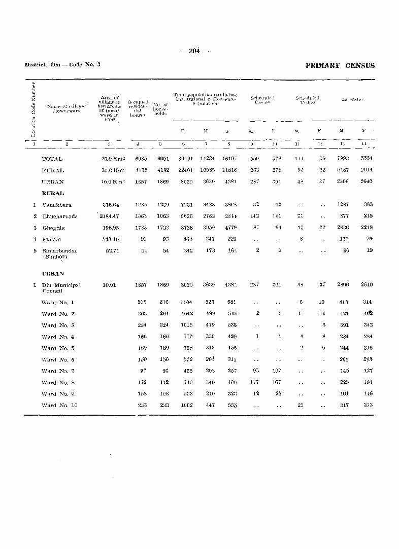
District: Diu - Code No. :3
1
NUI.tlC of Ylliug p /
Itown/\\'ar<i
2
TOTAL
RURAL
URBAN
RURAL
1 Vanakbara
2 Bhucharvad8
3 Ghoghla
4 Fudam
5 Sirnarbandar (Sirnbor)
\
FRBAN
I Diu Municipal Council
Ward No.1
Ward No.2
Ward No.3
Ward No.4
Ward No.5
Ward No.6
Ward No ...
Ward No.8
Ward No.9
Ward No. 10
Area of village :ill h('ctares & of town/ -ward in
I(nl~
3
40.0Km~
30.0 Km"
10.0Km~
376.6'1
2184.47
198.95
523.10
52.71
10.01
4
6035
4178
IS5,
1235
10B3
1733
9:3
54
1857
205
263
224
166
189
150
97
172
158
233
5
-204-
T"lai population (tnduutn.; Ill~\itutional & Hou'ele".'
pI ,plll~lt I(ln'
.P F
6 7 s
6051 30421 14224 16197
4182 22401 10585 11816
18S\'I 8020 3639 4381
123£1 7231
1063 5626
1733 8738
93 464
54 342
1869 8020
216 1104
264 1042
224 1015
166
189 768
151'1 572
97 465
172 740
158 533
233 1002
3423
2782
395£l
24.'3
178
3639
523
499
479
359
313
26L
203
340
210
H7
380':'
28H
477!:1
221
4381.
58t
543
536
42(1
455
311
25-;-
400
323
555
Srl!E'uuiP1l ('\-\..:tr;.!
1t)
550 579
26::;
:J01
42
142 IH
87 94
2 1
287 301
2 :3
1 1
93 107
177 167
12 23
PRIMARl:' CENSUS
f::1-'~lE·dult"·tl Trii>e"
IH
11
1H
15'
8
6
25
12
22
22
37
10
11
3
8
5
III
7993
5187
2806
1287
877
2836
127
60
2806
413
421
391
284
241
205
145
225
161
317
F
11
5554
2914
2640
383
215
2218
79
19
2i34()
314
342'
284
318
20S:
127
191
14&
313
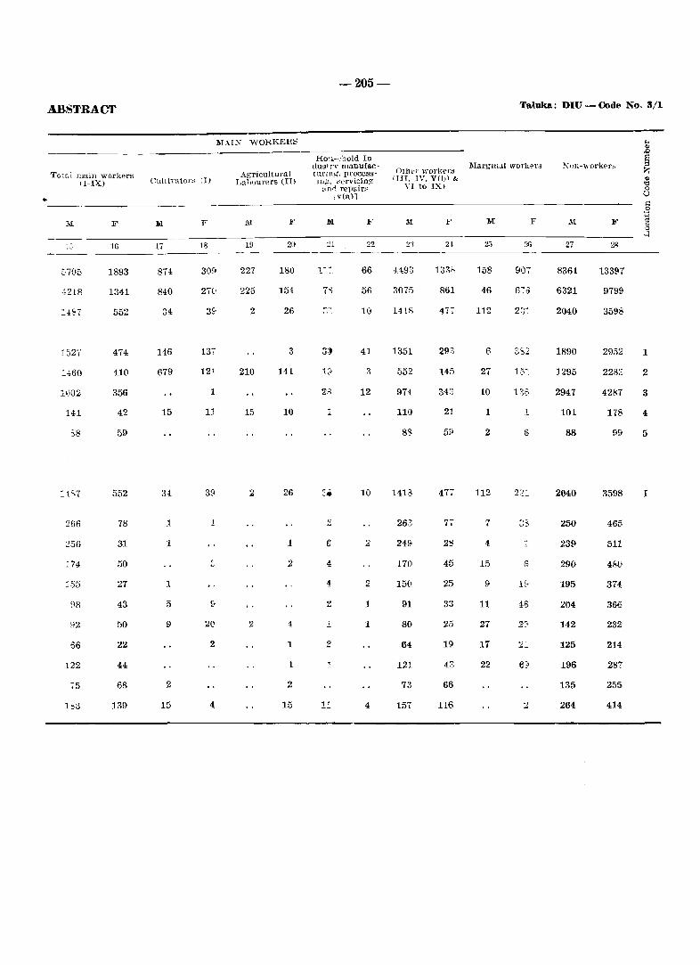
•
ABSTRACT
T(tifll nlain workers II-IX)
M F
16
1893
4218 1341
552
474
:,,60 410
356
141 42
S8 59
552
266 78
256 31
174 50
155 27
88 43
92 50
66 22
122 44
75 68
IS3 139
1\1.\1:\ WORKERS
CnltiYators I I)
l<I
17
874
840
34
146
679
15
34
1
1
1
5
9
2
15
F
18
309
270
3!i
137
121
1
11
39
1
2(!
2
4
Agricultural Labourers (II)
19
227
225
2
210
15
2
2
F
20
180
154
26
3
141
10
26
1
2
1
1
2
15
-205-
Ho~,,":hold Industr}' manufac(lU'ltlo;', processwg, "ervicin~
:_~ n.l repair~ \ v(a)l
F
22
66
56
10
41
12
1
10
6 2
4
4 2
2 1
1 1
2
1
11 4
Other \\'ol'l,,'rs lIn, IV, V())\ &
VI to IX,
F
4493 133';'
3075 861
1415 477
1351 293
552 145
974 343
110 21
83
1418 477
263 77
249> 23
170 45
150 25
91 33
80 25
64 19
121 43
73 66
157 116
Ta,luka: DIU - Code Noo 3/1
lIIarglll<l1 workers
M
158
46
112
6
27
10
1
2
112
7
4
15
9
11
27
17
22
F
907
670
3S2
15:
136
1
6
1f!
46
""m-workel'~
27
8361
6321
2040
1890
1295
2947
101
88
2040
250
239
290
195
204
142
125
196
135
264
F
28
13397
9799
3598
2952
2283:
4281
178
99
3598
4615,
511
48(}
374
366
232
214
287
255
414
1
2
3
4
5
I
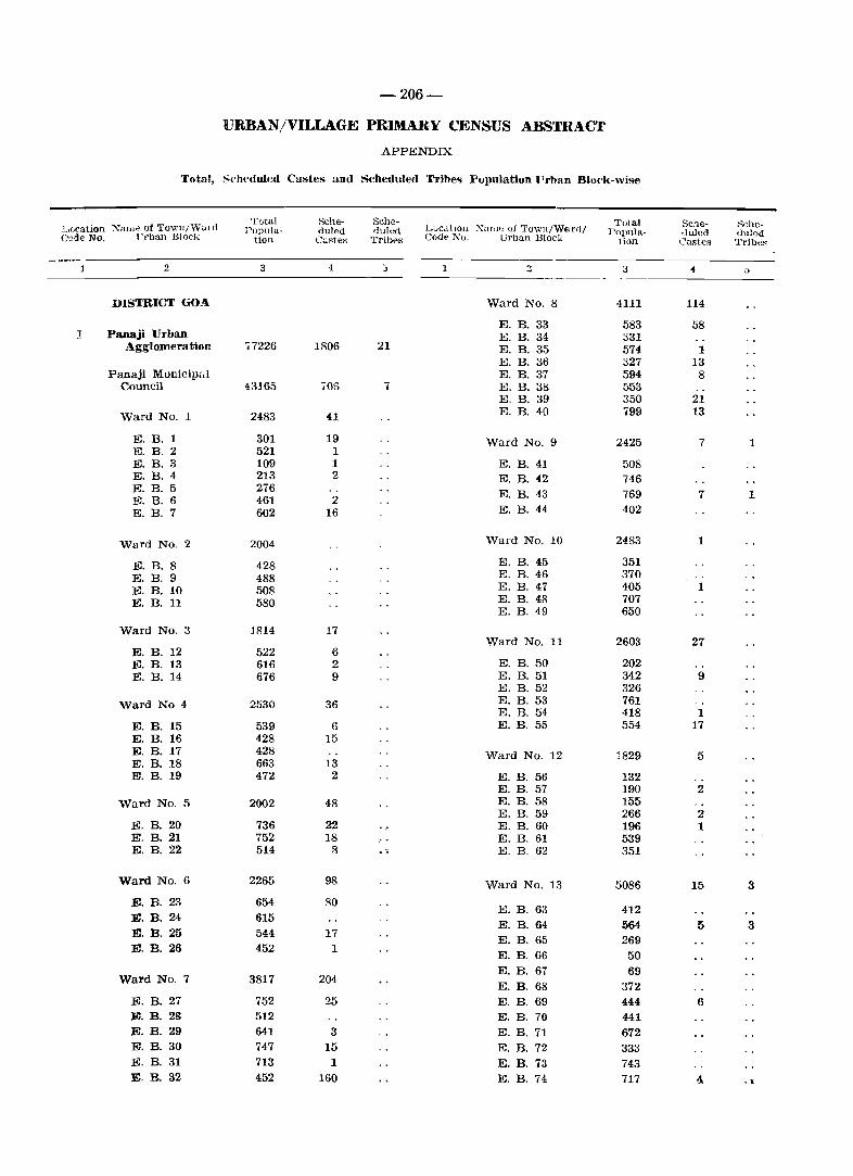
-206-
llJRBAN/VILLAGE PRIMARY CENSUS ABSTRACT
APPENDIX
Total, S('hpduled Castes and Scheduled Tribe<; Fupulation l'rban Block-wb-e
~If_}cation Xan1f" of Town/\'Valll Total Sehe- Sche-
LucoltlOll Xamp. of Town/W6ril/ Total Sche- 8che-
PODula- duled tIuIed POlJu!a- .Juled duled Clade No. l'j'ban Block tion Custes Tribps Codt'l'\o. Urban Block lion Castes Tribes
2 3 ·1 J :) 3 0{ a ----
DISTRICT GO."- Ward No. 8 4111 114
E. B. 33 583 58 ] Panaji Urban E. B. 34 331
Agglomeration ,7226 1806 21 E. B. 35 574 1 E. B. 36 327 13
Panaji MuniCipal E. B. 37 594 8 Council 43165 JOS 7 E. B. 38 553
E. B. 39 350 21
Ward No. 1 2483 41 E. B. 40 799 13
E. B. 1 301 19 Ward No.9 2425 7 1 E. B. 2 521 1 E. B. 3 109 1 E. B. 41 508 E. B. 4 213 2 E. B. 42 746 E. B. 5 276 E. B. 43 769 7 1 E. B. 6 461 2 E. B. 7 602 16 E. B. 44 402
Ward No. 2 2004 'Yard No. 10 2483 1
E. B. 8 428 E. B. 45 351
E. B. 9 488 E. B. 46 370
E. B. 10 508 E. B. 47 405 1
E. B. 11 580 E. B. 48 707 E. B. 49 650
Ward No.3 1814 17 Ward No. 11 2603 27
E. B. 12 522 6 E. B. 13 616 2 E. B. 50 202 E. B. 14 676 9 E. B. 51 342 9
E. B. 52 326
Ward No 4 2530 36 E. B. 53 761 E. B. 54 418 1
E. B. 15 539 6 E. B. 55 554 17 E. B. 16 428 15 E. B. 17 428 Ward No. 12 1829 5 E. B. 18 663 13 E. B. 19 472 2 E. B. 56 132
E. B. 57 190 2 Ward No.5 2002 48 E. B. 58 155
E. B. 59 266 2 E. B. 20 736 22 E. B. 60 196 1 E. B. 21 752 18 E. B. 61 539 E. B. 22 514 8 .. E. B. 62 351
Ward No.6 2265 98 Ward No. 13 5086 15 3
E. B. 23 654 80 E. B. 63 412
E. B. 24 615 E. B. 64 564 5 3
E. B. 25 544 17 E. B. 65 269
E. B. 26 452 1 E. B. 66 50 E. B. 67 69
Ward No.7 3817 204 E. B. 68 372
E. B. 27 752 25 E. B. 69 444 6 E. B. 28 512 E. B. 70 441 E. B. 29 641 3 E.B.71 672 E. B. 30 747 15 E. B. 72 333 E. B. 31 713 1 E. B. 73 743 E. B. 32 452 160 E. B. 74 717 4 . ,
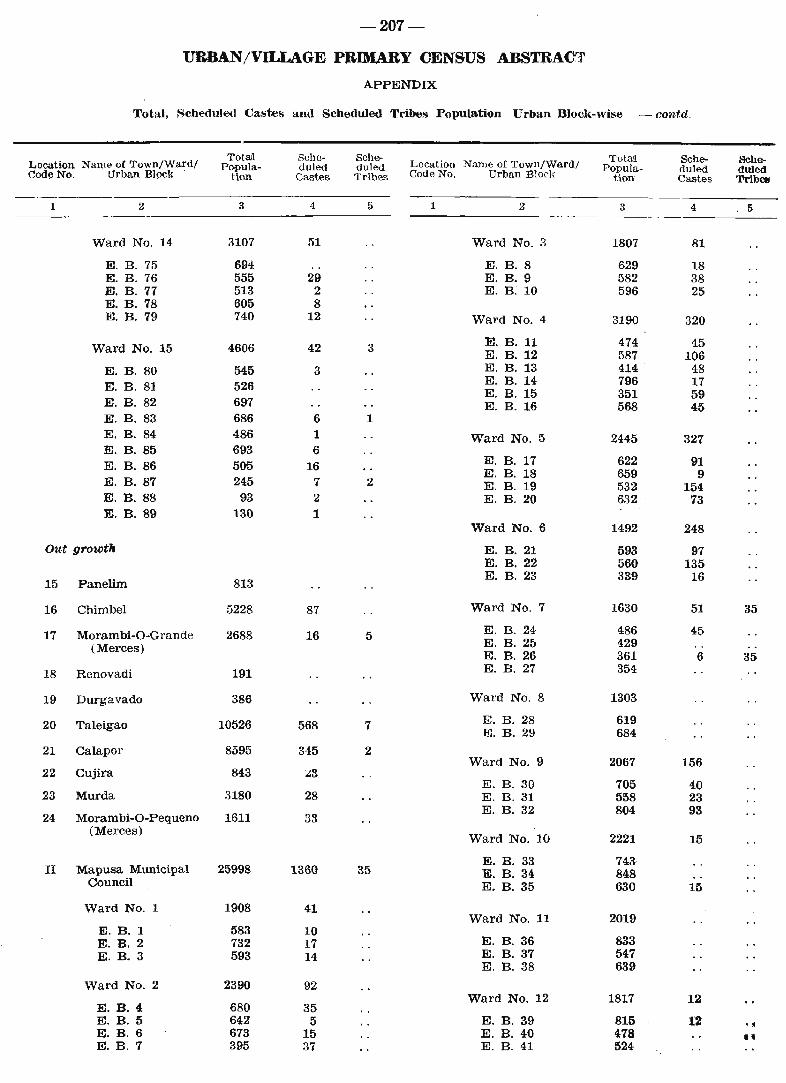
-207-
URBAN/VILLAGE PRIMARY CENSUS ABSTRACT
APPENDIX
Total, Scheduled Castes and Scheduled Tribes Population Urban Block-wise -contd.
Location Name of Town/Wa.rd! Totrul Sche- Sche-
Location Name of Town/Wa.rd/ Towl Sche- Sche-
Popula- duIed duIed Popula- duled duled Code No. Urban Block tion Castes Tribes Code No. Urban Block Hon Cas-tes Tribe!
1 Z 3 4 5 1 2 3 4 5 ------- .
Ward No. 14 3107 51 Ward No.3 1807 81
E. B. 75 694 E. B. 8 629 18 E. B. 76 555 29 E. B. 9 582 38 E. B. 77 513 2 E. B. 10 596 25 E. B. 78 605 8 E. B. 79 740 12 Ward NO.4 3190 320
Ward No. 15 4606 42 3 E. B. 11 474 45 E. B. 12 587 106
E. B. 80 545 3 E. B. 13 414 48
E. B. 81 526 E. B. 14 796 17 E. B. 15 351 59
E. B. 82 697 E. B. 16 568 45 E. B. 83 686 6 1 E. B. 84 486 1 Ward No.5 2445 327 E. B. 85 693 6 E. B. 86 505 16 E. B. 17 622 91
E. B. 18 659 9 E. B. 87 245 7 2 E. B. 19 532 154 E. B. 88 93 2 E. B. 20 632 73 E. B. 89 130 1
Ward No.6 1492 248
Out growth E. B. 21 593 97 E. B. 22 560 135
15 Panelim 813 E. B. 23 339 16
16 Chimbel 5228 87 Ward No.7 1630 51 35
17 Morambi-O-Grande 2688 16 5 E. B. 24 486 45
(Merces) E. B. 25 429 E. B. 26 361 6 35
18 Renovadi 191 E. B. 27 354
19 Durgavado 386 Ward No.8 1303
20 Taleigao 10526 568 7 E. B. 28 619 E. B. 29 684
21 Calapor 8595 345 2 Ward No.9 2067 156
22 Cujira 843 :.::3 E. B. 30 705 40
23 Murda 3180 28 E. B. 31 558 23
24 Moram bi-O-Pequeno 1611 33 E. B. 32 804 93
(Merces) Ward No. 10 2221 15
E. B. 33 743 II Mapusa Municipal 25998 1360 35 E. B. 34 848
Council E. B. 35 630 15
Ward No.1 1908 41 Ward No. 11 2019
E. B. 1 583 10 E. B. 2 732 17 E. B. 36 833 E. B. 3 593 14 E. B. 37 547
E. B. 38 639
Ward No.2 2390 92 Ward No. 12 1817 12
E. B. 4 680 35 E. B. 5 642 5 E. B. 39 815 12 .. ~ E. B. 6 673 15 E. B. 40 478 IJ E. B. 7 395 37 E. B. 41 524
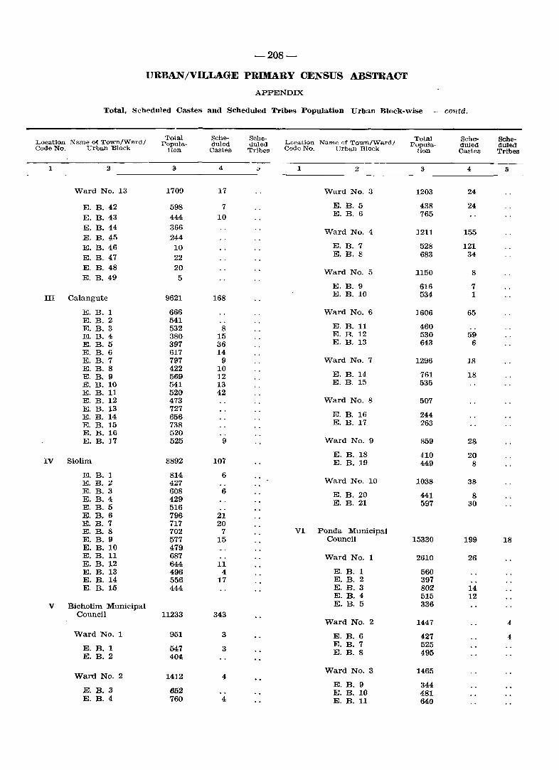
-208-
URBAN/VILLAGE PRIMARY CENSUS ABSTRACT
APPENDIX
Total, Scheduled Castes and Scheduled Tribes Population Urban Block-wise -contd.
Location Name of Town/Wal'd/ Total Sche- Selle-
LO(,A3.tion Name of Town/Ward/ ToW Sche- Sehe-
Papula- duled duled Popula- duled duled CadeNo. Urban Block tion Castes Tribes Code No. Urban Block Bon Castes Tribes
1 .2 3 4 .. 1 2 3 4 5
Ward No. 13 1709 17 Ward No. 3 1203 24
E. B. 42 598 7 E. B. 5 438 24
E. B.43 444 10 E. B. 6 765
E. B.44 366 E. B. 45 244
Ward No. 4 1211 155
E. B.46 10 E. B. 7 528 121 E. B.47 22 E. B. 8 683 34
E. B.48 20 E. B. 49 5
Ward No. 5 1150 8
E. B. 9 616 7 III Calangute 9621 168 E. B. 10 534 1
E. B. 1 666 Ward No.6 1606 65 E. B. 2 541 E. B. 3 532 8 E. B. 11 460 E. B. 4 380 15 E. B. 12 530 59 E. B. 5 397 36 E. B. 13 643 6 E. B. 6 617 14 E. B. 7 797 9 Ward No.7 1296 18 E. B. 8 422 10
E. B. 14 E. B. 9 569 12 761 18 E. B. 10 541 13 E. B. 15 535 E. B. 11 520 42 E. B. 12 473 Ward NO.8 507 E. B. 13 727
ill. B. 16 E. B. 14 656 244 E. B. 15 738 E. B. 17 263 E. B. 16 520 E. B. 17 525 9 Ward No.9 859 28
E. B. 18 410 20 IV Siolim 8892 107 E. B. 19 449 8
E. B. 1 814 6 E. B. 2 427 Ward No. 10 1038 38 E. B. 3 608 6 E. B. 20 441 8 E. B. 4 429 E. B. 21 597 30 E. B. 5 516 E. B. 6 796 21 E. B. 7 717 20 E. B. 8 702 7 VI Ponda Municipal E. B. 9 577 15 Council 15330 199 18 E. B. 10 479 E. B. 11 687 Ward No. 1 2610 26 E. B. 12 644 11 E. B. 13 496 4 E. B. 1 560 E. B. 14 556 17 E. B. 2 397 E. B. 15 444 E. B. 3 802 14
E. B. 4 515 12 V Bicholim Municipal E.B.5 336
Council 11233 343 Ward No. 2 1447 4
Ward No. 1 951 3 E. B. 6 427 4
E. B. 1 547 3 E. B. 7 525
E. B. 2 404 E. B. 8 495
Ward No. 3 1465 Ward No.2 1412 4
E. B. 9 344 E. B. 3 652 E. B. 10 481 E. B. 4 760 4 E. B. 11 640
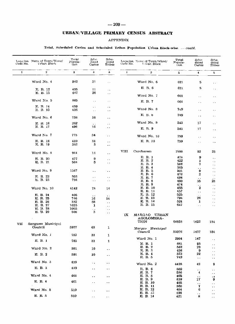
-209-
URBAN/VILLAGE PRIMARY CENSUS ABSTRACT
APPENDIX
Total, Scheduled Castes and Scheduled Tribes Population Urban Block-wise -contd.
Name of Town/Ward/ Total Sche- Sche-
Location Name of Town/Ward/ Total Sche- Sche-Location Popula- duled duled Popula- dUled duled Code No. LTrban Block tion Castes Tribes Code No. ~li ,.ban Block tion Castes Tribes
----- ------1 2 3 4 5 1 2 3 4 5
Word No. 4 942 31 Word No.6 621 5
E. B.12 495 11 E. B. 6 621 5
E. B. 13 447 20 Ward No. 7 601
Ward No.5 865 E. B. 7 601
E. B. 14 459 E. B. 15 406 Ward No. 8 749
E. B. 8 749 Ward No.6 758 16
E. B. 16 262 Ward No. 9 543 17 E. B. 17 496 16
E. B. 9 543 17
Ward No.7 773 34 Ward No. 10 759
E. B. 18 410 31 E. B. 10 759 E. B. 19 363 3
Ward NO.8 981 14 VIII Curchorem 7998 92 23
E. B. 20 477 9 E. B. 1 474 9 E. B. 2 422 1 E. B. 21 504 5 E. B. 3 506 7 E. B. 4 365
Ward No.9 1347 E. B. 5 901 9 E. B. 6 470 2
E. B. 22 553 E. B. 7 494 E. B. 23 794 E. B. 8 490 35 23
E. B. 9 474 Ward No. 10 4142 78 14 E. B. 10 455 2
E. B. 11 457 E. B. 24 466 E. B. 12 525 E. B. 25 746 16 14 E. B. 13 794 26 E. B. 26 382 58 E. B. 14 524 1 E. B. 27 1035 1 E. B. 15 647 E. B. 28 1005 E. B. 29 508 3
IX MARGAO URBAN AGGLOMERA-
VII Sanguem Municipal TION 64858 1622 184
Council 5977 63 1 Margao Municipal Council 53076 1437 184
Ward No. 1 783 31 1 Ward No. 1 2994 147
E. B. 1 783 31 1 E. B. 1 681 93
Ward No. 2 591 10 E. B. 2 562 23 E. B. 3 436 9
E. B. 2 591 10 E. B. 4 573 22 E. B. 5 742
Ward No. 3 419 Ward No. 2 4428 42 9
E. B. 3 419 E. B. 6 502 E. B. 7 586 4
Ward No. 4 401 E. B. 8 465 . ~ E. B. 9 619 17 9
E. B. 4 401 E. B. 10 485 E. B. 11 360 7
Ward No. 5 510 E. B. 12 494 6 E. B. 13 496
E. B. 5 510 E. B. 14 421 8
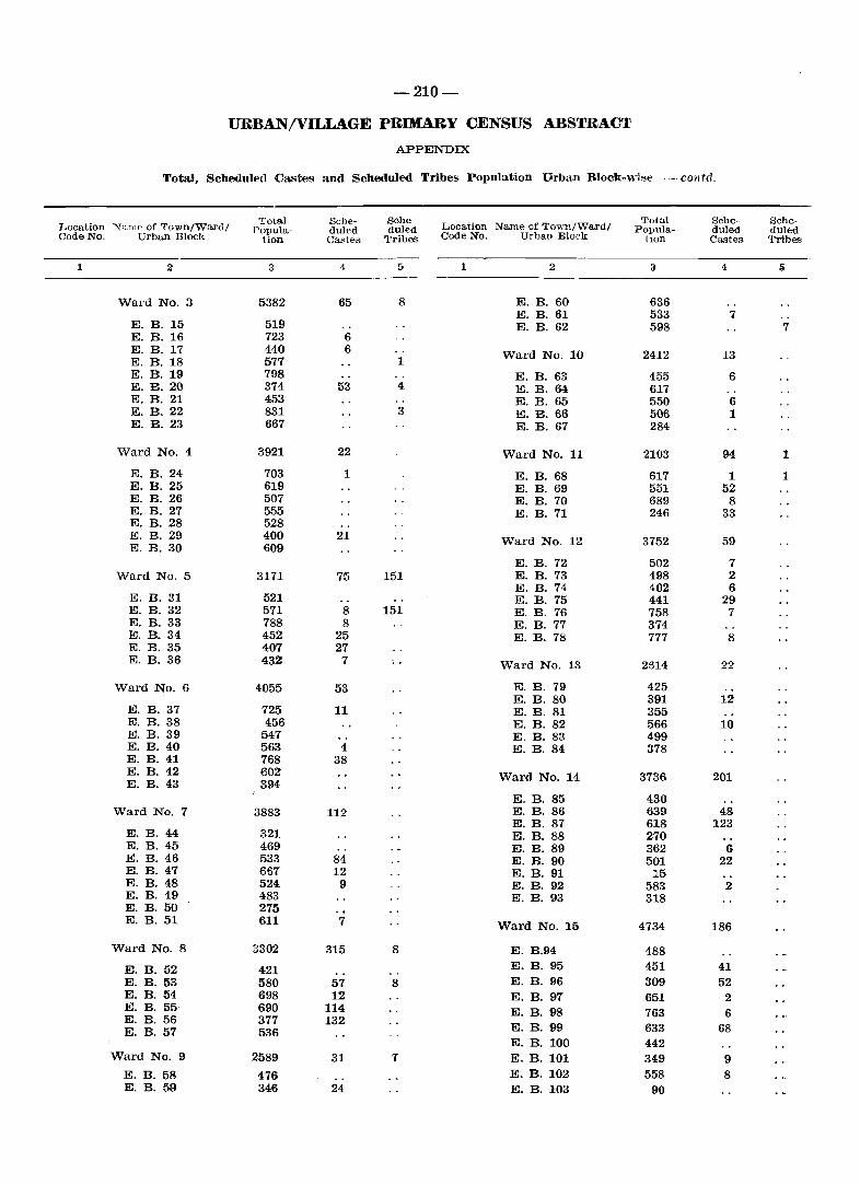
-210-
URBAN/VILLAGE PRIMARY CENSUS ABSTRACT
APPENDIX
Total, Scheduled Castes and Scheduled Tribes Population Urban Block-'wi~e -contd,
Total Sche- SChe-Name of Towl1/Ward/
Total Sehe- Sehe-Locati(m : N::mlf' of Town/Ward/ ropula- duled duled Location Papula- dUled duled Code No. Urban Block tion. Castes Tribes Code No. Urban Block tlOn Castes Tribes
1 2 3 4 5 1 2 3 4 [)
Ward No.3 5382 65 8 E. B. 60 636 E. B. 61 533 7
E. B. 15 519 E. B. 62 598 7 E. B. 16 723 6 E. B. 17 440 6 Ward No. 10 2412 13 E. B. 18 577 1 E. B. 19 798 E. B. 63 455 6 E. B. 20 374 53 4 E. B. 64 617 E. B. 21 453 E. B. 65 550 6 E. B. 22 831 3 E. B. 66 506 1 E. B. 23 667 E. B. 67 284
Ward No.4 3921 22 Ward No. 11 21{)3 94 1
E. B. 24 703 1 E. B. 68 617 1 1 E. B. 25 619 E. B. 69 551 52 E. B. 26 507 E. B. 70 689 8 E. B. 27 555 E. B. 71 246 33 E. B. 28 528 E. B. 29 400 21 Ward No. 12 3752 59 E. B. 30 609
E. B. 72 502 7 Ward No.5 3171 75 151 E. B. 73 498 2
E. B. 74 402 6 E. B. 31 521 E. B. 75 441 29 E. B. 32 571 8 151 E. B. 76 758 7 E. B. 33 788 8 E. B. 77 374 E. B. 34 452 25 E. B. 78 777 8 E. B. 35 407 27 E. B. 36 432 7 Ward No. 13 2614 22
Ward No.6 4055 53 E. B. 79 425 E. B. 80 391 12
E. B. 37 725 11 E. B. 81 355 E. B. 38 456 E. B. 82 566 10 E. B. 39 547 E. B. 83 499 E. B. 40 563 4 E. B. 84 378 E. B. 41 768 38 E. B. 42 602 Ward No. 14 3736 201 E. B. 43 394
E. B. 85 430 Ward No.7 3883 112 E. B. 86 639 48
E. B. 87 618 123 E. B. 44 321 E. B. 88 270 E. B. 45 469 E. B. 89 362 6 E. B. 46 533 84 E. B. 90 501 22 E. B. 47 667 12 E. B. 91 15 E. B. 48 524 9 E. B. 92 583 2 E. B. 49 483 E. B. 93 318 E. B. 50 275 E. B. 51 611 7 Ward No. 15 4734 186
Ward No.8 3302 315 8 E. B.94 488
E. B. 52 421 E. B. 95 451 41 E. B. 53 580 57 8 E. B. 96 309 52 E. B. 54 698 12 E. B. 97 651 2 E. B. 55 690 114 E. B. 98 763 6 E. B. 56 377 132
E. B. 99 633 68 E. B. 57 536 E. B. 100 442
Ward No.9 2589 31 1 E. B. 101 349 9 E. B. 58 476 E. B. 102 558 8 E. B. 59 346 24 E. B. 103 90
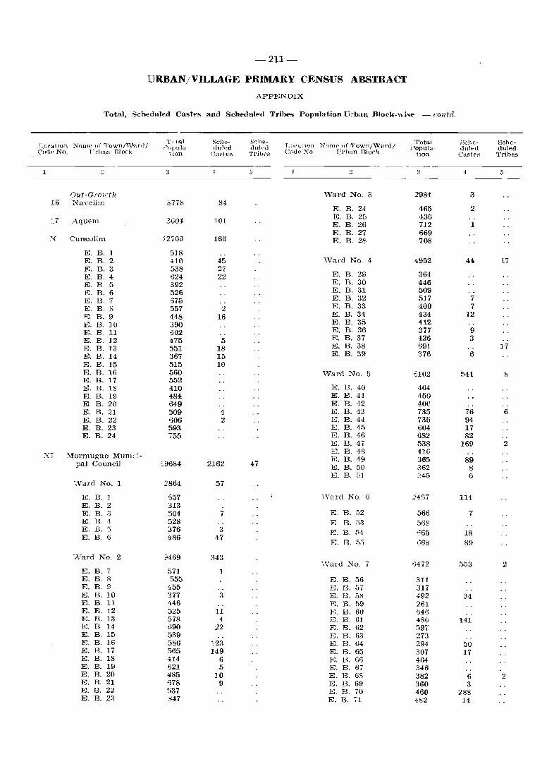
-211-
URBAN/VILLAGE PRIMARY CENSUS ABSTRACT
APPENDIX
Total, Sch€duled Castes and Scheduled Tribes Population n:ban Block-\\ j"e - cOlltel.
:'i'alllf' u1' Townj\V'81'dj Tfltal Selle- Sche-
LU('atlon Namp of Towllj\Val'dj Total Selle- Sehe-L,Oral1on .:_Ju lJula- duled duled :i~opula- <Jul.-d duled Cod(' No. Pl'hun Block lion Ca~tef:.. Tribe." COlle· Xo Prhan Block lion Caste" Tribes
------_ 1 ::: 3 5 .,
3 4 5
Out-GI'O l1:t1l W'ard No. 3 2984 3 16 Navelim S778 84
E. B. 24 465 2
l7 Aquem 3.004 101 E. B. 25 430 E. B. 26 712 1 E. B. 27 669
X Cuncolim :;2706 166 E. B. 28 708
E. B. 1 518 E. B. 2 410 45 'Nard No. 4 4952 44 17 E. B. 3 538 27
B.29 E. B. 4 524 22 E. 364 E. B 5 392 E. B. 30 446
E. B. 6 526 E. B.31 509 E. B. 7 ')75 E. B. 32 517 7
E. B. S 557 2 E. B. 33 400 7 K B. 9 448 16 E. B. 34 434 12 E. B. ]0 390 E. B. 35 412 E. B. 11 .002 E. B.36 377 9 E. B. ]2 475 5 E. B. 37 426 3
E. B. 13 551 18 E. B. 38 691 17 E. B. 14 367 15 E. B. 39 376 6
E. B. 15 515 10 E. B. 16 560 'Ward No.5 :;102 541 8 E. B. 17 552 E. B. I!> 410 E. B. 40 464 E. B. 19 484 E. B. 41 450 E. B.20 649 E. B. 42 406 E. B. 21 509 4 E. B. 43 735 76 6 E. B.22 606 2 E. B.44 735 94 E. B. 23 593 E. B. 45 1304 17 E. B. 24 755 E. B. 46 682 82
E. B. 47 538 169 2
XI Mormugao MUlllCi-E. B. 48 41e E. B. 49 365 89 pal Council £9684 2162 47 E. B. 50 362 8 8. B. 5] 345 6
-Nard No. 1 2864 57
E. B. ] ti57 \Vard No. G 2457 114 E. B. 2 313 E. B. 3 504 7 E. B. 52 566 7 E. B. ·1 528 E B. 53 568 E. B. 5 376 3 E. B. fi·1 665 18 E. B. 6 486 47
E. B. 55 ':::68 89
'Nard No. 2 9469 343 'Nard No. 7 -}472 553 2
E. B. 7 571 1 E. B. 8 555 E. B. 56 311 E. B. 9 455 E. B. 57 317 E. B. 10 377 3 }jj. B. 58 492 34 E. B. 11 446 E. B. t)9 261 E. B. 12 525 11 E. B. 60 1546 E. B. 13 578 4 E. B. 6] 480 141 E. B ]4 0390 22 E. B. 62 597 E. B. 15 539 E. B. 63 273 E. B. 16 586 123 E. B. 64 294 50 E. B. 17 565 149 E. B. 65 307 17 E. B. 18 414 6 E. B. (;6 464 E. B. 19 -521 5 E. B. 67 346 E. B. 20 485 10 E. B. 68 382 6 2 E. B. 21 £78 9 E. B. 69 360 3 E. B. 22 537 E. B. 70 460 288 E. B. 23 347 E. B. 71 482 14
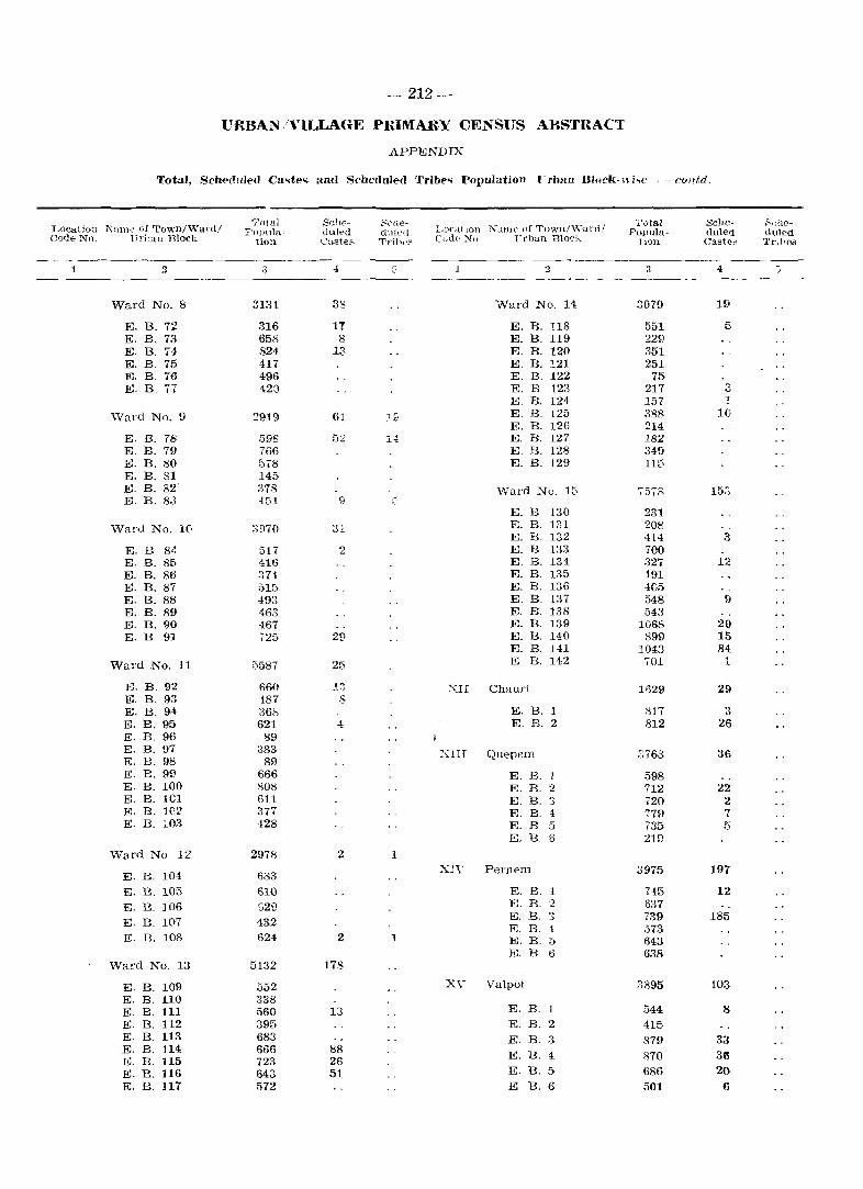
-212-
URBAN /VILLAGE PRIMARY CENSUS ABSTRACT
APPENDIX
Total, Sch{'(Tuled Cao;te .. and Scheduled Tribe.o; Population rrbun Block-whe - COlltd.
Location Name Gf'I'own/,Wal'd/ Total Sdw- SClle-
LOf'dt IOn Ncillle of Tuwn/\\-ul'fl/ Total Selle- ~che-Fopula- tlu[pd cluJe(! Popula- duled etuled
Code No. Urilun Block tion C"i.Ste::.. Tl'ibt~~ C'Olj« ~o TTl'ban Blon" !lOll Cast"" Trli_\OS
1 2 3 -1 G 2 3 4 :,
Ward No. 8 3131 38 Ward No. H 3079 19
E. B. 72 316 IT E. B. 118 551 5 E. B. 73 658 8 E. B. 119 229 E. B. 74 824 13 E. B. 120 351 E. B. 75 417 E.B. 121 251 E. B. 76 496 E. B. 122 75 E. B. 77 420 E. B 123 217 3
E. B. 124 157 I
\Yard No. 9 2919 61 19 E. B. 125 3S8 10 E. B. 126 214
E. B. 78 598 52 14 E. B. 127 182 E. B. 79 766 ~~. B. 128 349 E. B. 80 5.8 E. B. 129 115 E. B. 81 145 E. B. 82 378 ViaI'd No. 15 7573 15;:; E. B. 8J 454 9
E. B 130 231 Ward No. 1(- 3!:l70 31 E. B. 131 208
E. B. 132 414 3 E. B 84 517 2 E. B 133 700 E. B. 85 416 E. B. 134 327 12 E. B. 86 374 E. B. 135 491 E. B. 87 515 E. B. 136 4G5 E. B. 8g 493 E. B. 137 548 9 E. B. 89 46.3 E. B. 1.38 543 E. B. 90 467 E. B. 139 1068 29 E. B 91 72;:; 2£1 E. B. 140 899 15
E. B. HI 1043 84 Ward No. 11 5587 25 E B. 142 701 1
E. B.92 660 1:) XII Chauri lfl29 29 E. B. 93 4087 8 E. B. 94 361'. E. B. 1 817 3 E. B.95 621 4 E. B. 2 812 26 E. B. 96 89 E. B. 97 383 XIII Quepem 3763 36 E. B. 98 89 E. B.99 666 E. B. 1 598 E. B. 100 808 E. B. 2 712 22 E. B. 101 611 E. B. '3 720 2 E. B. 102 377 E. B. :1 779 7 E. B. 103 128 E. B 5 735 5
E. B. S 2H)
\Vard No 12 2978 2 1
E. B. 104 633 xn' Pernem 3975 197
E. B. 105 610 E. B. 1 745 12 E. B. ]06 G2D E. B. 2 637
E. B. 107 432 E. B. '.) 739 185 E. B. i 573
E. B. 108 624 2 1 E. B. 5 643 E. B 6 638
Ward No. 13 5132 178
E. B. 109 552 X\' Valpoi 3895 103 E. B. 110 338 E. B. 111 560 13 E. B. 1 544 8
E. B. 112 395 E. B. 2 415 E. B. 113 683 E. B. 3 879 33 E. B. 114 666 88 E. B. 1 870 36 E. B. 115 723 26 E. B. 116 643 51 E. B. 5 686 20 E. B. 117 572 E B. 6 501 6
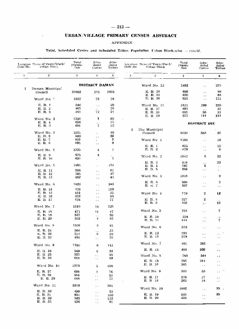
-213-
URBAN/VILLAGE PRIMARY CENSUS ABSTRACT
APPENDIX
Total, Scheduled Castes anel Scheduled Tribe" Population rrban Block-wise - cOlldd.
~ame of Town/"Vard/ Total Sche- Sche-
LocdtlOn ~;uu" of Town/"Va!'d/ Tota.l Sche- Sche-Location Popula- duled duled Popula- du1ed duled C(Jde No. Urban Bloel, tion Castes Tribes Code No Urban Block tion CasteR Tribes
1 2 3 -4 5 1 2 3 4 5
DISTRICT DAMAN Ward No. 12 1892 213 I Daman Municipal
Council 21003 315 2075 E. B. 34 609 98 E. B. 35 630 64
Ward No. 1 1527 12 79 E. B. 36 1}53 111
E. B. 1 596 29 ""Vard No. 13 1811 199 230 E. B. 2 463 26 E. B. 37 493 13 E. B. 3 458 72 24 E. B. 38 685 55 33
E. B. 39 633 144 184 Ward No. 2 1316 T 65
E. B. 4 636 33 DISTRICT DIU E. B. 5 680 7 32
I Diu Municipal Ward No. S 1531 40 Council 8020 588 85
E. B. 6 640 29 E. B. 7 400 2 Ward No 1 1104 16 E. B. 8 491 9
E. B. 1 625 10 Ward No. 4 1325 4 1 E. B. 2 479 6
E. B. 9 675 4 \Yard No. 2 1042 5 22 E. B. 10 650 1
E. B. 3 434 22 Ward NO.5 1493 151 E. B. 1 349 5
E. B. 11 526 61 E. B. 5 251:)
E. B. 12 365 47 " 1015 3 E. B. 13 602 43 "/ard No . ._,
E. B. (j 508 3 Ward No.6 1820 242 E. B. .. 507
E. B. 14 439 119 E. B. 15 411 31 Ward No. 4 779 2 12 E. B. 16 532 15 E. B. 17 438 77 E. B. S 327 2
E. B. .~ 452 12 Ward No.7 1510 18 225
E. B. 18 471 14 47 Ward No. 5 768 7
E. B. 19 537 95 E. B. 10 354 E. B. 20 502 4 83 E. B. 11 414 7
Ward No.8 1509 8 81 Ward No.6 572 E. B. 21 504 33 E. B. 22 514 8 20 E. B. 12 193 E. B. 23 491 28 E. B. 13 379
\Yard No.9 1780 6 141 Ward No.7 465 202
E. B. 24 569 6 24 E. B. 14 465 200
E. B. 25 523 48 \Yard No.8 740 344 E. B. 26 688 69
E. B. 15 355 344
Ward No. 10 1570 1 166 E. B. 16 385
E. B. 27 698 1 76 Ward No.9 533 35 E. B. 28 384 13
E. B. 17 270 17 E. B. 29 488 77 E. B 18 263 18
Ward No. 11 1919 381 Ward No. 10 1002 25
E. B. 30 499 38 E. B. 31 631 150 E. B. 19 568 25 E. B. 32 363 132 E. B. 20 434 E. B. 33 426 61
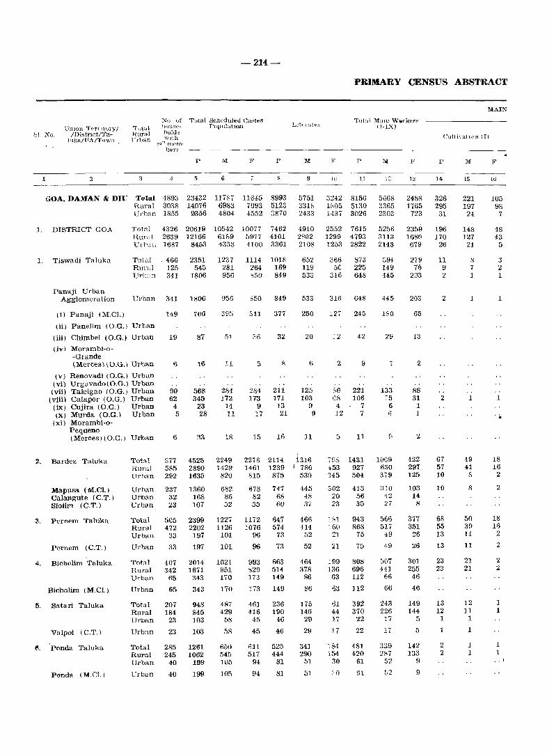
-214-
:\:(J (Jf Total Soheduled Ca~t€s Umon T~rllt\Jry I
IDistrlCt/Tal'll(a/FA/ToWll .
Tutul Hural 17"rlJ3n
110UHe- P0l-Jl11ation
.'Jl. No. holds '~nth
1 2 3
~C' membt"r~
4
p
5
GOA, DAMAN & DIU Total 4893 23432 Rural 3038 14076 Urban 1855 9356
M
6
11 Wi 6983 4804
1. DISTRICT GOA Totnl 4326 20619 10542 Rmul 2639 12166 61&9 Url'"n 1687 8453 4353
1. Tiswadi Taluka Total 0 466 2351 Rural 125 545 Ur]J;cn 341 1806
Panaji Urban Agglolllcra Hon Urban 341 1806
'}..
(i) Panaji (M.C!.) 149
(ii) Panelim (O.G.) Urban
(iii) Chimbel (O.G.) Urban 19
(iv) Morambi-o--Grande (Merces)\O.G.) Urban I)
(v) Renovadi (O.G.) Urban (vi) Urgavado(O.G.) Urban
(vii) Taleigao (O.G.) Urban (viii) Calapor (O.G.) Urban (ix) Cujira (O.G.) Urban (x) Murda (O.G.) Urban
(xi) Morambi-o-Pequeno (Merces) (O.G.) Urban
Bardez Taluka Total Rural Url)un
90 62
4 5
6
877 585 292
Mapusa (M.Cl.) Calangute (C.T.) Siolim (C.T.)
Urban 237 Urban 32 Urban 23
3. Pernem Taluka Total 505 Rural 472 Urban 33
Pernem (C.T.)
.... Bicholim Taluka
Bicholim (M.Cl.)
15. Satari Taluka
Valpoi (C.T.)
fl. 'Ponda Taluka
Panda (MoCl.)
Urban 33
Total 407 Rural 342 Urban 65
Urban 65
Total 207 Rural 184 Urban 23
Urban 23
Total 285 Rural 245 Urban 40
Urban 40
106
87
16
568 345
23 28
33
4525 2890 1635
1360 168 107
2399 2202
197
197
2014 1671
343
343
948 845 103
103
1261 1062
199
199
1237 281 956
956
395
51
11
284 172
14 11
18
2249 1429
820
682 86 52
122. 1126 101
101
1021 851 170
170
487 429
58
58
650 545 105
105
F
11645 7093 4552
p
8993 5123 3870
10077 7462 5977 4101 4100 3361
1114 1018 264 169 ':\50 849
850 849
311 377
36 32
8
284 211 173 171
9 13 17 21
15 16
2276 2114 1461 1239
815 875
678 82 55
747 68 60
1172 647 1076 574
96 73
96 73
993 663 ';;20 514 173 149
173 149
461 236 416 190
45 46
45 46
611 525 517 444
94 81
94 81
III
9
5751 331S 2433
4910 2'302 2108
652 119 533
533
250
20
125 103
9 9
11
1316 I 786
530
445 48 37
466 414
52
52
464 378
86
86
175 146
29
29
341 290
51
51
PR~RY CENSUS ABSTRACT
Tot'll M:un WtlrkerR IJ-IX)
3242 lS05 1437
p
1]
8156 5130 3026
2552 7615 1299 4793 1253 2822
366 50
316
873 225 648
316 648
127 245
,2 42
2 9
S6 221 68 106
4 7 12 7
5 11
786 453 345
302 20 23
IS1 160
21
21
199 136
63
63
1)1 44 17
17
184 154
30
:,1}
1431 927 504
413 56 35
943 868
75
75
808 696 112
112
392 370
22
22
481 420
61
61
5668 3365 2303
5256 3113 2143
594-149 445
445
l~O
133 75
6
1009 630 379
310 42 27
566 517
49
49
507 441
66
66
243 226
17
17
339 2~7
52
.')2
13
2488 1765
723
2359 1680
679
279 76
203
203
65
13
2
88 31
1 1
2
422 297 125
103 14
8
377 351
26
26
301 255
46
46
149 144
5
5
142 133
9
9
MAIN
Cult ivators 11)
p
326 295
31
196 170
26
11 9 2
2
2
67 57 10
10
68 55 13
13
23 23
13 12
1
1
2 2
M
15
221 197
24
148 127
2]
8 7 1
1
1
19 41
&
8
50 39 11
11
21 21
12 11
1
1
1 1
.. F
16
105 9R
7
48 43
5
3 2 1
1
1
18 16
2
2
18 16
2
2
1 1
1 1 ., ,
..
-215-
FOR SCHEDULED CASTES
A.gru uliural La1J.ou-1 cr,":; (II)
HOU.~0hold Indu~try-Ma- Mal~glllal Vyorkers XOH-Workers nnfacturJng. Processmg. Oth('r~ Wurkers <III. IV. 0 8er'~icillg and Repairs V (b) & VI 1 u IX) Z
V (a)
----------------------------------------------------------------------------------------- ~ p F p J\[ p p ]\1 p M F
17 1& 1!J 2() .:21 23 26 27 29 :-w 31 ------------------------------------------------------------
..
847 782
65
325 760 65
36 35
1
1
1
267 214
53
40 8 5
297 296
1
1
56 56
26 26
34 33
1
1
526 491
35
514 479 35
17 17
163 132
31
25 4 2
199 19&
1
1
39 39
20 20
22 21
1
1
321 1811 291 1633
30 178
311 1799 281 1624 30 1,;"5
19 l~
1
1
:>04 ~2 22
15 ·1 3
17 17
6 6
12 12
';9 .a 25
25
7
1
2 S
1
245 203
42
31 7 4
331 ,1lR 13
13
368 364
4
4
249 24G
3
3
176 176
874 773 101
!:I7l ,70 101
36 21 15
15
2
3
1
1
119 9Ii 23
17 4 2
105 103
2
169 167
2
2
126 124
2
105 105
937 5172 86U 2420
77 2752
928 4795 354 2239 74 25M
:;3 23 10
10
2
126 107
19
1-1 3 2
226 215
11
11
199 197
2
2
123 122
1
1
71 71
757 137 620
62(}
239
35
s
218 96
7 7
10
852 453 399
332 41 26
247 199
48
48
361 253 108
108
104 86 18
18
269 209
60
60
4047 1904 2143
3723 1737 1956
5:13 104 429
,129
178
26
6
133 56
6 G
678 361 317
260' 34 23
212 177 35
35
278 214
64
64
&5 71 14
14-
211 160
51
51
1125 1217 516 1040 609 177
1072 946 502 796 5/0 1[>0
224 33
191
191
€Jl
9
2
S5 3(1
1 1
2
174 92
72 7
35 22 13
13
~3
39 44
44
19 15
58 49
9
9
35 19 16
16
3
1
2
5
278 241
37
23 9 5
260 230
30
30
60 77
3
92 88
4
4
.g 43
1
1
298 234
64
272 222 50
12 8 4
4.
1
2
1
76 56 10
S 1
80 73
7
7
22 22
19 15
4
-1
7 6 1
1
919 14059 806 7906 113 6153
G74 12058 574 6577 100 5481
23 1443 11 301 12 1142
12 1142
2
1 3 2
458
·15
7
346 234 14 21
17
202 2816 175 1722
27 1094
14 924 8 103 5 67
180 1196 157 1104
23 92
23 92
58 1126 55 898
3 228
3
73 73
37 37
228
454 387
77
77
';"36 599 137
137
5821 3384 2437
5014 2854 2160
631 124 507
507
214
22
4
151 95 8 5
8
1164 733 431
363 43 25
581 536
45
45
492 388 104
104
225 188
37
37
304 252
52
52
8238 4522 3716
7044 1 3723 3321
812 177 635
635
244
23
3
195 139
6 16
9
1652 2 989 663
561 60 42
615 3 568
47
47
634 4 510 124
124
239 ::; 199
40
40
432 6 S47
85
85
-216-
Un tOll Terrilory / " District/Ta
lul<fl(l'A/Towl,
Total Hunll LriJall
Nv. 01 hou;-;f"holu...; with
TOldl Srlwdulf'd Ca'tt>~ T'< ]lUlutwtl
Sl Nfl
8C' lllt'lH-
h"l'~ - _.- - - .----
2
7. Sanguem Taluka
Sanguem (M.C!.)
8. Canacona Taluka
Chauri (M.C!.)
9. Quepem Taluka
Quepem (M.C!.) Curchorem (C.T.)
10. Salcete Taluka
Margao Urban Agglomeration
3 4
Total 262 Rural 248 Urban 14
Urban
Total Rural Urban
Urban
14
4S 42 6
6
Total 150 Rural 119 Urban 31
Urban 9 Urban 22
p
1131 ]068
63
63
ZOE> 179 29
29
6-!2 514 128
36 92
Total 4082 2541 Rural 159 753 Urban 323 1738
Urban 293 1622
(i) Margao (M. Cl.) Urban 256 1437
(ii) Navelim (O.G.) Urban 16 84
(iii) Aquem (O.G.) Urban Cuncolim (C.T.) Urban
21 30
11. MormugaoTaluka Total 637 Rural 118 Ul'ban 519
101 166
2599 437
2162
6
589 557
32
32
115 96 Hl
19
323 253
70
16 54
1290 383 907
836
743
47
46 71
1354 239
111[)
7
542 511
31
31
I'
8
307 271
36
36
93 104 83 87 10 17
10 17
319 242 261 203
5S 39
20 10 38 29
1251 1055 370 30:) ~31 752
786 685
694 598
37 44
55 95
12-15 19b
1U47
43 67
551 107 444
Mormug'ao (M.C!. I Urban 519 2162 1115 10 .. 7 444
2. DISTRICT DAMAN Total Rural Urban
Daman Taluka
Daman (M.C1.1
Total Rural Urban
Urban
342 286 56
342 286
56
56
3. DISTRICT DIU Total 225 Rural 113 Urban 112
Diu Taluka Total 225 Rural 113 Urban 112
Diu (M.Cl.) Urban 112
1684 1369 315
1684 1369 315
315
1129 541 583
1129 541 583
588
695 531 164
695 531 164
164
550 263 287
550 263 287
287
989" 838 151
989 838 151
151
579 278 301
1034 836 198
103! 836 198
198
497 186 311
579 497 278 186 301 311
301 311
M
9
219 196
2:3
2" .J
67 55 I::!
12
158 134
24
5 19
653 200 451
418
364
28
21) 35
399 84
315
31~
490 373 117
490 373 117
117
351 143 208
351 143 208
208
PRIMARY CENSUS ABSTRACT
Tiltal ,,[fun, WOli(c'r., II-IX)
F
88 75 13
13
37 32
5
5
p
11
55! 530
24
24
60 52 8
8
84 278 69 217 15 61
5 18 10 43
402 103 299
812 287 525
267 475
234 4.13
16 30
17 32
152 23
129
32 50
983 201 "f82
129 782
5H 463
81
544-463 81
81
146 43
103
146 43
103
103
304 222
82
304 222
82
82
237 115 122
237 115 122
122
362 347
15
15
49 42
7
193 147
46
10 36
603 181 422
JS4
341
21
791 146 645
645
216 149
67
216 149 67
67
196 103
93
196 103
93
93
F
1'J
192 18;;
9
9
11 10 1
1
85 70 15
8 7
209 106 103
91
72
9
If)
12
] "-01
88 73 15
88 73 15
15
41 12 29
.. 1 12 29
29
MA[N
Cult lvatDI'S (I)
p
7
4. 4-
1 1
111 106
5
111 106
5
5
19 19
19 19
15
5 5
2 2
54 51
54 51
3
3
19 19
19 19
F
16
2 2
2 2
1 1
57 55 2
57 55
2
2
•
•
-217-
FOR SCHEDULED CASTES - concld.
W(lRK~~RS
A;:rIcu!tural Lahour~r8 (II)
Household In,dustry-Ma-nufa('(urmg. ProcesslI1g. Oth"r", Workers IIII. IV.
Ser'-\clIl"': and Repairs V (bl & VI to IX)
l\Ian.;ll1al ,Vl)rker~ ci Z
Via) _________________________________________________ " _________________________ ~ m
p F p p F
17 18 1~ 21 ----- -- -_- --------------------------
66 66
8 8
12 10
2
2
20 15 5
3
2
3 1 2
2
17 17
17 17
5 5
5 5
34 34
8 8
7 5 2
1
1
1
1 1
7 7
7 7
5 5
5 5
32 32
8 6 2
2
13 10 3
2
2
1
2
2
10 10
10 10
37 34 3
3
25 25
77 68
9
9
205 134
71
53
36
1]
6 18
17 12
5
5
11 8 3
11 8 3
3
1 1
1 1
22 21 1
1
18 18
41 35
6
6
119 73 46
33
24
8
1 13
11 7 4
4
2 2
2 2
1 1
1 1
15 13
2
2
7 7
3 <, oJ
86 61 25
20
12
3
5 5
6 5 1
1
9 6
9 6 3
444 423 21
21
27 19
8
8
185 135
50
7 43
586 137 449
419
374
19
26 30
963 188 775
775
165 91 74
165 91 74
U
212 90
122
212 90
122
122
301 287 14
14
23 16
7
7
146 106
40
4 36
477 103 374
350
~16
13
21 24
779 138 841
641
153 89 64
153 89 64
64
171 78 93
171 78 93
93
7
4 3 1
1
39 29 10
3 7
109 34 75
69
58
6
5 8
184 50
134
134
12 2
10
12 2
10
10
41 12 29
41 12 29
29
16 15 1
1
3 8
40 40
50 26 24
18
1:3
1
4 6
34
231 231
231 231
40 13 27
40 13 27
27
27
8 7 1
1
6 6
6 6
17 S 9
7
6
1 2
19 5
14
1<1
5 5
5 5
21 7
14
21 7
14
14
8 8
2 2
561 523 38
38
140 119
21
21
34 324 34 257
67
18 49
33 1679 18 440 15 1239
11 1129
7 1011
1 53
3 65 4 110
24 1573 4 227
20 1346
20 1346
226 1149 226 916
233
226 1149 226 916
233
19 6
13
19 6
13
13
233
852 413 439
852 413 439
439
219 203 18
16
60 48 12
12
124 100
24
6 18
670 194 476
445
396
26
23 31
544 88
45!i
45!i
474 377
97
474 377
97
97
333 153 180
333 153 180
180
F
342 7 320 22
22
80 8 71
9
9
200 9 157
43
12 31
1009 10 246 763
684
615
27
42 79
1029 It 139 890
890
675 2 539 136
675 539 136
136
519 3 260 259
519 260 259
259
-218-
PRIMARY CENSUS ABSTRACT
M.UN
N"(I of Total Scheduled Tnb. Total MaIn W(Jrk(:r~
\_~m()l1 Terl'11fll'Y/ Tutu.1 huu~(_'- P()pulation LIterates II-IX)
SJ No. /DistrIctlTa- Uural holds IllkajUA/Town l'rhan wIth Cultn·atoI':::l (I'
ST lllem-
lJn~
p M F P ]I'!: F P M F i' M F
-_-_. ~ 3 4 j tj 7 8 ~ lU U 13 15 16
---_.
GOA, DAMAN AND Total 2093 10721 5512 5209 2839 1855 984 4166 2903 1263 465 313 132 DIU Rural 1579 8232 4221 4011 2160 1393 767 3324 2247 1077 456 306 150
Urban 514 2489 1291 1198 679 462 217 842 656 186 9 7 2
J. DISTRICT GOA Total 171 690 374 316 197 142 E>5 350 236 114 3 1 2 Rural 89 361 208 153 108 82 26 210 140 70 3 1 2
17rban 82 329 166 1(j3 1',9 60 29 140 86 44
I. Tiswadl Taluka Tutal 18 40 29 11 25 22 3 25 22 3 Rural 10 19 15 -1 14 13 1 15 14 1
Urban 8 21 14 7 11 H 2 10 8 2
PanaJi Urban AgglomeratIOn Urban 8 21 14_ 7 11 9 2 10 S 2
( i) Panaji (M.C!.) Urban -1 7 6 1 6 6 7 6 1
Oi) Pane lim (O.G.) Urban
(iii) Chimbel (O.G.) Urban
(iv) Morambi-o--Grande (O.G.) Urban 1 5 3 2 1 1
(v) Renovadi (O.G.) Urban (vi) Durgavado
(O.G.) Urban (vii) Taleigao (O.G.) Urban 2 7 4 3 4 2 2 1 (viii) Calapor (O.G.) Urban 1 2 1 1 1 1 1 1. (ix) Cujira (O.G.) Urban (x) Murda (O.G.) Urhan (xi) Morambi-o-
Pequeno (O.G.) Or-hall
2. Bardez Taluka Total 11 47 22 25 30 17 13 17 16 1 Rural -1 12 8 4 7 5 2 5 4 1 Urban 7 35 14 2] 23 12 11 12 12
Mapusa (M.e!.) Urban 7 35 14 21 23 12 11 12 12
Calangute (C.T.) Urban
Siolim (C.T.) Urban
3. Pernem Taluka Total Rural Urban
Pernem (C.T.) Urban
4. Bicholim Talnka Total 7 31 18 13 S 8 19 12 7
Rural 7 31 18 13 8 S 19 12 7
Urban
Bich(llim (MCl.) Urban
5. Satari Taluka rotal 1 4 4. 3 3 Rural 1 4. 4 3 3
Urban
Valpoi (C.T.) Urban
~. Ponda Taluka Total 4 18 9 9 5 2 3 8 7 1
Rural " Urban 4. 18 9 9 5 2 3 8 7 1
Ponda (M.C!.) Urban 4 18 9 9 5 2 3 8 7 1
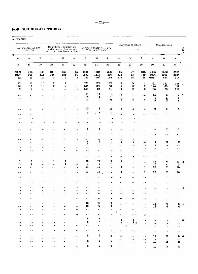
-219-
FOR SCHEDULED TRffiES
WORKERS
Marginal Workers Non-Workers AgrICultural Lubou- HmlFPhold Industry-Ma- Olh"r" Workers OIl, IV, 1 0
reI's (II) nufactUl'lng, PrOCessjng, V (b) & VI to IX) • I Z Servicing and Repairs VIa) iii
p M. F P M F P M Ii' .p M F P M F
17 18 19 20 21 22 23 24 25 26 27 28 29 30 31
1339 706 633 241 159 82 2121 1725 396 922 77 845 5633 2532 3101 1277 666 611 236 156 80 1355 1119 236 812 63 749 4096 1911 2185
62 40 22 5 3 2 766 606 160 110 14 96 '1537 621 916
22 12 10 2 2 323 221 102 9 5 4 331 133 198 1 20 10 10 2 2 185 127 58 5 3' 2 146 65 81
2 2 138 94 44 4 2 2 185 68 117
25 22 3 2 1 1 13 6 7 1 15 14 1 4 1 3 10 8 2 2 1 1 9 5 4
10 8 2 2 1 1 9 5 4
7 6 1
..
1 1 I' • 4 2 2
1 1 2 1 1 4 2 2 1 1 1 1
.. ' . .j
1 1 1 1 15 14 1 1 1 29 6 23 2 1 1 1 1 3 2 1 7 4 3
12 12 1 1 I 22 2 20
12 12 1 1 22 2 20
3
19 12 7 , 12 6 6 4 19 12 7 12 6 6
. i
.. ,;
3 3 1 1 5 3 3 1 1 I ~
• ·i .. 8 7 1 10 2 8 ~
8 7 1 10 2 8
8 7 1 10 2 8
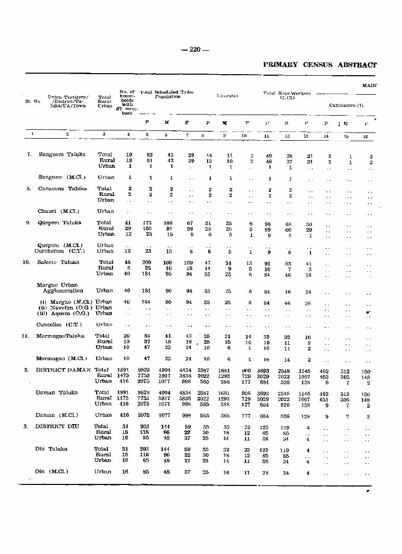
-220-
PRIMARY CENSUS ABSTRACT'
MAIN No. of Total Scheduled Tribe Total Main Workers
Union Territory/ Total hOllile- Populati<>Jl T )ite.rates (I-IX) 81. No" /District/Ta- Rural holds
]uka/UA/Town Urban with Cultivators (1) ST mem-
bers _-_ -
P M B' P ]I( F' P M F l~ M F ------- ------1 2 3 4 5 6 7 8 9 10 11 12 13 14 15 16
7. Sanguem Taluka Total 19 82 43 39 14 11 3 49 28 21 3 1 2 Rural 18 81 42 39 13 10 3 48 27 21 3 1 2 Urban 1 1 1 1 1 1 1
Sanguem (M.Ct) Urban 1 1 1 1 1 1
8. Canacona Taluka Total 2 2 2 2 2 2 2 Rural 2 2 2 2 2 2 2
Urban
Chauri (M.Cl.) Urban
9. Quepem Taluka Total 41 173 106 67 31 25 6 98 68 30 Rural 29 150 91 59 25 20 5 89 60 29 Urban 12 23 15 8 6 5 1 9 8 1
Quepem (M.Cl.) Urban Curchorem (C.T.) Urban 12 23 15 8 6 5 1 9 8 1
10. Salcete Taluka Total 48 209 100 109 47 34 13 94 53 41 Rural 8 25 10 15 14 9 5 10 7 3
Urban 40 184 90 94 33 25 8 84 46 38
Margao Urban Agglomeration Urban 40 184 90 94 33 25 8 84 46 38
(i) Margao (M.Cl.) Urban 40 184 90 94 (ii) Navelim (O.G.) Urban
33 25 8 84 46 38
(iii) Aquem (O.G.) Uroan •• Cuncolim (C.T.) Urban
11. MormugaoTaluka Total 20 84 41 43 35 21 14 35 25 10 Rural 10 37 18 19 25 15 10 19 11 8
Urban 10 47 23 24 10 6 4 16 14 2
Mormugao (M.e!.) Urban 10 47 23 24 10 6 4 Hi 14 2
2. DISTRICT DAMAN Total 1891 9828 4994 4834 2587 1681 906 3693 2548 1145 462 312 150-Rural 1475 7753 3917 3836 2022 1293 729 3029 2022 1007 453 305 148
Urban 416 2075 1077 998 565 388 177 664 526 138 9 7 2
Daman Taluka Total 1891 9828 4994 4834 2587 1681 906 3693 2548 1145 462 312 150 Rural 1475 7753 3917 3836 2022 1293 729 3029 2022 1007 453 305 148
Urban 416 2075 1077 998 565 388 177 664 526 138 9 7 2
Daman (M.Cl.) Urban 416 2075 1077 998 565 388 177 664 526 138 9 7 2
3. DISTRICT DID Total 31 203 144 59 55 32 . 23 123 119 4 Rural 15 118 96 22 30 18 12 85 85
Urban 16 85 48 37 25 14 11 38 34 4
Diu Taluka Total 31 203 144 59 55 32 23 123 119 4 Rural 15 118 96 22 30 18 12 85 85 Urban 16 85 48 37 25 14 11 38 34 4
Diu (M.e!.) Urban 16 85 48 37 25 14 11 38 34 4
,.'
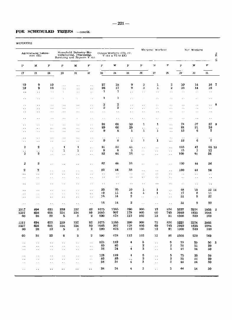
-221-
FOR SCHEDULED TRmES - conoid.
WORKERS
AgrIcultural Labourers (II)
P M F
17 18 19
19 9 10 19 9 10
2 2
2 2
2 2
2 2
1317 694 623 1257 656 601
60 38 22
1317 694 623 1257 656 601
60 38 22
60 38 22
Household Industry-Ma- Others Workers (III, IV, TIufacturing, Processing, V (b) & VI to IX)
Servicing and Repairs V (a)
P M F P M F
20 21 22 23 24 25
27 18 9 26 17 9 1 1
1 1
2 2 2 2
98 68 30 89 60 29
9 8 1
9 8 1
1 1 91 50 41 1 1 9 6 3
82 44 38
82 44 38
82 44 38
35 25 10 19 11 8 16 14 2
16 14 2
239 157 82 1675 1385 290 234 154 80 1085 907 178
5 3 2 590 478 112
239 157 82 1675 1385 290 234 154 80 1085 907 178
[) 3 2 590 478 112
5 3 2 590 478 112
123 119 4 85 85 38 34 4
123 119 4 85 85 38 34 4
38 34 4
MargInal Workers Non-Workers 0 Z
"1
P M F P M F
26 27 28 29 30 31
3 1 2 30 14 16 7 3 1 2 30 14 16
8
1 1 74 37 37 9 61 31 30
1 1 13 6 7
1 1 13 6 7
115 47 68 10 15 3 12
100 44 56
100 H 56
100 44 56
1 1 48 15 33 11 1 1 17 6 11
31 9 22
31 9 22
908 72 836 5227 2374 2853 2 805 60 745 3919 1835 2084 103 12 91 1308 539 769
908 72 836 5227 2314- 2853 805 60 745 3919 1835 2084 103 12 91 1308 539 769
103 12 91 1308 539 769
5 5 75 25 50 3 2 2 31 11 20 3 3 44 14 30
5 5 75 25 50 2 2 31 11 20 3 3 44, 14 30
3 3 44 14 30

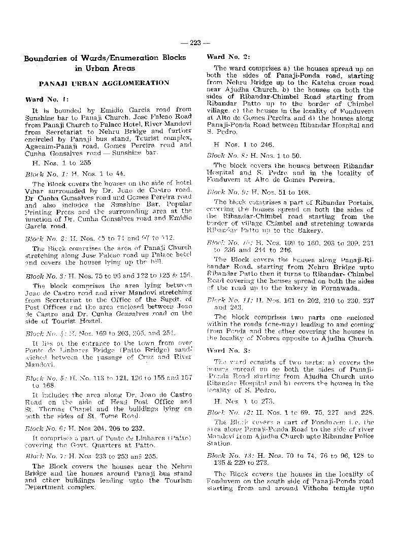
-223-
Boundaries of Wards/Enumeration Blocks in Urban Areas
PAl"JAJI URBAN AGGLOMERATION
Ward No.1:
It is bounded hv Emidio Garcia road from Sunshine bar to Pal;aji Church. Jose Falcao Roa~ from Panaji Church to Palace Hotel, River Man~ovI from Secretariat to Nehru Bridge and furtl1er encircled by Panaji bus stand, Tourist complex, Agacaim-Panaji road, Gomes Pereira road and Cunha Gonsalves road - Sunshine bar.
H. Nos. 1 to 255
Block No.1: H. Nos. 1 to 44. The Block covers the houses on the 5i.,le of hotel
Vihar surrounded bv Dr. Joao de C~i"tro road. Dr Cunha Gonsalves" road agd Gomes Pereira road and also includes the Sunshine Bar, Popular Printing Press a nd ire surrounding area at .t~e lunction of Dr. Cunha Gonsalves road and EmlCbo Garcia road.
Blor-k No.2: I·I. Nos. ~5 to 7·~ and m to }12.
The Block comrrises the area of Panaji Church stretching along Jose Falcao road up Palace notel "ll1d covers the houses lying up the 1,;1l.
Block No.3: H. Nos. 75 to 95 and 122 to 125 & 1513,
The block comnrises the area lying betwH'l1 Joao de Castro ro;.d and river Mandavi stretchin!:;" from Secretariat to the Office of the Supdt. of Post Offices C' nd the area enclosed between J (Jao :le Castro and Dr. Cunha Gonsalves road on the side of Tourist Hostel.
Blo~"': ·~No .. ~i: Ty. No,:. 169 to 203, 205, ~l.lld 2M
It lie,s Dt the €~1trallce to the town from over Pontp <if' Linh~, E'p. Bridge (Petito Bridge) sand: ,vich<:.0. between the rassage of Cruz and River :\iandovi.
Block No, 5: H. No. 113 tr> ]21,12(1 to 155 ::nd 157 to 168.
It include" the area along Dr . .Toao de Castro Read on U'E' side of He8.j Post Office and St. Thomas Chapel and the lmildings lying on ooth the i"ides of St. Tome Ro"!.d
mock No. fl: H. Nos 204.206 to 232. It comprise:? <J part of Ponte (~e Linharps (Patto)
covering the G'wt. Quartf'rs at. PaUo.
Blocl; No. ?: H. Nos 233 to 253 ani] 255.
The Block covers the houses near the Nehru Bridge and the houses around Panaji bus stand and other buildings le3.ding upt.o the Tourism ::Npartment complex.
Ward No.2:
The ward comprises a) the houses spread up on both the sides of Panaji-Ponda road, starting from Nehru Bridge up to the Katcha cross road near Ajudha Church. b) the houses on both the sides of Ribandar-Chimbel Road starting from Ribandar Patto up to the border of Chimbel Village. c) the houses in the locality of Fonduvem at Alto de Gomes Pereira and d) the houses along Panaji-Ponda Road between Rib3.ndar Hospital and S. Pedro.
H Nos. 1 to 246.
Block No, 8: H. Nos. 1 to 50.
The block covers the houses between Ribandar Hospital and S. Pedro and in the localitv of Fonduvem at Alto de Gomes Pereira. .
Slock No.9: H. Nos. 51 to 108.
The block comprises a part of Ribandar Portais, cC\Trin~ tJ'p houses spread un both the sides of the Ribandar-Chimbel road starting from the b'Jrder of village C!}imbel and stretching towards Riho1i6a!' Patto up to the Bakery.
Erne!: No. ](!: H. Nos. 109 to 160, 203 to 209. 231 to ?36 and 244 to 246.
Tile Block COVErs the hCUSf;'8 along Panaji-Rihandar RO'1.d. starting from Nehru Bridge upto RibRndar Patto then it turns to Ribandar- Chimbel Poarl covering the houlO'es spread on both the sides of the road up to the bakery in Fornawada.
ncr''' No, 11: H. N~s. 161 to 202, 210 to 230, 237 and 2,1_3.
The block comprises two parts one enclosed \vithin the roads (one-vIaY) leading to and coming rr,)m Pr; 11da :'>.nd the other covering the houses in the locality of Nobres opposite to Ajudha Church.
rrm't1 No.3:
TL2 \','"rcl consists of hyo Darts: a) coven; th8 !1('llS"S ~nn:'ad up 011 both the sides of Pana.ii-P,-.~;_c1a Roarl starting from Ajudha Church unto Rib? nc~Cl r Hosl'it,J] ~.nd b) ('oyers tf-.e hou5'e8 in the lcwality of S. Pedro.
H. Ncs 1 to 273.
B?ar",' No. ]2: H. Nos. 1 tc 69, 75, 227 and 228.
The Bh-..:,l;- COI'f'rs a Dart of F'ondll\7em i. ('. the 81 ea alon~ Pana.ii-Ponoa Road to the side c,f river ~1a'ldovi from Ajudha Church upto Ribandar Police Station.
Block No. 13: H. Nos. 70 to 74, 76 t,') 96, 128 to 135 & 229 to 273.
The Blo::k covers the houses in the locality of Fonduvem on the south side of Panaji-Ponda road starting from and around Vithoba temple upto
-224-
Ribandar Hospital. It also covers the houses in the locality of S. Pedro spread on both the sides of Panaji-Ponda Road beyond Ribandar Hospital.
Block No. 14: H. Nos. 97 to 127, 136 to 226.
The Block covers the remaining part of Fonduvem i. e. the houses to the south side of Panaji-Panda road, starting from the houses opposite to Vithoba Temple up to the houses opposite to Ajudha Church.
Ward No.4:
The ward is bounded on one side by Agasaim-Panaji Road and on the other side by Tarkar Pednekar Marg, Prof. Ramchandra Naik Road, and 31st January Road. It stretches from the saw mill near the four pillars and ends at the cross Road Gomes Pereira.
Block No. 15: H. Nos. 1 to 49-A, 215. 216-C and 218 A-C.
The block starts from the four pillars at the entrance to the town on the Agacaim-Pana ii road on the eastern side. It covers the saw mill. the houses around Nevgi Nagar, the grocery shop of Mr. Musa and the houses lying between Tarkar Pednekar Marg and A!!asaim-Panaji Road covering the nursery School, Ranu Niwas and the water pump house.
Block No. 16: H. Nos. 52 to 82 and 211.
The block covers the houses lying along eastern side of the Tarkar Pednekar Marg stretching from the Tailoring Training Centre upto the houses around the the Raj-Yoga Institute near Fontainh1s
Block No. 17: H. Nos. 83 to 111.
The block covers the houses lying along the eastern side of the Tarkar Pednekar Marg beyond Rai Yoga Institute unto Dukle Building in Mala and the houses arcund D~modar Niwas.
Block No. 18: H. Nos. 112 to 151 and 212 to 214-C.
The block is bounded by 31st January Road and the rivulet on Agasaim-Panaii Road stretching from Sinare's Petrel pump and extending upto the ercs::; Road Filipe Nery.
Block,No. 19: H. Nos. 152 to 210.
The block is encircled by Filip Nery Road. 31st January Road. Cunha Gonsalves Road. Gomes Pereira Road and Agasaim-Panaji Road. It covers the houses in Mala around Nursery Section of People's High S':!hool. Bible Study, Mary Immaculate School, Prema Building, Vaman Bar and Horse Shore Bar in Bairo Portais.
Ward No.5:
The ward covers the houses along 31st January Road to thc side of Altinho hill starting from the biscuit factory upto Poonam Lodge.
R. Nos. 1 to 164.
Block No. 20: H. Nos. 1 to 53A.
The block covers the houses lying below Altinho hill along 31st January Road starting from the southern side of its junction with Arma de Portuguesa Road upto the Biscuit factory of Mr. Kamat
Block No. 21: H. Nos. 54 to 102 and 162 to 164
The block covers the houses lying along 31st January Read from the northern side of its junco tion with Arma de Portuguese Road upto Precy building and the bouses behind Precy building on the road leading to Lyceum School building.
Block No. 22: H. Nos. 103 to 161.
The block coven the houses lying on the foothhill of Altinho along 31st January Road covering Mr. Hari Bharne's house. chapel of St. Sebastian and the houses around well near the steps and Pconam lodge.
Ward No.5:
It lies alon~ Ehatulem-Mala road to the side of Altinho hill stretching from Bhatulem Govern· ment quarters upto Fontainhas (H. No. 139) and the houses around St. Sebastian ChapeL
H. Nos. 1 to 141.
Block No. ,88: H. Nos. 1 to 12.
This covers B type Government Quarters a: Bhatulem.
Block No. 24: H. Nos. 18 to 69.
It covers the houses lying along Mala-Bhatulem Y08.d belGw Altinho hill starting from Fontainhas Post Office upto the cross near Bhatulem and St. SeouBtial1 Chapel.
Block No. 25: H. Nos. 70 to 109.
It covers the houses on the slone of Altinho hiL below Maruti TempL' at Mala. .
Block No. 26: H. Nos. 13 to 17, 110 to 141.
It COV2fS the houses lying to the side of Altinhc hill along Tarkar Pednecar Marg opposite to International Tailors iJ.B. Bakery at Mala.
Ward No.7:
It is spread along St. Inez-Bhatulem Road stretching from the houses adjacent to Bhatulem 'B' type Government quarters upto the St. Inez Ce- If
metery.
-225-
H. Nos. 1 to 70/1 and 83 to 244.
Block No. 27: H. Nos. 1 to ·47.
It covers all the houses around Sheti's temple on Adv. Tiofilo Braganza road excluding Government quarters.
Block No. 28: H. Nos. 48 to 70/1,83 to 85, 87, 8~r, 99,99/1,106, 107/1 to 107/14, 109, 117, 117'1 to 117/16 and 219.
It covers the houses spread on both the sides of Adv. Tiofilo Braganza road adjacent to the area of Pimpleshwar temple.
Block NO'. 29: H. Nos. 86, 89 to 98, 100 to 105/1, 107, 108, 110 to 116, 118 to 135.
It covers the houses around Pimpleshwar Temple at Bhatulem.
Block No. 30: H. Nos. 136 to 178.
The block covers the houses lying along Bhatulem St. Inez road. It covers the houses from T. B. Hospital to Crematorium. On the other side of the road, it stretches from the houses opposite to the chapel up to Godinho Building.
Block No. 31: H. Nos. 179 to 199 and 231 to 244.
The block covers the houses lying along St. Inez Bhatulem road to the side of Altinho hill stretching from the crematorium up to St. Inez cemetery and the Gov'~rnment quarters (5 bloclrs) at the junction of St. Inez.
Block No. 32: H. Nos. 200 to 218, 220 to 230/4.
The block covers the houses around the flour mill at the junction of St. Inez - D. Paula and St. Inez - Taleigao roads and is enclosed by a nalla.
Ward No.8:
It covers the areas on the slope of Altinho hill lying- along Emidio Garcia Road (Portais B), and on the top Government Higher Secondary School. Government Circuit House, All India Radio, Electricity Department Quarters and the Government Polytechnic.
H. Nos. 1 to 218.
Block No. 33: H. Nos. 1 t.o 66.
It covers the houses along Emidio Garcia Road on the slope of Altinho hill stretching from the houses opposite to the Registrar of Co-operative Societies upto the junction at Church Square and the houses along the left side of Fr. Agnelo Road leading to Altinho.
Block No. 34: H. Nos. 67 to 74/1, lt1 to 126/3 and 218.
The block covers the houses at Altinho around PWD office, Sesa Goa office, Salgaonkar Guest House, Circuit House and Maruti Temple.
Block NO'. 35: H. Nos. 12'7 to 137/3. 172 to 188.
The block covers the houses around Mental Hospital, the New Microwave Tower, 'E' type quarters, 'D' type quarters 1 to 4 and C-type quarters C-4 and C-5.
Block No. 36: H. Nos. 189 to 197 and 202.
The block covers the houses around Polytechnic hostel and the quarters for the Warden and D' type Government quarters D-5 to D-I0.
Block No. 37: H. Nos. 198 t.o 201, 203 to 207 and. 211.
The block covers the Police quarters - 'A'-type and 'C'-type Government quarters, C-l to C-24.
Block No. 38: H. Nos. 138 to 158, 168 to 171 and. 215 to 216/6.
The block covers the houses opposite to the Mi· litary quarters covering Nirmala Institute and extending upto the Electricity Office and a part of Electricity Department residential quarters.
Block No. 39: H. Nos. 159 to 167, 208 to 210, and and 212 to 214.
The block covers the remaining part of the Electricity Department residential quarters and the houses around Government Polytechnic and Old Microwave Office.
Block No. 40: H. Nos. 75 to 110/2 and 217/1.
The block covers the houses around MeteoroIo" gical Department, Police quarters, All India Radio, Bishop's Palace, C.M.'s House and C. M. Menezes Hospital.
Ward No.9:
It comprises the areas along Dr. Dada Vaidhya Road and Dr. Gama Pinto Road, to the side of Altinho hill stretching from the junction at church square up to Hotel Samrat.
H. Nos. 1 to 129/1.
Block No. 41: H. Nos. 1 to 31/4.
The block covers the houses lying between Dr. Dada Vaidhya Road and Fr. Agnelo Road, stretching from Church Square upto Mandovi Apartments.
-226-
Block No. 42: H. Nos. 32 to 65A and 120.
The block covers the houses lying along Dr. Dada Vaidhya Road, to the side of Altinho hill, stretchmg from Wagle House opposite to Mahalaxmi Lodge upto Maganlal Building.
Block No. 43: H. Nos. 66 to 99, 121 to 128.
The block covers the houses in the locality of Boca-de-Vaca i. e. the area of Talaulicar Hospital along Dr. Gama Pinto Road.
Block No. 44: H. Nos. 100 to 119. 5, 129 and 129 1.
The block covers the houses on the slope of Altinho hill along Dr. Gama Pjnto Road starting from the houses adjacent to Talaulicar Hospital upto Hotel Samrat.
Ward No. 10:
The ward covel'S the 2.reas around Singbal Book stall, Jolin Paul building, Seacter Care Centre, May Fair HoteL Kala Academy Theatre (old), and Purshottam huDding, enclosed between Dr. Dada Vaidhya Road, Dr. A. Borcar Road and Pe. Jose Vaz Road, and the houses on the slope of Altinho hill along Dr. Gama Pinto Road beyono Hotel S[!mrat and upto the ar('as around Venkateshwar :emple.
H. Nos. 1 to 142.
Block No. V'i: H. Nos. 1 to 22 & 25.
The block covers Singbal Bookstall. John Paul bldg., Ganesh Prasad bldg .. encircled by Pe. Jose Vaz Road, Dr. Dada Vaidhya Road, Dr. Pissur]ekar Rd .. and Dr. A. Borcar Road.
Block No. 46: H. Nos. 23. 24 and 26 to 52.
The block covf't's the houses lying between Dr. Dada Vaidhya Road, Dr. A. Borkar Road, Dr, Pissurlekar Road. and Dr. Shirodkar Road.
Block No. 47: H Nos. 53 to 79 and 140. 141.
The block covers the houses around May Fair Hotel, Kala Academy theatre and Purshottam bldg., enclosed between Dr. Dada Vaidhya Road, Dr. A. Borcar Road, and Dr. Shirodkar Road.
Block No. 48: H. Nos. 80 to 98 and 111, 112.
The block covers the houses lying along Dr. Garoa Pinto Road on the slope of Altinho hill below Police quarters stretching beyond Hotel Samrat up to the steps leading to the Altinho hill.
Block No. 49: H. Nos. 99 to 110 and 113 to 139 & 142.
The block covers the houses around Venkateshwar temple on the slope of Altinho hill
starting from the steps leading to Altinho, covering the houses upto the huts opposite to the Public Toilet.
Ward No. 11:
The ward consits of two parts viz.
a) the houses enclosed between 18th June· Road and Dr. A. Boreal' Road from Baban Naik's shop to Caculo Traffic Island and b) the houses lying between Afonso de Albuquerque Road and Dr. Gama Pinto Road from the houses behind Pharmacy College up to St. Inez cemetery.
H. Nos. 1 to 141.
Block No. 50: H. Nos. 1 to 14.
The block covers the area from Municipal Building upto Saraswati Mandir Building enclosed by Dr. A. Borkar Road. 18th June Road and Dr. Shirgaonkar Road.
Block No. 51: H. Nos. 15 to 30/1.
The block covers the area around Angles Building. Kadamba Appartments, Gujarat Lodge and Junta House enclosE-d by Dr. A. Borkar Road, Dr. Shirgaonkar Road, 18th June Road and the Junta House Building.
Block No. 52: H. Nos. 31 to 46 1.
The Block covers the area around Meenakshi Building, and Susheela Building bounded by Dr. A. Borkar Road, Volfango D'Silva Road. 18th June Road and Governador Pestana Road. .,..
Block No. 53: H. Nos. 47 to 71.
The block comprises of all houses around Pharmacy College and St. Inez Post Office.
j
Block No. 54: H. Nos. 72 to 99.
The block covers the houses ( Nos. 72 to 89) sround ~univas Builders and the houses (Nos. 90 to 99) on Dr. Braganza Pereira Road adjacent to Roshan Bar.
Blark No. 55: H. Nos. 100 to 141.
The block covers the area around St. Inez Church and Gomantak Press lying between Afonso de Albuquerque Road and Dr. Gama Pinto Road, stretching from Dr. Braganza Pereira Road upto the cemetery.
Ward No. 12:
The ward is covered by 18th June Road, Jose Falcao Road & Afonso de Albuquerque Road. starting from Mamai building and ending at Caculo island.
H. Nos. 1 to 157.
-227-
Block No. 56: H. Nos. 1 to 15.
The block covers the houses enclosed within the rectangle formed by Afonso de Albuquerque Road, Jose Falcao Road, 18th June Road and Roque de Souza Road including the areas of Mamai bldg., Club National, Club Vasco da Gama and George Bar.
Block No. 57: H. Nos. 16 to 34.
The block is covered by Afonso de Albuquerque Road, Roque de Souza Road, Ormuz Road, 18th June Road, and Antao de Noronha Road. It includes the areas of Cafe Bhosle, Hindu Pharmacy, Bharat Tours & Travels, Casa International and Municipal Garden.
Block No. 58: H. Nos. 35 to 63.
The block covers five clusters of areas around Mascarenhas bldgs., Hotel Riviera, National Theatre, Laxmi tours & travels and Casa Madhav.
Block No. 59: H. Nos. 64 to 56 2.
The block covers three clusters of areas around a) Dena Bank to Hotel Neptune (b) Ganga Niwas and c) the State Bank.
Block No. 60: H. Nos. 87 to 98.
The block comprises of three clusters of areas around (a) Govinda Bldg., (b) Vaz Bldg., and (c) Hotel Fidalgo.
Block No. 61: H. Nos. 99 to 138.
The block comprises of the clusters of houses around (a) Viegas bldg., (b) Sam rat Theatre and Ie) Karnataka Bank.
Block No. 62: H. Nos. 139 to 157.
The block comprises of two clusters of houses .L e. one cluster is opposite to Don Bosco School workshop and the other cluster is around Govt. {Po W. D.) Garage.
Ward No. 13:
The ward covers a) the area lying between River Mandavi and Afonso de Albuquerque Road stretching from the Abe de Faria Statue up to and around Military Hospital, b) the houses spread on both the sides of D. Bandodkar Marg from Military hospital to Bandodkar Samadhi and c) the houses around Dhempo College of Arts iScience and Sharada Mandir.
H. Nos. lto 312.
Block No. 63: H. Nos. 1 to 32.
". The block covers the buildings between Afonso de Albuquerque Road and River Mandovi stretch-
ing from Abe de Fa;ria :statue up to Dr. Pisttrlekar Road - Azad Maidan.
Block No. 64: H. Nos. 33 to 58 and 58/1 to 58, 4.
The block comprises pf six clusters of houses around a) Police H.Q. b) Geeta Bakery c) Orian Building d) Sunshine Building e) 2 Signal Training Centre and f) the houses opposite to Eldorado Theatre.
Block No. 65: H. Nos. 59 to 83, 85 & 299. The block comprises the areas around Hotel Diwar, Chandu Pharmacy, Eldorado Theatre and Dhempo Building. '
Block No. 66 H. Nos. 84(1) to 84(164)
The block covers a part of the market complex L e. the Grocery and the vegetable stalls at the main market, and the rows of stalls opposite to Goa Marketing Federation.
Block No. 67: H. Nos. 84 (165) to 84 (446).
The block covers the remaining area of Market complex including fish market and meat shop.
Block No. 68: H. Nos. 86 to 90, 119 to 126.
The block covers the areas around Don Bosco High School and Daulat Building.
Block No. 69: H. Nos. 91 to 118.
The block covers the areas from Goa Medical College, Directorate of, Health Services upto :\filitary hospital encircled by Dayanand Bandodkar Marg. Dr. Braganza Pereira Road. and the Rivulet behind Military Hospital running into River Mandavi. It also covers Kala Academy
• Complex (New).
Block No. 70: H. Nos. 127 to 149.
The block is spread up on both the sides of Dr. Braganza Pereira road stretching from Afonso Albuquerque Road upto the canal running behind :\filitary Hospital. .
Block No. 71: H. Nos. 150 to 192 1.
The block covers the houses around the open "'pace behind Gitanjali Building opposite to Gymkhana Football ground.
Block No. 72: H. Nos. 193 to 212/2.
The block covers the houses in and around Gitanjali Building.
-228-
Block No. 73: H. Nos. 213 to 255, 291, 298, 300 to 310 and 3,12.
The block covers the houses around Olympia Lodge/Shivam Building on the left side of Dayanand Bandodkar Marg and the houses around La Campala Housing Complex upto the Lake.
Block No. 71,: H. Nos. 256 to 290, 292, 296 & & 311/1.
The block comprising the area between D. Bandodkar Marg and River Mandovi starting from Indoor Stadium, and covers the houses around youth hostel, Hotel Solmar, Bandodkar Samadhi, Dhempo College and Sharada Mandir School.
Ward No. 14:
The ward comprises of the areas of St. Inez and Tonca. It covers the houses spread on both the sides of Afonso de Albuquerque Road (St. Inez-D.Paula Rd.) starting from the milk booth near Govt. Quarters Block - 5 and ending around St. Francis Chapel.
H. Nos. 1 to 285.
Block No. 75: H. Nos. 1 to 50.
The block covers the Govt. Quarters at St. Inez and the area of hutments on the other side of the road starting from the milk booth (near Block 5) and ending near P.W.D. office.
Block No. 76: H. Nos. 51 to 53 and 56 to 106.
The block covers the houses lying to the eastern side of St. Inez - D. Paula Rd. starting from P.W.D. office and ending at H. No. 106 opposite to Hotel Goa International.
Block No. 77: H. Nos. 107 to 179.
The block covers the houses on the eastern side of St. Inez - D. Paula Rd. starting from Keny's Soap factory and stretches towards D. Paula upto the Garage (H. No. 138) and it covers the houses spread on both the sides of the road around St. Francis Chapel.
Block No. 78: H. Nos. 180 to 230 & 55.
The block covers the houses spread on the western side of St. Inez - D. Paula Rd. stretching upto the sea shore and covers the houses starting from paddy field near St. Sebastian Chapel upto the houses adjacent to Hotel Goa InternationaL
Block No. 79: H. Nos. 231 to 285 & 54.
The block covers the houses spread on the western side of St. Inez - D. Paula Rd. starting from the paddy field adjacent to Hotel Goa International and upto the houses opposite to Govt. P. W. D. office at Tonca.
Ward No. 15:
The ward covers the. houses spread on both the sides of Dona Paula - St. Inez Road starting from Dona Paula Jetty and stretches upto the houses around Caranzalem football ground.
H. Nos. 1 to 490.
Block No. 80: H. Nos. 1 to 57.
The block covers the houses along the eastern side of Dona Paula - St. Inez road around Caranzalem football ground and houses on the western side of the road around the building which houses the Franciscan Sisters (Nuns).
Block No. 81: H. Nos. 68 to 127/1.
The block covers H. Nos. 68 to 89 which lie on the western side of Dona Paula - St. Inez road around Red Cross Centre and H. Nos. 90 to 127/1 lying near the sea-shore behind the paddy field adjacent to Red Cross centre.
Block No. 82: H. Nos. 129 to 164, 194 to 227, 229-& 488.
The block covers the houses spread on both the sides of Dona Paula - St. Inez road beyond Red Cross Centre upto the junction of four roads before Rosary Convent High School.
Block No.83: H. Nos. 165 to 193. 228 , 230 to 274 & 386 to 388.
The block covers the houses to the eastern sides of Dona Paula - St. Inez road from Rosary Con;.. vent High School upto the junction of roads to Bambolim and Cabo Raj Niwas near N.1. O. and the houses in Mitra wada opposite to Rosary Convent.
Block No. 84: H. Nos. 389 to 453/1.
The block covers the houses spread on both the sides of St. Inez - Dona Paula road beyond the junction of fours roads from N. I. O. Complex upto Dona Paula jetty.
Block No. 85: H Nos. 350 to 385/1 & 454 to 487, 489 and 490.
The block covers the houses spread on both the sides of the road leading to Cabo Raj Niwas, starting from the gate of N. I. O. Complex upto and including Cabo Raj Niwas area.
Block No. 86: H. Nos. 275 to 349/1.
The block covers the cluster of houses opposite to the gate of N. I. O. Complex surrounded by the sea, the paddy fields on the northern side, St. Inez - Dona Paula road on the eastern side and the road leading to Cabo Raj Niwas on the" southern side.
-229-
OUTGROWTHS:
Panelim - 16.
Block No. 90: H. Nos. 1 to 112.
It covers the entire revenue village of Panelim.
Chimbel-17
Block No. 91: H. Nos. 1 to 114.
The block covers the houses in Manaswada and a. part of Chinchwada. .
Block No. 92: H. Nos. 115 to 222. '
It covers a part of the hamlet Chinchwada.
Block No. 93: - H. Nos 223 to 350.
It covers the remaining part of Chinch wada a.nd a part of the hamlet Xirent.
Block No. 94: H. Nos. 351 to 463.
It covers the remaining part of Xirent and a ~)art of the hamlet Goulebhat.
Block No. 95: H. Nos. 464 to 590.
The Block covers the remaining portion of the hamlet Goulembhat.
Block No. 96: H. Nos. 591 to 758.
It covers a part of Indiranagar.
Block No. 97: H. Nos. 759 to 928.
It covers the remaining part of Indiranagar.
Morambi-O-Grande - 18 ., Block No. 98: H. Nos. 1 to 64.
The Block covers a part of the hamlet wadi.
Block No. 99: H. Nos. 65 to 141.
The Block covers a part of the hamlet wadi.
Block No. 100: H. Nos. 142 to 276.
It covers the remaining portion of the hamlet ,,,adi.
Block No. 101: H. Nos. 1 to 69.
The block covers a part of Barbara wada i. e. houses on both the sides of Chimbel-Merces main road stretching from St. Barbara Chapel upto the cross road to Kali wada.
Block No. 102: H. Nos. 70 to 146.
It covers the remaining part of Barbara wada i. e. from the cross road to Kali wada upto Vernekar's Stores.
Renovadi - 19.
• ,Block No. 103: H. Nos. 1 to 27.
The block covers the entire village of RenovadL
Durgavado - 20.
Block-No. 104: H. Nos. 1 to 62.
The block covers the entire revenue village of Durgavado.
Taleigau - 21.
Block No. 105: H. Nos. 1 to 76.
It covers a part of the hamlet Chincholem.
Block No. 106: H. Nos. 77 to 116.
It covers the remaining part of the hamlet Chincholem.
Block No. 107: H. Nos. 117 to 250.
The block covers the hamlets of Posrembhat and Cardozo and a part of Amaral.
Block No. 108: H. Nos. 251 to 376.
The block covers the hamlet of Bondiem and the remaining part of Amaral and a part of Galli
Block No. 109: H. Nos. 377 to 453.
It covers parts of the hamlets Galli and Santissmo and the whole of Oitelem wada.
Block No. 110: H. Nos. 454 to 504.
It covers the entire hamlet of Odxel.
Block No. 111: H. Nos. 505 to 556/2 .
The Block covers the hamlet D. Paula and E-1(J quarters along Bambolim - D. Paula Road.
Block No. 112: H. Nos. 557 to 618.
It covers the hamlets of Caranzalem and Keunem.
Block No. 113: H. Nos. 619 to 661/1.
It covers a part of N agali.
Block No. 114: H. Nos. 662 to 720.
It covers the remaining part of N agali.
Block No. 115: H. Nos. 721 to 779.
It covers the remaining part of Santissmo.
Block No. 116: H. Nos. 780 to 868.
The Block covers the hamlets of Martins Morod, Nairalem Morod, Borchem bhat and Eugenio Morod.
Block No. 117: H. Nos. 869 to 912 and 933 to 943 .
It covers the hamlets of J oselem Morod, Kailem Morod, Nomoxim and Kerant.
-236-
Block No. 118: H. Nos. 913 to 932 and 944 to 953.
The Block comprises a part of the hamlet Tonca.
Block No. 119: H. Nos. 954 to 1012.
It covers parts of the hamlets Tonca and St. ]nez.
Block No. 120: H. Nos. 1013 to 1087.
The Block covers the hamlet Boihhat and parts of St. Inez and Odlem bhat.
Block No. 121: H. No!'!. 1088 to 1193.
It covers the hamlet Dondrem and parts of Odlem bhat and Cardozo.
<8alapor - 22.
Block No. 122: H. Nos. 1 to 68.
The Block covers a part of the hamlet Bondir.
BiQ~k No. 123: H. Nos. 69 to 128.
It covers a part of the hamlet Bondir.
B~o.ck No. 124: H. Nos. 141 to 223.
It covers the remaining part of the hamlet Bondir.
Block No. 125: H. Nos 129 to 140 and 224 to 275.
The Block covers a part of St. Agostino - i. e. the area beyond St. Cruz market upto Dhempo nduse.
Block No. 126: H. Nos. 276 to 377.
It covers a part of the hamlet St. Agostinhoj. e.: the area beyond Dhempo house towards Bambolim and the houses behind Dhempo House.
Block No. 127: H. Nos. 378 to 523.
The Block covers parts of St. Agostinho and St. Domingos.
Block No. 128: H. Nos. 524 to 652.
It covets parts of St. Domingos and Odlem bhat.
Block No. 129: H. Nos. 653 to 759.
It covers parts of Odlem bhat and St. Domingos.
Block No. 130: H. Nos. 760 to 882.
It covers parts of the hamlets, 1st Bairro and St. Domingos.
Block No. 131: H. Nos. 883 to 963.
The Block covers the remaining part of 1st Bairro.
Block No. 132: H. Nos. 964 to 1(}87: The Block covers a part of 2nd Bairro.
Block No. 133: H .. Nos. 1088 to 1174. The Block covers a part of the hamlet Bando.
Block No. 134: H. Nos. 1175 to 1289.
It covers the remaining part of Bando and the hamlet Kakra.
Cujirn- 23.
Block No. 135: H. Nos. 1 to 121.
The Block covers the entire revenue village of Cujira.
Murda-24.
Block No. 136: H. Nos. 1 to 102.
It covers the hamlet Carmichembhat and a part ·:)f Dom' Joao.
Block No. 137: H. Nos. 103 to 216.
It covers the hamlet Mollac and the remaining part of Dom Joao.
Block No. 138: H. Nos. 217 to 311.
The Block covers the hamlets St. Caetano and Bamonbhat.
Block No. 139: H. Nos. 312 to 387.
It covers the hamlet of Oilem bhat.
)Iorombi-O-Pequeno - 25.
Block No. 140: H. Nos. 1 to 146.
The Block covers Gaunchem bhat, Salembhat and a part of Bhutembhat.
I
Block No. 141: H. Nos. 147 to 277.
The Block covers the hamlets of Carmichembhat, Mestabhat and the remaining part of Bhuteinbhat.
MAPUSA ~IUNICIPAL· COIJNCIL
Ward No.1:
It covers Cunchelim and Duler (Part).
H. Nos. 1 to 332.
Block No.'11: H. Nos. 1 to 113.
The block comprising a part of Cunchelim covers the houses on the junction of Mapusa-Camurlim and Mapusa-Siolim roads. It covers the houses, around Dattatraya Temple, Government Primary School etc. .
-231-
Block No.2: H. Nos. 114 to 214.
The block comprising a part of Cunchelim covers the houses spread on Marna-Siolim road and Sodiem-Siolim road. It covers Cunchelim Comunidade, Catholic Cemetery etc.
Block No.3: H. Nos. 215 to 332.
The block comprising the remaining part of Cunchelim lies on both the sides of Mapusa-Siolim and Duler-Xelpem roads. It covers St. Jerominawado too.
Ward No.2:
It covers Karaswada (part) and Duler (remaining part).
H. Nos. 1 to 254/ A 1.
Block No. 1,: H. Nos. 1 to 105.
The block comprising parts of Karaswada and Duler is spread on both the sides of the MapusaSiolim road. It covers Petrol Pump, garage, tile factory, houses around Dr. Dulapkar's residence etc.
Block No.5: H. Nos. 106 to 141), 154 to 156, 175
to 178, 182 to 193 and 251 to 254, A 1.
The block comprising rerts of Karaswada and Duler lies on one side of Mapusa-Siolim road. It covers Forest Check-Post, Post Office, Dr. Dias's residence, Marshal's Metal Workshop, etc.
Block No.6: H. Nos. 150 to 153, 157 to 167, 169 to 174 and 179 to 181.
The block comprising a part of Duler covers Dane;! Colony and the surrounding houses, Dangi Work;:JlOp and the new hoases on the hill.
Block No.7: H. Nos. 194 to 250.
The block comprising a part of Duler lies opposite to Duler Play ground and Judicial Court. It covers Dr. V. G. Tar's Maternity Home, Cane chair manufacturing unit, Mapusa industrial estate and houses around Hindu crematorium.
Ward No.3:
The Ward covers the remaining part of Karaswada.
H. Nos. 1 to 179.
Block No.8: H. Nos. 1 to 24 and 91 to 102.
The block comprising a part of Karaswada lits on one side of Mapusa-Tivim road. It starts from the Government Primary School and covers the !louses spread on both the sides of the kutch a road to Karaswada.
Block No.9: H. Nos. 25 to 90.
The block comprising a part of Karaswada covers the houses spread on Mapusa-Tivim road and Mapusa-Colvale road and Colvale-Cunchelim road.
Block No. 10: H. Nos. 103 to 179.
The block comprising a part of Karaswada is spread on Mapusa-Pedem, Mapusa-Colvale and Mapusa-Tivim roads. It covers Karaswada industrial estate.
Ward No.4:
It covers Kamarkhajan and Shetyewado (Part).
H. Nos. 1 to 385.
Block No. 11: H. Nos. 1 to 113.
The block comprising a part of Kamarkhajan lies on both the sides of Kamarkhajan Akai road and Duler-Gawaswada road. H. Nos. 1 to 14 are spread on both the sides of Duler-Gawaswada road and 15 to 113 are spread on both the sides of the Kamarkhajan-Akai road.
Block No. 12: H. Nos. 114 to 220
The block comprising a part of Kamarkhajan covers houses lying on both the sides of Kamarkhajan road and Akai road. It covers houses near Akai Union Club and the houses surrounding the Pedem ground, Government Primary school, etc.
Block No. 13: H. Nos. 221 to 223 and 256 and 257.
The block comprising a part of Kamarkhajan lies near Pedem playground.
Block No. 14: H. Nos. 254 to 255 and 258 to 313.
The block comprising a part of Shetyewado is located behind Duler Agricultural farm and covers houses near Technical High School, St. Francis Xavier High School and around the Animal Husbandry Office.
Block No. 15: H. Nos. 314 to 316, 350, 354, 380 to 385.
The block is located near Technical High School and Government Primary School. It covers the houses around Shinde's Copper Utensils Workshop and the hutment area.
Block No. 16: H. Nos. 317 to 349 355 to 378 1 to 378/9 and 379.
The block lies on one side of Mapusa-Duler road opposite to Janata Maternity Hospital. It covers the houses surrounding Duler football ground, Natraj Carpentery Workshop and agricultural farm.
-232-
Ward No.5:
It covers Feira Alto- (part) and Shetyewada (part) .
H. Nos. 1 to 232.
Block No. 17: H. Nos. 1 to 10, 49 to 52, 54, 56 to 100.
The block comprising a part of Feira Alto is spread on Mapusa-Duler road, St. Xavier's CollegE road and Dr. Ambedkar Road. It covers the houses around Judicial Court, Weights and Measures Office, Mapusa Gymkhana, St. Mary School and Comunidade Office and H. Nos. 71 to 100 lie on both the sides of Dr. Ambedkar road.
Block No. 18: H. Nos. 11 to 48, 53 and 55
The block comprising a part of Feira Alto lies at the corner of Mapusa-Duler and St. Xavier College road. It covers the houses around Hotel Manjunath, St. Brito High School and its hostel and the houses on one side of DaUawadi road.
Block No. 19: H. Nos. 101 to 179.
The block comprising a part of Feira Alto covers houses opposite to EI-Capitan Theatre and is enclosed between Mapusa-Duler road, road leading towards Alankar Theatre, road leading towards Mapusa Urban Health Centre and the road leading to Pedem. It covers Tar Building, National Bakery, Suraj Book Stall, etc.
Block No. 20: H. Nos. 180 to 232.
The block comprising old Municipal Market area covers houses around Urban Health Centre, Marr~latdar Office. the houses to the back side of Dr. Ratan Naik's Hospital, etc.
Ward No.6:
It covers Feira Alto (part) Gawaswada (part· and Horta Paroquial (part).
H. Nos. 1 to 226.
Block No. 21: H. Nos. 1 to 100.
The block comprising a part of Gawaswada is spread on both the sides of Rajwada-Kamarkhajan road.
Block No. 22: H. Nos. 101 to 178.
The .block comprising a part of Gawaswada i", spread on both the sides of Rajwada-Kamarkhajan road.
Block No. iZ3: H. Nos. 179 to 226.
The block comprising a part of Gawaswada and Horta Paroquiallies across the Gawaswada bridge on the bank of the river. It covers Saw Mill, Flour
Mill, Shri Singbal's firewood depot and thc houses on the sides of St. Milagres Church.
Ward No.7:
It covers Feira Baixo Rajwado and Angod (part) .
H. Nos. 1 to 237.
Block No. 2.1: H. Nos. 1 to 75.
The block comprising a part of Feira Baixo starts near Asilo Hospital and covers houses located on Mapusa-Bastora road, Remanso Hospital, Dr. Khemani's residence, Fair Price Shop, Janata High School, etc.
Block No. 25: H. Nos. 76 to 130.
The block comprising a part of Feira Baixo covers the house.::; lying opposite to Janata High 2~hool and Olavo's Maternity Hospital and ends near Asilo Hospital.
Block No. 26: H. Nos. 131 to 205.
The block comprising Rajwado and Angod covers Cine Alankar and the houses facing to it and the houses surrounding Drogaria Popular, Capela dos Suissos etc. on St. Jerome Road, It also covers the houses opposite to Shantadurga Mandir and the houses around the Mosque, Poonam Apartments, etc.
Block No. 27: H. Nos. 206 to 267.
The block comprising a part of Angod starts from Jyoti Photo Studio and covers Khalap's residence. Sequira Age!lCies, Davjekar Printing Works, Mapusa High School. Sales Tax Office,
·Canara Bank upto Dragaria Salcete.
'\Turd No.8:
It. covers Feira Baixo (part) and Ansabhat
H. Nos. 1 to 157.
Block No. 28: H. Nos. 1 to 69.
The block comprising a paet of Ansabhat covers the buildi.ngs around Maruti temple opposite to the Municipal garden, the ADEI Office, the Government Primary School, the Bank of India, the Saraswat Vidyalaya and the surrounding houses opposite to Hutatma Chowk, the houses around S.1'. Bus Stand, Jyoti Balvadi and Datta Mandir.
Block No. 29: H. Nos. 70 to 157.
The block comprising a part of Ansabhat i7• spread on both the sides of Ansabhat road and the road leading towards the Power House. It covers

-233-
the houses around Telephone Exchange Office. Vithoba Temple and Electricity Office ..
Ward No.9:
It covers Ansabhat (part).
H. Nos. 1 to 153/60.
Block No. 30: H. Nos.' 1 to 80.
The block comprising a part of Ansabhat covers the houses around Dr. Ghanekar's residence, Hotel Poornima, Dr. Kuvelkar's Hospital. National Garage, Police Station and upto Rashtroli Temple.
Block No. 31: H. Nos. 81 to 86, 90 to 95 and 151 to 153'/60.
The block comprising a part of Dattawadi covers the St. Xavier College. The College Hostel and the new constructions on the hill.
Block No. 32: H. Nos. 87 to 89, 96 to 150.
The block comprising a part of Dattawadi covers the houses around the Datta Mandir, the houses around soap factory and Dharmanand Hospital. It also covers Mapusa Industrial Estate.
Ward No. 10:
It covers Corlim (part).
H. Nos. 1 to 143.
~Block No. 33: H. Nos. 1 to 20, 31 to 36 and 35 to 48.
The block comprising a part of Corlim. It covers the houses on the hill starting from the Government Primary School upto Corlim Crema·wrium.
Block No. 3h: H. Nos. 21 to 30, 37, 37 1, 37 2 and 49 to 100A.
The: block comprises a part of Corlim and Colighati area. It starts from Ganapati Temple and ends near Khalap's residence covering in between the houses around Dr. Pathankar's Clinic, Milk Centre, etc.
Block No. 35: H. Nos. 101 to 143.
The block comprising a part of CorUm and Colt. ghati, covers the houses around Dr. Morajker's residence, Co-operative Society's Office, Baker's residence, the Shinde's Metal Factory and the surrounding kutcha houses opposite to the factory.
Ward No. 11:
It covers Corlim (part),
H. Nos. 1 to 165.
Block No. 36: H. Nos. 1 to 80.
The block comprising a part of Corlim lies opposite to Holy Cross Hostel. It covers Govekar Bakery and the houses lying on Mapusa Chapora main road and also the houses lying in the corner of Mapusa-Chapora road and Mapusa Corlim road.
Block No. 37: H. Nos. 81 to 130.
The block comprising a part of Corlim covers all the residential houses located behind the Sateri Temple and opposite Ganapati Temple. Chandra, ~ant's work-shop, Chari's garage and other shoppmg centres.
Block: No. 38: H. Nos. 131 to 165.
The block comprising a part of Corlim hill side area. It starts near Karekar~s Copper utensils v-mrkshop and ends neal' Nerurkar's Handloom works.
Ward No. 12:
It covers Corlim (part).
H. Nos. 1 to 201.
Block No. 39: H. Nos. 1 to 90.
The block comprising a part of Corlim lies on Corlim-Chapora road. It covers T. B. Hospital Quarters, Rashtoli temple, Dr. Singbal's residence Chari's furniture workshop and the houses o~ both the sides of the road leading to Canca.
Block No. 40: H. Nos. 91 to 142.
The block comprises a part of Corlim and Bandha area.
Block No. 41: H. Nos. 143 to 201.
The block comprising the remaining part 'of Corlim covers all the houses located across Ban .. dhawada bridge. It covers the houses around G~dekar's w;orkshop, Bombi Shinde's workshop lymg on Mapusa-Corlim road, Lanjekar's copper utensil workshop, Sonu Chari's workshop, Taranath library, etc.
Ward No. 13:
It covers Feira Baixo. Morad and Angod (part),
H. Nos. 1 to 218, 1 to 249 and 1 to 340.
Block No. 42: H. Nos. 1 to 90, 181, 2 to 181/28.
The block comprising a part of Morod covers the houses on both the sides of Mapusa-Morod road. It covers Block Development Office, and the commercial stalls and other residential houses.
-234-
Block No. -+3: H. Nos. 109, 110, 116 to 156, 161 180A & 180B, 181, 182, 197 and 199.
The block comprising the remaining part of Angod covers the houses located opposite to Mapusa Clinic on Mapusa-Duler road. It covers Mapusa Municipal Council, and the houses opposite to S. T. Bus stand and Mapusa Bus stand, the houses around Farmacia Joao Menezes, Dr. Pinto's residence, Sainath Printing Press, Menezes Pharmacy, Civil Registrar's Office, etc.
Block No. 4-4: H. Nos. 91 to 108, 144 to 144/1, 157 to 160, 162 to 180, 183 to 196, 198, 200, 202.
The block comprising a part of Feira baixo starts near Central Bank opposite to Municipal Market and covers all the houses opposite to Mapusa High School. It covers Novelty Store, Mapusa Clinic, Kalika Library, Hotel Man.iunath, Jose Farmacy, Bank of Baroda, Gyan Prasarak Vidhyalaya. Bank of Maharashtra, State Bank of India, Hotel Rardez and the surrounding houses.
Block No. 1,5: H. Nos. 112 to 115, 180/C, 196A to 1OO/C, 201, 204 to 218.
The block comprising bus stand area covers Dempo House, Shirsat Building, houses around Lohia Park, Petrol Pump and Hanuman Natyagriha, Children's Park, Tourist Hostel upto Bodgeshwar temple.
Block No. 1,6: H. Nos. 1 to 126.
The block comprises a part of Municipal market area.
Block No. 1,7: H. Nos. 127 to 249.
The block comprises a part of Municipal Market area.
Block No. 1,8: H. Nos. 1 to 170. The block comprises a part of Municipal Market
area.
Block No. 49: H. Nos. 171 to 340.
The block comprises the remaining part of Municipal Market area.
CALANGUTE TOWN
Ward No.1:
Calangute is a single ward town and comprises the following localities knowns as 1) Gaurawado, 2) Naikawado, 3) Tivaiwado, 4) Prabhuwado/ / Agarwado, 5) Umtawado/Mardam, 6) Cobrawado and 7) Sauntwado, H. Nos. 1 to 2495.
Block No.1: H. Nos. 1 to 197.
It covers the locality of Gaurawado (Part). Two sides are covered by road towards Candolim
village, Ice factory and Liquor shop the third side by paddy field and People's High School and the fourth side by H. Nos. 115-119 and 127-134.
Block No.2: H. Nos. 198 to 389.
This block covers the locality of Gaurawado (remaining Part). It is bounded to the North by Tivaiwado, West by Sea shore, South by Kutcharoad leading to the seashore and East by road towards Candolim and Chapel of Our Lady of Piety.
Block No.3: H. Nos. 390 to 496.
It covers the locality known as Naikawado (Part). The block is surrounded by junctions of roads towards Mapusa and Candolim village, St. Anthony's chapel and by a stream.
Block No. 1,: H. Nos. 497 to 588.
This block consists of the locality of Naikawado (Part). It is surrounded on all the sides by P.W.D. Road towards Candolim village.
Block No.5: H. Nos. 589 to 674.
This block covers the locality of Naikawado (Part) and is surrounded on the three sides by the P.W.D. Road towards Saligao and Sinquerim and on the fourth side by H. Nos. 628, 629 and 634.
Block No.6: H. Nos. 675 to 859.
This block covers the remaining part of the locality of Naikawado Tinto. North is bounded by shops and Petrol Pump, West by Maddowado-U¥ltawado, South by H. Nos. 854-859 and East by P.W.D. roads towards Cando lim village.
Block No.7: H. Nos. 860 to 1043l2). c
I This block comprises of the locality known as Tivaiwado. On one side it is covered by the Arabian sea and chapel of St. Peter and on the remaining three sides by open space and Chapel of St. Joseph (of Fr. Rego).
Block No.8: H. Nos. 1044 to 1158.
It covers the locality of Maddowado (Part). On one side it is surrounded by field and H. Nos. 1103-1105 and on the remaining three sides by open space and Chapel of Our Lady of Fatima.
Block No.9: H. Nos. 1159-1300.
It covers parts of Umtawado and Maddowado. On one side it is covered by paddy field and H. Nos. 1294-1297 Tea shops, on the second side by Block No.8 and H. Nos. 1173, 1165 and 1160 on the third side by H. Nos. 1221-1226 and on the fourth side by P.W.D. Road leading to the Beaeft and H. Nos. 1258, 1259 and 1275 Church.
-235-
Block No. 10: R Nos. 1301 to 1433.
This block covers the remaining part of Umtawado. It is covered by the Arabian sea, Tourist Hostel, shops and by P.W.D. Road leading to the Beach and' by Prabhuwado and Cobrawado.
BlOck No. 11: H. Nos. 1434 to 1450, 1484 to 1505 and 1565 to 1634.'
This block comprises of the locality of Prabhuwado (Part). It is covered by P.W.D. Roads Jleading to Baga on one side and to the Calangute Beach on the other side. The third and fourth sid~s are covered by the junctions of the P.W.D. Road leading to Mapusa via Arpora and via Guirim.
Block No. 12: H. Nos. 1451 to 1483 and 1506 to 1564.
This block covers the locality Prabhuwado (Part). North is bounded by H. Nos. 1543-1547, West by the P.W.D. Road towards Baga, South by the P.W.D. Road leading to the Calangute Beach and East by the P.W.D. Road towards Mapusa Via Arpora.
Block No. 13: H. Nos. 1635 to 1834.
This block covers the locality of Prabhuwado {remaining Part). It is covered by the paddy fields Chapel of St. Francis Xavier and P.W.D. Roads leading to Arpora and Mapusa.
~lock No. 14: H. Nos. 1835 to 2033.
This block consists of the locality of Cobrawado (Part). Bounded to the North and East by Open Space West by P.W.D. Road towards the Calangute beach and South by Prabhuwado.
Block No. 15: H. Nos. 2034 to 2219.
This block covers the remaining part of Cobrawado North is bounded by the Arabian Sea, West by H. No. 2189-2198 South by the P.W.D. Road towards Baga and East by the Open Space.
Block No. 16: H. Nos. 2220 to 2341.
This block covers the locality of Sauntawado (Part). North is bounded by Block No. 17, West and South by H. Nos. 2251-2255, and 2232-2236 and East by P.W.D. Road leading to Baga.
Block No. 17: H. Nos. 2342 to 2495.
This block is comprised of the remaining part IOf Sauntawado. North is bounded by Hotel Motel, West by Block No. 16 and P.W.D. Road towards ~aga, South by Open Space and East by H. Nos. 2474 and 2436.
SIOLDl . TOWN
Ward No.1:
Siolim is a uni-ward town comprIsmg of the following localities known as 1) Guddem, 2) Dan~ do, 3) Forna wado. 4) Porta wado, 5) Tarchi Bhat, 6) Dongar Marg, 7) Bamon wado, 8) Vaddy wado, 9) Gaunsa \Vado, 10) Rodrigueswado, 11) Sodiem, 12) Tropa, 13) Maina, 14) Pillimbi, 15) Fernandeswado and 16) Chunowado. Bounded to the North and East by the Chapora river, West by Oxel and South by Marna village.
H. Nos. 1-1325 (Siolirn) and 1-730 (Sodiem).
Block No.1: H. Nos. 1 to 203.
This block covers the locality of Vaddywado. )Jorth is bounded by Chapora River, West by the Kutcha road leading to Wadi and Liquor Distillery, South by the Hill, Area and road towards Assagao and East by the road towards Marna and Temple of Shri Datta.
Block No. B: H. Nos. 204 to 298.
This block comprises of the locality of Fernandeswado. North is bounded by Chap ora river, West by the road leading to Guddem, Dando, its Junction with P.W.D. Road towards Fernandes wado, South by road leading to Guddem and Dando and East by H. Nos. 290-299 and Church.
Block No.3: H. Nos. 299 to 448.
This block covers the locality of Guddem (Part), Modlo Bhatwada and Dando. North and West are bounded by Chapora river and Chapel of Our Lady of Piety and South and East by the Paddy fields and H. Nos. 424, 447 and 362.
Block No.4: H. Nos. 449 to 551.
The block comprises of Guddem (Part). North and West are bounded by Chapora river, chapel of S. Francis and Bus stop (Guddem-Siolim), South by paddy field and Mandap and East by paddy fields and Distillery.
Block No.5: H. Nos. 552 to 644.
The block consists of the remaining part of Guddem locality. North is bounded by Chapora river, West by the Bus-stop (Guddem-Siolim) and Government Primary School, South by paddy field and East by Nallah and H. Nos. 636-644.
Block No.6: H. Nos. 645 to 828.
The block covers the localities of Aforamento Fornowado and Portowado (Part). North and West are bounded by the N allah and South and East by H. Nos. 798-802 and 820-826 Liquor shop.
-236-
Block No.7: H. Nos. 829 to 974.
This block consists of Portowado (Part). It is covered by the kutcha road leading to Portawado (Raim) and Chapel of Holy Cross on one side and the remaining sides by the kutch a road joining the P.W.D. road towards Mapusa and the Clinic of Dr. V. Chodankar, the P.W.D. road leading to Mapusa and Shri Dandoba Temple.
Block No.8: H. Nos. 975 to 1092.
This block comprises of the locality of Tarchi Bhat and DOl1gar Marg. It is covered by the tar roads leading to the Church and So diem and by the River Chapora. It covers the houses around the V. P. office, Cinema H;all, Temple of Kamaxi and shops.
Block No.9: H. Nos. 1093 to 1208.
This block covers a part of the Bamonwado locality. It is covered by the kutch a road touching the pucca road leading to Guddem and Chapel of Holy Cross the river Chapora and the shop of Shri Ramesh ThalL
Block No. 10: H. Nos. 1209 to 1325.
This block covers the remaining part of the Bamonwado locality. It is covered by the Bamonwado road, So diem road and Government Primary School, the P.W.D. road leading to Mapusa, chapel of Holy Cross and the junction of the two roads leading to Mapusa.
Block No. 11: H. Nos. 1 to 158.
This block comprises of Gaunsawado locality. It is covered by open space and Temple of Sated. Church of Mae de Deus and Mandap, Chapel of Our Lady of Fatima, Holy Cross High School and Chapel of Holy Cross.
Block No. 1'£: H. Nos. 159 to 313.
This block comprises of the localities of Sodiem and Rodrigues wado. It is covered by the hilly area and Government Primary School, the Chapels of Holy Crosses, and Mandap.
Block No. 13: H. Nos. 314 to 451.
This block covers the locality. of Tropa and Pillimbi. It is covered on one side by the Foot-ball Ground.and on the other sides by V. P. Ward No. 2, P.W.D. Road towards Mapusa, Chapel of Holy Cross V. P. Ward No.5 and the Church of Tropa.
Block No. 14: H. Nos. 452 to 605.
This block comprises of a part of the locality of Maina. North is bounded by the hilly area an.d Chapel of Holy Cross, West by Government Pri-
mary School, South by the paddy field and East by Chapel of Holy Cross.
Block No. 15: H. Nos. 606 to 730.
This block covers the remaining part of Maina and Chunowado localities. It is covered by the hilly area and the Temple Mandap, liquor shop and Colvale and Camorlim villages.
PERNEM TOWN
Ward No.1: Pernem is a one ward town and comprises the
areas of Bandolwada, Sawalwada, Mauswada, Varpem, Kotkarwada, Nanerwada, Panshiwada, Busnurem, Sarmalem, Parastem, Bedgowada and Bhirondem.
H. Nos. 1 to 858.
Block No.1: H. Nos. 581 to 682 and 800 to 858.
The block starting from the Pernem-Naibag road (H. Nos. 581 to 644) covers the market area, Zonal Agricultural Office, Bus stand and the houses lying in Jawaharlal Nehru Path. H. Nos. 645 to 682 lie on Pernem-Parsem road and H Nos. 800 to 858 on Pernem-Colvale road covering parts of Sawalwada and Bandolwada. .
Block No.2: H. Nos. 683 to 799.
The block starting from Varpem covers H. Nos. 683 to 720 on both the sides of the PerneIri: -Morjim road and H. Nos. 721 to 799 comprising Kumbharwada a part of Mauswada, and the reo maining parts of Sawalwada and Bandolwada. ".
Block NO.3: H. Nos. 173 to 222 and 293 to 435
, The block starts from Harijanwada and cover~ the area around the Development Office, Panchayat Office, Mamlatdar Office, Post Office, Police Station, I. T. 1. and the Bhagavati tempk It also comprises of a part of Mausawada and the houses lying on one side of the Kerim-Mahakhajan and Pernem-Bandha road.
Block No.4: H. Nos. 436 to 580.
The block comprising Nal1erwada is spread on Pernem-Naibag road. It covers Govt. Primary School, Deshprabhu's residence, Electricity office, Animal Husbandry Office, etc.
Block No.5: H. Nos. 124 to 172 and 223 to 292
The block comprises the localities of Panshiwada, Gadekarwada, Busnurem, Chambhar bhat and Sarmalem.
Block No.6: H. Nos. 1 to 123.
The block comprises of Bedgowada, Parastem~ Bagayat and Bhirondem lying on Pernem-Corga~ road.
-237-
BICHOLIM MUNICIPAL COUNCIL
Ward No.1:
This covers the localities of Sastiwada, Valey. Gaonkarwada and Chavatho.
H. Nos. 1 to 188.
Block No.1: H. Nos. 1 to 123.
The block comprises the localities of Valey, Gaonkarwada and Sastiwada. It covers the houses Hound the Bank of India (branch). Gomantak s'oap factory, Shanta Agarbathi Industry, Gajanan Saw Mill, Ravalnath Temple, Taleshwar Temple. Govt. Primary School, Mahamaya Mandir, Datta 2\Iandir and Savaikar Cashew Factory.
Block No.2: Nos. 124 to 188.
The block covers the whole locality of Chavatho, and the houses around the B. .D. O. Office and Bhairao Temple extending upto the limit of Kumbharwada.
Ward No.2:
This covers the areas of Kumbharwada, Oilowada, Dabaro, Madhalawada and Wodachowada,
H. Nos. 1 to 178.
Block No.3. H. Nos. 1 to 86.
The block lying on Bicholim-Bordem road com, prises the localities of OiIowada. Madhalawad3 crnd a part of Kumbharwada.
Block No.4: H. Nos. 87 to 178.
The block lies on Bicholim-Bordem road and Bicholim-Maulinguem road comprising the remaining area of Kumbharwada and Wodachowada.
Ward No.3:
It covers the whole area of Bhaili Peth and Bicholim-Valpoi Main Road.
H. Nos. 1 to 188.
Block No.5: H. Nos. 1 to 79.
The block comprises the area of Bhaili Peth (Part) extending upto Bicholim-Mapusa road. It covers the houses around Shanta Durga High School, Excise Office, J. C. Club Office, Printing Press extending upto a Private Goods Transport Office.
Block No.6: H. Nos. 80 to 188.
The block comprises the remaining part of Bhaili Peth. It covers the houses around Higher
"',Secondary School, Mahapurush Math and Water reservoir.
Ward No.4:
It covers the localities of Maharwada, Mathonwadi, Pirachikond. Lakhere and Sundar' Peth (part) .
H. Nos. 1 to 251.
Block No.7: H. Nos. 96,97, 136 to 141, 145, 147 to 150, 151/1, 152, 153/1. 154 to 244.
The block comprises the localities of Maharwada, Mathonwadi and Lakhere.
Block No.8: H. Nos. 1 to 95/1, 98 to 135, 142, 143, 146, 146/1, 151. 153, 245-251.
The block comprising the localities of Pirachikond, Chinchwada and Sundar Peth (part) also cover Mamlatdar Office, Police Station, Dempo Building (Colony) and Municipal Garden.
Ward No.5:
This covers the whole locality of Mussalman· wada.
H. Nos. 1 to 111.
Block No.9: H. Nos. 1 to 61.
The block covers the houses around Tyre's India Factory and Steel Rolling Mill.
Block No. 10: H. Nos. 62 to 111.
The block comprises the remaining locality of Mussalmanwada,
Ward No.6:
This covers the localities of Auchitwada. Ban· darwada, Kantar and Sundarpeth (part).
H. Nos. 1 to 147.
Block No. 11: H. Nos. 1 to 72.
The block pomprising the locality of Auchitwada, parts of Bandarwada and Sundar Peth covers the houses around Radhakrishna High School, Municipal Office, Judicial Court and market area.
Block No. 12: H. Nos. 73 to 85, 117 to 135, and 146 to 147.
The block comprises the locality of Bandarwada (Part) and the Industrial Estate.
Block No. 13: H. Nos. 86 to 116/1 and 136 to 141/5.
The block comprising the locality of Dabdabha (Part) and Kantar covers Dempo Screening Plant, Research Centre, etc.
-238-
Ward No.7:
This covers Gaonkarwada No.1, Gaonkarwada No.2.
H. Nos. 1 to 182.
Block No. 14: H. Nos. 1 to 103.
The block comprising the locality of Gaonkarwada No. 1 and Dabdabha (part) covers the houses lying on Bicholim-Piligao road and Zantye's Cashew Factory.
Block No. 15: H. Nos. 104 to 1R2.
The block comprises the locality of Gaonkarwada No. 2 on Bicholim-Piligao road.
Ward No.8:
This covers the area of Bhiturli Peth. H. Nos. 1 to 93.
B~k No., 16: H. Nos. 1 to 39.
The block comprising a part of the locality of Bhiturli Peth lies on Shenoi Goenbab Road. It also covers the houses around Laximi Narayan Temple.
Block No. 17: H. Nos. 40 to 93.
The block comprises the remaining part of Bhiturli Peth and the houses around Shanta Durga Natya Graha.
Ward No.9:
, It covers the whole area of Sonar Peth and Bairro Alto.
H. Nos. 1 to 148.
Block No. 18: H. Nos. 77 to 148.
The block comprising the localities of Bairro Alto and Panchawada (Part) covers Anant Engineering Works, Coconut Coir Factory and Zantye's Cashew factory.
Block No. 19: H. Nos. 1 to 76.
The block comprising the remaining locality of Panchawada and Sonar Peth covers the houses around Shri Datta Mandir, Hira Talkies, Hotel Samadhan, Music School and the proposed Children Park stretches upto the canal and Kapadi Hotel. It also covers all the commercial units around Sunrise Hair Dressers.
Ward No. 10:
It covers the areas of Lamgaon Bhat, Lamgaon O,ilowada and Chimulwada.
H. Nos. 1 to 150.
Block No. 20: H. Nos. 1 to 67.
The block comprising the localities of Chimulwada and Lamgaon Oilowada covers the houses around Govt. Primary School, Maruti Temple upto the nallah.
Block No. 21: H. Nos. 68 to 150.
The block comprising the locality of Lamgao Bhat covers Dempo Canteen and Dempo Mines area on the road leading to Mayem lake and extends upto Electricity office and Electricity Department Housing Colony.
VALPOI TOWN
Ward No.1:
Valpoi is a single ward town. The ward comprises of the area of Valpoi and Massordem.
Nos. 1 to 294 and 1 to 164.
Block No.1: H. Nos. 1 to 41.
The block starts from J. C. I. Club and ends at the cashew factory in Valpoi - Mauxi road. It covers the Municipal garden, Police residential ,]uarters and houses around the market area and the Municipal Play ground.
Block No. B: H. Nos. 42 to 82.
The block starts from Kanekar's Saw Mill and ends with the tailoring shop (82). It covers houses behind the Municipal Play ground and around the Govt. Primary School and ADEI's Office.
Block No.3: H. Nos. 83 to 175.
The block is enclosed between the Valpoi-Thanem .' road, Valpoi-Nagargao road and a small rivuiet. It covers all the houses around Ciba Geigy Office, cashewnut processing factory and the tailors shops.
Block No.4: H. Nos. 176 to 294.
The block lies on Valpoi-Nagargao road. It covers the Mamlatdar's Office, PWD Office. Police Training Centre, and the houses around the Post Office, Dr. Dalal's Clinic, Police Station, Labour Welfare Centre, Goa State Coop. Bank and Our Lady of Lourdes High School. It also covers a part of ~arket area.
Block No.5: H. Nos. 1 to 95.
The block comprising part of Massordem starts from the Valpoi bridge and is spread on both the sides of Valpoi-Panaji road. It covers the houses around Daud Beg's Bakery, Forest Office, Govt. High School, Primary Health Centre, Forest rest house and some houses on Valpoi-Birondem road.
-239-
..
Block No.6: H. Nos. 96 to 164.
The block comprises the remaining part of Massordem.
PONDA MUNICIPAL COUNCn.
Ward No.1:
It covers the localities of Nagzar, Haveli Nagamasjid and cott of Curti.
H. Nos. 1 to 196/5.
Block No.1: H. Nos. 1 to 30.
The block comprising a part of Nagamasjid covers H. Nos. 1 to 23 spread on both sides of the Warkbanem road leading towards Warkhanem Ward (Ward No. 10) and H. Nos. 24 to 30 located near the camp gate on both sides of the Camp road leading to meet Savoi-Verem road.
Block No.2: H. Nos. 30/1 to 66.
The block lies on Ponda-Savoi-Verem main road covering H. Nos. 30/1 to 62 on left side of road leading towards Savoi-Verem and H. Nos. 61/1 and 63 to 66 covering a part of Nagzar and Cotto
Block No.3: H. Nos. 72 to 134.
The block lies on Ponda-Savoi-Verem road, divided into two parts by a nallah passing through it. Part I: H. Nos. 72 to 87 comprising a part of Haveli covers Curti chemical factory, Mar Dairy farm - H. Nos. 88 to 100 and 126 to 134 covers ,Electricity Department Housing colony. Part IT: H. Nos'. 101 to 113 covers Dairy Project, Dairy Housing ColO'ny and H. Nos. 114 to 125 lie at the N agzar locality.
Block No.4: H. NO's. 135 to 168.
The block lies on Ponda-SavO'i-Verem road, divided into two parts by a nallah passing through it. Part I: H. Nos. 135 to 146 and 146/1 spread on both the sides of the road lie on one side of the nallah comprising a part of Haveli and Part IT: H. Nos. 146/2 to 168 lie on the other side of the nallah comprising a part of locality of Nagzar.
Block No.5: H. Nos. 169 to 196/5.
It comprises parts of Nagamasjid and Nagzar, on Ponda-Savoi-Verem road.
Ward No.2:
It covers the Bazarwada of Curti, Mestawada of Curti, Budhvar Peth (Part.).
H. Nos. 1 to 139.
Block No.6: H. Nos. 1 to 30.
'" The block lies on the' junction where the Ponda-Candepar road (N. H. 4/A) and Ponda-Savoi-Ve-
rem road meets. H. Nos. 1 to 2100 on the road leading towards Savoi-Verem include Printing Press and Pradeep Magazine office. H. Nos. 22 to 30 enclosed between the two roads cover Animal Husbandry office, Goa Bagayat Supari Society, K. T. C. Transport office and Telephone Exchange office.
Block No.7: H. Nos. 31 to 80.
The block lies on the left side of the N. H. 4/ A leading from Ponda towards Curti-Candepar at Budhavar Peth and Mestawada comprising of the houses on the main road near Telephone exchange office upto Vithoba temple and is more spread to the interior covering the houses near Progress Workshop at Bazarmol and the houses near Nateshwar temple.
Block No.8: H. Nos. 81 to 139.
The block lies on the N. H. 4/ A leading from Ponda towards Curti-Candepar at Budhvar Peth starting from H. No. 81 opposite to Vithoba temple covering the houses around St. Mary's Convent High School, Cemetery, the houses around Sateri temple and the houses around St. Anne's Church, Datta temple, Guru temple and Mahalaximi temple near curti.
Ward No.3:
It covers Budhvar Peth (part).
H. Nos. 1 to 156.
Block No.9: H. Nos. 1 to 54.
The block lies Oon the right side of the N. H. 4/ A leading from Panda to Candepar compriSing Budhvar Peth covering most of the cOommercial units, Dr. Gokhale's Hospital, Panda Consumer's Society, H. P. Gas Office, etc.
Block No. 10: H. Nos. 55 to. 105.
The block lies on the N. H. 4/ A on the right side of the road leading tOowards Curti-Candepar. H. Nos. 55 to 68 comprise a part of Budhvar Peth. H. NOos. 69 to 90 lie between Shantinagar road and Betora-Nirankal road comprising a part of Durgabhat. H. Nos. 91 to 105 comprising a part o:f Curti lying on the main rOoad leading towards Candepar.
Block No. 11: H. Nos. 106 to 156.
The block lieS! between N. H. 4/ A Ponda-Candepar road and Ponda-Nirankal road covering the houses near Panda Market yard and Industrial area wherein located the Cosme Farma Laboratories. Colfex Pvt. Ltd., Carter Wallace Pvt. Ltd., Luco Plastic Pvt. Ltd. The houses around Jai Bholanath Saw mill. Shankar Vijay saw mill which are located on Nirankal road and St. Anne's Church at Curti.
-24()-
Ward No.4:
It covers the locality of Durgabhat (part).
H. Nos. 1 to 76.
Block No. 12: H. Nos. 1 to 44.
The block begins from Ponda-Candepar main road stretching towards Durgabhat covering the houses on the right side of the road leading towards Durgabhat. The houses around Shri Athola Mandir and Shri Bhumi Purush Mandir.
Block No. 13: H. Nos. 45 to 76.
The block comprises the area of Durgabhat on Betora Nirankal main road.
Ward No.5:
It covers the locality of Shantinagar.
H. Nos. 1 to 76.
Block No. 14: H. Nos. 1 to 45.
The block comprises the houses around Ashish Engineering Works extending upto Dr. Ghanekar's Nursing Home in the locality of Shantinagar.
Block No. 15: H. Nos. 45 to 76.
The block comprises of Shantinagar residential area and houses around office of the P.W.D. (PHE Work Div. II).
Ward No.6:
It covers Sadar (part).
H. Nos. 1 to' 100.
Block No. 16: H. Nos. 1 to 36/11.
The block comprises a part of Sadar covering the Police residential quarters (near Vegetable market) Shastri Hall Building", Mamlatdar Office, Police Station, Comunidade Office, Panda Bus stand upto the Petrol Filling station - Dada Vaidhya chowk, Electricity (Bill paying) Office, Hotel Sanman, Barve Hotel, Hotel Menino upto transport office and Dena Bank.
Block No. 17: H. Nos. 37 to 100.
The block comprising a part of Sadar lies on Ponda' Candepar main road (N. H. 4/ A) covering the houses around Faroqui Mansion, Hotel Vihar, Canara Bank upto the Petrol pump near the junction where the Ponda-Candepar and Ponda-Savoi Verem road meets. Further the block leads towards Dada Vaidhya chowk covering the houses around Government Primary School, A.D.E.I.'s Office and .J anki Memorial Hospital.
Ward No.7:
It covers the whole Wada of Santacruz.
H. Nos. 1 to 83.
Block No. 18: H. Nos. 1 to 47.
The block comprises a part of Santacruz covering the houses around Water Reservoir and forest area.
Block No. 19: H. Nos. 48 to 83.
The block comprising the other part of Santacruz covers the houses around the Range Forest Office and forest area.
Ward No.8:
It covers Sadar (part) and Dag (part).
H. Nos. 1 to 130.
Block No. 20: H. Nos. 1 to 59.
The block comprising a part of Sadar begins from the Post Office - covering the houses near Military Camp on Ponda-Margao road and the houses around the church leading towards the Hillock, stretching upto Tisk covering all the buildings on one side of the road leading towards Borim Margao. It covers the Zonal Agricultural office, the State' Bank of India (branch), Naik Photo Studio, Aisha Theatre and the houses around B. D. O. office P. H. centre and the Chapel of Our Lady of Piety at Tisk.
Block No. 21: H. Nos. 60 to 130. ... The block lies on the junction of the Borim
-Margao road and Queula-Durbhat road. It covers .the I. D. Hospital and the nearby houses, Saraswati
, Mandir and all the buildings enclosed between the Borim-Margao road and Queula-Durbhat road.
Ward No.9:
It covers Dag (part), Sadar (part) and Khadpaband.
H. Nos. 1 to 143.
Block No. 22: H. Nos. 1 to 73 and 143.
This block has two parts. Part I H. Nos. 1 to 73 and 143. The block lies in the left side of the road leading from Queula to Ponda covering the houses around Government Hospital stretching towards Tisk and covering the houses around Dr. Sirsat Hospital, Jai Hanuman Theatre, Municipal office, P.W.D. office upto Vidhya Vihar Housing Society. The other part lies near Ponda Bus stand on the bank of the Nallah comprising the houses around Government Primary School, Junior College andlio' Almeida High School.
•
-241-
Block No. ~3: H. Nos. 74 to 142.
The block comprises the whole interior part of Khadpaband a compact residential area.
Ward No. 10:
It covers the locality of Warkhanem.
H. Nos. 1 to 112 and 97/1 to 97/83.
Block No. ~4: H. Nos. 1 to 55.
The block lies on the entrance of Panaji-Ponda main road (N. H. 4/ A) facing Almeida High School comprising the localities of Warkhanem, and houses around Savaikar Nursing Home and Dr. Gaunekar's dispensary.
Block No. 25: H. Nos. 56. to 112.
The block starts from the interior of Warkhanem stretching towards Military camp covering a part of hutment area at Safamasjid and the houses around Hanuman temple and ends near Almeida High school.
Block No. 26: H. Nos. 97/1 to 97/83.
The block lies on the entrance of Panaji-Ponda main road (N. H. 4/ A) covering the full hutment area lying between Netaji Subhashchandra stadium and Safamasjid and some houses near the Military Camp.
SANGUEM MUNICIPAL COUNCIL
Each ward in this town consists of a single block and hence the ward number and the block number are one and the same.
Ward No. and Block No.1: H. Nos. 1 to 112(4).
The ward and the l?lock is bounded to the north by PWD road and river Zuari, west by Sanguem Municipal Tar road, south by Salaulim Dam and east by open space.
Ward No. and Block No.2: H. Nos. 1 to 90.
North is bounded by river Zuari and block No.3, west by road towards Bazarwada and block No.4, south by main road, and east by river Zuari and crematory.
Ward No. and Block No.3: H. Nos 1 to 63.
North is bounded by river Zuari and Taripanto bridge, west by river Zuari, Paik temple and Institute of Shorthand Typing, south by road towards Bazarwada and east by river Zuari and Zampar road.
Ward No. and Block No.4: H. Nos. 1 to 64/5.
• North is bounded by road to Bazarwada and Pharmacy, west by junctions of Katarpar Road
and Haroon Khan Marg, south by Curchorem .. -Sanguem road, Petrol pump and Bandodkar Bust and east by the road towards Kutiwada and Mamlatdar's office. '
Ward No. and Block No.5: H. Nos. 1 to 55(2).
North is bounded by Salauli River and Dattawadi road, west by Salauli river and Govt. Urdu school, south by Sanguem-Curchorem road and east by Masjid road, rice mill and Mosque.
Ward No. and Block No.6: H. Nos. 1 to 85(8).
North is bounded by river Zuari and block No.5, west by river Zuari and Bridge, south hy River Zuari and east by block No. 5 and 7 and the offices of A. D. E. I., PWD and Govt. Primary school.
WUJ"d No. and Block No.7: H. Nos. 1 to 74(2).
North is bounded by Sanguem-Curchorem road and west, south and east by river Zuari.
Ward No. and Block 8: H. Nos. 1 to 43 and 45 to 134.
North is bounded by Sanvordem-Sanguem road and Petrol Pump, west by open space and Tea hotel, south by road towards Orcotto with bridge and east by river Zuari and Mandir.
Wa,rd No. and Block No.9: H. Nos. 1 to 100/1.
North is bounded by river Zuari, west and south by Curchorem-Sanguem road and junction of Netravali road and east by Salauli river.
Ward No. and Block No. 10: H. Nos: 1 to 90/2.
North is bounded by Salauli river, west and south by Salauli river and Taripanta road and east by open space and Mandir.
CHAURI MUNICIPAL OOUNCIL
Ward No.1:
Chauri is a single ward town.
H. Nos. 1 to 133/1, 533, 541 to 545 and 1505 to 1632.
Block No.1: H. Nos. 533, 541 to 545, 1505 to 1632.
The block comprises a part of Chauri lying on Char Rastha i. e. Palolem-Sadashivgad road and Margao Patnem road. Nos. 533 and 541 to 545 are enclosed between Palolem and Patem road. H. Nos. 1505 to 1632 are spread around Govt. Primary school, Mallikarjun High School, Electricity Sub Station, Agricultural Office etc. '
-242-
Block No.2: H. Nos. 1 to 133/1.
The block comprising the remaining area of Chauri lies on Margao-Sadashivgad road. It covers all the commercial units and the houses around the Municipal garden - Cinema theatre, Bus Stand, State Bank and Primary Health CentreADEI Office.
CURCHOREM TOWN
Ward No.1:
Curchorem is a single ward town consisting of the localities known as 1) Botiniwada, 2) Baga, 3) Manerkarwada, 4) Deutiwada, 5) Vastwada, 6) Kandowada, 7) Camamola, 8) Morailem, 9) Shirfod, 10) Chowkwada, 11) Camral, 12) Ostamola, 13) Bepquegale, 14) Pontemol and 15) Udelwada. North and East are bounded by River Zuari and South and west by Cacora village.
H. Nos. 1 to 939.
Block No.1: H. Nos. 1 to 66.
This block covers the localities of Udelwada and Pontemol (Part). North is bounded by River Zuari, West by Block No.2' and South by Open Space and East by Pucca and Kutcha Road leading to Udel. It covers the Temple of Rama, Govt. Primary School, etc.
Block No.2: H. Nos. 67 to 88 and 458 to 480.
This block comprises of the locality of Ostamola and the remaining part of Pontemol. North is bounded by River Zuari and Temple of Lord Krishna, West and South by Open Space and East by Pucca road to Pontemol.
Block No.3: H. Nos. 89 to 130 and 450 to 457.
This block consists of the localities of Morailem (Part) and Bepquegale (Part). North is bounded by road towards Bepquegale and railway line towards Kalay, West by kutcha road near the Railway Gate, South by open Space and East by Block No.4.
Block No.4: H. Nos. 481 to 529.
This block covers the locality of Camral. North is bounded by Zuari River and West by Block No.3, Railway Line and South by H. No. 507 to 514 and East by Railway Line and Govt. Primary School.
Block No.5': H. Nos. 131 to 154, 168 to 218 and 426 to 449.
This block consists of the remaining part of Morailem and Bepquegale (Part). North is bounded by Railway Station Road leading to Carmel, west
by road towards Bepquegale, south by road to Morailem and east by Open Space and H. No. 140, 141 and 154 Petrol Pump.
Block No.6: H. Nos. 155 to 167, 219 to 222, 225 to 238 and 304 to 334.
This block comprises of the part of Bepquegale locality. North is bounded by pucca and kutcha road leading to Bepquegale, west by road to Bepquegale, Police Station and Bharat Petroleum, south by road to Hospital and east by road to Sarvadaya High School and Prashant Theatre.
Block No.7: H. Nos. 223 to 224 and 239 to 303.
This block covers a part of Bepquegale locality. North is bounded by road towards the Church, west by kutcha road leading to Morailem south by Block No.6 and Dr. Sanzgiri road and east by road to Cine Prashant.
Block No.8: H. Nos. 335 to 425.
This block covers the remaining part of Bepquegale locality. North is bounded by Railway Line and H. No. 396 Railway Station Office, west by Xelvona-Curchorem Road and H. Nos. 347-352 Govt. Primary School, Sarvodaya High School and Temple of Santeri, south by junction of Xelvona-Curchorem road with Quepem-Curchorem road and H. Nos. 335 to 338, Shops and east by road to Bepquegale, open space and H. No. 420 to 425, Transport Office.
Block No.9: H. Nos. 880 to 920 and 926 to 930:'
This block comprises of the localities of Deutiwada (Part), Botiniwada, Manerkarwada (Part) and Vastwada (Part), bounded to the North by Railway Station road and J aihind Timber Depot, west: by Vastwada road and Book Binding Workshop, South by open space and east by Curchorem-Xelvona road.
Block No. 10: H. Nos. 808 to 851.
This block consists of the localities of Kandewada and Deutiwada (Part). It is bounded to the North by Railway line, west by open space and south by block No. 11 and H. No. 830 Temple of Mahadeo and east by road towards Kandiwada and Temple of Ganpati.
Block No. 11: H. Nos. 852 to 879, 921 to 925-and 931 to 939.
This block covers the remaining parts of the localities of Deutiwada, Manerkarwada and Vastwada. North is bounded by block No. 10 and Govt. Primary School, west and south by open' space and east by road leading to Kandiwada.
-243-
Block No. 12: H. Nos. 675 to 725 and 795 to 807.
This block comprises of Shirfod and Baga localities. North and east are bounded by Shirfod pucca road, west by Shirfod kutcha road and south by Railway Line.
Block No. 13: H. Nos. 654 to 674 and 726 to 794.
This block consists of Camamola (Part) and Chowkwada localities. North is bounded by River Zuari and Temple of Purso Maru, west by open space south by Shirfod road and Training Workshop and East by kutcha road leading to Camamola.
Block No. 14: H. Nos. 530 to 587.
This block covers a part of Camamola locality. North is bounded by River Zuari and Dock shed, west by block No. 15, south by Camamola road, Railway line and Church-cum-School and east by open space and Saw-Mill.
Block No. 15: H. Nos. 599 to 653.
This block comprises of the remaining part of Camamola locality. North is bounded by River Zuari west by road to A. C. Martin's plot and Weigh Bridge, south by Camamola road and east by Camamola Dock road and Weigh Bridge.
QUEPEM MUNICIPAL COUNCIL
Ward No.1:
Quepem is a uni-ward town. It comprises of . Quepem and Cusmane revenue villages with the following localities known as 1) Odlembhat, 2) Sonarbhat, 3) Movati,4) Zoglamordi,5) Cotto, 6) Pimpolcotto, 7) Borimola (Part), 8) Champeabhat and 9) Coleamordi (Part). It is bounded to the North by Kushavati River, West by the Quepem-Margao Main Road, South by Deao village and East by Sirvoi village and the main road towards Curchorem.
H. Nos. 1 to 760 of Quepem and 1 to 39 of Cusmane.
Block No.1: H. Nos. 1 to 95, 251 to 284 and 554 to 556.
The block comprises of the localities of Cotto, Champeabhat and Coleamordi (Part) and is bounded to the North by Amona village, West by Kushavati river, South by the Quepem-Curchorem Main Road. It covers Dispensary, Bank of India, .shops, bridge and the Electricity office.
Block No.2: H. Nos. 96 to 250.
This block covers the localities of Pimpolcotto "nd Borimola (Part) and is bounded to the North by Quepem-Curchorem Main Road, West by
Kushavati river and east and south by Sirvoi village. It covers P. W. D. Office, Chapel, Govt. Primary School and office of A. D. E. I.
Block No.3: H. Nos. 285 to 451.
The area covered by this block is Quepem village (Part). It is bounded to the North East and West by Kushavati river and the South by Quepem-Margao main road.
Block No.4: H. Nos. 452 to 553 and 557 to 590.
This block covers the remaining part of Quepem village. It is bounded to the North by Quepem-Margao main road, south by the junction of the two roads leading to Bindiwada and Cuncolim and east and west by Church and an open space.
Block No.5: H. Nos. 591 to 760/1.
This block covers the localities of Odlembhat, Sonarbhat, Movati and Zoglamordi (Part) and is bounded to the north by Quepem village, south and west by Deao village and road leading to Ambaulim village and east by Kushavati river.
Block No.6: H. Nos. 1 to 39.
This block cons its of the whole area of Cusmane village.
l\IARGAO URBAN AGGLOMERATION
Ward No.1:
It covers the localities of Mungul, Madel, Murida and Mercado Velho.
Block No.1: H. Nos. 1 to 97.
The block starts from Municipal Garden near I Civil and Criminal Court stretching on the
Northern side upto the junction of Margao-Cortalim and Colva-Fatorda roads. On the western side it stretches upto bridge on river Sal in the localities of Madel Grande.
Block NO.2: H. Nos. 1 to 86.
The block starts beyond the junction of FatordaColva and Margao-Cortalim roads covering the houses around Dr. Rebelo's Hospital and Costa's and Rodrigues Furniture workshop in the locality of Madel Pequeno.
Block No.3: H. Nos. 1 to 97.
The block is bounded by Railway line on western side, border of Seraulim village on the Northern side, River Salon the Eastern side and the locality of Peda of Benaulim village on its southern side.
:-,244-
Block No.4: H. Nos. 1 to 126.
The block covers the houses' lying along both the sides of Margao-Colva road beyond the railway overbridge and upto the boundary of Peda locality of Seraulim village. It also covers the houses along the cross road leading from Mangul locality to Seraulim village. It covers the houses around Telco Office and Bandekar's workshop.
Block No.5: H. Nos. 1 to 111.
The block starts near the junction of Margao to Borim Road covering the houses lying on both the sides of road leading to Fatorda to Gogol in the locality of Murida. It covers the houses around Nag Temple, two small chapels and liquor distillery.
Ward No.2:
It covers the localities of Chandravado, Ambaji and Fatorda.
Block No.6: H. Nos. 1 to 59.
The block is located near the Gold Spot factory on the Margao-Ponda road covering the houses lying on the Northern side of the approach road from Chandrawado locality upto Ambaji. It covers the houses around N. D. Naik's garage, Mandovi Paints and Balwadi near the 'cross' in Chandrawado.
Block No.7: H. Nos. 1 to 85.
The block covers the houses lying on the Northern side of road leading to Ambaji locality from Fatorda starting from the junction point on the Ponda road. It covers houses around Natekar's Bakery and lake and the remaining area of Chandrawado.
Block No.8: H. Nos. 1 to 81.
The block is located opposite to the P.W.D. Office in the locality of Fatorda covering the houses lying on the Eastern side of Margao-Ponda road extending upto the katcha road near the boundary of Arlem village. It covers houses around Tyre Vulcanising Workshop near Don Bosco Technical Institute in Fatorda.
Block No.9: H. Nos. 1 to 84.
The block covers the houses along the southern side of Ponda-Margao Road starting from cross road leading to N. D. Naik's office and covers the houses around Parwar Workshop, Karekar's workshop, Verlekar's workshop and Dr. Dessai's clinic in the locality of Fatorda.
Block No. 10: H. Nos. 1 to 29 and 89 to 122.
The block is located behind Government Quarters at Fatorda and covers the houses around Tyre remoulding factory near Fatoroa road 'and Cement
Drill Factory of K. B. Naik, on the foothill side in the locality of Fatorda.
'Block No. 11: H. Nos. 30 to 88.
The block covers the houses along the Northern side of Fr. Pedro Ferrao road near Canara Bank. It covers the houses around Our Lady of Rosary's Chapel, Post Office cum School and cross near .. public water tap and the houses on both sides of katcha road leading to the hill side in the locality of Fatorda.
Block No. 12: H. Nos. 1 to 81.
The block is located opposite to Our Lady of Rosary, Fatorda, covering the houses between Fr. Pedro Ferrao Road and Cortalim-Margao road. It covers the houses around Fernandes Grocery shop, Tailoring shop, Wine shop in the locality of Fatorda.
Block No. 13: H. Nos. 1 to 95.
The block covers the houses along both the sides of Ambaji Road upto the joining point on Cortalim-Margao road in the locality of Ambaji. It covers the houses around chapel, Dr. Deshprabhu's residence, wine distillery and Dr. Arcanjo Menezes residence.
Block No. 14: H. Nos. 1 to 101.
The block starts at the entrance of Margao Municipal Council limit on the Cortalim-Margao road. It is surrounded by rivulet of river Salon the northern side and the part of Ambaji road on the eastern side. It covers Government Primary School, Andrade Workshop in the locality of Ambaji and part of Davondem.
Ward No.3:
It covers the locality of Fatorda.
Block No. 15: H. Nos. 1 to 79.
The block is bounded on Northern side by Fr. Pedro Ferrao road on southern side by Bishop Rebello road, eastern side by Margao to Ponda road on western side by Margao to Cortalim road. It covers Football ground, St. Francis Xavier Chapel, temple, Naik's liquor shop in the locality of Fgtorda.
Block No. 16: H. Nos. 1 to 88.
The block covers the houses lying along both the sides of Agali road. It covers PWD office, Government residential quarters, Carbon factory, Grill manufacturing factory and Government Primary school on the eastern side of Ponda-.. Margao road in the locality of Fatorda.
-~-
Block No. 17:. H. Nos. 1 to 50.
The block starts near the junction of Margao to Ponda and Don Bosco road and stretches upto the cross road near the residence of Emilio Araujo in the locality of Fatorda. It covers houses around Ice factory, Kamat's shop and Tea shop.
.. Block No. 18: H. Nos. 1 to 83.
The block starts from the junction point of Tanappa Kamat road, N. D. Naik Road and Housing Colony road near Chowgule College Hostel. It covers houses around Civil and Mechanical workshop, Borkar's workshop, Bank of India's colony, DCI Pharmaceutical factory, Government Primary School and Paulin Tiles factory in the Bhog Peshwar Pedda in the locality of Gogol.
Block No. 19: H. Nos. 1 to 81.
The block covers the Housing Board Colony Gogal on the southern side of Davorlim road and the part of Bhog Peshwar, Pedda and houses around Fernandes residence-cum-school in the locality of Gogol.
Block No. 20: H. Nos. 1 to 62.
The block is located near the junction of road leading to Paulin Tiles Factory and Aquem-Gogol road and covers the houses around Housing Board Office.
Block No. 21: H. Nos. 1 to 54.
The block covers the houses located between Fr. Agnelo road and Housing Colony road Gogol. It covers the houses around shopping complex in the locality of Gogol.
Block No. 22: H. Nos. 1 to 81.
The block covers the houses between Chowgule college road and Fr. Agnel road on the eastern side of Agali road and further on both sides of Curtorim road beyond Tisk. It covers houses around Corporation Bank and Government Primary School in the locality of Gogo!.
Block No. 23: H. Nos. 1 to 69.
The block is located on the eastern side of Agali road covering the houses around Government Primary school, Chowgule college, Canteen and Play ground, upto Chowgule College Bus stop on the Curtorim road in the locality of Gogol.
Ward No.4:
It covers the localities of Tolsamsor and Toleabando.
Block No. 24: H. Nos. 1 to 62.
'I The block is located opposite to Damodar Housing Cooperative Society covering the houses along
both the sides of Tolsamsor to Margao road near Government Primary School. It covers Amonkar's shop, Chari's Carpentary workshop, Kedar Industries, Balmandir Aquem in the locality of Tolsamsor (part).
Block No. 25: H. Nos. 1 to 57.
The block starts from the junction of Tanappa Kamat Road and Coelho road covering the houses around Bakery and branch of St. Joseph High School in the locality of Tolsamsor (part) and. Aquem Alto (part).
Block No. 26: H. Nos. 1, to 59.
The block covers the houses lying along both the sides of St. Joseph High School road starting from the junction point on Margao-Davorlim road near the Aquem Power house and extends upto Coelho road on the Northern side. It covers Tyre Remoulding workshop and Power house.
Block No. 27: H. Nos. 60 to 130.
The block is bounded on Northern side by Coelho road on southern side by Margao to Davorlim Electricity Office road and on western side by Tolsamsor to Curtorim road (i. e. Tanappa Kamat Road). It covers houses around Mis Costa's Food Canning Factory, Gomes Bakery and Dalal Workshop in the locality of Aquem Toleabando (eastern side).
Block No. 28: H. Nos. 1 to 60.
The block covers the houses around Toleabando (lake) and extends upto Railway line on the southern side and upto Aquem Davorlim road on the western side. It covers Motor vehicle repairs shop of Kunde, Cold Drink house and Executive Engineer's Office (Electrical).
Block No. 29: H. Nos. 1 to 53'.
The block is located opposite to Aquem Power house in the western part of Toleabando between N. D. Naik rqad and Railway line covering Signapurkar's workshop in Aquero.
Block No. 30: H. Nos. 1 to 73.
The block covers the locality of Aquem baixo (part) on the southern side of Margao-Aquem road. The houses are located beyond the junction of Margao to Aquem and Aquem-Davorlim road covering the clinic of Dr. K. Prabhu Dessai.
Ward No.5:
It covers localities of Tolsamsor, Aquem Alto and Aquem Baixo.
Block No. 31: H. Nos. 1 to 101.
The block is bounded on Northern side by Margao-Quepem road on southern side by Navelim
-246-
village boundary on western side by kutcha road starting near the cross on Margao-Quepem road and touching the Navelim village boundary on the southern side. It covers Gauns Bakery, Timber Depot, Liquor shop and V. K. Society and Dispensary in Aquem Baixo (part).
Block No. 32: H. Nos. 1 to 79.
The block covers the houses on the northern side of Margao-Quepem road near the junction of Aquem Navelim road extending upto Railway line eastern side of the block is surrounded. by Paddy fields. It covers distillery, Shindes residence, Grocery shop, Scrap Godown and Nala in Aquem Baixo.
• Block No. 33: H. Nos. 1 to 76.
The block is located between the Martires Dias road near Cine Vishant and the Railway line. It covers houses around Cine Vishant, Auto Universal workshop, Shopping Complex, P & T Office, Soda Mfg. workshop of Parodkar in Malbhat.
Block No. 34: H. Nos. 1 to 60.
The block covers the houses on both the sides of Margao-Quepem road extending upto Martires Dias road and Aquem-Gogol road opposite to Pandva Chapel. It covers Fernandes workshop, T. B. Cunha school, shapping centre and Primary school in Aquem Alto.
Block No. 35: H. Nos. 1 to 43.
The block is located on Aquem Alto on the Northern side of Martires Dias Road. It COvers houses around Primary school, Trade Union Link, Maternity home of Dr. N. K. Naik and Dr. J. Raikar and Dr. Borkar Consulting rooms.
Block No. 36: H. Nos. 44 to 94.
The block is located on the Northern side of the road to Gogol in the locality of Aquem Alto (part).
Ward No.6:
It covers localities of Sarvondem, Chinchal, Calcondem, Ratvado, Kolmorod and Santeri.
Block No. 37: H. Nos. 1 to 46.
The block is located between Railway line and Margao-Quepem road opposite to Rajendra Prasad Stadium. It covers shopping complex, Cement Godown, Dr. Raiturkar Hospital, PWD Office, Forest Office, Asian Paints, Prakash Engg. Works, Himalay Ice> Cream Factory.
Block No. 38: H. Nos. 1 to 68.
The block is divided into two parts, first part is located between Railway line and Roque COlTeia
road, and the other one is between Nala and Margao-Cuncolim road extending upto Paddy fields. It covers houses around new Green Hotel at Khareband and Annapurna Hotel and Lodge, Rodrigues Workshop, Vinicola Pvt. Ltd. office in Chinchal.
Block No. 39: H. Nos. t to 95.
The block is situated in the locality of Calcondem between Margao to Quepem road and Margao to Cuncolim road. It covers the houses around Saw Mill and the Forest Check Post.
Block No. 40: H. Nos. 1 to 53.
The block is located on the Margao-Quepem road covering the house around Office of the Agriculture Department Godown, Store-room, Pump Shed and Garage, Margao Cricket Club Office and Rajendra Prasad Stadium in Kolmorod.
Block No. 41: H. Nos. 1 to 94.
The block is located between Margao-Quepem road and Margao-Cuncolim road and bounded by Nala on the Northern side. It covers the houses around Virginkars workshop of Standard cars in the locality of Kolmorod.
Block No. 42: H. Nos.1 to 82.
The block is located on the western side of Margao to Cuncolim road in the locality of Ratvado. It covers houses around Pharmacy, Top Style Tailor, Government Primary School and Timber Stores.
Block No. 43: H. Nos. 1 to 61.
The first part of the block is located on the western side of Margao, to Cuncolim Road starting from Standard Garage upto Hotel Palace opposite to M.~.B. Garage in the locality of Ratvado. Second part ~s located in the Sirvodem locality and covers the houses around Dr. Kudchadkar's Hospital.
Ward No.7:
It covers localities of Sirvodem and Sarvondem.
Block No. 44: H. Nos. 1 to 3, 37 to 44, 56 to 74.
The block is surrounded by Roque Correia road on the Northern side and by Nata on the south-east side in the localit of Khareband. It covers Printing Press, Sweet Making, Mohan Kakre and Haji K. U smans Godown.
Block No. 45: H. Nos. 4 to 36, 45 to 55.
The block is surrounded by Roque Correia Road on the northern side and by Nala on its western and southern side. It covers the houses around Salaudin Khan Tyre Vulcanising shop and Coutinbo's Soda Factory in the locality of Khareband.
-24:7-
Block No. -i6: H. Nos. 1 to 40.
The block is surrounded by brooke on its eastern boundary by Nala on Northern side and by boundary of Navelim village on its southern and western side. It covers water stream, Simplicio Fernandes Wine distillery and Bidi N az residence.
Block No. -ii: H. Nos. 1 to 58.
The block is located near Jadhav's Bamboo Canning Workshop in the locality of Sirvodem. It covers houses around Primary School, Flour Mill and Mr. Barreto's workshop.
Block No. -i8: H. Nos. 1 to 25, 60 to 77.
The block is located on the eastern side of the Margao-Cuncolim road near Dr. Kurchorkar's hospital in the locality of Sirvodem (part).
Block No. 49: H. Nos. 26 to 59.
The block is located in the locality of Sirvodem (part) and covers the houses around Ahuja's residence cum workshop.
Block No. 50: H. Nos. 1 to 18, 37 to 38, 86 to 90.
The block is located near the junction of MargaoQuepem and Margao-Cuncolim road and covers the houses on both the sides of Margao-Cuncolim road upto the Railway bridge. It covers workshop e:f Kakodkar in the locality of Sirvodem (part).
Block No. 51: H. Nos. 19 to 36 and 39 to 85.
The block is located opposite to Dr. Curchorkar's hospital on the northern side of Sirvodem road and it covers Kelkalekar's residence-cum-shop in the locality of Sirvodem.
Ward No.8:
It covers localities of Pedda and Sarvodem.
Block No. 52: H. Nos. 1 to 35.
The block is located on the southern side of Roque Correia road and covers Naaz Hotel. It covers the houses around Dattatray Temple. Crown Engineering Steel Work, Hotel Ashok and Dr. Pereira's clinic in the locality of Sarvodem.
Block No. 53: H. Nos. 1 to 91.
The block is located on the southern side of Roque Correia road near MarUm Motor Garage. It covers the houses around Maruti Temple and Adpaikar Soda Factory.
Block No. 54: H. Nos. 1 to 83.
~ The block is surrounded by Railway line on its northern side, Roque Correia road on the southern
side Margao to Cavelosim road and kutcha road on the western side. It covers houses around Deulkar's Wood Selling Depot, Candle Workshop, bakery, Franco Medical Stores and Wine Shop in the locality of Khareban (Sarvodem).
Block No. 55: H. Nos. 1 to 80.
The block is bounded on Northern side by railway line, southern side by Roque Correia road and on eastern as well as, western side by canals. It covers houses around Francisco Luis Gomes Bridge, Cottage Industry, Government Primary school, Vaz Bakery and Soda Factory in the locality of Survodem.
Block No. 56: H. Nos. 1 to 37.
The block is bounded on southern side by NaIa, western side paddy field and northern side by block 5'7. It covers the residences of Shamsunder Chari, Francis Pereira, Damodar Borkar and Redkar workshop.
Block No. 57: H. Nos. 38 to 90.
The block is surrounded by Railway line touching its north-east side, by Nala on southern side and paddy field on its western side. It covers houses around Kavlekar Bakery, Minguel Vaz Bakery, Water Tank and Ismail workshop in the locality of Sarvodem.
Ward No.9:
It covers the locality of Comba.
Block No. 58: H. Nos. 1 to 44.
The block is located on the western side of 'Rafael Pereira road and also surrounded by
i Dr. Custodio road on its northern side. It covers Damodar D.Ed. Training College in Comba.
Block No. 59: H. Nos. 45 to 85.
The block is surrounded by Dr. Custodio road on its northern and western side. It covers Soares vlOrkshop, Chapel and Car repairing workshop in Comba.
Block No. 60: H. Nos. 1 to 75.
The block is located on the western side of Dharmanand Kossombe road and on the northern side of Dr. Custodio Pinho road. It covers Bondre workshop and garage in the locality of Comba.
Block No. 61: H. Nos. 1 to 42.
The block is located beyond Loyola High School. AU houses are located on both the sides of Rly. line near the Police Quarters in Comba.
-248-
Block No. 62: H. Nos. 1 to 58.
The block is surrounded on western side by Rafael Pereira Road on southern side by Martires Menezes road, on northern side by Don Custodio Pinho road. It covers Loyola High School, Post and Telegraph Office building and Popular High School beind Police Station in Comba.
Ward No. 10:
It covers localities of Comba and Murmuti.
Block No. 63: H. Nos. 1 to 68.
The block covers the houses along the eastern side of Aba de Faria road stretching from Vidya Niketan upto Dr. Custodio Pinho cross road. It covers houses around Kakoda farm.
Block No. 64: H. Nos. 1 to 72.
The block is surrounded on eastern side by Abade Faria road, on northern side by Irish D'Sa road on southern side by Don Custodio Pinho road. It covers Virginkar workshop cum residence, Tinned food staff factory in the locality of Comba.
Block No. 65: H. Nos. 1 to 58.
The block is located on the eastern side of Abade Faria road stretching from the cross road Irish D'Sa upto Municipal Garden. It covers Primary school and Damodar Temple in the locality of Murmuti.
Block No. 66: H. Nos. 1 to 7f.
The block is bounded on the northern side by Primitive Hospicio Road and N ala, western side Aba de Faria Road, eastern side near BPS Club and southern side by A vendi a Cocessao road. It covers houses around United Bank, Mohidin Auto Care Centre, Hotel Metropole and Theatre and Shirodkar's workshop and S. S. Costa's Hospital.
Block No. 67: H. Nos. 1 to 87.
The block is surrounded on eastern side by Abade Faria road, western side. by F. R. Miranda road, northern side by Praca Jorge Barreto road and on southern side by A venida Cocessao road. It covers .lanata Enterprises, Block Development Office, P & T Office, ABC Club and Sly Corner.
Ward No. 11:
It covers localities of Modsai, Tembi, Povocao and Mercado Velho.
Block No. 68: H. Nos. 1 to 67.
The block is bounded by Aba de Faria road on western side Rua Primitive Hospicio road on southern side, Pe. Miranda road on eastern side and Subray Naik road on northern side. It covers
houses around Hospicio da Clero Nursing school, Physio Therapy Centre and Dr. Rebello school.
Block No. 69: H. Nos. 1 to 64.
The block lies along eastern side of Mons Claudio Alvares road covering the houses around Presentation High School, ADEI Office, Mohan Meakin Brewery, Lorgo Da: St. Joaquim, Holy Spirit Church in the locality of Mercado Velho.
Block No. 70: H. Nos. 1 to 68.
The block is bounded on northern side by Bishop Rebello road, eastern side Antonio Caetano Pacheco road and southern side by S. J oaquim road. It covers Rashtramat Daily News Paper's Office, Central Bank, Office of Filaria Control Bureau.
Block No. 71: H. Nos. 1 to 36.
The block is bounded on northern side by Bishop Rebello road, southern side Gangeneli Rebello road and western side by Mons. Claudio Alvares road. It covers Mayur Hotel, Hospital, Vaz Bakery in the locality of Mercado Velho.
Ward No. 12:
It covers the locality of Borda.
Block No. 72: H. Nos. 1 to 57.
The block lies along the western side of Margao-Borda road stretching upto the Bishop road in the locality of Borda.
Block No. 73: H. Nos. 1 to 83.
The block lies along the northern side of Curtorim-Margao road covering houses around Acdil 'Institute, Dr. Proenca clinic and Dr. Noronha clinic
I upto Antonio Pacheco road in the locality of Borda.
Block No. 74: H. Nos. 1 to 68.
The block lies on the southern side of MargaoCurtorim road. It covers houses around Dunlop Office, Naik Furniture Workshop and two Primary Schools in Borda.
Block No. 75: H. Nos. 1 to 56.
The block is located on both the sides of Borda to Curto rim road covering the houses around candle workshop and Laundry. It is bounded on the northern and southern side by paddy field and Hill respectively.
Block No. 7'6: H. Nos. 1 to 112.
The block is bounded on northern side by Curtorim road, western side by kutcha road and eastern side by Tar road covering City Survey" Mamlatdar's Office, Carpentry Workshop, Liquor
-249-
shop and Garage and Carmel Sewa Mandir in the locality of Borda.
Block No. 77: H. Nos. t to 50.
The block is located opposite to the Office of the Mamlatdar of Record of Rights. It is bounded on southern. side by Margao to Curtorim road, northern side by N ala, eastern side by Municipal road leading towards Aquem and on western side by kutcha road in Borda. It covers Multi Purpose High School, I.T.I., Saw Mill and Custadio Wine Distillery.
Block No. 78: H. Nos 1 to lOO.
The block is located on the eastern side of the Office of the Mamlatdar of Records of Rights and stretching upto Tanappa Kamat road on the Curtorim-Margao road. It COVeTS old Animal Husbandry Office and Santos Garage in Borda.
Ward No. 13:
It covers the localities of Malbhat and Aquem Alto.
Block No. 79. H. Nos. 1 to 47.
The block is located between Isidore Baptista road and Martires Dias road from kutch a Cross road cutting across above both the roads upto Carmelite church in the locality of Pajifond. It covers National builders, New Era High School, Gomantak Trading Co., Goa Trade Link and Community Hall.
Block No. 80: H. Nos. 1 to 39.
The block is bounded on eastern side by Saudade road, western side Constancio Costa road, southern side by railway line and northern side by Isidore Baptista road, opposite to railway station. It covers Damodar Lodge, Baptista Bar, Bakery, Carpentary Workshop and School building in Malbhat.
Block No. 81: H. Nos. 1 to 49.
The block is bounded on northern side by Martires Dias road on western side Constancio Costa road and on southern as well as eastern side by Nala. It covers crunet factory and Urdu Primary School in the locality of Malbhat.
Block No. 82: H. Nos. 1 to 61.
The block is lying on the southern side of Margao to Aquem road and stretches upto Nala. It covers Vernekar's Flour mill, Printing Press and Primary school in the locality of Malbhat.
Block No. 83: H. Nos. 1 to 56.
The block is located on the southern side of ":Aquem to Margao road in the locality of Aquem Alto. It covers Saw Mill, Fernandes Liquor shop.
Block No. 84: H. Nos. 1 to 44.
The block is located on the southern side of Martires Dias road opposite to Carmelite church in Malbhat. It covers Ice Cream Factory, Kerkar Workshop, Kalangutkar Sweet Making Workshop in the locality of Malbhat.
Ward No. 14:
It covers the localities of Dando and Murmuti.
Block No. 85: H. Nos. 1 to 81.
Block is bounded on northern side by Francisco Luis Gomes Road (Station road), western side by Clovis Costa road, southern side by railway line and eastern side by Nala. It covers Railway station, Bank of Baroda near to Pimple Peda and New Market Complex (Mahatma Gandhi Market) in Dando.
Block No. 86: H. Nos. 1 to 97.
The block is located on the northern side of the Railway line and stretches upto Rua Francisco Luis road (Station road). It covers Madki Bazar in the remaining part of Pimple Peda and the houses around Syndicate Bank and K. B. Naik's Spare Part's shop near the Fish Market and Health Office in Dando.
Block No. 87. H. Nos. 1 to 102.
The block is bounded on eastern side by Jose Inacio road, northern and western side by Luis Miranda road and southern side by railway line. It covers Cine Lata Building, Fish Market, Bank of India, Gosalia building, Fomento Office and Virginkar Petrol Pump in Dando.
Block No. 88: H. Nos. r to 79.
The block is bounded on North side by Bus stand on eastern side by Children Park of Aga Khan opposite to Mamlatdars Office and on southern by, Municipal building and on the western side it covers the houses between Migual Loyola Furtado road and Martine Menezes road covered up by railway line on the south-west side in Dando.
Block No. 89: H. Nos. 1 to 64.
The block is situated in between Padre Miranda road and Yarde Valaulikar road, it covers Excise station, Dena Bank, Grace church, Mabai hotel, Comunidade building in Dando.
Block No. 90: H. Nos. 1 to 69.
The houses are in between Francisco Loyola road and Isidore Imilio Baptista road. It covers Bank of Baroda, Hari Mandir, Vijaya Bank and New India Assurance Company in Dando.
-200-
Block No. 91: H. Nos. 1 to 128.
. 'The block is bounded on northern side by Francis L. Da Costa road, southern side by Marian Gracias road, western side by Francis Gomes road and eastern side by Francis Loyola road in the locality of New Market.
Block No. 92: H. Nos. 1 to 63.
The block is bounded on northern side by Martires Dias road, southern side by Francis Luisa Gomes Road, eastern side by Saudttde road and western side by kutcha road leading to Railway station. It covers Jamia Masjid, Sanrit Hotel, Balaji Transport Office and Estrella laundry.
mock No. 93: H. Nos. 1 to 58.
The block is bounded on northern side by Martines Dias road, southern side by Francisco Luis Gomes road (station road) westexn side by Mariano Gracias road and eastern side by kutcha road. It covers Punjab National Bank, Gurudas Timblo Office, Dr. Vaidhya clinic, Gomantak Printing Press, Hotel Kamat Milan, Indian Bank, Laxmi Lodging and Model High school.
Ward No~ 15:
It covers the localities of Pajifond, Marlem, Dando and Borda.
Block No. 94: H. Nos. 1 to 68:
The block covers the houses to the northern side of Tanappa. Kamat road around candle factory, fair price shop and Microwave Station in the locality of Tolsanzor.
Block No. 95: H. Nos. 1 to 68: The block is located in Moti-Dongor area adja
cent to the road leading to the T.E. Hospital covering the houses on both sides of Nala.
Block No. 96: H. Nos. 1 to 45.
Block is located to the northern side of the road Miranda Road to Monte covering houses around Hospicio Hospital, T. B. Hospital, Monte Church, Gemetery and Dunlop Godown in part of Borda and part of Pajifond.
Block No. 97: H. Nos. 1 to 67. The block covers houses around Govt. Rest
houses, Electricity Department and Milk Supply Centre in Pajifond.
f-
Block No. 98: H. Nos. 68 to 77.
The block covers 'C' and 'D' type Junta Quarters in the locality of Pajifond.
Block No. 99: H. Nos. 1 to 54:
?, The blo(!k covers the houses on both the sides of road Saudade covering Datta Mandir, Orpha-
nage, Office of Margao, Co-op. Society, Laxmi Printing Press, Jain Mandir, Office of V. M. Salgaonkar, Hindu Cremotorium and Muslim burial ground in the locality of Pajifond.
Block No. 100: H. Nos. 1 to 28.
The block is located on the eastern side of Yarde Valaulikar road covering the houses around Hotel Gokul, and Alto Monte Coop. Housing Society Ltd. in Pajifond. '
Block No. 101: H. Nos. 29 to 57.
The block covers houses to the north-eastern side of the Junction between Rua de Baptista and Yarde Valaulikar road. It covers Adarsh Vanita Vidyalaya and Moped Repair shop in Pajifond.
Block No. 102: H. Nos. 1 to 78.
The block lies to the northern side of Baptista road covering houses on both sides of the cross roads Aga Khan and Saudade road and Pajifond road. It covers godown of Ashok Motors, Office of the Directorate of Mine Safety, Jamat Khana in Pajifond.
OUTGROWTHS
Navelim - 16:
Block No. 104: H. Nos. 1 to 114.
The block covers the hamlet Ratvado.
Block No. 105: H. Nos. 115 to 240.
It covers the hamlet N agmodem and a part of Siquerim.
Block No. 106: H. Nos. 241 to 381.
It covers the remaining part of Siquerim and a paq: of the hamlet Butica.
j
Block No. 107: H. Nos. 382 to 481.
It covers the remaining part of Butica, a part of Dongorim and the hamlet Manilhiros.
Block No.l0B: H. Nos. 482 to 588,
It covers the remaining part of Dongorim.
Block No. 109: H. Nos. 589 to 680.
It covers the hamlet Raurar.
Block No. 110: H. Nos. 681 to 762.
The block covers the hamlet Fradilery-Calvado.
Block, No. 111: H. Nos. 763 to 873.
It covers the hamlets Mandopa, Fil'gulen and" a part of Moddi.
-25:t:-
Block No. 112: H. Nos. 874 to 1034.
It covers the remaining part of the hamlet ModdL
Aquem-17:
Block No. 113: H. Nos. 1 to 99.
It covers a part of Aquem-Baixo and another part of Gantamorod.
Block No. 114: H. Nos. 100 to 184.
The block covers a part of Gantomorod.
Block No. 115: H. Nos. 185 to 239.
It covers the remaining part of Gantamorod.
Block No. 116: H. Nos. 240 to 346.
It covers a part of the hamlet Cotoca.
Block No. 117: H. Nos. 347 to 435/4.
The block covers the remaining parts of the hamlet Cotoca and Aquem Baixo.
CUNOOLIM TOWN
Ward No.1: Cuncolim is a uni-ward town. It comprises of
the localities known as 1) Murida, 2) Adiband, 3) Sirogem -Hollem-Carojem -Cotamol-Socricoto, 4) Demane, 5) Molanguinim-Pairabando-Josegale, 6) Milleam Vaddo, 7) MadicoUo-Canindem 8) Beneleavaddo, 9) Bhiunsa, 10) Naigilo, 11) Gottona, 12) Dandora-Fondubhat-Canenamodi, 13) Sanvorcotto, 14) Buring, 15) Anvale, 16) Culvado, 17) Moquim, 18) Zoripanto-SoleamandowParbuleamvado Oddi, 19) Gouleacotto-Kegdicotto, 20) Tacabando-Masconi, 21) Pitmadem-Panzorcon, 22) Comba Central, 23) Comba Paricotto, 24) Morod and 25) Osnimaddi. It is bounded to the North by Sarzora village, West by Velim, Ambelim and Assolna villages South by Bali village and East by Ambaulim village.
H. Nos. 1 to 2589.
Block No.1: H. Nos. 1 to 32 and 72 to 139.
This block covers the locality of Panzorcon (Part) and is bounded to the North by H. Nos. 127 to 139, West by road towards Margao, kutcha road leading to Govt. Primary School and Church, South by H. Nos. 8 to 32 Club and East by H. Nos. 78, 90 and 99.
Block No.2: H. Nos. 140 to 239.
This block consists of the remaining part of Panzorcon and it is bounded to the North by Sarzora village and Govt. Primary Schoor, West by National Highway towards Canacona, South by Panzorcon kutcha road and Stream and East by
Community building and Temples of Shantadurga Zolmi and Pail. '
Block NO.3: H. Nos. 33 to 71 and 240 to 311.
The localities of Pitmadem and Comba Central are covered in this block. It is covered by the roads on all the sides.
Block No.4: H. Nos. 312 to 448.
This block comprises of the localities of Dandora and Canenamodi.
Block No.5: H. Nos. 449 to 550.
This block is covered by the localities of Adiband and Murida (Part) and it is bounded to the North by H. Nos. 527 to 542, West by road towards Velim and Co-operative Bank and South and East by H. Nos. 450, 462 and 526.
Block No.6: H. Nos. 551 to 636 and 773 to 798.
This block consists of the localities of Fondubhat Naigilo (Part), Gottona and the remaining part of Murida.
Block NO.7: H. Nos. 637 to 772.
Tbis block covers the locality of Bhiunsa and the remaining part of Naigilo. It is bounded to the North by road towards Assolna and Flour Mill, West by Temple of Purush, South by Block No.6 and Tample and East by Chapel.
Block No.8: H. Nos. 799 to 910.
This block covers the locality of Josegale and it is bounded to the North by Fatorpa village, West by Hill and Temples, South by National Highway towards Karwar and East by H. Nos. 830, to 833.
IBlock No.9: H. Nos. 911 to 949 and 992 to 1028.
This block consists of the localities of Damani (Part), Molanguinim and Pairabando. It is bounded to the North by road leading to Molanguinim and Temple of Siddha, West by road towards F'atorpa village, South by road towards Canacona and Masjid Damani and East by river Pairabando and Shops.
Block No. 10: H. Nos. 950 to 991 and 1029 to 1043.
This block comprises of a part of the locality Damani and it is bounded to the North by Govt. Primary School, West by River Dugal, South by Temple of Laximi Mandir and East by road towards Canacona Baithak and Tea Hotel.
Block No. 11: H.Nos. 2441 to 2508 and 2555 to 2589.
This block covers the localities of Carojem, Sirogem and the remaming part of Demani. It is-
-4252-
bounded to the North by Block No. 11 and Crematory, West by road towards Canacona, Cross Breeding Centre (Animal Husbandry) and shops, South by Hill and Temple of Purush and Pond and East by road towards Bali.
Block No. 12: H. Nos. 1044 to 1132.
This block consists of the locality of Milleam Vaddo and it is bounded to the North by H. No. 1127, 1128 and 1130, West and South by Nallah and East by Road towards Canacona, Church and Police Station.
Block No. 13: H. Nos. 2385 to 2440,1171 to 1179 and 1133 to 1158.
This block comprises of the localities of Madicotto-Canindem. On the three sides it is surrounded by paddy fields and chapels of Holy Cross and St. Xavier and on one side by the road towards Sadashivgad, Clinic and Shops.
Block No. 14: H. Nos. 1159 to 1170, 1180 to 1271, 1473 to 1489 and 2367 to 2384.
This block covers the localities of Osnimaddi (Bazar) and Morod and it is bounded to the North by Dispensary, Pharmacy and V. P. Office, West by Cuncolim United High School, South by H. No. 1205 to 1209 and Shops and East by H. No. 1475 to 1489 and 2367 to 2384 Shops,
Block No. 15: H. Nos. 1272 to 1343 and 1405 to 1429.
This block consists the localities of Oddi and Moquim. It is surrounded on the two sides by roads towards Veroda village and Sadashivgad and Chapel of Holy Cross and on the remaining two sides by H. Nos. 1405 to 1416 and 1299 to 1309 Grocery Shop.
Block No. 16: H. Nos. 1344 to 1404 and 1512 to 1551.
This block is covered by a part of Culwado locality. It is bounded on the three sides by Cinema Hall and roads towards Sadashivgad and Quepem and Chapel of Martirs and on fourth side by H. Nos. 1360 to 1362.
Block No. 17: H. Nos. 1430 to 1472,1490 to 1511 and 1552 to 1598.
This block comprises of the localities of Soleamando, Porbuleamvado and the remaining part of Culwado. It is surrounded on the three sides by roads towards Karwar, Quepem, internal MOKI road, Blink of Baroda and Cuncolim Union Ground and chapels of Holy Crosses and on the fourth side by H. Nos. 1591 to 1598.
Block No. 18: H. Nos. 1599 to 1684 and 2101 to 2111.
This block covers the locality of Anvale and a Part of Sanvorcotto. On one side it is covered by road towards Quepem, Balwadi and Chapel of Child Jesus and on the remaining three sides by H. Nos, 1599 to 1623 and 1673 to 1684.
Block No. 19: H. Nos. 1690 to 1760 and 1.772 to 1789.
This block covers the remaining part of Sanvorcotto. On the two sides it is covered by roads to Veroda and Betul-Quepem and Govt. Primary School and on the other two sides by Nallah and H. Nos. 1777 to 1789 and Grocery Shop.
Block No. 20: H. Nos. 1685 to 1689, 1761 to 1771, 1790 to 1799 and 2016 to 2100.
This block comprises of the localities of Buring and Kegdicotto. It is bounded to the North by Nallah, West by Temple of Purush, South by H. Nos. 2060 to 2070 and East by H. Nos. 2016 to 2022.
Block No. 21: H. Nos. 1800 to 1882 and 1992 to 2015.
This block covers the locality of Tacaband and it is bounded to the North by Veroda village West and South by Nallah and H. Nos. 1806 to 2000 and 2004 chapel of Our Lady of Fatima and Temple of Vithoba and East by Crematory.
Block No. 22: H. Nos. 1883 to 1991 and 2538, to 2554.
This block consists of the localities of Gouleacotto, Masconi and Hollern. It is bounded to the North by road towards Quepem, West by river Tacabando, Chapels of Holy Crosses, South by H. Nos. 2538 to 2542 and West by H. Nos. 1960 to< 1963.
Block No. 23: H. Nos. 2112 to 2152 and 2293 to 2366.
This block covers the localities of Zoripanto and Bencleavaddo. On one side it is surrounded by road towards Quepem and Temple of Shantadurga and on the other three sides by H. Nos. 2348,2339, 2294, 2125 and 2132 Bakery.
Block No. 24: H. Nos. 2153 to 2292 and 2509 to 2537. ..
This block consists of the localities of Comba Paricotto and Cotamol-Socricotto. It is bounded to the North by Shop and Infant Jesus High School, West by Govt. Primary School, South by H. Nos. 2215 to 2218 and East by H. Nos. 2191 to-2193.
-253-
MORMUGAO MUNICIPAL COUNCIL
Ward No.1:
The ward is known as Non-Mon-Igreja, Vollar (A).
Block No.1: H. Nos. 1 to 93.
The block is bounded by the Road to INS 00-mantak, and the junction of Cortalim road near the Goa Shipyard. It covers all the houses at the foot of the hill including petrol pump, hair cutting sallon and printing press.
Block No.2: H. Nos. 1 to 38.
The block is covered by INS Gomantak road, road to Tilak Maidan and the junction of Cortalim road. It covers all the houses around the St. Andrew Church cum School.
Block NO.3: H. Nos. 1 to 62.
It is covered by Khariwada and fields on all three sides and kutcha road on one side.
Block No.4: H. Nos. 1 to 65.
The block is covered by Tilak Maidan road. Khariwada road at the junction and St. Andrew's Institute.
Block No.5: H. Nos. 1 to 37.
It is surrounded by Tilak Maidan road, kutcha road and field area. It includes work shop, Liquor Bar Rego and Soda factory.
Block No.6: H. Nos. 1 to 48.
This block is in Khariwada Covered by the kutcha roads on two sides and field on one side and Hindu Smashan Bhumi.
Ward No.2:
The ward consists of Vollar (B) and Careaddi Part of Alto Chicalim.
Block No.7: H. Nos. 1 to 104.
It is surrounded by road to Cortalim, field, Zuari river a canal and a lake. H. Nos. 1 to 24 are on the side of the Cortalim road consisting of chapel (3) and a general store (24) Post Office (25) Dispensary, (26) and Goa Shipyard (26) H. Nos. 54 to 104 lie on the other side of the stream.
Block No.8: H. Nos. 1 to 62.
It is bounded by road to Cortalim, a lake, a canel, Salkar colony and kutcha road.
Block No.9: H. Nos. 1 to 58.
It is bounded by Cortalim road and road to airport. This block covers the Police Quarters and the houses around the canal.
Block No. 10: H. Nos. 1 to 67.
It is covered by Mary Chapel road and Vasco to Cortalim road. The N ala passes through the block and it covers the houses around Babal Naik (117), Dr. Surlekar's Clinic, Dolly Bar, Jao Rusario, Xavier, etc.
Block No. 11: H. Nos. 1 to 66.
It is bounded on two sides by Vasco Cortalim road and Mercy Chapel road. It includes a chapel and cemetery and the houses around Mohideen building.
Block No. 12: H. Nos. 1 to 70.
lt is bounded by Cortalim to Vasco road, New Wadem road, a kutcha road and field. It covers the houses around a temple, Damodar Garage, Rajaram shop, etc.
Block No. 13: H. Nos. 1 to 80.
lt is bounded by New Wadem road, Maruti Temple, tar road and a kutcha road. H. Nos. 1 to 36 lie on one side of the kutch a road and 37 to 80 on the other side.
Block No. 14: H. Nos. 1 to 104.
It is covered by Maruti temple, hotel Ashirvad, road to New Wadem (top side) and railway lines.
Block No. 15: H. Nos 1 to 85.
lt is covered by Wadem road, a water tank and railway lines.
Block No. 16: H. Nos. 13 to 35.
It is covered by a kutcha road by the side of railway lines and a water tank. It includes the Houses in and around Housing Board Colony.
Block No. 17: H. Nos. 36 to 79, 1 to 12.
It is covered by Mangor to Airport road, kutcha road, railway line and water tank. H. Nos. 1 to 12 lie on the one side of the railway lines and 36 to 79 lie on the other side.
Block No. 18: H. Nos. 1 to 55.
It is covered by kutch a road on two sides, water tank and Housing Board Colony. The block covers the Houss around Wadem Nagar School.
Block No. 19: H. Nso. 1 to 84 and 88 to 95.
It is covered by road to New Wadem Nagar and a kutcha road encircling the entire block.
Block No. 20: H. Nos. 1 to 71.
It is covered by a kutch a road, Housing Board quarters, Sophia School and water tank.
-254-
Block No. 21: H. Nos. 1 to 117.
:. It is covered by tar roads on two sides and kut.cha roads on two sides. The block lies near the Housing Board Colony and the houses are spread around Saffia English medium school.
Block No. 22: H. Nos. 1 to 99.
It is covered by kutcha roads on all the sides and a New Wadem road (top area) passes through the. block. The block comprises of a flour mill (51) and confectionery shop (52) on the one side of New Wadem road and H. Nos. 68 to 99 the other side including the Ashirvad Hotel (68) and Maruti Temple (69).
Block No. 23: H. Nos. 1 to 96.
It is covered by New Wadem road, road to Cortalim, hilly area and tar road on other side. The block comprises of houses around the water tank.
Ward No.3:
The ward consists of Uddi, Maimollem, Belabairn, Tambelem, Mestavaddo or Muxelem and Mundvell (A).
Block No. 24: H. Nos. 1 to 52, 56 to 62, 64 and 79.
It is covered by Belabaim/Mestawada, Mangor road, Cortalim road, field and railway line. The block comprises of a garage, liquor bar and furniture mart, Bharat Petroleum, Uma Service Centre, garage, K. G. School, Primary School and Rebelo hotel, etc.
Block No. 25: H. Nos. 53 to 55, 63, 65 to 78 and 80 to 113.
Belabaim/Mestawada. It is bounded by Vasco to Cortalim road, field and railway lines.
Block No. 26: H. Nos. 1 to 97.
It is bounded by Mangor road Balabaim/Mestawada and Maimollem railway lines Muslim cemetery and a lake.
Block No. 27: H. Nos. 1 to 76.
It is covered by railway track, field by the side of Mangor hill road and kutch a road.
Block No. 28: H. Nos. 1 to 91.
lt is a part of Mestawada and bounded by a Nala and the field. A kutcha road runs across the block and the houses are spread on both the sides of the road.
Ward No.4:
The ward consists of Butteabatt (B), Driver Hill Orulem Mangor, Dactulem and Alto Mangor.
Block No. 29: H. Nos. 1, to 39.
Mangor and Driver Hill. It is covered by the field area by the side of
railway track, road to Mangor and the field.
Block No. 30: H. Nos. 40 to 88.
Mangor and Driver Hill.
It is bounded by road to Mangor, road to Driver Hill, kutcha road and field.
Block No. 31: H. Nos. 1 to 35.
Mangor and Driver Hill.
It is covered by the Driver Hill road and Belabaim road.
Block No. 32 H. Nos. 36 to 81.
Mangor and Driver Hill. It is covered by road to Railway Station, Driver
Hill road and kutch a road. The road to Mestawada runs through the block separating H. Nos. 36 to 61 and 62 to 81 including garage (81).
Block No. 33: H. Nos. 1 to 48.
Mangor and Driver Hill.
It is surrounded by main MangoI' Hill road, hill, a tavern and a pond.
Block No. 34: H. Nos. 1 to 58.
It is bounded by Gurudwara road, Navelkar's building, St. Thereza High School, Church and main Mangor road.
Block No. 35: H. Nos. 1 to 50.
lt 'is covered by Gurudwara road starting from Chlirch road and a kutcha road and a pond cum canal.
Block No. 36: H. Nos. 1 to 64.
It is bounded by Mangor hill road, a pond-cumcanal, hillock, Airport road and Gurudwara road.
Block No. 37: H. Nos. 1 to 56.
It is bounded by Junta quarters, St. Sebastian Church, kutcha road, hill, Driver hill road, Mangor hill road, N a velkar building by the side of Ambabai Temple road and Baina road.
Block No. 38: H. Nos. 1 to 28.
It is bounded by Baina road, Junta quarters, Agricultural Farm, Railway Yard, Mestawada kutcha road and Culvert.
Block No. 39: H. Nos. 44 to 70 and 56 to 72.
It is bounded by tar road leading to Mangor hills on three sides. One more tar road passes.
-255-
through the block and the block includes a garage, Dias Building, Dr. Kantak house, Water tank, etc.
Ward No.5:
The ward consists of Alto Mangor (B), Bimvel and Oiteiro de Brita (A).
Block No. 1,0: H. Nos. 1 to 34.
It is covered by road to Baina Church. liquor shop. Mangor road, a kutcha road and a cross.
Block No. 1,1: H. Nos. 35 to 76.
Mangor Hill.
It is bounded by block No. 40, Ward No. I and 9 and Bhutem Bhat.
Block No. 42: H. Nos. 1 to 39.
It is covered by kutcha road, Navy quarters road. Mangor to Baina road and Chowgule Colony's Basketball ground. H. Nos. 1 to 17 lie opposite to Chowgule Colony; H. Nos. 18 to 22 are Chowgule's residential quarters and H. Nos. 23 to 39 are other houses including Chowgule Club.
Block No. 43: H. Nos. 1 to 146.
It is covered by the road to Navy quarters, a temple by the side of kutch a road, Chowgule park and kutch a road.
Block No. 44: H. Nos. 1 to 68.
It is covered by kutcha road, a well, road to Navy quarters and Navy camp. It covers the houses around Hanuman temple, Mahadev temple and a school.
Block No. 45: H. Nos. 1 to 115.
It is bounded by road to Navy quarters and Gurudwara road. It covers the houses around Dr. Francis Menezes clinic, Shivaji temple etc.
Block No. 46: H. Nos. 1 to 78.
It is covered by road to Navy quarters and a Joot-path.
Block No. 47: H. Nos. 79 to 130.
It is covered by road to Navy quarters Margao to Gutudwara road and kutcha road.
Block No. 48: H. Nos. 1 to 51 and 55 to 74.
Mangor Hill.
It is covered by road to Navy quarters and kutcha road.
Block No. 49: H. Nos. 52 to 54 and 75 to 145.
It is a part of Mangor slum area.
Block No. 50: H. Nos. 1 to 67.
It is covered by road to Gurudwara, kutcha !'oad and a foot-path.
Block No. 51: H. Nos. 68 to 142.
It is covered by road to Gurudwara, klltcha road and St. Mary Church.
Ward No.6:
The ward consists of Outeiro de Brita (B) and Baina Sansomollo (E).
Block No. 52: H. Nos. 1 to 43.
It is bounded by tar road to Baina Church and road from Islampur to Mangor Hill a kutcha road :0 Mangor Hill. The blocks covers the houses around S. R. Haldankar's and J. C. Travasso's houses Haji I. I. Khans and Chowgule buildings.
Block No. 53: H. Nos. 1 to 55.
It is covered by the road to Church, kutcha road to Mangor Hill and hills. The block comprises of houses around the well and lake which are cencrally located in the block.
Block No. 54: H. Nos. 1 to 63.
It is bounded by a pond and a Hill, road to Kante Baina running through the block and a Church cum School. The block comprises of a Hanuman Temple.
Block No. 55: H. Nos. 1 to 66.
It is bounded by road to Kante Baina, the Hills and the Fields.
The ward consists of Sansmollo Baina (B).
Ward No.7:
It is bounded by road to Mangor Hill, road to Ice factory, road to Baina Church and the road to Baina beach and M.P.T. work shop by the side of the road. It includes Kamat garage, Tim workshop, a Clinic, a Library, P. W. D. Office, Goa Urban Co-operative Bank and Vaz Bakery.
Block No. 57: H. Nos. 1 to 49.
It is bounded by road to Mangor Hill, Islampure, Baina to Sansomollo road and road to Baina Police Station.
Block No. 58: H. Nos. 1 to 41.
It is bounded by road to Baina Church, a tar :road and a Church of Our Lady of Candelaria on other side of the road and Sansomollo to Baina
-256-
road and gutter. The block comprises of municipal well, a public tap and a cross.
Block No. 59: H. Nos. 1 to 49.
It is bounded by roads on all the sides including Sansmollo road and road to Vasco. The block comprises of a Tank, P. W. D. pumping station, Vishnu Naik Building, Universal Pharmacy etc.
Block No. 60: H. Nos. 1 to 41.
It is bounded by a kutcha road and Baina huts on Sea Shore. It includes Salgaonkar quarters a tailoring shop, liquor shop, Co-operative Society. a dispensary, a Masjit and P. W. D. building.
Block No. 61: H. Nos. 42 to 100.
It is surrounded by kutcha road, tar road am: Salgaonkar quarters. It is a part of hutment area.
Block No. 62: H. Nos. 1 to 76.
It is bounded by a kutcha road and a tar roac: to Sansmollo_ The block consists of flour mill. Dispensary, ice factory, Temple, Vishram building, etc.
Block No. 63: H. Nos. 1 to 44.
It is bounded by a kutcha road to Gandhi Nagar and Baina beach, D'Souza bar and kapad chacha chaw!. The block comprises of Jawahar Stall, a Hair Cutting Saloon, Chandrakant Chopdekar'E house etc.
Block No. 64-' H. Nos. 1 to 45.
It is surrounded by a kutcha road to Gandhi N agar and an open space. The block comprises of D'Souza Bar, Rehman Hotel, New Bandri Hote; etc.
Block No. 65: H. Nos. 1 to 44.
It is bounded by the road to Gandhi Nagar Mahatma Gandhi road and Baina road.
Block No. 66: H. Nos. 1 to 53.
It is covered by Mahatma Gandhi road, Baina tar road and a kutcha road. It includes Kamaxi bar, Government building with a compound Chowgule Building etc.
Block No. 67: H. Nos. 54 to 101.
It is surrounded by way to Baina beach and Baina road. It covers the houses around Bahadul' Hussen residence.
Block No. 68: H. Nos. 1 to 37.
It is covered by Baina road and Chowgule building. It includes Electricals shop. Barber shop. tai-
loring shop and tea shop. At the Baina road and kutcha road junction and Vaswant Naik building, Government building, Kamaxi bar, Chowgule com· pound, Prabhakar Kerkar building and cycle repairing shop.
Block No. 69: H. Nos. 1 to 35.
It is covered by way to M.P.T. quarters, way to ( Masjid and the seashore. The block comprises of a Public Tap, Tea Hotel, Kerosine store, and shops
Block No. 70: H. Nos. 1 to 89.
It is covered by Baina beach road, the roads on two sides and sea shore on the other side.
Block No. 71: H. Nos. 1 to 41.
It is covered by Sea shore, and kutcha roads. and Baina hutment area. The block comprises of small gada shops, Goldsmithy tailoring shops, Fayyas Bakery etc.
Ward No.8:
The ward consists of Sansomollo Baina (C) and Sansomollo Baina (D).
Block No. 72: H. Nos. 1 to 29.
It is a part of Baina. The block covers the houses around P. W. D. Hume Pipe Storage, Coco·· nut Plantation, D'Costa chaw!, Latif chawl and Placian Laundry.
Blork No. 78: H. Nos. 1 to 11.
It is a part of Baina. The block covers the houses around Shirodkar Shop, L.P. Kerkar chawl and Fernandes Taverna.
Block No. 74: H. Nos. 1 to 88.
It is a part of Baina on the Sea Shore. It covers the houses on both sIdes of the kutcha road including a temple, Fire wood Depot and a HoteL
Block No. 75: H. Nos. 1 to 52.
It is a part of Baina comprising of a Public Tap, Dr. D. A. Borker's clinic, Pradeep Bar and a Taverna.
Block No. 76: H. Nos. 1 to 48.
It is a part of Baina covered by a kutcha road to the beach and another road to Our L3.dy of Candolaria Church. The Block comprises of Public Tap and a Guttar, two Star Apartment Building, Soda and Ice Factory etc.
Block No. H. Nos. 49 to 89.
It is a part of Baina covered by the kutcha road to beach and kutcha road to Sansomollo. It covers the houses around Aurol Fernandes building, L. B. Gudinho building etc.
~257-
Ward No.9:
The ward consists of Patrong and Butteabatt (A).
Block No. 78: H. Nos. 1 to 95.
It is a part of Patrong Eaina. A Tar road passes through the block and this block comprises of Liquor Bar, a flour Mill, Chowgule Colony. :Market, etc.
Block No. 79: H. Nos. 1 to 55.
It is a part of Patrong Baina. It is covered by road to Mangor, Pai building, Municipal Garden. Coelho building and a tar road.
Block No. 80: H. Nos. 1 to 57.
It is a part of Butteabatt Patrong Eaina.
Block No. 81: H. Nos. 1 to 49.
It is a part of Patrong Baina. It is bounded by Chowgule's House, a kutch a road and MangoI' road. The Block comprises of a Church, Printing Press and Bar, Pai Building. The Pandurang Temple, Municipal Garden and the Chowgule Building.
Block No. 82: H. Nos. 1 to 32.
It is a part of Patrong Baina. It is bounded to the South by the Nala, east and west by kutch a road and north by Market. It includes a Garage. Mata School, a Bakery, a Dispensary Kantak's Clinic and a Tailoring Shop.
Block No. 83: H. Nos.l to 37.
It is a part of Patrong Baina. It is bounded by Mata School and the Railway Line.
Ward No. 10:
The ward consists of Bogda (B), Desterro Chapel, Desterro, Hospital and Sansmollo Baina.
Block No. 84-: H. Nos. 1 to 26.
It is covered by M. P. T. Work Shop, Chowgule's Quarters and road to Baina Sea Shore. A main road to Baina passes through the block. The block comprises of Fisheries Office, M. P. T. Work Shop. a Garage, Godown and a Pump house.
Block No. 85: H. Nos. 1 to 40.
It is bounded by a road from Eaina to Harbour road to Baina Beach, Baina Beach and Teli Building. The Block comprises of Fisheries Office. M. P. T. Quarters, Housing Board Quarters, M. D. L. B. Hospital and a Laterite Stone wall.
Block No. 86: H. Nos. 1 to 35.
It is covered by road from Baina to Harbour, Sea shore and south Central Railways Quarters, The block comprises of Railways Quarters, M.P.To Hospital Garage, Printing Press and Liquor Bar.
Block No. 87: H. Nos. 1 to 58.
It is bounded by Baina to Harbour road, Rajes· wari building, M. P. T. Quarters, Baina Sea Shore and a Tar road to Sea Shore.
Block No. 88: H. Nos. 1 to 59.
It is bounded by the Railway track, the road to Desterro Chapel, Elmonte Cinema Theatre and M. P. T. Assistant Engineer Office. The Block comprises of slaughter house, Busy Bee school, Liquor Shop, Hotel and a Church.
Block No. 89: H. Nos. 1 to 53.
It is bounded by a tar road to Sada, Municipal Garden and V. M. Salgaonkar quarters and the Flour Mill.
Block No. 90: H. Nos. 54 to 102.
The block comprises of a Club cum School (H. No. 54), V. M. Salgaonkar building (H. No. 55) and the Flour Mill (H. No. 10), Municipal Garden, Water Tank etc.
Block No. 91: H. Nos. 1 to 65.
It is bounded by a tar road to Sada, Navy com· pound, the road to Elmonte Cinema Theatre and the Sea Shore.
\Vard No. 11:
The ward consists of Headland Sada (A) and Jetty (A).
Block No. 92: H. Nos. 1 to 83.
The block covers the houses around M. P. T~ (Power House), Sada Market area, Laximi Narayan Temple and a School.
Block No. 93: H. Nos. 1 to 48.
The block is covered on all the sides by pucca roads. It covers the houses of Mohan Dicholkar (H. No.1), English Medium School (H. No.6), M. Fernandes (H. No. 39), Prabhakar (H. No. 35} and A. Kolgaonkar (H. No. 47).
Block No. 94-: H. Nos. 1 to 40.
The block comprises of Govt. Primary School (H. No.3) and Consumer Cooperative Society, Fair Price Shops, etc.
-258-
Block No. 95: H. Nos. 1 to 21.
The block comprises of a Clinic (H. No.3), M. P. T. Office cum Garage (H. No. 12), M. P. T. Cement Store room (H. No. 17) etc.
Block No. 96: H. Nos. 22 to 58.
It covers a big Catholic Cross, A. K. Flour Mill, M .. P. T. Fair Price Shop, the Dempo Store, a Hotel cum Residence, Dempo Office, Controlling Tower, Meteorological Office and Signal Station.
Block No. 97: H. Nos. 1 to 24.
It is bounded by the road to M. P. T. Guest House and the Vasco main road. It covers the Dock Labour Board quarters.
Block No. 98: H. Nos. 25 to 45.
The road from Customs Quarters to M. P. T. Guest House passes through this block. It covers the Customs and Central Excise Department.
Block No. 99: H. Nos. 1 to 79.
It is bounded on one side by Dock Labour Board quarters. The block covers the houses around a flour mill and a Govt. Middle School, etc.
Block No. 100: H. Nos. 1 to 72.
. The block is bounded by a pathway on the north, a kutcha road on east and south and a tar road on the west. The block includes a Saw Mill Bandodkar Clinic, etc.
Block No. 101: H. Nos. 1 to 94.
It is bounded on north by the road to interior part of Sada and east by the road to old Airport, Bogda and South by the road to Govt. Middle School Sada.
Block No. 102: H. Nos 1 to 78.
The block is covered by the Arabian Sea, road from interior part of Sada to the Vasco and Govt. Middle School Sad a and the kutcha road.
Block No. 103: H. Nos. 79 to 170.
It is covered by a kutch a road and a tar road to Vasco Harbour. The block covers the houses around a Temple and a School.
Ward No. 12:
The ward consists of Sada (B), Harbour and Jetty (B).
Block No. 104: H. Nos. 1 to 71.
It is covered on three sides by tar road and the fourth side by Harbour road. The block comprises of a flour mill, Yuwak Sangh Library and Sada bus stop.
Block No. 105: H. Nos. 1 to 50.
It is covered by a kutcha road, a tar road, open space and the Harbour road. The block comprises of Central Fire Station of M. P. T., an old fort Residence of M. P. T. Chairman & Water Tank etc.
Block No. 106: H. Nos. 1 to 58.
It is covered by kutcha road on all the sides and the M. P. T. Fire Station and a Church.
Block No. 107: H. Nos. 1 to ·16.
It is covered by M. P. T. Water Tank, road to M. P. T. colony and road to Vasco main town. The block comprises of the Tailoring Shop, the ::\.1. P. T. Guest House and an open ground.
Block No. 108: H. Nos. 1 to 145.
The block comprises of a Chapel, Syndicate Bank, State Bank of India, Chowgule Steam Ship Ltd., Police Station, Post Office (Harbour), St. Francis Xavier Church, Chowgule Head Office Administrative Building, Custom Office Mormugao, Launch control Office and the M. P. T. Office.
Ward No. 13:
The ward consists of Rumdavadqo and Bogda (A).
Block No. 109: H. Nos. 1 to 49 .
It is covered by the road from Sada to Old Airport and steps on two sides. The block comprises of a Govt. High School Bogda, M. P. T. staff residential colony and the houses on the slope of the hill ..
Block No. 110: H. Nos. 50 to 111.
It ~s covered by the steps on two sides of the railJ,ray line and the harbour road. The block comprises of Elmonte Cine Theatre, Barber Saloon and other houses.
Block No. 111: H. Nos. lto 22, 76 to 95.
It is covered by road from Destero to Sada :road from Vasco to Harbour on one side of railway line and Cine Elmonte Theatre.
Block No. 112: H. Nos. 23 to 75.
It is covered by the road from Destero to Sada. the road to Harbour and the Railway line.
Block No. 113: H. Nos. 1 to 71.
It is covered by Bogda Sada road, the railway line and the Micro Wave Station.
Block No. 114: H. Nos. 1 to 72.
It is covered by Destero to Sada, the steps, Vasco to Harbour road and the railway line. The block comprises of a Liquor Bar, Micro Wave
-259-
Station, Kannad Primary School and Rumdeshward Temple.
Block No. 115: H. Nos. 73 to 134.
It is covered by the road from Desterro to Sada. Sada Harbour road passes through the block. The block comprises of a Bar, Garage, Liquor Shop, Chowgule Staff Society, Primary School, M. P. T. Office, Rest House, Work Shop and an Old Power House.
Block No. 116: H. Nos. 1 to 54.
The block is covered by Bogda Sada road and a kutch a road. The block comprises of Maruti Temple, a flour mill, Pince Bakery, a Saw Mill and Sushanashram.
Block No. 117: H. Nos. 55 to 131.
It is covered by a kutcha road, road to Sada and Vasco to Harbour road. The Block comprises of a Garage, Liquor Shop, Cycle Stores, Parshuram Hotel, Tailoring Shops and Hair Cutting Saloons, Jetty Bus Stop and Chowgule Mechanical Plant.
Ward No. 14:
The ward consists Mormugao main town and Campo do Jogo (A).
Block No. 118: H. Nos. 1 to 56.
It is bounded by the road to Mangor, Railway track, road to Railway Station and Vasco main road. The block comprises of Hiralal Mansion, Thakker house, A. D. E. I. Office, Govt. Primary School, Dena Bank, Tailoring Shop, Bandekar Offices Lodging Hospedaria, Pharmacy National, Jay Photo, Alwan Dental Clinic, Hotel Satkar. M. P. T. Consumers Society and the Vasco Railway Station.
Block No. 119: H. Nos. 1 to 41.
The block is covered by road to Railway Station, Railway Line and road to Harbour. The block comprises of Bank of Baroda, Flour Mill, Aroma Shipping, Bakery, Pharmacy Salcete, Dhekne Cloth Store, Borkar's Clinic, Central Bank office, Milan Hotel, Adarsh Lodge, Bank of India and Railway Quarters.
Block No. 120: H. Nos. 1 to 64.
It is covered by Sea shore, Khalap Mansion and the railway line. The block comprises of Printing Press, New Bank of India, Police Station and Police Quarters, H. P. Tanks, Indian Oils Tanks, Indian Air lines Office and Ghosalia BUilding.
Block No. 121: H. Nos. 1 to 35.
The block comprises of Vegetable Shops, Hair Cutting Saloons, Cold Drink Shops, Stationery Shops, Grocery Shops, Liquor Bars, Photo Studio, Hotels, Dr. Porob Clinic, Natraj Drama Theatre and Khalap Mansion.
Block No. 122: H. Nos. 1 to 90.
The block is a part of commercial area. The block comprises of an open Fish Market, Hotel Zuari, the Vrandavan Hotel and Salgaonkar Office Building.
Block No. 123: H. Nos. 1 to 20.
The block is part of commercial area, consisting of Municipal Office, Mamlatdar Office and Govt. Offices, Schools and Shops, Dempo chawl' with many shops, Masjid, Hotel Marcel, Syndicate Bank. Deepak Mahal and Simson Society.
Block No. 124: H. Nos. 1 to 40.
It is surrounded by tar roads, Francisco Luis Gomes road and the Sea shore. The block compr·ises of a diesel pump, Bank, Printing Press, Post Office, Vegetable and Fruit Shops, Salgaonlmr Office building, Cine Vasco Theatre, Garage, Vasco bus stand, Bombay Dyeing Show Room and Cunha Chowk.
Block No. 125: H. Nos. 1 to 25.
The block is a part of commercial area with many shops. It covers Hotel Lapaz, Kamat Nursing Home, Mohidin Building, Damodar Poly Clinic, Dr. Kosambi Building, Municipal Garden, Agnis Institute, New Tourist Hostel and Juliet Building.
Block No. 126: H. Nos. 1 to 17.
The block comprises of Shri Damodar Temple, 'Tailoring Shops, Bandekar Laundry, Pharmacy, S. N. Kerkar Advocate Office, Rohan Mahal Building, Geetanjali Building and Mascarenhas BUilding.
Block No. 127: II. Nos. 1 to 20.
The block comprises of M. E. S. College, Joshi's Petrol Pump, Clinic, Garages, Tailoring Shops, Auto Service Work Shop, International Ship repairers, Krishna Sadan Building and St. Joseph's Institute.
Block No. 128: H. Nos. 1 to 13.
The block comprises of Mukund Building, Municipal staff quarters, Pushpa Sandhya, Dr. Ernest Borges Building, Lavina Laundry, Laxmi Vihar, Dwarkanath Math and Damodar Mandap Theatre.
Block No. 129: H. Nos. 1 to 19.
The block comprises of Red Cross Dispensary ~ Veterinary Dispensary, Laundry, Goa Urban
:_:_ 260-
Co-operative Bank, Doctor's clinic, Indian Overseas Bank, Bombay Marine Engineering Work, Shaikh Hassan Haroon's Office, Tyres India, Joy House and Ramnath Prasad BUilding.
Ward No. 15:
The ward consists of Pixem Dongri, Uddi and Campo do Jogo.
Block No. 130: H. Nos. 1 to 66.
The block is bounded by the Francisco Luis Gomes road, Petrol Pump, Bus stand, the Pavement, Statue Old Vegetable Market and River Zuari. The block comprises of houses around Health Centre Lotus Apartments and Bar Oasis.
Block No. 131: H. Nos. 1 to 16.
The block is covered by tar roads Lotus Apartment, Furtado Building, road to Karewada, Furt.ado House and Barket Ali Building. The block comprises of shops, Bar and the Gada shops, Barreto Building, Pereira Bar, Cycle Shop and Souza Bar.
Block No. 132: H. Nos. 1 to 32.
The block is bounded by the Cortalim road, Pixeam Dongri and the tar road. The block comprises of a Neugui Mansion with different offices, Pra vasi Hotel, Barakat Ali Building and Agai Building.
Block No. 133: H. Nos. 1 to 70.
The block is covered by a footpath, tar road and road to Kharewada. This area is called Pixeam Dongri.
Block No. 13lj: H. Nos. 1 to 34.
The block is bounded on all the four sides by pucca road and the area is called Uddiwada. The block comprises of the State Bank of India, Punjab National Bank, Hardware Shop, Liquor Shop, Battery repair shop, Tailoring shop and Prabhat Building.
Block No. 135: H. Nos. 1 to 45.
The block is bounded on all four sides by tar roads and it is a part of Khariwada. It comprises of Tilak Maidan Foot-ball Ground and a Temple.
Block No. 136: H. Nos. 46 to 83.
The block is another part of Khariwada bounded on one side by Tilak Football Ground. The block consists of Arabic School, Shanta Durga Tea Hotel, Bar D'Souza etc.
_ Block No. 137: H. Nos. 1 to 82.
The block covers the remaining part of Khariwada. The block is covered by Udiwada, Pixeam
Dongri, Zuari river and Hotel Cruise. The block comprises of factories work shops and Vengurlekar Grocery Shop.
DAMAN MUNICIPAL COUNCIL
Ward No.1:
This covers the areas of Market, Kansarwad,_ a part of Khariwad, Prabha Fallia, Wadi Falia, Zapa Bar and part of Golwad (North).
H. Nos. 1 to 563.
Block No.1: H. Nos. 1 to 222.
The block comprising the whole area of Prabha Fallia and parts of Kansarwad Market and Khariwad covers the houses around Goa State Cooperative Bank, United Commercial Bank, Pranami temple, Cold drink house, Bar, Store-rooms, Mahalaxmi temple and clinic.
Block No.2: H. Nos. 223 to 396.
The block comprising whole area of Wadi Falia and a part of Kansarwad and the houses spread on Bhidbhanjan road covers Milk Dairy, Store rooms, Masjid, Daman jilla sahkari Bhandar, temple, clinic, Daman Ganga Sub. DivisionalOffice (Gujarat Government), and cinema house.
Block No.3: H. Nos. 397 to 563.
The block comprising 'the areas of Zapa bar, part of Golwad (North) and a part of market is bounded to the north by Daman-Vapi road. It covers the houses around Daman Ganga Sub. Divisional Office, Hospital (Dr. Jariwala), Municipal market, vegetable market, Bars, restaurants, flour mills, printing press, Fair price shop and
. Motor Garage.
Ward No.2:
This covers the areas of a part of Golwad (south), Bhramanwad, Baniawad, Ori Falia, Koda Falia and a part of Ganchiwad (North).
H. Nos. 1 to 340.
Block No.4: H. Nos. 1 to 175.
The block covers the houses around Customs house and Jain temple in Variawad and the houses around temple in Orifalia and Masjid in Koda Falia. It covers the Government Godown, Garment factory, Jain Dharamshala and the clinic of Pandya.
Block No.5: H. Nos. 176 to 340.
The block covers the part of Golvad (South) and the part of Ganchiwad (North) between the Paka Talao road in the northern side and Baman .. falia road extended to Golwad road on the sou-
__,261-
them side. It covers the houses around Rana Panch wadi, Nut-bolt manufacturing workshop, Cement godown and flour mill-cum-oil Ghani.
Ward No.3:
This covers the part of Ganchivad (south) , Masjid Falia, Moti Semwad and Vahanwala Falia.
H. Nos. 1. to 347.
Block No.6: H. Nos. 1 to 141.
The block comprising Masjid Falia, Tandel Vas and Kharawad is bounded to the south by Daman Ganga river and East by Kharapat. It also covers the shops, motor garage and Reshma bakery.
Block No.1: H. Nos. 142 to 246.
The block comprising the localities of a part of Awala Falia, Medresa Sheri, Sulatan Sipoi Sheri, Mulla Falia and Holi Falia covers houses around tailoring shops, store room and flour mill.
Block No.8: H. Nos. 247 to 347.
The block comprising a part of Ganchiwad (south) Daraji Vas, a part of Avala Falia, Jafar street, Masjid Falia and Golvad Falia covers the houses around shops, Madresa and Masjid.
Ward No. 4::
This covers the area of Khariwad.
H. Nos. 1 to 256.
Block No.9: H. Nos. 1 to 129.
The block comprising a part of Khariwad covers the houses around Balmandir, Potter's workshops, Madresa and shop.
Block No. 10: H. Nos. 130 to 256.
The block comprising a part of Khariwad, Mitanavad Falia and Kaji Maholla covers the houses around shops, library, household industry (papad) and pottery workshop.
Ward No. 5:
This covers the area of Jumprim, Badarpur, Chitiawad and south area from Market of Moti Daman.
H. Nos. 1 to 200.
Block No. 11: H. Nos. 1 to 87.
The block comprising south area from market of Moti Daman is bounded to the West by Arabian sea and south by Kabrastan road. It covers the houses around churches, mutton market, carpentary shop and flour mill.
Block No. 12: H. Nos. 88 to 186.
The block comprising jumprim, Badarpur Ghachiwad covers the houses spread on both the sidse of Moti Daman-Jampur main road and Ghachiwad road. It also covers the houses around shops, flour mill, Satyanarayan temple, store-room, Somanth temple and Potters workshops.
Block No. 13: H. Nos. 187 to 290.
The block comprising the Chitiawad is bounded to the East by Boria talav tank and West by Moti Daman-Jampur main road. It covers the houses around Police station, shops, flour mill, store~ -rooms, Balvadi, Masjid, Meat shops and Household industry (coir).
Ward No.6:
This covers the areas of Mangalwad and Machiwad of Moti Daman.
H. Nos. 1 to 290.
Block No. 14: H. Nos. 1 to 61.
The block comprising a part of Machiwad is bounded to the West by Arabian sea covers the houses around Ranchhodji temple and shops.
Block No. 15: H. Nos. 62 to 135.
The block comprising a part of Machiwad is bounded to the west by Arabian sea covers the houses around shops, flour mill, church and store-room.
Block No. 16: H. Nos. 136 to 214.
The block comprising a part of Mangalwad is bounded to the west by Arabian sea covers the houses around Yogeshvar temple, shops and store rooms.
Block No. 1'7: H. Nos. 215 to 290.
The block comprising a part of Mangalwad is bounded to the west by Aarabian sea covers the houses around store-room, shop and temple.
Ward No.7:
This covers the areas of Fort and compodos Remedies of Moti Daman.
H. Nos. 1 to 468.
Block No. 18: H. Nos. 1 to 182.
The block comprising Fort area is bounded to the North by Daman-Ganga river covers the hou· ses inside the Fort. It also covers areas around Marine Secretary Office, Court, Government hospital, church, Municipal Council, Collector Office, Convent school, PWD Office.
-1262-
Block No. 19: H. Nos. 183 to 380.
The block comprising a part of Campodos Remedies covers the houses spread on both the sides of Moti Daman-Jampur main road. It also covers the houses around State Bank of India, Sport club, Workshop, Store-room, flour-mill, Fair price shop, Machhi market, Municipal market shops and Khoja Jamatkhana.
~lock No. 20: H. Nos. 381 to 468.
The block comprising the remaining part of Compodos Remedies is bounded to the west by cemetary and south by road. It covers houses around shops, Boria Talav, church and flour-mill.
Ward No.8:
This covers the areas of Parkota Sheri and Mora Falia.
H. Nos. 1 to 3'80.
Block No. 21: H. Nos. 1 to 150.
The block comprising Mora Falia covers the houses spread on both the sides of Khatriwad road and Mora Falia road. It also covers the houses around shops, carpentary shop, Prakash Bakery.
Block No. 22: H. Nos. 106 to 270.
The block comprising a part of Parkota Sheri covers the houses spread on both sides of Nani Daman Jetty-Market road and around Nani Daman Fort. It also covers shops, Government primary school, Education office, Library, Khoja Jamat Khana, Bar and Restaurant, PWD Office, Store-rooms, temple.
Block No. 23: H. Nos. 271 to 380.
The block comprising a part of Parkota Sheri and a part of Batli Sheri is bounded to the west by Arabian sea and North by Batli Sheri. It also covers houses around Mutton market, store rooms. Machhi Samaji house.
Ward No.9:
This covers the areas of Motegam, Master Sheri, Naviori, Otebru and Main road.
H. Nos. 1 to 409.
Block No. 24: H. Nos. 1 to 165.
The block comprising Naviori and a part of Batali sheri covers the houses spread on both sides of Navi Ori road and south side of Batli sheri road. It also covers houses around shops, Police headquarters, M. S. F. C. Office, Photo Studio, Gujarati Hindi Lodge, Rotari Club, State ~ank of India, Flour mill, laundaries, clinics, Parasi Agiyari and Telephone Exchange.
Block No. 25: H. Nos. 166 to 264.
The block comprising Master sheri is bounded to the west by Arabian sea, south by Batli sheri and east by Fort-Bustand road. It also covers area around Samaj Ghar.
Block No. 26: H. Nos. 265 to 409.
The block comprising Motegam is bbounded to the west by Arabian sea and North y Daman-Vapi main road. It covers houses around shops, flour mill, store-rooms, PWD Rest house, Sovarin hotel, Post Office and S. T. Bus Controlling room.
Ward No. 10:
This covers the areas of Kothapet sheri, Chhapli sheri, Satyanarayan temple sheri, Luhar wad, Market-road and S. T. stand area.
H. Nos. 1 to 416.
Block No. 27: H. Nos. 1 to 244.
The block comprising Satyanarayan temple sheri and Luhar Falia is bounded to the south by Dman-Vapi main road and east by Char Rasta-Tin Batti road. It also covers area around Masjid, shops, Dental clinic, Plastic works, New India Bakery, Store-rooms, Fish market, shopping centre, Bar Restaurant, Dena Bank, G. I. D. C. Office, Krishna Plastic factory, Satyanarayan temple, Government Fisheries office ahd Brayatan Hotel.
Block No. 28: H. Nos. 245 to 308 and 321.
The block comprising Chhapli sheri is bounded to the west by Arabian sea.
Block No. 29: H. Nos. 309 to 416 (excl. 321).
The block comprising Kothapet sheri is bounded to the west by Arabian sea. It covers houses around- the saw mill, Hansa Engineering works, Dr. Fatakiya clinic and store room.
Ward No. 11:
This covers the areas of Kolimar street (south) Andhia sheri, Fakirjiva sheri and Bhandari sheri.
H. Nos. 1 to 404.
Block No. 30: H. Nos. 1 to 102.
The block comprising Fakirjiva sheri is bounded to the west by Arabian sea, south by Khotha Path street and east by Kathiria road and north by Andhia sheri. It covers houses around shop, store-rooms and fair price shops.
Block No. 31: H. Nos. 130 to 240.
The block covers the houses in the locality of Andhia sheri and Barudia sheri. It covers N arain Industries, Sita Engineering Workshop, Soda Factory, Poultry farms and Ambassador Hotel.
-263-
Block No. 32: H. Nos. 249 to 291, 342 to 345 and 384 to 404.
The block is bounded on its west by Kathiria Road, south by Barudia sheri and east by Daman-Devka road. It covers the houses in the localities .of Bhandari sheri and a part of Kolimar sheri near Tangal Silk Mill.
Block No. 33: H. Nos. 292 to 341 and 346 to 383.
The block is bounded on the west by Arabian Sea on the south by Barudia sheri and on the east by Kathiria road. It covers the houses in the Kolimar sheri (part) Chinia sheri and Barudia sheri (part).
Word No. 12:
This covers the areas of Bara Jivan Sheri, Dabha sheri. Ghantini sheri, Kolimar and Sangia sheri.
H. Nos. 1 to 343.
Block No. 34: H. Nos. 1 to 117.
The block comprising Sangia sheri, a part of Kolimar sheri and Machhivad is bounded to the west by Arabian sea and North by Ghantini sheri. n covers houses around store rooms and motor garage.
Block No. 35: H. Nos. 118 to 219.
The block comprising a part .of Dabha sheri. Ghantini sheri covers the houses spread on both sides of Machhivad-Kabrastan road. It is boundded to the west by Arabian sea and east by Daman-Devaka Main road.
Block No. 36: H. Nos. 220 to 343.
The block comprising a part of Dabha Sheri and Bara Jivan Sheri covers the houses spread on hoth sides of Machhivad-Kabrastan road and the houses around store-rooms, shops, wine industry. flour mill, Limadi Mata temple and Raj Ice Cold storage , It is bounded to the west by Arabian sea.
Ward No. 13:
This covers the areas of Khatkiwad, market. Kathiria (south). Dhaklini wadi, Harijan wad. Kumbharwad and Janwarni wadi (Jauniwadi).
H. Nos. 1 to 545.
Block No. 37: H. Nos. 1 to 148.
The Block comprising Khatki wad and a part of market is bounded to the West by Char Rasta-Tinbatti Main road and south by Daman-Vapi Main road. It covers houses around bar restaurant clinics, shops, Vishvakarma temple, l~undary, sto~ re-rooms and taxi stand.
Block No. 38: H. Nos. 149 to 377.
The block comprising Dhaklini wadi, Kumbharwad and a part of market is bounded to the south by Daman-Vapi main road and North by Daman-Kunta-Vapi Main road. It covers houses around shops, bar, restaurants, hotel, workshops, store-rooms, fair price shop, Masjid, Doctor's clinics, Biblos market, Pottery workshops, Petrol pump and flour mill.
Block No. 39: H. Nos. 378 to 545.
The block comprising Janwarni wadi (Jauniwadi) covers the houses spread on eastern side of Daman-Devaka road on both the sides of Tin Batti (Daman-Kunta-Vapi) road and east side of Daman-Pataliya road. It is bounded to the west iJY Daman-Devaka road and east by Daman-Dune-tha road. It covers the houses around shops, New Bharat Hotel, Government Hospital (Marvad), Power)oom Industry, Airport Office, Veterinary Dispensary and temple.
DIU MUNICIPAL COUNCIL
Ward No.1:
This covers the areas of Bandar Bazar, Vorawado, Bhoiwado, Totradevi Machlipith and Hajiyawado.
H. Nos. 1 to 287.
Block No.1: H. Nos. 1 ~o 170.
'The block comprising the whole area of Bandar Bazar and a part of Hajiyawado covers the Census Houses around Petrol Pump, Ice Factory, Government Distillery, Aghakan Jamatkhana, Post Office, Sukhanata temple and shops and Goa State Co-op. Bank.
I Block No.2: H. Nos. 171 co 287.
The block comprises of the localities of Bhoivado, Totradevi, Machlipith and the remaining part of Hajiyawado. It covers all the houses around Dargah, Fish Market, Harshad-Mata temple, and on Harshad Mata road.
Ward No.2:
This covers the areas of Sanghadiyawado, Hadmatiyasheri, Sorthiyawado and Panchavati , Vaniya wado) .
H. Nos. 1 to 281.
Block No.3: H. Nos. 1 to 122.
The block comprises of Sanghadiyawado and Hadmatiya Sheri and Covers all the shops and houses around Rampir temple, Mahalaximi temple. Jain apashray, Ghodiamata temple and Mosque.
-264-
Block No.4: H. Nos. 123 to 202.
The block comprising Sorathia wado bounded to the north by Sorathiya road, west by Randalmata temple, haveli, south by Makata road and east by Panchavati road covers all the houses, shops and Somnath temple within the above limits.
Block No.5: H. Nos. 203 to 281.
The block comprising Panchvati bounded to the north by Government Primary School, west by Charpith road, Ghodiya road and Panchavati road and east by Bhavsharwada road. This also covers Pranami temple" Government Balwadi Centre and adjacent shops.
Ward No.3:
This covers the areas of Gundisheri (Luharwado) , Chipawado, Parsiwado and Fioguinwado.
H. Nos. 1 to 277.
Block No.6: H. Nos. 1 to 156.
The block comprising Chipawado, Parsiwado and Bandar Chowk is bounded to the north by Arabian Sea. It also covers the Jetty, Marine Office, Vegetable Market, Municipality Guest House, Central Bank and godowns.
Block No.7: H. Nos. 157 to 277. The Block comprising Fioguinwado and Gun
disheri is bounded to the north and east by Arabian Sea and south by Cemetery. It covers the Police H. Q., P. W. D. office, Fort, Government Primary School, P. W. D. Rest House and Government Higher Secondary SchooL
Ward No.4:
This covers the whole area of Surajvav and Sutarwado (Makata).
H. Nos. 1 to 174.
Block NO.8: H. Nos. 1 to 82.
The block comprising a part of Surajvav is bounded to the west by Surajvav road, south by Laxmi Narayan temple and east by Hingaraj Mata temple and Mali gnyati temple.
Block No.9: H. Nos. 83 to 174.
The block comprising the remaining part of Surajvav and Sutarwado is bounded to the north by Makata roa.d, covering Raghunath temple, Library, west by Radhakrishna ~emple and south and east by Surajvav road covering Ramachandra temple, Sitaram temple, Dargah, Jagadish temple and Dwarkanath temple.
Ward No.5:
This covers the areas of Kumbharwado, Khusalpara (Hajiyawado) Kodiwado.
H. Nos. 1 to 250.
Block No. 10: H. Nos. 1 to 128.
The block comprising the whole area of Kumbharwadc and a part of Kodiwado covers all the houses around Library, Mahila Samaj. Jain Derasan, and Bal Mandir.
Block No. 11: H. Nos. 129 to 250.
The block comprising the remaining part of Kodiwado and Khushalpara (Hajiyawada) is bounded to the north by Cinema House, west by .F'ort wall and south by Himgrat Mata temple.
Ward No.6:
This covers the areas of Khariyawado and Khatkiwado.
H. Nos. 1 to 183.
Block No. 12: H. Nos. 1 to 59.
The block comprising Khariyawado (part) is bounded to the north by Kumbharwada road west by Kodiwada road, south by Khatkiwado road and east by Khariyawada road.
Block No. 13: H. Nos. 60 to 183.
The block comprising the remaining part of Khariyawado and Khatkiwado is bounded. to the north by Mahadev temple, west by Fort-wall and south by Vekaria Chakratirth road.
Ward No.7:
This covers the areas of Vankarawado, Golawado, Vekariawado and Simar (Taliyawado).
H. Nos. 1 to 149.
Block No. 14: H. Nos. 1 to 149.
The block comprising Golawado, Vankarvas, Harijanwado, Vekariawado and Simar is bounded to the north by P. W. D. Water Tank, west by Fort-wall, Dargah and Ramdev temple, south by Arabian Sea, Chandika temple, Jalandhar temple and east by Government HospitaL
Ward No.8:
This covers SimaI' (Bhavarawadi) Zampa to Nagarkhan and Talav Phaliya,
H. Nos. 1 to 275.
Block No. 15: H. Nos. 1 to 81.
The block comprising Talav Phaliya, Ghandhi-Para is bounded to the north by Creek, Salt Pan, Ram Mandir, Khodiyar temple, west by Pond and Dada Jaipal temple, P. W. D. Water tank, south by Diu-Fudam road and east by Fort-wall,
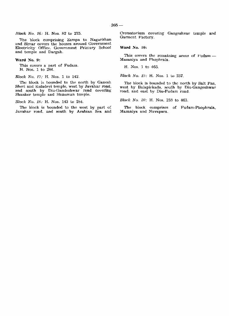
_,265-
Block No. 16: H. Nos. 82 to 275.
The block comprising Zampa to N agarkhan and Simar covers the houses around Government Electricity Office. Government Primary School and temple and Dargah.
Ward No.9: This covers a part of Fudam. H. Nos. 1 to 284.
Block No. 17: H. Nos. 1 to 142.
The block is bounded to the north by Ganesh Sheri and Kuladevi temple, west by Javahar road, and south by Diu-Gandeshwar road covering Shanker temple and Hanuman temple.
Block No. 18: H. Nos. 143 to 284.
The block is bounded to the west by part of J avahar road. and south by Arabian Sea and.
Crematorium covering Gangeshvar temple and Garment Factory.
Ward No. 10:
This covers the remammg areas of FudamMasaniya and Phophrala.
H. Nos. 1 to 463.
Block No. 19: H. Nos. 1 to 237.
The block is bounded to the north by Salt Pan, west by Balapirkada, south by Diu-Gangeshwar road. and east by Diu-Fudam road.
Block No. 20: H. Nos. 238 to 463.
The block comprises of Fudam-Phophrala, Masaniya and Navapara.

Page Number
1
7
12
21
30
35
53
61
170
68,74, 76,80, 82,86, 88,92,
94, 104
Particulars
2
III. A brief historical sketch of Goa, Daman & Diu, 4th para, 10th line.
7.1 Land use pattern, 2nd para 8th line and 6th para 1st line.
VIII. Places of Religious Historical and Archaeological importance in the villages and places of tourist interest in Towns, 1st para, 5th line.
Column heading
District Diu, 1961
Satari Taluka, U
Alphabetical list of villages, L. C. No. 17 and 24
Primary Census Abstract - Tiswadi L. C. No. 17 and 24
Village Directory-Common heading for columns 5 to 10 in respect of talukas Bardez, Pernem, Bicholim, Satari, Ponda and Canacona.
86 Village Directory - Satari L. C. No. 36
87 Village Directory - Satari L. C. No. 33
110 Village Directory - Salcete L. C. No. 10
126 Village Directory - Diu L. C. No.5
163 District Primary Census Abstract, Satari Taluka, T
214 Primary Census Abstract for Sche-duled Castes, Panaji Urban Agglomeration (vi) Durgavada (0. G.)
259 Block No. 116, 3rd line
262 Ward No.8, block No. 22
ERRATA
Table Number
3
4
10
25
Col. Number
4
2
3
17
1
2
3
15
6 '.
6
12
2
For
5
A.nirjitavaram
61277.2
.aints and sears
Number of inhabited villages range in each
4188
27.49
Morombi-O-Grande Morombi-O-Pequeno
-do-
brakets
771.87
282.19
FPC (1) RP (2) 0 (1)
-(-5kms.)
161
Urgavado
Pince Bakery
H. Nos. 106 to 270
Read
6
Anirjitavarman
71277.2
saints and seers
Number of inhabited villages in each range
4138
27.09
Morambi-O-Grande Morambi-O-Pequeno
-do-
brackets
771.78
360.69
PHS (1) FPC (1) RP (2) 0 (1)
-(5-10 kms.)
461
Durgavado
Prince Bakery
H. Nos. 151 to 270
CENSUS OF INDIA 1981 INDMDUAL SLIP
(Universal)
CONFIDENTIA IJ
Pad No ... it .... " ... ""_'. y
Slip No ................... " Location· Code .......•.................•.•.•.•.. ( ) S!. No. of Household [
, ,,' • H • - 0-1 Name ............. " ................ " ............................................................................................................... , .. ~ .. or ..... "
2 !tclatii?nship to head ........... 4 .. • • 8 Religion ... ; ~ ............. -_;;_---I
.................. .6 ................ • -111 .....
................................................................. .. 1-3 -Male (l)/Female (2) ...•.... , 9 Wh:;ther S.C. (1) 0[ S.T. (2) ..••• , ••
----~-
4 Age •............•..•... L 10 Name of caste/tribe. . • • • • •. _. ----
.......... ~ .............. _' __ 1 __ _ 5 Martial status ...............•..........
6 Mother tongu~ .•.....•.... 1
............................................
11 Literate (l)/Iiliterate (2) ......••.••••. !_
12 Educational attainm':!nt .......................... c:
7 Two other languages known .................... ~ ..... ----J ...................................................
Yes 14A Worked any time at all last year? •..••••..••.••••••••••••••..
. (No) HjSTjDjR/B/ljO) I_I L.-l 14B If yes in 14A, did you work for major part of last year? Yes(1)/No (2)
15A Main activity last year? ••••••••••••..••..•••••••• --I -·1 Yes in 14B (C./AL/HHI/OW)
If HHI/OW in 15A No in 14B (H/ST/D/RjBjIjO)
(i) Name of establishment ............................................ '_' •.. ____ _
(ii) Description of work ................ ., .............................. ............... _1 ____ _
(iii) Nature' of industry, trade or service .................................... ____ _
•.....•.•••••.•.• ; •.•.•.•••.•.•.•.•.•.•••.•.•••••.•••.•••••.•••.•••••. 1 ____ -
15B
(iv) Class of worker . . . . . . • . . . .• •......••••..•••••..••..•••••.•.•••••••• • ••••••• I __ l 14B Yes-Any other work any time last year? Yes (C{AL/HHI/OW)/No i--;
14B No-Work done any time last year? (CjAL/HHI/OW) .................. "l_l If HHI/OW in 15B
(i) Name of establishment ................................................. . _--:-__ _
(ii) Description of work ...... _ . .. .. .. . . . . .. .. . . . . . . . . . . . . . . . . . . . . . .. . . . . . . . . . . • _, ___ _
(iii) Nature of industry. trade or service .................................. ____ _
....................................... · .. · .. · ...................... . 1-.....:.....-=--(iv) Oass of worker t ••••••••••••••••••••••••••••••••••••••••••••••••••••••••••••• 1
1
_
16 If No in 14A or 14B seeking/available for work? Yes (l)/No (2) -...................... , -117
CENStJS OF INDIA t981
118
INDIVIDUAL SLlr,
(Sample)
CONFIDENTIAL
1 Birth p1ace 5 F.or all ever-married women only
(a) Place of birth • • • . • . • . • • .. . .. • . • • . ,- (a) Age at marriage .•.. . . . . . . • • 1, __ ........ \
I (b) Rural (l)/Urban (2) .•.......... ,- - (b) Number of children surviving at present
(c) District .•.•..•..•.....•• ,~_..:.,._....;__
I . ..- .......... ;____;__-=----Malel t TotaiLl ~
(d) State/Country
2 Last residence
(a) Place of last residence .............. -~\' . (c) Number of children ever born alive
(b) Rural (l)/Urban (2) ............ )- _"
(c) District .................. ___ _:__
(d) State/Country ............ I ,-, 1-) -j-l Male _ Female _ Total _
3 Reasons for migration from place
of last residence (Code)* .............. LI 6 For currently married women only
4 Duration of reSidenc~ at the -vil1~~ I Any child bom alive during _'_I town of enumeratIOn ..••••...•..•. - ___ 1 last one year •••••.••..•.•.•••••.
*Employment (1) Education (2) Family moved (3) Marriage (4) others (5)
I
~~(jn'};-S~- '':''f r .(!. Tadh/ND/S8--9,3.S'-300.