District Census Handbook, Erode, Part XII-A, Series-33
461
CENSUS OF INDIA 2001 SERIES-33 TAMILNADU DISTRICT CENSUS HANDBOOK Part -A ERODE DISTRICT VILLAGE & TOWN DIRECTORY Dr. C. Chandramouli of the Indian Administrative Service Director of Census Operations, Tamif Nadu
-
Upload
khangminh22 -
Category
Documents
-
view
1 -
download
0
Transcript of District Census Handbook, Erode, Part XII-A, Series-33
CENSUS OF INDIA 2001
SERIES-33 TAMILNADU
DISTRICT CENSUS HANDBOOK
Part - A
ERODE DISTRICT
VILLAGE & TOWN DIRECTORY
Dr. C. Chandramouli of the Indian Administrative Service
Director of Census Operations, Tamif Nadu

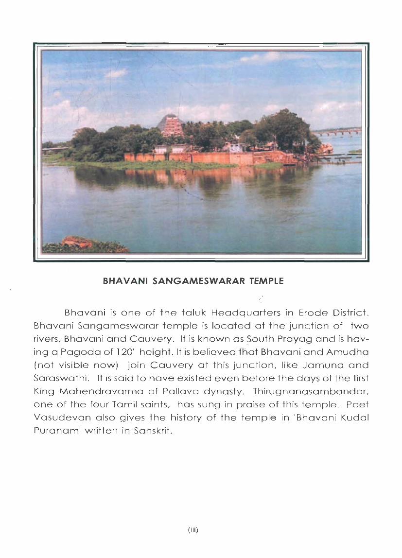
BHAVANI SANGAMESWARAR TEMPLE
Bhavani is one of the taluk Headquarters in Erode District.
Bhavani Sangameswarar temple is located ot the junction of two
rivers, Bhavani and Cauvery. It is known as ~outh Prayag and is hav
ing a Pagoda of 120' height. It is believed tnat Bhavani and Amudha
(not visible now) join Cauvery at this junction, like Jamuna and
Saraswathi. It is said to have existed even before Hie days of the first
King Mahendravarma of Pallava dynasty. Thirugnanasambandar,
one of the four Tamil saints, has sung in praise of this temple. Poet
Vasudevan also gives the history of the temple in 'Bhavani Kudal
Puranam' written in Sanskrit.
(iii)


Contents
Foreword
Preface
Acknowledgements
Map of Erode District
District Highlights - 2001
Important Statistics of the District, 2001
Ranking of Taluks in the District
Summary Statements from 1 - 9
Statement 1:
Statement 2:
Statement 3:
Statement 4:
Statement 5:
Statement 6:
Statement 7:
Statement 8:
Statement 9:
Analytical Note
Name of the headquarters of Districtffaluk, their rural-urban status and distance from District headquarters, 2001
Name of the headquarters of DistrictJCD block, their rural-urban status and distance from District headquarters, 2001
Population of the District at each census from 1901 to 2001
Area, number of villages/towns and population in District and Taluk, 2001
CD block wise number of villages and rural population, 2001
Population of urban agglomerations (including constituent units! towns), 2001
Villages with population of 5,000 and above at CD block level as per 2001 census and amenities available
Statutory towns with popUlation less than 5,000 as per 200 I census and amenities available
Houseless and institutional population of Taluks, Rural and Urban, 2001
(i) History and scope of the District Census Handbook
(ii) Brief History of the District
(ill) Administrative set-up
(iv) Physical features
(v)
Pages
xi
XIll
xv
xvii
XlX
xxi
xxiii
xxviii
xxviii
XXlX
xxx
XXXIV
xxxiv
XXXVI
xxxix
xl
3
3
4
4
(v) Census concepts
(vi) Non-Census concepts
(vii) Census 2001 findings
Distribution of population in Rural and Urban areas; Size, Class and Status
of Towns; Population Growth, Density and Sex Ratio; Literacy; Economic Activity; Scheduled Castes and Scheduled Tribes and Religion
(viii) Brief Analysis of data based on inset tables 1 to 52
(ix) Major Social and Cultural events in the District - Fairs and festivals
ex) Places of tourist interest in the District
(xi) Major characteristics of the District, contribution of the district in the form of any historical figure associated with the district
(xii) Scope of Village and Town Directory
Part A - Village and Town Directory
Section I - Village Directory
(a) Note explaining the abbreviations used in the village directory
(b) List of villages fully merged in Towns and outgrowths at 2001 Census
(c) CD block wise presentation of Village Directory Data
1. TALAVADI CD BLOCK
(i) Map of Sathyamangalam Taluk
(ii) Alphabetical List of Villages alongwith location code 1991 and 2001
(iii) Village Directory
2. BHAVANISAGAR CD BLOCK
(i) Alphabetical List of Villages alongwith location code 1991 and 200 1
(ii) Village Directory
3. SATHYAMANGALAM CD BLOCK
(i) Alphabetical List of Villages alongwith location code 1991 and 2001
(ii) Village Directory
4. THOOKANAICKENPALAYAM CD BLOCK
(i) Map of Gobichettipalayam Taluk
(ii) Alphabetical List of Villages alongwith location code 1991 and 200 1
(iii) Village Directory
(vi)
Pages
13
19
24
28
101
101
102
102
107
111
115
117
118
127
128
l39
140
149
151
152

(v) Census concepts
(vi) Non-Census concepts
(vii) Census 2001 findings
Distribution of population in Rural and Urban areas; Size, Class and Status of Towns; Population Growth, Density and Sex Ratio; Literacy; Economic Acti vity; Scheduled Castes and Scheduled Tribes and Religion
(viii) Brief Analysis of data based on inset tables 1 to 52
(ix) Major Social and Cultural events in the District - Fairs and festivals
(x) Places of tourist interest in the District
(xi) Major characteristics of the District, contribution of the district in the form of any historical figure associated with the district
(xii) Scope of Village and Town Directory
Part A - Village and Town Directory
Section I - Village Directory
(a) Note explaining the abbreviations used in the village directory
(b) List of villages fully merged in Towns and outgrowths at 2001 Census
(c) CD block wise presentation of Village Directory Data
1. TALAVADI CD BLOCK
(i) Map of Sathyamangalam Taluk
(ii) Alphabetical List of Villages alongwith location code 1991 and 200 1
(iii) Village Directory
2. BHAVANISAGAR CD BLOCK
(i) Alphabetical List of Villages alongwith location code 1991 and 200 1
(ii) Village Directory
3. SATHYAMANGALAM CD BLOCK
(i) Alphabetical List of Villages alongwith location code 1991 and 200 1
(ii) Village Directory
4. THOOKANAICKENPALAYAM CD BLOCK
(i) Map of Gobichettipalayam Taluk
(ii) Alphabetical List of Villages alongwith location code 1991 and 2001
(iii) Village Directory
(vi)
Pages
13
19
24
28
101
101
102
102
107
111
115
117
118
127
128
139
140
149
151
152

Contents
Foreword
Preface
Acknowledgements
Map of Erode District
District Highlights - 200 1
Important Statistics of the District, 2001
Ranking of Taluks in the District
Summary Statements from 1 - 9
Statement 1:
Statement 2:
Statement 3:
Statement 4:
Statement 5:
Statement 6:
Statement 7:
Statement 8:
Statement 9:
Analytical Note
Name of the headquarters ofDistrictffaluk, their rural-urban status and distance from District headquarters, 2001
Name of the headquarters of District/CD block, their rural-urban status and distance from District headquarters, 2001
Population of the District at each census from 1901 to 2001
Area, number of villages/towns and population in District and Taluk. 2001
CD block wise number of villages and rural population, 2001
Population of urban agglomerations (including constituent unitsl towns),2001
Villages with population of 5,000 and above at CD block level as per 2001 census and amenities available
Statutory towns with population less than 5,000 as per 2001 census and amenities available
Houseless and institutional population of Taluks, Rural and Urban, 2001
(i) History and scope of the District Census Handbook
(ii) Brief History of the District
(iii) Administrative set-up
(iv) Physical features
(v)
Pages
Xl
xv
XIX
XXI
xxiii
xxviii
xxviii
xxix
xxx
xxxiv
xxxiv
xxxvi
xxxix
xl
3
3
4
4
5. ANTHIYUR CD BLOCK
(i) Map of Bhavani Taluk
(li) Alphabetical List of Villages alongwith location code 1991 and 200 1
(iii) Village Directory
6. AMMAPET CD BLOCK
(i) Alphabetical List of Villages alongwith location code 1991 and 200 1
(li) Village Directory
7. BHAVANI CD BLOCK
(i) Alphabetical List of Villages alongwith location code 1991 and 200 1
(li) Village Directory
i18. GOBICHETTIPALAYAM CD BLOCK
(i) Alphabetical List of Villages alongwith location code 1991 and 200 1
(li) Village Directory
9. NAMBIYUR CD BLOCK
(i) Alphabetical List of Villages alongwith location code 1991 and 200 1
(li) Village Directory
10. UTHUKULI CD BLOCK
(i) Map of Perundurai Taluk
(li) Alphabetical List of Villages alongwith location code 1991 and 200 1
(iii) Village Directory
11. PERUNDURAI CD BLOCK
/
(i) Alphabetical List of Villages alongwith location code 1991 and 2001
eli) Village Directory
12. ERODE CD BLOCK
(i) Map of Erode Taluk
(li) Alphabetical List of Villages alongwith location code 1991 and 2001
(iii) Village Directory
13. CHENNIMALAI CD BLOCK
(i) Alphabetical List of Villages alongwith location code 1991 and 2001
eli) Village Directory
r4. MODAKURICHI CD BLOCK
(i) Alphabetical List of Villages alongwith location code 1991 and 2001
(li) Village Directory
(vii)
Pages
159
161
162
169
170
177
178
185
186
195
196
205
207
208
223
224
237
239
240
249
250
259
260

'15. KODUMUDI CD BLOCK
(i) Alphabetical List of Villages alongwith location code 1991 and 2001
(ii) Village Directory
JB. VELLAKOIL CD BLOCK
(i) Map of Kangeyam Taluk
(ii) Alphabetical List of Villages along with location code 1991 and 2001
(iii) Village Directory
i 1. KANGEYAM CD BLOCK
(i) Alphabetical List of Villages along with location code 1991 and 2001
(ii) Village Directory
(8. KUNDADAM CD BLOCK
(i) Map of Dharapuram Taluk
(ii) Alphabetical List of Villages along with location code 1991 and 2001
(iii) Village Directory
19. MULANUR CD BLOCK
(i) Alphabetical List of Villages along with location code 1991 and 200 1
(ii) Village Directory
10. DHARAPURAM CD BLOCK
(i) Alphabetical List of Villages along with location code 1991 and 200 1
(ii) Village Directory
d) Appendixes to Village Directory
Appendix I
Appendix la
Appendix Ib
Appendix Ie
Appendix II
Abstract of Educational, Medical and other amenities in villages - CD block Level
Villages by number of Primary Schools
Villages by Primary, Middle and Secondary Schools
Villages with different sources of drinlting water facilities available
Villages with 5,000 and above population which do not have one or more amenities
Pages
269
270
277
279
280
287
288
295
297
298
309
310
317
318
326
330
331
332
333
Appendix IIa List of Census Towns which do not have one or more amenities 335
Appendix III Land utilisation data in respect of Census 335 Towns/non-municipal towns
Appendix IV CD block wise list of inhabited villages where no amenity 335 other than drinking water facility is available
(viii)

Appendix V Summary showing number of villages not having Scheduled Castes population
Appendix VI Summary showing number of villages not having Scheduled Tribe population
Appendix VIla: List of villages according to the proportion of the Scheduled Castes to the total population by ranges
Appendix VIIb: List of villages according to the proportion of the Scheduled Tribes to the total population by ranges
Appendix VIII: Number of villages under each Gram Panchayat
Appendix IX : Statement showing number of girls schools in the villages
Section II - Town Directory
(i) Note explaining the abbreviations used in the Town Directory
(ii) Town Directory Statements
Pages
336
336
337
344
346
357
358
Statement I Status and Growth History 362
Statement II Physical Aspects and Location of Towns, 1999 368
Statement III Municipal Finance, 1998-99 372
Statement IV Civic and other Amenities, 1999 376
Statement V Medical, Educational, Recreational and Cultural Facilities, 1999 382
Statement VI Trade, Commerce, Industry and Banking, 1999 390
Statement VII Civic and other amenities in Slums, 1999 392
(iii) Appendix to Town Directory - Towns showing their outgrowth with population 418
Part B - Primary Census Abstract
Brief note on Primary Census Abstract
District Primary Census Abstract
Appendix to District Primary Census Abstract
Primary Census Abstract for Scheduled Castes
Primary Census Abstract for Scheduled Tribes
Village Primary Census Abstract -CD block wise
Urban Primary Census Abstract
(ix)
421
424
430
472
490
502
598

Pages
Annexures and their write-up
Annexure I Number of villages under each Gram Panchayat 756
Annexure II Note on fertility, mortality and migration 778
Annexure III Various measures of fertility and mean age at marriage 779
Annexure IV Percentage distribution of migrants by place of birth/place 780 of last residence
Annexure V Brief account of main religions in the District 782
Annexure VI Marital status of population in the District 783
Annexure VII Age, sex and educational level in the district 784
Annexure VIII Distribution of different mother tongues in the District 785
(x)
Foreword
The District Census Handbook (DCHB) published by Census Organisation since 1951 census, is one of the important publications in the context of planning and development at grossroots
level. The publication, which is brought out for each district, contains several demographic and socio-economic characteristics village-wise and town-wise of the district alongwith the status of availability of civic amenities, infrastructural facilities, etc.
The scope of the DCHB was initially confined to a few Census Tables and Primary Census Abstract (PCA) of each village and town within the district. Thereafter, at successive censuses, its scope and coverage has been enlarged. The DCHB published at the 1961 census provided a descriptive account of the district, administrative statistics, census tables and a village and town directory including PCA. The 1971 census-DCHB series was in three parts: Part-A related to village and town directory, Part-B to village and town PCA and Part-C comprised analytical report, administrative statistics, district census tables and certain analytical tables based on PCA and amenity data in respect of villages. The 1981 census DCHB was in two parts: Part-A contained village and town directory and Part-B the PCA of village and town including the SCs and STs PCA up to tahsil/town levels. New features alongwith restructuring of the formats of village and town directory were added into it. In Village Directory, all amenities except electricity were brought together and if any amenity was not available in the referent village. the distance in broad ranges from the nearest place having such an amenity, was given. Information on new items such as adult literacy centres, primary health sub-centres and community health workers in the village were provided so as to meet the requirements of some of the Revised Minimum Needs Programme. Information on approach to the village was provided for the first time in the Village Directory so as to give the details on number of inaccessible villages in each district. In the Town Directory, a statement (VII) on slums was introduced to provide the details on civic and other amenities in the notified slums of Class I and Class II towns.
The 1991 census DCHB, by and large, followed the pattern of presentation of 1981 census. except the format of PC A was restructured. Nine-fold industrial classification of main workers was given against the fourfold industrial classification presented in the 1981 census. In addition, sex-wise population,in 0-6 age group was included in the PCA for the first time with a view to enable the data users to compile more realistic literacy rate as all children below 7 years of age had been treated as illiterate at the time of 1991 census. One of the important innovations in the 1991 census was the Community Development Block (CD block) level presentation of village directory and PCA data instead of the traditional tahsilltalukIPS level presentation. It was expected that the presentation of village directory and PCA data at CD block level will help the planners in formulation of micro level development plans, CD block being lowest administrative unit.
The present series of 2001 census DCHBs have been made more informative and exhaustive in terms of coverage and content. The Village Directory has been enlarged in scope by including a number of other facilities iike banking. recreational and cultural facilities, newspapers and magazines and 'most important commodity' manufactured in village. Income and expenditure of gram panchayat, wherever possible, has been provided. Apart from these, more details on distance(s) at which basic amenities are available (if not available in the village), are given. This includes educational facilities (namely primary and middle schools and college), medical facilities (viz. Allopathic Hospital, Maternity & Child Welfare Centre and Primary Health Centre). drinking water, post & telegraph (post office and phone), communication, bank, credit societies and recreational facilities. In Town Directory. the statement on Slums has been modified and its coverage enlarged by including details on all slums instead of 'notified slums'. The information is given in case of all statutory towns irrespective of their class. against only Class I and Class II towns in the 1981 and 1991 censuses. The basic amenities available in the villages and towns are analysed in depth with the help of a number of cross-classified inset tables and
(xi)

statements. Two other significant additions in the publication are inclusion of 'motif' highlighting significant characteristic of the district and analytical notes as annexures. The analytical notes on (i) fertility and mortality and (ii) various measutes of fertility and mean age at marriage are prepared based on 1991 Census. Whereas, in the notes rei ating to (i) percentage distribution of migrants by place of birth/place of last residence, (ii) main religions, (iii) marital status of population, (iv) age, sex and education and (v) distribution of spectrum of mother tongue, nature and extent of changes occurred in the district in its basic socio-demographic features during the decade 1991-2001 are analysed. The eight digits permanent location code number (PLCN) to all the villages and towns have been assigned keeping in view the future needs.
The village and town level amenity data have been collected, compiled and computerised in prescribed record structure under the supervision of Dr. C. Chandramouli, Director of Census Operations, Tamil Nadu. Thereafter, efforts have been made to ensure comparability of the information with that of 1991 census data and the information brought out by the respective State Governments in their annual reports and statistical handbooks for various years after 1991. The task of planning, designing and coordination of this publication was can-ied out by Shri R.G. Mitra, Deputy Registrar General (C&T) and Dr. I.C. Agrawal, Assistant Registrar General of Social Studies Division. Dr. R.P.Singh, Deputy Registrar General (Map) provided the technical guidance in the preparation of maps. Whereas, Shri Anil Kumar Arora, Deputy Director of Data Processing Division who worked under the overall supervision of Shri Himakar, Addl. Director (EDP) helped in preparation of record structure for computerisation of village and town directory data and the programme for the generation of Village Directory and Town Directory statements including analytical inset tables. The draft DCHB manuscripts received from the Census Directorates have been scrutinised in the Social Studies Division under the guidance of Shri S.L. Jain, Deputy Director and Shri R.K. Mehta, Assistant Director. I am thankful to all of them and others who have contributed to make this publication possible.
New Delhi, 17the October, 2006.
(xii)
D.K. Sikri Registrar General &
Census Commissioner, India

Preface
publication of the District Census Handbooks (DCHBs) was initiated after the 1951 census and is continuing since then with innovations/modifications after each decennial census. This is the most valuable
district level publication brought out by the census organization on behalf of each State government/Union Territory administration. It inter-alia provides data/information on some of the basic demographic and socioeconomic characteristics and on the availability of certain important civic amenities/facilities in each village and town of the respective districts.
The District Census Handbook has two segments: part A and part B. Part A primarily deals with village and town Directory and part B contains Primary Census Abstract of each village and town of the District. The 1991 Census data presentation both in Part A and Part B of this book was the transition from traditional presentation at Taluk level to C D block level and this pattern continued in 2001 census as well.
For the first time in 2001 census, the District Census Handbooks are being made available in electronic format.
The District Census Handbook is the joint collaboration of the Census Directorate and the Government of Tamil Nadu. On behalf of the Government of Tamil Nadu, this Directorate has prepared the manuscript of this book.
The District Census Handbooks of 2001 have some additional information which is based on the 2001 census as compared to the previous censuses like capturing of information on participation of women in economic activities, netting all the children in age-group 0-14 as also elderly people of age 60 years and above. The data about the number of handicapped persons including partial disability has also been collected in 2001 census for the whole of India. The most important methodological innovation introduced in 2001 census relate to carving out separate slum enumeration blocks.
The data being presented in this publication have been collected and compiled by Shri M.R.V. Krishna Rao, Deputy Director of Census Operations, Tamil Nadu with the assistance of S/Shri S.K. Srivastav, N. Sukumar Nandagopal and A. Achchhu Ali, Assistant Directors. For the preparation of manuscript of this book, I received wholehearted co-operation from all the Heads of Departments, Heads of offices of the District / Taluk / Corporation / Municipal/Town and Rural Administration and a number of dedicated and experienced Census staff of this office. I am grateful to all of them for their valuable contribution in the accomplishment of this task of national importance. I must place on record the co-operation extended to me by the press media and electronic media to make the census taking a great success in the state.
I am deeply grateful to Shri J.K. Banthia, lAS the Registrar General and Census Commissioner, India, New Delhi for the valuable guidance and advice at every step till the finalisation of this handbook. I also express my thanks to Dr. I.C. Agrawal, Assistant Registrar General (Social Studies Division) and Shri S.L. Jain, Deputy Director, ORGI, New Delhi for preparing the set of instructions for the compilation of the village and Town Directory and other inset tables etc., being inserted in this District Census
Handbook.
In particular, it has to be mentioned that the write up portion was taken by Shri M.R.V.Krishna Rao, Deputy Director and finalised by Dr. D. Venkatesan, Deputy Director with the assistance of other members of the staff whose names have been mentioned in the "Acknowledgements".
Chennai - 600 090 Dated: 0110112003
(xiii)
Dr. C. Chandramouli, lAS Director of Census Operations,
Tamil Nadu


Acknowledgements
Editing and Supervision
Shri. M. RV. Krishna Rao Dr. D. Venkatesan
Drafting
Dr. D. Venkatesan Shri. A. AchchhuAli
Collection and Compilation of data
Shri. S. Gajendran Shri. M. Thangavelu Shri. A. Radhakrishnan Shri. A. Radhakrishnan
Data Entry
Shri. S. Anandakumar Shri. V. Vellingiri
DCHB Data merging and generation or tables
Smt. J. Chithra
Mapping
Shri. J.e. Srivatsava Shri. R Joseph Shri. E.S. Jayamohan Shri. A. Lazar Shri. J. Coumary Shri. G.. Rajkumar Shri. D. Jayakumar
Preparation of camera ready copy (eRC)
Shri. R Sripathy Shri. V. Vellingiri
(xv)
Deputy Director Deputy Director
Deputy Director Assistant Director
Statistical Investigator Grade 'I' Statistical Investigator, Grade 'II' Statistical Investigator Grade 'III' Statistical Investigator Grade 'III'
Assistant Compiler Data Entry Operator Gr.'B'
Data Processing Assistant
Research Officer (Map) Senior Geographer Senior Drawing Assistant Geographer Senior Draftsman Data Entry Operator Gr.'B' Data Entry Operator Gr.'B'
Data Entry Operator Gr. 'B' Data Entry Operator Gr. 'B'

l I
) , ..I ,.
~ < , i 'i ~ ~, "
c \
~
~ ,
< z (,/ , ~
0 , (J
til «I--0 I
~-'-0', .JG:: -I-" ztII w-"',./' xO l-II
~ D' S
~ 0
A.
t
~
;-
~ leT II !
i i ! @ @ ~ iii , . , , : : :
: : :
: : : ' ,
~ ~
t ~
1/1 ~ .Ie ~ ",
0 ~ Q
1 ; ,~ , ~
~ ~ ~
f ~
~ s ,~ Q

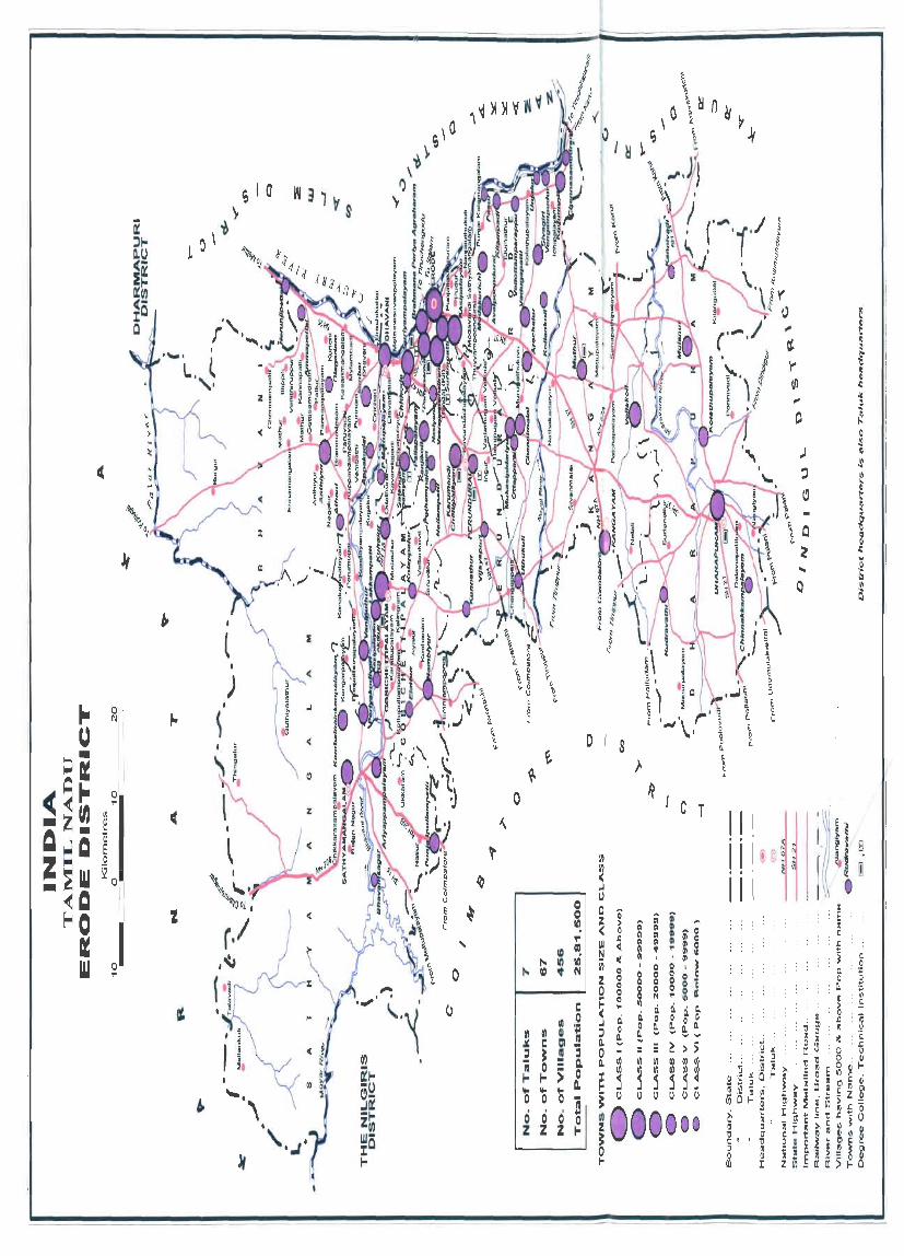
District Highlights - 2001 Census
1. Erode district was in the 10th place amongst the highest population size in the State.
2. Erode district has shared 46.3% population from urban areas.
3. Population density of the district was 314 persons per square km.
4. The district sex ratio was 972, lower when compared to the State sex ratio of 987.
5. The district has recorded the literacy rate of 65 .36% as compared with State literacy rate of73.45%.
6. The highest number of villages (106) is found in Perundurai taluk while Kangeyam taluk has the lowest number (39) of villages.
7. Kavandapadi village (L.C No. 00749800) in Bhavani taluk is the most populated with 25,172 and Devakiammapuram village (L.C No. 00771800) in Erode tal uk has the lowest population of97.
8. Guthiyalathur (Addition) R. village (L.C No. 00739(00) in Sathiamangalam taluk has the largest area of 82,595.8 hectares and Mudukkanthurai village (L.C No. (0742600) in Sathyamangalam taluk has the less area of 28.33 hectares
9. The total decadel population growth during 1991- 2001 was 11.26%.
10. Manufacturing of textile materials is the most important non-agricultural activity in the district.
11. Major social and cultural event celebrated in the district is "Kundam" at Bannari Amman Temple. The event takes place in the middle of March. Pilgrims visiting on that particular day can roughly be estimated more than five lakhs hailing from all over Tamil Nadu, Kerala and Karnataka.
12. Bhavani Sagar dam in Satyamangalarn taluk is an important tourist place in the district.
13. Improved drinking water facility and power supply have been extended to all villages in the district.
(xix)

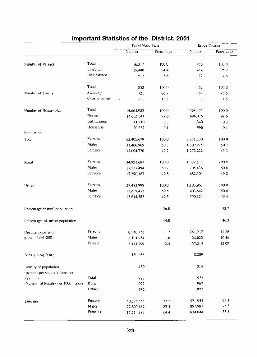
Important Statistics of the District, 2001 Tamil Nadu State Erode District
Number Percentage Number Percentage
Number of Vllages Total 16,317 100.0 456 100.0 Inhabited 15,400 94.4 434 95.2 Uninhabited 917 5.6 22 4.8
Total 832 100.0 67 100.0
Number of Towns Statutory 721 86.7 64 95.5 Census Towns III 13.3 3 4.5
Number of Households Total 14,665,983 100.0 698.405 100.0 Normal 14,603,541 99.6 696.075 99.6 Institutional 41,910 0.3 1.340 0.3 Houseless 20,532 0.1 990 0.1
Population
Total Persons 62,405,679 100.0 2.581,500 100.0 Males 31,400,909 50.3 1,309.278 50.7 Females 31,004,770 49.7 1,272,222 49.3
Rural Persons 34,921.681 100.0 1,387,537 100.0
Males 17,531,494 50.2 705,436 50.8 Females 17,390,187 49.8 682.101 49.2
Urban Persons 27,483,998 100.0 1.193,963 100.0
Males 13,869,415 50.5 603,842 50.6
Females 13,614,583 49.5 590,121 49.4
Percentage of rural population 56.0 53.7
Percentage of urban population 44.0 46.3
Oecadal population Persons 6,546,733 11.7 261.237 11.26
growth 1991-200 1 Males 3,101,934 11.0 124,022 10.46
Female 3,444.799 12.5 137.215 12.09
Area (In Sq. Km.) 130.058 8.209
Oensi ty of population 480 314
(persons per square kilometre)
Sex ratio Total 987 972
(Number of females per 1000 males) Rural 992 967
Urban 982 977
Literates Persons 40.524.545 73.5 1.521.955 65.4
Males 22,809,662 82.4 887.907 75.3
Females 17,714,883 64.4 634.048 55.1
(xxi)

Important Statistics of the District, 2001 (contd.)
Tamil Nadu State Erode District
Number Percentage Number Percentage
Scheduled Castes Population Persons 11,857.504 19.0 422,204 16.4 Males 5,932,925 18.9 213,312 16.3 Females 5,924,579 19.1 208,892 16.4
Scheduled Tribes Population Persons 651,321 1.0 17,693 0.7 Males 328,917 1.0 8,933 0.7 Females 322,404 1.0 8,760 0.7
Workers and non-workers
Tolal workers Persons 27,878,282 44.7 1,434.405 55.6
(Main & Marginal) Males 18,100,397 57.6 870.598 66.5 Females 9,177,885 31.5 563,807 44.3
(i) Main workers Persons 23,757,783 38.1 1,317.991 51.1 Males 16,303,310 51.9 830.689 63.4 Females 7,454,473 24.0 487,302 38.3
(ii) Marg~nal workers Persons 4,120,499 6.6 116,414 4.5 Males 1,797,087 5.7 39,909 3.0 Females 2,323,412 7.5 76.505 6.0
(iii) Non-workers Persons 34.527.397 55.3 1,147,095 44.4
Males 13,300,512 42.4 438.680 33.5 Females 21,226,885 68.5 708,415 55.7
Category of workers (Main & Marginal)
(i) Cultivators Persons 5,116.039 18.4 291.319 20.3 Males 3,262.489 18.0 170,615 19.6 Females 1,853,550 19.0 120,704 21.4
(ii) Agricultural labourers Persons 8,637,630 3l.0 480,970 33.5
Males 4,256,360 23.5 229.661 26.4
Females 4,381,270 44.8 251,309 44.6
(iii) Workers in household Persons 1,499,761 5.4 76.339 5.3
industry Males 648,589 3.6 37.327 4.3 Females 851,172 8.7 39.012 6.9
(iv) Other workers Persons 12,624,852 45.3 585,777 40.8
Males 9,932,959 54.9 432.995 49.7
Females 2,691,893 27.5 152,782 27.1
Definition of Census Town:
All places which satisfy or are expected to satisfy the following criteris are treated as Census Towns:
i) A minimum population of 5,000. ii) Atleast 7S percent of the male working population engaged in non-agricultural pursuits, and iii) A density of population of all east 400 per square kilometre ( 1,000 per square mile).
(xxii)

RANKING OF TALUKS IN THE DISTRICT ;;.::rial In Terms of Sathyamangalam Bhavani
No. Value Rank Value Rank
. Total population 287,605 5 423,708 2
2 Total area (in sq.kms) 2295.8 1482.54 2
3 Density of population I sq.km. 125.27 7 285.80 4
4 Sex ratio 970 4 949 7
5 Proportion of urban population 26.30 7 31.17 6
6 Proportion of Scheduled Caste population 18.62 3 14.85 6
7 Proportion of Scheduled Tribe population 3.07 1 1.34 2
8 Proportion of literates 51.24 7 52.82 6
9 Work participation rate (main+marginal) 55.14 6 57.63 4
10 Percentage of villages having primary schools 86.67 5 88.89 3
11 Percentage of villages having P.H.Sub-Centre 65.33 3 5556 6
12 Percentage of villages having wells 84.00 3 75.93 5
13 Percentage of villages having post office 78.67 7 81.48 5
14 Percentage of villages having bus facility 85.33 5 '83.33 6
15 Percentage of villages having pucca road 85.33 7 90.74 5
16 Percentage of villages having electricity for domestic use 88.00 6 90.74 5
17 Percentage of villages having forest area 1.33 4 0.00 5
18 Percentage of villages having irrigated area 88.00 4 90.74 3
(xxiii)

RANKING OF TALUKS IN THE DISTRICT Serial In Terms of Gobichettipalayam Perundurai
No. Value Rank Value Rank
Total population 361,201 3 326.782 4
2 Total area (in sq.kms) 66(5.05 7 803.8 5
3 Density of population I sq.km. 542.30 2 406.55 3
4 Sex ratio 986 2 969 5
5 Proportion of urban population 42.50 2 37.62 5
6- Proportion of Scheduled Caste population 16.79 4 16.27 5
7 Proportion of Scheduled Tribe population 0.43 3 0.01 7
8 Proportion of literates 55.90 5 58.42 4
9 Work participation rate (main+marginal) 58.54 2 57.44 5
10 Percentage of villages having primary schools 86.67 5 86.92 4
11 Percentage of villages having P .H.Sub-Centre 68.33 38.32 7
12 Percentage of villages having wells 75.00 6 66.36 7
13 Percentage of villages having post office 83.33 3 81.31 6
14 Percentage of villages having bus facility 90.00 3 81.31 7
15 Percentage of villages having pucca road 90.00 6 99.07
16 Percentage of villages having electricity for domestic use 91.67 4 99.07 2
17 Percentage of villages having forest area 0.00 5 6.54
18 Percentage of villages having irrigated area 100.00 1 99.07 2
(xxiv)
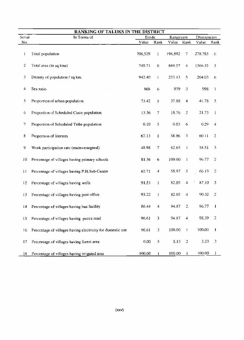
RANKING OF TALUKS IN THE DISTRICT Serial In Terms of Erode KangeJ::am Dharal2uram
No. Value Rank Value Rank Value Rank
Total population 706,529 196.892 7 278.783 6
2 Total area (in sq.kms) 749.71 6 844.57 4 1366.35 3
3 Density of population I sq.krn. 942.40 233.13 5 204.03 6
4 Sex ratio 968 6 979 3 998
5 Proportion of urban population 73.42 37.88 4 41.78 3
6 Proportion of Scheduled Caste population 13.36 7 18.76 2 2l.73
7 Proportion of Scheduled Tribe population 0.10 5 0.03 6 0.29 4
8 Proportion of literates 67.13 58.96 3 60.11 2
9 Work participation rate (main+marginal) 48.98 7 62.65 58.51 3
10 Percentage of villages having primary schools 81.36 6 100.00 96.77 2
II Percentage of villages having P.H.Sub-Centre 62.71 4 58.97 5 66.13 2
12 Percentage of villages having wells 91.53 1 82.05 4 87.10 2
13 Percentage of villages having post office 93.22 82.05 4 90.32 2
14 Percentage of villages having bus facility 86.44 4 94.87 2 96.77 ..
15 Percentage of villages having pucca road 96.61 3 94.87 4 98.39 2
16 Percentage of villages having electricity for domestic use 96.61 3 100.00 100.00
17 Percentage of villages having forest area 0.00 5 5.13 2 3.23 3
18 Percentage of villages having irrigated area 100.00 100.00 100.00
(xxv)


Summary Statements
Summary Statements
Statement 1: Name of the headquarters of DistrictiTaluk. their rural-urban status and distance from District headquarters, 2001.
Statement 2: Name of the headquarters of DistrictiC D block, their ruralurban status and distance from District headquarters, 2001.
Statement 3: Population of the District at each census from 1901 to 2001.
Statement 4: Area, number of village sf towns and population in District and Taluk2001.
Statement 5: CD block wise number of villages and rural popUlation, 2001.
Statement 6: Population of urban agglomerations (including constituent unitsl towns), 2001.
Statement 7: Villages with population of 5,000 and above at C D block level as per 2001 census and amenities available.
Statement 8: Statutory Towns with population less than 5,000 as per 2001 Census and amenities available.
Statement 9: Houseless and institutional population of Taluks, Rural and Urban, 2001.
(xxvii)
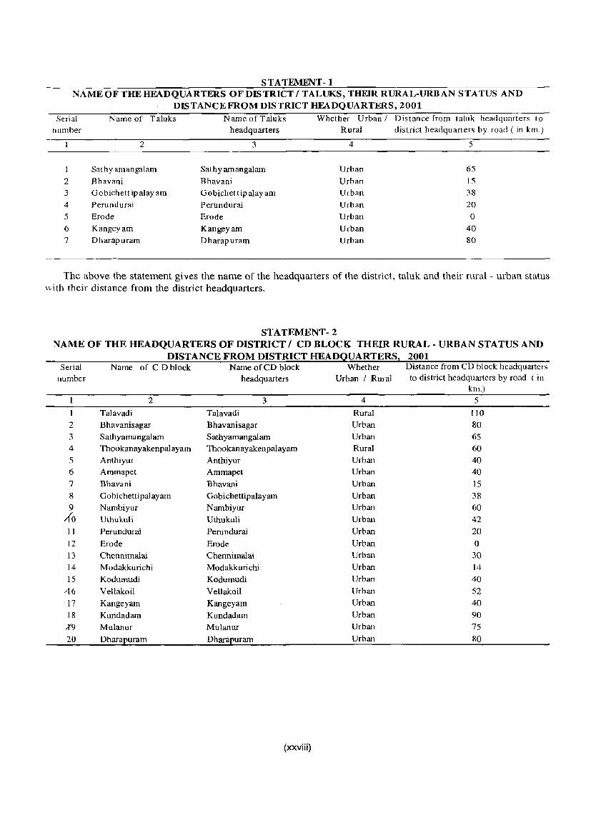
STATEMENT - 1 NAMEOFTHEHEADQUARTERS OFDISTRICT/TALUKS, THEIR RURAL-URBAN STATUS AND
DISTANCEFROM DISTRICT HEADQUARTERS, 2001 Serial
number
1
2 3
4
5
6
7
Name of Taluks
2
Sathyamangalam
Bhavani Gobichettipalayam Perundurai Erode
Kangeyam Dharapuram
Name ofTaluks headquarters
3
Sathyarnangalam
Bhavani Gobichettipalayam Perundurai
Erode Kangeyam Dharapuram
Whether Urban / Distance from taluk headquarters to Rural district headquarters by road ( in km.)
4 5
Urban 65
Urban 15
Urban 38
Urban 20
Urban 0
Urban 40 Urban 80
The above the statement gives the name of the headquarters of the district, taluk and their rural - urban status \vith their distance from the district headquarters.
STATEMENT - 2 NAME OF THE HEADQUARTERS OF DISTRICT I CD BLOCK THEIR RURAL - URBAN STATUS AND
DISTANCE FROM DISTRICT HEADQUARTERS, 2001 Serial Name of CD block Name of CD block Whether Distance from CD block headquarters
number headquarters Urban I Rural to district headquarters by road (in km.)
2 3 4 5
1 Talavadi Talavadi Rural 110 2 Bhavanisagar Bhavanisagar Urban 80 3 Sathyamangalam Sathyarnangalarn Urban 65
4 Thookanayakenpalayam Thookanayakenpalayam Rural 60
5 Anthiyur Anthiyur Urban 40 6 Ammapet Ammapet Urban 40 7 Bhavani Bhavani Urban 15
8 Gobichettipalayam Gobichettipala yam Urban 38
9 Nambiyur Nambiyur Urban 60 1(0 Uthukuli Uthukuli Urban 42
11 Perundurai Perundurai Urban 20
12 Erode Erode Urban 0
13 Chennimalai Chennimalai Urban 30 14 M odakkurichi Modakkurichi Urban 14
15 Kodumudi Kodumudi Urban 40 ,{6 Vellakoil Vellakoil Urban 52 -17 Kangeyam Kangeyam Urban 40
18 Kundadam Kundadam Urban 90
%9 Mulanur Mulanur Urban 75
20 Dharapuram Dharapuram Urban 80
(xxviii)

STATEMENT -3 PO PULA TION OF THE DISTRICT AT EACH CENSUS FROM 1901 TO 2001
District Total/ Census Persons Males Females Decadal population variation Rural/ Year Urban
Absolute Percentage
2 3 4 5 6 7 8
Erode Total 1901 867,839 429,312 438,527 1911 920,299 456,381 463,918 +52,460 +6.04 1921 999,473 498,432 501,041 +79,174 +8.60 1931 1,060,l24 527,307 532,817 +60,651 +6.07 1941 1,220,843 611,308 609,535 +160,719 +15.16 1951 1,392,385 696,837 695,548 +171,542 +14.05 1961 1,492,579 753,747 738,832 +100,194 +7.20 1971 1,797,016 914,413 882,603 +304,437 +20.40 1981 2,068,462 1,057,599 1,010,863 +271,446 + 15.11 1991 2,320,263 1,185,256 1,135,007 +251,801 +12.17 2001 2.581,500 1,309,278 1,272,222 +261,237 + 11.26
Rural 1901 816,268 404,030 412,238
1911 866,793 429,999 436,794 +50,525 +6.19
1921 940,800 468,810 471,990 +74,007 +8.54
1931 985,034 488,950 496,084 +44,234 +4.70
1941 1,126,489 563,792 562,697 +141,455 +14.36
1951 1,254,141 626,880 627,261 +127,652 + 11.33
1961 1,286,997 649,136 637,861 +32,856 +2.62
1971 1,469,846 746,119 723,727 +182,849 +14.21
1981 1,613,259 823,074 790,185 +143,413 +9.76
1991 1,746,993 891,517 855,476 +133,734 +8.29
2001 1,387,537 705,436 682,101 -359,458 -20.58
Urban 1901 51,571 25,262 26,289
1911 53,506 26,382 27,124 +1.935 +3.75
1921 58,673 29,622 29,051 +5,167 +9.66
1931 75,090 36,357 36,733 +16,417 +27.98
1941 94,354 47,516 46,838 +19,264 +25.65
1951 138,244 69,957 68,287 +43,890 +46.52
1961 205,582 104,611 100,971 +67,338 +48.71
1971 327,170 168,294 158,876 +121.588 +59.14
1981 455,203 234,525 220,678 + 128,033 +39.13
1991 573,270 293,739 279,531 +118,067 +25.94
2001 1,193,963 603,842 590,121 +620,693 +108.27
(xxix)

STA TEMENT-4 AREA, NUMBER OF VILLAGES/ TOWNS AND POPULATION IN DISTRICT AND TALUK, 2001
Serial number
District I Taluk / UA I Town
1 2
1 Erode
2 SathyamangaIam
3 AriyappampaIayam (TP)
4 Bhavanisagar (TP)
5 Kembainaickenpalayam (TP)
6 Punjaipuliampatti (TP)
7 Sathyamangalam (M)
8 Bhavani
9 Bhavani UA (Dis Its 09 & 10)
Bhavani UA (Part)
(a) Bhavani (M)
10 Ammapettai (TP)
II Anthiyur (TP)
12 Appakudal (TP)
13 Athani (TP)
14 Jambai (TP)
15 Nerunjipettai (TP)
16 Olagadam (TP)
17 SaIangapalayam (TP)
18 Gobichettipalayam
19 Elathur (TP)
20 Gobichettipalayam (M) 21 Kasipalayam (G) (TP)
22 Kolappalur (TP)
23 Kuhalur (TP)
24 Lakkampatti (TP)
25 Nambiyur (TP)
26 P.Mettupalayam (TP)
27 Periyakodiveri (TP) 28 Vaniputhur (TP)
29 Perundurai
30 Chennimalai (TP) 31 Kanjikoil (TP) 32 Karumandi Chellipalayam (TP)
33 Kunnathur (TP)
34 Mukasipidariyur (CT)
35 Nallampatti (TP)
36 Ottapparai (CT)
TotaU RuraU
Urban
3
Total Rural Urban Total
Rural
Urban
Urban
Urban
Urban
Urban
Urban
Total
Rural
Urban
Urban
Urban
Urban
Urban
Urban
Urban
Urban
Urban
Urban
Urban
Urban Total
Rural
Urban
Urban
Urban Urban Urban Urban Urban
Urban
Urban
Urban Urban
Total
Rural
Urban
Urban
Urban
Urban Urban
Urban
Urban
Urban
Area in Population Number of Number of Number of square per square Villages statutory
kilometers kilometer Inhabited Uninhabited towns
4
8,209.0 7,004.4 1,204.6 2,295.8
2,217.5
78.3
15.4 5.8
22.1
5.8
29.2
1,482.5
1,364.9
Il7.7
10.0 2.2
2.2
13.7
3.2
11.6
12.5 24.2
10.5
15.6 24.2
666.1
503.9
162.1
18.7
7.5
12.3
18.0
16.7
13.8
28.0
11.6
20.4 15.2
803.8 ,655.3
]48.6
4.0
20.0
25.6 7.1
14.0 3.6 7.0
(xxx)
5
314 198 991 125
96 966
811 743 467
2,571
1,154
286 214
1,122
10,496 17,870
17,870
678 6,195
821
672 620
661
602 607 542 412
947 41I
7,345 699 544 700 800 566
789 609 801 407 311 828
3,887 552 784 988
787
1,007
1,315
6 434
434
o 66 66 o o o o o o
49
49 o o o o o o o o o o o o
55
55
o o o o o o o o o o o
106
106
o o o o o o o o
7
22 22 o 9
9 o o o o o o 5 5 o o o o o o o o o o o o 5 5
o o o o o o o o o o o
o o o o o o o o
8
64
o 64
5
o 5
I
9
o 9
2
10
o 10
1
1
1
9
o 9
1
I
I
o
o
census towns
9
3 o 3 o o o o o o o o o o o o o o o o o o o o o o o o o o o o o o o o o o o 3
o :,
o o o o 1
o

STA TEMENT-4 AREA, NUMBER OF VILLAGES! TOWNS AND POPULA TION IN DISTRICT AND TALUK, 2001 (contd.) Serial District / Taluk / UA / Town Total/ Number of Population
number Rural/ households Urban Persons Males Females
2 3 10 11 12 13 Erode Total 698,405 2,581,500 1,309,278 1,272,222
Rural 383,467 1,387,537 705,436 682,101 Urban 314,938 1,193,963 603,842 590,121
2 Sathyamangalam Total 74,582 287,605 146,020 141,585
Rural 54,761 211,952 107,734 104,218 Urban 19,821 75,653 38,286 37.367
3 Ariyappampalayam (TP) Urban 3.354 12,462 6,309 6.153 4 Bhavanisagar (TP) Urban 1,130 4.329 2,212 2.117 5 Kembainaickenpalayam (TP) Urban 2,752 10,308 5.206 5.102 6 Punjaipuliampatti (TP) Urban 3,781 14,832 7,435 7.397 7 Sathyamangalam (M) Urban 8.804 33,722 17.124 16.598 8 Bhavani Total 1I3.149 423,708 217.380 206,328
Rural 78.565 291,647 150,101 141.546 Urban 34,584 132.061 67.279 64,782
9 Bhavani UA (Distts 09 & 10) Urban 26.695 104,646 52.998 51.648 Bhavani UA (Part) Urban 9,826 38,778 19.530 19.248
(a) Bhavani (M) Urban 9,826 38,778 19.530 19.248 10 Ammapettai (TP) Urban 2,505 9,259 4.748 4.511 II Anthiyur (TP) Urban 5,175 20,071 10,354 9.717 12 Appakudal (TP) Urban 2,574 9,522 4,864 4.658
14 Athani (TP) Urban 2.293 8,423 4,288 4.135 13 Jambai (TP) Urban 3,954 15,011 7,722 7.289
15 Nerunjipettai (TP) Urban 1,756 6.925 3,549 3.376 16 Olagadam (TP) Urban 2.470 9.370 4.823 4.547 17 Salangapalayam (TP) Urban 4,031 14,702 7.401, 7,301
18 Gobichettipalayam Total 100,751 361.201 181,854 179.347
Rural 59,316 207.689 105,069 102,620
Urban 41,435 153.512 76,785 76.727
19 Elathur (TP) Urban 2.166 7.678 3.882 3.796
20 Gobichettipalayam (M) Urban 14,414 55,158 27,287 27.871
21 Kasipalayam (G) (TP) Urban 2,396 8,570 4.345 4.225
22 Kolappalur (TP) Urban 2,738 9,803 4.877 4.926
23 Kuhalur (TP) Urban 3.134 11.684 5.894 5.790
24 Lakkampatti (TP) Urban 2,904 11.038 5,617 5.421
25 Nambiyur CTP) Urban 4,371 15,854 7,878 7.976
26 P.Mettupalayam (TP) Urban 2,661 9.115 4,557 4,558
27 Periyakodiveri (TP) Urban 3,201 12.405 6,314 6.091
28 Vaniputhur (TP) Urban 3,450 12,207 6,134 6,073
29 Perundurai Total 89,763 326,782 165.959 160.823
Rural 56,489 203,836 104.132 99.704
Urban 33,274 122,946 61,827 61.119
30 Chennimalai (TP) Urban 4,209 15,547 7,895 7.652
31 Kanjikoil (TP) Urban 3,110 11,040 5,570 5.470
32 Karumandi Chellipalayam (TP) Urban 5,206 20,072 9,839 10,233
33 Kunnathur (TP) Urban 1,923 7,032 3,517 3.515
34 Mukasipidariyur (CT) Urban 3,047 11,012 5,502 5.510
35 Nallampatti (TP) Urban 1,004 3.656 1.866 1.790
36 Ottapparai (eT) Urban 2,582 9,208 4.678 4.530
(xxxi)

STATEMENT -4 AREA, NUMBER OF VILLAGESI TOWNS AND POPULATION IN DISTRICT AND TALUK, 2001 (contd.) Serial
number District I Taluk I UA I Town
2
37 PaUapalayam (TP)
38 Perundurai (TP)
39 Pethampalayam (TP)
40 Uthukuli (TP)
41 Vijayapuri (CT)
42 Erode
43 Erode UA (Distts 09 & 10)
Erode UA (Part)
(a) Erode (M)
Total! Rural! Urban
3
Urban
Urban
Urban
Urban
Urban
Total
Rural
Urban
Urban
Urban
Urban (e) Brahmana Periya Agraharam (TP) Urban
44
(f) Veerappanchatiram (TP)
(g) Surampatti (TP)
(h) Kasipalayam (E) (TP)
Arachalur (TP)
45 Avalpoondurai (TP)
46 Chennasamudram (TP)
47 Chithode (TP) 48 Kilampadi (TP)
49 Kodumudi (TP)
50 Kollankoil (TP)
5] Modakurichi (TP)
52 Nasiyanur (TP)
53 Pasur (TP)
S4 Periyasemur (TP) 55 Sivagiri (TP)
56 Suriyampalayam (TP)
57 Unjalur (TP)
58 Vadugapatti (TP)
59 Vellottamparappu (TP)
60 Vengampudur (TP)
61 Kangeyam
62 Kangeyam (TP)
63 Muthur (TP)
-64 Vellakoil (TP)
65 Dharapuram
66 Chinnakkampalayam (TP)
67 Dharapuram (M)
68 Kanni vadi (TP)
69 Kolathupalayam (TP) 70 Mulanur (TP)
71 Rudravathi (TP)
Urban
Urban
Urban
Urban
Urban
Urban
Urban
Urban
Urban
Urban
Urban
Urban
Urban
Urban Urban
Urban
Urban
Urban
Urban
Urban
Total
Rural Urban
Urban
Urban
Urban
Total
Rural
Urban
Urban
Urban
Urban
Urban
Urban Urban
Area in square
kilometers
4
16.1
23.4
19.3
5.6
2.9
749.7
419.5
·.330.3
145.3
99.6
8.4 7.8
30.7
3.9 48.8
24.0
20.0
10.7
3.6 13.9
11.7
12.5
16.8
2.2 6.2
10.1 23.4
18.6
5.2
29.0
5.0
17.8
844.6
735.8
108.7
22.2
31.7
54.9
1,366.4
1,107.3
259.0
49.8
7.0
34.2
60.2 74.2
33.5
(xxxii)
Population Number of per square Villages kilometer -In-ha-b-i-te-d-U-n-inh....,.....-a-bl-·te-d-
5 404 724
369
1,489
2,287
942
448
1,571
2,372
3,303
17,837
2,755
2,367
8,298
1,073
514
562 684
2,140
457
1,087
702
599 4,422
627 3,171
695
1,179
504
377
1,626
428 233
166 686
1,275
375
628 204
147
450
195
9,257
129
290 186
182
6 7
o o o o o
57
57
o o o o o o o o o o o o o o o o o o o o o o o o o
39 39 o o o o
62
62 o o o o o o o
o o o o o 2
2
o o o o o o o o o o o o o o o o o o o o o o o o o o o o o o o o o o o o o o o o
Number of Number of statutory
towns
8
I
o 22 o
22
8
5
I
1
1
3 o 3
6
o 6 1
census towns
9
o a o a
o a o a o o a o a o a o a o o o o o o o o o o o o o o o a o o o o a a a o o o o o o

STATEMENT -4 AREA, NUMBER OF VILLAGESI TOWNS AND POPULATION IN DISTRICT AND TALUK, 2001 (contd.) Serial District I Taluk I UA I Town Totall Number of Population
number Rural/ households Urban Persons Males Females
2 3 10 11 12 13 37 Pallapalayam (TP) Urban 1,845 6,505 3,284 3.221 38 Perundurai (TP) Urban 4,379 16,943 8,440 8.503 39 Pethampalayam (TP) Urban 1,944 7,120 3.602 3.518 40 Uthukuli (TP) {,Jrban 2,235 8.294 4,241 4.053 41 Vijayapuri (CT) Urban 1,790 6,517 3,393 3,124 42 Erode Total 186,637 706,529 359,051 347,478
Rural 51,550 187,776 95.005 92.771
Urban 135,087 518,753 264,046 254.707 43 Erode UA (Distts 09 & 10) Urban 100,077 389,906 198,842 191,064
Erode UA (Part) Urban 84,391 329.019 167.620 161,399 (a) Erode (M) Urban 37,505 150,541 76,462 74,079 (e) Brahmana Periya Agraharam (TP) Urban 5,270 21,458 10,882 10,576 (f) Veerappanchatiram (TP) Urban 19,200 72.703 37,399 35.304 (g) Surampatti (TP) Urban 8,446 31,948 16,227 15.721 (h) Kasipalayam (E) (TP) Urban 13,970 52,369 26,650 25,719
44 Arachalur (TP) Urban 3,386 12,343 6,152 6,191
45 A valpoondurai (TP) Urban 2,740 11,243 5,846 5.397
46 Chennasamudram (TP) Urban 1,987 7.342 3.672 3.670
47 Chi thode (TP) Urban 2,040 7,704 3,916 3,788
48 Kilampadi (TP) Urban 1,828 6,343 3,118 3,225
49 Kodumudi (TP) Urban 3,450 12,664 6,347 6,317
50 Kollankoil (TP) Urban 2,416 8,754 4,393 4,361
51 Modakurichi (TP) Urban 2,786 10,052 5,091 4,961
52 Nasiyanur (TP) Urban 2,668 9,905 5,005 4.900
53 Pasur (TP) Urban 1,094 3,870 1.987 1.883
54 Periyasemur (TP) Urban 8,394 32,024 16,649 15,375
55 Sivagiri (TP) Urban 4,161 16,255 8,236 8,019
56 Suriyampalayam (TP) Urban 5,640 21,923 11,398 10.525
57 Unjalur (TP) Urban 713 2,628 1.323 1,305
58 Vadugapatti (TP) Urban 2.847 10.921 5,417 5.504
59 Vellottamparappu (TP) Urban 2,305 8,131 4,085 4,046
60 Vengampudur (TP) Urban 2,241 7.632 3.791 3,841
61 Kangeyam Total 55,652 196.892 99,505 97,387
Rural 35,263 122,316 61,817 60,499
Urban 20,389 74,576 37,688 36.888
62 Kangeyam (TP) Urban 7,683 28,258 14,447 13,811
63 Muthur (TP) Urban 3,244 11,880 5.957 5,923
64 Vellakoil (TP) Urban 9,462 34,438 17.284 17,154
65 Dharapuram Total 77,871 278,783 139.509 139.274
Rural 47,523 162,321 81,578 80,743
Urban 30.348 116,462 57,931 58,531
66 Chinnakkampalayam (TP) Urban 2,591 9,694 4,945 4,749
67 Dharapuram (M) Urban 15,884 64.984 31,998 32.986
68 Kannivadi (TP) Urban 1,313 4,412 2,194 2.218
69 Kolathupalayam (TP) Urban 4,905 17,438 8.704 8.734
70 Mulanur (TP) Urban 3,924 13,827 6,913 6.914
71 Rudravathi (TP) Urban 1,731 6,107 3,177 2,930
(xxxiii)
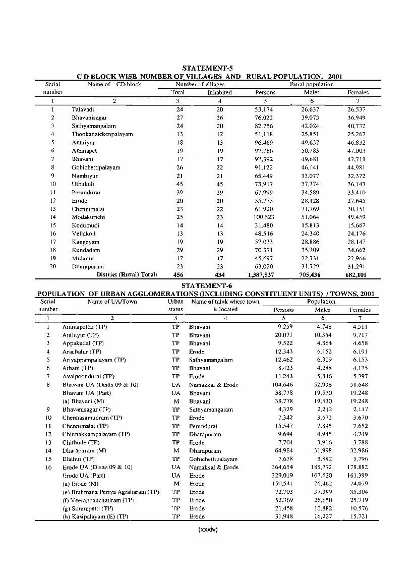
STA TEMENT-S C D BLOCK WISE NUMBER OF VILLAGES AND RURAL POPULATION, 2001
Serial Name of· CD block Number of villages Rural population number Total Inhabited Persons Males Females
2 3 4 5 6 7 Talavadi 24 20 53,174 26.637 26.537
2 Bhavanisagar 27 26 76.022 39,073 36.949 3 Sathyamangalam 24 20 82,756 42.024 40,732 4 Thookanaickenpalayam 13 12 51,118 25,851 25.267 5 Anthiyur 18 13 96.469 49.637 46.832 6 Ammapet 19 19 97.786 50.783 47.003 7 Bhavani 17 17 97,392 49,681 47,711 8 Gobichettipalayam 26 22 91, 122 46,141 44.981 9 Nambiyur 21 21 65,449 33,077 32,372 10 Uthukuli 45 45 73,917 37,774 36.143 11 Perundurai 39 39 67.999 34.589 33.410 12 Erode 20 20 55.773 28.128 27.645 13 Chennimalai 23 22 61,920 31,769 30.151 14 Modakurichi 25 23 100.523 51.064 49,459
15 Kodumudi 14 14 31,480 15,813 15.667 16 Vellakoil 13 13 48,516 24,340 24.176
17 Kangeyam 19 19 57,033 28.886 28.147 18 Kundadam 29 29 70,371 35.709 34.662 19 Mulanur 17 17 45,697 22,731 22.966 20 Dharapuram 23 23 63,020 31,729 31.291
District (Rural) Total: 456 434 1,387,537 705,436 682,101
STA TEMENT-6 POPULA TION OF URBAN AGGLOMERA TIONS ~INCLUDING CONSTITUENT UNITS) / TOWNS! 2001
Serial Name ofUAffown Urban Name of tal uk where town Population number status is located Persons Males Females
2 3 4 5 6 7
1 Ammapettai (TP) TP Bhavani 9,259 4,748 4,511
2 Anthiyur (TP) TP Bhavani 20,071 10,354 9,717 3 Appakudal (TP) TP Bhavani 9,522 4.864 4.658
4 Arachalur (TP) TP Erode 12,343 6,152 6,191
5 Ariyappampalayam (TP) TP Sathyamangalam 12,462 6.309 6,153
6 Athani (TP) TP Bhavani 8,423 4,288 4.135 7 A valpoondurai (TP) TP Erode 11,243 5,846 5,397
8 Bhavani UA (Distts 09 & 10) UA Namakkal & Erode 104,646 52,998 51,648
Bhavani UA (Part) UA Bhavani 38,778 19,530 19,248 (a) Bhavani (M) M Bhavani 38,778 19.530 19.248
9 Bhavanisagar (TP) TP Sathyamangalam 4.329 2,212 2.117
10 Chennasamudram (TP) TP Erode 7,342 3.672 3.670
II Chennimalai (TP) TP Perundurai 15,547 7.895 7.652 12 Chinnakkampalayam (TP) TP Dharapuram 9.694 4,945 4,749
13 Chi thode (TP) TP Erode 7,704 3.916 3.788
14 Dharapuram (M) M Dharapuram 64,984 31.998 32,986
15 Elathur (TP) TP Gob ichetti palayam 7,678 3,882 3,796
16 Erode UA (Distts 09 & 10) UA Namakkal & Erode 364,654 185,772 178,882
Erode UA (Part) UA Erode 329,019 167.620 161.399 (a) Erode (M) M Erode 150.541 76,462 74,079
(e) Brahmana Periya Agraharam (TP) TP Erode 72.703 37.399 35.304
(I) Veerappanchatiram (TP) TP Erode 52.369 26,650 25,719
(g) Surampatti (TP) TP Erode 21.458 10.882 10.576 (h) Kasipalayam (E) (TP) TP Erode 31,948 16,227 15.721
(xxxiv)

STATEMENT-6 (contd.) POPULA TION OF URBAN AGGLOMERA TIONS ~INCLUDING CONSTITUENT UNITS} / TOWNS: 2001 Serial Narne ofUAffown Urban N arne of taluk where town Population
number status is located Persons Males Females 2 3 4 5 6 7
17 Gobichettipalayarn (M) M Gobichettipalayarn 55.158 27,287 27,871
18 lambai (TP) TP Bhavani 15,011 7,722 7.289
19 Kangeyam (TP) TP Kangeyam 28,258 14,447 13,811
20 Kanjikoil (TP) TP Perundurai 11,040 5,570 5,470
21 Kannivadi (TP) TP Dharapurarn 4,412 2,194 2.218
22 Karumandi Chellipalayam (TP) TP Perundurai 20.072 9,839 10,233
23 Kasipalayarn (G) (TP) TP Gobichettipalayarn 8,570 4.345 4,225
24 Kembainaickenpalayarn (TP) TP Sathyarnangalarn 10,308 5,206 5,102
25 Kilarnpadi (TP) TP Erode 6,343 3.118 3,225
26 Kodumudi (TP) TP Erode 12.664 6,347 6.317 27 KolappaJur (TP) TP Gobichettipalayam 9.803 4,877 4,926
28 Kolathupalayarn (TP) TP Dharapurarn 17.438 8,704 8.734
29 Kollankoil (TP) TP Erode 8.754 4,393 4.361
30 Kuhalur (TP) TP Gobichettipalayarn 11,684 5,894 5.790 31 Kunnathur (TP) TP Perundurai 7.032 3.517 3,515
32 Lakkampatti (TP) TP Gobichettipalayarn 11,038 5,617 5,421
33 Modakurichi (TP) TP Erode 10,052 5,091 4.961
34 Mukasipidariyur (CT) CT Perundurai 11.012 5,502 5,510
35 Mulanur (TP) TP Dharapuram 13,827 6,913 6,914
36 Muthur (TP) TP Kangeyam 11,880 5,957 5,923
37 Nallampatti (TP) TP Perundurai 3,656 1,866 1,790
38 Narnbiyur (TP) TP Gobichettipalayarn 15,854 7,878 7,976
39 Nasiyanur (TP) TP Erode 9,905 5,005 4.900
40 Nerunjipettai (TP) TP Bhavani 6.925 3,549 3.376
41 Olagadarn (TP) TP Bhavani 9,370 4,823 4.547
42 Ottapparai (CT) CT Perundurai 9,208 4,678 4,530
43 P.Mettupalayam (TP) TP Gobichettipalayarn 9,115 4,557 4,558
44 PaUapalayam (TP) TP Perundurai 6,505 3,284 3,221
45 Pasur (TP) TP Erode 3,870 1,987 1.883
46 Periyakodiveri (TP) TP Gobichettipalayam 12.405 6,314 6.091
47 Periyasemur (TP) TP Erode 32,024 16.649 15.375
48 Perundurai (TP) TP Perundurai 16.943 8,440 8.503
49 Pethampalayam (TP) TP Perundurai 7.120 3,602 3,518
50 Punjaipuliampatti (TP) TP Sathyarnangalam 14,832 7,435 7,397
51 Rudravathi (TP) TP Dharapuram 6,107 3,177 2.930
52 Salangapalayam (TP) TP Bhavani 14,702 7,401 7,301
53 Sathyamangalam (M) M Sathyarnangalarn 33,722 17,124 16.598
54 Sivagiri (TP) TP Erode 16.255 8,236 8.019
55 Suriyampalayam (TP) TP Erode 21.923 11,398 10,525
56 Unjalur (TP) TP Erode 2.628 1,323 1.305
57 Uthukuli (lP) TP Perundurai 8.294 4,241 4.053
58 Vadugapatti (TP) TP Erode 10.921 5,417 5.504
59 Vaniputhur (TP) TP Gobich etti palayam 12,207 6,134 6,073
60 Vellakoil (TP) TP Kangeyam 34,438 17.284 17,154
61 Vellottamparappu (TP) TP Erode 8,131 4,085 4.046
62 Vengampudur (TP) TP Erode 7.632 3,791 3.841
63 Vijayapuri (CT) CT Perundurai 6,517 3.393 3.124
District (Urban) Total: 1,193,963 603,842 590,121
(xxxv)

ST A TEMENT-7 VILLAGES WITH POPULATION OF 5,000 AND ABOVE AT CD BLOCK LEVEL AS PER 2001 CENSUS
AND AMENITIES AVAILABLE
Talavadi
2 Talavadi
..... o
~ Z 2
3
4
5
6
7
8
9
Talavadi
Sathyamangalam
Sathyamangalam
Sathyamangalam
Sathyamangalam
Bhavanisagar
Anthiyur
10 Ammapet
11 Anthiyur
12 Anthiyur
13 Anthiyur
14 Anthiyur
15 Anthiyur
16 Anthiyur
17 Anthiyur
18 Ammapet
19 Ammapet
20 Ammapet
21 Ammapet
22 Ammapet
'23 Bhavani
24 Anthiyur
25 Bhavani
26 Bhavani
27 Ammapet
28 Ammapet
29 Bhavani
30 Bhavani
3 Mallankuli
Talavadi
Thingaloor
Guthiyalathur
Chilckar as ampalay am
Rajannagar
Ukkaram
Nallur
Burgur
Channampettai
Ennarnangalam
Anthiyur
Nagalur
Kuppandampalayam
Bramadesam
Pachampalayam
Gettisamudrarn
Mathur
Vellithiruppur
IlIipili
Kannappalli
PatIoor
Paruvachi
Vempathi
Punnam
Mylambadi
Kurichi
Kesarimangalam
Bhavani
Oricheri
4 5 6 7 8
<U OIl
2:l o u 9
Amenities available
10 11 12 13 14 15 00737700 5,050 No No 0 0 0 Yes No o 00738000 7,259 No Yes
00738400
00738800
00740800
, 00741000
00743300
00744400
5,286
14,213
6,880
5,553
9,345
7,549
00745200 15,874
00745700 9,379
00745900 7,535
00746100 15,889
No No 0
No No 0
No No 0
No No
No No 0
No No 1
No No 0
No No 1
No No 0
No Yes 0
o o o o o o o o o o o
o Yes No 2
Yes No 0 0
Yes No 0
o Yes No 0 0
o Yes No 0 0
I Yes No I 0
o Yes No 0 0
o Yes No 0 0
o I Yes No 0
o 0 Yes No 0
o Yes No 0 0
00746300 5,317 No No 0 0 0 0 Yes No 0 0
00746400
00746500
00746600
00746700
00746800
5,598
12,074
7,530
5,144
6,713
No No
No No
No No
No No 0
No No 0
o o o o o
o o o o
o Yes No 0
2 Yes No 2
o Yes No 0
o Yes No 0
Yes No 0
o o o
00746900 8,790 No No 0 0 0 Yes No 1 0
Yes No 2 0
Yes No 0 0
00747000 9,688 No No 0
00747100 5,651 No No 0 0 0
00747400 8,043
00747600 5,247
00747700 10,803
00748100 5,108
00748200 8,020
00748400 11,349
00749000 9,200
00749400 10,735
00749500 5,080
(xxxvi)
No No 0
No No I
No No 0
No No 0
No No
No No 0
No No 0
No No 0
No No
o o o o o o o o o
o Yes No I 0
o I Yes No 0 1
1 0 Yes No 0 0
o Yes No 0 0
o Yes No 0 0
o 1 Yes No 0 0
o Yes No I 0
o Yes No 0 3
o 0 Yes No 0 0

STATEMENT-7 Contd. VILLAGES WITH POPULATION OF 5,000 AND ABOVE AT CD BLOCK LEVEL AS PER 2001 CENSUS
AND AMENITIES AVAILABLE
31 Bhavani
32 Bhavani
33 Bhavani
34 Bhavani
.!<l U .9 .n Q U ....... o
~ Z 2
35 Thookanaickenpalayam
36 Thookanaickenpalayam
37 Thookanaickenpalayam
3 Kavandapadi
Odathurai
Urachikottai
Periyapuliyur
Kongarpalayam
Punjaithuraiyampalayam
Kandayam Palayarn
38 Thookanaickenpalayam Kannakkampalayam
39 Thookanaickenpalayam
40 Gobichettipalayam
41 Gobichettipalayam
42 Gobichettipalayam
43 Gobichettipalayam
44 Gobichettipalayam
45 Nambiyur
46 Gobichettipalayam
47 Gobichettipalayam
48 Gobichettipalayam
49 Nambiyur
50 Nambiyur
51 Uthukuli
52 Chennimalai
53 Chennimalai
54 Chennimalai
55 Chennimalai
56 Chennimalai
57 Erode
58 Erode
S9 Erode
60 Modakurichi
Perumugai
Kugalur
Alukkuli
Modachur
Kalingiam
Kottupullampalayam
Karattupalayam
Ayalur
Vellalankovil
Siruvalur
Kosanarn
Emmanpoondi
Chengappalli
Vadamugam Vellode
Kaudachipalayam
Thenmugam Vel lode
Ingur
Murungatholuvu
Elavamalai
Mettunastlvampalayam
Thindal(Kil )
Punjailakkapuram
4 5 6 7 8
00749800 25,172 No No 2
II) bIJ ~ '"0 u 9 o
Amenities available
10 11 12 13 14 15 2 Yes No 2 3
00749900 8,671 No No 0 0 2 Yes No 0
00750100 6,021 No No 0 0 Yes No 0 0
00750300
00750700
00750900
00751000
00751100
00751200
00751700
00752700
00753400
00753500
7,352
5,956
8,312
6,988
6,181
8,692
5,714
7,018
6,481
9,386
No No 0
No No 0
No No 1
No No 0
No No 0
No No 0
No No 0
No No 0
No No 0
No No 0
2
o o o o o o o o o
o o o o
o 1
o o
Yes No 0
Yes
1 Yes No
No 0
I
o o Yes No
Yes No 0
o
o o
2 Yes No I 0
1 Yes No 0 0
o ,Yes No 0 0
I Yes No 0 0
00753600 6,197 No No 0 0 0
o Yes No 0 0
Yes No 0 0
Yes No 0 0
Yes No 0 0
00753700 7,363 No No 0 0 0
00754400 5.610 No No 0 0
00754800
00754900
00755100
00755800
00761500
'00763400
00763600
00763700
00763900
5,475
7,493
6,582
5,563
5,937
8,292
5,364
7,696
5,651
No No 0
No No 0
No No 0
No No 0
No No 0
No No 1
No No 0
No No I
No No 0
00766100 7.378 No No 0
00767300
00767400
00768100
00769300
(xxxvii)
6.294
14,278
5.621
6.740
No No 0
No No 0
No No 1
No No 0
o o o o o
o o o
o o o o
o I
o o o
o
o
o Yes No I 0
1 Yes No 0 0
Yes No 0
Yes No 0 0
Yes No 2 0
Yes Yes I 0
Yes No 0 0
Yes No 1
Yes No 0
o 0 Yes No 0 0
o o 1
o
o Yes No 0
o Yes No 0
Yes No 0
Yes No
o I
o o

STATEMENT-7 Contd. VILLAGES WITH POPULATION OF 5,000 AND ABOVE AT CD BLOCK LEVEL AS PER 2001 CENSUS
AND AMENITIES AVAILABLE
..... o
2
61 Modakurichi
62 Modakurichi
63 Modakurichi
64 Modakurichi
65 Modakurichi
66 Modakurichi
67 Kodumudi
68 Kodumudi
69 Kangeyam
70 Vellakoil
71 Kangeyam
72 V ellakoi I
73 Vellakoil
74 Kundadam
75 Kundadam
76 Mulanur
77 Kundadam
78 Mulanur
79 Dharapuram
80 Dharapuram
Amenities available
3 4 5 6 7 8 9 10 11 12 13 14 15
Pudur 00769400 9,058 No No 000 Yes No
Thoyampoondurai 00769500 to,408 No No 0 0 Yes No
Modavandi SathiyamangaIam 00770000 7,039 No No 0 0 0 Yes No
o 0
o Nanjai Uthukuli
Punjaikalamangalam
Elumathur
KolathupaIayan
IchipaIayam
N athakkadaiyur
Mettupalayam
Sivanmalai
Pachapalayam
SenapathipaIayam
NilaIi
Surianallur
Kilangundal
Manurpalayam
Ponnivadi
Dhalavaipattinarn
Alagiyam
00770100 10,441 No No
00770500 8,158 No No
o 0 1 Yes Yes 0
o 00710800 8,543 No No 0 0
00711600 5,734 No No
00772400 5,617 No No
00713800 7,074 No No
o 0
o o
1 Yes No
1 Yes No
1 Yes No
2 Yes No
Yes No
00774500 5,927 No No 0 0 0 Yes No
00775100 7,135 No No 0 0 1 Yes No
00716000 5,111 No No o 0 0 1 Yes No
00776200 6,323 No No 0 o 1 Yes No
00776900 6,953 No No 0 0 0 0 Yes No
00777200 5,119 No No 0 0 0 0 Yes No
00779100 6,754 No No 0 0 0 Yes No
00780400 5,655 No No 0 0 0 Yes No
00782500 6,892 No No 0 0 0 1 Yes No
00782700 6,777 No No 0 0 2 Yes No
00782900 5,750 No No 0 0 1 Yes No
(xxxviii)
o
o
o o
o
o o 0
o 0
o 0
o 0
o o o o

STA TEMENT - 8
STATUTORY TOWNS WITH POPULATION LESS THAN 5,000 AS PER 2001 CENSUS AND AMENITIES AVAILABLE
Amenities available
'" .... Educational Medical Improved Communi- Banking I!.l
'" a drinking cation .... ::l
~ % water 1;J ::l '" I!.l 0- ..c
~ -"'i '0 t u _g ~ 0
"S ::0 (.)
~ en
S ca 0 ~ I': E-< U c ,_
~ .g "<:I 1:! 0 I!.l .~ .~ !:: °E .0 0 0 E S E-< 0 § ~ - (.) OJ .... OJ U '" ::l .... I': . ~ .... .... en <3 ~ ;>., c 0 0 I!.l I!.l I!.l -a -£3 £ ... bIl °a -£3 ro
<3 I!.l 8- 0 ~ ~ -"'i
~ '" I!.l I!.l ~ <3 c ·c ()
~ ~ 'a '0 '" OJ g. :a ro I!.l
Z .3 0 I!.l 0 :r:: i:Q en p... en U :r:: E-< ~
2 3 4 5 6 7 8 9 10 11 12 13
Bhavanai Sagar 41004000 4,329 No Yes No 3 No Yes No
2 Kannivadi 41063000 4,412 No ' No No No No 2 Yes No
3 Nallampatti 41029000 3,656 No No No No No Yes No
4 Pasur 41048000 3,870 No No No No No Yes Yes No
5 Unjalur 41055000 2,628 No No No No Yes Yes
(xxxix)

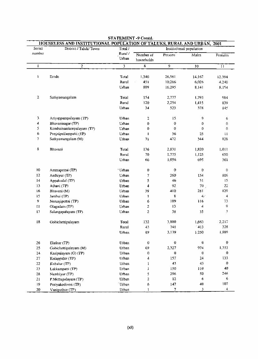
STATEMENT ·9 HOUSELESS AND INSTITUTIONAL POPULATION OF TALUKS, RURAL AND URBAN, 2001
Serial District / Taluk / Town Total / Houseless population
number Rural / Number of Persons Males Females Urban households
2 3 4 5 6 7
Erode Total 990 3,868 2,155 1.713 Rural 385 1,333 696 637 Urban 605 2,535 1,459 1,076
2 Sathyamangalam Total 220 794 407 387 Rural 211 769 395 374 Urban 9 25 12 13
3 Ariyapparnpalayam (TP) Urban 0 0 0 0 4 Bhavanisagar (TP) Urban 0 0 0 0 5 Kembainaickenpalayam (TP) Urban 0 0 0 0 6 PunjaipuJiampatti (TP) Urban 0 0 0 0 7 Sathyarnangalam (M) Urban 9 25 12 13
8 Bhavani Total 134 601 384 217 Rural 46 137 71 66 Urban 88 464 313 151
9 Ammapettai (TP) Urban 1 1 1 0
10 Anthiyur (TP) Urban 26 90 43 47 11 Appakudal (TP) Urban 4 20 9 11 12 Athani (TP) Urban 0 0 0 0
13 Bhavani (M) Urban 47 319 239 80
14 Jambai (TP) Urban 5 19 13 6 15 Nerunjipettai (TP) Urban 0 0 0 0
16 Olagadam (TP) Urban 5 15 8 7 17 Salangapalayam (TP) Urban 0 0 0 0
18 Gobichettipalayam Total 70 240 136 104 Rural 18 69 40 29 Urban 52 171 96 75
19 Elathur (TP) Urban 0 0 0 0
20 Gobichettipalayam (M) Urban 21 78 49 29 21 Kasipalayam (G) (TP) Urban 4 20 11 9
22 Kolappalur (TP) Urban 0 0 0 0 23 Kuhalur (TP) Urban 12 22 13 9 24 Lakkampatti (TP) Urban 0 0 0 0
25 Nambiyur (TP) Urban 9 38 15 23 26 P.Mettupalayam (TP) Urban 4 9 6 3 27 Periyakodiveri (TP) Urban 2 4 2 2
.28 Vaniputhur (TP) Urban 0 0 0 0
(xl)
STATEMENT -9 eontd. HOUSELESS AND INSTITUTIONAL POPULATION OF TALUKS, RURAL AND URBAN, 2001
Serial District I Taluk/ Town Total! Institutional population number Rural / Number of Persons Males Females
Urban households
2 3 8 9 10 II
Erode Total 1,340 26,561 14.167 12.394
Rural 451 10.266 6,026 4,240
Urban 889 16,295 8,141 8.154
2 Sathyamangalam Total 154 2,777 1.793 984
Rural 120 2,254 1,415 839
Urban 34 523 378 145
3 Ariyappampalayam (TP) Urban 2 15 9 6 4 Bhavanisagar (TP) Urban 0 0 0 0 5 Kembainaickenpalayam (TP) Urban 0 0 0 0 6 Punjaipuliampatti (TP) Urban 36 25 II
7 Sathyamangalam (M) Urban 31 472 344 128
8 Bhavani Total 136 2,831 1,820 1,011
Rural 70 1,775 1,125 650
Urban 66 1.056 695 361
10 Ammapettai (TP) "Urban 0 0 0 0
12 Anthiyur (TP) Urban 7 260 154 106
14 Appakudal (TP) Urban 5 46 31 15
13 Athani (TP) Urban 4 92 70 22
16 Bhavani (M) Urban 39 410 281 129
15 Jambai (TP) Urban 1 8 4,.' 4
9 Nerunjipettai (TP) Urban 6 189 116 73 II Olagadam (TP) Urban 2 13 4 9
17 Salangapalayam (TP) Urban 2 38 35 3
18 Oobichettipalayam Total 132 3,880 1,663 2,217
Rural 43 741 413 328
Urban 89 3,139 1.250 1.889
26 Elathur (TP) Urban 0 0 0 0 25 Oobichettipalayam (M) Urban 69 2,327 974 1,353
24 Kasipalayam (0) (TP) Urban 0 0 0 0
27 Kolappalur (TP) Urban 4 157 24 133
22 Kuhalur (TP) Urban I 43 43 0
23 Lakkampatti (TP) Urban 1 150 110 40
28 Nambiyur (TP) Urban 5 296 50 246
21 P.Mettupalayam (TP) Urban 2 12 6 6
19 Periyakodiveri (TP) 'Urban 6 147 40 107
20 Vaniputhuf (TP) Urban 7 3 4
(xli)

STA TEMENT ·9 Contd. HOUSELESS AND INSTITUTIONAL POPULATION OF TALUKS, RURAL AND URBAN, 2001
Serial District I Taluk ! Town Total! Houseless population number Rural! Number of Persons Males Females
Urban households
2 3 4 5 6 7
29 Perundurai Total 159 525 259 266 Rural 30 77 40 37 Urban 129 448 219 229
30 Chennimalai (TP) Urban 4 14 7 7 31 Kanjikoil (TP) Urban 92 317 156 161 32 Karumandi Chellipalayam (TP) Urban 0 0 0 0 33 Kunnathur (TP) Urban 9 38 18 20 34 Mukasipidariyur (Cl) Urban 0 0 0 0 35 Nallampatti (TP) Urban 9 31 13 18 36 Ottapparai (CT) Urban 7 25 13 12 37 Pallapalayam (TP) Urban 0 0 0 0
38 Perundurai (TP) Urban 7 21 11 10 39 Pethampalayam (TP) Urban 2 I 1 40 Uthukuli (TP) Urban 0 0 0 0
41 Vijayapuri (CT) Urban 0 0 0 0
42 Erode Total 208 934 593 341 Rural 31 104 58 46 Urban 177 830 535 295
43 Arachalur (TP) Urban 62 246 116 130 44 Avalpoondurai (TP) Urban 2 9 4 5 45 Brahmana Periya Agraharam (TP) Urban 0 0 0 0 46 Chennasamudram (TP) Urban 3 I 2 47 Chi thode (TP) Urban 0 0 0 0
48 Erode (M) Urban 63 368 276 92
49 Kasipalayam (E) (TP) Urban 6 27 14 13 50 Kilampadi (TP) Urban 0 0 0 0
51 Kodumudi (TP) Urban 7 7 7 0
52 Kollankoil (TP) Urban 0 0 0 0
53 Modakurichi (TP) Urban 8 30 17 13 54 Nasiyanur (TP) Urban 2 3 2 I
55 Pasur (TP) Urban 0 0 0 0
56 Periyasemur (TP) Urban 1 5 2 3 57 Sivagiri (TP) Urban 5 63 55 8 58 Surampatti (TP) Urban 0 0 0 0 59 Suriyampalayam (TP) Urban 18 66 39 27 60 Unjalur (TP) Urban 0 0 0 0
61 Vadugapatti (TP) Urban 1 2 1 62 Veerappanchatiram (TP) Urban 1 0
63 Vellottamparappu (TP) Urban 0 0 0 0
64 Vengampudur (TP) Urban 0 0 0 0
(xiii)

ST A TEMENT -9 Contd. HOUSELESS AND INSTITUTIONAL POPULATION OF TALUKS, RURAL AND URBAN, 2001
Serial District I Taluk I Town Total I Institutional population number Rural! Number of Persons Males Females
Urban households
2 3 8 9 10 II
29 Perundurai Total 164 4.047 2,178 1.869 Rural 96 2.123 1.706 417 Urban 68 1.924 472 1,452
30 Chennimalai (TP) Urban 3 76 38 38 31 Kanjikoil (TP) Urban 18 104 55 49 32 Karumandi Chellipalayam (TP) Urban 9 1.187 239 948 33 Kunnathur (TP) Urban 2 12 7 5 34 Mukasipidariyur (CT) Urban 2 13 7 6 35 Nallampatti (TP) Urban 2 13 6 7 36 Ottapparai (Cn Urban 0 0 0 0 37 Pallapalayam (TP) Urban 0 0 0 0 38 Perundurai (TP) Urban 31 513 117 396 39 Pethampalayam eTP) Urban I 6 3 3 40 Uthukuli (TP) Urban 0 0 0 0 41 Vijayapuri (Cn Urban 0 0 0 0
42 Erode Total 360 8,986 4.809 4.177 Rural 49 2.690 916 1.774 Urban 311 6,296 3,893 2,403
43 Arachalur (TP) Urban 17 331 101 230 44 A valpoondurai (TP) Urban 21 643 522 121 45 Brahmana Periya Agraharam eTP) Urban 8 113 38 75 46 Cheimasamudram (TP) Urban 1 6 4 2 47 Chi thode (TP) Urban 5 157 115 42 48 Erode (M) Urban 116 2.345 1,373 972 49 Kasipalayam (E) (TP) Urban 8 129 68 61 50 Kilampadi (TP) Urban I 6 3 3 51 Kodumudi eTP) Urban 5 191 100 91 52 Kollankoil eTP) Urban 0 0 0 0 53 Modakurichi (TP) Urban 9 133 114 19 54 Nasiyanur (TP) Urban 1 18 0 18 55 Pasur (TP) Urban 10 5 5
56 Periyasemur (TP) Urban 6 141 121 20
57 Si vagiri (TP) Urban 13 208 168 40
58 Surampatti (TP) Urban 4 63 17 46
S9 Suriyampalayam (TP) Urban 33 1,183 846 337
60 Unjalur (TP) Urban 0 0 0 0 61 Vadugapatti eTP) Urban 49 504 215 289
62 Veerappanchatiram (TP) Urban 13 1I5 83 32
63 Ve!lottamparappu (TP) Urban 0 0 0 0
64 Vengampudur (TP) Urban 0 0 0 0
(xliii)

STA TEMENT ·9 Conld. HOUSELESS AND INSTITUTIONAL POPULATION OF TALUKS, RURAL AND URBAN, 2001
Serial District! Taluk ! Town Total! Houseless population number Rural! Number of Persons Males Females
Urban households
2 3 4 5 6 7
65 Kangeyam Total 26 79 42 37
Rural 10 28 15 13
Urban 16 SI 27 24
66 Kangeyam (TP) Urban 15 49 26 23
67 Muthur (TP) Urban 0 0 0 0 68 Vellakoil (TP) Urban I 2
69 Dharapurarn Total 173 695 334 361
Rural 39 149 77 72
Urban 134 546 257 289
70 Chinnakkarnpalayam (TP) Urban 0 0 0 0
71 Dharapurarn (M) Urban 108 452 203 249
72 Kannivadi (TP) Urban 0 0 0 0
73 Kolathupalayarn (TP) Urban 4 24 14 10
74 Mulanur (TP) Urban 21 67 38 29
75 Rudravathi (TP) Urban I 3 2
ST A TEMENT ·9 Contd. HOUSELESS AND INSTITUTIONAL POPULATION OF TALUKS, RURAL AND URBAN, 2001
Serial District I Taluk ! Town Total! Institutional population number Rural I Number of Persons Males. Females
Urban households
2 3 8 9 IO II
65 Kangeyam Total 55 556 395 161
Rural 33 363 245 118
Urban 22 193 150 43
66 Kangeyam (TP) Urban 9 80 67 13
67 Muthur (TP) Urban 3 19 14 5
68 Vellakoil (TP) Urban 10 94 69 25
69 Dharapuram Total 339 3,484 1.509 1,975
Rural 40 320 206 114
Urban 299 3.164 1.303 1,861
70 Chinnakkampalayarn (TP) Urban 0 0 0 0
71 Dharapuram (M) Urban 285 3,079 1.260 1,819
72 Kannivadi (TP) Urban 4 19 9 10
73 KoJathupalayam (TP) Urban 3 20 11 9
74 Mulanur (TP) Urban 7 46 23 23
75 Rudravathi (TP) Urban 0 0 0 0
(xliv)
ANALYTICAL NOTE


ANALYTICAL NOTE
Analytical Note
(i) History and Scope of the District Census Handbook
The compilation of District Census Handbook is an innovation of the 1951 Census. District is considered as the most important unit for presentation
of Census data. Census Statistics are also compiled
for individual villages and towns, as they constitute
the basic units of human habitation. Besides this, some
other useful information pertaining to the land and the people has also been included in it to make it a
self-contained book of reference for the District. It
was, however, not altogether a new idea, since census data for smaller units were published in earlier censuses also in one form or the other. For the first
time in 1891 District wise list of villages Were published giving the population of each village. At the
1911 Census, data of villages were published in the
form of village directory. Such village directories were
again compiJed in the shape of District Census Statistics at the 1921 Census. Finally, District Census Handbooks emerged as regular decennial publication
since 1951 Census. The demand for the basic data for the smallest administrative unit was greatly felt in the post-independence era. The ushering in an era of planning and development in the wake of launching
of Five year plans after attaining independence, urgent
need for detailed data at village level was felt. Thus,
when the proposal to bring out District Census
Handbook was put before the State Government, they
readily agreed for the, compilation and printing of District Census Handbooks through their respective
Directors of Census Operations, under the authority of local government concerned. The general
appreciation and utility of this handbook encouraged
the Census Organisation to increase the scope of
publication.
The tradition thus built up has been continued in the present series of District Census Handbooks. In
the 1971 Census, it had been decided to bring out these hand books in three parts viz; Parts A, Band
C.
3
In respect of Tamil Nadu, Parts A and B of this
publication had been printed in one volume and part C as a separate volume. During 1981 Census, it had
been decided to print it in two parts viz. Parts A and B separately. Part A of this handbook consists of
village and Town Directory and Part B gives data on Primary Census Abstract (PCA). In 1991 Census also,
the same pattern was adopted publishing Parts A and B in a single Idouble volumes as per the requirement
and determining the size of the publication. However,
in this census some of the non-census data included are information on girl schools, social forestry areas etc. whereas items like staple food and information
on newspapers etc. have been omitted.
In the present Census, the District Census Handbook is being brought out in two volumes which
contain the village and town directory and also the Primary Census Abstract and it should certainly
quench the thirst of the planners involved in micro level planning. Similarly, additional data revealing civic and other amenities in Class I t,own has been
presented especially in respect of slum dewellers. Scholars and planners alike may benefit from the
data on amenities.
(ii) Brief History of the District
Erode district was a part of Coimbatore district.
The history is intertwined with that of Coimbatore.
It has close linkage with the erstwhile Coimbatore district. It is very difficult to separately deal with the
history of Erode Region. Together with the area comprised in the Coimbatore district, it formed part
of the ancient Kongu country known as "Kongunadu",
history of which dates back to the Sangam era. It is
found that in the early days, this area was occupied
by tribes, most prominent among them being the
"Kosars" reportedly having their headquarters at "Kosamputhur" which is believed to have in due course become Coimbatore. These tribes were overpowered by the Rashtrakutas from whom the
region fell in to the hands of the Cholas who ruled
supreme during the time of Raja Raja Chola. On the decline of Chotas, the Kongunadu came to be occupied by the Chalukyas and later by the Pandya and Hoysalas. Due to internal disessension in the
Pandian Kingdom, the Muslim rulers from Delhi interfered and thus the area fell in to the hands of
Madurai Sultanate. This region was later wrested by
Vijayanagar rulers after over throwing Madurai
Sultanate. For a few years, the area remained under Vijayanagar rule and later under the independent
control of Madurai Nayaks. The rule of Muthu Veerappa Nayak and later that of Thirumalai Nayak
were marked by internal strife and intermittent wars which ruined the Kingdom.
(iii) Administrative set up
Erode district came in to being as a result of the bifurcation of Coimbatore district, through the GO.Ms.
No. 1917, Revenue, dated 31.8.1979. Bhavani, Dharapuram, Erode and Sathyamangalam Taluks
were included in Erode district, which had a composite character at the beginning of the century. Of these, Sathyamangalam Taluk was renamed as GobichettipaJayam Taluk retaining Sathyamangalam
as a sub Taluk in 1975. Then Sathyamangalam sub taluk was upgraded in to a taluk. Soon these five
taluks were grouped together to constitute the new district of Erode.
Subsequently, Erode taluk has been divided in to
Erode and Perundurai whiile Dharamapuram tal uk
divided in to Dharapuram and Kangeyam. Now, Erode district consists of 7 taluks viz., Sathyamangalam,
Bhavani, Gobichettipalayam, Perundurai, Erode, Kangeyam and Dharapuram.
There are 456 revenue villages (434 habited and 22 uninhabited) in the district. The district consists of 59 Town Panchayats, 5 Municipalities, 343 village Panchayats and 20 Panchayat Unions. There are 11
Legistrative Assembly Constituencies (2 for SCs) and
one Parliamentary Constituency in the district.
The following table gives the name of Revenue divisions. Taluks, No. of towns, C.D. Blocks, No. of
Villages and inhabited Villages.
4
DISTRICT CENSUS HAND BOOK ERODE
Name of the ~ Name of the ... Name of the
C.D.B1ock. Revenue Q
Taluks Eo-< Division
Gobichettipalayam
Sathyamangalam
Bhavani
Gobichettipalayam
Erode Perundurffi
Erode
Dharapuram Kangeyam
Dharapuram
3 7
(iv) Physical features
5 Talavadi
9 Sathya· mangalam
10 Bhavani Sagar
12 Anthiyur
22 Ammapet
3 Bhavani
6 Thookanaicken-palayam
Gobichettipa1ayam
Nambiyur
Uthukuli Perundurai
Chennimalai
Erode Modakkurichi
Kodumudi
Kangeyam
Vellakoil
Kundadam
Mulanur
Dharapuram
67 20
24 20
24 20
27 26
18 13
19 1 ()
17 17
13 12
26 22
21 21
45 45 39 39
23 22
20 20 25 23
14 14
19 19
13 13
29 29
17 17
23 23
456 434
Erode District situated at between 100.36" and 110.58" North.latitude and between 760.49" and 77°.58"
East longitude. The region comprised ill the district can be portrayed as a long undulating plain gently
sloping towards the river Cauvery in the south east. The three major tributaries of river Cauvery viz.,
Bhavani, Noyyal and Amaravathy drain the long stretch of mountains in the north. A part of the eastern boundary of the district is formed by river Cauvery, entering the district from Salem and flowing
in a southemly direction.
ANALYTICAL NOTE
Physiography
By and large the region comprised in the district
could be described as a long undulating plain gently
sloping towards the river Cauvery in the south. T~e
long stretch of mountains in the north which slopes gradually is drained by the three major tributaries of
river Cauvery. viz.,Bhavani. Noyyal and Amaravathy. Cauvery which enters the district from Salem runs in
a southernly direction forming part of the eastern boundary of the district.
Drainage
Bhavani, Cauvery, Amaravathy and Noyyal are
the main rivers of the district. Other significant rivers are Palar in the North, Vatlamodai and Uppar rivers
in the south. Palar constitutes the boundary between Erode district and Karnataka State in the North. The
Bhavani Sagar main canal along with the above
mentioned rivers provide proper drainage and facilities
for assured irrigation in the district. Bhavani rises in
the silent valley in Palghat ranges in the neighbouring
State of Kerala after receiving Siruvani, a perennial
stream of Coimbatore district and gets reinforced by
the Kundah river before entering Gobichettipalayam. in Erode district.
Bhavani is more or less a perennial river fed
mostly by the South West monsoon. North East
monsoon also supplements its water resources. This river runs for over hundred miles through Erode
district traversing through Bhavani and
Gobichettipalayam taluks. It feeds the Bhavani Sagar reservoir. which takes an easterly course flowing through Gobichettipalayam. Sathyamangalam and
Bhavani taluks before it ultimately joins river Cauvery the Namakkal district borders.
Many small tributaries join Cauvery rising in the Coorg. It turns through Karnataka and at Hogenakal
falls takes a sharp turn, east to south. Before reaching
this point, its main tributary, viz., river Kabini joins it. From hcre it takes a Southeasterly direction forming
the boundary between Bhavani taluk of Erode district and Tiruchengode taluk of the neighbouring Namakkaldistrict. After river Bhavani flows into it.
5
the southeasterly course is continued forming the
boundary between Erode taluk and Tiruchengode taluk
of Namakkal district.
Noyyal River is noted for its capricious nature.
This is fed mostly by the Southwest monsoon but the Northeast monsoon brings freshes and this very often
results in floods. In spite of its unpredictable character. the river helps irrigating considerable areas in
Palladam taluk of Coimbatore district and Dharapuram taluk of Erode district.
River Amaravathy, which rises in the Travancore
region of Kerala State, enters Erode district from Udumalaipettai taluk in Coimbatore district. This river flows through Dharapuram before it joins Cauvery in
Karur district.
Climate
The district in general is characterized with a scanty rainfall and a dry climate. Maximum rainfall
is recoreded in Gobichettipalayam and Bhavani
Taluks. The Palghat Gap in the Western Ghats, which
has a soothing effect in the climate of Coimbatore district, does not render much help in bringing down
the dry climate in this area. The cool wind gushes out of west coast through Palghat gap looses its
coolness and becomes dry by the time it crosses Combatore district and reaches Erode region.
Unlike Coimbatore, which is blessed with a health-aiding climate, Erode district has dry weather
throughout except during the monsoon season.
Generally the first two months of the year are
pleasant. but in March, Mercury gains an upward trend, which persists till the end of May. Highest
temperature is normally recorded during May. The scanty showers during this period do not provide any
relief to the oppressive heat. There is a light improvement in the climate during June to August
period. During this pre-monsoon period, the Mercury reverses its trend and by September, this sky gets
overcast heavily but the rains are meager. North East
monsoon sets in vigorously only during October, November and by December, the rains disappear rendering the climate clear but pleasant.

( Rainfall in millimetre) South West Monsoon
Jun-Sep 1999
Actual
96.4
Normal
194.9
Winter Season Jan-Feb 2000
Actual
39.9
Forests
Normal
25.4
North East Monsoon Oct-Dec 1999
Actual
427.2
Normal
321.9
Hot Weather Mar -May 2000
Actual
68.5
Normal
153.8
Wi th more than 2,34180 hectares of land under dense forest, Erode is one of the few districts in the State, which can boast of extensive forest area as 28% of the total district area is under forests. These forests are rich in commercially significant items such as teak, sandalwood, rosewood, vogai, pillaimarathu etc., Sandal wood is abundant in Moyar valley and in strips facing Dodda Combai in Thalamalai ranges. Tamarind trees are plenty in Bhavani ranges. In high land forests of elevation 2,000 feet to 5,000 feet, diversified flora are prevalent. Here we find semi evergreen type, teak type, sandal type, bamboo type and shola type of vegetation.
Teak is available mostly in ranges of 3,200 feet to 3,600 feet height. Important places where bamboo available are in the outer slopes of North Coimbatore Plateau between 1,500 feet to 3,000 feet elevation. Main centres of availability is at Vadaparai and Hussanur basin in Sathyamangalam ranges. Dodda Combai in Bhavani ranges is also significant for the availability of bamboo.
The district is rich in fauna. It is varied and all the common species normally found in ranges and plains in the south are found to occur in this district. Significant is the presence of wild elephants and tigers especially on the hills in the northern or northeastern parts of the district. Cheetahs are not all together ibsent. They are sparsely distributed. Panthers are found in the scrub jungles and rocky hills of the district. Spotted deer, barking deers, jungle sheep etc., are normally present in the northern ranges.
The presence of Kangeyam breed of cattle noted for their milk yield and draught is significant. The
6
DISTRICT CENSUS HAND BOOK: ERODE
Bargur cattle found in Bhavani ranges though small in size, are well built and sturdy.
Minerals
Though the district cannot boast great mineral wealth, it has a few varied items of signi ficance. Both opaque and translucent varieties of fine quality of Feldspar are found abundantly in Erode tal uk. Mica and Muscovite occur in Vairavamangalam near Bhavani and near Punjai Puliampatti respectively. Asbestos is found to occur in a few places of Bhavani and Perundurai. Doddan Combai forest in Gobichettipalayam is bestowed with rich iron ore. This ore is found to be of very fine quality and rich in metal. Traces of gold also have been found in a few auriferous viens in Gobichettipalayam.
Soil
The soils of the district are mostly red sand and gravel with moderate amounts of red-loam and occasional black loam tracts. Vast stretches of the upland regions are mostly stony and gravelly. Redloam occurs mostly in land under Kalingarayan channel and its beds of tanks in Erode taluk and to some lesser extent in the valleys in Perundurai and Dharapuram taluks. It also occurs in the hilly tracts of Bhavani taluk.
Soils of Bhavani, Erode, Dharapuram and Perundurai taluks are chiefly gravelly, stony and sandy of the red variety. Soils of Gobichettipalayam and Sathyamangalam taluks are mostly of the red sandy variety. Red loam is prevalent mostly in
Gobicheuipalayam and Perundurai taluks.
Land and Land Use Pattern
As per the revenue land records, the total geographical area of the district is 8,20,961.30 hectares. Out of this 85.32% under rural and 14.68% under urban.
Of the total area in the district, 33.43% under forest, 37.88% under cultivable, 19.55% as cultivable waste, groves and gauchers and 9.14% as area not available for cultivation.
Out of 37.88% of cultivable area, 17.73% of the areas are irrigated and 20.15% as un-irrigated.
The following table shows the details of land and land use pattern of Erode district.

ANALYTICAL NOTE
Classification of land use Area in Percentage
Hectares
Forests 234,180.4 33.4
lrrigated 124,207.0 17.7
Un-irrigated 141,101.0 20.2
Cultivable waste and groves 136,949.6 19.6 & gaucher
Area not availavle for 64,000.3 9.1 cultivation
Rural Total 700,438.3 85.3
Urban Total 120,523.0 14.7
Erode District Total 820,961.3 100.0
Agriculture
Though noted for trade and industry, the district is by no means backward in the field of agriculture. Close association and link with Coimbatore district, which has the advantage of two premier agricultural Institutions viz., the Agricultural College and 'the Research Institute, have helped the ryots to keep abrest of developments in agricultural methods and practices and also improved strains of seeds. The publicity and developmental activities launched by the agricultural Institutions in Coimbatore penetrated far and wide in Erode district. Added to this was the propaganda and demonstration organized by the agricultural department. Availability of irrigation facilities coupled with the awareness of improved methods of farming helped the agriculturists to forge ahead. Though the soil is not the best, utilisation of improved methods of cultivation and improved strains of seeds together have helped the agriculturists in the district to maximise their output.
Pulses are not much in cultivation in the district. Only 31,498 hectares are used for raising pulses. Among condiments and spices turmeric and chillies are significant. Cultivation of turmeric extends <?ver 14,533 hectares.
Cropping pattern
Paddy is grown in 57,964 hectares. Next to paddy is Ragi, raised in 12,683 hectares. Cholam is also popular among the agriculturists, cultivated in 11,245 hectares. Food Crops account for 49.03% of
7
the total area cropped in the district. Cereals account for 77.43% of the area under food crops. Paddy is the main crop raised under cereals. Paddy accounts for 67.54% of the total area under cereals.
Out of 1,10,840 hectares of cultivation of food grains, 22.57% of the areas are pulses.
Among other non-food crops raised here, the most important items are groundnut (55,577 hectares), sugarcane (29,663 hectares), and cotton (11,946 hectares).
The following table gives the area under crops (in hectares) and their production (in MT) 1998-99.
Crop Area (in He) % Of total Production
Paddy
Cholam
Cumbu
Ragi
Maize
Other Cereals
Total Cereals
Green Gram
Red Gram
Black Gram
Bengal Gram
Horse Gram
Other Pulses
Total Pulses
Total Food grains
Sugarcane
Cotton
Ground nut
Gingelli
Castor
Horticulture
57,964
11,245
1,559
12,683
2.276
92
85,819
3,770
1.548
1,427
12
6,639
11,625
25,021
110,840
29,663
11,946
55,577
16,058
1,976
area sown (in MT)
17.57 272,600
3.41 10.190
0.47 2,560
3.85 13.660
5,280
304.290
8.500
8.99 403,030
3.62 26.300
16.85 102.640
4.87 12.970
In 1998-99, the area under various horticultural crops in the district were as follows:
Crop Area in Hectares Production (in MT)
I.Banana 4.853 217.798
2.0nion 1,906 18.793
3.Turmeric 12.845 73.962
4.Tapioca 4,489 181.986
5.Chillies 1,148 706

Sericulture
The total area under mulberry cultivation as on
1.4.2000 was 715.50 hectares. The area under irrigation was 530.84 hectares and under rain fed was
184.66 hectares. The total production of reeling cocoons was 4585 MTs, valid at Rs. 458.50 lakhs.
The production of raw silk in the same year was 0.483
MTs, valid at Rs. 579.16 lakhs.
Irrigation
The sub-soil in most parts of the district being
sandy and surface soil thin and of poor quality, the farmers have to depend heavily on irrigation facilities.
The uncertain aspects of Northeastern monsoon and not too favourable contribution from the Southwest
monsoon make the plight of local agriculturists miserable. The chief sources of irrigation in the district
dre the canals and wells and these constitute the main
stay of the farmers.
Major source of water supply for irrigation in this
District are as follows.
Irrigation Source
Canals
Irrigation Wells
Tube Wells
Reservoirs
Tanks
Number I Length in Kms.
131772
105,826
132
7
52
Rivers rising in the Western Ghats and fed mostly by the southwest monsoon are the chief sources of
irrigation in the district. These rivers are Cauvery,
Amaravathy and Noyyal. Apart from these main rivers there are a few uncertain jungle streams, which al~o contribute towards better irrigation and drainage in a
small way. The main irrigation projects of the district
are the Amaravathy reservoir project and the lower
Bhavani project. Amaravathy River with a number
of small anaicuts across it contributes to the irrigation
potential. The numerous small canals from Amaravathy have been reconditioned to grow more
food crops. The Amaravathy reservoir project proved to be a boon to the agriculturists in the district
especially Dharapuram area.
8
DISTRICT CENSUS HAND BOOK: ERODE
Out of 1,24,207.03 hectares of irrigated areas Government Canal irrigation contributes 48.20% and
well to 46.3%.
The following table gives the source wise net area irrigated in 1998-99.
Irrigation Source Area in Percentage Hectares
Govt. Canals 59,861.6 48.2
Tanks 177.3 0.1
Tube Well (with electricity) 2.258.5 1.8
Well (with electricity) 52,025.7 41.9
Well (without electricity) 5,501.1 4.4
Other Sources 4,382.8 3.5
Total 124,207.0 100.0
Animal Husbandry
The district is rich in cattle wealth and concerted
efforts of the Animal Husbandry Department have
further augmented the cattle wealth in the District.
There are 4 major breeds of cattle in the district. They are the Kangeyam breed, the Borgur breed,
the Kollegal variety and the Alanbodies. Kangeyam breed of cattle is indigenous to Coimbatore. The animal is breed in the farm in order to supplement
the efforts of private breeders. Like the Pattagar of Palayakottai, Kangeyam thrive well in the farm. Some
of the cows have yielded more than 4,000 Ibs. in a single lactation. Kangeyam cows are reared in large
numbers, due to their rich milk yield. Kangeyam bulls are also noted for their draught capacity. Borgur breed though smaller in size are well built and sturdy,
KoUegal variety is noted for their road draught and
is normally reared for transport purposes.
With varieties of breeds available, the district has
made rapid progress in the field of animal husbandry.
Erode has carved out an enviable position for itself in the field of dairy development industry in the State.
The Tamil Nadu milk producers Federation has a milk collection center and processing plant at Erode from where pasturised milk is transported in cases to different parts of the State everyday.

ANALYTICAL NOTE
To support the growing cattle wealth in the district,
Animal Husbandry Department has been various
measures including opening and maintenance of 5 bull stations for the collection and supply of serum to
various veterinary hospitals and artificial insemination centres. Apart from these bull stations, the department
maintains the following:
l. Veterinary hospitals
2. Veterinary dispensaries
3. Veterinary sub-centres
4. Clinical centres
5. Clinical veterinary laboratory
6. Mobile Units 7. MobIle Dispensaries (Panchayat Union)
8. ADIV
9. CBFD
IO.Squad
II. Vigilance
12.Check Post
10
50
107
2
I 4
20
Rinderpest Squad stationed at Erode, Rinderp
est Vigilance unit at Gobichettipalayam and Rinderpest checks post at Dimbum are all engaged in the eradication of Rinderpest disease in
the district. The district can also boost of a sheep breeding co-operative society.
As regards poultry development is concerned,
there are three Poultry Extension centres in the district.
They are at Chengampalli, Palavakulipalaiyam and Bhavani Sagar.The Poultry diagnostic laboratory in
the district facilities early diagnosis of various diseases
affecting the poultry and thus helps to prevent heavy
losses due to poultry diseases. The followipg information shows the number of cattle and poultry
in Erode district.
SI.No Animals Number
1 Cows 361,089
2 Buffaloes 267,132
3 Sheep 392,912
4 Goats 311,194
5 Poultry 1,378,671
6 Pigs 11,198
The activities of the Animal Husbandry
Department are controlled by 3 Assistant Directors of Animal Husbandry functioning from Erode,
Dharapuram and Gobicheuipalayam. 9
Fisheries
The Inland fisheries are the only resource for fishermen. Being a landlocked district, there are no changes for marine fishing. As such opportunities for fishing are restricted. With the help and encouragement by the fisheries department rapid strides have been made in the development of fisheries in the district. Special emphasis is laid on the formation of fishermen co-operatives and familiarising the local fishermen with the improved methods. With the help of the co-operative organisation, which assured deep involvement of the fishermen, a number of co-operative organisations have been formed. The activities of fisheries department in the district are being guided and controlled by the Assistant Director of Fisheries stationed at Bhavani Sagar. As per the records of Director of Statistics, 1095 tonnes of fishes have been
yielded during 1998-99.
Industry
In the Industrial Map of Tamil Nadu, Erode district has a place of unique importance with more than 30% of population depending on non-agriculture sector. Industries and Trade naturally occupied a place of prominence in the economy of the district. Industries that flourished in early days in the area were handloom weaving, carpet manufacturing. cart manufacturing, oil pressing brass vessel manufacturing etc., Though these industries flurished well in the early days, the advent of modern time changed the fate of some of these well established ancient industries. Dharapuram which was noted for the manufacture of load carrying and passengers carts lost its importance due to the advent of modern means of transport of two wheelers viz., cycle, scooter, mopped etc.,.However, the industry still survives here and load-carrying carts are still manufactured. Similarly, Bhavani, which was noted world over for its very beautiful carpets, has shrunk in to insignificance and the industry is almost non-existent now. Bhavani. Erode and Gobichettipalayam contribute to occupy important places in the fieldof oil pressing. The industry which hs been able to totally withstand the on slaught of modernisation has been the handloom weaving. Erode, Chennimalai etc., still hold that way and the district is noted for its handloom products,

vhich include cotton sarees, bedspreads, towels, fumising fabrics etc. Two other important production I..entres are Bhavani and lambai.
It is reported that more than 60,000 looms are functioning in Erode district. There are 132 coI)perative societies covering 33,485 looms. This accounts for 55% of the total looms in the district.
The cotton textile industry in Coimbatore arid handloom industry in Erode district have encouraged the growth of various ancillary industries to meet the needs of the textile mills. Chennimalai, Erode, Gobichettipalayam etc. are important centres where .::otton ginning is carried on a large scale. There are also important dyeing works in Erode, Chennimalai and Bhavani. A number of factories engaged in cotton fabrics printing are functioning in Erode.
Rice Milling is yet another industry which has been able to hold its own. Erode, Bhavani and Dharapuram are centres where a number of rice mills are flourishing. More than 50% of the rise mills are located in Uttukuli, and in Perundurai taluk. These Mills carryon lucrative trade in the west coast. A number of lorries carrying boiled rice ply between the centres and the delivery point in Kerala. There are a number of leather tanneries in Erode and Dharapuram area. Large quantities of leather are brought here for tanning and later exported to foreign countries.
There are two sugar mills, located one in Sathyamangalam taluk and another in Bhavani talllk of this district.
The Government has also come forward to provide incentives to small enterprises. Industrial estates have been set up at Erode and other places, where full facilities are offered to small industrialists. Small units have been set up here for the manufacture of steel furniture, nuller screen etc. There is also a unit at Erode for the manufactures of bolts and nuts and screws.
Trade and Commerce
Both manufactured items as well as agriculture l:ommodities are included in the trade items. Major items of export from the district are handloom
10
DISTRICT CENSUS HAND BOOK: ERODE
products, dairy products, raw cotton, rice etc. while the items brought are mostly oil seeds, coal etc. A large number of lorries carrying various items in to and from ply day in and day out.
Regulated Markets
There are 23 regulated markets and 6 subregulated markets in Erode district for transaction and marketing of products.
Fair price shops
There were 1010 fair price shops in this district; 892 of this were full time and 118 part times. Of this, Tamil Nadu Civil Supply Corporation runs 15 shops and 995 shops by the co-operative department. This district also has five women fair price shops.
Transport and communication
The transport and communication system in Erode district is well developed. Erode being one of the prominent trading centres in the State is well connected with all modern means of transport and communication except for air service. The nearest airport is at Coimbatore. Direct access by roads and rail from Chennai and other district headquarters is available. Erode is an important railway junction on the west-coast line. The broad gauge line between Chennai and Erode junction is fully electrified. All passengers' trains from Chennai to the West Coast halt here. There are 13 railway stations in the district viz., one at Uttukuli, 3 in Chennimalai Panchayat Union, 3 in Modakkurichi Panchayat Union and 6 in Kodumudi Panchayat Union areas.
Road Transport has developed by leaps and bounds. There are numbers of inter district bus routes operated by the Nationalised Transport Corporations linking Erode and other prominent places in Erode district with places of significance outside the district. Out of the 434 inhabited villages in the district, bus facility is available for 397 villages. While 37 villages have to go to the nearby places to catch the bus.
There were 18,624 commercial vehicles and 2,03,957 non-commercial vehicles registered in Erode district in 1999-2000.
The following table gives the details on vehicles:
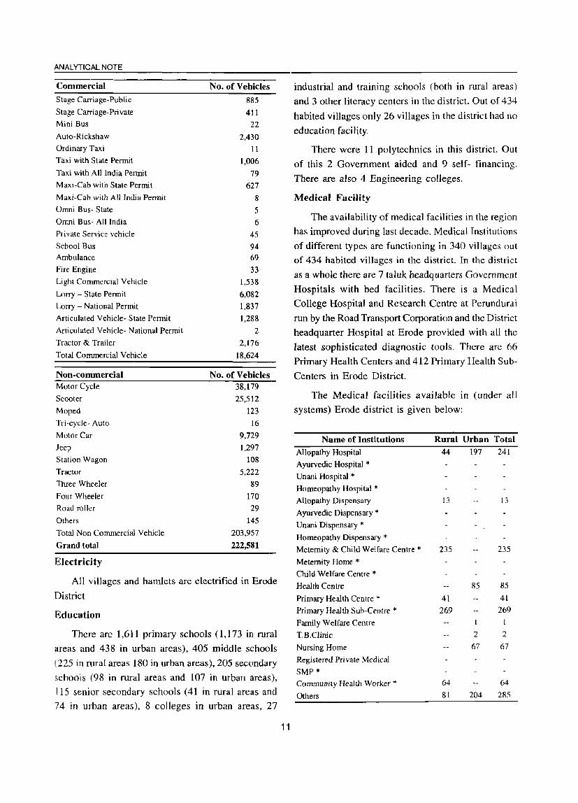
ANALYTICAL NOTE
Commercial
Stage Carriage-Public
Stage Carriage-Private
Mini Bus
Auto-Rickshaw
Ordinary Taxi
Taxi with State Permit
Taxi with All India Permit
Maxi-Cab with State Permit
Maxi-Cab with All India Permit
Omni Bus- State
Omni Bus- All India
Private Service vehicle
School Bus
Ambulance
Fire Engine
Light Commercial Vehicle
Lorry - State Permit
Lorry - National Permit
Articulated Vehicle- State Permit
Articulated Vehicle- National Permit
Tractor & Trailer
Total Commercial Vehicle
Non-commercial Motor Cycle
Scooter
Moped
Tri-cycle- Auto
Motor Car
Jeep
Station Wagon
Tractor
Three Wheeler
Four Wheeler
Road roller
Others
Total Non Commercial Vehicle
Grand total
Electricity
No. of Vehicles
885
411
22
2,430
11
1,006
79
627
8
5
6
45
94 69
33 1,538
6,082
1,837 1,288
2
2,176
18,624
No. of Vehicles 38,179
25,512
123
16
9,729
1,297
108
5,222
89
170
29
145
203,957
222,581
All villages and hamlets are electrified in Erode
District
Education
There are 1,611 primary schools (1.] 73 in rural
areas and 438 in urban areas), 405 middle schools
(225 in rural areas 180 in urban areas). 205 secondary
schools (98 in rural areas and 107 in urban areas).
115 senior secondary schools (41 in rural areas and
74 in urban areas). 8 colleges in urban areas. 27
11
industrial and training schools (both in rural areas)
and 3 other literacy centers in the district. Out of 434
habited villages only 26 villages in the district had no
education facility.
There were 11 polytechnics in this district. Out
of this 2 Government aided and 9 self- financing.
There are also 4 Engineering colleges.
Medical Facility
The availability of medical facilities in the region
has improved during last decade. Medical Institutions
of different types are functioning in 340 villages out
of 434 habited villages in the district. In the district
as a whole there are 7 taluk headquarters Government
Hospitals with bed facilities. There is a Medical
College Hospital and Research Centre at Perundurai
run by the Road Transport Corporation and the District
headquarter Hospital at Erode provided with all the
latest sophisticated diagnostic tools. There are 66
Primary Health Centers and 412 Primary Health Sub
Centers in Erode District.
The Medical facilities available in (under all
systems) Erode district is given below:
Name of Institutions Allopathy Hospital
Ayurvedic Hospital * Unani Hospital * Homeopathy Hospital * Allopathy Dispensary
Ayurvedic Dispensary * Unani Dispensary * Homeopathy Dispensary * Meternity & Child Welfare Centre * Metemity Home * Child Welfare Centre * Health Centre
Primary Health Centre * Primary Health Sub-Centre * Family Welfare Centre
T.B.Clinic
Nursing Home
Registered Private Medical
SMP*
Community Health Worker * Others
Rural Urban Total 44 197 241
13
235
41
269
64
81
85
I
2
67
204
13
235
85
41
269
I
2
67
64
285

Post & Telegraph
A good network of Post and Telegraph Offices arc found in the district. There are 2 postal divisions
serving the district with their headquarters at Erode and Dharapuram. Under the control of these postal divisions, there are 4 Head Post Offices, one each at Erode, Bhavani, Gobichettipalayam and Dharapuram.
Apart from the above, 363 villages had postal
facilities and 20 had both Post & Telegraph facilities. It is surprisingly noticed that out of 434 inhabited
villages, 99% of the villages have Phone facilities.
The table gives the comparative picture on post
,and telegraph facilities available in the district of 1991 and 2001.
1991 (Villages) 2001 (Villages)
P.O 289 363
T.O 4 P.T.O 56 20 Phone 31 428
Commericial Bank
There were 203 commercial Bank branches in this district as on 31.3.99, 101 were located in rural areas and 102 in semi-urban and urban areas. The deposits as on the same date was Rs. 1,786.97 crores. In addition there were 46 co-operative banks, 157 agriculture credit societies, 103 non-agriculture credit societies and 12 other credit societies in the rural areas of this district
Police
There were 43 Police Stations and 3 Women Police Stations in this district. There wyre also 10 Fire Stations in this district.
DISTRICT CENSUS HAND BOOK: ERODE
12

ANALYTICAL NOTE
(v) Census Concepts
Building
A 'Building' is generally a single structure on the ground. Sometimes it is made up of more than one component unit which are used or likely to be used as dwellings (residences) or establishments such as shops, business houses, offices, factories, workshops,
worksheds, Schools, places of entertainment, places of worship, godowns, stores etc. It is also possible that building which have component units may be used for a combination of purposes such as shop-cum-residence, workshop-cum-residence, office-cum-residence etc.Usuallya structure will have four walls and a roof. But in some areas the very nature of construction of houses is such that there may not be any wall. Such is the case of conical structures where entrance is also provided but they may not have any walls. Therefore,
such of the conical structures are also treated as separate buildings.
Permanent houses
Houses, the walls and roof of which are made of permanent materials. The material of walls can be any one from the following, namely, galvanized iron sheets or other metal sheets, asbestos sheets, burnt bricks, stones or concrete. Roof may be made of from any one of the following materials, namely, tiles, slate, gal vanized iron sheets, metal sheets, asbestos sheets, bricks, stones or concrete.
Semi-permanent houses
Houses in which either the wall or the roof is made of permanent material and the other is made of temporary material.
Temporary houses
Houses in which both walls and roof are made of materials, which have to be replaced frequently. Walls may be made from anyone of the following temporary materials, namely, grass, thatch, bamboo, plastic, polythene, mud, unburnt bricks or wood. Roof may be made from anyone of the following temporary materials, namely, grass, thatch, bamboo, wood, mud, plastic or polythene.
Dwelling Room
A room is treated as a dwelling room if it has walls with a doorway and a roof and should be wide and
13
long enough for a person to sleep in, i.e. it should have a length of not less than 2 meters and a breadth of at least 1.5 meters and a height of 2 meters. A dwelling room would include living room, bedroom, dining room, drawing room, study room, servant's room and other habitable rooms. Kitchen, bathroom, latrine, store room, passageway and verandah which are not normally usable for living are not considered as dwelling rooms. A room, used for multipurpose such as sleeping, sitting, dining, storing, cooking, etc., is regarded as a dwelling room. In a situation where a census house is used as a shop or office., etc., and the household also stays in it then the room is not considered as a dwelling room. But if a garage or servant quarter is used by a servant and if she! he also lives in it as a separate household then this has been considered as a dwelling room available to the servant's household. Tent or conical shaped hut if used for living by any household is also considered as dwelling room.
A dwelling room, which is shared by more than one household, has not been counted for any of them. If two households have a dwelling room each but in addition also share a common dwelling room, then the common room has not been counted for either of the households.
Census House
A 'census house' is a building or part of a building used or recognised as a separate unit because of ha ving a separate main entrance from the road or common courtyard or staircase, etc. It may be occupied or vacant. It may be used for residential or non- residential
purpose or both.
In certain peculiar situations, the manner in which buildings and census houses were identified for numbering in the field by the enumerators is described
hereunder:
Sometimes a series of different buildings are found along a street which are joined with one another by common walls on either side looking like a continuous structure. These different units are practically
In case of hostels, hotels, etc., even if the door of each room in which an inmate lives opens to a common verandah, staircase, courtyard or a common room, as it happens almost invariably, the entire hostel/hotel building was treated as one census house. but if such built at different times and owned by different persons.
In such cases, though the whole structure with all the adjoining units apparently appears to be one building, each portion was treated as a separate building and its . 'onstituent units as separate census houses.
On the other hand, one may come across cases, particularly in large cities of multi-storeyed ownership lats. In these cases while the structure looks like one
building, different persons own the flats. In case of such multi-storeyed structures, having a number of flats owned by different persons, the entire structure was treated as one building and each flat as a separate census house.
If within a large enclosed area. there are separate buildings owned by different persons then each such building is treated as a separate building. There can be :l situation where within an enclosed compound there ;lre separate buildings owned by an undertaking or company or even government that are actually in occupation of different persons. For example, Indian Oil Corporation colony where the buildings are owned hy the Corporation but these are in occupation of their ~mployees. Each such building was treated as a separate building. But if in anyone of these buildings there were flats in occupation of different households. each such flat was reckoned as a separate census house.
Sometimes it becomes difficult to apply the definition of census house strictly in certain cases. For ~xample, in an urban area, if a flat has five rooms, each room having direct entrance from the common staircase or courtyard. By definition, this has to be treated as five census houses. If all these five rooms are occupied by a single household it was not realistic to treat them as five census houses. In such a case, . singleness' of use of these rooms along with the main house should be considered and the entire flat was treated as one census house. On the other hand, if two independent households occupy these five rooms, the first household living in 3 rooms and the second household occupying 2 rooms, then considering the use, the first three rooms together were treated as one census house and the remaining rooms as another census house. But if each room was occupied by an independent household, then each such room was treated as a separate census house.
In case of hostels, hotels, etc., even if the door of each room in which an inmate lives opens to a common
14
DISTRICT CENSUS HAND BOOK: ERODE
verandah, staircase, courtyard or a common room, as it happens almost invariably; the entire hostel/hotel building was treated as one census house., but if such hostels/ hotels have out-houses or other structures used for different purposes or the same purpose, then each such structure attached to the main hostel/hotel was treated as a separate census house.
In some parts of the country, in rural areas, the pattern of habitation is such that a group of huts,located in a compound, whether enclosed or unenclosed, is occupied by one household. While the main residence may be located in one hut, other huts may be used for sleeping, as a kitchen, bath room, baithak, etc. Though each of the huts was a separates structure, they form a single housing unit and therefore, have to be treated collectively as one building and one census house. If some of the huts are used by one household and the others by a second household as residence, then the two groups of huts were treated as separate census houses. However, if there were also other huts in the compound used for other purposes and not as part of the household's residence such as, cattle shed, workshed, etc., these were treated as separate census houses.
On the other hand, in urban areas, where more than one structure within an enclosed or open compound (premises) belonging to the same person, e.g., the main house, the servant's quarter, the garage, etc .• only one building number was given for this group and each of the constituent a separate census house number.
Only cases where a structure with roof and pillars has come up was treated as a building.
Village
The basic unit for rural areas is the revenue village, which has definite surveyed boundaries. The revenue village may comprise of one or more hamlets but the entire village is treated as one unit for presentation of data. In unsurveyed areas, like villages within forest areas, each habitation area with locally recognized boundaries is treated as one village.
Rural-Urban area
The data in tables on Houses, Household Amenities and Assets are presented separately for rural and urban areas. The unit of classification in this regard is 'town' for urban areas and 'village' for rural areas. In the

ANALYTICAL NOTE
Census of India 2001, the definition of urban area adopted is as follows:
a) All places with a municipality, corporation,
cantonment board or notified town area
committee, etc.
b) A place satisfying the following three criteria
simultaneously:
i) A minimum population of 5,000;
ii) at least 75 per cent of male working
population engaged in non-agricultural
pursuits; and
iii) a density of population of at least 400 per sq. km.(l,OOO per sq. mile)
For identification of places which would qualify to
be classified as 'urban' all villages, which, as per the
1991 Census had a population of 4,000 and above, a
population density of 400 persons per sq. km. and having
at least 75 per cent of male working population engaged
in non-agricultural activity were considered. To work
out the proportion of male working population referred
to above against b) (ii), the data relating to main workers
were taken into account. Apart from these, the
outgrowths (OGs) of cities and towns have also been
treated as urban under 'Urban Agglomerations'. Examples of out-growths are railway colonies,
university campuses, port areas, military camps, etc.,
that may have come up near a statutory town or city
but within the revenue limits of a village or villages
contiguous to the town or city. Each such individual
area by itself may not satisfy the demographic criteria
laid down at (b) above to qualify it to be treated as a~ independent urban unit but may deserve to be clubbed
with the towns as a continuous urban spread. Thus,
the town level data, wherever presented, also includes
the data for outgrowths of such towns.
City
Towns with population of 100,000 and above are
called cities.
Urban Agglomeration
An Urban Agglomeration is a continuous urban spread constituting a town and its adjoining urban
outgrowths (OGs) or two or more physically contiguous
lawns together and any adjoining urban outgrowths of
15
such towns. In some cases, railway colonies, university
campuses, port areas, etc., may come up near a city
or statutory town outside its statutory limits but within
the revenue limits of a village or villages contiguous to
the town or city. Each such individual area by itself
may not satisfy the minimum population limit to qualify
it to be treated as an independent urban unit but may
deserve to be clubbed with the town as a continuous
urban spread.
For the purpose of delineation of Urban
Agglomerations during Census of India 2001. following
criteria are taken as pre-requisites:
(a) The core town or at least one of the constituent
towns of an urban agglomeration should
necessarily be a statutory town; and
(b) The total population of all the constituents
(i.e., towns and outgrowths) of an Urban
Agglomeration should not be less than 20,000
(as per the 1991 Census).
With these two basic criteria having been met, the
following are the possible different situations in which
Urban Agglomerations would be constituted:
i) a city or town with one or more contiguous
outgrowths;
ii) two or more adjoining towns with their
outgrowths; and
iii) a city and one or more adjoining towns with
their outgrowths all of which form a continuous
spread.
Household
A 'household' is usually a group of persons who
normally live together and take their meals from a
common kitchen unless the exigencies of work prevent
any of them from doing so. Persons in a household may be related or unrelated or a mix of both. However,
jf a group of unrelated persons live in a census house
but do not take their meals from the common kitchen,
then they are not constituent of a common household.Each such person was to be treated as a
separate household. The important link in finding out
whether it was a household or not was a common kitchen. There may be one member households, two member households or multi-member households.

',nstitutional Household
A group of unrelat~d persons who live in an , lstitution and take their meals from a common kitchen ," called an Institutional Household. Examples of Ilstitutional Households are boarding houses, messel', lostels, hotels, rescue homes, jails, ashrams, )rphanages, etc. To make the definition more clearly ~erceptible to the enumerators at the Census 200 1, it was specifically mentioned that this category or households would cover only those households where a group of unrelated persons live in an institution and ;hare a common kitchen.
douseless household
Households who do not live in buildings or census houses but live in the open on roadside, pavements, in hume pipes, under flyovers and staircases, or in the ()pen in places of worship, mandaps, railway platforms, rtc" are treated as Houseless Households.
_'cheduled Castes and Scheduled Tribes
Article 341 of the Constitution provides that the President may, with respect to any State or Union territory, specify the castes, races or tribes or parts of or groups within castes, races or tribes which shall for the purposes of the Constitution be deemed to be Scheduled Castes in relation to that State or Union territory. Article 342 similarly provides for specification .Jf tribes or tribal communities or parts of or groups within tribes or tribal communities which are to be deemed for the purposes of the Constitution to be Scheduled Tribes in relation to the various States and Union territories. In pursuance of these provisions, the list of Scheduled Castes and/or Scheduled Tribes are notified for each State and Union territory and are valid only within the jurisdiction of that State or Union territory and not outside. In September 1956, by an amendment, the Presidential Order of 1950 and in all subsequent Presidential Orders relating to Scheduled Castes, the Hindu and the Sikh religions were placed on the same footing with regard to the specification of Scheduled Castes. Later on, as per the amendment nade in the Constitution (Scheduled Castes) Order t 990. the Hindu, the Sikh and the Buddhist were placed un the same footing with regard to the recognition of the Scheduled Castes.
16
DISTRICT CENSUS HAND BOOK: ERODE
LIST OF SCHEDULED CASTES IN TAMIL NADU Serial
Number
1 Adi Andhra
2 Adi Dravida
3 Adi Kamataka
4 Ajila
5 Arunthathiyar
Scheduled Caste
6 Ayyanavar (in Kanniyakumaari District and
Shenkottah taluk of Tirunelveli district)*
7 Baira
8 Bakuda
9 Bandi
10 Bellara
II Bharatar (in Kanniyakumari district and
Shenkottah talukoITirunelveli district)*
12 Chakkiliyan
13 Chalavadi
14 Chamar, Muchi
15 Chandala
16 Cheruman
17 Devendrakulathan
18 Dam, Dombara, Paidi, Pano
19 Domban
20 Godagali
21 Godda
22 Gosangi
23 Holeya
24 Jaggali
25 JambuvuJu
26 Kadaiyan
27 Kakkalan (in Kanniyakutnari district and
Shenkottah talukoffirunelveli district)*
28 Kalladi
29 Kanakkan, Padanna (in the Nilgiris district)*'"
30 Karimpalan
31 Kavara (in Kanniyakumari district and
Shenkottah talukoITirunelveli district)*
32 Koliyan 33 Koosa
34 Kootan, Koodan (in Kanniyakumari district and
Shenkottah talukoITirunelveli district)*
35 Kudumban
36 Kuravan, Sidhanar
37 Madari
38 Madiga
39 Maila
40 Mala
41 Mannan (in Kanniyakumari district and
Shenkottah talukoITirunelveli district)*
42 Mavilan
43 Moger
44 Mundala

ANALYTICAL NOTE
LIST OF SCHEDULED CASTES IN TAMIL NADU (Conld.)
Serial Number
45
46
47
48
49
50
51
52
53
54
55
56 57
58
59
60 61 62 63
64
65 66
67 68
69 70 71
72
73 74
75 76
Note:
Nalakeyava
Nayadi
Scheduled Caste
Padannan (in Kanniyakumari district and
Shenkottah talukoffirunelveli district)*
Pagadai
Pall an
Palluvan
Pambada
Panan (in Kanniyakumari district and
Shenkottah talukoffirunelveli district)*
Panchama
Pannadi
Panniandi
Paraiyan, Parayan, Sambavar
Para van (in Kanniyakumari district and
Shenkottah ta1ukoffirunelveli district)*
Pathiyan (in Kanniyakumari district and
Shenkottah talukoffirunelveli district)*
Pulayan, Cheramar
Puthirai Vannan
Raneyar
Sarnagara
Samban
Sapari
Semman
Thandan (in Kanniyakumari district and
Shenkottah talukoffirunelveli district)*
Thoti
Tiruvalluvar
ValJon
Valluvan
Vannan (in Kanniyakumari district and
Shenkottah talukoffirunelveli district)*
Vathiriyan
Velan
Vetan (in Kanniyakumari district and
Shenkottah talukoffirunelveli district)*
Vettiyan
Vettuvan (in Kanniyakumari district and
Shenkottah taluk of Tirunelveli district)*
* The entry is to be read as "in Kanniyakumari district and Shenkottai taluk of Tirunelveli district",
** The entry is to be read as " in Nilgiris district",
**. The entry is to be read as "excluding Kanniyakumari district and Shenkottai taluk of Tirunelveli district",
*.** The entry is to be read as in "Dharmapuri, Vellore, Tiruvannamalai, Pudukkottai, Salem, Namakkal, Villupuram, Cuddalore, Tiruchirappalli, Karur and Perambalur district",
17
LIST OF SCHEDULED TRIBES IN TAMIL NADU Serial
Number Scheduled Tribe
I Adiyan
2 Aranadan
3 Eravallan
4 Irular
5
6
7
8 9 10 11
12 13
14
15 16
17 18 19
20 21 22 23 24
25
26 27 28 29
30
31
32 33
34
35
36
Kadar
Kammara (excluding Kanniyakumari district and
Shenkottah taluk of Tirunelveli district)***
Kanikaran, Kanikkar (in Kanniyakumari district
and Shenkottah taluk of Tirunelveli district)*
Kaniyan, Kanyan
Kattunayakan
Kochu Vaelan
Konda Kapus
Kondareddis
Koraga
Kota (excluding Kanniyakumari district and
Shenkottah taluk of Tirunelveli district)***
Kudiya, Melakudi
Kurichchan
Kurumbas (in the Nilgiris district)**
Kurumans
Maha Malasar
Malai Arayan
Malai Pandaram
Malai Vedan
Malakkuravan
Malasar Malayali (in Dharmapuri, North Arcot,
Pudukkottai, Salem, South Arcot and
Tiruchirappalli districts)**"'*
Malayekandi
Mannan
Mudugar, Muduvan
Muthuvan
Palleyan
Palliyan
Palliyar
Paniyan
Sholaga
Toda (excluding Kanniyakumari district and
Shenkottah taluk of Tirunelveli district)***
Uraly

Language and Mother tongue
As per the census concept, each language is a
~group of mother tongues. The census questionnaire
collects information on the mother tongue of each
person and mother tongue is defined as the language
spoken in childhood by the person's mother to the
person. If the mother died in infancy, the language
mainly spoken in the person's home in childhood will
be the mother tongue. In the case of infants and deaf
mutes, the language usually spoken by the mother is
considered as mother tongue. It is not necessary that
the language spoken as mother tongue should have'a
script. The mother tongues returned by the
respondents in census are classified and grouped
under appropriate languages according to their
linguistic characteristics.
Literate
A person aged 7 years and above who can both
read and write with understanding in any language is
taken as literate. A person who can only read but cannot
write is not literate. It is not necessary that to be
considered as literate, a person should have received
any formal education or passed any minimum
educational standard. Literacy could also have been
achieved through adult literacy classes or through any
non-formal educational system. People who are blind
and can read in Braille are treated as literates.
Literacy rate
Literacy rate of the popUlation is defined as the
percentage of literates in the age-group seven years
and above. For different age-groups the percentage
of literates in that age-group gives the literacy rate.
Educational level
The highest level of education a person has
completed.
Work
Work is defined as participation in any economically productive activity with or without
compensation, wages or profit. Such participation may
be physical andlor mental in nature. Work involves
18
DISTRICT CENSUS HAND BOOK: ERODE
not only actual work but also includes effective
supervision and direction of work. It even includes
part time help or unpaid work on farm, family
enterprise or in any other economic activity. All
persons engaged in 'work' as defined above are
workers. Persons who are engaged in cultivation or
milk production even solely for domestic consumption
are also treated as workers.
Reference period for determining a person as
worker and non-worker is one year preceding the date
of enumeration.
Main worker
A person who has worked for major part of the
reference period (i.e. six months or more during the
last one year preceding the date of enumeration) in
any economically productive activity is termed as 'Main
worker'.
Marginal worker
A person who worked for less than six months of
the reference period (i.e. in the last one year preceding
the date of enumeration) in any economic activity is
termed as 'Marginal worker'.
Non-worker
A person who has not worked at all in any
economically productive activity during the reference
period (Le. last one year preceding the date of
enumeration) is termed as 'Non worker'.
Cultivator
For purposes of the Census, a person is classified
as cultivator if he or she is engaged in cultivation on
land owned or held from government or held from
private persons or institutions for payment in money,
kind or share. Cultivation includes effective supervision
or direction in cultivation.
A person, who has given out herlhis land to another
person or persons or institution(s) for cultivation for
money, kind or share of crop and who does not even
supervise or direct cultivation in exchange of land, is
not treated as cultivator. Similarly, a person working
on another person's land for wages in cash or kind or

ANALYTICAL NOTE
a combination of both (agricultural labourers) is not
treated as cultivator.
Cultivation involves ploughing, sowing, harvesting
and production of cereals and millet crops such as
wheat, paddy, jowar, bajra, ragi, etc., and other crops
such as sugarcane, tobacco, ground-nuts, tapioca, etc.,
and pulses, raw jute and kindred fiber crop, cotton,
cinchona and other medicinal plants, fruit growing,
vegetable growing or keeping orchards or groves, etc.
Cultivation does not include the following plantation
crops - tea, coffee, rubber, coconut and betel nuts (areca).
Agricultural labourer
A person who works on another person's land for
wages in money or kind or share is regarded as an
agricultural labourer. She/he has no risk in the
cultivation, but merely works on another persoh's
land for wages. An agricultural labourer has no
right of lease or contract on land on which she/he
works.
Household industry worker
Household industry is defined as an industry
conducted by the head of the household herselflhimself
and or by the members of the household at home or
within the village in rural areas and only within the
precincts of the house where the household lives in
urban areas. The larger proportion of workers in
household industry should consist of members of the
household including the head. The industry should not
be run on the scale of a registered factory which would
qualify or has to be registered under the Indian
Factories Act and should be engaged in manufacturing,
processing, servicing and repairs of goods.
It does not include professions such as a pleader,
Doctor, Musician, Dancer, Waterman, Astrologer,
Dhabi, Barber, etc. or merely trade or business, even
if such professions, trade or services are run at home
by members of the household.
Other worker
A person, who has been engaged in some
economic activity during the reference period but not
19
as a cultivator or agricultural labourer or in Household
Industry, is termed as a 'Other Worker (OW)'. The
type of workers that come under this category of
'OW' include all government servants, municipal
employees, teachers, factory workers. plantation
workers, those engaged in trade, commerce, business,
transport, banking, mining. construction, political or
social work, priests, entertainment artists, etc. In
effect, all those workers other than cultivators or
agricultural labourers or household industry workers,
are 'Other Workers'.
Work participation rate
Percentage of workers (main + marginal) to total
popUlation.
Population density
Population density is the number of persons
inhabited per square kilometer of the area.
Age
Age is measured in terms of the completed number
of years.
Sex ratio
Number offemales per 1000 males in a population.
(vi) Non-Census Concepts
Improved drinking water
If the household had access to drinking water supplied from a tap, hand pump, tube well or well (protected or covered) situated within or outside the premises, it is considered as having access to improved
drinking water.
It may be mentioned that such uniform definition
may not be valid across all States.
System of sewerage
Generally, a sewerage system would mean a network of mains and branches of underground conduits for the conveyance of sewerage to the point of disposal. Sewers that carry only household and industrial wastage are called separate sewers; those that carry storm water from roofs, streets and other
surfaces are known as storm water drains, while those
carrying both sewage and storm water are called
combined sewers. However, in some towns, which are
not provided with such underground sewerage system,
it is served by open surface drain, box drain, silk pattern
drain. etc., in these towns.
Type of latrine and method of disposal of night soil
There are three prevalent systems of disposal of ~ . human wastes, VIZ. :
0) underground sewerage,
(ii) sanitary water flush latrines with individual
disposal systems, like septic tank, leaching cess
pool and collecting well, and
(iii) dry type of latrines with manual scavenging.
the street sewerage with which are connected the
<:anitary latrines constructed in the houses having water
closets and fitted with flushing cistern (or hand
flushing). Through this sewer the fecal matter is
transported without the need for scavenging. This
system generally exists in cities and big towns.
Where the street sewer does not exist, these
sanitary water flush latrines are connected to a local
septic tank with a sub-soil dispersion system or a
leaching pit. Here the liquid wastes from the water
closet is disposed of locally in leaching pit, a septic
tank with a soil dispersion system is constructed. This
dispersion requires an optimum travel through the pores
of the soil, which renders the harmful liquid bacterially ,
innocuous by the slow process of filtration through the
soil traversed.
Where the soil is impermeable, collecting wells are
constructed and the sanitary water flush latrines are
connected with them. These wells are cleaned at
periodic intervals by a suitable device. The dry type of
latrines are of service type latrines from where human
excreta is removed by scavengers from house to house.
in most cases carrying it on their heads or shoulders or
in baskets with handle or wheel barrows. These are
then collected in bullock carts or trucks or tractors
and trolleys for being carried to the dumping grounds.
20
DISTRICT CENSUS HAND BOOK: ERODE
Fertility
In demography, the word fertility is used in relation
to the actual production of children or occurrence of
births specially live births. Fertility is a measure of rate
at which popUlation adds to itself by births and nonnally
assessed by relating the number of births to a full or
part of the population, such as number of I?arried
women or number of women of child-bearing age. The
definitions of the terminology used in computing
different fertility rates are mentioned below:
Crude birth rate (CBR)
Ratio of the number of live births in a year to the
mid year popUlation, normally expressed per 1.000
population.
Number of live births during the year
CDR x 1,000
Mid-year Population
Crude death rate (CDR)
Ratio of the number of deaths in a year to the mid
year popUlation, normally expressed per 1,000
population.
Number of deaths during the year
CDR = x ],000
Mid-year Population
Natural growth rate
Growth rate is obtained as the difference between
crude birth rate and crude death rate in the absence of
migration.
Age specific fertility rate (ASFR)
N umber of live births in a year to female population
in any specified age-group normally expressed per
1,000 women.
Number of live births in a particular
age-group
ASFR= -----------x 1.000
Mid-year female population of the
same age-group

ANALYTICAL NOTE
Age specific marital fertility rate (ASMFR)
Number of live births in a year to married female
population in any specified age-group normally
expressed per 1,000 married women.
Number of live births in a particular
age-group
ASMFR ----------"'J 1,000
Mid-year married female population
of the same age-group
General fertility rate (GFR)
Number of live births per 1,000 women in the
reproductive age-group (15-49) years in a given year.
Number of live births in a year
GFR =-----------x 1,000
Mid-year female population in the
age-group (15-49) years
General marital fertility rate (GMFR)
Numberoflive births per 1,000 married women in
reproductive age-group (15-49) years in a given year.
Number of live births in a year
GMFR =>----------~ 1,000
Mid-year married female population
in the age-group (15-49) years
Total fertility rate (TFR)
It is obtained as the total of the age specific fertility
rates (number of children born per woman of the
particular age) for the entire reproductive age span. It
provides the average number of children that will be
born to a woman under the fertility levels indicated by
the age specific fertility rates assuming that there is
no mortality of women till the completion of
reproductive period.
TFR=
5 x I,45-49 ASFR 15·19
1,000
21
Total marital fertility rate (TMFR)
Average number of children that would be born to
a married woman if she experiences the current fertility
pattern throughout her reproductive span (15-49) years
assuming that there is no mortality of women till the
completion of reproductive period.
5 X L45~49 ASMFR IS~19
TMFR = --------1,000
Age-specific mortality rate (ASMR)
N umber of deaths in a particular age and sex group
per 1000 population of the same age-group.
ASMR
ql
Number of deaths in a
particular age-group
---------- 1,000
Mid-year population of
the same age- group
Probability of dying between birth and age 1. This
can be used as approximate value of Infant Mortality
Rate (IMR) which gives the ratio of number of deaths
in a year of children aged less than one year to the
number of births in that year.
q2
Probability of dying between birth and age 2.
q5 :
Probability of dying between birth and age 5. This
indicator is also known as Under Five Mortality Rate
(USMR).
Infant mortality rate (IMR)
Ratio of the number of infant deaths (deaths of
children below one year) in a year to the number of
live births in that year.
Number of infant deaths during
the year
IMR ::::------------ X 1,000
Number of live births during
the year
Infant mortality rate comprises of two parts, viz.,
Neo-natal mortality rate and Post neo-natal mortality
rate. The neo-natal mortality rate also comprises of
two parts viz., Early neo-natal mortality rate and late
neo-natal mortality rate. These are defined as:
Neo-natal mortality rate (NMR)
Number of infants dying within the first month of
life (28 days or under) in a year per 1,000 live births of
the same year.
Number of infant deaths aged 28
days or under during the year
NMR= x 1,000
N umber of live births during
the year
i) Early neo- natal mortality rate
=
Number of infant deaths of less
than 7 days during the year
Number of live births during
the year
ii) Late neo-natal mortality rate
Number of infant deaths of 7 days to
less than 29 days during the year
1,000
= ------------x 1,000
N umber of live births during
the year
Post neo-natal mortality rate (PNMR)
Number of deaths of 29 days to
less than One year during the year
= ------------x 1,000 .
Number of live births during
the year
Peri-natal mortality rate (PMR)
Number of still births plus deaths within 1st week
of delivery per 1000 births in a year.
22
DISTRICT CENSUS HAND BOOK: ERODE
Number of still births and infant deaths
of less than 7 days during the year
PMR= 1,000
Number of live births and still
births during the year
Still birth rate (SBR)
Number of still births during
the year
-------------x 1,000
Number oflive births and still
births during the year
Maternal mortality rate (MMR)
Number of deaths of women in the age-group 15-
49 while pregnant or within 42 days of termination of
pregnancy from any cause related to pregnancy and
child birth per 1,00,000 live births in a given year.
MMR=
Number of maternal deaths to
women in the age group 15-49
---------~ 1,00,000
Number of live birth
Eligible couple (Couples per 1,000 population)
Number of currently married females in the age
group 15-44 years per 1000 persons of all ages.
Child woman ratio (0-4)
1. Number of children in the age-group 0-4 years
per 1000 women in the age-group 15-49 years.
Child woman ratio (5-9)
2. Number of children in the age-group 5-9 years
per 1000 women in the age-group 15-49 years.
Migration, Internal and International migration,
Impact of migration.
Migration
Migration is the third component of population
change, the other two being mortality and fertility. A
person is considered as a migrant by place of birth
if the place in which he is enumerated during the
Census is other than the place of his birth. Similarly

ANALYTICAL NOTE
a person is considered as a migrant by place of last
residence if the place in which he is enumerated
during the Census is other than his place of immediate
last residence. By capturing the last of the migrations
in cases where persons have migrated more than
once, this concept would give a better picture of
current migration scenarios.
Internal And International Migration
The migrational movements are of three types
(i) Migration within the state itself with its components
(a) Migration within the district of enumeration (intra
district migration) (b) Migration from one district of
state to another district of state (interdistrict migration)
(ii) Migration from one state to another state of the
country interstate migration (iii) Migration from one
country to another country. The flrst two streams
together constitute internal migration, while the last
type of movement is called international migration.
Impact of Migration
As in 1991 and 2001 Census, like previous
Censuses, had collected migration details for each
individual by place of birth and last residence. Data
on last residence along with details like duration of
stay in the current residence and reason for migrati~n provides useful insights for studying migration
dynamics of population.
Civic status of urban units
Civic Status of a town/city is determined on the
basis of Civic Administrative authority of the town e.g.,
Municipal Corporation/Corporation, Municipal
CommitteelMunicipal council, Municipality etc.
Size class of U A I town
Size-class of UA / Town is based on the population.
UAs / Towns with lOO,OOO and above population are
classified as Class I UAslTowns. These Class I UAs.!
Towns are now further sub classifled into seven sub
classes namely M 1 to M7 depending on the populati on
size of VA/City/Town. These are:
23
M7 (5,000,000 and above);
M6 (2,000,000 to 4,999,999);
M5 (1,000,000-1,999,999);
M4 (500,000-999,999);
M3 (300,000-499,999);
M2 (200,000-299,999); and
Ml (100,000-199,999).
Towns with 50,000 to 99,999 population are
classified as Class II towns, 20,000 to 49,999
population are Class III towns, population with 10,000-
19,999 are Class IV towns, population with 5,000 and
9,999 are Class V towns and towns with less than
5,000 population are Class VI towns.
Slum area
The Slum Areas (Improvement and Clearance)
Act, 1956, which was enacted by the Central
Government defined slums as:
a) Areas where buildings are in any respect unfit
for human habitation; or
b) are by reasons of dilapidation. overcrowding.
fault arrangement and design of such buildings,
narrowness or faulty arrangement of streets, lack of
ventilation, light or sanitation facilities, or any
combination of these factors, are detrimental to safety,
health or morals.
Mega city
The concept of 'Mega city' is a recent
phenomenon in the Urban Sociology and is defined in
term of metropolitan city in the form of large size.
problem of management of civic amenities and
capacity to absorb the relatively high growth of
population. Indian Census in 1991 treated the
population size of 5 million and above as the cut off
point to identify a place as the mega city. Whereas.
for the purpose of inclusion in Centrally Sponsored
Scheme for Infrastructure Development in Mega
cities the Ministry of Urban Affairs and employment.
Department of Urban Development adopted the criteria of 4 million and above population as per 1991
Census for Mega Cities. In 200 1 Census. cities with
10 millions and above population have been treated
as Mega cities.

(vii) CENSUS 2001 FINDINGS
Census taking is a massive operation carried out
in a short span of time with the active participation
of a veritable army of enumerators. The reference
moment for the 2001 Census is the midnight of 28th
February, 2001 i.e. the census provides a snapshot of
the population of the country, as it existed at the
midnight of 28 th February, 200l. Actual enumeration
was spread over a period of 20 days from 9th to 28th
February, 2001 followed by revisional round up to 5th
March, 2001 for up dating of the population figures
with reference to the midnight of 28th February, 200 1. Household schedule was canvassed by the
enumerator and with a view to ensuring uniformity in
approach in understanding the various concepts and
in proper eliciting and recording of the information,
the enumerators and supervisors were imparted both
theoretical as well as practical training intensively in 3 rounds.
As a prelude to the actual census the urban and
rural areas were identified and listed out in respect
of each administrative unit. The Directorate of
Census Operations had prepared the list of urban
areas and simultaneously, a list of villages. These lists
DISTRICT CENSUS HAND BOOK: ERODE
formed the basic frame for the organization of the census operations. Thereafter, geographical areas that
could be conveniently covered by each enumerator
were carefully carved out to constitute the
enumerator's block (EB).
The second major step was the house listing
operation, which was calTied out in this District during
April, 2000. Thereafter, in order to adhere to the
prescribed workload norms the actual census
enumerator's blocks were carefully demarcate9 on
the basis of the house list population and the layout
sketches and notional maps prepared for the houselisting operation. Houselisting operation was also utilized to collect wealth of information on items such
as predominant material used for construction of
houses, amenities available to the census households,
number of living rooms etc.
Distribution of population in Rural and Urban ' areas
In 200 1, the total population of Erode District was
2,581,500; the rural with 1,387,537 and the urban with
1,193,963. In 1991, there were 2.320,263, 1,746.993
and 573,270 respectively.
TABLE A: DISTRIBUTION OF POPULATION - 2001 Name of Taluk Total Rural Urban Number
of Villages
'0 (1) ~
'" 03 03 ~ t:
a ~ (1) a ..<:: 0
u.. f- .5 f-
c II) c (1)
0 .., 03 0 II) 03 '" c; S '" c; S .... .... II)
::E II) II) ::E ~ p.. !J., e..
c 0 ., '" 03 .... II) ::E c.,
2 3 4 5 6 7 8 9 lO 11 12 13
Sathyamangalam 287,605 146,020 141,585 211,952 107,734 104.218 75.653 38.286 37.367 75 66 5
Bhavani 423,708 217,380 206,328 291,647 150,101 141,546 132.061 67,279 64,782 54 49 9
Gobichettipalayam 361,201 181,854 179,347 207.689 105,069 102.620 153,512 76,785 76.727 60 55 10
Perundurai 326,782 165,959 160,823 203,836 104,132 99,704 122.946 61,827 61,119 107 106 12
Erode 706,529 359,051 347,478 187,776 95,005 92.771 518,753 264,046 254,707 59 86 22
Kangeyam 196,892 99,505 97,387 122,316 61,817 60,499 74,576 37,688 36,888 39 32 3
Dharapuram 278,783 139,509 139,274 162,321 81,578 80.743 116,462 57,931 58,531 62 40 6
District Total 2,581,500 1,309,278 1,272,222 1,387,537 705,436 682,101 1,193,963 603,842 590,121 456 434 67
The above tables shows the taluk level distribution of population for Total, Rural and Urban areas of Erode District. The Erode Taluk has come out with the highest population of 706,529 and the lowest population recorded in Kangeyam taluk (196,892). In rural population, Bhavani tahfk ranks first (291,647) followed by Sathyamangalam (211, 952),
Gopichettipalayam (207,689) and Perundurai «203,836) . Kangeyam has recorded the lowest rural popUlation of 122.316.
Comparing the population of urban areas, Erode taluk rank in the first position with 518,753, followed by Gopichettipalayam ( 153,512), Bhavani( I 32,061) and Perudurai (122,046). Kangeyam has recorded the lowest urban population with 74,576.
24

ANALYTICAL NOTE
TABLE B: DISTRIBUTION OF VILLAGES BY POPULATION RANGES Serial
number
2
3
4
5
6
7
8
9
10
11
12
CD. block
2
Talavadi
Bhavanisagar
Sathyamangalam
Thookanaickenpalayam
Anthiyur
Ammapet
Bhavani
Gobichettipalayarn
Nambiyur
Uthukuli
Perundurai
Erode
I3 Chennimalai
14 Modakurichi
15
16
17
18
19
20
Kodumudi
Vellakoil
Kangeyam
Kundadam
Mulanur
Dharapurarn
Districts (Rural) Total:
Total number of
Number and percentage of villages ( Figures within brackets are Percentage)
inhabited -------------------------
villages < 200 200-499 500-999 1000-1999 2000-4999 5000-9999 10000 +
3
20
26
20
12
13
19
17
22
21
45
39
20
22
23
14
13
19
29
17
23
434
4 5
o (0.0) 0 (0.0)
o (0.0) 0 (0.0)
o (0.0) 0 (0.0)
o (0.0) 0 (0.0)
o (0.0) 0 (0.0)
o (0.0) 0 (0.0)
o (0.0) 0 (0.0)
o (0.0) 0 (0.0)
o (0.0) 1 (4.8)
6
3 (15.0)
2 (7 7)
1 (50)
1 (8.3)
0(0.0)
1 (5.3)
0(0.0)
0(0.0)
1 (4.8)
0(0.0) 2 (4.4) 11 (24.4)
1 (2.6) 2 (5.1) 10 (25.6)
0(0.0) 2 (10.0) 5 (25.0)
7
7 (35.0)
8 (30.8)
4 (20.0)
1 (8.3)
0(0.0)
J (5.3)
5 (29.4)
5 (22.7)
7 (33.3)
22 (489)
12 (30.8)
6 (30.0)
0(0.0) 1(4.5) 5 (22.7) 6 (27.3)
0(0.0) 1(4.3) 2 (8.7) I (4.3)
1(7.1) 0(0.0) 3(21.4)
o (0.0) 0 (0.0) 0 (0.0)
0(0.0) 0 (0.0) 3 (15.8)
0(0.0) 0(0.0) 1 (3.4)
o (0.0) 0 (0.0) 2 (11.8)
3 (21.4)
2(15.4)
2 (10.5)
15 (51.7)
6 (35.3)
8
7 (35.0)
15 (57.7)
11 (55.OJ
5 (41.7)
4 (30.8)
9 (474)
307.6)
9 (40.9)
9 (42.9)
9 (20.0)
14 (35.9)
4 (20.0)
5 (22.7)
12 (52.2)
5 (35.7)
8 (61.5)
12 (63.2)
10 (34 5)
7 (41.2)
0(0.0) 1 (4.3) 0 (0.0) 7 (30.4) 13 (56.5)
2 (0.5) 10 (2.3) 51 (11.8) 120 ( 27.6) 171 ( 39.4)
9
3 (15.0)
I 0.8)
3 (15.0)
5 (41.7)
5 (38.5)
7 (368)
7 (41.2)
8 (36.4)
304.3)
1 (2.2)
0(0.0)
2 (l0.Q)
5 (22.7)
5 (21.7)
2 (14.3)
3 (23.1)
2 (10.5)
3 (10.3)
2 (11.8)
10
o (O.Q)
0(0.0)
1(5.0)
0(0.0)
4 (30.8)
1 (53)
2 (11.8)
0(00)
0(0.0)
0(0.0)
O(O.Q)
1 (5.0)
0(0.0)
2 (8.7)
0(0.0)
0(0.0)
0(0.0)
0(00)
0(0.0)
2 (8.7) 0 (DO!
69 ( 15.9) 11 (2.5)
The table-B gives the number and percentage
of inhabited villages in specified population size ranges
with the related population in rural areas of Erode District. Out of 434 villages, 40% of the villages has been recorded in the population range of 2000-4999
followed by 27% in 1000-1999 and 16% in 5000-9999.
the statutory towns, one municipality fall under Class I, 2 Municipalities and 2 Town Panchayats fall under Class II, 2 municipalities and 8 Town panchayats fall under Class III, 22 Town Panchayats and one Census Town fall under Class IV and 22 Town Panchayats and 2 Census Towns fall under Class
V. There are 5 Town Panchayats fall under Class VI. The table below gives the size. class and status
of the towns in the district in detail.
SIZE, CLASS AND STATUS OF TOWNS
Out of 67 urban areas in Erode district, there are
64 statutory towns (5 Municipalities and 59 Town Panchayats) and 3 Non- statutory towns. Among
25

DISTRICT CENSUS HAND BOOK: ERODE
TABLE C : SIZE, CLASS AND NUMBER OF STATUTORY & NON· STATUTORY TOWNS 2001
Number of Number of
Non-Statutory
Statutory Towns
Towns
Size of the Town Class
100000 + 0 50000 - 99999 II 4 0 20000 - 49999 III 10 0 I 0000 - 19999 IV 22 5000 - 9999 V 22 2
< 5000 VI 5 0
GRAND TOTAL 64 3
DECADAL GROWTH OF POPULATION
The percentage of decadal variation of the total population during 1991-2001 in the district has been
recorded as 11.3%. The urban population has recorded
Size of the Town Number of Towns as per status
(Class) Municipalities TO\',11 Census Panchayats Towns
100000 + (I) I 0 0
50000 - 99999 (II) 2 2 0
20000 - 49999 (III) 2 8 0 10000 - 19999 (IV) 0 22 I 5000 - 9999 (V) 0 22 2
< 5000 (VI) 0 5 0 GRAND TOTAL 5 59 3
108.27% growth whereas the rural population with a negative growth of -20.58% which may be due to the
increase in the urban fold owing to change in urban
defmition.
TABLE D: DECADAL CHANGE IN DISTRIBUTION OF POPULATION Population
Name oflhe 1991 district Total Rural Urban Total
Erode 2.}20,263 1,746,993 573,270 2,581,500
DENSITY OF POPULATION AND SEX RATIO
The density of population in Erode district was 314,
less than the State average of 480. The sex ratio was
972 against the State level of 987.
TABLE E: DENSITY OF POPULA TION/SEX RATIO Name of
State/District
Tamil Nadu
Erode
LITERACY
Density of Population
480
314
Sex Ratio
987
972
A person who can both read and write with
understanding in any language has been takeh as
literate. A person who can merely read but cannot write is not literate. It is not necessary that a person who is literate should have received any formal
education or should have passed any minimum educational standard. Like 1991 Census all children
of age 6 years or less are treated as illiterates
although they may be going to school and can read and write a few odd words. During 1981 Census this limit was up to the age of 4 years. It had also been
decided in the 1991 Census to use only effective
Percentage decadal urban 2001 variation 1991-2001 po£uJalion
Rural Urban Total Rural Urban 1991 2001
1.387,537 1,193,963 11.26 -20.58 108.27 0.25 46.3
26
literacy rates i.e. the ratio of literates and popUlation
excluding the age group of 0-6.
TABLE F: LITERACY Name of the State /
district
Tamil Nadu Erode
Persons
73.5 65.4
Literates Males
82.4 75.3
Females
64.4 55.1
The literacy rate of the district was 65.4%, below the literacy rate of the State (73.5%). The literacy
rate for males was higher than females. The male literacy was 75.3% and the female was 55.1%.
ECONOMIC ACTIVITY
We must understand the term 'work' correctly because this word is used in a special sense in the
census. "Work may be defined as participation in any economically productive activity". Such participation
may be physical or mental in nature. "Work" involves
not only actual work but also effective supervision and direction of work. It also includes unpaid work or farm
or in family enterprise".
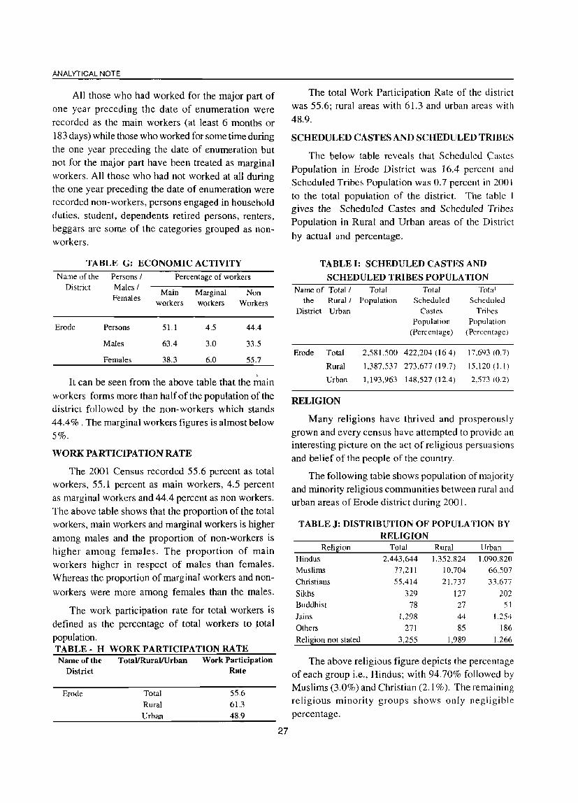
ANALYTICAL NOTE
All those who had worked for the major part of one year preceding the date of enumeration were recorded as the main workers (at least 6 months or
183 days) while those who worked for some time during the one year preceding the date of enumeration but not for the major part have been treated as marginal
workers. All those who had not worked at all during the one year preceding the date of enumeration were recorded non-workers, persons engaged in household duties, student, dependents retired persons, renters, beggars are some of the categories grouped as nonworkers.
TABLE G: ECONOMIC ACTIVITY Name of the Persons / Percentage of workers
District Males f Females
Erode Persons
Males
Females
Main Marginal workers workers
51.1
63.4
38.3
4.5
3.0
6.0
Non Workers
44.4
33.5
55.7
, It can be seen from the above table that the main
workers forms more than half of the population of the district followed by the non-workers which stands 44.4% . The marginal workers figures is almost below 5%.
WORK PARTICIPATION RATE
The 2001 Census recorded 55.6 percent as total workers, 55.1 percent as main workers, 4.5 percent as marginal workers and 44.4 percent as non workers.
The above table shows that the proportion of the total workers, main workers and marginal workers is higher
among males and the proportion of non-workers is higher among females. The proportion of main workers higher in respect of males than females. Whereas the proportion of marginal workers and non
workers were more among females than the males.
The work participation rate for total workers is
defined as the percentage of total workers to total population. TABLE - H WORK PARTICIPATION RATE Name of the TotaVRuraVUrban Work Participation
District Rate
Erode Total 55.6
Rural 61.3 Urban 48.9
27
The total Work Participation Rate of the district was 55.6; rural areas with 61.3 and urban areas with
48.9.
SCHEDULED CASTES AND SCHEDULED TRIBES
The below table reveals that Scheduled Castes Population in Erode District was 16.4 percent and Scheduled Tribes Population was 0.7 percent in 200 I to the total population of the district. The table I gives the Scheduled Castes and Scheduled Tribes Population in Rural and Urban areas of the District
by actual and percentage.
TABLE I: SCHEDULED CASTES AND
SCHEDULED TRIBES POPULATION Name of Total / Total Total Total
the Rural J Population Scheduled Scheduled District Urban Castes Tribes
Population Population (Percentage) (Percentage)
Erode Total
Rural
Urban
RELIGION
2,581,500
1.387,537
1,193,963
422,20406.4) 17.693 (0.7)
273.677 (19.7) 15.120(),1)
148,527 (12.4) 2,573 (0.2)
Many religions have thrived and prosperously
grown and every census have attempted to provide an interesting picture on the act of religious persuasions and belief of the people of the country.
The following table shows population of majority and minority religious communities between rural and urban areas of Erode district during 2001.
TABLEJ: DISTRIBUTION OF POPULATION BY RELIGION
Reli~ion Total Rural Urban
Hindus 2,443,644 1.352,824 1.090.820 Muslims 77,211 10.704 66.507 Christians 55,414 21.737 33.677
Sikhs 329 127 202 Buddhist 78 27 51
Jains 1,298 44 1.254
Others 271 85 186
Reli~ion not stated 3,255 1,989 1.266
The above religious figure depicts the percentage of each group i.e., Hindus; with 94.70% followed by Muslims (3.0%) and Christian (2.1 %). The remaining religious minority groups shows only negligible
percentage.
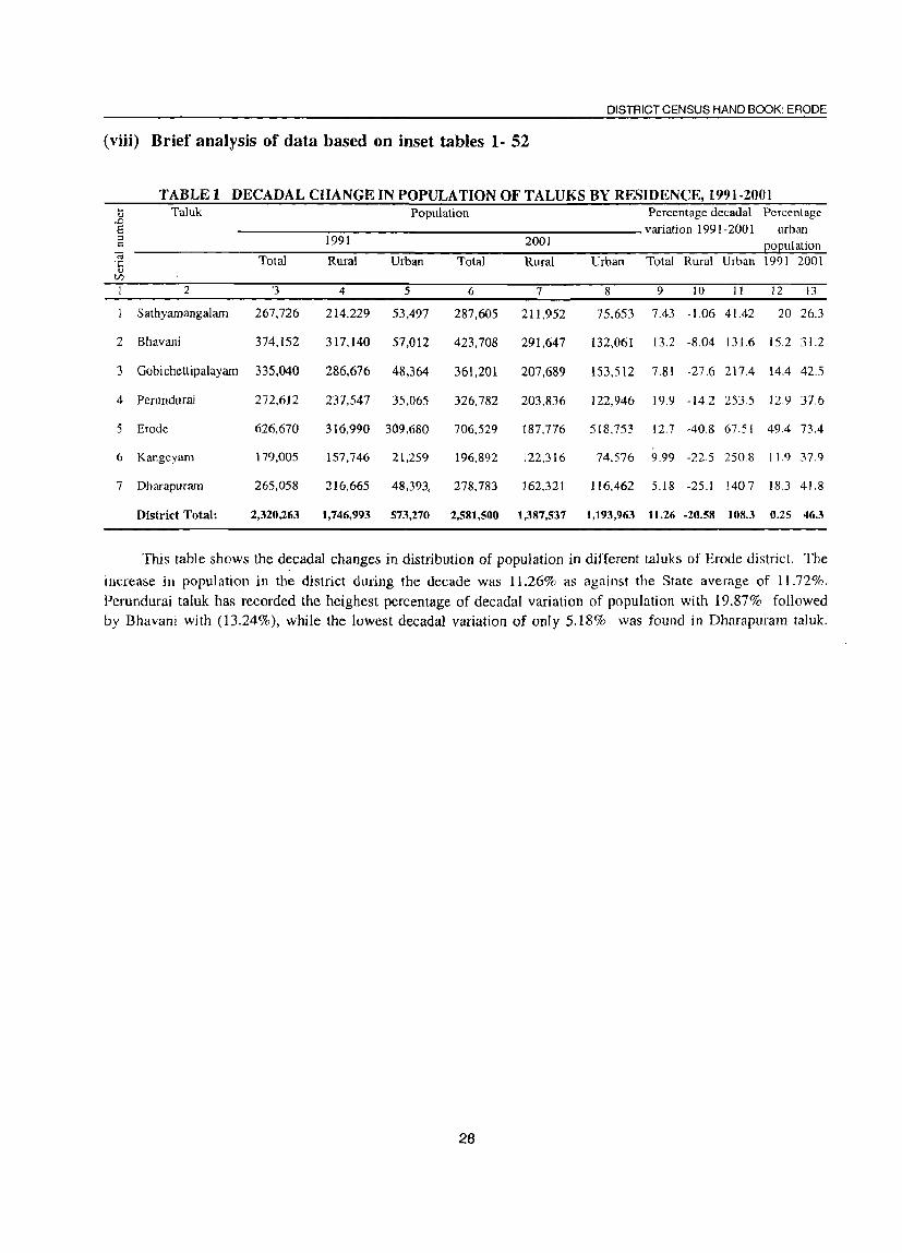
DISTRICT CENSUS HAND BOOK: ERODE
(viii) Brief analysis of data based on inset tables 1- 52
TABLE 1 DECADAL CHANGE IN PO PULA TION OF TALUKS BY RESIDENCE, 1991-2001 .... Taluk Population Percentage dccada1 Percentage <lJ
..D a variation 1991-200 I urban :;; 1991 2001 <= o ulalion -a Total Rural Urban Total Rural Urban Total Rural Urban 1991 2001 ;;:
<lJ U)
1 2 '3 4 5 6 7 8 9 10 11 12 13
Sathyamangalam 267,726 214,229 53,497 287,605 211,952 75.653 7.43 -] ,06 4].42 20 26.3
2 Bhavani 374.152 317.140 57,012 423,708 291,647 132,061 13.2 -8.04 131.6 15.2 31.2
3 Gobichettipalayam 335,040 286,676 48,364 361,201 207.689 153,512 7.81 -27.6 217.4 14.4 42.5
4 Perundurai 272,612 237,547 35.065 326,782 203,836 122,946 19.9 -14.2 2535 12.9 37.6
5 Erode 626.670 316.990 309.680 706,529 187.776 518,753 12.7 -40.8 67.51 494 73.4
6 Kangeyam 179.005 157,746 21.259 196.892 122.316 74.576 9.99 -22.5 250.8 11.9 37.9
7 Dharapuram 265,058 216,665 48,393, 278,783 162,321 116.462 5.18 -25.1 140.7 18.3 41.8
District Total: 2,320,263 1,746,993 573,270 2,581,500 1,387,537 1,193,963 11.26 -20.58 10!U 0.25 46.3
This table shows the decadal changes in distribution of population in different taluks of Erode district. The
increase in popUlation in the district during the decade was 11.26% as against the State average of 11.72%.
Perundurai taluk has recorded the heighest percentage of decadal variation of population with 19.87% followed
by Bhavani with (13.24%), while the lowest decadal variation of only 5.18% was found in Dharapuram taJuk.
28

ANALYTICAL NOTE
TABLE 2~NUMBER AND PERCENTAGE OF INHABITED VILLAGES IN SPECIFIED POPULA TION SIZE RANGES WITH THE RELATED POPULATION, 2001
Serial District I CD block Total number Total rural population Number and Population number of inhabited percentage of less than 200
villages Persons Males Females
villages Males Females
2 3 4 5 6 7 8 9
Talavadi 20 53,174 26,637 26,537 0(0.0) 0 0
2 Bhavanisagar 26 76,022 39,073 36,949 0(0.0) 0 0
3 Sathyamangalam 20 82,756 42,024 40,732 0(0.0) 0 0
4 Thookanaickenpalayam 12 51,118 25,851 25,267 0(0.0) 0 0
5 Anthiyur 13 96,469 49,637 46,832 0(0.0) 0 0
6 Ammapet 19 97,786 50,783 47,003 0(0.0) 0 0
7 Bhavani 17 97,392 49,681 47,711 0(0.0) 0 0
8 Gobichettipalayam 22 91,122 46,141 44,981 0(0.0) 0 0
9 Nambiyur 21 65,449 33,077 32,372 0(0.0) 0 0
10 Uthukuli 45 73,917 37,774 36,143 0(0.0) 0 0
II Perundurai 39 67,999 34,589 33,410 1(2.6) 98 92
12 Erode 20 55,773 28,128 27,645 0(0.0) 0 0
13 Chennimalai 22 61,920 31.769 30,151 0(00) 0 0
14 Modakurichi 23 100,523 51,064 49,459 0(0.0) 0 0
15 Kodumudi 14 31,480 15,813 15,667 1 (7.1) 50 47
16 Vellakoil 13 48,516 24,340 24,176 0(0.0) 0 0
17 Kangeyam 19 57,033 28,886 28,147 0(0.0) 0 0
18 Kundadam 29 70,371 35,709 34,662 0(0.0) 0 0
19 Mulanur 17 45,697 22,731 22,966 0(0.0) 0 0
20 Dharapuram 23 63,020 31,729 31,291 0(0.0) 0 0
Districts (Rural) Total: 434 1,387,537 705,436 682,101 2 (0.5) 148 139
29

DISTRICT CENSUS HAND BOOK: ERODE
TABLE 2 t NUMBER AND PERCENTAGE OF INHABITED VILLAGES IN SPECIFIED POPULATION SIZE RANGES WITH THE RELATED POPULATION, 2001 (contd.)
Serial District I CD block Number and Population 200-499 Number and Population 500-999 number percentage of percentage of
villages Males Females
villages Males Females
2 10 11 12 13 14 15
Talavadi 0(0.0) 0 0 3 (15.0) 1,162 1.173
2 Bhavanisagar 0(0.0) 0 0 2 (7.7) 816 713
3 Sathyamangalam 0(0.0) 0 0 I (5.0) 423 442
4 Thookanaickenpalayam 0(0.0) 0 0 1 (8.3) 414 406
5 Anthiyur 0(0.0) 0 0 0(0.0)
6 Amrnapet 0(0.0) 0 0 1 (5.3) 388 331
7 Bhavani 0(0.0) 0 0 0(0.0)
8 Gobichettipalayam 0(0.0) 0 0 0(0.0)
9 Nambiyur 1 (4.8) 146 132 1 (4.8) 502 485
10 Uthukuli 2 (4.4) 470 440 11 (24.4) 4,071 3,850
11 Perundurai 2 (5.1) 351 356 10 (25.6) 3,799 3,689
12 Erode 2 (10.0) 326 307 5 (25.0) 1,584 1,501
13 Chennimalai 1 (4.5) 194 213 5 (22.7) 1,891 1,872
14 Modakurichi 1 (4.3) 185 189 2 (8.7) 684 729
15 Kodumudi 0(0.0) 0 0 3 (2l.4) 1,103 1,061
16 Vellakoil 0(0.0) 0 0 0(0.0)
17 Kangeyam 0(0.0) 0 0 3 (15.8) 1,331 1,312
18 Kundadam 0(0.0) 0 0 1 (3.4) 342 334
19 Mulanur 0(0.0) 0 0 2 (11.8) 792 745
20 Dharapuram 1 (4.3) 117 137 0(0.0)
Districts (Rural) Total: 10 (2.3) 1,789 1,774 51 ( 11.8) 19,302 18,643
30

ANALYTICAL NOTE
TABLE 2: NUMBER AND PERCENTAGE OF INHABITED VILLAGES IN SPECIFIED POPULATION SIZE RANGES WITH THE RELATED POPULA TION ,2001 (coutd.)
Serial District I CD block Number and Population 1000-1999 Number and Population 2000-4999 number percentage of percentage of
villages Males Females
villages Males Females
2 16 17 18 19 20 21
Talavadi 7 (35.0) 5,589 5,621 7 (35.0) 10,990 11.044
2 Bhavanisagar 8 (30.8) 6,248 5,838 15 (57.7) 28,247 26.611
3 Sathyamangalam 4 (20.0) 2,751 2,688 11 (55.0) 20,643 19.818
4 Thookanai ckenpalay am 1 (8.3) 753 751 5 (41.7) 6,477 6.188
5 Anthiyur 0(0.0) 0 0 4 (30.8) 5,441 5.264
6 Amrnapet 1 (5.3) 991 927 9 (47.4) 13,657 12,679
7 Bhavani 5 (29.4) 3,549 3,414 3(17.6) 4,602 4.421
8 Gobichetti pal ayam 5 (22.7) 3,555 3,375 9(40.9) 15,498 15,320
9 Nambiyur 7 (33.3) 5,928 5,963 9 (42.9) 16,659 16.126
10 Uthukuli 22 (48.9) 15,406 14,746 9 (20.0) 14,831 14,166
11 Perundurai 12 (30.8) 8,720 8,269 14 (35.9) 21,621 21,004
12 Erode 6 (30.0) 5,243 4,642 4 (20.0) 7,491 8.486
13 Chennimalai 6 (27.3) 3,957 3,959 5 (22.7) 7,863 7.590
14 Modakurichi 1 (4.3) 667 657 12 (52.2) 18,765 18.260
15 Kodumudi 3 (21.4) 1,639 1,638 5 (35.7) 7,371 7,220
16 Vellakoil 2 (15.4) 1.775 1.818 8 (61.5) 13,870 13,692
17 Kangeyam 2 (10.5) 1,964 1,932 12 (63.2) 18,466 17,819
18 Kundadam 15 (51.7) 10,885 10,521 10 (34.5) 15,428 15.134
19 Mulanur 6 (35.3) 4,425 4,464 7(41.2) 10,695 10.930
20 Dharapuram 7 (30.4) 5,564 5,293 13 (56.5) 19,845 19,537
Districts (Rural) Total: 120 (27.6) 89,609 86,516 171 (39.4) 278,460 271,309
31

DISTRICT CENSUS HAND BOOK: ERODE
TABLE 4IDISTRIBUTION OF VILLAGES BY POPULATION DENSITY, 2001 Range of population density Total number of villages Percentage of villages Population Percentage
(per square kilometer) in each population in each population distribution of density range density range population
2 3 4 5
0-10 0 0.0 0 0.0
11-20 0 0.0 0 0.0
21-50 0 0.0 0 0.0
51-100 21 4.8 37,280 2.7
101-200 91 21.0 227,361 16.4
201-300 92 21.2 234,745 16.9
301-500 129 29.7 447.293 32.2
501 + 101 23.3 440.858 31.8
Not known 0 0.0 0 0.0
District Total: 434 100.0 1,387,537 100.0
Population Density (Rural) of the district: 198
This table gives the distribution of villages by population density. Out of 434 inhabited villages, 29.7% of population covers the range of population density of 301 - 500, 23.3% covers 501+ and 21% in each
range of 101 - 200 and 201 - 300.
TABLE 5: SEX RATIO OF STATE AND DISTRICT, 1901- 2001 Census Year Tamil Nadu Erode District
Total Rural Urban Total Rural Urban
1 2 3 4 5 6 7
1901 1,044 1,043 1,048 1,021 1.020 1,041
1911 1,042 1,044 1,032 1,017 1,016 1.028
1921 1,029 1,033 1,008 1,005 1,007 981
1931 1,027 1,034 997 1,010 1,015 1,010
1941 1,012 1,017 991 997 998 986
1951 1,007 1,014 986 998 1.001 976
1961 992 1,003 963 980 983 965
1971 978 990 951 965 970 944
1981 977 987 956 956 960 941
J991 974 981 960 958 960 952
2001 986 992 980 972 967 977
Note: Sex ratio has been defined here as the number of females per 1000 males.
34

ANALYTICAL NOTE
TABLE 6~SEX RATIO BY TALUKS, 2001 Serial number Name of Taluk Sex ratio
Total Rural Urban
2 3 4 5 1 Sathyamangalam 970 967 976 2 Bhavani 949 943 963 3 Gobichettipalayam 986 977 999 4 Perundurai 969 957 989
5 Erode 968 976 965 6 Kangeyam 979 979 979 7 Dharapuram 998 990 1,010
District Total: 972 967 977
This table furnishes the sex ratio for rural and urban areas in each tal uk of Erode district. It is noticed that Dharapuram taluk has the highest sex ratio of 998 followed by Gobichettipalayam (986) and Kangeyam (979). The district sex ratio has recorded as 972.
Serial nwnber
2
3
4
5
6
7
8
9
10
11
12
13
14
15
16
17
18
19
20
TABLE 7 : SEX RATIO BY CD BLOCKS, 2001 Name of C 0 block
2
Talavadi
Bhavanisagar
Sathyamangalam
Thookanaickenpalayam
Anthiyur
Ammapet
Bhavani
Gobichettipala~am
Nambiyur
Uthukuli
Perundurai
Erode
Chennimalai
Modakurichi
Kodumudi
Vellakoil
Kangeyam
Kundadam
Mulanur
Dharapuram
District (Rural) Total:
Sex ratio 3
996
946
969
977
943
926
960
975
979
957
966
983
949
969
991
993
974
971
1,010
986
967
This table shows the CD block wise sex ratio of Erode District. Out of 20 CD blocks in the district. Mulanur CD block has recorded the highest sex ratio of 1,010. The lowest sex ratio was recorded as 926 in
Ammapet CD block. The district average sex ratio was 967.
35

DISTRICT CENSUS HAND BOOK: ERODE
TABLE 8 : SEX RATIO OF RURAL PO PULA TION BY RANGES, 2001 Range of sex ratio for Number of Percentage of Population 2001 Percentage distribution of
villages inhabited villages in each population 1 2 3 4 5
Less than 700 0.2 1,781 0.1 700-749 1 0.2 4,456 0.3 750-799 3 0.7 9,594 0.7 800-849 3 0.7 3,175 0.2 850-899 20 4.6 52,338 3.8 900-949 96 22.1 328,903 23.7 950-999 214 49.3 726,271 52.3 ,
1000-1099 90 20.7 251,458 18.1 1100+ 6 1.4 9,561 0.7
District Total: 434 100.0 1,387,537 100.0
Sex ratio (Rural) for District: 967
This table furnishes the sex ratio of rural population by ranges. Out of 434 habited villages, 214 villages
,52.3%) fall under the sex ratio range of 950 - 999. Nearly 19% of population in 96 villages fall under range of sex ratio above 1000.
Serial number
2
3
4
5
6
7
8
9
10
II
12
13
14
15
16
17
18
19
20
TABLE 9: SEX RATIO OF URBAN AGGLOMERA nONS I TOWNS,
Name of UA I Town
2
Ammapettai (TP)
Anthiyur (TP)
Appakudal (TP)
Atachalur (TP)
Ariyappampalayam (TP)
Athani (TP)
A valpoondurai (TP)
Bhavani VA (Distts 09 & 10)
Bhavani VA (Part)
(a) Bhavani (M)
Bhavanisagar (TP)
Chennasamudram (TP)
Chennimalai (TP)
Chlnnakkampalayam (TP)
Chi thode (TP)
Dharapuram eM)
Elathur (TP)
Erode UA (Distts 09 & 10)
Erode VA (Part)
(a) Erode (M)
(e) Brahmana Periya Agraharam (TP)
(f) Veerappanchatiram (TP)
(g) Surampatti (TP)
(h) Kasipalayam (E) (TP)
Gobichettipalayam (M)
Jambai (TP)
Kangeyam (TP)
Kanjikoil (TP)
36
Urban status of town
3
TP
TP TP TP
TP TP
TP
VA
VA M
TP TP
TP
TP TP
M
TP
UA
VA
TP
M
TP
TP
TP M
TP
TP
TP
2001
Sex ratio
4
950
938
958
1.006
975
964
923
986
975
986
957
999
969
960
967
1,031
978
961
963
969
972
944
969
965
1,021
944
956
982

ANALYTICAL NOTE
TABLE 9: SEX RATIO OF URBAN AGGLOMERATIONS I TOWNS, 2001 (contd.)
Serial number Name of UA I Town Urban status of town Sex ratio
2 3 4
21 Kannivadi (TP) TP 1,011
22 Karumandi Chellipalayam (TP) TP 1,040
23 Kasipalayam (G) (TP) TP 972
24 Kembainaickenpalayam (TP) TP 980
25 Kilampadi (TP) TP 1,034
26 Kodumudi (TP) TP 995
27 Kolappalur (TP) TP 1,010
28 Kolathupalayam (TP) TP 1,003
29 Kollankoil (TP) TP 993
30 Kuhalur (TP) TP 982
31 Kunnathur (TP) TP 999
32 Lakkampatti (TP) TP 965
33 Modakurichi (TP) TP 974
34 Mukasipidariyur (CT) CT 1.001
35 Mulanur (TP) TP 1.000
36 Muthur (TP) TP 994
37 Nallampatti (TP) TP 959
38 Nambiyur (TP) TP 1.012
39 Nasiyanur (TP) TP 979
40 Nerunjipettai (TP) TP 951
41 Olagadam (TP) TP 943
42 Ottapparai (CT) CT 968
43 P .Mettupalayam (TP) TP 1.000
44 Pallapalayam eTP) TP 981
45 Pasur (TP) TP 948
46 Periyakodiveri (TP) TP 965
47 Periyasemur (TP) TP 923
48 Perundurai (TP) TP 1,007
49 Pethampalayam (TP) TP 977
50 Punjaipuliampatti (TP) TP 995
SI Rudravathi (TP) TP 922
52 Salangapalayam (TP) TP 986
53 Sathyamanga1am (M) M 969
54 Sivagiri (TP) TP 974
55 Suriyampalayam (TP) TP 923
S6 Unjalur (TP) TP 986
57 Uthukuli (TP) TP 956
58 Vadugapatti (TP) TP 1.016
59 Vaniputhur (TP) TP 990
60 Vellakoil (TP) TP 992
61 Vellottamparappu (TP) TP 990
62 Vengampudur (TP) TP 1.013
63 Vijayapuri (CT) CT 921
Sex ratio (Urban) for the district: 977
Among 63 towns, 14 towns have returned to sex ratio 1,000 and above. The highest was returned from
Karumandi Chellapalayam with 1,040 and rest of the towns have returned 900 and above. ,
37

DISTRICT CENSUS HAND BOOK: ERODE
Serial T~BLE 10;~EX RATIO OF POPULATION IN THE AGE GROUP 0-6 FOR TALUKS2 2001
Name of Taluk > Total I Rural Total QOQulation in 0-6 age grouQ Sex ratio for 0-6 number .. I Urban Persons Males Females age group
2 3 4 5 6 7
Sathyamangalam . Total 29,643 14,968 14,675 980
Rural 22.248 11,171 11.077 992
Urban 7,395 3,797 3,598 948
2 Bhavani Total 44,232 23,286 20,946 900
Rural 30,634 16,190 14.444 892
Urban 13,598 7,096 6,502 916
3 Go bichetti palayam Total 34,347 17,525 16,822 960
Rural 19,949 10,211 9,738 954
Urban 14,398 7,314 7,084 969
4 Perundurai Total 32,024 16,643 15,381 924
Rural 20,039 10,351 9,688 936
Urban 11,985 6,292 5,693 905
5 Erode Total 69.924 36,163 33.761 934
Rural 17,962 9,453 8,509 900
Urban 51,962 26,710 25,252 945
6 Kangeyam Total 17,922 9,217 8.705 944
Rural 10,685 5,482 5,203 949
Urban 7,237 3,735 3,502 938
7 Dharapuram Total 24,751 12,575 12,176 968
Rural 13,982 7,277 6,705 921
Urban 10,769 5,298 5,471 1.033
District Total: Total 252,843 130,377 122;466 939
Rural 135,499 70,135 65,364 932
Urban 117,344 60,242 57,102 948
This table shows the sex ratio of population in the age group of a - 6 for taluks in 2001. Sathiyamangalam
taluk has recorded the heighest sex ratio of 980 followed by Dharapuram (968) and Gobichettipalayam (960),
while Bhavani taluk has recorded the lowest sex ratio of 900 for 0-6 age group.
38

ANALYTICAL NOTE
TABLE l1;SEX RATIO OF POPULATION IN THE AGE GROUP 0-6 FOR CD BLOCKS, 2001 Serial Name of CD block Total population in 0-6 age group Sex ratio for 0-6
number Persons Males Females age group
2 3 4 5 6
Talavadi 6,022 2,963 3,059 1.032 2 Bhavanisagar 7,513 3,842 3,671 955 3 Sathyamangalam 8,713 4,366 4.347 996 4 Thookanaickenpalayam 5,079 2,566 2.513 979 5 Anthiyur 10,913 5,666 5,247 926 6 Amrnapet 10,026 5,495 4,531 825 7 Bhavani 9,695 5,029 4,666 928 8 Gobichetti pal ayam 8,591 4,453 4,138 929 9 Nambiyur 6,279 3.192 3,087 967 10 Uthukuli 7,768 3,990 3,778 947 II Perundurai 6,636 3,429 3,207 935 12 Erode 5,714 2,994 2,720 908
13 Chennimalai 5.635 2,932 2.703 922 14 Modakurichi 9.578 5,045 4.533 899 IS Kodumudi 2,670 1,414 1,256 888
16 Vellakoil 4,059 2,037 2.022 993 17 Kangeyam 5,154 2,678 2,476 925 18 Kundadam 6,295 3,282 3,013 918 19 Mulanur 3,304 1,741 1.563 898 20 Dharapuram 5,855 3,021 2.834 938
District (Rural) Total: 135,499 70,135 65,364 932
The above table gives the sex ratio of rural population in the age group of 0-6 for CD Blocks in 2001 of Erode district. Talavadi CD block has recorded the highest sex ratio of 1,032, while Ammapet CD block has recorded the lowest of 825. The average sex ratio of rural population in the age group of 0-6 in Erode district was 932.
TABLE 12! SEX RATIO OF RURAL POPULATION IN THE AGE GROUP 0-6 BY RANGES, 2001
Range of sex ratio for Number of inhabited Percentage distribution Population 2001 Percentage distribution of villages villages of villages population
2 3 4 5 ..
Less than 700 19 4.4 2,719 2.0
700-749 16 3.7 3.870 2.9
750-799 26 6.0 5,997 4.4
800-849 48 11.1 13,568 10.0
850-899 71 16.4 28,261 20.9
900-949 64 14.7 24,773 18.3
950-999 47 10.8 16,418 12.1
1000-1099 91 21.0 31,452 23.2
1100+ 52 12.0 8,441 6.2
District (Rural) Total 434 100.0 135,499 100.0
Sex ratio (Rural) for District: 932
This table shows the sex ratio of rural population in the age group of 0 - 6 by ranges 2001. Out of 434 villages, 143 villages (33%) of rural population fall under the range of sex ratio of 1000+ and III villages (26%) of rural population in the range of 900-999.
39

Serial number
2
3
4
5
6
7
8
9
10
11
12
13
14
15
16
17
18
19
20
21
22
23
24
25
26
27
28
DISTRICT CENSUS HAND BOOK: ERODE
TABLE13 : SEX RATIO OF POPULATION IN THE AGE GROUP 0-6 OF URBAN AGGLOMERATIONS I TOWNS, 2001
Name ofUA I Town
A mmapettai
Anthiyur
Appakudal
Arachalur
Ariyappampalayam
Athani
A valpoondurai
2
Bhavani VA (Distts 09 & 10)
Bhavani VA (Part)
(a) Bhavani
Bhavanisagar
Chennasamudram
Chennimalai
Chinnakkampalayam
Chithode
Dharapuram
Elathur
Erode VA (Distts 09 & 10)
Erode VA (Part)
(a) Erode
(e) Brahmana Periya Agraharam
(f) Veerappanchatiram
(g) Surarnpatti
(h) Kasipalayam (E)
Gobichettipalayam
Jambai
Kangeyam
Kanjikoil
Kannivadi
Karumandi Chellipalayam
Kasipalayam (0)
Kembainaickenpalayam
Kilampadi
Kodumudi
KoJappaJur
Kolathupalayam
Urban status of Total population in 0-6 age group Sex ratio for 0-town --P-e-r-so-n-s----M-a-le-s-----F-e-m-al-e-s- 6 age group
3
TP
TP
TP
TP
TP
TP
TP
VA
VA
M
TP
TP
TP
TP
TP
M
TP
VA
VA
M
TP
TP
TP
TP
M
TP
TP'
TP
TP
TP
TP
TP
TP
TP
TP
TP
40
4
996
2,019
986
1.141
1.287
883
983
10,868
4,162
4,162
434
611
1,485
1.001
693
6,131
711
40,605
33,924
14,756
2,634
7,944
3,425
5,165
5,081
1,483
2,815
999
291
1,996
752
949
505
1.030
950
1,528
5
509
1.101
504
563
630
442
481
5.569
2,129
2.129
224
320
772
545
357
2,898
346
20.953
17.441
7,496
1.371
4,163
1,740
2,671
2,549
806
1,463
507
160
1,081
382
498
257
549
487
740
6
487
918
482
578
657
441
502
5.299
2,033
2,033
210
291
713
456
336
3.233
365
19,652
16,483
7,260
1.263
3,781
1,685
2.494
2,532
677
1.352
492
131
915
370
451
248
481
463
788
7
957
834
956
1.027
1.043
998
1,044
952
955
955
938
909
924
837
941
1,116
1,055
938
945
969
921
908
968
934
993
840
924
970
819
846
969
906
965
876
951
1,065
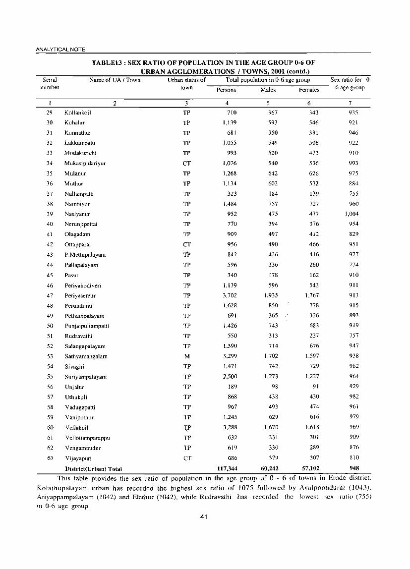
ANALYTICAL NOTE
TABLE13 : SEX RATIO OF POPULATION IN THE AGE GROUP 0-6 OF URBAN AGGLOMERATIONS I TOWNS, 2001 (contd.)
Serial Name ofUA I Town Urban status of Total population in 0-6 age group Sex ratio for 0-number town Persons Males Females 6 age group
2 3 4 5 6 7
29 Kollankoil TP 710 367 343 935
30 Kuhalur TP 1,139 593 546 921
31 Kunnathur TP 681 350 331 946
32 Lakkampatti TP 1,055 549 506 922
33 Modakurichi TP 993 520 473 910
34 Mukasipidariyur CT 1,076 540 536 993
35 Mulanur TP 1,268 642 626 975
36 Muthur TP 1,134 602 532 884
37 N all amp atti TP 323 184 139 755
38 Nambiyur TP 1,484 757 727 960
39 Nasiyanur TP 952 475 477 1,004
40 Nerunj ipettai TP 770 394 376 954
41 Olagadam TP 909 497 412 829
42 Ottapparai CT 956 490 466 951
43 P.Mettupalayam TP 842 426 416 977
44 Pallapalayam TP 596 336 260 774
45 Pasur TP 340 178 162 910
46 Periyakodiveri TP 1,139 596 543 911
47 Periyasemur TP 3,702 1,935 1,767 913
48 Perundurai TP 1,628 850 778 915
49 Pethampalayam TP 691 365 326 893
50 Punjaipu1iampatti TP 1,426 743 683 919
51 Rudravathi TP 550 313 237 757
52 Salangapalayam TP 1,390 714 676 947
53 Sathyamangalam M 3,299 1.702 1,597 938
54 Sivagiri TP 1,471 742 729 982
55 Suriyampalayam TP 2,500 1,273 1.227 964
S6 Unjalur TP 189 98 91 929
57 Uthukuli TP 868 438 430 982
58 Vadugapaui TP 967 493 474 961
59 Vaniputhur TP 1.245 629 616 979
60 Vellakoil TP 3,288 1,670 1,618 969 , 61 Vellottamparappu TP 632 331 301 909
62 Vengampudur TP 619 330 289 876
63 Vijayapuri CT 686 379 307 810
District(Urban) Total 117,344 60,242 57,102 948
This table provides the sex ratio of population in the age group of 0 - 6 of towns in Erode district.
Kolathupalayam urban has recorded the highest sex ratio of 1075 followed by Avalpoondurai (1043).
Ariyappampalayam (1042) and Elathur (1042), while Rudravathi has recorded the lowest sex ratio (755)
in 0-6 age group.
41

DISTRICT CENSUS HAND BOOK: ERODE
TABLE 14~ NUMBER AND PERCENTAGE OF SCHEDULED CASTES AND SCHEDULED TRIBES POPULATION IN TALUKS, 2001
Serial Name of TaluK Total/ Total Total Scheduled Total Percentage of Percentage of number Rural I population Castes Scheduled Scheduled Scheduled
Urban population Tribes Castes Tribes population populati on to population to
total population total population
2 3 4 5 6 7 8
Sathyamangalam Total 287,605 53,544 8,816 18.6 3.1
Rural 211,952 43,203 8,671 20.4 4.1
Urban 75,653 10,341 145 13.7 0.2
2 Bhavani Total 423,708 62,936 5,692 14.9 1.3
Rural 291,647 48,074 4,670 16.5 1.6
Urban 132,061 14,862 1,022 11.3 0.8
3 Gobichettipalayam Total 361,201 60,628 1,555 16.8 0.4
Rural 207,689 ' 40,458 1,244 19.5 0.6
Urban 153,512 20,170 311 13.1 0.2
4 Perundurai Total 326,782 53,160 38 16.3 0.0
Rural 203,836 39,559 12 19.4 0.0
Urban 122,946 13,601 26 11.1 0.0
5 Erode Total 706,529 94,418 724 13.4 0.1
Rural 187,776 34,734 213 18.5 0.1
Urban 518,753 59,684 511 1l.5 0.1
6 Kangcyam Total 196,892 36,943 59 18.8 0.0
Rural 122,316 27,054 29 22.1 0.0
Urban 74,576 9,889 30 13.3 0.0
7 Dharapuram Total 278,783 60,575 809 21.7 0.3
Rural 162,321 40,595 281 25 0.2
Urban 116,462 19,980 528 17.2 0.5
District Total: Total 2,581,500 422,204 17,693 16.4 0.7
Rural 1,387,537 273,677 15,120 19.7 1.1
Urban 1,193,963 • 148,527 2,573 12.4 0.2
This table gives the number and percentage of SC & ST population in taluks of Erode district. Dharapuram
taluk has recorded 21.7% of SC popUlation followed by Kangeyam (18.8%) and Sathyamangalam (18.6%). Erode
has recorded at the lowest (13.4%). In respect of ST popUlation, Sathyamangalam taluk has recorded the highest
population of 3.1 %.
42

ANALYTICAL NOTE
TABLE 15\ NUMBER AND PERCENTAGE OF SCHEDULED CASTES AND SCHEDULED TRIBES POPULATION IN CD BLOCKS, 2001
Serial Name of CD block Total Total Total Percentage of Percentage of number population Scheduled Scheduled Scheduled Scheduled
Castes Tribes Castes Tribes population population population population
to total to total population population
2 3 4 5 6 7
TaJavadi 53,174 10,312 3,347 19.4 6.3
2 Bhavanisagar 76,022 15,771 141 20.7 0.2
3 SathyamangaJam 82,756 17,120 5,183 20.7 6.3
4 Thookanaickenpalayam 51,118 9,934 1,228 19.4 2.4
5 Anthiyur 96,469 15,155 1.845 15.7 1.9
6 Ammapet 97,786 18,756 2.404 19.2 2.5
7 Bhavani 97,392 14,163 421 14.5 0.4
8 GobichettipaJayam 91,122 17,756 7 19.5 0
9 Nambiyur 65,449 12,768 9 19.5 0
10 Uthukuli 73,917 16,450 7 22.3 0
11 Perundurai 67,999 10,978 0 16.1 0
12 Erode 55,773 9,946 32 17.8 0.1
13 Chennimalai 61,920 12,131 5 19.6 0
14 Modakurichi 100,523 18,325 157 18.2 0.2
15 Kodumudi 31,480 6,463 24 20.5 0.1
16 Vellakoil 48,516 10.127 11 20.9 0
17 Kangeyam 57,033 12,581 22 22.1 0
18 Kundadam 70,371 16,417 6 23.3 0
19 Mulanur 45,697 10,881 7 23.8 0
20 Dharapuram 63,020 17,643 264 28 0.4
District (Rural) Total: 1,387,537 273,677 15,120 19.7 1.1
This table provides number and percentage of Scheduled Caste and Scheduled Tribes population in CD
blocks of Erode District. Out of 20 CD blocks Dharapuram has recorded the highest (28%) Scheduled Caste
population followed by Mulanur (23.8%) and Kundadam (23.3%), while Bhavani CD block has recorded the
lowest Scheduled Caste population of 14.5%. Talavadi and Sathyamangalam CD blocks have recorded the highest
Scheduled Tribe population of 6.3%, each.
43

DISTRICT CENSUS HAND BOOK: ERODE
TABLE 16; PROPORTION OF SCHEDULED CASTES POPULA TION TO TOTAL POPULATION IN VILLAGES, 2001
Percentage range of Scheduled Castes Number of villages Percentage
Scheduled Castes Percentage
population to total population Population
2 3 4 S
Nil 8 1.8 0 0.0
Less than 5 22 5.1 2,177 0.8
5-10 48 11.1 14,662 5.4
11-20 158 36.4 88,733 32.4
21-30 140 32.3 116,083 42.4
31-40 38 8.8 32,280 11.8
41-50 17 3.9 15,784 5.8
51-75 3 0.7 3,958 1.4
76 and above 0 0.0 0 0.0
District Total 434 100.0 273,677 100.0
This table gives the proportion of SC population to total population in villages by ranges. Out of 434 Villages in this district, 158 villages (32.40% of population) fall under the percentage range of 11 - 20 and 140 Villages (42.40% of population) fall under the percentage range of 21 - 30.
TABLE 17; PROPORTION OF SCHEDULED TRIBES PO PULA TION TO TOTAL POPULATION IN VILLAGES, 2001
Percentage range of Scheduled Tribes Number of villages Percentage
Scheduled Tribes Percentage
population to total population Population
2 3 4 5
Nil 339 78.1 0 0.0
Less than 5 81 18.7 3,684 24.4
5-10 7 1.6 2,228 14.7
11-20 2 0.5 1,264 8.4
21-30 2 0.5 4,883 32.3
31-40 3 0.7 3,061 20.2
41-50 0 0.0 0 0.0
51-75 0 0.0 0 0.0
76 and above 0 0.0 a 0.0
District Total 434 100.0 15,120 100.0
This table furnishes the proportion of ST population to total population in villages by ranges. Out of 434 villages in this district 81 villages (19%) fall under the percentage range of <5, Nearly 78% of villages have no ST population in this district.
44

ANALYTICAL NOTE
TABLE 18': NUMBER AND PERCENTAGE OF SCHEDULED CASTES AND SCHEDULED TRIBES POPULA TION IN URBAN AGGLOMERATIONS I TOWNS, 2001
... Name ofUA / Town Total population Total Total Percentage of Percentage of <U Scheduled Scheduled Scheduled Castes Scheduled Tribes ..0 S Castes Tribes population to population to ::! c c; population population total population total population ·c v
en I 2 3 4 5 6 7
I Ammapettai (TP) 9,259 ],348 618 14.6 6.7
2 Anthiyur (TP) 20,071 1,727 13 8.6 0.1
3 Appakudal (TP) 9,522 979 10.3
4 Arachalur (TP) 12,343 1,993 16.1
5 Ariyappampalayam (TP) 12,462 2.204 6 17.7 0.0
6 Athani (TP) 8,423 1.456 17.3
7 Avalpoondurai (TP) 11.24~ 1,751 5 15.6 0.0
8 Bhavani VA (Distts 09 & 10) 104,646 4,436 114 4.2 0.1
Bhavani UA (Part) 38,778 2,333 52 6.0 0.1
(a) Bhavani (M) 38,778 2,333 52 6.0 0.1
9 Bhavanisagar (TP) 4,329 1,153 8 26.6 0.2
IO Chennasamudram (TP) 7,342 916 12.5
11 Chennimalai (TP) 15,547 480 3.1
12 Chinnakkampalayam (TP) 9,694 1,517 15.6
13 Chi thode (TP) 7,704 654 4 8.5 0.1
14 Dharapuram (M) 64,984 10,112 511 15.6 0.8
15 Elathur (TP) 7,678 1,539 20.0
16 Erode UA (Distts 09 & 10) 389,906 34,263 344 8.8 0.1
Erode UA (Part) 329,019 31,846 328 9.7 0.1
(a) Erode (M) 150,541 12,642 74 8.4 0.0
(e) Brahmana Periya Agraharam (TP) 21,458 7,066 32.9
(f) Veerappanchatiram (TP) 72,703 4,367 24 6.0 0.0
(g) Surampatti (TP) 31,948 1,488 3 4.7 0.0
(h) Kasipalayam (E) (TP) 52,369 6,283 227 12.0 0.4
17 Gobichettipalayam eM) 55,15,8 4,882 251 8.9 0.5
18 Jambai (TP) 15,011 3,251 21.7
19 Kangeyam (TP) 28,258 3,570 12.6
20 Kanjikoil (TP) 11,040 1,796 3 16.3 0.0
21 Kanni vadi (TP) 4,412 728 16.5
22 Karumandi Chellipalayam (TP) 20,072 2,211 4 11.0 0.1
23 Kasipalayam (G) (TP) 8,570 1,483 22 17.3 0.3
24 Kembainaickenpalayam (TP) 10,308 1,449 10 14.1 0.1
25 Kilampadi (TP) 6,343 1,207 4 19.0 0.1
26 Kodumudi (TP) 12,664 2,022 16.0
27 Ko1appalur (TP) 9,803 1,694 17.3
28 Kolathupalayam (TP) 17,438 3,327 17 19.1 0.1
29 Kollankoil (TP) 8,754 1,400 16.0
30 Kuhalur (TP) 11,684 2,167 3 18.5 0.0
31 Kunnathur (TP) 7,032 751 6 10.7 0.1
45

DISTRICT CENSUS HAND BOOK: ERODE
TABLE 18: NUMBER AND PERCENTAGE OF SCHEDULED CASTES AND SCHEDULED TRIBES POPULA TION IN URBAN AGGLOMERA TlONS I TOWNS, 2001 (contd.)
.... Name of VA I Town Total population Total Total Percentage of Percentage of <1J .0
E Scheduled Scheduled Scheduled Castes Scheduled Tribes :l c Castes Tribes population to total population to total
c:l '1:: population population population population
<1J VJ
2 3 4 5 6 7
32 Lakkampatti (TP) 11,038 1,395 12.6 0.0
33 Modakurichi (TP) 10,052 1,856 20 18.5 0.2
34 Mukasipidariyur (CT) 11,012 932 4 8.5 0.1
35 Mulanur (TP) 13,827 2,624 19.0
36 Muthur (TP) 11,880 2,721 4 22.9 0.1
37 Nallampatti (TP) 3,656 879 24.0
38 Nambiyur (TP) 15,854 2,514 7 15.9 0.1
39 Nasiyanur (TP) 9,905 2,313 3 23.4 0.0
40 Nerunjipettai (TP) 6,925 1,220 62 17.6 0.9
41 Olagadarn (TP) 9,370 1,147 277 12.2 3.0
42 Ottapparai (CT) 9,208 632 6.9
43 P.Mettupalayam (TP) 9,115 863 9.5
44 PallapaJayam (TP) 6,505 1,043 16.0
45 Pasur (TP) 3,870 1,081 27.9
46 Periyakodiveri (TP) 12,405 2,001 II 16.1 0.1
47 Periyasemur (TP) 32,024 1,001 34 3.1 0.1
48 Perundurai (TP) 16,943 2,040 12.0
49 Pethampalayam (TP) 7,120 1,720 5 24.2 0.1
50 Punjaipuliampatti (TP) 14,832 2,588 17.4
51 Rudravathi (TP) 6,107 1,672 27.4
52 SalangapaJayam (TP) 14,702 1,401 9.5
53 Sathyamangalam (M) 33,722 2,947 121 8.7 0.4
54 Sivagiri (TP) 16,255 1.613 9.9
55 Suriyampalayam (TP) 21,923 5,192 23 23.7 0.1
56 Unjalur CTP) 2,628 272 lOA
57 Uthukuli (TP) 8,294 689 8.3
58 Vadugapatti (TP) 10,921 2,436 87 22.3 0.8
59 Vaniputhur (TP) 12,207 1,632 16 13.4 0.1
60 Vellakoil (TP) 34,438 3,598 26 10.4 0.1
61 Vellottamparappu (TP) 8,131 1,187 3 14.6 0.0
62 Vengampudur (TP) 7,632 944 12.4
63 Vijayapuri CCT) 6,517 428 4 6.6 0.1
District(Urban) Total 1,193,963 148,527 2573 12.4 0.2
This table gives the percentage of SC and ST population in the different towns of Erode district. It is seen
that Brahmana Periya Agraharam has recorded the highest percentage of SC population while Ammapettai town
has recorded the highest percentage of ST population. In Periyasemur town, the percentage of SC population
was the lowest with only 3.1 %. Out of 67 towns in this district, 28 towns have no ST population.
46

ANALYTICAL NOTE
TABLE 19: SEX RATIO AMONG SCHEDULED CASTES AND SCHEDULED TRIBES IN
Serial number
1
2
3
4
5
6
7
8
9
10
II
12
13
14
15
16
17
18
19
20
Name of CD block
2
Talavadi
Bhavanisagar
Sathyamangalam
Thookanaickenpalayam
Anthiyur
Ammapet
Bhavani
Gobichettipalayam
Nambiyur
Uthukuli
Perundurai
Erode
Chennimalai
Modakurichi
Kodumudi
Vellakoil
Kangeyam
Kundadam
Mulanur
Dharapuram
District (Rural) Total
C D BLOCKS, 2001
Scheduled Castes Scheduled Tribes
Sex Ratio Sex Ratio
3 4
1,000 1.046
949 1.014
999 980
983 987
964 982
940 972
987 1,064
967 750
991 1,250
964 167
981
955 1,000
957 667
976 915
968 2,000
999 1.200
982 ),200
964 1,000
981 750
989 1,000
974 997
This table provides the sex ratio among Scheduled Castes and Scheduled Tribes in CD blocks wise of Erode district. Out of 20 CD blocks in this district, Talavadi has the highest sex ratio of 1000 females per 1000 males and Ammapettai was the lowest sex ratio of 940 among Scheduled Castes. Among the Scheduled Tribes. Kodumudi recorded the highest sex ratio of 2000 and Chennimalai recorded the lowest of 667.
47

DISTRICT CENSUS HAND BOOK: ERODE
TABLE 20: SEX RATIO AMONG SCHEDULED CASTES AND SCHEDULED TRIBES IN URBAN AGGLOMERA TIONS / TOWNS, 2001
Serial number
2
3
4
5
6
7
8
9
10
II
12
13
14
15
16
17
18
19
20
21
22
23
24
25
26
27
28
29
30
31
Name of U.A.! Town
2
Ammapettai (TP)
Anthiyur (TP)
Appakudal (TP)
Arachalur (TP)
Ariyappampalayam (TP)
Arhani (TP)
Avalpoondurai (TP)
Bhavani UA (Distts 09 & 10)
Bhavani UA (Part)
(a) Bhavani (M)
Bhavanisagar (TP)
Chennasamudram (TP)
Chennimalai (TP)
Chinnakkampalayam (rp)
Chithode (TP)
Dharapuram (M)
Elathur (TP)
Erode UA (Distts 09 & 10)
Erode UA (Part)
(a) Erode (M)
(e) Brahmana Periya Agraharam (TP)
(f) Veerappanchatiram (TP)
(g) Surampatti (TP)
(h) Kasipalayarn (E) (TP)
Gobichettipalayam (M)
lambai (TP)
Kangeyam (TP)
Kanjikoil (TP)
Kannivadi (TP)
Karumandi Chellipalayam (TP)
Kasipalayarn (G) (TP)
Kembainaickenpalayam (TP)
Kilampadi (TP)
Kodumudi (TP)
Kolappalur (TP)
KolathupaJayam (TP)
Kollankoil (TP)
Kuhalur (TP)
Kunnathur (TP)
Scheduled Castes Sex Ratio
48
3
974
1,022
1,052
973
998
913
1,022
964
979
979
981
1,027
905
955
1,006
1,062
973
972
970
978
987
965
966
942
949
964
987
933
952
955
972
977
1,081
996
1.002
1,002
1,011
992
976
Scheduled Tribes Sex Ratio
4
884
444
1,000
250
869
926
926
333
1.000
950
870
874
897
1.000
500
861
846
500
1,000
833
1,500
1.000
889
2,000
1,000

ANALYTICAL NOTE ,
TABLE 20: SEX RATIO AMONG SCHEDULED CASTES AND SCHEDULED TRIBES IN URBAN AGGLOMERATIONS I TOWNS, 2001 (coutd.)
Serial number Name of U.A. I Town Scheduled Castes Sex Ratio Scheduled Tribes Sex Ratio
2 3 4
32 Lakkampatti (TP) 984
33 Modakurichi (TP) 1,004 1,000
34 Mukasipidariyur (en 1,017 3,000
35 Mulanur (TP) 1,033
36 Muthur (TP) 972 1.000
37 Nallampatti (TP) 989
38 Nambiyur (TP) 987 2,500
39 Nasiyanur (TP) 1,056
40 Nerunjipettai (TP) 1,030 879
41 Olagadam (TP) 981 910
42 Ottapparai (CT) 1,045
43 P.Mettupalayam (TP) 1,100
44 Pallapalayam (TP) 939
45 Pasur (TP) 987
46 Periyakodiveri (TP) 962 571
47 Periyasemur (TP) 967 889
48 Perundurai (TP) 1,028
49 Pethampalayam (TP) 986 1.500
50 PunjaipuJiampatti (TP) 1,028
51 Rudravathi (TP) 924
52 Salangapalayam (TP) 970
53 Sathyamangalam (M) 943 833
54 Sivagiri (TP) 991
55 Suriyampalayam (TP) 977 769
56 Unjalur (TP) 902
57 Uthukuli (TP) 969
58 Vadugapatti eTP) 1.040 933
59 Vaniputhur (TP) 1,025 778
60 Vellakoil (TP) 988 857
61 Vellottamparappu (TP) 1,090 2,000
62 Vengampudur (TP) 1,021
63 Vijayapuri (CT) 1,009 1.000
Sex ratio (Urban) for the district: 990 892
This table provides the sex ratio among SC and ST in urban areas of the district. P. Mettupalayam town has recorded the highest sex ratio of 1100 among SCs and Mukasipidaiyur town has recorded the sex ratio of 3000 among STs. The sex ratio of SCs & STs of this district have recorded 989 and 893 respectively.
49
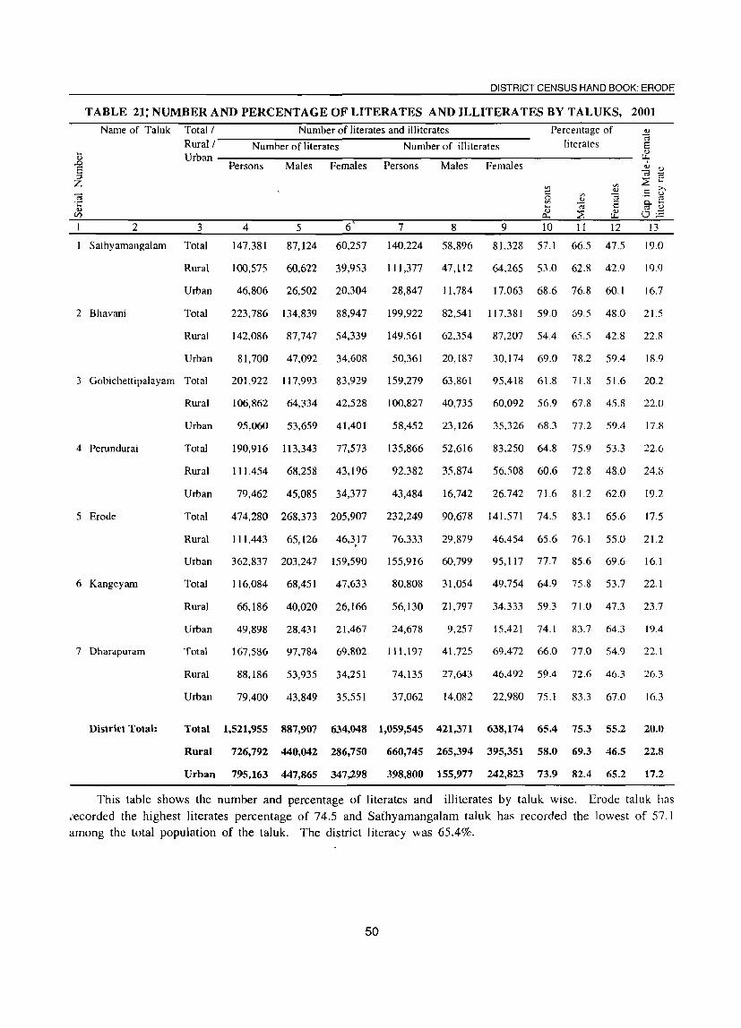
DISTRICT CENSUS HAND BOOK: ERODE
TABLE 21; NUMBER AND PERCENTAGE OF LITERATES AND ILLITERATES BY TALUKS, 2001
.... !!)
S ::!
Z
Name of Taluk
2
Sathyamangalam
2 Bhavani
Number of literates and illiterates Total/ Rmal/----~N~u-m7b-er-o~f~l~ite-r-at-e-s--------~N~u-m7b-er-o~f~ill~it-e-ra-te-s-----
Percentage of literates
Urban -------------------------------------------------------------
3
Total
Rmal
Urban
Persons Males Females Persons Males Females
4 5 6 7 8 9 10 II 12
147,381 87,124 60,257 140,224 58,896 81.328 57.1 66.5 47.5
100.575 60.622 39,953
46,806 26,502 20.304
111.377 47,112
28,847 11.784
64.265 53.0 62.8 42.9
17.063 68.6 76.8 60.1
13
19.0
19.9
16.7
Total 223,786 134.839 88,947 199.922 82.541 117.381 59.0 69.5 48.0 21.5
Rmal 142,086 87,747 54,339 149.561 62,354 87,207 54.4 65.5 42.8 22.8
Urban 81,700 47,092 34,608 50,361 20,187 30.174 69.0 78.2 59.4 18.9
3 Gobichettipalayam Total 201,922 117,993 83,929 159,279 63,861 95,418 61.8 71.8 51.6 20.2
4 Perundurai
5 Erode
6 Kangeyam
7 Dharapuram
District Total:
Rmal 106,862 64,334 42,528
Urban 95,060 53,659 41,401
Total
Rmal
Urban
Total
Rmal
Urban
Total
Rmal
Urban
Total
Rmal
Urban
190,916 113,343 77,573
111,454 68.258 43.196
79,462 45,085 34,377
474,280 268,373 205,907
111 ,443 65,126
362,837 203,247
46,317 ,
159.590
116,084 68,451 47,633
66,186 40,020 26,166
49.898 28,431 21,467
167.586 97,784 69,802
88,186 53,935 34,251
79,400 43.849 35,551
100,827 40,735 60,092 56.9 67.8 45.8 22.0
58,452 23,126 35.326 68.3 77.2 59.4 17.8
135,866 52,616 83,250 64.8 75.9 53.3 22.6
92.382 35.874 56,508 60.6 72.8 48.0 24.8
43,484 16,742 26.742 71.6 81.2 62.0 19.2
232,249 90,678 141.571 74.5 83.1 65.6 17.5
76,333
155,916
29,879
60.799
46,454 65.6
95,117 77.7
76.1
85.6
55.0 21.2
69.6 16.1
80,808 31,054 49.754 64.9 75.8 53.7 22.1
56,130 21,797 34.333 59.3 71.0 47.3 23.7
24,678 9.257 15.421 74.1 83.7 64.3 19.4
111,197 41.725 69.472 66.0 77.0 54.9 22.1
74,135 27,643 46.492 59.4 72.6 46.3 26.3
37.062 14.082 22.980 75.1 83.3 67.0 16.3
Total 1,521,955 887,907 634,048 1,059,545 421,371 638,174 65.4 75.3 55.2 20.0
Rural 726,792 440,042 286,750 660,745 265,394 395,351 58.0 69.3 46.5 22.8
Urban 795,163 447,865 347,298 398,800 155,977 242,823 73.9 82.4 65.2 17.2
This table shows the number and percentage of literates and illiterates by taluk wise. Erode taluk has ,ecorded the highest literates percentage of 74.5 and Sathyamangalam taluk has recorded the lowest of 57.1 among the total population of the tal uk. The district literacy was 65.4%.
50

ANALYTICAL NOTE
TABLE 22 : NUMBER AND PERCENTAGE OF LITERATES AND ILLITERA TES BY SEX IN C D BLOCKS, 2001
Name of CD Block
.... <U
.D E ::l Z (;3 C <U
Vi
2
Talavadi
2 Bhavanisagar
3 Sathyamangalam
4 Thookanaickenpalayam
5 Anthiyur
6 Ammapet
7 Bhavani
8 Gobichettipalayam
9 Nambiyur
10 Uthukuli
1 1 Perundurai
12 Erode
13 Chennimalai
14 Modakurichi
15 Kodumudi
16 Vellakoil
17 Kangeyam
18 Kundadam
19 Mulanur
20 Dharapuram
District (Rural) Total:
Number of literates and illiterates Percentage of
Number of literates
Persons
3
22,573
40,542
37,460
25,940
42,948
46,950
52,188
48,359
32,563
39,410
36,911
35,158
35,133
57,929
18,356
27.040
30,457
37,014
25,840
Males
4
13,621
24,438
22,563
15,507
26.957
29,554
31,236
28,895
19.932
24,399
22.153
19.710
21.706
34,391
11,025
16.203
18.482
22.647
15,980
Females
5
8,952
16.104
14,897
10,433
15.991
17,396
20,952
19,464
12,631
15.011
14,758
15,448
13.427
23,538
'7,331
10,837
11,975
14,367
9.860
34,021 20,643 13,378
726,792 440,042 286,750
Number of illiterates literates
Persons
6
30.601
35,480
45.296
25,178
53.521
50,836
45,204
42,763
32,886
34,507
31,088
20,615
26,787
42,594
13,124
21,476
26,576
33,357
19,857
Males
7
13,016
14,635
19,461
10,344
22,680
21,229
18,445
17,246
13,145
13,375
12,436
8,418
10,063
16,673
4,788
8,137
10.404
13,062
6,751
Females
8 9 10 11 12
17,585 47.9 57.5 38.1 19.4
20,845 59.2 69.4 48.4 21.0
25,835 50.6 59.9 40.9 19.0
14,834 56.3 66.6 45.9 20.7
30.841 50.2 61.3 38.5 22.9
29,607 53.5 65.3 41.0 24.3
26.759 59.5 70.0 48.7 21.3
25,517 58.6 69.3 47.7 21.7
19,741 55.0 66.7 43.1 23.6
21,132 59.6 72.2 46.4 25.8
18,652 60.2 71.1 48.9 22.2
12,197 70.2 78.4 62.0 16.4
16.724 62.4 75.3 48.9 26.4
25.921 63.7 74.7 52.4 22.3
8,336 63.7 76.6 50.9 25.7
13.339 60.8 72.6 48.9 23.7
16.172 58.7 70.5 46.6 23.9
20.295 57.8 69.8 45.4 24.4
13,106 61.0 76.1 46.1 30.1
28,999 11,086 17,913 59.5 71.9 47.0 24.9
660,745 265,394 395,351 58.0 69.3 46.5 22.8
This table gives the number and percentage of literates and illiterates by CD block wise of Erode district. Erode CD bleok has recorded the highest literates percentage of 70.2 and Talavadi has recorded the lowest of 47.9 among the total rural popUlation. The district rural literacy was 58%.
51

DISTRICT CENSUS HAND BOOK: ERODE
TABLE 23;: DISTRIBUTION OF VILLAGES BY LITERACY RATE RANGE, 2001 Range of literacy rate for
villages Number of inhabited Percentage distribution of Population Percentage distribution
of population
o 1-10
11-20 21-30 31-40 41-50 51-60 61-70 71-80 81-90 91-99
100 District Total:
T ,iteracy rate for District: 65.4
villages villages
2 3 o o 1
3 II 40
214 140 21
4 o o
434
0.0 0.0 0.2 0.7 2.5 9.2
49.3 32.3 4.8 0.9 0.0 0.0
100.0
4 o o
1,457 24,243 25,518
106,526 709,622 441,821
68,181 10,169
o o
1,387,537
5 0.0 0.0 0.1 1.7 1.8 7.7
51.1 31.8
4.9 0.7 0.0 0.0
100.0
The above table furnishes the distribution of villages by literacy rate and range. Out of 434 villages, 214
villages (49.3%) fall under the literacy range of 51 - 60 and 140 villages (32.28%) under the literacy rate range of 61 - 70. The district literacy rate has recorded as 65.4.
TABLE 24: NUMBER AND PERCENTAGE OF LITERATES AND ILLITERATES BY SEX IN URBAN AGGLOMERA TIONS / TOWNS 2001
Name and urban status of UArrown
Ammapettai (TP)
2 Anthiyur (TP)
3 Appakudal (TP)
4 Arachalur (TP)
2
5 Ariyappampalayam (TP)
6 Athani (TP)
7 Avalpoondurai (TP)
8 Bhavani VA (Districts 09 & 10)
Bhavani VA (Part)
(a) Bhavani (M)
9 Bhavanisagar (TP)
10 Chennasamudram (TP)
1 1 Chennimalai (TP)
12 Chinnakkampalayam (TP)
13 Chithode (TP)
14 Dharapuram (M)
15 Elathur (TP)
16 Erode VA (Districts 09 & 10)
Erode VA (Part)
(a) Erode (M)
(e) Brahmana Periya Agraharam (TP)
(f) Veerappanchatiram (TP)
(g) Surampatti (TP)
(h) Kasipalayam (E) (TP)
3 5,192
13,968
5,533
6,956 6,662
4,329
6,931
73,504 27,900
27,900
2,587
4,659 11,448
5,090
5,409
4 3,058
7,944
3,312
3,942 3,902
2,566
4,151
40,966 15,247
15,247
1,517
2,718
6,439 3,027
3,073
5 2,134
6,024
2,221
3.014 2,760
1,763
2,780
32,538
12.653
12,653
1,070
1,941
5,009 2,063
2,336
6 4,067
6,103
3,989
5,387 5,800
4,094
4,312
63,680 10,878
10,878
],742
2,683
4,099 4,604
2,295
49,075 25,987 23,088 15,909 3,574 2,252 1,322 4,104
279.089154,394 124.695110,817
242,202 133,279 108,923 86,817
115,346
13,571
50,849
62,753
7,630
28,489
52,593
5,941
22,360
35.195
7,887
21,854
7 1,690
2,410
1,552
2,210 2,407
1.722
1,695 20,460
4,283
4,283
695
954
1,456 1,918
843
6,011 1,630
44,448 34,341
13,709
3,252
8,910
23,331 12,876 10,455 8,617 3,351
39,105 21,531 17,574 13.264 5,119
52
8 9 lO 11 12 2.377 62.8 72.1 53.0 19.1
3,693 77.4 85.8 68.5 17.4
2.437 64.8 75.9 53.2 22.8
3,177 62.1 70.5 53.7 16.9
3.393 59.6 68.6 50.2 18.4
2.372 57.4 66.7 47.7 19.0
2,617 67.6 77.4 56.8 20.6
31,188 78.4 86.4 70.2 16.2
6.595 80.6 87.6 73.5 14.1
6,595 80.6 87.6 73.5 14.1
]'047 66.4 76.3 56.1 20.2
1,729 69.3 81.1 57.5 23.6
2,643 81.4 90.4 72.2 18.3
2,686 58.5 68.8 48.0 20.8
1,452 77.2 86.4 67.7 18.7
9,898 83.4 89.3 77.6 11.7
2.474 51.3 63.7 38.5 25.2
66.369 79.9 86.8 58.0 28.8
52,475 82.1 88.7 75.2 13.5
21,486 84.9 91.0 78.7 12.3
4,635 72.1 80.2 63.8 16.4
12.944 78.5 85.7 70.9 14.8
5.266 81.8 88.8 74.5 14.3
8.145 82.8 89.8 75.6 14.2

ANALYTICAL NOTE
TABLE 24: NUMBER AND PERCENTAGE OF LITERATES AND ILLITERATES BY SEX IN URBAN AGGLOMERATIONS I TOWNS, 2001 (eoutd.)
Name and urban status of UAffown Number of literates and illiterates Percentage of .u C :;:; ------------------.,.---- I· __, p E ___ N_u_m_be_r_o_f_li_re_ra_te_s ______ N __ um __ be_r_o_f_i_ll_ite_r_at_es ____ 1_te_r_at_es_____ 8 ~ @ Persons Males Females Persons Males Females
v> iG >:: v d § rJ c:J .- ~ 5 \3 C3 s§'s ~ ~ ~ ~O~
2 17 Gobichettipalayam (M)
18 Jambai (TP)
19 Kangeyam (TP)
20 Kanjikoil (TP)
21 Kannivadi (TP)
22 Karumandi Chellipalayam (TP)
23 Kasipalayam (G) (TP)
24 Kembainaickenpalayam (TP)
25 Kilampadi (TP)
26 Kodumudi (TP)
27 Kolappalur (TP)
28 Kolathupalayam (TP)
29 Kollankoil (TP)
30 Kuhalur (TP)
3 1 Kunnathur (TP)
32 Lakkampatti (TP)
33 Modakurichi (TP)
34 Mukasipidariyur (CT)
35 Mulanur (TP)
36 Muthur (TP)
37 Nallampatti (TP)
38 Nambiyur (TP)
39 Nasiyanur (TP)
40 Nerunjipettai (TP)
41 Olagadam (TP)
42 Ottapparai (CT)
43 P.Mettupalayam (TP)
44 Pallapalayam (TP)
45 Pasur (TP)
46 Periyakodiveri (TP)
47 Periyasemur (TP)
48 Perundurai (TP)
49 Pethampalayam (TP)
50 Punjaipuliampatti (TP)
51 Rudravathi (TP)
52 SalangapaJayam (TP)
53 Sathyamangalam (M)
54 Sivagiri (TP)
55 Suriyampalayam (TP)
56 Unjalur (TP)
57 Uthukuli (TP)
58 Vadugapatti (TP)
59 Vaniputhur (TP)
3 40,390
8,119
19,430
6,201
2,832
13,848
4,860
4,638
3,855
8,788
5,627
10,575
5,271
5,809
5,017
6,774
6,207
6,667
8,371
6,871
1,922
9,318
5,895
3,738
4,976
5,604
5,234
3,273
2,344
7,060
21,496
12,032
3,488
10,222
3,457
7,945
22,697
10,518
14,002
1,879
5,630
6,283
6,414
4 21,654
4,855
11,069
3,601
1,676
7,364
2,836
2,820
2,231
4,897
3,241
6,237
3,104
3,460
2,775
3,913
3,629
3,933
4,883
4,082
1,181
5,313
3,502
2,197
3,119
3,339
3,121
1,962
1,404
4,106
12,298
6,574
2,140
5,674
2,039
4.794
12,589
61123
8.328
1,080
3,252
3.566
3,763
53
5 18,736
3,264
8,361
2,600
1,156
6,484
2,024
1,818
1,624
3,891
2,386
4,338
2,167
2,349
2.242
2,861
2,578
2,734
3,488
2,789
741
4,005
2,393
1.541
1.857
2,265
2,113
1,311
940
2,954
9,198
5,458
1,348
4,548
1,418
3.151
10.108
4,395
5.674
799
2,378
2.717
2,651
6 14,768
6,892
8,828
4,839
1,580
6,224
3,710
5,670
2,488
3,876
4,176
6,863
3,483
5,875
2,015
4,264
3,845
4,345
5,456
5,009
1,734
6,536
4,010
3,187
4,394
3.604
3,881
3,232
1,526
5,345
10,528
4,911
3,632
4,610
2,650
6,757
11,025
5,737
7,921
749
2.664
4,638
5,793
7 5,633
2,867
3.378
1,969
518
2.475
1,509
2,386
887
1,450
1,636
2,467
1,289
2,434
742
1,704
1,462
1,569
2,030
1.875
685
2,565
1,503
1.352
1.704
1,339
1,436
1,322
583
2,208
4,351
1,866
1.462
1,761
1,138
2.607
4,535
2,113
3,070
243
989
1,851
2,371
8 9 10 11 12 9.135 80.6 87.5 73.9 13.6
4,025 60.0 70.2 49.3 20.9
5,450 76.4 85.2 67.1 18.1
2,870 61.8 71.1 52.2 18.9
1,062 68.7 82.4 55.4 27.0
3,749 76.6 84.1 69.6 14.6
2,201 62.1 71.5 52.4 19.2
3.284 49.6 59.9 39.1 20,9
1,601 66.0 78.0 54.5 23.5
2,426 75.5 84.4 66.7 17.7
2.540 63.6 73.8 53.5 20.4
4,396 66.5 78.3 54.6 23.7
2,194 65.5 77.1 54.0 23.1
3,441 55.1 65.2 44.8 20.4
1,273 79.0 87.6 70.3 17.3
2.560 67.9 77.2 58.2 19.0
2.383 68.5 79.4 57.4 21.9
2,776 67.3 79.5 55.2 24.4
3,426 66.6 77.9 55.4 22.5
3.134 63.9 76.2 51.7 24.5
1,049 57.6 70.2 44.7 25.5
3,971 64.9 74.6 55.3 19.4
2.507 65.8 77.3 54.1 23.1
1.835 60.7 69.7 51.3 18.4
2.690 58.8 72.1 44.9 27.2
2,265 67.9 79.7 55.7 24.0
2,445 63.3 75.6 51.0 24.5
1.910 55.4 66.6 44.2 22.3
943 66.3 77.5 54.5 23.0
3,137 67-.7 71.8 53.2 18.6
6,177 76.0 83.7 67.7 16.0
3,045 78.6 86.6 70.7 15.9
2.170 54.2 66.1 42.2 23.9
2.849 76.2 84.8 67.7 17.1
1.512 62.2 71.2 52.7 18.5
4,150 59.7 71.7 47.5 24.1
6,490 74.6 81.7 67.4 14.3
3,624 71.1 81.7 60.3 21.4
4,851 72.1 82.2 61.0 21.3
506 77.0 88.0 65.9 22.1
1.675 75.8 85.5 65.6 19.9
2,787 63.1 72.4 54.0 18.5
3,422 58.5 68.3 48.6 19.8

DISTRICT CENSUS HAND BOOK: ERODE
TABLE 24: NUMBER AND PERCENTAGE OF LITERATES AND ILLITERATES BY SEX IN URBAN AGGLOMERA TIONS I TOWNS, 2001 (coutd.)
~ Name and urban status of UAffown _____ N_u_m_b_e_r_o_f_lit_e_ra_te_s_a_n_d_il_li_te_ra_t_es_____ Percentage of ~ [;'
E ___ N_u_m_b_er_o_f_l_it_er_a_re_s ____ N __ Uffi __ b_er_o_f_I_·ll_it_er_a_te_s ________ li_te_ra_t_es ____ g j g Persons Males Females Persons Males Females on
C5 V':l UCQj (ij 0 c;j .;::: c;j 5 ~ ~ acta ~ ~ ~ ~o~
2 60 Vellakoil (TP)
61 Vellottamparappu (TP)
62 Vengampudur (TP)
63 Vijayapuri (CT)
District(Urban) Total
3 4 5 6
23,597 13,280 10,317 10,841
5,121 3,046 2,075 3.010
5,021
4,332
2,876
2,525
2,145
1,807
2,611
2,185
7
4,004
1,039
915
868
8 9 10 11 12
6,837 75.9 85.2 66.5 18.7
1.971 68.3 81.1 55.4 25.7
1,696 71.6
1,317 74.3
1,417,858 791,751 626,107 670,992 259,509 399,450 73.9
83.1
83.8
82.4
60.3 22.8
64.2 19.6
65.2 17.2
This table furnishes the number and percentage' of literates and illiterates by urban wise of Erode district. Frode Municipality has recorded the highest percentage of literates (84.9%) while Elathur town panchayat has recorded the lowest percentage of 51.3 among the total population in the urban area. The urban literacy rate A the district was 73.9%.
TABLE 25: NUMBER AND PERCENTAGE OF SCHEDULED CASTES LITERATES AND ILLITERATES BY SEX IN CD BLOCKS, 2001
Name of CD block
2
Talavadi
2 Bhavanisagar
3 Sathyamangalam 4 ThookanaickenpaIayam 5 Anthiyur
6 Ammapet
7 Bhavani
8 Gobichettipalayam
9 Nambiyur
10 Uthukuli
II Perundurai
12 Erode
13 Chennimalai
14 Modakurichi
15 Kodumudi 16 Vellakoil
17 Kangeyam
18 Kundadam
19 Mulanur
20 Dharapuram
District (Rural) Total:
Percentage of 11)
c;j Number of literates and illiterates
Number of literates Number of illiterates literates E - ____ - __ ---____ --____ --__ --____ --__ --__________ ----______ ~ Persons Males Females Persons Males Females V 11) g ~
3 4,257
5,405
5,835 3,699
6,377
7,018
5,581 6,455
4,167
6,219
3,852
4,421
5,143
7,809
3,080 4,191
5,211
6,193
5,188 7,309
107,410
4
2,515
3,339
3,452 2,269
3,892 4,464
3,350 3,838
2,471
3,841
2,282
2,670
3,178
4,730
1,885 2,502
3,066
3,783 3,144
4,468
65,139
5 1,742
2,066
2,383 1,430
2,485 2,554
2,231 2,617
, 1,696
2,378
1,570
1,751
1,965
3,079
1,195 1,689
2,145 2,410
2,044
2,841
42,271
6
6,055
10,366
11,285 6,235 8,778
11,738
8.582 11,301
8,601
10,231
7,126
5,525
6,988
10,516
3,383 5,936
7,370 10,224
5,693
10,334
166,267
7
2,642
4,754
5,111
2,740 3,823 5,202
3,777 5,190
3,941
4,536
3,260
2,418
3,022 4,542
1,399 2,563
3,283 4,574
2,349
4,402
73,528
8 9 10 I I
;>; .6 ~ g. ~ O~
12
3,413 46.4 54.7 38.0 16.7
5,612 38.6 46.5 30.3 16.2
6,174 38.4 45.3 31.4 13.9 3,495 41.9 51.0 32.6 18.3 4,955 47.3 56.7 37.5 19.2
6,536 42.4 52.6 31.6 21.0
4,805 44.5 52.8 36.0 16.8 6,111 40.8 47.7 33.6 14.1
4,660 36.4 42.9 29.7 13.2
5,695 43.1 52.3 33.6 18.7
3,866 39.9 46.S 33.0 13.5
3,107 51.2 60.3 41.6 18.7
3,966 48.0 58.1 37.5 20.6 5,974 48.3 58.0 38.4 19.6
1,984 53.3 64.9 41.6 23.3 3,373 46.1 54.8 37.3 17.5
4,087 46.9 54.5 39.1 15.4 5,650 43.0 51.5 34.0 17.5
3,344 53.0 63.8 42.1 21.7
5,932 46.7 56.9 36.4 20.5
92,739 44.3 53.0 35.3 17.7
This table discribes the number and percentage of Scheduled Castes literates and jJJiterates by sex in CD blocks of the district. Kodumudi CD block has recorded the highest percentage of 53.3 literates among the Scheduled Caste population in the district, while Nambiyur has recorded the lowest literacy of 36.4%. It is noticed that the Erode district Scheduled Caste literates has recorded as 44.3% among the rural population.
54
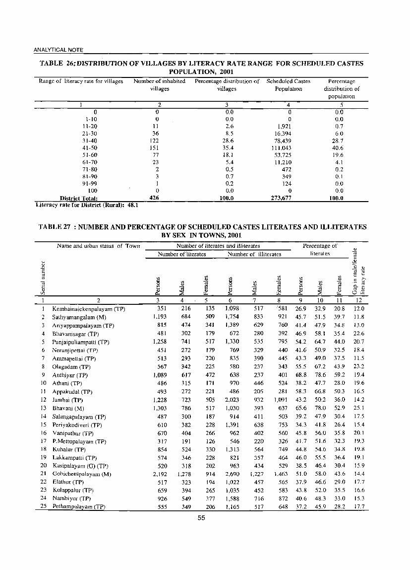
ANALYTICAL NOTE
TABLE 26:DISTRIBUTION OF VILLAGES BY LITERACY RATE RANGE FOR SCHEDULED CASTES POPULA TION, 2001
Range of literacy rate for villages Number of inhabited Percentage distribution of Scheduled Castes Percentage distribution of
population
o 1-10
11-20 21-30 31-40 41-50 51-60 61-70 71-80
villages villages Population
2 3 4 o 0.0 0 o ~O 0
11 2.6 1,921 36 8.5 16,394
122 28.6 78,439 151 35.4 111,043 77 18.1 53,725 23 5.4 11,210 2 0.5 472
5 0,0 0.0 0.7 6.0
28.7 40.6 19.6
81-90 3 0.7 0.2 0.0
349 124
4.1 0.2 0.1 0.0 0.0
91-99 I 100 0 o
District Total: 426 100.0 273,677 100.0 Literacy rate for District (Rural): 48.1
TABLE 27 : NUMBER AND PERCENTAGE OF SCHEDULED CASTES LITERATES AND ILLITERATES BY SEX IN TOWNS, 2001
Name and urban status of Town
2
1 Kembainaickenpalayam (TP)
2 Sathyamangalam (M)
3 Ariyappampalayam (TP)
4 Bhavanisagar (TP)
5 Punjaipuliampatti (TP) 6 Nerunjipettai (TP)
7 Amrnapettai (TP)
8 01agadam (TP)
9 Anthiyur (TP) 10 Athani (TP)
11 Appakudal (TP)
12 ] ambai (TP)
13 Bhavani (M)
14 Salangapalayam (TP)
15 Periyakodiveri (TP)
16 Vaniputhur (TP) 17 P.Mettupalayam (TP) 18 Kuhalur (TP)
19 Lakkarnpatti (TP)
20 Kasipalayam (0) (TP) 21 Gobichettipalayam (M)
22 Elathur (TP)
23 Kolappalur (TP) 24 Nambiyur (TP)
25 Pethampalayam (TP)
Number of literates and illiterates Percentage of 'I)
Number of literates Number of illiterates literates C;
------------------------~-------------------------- 8
3 351
1,193
815
481
1,258
451
513
567
1,089 486
493
1,228
1,303
487
610
670 317
854
574
520 2,192
517
659 926
555
4 216 684
474
302
741
272
293
342
617 315
272
723 786
300
382 404
191 524
346
318 1,278
323
394 549 349
5 6
55
135
509
1,098 1,754
341 1,389
179 672
517 1,330
179 220
225
472 171
769 835
580
638 970
221 486
505 2.023 517 1,030
187 914
228 1,391
266 962 126 546 330 1,313
228 821
202 963 914 2,690
194 1,022
265 1,035
377 1,588 206 1,165
7 517
833 629
280 535
329
390
237
237 446
205
932
393
411
638
402 220
564
357
434 1,227
457 452
716
517
8 '581
921
9 10
26.9 32.9
45.7 51.5
II
20.8
39,7
J:l
~ 8 c:; f!
>. .8 ~ 0.. ...
O~ 12
12.0
11.8
760 41.4 47.9 34.8 13.0
392 46.9 58.1 35.4 22.6
795 54.2 64.7 44.0 20.7
440 41.6
445 43.3
343 55.5
401 68.8 524 38.2
50.9 32.5 49.0 37.5
67.2 43.9
78.6 59.2 47.7 28.0
18.4
11.5
23.2
19.4 19.6
281 58.3 66.8 50.3 [6.5
1,091 43.2 50.2 36.0 14.2
637 65,6 78,0 52.9 25,1
503 39.2 47.9 30.4 17.5
753 34.3 41.8 26.4 15.4
560 45.8 56.0 35.8 20.1 326 41.7 51.6 32.3 19.3 749 44.8 54.6 34.8 19.8
464 46.0 55.5 36.4 19.1
529 38.5 46.4 30.4 15.9 1,463 51.0 58.0 43.6 14.4
565 37.9 46.6 29.0 [7.7
583 43.8 52.0 35.5 16.6 872 40.6 48.3 33.0 15.3
648 37.2 45.9 28.2 17.7

DISTRICT CENSUS HAND BOOK: ERODE
TABLE 27 : NUMBER AND PERCENTAGE OF SCHEDULED CASTES LITERATES AND ILLITERATES BY SEX IN TOWNS 2001 (contd.)
Name and urban status of Town
2 26 Pallapalayam (TP)
27 Kanjikoil (TP) 28 Karumandi CheUipalayam (TP)
29 Nallampatti (TP) 30 Kunnathur (TP) 3 I Vijayapuri (CT)
32 Perundurai (TP) 33 Mukasipidariyur (CT) 34 Uthukuli (TP) 35 Ottapparai (CT) 36 Chennimalai (TP) 37 Suriyampalayam (TP) 38 Chi thode (TP) 39 Nasiyanur (TP) 40 Periyasemur (TP) 41 Brahmana Periya Agraharam(TP) 42 Erode (M)
43 Veerappanchatiram (TP) 44 Surampatti (TP)
45 Kasipalayam (E) (TP) 46 Avalpoondurai (TP)
47 Modakurichi (TP) 48 Pasur (TP) 49 Arachalur (TP)
50 Vadugapatti (TP) 51 Kilampadi (TP) 52 Vellottamparappu (TP) 53 Sivagiri (TP)
54 Kollankoil (TP) 55 Unjalur (TP) 56 Vengampudur (TP) 57 Kodumudi (TP) 58 Chennasamudram (TP) 59 Muthur (TP) 60 Kangeyam (TP)
61 Vellakoil (TP) 62 Rudravathi (TP) 63 Kannivadi (TP) 64 Mulanur (TP) 65 KoJathupaJayam (TP) 66 Dharapuram (M) 67 Chinnakkampalayam (TP)
Number of literates and illiterates Percentage of ~ Number of literates Number of illiterates literates ~
---------------------------------------------------~
3 376 649
989
339 441 176
1,026 335 326 258
303 3,136
317 925
620 3,877 7,792
2,352 903
4,094
866
895 475 789
1,048 520
526 768 604 173 452
1,140
451 1,211
1,767 1,976
694 385
1,266 1,546 6,135
589
4 225
390 568 214 276 104 576 202 198 155 182
1,883 170 537 353
2,245 4,510
1,345 526
2,362
5·11
536 299 468
601 297 303 457 370 110 270 661 265 743
1,013 1,156
414 232 730 962
3,398 344
5 151
259 421
125 165 72
450 133 128 103 121
1.253 147 388 267
1.632 3,282
1,007 377
1,732 355
359 176 321
447 223 223 311
234 63
182 479 186 468 754
820 280
153 536 584
2,737 245
6 667
1,147 1,222
540 310 252
1,014 597 363 374 177
2,056
337 1,388
381 3,189 4,850
2,015 585
2,189 885
961 606
1,204
1,388 687 661 845 796 99
492 882 465
1,510
1,803 1,622
978 343
1,358 1,781 3,977
928
7 313 539 563
228 104 109 430 260 152 154 70
743 156 588 156
1,312 1,882
877 231 874
355
390 245 542
593 283 265 353 326
33 197 352 187 637 784
654 455
141 561 700
1,505
432
8 9 354 40.8
608 39.9 659 51.5 312 42.7 206 65.3 143 47.8 584 57.2 337 42.2
211 53.6 220 46.9 107 68.1
1,313 68.0 181 54.2 800 45.6 225 71.6
1,877 63.0 2,968 69.5
1.138 60.4 354 69.1
1,315 72.9 530 55.2
571 54.3 361 49.0 662 43.7
795 48.2 404 47.5 396 49.7 492 53.7 470 47.8
66 70.0
295 53.2 530 62.1 278 54.4 873 50.2
1,019 56.8
968 60.7 523 46.1 202 59.0 797 54.7
1,081 52.0 2,472 67.6
496 44.1
10 11 49.1 32.5
47.0 32.4 58.6 44.3
54.2 31.4 80.2 49.8 57.8 38.3 65.0 49.6 51.7 33.1 64.9 42.2 59.4 35.6 78.1 57.1 80.3 55.2 60.5 48.4 54.2 37.3
82.3 61.1 72.7 53.2 79.6 59.2
67.9 52.7 77.7 59.9 81.6 63.6 65.2 45.2
65.0 43.6 61.8 36.2 51.4 35.9
57.0 39.9 56.7 39.1 60.2 40.2 63.4 43.8
59.3 36.6 84.6 53.8
64.6 42.2 71.7 52.4 64.8 44.3 60.9 39.3 65.1 48.5
69.9 51.3 53.8 38.0 69.7 48.0 64.4 45.3
64.0 39.8 76.9 58.7 51.3 36.8
'V 'l.>
] '8 .5 :>-. o..S '" 'l.> oE 12 16.6
14.6 14.3
22.8 30.4 19.5 15.4 18.6
22.7 23.7 21.0 25.2 12.1 16.9 21.2
19.4 20.4
15.3 17.8
18.0 20.0
21.5 25.6 154 17.1 17.6 20.1 19.6 22.7 30.8
22.4 19.3 20.5 21.6 16.6
18.7 15.8 21.7 19.0 24.3 18.1 14.5
Erode (Urban) 72,619 42,556 30,063 75,908 32,089 43,819 55.0 64.3 45.7 18.5 .,
The table gives the number and percentage of Scheduled Castes literates and iiIiterates by sex in Erode district. Kasipalayam (E) town panchayat has recorded the highest (72.90%) literates while Kembanayakampalayam town has the lowest of 26.9% literates among the Scheduled Castes population.
56

ANALYTICAL NOTE
TABLE 28: NUMBER AND PERCENTAGE OF SCHEDULED TRIBES LITERA TES AND ILLITERA TES BY SEX IN C D BLOCKS, 2001
Name of C D block
2
Talavadi
2 Bhavanisagar
3 Sathyamangalam
4 Thookanaickenpalayam
5 Anthiyur
6 Ammapet
7 Bhavani
8 Gobichettipalayarn
9 Namhiyur
10 Uthukuli
1 1 Perundurai
12 Erode
13 Chennimalai
14 Modakurichi
15 Kodumudi
16 Vellakoil
17 Kangeyam
18 Kundadam
19 Mulanur
20 Dharapuram
District (Rural) Total:
Number of literates and illiterates
Number of literates Number of illiterates
3
744
68
1,043
296
552
1,667
324
6
4
6
o 26
4
84
7
6
15
4
4
92
4,952
4
478
43
676
181
336
942
158
4
2
6
o 13
3
51
2
4
8
3
3
66
2,979
5
266
25
367
115
216
725
166
2
2
o o
13
33
5
2
7
6
2,603
73
4,140
932
1,293
737
97
5
o 6
73
17
5
7
2
3
26 172
1,973 10,168
7
1,158
27
1,942
437
595
277
46
o 2
o o 3
o 31
6
2
o
66
4,594
8
1.445
46
2,198
495
698
460
51
1
3
o 3
42
11
4
5
2
2
106
5,574
Percentage of literates
9
26.0
54.4
22.9
26.6
35.0
75.4
84.6
10
33.8
68.3
29.4
32.1
42.4
84.8
88.3
85.7 100.0
44.4 50.0
85.7 100.0
0.0
89.7
0.0
86.7
80.0 100.0
62.2
33.3
66.7
75.0
73.9
28.6
80.0
80.0
66.7 100.0
66.7 100.0
39.5 56.9
37.2 44.7
11
18.3
40.3
16.3
20.9
27.S
65.8
81.4
66.7
40.0
12
15.5
27.9
13.1
11.1
14.9
18.9
6.9
33.3
10.0
0.0 100.0
00
92.9
50.0
50.0
35.7
50.0
70.0
33.3
33.3
22.2
29.7
0.0
-6.2
50.0
23.9
-7.1
30.0
10.0
66.7
66.7
34.7
15.0
The table provides the number and percentage of Scheduled Tribes literates and illiterates by sex in CD blocks. The total number of Scheduled Tribes literates in rural area of the district is noticed by only 4.952. Ammapettai CD block has the highest Scheduled Tribes literate population of 1.667 followed by Sathyamangalam (l ,043). Talavadi (744) and Anthiyur (522).
57
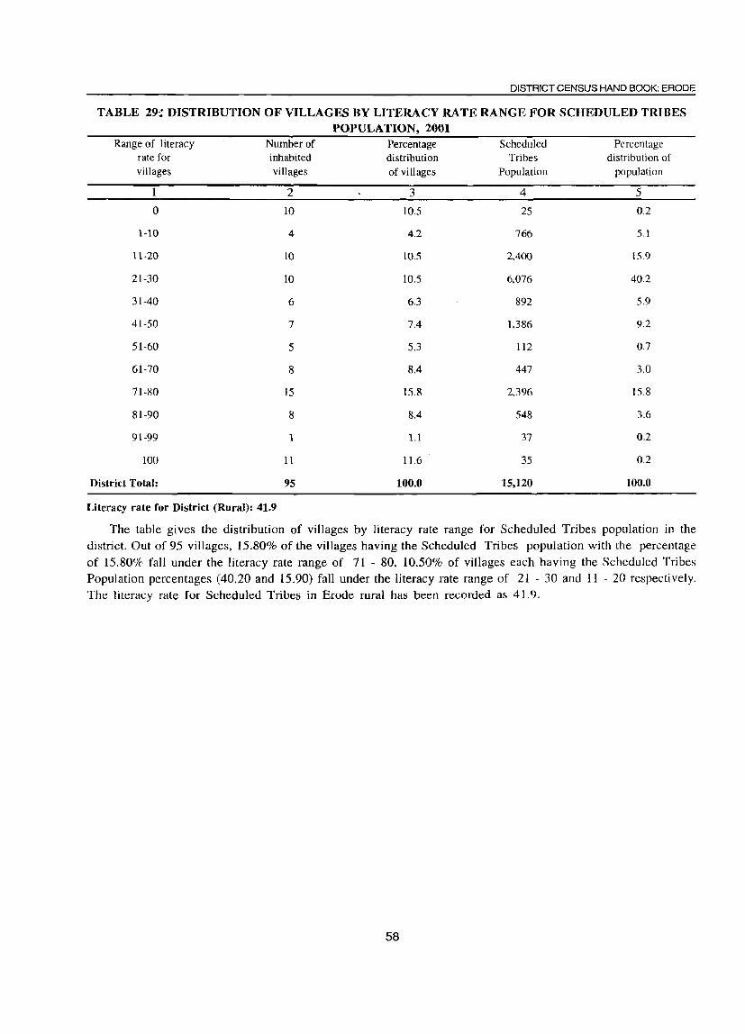
DISTRICT CENSUS HAND BOOK: ERODE
TABLE 29:; DISTRIBUTION OF VILLAGES BY LITERACY RATE RANGE FOR SCHEDULED TRIBES POPULATION, 2001
Range of literacy Number of Percentage Scheduled Percentage rate for inhabited distribution Tribes distribution of villages villages of villages Population population
2 3 4 5
0 10 10.5 25 0.2
1-10 4 4.2 766 5.1
11-20 10 10.5 2,400 15.9
21-30 10 10.5 6,076 40.2
31-40 6 6.3 892 5.9
41-50 7 7.4 1,386 9.2
51-60 5 5.3 112 0.7
61-70 8 8.4 447 3.0
71-80 15 15.8 2.396 15.8
81-90 8 8.4 548 3.6
91-99 1 1.1 37 0.2
100 11 11.6 35 0.2
District Total: 95 100.0 15,120 100.0
Literacy rate for District (Rural): 41.9
The table gives the distribution of villages by literacy rate range for Scheduled Tribes population in the
district. Out of 95 villages, 15.80% of the villages having the Scheduled Tribes population with the percentage
of 15.80% fall under the literacy rate range of 71 - 80, 10.50% of villages each having the Scheduled Tribes
Population percentages (40.20 and 15.90) fall under the literacy rate range of 21 - 30 and 11 - 20 respectively.
The literacy rate for Scheduled Tribes in Erode rural has been recorded as 41.9.
58

ANALYTICAL NOTE
TABLE 30: NUMBER AND PERCENTAGE OF SCHEDULED TRIBES LITERATES AND ILLITERATES BY SEX IN TOWNS 2001
Name and urban status of Town
2 Kembainaickenpalayam (TP)
2 Sathyamangalam (M)
3 Ariyappampalayam (TP) 4 Bhavanisagar (TP)
5 Nerunjipettai (TP) 6 Ammapettai (TP)
7 Olagadam (TP) 8 Anthiyur (TP)
9 Bhavani (M) 10 Periyakodiveri (TP) 11 Vaniputhur (TP)
12 KuhaJur (TP)
13 Lakkampatti (TP)
14 Kasipalayam (0) (TP)
15 Oobichettipalayam (M)
16 Nambiyur (TP)
17 Pethampalayam (TP) 18 Kanjikoil (TP)
19 Karumandi ChellipaJayam (TP
20 Kunnathur (TP) 21 Vij~yapuri (CT)
22 Mukasipidariyur (CT) 23 SuriyampaJayam (TP)
24 Chi thode (TP)
25 Nasiyanur (TP)
26 Periyasemur (TP) 27 Erode (M) 28 Veerappanchatiram (TP) 29 Surampatti (TP)
30 Kasipalayam (E) (TP) 31 AvaJpoondurai (TP) 32 Modakurichi (TP)
33 Vadugapatti (TP) 34 Kilampadi (TP)
35 Vellottamparappu (TP) 36 Muthur (TP)
37 Vellakoil (TP) 38 Kolathupalayam (TP)
39 Dharapuram (M)
Erode (Urban)
Number oHiterates and illiterates
Number of literates
3 6
40 4 8
38 423
234 11
36 9 3 3
o III
7 2 2 3 4 3 4
15 2
2 28 63 15 2
97 4
6 o 4 o o
14 15
357
1576
4 3
29 2 6
22 240 132
7 20
6 2
1
o o
62 2
2 2 1
11
2 15 36
7 1
57 4
4 o 2 o o
11 9
198
900
- 5 3
11
2 2
16 183
102 4
16 3 1
2
o 49
5 I' 1
2 2
3 4 1
o 13 27
8 1
40 o 2 o 2 o o 3 6
159-
676
Number of illiterates
'" c:: o '" ~ 6
4 81 2 o
24 195 43
2
16 2
13
o o
22 140
o 3
1
2
o 8 2 1
6 11
9 1
130
14
87 o 3 4
12 2
154
997
7
37
1 o
11 88 13 2 7
1 7
o o
12 74 o
o o 2
1
3 3 5 1
65 o 6
45 o
2
3 o
64
460
8 3
44 I o
13 107 30 o 9 1 6
o o
10 66 o 2 o o
o 6 1
o 3 8 4 o
65 1
8
42
o 2
2
9 2
90
537
Percentage of literates
9 60.0 36.0
66.7 100.0
67.9 75.1
88.0 91.7
76.6 90.0 25.0
100.0 100.0
0.0
52.1 100.0 40.0
100.0 100.0 80.0
100.0 100.0
78:.9 100.0
66.7 84.8 91.3 71.4
100.0
53.0 80.0 40.0
0.0
100.0 0.0
0.0
63.6 93.8
81.7
69.3
10
75.0 49.2
66.7 100.0
73.3 83.0 95.7 87.5
80.0 100.0 28.6
100.0 0.0 0.0
53.9
100.0
50.0 100.0 100.0 100.0 100.0 100.0 100.0 100.0 66.7
83.3 94.7 70.0
100.0
60.0 100.0
44.4 0.0
100.0
0.0
0.0
91.7 100.0 88.8
75.6
11 12 50.0 25.0 21.2 28.0 66.7 0.0
100.0
61.5 66.8 79.7
100.0
72.7 75.0 20.0
100.0 100.0
0.0 50.0
100.0 33.3
100.0 100.0 66.7
100.0 100.0 50.0
100.0 0.0
86.7 87.1 72.7
100.0
45.5 0.0
33.3 0.0
100.0
0.0
0.0
30.0 85.7
74.3
62.3
0.0
11.8 16.3
16.0 -12.5
7.3 25.0
R.6
0.0 -100.0
0.0
3.9
0.0 16.7
0.0 0.0
33.3 0.0 0.0
50.0 0.0
66.7
-3.3 7.6
-2.7 0.0
14.5 100.0
11.1 0.0 0.0
0.0 0.0
61.7 14.3
14.5
13.3
This table gives the number and percentage of Scheduled Tribes literates and illiterates by sex in towns of Erode district. The total number of literates in 39 towns where the Schedueld Tribes population are available has been returned as 1576. Ammapettai has recorded the highest Scheduled Tribes literates population of 423 followed by Dharapuram (357), Olagadam (234) and Gobichettipalayam (111) respectively.
59
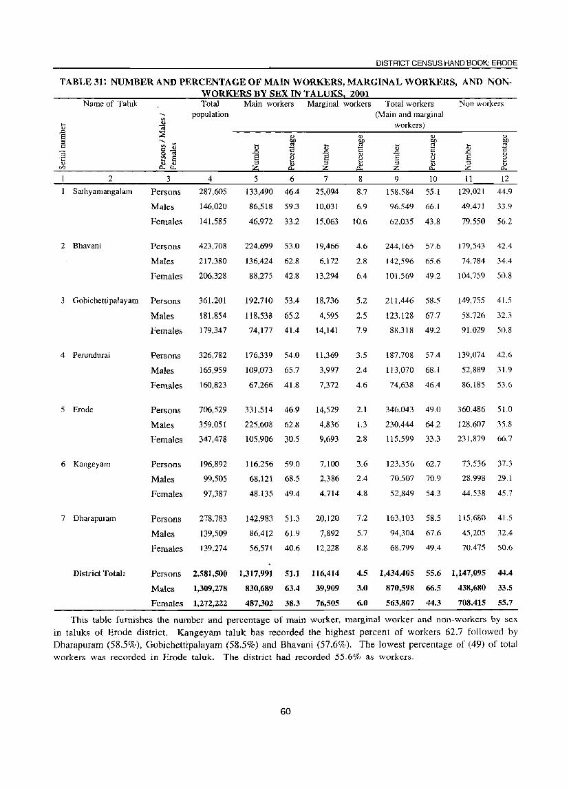
DISTRICT CENSUS HAND BOOK: ERODE
TABLE 31; NUMBER AND PERCENTAGE OF MAIN WORKERS, MARGINAL WORKERS, AND NONWORKERS BY SEX IN TALUKS, 2001
Name of Taluk
2
Sathyamangalam
2 Bhavani
3
Persons
Males
Females
Persons
Males
Females
3 Gobichettipalayam Persons
Males
Females
4 Perundurai
5 Erode
6 Kangeyam
7 Dharapuram
Persons
Males
Females
Persons
Males
Females
Persons
Males
Females
Persons
Males
Females
Total Main workers Marginal workers population
4
287,605
146,020
141,585
423,708
217,380
206,328
361,201
181,854
179,347
326,782
165,959
160,823
706,529
359,051
347,478
196,892
99,505
97,387
278,783
139,509
139,274
5 6 7 8
133,490 46,4 25,094 8.7
86,518 59.3 10,031 6.9
46,972 33.2 15,063 10.6
224,699 53.0
136,424 62.8
88,275 42.8
192,710 53.4
118.5313 65.2
74,177 41.4
176,339 54.0
109,073 65.7
67,266 41.8
331,514 46.9
225,608 62.8
105,906 30.5
19,466
6.172
13,294
18,736
4,595
14,141
11,369
3,997
7,372
14,529
4,836
9,693
116,256 59.0 7,100
68,121 68.5 2,386
48,135 49.4 4,714
142,983 51.3 20,120
86.412 61.9 7,892
56,571 40.6 12,228
4.6
2.8
6.4
5.2
2.5
7.9
3.5
2.4
4.6
2.1
1.3
2.8
3.6
2.4
4.8
7.2
5.7
8.8
Total workers (Main and marginal
workers)
9 10
158.584 55.1
96,549 66.1
62,035 43.8
244,165 57.6
142,596 65.6
101.569 49.2
211,446 58.5
123.128 67.7
88.318 49.2
187,708 57.4
113,070 68.1
74,638 46.4
346,043 49.0
230,444 64.2
115,599 33.3
123.356 62.7
70,507 70.9
52,849 54.3
163,103 58.5
94,304 67.6
68.799 49.4
Non workers
11 12
129.021 44.9
49,471 33.9
79.550 56.2
179,543 42.4
74,784 34.4
104.759 50.8
149,755 41.5
58.726 32.3
91,029 50.8
139,074 42.6
52,889 31.9
86,185 53.6
360,486 51.0
128,607 35.8
231,879 66.7
73,536 37.3
28.998 29.1
44.538 45.7
115,680 41.5
45,205 32.4
70,475 50.6
District Total: Persons 2,581,500 1,317,991 51.1 116,414 4.5 1,434,405 55.6 1,147,095 44.4
Males 1,309,278
Females 1,272,222
830,689 63.4 39,909
487,302 38.3 76,505
3.0
6.0
870,598 66.5
563,807 44.3
438,680 33.5
708,415 55.7
This table furnishes the number and percentage of main worker, marginal worker and non-workers by sex in taluks of Erode district. Kangeyam taluk has recorded the highest percent of workers 62.7 followed by Dharapuram (58.5%), GobichcttipaJayam (58.5%) and Bhavani (57.6%). The lowest percentage of (49) of total workers was recorded in Erode taluk. The district had recorded 55.6% as workers.
60

ANALYTICAL NOTE
TABLE 32: NUMBER AND PERCENTAGE OF MAIN WORKERS, MARGINAL WORKERS, AND NONWORKERS BY SEX IN CD BLOCKS, 2001
N arne of CD block ra Total Main workers
2
Talavadi
2 Bhavanisagar
3 Sathyamangalarn
] Population ~
3
P
M
F
P
M
F
P
M
F
4
53,174
26,637
26,537
76,022
39,073
36,949
82,756
42,024
40,732
4 Thookanaickenpalayam P 51,118
25,851
25,267
5 Anthiyur
6 Ammapet
7 Bhavani
8 Gobichettipalayam
9 Nambiyur
10 Uthukuli
11 Pcrundurai
12 Erode
M
F
P
M
F
P
M
F
P
M
F
P
M
F
P
M
F
P
M
F
P
M
F
P
M
F
96,469
49,637
46,832
97,786
50,783
47,003
97,392
49,681
47.711
91,122
46.141
44,981
65,449
33,077
32,372
73,917
37,774
36,143
67,999
34,589
33,410
55,773
28,128
27,645
5 6
17,297 32.5
12,269 46.1
5,028 18.9
40,555 53.3
25,810 66.1
14,745 39.9
43,521 52.6
26,036 62.0
17,485 42.9
30,184 59.0
17,062 66.0
13,122 51.9
53,100 55.0
31,538 63.5
21,562 46.0
55,268 56.5
31,587 62.2
23,681 50.4
51,651 53.0
31,457 63.3
20,194 42.3
51,343 56.3
30,769 66.7
20,574 45.7
36,l75 55.3
22,128 66.9
14,047 43.4
40,000 54.1
25,772 68.2
14,228 39.4
37,986 55.9
22,644 65.5
15,342 45.9
26,624 47.7
17,425 61.9
9,199, 33.3
61
Marginal workers Total workers
7 11,638
4,696
6,942
3,124
782
2,342
6,285
2,517
3,768
1,993
594
1,399
5,407
1,287
4,120
7,440
2,498
4,942
3,189
1,033
2,156
3,439
866
2,573
7,417
1,336
6,081
1,791
629
1,162
3,856
1,369
2,487
1,191
322
869
8
21.9
17.6
26.2
4.1
2.0
6.3
7.6
6.0
9.3
3.9
2.3
5.5
5.6
2.6
8.8
7.6
4.9
10.5
3.3
2.1
4.5
3.8
1.9
5.7
11.3
4.0
18.8
2.4
1.7
3.2
5.7
4.0
7.4
2.1
1.1
3.1
(Main and marginal workers)
9 10
28,935 54.4
16,965 63.7
11,970 45.1
43,679 57.5
26,592 68.1
17.087 46.2
49,806 60.2
28.553 67.9
21,253 52.2
32.177 62.9
17,656 68.3
14,521 57.5
58,507 60.6
32,825 66.1
25,682 54.8
oZ,708 64.1
34,085 67.1
28.623 60.9
54.840 56.3
32,490 65.4
22,350 46.8
54,782 60.1
31.635 68.6
23.147 51.5
43.592 66.6
23,464 70.9
20,128 62.2
41.791 56.5
26,401 69.9
15,390 42.6
41.842 61.5
24,013 69.4
17,829 53.4
27.815 49.9
17.747 63.1
10,068 36.4
Non workers
11 12
24,239 45.6
9,672 36.3
14.567 54.9
32,343 42.5
12.481 31.9
19.862 53.8
32,950 39.8
13,471 32.1
19,479 47.8
18,941 37.1
8,195 31.7
10.746 42.5
37,962 39.4
16,812 33.9
21,150 45.2
35,078 35.9
16,698 32.9
18.380 39.1
42,552 43.7
17.191 34.6
25,361 53.2
36,340 39.9
14,506 31.4
21,834 48.5
21,857 33.4
9,613 29.1
12,244 37.8
32,126 43.5
11.373 30.1
20,753 57.4
26,157 38.5
10,576 30.6
15,581 46.6
27,958 50.1
10.381 36.9
17.577 63.6

DISTRICT CENSUS HAND BOOK: ERODE
TABLE 32: NUMBER AND PERCENTAGE OF MAIN WORKERS, MARGINAL WORKERS, AND NON·
WORKERS BY SEX IN CD BLOCKS, 2001 (Contd.)
Name of CD block '" Total Main workers Marginal workers Total workers Non workers .., <3 Population (Main and marginal S ~ workers) ..... '" .... .., .., <a
.0 ::E E ~ <.> <.> .., :l ..... OJ) blJ OJ)
!: '" .... CII .... CII ..... c-:I .... c-:I
t:: 'I) I:: 'I) I:: 'l) ... 'l) .... (;3 "S "S .0 '" .0 '" 0 .., ..,
S 'l)
§ <!)
.t:; ~ ~ ~ ~ u 0 'I)
~ ~ ::l ..... .., 'I) 'I) 'l)
V) ~ 9= ~ ~ e: z 0..
2 3 4 5 6 7 8 9 10 11 12
13 Chennimalai P 61.920 36,504 59.0 2,076 3.4 38,580 62.3 23,340 37.7
M 31,769 20,940 65.9 620 2.0 21.560 67.9 10,209 32.1
F 30,151 15,564 51.6 1,456 4.8 17,020 56.4 13,131 43.6
14 Modakurichi P 100,523 55,409 55.1 3,885 3.9 59,294 59.0 41.229 41.0
M 51,064 33,321 65.3 1,252 2.5 34,573 67.7 16.491 32.3
F 49,459 22,088 44.7 2.633 5.3 24,721 50.0 24,738 50.0
15 Kodumudi P 31,480 20,674 65.7 528 1.7 21,202 67.4 10,278 32.6
M 15,813 10,943 69.2 150 0.9 11,093 70.2 4,720 29.8
F 15,667 9,731 62.1 378 2.4 10,109 64.5 5,558 35.5
16 VeJlakoil P 48,516 31,998 66.0 1,099 2.3 33,097 68.2 15,419 31.8
M 24,340 17,336 71.2 379 1.6 17,715 72.8 6,625 27.2
F 24,176 14,662 60.6 720 3.0 15,382 63.6 8,794 36.4
17 Kangeyam P 57,033 34,036 59.7 3,697 6.5 37,733 66.2 19.300 33.8
M 28,886 19,348 67.0 1,279 4.4 20,627 71.4 8,259 28.6
F 28,147 14,688 52.2 2,418 8.6 17,106 60.8 11.041 39.2
18 Kundadam P 70,371 43,843 62.3 3,470 4.9 47,313 67.2 23,058 32.8
M 35,709 24,262 67.9 1,212 3.4 25,474 71.3 10,235 28.7
F 34,662 19,581 56.5 2,258 6.5 21.839 63.0 12,823 37.0
19 Mulanur P 45,697 30,712 67.2 1,641 3.6 32,353 70.8 13,344 29.2
M 22,731 16,218. 71.3 507 2.2 16,725 73.6 6,006 26.4
F 22,966 14.494 63.1 1.134 4.9 15,628 68.0 7,338 32.0
20 Dharapuram P 63,020 33,275 52.8 7,662 12.2 40,937 65.0 22,083 35.0
M 31,729 19,324 60.9 2,835 8.9 22,159 69.8 9,570 30.2
F 31,291 13,951 44.6 4,827 15.4 18,778 60.0 12,513 40.0
District (Rural) Total: P 1,387,537 770,155 55.5 80,828 5.8 850,983 61.3 536,554 38.7
M 705,436 456,189 64.7 26,163 3.7 482,352 68.4 223,084 31.6
F 682,101 313,966 46.0 54,665 8.0 368,631 54.0 313,470 46.0
This table provides the number and percentage of main workers, marginal workers and non - workers by
sex in CD blocks of Erode district. The district has recorded 61.3% of workers and 38.7% of non - workers
among the rural population. Out of 20 CD blocks in the district, Mulanur has recorded the highest (70.8%) workers followed by Vellakoil (68.2%), Kodumudi (67.4%), Kundadam (67.2%) and Kangeyam (66.2%)
respectively where as the Erode CD block has recorded the lowest (49.9%) workers in the rural areas of this
district.
62

ANALYTICAL NOTE
TABLE 33: NUMBER AND PERCENTAGE OF MAIN WORKERS, MARGINAL WORKERS, AND NON· WORKERS BY SEX IN URBAN AGGLOMERATIONS I TOWNS, 2001
Name and urban status of VA / Town
2
I Ammapettai (TP)
2 Anthiyur (TP)
3 Appakudal (TP)
4 Arachalur (TP)
5 Ariyappampalayam (TP)
6 Athani (TP)
7 Avalpoondurai (TP)
8 Bhavani VA (Distts 09 & 10)
Bhavani VA (Part)
(a) Bhavani (M)
9 Bhavanisagar (TP)
10 Chennasamudram (TP)
3
P
M
F
P
M
F
P
M
F
P
M
F
P
M
F
P
M
F
P
M
F
P
M
F
P
M
F
P
M
F
P
M
F
P
M
F
4
9,~59
4,748
4,511
20,071
10,354
9,717
9,522
4,864
4,658
Main workers
5 6
4,817 52.0
2,947 62.1
1,870 41.5
8,951 44.6
6,420 62.0
2,531 26.0
4,475 47.0
2,821 58.0
1,654 35.5
12,343 6,944 56.3
6,152
6,191
4,118 66.9
2,826 45.6
12,462 5,859 47.0
6,309
6,153
8,423
4,288
4,135
11,243 , 5,846
5,397
38,778
19,530
3,908 61.9
1,951 31.7
4,948 58.7
2,881 67.2
2,067 50.0
5,510 49.0
3,355 57.4
2,155 39.9
16,086 41.5
11,757 60.2
19,248 4,329 22.5
104,646
52,998
51,648
38,778
19,530
19,248
4,329
2,212
2,117
50,008 47.8
33.750 63.7
16,258 31.5
16,086 41.5
11,757 60.2
4,329 22.5
1,784 41.2
1,302 58.9
482 22.8
7,342 4,554 62.0
3,672 2,481 67.6
3,670 2,073 56.5
63
Marginal workers
7 232
81
8 2.5
1.7
151 3.3
140 0.7
74 0.7
66 0.7
371 3.9
200 4.1
171 3.7
138 l.l
30 0.5
108 1.7
606 4.9
252 4.0
354 5,8
217 2.6
64 1.5
153 3.7
639 5.7
258 4.4
381 7.1
761 2.0
273 1.4
488 2.5
1.619
507
1,112
761
273
488
37
1.5
1.0
2.2
2.0
1.4
2.5
0.9
20 0.9
17 0.8
125 1.7
53 1.4
72 2.0
Total workers (Main and marginal workers)
.....
'" S ::l
Z 9 10
5.049 54.5
3,028 63.8
2,021 44.8
9,091 45.3
6,494 62.7
2,597 26.7
4,846 50.9
3,021 62.1
1,825 39.2
7,082 57.4
4,148 67.4
2.934 47.4
6,465 51.9
4,160 65.9
2,305 37.5
5,165 61.3
2.945 68.7
2,220 53.7
6,149 54.7
3.613 61.8
2,536 47.0
16.847 43.4
12.030 61.6
4,817 25.0
51,627 49.3
34,257 64.6
17.370 33.6
16,847 43.4
12,030 61.6
4,817 25.0
1.821 42.1
1.322 59.8
499 23.6
4,679 63.7
2.534 69.0
2,145 58.4
Non workers
..... '" ..0 S ::l
Z II
4,210
12
45.5
1.720 36.2
2,490 55.2
10.980 54.7
3,860 37.3
7.120 73.3
4.676 49.1
1.843 37.9
2,833 60.8
5,261 42.6
2.004 32.6
3.257 52.6
5,997 48.1
2,149 34.1
3.848 62.5
3.258 38.7
1,343 31.3
1.915 46.3
5,094 45.3
2.233 38.2
2,861 53.0
21.931 56.6
7,500 38.4
14.431 75.0
53,019 50.7
18.741 35.4
34.278 66.4
21,931 56.6
7,500 38.4
14,431 75.0
2,508 57.9
890 40.2
1.618 76.4
2.663 36.3
1,138 31.0
1.525 41.6

DISTRICT CENSUS HAND BOOK: ERODE
TABLE 33: NUMBER AND PERCENTAGE OF MAIN WORKERS, MARGINAL WORKERS, AND NONWORKERS BY SEX IN URBAN AGGLOMERATIONS I TOWNS, 2001 (coutd.)
Name and urban status of UA I Town
2
11 Chennimalai (TP)
12 Chinnakkampalayam (TP)
13 Chi thode (TP)
14 Dharapurarn (M)
15 Elathur (TP)
16 Erode UA (Distts 09 & 10)
Erode U A (Part)
(a) Erode (M)
(e) Brahmana Periya Agraharam (TP)
Cf) Veerappanchatiram (TP)
(g) Surampatti (TP)
(h) Kasipalayam (E) (TP)
3
P
M F
P M
F
P
M
F
P
M
F
P
M
F
4
15,547
7,895
Main workers
5
8,137
5,210
6
52.3
66.0
7,652 2,927 38.3
Marginal workers
7
251
37
8
1.6
0.5
214 2.8
9,694 4,105 42.3 1.852 19.1
4,945 2,512 50.8 756 15.3
4,749 1,593 33.5 1,096 23.1
7,704
3,916
3,788
64,984
31,998
3,179 41.3
2,401 61.3
778 20.5
21,913 33.7
16,925 52.9
125
22
103
3,505
2,033
1.6
0.6
2.7
5.4
6.4
32,986 4,988 15.1 1,472 4.5
7,678
3,882
3.796
4,507 58.7
2,657 68.4
1,850 48.7
662 8.6
157 4.0
505 13.3
Total workers (Main and marginal workers)
9
8,388
5.247
10
54.0
66.5
3,141 41.0
5,957 61.5
3,268 66.1
2,689 56.6
3.304 42.9
2,423 61.9
881 23.3
25,418 39.1
18,958 59.2
Non workers
11
7.159
2.648
12
46.0
33.5
4.511 59.0
3.737 38.5
1,677 33.9
2,060 43.4
4.400 57.1
1,493 38.1
2.907 76.7
39.566 60.9
13,040 40.8
6,460 19.6 26,526 80A
5,169 67.3
2,814 72.5
2,355 62.0
2,509 32.7
1.068 27.5
1.441 38.0
P 389,906 162,280 41.6 6,522 1.7 168,802 43.3 221,104 56.7
M 198.842 122,484 61.6 2,581 1.3 125.065 62.9 73.777 37.1
F 191,064 39,796 20.8 3.941 2.1 43.737 22.9 147.327 77.1 . P M
F
329,019 131,072 39.8 4,946 1.5 136.018 41.3 193,001 58.7
167,620 102,500 61.2
161,399 28,572 17.7
1,962
2,984
1.2
1.8
P 150,541 56,373 37.4 1,969 1.3
M 76,462 46,203 60.4 814 1.1
F
P M
F
P
M
F
P
M
F
P M
F
74.079 10,170 13.7 1,155 1.6
21.458 8,443 39.3
10,882 6,492 59.7
10,576 1,951 18.4
72,703
37,399
29,972 41.2
23,299 62.3
35,304 6,673 18.9
31,948
16,227
15,721
14,968 46.9
10,475 64.6
4,493 28.6
52,369 21,316 40.7
26,650 16,031 60.2
25,719 5,285 20.5
64
683 3.2
291 2.7
392 3.7
1,116
407
1.5
l.l
709 2.0
277 0.9
110 0.7
167 1. I
901 1.7
340 1.3
561 2.2
104,462 62.3
31,556 19.6
63.158 37.7
129.843 80.4
58,342 38.8 92,199 61.2
47.017 61.5 29,445 38.5
11.325 15.3 62.754 84.7
9,126 42.5
6,783 62.3
2,343 22.2
31,088 42.8
23,706 63.4
12.332 57.5
4,099 37.7
8,233 77.8
41,615 57.2
13,693 36.6
7,382 20.9 27.922 79.1
15,245 47.7
10.585 65.2
4,660 29.6
16,703 52.3
5,642 34.8
11,061 70.4
22.217 42.4 30,152 57.6
16,371 61.4
5,846 22.7
10,279 38.6
19,873 773

ANALYTICAL NOTE
TABLE 33: NUMBER AND PERCENTAGE OF MAIN WORKERS, MARGINAL WORKERS, AND NONWORKERS BY SEX IN URBAN AGGLOMERATIONS I TOWNS, 2001 (contd.)
Name and urban status ofUA I Town ;a
2
17 OobichettipaJayam (M)
18 J ambai (TP)
19 Kangeyam (TP)
20 Kanjikoil (TP)
21 Kannivadi (TP)
22 Karumandi Chellipalayam (TP)
23 KasipaJayam (0) (TP)
24 Kembainaickenpalayam (TP)
25 Kilampadi (TP)
26 Kodumudi (TP)
27 Kolappalur (TP)
28 Kolathupalayam (TP)
l .t ......
~ ...... '" c::
~ 3
P M
F
P
M
F
P
M F
P
M
F
P
M
F
P
M
F
P
M
F
P
M F
P
M
F
P
M F
P M
F
P
M
F
Main workers
4 5 6
Marginal workers
7 8
Total workers (Main and marginal workers)
9 10
Non workers
11 12
55,158 21,679 39.3 1,443 2.6 23,122 41.9 32,036 58.1
27,287
27,871
15,011
7,722
7,289
16,168 59.3
5,511 19.8
7,993 53.2
4,960 64.2
3,033 41.6
28,258 13,213 46.8
14,447 9,278 64.2
13,811
11,040
5,570
5,470
4,412
2,194
2,218
20,072
9,839
10,233
8,570
4,345
4,22'5
10,308
5,206
3,935 28.5
6,391 57.9
3,725 '66.9
2,666 48.7
2,009 45.5
1,456 66.4
553 24.9
7,463 37.2
5,570 56.6
1,893 18.5
5.183 60.5
3,009 69.3
2,174 51.5
6,147 59.6
3,527 67.7
5,102 2,620 51.4
6,343
3,118
3,225
12,664
6,347
3,516 55.4
2,079 66.7
1,437 44.6
6,097 48.1
3,931 61.9
6,317 2,166 34.3
9,803 5,558 56.7 4,877 3,189 65.4
4,926 2,369 48.1
17,438
8.704
8.734
7,852 45.0
5,303 60.9
2,549 29.2
65
491 1.8
952 3.4
510 3.4
167 2.2
343 4.7
671 2.4
281 1.9
390 2.8
616 5.6
147 2.6
469 8.6
224 5.1
19 0.9
205 9.2
1,076 5.4
521 5.3
555 5.4
106 1.2
33 0.8
73 1.7
758 7.4
241 4.6
517 10.1
347 5.5
29 0.9
318 9.9
81 0.6
31 0.5
50 0.8
334 3.4
127 2.6
207 4.2
1,388 8.0
419 4.8
969 11.1
16,659 61.1
6,463 23.2
8,503 56.6
5,127 66.4
3,376 46.3
13,884 49.1
9,559 66.2
4,325 313
7.007 63.5
3.872 69.5
3.135 57.3
2,233 50.6
1,475 67.2
.758 34.2
.8,539 42.5
6,091 61.9
2,448 23.9
5.289 61.7
3,042 70.0
2.247 53.2
6,905 67.0
3,768 72.4
3,137 61.5
3,863 60.9
2,108 67.6
1,755 54.4
6,178 48.8
3,962 62.4
2.216 35.1
5,892 60.1
3,316 68.0
2,576 52.3
9,240 53.0
5,722 65.7
3.518 40.3
10,628 38.9
21,408 76.8
6,508 43.4
2,595 33.6
3,913 53.7
14,374 50.9
4.888 33.8
9,486 68.7
4,033 36.5
1,698 30.5
2.335 42.7
2,179 49.4
719 32.8
1,460 65.8
11,533 57.5
3,748 38.1
7,785 76.1
3,281 38.3
1.303 30.0
1,978 46.8
3,403 33.0
1,438 27.6
1.965 38.5
2,480 39.1
1,0 to 32.4
1,470 45.6
6,486 51.2
2.385 37.6
4,101 64.9
3,911 39.9
1.561 32.0
2.350 47.7
8.198 47.0
2.982 34.3
5.216 59.7

DISTRICT CENSUS HAND BOOK: ERODE
TABLE 33: NUMBER AND PERCENTAGE OF MAIN WORKERS, MARGINAL WORKERS, AND NONWORKERS BY SEX IN URBAN AGGLOMERATIONS I TOWNS, 2001 (contd.)
Name and urban status of UA I Town
2
29 Kollankoil (TP)
30 Kuhalur (TP)
31 Kunnathur (TP)
32 Lakkampatti (TP)
33 Modakurichi (TP)
34 Mukasipidariyur (en
35 Mulanur (TP)
36 Muthur (TP)
37 Nallampatti (TP)
38 Nambiyur (TP)
39 Nasiyanur (TP)
40 Nerunjipettai (TP)
3 P
M
F
P
M
F
P
M
F
P
M
F
P
M
F
P
M
F
P
M
F
P
M F
P
M
F
P
M
F
P
M
F
P
M
F
Main workers
4 5 6 8,754 5,484 62.6
4,393 3,059 69.6
4,361 2,425 55.6
11,684
5.894
5,790
7,032
3,517
3,51S
11,038
5,617
5,421
10,052
5,091
4,961
11,012
5,502
5,510
6.028 51.6
3,635 61.7
2,393 41.3
2,657 37.8
2,176 61.9
481 13.7
5,254 47.6
3,441 61.3
1,813 33.4
5,695 56.7
3,353 65.9
2,342 47.2
7,199 65.4
3,908 71.0
3,291 59.7
13,827 7,565 54.7
6,913 4,617 66.8
6,914 2,948 42.6
11,880 6,715 56.5
5,957 4,146 69.6
5,923
3,656
1,866
1,790
15,854
7,878
7,976
9,905
5,005
2,569 43.4
2,246 61.4
1,325 71.0
921 51.5
8,173 51.6
5,204 66.1
2,969 37.2
5,610 56.6
3,416 68.3
4,900 2,194 44.8
6,925
3,549
3,376
3,628 52.4
2,189 61.7
1,439 42.6
66
Marginal workers
7 8
113 1.3
10 0.2
103 2.4
1,061 9.1
348 5.9
713 12.3
154 2.2
77 2.2
77 2.2
361 3.3
134 2.4
227 4.2
42 0.4
18 0.4
24 0.5
74 0.7
11 0.2
63 1.1
456 3.3
130 1.9
326 4.7
385 3.2
43 0.7
342 5.8
38 1.0
7 0.4
31 1.7
539 3.4
161 2.0
378 4.7
160 1.6
9 0.2
151 3.1
170 2.5
68 1.9
102 3.0
Total workers (Main and marginal workers)
9 10
5,597 63.9
3,069 69.9
2,528 58.0
7,089 60.7
3,983 67.6
3,106 53.6
2.811 40.0
2,253 64.1
558 15.9
5,615 50.9
3,575 63.6
2,040 37.6
5,737 57.1
3,371 66.2
2,366 47.7
7,273 66.0
3,919 71.2
3,354 60.9
8,021 58.0
4,747 68.7
3,274 47.4
7,100 59.8
4,189 70.3
2,911 49.1
2,284 62.5
1,332 71.4
952 53.2
8,712 55.0
5,365 68.1
3,347 42.0
5,770 58.3
3,425 68.4
2,345 47.9
3.798 54.8
2,257 63.6
1,541 45.6
Non workers
11 12
3,157 36.1
1,324 30.1
1.833 42.0
4,595 39.3
1,911 32.4
2.684 46.4
4.221 60.0
1,264 35.9
2.957 84.1
5,423 49.1
2,042 36.4
3,381 62.4
4,315 42.9
1,720 33.8
2,595 52.3
3,739 34.0
1,583 28.8
2,156 39.1
5,806 42.0
2,166 31.3
3,640 52.6
4,780 40.2
1.768 29.7
3.012 50.9
1,372 37.5
534 28.6
838 46.8
7.142 45.0
2,513 31.9
4.629 58.0
4,135 41.7
1.580 31.6
2.555 52.1
3.127 45.2
1,292 36.4
1.835 54.4

ANALYTICAL NOTE
TABLE 33: NUMBER AND PERCENTAGE OF MAIN WORKERS, MARGINAL WORKERS, AND NONWORKERS BY SEX IN URBAN AGGLOMERATIONS / TOWNS, 2001 (contd.)
Name and urban status of UA I Town
2
41 Olagadam (TP)
42 Ottapparai (CT)
43 P.Mettupalayam (TP)
44 Pallapalayam eTP)
45 Pasur (TP)
46 Periyakodiveri (TP)
47 Periyasemur (TP)
48 Perundurai (TP)
49 Pethampalayam (TP)
50 Punjaipuliampatti (TP)
51 Rudravathi (TP)
52 Salangapalayam (TP)
'" ..,
1
3
P M F
P
M
F
P
M F
P M
F
P M
F
P
M
F
P
M
F
P
M F
P
M
F
P
M
F
P
M
F
P
M
F
Main workers
4 5 6
9,370 4,948 52.8
4,823 2,839 58.9
4,547 2,109 46.4
9,208
4,678
4,530
9,115
4,557
4,558
6,505
5,660 61.5
3,212 68.7
2,448 54.0
5,137 56.4
3,064 67.2
2,073 45.5
3,682 56.6
3,284 2,115 64.4
3,221 1,567 48.6
3,870 2,199 56.8 . 1,987
1,883
12,405
1,222 61.5
977 51.9
7,008 56.5
6,314 4,308 68.2
6,091 2,700 44.3
32,024 13,587 42.4
16,649 10,438 62.7
15,375
16,943
8,440
8,503
7,120
3,602
3,518
14,832
7,435
7,397
3,149 20.5
6,702 39.6
4,909 58.2
1,793 21.1
4,545 63.8
2,522 70.0
2,023 57.5
5,793 39.1
4,375 58.8
1,418 19.2
6,107 2,766 45.3
1,809 56.9
957 32.7
14,702 8,834 60.1
7,401 5,028 67.9
7,301 3,806 52.1
67
Marginal workers
7 8
733 7.8
356 7.4
377 8.3
75 0.8
29 0.6
46 1.0
767 8.4
148 3.2
619 13.6
532 8.2
121 3.7
411 12.8
21 0.5
14 0.7
7 0.4
178 1.4
29 0.5
149 2.4
228 0.7
96 0.6
132 0.9
600 3.5
361 4.3
239 2.8
95 1.3
IS 0.5
77 2.2
574 3.9
260 3.5
314 4.2
670 11.0
254 8.0
416 14.2
296 2.0
71 1.0
225 3.1
Total workers (Main and marginal workers)
9 10
5,681 60.6 3,195 66.2
2,486 54.7
5,735 62.3
3.241 69.3
2,494 55.1
5,904 64.8
3,212 70.5
2,692 59.1
4,214 64.8
2.236 68.1
1,978 61.4
2,220 57.4
1,236 62.2
984 52.3
7.186 57.9
4,337 68.7
2,849 46.8
13,815 43.1
10,534 63.3
3,281 21.3
7.302 43.1
5,270 62.4
2,032 23.9
4,640 65.2
2,540 70.5
2.100 59.7
6,367 42.9
4,635 62.3
1,732 23.4
3,436 56.3
2.063 64.9
1,373 46.9
9,130 62.1
5.099 68.9
4.031 55.2
Non workers
II 12
3,689 39.4
1.628 33.8
2.061 45.3
3,473 37.7
1.437 30.7
2,036 44.9
3.211 35.2
1.345 29.5
1,866 40.9
2,291 35.2
1.048 31.9
1.243 38.6
1.650 42.6
751 37.8
899 47.7
5.219 42.1
1.977 31.3
3.242 53.2
18,209 56.9
6,115 36.7
12,094 78.7
9.641 56.9
3,170 37.6
6,471 76.1
2,480 34.S
1.062 29.5
1,41S 40.3
8,465 57.1
2.800 37.7
5,665 76.6
2.671 43.7
1.114 35.1
1,557 53.1
5.572 37.9
2.302 31.1
3.270 44.8
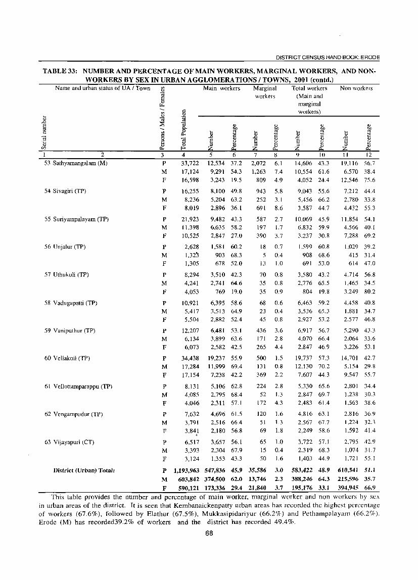
DISTRICT CENSUS HAND BOOK: ERODE
TABLE 33: NUMBER AND PERCENTAGE OF MAIN WORKERS, MARGINAL WORKERS, AND NONWORKERS BY SEX IN URBAN AGGLOMERATIONS / TOWNS, 2001 (contd.)
Name and urban status of UA / Town
2
53 Sathyamangalam (M)
54 Sivagiri (TP)
55 Suriyampalayam (TP)
56 Unjalur (TP)
57 Uthukuli (TP)
58 Vadugapatti (TP)
59 Vaniputhur (TP)
60 Vellakoil (TP)
61 Vellottamparappu (TP)
62 Vengampudur (TP)
63 Vijayapuri (CT)
District (Urban) Total:
j
3
P M F
P M
F
p
M
F
P M F
P M
F
P M F
p
M
F
P M
F
P M
F
p
M
F
p
M F
4 33,722
17,124 16,598
16,255
8,236
8,019
21,923 11,398
10,525
2,628
1,32~
1,305
8,294
4,241
4,053
10,921
Main workers
5 12,534
9,291
6
37.2
54.3 3,243 19.5
8,100 49.8
5,204 63.2
2,896 36.1
9,482 43.3 6,635 58.2
2,847 27.0
1,581 60.2
903 68.3 678 52.0
3,510 42.3
2,741 64.6
769 19.0
6,395 58.6
5,417 3,513 64.9 5,504 2,882 52.4
12,207 6,134
6,073
34,438 17,284
17,154
8,131
6,481 53.1 3,899 63.6
2,582 42.5
19,237 55.9 11,999 69.4
7,238 42.2
5,106 62.8
4,085 2,795 68.4 4,046 2,311 57.1
7,632 3,791
3,841 . 6,517 3,393
3,124
4,696 61.5 2,516 66.4
2,180 56.8
3,657 56.1 2,304 67.9
1,353 43.3
Marginal workers
7
2,072
1,263
8
6.1
7.4 809 4.9
943 5.8
252 3.1
691 8.6
587 2.7 197 1.7
390 3.7
18 0.7
5 0.4 13 1.0
70 0.8
35 0.8
35 0.9
68 0.6
23 0.4 45 0.8
436 3.6 171 2.8
265 4.4
500 1.5 131
369
0.8
2.2
224 2.8
52 1.3 172 4.3
120 1.6
51 1.3 69 1.8
65 1.0
15 0.4 50 1.6
P 1,193,963 547,836 45.9 35,586 3.0 2.3
3.7 M 603,842 374,500 62.0 13,746
F 590,121 173,336 29.4 21,840
Total workers (Main and marginal workers)
t ..0 S ;::l
Z 9 10
14,606
10,554
43.3
61.6 4,052 24.4
9,043 55.6
5,456 66.2
3,587 44.7
10,069 45.9 6.832 59.9
3.237 30.8
1,S99 60.8
908 68.6 691 53.0
3,580 43.2
2,776 65.5
804 19.8
6,463 59.2
3,536 65.3 2,927 53.2
6,917 56.7 4,070 66.4
2.847 46.9
19,737 57.3 12,130 70.2
7.607 44.3
5,330 65.6 2,847 69.7
2,483 61.4
4,816 63.1
2,567 67.7
2,249 58.6
3,722 57.1 2,319 68.3
1,403 44.9
583,422 48.9
388,246 64.3
195,176 33.1
Non workers
11 12
19.116
6.570
56.7
38.4 12,546 75.6
7,212 44.4
2,780 33.8
4,432 55.3
11,854 54.1 4,566 40.1
7,288 69.2
1,029 39.2
415 31.4 614 47.0
4.714 56.8 1,465 34.5
3.249 80.2
4.458 40.8 1.881 34.7 2.577 46.8
5,290 43.3 2,064 33.6
3.226 53.1
14,701 42.7 5,154 29.8
9.547 55.7
2.801 34.4 1.238 30.3
1.563 38.6
2.816 36.9
1.224 32.3
1.592 41.4
2.795 42.9 1,074 31.7
1,721 55.1
610,541 51.1
215,596 35.7
394,945 66.9
This table provides the number and percentage of main worker, marginal worker and non workers by sex in urban areas of the district. It is seen that Kembanaickenpatty urban areas has recorded the highest percentage of workers (67.6%), followed by Elathur (67.5%), Mukkasipidariyur (66.2%) and Pethampalayam (66.2%). Erode (M) has recorded39.2% of workers and the district has recorded 49.4%.
68

ANALYTICAL NOTE
T ABLE 34~ DISTRIBUTION OF WORKERS BY SEX IN FOUR CATEGORIES OF ECONOMIC A~IIl:III Il'!! ULllKS. ~iUU
Serial Name of Taluk "Persons I Total Total number of Cate~or;y of workers number Males I PopUlation workers (Main + Cultivators Agricultural Household Other
Females Marginal) Labourers Industry workers
workers 2 3 4 5 6 7 8 9
Sathyamangalam Persons 287,605 158,584 35,565 64,758 10,133 48.128
(55.1) (22.4) (40.8) (6.4) (30.3)
Males 146,020 96,549 23.223 32.474 5,303 35.549
(66.1) (24.1) (33.6) (5.5) (36.8)
Females 141,585 62,035 12,342 32,284 4,830 12.579
(43.8) (19.9) (52.0) (7.8) (20.3)
2 Bhavani Persons 423,708 244,165 52,233 101,584 17,814 72,534
(57.6) (21.4) ( 41.6) (7.3) (29.7)
Males 217,380 142,596 30,704 49,767 8,374 53,751
(65.6) (21.5) (34.9) (5.9) (37.7)
Females 206,328 101,569 21,529 51,817 9,440 18,783
(49.2) (21.2) (51.0) (9.3) (18.5)
3 Gobichetti palayam Persons 361,201 211,446 40,696 93,509 12.110 65,131
(58.5) ( 19.2) (44.2) (5.7) (30.8)
Males 181,854 123,128 24,432 44,420 6.140 48,136
(67.7) (19.8) (36.1 ) (5.0) (39.1)
Females 179,347 88,318 16,264 49,089 5.970 16.995
(49.2) (18.4 ) (55.6) (6.8) (19.2)
4 Perundurai Persons 326,782 187,708 35,472 46,02l 12,766 93,449
(57.4) ( 18.9) (24.5) (6.8) (49.8)
Males 165,959 113,070 20,368 21,9j5 6,310 64,477
(68.1) (18.0) (19.4) (5.6) (57.0)
Females 160,823 74,638 15,104 24,106 6,456 28.972
(46.4) (20.2) (32.3) (8.6) (38.8)
5 Erode Persons 706,529 346,043 48,127 7·9,047 11 ,130 207,739
(49.0) (13.9) (22.8) (3.2) (60.0)
Males 359,051 230,444 27,900 36,478 5,320 160.746
(64.2) (12.1 ) (15.8) (2.3) (69.8)
Females 347,478 115,599 20,227 42,569 5.810 46.993
(33.3) (17.5) (36.8) (5.0) (40.7)
69

DISTRICT CENSUS HAND BOOK: ERODE
TABLE 34: DISTRIBUTION OF WORKERS BY SEX IN FOUR CATEGORIES OF ECONOMIC ACTIVITY IN TALUKS, 2001 (Could.)
3erial Name of Taluk Persons / Total Total number of Cate~0!1 of workers I :mber Males / Population workers (Main + Cultivators Agricultural Household Other
Females Marginal) Labourers Industry workers workers
2 3 4 5 6 7 8 9
6 Kangeyam Persons 196,892 123,356 30,653 33.575 7,606 51.522
(62.7) (24.8) (27.2) (6.2) (41.8)
Males 99,505 70,507 16,577 15,354 3,448 35,128
(70.9) (23.5) (21.8) (4.9) (49.8)
Females 97,387 52,849 14,076 18.221 4,158 16.394
(54.3) (266) (]45) (7.9) (310)
7 Dharapuram Persons 278,783 163,103 48,573 62,476 4,780 47.274
(58.5) (29.8) (38.3) (2.9) (29.0)
Males 139,509 94,304 27,411 29,253 2,432 35,208
(67.6) (29.1) (31.0) (2.6) (37.3)
Females 139,274 68,799 21,162 33,223 2,348 12,066
(49.4) (30.8) (48.3) (3.4) (17.5)
District Total: Persons 2,581,500 1,434,405 291,319 480,970 76,339 585,777
(55.6) (20.3) (33.5) (5.3) (40.8)
Males 1,309,278 870,598 170,615 229,661 37,327 432,995
(66.5) (19.6) (26.4) (4.3) (49.7)
Females 1,272,222 563,807 120,704 251,309 39,012 152,782
(44.3) (21.4) (44.6) (6.9) (27.1)
,')te: Percent of Worker to total worker are given in brackets
This table gives the distribution of worker by sex in four categories of economic activity in taluks of Erode Jlstrict. Kangeyam taluk has recorded the highest of 62.7% with the four categories; cultivatior (24.8%), t\gricultural labourers (27.2%), Household Industries (6.2%) and Other workers (41.8%). Erode taluk has recorded the lowest percentage of 49 with cultivator (13.9%), Agriculturar laborour (22.8%), Household Industries (3.2%) and Other Worker (60%). The district workers were 55.6% and the categories were divided into :ultivator (20.3%), Agricultural laborour (33.5%), Household Industries (5.3%) and Otherworker (40.8%).
70

ANALYTICAL NOTE
TABLE 35.: DISTRIBUTION OF WORKERS BY SEX IN FOUR CATEGORIES OF ECONOMIC ACTIVITY IN CD BLOCKS: 2001
Serial Name of CD block Persons I Total Total Category of workers number Males I population number of Cultivators Agricultural Household Other
Females workers Labourers Industry workers (Main + workers
Mar inal) 2 3 4 5 6 7 8 9
1 Talavadi Persons 53.174 28,935 8.529 16,054 1,074 3.278 (54.4) (29.5) (55.5) (3.7) (11.3)
Males 26,637 16,965 6,843 7,513 314 2.295 (63.7) (40.3) (44.3) (1.9) (13.5)
Females 26,537 11,970 1,686 8,541 760 983 (45.1) (14.1) (71.4 ) (6.3) (8.2)
2 Bhavanisagar Persons 76,022 43,679 10,189 14,977 3,496 15,017 (57.5) (23.3) (34.3) (8.0) (34.4)
Males 39,073 26,592 6,210 7,745 2,013 10,624 (68.1) (23.4) (29.1) (7.6) (40.0)
Females 36,949 17,087 3,979 7,232 1.483 4,393 (46.2) (23.3) (42.3 ) (8.7) (25.7)
3 Sathyamangalam Persons 82,756 49,806 13,482 24,949 2,984 8.391 (60.2) (27.1) (50.1 ) (6.0) (16.8)
Males 42,024 28,553 8,006 12,694 1,561 6,292
(67.9) (28.0) (44.5) (5.5) (22.0)
Females 40,732 21,253 5,476 12,255 1,423 2.099
(52.2) (25.8) (57.7) (6.7) (9.9)
4 Thookanaickenpalayam Persons 51,118 32,177 6,195 18,563 1,112 6.307 (62.9) ( 19.3) (57.7) (3.5) (19.6)
Males 25,851 17,656 3,687 8,890 512 4.567 (68.3) (20.9) (50.4) (2.9) (25.9)
Females 25,267 14,521 2,508 . 9.673 600 1.740 (57.5) (17.3) (66.6) (4.1) (12.0)
5 Anthiyur Persons 96,469 58,507 17.570 27,856 2,905 10,176
• (60.6) (30.0) (47.6) (5.0) (17.4)
Males 49,637 32,825 10.553 13,697 1,291 7,284
(66.1) (32.1) (41.7) (3.9) (22.2)
Females 46,832 25,682 7.017.· 14.159 1.614 2.892 (54.8) (27.3) (55.1) (6.3) (11.3)
6 Ammapet Persons 97,786 62,708 17,402 32.638 1,687 10.981 (64.1) (27.8) (52.0) (2.7) ( 17.5)
Males 50,783 34,085 9,827 15,516 747 7.995 (67.1) (28.8) (45.5) (2.2) (23.5)
Females 47,003 28,623 7,575 17,122 940 2,986
(60.9) (26.5) (59.8) (3.3) (10.4)
7 Bhavani Persons 97,392 54,840 10.258 22,822 6,208 15.552
(56.3) (18.7) (41.6) (11.3) (28.4)
Males 49,681 32,490 6,158 11,376 3,001 11.955
(65.4) (19.0) (35.0) (9.2) (36.8)
Females 47,711 22,350 4,100 11,446 3.207 3.597 (46.8) ( 18.3) (51.2) (14.3) (16.1)
8 Gobichettipalayam Persons 91,122 54,782 12,403 27.236 2,458 12.685
(60.1) (22.6) (49.7) (4.5) (23.2)
Males 46,141 31,635 7,396 13,581 1.128 9.530
(68.6) (23.4) (42.9) (3.6) (30.1)
Females 44,981 23,147 5,007 13,655 1.330 3.155 (51.5) (21.6) (59.0) (5.7) ( 13.6)
71

DISTRICT CENSUS HAND BOOK: ERODE
TABLE 35: DISTRIBUTION OF WORKERS BY SEX IN FOUR CATEGORIES OF ECONOMIC A~IIYITI lri ~D BLQ~KS, 2001 (contd·l
5erial Name of CD block Persons I Total Total Category of workers , umber Males I population number of Cultivators Agricultural Household Other
Females workers Labourers Industry workers (Main + workers
Marginal)
2 3 4 5 6 7 8 9
9 Nambiyur Persons 65,449 43,592 13,282 17,637 3,273 9.400 (66.6) (30.5) (40.5) (7.5) (21.6)
Males 33,077 23,464 7,775 7,591 1.703 6.395 (70.9) (33.1) (32.4) (7.3) (27.3)
Females 32,372 20,128 5,507 10.046 1.570 3.005 (62.2) (27.4) (49.9) 0.8) ( 14.9)
10 Uthukuli Persons 73,917 41,791 7.259 8,934 3.778 21.820 (56.5) ( 17.4) (21.4 ) (9.0) (52.2)
Males 37.774 26,401 4,554 4,476 2,042 15,329 (69.9) ( 17.2) (17.0) 0.7) (58.1 )
Females 36,143 15,390 2,705 4,458 1,736 6,491 (42.6) (17.6) (29.0) (11.3 ) (42.2)
II Perundurai Persons 67,999 41,842 11.163 13,377 2,182 15.120 (61.5) (26.7) (32.0) (5.2) (36.1 )
Males 34,589 24,013 6,453 6,534 1,139 9.887 (69.4) (26.9) (27.2) (4.7) (41.2)
Females 33,410 17,829 4,710 6,843 1.043 5.233 (53.4) (26.4) (38.4) (5.9) (29.4 )
12 Erode Persons 55,773 27.815 5.083 7,879 572 14,2S1 (49.9) (18.3) (28.3) (2.1 ) (513)
- Males '28,128 17,747 3.072 3,736 198 10,741 (63.1) (17.3) (21.1 ) (1.1 ) (60.5)
Females 27,645 10,068 2,011 4,143 374 3,540 (36.4) (20.0) (41.2) (3.7) (35.2)
13 Chennimalai Persons 61,920 3S,580 10,159 12,454 2,256 13.711 (62.3) (26.3) (32.3) (5.S) (35.5 )
Males 31,769 21,560 5,413 5,577 1,127 9,443
(67.9) (25.1) (25.9) (5.2) (43.8)
Females 30,151 17,020 4,746 6,877 1,129 4.268 (56.4) (27.9) (40.4) (6.6) (25.1)
14 Modakurichi Persons 100,523 59,294 15,998 24,298 1.408 17.590 (59.0) (27.0) (41.0) (2.4) (297)
Males 51,064 34,573 9,375 11.089 732 13,377
(67.7) (27.1 ) (32.1 ) (2. ]) (38.7)
Females 49,459 24,721 6.623 13.209 676 4,213
(50.0) (26.8) (53.4) (2.7) (17.0)
IS Kodumudi Persons 31,480 21,202 7,766 9.976 483 2,977
(67.4) (36.6) (47.1) (2.3) (14.0)
Males 15,813 11.093 4,168 4,525 249 2,151
(70.2) (37.6) (40.8) (2.2) ( 19.4)
Females 15,667 10,109 3,598 5.451 234 826 (64.5) (35.6) (53.9) (2.3) (8.2)
16 Vellakoil Persons 48,516 33,097 9,946 12,278 2,154 8.719 (68.2) (30.1) (37.1) (6.5) (26.3)
Males 24,340 17,715 5.351 5,562 987 5.815 (72.8) (30.2) 01.4) (5.6) (32.8)
Females 24,176 15,382 4,595 6.716 1,167 2.904
(63.6) (29.9) (43.7) (7.6) (lS.9)
72
ANALYTICAL NOTE
TABLE 35 ~ DISTRIBUTION OF WORKERS BY SEX IN FOUR CA TEGORJES OF ECONOMIC ACTIVITY IN CD BLOCKS, 2001 (contd.)
Serial Name of CD block Persons I Total Total Category of workers number Males I population number of
Females workers Cultivators Agri cuI tural Household Other
(Main + Labourers Industry workers
Marginal) workers
2 3 4 5 6 7 8 9 17 Kangeyam Persons 57,033 37,733 12,839 11,432 2,300 11,162
(66.2) (34.0) (30.3 ) (6.1) (29.6)
Males 28,886 20,627 6.909 5.138 995 7.585 (71.4) (33.5) (24.9) (4.8) (36.8)
Females 28,147 17,106 5.930 6,294 1,305 3.577 (60.8) (34.7) (36.8) (7.6) (20.9)
18 Kundadam Persons 70,37l 47,313 21,248 18,314 1.397 6.354 (67.2) (44.9) (38.7) (3.0) ( 13.4)
Males 35,709 25,474 11,760 8,483 721 4,510
(71.3) (46.2) (33.3) (2.8) (177)
Females 34,662 21,839 9,488 9,831 676 1.844 (63.0) (43.4) (45.0) (3.1) (8.4)
19 Mulanur Persons 45,697 32,353 13,971 12,718 710 4.954 (70.8) (43.2) (39.3) (2.2) (15.3)
Males 22,731 16,725 7,302 5,417 392 3.614 (73.6) (43.7) (32.4) (2.3) (21.6)
Females 22,966 15,628 6,669 7.301 318 1.340 (68.0) (42.7) (46.7) (2.0) (8.6)
20 Dharapuram Persons 63,020 40,937 12,460 20,024 1.361 7.092 (65.0) (30.4) (48.9) (3.3) (17.3)
Males 31,729 22,159 7.081 . 9,334 678 5,066 (69.8) (32.0) (42.1) (3.1) (22.9)
Females 31,291 18,778 5.379 .' 10,690 683 2,026
(60.0) (28,6) (56.9) (3.6) (l0.8)
District (Rural) Total: P~rsons 1,3~7,537 850,983 237,202 354,416 43,798 215,567
(61.3) (27.9) (41.6) (5.1) (25.3)
Males 705,436 482,352 137,893 168,474 21,530 154,455 (68.4) (28.6) .. (34.9) (4.5) (32.0)
Females 682,101 368,631 99,309 185,942 22,268 61,112
(54.0) (26.9) (50.4) (6.0) (16.6)
Note: Percent of Worker to total worker are given in brackets
This table gives the distribution of workers by sex in four catogories of economic activity in CD blocks
of Erode district. The district rural total workers returned 27.9% as cultivators, 41.6% as aggricultural labourers, 5,1 % as household industries workers and 25.3% as other workers. Out of 20 CD blocks in the district, Mulanur
has the highest (70.8%) workers in respect of total population, with 43.2% as cultivator, 39.3% as aggricultural
labourers, 2.2% house hold industires and 15.3% as other workers. The lowest of 49.9% has recorded in Erode
CD block with 18.3% as cultivator, 28.5% as agricultural labourers, 2.1 % as household industries and 51.3%
as other workers.
73

DISTRICT CENSUS HAND BOOK: ERODE
TABLE 36: DISTRIBUTION OF WORKERS BY SEX IN FOUR CATEGORIES OF ECONOMIC ACTIVITY OF URBAN AGGLOMERATIONS I TOWNS, 2001
N arne and urban status of U A / Town Total Total Cate~orl: of workers
-- population number of Cultivators Agricultural Household Other '" j ~ workers Labourers Industry workers
.r. ~ (Main + workers a :::I -- Marginal) c: '" '" s:: 0)
c:a o "<a Number ·c ~ S )
~~ (Percentage r)
1 2 3 4 5 6 7 8 9 Ammapettai (TP) Persons 9,259 5,049 643 2.225 104 2.077
(54.5) (12.7) (44.1 ) (2.1 ) (41.1)
Males 4,748 3,028 358 1.126 34 1.510 (63.8) (11.8) (37.2) ( 1.1) (49.9)
Females 4,511 2,021 285 1,099 70 567 (44.8) (14.1) (54.4) (3.5) (28.1 )
2 Anthiyur (TP) Persons 20,071 9,091 148 666 1.483 6.794 (45.3) (1.6) (7.3) (l6.3) (74.7)
Males 10,354 6,494 56 410 870 5,158 (62.7) (0.9) (6.3) (13.4) (79.4)
Females 9,717 2,597 92 256 613 1,636 (26.7) (3.5) (9.9) (23.6) (63.0)
., Appakudal (TP) Persons 9,522 4,846 401 1.648 540 2.257 (50.9) (8.3) (34.0) (ll.l ) (46.6)
• Males 4,864 3,021 228 826 300 L667
(62.1) (7.5) (27.3) (9.9) (55.2)
Females 4,658 1,825 173 822 240 590
(39.2) (9.5) (45.0) (13.2) (32.3)
4 Arachalur (TP) Persons 12,343 7.082 1,569 2,850 454 2.209 (57.4) (22.2) (40.2) (6.4) (31.2)
Males 6,152 4,148 898 1,371 280 1.599 (67.4) (21.6) (33.1) (6.8) (38.5)
Females 6,191 2,934 671 1.479 174 610 (47.4) (22.9) (50.4) (5.9) (20.8)
5 Ariyappampalayam (TP) Persons 12,462 6,465 765 2.771 275 2,654
(51.9) (11.8) (42.9) (4.3) (41.1)
Males 6,309 4,160 500 1,479 114 2.067 (65.9) (12.0) (35.6) (2.7) (49.7)
Females 6,153 2,305 265 1,292 161 587
(37.5) (11.5) (56.1 ) (7.0) (25.5)
6 Athani (TP) Persons 8,423 5.165 1.083 2,644 195 1.243 (61.3) (21.0) (51.2) (3.8) (24.1 )
Males 4,288 2,945 633 1.311 74 927
(68.7) (21.5) (44.5) (2.5) (31.5)
Females 4.p5 2,220 450 1.333 121 316 (53.7) (20.3) (60.0) (5.5) (14.2)
7 Avalpoondurai (TP) Persons 11,243 6,149 1,613 2.788 154 1.594
(54.7) (26.2) (45.3) (2.5) (25.9)
Males 5,846 3,613 976 1,378 88 1,17 I (61.8) (27.0) (38.1) (2.4) (32.4)
Females 5,397 2,536 637 10410 66 423 (47.0) (25.1 ) (55.6) (2.6) (16.7)
74

ANALYTICAL NOTE
TABLE 36 : DISTRIBUTION OF WORKERS BY SEX IN FOUR CATEGORIES OF ECONOMIC ACTIVITY OF URBAN AGGLOMERATIONS I TOWNS, 2001 (contd.)
Name and urban status of UA I Town Total Total Category of workers -. population number of Cultivators Agricultural Household Other '" .... <I) workers Labourers Industry workers
)5 <a 8 :::E (Main + workers ::l -.
Marginal) I': '" '" c <I)
<3 ~] Number 't:; <I)
~~ (Percentage CI)
1 2 3 4 5 6 7 8 9
8 Bhavani UA (Distts 09 & 10) Persons 104,646 51,627 254 541 3,745 47,087
(49,3) (0.5) (1.0) (7.3) (91.2)
Males 52,998 34,257 164 301 1,768 32,024 (64,6) (0.5) (0.9) (5.2) (93,5)
Females 51,648 17,370 90 240 1,977 15,063
(33.6) (0.5) (1.4) (11.4) (86.7)
Bhavani UA (Part) Persons 38,778 16,847 70 122 1,067 15,588 (43.4) (OA) (0.7) (6.3) (92,5)
Males 19,530 12,030 50 66 450 11,464
(61.6) (OA) (0.5) (3.7) (95,3)
Females 19,248 4,817 20 56 617 4,124
(25.0) (004) (1.2) (12.8) (85,6)
Ca) Bhavani (M) Persons 38,778 16,847 70 122 1,067 15,588
(43.4) (004) (0.7) (6,3) (92,5)
Males 19,530 12,030 50 66 450 11,464
(61.6) (004) (0,5) (3.7) (95.3)
Females 19,248 4,817 20 56 617 4,124
(25.0) (0.4) (1.2) (12.8) (85,6)
9 Bhavanisagar (TP) Persons 4,329 1,821 25 392 16 1,388
(42.1) (104) (21.5) (0.9) (76.2)
Males 2,212 1,322 18 240 8 1.056
(59.8) (1.4) (18,2) (0,6) (79.9)
Females 2,117 499 7 152 8 332 (23.6) (1.4) (30.5) (1.6) (66,5)
I 0 Chennasamudram (TP) Persons 7,342 4,679 1.025 2,448 98 1,108
(63.7) (21.9) (52.3) (2.1) (23,7)
Males 3,672 2,534 541 1,117 44 832 •
(69.0) (21.3) (44.1) (1.7) (32,8)
Females 3,670 2,145 484 1,331 54 276
(58.4) (22.6) (62.1) (2.5) (12.9)
11 Chennimalai (TP) Persons 15,547 8,388 87 46 528 7,727
(54.0) (1.0) (0,5) (6.3) (92.1)
Males 7,895 5,247 49 18 157 5,023
(66,S) (0.9) (0,3) (3,0) (95.7)
Females 7,652 3,141 38 28 371 2,704
(41.0) (1.2) (0.9) (11.8) (86.1 )
12 Chinnakkampalayam (TP) Persons 9,694 5.957 1,418 3.515 156 868
(61.5) (23,8) (59.0) (2.6) (14,6)
Males 4,945 3,268 898 1,659 84 627
(66.1) (27.5) (50,8) (2.6) (19,2)
Females 4,749 2,689 520 1,856 72 241
(56.6) (19.3) (69.0) (2.7) (9,0)
75

DISTRICT CENSUS HAND BOOK: ERODE
TABLE 36: DISTRIBUTION OF WORKERS BY SEX IN FOUR CATEGORIES OF ECONOMIC ACTIVITY OF URBAN AGGLOMERATIONS I TOWNS, 2001 (contd.)
Name and urban status of VA / Town Total Total Catel20ry of workers ..... population number of Cultivators Agricultural Household Other til
workers Labourers Industry workers .... v .., ca .0 :::E (Main + workers S ::l .....
Marginal) c:: til til c: V <a ~~ Number 'C ..,
~~ (Percentage Vl
I 2 3 4 5 6 7 8 9
13 Chithode (TP) Persons 7,704 3,304 205 251 204 2,644
(42.9) (6.2) (7.6) (6.2) (80.0)
Males 3,916 2,423 139 140 137 2,007
(61.9) (5.7) (5.8) (5.7) (82.8)
Females 3,788 881 66 III 67 637 (23.3) (7.5) (12.6) 0.6) (72.3)
14 Dharapuram (M) Persons 64,984 25,418 407 4.175 649 20.187
(39.1) (1.6) (16.4) (2.6) (79.4)
Males 31,998 18,958 290 2,422 362 15.884
(59.2) (1.5) (12.8) (1.9) (83.8)
Females 32,986 6,460 117 1,753 287 4.303
(19.6) (1.8) (27.1) (4.4) (66.6)
15 Elathur (TP) Persons 7,678 5,169 1.539 2,440 40 1,150
(67.3) (29.8) ( 47.2) (0.8) (22.2)
Males 3,882 2.814 858 1.123 16 817
(72.5) (30.5) (39.9) (0.6) (29.0)
Females 3,796 2,355 681 1,317 24 333
(62.0) (28.9) (55.9) (1.0) (14.1 )
16 Erode UA (Distts 09 & 10) Persons 389,906 168,802 1,693 4.449 4,708 157.952
(43.3) (1.0) (2.6) (2.7) (93.6)
Males 198,842 125,065 1,088 2.146 1.911 119.920
(62.9) (0.9) (1.7) (1.5) (95.9)
Females 191.064 43,737 605 2.303 2.800 38.032
(22.9) (1.4) (5.3) (6.4) (87.0)
Erode VA (Part) Persons 329,019 136,018 1,168 3.555 4.048 127.247
(41.3) (0.9) (2.6) (3.0) (93.6)
Males 167,620 104,462 802 1.673 1,629 100.358
(62.3) (0.8) (1.6) (1.6) (96.1 )
Females 161,399 31,556 366 1.882 2,419 26.889
(19.6) (1.2) (6.0) (7.7) (85.2)
(a) Erode (M) Persons 150,541 58,342 244 418 1,345 56.335
(38.8) (0.4) (0.7) (2.3) (96.6)
Males 76,462 47,017 191 218 703 45.905
(61.5) (0.4) (0.5) (1.5) (976)
Females 74,079 11,325 53 200 642 10,430
(15.3) (0.5) ( 1.8) (5.7) (92.1 )
(e) Brahmana Periya Agraharam (TP) Persons 21,458 9,126 147 774 108 8.097
(42.5) (1.6) (8.5) ( 1.2) (88.7)
Males 10,882 6,783 91 323 39 6.330
(62.3) (1.3) (4.8) (0.6) (93.3)
Females 10,576 2,343 56 451 69 1,767
(22.2) (2.4) (19.2) (29) (54)
76

ANALYTICAL NOTE
TABLE 36: DISTRIBUTION OF WORKERS BY SEX IN FOUR CATEGORIES OF ECONOMIC ACTIVITY OF URBAN AGGLOMERATIONS I TOWNS, 2001 (contd.)
Name and urban status of UA f Town Total Total Category of workers population number of
'" Cultivators Agricultural Household Other
.... "-' workers Labourers Industry workers "-' Cd .0
~ (Main + workers 8 ::l -- Marginal) .: '" '" ~ "-' ~ ~] Number ·c "-' ~~ (Percentage (/)
2 3 4 5 6 7 8 9
(b) Veerappanchatiram (TP) Persons 72,703 31,088 142 604 456 29.886 (42.8) (0.5) (1.9) ( 1.5) (96.1)
Males 37,399 23,706 96 306 178 23,126
(63.4) (0.4) (1.3) (0.8) (97.6)
Females 35,304 7,382 46 298 278 6.760
(20.9) (0.6) (4.0) (3.8) (91.6)
(d) Surampatti (TP) Persons 31,948 15,245 105 147 1,189 13.804 (47.7) (0.7) (1.0) (7.8) (90.5)
Males 16,227 10,585 83 86 373 lO,043 (65.2) (0.8) (0.8) (3.5) (94.9)
Females 15,721 4,660 22 61 816 3,761
(29.6) (0.5) (1.3) (17.5) (80.7)
Cc) Kasipalayam (E) (TP) Persons 52,369 22,217 530 1,612 950 19.125
(42.4) (2.4) (7.3) (4.3) (86.1)
Males 26,650 16,371 341 740 336 14,954
(61.4) (2.1) (4.5) (2.1 ) (91.3)
Females 25,719 5,846 189 872 614 4.171 (22.7) (3.2) 04.9) (l0.5) (71.3)
17 Gobichettipalayam (M) Persons 55,158 23,122 647 3,176 726 18,573
(41.9) (2.8) (13.7) (3.1) (80.3)
Males 27,287 16,659 512 1,443 380 14.324
(61.1) (3.1) (8.7) (2.3) (86.0)
Females 27,871 6,463 135 1.733 346 4,249
(23.2) (2.1) (26.8) (5.4) (65.7)
18 Jambai (TP) Persons 15,011 8,503 1,096 3,480 493 3,434
(56.6) (12.9) (40.9) (5.8) (40.4)
Males 7,722 5.127 681 1,732 186 2.528
(66.4) (13.3) (33.8) (3.6) (49.3)
Females 7,289 3376 415 1,748 307 906
(46.3) (12.3) (51.8) (9.1) (26.8)
19 Kangeyam (TP) Persons 28,258 l3,884 729 1,245 1,753 lO,I57
(49.l) (5.3) (9.0) (12.6) (73.2)
Males ]4,447 9,559 448 628 754 7,729
(66.2) (4.7) (6.6) (7.9) (80.9,
Females 13,811 4,325 281 617 999 2.428
(31.3) (6.5) ( 14.3) (23.1) (56.1)
20 Kanjikoil (TP) Persons 1I,040 7,007 1,178 2,538 583 2,708
(63.5) 06.8) (36.2) (8.3) (38.6)
Males 5,570 3,872 654 1,151 246 1,821
(69.5) (16.9) (29.7) (6.4) (47.0)
Females 5,470 3,135 524 1,387 337 887
(57.3) ( 16.7) (44.2) (10.7) (28.3)
77
DISTRICT CENSUS HAND BOOK: ERODE
TABLE 36: DISTRIBUTION OF WORKERS BY SEX IN FOUR CATEGORIES OF ECONOMIC ACTIVITY OF URBAN AGGLOMERATIONS I TOWNS, 2001 (coutd.)
Name and urban status of UA / Town Total Total Cate~ory of workers population number of Cultivators
'" Agricultural Household Other
.... ., workers Labourers Industry workers
0 ~ .D ::iE (Main + workers E ::l -- Marginal) c '" '" c 0 -;; ~] Number '': 0 ., .,
(Percentage U'l P-.t1-.
1 2 3 4 5 6 7 8 9
21 Kannivadi (TP) Persons 4,412 2,233 643 804 8 778
(50.6) (28.8) (36.0) (004) (34.8)
Males 2,194 1,475 482 387 2 604
(67.2) (32.7) (26.2) (0.1 ) (40.9)
Females 2,218 758 161 417 6 174 (34.2) (21.2) (55.0) (0.8) (23.0)
22 Karumandi CheIJipaiayam (TP) Persons 20,072 8,539 687 1,468 163 6,221
(42.5) (8.0) (17.2) (1.9) (72.9)
Males 9,839 6,091 516 666 57 4,852
(61.9) (8.5) (10.9) (0.9) (79.7)
Females 10.233 2,448 171 802 106 1.369
(23.9) (7.0) (32.8) (4.3) (55.9)
23 Kasipalayam (0) (TP) Persons 8,570 5,289 546 2,818 175 1.750 (61.7) (10.3) (53.3) (3.3) (33.1)
Males 4,345 3,042 328 1,412 87 1,215 (70.0) (10.8) (46.4) (2.9) (39.9)
Females 4,225 2,247 218 1,406 88 535
(53.2) (9.7) (62.6) (3.9) (23.8)
24 Kembainaickenpalayam (TP) Persons 10,J08 6.905 1,546 3,307 794 1,258
(67.0) (22.4) (47.9) (11.5) (18.2)
Males 5,206 3,768 961 1.534 442 831
(72.4) (25.5) (40.7) (11.7) (22.1)
Females 5.102 3.137 585 1,773 352 427
(61.5) (18.6) (56.5) (11.2) (13.6)
25 Kilampadi (TP) Persons 6,343 3,863 1,054 1,740 23 1.046
(60.9) (27.3) (45.0) (0.6) (27.1 )
Males 3,118 2,108 631 718 9 750
(67.6) (29.9) (34.1) (004) (35.6)
Females 3,225 1,755 423 1.022 14 296
(54.4) (24.1) (58.2) (0.8) (16.9)
26 Kodumudi (TP) Persons 12,664 6,178 705 2,633 40 2,800
(48.8) (1104) (42.6) (0.6) (45.3)
Males 6.347 3,962 425 1,347 30 2.160
(62.4) (10.7) (34.0) (0.8) (54.5)
Females 6.317 2,216 280 1,286 10 640
(35.1 ) (12.6) (58.0) (0.5) (28.9)
27 Kolappalur (TP) Persons 9,803 5,892 778 :t..021 138 1.955
(60.1) (13.2) (51.3) (2.3) (33.2)
Males 4,877 3,316 501 1.373 56 1.386
(68.0) (15.1) (41.4) (1.7) (41.8)
Females 4,926 2.576 277 1,648 82 569
(52.3) ( 10.8) (640) (3.2) (22.1 )
78

ANALYTICAL NOTE
TABLE 36 : DISTRIBUTION OF WORKERS BY SEX IN FOUR CATEGORIES OF ECONOMIC ACTIVITY OF URBAN AGGLOMERATIONS I TOWNS, 2001 (eontd.)
Name and urban status of UA I Town Total Total Category of workers
-- population number of Cultivators Agricultural Household Other <IJ
..... 0) workers Labourers Industry workers 1S c;J
s ::E (Main + workers ::l -- Marginal) c
~i c:3 Number ·c 0) 0) 0) (Percentage CI'J ~f;L..
1 2 3 4 5 6 7 8 9
28 Kolathupalayam (TP) Persons 17,438 9,240 1,263 3,648 194 4,135 (53.0) (13.7) (39.5) (2.1 ) (44.8)
Males 8,704 5,722 868 1,865 53 2,936
(65.7) (15.2) (32.6) (0.9) (51.3)
Females 8,734 3,518 395 1,783 141 1,199 (40.3) (11.2) (50.7) (4.0) (34.1 )
29 Kollankoil (TP) Persons 8,754 5,597 1,430 2,233 929 1,005
(63.9) (25.5) (39.9) (16.6) (18.0)
Males 4,393 3,069 800 1,063 464 742 (69.9) (26.1) (34.6) (15.1) (24.2)
Females 4,361 2,528 630 1,170 465 263 (58.0) (24.9) (46.3) (18.4) (10.4)
30 Kuhalur (TP) Persons 11,684 7,089 773 4,617 55 1,644
(60.7) (10.9) (65.1) (0.8) (23.2)
Males 5,894 3,983 484 2,262 26 1,211
(67.6) (12.2) (56.8) (07) (30.4)
Females 5,790 3,106 289 2,355 29 433 (53.6) (9.3) (75.8) (0.9) (13.9)
3 1 Kunnathur (TP) Persons 1,032 2,811 119 236 100 2,356
(40.0) (4.2) (8.:4) (3.6) (83.8)
Males 3,517 2,253 104 127 59 1.963
(64.1) (4.6) (5.6) (2.6) (87.1)
Females 3,515 558 15 109 41 393
(15.9) (2.7) (19.5) (7.3) 00.4)
32 Lakkampatti (TP) Persons 11,038 5,615 558 .. 2,494 129 2,434
(50.9) (9.9) (44.4) (2.3) (43.3)
Males 5,617 3,575 352 1,149 83 1,991
(63.6) (9.8) (32.1 ) (2.3) (55.7)
Females 5,421 2,040 206 1,345 46 443
(37.6) (l0.1) (65.9) (2.3) (21.7)
33 Modakurichi (TP) Persons 10,052 5,737 1,104 2,406 94 2,133
(57.1) (19.2) (41.9) (1.6) (37.2)
Males 5,091 3,371 658 1.072 50 1,591
(66.2) (19.5) (31.8) (1.5) (47.2)
Females 4,961 2,366 446 1,334 44 542
(47.7) (18.9) (56.4) (1.9) (22.9)
34 Mukasipidariyur (CT) Persons 11,012 7,273 567 420 1,215 5.071
(66.0) 0.8) (5.8) (16.7) (69.7)
Males 5,502 3,919 270 184 476 2.989 , (71.2) (6.9) (4.7) (12.1) (76.3)
Females 5,510 3,354 297 236 739 2,082 (60.9) (8.9) (7.0) (22.0) (62.1)
79

DISTRICT CENSUS HAND BOOK: ERODE
TABLE 36: DISTRIBUTION OF WORKERS BY SEX IN FOUR CATEGORIES OF ECONOMIC ACTIVITY OF URBAN AGGLOMERATIONS I TOWNS, 2001 (contd.)
Name and urban status of UA I Town Total Total Cate~0!2: of workers -.. til
population number of Cultivators Agricultural Household Other .... I) workers Labourers Industry workers <1.l '(;l .0 ~ (Main + workers Ei ::l -..
Marginal) J:: til til s:: I)
0; §1 Number 'C <1.l I) <1.l (Percentage en ~~
1 2 3 4 5 6 7 8 9 35 Mulanur (TP) Persons 13,827 8,021 1,573 2,639 138 3,671
(58.0) (19.6) (32.9) (1.7) (45,8)
Males 6,913 4,747 852 1,249 70 2,576
(68.7) (17.9) (26.3) (1,5) (54,3 )
Females 6,914 3,274 721 1,390 68 1,095
(47.4) (22.0) (42.5) (2.1) (33.4)
36 Muthur (TP) Persons 11,880 7,100 1,337 2,576 151 3,036
(59.8) (18.8) (36.3) (2.1) (42.8)
Males 5>,957 4,189 791 1,173 73 2,152
(70.3) (18.9) (28.0) (1.7) (51.4)
Females 5,923 2,911 546 1,403 78 884
(49.1) (18.8) (48.2) (2.7) (30.4)
37 Nallampatti (TP) Persons 3,656 2,284 599 939 8 738
(62.5) (26.2) (41.1) (0.4) (32,3)
Males 1,866 1,332 342 467 5 518
(71.4) (25.7) (35.1 ) (0.4) (38.9)
Females 1,790 952 257 472 3 220
(53.2) (27.0) (49.6) (0.3) (23.1)
38 Nambiyur (TP) Persons 15,854 8,712 1,491 2,459 302 4,460
(55.0) (17.1) (28,2) (3,5) (51.2)
Males 7,878 5,365 952 1,173 137 3,103
(68.1) (17.7) (21.9) (2.6) (57.8)
Females 7,976 3,347 539 1,286 165 1,357
(42.0) (16.1 ) (38.4) (4.9) (40,5)
39 Nasiyanur (TP) Persons 9,905 5,770 1,267 2,328 64 2,111
(58.3) (22,0) (40,3) 0.1 ) (36,6)
Males 5,005 3,425 734 IJ07 28 1,556
(68.4) (21.4 ) (32.3) (0.8) (45.4)
Females 4,900 2,345 533 1,221 36 555
(47.9) (22.7) (52.1) (1. 5) (23.7)
40 Nerunjipettai (TP) Persons 6,925 3,798 465 2,057 92 1,184
(54.8) (12.2) (54.2) (2.4) (31.2)
Males 3,549 2,257 318 1,062 24 853
(63.6) (14.1) (47.1) (1.1 ) (37.8)
Females 3,376 1,541 147 995 68 331
(45.6) (9.5) (64.6) (4.4) (21.5)
41 Olagadam (TP) Persons 9,370 5,681 1,239 2,374 550 1,518
(60.6) (21.8) (41.8) (9.7) (26,7)
Males 4,823 3,195 686 1,200 167 1.142
(66,2) (21,5) (37,6) (5.2) (35.7)
Females 4,547 2,486 553 1,174 383 376
(54.7) (22,2) (47.2) (15.4) (15,1)
80

ANALYTICAL NOTE
TABLE 36 : DISTRIBUTION OF WORKERS BY SEX IN FOUR CATEGORIES OF ECONOMIC ACTIVITY OF URBAN AGGLOMERATIONS I TOWNS, 2001 (coutd.)
Name and urban status of UA / Town Total Total Category of workers
-- population number of Cultivators Agricultural Household Other '" .... <U workers Labourers. Industry workers
15 Cil 6 ~ (Main + workers ::l ......
Marginal) c:: '" '" -a §~ Number '1:: ~ OJ
~~ (Percentage Ul
2 3 4 5 6 7 8 9
42 Ottapparai (CT) Persons 9,208 5,735 124 59 1,348 4,204
(62.3) (2.2) ( l.0) (23.5) (73.3)
Males 4,678 3,241 70 25 678 2,468
(69.3) (2.2) (0.8) (20.9) (76.1)
Females 4,530 2,494 54 34 670 1,736 (55.1) (2.2) (1.4) (26.9) (69.6)
43 P.Mettupaiayam (TP) Persons 9,115 5,904 807 1,860 1,725 1.512
(64.8) (13.7) (31.5) (29.2) (25.6)
Males 4,557 3,212 459 845 844 1,064
(70.5) (14.3) (26.3) (26.3) (33.1)
Females 4,558 2,692 348 1,015 881 448
(59.1) (12.9) (37.7) (32.7) (16.6)
44 Pallapalayam (TP) Persons 6,505 4,214 1,064 2,046 184 920
(64.8) (25.2) (48.6) (4.4) (21.8 )
Males. 3,284 2,236 574 907 82 673
(68.1) (25.7) (40.6) (3.7) (30.1 )
Females 3.221 1,978 490 1,139 102 247
(61.4) (24.8) (57.6) (5.2) (12.5)
45 Pasur (TP) Persons 3,870 2,220 314 1.385 32 489
(57.4) (14.1) (6~A) (1.4) (22.0)
Males 1,987 1,236 190 662 21 363
(62.2) (15.4) (53.6) (1.7) (29.4)
Females 1,883 984 124 723 11 126
(52.3) (12.6) (73.5) (1.1) (12.8)
46 Periyakodiveri (TP) Persons 12,405 7,186 1,066 .. 2.546 1,886 1,688
(57.9) 04.8) (35.4) (26.2) (23.5)
Males 6,314 4,337 722 1,273 1.114 1.228
(68.7) (16.6) (29.4) (25.7) (28.3)
Females 6,091 2,849 344 1,273 772 460
(46.8) (12.1 ) (44.7) (27.1) (16.1)
47 Periyasemur (TP) Persons 32,024 13,815 174 348 227 13,066
(43.1) (1.3) (2.5) ( 1.6) (94.6)
Males 16,649 10,534 144 209 101 10.080
(63.3) (1.4) (2.0) (l.0) (95.7)
Females 15,375 3,281 30 139 126 2.986
(21,3) (0.9) (4.2) (3.8) (91.0)
48 Perundurai (TP) Persons 16,943 7,302 654 855 109 5.684
(43.1) (9.0) (11.7) (l.5) (77.8)
Males 8,440 5,270 370 420 52 4,428
(62.4) (7.0) (8.0) (l.0) (84.0)
Females 8,503 2,032 284 435 57 1,256
(23.9) (14.0) (21.4) (2.8) (618)
81
DISTRICT CENSUS HAND BOOK: ERODE
TABLE 36: DISTRIBUTION OF WORKERS BY SEX IN FOUR CATEGORIES OF ECONOMIC ACTIVITY OF URBAN AGGLOMERATIONS I TOWNS, 2001 (contd.)
Name and urban status of UA I Town Total Total Catel!;o!}:: of workers population number of Cultivators Agricultural Household Other
til .... OJ workers Labourers Industry workers ~ c;J
8 ~ (Main + workers ::I -- Marginal) c '" til Q OJ
0;; ~~ Number ·c :..l OJ OJ (Percentage VJ IJ..I:.t..
2 3 4 5 6 7 8 9
'~9 Pethampalayam (TP) Persons 7.120 4,640 1.474 1,999 74 1.093
(65.2) (31.8) (43.1) (1.6) (23.6) Males 3.602 2,540 782 976 24 758
(70.5) (30.8) (38.4) (0.9) (29.8)
Females 3,518 2,100 692 1.023 50 335 (59.7) (33.0) (48.7) (2.4) (16.0)
50 Punjaipuliampatti (TP) Persons 14.'ll32 6,367 70 547 478 5,272
(42.9) (Ll) (8.6) (7.5) (82.8)
Males 7,435 4,635 44 319 286 3.986
(62.3) (0.9) (6.9) (6.2) (86.0)
Females 7,397 1,732 26 228 192 1.286 (23.4) (1.5) ( 13.2) (11.1) (74.2)
51 Rudravathi (TP) Persons 6,107 3,436 983 1,566 163 724 (56.3) (28.6) (45.6) (4.7) (2l.! )
Males 3,177 2.063 723 746 74 520 (64.9) (35.0) (36.2) (3.6) (25.2)
Females 2,930 1,373 260 820 89 204
(46.9) (18.9) (59.7) (6.5) (14.9)
52 Salangapalayam (TP) Persons 14,702 9,130 1,858 3,052 2,490 1,730
(62.1) (20.4) (33.4) (27.3) (18.9)
Males 7,401 5,099 1,156 1,445 1,230 1.268
(68.9) (22.7) (28.3) (24.1) (24.9)
Females 7,301 4,031 702 1,607 1,260 462
(55.2) (17.4) (39.9) (31.3 ) (11.5 )
53 Sathyamangalam (M) Persons 33,722 14,606 959 1,761 1,016 10.870
(43.3) (6.6) (12.1) (7.0) (74.4)
Males 17.124 10,554 641 950 565 8.398 >
(61.6) (6.1 ) (9.0) (5.4) (79.6)
Females 16,598 4,052 318 811 451 2,472
(24.4) (7.8) (20.0) (11.1) (61.0)
)4 Sivagiri (TP) Persons 16,255 9,043 1,698 2,548 1,705 3.092
(55.6) (18.8) (28.2) (18.9) (34.2)
Males 8,236 5,456 957 1,219 942 2,338
(66.2) (17.5) (22.3) (17.3) (42.9)
Females 8,019 3,587 741 1,329 763 754
(44.7) (20.7) (37.1) (21.3) (21.0)
55 Suriyampalayam (TP) Persons 21,923 10,069 564 1,522 270 7.713
(45.9) (5.6) (15.1) (2.7) (76.6)
Males 11,398 6,832 337 648 123 5.724
(59.9) (4.9) (9.5) (l.8) (83.8)
Females 10,525 3,237 227 874 147 1,989
(30.8) (7.0) (27.0) (4.5) (61.4)
82

ANALYTICAL NOTE
TABLE 36: DISTRIBUTION OF WORKERS BY SEX IN FOUR CATEGORIES OF ECONOMIC ACTIVITY OF URBAN AGGLOMERATIONS / TOWNS, 2001 (contd.)
Name and urban status of UA / Town Total Total Category of workers
-- population number of Culti vators Agricultural Household Other '" .... <I.) workers Labourers Industry workers <> <il
.0 ::E (Main + workers 8 ::I ......
Marginal) <= '" '" <= <I.)
-a ~~ Number ·c <!) <I.) <I.) (Percentage ~ IJ..~
2 3 4 5 6 7 8 9 56 Unjalur (TP) Persons 2,628 1,599 278 559 0 762
(60.8) (17.4) (35.0) (0.0) (47.7) Males 1,323 908 157 226 0 525
(68.6) (17.3) (24.9) (0.0) (57.8)
Females 1,305 691 121 333 0 237 (53.0) (17.5) (48.2) (0.0) (34.3)
57 Uthukuli (TP) Persons 8,294 3,580 159 396 126 2.899
(43.2) (4.4) (11.1 ) (3.5) (81.0)
Males 4,241 2,776 115 260 79 2,322 , (65.5) (4.1) (9.4) (2.8) (83.6)
Females 4.053 804 44 136 47 577
(19.8) (5.5) ( 16.9) (5.8) (71.8)
58 Vadugapatti (TP) Persons 10,921 6,463 1,940 2,871 174 1,478
(59.2) (30.0) (44.4) (2.7) (22.9)
Males 5,417 3,536 1,087 1,280 101 ],068
(65.3) (30.7) (36.2) (2.9) (30.2)
Females 5,504 2,927 853 1,591 73 410
(53.2) (29.1 ) (54.4) (2.S) (14.0)
59 Vaniputhur (TP) Persons 12,207 6,917 611 '4,642 91 1,573
(56.7) (8.8) . (67.1) (1.3) (22.7)
Males 6,134 4,070 406 2,305 54 1.305
(66.4) (10.0) (56.6) (1.3) (32.1)
Females 6,073 2,847 205 2,337 37 268
(46.9) (7.2) (82.1 ) (1.3) (9.4)
60 Vellakoil (TP) Persons 34,438 19,737 409 1,117 1,252 16.959
(57.3) (2.1 ) (5.7) (6.3) (85.9)
Males 17,284 12,130 233 544 635 10,718
(70.2) 0.9) (4.5) (5.2) (88.4 )
Females 17,154 7,607 176 573 617 6,241
(44.3) (2.3) (7.5) (8.1) (82.0)
61 Vellottamparappu (TP) Persons 8,131 5,330 1,808 2,385 87 1,050
(65.6) (33.9) (44.7) (1.6) (19.7)
Males 4,085 2,847 1,051 1,030 57 709
(69.7) (36.9) (36.2) (2.0) (24.9)
Females 4,046 2,483 757 1,355 30 341
(61.4) (30.5) (54.6) (1.2) (13.7)
62 Vengampudur (TP) Persons 7,632 4,816 1.364 2.044 64 ],344
(63.1) (28.3) (42.4) (1.3) (27.9)
Males 3,791 2,567 758 868 37 904
(67.7) (29.5) (33.8) (1.4) (35.2)
Females 3,841 2,249 606 1,176 27 440
(58.6) (26.9) (52.3) (l.2) (19.6)
83

DISTRICT CENSUS HAND BOOK: ERODE
TABLE 36 : DISTRIBUTION OF WORKERS BY SEX IN FOUR CATEGORIES OF ECONOMIC A CTIVITY OF URBAN AGGLOMERATIONS I TOWNS, 2001 (contd.)
Name and urban status of UA I Town Total Total Cate!l:ory of workers -. '"
population number of Cultivators Agricultural Household Other .... II) workers Labourers Industry workers
~ <a ~ (Main + workers
;:::s -. Marginal) c:: '" ell C II)
<a §i Number ·c II) II) II) (Percentage Cf.l 1J,.,!:z..
I 2 3 4' 5 6 7 8 9
63 Vijayapuri (CT) Persons 6,517 3,722 179 254 112 3,177
(57.1 ) (4.8) (6.8) (3.0) (85.4)
Males 3,393 2,319 102 127 87 2,003
(68.3) (4.4) (5.5) (3.8) (86.4)
Females 3,124 1,403 77 127 25 1.174 (44.9) (5.5) (9.1) (1.8) (83.7)
District (Urban) Total: Persons 1,193,963 583,422 54,117 126,554 32,541 370,210 (48.9) (9.3) (21.7) (5.6) (63.5)
Males 603,842 388,246 32,722 61,187 15,797 278,540 (64.3) (8.4) (15.8) (4.1) (71.7)
Females 590,121 195,176 21,395 65,367 16,744 91,670 (33.1) (11.0) (33.5) (8.6) (47.0)
Note: Percent of worker to total worker are given in brackets.
This table furnishes the distribution of workers by sex in four categories of economic activity in urban areas
of Erode district. It is noticed that Kembanayakanpalayam urban area has recorded the highest (67.6%) workers
with the four catogories; cultivators (24.5%), agricultural labourers (48,7%), household industries 01.5%) and
other workers (15.3%). Erode (M) has recorded the lowest percentage of 39,2 with cultivator (1.5%), agircultural
labourers (1.7%), househhold industries (2.3%) and 94.5% of other workers. The district recorded to 49.4% as workers; 1l.0% as cultivator, 22.5% as agricultural labourers, 5.8% as househhold industries and 60.8% as
other workers among the total urban population. ,
TABLE 37: DISTRIBUTION OF VILLAGES ACCORDING TO AVAILABILITY OF DIFFERENT AMENITIES 2001
Name of C D block '0 Type of amenity available ~
~ * c '" .... ] t .S OJ OJ =II: '0 >, >,
.0 ~ C;;; - OJ 0-..... .., cI:I ._ .0'0 S 0 C '0 :l= u OJ t:; .~ .... u ..c:: ~ 0.. ;:::s 0 <a c:: E 0 u 0 ;:::s c: t) ~ '.0 Cil
.., 01> ..... 0 o j;; _ Cf.l
0$ .... lfJ
CIj U ;> .:::: 0 ..c::
~ ~ '" ;:::s ~ o 0:1 ....
~ 1~ u :.a }! 0.. § u:.a .... u .., ::s 'iii ~ .~ Q.) 0.. U ;,;
OJ ~ ..,
0 ~ ~ 8 OIl .... 0.. ;:::s 0 Cf.l Z .;;;: ~ ~ o:l ~u ~ 0.. ~
2 3 4 5 6 7 8 9 10 11 12 13 Talavadi 20 20 19 20 18 18 19 5 8 20 20
(100) (100.0) (95.0) (100.0) (90.0) (90.0) (95.0) (25.0) (40.0) (100.0) (lOO.o)
2 Bhavanisagar 26 25 25 26 25 26 25 4 8 26 26 (100) (96.2) (96.2) (100.0) (96.2) (100.0) (96.2) (15.4) (30.8) (100.0) (100.0)
3 Sathyamangalarn 20 20 20 20 16 18 20 3 6 18 20 (100) (100.0) (100.0) (100.0) (80.0) (90.0) (100.0) (15.0) (30.0) (90.0) (100.0)
4 Thookanaickenpalayam 12 11 12 12 I1 12 12 5 4 12 12 (100) (91.7) (100.0) (100.0) (91.7) (100.0) (100.0) (41.7) (33.3) (100.0) (100.0)
5 Anthiyur 13 13 13 13 13 13 13 3 5 13 13 (100) (100.0) ( 100.0) (100.0) (100.0) (100.0) (100.0) (23.1 ) (38.5) (100.0) (100.0)
6 Amrnapet 19 19 18 19 15 19 16 8 10 19 19 (100) (100.0) (94.7) (100.0) (78.9) (l00.0) (84.2) (42.1) (52.6) (100.0) (100.0)
7 Bhavani 17 16 16 17 16 17 17 4 8 17 17 (100) (94.1) (94.1) (100.0) (94.1) (100.0) ( l(lO.O) (23.5) (47.1) (100.0) (100.0)
84

ANALYTICAL NOTE
TABLE37! DISTRIBUfION OFVILLAG~ ACCORDING TO AVAILABILITYOFDIFFERFNT AMENIT~, 2001 (coutd)
.,. u o
::a Cl u
2 8 Gobichettipalayam
9 Nambiyur
10 Uthukuli
1 1 Perundurai
12 Erode
13 Chennimalai
14 M odakurichi
15 Kodumudi
16 Vellakoil
17 Kangeyam
18 Kundadam
19 Mulanur
20 Dharapuram
District Total:
3 22
(lOO)
21
(100)
45
(100)
39
(100)
20
(100)
22 (100)
23
(100)
14
(100)
4
22 (100.0)
20
(95.2)
41
(91.1 )
34
(87.2)
15
(75.0)
19
(86.4 )
21
(91.3)
13
(92.9)
5 6
22 22
(100.0) (lOO.O)
20 21
(95.2) (100.0)
18 45
(40.0)' (100.0)
21 39
(53.8) (100.0)
14 20
(70.0) (100.0)
14 22
(63.6) (l00.0)
20
(87.0)
22 (95.7)
7 14
(50.0) (100.0)
13 13 13 13
(100) (lOO.O) (100.0) (lOO.O)
19
(100)
29
(100)
17
19
(100.0)
29
(lOO.O)
17
11 19
(57.9) (100.0)
24 29
(82.8) (100.0)
17 17
(l00) (l00.0) (100.0) (100.0)
23 21 20 21
(lOO) (91.3) (87.0) (91.3)
434
(100)
408
(94.0)
344-
(79.3)
431
(99.3)
Note: . Percentages are given In hrackets.
Type of amenity available
7 8 9 10 11 12 13
2 I 22 22 4 12 22 22
(95.5) (100.0) (100.0) (18.2) (54.5) (100.0) (l pO.O)
18 21 21 6 10 20 21
(85.7) (100.0) (l00.0) (28.6) (47.6) (95.2) (100.0)
38 44 35 4 12 45 45
(84.4) (97.8) (77 .8) (8.9) (26.7) (100.0) (100.0)
29 39 38 7 9 39 39
(74.4) (100.0) (97.4) (17.9) (23.1) (l00.0) (100.0)
18 20 18 5 1 20 20
(90.0) (100.0) (90.0) (25.0) (5.0) (100.0) (100.0)
20 22 20 3 6 22 22
(90.9) (100.0) (90.9) (13.6) (27.3) (100.0) (100.0)
23 23 22 9 10 23 23
(100.0) (100.0) (95.7) (39.1) (43.5) (l00.0) (l00.0)
14 14 12 2 3 14 14
(100.0) (100.0) (85.7) (14.3) (21.4) (100.0) (l00.0)
10 13 13 3 10 11 13
(76.9) (100.0) (100.0) (23.1) (76.9) (84.6) (l 00.0)
17 19 17. 6 5 19 19
(89.5) (l00.0) (89.5) (31.6) (26.3) (100.0) (100.0)
24 29 2·9 5 7 29 29
(82.8) (100.0) (100.0) (17.2) (24.1) (100,0) (100.0)
16 17 17 3 7 17 17
(94.1) (100.0) (100;0) (17.6) (41.2) (l00.0) (100.0)
21 21 2 1 4 9 22 23
(91.3) (91.3) (91.3) (17.4) (39.1) (95.7) (100.0)
383 427 407 93 150 428 434
(88.2) (98.4) (93.8) (21.4) (34.6) (98.6) (100.0)
# Post office includes Post office. telegraph office and Post and telegraph office.
$ Transport communication includes bus service, rail facility and navigable waterways.
• Based on the improved drinking water source, drinking water supply has been classified as 'Improved ' or otherwise. If the household has access to drinking water supplied from a tap or a hand pump I tube well situated within or outside the premises it is considered as having access to 'Improved drinking water source'. However, the concept of improved drinking water is state specific and this is to be considered accordingly.
This table shows the distribution of villages according to the availability of different amenities. There are 434 inhabited villages in this district in 20 CD blocks. Of which 408 villages are provided with the education amenity which works out to 94%. Out of 20 CD blocks, 9 have 100% of education facility, 8 have above 90%, 2 have above 80% and 1 have above 75%. Out of 434 inhabited villages only 344 villages have medical facilities which works out to 79.3%. Out of 20 CD blocks, 6 have 100 percent of medical facillties, 5 have more than 90 percent and 3 have more than 80%. It is noticed that all the villages have drinking water and power supply facilities. Post office facilities and phone facilities are much improved which works out to 88.2% and 98.4% respectively. Communication and approach to pucca road have also shows a notable improvement which works out 93.8% and 98.6% respectively.
85
DISTRICT CENSUS HAND BOOK: ERODE
TABLE38! NUMBER AND PERCENT OF RURAL POPULATION SERVED BY DIFFERENT
AMENITIES 2001 Serial Name of C D . block Total population of Type of amenity availahle
number inhabited villages Education Medical Improved Post Office Telephone drinking water* #
2 3 4 5 6 7 8 Talavadi 53,174 53,174 51,675 53.174 50,846 46,818
(100) (100.0) (97.2) (100.0) (95.6) (88.0) 2 Bhavanisagar 76,022 75,317 71,701 76,022 74,447 76,022
(100) (99.1) (94.3) (100.0) (97.9) (100.0) 3 Sathyamangalam 82,756 82,756 82,756 82,756 75,603 78.216
(100) (100.0) (100.0) (100.0) (91.4) (94.5) 4 Thookanaickenpalayam 51.118 49,012 51,118 51,118 49.012 51, 118
(100) (95.9) (100.0) (100.0) (95.9) (100.0) 5 Anthiyur 96,469 96,469 96,469 96,469 96,469 96.469
(100) (100.0) (100.0) (100.0) (100.0) (100.0)
6 Ammapet 97,786 97,786 95,868 97,786 87,237 97,786 (100) (100.0) (98.0) (100.0) (89.2) (100.0)
7 Bhavani 97,392 94,867 94,867 97,392 96,351 97.392 (100) (97.4) (97.4) (100.0) (98.9) (l00.0)
8 Gobichettipalayam 91,122 91,122 91,122 91.122 84,641 91, 122 (100) (100.0) (100.0) (100.0) (92.9) (100.0)
9 Nambiyur 65,449 65,171 65,171 65,449 61,844 65,449 (100) (99.6) (99.6) (100.0) (94.5) (l00.0)
10 Uthukuli 73,917 68,774 41,461 73,917 65,083 73,248
(100) (93.0) (56.1) (100.0) (88.0) (99.1)
II Perundurai 67,999 64,402 48,446 67,999 60,742 67,999 (100) (94.7) (71.2) (100.0) (89.3) (100.0)
12 Erode 55,773 53,102 52,485 55,773 52,375 55,773
(100) (95.2) (94.1) (100.0) (93.9) (100.0)
13 Chennimalai 61,920 57,553 52,006 61.920 57,960 61,920 (100) (92.9) (84.0) (100.0) (93.6) (100.0)
14 Modakurichi 100,523 96,693 95,984 99,780 100.523 100.523 (100) (96.2) (95.5) (99.3) (100.0) (100.0)
15 Kodumudi 31,480 31,383 23,653 31,480 31,480 31,480 (100) (99.7) (75.1) (100.0) (100.0) (l00.0)
16 Vellakoil 48,516 48,516 48,516 48.516 37,708 48,516
(100) (100.0) (100.0) (100.0) (77.7) (l00.0)
17 Kangeyam 57,033 57,033 40,365 57,033 53,401 57,033 (100) (100.0) (70.8) (100.0) (93.6) (100.0)
18 Kundadam 70,371 70,371 55,906 70,371 60,105 70.371
(100) (100.0) (79.4) (100.0) (85.4) (100.0)
19 Mulanur 45,697 45,697 45,697 45.697 44,877 45.697
(100) (100.0) (100.0) (100.0) (98.2) (100.0)
20 Dharapuram 63,020 61,136 60,101 61,136 60.008 61.731 (100) (97.0) (95.4) (97.0) (95.2) (98.0)
District Total: 1,387,537 1,360,334 1,265,367 1,384,910 1,300,712 1,374,683
(100) (98.0) (91.2) (99.8) (93.7) (99.1)
Note: - Percentages are given in brackets.
# Post office includes Post office, telegraph office and Post and telegraph office. $ Transport communication includes bus service, rail facility and navigable waterways.
* Based on the improved drinking water source, drinking water supply has been classified as 'Improved' or otherwise.
If the household has access to drinking water supplied.from a tap or a hand pump I tube well situated within or outside
the premises it is considered as having access to 'Improved drinking water source'. However, the concept of improved
drinking water is state specific and this is to be considered accordingly.
86

ANALYTICAL NOTE
TABLE38~ NUMBER AND PERCENT OF RURAL POPULATION SERVED BY DIFFERENT AMENITIES1 2001 (contd.}
Serial Name of C D block Total population of Type of amenity available number inhabited villages Transport Banks Agri cui tural Approach Power
communi- Credit Societies by pucca supply cations $ road
2 3 9 10 II 12 13 Talavadi 53,174 51,675 18,567 24,004 53,174 53,174
(laO) (97.2) (34.9) (45.1) (l00.0) (l00.0) 2 B havani sagar 76,022 74,866 17,546 34,920 76.022 76,022
(100) (98.5) (23.1) (45.9) (100.0) (100.0) 3 Sathyamangalam 82,756 82,756 26,458 44,787 78.216 82,756
(100) (100.0) (32.0) (54.1 ) (94.5) ( 100.0) 4 Thookanaickcnpalayam 51,118 51,118 31,525 23.362 51.I18 51.118
(l00) (100.0) (61.7) (45.7) (100.0) (100.0) 5 Anthiyur 96,469 96,469 25.207 23,742 96.469 96.469
(laO) (100.0) (26.1) (24.6) (100.0) (100.0) 6 Ammapet 97.786 88,664 53,302 73,483 97.786 97,786
(100) (90.7) (54.5) (75.1) (100,0) (100.0) 7 Bhavani 97,392 97,392 49,825 71,695 97,392 97.392
(100) (100.0) (51.2) (73.6) (100.0) ( 100.0) 8 Gobichettipalayam 91,122 91,122 13,024 54,442 91,122 91,122
(l00) (100.0) (14.3) (59.7) (l00.0) (100.0)
9 Nambiyur 65,449 65,449 27.031 35,199 63,010 65,449 (100) (100.0) (41.3) (53.8) (96.3) (100.0)
10 Uthukuli 73,917 62,371 17,273 30,057 73,917 73,917 (100) (84.4) (23.4) (40.7) (100.0) (100.0)
II Perundurai 67,999 67,809 13,771 23,746 67,999 67,999 (100) (99.7) (20.3) (34.9) (100.0) (100.0)
12 Erode 55,773 54,955 27,022 4:560 55,773 55,773
(100) (98.5) (48.4) (8.2) (100.0) (100.0)
13 Chennimalai 61,920 53,536 21,639 36,357 61.920 61,920
(100) (86.5) (34.9) (58.7) (100.0) (100.0)
14 Modakurichi 100,523 99,853 59,320 56,838 100,523 100,523 (100) (99.3) (59.0) (56.5) (100.0) ( 100.0)
15 Kodumudi 31,480 29,847 11,351 15,452 31,480 31.480 (100) (94.8) (36.] ) (49.1) (100.0) (100.0)
16 Vellakoil 48,516 48,S 16 14,494 38,567 43,502 48,516 (100) (100.0) (29.9) (79.5) (89.7) (100.0)
17 Kangeyam 57,033 53,154 26,588 18.528 57,033 57.033
(100) (93.2) (46.6) (32.5) (100.0) (100.0)
18 Kundadam 70,371 10,371 18,991 20,555 70,371 70,371
(100) (100.0) (27.0) (29.2) (100.0) (100.0)
19 Mulanur 45.697 45.697 10,488 28,532 45,697 45,697
(100) (100.0) (23.0) (62.4) (100.0) (100.0)
20 Dharapuram 63,020 60,468 19,089 29,809 61,985 63,020
(l00) (96.0) (30.3) (47.3) (98.4) ( 100.0)
District Total: 1,387,537 1,346,088 502,511 688,635 1,374,509 1,387,537
(100) (97.0) (36.2) (49.6) (99.1) (100.0)
This table furnishes the proportion of rural population of inhabited villages served by different amenities.
The rural popUlation of the inhabited villages in the district were 13,87,537 and almost all of them avail the
amenities of drinking water and power <;upply. Next to this approach by pucca road is availed by most of the
people (99.1 %). The facility of education, medical, post office and communication availed by 98%.91.2%, 93.7% and 97% respectively.
87

DISTRICT CENSUS HAND BOOK: ERODE
TABLE 39;DISTRmUTION OF VILLAGES NOT HAVING CERTAIN AMEMTIES, ARRANGED BY DISTANCE RANG&'i FROM THE PLACES WHERE THESE ARE AVAILABLE, 2001
lace from the villa es where the ameni is available
Village not having the amenity of 5-10 kilometres 10+ kilometres Total (Col. 2 - 4) I 3 4 5
1. Education :-(a) Primary School 28 1 0 29 (b) Middle School 172 64 3 239 (c) Degree College 40 119 256 415
2. Medical:-(a) Hospital 136 180 94 410 (b) PHC 153 180 59 392
3. Post Office 41 10 0 51 4. Telephone 3 1 3 7 5. Bus Service 32 4 0 36 6. Banks
(a) Commercial Bank 174 167 27 368 (b) Cooperative Bank 129 181 83 393
7. Agricultural Credit Societies 162 103 19 284
This table shows the distribution of villages not having certain ammenities arranged by distance range from the places where such facilities are available; 29 villages have no education facilities at a distance range of <5 kms (28 villages) and 5-10 kms (1 village). Medical service as an important facility is not available to all; 94% and 90% of villages have no hospital and primary 'health center facilities but do avail this at a distance range of <5, 5-10 and 10+ kms. Post office, telephone and bus services facilities are noticed.
TABLE 40~DISTRIBUTION OF VILLAGES ACCORDING TO THE DISTANCE FROM THE NEAREST STATUTORY TOWN AND A VAILABILITY OF DIFFERENT AMENITIE~ 2001
Distance range from Number of Type of amenity available the nearest statutory inhabited Education Medical Post Telephone Transport Banks Agricultural Approach
town villages in Office # communicati Credit by pucca ( in kilometres) each range ons $ Societies road
1 2 3 4 5 6 7 8 9 10 Less than 5 135 123 102 121 132 120 29 39 134
(100.0) (91.1 ) (75.6) (89.6) (97.8) (88.9) (21.5) (28.9) (99.3) 5 -15 252 239 201 222 252 242 53 98 249
(100.0) (94.8) (79.8) (88.1) (l00.0) (96.0) (21.0) (38.9) (98.8) 16 - 50 44 44 39 37 40 42 10 12 42
(100.0) (100.0) (88.6) (84.1) (90.9) (95.5) (22.7) (27.3) (95.5) 51+ 1 1 I 1 I I 0 0 I
(l00.0) (100.0) (100.0) (100.0) (100.0) (l00.0) (0.0) (0.0) (l00.0) Unspecified 2 I I 2 2 2 1 1 2
(100.0) (50.0) (50.0) (100.0) (100.0) (100.0) (50.0) (50.0) (100.0) District total 434 408 344 383 427 407 93 150 428
(100.0) (94.0) (79.3) (88.2) (98.4) (93.8) (21.4) (34.6) (98.6)
# Post office includes Post office. Telegraph office and Post and telegraph office.
This table gives the distribution of inhabited villages according to the distance from the nearest town and availability of different amenities. Among the four categories of distance ranges, post office is available in almost all the villages except one village in the range 0- 5 kms. Similarly telephone facility has recorded 98A%of villages except 3 villages in the range of <5 and 4 villages in the range of 16-50. Education facility are available to the highest percentage in the range of 16-50, communication by 96% in the range of 5-15, and approach by pucca load by 99% in the range of <5, 22.7% and 37.7% with banks and aggricultural credit societies.
88

ANALYTICAL NOTE
TABLE 41; DISTRIBUTION OF VILLAGES ACCORDING TO POPULATION RANGE AND A.MENITIES AVAILABLE 2001
Population range Number of Type of amenity available inhabited
* '" '" i:: villages in
..... 2 ..,
~ '*" ·c ;;.-., ;;.-.,
(;j - .., P.. ~ ClJ ('j ._ ..0" each range I'::l " ~ u ..,
t:: .~ ..... u ..<:: ('j 0-0 4.1 0lJ S c:: o c: B 0 g e ;::$ ·c c;l 0 -Vl on > c:: 0 ..<:: 0..::;
::s _ ..... ~ U
~~ § § '" e ('j
~ ;e 0- §
u ._ 4.1
'i;; .., ._ '0
0. 0 :3: ..... .., ~ '§' ~ V bO,_ 0. 0 0 ,_ 0 ..:t:~ t- t-UIA o:l ..:t:u p..,
2 3 4 5 6 7 8 9 10 11 12 1-499 12 4 3 II 7 11 9 0 0 12 12
(100.0) (33.3) (25.0) (91.7) (58.3) (91.7) (75.0) (0.0) (0.0) (100.0) (100.0) 500-999 51 42 18 50 38 50 41 2 4 51 51
(100.0) (82.4) (35.3) (98.0) (74.5) (98.0) (80.4) (39) (7.8) (1000) (1000) 1000-1999 120 116 90 119 102 118 112 13 20 117 120
(100.0) (96.7) (75.0) (99.2) (85.0) (98.3) (93.3) ( 10.8) (16.7) (97.5) ( 100.0) 2000-4.999 171 166 154 171 157 168 167 35 73 168 171
(100.0) (97.1) (90.1) (100.0) (91.8) (98.2) (97.7) (20.5) (42.7) (98.2) ( 100.0)
5000-9999 69 69 68 69 68 69 67 37 48 69 69 (100.0) (100.0) (98.6) (100.0) (98.6) (100.0) (97.1 ) (53.6) (69.6) (100.0) (100.0)
10000 + 11 11 11 11 11 11 11 6 5 11 11
(100.0) (100.0) (100.0)' (100.0) (100.0) (100.0) ( 100.0) (54.5) (45.5) (100.0) (100.0) District Total 434 408 344 431 383 427 407 93 150 428 434
(100.0) (94.0) (79.3) (99.3) (88.2) (98.4) (93.8) (21.4) (34.6) (98.6) (100.0) # Post office includes Post office. Telegraph office and Post and $ Transport communication includes bus service. telegraph office. rail facility and navigable waterways.
* Based on the improved drinking water source, drinking water supply has been classified as 'Improved' or otherwise. If the household has access to drinking water supplied from a tap or a hand pump I tube well situated within or outside the premises it is considered as having access to 'Improved drinking water source'. However, the concept of improved drinking water is state specific and this is to be considered accordingly.
The table provides the distribution of inhabited villages according to different population ranges and amenities available. The amenity of drinking water and power supply are availed by almost all the villages. Among the fOLlT
catogories of population ranges 171 villages fall under 2000 - 4999 out of 434 inhabited villages in the district. Out of 120 villages in the population range of 1000 - 1999 education facility has recorded 96.7%, telephone with 98.3% transport and communication with 93.3%, medical with 75%, banks with 10.8%, aggricultural credit society with 16.7%, and approch to pucca road with 97.5%. Similarly 171 villages in the population range of 2000 - 4999 have the facilities of education by 97.1 %, medical by 90.1 %, post office by 91.8%, telephone by 98.2%, transport and comunication by 97.7%, banks by 20.5%, aggricultural credit societies by 4.27% and approach to pucca road by 98.2%.
TABLE 42: DISTRIBUTION OF VILLAGES ACCORDING TO LAND USE: 2001 Serial Name of CD block Number of Total area Percentage of cultivable Percentage of irrigated
number inhabited villages , area to total area area to total cultivable area
2 3 4 5 6 Talavadi 20 24,468.71 55.1 18.5
2 Bhavanisagar 26 17,845.48 59.7 32.8
3 Sathyamangalam 20 26,494.90 52.2 43.S 4 Thookanaickenpalayam 12 9,681.71 63.5 85.5 5 Anthiyur 13 22,079.73 69.5 41.4 6 Ammapet 19 20,288.79 73.1 48.1
7 Bhavani 17 15,812.28 71.8 73.4 8 Gobichettipalayam 22 18,708.32 74.8 75.9 9 Nambiyur 21 20,238.37 78.9 30.1 10 Uthukuli 45 2 J, 121.87 85.8 6.5
89

DISTRICT CENSUS HAND BOOK: ERODE
TABLE 42~ DISTRIBUTION OF VILLAGES ACCORDING TO LAND USE, 2001 (contd.)
Serial Name of C D block Number of Total area Percentage of cultivable Percentage of irrigated number inhabited villages area to total area area to total cultivable
area 2 3 4 5 6
II Perundurai 39 17,766.52 87.5 20.6 12 Erode 20 7,177.70 82.4 62.1 13 Chennimalai 22 25,956.68 70 26.2 14 Modakurichi 23 24,031.45 85 67.1 15 Kodumudi 14 10,360.29 88.4 61.2 16 Vellakoil 13 27,017.55 28.9 60.7 17 Kangeyam 19 32,731.93 36.7 59.4 18 Kundadam 29 53,636.62 30 51.7 19 Mulanur 17 35,352.51 27.8 44.6 20 Dharapuram 23 35,598.18 41.6 75.6
District Total: 434 466,369.59 56.5 46.5 Note: - Cultivable area = irrigated area + unirrigated area
The table furnishes the distribution of villages according to the land use. The total area of 434 inhabited
villages works out 466369.59 hectares of which the percentage of cultivable area to the total area recorded as
56.5. The percentage of irrigated area to the total cultivable area works out to 46.5%. Kodumudi and Perundurai
CD blocks shows the highest percentage of cultivable area to the total area viz, 88.4 and 87.5 and Mulanur CD block has recorded the lowest of 27.8%. In respect of percentage of irrigated area to the total cultivable area
Uthukuli and Talavadi occupies the last two possitions having 6.5 and 18.5 whereas Thookanayakanpalayam
occupies the first place having 85.5%.
TABLE 43~ PER CAPITA RECEIPT AND EXPENDITURE IN STATUTORY TOWNS Class, name & urban status of the Per capita receipt (in Rs.) Per capita expenditure (In Rs.)
Town Total Through From all Total General Public Public Public Other(s) ... 0,)
.0 taxes other Adminis- health works institut 8 ::s sources tration and ions c
-;:; convenie ·c 0,) nces en
2 3 4 • 5 6 7 8 9 10 11
1 V Ammapettai (TP) 389.5 21.7 367.9 355.8 30.5 14.2 179.4 0.0 131.7
2 III Andiyur (TP) 561.9 95.2 466.7 359.8 175.8 16.2 0.0 0.0 167.8
3 V Appakudal (TP) 530.4 64.9 465.5 495.0 51.3 37.9 255.1 0.0 150.6
4 IV Arachalur (TP) 481.7 9.6 472.2 470.9 34.7 1.6 208.3 0.0 226.4
5 IV Ariyappampalayam (TP) 147.4 91.5 55.8 159.6 10.0 2.5 20.8 0.0 126.3
6 V Athani (TP) 106.2 85.7 20.5 197.5 82.9 9.0 78.9 0.0 26.8
7 IV A val Poondurai (TP) 128.3 64.8 63.5 119.7 12.9 11.3 42.3 1.2 52.1
8 III Bhavani (M) 657.1 161.7 495.3 672.1 70.8 113.3 0.0 0.0 488.0
9 VI Bhavanisagar (TP) 765.2 151.3 613.8 519.2 252.0 28.1 124.9 17.6 96.6
10 III Brahmanaperia Agraharam (TP) 130.8 16.8 114.0 230.3 46.6 10.8 49.9 0.0 123.0
II V Chennasamudram (TP) 269.1 29.2 239.8 280.8 128.5 59.3 46.5 7.5 39.0
12 IV Chennimalai (TP) 586.1 47.1 539.0 632.2 65.7 13.7 292.9 0.0 259.9
13 V Chinakkampalayam (TP) 280.2 14.8 265.4 299.3 40.9 9.9 203.6 0.0 44.9
14 V Chi thode (TP) 384.0 107.1 276.9 162.0 24.4 25.5 0.0 0.0 112.1
15 II Dharapuram (M) 298.7 129.3 169.4 217.8 26.2 126.5 26.7 0.0 38.5
16 V Elathur (TP) 799.1 13.3 785.8 479.2 36.7 10.9 394.9 0.0 36.7
17 I Erode (M) 1,711.8 438.8 1,273.0 1,114.2 356.0 346.0 236.4 0.6 175.2
18 II Gobichettipalayam (M) 839.9 148.9 691.0 1,094.0 345.3 165.9 45.9 6.8 530.1
19 IV J ambai (TP) 412.7 23.3 389.4 440.8 32.2 46.6 286.5 2.2 73.3
20 III Kangayam (TP) 498.9 25.2 473.8 505.1 102.4 13.6 0.0 299.3 89.7 21 IV Kanjikoil (TP) 440.7 31.1 409.6 453.9 59.1 0.0 143.8 0.0 251.1
90

ANALYTICAL NOTE
TABLE 43: PER CAPITA RECEIPT AND EXPENDITURE IN STATUTORY TOWNS (contd.) Class, name & urban status of the
Town '
I 2
22 VI Kannivadi (TP)
23 III Karumadi C. Palayam (TP) 24 II Kasipalayam (TP) 25 V KasipaJayam(E) (TP)
26 IV Kempanaickenpalayam (TP)
27 V Kilambadi (TP)
28 IV Kodumudi (TP)
29 V Kolappalur (TP) 30 IV Kolathupalayam (TP)
31 V Kollankoil (TP)
32 IV Kugalur (TP)
33 V Kunnathur (TP) 34 IV Lakkampatti (TP) 35 IV Modakkurichi (TP)
36 IV Mulanur (TP)
37 IV Muthur (TP)
38 VI Nallampatti (TP)
39 IV Nambiyur (TP)
40 V Nasiyanur (TP)
41 V Nerungipettai (TP) 42 V Olakkadam (TP) 43 V P.Mettupalayam (TP)
44 V Pallapalayam (TP) 45 VI Pasur (TP)
46 IV Periakodiveri (TP) 47 III Periya Semur (TP)
48 IV Perundurai (TP) 49 V Pethampalayam (TP)
50 V Punjai Uthukuli (TP)
51 IV Punjaipuliampatti (TP)
52 V Ruthravathi (TP) 53 IV Salangapalayam (TP)
54 III Sathyamangalam (M) 55 IV Sivagiri (TP) 56 III Surampatti CTP) 57 III Suriampalayam (TP)
58 VI Unjalur (TP)
59 IV Vadugapatti (TP)
60 IV Vaniputhur (TP)
61 II Veerappanchattiram (TP)
62 III VellakoiI (TP)
63 V Vellottarn Parappu (TP) 64 V Vengambur (TP)
District Total
Per capita receipt (in Rs.)
Total Through From all
3
140.4
535.1 541.6
113.1
254.1
621.0 403.2
317.0 308.0
219.9 258.1
404.4 266.3 342.4
428.5 371.9
279.2
390.1
389.8
350.8 177.8 166.3 472.9
826.2 330.7 258.7
413.1 289.8
184.4
729.5
375.5 299.3
695.1
595.4 301.9 346.3
867.2
296.2
288.2 283.2
285.1
107.7 348.0 562.4
taxes other
4
17.6 32.6 23.4
49.2
14.7
87.2
35.8
20.9 11.5
56.7 13.9
177.5 156.5 51.6 29.3
26.5
41.4
32.2 57.0
51.3 23.4
54.3 30.1 14.8
q.4 114.5
26.8 38.3
22.3 106.8
36.9 35.5
115.7 20.0
100.1 82.5
31.2 10.9
70.0 13.9
64.5
no 34.7
113.7
sources
5 122.8
502.5 518.2
63.8
239.4
533.8 367.4
296.1
296.5
163.2 244.2
226.8 109.8 290.9
399.1 345.4
237.9
357.9
332.8
299.5 154.4 112.0
442.8
8Il.4 319.3 144.2
386.3 251.5
162.0
622.7
338.7 263.8
579.4 575.4 201.8 263.7
836.1 285.3
218.2 269.3
220.5 30.7
313.3 448.7
Total
6
181.3
497.5 558.0
158.4
206.3
586.8
541.3 335.7 792.9
801.7 244.5
246.6 237.4 268.5 133.0
817.5
38.3 249.3
362.5
406.5 171.3 106.7 484.8
773.7 357.6 215.9
126.9 289.8
159.2
802.1
227.3 248.5 709.6
305.7 312.4 253.2
822.5
284.0
301.5 344.1
357.7
325.2
232.8 494.7
Per capita expenditure (In Rs.)
General Public Public Public Other(s) Adminis- health works institut
tration
7
24.2
59.6
81.1 15.6
41.9
100.3 195.6
62.6
306.8
109.2 75.5
40.1 99.9
138.3 18.3
275.5
18.4
94.5
60.5
42.9 60.7
4.3 114.7
123.6 75.7 20.5
55.1 16.5
0.0 172.2
41.6 68.0
87.8 66.9 57.7
6.1
199.6 34.4
92.7
55.2
132.9 64.1
4.5 120.1
and convenie
nces
8 0.0
17.4
65.6
59.8
16.9
18.2
19.5
61.0
71.6
0.0 31.4
0.0 14.6
1.9 3.6 0.0
20.0
3.5 6.8
18.2 23.7
6.4
'.41.9 0.0 5.3
62.5
15.2 2.2
98.4
11.8
1.9 3.6
184.7 14.8 0.0
72.1
19.6 7,9
0.0
4.2
30.2 10.8
6.1 84.3
Ions
9 10
123.7 0.0
173.6 0.0
315.9 4.1
65.9 0.3
5.6 0.0
463.6 0.0
247.4 0.0
203.8 0.0 224.3 0.0
0.0 0.0 25.2 0.0
37.1 0.0 42. I 0.0 60.1 4.5 0.0 0.0
76.5 0.0
0.0 0.0
45.2 1.1
221.1 0.2
234.5 0.0 0.0 0.0
3.2 0.0 240.3 74.0 437.1 0.0 157.0 0.0 80.2 0.0
35.8 0.0 239.6 0.0
0.0 22.5 281.2 32.2
22.0 94.0 136.0 0.0
118.9 0.0 172.7 1.1 192. I 0.1 120.9 0.0
424.3 0.0 205.0 0.0
43.0 0.0
203.7 0.0
90.8 9.4 217.8 0.0
188.8 0.0 129.9 9.7
II
33.4
246.8 91.3
16.8
141.9
4.7
78.8
8.3 190.2
692.5 112.3 169.4 80.8
63.7 111.l
465.5
0.0
104.9
73.9
110.9 86.9 92.8 14.0
213.0 119.6 52.7
20.9 31.5
38.2 304.6
67.8 40.8
318.2 50.2 62.6
54.1
179.0 36.7
165.7
81.0
94.5 32.S
33.4 150.8
This table provides the Per-Capita Receipt and Expenditure in statutory towns of Erode District. Erode eM) has recorded the highest per-capita receipt of Rs.l,712, followed by Kannivadi (TP) with Rs.l,404 and Gopichettipalayam (M) with Rs.l,129.
91

DISTRICT CENSUS HAND BOOK: ERODE
TABLE 44~ SCHOOLS I COLLEGES PER 10,000 POPULATION IN STATUTORY TOWNS, 2001 Serial Name and urban status of Town Type of educational institution
number Primary Junior Secondary I Senior College Secondary I Matriculation Secondary
Middle 2 3 4 5 6 7
I Ammapettai (TP) 3.2 2.2 0 0 0 2 Andiyur (TP) 4.5 3.0 1.0 1.0 0 3 Appakudal (TP) 8.4 3.2 1.1 l.l 0 4 Arachalur (TP) 6.5 0.8 0.8 0 0.8 5 Ariyappampalayam (TP) 5.6 3.2 0.8 0.8 0 6 Athani (TP) 8.3 3.6 1.2 0 0 7 A val Poondurai (TP) 7.1 1.8 1.8 1.8 0 8 Bhavani eM) 2.3 1.0 0.5 0.5 0 9 Bhavanisagar (TP) 9.2 4.6 4.6 2.3 0 10 Brahmanaperia Agraharam (TP) 2.8 1.4 0.9 0.5 0 11 Chennasamudram (TP) 6.8 2.7 1.4 0 0 12 Chennimalai (TP) 2.6 1.3 0.6 0 0 13 Chinakkampalayam (TP) 8.3 2.1 0 0 0 14 Chi thode (TP) 3.9 1.3 1.3 0 0 15 Dharapuram (M) 1.8 1.2 0.8 0.6 0.2 16 E1athur (TP) 9.1 2.6 0 0 0 17 Erode (M) 1.5 1.5 1.1 0.9 0 18 Gobichettipalayam (M) 3.6 2.2 1.1 1.1 0 19 Jambai (TP) 6.7 1.3 0.7 0.7 0 20 Kangayam (TP) 3.5 0.7 0.7 0.7 0 21 Kanjikoil (TP) 7.2 1.8 0.9 0.9 0 22 Kannivadi (TP) 13.6 2.3 2.3 0 0 23 Karumadi C. Palayam (TP) 5.0 0.5 0.5 0.5 0.5 24 Kasipalayam (TP) 4.7 1.2 1.2 0 0 25 Kasipalayam(E) (TP) 1.9 0.6 0.6 0.6 0 26 Kempanaickcnpalayam (TP) 2.9 0 0 27 Ki1ambadi (TP) 9.5 3.2 0 0 0 28 Kodumudi (TP) 4.7 2.4 1.6 0.8 0 29 Kolappalur (TP) 7.1 2 1 0 0 30 Kolathupalayam (TP) 2.9 1.1 0.6 0.6 0 31 Kollankoil (TP) 6.9 1.1 l.l 0 0 32 Kugalur (TP) 5.1 2.6 0.9 0.9 0 33 Kunnathur (TP) 5.7 2.8 2.8 1.4 0 34 Lakkampatti (TP) 3.6 0.9 0.9 0 0.9 35 Modakkurichi (TP) 8 4 2 2 0 36 Mulanur (TP) 7.2 1.4 0.7 0.7 0 37 Muthur (TP) 6.7 2.5 1.7 0.8 0.8 38 Nallampatti (TP) 5.5 5.5 5.5 0 0 39 Nambiyur (TP) 6.3 1.3 0.6 0.6 0 40 Nasiyanur (TP) 7.1 1 I 1 0 41 Nerungipettai (TP) 4.3 2.9 1.4 0 0 42 Olakkadam (TP) 8.5 0 0 0 0 43 P.Mettupalayarn (TP) 3.3 1.1 1.1 0 0 44 Pallapalayam (TP) 9.2 0 0 0 0 45 Pasur (TP) 7.8 2.6 2.6 2.6 0 46 Periakodiveri (TP) 3.2 0.8 0.8 0.8 0 47 Periya Semur (TP) 1.9 0.6 0.6 0.6 0.3 48 Perundurai (TP) 6.5 2.4 1.2 1.2 0.6 49 Petharnpalayam (TP) 8.4 2.8 0 0 0 50 Punjai Uthukuli (TP) 4.8 1.2 L2 1.2 0 51 Punjaipuliampatti (TP) 2.7 2.7 1.4 1.4 0.7 52 Ruthravathi (TP) 6.5 3.3 1.6 1.6 0
92

ANALYTICAL NOTE
TABLE 44: SCHOOLS I COLLEGES PER 10,000 POPULATION IN STATUTORY TOWNS, 2001 (contd.) Serial Name and urban status of Town Type of educational institution
number Primary Junior Secondary I Senior College Secondary I Matriculation Secondary
Middle 1 2 3 4 5 6 7
53 Salangapalayam (TP) 6.1 1.4 0 0 0 54 Sathyamangalam (M) 2.7 1.8 1.5 0.6 0 55 Si vagiri (TP) 3.7 1.2 1.2 1.2 0 56 Surampatti (TP) 0.9 0.3 0 0 0 57 Suriampalayam (TP) 2.7 0.9 0.5 0 0 58 Unjalur (TP) 7.6 7.6 3.8 3.8 0 59 Vadugapatti CTP) 7.3 0.9 0.9 0.9 0 60 Vaniputhur (TP) 3.3 1.6 0.8 0 0 61 Veerappanchattiram (TP) 1.1 0.4 0.1 0.1 0.1 62 Vellakoil (TP) 3.5 1.2 1.2 0.6 0 63 Vellottam Parappu (TP) 11.1 3.7 2.5 0 0 64 Vengambur eTP) 7.9 1.3 0 0 0
District Total 5.5 1.9 1.1 0.6 0.1
This table gives the schools I colleges per 10,000 population in statutary towns in Erode district. Kannivadi and Vellottam Parappu towns have recorded the highest rate of 13.6 and 11.1 availability of Primary schools, Unjalur and Nallampatti have recorded 7.6 and 5.5 middle schools, Nallampatti and Bhavanisagar have recorded 5.5 and 4.6 secondary schools and Unjalur and Parur have recorded 3.8 and 2.6 Secondary schools respectively. Lakkampatty and Muthur have recorded 0.9 and 0.8 collegesin this district respectively.
TABLE 45. NUMBER OF BEDS I~ MEDICAL INSTITUTIONS IN TOWNS, 2001 Serial Name and urban status of the Number of beds in Serial Name and urban status of the Number of beds in
number Town medical institutions number Town medical institutions per 10.000 population per 10,000
population
2 3 1 2°, 3 Ammapettai(TP) 0 26 Kempanaickenpalayam(TP) 2
2 Andiyur(TP) 80 27 Kilambadi(TP) 16 3 A ppakudal (TP) 189 28 Kodumudi(TP) 3 4 Arachalur(TP) 2 29 Kolappalur(TP) 0 5 Ariyappampalayam(TP) 12 30 Kolathupalayam(TP) 0
6 Athani(TP) 0 31 Kollankoil(TP) 0 7 A val Poondurai(TP) 0 32 Kugalur(TP) 2 8 Bhavani(M) 26 33 Kunnathur(TP) 145
9 Bhavanisagar(TP) 35 34 Lakkampatti(TP) 0 10 Brahmanaperia Agraharam(TP) 13 35 Modakkurichi (TP) 21
II Chennasamudram(TP) 0 36 Mukasipidariyur(CT) 0 12 Chennimalai(TP) 10 37 Mulanur(TP) 12
13 Chinakkampalayam(TP) 0 38 Muthur(TP) 4
14 Chithode(TP) 6 39 NaIl ampatti (TP) 3 15 Dharapuram(M) 40 40 Nambiyur(TP) 42 16 Elathur(TP) 0 41 Nasi yanur(TP) 20
17 Erode(M) 112 42 N erungipeUai (TP) 0 18 Gobichettipalayam(M) 38, 43 Olakkadam(TP) 0
19 Jambai(TP) 0 44 Ottaparai(CT) 0 20 Kangayarn(TP) 55 45 P .Mettupalayam(TP) 0 21 Kanjikoil(TP) 9 46 Pallapalayam(TP) 0 22 Kannivadi (TP) 0 47 Pasur(TP) 0 23 Karumadi C. Palayam(TP) 100 48 Periakodiveri(TP) 0 24 Kasipalayam(TP) 5 49 Periya Semur(TP) 0
25 KasipalaYam(E)(TP) 29 50 Perundurai(TP) 18
93

DISTRICT CENSUS HAND BOOK: ERODE
TABLE 45 ~ NUMBER OF BEDS IN MEDICAL INSTITUTIONS IN TOWNS, 2001 (eontd.) Serial N arne and urban status of the Number of beds in Serial Name and urban status of the Number of beds in
number Town medical institutions number Town medical institutions per 10,000 population per 10,000
population
2 3 1 2 3 51 Pethampalayam(TP) 0 60 Unjalur(TP) 0 52 Punjai Uthukuli(TP) 2 61 Vadugapatti(TP) 0 53 Punj aipuliampatti (TP) 61 62 Vaniputhur(TP) 8 54 Ruthravathi(TP) 3 63 Veerappanchattiram(TP) 7 55 Salangapalayam(TP) 0 64 Vellakoil(TP) 28 56 S athyamangalam(M) 65 65 Vellottam Parappu(TP) 55 57 Sivagiri(TP) 18 66 Vengambur(TP) 0 58 S urampatti (TP) 9 67 Vijayapuri(CT) 0 59 SuriamEala~am(TP) 2 Distrct Total 20
This table provides the number of beds in Mepical Institutions per 10,000 population in towns of Erode district. Out of 67 towns in this district, Appakudal and Kunnathur have recorded the highest number of beds, 189 and 145 respectively per 10,000 population.
TABLE 46 !PROPORTION OF SLUM POPULATION IN TOWNS, 2001
.... Name of the Town Percentage .... Name of the Town Percentage <> of slum
11) of slum .c ~ a I':l = 10: I':l
::l 0 0 population ::l .~ .9 population 10: ',:::1 ',:::1 10: Cd cO cO to total to total <a ]"'3 8"'3 c;J ] "'3 8"'3 .;:: o p,. ;:s p,. population
.;:: p,. ::l p,. population <!)
E-< 8- Ci) 8- 11) 0 0 - 0 (/) (/) E-< p,. (/) p,.
2 3 4 5 2 3 4 5 Ammapettai 9,259 4,750 51.3 30 Kolathupalayam 17,438 5,925 34.0
2 Anthiyur 20,071 2,940 14.6 31 Kollankoil 8,754 1,956 22.3
3 Appakkudal 9,522 1,500 15.8 32 Kugalur 11,684 2,265 19.4
4 Arachalur 12,343 3,900 31.6 33 Kunnathur 7,032 1,290 18.3 5 Ariyappam palayam 12,462 2,500 20.1 34 Lakkampatti 11,038 1,476 13.4
6 Athani 8,423 2,450 29.1 35 Modakkurichi 10,052 2,850 28.4
7 Avalpoondurai 11,243 2,590 23.0 36 Mukasah pidariyur 11,012 2,180 19.8
8 B.p.agraharam 21,458 5,590 26.1 37 Mulanur 13,827 4,000 28.9 9 Bhavani 38,778 3,320 8.6 38 Muthur 11,880 5,400 45.5
10 Bhavanisagar 4,329 1,435 33.1 39 Nallam patti 3,656 766 21.0
II Chennasamudram 7,342 2,080 28.3 40 Nambiyur 15,854 3,150 19.9
12 Chennimalai 15,547 596 3.8 41 Nasianur 9,905 4,368 44.1
13 Chinnakkampalayam 9,694 2,075 21.4 42 Nerijipettai 6,925 2,680 38.7
14 Chithodc 7,704 826 10.7 43 01agadam 9,370 2,608 27.8
15 Dharapuram 64,984 17,010 26.2 44 Ottaparai 9,208 2,300 25.0 16 Elathur 7,678 1,855 24.2 45 P.mettupalayam 9,115 2,100 23.0
17 Erode 150,541 38,826 25.8 46 Pallapalayam 6,505 648 10.0
18 Gobichettipalayam 55,158 3,734 6.8 47 Pasur 3,870 1,548 40.0
19 Jambai 15,011 4,010 26.7 48 Periasemur 32,024 3,920 12.2
20 Kangayam 28,258 3,257 11.5 49 Periya kodivery 12,405 2,298 18.5
21 Kanjikoil 11,040 2,068 18.7 50 Perundurai 16,943 2,060 12.2
22 Kannivadi 4,412 944 21.4 51 Petham palayam 7,120 2,900 40.7
23 Karumandichellipalayam 20,072 1,804 9.0 52 Punjai puliampatti 14,832 7,460 50.3
24 Kasipalayam (E) 52,369 15,000 28.6 53 Ruthravathi 6,107 1,496 24.5
25 Kasipalayam (G) 8,570 2,092 24.4 54 SaJangapaJayarn 14,702 2,805 19.1
26 Kempaniekenpalayam 10,308 4,200 40.7 55 Sathyamangalam 33,722 4.136 12.3
27 Kilampadi 6,343 2.326 36.7 56 Sivagiri 16,255 2,280 14.0
28 Kodumudi 12,664 905 7.1 57 Surampatti 31,948 2,380 7.4
29 Kola£Ealur 9,803 2,110 21.5 58 Suri~amEa\ayam 21,923 1,860 8.5
94

ANALYTICAL NOTE
TABLE 46~ PROPORTION OF SLUM POPULATION IN TOWNS, 2001 (contd.)
.... Name of the Town Percentage .... Name of the Town Percentage .., of slum 0) of slum .D S S s::: s::: s::: ~
::; 0 0 population ::; .~ 0 population
c .~ .~ t:: .~
~ ~ to total cd
to total c;j "B""3 8 ""3 c;j "§ ""3 S ""3 .;:::: o 0- ::; 0- population .;:::: 0- ::; 0- population <I)
E-< 8- -< 0 0) 0 0 Vi 0 (/) CIl 0- CIl E-< 0- 0-
2 3 4 5 1 2 3 4 5 59 Unjalur 2,628 840 32.0 64 Vellottam parappu 8,131 876 10.8 60 Uthukuli 8,294 1,150 13.9 65 Vengambur 7,632 1.148 15.0 61 Vadugapatty 10,921 3,920 35.9 66 Verappan chatram 72,703 8,708 12.0 62 Vaniputhur 12,207 2,580 21.1 67 Vijayapuri 6,517 3,574 54.8 63 Vellakovil 34,438 6,741 19.6 District Total 1,193,963 247,335 20.7
The table shows the proportion of slum population in 67 towns in Erode district. Out of 67 towns in the district, Erode (M) has the highest slum population of 38,826 (25.8%) out of the total population 1,50,541. Chennimalai has recorded the lowest (596) population with 3.8%.
TABLE 47: MOST IMPORTANT COMMODITY EXPORTED OUT OF AND
MANUFACTURED IN TOWNS, 2001 Name and urban status of Town Most important commodity
.... <l.) Manufactured Exported c;j .D
.;:::: 8 .., ::; II III II III (/) c 2 3 4
Kempanaickenpalayam (TP) Towel Thread Yam 2 Sathyamangalam (M) Yam· 3 Ariyappampalayam (TP) Sugar Towel Yam 4 Bhavanisagar (TP) Dry fish Yam 5 Punjalpuliampatti (TP) Thread Towel Cotton 6 Nerungipettai (TP) Textiles 7 Ammapettai (TP) Textiles 8 Olakkadarn (TP) Textiles 9 Andiyur (TP) Towel Thread Cotton 10 Athani (TP) Sugar Rice Turmeric Yam
I I A ppakudal (TP) Sugar Carpets Yam 12 Jambai (TP) Mats Twel Yam
13 Bhavani (M) Mats Towel Yam 14 Salangapalayam (TP) Sugar Towel Yam 15 Periakodiveri (TP) Towel Yam 16 Vaniputhur (TP) Textiles Yam
17 P.Mettupalayarn (TP) Towels Jaggery Yarn
18 Kugalur (TP) Textiles , Yam 19 Lakkampatti (TP) Utensils Towel Bulb Aluminium Cotton
20 Kasipalayam (TP) Mosaic tiles Cakes Lungies 21 Gobichettipalayarn (M) Tobacco Cotton 22 Elathur (TP) Textiles 23 Kolappalur (TP) Textiles Muruku Flour Cotton 24 Nambiyur (TP) Yam Doties Towel Cotton 25 Pethampalayam (TP) Textiles 26 Pallapalayam (TP) Textiles 27 Kanjikoil (TP) Bedsheets Towels Murukku Cotton Oil seeds
95

DISTRICT CENSUS HAND BOOK: ERODE
TABLE 47: MOST IMPORTANT COMMODITY EXPORTED OUT OF AND MANUFACTURED IN TOWNS, 2001- Contd.
Q) Name and urban status of Town -a..o 'c S Q) ;:I
U) I"l
1 2 28 Karumadi C. Palayam (TP)
29 Nallampatti (TP)
30 Kunnathur (TP) 31 Vijayapuri (CT) 32 Perundurai (TP) 33 Mukasipidariyur (CT) 34 Punjai Uthukuli (TP)
35 Ottaparai (Cn 36 Chennimalai (TP)
37 Suriampalayam (TP) 38 Chi thode (TP)
39 Nasiyanur (TP) 40 Periya Semur (TP) 41 Brahmanaperia Agraharam (TP) 42 Erode (M) 43 Veerappanchattirarn (TP)
44 Surampatti (TP)
45 Kasipalayam(E) (TP)
46 A val Poondurai (TP) 47 Modakkurichi (TP)
48 Pasur (TP)
49 Arachalur (TP) 50 Vadugapatti (TP) 51 Kilambadi (TP)
52 Vellottam Parappu (TP) 53 Sivagiri (TP) 54 Kollankoil (TP)
55 Unjalur (TP)
56 Vengambur (TP)
57 Kodumudi (TP) 58 Chennasamudram (TP)
59 Muthur (TP) 60 Kangayam (TP)
61 Vellakoil (TP)
62 Ruthravathi (TP)
63 Kannivadi (TP)
64 Mulanur (TP)
65 KolathupaJayam (TP) 66 Dharapuram (M) 67 Chinakkampalayam (TP)
The above table refers about the
Most important commodity
Manufactured Exported
Oil Textiles
Rice
II
3
III
Nuts
Rig Spairs AC Spares Granite Towels Oil BanianS P.V.C.Pipcs Bread Textiles
Butter Rice Bed sheets
Pillow Bed Sheets
Covers Towels Dye
Dress Towels Textiles Textiles Towels
Dress
Textiles Dress materials Textiles Textiles Textiles
Textiles Textiles Turmeric powder Textiles Textiles
Towels
Jewels
Textiles
Mats Jewels
Oil Textiles Textiles
Textiles Dress materials Dress materials Textiles Textiles Dress materials
Muruku Turmeric powder
Bread
Dress materials
Dress materials
Sugar
Thread
Oil
Towels
Thread
Metal sheet
Cotton
Milk
Cotton
Cotton
Cotton
Cotton Cotton
Leather Cotton
Cotton
Cotton
Cotton
Cotton
Diamond
Coir Diamond
II
4
Flour
Paddy
Flour
Turmeric
Flour
III
three most important commodities which are being manufactured and
exported in towns of the Erode District.
96

ANALYTICAL NOTE
TABLE 48: HOUSEHOLDS BY TENURE STATUS AND NUMBER OF ROOMS OCCUPIED IN THE DISTRICT, 2001
Area Tenure Number of dwelling Number of households Name status households Total Scheduled Castes Scheduled Tribes
Total Rural Urban Total Rural Urban Total Rural Urban 2 3 4 5 6 7 8 9 10 11 12
Erode Owned No exclusive room 17,426 11,885 5,541 5,160 3,468 1,692 364 248 116 One room 261,208 IS5,368 75,840 81,390 58,178 23,212 6,198 5,035 1,163 Two rooms 158,828 100,261 58,567 25,562 16.575 8.987 2.159 1,453 706 Three rooms 60,394 31,650 28,744 4,520 2,460 2,060 563 271 292 3+ rooms 32,310 14,178 18,132 1,753 896 857 297 119 178 Median number of rooms 2 1 1
Rented No exclusive room 4,078 1,208 2,870 473 138 335 110 26 84 One room 65,080 18,056 47,024 5,300 1,670 3,630 892 260 632 Two rooms 46,377 9,205 37,172 2,857 684 2,173 636 205 431 Three rooms 19,235 2,876 16,359 746 191 555 192 39 153 3+ rooms 6,365 991 5,374 259 82 177 98 18 80 Median number of rooms 2 2
Others No exclusive room 786 436 350 206 106 100 4 3 One room 11,020 7,636 3,384 2,242 1,569 673 163 119 44 Two rooms 3,314 1,891 1,423 460 270 190 46 28 18 Three rooms 998 465 533 138 62 76 13 4 9 3+ rooms 463 193 270 51 25 26 9 3 6 Median number of rooms 1 1 1 1
The above table shows the households by tenure status and the number of rooms occupied in the households.
It clearly explains the status of the housholds with different kinds of dwelling rooms for common and Scheduled
Castes and Scheduled Tribes households of the District.
TABLE 49J>ERCENTAGE DISTRIBUTION OF HOUSEHOLDS LIVING IN J>ERMANENT, SEMI PERMANENT AND TEMPORARY HOUSES, 2001
District! Taluk Total Rural Urban
.... <U
..0 8 i:i i:i ~
..... i:i ~ 'i5 i:i ::l ~ <I) <I) <U <I) <U <I)
Z
~ ~ .... § §
....
~ §
~ ~ (ij .§ § .§ S .§ S ';:': .... ..... <U <I) <I) <I) <I)
~ <I) <I) <I)
~ <I) <I)
CIl Il.. CIl 0. E-< II) 0. E-'< CIl 0.
I 2 3 4 5 6 7 8 9 10
I Sathyamangalam Taluk 72.1 18.4 9.4 69.7 19.6 10.6 79.3 14.8
2 Bhavani Taluk 57.9 16.7 25.4 53.4 17.7 28.9 68.4 14.3
3 Gobichettipalayam TaIuk 61.8 25.5 12.7 58.1 26.2 15.7 67.5 24.3
4 Perundurai TaIuk 57.3 28.8 13.8 51.6 32.1 16.3 67.4 23.1
5 Erode TaIuk 75.0 12.9 12.1 66.1 16.5 17.5 78.5 11.5
6 Kangeyam Taluk 51.8 38.4 9.9 40.3 46.6 13.1 72.3 23.6
7 Dharapuram Taluk 54.1 37.0 8.8 50.1 40.0 10.0 61.4 31.8
District Total 63.5 22.8 13.7 56.3 26.8 16.9 72.8 17.6
Data source: Census of India 2001. H- series: "Tables on Houses, Household amenities and Assets." Note:-
;>-, l;l ..... 0
s-.., E-< II
5.9
17.4 8.1
9.5 10.0 4.1
6.8 9.5
Pennanent:-l Permaneut houses refers to those houses whose wall & roofs are made of pucca materials i.e .. where. burnt bricks, GI. Sheets or other metal sheets. stone cement concrete is used for wall and tiles slate. shingle, corrugated iron, zinc or other metal sheets asbestos sheets, bricks, lime and slone and RBClRCC concrete are used for roof. Semi permanent:· Semi-permanent houses refer to those houses made of other types of materials Temporary:- Temporary houses refers to those houses having wall and roofs made of Kutcha materials i.e. where grass, leaves, reeds, bamboo mud. unburnt bricks are used for the construction of walls and grass, leaves reeds, bamboo hatch. mud, unburnt bricks. wood etc. are used for roofs.
The above table explains the percentage distribution of households living in Permanent, Semi-Permanent and
Temporary houses. Around 63.5 percent of households of the district live in the permanent houses; rural with
56.3% and urban with 72.8%.
97

DISTRICT CENSUS HAND BOOK: ERODE
TABLE 50~PERCENTAGE OF HOUSEHOLDS HAVING IMPROVED DRINKING WATER SOURCE, ELECTRICITY, BATHROOM, TOILET AND DRAINAGE FACILITY, 200t
Taluk la Number and percentage of households having
~
2
Sathyamangalam
2 Bhavani
3
Total
Rural
Urban
Total
Rural
Urban
3 GobichettipaJayarn Total
Rural
Urban
4 Perundurai
5 Erode
Total
Rural
Urban
Total
Rural
4 5 6 7 8 9 10 11 12 13 14
75,485 75,485 100 48,598 64.4 31,135 41.2 19,855 26.3 33.357 44.2
56,307 56,307 100 33,628 59.7 18,695 33.2 10,420 18.5 19,607 34.8
19.178 19,178 lob 14,970 78.1 12,440 64.9 9,435 49.2 13,750 71.7
109,798 109,798 100 80,774 73.6 39,759 36.2 24,104 22.0 46.800 42.6
77,097 77,097 100 55,057 71.4 22,510 29.2 13,801 17.9 26,268 34.1
32,701 32,701 100 25,717 78.6 17.249 52.7 10,303 31.5 20.532 62.8
99,747 99,747 100 74,674 74.9 70,639 70.8 29,461 29.5 55,042 55.2
60,171 60,171 100 43,940 73.0 39,240 65.2 12,996 21.6 27,152 45.1
39,576 39,576 100 30,734 77.7 31,399 79.3 16,465 41.6 27.890 70.5
89,225 89,225 100 71,043 79.6 45,448 50.9 20,931 23.5 30.632 34.3
56,730 56,730 100 43.626 76.9 23.638 41.7 8,605 15.2 12.486 22.0
32,495 32,495 100 27,417 84.4 21,810 67.1 12,326 37.9 18,146 55.8
181,035 181,035 100 155,090 85.7 120,764 66.7 94,719 80.6 117,807 65.1
51,167 51,167 100 41,522 81.1 25,350 49.5 15.682 30.6 22.402 43.8
Urban 129,868 129,868 100 113,568 87.4 95,414 73.4 79,037 60.9 95.405 73.5
6 Kangeyam Total 55,932 55,932 100 45,062 80.6 30,808 55.1 15.918 28.5 18,409 32.9
Rural 35,809 35,809 100 27,414 76.6 16,385 45.8 5,488 15.3 7,525 21.0
Urban 20,123 20,123 100 17.648 87.7 14,423 71.7 10,430 51.8 10,884 54. I
7 Dharapurarn Total 76,660 76,660 100 56,184 73.3 31,659 41.3 17,910 23.4 30.102 39.3
Rural 49,018 49,018 100 34,868 71.1 15,264 31.1 6.458 13.2 14.125 28.8
Urban 27,642 27,642 100 21,316 77.1 16,395 59.3 11,452 41.4 15.977 57.8
District Total Total 687,882 687,882 100 531,425 77.3 370,212 53.9 222,898 32.4 332,149 48.3
Rural 386,299 386,299 100 280,055 72.5 161,082 41.7 73,450 19.0 129,565 33.5
Urban 301,583 301,583 100 251,370 83.4 209,130 69.3 149,448 49.6 202,584 67.2
This table provides the percentage of households having improved drinking water source, electricity, bath room, toilet and drainage facilities in the rural and urban areas of Erode District. It is seen that cent percent households reported having the facility of improved drinking water, followed by 77.3 percent having the facility of electricity, 53.9 percent having the facility of bath room,40.3 percent having the facility of drainage and 32.4 percent of households having the facility of toilet in the district.

ANALYTICAL NOTE
TABLE 51: NUMBER AND PERCENT OF HOUSEHOLDS BY TYP~ OF FUEL USED FOR COOKING1 2001 ... Taluk .... TY12es of fuel <1)
C;; <I.) !:! .0 ~ E ~ Vl .g ·E ;::;- OJJ '0
"C OJJ ~ 0/) I:: ;::I o::i "0 '<iJ boca <1) :Q c 0 r:: 'G
._ 0 0/) c .r: 0 <I.) ;::I .....:l u c <1) a - ; .... I; '" Vl
C;; 3 ~ ~ '0 • t;J :.;;a o:s Vl ... a ·c ~..D 0.. ~ v u <;;.r: OJJ 0 <1) u
o ::l v e o~ .., 0 0 ... .s <1) o .... .!:l au a (I) a
(I) E-O E-] IJ.. u u u 5j u~ u i5 ~ 0 Z 2 3 4 5 6 7 8 9 10 11 12 13 14
Sathyamangalam Total 75,485 54,157 2,;305 186 53 13 10,697 883 6,806 30 355 71.7 3.1 0.2 O.l 0.0 14.2 1.2 9.0 0.0 0.5
Rural 56,307 45,765 1,819 149 38 11 4,967 622 2,654 24 258 81.3 3.2 0.3 0.1 0.0 8.8 1.1 4.7 0.0 0.5
Urban 19,178 8,392 486 37 IS 2 5,730 261 4,152 6 97 43.8 2.5 0.2 0.1 0.0 29.9 1.4 21.6 0.0 0.5
2 Bhavani Total 109,798 76,092 3,980 581 79 23 12,029 2,328 14,327 12 347 69.3 3.6 0.5
~l 0.0 11.0 2.1 13.0 0.0 0.3
Rural 77,097 60,454 2,877 369 19 5,725 1,913 5.445 9 215 78.4 3.7 0.5 O. 0.0 7.4 2.5 7.1 0.0 0.3
Urban 32,701 15,638 1,103 212 H 4 6,304 415 8,882 3 132 47.8 3.4 0.6 OJ) 0.0 19.3 1.3 27.2 0.0 0.4
3 Gobichettipalayam Total 99,747 68,698 580 225 24 11 14.139 2,663 13,077 10 320 68.9 0.6 0.2 0.0 0.0 14.2 2.7 13.1 0.0 0.3
Rural 60,171 48,173 224 146 15 6 4.966 2,284 4,213 5 139 80.1 0.4 0.2 0.0 0.0 8.3 3.8 7.0 0.0 0.2
Urban 39,576 20,525 356 79 9 5 9,173 379 8,864 5 181 51.9 0.9 0.2 0.0 0.0 23.2 1.0 22.4 0.0 0.5
4 Perundurai Total 89,225 54,634 2,726 263 163 27 16,642 1,949 12,371 40 410 61.2 3.1 0.3 0.2 0.0 18.7 2.2 13.9 0.0 0.5
Rural 56,730 41,315 1,904 162 37 12 7,326 1,376 4,337 24 237 72.8 3.4 0.3 0.1 0.0 12.9 2.4 7.6 0.0 0.4
Urban 32,495 13,319 822 101 126 15 9,316 573 8,034 16 173 41.0 2.5 0.3 0.4 0.0 28.7 1.8 24.7 0.0 0.5
5 Erode Total 181,035 62,687 3,393 437 49 64 54,841 3,634 55,165 95 670 34.6 '1.9 0.2 0.0 0.0 30.3 2.0 30.5 0.1 0.4
Rural 51,167 30,851 1,365 187 24 16 9.816 '),086 6,604 21 197 60.3 2.7 0.4 0.0 0.0 19.2 4.1 12.9 0.0 0.4
Urban 129,868 31,836 2,028 250 25 48 45,025 1,548 48,561 74 473 24.5 1.6 0.2 0.0 0.0 34.7 1.2 37.4 0.1 0.4
6 Kangeyam Total 55,932 32,756 1,925 136 31 35 12,551 1,036 7,280 11 171 58.6 3.4 0.2 0.1 0.1 22.4 1.9 13.0 0.0 0.3
Rural 35,809 26,770 1,134 107 25 8 4,781 805 2,064 5 110 74.8 3.2 0.3 0.1 0.0 13.4 2.2 5.8 0.0 0.3
Urban 20,123 5,986 791 29 0 27 7,770 231 5,216 6 61 29.7 3.9 0.1 0.0 0.1 38.6 1.1 25.9 0.0 0.3
7 Dharapuram Total 76,660 55,001 2,261 252 48 9 10,129 1.477 7,272 12 199 71.7 2.9 0.3 0.1 0.0 13.2 1.9 9.5 0.0 0.3
Rural 49,018 40,639 1,482 199 35 4 3,330 1,270 1.936 6 117 82.9 3.0 0.4 0.1 0.0 6.8 2.6 3.9 0.0 0.2
Urban 27,642 14,362 779 53 13 5 6,799 207 5,336 6 82 52.0 2.8 0.2 0.0 0.0 24.6 0.7 19.3 0.0 0.3
District Total: Total 687,882 404,025 17,170 2,080 447 182 131,028 13,970 116,298 210 2,472 58.7 2.5 0.3 0.1 0.0 19.0 2.0 16.9 0.0 0.4
Rural 386,299 293,967 10,805 1,319 245 76 40,911 10,356 27,253 94 1,273 76.1 2.8 0.3 0.1 0.0 10.6 2.7 7.1 0.0 0.3
Urban 301,583 110,058 6,365 761 202 106 90,117 3,614 89,045 116 1,199 36.5 2.1 0.3 0.1 0.0 29.9 1.2 29.5 0.0 0.4
Data source: Census of India 2001, 11- series: "Tables on Houses, Household amenities and Assets.
The above table refers the number and percentage of households by type of fuel used for cooking in the
district. It is seen from the table that 58.7 percent households of the district have firewood as their main fuel
for cooking, followed by 19 percent of households have LPG and 16.9 percent have Kerosene as their main
fuel for cooking.
99

DISTRICT CENSUS HAND BOOK: ERODE
TABLE 52: NUMBER OF HOUSEHOLDS AVAILING BANKING SERVICES AND NUMBER Tal uk ~ !:>O Availability of household assets
5 ;§ ..
2
Sathyamangalarn
2 Bhavani
3 Gobichettipalayam
4 Perundurai
5 Erode
6 Kangeyam
7 Dharapuram
District Total:
3
Total
Rural
Urban
Total
Rural
Urban
Total
Rural
Urban
Total
"0 "0 'ca 8 ~ ~ ~ = .~ 'm ~:9 ~:2~ ~ g..8 g]gr 3 1;l 3 0) ._
o::l 0 8 ~ E-<..8 E-<..c:..c
!::: .9 '" .~
~ 4 5 6 7 8 9 10
75,485 12,639 27,427 17,830 5,346 30,866 11,924
56,307
19,178
8,590 19,940
4,049 7,487
9,742 2,365 21,625
8,088 2,981 9,241
7,250
4,674
8 >
11 12
969 29,908
484 24.274
485 5.634
109,798 17,986. 38,945 28,350 13,566 59,296 19,640 1,603 35,260
77,097 1l,898 26,658 15,659 7,944 42,047 12.877 991 25.690
32,701 6,088 12,287 12,691 5,622 17,249 6,763 612 9,570
99,747 19,212 40,678 27,464 12,130 56,996 21.399 1,478 29,268
60,171 11,514 24,654 12,464 5,358 35,005 11,881 627 18,491
39,576 7,698 16,024 15,000 6,772 21.991 9,518 851 10.777
89,225 17,325 38,200 27,959 13,104 52,561 25,725 2,089 22,498
Rural 56,730 10,105 24,102 14,098 6,783 34,598 15.978 1,010 14,597
Urban 32,495 7,220 14,098 13,861 6,321 17,963 9,747 1,079 7,901
Total
Rural
Urban
Total
Rural
Urban
Total
Rural
Urban
Total
Rural
181,035 44,668 73,736 88,477 39,418 100,789 60,496 6,943 40,410
51,167 14,069 21,699 18,202 9,210 31.617 16,6601,385 11,934
129,868 30,599 52,037 70,275 30,208 69,172 43.836 5,558 28,476
55,932
35,809
20,123
8,565 24,485 21,544 7,772 32,487 17.1831,520 12.794
5,145 15,468 10,645 3,782 21,989 10,450
3,420 9,017 10,899 3,990 10,498 6,733
704
816
8,850
3.944
76,660 17,206 31,559 24,931 8,155 36,501 19,595 1,284 23,694
49,018 10,619 20,181 12,107 3,368 23,812 12,229 638 15.877
27,642 6,587 11,378 12,824 4,787 12,689 7,366 646 7,817
687,882 137,601 275,030 236,555 99,491 369,496 175,962 15,886 193,832
386,299 71,940 152,702 92,917 38,810 210,693 87,325 5,839 119,713
Urban 301,583 65,661 122,328 143,638 60,681 158,803 88,637 10,047 74,119
Data source: Census of India 2001, H- series: "Tables on Houses, Household amenities and Assets,
This table describes the number of households availing banking services and number of households having Radiorrransistor, Television, Telephone, Bi-cycle, Scooter/Motor Cycle/Moped, Car/Jeep/Van and number of households not having the above said assets in Erode District.
100

ANALYTICAL NOTE
(ix) Major social and cultural events, natural and administrative developments and significant activities during the decade
As celebrated in the state of Tamil Nadu, Pongal (Uzhavar Thirunal) and Adi-perukku are tile important festivals of the Erode District.
An other important event to be mentioned that, "Kundam" at Bannari Mariamman Temple which is about 15 kilometres from Sathyamangalam (situated in Sathyamangalam - Mysore road), is a place of pilgrimage and famous for its Annual festival known as 'Kundam', which takes place in the middle of March every year. Pilgrims visiting on that particular day can roughly be estimated to five lakhs hailing from all over Tamil Nadu, Kerala and Karnataka States. Kundam is the fire spot, where walking takes place is 60 feet in length and nearly 25 cartloads of firewood are piled and kindled. About a lakh of persons including men, women and children participate in this walking.
(x) Brief description places of religious, historical, or archelogical importance in villages and places of tourist interest in the towns of Erode
• District
There are only few places, which have tourist interests. Among them, Bhavani Sagar Dam at Bhavani Sagar Town in Sathyamangalam taluk is important.
Apart from this, the place to be known for tourism is the Bhavani Sangameswarar temple, located at the junction of two rivers, Bhavani and Cauvery. It is also known as South Prayag and is having a Pagoda of 120 feet height. It is believed that Bhavani and Amudha (not visible now) join Cauvery at this junction, like Jamuna and Saraswathi (not visible) join with Ganges at Allahabad Prayag. It is said to have existed even before the days of the first King Mahendra Varma of Palla va dynasty. Thirugnana Sambandar one of the 4 Tamil Saints has sung in praise of this temple. Poet Vasudevan also gives the history of the temple in 'Bhavani Kudal Puranam' written in Sanskrit.
There are nearly 487 temples in Erode district. They are situated in 4 taluks, Bhavani, Gobichettipalayam, Erode and Dharapuram. Of the 207 places recognised as padal petrasthalam, there
101
are two temples found in Erode district viz., Bhavani and Kodumudi.
Sri Aggnigunda Kali or Kadantha Kaliamman temple is another one important temple situated 40 kms from Erode and 3 kms from Gobichettipalayam. Also it is famous for fire walking to be held in the month of January every year. More than a lakh of people will attend this festival.
There is one Jain temple at Vijaya Mangalam 25 kms from Erode. Jain King Konguvelir some 1,800 years back constructed it.
Chennimalai Sri Subramaniya Swamy temple is situated on a hill about 1,750 feet height and nealy 35tms from Erode. Arunagirinathar and Kalamegapulavar have sung the Lord Subramania here. There is a cave and it is believed that Pinnakku Siddhar one of the 18 Siddhars of south, Saravana Munivar and Sathyamuni lived and performed Yoga in this cave.
Sri. Magudeeswarar and Veeranarayana Perumal temple at Kodumudi is situated in the bank of Cauvery river and nealy 40 kms from Erode is one of the three places sung about Erode. Saints Thirugnana Sambandar, Thirunavukkarasar and Sundarar visited this place and each any composed one Thevaram about the temple. The special feature of this shrine is that Thirumurtis viz., Lord Brahma, Vishnu and Siva together in one and the same place. The direct sunrays penetrate on the image of Swamy and Amman for four days during the" months of Avani and Panguni (September and April). The Moolavar Sri Magudeswara Swamy is a Swayambu Lingam. It is a very old temple (more than 1500 years old), Pandian Kings made several renovations to the temple. Adiperukku (July-August), Chithirai and Panguni Uthiram (April-May) are the main festivals of this temple. At the time of Panguni Uthiram festivaL devotees carry 'Kavadi' to Palani temple from here. They used to take a bath in the sacred Cauvery river and carry the sacred water in a Kalasam to Palani Murugan temple. More than 5 lakhs of people come here for this festival every year and most of the devotees carry the Kalasam having the sacred Cauvery River will walk the entire distance (nealy 120 kms) to Palani.

The Sivan Malai temple is about 45kms from Erode and the temple dedicated of Lord Subramanya on the hillock. InAdi (July-August) and Thai (JanuaryFebruary) there are two important festivals here. Thai Poosam, Panguni Uthiram and Kandha Shasti in the month of Iypasi (November) are the main festivals of this temple. It is believed that God Sri Subramanya, the presiding deity of this temple appears in dreams to a spiritual man or woman and demand some offerings such as bicycle, silver coins, gold chains movable and immovable things: The devotees will bring them to the temple and worship the God Subramanya and till now this is going on. Sri Arunagirinathar refers to Sivanmalai by its ancient name Pattiari in Tiruppugal.
Sri. Kadu Hanumantha Swamy temple is situated at Dharapuram, 80kms from Erode. People belonging to Madhwa community mostly worship the temple. Hanuman is the son of Wind God (Vayu Bhagvan). To represent this, a opening is left above the Sanctum ~anctornm enabling presiding deity to enjoy wind, sun and rain alike. It is rare to find any notable temple in south India without a Vimanam or Tower above the Sanctum. During the 10 days festival (Vaikasi or May) there is a Car festival is also celebrated.
Natturayaswarny temple, Veerakumaraswamy temple, Bhagvan temple are the other famous temples in Erode district. Though Lord Muruga is worshipped in the Veerakumaraswamy temple, no woman is allowed to enter the temple and worship the God there. The Bhagvan temple at Ponnivadi, Dharapuram taluk is said to cure epidemics like Plague, Smallpox and Cholera.
Towards the construction of temples in Erode district popularly known as Kongunad, Cholas Hoysalas and Pandiyas have contributed their mite.
(xi) Major Characteristics of the District, ~ontribution of the district in the form of any historical figure associated with the district
The District's economy is predominantly based on agriculture. There are several industries on Textile. Spinning Mills and Sugar factories. Sakthi Sugars and Bannari Amman Sugar Mill are the two important industries. Apart, the major proportions of people in rural areas are engaged in power loom and Handlooln and various other related household industries.
102
DISTRICT CENSUS HAND BOOK: ERODE
The district has a good network of transport facilities. It is connected with state, other district headquarters and other important cities of the country by road and rail. This provides the facility for export of many products viz. carpet, sarees, lungies, ghee. milk, oil and rice to other part of the state as well as other countries. The nearest Ports availabl for shipping the goods are Cochin, Tuticorin and Chennai. The nearest airport is situated at Coimbatore.
The district has educational institutions in the field of Arts & Science, Engineering and Medical. Bharathiar University is situated in the district.
There are number of medical institutions which provides medical facilities to the people of the district.
(xii) Scope of Village and Town Directory
Village Directory
The "Village Directory" is one of the traditional compilations of census. It gives the list of Revenue villages, their location numbers, their area, population, number of households, amenities such as educational. medical, drinking water, post and telegraph, commercial and co-operative banks, agricultural, non-agricultural and other credit societies, recreational and cultural facilities, communication, approach to village, nearest town with distance, power supply, availability of newspaper and magazines, most important commodity manufactured and land use of each village.
Village is a statutory recognized unit having a definite boundary and separate land records. The villages which are considered as Census Towns, the amenities data are shown in the Town Directory.
The 'un-inhabited' villages (villages with no population) have been indicated as such after furnishing details in columns 1 to 3 i.e., serial number, name of village & location code and area of the village. The land use data for such villages are shown in col. 19 to 23.
Town Directory
The Town Directory is presented for each town covering different aspects of urban life. Like 1991 census, in the present census also there are seven Statements to be included in the District Census Handbook for presentation of data. The seventh Statement relates to slums which was numbered as IV - A in 1991 Census. Statements I to VI contain data about growth, density, sex ratio, physical aspects

ANALYTICAL NOTE
of towns, communications, municipal finances, civic, medical, educational and other amenities and trade, commerce, Industry, Banking facilities. The Erode District has sixty seven towns (including two D.A.s), the data for those townslU.A.s has been presented in these six Statements. Similarly the seventh Statement presents the data for slums.
Statement I shows status and growth history of the towns of Erode District. Column 2 in this Statement indicates class, name and civic administration status of a town (as in 2000). Class of the town indicated under this column has been introduced to facilitate the analysis of town directory data at the State and at the national level.. Column 6 presents area in Sq. kms. while Column 7 presents number of households including houseless households. Columns 8 to 18 give population and growth rate of towns since 1901. Column 19 presents density and Columns 20 to 22 present sex-ratio.
Statement II shows physical aspects and location of each town as in 1999. Column 2 shows the class and name of Town. Columns 3 to 5 show the rainfall and maximum and minimum temperature. Columns 6 to 13 show the name and distance of State HQ, district HQ, Taluk HQ, nearest city with a populaticn of one lakh and more, nearest city with a population of five lakh and more, Railway Station, Bus facility and Navigable river/canal from town.
Statement III shows the municipal finance of the Towns. The income and expenditure for the towns of Erode has been presented in this Statement.
Statement IV provides information for civic and other amenities available to the Town. This Statement presents general population as well as the Scheduled Castes/Scheduled Tribes population as per 200 1 census under Columns 3, 4 and 5. Columns 6 to 20 present data regarding road length, system of sewerage, number of latrines, method of disposal of night soil. protected water supply, fire fighting service, electric connections for domestic, industrial and commercial as well as road lighting (points) and others.
Statement V gives information regarding educational, medical, recreational and cultural facilities available in the town. Population figures for 2001 census have also been presented for the towns of Erode District which will facilitate in analyzing data on facilities available to the people. Data pertaining to medical facilities have been obtained from Director of Health Services and shown under Columns 4 and 5. The information on
103
educational facilities has been shown under Column 6-15.
This Statement also shows, number of working women's hostels, recreational and cultural facilities available in the town under Columns 16 to 20.
Statement VI presents information in respect of trade, commerce, industry and banking services in the towns. Columns 3 to 8 indicate three most important commodities exported and manufactured in the Towns. Information on number of banks available in the towns have been presented under column 9 whereas Columns 10 and 11 show the number of agricultural and nonagricultural credit societies in the towns.
Statement VII shows the various civic amenities available in the slums of sixty seven towns of Erode District.

Part - A
VILLAGE AND TOWN DIRECTORY


VILLAGE DIRECTORY
Section I - Village Directory
(a) Note explaining the abbreviations used in .the village directory
The Village Directory format has 25 columns and the details given under each column for the village are as follows:
Columns 1 & 25 : Serial Number
Self explanatory. All the villages within the C D block are presented serially in the ascending order of their location code number.
Columns 2 & 24 : Name and Location Code Number of village.
The name and location code number of the village are shown against these columns. This also includes the forest and uninhabited villages.
Column 3 : Area of the village
The area of the villages in hectares are given. Wherever the area figures was not furnished by the concerned department the column is 'left blank.
Column 4 : Total popUlation
The total population of the village as per 2001 Census is given against this column.
Column 5 : Number of households
The number of households as per 2001 Census is given in this column.
Amenities:
In column 6 to 23, availability in respect of different amenities such as education, medical, drinking water, post, telegraph, banks, credit societies, communication, power, approach road etc. in each village has been depicted with appropriate codes against the column concerned. Wherever the amenities are not available in the village, a dash (-) is shown in the column and next to it in brackets the distan<;e in broad ranges viz. <5 kms., 5-10 kms. and 10+ kms of the nearest place where the facility is available is given.
107
Column below:
wise details
Column 6 : Educational
are given
Classes upto class V included in Primary School. Classes from VI to Vln are included in the Middle school. Classes from IX and X included in Secondary / High school. Classes XI and XII are included in Higher / Senior secondary school.
In case of composite schools like middle school with primary school or secondary school with middle school, these are also included in the number of primary and middle schools, respectively.
Accordingly any of the following types of institutions if exists within the village is shown as per codes given below:
(i) Primary School P
(ii) Middle School M
(iii) High/Secondary School S
(iv) Higher/Senior Secondary School SS
(v) College C
(vi) Industrial School I
(vii) Training School Tr
(viii) Adult literacy class/centre AC
(ix) Others (specify) 0
Computer Training institutes, Tailoring Classes, Music and Dance Classes etc.
More than one institution of a type in the village is indicated by the number within brackets against the abbreviation. e.g. P(3), M(4), etc.
Column 7 : Medical
Availability of medical facility within the village is indicated by following codes :

(i) Allopathic Hospital Ayurvedic Hospital Unani Hospital Homeopathic Hospital
(ii) Allopathic Dispensary Ayurvedic Dispensary Unani Dispensary Homeopathic Dispensary
(iii) Maternity & Child Welfare
(iv) Maternity Home
(v) Child Welfare Centre
(vi) Health Centre
(vii) Primary Health Centre
(viii) Primary Health Sub-Centre
Cix) Family Welfare Centre
(x) T.B. Clinic
(xi) Nursing Home
(xii) Registered Private Medical Practitioner
(xiii) Subsidised Medical Practitioner
(xiv) Community Health Worker
(xv) Others
H HA HU.
H Hom
D DA DU
D Hom
MCW
MH
CWC
HC
PHC
PHS
FWC TB
NH
RMP
SMP
CHW
o More than one institution of a type in the village
is indicated by the number within brackets against the abbreviations, e.g. H(3), D(4), etc.
Column 8 : Drinking Water
The type of the drinking water supply sources available within the village are indicated by codes as follows:
(i) Tap Water T
(ii) Well Water W
(iii) Tank Water TK
(iv) Tubewell Water TW
(v) Handpump HP ,
(vi) River Water R
(vii) Canal C
(viii) Lake L
(ix) Spring S
(x) Others 0
(xi) Summer Source SS
108
DISTRICT CENSUS HAND BOOK: ERODE
Column 9 : Post, Telegraph and Telephone
It is indicated by codes as shown below whether within the village exists the following amenities:
(i) Post Office PO
(ii) Telegraph Office TO
(iii) Post & Telegraph Office PTO
(iv) Telephone Connection PH
Column 10: Commercial and Co-operative Banks
If the village is served by any banking service, commercial bank, co-operative bank etc. the same is indicated in codes mentioned below along with the number of banks in brackets. If not available the distance of nearest place where the facility exist is given:
(i) Commercial Bank
(ii) Co-operative Bank
Column 11: Credit Societies
CM
CP
If the village enjoys the services of Credit Societies i.e. Agricultural Credit Societies, Non Agricultural Credit Society or Other Credit Societies, the same is indicated in codes mentioned below along with the number of such societies in brackets. In case the facility is not available within the village the distance of the nearest place where such facility exist is given:
(i) Agricultural Credit Society ACS
(ii) Non-Agricultural Credit NCS Society
(iii) Other Credit Society OCS
Column 12 : Recreational and cultural facilities
If facilities such as Cinema/Video hall, Sports Club, Stadium/Auditorium is available in the village. The same is recorded in these columns. If not available the particulars of the nearest place with the facility is recorded. The information is indicated in codes mentioned below along with the number of such facilities in brackets:
(i) Cinema/Video Hall
(ii) Sports Club
(iii) Stadium/Auditorium
cv SP
ST

VILLAGE DIRECTORY
Column 13 : Communications
If the village is s~rved by any mode of publici private transport like Bus, Railway station or Navigable water ways they are to be mentioned as
follows:
(i) Bus BS
(ii) Railway Station RS
(iii) Navigable Waterway NW
Column 14 : Approach to village
Approach to village refers to the state of road
leading to village. The approach to the village is
indicated in following codes :
(i) Paved Road PR
(ii) Mud road MR
(iii) Foot path FP
(iv) Navigable River NR
(v) Navigable Canal NC
(vi) Navigable waterways other than NW River, Canal
Column 15 : Nearest Town and distance
The distance is given in kilometers in brackets against the name of the town nearest to the village.
Column 16 : Power supply
Availability of Power Supply In the village,
whatever may be the form of its use is given by qsing
following codes:
(i) Electricity for domestic use ED
(ii) Electricity for agricultural use EAG
(iii) Electricity for other purposes EO
(iv) Electricity for all purposes EA
Column 17 : News Paper/Magazine
If village receives any News PaperfMagazines the same is noted in this column using following codes:
(i) News Paper
(ii) Magazine
N
M
109
Column 18 : Most important commodities manufactured
The name of three most important commodities manufactured in the village is recorded against this column.
Column 19 to 23 : Land use i.e. area under different types of land use
Land use data maintained by the StatefU.T. Govts. are furnished against these columns. The data concerning area under Forest, Irrigated land (by source), Un-irrigated land, Culturable waste and Area not available for cultivation in the village are shown against these columns. The codes used for different types of irrigation facilities available in the village are indicated below :
(i) Government Canal GC
(ii) Private Canal PC
(iii) Well (without electricity) W
(iv) Well (with electricity) WE
(v) Tubewell (without electricity) TW
(vi) Tubewell (with electricity) TWE
(vii) Tank TK
(viii) River R
(ix) Lake L
(x) Waterfall WF
(xi) Others 0
(xii) Total T
The village directory also carries the following appendices.
Appendix-I
Appendix-I-A
It gives the abstract of educational, medical and other amenities available in villages C D block wise of the district.
Indicates number of villages C D block wise having one or more primary schools.
Appendix-I-B Indicates number of villages C D block wise having primary, middle and secondary schools.
Appendix-I-C Shows number of villages C D block wise with different sources of drinking water facilities.

Appendix-II Indicates the list of villages with 5,000 and above population which do not ha ve one or more important amenities.
Appendix-II-A Indicates list of Census Towns which do not have one or more amenities. Since there is no such census town in Chandigarh, therefore, data in this appendix is not presented.
Appendix-III It gives the land utilization data in respect of Census Towns/nonmunicipal Towns. Since there is no such census town in Chandi-garh, therefore, data in this appendix is not presented.
Appendix-IV CD block wise list of inhabited villages where no amenity other than drinking water facility is available.
110
Appendix-V
DISTRICT CENSUS HAND BOOK: ERODE
Summary showing number of villages not having Scheduled Castes population.
Appendix-VI Summary showing number of villages not having Scheduled Tribes population.
Appendix-VII A, VII B
The appendix shows the list of villages according to proportion of the Scheduled Castes and Scheduled Tribes to the total population by ranges.
Appendix-VIII Indicates CD Blockwise number of villages under each gram panchayat.
Appendix-IX Shows number of different types of girls school in a village.
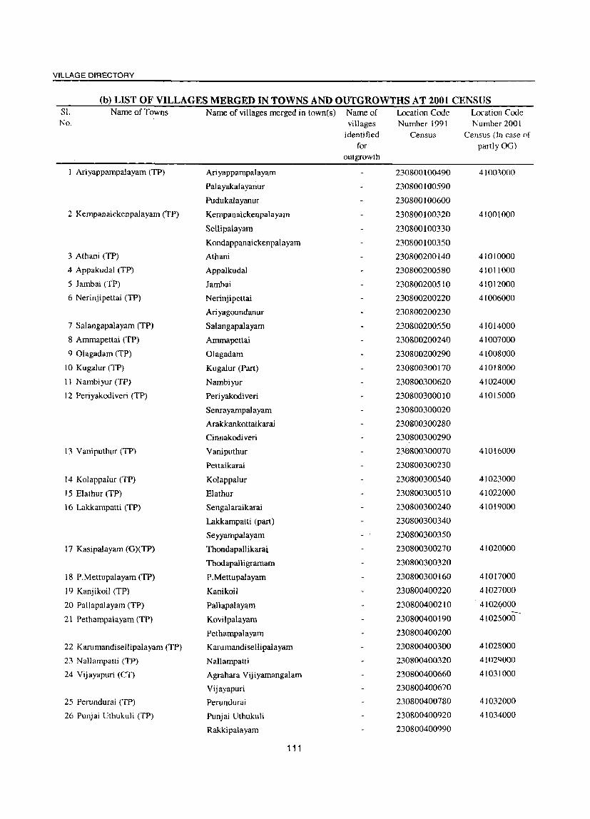
VILLAGE DIRECTORY
(b) LIST OF VILLAGES MERGED IN TOWNS AND OUTGROWTHS AT 2001 CENSUS SJ. Name of Towns Name of villages merged in town(s) Name of Location Code Location Ccxlc No. villages Number 1991 Number 2001
identified Census Census (In case of for partly 00)
outgrowth
1 Ariyappampalayam (TP) Ari yappampalayam 230800100490 41003000
Pal ayakal ayanur 230800[00590
Pudukalayanur 230800100600
2 Kempanaickenpalayam (TP) Kempanaickenpalayam 230800100320 41001000
Sellipalayam 230800100330
Kondappanaickenpalayam 230800100350
3 Athani (TP) Athani 230800200140 41010000
4 Appakudal (TP) Appalkudal 230800200580 41011000
5 Jambai (TP) Jambai 230800200510 41012000
6 Nerinjipettai (TP) Nerinjipettai 230800200220 41006000
Ari yagoundanur 230800200230
7 Salangapalayam (TP) Salangapalayam 230800200550 41014000
8 Ammapettai (TP) Anunapettai 230800200240 41007000
9 Olagadam (TP) Olagadam 230800200290 41008000
10 Kugalur (TP) Kugalur (Part) 230800300170 41018000
11 Nambiyur (TP) Nambiyur 230800300620 41024000
12 Periyakodiveri (TP) Periyakodiveri 230800300010 41015000
Senrayampalayam 230800300020
Arakkankottaikarai 230300300280
Cinnakodi veri 230800300290
13 Vaniputhur (TP) Vaniputhur 230800300070 41016000
Pettaikarai 230800300230
14 Kolappalur (TP) Kolappalur 230800300540 41023000
15 Elathur (TP) Elathur 230800300510 41022000
16 Lakkampatti (TP) Senga1araikarai 230800300240 41019000
Lakkampatti (part) 230800300340
Seyyampalayam 230800300350
17 Kasipalayam (G)(TP) Thondapallikarai 23080030<)270 41020000
Thodapalligramam 230800300320
18 P.Mettupalayam (TP) P.Mettupalayam 230800300160 41Ol7000
19 Kanjikoil (TP) Kanikoil 230800400220 41027000
20 Pallapalayam (TP) Pallapal a yam 230800400210 4102(i000
21 Pethampalayam (TP) KovilpaJayam 230800400190 41025000
Pethampalayam 230800400200
22 Karumandisellipalayam (TP) Karumandisellipalayam 230800400300 41028000
23 Nallampatti (TP) Nallampatti 230800400320 41029000
24 Vijayapuri (CT) Agrahara Vijiyamangalam 230800400660 41031000
Vijayapuri 230800400670
25 Perundurai (TP) Perundurai 230800400780 41032000
26 Punjai Uthukuli (TP) Punjai Uthukuli 230800400920 41034000
Rakkipalayam 230800400990
111

DISTRICT CENSUS HAND BOOK: ERODE
(b) LIST OF VILLAGES MERGED IN TOWNS AND OUTGROWTHS AT 2001 CENSUS S1. Name of Towns Name of villages merged in town(s) Name of Location Code Location Code No. villages Number 1991 Number 2001
identified Census Census (In case of for partly 00)
outgrowth
27 Suriyampalayam (TP) Anainasuvampalayam 230800500040 41037000
S uri yampal a yam 230800500050
Kumilamparappu 230800500060
28 Nasiyanur (TP) Thairpa1ayam 230800500090 41039000
Attyampalayam 230800500130
Vettai peri yampalayam 230800500140
Sennigoundampalayam 230800500150
Nasianur 230800500160
29 Periasemur (TP) Periasemur (Part) 230800500110 41040000
30 Avalpoondurai (TP) Avalpoondurai (Part) 230800400370 41046000
31 Modakurichi (TP) Karukkampalayam 230800400410 41047000
Modakurichi 230800400490
32 Pasur (TP) Pasur 230800500440 41048000
33 Arachalur (TP) Arachalur 230800400530 41049000
34 Vadugapatly (TP) Vadugapatty 230800400540 41050000
35 Kilambadi (TP) Punjai Kilambadi 230800500590 41051000
Nanjai Kilambadi 230800500890
36 Vellottamparappu (TP) Punjai Kolanalli 230800500610 41052000
37 Sivagiri (TP) Sivagiri 230800500640 41053000
38 Kollankoil (TP) Kollankoil 230800500670 41054000
39 Unjalore (TP) Unjalore 230800500730 41055000
40 Vengambur (TP) Vengambur 230800500740 41056000
41 Kodumudi (TP) Kodumudi 230800500750 41057000
42 Chennasamudram (TP) Chennasamudram 230800500800 41058000
43 Vellakoil (TP) Vellakoil 23080090024.0 41061000
44 Muthur (TP) Muthur 230800900090 41059000
Chinnamuthur NA
Oodayam NA
45 Kannivadi (TP) Kannivadi 230800700130 41063000
46 Rudravathi (TP) Kundadam 230800600030 41062000
47 Mulanur (TP) Mulanur 230800700230 41064000
Vellavavipudur NA
48 Kolathupalayam (TP) Kolathupalayam (Part) 230800700470 41065000
Kolinjivadi 230800700450
Alampalayam NA
49 Chinnakkampalayam (TP) Chinnakkampal ayam 230800700550 41067000
Selapalayam NA
Kan~a~am~ala~am NA
112
VILLAGE DIRECTORY
TALAVADI CD BLOCK
113


INDIA TAMILNADU
SATHYAMANGALAM TALUK ERODE DISTRICT
Kilomelres 2 0 2 4 6 6 10 12 . - - -
No. of Villages 75
No. of Towns
PLCN Starting from 00737600
PLCN Ending at 00745000
Total Population 2j87,605
Boundary, State." ". ". ". " .. " "
District ". ". ". " ....... ..
" Taluk ". ". ", ". ,,,.,, ".
" Panchayat Union (C.D.Block) ".
" ~l1ages with location COOe No.
" Reserved Forest with Name ...
TalukHeadquarters ".
Villages having 500·999,1000·4999 and SOOO & above llopulatioo
I
~ I
) "
~ 't, ')
_'_f.
~~131®o::1
:~~UN~!R(: @
••• I __ -X_38-_3 __ -_I, Uninhabited Villages \11th location Gode Number
Urban Area with Location Code number
National Highway." ".
State Highway".
Important Metalled Road ".
River and Stream '" ...
Post Office /Telegraph Office " Higher Secondary School " Pnmary Health Centre ."
Bank .. '
POITO
S
@
X 404
TAMALIJ EXTN. R.F.
VJ~ ..,
~~
,@; 0405, " '.1 ',' , ,
,.' , '@405,'
, '" 'PO ' ~ •••••. I
; ,(,1./ ..,c"
~ ! ,)
X 383
TAlAMAIAI R.F.
~5 ,
, "
@, ~~,
.~ ),
,.~, II I~, ,
.>. o ~
,~, %, -~ :2-
f ~
AVANASillTALUK 01•
COIMBATORE DISTRICT \ ~
K ~ A ie*', f\ "oJ ..... I
. \. j'-\ ... "",V' ,.,.,
" . " 384', @385 ;,.,:@. ", ' • , " '0.. 'PO
X 300
", f .....
".'
/"'388 ,', , '@'" " t: , I .,,' I
,@, '388' , ,
, , , , " 388',
"@: , ' " '.... ,
: X: @a188' X ,389 B ·GUlhl~~~r· , 387 , .' PO ... • t '\
~., @ .. X ,'. ','
,', , ' , , , ,
, MO'
'.' '@ 'B " '.,' '., ,406: 0' I
, ' .. , ,GUTHIYAlATHURRJ. " ... ,' , , " ' , , ,
" , , . , ,
, ,
"
t , ,
'(
.l
To ~Olichelffpr. '\ 1'8%/11
\
" " PMlCHAYATUNIONS
(C.D,BLOCKS)
@TALAVADI
@ SATHYAMANGALAM
© BHAVANISAGAR
,
I '" \' z , (
\ , '?
~ < ! ~ I
Pancnaya/ Union (C.D.Block) boUlldalf excludes sla/u/o,), lowns


VILLAGE DIRECTORY
Alphabetical list of Villages with Location Code Numbers of 1991 and 2001
Name of the District: Erode Name of Taluk: Sathyamangalam Name of CD Block: Talavadi
Serial 2001 Census location number Name of village code number 1991 Census location code number
1 2 3 4
Akkurinjieri Extn. R.F. 00739500 080010001000100200
2 Akkurinjieri R.F. 00739600 080010001000100210
3 Arulavadi 00737600 080010001000100010
4 Byannapuram 00739800 080010001000100230
5 Chikkahajanur 00737900 080010001000100040
6 Dhoddahajanur 00737800 080010001000100030
7 Dhoddamudukkarai 00740100 080010001000100260
8 Erahanahalli 00740000 080010001000100250
9 Gettavadi 00740200 080010001oo0}00270
10 Hassanur 00739100 080010001000100160
II Iggalore 00738200 080010001000100070
12 Karalavadi 00739400 080010001000100190
13 Kongahalli 00740300 '080010001000100280
14 Madahalli 00739700 080010001000100220
15 Mallankuli 00737700 080010001000100020
16 Marur 00738100 080010001000100060
17 Neithalapuram 00739200 080010001000100170
18 Panahahalli 00739900 0800]0001000100240
19 Talamalai 00740500 080010001000100300
20 Talamalai Extn.(R.F.) 00740400 080010001000100290
21 Talamalai R.F. 00738300 080010001000100080
22 Talavadi 00738000 080010001000100050
23 Theiginarai 00739300 080010001000100180
24 Thingalur 00738400 080010001000100090
117
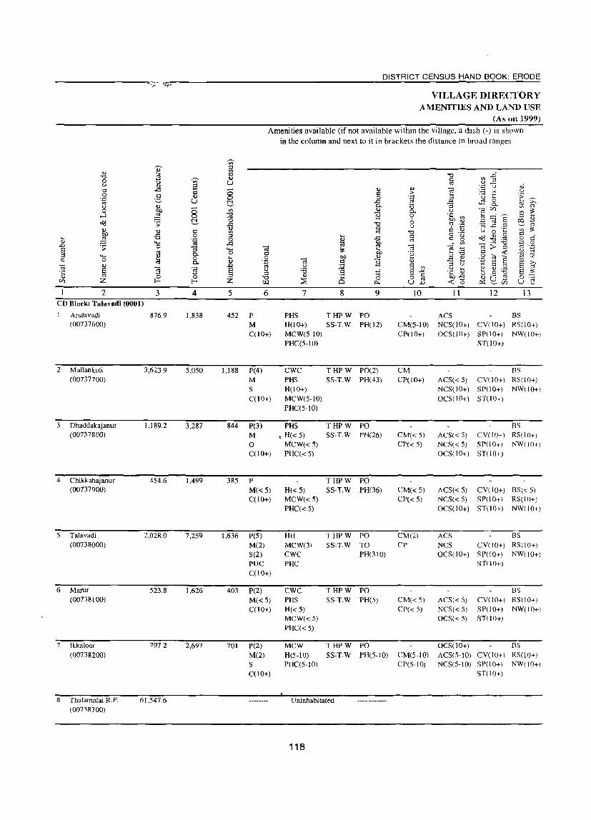
DISTRICT CENSUS HAND BOOK: ERODE ------------------~.~-~~~~,--------------------------------------------~~~~~--~-------------------
2 3 CD Block: Talavadi (0001)
2
3
4
S
Arulavadi (00737600)
Mallankuli (00737700)
Dhaddakajanur (00737800)
Chikkahajanur (00737900)
Talavadi (00738000)
6 Manu
7
(00738100)
Ikkaloor (00738200)
8 Thalamalai KF. (00738300)
876.9
3,623.9
1,189.2
454.6
2,028.0
523.8
797.2
61,547.6
4 5
1,838 452
5,050 1,188
3,287 844
1,499 385
7,259 1,636
1,626 403
2,697 701
VILLAGE DIRECTORY AMENITIES AND LAND USE
(As on 1999)
Amenities available (if not available within the village, a dash (-) is shown in the column and next to it in brackets the distance in broad ranges
6
P M C(lO+)
P(4) M S C(10+)
P(3) M o C(10+)
P M(<:S)
C(lO+)
peS)
M(2) 5(2)
7
PHS H(lO+) MCW(S-IO) PHC(S-IO)
CWC PHS H(IO+) MCW(S-IO) PHC(S-IO)
PHS • H« 5)
MCW«5) PHC« 5)
H«S) MCW«5) PHC« S)
HH MCW(3) CWC
8 9
THPW PO SS-T.W PH(12)
THPW PO(2) SS-T.W PH(43)
THPW PO 5S-T.W PH(26)
THPW PO 5S-T.W PH(6)
THPW PO 5S-T.W TO
PH(310) PUC PHC C(10+)
P(2) M(<: 5)
C(lO+)
P(2) M(2) S C(lO+)
CWC THPW PO PHS SS-T.W PH(5) H«5) MCW«S) PHC« 5)
MCW H(5-10) PHC(5-10)
THPW PO 5S-TW PH(S-IO)
Uninhabi tated
118
10 11 12 13
ACS CM(S-IO) NCS(IO+) CY(IO+) CP(lO+) OCS(10+) SP(lO+)
ST(lO+)
BS RS(lO+) NW(10+)
CM CP(IO+)
CM«5) CP«5)
CM«5) CP« S)
CM(2) CP
CM«S) CP«S)
CM(5-10) ep(S-IO)
BS ACS« 5) CY(IO+) RS(IO+) NCS(IO+) SP(lO+) NW(lO+) OCS(IO+) ST(IO+)
BS AC5« 5) CY(IO+) R5(!O+I NC5« 5) SP(10+) NW(IO+) OCS(!O+) ST(lO+)
ACS« 5) CY(lO+) BS« 5)
NCS« 5) SP(lO+) RS(IO+) OCS(lO+) ST(IO+) NW(IO+)
ACS as NCS CY(lO+) RS(lO+) OCS(IO+) SP(lO+) NW(lO+)
ST(lO+)
ACS« 5)
NCS« 5)
OCS« 5)
BS CY(lO+) RS(lO+) SP(IO+) NW(IO+) ST(lO+)
OCS(10+) BS ACS(S-IO) CY(lO+) RS(10+) NCS(S-IO) SP(lO+) NW(!O+I
ST(10+)

VILLAGE DIRECTORY
VILLAGE DIRECTORY AMENITIES AND LAND USE (As on 1999)
Q) bI)
~ .;; .9 ..c U os 0 ..... I:>-I:>-« 14
PR MR FP
PR MR FP
PR MR FP
PR MR FP
PR MR FP
PR MR FP
PR MR FP
]' Q
V
'" u Q
~ '" :a ~ Q ~ .9 Vi <l.)
@ <l.)
z 15
Charnarajanagar (21)
Chamarajanagar (22)
Chamarajanagar (25)
Charnarajanagar (24)
Chamaraj Nagar (22)
Chamaraj Nagar (23)
Chamaraj Nagar
(30)
.z.-. 0. go '" .... .., ~ 0
Po.
16
EA
EA
EA
ED EAG
EA
EA
EA
.. Cl .§ bO
'" ~ .. I:>-
'" I:>-
'" ~ z 17
N
N M
N
M
"0
'" a .M :l Q os 8 C :a 0
~ 0 u
N .... 0
.§ +-'
'" 0 ~
18
Blue Metal
N Black metal
M
N Granite' M
N Blue Metal, M Granite
N Granite
-.------ Uninhabitated ------------
Land use (i.e. area under
different types of land use in hectare)
Vi
'" ..... 0 ~
19
61,547.6
119
0' u 1;; 0
'" >. e "0
%1 OJ)
] 20
W(12.0)
WE(58.7) T(70.7)
W(17.l) WE(200.0) T{2l7.!)
W(23.2)
WE(264.1) T(287.2)
W(8.1)
WE(47.0) T(55.1)
W(42.6) WE(157.6) T(200.2)
W(11.3) WE(50.8) T(62.0)
W(42.1) WE(95.4)
T(l37.5)
bI) Q
:a ::I u 2- tfl .., .g >
0 '" bh o:l ~ "0 "0
'" .g OJ
~ '" os lil OIl a :~ ..c u
"3 ::I os ;::J u OIl
21 22
445.8 103.5
1,702.8 624.4
480.1 120.0
283.4 50.2
885.8 163.4
255.1 64.9
353.9 87.8
Q 0
'.0 o:l >
'.0 '3 U ....
..8 Q)
~ OJ OIl
~ .... ~ Q) .;; .0 > 8 '" ...... ::I "0 0 Q
'" ., ] '" § <l.) .... .... <t.> « z {/)
23 2
257.0 Arulavadi
1,079.6 Mallankuli 2
301.8 Dhaddakajanur 3
65.9 Chikkahajanur 4
778.7 Talavadi 5
141.7 Marur 6
218.0 Ikkaloor 7
Thalamalai R.F. 8

DISTRICT CENSUS HAND BOOK: ERODE
VILLAGE DIRECTORY AMENITIES AND LAND USE
(As on 1999) Amenities available (if not available within the village, a dash (-) is shown
in the column and next to it in brackets the distance in broad ranges
viz.< 5 kms., 5-10 kms. and 10+ kms of the v;- nearest place where the facility is available is given) ., ::; '" ..,
13 CI -0 .D -0 .., '" 0 v;- el .=l u u Col '"' U .., ::; E u oS c: ..CI '" - .., <!) -;:; '" u CI 8 CI > 0 d
.., E 'u t: .;; '.0 0 .~ >. u ~ ..c: <.::l 0 .... '" C>.. .... -a a. ..,
0; u '"' - OJ '" 0 bO 0 '" ..,
0- u ('3f/) V> '" ,_J ~ 0 -0 ~ 0 .~ V> 3....:~ ;:l ....
~ (5 6 .... -;:; E 6 ~ o:c! .;; ..c: -0 ? .~ -a ..c: .::! Col
'"' CI u
'" .., .., CI '" 0; "0 c: '"' u 0 .... V> eo -£3 0 ::; .... CI
o ._ ~ ~ .g '" ci ....
~ 'g 0 ~ ..c: 0; CI is 0
'"' ...... ..c: ~ ....: '" ('3:;] '§ .2 .D .:;: 0 '" -;:; E -a '0 ';3
'" .... Col .... U ~ 0; a. CI bO Tl 3'"6 '" ~ 'a ;:l ...... ..,
0 .... 0 bO .., .... .... .., .g -;:, a on c: 0 ~ 0.
.., 'g ';3 CI 3i OJ -a .... ::; » ('3 ..,
~ u
~ 8 '" u Col E ;:l E Col
~ ] ] u '"6 ...r S ..14 .~ t ~ g ~ E ~ . .: 0 0
::l <\.) . .: if> § 6b..c: ~ 0 13 '§ <I) "0 0 0 0 f/) Z E-< E-< Z UJ ::E Cl ~ U .D ~ '0 0::: ~ f/) u .... 2 3 4 5 6 7 8 9 10 11 12 13
9 111ingaloor 2,874.4 5,286 1,267 P(8) H THPW PO(2) BS (00738400) M PHC SS-T.W PH(4) CM(10+) ACS(JO+) CY(lO+) RS(lO+)
C(10+) PHS CP(IO+) NCS(lO+) SP(lO+) NW(10+) CHW OCS(IO+) ST(IO+)
10 Hasanur 1,065.6 3,690 953 P(8) CWC THPW PO(2) CM ACS BS (00739100) M(3) PHS SS-T.W PH(40) CP NCS(IO+) CY(lO+) RS(lO+)
S H(10+) OCS(10+) SP(lO+) NW(10+) PUC MCW(lO+) ST(IO+) C(10+) PHC(lO+)
II Neithalapuram 670.2 1,221 324 P PHS THPW PO BS (00739200) M(5-10) H(10+) SS-T.W PH CM(lO+) ACS(5-10) CY(lO+) RS(lO+)
C(10+) MCW(lO+) CP(IO+) NCS(lO+) SP(10+) NW(lO+) PHC(IO+) OCS(lO+) ST(IO+)
12 Theiginari 1,839.6 3,711 868 P(3) PHS THPW PO BS (00739300) M(2) ,0 SS-TW PH(lS) CM(5-10) ACS(lO+) CY(lO+) RS(IO+)
S H(5-10) CP(5-10) NCS(lO+) SP(lO+) NW(10+) C(lO+) MCW(5-10) OCS(lO+) ST(IO+)
PHC(5-10)
13 Karalavadi 1,140.6 1,672 405 P(2) PHS THPW PH(5) BS (00739400) M«5) H(5-1O) SS-T.W PO« 5) CM(5-10) ACS(lO+) CY(IO+J RS(lO+)
C(lO+) MeWe5-10) CP(S-IO) NCS(5-10) SP(lO+) NW(lO+)
PHC(5-10) OCS(IO+) ST(IO+)
14 Akkurinjeri Extn. 155.8 Uninhabitated R.F. (00739500)
IS Akkurinjeri R. F. 383.6 Uninhabitated (00739600)
16 Madhahalli 1,342.8 920 246 P PHS THPW PO BS (00739700) M(5-10) CHW SS-T.W PH(l4) CM(lO+) ACS« 5) CY([O+) RS(lO+)
C(10+) H«5) CP(IO+) NCS(5-IO) SP(10+) NW(lO+) MCW(IO+) OCS(IO+) ST(10+) PHC«5)
17 Byannapuram 900.7 2,587 610 P(4) MCW THPW PO ACS BS (00739800) M(5-10) PHC SS-T.W PH(14) CM(10+) NCS(10+) CY(!O+) RS(10+)
C(lO+) H« 5) CP(10+) OCS(10+) SP(lO+) NW(lO+) 5T(10+)
120
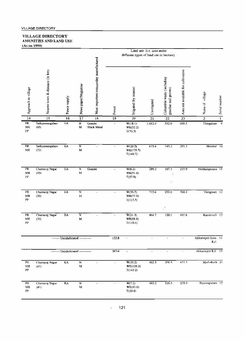
VILLAGE DIRECTORY
VILLAGE DIRECTORY AMENITIES AND LAND USE (As on 1999)
.., bI)
~ .;; 9 ..c: <) ~ 0 .... Q. Q.
-< 14
PR MR FP
PR MR
PR MR FP
PR MR FP
PR MR FP
]' g .., <) I: r; III :.s ~ I: ~ B ~ <Il
~ .., Z
15
Sathyamangalam (6S)
Sathyamangalam (32)
Chamaraj Nagar (4S)
Chamaraj Nagar (30)
Charnaraj Nagar (30)
..... 0.. g-
<Il .... .., ~ 0 c..
16
EA
EA
EA
EA
EA
.., = .~ bIl ~
~ ~ Q. <Il
~ ILl Z
17 N M
N M
N M
N M
N M
"0 .., E <)
~ ::I
~ 8 ~ ~ 0
§ 0 <)
Q ~ t:: o
.§ ~ <Il 0
;:;g
18 Granite. Black Metal
Granite
-------- Uninhabitated -----------
PR MR FP
PR MR FP
-------- Uninhabitated ------------
Chamaraj Nagar (41)
Chamaraj Nagar (41)
EA
EA
N
M
N M
~ <Il .., .... 0 ~
19
155.8
3836
Land use (i.e. area under different types of land use in hectare)
Q) ()
3 0 <Il
..... e "0
~ bIl
:§ 20
W(IS.I) WE(S2.2) T(70.3)
W(20.2) WE029.5) T(149.7)
W(6.2) WE(Sl.6) T(57.8)
W(3S.7) WE(77.9) T(113.S)
W(2l.3) WE(88.8) T(lIO.1)
W(l5.2) WE(l28.0) T(143.2)
W(7.2) WE(43.6) T(50.8)
"0
~ !:>O
:§ I:
:::> 21
1,662.6
47S.4
289.2
712.6
464.7
462.5
485.2
!:>O = ~ ::I U g CIl
<.l
~ ;> 0
'" .... ~ OIl ~ "0 ILl I:
~ '" i;l 3 ..c: .... <)
"3 ::I
'" u OIl
22
S32.0
14S.2
107.3
253.0
120.1
304.9
126.3
121
I: 0
'.0 o:j ;>
~ u ....
..8 .., ~ '@ ;> ~
'0 Q
~ .., ....
-< 23
609.S
29S.3
21S.9
760.4
445.6
432.3
238.3
<1.)
bIl
~ .... .., .;; ..0
Ei '- ::I 0 '" ..,
C'l ~ '':;
Z <u
U)
2
Thingaloor 9
Hasanur 10
Neithalapuram II
Theiginari 12
Karalavadi 13
Akkurinjeri Extn. 14 R.F.
Akkurinjeri R.F. IS
Madhahalli 16
Byannapuram 17

... <1)
..0 E :l c
2 I 8 Panakahalli
(00739900)
19 Erahanahalli (00740000)
20 Thottamudukari (00740100)
21 Gettavdi (00740200)
22 Kongahalli (00740300)
3 851.5
849.0
627.5
874.8
600.9
'" ::I
'" s::l u U
§ ~
4 1,809
2,403
759
1,545
656
23 Talamalai Extn. R.F. 1,240.6 (00740400)
24 Thalamalai (00740500)
Block Total
1,337.6 3,659
87,796_3 53,174
5 6
DISTRICT CENSUS HAND BOOK: ERODE
VILLAGE DIRECTORY AMENITIES AND LAND USE
(As on 1999) Amenities available (if not available within the village, a dash (-) is shown
in the column and next to it in brackets the distance in broad ranges viz.< 5 kms., 5-10 kms. and 10+ kms of the
nearest place where the facility is available is given)
7 8 9 10 11 12 13 429 P(2) PHS THPW PO CP
CM(IO+) ACS BS
587
M
S C(10+)
P(3) M(5-IO) C(10+)
189 P
387
150
919
M« 5)
C(lO+)
P(3) M«5) C(lO+)
P M(5-10) C(10+)
P(5) M(2) o C(10+)
H(S-lO) SS-TW PH(12) MCW(S-W) PHC(S-lO)
PHS H(5-IO) MCW(S-IO) PHC(5-IO)
THPW PO SS-TW PTa
PH
PHS THPW PO H(5-10) SS-TW PH(5) MCW(5-10) PHC(S-IO)
MCW H(10+) PHC(5-10)
THPW PO SS-T.W PH(25)
PHS T HP W PHO 0) H(IO+) SS-T.W PO(5-10) MCW(5-10) PHC(5-10)
Uninhabitated
H 'MCW PHC(IO+)
THPW PO(2) SS-T.W PH(lO+)
CM« 5)
CP« 5)
CP CM(10+)
CM(10+) CP(IO+)
CM(lO+) CP(5-to)
CM(lO+) CP(IO+)
NCS(S-IO) CV(IO+) RS(IO+) OCS(5-IO) SP(lO+) NW(lO+)
ST(lO+)
ACS BS NCS(lO+) CV(10+) RS(lO+) OCS(5-10) SP(10+) NW(10+)
ST(10+)
ACS BS NCS(10+) CV(lO+) RS(lO+l OCS« 5) SP(to+) NW(10+)
ST(10+)
BS ACS(5-10) CV(10+) RS(IO+l NCS(10+) SP(lO+) NW(lO+) OCS (1 0+ ) ST(l 0+ )
BS ACS(5-10) CV(10+) RS(lO+l OCS(lO+) SP(lO+) NW(lOt)
ST(lO+)
ACS BS NCS CV(10+) RS(IO+) OCS(10+) SP(lO+) NW(IO+)
ST(lO+)
12,943 P(60) H(2) T(20) W(20) IIP(20)
PO(22)
TO PTO PII(S7S)
CM(4) CP(4)
ACS(8) NCS(2)
BS(19)
M(l6) 8(7) PUC(2) 0(2)
HH MCW(7) CWC(4) PHC(2) PHS(14) CHW(2) o
122

VILLAGE DIRECTORY
VILLAGE DIRECTORY AMENITIES AND LAND USE (As on 1999)
0 OJ)
3 >-9
..c: u
'" 0 .... Po 0. « 14
PR MR
PR MR FP
PR MR FP
PR MR FP
PR MR FP
~ g 0 u <= is V>
:a o(j <= ;3: 9 -on CI)
;a <1) z 15
Chamaraj Nagar (38)
Chamaraj Nagar (37)
Chamaraj Nagar (29)
Chamaraj Nagar (46)
Chamaraj Nagar (50)
;.., c.. Po :; '" .... ., ;3: 0
0...
16 ED EAG
ED EAG
ED EAG
EA
ED EAG
Q)
<= .~
~
~ Q)
ft 0.
'" ~ Q)
Z
17 N M
N
M
N M
N M
." Q) a ~ :; = '" e Q ;a 0
~ 0 u
N .... 0 Po
.§ ... '" 0
~
18
Granite
-------- Uninhabitated ------------
PR Chamaraj Nagar EA N Granite MR (45) M FP
PR(20) ED N MR(20) EAG(5) (19)
FP(18) EA(15) M(17)
Land use (i.e. area under different types of land use in hectare)
... VI Q) .... 0 ~
19
1,240.6
0' u 3 0 VI
;.., or> '-' ."
Q)
(;j OJ)
] 20
W(15.0) WE(101.8) T(1l6.9)
W(10.5) WE(216.7) T(227.3)
W(12.2) L(tI8.1) T(l30.3)
W(15.2) WE(125.5) T(l40.7)
W(2.2) WE(23.0) T(25.2)
W(30.2) WE(93.2) T(l23.3)
63,327.6 W(365.6) WE(2005.3) L(118.1) T(2488.9)
123
OJ)
= ;a :; U g '" Q)
B >-
~ '" '" ." ;3: ." Q) <=
~ :g '" ~ OJ) a :§ ..c: U
<= "3 ::>
'" ::J U bO
21 22 367.1 106.9
305.5 103.3
239.5 68.0
342.6 100.1
200.5 83.6
573.8 197.4
10,988.0 3,462.3
= 0 .~
>-.;::
"3 u ....
<2 <1)
:g Q) OJ)
~ .... '8 Q)
>- .:; ..0 E <:I ,... :;
'0 0 <= <= '" <3 <:I ~ ·c Q) ....
Z OJ « U)
23 2 260.7 Panakahalli 18
212.9 Erahanahalli 19
189.7 Thottamudukari 20
291.4 Gettavdi 21
291.6 Kongahalli 22
Talamalai Extn. 23 R.F.
443.1 Thalamalai 24
7,529.5


VILLAGE DIRECTORY
BHAVANISAGAR CD BLO,CK
125 .


VILLAGE DIRECTORY
Alphabetical list of Villages with Location Code Numbers of 1991 and 2001
Name of the District: Erode Name of Taluk: Sathyamangalam Name of CD Block: Bhavanisagar
Serial 2001 Census location number Name of village code number 1991 Census location code number
2 3 4
Akkaraithathapalli 00742400 080010002000200530
2 Ayyampalayam 00743700 080010002000200680
3 Baguthampalayam 00741500 080010002000200430
4 Boosaripalayam 00742300 080010002000200520
5 Dhoddampalayam 00742500 080010002000200540
6 Ikkaraithathapalli 00741400 080010002000200420
7 Karapadi 00744800 080010002000200790
8 Karidoddampalayam 00742800 080010002000200570
9 Kavilipalayam 00744900 080010002000200800
10 Kothamangalarn 00741300 080010002000200410
11 Kurumbapalayam 00743500 080010002000200660
12 Madarnpalayam 00744600 080010002000200770
13 MarayeepaJayam 00744500 080010002000200760
14 Mudukkanthurai 00742600 080010002000200550
15 NalJur 00744400 080010002000200750
16 Pan ayampalli 00743900 080010002000200700
17 Periyakallipatti 00743800 080010002000200690
18 Pungampalli 00744100 080010002000200720
19 Pungur 00741200 080010002000200400
20 Pun j ai puliampatti 00744700 080010002000200780
21 Sellaparnpalayam 00744300 080010002000200740
22 Sunkakaranpalayam 00744000 080010002000200710
23 Thatchaperumapalayam 00744200 080010002000200730
24 Thoppampalayam 00742700 080010002000200560
25 Varapalayam 00745000 080010002000200810
26 Velamundi(R.F.) 00743600 080010002000200670
27 Vinnappalli 00743400 080010002000200650
127

DISTRICT CENSUS HAND BOOK: ERODE
VILLAGE DIRECTORY AMENITIES AND LAND USE
(As on 1999) Amenities available (if not available within the village, a dash (-) is shown
in the column and next to it in brackets the distance in broad ranges
viz.< 5 kms., 5-10 kms. and 10+ kms of the
Oil nearest place where the facility is available is given) ., ::s OJ '" }3 I'l '0 .ri '0 ~ OJ '" 0 u '" U
c §
::l u OJ ::s '" U .;
'" ..r:: '" <L> OJ '@ '" u
0 '" 8 = ;. 3 'u t .;; .g <L> 0 .~ .~ U ~ .c -3 ~ 0 ..... >:,
0.. ..... 0.. OJ
'" U OJ - "" '" 0
:W 8 '" ~ 0.. u 03 Vl
'" ::: -l 'tj
8 0 .~ ~ 3~~ ::I .... o<J ~ '0 0 .:= ] § e 8 '> ..r:: '0 ~ ',C '" II) = u ::> .~ ::: II) OJ C '" '" 'tj Q <L> u 0 ... '" bO
o ._ 0:: -s 0 ::s !l ~ ~ £ o<J .g .@ d .... ~ ';:l 0 .c 0 OJ .... '" ..r:: 0.. ,@::;"g .~ .S .D '> 0 '" '" ~ E :; ........ ~ ~ .... '" .... .~ ~ OJ c.. 0 Q OJ) 'u 3 :a c <t:: ::> ....... OJ bO <L> .g C=3 '8 0:: C 0 ~ 0 .... 0 '@ B
.... .... ., ::; c.. Q) 'g Q Q) "3 ... :>,
] OJ .D u ;Q ~ '" u 03 8 ::; S '" § '@ 11 s u :a = ... ~ .~ t ~ g :tj E Z .... '0 ::; ::I II) ·c '" bb.a &l (3 !1 Q) 0 'tj 0 0 ... 0 '§ Vl Z E-< E-< Z ~ :2 0 A.. U ..D <t:: 15 ~ _ Ul u
2 3 4 5 6 7 8 9 10 11 12 13 CD Block: Bhavanisagar (0002)
1 Pungar 332.1 2,905 779 P H(2) THPW PO BS (00741200) M« S} PHS R PH(l20) CM«5) ACS« 5) CV«S) RS(IO+)
C(lO+) MCW(5-iO) SS-T,W CP« 5) NCS(5-10) SP« 5) NW«S) PHC(5-IO) OCS(10+) ST« S)
2 Kothamangalam 361.4 3,877 1,026 P if THPW PO ACS BS (00741300) M(5-1O) MCW R PH(30) CM(5-10) NCS(IO+) CV(IO+) NW
C(lO+) PHC(5-IO) SS-T,W CP(lO+) OCS(IO+) SP(10+) RS(lO+) ST(10+)
3 Ikkarai Thatha 935.5 2,IS2 546 P(3) PHS THPW PO BS Palli M(S-lO) H«S) R PH(sO) CM«S) ACS«s) CV(s-lO) NW (00741400) C(lO+) MCW(5-10) SS-T,W CP(5-1O) NCS(S-IO) SP(10+) RS(lO+)
PHC(5-10) OCS(s-IO) ST(10+)
4 Bagutham 661.6 1,583 428 P(2) PHS THPW PO BS Palayam M«S) H(5-10) R PH(45) CM(S-lO) ACS(s-10) CV(10+) NW (00741500) C(lO+) MCW(5-1O) SS-T,W CP(5-to) NCS(lO+) SP(lO+) RS(IO+)
PHC(to+) OCS(lO+) ST(lO+)
5 Boosaripalayam 1,203.5 3.749 998 P(2) CWC THPW PO CM ACS BS (00742300) M(2) PHS SS-T,W PH (SO) CP(5-to) NCS(S-IO) CV(5-1O) RS(lO+)
AC H(S-JO) OCS(lO+) SP(5-10) NW(IO+) C(5-10) MCW«5) ST(IO+)
PHCC5-10)
6 Akkaraithathappal 464.2 2,358 633 P(2) MCW THl'W PO BS Ii M{<5) PHS SS-T,W PH(43) CM«5) ACS{<S) CV(S-IO) RS(lO+) (00742400) C(S-IO) CHW CP(S-IO) NCS« S) SP(IO+) NW(lO+)
H(S-lO) OCS(10+) ST(10+) , PHqlO+)
7 Dhoddampala yam 216.6 4,014 994 P DH THPW PO CM BS (00742500) M MCW RC PH(224) CP« 5) ACS« 5) CV(10+) NW
S PHS SS-T,W NCS(lO+) SP(lO+) RS(IO+)
C(lO+) H«S) OCS(lO+) ST« 5) PHCC< 5)
128

VILLAGE DIRECTORY
VILLAGE DIRECTORY AMENITIES AND LAND USE (As on 1999)
14
PR MR FP
PR MR FP NR
PR MR FP NR
PR MR FP NR
PR MR FP
PR MR FP
PR MR FP NR
15
Bhavanisagar (2)
Bhavanisagar (5)
Bhavanisagar (8)
Sathyamangalam (7)
Sathy (7)
Bhavanisagar (6)
B havanisagar (2)
16
EA
EA
EA
EA
EA
EA
EA
17
N M
N M
N M
N M
N M
N M
N M
18
Papermill
Sarees
Paper Products, Sarees
Saree
Bed Sheets. Carpet, Jaggery
Cotton Dhoties, Sarees
Cotton Karchief, Silk Sarees
19
Land use (Le. area under different types of land use in hectare)
129
20
W(16.0) WE(66.5) R(9.3) T(91.8)
W(7.0) WE(lS7.4) R(lo.o) T(174.4)
W(18.0) WE(246.6) T(264.6)
W(12.0) WE(234.2) R(S.O) T(251.2)
GC(27 5.6) W(5.I) WE(53.2) R(24.5) T(358.4)
GC(200.7) W(2.0) WE(26.0) R(19.7) T(248.4)
GC(86.6) WE(3S.4) T(122.0)
21 22
19.4 30.9
36.9 32.8
27.2 41S.8
26.4 326.7
71.3 127.3
10.0 136.2
31.2
23 2
189.9 Pungar
117.3 Kothamangalam 2
227.9 Ikkarai 111atha Palli 3
57.2 BaguthamPalayam 4
646.6 BoosaripaJayam 5
69.6 Akkaraithathappalli 6
63.4 Dhoddampalayam 7
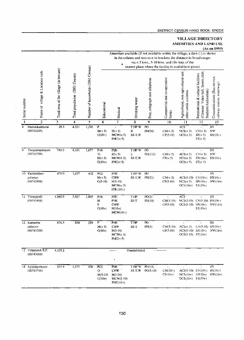
2 8 Mudukkanthurai
(00742600)
9 Thoppampalayam (00742700)
10 Karidaddampalayam (00742800)
11 Vinnappalli (00743400)
12 Kuru mbapalayam (00743500)
13 Velamundi R.F. (00743600)
14 Ayyampalayam (00743700)
3 28.3
782.2
470.0
1,060.9
876.3
4,329.2
607.4
-8 ~
4 4,321
4,161
1,427
3,927
824
1,575
5 6 1,102 P
M«S) C(lO+)
1,077 P(4) Tr
M«5) C(lO+)
402 P(2)
1,005
218
436
M«5) C(5-IO)
P(4) M S C(lO+)
P M«5) C(lO+)
P(2)
o M(S-IO) CO 0+)
DISTRICT CENSUS HAND BOOK: ERODE
VILLAGE DIRECTORY AMENITIES AND LAND USE
(As on 1999) Amenities available (if not available within the village, a dash (-) is shown
in the column and next to it in brackets the distance in broad ranges viz.< 5 kms., 5- IO kms. and 10+ kms of the
nearest place where the facility is available is given)
7
H« 5) MCW« 5)
PHC«5)
Pl,fS H« 5)
MCW«5) PHC« 5)
PHS CHW H(5-1O) MCW«5) PHC(10+)
PHC PHS CHW H(lO+) MCW(10+)
PHS CHW H(S-IO) MCW«S) PHC« 5)
8 9 THPW PO R PH(30) SS-T,W
THPW PO C PH(113) SS-T,W
THPW PO SS-T,W PH(2])
THP SS-T
THP SS-T
PO(2) PH(10)
PO PH(S)
Uninhabitated
PHS CHW H(5-IO) MCW(S-IO) PHC(lO+)
130
THPW PH(13) SS-T,W PO(S-IO)
10
CM« S)
CP(S-IO)
CM« 5) CP«5)
CM« 5)
CP(S-IO)
CM(5-10) CP(s-IO)
CM(5-10) CP(S-IO)
CM(lO+) CP(lO+)
II ACS NCS« 5)
OCS(<5)
ACS«S) NCS« 5) OCS« 5)
12 BS
eV«S) NW
13
SP( < 5) RS( 1 0+) ST«5)
BS eV« S) NW SP(IO+) RS(!O+) ST« 5)
BS ACS(5-10) eV(1o+) RS(lO+) NCS«S) SP(!O+) NW(lO+) OCS(IO+) ST(IO+)
Aes BS NCS(S-IO) eV(5-10) RS(IO+) OCS(S-IO) SP(IO+) NW(lO+)
ST(lO+)
BS ACS«5) eV(S-IO) RS(lO+) NCS(S-IO) SP(lO+) NW(lO+) OCS(5-10) ST( I 0+)
BS ACS(S-IO) eV(lo+) RS(IO+) NCS(lO+) SP(IO+) NW(10+) OCS(\ 0+) ST(10+)
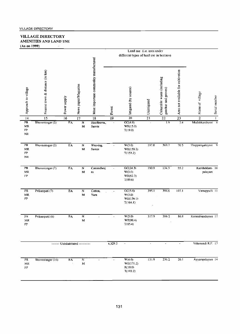
VILLAGE DIRECTORY
VILLAGE DIRECTORY AMENITIES AND LAND USE (As on 1999)
:§: ~
Q) u r= Q)
£9 r= Q)
'" .~ bll :.a ~ ~ o(l '> ~ r= :» .s ~ 'is.. p.. U
..c: .s =' ~ <J til C"l ;;; p.. 0 Q) ....
til .... la III
p.. a: a: 0. Q) 0 Q)
<t: Z 0.. Z
14 15 16 17 PR Bhavanisagar (2) EA N MR M FP NR
PR Bhavanisagar (2) EA N MR M FP NR
PR Bhavanisagar (7) EA N MR M FP
PR Puliampati (7) EA N MR M FP
PR Puliarnpatti (8) EA N MR M FP
-------- Uninhabitated ------------
PR MR FP
Bhavanisagar (16) EA N M
"0
M <J .s =' ~ 6 C ~ 0
~ 0 <J .... ~ 1: 0 p..
.13 .... til 0 ~
18 HandlooIIlS. Sarees
Weaving, Sarees
Cottondhoti es
Cotton, Yarn
Land use (i.e. area under
different types of land use in hectare)
.... '" Q) .... 0 u.. 19
4,329.2
131
., <J
3 0 til
:» e "0
~ bll
] 20
GC(4.0) WE(15.0) T(19.0)
W(3.0) WE(150.2) T(153.2)
GC(24.3) W(3.0) WE(62.3) T(89.6)
GC(5.0) W(3.0) WE(156.1) T(lM.I)
W(5.0) WE(80.4) T(85.4)
W(4.0) WE(171.2) R(18.0) T(l93.2)
bll r= :.a =' u .S tr.I '-' Q)
~ ;> 0
CIl 6b C"l a: "0 '0 r= ~ OJ
C"l
"" ~ blJ lil :§ 3 ..c:
u r= "3 =' C"l ;:::J U bll
21 22 1.9
197.8 360.7
190.9 134.3
395.1 394.6
317.9 386.2
151.9 236.2
r= 0 'g ;> .-=
"3 <J .... Jl
Q)
~ OJ bll :§ ....
'iiI Q)
.:; ..0 ;> S '" '0 4- =' 0 '" r= III ra § C"l ·c Q) .... Q)
<t: Z Vl
23 2 7.4 Mudukkanthurai 8
70.5 Thoppampalayarn q
55.2 Karidaddarn- 10 palayarn
107.1 Vinnappalli 1 1
86.8 Kururnbapalayarn 12
Velamundi R.F. 13
26.1 Ayyarnpalayam 14

DISTRICT CENSUS HAND BOOK: ERODE
VILLAGE DIRECTORY AMENITIES AND LAND USE
(As on 1999) Amenities available (if not available within the village, a dash (-) is shown
in the column and next to it in brackets the distance in broad ranges
viz.< 5 kms., 5-10 kms. and 10+ kms of the ~ nearest place where the facility is available is given)
'""' '" ::s
'" '" '" 5 o:l "1:;1 ..0 "1:;1 ~ '" o:l '" 0 u '" U " (L) ..=! u '" ::s
~ (J oS
o:l ..c: '" '" '" "@ '" u o:l 8 o:l > 0 ~ '" B TJ t:: ;;:
'.;:l 0 '.;:l ,-.
'" U ~ ..c: co co 0 ..... >,
fr .... "3 4-< 0- <U
" U <1l - <1l CIl 0 bI) 0 '" 0- U "@ <:I)
'" ~ ....J ~ 0 "1:;1 ] 0 .~ '" B :gs ::s .....
~ a b m g <:1(j .;; ..c: "1:;1 ~ .~ "3 ..c: .::! '" '" ~
u ~ '" <1l o:l '" "1:;1 Q '" u 0 .. '" OJ) oS 0 ::s .... o:l
o .~
~ ~ ,g o:l d ... ~ '.;:l 0 g ..c: co Q g 0
'" 4-< co ..c: ~ - '" "@>"'§ '.;:l 0
~ .;; 0 "3 "@ co "@ c;; .. co .~ S
._ ~ !;h u co 0 'u a 'B o:l «
::l "'" '" 0- Q
..!::l .S ~ E 'a Q 0 !;J 0 ..... 0 "@
bI) ... .. '" '" 0- (L) ';:l Q B '" "3 ..... >, c;; '" ~ co u ~ § '" u ~ S '" S t':l . ;:: § 11 5 e u 'B .. -'< .~ t-. ~ ~ ~ s ~
0 0 ::s ::s (L) .;:: '" c:I !;h1l a1 tJ !3 ~ '" "1:;1 0 0 0 Ul Z E-< E-< Z ~ Cl '" « 0 ~ p.. U ..0 c.::~<:I) u
2 3 4 5 6 7 8 9 10 II 12 13 15 Periakallipatti S26.1 1,562 456 P H MCW THPW PO BS
(00743800) M CWC SS-T,W PH(27) CM(S-IO) ACS(S-IO) CV(S-IO) RS(10+) 0 HCPHS CP(S-IO) NCS(5-10) SP(IO+) NW(10+) C(lO+) PHC(5-IO) OCS(5-10) ST(5-IO)
16 Panayampalli 1,665.1 4,990 1,327 P(4) MCW THPW PO CM BS (00743900) M S H(5-10) SS-T,W PH(50) CP(S-IO) ACS(5-IO) CV(S-IO) RS( 10+)
C(lO+) PHC(S-IO) NCS(S-IO) SP(10+) NW(lO+) OCS(S-IO) ST(10+l
17 Sungak1caran- 389.4 1,484 410 P(3) PHS THPW PO BS palayam M«S) H(5-10) SS-T,W PHOO) CM(5-1O) ACS«5) CV(S-IO) RS(lO+) (00744000) C(lO+) MCW«S) CP(5-tO) NCS«S) SP(lO+) NW(lO+)
PHC(S-IO) OCS« S) ST(10+)
18 Pungampalli S68.2 2,114 S43 P MCW THPW PO BS (00744100) M«S) H« S) SS-T,W PH(10) CM(S-lO) ACS« S) CV(S-IO) RS(lO+)
C(lO+) PHC« 5) CP(S·IO) NCS« 5) SP(lO+) NW(IO+) OCS« 5) ST(IO+)
19 Thatchu- 221.3 1,IS6 30S P(2) PHS H«5) THPW PO perumalpuram M«5) MCW« 5) SS-T,W PH CM« 5) ACS« 5) CV(5-IO) BS« 5) (00744200) C(5-1O) PHC«5) CP«5) NCS« 5) SP(5-10) RS(lO+)
OCS« S) ST(IO+) NW(lO+)
20 Sellappam- 226.2 705 202 PHS o THPW PO BS palayam P« S) H(5-10) SS-T,W PH(20) CM(5-10) ACS« 5) CV(S-IO) RS(lO+) (00744300) M(<5) MCW« 5) CP(5-IO) NCS(S-IO) SP(lO+) NW(10+)
C(5-10) PHC(5-IO) OCS(10+) ST(lO+)
2! Nallur 886.6 7,549 2,026 P(9) M(3) H(2) THPW PO ACS BS (00744400) S(3) MCW SS-T,W PH(120) CM« 5) NCS(10+) CV« 5) RS(lO+)
PUC PHS CP«5) OCS(10+) SP(lO+) NW(lO+) C(lO+) PHC(IO+) ST(IO+)
132
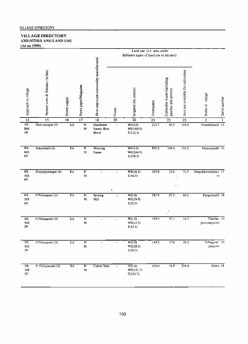
VILLAGE DIRECTORY
VILLAGE DIRECTORY AMENITIES AND LAND USE (As on 1999)
II) b(l
~ .; 8 .c ~ 0 .... 0.. 0.. ~
14 PR MR FP
PR MR FP
PR MR FP
PR MR FP
PR MR FP
PR MR FP
PR MR FP
]' 2 li) (,)
c ;3
'" :a 0I:l c ;>,
~ a 8 Q.
::s .... '" '" .... .., .., ~ ::: <IJ 0 Z 0...
15 16 Bhavanisagar (9) EA
Puliampatti (6) EA
Punjarpuliampat (6) EA
P.Puliampatti (6) EA
P.Puliampatti (5) EA
P.Puliampatti (3) EA
P. Puliyampatti (3) EA
II) c .~
btl 0:1
~ <Ll g. 0.. on ~ <Ll Z
17 N M
N M
N M
N M
N M
N M
N M
~
§ (,)
o!l ::s ~ 8 e-:.a 0 Ei Ei 0 (,)
~ 0 P.. .§ .... '" 0 ~
18 Handloom Sarees, Blue Metal
Weaving Sarees
Spinnig Mill
Cotton Yarn
~
'" <Ll .... 0
u..
19
Land use (i.e. area under different types of land use in hectare)
133
20
W(l2.0) WE(100.3) T(112.3)
W(l2.0) WE(246.5) T(258.5)
WE(16.3) T06.3)
W(3.0) WE(29.9) T(32.9)
W(I.O) WE(12.5) TO 3.5)
W(2.0) WE(28.3) T(30.3)
W(3.0) WE(121.7) T(124.7)
21 212.7
895.8
319.0
387.9
169.9
144.2
428.0
22 86.5
358.4
22.6
87.3
23.]
17.6
74.8
23 114.6
152.5
'o <1J
~ Z
2 Periakallipatli 15
Panayampalli 16
31.5 Sungakkaranpalaya 17 m
60.2
14.7
34.2
259.0
Pungampalli 18
Thatchu- 19 perumalpuram
Sellappam- 20 palayam
Nallur 21

DISTRICT CENSUS HAND BOOK: ERODE
VILLAGE DIRECTORY AMENITIES AND LAND USE
(As on 1999) Amenities available (if not available within the village, a dash (-) is shown
in the column and next to it in brackets the distance in broad ranges viz.< 5 kms., 5-10 Juns. and 10+ krns of the
--- nearest place where the facility is available is given) '" ~
::l OJ
CIl
"'" ,:::l
"'" .g 0 .... --- OJ C CIl
0 CIl U '" g u <I) ::l U oJ c ..c CIl
§ ::l OJ -a CIl u I'l > 0 2 II) B .~ a 'u t: .s;: .~ u ~ <!:l 0 h >.
p.. .... ::l 0.. <l.l ("OJ u ., .- OJ Ul 0 '>Il 8 '" ~ 0.. u --a UJ
CIl ~ .....l ~ :s! B 0 .~ ~ a :::i"a ::l ....
~ 0 6 6 B o<:l .:; 13 ] ~ .~ '3 ~ .= H
U :s: OJ ., C '" -0 C ., U 0 ... CIl bO .:; 0 ::l .l:l c
o ._ o<:l OJ .9 c
ci .... ;g ';;3 B ..c '"
d g :-s! '6 .~ OJ ...... ~
g- • CIl ~
0 ..c .:; 0 Cil '" -a Cil .... c:; > ::l '8 E ...... ~ .... '" 0 I'l bO 'u 3'6 d -< u
::l .... ~
p.. bO ~ 0 '2l a '0
.: 0 0
~ 0 Cil
.... .... OJ .~ ::l 0. 'g 0 B OJ ::l ,_.
E >. -a OJ u
~ E CIl u
Q) ::l E H
§ '8 '8 u :.a ..s E --"< .~ a; "- OJ :.a E ~ ·c .g '" C 'J C OJ 0 0 :::s Q) ·c 0 0 '"
00 ..c Q) ._ '" 0 '§ til Z l- I- Z Ul ~ Q 0... U ..c -< 0 ,:.::; S:J.. Ul u 2 3 4 5 6 7 8 9 10 11 12 13
22 Marayeepalayam 436.3 1,525 387 P(2) PHS TW PO BS (00744500) M«5) H(5-10) S5-T,W PH(IO) CM(5-10) ACS«S) CV(S-IO) RS(10+)
C(5-10) MCW«S) CP(S-IO) NCS(S-to) SP(lO+) NW(10+) PHC(5-1O) OCS(5-1O) ST(10+)
23 Madampalayam 824.0 4,348 1,164 P(4) Mew TW PO ACS BS (00744600) I CWC S5-T,W PH(30) CM«S) NCS« 5) CV«5) RS(lO+)
M«5) CHW CP« 5) OCS« 5) SP(\O+) NW(\O+) C(5-1O) H«S) ST(lO+)
PHC« S)
24 P. Puliyampatti 621.3 1,774 437 P(2) PHS THPW PO BS (00744700) M«5) H«5) SS-T,W PH(25) CM« S) ACS«5) CV«5) RS(lO+)
C(5-1O) M~W«5) CP(S-JO) NCS« S) SP(S-IO) NW(lO+) PHC(S-IO) OCS(5-10) ST(5-10)
25 Karapadi I,OSO.9 4,456 1,040 peS) MCW THPW PO ACS BS (00744800) M CHW SS-T,W PH(80) CM«S) NCS« 5) CV«5) RS(10+)
C(S-IO) H«S) CP« 5) OCS(!O+) SP(lO+) NW(10+)
PHC« 5) ST(lO+)
26 Kavilipalayam 1,278.7 4,793 1,336 P(7) HH THPW PO CP CV BS (00744900) M CWC SS-T,W PTO CM(S-lO) ACS(5-IO) SP(10+) RS(lO+)
S PHS PH(6S) NCS(5-JO) ST(lO+) N\V(lO+) PUC RMP OCS(5-IO)
C(10+) CHW H(S-IO) MCW(IO+) PHC(5-10)
27 Varapalayam I,ISI.S 2,693 806 peS) PHS THPW PO ACS BS
(00745000) M«5) H(lO+) SS-T,W PH(34) CM(S-IO) NCS(5-JO) CV(JO+) RS(lO+)
C(lO+) MCW«5) CP(lO+) OCS(lO+) SP(lO+) NW(IO+)
PHC(JO+) ST(10+)
Block Total 22,174.6 76,022 20,083 P(71) H(6) lUI T(26) PO(26) CM(3) ACS(8) CV B8(25) M(1I) DHPHC W(24) PTO CP N\V(6)
8(7) MCW('9) HP(24) PH(I236)
PUC(2) CWC(4) R(6)
ITrAC PIjS(20) C(2) 0(2) RMP
CHW(8)O
134

VILLAGE DIRECTORY
VILLAGE DIRECTORY AMENITIES AND LAND USE (As on 1999)
.., ~ . ;;: 8 ..c: u
'" 0 ... p.. 0-« 14 PR
MR FP
PR
MR
FP
PR
MR FP
PR MR FP
PR MR
FP
PR
MR FP
~ g II.) <)
r= £3 '" ;a o(j c: ;>,
~ 0.. 8 p..
::s ~ '" '" ... 0 0 ~ ~ 0 0 Z c..
15 16 P. Puliyampatti (5) EA
P. Puliyampatti (3) EA
P. Puliyampatti (3) EA
P. Puliyampatti (3) EA
P. Puliyampatti (8) EA
P. Puliyampatti (12) EA
II.) r:: .~ bQ
'" ~ II.)
~ p..
'" ~ II.)
Z
17 N
N M
N
M
N M
N M
N M
PR(26) MR(26) FP(26) NR(6)
EA(26) N(26) M(25)
"0 II.) a <)
.,s ::s c:l
'" e c ;a 0
§ 0 <)
i:i £3 .... 0 p..
.5 ~
'" 0
~
18
Cotton Yarn
Cotton
Yam. Sarees
0:; .., & 19
Land use (i.e. area under different types of land use in hectare)
0-u :3 0 '" » e "0
~ OJ)
~ 20
W(2.0) WE(110.3) T(l12.3)
W(9.2) WE(179.9) T(189.1)
W(2.0) WE047.1) T(l49.1)
W(4.0) WE(113.2) T(117.2)
W(84.0) WE(3.5) T(87.5)
W(lI.0) WE(29.9) T(40.9)
"0 2 '" OIl
:§ c:
;::J
21 211.4
355.7
338.8
737.1
747.4
766.4
OJ) r= ;a ::s U g '" 0 <U > .... ~ '" n
~ "0 0 c: :0 '" '" 1il 3':= ~ u '3 ::s
'" U OJ)
22 42.6
225.4
133.4
98.9
132.7
128.1
c:l 0
'.g >
';:l
'3 u ...
<2 II.)
~ 'a > '" <5 c:l
'" II.) ... « 23 70.0
53.9
97.7
311.1
216.1
4,329.2 GC(S96.16) W(223.37) WE(2593.79) R{86.51) T(J499.83)
7,159.1 4,046.3 3,140.3
135
<U OJ)
~ .... .., .;;: .0
E 4-< ::; 0 c:l II.) -a ~ ·c ., Z (/)
2 Marayeepalayam 22
Madampalayam 23
P. Puliyampatti 24
Karapadi 25
Kavilipalayam 26
Varapalayam 27


VILLAGE DIRECTORY
SATHYAMANGALAM CD BLOCK
137


VILLAGE DIRECTORY
Alpbabeticallist of ViUages with Location Code Numbers of 1991 and 2001
Name of the District: Erode Name of Taluk: Sathyamangalam Name of CD Block: Sathyamangalam
Serial 2001 Census location number N arne of village code number 1991 Census location code number
2 3 4
Akkarainegarnam 00742200 080010003000300510
2 Alathucombai 00741900 080010003000300470
3 Arasur 00743200 080010003000300630
4 Barabetta RF 00740600 080010003000300310
5 Chikkarasarnpalayarn 00740800 080010003000300360
6 Dasaripalayam 00740700 080010003000300340
7 Gundri 00738600 080010003000300110
8 Guthiyalathur 00738800 080010003000300130
9 Guthiyalathur (Addition) R.F. 00739000 080010003000300150
10 Guthiyalathur Extension RF 00738700 080010003000300120
11 Ikkarainegamam 00741600 080010003000300440
12 Indiampalayam 00743000 080010003000300610
13 Komarapalayam 00741700 Q80010003000300450
14 Konamoolai 00742100 ' . 080010003000300500
15 Koothampalayam 00738500 080010003000300100
16 Makinancornbai 00743100 080010003000300620
17 Malayadipudur 00741800 080010003000300460
18 Pattavarthiayyampalayarn 00740900 080010003000300370
19 Pudupeerkadavu 00741100 080010003000300390
20 Rajan Nagar 00741000 080010003000300380
21 Sadamugai 00742000 080010003000300480
22 Shenbagapudur 00742900 080010003000300580
23 Ukkaram 00743300 080010003000300640
24 Ulle£alayarn (R.F,) 00738900 080010003000300140
139

'+-< o
2
] o
E-<
3 CD Block: Sathyamangalam (0003)
4
I Kootham- 397.9 I ,457 palayarn (00738500)
2 Gundri (00738600)
3 Guthiyalathur Extn. R.F. (00738700)
4 Guthiyalathur (00738800)
702.8
16Z.4
IO,Z98.8
5 Ullepalayam R.F. 1,059.3 (00738900)
6 Guthiyalathur 8Z,595.8 Add!. RF. (00739000)
7 Barabetta R.F. (00740600)
8
9
Dasaripalayam (00740700)
Chikkarasampalayam (00740800)
10 Pattavarthiayyampalayarn (00740900)
1,468.5
173.1
2,433.4
667.5
3,083
14,ZI3
1,734
6,880
1,227
5 6
355 P(Z) M(10+) C(lO+)
744 P(3) M
3,667 P(l6)
477
1,828
296
M C(lO+)
P(Z) M« 5)
C«5)
P(8) M S o C(5-1O)
P M
S C(5-1O)
DISTRICT CENSUS HAND BOOK: ERODE
VILLAGE DIRECTORY AMENITIES AND LAND USE
(As on 1999) Amenities available (if not available within the village, a dash (-) is shown
in the column and next to it in brackets the distance in broad ranges viz.< 5 kms., 5-10 kms. and 10+ kms of the
7
MCW H\lO+) PHC(10+)
H MCW(2) PHC(lO+)
HA MCW(Z) PHC PHS RMP(3)
CWC H«5) MCW« S)
PHC« 5)
HA(Z) MCW PHS 0 H(5-10) PHC(5-10)
PHS H(5-10) MCW«5) PHC(5-10)
140
nearest place where the facility is available is given)
8 9
THPW PO SS-T.W PH(10+)
THPW PO SS-T.W PH(IO+)
Uninhabitated
THPW PO(4) SS-T.W PH
Uninhabitated
Uninhabitated
Uninhabitated
THPW PO R PH(4Z)
SS-T.W
THPW PO(2) SS-T.W PH(220)
THPW PH(75) SS-T.W PO(5-1O)
IO
CM(10+) CP(IO+)
CM(IO+) CP(lO+)
CM CP(lO+)
CM(5-1O) CP(5-10)
CM(5-1O) CP(S-IO)
CM(5-10) CP(5-10)
II 12 13
BS AC S(I 0+) CV(10+) RS(IO+} NCS(10+) SP(IO+} NW(IO+) OCS(lO+) ST(lO+)
5S ACS(lO+) CV(lO+) RS(lO+) NCS(lO+) SP(lO+) NW(lO+) OCS(lO+) ST(IO+}
ACS 5S NCS(lO+) CV(IO+) RS(IO+) OCS(lO+) SP(IO+) NW(lO+)
ST(lO+)
ACS« S)
NCS« 5)
OCS« 5)
ACS
BS CV(5-1O) RS(lO+) SP(5-10) NW(lO+) ST(10+)
BS NCS(5-1O) CV(5-1O) RS(lO+) OCS(5-IO) SP(lO+) NW(5-IO)
ST(5-10)
BS ACS«S) CV(S-IO) RS(lO+) NCS(S-IO) SP(lO+) NW(5-IO) OCS(S-IOJ ST(S-IO)
VILLAGE DIRECTORY
VILLAGE DIRECTORY AMENITIES AND LAND USE (As on 1999)
., bIl
~ :; B ..r:: u ~ o .... Co Co
-< 14
MR FP
MR FP
PR MR FP
PR MR FP
PR MR FP
PR MR FP
] ~ ... u r:: ~ '" :a
o(l r:: ~ B ~
'" ... ~ ... Z
15
Sathyamangalam (49)
Sathyamangalam (46)
;>,
C. §' '" .... ., ~ 0
P-.
16
EA
EA
., c:I .~
bIl ~
~ ., c-~ c-'" ~ ., Z
17
N M
-------- Uninhabitated ------------
Sathyamangalam (27) EA N M
-------- Uninhabitated ------------
-------- Uninhabitated ------------
-------- Uninhabitated ------------
Kempanaickenpalaya EA N m (I) M
Sathyamangalam (5) EA N M
Sathyamangalam (5) EA N M
"0 ., a J1 ::s ~ E3 0 :a 0
~ 0 u
= ~ 0
.§ ~
'" 0
::E 18
Yarn
.... '" 4) .... 0
IL<
i9
162.4
1,059.3
82,595.8
1,468.5
Land use (i.e. area under different types of land use in hectare)
bIl C
;a :; U
0- ·3 '" u ., !3 B >
0 0 ell .... ell COl bIl ;>, ~
"0 "0 e c ~
<> ~ ::0 "0 ~ ~ bIl COl
:§ a .a bIl u
] r:: "3 ::s os
::::J u bIl
20 21 22
W(4.0) 244.5 91.9 WE(24.3) T(28.3)
W(1.0) 535.1 154.3 T(I.O)
W(20.0) 4,151.8 1,562.1 WE(168.9) T(i88.9)
W(l.2) 39.6 23.4 WE(85.0) T(86.2)
W(90.1) 644.0 704.4 WE(546.5) R(lO.O) T(646.6)
W(2.0) 182.9 155.9 WE(219.9) R(6.5) T(228.5)
141
r:: 0 .~
> .;::
"3 u ,_
..8 <>
::0 ., bIl COl
~ .... '8 ... > .:; ..D
2 COl 4-< :J <5 0 c c <> " COl § ·c <> .... Z
'lJ
-< (/)
23 2
33.1 Koothampalayam
12.5 Gundri 2
Guthiya1athur Extn. 3 R.F.
4,396.1 Guthiyalathur 4
Ullepalayam R.F. .5
Guthiyalathur Add!. 6 R.F.
Barabetta R.F. 7
23.8 Dasaripalayam 8
438.5 Chikkarasam- ')
palayam
100.2 Pattavarthiayyam- 10 palayam
2 I I Rajannagar
(00741000)
12 Pudupeerkadavu (00741100)
13 Ikkarainegamam (00741600)
14 Komarapalayam (00741700)
IS Malayadipudur (00741800)
16 Alathucombai (00741900)
17 Sadumugai (00742000)
18 Konamoolai (00742100)
3 1,646.1
1,370.0
8S4.9
2S5.6
874.1
1,107.4
428.9
403.1
Q
.g ~
'3 c. o c.
"5 o
e:-<
4 S,S53
4,040
4,858
3,013
2,900
4,399
3,059
4,295
-8 !:::!. CIl "0
~ OJ en :::l o
..c ..... o
II ~ 5
1,470 6
P(3) M(2) PUC C(lO+)
1,083 P(2)
1,321
824
M«S) C(lO+)
P(4) M qS-IO)
P M«S) q< S)
763 P(2) M S C
1,029 P(3)
87S
1,143
M C
P M q< S)
P M
q5-IO)
DISTRICT CENSUS HAND BOOK: ERODE
VILLAGE DIRECTORY AMENITIES AND LAND USE
(As on 1999) Amenities available (if not available within the village, a dash (-) is shown
in the column and next to it in brackets the distance in broad ranges viz.< 5 kIns., 5-10 kms. and 10+ kIns of the
nearest place where the facility is available is given)
7 it PHS
S CHWO MCW(S-IO) PHC(IO+)
8 9 THPW PO SS-T.W PH(lSO)
PHS T HP PH(20) CHW SS-T,HP PO«5) H(S-lO) MCW(5-10) PHq< 5)
PHS CHW(3) H«S) MCW«S) PHC« 5)
H MCW(2) CHW PHq<5)
Mew
THPW PO R PH(28) SS-T,W
THPW PO R PH(34) SS-T,W
THPW PO CWC R PH(92) PHS SS-T,W CHW H« S) PHq<5)
RMP THPW PO H« 5) R PH(IOO) MCW« 5) SS-T,W PHq5-10)
PHS THPW PO H« S) R PH(75) MCW« 5) SS-T,W PHq5-10)
PHS THPW PO CHW SS-T,W PH(52) H« 5) MCW«5) PHq< 5)
142
10
CM«5) CP(lO+)
CM«5) CP(lO+)
CM«5) CP« S)
CM«5) CP« 5)
11 12 13 ACS
NCS(lO+) CV(5-1O) OCS(lO+) SP(lO+)
BS RS(lO+) NW(lO+)
ST(lO+)
BS ACS« 5) CV(lO+) RS(lO+) NCS(IO+) SP(lO+) NW(IO+) OCS(IO+) ST(lO+)
ACS« 5) NCS« 5) OCS« 5)
ACS« 5)
NCS« 5)
OCS« 5)
BS CV«5) NW SP(IO+) RS(lO+) ST(IO+)
BS CV« 5) RS(lO+) SP« 5) NW(!O+) ST« 5)
CP BS CM«S) ACS«5) CV«S) NW
NCS« 5) SP« 5) RS(lO+) OCS(IO+) ST« 5)
BS CM(5-10) ACS« 5) CV(5-10) RS(lO+) CP(S-IO) NCS(5-10) SP(IO+) NW(!O+)
OCS(5-10) ST(IO+)
CM(5-10) CP(S-IO)
CM«5) CP« 5)
ACS« 5)
NCS(5-10) OCS(5-10)
NCS ACS« 5)
OCS« 5)
BS CV(5-10) NW SP(S-IO) RS(lO+) ST(5-IOl
CV BS SP(lO+) RS(10+) ST(IO+) NW(IO+)

VILLAGE DIRECTORY
VILLAGE DIRECTORY AMENITIES AND LAND USE (As on 1999)
14
PR MR FP
PR MR FP
PR MR FP NR
PR MR FP
PR MR FP
PR MR FP NR
PR MR FP NR
PR MR FP
15 Bhavanisagar (10)
Bhavanisagar (IS)
Sathyamangalam (3)
Sathyamangalam (I)
Sathyamangalam (1)
Sathyamangalam (6)
Periakodivery (2)
Sathyamangalam (3)
16 EA
EA
EA
EA
EA
EA
EA
EA
17
1 u
<l:l § a ~
1 u
I .13
18 N Paper Mill M
N PapenniU M
N Mosaic M
N M
N Furniture M
N Sugar M
N Saree M
N Handloom M Clothes
19
Land use (i.e. area under different types of land use in hectare)
143
20
W(1.0) WE(344.9) R(52.4) T(398.4)
W(4.1) WE(20S.7) R(90.7) T(300.4)
WE(329.2) R(1l7.0) T(446.2)
W(2.8) WE(8S.0) R(J6.4) T(l04.2)
W(4.l) WE(98.0) R(15.2) T(117.4)
W(4.0) WE(17.4) R(614.4) T(635.8)
WE(14.4) R(19S.S) T(209.9)
GC(l69.1) WE(62.5) R(39.0) T(270.S)
21 337.6
163.2
70.3
44.2
273.8
108.8
98.5
17.3
22 318.6
229.2
162.5
2.6
259.3
126.0
4.9
41.7
23
591.5
677.2
175.9
104.6
223.7
236.8
115.7
73.5
2
~ " UJ
Raj anna gar II
Pudupeerkadavu 12
Ikkarainegamam 13
Komarapalayam 14
Malayadipudur 15
Alathucombai 16
Sadumugai 17
Konamoolai 18
DISTRICT CENSUS HAND BOOK: ERODE
VILLAGE DIRECTORY AMENITIES AND LAND USE
(As on 1999)
Amenities available (if not available within the village, a dash (-) is shown
in the column and next to it in brackets the distance in broad ranges
viz.< 5 kms., 5-10 kms. and 10+ kms of the ,....
nearest place where the facility is available is given) on OJ ~ .g 3 '" '0 .ci
~ II)
'" Vl :::s 0 u '" U '" u ... ~ '" :g u " '"
,.Q - <U .,
c:3 u
'" 0 '" > t: .!2 g II) 0 0 .~ a 'u .~
~ OJ U t!- .c e ~ 0 u ., 0- u :; 0- ~ 0 "" 8 '" ..!:! 0- w c:3 U)
Vl ~ ...l ~ ;g ~ 0 ~ '" 3 =s ::I ... ~ .:; t!- il "" 6 ~ .~ :; _g .S 6 ~
~ § u ~ <U II) C '0 c " u 0 .... '" OJ) -5 0 :::s .... '"
o ._ o<J ..g .§ c
d
" ~ ';:l 0 ~ .c
'" c~ ~ 0 .... '" .c 0-._ '0
.~ 0 ,r:, .:; 0 :; ..... (;! i:'!: '" c:3 ~~ c:3 > ::I .~ E 50 c ct<C
w .. 0- 0 d 'f? 0 '2 :::s '- ... 0 0 OJ) '" .§ ~ c 0 ~ 0- ~ .~ .. d B ., '~ E ~ ::I >, .. '" .D '" U ~ § on
::l u ~ E '" § n n s u :a 1i .~ ti
<U ._
S ~ ·c :::s o § u C '0
" 0 0 :::s "1:1 <U ·c 0 5O.c " ._ '"
0 '§ U) Z E- E- Z ~ ::E 0 p., U,r:, <r: '0 ~ U ~ U ~ U)
2 3 4 5 6 7 8 9 10 11 12 13 19 Akkarainegamam 415.6 865 230 P PHS THPW PH(28) BS
(00742200) M CHW 5S-T,W PO«S) CP(S-IO) ACS« S) CV«S, RS(lO+) C(5-tO) H(5-IO) NCS(5-10) SP(IO+) NW(IO+)
MCW(S-IO) OCS(S-IO) ST(lO+) PHC(5-1O)
20 Shenbagapudur 1,033.1 4,524 1,178 P DH THPW PO ACS BS (00742900) M(S-IO) PHS SS-T,W PH(24) CM(S-IO} NCS(S-IO) CV(lO+) RS(lO+)
C(S-IO) a H(S-IO) CP(5-1O) OCS(lO+) SP(lO+) NW(lO+) MCW(S-IO) ST(5-IO) PHe(S-IO)
21 Indiampalayam 361.6 2,018 501 P PHS THPW PO NCS BS (00743000) M«S) H(S-IO) SS-T,W PH(18) CM(S-IO) ACS«S) CV«S) RS(IO+)
C(lO+) MCW«S} CP(S-IO) OCS(5-10) SP(lO+) NW(lO+) PHC(5-1O) ST(lO+)
22 Makinamcombai 471.8 4,272 1,207 P CWCPHS THPW PO ACS ev BS (00743 1 oo} M CHW SS-T,W PH(72} CM(S-lO} NCS SP(IO+} RS( 10+)
C(IO+) H(S-to) CP(S-IO) OCS(IO+) ST(5-IO) NW(!O+) MCW(S-IO) PHC(5-IO)
23 Arasur 123.9 1,021 266 P PHS THPW PH(26) BS (00743200) M«5) H(S-to) SS-T,W PO«S} CM«S) AeS« 5) eV«5) RS(IO+)
C(lO+) MCW«S) CP«5) NCS(5-10) SP(IO+) NW(lO+) PHC(S-IO} OCS(S-IO) ST(lO+)
24 Ukkaram 2,475.5 9,345 2,478 P(9) ewc THPW PO CM ACS BS (00743300) M PHC 5S-T,W PH(72) CP(S-IO) OCS CV(5-10) RS(IO+)
C(10+) PHS NCS(S-IO) SP(S-lO} NW(!O+) H(lO+) ST(5-1O) MCW(S-IO)
Block Total 111,780.9 82,756 21,735 P(63) H(6) T(20} PO(20) CM(2) ACS(6) CV(2} BS(20} M(14) HA(3)DH W(19) PH(1129) CP NCS(3} NW(.') S(4) MCW(9) HP(20) OCS PUC CWC(4) R(6) C(2) PUC(2) 0(1) PHS(15)
RMP(4) CHW(lO) 0(3)
144

VILLAGE DIRECTORY
VILLAGE DIRECTORY AMENITIES AND LAND USE (As on 1999)
Land use (i .e. area under
different types of land use in hectare) ""d
M J1 ---
] ::I
'" g 0
8 .~
M g ?;- OJ) >
1 '" .~
OJ '6 :3 <.> ... ::I u ., S '" ] ~
... ... '" 'fl U .2 "" '6 0
~ ~ " ., ~ If <.> g > :D .,
"'d
~ 0 1>0 .:;
~ ~ '" ... ~ '" ;.-, '" "" ::9 .,
8 ~ 0.. ;.-, " ""d
n .:; ..0
2 g- ... 8- e ""d ., § > E ..c g. g M g :D 4- :::I
~ '" 0. § "0 <-:S
~ _g 0 'OJ " '" ... ~ "" E ~ .., '" w ;;; :§
c ... ~ 0- ~ ~ '" e bO
_ <.> M ~ C- " 0 "3 :::I .,
« z 0 Z ::; 0 :§ '" '" ....
Z OJ p.., Ix.. ::> U "" « (/J
14 15 16 17 18 J 9 20 21 22 23 2 PR Sathyamangalam EA N GC(l70.6) 7.4 72.1 11.5 Akkarainegamam 19 MR (5) M WE(75.1) FP R(78.8)
T(324.5)
PR Ariappampalayam EA N Yam, Granite GC(554.6) 70.2 104.8 162.8 Shenbagapudur 20 MR (5) M W(40.0) FP WE(lOO.7)
T(69S.3)
PR Ariappampalayam EA N Weaving GC(49.0) 55.0 45.4 81.8 lndiampalayam 21 MR (4) M Cloths, TWE(l30.4) FP Spinning Mill T(l79.4)
PR Ariappampalayam EA N Handloom GC(77.5) 4.3 10.'\.0 92.5 Makinamcombai 22 MR (6) M Sarees WE(160.9) FP R(31.7)
T(270.0)
PR Ariappampalayam EA N Saree GC(2.4) IJ.I 33.7 17.3 Aras"r 2.1 MR (S) M W(l.O) FP WE(5S.3)
T(61.7)
PR Sathyarnangalam EA N 0.6 GC(l83.5) 751.9 743.9 147.9 Ukkaram 24
MR (9) M W(52.6)
FP WE(S95.0) T(831.l)
PR(lS) EA(2D) N (Ill) 85,286.6 GC(12D6.611) 7,811.6 4,941.6 7,716.7
MR(20) M(lll) W(228.11) FP(20) WE(3l1Jl.64)
NR(3) TWE(130.43) R(1267.56) T(6024.43)
145


VILLAGE DIRECTORY
THOOKANAICKENPALAYAM •
CD ]Bl~OCK
147


INDIA TAMILNADU
GOBICHETTIPALAYAM TALUK ERODE DISTRICT
No, of Villages
No,ofTowns
PLCN Starting fiom
PLCN Ending at
Total Population
Kilometres 2 4
60
10
00750500
00756400
3,61,201
PANCHAYAT UNIONS
~
(C,D,BLOCKSI ~
@ THOOCKANAICKENPALAIYAM
@ GOBICHETTIPALAYAM
© NAMBIYUR
"fO 'IJ&
" ~
'i'
~ ..I,
'i'
Panchayat Unron le.DB/ock) boundary exctudes statutory towns
'i'
~ ,,;'
# ~~ ~ \l. l ~
'< N \) R u
1
\ '
9 ~ ,"'- I Siruvalurr ( •
PO TO '
® ~
\ ~
t
4
~
C
~ & ~
bl~ J ~ ~
l '<
Boundary, District ."
Taluk
" ~anchayat Union (CD.Block) ...
Villages with location Code No.
Taluk Headquarters.. @
Viltageshaving200·499, 500·999, 1000·4999 •••• and 5000 & above ~opulation
["'-X-52-1-- 1 Uninhabited Villages with Location Code Number
Urban Area with Location Code number ~ State Highway SH 15
Important Metalled Road .
River and Stream . ~ ~
Post Office IT elegraph Office ., POITO
Higher Secondary School . Primary Heatth Centre ... @
Bank ...


VILLAGE DIRECTORY
Alphabetical list of Villages with Locution Code Numbers of 1991 and 2001
Name of the District: Erode Name of Taluk: Gohkhettipalayam Name of CD Block: Thookanaickenpalayal
Serial number
2
3
4
5
6
7
8
9
10
II
12
13
Name of village 2
Akkaraikodi veri
Arrakkankottaigramam
KanakampaIayam
Kavandampalayam
Kondayampalayam
Kongarpalayarn
NanjaiPuliampatti
NanjaiThuraiyampaIayam
Odayagoundanpalayam
Perumugai
Pullappanaickenpalayam
Pun j ai thuraipal ayam
Singiripalayam
2001 Census location code number 1991 Census location code number
3 4
00752500 080030007000700300
00750600 080030007000700040
00751100 080030007000700100
00750800 080030007000700060
00751000 080030007000700090
00750700 080030007000700050
00752200 080030007000700220
00752100 080030007000700210
00753800 080030007000700460
00751200 080030007000700110
00750500 080030007000700030
00750900 080030007000700080
00752600 080030007000700310
151

~ o t)
c o .~ t) o
..J ~
~ .;;: ..... o Q)
~ z 2 3 4
CD Block: Thookanayakanpalayam (0004)
Pullappanaicken- 369.6 2,931
2
palayam (00750500)
Arrakkankottai (00750600)
3 Kongarpalayam
(00750700)
4 Kavandam-
palayam (00750800)
5 Punjaithuraiyam-palayam (00750900)
6 Kandayam Palayam (00751000)
7 Kannakkam-palayam
(00751100)
1,019.2 3,217
1,083.6 5,956
464.9 2,106
1,372.8 8,312
882.3 6,988
90>.1 6.181
..... g ~ '" 't:l
"0 ..c:
<JJ ::g o
,..0 ...... o
1 z 5
802
871
6
P(2)
M S C(5-10)
1,640 P
M
DISTRICT CENSUS HAND BOOK: ERODE
VILLAGE DIRECTORY AMENITIES AND LAND USE
(As on 1999) Amenities available (if not available within the village, a dash (-) is shown
in the column and next to it in brackets the distance in broad ranges
viz.< 5 kms., 5-10 kms. and 10+ kms of the nearest place where the facility is available is given)
7
HH MCW PHS
H« 5)
PHC« 5)
HH PHS
H« 5)
MCW«S)
PHC« 5)
HH
MCW
8 9
THPW PO R PH(315) SS-T,W
THPW PO R PH(225)
SS-T,W
THPW PO SS-T,W PH(l59)
C!)
> .~ .... <JJ 0.
'7' o u
§ .'§
I ~ o <1 U.o
10
CM«5) CP« 5)
CM«5) CP« 5)
11
NCS
ACS« 5) OCS« 5)
NCS
ACS« 5)
OCS« 5)
CP ACS
CM« 5) NCS
12 13
BS CV«5) RS(lO+) SP(10+) NW(10+1
ST(lO+)
BS CV« 5) RS(10+) SP(lO+) NW(10+)
ST(10+)
BS CV« 5) RS(10+)
C(10+) CWC OCS« 5) SP(10+) NW(IO+) ST(lO+)
585
2,209
2,042
P« 5) M«5) C(lO+)
P(4) M
S PUC I
M«5) C(10+)
1,744 peS) M
C(10+)
PHS H(d)
PHC <5 PHS T HP W PH(S3)
H« 5) SS-T,W PO« 5)
MCW«5) PHC« 5)
cwe THPW PO PHS S5-T,W PH(160)
HH MCW(2)
PHS H(10+)
PHC« 5)
152
THP PO
SS-T,HP TO PH(230)
THPW PO SS-T,W PH(175)
CM« 5)
CP« 5)
CM CP« 5)
CM«5)
CP« 5)
CP
ACS
NCS« 5)
OCS« 5)
ACS NCS(2)
OCS« 5)
ACS
NCS OCS(2)
NCS(2)
BS CV« 5) RS(lO+) SP(lO+) NW(10+)
ST« 5)
ST(2) BS CV« 5) RS(IO+) SP(lO+) NW(lO+)
BS CV« 5) RS(10+) SP(lO+) NW(lO+) ST«5)
CV BS CM«5) ACS«5) SP(lO+) RSrlO+)
OCS« 5) ST« 5) NW(iO+)

VILLAGE DIRECTORY
VILLAGE DIRECTORY AMENITIES AND LAND USE (As on 1999)
14
PR MR FP
PR MR FP
PR MR FP
PR MR FP
PR MR FP
PR
PR MR FP
15
Sath yamangaJam (8)
Sathyamangalam (10)
TN,Palayam (3)
TN.Palayam (2)
Gobichetpalayam (12)
TN.Palayam (7)
Vaniputhur (8)
16
EA
EA
EA
EA
EA
EA
EA
17
N M
N M
N M
N M
N M
N M
N M
18
Sarees, Dhoties
Jaggery, Pot
Coconut Coir
Sarees, Dhoties, Pot
Dhoties, Sarees
19
Land use (i.e. area under
different types of land use in hectare)
153
20
WE022.7) T(122.7)
WE(297.2) T(297.2)
WE(352.S) T(352.8)
WE(l85.7) TR(S.O) T(193.6)
GC(31.14) WE(690.0) TWE(77.0) T(798.1)
GC(246.96) WE(199.3) T(446.2)
GC(1.65) WE(513.5) T(515.1)
21 22
383 126.6
291.9 277.3
196.0
71.3 129.4
158.2 256.4
73.7 180.7
42.3 219.2
'" 0 'g >
~ u ....
<8 ~ .D r"J
~ > ro (5 <= 0:1 OJ .... -< 23
82.0
152.9
254.1
70.6
160.1
181.7
126.6
OJ blJ
::2 .... <U
'> .0 E
4-< ::l 0 <= OJ -a § .c;
<U Z Ul
,., "-
Pullappanaicken-palayam
Arrakkankottai 2
Kongarpalayam 3
Kavandam- 4 palayam
Punjaithuraiyam- 5
palayam
Kandayam 6 Palayam
Kannakkam- 7 palayam

DISTRICT CENSUS HAND BOOK: ERODE
VILLAGE DIRECTORY AMENITIES AND LAND USE
(As 011 1999) Amenities available (if not available within the village, a dash (-) is shown
in the column and next to it in brackets the distance in broad ranges
viz.< 5 kms., 5-10 kms. and 10+ kms of the ~ nearest place where the facility is available is given) .-.. '" :::I .., .., '" £j c::l "0 .0 "0 ~ ..,
'" 0 U til U c::
§ ::!
U .., ::! o:l U oS c ..c til ...... .., Q) 03 '-' c::l 8 c::l > ~ 0 § .., ... 'u .;;: 'n 0 .~ 2 ... >; '" U ~ ..c ..s 0 ... u .., 0. ... "3 0. ..,
'" Q) on 0 bI) 0 til ~ 0.. u 03 I/)
~ on .....J ~ 0 "0 2 0 'a Vl a :;:fs ::! ... ~ '0 6 6
.., o'<! 's;:' ..c "0 ~ .~ "3 '" Q,) c::l u o Q) ..t::= .a
~ <1l ., d til '" "0 U 0 ... Ul bI) oS 0 ::! ... C
o ._ o(l
.., 8 c ci ... ~ .~ 0 ~
..c '"
c g "0 :.a 0 .., 4-< ..c g. ...: Vl :> .~ .8 .0 .:; 0 :; 0$ C3 03 ::l E 4-< " ....
~ :B u S '" 0. 0 c::l bI) 'u c --0:: ';:; ::! ..... .., 0 .... 0 bll ~ ... ~ <l) 0 ~ a VI c 0 ~ 0. Q,) '.::1 03 c::l 2 Q) - .... .~ E ::! »
03 .., ,.Q '" '-' ~ § ::! u ::! § '" § '§ ] E u :.a til
.~ aJ I!J <l) :.a ~ ·c "'" ... ::l VI u c::l
OJ 0 0 ::I <l) ·c c::l bh.s ._ " I/) Z f-< f-< Z 't:l
~ 0 0 '" I!J U .... 0 '§ III Q Cl... U .0 --0:: 0 c.:: ~ I/) u
2 3 4 5 6 7 8 9 10 II 12 13 8 Perumugai 1.915.5 8.692 2,461 P(8) MCW(4) THPW PO(2) CM NCS(4) BS
(00751200) M PHC RC PTO ep(5-10) ACS« 5) CV« 5) RS(lO+) S PHS(2) SS-T,W PH(456) OCS(10+) SP(10+) NW(lO+) C(lO+) H(10+) ST(IO+)
9 Nanjaithuraiyam- 372.5 Uninhabitated palayam (Un) (00752100)
10 Nanjaipullyam- 446.9 1,504 470 P PHS THPW PO BS patti M«5) H(lD+) SS-T.W PH(60) CM(5-IO) ACS« S) CV« S) RS(lO+) (00752200) C(lO+) MCW(10+) CP«5) NCS« 5) SP(lO+) NW(10+)
PHC« 5) OCS(5-10) ST(5-10)
11 Akkaraikodiveri 481.1 2,384 632 P H THPW PO CP NCS ST BS (00752500) M MCW SS-T,W PH(100) CM« 5) ACS(10+) CV(lO+) RS(lO+)
C(lO+) PHS OC5(10+) 5P« 5) NW(10+) PHC« 5)
12 Singiripalayam 251.2 820 230 P PHS THPW PO NCS BS (00752600) M«5) 0(3) C PH(ZI) CM« 5) ACS« 5) CV« 5) RS( 10+)
C(5-10) H«5) S5-T,W CP«5) OCS(10+) SP(IO+) NW(IO+) MCW« 5) ST(lO+) PHC«5)
13 Odyagowendon- 491.5 2,027 591 P PHS THPW PO BS palayarn M(5-1O) H(IO+) SS-T,W PH(20) CM(IO+) ACS« 5) CV(IO+) RS(IO+) (00753800) C(lO+) MCW«5) CP(5-10) NCS« 5) SP(10+) NW(!O+)
PHC(5-10) OCS« 5) ST« 5)
Block Total 10,054.2 51,118 14,277 P(26) HIlA T(12) PO(12) CM(2) ACS(4) CV BS(12) M(6) HH(4) W(11) TO CP(3) NCS(14) ST(3) S(3) MCW(ll) HP(12} PTO OCS(2) PUC CWC(2) R(3) PII(1974)
PHC C(2) PHS(12) RMP(3) 0(3)
154

VILLAGE DIRECTORY
VILLAGE DIRECTORY AMENITIES AND LAND USE (As on 1999)
~ 3 .., u c:I f'i .., '" bJl 'i3 ~ ~ .;; c:I >.
9 ::: "E.. 9 c.. ..c:I
u ::l
'" 'in '" 0 ... .... .., 'I)
0- l;l ::: 0- .., 0
~ Z 0...
14 15 16 PR Gobichetpalayam EA MR (16)
dI c:I .~
bJl
'" ~ <I)
~ c..
'" ::: <I)
Z
17 N Coir
M
-------- Uninhabitated ------------
PR
PR MR
FP
PR
FP
PR
MR
FP
PR(12)
MR(9)
FP(9)
T.N.Palayam (3)
Gobichetpalayam (12)
Kasipalayam (2)
Kasipalayam (5)
EA
EA
EA
EA
EA(12)
N M
N M
N M
N
M
N(12)
M(12)
"t:l dI a .s ::l [il 8 c :a 0
~ 0 u
c: f'i .... 0
.§ .... .... '" '" 0 ::;E
.,
.... 0
tI..
18 19
Land use (i.e. area under different types of land use in hectare)
'ii:lt
165
0' u 3 0 Vl
>-. e "t:l
~ bJl
] 20
GC(501.0)
WE(795.8) T(1296.8)
GC(288.3) WE(O.S)
T(289.2)
GC(392.2) WE(2.1)
T(394.2)
GC(345.9) WE(3.2) T(349.l)
GC(l32.8) WE(2.0) T(l34.8)
GC(350.5)
WE(8.6) T(359.1)
GC(2476.1) WE(2987.8)
TWE(77.0)
TK(8.0) T(5548.9)
on c:I 'i3 :::l U g <J) .., ~ >
0 '" .... '" OIl ::: "t:l "0 c:I
~ ~ '" .0 ~ bIl '" :§ a ..c:I u
0 :; ::l
'" ;:J U bIl
21 22 14.2 232.7
0.7
3.9
55.9
4.0 82.2
59.3
889.6 1,904.9
c:I 0 '0
'" > '.:::l "3 U ....
<2 <U
::0 '" =a > '" '0 Q
<":I
~ ~
23 371.9
82.6
48.7
76.2
30.3
73.1
1,710.7
<U bJl
'" .... <))
.;; ..0 E
4-< ::l 0 c:I <I) c:3 § ·c z <))
(/)
2 Perumugai 8
Nanjaithuraiyam- 9
palayam
Nanjaipullyam- 10
patti
Akkaraikodiveri II
Singiripalayam 12
Odyagowendon- 13
palayam


VILLAGE DIRECTORY
ANTHIYUE~ CD BLOCK
157


~ I
0
"
T 8 t.r R
~ l ~ M
.'"'
ro c ~ c ~ z
~ I X ~ 0 , 0 ~ '-I
~ .. 8
I ". '') V'_'
I I
,J U K


VILLAGE DIRECTORY
Alphabetical list of Villages with I IIcation Code Numbers of 1991 and 2001
Name of the District: Erode Name of Tttluk: Bhavani Name of CD Block: Anthiyur
Serial --r-
2001 Census location code number Name of village number 1991 Census location code number
2 3 4
Anthiyur 00746100 080020004000400110
2 Brammadesam 00746500 080020004000400160
3 Burgur 00745200 080020004000400020
4 Burgur (North R.F.) 00745100 080020004000400010
5 Burgur South RF .. 00745400 080020004000400040
6 Ennamangalam 00745900 080020004000400090
7 Ennamangalam R.F. 00745800 080020004000400080
8 Gettisamudram 00746700 080020004000400180
9 Kilwani 00747900 080020004000400340
10 Kuppandampalayam 00746400 080020004000400150
11 Kuthampoondi 00748000 080020004000400350
12 Moongilpatti 00747800 080020004000400330
13 Nagalur 00746300 080020004000400130
14 Nagalur RF. 00746200 080020004000400120
15 Pachampalayam 00746600 080020004000400170
16 Sankarapalayam 00746000 080020004000400100
17 Thamarakkarai RF. 00745300 080020004000400030
18 Vembathi 00747700 080020004000400320
161

2 3 CD Block: Anthiyur (0005)
I Burgur North R.F 47,860.4 (00745100)
2 Burgur 5,522.5
(00745200)
3 Thamaraikkarai 3,066.6 R.F
4 Burgur South R.F. 24,881.0 (00745400)
5 Ennamangalam R.F. (00745800)
6 Ennamangalam
7
8
(00745900)
S ankarapalayam (00746000)
Anthiyur (00746100)
9 Nagalur R.F. (00746200)
10 Nagalur (00746300)
2,270.3
1,75S.0
643.8
4,013.2
226.5
1,876.3
...... 8 ~
4
15,874
7,535
3,353
IS,889
5,317
5 6
DISTRICT CENSUS HAND BOOK: ERODE
VILLAGE DIRECTORY AMENITIES AND LAND USE
(As on 1999) Amenities available (if not available within the village, a dash (-) is shown
in the column and next to it in brackets the distance in broad ranges viz.< 5 kms., 5-10 kms. and 10+ kms of the
nearest place where the facility is available is given)
7 8 9 10 11 12 13
Uninhabitated
3,651 P(14) MCW(2) PHC CHW H(lO+)
THPW PO SS-T,W PH(3)
BS ACS(lO+) CV(lO+) RS(lO+) NCS(lO+) SP(IO+) NW(lO+) OCS(lO+) ST(]O+)
2,042
895
4,214
1,368
M(2) S C(lO+)
Uninhabitated
Uninhabitated
Uninhabitated
P(4) MCW THPW PO SS-T,W PH(41O) M CHW
C(lO+)' H(5-10)
P(3) M C(10+)
peS) M(2) C(lO+)
PHC« 5)
HH RHS RMP CHW(2) MCW(5-10) PHC(5-IO)
MCW PHC RMP(3) H«5)
THP PO SS-T,HP PH(220)
THPW PO SS-T,W PH(447)
Uninhabitated
P(4) MS C(lO+)
MCW H(5-1O) PHC(S-IO)
162
THPW PO SS-T,W PH (50)
CM(IO+) CP(lO+)
CM CP(5-10)
CM(5-1O) CP(5-10)
CM«5) CP«S)
CM(5-IO) CP(5-10)
ACS BS NCS(5-10) CV(5-10) RS(IO+) OCS(S-IO) SP(lO+) NW(IO+)
. ST(lO+)
OCS BS ACS(5-10) CV(S-IO) RS(lO+) NCS(S-IO) SP(IO+) NW(lO+)
ST(lO+)
ACS« 5) NCS« 5) OCS« 5)
BS CV« 5) RS(lO+) SP« 5) NW(lO+) ST(lO+)
ACS ST BS NCS(5-10) eV(S-IO) RS(lO+) OCS(S-IO) SP(!O+) NW(5-10)
VILLAGE DIRECTORY
VILLAGE DIRECTORY AMENITIES AND LAND USE
(As on 1999) Land use (i.e. area under
different types of land use in hectare) "0 0 a u ~
j ::s d ~ 0 8 'g
3. ~ 00 > d 'a
<U :a :.a "3 u 0 U d CI)
~ :::s
is d U .... <U
'" .~ OJ g '" ..8 01) :.a 0
~ CI) CI)
;!l 00 <.)
~ > ~ <L> o'd <'S d 0 01) :;:
~ 0 '" i;i} ~ '-d >-> E "" M :a <l,)
9 ~ C. >-> ~ "0 ~ ..0 0 0 e "0
~ > S ..c 8 0.. f,f ~ ~ ro
u ::s 0.. 4-< :::s '" .9 -0 .0 (5 ro ~ 0.. ro til 0 '" 0 ... ~
01) d .... ~ <U CIJ - ~ :§ S..c <l,) c; 0.. ~ ~ '" 01)
_ u ro § '!:: 0.. Z 0 0 0 ~ ] d ;:; ::I Q)
< z ::;E Ol .... Z
0,)
0... J.I.. ::J U 01) < CIl
14 15 16 17 18 lij 20 21 22 23 2
-------- Uninhabitated ------------ 47.R60.4 Burgur North R.F
PR Anthiyur (32) EA N W(43.4) 3,391.4 497.4 1,590.2 Burgur 2 MR M T(43.4) FP
-------- Uninhabitated ------------ 3./)66.6 Thamaraikkarai 3 R.F
-------- Uninhabitated ------------ 24 ~81.0 Burgur South R.F. 4
-------- Uninhabitated ------------ 2.170.3 EnnamangaJam 5 R.F.
PR Anthiyur (8) EA N Carpets, GC(5.4) 366.3 292.5 331.9 Ennamangalam 6 MR M Mats" WE(76 1.9) FP Lungies T(767.3)
PR Anthiyur (5) EA N Bricks GC(6.3) 133.6 78.1 111.1 Sankarapa1ayam 7 MR M WE(314.7) FP T(321.0)
PR Anthiyur (5) EA N GC(67.6) 1,499.3 607.6 532.1 Anthiyur 8
MR M WE(1306.6) FP T(1374.2)
-------- Uninhabitated ------------ , !26.S NagaJurR.F 9
PR Anthiyur (5) EA N Bricks, WE(86 1.5) 327.2 442.6 245.0 Nagalur 10
MR M Sarees, Carpet T(861.S) FP
163

..... OJ
.D E ::l C
2 II Kuppandam-
palayam (00746400)
12 Bramadesam (00746500)
13 Pachampalayam (00746600)
14 Gettisamudram (00746700)
IS Vempathi (00747700)
16 Moongolpatti (00747800)
17 Keezhvani (00747900)
18 Koothampoondi (00748000)
Block Total
3 1,064.6
1,638.1
1,229.4
955.5
2,400.7
359.1
352.3
266.3
100,384
~
'" ::l '" = u
U
4 5,598
12,074
7,530
5,144
10,803
3,144
2,148
2,060
96,469
-8 ~
'" "0 :g u '" ::l o
..0 ..... o
}i § Z
5 6 1,504 P(6)
M(2) S PUC C(lO+)
3,285 P(6)
2,007
1,443
3,024
M(2) S PUC C(lO+)
P(7) M(3)S PUC Tr(2) C(10+)
P(4) M C(lO+)
P(9) M S
DISTRICT CENSUS HAND BOOK: ERODE
VILLAGE DIRECTORY AMENITIES AND LAND USE
(As on 1999) Amenities available (if not available within the village, a dash (-) is shown
in the column and next to it in brackets the distance in broad ranges viz.< 5 kms., 5-10 kms. and 10+ kms of the
nearest place where the facility is available is given)
7 tvICW(2) ewc PHC H«5)
MCW(3) PHS(2) RMP(3) H(5-10) PHC(IO+)
MCW RMP(2) CHW H«5) PHC« 5)
MCW CHW H«5} PHC(lO+)
MCW(2) PHC RMP CHW
8 9 THPW PO S5-T,W PH(l05)
THP PO 5S-T,HP PH(305)
THPW PO 55-T,W PH(150)
THP W PO(2) 55-T,W PH(420)
T HP PO(2) SS-T,HP PH(250)
10 CP CM«5)
CM(2) CP
CM«5) CP« 5)
CM«S) CP« 5)
CM« 5) CP« 5)
I 1 12 13 ACS BS NCS(IO+) CV(IO+) NW OCS(lO+) SP(lO+) RS(lO+)
ST(lO+}
BS ACS(5-10} CV« 5) RS(IO+) NCS(5-10} SP(5-10) NW(IO+) OCS(5-10) ST(lO+)
BS AC5«5) NCS« 5) OCS« 5}
CV« 5) RS(lO+) SP« 5) NW(IO+)
NCS ACS«5) OCS« 5}
NCS(2)
ST(lO+}
CV«S) SP(lO+) ST(lO+)
ACS« 5) CV« 5) OCS(lO+) SP(S-IO)
ST(lO+)
BS RS(lO+) NW(lO+)
BS RS(IO+) NW(\O+)
C(lO+) H« S)
870 P(Z) M S C(lO+)
645 P(4)
564
25,512
M«5) C(10+)
P M« 5) C(lO+)
P(72)
M(17) S(7)
PUC(3) I Tr(2)
PHS CHW H(5-10}
MCW«5) PHC« 5)
MCW CHW H(5-10) PHC(5-10)
PHS H«5) MCW«5) PHC(5-IO)
H HH MCW(15) CWC PHC(4) PlIS(S) RMP(lO) CHW(9)
164
THPW PO SS-T,W PH(42)
THPW PO SS-T,W PH(125)
THPW PO SS-T,W PH(125)
T(l3) W(10) lIP(13)
PO(15) PH(26S2)
ACS BS CM(5-10) NCS(IO+) CV(5-lO) RS(lO+) CP(lO+) OCS(IO+) SP(lO+} NW« 5)
ST(10+}
ACS BS CM(S-lO) NCS(lO+) CV(5-1O) NW CP(S-IO) OCS(lO+) SP(10+) RS(lO+}
CM«5) CP(5-10)
CM(3) CP(2)
ACS(5-10) NCS(IO+) ocs (l 0+)
ACS(S)
NCS(3) ocs
ST(!O+)
BS CV(5-IO) NW SP(lO+) RS(IO+) ST(10+)
ST BS(1J) NW(J)

VILLAGE DIRECTORY
VILLAGE DIRECTORY AMENITIES AND LAND USE (As on 1999)
14 15 16 P R Ahhani (I) EA MR FP NR
PR Anthiyur(4) EA MR FP
PR Anthiyur(l) EA MR FP
PR Anthiyur (3) EA MR FP
PR Appakudal(1) EA MR FP
PR Athani(5) EA MR FP
PR Athani(6) EA MR FP NR
PR Appa kudal (3) EA MR FP NR
P R(13) EA(13) MR(13) FP (13) NR(3)
17 18 N Coconut M Coir,
Bedsheet, Mat
N Bricks, M Mat,
Bedsheet
N Mat, M J agery,
Groundnut Oil
N Carpets, M Mat
N Bricks, M Bedsheet:
Mat
N Carpets, M J agery,
Sarees
N Carpets, M Jagery,
Sarees
N Jagery. M Mat
N (13) M(13)
19
78,304.7
Land use (i.e. area under different types of land use in hectare)
20 WE(382.4) R(255.0) T(637.4)
WE(229.8) T(229.8)
WE(373.S) T(373.8)
WE(399.2) T(399.2)
WE(633.6) R(66.8) T(700.4)
WE(141.2) R(78.7) T(219.9)
WE(147.3) R(915) T(238.8)
WE(134.6) R(49.2) T(183.S)
GC(79.30) W(43.40) WE(S686.61) R(541.14) T(63S0.4S)
21 22 124.8 122.1
1,085.6 134.6
629.5 Sl.8
255.7 65.2
1,086.8 370.0
56.5 8.2
22.4 211
8.6 20.4
8,987.7 2,741.7
165
23 180.2
188.2
144.4
235.4
243.4
74.4
70.1
53.6
3,999.9
I).) be
~ >
4-o
~ Z
2
.... I).) .0
8 ::l c::
Kuppandam- 11 palayam
Bramadesam 12
Pachampalayam 13
Gettis amudram 14
Vempathi 11
Moongolpatti 16
Keezhvani 17
Koothampoondi 18

VILLAGE DIRECTORY
AMMAPET CD BLOCK
167

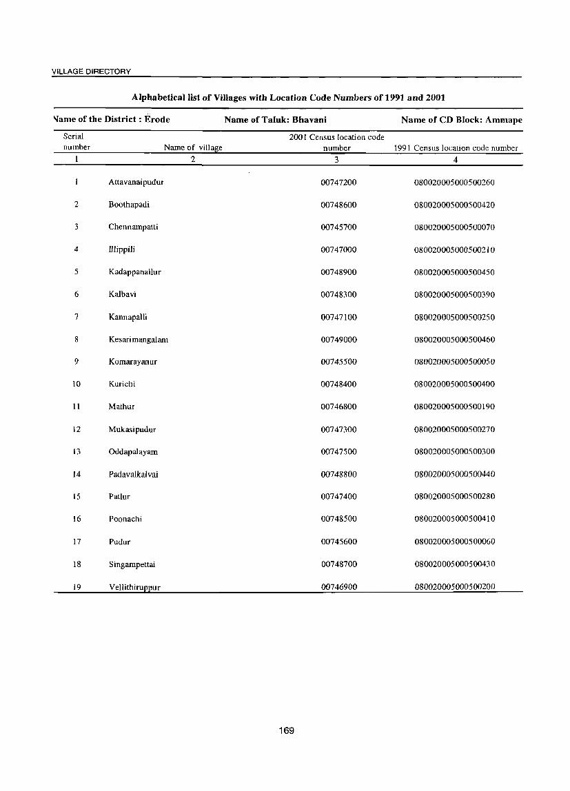
VILLAGE DIRECTORY
Alphabetical list of Villages with Location Code Numbers of 1991 and 2001
'lame of the District: Erode Name of Taluk: Bhavani Name of CD Block: Ammape
Serial 2001 Census location code number Name of village number 1991 Census location code number
2 3 4
Attavanai pudur 00747200 080020005000500260
2 Boothapadi 00748600 080020005000500420
3 Chennampatti 00745700 080020005000500070
4 Illippili 00747000 080020005000500210
5 Kadappanailur 00748900 080020005000500450
6 Kalbavi 00748300 080020005000500390
7 Kannapalli 00747100 080020005000500250
8 Kesarimangalam 00749000 080020005000500460
9 Komarayanur 00745500 080020005000500050
10 Kurichi 00748400 080020005000500400
11 Mathur 00746800 080020005000500190
12 Mukasipudur 00747300 080020005000500270
13 Oddapalayam 00747500 080020005000500300
14 Padavalkalvai 00748800 080020005000500440
15 PaUur 00747400 080020005000500280
16 Poonachi 00748500 080020005000500410
17 Pudur 00745600 080020005000500060
18 Singampettai 00748700 080020005000500430
19 VellithiruEEur 00746900 080020005000500200
169

'o <!)
§ z 2 3
CD Block: Ammapet (0006)
I Komarayanur 1,013.9 (00745500)
2 Pudur (00745600)
3 Channampettai
4
(00745700)
Mathur (00746800)
5 Vellithiruppur
(00746900)
6 Illipili (00747000)
7 Kannappalli (00747100)
8 Attavanaipudur (00747200)
9 Mukusipudur (00747300)
10 Patloor (00747400)
304.8
1,948.8
1,236.7
2,162.6
1,972.6
1,088.5
342.8
620.8
2,017.9
4
2,886
719
9,379
6,713
8,790
9,688
5,6S1
2,049
2,752
8,043
5
847
201
6
P(3) M(5-10) C(lO+)
P M(10+) C(lO+)
2,596 P(4) M
S PUC
COOT)
1,759 P(2) M«5) C(lO+)
2,447 peS)
M(2) 5 C(lO+)
2,446 P(5) M
S PUC C(10+)
1,517 P(4)
M«5) C(lO+)
565 P
711
2,098
M« 5)
C(lO+)
P(3) M C(10+)
peS) M COOT)
DISTRICT CENSUS HAND BOOK: ERODE
VILLAGE DIRECTORY AMENITIES AND LAND USE
(As on 1999)
Amenities available (if not available within the village, a dash (-) is shown in the column and next to it in brackets the distance in broad ranges
viz.< 5 kms., 5-10 kms. and 10+ kms of the nearest place where the facility is available is given)
7 8 9
CWC PHS T HP W PO H(IO+) SS-T,W PH(225) MCW(10+) PHC(IO+)
CWC H(10+) MCW(!O+) PHC(IO+)
THPW PH(25) S5-T.W PO« 5)
MCW CWC T HP W PO(2) PHS S5-T,W PH(256)
H(5-1O) PlfC(5-IO)
CWCPHS H«5) MCW«S) PHC«5)
THPR PO SS-T,HP PH(lS)
MCW CWC T HP PO PHS SS-T,HP TO H(5-1O) PHC(S-IO)
PH(35)
HHDMCW THP PO CWC PHC SS-T,HP PTO PHS PH(362) RMP(3) 0
SMPCHW
MCWCWC THPW PO PHS RMP(3)
H« 5)
PHC«S)
Mew PHS H(5-IO) PHC(S-IO)
PHS H(10+) MCW« 5)
PHC(5-10)
HHPHS H(5-1O)
MCW« 5)
PHC«5)
170
R PH(l51) SS-T,W
THPW PO SS-T,W PH(2S)
THPW PH(30) SS-T,W PO« S)
THP PO SS-T,HP PH(l40)
10
CM(5-10)
CP(S-IO)
CM(5-1O) CP(lO+)
CM CP(lO+)
CM« 5)
CP«5)
CM CP(10+)
CM(2) CP(lO+)
CM« 5)
CP(S-IO)
CM CP«S)
II 12 13
BS ACS(5-10) CV(5-10) RS(lO+) NCS(lO+) SP(lO+) NW(lO+) OCS(IO+) ST(10+)
ACS(5-10) cvr)-IO) BS« 5) NCS(lO+) SP(lO+) RS(lO+) OCS(lO+) ST(IO+) NW(IO+)
ACS cv BS NCS(10+) SP(10+) RS( 10+)
OCS(IO+) ST(lO+) NW(10-t-)
ACS BS NCS(lO+) CV« 5) RS(lO+) OCS(lO+) SP(lO+) NW(lO+)
ST(lO+)
ACS NCS(10+) CV«5) OCS(10+) SP(lo+)
BS RS(10+) NW(lO-t-)
ST(10+)
ACS CV BS NCS SP(IO+) RS(lO+) OCS(10+) ST(10+) NW(lO-t-)
ACS NCS« S) OCS«S)
CV«5) BS«5) SP(lO+) RS(IO+) ST(lO+) NW{5-10l
BS ACS«S) CV(5-IO) RS(lO+) NCS(S-lO) SP(lO+l NW(S-lO) OCS(5-10) ST(10+)
ACS CM(5-IO) NCS(5-10) CV(S-IO) BS« 5)
CP« 5) OCS(S-lO) SP(lO+) RS(lO+)
CM CP(S-IO)
ACS NCS« 5)
OCS« 5)
ST(lO+) NW(lO+)
CV BS SP(lO+) RS( J 0+) ST(10.l-) NW(lO+)

VILLAGE DIRECTORY
VILLAGE DIRECTORY AMENITIES AND LAND USE (As on 1999)
14
PR MR FP
PR MR FP
PR MR FP
PR MR FP
PR MR FP
PR MR FP
PR MR FP
PR MR FP
PR MR FP
PR MR FP
15 16
Arnmapettai (20) EA
Ammapettai (19) EA
Ammapettai (13) EA
Olagadam (10) EA
Olagadam (12) EA
Ammapettai (10) EA
Ammapettai (9) EA
Anthiyur (9) EA
Anthiyur (12) EA
Olagadam (2) EA
17
N
M
N M
N M
N
M
N M
N M
N M
N M
N M
N M
18
Palm J aggery
Bricks
Sarees
Groundnut Oil, Yarn, Sunflower Oil
Groundnut Oil
Groundnut Oil, Carpet, Mat
19
Land use (i.e. area under
different types of land use in hectare)
171
20
W(I1.I) WE(527.2) T(538.2)
W(7.2) WE(96.7) T(103.8)
W(40.2) WE(740.5) T(780.7)
21
211.8
109.4
624.0
W(8.0) 702.8 WE(286.6) T(294.6)
W(45.5) 1,310.8 WE(73.5) T(l19.0)
W(90.0) 457.1 WE (I 03 I. I) T(l121.1)
W(2.7) WE(316.0) T(318.7)
WE(26.0) T(26.0)
WE(24.0) T(24.0)
W(46.6) WE(l37.9) T(l84.5)
482.7
160.1
413.8
1,440.8
22
72.5
11.2
220.4
116.1
452.4
177.1
114.7
85.0
52.8
35.5
23 2
191.4 Komarayanur
80.3 Pudur 2
323.7 Channampettai 3
123.1 Mathur 4
280.3 VeUithiruppur 5
217.3 rIlipili 6
172.5 Kannappalli 7
71.7 Atta vanai pudur R
130.3 Mukusipudur 9
357.0 Patloor 10
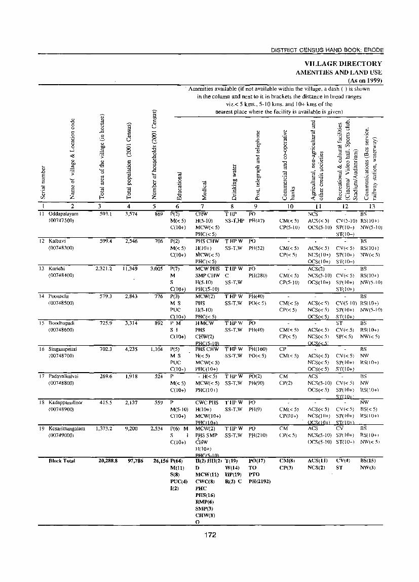
.... '" .D
§ C
2 I I Oddapalayam
(00747500)
12 Kalbavi (00748300)
13 Kurichi (00748400)
14 Poonachi (00748500)
15 Boodhapadi (00748600)
16 Singampettai (00748700)
17 Padavalkalvai
(00748800)
18 Kadappanalloor (00748900)
19 Kesarimangalam (00749000)
Block Total
3 4 593.1 3,574
599.4 2,546
2.321.2 11,349
579.3 2,843
72S.9 3,314
702.3 4,235
269.6 1,918
41S.5 2,137
1,373.2 9,200
20,288.8 97,786
DISTRICT CENSUS HAND BOOK: ERODE
VILLAGE DIRECTORY AMENITIES AND LAND USE
(As on 1999) . Amenities available (if not available within the village, a dash (-) is shown
in the column and next to it in brackets the distance in broad ranges viz.< 5 krns., 5-10 kms. and 10+ kms of the
5 6 869 P(2)
M« 5) C(lO+)
706 P(2) M« 5) C(10+)
3,005 P(7) M
S C(lOt)
776 P(3) MS PUC C(lO+)
892 PM
1,104
524
559
2,534
S I C(lO+)
P(5)
M3 PUC C(lO+) P M«5) C(10+)
P M(5-1O) C(10+)
P(6) M S I C(10+)
26,156 P(64) M(1I) 8(8) PUC(4) 1(2)
nearest place where the facility is available is given)
7 CHW H(S-IO) MCW« 5)
PHC«S)
8 9 THP pO
SS-T,HP PH(47)
PHS CHW THPW pO
HOO+) SS-T,W PH(52) MCW« 5) PHC«S) MCW PHS T HP W PO
SS-T,W SMPCHW C H(S-IO) PHC(5-10)
PH(280)
MCW(2) PHS H(5-1O)
PHC«S) HMCW PHS CHW(2)
H« 5) MCW« 5) PHC(IO+)
- H«5) MCW« 5) PHC(IO+)
THPW PH(40) 55-T,W pO« 5)
THPW PO SS-T,W PH(40)
T HP W PH(l60) S3-T,W pO« 5)
THPW PO(2) SS-T,W PH(90)
CWCPHS THPW PO H(lO+) SS-T,W PH(9) MCW(IO+) PH(OO+) MCW(2) T HP W pO
P.HS SMP SS·T,W PH(21O) CHW H(lO+)
H(Z) HH(2) T(19) D VV(14) MCVV(ll) HP(19) CWC(8) R(Z) C PHC PHS(16) RMP(6) SMP(3) CHW(8) o
172
PO(17)
TO PTO PH(2192)
10
CM« 5)
CP(S-IO)
CM«5) CP«5)
CM« 5) CP(5-10)
CM« 5) CP«5)
CM« 5) CP« 5)
CP CM« 5)
CM CP(2)
CM« 5) CP(lO+)
CM CP«5)
CM(8) CP(3)
11 12 13 NCS BS ACS«S) CV(5-IO) RS(IO+) OCS(S-IO) SP(IO+) NW(S-IO)
ST(lO+) BS
ACS« 5) CV« 5) RS(lO+) NCS(lO+) SP(lO+) NW«5) OCS(lO+) ST(IO+) ACS(2) BS NCS(5-10) CV«5) RS(IO+) OCS(IO+) SP(lO+) NW(5-10)
ACS(d) NCS« 5) OCS« 5)
ACS« 5) NCS« 5)
ACS« 5) NCS« 5) OCS« 5)
ACS NCS(5·10) OCS« S)
ST(lO+) BS
CV(S-IO) RS(10+) SP(JO+) NW(5-IO) ST(lO+) ST BS CV« 5) RS(JO+) SP« 5) NW« 5)
BS CV« S) NW SP(JO+) RS(JO+) ST(lO+)
BS CV«S) NW SP(10+) RS(JO+)
NW ACS« 5) CV« S) BS« 5) NCS(IO+) SP(lO+) RS(lO+) OCSO O±) SJ() Q±l ACS CV BS NCS(S-IO) SP(IO+) RS(IO+) OCS(5-10) ST(IO+) NW« 5)
ACS(11) NCS(Z)
CV(4)
ST
BS(15) NW(3)

VILLAGE DIRECTORY
VILLAGE DIRECTORY AMENITIES AND LAND USE (As on 1999)
Land use (i.e. area under
different types of land use in hectare) "0 u 3 t; ~
~ ::J
I':: fJ 0
E .~
g 0 OJ) :> I':: '0
u :.a ;a "3 u 0 u d <I)
~ ::l
cd I':: U ... 0) ....
.~ --- .9 t/} J::
OJ) '" <I)
~ ;a ~
~ 0) <I) bl) u
~ :>
~ <1)
~ <'Il Q 0 01) .;; ~
0 <Il bh ~ ... I':: :>.. 5 <Il cd '8 <l)
8 " 0... 6 :>.. " "Cl .;; .D 0.) e "Cl :>
..c:: 8 g- o. 0. ~ <l) I':: cd E
g <'Il :0 cd 4-< ::l .... '" 0. .§ "Cl cd 8 '0 0 c '" ~
OJ) cd 0 <l) t .... 3 I':: Q) ... 8
til ~ Vl :§ ..c:: -a 0. " " <Il Q) bO u cd § ·c 0- 0) 0 v 0 ... ] I':: "3 ::J <1)
<t: Z Z ~ 0 cd ... Z
v Il-c Il-. ::::J U OJ) <t: (./)
14 15 16 17 18 19 20 21 22 23 2 PR Olagadam (1) EA N Mat, WE(93.0) 384.7 81.8 33.5 Oddapalayam II MR M Carpet, T(93.0) FP Bakery
roduct PR Olagadam (6) EA N Groundnut GC(86.1) 354.2 25.2 60.6 Kalbavi 12 MR M Oil, Granite WE(73.3) FP polish, T(159.4)
Bricks PR Olagadam (4) EA N Jaggery, GC(638.5) 593.2 290.3 437.8 Kurichi 13 MR M Mat, Pots WE(357.6) FP R(3.8)
T(IOOO.O) PR Anthiyur (10) EA N Tapioca GC(32.8) 309.0 116.6 69.3 Poonachi 14 MR M powder WE(51.7) FP T(84.5)
PR Ammapettai (3) EA N Groundnut GC(237.J) 127.5 77.0 80.8 Boodhapadi 15
MR M oil WE(19S.8) FP R(7,9)
PR Ammapettai (2) EA N Jaggery, GC(3Z5.S) 6.0 131.8 122.5 Singampettai 16 MR M Bricks, WE(96.5) FP Power R(20.1) NR Generation T(442.0)
PR Ammapettai (2) EA N Jaggery, GC(86.6) 61.8 45.6 Padavalkalvai 17
MR M Bricks. WE(49.9) FP Dyeing R(25.8)
PR Ammapettai (13) EA N 4.9 61.8 40.0 Kadappanalloor 18
MR M FP
PR Ammapettai (9) EA N Silk, Yarn, • - GC(829.3) 210.2 222.0 Kesarimangalam 19
MR M Bricks WE(63.5) FP R(48.2)
T(94 1.0)
PR(19) EA(19) N(19) 0.0 GC(2235.92) 7,692.6 2,394.1 3,059.6
MR(19) M(19) W(287.24) FP(19) WE(4513.64) NR(3) R(105.72)
T(7142.52)
173


VILLAGE DIRECTORY
BHAVANI CD BLOCK
175


VILLAGE DIRECTORY
Alphabetical list of Villages with Location Code Numbers of 1991 and2001
Name of the District': Erode Name of Taluk: Bhavani Name of CD Block: Bhaumi
Serial 200 I Census location number N arne of village code number 1991 Census location code number
2 3 4
Alathur 00749700 080020006000600540
2 Andikularn 00750000 080020006000600580
3 Bhavani 00749400 080020006000600500
4 Chinnap uliy ur 00750200 080020006000600590
5 Kavandapadi 00749800 080020006000600560
6 Mylambadi 00748200 080020006000600380
7 Odathurai 00749900 080020006000600570
8 Oricheri 00749500 080020006000600520
9 Paruvachi 00747600 080020006000600310
10 Periy apuliy ur 00750300 080020006000600600
11 Punnam 00748100 080020006000600370
12 Sanyasipatti 00749100 080020006000600470
13 Settipalayarn 00750400 080020006000600610
14 Thalakularn 00749300 080020006000600490
15 U rachikot tai 00750100 0800202920000000
16 Varadan allur 00749200 080020006000600480
17 Vy ramangalarn 00749600 080020006000600530
177

... .., .0 S ::l C
:g Q)
VJ
2 3 CD Block: Bhavani (0007)
I Paruvachi 1.129.1
2
3
4
5
6
7
(00747600)
Punnam (00748100)
Mylambadi (00748200)
Sanyasipatti (00749100)
Varadhanullar (00749200)
Thalakulam (00749300)
Bhavani (00749400)
Oricheri (00749500)
<) Vairamangalam (00749600)
1.126.1
2,146.6
240.2
755.6
75.0
1,931.1
686.3
676.2
'" ::l
'" '" <1.)
u
4
S,247
5,108
8,020
1,114
1,520
2,525
10,735
5,080
3,389
5
1,212
1.338
2,222
301
430
720
3,124
1,371
DISTRICT CENSUS HAND BOOK: ERODE
VILLAGE DIRECTORY AMENITIES AND LAND USE
(As on 1999)
Amenities available (if not available within the village, a dash (-) is shown in the column and next to it in brackets the distance in broad ranges
viz.< 5 kms., 5-10 kms. and 10+ kms of the nearest place where the facility is available is given)
P(4) M 5
6
PUC C(10+)
P(2)
M C(10+)
7
DPHSRMP 5MPCHW H(S-IO) MCW(5-1O) PHC« S)
PH5CHW H(S-IO)
PHC(5-10)
8
0)
c o ..c 0.. <1.)
]
9
THPW PO S5-T,W PH(40)
THPW PO SS-T.W PH(20)
P(6) M 5 MCW(2) PHC T HP W PO(2) PUC RMP(2) SMP 5S-T,W PH(236) C(10+) CHW H(10+)
P M«S) C(10+)
P
M C(10+)
- P« 5) M«S) C(5-1O)
P(4) M(2)
C(5-10)
PHSCHW H(lO+) MCW(IO+)
. PHC(S-IO)
MCWCHW H(5-10) PHC(5-10)
- H(5-10) MCW(5-10)
PHC« 5)
PH5CHW H(5-10) MCW(5-1O) PHC(5-10)
P M(2) S MCW SMP PUC C(\O+)
CHWH«S) PHC(5-10)
THPW PO SS-T.W PB(54)
THPW PO SS-T,W PH(300)
THPW PO SS-T,W PH(25)
THPW PO R PH(700) SS-T,W
THPW PO SS-T,W PH(90)
10
CP CM(S-IO)
CM(S-IO)
CP«S)
CM(5-10)
CPO 0+)
CM(5-10) CP(5-10)
CM(S-IO) CP(5-10)
CM(S-IO) CP(5-10)
Cpm CM(5-10)
CM«S) CP«5)
11 12
ACS NCS(S-IO) CY(S-IO) OCS(5-10) SP(lO+)
ST(JO+l
13
BS R5(10+) NW(IO+)
CY BS ACS(10+) SP(10+) RS(10+)
NCS(lO+) ST(lO+) NW(S-IO) OCS(10+)
ACS BS NCS(] 0+) CY(!O+) RS(10+) OCS(10+) SP(JO+) NW(S-IOJ
ST(10+)
I3S
AC5(5-IO) CY(S-IO) I<S(10+) NCS(5-10) SP(lO+) NW(5-10) OCS(5-10) ST(1 0+)
BS ACS« 5) CY(S-IO) RS(IO+) NCS(5-10) SP(IO+) NW(d) OCS(5-10) ST(lO+)
BS ACS(5-IO) CV(5-10) RS(IO+) NCS(5-10) SP(lO+) NW« 5) OCS(5-IO) ST( I 0+)
ACSO) BS NCS(S-IO) CVCS-IO) RS(IO+) OCS(5-10) SP(IO+) NW« S)
ST(10+)
BS
ACS« 5) CV« 5) NW NCS« 5) SP(lO+) R5(l0+) OCS(IO+) ST(S-IO)
984 P(2) MCW(2) T HP W PO(2) ACS BS
M(2) C(lO+)
CHW H(5-10) SS-T,W PH(l90) PHC(S-IO)
178
CM(5-IO) NCS(5-10) CV(5-10) NW CP(5-10) OCS(5-10) SPCIO+) RS(10+)
ST(IO+)
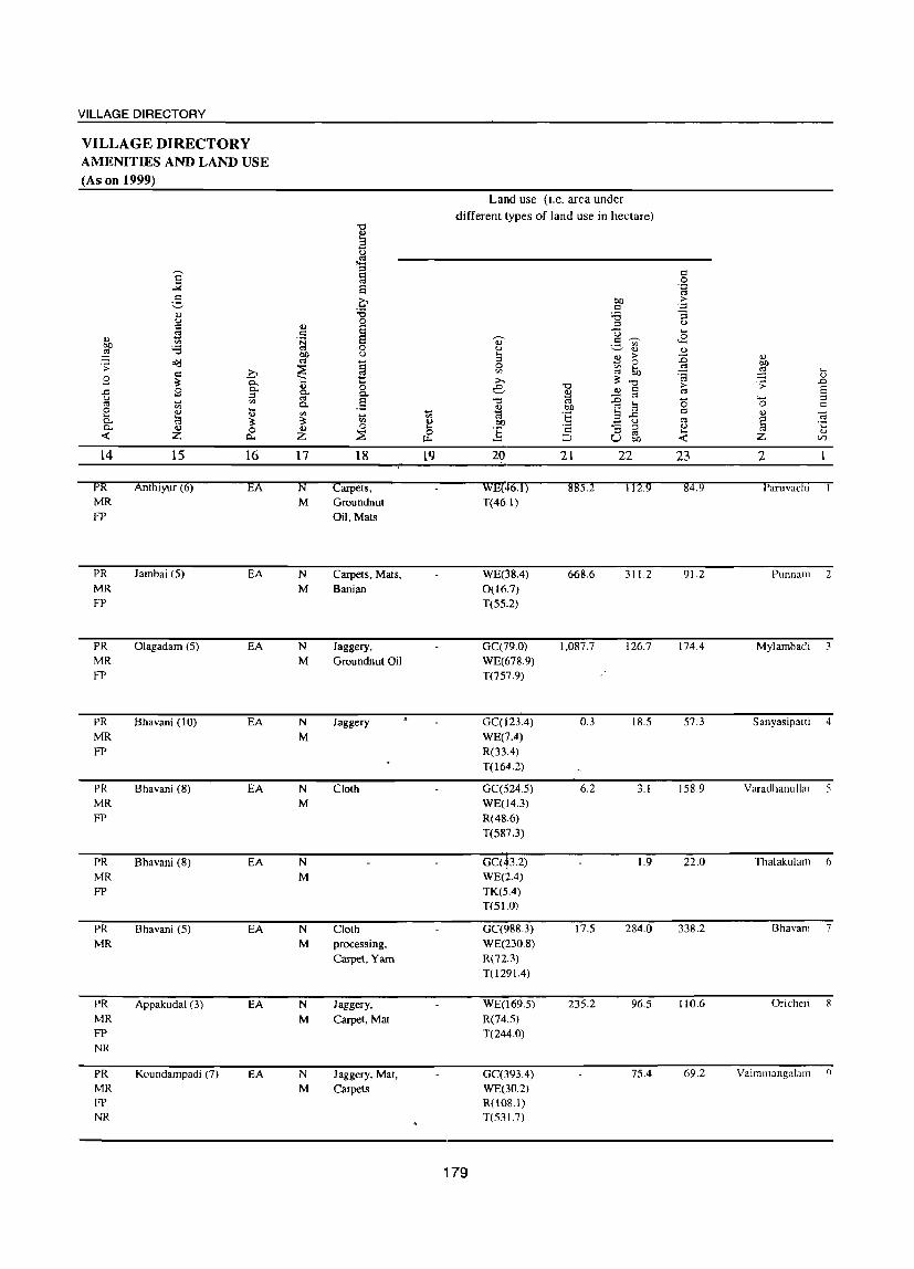
VILLAGE DIRECTORY
VILLAGE DIRECTORY AMENITIES AND LAND USE (As on 1999)
] g .., u I:l !9 .., '" 00 ;.a
~ c<:! .;; c .b g ?; 0..
.c 2 0.. ::l u '" <0 0:;
0 <U .... .... t:3
<1) c.. ?; 0.. <U 0 ~ Z c...
14 15 16
PR Anthlyur (6) EA MR FP
PR Jambai (5) EA MR FP
PR Olagadam (5) EA MR FP
PR Bhavani (10) EA MR FP
PR Bhavani (8) EA MR FP
PR Bhavani (8) EA MR FP
PR Bhavani (5) EA MR
PR Appakudal (3) EA MR FP NR
PR Koundampadi (7) EA MR FP NR
"" .., a t)
. ..::! ::l § S Q ;.a 0
Ii) S I:l .~ s
0
~ u
§ ~ 1:: Ii) 0 c.. c.. o:l .5 0.
'" 0:; .... ~ '" .., Ii) 0 ~ Z ~ u-
17 18 19
N carpets, M Groundnut
Oil,Mats
N Carpets, Mats, M Banian
N Jaggery, M Groundnut Oil
N Jaggery M
N Cloth M
N M
N Cloth M processing,
Carpet, Yam
N Jaggery, M Carpet, Mat
N Jaggery, Mat, M Carpets
Land use (i.e. area under different types of land use in hectare)
bO I:l
;.a ::l U
Q) 3 '" u .., a ~ >
0 0 '" 50 '" co ;>., ~ -0 e -0
~ ~ C co -0 co .g .., bO ~ Cd :§ a ..c bO u
] I:l -a ::l
~ u o:l 00
20 21 22
WE(46.1j 885.2 112.9 T{46.1)
WE(38.4) 668.6 311.2 0(16.7) T(55.2)
GC(79.0) I,OS7.7 126.7 WE(678.9) T(757.9)
GC(123.4) 0.3 IS.S WE(7.4) R(33.4) T(164.2)
GC(524.5) 6.2 3.1 WE04.3) R(48.6) T(5S7.3)
Gcrh2) 1.9 WE(2.4) TK(5.4) T(S1.0)
GC(988.3) 17.5 284.0 WE(230.8) R(72.3) T(l291.4)
WE(l69.5) 23S.2 96.S R(74.5) T(244.0)
GC(393.4) 7S.4 WE(30.2) ROOS.I) T(S31.7)
179
I:l .S2 'i:i >
';oj
-a u ....
<8 <1)
:0 <1)
~ 00
~ .... '<=3 v > .;; .0 01 E '0 '- ::l
0 C C V
~ .., § v .... v -< Z C/l
23 2
84.9 Paruvachl
91.2 Punnam 2
174.4 Mylambadi 3
57.3 Sanyasipatti 4
158.9 Varadhanullar 5
22.0 TIlalakulam ()
338.2 Bhavani 7
110.6 Oricheli 8
69.2 Vairam3ngalal1l ()

"-' o .., ~ Z
2 10 Alathur
(00749700)
11 Kavandapadi (00749800)
12 Odathurai (00749900)
13 Andikulam (00750000)
14 Urachikottai (00750100)
15 Chinnapuliyur (00750200)
16 Periyapuliyur (00750300)
17 Chettipatayam (00750400)
Block Total
3 4 302.8 1,862
2,204.8 25,172
1,346.8 8,671
94.5 1,426
255.6 6,021
663.6 3,109
1,961.2 7,352
216.9 1,041
15,812.3 97,392
5 513
6,943
2,408
406
1,711
6 P(2) M C(5-10)
P(9) M(4) 5(3) PUC(2) C(S-lO)
P(8) M S C(5-10)
P M« 5)
C«5)
P(2) M(2) S PUC
DISTRICT CENSUS HAND BOOK: ERODE
VILLAGE DIRECTORY AMENITms AND LAND USE
(As on 1999) Amenities available (if not available within the village, a dash (-) is shown
in the column and next to it in brackets the distance in broad ranges viz.< 5 kms., 5-10 kms. and 10+ kms of the
nearest place where the facility is available is given)
'" o P-;
7 8 9 MCW PHS T HP W PO CHWH«5) SS-T,W PH(50) PHC«5)
HHPHC PHS(2) RMP(2) MCW(S-IO)
H PHC PHS(2) RMPCHW MCW« 5)
CHW H« 5)
MCW« 5) PHC(5-10) ,
PHSCHW ,H«5) MCW« 5) PHC(5-10)
THPW PO(2) S5-T,W PTa
PH(2668)
THPW PO(2) SS-T,W PH(243)
THPW PO SS-T,W PH(70)
THPW PO R PH(250) SS-T.W
10
CM« 5)
CP« 5)
CM(2) CP(3)
CM CP«S)
CM« 5)
CP« 5)
CM«5) CP«5)
II
ACS«5) NCS« 5) OCS« 5)
12 13 BS
CV« 5) RS(lO+) SP(10+) NW(lO+) ST(lO+)
ACS(2) CV(2) BS NCS(3) ST RS(IO+) OCS (I 0+) SP(10+) NW(5-10)
ACS NCS« S) OCS«5)
ACS«5) NCS« 5)
OCS« S)
ACS« 5) NCS« 5) OCS« 5)
BS CV« 5) RS( 10+) SP(10+) NW(5-IO) ST(lO+)
BS CV« S) RS(lO+) SP(10+) NW(5-10) ST(10+)
BS CV« 5) RS(lO+) SP(10+) NW(5-10) ST(IO+)
879 P MCWCHW THPW PO ACS BS M«S) C(5-10)
H(5-10) SS-T,W PH(140) PHC« 5)
2,045 P(6) M(2) MCW PHC
290
26,897
5 C(2) PHS CHW H(5-IO)
P M(5-10) C(5-IO)
P(sl) M(20) S(9)
PUC(6) C(2)
CWCPHS 0(2) H(5-10) MCW(S-IO) PHC(S-IO)
H(3) IllI D MCW(9) CWC PHC(4) PHS(12) RMP(6) SMPc3)
180
THPW PO SS-T,W PH(l50)
THPW PH(20) S5-T,W PO(5-10)
T(17) PO(20) W(17) PTO HP(17) PH(5246) R(2)
CM(S·IO) NCS(S-IO) CV(S-IO) NW CP(S-tO) OCS(5-10) SP(lO+) RS(lO+)
ST(lO+)
ACS BS CM(5-10) OCS CV(S-IO) RS(10+) CP(5-10) NCS(5-iO) SP(lO+) NW« 5)
ST(lO+)
BS CM(S-IO) ACS(5-10) CV(5-10) RS(lO+) CP(S-IO)
CM(3) CP(7)
NCS(S-IO) SP(10+) NW(S-lO) OCS(5-1O) ST(lO+)
ACS(ll) CV(3) BS{l7) NCS(3) ST NW(3) OCS

VILLAGE DIRECTORY
VILLAGE DIRECTORY AMENITIES AND LAND USE (As on 1999)
Land use (i.e. area under
different types of land use in hectare) .., ~ ~
]' 'E
I: CI
'" 0 e 'g
5 0 eo ;>
:Q d ·c OJ :Q '5 u 0 d .,
~ ::l u
;S d U ... u 'N ~ .9 ~ ,£ '" OJ QI)
~ '" 0 u ~ OJ OJ :§ t}I) u 3 ~ ;>
~ Il)
~ '" ~ 0 00 .;;
~ 0 '" ... » VI '" eo :§ ,_
d '@ <1)
3 ?$ 0. » ?$ "0 .D 3 c.. ., 0 e "0 d
;> .;; 2 ..0 ::l c.. c.. ~ ..!:l '" '" u
~ VI '" .5 "0 ..0 '0 '- ::l
'" Vl c.. ~
QI) C'l a 0 d 0 ~ d .... OJ VI .... ~ :~ 3 ..Cl Il)
~ c.. a ?$ ~ VI <1) eo ~ u '" § c.. OJ 0 ., 0 ,_,
:§ CI '5 ::l <1)
;:;E 0 .... ., -< Z 0.. Z :::> u C'.! -< Z '"' eo C/l
14 IS 16 17 18 19 20 21 22 23 2 PR Salangapalayam (2) EA N Jaggery GC(229.9) 34.9 36.0 Alathur 10 MR M WE(2.0) FP T(231.9)
PR Salangapalayam (I) EA N Jaggery, GC(1093.2) 75.7 352.8 310.5 Kavandapadi 11 MR M Groundnut WE(372.6) FP Oil, Towel T(1465.8)
PR Kugalur (3) EA N Towel,Oil GC(767.4) 160.9 238.2 Odathurai 12 MR M WE(142.0) FP R(38.2)
T(947.6)
PR Bhavani (2) EA N Dyeing GC(30.8) 13.6 27.2 Andikulam 13 MR M WE(0.2) FP TK(22.8)
T(53.7)
PR Bhavani (2) EA N Cloth, Carpet, GC(72.8) 64.4 67.5 Urachikottai 14 MR M Dyeing WE(20.0) FP R(30.9)
T(123.7)
PR Bhavani (8) EA N Jaggery, GC(257.4) 19.2 107.5 86.6 Chinnapuliyur 15 MR M Spirit, Mat WE(94.6) FP R(98.3) NR T(450.3)
PR Salangapalayam (5) EA N Mats GC(ll05.2) 28.7 503.3 249.2 Periyapuliyur 16 MR M WE(74.8) FP T(l180.1)
PR Salangapalayam (5) EA N Jaggery GC(141.3) 31.4 386 Chettipalayam 17
MR M WE(S.6) FP T(l46.9)
PR(7) EA(t7) N(t7) 0.0 GC(5849.60) 3,024.1 2,299.0 2,160.4 MR(17) M(17) WE(1929.94) FP(16) TK(28.19) NR(3) R(504.35)
0(16.71) T(8328.79)
181

VILLAGE DIRECTORY
GOBICHETTIPALAYAM CD BLOCK
183


VILLAGE DIRECTORY
Alphabetical list of Villages with Location Code Numbers of 1991 and 2001
Name of the District: Erode Name of Taluk: Gobichettipalayam Name of CD Block: Gobicbettipalayam
Serial 2001 Census location code number Name of village number 1991 Census location code number
2 3 4
A graharakarai 00752000 080030009000900200
2 Alukuli 00752700 080030009000900330
3 Ammapalayam 00751400 080030009000900130
4 Ayalur 00754400 080030009000900530
5 Bodichinnampalayam 00752300 080030009000900250
6 Chandrapuram 00754700 080030009000900570
7 Kadukkampalayam 00754600 080030009000900560
8 Kalingiam 00753500 080030009000900430
9 KottupullampaJayam 00753600 080030009000900440
10 Kugalur 00751700 080030009000900170
11 KuUampaiayam 00753200 080030009000900400
12 Mev ani 00751500 080030009000900140
13 Modaehur 00753400 080030009000900420
14 Nagadevampalayam 00754500 080030009000900550
15 Nanjaigopi 00753000 080030009000900380
16 Nathipalayam 00753300 080030009000900410
17 Palayapariyurkarai 00751900 080030009000900190
18 Pariyur 00752800 080030009000900360
19 Perundalaiyur 00751600 080030009000900150
20 Pulavakalipalayam 00753100 080030009000900390
21 Puthukkarai 00751800 080030009000900180
22 Savandapur 00751300 080030009000900120
23 Siruvalur 00754900 080030009000900590
24 Solamadevikarai 00752400 080030009000900260
25 Vellalapalayam 00752900 080030009000900370
26 Vellankovil 00754800 080030009000900580
185
._ o u § Z
2 3 CD Block: Gobichettipalayam (0008)
4
1 Savandapure 736. I 3,732 (00751300)
2 Ammapalayam (00751400)
Mevani (00751500)
4 Peruntbalaiyur (00751600)
5 Kugalur (00751700)
6 Pudukkarai (00751800)
261.8
436.8
820.4
874.0
579.9
7 Palayapariyurkarai 347.9 (00751900)
8 Akrakarakarai 397.5 (00752000)
9 Bodichinnampalayam 287.1 (00752300)
I 0 Cholamadevikarai (00752400)
360.5
1,001
2,104
3,410
5,714
1,297
8 ~ CIl
"0 '0 .c u CIl ::I o .c .... o ... OJ ,D
§ Z
5 6
1,009 P
307
622
M«5) C(5-10)
P M«5) C(10+)
P M C(10+)
DISTRICT CENSUS HAND BOOK: ERODE
VILLAGE DIRECTORY AMENITIES AND LAND USE
(As on 1999) Amenities available (if not available within the village, a dash (-) is shown
in tbe colwnn and next to it in brackets the distance in broad ranges viz.< 5 kms., 5-10 kms. and 10+ kms of the
nearest place where the facility is available is given)
7
PHS H(5-l0) MCW«5) PHC« 5)
PHS H« 5) M~W(10+) PHC« 5)
MCW H(lO+) PHC(5-1O)
8 9
TW PO SS-T.W PH(40)
THPW PO SS-T,W PH(5)
TW PO SS-T,W PH(70)
Q)
> .~ Q)
9-o u
"0
~ ~ 'w
I~ U.o
10
CP CM« 5)
CM« 5)
CP« 5)
CP CM(S-IO)
11
ACS«5) NCS«5) OCS«5)
ACS« 5)
NCS« 5) OCS(<5)
12 13
BS CV(5-10) RS(lO+) SP(IO+) NW« 5) ST(lO+)
NW CV(S-IO) BS« S) SP(IO+) RS(IO+) ST(10+)
ACS BS NCS CV(lO+) NW OCS(10+) SP(IO+) RS(IO+)
ST(lO+)
917 P(3) MCW THPW PO NCS CV BS
M PHS R PH (7 0) C(10+) H« 5) SS-T,W
1,674 P(2)
M C(5-IO)
353 P
M«5) C(5-1O)
• PHC(5-10)
PHS H« 5) MCW«5) PHC« 5)
THPW PO R PH(30) SS-T,W
PHS THP W PO H(5-10) SS-T,W PH(5) MeW(5-10)
PHC« 5)
U ni nhabitated
U ninhabitated
U ninhabitated
U ninhabitated
186
CM« 5) CP(5-10)
CM« 5)
CP(5-IO)
CM« 5) CP«5)
ACS(5-10) SP(IO+) RS( 10+) OCS(5-10) ST(10+) NW(10+)
ACS NCS OCS
ACS
BS CV«5) NW SP(S-IO) RS(lO+)
STCS-IO)
BS NCS CV« 5) RS( 10+) OCS(5-10) SP« 5) NW« 5)
ST« 5)
VILLAGE DIRECTORY
VILLAGE DIRECTORY AMENITIES AND LAND USE (As on 1999)
14
PR
PR NR
PR NR
PR MR
FP
PR FP NR
PR MR
15
Athani (2)
Athani (2)
Kusalur (7)
Appakkdal (2)
Gobichetpalayam (7)
Kugalur (2)
16
ED EAG
EA
ED EAG
EA
EA
EA
17
N M
N M
N M
N M
N M
N M
18
Handloom Cloth, Jewels
Yam, Paper Wrappers
-------- Uninhabitated ------------
-------- Uninhabitated -----------
-------- Uninhabitated ------------
-------- Uninhabitated -----------
19
Land use (i.e. area under different types of land use in hectare)
187
20
GC(622.7) W(4.5) WE(16.5) 1WE(6.5) T(650.2)
GC(169.1) W(2.5) WE(59.2) T(230.8)
GC(381.3) W(!.3) WE(2.4) T(38S.0)
GC(476.0) W(59.0) WE(27.S) TK(24.4) R(39.3)
GC(453.6) W(32.0) WE(44.2) 1WE(8.0) T(S37.8)
GC(S4S.4) T(S4S.4)
GC(319.7) T(319.7)
GC(372.5) T(372.5)
GC(177.8) WE(70.8)
21 22
11.0
7.6
15.7
18.1
2.0 20S.4
3.6
3.2
4.1
8.S
1.3
23 2
74.9 Savandapure
23.4 Ammapalayam 2
36.2 Mevani 3
176.1 Perunthalaiyur 4
128.8 Kugalur 5
30.9 Pudukkarai 6
25.0 Palayapariyurkarai( 7
Uninhabited)
20.9 Akrakarakarai(Uni 8
nhabitedl
30.0 Bodichinnampalay 9 am (Un)
42.5 Cholarnadevl karai 10
(Un)

DISTRICT CENSUS HAND BOOK: ERODE
VILLAGE DIRECTORY AMENITIES AND LAND USE
(As on 1999) Amenities available (if not available within the village, a dash (-) is shown
in the column and next to it in brackets the distance in broad ranges
viz.< 5 kms., 5-10 kms. and 10+ kmS of the ~ nearest place where the facility is available is given) '" 0- = .., '" '0 S I::l '0 ..0
0 V> ..,
<=l '" ::l U U OJ ..,
<.) .., :::I ~ U .;
'" ..c '" - .., 0) C3 u 0 3
t:l 0 '" > 3 '0 ~ .;; <U 0 0 '.:J .... '.:J U [:!. ..c OJ .;3 0 .... -;, '" 0- .... ::; P- d)
'" <.) .., 0 d) U) on
0 bIl '" ~ P- u C3 '" ;l: -l ~ 0 '0 !:! 0 .~ ~ 8 :::is ::l ....
~ '0 I e ~ o(l .;;: ..c "0 0 ~ ',= ::; _g .::! cu '" u ;l: .., .., t:l '" '" "0 <=l cu u 0 .... '" bIl £ 0 :::l o .-
o(l ~ .g = .... ~ .... ..c = <=l 15 0 d '.::1 0 <U OJ 0) 4-< '" ..c (;l P- . '" C3>1il
.~ 0 .t:> .;;: 0 '3 iil '" 3 ~ .;:: 'B 8 ...... ~ blJ o <e u <d 0- 0 = u 9"0 'c ::l 4-< .., ~ . S '2l 'il U)
d 0 la 8- .... 0 C3 bIl .... ~ d)
::l cu .~ = .., - .... >,
C3 .., .t:> u ~
!:! § ::l u '" E ::l E '" ~ g 3 E u ;a '" .g ~ ~ g ~ z .;:: ...s ..><: E = = <) '" <= ~ U !3 .., 0 0 '0 ·c 0 0 bIl ..c 0 '8 U) Z E-< E-< Z u.l ::E Q U '" ~ 0 U p.. ..0 ~ '-' U) ....
2 3 4 5 6 7 8 9 10 11 12 13 II Alukkuli 939.2 7,018 2,OSS P(4) HH THPW PO(2) ACS(2) CV BS
(00752700) M MCW SS-T,W PHOto) CM(S-IO) NCS(5-10) SP(5-10) RS(IO+) I PHC CP(5-10) OCS(S-IO) ST(5-10) NW(lO+) C(5-1O) RMP
H(5-10)
12 Pari yurgramam 292.2 2,IS3 617 C PHS THP PO ACS BS (00752800) P« 5) H(<5) SS-T,HP PH(92) CM« 5) NCS« 5) CV«5) RS(lO+)
M«S) MCW«5) CP« 5) OCS« S) SP«5) NW(IO+)
PHq< 5) ST(lO+)
13 VellaJapalayam 500.2 4,958 1,44S P(2) MCW THP PO ACS BS (007S2900) M(2) H(S-IO) SS-T,HP PH(400) CM(S-IO) NCS CV(S-IO) RS(lO+)
S • PHqS-lO) CP(S-IO) OCS(S-IO) SP(5-10) NW(5-lO)
PUC ST« 5) q<S)
14 Nanjaigobi SIS.4 I,S89 442 P ewc THP PO NCS BS (00753000) M« 5) PHS SS-T,HP PH(35) CM(5-10) ACS«S) CV(5-10) RS(lO+)
C(5-1O) H(5-10) CP(5-10) OCS (I 0+) ST(5-10) NW(5-10)
MCW« 5) PHC(lO+)
IS PulavakalipaJayam 871.9 4,442 1,346 P PHS THP PO ACS BS (007S3Ioo) M R(5-IO) SS-T,HP PH(60J) CM(5-10) NCS CV(5-lO) RS(lO+)
S MCW(S-IO) CP(S-IO) OCS(S-IO) SP(lO+) NW(IO+)
PUC PHC(S-IO) ST(5-10)
C(S-IO)
16 Kullampalayam 376.7 2,790 818 P CWC THPW PO ACS BS (007S3200) M PHS SS-T,W PH(IS2) CM«S) NCS CV«S) RS(lO+)
S H«S) CP« 5) OCS« S) SP(IO+) NW(lO+)
1(2) MCW«S) ST(IO+)
C(S-IO) PHC(5-10)
17 Naathipalayam 284.6 1,330 407 P(2) MCW(2) THPW PO NCS BS
(00753300) M«S) H«5) SS-T,W PH(32) CM«5) ACS« S) CV«S) RS(IO+)
C«5) PHC« S) CP« 5) OCS« 5) SP(lO+) NW(lO+) ST(lO+)
1& Modachur 719.2 6,4& I 1,825 p CWC THPW PH(56) NCS BS (007S3400) M PHS SS-T,W PO« 5) CM«5) ACS«S) CV«S) RS(lO+)
C(5-1O) • H«5) CP« 5) OCS« 5) SP«5) NW(10+)
MCW«S) ST(lO+)
PHC(S-IO)
188

VILLAGE DIRECTORY
VILLAGE DIRECTORY _\MENITIES AND LAND USE (As on 1999)
14 PR MR FP
PR
PR MR
PR MR
PR MR
PR MR FP
PR MR FP
PR MR FP
15 Gobichetpalayarn (6)
Gobichetpalayam (2)
Gobichetpalayarn (5)
Gobichetpalayam (5)
Gobichetpalayarn (5)
Gobichetpalayarn (3)
Gobichetpalayam (4)
Gobichetpalayarn (2)
16 EA
EA
EA
ED EAG
EA
EA
EA
EA
17 N M
N M
N M
N M
N M
N M
N M
N M
18 Textiles, Bricks, Biscuits
Mineral Water
Milk bread
Jaggery
Granite Polishing, Yam
Bread, Textiles
Textilesl
Cattle feeds, Towels,
Granite(Polish ing)
19
Land use (i.e. area under different types of land use in hectare)
189
20
GC(337.6) W(64.2) WE(199.6) T(601.3)
GC(77.0) WE(l28.4) T(205.4)
GC(241.9) W(14.6) WE(IO.O) T(266.5)
GC(106.1) W(6.0) WE(213.9) T(326.0)
GC(598.9) W(23.5) WE(31.9) TWE(lO.O)
T(664.3)
GC(85.2) W(4.4) WE(132.2) TWE(3.2) T(224.9)
GC(49.3) W(l5.0) WE(80.8) TWE(25.0) T(170.1)
GC(157.0) W(40.6) WE(157.0) T(354.6)
21 22 13.9 173.3
0.3
56.7 114.1
36.2 103.2
.101.7
13.5 85.6
44.5 37.2
63.5 211.3
23 2 150.7 Alukkuli II
86.4 Pariyurgramam 12
62.9 Vellalapalayam 13
49.9 Nanjaigobi 14
105.8 PulavakaJipalayam IS
52.6 KullampaJayam 16
32.8 NaathipaJayarn 17
89.8 Modachur 18
2 1 9 Kalingiam
(00753500)
20 Kottupullampalayam (00753600)
21 Ayalur (00754400)
3 1,606.5
1,321.4
1,886.8
4 5 9,386 2,S80
6,197 1,815
5,610 1,673
6 peS) M C«S)
P(6) M C«S)
P(6) M C(5-IO)
DISTRICT CENSUS HAND BOOK: ERODE
VILLAGE DIRECTORY AMENITIES AND LAND USE
(As on 1999) Amenities available (if not available within the village, a dash (-) is shown
in the column and next to it in brackets the distance in broad ranges
viz.< 5 kms., 5-10 kms. and 10+ kms of the
nearest place where the facility is available is given)
7 MCW 0(2)
H«5) PHC« S)
PHS Ht5-10) MCW(S-IO) PHC« 5)
MCW PHC PHS H(5-10)
8 9 THPW PO C PH(326) 55-T,W
T HPW PO(2) SS-T,W PH(l75)
THPW PO S5-T,W PH(250)
10
CM(<5) CP«5)
11
ACS« S)
NCS« S)
OCS« S)
ACS
12 13 as
CV«S) RS(IO+) SP« 5) NW(10+) ST« 5)
BS CM(5-10) NCS«S) CV(5-10) RS(IO+) CP« 5) OCS(10+) SP(IO+) NW(10+)
ST(10+)
BS CM(5-10) ACS(5-IO) CV(S-IO) RS(10+) CP(S·IO) NCS(5-10) SP(lO+) NW(lO+)
OCS(5-10) ST(5-10)
22 Negadevampalayam 1,150.8 4,801 1,394 P(4) PHS T HP W PO ACS BS (00754500)
23 Kadulckampalayam (00754600)
24 Chandrapuram (00754700)
25 Vellalankovil (00754800)
26 Siruvalur (00754900)
Block Total
M H(S-IO) C PH(l36) C(S-IO) MCW(5-10) S5-T,W
PHC(5-IO)
568.3 2,428
334.9 1,713
1,109.2 5,475
2,522.3 7,493
724 P(2) M«S) C(10+)
499 P(2) M«5) C(lO+)
1,598 1'(3) M S C(IO+)
2,134 P(7) M C(lO+)
20,101,2 91,122 26,254 P(56) M(15) S(4) PUC(2) C 1(3)
PHS H(5-10) MCW«5) PHC(5·10)
PHS H(S-IO) MCW«5) PHC(10+)
Mew H(10+) PHC(S-lO)
PHC PHS H(lO+) MCW«S)
HH MCW(9) CWC(3) PHC(3) PHS(l6) RMP 0(2)
190
THPW PO 5S-T,W PH(l45)
THPW PO SS-T,W PH(27)
THPW PO SS-T,W TO
PH(6S)
THPW PO SS-T,W PTO
PH(98)
T(22) W(tS) W(20) R(2)
C(2)
PO(23) TO PTO PH(2920)
CM(5-IO) NCS(3) CV(5-! 0) RS(lO+) CP(5-10) OCS(5-10) SPt5-IO) NW(lO+)
CM« 5) CP(5-10)
ST(lO+)
NCS(3) SP BS ACS«5) CV(5-1O) RS(IO+) OCS(5-10) ST(5-10) NW(1 0+)
CP NCS BS CM(S-IO) ACS(5-1O) CV(5-1O) RS(lO+)
OCS(5-10) SP(5-IO) NW(5-10) S1'(5-10)
CM CP(10+)
CM« 5) CP(10+)
CM ep(3)
ACS BS NCS(4) CV« 5) RS(10+) OCS(10+) SP(lO+) NW(lO+)
ST(10+)
ACS BS NCS CV« 5) RS(lO+) OCS(lO+) SP(IO+) NW(lO+)
ST(10+)
ACS(13) NCS(22) OCS
CV(2) SP
BS(21) NW(3)
VILLAGE DIRECTORY
VILLAGE DIRECTORY AMENITIES AND LAND USE (As on 1999)
14 PR MR FP
PR MR FP
PR MR FP
PR MR FP
PR MR FP
PR MR
PR MR
PR MR fl'
PR(Z2) MR(17) FP(12) NR(3)
15 Gobichetpalayam (4)
Gobichetpalayam (6)
Kolappalur (5)
Gobichetpalayam (8)
Siruvalur (8)
Gobichetpalayam (10)
Siruvalur (5)
Kolappalur (3)
16 EA
EA
EA
EA
EA
EA
EA
EA
ED EAG(3) EA(19)
17 N M
N M
N M
N M
N M
N M
N M
N M
N(22) M(22)
18 Coconut powder, Paper, Iron
rod
Towels
Mat, Jaggery
Coconut powder, Soda,
Murukku
Towels, Jaggery,
Sarees
19
0.0
Land use (i.e. area under
different types of land use in hectare)
20
GC(667.8) W(50.3) WE(27 1.2) T(989.3)
GC(276.7) W(220.0) WE(31.2) TWE(20.0) TK(5.1)
W(12.S) WE(492.3)
TWE(328.2) T(833.0)
GC(655.7) W(IS.O) WE(38.0)
T008.7)
GC(l13.9) W(32.0) WE(225.4) TWE(3S.0)
GC(60.5) W(26.5) WE(133.5) TWE(l0.9)
GC(7333.1) W(718.2)
WE(3203.8) TWE(559.0)
TK(29.5) R(39.3) T(11882.9)
191
21 110.0
245.8
663.7
173.6
20.1
21.7
404.5
1,505.2
3,374.8
22 300.5
317.2
234.4
147.7
86.3
18.3
145.5
140.0
2,495.1
23 206.7
205.5
155.7
120.8
55.5
63.6
119.4
201.7
2,348.4
4-< o ., § z 2 Kalingiam 19
Kottupullam- 20 palayam
Ayalur 21
Negadevam- 22 palayam
Kadukkampalayam 23
Chandrapuram 24
Vellalankovil 25
Siruvalur 26


VILLAGE DIRECTORY
NAMBIYUR CD BLOCK
193

VILLAGE DIRECTORY
Alphabetical list of Villages with Location Code Numbers of 1991 and 2001
Name of the District: Erode Name of Taluk: Gobichettipalayam Name of CD Block: Nambiyur
Senal 2001 Census locatIOn code number Name of village number 1991 Census location code number
2 3 4
Andipalayam 00754200 080030008000800500
2 Anjanur 00755300 080030008000800640
3 A valampalayam 00756300 080030008000800740
4 Emmampoondi 00755800 080030008000800690
5 Gudakkarai 00754100 080030008000800490
6 lrugalur 00755200 080030008000800630
7 Kadasellipalayam 00756000 080030008000800710
8 Kadathur 00753900 080030008000800470
9 Karattupalayam 00753700 080030008000800450
10 Koshanam 00755100 080030008000800610
11 Kurumandur 00754300 080030008000800520
12 Lagampalayam 00755400 080030008000800650
13 Mottanam 00755700 080030008000800680
14 Nichampalayam 00756400 080030008000800750
15 Olalakovil 00755900 080030008000800700
16 Polavapalayam 00755600 080030008000800670
17 Santhipalayam 00756200 080030008000800730
18 Sinnaripalayam 00756100 080030008000800720
19 Sundakkampalayam 00754000 080030008000800480
20 Talguni 00755000 080030008000800600
21 Vemandampalayam 00755500 080030008000800660
195

2 3 CD Block: Nambiyur (0009)
I Karattupalayam 2,003.0
2
3
4
5
(00753700)
Kadathur (00753900)
Sundakkampalayam (00754000)
Gudakkarai (00754100)
Andipalayam (00754200)
6 Kuruandur (00754300)
7 Talkuni
8
(00755000)
Kosanam (00755100)
907.3
683.3
662.0
523.0
623.0
590.2
2,086.3
4
7,363
4,1311
4,048
3,080
1,879
4,17S
1,456
6,582
-8 ~
'" :s! o
~ ::l o
..0
'"' o
1 z 5 6
2,094 peG)
1,200
1,235
1186
546
M C(lO+)
P(4) M S C(lO+)
P(4) M«5) C(lO+)
P(3) M S C(lO+)
P M« 5) C(lO+)
1,102 P(2) M S PUC C{10+)
446 P(2)
),956
M«S) C(10+)
P(7)
M C(lO+)
DISTRICT CENSUS HAND BOOK: ERODE
VILLAGE DIRECTORY AMENITIES AND LAND USE
(As on 1999) Amenities available (if not available within the village, a dash (-) is shown
in the column and next to it in brackets the distance in broad ranges viz.< 5 kIDs., 5-tO kIDs. and 10+ kms of the
nearest place where the facility is available is given)
7
PHS RMP H(IO+) MCW« S) PHC«5)
PHS H« 5)
MCW« S) PHC«S)
PHS H(5-tO) MCW(S-IO) PHC(S-IO)
MCW H(S-tO) PHC(S-IO)
PHS H(S-IO) MeW(S-IO) PHC« 5)
MCW RMP(3) CHW H(S-IO) PHC(5-10)
MCW
8 9
THPW PO R PH(320) SS-T,W
THPW PO SS-T,W PH(270)
THPW PO SS-T,W PH(107)
THPW PO SS-T,W PH(6S)
THPW PO SS-T,W PH(45)
THPW PO R PTO SS-T,W PH(380)
THP PO o H« SS-T,HP PH(28) S)
PHC(S-IO)
PHS H(10+) MCW(S-IO) PHC« 5)
196
THPW PO SS-T,W PH(9S)
'" .~
" .... '" P-o
" u "0 §
C;; 'u i:l E '" E ~ o '" U.D
10
CM«S) CP« 5)
CM CP(lO+)
CM(5-10) CP(S-IO)
CM(5-10) CP(S-IO)
CM«S) CP(S-IO)
CM CP
CM«S) CP« 5)
CP CM(5-10)
11 12 13
BS ACS« 5) CY(lO+) RS(IO+) NCS(IO+) SP(lO+) NW(10+) OCS(lO+) ST(10+)
ACS NCS(5-1O) CY(5-1O) OCS(lO+) SP« 5)
ST(IO+)
BS RS(10+) NW(lO+)
BS ACS« 5) CY(5-10) RS(IO+) NCS(S-IO) SP(S-IO) NW(lO+) OCS(10+) ST(lO+)
ACS BS NCS(S-tO) CY(IO+) RS(10+) OCS(IO+) SP(S-IO) NW(lO+)
ACS« 5) NCS« 5) OCS« 5)
ACS
ST(10+)
BS CY«S) RS(lO+) SP« S) NW(lO+) ST(IO+)
BS NCS Cy(s-IO) RS(lO+) OCS(IO+) SP(IO+) NW(lO+)
ST(IO+)
BS ACS« 5) CY« 5) RS(IO+) NCS« 5) SP(5-IO) NW(IO+) OCS(S-IO) ST(lO+)
NCS(2) ACS(5-10) CV(5-1O) OCS(lO+) SP(IO+)
ST(10+)
BS RS(IO+) NW(10+)

VILLAGE DIRECTORY
VILLAGE DIRECTORY AMENITIES AND LAND USE (As on 1999)
]' g OJ u r:l !9 <!)
'" 00 :a ;:£ .:I(j .:; r:l >. s ~ i5.
0-..r:: S =' iil .... '" '" 0 ~
.... .... OJ 0.. ~ 0.. OJ 0 -< Z 0-
14 15 16
PR Elathur (6) EA MR FP
PR Elathur (3) EA MR FP
PR Elathur (10) EA MR FP
PR Elathur (8) EA MR FP
PR Elathur (3) EA MR FP
PR Nambiyur (8) EA MR
FP
PR Kolappalur (3) EA MR FP
PR Nambiyur (5) EA MR FP
"0 OJ
B ~ =' la s .~ "0 0
OJ
~ I=l .~
0 00 u ~ .....
~ I=l
~ OJ 0 [if 0-
.S "'-'"
... .... '" !l: '" cu OJ 0 .... Z :8 0
tl..
17 18 19
N M
N M
N M
N Soap Factory M
N M
N M
N Jaggery, M Sarees
N Dhothies, M Jaggery, Pots
Land use (i.e. area under
different types of land use in hectare)
00 I=l :a =' U
'""' OJ 3 Vl u OJ
!:3 > E 0 0 '" 50 '" '" ;>, "0
~ "0 e I=l ~ ~ '" "0 .0
.!l 00 '" l:a :~ 9 ..r:: '" 00 .... U
''§ "3 =' :::> u '" 00
20 21 22
GC(430.0) 517.U 392.0 WE(643.0) T(1073.0)
GC(1l9.0) 168.0 112.3 WE(414.0) T(533.0)
GC(460.0) 24.0 96.0 W(2.0) WE(!.3) T(463.3)
GC(1l4.0) 197.0 56.0 W(65.0) WE(102.0) TWE(3.0) T1284 Q)
GC(208.0) 73.h 83.3 W(IO.O) WE(62.0) TWE(1.0) T 281.0 GC(56.0) 290.(1 135.0 WE(140.0) T(196.0)
WE(29.4) 359.11 13.3 TWE(70.1) T(99.4)
WE(103.2) 1,518.0 248.1 T(103.2)
197
t:l 0
'J:)
'" > 'J:)
"3 u ....
c8 <!)
~ OJ bl)
'8 ;:£ .... <!)
> .;; .D
'" S (5 4- =' 0 '" I=l OJ c:; '" § OJ ·c .... <!)
-< Z Vl
23 2
21.0 Karattupalayam
94.0 Kadathur 2
100.0 Sundakkampalayam 3
125.0 Gudakkarai 4
85.8 Andipalayam 5
2.0 Kuruandur 6
118.0 Talkuni 7
217.0 Kosanam 8

DISTRICT CENSUS HAND BOOK: ERODE
VILLAGE DIRECTORY AMENITIES AND LAND USE
(As on 1999)
Amenities available (if not available within the village, a dash (-) is shown
in the column and next to it in brackets the distance in broad ranges
viz.< Slans., S-lOkms. and lO+kms of the ~ nearest place where the facility is available is given) '" ~ ::s '" '" [3 '" "" .!$ '0 ~ '" '" <Il ::; 0 '-' '" U <1)
t.) v ::s '" ';;:1 <:; .; c= ..c (/l - <1) 0.) t=3 :.::: <J .g 3
c= 0 '" > :3 .~ !3 .;; ., 0 ..8 'f.1 ....
~ u !2 g_ .... .... -; 4-< 0.) t.) OJ - p.. en ('j .,
C;; '" ::< 0 0() 0 '" .£ p.. .~ en .....l ~ 0 '0
~ 0 bb Q) :3 :::fa " ....
~ '0 " E9, £ o(! ';> .c ] C;S ''::: '3 _g .~ '" ., (.)
'" '" en ::< 0.) OJ '" '" 21 (.) o ....
0() .s 0 ::s .... o ._
o(! <tl .9 ;:: d" .... ~ ';:1 0 M
..c '" '" g '1:l ._ 0
<1) 4-< «i ..c g. .....;- '"
"" ._ '0
.~ 0 ..c .;; 0 "3 .... Ol ~ ] " ~ >- ::1 .~ 6 '" ~ 9 :.e = 't:l<t: (.)
c:>. 0 '" I 0 '13 ::l ..... OJ 0 ~
0 0() .£ ~ '" ;:: 0 :;; c:>. ';:1 ca '" £ - .... .~ S ~ ::l ;>,
'" ..c OJ (.)
~ ::1 t.) E '" '2 '§ '" .~ t
.., § 3 § u :a .J ~
.... Q) .~
6 ~ ::1 '" u t:I"O i) 0 0 '0
., ·c 0 !:)I) .c <1) ._ " 0 '8 z z ::E 0 C':l -< '0 v ... /l f-< f-< tI:! c:l iJ.< U ..0 ~ ,,-"U) U ....
2 3 4 5 6 7 8 9 10 11 12 I3 'J lrugaloor 636.6 2,769 818 peS) MCW(2) THPW PO ACS BS
(00755200) M«5) PHS SS-T,W PH(l60) CM(5-1O) NCS eV(5-IO) RS(lO+) C(10+) H(5-IO) CP(S-IO) OCS(10+) SP(5-10) NW(10+)
PHC(5-10) STC5-IOl
10 Anjanoar 821.0 1,798 516 P(3) PHC THPW PHellO) ACS BS (00755300) M«5) PHS SS-T,W PO« 5) CM(5-IO) NCS CV(5-10) RS(lO+)
C(10+) H(S-IO) CP(5-IO) OCS(lO+) SP(5-10) NW(IO+) MCW(5-10) ST(5-10)
II Lagampalayam 452.7 1,910 476 P(3) PHS THPW PO NCS BS (00755400) M«5) H(5-1O) SS-T,W PH(20) CM«5) ACS(<5) CVeS-IO) RS(10+)
C(lO+) MCW«5) CP(5-10) OCS(5-10) SP(IO+) NW(lO+)
PHC(5-10) ST(lO+)
12 Vemandampalayam 1,836.6 3,610 1,055 peS) MCW THPW PO(3) CM ACS BS (00755500) M(2) H(S-lO) SS-T,W PH(53) CP(S-tO) NCS CV(5-tO) RS(10+)
5(2) PHC(5-10) OCS SP(10+) NW(lO+)
C(10+) ST(lO+)
t3 Pala vapalayam S30.7 1,540 423 P(2) MCW THP PO ACS BS (00755600) M«5) H« 5) SS-T,HP PH(45) CM« S) NCS« S) CV« 5) RS(10+)
C(10+) PHC« 5) CP«S) OCS« 5) SP«5) NW(lO+) ST« 5)
14 Mottanam 461.3 987 266 P PHS THP PO BS (00755700) M«5) H« 5) SS-T,HP PH(35) CM« 5) ACS« 5) CV« 5) RS(IO+)
C(IO+) MCW«5) CP« 5) NCS« 5) SP«5) NW(10+) PHC«5) OCS« 5) ST«5)
15 Emmanpoondi 2,145.0 5,563 1,492 P(5) PHS THPW PO ACS BS (00755800) M H« 5) SS-T,W PH(207) CM«5) NCS« 5) CV(S-IO) RS(lO+)
S MCW(",5) CP(",S) OCS« 5) SP(lO+J NW(lO+) C(10+) PHC«5) ST(10+)
16 Ozhalakovil 1,754.9 4,805 1,361 peS) PHS HPW PO CM ACS BS (00755900) M lI(S-IO) SS-W,HP PH(170) CP(S-IO) NCS« 5) CV(S-lO) RS(lO+)
S MCW(S-lO) OCS(5-10) SP(S-IO) NW(10+)
PUC PHC(5-10) ST(lO+)
198
VILLAGE DIRECTORY
VILLAGE DIRECTORY AMENITIES AND LAND USE (As on 1999) ~------~----------------------------------------~--,~--~-----------------------Land use (i.e. area under
14 PR MR FJ>
PR MR FJ>
PR MR FJ>
PR MR FJ>
PR MR FJ>
PR MR FP
PR MR FJ>
PR MR FP
15 Elathur (5)
Narnbiyur (7)
Nambiyur (9)
Nambiyur (7)
Nambiyur (2)
Nambiyur (2)
Nambiyur (5)
Nambiyur (7)
16 EA
EA
EA
EA
EA
EA
EA
EA
17 N M
N M
N M
N M
N M
N M
N M
N M
18 Dbothies & Sarees, Jaggery, Kampatti
Dhoties & Sarees, Jaggery, Karupatti
Sarees, Yam, J"aggery
Dhoties & Sarees, Jaggery,
Bluemetal
Pvc Pipes, Cotton Mill
Sarees
Sarees
Jaggery, Handloom Dhoties
.t9
different types of land lise in hectare)
199
20
WE(l29.6) T(129.6)
W(5.0) WE(l97.0) T(202.0)
WE(84.0) T(84.0)
WE(131.7) TWE(99.4) T(231.2)
WE(34.0) T(34.0)
WE(33.0) T(33.0)
WE(215.0) T(2IS.0)
WE(72 I. 9) T(721.9)
353.0
452.0
276.7
1.132.8
333.3
1,623.0
791.0
22 79.0
83.0
37.0
227.4
]20.0
49.0
133.0
96.0
23 2 75.0 Imgaloor 9
84.0 Anjanoor 10
55.0 Lagampalayam 11
245.2 Vemandampalayam 12
l. 7 PolavapaJayam 13
46.0 Mottanam 14
174.0 Emmanpoondi IS
146.0 Ozhalakovil 16
DISTRICT CENSUS HAND BOOK: ERODE
VILLAGE DIRECTORY AMENITIES AND LAND USE
(As on 1999)
Amenities available (if not available within the village, a dash (-) is shown
in the column and next to it in brackets the distance in broad ranges
viz.< 5 kms., 5-10 kms. and 10+ kms of the ........ nearest place where the facility is .lVaiiable is given) <Il
0- ::I <.) '" "0 S ::I '" .0 0 '"
<.) ::I '" ::I u U '" <1J U <.) ::I g u- .s c: .d '" 8
0) <.) c:3 '" u 0
~ ::I Q > B ] t:: .;:;
'.::1 0) 0 '0 >, ('j U ~ .d '" 0 iJ .... :; 0.. u <.) - 0.. <1J '" '" 0 bf)
8 '" ~ 0.. .~ c:3 Vl en ~ -l ~ "0
~ 0 bO~ ~ ..... ~ :::s ....
~ '0 6 _.. c:3 S ~ tl ~ .:;: ..c: '" '" ._ "3 .d .::! ~'" 0) c u b V en ~ <.) Q.) ::I '" '" "0 u 0 ....
OJ) -5 0 o .-0) B c: .... ~
::l ... .d C '" g ~ 0 d <1J ..... '.:l 0
* ft '" '" ._ 'g 0 os ..c: . '" ._ '" .0 .:;: 0 :; ""id -a -a .... C; > ::I 'E s ..... ~ .... u
'" 0 d Ill) 'g .... _ c "'io~ ::I 4- <.) 0..
bf) ~ ::I "0 0 'a '" c 0 ta 0 ~ 0 OJ _.. .,
.~ 8 ] ::I 0.. . ~ ::I ~
<1J "3 ... >. C; <.) .0 u
~ § '" U
<1J 8 '" ~ '§ '§ S .g :..a .~ ~ <I) ._
~ ·c .... ~ ,_
::1"1:1 e u <1J 0 0 ::I .., ·c '" 0 6O.d <l)
._ t":l 0 ~ en Z f- E- Z ~ Q
0 '" ~ '0 c<: u - U til t:l. U .0 ~ Vl .... 2 3 4 5 6 1 8 9 10 11 12 13
17 Kodasellipalayam 252.1 278 89 THPW PH(8) BS (00756000) P« 5) H(5-10) SS-T,W PO«5) CM(5-10) ACS(5-10) CV(5-IO) RS(IO+)
M« 5) MtW(5-1O) CP« 5) NCS(5-1O) SP(lO+) NW(lO+) C(lO+) PHC(S-lO) OCS(10+) ST(lO+)
18 Chinnaripalayam 972.3 2,439 736 P(3) PHS THP PO NCS BS (00756100) M«5) H« 5) SS-T,HP PH(40) CM(S-lO) ACS(5-10) CV(10+) RS(IO+)
C(lO+) MCW« 5) CP(lO+) OCS(IO+) SP(IO+) NW(lO+l PHC« 5) ST(IO+)
19 Shanthipalayam 925.8 3,721 1,111 P(3) DH(2) THPW PO CM ACS BS (00756200) M MCW(3) SS-T,W PH(67) CP(5-IOl NCS(6) CV« 5) RS(lO+)
S PHC OCS(2) SP(IO+) NW(10+) PUC PHS ST(lO+) C(1o+) RMP
H(lO+)
20 A valampalayam 713.4 1,779 524 P MCW THPW PO NCS BS (00756300) M«5) CHW SS-T,W PH(l5) CM«5) ACS« 5) CV(S-IO) RS(10+)
C(lO+) • H« 5} CP(lO+) OCS« 5) SP(lO+) NW(IO+) PHC« 5) ST(lO+)
21 Nichampalayam 6S8.0 I,S29 453 P(2) PHS THP PH(10) BS (00756400) M«S) H(<5) SS-T,HP PO« 5) CM«5) ACS« 5) CV(S-IO) RS(10+)
C(10+) MCW« 5) CP(S-IO) NCS(IO+) SP(IO+) NW(10+-) PHC« 5) OCS(IO+) ST(IO+)
Block Total 20,238.4 65,449 18,785 P(61) DH(2) T(20) PO(20) CM(5) ACS(lO) BS(21) M(lO) MCW(ll) W(16) no CP(2) NCS(15) S(8) PHC(2) HP(21) PH(22S0) OCS(3) PUC(3) PHS(14) R(2)
RMP(5)
CHW(2) 0
200
VILLAGE DIRECTORY
VILLAGE DIRECTORY AMENITIES AND LAND USE (As on 1999)
<> Oil
~ .:;'
9 ..c: u
'" 0 .... 0-0-
-< 14
PR MR FP
MR FP
PR MR FP
PR MR
FP
PR MR FP
]' g
<> u t:l is '" ~
o'i!! t:l ;.., ~ 0.. 9 0-
:::s ... V>
'" .... <> <> til ~ <> 0 Z 0-
15 16 Nambiyur (S) EA
Kolappalur (6) EA
Kolappalur (4) EA
Kolappalur (4) EA
Kunnathur (6) EA
<> = .~ bJ)
'" ~ <> fJ-0-Vl
~ <> Z
17 N M
N M
N
N M
N M
PR(20) MR(2l) FP(21)
EA(21) N(21) M(2D)
"0 <> 3 u
<l:! :::s § E C ~ 0
§ 0 u ... § ~ 0
.§ ... '" 0
:E 18
Karupatti
Sarees, Karupatti
Yam
Handlooms Sarees. Jaggery
Sarees
.... '" 11) .... & 19
0.0
Land use (i.e. area under
different types of land use in hectare)
,.-. .., ~ 0 '" ;.., e "0 B oj <:>0
] 20
WE(23.3) T(23.3)
WE(6.9) TWE(30.0) T(36.9)
WE(10.0) TWE(2S.3) T(3S.3)
WE(5.6) TWE(10.0) T(1S.6)
WE(3.!) TWE(lO.O)
T03.!)
"0 B nj Oil
:§ = ;:J
21 204.S
735.6
6340
578.8
524.7
<:>0 t:l ~ ::I u .S ~ '" '-"' ..,
> B 0 '" 6h '" ~ "0 ~ ~ .0
'" la ;:; ..c: ... U "3 :::s
oj U Oil
22 2.2
12S.3
172.6
66.2
73.6
t:l 0
.,:!
'" > .;::
'"3 u I~
<2 ... :0
OJ
'@ > OJ
0 '" OJ
1:! -< 23 22.1
74.S
83.9
52.7
46.7
GC(1387.0) W(82.0) WE(3089.9) TWE(248.8) T(4807.8)
11,160.9 2,400.2 1,869.4
201
<1) bJ)
~ .... 0
':;' ..0 S
"-' :::s 0 '" <U c:J § 'r:;
<U Z CI)
2 Kodasellipalayam 17
Chinnaripalayam 18
Shanthipalayam 19
A valampalayam 20
Nichampalayam 21

VILLAGE DIRECTORY
UTHUKULI CD BLOCK
203


\{ I ~ \ A L a
~ , '\ t INDIA
, .... '""'\ ¢ 1'0" It~
~ ,J • \ .... ' ".cq~,
I ' \:U' , TAMILNADU ( <1 V A ~ / ~'~~ ,jilt,:)", oErod
~ , ,511. , XXVI ~ e
10. ~ PO l PAlLAPAlAYAII • PERUNDURAI TALUK sro I \
, POB [II I ERODE DISTRICT '-'I"
V I \ ~Iometres
,11'",( ~ 2 4
\J ('0" " , ,
r '\ ~ 0 No, of Villages 107 0 ~
~
Ii: No, of Towns 12 1)
~
/) PLCN Starting from 00756500
- ~ PLCN Ending at 00767100
, . \ Total Population 3,26,782
..;
'" 0 PANCHAYAI UNIONS
0 II' (C,D,BLOCKS)
® PERUNDURAl
~ ~ l .., ® UTHUKKULI
Ol ')0 i @ CHENNIMALAl
I'd '0/'(0,
~ '.11 > \\ Panchayat Union (C,D.Btock) boundary alciudes statutoI)' towns,
"" I'd
• I 1"'" ;'"-" o ~
0 '% ' t" °1
C ..... ' -if Boundary, Oislrict '" '"
" - ' J I Taluk" ,
t1I '-. l '-
~ ~ Panchayat Union (C,O,BlocI;)
\ ~ V1llages willi location Code No, ~]OI~s!(1
. Forest·Reserved willi Name ," '" .... "
( ~v\ I ,ChennimalaiRJ..
I:) ~ Taluk Headquarters , @
, \~ol v~es having Below 200, 200 ·499, 500 ·999, 0" •• I ·4999 and 5000 & above Population
" Uninhabited V1llages with Localioo Code Number ~ = ~ ~2 = = I Urban Area wilh Location Gode number " c::mcJ ,
670' ' Nalional Highway NH47 • I I -
;U > PO /,_, ("-' SlaleHighway , ..2!.!L. '" ' ,,; '-:;. -_. , oorbloo
. .' Importanl Metalled Road
\"'\1 Railway line, Broad Gauge '"
0 ' , ~ 'l RiverandSlream
U l{ ). U K ' ...... , Post Office I Telegraph Office , POtTO
N Higher Secondary School , S
G E y Prima~ Health Centre " @
A M Bank "


VILLAGE DIRECTORY
Alphabetical list of Villages with Location Code Numbers of 1991 and 2001
Name of the District: Erode Name of Taluk: Perundurai Name of CD Block: Uthukuli
Serial 2001 Census location code number Name of village number 1991 Census location code number
2 3 4 Agrahara Kathaganni 00765400 080040011001101010
2 Agraharaperiapalayarn 00765000 080040011001100960 3 Anaipalayarn 00765200 080040011001100980 4 Attavanai Pallagoundanpalayam 00762200 080040011001100640 5 Chengappalli 00761500 08004001100]100570 6 Chinnagoundanvalasu 00760900 080040011001100510 7 Edayapalayam 00760800 080040011001100500 8 Erumakkararnpalayam 00762000 080040011001100620
9 Ganapathipalayarn 00757300 080040011001100090 10 Ichipalayarn 00765500 080040011001101020 II Karnmalakuttai 00760700 080040011001100490
12 Karumanchirai 00760600 080040011001100480 13 Kavandarnpalayam 00764800 080040011001100940 14 Kavuthampalayarn 00761900 080040011001100610 15 Komaragoundanpalayarn 00756800 080040011001100040
16 Koonampatti 00762100 080040011001100630
17 Kurichi 00756900 080040011001100050
18 Mettupalayarn 00756600 080040011001100020 19 Morattupalayarn 00764900 080040011001100950 20 Mukasipallagoundanpalayarn 00762300 080040011001100650
21 Mutharnpalayarn 00761400 080040011001100560
22 Nadupatti 00764300 080040011001100880
23 N alligoundanpalayam 00756700 080040011001100030 24 Navakkadu 00760500 080040011001100470
25 Nettichipalayarn 00757000 080040011001100060
26 Pallavarayanpalayarn 00765300 080040011001101000
27 Pudupalayam 00756500-- 080040011001100010
28 Punjaithalavaipalayarn 00764500 080040011001100900
29 Puthur Pallapalayam 00764400 080040011001100890
30 Reddipalayam 00764600 080040011001100910
31 Sengali palayarn 00761800 080040011001100600
32 Setti Kuttai 00757100 080040011001100070
33 Sinniampalayarn 00760300 080040011001100450
34 Sircar Kathaganni 00765600 080040011001101030
35 Sircar Periapalayarn 00765100 080040011001100970
36 Sundakkampalayarn 00761200 080040011001100540
37 Thenmugarn Kangayapalayarn 00761600 080040011001100580
38 Vadarnugam Kangayapalayam 00761700 080040011001100590
39 Vadugapalayarn 00764700 080040011001100930
40 Valayapalayarn 00757200 080040011001100080
41 Vattalapathy 00761000 080040011001100520
42 Velampalayam 00760400 080040011001100460
43 Vellaravalli 00760200 080040011001100440
44 Velliampathy 00761100 080040011001100530
45 Virumandampalayarn 00761300 080040011001100550
207

DISTRICT CENSUS HAND BOOK: ERODE
VILLAGE DIRECTORY AMENITIES AND LAND USE
(As on 1999) Amenities available (if not available within the village, a dash (-) is shown
in the column and next to it in brackets the distance in broad ranges
viz.< 5 kms., 5-10 kms. and 10+ kms of the ';;) nearest place where the facility is available is given)
0- ::I <1.l
til
~ = "0 .Ii "0 ~ <1.l til 0 = ::I u til U '" <!) u <1.l ::I @ U U = ..c: til <!) <1.l (;j til U
0 g = 8 Q > a ] 1:: .;; .., 0 '0
.~ U C!- ..c: '" 0 .... -;:; 0.. .... "3 0.. ..,
'" u .., - .., til 0 bIl 0 til <1.l Q. u '" <Zl til ~
,_J ~ 0 "0 ] 0 .~ til 3,....;-~ ::I .... C!- :g .:, .... (;j E 6 2:l o(! .:; "0 u ~ .~ "3 ..c: .::! '" ..,
<1.l = .., Q Q <!) u ... til ~ til '" "0 0 bIl -5 0 ::I o .-
o(! ~ .g d
~ I:l Q g ci ... ;§ '0 0 ..c: ... 'g ..,
4-< co ..c: §' ,....;- til (;j;;:"§l 0 .0 :; 0 (;j '3 E "3 4-< (;j ~ 5b co .... u
'" Q. 0 d 'G 3";; d -< '2 ::I 4-< <1.l 0 .... 0 bll ~ .... .... <!) .g ('3 a til d 0 !a Q. .., '0 (;j d ~
.., - ... ::l >, (;j <1.l .0 '" u
~ § til ::I u '" S ::I § '" ~ "5 "5 § u ;; ..r .~ $... ~ g ~ ~ ·c ::I til ~ 5hll <!) 0 0 "0
<!) '" 0 ~ a B 0 :a <Zl z f-o f-o Z ::E 0 0 '" -< (5 ~ Il.. U .c p::: '-' <Zl U ....
2 3 4 5 6 7 8 9 10 11 12 13 CD Block: Uthukuli (0010)
Puduppalayam 312.S 1,144 340 P MCW(2) THPW PO BS (007S6Soo) M H(S-IO) SS-T,W PH(20) CM(S-IO) ACS(S-IO) CV(S-IO) RS(lO+)
S PHC(5-IO) CP(S-IO) NCS(10+) SP(10+) NW(10+) C(lO+) OCS(10+) ST(IO+)
2 Mettu Palayam 236.2 S03 139 P THPW PO BS (007S66OO) M(S-IO) H(S-IO) SS-T,W PH(7) CM(S-IO) ACS(S-IO) CV(S-IO) RS(IO+)
C(lO+) MCW(S-tO) CP(S-IO) NCS(lO+) SP(lO+) NW(lO+) PHC(S-10) OCS(10+) ST(IO+)
3 Nalligounden- 287.0 930 250 P THPW PO BS palayam M«S) H(S-IO) SS-T,W PH(lO) CM(S-IO) ACS(S-IO) CV(S-IO) RS(lO+) (00756700) C(10+) MCW«S) CP(S-IO) NCS(10+) SP(IO+) NW(lO+)
PHC(S-10) OCS(lO+) ST(IO+)
4 Komaragounden- 366.2 624 159 P THP PO BS pilayan M«S) H(S-IO) SS-T,HP PH(lS) CM(S-IO) ACS(S-IO) CV(5-10) RS(lO+) (00756800) C« 5) MCW(5-10) CP(5-10) NCS(S-IO) SP(!O+) NW(10+)
PHC(S-IO) OCS(S-IO) ST(IO+)
5 Kurichi 521.2 803 233 P THPW PO BS (007S6900) M(S-IO) H(S-IO) SS-T,W PH(l5) CM(S-IO) ACS(5-IO) CV(5-to) RS(lO+)
C(lO+) MCW(5-10) CP(5-10) NCS(10+) SP(10+) NW(10+)
PHC(S-IO) OCS(10+) ST(lO+)
6 Nettichipalayam 116.8 524 157 P THPW PO BS (00757UOO) M«S) H« 5) SS-T,W PH(2S) CM« S) ACS« 5) CV« 5) RS(lO+)
C(10+) MCW«S) CP« 5) NCS« 5) SI?(10+) NW(lO+)
PHC« 5) OCS(10+) ST(IO+)
7 Chettikuttai 431.8 669 201 P(2) THP PO (00757100) M«5) H« 5) SS-T,HP PH« 5) CM«5) ACS« 5) CV« 5) BS«5)
C(10+) MCW«5) CP«5) NCS« 5) SP(10+) RS(IO+)
PHC«5) OCS« 5) ST(10+) NW(IO+)
8 Valayapalayam 371.3 747 218 P THPW PO
(00757200) M«S) H« 5) SS-T,W PH(20) CM«S) ACS« 5) CV«S) BS« S)
C(lO+) MCW«S) CP«5) NCS« S) SP(IO+) RS(!O+)
PHC« S) OCS« S) ST(10+) NW(IO+)
208
VILLAGE DIRECTORY
VILLAGE DIRECTORY AMENITIES AND LAND USE (As on 1999)
14
PR MR FP
PR MR FP
PR MR FP
PR MR FP
PR MR FP
PR MR FP
PR MR FP
PR MR FP
15
Nandiyur (7)
Kunnathur (7)
Nandiyur (7)
Kunnalhur (7)
Kunnathur (10)
Kunnathur (2)
Kunnalhur(4)
Kunnathur (4)
16
EA
EA
EA
EA
EA
EA
EA
EA
17
N
M
N M
N M
N
M
N M
N M
N M
18
Jaggery
Cocounl Oil,
Cloth
Cloth
19
Land use (i.e. area under different types of land use in hectare)
20
W(1.4) WE(11.4) T(l2.8)
W(l.D)
WE(7.2) T(S.2)
W(2.l)
WE(l6.1) T(lS.2)
WE(26.S)
T(26.8)
W(2.2)
WE(29.0) T(31.2)
W(2.0) WE(4.7)
T(6.7)
W(O.8)
WE(l.O) TWE(l1.7)
T(l3.5)
209
W(1.5) WE(9.2) TWE(12.2) T(22.8)
21 22
274.3
211.9
242.5
308.9
440.7
48.4
368.5
322.1
23
25.3
16.1
26.3
30.6
49.4
61.6
49.9
26.4
2
Puduppalayam
Mettu Palayam 2
Nalligounden- 3 palayam
Komaragounden- 4 palayam
Kurichi 5
Nettichipalayam 6
Chellikuttai 7
VaJayapalayam 8

~ ..0
S ::l
"
2 9 Ganapathipalayam
(00757300)
10 Velleraveli (00760200)
,I Chinniampalayam (00760300)
12 Velampalayam (00760400)
13 Navakkadu (00760500)
14 Karumanchirai (00760600)
15 Kammalakuttai (00760700)
16 Edayapalayam (00760800)
3 348.5
587.2
487.5
348.5
178.0
377.6
235.0
475.5
-:3 !3
Q o
';:l o:s "3 0..
8-3 o
E-
4 836
4,369
1,155
1,367
1,127
1,796
1,478
1,086
5 6 236 P
1,223
M«5) C(lO+)
P M S C(lO+)
DISTRICT CENSUS HAND BOOK: ERODE
VILLAGE DIRECTORY AMENITIES AND LAND USE
(As on 1999) Amenities available (if not available within the village, a dash (-) is shown
in the column and next to it in brackets the distance in broad ranges
viz.< 5 lans., 5-10 lans. and 10+ lans of the
nearest place where the facility is available is given)
7
H« 5)
MCW«5) PHC« 5)
PHS H(5-tO) MCW(5-10) PHC(5-10)
8 9 THP PO SS-T,HP PH(25)
THPW PO SS-T.W PH(30)
10
CM«5) CP« 5)
CM CP(5-10)
11 12 13 ACS BS NCS CV«5) RS(10+) OCS« 5) SP(10+) NW(IO+)
ST(IO+)
ACS BS NCS(10+) CV(5-1O) RS(10+) OCS(tO+) SP(IO+) NW(!O+)
ST(10+)
338 P THPW PO BS CM(5-10) ACS(5-10) CV(5-1O) RS(lO+) M(5-10) H(S-IO) SS-T,W PH(10)
C(10+) MCW(5-IO)
377
311
P M C(10+)
P M(5-IO) C(lO+)
461 P M«5) C(lO+)
355
314
P(2) M S C(lO+)
P M S PUC C(10+)
PHC(5-10)
PHS o THP PO H« 5)
MCW«5) PHC«5)
PHS H« 5)
MCW«5) PHC«5)
MCW PHC PHS H(d)
MCW PHS H« 5)
PHC«5)
PHS H(5-tO) MCW(S-IO) PHC(5-IO)
210
SS-T,HP PH(30)
T SS-T,
PO PH(25)
TW PO 55-T,W PH(20)
THP PO SS-T,HP PH(14)
THP PO SS-T,HP PH(20)
CP(5-10) NCS(IO+) SP(10+) NW(IO+) OCS(lO+) ST(10+)
CM«5) CP« 5)
CM« 5) CP« 5)
CM«5) CP« 5)
CM« 5)
CP« 5)
CM(S-JO) CP(S-lO)
ACS« 5) NCS« 5) OCS« 5)
BS CV« 5) RS(lO+) SP(IO+) NW(IO+) ST(10+}
BS ACS« 5) CV« 5) RS( I 0+) NCS« 5) SP(10+) NW(lO+) OCS(lO+) ST(10+)
ACS BS NCS(5-10) CV(IO+) RS« 5) OCS« 5) SP(IO+) NW« 5)
ACS« 5) NCS« 5)
OCS« 5)
ST(10+)
BS CV« 5) RS(10+) SP(10+) NW(lO+) ST(IO+)
BS ACS(5-10) CV(5-1O) RS(10+l NCS(5-10) SP(lO+) NW(lO+) OCS(5-10) ST(lO+)

VILLAGE DIRECTORY
VILLAGE DIRECTORY AMENITIES AND LAND USE (As on 1999)
14 PR MR FP
PR MR FP
PR MR FP
PR MR FP
PR MR
FP
PR MR FP
PR MR
PR
15 16 Kunnathur (4) EA
Kunnathur (5) EA
Kunnathur (5) EA
Kunnathur (4) EA
Kunnathur (2) EA
Kunnathur (2) EA
Kunnathur (4) EA
Kunnathur (6) EA
17
N M
N M
N M
N
M
N M
N M
N M
N M
"0
1 ~
1 u
I .5
18 Cloth
Bedsheets, Towels
Bedsheets, Towels
Betsheets
Jagerry. Shirtings Cloth
Sarees, Chalkpiece. Cloth
Cotton mat
19
Land use (i.e. area under different types of land use in hectare)
211
20
WE(0.6) TWE(31.0) T(31.6)
W(2.1) WE(39.3) T(41.4)
W(2.3) WE(2S.1) T(27.4)
W(LO)
TWE(24.5) T(25.5)
W(2.0) WE(6.5)
T(8.5)
WeO.9) WE(37.3) T(38.2)
WE03.3) T03.3)
WE(36.7) T(36.7)
21 22 286.2
453.9
430.5
293.8
143.3
285.7
175.6
385.2
23 2 30.7 Ganapathipalayam 9
91.9 Velleraveli 10
29.6 Chinniampalayam II
29.2 Velampalayam 12
26.2 Navakkadu 13
53.8 Karumanchirai 14
46.2 Kammalakuttai 15
53.6 Edayapalayam 16

",
2 17 Chinnagounden
Valasu (00760900)
18 Vattalapathi (00761000)
'9 Velliyarnpathi (00761100)
Sundakkampalayarn (00761200)
21 Vinmandarn Palayarn (00761300)
,2 Muthanpalayam (00761400)
d Chengappalli (00761500)
24 Thenrnugarokangay am Palayarn (00761600)
3 385.5
498.S
298.7
749.5
1,048.3
414.6
1,291.8
462.1
4 5 1,420 386
1.219 334
1,417 388
2,853 793
3,328 923
1,169 306
5,937 1,594
I,OS8 303
6 P(2) M« S) C(lO+)
P(2) M« 5) C(lO+)
P(2) M C(10+)
P(3) M(S-IO) C(10+)
P(3) M«S) C(IO+)
P« 5)
M« 5)
C(10+)
P M C(10+)
P M C(lO+)
DISTRICT CENSUS HAND BOOK: ERODE
VILLAGE DIRECTORY AMENITIES AND LAND USE
(As on 1999) Amenities available (if not available within the village, a dash (-) is shown
in the column and next to it in brackets the distance in broad ranges viz.< 5 kms., 5-10kms. and 10+ kms of the
nearest place where the facility is available is given)
7
H«5) MCW«5) PHC« S)
H(5-10) MCW(S-IO) PHC(S-IO)
D MCW ewe H«5) PHC« 5)
H(5-10) MCW(S-IO) PHC(5-IO)
MCW H(S-IO) PHC(S-IO)
H(5-1O) MCW(S-IO) PHC(5-1O)
MCW ewe PHS RMP
SMP 0 H(5-10) PHC(5-1O)
PHS H«5) MCW«5) PHC« 5)
212
8 9 THPW PH(30) SS-T,W PO« 5)
THPW PO SS-T,W PH(25)
THP PO SS-T,HP PH(30)
THPW PO SS-T,W PH(40)
THP PO SS-T,HP PH(60)
THP PH(2S)
SS-T,HP PO« S)
THP PO SS-T,HP PH(2S0)
THP PO SS-T,HP PH(50)
Q.)
> .~ c.. o , o u
"0
1il ~
I~ U.o
10
CM(5-10) CP(5-10)
CM(5-10) CP(S-IO)
CM« 5) CP«S)
CM(5-IO) CP(5-IO)
CM« 5)
CP(5-10)
CM« S)
CP«S)
CM(2) CP«S)
CM« 5) CP«S)
II 12 13 BS«S)
ACS(S-IO) CV(IO+) RS(lO+) NCS(S-IO) SP(IO+) NW(lO+) OCS(lO+) ST(lO+)
ACS(5-10) CV(5-lm BS(5-10) NCS(5-10) SP(10;l-) RS(lO+) OCS(10+) ST(10+) NW(IO+l
ACS(5-10) NCS«S) OCS(5-10)
BS CV« 5) RS(5-IO) SP(10+) NW(IO+) ST(IO+)
BS(5-1O) ACS« 5) CV(S-IO) RS(S-IO) NCS(5-10) SP(10+) NW(10+) OCS(5-10) ST(10+)
ACS BS NCS« 5) CV(5-10) RS(5-1O) OCS(5-10) SP(IO+) NW(IO+)
ST(10+)
BS ACS« 5) CV(S-IO) RS(S-IO) NCS« 5) SP(10+) NW(\O+) OCS(5-10) ST(5-1O)
ACS BS NCS eV(S-IO) RS(S-IO) OCS(5-10) SP(10+) NW(lO+l
ST(S-IO)
ACS NCS« 5)
OCS«S)
BS CV« 5) RS(5-10) SP(10+) NW(10+) ST(lO+)

VILLAGE DIRECTORY
VILLAGE DIRECTORY AMENITIES AND LAND USE (As on 1999)
14
PR MR FP
PR MR
PR MR FP
PR MR FP
PR MR FP
PR MR FP
PR MR
FP
PR MR FP
15
Kunnathur (3)
Kunnathur (5)
Kunnathur(4)
Kunnathur (5)
Kunnathur (7)
Uthukuli (5)
Uthukuli (5)
Utthukuli (4)
16
EA
ED EAG
EA
EA
EA
EA
EA
EA
17
N M
N M
N M
N M
N M
N M
N M
N M
1 § 8 a
1 OJ
I 18
Betsheets, Sarees
Handloom cloth, ChaIkpiece
Handloom Sarees
Betsheets
Betsheets
19
Land use (Le. area under different types of land use in hectare)
20
W(2.0) WE(9.5) TWE(2.4) T(13.9)
WE(9.0) TWE(1.6) T(lO.6)
WE(9.4)
T(9.4)
W(5.2) WE(IS.O) TWE(S.7) T(25.9)
W(l0.2)
WE(40.0) T(50.2)
W(l.O) WE(l4.5) T(15.5)
WE(I.5) TWE(29.7) T(31.2)
W(6.0) WE(40.0) T(46.0)
213
21 22
337.8
441.9
249.4
561.3
906.1
240.5
1,099.5
354.7
23
33.8
46.1
39.9
162.3
92.0
158.6
161.1
2
Chinnagounden 17 Valasu
Vatta1apathi 18
VelIiyampathi 19
Sundakkam- 20 palayam
Virunandam 21 Palayam
Muthanpalayam 22
Chengappalli 23
61.4 Thenmugamkangaya 2<1 m Palayam
2 2S Vadamugam
kangayarnpalayam (00761700)
26 Sengalipalayam (00761800)
27 Kavuthampalayam (00761900)
28 Erurnaikkara
palayam (00762000)
29 Koonampatti (00762100)
30 Attavana Pallagoundenpalayarn (00762200)
31 Mukasipalagoundenpalayam (00762300)
'12 Nadupatti (00764300)
3 S80.3
S07.6
8S4.4
ISI.1
311.7
8S.7
315.7
S12.3
4 1,579
1,024
2,960
473
1.582
1,697
2,765
824
5 4S4
300
795
124
406
6 P(2) M(<5) C(10+)
P M« 5) C(10+)
P(3) M(5-tO) C(10+)
P M«S) C(lO+)
P M« 5)
C(lO+)
480 P
739
M C«S)
P«S) M«S) C«5)
212 P C M« 5)
DISTRICT CENSUS HAND BOOK: ERODE
VILLAGE DIRECTORY AMENITIES AND LAND USE
(As on 1999) Amenities available (if not available within the village, a dash (-) is shown
in the column and next to it in brackets the distance in broad ranges viz.< 5 kms., 5-10 kms. and 10+ luns of the
nearest place where the facility is available is given)
7
H(5-10) MCW(S-tO) PHC(5-10)
H(5-10) MCW(S-IO) PHC(5-10)
MCW PHS H«S) PHC(5-tO)
H(5-10) MeW(S-tO) PHC(5-10)
H(S-IO) MCW«S) PHC« 5)
RMP
ti' o
0...
8 9 THP PO SS-T,HP PH(70)
HPW PO SS-W,HP PH(20)
THPW PO SS-T.W PH(30)
HPW PO SS-W,HP PHOS)
HPW PH(lS) SS-W,HP PO« S)
THPW PO SMP SS-T,W PH(90) H(5-tO) MCW(S-tO) PHC(5-tO)
H(S-IO) MCW(S-IO) PHC(5-10)
PHS H(S-10) MCW«5) PHC« 5)
214
THP W PH(54) SS-T,W PO« 5)
THPW PO SS-T,W PH(30)
CI.l > .~ ..... ., c.. o
" u '0 §
10
CM(S-IO) CP(5-tO)
CM« 5) CP(lO+)
CP CM(5-10)
CM(S-IO) CP(10+)
CM(5-10) CP(lO+)
CM« S) CP(5-10)
CM« S)
CP(S-tO)
CM« 5)
CP(5-10)
II ACS NCS(S-IO) OCS(S-IO)
ACS« 5) NCS(lO+) OCS(lO+)
ACS
12 13 BS
CV (5-10) RS(S-IO) SP(tO+) NW(lO+) ST(IO+)
BS CV« S) RS(S-IO) SP« S) NW(lO+) ST(lO+)
BS NCS CV(IO+) RS(S-IO) OCS(lO+) SP(IO+) NW(S-IO)
ST(tO+)
BS ACS« S) CV« 5) RS(5-10) NCS(lO+) SP« S) NW(lO+) OCS(lO+) ST(tO+)
BS ACS« 5) CV« 5) RS(5-10) NCS(lO+) SP« S) NW(10+) OCS(IO+) ST(lO+)
OCS ACS« 5) NCS«5)
ACS«S) NCS«S) OCS«S)
ACS
CV« 5) BS(5-10) SP(S-IO) RS(S-IO) ST(lO+) NW(lO+)
CV(S-IO) BS« S) SP(S-IO) RS(5-1O) ST(IO+) NW(IO+)
NCS(5-10) CV« 5) BS« 5) OCS (l 0+) SP(5-IO) RS(5-10)
ST(lO+) NW(lO+)

VILLAGE DIRECTORY
VILLAGE DIRECTORY AMENITIES AND LAND USE (As on 1999)
14 PR MR FP
PR MR FP
PR MR FP
PR MR FP
PR MR
FP
PR MR FP
PR MR FP
PR MR FP
15 16 Utthukuli (5) EA
Vijayapuri (5) EA
Kunnathur (5) EA
Vijayapuri (6) EA
Vijayapuri (5) EA
Vijayapuri (4) EA
Vijayapuri (4) EA
Vijayapuri (4) EA
17 N M
N M
N
N M
N M
N M
N M
N M
18
Handloom cloth
Sarees, Towel, Cloth
Cloth, Oilmill
Cloth
Dhothies, Bedsheets, Towels
Yam, Car spares
Shirting Cloth, Bedsheets
19
Land use (i.e. area under
different types of land use in hectare)
20
W(3.0) WE(41.S) T(44.8)
W(2.0) WE(25.0) T(27.0)
W(1.0) WE(I03.0) T(l04.0)
W(0.5) WE(lS.5) T(19.0)
W(2.8) WE(36.0) T(38.8)
W(O.!) WE(0.6) T(O.8)
W(1.9) WE(8.0) T(9.9)
W(2.0) WE(16.0) T(IS.O)
215
21 456.4
424.4
622.0
115.2
246.0
71.0
262.8
464.9
22 23 2 79.1 Vadamugam-
kangayampalayam
56.2 Sengalipalayam
128.4 Kavuthampalayam
16.9 Erurnaikkarapalayam
26.9 Koonampatti
13.9 Attavana PaUagoundenpalayam
42.9 Mukasipala -goundenpalayam
29.4 Nadupatti
25
26
27
28
29
30
31
32

DISTRICT CENSUS HAND BOOK: ERODE
VILLAGE DIRECTORY AMENITIES AND LAND USE
(As on 1999) Amenities available (if not available within the village, a dash (-) is shown
in the column and next to it in brackets the distance in broad ranges
viz.< 5 kms., 5-10 kms. and 10+ kms of the --.. nearest place where the facility is available is given) til
0;- ::l v til
?l = '"d .0 '"d --.. V til 0 U til U I'l v ::I u v ::l rn :g U .s I'l ..c til - .., ..,
Ol u 0 = 8 I'l > t! .~ g ..,
0 'z:l El ] .;; >: u t!.- ..c '" 0 ...
u v 0-,_ -a 0.
.., OJ - .., Vl
0 00 0 til ..,
0. u Ol CIl til :;:
...J ~ 0 '"d 11 0 .~ til El dE' ::I ... t!.- o 6 e ~ ~ .;; ..c '"d u 9 ·3 -a .a .::! .., .., c
.., I'l 0= .., u ... til :;: til rn '"d 0
~ -s 0 ::I ,_ I'l o .~
~ v 9 '" d ... 'z:l 0 ~ ..c OJ '" 15 '"d 'i3
0 v '- OJ ..c 0. - '" :> .~ 0 .0 ;; 0 -a ";l OJ rn ";l Ol .... ";l ::I .~ e 4-< ~ 60 u OJ 0- 0 I'l Tl a 'i3 '" -< '2 ::I ...... V 0 ... 0 bIl ..!:l ~
0 ~ ~ c 0 l;:i Ol
.... .., 'z:l :::l 0- .., 'z:l I'l ~ - ... e >. 0 .0 (Ij .~ ~ 8 ::I U '" e OJ
~ "§ ] '" .~ ~ 0) ..,
§ <.) '"d ..I e ~ .... '" 'i3 S :;: ::I '" u
0 0 '"d 0) .;::
0 0 oo..c ~U.'3 0 ~ Z E-< E-< Z UJ :::; Cl p.. U '" -< 0 u .0 '-' CIl .... 2 3 4 5 6 7 8 9 10 11 12 13
Pultur Pallapalayam 687.0 689 179 P(2) THP PH(IO) (00764400) M(<5) H«5) SS-T,HP PO«S) CM«5) ACS«5) CV«5) BS« 5)
C(10+) MCW«5) CP«S) NCS«5) SP(IO+) RS(S-IO) PHC« 5) OCS«5) ST(lO+) NW(lO+)
14 Punjai - 1,136.B 2,026 544 P(2) PHS THP PO ACS BS thalavaipalayam M(5-1O) H(5-10) SS-T,HP PH(BO) CM(5-IO) NCS(2) CV(S-IO) RS(5-10) (00764S00) C«5) MCW(5-10) CP(5-10) OCS(5-10) SP(10+) NW(lO+)
PHC« 5) ST(lO+)
35 Reddiapalayam 327.2 1,716 475 P THP PO NCS BS (00764600) M« 5) H«5) SS-T,HP PH(52) CM«S) ACS«5) CV«S) RS« S)
C(5-10) MCW«5) CP«5) OCS«5) SP(IO+) NW(lO+) PHC« S) ST« S)
) Vadugapalayam 2S7.0 1,727 478 P THP PO NCS (00764700) M«5) H«5) SS-T,HP PH(45) CM«S) ACS«5) CV« 5) BS« 5)
C(5-1O) MCW« 5) CP«5) OCS«5) SP(lO+) RS« 5) PHC(IO+) ST« S) NW(lO+)
if Goundampalayam 335.B 1,337 371 P THP PO ACS BS (00764800) M« S) H«5) SS-T,HP PH(41) CM(S-IO) NCS CV(S-IO) RS« S)
C(lO+) MCW«5) CP(5-10) OCS(5-10) SP(lO+) NW(lO+) PHC(lO+) ST(S-IO)
~8 Morattuppalayam 891.5 4,661 1,213 P(4) MCW THP PO BS (00764900) M PHS SS-T,HP PH(200) CM(S-IO) ACS«5) CV(S-IO) RS(S-IO)
C(10+) H(5-10) CP(S-IO) NCS«5) SP(IO+) NW(10+)
PHC(IO+) OCS(5-10) ST(S-IO)
39 Agraharaka- 536.5 2,028 554 P(2) THP PO BS periyapalayam M« 5) H«5) SS-T,HP PH(61) CM« 5) ACS«5) CV(S-IO) RS(S-IO) (00765000) C(5-10) MCW(5-1O) CP(S-IO) NCS«5) SP(5-1O) NW(10+)
PHC(5-10) OCS(5-10) ST(5-10)
'." Sarkkar- 526.1 4,007 1,166 P(2) HH(2) THP PO CM ACS BS periyapalayarn M RMP SS-T,HP PH(100) CP«5) NCS(5-10) CV(S-IO) RS(S-IO) (00765100) C(5-10) H(5-10) OCS(5-10) SP(S-IO) NW(lO+)
MCW(S-IO) ST(IO+) PHC(S-IO)
216

VILLAGE DIRECTORY
VILLAGE DIRECTORY AMENITIES AND LAND USE (As on 1999)
Land use (i.e. area under
different types of land use in hectare) '0
~ u
~ .g
I:l g 0
E .= <1
~ 0 OJ) > .S .=
Q.) :a '3 u 0 '0 u
~ II.)
~ .E .... I:l --- u S II.)
'" .~ II.) .9 tI) OJ) '6 0 u ~ II.) <.)
~ OJ) u 3 8 > ~ '" o(! <1
~ 0 OJ) .;:;
~ 0 '" 50 ~ ...
I:l >. '" <1 '8 Q.)
.9 ~ -a >. ~ '0 .;; .0
.9 t:l. ... 0 e '0 I:l > 8 ..c:: g. t:l. M ..!:l <1
~ ::I <1 .... ::I
'" .§ '0 ~ " t:l p.. 8 OJ) til 0 '" (2 Q.) ~ .... a I:l Q.)
til '" .... '" ~ :§ .d ~ 0.. ~ ~ '" Q.) OJ) u <:I § 0.. Q.) ... 0 ... ] '3 ~ '" ...
0 ;;:s 0 I:l .... Q.) -< z ,:::l., z ~ :;:J u OJ) <t: Z [/)
14 IS 16 17 18 19 20 21 22 23 2 PR Uttukuli (4) EA N W(3.1) 5IOA 153.5 Puttur Pallapalayam 33 MR M WE(20.1) FP T(23.2)
PR Uthukuli (5) EA N 81.9 W(8.0) 815.3 187.5 Punjaithalavaipalayam 34 MR M WE(44.2) FP T(5Z.2)
PR Uthukuli (I) EA N W(2.Z) 258.3 60.9 Reddiapalayam 35 MR M WE(S.8) FP T(8.0)
PR Uthukuli (1) EA N Banian W(1.5) 207.9 44.2 Vadugapala yam 36 MR M WE(3.4) FP T(4.9)
PR Uthukuli (3) EA N W(4.1) 266.8 55.5 Goundampalayam 37
MR M WE(9.4)
FP T(l3.5)
PR Uttukkuli (4) EA N W(8.7) 779.5 101.3 Morattuppalayam 38 MR M WE(Z.O) FP T(l0.7)
PR Tirupur (10) EA N W(O.S) 447.3 84.8 Agraharaka- 39 MR M WE(4.0) peri yapalayam
FP T(4.5)
PR Tirupur (8) EA N Cloth, Battery W(2.0) 357.5 157.2 Sarkkarperiyapalayam 40
MR M WE(9.4) FP T(11.4)
217

DISTRICT CENSUS HAND BOOK: ERODE
VILLAGE DIRECTORY AMENITIES AND LAND USE
(As on 1999) Amenities available (if not available within the village, a dash (-) is shown
in the column and next to it in brackets the distance in broad ranges
viz.< 5 kIDs., 5-10 kms. and 10+ kIDs of the
--- nearest place where the facility is available is given) '"
~ '" OJ '" .r5 <l -0 -0 ~ OJ '" 0 c:l E u '" U '" OJ U OJ '" :g u .; c:l .c '" OJ OJ ca '" u <l 8 <l ;> 0 g '" 0 .~ a ] t:: '> --.~ u ~ .c 0 .... ;>,
0. .... "3 0. .., '" u OJ ~
OJ ca Ul ~ '" 0 bI)
8 '" 0. U ,._J '" -0 £ 0 .~ on a :ge '" ... ::::
~ "0 6 ill £ o:d .;;: .!:l -0 u ~ .~ '3 .!:l .2 '-' '" '" ~ '" OJ OJ 1:1 '" -0 <1 OJ u 0 ... on bI) oS 0 '" .... <l
o .~
o:d '" 8 <= d ... ~ ';:3 0 ~ .!:l
'" <1 g -0 ._ 0
OJ .... '" .c ~ • on ._ -0 'g 0 .0 . ;:;: 0 <a OJ ... ca > :::I 'n E "3 ""' ca ~ ...
'" 0 bI) 'u 3 :.a <1 ~<r: u ;3
:::I "- V 0. <1 bI) ~ 0 'S '" 0 ... 0 .... .... v ';:3
E ] <= 0 1;J 0. OJ ';:3 ca 1:1 £ '" '3 ... '"
:::I ;>, ca .., .0 '" u
~ ~ '" u ..,
~ '" § "5 "B § u :.a ..r ..>0: .;:? $-. ... .., ._ ~ 'r:; ::l I;b~ u <l -0
OJ 0 0 -0 .., 'r:; til
0 <l
'" ._ co:!
0 ~ Z Z ~ 0 '" U ... Ul E- f-o I.ll Q tl.. U .0 <r: 0 ~ ~ Ul U ...
2 3 4 5 6 7 8 9 10 11 12 13 41 Anaipalayam 618.0 1,872 520 P(2) T PO BS«5)
(00765200) M«5) H« 5) SS-T PH(36) CM«5) ACS« 5) CV« S) RS«S) C(lO+) MCW(d) CP« 5) NCS« 5) SP« 5) NW(10+)
PHC(5-1O) OCS« 5) ST(lO+)
··,2 Pallavarayan- 222.8 772 223 TW PH(18) palayam P« 5) H«5) SS-T,W PO« 5) CM(5-10) ACS(5-tO) CV(5-10) BS«S) (00765300) M(5-tO) MCW(IO+) CP(5-10) NCS(5-tO) SP(S-10) RS«S)
C(lO+) PHC«S) OCS«S) ST(lO+) NW(lO+)
43 Agrahara- 208.4 437 122 T PH(lt) kathankanni P« S) H« 5) SS-T, PO« S) CM(S-IO) ACS« 5) CV(S-IO) 8S«S) (00765400) M«5) MCW(tO+) CP(S-IO) NCS« 5) SP(lO+) RS«S)
C(lO+) PHC«S) OCS« 5) ST(lO+) NW(lO+)
44 Ighippalayam 475.3 1,003 265 P(2) THPW PO BS (00765500) M«5) H(5-1O) SS-T,W PH(l2) CM(5-10) ACS(S-IO) CV(5-1O) RS(5-10)
C(lO+) MCW(S-tO) CP(5-tO) NCS(5-tO) SP(5-10) NW(lO+) PHC(5-tO) OCS(S-lO) ST(S-10)
4S Sarkarkathagani 7S0.8 1,179 321 P(2) PHS THPW PO BS (00765600) M H(S-IO) SS-T,W PH(l8) CM(S-lO) ACS(S-IO) CV(S-IO) RS(S-IO)
C(lO+) MCW(5-10) CP(S-tO) NCS(S-tO) SP(S-lO) NW(IO+) PHC(S-10) OCS(5-tO) ST(5-10)
Block Total 21,121.9 73,917 20,280 P(63) 1llI(2) T(42) PO(38) CM(4) ACS(12) BS(32) M(12) D W(22) PH(1804) CP NCS(S) 8(4) MCW(9) HP(40) OCS PUC CWC(2)
C PHC PH8(13) RMP(3) SMP(2) 0(2)
218

VILLAGE DIRECTORY
VILLAGE DIRECTORY AMENITIES AND LAND USE (As on 1999)
14 PR MR FP
PR MR FP
PR MR FP
PR MR FP
PR MR FP
PR(4S) MR(44) FP(42)
15 Uttukkuli (4)
Uttukkuli (4)
Uttukkuli (4)
Uttukkuli (5)
Uttukkuli (7)
16 EA
EA
EA
EA
EA
ED EAG EA(44)
17 N M
N M
N M
N M
N M
N(44) M(43)
18 Cloth. Coconut oil. Bedsheets
Dhothies. Coconutoil. Bedsheets
Land use (l.e. area under different types of land use in hectare)
19 20
W(40.4) WE(34.0) T(74.4)
W(S.2) WE(l4.0) T(l9.2)
W(S.3)
WE(13.0) T(18.3)
W(10.2) WE(52.7) T(62.9)
W(4.2) WE(41.4) T(4S.S)
81.9 W(IS2.5) WE(905.5)
TWE(118.8) T(1176.8)
219
21 443.3
184.S
IS1.8
383.3
607.8
16,939.0
22 23 2 100.2 Anaipalayam
19.2 Pallavarayanpalayam
38.2 Agraharakathankanni
29.1 Ighippalayam
97.5 Sarkarkathagani
0.0 2,924.2
41
42
43
44
45

VILLAGE DIRECTORY
PERUNDURAI CD BLOCK
221


VILLAGE DIRECTORY
Alphabetical list of Villages with Location Code Numbers of 1991 and 2001
Name of the District: Erode Name of Taluk: Perundurai Name of CD Block: Perundurai
Serial 2bol Census loc'ation code number Name of village numb~r 1991 Census location code number
2 3 4
Ayegoundanpalayam 00762700 080040010001000710
2 Chinnamallampalayam 00759100 080040010001000330
3 Chinnavirasangili 00760,1;,00 080040010001000420
4 Kallakulam 00759 too 080040010001000360
5 Kambiliampatti 00764DOO 080040010001000850
6 Kandampalayam 00758100 080040010001000250
7 Karandipalayam 00759HOO 080040010001000400
8 Karukkapalayam 00757'lOO 0800400]0001000150
9 Kullampalayam 00763100 080040010001000760
10 Madathupalayam 00757100 080040010001000110
11 MarappanaickampaJayam 00762,100 080040010001000680
12 Mettupudur 00762(00 080040010001000700
13 Moongilpalayam 007625bo 080040010001000690
14 Mullampatti 00758,100 080040010001000240
15 Nichampalayam 007581:00 080040010001000160
16 Nirnittipalayam 00759:200 080040010001000340
17 OlapaJayam 00758:100 080040010001000230
18 Palakarai 007590do 080040010001000310
19 Pandiampalayam 007581qO 080040010001000170
20 Pappampalayam 00759900 080040010001000410
21 Pattackarampalayarn 007631(10 080040010001000750
22 Periyaveerasangili 007601(10 080040010001000430
23 Periyavilamalai 007581'(10 080040010001000260
24 Polanaickampalayam 00759'1110 080040010001000390
25 Ponmudi 00763:l(10 080040010001000770
26 Poovampalayam 00758')110 080040010001000290
27 Seenapuram 00762tHI0 080040010001000720
28 Sellappampalayam 00759:100 080040010001000370 I
29 Singanallur 00758:Jrjo 080040010001000180
30 Sinnavilamalai 007587do 080040010001000270
31 Sullipalayam 00763COO 080040010001000740
32 Sungakarampalayam 00757700 080040010001000130
33 Talayampalayam 00759(00 080040010001000380
34 Thingalur 00757800 080040010001000140
35 Thiruvachi 00758800 080040010001000280
36 Thoranavavi 00757400 080040010001000100
37 Thuduppathi 00762900 080040010001000730
38 Unjapa1ayam 007593flO 080040010001000350
39 Vettaiankinar 007576~0 080040010001000120
223

.., "'=' o u c: o .~
u
.3 o<!
~ .;;: ..... o
~ z
8 ~ I'l o
.", o:s '3 Q..
8-3 o E-
DISTRICT CENSUS HAND BOOK: ERODE
VILLAGE DIRECTORY AMENITIES AND LAND USE
(As on 1999) Amenities available (if not available within the village, a dash (-) is shown
in the column and next to it in brackets the distance in broad ranges viz.< 5 kms., 5-10 kms. and 10+ kms of the
nearest place where the facility is available is given)
2 3 4 5 6 7 8 9 10 11 12 13 -~~~~~~~--------------~----~----~----~----~~----~--~~--~~ ~ 'D Block: Perundurai (0011)
I Doranavavi 766.6 2,151 (00757400)
2 Madathupalayam
(00757500)
Vettainkinar (00757600)
Sungagaranpalayam (00757700)
5 Thingalur (00757800)
6 Karuklcupalayam
(00757900)
Nicham Palayam
(00758000)
8 Pandiampalayam
(00758100)
280.2 733
419.7 1,452
130.0 190
1,054.7 4,262
653.1 1,634
1,232.3 4,832
953.6 4,240
618 P PHS THPW PO M(S-IO) H(5-1O) SS-T,W PH(47)
C(lO+) MCW(5-10)
228 P M«5) C(lO+)
399 P M«5) C(IO+)
52
P« 5) M«5) C(10+)
1,198 P(3)
M S PUC. C(10+)
478 P
1,321
M«S) C(10+)
P(4)
M C(lO+)
1,185 P(2)
M S C(lO+)
PHC(5-10)
THPW PH(25)
H« 5) SS-T,W PO« 5)
MCW«5) PHC«5)
PHS
H« 5)
MCW«5)
PHC« S)
PHS H(<5) MCW«5)
PHC«S)
D CWC PHC PHS H(lO+)
W PHS
H« 5)
MCW«5) PHC« 5)
DH PHS
RMP H(lO+) MCW(S-IO) PHC(5-10)
THPW PO SS-T,W PH(13)
THPW PH(13)
SS-T,W PO« 5)
THPW PO SS-T,W PTO
PH(3IO)
THP PO
SS-T,TW PH(97)
THPW PO
SS-T,W PH(60)
HH THPW PO PHS SS-T,W PH(4S) RMP H(5-10) MCW(IO+) PHC(10+)
224
CM« 5) CP(5-10)
CM«5)
CP« 5)
CM«S) CP(lO+)
CM«S) CP«5)
CM CP
CP
CM«S)
CM(5-1O) CP(5-10)
BS ACS(5-10) CV(5-10) RS(lO+)
NCS(lO+) SP(lO+) NW(lO+) OCS(lO+) ST(lO+)
BS
ACS« 5) CV« 5) RS(lO+) NCS(lO+) SP(lO+) NW(lO+) OCS(lO+) ST(10+)
ACS BS NCS CV(10+) RS(10+) OCS(lO+) SP(lO+) NW(lO+)
ST(IO+)
ACS« 5) CV(lO+) BS« 5) NCS(lO+) SP(lo+) RS(lO+)
OCS(lO+) ST(10+) NW(lO+)
ACS CV BS NCS(10+) SP(lO+) RS(lO+) OCS(10+) ST(IO+) NW(lO+)
BS
ACS(IO+) CV(IO+l RS(lO+)
NCS(lO+) SP(lO+) NW(lO+) OCS(lO+) ST(lO+)
ACS BS NCS(lO+) CV(S-IO) RS(lO+l OCS(10+) SP(S-IO) NW(10+)
ST(lO+)
BS
CM(S-IO) ACS« 5) CV(S-IO) RS(lO+) CP« 5) NCS(S-IO) SP(lO+) NW(lO+)
OCS(lO+) ST(10+)

VILLAGE DIRECTORY
VILLAGE DIRECTORY AMENITIES AND LAND USE
(As on 1999)
14 15 16 17 18
Land use (I.e. aTea under
different types of land use in hectare)
Q a .~
bO .f; .8 '3 -g u
-. u 8 o .9 00 ~
~ ';;' ~ 2 g ~ 8 ~ t;_ '0 ;: ~ _ .., ~9 cd
Cj ,.Mol ~"
~ bO '"la g ~ ~ .§ EJ 13 cd
~ ] ~ 8~ ~ 19-' 20 21 22 23 2
--------------------------------------------~'~', --------------------------------------------------PR MR
FP
PR
MR
FP
PR MR
FP
PR MR FP
PR
MR
FP
PR MR FP
PR MR
FP
PR
MR FP
Siruvalur (5)
Siruvalur (5)
Siruvalur (7)
Siruvalur (7)
Nallampatti (I)
Siruvalur (4)
Nallarnpatti (5)
Nallampatti (5)
EA
EA
EA
EA
EA
EA
EA
EA
N M
N M
N M
N M
N M
N M
N M
N
M
Shirting cloth
Shirting cloth
Shirting cloth.
Lungies
--%09.3) T(l9.3)
WE(29.5) 1(29.5)
WE(S5.1) TWE(16.5} T(71.6)
wj3(6.7) T\VE(3.4) T(lO.I)
%(173.3) tWE(l5.0) T( 188.3)
W(42.9) TWE(5.0) t(47.9)
dC(179.1) W(lO.5) WE(218.4) TWE(4.0) T(412.0)
OC(419.2) W(5.2) WE(71.5) lWE(4.1) T(500.0)
225
673.1
231.0
312,5
110.5
737.6
551.3
660.4
284.1
74.2 Doranavavi
19.7 Madathupalayam 2
35.5 Vettainkinar
9.4 Sungagaranpalayarn 4
128.8 Thingalur 5
53.9 Karukkupalayam 6
4.4 155.5 Nicham Palayam 7
169.5 Pandiampalayam 8

9
2 Singanallur (00758200)
10 Olapalayam
(00758300)
II Mullampatti (007S8400)
12 Kandampalayam (00758500)
13 Periyavilamalai (00758600)
14 Chinnavilamalai (00758700)
IS Thiruvachi (007S8800)
16 Poovampalayam (00758900)
3 818.2
107.0
481.2
186.3
277.5
61.7
837.6
102.4
~ til ::l til c:l ..,
U
4 2,523
341
1,770
660
586
366
2,2S0
1,044
til ::l
'" c:l .., U
5 738
100
512
184
155
103
641
291
6 P(3) M(5-10) C(10+)
P M(d) C(lO+)
P(2)
M«S) C(lO+)
P M«5) C(lO+)
P M«5) C(5-10)
P M« 5) C(S-IO)
P M(S-IO) C(S-IO)
P« 5) M(S-IO) C(S-IO)
DISTRICT CENSUS HAND BOOK: ERODE
VILLAGE DIRECTORY AMENITIES AND LAND USE
(As on 1999) Amenities available (if not available within the village, a dash (-) is shown
in the column and next to it in brackets the distance in broad ranges viz.< 5 kms., 5-10 kms. and 10+ kms of the
nearest place where the facility is available is given)
7
H(10+) MCW(5-10) PHC(IO+)
H«5) MCW«S) PHe(d)
PHS H«S) MCW(IO+) PHe(d)
PHS H«S) MCW(lO+) PHC(lO+)
H(5-10) MCW(5-10) PHe(S-IO)
H(S-IO) MeW(S-IO) PHC(5-10)
PHS H(5-10) MCW(S-IO)
PHC(S-IO)
H(5-10) MeW(S-IO) PHC(5-10)
226
8 9 THP PO SS-T,HP PH(62)
THPW PO SS-T,W PH(42)
THPW PO S5-T,W PH(87)
T HPW PH(20) SS-T,W PO« 5)
T HPW PH(IO)
SS-T,W PO(S-IO)
T HPW PH(lO) SS-T,W PO(5-10)
THPW PO SS-T,W PH(92)
THPW PO SS-T,W PH(89)
10
CM(5-10) CP(5-1O)
CM« 5) CP« S)
CM« 5) CP«S)
CM« 5) CP«5)
CM(5-IO) CP(5-1O)
CM(5-10) CP(S-IO)
11 12 NCS(3) ACS(5-10) CV(lO+) OCS(IO+) SP(IO+)
ST(10+)
13 BS RS(lO+) NW(IO+)
BS« S) ACS« 5) CV« 5) RS(lO+) NCS« S) SP(lO+) NW(lO+) OCS(lO+) ST(lO+)
BS ACS« S) CV« 5) RS(lO+) NCS« 5) SP(lO+) NW(lO+) OCS(IO+) ST(lO+)
ACS«5) NCS«5) OCS« 5)
BS CV« 5) RS(lO+) SP(IO+) NW(IO+) ST(lO+)
BS ACS(5-10) CV(S-IO) RS(lO+) NCS(5-10) SP(lO+) NW(lO+) OCS(S-lO) ST(lO+)
BS ACS(5-10) CV(5-1O) RS(lO+) NCS(5-10) SP(lO+) NW(lO+) OCS(5-10) ST(lO+)
ACS BS CM(S-IO) NCS(5-10) CV(S-IO) RS(IO+) CP(S-IO) OCS(S·IO) SP(10+) NW(IO+)
ST(10+)
BS CM(S-IO) ACS«S) CV(S-IO) RS(IO+) CP(S-IO) NCS(5-1O) SP(lO+) NW(lO+)
OCS(5-10) ST(10+)

VILLAGE DIRECTORY
VILLAGE DIRECTORY AMENITIES AND LAND USE (As on 1999)
14 PR MR
FP
PR MR FP
PR MR FP
PR MR FP
PR MR
FP
PR MR FP
PR MR FP
PR MR FP
15 16 Nallampatti (5) EA
Nasiyanur (4) EA
Nasiyanur (4) EA
Perundurai ( 12) EA
Perundurai (10) EA
Perundurai ( 10) EA
Perundurai (5) EA
Perundurai (5) EA
17 N M
N M
N M
N
N M
N M
N M
N M
18 19
Land use (i.e. area under different types of land use in hectare)
20 GC(l70.4) WE(208.7) TK(75.4) T(454.5)
GC(46.0) W(5.0) WE(l7.0) T(68.0)
GC(193.4) WE(88.l) T(281.5)
GC(77.4) WE(4.6) TWE(6.0) T(88.0)
GC(20.1) W{I.2) WE(4.0) T(25.4)
WE(S.3)
T(5.3)
GC(139.6) W(3.2) WE(\03.3) T(246.1)
GC(39.7) WE(4.4) T(44.2)
227
21 276.8
14.1
126.5
42.2
209.2
50.0
466.5
40.5
22 23 2 86.8 Singanallur
24.9 Olapalayam
73.2 Mullampatti
56.2 Kandampalayam
42.9 Periyavilamalai
6.4 Chinnavilamalai
125.0 Thiruvachi
17.7 Poovampalayam
9
10
II
12
13
14
15
16

DISTRICT CENSUS HAND BOOK: ERODE
VILLAGE DIRECTORY AMENITIES AND LAND USE
(As on 1999) Amenities available (if not available within the village, a dash (-) is shown
in the column and next to it in brackets the distance in broad ranges
viz.< 5 kms., 5-10 kms. and 10+kms of the ~ nearest place where the facility is available is given) '" .., v ~
-0 S ~ ~ -0 '"
.0 0 d " u '" U ~
.., u .., " il u oj' d ..d '" - .., ..,
C;; u .S1 d 8 d >
3 'u ~ .:;;: 5 <U 0 '''; ~ 05 u ~ ..d ~ ..s t 0- ... "3 0- ~ u Q.) ...... ..,
'" 0 OIl 8 '" ~ 0- w C;; Ul
'" ~ .....J ~ -0 ~ 0 .~ '" ,3 __.:'a " ...
~ '0 0 6 ~ o(j .s: ..d -0 w C;S .~ "3 <l " .., ~
..d ._ ~ .., .., d '" -0 d .., u 0 .... '" OIl
o ._ .., 8 d .... ~ oS 0 :;l ... ..d c:: d g o(j 0 d 'J:] 0 ~
co:j -0 ._ .., 4-< '" ..d ~ - '" C;;
._ -0 ';::l 0 .0 .s: 0 "3 C;; C;; C;; ~ > ::l '" 'E Ei ""' ~ 6h u
~ 0- 0 c! 'u S ;a d ';a~ ';:: ::1 4-< Q.) 0 0 OIl .., .... ~ .., 0 '" c 0 t:3 0- tl 'J:] C;; d ~
.., - .... '''; S ~ ::1 >,
C;; ..,
~ '" u ~ § '"
::1 u '" § '" ~ ~ .~ ~ ..,
~ g :.a ...: ~ .... <!) ._
~ ·c '" 6h-s u d -0 .., 0 0 -0 .., ·c 0 0 .., ._ '" 0 =a z ::E ~ u ~ Vl
,_. ,_. Z tIl (:) 0... U .0 -< 0 0:: '"-"' Vl U .... 2 3 4 5 6 1 8 9 10 11 12 13
17 Palakarai 7SI.2 3,710 1,080 P(4) PHS THPW PO ST BS (00759000) M H(S-IO) SS-T,W PH(217) CM(S-lO) ACS«S) CV(S-IO) RS(5-10)
S MCW« 5) CP(5-1O) NCS(5-10) SP(IO+) NW(lO+) PUC PHC(S-IO) OCS(S-IO) C
18 Chinnamallam 338.6 808 242 THPW PO CP BS Palayam P« S) H« 5) SS-T,W PH(l13) CM«S) ACS(5-10) CV(S-IO) RS(10+) (00759100) M«S) MCW(5-10) NCS(S-IO) SP(10+) NW(lO+J
q< S) PHC(S-IO) ST(10+)
19 Namitipalayam 322.8 810 224 P(2) THPW PH(42) BS ... (007S9200) M(S-IO) H(S-IO) SS-T,W PO(S-IO) CM«S) ACS(S-IO) CV(IO+) RS(S-IO)
C(lO+) MCW(S-IO) CP« 5) NCS(S-IO) SP(S-IO) NW(lO+) PHC(S-IO) OCS(S-lO) ST(lO+)
20 Unjampalayam 187.8 6S0 192 THP PO BS (00759300) P« 5) H(S-IO) SS-T,TW PH(IO) CM«S) ACS(S-lO) CV(S-IO) RS(lO+)
M«S) MCW(S-IO) CP« S) NCS(S-IO) SP(lO+) NW(lO+) C(S-lO) PHC(S-IO) OCS(S-IO) ST(lO+)
21 Kallakulam 184.4 76S 220 P THP PO BS (00759400) M(S-IO) Hi5-1O) SS-T,TW PH(4) CM«5) ACS« 5) CV(S-IO) RS(lO+)
C(5-1O) MCW« 5) CP« 5) NCS(S-IO) SP(lO+) NW(10+) PHC« 5) OCS(S-IO) ST(lO+)
22 Sellappampalayam 224.2 771 230 P(2) PHS THP PH(ll) BS« 5) (00759500) M«5) H(<5) SS-T,TW PO« 5) CM«S) ACS(S-IO) CV(S-lO) RS(lO+)
C(5-10) MCW« 5) CP« 5) NCS(S-IO) SP(lO+) NW(10+) PHC«5) OCS(S-IO) ST(IO+)
23 Thalaiyampalayam 292.S 800 217 P(2) THPW PH(72) BS (007S96OO) M(S-IO) H(S-IO) SS-T,W PO«S) CM(S-IO) ACS(S-IO) CV(S-IO) RS(lO+)
C(lO+) MCW(5-10) CP(5-10) NCS(S-IO) SP(5-l0) NW(lO+) PHC(5-10) OCS(S-IO) ST(lO+)
24 Balanaicanpalayam 400.8 1,014 258 P THPW PH(13) BS« 5) (00759700) M(5-10) H« S) SS-T,W PO«5) CM«S) ACS« 5) CV(lO+) RS(lO+)
C(10+) MCW« 5) CP« 5) NCS(lO+) SP(lO+) NW(lO+) PHC« S) OCS (1 0+) ST(IO+)
25 Karandhipalayam 383.2 1,279 3S4 P THPW PO CP ACS BS (00759800) M(S-IO) H(lO+) SS-T,W PH(l23) CM«5) NCS(IO+) CV(IO+) RS(5-10)
C(lO+) MCW« 5) OCS(lO+) SP(lO+) NW(lO+) PHC(lO+) ST(lO+)
228

VILLAGE DIRECTORY
VILLAGE DIRECTORY AMENITIES AND LAND USE (As on 1999)
Land use (i.e. area under
different types of land use in hectare) "0 .., 3 u ~
]' ::l <:)
Iii 0
s .~
~ C I>IJ > Q . .;:: .., :.a :.a "3 u 0 ::l <.J
'" U
~ .s = u .... .., .~
,.-. .S VJ <2
I>IJ '" ..,
:.a u ~ .., ..!:l ;3 bO u 9 > u O;:! "" i:l ~ 0 ~ bO .;;:
~ 0 '" !;h ~ ...
c:: .Q CIS '" CIS 'a .., 8 ~ c:>. 5 ;;...,
"0 Ot "t:l > .s;: ..0
g- o e d 8 .c .9 §- ~ iii CIS
u c:>. :a "" 4-< ::l '" .9 "0 '0 CIS 'iii p. CI.) bI) CIS ~ 0 d
0 ij .... '" .... ~ '" .... <II <;j :§ a ..c: u --a Q.. ~ ~ '" .., bI) u CIS ~ '5 Q.. ..,
0 0 0 8 ] '" "3 :; CI.)
« z z ::::s '" ....
Z 0.. Po. 0 U bI) « Ul
14 15 16 17 18 19 20 21 22 23 2 PR Perundurai (5) EA N Coconut coir, WE(39.8) 507.7 184.7 Palakarai 17 MR M Yarn TWE(l9.0) FP Te58.8)
PR Perundurai (6) EA N BedSheet, GC(24.6) 239.9 49.8 ChinnamaJlam Palayam 18 MR M Towel W(3.5) FP WE(16.8)
TWE(4.Q) T(48.9)
PR Perundurai (9) EA N Coconut oil WE(17.3) 274.3 29.3 Namitipalayam 19
MR M TWE(2.0) FP T(19.3)
PR Nallampatti (2) EA N WE(53.5) 107.7 26.6 Vnjampaiayam 20
MR M T(53.5) FP
PR Nallampatti (3) EA N WE(15.6) 138.7 29.9 KaJlakulam 21
MR M TWE(0.2) FP T(15.8)
PR NaJlampatti (4) EA N W(18.8) 167.3 37.1 Sellappampalayam 22 MR M WE(l.O) FP T(19.8)
PR Perundurai (8) EA N WE(21.5) 242.1 22.6 Thalaiyampala yam 23
MR M TWE(6.3)
FP T(27.8)
PR Siruvalur (7) EA N Shirting cloth WE(13.7) 341.5 35.6 BaJanaicanpalayam 24
MR M TWE(IO.0) FP Te23.7)
PR Perundurai (12) EA N Shirting cloth W(2.5) 324.0 2.3 29.1 Karandhipalayam 25 MR M WE(25.3) FP T(27.8)
229
2 26 Pappampalayam
(00759900)
27 Chinnaveerasangali (00760000)
28 Periaveerasangali (00760100)
29 Marappanailcam Palayam (00762400)
30 Moongelpalayam (00762500)
31 Mettupudur (00762600)
32 Ayeegoundanpalayam (00762700)
33 Seenapuram (00762800)
3 4 358.3 1,436
600.5 2,643
594.2 2,810
50.6 90S
679.8 1,327
476.4 1,770
312.4 2,471
66S.3 3,S83
DISTRICT CENSUS HAND BOOK: ERODE
VILLAGE DIRECTORY AMENITIES AND LAND USE
(As on 1999) Amenities available (if not available within the village, a dash ( -) is shown
in the column and next to it in brackets the distance in broad ranges viz.< 5 krns., 5-10 krns. and 10+ krns of the
~
'" ::I nearest place where the facility is available is given)
'" = OJ U
5 6 7 8 9 400 P PHS
M(S-to) H(S-IO) THP PO SS-T,HP PH(43)
C(10+) MCW« S) PHC« S)
727 P(2) M« S) C(s-IO)
809 P(2)
234
M C(s-IO)
P« 5)
M« 5) C(lO+)
351 P(4) M« S)
C(lO+)
466 P
667
M« 5)
C(lO+)
P(2) M(S-tO) C(S-IO)
9SS P(3) M S C(lO+)
PHS THPW PO H(s-IO) SS-T,W PH(lS) MCW(10+) PHC(S-IO)
THPW PO(2) H(s-to) SS-T,W PH(l08) MCW(IO+) PHC(S-IO)
THPW PO H(lO+) SS-T,W PH MCW(10+) PHC« S)
MCW T HP W PH(130) H(10+) SS-T,W PO« 5) PHC(<5)
THPW PO H(IO+) SS-T,W PH(143) MCW«S) PHC(10+)
PHS H(5-lO) MCW(S-IO) PHC(S-IO)
H" MCW CWC RMP CHW PHC« S)
230
THPW PO SS-T,W PH(344)
THPW PO SS-T,W PH(296)
10
CM« 5) CP(S-IO)
CM«S) CP«S)
CM«S) CP«S)
CM« S) CP«S)
CM«s) CP« S)
CP CM« S)
11 12 13 BS
ACS(S-IO) CV(10+) RS(S-IO) NCS(S-IO) SP(lO+) NW(IO+) OCS(10+) ST(lO+)
BS ACS« 5) CV(IO+) RS(10+) NCS(lO+) SP(10+) NW(lO+) OCS(IO+) ST(10+)
BS ACS«s) CV(10+) RS(10+) NCS(10+) SP(1o+) NW(10+) OCS(10+) ST(10+)
ACS« S) NCS« 5)
OCS«S)
BS CV« 5) RS(5-10) SP(10+) NW(lO+) ST(lO+)
BS ACS« 5) CV« 5) RS(5-1O) NCS«s) SP(10+) NW(lO+) OCS(IO+) ST(IO+)
ACS BS NCS(IO+) CV(lO+} RS(S-lO) OCS(10+) SP(10+) NW(IO+)
ST(lO+)
BS CM(S-IO) ACS(S-IO) CV(S-IO) RS(S-IO)
CP(S-IO) NCS(s-IO) SP(IO+) NW(IO+) OCS(5-10) ST(10+)
CM«S) CP« 5)
ACS BS NCS(S-IO) CV(s-IO) RS(lO+) OCS(10+) SP(5-10) NW(lO+)
ST(S-IO)

VILLAGE DIRECTORY
VILLAGE DIRECTORY AMENITIES AND LAND USE (As on 1999)
Land use (i.e. area under
different types of land use in hectare) "Cl aJ a
~ ~ Q ~ 0 8 'g
g C btl ;> Q ~ v ;Q :a <.> 0 <.> s= 11.1 § ::l
5 . ~ U .... '""' ..8 OJ '" 11.1 .8 til btl :a 0 u
~ ~ 11.1 <IJ
btl u 3 .':l ;> :0 11.1 o:::l 0:1 ... 0 btl .s:
~ ~ 0 '" bh 0:1
~ .... Q » '" 0:1 '8 v
.9 ~ 0. t: ;.., ~ "Cl .;; .D
B g- 11.1 0 e -0 0 1a
;> Ei ..c g- o. ~ 0:1
al - '" .13 -0 ~ (5 4-< :l
'" 0. .':l btl a 0 s= 0 .... ... Q 0 0 '" :§ a ..c 0 '8 ... a ~ GO C'I Po ~ ~ ~ btl ~ '" § ·c 0.. 0 0 11.1 0
] s= "3 <IJ
-< Z z :E 0:1 .... Z '" p.. ~ ~ U I>ll -< CIj
14 15 16 17 18 19 20 21 22 23 2 PR Siruvalur (7) EA N Shirting Cloth WE(37.0) 285.6 26.4 Pappampalayam 26 MR M TWE(9.4) FP T(46.4)
PR Perundurai (20) EA N Cloth WE(42.9) 502.3 45.3 Chinnaveerasangali 27 MR M TWE(IO.O) FP T(52.9)
PR Perundurai (20) EA N Cloth WE(32.6) 494.2 54.9 Periaveerasangali 28 MR M TWE(i2.5) FP T(45.1)
PR Vijayapuri (3) EA N WE(1.5) 46.4 2.8 Marappanaikam Palayam 29 MR M T(I.5) FP
PR Vijayapuri (1) EA N Bedsheets, W(6.2) 567.7 79.8 Moongelpalayam 30 MR M Towels, WE(26.0) FP Shirting T(32.2)
Cloths
PR Vijayapuri (12) EA N Clothes W(3.0) 419.9 39.2 Mettupudur 31
MR M WE(14.4) FP T(17.4)
PR Perundurai (8) EA N WE(l9.4) 254.9 38.1 Ayeegoundanpalayam 32
MR M T(l9.4)
FP
PR Perundurai (6) EA N Yam, Coconut WE(44.3) 537.5 74.3 Seenapuram 3:1
MR M oil TWE(9.2) FP T(53.5)
231

2 34 Thuduppathy
(00762900)
Sullipalayarn (00763000)
36 Pattakaran Palayam (00763100)
37 Kullampalayam (00763200)
8 Ponmudi (00763300)
39 Kampiliarnpatti (00764000)
Block Total
3 4 245.5 1,914
351.6 2,104
413.4 2,832
348.5 1,289
445.3 1,060
777.4 2,2t4
17,766.5 67,999
DISTRICT CENSUS HAND BOOK: ERODE
VILLAGE DIRECTORY AMENITIES AND LAND USE
(As on 1999)
Amenities available (if not available within the village, a dash (-) is shown in the column and next to it in brackets the distance in broad ranges
viz.< 5 luns., 5-10 krns. and 10+ krns of the nearest place where the facility is available is given)
5 423
S89
746
6 C P« 5)
M«5)
P M«5) C(d)
7 MCW PHS H«5) PHC(5-1O)
MCW CWC PHS H« 5)
PHC(5-10)
P(2) MCW M(5-10) CWC C(5-10) PHS
CHW H(5-10) PHC(5-10)
8 9 THPW PO SS-T,W PH(113)
THP PO SS-T,HP PH(50)
THPW PO SS-T,W PH(37S)
343 P THPW PO M(S-tO) H(5-10) SS-T,W PH(65) C(S-IO) MCW« S)
278 P(2) M S PUC C(S-tO)
647 P(2) M« S)
C(5-10)
18,855 P(59) M(7) S(5) PUC(3) C(2)
PHC« 5)
H«5) MCW«S) PHC« 5)
PHS H«S) MCW«S) PHC« 5)
H HH D DH MCW(5) CWC(4) PHC PHS(19) RMP(3)
CHW(2)
232
THPW PO SS-T,W PH(74)
THPW PO SS-T,W PH(t40)
T(39) W(32) HP(39)
PO(30) PTO PH(3521)
10 CP CM« 5)
CP CM« 5)
CM(5-10) CP(5-10)
11
ACS(5-tO) NCS(5-10) OCS(tO+)
ACS NCS« 5) OCS« 5)
12 13 BS
CV(S-IO) RS(S-IO) SP(10+) NW(5-tO) ST(lO+)
BS CV« 5) RS(5-10) SP(10+) NW(lO+) ST(lO+)
BS ACS(5-10) CV(5-JO) RS(5-JO) NCS(5-10) SP(10+) NW(lO+) OCS(5-JO) ST(lO+)
BS CM(5-10) ACS(5-10) CV(5-tO) RS(5-10) CP(S-tO) NCS(5-10) SP(10+) NW(lO+)
OCS(5-JO) ST(lO+)
CM« 5) CP(S-lO)
CM« 5) CP(S-IO)
CM CP(7)
BS ACS(5-tO) CV« 5) RS(5-tO) NCS« 5) SP(10+) NW(5-tO) OCS«5) ST(IO+)
ACS BS OCS CV« 5) RS(5-10) NCS(<5) SP(lO+) NW(10+)
ACS(9) NCS(4) OCS
ST(IO+)
CV ST
BS(35)
VILLAGE DIRECTORY
VILLAGE DIRECTORY AMENITIES AND LAND USE (As on 1999)
<!J <:>Q
;§ .;; S ..e ~ 0 .... 0-0--< 14
PR MR f1'
PR MR f1'
PR MR
FP
PR MR f1'
PR MR FP
PR MR FP
PR(39) MR(39) FP(39)
~ g .., u c: .!:! on :;:;
otd r::l ;>-.
~ C. S §' ... '" on .., .... .., 1a ~ ..,
0 Z CI..
15 16 Perundurai (5) EA
Perundurai (5) EA
Perundurai (7) EA
Perundurai (9) EA
Vijayapuri (3) EA
Vijayapuri (3) EA
EA(39)
.., c: .~
~
~ u ~ 0-
'" ~ u z 17
N M
N M
N M
N M
N M
N M
N(39)
M(38)
"0 .., E 11 ::I
~ 8 C :;:; 0
§ 0 u
~ 0 0-
.§ t; 0
:::E
18 Towel. Lungies
Cloth polishing
Cloth polishing
19
0.0
Land use (Le. area under
different types of land use in hectare)
W(I.5) WE(7.7) T(9.2)
WE(7.5) T(7.5)
20 21 196.5
298.8
22 23 39.8 Thuduppathy
45.3 Sullipalayam
2
WE(39.4) T(39.4)
307.4 66.6 Pattakaran PaJayam
WE(27.8) T(27.8)
WE(27.3) TWE(lO.O) T(37.3)
WE(23.6) TWE(5.0) T(28.6)
GC(1309.56) W(1l0.26) WE(1558.35) TWE(151.62) TK(75.40) T(3205.19)
233
286.4 34.2 Kullampalayam
366.6 41.4 Ponmudi
648.8 100.0 Kampiliampatti
12,342.7 6.7 2,212.0
34
35
36
37
38
39

VILLAGE DIRECTORY
ERODE CD BLOCK
235


~ , ~
i
0 "0 0 @@~ J ~ 0 00 0 ;IIi ~ m cI c o 0 ;c Ol~ 0 CeO 0 c: ) C 5~ , , !l: ;Ii m ~ c: c: Oc ~ C ;c ;liz , - 1i (/I-x
& ~ "'0 z
~ 1/1 , , • , c ~
It
'J \ ~ lSI (\ 1
,\~1 lIn1'!~ \\
0
N2i 0" 3 ~ in
I> ~
III
Ol
~ "0 r
[ 0 z "0 0 m 'C :l c 9: i :l .. III 0' ~ :l ..
-I 0 b 0
-I aI -I bI (01 III 0 IP 0
0
!
m '" ~ ~ 00> C ~ ~. '" m ~ z C ~O iii-lZ· ~. ~) !r n C ~ -I~
"C Z Z r p p 0 z 0 0
"" "" (I) ~ ~ ~
;+ ~ i ~' = III
~ ~ III ~
~
~ 0 III (/I 0 III IP
~ -I III 0 0


VILLAGE DIRECTORY
Alphabetical list of Villages with Location Code Numbers of 1991 and 2001
Name of the District: Erode Name of TaIuk: Erode Name of CD Block: Erode
Serial 2001 Census location code number Name of village number 1991 Census location code number
1 2 3 4
E1avamalai 00767300 080050013001300020
2 Ellapalayam 00767800 080050013001300120
3 Gangapuram 00767700 080050013001300100
4 Kadirampatti 00768200 080050013001300200
5 Karai Ellapalayam 00767200 080050013001300010
6 Koorapalayarn 00768500 080050013001300230
7 Mettunasuvanpalayam 00767400 080050013001300030
8 Modakarai 00768400 080050013001300220
9 M uthampalayam 00769100 080050013001300290
10 Nanjanapurarn 00768800 080050013001300260
II Nochipalayarn 00767600 080050013001300080
12 Pagalathampalayam 00768900 080050013001300270
13 Perodu 00767500 080050013001300070
14 Puthur Pudupalayam 00768700 080050013001300250
15 Rayapalayam 00768300 080050013001300210
16 Thindal (Kil) 00768100 080050013001300190
17 Thindal (Mel) 00768000 080050013001300180
18 Thottani 00768600 080050013001300240
19 Veppampalayam 00769000 080050013001300280
20 V illarasam2atti 00767900 080050013001300170
239

2 3 CD Block: Erode (0012)
1 KaraieJlapalayam 164.4 (00767200)
2 Elavamalai (00767300)
3 Mettunasuvam-
4
5
6
palayam (00767400)
Perode (00767500)
Nochipalayam (00767600)
Gangapuram (00767700)
7 Ellappalayam (00767800)
840.6
496.2
541.2
100.4
717.4
320.1
4
647
6,294
14,278
2,617
203
4,337
1,921
5
182
1,761
6
P«5) M(5-IO) C(5-10)
P(4)
M S C(5-1O)
DISTRICT CENSUS HAND BOOK: ERODE
VILLAGE DIRECTORY AMENITIES AND LAND USE
(As on 1999) Amenities available (if not available within the village, a dash (-) is shown
in the column and next to it in brackets the distance in broad ranges viz.< 5 kms., 5-10 kms. and 10+ kms of the
nearest place where the facility is available is given)
7
H«5) MCW« 5) PHC«5)
MCW CHW H«5) PHC«5)
8 9
THPW PO R C rH(l5) SS-T,W
THPW PO RC PH(220) SS-T,W
10
CM(5-IO) CP« 5)
CM« 5) CP«5)
11
ACS« 5) NCS(10+) OCS(10+1
ACS« 5) NCS« 5) OCS(IO+)
12 13
BS CV(5-IOJ RS( 10+) SP(lO+) NW(lO+) ST« 5)
BS CV« 5) RS(lO+) SP(lO+) NW(lO+) ST(IO+)
3,930 peS} H , THPW PO CP BS
732
63
1,146
M« 5) MCW C« 5) RMP(2)
P(3}
M« 5) C(5-IO}
P« 5)
M« 5} C(5-1O}
P(3) M« 5) C(5-10)
CHW PHC« 5)
PHS CHW H« 5)
MCW« 5)
PHC«5)
H« 5)
MCW« 5) PHC«5)
Mew PHS CHW(3) H« 5)
PHC(lO+)
571 P(2) PHS M S PUC C« 5)
H« 5)
MCW« 5)
PHC«5)
240
RC PH(470) SS-T,W
THPW PO(3) SS-T,W PH(200)
THPW PO SS-T,W PH(19)
THPW PO SS-T,W PH(49)
THPW PH(30) SS-T,W PO« 5)
CM« 5) ACS(lO+) CV« 5) RS(lO+) NCS(IO+) SP« 5) NW(10+) OCS(IO+) ST« 5)
CM(5-IO) CP(5-IO)
CM« 5) CP« 5)
CM« 5)
CP« 5)
CM Cpe5-IO)
BS ACS(5-10) SP(lO+) RS(JO+) NCS(5-10) ST(IO+) NW(10+) OCS(10+)
ACS« 5) CV« 5) 8S« 5)
NCS(5-10) SP(lO+) RS(lO+) OCS(10+) ST« 5) NW(10+)
ACS« 5) NCS« 5) OCS« 5)
NCS
BS CV« 5) RS(5-1O) SP(5-10) NW(lO+) ST(5-10)
BS ACS(5-10) CV« 5) RS(5-IO) OCS(5-10) SP(5-10) NW(lO+)
ST(5-10)
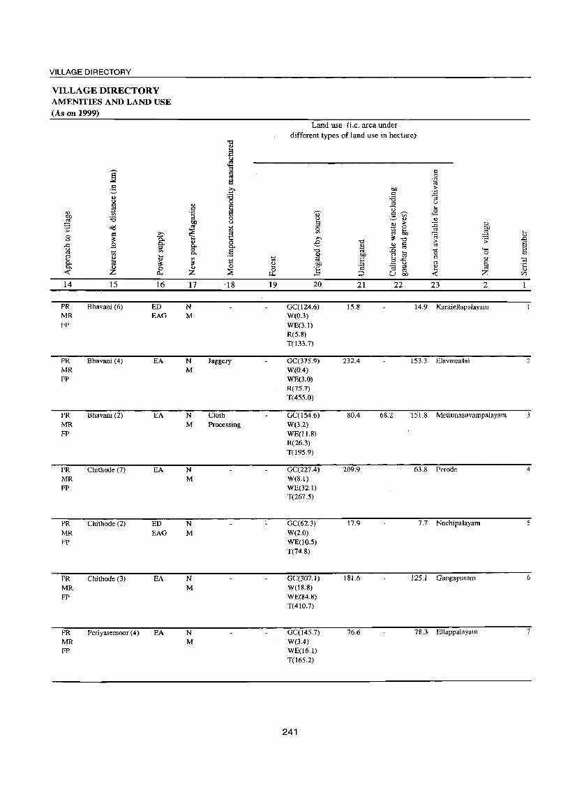
VILLAGE DIRECTORY
VILLAGE DIRECTORY AMENITIES AND LAND USE (As on 1999)
Land use (i.e. area under
different types of land use in hectare) '0 <.)
a ~
§ ::I t:l I:l
"" 0 8
. .;:: "" .g a bO >
C '';:: 0,) :.a :.a '3 u 0 u c ..,
§ ::I
S .S u .... <.)
'" ~ 0' c ~ ..8 ~ :.a 0 u :.:=" ~ ..,
bO u 3 E .. :g <!.)
~ "" ~ 0 co :;:
~ ~ Vl 5h a ...
i '" ~ 3 c
~ ..,
~ ;>-. '0 .-s; ..Q 0 e '0 > S ..c 9 ~ ~
.., &:l "" ~ ::I Q.. :c '" 4- :::l
~ '" Q.. .5 '0 '" ~ '0 0 s::; 0 '" t ~ bO
'" .... .., ~ ~ t; :§ !:l ..c <1)
~ Q.. la ~ Vl ~ co ~ u '" § .t:;
Q.. .., <.) 0 ] '3 ::I ..,
0 ::;E & s::;
'" .... <lJ -<t: Z 0.., Z :::,:, U bIl ~ Z (/)
14 15 16 17 ·18 19 20 21 22 23 2
PR Bhavani (6) ED N GC(l24.6) 15.8 14.9 Karaiellapalayam MR EAG M W(0.3) FP WE(3.!)
R(5.8) T(133.7)
PR Bhavani (4) EA N Jaggery GC(37S.9) 232.4 153.3 Elavamalai 2
MR M W(O.4) FP WE(3.0)
R(75.7) T(455.0)
PR Bhavani (2) EA N Cloth GC(154.6) 8004 68.2 '1 5 I.S Mettunasuvampalayam 3 MR M Processing W(3.2) FP WE(I1.8)
R(26.3) T(195.9)
PR Chi thode (7) EA N GC(227.4) 209.9 63.8 Perode 4
MR M W(8.1) FP WE(32.1)
T(267.5)
PR Chi thode (2) ED N GC(62.3) 17.9 7.7 Nochipalayam 5
MR EAG M W(2.0) FP WE(10.5)
T(74.8)
PR Chi thode (3) EA N GC(307.1) 181.6 125.1 Gangapuram 6 MR M W(18.8) FP WE(84.8)
T(410.7)
PR PeriyasemooT (4) EA N GC(14S.7) 76.6 78.3 Ellappalayam 7
MR M W(3A) FP WE(16.1)
T(l6S.2)
241

.g o u c o '0 o:l U o -l o(l
2 Villarasampatti (00767900)
Thindal (Mel)
(00768000)
:0 Thindal (Kil)
(00768100)
i Kadirampatti (00768200)
2 Rajapalayam (00768300)
13 Mulakkarai (00768400)
14 KurapaJayam (00768500)
3 785.6
381.0
208.0
342.9
114.5
179.6
139.6
~
'" ::s '" c o
U ...... 8 ~
4 4,560
4,463
5,621
1,356
615
430
618
5 6 1.185 P
820
1,364
M C« S)
P M S PUC C« S)
P M S PUC I
DISTRICT CENSUS HAND BOOK: ERODE
VILLAGE DIRECTORY AMENITIES AND LAND USE
(As on 1999) Amenities available (if not available within the village, a dash (-) is shown
in the column and next to it in brackets the distance in broad ranges viz.< 5 kms., 5-10 kms. and 10+ kms of the
nearest place where the facility is available is given)
7 PHS H«S) MCW« 5) PHC«5)
PHS H«S) MCW«5) PHC«S)
H MCW(2) CWC PHC PHS
8 9 THP PO SS-T,HP PH(40)
TW PO SS-T,W PH(l39)
THPW PO R PH(S97) SS-T,W
10 CM CP(S-IO)
CM CP«5)
CM«5) CP« S)
11 12 13 ACS BS NCS« 5) CV« S) RS(S-IO) OCS(S-10) SP(5-10) NW(lO+)
ST(S-IO)
ACS«5) NCS«S) OCS«5)
ACS«5) NCS« 5) OCS« 5)
ST BS CVC5-10) RS(5-IO) SP(S-IO) NW(5-IO)
SP BS CVC< 5) RS(5-IOl ST(5-10) NW(5-10)
C« 5) RMP
366 P
168
120
178
M«5) C«S)
P« 5)
M«5) C(S-IO)
P M(5-10) C« 5)
P« 5)
M(.: 5)
C(5-10)
SMP
MCW H(S-IO) PHC(S-IO)
H« 5) MCW«S) PHC«S)
PHS H(S-IO) MCW(S-IO) PHC(5-1O)
H« 5)
MCW(.:S) PHC«5)
242
TW PO SS-T,W PH(69)
THPW PO SS-T,W PH(2l)
THPW PO SS-T,W PH(25)
THPW PO SS-T,W PH(25)
BS CM(5-10) ACS(5-10) CV(S-IO) RS(S-IO) CP(5-1O) NCS(S-10) SP(S-IO) NW(lO+)
OCS(S-10) ST(S-IO)
CM«S) CP« S)
CM« S)
CP(S-IO)
CM«5) CP(.: 5)
ACS« 5)
NCS« 5) OCS« 5)
ACS(5-IO) NCS(5-10) OCS(10+)
ACS« 5)
NeS« 5) OCS« 5)
CV«S) BS«S) SP(lO+) RS(10+) ST« 5) NW(lO+)
BS CV« 5) RS(S-IO) SP(S-IO) NW(10+) ST« S)
BS CV(.: 5) RS(lO+) SP(lO+) NW(lO+) ST« 5)
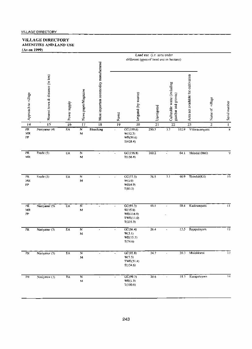
VILLAGE DIRECTORY
VILLAGE DIRECTORY AMENITIES AND LAND USE (As on 1999)
., ~ .;; B ..0 g 0 .... Q.. Q..
~
14 PR MR FP
PR MR
PR MR FP
PR MR FP
PR
PR
PR
] 2-'" u
~ :a o(j I::l ;...,
~ 0.. .9 g-..... '" '" .... '" ., 1;3 ~
'" 0 Z a..
15 16 Nasiyanur (4) EA
Erode (5) EA
Erode (3) EA
Nasiyanur (S) EA
Nasiyanur (3) EA
Nasiyanur (S) EA
Nasiyanur (3) EA
... .9 ~ tJIJ CIS
~ ... ft p..
'" ~ ., Z
17 N M
N M
N M
N M
N M
N M
N M
"t;j ... a u ~
'" r:l CIS 8
~ 0
§ 0 (.)
§ t: 0 p..
.13 ... '" 0 ~
18 Bleaching
19
Land use (i.e. area under different types of land use in hectare)
20
GC(359.6) W(l2.3) WE(56.6) T(428.4)
GC(1S6.8) T(J56.8)
GC(77.5) W(l.O) WE(4.9) T(83.S)
GC(93.3) W(lS.O) WE(116.0) TWE(ll.O) T(23S.3)
GC(S6.4) W(3.1) WE(lS.l) T(74.6)
GC(9S.8) W(7.S) TWE(31.4) T(134.6)
GC(99.3) WE(l.3) T(IOO.6)
243
21 250.5
160.2
76.S
49.1
26.4
24.7
20.6
22 23 3.7 102.9 Villarasarnpatti
64.1 Thindal (Mel)
7.1 40.9 Thindal(KiI)
58.4 Kadirampatti
13.S Rajapalayam
20.3 Mulakkarai
18.3 Kurapalayam
'+-< o <IJ
§ Z
2 8
9
10
11
12
13
14

2 15 Tholtani
(00768600)
16 PudurpllduppaJayam (00768700)
17 Nanjanapuram (00768800)
I 8 Pagalanthanpalayam (00768900)
I 9 Veppempalayam (00769000)
20 Muthampalayam (00769100)
Block Tobll
3 135.9
660.3
212.7
93.5
421.7
322.1
7,177.7
-8 ~
4 617
1.800
1,781
588
1,5S0
1,477
55,773
5 183
456
310
148
411
401
6 C P« 5) M(5-1O)
P M(5-10) C«5)
P C M« 5)
P« S) M«5) C« 5)
P(2) I M(5-10) C(5-10)
P M« 5) C«S)
14,495 P(27) M(5)
8(4)
PUC(3) C(2)
1(2)
DISTRICT CENSUS HAND BOOK: ERODE
VILLAGE DIRECTORY AMENITIES AND LAND USE
(As on 1999) Amenities available (if not available within the village, a dash (-) is shown
in the column and next to it in brackets the distance in broad ranges viz.< 5 kms., 5-10 kms. and 10+ kms of the
nearest place where the facility is available is given)
7
H(5-10) MCW(5-IO) PHC(S-tO)
PHS H(5-10) MCW(5-IO) PHC(5-IO)
PHS H(5-10) MCW(S-IO) PHC(5-10)
H(S-IO) MCW(S-IO) PHC(5-10)
PHS H« 5) MeW(5-10) PHC« S)
PHS H« 5)
MCW«5) PHCC< 5)
11(2)
MCW(6) CWC PHe PHS(ll) RMP(3) SMP CllW(6)
244
8 9 THPW PO S5-T,W PH(23)
THPW PO S5-T,W PH(47)
THPW PO SS-T.W PH(55)
THPW PO SS-T.W PH(13)
THPW PO SS-T,W PH(47)
THPW PH(62) SS-T,W PO« 5)
T(20) W(19)
HP(18)
R(4)
C(3)
PO(20) PH(2166)
10
CM« S) CP(5-1O)
CM CP« 5)
CM(5-1O) ep(5-10)
CM(S-IO) CP(S-IO)
CM« 5)
CP(S-IO)
CM(" 5) CP« 5)
CM(4) CP
11 12 13 BS
AC5(S-10) CV« 5) RS(5-10) NCS(5-10) SP(S-IO) NW(IO+)
OCS« 5) ST« 5)
BS ACS( < 5) CV (5-10) RS( < S)
NCS« 5) SP(5-1O) NW(lO+) OCS (1 0+) ST« 5)
BS ACS(5-10) eV(S-IO) RS(5-10) NCS('i-l0) SP(S-IO) NW(10+)
OCS(5-10) ST(5-1O)
BS ACS(5-10) eV(5-10) RS( 5-1 0) NCS(5-10) SPC5-IO) NW(10+)
OCS(5-10) ST(5-1O)
NCS(2) ns ACS(5-1O) eV« 5) RS(5-10) OCS(5-10) SP(5-10) NW(lO+)
ACS« 5) NCS« 5)
OCS« 5)
ACS NCS(3)
ST« 5)
BS CV(5-IO) RS(5-10) SP(S-IO) NW(5-10)
5TCS-10)
ST SP
nS(18)

VILLAGE DIRECTORY
VILLAGE DIRECTORY AMENITIES AND LAND USE (As on 1999)
14
PR
PR MR FP
PR MR FP
PR MR FP
PR MR FP
PR MR FP
PR(20)
MR(16) FP(IS)
15 Nasiyanur (3)
Nasiyanur (5)
Nasiyanur (4)
Nasiyanur (5)
Nasiyanur (5)
Erode (5)
16
EA
EA
EA
EA
EA
EA
ED EAG(2) EA(l8)
17
N M
N M
N M
N M
N M
N M
N(20) M(20)
18
Dhothies, Sarees
Bleaching
Kada Cloth
19
Land use (i.e. area under different types of land use in hectare)
20
GC(86.8) W(1.o) WE(7.I) T(94.9)
GC(l5S.2) W(4.9) WE(32.0) T(192.1)
GC(54.9) W(ILl)
WE(38.4) T( 104.4)
GC(l6.8) W(S.I) WE(26.2) T(48.1)
GC(l39.7) T(139.7)
GC(l81.3) T(l81.3)
21 26.1
377.3 5.4
85.9
36.3
215.3 0.7
76.8
22 23 15.0 Thottani
..... o ., § z 2
85.5 Pudurpuduppalayam
22.5 Nanjanapuram
9.1 Pagalanthanpalayam
66.0 Veppempalayam
64.0 Muthampalayam
0.0 GC(2970.89) 2,240.0 85.2 1,175.4
W(97.06) WE(459.05) TWE(42.37) R(107.79) T(3677.16)
245
'<l)
.D
E ::l c=
15
16
17
18
19
20


VILLAGE DIRECTORY
CHENNIMALAI CD BLOCK
247


VILLAGE DIRECTORY
Alphabetical list of Villages with Location Code Numbers of 1991 and 2001
Name of the District: Erode Name of Taluk: Perundurai Name of CD Block: Chennimalai
Serial 2001 Census location code number Name of village number 1991 Census locati on code number
2 3 4
Basuvapatti 007ti7000 080040012001201170
2 ChennimaIai 00766000 080040012001201070
3 Chennimalai R.F. 00766200 080040012001201090
4 Ekkattampalayam 00766900 080040012001201160
5 Ellaigramam 00766800 080040012001201150
6 lngur 00763900 080040012001200840
7 Kavundachipalayam 00763600 080040012001200810
8 Kodumanal 00766600 080040012001201130
9 Kongampalayam 00764200 080040012001200870
10 Kuppuchipalayam 00767100 080040012001201]80
11 Kuthampalayam 00765800 080040012001201050
12 Mukasi PulavapaIayam 00763800 080040012001200830
13 Murugatholuvu 00766100 080040012001201080
14 Nanjai Palatholuvu 00766400 080040012001201110
15 OrathupaJayam 00766700 080040012001201140
16 Pudupalayam 00766300 080040012001201100
17 Pungampadi 00763500 080040012001200800
18 Punjai Palatholuvu 00766500 080040012001201120
19 Sirukkalanchi 00765700 080040012001201040
20 Thenmugam Vellode 00763700 080040012001200820
21 Vadamugam Vellode 00763400 080040012001200790
22 Varapalayam 00764100 080040012001200860
23 VoiEadi 00765900 080040012001201060
249

.... ~ S ::l ::l
2 3 '::D Block: Chennimalai (0013)
Vadamugam 2,451.3
2
3
Vellode (00763400)
Pungampadi (00763500)
Kaudachipalayam (00763600)
., Thenmugam Veil ode (00763700)
5 Mugasipalavam
6
Palayam (00763800)
Ingur (00763900)
Varappatayam (00764100)
Kongampala yam (00764200)
843.5
1,054.1
3,231.8
305.0
2,396.6
640.7
234.9
4
8,292
2,598
5,364
7,696
741
5,651
745
666
5
2,328
751
1,509
DISTRICT CENSUS HAND BOOK: ERODE
VILLAGE DIRECTORY AMENITIES AND LAND USE
(As on 1999) Amenities available (if not available within the village, a dash (-) is shown
in the column and next to it in brackets the distance in broad ranges viz.< 5 kms., 5-10 Ians. and 10+ lans of the
nearest place where the facility is available is given)
6 7
P(6) M S MCW PUC PHC C PHS [ RMP Tr H« 5)
P(3) M« 5) C« S}
P(2) M(2)
C«5)
H(S-IO) MCW(S-IO) PHC« S)
MCW PHS H(5-10) PHC(S-IO)
8 9
TW PO(2) SS-T,W PH(40S)
THP PO SS-T,HP PH(ISO}
THPW PO(2) SS-T,W TO
PH(380)
10
CM CP(5-1O)
CM« S) CP«5}
CM(5-10) CP(5-1O)
11
ACS NCS« 5)
OCS« 5)
NCS ACS« 5) OCS« 5)
12
SI BS CV« 5) RS
13
SP« 5) NW(lO+)
BS CV« 5) RS« 5) SP« 5) NW(lO+) ST« S)
ACS BS NCS(5-10) CV(S-IO) RS« 5) OCS(S-IO) SP(5-10) NW(S-IO)
ST(S-IO)
2,086 P(2) MCW PHC PHS
THP PO CM CP
ACS BS
217
1,480
219
189
M S PUC C(S-10)
P M«5) C(5-10)
o H(5-IO}
H«S) MCW«S) PHC(<5)
P(8} PHS M(5-10) H(S-IO) C(S-lO) MCW(S-lO)
P(2) M« 5) C(10+)
p
M(<5) C(lO+)
PHC(S-IO)
CHW(2) H(S-lO) MCW(S-tO) PHC(5-1O)
H(<5) MCW(5-1O) PHC(5-IO)
250
SS-T,HP PH(460)
TW PO SS-T,W PH(SO)
THPW PO SS-T.W TO
PH(l2t6)
THP PO SS-T,HP PH(30)
THP PO SS-T.HP PH(1S)
CM« 5) CP(S-IO)
CM CP(5-10)
NCS CV(S-IO} RS« 5) OCS(IO+) SP(5-10) NW(lO+)
ST(S-IO)
BS ACS(5-10) CV« 5) RS(5-10) NCS(5-10) SP(lO+) NW(IO+) OCS(10+) ST(10+)
ACS NCS(S-IO) CV(S-IO) BS(5-10) OCS(5-10) SP(5-IO) RS(S-IO)
ST(5-10) NW(5-10)
NCS(2) BS CM(5-10) ACS« 5) CV(S-IO) RS« 5) CP« 5) OCS(10+) SP(lO+) NW(IO+)
CM« 5) CP« 5)
ST(IO+)
BS ACS« 5) CV(d) RS« 5) NCS« 5) SP(lO+) NW(IO+) OCS(lO+) ST(lO+)

VILLAGE DIRECTORY
VILLAGE DIRECTORY AMENITIES AND LAND USE (As on 1999)
14
PR
MR FP
PR MR FP
PR MR FP
PR MR FP
PR
MR FP
PR MR FP
PR MR
PR MR
15 16
Perundurai (2) EA
Perundurai (5) EA
Erode (10) EA
Perundurai (10) EA
Perundurai (12) EA
Perundurai (5) EA
Vijayapuri (5) EA
Vijayapuri (4) EA
17
N M
N M
N M
N M
N M
N M
N M
N M
18
Bedsheets, Towels
Bedsheets
Betsheets
Handloom, Bedsheets. Towels
19
64.1
Land use (I.e. area under different types of land use in hectare)
20 21 22 23 2
GC(683.2) WE(92.0) T(775.3)
575.0 1,101.0 Vadamugam Vellode
GC(220.0) 424.3 178.8 Pungampadi WE(20.4) T(240.4)
GC(391.6) 333.0 174.5 Kaudachipalayam WE(155.0) T(546.6)
GC(382.0) 2,041.2 383.1 Thenmugam Veil ode W(20.0) WE(405.6) T(807.6)
WE(28.9) " 2.'10.5 25.6 Mugasipalavam Palayam
T(28.9)
W(21.2) 1,315.2 977.5 fngur
WE(82.7) T(103.8)
WE(2.4) 573.9 64.4 Varappalayam
T(2.4)
WE(3.3) 153.0 14.4 Kongampalayam
T(3.3)
251
2
3
4
5
6
7
8

DISTRICT CENSUS HAND BOOK: ERODE
VILLAGE DIRECTORY AMENITIES AND LAND USE
(As on 1999) Amenities available (if not available within the village, a dash (-) is shown
in the column and next to it in brackets the distance in broad ranges
viz.< 5 krns., 5-10 kms. and 10+ krns of the -;;;- nearest place where the facility is available is given) ,...., ::I ... ... til
S c::l "0 .D "0 ,...., ... '" 0 <.> '" U c::l ... ::I
(.) ... ::I '" g u 0) c ..c: '" - ... 4) t=a u 0 g c::l 0 c::l >
B 'u t! 'S ,-. ';:l 4) 0 0 .~
U ~ ..c: ..s 0 .... >.
'" fr .... '"3 c..
(I) '" U ., ... t=a U) :;; ~ 0
~ 0 '" c.. .~ ..J 0 "0 ] 0 i;b '" B :gS ::I ....
~ '0 b a:< ~ o(! .:;: ..c: "0 <.> ~ .~ '3 ..c: .~ ~ <"> 4) c::l ~ ., ... c::l III '" "0 0:1 ... u 0 '"' '"
~ -5 0 ::I l:i § o ._
o(! 4) .8 c: d' .... ';:l 0 ..c: c::l g "0 ._ 0
4) ..... '" ..c: ~ g. - '" t=a ._ "0 '.g 0
.0 . :;: 0 '3 M t=a t=a ...... > ::I ';:l S ..... ~ i;b '" 0 c::l 'u 3:.0 c::l (;j« u S 0- 'a , ..... 4)
0 .... 0 bO ~ .... ...... ... 0 '" ;..; 0 l;j 0- u ';:l t=a c::l E 4) - .... ';:l S § ::I >.
.§ 4) .0 <'l (.)
~ S ::I u C':I § '" ~ "3 "3 s (.) :.0 til ·c ~
4) ., ._ Z ...... S -'<i '"' <::"0 ::I '" c::l u '1 0 0 ::I "0 " ... .... 0 0 bO-5 4) a s 0 '('3 Z E-< E-< Z t.1l ~ Cl ~ u '" « 0 ~ U .0 ~ U) ....
2 3 4 5 6 7 8 9 10 II 12 13 Sirukalanji 1,166.2 2,300 668 P(2) THPW PO SP BS (00765700) M H(10+) SS-T,W PH(70) CM«5) ACS« 5) CV« 5) RS«5)
C(10+) MCW(10+) CP« 5) NCS(10+) ST(IO+) NW(10+) PHC(5-1O) OCS(IO+)
10 Koothampalayam 577.6 1,119 307 P PHS THPW PO SP BS (00765800) M«5) H(10+) SS-T,W PH(19) CM(5-10) ACS« 5) CV(5-1O) RS«5)
C(10+) MCW(lO+) CP(5-10) NCS(IO+) ST(lO+) NW(IO+) PHC« 5) OCS(10+)
II Voipadi 1,429.2 1,976 597 P PHS THPW PO ACS SP RS (00765900) M H(5-1O) SS-T,W PH(70) CM(5-1O) NCS(IO+) CV(5-1O) RS« 5)
C(10+) MCW(S-IO) CP(10+) OCS(lO+) ST(lO+) NW(IO+) PHC(S-IO)
; Chennimalai 2,230.0 2,733 772 PHS THPW PH(55) (00766000) P« 5) H(5-1O) SS-T,W PO« 5) CM(5-JO) ACS« 5) CV(5-10) BS«5)
M(S-IO) MCW(S-IO) CP« 5) NCS« 5) SP(lO+) RS« 5) C(10+) PHC(S-IO) OCS« 5) ST(10+) NW(JO+)
J Murungatholuvu 2,801.3 7,378 2,053 peS) H THPW PO ACS BS (00766100) M MCW SS-T,W PH(432) CM« 5) NCS CV«5) RS(5-10)
C a CP«5) OCS« 5) SP(10+) NW(10+)
P~C(<5) ST(lO+)
14 Chennimalai R.F. 680.0 Uninhabitated (00766200)
IS Puduppalayam 734.8 1,331 390 P MCW THPW PO BS (00766300) M«5) H(10+) SS-T,W PH(36) CM(IO+) ACS(10+) CV(10+) RS(IO+)
C(10+) PHC« 5) CP(IO+) NCS(IO+) SP(10+) NW(10+) OCS(10+) ST(lO+)
-16 Nanjaipalatholuvu 178.9 1,227 334 THP PH(7) BS
(00766400) P«5) H(10+) SS-T,HP PO« 5) CM(5-10) ACS(5-1O) CV(5-10) RS(5-IO)
M«5) MCW(IO+) CP(5-10) NCS(JO+) SP«5) NW(10+) C(10+) PHC«5) OCS(JO+) ST(10+)
252

VILLAGE DIRECTORY
VILLAGE DIRECTORY AMENITIES AND LAND USE (As on 1999)
~ :; g .c i;j 8 0.. 0.. «
14 PR MR
PR MR
PR MR
PR MR FP
PR MR
FP
15 16 Uthukkuli (3) EA
Uthukkuli (5) EA
Uthukkuli (10) EA
Chennimalai (8) EA
Chennimalai (I) EA
17 N M
N M
N M
N M
N M
18 Bedsheets
Bed Sheets
.... '" ~ 19
Bed Spreads 130.3
Bedsheets 536.1
Bedsheet
-------- Uninhabitated ------------ 680.0
PR MR
FP
PR MR
Chennimali (12)
Uthukkuli (8)
EA
EA
N M
N M
Bedsheet 47.4
Bed Sheets
Land use (i.e. area under
different types of land use in hectare)
20
W(OA) WE(2.4) TWE(2.5) T(S.3)
W(0.3) WE(O.4) TWE(O.7) T(1.4)
W(0.6) WE(2.2) TWE(29.2) T(32.0)
W(39.4) WE(25.3) T(64.8)
GC(286.3) WE(137.9) TWE(46.7) T(470.9)
GC(31.3)
WECl7.I) T(48.4)
W(0.8) WE(3.6)
TWE(6.0) T(lOA)
253
21 838.6
390.9
578.6
865.9
1,915.8
535.6
115.2
22 228.4
26.4
534.4
26.1
2 93.9 Sirukalanji
158.9 Koothampalayam
153.8 Volpadi
763.3 Chennimalai
414.6 Mtlrungatholuvu
Chbnhimalai R.F.(Uninhabited) 679.95
103.4 Puduppalayam
27.2 Nanjaipalatholuvu
9
10
II
12
13
14
15
16

.... " .0 6' :::l C
2 17 Punjaipalatholuvu
(00766500)
18 Kodumanal (00766600)
19 Orathupalalyam (00766700)
20 Ellaigramam (00766800)
21 Ekkattampalayam (00766900)
22 Pasuvapatti (00767000)
23 Kuppichipalayam (00767100)
Block Total
3 4 1,477.2 744
705.3 867
277.0 407
605.7 1,155
1,384.0 4,589
807.0 3.233
424.8 1,108
26,636.6 61,926
DISTRICT CENSUS HAND BOOK: ERODE
VILLAGE DIRECTORY AMENITIES AND LAND USE
(As on 1999) Amenities available (if not available within the village, a dash (-) is shown
in the column and next to it in brackets the distance in broad ranges viz.< 5 lans., 5-10 kms. and 10+ kms of the
nearest place where the facility is available is given)
5 217
253
119
6 P(3) M«5) C(lO+)
P
7 PHC PHS H(10+) MCW(10+)
M(S-IO) H(10+) C(1 0+) MCW(S-IO)
PHC(5-10)
8 9 THPW PO SS-T,W PH(75)
THPW PO SS-T.W TO
PH(2S)
THPW PO P« 5) M(d) C(10+)
H(IO+) SS-T,W PH(20) MCW(10+) PHC(10+)
328 P(2) MCW M(S-IO) H(10+) C(lO+) PHC(5-10)
1,301
926
310
P(5) M S C« 5)
P M AC
P M«5) C(lO+)
17,354 P(48) M(9)
S(3) PUC(2) C(2)
I Tr AC
MCW H(S-IO) PHC(S-IO)
PHS H(5-10) MCW(S-IO) PHC(5-tO)
H(<5)
MCW(5-10) PHC« 5)
H MCW(7) PHC(3) PHS(9) RMP CHW(2) 0(2)
254
THPW PO SS-T,W PH(30)
THPW PO SS-T,W PH(60)
THPW PO SS-T,W PH(35)
THPW PO SS-T,W PH(89)
T(22) W(17) HP(20)
P0(22) TO(3) PH(3729)
10 11 12 13 BS
CM(5-1O) ACS(5-1O) CV(5-1O) RS(5-10) CP(5-10) NCS(10+) SP«S) NW(IO+)
OCS(lO+) ST(10+)
CM(IO+) CP(10+)
CM(lO+) CP(10+)
CM(lO+) CP(JO+)
BS ACS(IO+1 CV(10+) RS{IO+) NCS(lO+) SP(lO+) NW(IO+) OCS(10+) ST(IO+)
BS ACS(lO+) CV(lO+) RS(lO+) NCS« 5) SP(10+) NW(10+)
ST(lO+)
NCS BS ACS(lO+) CV(lO+) RS(lO+) OCS(lO+) SP(10+) NW{lO+)
ST(lO+)
BS CM(5-10) ACS(5-10) CV(5-10) RS(lO+) CP(S-IO) NCS(5-10) SP(10+) NW(10+)
OCS(S-10) ST(lO+)
BS CM(5-10) ACS(S-IO) CV(S-IO) RS(lO+) CP(S-IO) NCS(S-IO) SP(IO+) NW(10+)
OCS(5-1O) ST(10+)
BS CM(5-10) ACS« 5) CV(S-IO) RS(lO+) CP(5-IO) NCS(5-1O) SP(lO+) NW(lO+)
OCS(5-IO) ST(IO+)
CM(3) CP
ACS(6) NCS(6)
ST SP(3)
BS(26) RS

VILLAGE DIRECTORY
VILLAGE DIRECTORY AMENITIES AND LAND USE (As on 1999)
Land use (i.e. area under
different types of land use in hectare)
"" 4)
E u
4!l
]: ::l c:l J:l CIS 0
8 'g c:: >. C!l > V ... .8 '.:;1 OJ :e "d "3 u 0 ::l OJ c:: 4)
~ ~ r:l U .... Q)
'" .~ OJ .S f.I:l <2
C!l ~ 'i3 0
~ ~ ., Q)
bO u 2:! > :0 OJ
<>(! '" ~ 0 bJl .;;:
~ 0 '" 50 CIS
~ U) co '8 ~ ...
8 '" t! ~ OJ
~ 0.. >. "0 .;;: ..0
9 0.. tl 0 e "0 § > E ..c:: ::l 0.. 0.. 4) ~ co ~ - '" '" .5 "" "" ..0 0
...... ::I
'" 0. 2:! bQ CIS t:a 0 c 0 4) !3 ... c:l ...
~ U) t; ell '" :§ 3 ..c:: 4) -;:;
0. ~ ~ 4) bO ~ u CIS § .t:: 0. 4) 0 4) 0 ...
] '" :; ::l 4)
« z z :E 0 CIS .... <!)
0.. u.. ::::l U bI) « z U)
14 15 16 17 18 19 20 21 22 23 2 PR Uthukkuli (7) EA N Bed Sheets 114.1 W(4.0) 893.4 198.0 183.6 PunjaipalatholuVll 17 MR M WE(10.0)
TWE(74.1) T(88.1)
PR Chennimalai (10) EA N KadaCloths W(lI.O) 411.6 233.7 Kodumanal 18 MR M WE(49.0) FP T(60.0)
PR Chennimalai (13) EA N Bedsheets W(S.3) 160.0 99.8 Oralhupalalyam 19 MR M WE(l1.9) FP T(17.2)
PR Chennimalai (12) EA N Bedsheets GC(216.1) 212.1 130.9 Ellaigramam 20 MR M WE(46.6)
FP T(262.8)
PR Chennimalai (8) EA N Bedsheets, 107.9 GC(370.0) 494.8 256.4 Ekkat tampalayam 21
MR M Towels W(20.0) FP WE(135.0)
T(S2S.0)
PR Chennimalai (3) EA N GC(403.2) 128.1 155.2 Pasuvapatti 22
MR M W(lS.1) WE(6S.4) TWE(40.0) T(S23.7)
PR Chennimalai (9) EA N Bedsheet. GC(86.9) 214.9 69.0 Kupplchipalayam 23
MR M Cloths WE(40.3) FP TWE(l3.7)
T(140.9)
PR(22) EA(22) N(22) 1,679.9 GC(3070.62) 13,421.3 1,013.4 5,763.0
MR(22) M(22) W(138.08)
FP(14) WE(l337.4S) TWE(212.88) T(4759.03)
255


VILLAGE DIRECTORY
MODAKURICHICDBLOCK
257


VILLAGE DIRECTORY
Alphabetical list of Villages with Location Code Numbers of 1991 and 2001
Name of the District: Erode Name of Taluk:Erode Name of CD Block: Modakurichi
Serial 2001 Census location code number Name of village number 1991 Census location code number
2 3 4
Attavanai Hanuman PaW 00771100 080050014001400520
2 A valpoondurai 00769900 080050014001400370
3 Ellaikadai 00771800 080050014001400650
4 Elumathur 00770800 080050014001400480
5 Injampalli 00770600 080050014001400460
6 Kagam 00771200 08005001400]400550
7 Kanagapuram 00769600 080050014001400340
8 Kangayampalayam 00770200 080050014001400400
9 Kulavilakku 00771300 080050014001400560
10 Modavandi Sathyamangalam 00770000 080050014001400380
11 Mukasi Hanuman Palli 00771000 08005001400]400510
12 Nanjaikalamangalam 00770400 08005001400]400430
13 Nanj ail akkapuram 00769200 080050014001400300
14 Nanjaiuthukuli 00770100 080050014001400390
15 Palamangalam 00771400 080050014001400570
16 Pudur 00769400 080050014001400320
17 Punduraisemur 00769800 080050014001400360
18 Punjai Ka1amangalam 00770500 080050014001400450
19 Punjail akkapuram 00769300 080050014001400310
20 Sathambur 00770300 080050014001400420
21 Thanathampalayam 00770700 080050014001400470
22 Thuyyampoondurai 00769500 080050014001400330
23 Velampalayam 00769700 080050014001400350
24 Velampalayam 00710900 080050014001400500
25 Vilakethi 00771900 080050014001400660
259
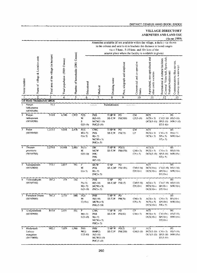
2 3 CD Block: Modakuricbi (0014)
Nanjai- 75.3 lakkapuram (00769200)
2 Punjai-
3
lakkapuram (00769300)
Pudur (00769400)
4 Thoyam-
5
6
7
8
9
poondurai (00769500)
Kanagapuram (00769600)
Velampalayam (00769700)
Poondurai Semur (00769800)
A valpoondurai (00769900)
Modavandi Sathiyamangalarn (00770000)
510.8
1,215.5
3,279.8
773.1
107.2
781.5
853.8
982.1
4
6,740
9,OS8
10,408
2,817
374
2.733
2,031
7.039
5
1,912
2,478
6
P(2)
M S C(5-10}
P(3) M«5) C(d)
DISTRICT CENSUS HAND BOOK: ERODE
VILLAGE DIRECTORY AMENITIES AND LAND USE
(As on 1999) Amenities available (if not available within the village. a dash (-) is shown
in the column and next to it in brackets the distance in broad ranges viz.< 5 kms., 5-10 kms. and 10+ kIns of the
nearest place where the facility is available is given)
7 8
~
'" o P-.
9
Uninhabitated
PHS THPW PO H(S-IO) 55-T,W PH(500) MCW(5-10) PHC(S-IO)
CWC PHS H(d) MCW«5) PHC(<5)
THPW PO SS-T,W PH(7S)
., > .~ ., 0..
9 o u
"0 ~ c; 'r;
J~ U.o
IO
CM CP(5-10)
CM CP
II 12 13
NC5 BS AC5«S) CV(5-10) RS(5-10) OC5(5-1O) 5P(5-10) NWfS-10)
ST(S-IOl
ACS NCS« 5) OCS« 5)
BS CY« 5) RS« 5) SP« 5) NW(IO+) ST« 5)
2,880 P(11) DH THPW POtS) SS-T,W PH(670)
ACS(3) BS
761
102
688
561
1,966
M MCW C(5-10) PHC
P M C(<5)
P« 5) M«5) C(5-10)
P(2) M C(10+)
P M«5) C(5-10)
P(6) M(2) C(5-10)
PHS H(5-10)
MCW PHS H« 5) PHC(d)
PHS H(S-IO) MCW«5) PHC« 5)
PHS H(5-1O) MCW«S) PHC(5-10)
CWC PHS H«5) MCW«5) PHC« 5)
PHS RMP(2) H(S-IO) MCW(5-10) PHC(5-10)
260
THP PO SS-T,HP PH(l8S)
THP PO SS-T,HP PH(l5)
THPW PO 5S-T,W PH(76)
THPW PO SS-T,W PH(42)
THPW PO(2) SS-T,W PH(230)
CM« 5) NCS« 5) CV« 5) RS(5-10) CP« 5) OCS(5-10) SP(5-10) NW(lO+)
CM(5-1O) CP(IO+)
CM(S-10) CP(lO+)
CM«5) CP(d)
CP CM«S)
CP CM(5-IO)
ST« 5)
ACS BS NCS(IO+) CV(5-IO) RS(5-10) OCS(lO+) SP(10+) NW(IO+)
ST(10+)
BS ACS« 5) CY(5-10) RS(5-10) NCS(10+) SP(IO+) NW(IO+) OCS(lO+) 5T(10+)
BS ACS« 5) CY« 5) RS(IO+) NCS« 5) SP(lO+) NW(lO+) OC5(1 0+) ST( < 5)
ACS BS NC5« 5) CY(lO+) RS(S-IO) OCS(I 0+) SP(l 0+) NW(l 0+)
ST(lO+)
ACS BS NCS(S-IO) CY« 5) RS(5-10) OCS(5-10) SP(5-lm NWflO+l
ST(5-10)
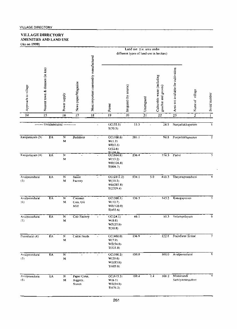
VILLAGE DIRECTORY
VILLAGE DIRECTORY AMENITIES AND LAND USE (As on 1999)
~ 5
iI.) u = ;s
OJ '" btl :a ;g
o(j .;; = >,
3 ;:: -a 9 Q. ..c::
u ::I ~ Ul o:s '" 0 iI.) .... ... 8
iI.)
0- ;:: 0- il.) 0 -< Z 0...
14 15 16
u = .~
btl o:s
~ u g-0.
'" ;:: u
Z
17
-------- Uninhabitated --------.. --
KasipaJayam (5) EA
Kasipalayam (4) EA
Avalpoondurai EA (5)
A valpoondurai EA (6)
A valpoondurai EA (5)
Poondurai (4) EA
Avalpoondurai EA (3)
Avalpoondurai EA (5)
N M
N
M
N M
N M
N M
N M
N M
N M
Bedsheet
Sacco Factory
Coconut Coir, Oil Mill
Coir Factory
Cattle Feeds
Paper Cone, Jaggery, Starch
] u ~ ::I
~ s a :e 0
§ 0 u
~ 0 o. § ... '" 0
~
18
Land use (i.e. area under
different types of land use in hectare)
btl = :a ::I U ,....., ~ u V)
u iI.)
3 ~ > 0 '" ~ V) o:s » ;:: "0 .D "0 = '-' ~ ~ o:s
"" '" .J:l
M btl co ~
~ :§ 3 ..c: btl
_ u
~ ~ r:l "3 ::I
'" ;;:J U bll
19 20 21 22
GC(35.S) 15.3 24.5 T(3S.S)
GC{108.6) 281.1 94.8 W(1.3) WE(2.S) 0(22.6)
236.4 174.3
GC(2111.2) 534.1 5.0 411.3 W(lO.S) WE(207.8) T(2329.4)
GC(360.1) 136.3 143.2 W(12.7) WE(l20.8) T(493.6)
GC(24.1) 46.1 10.3 W(O.S) WE(25.8) T(50.8)
GC(460.0) 136.9 122.8 W(7.0) WE(54.8) T(52J.8)
GC(500.2) 150.0 100.0 W(20.0) WE(83.6) T(603.8)
GC(615.3) 198.4 1.4 106.2 W(6.1) WE(54.8) T(676.2)
261
= 'g >
'::1 "3 u ,_ .8 ., ~ '" eo '8 ::3 ....
OJ .;;: .0 > a "" (5 ""' ::l 0 t::
d u "i3 o:s ~ ·c ., ,_ OJ -< Z V)
23 2
Nanjailakkapuram
Punjailakkapuram 2
Pudur 3
Thoyampoondurai 4
Kanagapuram 5
VelampaJayam 6
Poondurai Semur 7
A valpoondurai 8
Modavandi 9 Sathiyamangalam
.... o OJ
~ Z
2 '.J Nanjai Uthulculi
(00770100)
I I Kangayam
palayam (00770200)
" Sathampoor
(00770300)
• j Nanjaikda
mangalam (00770400)
14 Punjaikalamangalam (00770500)
15 Enjampalli (00770600)
, " Thanathampalayam
(00770700)
'I Elumathur
(00770&00)
3 1.604.1
2S1.1
300.7
359.8
1,663.1
1,471.7
152.3
2.167.6
= o 'z:l
'" i s o b
4 10,441
743
1,324
8,158
2,906
3,456
8.543
5 2,899
209
394
peS) M(2)
s PUC
6
r C(lO+)
P M« 5)
C(lO+)
P M(S-IO) C(lO+)
2,373 P(9) M S PUC
792 P(S)
965
2,348
M C(5-IO)
P«5)
M« 5) C(5-10)
P(8)
M C(5-1O)
DISTRICT CENSUS HAND BOOK: ERODE
VILLAGE DIRECTORY AMENITIES AND LAND USE
(As on 1999) Amenities available (if not available within the village, a dash (-) is shown
in the column and next to it in brackets the distance in broad ranges viz.< 5 kms., 5-10 kms. and 10+ kms of the
nearest place where the facility is available is given)
7 PHS H(lO+) MCW(lO+)
PHC(lO+)
PHS
H«S) MCW(S-IO)
PHC(S-IO)
8 9 THPW PO S5-T,W PH(3000)
WR PO SS-W,HP PHOO)
Uninhabitated
H« 5) MCW«S)
PHC« 5)
H MCW PHC
PHS RMP(2)
THPW PO SS-T,W PH(30)
THPW PO(2)
R PH(49 I)
SS-T,W
PHS THPW PO H(S-IO) S5-T.W PH(lOO)
MCW(S-IO) PHC(5-IO)
PHS THPW PO H(5-IO) SS-T,W PH(lO)
MCW(S-lO) PHC(5-IO)
MCW
PHC PHS RMP H(IO+)
262
THPW PO C PH(l64)
SS-T.W
10 CP
CM«S)
II 12 13 NCS BS ACS(S-IO) CV« S) RS OC5(l0+) SP(lO+) NW«5)
ST(IO+)
NW CM(S-IO) ACS(S-IO) CV(S-IO) BS« 5)
CP(5-10) NCS(S-lO) SP(S-IO) RS« 5)
OCS(5-IO) ST(S-IO)
CM«S) CP(10+)
CM CP(lO+)
CM CP(S-IO)
ACS«S) NCS«S)
OCS« 5)
BS eV(S-IO) NW SP(10+) RS(5-IO)
ST(lO+)
ACS BS NCS(lO+) CV(d) RS(5-IO) OCS(10+) SP(lO+) NW(lO+)
ST(lO+)
BS ACS(S-IO) eV(S-IO) RS« 5)
NCS(S-IO) SP(lO+) NW(S-IOJ OCS(5-10) ST(lO+)
BS CM(S-IO) ACS(5-IO) CV(S-IO) RS(5-IO)
CP(5-10) NCS(5-IO) SP(lO+) NW(5-10) OCS(5-1O) ST(lO+)
CM
CP
ACS BS NCS(S-IO) CV(5-10) RS(5-10) OCS(5-10) SP(IO+) NW(IO+)
ST(lO+)

VILLAGE DIRECTORY
VILLAGE DIRECTORY AMENITIES AND LAND USE (As on 1999)
.., :W .;;: ,9 .0 g 0 ... 0-0..
<t:
14
PR MR FP
PR FP NR
--. ] -2
Q.)
u c:: z:l Vl :e
a<J c :>. ~ Q. 9 0..
::I ~ Vl
'" .... <U V a ~ G) 0 Z t:l.
15 ]6 Poondurai (2) EA
Modakkurichi (6) ED EO
<1) d .~
~ ~ ...
<U g-0..
'" ;t-u Z
17
N M
N M
~
M <.J
<S ::I § s 0 :0 0
~ 0 U
t:i ~ 0 o.. .9 ~ tl)
0 ::E 18
KadaCloth
Brkks
-------- Uninhabitated ------------
PR Modakkurichi (8) EA N Bricks MR M
FP NR
PR Modakkurichi (3) EA N MR M FP
PR Modakkurichi (8) EA N
MR M FP
PR Modakkurichi (8) EA N
MR M FP
PR Erode (20) EA N MR M FP
~
'" ~ & 19
Land use (i.e. area under
different types of land use in hectare)
bIl CI
:.0 ::I U ., .=: '" ~ ~
.., S >
0 0 Vl 6b '" t"<S >, ~ ""0 e ~
~ c ~ '" '0 .0
~ 00 '" :a :§ 3.0 Oll
_ u
] CI "3 ::I
'" ::J U bIl
20 21 22 GC(214.7) 1,051.4 2.6 230.9 W(20.5) WE(63.0) 0(21.0) T(319.2)
GC(l49.8) 24.8 76.4 T(l49.8)
GC(21S.5) 11.6 70.6 T(21S.5)
GC(23 1.9) 8.7 119.2 T(23 1.9)
GC(236.2) 476.5 4.0 329.5 W(21.4) WE(140.5) 0(455.1) T(85J.2)
GC(889.0) 380.5 187.0 W(1.6) WE(l3.6)
T(904.2)
GC(97.0) 34.2 17.9 W(O.2) WE(3.0) T(lOO.2)
GC(1034.S) 778.8 1.1 341.2 W(2.2) WE(9.5) T(1046.5)
263
c 0
.;:) C"3
.~ "3 U .... ,8 <U :0 <1)
00
"" ::§ ..... ~ G)
.;;: .D > E c-o >-> .... ::l 0 0 c:: CI '-' C;; c-o § . .:; <I.l ....
Z <J
<t: en
23 2 Nanjai Uthukuli 10
Kangayalnpalayam II
Sathampoor 12
NanjaikdamangaJam 13
Punjaikalamangalam 14
Enjampalli I:;
TIlanathampalayam 16
Elumathur 17
<I)
'0 o u
'" o .~
g ...J o(j
2 ,8 Velampalayam
(00770900)
19 Mukasihanumanpalli (00771000)
20 Attavanai
Hanumanpalli (00771100)
,1 Kagam (00771200)
22 K.ulavilakku (00771300)
23 Palaroangalam (00771400)
24 Ellaikadu (O077J800)
15 Vilakkethi (00771900)
Block Total
3 4 1,449.7 3,90S
844.8 4,404
1,662.1 3,901
875.3 3,266
1,036.9 2,723
1,084.5 2,545
107.0 670
797.7 2,338
24,407.4 100,523
DISTRICT CENSUS HAND BOOK: ERODE
VILLAGE DIRECTORY AMENITIES AND LAND USE
(As on 1999) Amenities available (if not available within the village. a dash (-) is shown
in the column and next to it in brackets the distance in broad ranges viz.< 5 kms., 5-10 kms. and 10+ kms of the
nearest place where the facility is available is given)
5 1.012
I ,2 It
6 P(4)
M«S) C(S-IO)
P(3)
MS PUC C(5-10)
7 MCW PHS H(lO+)
PHC«5)
Mew PHS H(5-IO) PHC(5-10)
8 9 THPW PO SS-T.W PH(ISO)
THPW PO 5S-T.W PH(27S)
1,072 pes) PHS THPW PO SS-T.W PH(1D5) M(S-IO) H« 5)
C« 5) MCW« 5) PHC« 5)
934 P(2)
M C(10+)
814 prJ)
749
189
M«5) C(lO+)
P(3)
MS AC C(10+)
P M«S) C(5-IO)
664 P M«5) C(5-10)
27,973 P(77)
M(14) S(5} PUq3)
I AC
CWC T HP W PO(2)
PHS SS-T,W PH(60) H(IO+)
MCW(lO+) PHC(5-IO)
PHS THPW PO H(lO+) S5-T,W PH(60)
MCW(lO+) PHC(5-10)
H(10+) MCW(IO+)
PHC(lO+)
H«S) MCW(.::5) PHC(.:: 5)
MCW cwe PHS
H« 5)
PHC(.:: 5)
H DH MeW{7} CWC(4)
PHC(3)
PHS(20; RMP(5)
264
THPW PO
SS-T,W PH(52)
THPW PO S5-T,W PH(7S)
THPW PO SS-T,W PH(200)
T(22)
W(2l) HP(22; R(2) C
PO(30)
PH(6575)
10
CM«S)
CP« S)
CM CP(S-IO)
CM« 5)
CP«S)
11 12 13 BS
ACS« S) CV(S-IO) RS(IO+)
NC5« S) 5P(10+) NW« 5)
OC5(10+) ST(lO+)
NCS OCS
ACS« 5)
ACS NCS« 5)
OCS« S)
ST BS eV(S-IO) RS(lO+) SP(10+) NW(lO+)
B5 CV« 5) RS(IO+) SP« 5) NW(lO+)
ST« S)
BS CM(S-IO) ACS(5-JO) CV(5-1O) RS(IO+) CP(10+) NC5(JO+) SP(10+) NW(!O+)
OC5(5-IO) ST(1 0+)
CM« 5)
CP« 5)
BS AC5« 5) CV« 5) RS« 5) NC5(10+) SP(IO+) NW(IO+) OCS(5-10) ST(10+)
ACS CM(S-IO) NCS{lO+) CP(10+) OCS(S-IO)
BS CV(5-10) RS(S-IO) SP(IO+) NW(lO+)
ST(lO+)
CM« 5)
CP«5)
CM«5) CP«5)
CM(6) ep(5)
ACS« 5)
NCS« 5)
OCS« 5)
ACS
CV«S) BS«S)
SP(IO+) RS(lO+) ST« 5) NW(lO+l
BS NCS« 5) CV« 5) RS(lO+) OCS(lO+) SP(10+) NW(lO+)
ST( 10+)
ACS(12) ST NCS(3) Des
nS(21)
RS NW(2)

VILLAGE DIRECTORY
VILLAGE DIRECTORY AMENITIES AND LAND USE (As on 1999)
Land use (i.e. area under
] different types of land use in hectare)
]' 1 c: 0 .~
.g i bIJ ·f c OJ '5 ::; u 0 r:l ...
~ '" v 9 ,~ U '"' ... '" 0- .9 ~ <2 bIJ '3 '" 0
~ ., ..,
~ 00 u ~
:> :c ., ~ '" ~
0 OJ) .;; ~
0 to ~ ;>-, '" " ....
~ ... r:l OIl '<'; <U .9 ~ Q. ... ;>-, ~ '0 .;;: ..c 8 §t ... 0 e '0 c :> E ..c la' Q. " ..!l '" u " " '- ::l ~ '" .§ '" .0 (5 " g 0- B OIl " ~ 0 c 0 ~ ~ '" ... <I)
~ '" OJ :§ a..d OJ
~ 0. ~ ~ '" !:! bIl ~ u '" § 0. ... 0 ~ 0
~ c: "3 ::l l': -<C Z /J.. ~ 0 ;::J " -<C Z
0) u. U bIl (/)
14 15 16 17 18 19 20 21 22 23 2 PR Vadugapatti (25) EA N GC(816.3) 306.1 272.6 Velampala)'am 18 MR M W(l2.9) FP WE(41.8)
T(87U»)
PR Archalur (5) EA N Bedsheet, GC(269.0) 226.6 1209 MukasihanumanpaUi 19 MR M Oil W(26.0) FP WE(2022)
T(497.2)
PR Arachalur (1) EA N Bedsheet GC(533.7) 824.0 182,9 Attavanai Hanumanpalli 20 MR M W(29.8) FP WE(9U)
T(1)55.2)
PR Sivagiri (5) EA N GC(5157) 181.3 0.5 105,9 Kagam 21 MR M W(20.]) FP WE(51.8)
T(587.6)
PR Sivagiri (3) EA N GC(611.2) 265.6 0.1 147.0 Kulavilakku 22 MR M W(4.S) FP WE(S.5)
T(624.2)
PR Sivagiri (6) EA N Bedsheet. GC(606.5) 255.4 171.7 Palarrangalam 23 MR M Sarees, W(l6.0) FP Dhothis WE(34.9)
T(657.4)
PR Sivagh (2) EA N Jaggery GC(845) 75 150 Ellaikadu 24 MR M T(84_5) FP
PR Sivaglri (3) EA N GC(488.1) 188.1 IOU Vilakkelhi 25 MR M W(2.6) FP WE(17.8)
T(508.5)
PR(23) EO EO N(23) 0.0 GC(1l876.7) 6,755.7 14.6 3,677.1 MR(22) EA(22) M(23) W(22?4) FP(23) WE(1355.2) NR(2) 0(498.7)
T(13960.0)
265

VILLAGE DIRECTORY
KODUMUDI CD BLOCK
267


VILLAGE DIRECTORY
Alphabetical list of Villages with Location Code Numbers of 1991 and 2001
N arne of the District : Erode Name of Taluk:Erode Name ()f CD Block: Kodumudi
Serial 2001 Census location code number Name of village number 1991 Census location code number
2 3 4
Anjur 00772200 080050015001500700
2 A vudayaparai 00772900 080050015001500810
3 Ayyampalayam 00772600 080050015001500770
4 Devakiammapuram 00772800 080050015001500790
5 Elunoothimangalam 00772700 080050015001500780
6 Ichipalayam 00772400 080050015001500720
7 Kolathupalayam 00771600 080050015001500620
8 Kondalam 00771700 080050015001500630
9 Kongudayampalayam 00772000 080050015001500680
10 Murungiyampalayam 00772100 080050015001500690
11 Nagamanaickenpalayam 00773000 080050015001500820
12 Nanjaikolanalli 00771500 080050015001500600
13 Vadivullamangalam 00772500 080050015001500760
14 Valli2uram 00772300 080050015001500710
269

2 3 "D Block: Kodumudi (0015)
Nanjaikolanalli S13.2 (00771500)
1 Kolathupalayam (00771600)
3 Kondalam
6
7
(00771700)
Kongudaiyanpalayam (00772000)
Mumngiyampalayam (00772100)
Anjur (00772200)
VaUipuram (00712300)
951.8
1,731.S
1,360.7
S02.0
1,259.0
411.7
4
2,053
5,734
4,101
2,497
9S6
3,578
l,121
5
563
DISTRICT CENSUS HAND BOOK: ERODE
VILLAGE DIRECTORY AMENITIES AND LAND USE
(As on 1999) Amenities available (if not available within the village, a dash (-) is shown
in the column and next to it in brackets the distance in broad ranges viz.< 5 kms., 5-10 kms. and 10+ kms of the
6 7
P(2) M(5-10) H(lO+) C(10+) MCW« 5)
PHC« 5)
nearest place where the facility is available is given)
8 9
THPW PO R C PH(75) SS-T,W
10
CM« 5)
CP« 5)
11
ACS« 5)
NCS« S) OCS« 5)
12
BS CY« 5) RS SP(IO+) NW ST(lO+)
13
1,682 P(5) MCW PHC PHS H(5-10)
THPW PO SS-T,W PH(418)
CM CP(S-IO)
ACS CY BS M(<5) C(10+)
1,170 P(8) MCW PHS H(10+) PHC(S-IO)
THPW PO SS-T.W PH(147)
731
261
1,018
337
M«5) C(1O+)
P(3) M(<5) C(<5)
P
PHS H« S)
MCW« S) PHC«S)
THPW PO SS-T,W PH(I30)
M(S-IO) H(5-10) THPW PO SS-T.W PH(40)
C(5-10) MCW(5-10)
P(2) M C(5-10)
P M C(lO+)
PHC(S-IO)
MCW PHS(2) H(5-10) PHC(5-10)
THPW PO SS-T,W PTO
PH(7IO)
CWC THPW PO H(10+) 5S-T,W PH(30) MeWe5-10) PHC(S-IO)
270
CM«5) CP« 5)
CM«S) CP« S)
CM(S-IO) CP(S-IO)
CM(S-IO) ep(5-10)
CM(5-1O) CP(5-10)
NCS« S) SP(!O+) RS« 5)
OCS(IO+) ST(10+) NW« 5)
ACS BS NCS(10+) CY(5-IO) RS(lO+) OCS(5-10) SP(5-10) NW(lO+)
ST(S-IO)
ACS« 5) NCS« 5)
OCS« 5)
BS CY« 5) R5(10+) SP(IO+) NW(lO+) ST(IO+)
CY BS ACS(S-IO) SP(S-IO) RS(lO+) NCS(5-10) ST(S-IO) NW(IO+) OCS(10+)
BS ACS(S-IO) CY(S-IO) RS(5-10) NCS(5-10) SP(10+) NW(IO+) OCS(5-10) ST(IO+)
BS ACS« 5) CV(S-IO) RS(10+) NC5(10+) SP(5-IO) NW(lO+) OC5(5-10) ST(S-IO)
VILLAGE DIRECTORY
VILLAGE DIRECTORY AMENITIES AND LAND USE (As on 1999)
Land use (i,e, area under
different types of land use in hectare) "0
~ t) ~
E ::t .::: Q
'" 0
8 '.;:j
'" Q ~ Ol) > V Q '.;:j
<J :.a :.a :; u 0 u Q <J §
:::s .:g Q U .... ., '" '~ 0' .9 til ..8
Ol)
~ :a 0 u ~ <J <J bO u 3 ~ > :g <J o<:l '" ... 0 bO ';;
~ !ia 0 ~ 6h '" ... Q >-. '" ~ :::: <J
.9 ~ -a 1:: >-. ~ "0 ';; .0
.9 0-Q) 0 e "0
<J § > S ..r= 0- ~ '" ~ :::s
'" 0- :0 4-< :::s
~ en 0.. ,5 "0 '" ~ <5 0 '" 0 '" .... ... %l Ol) ell
C .... <J <J '" ... '" :§ E ..r= ., c:; 0- ~ ~ ~ '" <J Ol) U '" § .;::: 0.. <J 0 Z 0 ....
] c "3 ::t <J
<C Z ~ ~ '" ....
Z 0,
p.. ~ U bO <C (J)
14 15 16 17 18 19 20 21 22 23 2
PR Kolanalli (l) EA N GC(300.6) 131.0 32.4 Nanjaikolanalli MR M W(6.2) F1' WE(43.0) NR T(349.9)
PR Unjalur (3) EA N GC(40B.2) 274.6 161.7 Kolathupalayam 2
MR M W(l2.0) F1' WE(95.3)
T(515.5)
PR Sivagiri (5) EA N GC(919.8) 608.9 3.5 162.8 Kondalam 3 MR M W(4.2) F1' WE(32.3)
T(956.3)
PR Arachalur (4) EA N Bedsheet, GC(420.0) 639.8 2.4 82,S Kongudaiyanpalayam 4
MR M Towels W(41.0) F1' WE(l75.0)
T(636.0)
PR Sivagiri (6) EA N GC(301.7) 143.1 55.0 Murungiyampalayam 5
MR M WE(2.2) FP T(303.8)
PR Sivagiri (6) EA N GC(594.8) 414.1 158.3 Anjur 6
MR M W(i9.4) F1' WE(72.4)
T(686.6)
PR Sivagiri (5) EA N GC(250.4) 106.5 32.2 Vallipuram 7
MR M WE(22.6)
F1' T(273.0)
271
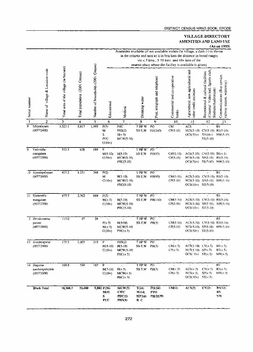
DISTRICT CENSUS HAND BOOK: ERODE
VILLAGE DIRECTORY AMENITIES AND LAND USE
(As on 1999) Amenities available (if not available within the village, a dash (-) is shown
in the column and next to it in brackets the distance in broad ranges
viz.< 5 kms., 5-10 kms. and 10+ krns of the ~ nearest place where the facility is available is given) .,
~ ::l
0 .,
't:I .,.
'd .6 0 --- 0 0:: on :> u ., U " <U OJ 0 ::s
~ U oJ C .d ., ...... <U <U OJ U 0 g 0:: 8 c > a 'u € 'E >: ':;l <U 0 'g "" U N .0 <r:! 0
'-' c. .... "3 0-<U "" U ~ <U 0:1 U) ~ ~ 0
~ 8 '" ~ p. OJ -l :s E 0 .~ ~ 3~~ ::l ....
N 0 6 ~ c:a S Q:l E dd ';' '-' .c 't:I C;S '.:1 '3 .0 .::! '--' "" ~ Q u ~ 0 0 .,. c 0 u o ... on
bO -s 0 '" 0:1 't:I o ._ .., .9 0:: ... ::§ ::l .... ..t:: Q C 15 o!:j 0 P ':;l 0 ~ o:j 't:I .-I))
""' "" .0 fJ' . '" ._ 't:I .~ 0 .0 .;; 0 "3 ..., OJ "" .1j c:; ~ c:a > :> .~ E "" ~ 6h 3'B t:!
a~ u
p. 0 .,. u '(3 ::l ""' ~ 0 .... 0 bO <U .... _ I))
0 '" c 0 1il p. ~ .~ OJ t:! ~
Q) ~ ..... '@ :;:j ;>-. c:a ~
.0 l)
~ § '" ::I U E ::I E '" 3 3 ~ ~ ~~ . ~ b ~ tU ..... 8 ~ ·c - o ~ u .9 'g 0 0 0 'd
.., ·c '" bO..c:: 0:::: Z Z ::E 0 ~S::-ci) U) ..... ..... W 0 Q., U.o -< '0 u ~
2 3 4 5 6 7 8 9 to 11 12 13 8 lchipalayam 1,527.1 5,617 1,593 PO) PHC THPW PO CM ACS BS
(00772400) M PHS(2) SS-T,W PH(240) CP(S-IO) NCS(S-IO) CV(S-IO) RS(5-IO)
S H«S) OCS(IO+) SP(IO+) NW(5-IO) PUC MCW(S-IO) ST(5-10) C(lO+)
9 Yadivulla- 552.3 628 189 P THPW PO mangaiam M(5-1O) H(S-LO) S5-T,W PH(35) CM(5-10) AC5(S-10) CY(S-IO) BS«5) (00772500) C(1O+) MCW(S-IO) CP(S-IO) NCS(S-IO) SP(S-IO) RS(S-IO)
PHC(S-lO) OCS(IO+) ST(S-IO) NW(5-IO)
.0 Ayyampalayam 417.2 l,lSI 348 P(2) THPW PO BS (00772600) M H(5-10) SS-T,W PH(95) CM(5-IO) ACS(5-IO) CV(S-IO) RS(5-10)
C(lO+) MCW(5-10) CP(5-IO) NCS(S-IO) SP(5-10) NW\S-IO) PHC(5-IO) OC5(IO+) ST(5-IO)
11 Elumoothi- 675.7 2,362 664 P(2) TliPW PO BS mangalam M« 5) H(5-10) SS-T,W PHOlO) CM(5-10) ACS(5-IO) CV(5-IO) RS(5-10) (00772700) C(lO+) MCW(S-W) CP(5-1O) NCS(5-10) SP(S-IO) NW(S-IO)
PHC(5-IO) OCS(lO+) ST(5-10)
2 Devakiamma- 113.0 97 24 THPW PO BS puram P«5) H(5'10) SS-T,W PH(3) CM(5-IO) ACS(5-1O) CV(5-10) RS(5-10) (00772800) M« 5) MCW(S-IO) CP(S-IO) NCSrS-IO) SP(5-10) NWrS-IO)
C(lO+) PHC« 5) OCS(IO+) ST(5-IO)
13 A vadayaparai 175.5 I ,DOS 319 P PHS(2) THPW PO (00772900) M(S-IO) H(5-10) 55-T,W PH(3) CM«5) ACS(5-10) CV(d) BS« 5)
C(lO+) MCW(S-to) CP«S) NCS(S-IO) SP«5) RS« 5)
PHC« 5) OCS(10+) ST« 5) NW«,)
14 Nagama- 169.8 580 183 P THPW PO BS
naickenpaiayam M(5-10) H«5) SS-T,W PH(3) CM« 5) ACS« 5) CY«S) RS«5)
(00773000) C(10+) MCW«5) CP« 5) NCS« 5) SP«S) NW«5)
PHC« S) OCS(IO+) ST«5)
Block Total 10,360.3 31,480 9,082 P(36) MCW(3) T(14) PO(l4) CM(2) ACS(3) eV(2) B8(12) M(4) ewe W(14) PTO R8
S PRe(2) HP(14) PII(20J9) NW pve PHS(9) RC
272

VILLAGE DIRECTORY
VILLAGE DIRECTORY AMENITIES AND LAND USE (As on 1999)
<l) OIl
~ .;; 9
..r:: u
"" 0 ... Co Co -< 14
PR MR FP
PR MR FP
PR MR FP
PR MR
PR MR FP
PR MR FP
PR MR FP
PR(14) MR(14) FP(13)
NR
E 5 .., (.) c .:3 '" :a ~ c >. ~ 0. 9 0-
::l ~ Vl
'" .., ... l=a
Q)
~ .., 0 Z 0-
15 16 Vengambur (3) EA
Kodumudi (7) EA
Kodumudi (7) EA
Chennasamudra EA m(J)
Chennasamudra ED m(J) EAG
Kodumudi (4) EA
Kodumudi (3) ED EAG
ED EAG(2) EA(12)
.., c .~ OIl <Q
~ 0) Co
"" Co til
~ ., Z
17 N M
N M
N M
N M
N M
N M
N M
N(14) M(14)
." .., a u ~ ::l § s ~ :a 0
~ 0 u
E .:3 ... 8-.5 .... ~ Vl
'" 0 ::;E
., ... &
18 19
Coconut COiT
0.0
Land use (i.e. area under different types of land use in hectare)
OIl C :a :::s
U
~ g </)
'" ~ >
0 ~ '" ...
"" OIl >. ~ ." e "0 c:
~ ~ "" "§ "" ..0 bIl "" l=a 'E ~ ..c: "" bIl ~ u
$ '2 "3 :::s '" ;:; U tIO
20 21 22 GC(859 . .'I) 409.9 7.0 212.4 W(7.I) WE(31.1) T(897.7)
GC(282.4) 227.5 42.3 T(282.4)
GC(148.2) 220.9 48.0 T(l48.2)
GC(338.9) 280.5 56.3 T(338.9)
GC(S6.0) 50.2 6.7
T(56.0)
GC(100.9) 39.0 27.1 W(I.S) WE(7.0) T(l09.4)
GC(46.8) 4.3 112.8 W(1.4)
WE(4.S) T(52.7)
GC(5028.15) 3,550.4 12.9 1,190.6 W(92.93) WE(485.35) T(5606.43)
273
c 0 -g ;>
'0 :; u ...
<2 <l)
:c '" OJ) ~ ,g .... 8 0)
> ;;: .0 E "" (5
,_ :::s 0 c c .,
" "" E 'r: e co 0)
<t: Z U)
23 2 IchipaJayam 8
Vadivullamangalam 9
Ayyampalayam 10
Elumoothimangalam II
Devakiammapuram 12
Avadayaparai 13
Nagamanaickenpalayam 14

VILLAGE DIRECTORY
VELLAKOIL CD BLOCK
275


/ I
\
E R l!
IV lJ U ~ 1 R
,.J," '.,. '-'-. ( ,755 i
,
. I'
I '. a ' , , f. 1"/' I 1
00776900 I ' - , '
• I © ~ /'1 PO N,lali ' C I '-'1
B I ~ \ , "I
/ 767 \ n S B ,.,..,...· ..... '1 \. POlO I '
~ \' / .: TO,7soo ~ d 1......... '1 I ,
~ , I @po I \Ii ' ' ... ,.,.... J ; ',-._{." ... _r
PANCHAYAT UNIONS (C.D.BLOCKS)
® KANGEYAM
® VELLAKOIL (Part)
© KUNDADAM (Part)
% ) % ! ,'l'~ ,./'.'\j
t' -\ '1 ( o ' ~ I),
\ % R
Panchayat Union (CD.Block) bounaary Bxcludes statutory towns,
E R o lJ
~
T L
, /,742 )
PO
\ \
I
.----·.·1~ ' ..... \
Senapa~ipa~yam.
I ,
I I
I . l '\ . 1
INDIA TAMILNADU
KANGEYAM TALUK ERODE DISTRICT
> <i
i ~i
,
Kilometres
No, of Villages 39
No,ofTowns
PLCN Starting from 00773100
PLCN Ending at
Total Population
00776900
1,96,892
PANCHAYAT UNIONS IC.D.BLOCK) FALLING IN TWOTALUKS
Kilometres Bounda~,Di'ict _ 10010
T'uk_ = CD,BIa<,_
Boundary, District"
Taluk"
Pancliayat Union (C,D,Block) ,
Villages ~th location Code No
TalukHeadquarters '" '" '" ."
Villages having 500-999, 1000·4999 and 5000 & alxive Populalion
Urban Area wilh local ion Code number
Nalional Highway ,
SialeHighway "
Importanl Melalled Road
River and Stream '"
Posl Office /Telegraph Office " Higher Seoondary School , Prrmary Heallh Cenlre , ,
Bank"
I OoTi3fof I
@ . , . ~ ...1!1iE.L. .,2i!_
POliO
S
®


VILLAGE DIRECTORY
Alphabetical list of Villages with Location Code Numbers of 1991 and 2001
Name of the District: Erode
Serial number
2
3
4
5
6
7
8
9
10
11
12
Name of village 2
Kambiliampatti
Lakkumanaickenpatti
Mangalapatti .
Mettupalayam
Patchapalayam
Poomandanvalavu
Rasathi valavu
Senapathipalayaml
Uthamapalayarn
Valliarachal
Veeracholapuram
Velampalayam
Name of Taluk: Dharapuram
13 Puduppai
Name of Taluk: Kangeyam Name of CD Block: Vellakoil
2001 Census location code number
3
00776400
00776300
00774300
00774500
00776000
00774200
00774600
00776200
00776100
00774700
00775900
00774400
1991 Census location code number 4
080060019001900260
080060019001900260
080060019001900100
080060019001900110
080060019001900220
080060019001900100
080060019001900110
080060019001900250
080060019001900230
080060019001900120
080060019001900210
080060019001900100
Name of CD Block: Vellakoil (Part
00777900 080070019001900110
279

DISTRICT CENSUS HAND BOOK: ERODE
VILLAGE DIRECTORY AMENITIES AND LAND USE
(As on 1999) Amenities available (if not available within the village. a dash (-) is shown
in the column and next to it in brackets the distance in broad ranges
viz. < 5 kms., 5-10 kms. and 10+ kms of the ~ nearest place where the facility is available is given) '"
~ :::l
Q) '" c:l -0 .D -0 ~ Q) § '" 0 u '" U Q) -= u Q) :l § u '" c ..c:: '" - Q) Q) -a VJ u 0 C
c:l 8 c ;>
B t:: '> '~ v '" 0 ';:l u >; U N ..c:: '" '" 0 ... .._, 0.. .... -a '+-< 0.. ~ '" u ~ Q) 0 8 '" ..!:! 0.. .::! -a CI)
U> ~ ..J ~ -0 8 0 6h ~ B -=-e ::l ....
~ -0 6 e ~ ~ '> ..c:: -0 ~ 'r:l -a -a '" Q) c:I u ..c:: .~ ~ Q) Q) c '" '" -0 c:I Q) U 0 .... '" OJ) i3 o .~
Q) 9 c tl :§
0 :::l !l ..c:: c " g ~ .52 ci ';:l 0 '" -0 ._
""" '" ..c:: ft ci: ._ -0
<:i .S .D '> 0 co <=3 "i5 >- '" E '3 .... <=3 ~ 50 u § '" c.. 0 c '0 3:.a c "",-< '0 :::l ....
~ 0 t 0 OJ) '" .... ~ Q) 0 ell C 0 0. ';:l ';;J c:I ] Q) -a .... ';:l E ] ::l ;>.,
"i5 Q) .c '" .::! ~ ~ '" u '" ~ OJ
~ 3 3 e u .~ t> Q) Q) ._
~ ·c -0 ~ .... c:I -0 :::l '" o~ u Q) 0 0 ::l -0 '~ ·c 0 bJl ..c:: OJ
._ '" 0 ~ en Z f-< E-- Z Ul Q 0.. uE « (5 cG u ~ u ~ en
2 3 4 5 6 7 8 9 10 11 12 13 CD Block: Vellakoil (0016)
Poomandanvalasu 1,043.0 1,716 SOl P PHS HPW PO ACS BS (00774200) M« 5) H(S-IO) SS-W,HP PH(6S) CM(S-IO) NCS(S-IO) CV(S-IO) RS(lO+)
C(S-IO) MCW«S) CP(S-IO) OCS(S-IO) SP(lO+) NW(10+) PHC(S-IO) ST(lO+!
2 Mangalappalli 1.007.1 3,298 980 P(3) PHS HPW PO BS (00774300) M H(10+) SS-W.HP PH(75) CM(5-10) ACS« 5) CV(5-10) RS(lO+l
C(lO+) MCW« 5) CP(IO+) NCS(10+) SP(lO+) NW(lO+) PHC(lO+) OCS(lO+) ST(lO+)
3 Vellampalayam 969.8 3,967 1,154 P(5) CWC THPW PH(l70) CM IlS (00774400) M« S) H«S) SS-T.W PO«S) CP«S) ACS« S) CV« S) RS(!O+l
C(S-IO) MCW«S) NCS«5) SP(lO+) NW(lO+) PHC« S) OCS(lO+) ST(IO+!
4 Mettupalayam 1.784.3 S,927 1.772 peS) CWC THPW PO CM ACS BS (00774SOO) M PHS SS-T,W PH(l61) CP(S-IO) NCS(5-10) CV(5-10) RS(10+)
C(S-IO) H(5-10) OCS(S-IO) SP(W+) NW(IO+)
MCW(S-W) ST(lO+) PHC« 5)
5 Rasathavalasu 1.828.8 2,684 773 P(3) MeW THP PH(200) BS (00774600) M H(S-IO) SS-T,HP PO(S-IO) CM(5-10) ACS(5-10) CV(5-10) RS(lO+)
C(5-1O) PHC(5-10) CP(5-10) NCS(5-10) SP(10+) NW(lO+) OCS(5-10) ST(lO+)
6 Valliarachal 2.075.1 4,157 1,225 P(6) PHS THPW PH(200) ACS BS
(00774700) M H(S-IO) SS-T,W PO«S) CM(5-10) NCS(5-10) CV(5-10) RS(!O+)
C MCW«5) CP(5-10) OCS(5-10) SP(IO+) NW(IO+)
PHC(S-IO) ST(lO+l
7 Veeracholapuram 1.909.7 1,877 542 P(3) CWC THPR PO ACS BS (0077S9OO) M PHS SS-T.HP PH(l50) CM(lO+i NCS(lO+) CV(10+) RS(IO+)
C(5-1O) H(lO+) CP(10+) OCS(10+) SP(10+) NW(10+) MCW(IO+) ST(lO+)
PHC(IO+)
280

VILLAGE DIRECTORY
VILLAGE DIRECTORY AMENITIES AND LAND USE (As on 1999)
Laud use (i.e. area under
different types of land use in hectare) "C:l
~ J1
~ ~ Q § 0
8 '0 rt g 0 00 >
Q '0 Q) :a :a '3 u
~ Q Q) ::l U
S Q <] ... I!.l .~
,..... Q ~ ..8 on '" Q) .~ '"
:§ :a 0 ~
~ .., <U on U ~
;> :c ., ciCl os
~ 0 00 .;;
~ 0 '" 50 rt .::;- '" os '8 :§ ....
Q II) g ~ Po. >. ~ "C:l .;; .0
9 g- <I) 0 e "C:l ~
;> S ..<:I §< Po. ~ ~ rt
al ';i; '" .9 "C:l rt .0 .... ""' ::I Po.
~ on os lil 0 0 Q 0 <I) ....
~ Q .... <I) til .... '" os :§ 3..<:1 <I) c:; Po. ~ ~ ~ til
~ 00 ~ u os ~ ·c Po. ~ 0 <I) 0
] Q "3 ::l <I)
<: z ~ 0 OJ .... Z
<I) p.., Il< :::> U I;)i) <: V)
14 15 16 17 18 19 20 21 22 23 2
MR Muthur(B) EA N Bedsheets OC(402.6) 2B.7 590.2 Poomandan valasu FP M W(6.0)
WE(15.4) T(424.0)
MR Muthur(6) EA N Coconut Coif OC(572.5) 30.5 302.0 1.1 Mangalappalli 2
FP M W(21.0) WE(80.0) T(673.S)
PR Muthur(3) EA N Oroundnut OC(589.2) 14.9 290.9 Vellampalayam 3 MR M oil, W(4.0) FP Bedsheets, WE(70.9)
Coconut oil T(664.1)
PR Vellakovil (6) EA N Bedsheets OC(494.6) 241.2 1.031.4 Mettupalayam 4
MR M WE(S.I) FP TWE(12.0)
T(SI!.7)
PR Muthur(7) EA N Bedsheets, OC(53i.8) 235.3 1,020.6 Rasathavalasu 5
MR M Yam W(9.l) FP WE(32.1)
T(S73.0)
PR Mathur (6) EA N Cloth, 0C(88.8) 113.9 1,572.3 Valliarachal 6
MR M Bedsheets, W(1l5.1) FP Towels WE(185.0)
T(38S.9}
PR Vellakovil (IS) EA N Yam 0C(43.2) 465.0 1,311.0 Veeracholapuram 7
MR M W(lS.2)
FP WE(72.4) T(133.8)
281

2 Pachapalayam (00776000)
3 5,011.4
9 Uthammapalayam 1,760.9 (00776100)
10 Senapathipalayam (00776200)
: I Lakkammanaickenpatti (00776300)
12 Kambiliampatti (00776400)
13 Pudupai (00777900)
Block Total
4,576.0
1,760.9
2,380.4
910.2
27,017.6
4 5,111
4,600
6,323
3,972
2,420
2,464
48,516
5 1,477
6 P(7) M C(5-10)
1,330 P(4)
1,758
1,117
736
M S C(5-10)
P(7) M C
P(2) M(2) C(lO+)
P(4) M C(lO+)
747 P(2) M C(5-1O)
14,112 P(52) M(12) S C(2)
DISTRICT CENSUS HAND BOOK: ERODE
VILLAGE DIRECTORY AMENITIES AND LAND USE
(As on 1999) Amenities available (if not available within the village, a dash (-) is shown
in the column and next to it in brackets the distance in broad ranges viz.< 5 kms., 5-10 kms. and 10+ kms of the
nearest place where the facility is available is given)
7 CWC(2) PHS H(5-10) MCW(5-to) PHC(5-to)
MCW PHS H(5-10) PHC(5-IO)
H CWC PHS MCW« 5) PHC« 5)
PHS H(10+) MCW(lO+) PHC(lO+)
MCW CWC(2) H(lO+) PHC(to+)
MCW PHS H«5) PHC(5-1O)
H MCW(4) CWC(S) PHS(10)
282
8 9 THP PO SS-T,HP PH(265)
THPW PO(2) R PH(l50) SS-T,W
THPW PO R PH(285) SS-T,W
THPW PO R PH(79) SS-T,W
THPR PO SS-T,HP PH(l20)
THPW PO R PH(lSO) SS-T,W
T(ll)
W(9) HP(13) R(6)
P0(11) PH(2070)
10 11 12 13 ACS BS
CM(5-IO) NCS(5-IO) CV(5-10) RS(IO+) CP(5-10) OCS(5-10) SP(lO+) NW(IO+)
CM CP
CM(<5) CP«5)
CM« 5)
CP(lO+)
CM(5-IO) CP(lO+)
ST(10+)
ACS BS NCS(5-10) CV(5-IO) RS(lO+) OCS(5-10) SP(lO+) NW(10+)
ST(10+)
ACS NCS« 5)
OCS« 5)
ACS
BS CV« 5) RS(IO+) SP(lO+) NW(10+) ST(lO+)
BS NCS(lO+) CV(IO+) RS(10+) OCS(lO+) SP(IO+) NW(lO+)
ST(lO+)
ACS BS NCS(10+) CV(10+) RS(10+) OCS(lO+) SP(lO+) NW(lO+)
ST(10+)
ACS BS CM(5-10) NCS CV(5-IO) RS(10+) CP(5-10) OCS(10+) SP(10+) NW(10+)
CM(3) CP
ACS(10) NCS
ST(IO+)
BS(13)

VILLAGE DIRECTORY
VILLAGE DIRECTORY AMENITIES AND LAND USE (As on 1999)
oU OJ)
~ .:; 9 .c ~ 0 ... r::>.. r::>.. -< 14
PR MR
FP
PR MR FP
PR MR FP
PR MR FP
PR MR FP
PR !\!R FP
PR(l1) MR(13) FP(13)
] 5
oU u = £3 CIl :.a ~ c:: ..._ ~ -a 9 Q. ::s ~ CIl CIl ... oU oU t::l ~ oU 0 z j;l.,
15 16 Vellakovil ( I 0) EA
Vellakoi1 (8) EA
Vellakoil (2) EA
Vellakovil (12) EA
Vellakovil (18) EA
Vellakoil (10) EA
EA(13)
N M
N M
N M
N M
N M
N M
.., = .~ OJ) CII
~ oU Q. CII r::>.. ."
~ .., z 17
N(t3)
M(13)
"0
M u ~ ::s = ell 8 c :0 0
§ 0 u
§ t: 0 Q.
.§ ... CIl 0
::E 18
Oil, Yam
Textile, Bedsheets, Yam
Bedsheet,
Lungies
Bedsheet
Yam
Bedsheet
~ .~ 19
I).b
Land use (i.e. area under
different types of land use in hectare)
OJ) c:: :.a ::s U
0' g CIl lJ oU a J!O > 0 '" ~ on CII ..._ ~
-0 -0 ,.0 c:: "-' ~ <!)
~ o:s
-0 t::l J!O btl a o:s :§ .c OJ) u
] = '3 ::s o:s ;:J U OJ)
20 21 22 GC(43.1) 696.2 3,865.4 7.9 W(93.6) WE(30S.1) T(441.8)
W(,15.1l 285.4 1,317.4 18.0 WE(11.'i.I) i(140.2)
GC(6.9) 411.4 3,998.1 0.1 W(34.2) WE(90.5) R(34.8) T(l66.4)
W(25.1) 285.4 1,317.4 18.0 WE(115.l) T(140.2)
W(l2.0) 145.8 1,982.0 WE(lOI.l) R(l39.4)
T(252.S)
W(8.0) 120.0 443.2 116.0 WE(lIO.Q)
R(113.0) , T(231.0)
GC(2772.61} 3,073.5 19,041.8 161.1
W(371.39) WE(1297.89) TWE(12.00) R(287.19) T(4741.08)
283
= 0 .~
.~ '3 lJ ...
<2 .., :0 <!)
OJ OJ)
~ ~ .... oU
> .;; ,.0
E r:I "- ::s (5 0 0;::
t:l <!)
~ o:s § .., ... '" -< Z <Zl
23 2 Pachapal a yarn 8
Utharnrnapal ayam Q
Senapathipalayam 10
Lakkammanaickenpatti II
Kambiliampatti 12
Pudupai 13


VILLAGE DIRECTORY
KANGEYAM CD BLOCK
285


VILLAGE DIRECTORY
Alphabetical list of Villages with Location Code Numbers of 1991 and 2001
Name of the District: Erode Name of Taluk: Kangeyam Name of CD Block: Kangeyam
Serial 2001 Census location code nUmber Name of village number 1991 Census location code number
1 2 3 4
Alambadi 00774900 080060016001600140
2 GanapathipaJayam 00773200 080060016001600020
3 Kadaiyur 00775600 080060016001600190
4 Kathanganni 00773100 080060016001600010
. 5 Keeranur 00775000 080060016001600150
6 KeetapaIayam 00774100 080060016001600080
7 Maravapalayam 00773400 080060016001600040
8 Marudurai 00773700 080060016001600060
9 Mullipuram 00773900 080060016001600070
10 Naalroad 00773600 080060016001600050
'11 Nathakadaiyur 00773800 080060016001600070
12 Padiyur 00775200 080060016001600170
13 PaIayakottai 00774000 080060016001600080
14 Pappini 00774800 080060016001600130
15 PeranjervaIi 00773500 080060016001600050
16 Sivanmalai 00775100 080060016001600160
17 ThammareddipaJayam 00773300 080060016001600030
18 Vattamalai 00775700 080060016001600190
19 Veeranampalayam 00775800 080060016001600200
287
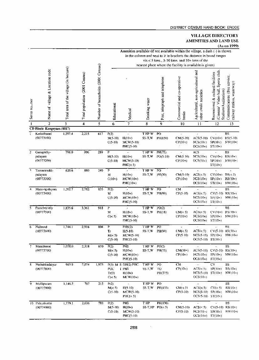
DISTRICT CENSUS HAND BOOK: ERODE
VILLAGE DIRECTORY AMENITIES AND LAND USE
(As on 1999)
Amenities available (if not available within the village, a dash (-) is shown
in the column and next to it in brackets the distance in broad ranges
viz.< 5 kms., 5-10 kms. and 10+ kms of the ,......
nearest place where the facility is available is given) '" 0- '" <l.) '" £3 ~ "0 ..0 "0 ,...... <l.) '" 0 ~ '" u '" U '"" .,
u <l.) '" ~ u ~ c ..d '" - <l.) <l.) ';:3 u ~ :3 c > t! 0 g ., 0 .~ a ·u .;;
. .:l >. '""
u ~ ..d ~ 0 ... 0- ... "S 0- .,
'"" <.) <l.) <l.) U) en 0 bI) 0 '" <l.) 0. u ';:3 en ~
,_J ~ 0 "0 11 0 .~ ~ a ........I-..~ .... Oi!! N "0 6 c;I E ro ~ .;; --- ..c "0 u ,.,; .~ "S ..c '" '-' c-:I <l.) <l.) ~ d 0 ·c U) ~ <l.) C til "0 u 0 bI) -s 0 '" ... ~
o .~ ., o c d Q:i ~ . .:l 0 ~ ..c o:l ~ g Oi!! "0 ~ .g ..... o:l ..c g. 71: ;; .~
~ .;; 0 "3 .... -a ~ ';:3 c; :::; n
13 :1 o:l 0. 0 d 50 ·u s:a c <t: .~ ..... I.) 0 ... 0 bI) I.) ..... ~ I.) 0 "(;J a C '" c 0 til 0-., . .:l -a c 11 I.) - .... ..:l 8 :::; >-c:; <l.) ..0 '" OJ
~ § :::; u ,.,;
'"" "§ "§ '" .~ t ., .,.= § ;:: ~ § u :a ~ .;.: ... C "0 ~ :::;
'" ~ 5o-s u <l.) 0 0 "0
., ·c 0 0 ., ._ ~ 0 ~ U) Z E- E- Z w :::E 0 P.. U '"" <t: 0 0:: S:!.c/lU ..0 ...
2 3 4 5 6 7 8 9 10 11 12 13 CD Block: Kangeyam (0017)
Kathaikanni 1,297.4 2,215 617 P(2) THPW PO BS (00773100) M(5-10) H(10+) SS-T,W PH(150) CM(5-10) ACS(5-10) CY(IO+) RS(S-IO)
C(S-10) MCW(S-IO) CP(lO+) NCS(IO+) SP(IO+) NW(lO+)
PHC(5-10) OCS(IO+) ST(10+)
2 Ganapathy- 798.0 996 289 P THPW PH(75) ACS BS palayam M(S-JO) H(IO+) SS-T,W PO(S-IO) CM(5-10) NCS(10+) CY(lO+) RS(lO+) (00773200) C(S-IO) MCW(S-JO) CP(lO+) OCS(10+) SP(lO+) NW(10+)
PHC« 5) ST(lO+)
Tammareddi- 620.6 880 240 P THPW PO palayam M H(10+) SS-T,W PH(30) CM(5-1O) ACS«5) CY(10+) BS« 5) (00773300) C(10+) MCW(lO+) CP(lO+) NCS(lO+) SP(lO+) RS(10+)
PHC(10+) OCS(10+) ST(IO+) NW(10+)
4 Maravapalayam 1,202.7 2,782 835 P(2) THPW PO CM BS (00773400) M H(IO+) SS-T,W PH(80) CP(5-IO) ACS«5) CY(S-IO) RS(IO+)
C(5-10) MCW(lO+) NCS(10+) SP(10+) NW(IO+)
PHC(5-10) OCS(10+) ST(lO+)
S Pamchervaly 1,835.6 3,361 918 P THPW PO(2) BS (00773500) M H(1O+) SS-T,W PH(18) CM« 5) ACS«5) CY(IO+) RS(lO+)
C«5) MCW(IO+) CP(lO+) NCS(lO+) SP(IO+) NW(10+)
PHce5-IO) OCS(10+) ST(10+)
6 Nallroad 1,744.1 2,916 804 P PHS(2) THPW PO BS
(00773600) Tr H(5-10) SS-T,W PH(90) CM« S) ACS« 5) CY(S-IO) RS(lO+)
M«5) MCW(S-IO) CP(5-10) NCS(S-IO) SP(10+) NW(10+)
C(5-10) PHce5-IO) OCS(S-IO) ST(lO+)
7 Manideerai 1,078.0 2,318 670 P(2) PHS THPW PO(2) BS (00773700) M«5) H(lO+) SS-T,W PH(75) CM(lO+) ACS(5-10) CY(S-IO) RS(lO+)
C(5-10) MCW(10+) CP(lO+) NCS (I 0+) SP(IO+) NW(10+)
PHC(5-10) OCS(10+) ST(lO+)
8 N athakkadai yur 963.9 7,074 1,973 P(3) M S OH(2) PHC THPW PO CM CY BS
(00773800) PUC I PHS SS-T,W TO CP(lO+) ACS« S) SP(10+) RS(lO+)
Tr(3) H(10+) PH(375) NCS(S-IO) ST(lO+) NW(lO+)
C«5) MCW(lO+) OCS(lO+)
9 Mullipuram 1.146.3 767 215 P(2) THPW PO BS
(00773900) M(d) H(5-10) SS-T,W PH(133) CM«S) ACS« 5) CY«S) RS(lO+) C(S-IO) MCW(5-1O) CP(S-IO) NCS(5-10) SP(lO+) NW(lO+)
PHC(d) OCS(S-10) ST(10+)
10 Palayakottai 1,779.1 2.636 783 P(2) PHS THP PH(190) BS (00774000) M(5-1O) HOO+) SS-T,HP PO«5) CM(5-10) ACS«5) CY(5-10) RS(IO+)
C(5-IO) MCW(S-IO) CP(S-IO) NCS(lO+) SP(IO+) NW(lO+)
PHC(S-IO) OCS(10+) ST(lO+)
288
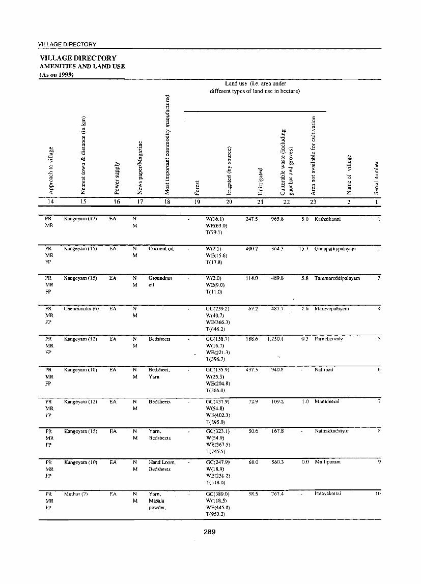
VILLAGE DIRECTORY
VILLAGE DIRECTORY AMENITIES AND LAND USE (As on 1999)
14
PR MR
PR MR FP
PR MR FP
PR MR FP
PR MR FP
PR MR FP
PR MR FP
PR MR FP
PR MR FP
PR MR FP
IS
Kangeyam (17)
Kangeyam (15)
Kangeyam (15)
ChennimaJai (6)
Kangeyam (12)
Kangeyam ( I 0)
Kangeyam (12)
Kangeyam (15)
Kangeyam ( I 0)
Muthur(7)
16
EA
EA
EA
EA
EA
EA
EA
EA
EA
EA
N M
N M
N M
N M
N M
17
N M
N M
N M
N M
N M
o
1 (.)
~ p..
.§
18
Coconut oil
Groundnut oil
Bedsheets
Bedsheet.
Yam
Bedsheets
Yarn, Bedsheets
Hand Loom. Bedsheets
Yarn, Masala powder.
19
Land use (i.e. area under different types of land use in hectare)
20
W(16.1) WE(63.0) T(79.1)
21
247.5
22
965.8
23 2
5.0 Kathaikanni
W(2.1) WE(1s.6) T(l7.8)
400.2 364.3 15.7 Ganapathypalayam
W(2.0) WE(9.0) TOl.O)
GC(239.2) W(40.7) WE(366.3) T(646.2)
GC(ls8.7) W(l6.7) WE(221.3) T(396.7)
GC(13S.9)
W(25.3) WE(204.8) T(366.0)
GC(437.9) W(S4.8) WE(402.3) T(895.0)
GC(323.1) W(54.9) WE(367.5) T(745.5)
GC{247.9) W(18.9) WE(25 1.2) T(518.0)
GC(389.0) W(l18.5) WE(445.8) T(953.2)
289
114.0 489.8
67.2 487.7
188.6 1.250.1
437.3 940.8
72.9 109.2
50.6 167.8
68.0 560.3
58.5 767.4
5.8 TammareddipaJayam
1.6 Maravapalayam
0.3 Pamchervaly
Nallroad
1.0 Manideerai
Nathakkadaiyur
0.0 Mullipuram
Palayakottai
... '" ..0 S ::l
'" ] .... '" (/)
2
3
4
5
6
7
8
9
10

t .Q
E ::s c
'" "0 o <J C o .~
g .....J o<!
'" ~ ·s ..... o
'" § Z
2 I I Kuttapalayam
(00774100)
12 Pappini (00774800)
13 Alambadi (00774900)
14 Keeranur (00775000)
15 Sivanmalai (00775100)
16 Padlyur (00775200)
17 Kadaiyur (00775600)
18 Vattamali (00775700)
19 Veranampalayam (00775800)
Block Total
3 1,752.6
3,321.8
1,281.9
1,825.3
4,094.3
1,127.7
1,689.0
1.714.7
3,458.9
32,731.9
T u ..... 8 ~
4 3,693
4,195
2,968
2,722
7,135
1,922
3,480
1,974
2,999
57,033
5 1,073
1,288
842
784
6 P(2) M C(S-IO)
P(7) M(2) S C« 5)
P(2) M(S-IO) C(S-IO)
P(3) M Ci5-10)
2,076 P(6)
534
993
545
858
M C(S-IO)
P(2) M 5 I C(lO+)
peS) M 5 C(10+)
P(2) M(2) C(S-IO)
P(6) M C(5-IO)
16,337 P(S2)
M(14)
5(4)
PUC 1(2) TJ:(4)
DISTRICT CENSUS HAND BOOK: ERODE
VILLAGE DIRECTORY AMENITIES AND LAND USE
(As on 1999) Amenities available (if not available within the village, a dash (-) is shown
in the column and next to it in brackets the distance in broad ranges viz.< 5 kms., 5-10 kms. and 10+ kms of the
nearest place where the facility is available is given)
7
H(lO+) MCW(IO+) PHC«S)
PHC PHS H(d) MCW«5)
CWC PHS H(S-IO) MCW(IO+) PHC(lO+)
PHC PHS H(10+) MCW(IO+)
MCW PHC PHS H(5-10)
PH5 H(5-10) MCW(10+) PHC(IO+)
Mew PHS H«5) PHC« 5)
H(5-1O) MCW(IO+) PHC«S)
PHS H«5) MCW«5) PHC« 5)
DH(2) MCW(2) ewe PHC(4) PHS(12)
, 290
8 9 THPW PO SS-T,W PH(60)
THPW PO S5-T,W PH(ln)
THPW PO 55-T,W PH(7S)
THP PO S5-T,HP PH(82)
THPW PO SS-T.W PH(4oo)
THPW PO 55-T.W TO
PH(7S)
THPW PO SS-T,W PH(85)
THPW PO(2) 5S-T,W PH(200)
THPW PO 5S-T,W PH(50)
T(19) W(17)
1IP(l9)
PO(20) TO(2) PH(2415)
10
CM«5) CP(lO+)
CP CM«S)
11 12 13 BS
ACS«S) CV«5) RS(lO+) NCS(lO+) SP(IO+) NW(lO+) OCS(lO+) ST(10+)
ACS NCS« 5)
OCS« 5)
BS CV« 5) RS(lO+) SP(10+) NW(10+) ST(10+)
BS CM(S-IO) ACS(5-1O) CV(S-IO) RS(lO+) CP(S-IO) NCS(5-10) SP(IO+) NW(lO+)
OC5(5-10) 5T(10+)
ACS BS CM(S-IO) NC5(10+) CV(lO+) RS(10+) CP(lO+) OCS(lO+) SP(lO+) NW(lO+)
CM CP(S-IO)
CM CP(lO+)
CM CP« 5)
ST(10+)
ACS BS NCS(S-IO) CV(S-Io) RS(10+) OCS(5-IO) 5p(IO+) NW(lO+)
5T(10+)
BS ACS(5-10) CV(S-lO) RS(10+) NCS(5-IO) SP(lO+) NW(lO+) OCS(lO+) ST(IO+)
ACS NCS« 5) OCS« 5)
BS CV« 5) RS(IO+) SP« 5) NW(10+) ST«5)
BS CM(5-1O) ACS(5-IO) CV(5-1O) RS(IO+) CP(S-IO) NCS(5-IO) SP(10+) NW(10+)
OCS(5-10) ST(IO+)
CM« 5} ACS«.5) CV« 5) 8S« 5) CP« 5) NCS« 5) SP« 5} R5(IO+)
OCS« 5) ST« 5) NW(IO+)
CM(S)
CP ACS(S) CV BS(17)

VILLAGE DIRECTORY
VILLAGE DIRECTORY AMENITIES AND LAND USE (As on 1999)
Land use (i.e. area under
different types of land use in hectare)
"" <) a ~
~ :::l
'" § 0
s ''::
" g c OJ) .~ c <) 'i3 :a :; l) 0 ::l l) C .,
§ E '" U .... 0 '" .~ 0- .8 ~ ..8 OJ) :.e 0
~ ~ ., (lJ
~ OJ) u 2:l > ::c 0.)
o<:l " t:i 0 bI) ;; ~
0 '" 5h .E;! >, ~ '" c-:J '" .... e: '8 " g ~ Q. >. ~ "0 .:;: ..0
~ .,
0 ..c "" '" > 8 .c g ~ 0- '-' 2:l 0 " u :::l ::c '" '- ::l
" ~ '" C- .5 't:I c-:J '" f;l
0 0 c:: 2:l OJ) 0
~ ....
'" til 'f 3 .c Cl 0.)
~ .... <)
~ .. 0:1
" ~ 0- ;$ ., ., t>o
_ u
0- I\) 0 ., 0 ....
] 'c -a ::l (lJ :;:; :::E 0 '"
.... -< z (l., z ~ ;:J u OJ) -< z C/)
14 15 16 17 18 19 20 21 22 23 2 PR Kangeyam (18) EA N Paper cone, GC(658.7) 46.0 365.4 Kuttapalayam 11 MR M Mat, Khadi W(47.8) FP Yam WE(634.7)
T(1341.1)
PR Kangeyam (4) EA N Coconut oil, GC(69.7) 383.2 2.581.7 32.5 Pappini 12
MR M Bedsheets. W(l7.8) FP Khadi Yam WE(2369)
T(324.4)
PR Kangeyam (6) EA N Coconut oil GC(l4.3) 220.0 991.6 Alambadi 13 MR M W(4.5) FP WE(51.6)
T(70.4)
PR Kangeyam ( I 2) EA N GC(1.8) 159.8 1,609.4 25.0 Keeranm 14 MR M W(5.6) FP WE(23.8)
T(31.2)
PR Kangeyam (5) EA N Coconut oil 21.6 GC(587) 671.8 3,036.6 74.0 Sivanmalai I)
MR M W(46.3) WE(l85.2) T(290.3)
PR Kangeyam (10) EA N Coconut W(S.9) 456.7 597.2 Padiyur 16
MR M WE(67.9) T(73.8)
PR Kangeyam (4) EA N Yarn, W(5,7) 354.6 1.155.9 35.4 Kadaiyur 17
MR M WE(l37.4) T(l43.1)
PR Kangeyam (5) EA N W(17.4) 524.2 1,114.8 Vattamali IR
MR M WE(58.3) T(75.7)
PR Kangeyam (4 ) EA N W(37.7) 348.6 2,959.5 Veranampalayam I<J
MR M WE(113.0)
FP T(lSO.7)
PR(19) EA(19) N(19) 21.6 GC(2734.85) 4,869,7 20,515,2 196,2
MR(l9) M(19) W(538,77) FP(l4) WE(J855,58)
T(7129.20)
291


VILLAGE DIRECTORY
KUNDADAM CD BLOCK
293


No. of Villages 62
No. ofT owns 6
PLCN Starting from 00777000
PLCN Ending at
Total Population
PANCHAYAT UNIONS (C.D.BLOCKS)
@ KUNDADAM (Part)
@ DHARAPURAM
© VELLAKOIL (Part)
@ MULANUR
Panch!)'!1 Union (C.D.Block) boundary excludes slalulory lowns
PALANITALUK DINDIGUL DISTRICT
Boundary, District ...
Taluk .... "
" Panchayal Union (CD Block) .
Villages wilh localion Code No
ReseNed Foresl wilh Name ",
Taluk Headquarters ".
Villa~es having 200 . 499, 500·999, 100 ·4999 and 5000 & above populalion
Urban Area with location Code number .
c
1 A V
.625 PO.B
Ponn.adi , I
\) A N C ~
Siale Highway ..
[!OI7I@] Importanl Metalltl:l Road .
::: Ga~~pal~~ Rf:: River and Stream ",
@ Posl Office I Telegraph Office ". Higher Secondary School .... Primary Hea~h Centre ".
~ Bank ...
K
, o
I o
( o
) I
i/->
INDIA TAMILNADU
DHARAPURAM TALUK ERODE DISTRICT
~ _J.--
~
porro
S: @:
Kilometres
--
PANCHAYAT UNIONS (C.D.BLOCK) FAlliNG IN TWO TALUKS
Kilom~res Boulldar'/,Dlst~ct _ 10 0 10
Talllk - ccc-___:__:] CO.8Ock_


VILLAGE DIRECTORY
Alphabetical list ofViUages with Location Code Numbers of1991 and 2001
Name of the District: Erode
Serial number Name of village
2
Aratholuvu
2 Kangayampalayam
3 Kurukkapalayam
4 Mudalipalayam{
5 Nelali
6 Sembandampalayam
7 Uthiyur
8 Vadasinnaripalayam
Name of Taluk: pharapuram
9 Bellampatti
10 Ergarnpatti
II Gathelrev
12 J othiampatti
13 Kannankoil
14 Kasilingapalayam
15 Kokkampalayam
16 Kolumangali
17 Manurpalayam
18 Marudur
19 Molarapatti
20 Muthiampatti
21 Nandavanampalayam
22 Navanari
23 Periyakumarapalayam
24 Ponganthurai
25 Sankarandampalayam
26 Sirukinar
27 Surianallur
28 Vadugapalayam
29 Velayudhampalayam
Name of TaJuk: Kangeyam Name of CD Block: Kundadam
2001 Census location code number
3
00776500
00775300
00776800
00776600
00776900
00775500
00776700
00775400
1991 Census location code number 4
080060020002000270
080060020002000180
080060020002000300
080060020002000280
080060020002000310
080060020002000180
080060020002000290
080060020002000180
Name of CD Block: Kundadam (Part)
00781100 080070020002000370
00780300 080070020002000310
00780100' 080070020002000290
00777100. 080070020002000020
00779700 080070020002000270
00780600 080070020002000320
00777000 080070020002000010
00777300, 080070020002000050
00780400. 080070020002000310
00781200 080070020002000380
00781500 080070020002000400
00780700 080070020002000330
00780500 080070020002000320
00780900 080070020002000350
00780800 080070020002000340
00777500 080070020002000070
00779500 080070020002000260
00777400 080070020002000060
00777200 080070020002000040
00779600- 080070020002000260
00780200 080070020001000300
297
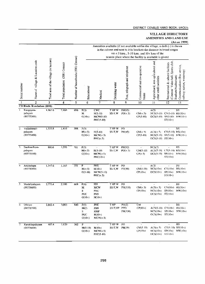
DISTRICT CENSUS HAND BOOK: ERODE
VILLAGE DIRECTORY AMENITIES AND LAND USE
(As on 1999)
Amenities available (if not available within the village, a dash (-) is shown in the column and next to it in brackets the distance in broad ranges
viz.< 5 kms., 5-10 kms. and 10+ kms of the r-. nearest place where the facility is available is given) '" OJ :::l .., '" 13 c:
" .0 " ~ ..,
V> 0 U '" U c <l) :::l
u .., :::l "" ;g u oS C ..0 '" - .., <l) -;:;
'" u = 0 c .:': 0 .g .., a T, '> .~ 0 0 '" ,_
~ u ~ ..c ,.s 0 ,_ ,_ "5 0- ~ u .., 0. .., rt
0 btl 8 '" ..,
0.. U -;:; U)
'" ~ ,_J ~ " '§ 0 .'~ en ,_
:;:fs :::l
~ '0 6 B e B o(j .s: ..0 " ~ .~ "5 .c .::! "" <U = U , ..... ~ .., .., = '" cd " = OJ U 0
,_ '" btl .s 0 :::l .... = o ._
o(j .., .9 c d ,_
~ '<:j 0 !!l .c '"
c: g " ._ 0 .., ..... '" .c ~ . '" ._ " '<:j 0 .0 .s: 0 "5 ~ '" C'iI c:3 .~ -;:; > :::l '" .~ S ..... i:l: 6b = u
"" C. 0 c: 'u 3" 03< '2 :::l ..... ~ 0 .... 0 bO .., .... ..... <I) 0 '" e 0 c. .., '<:j Cil = '§ .., - .... '<:j
8 ~ ::l >. -;:; .., ,c '" u ~ ~ '"
;:l u '" S "" ~ '5 '5 § u :0 u .... .., .., ._ ~ ·c ...s
.~ .e .... e " S :;)
'" o ~ u .., 0 0 " <I) ·c 0 .., ._ "" 0 '0; U) Z I:-< I:-< Z ILl ;:::,s Q p... u.2 < 0 ~
U ..... U ~ CI) ....
2 3 4 5 6 7 8 9 10 11 12 13 CD Block: Kundadam (0018)
I Kangayam- 1,062.6 2,460 696 P(2) CWC THPW PH(65) ACS BS palayam M H(5~10) SS-T,W PO« 5) CM« 5) NCS(5-10) CY(5-10) RS(lO+) (00775300) C(10+) MCW(S-IO) CP(S-IO) OCS(S-IO) SP(S-IO) NW(lO+)
PHC(S-lO) ST(lO+)
2 Yadasinnari- 1,533.8 1,410 39& P(3) THPW PO BS palayam M«S) H(S-IO) SS-T,W PH(4S) CM(<5) ACS« 5) CY(5-10) RS(IO+) (00775400) C(lO+) MCW« 5) CP(5-10) NCS(S-IO) SP(S-IO) NW(lO+)
PHC« S) OCS(S-IO) ST(lO+)
3 Sambandham- 880.6 1,020 301 P(3) THPW PH(92) NCS(2) BS palayam M«S) H(5-10) SS-T,W PO« 5) CM(5-1O) ACS(5-10) CY(S-IO) RS(IO+) (00775500) C(lO+) MCW«S) CP« 5) OCS(5-10) SP(lO+) NW(lO+)
PHC(lO+) ST(10+)
4 Arutholugu 1,347.6 1,165 351 P PHS THPW PO ACS BS (00776500) M«5) H(lO+) SS-T,W PH(SO) CM(5-1O) NCS(lO+) CY(lO+) RS(IO+)
C(5-1O) MCW(S-IO) CP(10+) OCS(lO+) SP(10+) NW(lO+)
PHC«S) ST(lO+)
5 Mudalipalayam 2,771.4 2,100 669 P(4) HH THPW PO BS (00776600) M MeW 5S-T,W PH(310) CM« 5) ACS« 5) CY(lO+) RS(10+)
S PHC CP(IO+) NCS(lO+) SP(lO+) NW(lO+)
PUC PHS OCS(lO+) ST(lO+)
C(lO+) H(IO+)
6 Uthiyur 2,862.4 3,003 840 peS) PHi':' THP PO(2) CM BS
(00776700) M(2) PHS SS-T,HP PTO CP(IO+) ACS(5-tO) CY(10+) RS(lO+)
S RMP PH(330) NCS(tO+) SP(tO+) NW(lO+)
PUC H(lO+) OCS(tO+) ST(lO+)
C(lO+) MCW«5)
7 Kurukkapalayam 467.4 1,120 362 P THPW PO BS
(00776800) M(5-tO) H(lO+) SS-T,W PH(39) CM(S-IO) ACS« 5) CY(S-IO) RS(10+)
C(lO+) MCW«5) CP(IO+) NCS(IO+) SP(lO+) NW(lO+)
PHC(5-10) OCS(IO+) ST(10+)
298

VILLAGE DIRECTORY
VILLAGE DIRECTORY AMENITIES AND LAND USE (As on 1999)
14
PR MR FP
PR MR FP
PR MR FP
PR MR FP
PR MR FP
PR MR
PR MR FP
15 16
Kangeyam (7) EA
Kangeyarn (7) EA
Kangeyarn (10) EA
Kangeyarn (12) EA
Kangeyarn (15) EA
Kangeyam (15) EA
Kangeyam (12) EA
17
N M
N
M
N M
N M
N M
N M
N M
18 19
Yam
Explosives 28.6
Explosives 339.6
Land use (I.e. area under different types of land use in hectare)
20
W(86.2)
WE(l47.6) T(233.9)
W(36.8) WE(76.4) T(113.2)
Ge(133.0) W(15.2) WE(98.0) 0(163.1) T(409.2)
W(10.6) WE(34.1) T(44.7)
W(l3.0) WE(40.0) T(53.0)
WE(65.4) 1(65.4)
WE(67.2)
T(67.2)
299
21 22
136.2 609.5
1,191.4
J 13.0 358.2
125.2 1,076.1
183.0 2,295.4
190.5 2,082.3
232.3 129.5
23 2
83.0 Kangayampalayam
144.7 Vadasinnaripalayam
0.2 Sambandhampalayam
101.6 Arutholugu
211.3 Mudalipa1ayam
184.6 Uthiyur
38.5 Kurukkapalayam
4
5
6
7

DISTRICT CENSUS HAND BOOK: ERODE
VILLAGE DIRECTORY AMENITIES AND LAND USE
(As on 1999) Amenities available (if not available within the village, a dash (-) is shown
in the column and next to it in brackets the distance in broad ranges
viz.< 5 kms., 5-10 kms. and 10+ kms of the -;;- nearest place where the facility is available is given) ., :::> ... <I)
~ 1':1 """ .Q
""" ..-., ... '" 0 (.) <I) U Cl .., ::s '-' ... :::> oj
~ u oS d ..t:l '" - .., ..,
Cd d 8 d > !l .::! 0 g 4) .~ 3 'u . ~ 0 .... > >: U ~ .<:: ~ 0 .... 0.. :; 0.
.., <1 (j ... - ..,
V1 '" 0 bl) 0 '" ... 0.. u Cd ~ ...J ~ 0 """ '£ 0 .~ El
_..,.-.._~ ... ~ "0 " '" -;:; 8 m ~ Od .:;: <1)
.<:: "'0 u ~ .~ :; ..r:::: .~ ._, 4) c ~ ... "" Cl '" o:s
""" d .., u 0 ... en
I>J) oS 0 :::> .... c o ._
o'd 0 g Q a ... ~ '.::1 0 M ..t:l
'"' c g "0 0 ... ..... o:s ..c::: g. . '" >=
'i3 .~ 0 .D '> 0 "3 e; e:; e:; .::: ';:l ;:l .;:: E ..... at !in o:s 0.. 0 Cl .~ 3 "0
Cl < '2 .:3 ;:l .....
~ 0 1i 0 bO ~ ~ Il) 0 ~ a <I) Cl 0 0.. '.:l ;a Q
~ "" - .... '::;l 8 ;:l >,
.g "" o:s .S! :;;a 8 ;:l u r:1 :::> 8 <1
~ ] T9 § (.) en .S! ~ e <I,) e ~ 't) d .J E~ c :a :::>
"" '" bO£ u <I,) 0 0 "'0 .c: 0 o r.l <U
._ <1 o~ Z Z ~ U -V1 f-< f-< ILl £:) 0.. U.o < 0 ex: ~ tI) u ....
2 3 4 5 6 7 8 9 10 II 12 13
8 Nilali 3,837.3 6,953 1.944 P(7) THPW PO eM BS (00776900) M H(iO+) SS-T,W PH(l63) CP ACS(5-10) CV(lO+) RS(10+)
C(lO+) MCW«5) NCS(5-10) SP(lO+) NW(lO+) PHC(<5) OCS(5-10) ST(10+)
9 Kokkampalayam 1.809.4 2,397 668 P(3) CWC THPW PO BS (00777000) M(S-IO) H(S-IO) SS-T,W PH(l20) CM(S-IO) ACS(S-IO) CV(lO+) RS(lO+)
C(10+) MCW(5-IO) CP(S-IO) NCS(5-IO) SP(IO+) NW(lO+)
PHC(5-10) OCS(5-IO) ST(10+)
:0 Jolliyampatti 795.5 1,391 397 P MCW THPW PH(41) BS (00777100) M(S-IO) CWC SS-T,W PO(5-IO) CM(S-IO) ACS(5-10) CV(tO+) RS(IO+)
C(lO+) H(5-IO) CP(S-IO) NCS(5-IO) SP(IO+) NW(10+) PHC(10+) OCS(lO+) ST(lO+)
II Surianatlur 4,198.6 5,119 1,495 P(7) MCW THPW PO(2) ACS BS (00777200) M(5-10) CWC SS-T,W PH(65) CM(5-1O) NCS(5-10) CV(lO+) RS(lO+)
C(S-IO) H(S-IO) CP(S-IO) OCS(5-IO) SP(lO+) NW(IO+.1
PHC(5-10) ST(IO+)
12 Kolumanguli 1,536.6 1,823 549 P(3) PHS THPW PO BS (00777300) M«5) H«5) SS-T,W PH(IOO) CM(5-1O) ACS(5-10) CV(IO+) RS{10+)
C(lO+) MCW« 5) CP(S-IO) NCS(5-10) SP(lO+) NW(tO+)
PHC«5) OCS(5-JO) ST(lO+)
13 Sirutdnar 2,980.7 2,198 683 P(4) CWC THPW PO ACS BS
(00777400) M«5) H(5-IO) 55-T,W PH(42) CM(lO+) NCS(lO+ ) CV(lO+) RS(lO+)
C(lO+) MCW« 5) CP(lO+) OC5(10+) SP(lO+) NW(lO+l PHC(5-10) ST(lO+)
14 Pungandurai 1,924.2 1,510 444 P(2) ewe THP PO BS (00777500) M«5) H« 5) SS-T,HP PH(27) CM«5) ACS(lO+l CV(IO+l RS(lO+)
C(lO+) MCW«5) CP(lO+) NCS(lO+) 5P(l0+) NW(tO+)
PHC« 5) OC5« 5) 5T(l0+)
l5 Sankarandam- 2,469.3 1,963 579 P(4) H THPW PO CM BS
patayam M Mew SS-T,W PH(75) CP(5-l0) AC'S(5-10) CV( 10+) RS(lO+)
(00779500) S PHC NCS(5-IO) SP(IO+) NW(IO+l
C(lO+} PHS OCS(5-10) 5T(l0+)
300

VILLAGE DIRECTORY
VILLAGE DIRECTORY AMENITIES AND LAND USE (As on 1999)
Land use (l.e. area under
different types of land use in hectare) ."
§ ....
..f!
]: :I CI § 0
8 'g .:: ~ 01) > - CI '0 ., :.a :.a :; u 0 <.J c:: .,
§ ::l
1S c U ... ., !Il ·S OJ § v;- ,£
01) :.a 0 u ., ~ !:! 01) u 3 B > 0
a(j 0:1 i:i 0 ..0 co .; ~
0 VJ .... 0:1
'" >-. g '" M 01) ~ ::2 .... 8 -a. ..... '"
OJ it .... ." .; ..0
8 Q. II) e '0 .., CI > 8 ..c: ~ Q.. ~ 0:1 U ::I :c '"" <-. :I
'" .§ '0 0:1 0 '"" ~ Q..
~ 01)
~ ~ 0 c::
8 ... ~ c ., VJ - '" '" 'E ..c: <1J
~ Q..
'" it '" ~ ]
U 0:1 § c.. 0) ., 0 '2 :I ., -< Z 0 Z ~ & ::l '"
.... <J tl. ::J U bI) -< Z til
14 15 16 17 18 19 20 21 22 23 2 PR Kangayam (20) EA N Yarn, GC(794.7) 397.1 2,029.3 548.4 Ni1all 8 MR M Tobacco W(22.8) FP Processing WE(44.9)
T(862.5)
PR Kundadarn (6) EA N GC(29 1.8) 196.2 1,040.7 169.7 Koklcampala yam I)
MR M W(35.0) FP WE(76.1)
T(402.8)
PR Kundadam (5) EA N GC(156.7) 83.4 350.0 67.2 Jolliyampatti 10
MR M W(38.3) FP WE(lOO.O)
T(295.0)
PR Kundadam (5) EA N GC(l44.8) 543.9 ~,063.5 333.5 Surianallur II MR M W(42.0)
FP WE(70.9) T(257.6)
PR Kundadam (8) EA N Khadi Yam, W(22.5) 59&.0 702.9 124.5 Kolumanguli 12
MR M COlton WE(88.7) FP Clothes, T(lIl.3)
Towels
PR Dharapuram EA N W(S4.6) 681.4 1,855.9 282.8 Sirukinar 13
MR ( 15) M WE(105.9)
FP T(l60.5)
PR Dharapuram EA N W(l6.9) 267.5 1,299.0 202.5 Pungandurai 14
MR (21) M WE(138.3)
FP T(l55.2)
PR Kundadam (l0) EA N W(105.2) 595.3 995.3 451.2 Sankarandampalayam 15
MR M WE(322.2)
FP T(427.5)
301

2 16 VadugapaJayam
(00779600)
17 Kannankoil (00779700)
18 Gelthelrev (00780100)
1 9 Velayuthampalayam (00780200)
20 Eragampatti (00780300)
2 I Manurpalayam (00780400)
22 Nandavanampalayam (00780500)
23 Kasilingampalayam (00780600)
3 2,585.4
659.4
2,636.7
804.7
3,112.6
2,247.7
2,752.0
2,383.0
4 3,962
1,365
3,571
676
2,268
5,655
4,625
3,978
5 1,203
403
1,062
213
621
6 P(3)
M C(5-IO)
P(3)
M(S-IO) C(5-IO)
P(6) M« 5)
C(5-10)
P M(5-IO) C(5-1O)
P(4)
M« 5)
C(lO+)
1,582 P(3)
1,323
1,197
M S C(lO+)
P(6) M C(10+)
P(5) M(S-tO) C(lO+)
DISTRICT CENSUS HAND BOOK: ERODE
VILLAGE DIRECTORY AMENITIES AND LAND USE
(As on 1999) Amenities available (if not available within the village, a dash (-) is shown
in the column and next to it in brackets the distance in broad ranges viz.< 5 kms., 5-10 kms. and 10+ kms of the
nearest place where the facility is available is given)
7 8 9 THPR PO
H(5-10) SS-T,HP PH(l70) MCW(S-IO) PHC(5-IO)
Mew PHS H(5-IO) PHP5-10)
DA cwe H(S-lO) MeW(5-10) PHC(S-IO)
ewc H(10+) MCW(5-to) PHC(5-10)
CWC PHS H«5) MCW« 5) PHC(5-10)
MCW cwe PHS H(10+) PHC(IO+)
MCW(2)
CWC H(lO+) PHC(tO+)
ewc H(lO+) MCW(IO+) PHC(IO+)
302
THPW PO SS-T,W PH(22)
THPW PO SS-T,W PH(60)
THPW PO R PH(5) SS-T,W
THPW PO SS-T,W PH(68)
THPW PO SS-T,W PH(65)
THPW PO(2) SS-T,W PH(200)
THPW PH(85) SS-T,W PO« 5)
10 11 12 13 BS
CM(S-IO) ACS(~-IO) CV(S-101 RS(lO+) CP(S-IO) NCS(S-IO) SP(S-IO) NW(lO+)
OCS(5-10) ST(5-IO)
CM(S-IO) CP(lO+)
BS ACS« 5) CV(lO+} RS(IO+) NCS(S-IO) SP(lO+) NW(lO+) OCS(S-IO) ST(lO+)
ACS BS CM(S-IO) NCS(5-10) CV(S-IO) RS(10+) CP(S-tO) OeS(S-IO) SP(S-IU) NW(lO+)
ST(5-10)
BS CM(5-10) ACS«5) CV(lO+) RS(lO+) CP(S-IO) NCS(5-10) SP(10+) NW(lO+l
OeS(S-IO) ST( I 0+)
CM«5) CP(S-IO)
2M CP(10+1
CM(5-10) CP(5-IO)
CM(5-10) CP(lO+)
ACS«S) NCS«51 OeS«5)
BS CV(IO+) RS(lO+) SP(lO+) NW(10+1 ST(IO+)
DS ACS(5-10) CV(IO+) RS(lO+) NCS(10+) SP(10+) NW(10+) OCS(10+) ST(IO+)
ACS BS NCS(5-10) CV(lO+) RS(IO+) OCS(5-10) SP(IO+) NW(lO+)
ST(lO+)
BS ACS«5) CV(5-101 RS{lO+) NCS(10+1 SP(IO+) NW(lO+) OCS(lO+) ST(10+)

VILLAGE DIRECTORY
VILLAGE DIRECTORY AMENITIES AND LAND USE (As on 1999)
14 PR MR FP
PR MR FP
PR MR FP
PR MR FP
PR MR FP
PR MR FP
PR MR FP
PR MR FP
15 Kolathupalayam (5)
Kundadam (6)
Kundadam (6)
Kundadam (8)
Kundadam (7)
Kundadam ( (5)
Kundadam (10)
Kundadam (20)
16 EA
EA
EA
ED EAG
EA
EA
EA
EA
17 N M
N M
N M
N
M
N M
N
M
N
M
N M
18 19
Sarees
Sarees
Land use (i.e. area under different types of land use in hectare)
20 GCn8.7) WE(l91.8)
TWE(l90.6) R(93.6)
T(554.7)
W(32.6) WE(98.8) T(131.3)
GC(279.9) W(68.5) WE{139.7)
T(488.1)
WE{90.1) TWE(16.4) T(106.5)
GC{333.6) W(65.4)
WE(208.6)
T(607.6)
GC(220.9)
W(89.0) WE(l77.8)
T(487.7)
W(20.0) WE(35 1.0)
T(371.0)
W(l06.0) WE(682.0) T(788.0)
303
21 22 360.9 1,230.9
120.4 349.0
265.9 \,587.2
153.0 283.2
255.7 1,577.7
428.7 1,151.1
477.0 1,712.0
479.0 888.0
23 2 438.9 Vadugapalayam
58.8 Kannankoil
295.5 Gelthelrev
262.0 Velayuthampalayam
671.7 Eragalllpatti
180.2 Manurpalayam
192.0 Nandavanarnpalayam
228.0 Kasilingampalayam
16
l7
18
19
20
21

DISTRICT CENSUS HAND BOOK: ERODE
VILLAGE DIRECTORY AMENITIES AND LAND USE
(As on 1999)
Amenities available (if not available within the village, a dash (-) is shown in the column and next to it in brackets the distance in broad ranges
viz. < 5 krns., 5-10 krns. and 10+ krns of the -;;;- nearest place where the facility is available is given)
~ ::s ., <J)
.0 I'l "0 'Q '""' II) I'l OIl
0 U :g U co <1.1 ::s (.) .,
~ U 05 c ..c <J) ., ., <3 '" u
0 = 8 r::I >-.3 'u t: I g II) 0 'J:l
.~ U ~ ..c:: co "" 0 ~ 0..
..., :; ..... Q.. ~ co u ., <1.1 c:3 en ~ 0 bO 8 til ..,
Q.. .;:! '" .....J ~ "0 ~ 0 6h en a ___; ---. :::I ..., ~ "0 6 <3 Ei o::l ~ o(! .:;: ..c 'Q u ~ .~ "3 ..c ;::l ~
<U <U = II) r::I c <U U .c: '" ~
00 '" co "0 o .~ 0 8 c:l ..., ~
-5 0 ::s .... -& c c g d(! Q.) 0 d" 'J:l 0 II) co "0 '0 <U '- '" .d ~ . '" :> .~ .S:! .0 . :;: 0 :; OJ ~ ~ <3 ..... 03 ::s
'" a co ..... ~ 9'-8 c « .~ ::s '- <U Q.. 0 c ~
u 0 'Oil E I'l v;
C 0 a 0 ..., 0 03 eo ..., ..... .,
.~ Q.. II) 'J:l c £ II) "3 .... a ::l >,
~ <U ..0 co .~ ~ § til U co
"3 g 'a] ., o.~ § § § u ....: ..., ~ ~ ::l -0
'" o § u c"O 0 "0
.., ·c 0 II) .~ ro 0 .c;; Z E- E- Z P..1 ,:;E 0 A.. U..o « -0 p:: ~U5u .... 2 3 4 5 6 7 8 9 10 11 12 13
: 1 Muthiyampatti 713.1 1,303 376 P(2) CWC THP PO BS (00780700) M«S) H« 5) SS-T,TW PH(lS) CM« S) ACS(lO+) CV(IO+) RS(IO+)
C(lO+) MCW(lO+) CP(10+) NC5(10+) 5P(lO+) NW(lO+) PHC(IO+) OCS(lO+) ST(IO+)
:i Periya- 1,293.0 1,924 523 P ewc THPW PO BS kumarapalayam M H(10+) 55-T,W PH(4S) CM(5-10) ACS« 5) CV(S-IO) RS(IO+) (00780800) C(10+) MCW(IO+) CP(lO+) NCS(lO+) SP(IO+) NW(lO+)
PHC(IO+) OCS(lO+) ST(lO+)
26 Navanari 1,144.8 1.417 397 P(2) ewc THPW PH(2S) CP ACS BS (00780900) M(<5) H(lO+) S5-T,W PO« 5) CM(5-1O) NCS(lO+) CV(lO+) RS(lO+)
C(!O+) MCW(IO+) OCS(lO+) SP(lO+) NW(lO+) PHC(lO+) ST(10+)
27 Bellampatti 967.3 1,818 522 P CWC THPW PO BS (00781100) M H(IO+) SS-T,W PH(40) CM« S) ACS« 5) CV(lO+) RS(lO+)
S MCW(S-IO) CP(S-IO) NCS« S) SP(IO+) NW(10+)
C(lO+) PHC(S-IO) OCS(S-IO) ST(10+)
Marudur 991.0 1,044 297 P(2) CWC THPW PO RS (00781200) M«S) H(lO+) S5-T,W PH(6) CM(5-10) ACS(S-IO) CV(lO+) RS(lO+)
C(lO+) MCW(IO+) CP(S-lO) NCS(S-IO) SP(10+) NW(10+)
PHC{lO+) OeS(lO+) ST(IO+)
29 Molarapatti 868.6 1,133 319 P CWC THPW PO BS
(00781500) M H(1o+) SS-T,W PH(18) CM(lO+) ACS« 5) CV(IO+) RS(lO+)
C(lO+) MCW(10+) CP«5) NCS(IO+) SP(IO+) NW(lO+)
PHC(IO+) OCS(lO+) ST(lO+)
Block Total 53,636.6 70,371 20,414 P(90) H T(29) PO(27) CM(4) ACS(7) 8S(29) M(12) HH W(25) PTO CP(2) NCS(2)
SCSi DA lIP(29) PH(2388) PUC(2) MeW(S) R(2)
CWC(18) PllC(3) PllS(8) RMP
304

VILLAGE DIRECTORY
VILLAGE DIRECTORY AMENITIES AND LAND USE (As on 1999)
s
14 PR MR FP
PR MR
FP
PR MR FP
PR MR FP
PR MR FP
PR MR FP
PR(29) MR(29) FP(28)
15 Kundadam (15)
Kundadam (18)
Kundadam (20)
Kundadam (10)
Kundadam (18)
Kundadam (15)
16 EA
EA
EA
EA
EA
EA
ED EAG EA(28)
17 N M
N M
N M
N M
N(27) M(27)
18
Dhothicloth s, Sarees
Land use (i.e. area under different types of land use in hectare)
19 20
GC(l26.3) WE(70.3) T(l96.6)
GC(28.8) W(3S.3)
WE(l50.5) T(214.7)
GC(224.1) WE(18.5) T(242.6)
GC(105.7) W(45.0) WE(96.7) T(247.3)
WO.5) WE(105.3) T(1l2.8)
W(30.6) WE(72.4) T(lOJ.1)
368.2 GC(2918.93) W(999.20) WE(3929.13) TWE(206.95) R(93.60) 0(163.12) T(8310.93)
305
21 52.7
65.6
117.1
65.2
262.3
240.1
7,771.0
22 410.3
858.4
644.5
563.7
508.8
336.8
23
....... o <> § z 2
53.4 Muthiyampatti
154.4 Periyakumarapa1ayam
140.7 Navanari
91.2 Bellampatti
107.2 Marudur
188.7 Mo1arapatti
31,180.5 6,006.0
24
25
26
27
28
29


VILLAGE DIRECTORY
MULANUR CD BLOCK
307


VILLAGE DIRECTORY
Alphabetical list of Villages with Location Code Numbers of 1991 and 2001
N arne of the District: Erode Name of Taluk: Dharapuram Name of CD Block: Mulanur
Serial 2001 Census location code number Name of village number 1991 Census location code number
2 3 4
Arikkaranvalasu 00778700 080070018001800170
2 Chinnamarudur 00778900 080070018001800190
3 Edakkalpadi 00778800 080070018001800180
4 Erasinampalayam 00778000 080070018001800120
5 Kalipalayam 00779200 080070018001800220
6 Kilangudal 00779100 080070018001800210
7 Komarapalayam 00779000 080070018001800200
8 Mulayampoondi 00777800 080070018001800100
9 Nanjaithalaiyur . 00778400 080070018001800150
10 Peramium 00779300 080070018001800240
11 Ponnivadi 00782500 080070018001800490
12 Pun j aithalai yur 00778200 080070018001800140
13 Senathypathypalayam 00778300 080070018001800140
14 Sundakkampalayam 00778500 080070018001800160
15 Thattaravaluvu . 00778100 080070018001800120
16 Thurambadi 00777700 080070018001800090
17 Velampoondi / 00778600 080070018001800170 ,
309

DISTRICT CENSUS HAND BOOK: ERODE
VILLAGE DIRECTORY AMENITIES AND LAND USE
(As on 1999) Amenities available (if not available within the village, a dash (-) is shown
in the column and next to it in brackets the distance in broad ranges
viz.< 5 kms., 5-10 kms. and 10+ kms of the ~ neare~t place where the facility is available is given) '" Q) ::l
<u '" n '" "" .D " ..--. <u r= '" 0 u '" U 4) ~ u .., :::I oj
2 u .,; ..c:: '" ...... .., <lJ OJ Cl Cl 0 Q > ZJ u .g g <u 0 0 .~ E 'G a .;; ~ u ~ ..c:: ~ ...
oj 0. ~ "3 c:.. ~ u <u
0
~ 0 '" ~ Po u c:3 CI) :s: ....J 0 ;g 2:! 9 .~ ~ E _..-~ ~ o(! .;; ~ _g "" 0 oj ._
"3 Ol E a:l .., Q U Q 4) ..c::.::! ~ :s: .., .., Cl '" oj "0 u 2 9 ~ E oS 0 ::l .... ;l
o ._ d" :) ."'" _g ~
..c:: Q is "<l "0 ._ 0 ...... oj §' . '" ._ "" .~ 0 .;; 0 "3 OJ c;; r3 .~ OJ > ::l ':::J ._ ~ so 'u d
~~ u
~ oj 0 Cl 3 "0 "-' <lJ 0. .., 0 'is 0 ~ 8.. ~ 0 0;
bl}
11 I ~ ..,
'.;:l ::1 'p Cl - .... ~ OJ Q) 1 os u :.Q ::1 u oj E ::l S ~ ~ ~ u :.a VI u .... <u .., ._
~ c Cl ~ ~ 'b1, .s .... r= "" 8 ::l '" u v 0 0 "'"
.., .;::; 0 0 <=l OJ
._ '" 0 <0 (/) Z f-< f-< Z tIl ~ Q Q., U
oj < 0 ~ u ~
U .0 ~ (/) '-
2 3 4 5 6 7 8 9 10 11 12 13
.::n Block: MuJanur (0019)
Thurampadi 1,635.3 2,973 875 P(5) MCW HPWR PO(2) BS (00777700) M cwe SS-W,HP PH(l55) CM(5-10) ACS(5-IO) CV(5-IO) RS(lO+)
C(10+) PHS CP(S-IO) NCS(S-IO) SP(lO+) NW(IO+)
H(5-10) OCS(S-IO) ST(lO+)
PHC(5-1O)
Mulaiampoondi 1,622.1 3,255 923 P(5) PHS THPW PO(2) NCS BS (00777800) M H(5-10) R PH(l50) CM(5-10) ACS(S-IO) CV(5-10) RS(lO+)
C(S-10) MCW(<:S) SS-T,W CP(S-IO) OCS(lO+) SP(lO+) NW(IO+)
PHC(5-1O) ST(lO+)
Erasinampalayam 1,150.8 1,844 554 P(2) PHS THPW PO ACS BS (00778000) M H(S-IO) R PH(l50) CM(5-IO) NCS(5-IO) CY(5-IO) RS(10+)
C(lO+) MCW(S-IO) SS-T,W CP(S-IO) OCS(lO+) SP(lO+) NW(lO+) PHC(S-IO) ST(lO+)
1 Thattaravalasu 1,603.5 1,770 516 P(3) CWC PHS THPW PO BS (00778100) M«5) H(5-10) SS-T,W PH(22) CM(5-IO) ACS« 5) eV(<: 5) RS(lO+l
C(lO+) MCW«5) CP(5-to) NCS(S-IO) SP(lO+) NW(10+)
PHC(5-10) OCS(S-10) ST(lO+)
5 Punjiyhalayur 1,251.4 1,504 461 P(4) PHS THPW PO BS (00778200) M H(5-10) SS-T,W PH(72) CM(5-10) ACS(5-IO) CV(5-10) RS(IO+)
S MCW(S-to) CP(lO+) NCS(lO+) SP(10+) NW(IO+)
C(5.10) PHC(5-IO) OCS(lO+) ST(10+)
Senapathy- 1,188.3 1,535 489 P(3) PHS THPR PO BS palayam M(<: 5) H«S) SS-T,HP PH(200) CM(<: 5) ACS(JO+) CY(5-10) RS(lO+)
(00778300) C(IO+) MCW« 5) CP«5) NCS(10+) SP(lO+) NW(lO+)
PHC(<: 5) OCS() 0+) ST(lO+)
Nanjairhalaiyur 224.9 717 210 P PHS THPW PO BS (00778400) M(<: 5) H(5-10) R PH(20) CM(5-10) ACS(S-IO) CV(S-IO) RS(IO+)
C(5-10) MCW(5-1O) S5-T,W CP(10+) NCS(lO+) SP(IO+) NWI.IO+)
PHC(5-10) OCS(10+) ST(lO+)
8 Sundakkam- 303.4 1,170 339 P CWCPHS THPW PO BS
paJayam M(<: 5) H«5) RC PH(33) CM« 5) ACS« 5) CY(lO+) RS(lO+) (0077gS00) C(S-IO) MCW«5) SS-T,W CP(lO+) NCS« 5) SP(10+) NW(IO+)
PHC(<: 5) OCS(10+) ST(IO+l
9 Velampoondi 1,735.2 2,355 748 P(3) MCW THPW PO BS
(00778600) M« 5) CWC RC PH(lIO) CM« 5) ACS« 5) CY(lO+) RS(l 0+)
C« 5) PHS SS-T,W CP(lO+) NCS« 5) SP(IO+l NW(lO+)
H«5) OCS(lO+) ST(10+)
PHC(<: 5)
310

VILLAGE DIRECTORY
VILLAGE DIRECTORY AMENITIES AND LAND USE (As on 1999)
Land use (i.e. area under
different types of land use in hectare) '0
~ u ~
E ;::J
'" ~ 0
8 '0
"" g .~ bI) ~
tl ~ <I) '0 :.a u 0
'" u
~ :s u
!9 '" "0 '-OJ '" .~ 0' .S en .8 bI) :a 0 u '-' OJ OJ ,g bI) u S ~ > :a OJ
o(l "" ~ 0 co .:;
~ 0 '" r:l
» '" r:l ED ';3 ,g .... '" <U
B :l: 8: » :l: '0 .:; .0
" 0 .0 '0 > S .c .9 ~ 0- '-' ~ ..!:! § r:l u ::s 4-< ::l
~ '" .§ '0 '" .c 0 '" '" 0. ~ co r:l t:3 0 '" 2 <I) ... ~ '" t:3
.., '" ...;
'" :§ 3.<: <U
~ 0- ~ !3: '" <U co ~ u "" § 0. .., "
0 .... "3 ::l <U 0 ::;E 0 ] '" "" '- OJ « Z 0- Z j:I.. :::J U co « z [/)
14 15 16 17 18 19 20 21 22 23 2
PR Mulanur (6) EA N Bedsheet. W(6.0) 426.2 895.1 131.1 Thurampadi MR M Poultry WE(11O.5) FP feeds R(66.4)
T(l83.0)
PR . Mulanur (I2) EA N Bedsheets W(20.0) 206.0 989.3 204.2 Mulaiampoondi 2 MR M WE(83.2) FP R(l19.3)
T(222.6)
PR Kannivadi (6) EA N Bedsheet, WE(2.9) 163.0 778.4 IS4.3 Erasinampalayam 3 MR M Towels R(S2.2)
FP T(SS.I)
PR Mulanur (5) EA N Bedsheets GC(3.0) 265.0 1,171.0 113.7 Thattaravalasu 4
MR M Yarn W(IO.O) FP WE(40.8)
T(S3.8)
PR Kannivadi (7) EA N GC(IO.8) 66.4 914.3 134.0 Punjiyhalayur 5 MR M W(IO.O)
FP WE(90.0) R(26.0)
PR Kannivadi (3) EA N Polythene 22S.2 768.4 91.6 Senapathypalayam 6
MR M bags, Yarn
FP
PR Kannivadi (8) EA N GCOI2.1) 6.8 16.4 66.4 Nanjaithalaiyur 7
MR M W(1.4)
FP WE(3.0) R(l8.9)
PR Chinnadarapura EA N GC(SO.2) 46.3 110.6 SS.4 SundakkampaJayam 8
MR m(3) W(S.O) WE(11.9) R(23.9)
PR Chinnadarapura EA N GC(5.6) 99.1 1,402.5 100.4 Velampoondi 9
MR m(2) M W(4.0) WE(30.S) R(93.2) T(133.2)
311

....... o
2 10 Arikkaranvalasu
(00778700)
II Edakkalpadi (00778800)
12 Chinnamarudur (00778900)
13 Komarapalayam (00779000)
14 Kilangundal (00779100)
15 Kalipalayam (00779200)
16 Peramiam (00779300)
17 Ponnivadi (00782500)
Block Total
3 1,688.7
1,200.9
3,326.3
5,074.4
5,782.8
522.9
2,028.9
5,012.8
~
'" ::I '" C ..,
U
4 2.530
1,066
3,089
4,618
6,754
820
2,805
6,892
5 6 81S 1'(4)
M C(lO+)
330 P(3)
956
1,541
M«5) C(10+)
peS) M q<5)
P(9) M(2)
S(2) C(lO+)
2,194 PO) M(2) 8 C(lO+)
228 P M«S) C(10+)
869 P(5) M S C(lO+)
2,047 P(12) M S C(lO+)
35,352.5 45.697 14,095 P(73) M(12)
8(6)
DISTRICT CENSUS HAND BOOK: ERODE
VILLAGE DIRECTORY AMENITIES AND LAND USE
(As on 1999)
Amenities available (if not available within the village, a dash (-) is shown in the colwnn and next to it in brackets the distance in broad ranges
viz.< 5 laTIS., 5-10 kms. and 10+ kms of the nearest place where the facility is available is given)
7 Mew H(5-IO) PHC(5-1O)
PHS H« 5) MCW«5) PHC« 5)
CWC PHS H:(5-IO) MCW(S-IO) PHC(10+)
MCW(3) PHS H(10+) PHC(IO+)
MCW(2) PHS H(5-IO) PHC(5-10)
ewc H« 5) MCW«S) PHC« 5)
8 9 THPW PO(2) R C PH(225) SS-T,W
THPW PO SS-T,W PH(50)
THPW PO(2) SS-T,W PH(72)
THPW P0(4) S5-T,W PH(400)
THP PO(2) SS-T,HP PH(75)
THPW PH(13) S5-T,W PO« S)
ewc THPW PO PHS R TO H:(10+) S5-T,W PH(200) MCW(lO+) PHC(10+)
MCW THPW PO(3) CWC S5-T,W PH(300) PHS H(lO+) PHC(lO+)
10 CM CP
CM CP« 5)
11 12 13 ACS BS NCS(S-IO) CV(S-IO) RS(IO+) OCS(IO+) SP(10+) NW(IO+)
ST(lO+)
5S ACS«5) CV«S) RS(lO+) NCS« 5) 8P(l0+) NW(IO+) OCS(lO+) ST(lO+)
ACS BS CM(S-IO) NCS(lO+) CV(5-10) RS(lO+) CP(10+) OCS(lO+) SP(10+) NW(lO+)
CM(lO+) CP(10+)
ST(IO+)
ACS BS NCS(10+) CVOO+) R5(10+) OCS(10+) SP(lO+) NW(lO+)
ST(lO+)
ACS BS CM(S-IO) NeS(3) CV(5-10) RS(IO+) CP(5-10) OCS(lO+) SP(S-Io) NW(10+)
CM«S) CP« 5)
CM(lO+)
CP(lO+)
eM CP(10+)
ST(S-IO)
BS ACS«5) CV«5) RS(!O+) NCS« 5) SP(10+) NW(lO+) OeS( <: 5) ST(I 0+)
ACS 5S NCS(3) CV(lO+) RS(IO+)
OCS(lO+) SP(lO+) NW(IO+) ST(lO+)
ACS BS NC5(10+) CY(lO+) RS(lO+) OC5(10+) SP(10+) NW(10+)
ST(lO+)
MCW(9) eWe(S) PHS(15)
T(16) P0(26) CM(3) ACS(7) NCS(7)
8S(17)
W(tS) TO CP HP(17) PH(2247) R(9)
C(3)
312

VILLAGE DIRECTORY
VILLAGE DIRECTORY AMENITIES AND LAND USE (As on 1999)
0)
OIl
~ .:; 8 .<: u co 0 .... Q. Q.
-< 14
PR MR FP
PR MR FP
PR MR FP
PR MR
PR MR FP
PR MR FP
PR MR FP
PR MR FP
PR(17) MR(l7) FP(l4)
]' 5 ., u c:l !l '" 'i3
o!:! c:: ~ 8 t;:; 1lJ a V z 15
Aravakkurichi (5)
Kannivadi (4)
Mulanur(15)
Mulanur (12)
Mulanur (7)
Mulanur 0)
Malanur (12)
Dharapuram (14)
>,
-a. 0. ::l
'" .... ., ~ 0 c..
16 EA
EA
EA
EA
EA
ED EAG
EA
EA
ED EAG EA(16)
" c:l .~ OIl t':I
~ v ~ 0.
'" ~ " z
17 N M
N M
N M
N M
N M
N M
N
N M
N(17) M(15)
"d
" a u ~ ::s § E e-:B 0
~ 0 u ....
~ 0.
.5 -'" 0 ~
18 Bedsheets
Bedsheet, Towel
Bedsheets, Towel
Bedsheets
Bedsheets Tablecloth
Land use (i.e. area under
different types of land use in hectare)
v u 3 0 '" >. e ." - B
'" <0:1
" OIl .... ] &:
19 20
GC(SI.2) W(8.1) WE(90.0) R(2.S)
WE(60.1) T(69.1)
W(lO.O) WE(482.0) T(492.0)
649.3 W(91.2) WE(61O.0) T(701.2)
W(40.0) WE(662.7) T(702.7)
W(5.5) WE(40.0) T(45.5)
W(7.7) WE(30.0) R(91.8) T( 135.5)
W(23.5) WE(940.0) T(963.5)
649.3 GC(272.43) W(254.71) WE(3347.74) R(500.60) T(4375.48)
313
OIl c:l :.e ::l U .S t:n ~ .., ~ >
0 ~ ...
OIl ~ "0 'C § ~ " :0
OIl '" 1:3 :§ a ..c:
u c:l "3 ::l co ;::J u bI}
21 22 224.1 1,112.3 200.3
128.6 896.6 106.6
5013 1,998.0 335.0
746.8 2,500.3 476.7
663.0 3,788.4 628.7
292.5 140.7 44.3
293.5 1,439.0 160.9
1,084.5 2,445.8 519.1
5,438.2 21,366.9 3,522.6
c:l 0 'g > '0 "3 U
'"' .8 0)
:0 0)
t':I OIl
'i3 ~ .... <.I
:; .0 > E '" Q '- ::l 0 c::
'" 0) c; '" ~ ·c " ....
Z 0)
-< tI)
23 2 Arilckaranvalasu 10
Edakkalpadi 11
Chinnamarudur 12
Komarapalayam D
Kilangundal 14
Kalipalayam 15
Peramiam 1(,
Ponnivadi 17


VILLAGE DIRECTORY
DHARAPURAM CD BLOCK
315

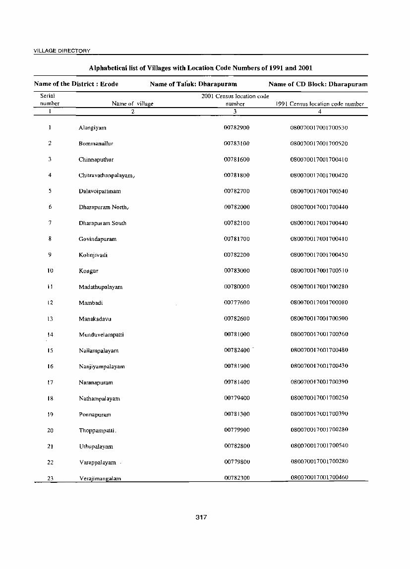
VILLAGE DIRECTORY
Alphabetical list of Villages with Location Code Numbers of 1991 and 2001
Name of the District: Erode Name of Talnk: Dharapuram Name of CD Block: Dharapuram
Serial 2001 Census location code number Name of village number 1991 Census location code number
2 3 4
Alangiyam 00782900 080070017001700530
2 Bommanallur 00783100 080070017001700520
3 Chinnaputhur 00781600 080070017001700410
4 Chitravathanpalayam/ 00781800 080070017001700420
5 Dalavoipattinam 00782700 080070017001700540
6 Dharapuram North, 00782000 080070017001700440
7 Dharapuram South 00782100 080070017001700440
8 Govindapuram 00781700 080070017001700410
9 Kolinjivadi 00782200 080070017001700450
10 Kongur 00783000 080070017001700510
II Madathupalayam 00780000 080070017001700280
12 Mambadi 00777600 080070017001700080
13 Manakadavu 00782600 080070017001700500
14 Munduvelampatti 00781000 080070017001700360
15 Nallampalayam 00782400 . 080070017001700480
16 Nanjiyampalayam 00781900 080070017001700430
17 Naranapuram 00781400 080070017001700390
18 Nathampalayam 00779400 080070017001700250
19 Ponnapuram 00781300 080070017001700390
20 Thoppampatti. 00779900 080070017001700280
21 Uthupalayam 00782800 080070017001700540
22 Varappalayam 00779800 080070017001700280
23 Verajiman~alam 00782300 080070017001700460
317

DISTRICT CENSUS HAND BOOK: ERODE
VILLAGE DIRECTORY AMENITIES AND LAND USE
(As on 1999) Amenities available (if not available within the village, a dash (-) is shown
in the column and next to it in brackets the distance in broad ranges viz.< 5 kms., 5-10 krns. and 10+ kms of the
Vi' nearest place where the facility is available is given)
~ '" .., '" c:: " ..0 " ~ ..,
'" 0 Cl ::l u '" U Cd ..,
u .., ::I il u .; Cl ..c::: '" - .., .., <a u 0 $
c:: 8 >=l > 3 'r:; ~ .;; '0
.., 0 '0 >: Cd u t:!- ..c::: ~ -3 J3 .... Q. C. <1)
'"" u .., .., C.f) '" 0 OJ} 0 '" 2 0. .~ "3 Ul ~
,_l ~ 0 :s! B 0 6h '" 3 =i"s '" ....
t:!- o 6 6 <U
o<! ';> ..c: .", u 7' ·3 "3 _g .2 "" .., >=l :-: IU .., Cl '" '" " >=l .., u 0 .... Ul
OJ} -5 0 ::I .... = o ._
o<! ~ .g "" ci .... ~ '0 0 .., ..c::: '" d" ~ 0
<1) '- '" ..t: ~ ~ 03::;:"2 '0 0 .D .;; 0 "3 ~ 03 '"Cd ~ c:! .;::: E ..... ~ 6h u
'" Q. 0 = 'u 3:0 "" --< '13 £3 '" '- ..,
2 .g '" S '" c: 0 !a 0 .... 0 ca eo .... ~ ~ '" 0. ., '0 = B '" ..... ca .., ..0 '" u ~ § '" '" u
Cd 8 '" E '" § ]1 ]1 ~ u :0 .J u .... ~ ~ ~ E ~ .;:: 0 ::s
'" .;:: '" o~ .~ _g ~ U ;J .., 0 ;g 0 0 '@ C.f) Z Eo-< E- Z :::E 0 p... u15 --< '0 p:: ~ C.f) u .... 2 3 4 5 6 7 8 9 10 11 12 13
CD Block: Dharapuram (0020)
I Mambadi 1,760.7 2,670 7S6 P(3) MCW THPW PO ACS BS (00777600) M(5-10) ewc R PH(75) CM« 5) NCS(IO+) CY(lO+) RS(IO+)
C(10+) PHS SS-T,W CP(lO+) ocs(lO+) SP(lO+) NW(lO+)
CHW ST(5-1O) H(10+) PHC 10+
2 Natham- 1,124.2 1,3S0 40S P(2) PHS HPW PO BS palayam M«5) H(lO+) SS-W,HP PH(30) CM(S-IO) ACS« S) CYeS-IO) RS(IO+) (00779400) C(lO+)
, MCW(IO+) CP(S-IO) NCS« S) SP(lO+) NW(lO+)
PHC(S-IO) OCS(10+) ST(10+)
3 Yarapalayam 1,400.6 2,604 774 P(3) CWC THPW PO BS (00779800) M«5) PHS SS-T,W PH(2S) CM(5-1O) ACS(5-10) CY(5-10) RS(lO+)
C(5-10) H(5-10) CP(S-IO) NCS(5-10) SP(5-10) NW(lO+) MCW(IO+) OCS(S-10) ST(5-1O)
PHC(lO+)
4 Thoppampaui 1,1I8.1 2,358 681 P(3) CWC THPW PO ACS BS. (00779900) M PHS SS-T,W PH(52) CM(S-IO) NCS(S-IO) CY(S-IO) RS(lO+)
C(S-IO) H(S-IO) CP(S-IO) OCS(S-IO) SP(S-IO) NW(IO+) MCW(10+) ST(5-10) PHC(10+)
5 Madalhu- palayam 1,221.1 1,548 426 P(4) PHS THPW PO ACS BS (00780000) M H(5-10) SS-T,W PH(50) CM(5-1O) NCS(S-IO) CY« 5) RS(10+)
C(5-10) MCW(5-IO) CP(5-10) OCS(S-lO) SP« 5) NW(lO+)
PHC(S-IO) ST« 5)
6 Mundu- 3,270.1 4,455 1,287 peS) CWC THPW PO(2) BS velampatti M«5) PHS SS-T,W PH(50) CM(<5) ACS(S-IOl CY(lO+) RS(IO+) (00781000) C(10+) CHW CP«5) NCS« 5) SP(lO+) NW(lO+)
H«5) OCS(S-IO) ST(lO+) MCW«S) PHC <5
7 Ponnapuram 2,303.2 2,829 783 PO) MCW TW PO(2) BS (00781300) M PIlC SS-T,W PH(22) CM(5-10) ACS(lO+) CY(lO+) RS(IO+)
C(lO+) PHS CP(S-IO) NCS(S-IO) SP(10+) NW(10+)
H(10+) OCS(IO+) ST(S-IO)
8 Naranapuram 2,098.8 2,758 791 P PHS THPW PH(75) BS (00781400) M(lO+) H(10+) SS-T,W PO«S) CM(IO+) ACS(lO+) CY(lO+) RS(IO+)
C(10+) MCW(lO+) CP(10+) NCS(10+) SP(10+) NW(lO+)
PHC« 5) OCS(10+) ST(lO+)
318

VILLAGE DIRECTORY
VILLAGE DIRECTORY AMENITIES AND LAND USE (As on 1999)
Land use (i.e. area under
different types of land use in hectare) "0 '" 13
.M
~ ::s
<:l ~ 0 £3 'g
g 0 bJl > ;a <=l ';:l
0) ::c; "3 u 0 (.) <= Q)
~ ::s
~ <= u ..... Q)
~ ·s Q) .8 Vl .,2
OIl 0 (.) ~ .., <!) ;g bJl (.) 3 > ~ ..,
~ OJ
~ ~ 0 bJl .;;
~ 0 Ul ...
>. '" n bJl ';a g .... <= <lJ
3 ~ 0. ~ >. ~ "0 .;; .J:J c.. Q) 0 e "0 <= > E ..c:: 9 ~ .§ ~
C!) ro (.) ::s :0 cd 4-< ::s '"
... '" c:>. "0 la 0 0 '" 0 '" .... ... ~ bJl '" <:l .... .., " en ... :§ 13 ..c:: 0)
~ ~ '" ro c:>. ~ ~ ., ~ OIl u n § c.. ..,
0 C!) 0 ] <=l "3 ~
.., --< Z z :E 0 ...
Z <!)
A. Il.. ;:J U bJl --< Ul
14 15 16 17 18 19 20 21 22 23 2
PR Mulanur (12) EA N Khadi GC(56.9) 240.0 948.0 119.0 Mambadi MR M Shirts, W(16.1) FP Bedsheets WE(60.6)
Carpets R(377.0) T(453.7)
PR Dharapuram (23) ED N GC(56.9) 392.1 499.9 70.2 Nathampalayam Z
MR EAG M W(31.5) FP WE(73.6)
T(l62.0)
PR Dharapuram (7) EA N GC(693.7) 128.9 328.5 181.2 Varapalayam 3 MR M W(3.4) FP WE(64.9)
T(762.0)
PR Dharapuram (7) EA N GC(465.7) 157.1 349.0 126.8 Thoppampatti 4 MR M W(1.0) FP WE(18.4)
T(485.2)
PR Dharapuram (5) EA N GC(393.3) 9.7 564.8 126.3 Madathupa1ayam 5 MR M W(12.7) FP WEOI4.3)
T(520.3)
PR Poolawadi (3) EA N W(97.1) 128.2 2,165.6 329.1 Munduvelampatti 6 MR M WE(550.2) FP T(647.3)
PR Dharapuram (17) EA N GC(252.4) 170.1 1,396.5 164.1 Ponnapuram 7
MR M W(20.0) FP WE(300.0)
T(572.5)
PR Dharapuram (18) EA N W(38.5) 139.4 1.535.6 175.3 Naranapuram 8
MR WE(21O.0) FP T(248.5)
319

..... o
~ Z
2 J Chinnaputhur
(00781600)
10 Govindapuram (00781700)
II Chittrauthan-palayam (00781800)
12 Nangaipalayam (00781900)
13 Dharapuram (00782000)
14 Dharapuram (South) (00782100)
15 Kolinjivadi (00782200)
16 Veeratchimangalam (00782300)
3 4 3,445.0 3,257
1.854.5 4,174
1,698.9 2,054
60S.2 2,388
711.9 1,035
608.3 1,630
302.1 254
751.7 3.198
5 894
1,190
581
687
289
436
74
9S1
6 P(2)
M«5)
C(10+)
peS)
M S PUC
C«5)
P(4)
M«S)
C«5)
P(4)
M(2)
S
C
P M«S) C«5)
P(S-IO)
M(S-lO)
C(5-1O)
P« 5)
M«S)
C«5)
P(2)
M C(S-IO)
DISTRICT CENSUS HAND BOOK: ERODE
VILLAGE DIRECTORY AMENITIES AND LAND USE
(As on 1999) Amenities available (if not available within the village, a dash (-) is shown
in the column and next to it in brackets the distance in broad ranges viz.< 5 kms., 5-10 kms. and 10+ kIns of the
nearest place where the facility is available is given)
7 CWC
PHS CHW
H(IO+) MCW(S-IO)
P -1 CWC PHS
RMP(2) CHW(2)
'H(lO+)
MCW«5) PHC«5)
CWC PHS
H« 5)
MCW« S) PHC«5)
ewc PHS H« 5)
MCW«5) PHC«5)
H« 5) MCW«S) PHC«S)
H(S-to) MCW(5-1O)
PHC(5-1O)
H« 5)
MCW«S) PHC«5)
MCW PHS H(S-IO) PHC(S-IO)
320
8 9 THPW PO SS-T,W PH(20)
THPW PO S5-T,W PH(SO)
THPW PO SS-T,W PH(17S)
THPW PO SS-T,W PH(80)
THP PO
SS-T,HP PH« 5)
WRC
SS-W,
WRC
SS-W,R
PO PH(4)
PO« 5) PH« 5)
THPR PO SS-T,HP PH(48)
10
CM«S)
CP(10+)
CM
CP(lO+)
CM«5) CP« 5)
CM CP« 5)
CM«S) CP« 5)
CM(S-IO) CP(S-IO)
CM«5)
CP«S)
CM(S-IO)
CP(S-IO)
11 12 13 ACS BS NCS(5-1O) eV(S-IO)
OCS(lO+) SP(S-IO)
RS« S)
NW(IO+l
ST(5-10)
ACS NC5(lO+) CV(iO+) OCS(lO+) SP(lO+)
BS R5(l0+1 NW(IO+)
ACS« 5)
NCS« 5) OCS« 5)
ACS
NCS« 5)
OCS« 5)
ACS« 5) NCS« 5)
OCS« 5)
ST(lO+)
BS CV« 5) RS(lO+)
SP« S) NW(lO+)
ST« S)
ST BS CV« 5) RS(IO+)
SP« S) NW(lO+)
CV« 5) 8S(<5) SP« 5) RS(IO+)
ST« 5) NW« 5)
as ACS(5-10) CV(S-IO) RS(10+) NCS(S-IO) SP(S-IO) NW(IO+)
OCS(5-10) ST(5-1O)
ACS« 5)
NCS« 5)
OCS« 5)
BS CV«5) RS(IO+)
SP«S) NW(IO+l
ST« 5)
BS ACS(5-10) CV(5-IO) RS(lO+)
NCS(S-IO) SP(S-IO) NW(lO+)
OCS( 10+) ST(S-IO)
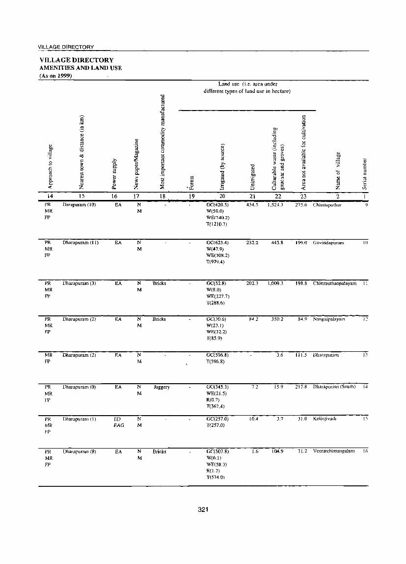
VILLAGE DIRECTORY
VILLAGE DIRECTORY AMENITIES AND LAND USE (As on 1999)
Land use (i.e. area under different types of land use in hectare)
'0 ... a
E ~
<=l <=l c<l 0
e ';::l
'" 3 c- OD > c ';::l
<l) :a :a '3 u 0 u c ., §
OJ
;3 <=l U .... ... til .~ d) .5' ~ 3 00 :a 0 u ~ ... ... ~ ~ u 3 ~ >
~ ..,
o(j Q 0 00 .;; ~
0 til .... >,
~ til C'3 bO ~ ....
.8 c
0. ;!; '0 .t; ...
~ >-. '0 > '': .0
8 c.. ..,
8. e ... c '" 8 ..c ::; ft ~ C'3 u ~ <II . § '0 c<l ::0 <5 ..... OJ
C'3 til c.. M bl) C'3 ~ 0 c
0 0) .... ~ a <=l a. 1:3 (l) til
~ '" :§ ..c .., .~ ~ ;!; 0) 00 u '" ~ c.. <l) 0 II> 0 ...
] c '3 OJ <l)
::; '& C'3 .... '" -< Z Q.. Z ::J U 00 -< Z t/l
14 15 16 17 18 19 20 21 22 23 2 PR Darapuram (10) EA N GC(420.5) 434.5 1,524.3 275.6 Chinnaputhur 9 MR M W(50.0} FP WE(740.2)
T(l210.7}
PR Dharapuram (II) EA N GC(623.4) 232.2 443.8 199.0 Govindapuram 10
MR M W(47.9) FP WE(30S.2)
T(979.4)
PR Dharapuram (3) EA N Bricks GC(52.8) 202.3 1.009.3 198.8 Chittrauthanpalayarn II MR M W(8.0) FP WE(227.7)
T(288.6)
PR Dharapurarn (2) EA N Bricks GC(30.6) 84.2 350.2 84.9 NangaipaJayam 12
MR M W{23.l) FP WE(32.2)
T(85.9)
MR Dharapuram (2) EA N GC(596.8) 3.6 111.5 Dharapuram 13 FP M T(S96.8)
PR Dharapuram (0) EA N Jaggery GC(345.3) 7.2 15.9 217.8 Dharapuram (South) 14
MR M WE(21.5) FP R(0.7)
T(367.4)
PR Dharapuram (l) ED N GC(257.0) 10.4 3.7 31.0 Kolinjivadi I:;
MR EAG M T(257.0)
FP
PR Dharapuram (8) EA N Bricks GC(S07.8) 1.6 104.9 71.2 Veeratchimangalam 16
MR M W(6.1)
FP WE(58.3) R(1.7)
T(5740)
321

DISTRICT CENSUS HAND BOOK: ERODE
VILLAGE DIRECTORY AMENITIES AND LAND USE
(As on 1999)
Amenities available (if not available within the village, a dash (-) is shown
in the column and next to it in brackets the distance in broad ranges
viz. < 5 kIDs., 5-10 kms. and 10+ kIDs of the ,....._
nearest place where the facility is available is given) '" ~
::I
~ '" E' c:: '0 0 ';) <0
~ '" u U <0 U <0 ::I ;:g u 05 ..c '" .., Q.) -;; c: c § <=l :> E u 0 g <0 0 'a ~ Ti .;; 'a U ~ ..c ~ ..s 0 .... ~ ~ u .., P- t P- Q.)
'" til '" 0 t>O 8 '" Q.) P- u -;; '" :t
-' "" "t:) '8 0 -a '" 3 :gs ::I 2 ~ ~ "0 6 e-O/:! ..c '0 ~ .~ '3 ..c ,2 '" <0 § U ~ '-' '-' c '" "0 '" '" 0 0
,_ ~ OJ) -5 0 ::I !l c:
o ._ O/:! <0 8 ci .... ~ 'a 0 ..c ~ '" g '0 0 ..,
:-;:: ..... ~ ..0 ~ . '" :;;: :.a .~ 0 ..0 0 "" 03 ];5 03 -n IS > '3 "'-< 03
"" bb ::I
~ P- o c: -n '" « .~ s ::I '- ..,
bO ~ 0 '<'3 8 0:: '" 0 0 ~ 0 .... 0 'a .... ... .., 'a P- O.) 'a c: ~ ..,
"3 .... S ::I ;:..., -;;; Q.) ..0 ~ 0 ~ S u ~ g:B § '" § 79 79 ~ u ;a ~ .~ ~ "-' ~ ·c .J' S .... :;:s <0 i§ '" c: ~ U g 0 ..,
Z 0 0
Z '0 '~ 0 0 ~ bll-5 .~ til E-< E-< II.l p... U ..0 « 0 O::~tIlU
2 3 4 5 6 7 8 9 10 11 12 13 17 Nallampalayam 1,509_5 1,936 564 P(3) CWC THPW PO(2) BS
(00782400) M«5) PHS SS-T,W PH(25) CM(5-10) ACS(5-1O) CY(10+) RS(IO+) C(lO+) CHW CP(!O+) NCS(5-1O) SP(10+) NW(]O+)
H(IO+) OCS(IO+) ST(S-IO) MCW(lO+) PHC(10+)
18 Manakkadavu 2,746.4 4,256 1.177 P(6) CWC THPW PO(2) ACS BS (00782600) M(2) PHS SS-T,W PH(104) CM(5-1O) NCS(5-1O) CY(5-1O) RS(lO+)
Tr H(5-10) CP(5-10) OCS(lO+) SP(S-IO) NW(10+) C(5·10) MCW(S-lO) ST(S·lO)
PHC(5·10)
19 Dhalavai· 1,410.1 6.777 1,829 P(4) MCW THPW PO CM ACS BS pattinam M(2) PHC SS-T,W PH(25) CP(5-10) NCS(5-1O) CY(5-10) RS(IO+) (00782700) S PHS (2) OCS(lO+) SP(5-IO) NW(10+)
C(5·1O) H(5-10) ST(5-10)
20 Uthupalayam 1,331.7 1,517 416 P(2) PHS o THP PO NCS(2) (00782800) M(2) H(5-10) SS-T,HP PH(25) CM« 5) ACS(5·1O) CY(5-10) BS« 5)
C(5-10) MCW«5) CP« 5) OCS(10+) SP(S-IO) RS(10+) PHC«5) ST(5-10) NW(lO+)
21 Alagiyam 882_2 5,750 1,577 P(3) ewc THPW PO CM ST BS (00782900) M PHC SS-T,W PH(l50) CP(5-10) ACS« 5) CY(5-10) RS(10+)
S PHS NCS(5-IO) SP(5-10) NW(IO+) , C(5-10) H(5-IO) OCS(S-IO)
MCW(5-10)
22 Kongur 2,524.1 2,381 697 P(4) MCW THPW PO ACS BS (00783000) M«S) ewc SS-T,W Plf(36) CM(iO+) NCS(lO+) CY(lO+) RS(lO+)
C(5-10) PHS CP(IO+) OCS(IO+) SP(IO+) NW(10+) H(lO+) ST(lO+) PHCCIO+)
23 I30mmanallur 919_9 1,841 533 P(2) CWC THPW PO NCS(2) I3S (00783100) M(5-1O) PHS SS-T,W PH(22) CM(lO+) ACS« 5) CY(lO+) RS(IO+)
C(IO+) H(IO+) CP(IO+) OCS(lO+) SP(IO+) NW(10+) MCW(10+) ST(lO+) PHC(<:5)
Block Total 35,598.2 63,020 17,828 P(66) MCW(S) T(20) PO(2S) CM(4) ACS(9) ST(2) BS(21) M(14) CWC(13) W(20) PH(1143) NCS(4) 8(4) PHC(3) HP(20) PUC PHS(21) R(4)
e RMP(2) C(2) CHW(6)
Tr(2) 0
322

VILLAGE DIRECTORY
VILLAGE DIRECTORY AMENITIES AND LAND USE (As on 1999)
~ 2-., u = ~ .,
~ ;a oCI .:;
9 = .Q ~ 0-
..c 9 0-:I u
~ '" '"' 0 '" .... ... cu cu 0- 1il ~ 0- cu 0 « z Il.
14 15 16 PR Kolathupalayam (7) EA MR
PR Dharapuram (10) EA MR FP
PR Dharapuram (10) EA MR FP
PR Dharapuram (9) EA MR FP
PR Dharapuram (10) EA MR FP
PR Dharapuram (IS) EA MR FP
PR Dharapuram (IS) EA MR
FP
PR(22) ED MR(23) EAG(2) FP(22) EA(2l)
"0 ., a ~ :I c:l OJ
8 0 ;a 0 v § c:l ·s 0
Of) u OJ
~ ~ .... v 0 ~ 0-
.5 0-
'" ..... ~ '" v 0
Z ~
17 18 19 N Chewing M tobacca
N M
N Coconut ' -M coir,
Jaggery
N Jaggery 131.4 M
N Jaggery M
N Jaggery
N M
N(23) 131.4 M(21)
Land use (i.e. area under different types of land use in hectare)
20
W(IO.O) WE(340.0) T(350.0)
GC(8.6) W(l4.1) WE(430.0) R(l27.0) T(S79.6)
GC(400.S) W(5.6) WE(l05.4) T(SII.S)
GC(219.1) W(34.8) WE(8!.3) T(335.2)
GC(417.7) W(l6.0) WE(l46.2) T(579.8)
GC(0.4) W(l27.5) WE(209.I) TK(36.2) R(44.8)
W(5.6) WE(200.0) T(205.6)
GC(S742.92) W(568.9S) WE(4292.00) TK(36.21) R(S51.19) T(11191.27)
323
21 22 205.4 874.7
213.S 1,696.6
7S.S 61S.7
ISO.6 596.2
65.6 134.8
313.8 1,48S.9
249.2 379.8
3.611.2 17,027.2
23 2 79.4 Nallampalayam
2S6.7 Manakkadavu
207.2 Dhalavaipattinam
118.3 Uthupalayam
102.0 Alagiyam
306.S Kongur
8S.4 Bommanallur
3,637.1
.... <!)
..0 E " <= r3 ·c
<!) (I)
17
18
19
20
21
22
23

VILLAGE DIRECTORY
APPICNDIXES TO VILLA(jE DIRECTORY
325

DISTRICT CENSUS HAND BOOK: ERODE
APPENDIX I - Village Directory Abstract of Educational, Medical and other Amenities in villages - C.D. block level
~ame of the District: Erode
TaJavadi
~ o
::0 c::i U ..... o
~ Z 2
2 Bhavanisagar
3 Sathyamangalam
4 Thookanaickenpalayam
5 Anthiyur
6 Ammapet
7 Bhavani
8 GohichettipaJayam
9 Nambiyur
10 Uthukuli
11 Perundurai
12 Erode
13 Chennimalai
14 Modakurichi
15 Kodumudi
16 Vellakoil
17 Kangeyam
18 Kundadam
19 Mulanur
20 Dharapuram
District (Rural) :
3
~o
~6
20
12
13
19
17
22
21
45
39
20
22
23
14
13
19
29
17
23
~ o
::c d U .... o s:: .g
i 8.
~ 4
53,174
76,022
82,756
51,118
96,469
97,786
97,392
91,122
65,449
13,917
67,999
55,773
61,920
100,523
31,480
48,516
57,033
70,371
45,697
63,020
5
20
25
20
11
13
19
16
21
20
41
33
14
19
21
13
13
19
29
17
21
Educational institutions
6 7
til
§ .~ '.:;j til ..s 8 9
til
§ .~ '.:;j
'" ..s 10
60 10 16 6 7
II 12 13 14 15 16
2 2 0 o 0 0
71 8 11 5 7 2 200
63 13 14 4 4 2 2 0 0
26 6 6 3 3 o o 0 0
72 11 17 7 7 3 3 o 0 0 0
64' 10 11 8 8 440 o 0 0
51 12 20 7 9 5 6 2 0 0
56 14 15 4 4 2 2 o 0
67 9 10 7 8 3 3 o o 0 0
63 12 12 4 4 o 0
59 7 7 5 5 3 3 2 2 0 0
27 5 544 3 3 2 2 0 0
48 8 9 3 3 2 2 2 2
77 12 14 5 5 3 3 o o
36 4 4 o o 0 0
52 11 12 o o 2 2 0 0
52 12 14 4 4 o o 0 0
90 11 12 5 5 220 o 0 0
73 10 12 5 6 0 0 0 o 0 0
66 10 14 4 4 o 0
17 18 19
220
4 4
o
2 3 0
220
o 0
2 3 o
o 0
004
005
225
2 3
2
o 0
000
3 6 0
000
000
2 3 :2
434 1,387,537 405 1,173 195 235 92 99 40 41 14 15 3 3 23 30 26
326

VILLAGE DIRECTORY
APPENDIX t· Village Directory (contd.) Abstract of Educational, Medical and other Amenities in villages - C.D. block level
Name of the District: Erode Medical Institutions
C'3 u :a II)
8 o Z
2 3 20 21 22 3 24 25 26 27 28 29 30 31 32 33 34 36
Talavadi 20 3 6 0 0 3 3 14 14 8 11 0 0 2 2
2 Bhavanisagar 26 5 7 1 2 2 20 20 11 13 0 0 8 8 2 2
3 Sathyamangalam 20 5 9 2 2 15 15 9 13 0 0 8 10 5 7 0
4 ThookanaickenpaJayam 12 5 6 0 0 II 12 7 13 0 0 0 0 3 6 0
5 Anthiyur 13 2 o 0 4 4 4 5 10 16 0 0 8 9 5 10 0
6 Ammapet 19 3 4 16 16 13 19 0 0 7 8 4 10
7 Bhavani 17 2 4 4 4 10 12 8 10 0 0 14 14 6 11
8 Gobichettipalayam 22 003 3 16 16 11 12 0 0 0 0 2 3 0
9 Nambiyur 21 o 0 222 14 14 8 11 0 0 2 2 4 6
10 Uthukuli 45 2 13 13 8 11 0 0 0 0 4 7 27
11 Perundurai 39 2 2 2 2 19 19 6 900 2 2 3 3 18
12 Erode 20 2 2 0 0 11 11 5 7 0 0 4 6 2 4 6
13 Chennimalai 22 003 3 9 9 7 700 2 3 3 8
14 Modakurichi 23 3 3 20 20 10 11 0 0 0 0 3 5 3
15 Kodumudi 14 0 0 0 0 2 2 6 9 4 400 000 0 7
16 Vellakoil 13 o 0 0 0 10 10 9 10 0 0 0 0 0 0 0
17 Kangeyam 19 0 0 244 11 12 3 3 0 0 0 0 0 0 8
18 Kundadam 29 2 2 1 3 3 8 8 21 26 0 0 0 0 5
19 Mulanur 17 0 0 0 0 0 0 15 15 11 17 0 0 0 0 0 0 0
20 Dharapuram 23 0 0 0 0 3 3 20 21 16 18 0 0 5 6 2 3 3
District (Rural) : 434 35 50 11 13 43 43 262 271 185 241 0 0 61 69 50 82 90
327

DISTRICT CENSUS HAND BOOK: ERODE
APPENDIX I - Village Directory (contd.) Abstract of Educational, Medical and other Amenities in villages - C.D. block level
Name of the District: Erode
2
Tal avadi
2 Bhavanisagar
3 Sathyamangalam
4 Thookanaickenpalayam
5 Anthiyur
6 Ammapet
7 Bhavani
8 Gobichettipalayam
9 Nambiyur
10 Uthukuli
I I Perundurai
12 Erode
13 Chennimalai
14 Modakurichi
15 Kodumudi
16 Vellakoil
17 Kangeyam
18 Kundadam
19 Mulanur
20 Dharapuram
District (Rural) :
Drinking water source
3 37 38 39 40 41 42 43 44 45 46
20 20 20 0 0 o 0 o 20 20 0
26 26 24 0 0 6 0 2 24 26 0
20 20 19 0 0 6 0 o 20 20 0
12 12 11 0 0 3 0 2 12 12 0
13 13 10 0 0 o 0 o 13 13 0
19 19 14 0 0 2 0 19 19 0
17 17 17 0 0 2 0 o 17 17 0
22 22 18 0 0 2 0 2 20 22 0
21 20 16 0 0 2 0 o 21 21 0
45 42 22 0 0 '0 0 o 40 42 0
39 39 32 0 0 o 0 o 39 39 0
20 20 19 0 0 4 0 3 18 20 0
22 22 17 0 0 o 0 o 20 22 0
23 22 21 0 0 2 0 22 23 0
14 14 14 0 0 o 14 14 0
13 11 9 0 0 6 0 o 13 13 0
19 19 17 0 0 o 0 o 19 19 0
29 29 25 0 0 2 0 o 29 29 0
17 16 15 0 0 9 0 3 17 17 0
23 20 20 0 0 4 0 2 20 23 0
<J U
!+=l ...... o
47
18
25
16
11
13
15
16
21
18
38
29
Post, Telegraph & Telephone
48 49 50 51 52 53
16 18
o 25 o 26
o o 14 0 0 18
1 11 12
o o 13 o 0 13
15 19
o 16 0 17
21 22
o 18 o 21
o 0 37 o 0 44
o 29 o 39
18 0 o 18 0 0 20
20 3 o 20 3 0 22
23 o 0 23 o 0 23
14 o 14 0 14
10 0 0 10 0 0 13
17 2 0 17 2 0 19
24 o 24 0 29
16 o 16 0 17
21 o 0 20 0 0 21
434 423 360 0 0 51 0 17 417 431 0 383 10 10 377 10 10 427
, 328

VILLAGE DIRECTORY
APPENDIX I - Village Directory (coutd.) Abstract of Educational, Medical and other Amenities in villages - C.D. block level
Name of the District: Erode
Talavadi
..;.: u o :c o cj "o o ~ Z 2
2 Bhavanisagar
3 Sathyarnangalarn
4 11100kanaickenpalayarn
5 Anthiyur
6 Ammapet
7 Bhavani
8 Gobichettipalayam
9 Nambiyur
10 Uthukuli
11 Pemndurai
12 Erode
13 Chenni mal ai
14 Modakurichi
15 Kodumudi
16 Vellakoil
17 Kangeyam
18 Kundadam
19 Mulanur
20 Dharapuram
District (Rural) :
Transport communi
cations
Banks Power Credit societies 'supply
3 54 55 56 57 sf 59 60 61 62 63 64 65 66
20 19 0 0 5 8 20 0 8 8 2 2 0 0
26 25 0 0 4 4 26 0 8 8 0 000
20 20 0 0 3 3 20 0 6 6 3 3 1
12 12 0 0 5 5 12 0 4 4 9 14 2
13 13 0 0 3 5 13 0 5 5 2 3
19 15 0 0 8 II 19 0 10 11 2 200
17 17 0 0 4 10 17 0 8 11 3
22 21 0 0 4 4 22 0 12 13 15 22
21 21 0 0 6 7 21 0 10 10 9 15 2 3
45 32 0 0 4 5 45 0 12 12 7 8
39 35 0 0 7 8 39 0 9 9 2 4
20 18 0 0 5 5 20 0 2 3 0 0
22 20 o 3 4 22 0 6 6 5 600
23 21 o 9 11 23 0 10 12 3 3
14 12 o 2 2 14 0 3 3 0 000
13 13 0 0 3 4 13 0 10 10 o 0
19 17 0 0 6 6 19 0 5 5 0 000 ,
29 29 0 0 5 6 29 0 7 7 200
17 17 0 0 3 4 17 0 7 7 3 7 0 0
23 21 0 0 4 4 23 0 9 9 2 400
Recreational Newspaper / facility Magazine
67 68 69 70 71 72
o 0 o 19 17 17
o o 26 25 25
2 0 o 19 19 19
o 3 12 12 12
o 0 13 13 13
4 0 19 19 19
3 0 17 17 17
2 o 22 22 22
o 0 o 21 20 20
o 0 0 44 43 42
o 39 38 38
o 20 20 20
o 3 22 22 22
o 0 23 23 23
2 0 o 14 14 14
o 0 o 13 13 13
o o 19 19 19
o 0 o 27 27 27
o 0 o 17 15 15
o 0 2 23 21 21
434 398 3 0 93 116 434 0 150 157 69 102 10 12 17 5 12 429 419 418
329

DISTRICT CENSUS HAND BOOK: ERODE
APPENDIX I A - Village Directory
Villages by number of Primary Schools ~o/ame of the District:Erode . Serial number Name of CD block Total number of Number of primary schools
inhabited villages None One Two Three Four + 2 3 4 5 6 7 8
Talavadi 20 0 6 4 4 6
2 Bhavanisagar 26 7 8 2 8
3 SathyamangaJam 20 0 9 4 3 4
4 Thookanaickenpalayam 12 7 0 3
5 Anthiyur 13 0 10
6 Ammapet 19 0 5 3 3 8
7 Bhavani 17 6 4 0 6
8 Gobichettipalayam 22 0 9 5 2 6
9 Nambiyur 21 1 3 4 5 8
10 Uthukuli 45 4 24 13 3
11 Perundurai 39 5 17 11 3 3
12 Erode 20 5 9 2 2 2
13 Chennimalai 22 3 8 5 2 4
. 14 Modakurichi 23 2 6 3 4 8
15 Kodumudi 14 5 4 3
16 Vellakoil 13 0 2 3 7
17 Kangeyam 19 0 4 9 2 4
18 Kundadam 29 0 7 5 7 10
19 Mulanur 17 0 3 4 9
20 Dharapuram 23 2 2 5 6 8
District Total: 434 26 139 94 57 118
330

VILLAGE DIRECTORY
APPENDJX I-B - Village Directory
Villages by Primary, Middle and Secondary Schools Name of the District:Erode .
... Name of CD block Total number of Type of educational institutions available <l)
S inhabited :::l c villages oa ·c No School At least one At least one At least one <l) (/J primary school primary school middle school
and no middle and one middle and one school school secondary school
2 3 4 5 6 7
Talavadi 20 0 10 IO 6
2 Bhavanisagar 26 17 8 5
3 Sathyamangalam 20 0 7 13 4
4 Thookanaickenpalayam 12 5 6 3
5 Anthiyur 13 0 2 11 7
6 Ammapet 19 0 9 10 8
7 Bhavani 17 1 - 4 12 7
8 Gobichettipalayam 22 0 7 14 4
9 Nambiyur 21 11 9 7
10 Uthukuli 45 4 29 12 4
11 Perundurai 39 5 26 7 5
12 Erode 20 5 9 5 4
13 Chennimalai 22 3 11 8 3
14 Modakurichi 23 2 9. 12 5
15 Kodumudi 14 9 4 1
16 Vellakoil 13 0 2 I 1
17 Kangeyam 19 0 7 12 4
18 Kundadam 29 0 18 11 5
19 Mulanur 17 0 7 10 5
20 Dharapuram 23 2 II 10 4
Total: 434 26 210 195 92
331

DISTRICT CENSUS HAND BOOK: ERODE
APPENDIX I -C • ViUge Directory Villages with different sources of drinking water facilities available
2',ame of the District: Erode Serial number Name of CD block Number of villages with different sources of drinking water available
Only tap Only well Only tube well Only More than one
handpump source only from tap, well, tube
well. hand um
2 3 ., 4 5 6 7
Talavadi 0 0 0 0 20
2 Bhavanisagar 0 0 0 0 26
3 S athyamangalam 0 0 0 0 20
4 Thookanaickenpalayam 0 0 0 0 12
5 Anthiyur 0 0 0 0 13
6 Ammapet 0 0 0 0 19
7 Bhavani 0 0 0 0 17
8 Gobichettipalayam 0 0 0 0 22
9 Nambiyur 0 0 0 0 21
10 Uthukuli 3 0 0 0 42
11 Perundurai 0 0 0 0 39
12 Erode 0 0 0 0 20
13 Chennimalai 0 0 0 0 22
14 Modakurichi 0 0 0 0 22
15 Kodumudi 0 0 0 0 14
16 Vellakoil 0 0 0 0 13
17 Kangeyam 0 0 0 0 19
18 Kundadam 0 0 0 0 29
19 Mulanur 0 0 0 0 17
20 Dharapurarn 0 0 0 0 21
District Total: 3 0 0 0 428
332

VILLAGE DIRECTORY
APPENDIX II - Village Directory Villages with 5,000 and above population which do not have one or more amenities
Name of the District: Erode Name of village
Mallankuli
2 Talavadi
3 Thingaloor
4 Nallur
5 Guthiyalathur
6 Chikkarasampalayam
7 Rajannagar
8 Ukkaram
9 Kongarpalayam
10 Punjaithuraiyampalayam
I 1 Kandayam Palayam
12 Kannakkampalayam
13 Perumugai
14 Burgur
IS Ennamangalam
16 Anthiyur
17 Nagalur
18 Knppandampalayam
19 Bramadesam
20 Pachampalayam
21 Gettisamudram
22 Yempathi
23 Channampettai
24 Mathur
25 Yellithiruppur
26 Illipili
27 Kannappalli
28 Patloor
29 Kurichi
30 Kesarimangalam
31 Paruvachi
32 Punnam
33 Mylambadi
34 Bhavani
35 Oricheri
36 Kavandapadi
37 Odathurai
38 Urachikottai
39 Periyapuliyur
40 Kugalur
Amemhes not aVailable Location code
number
Name of CD block ( indicate N. A. where amenity not available)
00737700 Talavadi
00738000 Talavadi
00738400 Talavadi
00744400 Bhavanisagar
00738800 Sathyamangalam
00740800 Sathyamangalam
00741000 Sathyamangalam
00743300 Sathyamangalam
00750700 Thookanaickenpalayam
00750900 Thookanaickenpalayam
00751000 Thookanaickenpalayam
5,050 N.A. N.A.
7,259 Available N.A.
'5,286 N.A. N.A.
7,549 Available N.A.
14,213
6,880
N.A.
N.A.
NA
N.A.
5,553 Available N.A.
9,345
5,956
N.A.
N.A.
N.A.
N.A.
8,312 Available N.A.
6,988 N.A.
0075 I 100 Thookanaickenpalayam 6,181
N.A.
N.A.
N.A.
N.A.
N.A.
00751200 Thookanaickenpalayam 8,692
00745200 Anthiyur 15,874
7,535 N.A.
N.A.
N.A.
N.A.
15,889 N.A. N.A.
5,317 N.A. N.A.
5,598 Available N.A.
12,074 Available N.A.
7,530 Available N.A.
5,144 N.A. N.A.
10,803 N.A. N.A.
• 9,379 Available N.A.
6,713 N.A. N.A.
8,790 N.A. N.A.
9,688 Available N.A.
5,651 N.A. N.A.
8,043 N.A. N.A.
11,349 N.A. N.A.
9,200 N.A. N.A.
5,247 Available N.A.
5,108 N.A. N.A.
8,020 Available N.A.
10,735 N.A. N.A.
5,080 Available N.A.
25,172 Available N.A.
8,671 N.A. N.A
6,021 Available N.A.
10 11 12
Available Available Available Available Available
N.A. Available Available Available Available
Available Available Available Available N.A.
Available Available Available Available N.A.
Available Available Available Available Available
Available Available Available Available N.A.
Available Available Available Available N.A.
Available Available Available Available Available
Available Available Available Available N.A.
Available Available Available Available Available
N.A. Available Available Available N.A.
A vailable Available Available Available N.A.
Available Available Available Available Available
N.A. Available Available Available N.A.
N.A.
N.A.
N.A.
N.A.
Available Available Available Available
Available Available Available N.A.
Available Available Available N.A.
Available Available Available N.A.
Available Available Available Available Available
N.A.
N.A.
Available Available Available N.A.
Available Available Available N.A.
N.A. Available Available Available N.A.
Available Available Available Available Available
Available Available Available Available N.A.
Available Available Available Available Available
Available Available Available Available Available
Available Available N.A. Available N.A.
Available Available Available Available Availahle
Available Available Available Available N.A.
Available Available Available Available Available
Available Available Available Available N.A.
Available Available Available Available N.A.
N.A. Available Available Available N.A.
Available Available Available Available N.A.
N.A. Available Available Available N.A.
Available Available Available Available Available
Available Available Available Available Available
Available Available Available Available N.A
00745900 Anthiyur
00746100 Anthiyur
00746300 Anthiyur
00746400 Anthiyur
00746500 Anthiyur
00746600 Anthiyur
00746700 Anthiyur
00747700 Anthiyur
00745700 Ammapet
00746800 Ammapet
00746900 Ammapet
00747000 Ammapet
00747100 Ammapet
00747400 Ammapet
00748400 Ammapet
00749000 Ammapet
00747600 Bhavani
00748100 Bhavani
00748200 Bhavani
00749400 Bhavani
00749500 Bhavani
00749800 Bhavani
00749900 Bhavani
00750100 Bhavani
00750300 Bhavani 7,352
5,714
N.A. Available Available Available Available Available N.A.
00751700 Gobichettipalayam N.A. N.A. Available Available Available Available N.A.
333

DISTRICT CENSUS HAND BOOK: ERODE
APPENDIX II - Village Directory (contd.) Villages with 5,000 and above population which do not have one or more amenities
Name of village Location Name of CD Amenities not available
41 Alukkuli
42 Modachur
.3 Kalingiam
2
44 KottupulJarnpaJayam
.. S Ayalur
~6 Vellalankovil
47 Siruvalur
~8 Karattupalayam
49 Kosanam
SO Emmanpoondi
51 Chengappalli
S2 Elavarnalai
53 Mettunasuvampalayam
54 Thindal(KiI)
5S Vadamugarn Vellode
56 Kaudachipalayarn
57 Thenmugarn Vellode
~8 !ngur
S9 Murungatholuvu
60 Punjailakkapuram
Ijj Pudur
62 Thoyampoondurai 63 Modavandi-
Sathiyamangalam
64 Nanjai Uthukuli
65 Punjaikalamangalam
66 Elumathur
67 Kolathupalayan
68 lchipalayam
69 Mettupalayam
70 Pachapalayam
71 Senapathipalayam
72 Nathakkadaiyur
73 Sivanmalai
74 Nilali
75 Surianallur
76 Manurpalayam
77 Kilangundal
78 Ponnivadi
79 Dhalavaipattinam
80 Alagiyam
code block (indicate N. A. where amenity not available) number
3
00752700
00753400
00753500
4
Gobichettipalayam
Gobichettipalayam
Gobichettipalayam
00753600 GobichettipaJayam
00754400 Gobichettipalayam
00754800 Gobichettipalayarn
00754900 Gobichettipalayam
00753700 Nambiyur
00755100 Nambiyur
00755800 Nambiyur
00761500 Uthukuli
00767300 Erode
00767400 Erode
00768100 Erode
00763400 Chennimalai
00763600 Chennimalai
00763700 Chennimalai
00763900 Chennimalai
00766100 Chennimalai
00769300 Modakurichi
00769400 Modakurichi
00769500 Modakurichi
00770000 Modakurichi
00770100 Modakurichi
00770500 Modakurichi
00770800 Modakurichi
00771600 Kodumudi
00772400 Kodumudi
00774500 Vellakoil
00776000 Vellakoil
00776200 Vellakoil
00773800 Kangeyam
00775100 Kangeyam
00776900 Kundadam
00777200 Kundadam
00780400 Kundadam
00779100 Mulanur
00782500 MuJanuT
00782700 Dharapuram
00782900 Dharapuram
5 7,018
6,481
9,386
6,]97
5,610
5,475
., 7,493
7,363
6,582
5,563
5,937
6,294
ioQ "0 .g 0 .... (J ..c:: o 0 (J
VlVltf.l
6
N.A
N.A.
N.A.
N.A.
N.A.
N.A.
N.A.
N.A.
N.A.
N.A.
N.A.
N.A.
N.A.
7
N.A.
N.A.
N.A.
N.A.
N.A.
N.A.
N.A.
NA
N.A.
N.A.
N.A.
N.A.
NA
Available N.A.
8 9 IO
N.A. Available Available
Available Available Available
N.A. Available Available
II
Available
Available
Available
12
N.A
N.A.
N.A
AvaHable Available Available Available N.A.
Available Available Available Available N.A.
N.A. Available Available Available Available
Available Available Available Available N.A.
Available Available Available Available N.A.
Available Available Available Available N.A.
Available Available Available Available N.A.
Available Available Available Available Availahle
N.A. Available Available Available N.A.
N.A. Available Available Available N A.
Available Available Available Available N.A.
14,278
5.621
8,292
5,364
Available Available Available Available Available Available Availahle
N.A. N.A.
7,696 Available N.A.
5,651
7,378
6,740
9,058
10,408
NA NA
NA Available
N.A.
NA
N.A.
N.A.
N.A.
N.A.
7,039 N.A. N.A.
10,441 Available N.A.
8,]58 Available N.A.
• 8,543 N.A. N.A.
5,734 N.A. N.A.
5,617 Available N.A.
5,927 N.A. N.A.
N.A. N.A.
Available Available Available Available N.A.
A vailable A vailable Available Avrulable Available
Available Available N.A. Availahle Available
N.A. Available Available Available N.A.
Available Available Available Available AvaiiabJe
Available Available Available Availal'le Available
Available Available Available Available N.A
Available Available Available Available N.A.
Available Available Available Available N.A.
Available Available Available Available Available
Available Available Available Available Available
Available Available Available Available Available
Available Available Available Available Available
Available Available Available Available Available
Available Available Available Available 5, 111
6,323
7,074
7,135
6,953
5,119
5,655
6,754
6,892
6,777
5,750
N.A. Available Available Available Available Available
NA
NA
334
Available
N.A.
N.A.
N.A.
N.A.
N.A.
N.A.
N.A.
N.A.
N.A.
N.A.
NA
N.A.
N.A.
N.A.
N.A.
N.A.
NA
Available Available Available
Available Available Available
N.A. Available Available
N.A. Available Available
Available Available Available
Available Available Available
Available AvailabJe Available
Available Available Available
Available Available Available
Available Availahle
Available Available
Available Available
Available NA
Available Available
Available N.A.
Available Available
Available Available
Available Available
VILLAGE DIRECTORY
APPENDIX II - A - Village Directory
Cettsus Towns which do not have one or more amenities
Name of the District: Erode Name of census Location r-Iame of C Popula- Amenities not available .._
code b block tion <1) town ( indicate N. A. where ameni~ not available) .0 S number Seniot College Health Tap Bus Approach Banks ::l c::
Secondary Centre drinking facility by Pucca C; .;:::
School water road <1) CI:l
2 3 4 5 6 7 8 9 10 11 12
Vijayapuri 4103 1000 Penmdurai 6,517 Available N.A. N.A. Available Available Available
2 Mukasipidariyur 41033000 Pcnmdurai 11,012 Available N.A. Available Available Available Available N.A.
3 OttaEarai 41035000 P~nmdurai 9,208 N.A. N.A. Available Available Available Available Available
APP~NDIX - III - Village Directory
Land utilisation data in respect of Census Towns I Non-Municipal Towns
c; .... Name of Census town and CD Area under different type of land use in hectares rounded upon two decimal <U .;::: .0
0) S block within brackets Forest Irrigated by Unirrigated Culturable waste Area not CI:l ::l c::
( including available for source
Total area gauchar & groves ) cultivation
2 3 4 5 6 7 8 Vijayapuri 285.0 T37.oo 170.0 58.0 20.0 (Perundurai) WE 37.00
2 M ukasi pidari yUT 1,400.0 T 17.00 1,030.0 45.0 308.0
(Perundurai) WE 17.00
3 Ottaparai 700.0 T 15.00 217.0 380.0 88.0
(Perundurai) WE 15.00
APPENDIX IV - Village Directory
CD block wise list of inhabited villages where no amenity other than drinking water facility is available
Name of the District: Erode Serial Location Name of Serial Location Name of
number Name of CD Block ~ode number village number Name of CD Block code number village 1 2 3 1 2 3
Talavadi Nil Nil II Perundurai Nil Nil
2 Bhavanisagar Nil Nil 12 Erode Nil Nil
3 Sathyamangalam Nil Nil 13 Chennimalai Nil Nil
4 Thookanaickenpalayam Nil Nil 14 Modakurichi Nil Nil
5 Anthiyur Nil Nil 15 Kodumudi Nil Nil
6 Ammapet Nil Nil 16 Vellakoil Nil Nil
7 Bhavani Nil Nil 17 Kangeyam Nil Nil
8 Gobichettipalayam Nil Nil 18 Kundadam Nil Nil
9 Nambiyur Nil Nil 19 Mulanur Nil Nil , 10 Uthukuli Nil Nil 20 Dharapuram Nil Nil
335
DISTRICT CENSUS HAND BOOK: ERODE
APPENDIX· V· Village Directory
Summary showing number of villages not having Scheduled Castes population
Serial Name of CD block Total villages Uninhabited Inhabited Number of inhabited number villages villages villages having no
Scheduled Castes population
2 3 4 5 6 1 Talavadi 24 4 20 0
2 Bhavanisagar 27 1 26 0 3 Sathyamangalam 24 4 20 0
4 Thookanaickcnpalayam 13 1 12 0
5 Anthiyur 18' 5 13 0
6 Ammapet 19 0 19 0 7 Bhavani 17 0 17 0
8 Gobichettipalayam 26 4 22 0
9 Nambiyur 21 0 21 0 10 Uthukuli 45 0 45 2 11 Perundurai 39 0 39 2 12 Erode 20 0 20 J
13 Chennimalai 23 22 0 14 Modakurichi 25 2 23 1
15 Kodumudi 14 0 14 0
16 Vellakoil 13 0 13 0 17 Kangeyam 19 0 19 0
18 Kundadam 29 0 29 19 Mulanur 17 0 17
20 Dharapuram 23 0 23 0
District Total: 456 22 434 8
APPENDIX - VI - VilJasze Directorv Summary showing number of villages not having Scheduled Tribes population
Serial Name of CD block Total villages Uninhabited Inhabited Number of inhabited number villages villages villages having no
Scheduled Tribes population
2 3 4 5 6 Talavadi 24 4 20 11
2 Bhav~isagar 27 1 26 17
3 SathyamangaJam 24 4 20 13 4 Thookanaickenpalayam 13 12 5
5 Anthiyur 18 5 13 5 6 Amrnapet 19 0 19 4 7 Bhavani 17 0 17 12 8 Gobichettipalayam 26 4 22 20
9 Nambiyur 21 0 21 17 10 Uthukuli 45 0 45 42 11 Perundurai 39 0 39 39 12 Erode 20 0 20 17 13 Chennirnalai 23 1 22 20 14 Modakurichi 25 2 23 16 15 Kodumudi 14 0 14 11
16 Vellakoil 13 0 13 10 17 Kangeyam 19 0 19 16 18 Kundadarn 29 0 29 28 19 Mulanur 17 0 17 16 20 Dharapuram 23 0 23 20
District Total: 456 • 22 434 339
336

VILLAGE DIRECTORY
APPENDIX - VII A - Villa2e Directory List of villages according to the proportion of the Scheduled Castes to the total population by ranges
Name of the District: Erode A-Scheduled Castes '" Location Name of village '" Location Name of village '" Location Name of village tl code tl code tl code d ~ number d ~ number l3 ~ number "<jCbJ "<jCbI "COl
a~j~ ~~j! ~uO~ a)~~aJ ..g~~ ~:g~~ tlllv:::lU u::;lU tlllU:::l U ~-5g-~ ..c::o.t; ~-5g-~ ::t:Vl E <J .e Vl E
Name of CD Block: Talavadi
< 5 00739100 Hasanur
00738400 Thingaloor
5-10 00737900 Chikkahajanur
Name of CD Block: Bhavanisagar
< 5 00742600 Mudukkanthurai
5-10 00743700 Ayyampalayam
00742500 Dhoddampalayam
11-20 00740100 Thottamudukari 11-20 00745000 Varapalayam
00739200 Neithalapuram
00738000 Talavadi
00739700 Madhahalli
00737800 Dhaddakajanur
00740300 Kongahalli
00739300 Theiginari
21-30 00737700 Mallankuli
00739800 Byannapuram
00740200 Gettavdi
00738200 Ikkaloor
00740000 Erahanahalli
31-40 00738100 Marur
00739400 Karalavadi
00740500 Thalamalai
00737600 Arulavadi
41-50 00739900 Panakahalli
51-75 Nil
00744900 Kavilipalayam
00743400 Vinnappalli
00743500 Kurumbapalayam
00744800 Karapadi
00741200 Pungar
00741500 Bagutham Palayam
00744200 Thatchuperuroalpuram
21-30 00744400 Nallur
00742700 Thoppampalayam
00741300 Kothamangalam
00742400 Akkaraithathappalli
00744000 Sungakkaranpalayam
00744100 Pungampalli
00742800 Karidaddampalayam
00743800 Periakallipatti
00742300 Boosaripalayam , 00741400 Ikkarai Thatha PalH
00744500 Marayeepalayam
31-40 00743900Panayarnpalli
00744600 Madampalayam
00744300 SellappampaJayam
41-50 00744700 P. Puliyampatti
51-75 Nil
337·
Name of CD Block: Sathyamangalam
< 5 00738600 Gundri
5-10 00738800 Guthiyalathur
00738500 Koothampalayam
00741800 Malayadipudur
00743000 Indiampalayam
11-20 00742200 Akkarainegamarn
00742900 Shenbagapudur
00741900 Alathucornbai
00742100 Konamoolai
00743200 Arasur
00742000 Sadumugai
21-30 00740800 Chikkarasampalayam
00741100 Pudupeerkadavu
00743300 Ukkaram
31-40 00741000 Rajannagar
00743100 Makinamcomhal
00740900 Pattavarthiayyampalayam
00741700 Komarapalayam
00741600 Ikkarainegamam
41-50 Nil
51-75 00740700 Dasaripalayam
DISTRICT CENSUS HAND BOOK: ERODE
APPENDIX - VII A - Contd., List of villages according to the proportion of the Scheduled Castes to the total population by ranges
Name of the District: Erode A·Scheduled Castes Location
code number
2
Name of village
3 Name of CD Block: Thookanaickenpalayam
<5 Nil
5-10 00752600 Singiripalayam
11·20 00750900 Punjaitburaiyampalayam
00750600 Arrakkankottai
00752200 Nanjaipullyampatti
00751000 Kandayam Palayam
00750500 Pullappanaickenpalayam
21-30 00750800 Kavandampalayam
00750700 Kongarpalayam
00751200 Perumugai
00751100 Kannakkampalayam
31-40 00753800 Odyagowendonpruayarn
41-50 00752500 Akkaraikodiveri
Location code
number
2
Name of village
3 Name of CD Block: Anthiyur
<5 00747800 Moongolpatti
00745200 Burgur
5-10 00746500 Bramadesam
11-20 00747700 Vempathi
00748000 Koothampoondi
00745900 Ennamangalani
00746600 Pachampalayam
21-30 00746300 Nagalur
00746700 Gettisamudram
Location code
number
2
Name of village
3 Name of CD Block: Ammapet
<5 00748900 Kadappanalloor
00748700 Singampettai
00749000 Kesarimangalam
5-10 00745600 Pudur
11·20 007475000ddapalayam
00746800 Mathur
00747000 IlIipili
00747100 Kannappalli
00748800 Padavalkalvai
00745500 Komarayanur
00748400 Kurichi
21-30 00748500 Poonachi
00748300 Kalbavi
00746400 Kuppandampalayam 00746900 Vellithiruppur
00746100 Anthiyur 00747400 Patloor
00747900 Keezhvani
31-40 Nil 31-40 00748600 Boodhapadi
00745700 Channampettai
00747200 Attavanaipudur
00747300 Mukusipudur
41-50 00746000 Sankarapalayam 41-50 Nil
338
VILLAGE DIRECTORY
APPENDIX - VII A - eontd., List of villages according to the proportion of the Scheduled Castes to the total population by ranges
Name of the District: Erode A-Scheduled Castes
'" Location Name of village '" Location Name of village '" Location Name of village ~ code £ code E code ~ ~ ~ number Jl ~ /'" U ~ number U ~ U ~ number "CO "C~ ,,~O o .a g ~ b ~ .g f ::; 3 g ~
.., "'0 !:l .. ~ .g!:l [ 1:'0 "?, .§! ~ (1)0=,'- 1>Jl..,::l(. ~~_,~ §..co.[ E..co.~ C..co.~ :.::~8.': gr08.,"- ~~8.':
1 2 3 1 2 3 1 2 3
Name of CD Block: Bhavani Name of CD Block: Gobichettipalayam Name of CD Block: Nambiyur
<5
5-10
11-20
21-30
31-40
51-75
00750100 Urachikottai
00747600 Paruvachi
00749700 Alathur
00750300 PeriyapuJiyur
00748100 Punnam
00749200 Varadhanullar
00749300 Thalakulam
00749800 Kavandapadi
00748200 Mylambadi
00749600 Vairamangalam
00749500 Oricheri
00749900 Odathurai
00749400 Bhavani
00750000 Andikulam
00750400 Chettipalayam
00749100 Sanyasipatti
<5
5-10
11-20
21-30
00750200 Chinnapuliyur 31-40
Nil 51-75
00751800 Pudukkarai
00754700 Chandrapuram
00753200 Kullampalayam
00752900 Vellalapalayam
00753400 Modachur
00751600 Perunthalaiyur
00753500 Kalingiam
00754900 Siruvalur
00751700 Kugalur
00754800 Vellalankovil
00754400 Ayalur
00751400 Ammapalayam
00751500 Mevani
00752800 Pariyurgramam
00753600 Kottupul1ampalayam
<5
5-10
11-20
00754500 Negadevampalayam 21-30
00753300 Naathipalayam
00753100 Pulavakalipalayam
00754600 Kadukkampalayam
00753000 Nanjaigobi
00752700 Alukkuli
00751300 Savandapure
339
31-40
51-75
Nil
00756400 Nichampalayam
00755400 Lagampalayam
00755700 Mottanam
00755600 Polavapalayam
00755900 Ozhalakovil
00755800 Emmanpoondi
00753900 Kadathur
00753700 Karattupalayam
00754300 Kuruandur
00755200 lrugaloor
00754200 Andipalayam
00756100 Chinnaripalayam
00755500 Vemandampalayam
00754100 Gudakkarai
00755100 Kosanam
00756000 Kodasellipalayam
00755000 Talkuni
00755300 Anjanoor
00754000 Sundakkampalayam
00756300 Avalampalayam
00756200 Shanthipalayam
Nil
DISTRICT CENSUS HAND BOOK: ERODE
, APPENDIX - VII A- Contd.,
List of villages according to the proportion of the Scheduled Castes to the total population by ranges Name of the District: Erode A-Scheduled Castes
'" Location Name of village til Location Name of village ~ code 0 code ~ u~ ~ :; ~ ~ number "0 ~ ~ number
~~oe ~~~g v~]~ o~~~ OIlo::lU OIlO::lU ;::j..<::g.\3 ~"<::P.B .::.::~ p,..!: :r:;~ 8.>-
1 2 3 1 2 3 Name of CD Block: Uthukuli Name of CD Block: Perundurai < 5 00762000 Erumaikkarapalayam < 5 00757600 Vettainldnar
5·10
11-20
00762200 Attavana Pallagoundelpalayam 00759500 Sellappampalayam
00757200 Valayapalayam
00761400 Muthanpalayam 00765300 Pallavarayanpalayam 00760200 Velleraveli 00764300 Nadupatti 00760800 Edayapalayam 00764900 Morattuppalayam 00762100 Koonampatti
00757100 Chettikuttai 00757000 Nettichipalayam 00760900 Chinnagounden Valasu 00760700 Karnmalakuttai 00760300 Chinniampalayam 00764400 Puttur Pallapalayam 00756500 Puduppalayam 00756800 Komaragoundenpalayan 00765600 Sarkarkathagani
5-10
11·20
00762700 Ayeegoundanpalayam 00760100 Periaveerasangali
00758500 Kandampalayam 00759800 Karandhipalayam 00759900 PappampaJayam 00763200 Kullampalayam 00762600 Mettupudur 00759600 Thalaiyampalayam 00762500 Moongelpalayam 00763000 Sullipalayam
,00758900 Poovampalayam 00759000 Palakarai 00762800 Seenapuram 00763100 Pattakaran Palayam 00760000 Chinnaveerasangali 00763300 Ponmudi 00757400 Doranavavi 00758000 Nicham Palayam 00759200 Namitipalayam 00757800 Thingalur
Location
code number
2
Name of village
3 Name of CD Block: Erode < 5 00768400 Mulakkarai
00768800 Nanjanapuram
5·10
11-20
00768100 Thindal(Kil)
00767400 Mettunasuvampalayam
00768700 Pudurpuduppalayam
00767900 Villarasampatti 00768200 Kadirampatti 00769000 Veppempalayam 00768900 Pagalanthanpalayam
00768000 Thindal (Mel)
21-30 00761700 Vadamugamkangayampalayam 21-30 00764000 Kampiliampatti 21-30 00767700 Gangapuram 00768500 Kurapalayam 00767300 Elavamalai 00769100 Muthampalayam
31-40
41·50
51·75
00757300 Ganapathipalayam 00760600 Karumanchirai 00761500 Chengappalli 00761800 Sengalipalayam 00762300 Mukasipalagounden Palayam 00760400 Velampalayam 00764600 Reddiapalayam 00756900 Kurichi 00761900 Kavuthampalayam 00764500 PunjaithaJavaipalayam 00761200 Sundakkampalayam 00765500 IghippaJayam 00765100 Sarkkarperiyapalayam 00765000 Agraharakaperiyapalayam 00764800 Goundampalayam 00761300 Virunandam Palayam 31-40 00761600 Thenmugamkangayam Palayam 00761000 Vattalapathi 00761100 Velliyampathi 00765200 Anaipalayam
00756700 Nalligoundenpalayam 00764700 Vadugapalayam 00760500 Navakkadu
41-50
51·75
00757900 Karukkupalayam 00762400 Marappanaikam Palayam 00758200 Singanallur 00759400 Kallakulam 00762900 Thuduppathy 00758800 Thiruvachi 00759700 Balanaicanpalayam
00758400 Mullampatti 00757500 Madathupalayam 00758100 Pandiampalayam 00759100 Chinnamallam Palayam 00758700 Chinnavilamalai 00758300 Olapalayam 00759300 Unjampalayam
Nil
340
31-40
41·50
51·75
00767500 Perode 00767800 Ellappalayam 00768300 Rajapalayam
00768600 Thottani 00767200 Karaiellapalayam
Nil

VILLAGE DIRECTORY
APPENDIX - VII A - Contd .• List of villages according to the proportion of the Scheduled Castes to the total population by ranges
Name of the District: Erode .. A-Scheduled Castes
Name of village
2 3 Name of CD Block: Chennimalai
<5 00764100 Varappalayam
5-10 00765900 Voipadi
11-20 00766700 Orathupalalyam
00765700 Sirukalanji
00766800 Ellaigramam
00763600 Kaudachipalayam
00766000 Chennimalai
00763900 Ingur
00766100 Murungatholuvu
00763400 Vadamugam Vellode
00767100 Kuppichipalayarn
00766600 Kodumanal
21-30 00764200 Kongampalayam
00763800 Mugasipalavam Palayarn
00766900 Ekkattampalayam
00763700 Thenmugam Vellode
00766400 Nanjaipaiathoiuvu
31-40 00766300 Puduppalayam
00767000 Pasuvapatti
00766500 Punjaipalatholuvu
00763500 Pungampadi
41-50 00765800 Koothampalayam
Location code
number
2
Name of village
3 Name of CD Block: Modakurichi
<5 Nil
5-10 00770600 EnjampaUi
00769400 Pudur
00770400 Nanjaikdamangalam
Location code
number
2
Name of village
3 Name of CD Block: Kodumudi
<5 00772300 Vallipuram
00772100 Murungiyampalayam
5-10 00772800 Devakiammapuram
00772600 Ayyampalayam
11-20 00770000 Modavandi Satbiyamangalarn 11-20 00772500 Vadivullamangalam
00769300 Punjailaklcapuram 00771700 Kondalam
00771000 Mukasihanurnanpalli 00772000 Kongudaiyanpalayam
00771400 Palamangalarn 00772200 Anjur
00771900 Vilakkethi
00769600 Kanagapuram
00770800 Elumathur
00771200 Kagam
00770500 Punjaikalarnangalam
21-30 oo76~,500 Thoyampoondurai 21-30 00772400 Ichipalayam
00771100 Attavanai Hanumanpalli 00771600 Kolathupalayan
00770100 Nanjai Uthukuli 00772900 A vadayaparai
00769900 A valpoondurai 00772700 Elumoothimangalam
00770900 Velampalayam
00771800 Ellaikadu
00771300 Kulavilakku
31·40 00770700 Thanathampalayam 31-40 00773000 Nagamanaickenpalayam
00770200 Kangayampalayam
00769800 Poondurai Semur
41·50 Nil 41-50 00771500 Nanjaikolanalli
341

DISTRICT CENSUS HAND BOOK: ERODE
APPENDIX - VII A - eontd., List of villages according to the proportion of the Scheduled Castes to the total population by range ..
Name of the District: Erode.. A-Scheduled Castes Location
code number
2
Name of village
3 '-ame of CD Block: Vellakoil
/5
:":-10
! 1-20
_1-30
31-40
41-50
Nil
00776200 Senapathipalayam
00776100 Uthammapalayam
00777900 Pudupai
00775900 Veeracholapuram
00776300 Lakkammanaickenpatti
00774300 Mangalappalli
00774700 Valliarachal
00776400 Kambiliampatti
00774600 RasathavaIasu
00774500 Mettupalayam
00774200 Poomandanvalasu
00776000 Pachapalayam
00774400 Vellampalayam
Nil
Nil
Location code
number
2
Name of village
3 Name of CD Block: Kangeyam
<5
5-10
11-20
21-30
31-40
41-50
Nil
00773700 Manideerai
00774000 Palayakottai
00773,800 Nathakkadaiyur
00773200 Ganapathypalayam
00775700 Vattamali
00774100 Kuttapalayam
00773500 Parnchervaly
00774800 Pappini
00775100 Sivanmalai
00775600 Kadaiyur
00775800 Veranampalayarn
00773400 Maravapalayarn
00773100 Kathaikanni
00775000 Keeranur
00773300 Tammareddipalayarn
00773900 Mullipuram
00774900 Alambadi
00773600 Nallroad
00775200 Padiyur
Nil
342
Location code
number
2
Name of village
3 Name of CD Block: Kundadam
<5
5-10
11-20
21-30
31-40
41-50
Nil
00779500 Sankarandampalayam
00775400 Vadasinnaripalayam
00780800 Periyakumarapalayam
00779700 Kannankoil
00777500 Pungandurai
00776500 Arutholugu
00781200 Marudur
00777400 Sirukinar
00781500 Molarapatti
00777300 Kolumanguli
00780700 Muthiyampatti
00777000 Kokkampalayam
00780600 Kasilingampalayam
00780200 Velayuthampalayam
00775500 Sarnbandhampalayam
00780100 Gelthelrev
00776600 MudaJipalayam
00777200 SurianalJur
00781100 Bellampatti
00776900 Nilali
00780900 Navanari
00775300 Kangayampalayam
00776700 Uthiyur
00780400 Manurpalayam
00780300 Eragampatti
00780500 NandavanampaJayam
00776800 KurukkapaJayam
Nil
00779600 Vadugapalayam

VILLAGE DIRECTORY
APPENDIX· VII A . Contd., List of villages according to the proportion of the Scheduled Castes to the total population by ranges
Name of the District: Erode A·Scheduled Castes Range of Scheduled Location code Name of village Range of Scheduled Location code Name of village Castes population number Castes population number
(percentages) (percen tages)
1 2 3 1 2 3 Name of CD Block: Mulanur Name of CD Block: Dharapuram
5·10 00778800 Edakkalpadi 5·10 Nil
11-20 00778300 Senapathypalayam 11-20 00777600 Mambadi
00778200 Punjiyhalayur 00779400 N athampalay am
00783000 Kongur
00782000 Dharapurarn
00780000 Madathupalayam
00779800 Varapalayam
00781600 Chinnaputhur
00782100 Dharapuram (South)
21·36 00779100 Kilangundal 21·36 00779900 Thoppampatti
00778600 Velampoondi 00781000 Munduveiarnpatti
00779000 Komarapalayam 00781300 Ponnapuram
00778100 Thattaravalasu 00782600 Manakkadavu
00777700 Thurampadi 00781800 Chittrauthanpalayarn
00779300 Perarniam 00781700 Govindapuram ,
00778500 Sundakkampalayam 00783100 Bommanallur
00778900 Chinnamarudur 00781400 N aranapuram
00778000 Erasinampalayam 00782800 Uthupalayam
00778700 Arikkaranvalasu
00782500 Ponnivadi
00777800 Mulaiampoondi
31·40 Nil 31·40 00782900 Alagiyam
00782400 N allampaJayam
41·50 Nil 41·50 00782200 Kolinjivadi
00781900 NangaipaJayam
00782700 Dhalavaipattinam
51-75 00779200 KaliEala~arn 51·75 00782300 Veeratchi mansal am
343

DISTRICT CENSUS HAND BOOK: ERODE
APPENDIX - VII B - VilIaee Directory List of villages according to the proportion of the Scheduled Tribes to the total population by ranges
Name of the District: Erode Location
code number
2
Name of village
3
Location code
number
2
Name of village
3
B-Scheduled Tribes Location
code number
2
Name of village
3 Name of CD Block: Talavadi Name of CD Block: Bhavanisagar Name of CD Block: Sathyamangalarn
< 5 00740500 Thalamalai
00738000 Talavadi
00739800 Byannapuram
00739300 Theiginari
5-10 00740000 Erahanahalli
00738200 Ikkaloor
00739200 Neithalapuram
21-30 00738400 Thingaloor
31-40 00739100 Hasanur
< 5 00744400 Nallur
00741300 Kothamangalam
00744800 Karapadi
00742300 Boosaripalayarn
5-10
00742400 AkkaraithathappalJi
00744600 Madampalayam
00742500 Dhoddampalayam
00741200 Pungar
00741400 Ikkarai Thatha PaIIi
Nil
21-30 Nil
31-40 Nil
< 5 00741600 Ikkarainegamam
00742100 Konamoolai
00741100 Pudupeerkadavu
00740800 Chikkarasam-
5-10
21-30
31-40
palayam
Nil
00738800 Guthiyalathur
00738500 Koothampalayam
00738600 Gundri Name of CD Block: Name of CD Block: Anthiyur Name of CD Block: Ammapet
< 5 00750800 Kavandampalayam
00750900 Punjaithuraiyampalayam
00750700 Kongarpalayam
00751200 Perumugai
00750500 PUllappanaickenpalayam
00750600 Arrakkankottai
00751100 Kannakkampalayam
5-10 Nil
11-20 Nil
21·30 Nil
31-40 Nil
<5 00746400 Kuppandampalayam
00746100 Anthiyur
00146300 Nagalur
00746600 Pachampalayam
00745900 Ennamangalam
00746700 Gettisamudram
5-10 00145200 Burgur
00746000 Sankarapalayam
11-20 Nil
21·30 Nil
31-40 Nil
344
< 5 00748400 Kurichi
00748500 Poonachi
5-10
11-20
21-30
31-40
00745500 Komarayanur
00748600 Boodhapadi
00745700 Channampcttai
00749000 KesarimangaJam
00746900 Vellithiruppur
00748300 Kalbavi
00747300 Mukusipudur
00748800 Padavalkalvai
00747500 Oddapalayam
00746800 Mathur
00747000 IlIipili
Nil
00747400 Patloor
00747200 Attavanaipudur
Nil
Nil

VILLAGE DIRECTORY
APPENDIX - VII B - Coutd., List of villages according to the proportion of the Scheduled Tribes to the total population by ranges
Name of the District: Erode B-Scheduled Tribes Location
code number
2
Name of village
3
Name of CD Block: Bhavani
<5 00749800 Kavandapadi
00750300 Periyapuliyur
00750100 Urachikottai
00749400 Bhavani
00748200 Mylambadi
Name of CD Block: Uthukuli
<5 00765000 Agraharakaperiyapalayam Vadamugam
00761700 k angayam-palayam
00762100 Koonampatti
Name of CD Block: Chennimalai
Location code
number
2
Name of village
3
Name of CD Block: Gobichettipalayam
<5 00754800 Vellalankovil
00753200 Kullampalayam
Name of CD Block: Perundurai
<5 Nil
Name of CD Block: Modakurichi
<5 00770100 Nanjai Uthukuli
Location code
number
2
N arne of village
3
Name of CD Block: Nambiyur
<S 00756200 Shanthipalayam
00755800 Emmanpoondi
00753900 Kadathur
00754200 Andipalayam
Name of CD Block: Erode
<5 00768000 Thindal (Mel)
00768100 Thindal(Kil)
00767400 Mettunasuvampalayam
Name of CD Block: Kodumudi
<5 00772000 Kongudai yan-palayam
< 5 00766100 Murungatholuvu
00767000 Pasuvapatti 00771000 Mukasihanumanpalli
00770500 Punjaikalamangalam
00770600 EnjampalJi
00770800 Elumathur
00770000 Modavandi Sathiyamangalam
00769300 Punjai\akkapuram
Name of CD Block: Vellakoil Name of CD Block: Kangeyam
<5 00774300 Mangalappalli <5 00775100 Sivanmalai
00776300 Lakkammanaickenpatti 00774800 Pappini
00773800 Nathakkadaiyur 00777900 Pudupai
Name of CD Block: Mulanur Name of CD Block: Dharapuram
<5 00778100 Thattaravalasu <5 00781700 Govindapuram
00779800 Varapalayam
00782700 Dhalavaipattinam Note:- Villages having NIL Scheduled Tribes Population have been excluded
345
00771700 Kondalam
00772400 Icbipalayam
Name of CD Block: Kundadam
<5 00777000 KokkampaJayam
Name of gram panchayat
DISTRICT CENSUS HAND BOOK: ERODE
APPENDIX VIII - Village Directory Number of villages under each Gram Panchayat
Village Name Income and Expenditure of Gram
Panchayat (in Rs. )
2 3 4 5 6 7 8 9 10 I 1 12
1. Talavadi
1.Byannapuram
2.Germalam
3.Hassanur
4.Iggalore
5.Mallankuli
6.Neithalapuram
7.Talamalai
8.Talavadi
9.Theiginarai
10.Thingalur 2. Bhavanisagar
l.Desipalayam
2.Karapadi
3.Kavilipalayam 4.Kothamangalam
5.Madampalayam
6.Mudukkanthurai 7.Nallur 8.Nochikuttai 9.Panayampalli lO.Pe'riyakallipatti
6 00739700 Madahalli
00739800 Byannapuram
00739900 Panahahalli
00740100 Dhoddamudukkarai
00740200 Gettavadi
00740300 KongahalJi
1 00738400 Thingalur
1 00739100 Hassanur
1 00738200 Iggalore
2 00737600 Arulavadi
00737700 Mallankuli
1 00739200 Neithalapuram
1 00740500 Talamalai
4 00737800 Dhoddahajanur
00737900 Chikkahajanur
00738000 Talavadi
00738100 Marur
3 00739300 Theiginarai
00739400 Karalavadi
00740000 Erahanahalli
1 00738400 Thingalur
3 00744000 Sunkakaranpalayam 00744100 Pungampalli
Thatchaperuma-00744200 palayam
2 00744300 Sellapampalayam 00744800 Karapadi
1 00744900 Kavilipalayam 3 00741300 Kothamangalall1
00741400 Ikkaraithathapalli 00741500 Baguthampalayam
2 00744500 Marayeepalayam 00744600 Madampalayam
1 00742600 Mudukkanthurai 1 00744400 Nallur 1 00744700 Punjaipuliampatti 1 00743900 Panayampalli 200743700 Ayyampalayam
00743800 Periyakallipatti
346
1,342.8
900.7
851.5
246 920
610 2,587
429 1.809
144
529
873
o 1,080,800
3 1.080,800
o 1.080.800
697.573
697.573
697,573
627.5 189
874.8 387
600.9 150
759 97 o 1,080,800 697,573
2,874.4 449
1,065.6 953
797.2 701
876.9 452
3,623.9 1,188
670.2 324
1,545 321 0 1,080,800
656 129 0 1,080.800
1,854 42 499 366.029
3,690 60 ],334 490,992
2,697 562
1,838 711
5,050 1,017
1,221 164
179 274,397
o 701,094
o 701,094
101 126,840
1.337.6 919 3,659 1,391 1 519,239
1,189.2 844 3,287 523 o 1,401,639
697,573
697.573
228,229
319,819
248.014
650.042
650,042
108,842
494,881
122,210
454.6 385 1,499 144
2,028.0 1,636 7,259 1,037
523.8 403 1.626 497
o 1,401,639 1,229,210
8 1,401,639 1.229,210
o 1,401,639 1,229,210
1,839.6
1,140.6
849.0
2,874.4
389.4 568.2
868 3,711
405 1,672
587 2,403
818 3,432
410 1,484 543 2,114
221.3 305 1,156 226.2 202 705
1,050.9 1,040 4,456 1,278.7 1,336 4,793
361.4 1,026 3,877 935.5 661.6 436.3
546 2,152 428 1,583 387
824.0 1,164 28.3 1,102
886.6 2,026 621.3 437
1,665.1 1,327 607.4 436 526.1 456
1,525 4,348 4,321 7,549 1,774 4,990 1,575 1,562
739 5
533 0
584 135
215 1,082
393 589
203 266 765 655 900 619 275 442
1,462 15
1,615 730
1,551 103 441
o o
o o 4
o 3
45 o o
13 o 4 o o o o
692,832
692,832
692,832
366,029
291101 291101
291101 206251 206251 422747
729,941 729,941 729,941 249104 249104 32,827
379173 77648
286877 136076 136076
395.756
395.756
395.756
228,229
261414 261414
261414 1836531
183653 181701
794,332 794,332 794,332 216787 216787 66,418 349632
87143 152007 127741 127741

VILLAGE DIRECTORY
APPENDIX VIII - Village Directory Nwnber of villages under each Gram Panchayat (contd.)
Name of gram panchayat ..... Village Name "i;j Income and OJ ~ '" 2 <1)
..0 "0 Expenditure of Gram E ..c:: :8 '" ..0
..I<: '" U ~ ·c u ., :::l § U f- Panchayat .2 i'Jl z .,
0... '" ~ "0 "0 o:J ., :j 0 C1) C1) (in Rs.)
'> "0
~ 0 .~ "3 :g CI 0 ..c:: "0 aJ
U ...... U ..... "3 0 '" ou <1) ....
'-- 0 ~ 0 0.. ..c:: ..c:: 3
0 .... ~ ..... 0 u u ., 0 ..... v 0.. CI') <Zl (lJ :.a <U ..0 .~ 0 u ..0 ~ E - E ~ E ~ ou E ] ~ ] u ou..c:: .c::l 0.. :j 0 :::l '0 ~ 0
Z Z ~ .S 0 0 o <) 0 K
.....:I Z E-< E-< E- E-<.B E-t.Ll 2 3 4 5 6 7 8 9 10 11 12
11.Pungur 1 00741200 Pungur 332.1 779 2,905 499 29 171,263 171,967 12.Thoppampalayam 200742500 Dhoddampalaylun 216.6 994 4,014 275 31 759,892 336,233
00742700 Thoppampalayam 782.2 1,077 4,161 895 0 1,152,188 873.388 13.Uthandiyur 300742300 Boosaripalayam 1,203.5 998 3,749 1,061 6 0 0
00742400 Akkaraithathapalli 464.2 633 2,358 592 6 807,399 677,266 00742800 KaridoddampaJayam 470.0 402 1,427 401 0 416,472 523,603
14.Varapalayam 1 00745000 Varapalayam 1,151.5 806 2,693 315 0 134,979 277,786 15. V innappalli 200743400 Vinnappalli 1,060.9 1,005 3,927 579 0 245,118 153,235
00743500 Kurumbapalayam 876.3 218 824 130 0 245,118 153,235 3. Sathyamangalam
I.Arasur 1 00743200 Arasur 123.9 266 1,021 198 0 51,916 53,334 2.Chikkarasampalayam 200740800 Chikkarasampalayam 2,433.4 1,828 6,880 1,466 123 736,571 544,520
Pattavarthiayyam-00740900 palayam 667.5 296 1,227 402 0 736,571 544,520
3.Gundri 1 00738600 Gundri 702.8 744 3,083 78 1,210 215,192 226,056
4.Guthiyalathur 1 00738800 Guthiyalathur 10,298.8 3,667 14,213 832 3,302 688,882 544.520
5.Ikkarainegamam 1 00741600 Ikkarainegamam 854.9 1,321 4,858 1,922 5 358,376 418,103
6.Indiampalayam 1 00743000 Indiampalayam 361.6 501 2,018 193 0 456,625 5,020,420
7.Komarapalayam 300740700 Dasaripalayam 173.1 477 1,734 916 0 881,169 587,241
00741700 Komarapalayam 255.6 824 3,013 1,076 0 881,169 587,24}
00741800 Malayadipudur 874.1 763 2,900 264 0 881.169 587,241
8.Konamoolai 200742100 Konamoolai 403.1 1,143 4,295 831 7 721,612 1,016,358
00742200 Akkarainegamam 415.6 230 865 102 0 721,612 1,016,358
9.Koothampalayam 1 00738500 Koothampalayam 397.9 355 1,457 92 517 0 0
10.Makinancombai 1 00743100 Makinancombai 471.8 1,207 4,272 1.384 0 370,199 477,553
I1.Pudupeerkadavu 1 00741100 Pudupeerkadavu 1,370.0 1,083 4,040 982 19 437,610 378,688
12.Rajan Nagar 1 00741000 Rajan Nagar 1,646.1 1,470 5,553 1,792 0 696,549 429,139
13.Sadamugai 200741900 Alathucombai 1,107.4 1,029 4,399 800 0 2.010,842 1,750.298
00742000 Sadamugai 428.9 875 3,059 596 0 2,010,842 1,750.298
14. Shenbagapudur 1 00742900 Shenbagapudur 1,033.1 1,178 4,524 798 0 594,172 657.638
15.Ukkaram 1 00743300 Ukkaram 2,475.5 2,478 9,345 2,396 0 951,138 1,445,902
40 Thookanaickenpalayam l.Akkaraikodiveri 200752500 Akkaraikodi veri 481.1 632 2,384 1,033 0 500,320 577,504
00752600 Singiripalayam 251.2 230 820 43 0 500,320 577,504
2. Arrakkankottai 1 00750600 Arrakkankottaigramam 1,019.2 871 3,217 434 130 1.812,485 482.943
3. Kanakampal ayam 1 00751100 Kanakampalayam 903.1 1,744 6,181 1,425 281 519,606 518.790
4.Kondayampalayam 1 00751000 Kondayampalayam 882.3 2,042 6,988 1,031 0 728,157 968,782
5.Kongarpalyam 200750700 Kongarpalayam 1.083.6 1.640 5,956 1.323 205 1,025,882 597.051
00750800 Kavandampalayam 464.9 585 2,106 457 8 1,025,882 597.051
6.NanjaiPuliampatti 1 00752200 NanjaiPuliampatti 446.9 470 1,504 214 0 357,697 379,444
7.0dayagoundanpaJayam 1 00753800 Odayagoundanpal ayan 491.5 591 2,027 696 0 364,954 220,714
8.Perumugai 1 00751200 Perumugai 1,915.5 2,461 8,692 1,986 319 1,218,636 960,377
Pullappanaicken-9.Pullappanaickenpalayam 1 00750500 palayam .369.6 802 2,931 448· 114 398,855 2,024.481
10.Punjaithuraipalayam 1 00750900 Punjaithuraipalayam 1,372.8 2,209 8,312 844 171 1,142,293 ).371.513
347

DISTRICT CENSUS HAND BOOK: ERODE
APPENDIX VIII - Village Directory Number of villages under each Gram Panchayat (contd.)
Name of gram panchayat .... Village Name ~ Income and II) ;;.., '" 1l II)
Expenditure of Gram ~ ~ "1j .D ..c:: "0 '" -"" '" ~ 'r:: 0) ;::l u ..c:: U E- Panchayat u § ..Q 1'Jl z II) r:: '" "1j "1j
co = II) p... ;::l 0 ~ II) (in Rs. '000) .;;: "0 ~
0 '_,:j ;::l "3 Q 0 ..c:: ~
"3 "1j "1j 0)
U ..... U .... '" ..... .., .., ....
0 0 ~ 0 0- -B ..c:: a 4-< .... C .... 0 u 0 0) 0 ""' 0) 0- I:Il I:Il 0) ;a .., "S '!:l 0 u "S
_ 8 ~ ~ § ~ ~ .., 'IS 'IS 'IS u .., ..c .. 0 _ 0.
;::l 0 ~ .S
;::l 0 0 0 ~ u o ~ Z Z .....l Z E- E- E- ~.E E-1:.I.l 1 2 3 4 5 6 7 8 9 10 II 12
5. Anthiyur I.Brarnmadesam I 00746500 Brammadesam 1,638.1 3,285 12,074 1,183 0 598,770 577,282 2.Burgur 1 00745200 Burgur 5,522.5 3,651 15,874 491 877 501,471 394,648 3. Chi nnathambipalayam I 00746100 Anthiyur 4,013.2 2,497 9,328 1,879 0 500,672 519,478 4.Ennamangalam I 00745900 Ennamangalam 1,758.0 2,042 7,535 1,051 228 394,960 412.994 5.Gettisamudram 1 00746700 ~ttisamudram 955.5 1,443 5,144 1.205 231 394,113 401.452 6.Kilwani 1 00747900 Kilwani 352.3 645 2,148 599 0 498,402 509:611 7.Kuppandampalayam 1 00746400 Kuppandampalayam 1,064.6 1,504 5,598 1,356 4 1,130,194 1,179.781 8. Kuthampoondi 1 00748000 Kuthampoondi 266.3 564 2,060 278 0 215,774 274,569 9.Michaelpalayam I 00746100 Anthiyur 4,013.2 1,717 6,561 1,978 54 500.672 519.478 10.Moongilpatti 1 00747800 Moongilpatti 359.1 870 3,144 62 0 301,314 274.533 11.Nagaiur 1 00746300 Nagalur 1,876.3 1,368 5,317 1,161 60 302.246 252.652 12.Pachampalayam 1 00746600 Pachampalayam 1.229.4 2,007 7,530 1.234 187 507,322 463,566 13.Sankarapalayam 1 00746000 Sankarapalayam 643.8 895 3,353 1,409 204 272,473 266.015 14.Vembathi I 00747700 Vembathi 2,400.7 3,024 10,803 1,269 0 576,501 476.587
6. Arnmapet 1.Attavanaipudur 1 00747200 Attavanaipudur 342.8 565 2,049 704 329 140,743 134.253 2.Boothapadi 1 00748600 B()othapadi 725.9 892 3,314 1.025 11 427,836 471.790 3. Chennampatti 1 00745700 Chennampatti 1,948.8 2,596 9.379 2.905 45 599,254 680.791 4.Guruvareddiyur I 00747000 lllippili 1,972.6 2,446 9,688 1,344 451 727,053 717,055 5.Kadappanallur 1 00748900 Kadappanall ur 415.5 559 2,137 7 0 294,159 293.408 6.Kalbavi 1 00748300 Kalbavi 599.4 706 2,546 668 31 170,314 170,833 7.Kannapalli 1 00747100 K<tJ;lnapalli 1,088.5 1,517 5,651 798 0 345,738 257.359 8.Kesarimangalam 1 00749000 Kesarimangalam 1,373.2 2,534 9.200 416 56 820,927 825,163 9. Komarayanur 1 00745500 Komarayanur 1.013.9 847 2,886 456 6 187,507 204,691 10.Kurichi 1 00748400 Kurichi 2,321.2 1,650 6,332 1,333 5 428,033 448.765 11.Manickampalayam 1 00748400 Kurichi 2,321.2 1,355 5,017 770 0 428,033 448.765 12.Mathur 1 00746800 Mathur 1,236.7 1,759 6,713 924 235 301,822 318.106 13.Mukasipudur 1 00747300 Mukasipudur 620.8 711 2,752 1,007 60 180.823 185.123 14.0ddapalayam 1 00747500 Oddapalayam 593.1 869 3,574 487 III 153.183 160.963 15 .Padavalkal vai 1 00748800 Padavalkalvai 269.6 524 1,918 282 43 259,593 240.986 16.Patlur 1 00747400 Patlur 2,017.9 2,098 8,043 2.374 935 456,847 183.529 17.Poonachi I 00748500 P()onachi 579.3 776 2,843 659 5 155,276 230,668 18.Pudur I 00745600 Pudur 304.8 201 719 71 0 67,044 63,339 19.5ingampettai I 00748700 Singampettai 702.3 1,104 4,235 140 0 618,521 815.928
20.Vellithiruppur 1 00746900 Vellithiruppur 2,162.6 2,447 8,790 2,386 81 458.637 47.951 7. Bhavani
1.AJathur 1 00749700 Alathur 302.8 513 1,862 175 0 137,614 125,630
2.Andikulam 1 00750000 Andikulam 94.5 406 1,426 300 0 134,425 99.048 3. Chi nnapuliyur I 00750200 Chinnapuliyur 663.6 879 3.109 1,097 0 653,416 568.539 4.Kavandapadi 1 00749800 Kavandapadi 2,204.8 6,943 25,172 3,560 7 3,312,836 2.667.037
5.Mylambadi I 00748200 Mylarnbadi 2,146.6 2,222 8,020 1,141 274 1,141,735 1.155.713 6.0dathurai 1 00749900 Odathurai 1,346.8 2,408 8,671 1,567 0 688.810 772.839 7.0richeri 1 00749500 Oricheri 686.3 1,371 5,080 871 0 226.256 222.675
8.Paruvachi 1 00747600 Paruvachi 1,129.1 1,212 5,247 385 0 325,644 313.186
348

VILLAGE DIRECTORY
APPENDIX VIII - Village Directory Number of villages undereach Gram Panchayat (contd.)
Name of gram panchayat Village Name o:i Income and ...
<Ll >-. "" S OJ Expenditure of Gram ~
ell "1:! -d (5 '" ..0
-"" '" (,) ell ·c Panchayat u '" ::3 a ..c: U E-< .s ~ z OJ J:: 0.. '" "1:! "1:! (in Rs.) ~ :::: <Ll ;:j 0 OJ -3 .s: "1:! ~ 0 '.:::1 :g 0 ..c: <'1 0 "3 "1:! OJ
U .... U ... '" .... OJ <) ... '- 0 0 ~
0 0.. ..c: ..c: E:! 0 ... r::
4-< ... 0 (,) u 'B ... 0 0
<) 0.. U) U) S OJ "S 'p u ..0 .:: ~ ell cd ... s r3 S 3 "@ OJ (,) ~ -d "@ 0 ~ 0.. ;:J 0 ;:j 0 0 0 ~$ o >< Z Z ...l < .5 Z E-< E-< E-< E-<~
1 2 3 4 5 6 7 8 9 10 11 12 9.Periyapuliyur 200750300 Periyapuliyur 1,961.2 2,045 7,352 724 32 828,448 822.535
00750400 Settipalayam 216.9 290 1,041 250 0 828,448 822,535 10.Punnam 1 00748100 Punnam 1,126.1 1,338 5,108 542 0 220,771 215,313 II.Sanyasipatti 1 00749100 Sanyasipatti 240.2 301 1,114 306 0 299,336 324,243 12.Thottipalayam 1 00749400 Bhavani 1.931.1 3,124 10,735 1.974 71 634.532 619.970 13.Urachikottai 1 00750100 Urachikottai 255.6 1,711 6,021 210 37 788,900 632,490 14. Varadanallur 200749200 V aradanall ur 755.6 430 1,520 211 0 419,126 455.831
00749300 Thalakulam 75.0 720 2,525 352 0 419,126 455.831 15. Vyramangalam 1 00749600 Vyramangalam 676.2 984 3,389 498 0 410,731 258.295
8. Gohichettipalayam I.Alukuli 1 00752700 Alukuli 939.2 2,055 7,018 2,626 0 1,029,120 401,690 2.Ammapalayam 1 00751400 Ammapalayam 261.8 307 1,001 176 0 56,716 83,898 3.Ayalur 1 00754400 Ayalur 1,886.8 1,673 5,610 910 0 154,396 222,996 4.Bommanaickanpalayam 1 00751700 Kugalur 874.0 1,674 5,714 861 0 745,754 743.708 5. Chandrapuram 1 00754700 Chandrapuram 334.9 499 1,713 122 0 78,416 611,961 6.Kadukkampalayam 1 00754600 Kadukkampalayam 568.3 724 2,428 752 0 270,249 178,596 7.Kalingiam 1 00753500 Kalingiam 1,606.5 2,580 9,386 1,126 0 603,669 4,042.041 8. Kottupullampalayam 1 00753600 Kottupullampalayam 1,321.4 1,815 6,197 1,176 0 261,398 278,951 9.KulJampalayam 1 00753200 Kullampalayam 376.7 818 2,790 210 3 292,180 193.355 10.Mevani 1 00751500 Mevani 436.8 622 2,104 382 0 137,968 145,344 11.Modachur 1 00753400 Modachur
, 719.2 1,825 6,481 707 0 323,126 347,812
12. Nagadevampal ayam 100754500 Nagadevampalayam 1,150.8 1,394 4,801 1,116 0 220,133 284.934 13.Nanjaigopi 200751800 Puthukkarai 579.9 353 1,297 12 0 221,334 1.908.891
00753000 Nanjaigopi 515.4 442 1,589 558 0 221,334 190.889 14.Nathipalayam 1 00753300 Nathipalayam 284.6 407 1,330 335 0 59,186 67,124 15.Pariyur 1 00752800 Pariyur 292.2 617 2,153 403 0 516,598 460.310 16.Perundalaiyur 1 00751600 Perundalaiyur 820.4 917 3,410 386 0 114,781 138.266 17.Pulavakalipalayam 1 00753100 Pu1avakalipalayam 871.9 1,346 4,442 1,152 0 248,783 221,459 18.Savandapur 1 00751300 Savandapur 736.1 1,009 3,732 2,455 0 219,547 2.543,441 19.5iruvaluf 1 00754900 Siruva!uf 2,522.3 2,134 7,493 965 0 597,612 575.431 20. Vellalapalayam 1 00752900 Vellalapalayam 500.2 1,445 4,958 460 0 253,199 279.959 21. Vellankovil 1 00754800 VeIlankovii 1,109.2 1,598 5,475 866 4 521,470 529.470
9. Nambiyur I.Andipalayam 1 00754200 Andipalayam 523.0 546 1,879 383 2 230,139 217,069 2.Anjanur 200755200 lrugalur 636.6 818 2,769 561 0 273,544 254,607
00755300 Anjanur 821.0 516 1.798 419 0 273,544 254,607
3.Emmampoondi 1 00755800 Emmampoondi 2,145.0 1,492 5,563 877 2 453,665 439,195 4.Gettichaviyur 400756100 Sinnaripalayam 972.3 736 2,439 510 0 735,026 723.593
00756200 Santhipalayam 925.8 1,111 3,721 1,139 1 735,026 723,593 00756300 Avalampalayam 713.4 524 1,779 438 0 735,026 723.593
00756400 Nichampalayam 658.0 453 1,529 87 0 735,026 723.593
5. Gudakkarai I 00754100 Gudakkarai 662.0 886 3,080 679 0 264,861 397,604
6. Kadathur 1 00753900 Kadathur 907.3 1,200 4,138 758 4 283,727 298,646 7.Karattupalayam 1 00753700 Karattupalayam 2,003.0 2.094 7.363 1,396 0 529.353 802.429
8.Koshanam 200755100 Koshanam 2,086.3 1,956 6,582 1,465 0 462,959 437.942 00756000 Kadasellipalayam 252.1 89 278 63 0 462,959 437,942
349
Name of gram panchayat·
2 9. Kurumandur 10.Lagampalayam II.Olalakovil 12.Polavapalayam
13.Sundakkampalayam 14.Talguni 15. Vemandampalayam
10. Uthukuli I.Agraharaperiapalayam 2.Anaipalayam 3.ChengappaiJi 4.Chinnagoundanvalasu 5.Edayapalayam 6.Ganapathipalayam 7.lchipalayam 8. Kammalakuttai
9. Karumanchirai
1 O.Kasthuripalayam
11.Kavandarnpalayarn 12.Kavuthampalayam 13.Komaragoundanpalayam
14. Koonampatti
15.Kurichi 16.Morattupalayarn 17.Muthampalayam
18.Nadupatti
19.Nalligoundanpalayarn
20.Navakkadu 21.PaJlavarayanpalayam
22.Pudupalayam 23 .Punjaithalav ai palayam 24.Puthur Pallapalayarn 25.Reddipalayarn
DISTRICT CENSUS HAND BOOK: ERODE
APPENDIX VIII - Village Directory Number of viDages undereach Gram Panchayat (contd.)
Village Name
3 4 5 1 00754300 Kurumandur 1 00755400 Lagampalayam I 00755900 Olalakovil 2 00755600 Polavapalayam
00755700 Mottanam 1 00754000 Sundakkampalayam 1 00755000 Talguni 1 00755500 Vemandarnpalayarn
1 00765000 Agraharaperiapalayarn 1 00765200 Anaipalayarn 1 00761500 Chengappalli 1 00760900 Chinnagoundanvalasu I 00760800 Edayapalayarn 1 00757300 Ganapathipalayam 1 00765500 Ichipalayarn 2 00757000 Nettichipalayarn
00760700 Kammalakuttai 1 00760600 Karumanchirai
Thenmugarn 2 00761600 Kangayapalayam
Vadarnugarn 00761700 Kangayapalayam
1 00764800 Kavandarnpalay~ 1 00761900 KavuthampaIayam
Komaragoundan-1 00756800 palayam
200762000 Erumakkarampalayam 00762100 Koonampalti
1 00756900 Kurichi 1 00764900 Morattupalayarn 1 00761400 Muthampalayam
Attavanai 3 00762200 PalJagoundanpaiayam
Mukasipallagoundanpa 00762300 layam 00764300 Nadupatti
2 00756600 Mettupalayam 00756700 NaIligoundanpalayam
I 00760500 Navakkadu 2 00765300 Pallavarayanpalayam
00765400 Agrahara Kathaganni 1 00756500 Pudupalayam 1 00764500 Punjaithalavaipalayam I 00764400 Puthur PalJapalayam 1 00764600 Reddipalayam '
350
6 7 623.0 1.102 452.7 476
1,754.9 1.361 530.7 423 461.3 266 683.3 1,235 590.2 446
1,836.6 1,055
8 4,175 1,910 4,805 1.540
987 4,048 1,456 3,610
9 800 143 657 192 84
994 335 788
536.5 554 2,028 562 618.0 520 1,872 666
1,291.8 1,594 5,937 1,290 385.5 386 1,420 232 475.5 314 1,086 137 348.5 236 836 178 475.3 265 116.8 157 235.0 355 377.6 461
1,003 524
1,478 1,796
462.1
580.3 335.8 854.4
303 1,058
454 1,579 371 1.337 795 2,960
269 76
247 388
346
336 374 746
366.2 159 624 115
151.1 124 473 311.7 406 1,582 521.2 233 803 891.5 1,213 4,661 414.6 306 1,169
85.7 480 1,697
315.7 512.3 236.2 287.0 178.0 222.8 208.4 312.5
1.136.8 687.0 327.2
739 2,765 212 824 139 503 250 930 311 1,127 223 772 122 437 340 1.144 544 2,026 179 689 475 1,716
14 221 199 628 125
66
639 96 o
402 587
83 o
205 525 123 408
10
Income and Expenditure of Gram
Panchayat (in Rs.)
o o o
11 329,259 266,824 638,150
12 373.839 201,066 546,952
o 217,452 218,314 o 217,452 o 3,870,121 o 121.847
218,314 440,700 123,920
o 340,698 357,694
1
o o o o o o o o o
o
1 o o
o
252,686 137,549 452,440 134.610 117,644 47.021 89,965
121,252 121,252 107,033
255,086
255,086 125,701 183,284
54,659
o 117,360 5 117,360 o 67,245 o 1,335,052 o 65,598
296,675 143,537 448.076 118,028 94,243 68.506 77,792
119.894 119,894 126,346
246,463
246,463 119,109 240,676
35,264
96,765 96,765 66,000
617,210 69.097
o 593,824 524,469
o o o o o o o o o o o
593,824 593,824
65.598 86,674 80,340 75,096 75,096
113,505 204,393
109.013 204,103
524,469 524,469
69.097 25,631 69.949 77,127 77.127 18,107
184.028 96.197
121.473

VILLAGE DIRECTORY
APPENDIX VIII· Village Directory Number of villages undereach Gram Panchayat (contd.)
Name of gram panchayat .... Village Name ~ Income and .., >. '" B .., ..0 ~ "<:I Expenditure of Gram S ..c: -0 '" P-
..I<: '" U oS .... u .., ;::j
~ ..r::: U ...., Panchayat
0
~ Z ..,
iXi P-. '" c:: "<:I "<:I
~ ::I 0 .., .., (in Rs.)
Q .s: ~ _g 'p "3 :g 0 oS "<:I ..,
U ""' U .... '" ""' "3 .., OJ .... ._ 0 0 .., 0 0. ..r::: ..r::: 2 .... c:: S 0 0 "-< I:; 0 c.> u 'B .., 0. (I) (I) ., ..,
S 'p 0 c.> ..0 Cd S ca ~ § ~ ~ ., s "3 Cd Cd u ..,..r::: '0 '0 -0 8 ~ 0. ;::j 0 < .S
::I 0 o >< Z Z .....:I Z ...., ...., ...., ....,.El ""'[.l.l 2 3 4 5 6 7 8 9 10 11 12
26.SengaIipaIayam 100761800 SengaIipaIayam 507.6 300 1,024 235 0 139,390 118,290 27.Setti Kuttai 200757100 Setti Kuttai 431.8 201 669 95 0 106,351 91,813
00757200 VaIayapaIayam 371.3 218 747 54 0 106,351 91,813 28.Sinniampalayam 100760300 SinniampaIayam 487.5 338 1,155 196 0 172,306 79,914 29.Sircar Kathaganni 1 00765600 Sircar Kathaganni 750.8 321 1,179 234 0 122,187 117,719 30.Sircar PeriapaJayam 1 00765100 Sircar PeriapaJayam 526.1 1,166 4,007 1,096 0 483,078 79.914 31.Sundakkampalayam 100761200 Sundakkampalayarn 749.5 793 2,853 751 0 276,796 297,167 32.Vadugapalayam 100764700 VadugapaIayarn 257.0 478 1,727 797 0 181,203 158,409 33.VattaIapathy 1 00761000 VattaIapathy 498.5 334 1,219 401 0 97,274 99,529 34. VelampaIayarn 100760400 Velampalayam 348.5 377 1,367 325 0 104,673 54,674 35. Vellaravalli 100760200 VellaravaIli 587.2 1,223 4,369 . 471 0 317,328 240.470 36.Velliampathy 1 00761100 Velliampathy 298.7 388 1.417 467 0 100,706 88,543 37. Virumandampal ayarn I 00761300 Virumandampalayam 1,048.3 923 3,328 1,045 0 227,253 237,363
11. Perundurai I.Chinnavirasangili 1 00760000 Chinnavirasangili 600.5 727 2,643 354 0 108,704 143.233 2. Kall akul am 200759300 UnjapaIayam 187.8 192 650 273 0 36,900 40,216
00759400 KaIlakulam 184.4 220 765 167 0 36,900 40,216 3.Kambiliampatti 1 00764000 Kambiliampatti 777.4 647 2,214 449 0 96,117 60,239 4.Kandarnpalayam 100758500 KandarnpaIayam 186.3 184 660 35 0 117,027 79,515 5.KarandipaIayam 100759800 Karandipalayam 383.2 354 1,279 68 0 54,950 54,209 6. KarukkapaIayarn 100757900 KarukkapaIayam 653.1 478 1,634 336 0 147,880 83.165 7.KuUampalayam 100763200 Kullampalayam 348.5 343 1,289 100 0 36,443 30,593 8. Madathupalayam 100757500 Madathupalayam 280.2 228 733 227 0 59,023 44,904 9.Mettupudur 1 00762600 Mettupudur 476.4 466 1,770 161 ° 80,727 79,727
Marappanaickam-10. Moongilpalayarn 200762400 paIayam 50.6 234 905 187 0 111,581 122.637
00762500 Moongilpalayam 679.8 351 1,327 142 0 111,581 122.637 11. Mullampatti 1 00758400 Mullampatti 481.2 512 1,770 544 0 130,768 125,348 12. Nichampalayam 100758000 Nichampalayam 1.232.3 1.321 4,832 746 0 198,521 163,545
13.Pandiampalayam 1 00758100 Pandiarnpalayam 953.6 1,185 4,240 1,349 0 207,383 238,431 14. Pappampalayam 100759900 Pappampalayam 358.3 400 1,436 83 0 53,291 47.085
15.PattackarampaIayam 1 00763100 Pattackarampalayam 413.4 746 2,832 377 0 103,114 57,012 16. Periyaveerasangili 1 00760100 Periyaveerasangili 594.2 809 2,810 137 0 182.124 172,359
17.Periyavilamalai 300758300 Olapa1ayam 107.0 100 341 124 0 62,848 52,722
00758600 PeriyaviiamaIai 277.5 155 586 0 0 62.848 52,722
00758700 Sinnavilamalai 61.7 103 366 121 0 62,848 52.722
18. Polanaickampal ayam 100759700 PolanaickampaIayam 400.8 258 1,014 280 0 36,654 65,990
19.Ponmudi 100763300 Ponmudi 445.3 278 1,060 154 0 133,197 104.302
20. Seenapuram 400759200 Nimittipalayam 322.8 224 810 141 0 357,692 540.694
00759600 Talayampalayam 292.5 217 800 81 0 357,692 540,694
00762700 AyegoundanpaIayam 312.4 667 2.471 56 0 357.692 540.694
00762800 Seenapuram 665.3 955 3,583 465 0 357,692 540,694
21.Sellappampalayam 100759500 Sellappampalayam 224.2 230 771 16 0 28,820 22,264
22.Singanallur 100758200 Singanallur 818.2 738 2,523 536 0 101.269 136,633
23.Sullipalayam 100763000 Sullipalayam 351.6 589 2,104 244 0 66,307 20,647
24. Thingalur 100757800 ThingaIur 1,054.7 1,198 4,262 784 0 268,725 298,857
351

"'" u o co Cl U .... o
~ Z
Name of gram panchayat
I 2 25. Thiruvachi
26. Thoranavavi 27. Thu~uppathi
28. Vettaiankinar
12. Erode I.Elavamalai
2.Ellapalayam 3.Gangapuram 4.Kadirampatti
S.Koorapaiayam
6.Mettunasuvanpalayam 7.Muthampalayam 8.Perodu
9.Pitchandampalayam
10.Thindai
II. Villarasampatti 11. Chennimalai
I.BasuvapaUi 2.Ekkattampalayam 3.Ellaigramam
4.lngur 5 .Kavundachi pa\ayam 6.Kodumanal 7. Kumaravalasu 8.Kuppuchipalayam 9.Kuthampalayam 10. Kuttapal ayarn
I LMukasi Pulavapalayam I 2. Murugatholuvu I 3. Paniampal Ii 14.Pudupalayam
DISTRICT CENSUS HAND BOOK: ERODE
APPENDIX VIII - Village Directory Number of villages undereach Gram Panchayat (contd.)
3 4 5 2 00758800 Thiruvachi
00758900 Poovampalayam 1 00757400 Thoranavavi 3 00759000 Palakarai
00759100 Chinnamallampalayam 00762900 Thuduppalhi
2 00757600 Veltaiankinar 00757700 Sungakarampalayam
2 00767200 Karai Ellapalayarn 00767300 E1avamalai
I 00767800 1 00767700 300768200
00768800 00768900
400768300 00768400 00768500 00768600
100767400 1 00769100 200767500
00767600 200768700
EllapaJayarn Gangapuram Kadirarnpaui Nanjanapuram Pagalathampalayam RayapaJayarn Modakarai Koorapalayam Thottani Mellunasuvanpalayam Mutharnpalayam Perodu NochipaJayarn Puthur Pudupalayarn
00769000 Veppampalayam 2 00768000 ThindaJ (Mel)
00768100 Thindal (Ki1)
1 00767900 Villarasampatti
1 00767000 Basuvapatti 1 00766900 Ekkattampalayam 2 00766700 Orathupalayarn
00766800 Ellaigramam 1 00763900 Ingur 1 00763600 Kavundachipalayam 1 00766600 Kodumanal 1 00763700 Thenmugam Veil ode 1 00767100 Kuppuchipalayam 1 00765800 Kuthampalayarn I 00763400 Vadamugarn Vellode
1 00763800 Mukasi Pulavapalayam 1 00766100 Murugatholuvu I 00766000 Chennimalai 1 00766300 Pudupalayam
352 ,
6 7 8 837.6 641 2,250 102.4 291 1.044 766.6 618 2.151 751.2 1.080 3.710 338.6 242 808 245.5 423 1,914 419.7 399 130.0 52
1,452 190
9 619 125 330 450 260 445
12 o
164.4 182 840.6 1,761
647 307 6,294 1,763
320.1 571 1,921 717.4 1,146 4,337 342.9 366 1,356 212.7 310 1,781
93.5 148 588 114.5 168 615 179.6 120 430 139.6 178 618 135.9 183 617 496.2 3,930 322.1 401 541.2 732 100.4 63
14,278 1,477 2,617
203 660.3 456 1,800 421.7 411 381.0 820 208.0 1,364 785.6 1,185
1,550 4,463 5.621 4,560
660 979 219 67
104 242
4 146 287
1,569 426 803
o 206 262 830 494 578
807.0 926 3,233 1,105 1,384.0 1,301 4,589 1.122
277.0 119 605.7 328
407 1,155
41 141
2,396.6 1,480 5,651 767 1,054.1 1,509 5,364 705
705.3 253 867 165 3.231.8 2.086 7.696 2,046
424.8 310 1.108 186 577.6 307 1,119 546
2,451.3 685 2,305 133
305.0 217 2,801.3 2,053 2.230.0 772
734.8 390
741 7,378 2,733 1,331
169 1,035
367 422
10
Income and Expenditure of Gram
Panchayat (in Rs.)
11 240,975 240,975
40,429
12 289,306 289.306 109,160
o o o o o o o o
242,479 337,416 242,479 337.416 242,479 ~337,416
o o
24,020 24,020
288,505 288.505
o 96,773 o 324,417 o 173,478 o 173,478 o 173,478 o 154,841 o 154,841 o 154,841 o 154,841
39.}85 39,385
286.736 286.736
98.299 343.797 196.913 196.913 196,913 147,033 147,033 147.033 147,033
20 1,180,545 1,184,726 165.295 274,431 274,431 197,477 197,477 724,968 724.968 359,062
o 88,923 o 217.972 o 217.972 o 177.708 o 177,708 5 1.014,105 7 1,014,105 o 281,322
4 o o o o o o o o o o
o 1
o o
203,863 200,561 117,662 117,662 267,516 230,121
36,565 400,612
84.088 50,153
315,136
30,809 346,432
87,005 79,097
360,339 126,951 357.407 357,407 239.503 228,601
29,249 288,576 282.051
96,404 246,016
27,943 788,216
25.181 74,938

VILLAGE DIRECTORY
APPENDIX VIII - Village Directory Number of villages undereach Gram Panchayat (contd.)
Name of gram panchayat ... Village Name ~ Income and Q) ~ ~ ~ ,e S ..r:: :2 Expenditure of Gram
..:.:: Vl u C'J ... u <l.) ;:::I § u r Panchayat 0 ~ Z
., .:
Ci5 p... '" " " :::: Q) ;:::I 0 .2 ., (in Rs.) Q '> "0 § _g .~ ~ ::;
0 " " <l.)
U ._
U ... Vl ._ "3 <l.) ., ... ._ 0 I:.:) B 0 0- ..r:: ..r:: B I:l
0 ... 0 ._ ... 0 u u :a <l.) 0 15 0- Ul Ul .,
~ .D .;:: u c; a - G s «l i3 II s 3 3 3 u
_ 0 ~ 0-;:::I 0 ~ .S ~ 0 0 0 o u o >< Z Z ,.....1 r r r r,s bP-l
1 2 3 4 5 6 7 8 9 10 11 12
15. Pungampadi 1 00763500 Pungampadi 843.5 751 2,598 940 0 217,578 217,111 16.Punjai Palatholuvu 200766400 Nanjai Paiatholuvu 178.9 334 1,227 333 0 90,535 36,865
00766500 Punjai Paiatholuvu 1,477.2 217 744 267 0 90,535 36.865 17.Sirukkaianchi 100765700 Sirukkalanchi 1,166.2 668 2,300 236 0 144,115 110,826 18. Vadamugam Vellode 1 00763400 Vadamugam Vellode 2,451.3 1,643 5,987 1,111 0 315,136 246.016 19. Varapaiayam 200764100 Varapaiayam 640.7 219 745 16 0 39,311 26.033
00764200 Kongampalayam 234.9 189 666 135 0 39,311 26.033 20.Voipadi 1 00765900 Voipadi 1,429.2 597 1,976 143 0 75,964 71.206
14. Modakurichi I.Annandampalayam 1 00770800 Elumathur 2,167.6 1,015 3,717 664 0 215,626 185,013 2.Attavanai Hanuman Attavanai Hanuman Paili 1 00771100 Palli 1,662.1 1,072 3,901 794 0 185.541 168,877 3.Elumathur 1 00770800 Elumathur 2,167.6 1,333 4,826 942 7 215,626 185,013 4.Ganapathipalayam 100770500 Punjai Kalamangalam 1,663.1 1,260 4,288 801 0 182,150 161,433 5 .Inj ampalli 200770600 Injampaili 1,471.7 792 2,906 200 2 259,991 3,759,538
00770700 Thanathampalayam 152.3 965 3,456 1,037 0 259,991 3,759.538 6.Kagam 1 00771200 Kagam 875.3 934 3,266 646 0 246,749 222,241 7.Kanagapuram 200769600 Kanagapuram 773.1 761 2,817 452 0 233,897 196,698
00769700 VeJampaJayam 107.2 102 374 0 0 240,249 237,913 8.Kandikattuvalsu 1 00769500 Thuyyampoondurai 3,279.8 774 2,822 597 0 322.867 320,895 9.Kulavilakku 1 00771300 Kulavilakku 1,036.9 814 2,723 753 0 291,271 219,271 10.Kulur 200769500 Thuyyampoondurai 3,279.8 771 2,735 516 0 322,867 320,895
00769900 A valpoondurai 853.8 561 2,031 484 0 322,867 320,895 1 1. Lakkapuram 1 00769300 Punjail~apuram 510.8 1,912 6,740 935 134 374,263 354,912 12.Modavandi Modavandi Sathyamangalam 1 00770000 Sathyamangalam 982.1 1,966 7,039 734 10 234,711 185,633
13. Mukasi Hanuman Paili 1 00771000 Mukasi Hanuman Palli 844.8 1,211 4,404 627 241,630 187,294 14. Muthugounder-palayam 1 00770100 Nanjaiuthukuli 1,604.1 1,273 4,540 844 0 396,366 361,820
15.Nanjaikalamangalam 1 00770400 Nanjaikalamangalam 359.8 394 1,324 129 0 89,312 97,981
16. Nanjaiuthukuli 200770100 Nanjaiuthukuli 1,604.1 1,626 5,901 1,472 396,366 361.820
00770200 Kangayampaiayam 251.1 209 743 248 0 396,366 361,820
17.Palamangaiam 1 00771400 Palamangalam 1,084.5 749 2,545 368 0 194,241 114.383
18.Pudur 1 00769400 Pudur 1,215.5 2,478 9,058 810 0 465,105 332,083
19.Punduraisemur 1 00769800 Punduraisemur 781.5 688 2,733 962 0 132,080 101,590
20.Punjai Kalamangalam 1 00770500 Punjai Kalamangaiam 1,663.1 1,113 3,870 818 2 182,150 161.433
21. Thuyyampoondurai 1 00769500 Thuyyampoondurai 3,279.8 1,335 4,851 971 0 322,867 320,895
22. Velampalayam 1 00770900 Velampalayam 1,449.7 1,012 3,905 981 0 240,249 237,913
23. Vilakethi 200771800 Ellaikadai 107.0 189 670 183 0 243,775 215,502
00771900 Vilakethi 797.7 664 2,338 357 0 243,775 215,502
353

DISTRICT CENSUS HAND BOOK: ERODE
APPENDIX VIII - Village Directory Number of villages undereach Gram Panchayat (contd.)
Name of gram panchayat. .... Village Name ~ Income and
~ ~ '" S <l)
~ .0 Expenditure of Gram VJ
..c: gj • to: ..><: <.) u ~ :::s
1'3 .J:: U ~ Panchayat
0 Z OJ C '0 ;:0 ~ Cl.. '" '0
~ g 0 ~ <l) (in Rs.) Cl
.s: 0 ~ ..c: .~ .§ :g
~ U ""' U .... '" ..... "3 <l) <l)
'-0
15 0 II) 0 0.. ..c: ..c: a
0 .... .... ~ ..... 0 u u :0 <l) <l) 0.. Ui Ui <l)
OJ .0 . ~ o ....
1 OJ s - ~ u 3 "§ 3 § E «l <l)
U f:!.t:: ~ 0 S Q.
:i .3 0 0 0 o u o >< Z -< .S Z ~ ~ E- E-.5 E-IJ.J 2 3 4 5 6 7 8 9 10 11 12
15. Kodumudi 1. Anjur 200772100 Murungiyampalayam 502.0 261 956 24 0 376,235 331,970
00772200 Anjur 1,259.0 1,018 3,578 637 0 376,235 331,970 2. Avudayaparai 200772900 A vudayaparai 175.5 319 1,005 254 0 361,131 444.1 IS
Nagamanaicken-00773000 palayam 169.8 183 580 205 0 361,131 444.115
3.Ayyampalayam 200772500 Vadivullamangalam 552.3 189 628 90 0 136,877 123,559 00772600 Ayyampalayam 417.2 348 1,151 100 0 136,877 123,559
4.Elunoothimangalam 200772700 Elunoothimangalam 675.7 664 2,362 702 0 160,491 156.629 00772800 Devakiammapuram 113.0 24 97 5 0 160,491 156,629
5.khipalayam 100172400 lcrupalayam 1,521.1 1,593 5,617 1,192 12 424,105 506,619 6.KolathupaIayam 1 00171600 Kolathupalayam 951.8 1,682 5,134 1,286 0 742,105 752,364 7. KondaJam 1 00771700 KondaJam 1,731.5 1,170 4,101 606 8 351,027 197.345 8.KongudayampaIayam 1 00772000 Kongudayampalayam 1,360.7 731 2.497 423 4 151,130 148.006 9.Nanjaikolanalli 1 00771500 Nanjaikolanalli 513.2 563 2,053 922 0 250,811 412,519 IO.VaIlipuram 1 00772300 VaIlipuram 411.7 337 1,121 17 0 89,386 79,357
16. Vellakoil I.Lakkamanaickenpatti 200776300 Lakkumanaickenpatti 1,760.9 1,117 3,972 641 4 514,343 472.1 I3
00776400 Kambiliampatti 2,380.4 736 2.420 636 0 514,343 472,113 2. MettupaIayam 200774500 Mettupalayam 1,784.3 1,772 5,927 1,613 0 600,380 628,993
00774600 Rasatbi valavu 1,828.8 773 2,684 706 0 600,380 628.993 3. N agamanaickenpatti 1 00776100 UthamapaIayam 1,760.9 1.330 4,600 603 0 300,629 311,238 4. Patchapalayam 1 00776000 Patchapalayam 5,011.4 1.477 5,111 1,440 0 477,846 474,788 5. Puduppai 1 00777900 Puduppai 910.2 747 2,464 342 4 351,642 389,040 6. Valliarachal 1 00774700 VaIliarachal 2,075.1 1,225 4,157 958 0 241,457 254,730 7. Veeracholapuram 1 00775900 Veeracholapuram 1,909.7 542 1,877 270 0 159,898 153,621 8.Velampalayam 300774200 Poomandanvalavu 1,043.0 501 1,716 476 0 678,504 645,102
00774300 Mangalapatti 1,007.1 980 3,298 688 3 678,504 645,102 00774400 Velampalayam 969.8 1.154 3.967 1.128 0 678,504 645.102
9. VeJappanaickenvalasu 1 00776200 Senapathipalayam 4,576.0 1,758 6,323 626 0 478,082 486,887 17. Kangeyam
I.Alambadi 1 00774900 Alambadi 1,281.9 842 2,968 856 0 139,341 140.561 2.Balasamudrampudur 1 00773100 Katbanganni 1,297.4 617 2,215 548 0 115,176 24,321 3.Ganapathipalayam 1 00773200 GanapatbipaIayam 798.0 289 996 190 0 69.661 70,525 4. Keeranur 1 00775000 Keeranur 1,825.3 784 2,722 710 0 283,752 215,757 5.MaravapaIayam 1 00773400 M aravapaIayam 1.202.7 835 2.782 688 0 270,010 217,091 6. Marudurai 1 00773700 Marudurai 1,078.0 670 2,318 302 0 322,406 209,942 7.Nathakadaiyur 200773800 Nathakadaiyur 963.9 1,973 7,074 1,094 10 647,687 917,338
00773900 Mullipuram 1,146.3 215 767 214 0 647,687 917.338 8J>adiyur 1 00775200 Padiyur 1,127.7 534 1,922 617 0 132.620 218,803 9.Palayakottai 200774000 Palayakottai 1,779.1 783 2,636 376 0 468,383 711,917
00774100 Keetapalayam 1,752.6 1,073 3,693 726 0 468,383 711,917 1O.Pappini 1 00774800 Pappini 3,321.8 1,288 4,195 900 5 378.185 282,106
354
VILLAGE DIRECTORY
APPENDIX VIII - Village Directory Number of viJJages undereach Gram Panchayat (contd.)
Name of gram panchayat .... Village Name 'iil Income and 0,) id' '" OJ 0,)
.D "0 ti5 P- Expenditme of Gram S ,;:: -0 ,..,. '" <.) 0:1 ....
u OJ ::l § ,;:: U f- Panchayat 0 ~ Z 0,) ~
03 ~ '" "0 "0 :::::: 0,) ::l 0 OJ ~ (in Rs.) '> "0 e 0 .~ "3 Cl 0 ,;:: ::l
~ "0 "0 '" U '- U .... '" '- "3 '" <I) .... '-
0 0 ~ 0 0- ,;:: ,;:: .2 ~
0 .... 0 '- .... 0 <.) u 'B OJ 0,) 0- CI) CI) OJ
\l) ~ 'p 0 u ~ ~ S ::: ~ S cQ ~ d) ] ] Ci1 - <lJ U ~,;:: (5
C':S 0 .s 0-::l 0 ::l ~ 0 ~.s z <t: .5 o >< Z ....l Z E- E- f-LlJ
2 3 4 5 6 7 8 9 10 11 12 11 Peranjervali 200773500 Peranjervali 1,835.6 918 3,361 695 0 602,607 519.324
00773600 Naalroad 1,744.1 804 2,916 871 0 602,607 519,324 12.Pothiapalayam 2 00775600 Kadaiyur 1,689.0 993 3,480 806 0 572,076 506.295
00775700 Vattamalai 1,714.7 545 1,974 377 0 572,076 506.295 13.Sivanmalai 1 00775100 Sivanmalai 4,094.3 2,076 7,135 1,639 7 516.072 340,617
14.Thammareddipa1ayam 1 00773300 Thammareddi,palayam 620.6 240 880 239 0 65,956 58.970 15. Veeranampalayam 1 00775800 Veeranampalayam 3,458.9 858 2,999 733 0 3,000.817 323,504
18. Kundadam I.Aratholuvu I 00776500 Aratholuvu 1,347.6 351 1,165 166 0 75,964 83.136 2. Bell ampatti 1 00781100 Bellampatti 967.3 522 1,818 463 0 92,192 110.993 3.ElIapaiayampudur I 00776900 Nelali 3,837.3 1,944 6,953 1,816 0 559,217 617.947 4.Gathelrev 1 00780100 Gathelrev 2,636.7 1,062 3,571 793 0 185,200 452,331 5 .Jothi ampatti 1 00777100 Jothiampatti 795.5 397 1,391 0 0 69,004 60,794 6.Kannankoil 1 00779700 Kannankoil 659.4 403 1,365 178 0 101,558 121.198 7.Kokkampalayam 1 00777000 Kokkampalayam 1,809.4 668 2,397 494 6 268,030 260.044 8.Kolumanguli 1 00777300 Kolumangali 1,536.6 549 1,823 336 0 62,731 61.373 9.Kurukkapalayam 1 00776800 Kurukkapa1ayam 467.4 362 1,120 330 0 71,688 80.532 10. Marudur 1 00781200 Marudur 991.0 297 1,044 160 0 67,890 77,132 1 1. Molarapatti 1 00781500 Molarapatti 868.6 319 1,133 205 0 70,885 79,365 12.Muthiampatti 1 00780700 Muthiampatti 713.1 376 1,303 267 0 73,946 116,559 13.Nandavanampalayam 200780500 Nandavanampalayam 2,752.0 1,323 4,625 1,354 0 471,504 344.680
00780600 Kasilingapalayam 2,383.0 1.197 3,978 834 0 471,504 344.680 14.Navanari 1 00780900 Navanari 1,144.8 397 1,417 372 0 57,739 100,948
15.Periyakumarapalayam 1 00780800 Periyakumarapalayam 1,293.0 523 1,924 232 0 52.250 226,999 16. Perumalpalayam 1 00776600 Mudalipalayam 2,771.4 669 2,100 469 0 92.933 90.694 17. Punganthurai 1 00777500 Ponganthurai 1,924.2 444 1,510 210 0 112,296 195.734 18.Sadayapalayam 200780300 Ergampatti 3,112.6 621 2,268 656 0 383,105 532,647
00780400 Manurpalayam 2,247.7 1,582 5,655 1,587 0 383.105 532.647 19. S ankarandampalayam 200779500 Sankarandampalayam 2,469.3 579 1,963 123 0 723,466 772.808
00779600 Vadugapalayam 2,585.4 1,203 3,962 1.731 0 723.466 772.808
20. Sengodampal ayam 1 00776700 Uthiyur 2,862.4 840 3.003 836 0 171,947 164.656 21. Sirukinar 1 00777400 Sirukinar 2,980.7 683 2,198 361 0 104,205 125,637
22.Smianallur 1 00777200 Surianall ur 4,198.6 1,495 5,119 1,228 0 26,339 319,434
23. Vadasinnaripalayam 300775300 Kangayampalayam 1,062.6 696 2,460 681 0 567,959 482.055 00775400 Vadasinnaripalayarn 1,533.8 398 1,410 166 0 567,959 462.055
00775500 Sembandampalayam 880.6 301 1,020 224 0 567.959 482.055
24. Velayudhampalayam 1 00780200 Velayudhampalayam 804.7 213 676 145 0 46,013 47.745
19. Mulanur I.Edakkaipadi 1 00778800 Edakkalpadi 1,200.9 330 1.066 92 0 31,776 30.163
2.Erasinampalayam 2 00778000 ErasinampaJayam 1,150.8 554 1,844 475 0 114,109 105.226
00778100 Thattaravaluvu 1,603.5 516 1,770 409 7 114,109 105.226
3.Kalipalayam 1 00779200 Kalipalayam 522.9 228 820 418 0 29,386 24,392
4.Karuppanvalasu 1 00777800 Mulayampoondi 1,622.1 923 3.255 946 0 370,897 271.181
5.Kilangudal 1 00779100 Kilangudal 5,782.8 2,194 6,754 1,396 0 191,510 271.181
355

Name of gram panchayat.
2 6.Komarapalayam 7. Kottamarudur 8.Peramium 9.Ponnivadi 10. Punjaithalaiyur
1 I. Thurambadi 12. Velampoondi
20. Dharapuram I.Alangiyam 2. Bommanallur 3.Chinnaputhur 4. Dala voipattinam
5. Govindapuram 6. Kavundachipudur
7.Kongur 8.Mambadi 9.Manakadavu 10. NaIl ampal ayam 1 1. Nanjiyampalayam
12.Nathampalayam 13. Ponnapuram
14.Pottikkampalayam IS. Thoppampatti
16. Verajimangalam
DISTRICT CENSUS HAND BOOK: ERODE
APPENDIX VIII - Village Directory Number of villages undereach Gram Panchayat (contd.)
.... Village Name (is
j _g Z g
0...
3
-g U r::: o .~
3 4 5
1 00779000 Komarapalayam 1 00778900 Chinnamarudur 1 00779300 Peramium I 00782500 Ponnivadi 3 00778200 Punjaithalaiyur
00778300 Senathypathypalayam 00778400 Nanjaithalaiyur
1 00777700 Thurambadi 3 00778500 Sundakkampalayam
00778600 Ve!ampoondi 00778700 Arikkaranvalasu
1 00782900 Alangiyam 1 00783100 Bommanallur 1 00781600 Chinnaputhur 2 00782700 Dalavoipattinam
00782800 Uthupalayam 1 00781700 Govindapuram 200781800 Chitravathanpalayam
00782100 Dharapuram South 1 00783000 Kongur 1 00777600 Mambadi 1 00782600 Manakadavu 1 00782400 Nallampalayam 200781900 Nanjiyampalayam
00782000 Dharapuram North 1 00779400 Nathampalayam 2 00781300 Ponnapuram
00781400 Naranapuram 1 00781000 Munduvelampatti 3 00779800 Varappalayam
00779900 Thoppampatti ' 00780000 Madathupalayam
2 00782200 Kolinjivadi 00782300 Verajimangalam
356
~ ~ g o ti ~ll
-< .S 6 7 8
5.074.4 1.541 3,326.3 956 2,028.9 869 5,012 . .8 2,047
4,618 3,089 2,805 6,892
1,251.4 1,188.3
224.9 1,635.3
303.4 1,735.2 1,688.7
461 1,504 489 1,535 210 717 875 2,973 339 1.170 748 2,355 815 2,530
9 976 790 679
1.946 289 266
o 707 299 496 697
882.2 1,577 5.750 1.925 919.9 533 1,841 469
3,445.0 894 3,257 638 1,410.1 1,829 6.777 3.262 1,331.7 416 1,517 443 1.854.5 1,190 4,174 1,053 1,698.9 581 2,054 474
608.3 436 1,630 324 2,524.1 697 2,381 400 1,760.7 756 2,670 274 2,746.4 1,177 4,256 935 1,509.5 564 1.936 730
605.2 687 2,388 1.065 711.92891,035 178
1,124.2 2.303.2 2,098.8 3,270.1 1,400.6 1,118.1 1,221.1
302.1
405 1.350 783 2.829 791 2,758
1,287 4,455 774 2,604 681 2,358 426 1,548
74 254
207 602 720 948 506 473 288 111
751.7 981 3,198 1,618
10 o o o o o o o o o o o
o o o
249 o 8 o o o o o o o o o o o o 7 o o o o
Income and Expenditure of Gram
Panchayat (in Rs.)
11 162,993 111.155 94,359
230.191 144,455 144,455 144.455 121.307 336,443 336,443 336,443
428,297 29,130
12 155,188 101,811 52,285
116.780 131,626 131,626 131,626 80,304
197,593 197,593 197,593
448,355 64.091
385,052 395,482 654,876 1.069.380 654,876 1,069,380 156,497 142.30 I 316.038 330.320 316,038 104,353 64,703
466,179 87,617
845,889 845,889
62.587 309,412 309.412 223.143 991,620 991,620 991,620 212.818 212,818
330.320 152.553 95,930
289,771 75,073
673.712 673.712
50,422 375,381 375.381 211,500 968.097 968.097 968.097 288,857 288.857

VILLAGE DIRECTORY
Name of the District: SI.No. Name of
Panchayat Villages
2
APPENDIX-IX - Village Directory Statement Showing Number of Girls Schools in the Villages
Erode Village Name of
Location Village Code Number
3 4
Primary School
5
- Not Available -
Middle School
6
Number of Girls School
Matriculation / Secondary School
7
Note: The data pretends to this appendix table is not available.
357
Higher Secondary/ PUC/Intermediate!
Junior College
8

DISTRICT CENSUS HAND BOOK: ERODE
Section II - Town Directory
(i)Note explaining the abbreviations used in the Town directory
Town Directory statements (I to VII)
Statement I : Status and Growth History
Column (2) : Class, name and civic adminis-tration status of town
Class has been introduced to facilitate analysis of town directory data at the state and all India levels. It is presented according to 2001 Census Population of the town as follows :
Population Class
100,000 and above I
50,000 - 99,999 II
20,000 - 49,999 ill
10,000 - 19,999 IV
5,000 - 9,999 V
Below 5,000 VI
Town with a population of one hundred thousand (l,OO,OOO)and above is treated as a city.
The civic administration status of the towns is indicated within bracket against the name of the town. The following abbreviations are used to denote civic status of town.
(i) Municipal Corporation M. Corp.
(ii) Municipal Committee MC
(iii) Municipal Council M CI
(iv) City Municipal Council CMC
(v) Town Municipal Council TMC
(vi) Municipal Board MB
(vii) Municipality M
( viii) Cantonment Board/Cantonment CB
(ix) Notified Area NA'
(x) Notified Town NT
358
(xi) Notified Area Committee! NAC Notified Area Council
(xii) Notified Town Area NTA
(xiii) Industrial Notified Area INA
(xiv) Industrial Township ITS
(xv) Township TS
(xvi) Town Panchayat TP
(xvii) Nagar Panchayat NP
(xviii) Town Committeetrown Area Committee TC
(xix) Small Town Committee ST
(xx) Estate office EO
(xxi) Gram Panchayat
(xxii) Census Town Others columns need no comments.
OP
CT
Statement II : Physical Aspects and Location of towns, 1999.
Column 3 to 5 : Physical Aspects
In this columns the Rainfall and Maximum & Minimum Temperature of the town is recorded.
Column 6, 7 and 8 :
Name of the State headquarters, District headquarters and Sub-Divisional headquarters with distance from the referent town in kilometers, is to be recorded respectively. If the names mentioned in these columns are the same as the referent town itself, the distance is recorded as (0) zero.
Column 9 & 10 :
Name of the nearest city with one lakh and more and five lakh and more popUlation are recorded.
Column 11, 12 and 13 :
If referent town enjoys the facility of railway station, bus route facility or navigable river/canal. Its name is to be mentioned. If not available, then the
TOWN DIRECTORY
name of nearest place with distance, where such facility exists is to be mentioned.
Statement III : Municipal Finance 1998-1999
Item-wise amount of receipt and expenditure in thousand rupees, relating to municipal finance of the town for the year 1998-99 is to be recorded.
Statement IV : Civic and Other amenities, 1999
Column (1 to 5) : Self explanatory.
Column (6) : Road length (in kms.)
Information about kutchalpucca road is to be recorded separately for the roads within the limits of the referent town.
(i) Pucca Road
(ii) Kutcha Road
Column (7) : System of Sewerage
PR
KR
Generally, by sewerage system is implied the network of mains and branches of underground conduits for the conveyance of sewerage to the point of disposal. Sewers that carry only household and industrial wastes are called separate sewers, those that carry storm water from roofs, streets and other surface are known as storm water drains, while those carrying both sewage and storm water are called combined sewers.
, The codes used for different types of drainage
system are as follows :
(i) Sewer S
(ii) Open Surface Drains OSD
(iii) Box Surface Drains BSD
(iv) Sylk Drains SD
(v) Cesspool method CP
(vi) Pit System Pt
(vii) Others 0
Column 8 to 11 : Number of latrines
Number of various types of latrines both Public and Private are given in these columns.
Column 12 : Method of disposal of night soil
The various prevalent method of disposal of night soil are given below with codes:
Head Loads 359
Basket B
Wheel Barrows WB
Septic Tank ST
Pit System Pt
Sewerage S
Others 0
Column 13 and 14 : Water supply
Source and capacity of storage system. The following codes are used in these columns:
Column 13 :
(i) Tap water
(ii) Tube-well water
(iii) Tank Water
(iv) Well water
Column 14 :
(v) Over Head Tank
(vi) Service Reservoir
(vii) River Infiltration Gallery
(viii) Bore Well Pumping System
(ix) Pressure Tank
T
TW
TK
W
OHT
SR
RIG
BWP
PT
The information on major source of water supply are given in column 14 and the storage capacity against each in kilo-litres (in bracket) are presented in column 15.
Column 15 : Fire Fighting Service
In case the fire fighting service is available in the referent town 'yes' is recorded. If the facility is not available within the town. The name of the nearest place having this facility with its distance from the referent town has been recorded.
Column 16 to 20 : Electrification (Number of connections)
Different types of electric connections have been shown in these columns, i.e. Domestic, Industrial, Commercial, Road lighting (points) & others.
Statement V : Medical, Educational, Recreational and Cultural Facilities, 1999
Column 1 to 3 : Self explanatory.
Column 4 & 5 :
The data covers all such medical institutions run

by or aided by Government/Semi GovernmentfLocal bodies and Charitable institutions or Social agencies like the Missionaries. Where the family planning centres are attached to hospitals or maternity and child welfare centres or Primary Health Centres, may be treated as independent units and counted separately using following codes :
(i) Hospital H
(ii) Dispensary D
(iii) Health Centre HC
(iv) Family Welfare Centre FWC
(v) T.B. Clinic TB
(vi) Nursing Home NH
(vii) Others 0
In case of more than one institutions of any type, it is indicated within brackets the number of such institution (s) e.g. D(3), NH(8), etc. The institutions have further been distinguished by providing additional codes within the bracket as given below :
Ayurvedic
Unani
Homoeopathic
Column 6 to 9 :
A
U
Hom
The codes used for these columns are follows:
(i) Arts only A
(ii) Science only S
(iii) Commerce only C
(iv) Arts & Science only AS
(v) Arts & Commerce only AC
(vi) Combined for all categories - ASC Arts, Science and Commerce
(vii) Law L
as
Column 10: Recognized shorthand, typewriting and vocational training institutes
"Recognised" should mean recognised by some statutory authority, like education department, commerce department, labour department etc. of the government or semi government or autonomous bodies, public sector undertakings etc.
The following codes are used :
(i) Shorthand SH 360
DISTRICT CENSUS HAND BOOK: ERODE
(ii) Typewriting
(iii) Shorthand & Typewriting
(iv) Others
Type
SH Type
o The vocational institutions like - Applied Art/
Painting college, Pharmacy college, B. Ed. College, Teacher's Training Institute, MusiclDance School, Nursing School etc. are covered under 'Others'.
Column 11 to 14 :
Higher SecondarylIntermediate/Senior Secondary/ PUC/Junior College level, SecondaryiMatriculation, Middle Schools/ Junior Secondary and Primary Schook
School up to class V are treated as Primary or elementary schools. These include Nursery schools, Kindergarten schools, Pre-Primary schools, Junior Basic schools upto class V and Primary schools upto class IV.
Schools upto VIII are considered as Middle school or Junior Secondary.
Schools upto class X are considered as Matriculation or Secondary schools.
Schools up to XI or XII classes are considered as Higher SecondarylIntermediatelPre University /Junior College etc. This would cover 10+2 classes whether held in schools or college.
If there are composite schools like middle schools with primary classes or Secondary schools with Middle classes, these are also included in the number of Primary and Middle schools, respectively. For example, if in a town, there are two Primary Schools and one Middle school with Primary classes, the number of Primary schools in the town is given as three and that of Middle schools as one though there are only three educational institutions.
If there are more institutions of a type in the town, the number is indicated within bracket along with the abbreviation, e.g. P(4), M(3).
Column 15 : Adult literacy class/centres
This column has been introduced keeping in view the Minimum Needs Programme of the Planning Commission. There are number of Adult Education Centres which are included in these columns.
If an educational facility is not available in the

TOWN DIRECTORY
town, the name of the nearest place and its distance in kilometres from the town where the facility IS
available is mentioned.
Column 16 : Working Women's hostels with number of seats
The number of working women's hostel if available in the referent town is mentioned with number
of seats. If the facility is not available in the town the name of nearest place with distance where the facility is available is recorded.
Column 17 to 19: Recreational and Cultural Facilities
Stadium, Cinema, Auditorium!DramalCommunity Hall are covered under recreational & cultural facilities. The particulars of permanent recreational facilities are considered for these columns.
Column 20 : Public Libraries, Reading Rooms
Number of public libraries and reading rooms available in the referent town are recorded in codes as follows:
(i) Public Library
(ii) Reading room
PL
RR
361
Statement VI Trade, Commerce, Industry and Banking, 1999
Column 3 to 8 :
Name of three most important commodities exported and names of three most important commodities manufactured in the town are recorded.
Column 9 : Number of Banks
Number of Banks available in the referent town both Commercial and Co-operative banks are recorded against this column.
Column 10 & 11 : Number of Agricultural Credit Societies and Non Agricultural Credit Societies
The total number of Agricultural Credit Societies and Non Agricultural Credit Societies in the referent town are recorded against these columns.
Statement VII : Ovic and other Amenities in Slums, 1999
This is the statement on civic and other amenities in all slums whether notified or not and for all towns having statutory bodies, like municipality, Municipal Corporation, Town area committee etc.

DISTRICT CENSUS HAND BOOK: ERODE
STATEMENT - I Status and Growth History
Class, name and civic status of town location Name ofTalukI Number of Population and growth rate (in Code Tahsil/Police ~
~ Households brackets) of the town at the
Number Stationllsland etc. c:l including Censuses of
8 0- houseless ,; '" z '0 2- households
'" ~ '"' (200I ·c ~ .,
Census) 1901 1911 1921 en Z 2 3 4 5 6 7 8 9 10
IV Kempanaickenpalayam (11') 41001000 Sathyamangalam 22.08 2,752
2 nr Salhyamangalam (M) 41002000 Satbyamangalam 29.23 8,804
3 IV Aoyappampalayam (11') 41003000 Sathyamangalam 15.37 3,354
4 VI Bhavanisagar (TPl 41004000 Satbyarnangalam 5.83 1,130
5 IV Punjaipuliampatti (11') 41005000 Sathyarnangalam 5.77 3,781
6 V Nerungipettai (TP) 41006000 Bhavani 10.47 1,756
7 V Ammapettai (TP) 41007000 Bhavani 13.66 2,505
8 V Olakkadam (TP) 41008000 Bhavani 15.56 2,470
9 III Andiyur (TP) 41009000 Bhavani 3.24 5,175
10 V Alhani (TP) 41010000 Bhavani 12.53 2,293
II V Appakudal (TPl 41011000 Bhavani 11.60 2,574
12 IV Jambai (TP) 41012000 Bhavani 24.22 3,954
13 III Bhavani (M) 41013000 Bhavani 2.17 9,826 8,637 8,716 5,536 (+0.91) ( -36.48)
14 IV Salangapalayam (TP) 41014000 Bhavani 24.24 4,031
15 IV Peoakodi veri (TP) 41015000 Gobicheuipalayam 20.36 3,201
~6 IV Vaniputhur (TP) 41016000 Gobichettipalayam 15.24 3,450
17 V P.Mettupalayam (11') 41017000 Gobicheuipalayam 11.55 2,661
18 IV Kugalur (TP) 41018000 Gobichettipalayam 16.68 3,134
19 IV Lakkampatti (TP) 41019000 Gobichettipalayam 13.80 2,904
20 V Kasipalayam.(TP) 41020000 Gobichettipalayam 12.26 2,396
21 II Gobichettipalayam (M) 41021000 Gobichettipalayam 7.51 14.414 10,227 10,163 14,102
CO.63) ( +38.76)
22 V Elathur (TP) 41022000 Gobichettipalayam 18.68 2,166
23 V KolappaJur (TP) 4]023000 Gobichettipalayam 18.03 2,738
24 IV Nambiyur (TP) 41024000 Gobicheuipalayam 28.00 4,371
25 V PeiliamEalal:am !TP~ 41025000 Perundurai 19.27 1,944
362

TOWN DIRECTORY
STATEMENT - I Status and Growth History
Population and growth rate (in brackets) of the town at the Censuses of
Density Sex ratio (2001
1931 1941 1951 1961 1971 1981 1991 2001 Census) 1981 1991 2001 Class, name and civic status of town II 12 13 14 15 16 17 18 19 20 21 22 2
10,308 467 980 IV Kempanaickenpalayam (TP)
8,981 14,018 19,236 25,931 31,040 32,417 33,722 1,154 946 955 969 III Sathyamangalam (M) (+56.09) (+37.22) (+34.80) (+19.70) (+4.44) (+4.0)
12,462 811 975 IV Ariyappampalayam (TP)
2,984 3,221 3,650 6,005 4,329 743 876 951 957 VI Bhavanisagar (TP) (+7.94) (+3.32) (+64.52) ( -27.9)
10,425 12,046 15,075 14,832 2,571 969 985 995 IV Punjaipuliampatti (TP) (+15.55) (+25.15) (-1.6)
6,925 661 951 V Nerungipetlai (TP)
9,259 678 950 V Ammapettai (TP)
9,370 602 943 V Olakkadam (TP)
14,896 17,524 20,071 6,195 937 928 938 III Andiyur (TP) (+17.64) (+14.5)
8,423 672 964 V Athani (TP)
9,522 821 958 V Appakudal (TP)
15,011 620 944 IV Jambai (TP)
6.896 9,090 12,133 15,860 23,114 28,898 35,198 38,778 17,870 957 961 986 III Bhavani (M) (+24.57 (+31.82) (+33.48) (+30.72) (+41.74) (+25.02) (+21.80) (+10.2)
14,702 607 986 IV Saiangapalayarn (TP)
12,405 609 965 IV Periakodiveri (TP)
12,207 801 990 IV Vaniputhur (TP)
9,115 789 1,000 V P.Mettupalayarn (TPJ
11,684 701 982 IV Kugalur (TP)
11,038 800 965 IV Lakkarnpatti (TP)
8,570 699 972 V Kasipalayam (TP)
16.304 16,140 30,354 27,004 36,356 43,862 48,364 55,158 7,345 941 956 1,021 II Gobicheuipalayarn (M) (+15.61 (_l.OI) (+88.07) LI1.04) (+34.63) (+20.65) (+10.26) (+14.0)
7,678 411 978 V Elathur (TP)
9,803 544 1,010 V Kolappalur (TP)
15,854 566 1,012 IV Narnbiyur (TP)
7,120 370 977 V Petharnpalayam (TP)
363

DISTRICT CENSUS HAND BOOK: ERODE
STATEMENT - I Status and Growth Histor~
g Number of
~ Households Population and growth rate (in
iii including brackets) of the town at the Cl U 6' houseless Censuses of 0 '" z Location Name of Talukl .... .g households 0
~ OJ Code TahsillPolice § i'i (2001
0:; Class, name and civic status of town
.... Census) '" Number Stationllsland etc. Z -< 1901 1911 1921
2 3 4 5 6 7 8 9 10 26 V PaUapaiayam (lP) 41026000 Perundurai 16.12 1,845
27 IV Kanjikoil (IF) 41027000 Perundurai 20.00 3,110
28 III Karumadi C. Palayam (TP) 41028000 Perundurai 25.60 5,206
29 VI Na!lampatti (TP) 41029000 Perundurai 3.63 1,004
30 V Kunnathur (TP) 41030000 Perundurai 7.12 1,923
31 V Vijayapuri (CT) 41031000 Perundurai Perun- 2.85 1,790 durai
32 IV Perundurai (TP) 41032000 Perundurai 23.39 4,379
33 IV Mukasipidariyur (CT) 41033000 Perundurai Perun- 14.00 3,047
durai
34 V Punjai Uthukuli (TP) 41034000 Perundurai 5.57 2,235
35 V Ottaparai (CT) 41035000 Perundurai Perun- 7.00 2,582
durai
36 IV Chennimalai (TP) 41036000 Perundurai 4.00 4,209
37 III Suriampalayam (TP) 41037000 Erode 18.60 5,640
38 V Chi thode (TP) 41038000 Erode 3.60 2,040
39 V Nasiyanur (TP) 41039000 Erode 2.24 2,668
40 III Periya Scmur (TP) 41040000 Erode 10.10 8,394
41 III Brahmanaperia Agraharam (TP) 41041000 Erode 7.79 5,270
42 I Erode (M) 41042000 Erode 8.44 37,505 15,529 16,701 22,911 (+7.55) (+37.18)
43 n Veerappanchattiram (TP) 41043000 Erode 30.72 19,200
44 III Surampatti (TP) 41044000 Erode 3.85 8,446
45 II KasipaJayam(E) (TP) 41045000 Erode 48.80 13,970
46 IV A val Poondurai (TP) 41046000 Erode 20.oz 2,740
47 IV Modakkurichi (TP) 41047000 Erode 16.77 2,786
48 VI Pasur (lP) 41048000 Erode 6.17 1,094
49 IV Arachalur (TP) 41049000 Erode 24.00 3,386
50 IV VadugaEatti !TP2 41050000 Erode 29.00 2,847
364

TOWN DIRECTORY
STATEMENT - I Status and Growth History
Population and growth rate (in brackets) of the town at the Censuses of
Density Sex ratio (2001
1931 1941 1951 1961 1971 1981 1991 2001 Census) 1981 1991 2001 Class, name and civic status of town
11 12 13 14 15 16 17 18 19 20 21 22 2 6,505 404 981 V Pallapalayam (TP)
11,040 552 982 IV Kanjikoil (TP)
20,072 784 1,040 III Karumadi C. Palayam (TP)
3,656 1,007 959 VI Nallampatli (TP)
5,160 6,183 7,032 988 962 987 999 V Kunnathur (TP) (+19.83) (+13.7)
6,517 2,287 921 V Vijayapuri (CT)
16,943 724 1,007 IV Perundurai (TP)
9,006 11,012 787 917 1,001 IV Mukasipidariyur (Cn
(+22.3)
8,294 1.489 956 V Punjai Uthukuli (TP)
6,414 6,423 9,208 1,315 957 969 968 V Ottaparai (Cn (+0.14) (+43.4)
11,357 13,453 15,547 3,887 934 933 969 IV Chennimalai (TP) (+18.46) (+15.6)
21,923 1,179 923 III Suriampalayarn (TP)
5,771 6,993 7,704 2,140 933 983 967 V Chithode (TP) (+21.17) (+10.2)
,9,905 4,422 979 V Nasiyanur (TP)
32,024 3,171 923 III Periya Semur (TP)
6,714 8,419· 11,694 16,293 21,458 2,755 957 997 972 III Brahmanaperia Agraharam (TP) (+25.39) (+38.90) (+30.33) (+31.7)
33,672 39.483 57,576 73,762 105,111 142,252 159,232 150,541 17,837 928 945 969 1 Erode eM) (+16.77 (+17.26) (+45.82) (+28.11) (+42.50) (+35.34) (+11.04) (-5.5)
35,743 61,649 72,703 2.367 913 926 944 II Veerappanchattiram (TP) (+72.48) (+17.9)
5,588 14,934 24,209 31,948 8,298 931 941 969 III Surampatti (TP) (+167.25 (+62.11) (+32.0)
21,077 41,304 52,369 1,073 923 933 965 11 Kasipalayam(E) (TP) (+95.97) (+26.8)
11,243 562 923 IV A val Poondurai (TP)
10,052 599 974 IV Modakkurichi (TP)
3,870 627 948 VI Pasur (TP)
12,343 514 1.006 IV Arachalur (TP)
10,921 377 1.016 IV Vadugapatti (TP)
365
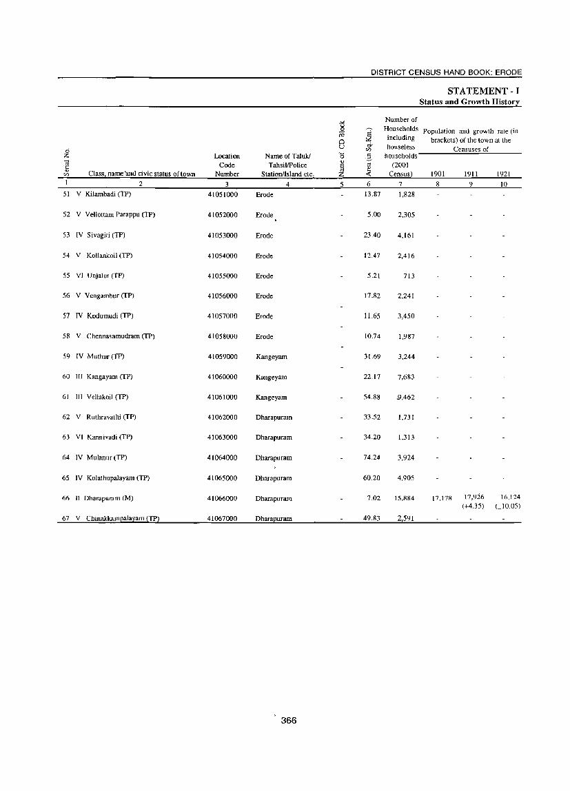
DISTRICT CENSUS HAND BOOK: ERODE
STATEMENT - I Status and Growth IIistor~
_". Number of
il ~
Households Population and growth rate (in 10
0 including brackets) of the town at the
U 0- houseless Censuses of 0 CI)
Z Location Name of Taluk/ '0 -3 households .~ Code TahsilJPolice ~ os (2001 ..,
Class, name 'and civic status of town ~
CI) Number Stationllsland etc, Z « Censusl 1901 1911 1921 2 3 4 5 6 7 8 9 10
51 V Kilambadi (TP) 41051000 Erode 13.87 1,828
52 V Vellottam Parappu (TP) 41052000 Erode 5.00 2,305
53 IV Sivagiri (TP) 41053000 Erode 23.40 4,161
54 V Kollankoil (TP) 41054000 Erode 12.47 2,416
55 VI Unjalur (TP) 41055000 Erode 5.21 713
56 V Vengambur (TP) 41056000 Erode 17.82 2,241
57 IV Kodumudi (TP) 41057000 Erode 11.65 3,450
58 V Chennasamudram (TP) 41058000 Erode 10.74 1,987
59 IV Muthur (TP) 41059000 Kangeyam 31.69 3,244
60 III Kangayam (TP) 41060000 Kangeyam 22.17 7,683
61 III Vellakoil (TP) 41061000 Kangeyam 54.88 .9,462
62 V R uthravathi (TP) 41062000 Dharapuram 33.52 1,731
63 VI Kannivadi (TP) 41063000 Dharapuram 34.20 1,313
64 IV Mulanur (TP) 41064000 Dharapuram 74.24 3,924
65 IV Kolathupalayam (TP) 41065000 Dharapuram 60.20 4,905
66 II Dharapuram (M) 41066000 Dharapuram 7.02 15,884 17,178 17,926 16,124 (+4.35) UO.05)
67 V ChinakkamEala:z:am ~TPl 41067000 DharaEuram 49.83 21591
366

TOWN DIRECTORY
STA TEMENT - I Status and Growth History
Population and growth rate (in brackets) of the town at the Censuses of
Density Sex ratio (2001
1931 1941 1951 1961 1971 1981 1991 2001 Census) 1981 1991 2001 Class, name and civic status of town 11 12 13 14 15 16 17 18 19 20 21 22 2
6,343 457 1,034 V Kilambadi (TP)
8,131 1,626 990 V Vellottam Parappu (TP)
16,255 695 974 IV Sivagiri (TP)
8,754 702 993 V Kollankoil (TP)
2,628 504 986 VI Unjalur (TP)
7,632 428 1,013 V Vengambur eTP)
12,664 1,087 995 IV Kodumudi (TP)
,7,342 684 999 V Chennasamudram (TP)
11,880 375 994 IV Muthur (TP)
12,864 14,720 21,259 28,258 1,275 940 950 956 III Kangayam eTP) (+14.43) (+44.44) (+32.9)
34,438 628 992 III Vellakoil (TP)
6,107 182 922 V Ruthravathi (TP)
4,412 129 1,011 VI Kannivadi (TP)
13,827 186 1,000 IV Mulanur (TP)
17,438 290 l.003 IV Kolathupalayam eTP)
18,218 20,660 24.163 26,490 34,500 42,263 48,393 64,984 9,257 1,004 1,004 1.031 II Dharapuram (M) (+12.99 (+13.40) (+16.96) (+9.63) (+30.24) (+22.50) (+14.50) (+34.3)
9,694 195 960 V Chinakkampalayam (TP)
367

2
3
4
5
6
7
8
9
10
II
12
13
14
15
16
17
18
19
20
21
22
23
24
25
26
27
28
29
30
31
32
33
34
Name and civic status of town
2 Kempanaickenpalayam (TP)
Sathyamangalam (M)
Ariyappampalayam (TP)
Bhavanisagar (TP)
Punjaipuliarnpatti (TP)
Nerungipettai (TP)
Ammapettai (TP)
Olakkadam (TP)
Andiyur (TP)
Athani (TP)
Appakudal (TP)
Jambai (TP)
Bhavani (M)
Salangapalayam (TP)
Periakodiveri (TP)
Vaniputhur (TP)
P.Mettupalayam (TP)
Kugalur (TP)
Lakkampatti (TP)
Kasipalayam (TP)
Gobichettipalayam (M)
Elathur (TP)
Kolappalur (TP)
Nambiyur (TP)
Pethampalayam (TP)
PalJapalayam (TP)
Kanjikoil (TP)
Karumadi C. Palayam (TP)
Nallampatti (TP)
Kunnathur (TP)
Vijayapuri (Cn
Perundurai (TP)
Mukasipidariyur (CT)
Punjai Uthukuli (TP)
Ra~pfaIl (in mm)
3
632.0
632.0
632.0
632.0 632.0
632.0
632.0
632.0
632.0
632.0
632.0
632.0
632.0 , 632.0
632.0
632.0
632.0
632.0
632.0
632.0
632.0
632.0
632.0
632.0
632.0
632.0
632.0
632.0
632.0
632.0
632.0
632.0
632.0
632.0
368
DISTRICT CENSUS HAND BOOK: ERODE
STATEMENT-II Physical Aspects and Location of Towns, 1999
Physical aspects State Head District 'I emperature Quarters Head
(in centigrade) Quarters
Maximum
4
35.8
35.8
35.8
35.8
35.8
35.8
35.8
35.8
35.8
35.8
35.8
35.8
35.8
35.8
35.8
35.8
35.8
35.8
35.8
35.8
35.8
35.8
35.8
35.8
35.8
35.8
35.8
35.8
35.8
35.8
35.8
35.8
35.8
35.8
Minimum
5
19.2
192
19.2
19.2
19.2
19.2
19.2
19.2
19.2
19.2
19.2
192
192
19.2
19.2
19.2
19.2
19.2
19.2
19.2
192
19.2
19.2
19.2
19.2
19.2
19.2
19.2
19.2
19.2
19.2
19.2
19.2
19.2
6 7
Chennai 456 Erode 62
Chennai 450 Erode 65
Chennai 460 Erode 65
Chennai 476 Erode 80
Chennai 485 Erode 80
Chennai 400 Erode 35
Chennai 445 Erode 45
Chennai 450 Erode 36
Chennai 400 Erode 36
Chennai 465 Erode 40
Chennai 410 Erode 31
Chennai 425 Erode 25
Chennai ~()(} Erode 15
Chennai 450 Erode 30
Chennai 490 Erode 60
Chennai 447 Erode 53
Chennai 452 Erode 28
Chennai 450 Erode 48
Chennai 445 Erode 45
Chcnnai 433 Erode 47
Chennai 440 Erode 38
Chennai 450 Erode 64
Chennai 500 Erode 50
Chennai 410 Erode 60
Chennai 420 Erode 20
Chennai 420 Erode 25
Chennai 436 Erode 20
Chennai 420 Erode 20
Chennai 445 Erode 26
Chennai 440 Erode 40
Chennai 430 Erode 28
Chennai 420 Erode 20
Chennai 420 Erode 35
Chennai 490 Erode 42

TOWN DIRECTORY
STATEMENT ·11 Physical Aspects and Location of Towns, 1999
Name of and distance in kilometer(s) from Name and civic status of town
Sub- Nearest city Nearest city Railway Bus Navigable divisioniTalukIPolice with with population stiltion facility river/canal (if station/Development population of five lakh and within
Block/Island H.Q. of one lakh more 10kms.) and more
9 10 11 12 13 14 2 Sathyamangalam 9 Erode 62 Coimbatore 70 Erode 62 Yes No Kempanaickenpalayam (TP) Sathyamangalam 0 Erode 65 Coimbatore 75 Mettupalayam Yes No Sathyamangalam (M)
43 Sathyamangalam 2 Tirupur 56 Coimbatore 70 Tirupur 56 Yes No Ariyappampalayam (TP)
Sathyamangalam 16 Coimbatore Coimbatore 56 Mettupalayam Yes No Bhavanisagar (TP) 'iti ~4
Sathyamangalam 21 Tirupur 32 Coimbatore 50 Tirupur 32 Yes No PunjaipuJiampatti (TP) Bhavani 25 Erode 35 Salem 90 Erode 35 Yes No Nerungipettai (TP)
Bhavani 22 Erode 45 Salem 87 Erode 45 Yes No Arnmapettai (TP)
Bhavani 17 Erode36 Salem 82 Erode 36 Yes No Olakkadam (TP)
Bhavani 19 Erode 36 Salem 84 Erode 36 Yes No Andiyur (TP)
Bhavani 25 Erode 40 Salem 90 Erode 40 Yes No Athani (TP)
Bhavani 15 Erode 31 Salem 80 Erode 31 Yes No Appakudal (TP)
Bhavani 8 Erode 25 Salem 73 Erode 25 Yes No Jambai (TP)
Bhavani 0 Erode 15 Salem 65 Erode 15 Yes No Bhavani (M)
Bhavani 15 Erode 30 Salem 80 Erod~ 30 Yes No Salangapalayam (TP)
Gobichettipalayam 20 Erode 60 Coimbatore 80 Erode 60 Yes No Periakodiveri (TP)
Gobichettipalayam 13 Erode 53 Coimbatore 100 Erode 55 Yes No Vaniputhur (TP)
Gobichettipalayam 18 Erode 28 Salem 80 Erode 28 Yes No P.Mettupalayam (TP)
Gobichettipalayam 10 Erode 48 Salem 85 Erode 48 Yes No Kugalur (TP)
Gobichettipalayam 3 Erode 45 Coimbatore 90 Erode 45 Yes No Lakkampatti (TP)
Gobichettipalayam 15 Erode 47 Coimbatore 95 Erode 47 Yes No Kasipalayam (TP)
Gobichettipalayam 0 Erode 38 Coimbatore 85 Erode 38 Yes No Gobichettipalayam (M)
Gobichettipalayam 28 Tirupur 41 Coimbatore 95 Tirupur 41 Yes No Elathur (TP)
Gobichettipalayam IO Erode 50 Coimbatore 100 Tirupur 40 Yes No Kolappalur (TP)
Gobichettipalayam 19 Tirupur 32 Coimbatore 80 Tirupur 32 Yes No Nambiyur (TP)
Perundurai 9 Erode 20 Coimbatore 85 Perundurai 9 Yes No Pethampalayam (TP)
Perundurai 15 Erode 25 Coimbatore 90 Perundurai 25 Yes No Pallapalayam (TP)
Perundurai 10 Erode 20 Coimbatore 90 Perundurai 10 Yes No Kanjikoil (TP)
Perundurai 2 Erode 20 Coimbatore 100 Perundurai 2 Yes No Karumadi C. Palayam (TP)
Perundurai 18 Erode 26 Salem 90 Perundurai 18 Yes No N allampatti (TP)
Perundurai 19 Tirupur 25 Coimbatore 85 Uthukuli 14 Yes No Kunnathur (TP) , Perundurai 10 Erode 28 Coimbatore 70 Perundurai 12 Yes No Vijayapuri (CT)
Perundurai 0 Erode 20 Coimbatore 80 Perundurai 0 Yes No Perundurai (TP)
Perundurai 15 Erode 35 Coimbatore 95 Ingur 7 Yes No Mukasipidariyur (CT)
Perundurai 22 Tirupur 14 Coimbatore 80 Uthukuli 0 Yes No Punjai Uthukuli (TP)
369
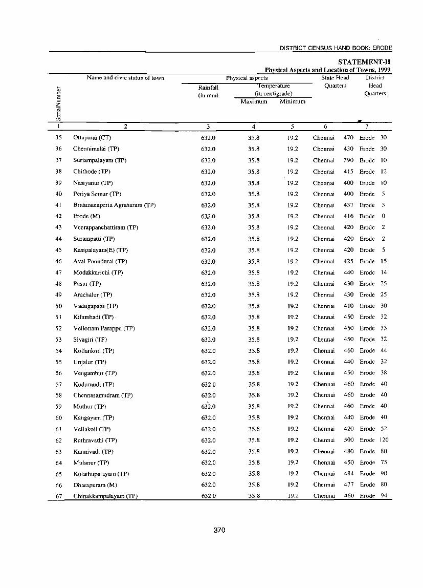
35
36
37
38
39
40
41
42
43
44
45
46
47
48
49
50
51
52
53
54
55
56
57
58
59
60
61
62
63
64
65
66
67
Name and civic status of town
2
Ottaparai (CT)
Chennimalai (TP)
Suriampalayarn (TP)
Chi thode (TP)
Nasiyanur (TP)
Periya Semur (TP)
Brahmanaperia Agraharam (TP)
Erode (M)
Veerappanchattiram (TP)
Surampatti (TP)
Kasipaiayam(E) (TP)
A val Poondurai (TP)
Modakkurichi (TP)
Pasur (TP)
Arachalur (TP)
Vadugapatti (TP)
Kilambadi (TP) .
Vellottam Parappu (TP)
Sivagiri (TP)
Kollankoil (TP)
Unjalur (TP)
Vengambur (TP)
Kodumudi (TP)
Chennasamudram (TP)
Muthur (TP)
Kangayam (TP)
Vellakoil (TP)
Ruthravathi (TP)
Kannivadi (TP)
Mulanur (TP)
Kolathupalayam (TP)
Dharapuram (M)
Chinakkampalayam (TP)
Rainfall (in mm)
3
632.0
632.0
632.0
632.0
632.0
632.0
632.0
632.0
632.0
632.0
632.0
632.0
632.0
632.0
632.0
632.0
632.0
632.0
632.0
632.0
632.0
632.0
632.0
632.0 ,
632.0
632.0
632.0
632.0
632.0
632.0
632.0
632.0
632.0
370
DISTRICT CENSUS HAND BOOK: ERODE
STATEMENT-II Physical Aspects and Location of Towns, 1999
Physical aspects State Head District
Maximum
4
35.8
35.8
35.8
35.8
35.8
35.8
35.8
35.8
35.8
35.8
35.8
35.8
35.8
35.8
35.8
35.8
35.8
35.8
35.8
35.8
35.8
35.8
35.8
35.8
35.8
35.8
35.8
35.8
35.8
35.8
35.8
35.8
35.8
Minimum
5
19.2
19.2
19.2
19.2
19.2
19.2
19.2
19.2
19.2
19.2
19.2
19.2
19.2
19.2
19.2
19.2
19.2
19.2
19.2
19.2
19.2
19.2
19.2
19.2
19.2
19.2
19.2
19.2
19.2
19.2
19.2
19.2
19.2
Quarters
6
Head Quarters
7
Chennai 470 Erode 30
Chennai 430 Erode 30
Chennai 390 Erode 10
Chennai 415 Erode 12
Chennai 400 Erode 10
Chennai 400 Erode 5
Chennai 437 Erode 5
Chennai 416 Erode 0
Chennai 420 Erode 2
Chennai 420 Erode 2
Chennai 420 Erode 5
Chennai 425 Erode 15
Chennai 440 Erode 14
Chennai 430 Erode 25
Chennai 430 Erode 25
Chennai 410 Erode 30
Chennai 450 Erode 32
Chennai 450 Erode 33
Chennai 450 Erode 32
Chennai 460 Erode 44
Chennai 440 Erode 32
Chennai 450 Erode 38
Chennai 460 Erode 40
Chennai 460 Erode 40
Chennai 460 Erode 40
Chennai 440 Erode 40
Chennai 420 Erode 52
Chennai 500 Erode 120
Chennai 480 Erode 80
Chennai 450 Erode 75
Chennai 484 Erode 90
Chennai 477 Erode 80
Chennai 460 Erode 94
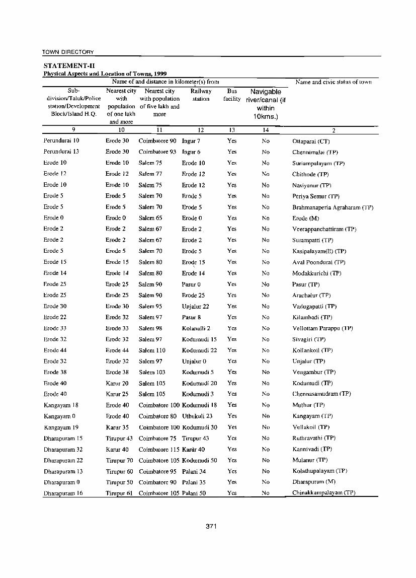
TOWN DIRECTORY
STATEMENT ·11 Ph~sical As~ects and Location of Towns! 1999
Name of and distance in kilometer(s) from Name and civic status of town
Sub- Nearest city Nearest city Railway Bus Navigable divisionITalukIPolice with with population station facility river/canal (if station/Development population of five lakh and within
Block/Island H.Q. or one lakh more 10kms.) and more
9 10 11 12 13 14 2
Perundurai 10 Erode 30 Coimbatore 90 Ingur 7 Yes No Ottaparai (CT)
Perundurai 13 Erode 30 Coimbatore 93 Ingur 6 Yes No Chennimalai (TP)
Erode 10 Erode 10 Salem 75 Erode 10 Yes No Suriampalayam (TP)
Erode 12 Erode 12 Salem 77 Erode 12 Yes No Chi thode (TP)
Erode 10 Erode 10 Salem 75 Erode 12 Yes No Nasiyanur (TP)
Erode 5 Erode 5 Salem 70 Erode 5 Yes No Periya Semur (TP)
Erode 5 Erode 5 Salem 70 Erode 5 Yes No Brahmanaperia Agraharam (TP)
Erode 0 Erode 0 Salem 65 Erode 0 Yes No Erode (M)
Erode 2 Erode 2 Salem 67 Erode 2 Yes No Veerappanchattiram (TP)
Erode 2 Erode 2 Salem 67 Erode 2 Yes No Surampatti (TP)
Erode 5 Erode 5 Salem 70 Erode 5 Yes No Kasipalayam(E) (TP)
Erode IS Erode 15 Salem 80 Erode 15 Yes No A val Poondurai (TP)
Erode 14 Erode 14 Salem 80 Erode 14 Yes No Modakkurichi (TP)
Erode 25 Erode 25 Salem 90 Pasur 0 Yes No Pasur (TP)
Erode 25 Erode 25 Salem 90 Erode 25 Yes No Arachal ur (TP)
Erode 30 Erode 30 Salem 95 Unjalur 22 Yes No Vadugapatti (TP)
Erode 22 Erode 32 Salem 97 Pasur 8 Yes No Kilambadi (TP)
Erode 33 Erode 33 Salem 98 Kolanalli 2 Yes No Vellottam Parappu (TP)
Erode 32 Erode 32 Salem 97 Kodumudi IS Yes No Sivagiri (TP)
Erode 44 Erode 44 Salem 110 Kodumudi 22 Yes No Kollankoil (TP)
Erode 32 Erode 32 Salem 97 Unjalur 0 Yes No Unjalur (TP)
Erode 38 Erode 38 Salem 103 Kodumudi 5 Yes No Vengambur (TP)
Erode 40 Karur 20 Salem 105 Kodumudi 20 Yes No Kodumudi (TP)
Erode 40 Karur 25 Salem 105 Kodumudi 3 Yes No Chennasamudram (TP)
Kangayam 18 Erode 40 Coimbatore 100 Kodumudi 18 Yes No Muthur (TP)
Kangayam 0 Erode 40 Coimbatore 80 Uthukuli 23 Yes No Kangayam (TP)
Kangayam 19 Karur 35 Coimbatore 100 Kodumudi 30 Yes No Vellakoil (TP)
Dharapuram 15 Tirupur43 Coimbatore 75 Tirupur 43 Yes No Ruthravathi (TP)
Dharapuram 32 Karur 40 Coimbatore 115 Kanlr 40 Yes No Kanni vadi (TP)
Dharapuram 22 Tirupur 70 Coimbatore 105 Kodumudi 50 Yes No Mulanur (TP)
Dharapuram 13 Tirupur 60 Coimbatore 95 Palani 34 Yes No Kolathupalayam (TP)
Dharapuram 0 Tirupur 50 Coimbatore 90 Palani 35 Yes No Dharapuram (M)
Dhara2uram 16 Tiru2ur 61 Coimbatore 105 Palani 50 Yes No Chinakk:am2ala~am (TP)
371
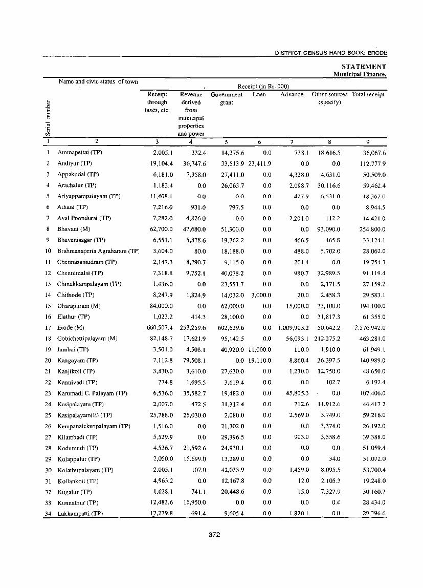
2
3
4
5
Name and civic status of town
2
Ammapettai (TP)
Andiyur (TP)
Appakudal (TP)
Arachalur (TP)
Ariyappampalayam (TP)
6 Athani (TP)
7 A val Poondurai (TP)
8 Bhavani (M)
9 Bhavanisagar (TP)
10 Brahmanaperia Agraharam (TP;
II Chennasamudram (TP)
12 Chennimalai (TP)
13 Chinakkampalayam (TP)
14 Chithode (TP)
15 Dharapuram (M)
16 Elathur (TP)
17 Erode (M)
18 Gobichettipalayam (M)
19 J ambai (TP)
20 Kangayam (TP)
21 Kanjikoil (TP)
22 Kannivadi (TP)
23 Karumadi C. Palayam (TP)
24 Kasipalayam (TP)
25 Kasipalayam(E) (TP)
26 Kempanaickenpalayam (TP)
27 Kilambadi (TP)
28 Kodumudi (TP)
29 Kolappalur (TP)
30 Kolathupalayam (TP)
31 Kollankoil (TP)
32 Kugalur (TP)
33 Kunnathur (TP)
34 Lakkampatti (TP)
Receipt through
taxes, etc.
3
2,005.1
19,104.4
6,181.0
1.183.4
11,408.1
7,216.0
7,282.0
62,700.0
6,551.1
3,604.0
2,147.3
7,318.8
1,436.0
8,247.9
84,000.0
1,023.2
Revenue derived
from municipal properties and power
4
332.4
36,747.6
7,958.0
0.0
0.0
931.0
4,826.0
47,680.0
5,878.6
80.0
8,290.7
9,752.1
0.0
1,824.9
0.0
414.3
660,507.4 253,259.6
82,148.7 17,621.9
3,501.0 4,508.1
7,112.8 79,508.1
3,430.0
774.8
6,536.0
2,007.0
25,788.0
1,516.0
5,529.9
4.536.7
2,050.0
2,005.1
4,963.2
1,628.1
12,483.6
17,279.8
3,610.0
1,695.5
35,582.7
472.5
25,030.0
0.0
0.0
21,592.6
15,699.0
107.0
0.0
741.1
15,950.0
691.4
DISTRICT CENSUS HAND BOOK: ERODE
STATEMENT Municipal Finance,
Receipt (in Rs.'OOO) Government Loan Advance Other sources Total receipt
(specify) grant
5 6
14,375.6 0.0
33,513.9 23,411.9
27,411.0
26,063.7
0.0
797.5
0.0
51,300.0
19,762.2
18,188.0
0.0
0.0
0.0
0.0
0.0
0.0
0.0
0.0
9,115.0 0.0
40.078.2 0.0
23.551.7 0.0
14,032.0 3,000.0
0.0
0.0
7
738.1
0.0
4,328.0
2,098.7
427.9
0.0
2,201.0
0.0
466.5
488.0
201.4
980.7
0.0
20.0
8
18,616.5
0.0
4,631.0
30,116.6
6,531.0
0.0
112.2
93,090.0
465.8
5,702.0
0.0
32,989.5
2,171.5
2.458.3
15,000.0 33,100.0
0.0 31,817.3
62,000.0
28,100.0
602,629.6 0.0 1,009,903.2 50,642.2
372
95,142.5 0.0
40,920.0 11,000.0
0.0 19,110.0
27,630.0
3,619.4
19,482.0
31,312.4
2,080.0
21,302.0
29,396.5
24,930.1
13,289.0
42,033.9
12,167.8
20,448.6
0.0
9,605.4
0.0
0.0
0.0
0.0
0.0
0.0
0.0
0.0
0.0
0.0
0.0
0.0
0.0
0.0
56,093.1 212,275.2
110.0 1,910.0
8,860.4 26,397.5
1,230.0
0.0
45,805.3
712.6
2.569.0
0.0
903.0
0.0
0.0
1,459.0
12.0
15.0
0.0
1,820.1
12,750.0
102.7
0.0
11.912.6
3,749.0
3,374.0
3,558.6
0.0
34.0
8,095.5
2.105.3
7,327.9
0.4
0.0
9
36,067.6
112,777.9
50,509.0
59,462.4
18,367.0
8,944.5
14,421.0
254,800.0
33,124.1
28,062.0
19,754.3
91.119.4
27.159.2
29,583.1
194,100.0
61.355.0
2,576,942.0
463,281.0
61,949.1
140.989.0
48.650.0
6.192.4
107,406.0
46,417.2
59,216.0
26,192.0
39,388.0
51,059.4
31.072.0
53,700.4
19,248.0
30.160.7
28,434.0
29,396.6
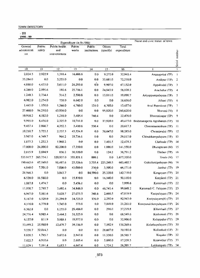
TOWN DIRECTORY
- III 1998·99
General administrati
on
10
2,824.5
35,284.0
4,888.0
4,280.0
1,240.3
6.982.0
Public safety
11
2,922.9
0.0
4,433.0
2.995.6
2,734.4
2,254.0
1,445.0 1,150.0
27,460.0 94,210.0
10,910.2 4,182.0
9,995.0
9,437.4
10,210.7
3,967.0
1,877.3
17.000.0
2,815.9
8,456.0
2.866.7
3,755.1
4,349.7
1,232.3
24,000.0
2,694.9
535.917.7 263,734.1
190.443.6
4,840.0
28,946.3
6,520.0
1,067.8
11,970.7
6,947.0
8,167.0
4,316.0
6,362.8
24,776.4
6.137.0
53,499.2
9,558.7
8.820.5
2.822.5
11,029.1
67,149.0
7,501.0
0.0
11,580.0
1,474.7
2,795.7
5,161.6
6,529.0
6,778.0
0.0
9,983.4
811.9
25,980.9
32,014.3
1,795.7
6.910.6
7,191.4
Expenditure (in Rs. '000)
Public health Public Public Others (specify) and
conveniences
12
1,316.4
3,253.0
3,611.0
192.6
314.2
758.0
1,266.0
43,930.0
1,218.0
2,325.0
4,352.3
2,137.5
964.2
1,968.2
82,200.0
836.2
works
13
16,606.6
0.0
24,293.0
25,716.1
2,590.8
6,642.0
4,760.0
0.0
5,405.4
10,711.0
3,410.6
45,534.8
19,736.1
0.0
17,350.0
30,320.0
institutions
14 15·
0.0 9,271.0
0.0 33,681.0
O~O 9,907.0
0.0 24,943.9
0.0 13,011.0
0.0 0.0
131.0 4,705.0
0.0 95,020.0
760.4 0.0
0.0 17,928.0
550.4 0.0
0.0 36,647.0
0.0 0.0
0.0 7,401.5
0.0 1,000.0
0.0 124.2
Total expenditure
16
32,941.4
72,218.0
47,132.0
58,128.2
19.890.7
16,636.0
13,457.0
260,620.0
22,476.0
Name and civic status of town
2
Ammapettai (TP)
Andiyur (TP) 2
Appakudal (TP) 3
Arachalur (TP) 4
Ariyappampalayam (TP) 5
Athani (TP) 6
A val Poondurai (TP) 7
Bhavani (M) 8
Bhavanisagar (TP) 9
49,415.0 Brahmanaperia Agraharam (TP) 10
20,617.3 Chennasamudram (TP) J I
98,285.0 Chennimalai (TP) 12
29,017.0
12,479.3
141,550.0
36,791.2
520,937.0 355,851.1 880.1 0.0 1.677,320.0
Chinakkampalayam (TP) 13
Chi thode (TP) 14
Dharapuram (M) 15
Elathur (TP) ] 6
Erode (M) 17
Gobichettipalayam (M) 18
Jambai (TP) 19
Kangayam (TP) 20
Kanjikoil (TP) 21
Kannivadi (TP) 22
Karumadi C. Pal"yam (TP) 23
Kasipalayam (TP) 24
Kasipalayam(E) (TP) 25
91,487.6
7,000.0
3,843.7
0.0
0.0
3,492.4
5,620.7
31,294.0
1.745.0
l,155.0
2,464.2
5,980.1
12,479.7
0.0
3,672.6
0.0
1,613.5
25,326.6
43,000.0
0.0
15,870.0
5,456.1
34,848.0
27,075.5
34,525.0
573.0
29,406.0
31,325.6
19,977.0
39,116.9
0.0
2,947.0
2.605.4
4,647.4
3,755.4 225,240.5
330.0 3,500.0 , 84,590.0
0.0
0.0
0.0
348.6
136.0
0.0
0.0
0.0
0.0
0.0
0.0
0.0
0.0
0.0
373
25,338.0
16,140.0
0.0
46,741.4
2,666.5
2,292.0
7,849.0
296.0
0.0
0.0
7,192.9
28,607.0
11,330.0
5,000.0
1,724.2
603,402.7
66,171.0
142,718.0
50,110.0
7,998.6
99,848.2
47,819.9
82,943.0
21,261.0
37,219.8
68,549.6
32,906.0
138,269.6
70,180.0
28,565.7
17.338.5
26,205.7
Kempanaickenpalayam (TP) 26
Kilambadi (TP) 27
Kodumudi (TP) 28
Kolappalur (TP) 29
Kolathupalayam (TP) 30
Kollankoil (TP) 3 J
Kugalur (TP) 32
Kunnathur (TP) 33
Lakkampatti (TP) 34

Name and civic status of town
2
Modakkurichi (TP)
:'0 Mukasipidariyur (CT)
37 Mulanur (TP)
38 Muthur (TP)
39 Nallampatti (TP)
40 Nambiyur (TP)
41 Nasiyanur (TP)
Nerungipettai (TP)
: ~ Olakkadam (TP)
Ottaparai (CT)
P.Mettupalayam (TP)
' .. ' Pallapalayam (TP)
r. Pasur (TP)
48 Periakodiveri (TP)
49 Periya Semur (TP)
50 Perundurai (TP)
51 Pethampalayam (TP)
52 Punjai Uthukuli (TP)
51 Punjaipuliampatti (TP)
~ Ruthravathi (TP)
Salangapalayam (TP)
.') Sathyamangalam (M)
Sivagiri (TP)
\. Surampatti (TP)
)9 SuriampaJayam (TP)
60 Unjalur (TP)
61 Vadugapatti (TP)
62 Vaniputhur (TP)
63 Veerappanchattiram (TP)
64 Vellakoil (TP)
Vellottam Parappu (TP)
c" Vengambur (TP)
Vijayapuri (eT)
DISTRICT CENSUS HAND BOOK: ERODE
Receipt (in Rs.'OOO) Receipt through
Revenue Government Loan Advance derived grant
taxes, etc. from
3
5,182.5
2,720.0
4,054.8
3,153.3
1,512.3
5,108.9
5,640.9
3,550.0
2,190.4
2,750.0
4,947.0
1,958 . .,
571.0
1,410.0
36,665.0
4,546.0
2,727.0
1,850.0
15,839.6
2,251.1
5,215.6
39,000.0
3,257.0
31,967.0
municipal properties and power
4
0.0
0.0
16,083.1
2,771.8
0.0
20,050.3
12,106.0
3,750.0
605.8
0.0
1,055.0
4,598.1
17,043.0
11,440.0
519.0
59,629.0
0.0
1,000.0
70,531.2 ,
3,614.8
1,200.0
47,050.0
17,789.0
14,107.0
18,090.0 0.0
818.7 464.2
1,190.5 0.0
8,550.0 918.0
10.105.0 158,744.0
22,228.4 44,759.3
6,264.3 0.0
2,648.7
785.2
266.4
12.0
374
5
20,289.0
7,000.0
30,203.1
38,190.0
8,633.5
15,342.5
14,761.9
16,990.0
13,705.0
3,000.0
2,150.0
15,323.6
12,487.0
20,970.0
44,014.0
0.0
17,058.0
6
0.0
0.0
0.0
0.0
0.0
0.0
0.0
0.0
0.0
0.0
0.0
0.0
0.0
0.0
0.0
0.0
0.0
9,500.0 0.0
21,289.3 0.0
9,920.8 0.0
18,000.0 0.0
58,000.0 0.0
33,114.2 30,700.0
50,375.0 0.0
32,019.0 0.0
17,756.9 0.0
27,968.8 0.0
15,000.0 0.0
23,669.0 13,350.0
15.893.9 0.0
988.6 0.0
23,493.7
24,687.0
0.0
0.0
7
2,282.1
0.0
521.4
65.5
63.5
2,852.2
2,205.8
0.0
155.8
0.0
2,264.0
1,526.6
645.0
150.0
1,653.0
3,299.0
364.0
1,040.0
541.0
1,230.3
2,580.0
12,650.0
280.0
0.0
596.0
1,581.0
0.0
0.0
0.0
1.839.0
9.9
148.0
0.0
STATEMENT Municipal Finance,
Other sources Total receipt (specify)
8
6.666.8
0.0
8,382.9
0.4
0.0
18,497.7
3,893.7
0.0
0.0
0.0
4.740.0
7,356.3
1,227.0
7,050.0
0.0
2,518.0
484.1
1,900.0
0.0
5.917.2
17,000.0
77,700.0
11.642.0
0.0
25.206.0
2,170.1
3,189.3
10,714.3
0.0
13,451.3
1.496.5
0.0
0.0
9
34,420.3
9.720.0
59,245.2
44,181.0
10,209.3
6].851.5
38.608.3
24,290.0
16,657.0
5.750.0
15.156.0
30,763.3
31,973.0
41,020.0
82,851.0
69,992.0
20,633.0
15.290.0
108,201.0
22.934.3
43,996.0
234,400.0
96,782.0
96,449.0
75,911.0
22.790.9
32.348.6
35,182.3
205.868.0
98.171.9
8,759.3
26,557.0
25,484.0

TOWN DIRECTORY
- III 1998·99
General administrati
on
10
13.904.5
250.0
2,528.4
32,727.2
671.2
14,974.6
5,987.7
2,970.0
5,690.1
150.0
393.0
7,459.9
4,784.0
9,390.0
6,580.0
9,328.0
1.174.0
0.0
Public safety
11
6,405.9
0.0
0.0
55,306.8
0.0
193.2
6,552.1
7,680.0
8,137.9
0.0
6,709.0
640.9
6,684.0
650.0
16,880.0
1,826.0
1.262.0
0.0
25,537.3 42,025.7
2,539.6 419.0
10,000.0 6,000.0
29.600.0 0.0
10,874.0
18,422.0
1,346.0
5,246.2
3,754.4
11,320.0
40.165.7
45,766.2
S.208.3
3471
12.0
7,956.0
20,007.0
8.005.0
4.675.0
3,819.3
6,650.0
58,895.0
11,032.7
1.525.0
2.549.6
41.0
Expenditure (in Rs.'OOO) Public health Public Public Others
(specify) and conveniences
12
189.5
500.0
494.6
0.0
729.9
562.2
673.3
1,260.0
2,222.0
500.0
580.0
2,722.5
0.0
660.0
20,000.0
2.567.0
160.0
8,160.0
1,756.8
118.9
530.0
62,300.0
2,400.0
0.0
15.798.0
514.9
864.1
0.0
3,042.0
10,392.1
880.2
463.3
161.0
works
13
6,040.0
7,000.0
0.0
9,084.2
0.0
7,170.0
21,896.3
16,240.0
0.0
5,000.0
296.0
15,629.9
16,914.0
19,470.0
25,680.0
6,062.0
17,058.0
0.0
41,715.0
1,340.9
20,000.0
40,100.0
28,075.0
61,359.0
26,510.0
11,149.7
22,387.8
5,250.0
148,079.0
31,257.8
17,708.2
14,406.4
24,620.0
institutions
14
450.1
0.0
0.0
0.0
0.0
177.1
24.4
0.0
0.0
0.0
0.0
4,815.1
0.0
0.0
0.0
0.0
0.0
1,870.0
4,769.6
?,742.0
0.0
15
0.0
1,500.0
15,364.6
0.0
0.0
16,442.9
767.6
0.0
0.0
100.0
1,751.0
267.6
1,560.0
14,190.0
0.0
1,710.0
979.0
3,170.0
3,157.0
3,721.7
0.0
0.0 107,300.0
181.0
32.0
0.0
0.0
0.0
0.0
0.0
3,231.1
0.0
0.0
50.0
375
205.0
0.0
3.845.0
28.6
194.0
13,580.0
0.0
21.496.9
1.119.6
0.0
0.0
Total expenditure
16
26.990.0
9,250.0
18,387.7
97,118.2
1,401.0
39.520.0
35,901.4
28,150.0
16,050.0
5,750.0
9,729.0
31,535.9
29,942.0
44,360.0
69,140.0
21,493.0
20.633.0
13,200.0
118,961.2
13,882.0
36,530.0
239,300.0
49,691.0
99,820.0
55,504.0
21,614.4
31,020.0
36.800.0
250,181.7
123,176.8
26,441.3
17,766.4
24.884.0
Name and civic slatus of town
2
Modakkurichi (TP) 35
Mukasipidariyur (CT) 36
Mulanur (TP) 37
Muthur (TP) 38
Nallampatti (TP) 39
Nambiyur (TP) 40
Nasiyanur (TP) 41
Nerungipettai (TPJ 42
Olakkadam (TP) 43
Ottaparai (Cn 44
P.Mettupalayam (TP) 45
Pallapalayam (TP) 46
Pasur (TP) 47
Periakodiveri (TP) 48
Periya Semur (TP) 49
Perundurai (TP) 50
Pethampalayam (TP) 51
Punjai Uthukuli (TP) 52
Punjaipuliampatti (TP) 53
Ruthravathi (TP) 54
Salangapalayarn (TP) 55
Sathyamangalam (M) 56
Sivagiri (TP) 57
Surampatti (TP) 58
Suriampalayam (TP) 59
Unjalur (TP) 60
Vadugapatti (TP) 6 J
Vaniputhur (TP) 62
Veerappanchattiram (TP) 63
Vellakoil (TP) 64
Vellottam Parappu (TP) 65
Vengambur (TP) 66
Vijayapuri (CT) 67

Name and civic status of town
2 3
Kempanaickenpalayam (TP) TP
2 Sathyamangalarn (M) M
3 Ariyappampalayam (TP) TP
4 Bhavanisagar (TP) TP
5 PunjaipuJiampatti (TP) TP
6 Nerungipettai (TP) TP
7 Ammapettai (TP) TP
8 Olakkadam (TP) TP
9 Andiyur (TP) TP
10 Athani (TP) TP
11 Appakudal (TP) TP
12 lambai (TP) TP
13 Bhavani (M) M
14 Salangapalayam (TP) TP
15 Periakodiveri (TP) TP
16 Vaniputhur (TP) TP
17 P.Mettupalayam (TP) TP
18 Kugalur (TP) TP
19 Lakkampatti (TP) TP
20 Kasipalayam (TP) TP
21 Gobichettipalayam (M) M
22 Elathur (TP) TP
23 Kolappalur (TP) TP
24 Nambiyur (TP) TP
Population(2001 Census)
3
10,308
33,722
12,462
4,329
14.832
6,925
9,259
9,370
20,071
8,423
9,522
15,011
38,778
14,702
12,405
12,207
9,115
11,684
11,038
8,570
55,158
7,678
9,803
15,854
4 5
1,449 10
2,947 121
2,204 6
q53 8
2,588
1,220 62
1,348 618
1,147 277
1,727 13
1,456
979
3,251
2,333
1,401
2,001
1,632
863
2,167
1,395
1,483
52
11
16
3
22
4,882 251
1,539
1,694
2,514 7
376
DISTRICT CENSUS HAND BOOK: ERODE
STA TEMENT - IV -Number of latnnes
6 7 8
15 OSD 3
63 OSD 6,768
39 OSD 5
23 OSD 327
21 OSD 5,647
o E o .0 ,_.
~ 9
3
6,768
5
327
3,407
13 OSD 156 156
20 OSD 5 5
36 OSD 3 3
24 OSD 2,228 2,228
18 OSD 551 551
30 OSD 563 563
43 OSD 606 606
27 OSD 3,593 3,593
31 OSD 5 5
34 OSD 108 108
23 OSD 2,152 2,152
19 OSD 305 305
22 OSD 675 675
33 OSD 1,548 1,548
26 OSD 1.106 1.106
89 OSD 3,136 1,488
35 OSD 154 154
20 OSD 502 502
34 OSD 3 3
10 11
'<-< o
12
ST
ST
ST
ST
2,240 ST
ST
ST
ST
ST
ST
ST
ST
ST·
ST
ST
ST
ST
ST
ST
ST
1.648 ST
ST
ST
ST

TOWN DIRECTORY
Civic and other Amenities2 1999 ElectnllcatlOn (numEer or connectIons) Water sU2EI~ Fire fighting Name and civic status of town
service* Domestic Industrial Commercial Road Others b
OJ lighting ~ I=l 0- ..... - (points) 0- S ;:... ~ ~ '0 g "-0 O~v:l~ OJ E '" <U ~ U <U U .13 ~ .... 'iil.,sou ::l 0 >. ._ :-= ~
(/)
13 15 16 17 18 19 20 2
T OHT Sathyamangalam 1,237 12 76 237 14 Kempanaickenpalayam (TP) (450000) (9)
T OHT Yes 6,783 175 2,097 983 15 Sathyamangalam (M) (3275000)
TW OHT Sathyamangalam 1,478 15 95 391 Ariyappampalayam (TP) (1250000) (2)
TW OHT Sathyamangalam 882 24 188 368 26 Bhavanisagar (TP) (1380000) (16)
TW OHT Sathyamangalam 3,275 355 275 626 39 Punjaipuliampatti (TP) (1000000) (21)
T OHT Bhavani 810 7 28 218 12 Nerungipettai (TP) (220000) (25)
TW OHT Bhavani 1,993 23 275 341 21 Ammapettai (TP) (190000) (22)
TWffK OHT Bhavani 5,400 5 300 214 10 Olakkadam (TP) (500000) (17)
W OHT Yes 4,150 425 395 555 31 Andiyur (TP) (1200000)
TK OHT, SR Gobi 1,505 10 250 45 300 Athani (TP)
0 (15) T OHT Bhavani 2,220 12 190 367 6 Appakudal (TP)
(445000) (15) TW OHT Bhavani 2,800 100 230 406 40 Jambai (TP)
(84500) (8) T,TW OHT Yes 7,085 262 1.990 1,330 2,365 Bhavani (M)
(2850000) TW OHT Gobi 1,905 35 79 367 583 Salangapalayam (TP)
(900000) (16) T,TW OHT Sathyamangalam 1,896 20 75 371 Pcriakodivcri (TP)
(500000) (8) T,TW OHT Gobi C.Palayam 3,500 20 180 419 47 Vaniputhur (TP)
(257000) (13) TKfTW OHT,RIG Gobi C.Palayam 1,805 3 65 244 300 P.Mettupalayam (TP)
(900000) (18) T.W OHT Gobi C.Palayarn 1,665 13 133 387 Kugalur (TP)
(700000) (8) T,TW OHT Gobi C.Palayarn 2,110 43 232 329 48 Lakkampatti (TP)
(330000) (3) TWffK OHT Gobichettipalay 1,21t; 29 155 292 265 Kasipalayam (TP)
(580000) (15) TW OHT Yes 10,388 271 3,398 2,171 Gobichettipalayarn (M)
(2950000) T,TW OHT Gobi C.Palayarn 1,239 11 74 393 476 Elathur (TP)
(450000) (28) T,TW OHT,BWP Gobi C.Palayam 1,276 76 108 88 493 KolappaIur (TP)
(518000) (10) T,TW OHT Gobichettipalay 3,115 60 354 700 12 Nambiyur (TP)
(1166000) (20)
377

DISTRICT CENSUS HAND BOOK: ERODE
STATEMENT - IV -Name and civic status of town Population(2001 Census) Number of latrines
2 3 3 4 5 6 7 8 9 10 11 12 25 Pethampalayam (TP) TP 7,120 1,720 5 29 OSD ST
26 Pallapalayam (TP) TP 6,505 1,043 24 OSD 300 300 ST
27 Kanjikoil (TP) TP 11,040 1,796 3 23 OSD 280 280 ST
28 Karumadi C. Palayam (TP) TP 20,072 2,211 4 40 OSD 3,750 3,750 ST
29 Nallampatti (TP) TP 3,656 '879 33 OSD 3 3 ST
30 Kunnathur (TP) TP 7,032 751 6 15 OSD 555 555 ST
31 Vijayapuri (CT) CT 6,517 428 4 12 OSD 210 210 ST
32 Perundurai (TP) TP 16,943 2,040 41 OSD 2,913 2,913 ST
33 Mukasipidariyur (CT) CT 11,012 932 4 38 OSD 402 202 200 ST
34 Punjai Uthukuli (TP) TP 8,294 689 14 OSD 1,018 1,018 ST
35 Ottaparai (CT) CT 9,208 632 25 OSD 153 153 ST
36 Chennimalai (TP) TP 15,547 480 26 OSD 3,799 3,799 ST
37 SuJiampaiayam (TP) TP 21,923 5,192 23 10 OSD 1,063 1,063 ST
38 Chithode (TP) TP 7,704 654 4 17 OSD 1,891 1,891 ST
3'9 Nasiyanur (TP) TP 9,905 2,313 3 15 OSD 130 128 2 ST
40 Periya Semur (TP) TP 32,024 1,001 34 27 OSD 5 5 ST
41 Brahmanaperia Agraharam (TP) TP 21,458 7,066 20 OSD 2,340 2,340 ST
42 Erode (M) M 150,541 12,642 74 102 OSD 7,680 7,680 ST
43 Veerappanchattiram (TP) TP 72,703 4,367 24 67 OSD 10,213 10,213 ST
44 Surampatti (TP) TP 31,948 1,488 3 27 OSD 3,577 3,577 ST
45 Kasipalayam(E) (TP) TP 52,369 6,283 227 85 OSD 15 10 5 ST
46 A val Poondurai (TP) TP 11,243 1.751 5 30 OSD 1,791 1,791 ST
47 Modakkurichi (TP) TP 10,052 1,856 20 31 OSD 1,202 1,202 ST
48 Pasur (TP) TP 3,870 1,081 9 OSD 252 246 6 ST
378

TOWN DIRECTORY
Civic and other Amenitiess 1999 Water sUE£I~ Fire fighting Electrification (number of connections) Name and civic status of town
service'" Domestic Industrial Commercial Road Others <I.)
lighting ;>, ~J:: -a ..... - (points) 0.. S 0 ::l
'" ~ 'u .g 4-0 0 OcdiU'l'-"
<I.) S §' <I.) Z U <I.) u .!3 ~ ....
';;;.fjo~ :::l 0 ~.~;.:: ~
CI'l
13 14 15 16 17 18 19 20 2 TW OHT Perundurai 996 3 19 231 3 Pethampalayam (TP)
(250000) (19)
TW OHT Erode 1,208 5 229 450 Pallapalayam (TP) (575000) (25)
TW,TK OHT Perundurai 2,696 55 234 419 4 Kanjikoil (TP) (309000) (14)
T OHT Perundurai 3,520 75 1,200 680 215 Karumadi C. Palayam (TP) (513000) (16)
TW,W OHT Perundurai 750 10 100 163 7 Nallampatti (TP) (600000) (18)
T OHT Perundurai 710 82 220 48 Kunnathur (TP) (50000) (19)
OHT Perundurai 500 14 12 199 Vijayapuri (CT) (432000) (10)
T,W OHT Yes 3,011 303 915 696 710 Perundurai (TP) (500000)
T OHT Perundurai 2,500 400 300 252 Mukasipidariyur (eT) (100000) (15)
T OHT Perundurai 1,970 85 460 25 Punjai Uthukuli (TP) (500000) (22)
T OHT Perundurai 2,000 400 200 205 Ottaparai (CT) (l00000) (15)
T OHT,SR Perundurai 5,613 1,063 1,388 619 70 Chennimalai (TP) (400000) (13)
T,W OHT Bhavani 2,780 206 96 580 15 Suriampalayam (TP) (300000) (6)
T OHT,GLR Erode 1,630 35 70 306 Chi thode (TP) (550000) (12)
T,TW OHT Erode 2,162 105 250 356 595 Nasiyanur (TP) (476000) (10)
T OHT Erode 4,763 408 258 699 Periya Semur (TP) (1600000) (8)
T,W OHT Yes 2,350 170 810 419 475 Brahmanaperia Agraharam (Tf
(1125000) T,W OHT Yes 25,963 1,056 14,201 4,679 183 Erode (M)
(10700000) T OHT Erode 11 ,071 894 1,036 1,388 6 Veerappanchattiram (TP)
(3035000) (2) T,TW OHT Erode 5,922 327 907 853 22 Surampatti (TP)
(411000) (3) OHT OHT Erode 14,207 46 2,207 936 84 Kasipalayam(E) (TP)
(600000) (2)
T OHT Erode 4,386 ,
198 549 187 191 Aval Poondurai (TP) (1011000) (15)
T OHT Erode 3,018 170 393 283 1,087 Modakkurichi (TP) (250000) (4)
TW,T OHT Kodumudi 677 8 35 205 65 Pasur (TP)
(220000) (25)
379

DISTRICT CENSUS HAND BOOK: ERODE
STA TEMENT • IV . Name and civic status of town POEulation(200I Census) Numoer of latrines '-
I:' S 0 0
0 bO -;; ·0 til '" ~ ~ '" «I £ .... 0 b---- v g 0 ....
.~ 8 til ,g ~ 0.
0 "I '" .D
j~ U E-' .s 0 0 :a 8 til
E "1:l '0 I>IJ '- '-::l c:: 0,-:= c:: '" ~
0 0 «I .- "3 ,!l 8 .D <1) '0 0 . '-' til o '" C;; (.) til "1:l .... u
3 '0 B ~ B .~ .... -5E .;:: .s;: a '" ~ '" <I.> ..c: ~ c-::I -5 <I.> OJJ <1) .- fj
~ to) u 0 ---- 0 ~
v ~ ·c en U '" !Q sa p::: ~ en t: en 0 1 2 3 3 4 5 6 7 8 9 10 11 12
49 Arachalur (TP) TP 12,343 1,993 30 OSD 541 541 ST
50 Yadugapatti (TP) TP 10,921 2,436 87 37 OSD 424 424 ST
51 Kilambadi (TP) TP 6,343 1,207 4 19 OSD 195 195 ST
52 Yellottam Parappu (TP) TP 8,131 U87 3 34 OSD 108 108 ST
53 Sivagiri (TP) TP 16,255 1,613 31 OSD 752 752 ST
54 Kollankoil (TP) TP 8,754 1,400 22 OSD 498 498 ST
55 Unjalur (TP) TP 2,628 272 7 OSD 256 256 ST
56 Vengambur (TP) TP 7,632 944- 20 OSD 1,408 1,408 ST
57 Kodumudi (TP) TP 12,664 2,022 20 OSD 677 677 ST
58 Chennasamudram (TP) TP 7,342 916 35 OSD 675 675 ST
59 Muthur (TP) TP 11,880 2,721 4 23 OSD 758 758 ST
60 Kangayam (TP) TP 28,258 3,570 39 OSD 4,300 4,300 ST
61 Yellakoil (TP) TP 34,438 3,598 26 91 OSD 2,735 2,735 ST
62 Ruthravathi (TP) TP 6,107 1.672 38 OSD III 111 ST
63 Kanni vadi (TP) TP 4,412 728 51 OSD ST
64 Mulanur (TP) TP 13,827 2,624 65 OSD 1,451 1.451 ST
65 Kolathupa1ayarn (TP) TP 17,438 3,327 17 50 OSD 352 352 ST
66 Dharapurarn (M) M 64,984 10,112 511 33 OSD 9,503 9,503 ST
67 Chinakkampalayam (TP) TP 9,694 1,517 606 OSD ST
380
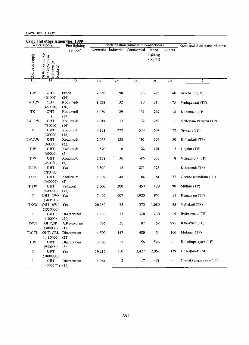
TOWN DIRECTORY
Civic and other Amenitiesl 1999 Water su££I~ Fire fighting 'Electrii'ication (number of connections) Name and civic status of town
service * Domestic IndUstrial Commercial Road Others ;>,
.., lighting
0. ~I': ..... - (points) 0- .9 ;>.. :::l Vl ~ '0 .g '-0 o ~ (/.) ".-.." .., 8 §- .., s (,) II) (,) .~ ~ .....
~-£lo(,) :::l 0 ;>...~ :-;:: ~
VJ
13 14 15 16 17 18 19 20 2
T,W OHT Erode 2,656 98 176 296 46 Arachalur (TP) (64000) (24)
TW,T,W OHT Kodumudi 1,638 32 110 319 75 Vadugapatti (TP) (480000) (26)
TK OHT Kodumudi 1,630 39 131 267 12 Kilambadi (TP)
0 (17) TW.T.W OHT Kodumudi 2,019 13 72 269 Vellottam Parappu (TP)
(730000) (16) T OHT Kodumudi 4,181 373 539 584 72 Sivagiri (TP)
(300000) (15) TW,T,W OHT Kodumudi 2,055 133 191 303 50 Kollankoil (TP)
(60000) (22) T,W OHT Kodumudi 570 6 122 161 5 Unjalur (TP)
(60000) (5)
T.W OHT Kodumudi 2,128 36 486 338 8 Vengambur (TP) (250000) (5)
T.TK OHT Yes 3,890 15 275 523 Kodumudi (TP) (280000)
TrTK OHT Kodumudi 1,309 48 164 61 22 Chennasamudram (TP) (340000) (3)
T,TW OHT Vellakoil 2,000 300 450 420 90 Muthur (TP) (400000) (12)
T OHT,BWP Yes 7,492 607 1,920 955 58 Kangayam (TP) (380500)
TKfW OHT, BWP Yes 20,150 75 375 1,080 35 Vellakoil (TP) (1350000)
T OHT Dharapuram 1,756 13 320 230 9 Ruthravathi (TP) (10000) (20)
TW.T OHT.SR A.Ravakulam 796 36 87 59 295 Kannivadi (TP)
(308000) (12) TW,TK OHT,GRL Dharapuram 1,500 147 480 54 160 Mulanur (TP)
(1180000) (22) T,W OHT Dharapuram 3,705 25 56 546 Kolathupalayam (TP)
(950000) (8) T OHT Yes 10,215 350 3,427 2,062 139 Dharapuram (M)
(1800000) T OHT Dharapuram 1,964 2 17 451 ChinakkarnpaJayam (TP)
(440000 **) (16)
381
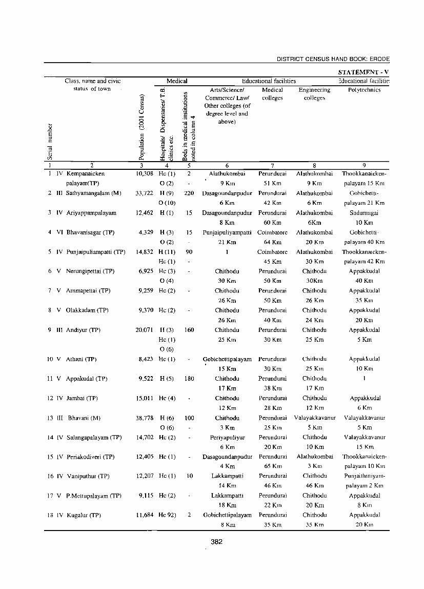
Class, name and civic status of town
2 IV Kempanaieken
palayamCTP)
2 III Sathyamangalarn (M)
3 IV Ariyappampalayam
4 VI Bhavanisagar (TP)
5 IV Punjaipuliampatti (TP)
6 V Nerungipettai CTP)
7 V Amrnapettai (TP)
8 V Olakkadam (TP)
9 III Andiyur (TP)
10 V Athani (TP)
II V Appakudal (TP)
12 IV lambai (TP)
13 III Bhavani (M)
14 IV Salangapalayam (TP)
15 IV Periakodiveri (TP)
16 IV Vaniputhur (TP)
17 V P.Mettupalayam (TP)
18 IV Kugalur (TP)
DISTRICT CENSUS HAND BOOK: ERODE
STA TEMENT - V
Medical Educational facilities ~ducational facilitie:
-:3 N '-'
3 4 10,308 He (1)
0(2)
33,722 H (9)
0(10)
12,462 H (1)
4,329 H (3)
0(2)
14,832 H (II)
He (I)
6,925 He (3)
0(4)
9,259 He (2)
9,370 He (2)
5
Arts/Science! Commercel Law/
Other colleges (of degree level and
above)
6
Medical colleges
7
Engineering colleges
8 2 Alathukornbai Perundurai Alathukombai
9 Km 51 Krn 9 Krn
220 Dasagoundanpudur Perundurai Alathukombai
6 Krn 42 Krn 6 Krn
15 Dasagoundanpudur Perundurai AIathukombai
8 Krn 60 Krn 6Km
15 Punjaipuliyampatti Coirnbatore Alathukombai
21 Krn 64 Km 20 Krn
90 I Coirnbatore Alathukombai
45Km
Perundurai
50 Krn
Perundurai
Polytechnics
9
20,071 H (3) 160
Chithodu
30 Krn
Chithodu
26Km
Chithodu
26Krn
Chithodu
25 Krn
50Km
Perundurai
40Km
Perundurai
30Km
30 Krn
Chithodu
30Km
Chithodu
26 Krn
Chithodu
24 Km
Chithodu
25 Km
Thookkanaicken
palayam 15 Km
Gobichetti
palayam 21 Km
Sadumugai
lOKm
Gobichetti
palayam 40 Krn
Thookkanatcken
palayam 42 Km
Appakkudal
40 Km
Appakkudal
35 Km
Appakkudal
20Km
Appakkudal
He (1)
0(6)
8,423 He (I)
9,522 H (5)
15,011 He (4)
38,778 H (6)
0(6)
14,702 Be (2)
12,405 He (I)
12,207 He (1)
9,115 He (2)
11,684 He 92)
180
Gobichettipalayam Perundurai
15Km 30Km
Perundurai
38 Km
Perundurai
28Km
Chithodu
25 Km
Chithodu
17 Km
Chithodu
12 Km
5 Krn
Appakkudal
IOKm
Appakkudal
6 Krn
100
Chithodu
17 Krn
Chithodu
12 Krn
Chithodu
3 Krn
Perundurai Valayakkavanur Valayakkavanur
25 Km 5 Km 5 Km
Periyapuliyur Perundurai
6 Krn 20 Krn
Dasagoundanpudur Perundurai
4 Krn 65 Km
10 Lakkarnpatti Perundurai
14 Km 46Km
Lakkampatti Perundurai
18 Krn 22 Km
2 Gobichettipalayam Perundurai
8 Krn 35 Km
382
Chithodu
10 Km
Alathukombai
3Km
Chithodu
46Km
Chithodu
20 Km
Chithodu
35 Krn
Val ayakkavanur
15 Km
Thookkanaieken
palayam 10 Km
Punjaithiniyam
paJayam 2 Km
Appakkudal
8 Krn
Appakkudal
20Km

TOWN DIRECTORY
Medical, Educational, Recreational and Cultural Facilities, 1999
Recognised shorthand,
typewriting and vocational training
institutions
10
Sathyamangalam
9Km
0(4)
Sathyamangalam
2Km
Ty (2),
0(2)
Sh (I),
Ty (4)
Bhavani
25 Km
Bhavani
20 Km
Bhavani
IOKm
Ty (2),
Shty (1)
Gobichettipalayam
15 Km
Shty (1)
Appakkudal
6Km
Shty (4)
Bhavani
10Km
Sathyarnangalam
8Km
Higher secondary! Intermediate! Senior
Secondary! PUC (Pre-university
Couree) College! Junior college level
II
Sathyamangalam
9Km
2
2
S i ngampettai
8Km
Singampettai
3Km
2
Kugalur
7Km
1
2
Kavundapadi
2Km
Gobichettipalayam Gohichettipalayam
14Km 14 Km
Gobichettipalayam
18 Km
Gobichettipalayam
8 Km
Appakkudal
SKm
Educational facilities (Contd .... )
12
5
2
2
Singampettai
3Km
2
2
Kavundapadi
2Km
1
13
6
4
2
4
2
2
6
3
3
2
4
2
3
14 15
3
9
7
4
4
3
3
8
9
7
8
10
9
9
4
4
3
6
383
Working women's hostels with number
of seats
16
Ariyappanpalayam
10Km
Ariyappanpalayam
2Km
1 (133)
Ariyappanpalayam
20Km
Ariyappanpalayam
20Km
Erode
35 Km
Erode
45 Km
Erode
36Km
Erode
36Km
Erode
40Km
Erode
31 Km
Erode
25 Km
Erode
15 Km
Erode
30Km
Ariyappanpalayam
8Km
Ariyappanpalayam
35 Km
Ariyappanpalayam
38 Km
Ariyappanpalayam
28 Km
17 18
3 3
3
2 4
2
19
2
1
4
20 PL I
PL 1
PL 1
PL 1
PL 1
PL I
PL I
RR 1
PL 1
PL 1
PL2
PL I
RR I
PL I
PL2
PL I
PL I
PL 1

DISTRICT CENSUS HAND BOOK: ERODE
STATEMENT - V
Class, name and civic Medical Educational facilities status of town cci Arts/Science! Medical Engineering Polytechnics
~ '" '" I'::: Commerce/ Law/ colleges colleges ::l '<II .9 '" I'::: 01) a Other colleges (of OJ '!a u '0
degree level and Vl '" 0 [ .5 ..".
... 0 ~ § above) ~
Vl 01)
is u ..0 '8E S I'::: '<II <.l S 8 ::l .9 c 'c;j ca tl .S .5 C'3 "3 .t: ~
~'2 ",-0 ·c 0. -0 OJ <1) d: 0:.::= 01) 0
(/)
2 3 6 7 8 9 19 IV Lakkampatti (TP) 11,038 He (2) Perundurai Chithodu Thookkanaicken-
42Km 40Km palayam 10 Km
~o V Kasipalayam (TP) 8,570 Hc (2) 4 Lakkampatti Perundurai Alathukombai Alikuli
0(2) 12Km 40Km 22 Km 4Km
21 II Gobichettipalayam (M) 55,158 H (20) 209 Lakkampatti Perundurai Alathukombai Alikuli 5 Km
0(20) 3 Km 30Km 22 Km
~1 V Elathur (TP) 7,678 He (2) Lakkampatti Perundurai Alathukombai Alikuli
28Km 45Km 22 Km 15 Km
23 V Kolappalur (TP) 9,803 He (1) Lakkampatti Perundurai Chithodu Karattadi-
0(3) IOKm 20Km 30Km Palayam IS Km
24 IV Nambiyur (TP) 15,854 H (6) 55 Lakkampatti Perundurai Alathukomhai Alikuli
Hc (1) 10 18Km 35Km 30Km 15 Km
0(2)
2S V Pethampalayam (TP) 7,120 He (2) Perundurai Perundurai Perundurai Perundurai
9Km 9Km 9Km 9Km
26 V Pallapalayam (TP) 6,505 He (1) Ellispettai Perundurai Chithodu Perundurai
4Km 15 Km 30Km 15 Km
-'7 IV Kanjikoil (TP) 11,040 He (2) 10 Perundurai Perundurai Chithodu Perundurai
0(8) IOKm 10Km 30Km 10Km
. 3 III Karumadi Chell i- 20,072 H (1) 100
Palayam (TP) The (1) 100
He (I)
29 VI Nallampatti (TP) 3,656 He (I) Seenapuram Perundurai Thudupathi Perundurai
6Km 18Km 6Km 18Km
30 V Kunnathur (TP) 7,032 H (4) 100 Perundurai Perundurai Thudupathi Perundurai
Hc (1) 2 19Km 19Km :;WKm 19 Km
31 V Vijayapuri (CT) 6,517 He (2) Perundurai Perundurai Thudupathi Perundurai
IOKm lOKm 15 Km 10 Km
~2 IV Perundurai (TP) 16,943 H (4) 30 I I
0(2)
~3 IV Mukasipidariyur (Cn 11,012 He (1) Thudupathi Perundurai Asokapuram Asokapuram
8Km 14Km 3Km 3Km
,4 V PunjaJ Uthukuli (TP) 8,294 Hc (2) 2 Thiruppur Perundurai Nadupatti Nadupatti
0(2) 20Km 26Km 7Km 7Km
35 V Ottaparai (CT) 9,208 He (1) Thittuparai Perundurai Asokapuram Asokapuram
7Km 15 Km 2Km 2Km
384

TOWN DIRECTORY
Medical, Educational, Recreational and Cultural Facilities, 1999 (contd.)
Educational facilities (Contd .... ) Recognised Higher secondary! ... Working women's shorthand, Intermediatel Senior J:::
:g hostels with number OJ)
typewriting and Secondaryl PUC 0 ~ ,-._
of seats c 'g ~S 'B "0 ""?3 :;; vocational training (Pre-uni versity ;5 § ., u
'" ... a u (.) ~ 0..
institutions Cource) College I .~ ~ c;j '" .8 <Il
_ <Il
.... ~ -0
(.)~ Cl OJ ~ >..~ '" Junior college level "0 0 ::r: .§ a c (.) ... ...... 0 ...r::: ~£i a .~ 0
~ <.> (.) ,_ E: <n. ~ 0 .2 :§ ... C
"0 <Il <Il i ;.::: ..,; a c;S ,_ :;; OJ)
c .... - - ... :;; a B § .Sl c 0 o 0 - .... 'B <U 'B 'B .- 0 ;:j - :0 (.) §13 ff "0 C c;j C ;:s c-; .,
5 ~ Ui 0 0 & (I.) so h '" « y ,_ 10 11 12 13 14 15 16 17 18 19 20
Shty (1) 1 4 Ariyappanpalaya PL2
20Km
Gobichettipalayam Kurumandur 4 Ariyappanpalaya PL 1
15 Km 10Km 20Km
Ty (12) 6 6 ' 12 20 Ariyappanpalayam 20 6 5 2 PL 1
Sathyamangalam Nambiyur Nambiyur 2 7 Ari yappanpal ayam PL I
15 Km 4Km 4Krn 20Km
Gobichettipalayam 2 7 Ariyappanpalayam PL2
6Km 30Km
Ty (1) 2 10 Ariyappanpalayam PL 1
25 Km
Perundurai Perundurai Perundurai 2 6 Erode PL I
9Km 9Km 9Km 20Km
Perundurai Ellispettai Kanjikoil Kanjiko 6 Erode
15 Km 4Km 3Km 3Km 25 Km
Pcrundurai 2 8 Erode 20 Km 2 PL I
10 Km 20Km
Perundurai 10 Erode 20 Km 3 PL I
2Km 20Km
Perundurai Kanjikoil 2 2 2 Erode
18 Km 12 Km 30Km
Shty (1) 1 2 2 4 Erode PL I
40Km
Perundurai 3 3 Erode PL 1.
10Km 28Km RR 1
Sh (1) 2 2 4 11 Erode 2 PL 1
Ty (1) 20Km
Perundurai 3 Erode
14 Km 27Km
Ty (1) 4 Erode
44Km
Perundurai Chennimalai Chennimalai 4 Erode
15 Km 2 Km 2Km 27Km
385

DISTRICT CENSUS HAND BOOK: ERODE
STATEMENT· V
Class, name and civic Medical Educational facilities status of town o:i ArtS/Science! Medical Engineering Polytechnics
,-.. ~ '" '" a:: Commerce! Law! colleges colleges ~ "<il ,51 a:: 0 a Other colleges (of u '!;j
U '::I degree level and '" '" .- I'l ,8 -.:t 8 0 above) .... Q.. ]j 0) ~ '"
S is ::l § "<il U ~ 8 c:; 'g c;j '0 ,8 ,5
c;j 1 ·a.~ ",-0 'C '" I'l -0 0 0) o~ 0) ~
IZI p... j:Q 0
2 3 '5 6 7 8 9 36 IV ChennimaIai (TP) 15,547 H (2) 6 Thittuparai Perundurai Murugatholuvu M urugatholuvu
Hc (3) 10 10 Km 13Km 3Km 3Km
0(7)
37 III SuriampaJayam (TP) 21,923 Hc (I) 5 Chithode Perundurai Erode
4 Km 25Km 13 Km
38 V Chi thode (TP) 7,704 Hc (1) 5 Perode Perundurai Kavunthapadi
3Km 20Km 13 Km
39 V Nasiyanur (TP) 9,905 H(1) 15 Ellispet Perundurai Suriyampalayam Perundurai
Hc(l) 5 lOKm 15Km lOKm 20Km
40 III Periya Semur (TP) 32,024 Perundurai Chi thode Ellispet
21 Km 4Km 8Km
41 III B rahmanaperia 21,458 H(l) 25 Veerappanchatram Perundurai Chi thode Perundurai
Agraharam (TP) Hc(1) 2 3Km 22Km 13 Km 22 Km
42 I Erode (M) 150,541 H(78) 1,023 Veerappanchatram Perundurai Thindal Thindal
Nb(63) 547 2Km 18Km 9Km 9Km
Hc(2) 22
Fwc(l) 60
The(l) 40
0(100)
43 II Veerappan Chattiram 72,703 H(5) 50 Perundurai Chithode Erode
10Km 15 Km 2Km
44 III Surampatti (TP) 31,948 H(5) 30 Erode 3 Km Perundurai Chithode Perundurai
0(3) 20Km 15 Km 20Km
45 II KasipaIayam(E) (TP) 52,369 H(6) 151 Erode 5 Km Perundurai Chithode Nanjaiuthukuli
0(5) 25Km 12 Km 6Km
46 IV A val Poondurai (TP) 11,243 Hc(2) Arachalur 8Km Perundurai Chi thode Erode
0(2) 22Km 25 Km 15 Km
47 IV Modakkurichi (TP) 10,052 Hc(2) 2 Erode 14 Km Perundurai Chi thode Nanjaiuthukuli
Nh(4) 19 39Km 25 Km 4Km
48 VI Pasur (TP) 3.870 He(l) Erode 25 Km Perundurai Chithode Nanjaiuthukuli
45Km 35 Km 25 Krn
49 IV Arachalur (TP) 12,343 H(I) 2 Perundurai Chi thode Erode
He(2) 22Km 35 Km 22 Km
0(3)
50 IV Vadugapatti (TP) 10,921 He(2) Araehalur 5 Km Perundurai Perundurai Chennimalai
23Km 23 Km 18 Km
51 V Kilambadi (TP) 6,343 H(2) 10 Erode 32 Km Perundurai Chithode Erode
4SKm 42 Km 32Km
386

TOWN DIRECTORY
Medical, Educational, Recreational and Cultural Faciliijes, 1999 (coutd.)
Educational facilities (Contd .... )
Recognised Higher secondary/ 0 Working women's shorthand, Intermediate! Senior ,;::
:g hostels with number 0/)
typewriting and Secondary/ PUC 0 ~ -'""'
of seats to:: ·iii ~S :.a "" ] .2 vocational training (Pre-university S § 0 U
til 0 u institutions Cource) College / .1=1
~ ~ Q,
e~ .S '(;j '" u~ '0 COil til
Junior college level ~ ] ~ E 0 on
.8 --..:r: .j:3 E .._ 0 ~£ a c- o ~ u U I-< 0 .., '" ~ 0 ::l ·s :§ I-<
"" '" '" ~ :=: v;- a ~ .c:
:::s 01J ,;:: .... '0 .=: ~ ::l 8 8
~ .~ c
0 0 .8 8 ~
.., ;e :0 ;e ·s ::l -u FE
'd .:: c ::l co:j 0 ::l u '% e Vi Q '% 0 ~ <I..) co .., <!! Y I-<
10 11 12 13 14 15 16 17 18 19 20 Ty (1) Mukasipidariyur 1 2 4 Erode 2 PL I
0(1) 2Km 30Km
Chithode Chithode 2 6 Erode
4 Km 4 Km 10Km
Ty (2) Rayapalayam 3 Erode PL 1
2Km 12 Km
Erode 7 Erode PL 1
10 Km IOKm RR 1
Erode 2 2 , 2 6 Erode PL I
4Km 4Km
Ty (1) 2 3 6 Erode PL 1
SKm
Ty(8) 13 17 23 23 6 (120) 2 15 20 Pl5
Shty(2)
Shty (1) 3 8 Erode 6
2Km
Erode Erode Erode 3 Erode 2
3Km 3Km 3Km 3Km
Erode 3 3 3 10 Erode 3 PI2
3Km 3 Km
Ty(l) 2 2 2 8 Erode PL 1
15 Km
Ty(2) 2 2 4 8 Erode 2 PL I
14 Km
Erode 3 Erode PL 1
25 Km 25 Km
Erode Palliyuthu 8 Erode PL 1
22Km 4Km 22Km
Erode 8 Erode PL 1
30Km 30Km
Erode Kodumudi Vellottam- 2 6 Erode PL 1
32 Km 17 Km Parappu 2 32Km
387

DISTRICT CENSUS HAND BOOK: ERODE
STATEMENT - V
Class, namc and civic Medical Educational facilities status of town !Xi ArtS/Science! Medical Engineering Polytechnics
'" ,-, ~ I:::i Commerce! Law! colleges colleges '" ::l 'Ci5 .9 '" a I:::i .~ Other colleges (of II)
U '0 degree level and '" '" ...... I:::i .5 "<:t
00 B. above) ... 0 e § II) ~ '" "8 is ~.a I:::i ::l .9 'Ci5 <..i S 8 c
1;j c;3 t) .S .5 c;3 "3 .~ til
·c p.. ~'a ~"3 II) 0 0;.::: ~ '0 til ~
2 3 5 6 7 8 9 52 V Vellottam Parappu 8,131 38 Araehalur 23 Km Perundurai Erode Erode
He(2) 7 45Km 33 Km 33 Km
53 IV Sivagiri (TP) 16,255 H(1) 20 Muthur 15 Km Perundurai Chithode Nanjaiuthukuli
Hc(2) 10 40Km 42 Km 15 Km
0(2)
54 V Kollankoil (TP) 8,754 Hc(2) Arachalur 30 Km Perundurai Chithode Nanjaiuthukuli
42Km 50 Km 40Km
55 VI Unjalur (TP) 2,628 Hc(1) Erode 32 Km Perundurai Chi thode Nanjaiuthukuli
0(1) 45Km 42 Km 29Km
56 V Vengambur (TP) 7,632 Hc(1) Erode 38 Km Perundurai Chithode Nanjaiuthukuli
49Km 45 Km 38 Km
57 IV Kodumudi (TP) 12,664 H(I) 4 Karur 30 Km Perundurai Karur Nanjaiuthukuli
He(2) 60Km 30Km 35 Km
58 V Chennasamudram (TP) 7,342 He(3) Karur25 Km Perundurai Karur Karur
0(3) 45Km 25 Km 25 Km
59 IV Muthur (TP) 11.880 Hc(2) 5 Perundurai Karur Nanjaiuthukuli
0(2) 52Km 40Km 32Km
60 III Kangayam (TP) 28,258 H(9) 155 Thittaparai Perundurai Thudapathi Perundurai
He(2) 6Km 32Km 32Km 32Km
0(3)
61 III Vellakoil (TP) 34,438 H(7) 95 Kurukkathi Perundurai Thudapathi Erode
Hc(l) 4Km 57Km 57 Km 50Km
0(4)
62 V Ruthravathi (TP) 6,107 Hc(l) 2 Dharapuram Coimbatore Coimbatorc Dharapuram
0(2) 20Km 60Km 60Km 20Km
63 VI Kannivadi (TP) 4,412 He(2) Karur Perundurai Karur Dharapuram
40Km 85Km 40Km 32 Km
64 IV Mulanur (TP) 13,827 H(l) 6 Dharapuram Perundurai Karur Dharapuram
Hc(l) 10 22Km 85Km 45 Km 22 Km
0(4)
65 IV Kolathupalayam (TP) 17,438 Hc(l) Dharapuram Perundurai Perundurai Dharapuram
0(1) 8Km 75Km 75 Km 8Km
66 II Dharapuram (M) 64,984 H(lO) 260 Perundurai Perundurai
0(3) 55Km 55 Km
67 V Chinakkam- 9,694 Hc(2) Dharapuram Perundurai Perundurai Dharapuram
palayam (TP) 16Km 55Km 55 Km 16 Km
388

TOWN DIRECTORY
Medical, Educational, Recreational agd Cultural Facilities, 1999 (contd.)
Recognised shorthand,
typewriting and vocational training
institutions
10 Erode
33 Km
Erode
32Km
Erode
44Km
Kodumudi
SKm
Kodumudi
SKm
Ty(l)
Kodumudi
3Km
Ty(3)
0(1)
Ty(2)
0(2)
Ty(2)
Dharapuram
20Km
Dharapuram
32 Km
Dharapuram
22 Km
Dharapuram
8Km
Ty(6)
Vo(l)
Dharapuram
16Km
Higher secondary/ Intermediate! Senior
Secondaryl PUC (Pre-university
Cource) College / Junior college level
11 Kodumudi
16Km
2
Sivagiri
16Km
Kodumudi
SKm
Kodumudi
3Km
2
2
Mulanur
10 Km
4
Kolathupalayam
8Km
Educational facilities (Contd .... )
12 2
2
Kodumudi
SKm
2
2
2
4
S
Kolathu
Palayam 8
13 3
2
2
3
2
3
2
4
2
2
2
8
2
14 IS 9
6
6
2
6
6
S
8
10
12
4
6
10
S
12
8
389
Working women's hostels with number
of seats
16 Erode
33 Km
Erode
32Km
Erode
44Km
Erode
32Km
Erode
38Km
Karur
30Km
Karur
30Km
Erode
40Km
Dharapuram
3S Km
Erode
SOKm
Dharapuram
20Km
Dharapuram
32Km
Dharapuram
22Km
Dharapuram
8 Km
1 (12S)
Dharapuram
16 Km
17 18 19 20 RR 1
2 PLI
PL 1
PL 1
PL 1
PL 1
3 3 PL I
4 3 PL 1
PL I
PL I
PL I
4 PL I
PL I
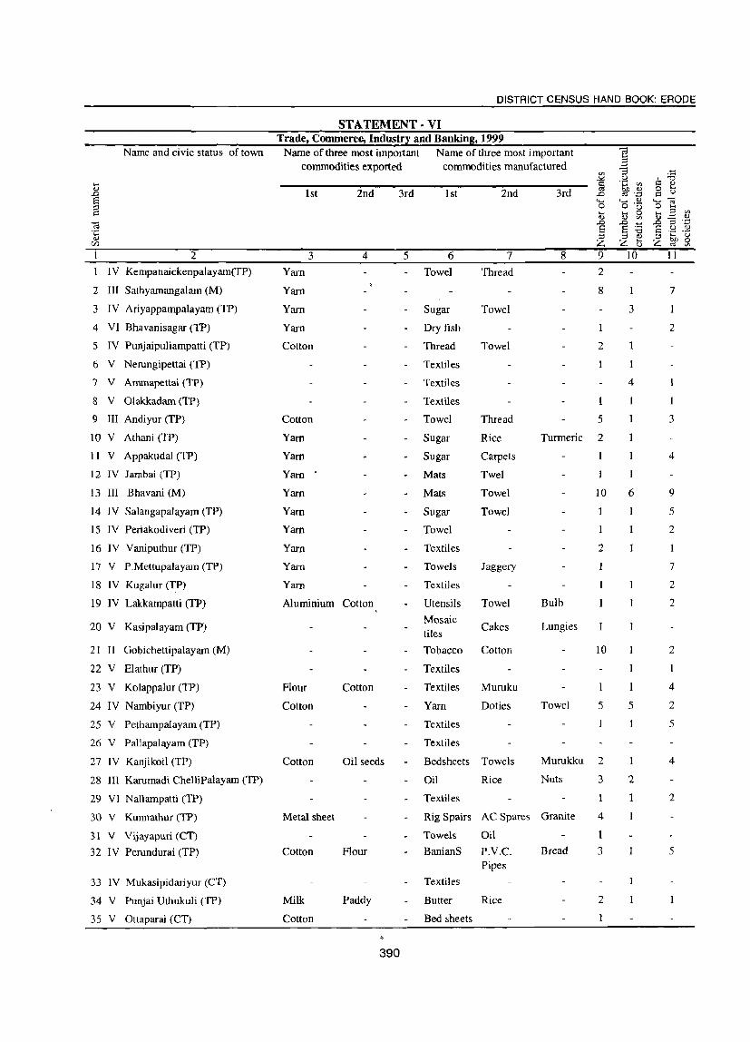
DISTRICT CENSUS HAND BOOK: ERODE
ST A TEMENT . VI Trade, Commerce, Industr~ and Bankins. 1999
Name and civic status of town Name of three most important Name of three most important c:3 ~
commodities exported commodities manufactured -3 '" § .~ '" ' -0 .... s::: !:! .., 1st 2nd 3rd 1st 2nd 3rd ~ .~ 15 (..) .D ,0
~ 4-< ..... ..,
~] 0 o ·u ..... .... 0 ..... ::l Vl .., .., '" OJ .:::::; d)
c:3 .0 .0 ~ ...0 ::$ '_;j
·5 8 8 :a 8 .;:! .2:! ::l ::l .., ::l ..... (.)
C/l Z Z G Z ~ Sl 2 3 4 5 6 7 8 9 10 11
IV Kempanaickenpalayam(fP) Yam Towel Thread 2
2 III Sathyamangalam (M) Yam 8 1 7
3 IV Ariyappampalayam (TP) Yarn Sugar Towel 3
4 VI Bhavanisagar (TP) Yarn Dry fish 2
5 IV Purtjaipuliampatti (TP) Cotton Thread Towel 2
6 V Nerungipettai (TP) Textiles
7 V Ammapettai (TP) Textiles 4
8 V Olakkadam (TP) Textiles 1
9 III Andiyur (TP) Cotton Towel Thread 5 3
IOV Athani (TP) Yarn Sugar Rice Turmeric 2
11 V Appakudal (TP) Yarn Sugar Carpets 4
12 IV Jambai (TP) Yam Mats Twel
13 III Bhavani (M) Yarn Mats Towel 10 6 9
14 IV Salangapalayam (TP) Yarn Sugar Towel 5
15 IV Periakodiveri (TP) Yarn Towel 2
16 IV Vaniputhur (TP) Yarn Textiles 2
17 V P.Mettupalayam (TP) Yarn Towels Jaggery 7
18 IV Kugalur (TP) Yam Textiles 2
19 IV Lakkampatti (TP) Aluminium Cotton Utensils Towel Bulb 2
20 V Kasipalayam (TP) Mosaic
Cakes Lungies tiles
21 II Gobichettipalayam (M) Tobacco Cotton 10 2
22 V Elathur (TP) Textiles I
23 V Kolappalur (TP) Flour Cotton Textiles Muruku I 4
24 IV Nambiyur (TP) Cotton Yarn Doties Towel 5 5 2
25 V Pethampalayam (TP) Textiles 5
26 V PalJapalayam (TP) Textiles
27 IV Kanjikoil (TP) Cotton Oil seeds Bedsheets Towels Murukku 2 4
28 III Karumadi ChelliPalayam (TP) Oil Rice Nuts 3 2
29 VI Nallampatti (TP) Textiles 1 2
30 V Kunnathur (TP) Metal sheet Rig Spairs AC Spares Granite 4
31 V Vijayapuri (CT) Towels Oil I
32 IV Perundurai (TP) Cotton Flour BanianS p.v.e. Bread 3 5 Pipes
33 IV Mukasipidariyur (CT) Textiles
34 V Punjai Uthukuli (TP) Milk Paddy Butter Rice 2
35 V Ottaparai (CT) Cotton Bed sheets 1
390

TOWN DIRECTORY
Name and civic status commodities exported
1 2 36 IV Chennimalai (TP)
37 III Suriampalayam (TP)
38 V Chi thode (TP)
1st
3
Cotton
Cotton
Cotton
39 V Nasiyanur (TP) Cotton
40 III Periya Semur (TP)
41 III Brahmanaperia Agraharam (TP) Leather
42 I Erode (M) Cotton
43 II Veerappan Chattiram (TP) Cotton
44 III Surampatti (TP)
45 II Kasipalayam(E) (TP)
46 IV A val Poondurai (TP)
47 IV Modakkurichi (TP)
48 VI Pasur (TP)
49 IV Arachalur (TP)
50 IV Vadugapatti (TP)
5 1 V Kilambadi (TP)
52 V Vellottam Parappu (TP)
53 IV Sivagiri (TP)
54 V Kollankoil (TP)
55 VI Unjalur (TP)
56 V Vengambur (TP)
57 IV Kodumudi (TP)
58 V Chennasamudram (TP)
59 IV Muthur (TP)
60 III Kangayam (TP)
61 III Vellakoil (TP)
62 V Ruthravathi (TP)
63 VI Kannivadi (TP)
64 IV Mulanur (TP)
65 IV Kolathupalayam (TP)
66 II Dharapuram (M)
67 V Chinakkampalayam (TP)
Cotton
Cotton
Cotton
Diamond
Coir
Diamond
2nd
4
Flour
Turmeric
Flour
3rd
5
391
commodities manufactured
1 st 2nd
6 7
Bed Sheets Pillow Covers
Towels
Dress
Towels
Textiles
Textiles
Towels
Dress
Textiles
Dress materials
Textiles
Textiles
Textiles
Textiles
Textiles
Turmeric powder
Textiles
Textiles
Towels
Jewels
Textiles
Mats
Jewels
Oil
Textiles
Textiles
Textiles
Dress materials
Dye
Muruku
Turmeric powder
Bread
Dress materials
Dress materials
Sugar
Thread
Dress Oil materials
Textiles
Textiles
Dress materials
3rd
8
Towels
Thread
9
4
3
1
2
44
2
3
3
2
2
2
2
2
1
3
2
5
6
3
5
10
10
2
2
2
2
2
11
2
28
2
3
6
7
4
5
9
4
3
4

DISTRICT CENSUS HAND BOOK: ERODE
STATEMENT - VII Civic and other amenities in Slums, 1999
Class. name and status of town Name of the slum Is it No. of households Population of notified (approximate) the Slum
... (approximate) 0 ..0 E1 :::: I')
C;; ·c 0 Vl
2 3 4 5 6 1 IV Kempanaickenpalayam ('TP) 1.K.N .Palayam A.D Colony Yes 32{} 1050
2.Narasapuram Yes 210 600 3.Theneer Pundal Yes 120 400 4.Kalur A.D Colony Yes 310 900 5.Palinjur A.D Colony Yes 65 230 6.Koundapu Naickenpalayam Yes 70 300 7.1ndira Nagar Kuliur Yes 205 600 8.Pudu Colony K.N PaJayam Yes 45 120
2 III Sathyamangalam (M) 1.Thoppur No 450 1184 2.Pillar koil St. No 250 424 3.Jayalalitha Nagar No 75 280 4.Puliankombai No 110 380 5.Anna Nagar (North Pet) No 224 810 6.Govindarajapuram No 62 480 7.Puduvalavu No 42 126 8.Kasikadu No 74 132 9.M.G.R Nagar No 55 104 10.Kolathur No 72 216
3 IV Ariyappampalayam (TP) l.Nehru Nagar No 60 240 2. Karattur No 15 75 3.Aniyappam Palayam No 120 180 4.Kondamuthanur No 105 340 5.PuduKothu Kodu No 75 270 6.ElIaivai Gandhi Nagar No 25 105 7.Alagiri Coliony No 95 380 8.Jalliyur No 210 910
4 VI Bhavanisagar (TP) l.Mudukkan Durai Harijan Colony Yes 105 420 2.Coolies linr Yes 185 740 3.Kudil Nagar Yes 68 275
5 IV Punjaipuliampatti (TP) l.J.J.Nagar Yes 250 1000 2.Anna Nagar Yes 315 1260 3.Gandhi Nagar Yes 1175 4700 4.1ndiranagar Yes 125 500
6 V Nerungipettai (TP) I.Chinna Pall am Yes 150 600 2.Siddaiyan Nagar Yes 100 400 3.Harijan Colony Yes 120 480 4.Ariya gandanoor Yes 150 600 5.Perumal Koil Yes ISO 600
7 V Ammapettai (TP) 1.Sundaram palayam Yes 310 1550 2.Moovam Chavadi Yes 250 1250 3.Marup Pavoor Yes 180 900 4.Ammapettai Yes 210 1050
8 V Olakkadam (TP) l.Kuttai Medu Yes 300 1200 2.Mummi Reddipalayam Yes 202 808 3.Thandam Palayam Yes 20 80 4.Kumakka Palayam Yes 60 240 5.01agadam Ad Colony Yes 70 280
392

TOWN DIRECTORY
STA TEMENT - VII Civic and other amenities in Slums, 1999
Paved roads System of Method No. of tap (in
kilometers)
7 0.5 0.2 0.1 0.1 0.1 0.1 0.1 0.1
0.75 0.24 0.18 0.65 0.82 0.3
0.35 0.24 0.18
1.6
0.8 1.27 1.2 0.9 0.9 1.2 0.8 1.5 2.0 0.5 1
0.8 0.6 0.4 0.5 0.5 0.6
0.35 0.2 2.85
4
1 2.2 3.1 3 4 4
sewerage Number of latrines of
8 OSD OSD OSD OSD OSD OSD OSD OSD OSD OSD OSD OSD OSD OSD OSD OSD OSD OSD OSD OSD OSD OSD OSD OSD OSD OSD OSD OSD OSD OSD OSD OSD OSD OSD OSD OSD OSD OSD OSD OSD OSD OSD OSD OSD OSD OSD OSD
9 3 2 2 3
1 2 2 1 6
90 20 1
60 3 2 2
8 2 2
1 2
3 2 I
8
6 25 75 15 24 15 27 4 4
2 3 3
3 16 6 I
21 20 3 1 3 2
10
disposal .c of night .~ soil
~ § o CJ 11 12 13
5
4 3
5 3
S.T.
S.T. S.T. S.T. S.T. S.T. S.T. S.T. S.T S.T S.T S.T S.T S.T S.T S.T S.T S.T S.T S.T S.T S.T S.T S.T S.T S.T S.T S.T S.T S.T S.T S.T S.T S.T S.T S.T S.T
S.T S.T S.T S.T S.T S.T S.T S.T S.T S.T
points/public hydrants
installed for s\,lpplyof protected
water 14 4
5 4 6 1 4 2 1 5 2 4 4 3
3 3
2 5 4
2 6 4 2 2
4 2 3 9 3 4 3 5 3 10 5 6 6 9
25 3 3 7 16 5 3 6 6
393
Electricity connections
Class. name and status of town
-------u .p Road
~ lighting ~ 8 (points) 0 15 16 17 2 60
70 50 45
10 20 40 15
418 250 48 59 142 SO 18 20 24 28 10
15 10 5 4
10 2 25 45 15
200 295 315 100 100
80 80 100 80 150 66 75 120 250 160 10 40 50
5 4 6
5 3 2
3
4 40 15 12 21 15 4 4 8 4 9 4
2 8 4 4 3 6 2 6
13 9 8 9 10 8 10 7 12 12 15 49 II 10 15 5
7 3 4 5
- IV Kempanaickenpalayam (TP)
5 III Sathyamangalam (M) 6 1
1 2
2 - IV Ariyappampalayam (TP)
- VI Bhavanisagar (TP)
- IV Punjaipuliampatti (TP)
- V Ncrungipettai (TP)
- V Anunapettai (TP)
- V Olakkadam (TP)
2
3
4
5
6
7
8

Class, name and status of town Name of the slum
2 3 9 III Andiyur (TP) I.Sweeper Colony
2.Siva Sakthi Nagar
3.Ambathkar St.
4.Thilakar St.
5.Vivekanthar SL
6.Vadan Colony 10 V A thani (TP) I.Athuri Colony
2.Citluran kodu
3.Athani Pudukkadu Harijana Colony
4.Perumal Pulayam
II V Appakudal (TP) I.A.Pudu Palayam
2.Kamaraj Colony
3.A.Karattu Palayam
4.Ambedkar St. 12 N lambai (TP) I.Muthugoundanur
2.Thurusam Palayam
3.Vaikkal Palayam
4.Jambai Pudur
5.Chiniyam Palayam
6.Chiniyam Palayam Methi Colony
7.Gandhi Nagar
8.Vivekananda Nagar
9.Sathiyammoorthi Nagar
10.Jambai
Il.periamola Palayam MGR Colony
12.Peru Map~ayam
13.Serankadu
14.Kalunya Colony
15.Apichiyar St.
16.Kamaraj Colony
17.Nathakadu
18.Vaikkal Palayam New Colony
13 III Bhavani (M) I.Palakkari
2.Thiruvalluvar Nagar
3.Manthozhilalar St.
4.Makkan St.
5.Chokkaran Kadu 14 IV SaJangapaJayam (TP) I.Sentham PaJayarn
2.Dharrnapudir Harijana Colony
3.Krishna Puram
4.Guruchan Valasu Harijana Colony
5.Peciyagoundaq Valasu
6.Mettur Harijana Colony
7.Ayyanvasu Harijana Colony
8.Kasilinga Goundhanpudur
9.E.I.T.Harijana Colony
IO.Salangapalayarn
394
DISTRICT CENSUS HAND BOOK: ERODE
STATEMENT - VII Civic and other amenities in Slums, 1999
Is it No. of households Population of notified (approximate) the Slum
(approximate)
4 5 6 Yes 170 630
Yes 140 490
Yes 230 660
Yes 50 520
Yes 60 470
Yes 30 170
NO 120 600
NO 40 550
NO 180 900
NO 80 400
No 25 100
No 70 280
No 30 120
No 250 1000
Yes 105 420
Yes 40 160
No 75 300
No 50 200
No 30 120
No 40 160
Yes 30 120
No 28 112
No 70 280
Yes 85 340
Yes 125 500
Yes 40 160
Yes 35 140
Yes 40 160
Yes 27 108
Yes 67 260
Yes 70 280
Yes 70 190
No 139 695
No 123 615
No 167 835
No 121 605
No 114 570
No 60 350 Np 70 330
No 83 440 No 84 180
No 80 400 No 70 350 No 80 400
No 10 75
No 25 160
No 20 120
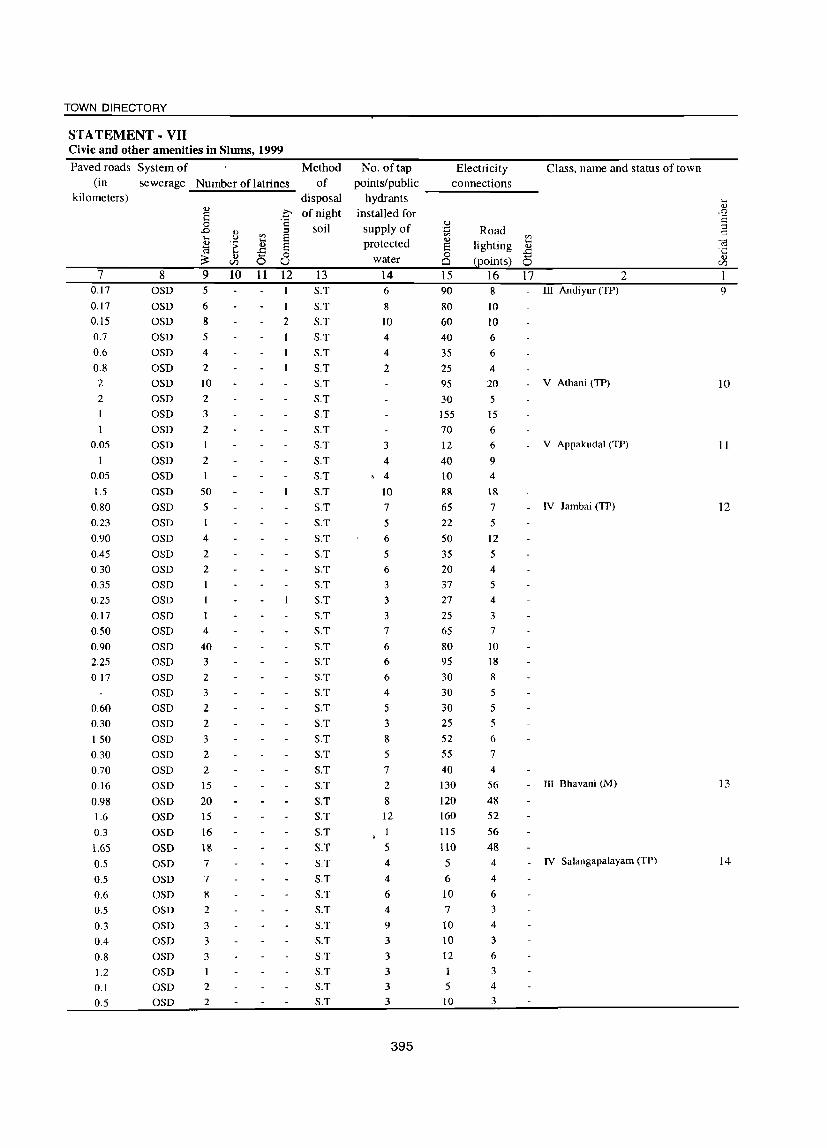
TOWN DIRECTORY
STATEMENT· VII Civic and other amenities in Slums, 1999
Paved roads System of Method (in sewerage Number of latrines of
kilometers)
7 0.17
0.17
0.15
0.7
0.6
0.8
2 2
0.05
I
0.05
J.5
0.80
0.23
0.90
0.45
0.30
0.35
0.25
0.17
0.50
0.90
2.25
0.17
0.60
0.30
1.50
0.30
0.70
0.16
0.98
1.6
0.3
1.65
0.5
0.5
0.6
0.5
0.3
0.4
0.8
1.2
0.1 0.5
8 OSD
OSD OSD OSD OSD OSD OSD OSD OSD OSD OSD OSD OSD OSD OSD OSD OSD OSD OSD OSD OSD OSD OSD OSD OSD OSD OSD OSD OSD OSD OSD OSD OSD OSD OSD OSD OSD OSD OSD OSD OSD OSD OSD OSD OSD OSD OSD
9 5
6
8 5
4
2
10
2
3
2
I
2
50
5 I
4
2
2
4
40
3 2
3
2
2
3 2
2
15
20 15
16
18
7
7
8 2
3
3
3
1
2
2
10 11
disposal Co of night
'1 soil
o u 12 13
1
2
S.T
S.T
S.T
S.T
S.T
S.T
S.T
S.T
S.T
S.T
S.T
S.T
S.T
S.T
S.T
S.T
S.T
S.T
S.T
S.T
S.T
S.T
S.T
S.T
S.T
S.T
S.T
S.T
S.T
S.T
S.T
S.T
S.T
S.T
S.T
S.T
S.T S.T
S.T
S.T
S.T
S.T
S.T
S.T
S.T
S.T
S.T
No. of tap points/public
hydrants installed for
supply of protected
water
14 6
8
10
4
4
2
3
4 , 4
10
7
5
6
5
6
3
3
3
7
6 6
6
4
5 3
8
5
7
2
8
12
1
5
4
4
6 4
9
3
3
3
3 3
395
Electricity connections --------
Road '"
lighting ~ (points) 0
15 16 17
Class, name and status of town
2 III Andiyur (TP)
V Athani (TPl
V Appakudal (TP)
90
80
60
40
35
25
95
30
155
70
12
40
10
88
65
22
50
35
20 37 27
25
65
80
95
30
30
30
25
52
55
40
130
120 160 115
llO
8
10
10
6
6
4
20 5
15
6
6
9 4
18
7 _ IV J ambai (TP)
5
6
10 7
10
10
12
1
5 10
5
12
5
4
5
4
3
7
10
18
8
5
5 5
6
7
4
56
48 52
56
48 4
4
6
3
4
3
6
3
4
3
_ III Bhavani (M)
_ IV Salangapalayam (TP)
9
10
11
12
13
14

DISTRICT CENSUS HAND BOOK: ERODE
STATEMENT - VII Civic and other amenities in Slums, 1999
Class, name and status of town N arne of the slum Is it No. of households Population of
notified (approximate) the Slum ... (approximate) <U
.ro E ::l I'::
c:; ·c
<U <Zl
1 2 3 4 5 6 15 IV Periakodiveri (TP) 1.Athiappa Gounden Pudur NO 18 90
2.Chattaram Pudur NO 78 390
3. Kullanaickennur NO 34 172
4.KaUipatti NO 15 73
5.Muniappa Nagar NO 32 163
6.Nanjan Colony NO 58 276
7.Thembuli Colony NO 149 669
8.Vettuvan Pudur NO 87 465 16 IV Vaniputhur (TP) I .Harijan Colony North St. No 240 960
2.Harijan Colony South St. No 100 400
3.Harijan Colony West St. No 80 240
4.Pallathur No 195 780
5.Vanipurathur Medu No 50 200 17 V P.Mettupalayam (TP) I.Kavandam Palayam Colony No ISO 500
2.Madunaiverai Colony No 300 1200
3.Gandhi Nagar No 15 100
4.Poomandagr Colony No 75 300 18 IV Kugalur (TP) I.Manuvakadu NO 140 500
2.Kattu valavu NO 60 300
3.Thitti Pa1ayam NO 150 615
4.Tha1akan pudur NO 145 700
5.Bharathi Nagar NO 45 150 19 IV Lakkarnpatti (TP) I.Ghandhi Street No 120 480
2.Nehru St. No 24 96
3.Mallanaicken Thottarn No 45 180
4.College Colony No 18 72
5.College Road Colony No 52 208
6.Ambedkar St. No 98 392
7.Raman Colony No 12 48 20 V Kasipalayam (K) (TP) l.lndira Nagar No 171 855
2.Gandhi Nagar No 132 637
3.Gandhi Nagar New AD Colony No 150 600
21 II Gobichettipalayam (M) l.Siva Shanmugam St. No 318 1002
2.Sarninathan Puram No 79 142
3.Nanji Goundan Palayarn No 300 1289
4.Sengottaiyan Colony No 105 381
5.Sankaran SI. No 54 103
6.Peter SI. No 36 162
7.LIG Colony Srirarnapuram No 184 655 22 V Elathur (TP) I.E.Chetipalayarn(Oid Colony) Yes 30 ISO
2.E.Chetipalayam(New Colony) Yes 140 550
3. Koramadaipulur Yes 20 80
4.Elathur (Old Colony) Yes 30 ISO 5.Elathur (New Colony) Yes 120 500
6.Vettaiampalayarn colony Yes 80 365
396

TOWN DIRECTORY
STA TEMENT - VII Civic and other amenities in Slums, 1999
Paved roads System of Method No. of tap Electricity Class, name and status of town (in sewerage Number oflatrines of points/public connections
kilometers) disposal ' hydrants .... <l.l ..,
.0 of night installed for .r:;;
E S 0 'S
soil supply of .~ Road ;:::I
..0 OJ
~ t:: .... U '" .., '" .., 't .... protected lighting
.... (;3
~ S .., 'iii ..c:: '1:: ;:: OJ 0
water 0
(Eoints) (5 <l.l CIJ U Ci CIJ
7 8 9 10 11 12 13 14 15 16 17 2 1
OSD 1 S.T. 5 10 3 - IV Periakodiveri (TP) 15
OSD 6 S.T. 10 18 10 OSD 3 S.T. 7 4 3
OSD 1 S.T. I 2
OSD 3 S.T. 3 2 7
OSD 4 S.T 3 13 11
I OSD 10 S.T 4 25 13
0.2 OSD 3 S.T 6 20 9 0.5 OSD 18 S.T 10 200 12 IV Vaniputhur (TP) 16
4 OSD 20 S.T 4 85 5
3 OSD IS S.T 3 60 4
OSD 50 S.T 9 ISO 13
4 OSD 10 S.T 4 30 4
0.8 10 S.T 5 65 6 V P.Mettupalayam (TP) 17
1.15 24 S.T 7 100 12 2
0.2 S.T 5 1
0.3 2 S.T 2 20 4
0.3 OSD 3 S.T 8 6 20 IV Kugalur (TP) 18
1.5 OSD 8 S.T 8 30 18
075 OSD 25 S.T 10 100 20
1.5 OSD 10 S.T 9 115 25
0.2 OSD 2 S.T 6 5 6
0.2 OSD 10 12 S.T 3 95 5 IV Lakkampatti (TP) 19
0.07 OSD S.T 10 3
0.36 OSD S.T 4 5
0.35 OSD S.T 7 3
0.35 OSD 2 6 S.T 2 26 5
0.5 OSD 3 6 S.T 3 65 IS 0.3 OSD S.T 2 8 2
1.4 OSD S.T 15 93 30 V Kasipalayam (K) (TP) 20 1.14 OSD 1 S.T 110 110 33
5 OSD 5 S.T 1 1 1
0.13 OSD 5 2 S.T 4 203 18 5 II Gobichettipalayam (M) 21 0.15 OSD 3 2 S.T 4 70 16 5
I OSD 4 2 S.T 4 51 18 5
0.35 OSD 5 1 S.T 2 18 18 5 0.144 OSD 4 S.T 15 5 5
0.13 OSD 6 S.T 1 30 5 5
I OSD 2 S.T 4 72 18 5
0.42 OSD 1 S.T 6 lO 6 V Elathur (TP) 22
0.96 OSD 3 S.T 8 IS 0.8 OSD S.T 2 4 3
0.5 OSD 2 S.T 3 IS 10
0.7 OSD 3 S.T 6 20 9
0.56 OSD 2 S.T 4 30 22
397

Class, name and status of town Name of the slum
2 3 V Elathur (TP) Contd., 7. Urkkuru vipalayam
23 V Kolappalur (TP) I.AruvenKooai
2.Sanor Palayam
3.Kallumadai
4.Kumaran Colony
5 .Mettuvalu vu
6.Annai Nagar
7.L.M Colony 24 IV Nambiyur (TP) I.Kamaraj Nagar
2.Ramnatha Puram
3.Ambedkar Nagar
4.Ichipalayam Colqny
5.Bharathiyar Nagar 25 V Pethampalayam (TP) 1. Valli nagar
2. Sengodampa1ayam
3. Suraiyampalayam
4. Madhanaickenpalayam
5. Naripalayam
6. Karukkampalayam
7. Elayampalayam
8. Poonadavalasu
9. Sellappagoundanvalasu 26 V Pallapalayam (TP) I.Avaran Kattuvalasu
2. Dhasonauckanur
3.Kundumallanaickenur
4.Kondasamy Goundenpudur
5.Starthi Nagar
6.Mallampalayam
7.Melavara Selankadu
8.Unon kattuvalasu 27 IV Kanjikoil (TP) I.Avanah lighuem
2.Chinniam Palayam
3.Gandhi Nagar
4.Kolathan Colony
5.PerumaPalayam
6.R.K. U .Nagar
7. Thi ttukkal
8.Velliany Colony 28 III Karumadi C. Palayam (TP) I.Thirthampalayam
2.Ellapalayam HC
3.Seelampalti H.C
4.Tottia Selampatti
5.K.S.Palayam H.C
6.Velliam Palayam
7.karugam Palayam H.C
8.Slature Puram H.C
9.Palan Nagar H.C
398
DISTRICT CENSUS HAND BOOK: ERODE
STATEMENT· VII Civic and other amenities in Slums, 1999
Is it No. of households Population of notified (approximate) the Slum
(approximate)
4 5 G Yes 10 60
No 255 680
No 85 140
No 80 190
No 160 415
No IDS 345
No 100 190
No 60 150
NO 101 700
NO 123 1000
NO 50 800
NO 25 300
NO 25 350
Yes 110 460
Yes 60 240
Yes 95 380
Yes 80 320
Yes 60 240
Yes 90 360
Yes 63 252
Yes 72 288
Yes 90 360
No 22 88
No 18 72
No 24 96
No 7 28
No 12 48
No 9 36
No 26 104
No 44 176
No 100 145
No 50 62
No 52 71
No 46 65
No 106 ISO
No 64 112
No 32 75
No 42 60
.Yes 25 100
Yes 25 100
Yes 15 60
Yes 32 128 Yes 66 264
Yes 45 180
Yes 48 192
Yes 20 80
Yes 25 100

TOWN DIRECTORY
STATEMENT - VII Civic and other amenities in Slums, 1999
Paved roads System of Method No. of tap El ectri ci ty Class, name and status of town (in sewerage Number of latrines of points/public connections
kilometers) disposal hydrants ... 'l) ..,
C of night installed for .J:o E E 0 '8
soil supply of u :::l .J:o ..,
~ '.0 Road 0:: ..... .~ e; '" e;
£ ;> .., protected 8 lighting .., -;:j .. .... .£ .£ ·c ~
.., 0 8 (points) <!) (/) 0 U water 0 (/)
7 8 10 11 12 13 14 15 16 17 2 0.1 OSD S.T 2 2 4 - V Elathur (TP) Contd.,
0.9 OSD 4 S.T 10 80 2 V Kolappalur (TP) 23 1.5 OSD S.T 6 3 1 0.3 OSD 1 S.T 4 19 2
3 OSD 2 S.T 7 20
2.8 OSD 2 S.T 6 10
OSD S.T 2 1
1.9 OSD 1 S.T 3 45 2
2 OSD 3 S.T 10 50 15 IV Nambiyur (TP) 24 2 OSD 5 S.T 14 75 12
2 OSD 3 S.T 6 35 8
0.3 OSD 2 S.T 2 10 3
0.3 OSD 2 S.T 7 22 5
0.2 OSD S.T 4 90 4 - V Pethampalayam (TP) 25 0.1 OSD S.T 2 50 10
0.25 OSD S.T 4 80 10
0.5 OSD S.T 3 70 10
0.4 OSD S.T 4 50 10
0.5 OSD S.T 2 80 6
0.25 OSD S.T 2 50 8
0.35 OSD S.T 2 60 5
0.5 OSD S.T 2 80 10
3.5 OSD S.T 8 2 3 - V Pallapalayam (TP) 26 3 OSD S.T 2 4
4.5 OSD S.T 4 3 4
4 OSD S.T 7 2
3 OSD S.T 4 5
2.5 OSD S.T 3 2 3
4 OSD 2 S.T 7 4 2
3 OSD 2 S.T 6 4 7
OSD 2 S.T 4 32 4 - IV Kanjikoil (TP) 27 OSD S.T 42 6
OSD S.T 4 36 8
OSD I S.T 3 76 4
OSD 3 S.T 4 120 4
OSD 2 S.T 2 45 6
1 OSD I S.T 1 36 2
1 OSD 1 S.T 4 46 2
0.2 OSD 2 S.T 20 4 - III Karumadi C. Palayal11 (TP) 28
0.2 OSD 2 S.T 6 22 3
0.2 OSD S.T 3 13 6
0.6 OSD 2 S.T 5 25 5
3 OSD 3 S.T 8 54 10
1 OSD 2 S.T 7 40 7
0.6 OSD 2 S.T 6 43 5
0.3 OSD S.T 5 18 7
0.3 OSD 2 S.T 3 17 4
399
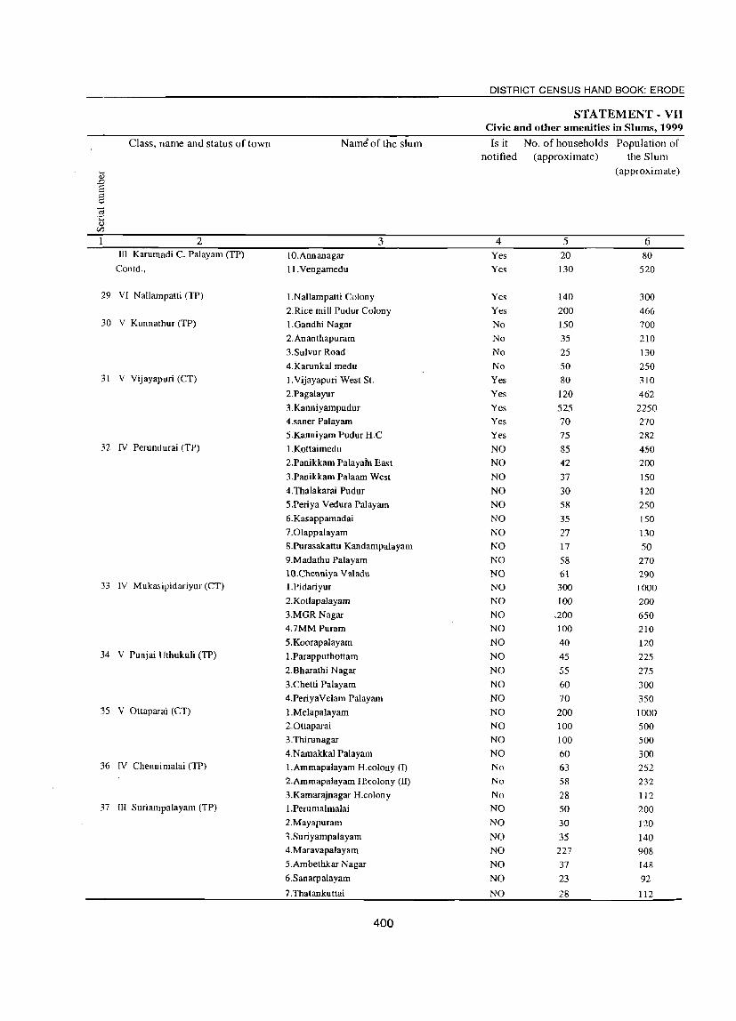
DISTRICT CENSUS HAND BOOK: ERODE
STATEMENT - VII Civic and other amenities in Slums, 1999
Class, name and status of town Name of the slum Is it No. of households Population of notified (approximate) the Slum
..... (approximate) 0.)
.D S :::J ~
C;; c: 0.)
en 2 3 4 5 6
III Karumadi C. Palayam (TP) IO.Annanagar Yes 20 80 Contd., II.Vengamedu Yes 130 520
29 VI Nallampatti (TP) I.Nallampatti Colony Yes 140 300
2.Rice mill Pudur Colony Yes 200 466 30 V Kunnathur (TP) I.Gandhi Nagar No 150 700
2.Ananthapuram No 35 210 3.Sulvur Road No 25 130 4.Karunkal medu No 50 250
31 V Vijayapuri (CT) I.Vijayapuri West SI. Yes 80 310 2.Pagalayur Yes 120 462
3.Kanniyampudur Yes 525 2250 4.saner Palayam Yes 70 270 S.Kanniyam Pudur H.C Yes 75 282
32 IV Perundurai (TP) I.Kottaimedu NO 85 450 2.Panikkam Palayafu East NO 42 200 3.Panikkam Palaam West NO 37 ISO 4.Thalakarai Pudur NO 30 120 S.Periya Vedura Palayam NO 58 250 6.Kasappamadai NO 35 150 7.0lappalayam NO 27 130 8.Purasakattu Kandampalayam NO 17 50 9.Madathu Palayam NO 58 270 lO.Chenniya Valadu NO 61 290
33 IV Mukasipidariyur (CT) l.Pidariyur NO 300 1000 2.Kotlapalayarn NO 100 200 3.MGR Nagar NO ,200 650 4.7MM Puram NO 100 210 S.Koorapalayam NO 40 120
34 V Punjai Uthukuli (TP) I.Parapputhottam NO 45 225 2.Bharathi Nagar NO 55 275 3.Chetti Palayam NO 60 300 4.PeriyaVelarn Palayam NO 70 350
35 V Ottaparai (CT) I.Melapalayam NO 200 1000 2.0ttaparai NO 100 500 3.Thirunagar NO 100 500 4.Namakkal Palayam NO 60 300
36 IV Chennimalai (TP) I.Ammapalayam H.colony (0 No 63 252 2.Ammapalayam H!colony (II) No 58 232 3.Kamarajnagar H.colony No 28 112
37 III Suriampalayam (TP) I.Perumalmalai NO 50 200 2.Mayapuram NO 30 120 3.Suriyampalayam NO 35 140 4.Maravapalayam NO 227 908 S.Ambethkar Nagar NO 37 148 6.Sanarpalayam NO 23 92
7.Thatankuttai NO 28 112
400
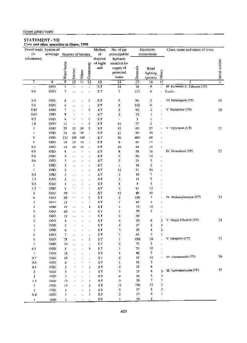
TOWN DIRECTORY
STA TEMENT - VII Civic and other amenities in Slums, 1999
Paved roads System of (in sewerage
kilometers)
7
0.8
0.4 0.6
0.89
0.63
0.5
1.8
I
3
0.5
0.8
0.6
0.6
I
0.8
1.5
0.8
1.2
2
6
2
2
5
2
2
0.5
0.7
0.6
0.4 2
2
1.3
3
2
0.4
8 OSD OSD
OSD OSD OSD OSD OSD OSD OSD OSD OSD OSD OSD OSD OSD OSD OSD OSD OSD OSD OSD OSD OSD OSD OSD OSD OSD OSD OSD OSD OSD OSD OSD OSD OSD OSD OSD OSD OSD OSD OSD OSD OSD OSD OSD OSD
Method Number of latrines of
9
7
4
4
7
9
6
II
10 11
disposal o of night
'1 soil
o u 12 13
S.T S.T
20 15 24 2
S.T S.T S.T S.T S.T S.T S.T S.T S.T S.T S.T S.T S.T S.T S.T S.T S.T S.T S.T S.T S.T S.T S.T S.T S.T S.T S.T S.T S.T S.T S.T S.T
S.T·
S.T S.T
S.T
S.T S.T
S.T
S.T
S.T
S.T
S.T
S.T
35 16 36
131 109 140 14 10 16
14 10 16
9
4
3
2
3
3
2
I
4
10 20
13
12
20
I3
4
5
6
7
75 10 5
10
14
6
2 5
7
13
15
5
7
2
5
2
No. of tap points/public
hydrants installed for
supply of protected
water
14 14
7
5
8
5
5
11
12 21
56 8
10 8
3
3
13
2
2
1
2
II
2
2
4
4
3
7
1
2
4
I
2
5
4
3
12
5
3
401
Electricity connections --------
u .~
S o ~
15 16
112
Road '" lighting ]
(points) 0 16 17 9
6
5
6
2
1
1
2
27 29
60
17
15
16 14
5
2
10 7
7
3 13
16 7
5
10
5
Class. name and status of town
2 III Karumadi C. Palayam (TP)
Contd.,
VI Nallampatti (TP)
V Kunnathur (TP)
V Vijayapuri (CT)
IV Perundurai (TP)
IV Mukasipidariyur (CT)
80
102 92
22
5
27 60
90
400 45
40 58
26
21 16
31
19
11
9 41
49 150 45
10 70
30
30 37
39 45
150 75
75
40 55
36
25 15 26 30 196
27 15
10
6
2
4
3
10 5
10
7 16 3
6
8
5
7
IS
8
6
4
2 V Punjai Uthukuli (TP)
2
V Ottaparai (CT)
IV Chennimalai (TP)
2 ill Suriampalayam (TP)
3
3
2
1
29
30
31
32
33
34
35
36
37

Class, name and status of town Name of the slum
.... <l)
.D S ::l C
C;; '1::
<l)
CI1
2 3 I1I Suriampalayam (TP) Contd., 8.Neelikkaradu
38 V Chithode (TP) I.Pachapali
2.0dakudu
3.Annanagar
4.Kumalai parappu
39 V Nasiyanur (TP) I.Tharrpalayam
2.Attiayam Palayam
3.Pallathur 4.Vettuva Palayam
5.Thotti Pa\ayam
6.Chinthem pettai
7.Sami Oounden Palayam
8.Merun Pudur 40 III Periya Semur (TP) I.Pichai Karam Palayam
2.M.O.R Nagar
3.M.O.R Colony 41 III Brahmanaperia Agraharam (TP) 1.0annapuram
2.Panrruttai
3.Kamaraj Nagar
4.Annaisathyanagar
5.Joshpthottam
6.Bharathi Nagar
7.Shaatri Nagar 42 I Erode (M) I.Madavakadu
2.krishnampalayam
3.pudumai Colony
4.Jayagopal I Street
5.Krishnampalayam
6.Vandiyurankoi1 St.l
7.Vandiyurankoil SUI
8.Cauvery Road
9.North Chinnamariamman Koil SI.
10.Senguttivan S.
II.Kuilanthoppu
12.Kamatchiamman koil SI.
13.0nkaliarnman Koil St.
14.K.N.K Road Back Side
15.Subbaiah SI.
16.Mill Street Back side
17.EVR Kattu huts
18.Thiruvalluvar
19.Idaiyar Thottam
20.Jinnamaidhanan
21.Mosikeeranr St. 22.Ayyanarappan koil I St.
23.Ayyanarappan koil II SI.
24Kuppipalam Road
402
DISTRICT CENSUS HAND BOOK: ERODE
STATEMENT - VII Civic and other amenities in Slums, 1999
Is it No. of households Population of notified (approximate) the Slum
(approximate)
4 5 6 NO 35 140
Yes 40 162
Yes 60 253
Yes 45 181
Yes 57 230
No 182 728 No 210 840
No 74 196 No 125 464
No 74 172
No 248 844
No 187 642
No 126 482
No 655 1970 Yes 380 1155
NO 295 795
Yes 170 550
No 60 205
Yes 180 570
Yes 650 1650 No 220 690
Yes 160 510
Yes 450 1415
Yes 300 1022
Yes 600 1983
Yes 1000 3165
Yes 300 1015
Yes 400 1428
Yes 100 300
Yes 50 112
Yes 400 1165
Yes 100 213
Yes 200 712
Yes 300 820
Yes 100 315
Yes 50 186
Yes 300 1008
Yes 300 821 Yes 100 194
Yes 200 879
Yes 30 72 Yes 15 54 Yes 50 183
Yes 450 1440 Yes 200 612
Yes 100 458
Yes 100 204

TOWN DIRECTORY
STATEMENT - VII Civic and other amenities in Slums, 1999
Paved roads System of Method No. of tap Electricity Class, name and status of town (in sewerage Number of latrines of points/public connections
kilometers) disposal hydrants ,.... <l)
<I) ;>, of night installed for ..D E
'1 C,,) s
0 soil supply of '<=l Road ::I ..D Q,) C
til til til ,.... .~ ,....
protected <I)
lighting ,....
3 ~ > -6 8 0)
0 0 0 -5 ,.... ~ (points)
0)
til 0 U water Cl 0 U)
7 8 9 10 11 12 13 14 15 16 17 2 1 1 OSD 2 S.T 16 3 III Suriampalayam (TP) Conld .. 2 OSD 3 S.T 2 23 2 - V Chi thode (TP) 38
O.S OSD 4 S.T 3 38 3
0.5 OSD 3 S.T 2 19 3
1.05 OSD 4 S.T 2 34 4
0.6 OSD 6 S.T. 6 36 6 V Nasiyanur (TP) 39 0.8 OSD 9 S.T. 8 64 12 0.1 OSD 7 S.T. 6 27 4 0.3 OSD 4 S.T. 10 76 9 0.4 OSD 8 S.T. 9 42 II
0.3 OSD II S.T. 12 117 7 0.2 OSD 9 S.T. 10 82 12 0.1 OSD 7 S.T. 6 76 9
2.4 OSD 31 S.T. 12 610 7 III Periya Semur (TP) 40 2 OSD 22 S.T. 5 34S 6 2 OSD 3 S.T. 3 263 5
0.9 OSD 20 S.T 7 112 20 - III Brahmanaperia Agraharam (TP) 41
0.2 OSD 2 S.T 3 40 7 0.4 OSD 20 S.T 5 80 23
1.4 OSD 64 S.T 16 4IS 33 0.37 OSD 60 S.T 4 152 17
0.22 OSD 10 S.T 2 30 8
l.51 OSD 80 S.T 18 262 42 0.2 OSD 2S0 I S.T 250 8 I Erode (M) 42
0.1 OSD 450 2 S.T 2 450 24
0.2 OSD 800 1 S.T 3 800 31
0.2 OSD 2S0 S.T 250 10
0.4 OSD 3S0 S.T 350 21
0.2 OSD 75 S.T 90 13
OSD 25 S.T 40 17
0.2 OSD 3S0 S.T 300 10
0.1 OSD 50 S.T 70 3
0.1 OSD 150 S.T 150 6
0.1 OSD 200 S.T SO 24
0.1 OSD SO S.T 25 12
0.1 OSD 40 S.T 40 5
0.1 OSD 200 S.T 250 8
0.6 OSD 200 S.T 75 8
0.3 OSD 50 S.T I 80 10
0.1 OSD 150 S.T 2 20 6
0.1 OSD 15 S.T 12 6
0.1 OSD 10 S.T 12 5
U.l OSD 40 S.T I 40 3
0.3 OSD 400 S.T 3 250 32
0.2 OSD ISO S.T 2 180 8
0.1 OSD 75 S.T 50 2
0.1 OSD 75 S.T SO 5
403
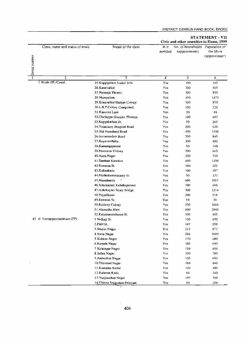
Class, name and status of town Name of the slum
2 3 T Erode (M) Contd .. 25.Kuppipalam Vaikal Side
26.Karaivaikal
27 .Nataraja Theatre
28.Marapalam
29.Konavaikal Harijan Colony
30.L.B.P.Colony Compound
31.Kuruvan Lane
32.CheUappa Gounder Thottam
33.Kuppakathan St-
34.Vetarinary Hospital Road
35.01d Poondurai Road
36.Jeevanandam Road
37.Kuyavanthittu
38.Kamarajapuram
39.Meenavar Colony
40.Anna Nagar
41.Santhan Karukku
42.Eswaran St.
43.Kaliankadu
44.Muthukumarasamy st.
45.Manalmedu
46.Ashokapuri Knlathupannai
47.Ashokapuri Stony Bridge
48.Poyarikarai
49.Eswaran St.
50.Railway Colony
51.Alamathu Huts
52.Kalyanasundaram St.
43 II Veerappanchattiram (TP) 1.Nethaji St.
2.Palil St.
3.Sindan Nagar
4.Jeeva Nagar
5.Kakkan Nagar
6.Kamala Nagar
7 .Kalaingar Nagar
8.lndira Nagar
9.Ambedkar Nagar
10.Thirurnal Nagar
II.Kurnalan Kuttai
12.Kalattan Kadu
13.Vanjinathan Nagar
14.Chinna Sengodam Palayarn
404
DISTRICT CENSUS HAND BOOK: ERODE
STATEMENT - VII Civic and other amenities in Slums, 1999
Is it No.ofhouseholds Population of notified (approximate) the Slum
(approximate)
4 5 6 Yes 100 305
Yes 200 505
Yes 300 950
Yes 450 1475
Yes 300 970
Yes lOa 320
Yes 20 40
Yes 100 402
Yes 50 265
Yes 200 620
Yes 400 1300
Yes 300 840
Yes 300 480
Yes 50 160
Yes 200 665
Yes 200 710
Yes 400 1200
Yes 100 245
Yes 100 287
Yes 50 132
Yes 600 1855
Yes 100 688
Yes 300 1214
Yes 200 518
Yes 10 30
Yes 250 1044
Yes 600 2840
Yes 100 405
Yes ISO 600
Yes 147 588
Yes 213 852
Yes 260 1040
Yes 170 680
Yes 160 640
Yes ISO 600
Yes 190 760
Yes 150 600
Yes 160 640
Yes 120 480
Yes 60 240
Yes 197 788
Yes SO 200

TOWN DIRECTORY
STATEMENT - VII Civic and other amenities in Slums, 1999
Paved roads System of Method No. of tap Electricity Class, name and status of town (in sewerage Number of latrines of points/public connections
kilometers) disposal hydrants '"" QJ
(!.)
E: a of night installed for "El 0 'S .~ Road ::I .D (!.)
~ soil supply of ~
'" '" ~ (.) .... <U .... c::l 'E II) protected 8 lighting <U
-5 ..c: ·c ~
<I) 0 0 (j2oints) (5 <l)
U) 0 U wat!<r Cl U)
7 8 9 10 11 12 13 14 15 16 17 2
0.1 OSD 75 S.T 150 11 - I Erode (M) Contd.,
0.15 OSD 150 S.T 2 150 7
0.1 OSD 250 S.T 2 250 9
0.2 OSD 300 S.T 2 200 5
0.1 OSD 250 S.T 2 250 24
0.1 OSD 50 S.T 1 75 5
0.2 OSD 10 S.T 15
0.2 OSD 50 S.T 50 7
0.1 OSD 25 S.T 2 40 7
0.2 OSD 150 S.T 2 150 12
0.16 OSD 250 S.T 2 250 9
0.6 OSD 250 S.T 2 250 6
0.4 OSD 250 S.T 2 250 15
0.15 OSD 25 S.T 40 14
0.6 OSD 150 S.T 1 150 12
0.2 OSD 150 S.T 1 150 15
0.15 OSD 300 S.T 2 350 7
0.1 OSD 100 S.T 75 7
0.25 OSD SO S.T 75 7
0.3 OSD SO S.T 40
0.2 OSD 350 S.T 3 500 37
0.6 OSD 600 ST 2 100 15
0.6 OSD 1400 S.T 2 250 5
0.3 OSD 150 ST 1 150 5
0.6 OSD 10 ST 8
0.75 OSD 250 S.T 2 200 8
0.6 OSD 900 S.T 3 500 8
0.1 OSD 200 1 ST 75 3
8.3 OSD 10 3 S.T 2 100 7 - II Veerappanchattiram (TP) 43
0.5 OSD 8 S.T 2 120 4
0.5 OSD 12 S.T 4 150 18
0.5 OSD 15 S.T 2 163 13
0.5 OSD 10 S.T 2 140 13
0.5 OSD 10 ST 101 28
0.5 OSD 10 ST 2 120 17
0.5 OSD 11 ST 2 102 5
0.5 OSD 10 S.T 2 120 13
0.5 OSD 10 S.T 3 85 17
0.5 OSD 9 S.T 2 67 12
0.5 OSD 4 S.T 3 45 5
0.5 OSD 12 ST 2 109 8
0.5 OSD 4 S.T 2 40 10
405

DISTRICT CENSUS HAND BOOK: ERODE
STATEMENT - VII Civic and other amenities in Slums, 1999
Class, name and status of town Name of the slum Is it No. of households Population of
notified (approximate) the Slum h (approximate) OJ
..0 S ;::J ~
«l .c: OJ
CI)
1 2 , 3 4 5 6 44 III Surampatti (TPl I.Ambedthkamagar West Yes 144 580
2.Sastri Salai Yes 250 750
3.Ambethkar Nagar East Yes 108 450
4.Palayapalayam Yes 100 300
5.Nethaji Nagar Yes 73 300
45 II Kasipalayam(E) (TP) I.Ramamoorthi Nagar NO 156 624
2.Srinivasa Rao St. NO 149 594
3.Senapathi Palayam NO 305 1220
4.Subramaniya Nagar NO 387 1548
5.Eranian St.! NO 156 623
6.Kalyanasundram St. NO 190 761
7.Sastri Nagar (Ward 4) NO 518 2070
45 Kasipalayam (E) (contd.) 8.Sastri Nagar (Ward 5) NO 159 635
9.Kattabomman St. NO 234 937
IO.Balashandayutham SI. NO 210 840 11.Manalikandasamy St. NO 212 849
12.Ramamoorthi St. NO 232 927
13.01d Kalivalasu NO 176 704
14.Bharathi Palayam NO 160 638
15.1eevanatham St. NO 144 576 16.New Kallivalasu NO 222 886
17. Periyasadayam Palayam NO 142 568 46 IV Aval Poondurai (TP) I.Solipalayam NO 45 225
2.Kalipalayam NO 65 325
3.N.Volliyam Palayam NO 45 225
4.Pathu palayam NO 60 300
5.Palla Palayam NO 70 325
6.Palani Goundam Vaksn NO 30 155
7 Pongali valasu NO 49 265
8.Karathupalayam NO 30 175
9.Erappam Palayam NO 50 240
10.Rattaisntri Palayam NO 18 105 II.Poolakadu NO 45 250
47 IV Modakkurichi (TP) I.Nadupalayam New Colony Yes 80 485
2.Nadupalayam Old Colony Yes 25 170
3.Kerical Kadu Yes 75 475
4.Panchalingapuram T.V St. Yes 47 290
5.Toorapalayam St. Yes 35 230
6.0lapalayam Yes 55 345
7.Mannr PuIikadu Yes 15 108 8.VeUampalayam Yes 85 522
9.Aluthi palayam Yes 35 225 48 VI Pasur (TP) I.Palani Colony No 52 208
2.Panamkattu pudur No 74 296 3.Vadakhu Pudur No 134 536
406
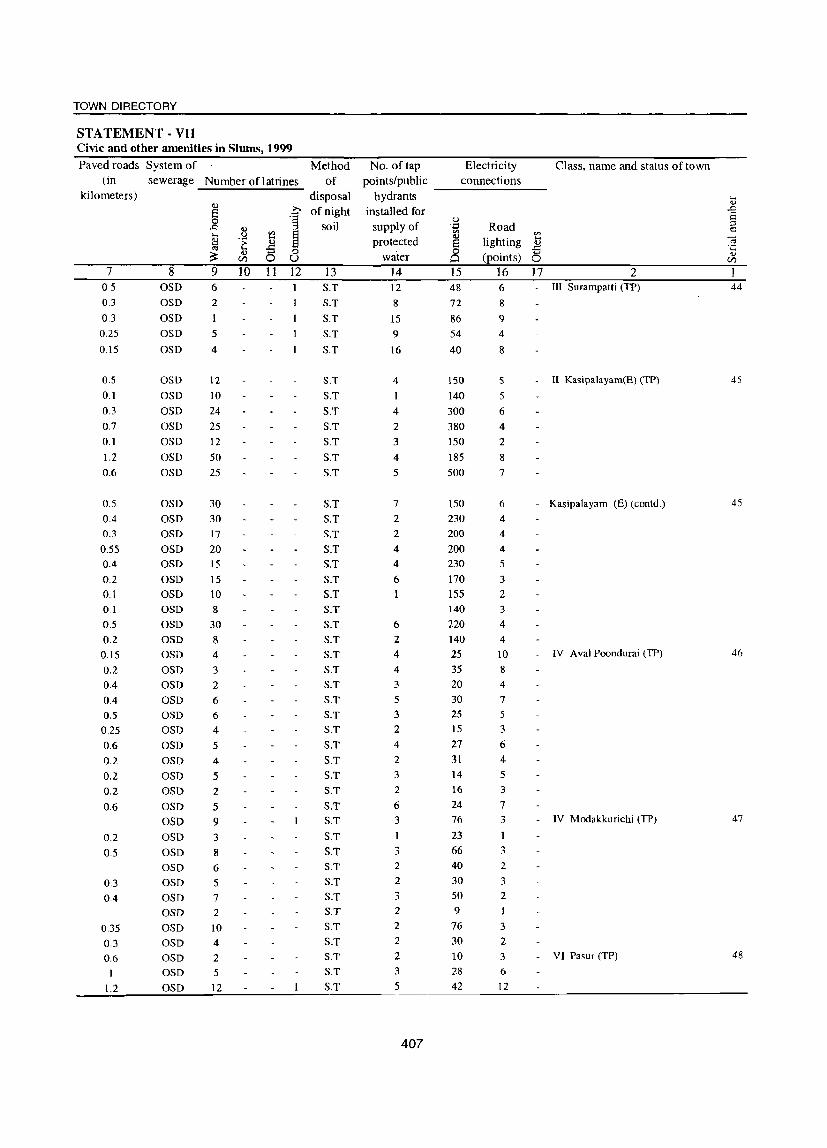
TOWN DIRECTORY
STATEMENT· VII Civic and other amenities in Slums, 1999
Paved roads System of Method No. of tap Electricity Class, name and status of town (in sewerage Number oflatrines of points/public connections
kilometers) disposal hydrants .... .., 11.) >-. of night installed for -s § ·S
soil supply of u ::l J:J ..,
~ ';;;J Road c VJ Vl Vl ..... .~ 8 1:l
.... protected lighting
.... ] ~ .5
., '" 0 8 -5 .... ~ (points)
.., U) 0 U water 0 U)
7 8 9 10 11 12 13 14 15 16 17 2 0.5 OSD 6 S.T 12 48 6 - III Surampatti (TP) 44
0.3 OSD 2 S.T 8 72 8
0.3 OSD 1 S.T 15 86 9 0.25 OSD 5 S.T 9 54 4
0.15 OSD 4 S.T 16 40 8
0.5 OSD 12 S.T 4 150 5 II Kasipalayam(E) (TP) 4S
0.1 OSD 10 S.T 1 140 5
0.3 OSD 24 S.T 4 300 6
0.7 OSD 25 S.T 2 380 4
0.1 OSD 12 S.T 3 150 2
1.2 OSD SO S.T 4 185 8
0.6 OSD 25 S.T 5 500 7
0.5 OSD 30 S.T 7 150 6 - Kasipalayam (E) (conld.) 45
0.4 OSD 30 S.T 2 230 4
0.3 OSD 17 S.T 2 200 4
0.55 OSD 20 S.T 4 200 4
0.4 OSD 15 S.T 4 230 5
0.2 OSD 15 S.T 6 170 3
0.1 OSD 10 S.T 155 2
0.1 OSD 8 S.T 140 3
0.5 OSD 30 S.T 6 220 4
0.2 OSD 8 S.T 2 140 4
0.15 OSD 4 S.T 4 25 10 - IV Aval Poondurai (TP) 46
0.2 OSD 3 S.T 4 35 8
0.4 OSD 2 S.T 3 20 4
0.4 OSD 6 S.T 5 30 7
0.5 OSD 6 S.T 3 25 5
0.25 OSD 4 S.T 2 15 3
0.6 OSD 5 S.T 4 27 6
0.2 OSD 4 S.T 2 31 4
0.2 OSD 5 S.T 3 14 5
0.2 OSD 2 S.T 2 16 3
0.6 OSD 5 S.T 6 24 7
OSD 9 S.T 3 76 3 - IV Modakkurichi (TP) 47
0.2 OSD 3 S.T 1 23 1
05 OSD 8 S.T 3 66 3
OSD 6 S.T 2 40 2
0.3 OSD 5 S.T 2 30 3
0.4 OSD 7 S.T 3 50 2
OSD 2 S.T 2 9 1
0.35 OSD 10 S.T 2 76 3
0.3 OSD 4 S.T 2 30 2
0.6 OSD 2 S.T 2 10 3 - VI Pasur (TP) 48
1 OSD 5 S.T 3 28 6
1.2 OSD 12 S.T 5 42 12
407

DISTRICT CENSUS HAND BOOK: ERODE
STA TEM ENT - VII Civic and other amenities in Slums, 1999
Class, name and status of town Name of the slum Is it No. of households Population of
notified (approximate) the Slum .... l approximate) 0,)
..0 e ::l c:::
0;; C 0,)
UJ
2 3 4 5 6 VI Pasur (TP) Contd., 4. Varakhuttipudur No 55 220
5.Vengiam Palayam Colony No 72 288
49 IV Arachalur (TP) l.Veerappam Palayam No 60 300 2.Meenasni Puram No 50 250
3.Nalligoundanualasu No 20 100 4.Sellarn paJayarn No 30 150
5.Komarapalayam No 51 255
6.Auchalur (Kandan kadu) No 43 215
7.Sullikkadu No 26 130 8.Goundapalayam Kadu No 33 105
9.Nallamangapalayam No 31 155
10.Vettukkattal valasu No 86 SID
II.Nachivalasu ,
No 146 730
12.Kullarangam Palayam No 90 450 IV Arachalur (TP) (Contd.,) 13.Naduppalayam No 40 200
14.Alangagounden Valasu No 30 150
15.Vadapalari No 40 200
50 IV Vadugapaui (TP) l.Vaduga patty padu Yes 40 160
2.Saminatha Puram Yes 45 205
3.Nathamedu Yes 20 80 4.Uthiram Kattupudur Yes 55 245
5.Karattur Yes 25 95
6.Elavanatham Yes 30 120
7.Ganapuram Yes 95 320
8.Pannaikinaru Yes 40 165
9.Vinolagramam Yes 45 200
1O.Kasthri Palayam Yes 30 120
11.Thottiankinathu Pudur Yes 55 245
12.Nallakatti Palayam Yes 10 40
13 .jayaramapuram Yes 65 225
14.Karattan Kattu pudur Yes 100 425
15.Kootham Patty Yes 65 375
16.J.l.Nagar Yes 156 580
17 .Devanam Palayam Yes 60 320
51 V Kilambadi (TP) 1.Solangapalayam.Pallam NO 39 lID
2.Paraluagoundam Palayam HC NO 61 244
3.Pudupalayam Pallan Colony NO 63 252
4.Muniappam Palayam Pallan Colony NO 95 380
5.Muniappam Palayam HC NO 65 260
6.Gandhi Nagar Colony NO 69 276
7.Karumandampalayam H.C NO 63 252
8.Malayam Palayam H.C NO 59 236
9.Malayam PaJayam NO 49 196 10.Kompu Palayam Palloncolony NO 30 120
52 V Vellottam Parappu (TP) I.Manakattupudur No 50 200
408

TOWN DIRECTORY
STATEMENT - VII Civic and other amenities in Slums, 1999
Paved roads System of Method No. of tap Electricity Class, name and status of town (in sewerage Number of latrines of points/public connections
kilometers) disposal hydrants ,_ 4)
<1)
e 0 of night installed for S 0 'S soil supply of
u Road :l ..0 <1)
~ .~ r::
tl u '" ~ '" 'E .... protected lighting
.... ca 4) <1) t;j .s .s ·c ~
<1) 0 0 (j!0ints)
<1) tI) 0 U water 0 0 tI)
7 8 9 10 11 12 13 14 15 16 17 2 aSD 3 S.T 2 15 7 VI Pasur (TP) Cootd., aSD 5 S.T 3 18 5
0.1 aSD 4 S.T 3 30 2 IV Arachalur (TP) 49
0.3 aSD 3 S.T 2 23 5 0.09 aSD 2 S.T 2 11 3 0.5 aSD 2 S.T 6 16 3 0.3 aSD 3 S.T 4 23 5 0.2 aSD 2 S.T 2 20 3 0.3 aSD 2 S.T 4 13 3 0.3 aSD S.T 20 4
0.15 aSD 2 S.T 3 23 5 1.4 aSD 8 S.T 5 46 4 0.1 aSD 9 S.T 9 80 1
0.2 aSD 6 S.T 3 44 5
0.2 aSD 3 S.T 2 21 3 IV Arachalur (TP) (Coold .. )
0.6 aSD 2 S.T 2 12 3
1.3 aSD 2 S.T 4 24 7
2
0.2 aSD 3 S.T. 2 20 4 IV Vadugapatti (TP) 50
0.25 aSD S.T. 2 27 5
0.1 aSD 4 S.T. 5
0.4 aSD S.T. 10 35 7 2
0.2 aSD 2 S.T. 1 6 2
0.1 aSD 6 S.T. 2 15 3
0.5 aSD 2 S.T. 7 80 12
0.15 aSD 3 S.T. 2 30 3
0.1 aSD 2 S.T. 2 35 5
0.2 aSD 4 S.T. 3 18 2
0.2 aSD 1 S.T. 3 37 3
0.05 aSD 4 S.T. 1
0.2 aSD 6 S.T. 5 45 5
0.4 aSD 5 S.T. 3 65 6 1
0.25 asp 9 S.T. 7 53 8 2
0.5 aSD 6 S.T. 3 12 9
0.15 aSD 2 S.T. 2 40 6
0.6 aSD 4 S.T. 1 1 3 V Kilambadi (TP) 51
0.7 aSD 4 S.T. 2 20 5
0.8 aSD 6 S.T. 2 15 3
0.5 aSD 4 S.T. 1 20 4
0.2 aSD 4 S.T. 2 14 4
1.2 aSD 4 S.T. 1 13 3
1 aSD 3 S.T. 3 20 8
0.2 aSD 4 S.T. 2 3
0.2 aSD S.T. 4 3
0.2 aSD 1 S.T. 8 4
1.5 OSD 3 S.T. 30 6 V Velloltam Parappu (TP) 52
409
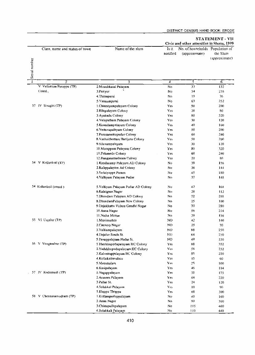
Class. name and status of town
2 V Vellottam Parappu (TP)
Contd.,
53 IV Sivagiri (TP)
54 V Kollankoil (TP)
S4 Kollankoil (contd.)
55 VI Unjalur (TP)
S6 V Vengambur (TP)
57 IV Kodumudi (TP)
58 V Chennasamudram (TP)
Name of the slum
3
2.Mosukkarai Palayam
3.Periyur
4.Thittuparai
5. Vannamparai
I.Chinniyampalayam Colony
2.ElIapalayam Colony
3.Ayakadu Colony
4.Velayutham Palayam Colony
5.Koundampalayam Colony
6.Vettuvapalayam Colony
7.Purasamettupudur Colony
8.Vazhaithottam Harijana Colony
9.Siluvampalayarn
1O.Marappam Palayam Colony
II.Palamedu Colony
12.Rangasamuthram Colony
I.Kandasamy Palayam AD Colony
2.Kalippalayam Ad Colony
3.Sadaiyappa Puram
4.Valliyam Palayam Pudur
5.Valliyam Palayam Pudur AD Colony
6.Kalaignar Nagar
7.Dhondam Pa1ayam AD Colony
8.DhondamPalayam New Colony
9.Unjakkattu Valasu Gandhi Nagar
10.Anna Nagar
11.Natha Meltur
I.Manimuthur
2.Cauvery Nagar
3.Valliampalayam
4.Unjalur South St.
5.Panappalayam Nadar SI.
I.Therkkupudupalayam HC Colony
2.Vadakkupudupalayam HC Colony
3.Kalvettuppalayam HC Colony
4.Kollukattuvalasu
5.Mettukalam
6.Kasipalayam
1.Nagappalayam
2.Arasom Palayam
3.Pallar St.
4.Sulakkal Palayam
5.lIluppu Thoppu
1.Kollampuduppalayam
2.Anna Nagar
3.Chittapullapalayam
4.Solakkali Palayapl
410
DISTRICT CENSUS HAND BOOK: ERODE
STATEMENT - VII Civic and other amenities in Slums. 1999 Is it No.ofhouseholds Population of
notified (approximate) the Slum
(approximate)
4 5 6
No 33 132
No 54 216
No 19 76
No 63 252
Yes 50 200
Yes 20 80
Yes 80 320
Yes 30 120
Yes 40 160
Yes 50 200
Yes 60 240
Yes 50 200
Yes 30 120
Yes 80 320
Yes 60 240
Yes 20 80
No 39 156
No 36 144
No 45 180
No 37 148
No 42 168
No 28 112
No 72 288
No 25 100
No 70 280
No 56 224
No 39 156
NO 42 140
NO 25 70
NO 88 250
NO 64 230
NO 49 150 Yes 88 352
Yes 58 232
Yes 55 220
Yes IS 60 Yes 25 100
Yes 46 184 Yes 35 175
Yes 44 220 Yes 24 120 Yes 18 90 Yes 60 300 No 40 160 No 90 360
No 115 460
No 110 440
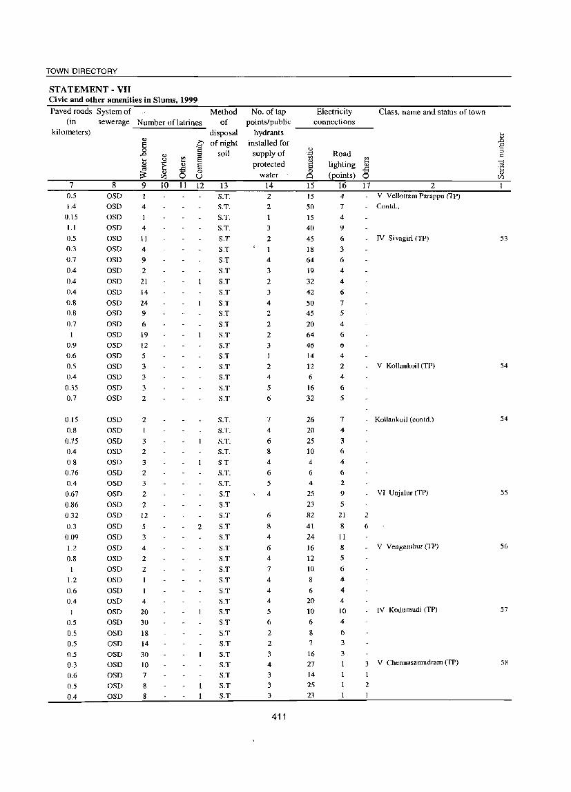
TOWN DIRECTORY
STATEMENT - VII Civic and other amenities in Slums, 1999
Paved roads System of Method (in
kilometers)
7 0.5
1.4 0.15 11
0.5
0.3
0.7
0.4
0.4
0.4
0.8
0.8
0.7
I
0.9
0.6
0.5
0.4
035 0.7
0.15
0.8
0.75
0.4 0.8
0.76
0.4
0.67
0.86
0.32
0.3
0.09
1.2
0.8
1.2
0.6
0.4
1
0.5
0.5
0.5
0.5
0.3
0.6
0.5
0.4
sewerage Number oflatrines of
8 OSD OSD OSD OSD OSD OSD OSD OSD OSD OSD OSD OSD OSD OSD OSD OSD OSD OSD OSD OSD
OSD OSD OSD OSD OSD OSD OSD OSD OSD OSD OSD OSD OSD OSD OSD OSD OSD OSD OSD OSD OSD OSD OSD OSD OSD OSD OSD
9
4
4
II
4
9
2 21 14
24
9 6
19
12 5
3
3
3
2
2
1
3
2
3
2 3
2
2 12
5
3 4
2
2
4
20 30
18 14
30 10 7
8
8
<IJ o .~ CIl
10 11
disposal .~ of night c
~ o U 12
2
soil
13 S.T.
S.T.
S.T.
S.T.
S.T
S.T
S.T
S.T
S.T
S.T
S.T
S.T
S.T
S.T
S.T
S.T
S.T
S.T
S.T
S.T
S.T. S.T.
S.T. S.T.
S.T S.T. S.T.
S.T
S.T S.T
S.T
S.T S.T
S,T
S.T
S.T
S.T
S.T
S.T S.T
S.T
S.T
S.T
S.T S.T
S.T
S.T
No. of tap points/public
hydrants installed for
supply of protected
water 14 2
2
3
2
4
3 2
3
4
2
2
2
3
2
4
5
6
7
4
6 8
4
6
5
4
6
8
4
6
4
7
4
4
4
5
6
2 2
3
4
3
3
3
411
Electricity connections
Class, name and status of town
--------
15 15 50
15 40
45
18
64
19
32
42
50 45
20 64
46
14
12 6
16
32
26 20
25
10 4
6
4
25
23
82
41
24
16
12 10 8
6
20 to
6
8 7
16
27
14
25
23
Road ~
lighting .5 (points) 0
16 17 4
2 V Vellottam Parappu (TP)
7
4
9
6
3
6
4 4
6
7
5
4
6
6
4
2
4
6
5
- Conld.,
7
4
3
6
4
6 2
9
5 21
8
11
8
5
6
4
4
4
10 4
6 3
3
I
- IV Si vagiri (TP)
- V Kollankoil (TP)
2
6
Kollankoil (conld.)
VI Unjalur (TP)
V Vengambur (TP)
IV Kodumudi (TP)
3 V Chennasamudram (TP)
2
J
53
54
54
55
56
57
58
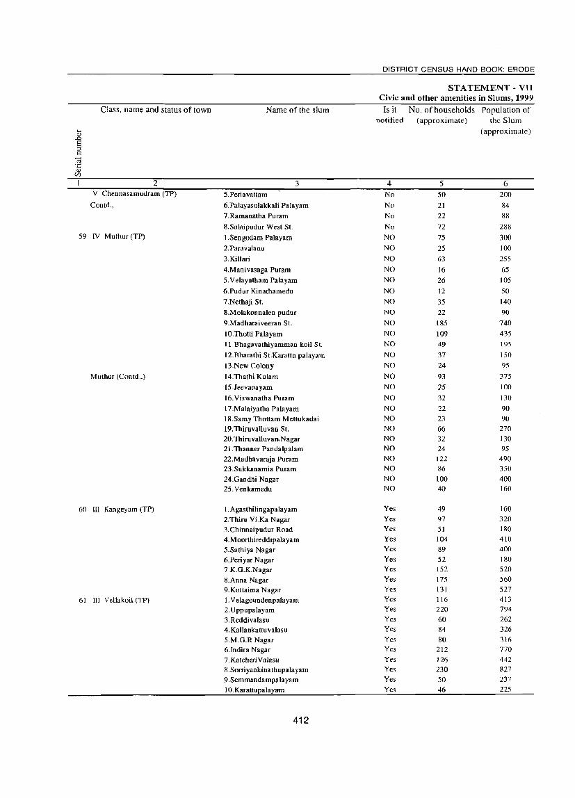
Class, name and status of town
2 V Chennasamudram (TP)
Coutd.,
59 IV Muthur (TP)
Muthur (Coutd.,)
60 III Kaugeyam (TP)
61 III Vellakoil (TP)
Name of the slum
3 5.Periavattam
6.Palayasolakkali Palayam
7.Ramanatha Purarn
8.Salaipudur West SI.
l.Sengodam Palayam
2.Paravalanu
3. Killari
4.Manivasaga Puram
5.Velayutham Palayam
6.Pudur Kinatharnedu
7.Nethaji SI.
8.Molakonnalen pudur
9.Madharaiveeran St.
10.Tholli Palayam
11.Bhagavathiyamman koil SI.
12.Bharalhi St.Karattn palayam
I3.New Colony
14.Thathi Kulam
15.Jeevanayam
I6.Viswanatha Puram
I7.Malaiyatha Palayam
IS.Samy Thottam Mettukadai 19.Thiruvalluvan SI. 20.ThiruvalIuvan,Nagar 21.Thanner Pandalpalam
22.Madhavaraja Puram 23.Sukkanamia Puram
24.Gandhi Nagar 25.Venkamedu
I.Agasthilingapalayarn 2.Thiru Vi.Ka Nagar
3.Chinnaipudur Road
4.Moorthireddipalayam 5.Sathiya Nagar
6.Periyar Nagar 7 K.G.KNagar
8.Anna Nagar 9.Kuttaima Nagar
I. Velagoundenpalayam 2.Uppupalayam
3.Reddivalasu 4. Kallankattuvalasu S.M.G.R Nagar 6.lndira Nagar 7. KatcheriValasu 8.Sorriyankinathupalayam 9. Semmandampala yam
IO.Karattupalayam
412
DISTRICT CENSUS HAND BOOK: ERODE
ST A TEMENT - VII Civic and other amenities in Slums, 1999
Is it No. of households Population of notified (approximate) the Slum
(approximate)
4 5 6 No 50 200
No 21 84
No 22 88 No 72 288
NO 75 300
NO 25 100
NO 63 255
NO 16 65
NO 26 105
NO 12 50
NO 35 140
NO 22 90
NO 185 740
NO 109 435
NO 49 195
NO 37 150
NO 24 95
NO 93 375
NO 25 100
NO 32 130
NO 22 90 NO 23 90 NO 66 270 NO 32 130 NO 24 95 NO 122 490 NO 86 350
NO 100 400 NO 40 160
Yes 49 160 Yes 97 320 Yes 51 180 Yes 104 410
Yes 89 400 Yes 52 180 Yes 152 520
Yes 175 560 Yes 131 527 Yes 116 413 Yes 220 794
Yes 60 262 Yes 84 326 Yes 80 316 Yes 212 770 Yes 126 442 Yes 230 827 Yes 50 237
Yes 46 225

TOWN DIRECTORY
STA TEMENT - VII Civic and other amenities in Slums, 1999
Paved roads System of Method No. of tap Electricity Class, name and status of town (in sewerage Number of latrines of points/public connections
kilometers) disposal hydrants ..... <!J
<!J C of night installed for "S E 0 'S
soil <.>
Road ;;:J
.0 " ::l supply of ';:3 c .... .~ ~ § <Il <Il
" .... ~ ~ > <!J protected !3 lighting " ~ .s .s c ~
0 0 <!J Cf.l 0 U water 0 (points) 0 Ul
7 8 9 10 11 12 13 14 15 16 17 2 1 0.2 OSD 4 S.T 4 17 - V Chennasamudram (TP) 0.1 OSD 6 S.T 2 10 - Conrd., 0.2 OSD 3 S.T 2 12 1
0.6 OSD 8 S.T 3 18 4
0.2 OSD 2 S.T 2 50 4 - N Muthur (TP) 59
0.5 OSD 2 S.T I 20 1
0.2 OSD 4 S.T 1 30 2 0.6 OSD I S.T 3 10 I 0.3 OSD 2 S.T 1 15 3 0.3 OSD 1 S.T 1 10 1
0.3 OSD 3 S.T 2 20 2
0.4 OSD S.T 3 10 7
OSD 12 S.T 3 50 5
1.5 OSD 8 S.T 3 50 3 0.4 OSD 4 S.T 10 0.2 OSD 3 S.T 2 15 2
0.1 OSD 1 S.T 10 I
0.1 OSD 3 S.T 50 3 - Muthur (Contd.,)
OSD 2 S.T 10 2
0.7 OSD 2 S.T 2 10 2
0.4 OSD S.T 10 2 0.3 OSD S.T. 12 2 59
0.4 OSD 5 S.T. 10 2 0.2 OSD 2 S.T. 10 2
0.4 OSD S.T. 2 30 3 0.2 OSD S.T. 1 10 5
0.2 OSD 3 S.T. 1 12 2
1 OSD 4 S.T. 50 4
0.1 OSD 2 S.T. 20 2
OSD 2 S.T. 2 22 3 - III Kangeyam (TP) 60 0.2 OSD 6 S.T. 3 51 2
OSD 3 S.T. 3 42 5
OSD 8 S.T. 8 56 9
0.6 OSD 8 S.T. 7 19 12
0.6 OSD 3 S.T. 5 11 3
0.6 OSD 10 S.T. 7 44 8
0.2 OSD 10 S.T. 6 32 5
0.8 OSD 10 S.T. II 43 8
OSD 8 S.T. 2 30 7 - III VeJlakoil (TP) 61
0.4 OSD 10 S.T. 6 75 15
OSD 4 S.T. 10 2
OSD 6 S.T. 4 25 6
OSD 6 S.T. 2 20 10
I OSD 13 S.T. 6 130 22
05 OSD 8 S.T. 4 40 10
1.2 OSD 5 S.T. 7 97 16
0.4 OSD 4 S.T. 3 30 3
1 OSD 4 S.T. S 15 6
413

Class, name and status of town Name of the slum
2 • 3 III Vellakoil (TP) ontd., II.PuUachelli palayam
12.AgalaraiPalayam pudur 13.Theetham Palayam 14.ThannerPandal 15.Kadaiyuranvalasu 16.Arivolinagar
62 V Ruthravathi (TP) I.Ruthravathi 2.Somga Palayam 3.Sada Pa1ayam 4.Nava Kumlu S. Kadhakkuri 6.Kamarajapuram 7.Sungalingaam palayam
8.Sengodampuri 9. Karachikall
IO.Ganapathi Palayam
63 VI Kannivadi (TP) I.Ayyampalayam 2. Kannivadi 3. Kathakkottai 4.Kolathuppudur 5.Monganallampalayam 6.0rathupalayam 7.Perumagounden Valasu 8.Seelampatty 9. Vanjivalasu
64 IV Mulanur (TP) I.Nachi Palayam
2.Pudu Kootai
3.Sornuthara Valasu
4.Sanor Palayam (E)
5.Sanur Palayam (Essuveethu»
6.Sanur Palayam (W)
7.Kasilingam Palayam 8.Velavani Pudur
9.Palli Patti
IO.Chenagam Patti
II.Kottai M ulanur
12.Kolla Patti
I3.Metta Patti
14.Vanchi Valasu
15.Nadu Patti
16.Dhalla Kari
17.Mettu Valasu
18.Vanchi Palayam
19.Uranayagarn Valasu
20.0ddai Purarn Pokuveethi
21.Perarnyagam Valasu
22. Veeruppa Gouo'den Valasu
414
DISTRICT CENSUS HAND BOOK: ERODE
STATEMENT - VII Civic and other amenities in Slums, 1999
Is it No. of households Population of
notified (approximate) the Slum
(approxi mate)
4 5 6 Yes 65 276 Yes 146 601
Yes 85 379
Yes 75 301 Yes 70 291 Yes 85 281 Yes 30 120 Yes 50 200 Yes 30 120 Yes 50 200 Yes 20 80 Yes 20 80 Yes 24 88 Yes 50 200 Yes 50 200
Yes 52 208
No 10 40 No 45 180
No 30 120 No 26 104
No 30 120 No 55 220 No 10 40 No 20 80 No 10 40
Yes 25 100
Yes 30 ISO
Yes 50 176
Yes 40 193
Yes 70 250
Yes 300 600
Yes 4 16
Yes 60 170
Yes 45 170
Yes 125 380
Yes 40 120
Yes 40 150
Yes 30 120 Yes 7 IS
Yes 20 100
Yes 40 130
Yes 35 130
Yes 15 70
Yes 100 350 Yes 20 100
Yes 5 20
Yes 20 190

TOWN DIRECTORY
STA TEMENT - VII Civic and other amenities in Slwns, 1999
Paved roads System of Method No. of tap Electricity Class, name and status of town (in sewerage Number of latrines of points/public connections
kilometers) disposal hydrants .... .., .., C ..0
E of night ins tailed for 8 0 'S u Road ::l ..0 .., ::l soil • supply of '0 .::: ..... u '" § '" '" ..... .., ..... -;; £ .;;
~ protected 8 lighting .., ~ .... -5 ·c ~
.., 0 0 (points) OJ til U water 0 0 til
7 8 9 10 11 12 13 14 15 16 17 2 OSO 5 S.T. 22 6 - ill Vellakoil (TP) outd .. OSO 7 S.T. 2 75 5
0.5 OSO 7 S.T. 3 37 10
OSO 6 S.T. 10 8 aso 6 S.T. 2 25 5
0.3 OSO 6 S.T. 1 45 2 1.4 aso 2 S.T. 2 17 2 - V Ruthravathi (TP) 62 0.6 OSO 4 S.T. 3 13 2 1.9 OSO 2 S.T. 2 16 3 0.5 aso 4 S.T. 3 12 4 0.3 OSO 1 S.T. 5 11 2 0.2 aso S.T. 2 18 2
1 aSD 1 S.T. 2 13 3 0.8 aso 4 S.T. I 15 4 2.9 aso 4 S.T. 3 10 2 1.9 OSO 4 S.T. 6 9 2
OSD S.T. 2 8 - VI Kaunivadi (TP) 63
0.1 aso 4 S.T. S 37 aso 3 S.T. 3 22
0.1 aso 2 S.T. 6 8 OSO 2 S.T. S 19
0.1 OSO 4 S.T. 11 35 2
0.1 aso 1 S.T. 2 6 0.1 OSO 2 S.T. 7 9 0.1 aso S.T. 2 6
0.5 aso 2 S.T 2 IS 2 - IV Mulanur (TP) 64
0.5 aso 3 S.T 3 18 4
0.5 OSO 3 S.T 3 20 2
0.5 OSO S.T 2 35 2
0.5 OSO 10 S.T 3 61 5
0.5 aso 12 S.T 6 270 8
I OSO 1 S.T 1 2 1
OSO 5 S.T 2 45 3
0.05 aSD 4 S.T 4 40 3
0.5 OSO 7 S.T 4 115 5
aso 2 S.T 4 35 4
aso 2 S.T 4 30 7
OSO S.T 2 25 5
1 aSD 2 S.T 5 1
1.5 aso 47 S.T 15 3
1.5 OSO 2 S.T 2 31 3
0.5 OSO 2 S.T 3 29 2
aso S.T 1 II I
1.5 aso 7 S.T 6 91 5
0.5 aso 15 S.T 3 18 2
0.5 aSD S.T 1 4 4
1 OSO 3 S.T 3 19 4
415
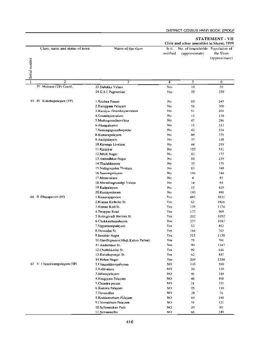
Class, name and status of town Name of the slum
2 3 IV Mulanur (TP) Contd., 23.Dulukka Valasu
24.G.S.I Pageseridai
65 IV Kolathupalayam (TP) l.Krishna Puram
2.Karuppam Palayam
3. Karaiyur Goundaiyanvalasu
4.Goundayanvalasu
5.Muthugoundanva1asu
6.A1ampalayam
7. Seerangagoundenpudur
8. Kumarapa1a yam
9. Andipalayam
IO.Karunga Livalasu
II. Karaiyur
12.MGR Nagar
13.Ambedhkar Nagar
I4.Thu1ukkanoor
IS .Nalligounden Thottam
16.Seerampalayam
17.Mettuvalasu
18.Marudhagoundt;.n Va1asu
19.Kalipalayam
20.Ramapattinam 66 II Dharapuram (M) I. Kamarajapuram
2.Roman Katholic St.
3.Kaman Koil St.
4.Tiruppur Road
5.Kolingivadi Harizan St.
6.Chokkanthapalayam
7. Uppuduraipalayam
8.Devendra St.
9.Jawahar Nager
10.Gandhipuram(Aladi Ka1am Pathai)
11.Ambethkar St.
12.Chollakkadai St.
13.Kulathupunjai St.
14.Nehru Nagar 67 V Chinakkampalayam (TP) I.Chinnakkampa1ayam
2. Kalli valasu
3.Sillampalayam
4.Kangiyam Palayam
5.Chandra puram
6.Kumara Palayam
7.Devanallur
8.Koddamutham P~layam 9.Chinnakkam Palayam
10.Sellanaickan Patti
11.Semannuthu
416
DISTRICT CENSUS HAND BOOK: ERODE
STATEMENT - VII Civic and other amenities in Slums, 1999
Is it No. of households Population of notified (approximate) the Slum
(approximate)
4 5 6 Yes 10 50
Yes 50 250
No 60 243
No 58 300
No 51 204
No 13 130
No 47 286
No 15 212
No 42 224
No 69 375
No 37 148
No 44 219
No 103 511
No 42 172
Nu 50 239
No 35 171
No 62 249
No 166 744
No 4 93
No 14 85
No 55 429
No 193 891
Yes 482 3821
Yes 62 1866
Yes 135 1174
Yes 177 969
Yes 202 1052
Yes 237 1012
Yes 52 462
Yes 164 765
Yes 315 1130
Yes 75 701
Yes 90 1247
Yes 92 646
Yes 62 847
Yes 209 1318
NO 145 580
NO 30 120
NO 46 184
NO 40 160
NO 31 155
NO 25 110
NO 20 76
NO 60 240
NO 31 121
NO 20 80 NO 68 249

TOWN DIRECTORY
STATEMENT· VII Civic and other amenities in Slums, 1999
Paved roads System of Method No. of tap Electricity Class, name and status of town (in sewerage Number of latrines of points/public connections
kilometers) disposal hydrants .... Q)
Q) Q of night installed for ..0
E '§ (.) S 0
soil supply of 'p Road ;::I ..0 Q) C ..... (.) t2 ~ pmtected ~ t2 3 ~ 'E <!) lighting <!)
0$ .£ .£ .... ~ OJ 0 water 0
(points) v cr.l 0 U 0 0 cr.l
7 8 9 10 11 12 13 14 15 16 17 2 OSD S.T 6 IV Mulanur (TP) Contd.,
0.5 OSD 5 S.T 45 2
0.2 OSD 5 S.T 6 20 6 IV Kolathupalayam (TP) 65
02 OSD 2 S.T 3 20 5
0.2 OSD I S.T 2 5 4 0.2 OSD I S.T 4 15 5 0.1 OSD 2 S.T 4 25 6 0.4 OSD 2 S.T 2 15 4 0.6 OSD 2 S.T 2 10 3
0.45 OSD 3 S.T 4 50 10 0.4 OSD 2 S.T 15 4
0.15 OSD 3 S.T 3 40 7 0.6 OSD 10 S.T 10 100 10
0.56 OSD 3 S.T 9 20 9
0.1 OSD 4 S.T 8 15 6 015 OSD 3 S.T 6 15 6 0.2 OSD 6 S.T 4 15 9
0.26 OSD 9 S.T 6 60 10 0.24 OSD S.T 2 3 2 0.6 OSD 1 S.T 2 150 10 0.7 OSD 8 S.T 10 15 5 1.2 OSD 9 S.T 10 300 20 0.4 OSD 20 2 S.T 8 460 48 II Dharapuram (M) 66
0.18 OSD 10 S.T 3 57 51 0.2 OSD 6 S.T 5 120 20
0.19 OSD 15 S.T 5 160 45
0.5 OSD 10 S.T 3 180 26 66 0.35 OSD 10 S.T 4 210 30 0.4 OSD 20 1 S.T 3 30 16 0.5 OSD 15 2 S.T 3 150 70 0.2 OSD 20 S.T 3 300 32 0.4 OSD 9 S.T 2 40 40 0.2 OSD 5 S.T 2 60 12
0.16 OSD 10 S.T 3 50 15 0.17 OSD 10 S.T 4 40 10 03 OSD 15 S.T 5 170 30
OSD 10 S.T 10 4S 15 V Chinakkampalayam (TP) 67
OSD 2 S.T 12 15 10 0.25 OSD 2 S.T 15 16 5 0.21 OSD 2 S.T 3 20 25
OSD 2 S.T 4 15 15 0.26 OSD 2 S.T 3 10 10
OSD 1 S.T 5 15 13 OSD 5 S.T 6 10 15 OSD 2 S.T 6 15 19 OSD 1 S.T 7 18 15 OSD 4 S.T 5 45 12
417

DISTRICT CENSUS HAND BOOK: ERODE
(iii) Appendix to Town Directory: Towns showing their outgrowth with population Sl. No. Name of Town with location code Population of the core Town Out Growth Population of Out Growth
NIL NIL NIL NIL NIL
418