Distribution List April 27, 2018 - Grand River Dam Authority
254
-
Upload
khangminh22 -
Category
Documents
-
view
2 -
download
0
Transcript of Distribution List April 27, 2018 - Grand River Dam Authority

Distribution List April 27, 2018
1
* Denotes correspondence was mailed to relicensing participants without a known email address. Federal Agencies: Dr. John Eddins Advisory Council on Historic Preservation Federal Permitting, Licensing and Assistance Section 401 F Street NW, Suite 308 Washington DC 20001-2637 [email protected] Mr. Andrew Commer, Chief U.S. Army Corps of Engineers, Tulsa District Attn: CESWT-P-R (Regulatory Branch) 2488 East 81st Street Tulsa, OK 74137 [email protected] Mr. Mike Abate U.S. Army Corps of Engineers 2488 East 81st Street Tulsa, OK 74137 [email protected] Ms. Jennifer Aranda U.S. Army Corps of Engineers 2488 East 81st Street Tulsa, OK 74137 [email protected] Mr. William Chatron U.S. Army Corps of Engineers 2488 East 81st Street Tulsa, OK 74137 [email protected] Ms. Tonya Dunn U.S. Army Corps of Engineers 2488 East 81st Street Tulsa, OK 74137 [email protected] Mr. Greg Estep U.S. Army Corps of Engineers 2488 East 81st Street Tulsa, OK 74137 [email protected]
Mr. Scott Henderson U.S. Army Corps of Engineers 2488 East 81st Street Tulsa, OK 74137 [email protected] Mr. Mike Love U.S. Army Corps of Engineers 2488 East 81st Street Tulsa, OK 74137 [email protected] Mr. Steve Nolen U.S. Army Corps of Engineers 2488 East 81st Street Tulsa, OK 74137 [email protected] Ms. Dawn Rice U.S. Army Corps of Engineers 2488 East 81st Street Tulsa, OK 74137 [email protected] Mr. Terry Rupe U.S. Army Corps of Engineers 2488 East 81st Street Tulsa, OK 74137 [email protected] Mr. David Williams U.S. Army Corps of Engineers 2488 East 81st Street Tulsa, OK 74137 [email protected] Ms. Eva Zaki-Dellitt U.S. Army Corps of Engineers 2488 East 81st Street Tulsa, OK 74137 [email protected] Mr. Johnny Bell FERC Hydropower Coordinator U.S. Army Corps of Engineers 2488 East 81st Street Tulsa, OK 74137 [email protected]
2
Mr. Eddie Streater Regional Director U.S. Bureau of Indian Affairs Eastern Oklahoma Regional Office PO Box 8002 Muskogee, OK 74401-6206 [email protected] Ms. Jessie Durham Deputy Regional Director U.S. Bureau of Indian Affairs Eastern Oklahoma Regional Office PO Box 8002 Muskogee, OK 74401-6206 [email protected] Mr. Mosby Halterman Environmental Protection Specialist U.S. Bureau of Indian Affairs PO Box 8002 Muskogee, OK 74401 [email protected] Ms. Allison Ross Division Director U.S. Bureau of Indian Affairs Eastern Regional Office PO Box 8002 Muskogee, OK 74401 [email protected] Ms. Lisa Atwell U.S. Bureau of Indian Affairs Eastern Regional Office PO Box 8002 Muskogee, OK 74401 [email protected] Ms. Kate Moore Regional Archaeologist U.S. Bureau of Indian Affairs Eastern Oklahoma Regional Office Division of Environmental & Cultural Resource Management PO Box 8002 Muskogee, OK 74401 [email protected]
Mr. James Schock Regional Director U.S. Bureau of Indian Affairs Southern Plains Office PO Box 368 Anadarko, OK 73005 [email protected] Ms. Crystal Keys Water Program Manager U.S. Bureau of Indian Affairs Southern Plains Office PO Box 368 Anadarko, OK 73005 [email protected] Mr. John Worthington Natural Resources Officer U.S. Bureau of Indian Affairs Southern Plains Regional Office PO Box 368 Anadarko, OK 73005 [email protected] Mr. Robert Pawelek Field Manager U.S. Bureau of Land Management Oklahoma Field Office 201 Stephenson Parkway, Suite 1200 Norman, OK 73072 [email protected] U.S. Department of the Army * 1645 Randolph Road Fort Sill, OK 73503 Mr. Conor Cleary U.S. Department of the Interior Tulsa’s Field Office of the Solicitor 7906 East 33rd Street, Suite 100 Tulsa, OK 74145 [email protected] Ms. Kimeka Price NEPA Project Manager U S Environmental Protection Agency Region 6 Fountain Place 1445 Ross Avenue Dallas, TX 75202-2760 [email protected]

3
Mr. Ken Collins U.S. Fish and Wildlife Service 9014 E 21st Street Tulsa, OK 74129-1428 [email protected] Ms. Jonna Polk U.S. Fish and Wildlife Service 9014 E 21st Street Tulsa, OK 74129-1428 [email protected] Mr. Kevin Stubbs Field Supervisor U.S. Fish and Wildlife Service 9014 E 21st Street Tulsa, OK 74129-1428 [email protected] Chief Tony Tooke U.S. Forest Service 1400 Independence Avenue, SW Washington, DC 20250 [email protected] Dr. William Andrews, Director U.S. Geological Survey Oklahoma Water Science Center 202 NW 66th Street, Building 7 Oklahoma City, OK 73116 [email protected] Acting Chief Leonard Jordan U.S. Natural Resources Conservation Service 1400 Independence Avenue, SW Room 5105-S Washington DC 20250 [email protected] Sue Masica Regional Director National Park Service 12795 Alameda Parkway Denver, CO 80225 [email protected]
Ms. Nicole McGavock National Weather Service Tulsa, OK Weather Forecast Office 10159 E 11th Street, Suite 300 Tulsa, OK 74128 [email protected] Mr. James Paul National Weather Service Tulsa, OK Weather Forecast Office 10159 E 11th Street Suite 300 Tulsa, OK 74137 [email protected] State Agencies: Dr. Kary Stackelbeck State Archeologist Oklahoma Archeological Survey University of Oklahoma 111 East Chesapeake Street, Room 102 Norman, OK 73019-5111 [email protected] Ms. Deby Snodgrass Executive Director Secretary of Commerce and Tourism Oklahoma Department of Commerce 900 North Stiles Avenue Oklahoma City, OK 73104 [email protected] Mr. Brooks Tramell Director of Monitoring, Assessment & Wetlands Oklahoma Conservation Commission 2800 North Lincoln Boulevard, Suite 200 Oklahoma City, OK 73105 [email protected] Ms. Shanon Phillips Director of Water Quality Division Oklahoma Conservation Commission 2800 North Lincoln Boulevard, Suite 200 Oklahoma City, OK 73105 [email protected]
4
Mr. Tim Rhodes * Director of Administration Oklahoma Corporation Commission 2101 North Lincoln Boulevard Oklahoma City, OK 73105 Mr. Jim Reese Commissioner Oklahoma Department of Agriculture Food and Forestry 2800 North Lincoln Boulevard, Suite 100 Oklahoma City, OK 73105 [email protected] Mr. Joe Long Environmental Programs Manager Watershed Planning Section Oklahoma Department of Environmental Quality PO Box 1677 Oklahoma City, OK 73101-1677 [email protected] Ms. Elena Jigoulina Environmental Programs Specialist Oklahoma Department of Environmental Quality PO Box 1677 Oklahoma City, OK 73101-1677 [email protected] Mr. Charles Kerns Oklahoma Office of Emergency Management PO Box 53365 Oklahoma City, OK 73152-3365 [email protected] Ms. Valauna Grissom Secretary Oklahoma Department of Health 1000 NE 10th Street Oklahoma City, OK 73117 [email protected] Mr. Mike Patterson Executive Director Oklahoma Department of Transportation 200 NE 21st Street Oklahoma City, OK 73105 [email protected]
Mr. Dick Dutton * Executive Director Oklahoma Tourism and Recreation Department 900 North Stiles Avenue Oklahoma City, OK 73104 Ms. Janet Logan State Parks and Resorts Oklahoma Tourism and Recreation Department 900 North Stiles Avenue Oklahoma City, OK 73104 [email protected] Mr. Barry Bolton Chief of Fisheries Division Oklahoma Department of Wildlife Conservation PO Box 53465 Oklahoma City, OK 73152 [email protected] Mr. JD Strong Director Oklahoma Department of Wildlife Conservation PO Box 53465 Oklahoma City, OK 73152 [email protected] Mr. Wade Free Assistant Director Oklahoma Department of Wildlife Conservation PO Box 53465 Oklahoma City, OK 73152 [email protected] Mr. Josh Johnston NE Region Fisheries Supervisor Oklahoma Department of Wildlife Conservation PO Box 1201 Jenks, OK 74037 [email protected]
5
Mr. Josh Richardson Wildlife Biologist Oklahoma Department of Wildlife Conservation PO Box 53465 Oklahoma City, OK 73152 [email protected] Mr. Alan Peoples Chief of Wildlife Division Oklahoma Department of Wildlife Conservation PO Box 53465 Oklahoma City, OK 73152 [email protected] Mr. Brad Johnston Fisheries Biologist Oklahoma Department of Wildlife Conservation 61091 E 120 Road Miami, OK 74354 [email protected] Mr. Ken Cunningham Assistant Chief of Fisheries Oklahoma Department of Wildlife Conservation PO Box 53465 Oklahoma City, OK 73152 [email protected] Mr. Bruce Burton NE Region Wildlife Supervisor Oklahoma Department of Wildlife Conservation 9097 N 34th Street West Porter, OK 74454 [email protected] Ms. Lynda Ozan Deputy State Historic Preservation Officer Oklahoma Historical Society 800 Nazih Zuhdi Drive Oklahoma City, OK 73105-7917 [email protected]
Ms. Catharine Wood Historical Archaeologist/Section 106 Coordinator Oklahoma Historical Society 800 Nazih Zuhdi Drive Oklahoma City, OK 73105-7917 [email protected] Ms. Julie Cunningham Executive Director Oklahoma Water Resources Board 3800 North Classen Boulevard Oklahoma City, OK 73118 [email protected] Mr. William Cauthron Acting Director, Water Quality Division Oklahoma Water Resources Board 3800 North Classen Boulevard Oklahoma City, OK 73118 [email protected] Ms. Nikki Davis Staff Secretary, Water Quality Division Oklahoma Water Resources Board 3800 North Classen Boulevard Oklahoma City, OK 73118 [email protected] Mr. Lance Phillips Environmental Programs Manager Oklahoma Water Resources Board 3800 North Classen Boulevard Oklahoma City, OK 73118 [email protected] Mr. Monty Porter Section Head, Water Quality Standards Oklahoma Water Resources Board 3800 North Classen Boulevard Oklahoma City, OK 73118 [email protected] Mr. Kent Wilkins Planning and Management Division Oklahoma Water Resources Board 3800 North Classen Boulevard Oklahoma City, OK 73118 [email protected]
6
Ms. Brittnee Preston Director of Federal and Congressional Affairs Oklahoma Water Resources Board Oklahoma Department of Wildlife Conservation 23422 Spice Bush Terrace Ashburn, VA 20148 [email protected] Mr. Luke Tallant * Office of State Fire Marshal 2401 NW 23rd Street, Suite 4 Oklahoma City, OK 73107 Tribal Organizations: Inter-Tribal Council Inc. * PO Box 1308 Miami, OK 74355 Chief Nelson Harjo * Alabama-Quassarte Tribal Town PO Box 187 Wetumka, OK 74883 Chairman Bobby Komardley * Apache Tribe of Oklahoma 511 E Colorado Anadarko, OK 73005 Chairman Tamara Francis-Fourkiller Caddo Nation of Oklahoma PO Box 487 Binger, OK 73009 [email protected] Mr. Phil Cross Acting Tribal Historic Preservation Officer Caddo Nation PO Box 487 Binger, OK 73009 [email protected] Chief Bill John Baker * Cherokee Nation PO Box 948 Tahlequah OK 74465
Ms. Elizabeth Toombs Cherokee Nation Tribal Historic Preservation Officer PO Box 948 Tahlequah, OK 74465 [email protected] Mr. Tom Elkins Administrator Cherokee Nation Environmental Programs PO Box 948 Tahlequah, OK 74465 [email protected] Ms. Kim Penrod Director, Cultural Resources/106 Delaware Nation 31064 State Highway 281 PO Box 825 Anadarko, OK 73005 [email protected] Ms. Deborah Dotson President Delaware Nation PO Box 825 Anadarko, OK 73005 [email protected] Chief Chester Brooks Delaware Tribe of Indians 170 NE Barbara Bartlesville OK 74006 [email protected] Dr. Brice Obermeyer Historic Preservation Office Delaware Tribe of Indians 1200 Commercial Street Roosevelt Hall, Room 212 Emporia KS 66801 [email protected] Chief Glenna J. Wallace Eastern Shawnee Tribe of Oklahoma 12755 South 705 Road Wyandotte, OK 74370 [email protected]

7
Mr. Brett Barnes Tribal Historic Preservation Officer Eastern Shawnee Tribe of Oklahoma 12705 East 705 Road Wyandotte, OK 74370 [email protected] Chairman Bobby Walkup * Iowa Tribe of Oklahoma 335588 E 750 Road Perkins, OK 74059 Ms. Renee Hagler * Acting Tribal Administrator Iowa Tribe of Oklahoma 335588 E 750 Road Perkins, OK 74059 Chairman Matthew Komalty Kiowa Tribe of Oklahoma 100 Kiowa Way Carnegie, OK 73015 [email protected] Ms. Regina Gasco-Bentley * Little Traverse Bay Bands of Odawa Indians 7500 Odawa Circle Harbor Springs, MI 49740 Chief Douglas G. Lankford Miami Tribe of Oklahoma PO Box 1326 Miami, OK 74354 [email protected] Ms. Robin Lash General Counsel Miami Tribe of Oklahoma PO Box 1326 Miami, OK 74354 [email protected] Mr. Joe Halloran Counsel for Miami Nation Jacobson Law Group 180 East 5th Street, Suite 940 St. Paul, MN 55101 [email protected]
Mr. Phil Mahowald Jacobson Law Group 180 East 5th Street, Suite 940 St. Paul, MN 55101 [email protected] Mr. Jeff Holth Jacobson Law Group 180 East 5th Street, Suite 940 St. Paul, MN 55101 [email protected] Chief Bill Follis Modoc Tribe of Oklahoma 515 G Street SE Miami, OK 74354 [email protected] Chief James Floyd Muscogee (Creek) Nation PO Box 580 Okmulgee, OK 74447 [email protected] Ms. RaeLynn Butler Historic and Cultural Preservation Department, Manager Muscogee (Creek) Nation PO Box 580 Okmulgee, OK 74447 [email protected] Chief Geoffrey Standing Bear * Osage Nation 627 Grandview Avenue Pawhuska, OK 74056 Mr. James Munkres Archaeologist Osage Nation Historic Preservation Office 627 Grandview Avenue Pawhuska, OK 74056 [email protected] Dr. Andrea Hunter Osage Nation Historic Preservation Office 627 Grandview Avenue Pawhuska, OK 74056 [email protected]
8
Chairman John Shotton Otoe-Missouria Tribe of Indians 8151 Hwy 177 Red Rock, OK 74651 [email protected] Ms. Elsie Whitehorn Tribal Historic Preservation Officer Otoe-Missouria Tribe of Indians 8151 Hwy 177 Red Rock, OK 74651 [email protected] Chief Ethel Cook Ottawa Tribe of Oklahoma PO Box 110 Miami, OK 74354 [email protected] Ms. Rhonda Hayworth Tribal Historic Preservation Officer Ottawa Tribe of Oklahoma PO Box 110 Miami, OK 74354 [email protected] Chief John Froman Peoria Tribe of Oklahoma 118 South Eight Tribes Trail Miami, OK 74354 [email protected] Mr. Logan Pappenfort Special Project Manager NAGPRA Representative Peoria Tribe of Oklahoma 118 S Eight Tribes Trail PO Box 1527 Miami, OK 74355-1527 [email protected] Chairman John Berrey * Quapaw Tribe of Oklahoma PO Box 765 Quapaw, OK 74363 Mr. Everett Bandy Quapaw Tribe of Oklahoma PO Box 765 Quapaw, OK 74363 [email protected]
Chief Kay Rhoads * Sac and Fox Nation of Oklahoma 920883 S Hwy 99, Building A Stroud, OK 74079 Sandra Kay Massey Historic Preservation Program Sac and Fox Nation of Oklahoma 920883 S Hwy 99, Building A Stroud, OK 74079 [email protected] Chief William Fisher Seneca-Cayuga Nation PO Box 453220 Grove, OK 74345-3220 [email protected] Mr. William Tarrant Tribal Historic Preservation Officer Seneca-Cayuga Nation 23701 South 665 Road Grove, OK 74344 [email protected] Mr. Rick Dubois Environmental Director Seneca-Cayuga Nation PO Box 453220 Grove, OK 74345-3220 [email protected] Mr. Micco Emarthla Environmental Specialist Seneca Cayuga Nation PO Box 453220 Grove, OK 74345-3220 [email protected] Chief Ron Sparkman Shawnee Tribe of Oklahoma PO Box 189 Miami, OK 74354 [email protected] Ms. Jodi Hayes * Tribal Administrator Shawnee Tribe of Oklahoma PO Box 189 Miami, OK 74355

9
President Russell Martin * Tonkawa Tribe of Oklahoma 1 Rush Buffalo Road Tonkawa OK 74653 Chief Joe Bunch* United Keetoowah Band of Cherokees PO Box 746 Tahlequah, OK 74465 Mr. Eric Oosahwee-Voss * Tribal Historic Preservation Officer United Keetoowah Band of Cherokees PO Box 1245 Tahlequah, OK 74465 President Terri Parton Wichita and Affiliated Tribes PO Box 729 Anadarko, OK 73005 [email protected] Mr. Gary McAdams Tribal Historic Preservation Officer Wichita and Affiliated Tribes PO Box 729 Anadarko, OK 73005 [email protected] Chief Billy Friend Wyandotte Tribe of Oklahoma 64700 East Highway 60 Wyandotte, OK 74370 [email protected] Ms. Sherri Clemons Tribal Historic Preservation Officer Wyandotte Tribe of Oklahoma 64700 East Highway 60 Wyandotte, OK 74370 [email protected] Mr. Norman Hildebrand, Jr. Second Chief Wyandotte Nation 64700 East Highway 60 Wyandotte, OK 74370 [email protected]
Mr. Christen Lee Environmental Director Wyandotte Nation 64700 East Highway 60 Wyandotte, OK 74370 [email protected] Congressional Delegation: The Honorable James Mountain Inhofe United States Senate 205 Russell Senate Office Building Washington DC 20515 [email protected] The Honorable James Lankford United States Senate 316 Hart Senate Office Building Washington DC 20510 [email protected] The Honorable Jim Bridenstine 216 Cannon House Office Building Washington DC 20515 [email protected] The Honorable Markwayne Mullin 1113 Longworth House Office Building Washington DC 20515 [email protected] The Honorable Michael Bergstrom Oklahoma State Senate, District 1 2300 North Lincoln Boulevard, Room 522 Oklahoma City, OK 73105 [email protected] The Honorable Marty Quinn Oklahoma State Senate, District 2 2300 North Lincoln Boulevard, Room 417B Oklahoma City, OK 73105 [email protected] The Honorable Wayne Shaw Oklahoma State Senate, District 3 2300 North Lincoln Boulevard, Room 325 Oklahoma City, OK 73105 [email protected]
10
The Honorable Josh West House of Representatives, District 5 2300 North Lincoln Blvd, Room 242A Oklahoma City, OK 73105 [email protected] The Honorable Chuck Hoskin House of Representatives, District 6 2300 North Lincoln Boulevard, Room 509 Oklahoma City, OK 73105 [email protected] The Honorable Ben Loring House of Representatives, District 7 2300 North Lincoln Boulevard Oklahoma City, OK 73105 [email protected] The Honorable Tom Gann House of Representatives, District 8 2300 North Lincoln Boulevard, Room 500 Oklahoma City, OK 73105 [email protected] The Honorable Mary Fallin* Governor of Oklahoma 2300 North Lincoln Boulevard, Suite 212 Oklahoma City, OK 73105 The Honorable Michael Teague Secretary of Energy and Environment 204 North Robison, Suite 1010 Oklahoma City, OK 73102 [email protected] Other Governmental Entities: Afton Public Works Authority PO Box 250 Afton, OK 74331 [email protected] Mr. Bill Keefer City Manager City of Grove 104 West 3rd Grove, OK 74344 [email protected]
Ms. Debbie Bottoroff Assistant City Manager City of Grove 104 West 3rd Grove, OK 74344 [email protected] Mayor Rudy Schultz City of Miami PO Box 1288 Miami, OK 74355 [email protected] Mr. Dean Kruithof City Manager City of Miami PO Box 1288 Miami, OK 74355 [email protected] Carlos Gutierrez Davis Wright 1251 Avenue of the Americas 21st Floor New York, NY 10020 [email protected] Ms. Amber Prewett City of Miami PO Box 1288 Miami, OK 74355 [email protected] Fire Chief Robert Wright City of Miami PO Box 1288 Miami, OK 74355 [email protected] Police Chief Thomas Anderson City of Miami PO Box 1288 Miami, OK 74355 [email protected] Ms. Alicia Hogan Public Works Director City of Miami PO Box 1288 Miami, OK 74355 [email protected]
11
Coo-Y-Yah Museum * 847 Highway 69 South 8th Street Pryor, OK 74361 Mr. Lowell Walker Craig County Commissioner District 1 210 W Delaware Avenue, Suite 106 Vinita, OK 74301 [email protected] Mr. Mike Fitzpatrick Craig County Commissioner District 2 210 W Delaware Avenue, Suite 106 Vinita, OK 74301 [email protected] Mr. Dan Peetom Craig County Commissioner District 3 210 W Delaware Avenue, Suite 106 Vinita, OK 74301 [email protected] Mr. Morris Bluejacket Craig County Flood Plain Manager 210 West Delaware, Suite 103 Vinita, OK 74301-4236 [email protected] Cambra Fields District Conservationist Craig County Conservation District 235 West Hope Avenue Vinita, OK 74301-1302 [email protected] Mr. Doug Smith Delaware County Commissioner District 1 2001 Industrial 10 RD Grove, OK 74344 [email protected]
Mr. Russell Martin Delaware County Commissioner District 2 327 South 5th Street Jay, OK 74346 [email protected] Martin Kirk * Delaware County Commissioner District 3 327 South 5th Street Jay, OK 74346 Mr. Robert Real Delaware County Floodplain Administrator PO Drawer 309 429 South 9th Street Jay, OK 74346-0309 [email protected] Delaware County Historical Society & Museum * 538 Krause Street Jay, OK 74346 Delaware County Conservation District 2749 State Highway 20 Jay, OK 74346 [email protected] Eastern Trails Museum 215 West Illinois Avenue Vinita, OK 74301 [email protected] Mr. Jonas Rabel Administrator Integris Health Center 200 2nd Avenue SW Miami, OK 74354 [email protected] Ms. Jill Lambert Ketchum Public Works Authority PO Box 958 Ketchum, OK 74349 [email protected]
12
Mr. Kevin Whiteside Mayes County Commissioner District 1 One Court Place, Suite 140 Pryor, OK 74361 [email protected] Ms. Meredith Frailey* Mayes County Commissioner District 2 One Court Place, Suite 140 Pryor, OK 74361 Mr. Ryan Ball Mayes County Commissioner One Court Place, Suite 140 Pryor, OK 74361 [email protected] Mayes County Conservation District 4238 N E 1st PO Box 36 Pryor, OK 74362 [email protected] Mr. Johnny Janzen Mayes County Floodplain Manager One Court Place, Suite 140 Pryor, OK 74361 [email protected] Mr. Jeremy Hogan Superintendent Miami Public Schools 26 N Main Street Miami, OK 74354 [email protected] Mr. Steve Gilbert Director Miami Regional Chamber of Commerce 11 South Main Miami, OK 74354 [email protected] Mr. Brian Forrester Council Member NE Ward 1 PO Box 1288 Miami, OK 74355-1288 [email protected]
Mr. Doug Weston Council Member NE Ward 2 PO Box 1288 Miami, OK 74355-1288 [email protected] Mr. Neal Johnson Council Member SW Ward 3 PO Box 1288 Miami, OK 74355-1288 [email protected] Ms. Vicki Lewis Council Member SE Ward 4 PO Box 1288 Miami, OK 74355-1288 [email protected] Mr. Joe Dan Morgan Ottawa County Emergency Management Certified Floodplain Manager 123 East Central Ave., Suite 103 Miami, OK 74354 [email protected] Chairman John Clarke Ottawa County Commissioner District #1 102 East Central Avenue, Suite 202 Miami, OK 74354 [email protected] Mr. Gary Wyrick Ottawa County Commissioner District #2 310 West Walker Wyandotte, OK 74370 [email protected] Mr. Russell Earls Ottawa County Commissioner District #3 102 East Central Avenue, Suite 202 Miami, OK 74354 [email protected]
13
Ottawa County Conservation District 630 East Steve Owens Boulevard, Suite 3 Miami, OK 74354-7800 [email protected] Ottawa County Historical Society * (Dobson Museum) 110 A Street SW Miami, OK 74354 Mr. Matt Outhier RWD #3 Delaware County PO Box 1228 Jay, OK 74346 [email protected] RWD #3 Mayes County – Disney PO Box 279 Disney, OK 74340 [email protected] Town of Afton * PO Box 250 Afton, OK 74331 Town of Bernice * 209 S Broadway Bernice, OK 74331 Town of Disney * PO Box 318 Disney, OK 74340 Town of Fairland * PO Box 429 Fairland, OK 74343 Town of Ketchum * PO Box 150 Ketchum, OK 74349 Ms. Melissa Yarbrough Town of Langley PO Box 760 Langley, OK 74350 [email protected] City of Vinita * PO Box 329 104 East Illinois Avenue Vinita, OK 74301
Town of Wyandotte * 212 South Main Wyandotte, OK 74370 Non-Governmental Organizations: American Rivers 1101 14th Street NW Suite 1400 Washington DC 20005 [email protected] American Whitewater PO Box 1540 Cullowhee, NC 28723 [email protected] Nathan Johnson Ducks Unlimited Regional Director 1812 Cinnamon Ridge Road Edmond, OK 73025 [email protected] Grand Lake Audubon Society * PO Box 1813 Grove, OK 74345-1813 Mr. Bruce Watson, Squadron Commander Grand Lake Sail and Power Squadron 31380 S 628 Lane Grove, OK 74344 [email protected] Grand Lake Watershed Alliance Foundation PO Box 451185 Grove, OK 74345-1185 [email protected] Ms. Rebecca Jim Local Environmental Action Demanded Inc. 223 A Street SE Miami, OK 74354 [email protected] Ms. Melissa Shackford Director of Land Protection The Nature Conservancy 408 NW 7th Street Oklahoma City, OK 73102 [email protected]
14
Mr. Jay Pruett Director of Conservation The Nature Conservancy 10425 S 82nd E Avenue, Suite 104 Tulsa, OK 73133 [email protected] Mr. Chris Wood, President Trout Unlimited 1777 N Kent Street, Suite 100 Arlington, VA 22209 [email protected] Mr. John Kennington President Tulsa Audubon Society PO Box 330140 Tulsa, OK 74133 [email protected] Public/Citizens: Larry Bork GSEP 515 S. Kansas Ave. Topeka, KS 66603 [email protected] Mr. Clayton Garner Cherokee Grove Golf at Carey Bay 519 Quail Run Road Grove, OK 74344 [email protected] Grand Bluffs Development * 32922 Pebble Beach Afton, OK 74331 Mr. Justin May Shangri-La Management 31000 South Highway 125 Afton, OK 74331 [email protected] Mr. Robert Steinkirchner Spinnaker Point, Manager 450779 East 341 Road Afton, OK 74331 [email protected]
Mr. Kent Stewart Shoreline, LLC PO Box 6586 Grove, OK 74344 [email protected] Mr. Eric Grimshaw Spinnaker Point Estates 2639 E 33rd Place Tulsa, OK 74105 [email protected] Mr. Bruce Hensley Tera Miranda Shores Inc. 28251 South 561 Road Monkey Island, OK 74331 [email protected] Dr. Robert Nairn School of Civil Engineering The University of Oklahoma 202 West Boyd Street, Room 334 Norman, OK 73109-3073 [email protected] Dr. Robert Knox School of Civil Engineering The University of Oklahoma 202 West Boyd Street, Room 334 Norman, OK 73109-3073 [email protected] Dr. Randy Kolar School of Civil Engineering The University of Oklahoma 202 West Boyd Street, Room 334 Norman, OK 73109-3073 [email protected] Oklahoma State University Burns Hargis, President 107 Whitehurst Stillwater, OK 74078 [email protected] Mr. Jeffrey Hale President Northeastern Oklahoma A & M College 200 I Street NE Miami, OK 74354 [email protected]
15
Mr. Mark Rasor Vice President for Business 200 I Street NE Miami OK 74354 [email protected] Mr. Steve Stephens General Counsel OSU-A&M College Board of Regents 2800 N Lincoln Blvd Oklahoma City, OK 74105 [email protected] Dr. Keith Martin Dean, Professor of Biology Rogers State University 1701 West Will Rogers Boulevard Claremore, OK 74017 [email protected] Miami Flood Mitigation Advisory Board * City of Miami PO Box 1288 Miami, OK 74355-1288 Grand Seaplanes, LLC * 5200 South Chestnut Avenue Broken Arrow, OK 74011 Anglers in Action * PO Box 803 High Ridge, MO 63049 Grand Lake Association & Visitor Center * 9630 Highway 59 N, Suite B Grove, OK 74344 Rusty Fleming * Executive Director Grand Lakers United Enterprise PO Box 1 Langley, OK 74350 Mr. Jay Cranke Director Grand Lake Association 9630 US Highway 59, Suite B Grove, Oklahoma 74344 [email protected]
Mr. Donnie Crain * President Grove Area Chamber of Commerce 9630 US Highway 59 Grove, OK 74344 South Grand Lake Area Chamber of Commerce PO Box 215 Langley, OK 74350 [email protected] Director Michele Bolton Miami Area Chamber of Commerce 103 East Central Avenue, Suite 100 Miami, OK 74354 [email protected] Oklahoma Association of Realtors * 9807 Broadway Ext Oklahoma City, OK 73114-6312 Har-Ber Village * 4404 West 20th Street Grove, OK 74344 Dr. Mark Osborn * 301 2nd Avenue SW Miami, OK 74354 Mr. Jack Dalrymple * 54297 E 75 Road Miami, OK 74354 Mr. Mike Williams Director of Communications & Gov’t Relations Shangri-La Marina 57151 East Highway 125 Afton, OK 74331 [email protected] Mr. Charlie Russell General Manager Cherokee Yacht Club Marina PO Box 600 Ketchum, OK 74349 [email protected]
16
Mr. Gary Stuart Manager Port Carlos PO Box 780 Ketchum, OK 74349 [email protected] Mr. Joe Harwood Owner Arrowhead Yacht Club (North & South) PO Box 600 Ketchum, OK 74349 [email protected] Mr. Mike Whorton Owner Clearwater Bay Marina PO Box 219 Disney, OK 74340 [email protected] Ms. Judy Florida General Manager Harbors View Marina 451107 East 320 Road Afton, OK 74331 [email protected] Mr. Jeff Rose Regional Manager Safe Harbor Marinas 14785 Preston Road, Suite 975 Dallas, TX 75254 [email protected] Mr. Jason Macer Manager Thunder Bay Marina LLC 450780 Thunder Bay Road Afton, OK 74331 [email protected] Mr. Jerry Cookson Manager Cedar Port Marina PO Box 600 Ketchum, OK 74349 [email protected]
Mr. Tom Berry Manager Tera Miranda Marina Resort 28251 South 561 Road Monkey Island, OK 74331 [email protected] Ms. April Cummins Manager Honey Creek Landing Marina 2520 South Main Street Grove, OK 74344 [email protected] Mr. Greg Crenshaw Willow Park Marina PO Box 120 Ketchum, OK 74349 [email protected] Mr. Ted Peitz Owner Southwinds Marina PO Box 3977 Bernice, OK 74331 [email protected] Mr. Paul Staten Owner The Landings Marina PO Box 61250 Oklahoma City, OK 73146 [email protected] Scotty’s Cove, Inc * PO Box 580 Langley, OK 74350 Mr. Nick Powell Manager Hammerhead Marina PO Box 600 Ketchum, OK 74349 [email protected] Grand Lakeside Marina * 11350 North Highway 59 Grove, OK 74344
17
Mr. Todd Elson Manager Indian Hills Resort and Marina PO Box 3747 Bernice, OK 74331 [email protected] Mr. Kevin McClure Manager Hi-Lift Marina LLC 196 Private Road 138 Eucha, OK 74342 [email protected] Mr. Harry Cole Owner Dripping Springs Yacht Club 200 Dripping Springs Landing Eucha, OK 74342 [email protected] Mr. Sam Chapman Owner Red Arrow Marina 453881 East 305 Road Afton, OK 74331 [email protected] Mr. Russ Allard Owner Elk River Landing 1923 North Barrington Drive Fayetteville, AR 72701 [email protected]

© Copyright 2018 Grand River Dam Authority
Pensacola Hydroelectric Project, FERC No. 1494
Proposed Study Plan
April 2018

© Copyright 2018 Grand River Dam Authority
Proposed Study Plan
Pensacola Hydroelectric Project Grand River Dam Authority FERC No. 1494 i April 2018
© Copyright 2018 Grand River Dam Authority
TABLE OF CONTENTS
1.0 Introduction and Background ........................................................................................ 1 1.1 Project Location and Description ........................................................................... 1 1.2 Initiation of the Integrated Licensing Process (ILP) ............................................... 5 1.3 FERC Abeyance .................................................................................................... 6 1.4 Public and Native American Government-to-Government Meetings ..................... 6 1.5 Resumption of the ILP and Environmental Scoping .............................................. 6
2.0 Development of GRDA’s Proposed Study Plan (PSP) ................................................. 7 2.1 FERC’s Study Plan Criteria ................................................................................... 7 2.2 Comments and Study Requests from Relicensing Participants ............................ 8
3.0 Overview of GRDA’s PSP ............................................................................................... 9 3.1 Proposed Studies .................................................................................................. 9
3.1.1 Hydrologic and Hydraulic Modeling Study ................................................. 9 3.1.2 Sedimentation Study................................................................................ 10 3.1.3 Recreation Facilities Inventory and Use Survey ...................................... 10 3.1.4 Cultural Resources Study ........................................................................ 11 3.1.5 Socioeconomics Study ............................................................................ 11
3.2 Phased Approach to Study Implementation ........................................................ 11
4.0 GRDA’s Response to Study Requests Received ....................................................... 12 4.1 General Study Considerations............................................................................. 20
4.1.1 Flood Control Operations......................................................................... 20 4.1.2 Environmental Baseline ........................................................................... 25 4.1.3 Cultural Resources Investigations in Inundated Areas ............................ 26 4.1.4 Addressing the Effects of Climate Change .............................................. 28 4.1.5 Protection, Mitigation and Enhancement Measures ................................ 28
4.2 Study Requests Included in GRDA’s PSP........................................................... 28 4.2.1 Flooding/Inundation Study ....................................................................... 28 4.2.2 Sedimentation Study................................................................................ 32 4.2.3 Cultural Resources Study ........................................................................ 32 4.2.4 Socioeconomics Study ............................................................................ 34
4.3 Study Requests Excluded from GRDA’s PSP ..................................................... 34 4.3.1 Federal Lands .......................................................................................... 34 4.3.2 Contaminated Sediment Transport Study ................................................ 36 4.3.3 Quantifying the Effects of Increased Water Level within the Grand Lake
Watershed ............................................................................................... 38 4.3.4 Impacts of Grand Lake Elevation Manipulation on Headwater River
Hydrology and Paddlefish Spawning / Recruitment ................................. 38 4.3.5 Alteration of Tailwater Fish Habitat Downstream of Pensacola Dam as a
Result of Hydropower Operations ............................................................ 39 4.3.6 Changes in Tailwater Fish Populations Due to Hypolimnetic Releases .. 39 4.3.7 Wetland Documentation .......................................................................... 40 4.3.8 Loss of Wildlife Lands from Flooding ....................................................... 41 4.3.9 Recovery of Lost Wildlife Mitigation Opportunity ..................................... 42 4.3.10 Flora and Fauna Impacts ......................................................................... 43 4.3.11 Infrastructure Improvement Study ........................................................... 44
Proposed Study Plan
Pensacola Hydroelectric Project Grand River Dam Authority FERC No. 1494 ii April 2018
© Copyright 2018 Grand River Dam Authority
4.4 FERC Additional Information Requests (AIRs) .................................................... 44 4.4.1 AIR 1 Project Operations ......................................................................... 44 4.4.2 AIR 2 Fisheries and Aquatic Resources .................................................. 45 4.4.3 AIR 3 Land Use ....................................................................................... 45 4.4.4 AIR 4 Cultural Resources ........................................................................ 46
5.0 Next Steps: Finalizing GRDA’s Study Plan ................................................................. 46 5.1 Study Plan Meeting ............................................................................................. 46 5.2 Comments on the PSP ........................................................................................ 46 5.3 Revised Study Plan (RSP) .................................................................................. 47 5.4 Study Plan Determination and Dispute Resolution (if Needed) ........................... 47
6.0 Implementation of Final Study Plan ............................................................................ 47 6.1 Relicensing Schedule .......................................................................................... 47 6.2 Relationship of Study Program to License Application Deadline ......................... 49
7.0 References ..................................................................................................................... 50
ATTACHMENTS
Attachment A. Study Plans Attachment B. List of Comment Letters and Study Requests Filed with FERC Attachment C. Entrainment Susceptibilities of Fishes Inhabiting the Lower Portion of Grand
Lake, Oklahoma
Proposed Study Plan
Pensacola Hydroelectric Project Grand River Dam Authority FERC No. 1494 iii April 2018
© Copyright 2018 Grand River Dam Authority
LIST OF TABLES
Table 1.1-1. Target elevations for Pensacola Project. ............................................................... 5
Table 4.0-1. Summary of formal study requests and GRDA’s responses. .............................. 13
Table 4.0-2. Formal study requests filed with FERC. .............................................................. 19
Table 6.1-1. Process plan and schedule. 1 .............................................................................. 47
LIST OF FIGURES
Figure 1-1.1. McClellan-Kerr River system. ................................................................................ 2
Figure 1-1.2. Pensacola Project vicinity. ..................................................................................... 3
Figure 1.1-3. Pensacola Project rule curve. ................................................................................ 5
Proposed Study Plan
Pensacola Hydroelectric Project Grand River Dam Authority FERC No. 1494 iv April 2018
© Copyright 2018 Grand River Dam Authority
LIST OF ACRONYMS
1-D .................................. one dimensional
2-D .................................. two dimensional
ACHP .............................. Advisory Council on Historic Preservation
AIR .................................. Additional Information Request
APE ................................. Area of Potential Effects
AUC ................................ Allowable Use Category
BIA .................................. Bureau of Indian Affairs
CCWMA .......................... Coal Creek Wildlife Management Area
C.F.R. .............................. Code of Federal Regulations
CHM ................................ Comprehensive Hydraulic Model
CRWG ............................. Cultural Resources Working Group
DLA ................................. Draft License Application
DO ................................... Dissolved Oxygen
EA ................................... Environmental Assessment
EPA ................................. Environmental Protection Agency
ESA ................................. Endangered Species Act
FEMA .............................. Federal Emergency Management Agency
FERC .............................. Federal Energy Regulatory Commission
FLA ................................. Final License Application
FPA ................................. Federal Power Act
FWHMP .......................... Fish and Waterfowl Habitat Management Plan
GIS .................................. Geographic Information System
GRDA .............................. Grand River Dam Authority
HEC-RAS ........................ Hydrologic Engineering Center’s River Analysis System
H&H Study ...................... Hydrologic and Hydraulic Modeling Study
HPMP .............................. Historic Properties Management Plan
IA ..................................... Interagency Agreement
ILP ................................... Integrated Licensing Process
ISR .................................. Initial Study Report
kVA ................................. kilovolt amp
kW ................................... kilowatt
LEAD ............................... Local Environmental Action Demanded
Proposed Study Plan
Pensacola Hydroelectric Project Grand River Dam Authority FERC No. 1494 v April 2018
© Copyright 2018 Grand River Dam Authority
LiDAR .............................. Light Detection and Ranging
Mitigation Fund ............... fish and wildlife mitigation fund
MW .................................. megawatt
NAVD .............................. North American Vertical Datum of 1988
NEPA .............................. National Environmental Policy Act
NGO ................................ non-governmental organization
NGVD .............................. National Geodetic Vertical Datum of 1929
NHPA .............................. National Historic Preservation Act
NOI .................................. Notice of Intent
NWI ................................. National Wetlands Inventory
OAS ................................ Oklahoma Archaeological Survey
ODWC ............................. Oklahoma Department of Wildlife Conservation
OSU ................................ Oklahoma State University
OU ................................... University of Oklahoma
OU2 ................................. Operable Unit 2
OWRB ............................. Oklahoma Water Resources Board
PAD ................................. Pre-Application Document
PD ................................... Pensacola datum
PLP ................................. Preliminary Licensing Proposal
PM&E .............................. protection, mitigation, and enhancement
Project ............................. Pensacola Hydroelectric Project
PRP ................................. potentially responsible party
PSP ................................. Proposed Study Plan
RM .................................. river mile
RSP ................................. Revised Study Plan
SD1 ................................. Scoping Document 1
SD2 ................................. Scoping Document 2
SHPO .............................. State Historic Preservation Officer
SMC ................................ Shoreline Management Classification
SMP ................................ Shoreline Management Plan
SQG ................................ sediment quality guidelines
STID ................................ Supporting Technical Information Document
TAAMS ............................ Trust Asset and Accounting Management System
TCP ................................. Traditional Cultural Properties
Technical Committee ...... fish and wildlife technical committee
Proposed Study Plan
Pensacola Hydroelectric Project Grand River Dam Authority FERC No. 1494 vi April 2018
© Copyright 2018 Grand River Dam Authority
TSMD .............................. Tri-State Mining District
USACE ............................ U.S. Army Corps of Engineers
U.S.C. ............................. U.S. Code
USFWS ........................... U.S. Fish and Wildlife Service
USGS .............................. U.S. Geological Survey
USR ................................ Updated Study Report
VMP ................................ Vegetation Management Plan
WMA ............................... Wildlife Management Area
Proposed Study Plan
Pensacola Hydroelectric Project Grand River Dam Authority FERC No. 1494 1 April 2018
© Copyright 2018 Grand River Dam Authority
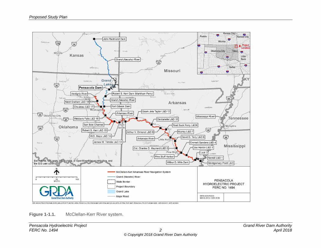
1.0 INTRODUCTION AND BACKGROUND The 120-megawatt (MW) Pensacola Hydroelectric Project (Pensacola Project or Project), owned and operated by the Grand River Dam Authority (GRDA), is licensed by the Federal Energy Regulatory Commission (FERC or Commission) as Project No. 1494. GRDA is a non-appropriated agency of the State of Oklahoma, created by the Oklahoma legislature in 1935 to be a “conservation and reclamation district for the waters of the Grand River.” The existing license for the Pensacola Project was issued on April 24, 1992, and will expire on March 31, 2022. GRDA is applying for a new license for the Pensacola Project. In accordance with FERC regulations at 18 Code of Federal Regulations (C.F.R.) Part 5, GRDA is utilizing FERC’s Integrated Licensing Process (ILP) for preparing its relicensing application. This Proposed Study Plan (PSP) is being filed with FERC pursuant to 18 C.F.R. § 5.11 and the Process Plan and Schedule referenced in FERC’s Scoping Document 1 (SD1 – see Table 6.1-1 in this PSP). Notification of availability of this PSP is also being distributed to federal and state resource agencies, Native American Tribes, local governments, non-governmental organizations (NGO), and other interested parties (collectively referred to as “relicensing participants”).
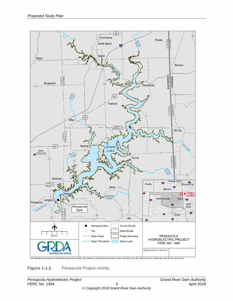
1.1 Project Location and Description As licensed by FERC, the Project serves multiple purposes, including hydropower generation, water supply, public recreation, and wildlife enhancement. As directed by Congress under the Flood Control Act of 1944, 58 Stat. 887, 890-91, and under the jurisdiction of the U.S. Army Corps of Engineers (USACE), the Project also serves as part of the McClellan-Kerr Arkansas River Navigation System of reservoirs providing navigation and flood control throughout the Grand and larger Arkansas River basin (Figure 1.1-1). USACE has exclusive jurisdiction over Grand Lake for flood control purposes, and USACE has designated a flood control pool for Grand Lake that extends above the 745-foot elevation Pensacola datum (PD).1,2 The Project is located northeast of Tulsa on the Grand/Neosho River (referred to as the Grand River) in Craig, Delaware, Mayes, and Ottawa counties, Oklahoma (Figure 1.1-2). The Grand River originates as the Neosho River in Kansas and flows south through northeastern Oklahoma approximately 460 miles before discharging into the Arkansas River near the town of Fort Gibson. Below its confluence with the Spring River at river mile (RM) 122.6,3 near Wyandotte and State Highway 60, where the Twin Bridges crosses the river in Ottawa County, the Neosho River becomes the Grand River. The Pensacola Dam is located at RM 77 and creates Grand Lake.
1 All elevations referenced are relative to PD. PD elevations can be converted to National Geodetic Vertical Datum of 1929 (NGVD) by adding 1.07 feet and to North American Vertical Datum of 1988 (NAVD) by adding 1.40 feet (for example, elevation 745 feet PD = 746.07 feet NGVD = 746.4 feet NAVD88)(http://ok.water.usgs.gov/projects/webmap/miami/datum.htm). 2 In response to a PAD comment by N. Larry Bork (3/13/18), in general, elevations will be converted to and expressed in PD using the above conversion factors. 3 In previous project documents this value is cited as RM 131, which comes from Holly (2004).
Proposed Study Plan
Pensacola Hydroelectric Project Grand River Dam Authority FERC No. 1494 2 April 2018
© Copyright 2018 Grand River Dam Authority
Figure 1-1.1. McClellan-Kerr River system.
Proposed Study Plan
Pensacola Hydroelectric Project Grand River Dam Authority FERC No. 1494 3 April 2018
© Copyright 2018 Grand River Dam Authority
Figure 1-1.2. Pensacola Project vicinity.

Proposed Study Plan
Pensacola Hydroelectric Project Grand River Dam Authority FERC No. 1494 4 April 2018
© Copyright 2018 Grand River Dam Authority
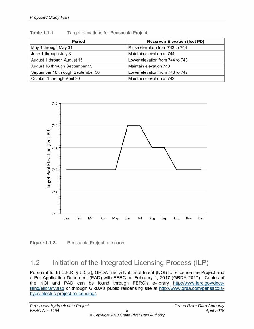
The Project consists of: (a) a reinforced-concrete dam with a multiple-arch section 4,284 feet long, a spillway 861 feet long containing twenty-one radial gates, a non-overflow gravity section 451 feet long, and two non-overflow abutments, comprising an overall length of 5,950 feet and a maximum height of 147 feet; (b) a reinforced-concrete, gravity-type spillway section 886 feet long containing twenty-one radial gates and located about 1 mile east of the main dam; (c) the Grand Lake reservoir, which extends approximately 66 miles upstream from the Pensacola Dam, has a surface area of approximately 45,200 acres, a storage capacity of 1,680,000 acre-feet at normal maximum water surface elevation of 745 feet PD, below which is known as the conservation pool, and approximately 667 miles4 of shoreline; (d) six, 15-foot-diameter steel penstocks supplying flow to six turbines each rated at 17,446 kilowatts (kW) attached to six generators each rated at 24,000 kilovolt amp (kVA) or 21,600 kW, and one 3-foot-diameter penstock supplying flow to one turbine rated at 500-kW5 attached to an identically rated generator, located in a powerhouse immediately below the dam; (e) a tailrace approximately 300 feet wide and a spillway channel approximately 850 feet wide, both about 1.5 miles long; and (f) appurtenant facilities (FERC 1996; GRDA 2010). In addition, GRDA operates and maintains five FERC-approved recreation sites at the Project including: (1) Duck Creek Bridge Public Access Area; (2) Seaplane Base Public Access; (3) Monkey Island Public Boat Ramp; (4) Big Hollow Public Access; and (5) Wolf Creek Public Access. These facilities provide public access to Grand Lake for boating, fishing, and other recreational activities. The Project Boundary is defined by a combination of a metes and bounds description and generally follows contour elevation 750 feet PD. It encompasses 53,965 acres, including the 45,200 acres of the Project reservoir (at the upper extent of the conservation pool of 745 feet PD). The Project Boundary encompasses all Project facilities and works, Project recreation areas, and a shoreline buffer around the entire reservoir (generally between 745 and 750 feet PD). To balance the multiple uses of the reservoir, GRDA currently operates the Project to target reservoir surface elevations known as the Project’s rule curve6, shown in Table 1.1-1 and Figure 1.1-3.
4 The Project license states there are 1,300 miles of shoreline around the Pensacola Project and, traditionally, GRDA has referenced 1,300 miles of shoreline for Grand Lake. However, it has been determined that the 1,300 value relates to the total shoreline miles of GRDA’s three hydropower projects. For consistency in management and tracking of matters related to the Shoreline Management Plan (SMP), in 2008, based on a new Geographic Information System (GIS) system, GRDA hand digitized the data available at the time, which resulted in a total amount of shoreline within the Project Boundary of 522 miles. With technological advances in the GIS field, more accurate data (including LiDAR) indicate that the amount of shoreline within the Project Boundary is 667 miles. 5 The 2011 Supporting Technical Information Document (STID) mistakenly identifies the unit as 625 kW and will be corrected in a future revised STID (GRDA 2011). 6 Order Amending License and Dismissing Application for Temporary Variance, 160 FERC ¶ 61,001 (2017).
Proposed Study Plan
Pensacola Hydroelectric Project Grand River Dam Authority FERC No. 1494 5 April 2018
© Copyright 2018 Grand River Dam Authority
Table 1.1-1. Target elevations for Pensacola Project.
Period Reservoir Elevation (feet PD)
May 1 through May 31 Raise elevation from 742 to 744 June 1 through July 31 Maintain elevation at 744
August 1 through August 15 Lower elevation from 744 to 743 August 16 through September 15 Maintain elevation 743
September 16 through September 30 Lower elevation from 743 to 742 October 1 through April 30 Maintain elevation at 742
Figure 1.1-3. Pensacola Project rule curve.
1.2 Initiation of the Integrated Licensing Process (ILP) Pursuant to 18 C.F.R. § 5.5(a), GRDA filed a Notice of Intent (NOI) to relicense the Project and a Pre-Application Document (PAD) with FERC on February 1, 2017 (GRDA 2017). Copies of the NOI and PAD can be found through FERC’s e-library http://www.ferc.gov/docs-filing/elibrary.asp or through GRDA’s public relicensing site at http://www.grda.com/pensacola-hydroelectric-project-relicensing/.
Proposed Study Plan
Pensacola Hydroelectric Project Grand River Dam Authority FERC No. 1494 6 April 2018
© Copyright 2018 Grand River Dam Authority
1.3 FERC Abeyance In light of the rule curve license amendment proceeding that was ongoing at the time of the filing of the NOI and PAD and the lack of a quorum of FERC commissioners to rule on the amendment application, on February 15, 2017, FERC issued a Letter Order holding the relicensing process in abeyance. Six months later, once a quorum of commissioners was restored, FERC approved the rule curve amendment.7 Two weeks later, FERC issued a Letter Order on August 24, 2017, lifting the abeyance and providing a revised ILP process plan and schedule. As a result of the abeyance, the ILP process for this relicensing lags several months behind the process envisioned in the Commission’s regulations. Specifically, to meet the statutory deadline under section 15(c) of the Federal Power Act (FPA) to file the Final License Application (FLA) two years prior to license expiration, 16 U.S. Code (U.S.C.) 808(c)(1), GRDA must file its relicensing application by March 31, 2020. At that point in the ILP, GRDA will have completed only a single season of studies, with the second study season underway. GRDA’s proposal to resolving this disparity between the license application filing deadline and the ILP process—in a manner that allows for full completion of environmental studies and input from relicensing participants before GRDA files its FLA—appears in Section 6.2 of this PSP.
1.4 Public and Native American Government-to-Government Meetings
Prior to the formal commencement of the relicensing process in January 2018, FERC held a series of public information sessions regarding the procedure for relicensing the Pensacola Project. Meetings were held in Langley (November 14 and 15, 2017), Grove (November 15, 2017), and Miami, Oklahoma (December 13, 2017). The meetings included an overview of the ILP and a discussion of the specific process plan, opportunities for public comment, and how FERC assesses information needs during the study planning process. In addition, FERC held government-to-government tribal consultation meetings with several Native American Tribes in Miami, Oklahoma, on December 13, 2017,8 and with the Osage Nation in Pawhuska, Oklahoma, on December 14, 2017.
1.5 Resumption of the ILP and Environmental Scoping On January 12, 2018, FERC issued notice of the PAD and NOI and commencement of the relicensing pre-filing process. FERC’s January 12, 2018 notice also designated GRDA as FERC’s non-federal representative for carrying out informal consultation, pursuant to Section 7 of the Endangered Species Act (ESA), and Section 106 of the National Historic Preservation Act (NHPA). In addition, the notice requested that relicensing participants provide comments regarding the PAD and provide study requests. Concurrently, FERC issued SD1 to outline the subject areas to be addressed in its environmental analysis of the Project pursuant to the National Environmental Policy Act (NEPA)9. 7 Order Amending License and Dismissing Application for Temporary Variance, 160 FERC ¶ 61,001 (2017). 8 Tribes represented at the meeting included: Cherokee Nation, Eastern Shawnee Tribe, Miami Tribe, Muscogee Creek Nation, Ottawa Tribe, Peoria Tribe, Quapaw Tribe, Seneca-Cayuga Nation, and Wyandotte Nation. 9 42 U.S.C. § 4321 et seq.
Proposed Study Plan
Pensacola Hydroelectric Project Grand River Dam Authority FERC No. 1494 7 April 2018
© Copyright 2018 Grand River Dam Authority
On February 7, 8, and 9, 2018, FERC held agency and public scoping meetings in Langley, Grove, Miami, and Tulsa, Oklahoma. A site visit to the Project was held on February 8, 2018, and was available to all relicensing participants and the public. Representatives of Oklahoma Department of Agriculture, Food and Forestry, Bureau of Indian Affairs (BIA), and the Miami News participated in the site tour. In accordance with ILP regulations, comments on the PAD and SD1 and study requests were due to FERC by March 13, 2018, within 60 days of FERC’s notice of the PAD and NOI and commencement of the pre-filing process.
2.0 DEVELOPMENT OF GRDA’S PROPOSED STUDY PLAN (PSP)
The purpose of this PSP is to describe GRDA’s proposed methodologies for conducting studies and to address relicensing participant study requests. This PSP also provides FERC and relicensing participants with the opportunity to comment on the studies proposed by GRDA. The individual study plans for the proposed studies are included in Attachment A of this PSP.
2.1 FERC’s Study Plan Criteria FERC’s ILP regulations at 18 C.F.R. § 5.9 specify required components of study requests to allow GRDA, as well as FERC staff, to determine the appropriateness and relevance of the proposed study to the relicensing. Under 18 C.F.R. Section 5.9(b) of FERC’s ILP regulations, these required components of the study request (the “Study Criteria”) are as follows: (1) Describe the goals and objectives of each study and the information to be obtained
(§ 5.9(b)(1));
This section describes why the study is being requested and what the study is intended to accomplish, including the goals, objectives, and specific information to be obtained. The goals of the study should clearly relate to the need to evaluate the effects of the Project on a particular resource. The objectives are the specific information that needs to be gathered to allow achievement of the study goal. (2) If applicable, explain the relevant resource management goals of the agencies or Indian
tribes with jurisdiction over the resource to be studied (§ 5.9(b)(2));
This section should clearly establish the connection between the study request and management goals or resource of interest. A statement by an agency connecting its study request to a legal, regulatory, or policy mandate needs to be included that thoroughly explains how the mandate relates to the study request, as well as the Project impacts. (3) If the requester is not a resource agency, explain any relevant public interest
considerations in regard to the proposed study (§ 5.9(b)(3));
This section is for non-agency requestors or Native American Tribes to establish the relationship between the study request and the relevant public interest considerations.

Proposed Study Plan
Pensacola Hydroelectric Project Grand River Dam Authority FERC No. 1494 8 April 2018
© Copyright 2018 Grand River Dam Authority
(4) Describe existing information concerning the subject of the study proposal, and the need for additional information (§ 5.9(b)(4));
This section should discuss any gaps in existing data by reviewing the available information presented in the PAD or information relative to the Project that is known from other sources. This section should explain the need for additional information and why the existing information is inadequate. (5) Explain any nexus between Project operation and effects (direct, indirect, and/or
cumulative) on the resource to be studied, and how the study results would inform the development of license requirements (§ 5.9(b)(5));
This section should clearly connect Project operations and Project effects on the applicable resource. This section should also explain how the study results would inform the development of protection, mitigation, and enhancement (PM&E) measures. (6) Explain how any proposed study methodology is consistent with generally accepted
practices in the scientific community or, as appropriate, considers relevant tribal values and knowledge. This includes any preferred data collection and analysis techniques, or objectively quantified information, and a schedule including appropriate field season(s) and the duration (§ 5.9(b)(6));
This section should provide a detailed explanation of the study methodology. The methodology may be described by outlining specific methods to be implemented or by referencing an approved and established study protocol and methodology. (7) Describe considerations of level of effort and cost, as applicable, and why any proposed
alternative studies would not be sufficient to meet the stated information needs (§ 5.9(b)(7));
This section should describe the expected level of cost and effort to conduct the study. If there are proposed alternative studies, this section should address why the alternatives would not meet the stated information needs.
2.2 Comments and Study Requests from Relicensing Participants
A total of 61 comment letters from federal and state resource agencies, Native American Tribes, non-governmental organizations, and other interested parties were filed with FERC regarding the relicensing of the Pensacola Project from January 8, 2018 through March 19, 2018. Comments received were a combination of general comments regarding the Project, comments on the PAD and SD1, and study requests. In accordance with ILP regulations, comments on the PAD and SD1 and study requests were due to FERC by March 13, 2018. A total of 27 formal and individual study requests were made by relicensing participants and FERC. Based on these requests and its independent evaluation of resources at the Project, GRDA has prepared its PSP, which is described in Section 3 of this PSP, with the actual proposed study plans appearing in Attachment A of this PSP. GRDA’s response to all study requests received is detailed in Section 4 of this PSP. In many instances, GRDA received comments instead of a study request. While the purpose of this PSP document is to set forth GRDA’s study plan for the relicensing effort—and not to respond to every comment received—in some instances the comments related to proposed
Proposed Study Plan
Pensacola Hydroelectric Project Grand River Dam Authority FERC No. 1494 9 April 2018
© Copyright 2018 Grand River Dam Authority
studies. GRDA’s responses to these relevant comments are detailed in the discussion of study requests in Sections 4.2 and 4.3. Several organizations (as listed below) filed PAD and SD1 comments that did not include formal study requests or relate to the proposed studies. While the comments may not directly relate to studies, GRDA will give them due consideration and ensure all identified issues are addressed and all necessary NEPA requirements are incorporated into its Environmental Exhibit (Exhibit E) of the relicensing application.
City of Grove
Environmental Protection Agency (EPA)
Grand Riverkeeper
LEAD Agency, Inc. (Local Environmental Action Demanded)
Southwest Power Administration Attachment B of this PSP provides a table detailing all of the comment letters and study requests that were received from relicensing participants. Comment letters and all documents filed with FERC can be accessed through FERC’s eLibrary at www.ferc.gov/docs-filing/elibrary.asp by searching under Docket P-1494-438.
3.0 OVERVIEW OF GRDA’S PSP
3.1 Proposed Studies Based on studies proposed in the PAD and in response to the study requests and comments received during the scoping period, GRDA is proposing the following studies and information-gathering efforts:
1. Hydrologic and Hydraulic Modeling Study (H&H Study)
2. Sedimentation Study
3. Recreation Facilities Inventory and Use Survey
4. Cultural Resources Study
5. Socioeconomics Study Specific study requests relevant to the above-listed resource areas are referenced in Section 4 of this PSP.
3.1.1 Hydrologic and Hydraulic Modeling Study
GRDA is proposing an H&H Study to identify areas inundated during the current operation of the Project, as well as during any operational changes that may be proposed as part of the relicensing effort. In addition to the inundation area, the study will provide other flood routing specifics such as the frequency, timing, amplitude, and duration of the inundation. The overall H&H Study goal is to provide information through modeling and mapping to determine the effect of the operation of the Project upon several resource areas. Specifically, the H&H Study will: (1) determine the duration and extent of inundation under the current

Proposed Study Plan
Pensacola Hydroelectric Project Grand River Dam Authority FERC No. 1494 10 April 2018
© Copyright 2018 Grand River Dam Authority
operation of the Project during several measured inflow events; (2) determine the duration and extent of inundation under any proposed change in operation that occurs during several measured or synthetic inflow events; (3) provide the model results in a format that can inform other analyses (to be completed separately) about Project effects, if any, in several resource areas; and (4) determine the feasibility of implementing alternative operation scenarios that may be proposed by GRDA as part of the relicensing effort. A Comprehensive Hydraulic Model (CHM) will be constructed to determine the inundation areas and other flood routing specifics during several measured inflow events where inflow hydrographs already exist. To evaluate the effects of any proposed operational changes, a separate Operations Model will be constructed to synthesize hypothetical events that inform the CHM. Information gathered from these models will be used to inform separate analyses about the effects of inundation on various resources and will be summarized in future licensing documents. A model input status report, initial technical report, and final technical report will be prepared as part of the H&H Study. The H&H Study Plan is included in Attachment A of this PSP and provides additional details regarding the overall study, models being developed, and methodology.
3.1.2 Sedimentation Study
GRDA is proposing to conduct a Sedimentation Study to address whether operation of the Project has influenced sedimentation in the Grand/Neosho watershed upstream of Grand Lake, and if so, the extent to which sedimentation has affected water levels in these areas during high flow events. This study has been designed as a one-year study, with the possibility of a second year of study, depending upon the results of the first year of study. The overall goal of this study is to acquire a better understanding of the interaction between sedimentation processes, operation of the Project, and the extent and duration of inundation. All of the proposed goals are intended to provide a clear understanding of the sediment transport processes and patterns upstream of Grand Lake on the Grand/Neosho, Spring, and Elk rivers and Tar Creek. Study Year One will involve analyzing historical sediment accretion and deposition patterns in the area upstream of Grand Lake in the Grand/Neosho, Spring and Elk rivers and Tar Creek. Study Year One will consist of the following four tasks: (1) Background Data and Literature Review; (2) Bathymetric Dataset Comparisons; (3) Operational Change Analysis; and (4) Data Synthesis and Reporting. Contingent Study Year Two, if determined to be necessary, will involve field data collection and data synthesis and reporting. A technical report will be developed for each study year, as necessary, as part of this study. The Sedimentation Study Plan is included in Attachment A of this PSP and provides additional details regarding the overall study and methodology.
3.1.3 Recreation Facilities Inventory and Use Survey
GRDA is proposing to conduct a Recreation Facilities Inventory and Use Survey as part of this PSP. The goals of this study are to gather information regarding current recreational use, and identify recreation resources and activities that may be affected by the continued operation of the Project. The study area will include the five FERC-approved recreation facilities on Grand Lake that are owned, operated, and maintained by GRDA.
Proposed Study Plan
Pensacola Hydroelectric Project Grand River Dam Authority FERC No. 1494 11 April 2018
© Copyright 2018 Grand River Dam Authority
There are three tasks associated with conducting this study: (1) Recreation Facility Inventory and Condition Assessment; (2) Recreation Visitor Use Data; and (3) Data Analysis and Reporting. Task 1 will involve collecting information regarding each of the five recreation areas via photo documentation and completing a Facilities and Inventory and Condition Form. Recreation visitor use data will be collected during Task 2 via field reconnaissance and conducting personal interviews at each of the five recreation locations. Task 3 of this study will be the data analysis and development of the study report. The Recreation Facilities Inventory and Use Survey Study Plan is included in Attachment A of this PSP and provides additional details regarding the overall study and methodology.
3.1.4 Cultural Resources Study
GRDA is proposing to conduct a Cultural Resources Study as part of this PSP. The goals of this study are: (1) to identify historic properties within the Project’s Area of Potential Effects (APE) that are being adversely affected by Project operations (if any), including properties of traditional religious and cultural importance; and (2) to develop a Historic Properties Management Plan (HPMP) in consultation with the Oklahoma State Historic Preservation Officer (SHPO), Oklahoma Archaeological Survey (OAS), and Native American Tribes, that provides for the long-term management of historic properties within the APE over the term of the new license. This study will consist of the following seven tasks: (1) Determine the APE; (2) Background Research and Archival Review; (3) Pre-fieldwork Report; (4) Reconnaissance Surveys; (5) Identify Traditional Cultural Properties (TCP); (6) Programmatic Agreement; and (7) Develop a HPMP. A Pre-fieldwork Study Report, Study Year One Reconnaissance Survey Report, Study Year Two Reconnaissance Survey Report, and a draft HPMP will be developed as part of this study. GRDA anticipates developing a draft HPMP in consultation with the Cultural Resources Working Group (CRWG), which will be included as part of GRDA’s FLA filed with the Commission. The Cultural Resources Study Plan is included in Attachment A of this PSP and provides additional details regarding the overall study and methodology.
3.1.5 Socioeconomics Study
GRDA is proposing to perform a Socioeconomics Study to gather, synthesize, and report on existing information necessary to qualitatively evaluate the socioeconomic effects of the Pensacola Project in the study area. The objectives of the study are to describe baseline economic conditions in the Project area and to identify the socioeconomic contribution of the Project in the state and the region. GRDA will perform a desktop review of available regional socioeconomic data. Available information on the demographic and economic conditions of the region will be compiled and summarized in a final study report to present a qualitative assessment for the study area. The Socioeconomics Study Plan is included in Attachment A of this PSP and provides additional details regarding the overall study and methodology.
3.2 Phased Approach to Study Implementation As detailed in the individual study plans appearing in Attachment A, GRDA proposes to integrate these individual studies, where appropriate, to inform both the scoping of studies during the second year of studies, and to undertake its environmental effects analysis in the
Proposed Study Plan
Pensacola Hydroelectric Project Grand River Dam Authority FERC No. 1494 12 April 2018
© Copyright 2018 Grand River Dam Authority
Environmental Exhibit of the relicensing application, as required under FERC’s ILP regulations, 18 C.F.R. 5.18. For example, the outputs of the H&H Study at the end of Study Year One will be incorporated into the process under the Cultural Resources Study for prioritizing areas for study during Study Year Two. The outputs of the H&H Study also will be used to evaluate effects on resources in which a specific study is not proposed as part of this PSP. In the Environmental Exhibit, for example, the H&H Study will be used to evaluate any effects on aquatic and terrestrial resources using the wealth of existing information already available in these resource areas.
4.0 GRDA’S RESPONSE TO STUDY REQUESTS RECEIVED
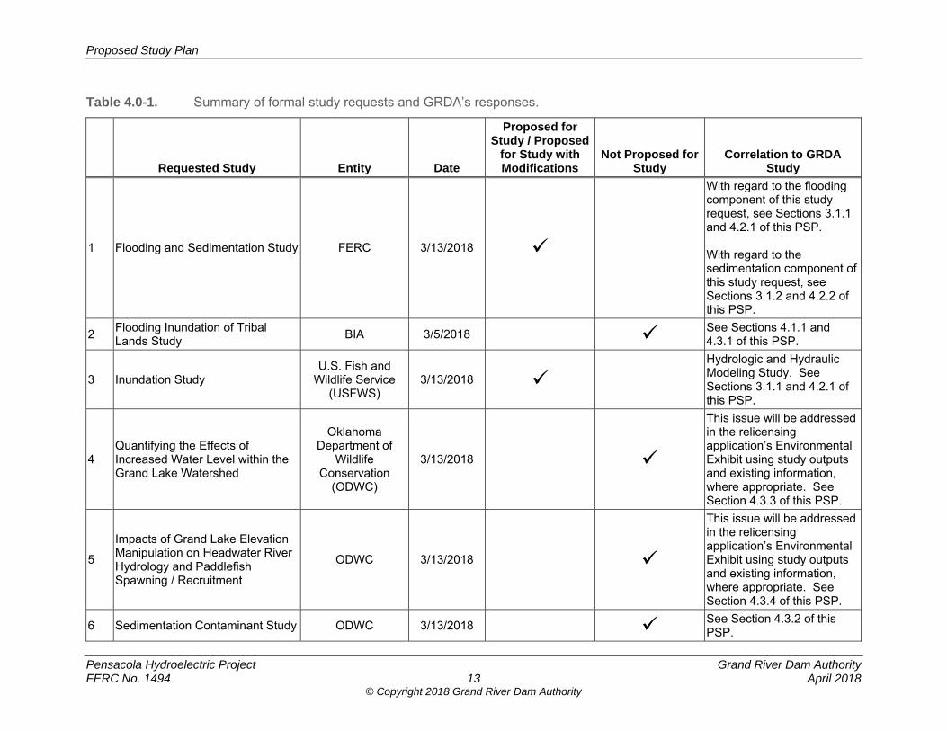
As noted above, GRDA received a total of 27 study requests submitted by FERC staff, federal and state resource agencies, Native American Tribes, and other relicensing participants. Some of these study requests did not provide all of the information required by FERC’s ILP regulations (18 C.F.R. § 5.9(b)), as set forth in Section 2.1 of this PSP. Regardless, in an effort to be complete, GRDA has attempted in this PSP document to identify and evaluate all study requests submitted, including those that may not have fully complied with FERC’s Study Criteria. Table 4.0-1 summarizes the results of GRDA’s review of the formal study requests and determination based on the Study Criteria. Where possible, GRDA consolidated common themes and elements expressed in the study requests (Table 4.0-2). The correspondence from relicensing participants requesting studies and providing comments is listed in Attachment B of this PSP.
Proposed Study Plan
Pensacola Hydroelectric Project Grand River Dam Authority FERC No. 1494 13 April 2018
© Copyright 2018 Grand River Dam Authority
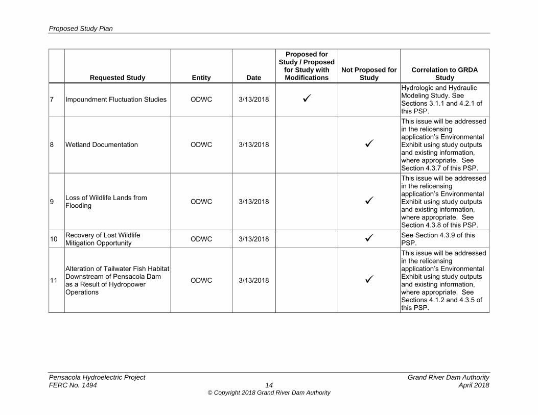
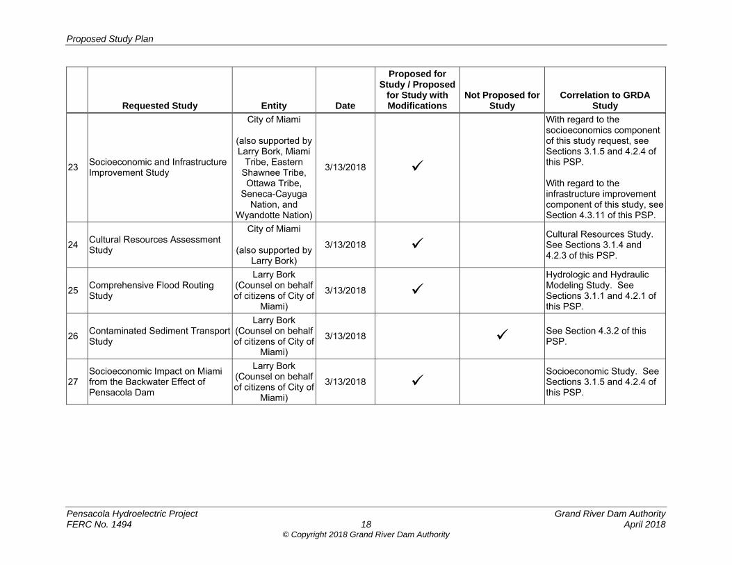
Table 4.0-1. Summary of formal study requests and GRDA’s responses.
Requested Study Entity Date
Proposed for Study / Proposed
for Study with Modifications
Not Proposed for Study
Correlation to GRDA Study
1 Flooding and Sedimentation Study FERC 3/13/2018
With regard to the flooding component of this study request, see Sections 3.1.1 and 4.2.1 of this PSP. With regard to the sedimentation component of this study request, see Sections 3.1.2 and 4.2.2 of this PSP.
2 Flooding Inundation of Tribal Lands Study
BIA 3/5/2018 See Sections 4.1.1 and 4.3.1 of this PSP.
3 Inundation Study U.S. Fish and
Wildlife Service (USFWS)
3/13/2018
Hydrologic and Hydraulic Modeling Study. See Sections 3.1.1 and 4.2.1 of this PSP.
4 Quantifying the Effects of Increased Water Level within the Grand Lake Watershed
Oklahoma Department of
Wildlife Conservation
(ODWC)
3/13/2018
This issue will be addressed in the relicensing application’s Environmental Exhibit using study outputs and existing information, where appropriate. See Section 4.3.3 of this PSP.
5
Impacts of Grand Lake Elevation Manipulation on Headwater River Hydrology and Paddlefish Spawning / Recruitment
ODWC 3/13/2018
This issue will be addressed in the relicensing application’s Environmental Exhibit using study outputs and existing information, where appropriate. See Section 4.3.4 of this PSP.
6 Sedimentation Contaminant Study ODWC 3/13/2018 See Section 4.3.2 of this PSP.
Proposed Study Plan
Pensacola Hydroelectric Project Grand River Dam Authority FERC No. 1494 14 April 2018
© Copyright 2018 Grand River Dam Authority
Requested Study Entity Date
Proposed for Study / Proposed
for Study with Modifications
Not Proposed for Study
Correlation to GRDA Study
7 Impoundment Fluctuation Studies ODWC 3/13/2018
Hydrologic and Hydraulic Modeling Study. See Sections 3.1.1 and 4.2.1 of this PSP.
8 Wetland Documentation ODWC 3/13/2018
This issue will be addressed in the relicensing application’s Environmental Exhibit using study outputs and existing information, where appropriate. See Section 4.3.7 of this PSP.
9 Loss of Wildlife Lands from Flooding
ODWC 3/13/2018
This issue will be addressed in the relicensing application’s Environmental Exhibit using study outputs and existing information, where appropriate. See Section 4.3.8 of this PSP.
10 Recovery of Lost Wildlife Mitigation Opportunity
ODWC 3/13/2018 See Section 4.3.9 of this PSP.
11
Alteration of Tailwater Fish Habitat Downstream of Pensacola Dam as a Result of Hydropower Operations
ODWC 3/13/2018
This issue will be addressed in the relicensing application’s Environmental Exhibit using study outputs and existing information, where appropriate. See Sections 4.1.2 and 4.3.5 of this PSP.
Proposed Study Plan
Pensacola Hydroelectric Project Grand River Dam Authority FERC No. 1494 15 April 2018
© Copyright 2018 Grand River Dam Authority
Requested Study Entity Date
Proposed for Study / Proposed
for Study with Modifications
Not Proposed for Study
Correlation to GRDA Study
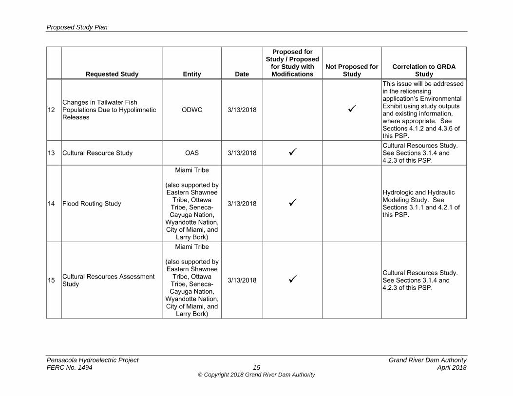
12 Changes in Tailwater Fish Populations Due to Hypolimnetic Releases
ODWC 3/13/2018
This issue will be addressed in the relicensing application’s Environmental Exhibit using study outputs and existing information, where appropriate. See Sections 4.1.2 and 4.3.6 of this PSP.
13 Cultural Resource Study OAS 3/13/2018 Cultural Resources Study. See Sections 3.1.4 and 4.2.3 of this PSP.
14 Flood Routing Study
Miami Tribe
(also supported by Eastern Shawnee
Tribe, Ottawa Tribe, Seneca-Cayuga Nation,
Wyandotte Nation, City of Miami, and
Larry Bork)
3/13/2018
Hydrologic and Hydraulic Modeling Study. See Sections 3.1.1 and 4.2.1 of this PSP.
15 Cultural Resources Assessment Study
Miami Tribe
(also supported by Eastern Shawnee
Tribe, Ottawa Tribe, Seneca-Cayuga Nation,
Wyandotte Nation, City of Miami, and
Larry Bork)
3/13/2018 Cultural Resources Study. See Sections 3.1.4 and 4.2.3 of this PSP.
Proposed Study Plan
Pensacola Hydroelectric Project Grand River Dam Authority FERC No. 1494 16 April 2018
© Copyright 2018 Grand River Dam Authority
Requested Study Entity Date
Proposed for Study / Proposed
for Study with Modifications
Not Proposed for Study
Correlation to GRDA Study
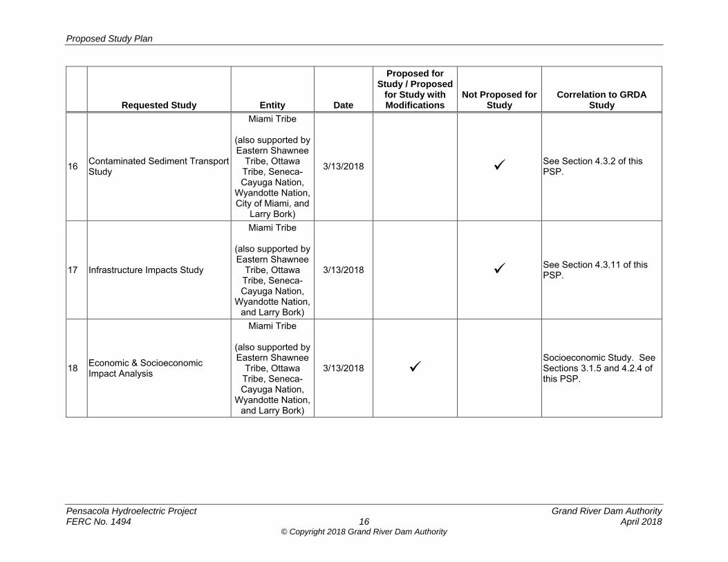
16 Contaminated Sediment Transport Study
Miami Tribe
(also supported by Eastern Shawnee
Tribe, Ottawa Tribe, Seneca-Cayuga Nation,
Wyandotte Nation, City of Miami, and
Larry Bork)
3/13/2018 See Section 4.3.2 of this PSP.
17 Infrastructure Impacts Study
Miami Tribe
(also supported by Eastern Shawnee
Tribe, Ottawa Tribe, Seneca-Cayuga Nation,
Wyandotte Nation, and Larry Bork)
3/13/2018 See Section 4.3.11 of this PSP.
18 Economic & Socioeconomic Impact Analysis
Miami Tribe
(also supported by Eastern Shawnee
Tribe, Ottawa Tribe, Seneca-Cayuga Nation,
Wyandotte Nation, and Larry Bork)
3/13/2018 Socioeconomic Study. See Sections 3.1.5 and 4.2.4 of this PSP.

Proposed Study Plan
Pensacola Hydroelectric Project Grand River Dam Authority FERC No. 1494 17 April 2018
© Copyright 2018 Grand River Dam Authority
Requested Study Entity Date
Proposed for Study / Proposed
for Study with Modifications
Not Proposed for Study
Correlation to GRDA Study
19 Flora & Fauna Impacts
Miami Tribe
(also supported by Eastern Shawnee
Tribe, Ottawa Tribe, Seneca-Cayuga Nation,
Wyandotte Nation, and Larry Bork)
3/13/2018 See Section 4.3.10 of this PSP.
20 Full Basin-up Archaeological and Cultural Resources Assessment
Cherokee Nation 3/13/2018 Cultural Resources Study. See Sections 3.1.4 and 4.2.3 of this PSP.
21 Flood Routing Study
City of Miami
(also supported by Larry Bork, Miami
Tribe, Eastern Shawnee Tribe, Ottawa Tribe,
Seneca-Cayuga Nation, and
Wyandotte Nation)
3/13/2018
Hydrologic and Hydraulic Modeling Study. See Sections 3.1.1 and 4.2.1 of this PSP.
22 Contaminated Sediment Transport Study
City of Miami
(also supported by Larry Bork, Miami
Tribe, Eastern Shawnee Tribe, Ottawa Tribe,
Seneca-Cayuga Nation, and
Wyandotte Nation)
3/13/2018 See Section 4.3.2 of this PSP.
Proposed Study Plan
Pensacola Hydroelectric Project Grand River Dam Authority FERC No. 1494 18 April 2018
© Copyright 2018 Grand River Dam Authority
Requested Study Entity Date
Proposed for Study / Proposed
for Study with Modifications
Not Proposed for Study
Correlation to GRDA Study
23 Socioeconomic and Infrastructure Improvement Study
City of Miami
(also supported by Larry Bork, Miami
Tribe, Eastern Shawnee Tribe, Ottawa Tribe,
Seneca-Cayuga Nation, and
Wyandotte Nation)
3/13/2018
With regard to the socioeconomics component of this study request, see Sections 3.1.5 and 4.2.4 of this PSP. With regard to the infrastructure improvement component of this study, see Section 4.3.11 of this PSP.
24 Cultural Resources Assessment Study
City of Miami
(also supported by Larry Bork)
3/13/2018 Cultural Resources Study. See Sections 3.1.4 and 4.2.3 of this PSP.
25 Comprehensive Flood Routing Study
Larry Bork (Counsel on behalf of citizens of City of
Miami)
3/13/2018
Hydrologic and Hydraulic Modeling Study. See Sections 3.1.1 and 4.2.1 of this PSP.
26 Contaminated Sediment Transport Study
Larry Bork (Counsel on behalf of citizens of City of
Miami)
3/13/2018 See Section 4.3.2 of this PSP.
27 Socioeconomic Impact on Miami from the Backwater Effect of Pensacola Dam
Larry Bork (Counsel on behalf of citizens of City of
Miami)
3/13/2018 Socioeconomic Study. See Sections 3.1.5 and 4.2.4 of this PSP.

Proposed Study Plan
Pensacola Hydroelectric Project Grand River Dam Authority FERC No. 1494 19 April 2018
© Copyright 2018 Grand River Dam Authority
Table 4.0-2. Formal study requests filed with FERC.
Requested Study
FE
RC
BIA
US
FW
S
OD
WC
OA
S
Mia
mi
Tri
be
Eas
tern
S
haw
nee
T
rib
e
Ott
awa
Tri
be
Sen
eca-
Cay
ug
a N
atio
n
Wya
nd
ott
e N
atio
n
Ch
ero
kee
Nat
ion
Cit
y o
f M
iam
i
N. L
arry
B
ork
1
1 Flooding/Inundation Study
2 Sedimentation Study
3 Flooding Inundation of Tribal Lands Study
4 Contaminated Sediment Transport Study
5 Quantifying the Effects of Increased Water Level within the Grand Lake Watershed
6
Impacts of Grand Lake Elevation Manipulation on Headwater River Hydrology and Paddlefish Spawning / Recruitment
7 Alteration of Tailwater Fish Habitat Downstream of Pensacola Dam as a Result of Hydropower Operations
8 Changes in Tailwater Fish Populations Due to Hypolimnetic Releases
9 Wetland Documentation
10 Loss of Wildlife Lands from Flooding
11 Recovery of Lost Wildlife Mitigation Opportunity
12 Flora and Fauna Impacts
13 Cultural Resources Study
14 Socioeconomic Study
15 Infrastructure Improvement Study
Notes: 1 Counsel for City of Miami citizens.
Proposed Study Plan
Pensacola Hydroelectric Project Grand River Dam Authority FERC No. 1494 20 April 2018
© Copyright 2018 Grand River Dam Authority
4.1 General Study Considerations The studies proposed by GRDA in this PSP are intended to collect information and data to inform the development of the Preliminary Licensing Proposal (PLP)/Draft License Application (DLA) (which under the current schedule will be filed no later than November 3, 2019), FLA (which under the current schedule will be filed no later than March 31, 2020), FERC’s environmental document under the NEPA, and eventual license conditions. As such, GRDA intends to perform studies that collect information that would be used to inform the assessment of Project-related resource impacts (if any) in the Environmental Exhibit of the PLP/DLA, FLA, and FERC’s Environmental Assessment (EA) and are consistent with FERC’s Study Criteria. The numerous comments and study requests as filed with FERC raise common issues that deserve a detailed response, explaining GRDA’s reasons for proposing in this PSP either to reject a study request altogether, or to propose a different scope or methodology from a requested study. These over-arching, common themes are discussed in the subsections that follow.
4.1.1 Flood Control Operations
Several commenters take the position that the Commission has jurisdiction over flood control operations at the Project, that flood control is a licensed purpose of the Project, and that the Commission in this relicensing effort should consider measures to mitigate effects of flooding. These comments allege “backwater flooding caused by the Project’s operations during heavy precipitation events”;10 that Pensacola Dam “as currently operated exacerbates natural flooding by increasing the frequency, depth, and duration of water on property for which there are no flowage easements”11; “that every increase in lake elevation decreases the flood control capacity” of the Project;12 and that “previous studies demonstrate the patent inadequacy of the footprint as FERC has defined it.”13 Accordingly, these commenters request measures under the new license “requiring GRDA to operate pursuant to a revised rule curve, to acquire flowage easements, and to implement other mitigation measures such as infrastructure improvements.”14 As indicated in Section 3.1 of this PSP, GRDA proposes to conduct a comprehensive H&H Study that will model the Grand/Neosho River, including several tributaries, both upstream and downstream of Pensacola Dam. The modeling effort under the H&H Study will produce a tool for analyzing the effects of GRDA’s operation of the Project under the new license, as well as indirect and cumulative impacts associated with flood control operations conducted at the direction of the USACE. 10 Comments of the City of Miami, Oklahoma on Pre-Application Document, Scoping Document 1 and Study Requests at 1, Project No. 1494-438 (filed March 13, 2018) (“City of Miami Comments”). 11 Id. See also Larry Bork, Goodell Stratton Edmonds & Palmer, Comments of Plaintiffs on PAD, Scoping Document 1 and Requesting Studies Within the Relicensing of the Pensacola Project, pp. 1-2 (filed March 13, 2018) (hereinafter “Bork Comments”); Comments of Miami Tribe of Oklahoma on Grand River Dam Authority’s Pre-Application Document and FERC’s Scoping Document 1, and Miami Tribe of Oklahoma’s Study Requests at 3, Project No. 1494-438 (filed March 13, 2018) (“Miami Tribe Comments”). 12 Miami Tribe Comments at 4. 13 Bork Comments at 2. 14 City of Miami Comments at 1.
Proposed Study Plan
Pensacola Hydroelectric Project Grand River Dam Authority FERC No. 1494 21 April 2018
© Copyright 2018 Grand River Dam Authority
In this regard, it is premature for any relicensing participant to conclude whether GRDA’s Project operations under its license cause or contribute to: (1) upstream flooding beyond existing flowage easements; (2) overbank conditions that may result in deposition of heavy metals and other contaminants from upstream Superfund sites; (3) access and transportation impediments during high precipitation events; or (4) other adverse effects. The whole purpose of the H&H Study will be to better understand the interrelated complexities and effects associated with GRDA’s operations under its FERC-issued license, USACE flood control operations, and other factors (including natural conditions) that influence and affect inundation in the Grand/Neosho River and its tributaries. In fact, USACE has already analyzed this issue and independently concluded, pursuant to Congressional direction,15 that its flood control operations alone have significantly contributed to upstream flooding beyond existing easements. In its Draft Report Grand Lake, Oklahoma, Preliminary Analysis of Flood Control Operation, USACE concluded:
Flood control operations for selected historic events appear to impact lands where no easements are held.
Flood control operations for selected frequency flood events appear to impact lands where no easements are held.
Some of the selected frequency floods and historic flood events would have exceeded the limits of existing flowage easements for the without-flood-control condition (hydropower only).
All evaluated flood events would tend to exceed the limits of existing flowage easements to a greater degree for the with-flood-control operation condition (flood control and hydropower).16
In a follow-up 2006 Letter Report, USACE concluded: “Based on the backwater modeling of selected historic storms and frequency events, water surface elevations were found to be up to 4.3 feet higher than existing elevations at selected locations due to flood control operations of the reservoir.”17 In response to Congress’ direction that full federal funding for a feasibility study be recommended if flood control operations are “a significant cause of the backwater effects,”18 the 2006 report recommended that the Assistant Secretary of the Army (Civil Works) determine “that Federal actions have been a significant cause of the backwater effects on land around Grand Lake, Oklahoma and . . . proceed with a feasibility study at full Federal expense.”19 In 2007, the Assistant Secretary for the Army determined that “federal actions have contributed to backwater effects,”20 and recommended that a feasibility study be funded by the United Sates. 15 Pub. L. No. 106-541, § 449(a)(1) (2000) (directing USACE to “evaluate the backwater effects specifically due to flood control operations on land around Grand Lake, Oklahoma”). 16 USACE, Grand Lake, Oklahoma, Preliminary Analysis of Flood Control Operation at 6 (Draft Report, August 2002). On April 12, 2018, USACE filed this report in the FERC docket for this relicensing proceeding. 17 Grand Lake, Oklahoma, May 2006 Letter Report at 5 (2006) (emphasis added). On April 12, 2018, USACE filed this report in the FERC docket for this relicensing proceeding. 18 Pub. L. No. 106-541, § 449(b)(2). 19 May 2006 Letter Report at 5. 20 U.S, Department of the Army, Office of the Assistant Secretary Civil Works, Memorandum for the Director of Civil Works (Sep. 14, 2007). On April 12, 2018, USACE filed this memorandum in the FERC docket for this relicensing proceeding.
Proposed Study Plan
Pensacola Hydroelectric Project Grand River Dam Authority FERC No. 1494 22 April 2018
© Copyright 2018 Grand River Dam Authority
Moreover, the Tetra Tech model previously commissioned by the City of Miami recognized that a multitude of factors—both natural and anthropogenic—contribute to high water levels upstream of the Project during high precipitation events.21 Moreover, the 2004 report prepared by Dr. Forrest Holly concludes that the City of Miami “is located just upstream of the zone of significant flood-level effects that would result from raising the Pensacola Dam power pool to 745 ft PD,” and that “the river steepens significantly upstream of about RM 139, effectively eliminating significant backwater effects upstream of that point.”22 Dr. Holly’s 2004 analysis also found that the downstream limit of developed areas in the vicinity of Miami is RM 142.
GRDA is confident that the H&H Study will build on these prior investigations and improve understanding of the dynamic and complex factors that influence the magnitude, duration, and frequency of inundation along the Grand/Neosho River and its tributaries. Based on participants’ comments, however, two essential qualifications of this effort are warranted:
1. Effects of USACE Flood Control Operations Must Be Understood. Like the
previous studies Congress required of the USACE, an important aspect of the H&H Study will be to analyze and distinguish the effects of USACE flood control operations, as opposed to simply analyzing effects of the Pensacola Dam operations generally. As GRDA has explained repeatedly for years, flood control operations at Pensacola Dam are under the exclusive jurisdiction of the USACE pursuant to the Flood Control Act of 1944.23 The Commission also has repeatedly—and recently—acknowledged the exclusivity of USACE’s jurisdiction.24 USACE’s recent correspondence with the City of Miami,25 together with the wealth of information recently filed in this relicensing docket by USACE, demonstrate that flood risk management, through the entire system of 35 projects in USACE’s Tulsa District (an area that straddles three states), is within
21 See Motion of City of Miami, Oklahoma for Leave to Intervene and Protest, Att. C – Hydraulic Analysis of the Effects of Pensacola Dam on Neosho River Flooding in the Vicinity of Miami, Oklahoma at viii, Project No. 1494-433 (filed July 22, 2016). 22 Analysis of Effect of Grand Lake Power-Pool Elevations on Neosho River Levels During a Major Flood at 5 (Jan. 27, 2004). 23 Incorporated by reference are GRDA’s other filings with the Commission that address this issue. See, e.g., Letter from Charles R. Sensiba, Troutman Sanders LLP, to Kimberly D. Bose, Federal Energy Regulatory Commission, Project No. 1494-438 (filed March 9, 2018); Response of Grand River Dam Authority to Comments on Environmental Assessment, Project No. 1494-437 (filed Feb. 21, 2017); Answer of Grand River Dam Authority to Motions to Intervene and Comments on License Amendment Application, Project No. 1494-437 (filed Nov. 8, 2016); Answer of Grand River Dam Authority to City of Miami, Project No. 1494-432 (filed Aug. 11, 2015). 24 E.g., Grand River Dam Auth., 160 FERC ¶ 61,001, at PP 3, 49 n.67 (2017); Grand River Dam Auth., 67 FERC ¶ 62,239 at p. 64,431 (1994) (noting that “any attributions to issues such as flooding or backwater conditions within the flood pool cannot be reached and are, in any event, under the purview of the U.S. Army Corps of Engineers”); Grand River Dam Auth., 59 FERC ¶ 62,073, at p. 63,247 (1992) (stating that the flood pool is “controlled by the Corps for flood control storage, as mandated by the Flood Control Act of 1944, and not subject to Commission authority”); Grand River Dam Auth., License Affecting Navigable Waters and Reservations of the United States at Article 14, Project No. 1494 (July 26, 1939) (providing that the “operation of the project by the Licensee, so far as such operation may affect the use, storage, and discharge from storage, or waters, shall at all times be subject to the control of the Secretary of War under such rules and regulations as he may prescribe in the interests of navigation and flood control . . .”). 25 Letter from Jennifer A. Aranda, U.S. Army Corps of Engineers, to Carlos Gutierrez, Davis Wright Tremaine at 2, Project No. 1494-438 (filed Apr. 3, 2018).
Proposed Study Plan
Pensacola Hydroelectric Project Grand River Dam Authority FERC No. 1494 23 April 2018
© Copyright 2018 Grand River Dam Authority
the exclusive purview of the USACE and is a matter that is well beyond the scope of this relicensing effort. Simply stated, neither the Commission nor GRDA have any control over USACE’s decisions related to flood control at the Project. For this reason, GRDA’s H&H Study is designed to evaluate the full range of factors that influence inundation along the Grand/Neosho River and its tributaries, such that the Commission can properly analyze the direct effects of its licensing action, as well as understand the indirect and cumulative effects of actions that are beyond its licensing jurisdiction—including the flood operations of USACE.26
2. Mitigation for USACE Flood Control Operations Is Beyond the Scope of the Commission’s Relicensing. At this early stage of the relicensing process, it is premature for participants to seek any mitigation—because Project-related effects have yet to be studied or analyzed.27 As several participants raised the issue of mitigation for flooding damages, however, GRDA believes it is appropriate to address this issue at the outset of this relicensing process.
The FERC relicensing process is not the forum to address the issue of whether the United States possesses sufficient flowage easements to sustain USACE’s flood control operations. Since the very beginning of this Project over 75 years ago, the top of the conservation pool for purposes of the Commission-issued license has been 745 feet PD, and the buffer zone for purposes of carrying out Project purposes under the FPA has been established at approximately elevation 750 feet PD.28 Lands above that elevation have never been GRDA’s responsibility; to the contrary, the acquisition of flowage easements for purposes of USACE’s flood control operations has always been a responsibility of the federal government. For example:
In 1942, after the Project was acquired by the United States under section 16 of the FPA to support the World War II effort,29 President Roosevelt directed the Federal Works Administration to acquire additional acreage at the Project for purposes of flood control.30
26 In the recently completed rule curve license amendment proceeding, the Commission recognized that USACE flood operations are a cumulative effect at this Project. Final Environmental Assessment, Amendment of Article 401 to Modify Reservoir Elevation Rule Curve at 21, Project No. 1494-437 (issued May 11, 2017) (“[T]he flood studies reviewed in the Draft EA provide a thorough analysis of the cumulative effects of the proposed action in the amendment application, in addition to analyzing the effects of operation with the proposed rule curve under normal conditions.”). 27 See infra § 4.1.5. 28 See, e.g., Grand River Dam Auth., License Affecting Navigable Waters and Reservations of the United States at Article 12, Project No. 1494 (July 26, 1939) (directing GRDA to “acquire all necessary lands, easements, and rights-of-way up to elevation 750”); Pub. L. No. 76-597, 54 Stat. 303 (1940) (“[T]here is hereby granted to the Grand River Dam Authority, a public corporation of the State of Oklahoma, all the right, title, and interest held by the United States and by individual Indians and tribes of Indians in Indian lands located in Ottawa, Delaware, Craig, and Mayes Counties, Oklahoma, lying below an elevation of seven hundred and fifty feet above mean sea level, which may be required for the Grand River Dam Reservoir . . . .”). 29 16 U.S.C. § 809; Exec. Order No. 8944 (1941). 30 U.S. Army Corps of Engineers, Grand Lake, Oklahoma, Real Estate Adequacy Study at 2 (1998) [hereinafter, Real Estate Adequacy Study].
Proposed Study Plan
Pensacola Hydroelectric Project Grand River Dam Authority FERC No. 1494 24 April 2018
© Copyright 2018 Grand River Dam Authority
When requiring the return of the Project to GRDA following the War effort, Congress required that the Secretary “retain all lands or interests therein of the United States above elevation seven hundred and fifty feet mean sea level necessary or desirable for operation of the Grand River Dam project at a pool elevation of seven hundred and fifty-five feet above mean sea level at the Grand River Dam, and [GRDA] shall grant to the Secretary on behalf of the United States flowage rights on all lands or interests therein of [GRDA] above elevation seven hundred and fifty feet mean sea level which are necessary or desirable for such operation.”31 Congress also provided that federal lands, “lying between elevations 750 and 760 feet above mean sea level, may be used perpetually by the United States, and its duly authorized agencies and representatives, to flow thereon and withdraw therefore the waters of the Pensacola Reservoir of the Grand River Dam project for the purpose of and in connection with controlling floods and the production of hydroelectric power.”32
When effectuating the transfer of the Project as directed by Congress, President Truman noted the Secretary of the Interior’s power and duty “for the acquisition of an additional five feet of reservoir storage for the Grand River Dam Project.”33 In response, the Secretary acquired 11,700 acres of flowage easements between GRDA’s Project Boundary and elevations 750 and 757 feet PD at the Dam and elevations 750 and 760 feet PD in the upper reaches of the reservoir.34
During the 1946 to 1950 period, a dispute arose between USACE and the Southwest Power Administration as to whether the United States (not GRDA) possessed sufficient flowage easements for flood control purposes. USACE’s analysis concluded that “an additional 11,750 acres of easements should be acquired for purpose of the project for flood control.”35
Following heavy flooding in 1986, Congress directed USACE to conduct additional studies to determine the adequacy of the United States’ easements for flood control purposes.36
In 1996, Congress directed USACE to “complete a study of flooding in the Grand/Neosho Basin and tributaries in the vicinity of the Pensacola Dam . . . to determine the scope of backwater effects of operation of the dam and to identify any lands that that the Secretary determines have been adversely impacted by such operation or should have been originally purchased as flowage easements for the project.37 Further, Congress authorized USACE to “acquire from willing sellers such real property
31 Pub. L. No. 79-573 § 3, 60 Stat. 743, 744 (1946). 32 Pub. L No. 79-712, 60 Stat. 974 (1946). 33 Exec. Order No. 9839 (1947). 34 Real Estate Adequacy Study at 2. 35 Id. 36 H.R. Rep. No. 100-498, at 693 (1987) (Conf. Rep.). 37 Pub. L. No. 104-303, § 560, 110 Stat. 3658, 3784 (1996).
Proposed Study Plan
Pensacola Hydroelectric Project Grand River Dam Authority FERC No. 1494 25 April 2018
© Copyright 2018 Grand River Dam Authority
interests in any lands identified in the study as the Secretary determines are necessary to reduce adverse impacts identified in the study . . . .”38
Again in 2000, Congress directed USACE to conduct a study to determine the feasibility of “addressing the backwater effects of the operation of the Pensacola Dam” and “purchasing easements for any land that has been adversely affected by backwater flooding in the Grand/Neosho River basin.”39 As described above, USACE determined that federal flood control operations have been a significant cause of backwater effects and that the federal government should fully fund a feasibility study to address the issue.
Finally, USACE recently informed relicensing participants that it has extensively studied the feasibility of acquiring flowage easements related to its flood control operations at the Project in the past, and that it plans to seek funding to assess the need for and feasibility of flood mitigation measures “through the Silver Jackets program.”40
This extensive history—dating back more than 75 years—unquestionably demonstrates that Congress, the President, and USACE have long recognized that: (1) GRDA’s responsibilities for its Project-related operations extend only to elevation 750 feet PD; (2) the United States bears responsibility for flowage easements above 750 feet PD: and (3) any mitigation needed for flood-control activities is exclusively a responsibility of the United States—not GRDA. Moreover, “[t]he FPA does not . . . confer on this Commission any jurisdiction or authority to resolve disputes between the licensee and third parties that concern interests in real property.”41 The Commission has recognized that such matters are to be addressed as provided under sections 10(c) and 21 of the FPA.42
4.1.2 Environmental Baseline
Several study requests, including requests for cultural resources assessments and hydraulic modeling, have sought to analyze environmental and other resources under a “pre-project” scenario. However, FERC’s longstanding policy is to evaluate project effects based on the current environment—not under any hypothetical pre-project conditions. As the Commission has explained, it is not required to “pretend that current projects do not exist, or to require applicants to gather information to recreate a 50-year-old environmental base upon which to make present day development decisions.”43
38 Id. 39 Pub. L. No. 106-541, § 449 (2000). 40 Letter from Jennifer A. Aranda, U.S. Army Corps of Engineers, to Carlos Gutierrez, Davis Wright Tremaine at 2, Project No. 1494-438 (filed Apr. 3, 2018). 41 Halecrest Co., 60 FERC ¶ 61,121 at p. 61,413 (1992), order on reh’g, 63 FERC ¶ 61,307 (1993); see also JDJ Energy Co., 101 FERC ¶ 61,059 at PP 10-12 (2002). 42 See Grand River Dam Auth., 156 FERC ¶ 61,106 at P 67 (2016); E. Bay Mun. Util. Dist., 66 FERC ¶ 61,199 at p. 61,449 & n.16 (1994). Moreover, as the U.S. Court of Appeals for the 10th Circuit noted nearly 20 years ago in litigation concerning this Project, parties seeking to file claims against the USACE for flooding damages may file an action at the U.S. Court of Federal Claims. See Dalrymple v. GRDA, 145 F.3d 1180, 1187 (10th Cir. 1998). 43 See City of Tacoma, Washington, 67 F.E.R.C. ¶ 61,152 (citing FERC Statutes and Regs. Preambles 1986-1990 ¶ 30,853 at 31,401).
Proposed Study Plan
Pensacola Hydroelectric Project Grand River Dam Authority FERC No. 1494 26 April 2018
© Copyright 2018 Grand River Dam Authority
FERC’s identification of current project conditions as the appropriate baseline for evaluating environmental and other impacts of a project has been upheld upon judicial review. In 1999, the Ninth Circuit determined, in American Rivers v. FERC, that it was “more than reasonable . . . for the Commission to conduct its ‘evaluation and consideration of the appropriateness of requiring enhancement measures . . . in the context of today’s environment and not in the context of the world as it existed [in the past].’”44 According to the court, evaluation of a pre-project environment, to the extent that such a hypothetical situation could even be recreated, would only be useful for determining the current cumulative effect of historical changes on natural resources.45 Shortly after the American Rivers decision, the D.C. Circuit rejected efforts of a number of petitioners to require FERC to evaluate impacts on fish and wildlife as if an existing dam were not in place.46 The court confirmed FERC’s choice of existing conditions as the environmental baseline, incorporating by reference the reasoning of the Ninth Circuit in American Rivers.47 For these reasons, GRDA’s proposed study plans do not propose to conduct analyses of pre-project conditions. Instead, consistent with long-standing Commission and judicial precedent, the existing environment and the project as it exists today is the baseline for all of GRDA’s proposed studies.
4.1.3 Cultural Resources Investigations in Inundated Areas
Similar to comments on the environmental baseline, several relicensing participants suggest that GRDA’s cultural resources investigations should include “river bottom surveys” or assessments of “permanently inundated areas.” For example, the Miami Tribe’s comments reference a “voluminous record of archeological sites within the original pool at the time it was filled” and assert that the cultural resources assessment study must include a review of “pre-dam archeology,” including river bottom surveys.48 Such requests are inconsistent with Section 106 of the NHPA and its implementing regulations. Under Section 106, federal agencies must take into account the effect of their undertakings on any “historic property.”49 A historic property is defined by the implementing regulations as “any prehistoric or historic district, site, building, structure, or object” that is included in, or eligible for inclusion in, the National Register of Historic Places.50 The regulations identify four criteria for evaluating whether properties are eligible for the National Register. However, in addition to satisfying at least one of the four listed criteria, the regulations also require that, in order to qualify as a “historic property,” a property must “possess integrity of location, design, setting, materials, workmanship, feeling, and association.”51 According to a National Register bulletin addressing how to apply the National Register Criteria for Evaluation, a property “will always possess several, and usually most,” of these seven
44 American Rivers v. FERC, 201 F.3d 1186, 1198 (1999). 45 Id. at 1197. 46 Conservation Law Foundation v. FERC, 216 F.3d 41 (2000). 47 Id. at 46. 48 Miami Tribe Comments at 12. The City of Miami endorsed and incorporated in its own comments the Miami Tribe’s request for “comprehensive cultural resources assessment study…including permanently inundated areas.” City of Miami Comments at 20. 49 54 U.S.C. § 306108. 50 36 C.F.R. § 800.16(l)(1). 51 36 C.F.R. § 60.4.
Proposed Study Plan
Pensacola Hydroelectric Project Grand River Dam Authority FERC No. 1494 27 April 2018
© Copyright 2018 Grand River Dam Authority
aspects in order to retain historic integrity.52 The bulletin also sets out a series of steps for determining whether a property can be said to have “integrity.” The first two steps are to (1) “define the essential physical features that must be present for a property to represent its significance,” and (2) to “determine whether the essential physical features are visible enough to convey their significance.”53 In addition, the bulletin makes clear that while it is not necessary for a property to retain all its historic physical features over the course of time, a property must retain the essential physical features that enable it to convey its historic identity.54 The original license for the Pensacola Project was issued in 1939, which means that any archaeological resources within the inundation zone of the reservoir before the original pool was filled have been under water for close to eighty years. As such, these resources are either preserved in place and unaffected by continued operation of the Project, or are highly unlikely to have retained their essential physical features after being inundated for such a long period of time. Another National Register bulletin, which focuses specifically on archaeological properties, explains that when evaluating integrity, archaeologists are focused on “the level of preservation or quality of information” of a property.55 The bulletin notes that a property with integrity has deposits that are “relatively intact and complete,” rather than being “severely impacted by later cultural activities or natural processes.”56 In identifying historic properties under Section 106 of the NHPA, an agency is required to make a reasonable and good faith effort, which allows the agency to take into account “the likely nature and location of historic properties within the area of potential effects,” as well as the nature and extent of potential effects on historic properties.57 Even if any permanently inundated properties were to possess integrity, continued operation of the Pensacola Project under a new license would not create any additional potential effects on the property, given that the property would remain inundated, as it has been for decades.58 For these reasons, GRDA’s Cultural Resources Study Plan does not propose to conduct investigations in areas that are permanently inundated and instead to focus in areas where continued Project operations may affect historic properties. Relicensing participants requesting such a broad and prohibitively expensive study scope have identified no instance in which the Commission has required a license applicant to undertake an investigation of permanently inundated areas. As the Advisory Council of Historic Preservation (ACHP) has explained:
[A]rchaeological identification efforts for a license renewal from the Federal Energy Regulatory Commission likely would not involve the entire APE. Rather it would be directed to those locations within the APE that are experiencing project related effects associated with operation, usually along the shoreline.59
52 National Register Bulletin, “How to Apply the National Register Criteria for Evaluation,” at p. 44 (rev. 1997). 53 Id. at p. 45. 54 Id. at p. 46. 55 National Register Bulletin, “Guidelines for Evaluating and Registering Archaeological Properties,” at p. 25 (2000). 56 Id. 57 36 C.F.R. § 800.4(b)(1). 58 “Effect” is defined as “alteration to the characteristics of a historic property qualifying it for inclusion in or eligibility for the National Register. 36 C.F.R. § 800.16(i). 59 Section 106 Archaeology Guidance at p. 17.
Proposed Study Plan
Pensacola Hydroelectric Project Grand River Dam Authority FERC No. 1494 28 April 2018
© Copyright 2018 Grand River Dam Authority
4.1.4 Addressing the Effects of Climate Change
Some relicensing participants included a climate change component to their flooding/inundation study requests. GRDA’s PSP has not adopted this proposed element. FERC precedent uniformly maintains that climate change studies are not needed in hydropower licensing proceedings. FERC has acknowledged that climate change is a complex issue, but under NEPA and Council on Environmental Quality regulations, it is afforded discretion based on its expertise and experience to determine the scope of an environmental analysis based on available information.60 FERC has explained that climate change models would not allow it “to predict matters such as water supply or flow within a given basin during the 30 to 50-year term of a typical hydropower license in such a manner to assist the Commission in analyzing alternatives and determining appropriate mitigation for environmental impacts.”61 In addition, FERC has determined that climate change studies are not likely to yield reliable data that can be used to develop license requirements.62 FERC has found that conventional hydrological studies, monitoring techniques, and predictive models can be used to effectively study and evaluate the effects of projects on environmental resources.63
4.1.5 Protection, Mitigation and Enhancement Measures
GRDA received comments and requests concerning proposed PM&E measures for the Project. Per the ILP, assessing the need for and adequacy of any such measures now is premature. As such, GRDA is not proposing to incorporate into its studies or otherwise address PM&E measures at this point in the relicensing process. In accordance with the Commission’s regulations at 18 C.F.R. § 5.11, this PSP describes GRDA’s proposed approaches for collecting information and data required to meet FERC’s ILP study requirements. The resource studies will culminate in the preparation of study reports. The study reports will develop information sufficient for characterizing, as part of the Environmental Exhibit in the relicensing application, the existing environment and evaluating any potential impacts of continued project operations. Prior to GRDA’s filing of the FLA with FERC, this analysis will be available for comment by relicensing participants as part of GRDA’s PLP/DLA.
4.2 Study Requests Included in GRDA’s PSP
4.2.1 Flooding/Inundation Study
Requests for studies outlined and recommended several approaches with names synonymous to an H&H Study. Such names used by relicensing participants are CHM, flood routing studies, inundation studies, impoundment fluctuation studies, comprehensive flood routing studies, and operations models. Although this study plan will not directly title the proposed and recommended
60 See Eagle Crest Energy Company, 153 FERC ¶ 61,058, at P 39 (2015). 61 See Id., see also Alabama Power Company, 155 FERC ¶ 61,080, P 29 (2016) (“attempting to predict future flow scenarios that may occur due to climate change or other conditions would be too speculative given the state of the science at this time”). 62 See Alaska Energy Authority, 144 FERC ¶ 61,040, at P 8 (2013). 63 Id., at P 9.
Proposed Study Plan
Pensacola Hydroelectric Project Grand River Dam Authority FERC No. 1494 29 April 2018
© Copyright 2018 Grand River Dam Authority
studies incorporated into this H&H Study Plan using all of the synonymous descriptions, the study plan incorporates all of them (regardless of how they have been previously referenced). The specific relicensing participants requesting an H&H Study are FERC, BIA, USFWS, ODWC, City of Miami, Miami Tribe, Eastern Shawnee Tribe, Ottawa Tribe, Seneca-Cayuga Nation, Wyandotte Nation, Cherokee Nation, and N. Larry Bork (counsel for the City of Miami citizens). Regarding recommended approaches and items to include in the H&H Study, FERC, BIA, ODWC, and City of Miami made specific recommendations about approaches and items to include in the H&H Study. The specific recommendations of the Miami Tribe, Eastern Shawnee Tribe, Ottawa Tribe, Seneca-Cayuga Nation, Wyandotte Nation, and N. Larry Bork (counsel for the City of Miami citizens) are the same as the City of Miami recommendations. The USFWS and Cherokee Nation did not provide any specific recommended approaches to the H&H Study. The proposed H&H Study will provide information through modeling and mapping to determine the effect of the operation of the Project upon several resource areas. The H&H Study will determine the duration and extent of inundation under the current operation of the Project during several measured inflow events, determine the duration and extent of inundation under any proposed change in operation that occurs during several measured or synthetic inflow events, provide the model results in a format that can inform other analyses (to be completed separately) about Project effects, if any, in several resource areas, and will determine the feasibility of implementing alternative operation scenarios that may be proposed by GRDA as part of the relicensing effort. The modeling conducted as part of the H&H Study will encompass the Neosho, Spring, and Elk rivers and Tar Creek and use Hydrologic Engineering Center’s River Analysis System (HEC-RAS) software and incorporate some two dimensional (2-D) analysis, where appropriate. The H&H Study will compare current channel geometry to historical channel geometry to compare flood routing specifics resulting from sediment accretion and erosion in the river channels. Description of USACE and GRDA Flood Control Operations As explained above,64 GRDA’s responsibilities for its Project-related operations extend only to elevation 750 feet PD, consistent with the Flood Control Act of 1944, USACE’s 1992 Water Control Manual for the Pensacola Reservoir, and the Water Control Agreement for the Pensacola Dam. Upstream Sedimentation FERC requested the H&H Study to assess how rule curve modifications to reduce flooding may contribute to sedimentation upstream of Grand Lake. As explained elsewhere in this PSP, GRDA is proposing to conduct a sedimentation study.65 Flood Frequency Analysis FERC requests a flood frequency analysis to establish arbitrary flood events (10-year, 25-year, 50-year, and 100-year) and the City of Miami requests a flood frequency analysis to establish arbitrary flood frequency curves. Such effort necessarily would need to be based upon numerous assumptions with misleading results. Each individual tributary can have several different inflow
64 See supra § 4.1.1. 65 See supra § 3.1.2, infra § 4.2.2.
Proposed Study Plan
Pensacola Hydroelectric Project Grand River Dam Authority FERC No. 1494 30 April 2018
© Copyright 2018 Grand River Dam Authority
events which could lead to an arbitrary recurrence interval at Pensacola Dam. Instead, the H&H Study proposes a flood frequency analysis for the peak inflow event observed during the measured inflow event used in the CHM model runs at Pensacola Dam. Analysis of Pre-Dam Conditions and Previous Rule Curves City of Miami makes several requests to analyze pre-dam conditions or previous rule curves and compare them to current conditions. Because FERC’s environmental baseline policy considers current conditions, the H&H Study does not include any efforts to compare the current or proposed operation to pre-dam conditions or previous rule curves.66 The City of Miami states their reasoning for requesting a model of pre-dam conditions is to “evaluate the adequacy of the easements using the USACE procedures.” The adequacy of USACE’s flowage easements is beyond the scope of this relicensing process,67 but can be determined by mapping and a comparison of the inundation areas. Therefore, a pre-dam model or a previous rule curve model run is not part of the H&H Study. This conclusion is supported by “A Guide to Understanding and Applying the Integrated Licensing Process Study Criteria” (Study Criteria Guidelines) released by FERC in March 2012. Evaluate Alternatives to Reduce Inundation FERC and City of Miami each recommend several evaluations of alternates to potentially reduce inundation. This request is premature because the contribution, if any, of Project operation to the inundation has not yet been determined. Should the results of the H&H Study demonstrate that GRDA’s Project operations adversely affect water levels in areas in which flowage easements do not exist, at that time GRDA in the PLP/DLA may consider evaluating potential measures to address such effects. However, as explained above, USACE flood control operations are not within the scope of this relicensing process.68 Evaluating Future Conditions City of Miami, Miami Tribe, Eastern Shawnee Tribe, Ottawa Tribe, Seneca-Cayuga Nation, Wyandotte Nation, and N. Larry Bork (counsel for the City of Miami citizens) request model runs to evaluate potential impacts due to continued sedimentation and vegetation growth along the channel margins. The existing information provides sufficient information to address this concern. Use of Existing Information The following existing information will not be included or used as a model basis for the H&H Study:
USACE (1996) and Simons (1998) Models Both the USACE and the Simons Models utilize a USACE HEC software called HEC-2 released in 1990. The Neosho River from Twin Bridges to just upstream of the U.S. Geological Survey (USGS) gage at Commerce was modeled as steady-state in these efforts. Since the efforts utilize data collected in 1995 and 1997 (topography and bathymetry) and they do not include Grand Lake, they will not be used as a model basis for the H&H Study.
66 See supra § 4.1.2. 67 See supra § 4.1.1. 68 See supra § 4.1.1.
Proposed Study Plan
Pensacola Hydroelectric Project Grand River Dam Authority FERC No. 1494 31 April 2018
© Copyright 2018 Grand River Dam Authority
OU Model (Dennis 2014) During a previous license amendment request, GRDA commissioned a hydraulic study through the University of Oklahoma (OU) in 2014. The OU Model was developed using one-dimensional (1-D) HEC-RAS software and included the Neosho River and several major tributaries from Pensacola Dam to the USGS gage at Commerce. The OU model relied on the 1996 USACE bathymetry data for the Neosho River between Twin Bridges and the USGS gage at Commerce. The model also relied on 2008 bathymetric survey information for Grand Lake from the Oklahoma Water Resources Board (OWRB), and Light Detection and Ranging (LiDAR)-acquired topography collected for the USGS in 2011 was used to represent the overbank areas. Due to the age of the bathymetry data (1996) and the limited purpose for its development to support a specific change in the rule curve, this model will not be used as a model basis for the H&H Study. FERC Model (2015) In 2015, FERC created an independent hydraulic model in response to the proposed license amendment to modify the rule curve. The FERC Model was created using the OU Model as a basis in 1-D HEC-RAS software and was modified to overcome the original limits of the OU Model. The FERC model was an unsteady-state69 analysis for the Neosho River, but did not include the portion of the Grand Lake downstream of Twin Bridges and was calibrated using roughness values from historic flood events. Because the model does not represent the Spring River, Elk River or Grand Lake, this model will not be used as a model basis in the H&H Study. FEMA Tar Creek Model (2015) As part of Federal Emergency Management Agency (FEMA) flood risk mapping efforts for the Grand Lake Watershed, the FEMA Tar Creek Model was developed. The FEMA Model extends approximately 7.5 miles up Tar Creek. After a review of the FEMA Model, it was determined that utilizing available LiDAR (survey conducted by the USGS in 2011) data as the model basis for the Tar Creek portion of the watershed is not the best approach to attain the goals of the H&H Study and, therefore, the FEMA Model will not be used as a basis for the H&H Study.
Hydrology Miami Tribe, Eastern Shawnee Tribe, Ottawa Tribe, Seneca Cayuga Nation, Wyandotte Nation, and N. Larry Bork (counsel for the City of Miami citizens) also request the use of the USACE Flood Operations Model for the Arkansas Basin Reservoir System. The USACE Flood Operations Model is a basin-wide model used by the USACE to plan flood control operations throughout the entire Arkansas River basin and is not specific to the Pensacola Project. Its primary intent is for planning flood control operations. Therefore, it is not relevant to this relicensing effort and will not be utilized as part of the H&H Study.
69 An unsteady-state model utilizes varying inflows through the cycle of the inflow event to show the conditions as the inflow event moves through the river system. Unsteady state modeling is considered to be the most-representative of natural conditions occurring in the river system during the inflow event.
Proposed Study Plan
Pensacola Hydroelectric Project Grand River Dam Authority FERC No. 1494 32 April 2018
© Copyright 2018 Grand River Dam Authority
Bathymetry The 2015 Tetra Tech bathymetric data is being superseded by the most-current 2017 USGS bathymetric data. Other Requests City of Miami requests a cost estimate to purchase additional flowage easements. As described above, the adequacy of USACE’s flowage easements and other issues related to property rights and ownership are beyond the scope of this relicensing process.70 Model Run Parameters City of Miami and BIA recommend specific parameters and numbers of model runs for the H&H Study. These specifics and the reasons for the approach in the H&H Study are outlined in Section 2.6 of the H&H Study plan. Deliverables BIA recommends development of an additional web-based map viewer for the H&H Study. The viewer would be designed for the non-technical audience. While GRDA understands the need to make the results of the H&H Study understandable to the non-technical audience, the requested viewer would not accomplish this result. Due to current technological limitations of web-based tools to demonstrate modeling results, this type of viewer would require the creation and use of an entirely separate steady-state 1-D model that relicensing participants have acknowledged would be insufficient for this relicensing effort. Instead, GRDA will work with BIA and other relicensing participants to ensure that modeling reports are user-friendly and understandable to a non-technical audience. Relicensing Participant Consultation City of Miami, Miami Tribe, Eastern Shawnee Tribe, Ottawa Tribe, Seneca-Cayuga Nation, Wyandotte Nation, and N. Larry Bork (counsel for the City of Miami citizens) recommended development of a protocol for extensive consultation during the H&H Study. The proposed H&H Study Plan includes significant detail on the methodology that relicensing participants can provide detailed comments on. GRDA has also proposed an additional progress report near the middle of the study season. Beyond that proposed measure, the ILP provides an adequate forum for consultation on studies because it is divided into two study seasons which will include consultation with relicensing participants on the initial study results after the first year of studies.
4.2.2 Sedimentation Study
The FERC requested an assessment of how rule curve modifications to reduce inundation duration and extent may contribute to upstream sedimentation. The proposed Sedimentation Study addresses this issue.
4.2.3 Cultural Resources Study
OAS, Miami Tribe (supported by the City of Miami, Eastern Shawnee Tribe, Ottawa Tribe, Seneca-Cayuga Nation, Wyandotte Nation), and Cherokee Nation have requested a Cultural Resources Study to assess the Project’s effects on archaeological, historical, and Tribal resources. The requesters recommend that the APE for this study be defined broadly to include the Grand Lake Reservoir to elevation 760, as well as any adjacent areas that are periodically
70 See supra § 4.1.1.
Proposed Study Plan
Pensacola Hydroelectric Project Grand River Dam Authority FERC No. 1494 33 April 2018
© Copyright 2018 Grand River Dam Authority
inundated by Grand Lake. The Miami Tribe further requests that the APE include “all Tribal Property in the vicinity of the Project.” The Miami Tribe recommends specific study methods; the Cherokee Nation requested that GRDA conduct a “full basin-up archaeological and cultural resources assessment.” Both the Miami Tribe and Cherokee Nation recommended that GRDA develop an HPMP to provide for the management and treatment of archaeological resources that may be affected by the Project. GRDA has proposed a Cultural Resources Study to (1) identify historic properties within the Project’s APE that are being adversely affected by Project operations (if any), including properties of traditional religious and cultural importance; and (2) to develop an HPMP in consultation with the Oklahoma SHPO, OAS, and Native American Tribes that provides for the long-term management of historic properties within the APE over the term of the Project’s new license. The proposed Cultural Resources Study Plan is a reasonable and good faith effort to carry out appropriate identification efforts. As a component of the Cultural Resources Study, GRDA proposes to define an APE in consultation with the CRWG that takes into account areas where Project-related activities may directly or indirectly cause alterations in the character or use of historic properties, if any such properties exist. In the proposed Cultural Resources Study Plan, GRDA also recognizes that the geographical extent of the APE may be refined based on the results of the H&H Study or other studies if such studies indicate that the Project has the potential to adversely affect historic properties in areas outside the current Project Boundary. This approach is appropriate and consistent with the ACHP’s Section 106 Archaeology Guidance (Section 106 Guidance), which notes that “[t]he APE is not static, but should be adjusted as a federal agency develops details of the undertaking and learns more about potential historic properties and how they may be affected.” The APE can be modified in consultation with the CRWG if the results of the H&H Study (or another study) indicate the potential for an adverse Project effect. The proposed Cultural Resources Study Plan adopts an approach generally recommended by the Miami Tribe that includes the CRWG in the planning of field investigations and provides for on-going consultation with the CRWG during the ILP and after the new license is issued. While the methods proposed by GRDA are not identical to those recommended by the Miami Tribe, GRDA proposes to (1) work with the CRWG to identify high-priority areas and sites within the APE for study during the 2-year ILP process for purposes of informing FERC’s analyses under both Section 106 and the NEPA; and (2) continue cultural resource investigations post-licensing over a longer period of time as part of the HPMP. This approach recognizes the limited, 2-year window for conducting cultural resources studies during Project relicensing—particularly when considering the vast geographic area occupied by the Project and other areas that may be affected by Project operations. The proposed Cultural Resources Study would include an initial literature review and archival research, the development of a Pre-fieldwork Study Report, consultation with the CRWG to identify appropriate areas for field investigations, multi-year Reconnaissance Surveys of the APE (including areas that may be refined based on the results other relicensing studies), a study of TCPs, and the development of an HPMP in consultation with the CRWG to provide for the management of historic and archaeological resources within the APE (including provisions for additional investigations during the term of the new license). As explained above,71 a “full basin-up” archaeological and cultural resources study, including areas that are permanently inundated by the Project, would be inconsistent with the ACHP’s Section 106 Guidance which states that “archaeological identification efforts for a license
71 See supra § 4.1.3.
Proposed Study Plan
Pensacola Hydroelectric Project Grand River Dam Authority FERC No. 1494 34 April 2018
© Copyright 2018 Grand River Dam Authority
renewal from the Federal Energy Regulatory Commission likely would not involve the entire area of potential effects (APE). Rather it would be directed to those locations within the APE that are experiencing project related effects associated with operation, usually along the shoreline.” GRDA does not envision performing identification efforts at a basin-wide level without evidence that the Project is having an effect on archaeological or historic resources across the entirety of the 10,300-square-mile Grand River Basin. A basin-wide inventory and assessment of archaeological resources is neither practical nor warranted.
4.2.4 Socioeconomics Study
City of Miami, Miami Tribe, and N. Larry Bork (counsel for the City of Miami citizens) request detailed data and economic modeling specifically related to potential flood impacts in the Project vicinity which are a cumulative effect in the area, and go beyond the scope of relicensing. The requested analyses are related to property values, insurance, tourism and recreation, taxes, business closures, relocations and employment losses, education, emergency services, infrastructure capital and maintenance expenses, exploration and mining, agricultural development, hunting, fishing and trapping, quality of life, and others. GRDA has proposed a Socioeconomics Study that will rely upon existing information to define the baseline economic conditions in the region under current operations to a level that will allow for assessment of any potential changes between the existing condition and proposed operational changes. To the extent that quantifiable information is available regarding the requested socioeconomic information, including land and resource values, tourism, employment, education, electric generation, and regional industry and agricultural trends, it will be summarized in the proposed study. Analysis of flood insurance, property values, taxes, infrastructure access, and emergency services related to flood conditions is outside the scope of this study.
4.3 Study Requests Excluded from GRDA’s PSP
4.3.1 Federal Lands
Several relicensing participants requested study of land ownership at the Project to determine whether the Project occupies any federal lands or interest in lands. The USFWS, for example, requested a study “to determine if operation of the Project at surface elevation levels within the Project Boundary causes or contributes to flooding that affects federal lands or interests in lands that are held in trust for any Indian tribe or individual Indian.”72 On March 12, 2018, the U.S. Department of the Interior, BIA filed trust maps with FERC based on land inventory data from BIA’s Trust Asset and Accounting Management System (TAAMS). BIA’s maps depict parcels, adjacent to and in the vicinity of the Project, that BIA has identified as either trust lands or restricted fee lands.73 BIA’s filing noted that these maps “do not attempt to identify which tracts are within the boundaries of or affected by the Pensacola Project.”74 However, both the Miami Tribe of Oklahoma and City of Miami contend that the Project occupies lands held by the United
72 Letter from Joanna E. Polk, U.S. Fish and Wildlife Service, to Kimberly D. Bose, Federal Energy Regulatory Commission, at 5, Project No. 1494-483 (filed March 13, 2018). 73 See United States Department of the Interior, Bureau of Indian Affairs’ Trust Lands Maps, Project No. 1494-438 (filed March 12, 2018). 74 Id. at 2.
Proposed Study Plan
Pensacola Hydroelectric Project Grand River Dam Authority FERC No. 1494 35 April 2018
© Copyright 2018 Grand River Dam Authority
States in trust for a Native American Tribe or Individual Indians.75 Commission staff has requested BIA, with regard to the parcels depicted in its maps, to “describe the nature of the federal interest held by the federal government” and particularly “whether the title of the land is held in trust by the federal government or in fee by a tribe or individual Indian.”76 BIA filed additional information in response to this request on April 11, 2018. Throughout the long history of this Project, the Commission repeatedly and uniformly has concluded that the Project does not occupy any federal lands.77 This conclusion is supported by the many times in which Congress, the President, and USACE have consistently established that GRDA has no responsibilities for land ownership above elevation 750 feet PD, as summarized above. GRDA’s FERC-approved Project Boundary—while it is a metes and bounds survey—generally follows the 750-foot PD contour elevation. Nonetheless, GRDA recognizes that the question of whether the Project actually occupies any federal lands or interests in lands presents a complex set of issues, including:
Whether BIA’s TAAMS contains accurate and current information on federal land ownership in the vicinity of the Project;
Whether the information presented in BIA’s TAAMS maps presents a full depiction of property ownership within each parcel that is noted as trust land, e.g., whether in light of the extraordinary and complex history associated with this Project, GRDA has a preexisting flowage easement on these parcels, or whether the United States maintains a right to use these lands for flood control or other purposes;78
Whether the depicted lands are actually within the FERC-approved Project Boundary, or simply near or adjacent to the Project Boundary;79 and
Whether any lands adjacent to or in the vicinity of the Project, to which the United States holds an interest, are needed for purposes of the Project, based on the results of the relicensing studies (including the H&H Study) and the Commission’s evaluation under the FPA.80
GRDA—which provided information to BIA for use in producing its TAAMS maps—will continue to work with BIA, Commission staff, and other relicensing participants to address this issue in the normal course of the relicensing effort. However, no specific study related to this matter is needed. Rather, as is required for every license applicant, GRDA’s PLP/DLA will contain a set
75 Miami Tribe Comments at 1-2; City of Miami Comments at 6. 76 Letter from Stephen Bowler, Federal Energy Regulatory Commission, to Eddie R. Streater, Bureau of Indian Affairs, at 1, Project No. 1494-438 (issued March 15, 2018). 77 See, e.g., Grand River Dam Auth., 158 FERC ¶ 62,003 at P 1 (2017); Final Environmental Assessment at 50, Project No. 1494-437 (issued May 11, 2017) (finding that “the Pensacola Project boundary, as currently defined, does not occupy Tribal lands held in trust”); Grand River Dam Auth., 153 FERC ¶ 62,080 at P 1 (2015); see also Comments of U.S. Department of the Interior – OEPC at 2, Project No. 1494-437 (filed October 21, 2016) (“as currently defined, the Project Boundary does not occupy Indian lands”) 78 See supra § 4.1.1. 79 The actual placement of the Project Boundary has not been evaluated for decades, and even under the Commission’s relatively recently updated standards, the boundary is only required to be “positionally accurate to ±40 feet, in order to comply with the National Map Accuracy Standards for maps at a 1:24,000 scale.” 18 C.F.R. § 4.41(h). 80 See 16 U.S.C. §§ 769(11), 803(a)(1).
Proposed Study Plan
Pensacola Hydroelectric Project Grand River Dam Authority FERC No. 1494 36 April 2018
© Copyright 2018 Grand River Dam Authority
of proposed Project Boundary maps as part of its Exhibit G,81 and Exhibit A will identify “[a]ll lands of the United States that are enclosed within the project boundary . . . identified and tabulated by legal subdivisions of a public land survey of the affected area or, in the absence a public land survey, by the best available legal description.”82 All relicensing participants will have an opportunity to review and comment on these documents.
4.3.2 Contaminated Sediment Transport Study
ODWC, City of Miami, N. Larry Bork (counsel for City of Miami citizens), and Miami Tribe (supported by the Eastern Shawnee Tribe, Ottawa Tribe, Seneca-Cayuga Nation and Wyandotte Nation) have requested a Sedimentation Contaminant Study. The information requested focuses on analyzing the potential effect of increased flooding associated with Project operations on contaminated sediment deposition along the Neosho drainage system including: Neosho River, Spring River, Mud Creek, Coal Creek, and Tar Creek. GRDA is not proposing to conduct this requested study. As an initial matter, the Project is not at all responsible for the presence of any heavy metals in Tar Creek. As such, this type of study would not “inform the development of license requirements,” as required by FERC’s ILP regulations.83 As FERC has recognized in other contexts, since GRDA is not responsible for the presence of heavy metals and has no ability to mitigate effects of these substances, this type of study would not inform this relicensing process.84 Moreover, the Tar Creek superfund site has been well documented and the potentially responsible parties (PRP) have been identified by the EPA. The Tri-State Mining District (TSMD) encompasses an approximate 2,500 square mile area that was extensively mined for lead and zinc from 1850-1950. This historic mining area contains the Tar Creek superfund site and is the source for sediment-bound metals in Grand Lake. The effect that TSMD metals contamination has had on organisms is well documented through various studies (McCormick 1985, OWRB and Oklahoma State University (OSU) 1995, MacDonald et al. 2010, and Morrison et.al. 2014) over the years, and the primary impacts have been observed upstream of the Pensacola Project. The EPA conducted a Phase 1 Study that evaluated overall toxicity in the area of the superfund site and concluded that there were no significant toxic effects upon sensitive species of small fish or micro-crustaceans exposed to water samples collected from Grand Lake (OWRB and OSU 1995). Furthermore, the study concluded that the contaminants of concern appear to be chemically bound to sediments since toxic concentrations of metals could not be extracted under conditions that occur naturally in the lake (OWRB and OSU 1995). In the EPA Phase 1 Study it was postulated that sediment disturbance could cause the release of toxic concentrations of metals (OWRB and OSU 1995). Researchers found that under both disturbed and undisturbed conditions that survival and biomass did not exhibit any significant differences between contaminated (Neosho, Spring, and Grand rivers) and uncontaminated reference sites (Elk River) (Morrison et.al. 2014). In summary, past research spanning decades indicate no acute or chronic toxicity as a result of metals contamination within Grand Lake. The 81 18 C.F.R. § 4.51(h). 82 18 C.F.R. § 4.51(b)(6). 83 18 C.F.R. § 5.9(b)(5). 84 See, e.g., Study Plan Determination for the Toledo Bend Project at 17, Project No. P-2305 (issued Aug. 6, 2009) (rejecting the risk assessment study for the accumulation of Mercury and Sediment into the Toledo Bend Reservoir “[d]ue to the lack of a nexus between project operation and the resource to be studied”).
Proposed Study Plan
Pensacola Hydroelectric Project Grand River Dam Authority FERC No. 1494 37 April 2018
© Copyright 2018 Grand River Dam Authority
result of these studies is consistent with expectations based on Grand Lake water chemistry including pH, hardness, and the presence of anoxic sediments, bioavailability of metals would be expected to be low (Atkinson et al. 2007). Also, there is no need for this relicensing process to address this issue, as EPA has an existing program in place to address it. Under EPA’s Operable Unit 2 (OU2),85 EPA has developed a remedial action plan for the residential areas86 of the Superfund Site. The action plan requires EPA to sample soils to determine whether contaminants in the soils are at levels above those protective of human health. If contaminants are found above established threshold levels, EPA would excavate contaminated soils, which are transported off-site. The excavated areas are then back-filled with clean soil.87 Through 2015, EPA has remediated 2,940 residential areas.88 Current soil sampling assessments and remediation are being addressed by The Oklahoma Department of Environmental Quality through a cooperative agreement with EPA Region 6.89 Finally, although relicensing participants have requested this study on the basis that overbanking events along Tar Creek have deposited heavy metals in adjacent soils, there is no indication that such overbanking is attributable to GRDA’s operations under its license. Even if the results of the H&H Study later demonstrate that GRDA’s operations influence water levels in Tar Creek, the fact that GRDA is not responsible for the presence of the heavy metals in the Creek renders this a cumulative effect, at best, that can be analyzed by the Commission using existing information.90 Morrison et al. (2018) conducted a study on the distribution and bioavailability of trace metals in shallow sediments from Grand Lake. The purpose of this study was to assess whether TSMD-specific sediment quality guidelines (SQG), developed for small streams and tributaries draining the TSMD, are predictive of biological effects within the greater lake body. Thus, investigations focused on determining trace metal distribution within the northern reaches of Grand Lake, emphasizing shallow water areas (≤ 6 meter depth), and the effects of sediment disturbance on trace metal bioavailability and toxicity to freshwater amphipods (Hyalella azteca) and snails (Helisoma trivolvis). No significant mortality or differences in growth occurred under natural or disturbed sediment conditions for either aquatic invertebrate despite using some sediments that exceeded both general- and TSMD-specific SQGs. In summary, the TSMD contains the Tar Creek superfund site located upstream of the Pensacola Project and is the source of sediment-bound metals in Grand Lake. GRDA is not responsible for the presence of heavy metals in Tar Creek. Heavy metal contamination in sediment in Grand Lake is a cumulative effect in the area due to seasonal flooding upstream and is not directly related to Project operations. As summarized in Section 6.3 of the PAD and briefly above, existing information demonstrates that prior flooding in the area has not caused significant sediment transport of heavy metals and there is no evidence of acute or chronic
85 EPA, Record of Decision, Residential Areas Operable Unit 2 (August 1997). 86 “Residential areas” includes single-family residences, apartments, condominiums, and high access areas (places frequented by children such as daycares, playgrounds and schoolyards). 87 Id. 88 https://cumulis.epa.gov/supercpad/SiteProfiles/index.cfm?fuseaction=second.cleanup&id=0601269. 89 Id. 90 See CEQ, Considering Cumulative Effects Under the National Environmental Policy Act, P. 3 (January 1997) (finding that decisions on cumulative effects “must be supported by the best analysis based on the best data we have or are able to collect.”)(emphasis added); see also id.at P. 31 (“Obtaining information on cumulative effects is often the biggest challenge . . . In some cases, federal agencies or the project proponent will have adequate data.”).
Proposed Study Plan
Pensacola Hydroelectric Project Grand River Dam Authority FERC No. 1494 38 April 2018
© Copyright 2018 Grand River Dam Authority
toxicity as a result of metals contamination within Grand Lake. The EPA has identified the PRPs and has a program in place to address the remediation of the Tar Creek superfund site. For these reasons, GRDA believes that this study request does not meet FERC’s Study Criterion No. 5 related to Project “nexus” and that a Contaminated Sediment Study is not warranted for the Pensacola Project.
4.3.3 Quantifying the Effects of Increased Water Level within the Grand Lake Watershed
ODWC has requested a study Quantifying the Effects of Increased Water Level within the Grand Lake Watershed. The ODWC requests that a model be developed to quantify the amount of riverine/lotic habitat that will transition to reservoir/lentic habitat if the year-round operating pool is increased to 745 feet above sea level. The ODWC requests that the model also quantify specific seasonal inundation of currently riverine/lotic habitats. GRDA is proposing an H&H Study as part of this PSP. As part of the H&H Study, a CHM will be constructed to determine the inundation areas and other flood routing specifics during several measured inflow events where inflow hydrographs already exist. To evaluate the effects of any proposed operational changes, a separate operations model will be constructed to synthesize hypothetical flood event that informs the CHM. Informing the CHM with the synthetic event will predict the inundation areas and other flood routing specifics that could occur because of operational changes. This will allow for a comparison between flood routing specifics resulting from differing operation scenarios. The information provided from these models will be used to quantify potential changes in lotic/lentic habitat in the Project area. The models that will be produced as components of the H&H Study, along with existing information, will be used to assess the amount of lotic habitat that would potentially transition to lentic habitat if existing Project operations were to change. This information will also be used to analyze any seasonal changes. Additionally, GRDA will use information resulting from the H&H Study to confirm the Shoreline Management Classifications (SMC) as defined in the Project’s Shoreline Management Plan (SMP). GRDA will provide the results and analysis from the H&H Study and evaluate potential changes in lotic/lentic habitats in the PLP/DLA and FLA as part of the relicensing process.
4.3.4 Impacts of Grand Lake Elevation Manipulation on Headwater River Hydrology and Paddlefish Spawning / Recruitment
ODWC has requested a study on the Impacts of Grand Lake Elevation Manipulation on Headwater River Hydrology and Paddlefish Spawning / Recruitment. ODWC requests GRDA to use sonar and/or Geographic Information System (GIS) to develop bathymetric baseline maps of headwaters and habitats to model changes in inundation of gravel shoals and off-channel habitats as a result of artificial, seasonal manipulation of reservoir elevation. There is a wealth of information on Paddlefish in Oklahoma and multiple studies have been performed to collect bathymetry data for the Neosho, Spring, and Elk rivers. During 2015 and 2016, the ODWC conducted a benthic habitat mapping effort in the Neosho and Spring rivers from the Kansas state line to the confluence at Twin Bridges State Park. ODWC used GIS and field measurements (sonar) to quantify spawning habitat availability at various river stages within a range of historical spring measurements (Schooley et al. 2016).
Proposed Study Plan
Pensacola Hydroelectric Project Grand River Dam Authority FERC No. 1494 39 April 2018
© Copyright 2018 Grand River Dam Authority
Additionally, in 2017, USGS collected bathymetric data for the Neosho, Spring and Elk rivers. The bathymetric data extends along both the Neosho, and Spring Rivers from the Kansas/Oklahoma state line downstream to the confluence of the two rivers near Twin Bridges. The bathymetric data also extends along the Elk River from just downstream of Noel, Missouri, to the Oklahoma State Highway 10 bridge near Grove, Oklahoma (USGS 2017). GRDA is proposing an H&H Study as part of this PSP. The H&H Study will include a CHM that will be constructed to better understand the inundation areas and other flood routing specifics during several measured inflow events where inflow hydrographs already exist. The USGS data from the 2017 survey will be incorporated into the CHM as part of the study. In addition to the CHM, a separate operations model will be constructed to synthesize a hypothetical event that informs the CHM. The information from these models will provide additional data that will be used to analyze potential impacts to Paddlefish spawning habitat / recruitment in the Project vicinity. As described above, bathymetric data already exists for the Neosho, Spring, and Elk rivers. Using existing habitat information (Schooley et al 2016), recent bathymetric data, and the models developed for the H&H Study, GRDA will have sufficient information to analyze changes in inundation of gravel shoals and off-channel habitats resulting from potential changes in reservoir elevation and to assess any potential impacts to Paddlefish spawning habitat / recruitment. For these reasons, GRDA does not believe that a separate study is necessary. GRDA will provide an analysis on potential impacts to Paddlefish spawning / recruitment in the PLP/DLA and FLA as part of the relicensing process.
4.3.5 Alteration of Tailwater Fish Habitat Downstream of Pensacola Dam as a Result of Hydropower Operations
The ODWC has requested a study on the Alteration of Tailwater Fish Habitat Downstream of Pensacola Dam as a Result of Hydropower Operations. The ODWC states that “If a change in “power pool” operations is granted under this license, GRDA will be allowed discretion over all water up to 745 feet above sea level. This could allow for much different water-release schedules based solely on peak electrical generation times. How will this change in water releases affect the downstream fish habitat in Grand River?” At this time GRDA is not proposing any changes to hydropower operations and facilities that would result in changes to water releases downstream of the Pensacola Project. Should GRDA decide to evaluate potential changes in hydropower operations, existing bathymetric data along with the CHM and operations models being developed as part of the proposed H&H Study would be used to analyze any potential impacts to fish habitat downstream of the Project. Since GRDA is not proposing any changes to hydropower operations and facilities at this time, GRDA believes that existing information as presented in the PAD is sufficient for FERC to assess any potential Project effects and develop future license requirements for the Pensacola Project.
4.3.6 Changes in Tailwater Fish Populations Due to Hypolimnetic Releases
ODWC has requested a study on the Changes in Tailwater Fish Populations Due to Hypolimnetic Releases. The ODWC states that “If a change in “power pool” operations is granted under this license, GRDA will be allowed discretion over all water up to 745 feet above sea level. This could allow for much different water-release schedules based solely on peak
Proposed Study Plan
Pensacola Hydroelectric Project Grand River Dam Authority FERC No. 1494 40 April 2018
© Copyright 2018 Grand River Dam Authority
electrical generation times. What changes in fish populations downstream can be expected due to changes in water releases at Pensacola Dam?” As a result of the elevation of the intake, during summer stratification water that is low in dissolved oxygen (DO) from the hypolimnion is released downstream into the tailrace during generation. Through collaboration with resource agencies, especially OWRB, GRDA has successfully mitigated for this issue through an alert system that allows GRDA to respond in real-time to quickly improve the DO conditions in the tailrace downstream of the Pensacola Dam. Through its installation and operation of air baffles and vacuum breaker bypass vales on the turbines, GRDA is able to move water at both low and high wicket gates and successfully oxygenate the tailrace. Currently GRDA has an automated system of water quality sondes that send email alarms to dam operators when DO is getting low in the tailrace. Operators then turn on the generators until DO levels are at or above state standards. In 2014, with implementation of the mitigation protocol, DO values were below criterion in only 1.6 percent of the samples from June through October. Results indicated that when DO values dropped to a level to trigger the mitigation protocols, the DO concentrations were brought back above criterion within the hour (OWRB 2015). Since the implementation of this program, GRDA has almost eliminated instances of acute DO occurrences below the dam. Section 6.2 of the PAD provides additional information on water quality in the Project tailwaters. At this time, GRDA is not proposing any changes to hydropower operations and facilities that would result in changes to water releases downstream of the Pensacola Project. Since GRDA has successfully mitigated for low DO issues in the Project tailwaters and is not proposing any changes to hydropower operations and facilities, GRDA believes that existing information as presented in the PAD is sufficient for FERC to assess any potential Project effects and develop future license requirements for the Pensacola Project.
4.3.7 Wetland Documentation
ODWC has requested a Wetland Documentation Study to identify key aquatic habitat areas in the Project vicinity to provide information on the extent and quality of wetlands and aquatic vegetation. Wetlands in the Project vicinity are confined to inlets and coves along the numerous small tributaries that enter the reservoir and are more abundant along the upper, shallower reaches of the northern and western shores of the reservoir where silty soils and gently sloping banks provide favorable conditions for wetland vegetation (GRDA 2008). Shoreline areas within the reservoir’s lower reaches primarily consist of limestone bluffs, with wetlands restricted to coves and backwaters of inundated tributaries. Acreages of the various wetland types occurring in the Project vicinity are summarized in Section 6.5 of the PAD. GRDA, in coordination with interested parties, developed a SMP in 2008 that was approved by FERC in 2013 (GRDA 2008; FERC 2013). Land use along Grand Lake’s shoreline is managed through a permitting system described in the SMP. Management regulations preclude construction below elevation 750 feet PD without prior authorization from GRDA. Shoreline management is defined by the SMP’s SMC and Allowable Use Categories (AUC). The SMP system includes seven SMCs: Project Operations Areas, Municipal/Public Use Areas, Stewardship Areas, Wildlife Management Areas (WMA), Responsible Growth Areas, Responsible Growth-Wetlands Areas, and Responsible Growth-Sensitive Areas. The AUCs
Proposed Study Plan
Pensacola Hydroelectric Project Grand River Dam Authority FERC No. 1494 41 April 2018
© Copyright 2018 Grand River Dam Authority
define the use types that will be permitted in those areas. The SMP helps define management responsibilities of both GRDA and FERC under the Project’s license and the FPA, respectively (GRDA 2008). GRDA has made qualitative evaluations of existing shoreline uses and environmental resources immediately adjacent to and/or within the Project. The basis of the evaluation was a series of maps produced using existing GIS databases that included palustrine wetlands, contour and bathymetric data, and aquatic and terrestrial habitats considered significant by state and federal wildlife agencies. GRDA compared these resources with existing shoreline development data obtained by GRDA staff through a lake-wide global positioning system effort, review of aerial photography, and the personal and corporate knowledge of GRDA staff and stakeholders. Shoreline management classification maps are included as Appendix B to the SMP. Classifications and categories are contained in a GRDA database and updated periodically, with a lake-wide review of all classifications scheduled every 6 years. Lake-wide updates are scheduled to occur in 2019, six years after the SMP Order issuance in 2013. GRDA uses existing information from state and federal agencies, including National Wetlands Inventory (NWI) data, as well as shoreline development data obtained by GRDA staff to document existing wetlands within the Project vicinity. GRDA also performs wetland delineations as necessary as part of their permitting process under the SMP. GRDA does not believe that a wetland documentation study is necessary based on the existing information and due to the continued implementation of the SMP. Any potential impacts to existing wetlands will be addressed in the PLP/DLA and FLA as part of the relicensing process. Any potential PM&E measures to minimize potential impacts to wetlands will also be provided in the PLP/DLA and FLA as necessary.
4.3.8 Loss of Wildlife Lands from Flooding
The ODWC has requested a study on the Loss of Wildlife Lands from Flooding to quantify the amount of WMA acres at maximum expected Project pool. The study would involve mapping the habitat in the fluctuation zone at full pond and quantifying the acreage available. As part of Article 406 of the current license, GRDA manages 1,630 acres of Project lands as four WMAs located either adjacent to streams entering the reservoir or as islands within the reservoir (GRDA 2015). Additionally, Article 411 requires GRDA to implement a Fish and Waterfowl Habitat Management Plan (FWHMP) to mitigate effects of the Project on fish and waterfowl habitat. As described in detail below,91 GRDA, in consultation with ODWC and other parties, has employed several strategies over the years to effectively mitigate these effects. More recently, GRDA, in partnership with ODWC, has proposed development of the Coal Creek Wildlife Management Area (CCWMA) for wildlife purposes with the focus on conservation and restoration of grasslands, bottomland hardwoods, wetlands, and riparian areas (GRDA 2016a; ODWC 2016; GRDA and ODWC 2017). Review and approval of the CCWMA are ongoing at the time of this PSP. GRDA is proposing an H&H Study as part of this PSP. As part of the H&H Study, a CHM will be constructed to determine the inundation areas and other flood routing specifics during several measured inflow events where inflow hydrographs already exist. To evaluate the effects of any
91 See infra § 4.3.9.
Proposed Study Plan
Pensacola Hydroelectric Project Grand River Dam Authority FERC No. 1494 42 April 2018
© Copyright 2018 Grand River Dam Authority
proposed operational changes that GRDA may propose, a separate operations model will be constructed to synthesize a hypothetical flood event that informs the CHM. Informing the CHM with the synthetic event will predict the inundation areas and other flood routing specifics that could occur because of operational changes. This will allow for a comparison between flood routing specifics resulting from differing operation scenarios. The information provided from these models will be used to map wildlife habitat in the fluctuation zone at full pond and quantify the acreage available. Using existing information and the models produced as components of the H&H Study, GRDA will have sufficient data to map wildlife habitat in the fluctuation zone at full pond and quantify the acreage available and, therefore, a separate study is not necessary. GRDA will provide the results and analysis from the H&H Study and quantify available wildlife habitat in the PLP/DLA and FLA as part of the relicensing process. Any potential impacts to wildlife lands in the Project area will be discussed in the PLP/DLA and FLA and potential PM&E measures provided as appropriate.
4.3.9 Recovery of Lost Wildlife Mitigation Opportunity
The ODWC has requested a study on the Recovery of Lost Wildlife Mitigation Opportunity to identify lost resource benefits from what it characterizes as inaction/mismanagement of mitigation funds within the FWHMP. Article 404 of the current license required GRDA to annually seed mudflats for habitat improvement. The Commission removed Article 404 from the license in its May 22, 2003 Order, Approving Fish and Waterfowl Habitat Management Plan. In an effort to mitigate any negative effects to fish and waterfowl, the Commission added Article 411 to the license requiring GRDA to file a FWHMP. The FWHMP as approved by FERC establishes a fish and wildlife mitigation fund (Mitigation Fund) and a fish and wildlife technical committee (Technical Committee92), to fund, design, implement, and evaluate projects that would protect, mitigate, and enhance fish and wildlife resources at the Pensacola Project. GRDA's FWHMP incorporated the requirements of Article 404 which required GRDA to annually seed 1,000 acres of mudflats along Grand Lake's shoreline with Japanese millet (Echinochloa esculenta). Incorporating these requirements enabled the Technical Committee to adaptively manage this program, leaving GRDA and the Technical Committee free to decide when and how to seed millet each year based on prevailing conditions at Grand Lake like weather, lake levels, and river flows. Millet seeding was not successful in several years, in part, because Article 404 and the Mudflat Seeding Plan did not allow GRDA to alter or defer seeding based on such conditions. Moving the requirements of Article 404 to the FWHMP gave GRDA and the Technical Committee more flexibility to manage the program. However, the program still did not achieve the desired results and was discontinued in 2011. GRDA also conducted several years of aquatic plantings which also proved ineffective, despite the efforts of GRDA and the Technical Committee. In response to these challenges, the Technical Committee began to explore alternate mitigation solutions that would meet the objectives of the FWHMP and Article 411 of the license. In January 2016, these efforts culminated with the signing of an Interagency Agreement (IA)
92 The Technical Committee consists of GRDA, ODWC, USFWS, OWRB, USACE, USGS’s Oklahoma Cooperative Fish and Wildlife Research Unit, and OSU.
Proposed Study Plan
Pensacola Hydroelectric Project Grand River Dam Authority FERC No. 1494 43 April 2018
© Copyright 2018 Grand River Dam Authority
between ODWC and GRDA, which allows GRDA to fulfill the requirements of the FWHMP and Article 411 through adjacent-site restoration and wetland development. The IA provided for adjacent-site restoration and management. The restored habitat negates the need to perform millet seeding and is expected to directly benefit waterfowl in the Grand Lake/Neosho River Basin (ODWC 2016, as cited in GRDA 2016b). By letter dated February 3, 2017, GRDA distributed the draft Implementation Plan for the CCWMA (GRDA and ODWC 2017). The purpose of the Implementation Plan is to establish the management goals and measures for the joint development and operation by GRDA and the ODWC of the proposed CCWMA. The proposed CCWMA is a 540-acre tract that includes wetlands providing important wildlife habitat (GRDA 2016a; ODWC 2016), which was purchased by GRDA and is located along the Neosho River immediately adjacent to the Pensacola Project. This plan was developed by GRDA and ODWC in consultation with the Technical Committee. A revised CCWMA plan was distributed to the Technical Committee for comment on April 23, 2018, and will be filed with FERC at the conclusion of the 30-day comment period. For these reasons, there is no basis for ODWC’s assertions of inaction and mismanagement. GRDA, ODWC, and other parties have worked together over many years to employ various strategies to mitigate for habitat effects, and GRDA is confident that the CCWMA will be a permanent, successful solution to this long-elusive challenge. Because ODWC’s assertions lack a factual basis, the proposed study request is unneeded, and additional information resulting from the H&H Study, coupled with a wealth of existing information, will be sufficient to assess potential Project effects on fish and wildlife resources.
4.3.10 Flora and Fauna Impacts
The Miami Tribe (supported by Eastern Shawnee Tribe, Ottawa Tribe, Seneca-Cayuga Nation Wyandotte Nation, and N. Larry Bork [counsel for the City of Miami citizens]) has requested a Flora and Fauna Impacts Study. The Miami Tribe states in its study request letter that “First, an assessment of flora and fauna impacts must include meaningful and ongoing consultation and coordination with environmental and natural resources departments for each area tribe.” and “Second, any study approved for evaluation of flora and fauna impacts should be led and coordinated by an independent third party with expertise in assessment of impacts to flora and fauna.” This study request does not meet the Study Criteria as specified by C.F.R. 18, §5.9(b) of FERC’s regulations on the ILP. Study requests should demonstrate the need for additional, site-specific information for purposes other than general research. Requestors should also describe why existing information is insufficient to inform the development of license requirements and/or contribute to the development of PM&E measures. The Miami Tribe’s study request is an overly broad request and does not identify or specify any potential resource issues or explain what additional information the Tribe believes is necessary for FERC to conduct its NEPA analysis for the relicensing of the Pensacola Project and aid in the development of future license requirements. As stated in Section 7.4 of the PAD, GRDA has not identified any existing information or data regarding wildlife or botanical resources that suggests that the Project’s operation will adversely impact these resources in the Project area. Further, current license commitments (Articles 406 and 411) and a FWHMP provide lands and wildlife management areas to mitigate ongoing impacts and enhance wildlife resources. The existing SMP includes a Vegetation Management Plan (VMP) and measures to limit impacts of any ground-disturbing and ongoing maintenance activities on terrestrial resources. GRDA believes that this available information is sufficient to
Proposed Study Plan
Pensacola Hydroelectric Project Grand River Dam Authority FERC No. 1494 44 April 2018
© Copyright 2018 Grand River Dam Authority
evaluate any potential effects of continued operation of the Project and that no additional information is necessary for FERC to perform its NEPA analysis for the Project.
4.3.11 Infrastructure Improvement Study
The Miami Tribe (supported by N. Larry Bork [Counsel for Citizens of City of Miami], Eastern Shawnee Tribe, Ottawa Tribe, Seneca-Cayuga Nation and Wyandotte Nation) has requested an Infrastructure Impacts Study to evaluate current and future impacts on infrastructure resulting from the operation and maintenance of the Pensacola Project. The Miami Tribe states in its study request “Project-related activities, especially the operation and maintenance of the Pensacola Dam at the current levels permitted by the amended rule curve, adversely affect City and Tribal infrastructure and on lands outside the current Project boundary that have been permanently or periodically inundated due to Project-related flooding.” GRDA is not proposing to conduct the requested infrastructure improvement study. Under FERC’s ILP Study Criteria, a study requestor must demonstrate a reasonable connection between Project operations and effects on the resource in question. As licensed by FERC, the Project serves multiple purposes, including hydropower generation, water supply, public recreation, and wildlife enhancement. As directed by Congress under the Flood Control Act of 1944, 58 Stat. 887, 890- 91, the USACE has exclusive jurisdiction over Grand Lake for flood control purposes. USACE has designated a flood control pool for Grand Lake that extends above the 745-foot PD elevation of the conservation pool. The access and infrastructure issues identified by the Miami Tribe and other relicensing participants are absent during normal Project operations, when Grand Lake levels are within the conservation pool. Thus, any effects that may result from USACE’s flood control operations at Grand Lake under Section 7 of the Flood Control Act of 1944, 58 Stat. 887, 890-91, are beyond the scope of this relicensing process and will not inform the development of any mitigation measures that the Commission may require under the FPA.93
4.4 FERC Additional Information Requests (AIRs) In its comments dated March 13, 2018, FERC staff requested additional information about the Pensacola Project based on their review of the PAD. The following identifies the information requests and GRDA’s response for each requested item.
4.4.1 AIR 1 Project Operations
On page 1, the PAD indicates that Grand Lake has a surface area of 45,200 acres at elevation 745 feet (Pensacola datum). However, the project’s license states that the surface area of the reservoir is 46,500 acres at 745 feet. Please explain this discrepancy. In addition, please provide, based on the most recent information available, a surface area-lake elevation curve for the project that shows the reservoir surface area at elevations 745 feet, 750 feet, and 755 feet. The Project license states that the surface area of Grand Lake is 46,500 acres at 745 feet PD, and traditionally GRDA has referenced the 46,500-acre surface area value. With technological advances in the GIS field, more accurate data (including LiDAR) indicate that the surface area is approximately 45,200 at 745 feet PD.
93 See supra § 4.1.1.
Proposed Study Plan
Pensacola Hydroelectric Project Grand River Dam Authority FERC No. 1494 45 April 2018
© Copyright 2018 Grand River Dam Authority
The most recently published area-capacity curve developed for the Pensacola Project is a 2009 update prepared by the USACE based on the 2009 LiDAR data. With the addition of newly acquired bathymetry, GRDA is in the process of updating the current area-capacity curve to reflect the updated subsurface areas and volumes. GRDA will submit the new curve separately as soon as the update is complete.
4.4.2 AIR 2 Fisheries and Aquatic Resources
The PAD at page 34 describes entrainment studies conducted in 1990 to support the prior relicensing of the project. Please file the study report entitled, “Entrainment Susceptibilities of Fishes Inhabiting the Lower Portion of Grand Lake, Oklahoma” (Sorensen, 1990), in the docket for the current relicensing and describe any factors that may have changed regarding the study’s assumptions since its completion. Please include a description of any current operational measures you are taking to manage potential fish entrainment.
The study report titled, “Entrainment Susceptibilities of Fishes Inhabiting the Lower Portion of Grand Lake, Oklahoma” (Sorensen 1990), is provided in Attachment C of this PSP.
Data for an entrainment study of the hydropower intake area was collected from August 1988 to July 1989 as part of an Environmental Impact Assessment of Pensacola Dam. Researchers from Oklahoma State University found that 99.5 percent of entrainment was Gizzard Shad, followed by White Crappie (0.21 percent), and Channel Catfish (0.16 percent). The study concluded that entrainment at the Pensacola Dam was limited because recreationally and commercially important sport and food fishes were not abundant near the dam intakes due to their biology. Although small Gizzard Shad (<130 millimeters) were susceptible to winter entrainment, the biomass of this species in the overall lakeside fisheries assemblage suggested that mortality and removal was inconsequential to the population. Overall, fishes were not entrained in rates that reflect their relative abundance in Grand Lake as only 8 of the 25 species documented in the lake were found entrained below the dam. This study suggested that due to the low entrainment rates of game fish and seasonality of shad entrainment, implementation of entrainment deterrence devices would not lead to significant improvement in Grand Lake fisheries.
As a result of this study, GRDA did not put operational measures in place to manage fish entrainment through the electric generators. Since the time of the study, no structural or operational changes to the dam have occurred that would change the depth water is drawn from which in turn could alter the species and seasonality of fish entrainment. No changes have occurred to lake physics or seasonal characteristics as Grand Lake is still a warm monomictic reservoir with seasonal summertime stratification and anoxia. Due to the depth of the water intake structures below the thermocline in anoxic summer waters, study and mitigation efforts have focused on reducing and eliminating releases of anoxic waters during power generation in the summertime. Thus, structural and operational changes were made to improve DO conditions below the tailrace of Pensacola Dam and are detailed in Section 6.2 of the PAD.
4.4.3 AIR 3 Land Use
The PAD at page 4 describes the existing Shoreline Management Plan for the project including the requirement for updates to be filed every 6 years, with the next update being due in 2019. Please describe the status of the required update to the Shoreline Management Plan.
Given the timing of the deadline for SMP updates (October 2019) relative to the relicensing schedule, GRDA will be proposing to integrate the next SMP update into the relicensing process. GRDA would file the updated SMP with its FLA (which under the current schedule will
Proposed Study Plan
Pensacola Hydroelectric Project Grand River Dam Authority FERC No. 1494 46 April 2018
© Copyright 2018 Grand River Dam Authority
be filed no later than March 31, 2020). GRDA will submit a formal request for extension of the SMP update deadline in the fall of this year, once FERC issues its Study Plan Determination.
4.4.4 AIR 4 Cultural Resources
The PAD at page 138 states that archaeological surveys of the project area were conducted between 1937 and 1940 by the Works Progress Administration, and that additional survey work continued after the creation of Grand Lake. The PAD also states that detailed records of these studies and reports on these investigations are not currently available. In the study plan for your proposed Phase I Cultural Resource Background Study, please clarify the steps taken to locate and obtain the study reports or records from these surveys and any plans GRDA has to review the existing pre- and post-construction records. The Cultural Resources Study Plan, provided in Attachment A of this PSP, includes the requested detail.
5.0 NEXT STEPS: FINALIZING GRDA’S STUDY PLAN
5.1 Study Plan Meeting The purpose of the Study Plan Meeting is to clarify the intent and contents of GRDA’s PSP and identify any outstanding issues or information needed with respect to the proposed studies. In accordance with 18 C.F.R. § 5.11, GRDA is to hold the Study Plan Meeting required by the ILP within 30 days after the deadline for filing the PSP (no later than May 27). Due to an unavoidable conflict identified by the Tribes the week of May 21, meetings are scheduled for May 30, 2018, from 9:00 a.m. to 5:00 p.m. and May 31, from 9:00 a.m. to 12:00 p.m., at GRDA’s Ecosystems and Education Center in Langley, Oklahoma. The background, concepts, and studies described in this PSP will be presented during the Study Plan Meetings. In addition, GRDA has scheduled a CRWG meeting for May 31, 2018, from 1:00 to 5:00 p.m. at the same location. The meeting agendas will be filed with FERC and will be available through GRDA’s public relicensing website at http://www.grda.com/pensacola-hydroelectric-project-relicensing/.
To assist with meeting planning and logistics, GRDA requests that all relicensing participants who plan to attend the PSP meetings RSVP by sending an email to [email protected] by May 21, 2018. Meeting RSVPs or questions about the meeting may also be directed by phone or mail to:
Ms. Jacklyn Jaggars Administrative Assistant Grand River Dam Authority 420 E Highway 28 Langley, OK 74350 (918) 256-0723 [email protected]
5.2 Comments on the PSP Comments on GRDA’s PSP, including any revised information or study requests, must be filed with FERC within 90 days after the deadline for filing this PSP, or by July 26, 2018. Pursuant to
Proposed Study Plan
Pensacola Hydroelectric Project Grand River Dam Authority FERC No. 1494 47 April 2018
© Copyright 2018 Grand River Dam Authority
18 C.F.R. § 5.12, comments must also include an explanation of any study plan concerns and any accommodations reached with GRDA regarding those concerns. All proposed modifications to the PSP must also meet the aforementioned Study Criteria.
5.3 Revised Study Plan (RSP) Upon receiving comments on the PSP, GRDA will update study plans based on comments that are consistent with FERC’s Study Criteria. Pursuant to 18 C.F.R. § 5.13(a), by August 25, 2018, GRDA will file with FERC a RSP, including a summary of GRDA’s proposed responses to all PSP comments. For any requested study submitted as part of PSP comments that GRDA does not adopt in the RSP, GRDA will explain the rationale for its decision with reference to the Study Criteria.
5.4 Study Plan Determination and Dispute Resolution (if Needed)
FERC will issue its study plan determination by September 24, 2018, within 30 days of GRDA’s filing of the RSP. If any portions of the final Study Plan Determination are disputed by federal agencies with Section 4(e) and Section 18 authority or an agency or Tribe with authority to issue Section 401 water quality certification for the Project, a formal dispute resolution process will be initiated, as provided for under C.F.R. 18 § 5.14, and a final study dispute determination (constituting amendment of the approved study plan) for the disputed study components will be issued in December 2018.
6.0 IMPLEMENTATION OF FINAL STUDY PLAN
As required by 18 C.F.R. § 5.15, GRDA will provide progress reports in general, as study work progresses, and as detailed in the individual study plans (Attachment A), file an Initial Study Report (ISR), hold a meeting with relicensing participants and FERC staff to discuss the initial study results (ISR Meeting), file an Update Study Report (USR), and hold a meeting with relicensing participants and FERC staff to discuss the final study results (USR Meeting). GRDA will submit all study documents that must be filed with FERC via FERC’s e-library system. Public study documents will also be provided through GRDA’s public relicensing website (http://www.grda.com/pensacola-hydroelectric-project-relicensing/).
6.1 Relicensing Schedule Table 6.1-1. Process plan and schedule. 1
18 C.F.R. Lead Activity Timeframe Deadline
§ 5.5(a) GRDA Filing of NOI and PAD Actual filing date 2/1/2017
§ 5.7 FERC Initial Tribal Consultation Meeting
Waived 12/13/2018, 12/14/2018
§5.8 FERC FERC Issues Notice of Commencement of Proceeding and SD1
Waived 1/12/2018
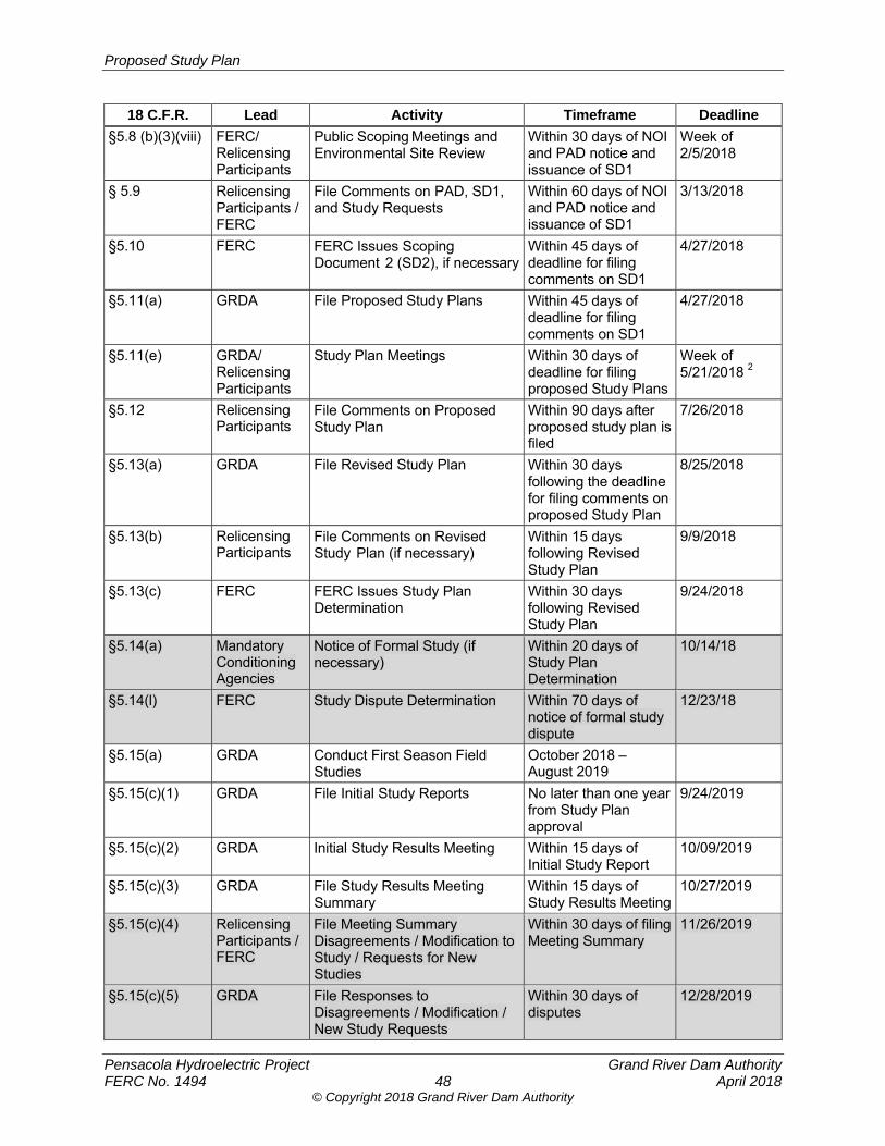
Proposed Study Plan
Pensacola Hydroelectric Project Grand River Dam Authority FERC No. 1494 48 April 2018
© Copyright 2018 Grand River Dam Authority
18 C.F.R. Lead Activity Timeframe Deadline
§5.8 (b)(3)(viii) FERC/ Relicensing Participants
Public Scoping Meetings and Environmental Site Review
Within 30 days of NOI and PAD notice and issuance of SD1
Week of 2/5/2018
§ 5.9 Relicensing Participants / FERC
File Comments on PAD, SD1, and Study Requests
Within 60 days of NOI and PAD notice and issuance of SD1
3/13/2018
§5.10 FERC FERC Issues Scoping Document 2 (SD2), if necessary
Within 45 days of deadline for filing comments on SD1
4/27/2018
§5.11(a) GRDA File Proposed Study Plans Within 45 days of deadline for filing comments on SD1
4/27/2018
§5.11(e) GRDA/ Relicensing Participants
Study Plan Meetings Within 30 days of deadline for filing proposed Study Plans
Week of 5/21/2018 2
§5.12 Relicensing Participants
File Comments on Proposed Study Plan
Within 90 days after proposed study plan is filed
7/26/2018
§5.13(a) GRDA File Revised Study Plan Within 30 days following the deadline for filing comments on proposed Study Plan
8/25/2018
§5.13(b) Relicensing Participants
File Comments on Revised Study Plan (if necessary)
Within 15 days following Revised Study Plan
9/9/2018
§5.13(c) FERC FERC Issues Study Plan Determination
Within 30 days following Revised Study Plan
9/24/2018
§5.14(a) Mandatory Conditioning Agencies
Notice of Formal Study (if necessary)
Within 20 days of Study Plan Determination
10/14/18
§5.14(l) FERC Study Dispute Determination Within 70 days of notice of formal study dispute
12/23/18
§5.15(a) GRDA Conduct First Season Field Studies
October 2018 – August 2019
§5.15(c)(1) GRDA File Initial Study Reports No later than one year from Study Plan approval
9/24/2019
§5.15(c)(2) GRDA Initial Study Results Meeting Within 15 days of Initial Study Report
10/09/2019
§5.15(c)(3) GRDA File Study Results Meeting Summary
Within 15 days of Study Results Meeting
10/27/2019
§5.15(c)(4) Relicensing Participants / FERC
File Meeting Summary Disagreements / Modification to Study / Requests for New Studies
Within 30 days of filing Meeting Summary
11/26/2019
§5.15(c)(5) GRDA File Responses to Disagreements / Modification / New Study Requests
Within 30 days of disputes
12/28/2019
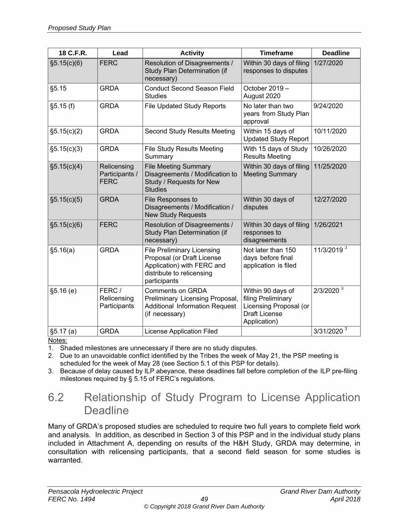
Proposed Study Plan
Pensacola Hydroelectric Project Grand River Dam Authority FERC No. 1494 49 April 2018
© Copyright 2018 Grand River Dam Authority
18 C.F.R. Lead Activity Timeframe Deadline
§5.15(c)(6) FERC Resolution of Disagreements / Study Plan Determination (if necessary)
Within 30 days of filing responses to disputes
1/27/2020
§5.15 GRDA Conduct Second Season Field Studies
October 2019 – August 2020
§5.15 (f) GRDA File Updated Study Reports No later than two years from Study Plan approval
9/24/2020
§5.15(c)(2) GRDA Second Study Results Meeting Within 15 days of Updated Study Report
10/11/2020
§5.15(c)(3) GRDA File Study Results Meeting Summary
With 15 days of Study Results Meeting
10/26/2020
§5.15(c)(4) Relicensing Participants / FERC
File Meeting Summary Disagreements / Modification to Study / Requests for New Studies
Within 30 days of filing Meeting Summary
11/25/2020
§5.15(c)(5) GRDA File Responses to Disagreements / Modification / New Study Requests
Within 30 days of disputes
12/27/2020
§5.15(c)(6) FERC Resolution of Disagreements / Study Plan Determination (if necessary)
Within 30 days of filing responses to disagreements
1/26/2021
§5.16(a) GRDA File Preliminary Licensing Proposal (or Draft License Application) with FERC and distribute to relicensing participants
Not later than 150 days before final application is filed
11/3/2019 3
§5.16 (e) FERC / Relicensing Participants
Comments on GRDA Preliminary Licensing Proposal, Additional Information Request (if necessary)
Within 90 days of filing Preliminary Licensing Proposal (or Draft License Application)
2/3/2020 3
§5.17 (a) GRDA License Application Filed 3/31/2020 3 Notes: 1. Shaded milestones are unnecessary if there are no study disputes. 2. Due to an unavoidable conflict identified by the Tribes the week of May 21, the PSP meeting is
scheduled for the week of May 28 (see Section 5.1 of this PSP for details). 3. Because of delay caused by ILP abeyance, these deadlines fall before completion of the ILP pre-filing
milestones required by § 5.15 of FERC’s regulations.
6.2 Relationship of Study Program to License Application Deadline
Many of GRDA’s proposed studies are scheduled to require two full years to complete field work and analysis. In addition, as described in Section 3 of this PSP and in the individual study plans included in Attachment A, depending on results of the H&H Study, GRDA may determine, in consultation with relicensing participants, that a second field season for some studies is warranted.
Proposed Study Plan
Pensacola Hydroelectric Project Grand River Dam Authority FERC No. 1494 50 April 2018
© Copyright 2018 Grand River Dam Authority
As described in more detail in Section 1.3 of this PSP, the delay in the ILP process due to a lack of a quorum of FERC commissioners resulted in an incongruity between the ILP process and the statutory deadline under the FPA for GRDA to file its FLA with FERC. Under the current relicensing schedule (Table 6.1-1), nearly the entire second field season (October 2019-August 2020) and associated study reporting (USR; due September 2020) are scheduled to occur after GRDA files both the PLP/DLA (due November 2019) and FLA (due March 2020). GRDA is concerned that this unintended result will create challenges and redundancies in the relicensing effort, as both the DLA/PLP and FLA will be supported by incomplete information, while studies in the second season will be ongoing. This process would be administratively challenging, as GRDA and other relicensing participants would be forced to prepare and comment on an incomplete DLA/PLP and FLA, and then supplement and re-review the incomplete documents as the second study season concludes.
To avoid this circumstance and align the ILP process with the license expiration date, GRDA will be seeking a modest extension of the existing license term, such that the license application filing date can be adjusted, as appropriate, to match the ILP process. The Commission has adopted this strategy in other projects facing other uncontrollable circumstances,94 and GRDA believes that a reasonable extension in this case will be widely supported, as this approach would benefit all relicensing participants by allowing the ILP to proceed as envisioned in FERC’s regulations.
GRDA expects to conduct informal outreach to relicensing participants in this approach as part of the upcoming study plan meetings. Once GRDA and relicensing participants have completed the ongoing effort to develop the study plan and FERC issues its Study Plan Determination, GRDA anticipates filing the license extension application with the Commission at that time.
7.0 REFERENCES Atkinson, CA; Jolley, DF; Simpson, SL. 2007. Effect of overlying water pH, dissolved oxygen,
salinity and sediment disturbances on metal release and sequestration from metal contaminated marine sediments. Chemosphere, 69:1428-1437.
Dennis, Alan C. 2014. Floodplain Analysis of the Neosho River Associated with Proposed Rule Curve Modifications for Grand Lake O’ The Cherokees. Submitted in Partial Fulfillment of Master’s Thesis, University of Oklahoma (OU), Norman, Oklahoma.
FEMA (Federal Emergency Management Agency). 2015. Task Order HSFE06-11-J-001 for Grand Lake O’ The Cherokees Watershed, OK HUC 8 – 11070206, Craig, Delaware, Mayes, and Ottawa Counties, Oklahoma. February 6, 2015.
FERC (Federal Energy Regulatory Commission). 1996. Order Amending License. 77 FERC ¶ 61,251. December 3, 1996.
FERC. 2013. Order Modifying and Approving Shoreline Management Plan. 145 FERC ¶ 62,041. October 17, 2013.
94 E.g., TransCanada Hydro Northeast Inc., 152 FERC ¶ 62,048 (2015).
Proposed Study Plan
Pensacola Hydroelectric Project Grand River Dam Authority FERC No. 1494 51 April 2018
© Copyright 2018 Grand River Dam Authority
FERC. 2015. Memorandum to Public File of Pensacola Project, P-1494-432. Supporting information for Commission staff’s independent analysis of GRDA’s request for expedited approval of a temporary variance from Article 401. August 31, 2015.
FERC. 2017. Amendment of Article 401 to Modify Reservoir Elevation Rule Curve for Pensacola Hydroelectric Project, P-1494. May 2017.
GRDA (Grand River Dam Authority). 2008. Shoreline Management Plan. Pensacola Hydroelectric Project, FERC No. 1494. June 11, 2008.
GRDA. 2010. Letter from GRDA to FERC with photographs of the installed turbine and generator nameplates on the Pensacola Project’s six units. May 12, 2010.
GRDA. 2011. Supporting Technical Information Document for the Pensacola Project No. 1494. Prepared by Burns & McDonnell Engineering for GRDA. September 2011.
GRDA. 2015. Pensacola Hydroelectric Project Public Recreation Management Plan Monitoring Report. April 1, 2015.
GRDA. 2016a. Article 411 Fish and Waterfowl Habitat Management Plan, Annual Report. April 27, 2016.
GRDA. 2016b. Environmental Report Prepared in Support of Non-Capacity License Amendment to Modify Article 401 (Rule Curve), FERC Project No. 1494. Prepared by McMillen Jacobs Associates. May 6, 2016.
GRDA. 2017. Pensacola Hydroelectric Project, P-1494, Pre-Application Document. February 2017.
GRDA and ODWC. 2017. Implementation Plan for the Coal Creek Wildlife Management Area, Draft. A Joint Project by the Grand River Dam Authority and the Oklahoma Department of Wildlife Conservation. February 3, 2017.
Holly, Jr. F. 2004. Analysis of Effect of Grand Lake Power-Pool Elevations on Neosho River Levels During a Major Flood. Prepared for: Robert Sullivan, AGM of Risk Management and Regulatory Compliance, GRDA.
MacDonald, D.D., C.G. Ingersoll, M. Crawford, H. Prencipe, J.M. Besser, W.G. Brumbaugh, N. Kemble, T.W. May, C.D. Ivey, M. Menehetti, J. Sinclair, and M. O’Hare. 2010. Advanced Screening-Level Ecological Risk Assessment for Aquatic Habitats within the Tri-State Mining District, Oklahoma, Kansas, and Missouri. Final Draft Technical Report. Prepared by USGS, Columbia MO and MacDonald Environmental Sciences Ltd., CH2M Hill, Dallas Texas for the USEPA, Dallas, TX; USEPA Kansas City, MO; and USFWS, Columbia, MO.
McCormick, C.A. 1985. Water Quality and sediments of an area receiving acid-mine drainage in northeastern Oklahoma. M.S. Thesis. Oklahoma State University, Stillwater, OK.
Morrison S., S. Nikolai, D. Townsend, J. Belden. 2014. Distribution and Bioavailability of trace metals in shallow sediments from Grand Lake, OK. Paper Presented at the American Society of Mining and Reclamation Conference, Oklahoma City, Oklahoma.
Proposed Study Plan
Pensacola Hydroelectric Project Grand River Dam Authority FERC No. 1494 52 April 2018
© Copyright 2018 Grand River Dam Authority
Morrison, S., S. Nikolai., D. Townsend, J. Belden. 2018. Distribution and Bioavailability of trace metals in shallow sediments from Grand Lake, OK. Archives of Environmental Contamination and Toxicology. In Press Xx(x):xxx-xxx.
ODWC (Oklahoma Department of Wildlife Conservation). 2016. Interagency Agreement between Grand River Dam Authority and Oklahoma Department of Wildlife Conservation. January 4, 2016.
OWRB (Oklahoma Water Resources Board) and OSU (Oklahoma State University). 1995. Diagnostic and Feasibility Study of Grand Lake O’ The Cherokees, Phase I of a Clean Lakes Project, Final Report. March 10, 1995.
OWRB. 2015. Sample Year 2014 Testing for Pensacola Dam/Neosho River Dissolved Oxygen Mitigation Plan. January 2015.
Schooley, J.D. and S. O’Donnell. 2016. Benthic Habitat Mapping of Grand Lake Tributaries as it Relates to Paddlefish Recruitment. Grant Report. Project Number: F15AF00540.
Simons & Associates, Inc. 1998. Revised Hydraulic and Backwater Analysis of the Neosho River Upstream of the Reservoir to the Commerce Gage. Miami, Oklahoma.
USACE (U.S. Army Corps of Engineers). 1996. HEC-2 Hydraulic Model.
USACE. 1998. Grand Lake, Oklahoma, Real Estate Adequacy Study. September 1998.
USACE. 2002. Grand Lake, Oklahoma, Preliminary Analysis of Flood Control Operation. August 2002.
USACE. 2006. Grand Lake, Oklahoma, Letter Report. May 2006.
USGS (U.S. Geological Survey). 2017. Bathymetric Surveys of the Neosho River, Spring River, and Elk River, Northeastern Oklahoma and Southwestern Missouri, 2016-17. Scientific Investigations Report 2017-5101. Version 1.1, October. U.S. Department of Interior.
Proposed Study Plan
Pensacola Hydroelectric Project Grand River Dam Authority FERC No. 1494 April 2018
© Copyright 2018 Grand River Dam Authority
ATTACHMENT A. STUDY PLANS

Proposed Study Plan
Pensacola Hydroelectric Project Grand River Dam Authority FERC No. 1494 April 2018
© Copyright 2018 Grand River Dam Authority
[This page intentionally left blank.]
© Copyright 2018 Grand River Dam Authority
Pensacola Hydroelectric Project, FERC No. 1494
Proposed Study Plan
Hydrologic and Hydraulic Modeling Study
Prepared for
Prepared by
www.meadhunt.com
April 2018

© Copyright 2018 Grand River Dam Authority
Proposed Study Plan Hydrologic and Hydraulic Modeling Study
Pensacola Hydroelectric Project Grand River Dam Authority FERC No. 1494 i April 2018
© Copyright 2018 Grand River Dam Authority
TABLE OF CONTENTS
1.0 Introduction ..................................................................................................................... 1
2.0 Study Plan Elements ....................................................................................................... 1 2.1 Study Goals and Objectives .................................................................................. 1 2.2 Agency and Native American Tribe Resource Management Goals ......................... 2 2.3 Background and Existing Information .................................................................... 2 2.4 Nexus between Project Operations and Effects on Resources ............................. 5 2.5 Study Area ............................................................................................................. 5 2.6 Methodology .......................................................................................................... 8 2.7 Consistency with Generally Accepted Scientific Practice .................................... 13 2.8 Schedule ............................................................................................................. 14 2.9 Level of Effort and Cost ....................................................................................... 14
3.0 References ..................................................................................................................... 15
LIST OF TABLES
Table 2.8-1. H&H modeling study schedule. ........................................................................... 14
LIST OF FIGURES
Figure 2.5-1. H&H modeling initial study area. ........................................................................... 7
Proposed Study Plan Hydrologic and Hydraulic Modeling Study
Pensacola Hydroelectric Project Grand River Dam Authority FERC No. 1494 ii April 2018
© Copyright 2018 Grand River Dam Authority
LIST OF ACRONYMS
1-D ............................ one-dimensional
2-D ............................ two-dimensional
BIA ............................ Bureau of Indian Affairs
CHM .......................... Comprehensive Hydraulic Model
DEM .......................... digital elevation model
FEMA ........................ Federal Emergency Management Agency
FERC ........................ Federal Energy Regulatory Commission
GRDA ........................ Grand River Dam Authority
HEC .......................... Hydrologic Engineering Center
HEC-RAS .................. Hydrologic Engineering Center’s River Analysis System
H&H .......................... Hydrologic and Hydraulic
LiDAR ........................ Light Detection and Ranging
NED .......................... National Elevation Dataset
NGVD ........................ National Geodetic Vertical Datum
OK ............................. Oklahoma
OU ............................. University of Oklahoma
OWRB ....................... Oklahoma Water Resources Board
PAD ........................... Pre-Application Document
PD ............................. Pensacola datum
Project ....................... Pensacola Hydroelectric Project
PSP ........................... Proposed Study Plan
SD1 ........................... Scoping Document 1
USACE ...................... U.S. Army Corps of Engineers
USFWS ..................... U.S. Fish and Wildlife Service
USGS ........................ U.S. Geological Survey
VBA ........................... Visual Basic for Applications
Proposed Study Plan Hydrologic and Hydraulic Modeling Study
Pensacola Hydroelectric Project Grand River Dam Authority FERC No. 1494 1 April 2018
© Copyright 2018 Grand River Dam Authority
1.0 INTRODUCTION The Grand River Dam Authority (GRDA) filed a Pre-Application Document (PAD) with the Federal Energy Regulatory Commission (FERC) on February 1, 2017, as part of relicensing the Pensacola Hydroelectric Project (Pensacola Project or Project; FERC No. 1494). In Section 7 of the PAD, GRDA proposed a Hydrologic and Hydraulic Modeling Study (H&H Study) that will model the Grand/Neosho River, including several tributaries, both upstream and downstream of Pensacola Dam. The modeling effort under the H&H Study will produce a tool for analyzing the effects of GRDA’s operation of the Project under the new license, as well as indirect and cumulative impacts associated with flood control operations, which are under the exclusive jurisdiction of the U.S. Army Corps of Engineers (USACE). As indicated in Section 3.1 of the main body of the Proposed Study Plan (PSP), GRDA proposes to conduct a comprehensive H&H Study as presented in this study plan. FERC’s January 12, 2018 Scoping Document 1 (SD1) identified the following environmental resource issues to be analyzed for the Project relicensing:
Effects of project operation for both power generation and flood control on water quantity, including its relationship to reservoir level, flooding upstream and downstream of the Pensacola Dam, and drought/low flow periods.
In addition to the inundation area, the H&H Study will provide other flood routing specifics such as the frequency, timing, amplitude, and duration of the inundation. The information obtained from the H&H Study will also inform separate analyses about the effects of inundation on resources such as geology and soils, water resources, fisheries and aquatic resources, terrestrial resources, threatened and endangered resources, cultural resources, and power generation. The H&H Study will also help determine lands needed for Project purposes and, therefore, inform FERC’s determination of the placement of the Project Boundary. FERC, Bureau of Indian Affairs (BIA), U. S. Fish and Wildlife Service (USFWS), City of Miami, Miami Tribe, Eastern Shawnee Tribe, Ottawa Tribe, Seneca-Cayuga Nation, Wyandotte Nation, Cherokee Nation, and N. Larry Bork (counsel for the City of Miami citizens) subsequently submitted formal requests related to flood control operations and inundation. Sections 4.1.1 and 4.2.1 of the main body of the PSP detail GRDA’s response to these requests.
2.0 STUDY PLAN ELEMENTS
2.1 Study Goals and Objectives The overall H&H Study goal is to provide information, through modeling and mapping, to support the determinination of the effects, if any, of GRDA’s operations under the FERC-issued license for the Project upon several resource areas. Specifically, the H&H Study will: (1) determine the duration and extent of inundation under the current license operations of the Project during several measured inflow events; (2) determine the duration and extent of inundation under any proposed change in such operations that occurs during several measured
Proposed Study Plan Hydrologic and Hydraulic Modeling Study
Pensacola Hydroelectric Project Grand River Dam Authority FERC No. 1494 2 April 2018
© Copyright 2018 Grand River Dam Authority
or synthetic inflow events; (3) provide the model results in a format that can inform other analyses (to be completed separately) of Project effects, if any, in several resource areas; and (4) determine the feasibility of implementing alternative operation scenarios, if applicable, that may be proposed by GRDA as part of the relicensing effort.
2.2 Agency and Native American Tribe Resource Management Goals
The modeling and mapping results can inform separate efforts to assess Project effects on resources such as geology and soils, water resources, fisheries and aquatic resources, terrestrial resources, tribal lands, paddlefish spawning recruitment, wildlife lands, threatened and endangered resources, cultural resources, and power generation. Such analyses, in turn, can inform agency decision making pursuant to their statutory obligations.
2.3 Background and Existing Information There is a considerable amount of public information available to support and inform the H&H Study. The information consists of previous hydraulic models, flow, stage and high-water mark data (hydrology), bathymetry, topography, and sedimentation. Hydraulic Models Several hydraulic models have previously been developed for portions of the Grand Lake Watershed. Previous hydraulic models on the Neosho River upstream from Grand Lake and a hydraulic model of Tar Creek are currently available in the public record. Additionally, a previously cited, but not publicly available, model exists that extends from Twin Bridges State Park, Fairland, Oklahoma (OK) (Twin Bridges) to the U. S. Geological Survey (USGS) Gage No. 07185000, Neosho River near Commerce, OK (USGS gage at Commerce) (Holly 2001, 2004); however, due to inaccessibility, this model will not be reviewed or used as a basis in the H&H Study. The publicly available hydraulic models that will be discussed further are listed below as they are commonly cited:
USACE Model (1996)
Simons Model (1998)
University of Oklahoma (OU) Model (Dennis 2014)
FERC Model (2015)
Tetra Tech Models (Tetra Tech 2010, 2013, 2015)
Federal Emergency Management Agency (FEMA) Tar Creek Model (2015) USACE (1996) and Simons (1998) Models Both the USACE and Simons Models utilize a USACE Hydrologic Engineering Center (HEC) software called HEC-2, which was released in 1990. The Neosho River from Twin Bridges to just upstream of the USGS gage at Commerce was modeled as steady-state1 in these efforts. Since the efforts utilize data collected in 1995 and 1997 (topography and bathymetry) and do not include Grand Lake, they will not be used as a model basis for the H&H Study.
1 A steady-state model utilizes a constant inflow value that does not vary with time.
Proposed Study Plan Hydrologic and Hydraulic Modeling Study
Pensacola Hydroelectric Project Grand River Dam Authority FERC No. 1494 3 April 2018
© Copyright 2018 Grand River Dam Authority
OU Model (Dennis 2014) GRDA commissioned a hydraulic study through the University of Oklahoma (OU) in 2014 for a previous Project license amendment request. The OU Model was developed using one-dimensional (1-D) HEC-River Analysis System (RAS) software and included the Neosho River and several major tributaries from Pensacola Dam to the USGS gage at Commerce. The OU Model relied on the 1996 USACE bathymetry data for the Neosho River between Twin Bridges and the USGS gage at Commerce and on 2008 bathymetric survey information for Grand Lake from the Oklahoma Water Resources Board (OWRB). The model also used Light Detection and Ranging (LiDAR)-acquired topography collected for the USGS in 2011 to represent overbank areas. The OU Model will not be used as a model basis for the H&H Study due to the age of the bathymetry data (1996) and the limited purpose for which this model was developed. FERC Model (2015) In 2015, FERC developed an independent hydraulic model in response to the proposed license amendment to modify the rule curve under the Project’s license. The FERC Model was created using the OU Model as a basis in 1-D HEC-RAS software and was modified to overcome the original limits of the OU Model. The FERC model was calibrated using roughness values from historic flood events and was an unsteady-state2 analysis for the Neosho River; however, the model did not include the portion of the Grand Lake downstream of Twin Bridges. The FERC Model will not be used as a model basis in the H&H Study because it does not represent the Spring River, Elk River, or Grand Lake. Tetra Tech Models (2010, 2013, 2015) In 2010, 2013, and 2015, the City of Miami commissioned Tetra Tech to develop a hydraulic model. The 2010 and 2013 Models utilized proprietary FLO-2D software, which has both 1-D and two-dimensional (2-D) capabilities. The 2010 and 2013 Models utilized USACE 1996 topography and Simons 1998 bathymetry to focus on the vicinity of the City of Miami and the Neosho River. The 2015 Model improved upon the 2010 and 2013 Models by utilizing HEC-RAS Version 5.0 software, which also has 1-D and 2-D capabilities. The 2015 Model included unsteady-state 1-D and 2-D areas for the Grand/Neosho River from Pensacola Dam to the USGS gage at Commerce. It also incorporated bathymetric survey data for the Grand/Neosho River collected by Tetra Tech in April 2015 specifically for the 2015 Model. Although the 2015 Model has some deficiencies and requires several improvements for use in the H&H Study, it provides the best existing model basis for moving forward into the H&H Study. The 2015 Model, along with proposed improvements, will be used as a basis for the H&H Study. The list of improvements, including updated bathymetric data from 2017, are outlined in Section 2.6, Methodology.
2 An unsteady-state model utilizes varying inflows through the cycle of the inflow event to show the conditions as the inflow event moves through the river system. Unsteady-state modeling is considered to be the most-representative of natural conditions occurring in the river system during the inflow event.
Proposed Study Plan Hydrologic and Hydraulic Modeling Study
Pensacola Hydroelectric Project Grand River Dam Authority FERC No. 1494 4 April 2018
© Copyright 2018 Grand River Dam Authority
FEMA Tar Creek Model (2015) FEMA developed the Tar Creek 1-D HEC-RAS Model as part of their flood risk mapping efforts for the Grand Lake Watershed. The FEMA Model extends approximately 7.5 miles up Tar Creek from its confluence with the Spring River. After a review of information associated with the FEMA Model, it was determined that utilizing available USGS 2011 LiDAR data as the model basis for the Tar Creek portion of the watershed, versus the data from the FEMA model, is not the best approach to attain the goals of the H&H Study. Therefore, the FEMA Model will not be used as a basis for the H&H Study. Hydrology The following hydrology information will be reviewed and utilized, as appropriate, in the H&H Study.
USGS data from the following six gages:
o Neosho River near Commerce, OK (USGS Gage No. 07185000).
o Neosho River at Miami (USGS Gage No. 07185080).
o Tar Creek at Miami, OK (USGS Gage No. 07185095).
o Spring River near Quapaw, OK (USGS Gage No. 07188000).
o Elk River near Tiff City, MO (USGS Gage No. 07189000).
o Lake O’ The Cherokees at Langley, OK (USGS Gage No. 0719000).
GRDA records of flow release and water surface elevations at Pensacola Dam.
Surveyed high-water marks during and after historical inflow events. Topography The following sources of topographic data will be reviewed and utilized, as appropriate, in the H&H Study:
LiDAR survey conducted by the USGS in 2011 (does not cover entire study area).
USGS 1/3 arc-second (10-meter) National Elevation Dataset (NED) digital elevation model (DEM).
LiDAR coverage is not available in the upper reaches of some of the tributaries associated with the H&H Study. For those areas without coverage, information from the NED will be used for the H&H Study. Bathymetry The following sources of bathymetric data will be reviewed and utilized, as appropriate, in the H&H Study:
2008 OWRB bathymetric survey for Lake Hudson extending from just upstream of Kerr Dam to just downstream of the Project.
2009 OWRB bathymetric survey of Grand Lake and 4.5 miles of the Neosho River upstream of the confluence of the Spring River.
2017 USGS bathymetric survey of the Neosho River, Spring River, and Elk River.
Proposed Study Plan Hydrologic and Hydraulic Modeling Study
Pensacola Hydroelectric Project Grand River Dam Authority FERC No. 1494 5 April 2018
© Copyright 2018 Grand River Dam Authority
Sedimentation Historical Cross-Sections The H&H Study proposes to use the cross-section information from the 1996 USACE Hydraulic Model or 1997 USACE DEM data, where appropriate, for comparison in determining the impact of sedimentation on the results of current model runs. Operations Model The following sources of data will be reviewed and utilized, as appropriate, in the Operations Model.
Facility drawings (GRDA)
Turbine hill curves (Siemens 1999 and Bertrand 2009)
Generator efficiency vs. load curves (Siemens 1999 and Bertrand 2009)
Turbine index testing (Siemens 1999 and Bertrand 2009)
Turbine air valve operation vs. turbine efficiency data (Bertrand 2009)
USACE spillway discharge capacity rating (USACE 1990 and 1991)
Reservoir stage-storage curves for Grand Lake
Historical observed operations data (headwater elevation, tailwater elevation, and discharge) collected by GRDA
Area Capacity Curve The 2009 OWRB area capacity curves for Grand Lake contained in the hydrographic survey report will be reviewed and utilized, as appropriate, in the H&H Study.
2.4 Nexus between Project Operations and Effects on Resources
Project operation influences water levels of the Grand/Neosho River, as well as some tributaries, both upstream and downstream of Pensacola Dam. The H&H Study will help quantify these influences; improve understanding of the magnitude, duration, and frequency of such influences; identify the operational sources of such influences (e.g., hydroelectric operations and USACE flood control operations); and assist in analyzing resource-level effects that could be associated with these influences. The H&H Study will also help identify changes in areas inundated, if any, that may be associated with any changes to current operations that may be proposed by GRDA as part of the relicensing effort.
2.5 Study Area The overall H&H Study will encompass the channel and overbank areas of the Grand/Neosho River watershed that have a measurable difference in water surface elevations due to Project operation during the measured inflow events of the H&H Study (See also Section 2.6 Methodology of this study plan). Initially, along the main tributaries, the study will extend upstream from the Pensacola Dam along the Grand/Neosho River to within approximately 3 miles of the Kansas State line, upstream along the Spring River to within 6.5 miles of the Kansas State line, and upstream along the Elk River approximately 11.5 miles beyond the State
Proposed Study Plan Hydrologic and Hydraulic Modeling Study
Pensacola Hydroelectric Project Grand River Dam Authority FERC No. 1494 6 April 2018
© Copyright 2018 Grand River Dam Authority
line into Missouri, and along Tar Creek which will extend just upstream of the USGS gage at the 22nd Avenue Bridge (Figure 2.5-1). The study will also encompass the bays/coves within Grand Lake associated with tributaries flowing into the lake. The overall H&H Study will also include channel and overbank areas that have a measurable difference in water surface elevations due to Project operation during the measured inflow events extending downstream of the Pensacola Dam. While this Section 2.5 identifies the initial H&H Study area, as descried in Section 2.6 below, the Comprehensive Hydraulic Model (CHM) will be refined, as necessary and appropriate, through an iterative process.
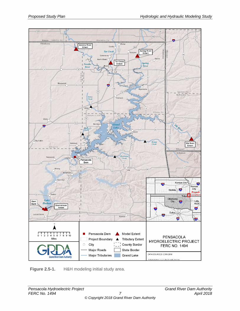
Proposed Study Plan Hydrologic and Hydraulic Modeling Study
Pensacola Hydroelectric Project Grand River Dam Authority FERC No. 1494 7 April 2018
© Copyright 2018 Grand River Dam Authority
Figure 2.5-1. H&H modeling initial study area.
Proposed Study Plan Hydrologic and Hydraulic Modeling Study
Pensacola Hydroelectric Project Grand River Dam Authority FERC No. 1494 8 April 2018
© Copyright 2018 Grand River Dam Authority
2.6 Methodology For the H&H Study, a CHM will be constructed to determine the inundation areas and other flood routing specifics during several measured inflow events where inflow hydrographs already exist. To evaluate the effects of any proposed operational changes, a separate Operations Model will be constructed to synthesize hypothetical events that inform the CHM. Informing the CHM with the synthetic or hypothetical events will predict the water surface elevations and other flood routing specifics that could occur because of changes to Project operations. This will allow for a comparison between flood routing specifics resulting from different operation scenarios. To evaluate the extent to which sedimentation affects the results of the CHM, the CHM with the current channel geometry will be modified by inserting historical channel geometry in the place of the 2017 channel geometry to create a new CHM. The new CHM will be re-run under a wide range of inflow events and operating scenarios. This will allow for a comparison between flood routing specifics resulting from the effect of sediment accretion and erosion in the river channels. The effects of the Project operation on sediment accretion and erosion will be the subject of a separate Sedimentation Study. A hydrology analysis will provide context to the magnitude of measured inflow events being used for runs of the CHM. As a result, the flood frequency at the Pensacola Dam of all the measured inflow events where hydrographs already exist will be determined to provide a frame of reference to their overall magnitude and recurrence. Comprehensive Hydraulic Model (CHM) The CHM will use the USACE HEC-RAS software Version 5.0.3 or later. This software is the engineering standard for this type of analysis because it is the most up-to-date version of the software. The software has the capability to perform unsteady-state analyses in both 1-D and 2-D. The Tetra Tech 2015 Model will be utilized as a basis to create the new CHM. Like the Tetra Tech 2015 Model, the CHM will be a single (inflow) event model. In addition to using the Tetra Tech 2015 Model as a basis on the Grand/Neosho River, the CHM will also extend upstream and include the Spring River, Elk River, Tar Creek and downstream through Lake Hudson to just upstream of Kerr Dam. For upstream terrain and bathymetric data, the CHM will represent overbank areas using the DEM derived from the 2011 USGS LiDAR data. Where needed, the DEM derived from the 2011 LiDAR will be supplemented with a coarser 1/3 arc-second DEM gathered from the USGS NED. The bathymetric data collected by the OWRB will be used to represent the bottom of Grand Lake. The bathymetric data for the Neosho, Spring, and Elk Rivers gathered during the 2017 USGS survey will also be incorporated into the CHM. The 2017 USGS bathymetric data extends along both the Neosho and Spring Rivers from the Kansas/Oklahoma state line downstream to the confluence of the two rivers near Twin Bridges. The 2017 USGS bathymetric data also extends along the Elk River from just downstream of Noel, Missouri, to the Oklahoma State Highway 10 bridge near Grove, Oklahoma. USGS has processed the survey data into a DEM that will represent the channel bottom. The DEM of the channel bottom will be merged with the DEM used in the CHM that represents the overbank areas and bathymetry within Grand Lake.
Proposed Study Plan Hydrologic and Hydraulic Modeling Study
Pensacola Hydroelectric Project Grand River Dam Authority FERC No. 1494 9 April 2018
© Copyright 2018 Grand River Dam Authority
The CHM will also incorporate various stream crossings/bridges according to the original design drawing geometries obtained (or according to field verification, if design drawings are not available). For upstream of Pensacola Dam, the CHM will utilize the Tetra Tech 2015 Model as a basis for the location of cross-sections and 2-D areas included within the model. A review of the location of the Tetra Tech 2015 Model basis cross-sections will be completed and additional cross-sections to provide the necessary model resolution will be added to make the CHM more robust than the Tetra Tech 2015 Model (e.g. the number of cross-sections in Grand Lake will be increased and cross-sections for the Spring River and the Elk River will be added to the CHM). The upper portions of Grand Lake (upstream of Sailboat Bridge) will be represented as 1-D cross-sections with adequate spacing and configuration to represent the reservoir volume. The study reach through Grand Lake downstream of Sailboat Bridge will be represented as a 2-D model. Both the 1-D cross-sections and 2-D grid will be extracted using the 2011 USGS LiDAR data and USGS 1/3 arc-second DEM (where needed) for the overbank portions, along with the 2009 OWRB Bathymetric Data for Grand Lake for the reservoir bottom Spring River will be represented as a 1-D reach. The 1-D cross-sections will be extracted using the 2011 USGS LiDAR data and a USGS 1/3 arc-second DEM (where needed) for the overbank portions, along with the 2017 USGS bathymetric data obtained for the channel bottom. Elk River will be represented as a 1-D reach, with cross-sections extracted using the 2011 USGS LiDAR and a USGS 1/3 arc-second DEM (where needed) to represent the overbank areas, along with the 2017 USGS bathymetric data for the channel bottom. Tar Creek will be represented as a 2-D model, with the 2-D grid extracted using the 2011 USGS LiDAR and a USGS 1/3 arc-second DEM (where needed) to represent the overbank areas. In place of bathymetry, the 2011 LiDAR data will be used. For the CHM section downstream of Pensacola Dam, an unsteady-state 1-D HEC-RAS model will be developed, extending from just downstream of the Pensacola Dam, through Lake Hudson to just upstream of Kerr Dam. For downstream terrain, the 1/3 arc-second (approximately 10-meter resolution) DEM from the NED will be used. The topographic data will be downloaded from the USGS and compiled to generate a single, large DEM to represent the study area. For downstream bathymetry, the 2008 bathymetric survey for Lake Hudson by the OWRB extending from just upstream of Kerr Dam to just downstream of the Project will be utilized. It will represent the river/reservoir bottom throughout the downstream section of the CHM. The bathymetric data will be merged with the NED to create the terrain model that will be used in the CHM. In the downstream study reach, the CHM will also incorporate various stream crossings/bridges according to the original design drawing geometries obtained (according to field verification if design drawings are not available). These bridges include Highway 82, Strang Road, and Highway 20. Hydraulic roughness coefficients are an important part of the CHM. Therefore, aerial photography and site observations will be used to establish roughness coefficients, which will be
Proposed Study Plan Hydrologic and Hydraulic Modeling Study
Pensacola Hydroelectric Project Grand River Dam Authority FERC No. 1494 10 April 2018
© Copyright 2018 Grand River Dam Authority
cross-checked against the coefficients used in the 2015 Tetra Tech Model in the areas where the two models overlap. Standard Manning’s n references will be utilized to correlate the existing overbank land uses to roughness coefficients. During calibration of the CHM, roughness values will be adjusted as appropriate to improve consistency with observed high water marks or flood conditions. Operations Model The Operations Model is a tool that will be used to synthesize and create events that inform or set the boundaries3 of a CHM run. In addition to the operation of the Project, the model will account for cumulative effects of project operations on the upstream and downstream dams operated by the USACE, but the model will not explicitly include those projects. The extent of the Operations Model will include Grand Lake upstream of Pensacola Dam and downstream (possibly through Lake Hudson upstream of Kerr Dam) as far as required to synthesize inflows to create CHM input boundaries. The Operations Model will utilize a level-pool routing method. A comparison of the water surface elevations and other flood routing specifics that could occur from different operating scenarios will be based on the different CHM boundary conditions synthesized through the Operations Model for those same operating scenarios. This comparison will illustrate the change in inundation areas and other flood routing specifics arising from the operational changes. The Operations Model can also be used to predict differences in power for different operating scenarios. The Operations Model will be a Microsoft Excel spreadsheet-based tool, including Visual Basic for Applications (VBA) subroutines to enhance the functionality of the Excel model. The Operations Model will calculate hourly outflows and generation based on various physical constraints (i.e. friction headloss between the reservoir and the turbines, turbine generator efficiency curves, dissolved oxygen valves opened and closed, spillway discharge rating curves, reservoir stage-storage curves, tailwater rating curves, and turbine maximum discharge vs. head rating curves), USACE flood routing operations, and Project operating rules. Friction loss will be calculated based on facility drawings. Turbine and generator efficiency curves will be developed from existing turbine hill curve, generator efficiency vs. load curve, turbine index testing, and turbine air valve operation vs. turbine efficiency data. Spillway discharge capacity rating curves for Pensacola Dam will be transcribed from existing USACE curves and extrapolated to higher elevations as needed. The Operations Model will not track how many spillway gates are open or what the gate opening height is at any given time; rather an elevation vs. capacity table will be used to determine the maximum potential spillway discharge for any given reservoir elevation. The model may discharge less than full capacity
3 The boundaries of the CHM are best described as the stage hydrograph at the dam. When operational changes are being modeled, the Project outflow hydrograph must be synthesized, and a hypothetical stage hydrograph needs to be created based upon the operation of the facility. The hypothetical or synthetic stage hydrograph created using the operations model will set the boundaries for the CHM model run.
Proposed Study Plan Hydrologic and Hydraulic Modeling Study
Pensacola Hydroelectric Project Grand River Dam Authority FERC No. 1494 11 April 2018
© Copyright 2018 Grand River Dam Authority
through the spillway, according to the other model constraints, but it will not exceed the maximum capacity of the spillway. Reservoir stage-storage curves will be transcribed from existing curves. The tailwater rating curve for Pensacola Dam will be developed based on historical observed tailwater elevation and discharge data collected by GRDA. The turbine maximum discharge vs. head rating curves will be based on existing turbine efficiency curves. For predictive comparisons (i.e., not for calibration to historical events, but rather for hypothetical comparisons, such as comparisons between different initial reservoir elevations), the amount of total discharge required at each time step during a flood event when the USACE would dictate flood control operations will be determined either from rating curves to be provided by USACE, or from an analysis of historical hourly operations data (headwater level, inflow, and total outflow) will be used to generate a representative rating curve. Calibration Calibration of the CHM is necessary before the results can be considered representative. The CHM will be calibrated using several historic inflow events that represent a relatively broad range of the recorded and surveyed high water marks available. The CHM will be adjusted until calibration is completed. The calibration will be considered complete when the predicted water-surface elevations approach the measured values and timing of the predicted stage hydrograph between the CHM and the inflow event recorded at stream gages within the study area are acceptable. Calibration of the Operations Model is also necessary before results of the Operations Model or the CHM can be considered representative. The Operations Model will be calibrated using several wide-ranging operational periods of historical operations data at the Pensacola Dam. The modeled annual power generation totals will be compared to the observed historical annual power generation totals to assess the effectiveness of the calibration. Model inputs which can be varied to effect a better calibration include operating rules, physical system characteristics, hydrologic routing methods, and quality control processes applied to observed historical data. Study Area Determination Section 2.5 outlines an initial study area for the CHM. Unlike the Operations Model, which will include Grand Lake upstream of Pensacola Dam and downstream as far as required to synthesize inflows to create CHM input boundaries, the CHM study area will be determined through an iterative process. In the iterative process, several CHM runs at varying ranges of measured inflow events and operating scenarios will be required to determine the actual extent upstream to which the CHM will need to reach. If a CHM run demonstrates a measurable water surface elevation difference at the most-upstream extent of the CHM that is also significant in terms of effects on resources, the CHM will need to be extended upstream. When the CHM results for a range of measured inflow events no longer show overbank areas that have a measurable water surface elevation difference, the CHM upstream extent will be finalized.
Proposed Study Plan Hydrologic and Hydraulic Modeling Study
Pensacola Hydroelectric Project Grand River Dam Authority FERC No. 1494 12 April 2018
© Copyright 2018 Grand River Dam Authority
Model Runs A minimum of six inflow hydrographs (including the 20074 inflow hydrograph) for the current licensed operating scenario will be run at starting reservoir elevations at Pensacola Dam ranging from 742 feet to 745 Pensacola datum (PD)5 in one-foot increments. An additional suite of model runs following the same parameters will also be run for each alternate operating scenario that GRDA may propose using the synthetic inflow data created by the Operations Model. Sedimentation To evaluate the extent to which sedimentation affects the results of the CHM, the model with the current channel geometry will be modified by inserting the 1996/1997 USACE channel geometry in the place of the 2017 channel geometry to create a new CHM. The new CHM will be re-run under a wide range of inflow events and operating scenarios, which will allow for a comparison between flood routing specifics resulting from the effect of sediment historically deposited in the river channels. The effects of the Project operation on sediment accretion and erosion will be the subject of the separate Sedimentation Study. Since historical channel geometry data is only available for the Grand/Neosho River channel and Grand Lake, this comparison will be limited to the effects of sedimentation in the Grand/Neosho River and Grand Lake. Flood Frequency To provide a perspective about the frequency of the inflow events utilized in individual runs of the CHM, a flood frequency analysis will be completed to provide a recurrence interval for each modeled inflow event at the Project. Because responsibility for flood regulation (USACE vs. GRDA) and the amended license rule curves for Grand Lake are based on the current and projected future elevations at the gage near Pensacola Dam, inflow recurrence intervals should properly be based on the total inflow at the location of the gage, just upstream of the dam. The inflow at a point just upstream of Pensacola Dam is not a historically-observed parameter. Therefore, calculations including the total turbine and spillway discharge, reservoir stage-storage curves, headwater level, and USGS stream gage discharge will be used when creating the (back-calculated) inflow data set for the frequency analysis. Ungaged inflow will be determined based on the total discharge at the dam, plus the change in storage in the reservoir, minus other (observed) inflows for a given time step. Hydrologic routing will be used to combine the observed and ungaged inflow at a point just upstream of the dam. The reservoir level gage that produced the headwater level data is not a perfect instrument. Reservoir level gage reading fluctuations on the order of a few hundredths of a foot can significantly alter the back-calculated inflow time series values and can even result in large negative values if the reservoir level decreases substantially without a corresponding recorded outflow. A time-averaging procedure will be used to eliminate negative values due to imprecision/fluctuation in the reservoir level gage data.
4 The 2007 inflow hydrograph is the largest inflow event of recent record on the Neosho River. 5 All elevations referenced are relative to PD. PD elevations can be converted to National Geodetic Vertical Datum of 1929 (NGVD) by adding 1.07 feet and to North American Vertical Datum of 1988 (NAVD) by adding 1.40 feet (for example, elevation 745 feet PD = 746.07 feet NGVD = 746.4 feet NAVD88)(http://ok.water.usgs.gov/projects/webmap/miami/datum.htm).
Proposed Study Plan Hydrologic and Hydraulic Modeling Study
Pensacola Hydroelectric Project Grand River Dam Authority FERC No. 1494 13 April 2018
© Copyright 2018 Grand River Dam Authority
Area Capacity Curve The OWRB has developed up-to-date area capacity curves for Grand Lake. However, the area capacity curves only reach to an upper elevation of 745 PD feet, which matches upper elevation of the conservation pool. The OWRB curve will be modified to reach an upper elevation of 760 feet PD and will identify areas above the elevation of 745 PD, which is outside of GRDA’s operation of the Project. Deliverables To allow relicensing participants to better understand the CHM and the Operations Model, GRDA will provide a model input status report in April 2019. This will allow relicensing participants to obtain information on model runs proposed as part of the H&H Study. To allow relicensing participants to review the modeling results, the H&H Study will provide a technical report, maps displaying areas of inundation, and maps comparing the inundation areas under varying operation constraints beginning with a starting reservoir elevation of 742 feet PD and increasing in one-foot increments to a maximum of 745 feet PD. The technical report will also include the results of flood frequency analyses and the modified area capacity curve. The technical report will document the data sources, the input hydrology, how the CHM and the Operations Model were developed, the assumptions used in creating the models, the calibration processes, and their results. It will provide an explanation of the USACE involvement in Project operation, graphs and summary tables for stage and outflows synthesized by the Operations Model, and an explanation of input parameters for each CHM scenario run. The technical report will also include a description of the flood frequency analysis, the results of the analyses, and a description of the limitations of the analyses. Inundation depth maps layered on recent aerial photos with the current Project Boundary depicted will be provided in electronic format. Each set of inflow event maps will include an inundation line to represent the maximum water surface elevation, the current flowage easements, and identification of any stuctures within the inundation areas. Flood maps will include overlays of ownership of lands flooded. Another set of inundation maps to be provided will be identical to the maps described above, but but will incorporate the inundation areas resulting from CHM runs with the 1996/1997 USACE channel geometry visible as a separate layer. This set of maps will incorporate a description of the change in anticipated impacts of sediment accumulated in the river system since 1996/1997.
2.7 Consistency with Generally Accepted Scientific Practice
The H&H Study incorporates methods and data that are consistent with generally accepted scientific practice. The scope of the study will encompass the entire area that is inundated during measured inflow events. This includes the Spring River, Elk River, Grand/Neosho River, and Tar Creek. Specifically, after a thorough data review and inventory, the study will incorporate the 2017 USGS bathymetric data and the 2011 LiDAR information. It will also incorporate bridge
Proposed Study Plan Hydrologic and Hydraulic Modeling Study
Pensacola Hydroelectric Project Grand River Dam Authority FERC No. 1494 14 April 2018
© Copyright 2018 Grand River Dam Authority
geometry (or field-verified information) when developing cross-sections for critical locations where existing infrastructure are believed to restrict the flow beyond the channel or floodplain.
The CHM in the H&H Study will use HEC-RAS Version 5.0.3 or later software, which is the standard in the engineering community for hydraulic studies of river systems. It will incorporate both 1-D and 2-D reaches to accurately represent the flow patterns both in the vicinity of bridges and in areas of broad floodplains within the study area. The limitations to any previous hydraulic models will be further addressed by extending the model further upstream and including the Spring and Elk Rivers into the model to address stakeholder interest, including tribal interests. In addition, the resolution of cross-sections in Grand Lake will be increased to understand in detail the interactions of the various major tributaries when they enter Grand Lake. The CHM will be calibrated using several historic inflow events that represent a relatively broad range of the recorded and surveyed high water marks available and all model elevations will reference National Geodetic Vertical Datum (NGVD) 1929 as a common datum. The Operations Model will be a Microsoft Excel spreadsheet-based tool, including VBA subroutines to enhance the computation efficiency of the Excel model. Calibration of the Operations Model will be completed using several wide-ranging operational periods of historical operations data at the Pensacola Dam. The modeled annual power generation totals will be compared to the observed historical annual power generation totals to assess the effectiveness of the calibration. Model inputs which can be varied to effect a better calibration include operating rules, physical system characteristics, hydrologic routing methods, and quality control processes applied to observed historical data.
2.8 Schedule The schedule for completion of the H&H Study is displayed in Table 2.8-1.
Table 2.8-1. H&H modeling study schedule.
Task Completion Date
Anticipated Completion of Study Plan Determination Process 9/24/2018
Model Input Status Report 04/01/2019
Initial Study (Technical) Report 09/24/2019
Second Field Season-Additional Analysis and Updates 08/01/2020
Updated Study (Technical) Report 09/24/2020
2.9 Level of Effort and Cost The total estimated cost for the entire H&H Study as outlined in the Methodology section of this study plan is approximately $800,000.
Proposed Study Plan Hydrologic and Hydraulic Modeling Study
Pensacola Hydroelectric Project Grand River Dam Authority FERC No. 1494 15 April 2018
© Copyright 2018 Grand River Dam Authority
3.0 REFERENCES Bertrand, A. 2009. Electrical and Mechanical Calculations Characteristics of Generators 1, 2,
3, and 4. Alstom Power & Transport Canada Inc. (Rev. 2014, July 7). Dennis, Alan C. 2014. Floodplain Analysis of the Neosho River Associated with Proposed Rule
Curve Modifications for Grand Lake O’ The Cherokees. Submitted in Partial Fulfillment of Master’s Thesis, University of Oklahoma (OU), Norman, Oklahoma.
Dewberry. 2011. USGS Grand Lake, OK LiDAR Project. Prepared for the U.S. Geological
Survey. November. FEMA (Federal Emergency Management Agency). 2015. Task Order HSFE06-11-J-001 for
Grand Lake O’ The Cherokees Watersheed, OK HUC 8 – 11070206, Craig, Delaware, Mayes, and Ottawa Counties, Oklahoma. February 6, 2015.
FERC (Federal Energy Regulatory Commission). 2015 . Memorandum, Pensacola Project No.
1494, Review of Supporting Information for Temporary Variance Request. August 26, 2015.
FERC. 2018a. Transcript of December 13, 2017 tribal consultation. FERC. 2018b. Scoping Document 1, Pensacola Hydroelectric Project No. 1494-438. January
12, 2018. GRDA (Grand River Dam Authority). 1961. Dam and Power House, Power House and Intake,
Transverse Sections, Markham Ferry Project. As-Built Drawings. GRDA. 1987. Dam and Powerhouse Section and Elevation of Dam and Powerhouse,
Pensacola Dam Hydropower Project. Application for FERC License, FERC No. 1494-169. Exhibit F, Sheet 2. February 26.
GRDA. 2017. Pensacola Hydroelectric Project, Pre-Application Document. Holly, F.M. 2001. Flood Level and Duration Determination Neosho River Below Commerce
Gage. Prepared for Dalrymple et al. v. Grand River Dam, Case No. CJ-94-444, Miami, Oklahoma. April.
Holly, F.M. 2004. Analysis of the Effect of Grand Lake Power-Pool Elevations on Neosho River
Levels During a Major Flood. January. OWRB. (Oklahoma Water Resources Board). 2008. Hydrographic Survey of Lake Hudson.
October 23. OWRB. 2009. Hydrographic Survey of Grand Lake. August 26, 2009. Siemens. 1999. Efficiency Calculations, Pensacola Power Plant, Unit No. 3. Siemens
Westinghouse Generator Engineering. Page V of V. January 13.
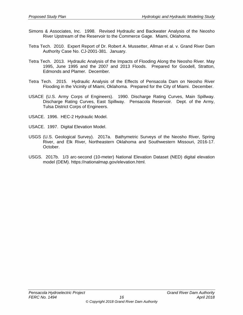
Proposed Study Plan Hydrologic and Hydraulic Modeling Study
Pensacola Hydroelectric Project Grand River Dam Authority FERC No. 1494 16 April 2018
© Copyright 2018 Grand River Dam Authority
Simons & Associates, Inc. 1998. Revised Hydraulic and Backwater Analysis of the Neosho River Upstream of the Reservoir to the Commerce Gage. Miami, Oklahoma.
Tetra Tech. 2010. Expert Report of Dr. Robert A. Mussetter, Allman et al. v. Grand River Dam
Authority Case No. CJ-2001-381. January. Tetra Tech. 2013. Hydraulic Analysis of the Impacts of Flooding Along the Neosho River. May
1995, June 1995 and the 2007 and 2013 Floods. Prepared for Goodell, Stratton, Edmonds and Plamer. December.
Tetra Tech. 2015. Hydraulic Analysis of the Effects of Pensacola Dam on Neosho River
Flooding in the Vicinity of Miami, Oklahoma. Prepared for the City of Miami. December. USACE (U.S. Army Corps of Engineers). 1990. Discharge Rating Curves, Main Spillway.
Discharge Rating Curves, East Spillway. Pensacola Reservoir. Dept. of the Army, Tulsa District Corps of Engineers.
USACE. 1996. HEC-2 Hydraulic Model. USACE. 1997. Digital Elevation Model. USGS (U.S. Geological Survey). 2017a. Bathymetric Surveys of the Neosho River, Spring
River, and Elk River, Northeastern Oklahoma and Southwestern Missouri, 2016-17. October.
USGS. 2017b. 1/3 arc-second (10-meter) National Elevation Dataset (NED) digital elevation
model (DEM). https://nationalmap.gov/elevation.html.
© Copyright 2018 Grand River Dam Authority
Pensacola Hydroelectric Project, FERC No. 1494
Proposed Study Plan
Sedimentation Study
Prepared for
Prepared by
www.meadhunt.com
April 2018

© Copyright 2018 Grand River Dam Authority
Proposed Study Plan Sedimentation Study
Pensacola Hydroelectric Project Grand River Dam Authority FERC No. 1494 i April 2018
© Copyright 2018 Grand River Dam Authority
TABLE OF CONTENTS
1.0 Introduction ..................................................................................................................... 1
2.0 Study Plan Elements ....................................................................................................... 1 2.1 Study Goals and Objectives .................................................................................. 1 2.2 Agency and Native American Tribe Resource Management Goals ......................... 2 2.3 Background and Existing Information .................................................................... 2 2.4 Nexus between Project Operations and Effects on Resources ............................. 3 2.5 Study Area ............................................................................................................. 3 2.6 Methodology .......................................................................................................... 5 2.7 Consistency with Generally Accepted Scientific Practice ...................................... 9 2.8 Schedule ............................................................................................................... 9 2.9 Level of Effort and Cost ......................................................................................... 9
3.0 References ....................................................................................................................... 9
LIST OF TABLES
Table 2.6-1. List of available USGS historical suspended sedimentation data. ........................ 6
Table 2.8-1. Sedimentation study schedule. .............................................................................. 9
LIST OF FIGURES
Figure 2.5-1. Existing USGS data locations and potential field monitoring locations. ................ 4
Proposed Study Plan Sedimentation Study
Pensacola Hydroelectric Project Grand River Dam Authority FERC No. 1494 ii April 2018
© Copyright 2018 Grand River Dam Authority
LIST OF ACRONYMS
ADCP ........................ Acoustic Doppler Current Profiler
CHM .......................... Comprehensive Hydraulic Model
FERC ........................ Federal Energy Regulatory Commission
GRDA ........................ Grand River Dam Authority
LiDAR ........................ Light Detection and Ranging
OWRB ....................... Oklahoma Water Resources Board
Project ....................... Pensacola Hydroelectric Project
PSP ........................... Proposed Study Plan
SD1 ........................... Scoping Document 1
SSC ........................... suspended sediment concentration
SWAT ........................ soil and water assessment tool
USACE ...................... U.S. Army Corps of Engineers
USGS ........................ U.S. Geological Survey
Proposed Study Plan Sedimentation Study
Pensacola Hydroelectric Project Grand River Dam Authority FERC No. 1494 1 April 2018
© Copyright 2018 Grand River Dam Authority
1.0 INTRODUCTION The Pensacola Hydroelectric Project (Pensacola Project or Project), owned and operated by the Grand River Dam Authority (GRDA), is licensed by the Federal Energy Regulatory Commission (FERC or Commission) as Project No. 1494. GRDA is a non-appropriated agency of the State of Oklahoma, created by the Oklahoma legislature in 1935 to be a “conservation and reclamation district for the waters of the Grand River.” As licensed by FERC, the Project serves multiple purposes, including hydropower generation, water supply, public recreation, and wildlife enhancement. As directed by Congress under the Flood Control Act of 1944, 58 Stat. 887, 890-91, the U.S. Army Corps of Engineers (USACE) has exclusive jurisdiction over Grand Lake for flood control purposes.
FERC’s January 12, 2018 Scoping Document 1 (SD1) identified the following resource issue to be analyzed for the Project relicensing:
Effects of project operations on sedimentation within the project boundary.
FERC subsequently submitted a formal request related to sedimentation. Section 4.2.1 of the main body of the Proposed Study Plan (PSP) details GRDA’s response to the request.
GRDA proposes to conduct a Sedimentation Study to address whether operation of the Project has influenced sedimentation in the Grand/Neosho watershed upstream of Grand Lake, and if so, the extent to which sedimentation has affected water levels in these areas during high flow events.
The Sedimentation Study has been designed as a one-year study, with the possibility of a second year of study, depending upon the results of the first year of study. The first year of the study (Study Year One) will analyze historical sediment data to determine accretion and deposition patterns along the Grand/Neosho, Spring, and Elk rivers and Tar Creek upstream of Grand Lake to determine whether operation of the Project influences sedimentation in the watershed upstream of Grand Lake. The second year of study (Study Year Two) is contingent upon the results of the first year of study and will include the collection of field data, as provided below.
2.0 STUDY PLAN ELEMENTS
2.1 Study Goals and Objectives The overall Sedimentation Study goal is to acquire a better understanding of the interaction between sedimentation processes, operation of the Project, and the extent and duration of inundation. All study goals are intended to provide a clear understanding of the sediment transport processes and patterns upstream of Grand Lake on the Grand/Neosho, Spring, and Elk rivers and Tar Creek.
Study Year One Goals Study Year One of the Sedimentation Study will: (1) review all relevant previous reports and sediment sampling investigations conducted within the basin; (2) evaluate long-term trends in
Proposed Study Plan Sedimentation Study
Pensacola Hydroelectric Project Grand River Dam Authority FERC No. 1494 2 April 2018
© Copyright 2018 Grand River Dam Authority
sedimentation by spatially and temporally comparing bathymetric data sets; and (3) develop a relationship between water levels or operation scenarios in the upper reaches of Grand Lake where Project operations may influence riverine flow in the Grand/Neosho, Spring, and Elk rivers and Tar Creek (under normal Project operations as opposed to flood control operations under the control of USACE) by considering commonly occurring flows.
Contingent Study Year Two Goals The decision to move into Study Year Two will be based on the results of the Study Year One. Study Year Two will occur if the results of Study Year One indicate that GRDA’s operations pursuant to its FERC license materially affect riverine flow in the Grand/Neosho, Spring, and Elk rivers and Tar Creek under a range of common flows (under normal project operations as opposed to flood operations under the control of USACE), and that such effects on riverine flow may significantly increase water surface elevations in these reaches of the watershed. The contingent Study Year Two will incorporate collection and analysis of field data to better quantify effects on water surface elevations due to Project-related sedimentation.
Study Year Two will: (1) expand the study area, if necessary, based upon the results of Study Year One; (2) collect water level information in conjunction with the collection of Acoustic Doppler Current Profiler (ADCP) data; (3) collect supplemental suspended sediment concentration (SSC) data at selected locations as determined in the year one analysis; (4) collect bed material samples for particle size distribution analysis at proposed field measurement locations; (5) complete a critical shear analysis from the findings from physical field measurement surveys; and (6) given the additional information from Study Year Two, reevaluate the relationship of Project operations and sedimentation to the extent and duration of inundation.
2.2 Agency and Native American Tribe Resource Management Goals
The Sedimentation Study results can inform separate analyses to assess Project effects on resources such as geology and soils, water resources, fisheries and aquatic resources, terrestrial resources, tribal lands, paddlefish spawning recruitment, wildlife lands, threatened and endangered resources, cultural resources, and power generation. Such analyses, in turn, can inform agency decision-making pursuant to their statutory obligations.
2.3 Background and Existing Information There is a considerable amount of public information available to support and inform the Sedimentation Study. The current understanding of sediment transport mechanisms is good, and there are several existing specialized studies that have taken place within the Grand/Neosho watershed on localized sediment transport. The primary focus of many of the previous localized sediment transport studies has been on the toxicity of the sediments. The toxicity of the sediments is not within the scope of this Sedimentation Study, but the previous localized sediment studies have produced data points for estimating transport rates within the Neosho and Spring rivers that will be useful to this Sedimentation Study.
The existing information below will be reviewed and utilized in this Sedimentation Study, as appropriate, to meet the study goals:
Proposed Study Plan Sedimentation Study
Pensacola Hydroelectric Project Grand River Dam Authority FERC No. 1494 3 April 2018
© Copyright 2018 Grand River Dam Authority
Historic streamflow data and sources for current streamflow data collected by the U.S.Geologic Survey (USGS)
Historic water-surface elevation data and sources for current water surface elevationdata from USGS and GRDA
Historic suspended sediment concentration (SSC) data from USGS
2008 Oklahoma Water Resources Board (OWRB) bathymetric survey for Lake Hudsonextending from just upstream of Kerr Dam to just downstream of the Project
2009 OWRB bathymetric survey of Grand Lake and 4.5 miles of the Neosho Riverupstream of the confluence of the Spring River
Sediment information (USGS / Andrews et al. / Ingersoll et al. / Juracek et al. 2009)
Light Detection and Ranging (LiDAR) Survey of the project area (Dewberry/USGS 2011)
2015 Tetra Tech bathymetric survey of the Neosho River from Twin Bridges to theUSGS gage located at Commerce
Sediment information (USGS / Smith 2016)
2016 USACE H&H Technical Report – Loss of Flood Storage at Grand Lake
A 2017 USGS bathymetric survey of the Neosho River, Spring River, and Elk River
Soil and Water Assessment Tool (2018)
City of Miami, Miami Tribe, Eastern Shawnee Tribe, Ottawa Tribe, Seneca Cayuga Nation, Wyandotte Nation, and N. Larry Bork (counsel for the City of Miami citizens) provided a list of existing information to be used in their requested contaminated sediment transport study. The toxicity of the sediments is not within the scope of this Sedimentation Study. However, the list of existing information provided in these study requests will be reviewed and, as applicable, incorporated into this Sedimentation Study.
2.4 Nexus between Project Operations and Effects on Resources
The operation of the Pensacola Project affects the elevations of Grand Lake. The Sedimentation Study will allow relicensing participants to understand the relationship between Project operations and sedimentation pertaining to the extent and duration of inundation.
2.5 Study Area The overall Sedimentation Study will encompass the Grand/Neosho, Spring, and Elk rivers and Tar Creek with the focus on the upper reaches and areas immediately upstream of Grand Lake.
Study Year One Locations of the areas where existing data has been collected are generally depicted in Figure 2.5-1 as Active and Inactive USGS SSC locations.

Proposed Study Plan Sedimentation Study
Pensacola Hydroelectric Project Grand River Dam Authority FERC No. 1494 4 April 2018
© Copyright 2018 Grand River Dam Authority
Figure 2.5-1. Existing USGS data locations and potential field monitoring locations.
Proposed Study Plan Sedimentation Study
Pensacola Hydroelectric Project Grand River Dam Authority FERC No. 1494 5 April 2018
© Copyright 2018 Grand River Dam Authority
Contingent Study Year Two Locations that could be monitored are generally depicted in Figure 2.5-1 as Monitoring Locations1. The study area will be expanded or narrowed, if necessary, based upon the results of Study Year One.
2.6 Methodology Study Year One Study Year One will involve analyzing historical sediment accretion and deposition patterns in the area upstream of Grand Lake in the Grand/Neosho, Spring, and Elk rivers and Tar Creek.
Background Data and Literature Review Several specific studies have taken place within the Grand Lake watershed with respect to localized sediment transport. These studies focused on sediments from Tar Creek and have produced data points that are useful in estimating transportation rates and deposition within the Neosho River downstream of its confluence with Tar Creek.
For physical data, there is a lengthy sediment concentration record along the Grand/Neosho, Spring, and Elk rivers and Tar Creek that has been collected by the USGS. Recent suspended sediment data exists for several sampling locations while the USGS continues to monitor the basin (Table 2.6-1).
All relevant previous reports and historic sediment sampling investigations conducted within the basin will be reviewed. Previous report findings and sample results will be assimilated to develop an understanding of in-stream sediment type and physical processes at work in the Grand Lake watershed.
Bathymetric Dataset Comparisons Rivers involve complex interactions between water, sediment transport, and bed geometry. Understanding sedimentation processes in rivers depends on predicting the effects of these interactions, including channel migration and cross-sectional change. Several structures run across the Neosho River passing through the City of Miami, which can act as hydraulic “choke-points”. The existence of these choke-points adds friction losses which can result in a decrease in entrained sediment concentrations as velocities decrease due to backwater effects.
To evaluate long-term trends in sedimentation, bathymetric data sets collected over time for the Grand/Neosho and Spring rivers will be compared. Bathymetric data collection has been performed by the OWRB, Tetra Tech, and the USGS between 2008 and 2017 and will provide a basis for sediment volume change estimates. Data sets prior to this time will also be reviewed for applicability. Cross-sectional data between survey periods will be compared and analyzed volumetrically for changes across each profile. This analysis will inform estimates of accretion and erosion rates and will provide spatial information about sediment transport patterns in the tributaries and the basin.
1 ADCP readings (if necessary) will at a minimum, be taken in the same monitoring locations depicted in Figure 2.5-1. Other monitoring locations could include bridges near monitoring locations.
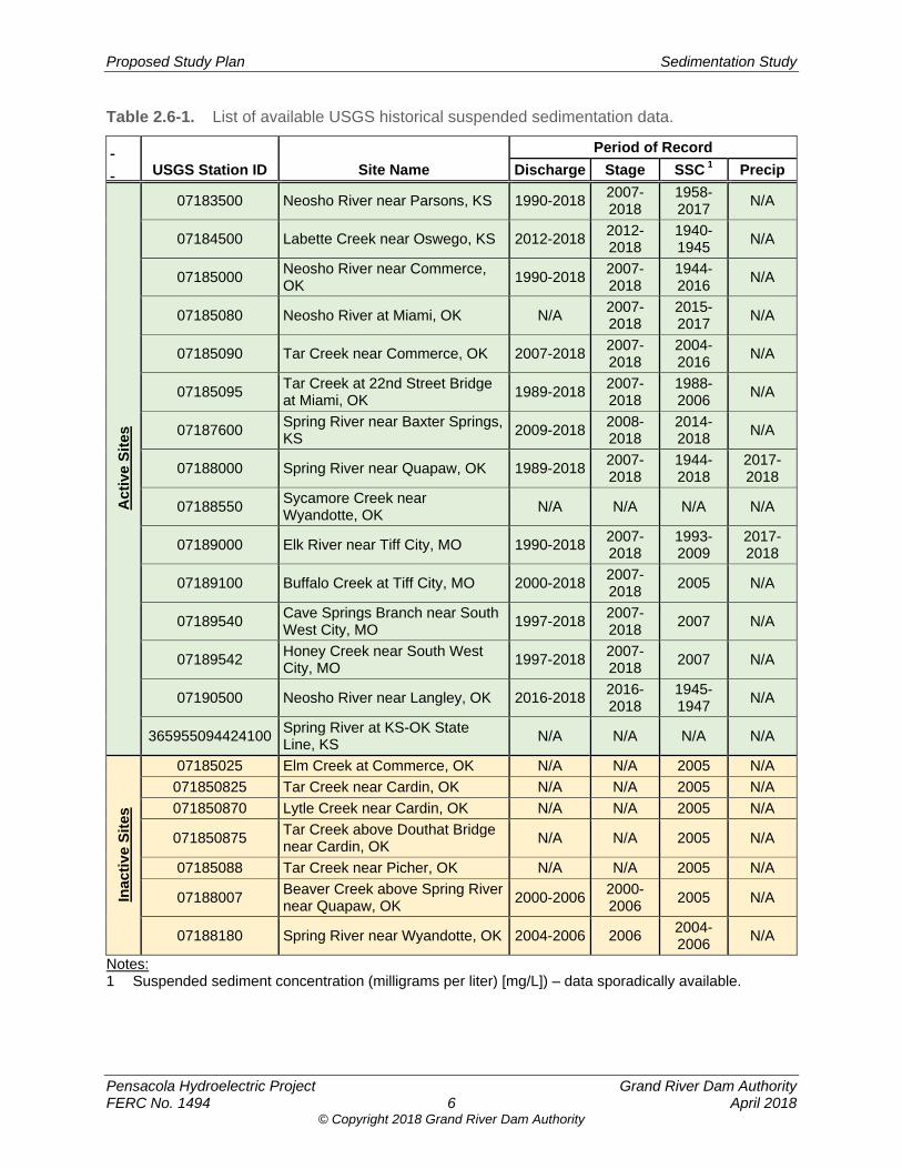
Proposed Study Plan Sedimentation Study
Pensacola Hydroelectric Project Grand River Dam Authority FERC No. 1494 6 April 2018
© Copyright 2018 Grand River Dam Authority
Table 2.6-1. List of available USGS historical suspended sedimentation data.
USGS Station ID Site Name
Period of Record
Discharge Stage SSC 1 Precip
Act
ive
Sit
es
07183500 Neosho River near Parsons, KS 1990-20182007-2018
1958-2017
N/A
07184500 Labette Creek near Oswego, KS 2012-20182012-2018
1940-1945
N/A
07185000 Neosho River near Commerce, OK
1990-20182007-2018
1944-2016
N/A
07185080 Neosho River at Miami, OK N/A 2007-2018
2015-2017
N/A
07185090 Tar Creek near Commerce, OK 2007-20182007-2018
2004-2016
N/A
07185095 Tar Creek at 22nd Street Bridge at Miami, OK
1989-20182007-2018
1988-2006
N/A
07187600 Spring River near Baxter Springs, KS
2009-20182008-2018
2014-2018
N/A
07188000 Spring River near Quapaw, OK 1989-20182007-2018
1944-2018
2017-2018
07188550 Sycamore Creek near Wyandotte, OK
N/A N/A N/A N/A
07189000 Elk River near Tiff City, MO 1990-20182007-2018
1993-2009
2017-2018
07189100 Buffalo Creek at Tiff City, MO 2000-20182007-2018
2005 N/A
07189540 Cave Springs Branch near South West City, MO
1997-20182007-2018
2007 N/A
07189542 Honey Creek near South West City, MO
1997-20182007-2018
2007 N/A
07190500 Neosho River near Langley, OK 2016-20182016-2018
1945-1947
N/A
365955094424100Spring River at KS-OK State Line, KS
N/A N/A N/A N/A
Inac
tive
Sit
es
07185025 Elm Creek at Commerce, OK N/A N/A 2005 N/A
071850825 Tar Creek near Cardin, OK N/A N/A 2005 N/A
071850870 Lytle Creek near Cardin, OK N/A N/A 2005 N/A
071850875 Tar Creek above Douthat Bridge near Cardin, OK
N/A N/A 2005 N/A
07185088 Tar Creek near Picher, OK N/A N/A 2005 N/A
07188007 Beaver Creek above Spring River near Quapaw, OK
2000-20062000-2006
2005 N/A
07188180 Spring River near Wyandotte, OK 2004-2006 2006 2004-2006
N/A
Notes: 1 Suspended sediment concentration (milligrams per liter) [mg/L]) – data sporadically available.
Proposed Study Plan Sedimentation Study
Pensacola Hydroelectric Project Grand River Dam Authority FERC No. 1494 7 April 2018
© Copyright 2018 Grand River Dam Authority
The sedimentation rates and patterns determined from the cross-sectional analysis will be compared to results of recent soil and water assessment tool (SWAT) modeling currently being conducted for GRDA by Parsons. The current SWAT modeling effort is being conducted to evaluate nitrogen and phosphorus loading, but it is suited to estimate the relative contributions of upland shoreline sediment sources. Relative sediment contributions along the river system estimated by the SWAT model will be compared to the spatial erosion and sedimentation cross-section data for potential correlation.
The more commonly occurring flow rates have the greatest effect on how sediment moves through a river system and how the river is shaped. The effective discharge is the flow along a river that transports the most sediment throughout the year. The USGS has SSC data at several locations in the Grand/Neosho River watershed (See also Figure 2.5-1). These data will be correlated with flow to develop regression equations relating suspended sediment discharge with flow upstream of Grand Lake in the Grand/Neosho, Spring, and Elk rivers and Tar Creek. Using daily flow data (and/or flow duration analysis), suspended sediment transport estimates will be developed. An effective discharge analysis will be conducted based on the relationships developed between flow and suspended sediment discharge.
Operational Change Analysis The Comprehensive Hydraulic Model (CHM) that will be a product of the proposed Hydrologic and Hydraulic Modeling Study will be calibrated for lower discharge events, so that it can be utilized to estimate the effects of GRDA’s operations under the FERC license on sediment transport upstream.
The CHM model will then be analyzed under different operational scenarios to determine the relative change in velocities throughout the study area. These relative changes in velocity will be related to sediment transport characteristics to quantify changes to sedimentation patterns under different operational scenarios.
Data Synthesis and Reporting The final step of Study Year One will assimilate the findings from previous documented studies and from the bathymetric data set comparison into an understanding of the sediment transport processes and patterns throughout the study area. Existing data will be used to quantify historic sediment transport rates. These rates could be used to project future sediment loading estimates.
Study Year One deliverables will include a report of findings and associated figures summarizing findings from the literature review, sediment deposition, and erosion patterns. The report will give numerical details of sediment transport and deposition patterns in relevant areas, both spatially and temporally. It will also provide a summary of the relationship between Project operations, sedimentation, and water levels upstream of Grand Lake to inform GRDA’s decision as to whether Study Year Two is warranted. To the extent that significant Project-related sedimentation effects are determined in Study Year One, the study would be extended to Study Year Two as previously described.
Contingent Study Year Two In the event Study Year Two is triggered based on the results of the Study Year One, Study Year Two will incorporate collection and analysis of field data to better quantify effects on water surface elevations due to Project-related sedimentation.
Proposed Study Plan Sedimentation Study
Pensacola Hydroelectric Project Grand River Dam Authority FERC No. 1494 8 April 2018
© Copyright 2018 Grand River Dam Authority
Field Data Collection Study Year Two involves the collection of field data. In addition to the analysis of historic USGS flow and sediment data, developing the relationship between water levels and velocities upstream of Grand Lake in the Grand/Neosho, Spring, and Elk rivers and Tar Creek can allow for greater understanding of sediment transport mechanisms throughout the basin.
Water levels and velocity profiles will provide insight into long-term geomorphic processes at work in the Grand/Neosho River watershed upstream of Grand Lake. Combined with water level data, velocity measurements will provide additional information about long-term sediment transport mechanisms at work. Collecting velocity profile data will inform which size particles are mobilized under different flow conditions and further inform the rate of sediment transport.
ADCP data will be collected to give the velocity distribution across the surveyed cross section. Additionally, this data collection will provide current cross-section bathymetric data that will be used in the cross-section comparison analysis. Water level sensors will also be placed at multiple locations throughout the basin to collect one full year of data. Potential ADCP and water level sensor locations are generally outlined as field monitoring locations in Figure 2.5-1.
During low-flow conditions at riverine locations (and possibly reservoir locations depending on exposure of bed), bed material samples will be collected to determine particle size distribution. Using critical shear analysis and the ADCP velocity data correlated to flow, sediment mobility analyses will be conducted using the sampled particle size distribution.
Supplemental suspended sediment samples will be collected at selected field data locations generally outlined as field monitoring locations in Figure 2.5-1. The exact locations and methodology for their collection will be determined after analysis of the Study Year One data.
ADCP data and suspended sediment sampling will also be conducted over a wide a range of flows to cover the hydrologic range. This would be dependent on hydrologic conditions as they develop over the available time-period for field data collection.
Data Synthesis and Reporting The final step of Study Year Two will assimilate the findings from Study Year One, previous documented studies, bathymetric data set comparison, and physical field measurement surveys into a more in-depth understanding of the sediment transport processes and patterns throughout the study area. Existing and collected data will be used to further quantify historic sediment transport rates. These rates could also be used to further project future sediment loading estimates.
Study deliverables will include a report summarizing the findings of Study Year One and further report on the findings and associated figures summarizing findings from the overall insights and trends developed from the water level and velocity profile analysis and the various components of sediment analysis. The report will give further numerical details of sediment transport and deposition patterns in relevant areas both spatially and temporally to determine whether operation of the Project influences sedimentation and consequently the duration and extent of inundation. Results and all field data will be made available.
Proposed Study Plan Sedimentation Study
Pensacola Hydroelectric Project Grand River Dam Authority FERC No. 1494 9 April 2018
© Copyright 2018 Grand River Dam Authority
2.7 Consistency with Generally Accepted Scientific Practice
The Sedimentation Study follows generally accepted scientific practice. It incorporates the best available information and generally accepted methods. The scope of the study will encompass the major tributaries upstream of Grand Lake in the Grand/Neosho, Spring, and Elk rivers and Tar Creek.
2.8 Schedule The schedule for completion of the Sedimentation Study is displayed in Table 2.8-1.
Table 2.8-1. Sedimentation study schedule.
Task Completion Date
Anticipated Completion of Study Plan Determination Process 09/24/2018
Study Year One (Technical) Report (Initial Study Report) 09/24/2019
Study Year Two (Technical) Report (Updated Study Report) 09/24/2020
2.9 Level of Effort and Cost The estimated cost for completion of Study Year One as outlined in the Methodology section of this study plan is approximately $140,000. The estimated cost for completion of contingent Study Year Two as outlined in the Methodology section of the study plan is approximately $290,000.
3.0 REFERENCES Andrews, W.J., M.F. Becker, S.L. Mashburn, and S.J. Smith. 2009. Selected metals in
sediments and streams in the Oklahoma part of the Tri-State mining district: U.S. Geological Survey Scientific Investigations Report SIR 2009-5032, 36 p.
Dennis, Alan C. 2014. Floodplain Analysis of the Neosho River Associated with Proposed Rule
Curve Modifications for Grand Lake O’ The Cherokees. Submitted in Partial Fulfillment of Master’s Thesis, University of Oklahoma, Norman, Oklahoma.
Dewberry. 2011. USGS Grand Lake, OK LiDAR Project. Prepared for the U.S. Geological
Survey. November, 63 p. FERC (Federal Energy Regulatory Commission). 2018. Scoping Document 1, Pensacola
Hydroelectric Project. January 12, 2018. Ingersoll, C. G., C.D. Ivey, W.G. Brumbaugh, J.M. Besser, N.E. Kemble, and& S. Dudding.
2009. Toxicity assessment of sediments from the Grand Lake O’the Cherokees with the amphipod Hyalella azteca. US Geological Survey Administrative Report CERC-8335-FY09-20-01.
Proposed Study Plan Sedimentation Study
Pensacola Hydroelectric Project Grand River Dam Authority FERC No. 1494 10 April 2018
© Copyright 2018 Grand River Dam Authority
Juracek, K.E., and M.F. Becker. 2009. Occurrence and trends of selected chemical constituents in bottom sediment, Grand Lake O’ the Cherokees, northeast Oklahoma, 1940–2008. U.S. Geological Survey Scientific Investigations Report 2009-5258, 28 p.
Moriasi, D. N., B. N. Wilson, K. R. Douglas-Mankin, J. G. Arnold, and P. H. Gowda. 2012. Hydrologic and water quality models: use, calibration, and validation. Transactions of the ASABE. Vol. 55(4): 1241-1247.
OWRB (Oklahoma Water Resources Board). 2009. Hydrographic Survey of Grand Lake. August 26, 2009.
Smith, D.C. 2016. Occurrence, distribution, and volume of metals-contaminated sediment of selected streams draining the Tri-State Mining District, Missouri, Oklahoma, and Kansas, 2011–12: U.S. Geological Survey Scientific Investigations Report 2016–5144, 86 p., http://dx.doi.org/10.3133/sir20165144.
USACE (U.S. Army Corps of Engineers). 2016. Loss of Flood Storage at Grand Lake: USACE Tulsa District (CESWT-RO) H&H Technical. Reporthttps://elibrary-backup.ferc.gov/idmws/common/OpenNat.asp?fileID=14885870.
USGS (U.S. Geological Survey). 2017. Bathymetric Surveys of the Neosho River, Spring River, and Elk River, Northeastern Oklahoma and Southwestern Missouri, 2016-17. Scientific Investigations Report 2017-5101. Version 1.1, October. U.S. Department of Interior.
© Copyright 2018 Grand River Dam Authority
Pensacola Hydroelectric Project, FERC No. 1494
Proposed Study Plan
Recreation Facilities Inventory and Use Survey
Prepared for
Prepared by
April 2018

© Copyright 2018 Grand River Dam Authority
Proposed Study Plan Recreation Facilities Inventory and Use Survey
Pensacola Hydroelectric Project Grand River Dam Authority FERC No. 1494 i April 2018
© Copyright 2018 Grand River Dam Authority
TABLE OF CONTENTS
1.0 Introduction ..................................................................................................................... 1
2.0 Study Plan Elements ....................................................................................................... 1 2.1 Study Goals and Objectives .................................................................................. 1 2.2 Agency and Native American Tribe Resource Management Goals ...................... 2 2.3 Background and Existing Information .................................................................... 2 2.4 Nexus between Project Operations and Effects on Resources ............................. 3 2.5 Study Area ............................................................................................................. 3 2.6 Methodology .......................................................................................................... 5
2.6.1 Recreation Facility Inventory and Condition Assessment .......................... 5 2.6.2 Recreation Visitor Use Data ...................................................................... 5 2.6.3 Data Analysis and Reporting ..................................................................... 6
2.7 Consistency with Generally Accepted Scientific Practice ...................................... 7 2.8 Schedule ............................................................................................................... 7 2.9 Level of Effort and Cost ......................................................................................... 7
3.0 References ....................................................................................................................... 8
APPENDICES
Appendix A. Facility Inventory and Condition Form Appendix B. Visitor Use Survey Questionnaire
LIST OF TABLES
Table 2.3-1. FERC-approved recreation facilities on Grand Lake. ............................................ 3
Table 2.6-1. Visitor use survey schedule. .................................................................................. 6
LIST OF FIGURES
Figure 2.5-1. Recreation facilities and access sites at the Pensacola Project. ........................... 4
Proposed Study Plan Recreation Facilities Inventory and Use Survey
Pensacola Hydroelectric Project Grand River Dam Authority FERC No. 1494 ii April 2018
© Copyright 2018 Grand River Dam Authority
LIST OF ACRONYMS
ADA ........................... Americans with Disabilities Act
FERC ........................ Federal Energy Regulatory Commission
GRDA ........................ Grand River Dam Authority
ILP ............................. Integrated Licensing Process
OTRD ........................ Oklahoma Tourism and Recreation Department
PAD ........................... Pre-Application Document
PD ............................. Pensacola datum
PM&E ........................ protection, mitigation and enhancement
Project ....................... Pensacola Hydroelectric Project
RMP .......................... Recreation Management Plan
SCORP ..................... Statewide Comprehensive Outdoor Recreation Plan
SD1 ........................... Scoping Document 1
SMP .......................... Shoreline Management Plan
USFS ........................ U.S. Forest Service
USFWS ..................... U.S. Fish and Wildlife Service
Proposed Study Plan Recreation Facilities Inventory and Use Survey
Pensacola Hydroelectric Project Grand River Dam Authority FERC No. 1494 1 April 2018
© Copyright 2018 Grand River Dam Authority
1.0 INTRODUCTION Project operations at the Pensacola Hydroelectric Project (Pensacola Project or Project; FERC No. 1494), specifically of Grand Lake, have the potential to affect public access and recreation opportunities in the Project Boundary. Grand River Dam Authority (GRDA) operates and maintains five Federal Energy Regulatory Commission (FERC)-approved recreation facilities in accordance with the current license, as outlined in the Recreation Management Plan (RMP; GRDA 1997) required by license Article 407. An up-to-date inventory and condition assessment of existing Project recreation areas and user surveys will be helpful in understanding current recreation use and future recreation facility needs.
GRDA filed a Pre-Application Document (PAD) with the FERC on February 1, 2017, as part of the relicensing of the Project. In Section 7 of the PAD, GRDA identified a Recreation Facilities Inventory and Use Survey as a proposed study to characterize recreation resources within the Project Boundary. FERC’s January 12, 2018, Scoping Document 1 (SD1) identified the following environmental resource issues related to recreation to be analyzed for the Project relicensing:
Whether existing facilities and public access are adequate to meet current and futurerecreation demand;
Effects of Project operation (reservoir fluctuation) on access to existing recreationfacilities; and
Adequacy of the existing Recreation Management Plan to manage development and useof the Project’s recreation facilities.
No recreation study requests or comments were received from relicensing participants.
2.0 STUDY PLAN ELEMENTS
2.1 Study Goals and Objectives The goals of this study are to gather information regarding current recreational use, and identify recreation resources and activities that may be affected by the continued operation of the Project. Consistent with FERC’s study request, the specific objectives of the study are to:
Characterize current recreational use of the Project area;
Estimate future demand for public recreation use at the Project;
Gather information on the condition of recreation facilities and identify any need forimprovement; and
Evaluate the potential effects of continued operation of the Project on recreationresources and access in the Project area.
Proposed Study Plan Recreation Facilities Inventory and Use Survey
Pensacola Hydroelectric Project Grand River Dam Authority FERC No. 1494 2 April 2018
© Copyright 2018 Grand River Dam Authority
2.2 Agency and Native American Tribe Resource Management Goals
The Oklahoma Tourism and Recreation Department (OTRD) promotes the development and operation of tourism and recreation opportunities throughout the State. The OTRD uses the Oklahoma Statewide Comprehensive Outdoor Recreation Plan (SCORP) as a planning tool to assist in preserving, developing, and assuring accessibility to outdoor recreation resources (OTRD 2012).
2.3 Background and Existing Information Section 6.7 of the PAD describes existing information about recreation facilities and opportunities in the Project area. The Project’s Grand Lake is the premier recreational lake in northeast Oklahoma (FERC 2014). Bass fishing is very popular and draws both local and out-of-state anglers to the area. Public recreation facilities at Grand Lake are available at facilities owned and operated by GRDA and others, including five state parks around the shoreline and at more than a dozen privately operated facilities. Together, these facilities offer numerous boat launches, marinas, tailwater fishing facilities, and fishing piers available to the public, as well as several wildlife areas, two visitor centers, several public overlooks, and one golf course. In addition, there are many popular, unimproved sites that can be used to access Grand Lake to launch boats, fish, and swim. There are also many campgrounds on Grand Lake providing tent, trailer, and recreational vehicle sites.
Development along the shoreline adjacent to Grand Lake primarily consists of residential, light commercial and business, and limited agricultural lands. Grand Lake is a popular location for recreation and residential development, particularly summer homes, due in part to the scenic quality of the reservoir and surrounding landscape, recreational fishing, and proximity to major population centers in Oklahoma, Kansas, Missouri, and Arkansas (GRDA 2008). Although lands adjacent to Grand Lake are mostly privately owned, GRDA owns title along the shoreline and has authority to prescribe and enforce rules and regulations for commercial and recreational use of the lake. GRDA manages the shoreline of the Project in accordance with its Shoreline Management Plan (SMP) and operates a lake patrol to enforce boating regulations. The SMP serves as a planning tool to guide GRDA in the protection and enhancement of the Project’s environmental, recreational, and other values. Since 1992, over 2,600 private and 120 commercial boat docks have been permitted on Grand Lake1.
The Project is located in the Ozark Plateau’s Grand River lake region, which provides a host of recreational activities, including fishing, hunting, boating, hiking, camping, biking, rock climbing, cave exploration, and off-highway vehicles activities. Tourism is the stimulus for recreational developments in the region including resorts, campgrounds, lake marinas, vacation homes, and associated support services (USFWS 2002).
Grand Lake is a popular recreation spot for local residents and tourists. Although some recreational activities such as boating take place year-round on Grand Lake, the primary recreation season typically spans May 1 through September 30. Recreational opportunities and activities at the Project include sailing, fishing, rafting (tying together of two or more anchored
1 FERC - 75 FERC, 59 FERC ¶62,073, Grand River Dam Authority, Project No. 1494-002 - Oklahoma, Federal Energy Regulatory Commission, (Apr. 24, 1992)
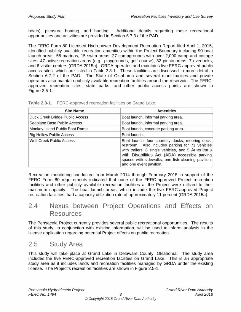
Proposed Study Plan Recreation Facilities Inventory and Use Survey
Pensacola Hydroelectric Project Grand River Dam Authority FERC No. 1494 3 April 2018
© Copyright 2018 Grand River Dam Authority
boats), pleasure boating, and hunting. Additional details regarding these recreational opportunities and activities are provided in Section 6.7.3 of the PAD. The FERC Form 80 Licensed Hydropower Development Recreation Report filed April 1, 2015, identified publicly available recreation amenities within the Project Boundary including 90 boat launch areas, 58 marinas, 15 swim areas, 27 campgrounds with over 2,000 camp and cottage sites, 47 active recreation areas (e.g., playgrounds, golf course), 32 picnic areas, 7 overlooks, and 6 visitor centers (GRDA 2015b). GRDA operates and maintains five FERC-approved public access sites, which are listed in Table 2.3-1. These facilities are discussed in more detail in Section 6.7.2 of the PAD. The State of Oklahoma and several municipalities and private operators also maintain publicly available recreation facilities around the reservoir. The FERC-approved recreation sites, state parks, and other public access points are shown in Figure 2.5-1.
Table 2.3-1. FERC-approved recreation facilities on Grand Lake.
Site Name Amenities
Duck Creek Bridge Public Access Boat launch, informal parking area.
Seaplane Base Public Access Boat launch, informal parking area.
Monkey Island Public Boat Ramp Boat launch, concrete parking area.
Big Hollow Public Access Boat launch.
Wolf Creek Public Access Boat launch, four courtesy docks, mooring dock, restroom. Also includes parking for 71 vehicles with trailers, 8 single vehicles, and 5 Americans with Disabilities Act (ADA) accessible parking spaces with sidewalks, one fish cleaning pavilion, and one event pavilion.
Recreation monitoring conducted from March 2014 through February 2015 in support of the FERC Form 80 requirements indicated that none of the FERC-approved Project recreation facilities and other publicly available recreation facilities at the Project were utilized to their maximum capacity. The boat launch areas, which include the five FERC-approved Project recreation facilities, had a capacity utilization rate of approximately 11 percent (GRDA 2015a).
2.4 Nexus between Project Operations and Effects on Resources
The Pensacola Project currently provides several public recreational opportunities. The results of this study, in conjunction with existing information, will be used to inform analysis in the license application regarding potential Project effects on public recreation.
2.5 Study Area This study will take place at Grand Lake in Delaware County, Oklahoma. The study area includes the five FERC-approved recreation facilities on Grand Lake. This is an appropriate study area as it includes lands and recreation facilities managed by GRDA under the existing license. The Project’s recreation facilities are shown in Figure 2.5-1.
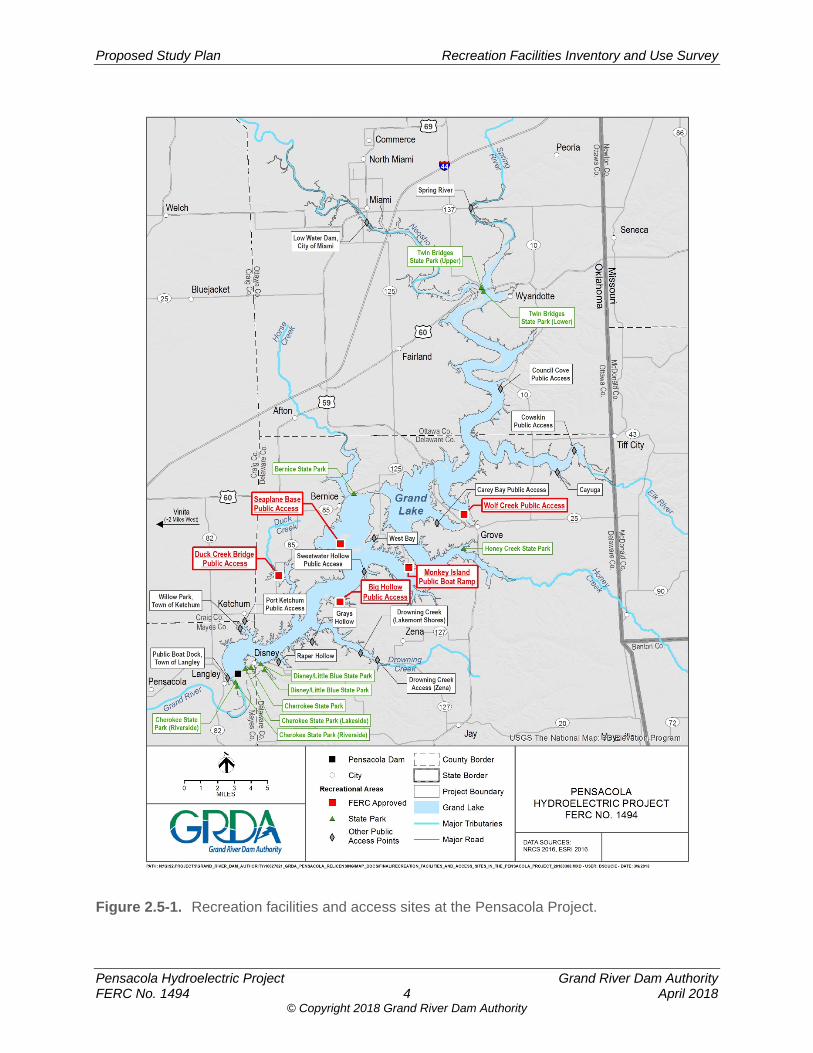
Proposed Study Plan Recreation Facilities Inventory and Use Survey
Pensacola Hydroelectric Project Grand River Dam Authority FERC No. 1494 4 April 2018
© Copyright 2018 Grand River Dam Authority
Figure 2.5-1. Recreation facilities and access sites at the Pensacola Project.
Proposed Study Plan Recreation Facilities Inventory and Use Survey
Pensacola Hydroelectric Project Grand River Dam Authority FERC No. 1494 5 April 2018
© Copyright 2018 Grand River Dam Authority
2.6 Methodology
2.6.1 Recreation Facility Inventory and Condition Assessment
Information will be collected for each of the FERC-approved recreation areas listed in Table 2.3-1 using a Facilities Inventory and Condition Form (provided in Appendix A). GRDA will record the following information for each recreational facility including:
A description of the type and location of existing recreation facilities;
The type of recreation provided (boat access, angler access, picnicking, etc.);
Existing facilities and sanitation;
The type of vehicular access and parking (if any);
Suitability of facilities to provide recreational opportunities and access for persons withdisabilities (i.e., compliance with current ADA standards for accessible design); and
Photographic documentation of recreation facilities.
Additionally, a qualitative assessment of the condition of the recreation facilities will be performed. Site conditions at state- or privately-owned commercial facilities will not be assessed. Using the Facilities Inventory and Condition Form, the recreation amenities available at each recreation facility will be rated using the following criteria: (N) Needs replacement (broken or missing components, or non-functional); (R) Needs repair (structural damage or otherwise in obvious disrepair); (M) Needs maintenance (ongoing maintenance issue, primarily cleaning); and (G) Good condition (functional and well-maintained). If a facility is given a rating of “N”, “R”, or “M”, an explanation for the rating will be provided. The age of the facilities and signs of overuse will also be noted.
2.6.2 Recreation Visitor Use Data
GRDA will collect visitor use data at Project recreation facilities through a combination of in-person surveys, field reconnaissance, and photo documentation. GRDA will conduct field reconnaissance and interviews with respondents at the following Project recreation facilities during the prime recreational season from May 2019 through September 2019:
Duck Creek Bridge Public Access;
Seaplane Base Public Access;
Monkey Island Public Boat Ramp;
Big Hollow Public Access; and
Wolf Creek Public Access.
Surveys will begin at 8:00 AM and continue until 6:00 PM to capture a range of recreational activities throughout the day. GRDA intends to conduct surveys pursuant to the schedule presented in Table 2.6-1.
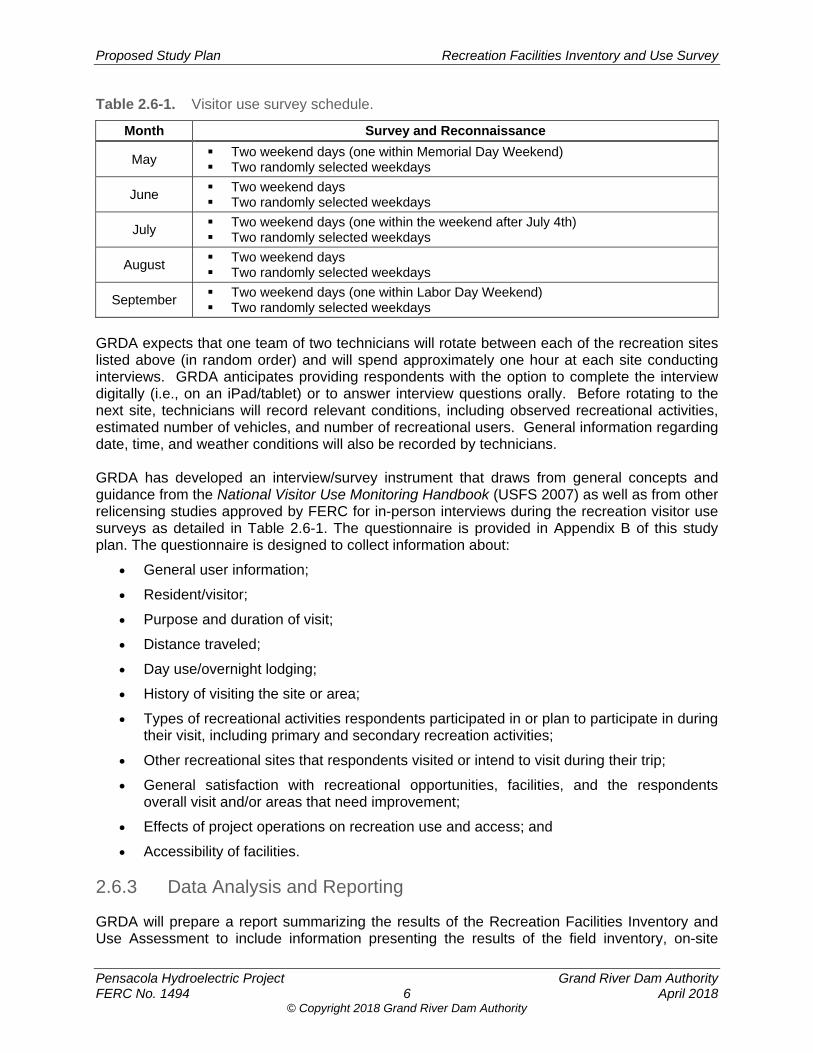
Proposed Study Plan Recreation Facilities Inventory and Use Survey
Pensacola Hydroelectric Project Grand River Dam Authority FERC No. 1494 6 April 2018
© Copyright 2018 Grand River Dam Authority
Table 2.6-1. Visitor use survey schedule.
Month Survey and Reconnaissance
May Two weekend days (one within Memorial Day Weekend) Two randomly selected weekdays
June Two weekend days Two randomly selected weekdays
July Two weekend days (one within the weekend after July 4th) Two randomly selected weekdays
August Two weekend days Two randomly selected weekdays
September Two weekend days (one within Labor Day Weekend) Two randomly selected weekdays
GRDA expects that one team of two technicians will rotate between each of the recreation sites listed above (in random order) and will spend approximately one hour at each site conducting interviews. GRDA anticipates providing respondents with the option to complete the interview digitally (i.e., on an iPad/tablet) or to answer interview questions orally. Before rotating to the next site, technicians will record relevant conditions, including observed recreational activities, estimated number of vehicles, and number of recreational users. General information regarding date, time, and weather conditions will also be recorded by technicians. GRDA has developed an interview/survey instrument that draws from general concepts and guidance from the National Visitor Use Monitoring Handbook (USFS 2007) as well as from other relicensing studies approved by FERC for in-person interviews during the recreation visitor use surveys as detailed in Table 2.6-1. The questionnaire is provided in Appendix B of this study plan. The questionnaire is designed to collect information about:
General user information;
Resident/visitor;
Purpose and duration of visit;
Distance traveled;
Day use/overnight lodging;
History of visiting the site or area;
Types of recreational activities respondents participated in or plan to participate in during their visit, including primary and secondary recreation activities;
Other recreational sites that respondents visited or intend to visit during their trip;
General satisfaction with recreational opportunities, facilities, and the respondents overall visit and/or areas that need improvement;
Effects of project operations on recreation use and access; and
Accessibility of facilities.
2.6.3 Data Analysis and Reporting
GRDA will prepare a report summarizing the results of the Recreation Facilities Inventory and Use Assessment to include information presenting the results of the field inventory, on-site
Proposed Study Plan Recreation Facilities Inventory and Use Survey
Pensacola Hydroelectric Project Grand River Dam Authority FERC No. 1494 7 April 2018
© Copyright 2018 Grand River Dam Authority
interviews and field reconnaissance, and representative photographs of the recreation facilities. GRDA anticipates that the Recreation Facilities Inventory and Use Assessment Report will include the following elements:
Project Introduction and Background
Study Objectives
Study Area
Methodology
Study Results
Discussion and Analysis
Variances from FERC-approved Study Plan and Proposed Modifications
Location maps and photos
Any agency correspondence and or consultation
References
The results of the Recreation Facilities Inventory and Use Assessment will be used to describe existing public access and use of the Project and evaluate the potential effects of continued operation of the Project on recreation resources and activities in the Project area; and identify potential PM&E measures that could be implemented to enhance recreation or mitigate project effects on recreation in the Preliminary Licensing Proposal/Draft License Application and Final License Application, as appropriate.
2.7 Consistency with Generally Accepted Scientific Practice
The methods for this study are consistent with accepted professional practices such as those provided in the U.S. Forest Service’s National Visitor Use Monitoring Program (July 2007). The overall approach is commonly used in relicensing proceedings and is consistent with generally accepted methods for recreation studies and analytical techniques used by federal and state agencies. In addition, the proposed methods for this study are consistent with FERC study requirements under the Integrated Licensing Process (ILP).
2.8 Schedule This study plan is anticipated to be finalized in late 2018. At this time, GRDA intends to conduct the Recreation Facilities Inventory and Use Assessment Study from May 2019 through September 2019. Upon completion of field work, the data will be analyzed and a final study report will be included as part of the Initial Study Report.
2.9 Level of Effort and Cost This estimated level of effort for this study is approximately 570 man-hours. The estimated cost of this study is expected to be approximately $ 75,000.
Proposed Study Plan Recreation Facilities Inventory and Use Survey
Pensacola Hydroelectric Project Grand River Dam Authority FERC No. 1494 8 April 2018
© Copyright 2018 Grand River Dam Authority
3.0 REFERENCES
FERC (Federal Energy Regulatory Commission). 2014. Draft Environmental Assessment for Hydropower License Salina Pumped Storage Project – FERC Project No. 2524-021 Oklahoma. November 2014.
GRDA (Grand River Dam Authority). 1997. Grand Lake O’ The Cherokees Recreation Management Plan Pensacola Hydroelectric Project FERC Project No. 1494-002. Vinita, OK.
GRDA. 2008. Shoreline Management Plan. Pensacola Hydroelectric Project FERC No. 1494. June 2008.
GRDA. 2015a. Pensacola Hydroelectric Project FERC Form 80. April 2015.
GRDA. 2015b. Pensacola Hydroelectric Project Public Recreation Management Plan Monitoring Report. April 2015.
OTRD (Oklahoma Tourism and Recreation Department). 2012. Statewide Comprehensive Outdoor Recreation Plan 2013 – 2017. November 2012.
USFS (U.S. Forest Service). 2007. National Visitor Use Monitoring Handbook. National Visitor Use Monitoring Program, U.S. Forest Service, Washington, D.C.
USFWS (U.S. Fish and Wildlife Service). 2002. Ozark plateau national wildlife refuge proposed refuge expansion environmental assessment. September 2002. [Online]. URL: http://www.fws.gov/southwest/refuges/oklahoma/Ozark/ (Accessed September 16, 2010).
Proposed Study Plan Recreation Facilities Inventory and Use Survey
Pensacola Hydroelectric Project Grand River Dam Authority FERC No. 1494 April 2018
© Copyright 2018 Grand River Dam Authority
APPENDIX A. FACILITY INVENTORY AND CONDITION FORM

Proposed Study Plan Recreation Facilities Inventory and Use Survey
Pensacola Hydroelectric Project Grand River Dam Authority FERC No. 1494 April 2018
© Copyright 2018 Grand River Dam Authority
[This page intentionally left blank.]
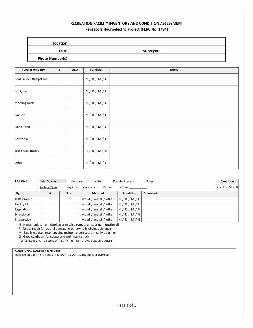
Page 1 of 1
RECREATION FACILITY INVENTORY AND CONDITION ASSESSMENT
Pensacola Hydroelectric Project (FERC No. 1494)
Location:
Date: Surveyor:
Photo Number(s):
Type of Amenity # ADA Condition Notes
Boat Launch Ramp/Lane N / R / M / G
Dock/Pier N / R / M / G
Mooring Dock N / R / M / G
Pavilion N / R / M / G
Picnic Table N / R / M / G
Restroom N / R / M / G
Trash Receptacles N / R / M / G
Other N / R / M / G
PARKING Total Spaces: _____ Standard: _____ ADA: _____ Double (trailer): _____ Other: _____ Condition
Surface Type: Asphalt Concrete Gravel Other:___________ N / R / M / G
Signs # Size Material Condition Comments
FERC Project wood / metal / other N / R / M / G
Facility ID wood / metal / other N / R / M / G
Regulations wood / metal / other N / R / M / G
Directional wood / metal / other N / R / M / G
Interpretive wood / metal / other N / R / M / G
N ‐ Needs replacement (broken or missing components, or non‐functional) R ‐ Needs repair (structural damage or otherwise in obvious disrepair) M ‐ Needs maintenance (ongoing maintenance issue, primarily cleaning) G ‐ Good condition (functional and well‐maintained) If a facility is given a rating of “N”, “R”, or “M”, provide specific details.
ADDITIONAL COMMENTS/NOTES: Note the age of the facilities (if known) as well as any signs of overuse.

Proposed Study Plan Recreation Facilities Inventory and Use Survey
Pensacola Hydroelectric Project Grand River Dam Authority FERC No. 1494 April 2018
© Copyright 2018 Grand River Dam Authority
APPENDIX B. VISITOR USE SURVEY QUESTIONNAIRE

Proposed Study Plan Recreation Facilities Inventory and Use Survey
Pensacola Hydroelectric Project Grand River Dam Authority FERC No. 1494 April 2018
© Copyright 2018 Grand River Dam Authority
[This page intentionally left blank.]

Page 1 of 4
ON‐SITE/IN‐PERSON RECREATION INTERVIEW
Pensacola Hydroelectric Project (FERC No. 1494)
Grand River Dam Authority (GRDA) is the licensee, owner, and operator of the 120 megawatt (MW) Pensacola
Hydroelectric Project (Project or Pensacola Project) which is licensed by the Federal Energy Regulatory Commission
(FERC). The five FERC‐approved recreation facilities associated with the Project are all located along the Project’s
reservoir, Grand Lake. The current operating license for the Project was issued on April 24, 1992, and expires on
March 31, 2022. GRDA must file its application with FERC for a new license no later than March 31, 2020. As part
of the relicensing process, GRDA is conducting studies on environmental resources to enable FERC to prepare an
environmental document. The purpose of this survey is to collect information about use of the Project’s five FERC‐
approved recreation facilities.
Interview Location:
Duck Creek Bridge Public Access□ Seaplane Base Public Access□ Big Hollow Public Access□ Monkey Island Public Boat Ramp□ Wolf Creek Public Access□
Home Zip Code: Date:
Time:
Are you: Male □ Female □ Prefer not to answer □Interviewer:
Q‐1. Regarding the Grand Lake area, do you consider yourself: (Please circle one)
1. A regular visitor to this area (3 or more times per year)
2. An occasional visitor (1‐2 times per year)
3. An infrequent visitor (Less than 1 time per year)
4. This is my first visit
Q‐2. On this trip to the Grand Lake area, when did you arrive?
Arrival Date Arrival Time
_____/_____/_____ ____________AM/PM
When do you expect to leave the Grand Lake area?
Departure Date Departure Time
_____/_____/_____ ____________AM/PM
Q‐3. During the last 12 months (including this trip), which month(s) did you visit the Grand Lake area? (Please
select all that apply)
Jan □ Feb □ Mar □ Apr □ May □ Jun □ Jul □ Aug □ Sep □ Oct □ Nov □ Dec □

Page 2 of 4
Q‐4. Which of the following recreation areas at or near Grand Lake did you visit for recreation during the past
12 months? (Please select all that apply)
□ Duck Creek Bridge Public Access
□ Seaplane Base Public Access
□ Big Hollow Public Access
□ Monkey Island Public Boat Ramp
□ Wolf Creek Public Access
□ None of the above
□ Other (Please list)
______________________________________________________________________________________
______________________________________________________________________________________
Q‐5. About how many miles did you travel to get to the Grand Lake area?
A. _________miles
Q‐6. Are you staying overnight in the Grand Lake area (not including at your own home) on this trip?
1. Yes 2. No
Q‐7. If you answered yes to Q‐6, at what type of accommodations will you be staying? (Please select one)
1. RV/Auto/Tent Campground
2. Motel/hotel
3. Bed and Breakfast
4. Vacation or rental home
5. Other (Please specify: __________________________________________________)
Q‐8. How many people (including you) are in your group?
A. _____________people
Q‐9. Which of the following best describes your group during this trip?
1. Individual
2. Adult group (over 21)
3. Youth group (under 21)
4. Family (with children)
5. Mixed group (families and friends of various ages)
Q‐10. On this trip to the Grand Lake area, in which of the following activities have you or do you expect to
participate? (Please select all that apply)
1. Bank fishing 5. Picnicking 8. Hunting
2. Boat fishing 6. Swimming 9. Rafting
3. Pleasure Boating 7. Sight‐seeing 10. Other (please describe)
4. Personal watercraft
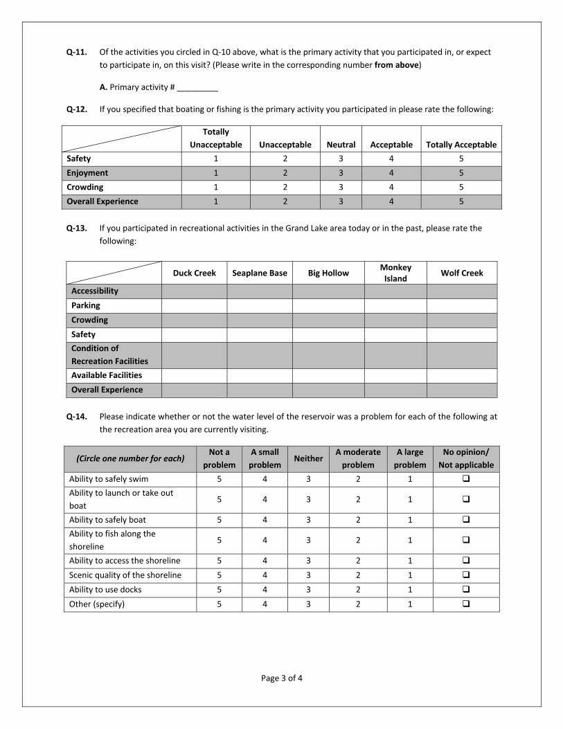
Page 3 of 4
Q‐11. Of the activities you circled in Q‐10 above, what is the primary activity that you participated in, or expect
to participate in, on this visit? (Please write in the corresponding number from above)
A. Primary activity # _________
Q‐12. If you specified that boating or fishing is the primary activity you participated in please rate the following:
Totally
Unacceptable Unacceptable Neutral Acceptable Totally Acceptable
Safety 1 2 3 4 5
Enjoyment 1 2 3 4 5
Crowding 1 2 3 4 5
Overall Experience 1 2 3 4 5
Q‐13. If you participated in recreational activities in the Grand Lake area today or in the past, please rate the
following:
Duck Creek Seaplane Base Big Hollow Monkey Island
Wolf Creek
Accessibility
Parking
Crowding
Safety
Condition of
Recreation Facilities
Available Facilities
Overall Experience
Q‐14. Please indicate whether or not the water level of the reservoir was a problem for each of the following at
the recreation area you are currently visiting.
(Circle one number for each) Not a
problem
A small
problem Neither
A moderate
problem
A large
problem
No opinion/
Not applicable
Ability to safely swim 5 4 3 2 1
Ability to launch or take out
boat 5 4 3 2 1
Ability to safely boat 5 4 3 2 1
Ability to fish along the
shoreline 5 4 3 2 1
Ability to access the shoreline 5 4 3 2 1
Scenic quality of the shoreline 5 4 3 2 1
Ability to use docks 5 4 3 2 1
Other (specify) 5 4 3 2 1

Page 4 of 4
Q‐15. Please share any other comments that you have regarding recreation on Grand Lake near the Pensacola
Project:________________________________________________________________________________
______________________________________________________________________________________
______________________________________________________________________________________
______________________________________________________________________________
______________________________________________________________________________
______________________________________________________________________________
______________________________________________________________________________
______________________________________________________________________________
______________________________________________________________________________
Thank you for completing the Recreation Survey!
© Copyright 2018 Grand River Dam Authority
Pensacola Hydroelectric Project, FERC No. 1494
Proposed Study Plan
Cultural Resources Study
Prepared for
Prepared by
April 2018

© Copyright 2018 Grand River Dam Authority
Proposed Study Plan Cultural Resources Study
Pensacola Hydroelectric Project Grand River Dam Authority FERC No. 1494 i April 2018
© Copyright 2018 Grand River Dam Authority
TABLE OF CONTENTS
1.0 Introduction ..................................................................................................................... 1
2.0 Study Plan Elements ....................................................................................................... 2 2.1 Study Goals and Objectives .................................................................................. 2 2.2 Agency and Native American Tribe Resource Management Goals ...................... 3 2.3 Background and Existing Information .................................................................... 4 2.4 Nexus between Project Operations and Effects on Resources ............................. 5 2.5 Area of Potential Effects ........................................................................................ 5 2.6 Methodology .......................................................................................................... 7
2.6.1 Area of Potential Effects ............................................................................ 7 2.6.2. Background Research and Archival Review .............................................. 7 2.6.3 Pre-fieldwork Report .................................................................................. 8 2.6.4 Reconnaissance Surveys .......................................................................... 8 2.6.5 Traditional Cultural Properties ................................................................. 10 2.6.6 Programmatic Agreement ........................................................................ 10 2.6.7 Historic Properties Management Plan ..................................................... 10
2.7 Consistency with Generally Accepted Scientific Practice .................................... 12 2.8 Schedule ............................................................................................................. 12 2.9 Level of Effort and Cost ....................................................................................... 12
3.0 References ..................................................................................................................... 13
APPENDICES
Appendix A. Oklahoma Archaeological Site Survey Form Appendix B. Isolated Find Form Appendix C. Historic Preservation Resource Identification Form
LIST OF FIGURES
Figure 2.5-1. Proposed Area of Potential Effects. ...................................................................... 6
Proposed Study Plan Cultural Resources Study
Pensacola Hydroelectric Project Grand River Dam Authority FERC No. 1494 ii April 2018
© Copyright 2018 Grand River Dam Authority
LIST OF ACRONYMS
ACHP ........................ Advisory Council on Historic Preservation
APE ........................... Area of Potential Effects
BIA ............................ Bureau of Indian Affairs
C.F.R. ........................ Code of Federal Regulations
CRWG ....................... Cultural Resources Working Group
FERC ........................ Federal Energy Regulatory Commission
FLA ........................... Final License Application
FR ............................. Federal Register
GRDA ........................ Grand River Dam Authority
HPMP ........................ Historic Properties Management Plan
ILP ............................. Integrated Licensing Process
ISR ............................ Initial Study Report
NAGPRA ................... Native American Graves Protection and Repatriation Act
NAVD ........................ North American Vertical Datum
NEPA ........................ National Environmental Policy Act
NGVD ........................ National Geodetic Vertical Datum
NHPA ........................ National Historic Preservation Act
NOI ............................ Notice of Intent
NRHP ........................ National Register of Historic Places
OAS .......................... Oklahoma Archaeological Survey
OLI ............................ Oklahoma Landmarks Inventory
PA ............................. Programmatic Agreement
PAD ........................... Pre-Application Document
PD ............................. Pensacola datum
P.L. ............................ Public Law
Project ....................... Pensacola Hydroelectric Project
PSP ........................... Proposed Study Plan
SD1 ........................... Scoping Document 1
SHPO ........................ State Historic Preservation Officer
TCP ........................... traditional cultural properties
THPO ........................ Tribal Historic Preservation Officer
U.S.C. ....................... U.S. Code
USGS ........................ U.S. Geological Survey
USR .......................... Updated Study Report
WPA .......................... Works Progress Administration
Proposed Study Plan Cultural Resources Study
Pensacola Hydroelectric Project Grand River Dam Authority FERC No. 1494 1 April 2018
© Copyright 2018 Grand River Dam Authority
1.0 INTRODUCTION The Grand River Dam Authority (GRDA) filed a Pre-Application Document (PAD) with the Federal Energy Regulatory Commission (FERC) on February 1, 2017 as part of the relicensing of the Pensacola Hydroelectric Project (Pensacola Project or Project; FERC No. 1494). In Section 7 of the PAD, GRDA identified a Cultural Resources Study as a proposed study or information gathering activity necessary to characterize archaeological and historic resources and historic properties of traditional religious and cultural importance within the Project’s Area of Potential Effects (APE). FERC’s January 12, 2018 Scoping Document 1 (SD1) identified the following environmental resource issues to be analyzed for the Project relicensing:
Effects of the Project operation and maintenance on historic and archeological resourcesthat may be eligible for inclusion in the National Register of Historic Places (NRHP orNational Register).
Effects of Project operation and maintenance on properties of traditional religious andcultural importance to Native American Tribes.
In SD1, FERC indicated its intent to analyze the resource issues above for both cumulative and site-specific effects. The Commission has tentatively defined the geographic scope for cultural resources at the Grand Lake Reservoir to elevation 760 feet Pensacola datum (PD),1 as well as any adjacent upland areas that are periodically inundated.
The Oklahoma Archeological Survey (OAS), Cherokee Nation, and Miami Tribe of Oklahoma (as supported by the City of Miami, Eastern Shawnee Tribe, Seneca-Cayuga Nation, Wyandotte Nation, and Ottawa Tribe) subsequently submitted formal requests related to cultural resources.2 Sections 4.1.3 and 4.2.3 of the main body of the Proposed Study Plan (PSP) details GRDA’s response to the requests.
1 Unless otherwise noted, all elevations referenced are relative to PD. PD elevations can be converted to National Geodetic Vertical Datum of 1929 (NGVD) by adding 1.07 feet and to North American Vertical Datum of 1988 (NAVD) by adding 1.40 feet (for example, elevation 745 feet PD = 746.07 feet NGVD = 746.4 feet NAVD88)(http://ok.water.usgs.gov/projects/webmap/miami/datum.htm). 2 During PSP development, GRDA conducted early outreach to a number of relicensing participants to discuss foundational concepts of the proposed Cultural Resources Study Plan. These stakeholders include the Cherokee Nation, Bureau of Indian Affairs (BIA), U.S. Department of the Interior’s Solicitor’s Office, Miami Tribe of Oklahoma, Osage Nation, OAS, and Oklahoma State Historic Preservation Officer. GRDA appreciated the engagement and cooperation of these stakeholders.
Proposed Study Plan Cultural Resources Study
Pensacola Hydroelectric Project Grand River Dam Authority FERC No. 1494 2 April 2018
© Copyright 2018 Grand River Dam Authority
2.0 STUDY PLAN ELEMENTS
2.1 Study Goals and Objectives The goals of the Cultural Resources Study are: (1) to identify historic properties3 within the Project’s APE that are being adversely affected by Project operations (if any), including properties of traditional religious and cultural importance; and (2) to develop an Historic Properties Management Plan (HPMP) in consultation with the Oklahoma State Historic Preservation Officer (SHPO), OAS, and Native American Tribes4, that provides for the long-term management of historic properties within the APE over the term of the new license. The primary objectives for meeting these goals are:
Consult with Commission staff, the Oklahoma SHPO, OAS, Native American tribes, Bureau of Indian Affairs (BIA) and other identified parties (collectively, the “Cultural Resources Working Group” or “CRWG”) to determine the Project’s APE.
Conduct background research and an archival review.
Prepare a Pre-fieldwork Report based on the results of the background literature and archival review.
Consult with the CRWG to identify and target appropriate areas of the APE for field investigation during Project relicensing.
During Study Years One and Two, conduct field investigations to include a Phase I Reconnaissance Survey (Reconnaissance Survey) of targeted areas which would include a visual inspection and the excavation of limited shovel tests. If sites are identified, delineate in the field.
Following Study Year One, prepare a Reconnaissance Survey Report as part of the Initial Study Report (ISR) that provides study results and recommendations for identified archaeological resources and/or additional investigations, as necessary. Following Study Year Two, prepare the same report as part of the Updated Study Report (USR) for the sites identified during the Study Year Two investigation.
Determine appropriate management measures for identified resources and the need for additional resource investigations in consultation with the CRWG.
Develop an HPMP in consultation with the CRWG to provide appropriate measures for the management of historic properties within the Project’s APE through the term of the new license. The HPMP would be prepared during the Integrated Licensing Process
3 For purposes of this Cultural Resources Study Plan, the term “historic properties” will have the same definition as the regulations of the Advisory Council on Historic Preservation (36 C.F.R. § 800.16(l)). 4 FERC has identified the following Native American Tribes as consulting parties for this undertaking: Alabama-Quassarte Tribal Town, Apache Tribe of Oklahoma, Caddo Nation of Oklahoma, Cherokee Nation, Delaware Nation, Delaware Tribe of Indians, Eastern Shawnee Tribe of Oklahoma, Iowa Tribe of Oklahoma, Kiowa Tribe of Oklahoma, Little Traverse Bay Bands of Odawa Indians, Miami Tribe of Oklahoma, Modoc Tribe of Oklahoma, Muscogee (Creek) Nation, Osage Nation, Otoe-Missouria Tribe of Indians, Ottawa Tribe of Oklahoma, Peoria Tribe of Oklahoma, Quapaw Tribe of Oklahoma, Sac and Fox Nation of Oklahoma, Seneca-Cayuga Nation, Shawnee Tribe of Oklahoma, Tonkawa Tribe of Oklahoma, United Keetoowah Band of Cherokees, Wichita and Affiliated Tribes, Wyandotte Tribe of Oklahoma. Unless otherwise specified, the term “Native American Tribes” as used in this Proposed Study Plan (PSP) refers collectively to the Tribes identified by FERC as consulting parties.
Proposed Study Plan Cultural Resources Study
Pensacola Hydroelectric Project Grand River Dam Authority FERC No. 1494 3 April 2018
© Copyright 2018 Grand River Dam Authority
(ILP) and filed with FERC as part of GRDA’s relicensing application. As appropriate, the HPMP may include provisions for additional studies to be conducted post-licensing, on a schedule determined in consultation with the CRWG.
The ILP affords a limited, 2-year window (Study Year One and Study Year Two) for conducting cultural resources studies during Project relicensing – particularly when considering the vast geographic area occupied by the Project and other areas that may be affected by Project operations. Recognizing the constraints of the ILP in the context of the overall geographical scope of the anticipated APE for the Pensacola Project is important to developing study methods and schedules that can realistically achieve the goals of the study. For this reason, GRDA’s approach to the study will be to: (1) work with the CRWG to identify high-priority areas and sites within the APE for study during the 2-year ILP process, for purposes of informing FERC’s analyses under both Section 106 and the National Environmental Policy Act (NEPA); and (2) continue cultural resource investigations post-licensing (as necessary) over a longer period of time as part of the HPMP. This longer-term phased approach has been successfully implemented at other large FERC-licensed projects.
2.2 Agency and Native American Tribe Resource Management Goals
In considering a new license for the Project, FERC has the lead responsibility for compliance with applicable federal laws, regulations, and policies pertaining to historic properties, including the National Historic Preservation Act of 1966, as amended (NHPA)5. Section 106 of the NHPA (Section 106)6
directs federal agencies to take into account the effects of their undertakings on historic properties and to afford the Advisory Council on Historic Preservation (ACHP) a reasonable opportunity to comment. The regulations implementing Section 106 (36 Code of Federal Regulations [C.F.R.] Part 800) define “historic properties” as any pre-contact or historic period district, site, building, structure, or individual object included in or eligible for inclusion in the NRHP. This term includes artifacts, records, and remains that are related to and located within historic properties, as well as properties of traditional religious and cultural importance (often referred to as “traditional cultural properties” [TCP]) that meet the National Register Criteria. The Secretary of the Interior has established the criteria for evaluating properties for inclusion in the NRHP (36 C.F.R. Part 60). In accordance with the criteria, properties are eligible if they are significant in American history, architecture, archaeology, engineering, or culture. The quality of significance is present in historic properties that possess integrity7 of location, design, setting, materials, workmanship, feeling, or association and meet one or more of the National Register Criteria:
5 54 U.S.C. § 300101 et seq. 6 54 U.S.C. § 306108 7 Integrity is the authenticity of a property’s historic identity, evidenced by the survival of physical characteristics that existed during the property’s pre-contact or historic period (National Park Service 1997). The integrity of archaeological resources is generally based on the degree to which remaining evidence can provide important information. If the context and association of archaeological material found at a site are disturbed, the archaeological site may not possess integrity and would, therefore, be ineligible for inclusion in the NRHP.
Proposed Study Plan Cultural Resources Study
Pensacola Hydroelectric Project Grand River Dam Authority FERC No. 1494 4 April 2018
© Copyright 2018 Grand River Dam Authority
Criterion A: Are associated with events that have made a significant contribution to the broad patterns of our history; or
Criterion B: Are associated with the lives of persons of significance in our past; or
Criterion C: That embody the distinctive characteristics of a type, period, or method of construction, or that represent the work of a master, or that possess high artistic values, or that represent a significant and distinguishable entity whose components could lack individual distinction; or
Criterion D: That have yielded, or could be likely to yield, information important in prehistory or history.
Normally, NRHP eligibility requires a property to be at least 50 years of age. Resources less than 50 years of age that are highly significant and meet the “special criteria considerations” as outlined in the regulations (36 C.F.R. 60.4) also may be eligible for the NRHP. The implementing regulations of Section 106 are intended to accommodate historic preservation concerns with the needs of federal undertakings through a process of consultation among agency officials, federally recognized Native American Tribes, SHPOs, Tribal Historic Preservation Officers (THPO), and other parties, including the public, as appropriate. Concurrent with the filing of the PAD and Notice of Intent (NOI), GRDA requested designation as the Commission’s non-federal representative for carrying out informal consultation pursuant to Section 106. The Commission granted GRDA’s request by notice dated January 12, 2018. While GRDA is authorized to consult in an informal capacity, the Commission remains legally responsible for all agency findings and determinations under Section 106.
2.3 Background and Existing Information Archaeological and historic resources within the Project’s vicinity have been inventoried by avocational archaeologists and historians and as a result of prior cultural resources studies in the area. In preparing the PAD, GRDA conducted a search of publicly available literature, as well as records housed at the OAS to summarize the cultural context of the Project and to identify known archaeological and historic resources within a one-mile buffer zone of the Project, including those properties listed in or eligible for the NRHP. While the one-mile buffer is much larger than the expected APE for this undertaking, a review of previously reported archaeological and historic resources within a one-mile radius of the Project was conducted to characterize the types of historic properties that may occur within the APE. Section 6.9 of the PAD summarizes the pre-contact and historic context for the Project and presents information on reported archaeological sites and historic resources. In total, 195 archaeological sites were identified within one mile of the Project. One of the archaeological sites (34DL285) within the search radius is considered eligible for inclusion in the NRHP. A total of 50 of the sites are considered not eligible for inclusion in the NRHP, 125 have unknown NRHP eligibility statuses, and the remaining 19 sites have unassessed NRHP eligibility statuses. Sites within the current FERC-established Project Boundary (which approximately follows the 750-foot PD contour) are either considered not eligible for the NRHP or have not been evaluated for NRHP eligibility. The Oklahoma SHPO’s website for the NRHP in Oklahoma was also consulted during development of the PAD to identify any NRHP-listed or eligible historic architectural properties
Proposed Study Plan Cultural Resources Study
Pensacola Hydroelectric Project Grand River Dam Authority FERC No. 1494 5 April 2018
© Copyright 2018 Grand River Dam Authority
or districts within one mile of the Project. A total of eight NRHP historic architectural properties/districts are located within one mile of the Project. One of the eight properties/districts (Pensacola Dam Historic District) is located within the current Project Boundary. The Pensacola Dam Historic District was listed on the NRHP in September 2003. The district includes three buildings – a substation, an observation building, and a powerhouse designed by noted Oklahoma architect John Duncan Forsyth. Four structures – the multi-arched dam, two spillways, and a pumping/intake structure – are also included in the historic district. Additionally, the Oklahoma Landmarks Inventory (OLI) Database found 150 other historical sites within one mile of the Project. The Project Boundary encompasses an historic district listed in the NRHP, as well as archaeological and historic resources which may be eligible for inclusion in the NRHP (but have not been evaluated). In addition, there may be unknown historic properties or archeological sites within the APE. This proposed Cultural Resources Study will identify historic and archaeological resources within the Project’s APE that may be affected by relicensing the Project.
2.4 Nexus between Project Operations and Effects on Resources
The continued operation and maintenance of the Project may have the potential to directly, indirectly, or cumulatively affect historic properties listed in or eligible for inclusion in the NRHP during the term of any new license issued by the Commission. Effects on cultural resources may potentially result from Project-related activities, such as reservoir level fluctuations attributable to hydropower operations, modifications to Project facilities, or other Project-related, ground-disturbing activities (e.g., new construction). Effects on the integrity of cultural resources can come from a variety of sources, including the ongoing direct, indirect, or cumulative effects of shoreline fluctuations, recreation, public use, shoreline development, and routine maintenance activities. These potential activities are most likely to impact archaeological sites along the reservoir’s shoreline.
2.5 Area of Potential Effects In SD1, FERC tentatively identified the geographic scope for cultural resources as the Grand Lake Reservoir, to elevation 760 feet PD, as well as any adjacent upland areas that are periodically inundated by Grand Lake. FERC concluded that “existing operation and maintenance of the Project, in combination with other developmental and non-developmental activities within the Grand River Basin, may cumulatively affect cultural resources located on lands adjacent to the reservoir, including by flooding of adjacent lands” (FERC 2018). The study area for the Cultural Resources Study includes the APE (Figure 2.5-1). GRDA intends to define an APE in consultation with the CRWG as a component of the Cultural Resources Study. GRDA tentatively proposes the following APE, which will be refined through consultation and informed by the result of other studies conducted in support of Project relicensing:
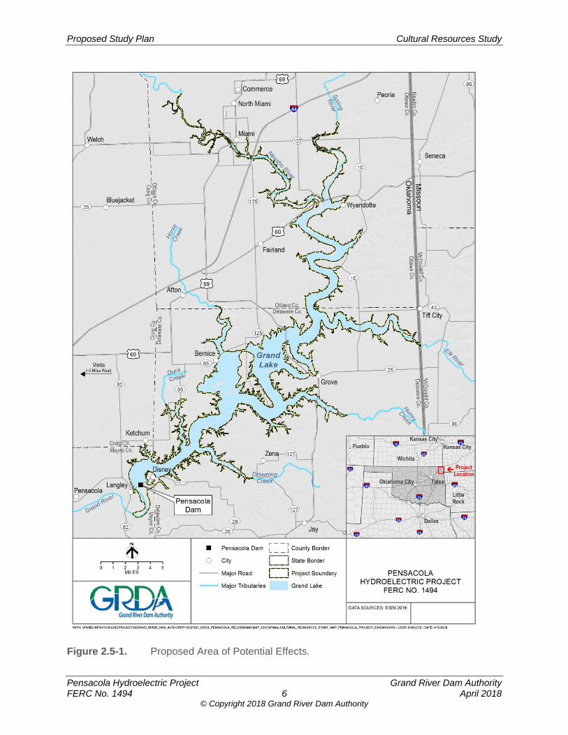
Proposed Study Plan Cultural Resources Study
Pensacola Hydroelectric Project Grand River Dam Authority FERC No. 1494 6 April 2018
© Copyright 2018 Grand River Dam Authority
Figure 2.5-1. Proposed Area of Potential Effects.
Proposed Study Plan Cultural Resources Study
Pensacola Hydroelectric Project Grand River Dam Authority FERC No. 1494 7 April 2018
© Copyright 2018 Grand River Dam Authority
The APE for this undertaking includes all lands within the FERC-approved Project Boundary. The APE also includes lands or properties outside the Project Boundary where Project operations or Project-related recreation activities or other enhancements may cause changes in the character or use of historic properties, if any such properties exist.
2.6 Methodology
2.6.1 Area of Potential Effects
GRDA has tentatively proposed an APE as presented in Section 2.5. Pursuant to the implementing regulations of Section 106 at 36 C.F.R. § 800.4(a), GRDA will consult with the CRWG to determine and document the APE for the Project as defined in 36 C.F.R. § 800.16(d). As tentatively defined in Section 2.5, the APE includes lands outside the current Project Boundary where Project-related operations or activities may have a direct, indirect, or cumulative effect on historic properties. Based on the results of hydraulic modeling and other studies, the geographic extent of the APE may be refined in consultation with the CRWG in Study Year Two.
2.6.2. Background Research and Archival Review
GRDA will conduct background research and an archival review to inform the specific research design and the historic and environmental contexts of the APE. The background research and archival review will be conducted by a qualified cultural resources professional8. GRDA will review relevant sources of information that may include (but are not necessarily limited to):
Information on archaeological sites, historic architectural resources, and previous cultural resources studies on file with OAS, Oklahoma SHPO, and Native American Tribes;
Available reports on previous cultural resources studies conducted within the APE9;
A review of the OLI and Oklahoma’s NRHP listings;
Historic maps and aerial photographs of the APE, including relevant plat and Sanborn maps;
Aerial photographs of the APE;
8 For purposes of this Cultural Resources Study Plan, a “qualified cultural resources professional” is defined as an individual who meets the Secretary of the Interior’s Professional Qualification Standards (48 Federal Register [FR] 44738-44739, Sept. 1983) and the standards established by the Oklahoma SHPO. 9 As discussed in the PAD, archaeological surveys of the Project area were conducted between 1937 and 1940 by the Works Progress Administration (WPA), and additional survey work continued after the creation of Grand Lake. In developing the PAD, GRDA reviewed archival information and documents on file with OAS. The WPA reports were not readily available from OAS or in GRDA’s archives. As part of this background research and archival review task, GRDA will conduct an additional review of its archives, consult with OAS, and review information on file with local and state repositories in an effort to obtain copies of the WPA reports.
Proposed Study Plan Cultural Resources Study
Pensacola Hydroelectric Project Grand River Dam Authority FERC No. 1494 8 April 2018
© Copyright 2018 Grand River Dam Authority
Relevant documents related to Project construction;
Relevant information available from local repositories;
Information on the current and historical environment, including mapped soils, bedrock geology, geomorphology, physiography, topography, and hydrology in the vicinity of the APE;
Relevant historical accounts of the Project area;
Relevant management plans for the Project;
Historic context statements for Management Region 3 available from the Oklahoma SHPO; and
Any additional relevant information made available by the CRWG or other relicensing participants.
As part of the background research and archival review, GRDA may undertake limited field observations to better characterize and document existing shoreline conditions at the reservoir and inform the Pre-fieldwork Report (see Section 2.6.3 of this study plan).
2.6.3 Pre-fieldwork Report
GRDA will prepare a Pre-fieldwork Report based on the results of the background literature review that will identify and map:
Previously reported archaeological sites, historic resources, and relevant map-documented structures;
Areas with archaeological sensitivity, such as pre-Project terrace landforms, the outlets of tributary streams, and other landscape features; Pre-project trails and roads; and historic towns, villages, or other population centers; and
Areas identified within the APE where erosion or other Project-related effects are occurring.
2.6.4 Reconnaissance Surveys
Based on the Pre-fieldwork Report, GRDA will consult with the CRWG to identify high-priority areas and sites within the APE for study during the 2-year ILP process for purposes of informing FERC’s analyses under both Section 106 and the NEPA. GRDA will conduct a Reconnaissance Survey of the Project’s APE during Study Year One and Study Year Two. The proposed methods for the Reconnaissance Survey are the same for both study years and take into account the nature and extent of potential effects on historic properties and the likely nature and location of historic properties within the APE (36 C.F.R. 800.4(b)(1)). The Reconnaissance Survey will be conducted by a qualified cultural resources professional retained by GRDA and will be in accordance with the Secretary of the Interior’s Standards and Guidelines for Archaeology and Historic Preservation (48 Federal Register [FR] 44716, Sept. 1983) and guidance documents promulgated by the Oklahoma SHPO, including:
Guidelines for Developing Archaeological Survey Reports in Oklahoma and Report Components (Oklahoma SHPO 2013a); and
Architectural/Historical Resources Survey Field Guide (Oklahoma SHPO 2013b).
Proposed Study Plan Cultural Resources Study
Pensacola Hydroelectric Project Grand River Dam Authority FERC No. 1494 9 April 2018
© Copyright 2018 Grand River Dam Authority
The Reconnaissance Survey will include a visual reconnaissance of the exposed portions of the reservoir shoreline areas within the APE to identify any previously recorded or unrecorded archaeological and/or historic architectural resources. If archaeological material is observed during the Reconnaissance Survey, GRDA will delineate site boundaries. The maximum length and width of each site will be measured and recorded and the site’s location geo-located. Site dimensions and elevations will be recorded on standardized field forms along with sketch maps of site settings and notations regarding landform, site aspect, temporal affiliations (if possible) and density of observed materials, site condition, any evidence of Project-related effects, and the nature of site deposits. Site boundaries will be located on Project maps and U.S. Geological Survey (USGS) topographic maps. Based on the judgment of the archaeologist, visual reconnaissance may be augmented by limited subsurface testing (e.g., shovel test pits) to record site depth, stratigraphy, and other features. GRDA will geo-locate, record, and collect any observed artifacts, features, or other pre-contact or historic period cultural material (as appropriate), and any new archaeological sites discovered will be documented on Oklahoma Archaeological Site Survey Form (Appendix A) or Isolated Find Form (Appendix B). Treatment and disposition of any human remains that may be discovered will be managed in a manner consistent with the Native American Graves Protection and Repatriation Act (NAGPRA) (Public Law [P.L.] 101-601; 25 U.S. Code [U.S.C.] 3001 et seq.)10; the Council’s Policy Statement Regarding Treatment of Burial Sites, Human Remains, and Funerary Objects (ACHP 2007); and the Burial Desecration Law – Oklahoma Statute Chapter 47 (Section 1168.0 - 1168.6). Any human remains, burial sites, or funerary objects that are discovered will at all times be treated with dignity and respect. In the event that any Native American graves and/or associated cultural items are inadvertently discovered, GRDA will immediately notify the Oklahoma SHPO, OAS, and potentially affected Native American Tribes. If individual historic architectural resources or districts that potentially meet the NRHP criteria are observed, GRDA will geo-locate the resource and delineate the boundary. Relevant dimensions will be estimated and recorded, and the location will be documented on Project maps and USGS topographic maps. GRDA will take a minimum of two representative photos of the architectural resources, and GRDA will record land use patterns, the general age of the area, the character of the building stock (such as type, style, building material, integrity, and condition), the landscaping, and particularly notable and representative features. GRDA will complete a Historic Preservation Resource Identification Form for each resource (Appendix C). Information on cultural resources from this reconnaissance survey will be used to determine the potential for adverse effects on identified archaeological and historic resources created by the continued operation of the Project and to support development of the HPMP. Where the potential for adverse effects from continued operation of the Project is determined, the HPMP will describe appropriate management or treatment measures that may include formal site evaluations to determine the NRHP-eligibility of a site or specific mitigation and treatment measures.
10 Pursuant to 43 C.F.R. Part 10, NAGPRA applies to human remains, sacred objects, and items of
cultural patrimony (described as “cultural items” in the statute) located on federal or tribal lands or in the possession and control of federal agencies or certain museums. Regardless of where cultural items are discovered, the principles described in NAGPRA’s implementing regulations will serve as guidance for GRDA’s actions should the remains or associated artifacts be identified as Native American and to the extent such principles and procedures are consistent with any other applicable requirements.
Proposed Study Plan Cultural Resources Study
Pensacola Hydroelectric Project Grand River Dam Authority FERC No. 1494 10 April 2018
© Copyright 2018 Grand River Dam Authority
Following Study Year One, GRDA will prepare a Reconnaissance Survey Report as part of the ISR that provides study results and recommendations for identified archaeological and historic resources, including any recommendations for additional cultural resources investigations, as appropriate. GRDA will consult with the CRWG regarding the Study Year One Reconnaissance Survey Report. During Study Year Two, GRDA will conduct a second Reconnaissance Survey of the APE. The locations of the Study Year Two survey will be determined in consultation with the CRWG. GRDA expects that the results of the hydraulic modeling study will assist GRDA and the CRWG in refining the appropriate areas for study during Study Year Two, if needed. Following Study Year Two, GRDA will prepare a Reconnaissance Survey Report as part of the USR that provides study results and recommendations for identified archaeological and historic resources, including any recommendations for additional cultural resources investigations, as appropriate. GRDA will consult with the CRWG regarding the Study Year Two Reconnaissance Survey Report.
2.6.5 Traditional Cultural Properties
TCPs are properties of traditional religious and cultural importance to a Native American Tribe that meet the National Register criteria (36 C.F.R. § 800.16(l)(1)). TCPs may be eligible for inclusion in the NRHP because of their association with cultural practices or beliefs of a living community that are (1) rooted in that community’s history, and (2) important in maintaining the continuing cultural identity of the community. GRDA recognizes the special expertise that the Native American Tribes have in identifying properties that have traditional and religious significance to their communities. As such, GRDA will consult with Native American Tribes to develop specific methods and approaches to conducting a TCP inventory for lands within the APE. GRDA proposes to consult with Native American Tribes during Study Year One to develop the specific TCP study methods and to initiate the TCP study during Study Year Two.
2.6.6 Programmatic Agreement
Pursuant to 36 C.F.R. Part 800.14(b), GRDA anticipates that FERC will enter into a Programmatic Agreement (PA) with the Oklahoma SHPO for managing historic properties that may be affected by Project operations or activities during the term of the new license. The PA will formally meet the Commission’s obligations under NHPA Section 106 for the relicensing of the Project, and is likely to provide for GRDA to implement an HPMP for the long-term management of historic properties during the new license term.
2.6.7 Historic Properties Management Plan
In anticipation of a PA, GRDA will prepare an HPMP providing measures that will direct GRDA’s management of historic properties within the Project’s APE throughout the term of the new license. The HPMP is not intended to be a static document, but will include measures for additional consultation and processes for additional identification and treatment of historic properties. GRDA will develop the HPMP in consultation with the CRWG; through this consultation, GRDA and the CRWG will develop specific management measures to be incorporated into the HPMP. GRDA anticipates that the CRWG will have an ongoing role in the HPMP implementation. GRDA expects to file the HPMP with FERC as part of its relicensing
Proposed Study Plan Cultural Resources Study
Pensacola Hydroelectric Project Grand River Dam Authority FERC No. 1494 11 April 2018
© Copyright 2018 Grand River Dam Authority
application, such that it may be approved and implemented immediately upon the effective date of the new license issued by FERC.
GRDA has outlined the following three goals for managing historic resources under the HPMP:
Continue ongoing operations of the Project while maintaining and preserving the integrity of historic properties within the Project Boundary, in consultation with the CRWG;
To the extent possible, avoid, minimize, or mitigate adverse effects on historic properties that would be affected by the continued operation of the Project under the new license, in consultation with the CRWG; and
Ensure historic properties are managed in an efficient and cost-effective manner that does not impede GRDA’s ability to comply with the terms of its operating license and other applicable federal, state, and local statutes.
To address these goals, GRDA will develop an HPMP in consultation with the CRWG and in accordance with the Guidelines for the Development of Historic Properties Management Plans for FERC Hydroelectric Projects, promulgated by the FERC and the ACHP on May 20, 2002. At a minimum, GRDA anticipates that the HPMP will address the following items (ACHP and FERC 2002):
Any additional studies necessary to assist in the identification or management of historic properties within the APE, including a schedule for completing such studies;
A plan and schedule for completing Reconnaissance Surveys of areas within the APE identified in consultation with the CRWG, including areas where Reconnaissance Surveys could not be completed during the ILP;
Potential effects on historic properties resulting from the continued operation and maintenance of the Project;
Management and treatment measures for historic properties (including any identified TCPs);
Protection of historic properties threatened by potential ground-disturbing or land-clearing activities during the term of the new license;
Protection of historic properties threatened by other direct or indirect Project-related activities, including routine Project maintenance;
The resolution of unavoidable adverse effects on historic properties;
Treatment and disposition of any human remains that are discovered;
Provisions for unanticipated discoveries of previously unidentified cultural resources within the APE;
A dispute resolution process;
Categorical exclusions from further review of effects;
Public interpretation of the historic and archaeological values of the Projects, if any;
Specific measures and a schedule for implementing the HPMP;
Proposed Study Plan Cultural Resources Study
Pensacola Hydroelectric Project Grand River Dam Authority FERC No. 1494 12 April 2018
© Copyright 2018 Grand River Dam Authority
Roles and responsibilities of GRDA, the Oklahoma SHPO, OAS, Native American Tribes, and other individuals and organizations in regards to implementation of the HPMP; and
Coordination with the CRWG during implementation of the HPMP.
2.7 Consistency with Generally Accepted Scientific Practice
The proposed methods for this study are consistent with accepted scientific practices. The overall approach complies with the ACHP’s Section 106 Archaeology Guidance (ACHP 2009)11 and is consistent with cultural resources studies conducted in support of other relicensing proceedings in Oklahoma. The Cultural Resources Study will allow GRDA to identify archaeological resources that are potentially affected (directly or indirectly) by the Project and to develop appropriate management measures for those resources. In addition, the proposed methods for this study are consistent with FERC study requirements under ILP. No alternative approaches to this study are necessary.
2.8 Schedule GRDA will initiate consultation with the Oklahoma SHPO and Native American Tribes to seek concurrence regarding the Project’s APE in May 2018, as part of the planned PSP and CRWG meetings. Background research and archival reviews and consultation to develop TCP inventory methods will be conducted from September 2018 – April 2019. GRDA anticipates the Pre-fieldwork Study Report will be completed in April 2019, and that the Study Year One Reconnaissance Survey will be completed from May 2019 – August 2019. The Study Year One Reconnaissance Survey Report will be prepared as part of the ISR which will be filed in September 2019. GRDA expects that the Study Year Two Reconnaissance Survey will be conducted from May 2020 – August 2020. The Study Year Two Reconnaissance Survey Report will be prepared as part of the USR which will be filed in September 2020. GRDA anticipates that the TCP inventory will also be initiated during Study Year Two. GRDA will consult with the CRWG in the development of a draft HPMP and expects to file the HPMP with the Commission concurrent with the March 31, 2020 filing of the Final License Application (FLA).
2.9 Level of Effort and Cost The estimated level of effort for this study is approximately 4,000 man-hours. The estimated cost of this proposed study is $450,000.
11 The ACHP’s guidance states that “[A] federal agency is not expected to conduct a 100 percent survey of the area of potential effects. Rather, the identification effort should be conditioned by where effects are likely to occur and the likely impact of these effects on listed or eligible archaeological sites. For example, archaeological identification efforts for a license renewal from the Federal Energy Regulatory Commission likely would not involve the entire area of potential effects (APE). Rather it would be directed to those locations within the APE that are experiencing project related effects associated with operation, usually along the shoreline.”
Proposed Study Plan Cultural Resources Study
Pensacola Hydroelectric Project Grand River Dam Authority FERC No. 1494 13 April 2018
© Copyright 2018 Grand River Dam Authority
3.0 REFERENCES ACHP (Advisory Council on Historic Preservation). 2007. Policy Statement Regarding
Treatment of Burial Sites, Human Remains and Funerary Objects. [Online] URL: http://www.achp.gov/docs/hrpolicy0207.pdf. Accessed January 2018.
ACHP. 2009. Section 106 Archaeology Guidance. [Online] URL:
http://www.achp.gov/archguide/. Accessed January 2018. ACHP and FERC (Federal Energy Regulatory Commission). 2002. Guidelines for the
Development of Historic Properties Management Plans for FERC Hydroelectric Projects. [Online] URL: http://www.achp.gov/ferc-hpmp.pdf. Accessed January 2018.
FERC. 2018. Scoping Document 1 for the Pensacola Hydroelectric Project, P-1494. January
12, 2018. National Park Service. 1997. National Register Bulletin: How to Complete the National Register
Registration Form. National Park Service, National Register of Historic Places, Washington, D.C.
SHPO (Oklahoma State Historic Preservation Office). 2013a. Fact Sheet #16: Guidelines for
Developing Archaeological Survey Reports in Oklahoma and Report Components. [Online] URL: http://www.okhistory.org/shpo/factsheets/fs16archreports.pdf. Accessed January 2018.
SHPO. 2013b. Architectural/Historic Resources Survey: A Field Guide. [Online] URL:
http://www.okhistory.org/shpo/ architsurveys/ fieldguide.pdf. Accessed January 2018.

Proposed Study Plan Cultural Resources Study
Pensacola Hydroelectric Project Grand River Dam Authority FERC No. 1494 14 April 2018
© Copyright 2018 Grand River Dam Authority
[This page intentionally left blank.]

Proposed Study Plan Cultural Resources Study
Pensacola Hydroelectric Project Grand River Dam Authority FERC No. 1494 April 2018
© Copyright 2018 Grand River Dam Authority
APPENDIX A. OKLAHOMA ARCHAEOLOGICAL SITE SURVEY FORM

Proposed Study Plan Cultural Resources Study
Pensacola Hydroelectric Project Grand River Dam Authority FERC No. 1494 April 2018
© Copyright 2018 Grand River Dam Authority
[This page intentionally left blank.]
1
OKLAHOMA ARCHAEOLOGICAL OKLAHOMA ARCHAEOLOGICAL Site#:Site#:SITE SURVEY FORMSITE SURVEY FORM County:County:
COMPLETE ALL SECTIONS______________________________________________________________________
1.SITE NUMBER AND NAME:1.SITE NUMBER AND NAME:
Site Name:Site Name: Project No.:Project No.:(derived from owner's (Temporary number or name(derived from owner's (Temporary number or nameassignedassigned name, etc.) during project.) name, etc.) during project.)______________________________________________________________________2.LOCATIONAL INFORMATION:2.LOCATIONAL INFORMATION:U.T.M.U.T.M. ReferenceReference
Zone:Zone: 14Northing:Northing: Easting:Easting:
LegalLegal DescriptionDescription ____1/4 of ____ 1/4 of ___1/4 of Sectionof Section ___ TownshipTownship ____ RangeRange ____
U.S.G.S. Quad Name:U.S.G.S. Quad Name: Quad Date (revised):Quad Date (revised): ______________________________________________________________________Other Other Locational References (i.e., benchmarks, road intersections,Locational References (i.e., benchmarks, road intersections,bridges, etc., please give distance and bearing to site):bridges, etc., please give distance and bearing to site):
______________________________________________________________________
3.OWNER(S) OF PROPERTY:3.OWNER(S) OF PROPERTY:
Name:Name:Street and Number:Street and Number:City/Town, State:City/Town, State:Zip:Zip:______________________________________________________________________
4.SITE SURVEYED BY: Reported by (if different):4.SITE SURVEYED BY: Reported by (if different):
Name:Name: Name:Name:
Date Recorded:Date Recorded: Date Reported:Date Reported:
Time spent at site and time of day:Time spent at site and time of day:
2
5.CULTURAL AFFILIATION - Cultural Periods (underline one):5.CULTURAL AFFILIATION - Cultural Periods (underline one):
Unassigned prehistoric Woodland:Paleoindian: Eastern – may be eastern? Early Plains Middle Late Village Farming/MississippiArchaic: Plains Village Early Protohistoric/Historic Ind. Middle Historic non-Indian Late______________________________________________________________________
Archaeological Cultures, Phases, etc. representedArchaeological Cultures, Phases, etc. represented:
How was cultural affiliation determined (diagnostic artifacts,How was cultural affiliation determined (diagnostic artifacts,radiocarbon dates, etcradiocarbon dates, etc.):
______________________________________________________________________
6.HISTORIC PHASE IDENTIFICATION (ETHNIC):6.HISTORIC PHASE IDENTIFICATION (ETHNIC):Underline appropriate group.Underline appropriate group.1. Choctaw 16. Osage2. Cherokee 17. Cheyenne3. Saux-Fox 18. Caddo4. Pottawatomie 19. Shawnee5. Seminole 20. Delaware6. Comanche 21. Creek7. Apache 22. Dakotas8. Kiowa 23. Chickasaw9. Kiowa-Apache 24. 12 & 1710. Kickapoo 25. Missouri-Otos11. Pawnee 26. Iowa12. Arapaho 27. Anglo-American13. Ottawas 28. French14. Wichita 29. Spanish15. Quapaw 20. Other:
How was historic identification determined?:How was historic identification determined?:
______________________________________________________________________
7.HISTORIC SITE RANGE (underline one):7.HISTORIC SITE RANGE (underline one):
0. Missing data; unknown 5. 1890-19291. pre-1800 6. 1930-19502. 1800-1830 7. 1800-19003. 1830-1859 8. 1800-present4. 1860-1889 9. 1900-present
3
8.INFERRED SITE TYPE8.INFERRED SITE TYPEPlease underline those that apply (can be more than one category)Please underline those that apply (can be more than one category)
Open habitation w/o mounds Petroglyph/pictographOpen habitation with mounds Isolated burials (<2)Earth mound (not midden mound) Cemetery (>2)Mound complex Specialized activity sitesStone mounds/rock piles Rock alignments (tepee rings, etc.)Burned rock concentrations Historic farmsteadNon-mound earthworks Historic mill/industrialRock shelter Historic fortCave DugoutQuarry/workshop Historic trash dump______________________________________________________________________9.MIDDEN AT SITE (underline):9.MIDDEN AT SITE (underline):
Don't know Present, earthAbsent Present, shell Present, rock______________________________________________________________________
10.MATERIALS COLLECTED:10.MATERIALS COLLECTED:
TypeType NumberNumberCeramicsCeramicsProjectile points/base frags.Projectile points/base frags. Hafted scrapersHafted scrapersDrillsDrillsBifaces/biface fragmentsBifaces/biface fragmentsUnifacesUnifacesPerforators/graversPerforators/graversSpokeshavesSpokeshavesScrapers (unhafted)Scrapers (unhafted)Debitage (flakes, cores, chunks)Debitage (flakes, cores, chunks) Ground/pecked/battered stoneGround/pecked/battered stoneWorked bone/shellWorked bone/shellHuman boneHuman boneFaunal remainsFaunal remainsFloral remainsFloral remainsOther prehistoricOther prehistoricHistoric (describe)Historic (describe)
Total Items:Total Items:
Briefly describe diagnostic artifacts including type names. Briefly describe diagnostic artifacts including type names. Attach outline drawings:Attach outline drawings:
Materials observed but not collected:Materials observed but not collected:
4
Name and address of owner of other collections from site:Name and address of owner of other collections from site:
______________________________________________________________________
11.ARTIFACT REPOSITORY11.ARTIFACT REPOSITORY
Name of institution where artifacts are to be stored:Name of institution where artifacts are to be stored:
Photos:Photos:Number of black and white photos:Number of black and white photos:Number of color photos:Number of color photos:
Name and address of institution where photos are filed:Name and address of institution where photos are filed:
______________________________________________________________________
12.EVIDENCE OF RECENT VANDALISM OBSERVED? (Yes or No):12.EVIDENCE OF RECENT VANDALISM OBSERVED? (Yes or No):______________________________________________________________________
13.SITE CONDITION (underline one):13.SITE CONDITION (underline one):
1. apparently undisturbed 5. 76-99% disturbed2. <25% disturbed 6. totally destroyed3. 26-50% disturbed 7. disturbed, % unknown4. 51-75% disturbed
______________________________________________________________________
14.MAJOR LAND USE (underline those that apply):14.MAJOR LAND USE (underline those that apply):
Cultivated field IndustrialPasture ResidentialWoods, forest RecreationRoad/trail CommercialDitch/dike/borrow pit MilitaryLandfill Logging/fire breakModern cemetery Scrub/secondary growth/oil fieldMining Modern dumpInundated
Other:
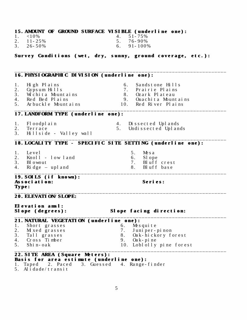
5
15.AMOUNT OF GROUND SURFACE VISIBLE (underline one):15.AMOUNT OF GROUND SURFACE VISIBLE (underline one):1. <10% 4. 51-75%2. 11-25% 5. 76-90%3. 26-50% 6. 91-100%
Survey Conditions (wet, dry, sunny, ground coverage, etc.):Survey Conditions (wet, dry, sunny, ground coverage, etc.):
______________________________________________________________________16.PHYSIOGRAPHIC DIVISION (underline one):16.PHYSIOGRAPHIC DIVISION (underline one):
1. High Plains 6. Sandstone Hills2. Gypsum Hills 7. Prairie Plains3. Wichita Mountains 8. Ozark Plateau4. Red Bed Plains 9. Ouachita Mountains5. Arbuckle Mountains 10. Red River Plains______________________________________________________________________17.LANDFORM TYPE (underline one):17.LANDFORM TYPE (underline one):
1. Floodplain 4. Dissected Uplands2. Terrace 5. Undissected Uplands3. Hillside - Valley wall______________________________________________________________________18.LOCALITY TYPE - SPECIFIC SITE SETTING (underline one):18.LOCALITY TYPE - SPECIFIC SITE SETTING (underline one):
1. Level 5. Mesa2. Knoll - low land 6. Slope3. Blowout 7. Bluff crest4. Ridge – upland 8. Bluff base______________________________________________________________________19.SOILS (if known):19.SOILS (if known):Association:Association: Series:Series:Type:Type:______________________________________________________________________20.ELEVATION/SLOPE:20.ELEVATION/SLOPE:
Elevation amsl:Elevation amsl:Slope (degrees):Slope (degrees): Slope facing direction:Slope facing direction:______________________________________________________________________21.NATURAL VEGETATION (underline one):21.NATURAL VEGETATION (underline one):1. Short grasses 6. Mesquite2. Mixed grasses 7. Juniper-pinon3. Tall grasses 8. Oak-hickory forest4. Cross Timber 9. Oak-pine5. Shin-oak 10. Loblolly pine forest______________________________________________________________________22.SITE AREA (Square Meters):22.SITE AREA (Square Meters):Basis for area estimate (underline one):Basis for area estimate (underline one):1. Taped 2. Paced 3. Guessed 4. Range-finder 5. Alidade/transit

6
Confident of site boundaries? (Yes or No):Confident of site boundaries? (Yes or No):______________________________________________________________________
23.DESCRIPTION OF SITE:23.DESCRIPTION OF SITE:
Give physical description of site and its setting, includingGive physical description of site and its setting, includingdimensions, features, nature of materials and artifactdimensions, features, nature of materials and artifactconcentrations. Include copy of U.S.G.S. topographic map with siteconcentrations. Include copy of U.S.G.S. topographic map with sitelocation and boundaries marked (and sketch map if appropriate).location and boundaries marked (and sketch map if appropriate).
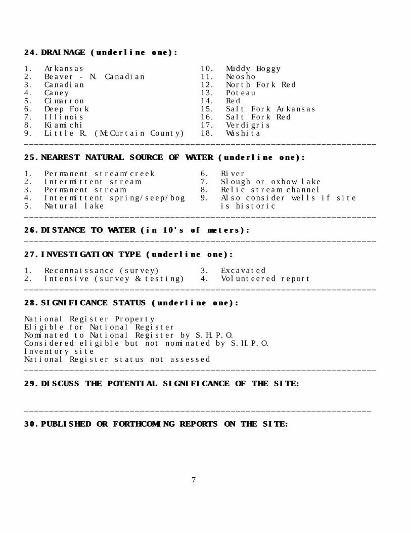
7
24.DRAINAGE (underline one):24.DRAINAGE (underline one):
1. Arkansas 10. Muddy Boggy2. Beaver - N. Canadian 11. Neosho3. Canadian 12. North Fork Red4. Caney 13. Poteau5. Cimarron 14. Red6. Deep Fork 15. Salt Fork Arkansas7. Illinois 16. Salt Fork Red8. Kiamichi 17. Verdigris9. Little R. (McCurtain County) 18. Washita______________________________________________________________________
25.NEAREST NATURAL SOURCE OF WATER (underline one):25.NEAREST NATURAL SOURCE OF WATER (underline one):
1. Permanent stream/creek 6. River2. Intermittent stream 7. Slough or oxbow lake3. Permanent stream 8. Relic stream channel4. Intermittent spring/seep/bog 9. Also consider wells if site5. Natural lake is historic______________________________________________________________________
26.DISTANCE TO WATER (in 10's of meters):26.DISTANCE TO WATER (in 10's of meters):______________________________________________________________________
27.INVESTIGATION TYPE (underline one):27.INVESTIGATION TYPE (underline one):
1. Reconnaissance (survey) 3. Excavated2. Intensive (survey & testing) 4. Volunteered report______________________________________________________________________
28.SIGNIFICANCE STATUS (underline one):28.SIGNIFICANCE STATUS (underline one):
National Register PropertyEligible for National RegisterNominated to National Register by S.H.P.O.Considered eligible but not nominated by S.H.P.O.Inventory siteNational Register status not assessed______________________________________________________________________
29.DISCUSS THE POTENTIAL SIGNIFICANCE OF THE SITE:29.DISCUSS THE POTENTIAL SIGNIFICANCE OF THE SITE:
_____________________________________________________________________
30.PUBLISHED OR FORTHCOMING REPORTS ON THE SITE:30.PUBLISHED OR FORTHCOMING REPORTS ON THE SITE:

Proposed Study Plan Cultural Resources Study
Pensacola Hydroelectric Project Grand River Dam Authority FERC No. 1494 April 2018
© Copyright 2018 Grand River Dam Authority
APPENDIX B. ISOLATED FIND FORM

Proposed Study Plan Cultural Resources Study
Pensacola Hydroelectric Project Grand River Dam Authority FERC No. 1494 April 2018
© Copyright 2018 Grand River Dam Authority
[This page intentionally left blank.]
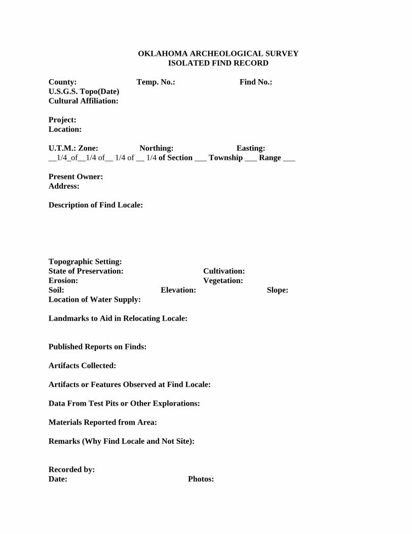
OKLAHOMA ARCHEOLOGICAL SURVEY ISOLATED FIND RECORD
County: Temp. No.: Find No.: U.S.G.S. Topo(Date) Cultural Affiliation: Project: Location: U.T.M.: Zone: Northing: Easting: __1/4_of__1/4 of__ 1/4 of __ 1/4 of Section ___ Township ___ Range ___ Present Owner: Address: Description of Find Locale: Topographic Setting: State of Preservation: Cultivation: Erosion: Vegetation: Soil: Elevation: Slope: Location of Water Supply: Landmarks to Aid in Relocating Locale: Published Reports on Finds: Artifacts Collected: Artifacts or Features Observed at Find Locale: Data From Test Pits or Other Explorations: Materials Reported from Area: Remarks (Why Find Locale and Not Site): Recorded by: Date: Photos:

Proposed Study Plan Cultural Resources Study
Pensacola Hydroelectric Project Grand River Dam Authority FERC No. 1494 April 2018
© Copyright 2018 Grand River Dam Authority
APPENDIX C. HISTORIC PRESERVATION RESOURCE IDENTIFICATION FORM

Proposed Study Plan Cultural Resources Study
Pensacola Hydroelectric Project Grand River Dam Authority FERC No. 1494 April 2018
© Copyright 2018 Grand River Dam Authority
[This page intentionally left blank.]

HISTORIC PRESERVATION RESOURCE IDENTIFICATION FORM
1. PROPERTY NAME:
2. RESOURCE NAME:
3. ADDRESS:
4. CITY: 5. VICINITY:
6. COUNTY NAME:
7. LOT: 8. BLOCK: 9. PLAT NAME:
10. SECTION: 11. TOWNSHIP: 12. RANGE:
13. LATITUDE (NORTH): (ENTER AS: "dd.ddddd")
14. LONGITUDE (WEST): (ENTER AS: "-dd.ddddd")
15. UTM ZONE: 16. NORTHINGS: 17. EASTINGS:
18. RESOURCE TYPE:
19. HISTORIC FUNCTION:
21. AREA OF SIGNIFICANCE, PRIMARY:
23. DESCRIPTION OF SIGNIFICANCE:
24. DOCUMENTATION RESOURCE:
25. NAME OF PREPARER:
26. PROJECT NAME:
27. DATE OF PREPARATION: 28. PHOTOGRAPHS
29. YEAR:
PLEASE TYPE ALL DATA IN UPPERCASE - FIELDS IN RED ARE REQUIRED
20. CURRENT FUNCTION:
22. AREA OF SIGNIFICANCE, SECONDARY:
59. SURVEY PROJECT

30. ARCHITECT/BUILDER:
31. YEAR BUILT:
32. ORIGINAL SITE: 33. DATE MOVED:
34. FROM WHERE: 35. ACCESSIBLE:
36. ARCHITECTURAL STYLE:
37. OTHER ARCHITECTURAL STYLE:
38. FOUNDATION MATERIAL:
39. ROOF TYPE:
43. WINDOW TYPE:
45. DOOR TYPE:
47. EXTERIOR FEATURES:
48. INTERIOR FEATURES:
49. DECORATIVE DETAILS:
50. CONDITION OF RESOURCE:
51. DESCRIPTION OF RESOURCE:
52. COMMENTS:
40. ROOF MATERIAL:
41. WALL MATERIAL, PRIMARY:
42. WALL MATERIAL, SECONDARY:
44. WINDOW MATERIAL:
46. DOOR MATERIAL:
53. ATTACH LOCATION MAP
55. NATIONAL REGISTER ENTRY:
54. LISTED ON NATIONAL REGISTER:
56. CONTINUATION
© Copyright 2018 Grand River Dam Authority
Pensacola Hydroelectric Project, FERC No. 1494
Proposed Study Plan
Socioeconomics Study
Prepared for
Prepared by
April 2018

© Copyright 2018 Grand River Dam Authority
Proposed Study Plan Socioeconomics Study
Pensacola Hydroelectric Project Grand River Dam Authority FERC No. 1494 i April 2018
© Copyright 2018 Grand River Dam Authority
TABLE OF CONTENTS
1.0 Introduction ..................................................................................................................... 1
2.0 Study Plan Elements ....................................................................................................... 1 2.1 Study Goals and Objectives .................................................................................. 1 2.2 Agency and Native American Tribe Resource Management Goals ...................... 1 2.3 Background and Existing Information .................................................................... 2 2.4 Nexus between Project Operations and Effects on Resources ............................. 3 2.5 Study Area ............................................................................................................. 3 2.6 Methodology .......................................................................................................... 3 2.7 Consistency with Generally Accepted Scientific Practice ...................................... 3 2.8 Schedule ............................................................................................................... 3 2.9 Level of Effort and Cost ......................................................................................... 5
3.0 References ....................................................................................................................... 5
LIST OF FIGURES
Figure 2.5-1. Location map of the Pensacola Project. ................................................................ 4
Proposed Study Plan Socioeconomics Study
Pensacola Hydroelectric Project Grand River Dam Authority FERC No. 1494 ii April 2018
© Copyright 2018 Grand River Dam Authority
LIST OF ACRONYMS
FERC ........................ Federal Energy Regulatory Commission
GRDA ........................ Grand River Dam Authority
ILP ............................. Integrated Licensing Process
ISR ............................ Initial Study Report
OTRD ........................ Oklahoma Tourism and Recreation Department
PAD ........................... Pre-Application Document
Project ....................... Pensacola Hydroelectric Project
PSP ........................... Proposed Study Plan
SCORP ..................... Statewide Comprehensive Outdoor Recreation Plan
SD1 ........................... Scoping Document 1
USACE ...................... U.S. Army Corps of Engineers
Proposed Study Plan Socioeconomics Study
Pensacola Hydroelectric Project Grand River Dam Authority FERC No. 1494 1 April 2018
© Copyright 2018 Grand River Dam Authority
1.0 INTRODUCTION The Pensacola Hydroelectric Project (Pensacola Project or Project), owned and operated by the Grand River Dam Authority (GRDA), is licensed by the Federal Energy Regulatory Commission (FERC or Commission) as Project No. 1494. GRDA is a non-appropriated agency of the State of Oklahoma, created by the Oklahoma legislature in 1935 to be a “conservation and reclamation district for the waters of the Grand River.” As licensed by FERC, the Project serves multiple purposes, including hydropower generation, water supply, public recreation, and wildlife enhancement. As directed by Congress under the Flood Control Act of 1944, 58 Stat. 887, 890-91, the U.S. Army Corps of Engineers (USACE) has exclusive jurisdiction over Grand Lake for flood control purposes. FERC’s January 12, 2018 Scoping Document 1 (SDI) identified the following resource issue to be analyzed for the Project relicensing:
Effects of any proposed changes in project operation or maintenance on socioeconomic resources.
The City of Miami, Miami Tribe (as supported by the Eastern Shawnee Tribe, Ottawa Tribe, Seneca-Cayuga Nation, and Wyandotte Nation), and N. Larry Bork (counsel for City of Miami citizens) subsequently submitted formal requests related to socioeconomics. Section 4.2.4 of the main body of the Proposed Study Plan (PSP) details GRDA’s response to the requests.
2.0 STUDY PLAN ELEMENTS
2.1 Study Goals and Objectives The goal of this study is to gather, synthesize, and report on existing information necessary to qualitatively evaluate the socioeconomic effects of the Pensacola Project in the study area. The objectives of the study are to:
Describe baseline economic conditions in the Project area.
Identify the socioeconomic contribution of the Project in the state and the region.
2.2 Agency and Native American Tribe Resource Management Goals
Recreation in the Project area provides socioeconomic benefits to the region. The Oklahoma Tourism and Recreation Department (OTRD) promotes the development and operation of tourism and recreation opportunities throughout the State. The primary goal of the OTRD is to expand the economy of Oklahoma through increased tourism promotion and development (OTRD 2018). The OTRD uses the Oklahoma Statewide Comprehensive Outdoor Recreation Plan (SCORP) as a planning tool to assist in preserving, developing, and assuring accessibility to outdoor recreation resources (OTRD 2012).
Proposed Study Plan Socioeconomics Study
Pensacola Hydroelectric Project Grand River Dam Authority FERC No. 1494 2 April 2018
© Copyright 2018 Grand River Dam Authority
2.3 Background and Existing Information Section 6.10 of the Pre-Application Document (PAD) summarizes existing information on socioeconomic resources in the Project area. The Pensacola Project dam and hydroelectric generating facility is located northeast of Tulsa on the Grand (Neosho) River (Grand River) in Craig, Delaware, Mayes, and Ottawa counties, Oklahoma. The Pensacola Dam creates the Grand Lake O’ The Cherokees, also known as Grand Lake. The entirety of the Project resides in Craig, Delaware, Mayes, and Ottawa counties, which are located along the northeastern border of the state of Oklahoma. Ottawa County, the northernmost of the four counties occupied by the Pensacola Project, has two incorporated cities, six incorporated towns, and one unincorporated community with a total estimated population of 31,981 as of the 2015 census. Mayes County, located to the southwest of Ottawa County, has one incorporated city, twelve incorporated towns, and five unincorporated communities with a total estimated population of 40,887 in 2015. Delaware County, located to the east of Mayes County, has two incorporated cities, five incorporated towns, and two unincorporated communities with a total estimated population of 41,459 in 2015. Craig County, located to the northwest of Delaware County, has one incorporated city, four incorporated towns, and one unincorporated community with a total estimated population of 14,818 in 2015 (U.S. Census Bureau 2016). Current uses around Grand Lake include residential and commercial development, agriculture, and wildlife management areas. Lands surrounding the Project vicinity are generally rural and undeveloped, but historically, mining for lead and zinc was prevalent in Ottawa County, Oklahoma, and mining for coal was prevalent in Craig County, Oklahoma (Oklahoma Historical Society 2009). Approximately 53 percent of land within the Project Boundary is deciduous forestlands. Residential, commercial, and other development accounts for approximately 11 percent of total land area within the Project Boundary. Approximately 53 percent of lands adjacent to the Project boundary are undeveloped forestlands. In addition, 31 percent of lands adjacent to the Pensacola Project are designated as agricultural/crop lands. The majority of these agricultural areas are in Ottawa County (GRDA 2008). Grand Lake is also the premier recreational lake in northeast Oklahoma (FERC 2014), and the popularity of water-based recreation at Grand Lake has resulted in significant economic development, particularly in real estate, goods, and services. Detailed reports on the economic conditions in the state and region are sufficient to describe the socioeconomic conditions in the study area and the Project’s contributions to the state and regional economy. Existing studies on the socioeconomics in the region include:
Data regarding the Economic impact of the GRDA (Oklahoma Department of Commerce 2012a, updated in 2015)
Demographic data including land use, population, and employment data (U.S. Census Bureau 2015, 2016; Oklahoma Department of Commerce 2012b, 2015; Oklahoma Employment Security Commission 2016; Oklahoma Historical Society 2009; and GRDA 2008)
Estimating Non-Market Value for the Grand River Watershed (Brand et al. 2017)
Estimating Lake Amenity Values on Grand Lake o’ the Cherokees (Ghimire et al. 2017)
Proposed Study Plan Socioeconomics Study
Pensacola Hydroelectric Project Grand River Dam Authority FERC No. 1494 3 April 2018
© Copyright 2018 Grand River Dam Authority
2.4 Nexus between Project Operations and Effects on Resources
The presence of the Pensacola Project provides significant contributions to the state and regional economy. The results of the study, in conjunction with existing information, will be used to inform analysis in the license application.
2.5 Study Area The entirety of the Project resides in Craig, Delaware, Mayes, and Ottawa counties, which are located along the northeastern border of the state of Oklahoma (Figure 2.5-1). The study area for this desktop review will primarily focus on these four counties. Project-related economic impacts are also felt in the broader northeastern Oklahoma region, and the state of Oklahoma as a whole, and this study proposes to provide that information to the extent it is available.
2.6 Methodology A desktop review of available regional socioeconomic data will be completed. Information on the demographic and economic conditions of the region will be compiled and can be readily obtained from governmental agencies, such as the U.S. Census Bureau and the Oklahoma Department of Commerce. Parties to the relicensing as well as local industry organizations will be queried for available, verifiable data. Available county level economic data is presented in the PAD and includes population, income, and labor force. In addition, GRDA will provide information from published sources, including those listed in Section 2.3, to present a qualitative assessment for the study area, including:
State and regional population, income, and employment data;
State and regional industry trends (e.g., goods and services; agricultural use);
Regional trends in land and resource values (e.g., tribal practices; hunting, fishing, eco-tourism, outfitting, trapping, recreation, tourism, exploration, and mining activities);
Pensacola Project’s economic impact on the state and region under current operations;
The potential state and regional economic impact of proposed operations.
2.7 Consistency with Generally Accepted Scientific Practice
The proposed methods for this study are consistent with FERC study requirements under the Integrated Licensing Process (ILP).
2.8 Schedule The study will be complete and a final study report will be included as part of the Initial Study Report (ISR) filing in September 2019.
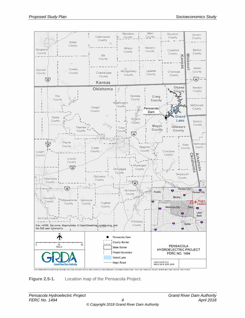
Proposed Study Plan Socioeconomics Study
Pensacola Hydroelectric Project Grand River Dam Authority FERC No. 1494 4 April 2018
© Copyright 2018 Grand River Dam Authority
Figure 2.5-1. Location map of the Pensacola Project.
Proposed Study Plan Socioeconomics Study
Pensacola Hydroelectric Project Grand River Dam Authority FERC No. 1494 5 April 2018
© Copyright 2018 Grand River Dam Authority
2.9 Level of Effort and Cost The estimated cost of this study is expected to be approximately $75,000.
3.0 REFERENCES Brand, S., T.A. Boyer, and R.M. Melstrom. 2017. Estimating Non-Market Value for the Grand
River Watershed. Oklahoma State University, Stillwater, Oklahoma. May 2017.
FERC (Federal Energy Regulatory Commission). 2014. Draft Environmental Assessment for Hydropower License Salina Pumped Storage Project – FERC Project No. 2524-021 Oklahoma. November 2014.
Ghimire, M., T.A. Boyer, D. Shideler, M. Melstrom, and A. Stoecker. 2017. Estimating Lake Amenity Values on Grand Lake o’ the Cherokees. Oklahoma State University, Stillwater, Oklahoma. June 2017.
GRDA. (Grand River Dam Authority). 2008. Shoreline Management Plan. Pensacola Hydroelectric Project FERC No. 1494. June 2008.
Oklahoma Department of Commerce. 2012a. Economic Impact of the Grand River Dam Authority. March 2012.
Oklahoma Department of Commerce. 2012b. 2012 Demographic State of the State Report.
Oklahoma Department of Commerce. 2015. Economic Impact of the Grand River Dam Authority. March 2015.
Oklahoma Employment Security Commission. 2016. Oklahoma Economic Indicators. April 2016.
OHS (Oklahoma Historical Society). 2009. Ottawa County.
OTRD (Oklahoma Tourism and Recreation Department). 2012. Statewide Comprehensive Outdoor Recreation Plan 2013 – 2017. November 2012.
OTRD. 2018. Agency Information. [Online]. URL: https://otrd.ok.gov/OkTourism/. (Accessed March 19, 2018).
U.S Census Bureau. 2015. Oklahoma Quickfacts. [Online]. URL: http://www.census.gov /quickfacts/table/PST045215/40. (Accessed June 1, 2016).
U.S. Census Bureau. 2016. Fact Finder. [Online]. URL: http://factfinder.census.gov. (Accessed June 2, 2016).

Proposed Study Plan Socioeconomics Study
Pensacola Hydroelectric Project Grand River Dam Authority FERC No. 1494 6 April 2018
© Copyright 2018 Grand River Dam Authority
[This page intentionally left blank.]

Proposed Study Plan
Pensacola Hydroelectric Project Grand River Dam Authority FERC No. 1494 April 2018
© Copyright 2018 Grand River Dam Authority
ATTACHMENT B. LIST OF COMMENT LETTERS AND STUDY REQUESTS AS FILED WITH FERC

Proposed Study Plan
Pensacola Hydroelectric Project Grand River Dam Authority FERC No. 1494 April 2018
© Copyright 2018 Grand River Dam Authority
[This page intentionally left blank.]
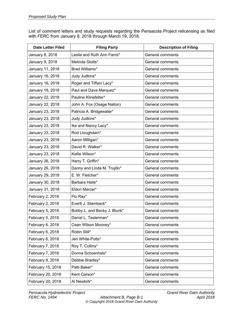
Proposed Study Plan
Pensacola Hydroelectric Project Grand River Dam Authority FERC No. 1494 Attachment B, Page B-1 April 2018
© Copyright 2018 Grand River Dam Authority
List of comment letters and study requests regarding the Pensacola Project relicensing as filed with FERC from January 8, 2018 through March 19, 2018.
Date Letter Filed Filing Party Description of Filing
January 8, 2018 Leslie and Ruth Ann Farris* General comments
January 9, 2018 Melinda Stotts* General comments
January 11, 2018 Brad Williams* General comments
January 16, 2018 Judy Judkins* General comments
January 16, 2018 Roger and Tiffani Lacy* General comments
January 16, 2018 Paul and Dava Marquez* General comments
January 22, 2018 Pauline Klinefelter* General comments
January 22, 2018 John A. Fox (Osage Nation) General comments
January 23, 2018 Patricia A. Bridgewater* General comments
January 23, 2018 Judy Judkins* General comments
January 23, 2018 Ike and Nancy Lacy* General comments
January 23, 2018 Rod Lloughdam* General comments
January 23, 2018 Aaron Milligan* General comments
January 23, 2018 David R. Walker* General comments
January 23, 2018 Kellie Wilson* General comments
January 26, 2018 Harry T. Griffin* General comments
January 26, 2018 Danny and Linda M. Trujillo* General comments
January 29, 2018 E. W. Fletcher* General comments
January 30, 2018 Barbara Haile* General comments
January 31, 2018 Eldon Mercer* General comments
February 2, 2018 Flo Ray* General comments
February 2, 2018 Evertt J. Stamback* General comments
February 5, 2018 Bobby L. and Becky J. Blunk* General comments
February 5, 2018 Darrel L. Testerman* General comments
February 6, 2018 Cean Wilson Mooney* General comments
February 6, 2018 Robin Still* General comments
February 6, 2018 Jeri White-Potts* General comments
February 7, 2018 Roy T. Collins* General comments
February 7, 2018 Donna Schoenhals* General comments
February 8, 2018 Debbie Bradley* General comments
February 15, 2018 Patti Baker* General comments
February 20, 2018 Kent Carson* General comments
February 20, 2018 Al Newkirk* General comments
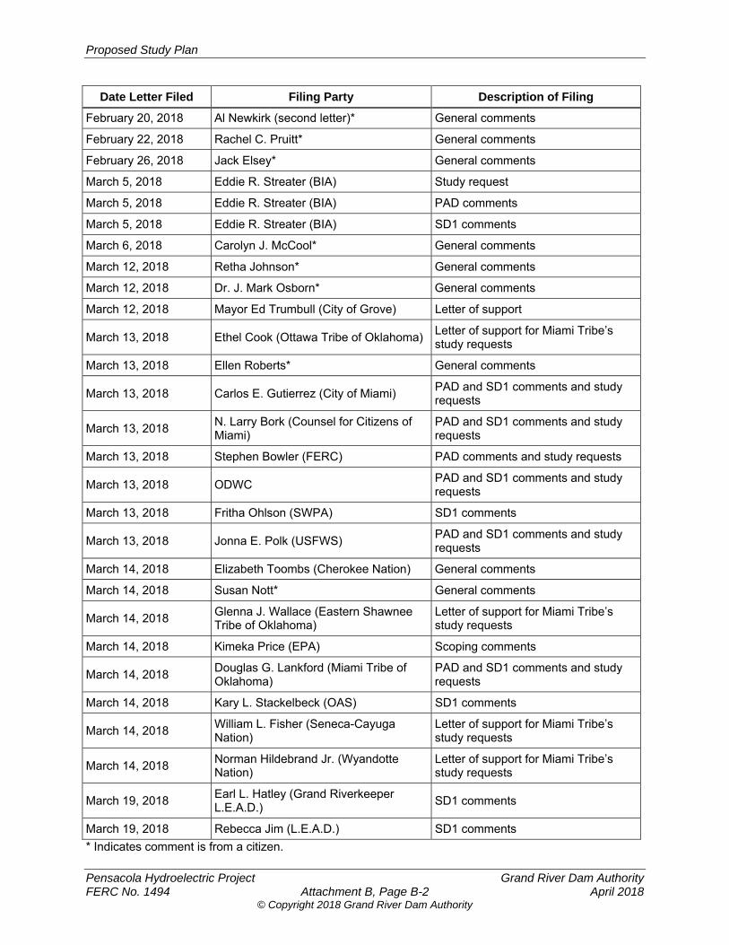
Proposed Study Plan
Pensacola Hydroelectric Project Grand River Dam Authority FERC No. 1494 Attachment B, Page B-2 April 2018
© Copyright 2018 Grand River Dam Authority
Date Letter Filed Filing Party Description of Filing
February 20, 2018 Al Newkirk (second letter)* General comments
February 22, 2018 Rachel C. Pruitt* General comments
February 26, 2018 Jack Elsey* General comments
March 5, 2018 Eddie R. Streater (BIA) Study request
March 5, 2018 Eddie R. Streater (BIA) PAD comments
March 5, 2018 Eddie R. Streater (BIA) SD1 comments
March 6, 2018 Carolyn J. McCool* General comments
March 12, 2018 Retha Johnson* General comments
March 12, 2018 Dr. J. Mark Osborn* General comments
March 12, 2018 Mayor Ed Trumbull (City of Grove) Letter of support
March 13, 2018 Ethel Cook (Ottawa Tribe of Oklahoma) Letter of support for Miami Tribe’s study requests
March 13, 2018 Ellen Roberts* General comments
March 13, 2018 Carlos E. Gutierrez (City of Miami) PAD and SD1 comments and study requests
March 13, 2018 N. Larry Bork (Counsel for Citizens of Miami)
PAD and SD1 comments and study requests
March 13, 2018 Stephen Bowler (FERC) PAD comments and study requests
March 13, 2018 ODWC PAD and SD1 comments and study requests
March 13, 2018 Fritha Ohlson (SWPA) SD1 comments
March 13, 2018 Jonna E. Polk (USFWS) PAD and SD1 comments and study requests
March 14, 2018 Elizabeth Toombs (Cherokee Nation) General comments
March 14, 2018 Susan Nott* General comments
March 14, 2018 Glenna J. Wallace (Eastern Shawnee Tribe of Oklahoma)
Letter of support for Miami Tribe’s study requests
March 14, 2018 Kimeka Price (EPA) Scoping comments
March 14, 2018 Douglas G. Lankford (Miami Tribe of Oklahoma)
PAD and SD1 comments and study requests
March 14, 2018 Kary L. Stackelbeck (OAS) SD1 comments
March 14, 2018 William L. Fisher (Seneca-Cayuga Nation)
Letter of support for Miami Tribe’s study requests
March 14, 2018 Norman Hildebrand Jr. (Wyandotte Nation)
Letter of support for Miami Tribe’s study requests
March 19, 2018 Earl L. Hatley (Grand Riverkeeper L.E.A.D.)
SD1 comments
March 19, 2018 Rebecca Jim (L.E.A.D.) SD1 comments
* Indicates comment is from a citizen.
Proposed Study Plan
Pensacola Hydroelectric Project Grand River Dam Authority FERC No. 1494 April 2018
© Copyright 2018 Grand River Dam Authority
ATTACHMENT C. ENTRAINMENT SUSCEPTIBILITIES OF FISHES INHABITING THE LOWER PORTION OF GRAND LAKE, OKLAHOMA

Proposed Study Plan
Pensacola Hydroelectric Project Grand River Dam Authority FERC No. 1494 April 2018
© Copyright 2018 Grand River Dam Authority
[This page intentionally left blank.]
ENTRAINMENT SUSCEPTIBILITIES OF FISHES
INHABITING THE LOWER PORTION OF
GRAND LAKE, OKLAHOMA
By
KENT MICHAEL SORENSON
Bachelor of Science
South Dakota State University
Brookings, South Dakota
1985
Submitted to the Faculty of the Graduate College of the
Oklahoma State University in partial fulfillment of
the requirements for the Degree of
MASTER OF SCIENCE July 1990

Oklahoma State U:niv,. Library
ENTRAINMENT SUSCEPTIBILITIES OF FISHES
INHABITING THE LOWER PORTION OF
GRAND LAKE, OKLAHOMA
Thesis Approved:
Dean of the Graduate College
1370560 ii
ACKNOWLEDGEMENTS
I wish to express sincere appreciation to Dr. Al Zale
for his encouragement and advice throughout my graduate
candidacy. I also thank .Dr. Rudy Miller and Dr. Dale Toetz
for serving on my graduate committee. My gratitude also
extends to Dr. Bill Fisher and Matt Lechner for their help
early in the study.
I would like to thank the staff and technicians of the
Oklahoma Cooperative Fish and Wildlife Research Unit for
their unwavering ability to allocate the time and equipment
needed for this project. A deep appreciation goes to Jan
Mord and Vince Travnichek. Their help in the field was
invaluable, and I thank them for making fieldwork efficient
and entertaining. I would also like to acknowledge the
financial support and cooperation of the Grand River Dam
Authority.
Finally, I would like to thank my family. To my
father, John, and my mother, Sherry, thank you for the
support and understanding throughout my education. Their
guidance and belief in me is highly valued as I continue to
pursue a career in fisheries.
iii
TABLE OF CONTENTS
Chapter Page
I. INTRODUCTION 1
II. ENTRAINMENT SUSCEPTIBILITIES OF FISHES INHABITING THE LOWER PORTION OF GRAND LAKE, OKLAHOMA...... 2
REFERENCES
APPENDIXES
Abstract . . . . . . . . . . . . . . . . . . . . . . . . . . . . . . .. . . . . . 3 Introduction . . . . . . . . . . . . . . . . . . . . . . . . . . . . . . . . 4 Study Site . . . . . . . . . . . . . . . . . . . . . . . . . . . . . . . . . . 8 Methods . . . . . . . . . . . . . . . . . . . . . . . • . . . . • . . . . . . . . 9 Results . . . . . . . . . . . . . . . . . .. . . . . . . . . . . . . . . . . . . . . 14 Discussion . . . . . . . . . . . . . . . . . . . . . . . . . . . . . . . . . . . 19
26
APPENDIX A- MONTHLY ENTRAINMENT RATES ......... 43
APPENDIX B- SUSCEPTIBILITY VALUES ............. 45
APPENDIX C - TOTAL CATCHES AND RELATIVE ABUNDANCE BY GEAR • • • • • • • • • • • • • • • • • • • • • • • • • • • 52
APPENDIX D- ANOVA OF MONTHLY MEAN CPUE ........ 54
iv
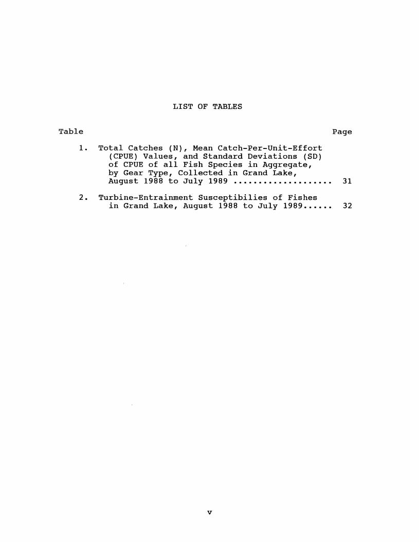
LIST OF TABLES
Table
1. Total Catches (N), Mean Catch-Per-Unit-Effort (CPUE) Values, and Standard Deviations (SD) of CPUE of all Fish Species in Aggregate, by Gear Type, Collected in Grand Lake,
Page
August 1988 to July 1989 •••••••••••••••••••• 31
2. Turbine-Entrainment Susceptibilies of Fishes in Grand Lake, August 1988 to July 1989 •••••• 32
v
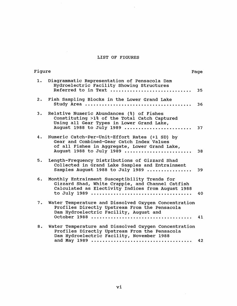
LIST OF FIGURES
Figure Page
1. Diagrammatic Representation of Pensacola Dam Hydroelectric Facility Showing Structures Referred to in Text . . . . . . . . . . . . . . . . . . . . . . . . . . . . . 3 5
2. Fish Sampling Blocks in the Lower Grand Lake Study Area . . . . . . . . . . . . . . . . . . . . . . . . . . . . . . . . . . . . . . 3 6
3. Relative Numeric Abundances (%) of Fishes Constituting >1% of the Total Catch Captured Using all Gear Types in Lower Grand Lake, August 1988 to July 1989 ••••••..•••••••••.•.•••• 37
4. Numeric Catch-Per-Unit-Effort Rates (+1 SD) by Gear and Combined-Gear catch Index Values of all Fishes in Aggregate, Lower Grand Lake, August 1988 to July 1989 • • • • • • • • • • • • • • • • • • • • • • • • 38
5. Length-Frequency Distributions of Gizzard Shad Collected in Grand Lake Samples and Entrainment Samples August 1988 to July 1989 •••.•••••••••••• 39
6. Monthly Entrainment Susceptibility Trends for Gizzard Shad, White Crappie, and Channel Catfish Calculated as Electivity Indices from August 1988 to July 1989 . . . . . . . . . . . . . . . . . . . . . . . . . . . . . . . . . . . . 40
7. Water Temperature and Dissolved Oxygen Concentration Profiles Directly Upstream From the Pensacola Dam Hydroelectric Facility, August and October 1988 . . . . . . . . . . . . . . . . . . . . . . . . . . . . . . . . . . . . 41
8. Water Temperature and Dissolved Oxygen Concentration Profiles Directly Upstream From the Pensacola Dam Hydroelectric Facility, November 1988 and May 1989 . . . . . . . . . . . . . . . . . . . . . . . . . . . . . . . . . . . . 42
vi
Chapter I
INTRODUCTION
This thesis is comprised of one manuscript written for
submission to the Transactions of the American Fisheries
Society. Chapter I is an introduction to the rest of the
thesis. The manuscript is complete as written and does not
require additional support material. The manuscript is
contained in Chapter II and is titled 'Entrainment
susceptibilities of fishes inhabiting the lower portion of
Grand Lake, Oklahoma.'
1
Chapter II
ENTRAINMENT SUSCEPTIBILITIES OF FISHES
INHABITING THE LOWER PORTION
OF GRAND LAKE 1 OKLAHOMA
Kent Sorenson
Oklahoma Cooperative Fish and Wildlife Research Unit,
Department of Zoology, Oklahoma State University,
Stillwater, OK 74078
2
3
Abstract.-! documented the seasonal dynamics of juvenile and
adult fish in the vicinity of the Pensacola Dam hydropower
facility on Grand Lake, Oklahoma, to determine
species-specific entrainment susceptibilities. Fishes in
Grand Lake were sampled monthly from August 1988 to July
1989 using gill nets, trap nets, and electrofishing gear.
Water quality profiles were recorded concurrently. I used
techniques typically used to quantify foraging preferences
of selective predators to estimate the entrainment
susceptibilities of individual species to non-selective
"predation" by hydropower intakes. Relative abundances of
fishes in Grand Lake were compared to relative abundances of
fishes entrained (obtained from a concurrent study
estimating entrainment rates) using Strauss' electivity
index to determine species-specific entrainment
susceptibilities. Wilcoxon's signed-rank test was used to
incorporate sampling error and test statistical
significance. Fishes were not entrained at rates reflecting
their relative abundance in the lake. Only 8 of the 25
species collected in Grand Lake were entrained. Entrainment
of gizzard shad exceeded expectations based on their
relative abundance in the reservoir and it was the only
species significantly susceptible to entrainment.
Susceptibility to entrainment of all other species was
negative or proportional to relative abundance. High
midwinter entrainment of gizzard shad resulted from their
4
habitation of deep water proximal to the turbine intakes and
cold-induced torpor. Entrainment was size-selective being
skewed to enhance the selection of small fish. Occasional
entrainment of white crappie and channel catfish was
probably a result of the predilection of these species for
structural cover in deep water as afforded by the forebay of
the intake structure. Hypolimnetic anoxia associated with
summer stratification precluded entrainment of all species
during summer.
5
Extensive research on the effects of hydropower on
adult and juvenile fish has been conducted in coldwater
systems. These studies addressed upstream and downstream
passage associated with the completion of life cycles of
anadrornous salmon and shad in the Pacific Northwest and New
England (e.g., Schoeneman et al. 1961; Raymond 1979; Bell
and Kynard 1985). Fish passing through hydropower plants
may be subject to both immediate and delayed mortality.
Common forms of immediate mortality include decapitation and
crushing; delayed forms include deaths resulting from
internal injuries, sudden pressure changes, and predation
(Cramer and Oligher 1964; Cada 1988). Of no less importance
are the fishes merely displaced downstream from the darn,
because they are lost from the reservoir fishery.
Entrainment in warm-water reservoirs has not been
st~died because of the absence of obligatory migrants in
these systems. However, many warrnwater reservoirs contain
populations of once-anadrornous, now land-locked species
(e.g., striped bass, Morone saxatilis; Scruggs 1955) which
range widely (Pflieger 1975) and are subject to entrainment.
In addition, many reservoir fishes are pelagic and nomadic
(Pflieger 1975), rendering them vulnerable to entrainment.
Grand Lake 0' the Cherokees (Grand Lake) is an 18,818-
hectare multi-purpose hydropower impoundment completed by
the Grand River Darn Authority (GRDA) in 1940 by inundation
of the Grand (Neosho) River by the Pensacola Darn. Grand
6
Lake was authorized by Congress to provide flood control,
recreation, and hydropower, and the hydroelectric generating
plant was granted a 50-year operating license. The license
expired in 1988 and required renewal for the GRDA to
continue hydropower generation. Relicensing required the
GRDA to prepare an environmental impact assessment of the
hydropower project. This assessment provided an opportunity
to examine the effects of entrainment by the hydropower
plant on adult and juvenile fishes in a warm-water
reservoir.
The only previous study on entrainment of adult and
juvenile warm-water fish was on the Ohio River (Greenup Dam,
Vanceburg, Kentucky). Seasonal spatial and temporal
distributions of fishes remained unchanged throughout the
nine month duration of the study. At least 80 percent of
the fish detected hydroacoustically immediately upstream of
the forebay trashracks were entrained into the turbine
gallery. Of those entrained, 93 percent were gizzard shad
(Dorosoma cepedianum) and freshwater drum (Aplodinotus
grunniens). Sport fish were entrained at a lower rate than
expected as judged by their relative abundances upstream
from the dam. However, no work was done during the winter
months when streamflows peaked and entrainment potentials
probably were greatest (Olson et al. 1988).
Simply documenting the presence of fishes in areas of
potentially high entrainment risk does not allow estimation
of entrainment because the assumption of equal
species-specific entrainment susceptibility is likely
erroneous (Helvey 1985). Entrainment susceptibility is
regulated by attraction to intake structures, taxis to
current, and body length due to the relationship between
swimming speed and body length (Jones et al. 1974).
Behavioral activities of a species may enhance or diminish
entrainment potential, but species-specific entrainment
susceptibilities have only been inferred by investigating
behaviors and life histories (Helvey 1985).
7
Estimates of entrainment susceptibility can be made by
comparing relative abundances of fishes subject to
entrainment to the relative abundances of fishes entrained.
My goal was to assess the possible effects of hydropower
generation on fish populations in the lower portion of Grand
Lake. Accordingly, my objectives were to: determine if
relative abundances of fishes in the lower portion of Grand
Lake were reflected by species-specific entrainment rates;
determine if seasonal distribution of fishes contributed to
the entrainment susceptibilities of fishes in the lower
portion of Grand Lake; and de·termine if temporal differences
in water quality affected entrainment rates of fishes in the
lower portion of Grand Lake.
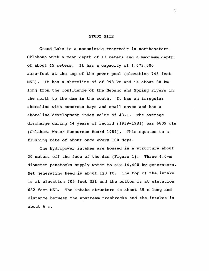
8
STUDY SITE
Grand Lake is a monomictic reservoir in northeastern
Oklahoma with a mean depth of 13 meters and a maximum depth
of about 45 meters. It has a capacity of 1,672,000
acre-feet at the top of the power pool (elevation 745 feet
MSL). It has a shoreline of of 998 km and is about 88 km
long from the confluence of the Neosho and Spring rivers in
the north to the dam in the south. It has an irregular
shoreline with numerous bays and small coves and has a
shoreline development index value of 43.1. The average
discharge during 44 years of record (1939-1981) was 6809 cfs
(Oklahoma Water Resources Board 1984). This equates to a
flushing rate of about once every 100 days.
The hydropower intakes are housed in a structure about
20 meters off the face of the dam (Figure 1). Three 4.6-m
diameter penstocks supply water to six-14,400-kw generators.
Net generating head is about 120 ft. The top of the intake
is at elevation 705 feet MSL and the bottom is at elevation
682 feet MSL. The intake structure is about 35 m long and
distance between the upstream trashracks and the intakes is
about 6 m.
9
METHODS
Field techniques
The fish assemblage inhabiting Grand Lake in the
vicinity of Pensacola Dam was sampled at about monthly
intervals from August 1988 to July 1989 using three gear
types (gill nets, trap nets, and electrofishing). The study
area encompassed the lower section of Grand Lake within
about 3 km of the hydroelectric facility (Figure 2). The
area was divided into 22 sampling blocks, each roughly 500-m
square (Figure 2).
From August through December 1988, twelve
monofilament-nylon experimental gill nets were set each
month. The nets were 2.4 m deep, 91.4 m long, and included
six 15.2-m panels with bar mesh sizes of 3.81, 5.08, 6.35,
7.62, 8.89, and 10.16 em. A stratified-random sampling
design was used to select net locations and depths, with
emphasis placed on the four blocks in the vicinity of the
hydropower intakes (blocks 1, 2, 5, and 6; Figure 2). Four
nets were set at randomly selected locations in these
blocks, and the remainder were set in randomly selected
blocks throughout the study area. Four nets were set at the
surface, four at mid-water, and four at the bottom. Nets
were fished for 24 hours. All captured fish were removed,
identified, weighed (g), measured (mm total length), and
released. Each net set constituted one unit of effort.
Effort was increased to 16 net sets per month from January
through July 1989 by the addition of four nets in block 1.
10
Ten trap nets were set in the study area on each
sampling date. Trap nets were set in coves in sampling
blocks 1 (2 nets), 4 (4 nets), 8 (3 nets), and 13 (2 nets).
The nets were constructed of tarred 1.3-cm nylon mesh
stretched over two 1.8x0.9-m frames and four 0.76-m diameter
hoops; a single 12.7-m lead extended perpendicularly from
the mouth of each net. The trap nets were set perpendicular
to shore with their leads extending towards shore and fished
for 24 hours. All captured fish were removed, identified,
weighed, measured, and released. Each net set constituted
one unit of effort in the catch-rate analyses.
A commercially-produced 6.1-m aluminum electrofishing
boat (Coffelt Manufacturing, Inc., Flagst~ff, AZ) was used
to complete 10 standardized electrofishing transects each
month from August through December 1988. Pulsed direct
current (300 volts, 6 to 8 amperes, 60% pulse width, 80
pulses per second) was applied in 500-m linear transects.
Transects were completed at randomly selected stations
stratified as follows: three along the east shoreline
(blocks 4, 8, and 13), one along the west shoreline (blocks
1, 5, 9, 14, 19, 20, and 22), one along the face of the dam
in block 1, one along the shoreline in block 1, and four in
open-water blocks. Two of the open-water transects were in
11
the vicinity of the hydropower intakes (blocks 1, 2, 5, and
6; Figure 1). All captured fish were identified, weighed,
measured, and released. Total catches of each species in
each transect will constitute catch-per-unit-effort rates
(i.e., number per transect). Effort was increased to 12
electrofishing transects per month from January through July
1989 by the addition of two open water transects in block 1.
Water quality profiles of the water column about 150 m
directly upstream from the hydroelectric facility were
recorded in association with fish sampling. Water
temperature, dissolved oxygen concentration, pH, and
conductivity were measured with a Hydrolab Surveyor II at
1-m intervals from the surface to a depth of 20 m;
additional measurements were taken at 5-m intervals to the
bottom.
Analyses
Mean catch-per-unit-effort (CPUE) rates (by gear) of
all species in aggregate and of species composing >1% of
total catch were plotted over time to assess seasonal trends
in abundance at the study sites. A catch index value
combining the two most effective gear types for each species
was calculated for each sampling date to facilitate
evaluation of seasonal trends in abundance of major species;
the index incorporated the relative magnitude of
gear-specific catch rates by date and treated both gears
12
equally. Monthly gear-specific CPUE rates were divided by
the highest CPUE of that gear type obtained over the study
duration to calculate a relative CPUE value ranging from 0
to 1. The catch index value was the mean of the two
relative CPUE rates. For example: Monthly index value =
[(Gear 1 monthly CPUE/Gear 1 highest observed CPUE)+(Gear 2
monthly CPUE/Gear 2 highest observed CPUE)]/2. All three
gear types were used to calculate the index value for all
species in aggregate. The index values were used only to
facilitate evaluation of seasonal trends; they were not used
in the quantitative analyses.
Analysis of variance was used to test whether
significant differences existed in mean CPUE rates of all
species among sampling dates. Duncan's multiple comparison
procedure was used to identify months during which CPUE
rates were significantly different (alpha= 0.05).
Length-frequency distributions of fishes collected in Grand
Lake were constructed for comparison with fishes collected
in the entrainment samples.
A concurrent study conducted by the Oklahoma
Cooperative Fish and Wildlife Research Unit estimated
monthly entrainment of fishes at the Pensacola Dam
hydropower facility (Fisher and Zale 1990). Entrained fish
were collected in modified fyke nets positioned in the draft
tubes. The densities of entrained fish were multiplied by
monthly discharges to estimate total monthly entrainment. A
total of nine species were entrained (gizzard shad, white
crappie (Pomoxis annularis), channel catfish (Ictalurus
punctatus), bluegill (Lepomis macrochirus), blue catfish
(Ictalurus furcatus), green sunfish (Lepomis cyanellus),
freshwater drum, white bass (Morone chrysops), and bigmouth
buffalo (Ictiobus cyprinellus); Appendix A). Most entrained
individuals were small (<200 mm), with the exception of a
few catchable-sized channel catfish and one large bigmouth
buffalo.
13
These entrainment estimates were compared to relative
abundances of fishes in monthly collections from Grand Lake
to estimate entrainment susceptibilities of sp~cies present.
I used techniques typically u~ed to quantify foraging
preferences of selective predators to quantify
susceptibilities of individual species to non-selective
'predation' by the turbine intakes. The linear electivity
index (Strauss 1979) was us~d to determine relative
susceptibilities of individual species to entrainment; the
index is defined as
L=r-p
where r and p are the relative abundances of a species in
entrainment samples and Grand Lake, respectively. Strauss'
index was used mainly because of its simplicity, but its
linear property gives the advantage of having symmetrical
deviation of the index for all values where r does not equal
p (Lechowicz 1982). Relative abundances of each species in
14
pooled monthly collections (all three gear types) and in
pooled monthly turbine-net samples were compared. L ranges
from -1 to +1, with positive values indicating enhanced
susceptibility to entrainment and negative values indicating
lower susceptibility to entrainment. The expected value for
a species entrained in proportion to its relative abundance
(i.e., random sdsceptibility') is zero. Wilcoxon's
signed-rank test (Hollander and Wolfe 1973; Kohler and Ney
1982) was used to determine if susceptibilities were
significantly different from random. Relative abundances of
each species in pooled monthly collections and in individual
turbine-net samples collected in a month were compared using
this nonparametric paired test (Appendix B).
RESULTS
A total of 25 species cornposed of 3,726 individuals was
collected in the lower Grand Lake study area with all three
gear types from August 1988 to July 1989. Gizzard shad
dominated the total catch (34.2%), followed by white crappie
(14.3%), brook silverside (Labidesthes sicculus; 13.9%) and
bluegill (13.8%); 10 species individually composed >1% of
the total catch and 95.4% in aggregate (Figure 3).
The white bass was the most abundant (27.3%) of the 15
species in the gill net catch, followed by white crappie
(23.8%), channel catfish (18.4%), and gizzard shad (10.2%).
Ten species individually composed >1% of the gill-net catch
15
and 97.6% in aggregate. White crappie (51.7%) and bluegill
(37.5%) dominated the trap-net catch. Six of the 14 species
collected with trap nets individually composed >1% of the
catch and 98.2% in aggregate. The electrofishing catch was
dominated by gizzard shad (51.6%). Brook silversides
composed 22.3% of the electrofishing catch and 7 other
species individually contributed at least 1%. In aggregate,
these 9 species (out of 20) composed 97.7% of the
electrofishing catch (Appendix C).
Gear-specific catch rates of all species in aggregate
exhibited only modest seasonal fluctuations (Table 1).
Catch rates of all species in aggregate for all gear types
tended to be low and stable in autumn and winter and higher,
yet variable, in spring and summer (Figure 4). Significant
differences existed among monthly mean catch rates of all
species in aggregate (Appendix D) only for trap nets
(P=0.0012); no significant difference existed among monthly
mean catch rates of all species in aggregate in gill nets
(P=0.1320) or by electrofishing (P=0.1177).
Of the 11 major species present in lower Grand Lake
(i.e., species that composed >1% of the total catch),
significant differences existed among monthly mean catch
rates of only three (bluegill, channel catfish, and gizzard
shad) in the gear type most effective for each. Catch rates
of bluegill in trap nets and channel catfish in gill nets
were significantly elevated during July 1989 and June 1989,
16
respectively. Catch rates of gizzard shad in electrofishing
samples were significantly higher in November 1988 than
during the remainder of the study period. Gill net catches
of white bass peaked in April 1989, but the increased catch
rate was not significant. Although elevated in summer, no
significant differences existed among the monthly mean catch
rates of the remaining abundant and entrained species in the
gear type most effective for each (white crappie in trap
nets, and green sunfish in electrofishing samples).
The length-frequency distribution of gizzard shad
collected in lower Grand Lake was largely unimodal and
primarily composed of adult sizes; the entrained gizzard
shad consisted of mainly young-of-the-year individuals
(Figure 5). The length frequency distribution of white
crappie in Grand Lake consisted of unimodal adult-sized
(>200 mm) individuals; entrained white crappie were
represented by smaller (<200 mm) individuals. Channel
catfish in Grand Lake were represented by wide size ranges
of individuals including multiple age-classes and
catchable-sized individuals. Entrained channel catfish were
represented largely by sub-adult individuals, but
catchable-sized fish were also collected.
Of 9 species entrained, 8 were collected in lower Grand
Lake. A single bigmouth buffalo was taken in entrainment
samples, but the species was absent in Grand Lake
collections. Species that composed >1% of the Grand Lake
assemblage but which were not entrained, included brook
silversides, largemouth bass, smallmouth buffalo, and
longear sunfish. Thirteen other species also collected in
Grand Lake were absent from entrainment samples.
17
Susceptibility to entrainment of the 9 species
entrained from August 1988 to July 1989 was positive (as
judged by the linear electivity index) only for gizzard shad
and bigmouth buffalo over the entire period (Table 2).
However, susceptibility to entrainment was significantly
positive only for gizzard shad over the entire August 1988
to July 1989 period; susceptibility was significantly
negative for all other species (Table 2).
Entrainment susceptibilities of individual species
varied. among months as relative abundances in Grand Lake and
in entrainment samples changed. However, significant
positive susceptibility to entrainment was limited to
gizzard shad and only from February through June 1989
(Figure 6). Entrainment of gizzard shad did not differ
significantly from random during other months except during
November 1988 when they were significantly negatively
susceptible to entrainment. Monthly entrainment
susceptibilities of all other species were either random or
significantly negative over the entire period (Appendix B).
Seasonal trends in susceptibility to entrainment were
evident only for gizzard shad, white crappie, and channel
catfish. Entrainment susceptibilities of gizzard shad were
18
depressed in autumn and enhanced in late winter, spring, and
summer (Figure 6). The inverse, albeit less dramatic; was
evident for white crappie and channel catfish (Figure 6).
Entrainment susceptibilities of white bass, bluegill, blue
catfish, green sunfish, 'and freshwater drum were typically
random or slightly negative and-showed no distinct seasonal ·'
trends.
Limnological characteristics of the water column in the
immediate vicinity of Pensacola Dam (Figures 7 and 8) were
largely dictated by seasonal reservoir stratification
dynamics. Strong stratification was evident from August
through October 1988 (Figure 7), but dissolved oxygen
concentrations in 1988 were <2 mg/L over .~he entire range of
depths encompassed by the intakes only during August (Figure
7). Stratification was absent from November 1988 through
March 1989 (Figure 8), intermediate in May 1989 (Figure 8),
and returned to patterns exhibited in October 1988 (Figure
7) and August 1988 (Figure 7) in June and July 1989,
respectively. Dissolved oxygen concentrations were <2 mg/L
over the entire range of depths encompassed by the in~akes, . similar to August 1988 profiles (Figure 7), again during
July 1989. Only two fish were caught in gill nets set below
the thermocline during periods when the reservoir was
stratified; these may have become-enmeshed during net
retrieval.
19
DISCUSSION
The relative abundances of individual fish species in
the hydropower intake area of Grand Lake did not accurately
reflect relative entrainment rates. Both lake and
entrainment samples were dominated by gizzard shad, but
entrainment of this species often exceeded its relative
abundance, suggesting it was more susceptible to entrainment
than other fishes present in lower reaches of Grand Lake.
The gizzard shad accounted for over 99% of the total
abundance in entrainment samples (Fisher and Zale 1990), but
it composed about 34% of the collections in Grand Lake. The
gizzard shad was also the most frequently entrained species
at Greenup Dam, Kentucky (Olson et al., 1988).
Gizzard shad tend to travel in large schools (Miller
and Robison 1973; Pflieger 1975) which may predispose them
to additional entrainment risk. At an offshore cooling
intake off the Karachi coast of Pakistan, schooling fishes
were generally more vulnerable to entrainment, as they were
often sluggish, weak swimmers, and were generally of small
size (Moazzam and Rizvi 1980). Schooling fishes were
entrained at an offshore cooling intake off the California
coast more often than resident reef fishes (Helvey 1985).
Whereas gizzard shad are not a physically hardy species
(Miller 1960), I do not believe them to be weak swimmers.
However, schooling behavior may tend to magnify the
consequence of an encounter with the hydropower intakes
because entrainment is the fate of many individuals
simultaneously.
20
Entrainment susceptibilities of other entrained species
in Grand Lake (white crappie, channel catfish, bluegill,
blue catfish, green sunfish, bigmouth buffalo, freshwater
drum, and white bass) were negative and many species present
in lower Grand Lake were absent in entrainment samples.
These were often species that, due to their behavior and
habitat preferences were not present in the deeper waters
near the intake structures. For example, the brook
silverside was numerically the third most abundant fish
present in Grand Lake but was absent from entrainment
samples. It spends most of its life within a few
centimeters of the surface and never goes deeper than a few
meters (Pflieger 1975). The largemouth bass (Micropterus
salmoides) was not collected in entrainment sampled despite
being the seventh most abundant fish collected in Grand
Lake. Largemouth bass prefer weedy littoral areas and when
in deeper water are found near bottom (Pflieger 1975).
Pelagic species other than gizzard shad (i.e., white
bass, hybrid striped bass, and freshwater drum) did not
appear to be susceptible to entrainment. Hybrid striped
bass are stocked at locations far upstream of the intakes
(Jim Smith, Oklahoma Department of Wildlife Conservation,
pers. com.). Stocking them far upstream allows them time to
grow before encountering the intakes and renders them less
apt to be entrained. White bass migrate to tributary
streams to spawn (Pflieger 1975), and by the time the young
encounter the intakes, they too are likely large enough to
effectively resist intake velocities. Freshwater drum were
not abundant in the lower portion of Grand Lake and were
entrained at rates proportional to, or less than, their
monthly relative abundances.
21
White crappie and channel catfish were the only species
other than gizzard shad often entrained. Although never
significantly susceptible to entrainment, these were the
only other species to frequently exhibit enhanced likelihood
of entrainment as indicated by Strauss' index. Because
lower Grand Lake is largely devoid of cover, the entrainment
of these species may have resulted from their attraction to
the cover afforded by the intake structure. Inasmuch as the
intake structure offered cover, it also caused local
vertical velocity gradients having an unknown effect on
orientation and behavior (Hocutt and Edinger 1980).
Fishes may become entrained because of behaviors that
bring them into direct contact with the intake water
currents at times when their vision is impaired or when
intake hydraulics disorient their position in the flow
(Helvey 1985). Confusion caused by these factors may
prevent fishes from vacating areas where intake velocities
make entrainment imminent. In addition, the Pensacola plant
22
is a load-control facility exhibiting frequent start-ups
during peak electrical demand. This method of operation may
have promoted entrainment of white crappie and channel
catfish that were inhabiting the forebay during periods of
non-generation.
Entrainment was size-selective and consisted primarily
of small, young-of-the-year individuals. Although the
hydroelectric facility's trash racks precluded entrainment
of exceptionally large individuals, it is likely that
size-selective entrainment was a function of the positive
relationship between swimming speed and body length (Jones
et al. 1974). Large individuals could attain swimming
speeds required to escape intake velocities whereas smaller
fish were unable to escape and were entrained. High
entrainment rates of young-of-the-year gizzard shad during
winter were likely a product of their size-mediated swimming
ability, sensitivity to low temperatures (Miller 1960;
Heidinger 1983), and propensity to 'hibernate' in deep water
during winter (Velasquez 1939; Jester and Jensen 1972).
Seasonal changes in relative abundance were not
reflected by similar entrainment rate changes. In fact,
relative abundances in the lake were most often opposite
those in the entrainment samples. Gizzard shad entrainment
peaked during late winter and early spring coincident with
their lowest CPUE rates and relative abundances in Grand
Lake. Similarly, entrainment rates of other species (white
23
crappie and channel catfish) were highest in late summer,
autumn, and early winter, corresponding temporally with
their lowest CPUE rates and relative abundances. The
apparent high susceptibility of gizzard shad to entrainment
during winter may have been due, in part, to sampling gear
limitations. Gill nets were the only gear used to sample
the profunda! areas inhabited by the gizzard shad in the
winter. Cold water renders passive gears less effective by
reducing the activity of fish, ultimately leading to
underrepresentation in the abundance estimates in the lake.
The enhanced electivity index values (i.e., high
susceptibility) may be an artifact of inadequate sampling
gear performance, which artifically lowered the relative
abundance estimates of gizzard shad in the winter samples of
lower Grand Lake.
Seasonal stratification of Grand Lake influenced
vertical fish distributions and entrainment rates. Fish
were absent from the hypolimnion, but the thermocline was
typically present at depths below the upper edge of the
turbine intakes. Accordingly, stratification capable of
inhibiting entrainment was present only during mid-summer.
The two lowest estimates of monthly turbine entrainment were
recorded in August 1988 and July 1989 when dissolved oxygen
concentrations were <2 mg/L over the entire range of depths
encompassed by the intakes. Gizzard shad, white crappie,
and channel catfish avoid waters with dissolved oxygen
24
concentrations less than 2 mg/L (Gebhart and Summerfelt
1978). However, low rates of entrainment during these
months suggested that stratification was destabilized by
hydropower generation in the forebay of the intake structure
and allowed habitation of the forebay structure at the depth
of the intakes by fish.
To minimize the effects of entrainment at hydropower
facilities, methods to divert fish away from areas of high
risk and practices to increase survival of entrained fish
have been used. Operation of hydropower facilities at peak
efficiency minimizes the probability of encounter of excess
stress during turbine passage. Operatio~ at low efficiency
subjects entrained fish to increased cavitation, excess
turbulence, and shear forces. However, no single
operational or design approach decreases mortality rates to
<10% on a consistent basis (Cada 1988). Where operational
or design alterations are not feasible, appreciable
decreases in mortality- are best obtained through exclusion
from areas of high entrainment risk. Due to the low
entrainment rates of game fish and the seasonality of
gizzard shad entrainment, implementation of entrainment
deterrance devices would probably not lead to a significant
improvement in the fishery of Grand Lake.
In summary, entrainment of recreationally and
commercially important sport and food fishes by the
Pensacola Dam hydroelectric facility was limited because
25
these spec1es were not abundant in the vicinity of the dam
and their relative susceptibilities to entrainment were low.
Gizzard shad, especially young-of-the-year, were seasonally
susceptible to entrainment, but dominance of the reservoir's
fish assemblage by this species suggested that effects of
entrainment were minimal or inconsequential. Because
gizzard shad are often considered over-abundant in
impoundments (Miller 1960; Jenkins 1957), it seems unlikely
that selective entrainment of this species is deleterious to
the ichthyofauna of Grand Lake.
My research may be applicable to many morphologically
similar southern reservoirs built primarily for hydropower
generation. Application to smaller reservoirs, those not
stratifying, or those with faster flushing rates (i.e., more
riverine in nature) may be limited. Relevance to pumped
storage facilities would only be incurred during generation
periods and not to pump phases of operation.
REFERENCES
Bell, C. E. and B. Kynard. 1985. Mortality of adult
American shad passing through a 17-megawatt Kaplan
turbine at a low head hydroelectric dam. North
American Journal of Fisheries Management 5:33-38.
Cada, G. F. 1988. Assessing fish mortality rates. Hydro
Review 9:52-60.
Cramer, F. K., and R. C. Oligher. 1964. Passing fish
through hydraulic turbines. Transactions of the
American Fisheries Society 93:243-259.
Fisher, W. L., J. J. Charbonneau, and M. J. Hay. 1986.
Development of management programs and measurement of
economic values. Pages 5-10 in G. E. Hall and M. J.
Van Den Avyle, editors. Reservoir fisheries
management: Strategies for the 80's. Reservoir
Committee, Southern Division American Fisheries
Society, Bethesda, Maryland.
Fisher, W. L. and A. V. Zale. 1990. Effects of the
Pensacola hydropower project on the fishery resource of
the Grand River. Component A.2. Final report to the
Grand River Dam Authority, Vinita, Oklahoma. 39pp.
26
27
Gebhart, G. E. and R. C. Summerfelt. 1978. Seasonal growth
rates of fishes in relation to conditions of lake
stratification. Proceedings of the Oklahoma Academy of
Science 58:6-10.
Heidinger, R.C. 1983. Life history of gizzard shad and
threadfin shad as it relates to the ecology of small
lake fisheries. Pages 1-18 in Proceedings of Small
Lake Management Workshop "Pros and Cons of Shad." Des
Moines, Iowa.
Helvey, M. 1985. Behavioral factors influencing fish
entrapment at offshore cooling-water intake structures
in southern California. Marine Fisheries Review
47(1):18-26.
Hocutt, C. H., and J. E. Edinger. 1980. Fish behavior in
flow fields. Pages 143-183 in C. H. Hocutt, J. R.
Stauffer, Jr., J. E. Edinger, L. W. Hall, Jr., and R.
P. Morgan II, editors. Power plants effects on fish
and shellfish behavior. Academic Press, New York.
Hollander, M., and D. A. Wolfe. 1973. Nonparametric
statistical methods. Wiley and Sons, New York.
Jenkins, R. M. 1957. The effect of gizzard shad on the
fish population of a small Oklahoma lake. Transactions
of the American Fisheries Society 85:58-74.
Jester, D. B., and B. L. Jensen. 1972. Life history and
ecology of the gizzard shad, Dorosoma cepedianum
(LeSueur) with reference to Elephant Butte Lake. New
Mexico State University Agriculture Experiment Station
Research Report 218. 56 pp.
Jones, D. R., J. W. Kideniuk, and 0. S. Banford. 1974.
Evaluation of the swimming performance of several fish
species from the Mackenzie River. Journal of the
Fisheries Research Board of Canada 31:1641-1647.
Kohler, C. c., and J. J. Ney. 1982. A comparison of
methods for quantitative analysis of feeding selection
of fishes. Environmental Biology of Fishes 7:363-368.
Lechowicz, M. J. 1982. Sampling characteristics of
electivity indices. Oecologia 52:22-30.
Miller, R. J. and H. Robison. 1973. Fishes of Oklahoma.
Oklahoma State University Press, Stillwater, Oklahoma.
28
Miller, R. R. 1960. Systematics and biology of the gizzard
shad (Dorosoma cepedanium) and related fishes.
Fish and Wildlife Service Fisheries Bulletin
392.
u.s.
60:371-
Moazzam, M. and S. H. Rizvi. 1980. Fish entrapment in the
seawater intake of a power plant at Karachi coast.
Environmental Biology of Fishes 5:49-57.
Oklahoma Water Resources Board.
Atlas. Publication No. 120.
1984. Oklahoma's Water
185pp.
Olson, F. w., J. F. Palmisano, G. E. Johnson, and w. R.
Ross. 1988. Fish population and entrainment studies
for the Vanceburg Hydroelectric Generating Station No.
1. Volume 1. Fisheries resource studies Vanceburg
Hydroelectric Generating Station No. 1. FERC Project
No. 2614. City of Vanceburg, Kentucky. 92 pp.
Pflieger, W. L. 1975. The Fishes of Missouri. Missouri
Department of Conservation, Jefferson City, Missouri.
29
Raymond, H. L. 1979. Effects of dams and impoundments on
migrations of juvenile chinook salmon and steelhead
from the Snake River 1966 to 1975. Transactions of the
American Fisheries Society 108:505-529.
Schoeneman, D. E., R. T. Pressey, and C. 0. Junge. 1961.
Mortalities of downstream migrant salmon at McNary Dam.
Transactions of the American Fisheries Society 90:58-
72.
Scruggs, G. D. Jr. 1955. Reproduction of resident striped
bass in Santee-Cooper Reservoir, South Carolina.
Transactions of the American Fisheries Society 85:144-
159.
Strauss, R. E. 1979. Reliability estimates of Ivlev's
electivity index, the forage ratio, and a proposed
linear index of food selection. Transactions of the
American Fisheries Society 108:344-352.

Velasquez, G. T. 1939. On the viability of algae obtained
from the digestive tract of the gizzard shad, Dorosoma
cepedianum (LeSueur). American Midland Naturalist
22:376-412.
30
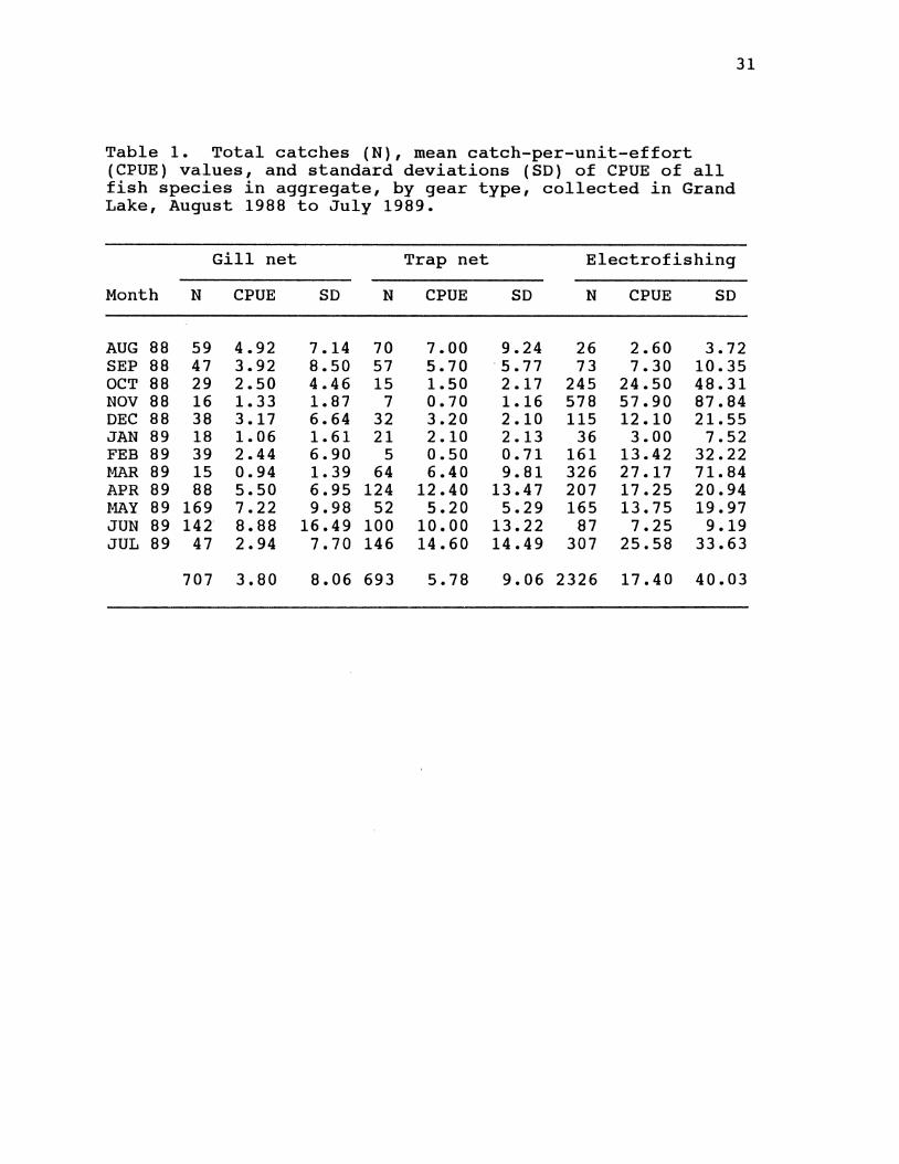
31
Table 1. Total catches (N), mean catch-per-unit-effort (CPUE) values, and standard deviations (SD) of CPUE of all fish species in aggregate, by gear type, collected in Grand Lake, August 1988 to July 1989.
Gill net Trap net Electrofishing
Month N CPUE SD N CPUE SD N CPUE SD
AUG 88 59 4.92 7.14 70 7.00 9.24 26 2.60 3.72 SEP 88 47 3.92 8.50 57 5.70 ·5.11 73 7.30 10.35 OCT 88 29 2.50 4.46 15 1.50 2.17 245 24.50 48.31 NOV 88 16 1. 33 1.87 7 0.70 1.16 578 57.90 87.84 DEC 88 38 3.17 6.64 32 3.20 2.10 115 12.10 21.55 JAN 89 18 1.06 1.61 21 2.10 2.13 36 3.00 7.52 FEB 89 39 2.44 6.90 5 0.50 0.71 161 13.42 32.22 MAR 89 15 0.94 1. 39 64 6.40 9.81 326 27.17 71.84 APR 89 88 5.50 6.95 124 12.40 13.47 207 17.25 20.94 MAY 89 169 7.22 9.98 52 5.20 5.29 165 13.75 19.97 JUN 89 142 8.88 16.49 100 10.00 13.22 87 7.25 9.19 JUL 89 47 2.94 7.70 146 14.60 14.49 307 25.58 33.63
707 3.80 8.06 693 5.78 9.06 2326 17.40 40.03
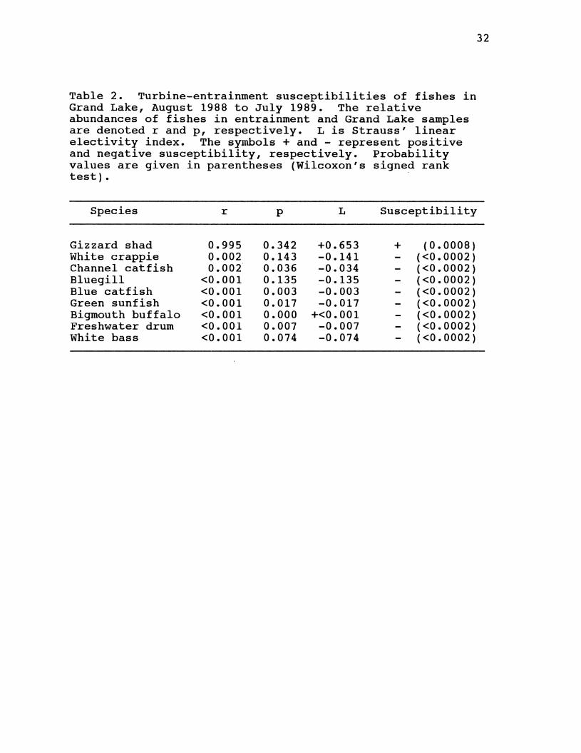
Table 2. Turbine-entrainment susceptibilities of fishes in Grand Lake, August 1988 to July 1989. The relative abundances of fishes in entrainment and Grand Lake samples are denoted r and p, respectively. L is Strauss' linear electivity index. The symbols + and - represent positive and negative susceptibility, respectively. Probability values are given in parentheses (Wilcoxon's signed rank test). -
Species r p L Susceptibility
Gizzard shad 0.995 0.342 +0.653 + (0.0008) White crappie 0.002 0.143 -0.141 (<0.0002) Channel catfish 0.002 0.036 -0.034 (<0.0002) Bluegill <0.001 0.135 -0.135 (<0.0002) Blue catfish <0.001 0.003 -0.003 (<0.0002) Green sunfish <0.001 0.017 -0.017 (<0.0002) Bigmouth buffalo <0.001 0.000 +<0.001 (<0.0002) Freshwater drum <0.001 0.007 -0.007 (<0.0002) White bass <0.001 0.074 -0.074 (<0.0002)
32
FIGURE CAPTIONS
1. Diagrammatic Representation of Pensacola Dam
Hydroelectric Facility Showing Structures
Referred to in Text.
2. Fish Sampling Blocks in the Lower Grand Lake
Study Area.
3. Relative Numeric Abundances (%) of Fishes
Constituting >1% of the Total Catch Captured
Using all Gear Types in Lower Grand Lake,
August 1988 to July 1989.
4. Numeric Catch-Per-Unit-Effort Rates (+1 SD) by
Gear and Combined-Gear catch Index Values
of all Fishes in Aggregate, Lower Grand Lake,
August 1988 to July 1989.
5. Length-Frequency Distributions of Gizzard Shad
Collected in Grand Lake Samples and Entrainment
Samples August 1988 to July 1989.
6. Monthly Entrainment susceptibility Trends for
Gizzard Shad, White Crappie, and Channel catfish
Calculated as Electivity Indices from August 1988
to July 1989.
33
7. Water Temperature and Dissolved oxygen Concentration
Profiles Directly Upstream From the Pensacola
Dam Hydroelectric Facility, August and
34
october 1988. The bars along the right vertical axes
indicate the depths of the turbine intakes.
8. Water Temperature and Dissolved Oxygen Concentration
Profiles Directly Upstream From the Pensacola
Dam Hydroelectric Facility, November 1988
and May 1989. The bars along the right vertical axes
indicate the depths of the turbine intakes.
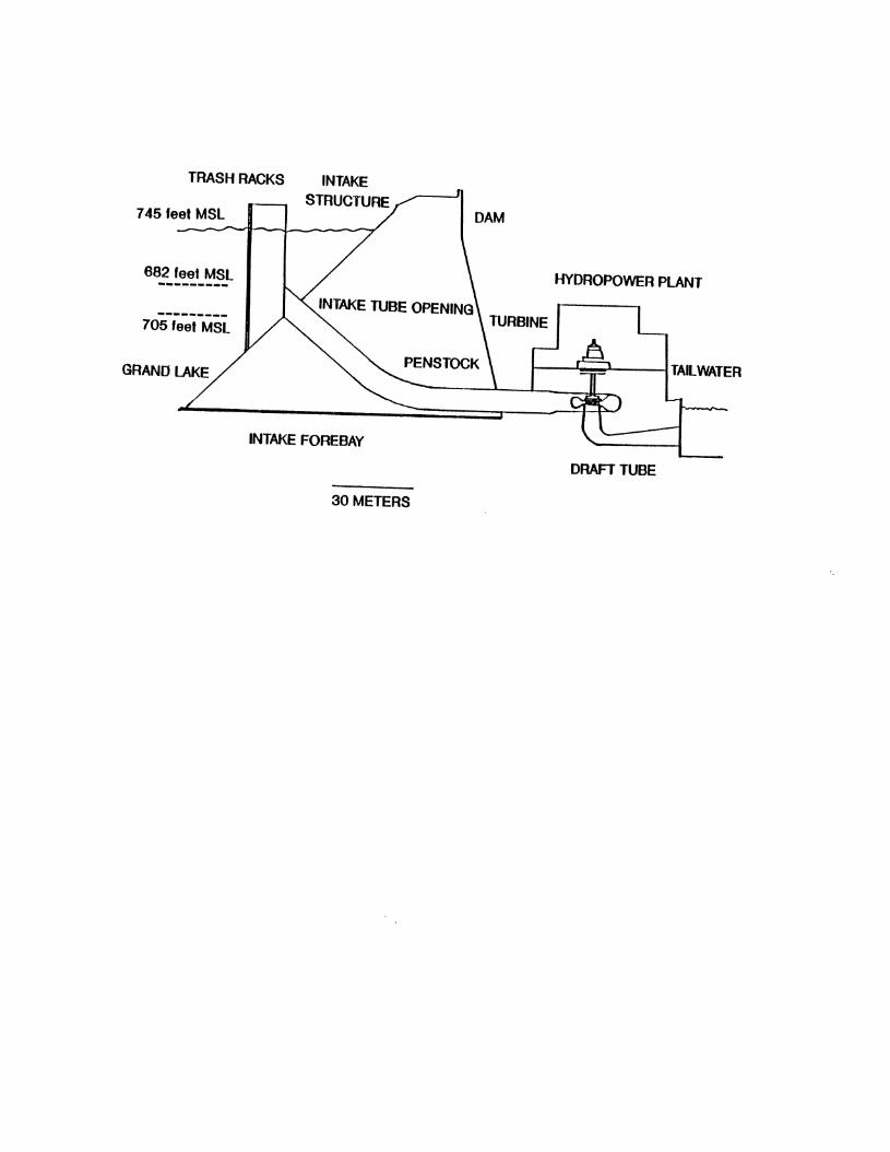
TRASH RACKS
745 feet MSL
682 feet MSL HYDROPOWER PLANT
TURBINE 705 feet MSL
INTAKE FOREBAY
DRAFT TUBE
30 METERS
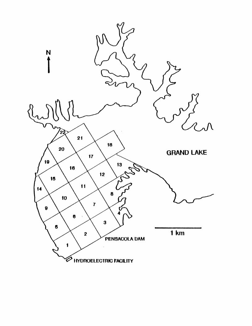
N
t
GRAND LAKE
1 km
~ HYOROElECffiiC FACLITY
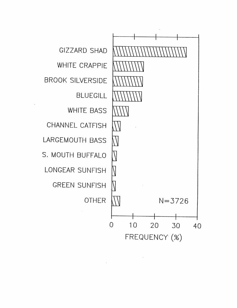
GIZZARD SHAD
WHITE CRAPPIE
BROOK SILVERSIDE
BLUEGILL
WHITE BASS
CHANNEL CATFISH
LARGEMOUTH BASS
S. MOUTH BUFFALO
LONGEAR SUNFISH
GREEN SUNFISH
OTHER N=3726
0 10 20 30 40
FREQUENCY·(%)

ALL FISHES - CPUE 30+-~--~-~·~--~~~~~~--~·--~~--+
N = 707
l:;:j 20 z .....J .....J (.:) 10
0 . . . 30 .
l:;:j 20 z a.. <( a::: 10 1-
0
150 (!) z
I .L
N = 2326 I U1 100 Lt. 0 a::: 1- 50 u w .....J w
0 . . 1.0 i
X w
0.5 0 z
0.0 ' I
A S 0 N D J F M A M J J
1988 1989
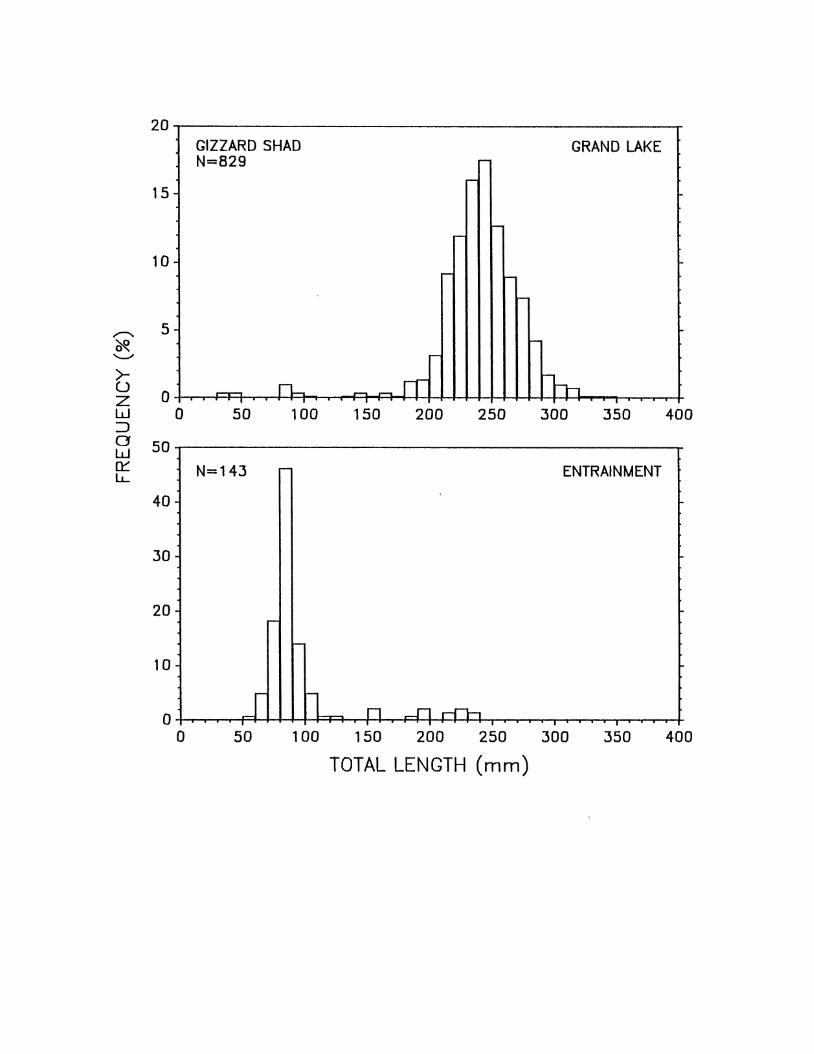
>u z w ::J 0 w r::r LL
20
15
10
5
0
50
40
30
20
10
0
0
-
0
GIZZARD SHAD GRAND LAKE N=829
..-.---. I
50
N=143
-
I 50
~
r-
--
r- r-
--
-
n-..,_ IT ~ I .
100 150 200 250 300 350
- ENTRAINMENT
'
r-
11 n ..n r-rh
1 00 150 200 250 300
TOTAL LENGTH (mm) 350
400
-
400
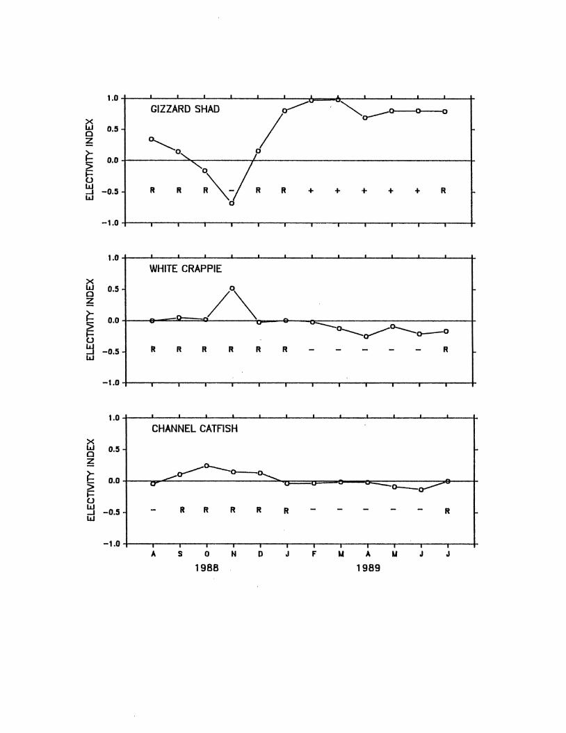
1.0 I . . I I
GIZZARD SHAD ~.., ~a---o---o--o X I w 0.5 0 ~ ~0 ~ 0.0
.. , p ~ "0 7 0
R""- R ~ -0.5 R R R + + + + + R w
-1.0 . I I I I I I I I I
1.0 . • I I _I I
WHITE CRAPPIE X w 0.5
/\ 0 z
~ 0.0 _ ....
5 U'
-----o-..._~o-..._o--0
~ -0.5 R R R R R R R w
-1.0 I I • I I
1.0 . . I I I
CHANNEL CATFISH X w 0.5 0 z
_...a--'~o.......... ~ 0.0
~ cr - -a--a---
u w -0.5 R R R R R R _.
w
-1.0 I I . A s 0 N D J F u A u J J
1988 1989
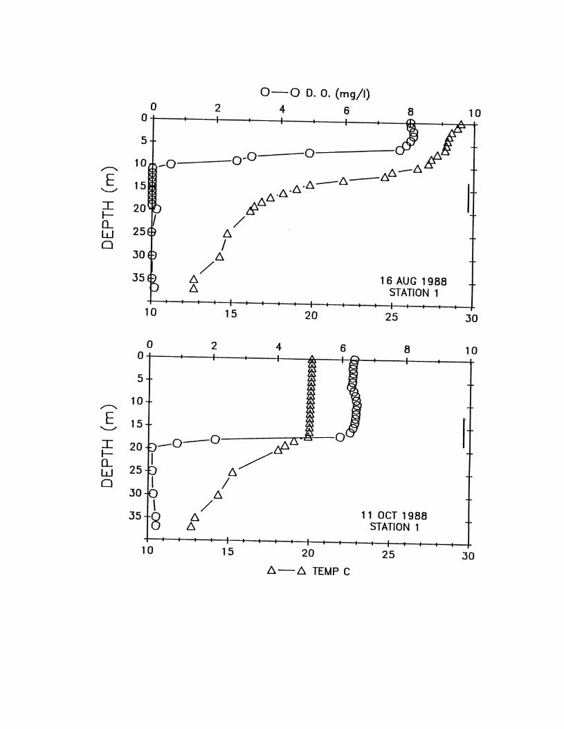
0-0 D. 0. (mg/1) 0 2 4 6 8 10 0
5
0'0 0 If 10 -0 b.-b. ,..--... /):..-~ E 15 6../):.-...__,
6..6.· :::r:: &6. I- / 0... w 6. 0 I
30 6. /
16 AUG 1988 35 6 6. STATION 1
10 15 20 25 30
0 2 4 6 8 10 0 ,... ~
5 ~ =:.:::
10 ~ ,..--...
E ~
I 15 o&
...__,
p-o-o !PD. :::r:: 20 I-
b 6./ 0...
25 w 0 ~ I
30 6. \ /
11 OCT 1988 35 8 6. 6. STATION 1
. 10 15 20 25 30
6.-6. TEMP C
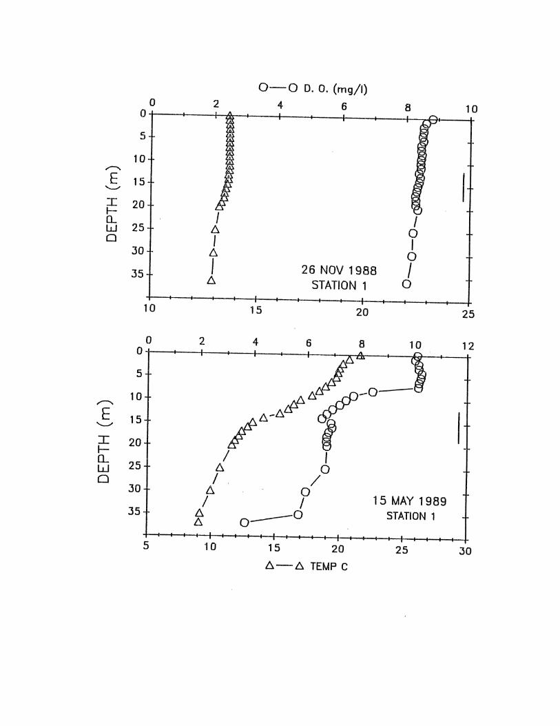
0-0 D. 0. (mg/1) 0 2 4 6 8 10 0 I'"'\
' r 5
~ 10 ~ ,.-....,
E 15
~~ ............
t I 20 ~ 1- I I (L w 25 6. 0 0 I I 30 6. 0
35 I 26 NOV 1988 I 6. STATION 1 0 I
10 15 20 25
0 2 4 6 8 10 12 0
5
10 ,--....
E 15 .....__.,
I 20 I-()_
25 w 0
30 15 MAY 1989
35 STATION 1
5 10 15 20 25 30 6.-6. TEMP C

APPENDIX A
MONTHLY ENTRAINMENT RATES
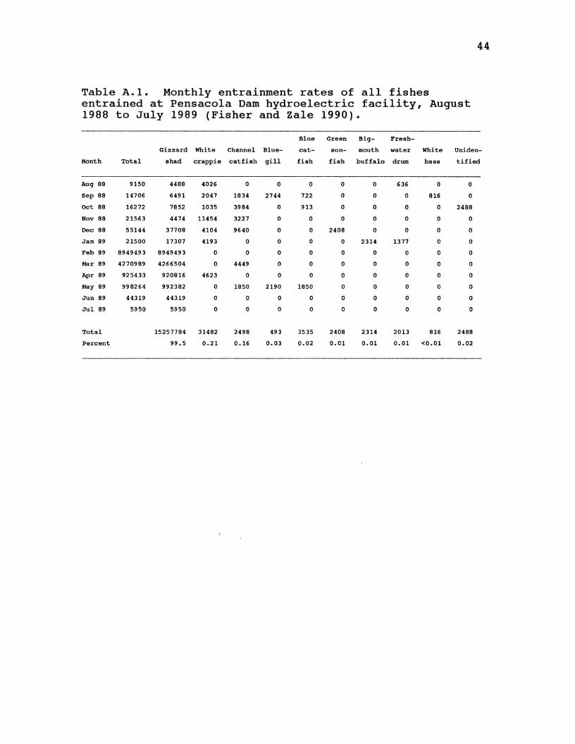
44
Table A.l. Monthly entrainment rates of all fishes entrained at Pensacola Dam hydroelectric facility, August 1988 to July 1989 (Fisher and Zale 1990).
Blue Green Big- Fresh-
Gio::~~ard White Channel Blue- cat- sun- mouth water White Uniden-
Month Total shad crappie catfish gill fish fish buffalo drum bass tified
Aug 88 9150 4488 4026 0 0 0 0 0 636 0 0
Sep 89 14706 6491 2047 1934 2744 722 0 0 0 816 0
Oct 88 16272 7852 1035 3984 0 913 0 0 0 0 2488
Nov 88 21563 4474 11454 3227 0 0 0 0 0 0 0
Dec 88 55144 37708 4104 9640 0 0 2408 0 0 0 0
Jan 89 21500 17307 4193 0 0 0 0 2314 1377 0 0
Feb 89 8949493 8949493 0 0 0 0 0 0 0 0 0
Mar 89 4270989 4266504 0 4449 0 0 0 0 0 0 0
Apr 89 925433 920816 4623 0 0 0 0 0 0 0 0
May 89 998264 992382 0 1850 2190 1850 0 0 0 0 0
Jun 89 44319 44319 0 0 0 0 0 0 0 0 0
Jul 89 5950 5950 0 0 0 0 0 0 0 0 0
Total 15257784 31482 2498 493 3535 2408 2314 2013 816 2488
Percent 99.5 0.21 0.16 0.03 0.02 0.01 0.01 0.01 <0.01 0.02
APPENDIX B
SUSCEPTIBILITY VALUES
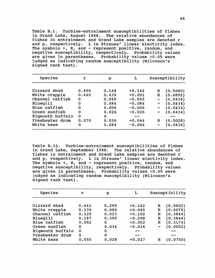
46
Table B.1. Turbine-entrainment susceptibilities of fishes in Grand Lake, August 1988. The relative abundances of fishes in entrainment and Grand Lake samples are denoted r and p, respectively. L is Strauss' linear electivity index. The symbols +, R, and - represent positive, random, and negative susceptibility, respectively. Probability values are given in parentheses. Probability values >0.05 were judged as indicating random susceptibility (Wilcoxon's signed rank test) .
Species r p L Susceptibility
Gizzard shad 0.490 0.148 +0.342 R (0.9680) White crappie 0.440 0.439 +0.001 R (0.6892) Channel catfish 0 0.045 -0.045 (0.0434) Bluegill 0 0.084 -0.084 (0.0434) Blue catfish 0 0.006 -0.006 (0.0434) Green sunfish 0 0.026 -0.026 (0.0434) Bigmouth buffalo 0 0 Freshwater drum 0.070 0.026 +0.044 R (0.5028) White bass 0 0.084 -0.084 (0.0434)
Table B.32. Turbine-entrainment susceptibilities of fishes in Grand Lake, September 1988. The relative abundances of fishes in entrainment and Grand Lake samples are denoted r and p, respectively. L is Strauss' linear electivity index. The symbols+, R, and- represent.positive, random, and negative susceptibility, respectively. Probability values are given in parentheses. Probability values >0.05 were judged as indicating random susceptibility (Wilcoxon's signed rank test).
Species r p L Susceptibility
Gizzard shad 0.441 0.299 +0.142 R (0.9602) White crappie 0.139 0.090 +0.049 R (0.0075) Channel catfish 0.125 0.023 +0.102 R (0.3844) Bluegill 0.187 0.395 -0.208 R (0.3844) Blue catfish 0.052 0 +0.052 R (0.3174) Green sunfish 0 0.034 -0.034 (0.0052) Bigmouth buffalo 0 0 Freshwater drum 0 0 White bass 0.055 0.028 +0.027 R (0.0750)
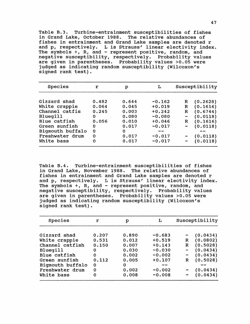
47
Table B.3. Turbine-entrainment susceptibilities of fishes in Grand Lake, October 1988. The relative abundances of fishes in entrainment and Grand Lake samples are denoted r and p, respectively. L is Strauss' linear electivity index. The symbols +, R, and - represent positive, random, and negative susceptibility, respectively. Probability values are given in parentheses. Probability values >0.05 were judged as indicating random susceptibility (Wilcoxon's signed rank test).
Species r p L Susceptibility
Gizzard shad 0.482 0.644 -0.162 R (0.2628) White crappie 0.064 0.045 +0.019 R (0.1616) Channel catfis 0.245 0.003 +0.242 R (0.6744) Bluegill 0 0.080 -0.080 (0.0118) Blue catfish 0.056 0.010 +0.046 R (0.1616) Green sunfish 0 0.017 -0.017 (0.0118) Bigmouth buffalo 0 0 Freshwater drum 0 0.017 -0.017 (0.0118) White bass 0 0.017 -0.017 (0.0118)
Table B.4. Turbine-entrainment susceptibilities of fishes in Grand Lake, November 1988. The relative abundances of fishes in entrainment and Grand Lake samples are denoted r and p, respectively. L is Strauss' linear electivity index. The symbols +, R, and - represent positive, random, and negative susceptibility, respectively. Probability values are given in parentheses. Probability values >0.05 were judged as indicating random susceptibility (Wilcoxon's signed rank test) . ·
Species r p L Susceptibility
Gizzard shad 0.207 0.890 -0.683 (0.0434) White crappie 0.531 0.012 +0.519 R (0.0802) Channel catfish 0.150 0.007 +0.143 R (0.5028) Bluegill 0 0.030 -0.030 (0.0434) Blue catfish 0 0.002 -0.002 (0.0434) Green sunfish 0.112 0.005 +0.107 R (0.5028) Bigmouth buffalo 0 0 Freshwater drum 0 0.002 -0.002 (0.0434) White bass 0 0.008 -0.008 (0.0434)

48
Table B.5. Turbine-entrainment susceptibilities of fishes in Grand Lake, December 1988. The relative abundances of fishes in entrainment and Grand Lake samples are denoted r and p, respectively. L is Strauss' linear electivity index. The symbols +, R, and - represent positive, random, and negative susceptibility, respectively. Probability values are given in parentheses. Probability values >0.05 were judged as indicating random susceptibility (Wilcoxon's signed rank test).
Species r p L Susceptibility
Gizzard shad 0.684 0.530 +0.154 R (0.6600) White crappie 0.074 0.097 -0.023 R (0.2846) Channel catfish 0.175 0.049 +0.126 R (0.0512) Bluegill 0 0.108 -0.108 (0.0034) Blue catfish 0 0 Green sunfish 0 0.016 -0.016 (0.0034) Bigmouth buffalo 0.042 0 +0.042 R (0.3174) Freshwater drum 0.025 0 +0.025 R (0.3174) White bass 0 0.070 -0.070 (0.0034)
Table B.6. Turbine-entrainment susceptibilities of fishes in Grand Lake, January 1989. The relative abundances of fishes in entrainment and Grand Lake samples are denoted r and p, respectively. L is Strauss' linear electivity index. The symbols +, R, and - represent positive, random, and negative susceptibility, respectively. Probability values are given in parentheses. Probability values >0.05 were judged as indicating random susceptibility (Wilcoxon's signed rank test).
Species r p L Susceptibility
Gizzard shad 0.805 0 +0.805 R ( 1. 0000) White crappie 0.195 0.200 +0.005 R (1.0000) Channel catfish 0 0.040 -0.040 R (0.1096) Bluegill 0 0.120 -0.120 R (0.1096) Blue catfish 0 0.013 -0.013 R (0.1096) Green sunfish 0 0 Bigmouth buffalo 0 0 Freshwater drum 0 0.013 -0.013 R (0.1096) White bass 0 0.147 -0.147 R (0.1096)
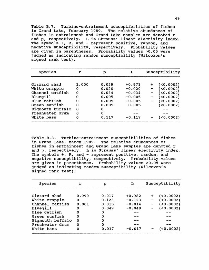
49
Table B.7. Turbine-entrainment susceptibilities of fishes in Grand Lake, February 1989. The relative abundances of fishes in entrainment and Grand Lake samples are denoted r and p, respectively. L is Strauss' linear electivity index. The symbols +, R, and - represent positive, random, and negative susceptibility, respectively. Probability values are given in parentheses. Probability values >0.05 were judged as indicating random susceptibility (Wilcoxon's signed rank test).
Species r p L Susceptibility
Gizzard shad 1.000 0.029 +0.971 + (<0.0002) White crappie 0 0.020 -0.020 (<0.0002) Channel catfish 0 0.034 -0.034 (<0.0002) Bluegill 0 0.005 -0.005 (<0.0002) Blue catfish 0 0.005 -0.005 (<0.0002) Green sunfish 0 0.005 -0.005 (<0.0002) Bigmouth buffalo 0 0 Freshwater drum 0 0 White bass 0 0.117 -0.117 (<0.0002)
Table B.8. Turbine-entrainment susceptibilities of fishes in Grand Lake, March ,1989. The relative abundances of fishes in entrainment and Grand Lake samples are denoted r and p, respectively. L is Strauss' linear electivity index. The symbols +, R, and - represent positive, random, and negative susceptibility, respectively. Probability values are given in parentheses. Probability values >0.05 were judged as indicating random susceptibility (Wilcoxon's signed rank test).
Species r
Gizzard shad 0.999 White crappie 0 Channel catfish 0.001 Bluegill 0 Blue catfish 0 Green sunfish 0 Bigmouth buffalo 0 Freshwater drum 0 White bass 0
p
0.017 0.123 0.015 0.049 0 0 0 0 0.017
L Susceptibility
+0.982 -0.123 -0.014 -0.049
-0.017
+ (<0.0002) (<0.0002) (<0.0002) (<0.0002)
(<0.0002)
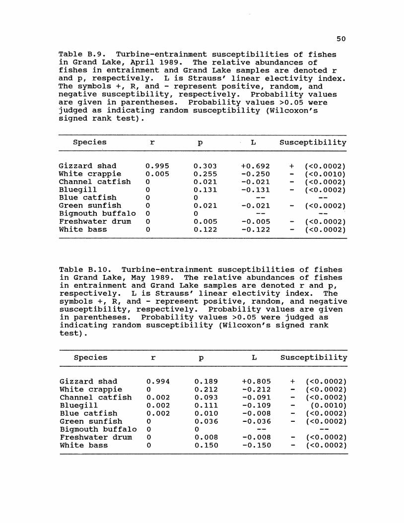
50
Table B.9. Turbine-entrainment susceptibilities of fishes in Grand Lake, April 1989. The relative abundances of fishes in entrainment and Grand Lake samples are denoted r and p, respectively. L is Strauss' linear electivity index. The symbols +, R, and - represent positive, random, and negative susceptibility, respectively. Probability values are given in parentheses. Probability values >0.05 were judged as indicating random susceptibility (Wilcoxon's signed rank test).
Species r p L Susceptibility
Gizzard shad 0.995 0.303 +0.692 + (<0.0002) White crappie 0.005 0.255 -0.250 (<0.0010) Channel catfish 0 0.021 -0.021 (<0.0002) Bluegill 0 0.131 -0.131 (<0.0002) Blue catfish 0 0 Green sunfish 0 0.021 -0.021 (<0.0002) Bigmouth buffalo 0 0 Freshwater drum 0 0.005 -0.005 (<0.0002) White bass 0 0.122 -0.122 (<0.0002)
Table B.10. Turbine-entrainment susceptibilities of fishes in Grand Lake, May 1989. The relative abundances of fishes in entrainment and Grand Lake samples are denoted r and p, respectively. L is Strauss' linear electivity index. The symbols +, R, and - represent positive, random, and negative susceptibility, respectively. Probability values are given in parentheses. Probability values >0.05 were judged as indicating random susceptibility (Wilcoxon's signed rank test) .
Species r p L Susceptibility
Gizzard shad 0.994 0.189 +0.805 + (<0.0002) White crappie 0 0.212 -0.212 (<0.0002) Channel catfish 0.002 0.093 -0.091 (<0.0002) Bluegill 0.002 0.111 -0.109 (0.0010) Blue catfish 0.002 0.010 -0.008 (<0.0002) Green sunfish 0 0.036 -0.036 (<0.0002) Bigmouth buffalo 0 0 Freshwater drum 0 0.008 -0.008 (<0.0002) White bass 0 0.150 -0.150 (<0.0002)
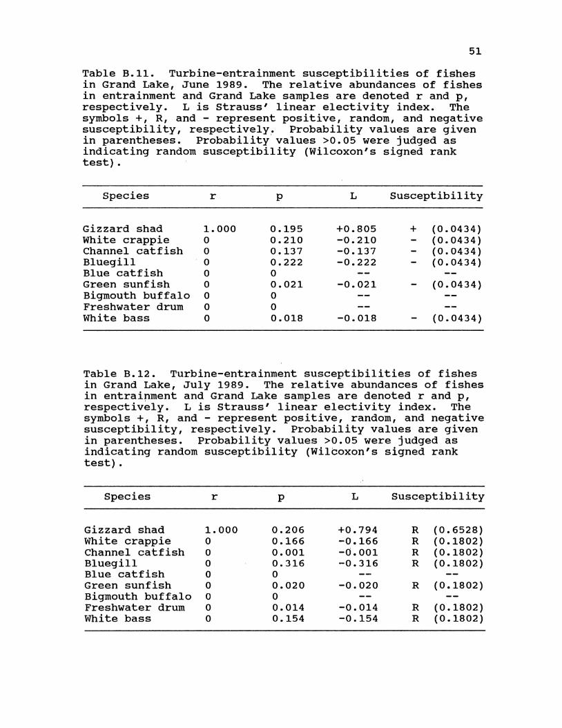
51
Table B.ll. Turbine-entrainment susceptibilities of fishes in Grand Lake, June 1989. The relative abundances of fishes in entrainment and Grand Lake samples are denoted r and p, respectively. L is Strauss' linear electivity index. The symbols +, R, and - represent positive, random, and negative susceptibility, respectively. Probability values are given in parentheses. Probability values >0.05 were judged as indicating random susceptibility (Wilcoxon's signed rank test).
Species r p L Susceptibility
Gizzard shad 1. 000 0.195 +0.805 + (0.0434) White crappie 0 0.210 -·0.210 (0.0434) Channel catfish 0 0.137 -0.137 (0.0434) Bluegill 0 0.222 -0.222 (0.0434) Blue catfish 0 0 Green sunfish 0 0.021 -0.021 (0.0434) Bigmouth buffalo 0 0 Freshwater drum 0 0 White bass 0 0.018 -0.018 {0.0434)
Table B.l2. Turbine-entrainment susceptibilities of fishes in Grand Lake, July 1989. The relative abundances of fishes in entraipment and Grand Lake samples are denoted r and p, respectively. L is strauss' linear electivity index. The symbols +, R, and - represent positive, random, and negative susceptibility, respectively. Probability values are given in parentheses. Probability values >0.05 were judged as indicating random susceptibility (Wilcoxon's signed rank test).
Species r p L Susceptibility
Gizzard shad 1. 000 0.206 +0.794 R (0.6528) White crappie 0 0.166 -0.166 R (0.1802) Channel catfish 0 0.001 -0.001 R (0.1802) Bluegill 0 0.316 -0.316 R (0.1802) Blue catfish 0 0 Green sunfish 0 0.020 -0.020 R (0.1802) Bigmouth buffalo 0 0 Freshwater drum 0 0.014 -0.014 R (0.1802) White bass 0 0.154 -0.154 R (0.1802)
APPENDIX C
TOTAL CATCHES AND RELATIVE ABUNDANCE BY GEAR
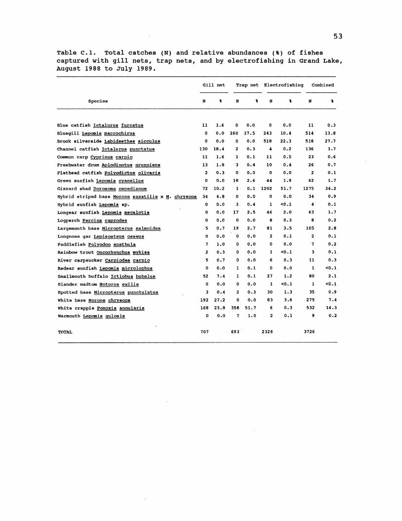
53
Table c.1. Total catches (N) and relative abundances (%) of fishes captured with gill nets, trap nets, and by electrofishing in Grand Lake, August 1988 to July 1989.
Gill net Trap net Electrofishing
Species N % N i N \
Blue catfish Ictalurus furcatus 11 1.6 0 0.0 0 0.0
Bluegill Lepomis macrochirus 0 0.0 260 37.5 243 10.4
Brook silverside Labidesthes sicculus 0 0.0 0 0.0 518 22.3
Channel catfish Ictalurus punctatus 130 18.4 2 0.3 4 0.2
Common carp Cyprinus carpio 11 1.6 1 0.1 11 0.5
Freshwater drum Aplodinotus qrunniens 13 1.8 3 0.4 10 0.4
Flathead catfish Polyodictus olivaris 2 0. 3 0 0. 0 0 0. 0
Green sunfish Lepomis £Y.anellus 0 0.0 18 2.6 44 1.9
Gizzard shad Dorosoma cepedianum 72 10.2 1 0.1 1202 51.7
Hybrid striped bass ~ saxatilis x ~- chrysops 34 4. 8 0 0. 0 0 0. 0
Hybrid sunfish Lepcmis sp. 0 0.0 3 0.4 1 <0.1
Longear sunfish Lepomis megalotis 0 0.0 17 2.5 46 2.0
Logperch Percina caprodes 0 0. 0 0 0. 0 8 0. 3
Largemouth bass Micropterus salmoides 5 0. 7 19 2. 7 81 3. 5
Longnose gar Lepisosteus ~ 0 0. 0 0 0. 0 2 0.1
Paddlefish Polyodon spathula 7 1.0 0 0.0 0 0.0
Rainbow trout Oncorhynchus mykiss 2 0. 3 0 0. 0 1 <0 .1
River carpsucker Carpiodes carpio 5 0 • 7 0 0 • 0 6 0 • 3
Redear sunfish Lepomis microlophus 0 0. 0 1 0. 1 0 0. 0
Smallmouth buffalo Ictiobus bubalus 52 7. 4 1 0. 1 2 7 1. 2
Slender madtom ~ exilis 0 0.0 0 0.0 1 <0.1
Spotted bass Micropterus punctulatus 3 0. 4 2 0. 3 30 1. 3
White bass Morone chrysops 192 27.2 0 0.0 83 3.6
White crappie Pomoxis annularis 168 23.8 358 51.7 6 0.3
Warmouth Lepomis gulos is 0 0. 0 7 1. 0 2 0. 1
TOTAL 707 693 2326
Combined
N
11
514
518
136
23
26
2
62
1275
34
4
63
8
105
2
7
3
11
1
80
1
35
275
532
9
3726
'
0.3
13.8
27.7
3.7
0.6
0.7
0.1
1.7
34.2
0.9
0.1
1.7
0.2
2.8
0.1
0.2
0.1
0.3
<0.1
2.1
<0.1
0.9
7.4
14.3
0.2
APPENDIX D
ANOVA OF MONTHLY MEAN CPUE
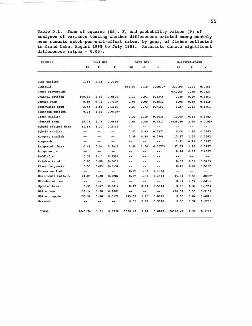
55
Table 0.1. Sums of squares (SS), F, and probability values (P) of analyses of variance testing whether differences existed among monthly mean numeric catch-per-unit-effort rates, by gear, of fishes collected in Grand Lake, August 1988 to July 1989. Asterisks denote significant differences (alpha 0.05).
Species Gill net
ss F p
Blue catfish 1. 34 1.15 0.3280
Bluegill
Brook silverside
Channel catfish 108.61 1.85 0.0505
Common carp 0.59 0.73 0.7079
Freshwater drum 2.44 1.55 0.1186
Flathead catfish 0.23 1.88 0.0449*
Green sunfish
Gizzard shad 85.73 1. 75 0.0665
Hybrid striped bass 11.64 1.22 0.2755
Hybrid sunfish
Longear sunfish
Logperch
Largemouth bass 0.42 0.94 0.5014
Longnose gar
Paddlefl.sh 0.37 1.11 0.3594
Rainbow trout 0.06 0.88 0.5617
River carpsucker 0.58 0.83 0.6134
Redear sunfish
Smallmouth buffalo 24.09 1.30 0.2282
Slender madtom
Spotted bass 0.51 1.67 0.0814
White bass 138.14 1.58 0.1081
White crappie 135.96 1.80 0.0572
Warmouth
TOTAL 1045.76 1.51 0.1320
ss Trap net
F
845.07 3.10
0.17 0.91
0.09 1.00
0.27 0.73
2.30 1.19
0.09 1.00
0.43 0.93
7.49 0.84
6.49 2.50
0.09 1.00
0.09 1.00
0.17 0.91
795.57 1.80
0.05 0.94
2338.43 3.09
p
0.0012*
0.5344
0.4513
0.7102
0.3036
0.4513
0.5173
0.5964
0.0077*
0.4513
0.4513
0.5344
0.0622
o. 5017
0.0012*
Electrofishing
ss F p
320.90 1.64 0.0956
7642.59 1.30 0. 2 329
0.40 0.80 0.6363
1.08 0.80 0.6418
1.27 1.41 0.1761
10.05 0.53 0.8783
24836.80 3.30 0.0005*
0.09 1.14 0.3363
15.37 1.25 0. 2 642
2.11 0.92 0.5247
37.55 1.20 0.2927
0.14 0.83 0. 6127
0.07 0.92 0.5255
0.41 0.87 0.5762
15.99 2.55 0.0062*
0.07 0.92 0.5255
8.05 1. 37 0.1961
420.59 0.93 0.5169
0.96 0.84 0.6025
0.30 0.92 0.5255
26340.49 1. 56 0.1177
VITA
Kent Michael Sorenson
Candidate for the Degree of
Master of Science
Thesis: ENTRAINMENT SUSCEPTIBILITIES OF FISHES INHABITING THE LOWER PORTION OF GRAND LAKE, OKLAHOMA
Major Field: Wildlife a~d Fisheries Ecology
Biographical:
Personal Data: Born in Westbrook, Minnesota, May 21, 1963, the son of John C. and Sheryl R. Sorenson.
Education: Graduated from Storden-Jeffers High School, Jeffers, Minnesota, in May, 1981; received Bachelor of Science Degree in Wildlife and Fisheries Science from South Dakota State University in May, 1985; completed requirements for the Master of Science degree at Oklahoma State University in July, 1990.
Professional Experience: Professional Aide, South Dakota Department of Game, Fish, and Parks, Pierre, South Dakota, April 1986, to August, 1987; Graduate Research Assistant, Oklahoma Cooperative Fish and Wildlife Research Unit, Oklahoma State University, August, 1987, to June, 1990.
Organizational Memberships: American Fisheries Society, Oklahoma Academy of Science, Oklahoma Chapter of the American Fisheries Society.