Discrete Choice Model for Defining a Parking-Fee Policy on Island of Ortigia, Siracusa
11
Scopus - Document details http://www.scopus.com/...22%2ct&sl=20&s=AUTHOR-NAME%28inturri%29&relpos=5&relpos=5&searchTerm=AUTHOR-NAME(inturri) AND ( LIMIT-TO(AU-ID,/[08/02/2011 09:03:22] View search history | Back to results | < Previous 6 of 8 Next > Cited by since 1996 This article has been cited 2 times in Scopus: Camillen, F. , Caprì, S. , Garofalo, C. Multi agent simulation of pedestrian behavior in closed spatial environments (2009) TIC-STH'09: 2009 IEEE Toronto International Conference - Science and Technology for Humanity Anastasiadou, M. , Dimitriou, D.J. , Fredianakis, A. Determining the parking fee using the contingent valuation methodology (2009) Journal of Urban Planning and Development View details of all 2 citations Inform me when this document is cited in Scopus: Set alert Set feed Hide Applications Add My Applications The authors of this article have a total of 11 records in Scopus: (Showing 5 most recent) Buscema, D.,De Pietro, R.,Ignaccolo, M.,Inturri, G. The exchange of braking energy between the trains: Determinist analysis and proposal of a probabilistic one (2010)International Conference on Electrical Systems for Aircraft, Railway and Ship Propulsion, ESARS 2010 Buscema, D.,Ignaccolo, M.,Inturri, G.,Pluchino, A.,Rapisarda, A.,Santoro, C.,Tudisco, S. More By These Authors Download PDF Export Print E-mail Create bibliography Add to My List Add to 2collab Journal of Urban Planning and Development Volume 132, Issue 3, September 2006, Pages 147-155 ISSN: 07339488 DOI: 10.1061/(ASCE)0733-9488(2006)132:3(147) Document Type: Article Source Type: Journal View references (6) View at publisher | Discrete choice model for defining a parking-fee policy on Island of Ortigia, Siracusa Ignaccolo, M. a , Capri, S. a , Giunta, U. a , Inturri, G. b a Dip. to di Ingegneria Civile e Ambientale, Univ. of Catania, Viale A. Doria 6, 95125 Catania, Italy b Dip. to di Ingegneria, Univ. of Catania, Viale A. Doria 6, 95125 Catania, Italy Abstract The island of Ortigia is a small extremity of the urban fabric of the city of Siracusa, located in the eastern part of Sicily. The island forms part of the historic city center and is characterized by its own particular urban configuration, representing a kind of "suburban historic center". Apart from being the site of some central business district activities, it is particularly attractive to tourists for which reason it would be desirable to eliminate traffic from the island, as far as possible. An almost total closure to traffic was hypothesized and applied and a methodology was also developed, based on a random utility model for discrete user choice, thanks to surveys carried out among drivers. The model allowed a distribution mechanism of car-park use to be established on the basis of which a redefinition of parking fees was effected. © ASCE. Language of original document English Author keywords Parking facilities; Public transportation; Traffic management; Traffic surveys; Transportation networks; Urban planning Index Keywords Engineering controlled terms: Mathematical models; Parking; Public policy; Random processes; Traffic control; Traffic surveys; Transportation Engineering uncontrolled terms: Public transportation; Traffic management; Transportation networks Engineering main heading: Urban planning GEOBASE Subject Index: parking; traffic management; transportation planning; transportation policy; urban planning; urban transport Regional Index: Eurasia; Europe; Italy; Sicily; Siracusa; Southern Europe References (6) View in table layout Select: Page Export Print E-mail Create bibliography Quick Search Hub ScienceDirect Scopus SciTopics Applications Search Sources Analytics My alerts My list My settings Help Register Go to SciVal Suite Login Find related documents In Scopus based on References Authors Keywords
Transcript of Discrete Choice Model for Defining a Parking-Fee Policy on Island of Ortigia, Siracusa
Scopus - Document details
http://www.scopus.com/...22%2ct&sl=20&s=AUTHOR-NAME%28inturri%29&relpos=5&relpos=5&searchTerm=AUTHOR-NAME(inturri) AND ( LIMIT-TO(AU-ID,/[08/02/2011 09:03:22]
View search history | Back to results | < Previous 6 of 8 Next >
Cited by since 1996
This article has been cited 2 times in Scopus:
Camillen, F. , Caprì, S. , Garofalo, C. Multi agent simulation of pedestrian behavior inclosed spatial environments (2009) TIC-STH'09: 2009 IEEE Toronto InternationalConference - Science and Technology for Humanity
Anastasiadou, M. , Dimitriou, D.J. , Fredianakis, A. Determining the parking fee using thecontingent valuation methodology (2009) Journal of Urban Planning and Development
View details of all 2 citations
Inform me when this document is cited in Scopus:
Set alert
Set feed
Hide Applications
Add
My Applications
The authors of this article have a total of 11 records inScopus:(Showing 5 most recent)
Buscema, D.,De Pietro, R.,Ignaccolo, M.,Inturri, G.The exchange of braking energy between thetrains: Determinist analysis and proposal of aprobabilistic one(2010)International Conference on Electrical Systems for Aircraft,Railway and Ship Propulsion, ESARS 2010
Buscema, D.,Ignaccolo, M.,Inturri, G.,Pluchino, A.,Rapisarda,A.,Santoro, C.,Tudisco, S.
More By These Authors
Download PDF Export Print E-mail Create bibliography Add to My ListAdd to 2collab
Journal of Urban Planning and Development Volume 132, Issue 3, September 2006, Pages 147-155
ISSN: 07339488DOI: 10.1061/(ASCE)0733-9488(2006)132:3(147)Document Type: ArticleSource Type: Journal
View references (6)
View at publisher |
Discrete choice model for defining a parking-fee policy onIsland of Ortigia, Siracusa
Ignaccolo, M.a , Capri, S.a , Giunta, U.a , Inturri, G.b a Dip. to di Ingegneria Civile e Ambientale, Univ. of Catania, Viale A. Doria 6, 95125Catania, Italyb Dip. to di Ingegneria, Univ. of Catania, Viale A. Doria 6, 95125 Catania, Italy
Abstract
The island of Ortigia is a small extremity of the urban fabric of the city of Siracusa,located in the eastern part of Sicily. The island forms part of the historic city center and ischaracterized by its own particular urban configuration, representing a kind of "suburbanhistoric center". Apart from being the site of some central business district activities, it isparticularly attractive to tourists for which reason it would be desirable to eliminate trafficfrom the island, as far as possible. An almost total closure to traffic was hypothesized andapplied and a methodology was also developed, based on a random utility model fordiscrete user choice, thanks to surveys carried out among drivers. The model allowed adistribution mechanism of car-park use to be established on the basis of which aredefinition of parking fees was effected. © ASCE.
Language of original document
English
Author keywords
Parking facilities; Public transportation; Traffic management; Traffic surveys;Transportation networks; Urban planning
Index Keywords
Engineering controlled terms: Mathematical models; Parking; Public policy;Random processes; Traffic control; Traffic surveys; TransportationEngineering uncontrolled terms: Public transportation; Traffic management;Transportation networksEngineering main heading: Urban planningGEOBASE Subject Index: parking; traffic management; transportation planning;transportation policy; urban planning; urban transportRegional Index: Eurasia; Europe; Italy; Sicily; Siracusa; Southern Europe
References (6) View in table layout
Select: Page
Export Print E-mail Create bibliography
Quick Search
Hub ScienceDirect Scopus SciTopics Applications
Search Sources Analytics My alerts My list My settings Help
Register Go to SciVal SuiteLogin
Find related documents
In Scopus based on
References
Authors
Keywords

Scopus - Document details
http://www.scopus.com/...22%2ct&sl=20&s=AUTHOR-NAME%28inturri%29&relpos=5&relpos=5&searchTerm=AUTHOR-NAME(inturri) AND ( LIMIT-TO(AU-ID,/[08/02/2011 09:03:22]
View search history | Back to results | < Previous 6 of 8 Next > Top of page
Ignaccolo, M.; Dip. to di Ingegneria Civile e Ambientale, Univ. of Catania, Viale A. Doria 6, 95125 Catania,Italy; email:[email protected] © Copyright 2008 Elsevier B.V., All rights reserved.
Journal of Urban Planning and Development Volume 132, Issue 3, September 2006, Pages 147-155
1 Ben Akiva, M., Lerman, S.(1985) Discrete Choice Analysis: Theory and Application to Travel Demand. Cited 98 times.MIT Press, Cambridge, Mass
2 Hensher, D.A., King, J.
Parking demand and responsiveness to supply, pricing and location inthe Sydney central business district (2001) Transportation Research Part A: Policy and Practice, 35 (3), pp. 177-196. Cited 45times.doi: 10.1016/S0965-8564(99)00054-3
3 Ignaccolo, M., Caprì, S.
"Pedestrian accessibility and mobility within the island of Ortigia,Siracusa" (2000) Proc., 7th Conf. Int. "Vivere E Camminare in Città"CeSCAm, Brescia, Italy
4 Lambe, T.A.
Driver choice of parking in the city (1996) Socio-Economic Planning Sciences, 30 (3), pp. 207-219. Cited 9 times.doi: 10.1016/0038-0121(96)00008-0
5 (2000) Highway Capacity Manual. Cited 827 times.Transportation Research Board (TRB). National Research Council, Washington, D.C
6 Tsamboulas, D.A.
Parking fare thresholds: A policy tool (2001) Transport Policy, 8 (2), pp. 115-124. Cited 6 times.doi: 10.1016/S0967-070X(00)00040-8
View at publisher
View at publisher
View at publisher
About ScopusWhat is ScopusContent coverageWhat do users thinkLatestTutorialsDevelopers
Contact and SupportContact and supportLive Chat
About ElsevierAbout ElsevierAbout SciVerseAbout SciValTerms and ConditionsPrivacy Policy
Copyright © 2010 Elsevier B.V. All rights reserved. SciVerse® is a registered trademark of Elsevier Properties S.A., used under license. Scopus® is a registered trademark of ElsevierB.V.
Search Sources Analytics My alerts My list My settings Help
Discrete Choice Model for Defining a Parking-Fee Policyon Island of Ortigia, Siracusa
Matteo Ignaccolo1; Salvatore Caprì2; Ugo Giunta, Ph.D.3; and Giuseppe Inturri4
Abstract: The island of Ortigia is a small extremity of the urban fabric of the city of Siracusa, located in the eastern part of Sicily. Theisland forms part of the historic city center and is characterized by its own particular urban configuration, representing a kind of “suburbanhistoric center.” Apart from being the site of some central business district activities, it is particularly attractive to tourists for which reasonit would be desirable to eliminate traffic from the island, as far as possible. An almost total closure to traffic was hypothesized and appliedand a methodology was also developed, based on a random utility model for discrete user choice, thanks to surveys carried out amongdrivers. The model allowed a distribution mechanism of car-park use to be established on the basis of which a redefinition of parking feeswas effected.
DOI: 10.1061/�ASCE�0733-9488�2006�132:3�147�
CE Database subject headings: Parking facilities; Public transportation; Traffic management; Traffic surveys; Transportationnetworks; Urban planning.
Introduction
Ortigia, an important part of Siracusa’s historic city center, is asmall island �having a surface area of 1 /2 km2 and 4,500 inhab-itants� connected to the mainland by means of two bridges. Theroad network is based on the Matteotti–Archimede–Roma axiswhich, following the direction of the Ancient Greek Holy Street,divides the island into two, longitudinally: the western part con-tains a large number of commercial activities, buildings of archi-tectural interest, and public offices; the eastern part contains themarket and the larger residential area and is subject to a buildingrestoration plan that is still incomplete.
As far as the aspects concerning traffic are concerned, it mustbe emphasized that Ortigia �Ignaccolo and Caprì 2000�:• Attracts a large number of people on weekday mornings for
work, study, and business reasons;• Attracts a large number of people for entertainment reasons in
the evenings, especially on Saturdays; and• Represents a peculiar case study, because it is an “anomalous”
historic center in that it is a true “appendix” to the city.
1Associate Professor, Dip.to di Ingegneria Civile e Ambientale, Univ.of Catania, Viale A. Doria 6, 95125 Catania, Italy �corresponding author�.E-mail: [email protected]
2Assistant Researcher, Dip.to di Ingegneria Civile e Ambientale,Univ. of Catania, Viale A. Doria 6, 95125 Catania, Italy. E-mail:[email protected]
3Dip.to di Ingegneria Civile e Ambientale, Univ. of Catania, Viale A.Doria 6, 95125 Catania, Italy. E-mail: [email protected]
4Researcher, Dip.to di Ingegneria, Univ. of Catania, Viale A. Doria 6,95125 Catania, Italy. E-mail: [email protected]
Note. Discussion open until February 1, 2007. Separate discussionsmust be submitted for individual papers. To extend the closing date byone month, a written request must be filed with the ASCE ManagingEditor. The manuscript for this paper was submitted for review and pos-sible publication on March 21, 2005; approved on September 22, 2005.This paper is part of the Journal of Urban Planning and Development,Vol. 132, No. 3, September 1, 2006. ©ASCE, ISSN 0733-9488/2006/3-
147–155/$25.00.JOURNAL OF URBAN P
This means that there is no “crossing” traffic, nor any of thecritical situations that this would produce, unlike the typical situ-ations of many central areas in European cities.
Both on weekday mornings and Saturday and Sunday eve-nings there are peaks in the number of people using private trans-port to come to the island. This is due to the poor public transportservice of the whole city and the present situation of being able todrive and park all over the island. Before we intervened, sometraffic limitation measures were in force in the evening over alarge part of the island, which resulted in long queues of vehicleson the mainland side of the bridges.
The analysis we propose regards the two time zones men-tioned above, bearing in mind that the morning period is in anycase covered by the 24 h zona a traffico limitato �ZTL�, a re-stricted traffic area measure to be introduced for all days of theyear in the western part. The object is to find the best, practicalalternative with regard to the organization of parking and publictransport on the island.
Analysis of Transport Systems
Study Area and Zoning
In order to study Ortigia it is necessary to divide its territory intotwo kinds of zones. The first procedure consists of identifyingtraffic zones and the format of the origin–destination matrix bywhich the expression of the transport flow is typically repre-sented. The second kind of zoning leads to an aggregation of thespaces in which it is possible to park cars, whether they are alongstreets, in special areas or squares, or in public garages. The defi-nition of the parking areas constitutes the basis for identifying“intermediate” destinations between the origins of the trip �nearlyall located outside the island, mainly over the remaining urbanterritory of Siracusa� and the “desired” or “final” destinationwhere the user always arrives on foot from the parking area.
With regard to the definition of the study area, it should be
noticed that the natural “confines” of the island constitute a realLANNING AND DEVELOPMENT © ASCE / SEPTEMBER 2006 / 147
idea of a “cordon” around the area, or rather a line �of a virtualkind, but in this instance absolutely real� that separates the re-search territory from the area in which any changes to the trans-port system have a reasonably negligible effect.
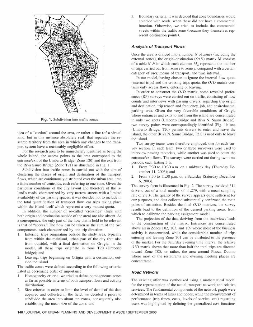
For the research area to be immediately identified as being thewhole island, the access points to the area correspond to theentrance/exit of the Umberto Bridge �Zone T20� and the exit fromthe Riva Sauro Bridge �Zone T21� as illustrated in Fig. 1.
Subdivision into traffic zones is carried out with the aim ofclustering the places of origin and destination of the transportflows, which are continuously distributed over the urban area, intoa finite number of centroids, each referring to one zone. Given theparticular conditions of the city layout and therefore of the is-land’s roads, characterized by very narrow streets with a limitedavailability of car parking spaces, it was decided not to include inthe total quantification of transport flow, car trips taking placewithin the island itself which represent a very modest quota.
In addition, the number of so-called “crossings” �trips withboth origin and destination outside of the area� are also absent. Asa consequence, the only part of the flow that is held to be relevantis that of “access.” The flow can be taken as the sum of the twocomponents, each characterized by one trip direction:1. Entering: trips originating outside the study area, typically
from within the mainland, urban part of the city �but alsofrom outside�, with a final destination on Ortigia; in themodel, all these trips originate in zone T20 �Umbertobridge�; and
2. Leaving: trips beginning on Ortigia with a destination out-side the island.
The traffic zones were defined according to the following criteria,listed in decreasing order of importance:1. Homogeneity criteria: we tried to define homogeneous zones
as far as possible in terms of both transport flows and activitydistribution;
2. Size criteria: in order to limit the level of detail of the dataacquired and collected in the field, we decided a priori tosubdivide the area into about ten zones, consequently also
Fig. 1. Subdivision into traffic zones
establishing the mean size of the zone; and
148 / JOURNAL OF URBAN PLANNING AND DEVELOPMENT © ASCE / SE
3. Boundary criteria: it was decided that zone boundaries wouldcoincide with roads, when these did not have a commercialfunction. Otherwise, we tried to include the commercialstreets within the traffic zone �because they themselves rep-resent destination points�.
Analysis of Transport Flows
Once the area is divided into a number N of zones �including theexternal zones�, the origin–destination �O /D� matrix M consistsof a table N ·N in which each element Mij represents the numberof trips carried out from zone i to zone j, compared with a certaincategory of user, means of transport, and time interval.
In our model, having chosen to ignore the internal flow quota�internal trips� and the crossing trips quota, the O /D matrix con-tains only access flows, entering or leaving.
In order to construct the O /D matrix, some revealed prefer-ences �RP� surveys were carried out on traffic, consisting of flowcounts and interviews with passing drivers, regarding trip originand destination, trip reason and frequency, job, and desired/actualparking area. Given the very favorable conditions of Ortigiawhere entrances and exits to and from the island are concentratedin only two spots �Umberto Bridge and Riva N. Sauro Bridge�,two survey points were correspondingly identified �Fig. 1�: one�Umberto Bridge, T20� permits drivers to enter and leave theisland, the other �Riva N. Sauro Bridge, T21� is used only to leavethe island.
Two survey teams were therefore employed, one for each sur-vey section. In each team, two or three surveyors were used tointerview passing motorists, while another was used to count theentrance/exit flows. The surveys were carried out during two timeperiods, each lasting 3 h:1. From 7:30 to 10:30 a.m. on a midweek day �Thursday De-
cember 11, 2003�; and2. From 8:30 to 11:30 p.m. on a Saturday �Saturday December
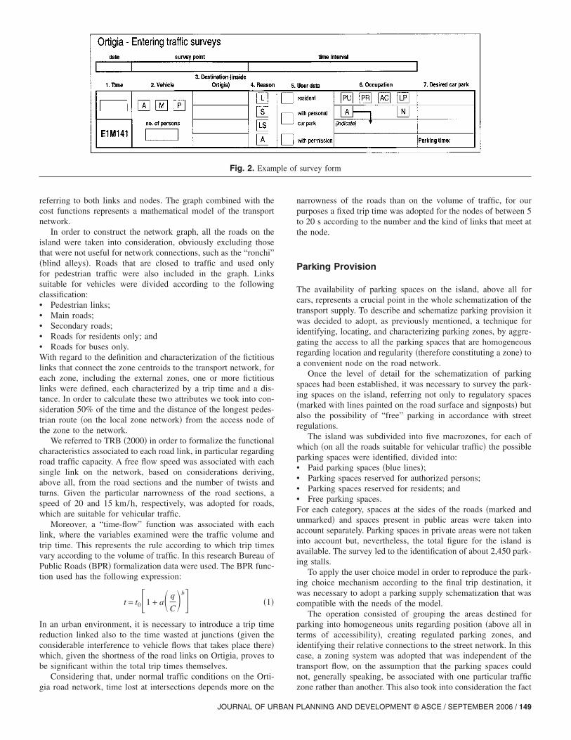
6, 2003�.The survey form is illustrated in Fig. 2. The survey involved 314drivers, out of a total number of 11,279, with a mean samplingrate of 2.8%. The quality of the survey appears quite sufficient forour purposes, and data collected substantially confirmed the mainpoles of attraction. Besides the final O /D matrices, the surveyresults lead to the definition of the desired parking areas, fromwhich to calibrate the parking assignment model.
The projection of the data deriving from the interviews leadsto the construction of the matrix. Entrances are concentratedabove all in Zones T02, T03, and T09 where most of the businessactivity is concentrated, while the considerable number of tripsentering and leaving Zone T01 can be attributed to the presenceof the market. For the Saturday evening time interval the relativeO /D matrix shows that more than half the total trips are directedtoward Zone T08, or rather, the area around Piazza Duomowhere most of the restaurants and evening meeting places areconcentrated.
Road Network
The existing offer was synthesized using a mathematical modelfor the representation of the actual transport network and relativeservices. The fundamental components of the network graph weredetermined in terms of links and nodes, while the measurement ofperformance �trip times, costs, levels of service, etc.� regarding
users was highlighted by defining the generalized cost functionsPTEMBER 2006
referring to both links and nodes. The graph combined with thecost functions represents a mathematical model of the transportnetwork.
In order to construct the network graph, all the roads on theisland were taken into consideration, obviously excluding thosethat were not useful for network connections, such as the “ronchi”�blind alleys�. Roads that are closed to traffic and used onlyfor pedestrian traffic were also included in the graph. Linkssuitable for vehicles were divided according to the followingclassification:• Pedestrian links;• Main roads;• Secondary roads;• Roads for residents only; and• Roads for buses only.With regard to the definition and characterization of the fictitiouslinks that connect the zone centroids to the transport network, foreach zone, including the external zones, one or more fictitiouslinks were defined, each characterized by a trip time and a dis-tance. In order to calculate these two attributes we took into con-sideration 50% of the time and the distance of the longest pedes-trian route �on the local zone network� from the access node ofthe zone to the network.
We referred to TRB �2000� in order to formalize the functionalcharacteristics associated to each road link, in particular regardingroad traffic capacity. A free flow speed was associated with eachsingle link on the network, based on considerations deriving,above all, from the road sections and the number of twists andturns. Given the particular narrowness of the road sections, aspeed of 20 and 15 km/h, respectively, was adopted for roads,which are suitable for vehicular traffic.
Moreover, a “time-flow” function was associated with eachlink, where the variables examined were the traffic volume andtrip time. This represents the rule according to which trip timesvary according to the volume of traffic. In this research Bureau ofPublic Roads �BPR� formalization data were used. The BPR func-tion used has the following expression:
t = t0�1 + a� q
C�b� �1�
In an urban environment, it is necessary to introduce a trip timereduction linked also to the time wasted at junctions �given theconsiderable interference to vehicle flows that takes place there�which, given the shortness of the road links on Ortigia, proves tobe significant within the total trip times themselves.
Considering that, under normal traffic conditions on the Orti-
Fig. 2. Exam
gia road network, time lost at intersections depends more on the
JOURNAL OF URBAN P
narrowness of the roads than on the volume of traffic, for ourpurposes a fixed trip time was adopted for the nodes of between 5to 20 s according to the number and the kind of links that meet atthe node.
Parking Provision
The availability of parking spaces on the island, above all forcars, represents a crucial point in the whole schematization of thetransport supply. To describe and schematize parking provision itwas decided to adopt, as previously mentioned, a technique foridentifying, locating, and characterizing parking zones, by aggre-gating the access to all the parking spaces that are homogeneousregarding location and regularity �therefore constituting a zone� toa convenient node on the road network.
Once the level of detail for the schematization of parkingspaces had been established, it was necessary to survey the park-ing spaces on the island, referring not only to regulatory spaces�marked with lines painted on the road surface and signposts� butalso the possibility of “free” parking in accordance with streetregulations.
The island was subdivided into five macrozones, for each ofwhich �on all the roads suitable for vehicular traffic� the possibleparking spaces were identified, divided into:• Paid parking spaces �blue lines�;• Parking spaces reserved for authorized persons;• Parking spaces reserved for residents; and• Free parking spaces.For each category, spaces at the sides of the roads �marked andunmarked� and spaces present in public areas were taken intoaccount separately. Parking spaces in private areas were not takeninto account but, nevertheless, the total figure for the island isavailable. The survey led to the identification of about 2,450 park-ing stalls.
To apply the user choice model in order to reproduce the park-ing choice mechanism according to the final trip destination, itwas necessary to adopt a parking supply schematization that wascompatible with the needs of the model.
The operation consisted of grouping the areas destined forparking into homogeneous units regarding position �above all interms of accessibility�, creating regulated parking zones, andidentifying their relative connections to the street network. In thiscase, a zoning system was adopted that was independent of thetransport flow, on the assumption that the parking spaces couldnot, generally speaking, be associated with one particular traffic
survey form
ple ofzone rather than another. This also took into consideration the fact
LANNING AND DEVELOPMENT © ASCE / SEPTEMBER 2006 / 149
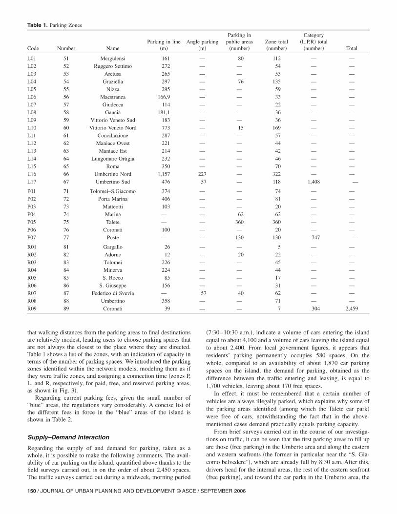
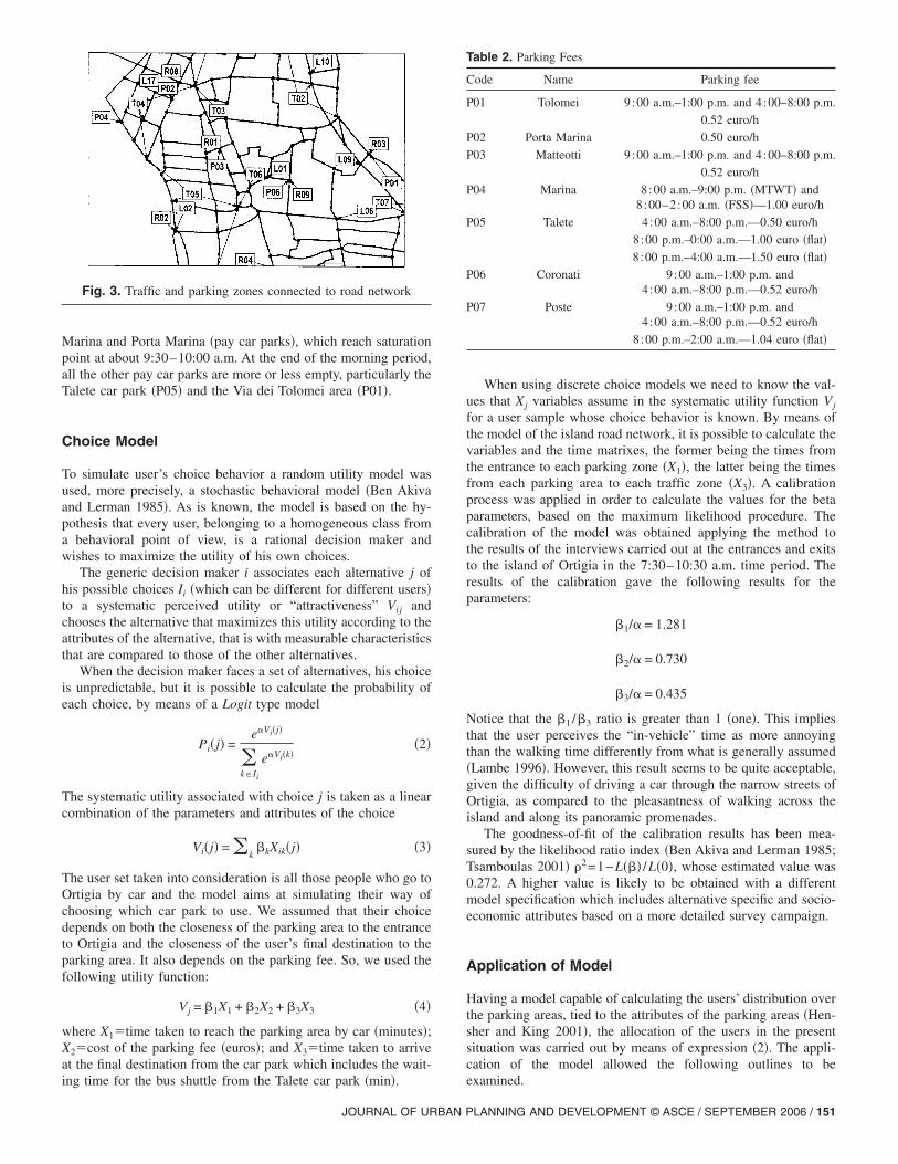
that walking distances from the parking areas to final destinationsare relatively modest, leading users to choose parking spaces thatare not always the closest to the place where they are directed.Table 1 shows a list of the zones, with an indication of capacity interms of the number of parking spaces. We introduced the parkingzones identified within the network models, modeling them as ifthey were traffic zones, and assigning a connection time �zones P,L, and R, respectively, for paid, free, and reserved parking areas,as shown in Fig. 3�.
Regarding current parking fees, given the small number of“blue” areas, the regulations vary considerably. A concise list ofthe different fees in force in the “blue” areas of the island isshown in Table 2.
Supply–Demand Interaction
Regarding the supply of and demand for parking, taken as awhole, it is possible to make the following comments. The avail-ability of car parking on the island, quantified above thanks to thefield surveys carried out, is on the order of about 2,450 spaces.
Table 1. Parking Zones
Code Number NameParking in line
�m�An
L01 51 Mergulensi 161
L02 52 Ruggero Settimo 272
L03 53 Aretusa 265
L04 54 Graziella 297
L05 55 Nizza 295
L06 56 Maestranza 166,9
L07 57 Giudecca 114
L08 58 Gancia 181,1
L09 59 Vittorio Veneto Sud 183
L10 60 Vittorio Veneto Nord 773
L11 61 Conciliazione 287
L12 62 Maniace Ovest 221
L13 63 Maniace Est 214
L14 64 Lungomare Ortigia 232
L15 65 Roma 350
L16 66 Umbertino Nord 1,157
L17 67 Umbertino Sud 476
P01 71 Tolomei–S.Giacomo 374
P02 72 Porta Marina 406
P03 73 Matteotti 103
P04 74 Marina —
P05 75 Talete —
P06 76 Coronati 100
P07 77 Poste —
R01 81 Gargallo 26
R02 82 Adorno 12
R03 83 Tolomei 226
R04 84 Minerva 224
R05 85 S. Rocco 85
R06 86 S. Giuseppe 156
R07 87 Federico di Svevia —
R08 88 Umbertino 358
R09 89 Coronati 39
The traffic surveys carried out during a midweek, morning period
150 / JOURNAL OF URBAN PLANNING AND DEVELOPMENT © ASCE / SE
�7:30–10:30 a.m.�, indicate a volume of cars entering the islandequal to about 4,100 and a volume of cars leaving the island equalto about 2,400. From local government figures, it appears thatresidents’ parking permanently occupies 580 spaces. On thewhole, compared to an availability of about 1,870 car parkingspaces on the island, the demand for parking, obtained as thedifference between the traffic entering and leaving, is equal to1,700 vehicles, leaving about 170 free spaces.
In effect, it must be remembered that a certain number ofvehicles are always illegally parked, which explains why some ofthe parking areas identified �among which the Talete car park�were free of cars, notwithstanding the fact that in the above-mentioned cases demand practically equals parking capacity.
From brief surveys carried out in the course of our investiga-tions on traffic, it can be seen that the first parking areas to fill upare those �free parking� in the Umberto area and along the easternand western seafronts �the former in particular near the “S. Gia-como belvedere”�, which are already full by 8:30 a.m. After this,drivers head for the internal areas, the rest of the eastern seafront
rkingParking in
public areas�number�
Zone total�number�
Category�L,P,R� total
�number� Total
80 112 — —
— 54 — —
— 53 — —
76 135 — —
— 59 — —
— 33 — —
— 22 — —
— 36 — —
— 36 — —
15 169 — —
— 57 — —
— 44 — —
— 42 — —
— 46 — —
— 70 — —
— 322 — —
— 118 1,408 —
— 74 — —
— 81 — —
— 20 — —
62 62 — —
360 360 — —
— 20 — —
130 130 747 —
— 5 — —
20 22 — —
— 45 — —
— 44 — —
— 17 — —
— 31 — —
40 62 — —
— 71 — —
— 7 304 2,459
gle pa�m�
—
—
—
—
—
—
—
—
—
—
—
—
—
—
—
227
57
—
—
—
—
—
—
—
—
—
—
—
—
—
57
—
—
�free parking�, and toward the car parks in the Umberto area, the
PTEMBER 2006
Marina and Porta Marina �pay car parks�, which reach saturationpoint at about 9:30–10:00 a.m. At the end of the morning period,all the other pay car parks are more or less empty, particularly theTalete car park �P05� and the Via dei Tolomei area �P01�.
Choice Model
To simulate user’s choice behavior a random utility model wasused, more precisely, a stochastic behavioral model �Ben Akivaand Lerman 1985�. As is known, the model is based on the hy-pothesis that every user, belonging to a homogeneous class froma behavioral point of view, is a rational decision maker andwishes to maximize the utility of his own choices.
The generic decision maker i associates each alternative j ofhis possible choices Ii �which can be different for different users�to a systematic perceived utility or “attractiveness” Vij andchooses the alternative that maximizes this utility according to theattributes of the alternative, that is with measurable characteristicsthat are compared to those of the other alternatives.
When the decision maker faces a set of alternatives, his choiceis unpredictable, but it is possible to calculate the probability ofeach choice, by means of a Logit type model
Pi�j� =e�Vi�j�
�k�Ii
e�Vi�k��2�
The systematic utility associated with choice j is taken as a linearcombination of the parameters and attributes of the choice
Vi�j� = �k�kXik�j� �3�
The user set taken into consideration is all those people who go toOrtigia by car and the model aims at simulating their way ofchoosing which car park to use. We assumed that their choicedepends on both the closeness of the parking area to the entranceto Ortigia and the closeness of the user’s final destination to theparking area. It also depends on the parking fee. So, we used thefollowing utility function:
Vj = �1X1 + �2X2 + �3X3 �4�
where X1�time taken to reach the parking area by car �minutes�;X2�cost of the parking fee �euros�; and X3�time taken to arriveat the final destination from the car park which includes the wait-
Fig. 3. Traffic and parking zones connected to road network
ing time for the bus shuttle from the Talete car park �min�.
JOURNAL OF URBAN P
When using discrete choice models we need to know the val-ues that Xj variables assume in the systematic utility function Vj
for a user sample whose choice behavior is known. By means ofthe model of the island road network, it is possible to calculate thevariables and the time matrixes, the former being the times fromthe entrance to each parking zone �X1�, the latter being the timesfrom each parking area to each traffic zone �X3�. A calibrationprocess was applied in order to calculate the values for the betaparameters, based on the maximum likelihood procedure. Thecalibration of the model was obtained applying the method tothe results of the interviews carried out at the entrances and exitsto the island of Ortigia in the 7:30–10:30 a.m. time period. Theresults of the calibration gave the following results for theparameters:
�1/� = 1.281
�2/� = 0.730
�3/� = 0.435
Notice that the �1 /�3 ratio is greater than 1 �one�. This impliesthat the user perceives the “in-vehicle” time as more annoyingthan the walking time differently from what is generally assumed�Lambe 1996�. However, this result seems to be quite acceptable,given the difficulty of driving a car through the narrow streets ofOrtigia, as compared to the pleasantness of walking across theisland and along its panoramic promenades.
The goodness-of-fit of the calibration results has been mea-sured by the likelihood ratio index �Ben Akiva and Lerman 1985;Tsamboulas 2001� �2=1−L��� /L�0�, whose estimated value was0.272. A higher value is likely to be obtained with a differentmodel specification which includes alternative specific and socio-economic attributes based on a more detailed survey campaign.
Application of Model
Having a model capable of calculating the users’ distribution overthe parking areas, tied to the attributes of the parking areas �Hen-sher and King 2001�, the allocation of the users in the presentsituation was carried out by means of expression �2�. The appli-cation of the model allowed the following outlines to be
Table 2. Parking Fees
Code Name Parking fee
P01 Tolomei 9 :00 a.m.–1:00 p.m. and 4:00–8:00 p.m.
0.52 euro/h
P02 Porta Marina 0.50 euro/h
P03 Matteotti 9 :00 a.m.–1:00 p.m. and 4:00–8:00 p.m.
0.52 euro/h
P04 Marina 8:00 a.m.–9:00 p.m. �MTWT� and8:00–2:00 a.m. �FSS�—1.00 euro/h
P05 Talete 4 :00 a.m.–8:00 p.m.—0.50 euro/h
8:00 p.m.–0:00 a.m.—1.00 euro �flat�
8:00 p.m.–4:00 a.m.—1.50 euro �flat�
P06 Coronati 9 :00 a.m.–1:00 p.m. and4:00 a.m.–8:00 p.m.—0.52 euro/h
P07 Poste 9 :00 a.m.–1:00 p.m. and4:00 a.m.–8:00 p.m.—0.52 euro/h
8:00 p.m.–2:00 a.m.—1.04 euro �flat�
examined.
LANNING AND DEVELOPMENT © ASCE / SEPTEMBER 2006 / 151
For the “short term” scenario, which was the one analyzedby the choice model, we intend a configuration such as thefollowing:• A 24 h ZTL is set up in the western zone of Ortigia;• The area is closed to traffic and therefore also the use of car
parking areas within the ZTL is prohibited;• The Talete car park is free;• The Talete car park is the terminus for a set of public transport
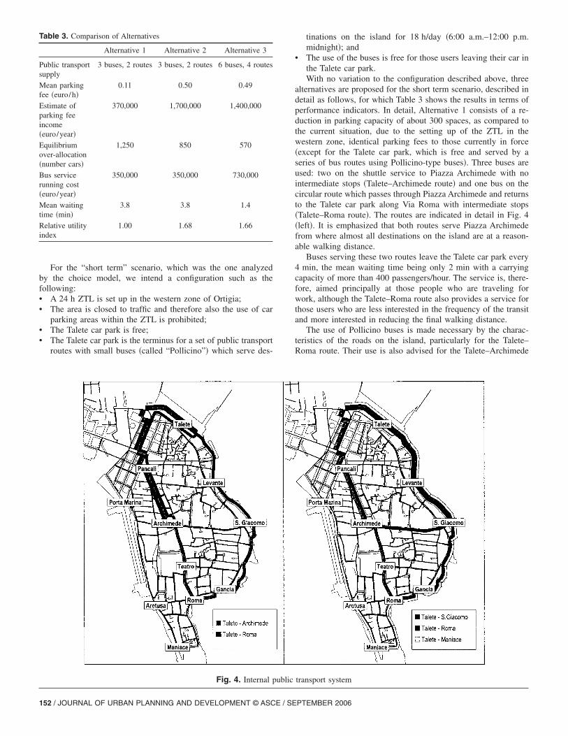
routes with small buses �called “Pollicino”� which serve des-
Table 3. Comparison of Alternatives
Alternative 1 Alternative 2 Alternative 3
Public transportsupply
3 buses, 2 routes 3 buses, 2 routes 6 buses, 4 routes
Mean parkingfee �euro/h�
0.11 0.50 0.49
Estimate ofparking feeincome�euro/year�
370,000 1,700,000 1,400,000
Equilibriumover-allocation�number cars�
1,250 850 570
Bus servicerunning cost�euro/year�
350,000 350,000 730,000
Mean waitingtime �min�
3.8 3.8 1.4
Relative utilityindex
1.00 1.68 1.66
Fig. 4. Internal p
152 / JOURNAL OF URBAN PLANNING AND DEVELOPMENT © ASCE / SE
tinations on the island for 18 h/day �6:00 a.m.–12:00 p.m.midnight�; and
• The use of the buses is free for those users leaving their car inthe Talete car park.With no variation to the configuration described above, three
alternatives are proposed for the short term scenario, described indetail as follows, for which Table 3 shows the results in terms ofperformance indicators. In detail, Alternative 1 consists of a re-duction in parking capacity of about 300 spaces, as compared tothe current situation, due to the setting up of the ZTL in thewestern zone, identical parking fees to those currently in force�except for the Talete car park, which is free and served by aseries of bus routes using Pollicino-type buses�. Three buses areused: two on the shuttle service to Piazza Archimede with nointermediate stops �Talete–Archimede route� and one bus on thecircular route which passes through Piazza Archimede and returnsto the Talete car park along Via Roma with intermediate stops�Talete–Roma route�. The routes are indicated in detail in Fig. 4�left�. It is emphasized that both routes serve Piazza Archimedefrom where almost all destinations on the island are at a reason-able walking distance.
Buses serving these two routes leave the Talete car park every4 min, the mean waiting time being only 2 min with a carryingcapacity of more than 400 passengers/hour. The service is, there-fore, aimed principally at those people who are traveling forwork, although the Talete–Roma route also provides a service forthose users who are less interested in the frequency of the transitand more interested in reducing the final walking distance.
The use of Pollicino buses is made necessary by the charac-teristics of the roads on the island, particularly for the Talete–Roma route. Their use is also advised for the Talete–Archimede
transport system
ublicPTEMBER 2006
route, not because of particular problems of maneuverability, butin order to have a homogeneous fleet which can be used differ-ently outside of the morning rush hour.
In fact, once the home-to-work demand has been satisfied thetwo buses from the Talete–Archimede route could be used toincrease the Talete–Roma service.
The bus service is free to users who get on at the Talete carpark terminus.
The operating of the Talete–Archimede route requires a spe-cific bus lane going against the flow of traffic in Corso Matteotti.This would lead to some limitations on traffic flow and parking.
For the Piazza Archimede destination buses would leave every6 min �a mean waiting time at the Talete car park of 3 min� andhave a carrying capacity of 300 passengers/hour.
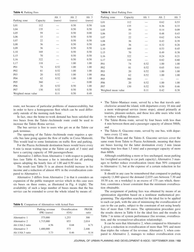
Alternative 2 differs from Alternative 1 with respect to parkingfees �see Table 4�, because a fee is introduced for all parkingspaces adopting the hourly fees of 1.00 and 0.50 euros.
The result �see Table 5� is an almost fivefold increase in feeincome and a reduction of almost 40% in the overallocation com-pared to Alternative 1.
Alternative 3 differs from Alternative 2 in that it considers anexpansion of the public transport service which in this case usessix buses on three routes, as illustrated in Fig. 4 �right�. Theavailability of such a large number of buses means that the busservice can be extended to cover the whole island by means of:
Table 4. Parking Fees
Parking zone CapacityAlt. 1�euros�
Alt. 2�euros�
Alt. 3�euros�
L01 112 — 0.50 0.50
L04 135 — 0.50 0.50
L05 59 — 0.50 0.00
L06 33 — 0.50 0.50
L07 22 — 0.50 0.50
L08 36 — 0.50 0.50
L09 36 — 0.50 0.50
L10 169 — 0.50 0.50
L15 70 — 0.50 0.50
L16 322 — 0.50 0.50
L17 118 — 1.00 1.00
P01 74 0.52 1.00 1.00
P02 81 0.52 1.00 1.00
P03 20 0.52 1.00 1.00
P04 62 0.52 1.00 1.00
P05 360 — — 0.00
P06 20 0.52 0.50 1.00
P07 130 0.52 0.50 0.50
Weighted mean value 0.11 0.50 0.49
Table 5. Comparison of Alternatives with Actual Fees
Parking revenue�PR� �euros�
Overallocation�OA�
PR/ORratio
Alternative 1 375,000 1,253 300
Alternative 2 1,715,000 853 2,014
Alt.1/Alt.2 ratio 4.56 0.68 6.71
Alternative 3 1,400,000 573 2,446
Alt.1/Alt.3 ratio 3.73 0.46 8.14
JOURNAL OF URBAN P
• The Talete–Maniace route, served by a bus that travels anti-clockwise around the island, with departures every 18 min anda more widespread service �more stops�, aimed primarily attourists, pleasure-seekers, and those less able users who wishto reduce walking distances;
• The Talete–Roma route, served by four buses with less than4 min between them and a passenger capacity of almost 500/h;and
• The Talete–S. Giacomo route, served by one bus, with depar-tures every 12 min.
The Talete–Roma and the Talete–S. Giacomo services cover thesame route from Talete to Piazza Archimede, meaning that thereare buses leaving for the latter destination every 3 min �meanwaiting time less than 1.5 min� and a passenger capacity of morethan 600/h.
Although establishing a more or less unchanged, mean parkingfee �weighted according to car park capacity�, Alternative 3 man-ages to further reduce overallocation �more than 50% comparedto Alternative 1�, but at the expense of a certain reduction in feerevenue.
It should in any case be remembered that compared to parkingcapacity �1,860 spaces� the demand �2,035 cars between 7.30 and10:30 a.m. on a weekday� is an excess of 175 cars which, there-fore, constitutes a lesser constraint than the minimum overalloca-tion obtainable.
The assignment of parking fees was obtained by means of anoptimization algorithm based on a nonlinear mathematical pro-gramming. The algorithm searched for the ideal fee to be appliedto each car park, with the aim of minimizing the overallocation ofcars to the car parks, subject to the constraint of not using hourlyfees of more than 1.00 euros. The optimization procedure gavethe results shown in Table 6 for the ideal fees and the results inTable 7 in terms of system performance �fee revenue, overalloca-tion, and the revenue/over-allocation relationship�.
It can be seen that Alternative 2, when compared to Alternative1, gives a reduction in overallocation of more than 70% and morethan triples the volume of fee revenue. Alternative 3, when com-
Table 6. Ideal Parking Fees
Parking zone Capacity Alt. 1 Alt. 2 Alt. 3
L01 112 — 0.62 0.53
L04 135 — 0.36 0.33
L05 59 — 0.14 0.09
L06 33 — 0.48 0.43
L07 22 — 0.62 0.54
L08 36 — 0.42 0.39
L09 36 — 0.32 0.26
L10 169 — 0.53 0.45
L15 70 — 0.49 0.38
L16 322 — 0.24 0.21
L17 118 — 0.82 0.80
P01 74 0.52 1.00 1.00
P02 81 0.52 0.65 0.61
P03 20 0.52 1.00 1.00
P04 62 0.52 1.00 1.00
P05 360 — — —
P06 20 0.52 1.00 1.00
P07 130 0.52 0.50 0.46
Weighted mean value 0.11 0.42 0.38
pared to Alternative 2, manages to reduce overallocation even
LANNING AND DEVELOPMENT © ASCE / SEPTEMBER 2006 / 153
further, at the expense of a modest reduction in revenue: in anycase the revenue/overallocation relationship improves.
It is obvious that the fees produced by the optimization proce-dure cannot effectively be put into force due to the difficulty inlevying them. It was, therefore, decided to limit the fee values to1.00 and 0.50 euros. This obviously produces an inevitable “loss”of system performance, above all in terms of an increase in over-allocation, that is a move away from equilibrium conditions. Atthe same time a slight increase in fee revenue is obtained.
Table 8 shows the results of the assignment of cars to each carpark using both the current and the “ideal” fees.
Sensitivity Analysis
A kind of sensitivity analysis was carried out, for both Alterna-tives 2 and 3, to predict the changes in behavior on the basis ofthe changes in utility values, which affect the alternative at-tributes. A parametric fee was assumed as an independent variabledescribing the fee level to be applied for each parking area. Eachparking area was levied with a fee proportional to the assumedparametric fee in order to leave the ratio between the fees of eachpair of parking areas unchanged with respect to the fee sets usedfor Alternatives 2 and 3.
Table 7. Comparison of Alternatives with Ideal Fees
Parkingrevenue �PR�
�euros�Overallocation
�OA�PR/OR
ratio
Alternative 1 375,000 1,253 300
Alternative 2 1,425,000 344 4,136
Alt.1/Alt.2 ratio 3.79 0.27 13.77
Alternative 3 1,310,000 282 4,641
Alt.1/Alt.3 ratio 3.48 0.23 15.45
Table 8. Assignment Results
Parkingzone
Alt. 1 Alt. 2 Alt. 3
Capacity CFa CFa IFb CFa IFb
L01 112 38 217 112 164 112
L04 135 165 52 135 46 135
L05 59 10 4 59 198 59
L06 33 89 34 33 21 33
L07 22 84 64 22 32 22
L08 36 14 29 36 13 24
L09 36 23 10 36 6 36
L10 169 133 281 169 210 169
L15 70 49 80 70 36 70
L16 322 123 30 322 22 322
L17 118 1,199 51 118 48 118
P01 74 0 1 1 1 0
P02 81 6 8 81 6 81
P03 20 44 359 249 344 212
P04 62 46 243 178 230 152
P05 360 8 368 285 505 360
P06 20 1 30 0 1 0
P07 130 3 176 130 152 130aAssignment with current fees.b
Assignment with ideal fees.154 / JOURNAL OF URBAN PLANNING AND DEVELOPMENT © ASCE / SE
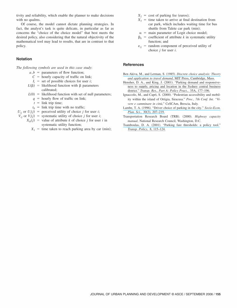
Fig. 5 shows the overallocation of cars to the car parks, ex-pressed in terms of the ratio between the overallocation of theproject cases �Alternatives 2 and 3� and the “no project case” one�Alternative 1�. The overallocation ratio is significantly sensitiveto changes in the fee level, reaching its minimum when the feelevel is very close to its unchanged value for Alternative 2 andwhen it is slightly reduced for Alternative 3, as a consequence ofthe improved bus service performance, which allows a better carallocation among all the car parks even if the average parking feeis lowered. The figure also shows that the model is quite stable,because it produces an increase in the overallocation ratio, arounda parametric fee of 0%, which is less than half the increase �ordecrease� of the parametric fee.
Conclusions
Regulatory works were examined which concern the number ofparking spaces available, parking fees, and public transport usedin a support role for the working of the car park infrastructure�park and ride�. These are considered as the first stage in a processwhich aims to improve mobility, so as to guarantee adequate sup-port for all the activities carried out on the island �both work andstudy, commerce, and pleasure�.
By setting up and applying the user parking choice model wewere able to direct the local administration’s interventions withregard to the regulation of traffic on the island. In fact, thanks tothe results of the model, the local administration was convincedthat it was possible to take different measures with regard to thetraffic problem �above all, the suppression of the fee for the Taletecar park� which could seem to be quite risky, at first sight. In spiteof its approximation, the model allows an equilibrium point to befound among all the decision variables �fees, closures to traffic,public transport service lines, and trips and service costs�, in sucha way as to “automatically” drive users to follow the intentions ofthe planner without feeling that they are forced to do so. This is,perhaps, the most important result for the administration, whichobviously cares greatly about the “political” aspect of interven-tions on traffic.
In fact, the Ortigia experience proved to be very interesting, inparticular from one certain point of view: the local administra-tion’s sensitivity toward the numeric analysis was notable, if com-pared with the Southern Italian background. The administrationsuddenly understood the usefulness of the modeling tool we setup, and put most of the model’s findings into practice.
Therefore, even if some results of the analysis �although notall� could be roughly deduced by simply observing the real situ-
Fig. 5. Sensitivity analysis
ation, the mathematical model gives the results a scientific objec-
PTEMBER 2006
tivity and reliability, which enable the planner to make decisionswith no qualms.
Of course, the model cannot dictate planning strategies. Infact, the analyst’s task is quite delicate, in particular as far asconcerns the “choice of the choice model” that best meets thedesired policy, also considering that the natural objectivity of themathematical tool may lead to results, that are in contrast to thatpolicy.
Notation
The following symbols are used in this case study:a ,b � parameters of flow function;
C � hourly capacity of traffic on link;Ii � set of possible choices for user i;
L��� � likelihood function with � parameterscalibrated;
L�0� � likelihood function with set of null parameters;q � hourly flow of traffic on link;t � link trip time;
t0 � link trip time with no traffic;Uij or Ui�j� � perceived utility of choice j for user i;Vij or Vi�j� � systematic utility of choice j for user i;
Xik�j� � value of attribute k of choice j for user i insystematic utility function;
X � time taken to reach parking area by car �min�;
1JOURNAL OF URBAN P
X2 � cost of parking fee �euros�;X3 � time taken to arrive at final destination from
car park, which includes waiting time for busshuttle from Talete car park �min�;
� � main parameter of Logit choice model;�k � coefficient of attribute k in systematic utility
function; and�ij � random component of perceived utility of
choice j for user i.
References
Ben Akiva, M., and Lerman, S. �1985�. Discrete choice analysis: Theoryand application to travel demand, MIT Press, Cambridge, Mass.
Hensher, D. A., and King, J. �2001�. “Parking demand and responsive-ness to supply, pricing and location in the Sydney central businessdistrict.” Transp. Res., Part A: Policy Pract., 35A, 177–196.
Ignaccolo, M., and Caprì, S. �2000�. “Pedestrian accessibility and mobil-ity within the island of Ortigia, Siracusa.” Proc., 7th Conf. Int. “Vi-vere e camminare in città,” CeSCAm, Brescia, Italy.
Lambe, T. A. �1996�. “Driver choice of parking in the city.” Socio-Econ.Plan. Sci., 30�3�, 207–219.
Transportation Research Board �TRB�. �2000�. Highway capacitymanual, National Research Council, Washington, D.C.
Tsamboulas, D. A. �2001�. “Parking fare thresholds: a policy tool.”Transp. Policy, 8, 115–124.
LANNING AND DEVELOPMENT © ASCE / SEPTEMBER 2006 / 155