Discovery of sediment indicating rapid lake-level fall in the late ...
33
HAL Id: hal-00109562 https://hal.archives-ouvertes.fr/hal-00109562 Submitted on 24 Oct 2006 HAL is a multi-disciplinary open access archive for the deposit and dissemination of sci- entific research documents, whether they are pub- lished or not. The documents may come from teaching and research institutions in France or abroad, or from public or private research centers. L’archive ouverte pluridisciplinaire HAL, est destinée au dépôt et à la diffusion de documents scientifiques de niveau recherche, publiés ou non, émanant des établissements d’enseignement et de recherche français ou étrangers, des laboratoires publics ou privés. Discovery of sediment indicating rapid lake-level fall in the late Pleistocene Gokarna Formation, Kathmandu Valley, Nepal: implication for terrace formation Tetsuya Sakai, Tomohiro Takagawa, Ananta Prasad Gajurel, Hideo Tabata, Nobuo Ooi, Bishal Nath Upreti To cite this version: Tetsuya Sakai, Tomohiro Takagawa, Ananta Prasad Gajurel, Hideo Tabata, Nobuo Ooi, et al.. Discov- ery of sediment indicating rapid lake-level fall in the late Pleistocene Gokarna Formation, Kathmandu Valley, Nepal: implication for terrace formation. Quaternary Research, Elsevier, 2006, 45(2), pp.99- 112. hal-00109562
-
Upload
khangminh22 -
Category
Documents
-
view
0 -
download
0
Transcript of Discovery of sediment indicating rapid lake-level fall in the late ...

HAL Id: hal-00109562https://hal.archives-ouvertes.fr/hal-00109562
Submitted on 24 Oct 2006
HAL is a multi-disciplinary open accessarchive for the deposit and dissemination of sci-entific research documents, whether they are pub-lished or not. The documents may come fromteaching and research institutions in France orabroad, or from public or private research centers.
L’archive ouverte pluridisciplinaire HAL, estdestinée au dépôt et à la diffusion de documentsscientifiques de niveau recherche, publiés ou non,émanant des établissements d’enseignement et derecherche français ou étrangers, des laboratoirespublics ou privés.
Discovery of sediment indicating rapid lake-level fall inthe late Pleistocene Gokarna Formation, Kathmandu
Valley, Nepal: implication for terrace formationTetsuya Sakai, Tomohiro Takagawa, Ananta Prasad Gajurel, Hideo Tabata,
Nobuo Ooi, Bishal Nath Upreti
To cite this version:Tetsuya Sakai, Tomohiro Takagawa, Ananta Prasad Gajurel, Hideo Tabata, Nobuo Ooi, et al.. Discov-ery of sediment indicating rapid lake-level fall in the late Pleistocene Gokarna Formation, KathmanduValley, Nepal: implication for terrace formation. Quaternary Research, Elsevier, 2006, 45(2), pp.99-112. �hal-00109562�
Running head: Discovery of sediment indicating rapid lake level fall
Discovery of sediment indicating rapid lake-level fall in the late Pleistocene
Gokarna Formation, Kathmandu Valley, Nepal: implication for terrace formation
Tetsuya SAKAI,1 Tomohiro TAKAGAWA,2 Ananta P. GAJUREL,3 Hideo TABATA,4
Nobuo O'I5 and Bishal N. UPRETI3
1. Department of Geoscience, Shimane University, Shimane690-8504, Japan
2. Division of Earth and Planetary Sciences, Graduate School of Science, Kyoto
University, Kyoto 606-8502, Japan
3. Deparment of Geology, Tru-chandra Campus, Tribhuvan University, Ghantaghar,
Kathmandu, Nepal
4. Gifu Academy of Forest Science and Culture, Mino, Gifu, 501-3714, Japan
5. ONP Laboratory, Neyagawa, Osaka, 654-3805, Japan
Telephone: +81-75-753-4158
Email: [email protected]
1
Abstract
Sediment indicating a rapid fall in lake level has been discovered in the late Pleistocene
Gokarna Formation, Kathmandu Valley, Nepal. The indicator is observed along a widely
traceable erosional surface in this formation, and is characterized by (1) gently inclined
(ca. 10°) tabular cross-stratified sand beds of delta front origin consisting of coarser
material and showing gradual decrease in elevation of its top to the progradation
direction, (2) an antidune cross-laminated sand bed that interfingers with the delta front
deposit, and (3) an approximately 5 m-deep erosional depression filled with convolute
laminated sand beds and recognized at a location distal to that where deposits (1) and
(2) were found.
The early phase of rapid lake level fall caused minor erosion of the delta plain deposits
by fluvial processes, introducing a higher rate of progradation of the delta front and
resulting in the accumulation of deposit (1). The delta emerged as dry land due to
further lowering of the lake level. The antidune cross-laminated sand bed shows
evidence of having accumulated from a high-velocity stream that may have formed as
the lake water drained from the delta front during the lowering of lake level. When the
lake level fell below the level of the topographic high created by delta accumulation,
incised valleys may have formed and part of them may have been filled with sediment
at that time.
The rapid fall in lake level is interpreted to have been the result of lake-wall failure,
which would have occurred at the gorge outlet as the only discharge path for the basin.
2

The initial rise of lake level causing accumulation of terrace sediments may have been
due to the formation of a plug at this outlet, attributable to mass movement along the
gorge.
1. Introduction
The purpose of this study is to describe the depositional facies of the lacustrine
terrace sediments (Gokarna and Thimi formations) distributed to the north of
Kathmandu City, Nepal, to characterize deposits indicating a rapid fall in lake level in
the Gokarna Formation, and to discuss potential causes of lake level change, and terrace
formation. The Kathmandu Valley (Fig. 1) is one of several intermontane basins
developed in the lesser Himalayan Belt (Katel, 1996; Yoshida and Igarashi, 1984; Sakai
et al., 2000). This basin is filled with fluvio-lacustrine sediments that have formed
several depositional terraces accumulated during the Pleistocene (e.g. Natori, 1980;
Katel et al., 1996; Gajurel et al., 1998; Sakai et al., 2000). Topographic studies have
discriminated three terraces in the southern region, and another three terraces in the
central and northern regions of the basin (e.g. Akiba, 1980; Yamanaka, 1982; Yoshida
and Igarashi, 1984). To explain their spatial distribution, Yoshida and Igarashi (1984)
proposed a model for the formation of the Kathmandu Valley terraces based mainly on
14C age data from the northern and central terrace sediments (e.g. Yonechi, 1973;
Yoshida and Igarashi, 1984). They explained that the southern terraces were formed in
conjunction with the migration of the lake toward the north, caused by uplift of the
3

southern part of the basin, probably associated with Mahabharat Range, which
punctuates the southern margin of the basin. However, this suggestion is unconfirmed
because there is no age data for the southern terrace sediment. The age data from the
northern and central terrace sediments indicated they were formed during the last glacial
period, and the terrace tend to be young toward the basin center. Their formation has
been interpreted as being due to lake area reduction toward the basin center (Yoshida
and Igarashi, 1984). This model, however, cannot explain the buildup of each terrace,
which has been recognized as being of depositional origin; the terrace sediments are
composed of stacked delta deposits (cf. Sakai et al., 2000), which are suggestive of the
terrace formation associated with lake level rise. Dill et al.(2001) inferred the cause of
dry up of the lake as linear southern mountain erosion of the Kathmandu Valley
associated with the progradation of frontal thrust tectonic structures and subsequent
breakthrough of Bagmati River at the gorge to the south of Kathmandu after ca. 18 ka.
But they did not show concrete evidence of such event recorded in both on the
topography and in the sediments. They also did not explain terrace formation processes
in their model.
The lack of a detailed description of the terrace sediments of the basin precludes
concrete discussion on terrace formation and basin fill history. Therefore, the
description we provide here will contribute not only to the understanding of the terrace
formation processes in the Kathmandu Valley, but also provide a good example of
sedimentation processes in the marginal areas of lakes in intermontane basins.
4
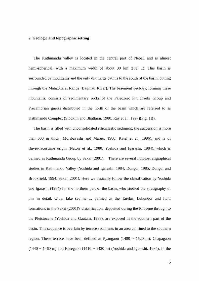
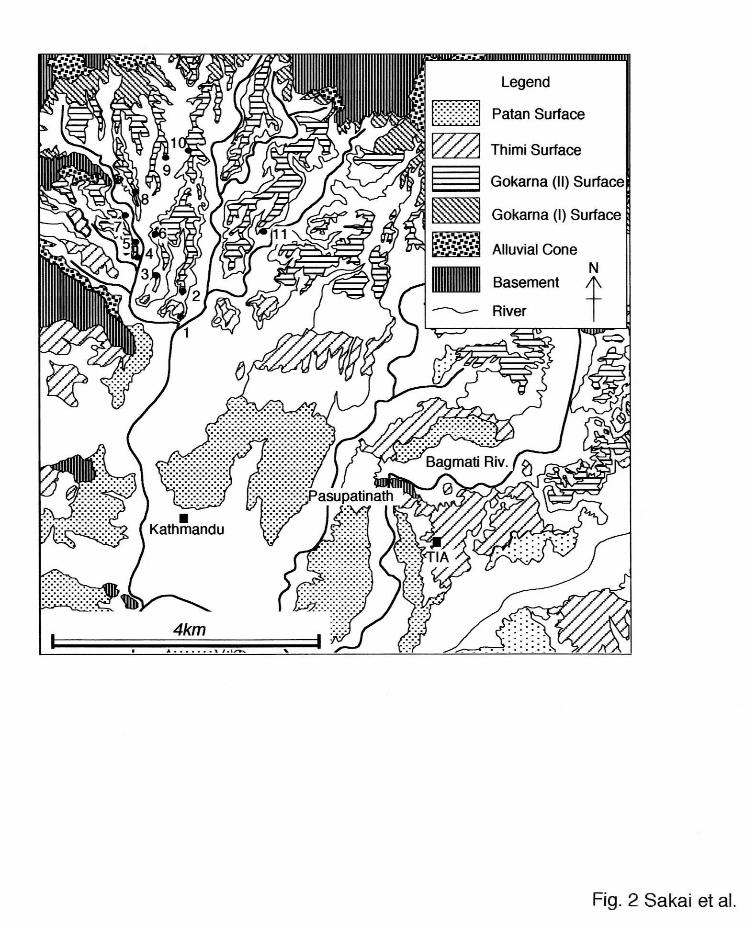
2. Geologic and topographic setting
The Kathmandu valley is located in the central part of Nepal, and is almost
hemi-spherical, with a maximum width of about 30 km (Fig. 1). This basin is
surrounded by mountains and the only discharge path is to the south of the basin, cutting
through the Mahabharat Range (Bagmati River). The basement geology, forming these
mountains, consists of sedimentary rocks of the Paleozoic Phulchauki Group and
Precambrian gneiss distributed in the north of the basin which are referred to as
Kathmandu Complex (Stöcklin and Bhattarai, 1980; Ray et al., 1997)(Fig. 1B).
The basin is filled with unconsolidated siliciclastic sediment; the succession is more
than 600 m thick (Moribayashi and Maruo, 1980; Katel et al., 1996), and is of
fluvio-lacustrine origin (Natori et al., 1980; Yoshida and Igarashi, 1984), which is
defined as Kathmandu Group by Sakai (2001). There are several litholostratigraphical
studies in Kathmandu Valley (Yoshida and Igarashi, 1984; Dongol, 1985; Dongol and
Brookfield, 1994; Sakai, 2001), Here we basically follow the classification by Yoshida
and Igarashi (1984) for the northern part of the basin, who studied the stratigraphy of
this in detail. Older lake sediments, defined as the Tarebir, Lukundor and Itaiti
formations in the Sakai (2001)'s classification, deposited during the Pliocene through to
the Pleistocene (Yoshida and Gautam, 1988), are exposed in the southern part of the
basin. This sequence is overlain by terrace sediments in an area confined to the southern
region. These terrace have been defined as Pyangaon (1480 ~ 1520 m), Chapagaon
(1440 ~ 1460 m) and Boregaon (1410 ~ 1430 m) (Yoshida and Igarashi, 1984). In the
5
central and northern part of the basin, other depositional terraces, Gokarna (1350 ~ 1390
m), Thimi (1330 ~ 1340 m) and Patan (1300 ~ 1320 m) have been discriminated (Akiba,
1980; Yoshida and Igarashi, 1984). Our field observations have revealed that there is
small cliff that separates the Gokarna Surface into two minor surfaces; the newly
defined Gokarna I Terrace (1380 ~ 1390 m) and Gokarna II Terrace (1350 ~ 1370 m).
These terraces do not appear to have been directly affected by tectonic activity; the
elevation of the top surface of the terrace is almost the same in the central and northern
parts of the basin.
These three terrace sediments have been stratigraphically defined using the
appropriate terrace name (Gokarna, Thimi, and Patan formations), and were 14C-dated
as follows: ~28 ka (Gokarna Formation), 28 ~ 24 ka (Thimi Formation) and 19 ~ 11 ka
(Patan Formation) (e.g. Yonechi, 1973; Yoshida and Igarashi, 1984).
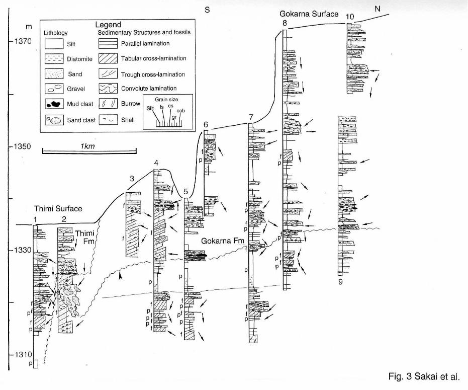
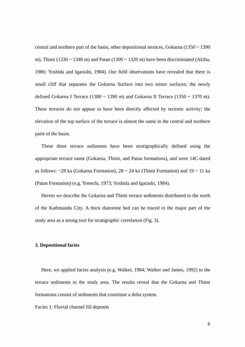
Herein we describe the Gokarna and Thimi terrace sediments distributed to the north
of the Kathmandu City. A thick diatomite bed can be traced in the major part of the
study area as a strong tool for stratigraphic correlation (Fig. 3).
3. Depositional facies
Here, we applied facies analysis (e.g. Walker, 1984; Walker and James, 1992) to the
terrace sediments in the study area. The results reveal that the Gokarna and Thimi
formations consist of sediments that constitute a delta system.
Facies 1: Fluvial channel fill deposits
6
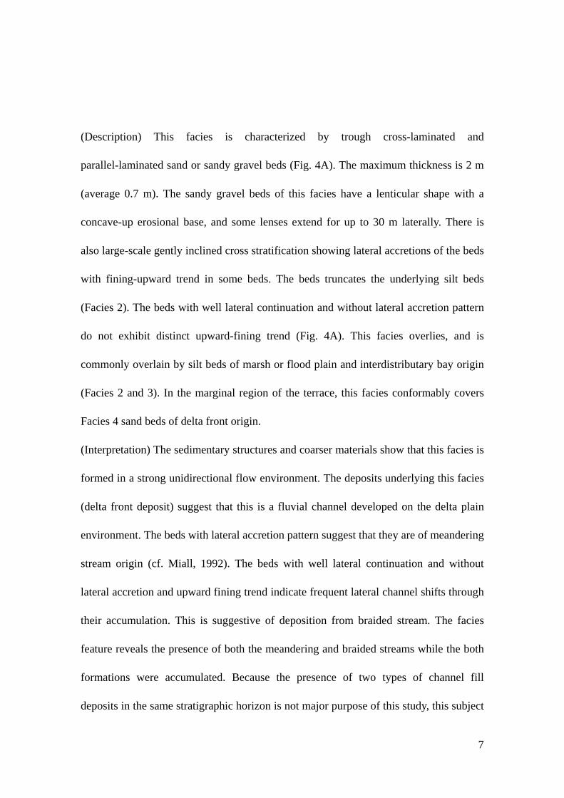
(Description) This facies is characterized by trough cross-laminated and
parallel-laminated sand or sandy gravel beds (Fig. 4A). The maximum thickness is 2 m
(average 0.7 m). The sandy gravel beds of this facies have a lenticular shape with a
concave-up erosional base, and some lenses extend for up to 30 m laterally. There is
also large-scale gently inclined cross stratification showing lateral accretions of the beds
with fining-upward trend in some beds. The beds truncates the underlying silt beds
(Facies 2). The beds with well lateral continuation and without lateral accretion pattern
do not exhibit distinct upward-fining trend (Fig. 4A). This facies overlies, and is
commonly overlain by silt beds of marsh or flood plain and interdistributary bay origin
(Facies 2 and 3). In the marginal region of the terrace, this facies conformably covers
Facies 4 sand beds of delta front origin.
(Interpretation) The sedimentary structures and coarser materials show that this facies is
formed in a strong unidirectional flow environment. The deposits underlying this facies
(delta front deposit) suggest that this is a fluvial channel developed on the delta plain
environment. The beds with lateral accretion pattern suggest that they are of meandering
stream origin (cf. Miall, 1992). The beds with well lateral continuation and without
lateral accretion and upward fining trend indicate frequent lateral channel shifts through
their accumulation. This is suggestive of deposition from braided stream. The facies
feature reveals the presence of both the meandering and braided streams while the both
formations were accumulated. Because the presence of two types of channel fill
deposits in the same stratigraphic horizon is not major purpose of this study, this subject
7
will be discussed in other paper.
Facies 2: Marsh or flood plain deposits
(Description) The lithology of this facies resembles that of Facies 4. This facies is
characterized by black silt beds (up to 2 m thick) with thin interbedded very fine to fine
sand layers (up to 20 cm thick). Roots are common in this facies, particularly reed roots
(Fig. 4B). This facies is overlain by the fluvial channel deposits of Facies 1, and in some
cases changes gradually upward into Facies 4 silt beds. The interbeded sand beds are
commonly parallel stratified and are well-continued in outcrops
(Interpretation) The lithology suggests that this facies was deposited under calmer
hydraulic conditions than the other facies. In particular the presence of reed roots is a
very good indicator of a marsh environment. The relationship between this facies and
the overlying Facies 3 suggests that the marsh was distributed along the head of
interdistributary bays. The sand interbeds are interpreted to have been transported by
low-energy streams during flood events (probably by small scale sheet flood (cf. Rust
and Nanson, 1989).
Facies 3: Interdistributary bay deposits
(Description) This facies consists of black, laminated or massive silt beds with
interbedded sand layers. The silt is slightly finer than that of Facies 3. The maximum
thickness of this facies is about 3 m, with an average thickness of 0.5 m. Some silt beds
are very rich in diatom and organic materials (Fig. 4C) such as reed stem and root
8
fragments. The interbedded sands are up to 30 cm thick, and are characterized mainly
by parallel and ripple cross-laminations. Some coarse to very coarse sand interbeds have
tabular cross-lamination and taper out into silt beds. There is also local wave ripple
lamination in this facies. This facies is commonly overlain by fluvial channel fill
deposits (Facies 1), very thin (up to 50 cm thick) prodelta and delta front deposits
(Facies 4 and 5) and marsh deposits (Facies 2). The silt beds of this facies are not
generally traceable between outcrops.
(Interpretation) The predominance of finer laminated sediments, the presence of local
wave-generated structures, the poor lateral continuity and the diatom-rich silt beds, all
suggest that deposition occurred primarily from suspension in a shallow closed bay
environment. This facies is interpreted as being of narrow, shallow interdistributary bay
origin (cf. Elliot, 1974). Sand interbeds with tangential shapes might have been
deposited from short-lived high-energy currents, representing crevasse-spray or
crevasse-delta deposits (cf. Reading and Collinson, 1996). Reed fragments appear to
have been transported from the marsh environment that is thought to have stretched
along the head of the bay. The overlying deposits suggest that the bay was filled by
channel migration or changed into an open lake environment by subsequent lake-level
rise.
Facies 4: Delta front deposit
(Description) This facies consists of sand, sandy gravel, or alternating sand and
sandy-silt beds with large-scale tabular cross-stratification (Fig. 4D). This facies is
9
between 0.3 m and 10 m thick. Some beds exhibit good lateral continuity; the maximum
lateral extent was observed to be about 300 m. Each sand unit in the tabular
cross-stratified beds is up to 50 cm thick (average 5 cm), and each shows massive,
inverse or normal grading and parallel lamination. Wave ripple lamination and
hummocky cross-stratification are also recognized in this facies sand beds thicker than 5
m.. In the case that facies thickness is less than 5 m, coarser grains tend to be distributed
in the basal part of the cross-stratification. Several fine to very fine sand beds extend
into the underlying prodelta silt beds. This facies is overlain by fluvial channel fill
deposits (Facies 1).
(Interpretation) The wave-generated sedimentary structures indicate subaqueous
deposition. The massive, inverse or normal grading of the sand beds and the coarser
grains in the basal part of the cross-stratified beds suggest that the sediments were
transported by small-scale gravity flows such as grain flows on the slope (cf. Nemec,
1990). The large-scale cross-stratification, good lateral continuity and overlying fluvial
deposits indicate that this facies is of delta front origin (cf. Flores, 1990;
Garcia-Mondejar, 1990).
Facies 5 Prodelta deposits
(Description) This facies consists of alternating sand and black silt beds or silt beds with
traceable diatomaceous interbeds containing organic material. The maximum thickness
of this facies is about 2 m. The interbedded sand is commonly a continuation from the
delta front deposits, is characterized by parallel and climbing ripple laminations, and
10

tends to thin away from the foot of the delta front slope. Wave ripple lamination is also
found in the sand beds. This facies can be confidently traced between outcrops in some
cases (e.g. a silt bed above the solid line at around 1320 m in Fig. 3).
(Interpretation) Wave ripple lamination, and more extensive facies continuity suggest
that deposition occurred in a open lake environment. The interbedded sand layers
exhibit indicators of intermittent sediment supply from the delta front environment as
traction or suspended load. These features suggest that this facies is of prodelta origin
(cf. Flores, 1990; Garcia-Mondejar, 1990).
4. Lateral and Vertical Facies Relationships
Facies analysis reveals that the terrace sediments constitute a lacustrine delta system.
Facies 1 ~ 3 are components of delta plain deposits (cf. Elliot, 1974; Bhattacharya and
Walker, 1992; Plint and Browne, 1994; Reading and Collinson, 1996). Cross sections
(Fig. 3) taken subparallel to the paleo shore-normal direction (from paleoflow
observations), reveal different facies stacking patterns in the southern and northern part
of the study area (Fig. 3). The terrace sediments in the southern part, typically found
below the erosion surface at around 1330 m (Fig. 3), are comprised of thick delta front
deposits (e.g. Loc. 2) that grade into several complete delta successions to the north
(Locs. 4, 5, 7 and 8). Further north, only delta plain deposits (Facies 1 - 3) are
distributed (Loc. 9). Similar facies changes are also recognized in the sediments above
the erosion surface (Fig. 3).
11

This lateral facies change indicates that delta plain deposits accumulated in the
northern part of the study area during the lake-level rise, and progradation of deltas
occurred to the south when the lake-level was stabilized. The stacked delta successions
found, particularly in Locs 4 and 5, is interpreted to be accumulated by repeated
lake-level rise and stabilization. The flat top of the each delta plain deposits in piled
delta successions indicates that the delta progradation occurred when the lake level was
stabilized. During the lake-level rise, the sediment accumulation is interpreted as having
been occurred on the delta plain in the northern part of the study area. Sediment
accumulation on the delta plain is also reported from the another areas
(Garcia-Mondejar, 1990). The lateral variation in the number and thickness of delta
successions can be attributed to the lateral shift of delta lobes. The thicker delta front
deposits at Locs. 2 and 3 are interpreted to have been formed as a result of progradation
of the delta front beyond the underlying delta margin.
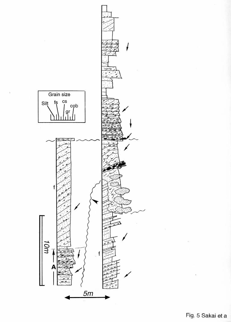
In the basinward end of the Gokarna Formation, small incised valleys are commonly
found. In the case of the Loc. 2, the valley fill deposits consists of basal fluvial channel
fill deposits followed by sandy prodelta and delta front deposits. Boulder-sized sand or
mud clasts which are interpreted to be fall or slide origin covers the side wall of the
valley (Fig. 5).
The sediments at Loc. 1 and in the upper part of Loc. 2 appear to belong to the Thimi
Formation. The presence of delta plain deposits distal to the thick delta front deposits
suggests that these sediments were associated with another lake-level rise that would
have occurred after the deposition of the Gokarna Formation.
12

5. Characteristics of beds indicating rapid lake-level fall
The traceable erosion surface recognized at around 1330 m records a lake-level fall
event during the deposition of the Gokarna Formation. The erosion surface incises the
delta front deposits in the marginal region of the Gokarna Terrace (Loc. 2 of Fig. 3 and
Fig. 5). The incised valley is filled with trough cross-stratified sandy gravel beds of
fluvial channel origin, with overlying tabular cross-laminated sand beds of delta front
origin. Sand beds with abundant boulder-sized sand clasts, which appear to have been
entrained due to slope failure of the incised valley wall, are also interbedded in the
valley fill deposits (Fig. 5).
The surface becomes nearly flat toward the north between Locs. 5 and 9, with
undulations of less than 1 m relief. In this area, this surface is overlain by pebble or
cobble gravel beds containing abundant boulder-sized mud clasts (Fig. 3).
The presence of the valley fill fluvial deposits indicates that almost all of the
topographic high formed by delta accumulation temporally emerged as a subaerial
terrace. Surface features and overlying sediments between Locs. 5 ~ 9 also suggest a
drop in water level. The deposition of overlying delta front deposits is associated with
subsequent lake-level rise.
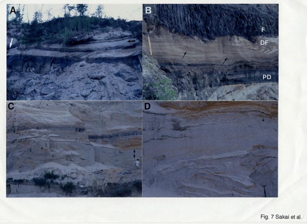
The composition and features of a delta succession and its lateral facies change at
Loc. 11 (open-arrowed interval in Fig. 6), located near the head of the incised valley,
suggest that this lake-level fall occurred in a relatively short time interval. The delta
13
front and its distal correlates have the following features: (1) The delta front deposit
consists of very coarse sand to granule, which is coarser than that of other delta front
deposits in this area, and have slightly gentler tabular cross-stratification (ca. 10°) than
in other intervals (Fig. 7A). The elevation of the top of the delta front deposits tends to
decrease to the progradation direction. (2) The delta front deposit interfingers with a
sand bed that exhibits antidune cross-lamination where delta progradation ceased (Fig.
7B). The antidune cross-laminated sand overlies prodelta sand and silt beds and tends to
thin away from the foot of the delta front. Both the antidune sand bed and the delta front
sand beds are truncated by another erosional depression, which is filled with fluvial
channel sandy gravel and abandoned channel fill silt beds (Fig. 7B). (3) An erosional
depression, about 5 m deep, appears in the south of the antidune site. The erosional
depression is filled with convolute laminated sand beds (Fig. 7C) that contain elliptical
boulder-sized mud clasts, the maximum long axis of which is about 3 m. The 5 m-thick
bed continues at least 50 m without thickness change. Undeformed tabular
cross-stratified beds are partially interbedded with the convolute laminated sand beds
(Fig. 7D), indicating that this interval was originally a delta (referred to as delta-like
deposit) filling the depression, which might not have been formed by normal fluvial
processes.
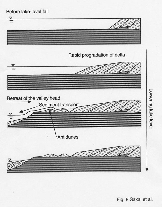
The delta front deposit, consisting of coarser materials and representing a gradual
decrease in the height of the delta, exhibits features suggestive of enhanced fluvial
erosion processes that can be associated with a gradual drop in water level (Fig. 8B).
The gentler inclination of the cross-stratified beds may have resulted from a faster
14

progradation rate. According to flume experiments, the shape of cross-stratification
changes from angular to tangential type with lowering the base level (Jopling, 1965)
and the inclination of stratification tends to decrease.
Antidunes are commonly formed in water that is shallow enough to produce in-phase
waves between the bed and the water surface at high stream energies, or upper flow
regime condition (e.g. Kennedy, 1969; Simons et al., 1965; Cheel, 1990). These types of
deposits have been reported to have been formed in environments such as wash-over
fans (Barwis and Hayes, 1985) and gravel bars in a braided river (e.g. Suzuki, 2000),
where strong currents are generated during storms or floods. The interfingering
relationship between the antidune cross-laminated sand and the delta front deposits
indicates that a stream with sufficiently high velocity to form antidunes was caused at
the time when delta progradation ceased (Fig. 8C). This fast flow condition may have as
the last of the lake water drained from the topographic high of the delta, forming an
erosional depression.
The phase in which the erosional depression was filled is still uncertain, however, we
believe that it was filled during the final stages of draining. Strata formed during this
period are unlikely to have been preserved. As the base of the depression is almost flat,
convolute laminated beds, originally a delta-like deposit, that would have accumulated
from a sediment-rich flow that concentrated in the depression after the lake level fell
below the topographic high, might be preserved(Fig. 8D)..
6. Cause of lake-level fluctuation and terrace formation
15
The rise of lake level suggested by the delta successions and the rapid fall in lake
level recorded by the terrace sediments are interpreted as having been the result of plug
formation and destruction in the gorge at the basin outlet. The Bagmati River, which
cuts across the Mahabharat Range, forms a gorge as the only discharge path for the
basin. Due to the lack of evidence in the terrace for a gradual fall in lake level at the
terrace top, such as a gradual decrease in the height of the delta front deposits, the most
likely interpretation is that the Gokarna Terrace was formed as a result of plug
destruction and rapid lake level fall. If this is the case, then the elevation of the three
terraces (Gokarna, Thimi and Patan) would have been determined by the height of the
plug in the gorge, which would have constrained the upper limit of lake-level rise. As
such, the Gokarna formation can be assumed to have formed as a result of the greatest
lake-level rise event (highest plug level), followed by the Thimi phase and the Patan
phase with lowest plug level through the late Pleistocene. If a higher plug had formed
during the Patan phase, further accumulation of the delta deposits would have buried the
Gokarna Terrace. There is also the possibility that this process of lake level rise and
rapid fall may have occurred numerous times before the deposition of the Gokarna
Formation, meaning that there may be older terrace sediments below the Gokarna
Formation that are not yet to be identified. Further studies are needed to reconstruct in
detail the basin fill history of the Kathmandu Valley, which will provide fundamental
information for deciphering the paleoclimatic change and uplift of the Himalayan
Mountains.
16
Unfortunately we can not know the specific mechanisms of such catastrophic lake
level fall in this basin because the sediments which might have plugged the basin seems
to be completely removed now. Near the basin exit gorge, thick poorly sorted gravel
beds, which are interpreted to be of large scale gravity flow deposits including debris
flow, are frequently recognized. We now believe that such large scale mass wasting
contributed to make the plug of the basin. Because the basin exit gorge is narrow (in
some locations less than 200 m), a large mass wasting from the adjacent steep slopes
easily plugs the gorge to the higher level. Probably larger volume of lake water
spill-over triggered by flooding or earthquakes must be a possible cause of the out-burst.
Basin tilting could not be attributable because each terrace surfaces have the almost
same level in the major part of the basin.
7. Summary
(1) The Gokarna Formation consists of delta deposits, and its characteristics differ
between the northern and southern regions of the study area. Typical delta successions
characterize the southern area, and delta plain deposits occupy the majority of the
northern sediments. The accumulation of delta deposits record a lake-level rise.
(2) Evidence of a rapid lake level fall was discovered in deposits along a traceable
erosional surface, characterized by gentle tabular cross-stratification, antidune
cross-laminated sand beds that interfinger with the delta front deposits, and erosional
depressions.
17

(3) The cause of lake level fluctuation has been attributed to plugging and unplugging of
the gorge at the basin outlet.
Acknowledgement
I would like appreciate Prof. Fujio Masuda of Kyoto University who gave us
beneficial comments about delta deposits, and journal reviewers, Dr. K. Arita and H.
Sakai for their critical comments. Part of this study is supported by a Grant-in Aid for
Scientific Research from Ministry of Education, Science Culture and Technology of
Japan (No.11691112 for Dr. K. Arita and No. 14740298 for T.S.).
References
Akiba, T., 1980. Classification of the fluvial terraces in central Nepal. Journal of
Hokkaido University of Education, Section IIB 30, 179-188.**
Barwis, J.H. and Hayes, M.O., 1985. Antidunes on modern and ancient washover fans.
Journal of Sedimentary Petrology 55, 907-916.
Bhattacharya, J.P. and Walker, R.G., 1992. Deltas. In Walker, R.G. and James, N. (Eds.),
Facies models: response to sea level changes. Geological Association of Canada,
pp. 157-178.
Cheel, R.J., 1990. Horizontal lamination and the sequence of bed phases and
stratification under upper-flow-regime condition. Sedimentology 37, 517-529.
Dill, H.G., Kharel, B.D., Singh, V.K., Piya, B., Busch, K. and Geyh, C, 2001.
18
Sedimentology and paleogeographic evolution of the intermontane Kathmandu
basin, Nepal, during the Pliocene and Quaternary. Implications for formation of
deposits of economic interest. Journal of Asian Earth Sciences 19, 777-804.
Dongol, G.M.S., 1985. Geology of the Kathmandu fluvial lacustrine sediments in the
light of new vertebrate fossil occurrences. Journal of Nepal Geological Society 3,
43-57.
Dongol, G.M.S. and Brookfield, M.E., 1994, The Quaternary Kathmandu Basin, Nepal.
In Gierlowski-Kordesch, E. and Kelts, K. (Eds.) Global Geological Record of Lake
Basins, volume 1. World and Regional Geology, 4, Cambridge University Press,
Cambridge, USA, 349-350.
Elliot, T., 1974. Interdistributary bay sequences and their genesis. Sedimentology 21,
611-622.
Flores, R.M., 1990. Transverse and longitudinal Gilbert-type deltas, Tertiary Coalmont
Formation, North Park Basin, Colorado, USA. International Association of
Sedimentologist Special Publication 10, 223-233.
Gajurel, A.P., Huyghe, P., France-Lanord, C. Mugnier, J.L., Upreti, B.N. and Le Fort, P.,
1998. Seismites in the Kathmandu basin, Nepal. Journal of Nepal Geological
Society 18, 125-134.
Garcia-Mondejar, J., 1990, Sequence analysis of a marine Gilbert-type delta, La Miel,
Albian Lunada Formation of northern Spain. Special Publication of International
Association of Sedimentlogists, 10, 255-269.
Jopling, A.V., 1965. Hydraulic factors controlling the shape of laminae in laboratory
19
deltas. Journal of Sedimentary Petrology 35. 777-791.
Katel, T.P., Upreti, B.N. and Pokharel, G.S., 1996. Engineering properties of fine
grained soils of Kathmandu Valley, Nepal. Journal of Nepal Geological Society 13,
121-138.
Kennedy, J.F., 1969. The formation of sediment ripples, dunes, and antidunes. Annual
Review of Fluid Mechanics 1, 147-168.
Miall, A.D., 1992. Alluvial deposits. In Walker, R.G.,and James, N.P. (Eds.), Facies
Models, response to sea level change. Geological Association of Canada, pp.
119-142.
Moribayashi, S. and Maruo, Y., 1980. Basement topography of the Kathmandu Valley,
Nepal: am application of gravitational method to the survey of a tectonic basin in
the Himalayas. Journal of The Japan Society of Engineering Geologist 21, 30-37.
Natori, H., Takizawa, F., Motojima, K. and Nagata, S., 1980. Natural gas in the
Kathmandu Valley. Chisitsu News 312, 24-35.*
Nemec, W., 1990, Aspects on sediment movement on steep slope. International
Association of Sedimentologist Special Publication 10, 29-73.
Plint, A.G. and Browne, G.H., 1994. Tectonic event stratigraphy in a fluvio-lacustrine,
strike-slip setting: the Boss Point Formation (Westphalian A), Cumberland Basin,
Maritime Canada. Journal of Sedimentary Research B64 341-364.
Rai, S.M., Le Fort, P. and Upreti, B.N., 1997. Geology structure and metamorphism in
Kathmandu and Gosainkund regions, central Nepal. Abstract. Journal of Nepal
20
Geological Society 16, 20-22.
Reading, H.G. and Collinson, J.D., 1996, Clastic coast. In H.G. Reading (Ed..), Sediment
Environments: Process, Facies and Stratigraphy, 3rd ed., Blackwell, Cambridge,
USA, 154-231.
Rust, B.R., Nanson, G.C., 1989, Bedload transport of mud as pedogenic aggregates in
modern and ancient rivers. Sedimentology, 36, 291-306.
Sakai, H., Fujii, R., Kuwahara, Y. and Noe, H., 2000. Climatic changes and tectonic
events recorded in the Paleo-Kathmandu Lake sediments. Chigaku Zasshi (Journal
of Geography) 109, 759-769.**
Sakai, H., 2001, Stratigraphic division and sedimentary facies of the Kathmandu Basin
Group, central Nepal. Journal of Nepal Geological Society, 25, 19-32.
Sakai, T., O'i, N., Takagawa, T., Gajurel, A and Tabata, H., 2000. Reconstruction of
depositional environment and paleoclimate change from the Quaternary basin fill
succession of the Kathmandu Valley, Nepal. International Workshop on Himalayan
Uplift and Climate Change. Program and Abstract, 27-31.
Simons, D.B., Richardson, E.V., and Nording, C.F., 1965. Sedimentary structures
generated by flow in alluvial channels. Society of Economic Paleontologists and
Mineralogists Special Publication 12, 34-52.
Stöcklin, J. and Bhattarai, K.D., 1980. Geological map of Kathmandu area and Central
Mahabharat range (1: 250,000). Department of Mines and Geology, His Majesty's
Government of Nepal, 64p.
Suzuki, K., 2000. Analysis of the modern alternating bar deposits in gravelly Yasu river,
21
Japan. The Association of the Geological Collaboration in Japan, Monograph 48,
67p.**
Walker, R.G., 1984, Facies models (2nd edition). Geological Association of Canada,
Geoscience Canada Reprint Series 1, 150p.
Walker, R.G. and James, N.P., 1992. Facies model; response to sea level change.
Geological Association of Canada, 180p.
Yamanaka, H., 1982. Classification of geomorphic surfaces in the Kathmandu Valley
and its concerning problems. Congress of Association of Japanese Geographer
Reprint 21, 58-59.
Yonechi, F., 1973. A preliminary report on the geomorphology of Kathmandu Valley.
Science Report of Tohoku University, 7th Series (Geography), 23, 153-161.
Yoshida, M. and Gautam, P., 1988. Magnetostratigraphy of Plio-Pleistocene lacustrine
deposits in the Kathmandu Valley, central Nepal. Proceedings of Indian National
Science Academy 54A, 410-417.
Yoshida, M. and Igarashi, Y., 1984. Neogene to Quaternary lacustrine sediments in the
Kathmandu Valley, Nepal. Journal of Nepal Geological Society 4, p.73-100.
* in Japanese ** in Japanese with English Abstract
22

Figure caption
Fig. 1 Location map (A) and simplified geologic map for Kathmandu Valley (B),
modified from Rai et al. (1997). KTM: Kathmandu
Fig. 2 Topographic classification map for the area indicated in Fig. 1, based on Yonechi
(1973) and Yoshida and Igarashi (1984). 1 ~ 11 are sites where the columnar
sections shown in Figs. 3, 5 and 6 were measured. TIA: Tribhuvan International
Airport
Fig. 3 Columnar cross sections of Thimi and Gokarna formations to the north of
Kathmandu City (Locs. 1 ~ 10). Small and large arrows indicate paleoflows (up =
north) and traceable erosional surfaces. Coarse intervals without "f" and silt beds
without "p" represent Facies 1 and 3 or 4, respectively. f: delta front deposits; p;
prodelta deposits
Fig. 4 Outcrop photographs of typical facies of Gokarna and Thimi formations. (A) An
example of fluvial channel fill deposit (arrowed interval). The scale is 50 cm long.
(B) Silt bed of marsh origin, containing reed roots (black arrows). The scale is 30
cm long. (C) Close-up of interdistributary bay deposit containing diatomite and
plant fragment-rich, black silt beds. The scale is 30 cm long. (D) Typical delta
succession in Gokarna Formation. The outcrop is ca. 15 m high. DP; Delta-plain
deposit, DF; Delta-front deposit, PD; Prodelta deposit.
Fig. 5. Columnar cross sections for Loc. 2. The erosion surface forms a small incised
valley at this site. Fluvial channel fill deposits characterized by trough
23

cross-laminated sand beds are recognized inside the valley (shown in "A" ). Other
abbreviations, see Fig. 3.
Fig. 6 Columnar cross sections for Loc. 11. An erosion surface, indicated by the large
arrow, corresponds with that shown in Fig. 3. AN: Antidune cross-lamination, CV;
Convolute lamination. See text for detailed description of open-arrowed interval in
which there is evidence of rapid lake-level fall. Symbols and other abbreviations,
see Fig. 3.
Fig. 7 Outcrop photographs for Loc. 11. (A) Outcrop at Loc. 11. Black arrow shows the
delta front deposit, having gently inclined tabular cross-stratification. White arrow
indicates the position of photograph in Fig. 7B. (B) Close-up of Fig. 7A. Black
arrows indicate antidune cross-lamination. Cross-laminated part represents a delta
front deposit. F; Fluvial deposits, consisting of thin gravel beds and abandoned
channel fill silt beds; PD; Prodelta deposit. (C) Convolute laminated sand beds.
Arrow indicates undeformed interval in the convolute laminated division of Fig.
7D. The outcrop is 7 m high. (D) Close-up of point in Fig. 7C. The scale is 30 cm
long.
Fig. 8 Model of sedimentation associated with the rapid lake level fall. See text for
details.
24