Digital footprints in the cityscape: Finding networks of segregation through Big Data
15
Digital footprints in the cityscape: 1 Finding networks of segregation through Big Data Vinicius M. Netto Maíra Pinheiro João Vitor Meirelles Henrique Leite 2 Abstract. Segregation has been one of the most persistent features of cities and therefore one of the main research topics in social studies. From a tradition that can be traced back to the Chicago School in the early 20th century, social segregation has been seen as the natural consequence of the social division of space, reducing segregation territorial segregation and taking the space as a substitute for social distance. We propose a change in the focus of static segregation of places to as social segregation is played by embodied urban trajectories. We analysed trajectories of groups of social actors differentiated by income levels in Rio de Janeiro, Brazil. Firstly, we used metadata from Twitter users moving around the city to derive geographic coordinates and timestamp of tweets, and identified users’ origins and destinations. Then we crossed information on trajectories with socioeconomic data in order to see potential social networks according to income, assess their spatial behaviour and potential spaces of social convergence – a geography of the segregative / integrative potential of encounters. This approach is intended to recast the spatiality of segregation potentially active in the circumstances of social contact in the city rather than in static territories and patterns of residential location. Key words: segregation, mobilities, social networks, Big Data. 1. Introduction: a new approach to urban segregation We will examine in this paper the relationship between forms of social segregation in the city and the mobilities of socially different actors. We suggest that the usual, purely spatial forms of segregation cannot explain the phenomenon of social segregation. Even if the answer to the question of the ways we experience social segregation still implies a role for space, we hope to show that this role cannot be reduced to territorial segregation. We will argue that, since our societies are highly mobile interaction systems, we need to see urban space beyond its seemingly static condition. Through a critique of usual approaches to segregation that have space as a reason and an explanation for social distance, we will emphasize the spatiality of our daily actions and urban encounters as main components of the experience and the phenomenon of segregation. In other words, in contrast to a literature traditionally focused on the territorial dimension, our approach reformulates the spatiality of segregation, showing ways in which segregation is shaped by the segregative / integrative potential of encounter. This shift represents a change of focus, from the vision of static forms of segregation inherent in places – where social distance is assumed, rather than understood in all its material manifestation – to the vision of social segregation reproduced through our actions and trajectories as urban actors. This reformulation of the spatiality of segregation should put the body, both the element that carries the signals of identities and personal differences, as the primordial instance where segregation is socially revealed and lived by the actor. In doing so, we intend to show that urban space maintains a key role in segregation – in 1 The title recalls Frederico de Holanda’s work “Class footprints in the landscape” (Holanda, 2000). 2 The authors are with Universidade Federal Fluminense (UFF), Escola Nacional de Ciência Estatística (ENCE), Universidade de São Paulo (USP) and Universidade Federal do Rio Grande do Sul (UFRGS) respectively. Email: [email protected]
Transcript of Digital footprints in the cityscape: Finding networks of segregation through Big Data

Digital footprints in the cityscape: 1 Finding networks of segregation through Big Data
Vinicius M. Netto Maíra Pinheiro
João Vitor Meirelles Henrique Leite2
Abstract. Segregation has been one of the most persistent features of cities and therefore one of the main research topics in social studies. From a tradition that can be traced back to the Chicago School in the early 20th century, social segregation has been seen as the natural consequence of the social division of space, reducing segregation territorial segregation and taking the space as a substitute for social distance. We propose a change in the focus of static segregation of places to as social segregation is played by embodied urban trajectories. We analysed trajectories of groups of social actors differentiated by income levels in Rio de Janeiro, Brazil. Firstly, we used metadata from Twitter users moving around the city to derive geographic coordinates and timestamp of tweets, and identified users’ origins and destinations. Then we crossed information on trajectories with socioeconomic data in order to see potential social networks according to income, assess their spatial behaviour and potential spaces of social convergence – a geography of the segregative / integrative potential of encounters. This approach is intended to recast the spatiality of segregation potentially active in the circumstances of social contact in the city rather than in static territories and patterns of residential location. Key words: segregation, mobilities, social networks, Big Data. 1. Introduction: a new approach to urban segregation We will examine in this paper the relationship between forms of social segregation in the city and the mobilities of socially different actors. We suggest that the usual, purely spatial forms of segregation cannot explain the phenomenon of social segregation. Even if the answer to the question of the ways we experience social segregation still implies a role for space, we hope to show that this role cannot be reduced to territorial segregation. We will argue that, since our societies are highly mobile interaction systems, we need to see urban space beyond its seemingly static condition. Through a critique of usual approaches to segregation that have space as a reason and an explanation for social distance, we will emphasize the spatiality of our daily actions and urban encounters as main components of the experience and the phenomenon of segregation. In other words, in contrast to a literature traditionally focused on the territorial dimension, our approach reformulates the spatiality of segregation, showing ways in which segregation is shaped by the segregative / integrative potential of encounter. This shift represents a change of focus, from the vision of static forms of segregation inherent in places – where social distance is assumed, rather than understood in all its material manifestation – to the vision of social segregation reproduced through our actions and trajectories as urban actors. This reformulation of the spatiality of segregation should put the body, both the element that carries the signals of identities and personal differences, as the primordial instance where segregation is socially revealed and lived by the actor. In doing so, we intend to show that urban space maintains a key role in segregation – in
1 The title recalls Frederico de Holanda’s work “Class footprints in the landscape” (Holanda, 2000). 2 The authors are with Universidade Federal Fluminense (UFF), Escola Nacional de Ciência Estatística (ENCE), Universidade de São Paulo (USP) and Universidade Federal do Rio Grande do Sul (UFRGS) respectively. Email: [email protected]

2
fact, a role much more subtle, penetrating and definitive than the usual reading of spatial segregation would have; a new, dynamic aspect of the experience of space essential to explain the lasting experience of segregation. In fact, this aim involves entering an almost infinite tangle of movements and interactions in cities. This paper develops a method to capture such elusive fabric, making an eclectic use of ideas, from Linton Freeman's view (1978) segregation as "restrictions on interaction" to references to the time-‐geography of Torsten Hägerstrand (1970). This method is illustrated by an empirical study of large-‐scale mapping of urban trajectories in the city of Rio de Janeiro. Our approach is intended to help us understand the elusive forms which render the Other invisible in our daily lives, and how subtle forms of social distance silently penetrates everyday life, transforming social differences in structural distance, and the Other in a form of otherness unknown – as if we lived in different social worlds; a subtle process that operates in the final analysis, through the body. This reconsideration of segregation seems also useful if we take into account the complex patterns of daily mobility in contemporary cities. Since the work of the Chicago School of Park (1916) and Burgess (1928) to the recent approaches to the contextual characteristics of segregation, mobility has been mostly represented by migration, with the slow temporality of production of residential areas and location as an expression (as in Maloutas, 2004; 2007). In this view, the temporality and spatiality inherent to everyday mobility, such as the ability to access and join social situations, have been neglected. Very differently from that vision, we want to explore an idea of mobility closer to Georg Simmel (1997): mobility as property of "a world in flux, whose substantive content is dissolved in motion" (Frisby in Maloutas, 2004: 195). In fact, there are highly interdependent forms of mobility, including displacement of people for work, leisure situations, family life, migration and escape, which are central to building and maintaining complex connections in a network society (Urry, 2002: 1). Hope to explore this approach and incorporate connections which are at the same time the elusive conditions of contact between the actors, and what Giddens (1984) considers as a key element of social integration: the encounter. First, we will develop these ideas in order to achieve a clearer understanding of the relationship between mobility and the circumstances of the encounter. Next, we list the producers of mobility against social differences. We argue that social differences can be active factors in mobility, especially in strongly unequal societies. We will build on these relationships in order to break free from the spatial reduction of segregation to a social division of space. 2. Segregation as restrictions on interaction One of the most powerful views of segregation is Freeman’s (1978: 413): "All restrictions on interaction, whether they involve physical space or not, are forms of segregation – in social space." Our approach is strongly related to Freeman's view of the restriction on interaction in order to understand segregation as a restriction of the presence of the other in our actions in the city, immersed in the delicate fabric of encounters and interactions that keeps local social systems integrated. Usual approaches seem ill-‐equipped to recognize these subtle dimensions of segregation active in urban rhythms of the encounter. So if we want to understand the integrative / segregative potential of the encounter, we must turn to the fabric of our daily actions and movement beyond

3
segregated areas. This means the possibility of finding a more complex spatiality of segregation and potentials of social integration perhaps latent in places that allow what we can call "social convergence". A closer view of urban practices in different social groups requires a concept able to identify how actors perform their actions spatially in order to access and join social situations. Importantly, different mobilities could be associated with different social groups and different forms of urban experience. We will argue that income is a key factor and may have effects on the number of activities in which they are able to engage. The location of activities is also important, and here approaches to spatial segregation still have much to say, given that living in accessible places implies we are closer to more activities and can perform them in greater numbers and more efficiently. Encounters can be dispersed in the streets or polarized in places of work, leisure and consumption; at bus stops, subway stations, institutional buildings and so on. If we understand the city as a network, we can see activity places like "attractors":3 a substantial part of social life unfolds inside buildings, as our communication and the possibility to relate our actions to the actions of others. We can participate in a particular activity if it interests us, if we have a role to play in it, if we afford to do it, and if we are unable to get to its place – and if we are aware that it exists in the city in the first place. All these factors mean that at least some activities are often not interesting or not accessible (socially and spatially) to everyone. These factors also have an impact on our actions, like sparks to a dense network of daily movements from residential locations. If movement could leave visible traces in space, such appropriation networks could reveal the potential to encounters and bodily segregation unfolding in the city. Mapping these actions networks and movements in the city is precisely an objective of this paper. In fact, the idea of mapping trajectories is far from new. The work of Hägerstrand (1970) was the first systematic attempt to capture trajectories and restrictions spatiotemporal hanging over our actions. Although Hägerstrand’s approach – fashionable in the early 1980s in human geography (e.g. Pred, 1981) – has lost interest to most since then, recent empirical approaches have taken the spirit of that work, making use of technologies capable of recording the movement of actors and identify patterns of mobility.4 We propose to add new layers to this idea, and evaluate how the everyday appropriation of actors shapes encounters. In this sense, we will explore mobility patterns potentially related to different social groups. Networks of movement are of course evanescent features of our effective presence in space. If we could capture at least some of them, we could have a better idea of how socially differentiated groups spatialize their actions. These "courses of action" can shape the possibilities of encounter and relationship between people and may contain the potential spaces of co-‐presence and systematic absence of socially different individuals. In other words, this mapping of actions can allow an understanding of the spatiality of the presence and absence as active features of social segregation.
3 We devise a form of analysing the city drawing on configurational studies, namely Kruger (1979), Hillier and Hanson (1984) and Krafta (1994). 4A method developed by Gonzales et al (2008) uses an extensive data base recorded through mobile phone communication in American cities to map spatial paths, showing that actors have a remarkable tendency to recursivity.

4
We would like to explore a particular definition of "social network" that will be useful for understanding how the spatiality of the encounter shapes the experience of social segregation as a dynamic formation of (and distance between) social groups. We shall not use the concept as a mathematically identifiable arrangement of personal ties, as in Social Network Analysis approaches in quantitative sociology, active since the 1950s.5 We will use a definition of social network as an open set of relationships changing over time – one taking into account the social positions of the actors and the circumstances of time-‐space where groups are formed. This intentionally flexible definition of networks is intended to include the probability of encounter a key sociological factor to understanding how increasing or decreasing connections and settings are definitive features for actors generating social relations. Graphically, we do not represent actors by points as in classical social networks analysis. Instead, we choose invert this representation, seeing the actors as “lifelines” (as in Hägerstrand) converging to positions in space-‐time, in homological relations with real spatial or urban paths. This inversion seeks to make the spatiality of the encounter and the role of space in the production of social networks more intuitive (Figure 1).
Figure 1 – Principles of homology between social and spatial networks operating in time. 3. Social differences and different mobilities What is the chance to meet someone from a different social group? We shall first deploy a number of assumptions apparently reasonable from a material standpoint, and then examine them in the light of previous empirical work. ! First, we are aware that the formation of social networks in cities seems to depend
substantially on circumstances of co-‐presence. ! Secondly, cities are historically produced and spatially structured so as to make social
situations in principle accessible to potential participants. In fact, city-‐making processes are consistently related to patterns of location and accessibility, as many studies in spatial
5 See graph theoretical approaches in Gravonetter (1973), Freeman (1978; 2006), Scott (1991), Wasserman and Faust (1994) and Marques (2012).
5
economics (Hansen, 1959; Glaeser, 2010) and urban studies (from Lynch, 1960 to Hillier, 2012) have systematically revealed.6
! Third, activity places tend to increase the potential for convergence of actors who share similar interests and mobilities.7
! Fourth, courses of action able to include more activity places also increase the potential for social contact. The more broad and complex the pattern of appropriation of space in relation to the number of houses and streets that make up cities, larger would be the potential to enhance our personal social networks.
! Fifth, income plays a role in this process. People with smaller budgets face further restriction in mobility and less diversity in their activities -‐ which in turn leads to less diverse forms of appropriation of space. As we shall see, limitations in mobility enhance localism – the dependency on proximity to do generate personal social networks. In these cases, the density of encounters tends to increase especially around home, and actors tend to use places in the neighbourhood to create and maintain relationships.
! Furthermore, there is a range of activities not dependent on proximity to the residence, such as those around the work, which can increase the length and complexity of urban trajectories of lower income actors. Public transport and the progressive increase of private vehicle ownership in developing countries also allow a broader and more complex mobility in the city. In fact, a number of empirical studies have consistently shown that higher levels of income allow less dependence on spatial proximity.8
Our hypothesis is that restrictions in patterns of mobility and appropriation of space would lead to increases in the density of encounters between similar social actors. In turn, this spatial trend toward both higher levels of homophily and different degrees of connectivity in personal social networks, both generated by differences in income, lifestyles and mobility, may have strong implications for social performance. A number of studies support the idea of a substantial change in the dependency on proximity in the formation of personal social networks according to class and income – in Brazil, country of our case study, and other countries in the world. For example, a recent study by Marques (2012) in Sao Paulo analyses the profiles of sociability of actors in poverty and its role in the formation of social networks, and reveals differences between personal network structures of actors from different social classes. Middle class networks tend to be less dependent on the proximity, as if they were personal deterritorialized communities (Wellman in Marques, 2012) – a very different pattern than actors in poverty. A similar relationship of income and network formation is found in analyses of cases in California USA, and Israel (Fischer and Shavit, 1995), France (Grosseti, 2007), Finland and Russia (Lonkila, 2010) and Chinese (Lee et al., 2005), among others. Their findings suggest that personal networks vary according to the class more than in relation to cultural and regional
6 In a long tradition stemming from Alfred Weber (1909) and Hansen (1959), approaches in spatial economics have been able to identify actors’ preferences and location patterns amidst the apparent randomness of location. 7 The effects of linear paths over the density of encounters have been recently theorized by Bettencourt (2013). 8 See Holanda (2000) and Marques (2012). Empirical data on transport expenses in Brazil show that higher income groups not only spend more than low-‐income groups, they spend more than proportionally (POF, 2009).
6
contexts. The inverse relationship between the dependence on proximity and income also finds support in Briggs (2003; 2005). These approaches to segregation, however, still tend to view the spatiality networks limited to the location of residential areas. We have to clarify how the formation of social networks is effectively performed both spatially and temporally, involving circumstances of co-‐presence and absence. Could mobility – not proximity – be the key factor in networking? In turn, approaches to mobility that make use of geographic information derived from digital data (say, the data usage of mobile phones) are still restricted to capture spatial patterns of behaviour (e.g., Gonzales, Hidalgo and Barabasi, 2008) – with no connection with the social conditions of spatial behaviour, such as the influence of income and class. We propose that a detailed analysis of the structure of routines and urban trajectories could clarify causal factors in the formation of segregated networks and what we might call, reminding Young (1990), the “invisibility of the Other.” 4. Networks of segregation Now let's analyse the temporal formation of personal social networks in an urban context. It seems quite reasonable to say that increases in our access to different social situations could lead to expansions in our personal networks. It also seems reasonable to say that this increase depends on increased mobility. We know that broader and diverse personal networks allow more opportunities for social and economic activity (Marques, 2012). We arrive now at another key point of our argument. If social networks are to really offer more opportunities for activity, networks must first be formed. However, social networking in cities is a spatial capability. In other words, mobility and urban trajectories create encounters that generate and expand social networks, creating new contacts and opportunities for activity. If these implications are correct, mobility must be considered as a key factor in overcoming localism and in the diversification of sociability. Income certainly keeps its central role, as it supports mobility, but we have to consider that increasing mobility is directly related to an increased capacity to form personal networks and perform in them. On the other hand, a low mobility tends to limit interactions, as we can see in the case of poor actors. Mobility and income are associated in a circle that leads to increases or decreases in the potential to create, maintain and expand personal networks. But how does this happen? If networking depends on situations of encounter, we need to understand how mobility matters in the structure of urban encounters, as the instance in which social segregation operates in everyday life. We have seen that mobility may have a direct influence on interaction potentials. We also know that low-‐income actors, despite having more limited mobility, are not static within socially homogeneous areas. Differences in levels of localism and sociability in their personal networks suggest variations in their spatial reach and, by extension, in their condition of presence in places in the city. But how (and where) does the potential of encounter between the socially different materialize? In order to answer this question, we need to examine the effects of different mobilities in the formation of personal networks within and between social groups in order to understand the opportunities of encounter. We suggest that if social networks are formed so that actors can
7
perform connections, then class networks (i.e., social networks operating within large-‐scale groups with common economic features that strongly influence their actions and lifestyles)9 and other forms of social grouping are shaped by probabilities of encounter in personal networks. As we hope to show in our empirical study, space matters here. Even though we do not usually think about it, our daily trajectories constitute the backbone of our interactions and shape the elusive structure of social life in the city. The distance between locations in a city, associated with different mobilities, impose limitations on probabilities of encounter. Differences in mobility, income and lifestyle bring inequalities in the capacity to participate in social situations. Actually, a counterfactual perspective is able to reveal the extent of this problem in the experience of segregation. Inequalities and incompatibilities in patterns of appropriation are forms of what we may call the disjunction of encounters – a displacement of presences, a way of disrupting the possibility of encounters that otherwise could happen. The disjunction of encounters seems especially active among socially different people – it is the social and material conditions that prevent them to become co-‐present and acknowledge each other’s existence. Simply put, there is a much greater chance of social networks incorporate actors who share similar mobilities. These descriptions begin to portray the complex fabric of sociality in the city. However, how can we understand in detail such volatile spatiality of the encounter? How can we see the fabric of personal trajectories that intertwine, only to be separated later in the space-‐time of our urban lives? 5. Digital footprints in the cityscape: the methodological use of Big Data It seems almost impossible to see the spatiality of the tremendously complex flows of convergences and divergences of our actions and paths in the city. Our own previous studies remained at a level of small scale, using social and spatial data derived from interviews (Netto et al 2010). They offered delicate images of segregation in social class networks operating in the city. So a key question posed to us is how can we expand this dynamic approach in order to grasp the panorama of segregation in an entire city? The answer is that we can track and record the movement of a large number of (socially different) actors in the city exploring the enormous potential of so-‐called 'Big Data' as a way of dealing with an urban environment. In that spirit, we conducted an empirical study in the city of Rio de Janeiro. Twitter offers particularly attractive terms, as it makes its metadata bank public through a principle of anonymity. The set of variables provided by Twitter API includes user IDs along with the timestamp and geographic coordinates for each tweet. We collected metadata from tweets posted in Rio between November 12th (0:07:13 am) and 14th (2:36:45) in 2014. We would like to show initial results from an ongoing empirical experiment in Rio. We recorded posts during a period of 56 hours, generating a database of 14,960 users and the positions and times of tweets (Figure 2).
9 We derive this notion from Giddens’ concept of class (Giddens, 1993).

8
Figure 2 -‐ Total number of tweets in Rio de Janeiro November 12th (12:07:13) – 14th (2:36:45).
We could find a clear temporal pattern in tweeting behaviour. There is a steady increase during the day, a little peak around midday, raising again to drop immediately around midnight, to raise again in the early morning, when the cycle begins again – something like “the social pulse of the city” seen through the prism of digital information (figure 3).
Figure 3 – Twitter city pulse: frequency in series of tweets in Rio de Janeiro.
This metadata allowed us to generate a classification of users according to their posting behaviour. Filters were used to ignore users that do not provide sufficient data to infer their residential location, say excluding 40% of users with only two or less tweets during the study period. Automatic tweeters posting for commercial purposes (bots), identifiable by the large number of tweets posted from the same position in space, were also excluded. Furthermore, the analysis of average Euclidean distance between tweet spatial positions revealed users whose movements were also not relevant to our study. A statistical analysis via quantile classification of the results showed that the threshold between high frequencies of short distances and the exponential distribution of long distance was 106 meters per tweet. Values lower than this were filtered, reducing the data set to
9
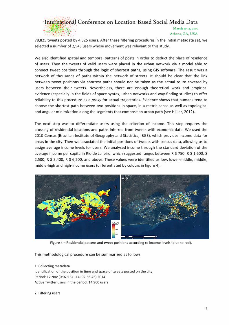
78,825 tweets posted by 4,325 users. After these filtering procedures in the initial metadata set, we selected a number of 2,543 users whose movement was relevant to this study. We also identified spatial and temporal patterns of posts in order to deduct the place of residence of users. Then the tweets of valid users were placed in the urban network via a model able to connect tweet positions through the logic of shortest paths, using GIS software. The result was a network of thousands of paths within the network of streets. It should be clear that the link between tweet positions via shortest paths should not be taken as the actual route covered by users between their tweets. Nevertheless, there are enough theoretical work and empirical evidence (especially in the fields of space syntax, urban networks and way-‐finding studies) to offer reliability to this procedure as a proxy for actual trajectories. Evidence shows that humans tend to choose the shortest path between two positions in space, in a metric sense as well as topological and angular minimization along the segments that compose an urban path (see Hillier, 2012). The next step was to differentiate users using the criterion of income. This step requires the crossing of residential locations and paths inferred from tweets with economic data. We used the 2010 Census (Brazilian Institute of Geography and Statistics, IBGE), which provides income data for areas in the city. Then we associated the initial positions of tweets with census data, allowing us to assign average income levels for users. We analysed income through the standard deviation of the average income per capita in Rio de Janeiro, which suggested ranges between R $ 750; R $ 1,600; $ 2,500; R $ 3,400, R $ 6,200, and above. These values were identified as low, lower-‐middle, middle, middle-‐high and high-‐income users (differentiated by colours in figure 4).
Figure 4 – Residential pattern and tweet positions according to income levels (blue to red).
This methodological procedure can be summarized as follows: 1. Collecting metadata Identification of the position in time and space of tweets posted on the city Period: 12 Nov (0:07:13) -‐ 14 (02:36:45) 2014 Active Twitter users in the period: 14,960 users 2. Filtering users

10
Minimum number of tweets per user (3) Eliminating automatic tweeters Selected users: 2,543 users 3. Geographical analysis of tweets and residential location of users Identification of the location of the first tweet in the morning (first in the sequence of tweets) Confirmation by repeating the location of the first tweet day. 4. Generation of shortest paths between tweet positions An analytical procedure performed through GIS software allowed us to find the shortest paths within the urban fabric, as a proxy for the actual paths of users. 5. Crossing census data (income) with the inferred location of users Procedure performed through GIS software. There is a striking difference between what the map generated from census data shows (figure 4, left) and a finer scale analysis, when we look into the actors scale (figure 4, right). Twitter users derived locations reveal more complexities in locational pattern than procedures based on mean income levels for areas in census maps suggest, whereas there is also room for clear patterns of aggregation. Perhaps ironically, the Twitter users map seems closer to the real city. A final methodological question involves the representation Twitter in relation to the population of Rio de Janeiro – for example, how do we have all social classes and income groups that make up the city proportions in the use of Twitter? First we compared histograms of the average per capita income in Rio’s population and Twitter users. Although histograms display a similar trend, there are differences (figure 5, left). We investigated this question and found a significant correlation between population (at different levels of income) and income profile of Twitter users (figure 5, right). Linear regression (dark line) brings an adjusted R squared of 0.67, showing that the income distribution of users has a fairly reasonable degree of similarity with the income distribution of the population in general.
Figure 5 – Histograms of average per capita income in Rio’s population and Twitter users (left); and regression
between users (Y) and population (X) in urban districts; colours display income level (right).
Distribution of users x Populations in sectors
11
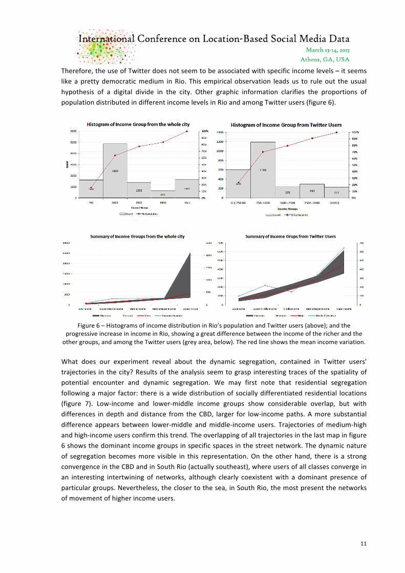
Therefore, the use of Twitter does not seem to be associated with specific income levels – it seems like a pretty democratic medium in Rio. This empirical observation leads us to rule out the usual hypothesis of a digital divide in the city. Other graphic information clarifies the proportions of population distributed in different income levels in Rio and among Twitter users (figure 6).
Figure 6 – Histograms of income distribution in Rio’s population and Twitter users (above); and the
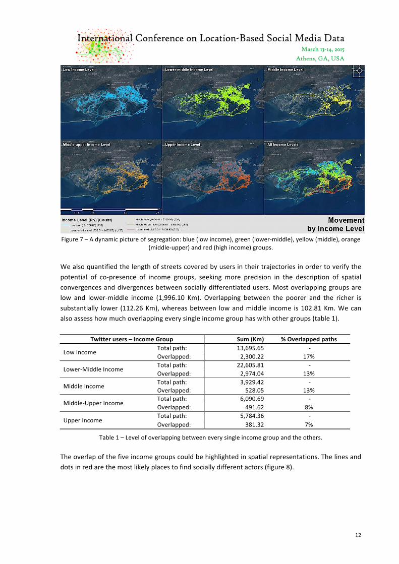
progressive increase in income in Rio, showing a great difference between the income of the richer and the other groups, and among the Twitter users (grey area, below). The red line shows the mean income variation. What does our experiment reveal about the dynamic segregation, contained in Twitter users' trajectories in the city? Results of the analysis seem to grasp interesting traces of the spatiality of potential encounter and dynamic segregation. We may first note that residential segregation following a major factor: there is a wide distribution of socially differentiated residential locations (figure 7). Low-‐income and lower-‐middle income groups show considerable overlap, but with differences in depth and distance from the CBD, larger for low-‐income paths. A more substantial difference appears between lower-‐middle and middle-‐income users. Trajectories of medium-‐high and high-‐income users confirm this trend. The overlapping of all trajectories in the last map in figure 6 shows the dominant income groups in specific spaces in the street network. The dynamic nature of segregation becomes more visible in this representation. On the other hand, there is a strong convergence in the CBD and in South Rio (actually southeast), where users of all classes converge in an interesting intertwining of networks, although clearly coexistent with a dominant presence of particular groups. Nevertheless, the closer to the sea, in South Rio, the most present the networks of movement of higher income users.
12
Figure 7 – A dynamic picture of segregation: blue (low income), green (lower-‐middle), yellow (middle), orange
(middle-‐upper) and red (high income) groups. We also quantified the length of streets covered by users in their trajectories in order to verify the potential of co-‐presence of income groups, seeking more precision in the description of spatial convergences and divergences between socially differentiated users. Most overlapping groups are low and lower-‐middle income (1,996.10 Km). Overlapping between the poorer and the richer is substantially lower (112.26 Km), whereas between low and middle income is 102.81 Km. We can also assess how much overlapping every single income group has with other groups (table 1).
Twitter users – Income Group Sum (Km) % Overlapped paths
Low Income Total path: 13,695.65 -‐ Overlapped: 2,300.22 17%
Lower-‐Middle Income Total path: 22,605.81 -‐ Overlapped: 2,974.04 13%
Middle Income Total path: 3,929.42 -‐ Overlapped: 528.05 13%
Middle-‐Upper Income Total path: 6,090.69 -‐ Overlapped: 491.62 8%
Upper Income Total path: 5,784.36 -‐ Overlapped: 381.32 7%
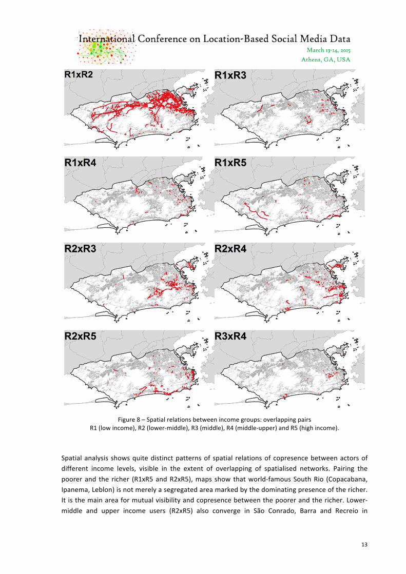
Table 1 – Level of overlapping between every single income group and the others. The overlap of the five income groups could be highlighted in spatial representations. The lines and dots in red are the most likely places to find socially different actors (figure 8).
13
Figure 8 – Spatial relations between income groups: overlapping pairs
R1 (low income), R2 (lower-‐middle), R3 (middle), R4 (middle-‐upper) and R5 (high income). Spatial analysis shows quite distinct patterns of spatial relations of copresence between actors of different income levels, visible in the extent of overlapping of spatialised networks. Pairing the poorer and the richer (R1xR5 and R2xR5), maps show that world-‐famous South Rio (Copacabana, Ipanema, Leblon) is not merely a segregated area marked by the dominating presence of the richer. It is the main area for mutual visibility and copresence between the poorer and the richer. Lower-‐middle and upper income users (R2xR5) also converge in São Conrado, Barra and Recreio in

14
Southeast Rio, in the CBD, and in Gloria, Catete and Flamengo to southeast. In fact, lower-‐middle income users (R2) have a key social role created by a powerful range of appropriation in the city, already able to afford a higher mobility, overlapping more than any other group with other income groups above or below their position in the income grade. Lower-‐middle-‐income users also overlap with middle-‐income users (R2xR3) across areas like Tijuca (North Rio near the CBD) and Jacarapaguá (between North and Southwest Rio, near the ocean). Nevertheless, poorer income users (R1xR2) share much more spaces when appropriating the city, mostly in North and Northwest Rio. Spaces of social convergence are to be found in denser, busier areas like the CBD and South Rio. These are the most likely spaces to find alterities. 6. Conclusion: segregation and the probability of interaction Considering that this experiment consists of a proxy can only show trends of segregation, we can see potential encounters even within the trajectories of a limited number of users, suggesting the city also as a place of coexistence. The study suggests that the probability of encounters is impregnated with spatiality, as much as different spatialities also seem to contain different social potentials in its visible structures. These material properties of the action and its spaces seem active in the passage from the individual action to co-‐presence as a key factor for the social experience. Urban spatiality seems to render this passage in a rather non-‐mechanistic way: the materialisation of social life involves high variability in the arrangement of urban trajectories. The relationship between inherent mobility, encounter and spatial heterogeneity opens up possibilities for constant change and unpredictability – a non-‐deterministic relationship immersed in randomness. Contingencies come into play as unpredictable changes in decisions and choices and trajectories, and in the city itself, where new activities and events arise all the time. The analysis of the digital footprints of class networks in the cityscape seems to reveal this complexity in a way that the purely territorial analysis of segregation could not. In this sense, our approach is intended to shed light on the complexity of segregation now captured as a highly dynamic micro-‐segregation that occurs at the level of our actions, trajectories and their spaces. The odds of finding the 'other' seem distributed according to the spatial and temporal frames of action of different groups within a city. These frames seem to have a stronger potential for cohesion factor in networks operating within specific social classes, shaped by differences in income, social mobility and access to urban places and events. The paths of Twitter users, mapped in space-‐time, suggest greater compatibility between certain users – and, by extension, a greater potential for social interaction generated through encounters. Social ties in personal networks are formed through the recursivity of encounters, so that networks can arise more cohesively within social classes than between them. Incompatibilities between patterns of appropriation of space take the form of differences in choices and capabilities to access activities, the elimination of certain places as opportunities of social coexistence, and structural differences in the materialisation of urban trajectories in time. References Briggs, X. (2003) “Bridging networks, social capital and racial segregation in America”. Faculty Research Working Paper
Series, John F. Kennedy School of Government, Cambridge, MA.

15
Briggs, X. (2005) “Social capital and segregation in the United States” In L.Varady (ed.), Desegregating the city, Suny Press, Albany, NYBurgess, E.W. (1928) Residential Segregation in American Cities. Annals of the American Academy of Political and Social Science 140, 105–115.
Burgess, E.W. (1928) Residential Segregation in American Cities. Annals of the American Academy of Political and Social Science 140, 105–115.
Fischer, C. and Y. Shavit (1995) National differences in network density: Israel and the United States. Social Networks 17.2, 129–45.
Freeman, L. (1978) Segregation in social networks. Sociological Methods & Research 6.4, 411–429. Hansen, W.G. (1959) “How acessibility shapes land use.” Journal of the American Institute of Planners. v. 25, Issue 2. Glaeser, E. (2010) The triumph of the city: how our greatest invention makes us richer, smarter, greener, healthier and
happier. New York: Penguim. Giddens, A. (1984) The Constitution of Society. Cambridge Polity Press, Cambridge. Giddens, A. (1993) Sociology. Cambridge Polity Press, Cambridge. Gonzales, M., Hidalgo, C. and Barabási, A-‐L. (2008) Understanding individual human mobility patterns. Nature 453, 479-‐
482. Grosseti, M. (2007) Are French networks different? Social Networks 29.3, 391–404. Hägerstrand, T. (1970) What about people in regional science? Papers of the Regional Science Association 24.1, 6–21. Hillier, B. (2012) The genetic code for cities: Is it simpler than we think? In Juval Portugali, Han Meyer, Egbert Stolk and
Ekim Tan (Eds) Complexity theoris of cities have come of age: an overview with implications to urban planning and design. London: Springer, pp 67-‐89.
Hillier, B. and Hanson, J. (1984) The Social Logic of Space. Cambridge University Press, Cambridge. Holanda, F. (2000) Class footprints in the landscape. Urban Design International 5, 189-‐198. Krafta, R. (1994) “Urban convergence: morphology and attraction.” Environment and Planning: Planning and Design B, v.
23. Kruger, M. (1979) An approach to buiIt-‐form connectivity at an urban scale: variations of connectivity and adjacency
measures amongst zones and other related topics. Environment and Planning B 6.3, 305–320. Lee et al Lee, R., D. Ruan and G. Lai (2005) Social structure and support networks in Beijing and Hong Kong. Social
Networks 27.3, 249–74. Lynch, K. (1960) The image of the city. Cambridge: The M.I.T. Press. Lonkila, M. (2010) The importance of work-‐related social ties in post-‐soviet Russia: the role of co-‐workers in the personal
networks in St. Petersburg and Helsinki. Connections 30.1, 46–56. Maloutas, T. (2004) Segregation and residential mobility spatially entrapped social mobility and its impact on segregation
in athens. European Urban and Regional Studies 11.3, 195–211. Maloutas, T. (2007) Segregation, Social Polarization and Immigration in Athens during the 1990s: Theoretical Expectations
and Contextual Difference. International Journal of Urban and Regional Research 31.4, 733–758. Netto, V.M.; Paschoalino, R.; Pinheiro, M. (2010) Social networks in the city, or the urban condition of coexistence. Virus,
v. 01, p. 04. Park, R.E. (1916) The City: Suggestions for the Investigation of Human Behaviour in the Urban Environment. American
Journal of Sociology, 577–612; reprinted in Park, R.E. (1957) Human Communities: The City and Human Ecology. Free Press, Glencoe.
Pred, A.R. (1981) (ed) Space and time in geography: Essays dedicated to Torsten Hägerstrand. Lund Studies in Geography, Series B, No. 48. Lund: C.W.K. Gleerup.
Simmel, G. (1997) Simmel on Culture. In D. Frisby and M. Featherston (eds.), Sage Publications, London. Scott, J. (1991) Social Network Analysis. Sage Publications, London. Urry, J. (2002) Mobility and proximity. Sociology 36.2, 255–274. Wasserman, S. and Faust, K. (1994) Social Network Analysis: Methods and Applications. Cambridge University Press,
Cambridge. Young. I.M. (1990) Justice and the Politics of Difference. Princeton University Press, Princeton.