DIGISOIL: An Integrated System of Data Collection Technologies for Mapping Soil Properties
13
Chapter 7 DIGISOIL: An Integrated System of Data Collection Technologies for Mapping Soil Properties G. Grandjean, O. Cerdan, G. Richard, I. Cousin, P. Lagacherie, A. Tabbagh, B. Van Wesemael, A. Stevens, S. Lambot, F. Carré, R.Maftei, T. Hermann, M. Thörnelöf, L. Chiarantini, S. Moretti, A.B. McBratney, and E. Ben Dor Abstract The multidisciplinary DIGISOIL consortium intends to integrate and improve in situ proximal measurement technologies for assessing soil properties and soil degradation indicators, moving from the sensing technologies themselves to their integration and application in (digital) soil mapping (DSM). The core objective of the project is to explore and exploit new capabilities of advanced geo- physical technologies for answering this societal demand. To this aim, DIGISOIL addresses four issues covering technological, soil science, and economic aspects: (i) development and validation of hydrogeophysical technologies and integrated pedogeophysical inversion techniques; (ii) the relation between geophysical param- eters and soil properties; (iii) the integration of derived soil properties for mapping soil functions and soil threats; and (iv) the evaluation, standardisation, and indus- trialisation of the proposed methodologies, including technical and economic studies. Keywords Soil properties · Sensing technologies · Geophysical techniques · Inference model · Water content 7.1 Introduction The main objective of the European FP7 Cooperation Work Program on Environment 1 proposes to address global environmental issues in an integrated way by advancing our knowledge and capacities to develop new technologies for sustainable management of the environment and its resources. The DIGISOIL G. Grandjean (B ) BRGM, Orléans, France e-mail: [email protected] 1 Framework Program 7. 89 R.A. Viscarra Rossel et al. (eds.), Proximal Soil Sensing, Progress in Soil Science 1, DOI 10.1007/978-90-481-8859-8_7, C Springer Science+Business Media B.V. 2010
-
Upload
independent -
Category
Documents
-
view
1 -
download
0
Transcript of DIGISOIL: An Integrated System of Data Collection Technologies for Mapping Soil Properties

Chapter 7DIGISOIL: An Integrated System of DataCollection Technologies for Mapping SoilProperties
G. Grandjean, O. Cerdan, G. Richard, I. Cousin, P. Lagacherie, A. Tabbagh,B. Van Wesemael, A. Stevens, S. Lambot, F. Carré, R. Maftei, T. Hermann,M. Thörnelöf, L. Chiarantini, S. Moretti, A.B. McBratney, and E. Ben Dor
Abstract The multidisciplinary DIGISOIL consortium intends to integrate andimprove in situ proximal measurement technologies for assessing soil propertiesand soil degradation indicators, moving from the sensing technologies themselvesto their integration and application in (digital) soil mapping (DSM). The coreobjective of the project is to explore and exploit new capabilities of advanced geo-physical technologies for answering this societal demand. To this aim, DIGISOILaddresses four issues covering technological, soil science, and economic aspects:(i) development and validation of hydrogeophysical technologies and integratedpedogeophysical inversion techniques; (ii) the relation between geophysical param-eters and soil properties; (iii) the integration of derived soil properties for mappingsoil functions and soil threats; and (iv) the evaluation, standardisation, and indus-trialisation of the proposed methodologies, including technical and economicstudies.
Keywords Soil properties · Sensing technologies · Geophysicaltechniques · Inference model · Water content
7.1 Introduction
The main objective of the European FP7 Cooperation Work Program onEnvironment1 proposes to address global environmental issues in an integratedway by advancing our knowledge and capacities to develop new technologies forsustainable management of the environment and its resources. The DIGISOIL
G. Grandjean (B)BRGM, Orléans, Francee-mail: [email protected] Program 7.
89R.A. Viscarra Rossel et al. (eds.), Proximal Soil Sensing, Progress in Soil Science 1,DOI 10.1007/978-90-481-8859-8_7, C! Springer Science+Business Media B.V. 2010
90 G. Grandjean et al.
project started in autumn 2008. As with the iSoil project (Chapter 8), it is definedaccording to the FP7 work program and addresses ‘technologies for data collec-tion in (digital) soil mapping’. The multidisciplinary DIGISOIL consortium aimsto integrate and improve in situ and proximal measurement technologies for theassessing soil properties and soil degradation indicators, moving from the sens-ing technologies themselves to their integration and application in (digital) soilmapping (DSM).
In order to assess and prevent soil degradation and to benefit from the dif-ferent ecological, economic, and historical functions of the soil in a sustainableway, there is an obvious need for high-resolution, accurate maps of soil proper-ties. The core objective of the project is to explore and exploit new capabilities ofadvanced geophysical technologies for answering this societal demand. To this end,DIGISOIL addresses four issues covering technological, soil science, and economicaspects (Fig. 7.1): (i) the validation of geophysical (in situ, proximal, and airborne)technologies and integrated hydrogeophysical inversion techniques (mechanisticdata fusion); (ii) the relation between geophysical parameters and soil properties;(iii) the integration of derived soil properties for mapping soil functions and soilthreats; and (iv) the evaluation, standardisation, and industrialisation of the proposedmethodologies, including technical and economic studies.
7.2 Objectives
The purpose of the DIGISOIL project is to identify and bridge the technologicalgap and develop pertinent, reliable, and cost-effective geophysical mapping solu-tions. Considering the new equipment and signal processing developments offeredby recent scientific investigations, the problem of performing soil data collectionsat the catchment scale using geophysical sensors can be foreseen in the near future,particularly for methods identified in the following tables (GPR, EMI, seismics,magnetics, and airborne hyperspectral) (Tables 7.1 and 7.2). Gravity-based andthermal-based methods will not be incorporated in DIGISOIL because of their lowcontribution to the characterisation of soil properties related to degradation pro-cesses. For gamma radiometrics, several investigations have already been carriedout to study their potential for soil properties mapping (e.g. Viscarra Rossel et al.,2007). This technology has given satisfactory results and permits one to map typesof clay minerals in the topsoil through the analysis of U, K, and Th anomaliesin the gamma spectrum. We will not consider this method since it appears to bealready used in the soil science community (Wilford and Minty, 2006). However,since the information provided by this technology has many interesting aspects, wewill integrate it as potential auxiliary data in our mapping strategy. This context istherefore favourable for the development of DIGISOIL’s mapping tools and prod-ucts in relation to DSM applications. With respect to these issues, the milestones ofthe DIGISOIL project are

7 DIGISOIL: An Integrated System of Data Collection Technologies 91
Fig
.7.1
DIG
ISO
ILco
ncep
t

92 G. Grandjean et al.
Table 7.1 Common elements for the identification of risk areas
Soil threats
Soil erosion OM decline Compaction Salinisation Landslide
Soil properties
Soil texture Soiltexture/claycontent
Soil texture Soil texture
Soil density Soil densitySoil hydraulic
propertiesSoil hydraulic
propertiesSoil hydraulic
propertiesSoil organic
carbonSoil organic
matter
Soil-related parameters
Topography Topography Topography TopographyLand cover Land cover Land cover Land coverLand use Land use Land use Irrigation
areasLand use
Climate Climate Climate Climate ClimateHydrological
conditionsAgro-
ecologicalzone
Occurrence/densityof existinglandslides
Groundwaterinformation
BedrockSeismic risk
1. To develop, test, and validate the most relevant geophysical technologies formapping soil properties: geoelectric, seismic, GPR/EMI, magnetic, and airbornehyperspectral.
2. To establish correlations between the measured geophysical measurementsand the soil properties involved in soil functions/threats (erosion, compaction,organic matter decline, salinisation, and shallow landslides) by using innovativedata processing (inversion) and correlation protocols.
3. To evaluate the societal impact of the developed techniques by investigat-ing their relevance to end-user needs, their technical feasibility, and theircost-effectiveness.
4. To produce an exploitation plan including the standardisation of the processesand the technical specifications of the developed methodologies describingthe system components in terms of equipment (sensors, acquisition system,

7 DIGISOIL: An Integrated System of Data Collection Technologies 93
Table 7.2 Potential influence of soil threats on functions of soils
Function ofsoil/soil threat
Biomassproduction
Storing,filteringand trans-formation
Biodiversitypools
Physicalandculturalmedia
Rawmaterial
Carbonpool
Geologicaland archaeo-logicalheritage
Erosion x x x x x x xDecline inorganic matter
x x x – x x –
Contamination x x x x x x xSealing x x x x x x xCompaction x x x x – x xDecline in soilbiodiversity
x x x – – x –
Salinisation x x x – – x –Floods andlandslides
x x x x x x x
x potential influence; – no influence
mobile vector), techniques (signal processing, inversion or fusion processes,specialisation), and operational protocols.
7.3 Strategy and Workplan
The DIGISOIL architecture is structured according to five items in relation to theabove-cited objectives of the project:
1. Identification of pertinent sensor technologies: the capabilities of the differentgeophysical techniques will be investigated and technically adapted so as to char-acterise highly complex soil properties (spatial and temporal heterogeneities, lowvariations of properties, context-dependant, etc.). Two series of experiments willbe carried out with a two-step feedback approach in order to analyse sequen-tially, and on different sites, the quality of the results and the efficiency of eachtechnology.
2. The data integration for estimating soil properties: the conversion of geophys-ical parameters into soil properties and the derivation of soil threats are notstraightforward. Most of the time, several indicators are necessary to reduce theuncertainty of the estimation. Studying the different correlation between indica-tors and possible soil properties should finally lead to an innovative methodologyof fusion, guaranteeing a final assessment in terms of soil diagnostics (soilproperties, threats, and soil functions).
3. Testing and validation on selected sites: the Commission policies have to dealwith various European environments. For that reason, the sensor technologieswill be tested on two series of sites: (i) second-order test sites for a specific

94 G. Grandjean et al.
technique adaptation and (ii) first-order sites for testing the validity domain ofdifferent sensors at the same location. The latter have been selected in orderto ensure a maximal geographical representativeness within Europe. For thisvalidation task, classical in situ invasive sensors will be used.
4. Evaluation of the proposed methodologies: as the intent is oriented towards serv-ing DSM applications, the results should be evaluated in terms of technicalfeasibility, maturity, and economical costs.
5. Exploitation of the proposed methodology: with respect to the Work Program’sobjectives, which stipulate that technologies developed in the CollaborationProgram have to be finally exploited as European services, an exploitationplan, including technical specifications of the developed methodologies, will bepresented.
7.4 From Soil Threats to Geophysical Properties
The DIGISOIL project can be seen as the setting up of operational techniques usefulfor implementing existing and emerging EU environmental legislation and policy –like the European Soil Thematic Strategy, which aims to protect soil functions andprevent soil degradation. Table 7.1 represents the main soil and soil-related parame-ters to be considered by member states for delineating risk areas. Since soil texture,soil water content, soil hydraulic properties, bulk density, and soil organic matterare involved in many soil functions, these properties have to be considered the firstpriority. Soils under threat cannot continue to perform all their environmental, eco-nomic, social, and cultural functions in the same way after being degraded (e.g.biomass production is not possible on sealed soils). The gradual loss of performanceof soil functions depends on the severity of a threat, which can be gauged in termsof its intensity and duration. Depending on the type of threat, different soil functionsmay be affected (Table 7.2). In some cases more than one threat occur on a certainpiece of land.
The combination of threats sometimes worsens their effect on soil functions. Asillustrated in Fig. 7.1, which summarises the DIGISOIL concept, the core objec-tives of the program are focused on determining the most relevant soil properties,which in a second phase (and through the use of pedo- and hydro-models, aswell as auxiliary data) will allow us to map soil threats and functions. In the lastdecades, geophysical prospecting applied to subsurface characterisation has beenof an increasing interest, particularly in soil science. Major advances in this tech-nological domain can be attributed to the development of integrated measuringsystems, increasing computing power, equipment portability, and hardware/softwarediffusion. In this context, two kinds of technological platforms can be involved:ground-based and proximal technologies, working from the surface and from theair. Ground-based geophysical instruments are now equipped with digital signal pro-cessing and recording capabilities previously restricted to large corporate computingcentres. This improved computational capacity has provided investigators withnear real-time results that, in turn, drive improvements in instrument sensors and
7 DIGISOIL: An Integrated System of Data Collection Technologies 95
Table 7.3 Main ground-based and airborne geophysical methods and related physical parameters.Italics indicate methods that will not be integrated into the DIGISOIL tool
Geophysical methods Physical parameters
Ground-penetrating radar (GPR) Dielectric permittivity, electric conductivity,magnetic permeability, frequency dependence ofthese electromagnetic properties
Seismic reflection and refraction Volume and shear-wave velocitiesElectromagnetic induction (EMI) Electrical resistivity (electric conductivity and
frequency dependence)Electrical resistivity (geoelectric) Electrical resistivity (almost zero-frequency)Gravity DensityMagnetics Magnetic susceptibility and viscosityAirborne thermic Surface temperatureAirborne hyperspectral Spectral reflectanceGammametry Gamma spectrum (U, K, Th)
processing algorithms. In a similar way, recent airborne geophysics has sparkedstrong interest due to the possibilities of civil airplanes equipped with optical, ther-mal, or hyperspectral sensors. The most common methods that take advantage ofthese enhancements, and their related parameters, are listed in Table 7.3.
Measuring the electrical resistivity of soil was proposed in the DIGISOIL projectbecause it is closely related to several soil parameters and can be performed overareas of several hectares with high resolution (Panissod et al., 1997; Chapter 26,this volume). Up to now, the interpreting electrical measurements have remaineddifficult because the different influences soil parameters have on electrical resistiv-ity are still hard to discriminate. There are numerous relationships between electricalresistivity and any one soil physical or chemical parameter. For example, there arelinear (or more complex) correlations between electrical resistivity and soil temper-ature (Keller and Frischknecht, 1966), soil water content and salinity (Sen et al.,1988), soil cationic exchange capacity (Shainberg et al., 1980), soil texture (i.e. claycontent), and soil porosity (Friedman, 2005). Other studies have demonstrated theinfluence of soil structure on electrical resistivity, such as the impact of bulk densityor the effect of cracks (Samouëlian et al., 2003).
Spatial electrical investigations therefore enable us to describe soil structuralheterogeneity, with the aim of delineating specific zones for use in precision agri-culture or to map soil texture (Tabbagh et al., 2000) or salinity (Corwin et al., 2006).Nevertheless, despite these known relationships, it remains difficult to describe theeffect of ancillary parameters on electrical resistivity, especially the effect of thesoil structure (which changes quickly under the influence of water content and tem-perature). To address these issues, specific experiments will be conducted in theDIGISOIL project, such as taking measurements that should help describe the evo-lution of at least one or two parameters (assuming the others remain constant). Asan example, Fig. 7.2 shows three electrical resistivity maps recorded on three dateswhen only the soil water content was supposed to vary (Besson et al., 2008).

96 G. Grandjean et al.
Fig. 7.2 Resistivity maps for three dates showing the impact of water saturation in soils onelectrical resistivity (Besson et al., 2008)
Other studies will evaluate the possibility of using field spectroscopy(Chapter 11) to estimate carbon content (Stevens et al., 2006). Visible and near-infrared (VNIR) spectral analysis and diffuse reflectance analysis are techniquesthat can rapidly quantify various soil characteristics simultaneously (Ben-Dor andBanin, 1995; Viscarra Rossel et al., 2006). There are three types of VNIR techniques(Chapter 13), which operate at different spatial scales and in different environ-ments: (1) laboratory spectroscopy (LS); (2) portable field spectroscopy (PS); and(3) imaging spectroscopy (IS). LS and PS rely on ground-based sensors (such asthe Fieldspec Pro FR from Analytical Spectral Devices covering 350–2,500 nm).IS uses air- or space-borne sensors such as the Compact Airborne SpectrographicImager or CASI (covering 405–950 nm) and the Shortwave Infrared AirborneSpectrographic Imager (SASI), covering 900–2,500 nm). Two different test sites insouthern Belgium were monitored within the framework of the Belgian airborneimaging spectroscopy campaigns under the PRODEX program. The aim was toexplore the capabilities of VNIR spectroscopy in the context of soil organic car-bon (SOC) inventories and monitoring. The sites, Ortho in the Ardennes (50!8"
N, 5!36" E) and Attert (49!45" N, 5!44" E), were overflown with a CASI sensorin October 2003 when cereal fields had been ploughed, harrowed, and reseeded.Exactly 120 soil spectra from 13 bare fields were taken at Ortho and 40 from 10 barefields at Attert using the Fieldspec Pro (ASD). At the same sites, topsoil (0–5 cm)samples were taken and analysed for moisture content and organic carbon content(the latter by wet oxidation). Furthermore, three bulk density samples were taken ineach field in order to calculate the SOC stock in the ploughed layer (mean thick-ness 22 cm). Another dataset from a previous IS campaign near Attert, using bothCASI and SASI sensors, was also analysed. We used both stepwise and partial leastsquare (PLS) regression analysis to relate spectral measurements to SOC content.Root mean square error of prediction (RMSEP) for the ASD ranged from 2.4 to3.3 g C kg#1 depending on soil moisture content of the surface layer (Table 7.4).Imaging spectroscopy performed poorly, mainly due to the narrow spectral range ofthe CASI. Tests using both the CASI and the SASI performed better. The variationin soil texture and soil moisture content degrades the spectral response to SOC con-tents. Currently, RMSEP allows us to detect an SOC stock change of 1.9–4.4 gC kg#1 or 4.2–9.9 Mg C ha#1 in the upper 22 cm of the soil and is thereforestill somewhat high, at least in comparison with changes in SOC stocks resultingfrom management or land conversion reported in the literature (0.3–1.9 Mg C ha#1

7 DIGISOIL: An Integrated System of Data Collection Technologies 97
Table 7.4 PLS regression output statistics of the best model for each dataset
Calibration Validation
RMSECa RMSEPb
Data N g C kg#1 RMSEC/SD N g C kg#1 RPDc R2
ASD 108 2.8 0.45 37 3.3 1.79 0.82ASDd 77 1.7 0.25 24 2.4 2.33 0.90CASI (Ortho) 94 3.0 0.93 32 4.4 1.08 0.44CASI (Attert) 75 3.4 0.51 24 3.8 1.97 0.87Casi+SASI 73 2.9 0.60 26 1.9 2.50 0.92
aRoot mean square error of calibrationbRoot mean square error of predictioncRatio of performance to deviation (RMSEP/SD)dOnly including the dataset of dry soil surfaces
Fig. 7.3 Map of soil organic carbon content in a freshly ploughed field after land consolidation.The borders of the original fields that were joined are indicated with dashed lines (Stevens et al.,2006)
yr#1; Freibauer et al., 2004). A detailed SOC map produced by IS reflected the pat-terns in SOC content due to the site’s recent conversion from grassland to cropland(Fig. 7.3).
Accuracy of the spectral techniques is lower than that of most routine labora-tory SOC analyses. However, the large number of samples that can be analysedby hyperspectral techniques outweighs the slight loss of precision compared totraditional chemical analyses. The greatest potential lies in airborne applicationsbecause imaging spectroscopy can cover a wide region almost instantaneously and
98 G. Grandjean et al.
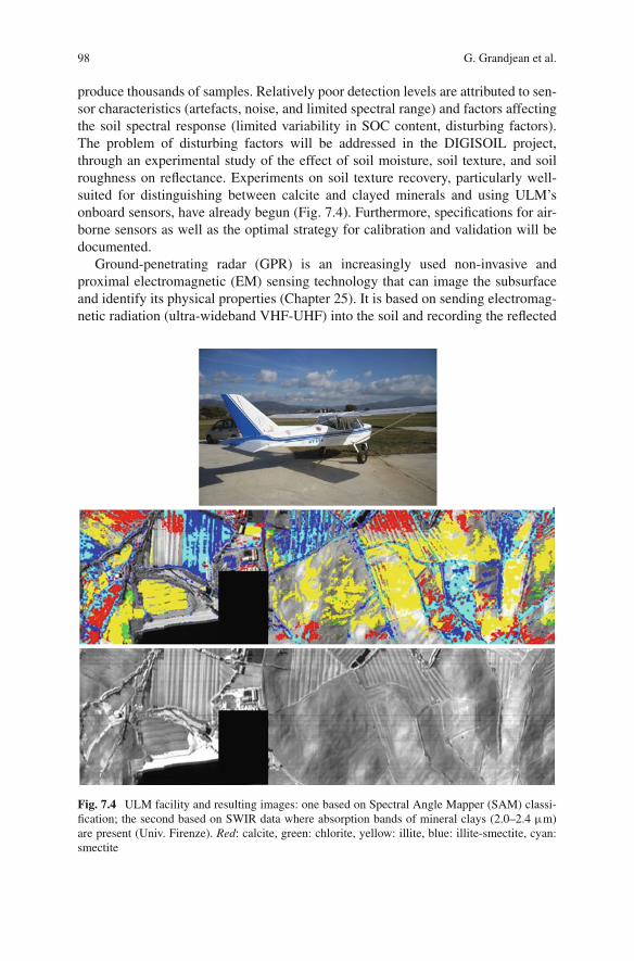
produce thousands of samples. Relatively poor detection levels are attributed to sen-sor characteristics (artefacts, noise, and limited spectral range) and factors affectingthe soil spectral response (limited variability in SOC content, disturbing factors).The problem of disturbing factors will be addressed in the DIGISOIL project,through an experimental study of the effect of soil moisture, soil texture, and soilroughness on reflectance. Experiments on soil texture recovery, particularly well-suited for distinguishing between calcite and clayed minerals and using ULM’sonboard sensors, have already begun (Fig. 7.4). Furthermore, specifications for air-borne sensors as well as the optimal strategy for calibration and validation will bedocumented.
Ground-penetrating radar (GPR) is an increasingly used non-invasive andproximal electromagnetic (EM) sensing technology that can image the subsurfaceand identify its physical properties (Chapter 25). It is based on sending electromag-netic radiation (ultra-wideband VHF-UHF) into the soil and recording the reflected
Fig. 7.4 ULM facility and resulting images: one based on Spectral Angle Mapper (SAM) classi-fication; the second based on SWIR data where absorption bands of mineral clays (2.0–2.4 µm)are present (Univ. Firenze). Red: calcite, green: chlorite, yellow: illite, blue: illite-smectite, cyan:smectite
7 DIGISOIL: An Integrated System of Data Collection Technologies 99
signals. In areas of agricultural and environmental engineering, GPR has beenused to identify soil vertical structures, locate water tables, follow wetting frontmovement, identify soil hydraulic parameters, measure soil water content, assesssoil salinity, monitor contaminants, and delineate soil compaction. Nevertheless,existing GPR techniques still suffer from major limitations due to simplifyingassumptions on which they rely, particularly about EM wave propagation. In gen-eral, the radar system and antennas are not accounted for, ray approximation isapplied to describe GPR wave propagation, and only the propagation time toreflectors is considered in signal processing algorithms. Reflection amplitude canalso be used, but this is limited to the surface reflection for airborne GPR, andrequires calibrations that are not practical for automated and real-time mapping.As a result, only a part of the information contained in the GPR data is usuallyused, and significant errors in the estimates are often introduced. To circumventthese shortcomings, Lambot et al. (2004) have recently developed a new approach:stepped-frequency continuous-wave monostatic off-ground GPR. The off-groundmode is particularly appropriate for real-time mapping of shallow subsurface prop-erties. The radar system is based on ultra-wideband vector network analyser (VNA)technology. In contrast to classical GPR systems, the physical quantity measuredby a VNA is exactly known and defined as an international standard. This per-mits the use of advanced full-waveform forward and inverse modelling techniquesto estimate soil EM properties from the GPR signal, which intrinsically max-imises information retrieval from the recorded data. In that respect, Lambot et al.(2004) developed a remarkably accurate EM model for their specific radar config-uration, which included internal antenna and antenna–soil interaction propagationeffects; they were able to exactly solve the three-dimensional Maxwell equationsfor wave propagation in multilayered media. Through GPR signal inversion, theapproach has been successfully validated in a series of controlled hydrogeophysicalexperiments for electromagnetic soil characterisation (which included dielectric per-mittivity, electric conductivity, and frequency dependence of these quantities). GPRdata inversion has been also integrated with hydrodynamic modelling to retrievesoil hydraulic properties from time-lapse radar data and to monitor the dynamicsof continuous water content profiles (Lambot et al., 2006). In addition, the tech-nique improves shallow subsurface imaging, which represents an important assetfor determining high-resolution soil stratigraphy. Figure 7.5 shows an exampleof a field application where the developed method is used for real-time mappingof the soil surface dielectric permittivity and correlated water content, bridgingthe spatial scale gap between traditional soil sampling and remote sensing inhydrology.
To complement the above-cited techniques, DIGISOIL aims also to explore inno-vative geophysical methods for characterising specific soil properties. In particular,seismic methods will be tested in order to quantify the soil’s mechanical modulus,a parameter closely related to soil compaction (Grandjean, 2006). Already vali-dated in geotechnics for investigating zones tens of metres in extent, the challengewill be in adapting the methodology to small seismic devices, i.e. zones of severalmetres.

100 G. Grandjean et al.
Fig.7.5 Real-time mapping of soil surface water content with advanced GPR (Lambot et al., 2006)
7.5 Conclusions
In order to assess and prevent soil degradation, and to benefit from the different eco-logical, economic, and historical functions of the soil in a sustainable way, there is anobvious need for high-resolution, accurate maps of soil properties. The core objec-tive of the project is to explore and exploit new capabilities of advanced geophysicaltechnologies for answering this societal demand. Some geophysical techniques thatwill be carried out in the project are based on positive experiences in the domain andpromise to fulfil the objectives of the project. Electrical and GPR measurements,hyperspectral imagery, and more innovative methods like seismic methods will betested and technically adapted to soil properties mapping. An important output ofthe project will concern the use of related soil properties in an application dedicatedto digital soil mapping (Chapter 5).
Acknowledgement The DIGISOIL project is financed by the European Commission under the7th Framework Program for Research and Technological Development, Area ‘Environment’,Activity 6.3 ‘Environmental Technologies’.
References
Ben-Dor E, Banin A (1995) Near infrared analysis (NIRA) as a rapid method to simultaneouslyevaluate several soil properties. Soil Sci Soc Am J 59:364–372
Besson A, Cousin I, Bourennane H, Pasquier C, Nicoullaud B, Richard G, King D (2008)Discretization of spatial and temporal soil water variability into homogeneous zones based onelectrical resistivity measurements at the field scale. EUROSOIL congress 2008, Soil, Society,Environment, 25-29/08/2008, Vienna
Corwin DL, Lesch SM, Oster JD, Kaffka SR (2006) Monitoring management-induced spatio-temporal changes in soil quality through soil sampling directed by apparent electricalconductivity. Geoderma 131:369–387

7 DIGISOIL: An Integrated System of Data Collection Technologies 101
Freibauer A, Rounsevell MDA, Smith P, Verhagen J (2004) Carbon sequestration in the agriculturalsoils of Europe. Geoderma 122:1–23
Friedman SP (2005) Soil properties influencing apparent electrical conductivity: a review. ComputElectron Agric 46:45–70
Grandjean G (2006) A seismic multi-approach method for characterizing contaminated sites. JAppl Geophys 58:87–98
Keller GV, Frischknecht FC (1966) Electrical methods in geophysical prospecting. Pergamon,Oxford
Lambot S, Slob EC, van den Bosch I, Stockbroeckx B, Vanclooster M (2004) Modeling of ground-penetrating radar for accurate characterization of subsurface electric properties. IEEE TransGeosci Remote Sens 42:2555–2568
Lambot S, Slob EC, Vanclooster M, Vereecken H (2006) Closed loop GPR data inver-sion for soil hydraulic and electric property determination. Geophys Res Lett 33:L21405,doi:10.1029/2006GL027906
Panissod C, Dabas M, Jolivet A, Tabbagh A (1997) A novel mobile multipole system (MUCEP)for shallow (0–3 m) geoelectrical investigation: the ‘Vol-de-canards’ array. Geophys Prospect45:983–1002
Samouëlian A, Cousin I, Richard G, Tabbagh A, Bruand A (2003) Electrical resistivity imagingfor detecting soil cracking at the centimetric scale. Soil Sci Soc Am J 67:1319–1326
Sen PN, Goode PA, Sibbit, A (1988) Electrical conduction in clay bearing sandstones at low andhigh salinities. J Appl Phys 63:4832–4840
Shainberg I, Rhoades JD, Prather RJ (1980) Effect of ESP, cation exchange capacity and soilsolution concentration on soil electrical conductivity. Soil Sci Soc Am J 44:469–473
Stevens A, van Wesemael B, Vandenschrieck G, Tychon B, Touré S (2006) Detection of car-bon stock change in agricultural soils using spectroscopic techniques. Soil Sci Soc Am J70:844–850
Tabbagh A, Dabas M, Hesse A, Panissod C (2000) Soil resistivity: a non-invasive tool to map soilstructure horizonation. Geoderma 97:393–404
Viscarra Rossel RA, Walvoort D, McBratney AB, Janik L, Skjemstad J (2006) Visible, nearinfrared, mid infrared or combined diffuse reflectance spectroscopy for simultaneous assess-ment of various soil properties. Geoderma 131:59–75
Viscarra Rossel RA, Taylor HJ, McBratney AB (2007) Multivariate calibration of hyperspectralgamma-ray energy spectra for proximal soil sensing. Eur J Soil Sci 58:343–353
Wilford J, Minty B (2006) The use of airborne gamma-ray imagery for mapping soils and under-standing landscape processes. In: Lagacherie P, McBratney AB, Voltz M (eds) Digital soilmapping: an introductory perspective. Elsevier Science, Amsterdam, 600 pp