Development and future prospects of quantitative mineral ...
13
Development and future prospects of quantitative mineral assessment in China Shi-hong Zhang a, b,* , Ke-yan Xiao a,* , Jian-ping Chen b , Jie Xiang a , Ning Cui c , Xiao-nan Wang b, d a MLR Key Laboratory of Metallogeny and Mineral Assessment, Institute of Mineral Resources, Chinese Academy of Geological Sciences, China Geological Survey, Ministry of Natural Resources, Beijing 100037, China b China University of Geosciences (Beijing), Beijing 100083, China c Development Research Center, China Geological Survey, Ministry of Natural Resources, Beijing 100037, China d Sichuan Energy Industry Investment Group Co., Ltd, Chengdu 610011, China ARTICLE INFO ABSTRACT Article history: Received 8 March 2018 Received in revised form 27 April 2019 Accepted 7 May 2019 Available online 7 June 2019 Keywords: Quantitative mineral assessment Synthesis information Fractals Big data 3D Geological modeling Machine learning Mineral potential assessment at the Earth’s surface has been an important research for geoscientists around the world in the past five decades. The fundamental aspects of mineral assessment at different scales can be associated with the following tasks, e.g., mineral potential mapping and estimation of mineral resources. This paper summarized the history and development in terms of theories, methods technologies and software platforms for quantitative assessment of mineral resources in China, e.g. comprehensive information methodology, geological anomaly, three-component quantitative prediction method, 5P ore- finding area, integrated information assessment method, nonlinear process modeling and fractals, three dimensional mineral potential mapping, etc. At last, to discuss the future of quantitative mineral assessment in an era of big data including platform for 3D visualization, analysis and sharing, new methods and protocols for data cleaning, information enhancement, information integration, and uncertainties and multiple explanations of multi-information. ©2019 China Geology Editorial Office. 1. Introduction Geomathematics is an interdisciplinary science of geology, mathematics and computer science. The representative ideas on the geomathematics, in its broader sense, covers all applications of mathematics to studies of the Earth’s crust (Agterberg FP, 1974), in a narrow sense, is the scientific discipline which deals with the establishment of mathematical models of geological processes (Vistelius AB, 1968). Quantitative mineral assessment at the Earth’s surface have been of interest since the 1960s as the widest application to mathematics in geology (Bonham-Carter GF et al. 1989; Wang SC et al., 1990; Singer DA and Kouda R, 1996; Brown WM et al., 2000; Porwal AK and Carranza EJM, 2001; Zhao PD, 2002; Cheng QM et al., 2015; Xiao KY et al., 2017), which can be divided into several stages marked by the emphasis of research (Ye TZ, 2004). E.g., formative and exploration stage (1950 –1976) was characterized by rudi- mentary applications of metallogenetic mapping and multivariate statistics analysis in mineral exploration. During this time, Allais M (1957) originally used Poisson distribution for the probabilities of deposit occurrence in the Algerian Sahara, and Harris DP (1965) quantified geological maps to assessment metallic mineral deposits by means of multivariate statistical analysis. Development and application stage (1976 –1990) benefited from the application of computers. International Union of Geological Sciences (IUGS) summarized the achievement about mineral prediction all over the world and put forward six methods of mineral resources assessment in 1976. In the meantime there have been various countries began research programs to develop methods, technologies and computer software to predict mineral occurrences and to evaluate mineral resources (Richter DH et al., 1975; Eberlein DG and Menzie WD, 1978; Cox DP, 1983; Zhao PD, 1983; Schruben P, 2002; Xiao KY et al., 2012), and many articles using various methods to quantitatively assessment mineral resource have been published (Harris DP, 1984; Singer DA, 1993). Since 1990 to present is digital and integration stage. The personal computers and powerful workstations, because of advanced performance and low cost, have made itself widely accepted in all aspects of data * Corresponding author: E-mail address: [email protected] (Shi-hong Zhang); kyanxiao@ sohu.com (Ke-yan Xiao). doi:10.31035/cg2018097 2096-5192/© 2019 China Geology Editorial Office. China Geology 2 (2019) 198−210 China Geology Journal homepage: http://chinageology.cgs.cn
-
Upload
khangminh22 -
Category
Documents
-
view
1 -
download
0
Transcript of Development and future prospects of quantitative mineral ...
Development and future prospects of quantitative mineral assessment in ChinaShi-hong Zhanga, b,*, Ke-yan Xiaoa,*, Jian-ping Chenb, Jie Xianga, Ning Cuic, Xiao-nan Wangb, d a MLR Key Laboratory of Metallogeny and Mineral Assessment, Institute of Mineral Resources, Chinese Academy of Geological Sciences, China Geological Survey, Ministry of NaturalResources, Beijing 100037, Chinab China University of Geosciences (Beijing), Beijing 100083, Chinac Development Research Center, China Geological Survey, Ministry of Natural Resources, Beijing 100037, Chinad Sichuan Energy Industry Investment Group Co., Ltd, Chengdu 610011, China
A R T I C L E I N F O A B S T R A C T
Article history:Received 8 March 2018Received in revised form 27 April 2019Accepted 7 May 2019Available online 7 June 2019
Keywords:Quantitative mineral assessmentSynthesis informationFractalsBig data3D Geological modelingMachine learning
Mineral potential assessment at the Earth’s surface has been an important research for geoscientists aroundthe world in the past five decades. The fundamental aspects of mineral assessment at different scales canbe associated with the following tasks, e.g., mineral potential mapping and estimation of mineralresources. This paper summarized the history and development in terms of theories, methods technologiesand software platforms for quantitative assessment of mineral resources in China, e.g. comprehensiveinformation methodology, geological anomaly, three-component quantitative prediction method, 5P ore-finding area, integrated information assessment method, nonlinear process modeling and fractals, threedimensional mineral potential mapping, etc. At last, to discuss the future of quantitative mineralassessment in an era of big data including platform for 3D visualization, analysis and sharing, newmethods and protocols for data cleaning, information enhancement, information integration, anduncertainties and multiple explanations of multi-information.
©2019 China Geology Editorial Office.
1. Introduction
Geomathematics is an interdisciplinary science ofgeology, mathematics and computer science. Therepresentative ideas on the geomathematics, in its broadersense, covers all applications of mathematics to studies of theEarth’s crust (Agterberg FP, 1974), in a narrow sense, is thescientific discipline which deals with the establishment ofmathematical models of geological processes (Vistelius AB,1968). Quantitative mineral assessment at the Earth’s surfacehave been of interest since the 1960s as the widest applicationto mathematics in geology (Bonham-Carter GF et al. 1989;Wang SC et al., 1990; Singer DA and Kouda R, 1996; BrownWM et al., 2000; Porwal AK and Carranza EJM, 2001; ZhaoPD, 2002; Cheng QM et al., 2015; Xiao KY et al., 2017),which can be divided into several stages marked by theemphasis of research (Ye TZ, 2004). E.g., formative andexploration stage (1950 –1976) was characterized by rudi-
mentary applications of metallogenetic mapping andmultivariate statistics analysis in mineral exploration. Duringthis time, Allais M (1957) originally used Poisson distributionfor the probabilities of deposit occurrence in the AlgerianSahara, and Harris DP (1965) quantified geological maps toassessment metallic mineral deposits by means of multivariatestatistical analysis. Development and application stage(1976 –1990) benefited from the application of computers.International Union of Geological Sciences (IUGS)summarized the achievement about mineral prediction all overthe world and put forward six methods of mineral resourcesassessment in 1976. In the meantime there have been variouscountries began research programs to develop methods,technologies and computer software to predict mineraloccurrences and to evaluate mineral resources (Richter DH etal., 1975; Eberlein DG and Menzie WD, 1978; Cox DP, 1983;Zhao PD, 1983; Schruben P, 2002; Xiao KY et al., 2012), andmany articles using various methods to quantitativelyassessment mineral resource have been published (Harris DP,1984; Singer DA, 1993). Since 1990 to present is digital andintegration stage. The personal computers and powerfulworkstations, because of advanced performance and low cost,have made itself widely accepted in all aspects of data
* Corresponding author: E-mail address: [email protected] (Shi-hong Zhang); kyanxiao@
sohu.com (Ke-yan Xiao).
doi:10.31035/cg20180972096-5192/© 2019 China Geology Editorial Office.
China Geology 2 (2019) 198−210
China Geology
Journal homepage: http://chinageology.cgs.cn
capture, manipulation, and analysis. Various geometricaloperations and spatial analysis on database and potentialmineral assessments are possible with the widespreadavailability of Geographic Information Systems (GIS,Bonham-Carter GF, 1994) and newly developed GIS-basedthree-dimensional geoscience software. Main typical softwareincluding GOCAD, SURPAC, Arc-SDM, MRAS, andGeoDAS appeared successively.
Research on quantitative mineral assessment in Chinabegan at the early 1960s. Zhao PD (1964) introducedprobability and statistical methods into practical applicationsin numerical exploration and exploitation. Subsequently,many theories and methods of mineral prediction wereproposed and gradually improved during exploration practice.Wang SC and Wang YT (1989) developed an integratedinformation methodology for identifying potential mineraltargets. Zhao PD and Chi SD (1991) put forward the conceptof geological anomaly and Three-Component quantitativeprediction method. Ye TZ et al. (2007) proposed a methodnamed model-based information synthesis and quantitativemineral assessment, which emphasizes the combination of theore deposit model, tectonic environment, analysis of anintegrated geological database and quantitative assessmentsfor the various minerals. So far Chinese government haslaunched a series of programs with the aims to map mineralpotential and to estimate the total mineral resources in China,e.g., geological survey project on replaceable resources ofresource-exhausted mines (Zhao PD et al., 2004), quantitativeassessment initiative of major minerals (Xiao KY et al.,2014), research about mineral resources integrated predictionin covered areas (Cheng QM, 2012), and the special projecton exploration and exploitation of mineral resources in deepearth, etc. With the development of mathematical model andinformation technology, methods of mineral assessment haveundergone changes from simple to complex, from qualitativeprediction to quantitative prediction, from single informationto multi-information comprehensive prediction, from similaranalogy to pattern recognition and statistical analysisprediction. Additionally, 3D prospectivity modeling have awildly used in mineral assessment aided by computertechnology and developments and mineral system approach,for instance, Chen JP et al. (2007) proposed an integrated 3Dquantitative method and procedure of so called “cubeprediction model ” for locating concealed orebodies. Nu-merous software platform were developed in China includingMRAS (Huang WB et al., 2011), GeoDAS (Cheng QM,2000), MinExplorer (Xiao KY et al., 2010a), 3DMP, and3DMINE, etc. At the beginning of the 21st century, Big Datascience became the new scientific paradigm, and quantitativemineral assessment had entered the geological the era of bigdata. New software platform and methods for efficient storageand management, integration, and mining of variousdimensional, heterogeneous geosciences data are requirement.This paper summarized the development of mineral resourceassessment in China with insights into theoretical methods,software systems, platform construction, etc. Additionally, the
future of quantitative mineral assessment in an era of big datawas also discussed.
2. Development of quantitative mineral assessment
2.1. The theories and methods of quantitative mineralresource assessment
2.1.1. Ore-related geo-anomaly and three-componentquantitative prediction
Zhao PD (1983) pioneered a study on mineral statisticsand predictions. The book “Statistical Prediction of MineralDeposit ” illustrates three principles for mineral depositprediction in detail, which includes “similarity analogy ”,“anomaly seeking ”, and “quantitative combination ofmineralization-controlling factors ”. The authors also pointedout that “anomaly seeking ” is as important as “similarityanalogy”. The principle of anomaly seeking especially focuson the new type of ore deposits or new interest areas wherethere are no well-established mineral deposit models to becompared with, while similar analogy is used for discoveringmineral deposits following general regulations. Zhao PD andChi SD (1991) put forward the concept of geological anomalythat result in geochemical and geophysical anomalies. Ageological anomaly is a set of distinctively differentgeological features compared with surrounding environments,not only in composition, texture, structure, but also in genesis.It can be separated from background areas by a thresholdselected by means of statistics, fuzzy mathematics, entropy,fractal, and technologies of geophysics, geochemistry andremote sensing (Zhao PD and Hu WL, 1992; Zhao PD andMeng XG 1993). The theory of the mineralization-controllingcomprehensive geological anomalies defines mineral depositas an economically valuable geological anomaly of oreelement, ore mineral or mineral assemblages (Zhao PD et al.,2005). Zhao PD (2002) developed a digital mineralexploration theory named “three-component (geo-anomalymineralization, diversity mineral, deposit spectrum) mineralresource quantitative prediction and evaluation ”, whichprovided a theoretical basis and methods for mineralexploration at various scale combining with “5P ore-findingarea” (Zhao PD et al., 2000).
2.1.2. Metallogenic prediction theory based on integratedinformation
Wang SC and Wang YT (1989) put forward an integratedinformation theory for mineral potential mapping, which hasbeen widely applied to the exploration and to prediction ofmineral resources during the past three decades. The purposeof the integrated information theory is to delineate the mineralresource target based on various different informationextracted from geologic, geophysical, geochemical andremote sensing data, and then make decisions about thenumber and location of mineral deposits, and undiscoveredmineral resources in target zones. Besides, emphasis is alsoplaced on the uncertainty of the prediction (Wang SC, 2010).The methodology was proposed with the theory of
Zhang et al. / China Geology 2 (2019) 198−210 199
metallogenic series, and a software package was developed todistinguish multiple backgrounds and anomalies. The theoryadvocated that geological background, mineralization seriesand metallogenic series should be separated by using multi-information based on the study of metallogenic series andtypical deposits in the prediction area. Comprehensiveinterpretation and analysis of multi-information is animportant part of mineral prediction. Firstly, on the basis ofgeological knowledge, the comprehensive interpretation ofaeromagnetic, gravity, remote sensing, heavy minerals andstream sediment anomalies of same scales is carried out. Thena series of maps are compiled based on the study of ore-controlling factors of typical deposits, and a comprehensiveinformation prospecting model is established. Finally,integration of the multiple geological database identifies andextracts ore anomaly information for quantitative predictionof different types of deposits (Wang SC and Chen YQ, 1994).
2.1.3. Model-based information synthesis and quantitativemineral assessment
Ye TZ et al. (2007) sponsored a systematic methodologyof model-based information synthesis and quantitativemineral assessment based on geodynamics, metallogeny,metallogenic series and information technology, which havebeen developed and widely applied to the project of “ChinaNational Mineral Assessment Initiative” (Lei SB et al., 2016;Sun L et al., 2018; Cui N et al., 2018). There are three majorcomponents in this research (Xiao KY et al., 2017). One ofthe studies is the development of deposit models aimed atdefining prospective areas of 25 critical minerals, e.g. gold,silver, base metals, Rare Earth Elements (REE), iron, bauxite,manganese, antimony, coal and uranium (Song XL et al.,2018). The goal is to understand regional geology, tectonicevolution, metallogenic process combining with a literaturesearch to compile the achievement of mineral exploration andacademic studies. The second theme is quantitative mappingof mineral prospectivity based on deposit models anddifferent type of prediction methods. The main lines are focuson the transformation between conceptual geological,mineralization models and prediction models which arepresented as GIS-based layers. The proxy predictors refer toall favorable ore controlling factors features, and thencombined with mineralization anomaly obtained fromgeophysical, geochemical, and remote sensing data using GISsoftware (Sun YB et al., 2018; Liu QN et al., 2018, Du BF etal., 2018; Wang YS et al., 2018). The third is estimation ofundiscovered mineral resources, which also is an importantpart in appraising the mineral potential and its long-term use(Ye TZ, 2013). The initial method used to estimate themineral resources Monte-Carlo simulation model such asMARK3 and a three-part method (Root DH et al., 1992;Singer DA, 1993). Furthermore, a volumetric method ofsynthesis information based on mineral deposit models(Singer DA, 1993) and the volumetric method (Kingston GAet al., 1978; Meyer RF, 1978) was also wildly used, whichhighlight the value of mineral system analysis (Wyborn LAIet al., 1994; Zhai YS, 1999) and application of multi-
information (Xiao KY et al., 2010b). There were sixcategories of prediction methods are established according toore deposit types for assessment of mineral resources, i.e.,intrusive-rock related type, magmatic hydrothermal type,volcanic-rock hosted type, strata-bound endogenic type, thesedimentary-rock hosted type, and metamorphic type (ZhangSH et al., 2017). Different types of prediction methods willuse different prediction processes, prediction base maps andmethod combinations. Genetic implications and other factorsconsidered in the study were grouped into 26 categories byXiao KY et al. (2013), and total 80 mineral prediction modelswere established based on this principle for important mineralresources in China (Zhang SH et al., 2017).
In addition, an independently information packages-Mineral Resource Assessment System (MRAS) wasdeveloped and widely applied in this study, which systemintegrates most of functions throughout mineral assessmentfrom information processing, mineral prospectivity mappingto estimation of mineral resources (Xiao KY et al., 2007; LiGM et al., 2009; Zhang J et al., 2012).
2.1.4. Nonlinear theory and method for mineral resourcesassessment
Fractal geometry was introduced and popularized byMandelbrot BB (1975) to describe complex natural objectsshowing similar geometry over a variety of scale. In recentyears there has been a surge of research interest in nonlineartheory, in particular, the factual models. The application ofnonlinear theory in geoscience mainly focuses on thefollowing aspects, including the description of the formationand growth of minerals, mineral structures, the simulationgeodynamics and distribution of mineral resources, oreelement concentrations, and the extraction of anomalies(Cheng QM, 2006). Chinese scholars applied nonlinear theoryto geology began in the late 1980s (Yu CW, 1987).Subsequently, many meaningful papers and monographs werepublished, such as "Application of Fractals in Earth Science"(Chen Y, 1989), “Fractal Structural Factors and ItsApplication in Geology ” (Shen BM, 1993), and “FractalGrowth of mineral deposits at the Edge of Chaos” (Yu CW,2006).
Understanding the occurrences of various extreme events(e.g., mineralization) of the Earth system, and predicting suchkind of events are crucial missions in geosciences. Thesemissions are beset with difficulties since the mechanisms ofthe occurrences of such extreme events are complicated andchaotic. In the last decades, Qiu-ming Cheng and hiscolleagues are dedicated to modeling the geo-complexity ofthe solid Earth by using the nonlinear theories and methods,including fractals/multifractals, singularity and self-organizedcriticality (Cheng QM et al., 1994; Cheng QM, 2007, 2012a,2017). Cheng QM et al. (1994) pioneered the way of usingfractal/multifractal model for mineral resource prediction. Theconcentration-area (C-A) fractal model was developed fordetermining the threshold between background and anomalyfor geochemical exploration. The significance of C-A modelis that it makes multifractal model capable of dealing with
200 Zhang et al. / China Geology 2 (2019) 198−210
locations rather than early global statistical frequency modelthat have no locational “predictability ”. Several associated,refined fractal models have been developed from the C-Afractal model for analyzing geology, geochemical,geophysical and remote sensing data, including singularitymapping based on fractal density model (Cheng QM, 1999,2007), multifractal filtering based on spectrum-area (S-A)model (Cheng QM et al. 2000; Cheng QM, 2004), and weightof evidence (WofE) based on multifractal cascade model(Cheng QM, 2008), to name but a few.
Furthermore, a systematic nonlinear theory and methodfor mineral resources quantitative prediction and assessmentwere developed by Cheng QM (1999, 2000, 2004, 2006,2008, 2012a). This theory and method consist of threeadvanced techniques and the professional software, GeoDAS.These three techniques are the identification of weak geo-anomaly, separation of mixed geo-field and spatial decision ofmulti-layer heterogeneous geo-information. As known, thefootprints or information (e.g., geophysical and geochemical)that we can usually observe on Earth surface for findingdeeply buried mineral deposits are quite weak and havemixing nature, which bring up the crucial challenges forfinding the potential mineral resources in covered area. Thelocal singularity analysis is developed on fractal densitymodel to map mineralization as singularity process, i.e., scale-invariant process that extracts the weak geo-anomalies bysingularity index (α) which is independent of scale (i.e.,depth) (Cheng QM, 2007, 2012a). The multifractal filtering isdeveloped on scaling fractal model that can decompose mixedgeo-anomaly patterns into anomaly and background ormultiple components according to distinct self-similaritiesidentified in the frequency (Cheng QM et al., 2000),eigenvalue domain (Cheng QM, 2005) or wavelet domain(Chen GX and Cheng QM, 2017). The methods of multi-layerdata fusion and spatial decision are further developed onabove nonlinear mathematical models for targeting thepotential mineral deposits, for instance, the Fuzzy WofE(Cheng QM and Agterberg FP, 1999), spatially weightedprincipal component analysis (Cheng QM et al., 2011), andboost WofE (Cheng QM, 2015). As professional softwarepackage, the GeoDAS has integrated both conventionalmethods and newly developed nonlinear models/methods thathave been successfully applied for mineral exploration andenvironmental impact assessment in more than 20 countriesand 14 mineral districts worldwide (Cheng QM, 2000, 2008).
2.2. Information integration and estimation of mineralresources
The fundamental aspects of mineral assessment atdifferent scales can be associated with the following tasks,e.g., mineral potential mapping and estimation of mineralresources (Zhu YS, 2006; Porwal AK and Kreuzer OP, 2010).Data and information obtained from various fields of scienceare different in sampling methods, density distribution anddimension. For example, geological data often present asdigital maps consisting of strata, faults, magmatite and so on,which are typically non-numerical attributes. Geochemical
data can be collected from rock outcrop, stream or soilsediments, which usually are discrete sampling points ininterest areas. Geophysics data involve gravity, magnetics,electrical and seismic data, which often distribute along a lineof survey or drill column, while remote sensing data areimagine (Pan GC, 2018). Therefore, how to process, analyze,interpret, extract and integrate multiple data/information usingquantitative techniques has become a common practice inassessment of mineral potentials, and some significantprogress have been made in development of mathematicalmethodologies since 1950s (Allais M, 1957; Harris DP, 1965;Matheron G, 1971). At present, most of methods can beimplemented by using GIS technologies. Many processingtechniques including but is not limited to filtering andenhancing are necessary for identification and extraction ofuseful information related to mineralization. For instance,multifractal filtering based on spectrum-area (S-A) model,multifractal interpolation algorithms based on singularityindex are used to separate geochemical and geophysicalanomalies from background values.
Geo-computational (quantitative) methods for mineralpotential mapping (e.g. data integration) aim at integratingtwo or more favorable evidence into a single one refers to thelikelihood that mineral deposits of the type sought arecontained in an area, which can be divided generally into twocategories including knowledge-driven and data-driven(Bonham-Carter GF, 1994; Pan GC and Harris DP 2000; ZuoRG and Carranza EJM, 2011; Zhang ZJ et al., 2016).Representative knowledge-driven methods include Booleanlogic, fuzzy logic and evidential belief. Data-driven methodsused to measure spatial associations between evidentialfeatures and known deposits can be either bivariate ormultivariate, such as weights of evidence (Bonham-Carter GFet al., 1989), logistic regression (Chung CF, 1978), artificialneural networks (Singer DA and Kouda R, 1996), etc. ChengQM and Agterberg FP (1999) introduced the fuzzy weights ofevidence and boost weights of evidences method (Cheng QM,2015), modified models of weights of evidence. The formerrelaxed the requirement of the ordinary weights of evidencemodel on conditional independency among evidential layers,and the latter can use multivariate discrete evidential layerswith less loss of useful information than bivariate. Zuo RGand Carranza EJM (2011) introduced support vector machine(SVM) algorithm to mineral prospectivity mapping, and thatwas proved to be a usefulness tool for mineral potentialmapping. Chen YL (2015) explored successively restrictedboltzmann machine and extreme learning machine regression(Chen YL and Wu W, 2017) to integrate multiple informationto mineral prospectivity.
The methods usual used for estimation of undiscoveredmineral resources include the volumetric method (KingstonGA et al., 1978; Meyer RF, 1978), Zipf’s Law (Merriam DFet al., 2004), deposit density models (Bliss JD and MenzieWD, 1993), and grade-tonnage models (Singer DA, 1993). Anew method of synthesis information volumetric method(SIVM) was proposed by Xiao KY et al. (2010c) based ontraditional volumetric method, which emphasize the
Zhang et al. / China Geology 2 (2019) 198−210 201
application of multi-information and mineral system analysis(Li N et al., 2018). The general equation for estimating theundiscovered resources assessment is presented in Eq. (1).
RPredicting area =C×S ×VPredicting area (1)
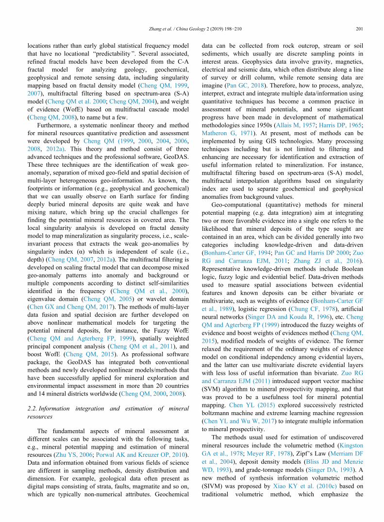
Where: RPredicting area is the total amount of mineralresources in the prospective area; VPredicting area is the volumeof the mineralization system in the prospective area; S is thesimilarity coefficient, representing the similarity of themineralization characteristics between the prospective areaand the model area covering known ore deposits; C is ore-bearing ratio in the mineral system, is theoretically calculatedby multiplying the grade and proportion. However, obviously,it is hard to determine the grades and proportions in traps.These data are extrapolated from known ore deposits in thepermissive boundaries by calculating their mean ore-bearingratio. The above data indicate that the mineral deposit model,mineralization systems, and volumes are the three majorcomponents. The variables needed include the ore-bearingratio, similarity coefficient, and volumes of host rocks or ore-bearing formations at a deposit scale, as well as the volumesof mineralization system in a prospective. The predictionaccuracy of SIVM is similar to the deposit model method interms of data, models and methods, and the application of thelarge-scale exploration data will produce a better result thanthe deposit model method (Fig. 1).
2.3. GIS and 3-dimension mineral prospectivity mapping
Computers have brought about far-reaching developmentsin quantitative techniques for geosciences including GIStechnology since late 1980s (Agterberg FP, 1989). GIS is acomputer system capable of capturing, coordinating, storing,processing, analyzing, displaying and managing geospatialinformation, especially combining geospatial information inunique ways and extracting something new. This makesquantitative assessment of mineral resources assessmentpossible to use spatial database and spatial analysistechnology on GIS. Now days, most optimal data integrationmethods proposed can be effectively applied by using GIStechnologies.
China has independently developed numerous softwarepackages for mapping and mineral resource assessment.
Earlier, MAPGIS software developed by Zondi CyberTechnology Co., Ltd make geology mapping efficient. Later,based on the MAPGIS platform, MORPAS (Hu GD et al,2000), MRQP (Wang Y et al., 2008) and MRAS (Li GM etal., 2009) etc. successively used for mineral resourcesassessment covering various data management, dataprocessing, anomaly analysis, information integration andestimation of minerals. Furthermore, specific software alsoappeared in succession, for example, China GeologicalSurvey developed DGSS digitalize the whole process ofgeological survey from field work to cartographicgeneralization, RGIS for geophysical data processing andinterpretation, GeoMDIS for regional geochemical datamanagement and GeoExpl for managing and analyzing multi-database, etc.
Since the beginning of 21st century, three-dimensional(3D) geological modeling has been regarded as an importantmethod to visualize and analyze the subsurface geology,which also was adopted by geologists for quantitative mineralassessment (Houlding SW, 1994; Mallet JL, 2002; Chen JP etal., 2007; Xiao KY et al., 2015a; Mao XC et al., 2016; Li N etal., 2018). 3D geological modeling is facilitated not only bydevelopments in computer, 3D visualization, quantitativegeometry and image analysis, but by considerable ongoingimprovements in geophysical and geochemical mappingmethods (Steuer A et al., 2009; Gao L et al., 2017). The 3Dgeological modeling is an extension of two-dimensional (2D)geological mapping, which can help to reveal hiddeninformation on the variability of controlling factors and todefine likelihood of occurrence of mineralization processes(Pan GC, 2018). 3D geological modeling was first proposedby Houlding SW in 1993 (Houlding SW, 1994), subsequently,some basic methods for geological modeling including thespatial data analysis, geological interface modeling, andgeological boundary connection were discussed in detail.Mallet JL (2002) defined the 3D geological modeling as acollection of mathematical approaches for simulating thetopological, geometrical, and physical properties of geologicalobjects. The theme on 3D geological map was presented in ajoint meeting between Geological Society of America (GSA)and Geological Association of Canada (GAC) in 2001, withthe aim to discuss how to convert map-making from 2D to3D. Subsequently, lager number of researches for 3Dgeological modeling and visualization at different scales werecarried out in the United States, Britain, Australia and Canada(Berg RC, 2011; Schultz A, 2018). Software developers havebuilt several packages for geological modeling, such asSKUA GoCad, Geomodeller 3D, Micromine, Surpac, etc.
Chinese scholars started research on 3D visualizationtechnology in 1990s, and a lot of achievements have beenmade in spatial geological modeling and 3D mineral potentialmapping (Chen JP et al., 2007; Wang GW and Huang L,2012; Shen XD et al., 2017). For instance, MinExplorerdeveloped by Institute of Mineral Resources, ChineseAcademy of Geological Sciences (CAGS), was appliedsuccessfully to 3D geological modeling of many metal deposit
Info
rmat
ion l
evel
Deposit modeling
Volume
method
Model-based integrated
information volumetric method
Successive resource assessments
1 2 3 4 5 6 7 8
Fig. 1. Relationship between Model-based integrated informationvolumetric method and deposit modeling method of resource assess-ment(modified from Kingston GA et al., 1978; Xiao KY et al.,2010b).
202 Zhang et al. / China Geology 2 (2019) 198−210
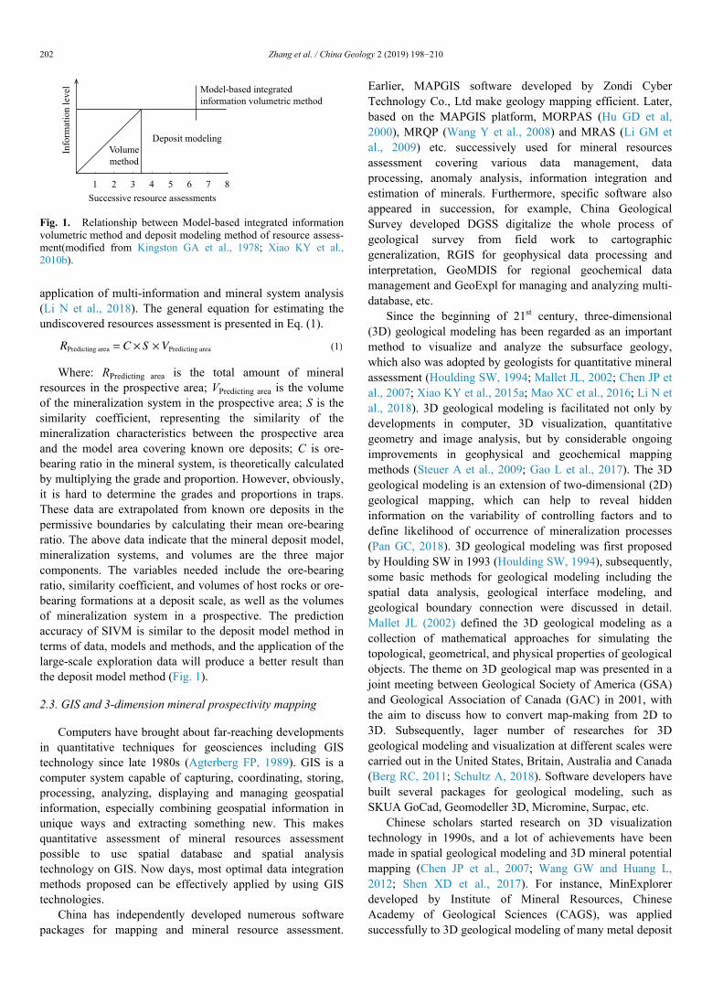
including Laochang Ag-Pb deposit in Yunnan province andJiama copper deposit in Tibet (Xiao KY et al., 2010a, 2015a;Li S et al., 2011). Chen JP et al. (2007) developed the three-dimensional prediction system (3DMP), and proposed anintegrated 3D quantitative method and procedure of so called“cube prediction model” for locating concealed orebodies atdifferent scale area (Fig. 2). The method was devoted to makefull use of various different dataset for determining position,quantity and probability of deep ore bodies, and hadsuccessful application in many mines and metallogenic belts(Chen JP et al., 2012, 2014). Wang Gongwen develops asoftware package GeoCube for 3D data processing,extraction, integration of exploration criteria from spatial data(Li RX et al., 2016). Mao XC et al. (2019) performed multi-constraint geological modeling and spatial analysis involving3D buffer analysis, shape analysis and field analysis for theDayingezhuang gold deposit to quantitatively assessment thegold distribution and its association with geological features,and further integrated indicators into 3D prospectivitymodeling by fuzzy WofE and continuous WofE methods toassessment mineral potential. In addition, commercial
software also rapidly expand include 3DMINE developed byBeijing 3DMINE Software Co., Ltd. for mining engineering,etc.
Geological interfaces modeling and geological objectsmodeling are two usual results in 3D geological modeling,and the basic methods including the spatial data analysis andinterpolation, geological interface modeling and geologicalboundary connection (Houlding SW, 1994). Usually, thegeological interfaces are represented by discrete surfaces (e.g.polygonal surface meshes), which can be generated directly in3D (Frank T et al., 2007), or obtained by creating planarmeshes first and then interpolating or simulating into 3Dbased on discrete points and contours (Mallet JL, 1997). Theformer allows modelers to simulate quite complex geologicalinterfaces by using information from boreholes, cross-sectionsand 2D geological maps using mathematical methods(Kaufmann O and Martin T, 2008). The downside of thisapproach is costs of much more efforts on generating surfacemeshes. The latter is relatively easier to implement, especiallywhen the geological interfaces are layered. 3D geologicalobjects can be represented by wire-frames (connection of
Deep geophysical
modeling
Deep geochemical
modeling
Reconstruction of deep
3D mineralization
system
3D stratum
Modeling
3D lithology
modeling
3D orebody
modeling
3D structural
modeling 3D geological
solid modeling3D alteration
modeling
…
Data collection,
metallogenic analysis
and preprocessing
3D geological
modeling
Analysis, extraction of
favorable metallogenic
information and data
integration
The delineation of
prospecting target and
assessment of
uncertainty
Continuous-interpolation
modeling with sufficient
data in well-explored
spaces
Discrete-speculation
modeling with scanty
data in less-explored
spaces
Nonlinear methods,
analysis of fractal
dimension
Geological
data
Minerals
exploration
Geochemical
survey
Geophysical
survey
Remote
sensing
GIS database
Multivariate statistical
methods (Cube prediction
model)
Fig. 2. The delineation of prospecting target at different scale and depth.
Zhang et al. / China Geology 2 (2019) 198−210 203
closed line on plan at different depth or cross-section map),boundaries (e.g. intersection of surface meshes), and voxelsdata models benefitted from development of varioustechnologies and methods for acquisition and processing ofgeoscientific information (Xiang J et al., 2016; Zhang BY etal., 2018; Di QY et al., 2019).
2.4. Big Data and mineral assessment
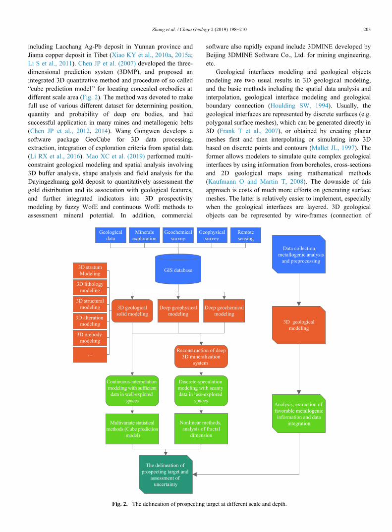
Big Data represents the information assets characterizedby such a high volume, velocity, variety and veracity (MauroAD et al., 2016). Let data speak for itself allow us to discoverpatterns and correlations in the data or to perform predictionsof outcomes and behaviors (Mayer-Schönberger V and CukierK, 2013). Markus R et al. (2019) insisted that earth systemdata are exemplary of all ‘four Vs’ of big data, and geosciencedata are undergoing an explosive growth with development ofgeological survey to “Deep Earth” “Deep Sea” “Deep Space”and “Deep Time” (Zhao PD, 2015, Fig. 3). So far researchand application of Big Data are in earth system sciences beingextensively explored by governments, academics andcompanies. In 2007, the European Union launched theinitiative of “Infrastructure for Spatial Information in theEuropean Community ” (INSPIRE), with the purpose ofestablishing integrated European spatial data infrastructure,sharing of relevant environmental information within the EU,and facilitating inter-regional policy decision making andapplications (European Parliament and Council of theEuropean Union, 2007). The intercontinental Earth Serverinitiative has established a European data cube platform withproven scalability (Merticariu V and Baumann P, 2016).Furthermore, many developed countries have already setuptheir geological data sharing platforms, such as the USGeospatial One-Stop, Canada’s GeoConnections, which effec-tively facilitate national, provincial and local governments,private enterprises, academic communities and the public, toquery, access and obtain geospatial information, therebyhelping share and access information to make smarter
decisions (Folger P, 2009; Sierra Systems Group, 2003). Inaddition to hardware architectures and correspondingsoftware, scientific methodologies are also important to dealwith these big data.
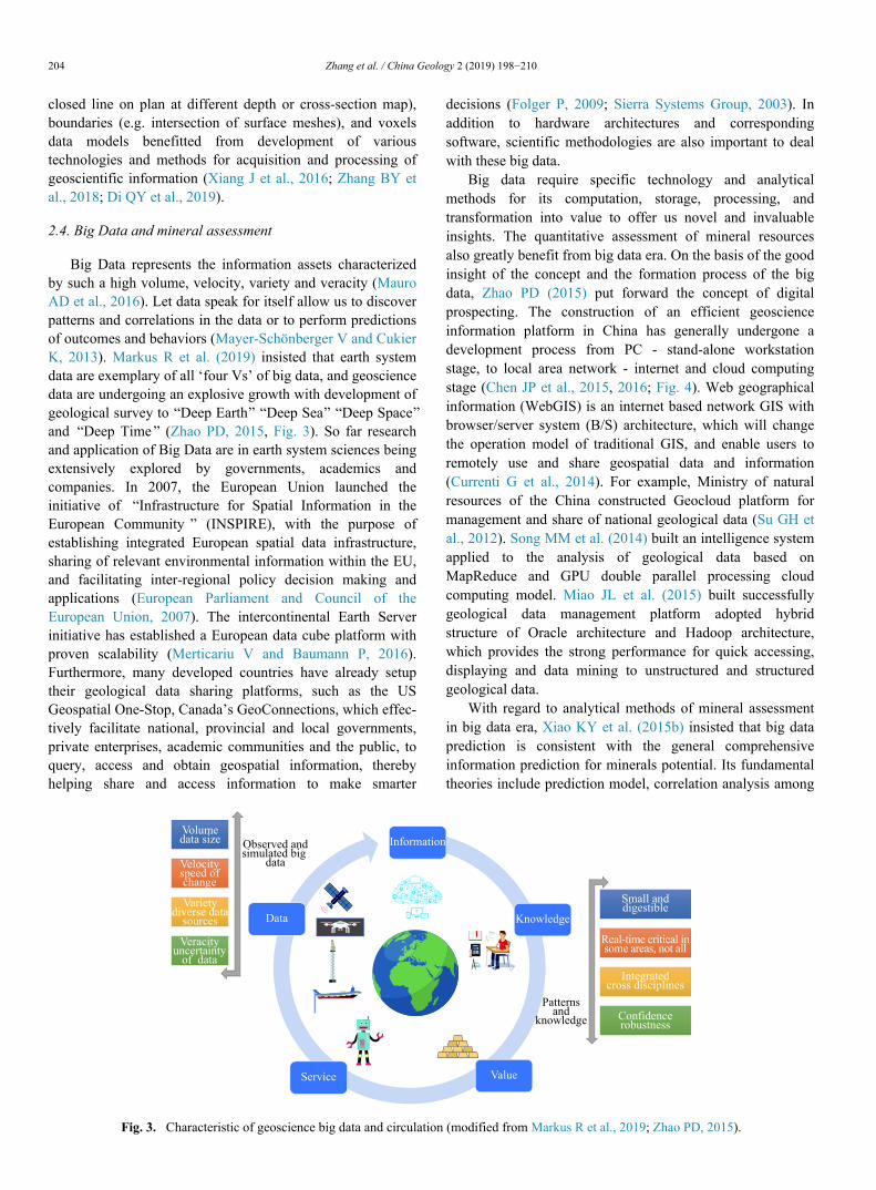
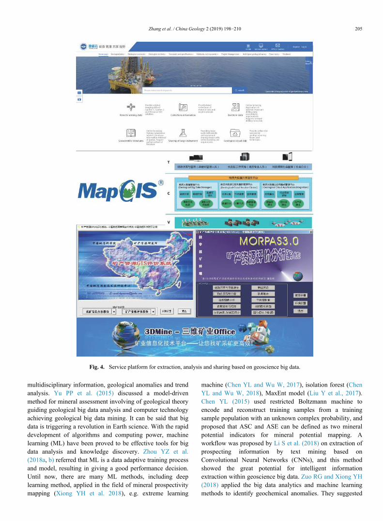
Big data require specific technology and analyticalmethods for its computation, storage, processing, andtransformation into value to offer us novel and invaluableinsights. The quantitative assessment of mineral resourcesalso greatly benefit from big data era. On the basis of the goodinsight of the concept and the formation process of the bigdata, Zhao PD (2015) put forward the concept of digitalprospecting. The construction of an efficient geoscienceinformation platform in China has generally undergone adevelopment process from PC - stand-alone workstationstage, to local area network - internet and cloud computingstage (Chen JP et al., 2015, 2016; Fig. 4). Web geographicalinformation (WebGIS) is an internet based network GIS withbrowser/server system (B/S) architecture, which will changethe operation model of traditional GIS, and enable users toremotely use and share geospatial data and information(Currenti G et al., 2014). For example, Ministry of naturalresources of the China constructed Geocloud platform formanagement and share of national geological data (Su GH etal., 2012). Song MM et al. (2014) built an intelligence systemapplied to the analysis of geological data based onMapReduce and GPU double parallel processing cloudcomputing model. Miao JL et al. (2015) built successfullygeological data management platform adopted hybridstructure of Oracle architecture and Hadoop architecture,which provides the strong performance for quick accessing,displaying and data mining to unstructured and structuredgeological data.
With regard to analytical methods of mineral assessmentin big data era, Xiao KY et al. (2015b) insisted that big dataprediction is consistent with the general comprehensiveinformation prediction for minerals potential. Its fundamentaltheories include prediction model, correlation analysis among
Observed andsimulated big
data
Patternsand
knowledge
Velocityspeed ofchange
Varietydiverse data
sources
Veracityuncertainty
of data
Small anddigestible
Real-time critical insome areas, not all
Integratedcross disciplines
Confidencerobustness
Data
Service
Information
Knowledge
Value
Volumedata size
Fig. 3. Characteristic of geoscience big data and circulation (modified from Markus R et al., 2019; Zhao PD, 2015).
204 Zhang et al. / China Geology 2 (2019) 198−210
multidisciplinary information, geological anomalies and trendanalysis. Yu PP et al. (2015) discussed a model-drivenmethod for mineral assessment involving of geological theoryguiding geological big data analysis and computer technologyachieving geological big data mining. It can be said that bigdata is triggering a revolution in Earth science. With the rapiddevelopment of algorithms and computing power, machinelearning (ML) have been proved to be effective tools for bigdata analysis and knowledge discovery. Zhou YZ et al.(2018a, b) referred that ML is a data adaptive training processand model, resulting in giving a good performance decision.Until now, there are many ML methods, including deeplearning method, applied in the field of mineral prospectivitymapping (Xiong YH et al. 2018), e.g. extreme learning
machine (Chen YL and Wu W, 2017), isolation forest (ChenYL and Wu W, 2018), MaxEnt model (Liu Y et al., 2017).Chen YL (2015) used restricted Boltzmann machine toencode and reconstruct training samples from a trainingsample population with an unknown complex probability, andproposed that ASC and ASE can be defined as two mineralpotential indicators for mineral potential mapping. Aworkflow was proposed by Li S et al. (2018) on extraction ofprospecting information by text mining based onConvolutional Neural Networks (CNNs), and this methodshowed the great potential for intelligent informationextraction within geoscience big data. Zuo RG and Xiong YH(2018) applied the big data analytics and machine learningmethods to identify geochemical anomalies. They suggested
Fig. 4. Service platform for extraction, analysis and sharing based on geoscience big data.
Zhang et al. / China Geology 2 (2019) 198−210 205
that conventional methods mainly focus on the detection ofpositive geochemical anomalies and ignore the negativegeochemical anomalies related to mineralization. The big dataanalytics technique can overcome the limitations ofconventional methods by utilizing the entire geochemicaldataset to identify geochemical anomalies and quantify thestatistical correlations between geochemical patterns andknown mineralization patterns supported by machine learningmethods (Xiong YH and Zuo RG, 2016; Zuo RG, 2017). Inthe era of big data, the use of deep learning methods for datacleaning and exploring will be an important direction forprediction of mineral resources.
3. Future prospects of mineral resources assessment
Mineral exploration is currently facing three challenges interm of identification, discovery and usage. The main reasonsare due to that most mineral deposits near earth surface havebeing discovered and used, particularly large and super largemineral deposits. Mineral exploration in depth and insurrounding areas of known mineral deposits has become thepractical strategy for further mineral exploration. Deepmineral explorations are inevitable to guarantee sustainabledevelopment of economics and society of China (Zhao PD etal., 2008). With the explosive increase of global data, humanhave entered the “Big Data” era. There is little doubt that bigdata offers substantial value to users, but also brings aconsiderable number of challenges due to the difficulties incapture, storage, sharing, analysis, and visualization of data,especially in field of geosciences. The following issues beloware critical but not exhaustive.
(i) Platform for 3D geological modeling, visualization,analysis and sharing. Mineral potential mapping aims todiscover new mineralization or economic deposits in aninterest areas by using geoinformation related tomineralization of sought. 2D potential mapping has beenwidely used and is regarded as a powerful tool for explorationtargeting on regional scales. In recent decades, mineralexplorations are focusing on deep mineral resources. Thismeans it is necessary to extend 2D prospectivity mapping intothe 3D potential modeling to identify economic deposits atdepth (Mao XC et al., 2019). Additional, visualisation formanagement of computer networks and software analytics isalso attracting attention of researchers and practitioners for itsextreme relevance to management of large-scale infrastructureand software, with implications in global softwaredevelopment, open source software development, andsoftware quality improvements (Menzies T and ZimmermannT, 2013).
(ii) New methods and protocols for mineral exploration indeeper or covered conditions should be development for datacleaning, information enhancement, information integration,as well as target identification based on data of differentnature (structured, unstructured, semi-structured) and sourcesunder geological constraints. Deep learning algorithms are apowerful tool to extract geological features, integrate multi-
source data, and helpful to discover geochemical patterns orto delineate geochemical anomalies that conventionalmethods cannot detect (Zuo RG et al, 2019). However, thedisadvantage of application of deep learning algorithms inmineral assessment is that depend only on the data itselfwithout a good integration in the term of geology andmineralization. Additional mineralization is usually a rareevent with small a small amount of training samples (knownmineral deposits and occurrences). Therefore, how to combinethe deep learning algorithms, geological theories and mineralsystem approach is an enormous challenge.
(iii) 3D geological modeling relies largely oncomprehensive data and mathematical methods, but use ofgeological concepts is essential in this endeavor as it requiresa good understanding of the underlying physical and chemicalprocesses (Agterberg FP, 2014; Jørgensen F et al., 2015).Geophysics is a good source of information to complementgeological data at depth since it provides supplementaryinformation to surficial data (Martelet G et al., 2004; GuillenA et al., 2008; Reninger PA et al., 2017). This result issubjective to a large extent since available information mostlydepends on the geologist's cognition. And besides, geologicaldata are scarce and scattered that producing largeuncertainties in 3D geological models. The great uncertaintiesand possibility of multiple explanations are among the manychallenges because of the great complexity of geologicalprocesses, and more and more attention will be paid to thesolution of uncertainties.
4. Conclusions
Quantitative assessment of mineral resource is animportant part of geoscientific research, and significantprogress has been made with development of mathematicaltechniques and estimation methodologies for mineral potentialmapping and resource estimation. Chinese geologists havealso made a great contribution in theories, methods andsoftware platform for assessment of mineral resources. Bigdata are characteristic with “four Vs”, as an interdisciplinaryscience, geomathematics greatly benefit from big data era,and no exception in mineral assessment. Big data analysisincluding development of deep learning algorithm make iteasy to process and mine the hidden feature and informationrelated to mineralization, however technology challenges areencountered in research of software and algorithm for thecapture, integration and visualisation of various differentgeoinformation or data. A forward model of knowledge-driven and an inversion model of data-driven are double-edged sword for geosciences. Geology have differs from mostother areas in the big data era due to complexity of geologicalprocess, and the uncertainties and ambiguous interpretationare general. When faced with geological data, bothcorrelations among information and causality between outputsand geological control are important. Moreover, a high-performance integration and access platform for dataacquisition, integration, transfer, data mining, information
206 Zhang et al. / China Geology 2 (2019) 198−210
extraction and sharing is required, particularly in big data era.The launch of the deep probe initiative will further facilitatedthe development of 3D geological modeling and 3Dvisualization software platforms. Additional, data policy onsecurity and monitoring should be paid more attentionconsidering of features of geological data.
Acknowledgement
This research was financially supported by the NationalKey Research and Development Program of China(2017YFC0601500, 2017YFC0601501), and the ChinaGeological Survey Project (1212011121040). Thanks are dueto the editors for helpful comments to improve the text, and toDr. Ren-guang Zuo for assistance in providing materials ofearlier manuscript.
References
Agterberg FP. 1974. Geomathematics. Elsevier, Amsterdam, 596.Agterberg FP. 1989. Computer programs for mineral exploration.
Science, 245, 76–81. doi: 10.1126/science.245.4913.76.Agterberg FP. 2014. Geomathematics: Theoretical foundations,
applications and future developments. Springer InternationalPublishing, 553.
Allais M. 1957. Method of appraising economic prospects of miningexploration over large territories: Algerian Sahara case study.Management Science, 3(4), 285–347. doi: 10.1287/mnsc.3.4.285.
Berg RC. 2011. Synopsis of current three-dimensional geologicalmapping and modeling in geological survey organizations.Champaign ILL Illinois State Geological Survey, 578.
Bliss JD, Menzie WD. 1993. Spatial mineral-deposit models and theprediction of undiscovered mineral deposits. In: Kirkham RV,Sinclair WD, Thorpe RI, Duke JM (eds) Mineral deposit modeling.Geological Association Canada Special Paper, 40, 693–706
Bonham-Carter GF, Agterberg FP, Wright, DF. 1989. Weight ofevidence modeling: A new approach to mapping mineral potential.In: Agterberg, F.P., Bonham-Carter, G.F., (Eds.), StatisticalApplications in the Earth Sciences: Geological Survey Canada Paper89–9, 171–183.
Bonham-Carter GF. 1994. Geographic information systems forgeoscientists: modelling with GIS. Pergamon, Computer Methods inthe Geosciences, 13, 398.
Brown WM, Gedeon TD, Groves DI, Barnes RG. 2000. Artificial neuralnetworks: a new method for mineral prospectivity mapping.Australian Journal of Earth Sciences, 47(4), 757 –770. doi: 10.1046/j.1440-0952.2000.00807.x.
Chen GX, Cheng QM. 2017. Fractal-based wavelet filter for separatinggeophysical or geochemical anomalies from background.Mathematical Geosciences, 1–24.
Chen JP, Lü P, Wu W, Zhao J, Hu Q. 2007. A 3D method for predictingblind orebodies, based on a 3d visualization model and itsapplication. Earth Science Frontiers, 14(5), 54–62 (in Chinese withEnglish abstract). doi: 10.1016/S1872-5791(07)60035-9.
Chen JP, Wang CN, Shang BC, Shi R. 2012. Three-dimensionalmetallogenic prediction in Yongmei region based on digital oredeposit model. Scientific & Technological Management of Land &Resources, 29(6), 14–20 (in Chinese with English abstract).
Chen JP, Yu PP, Shi R, Yu M, Zhang SC. 2014. Research on three-dimensional quantitative prediction and evaluation methods ofregional concealed ore bodies. Earth Science Frontiers, 21(5),211–220 (in Chinese with English abstract).
Chen JP, Li J, Cui N, Yu PP. 2015. The construction and application ofgeological cloud under the big data background. Geological Bulletin
of China, 34(7), 1260–1265 (in Chinese with English abstract).Chen JP, Xiang J, Hu Q, Yang W, Lai ZL, Hu B, Wei W. 2016.
Quantitative geoscience and geological big data development: areview. Acta Geologica Sinica (English Edition), 90(4), 1490–1515.
Chen YL. 2015. Mineral potential mapping with a restricted boltzmannmachine. Ore Geology Reviews, 71, 749 –760. doi: 10.1016/j.oregeorev.2014.08.012.
Chen YL, Wu W. 2017. Mapping mineral prospectivity using an extremelearning machine regression. Ore Geology Reviews, 80, 200 –213.doi: 10.1016/j.oregeorev.2016.06.033.
Chen YL, Wu W. 2018. Isolation Forest as an alternative data-drivenmineral prospectivity mapping method with a higher data-processingefficiency. Natural Resources Research, 1–16.
Chen Y. 1989. Application of fractals in earth science. Academic Press,1–163 (in Chinese with English abstract).
Cheng QM, Agterberg FP, Ballantyne S. 1994. The separation ofgeochemical anomalies from background by fractal methods. Journalof Geochemical Exploration, 51, 109 –130. doi: 10.1016/0375-6742(94)90013-2.
Cheng QM, Agterberg FP. 1999. Fuzzy weights of evidence method andits application in mineral potential mapping. Natural ResourcesResearch, 8, 27–35. doi: 10.1023/A:1021677510649.
Cheng QM. 1999. Multifractality and spatial statistics. Computers &Geosciences, 25, 949–961.
Cheng QM. 2000. GeoData analysis system (GeoDAS) for mineralexploration: user ’s guide and exercise manual. Material for thetraining workshop on GeoDAS held at York University, 1–3, 2000.
Cheng QM, Xu Y, Grunsky E. 2000. Integrated spatial and spectrummethod for geochemical anomaly separation. Natural ResourcesResearch, 9, 43–52. doi: 10.1023/A:1010109829861.
Cheng QM. 2004. A new model for quantifying anisotropic scaleinvariance and for decomposition of mixing patterns. MathematicalGeology, 36, 345 –360. doi: 10.1023/B:MATG.0000028441.62108.8a.
Cheng QM. 2005. Multifractal distribution of eigenvalues andeigenvectors from 2D multiplicative cascade multifractal fields.Mathematical Geology, 37, 915 –927. doi: 10.1007/s11004-005-9223-1.
Cheng QM. 2006. Singularity generalized self Similarity fractal spectrum(3S) models. Earth Science, 31(3), 337–348 (in Chinese with Englishabstract).
Cheng QM. 2007. Mapping singularities with stream sedimentgeochemical data for prediction of undiscovered mineral deposits inGejiu, Yunnan Province, China. Ore Geology Reviews, 32, 314–324.doi: 10.1016/j.oregeorev.2006.10.002.
Cheng QM. 2008. Non-linear theory and power-law models forinformation integration and mineral resources quantitativeassessments. Mathematical Geosciences, 40, 503 –532. doi:10.1007/s11004-008-9172-6.
Cheng QM, Bonham-Carter GF, Wang WL, Zhang SY, Li WC, Xia QL.2011. A spatially weighted principal component analysis for multi-element geochemical data for mapping locations of felsic intrusionsin the Gejiu mineral district of Yunnan, China. Computers &Geosciences, 37, 662–669.
Cheng QM. 2012a. Singularity theory and methods for mappinggeochemical anomalies caused by buried sources and for predictingundiscovered mineral deposits in covered areas. Journal ofGeochemical Exploration, 122, 55 –70. doi: 10.1016/j.gexplo.2012.07.007.
Cheng QM. 2012b. Ideas and methods for mineral resources integratedprediction in covered areas. Earth Science, 37(6), 1109 –1125 (inChinese with English abstract).
Cheng QM. 2015. Boost WofE: A new sequential weights of evidencemodel reducing the effect of conditional dependency. MathematicalGeosciences, 47, 591–621. doi: 10.1007/s11004-014-9578-2.
Cheng QM. 2017. Singularity analysis of global zircon U-Pb age seriesand implication of continental crust evolution. Gondwana Research,
Zhang et al. / China Geology 2 (2019) 198−210 207
51, 51–63. doi: 10.1016/j.gr.2017.07.011.Chung CF. 1978. Computer program for the logistic model to estimate
the probability of occurrence of discrete events. Geological Survey ofCanada, 78–12, 23.
Cox DP. 1983. U.S. Geological Survey-INGEOMINAS mineral resourceassessment of Colombia: additional ore deposit models. U.S.Geological Survey Open File Report, 83–901.
Cui N, Chen JP, Xiang J. 2018. Prediction model and resource potentialof copper in China. Earth Science Frontiers, 25(3), 13–30 (in Chinesewith English abstract).
Currenti G, Napoli R, Sicali A, Greco F, Negro CD. 2014. Geofim: aWebGIS application for integrated geophysical modeling in activevolcanic regions. Computers & Geosciences, 70(9), 120–127.
Di QY, Zhu RX, Xue GQ, Yin CC, Li X. 2019. New development of theElectromagnetic (EM) methods for deep exploration. Chinese Journalof Geophysics, 62(6), 2128–2138 (in Chinese with English abstract).
Du BF, Yang CQ, Chai JY, Bai GD, Li WW, Ning FZ. 2018. The effectof stream sediment survey for prospecting in Chunzhe area, Tibet.Geology in China, 45(3), 604 –616 (in Chinese with Englishabstract).
Eberlein DG, Menzie WD. 1978. Maps and tables describing areas ofmineral resource potential of Central Alaska. U.S. Geological SurveyOpen File Report 78–1–D.
Folger P. 2009. Geospatial information and geographic informationsystems (GIS): current issues and future challenges. CRS Report forCongress, 1–26.
Frank T, Tertois AL, Mallet JL. 2007. 3D-reconstruction of complexgeological interfaces from irregularly distributed and noisy pointdata. Computers and Geosciences, 33(7), 932 –943. doi:10.1016/j.cageo.2006.11.014.
Gao L, Lu YT, Yu PP, Xiao F. 2017. Three-dimensional visualizationand quantitative prediction for mine: A case study in XiayuandongPb-Zn ore deposits, Pangxidong region, southern part of Qin-Hangmetallogenic belt, China. Acta Petrologica Sinica, 33(3), 767–778 (inChinese with English abstract).
Guillen A, Calcagno P, Courrioux G, Joly A, Ledru P. 2008. Geologicalmodelling from field data and geological knowledge - Part II.Modelling validation using gravity and magnetic data inversion.Physics of the Earth and Planetary Interiors, 171(1-4), 158–169.
Harris DP. 1965. An application of multivariate statistical analysis tomineral exploration. PhD dissertation. The Pennsylvania State Univ.,University Park, Pennsylvania, 261.
Harris DP. 1984. Mineral resources appraisal –mineral endowment,resources, and potential supply. Concept, methods, and cases. OxfordUniversity Press, New York, 455.
Houlding SW. 1994. 3D geoscience modeling: computer techniques forgeological characterization. London: Springer-Verlag, 309.
Hu GD, Chen JG, Chen SY. 2000. Metallic mineral resources assessmentand analysis system design. Journal of China University ofGeosciences, 11(3), 308–311 (in Chinese with English abstract).
Huang WB, Xiao KY, Ding JH, Li N. 2011. Potential assessment of solidmineral resources based on GIS. Acta Geologica Sinica, 85(11),1834–1843 (in Chinese with English abstract).
Jørgensen F, Høyer AS, Sandersen PBE, He XL, Foged N. 2015.Combining 3D geological modelling techniques to address variationsin geology, data type and density-an example from southerndenmark. Computers & Geosciences, 81(C), 53–63.
Kaufmann O, Martin T. 2008. 3D geological modelling from boreholes,cross-sections and geological maps, application over former naturalgas storages in coal mines. Computers & Geosciences, 34(3),278–290.
Kingston GA, David M, Meyer RF, Oeenshine AT, Slamet S, Schanz JJ.1978. Workshop on volumetric estimation. Journal of theInternational Association for Mathematical Geology, 10(5), 495–499.doi: 10.1007/BF02461980.
Lei SB, Qing M, Niu CY, Wang L. 2016. Current gold prospecting inChina. Acta Geologica Sinica (English Edition), 90(4), 1298–1320.
Li GM, She HQ, Zhang L, Liu B, Dong YJ. 2009. Based on MineralResource Assessment System (MRAS) for the metallogenicprognosis in the Gangdese metallogenic belt, Tibet. Geology andExploration, 45(6), 645–654 (in Chinese with English abstract).
Li RX, Wang GW, Carranza EJM. 2016. Geocube: A 3D mineralresources quantitative prediction and assessment system. Computers& Geosciences, 89, 161–173.
Li N, Xiao KY, Sun L, Li SM, Zi JW, Wang K, Song XL, Ding JH, LiCB. 2018. Part I: a resource estimation based on mineral systemmodelling prospectivity approaches and analogical analysis: a casestudy of the MVT Pb-Zn deposits in huayuan district, china. OreGeology Reviews, 101, 966 –984. doi: 10.1016/j.oregeorev.2018.02.014.
Li S, Chen JP, Xiang J. 2018. Prospecting information extraction by textmining based on convolutional neural networks-a case study of thelala copper deposit, China. IEEE Access, 6, 52286 –52297. doi:10.1109/ACCESS.2018.2870203.
Li S, Xiao KY, Tang JX, Zou W, Li N, Sun Y. 2011. 3D geologicmodeling of the Jiama Cu deposit based on MinExplorer system.Journal of Chengdu University of Technology, 38(3), 291 –297 (inChinese with English abstract).
Liu Y, Zhou KF, Xia QL. 2017. A maxEnt model for mineralprospectivity mapping. Natural Resources Research, 27, 299–313.
Liu QN, Zhou XD, Su XY, He YL, Guo Z. 2018. An analysis ofgeological, geophysical and geochemical characteristics andprospecting potentiality of the Liulaowan area in Henan Province.Geology in China, 45(2), 392 –407 (in Chinese with Englishabstract).
Mallet JL. 1997. Discrete modeling for natural objects. MathematicalGeology, 29(2), 199–219. doi: 10.1007/BF02769628.
Mallet JL. 2002. Geomodeling. Applied Geostatistics. Oxford UniversityPress, New York, 624.
Mandelbrot BB. 1975. Les objects fractals: forme, hazard et dimension.Flammarion, Paris, 1–19.
Mao XC, Ren J, Liu ZK, Chen J, Tang L, Deng H, Bayless RC, Yang B,Wang MJ, Liu CM. 2019. Three-dimensional prospectivity modelingof the Jiaojia-type gold deposit, Jiaodong Peninsula, Eastern China:A case study of the Dayingezhuang deposit. Journal of GeochemicalExploration, 203, 27–44. doi: 10.1016/j.gexplo.2019.04.002.
Mao XC, Zhang B, Deng H, Chen J. 2016. Three-dimensionalmorphological analysis method for geologic bodies and its parallelimplementation. Computers & Geosciences, 96, 11–22.
Markus R, Gustau CV, Bjorn S, Martin J, Joachim D, Nuno C, Prabhat.2019. Deep learning and process understanding for data-driven Earthsystem science. Nature, 566, 195 –204. doi: 10.1038/s41586-019-0912-1.
Martelet G, Calcagno P, Gumiaux C, Truffert C, Bitri A, Gapais D, BrunJP. 2004. Integrated 3D geophysical and geological modelling of theHercynian Suture Zone in the Champtoceaux area (South Brittany,France). Tectonophysics, 382(1-2), 117 –128. doi: 10.1016/j.tecto.2003.12.009.
Matheron G. 1971. The Theory of Regionalized Variables and itsApplications. Ecole Nationale Supérieure des Mines de Paris,Fontainebleau, 21.
Mauro AD, Greco M, Grimaldi M. 2016. A formal definition of big databased on its essential features. Library Review, 65(3), 122–135. doi:10.1108/LR-06-2015-0061.
Mayer-Schönberger V, Cukier K. 2013. Big data: a revolution that willtransform how we live, work and think. Houghton Mifflin Harcourt,1–256.
Menzies T, Zimmermann T. 2013. Software analytics: So what? IEEESoftware, 30(4), 31–37. doi: 10.1109/MS.2013.86.
Merriam DF, Drew J, Schuenemeyer JH. 2004. Zipf's Law: a viablegeological paradigm? Natural Resources Research, 13, 265–271. doi:10.1007/s11053-004-0134-5.
Merticariu V, Baumann P. 2016. The earthServer federation: State, role,and contribution to GEOSS. EGU general assembly
208 Zhang et al. / China Geology 2 (2019) 198−210
Conference(Vol.18). EGU General Assembly Conference Abstracts.http://www.earthserver.eu/node/152.
Meyer RF. 1978. The volumetric method for petroleum resourceestimation. Journal of the International Association for MathematicalGeology, 10(5), 501–518. doi: 10.1007/BF02461981.
Miao JL, Shang W, Wei YH, Gao ZX, Xu Z. 2015. Construction andpractice of geological big data management platform based on hybridarchitecture. Scientific and Technological Management of Land andResources, 32(2), 114–119 (in Chinese with English abstract).
European Parliament and Council of the European Union. 2007.Directive 2007/2/EC of the European Parliament and of the Councilof 14 March 2007 establishing an Infrastructure for SpatialInformation in the European Community (INSPIRE). OfficialJournal of the European Union, L 108, 1 –14. https://eur-lex.europa.eu/legal-content/EN/ALL/?uri=CELEX:32007L0002.
Pan GC, Harris DP. 2000. Information synthesis for mineral exploration.Oxford University Press, 450.
Pan GC. 2018. General framework of quantitative target selections. In:Sagar BSD, Cheng QM, Agterberg FP, (Eds.), Handbook ofMathematical Geosciences, 171–183.
Porwal AK, Carranza EJM. 2001. Extended weights-of-evidencemodelling for predictive mapping of base metal deposit potential inAravalli province. Exploration and Mining Geology, 10(4), 273–287.doi: 10.2113/0100273.
Porwal AK, Kreuzer OP. 2010. Introduction to the special issue: mineralprospectivity analysis and quantitative resource estimation. OreGeology Reviews, 38(3), 121 –127. doi: 10.1016/j.oregeorev.2010.06.002.
Reninger PA, Martelet G, Perrin J, Deparis J, Chen Y. 2017. Slopes of anairborne electromagnetic resistivity model interpolated jointly withborehole data for 3d geological modelling. Geophysical Prospecting,65, 1085–1096. doi: 10.1111/gpr.2017.65.issue-4.
Richter DH, Singer DA, Cox DP. 1975. Mineral resource map of theNabesna Quadrangle, Alaska. U.S. Geological Survey MiscellaneousField Studies Map MF–655K.
Root DH, Menzie WD, Scott WA. 1992. Computer Monte Carlosimulation in quantitative resource estimation. NonrenewableResources 1, 125–138.
Schruben P. 2002. Assessment of undiscovered deposits of gold, silver,copper, lead, and zinc in the United States: a portable document(PDF) recompilation of USGSOFR 96–96 and Circular 1178 (1998).U.S. Geological Survey Open File Report 02–198.
Schultz A. 2018. The evolution of a continent: thirteen years ofEarthScope magnetotelluric three-dimensional imaging of the UnitedStates. Acta Geologica Sinica (English Edition), 92(z1), 1–2.
Shen BM. 1993. Fractal structural factors and its application in geology.Acta Petrologica Sinica, 9(3), 267 –276 (in Chinese with Englishabstract).
Shen XD, Chen C, Meng HC. 2017. Research progress of three-dimensional geological modeling of mine based on 3DMine.Industrial Minerals & Processing, (4), 34 –37 (in Chinese withEnglish abstract).
Sierra Systems Group Inc. 2003. GeoNOVA portal architecture andimplementation plan. http://www.gov.ns.ca/snsmr/land/geonova/pdf/Geo-NOVAPortal-Vision_Final_20030721.pdf.
Singer DA, Kouda R. 1996. Application of a feedforward neural networkin the search for kuroko deposits in the Hokuroku district, Japan.Mathematical Geology, 28(8), 1017 –1023. doi: 10.1007/BF02068587.
Singer DA. 1993. Basic concepts in three-part quantitative assessmentsof undiscovered mineral resources. Nonrenewable Resources, 2(2),69–83. doi: 10.1007/BF02272804.
Song MM, Li Z, Zhou B, Li CL. 2014. Cloud computing model for biggeological data processing. Applied Mechanics & Materials, 475-476, 306–311.
Song XL, Li N, Xiao KY, Fan JF, Cui N. 2018. Design andimplementation of a information management system for the national
mineral resource potential assessment project. Earth ScienceFrontiers, 25(3), 196–203 (in Chinese with English abstract).
Steuer A, Siemon B, Auken E. 2009. A comparison of helicopter-borneelectromagnetics infrequency- and time-domain at the Cuxhavenvalley in Northern Germany. Journal of Applied Geophysics, 67(3),194–205. doi: 10.1016/j.jappgeo.2007.07.001.
Su GH, Shen YP, Sun JH, He SF and Wei HL. 2012. The global oil andgas geology database information sharing system based on ArcGISserver. Journal of Geo-Information Science, 14(2), 217 –222 (inChinese with English abstract). doi: 10.3724/SP.J.1047.2012.00217.
Sun L, Xu CP, Xiao KY, Zhu YS, Yan LY. 2018. Geologicalcharacteristics, metallogenic regularities and the exploration ofgraphite deposits in China. China Geology, 1, 425–434.
Sun YB, Wang RJ, Wei BZ, Wang B, Dong SF, Li CJ, Li MS. 2018. Theapplication of hyperspectral remote sensing ground-air integratedprediction method to the copper gold deposit prospecting in Kalatagarea, Xinjiang. Geology in China, 45(1), 178–191 (in Chinese withEnglish abstract).
Vistelius AB. 1968. Mathematical geology: a report of progress.Geocom, 1(8), 229–269.
Wang GW, Huang L. 2012. 3D geological modeling for mineral resourceassessment of the Tongshan Cu deposit, Heilongjiang Province,China. Geoscience Frontiers, 3(4), 483–491 (in Chinese with Englishabstract). doi: 10.1016/j.gsf.2011.12.012.
Wang SC, Wang YT. 1989. Principles of synthetic informationinterpretation and the compiling method of synthetic prognostic map.Press of Jilin University, Changchun, China, 165 (in Chinese withEnglish abstract).
Wang SC, Fan JZ, Cheng QM. 1990. Evaluation method ofcomprehensive information for Au deposits. Jilin Science andTechnology Press, 441.
Wang SC, Chen YQ. 1994. The basic rules and characteristics of ore-forming series prognosis. Contributions To Geology and MineralResources Research, 9(4), 79–85 (in Chinese with English abstract).
Wang SC. 2010. The new development of theory and method ofsynthetic information mineral resources prognosis. GeologicalBulletin of China, 29(10), 1399 –1403 (in Chinese with Englishabstract).
Wang Y, Shen W, Zhao PD. 2008. MRQP: A windows-based mixedlanguage program for mineral resource quantitative prediction.Computers & Geosciences, 34(11), 1631–1637.
Wang YS, Liu SF, Wang JH, Qin XY, Liu GQ, Cui XL. 2018.Geophysical field characteristics and deep ore prospecting predictionof the Nannihu molybdenum lead-zinc-silver polymetallic ore field ineast Qinling mountain. Geology in China, 45(4), 803 –818 (inChinese with English abstract).
Wyborn LAI, Heinrich CA, Jauqes AL. 1994. Australian Proterozoicmineral systems: essential ingredients and mappable criteria. Journalof the City Planning Institute of Japan, v. 5, p. 109–115.
Xiang J, Chen J, Hu B, Hu Q, Yang W. 2016. 3D metallogenicprediction based on 3D geological-geophysical model: A case studyin Tongling mineral district of Anhui. Advances in Earth Science,31(6), 603–614 (in Chinese with English abstract).
Xiao, KY, Zhang XH, Li JC, Yang YH, Chen JP, Ding JH, Lou DB,Wang BL, Ye TZ, Zhang LX. 2007. Quantitative assessment methodfor national important mineral resources prognosis. Earth ScienceFrontiers, 14(5), 20–26 (in Chinese with English abstract).
Xiao KY, Chen XG, Li N, Zou W, Sun L. 2010a. 3D visualizationtechnology for geological and mineral exploration assessment andthe development of MinExplorer system. Mineral Deposit, 29(s1),758–760 (in Chinese with English abstract).
Xiao, KY, Ye TZ, Li JC, Yang YH, Ding JH. 2010b. Integrated geo-information modeling reserve estimation method. GeologicalBulletin of China, 10, 1404–1412 (in Chinese with English abstract).
Xiao KY, Cheng SL, Lou DB, Sun L. 2010c. Integrated informationevaluation model for regional mineral resources quantitativeassessment. Geological Bulletin of China, 29(10), 1430 –1444 (in
Zhang et al. / China Geology 2 (2019) 198−210 209
Chinese with English abstract).Xiao KY, Li, N, Sun L, Zou W, Li Y. 2012. Method of 3D digital
deposit modeling establishment and its application. MineralDeposits, s1, 929–930 (in Chinese with English abstract).
Xiao KY, Lou DB, Sun L, Yin JN, Cong Y, Zhang TT. 2013. Collectedmodel of potential evaluation for important national mineralresources in China. Journal of Geology, 37(3), 341–348 (in Chinesewith English abstract).
Xiao KY, Sun L, Yin JN, Ding JH, Niu CW, Chen JP, Yang HY. 2014.The prediction and assessment of important mineral resources inChina. Acta Geoscientica Sinica, 35(5), 543 –551 (in Chinese withEnglish abstract).
Xiao KY, Li N, Porwal A, Holden EJ, Bagas L, Lu Y. 2015a. Researchon GIS-based 3D prospectivity mapping and a case study of Jiamacopper-polymetallic deposit in Tibet, China. Ore Geology Reviews,71(3), 611–632.
Xiao KY, Sun L, Li N, Wang K, Fan JF, Ding JH. 2015b. Mineralresources assessment under the thought of big data. GeologicalBulletin of China, 34(7), 1266 –1272 (in Chinese with Englishabstract).
Xiao KY, Xing SW, Bagas L, Sun L, Li N, Yin JN, Cui N, Cong Y, Li J,Chen YC, Ye TZ. 2017. The China national mineral assessmentinitiative. Ore Geology Reviews, 91, 1084 –1093. doi: 10.1016/j.oregeorev.2017.08.036.
Xiong YH, Zuo RG. 2016. Recognition of geochemical anomalies usinga deep autoencoder network. Computers & Geosciences, 86, 75–82.
Xiong YH, Zuo RG, Carranza EJM. 2018. Mapping mineralprospectivity through big data analytics and a deep learningalgorithm. Ore Geology Reviews, 102, 811 –817. doi: 10.1016/j.oregeorev.2018.10.006.
Yu CW. 1987. Mineralization and dissipative structure. Acta GeologicaSinica, 4, 54–67 (in Chinese with English abstract).
Yu CW. 2006. Fractal growth of mineral deposits at the edge of chaos.Anhui Education Publishing House, 1429 (in Chinese with Englishabstract).
Yu PP, Chen JP, Chai FS, Zheng X, Yu M, Xu B. 2015. Research onmodel-driven quantitative prediction and evaluation of mineralresources based on geological big data concept. Geological Bulletinof China, 34(7), 1333–1343 (in Chinese with English abstract).
Ye TZ. 2004. Research on method and technology for assessment ofsolid mineral resources. China Land Press, Beijing, 351.
Ye TZ, Xiao KY, Yan GS. 2007. Methodology of deposit modeling andmineral resource potential assessment using integrated geologicalinformation. Earth Science Frontiers, 14(5), 11–19 (in Chinese withEnglish abstract).
Ye TZ. 2013. Theoretical framework of methodology of depositmodeling and integrated geological information for mineral resourcepotential assessment. Journal of Jilin University (Earth ScienceEdition), 43(4), 1053–1072 (in Chinese with English abstract).
Zhai YS. 1999. On the metallogenic system. Earth science Frontiers,6(1), 13–27 (in Chinese with English abstract).
Zhang J, Li SY, Xu S, Liu CC, Zhou YH. 2012. Potential gold evaluationwith weighting of evidence based on MRAS in Jinzhou-Fuxin goldmetallogenic belt, western Liaoning Province. Journal of CentralSouth University (Science and Technology), 43(09), 3565–3574 (inChinese with English abstract).
Zhang ZJ, Zuo RG, Xiong YH. 2016. A comparative study of fuzzyweights of evidence and random forests for mapping mineralprospectivity for skarn-type Fe deposits in the southwestern Fujianmetallogenic belt, China. Science China Earth Sciences, 59,556–572. doi: 10.1007/s11430-015-5178-3.
Zhang SH, Xiao KY, Zhu YS, Cui N. 2017. A prediction model forimportant mineral resources in China. Ore Geology Reviews, 91,
1094–1101. doi: 10.1016/j.oregeorev.2017.09.010.Zhang BY, Chen YR, Huang AS, Lu H, Cheng QM. 2018. Geochemical
field and its roles on the 3D prediction of concealed ore bodies. ActaPetrologica Sinica, 34(2), 352 –362 (in Chinese with Englishabstract).
Zhao PD. 1964. Some basic problems of research on orebody geology indeposits exploration. Geology in China, 2, 9 –18 (in Chinese withEnglish abstract).
Zhao PD. 1983. Some questions of prediction of total reserves ofmineral. China Geology, 1, 16–19 (in Chinese with English abstract).
Zhao PD, Chi SD. 1991. A preliminary view on geological anomaly.Earth Science-Journal of China University of Geosciences, 3,241–248 (in Chinese with English abstract).
Zhao PD, Hu WL. 1992. Geologic anomaly theory and mineral resourceprognosis. Xinjiang Geology, 2, 93 –100 (in Chinese with Englishabstract).
Zhao PD, Meng XG. 1993. Geological anomaly and mineral prediction.Earth Science-Journal of China University of Geosciences, 1, 39–47(in Chinese with English abstract).
Zhao PD, Chen YQ, Jin YY. 2000. Quantitative delineation andassessment of "5P" ore-finding area on the basis of geoanomalyprinciples. Geological Review, S1, 6 –16 (in Chinese with Englishabstract).
Zhao PD. 2002. Three component quantitative resources prediction andassessments: theory and practice of digital mineral prospecting. EarthScience-Journal of China University of Geosciences, 27(5), 482–489(in Chinese with English abstract).
Zhao PD, Zhang ST, Chen JP. 2004. Discussion on prediction andappraisement of replaceable resources of crisis mine. Journal ofChengdu University of Technology (Science & Technology Edition),31(2), 111–117 (in Chinese with English abstract).
Zhao PD, Chen JP, Zhang ST. 2005. Mineral deposits: geologicalanomalies with high economic value. In: Cheng, Q.M., Bonham-Carter, G., eds., Proceedings of Annual Conference of InternationalAssociation for Mathematical Geology (IAMG’05), 1022–1027.
Zhao PD, Cheng QM, Xia QL. 2008. Quantitative prediction for deepmineral exploration. Journal of China University of Geosciences,19(4), 309–318. doi: 10.1016/S1002-0705(08)60063-1.
Zhao PD. 2015. Digital mineral exploration and quantitative evaluationin the big data age. Geological Bulletin of China, 34(7), 1255–1259(in Chinese with English abstract).
Zhou YZ, Chen S, Zhang Q, Xiao F, Wang SG, Liu YP, Jiao ST. 2018a.Advances and prospects of big data and mathematical geoscience.Acta Petrologica Sinica, 34(2), 255 –263 (in Chinese with Englishabstract).
Zhou YZ, Wang J, Zuo RG, Xiao F, Shen WJ and Wang SG. 2018b.Machine learning, deep learning and Python language in field ofgeology. Acta Petrologica Sinica, 34(11), 3173–317 (in Chinese withEnglish abstract).
Zhu YS. 2006. Mineral prognosis theory. Acta Geologica Sinica, 10(80),1515–1527 (in Chinese with English abstract).
Zuo RG, Carranza EJM. 2011. Support vector machine: a tool formapping mineral prospectivity. Computers & Geosciences, 37(12),1967–1975.
Zuo RG. 2017. Machine learning of mineralization-related geochemicalanomalies: a review of potential methods. Natural ResourcesResearch, 26, 457–4. doi: 10.1007/s11053-017-9345-4.
Zuo RG, Xiong YH. 2018. Big data analytics of identifying geochemicalanomalies supported by machine learning methods. NaturalResources Research, 27, 5–13. doi: 10.1007/s11053-017-9357-0.
Zuo RG, Xiong YH, Wang J, Carranza EJM. 2019. Deep learning and itsapplication in geochemical mapping. Earth-Science Reviews, 192,1–14. doi: 10.1016/j.earscirev.2019.02.023.
210 Zhang et al. / China Geology 2 (2019) 198−210