Geomorphic setting and stratigraphy of Cotiga Mound, Mingo County, West Virginia

unco
rrecte
d proo
fsDetermining the geomorphic changes
in Srinagar (Garhwal) valley, NW Himalaya in last two centuries using landscape painting
Rahul Devrani and Vimal Singh
with 3 figures
Summary. There are present several methods to study the landscape changes at decadal andthousand to million year scale changes. However, there are rare methods to examine landscapechanges at century scale. The datasets are even rarer to make such kind of studies in theHimalaya, one of the most dynamic areas. Landscape painting has been used successfully inthe past in several areas to detect changes at century scale. In this study it is being used for thefirst time in the Himalaya to detect changes (since ~ 1790) at Srinagar (Garhwal) along theAlaknanda River, tributary of a large and important river of the Indian continent i. e., GangaRiver. Results show rapid rate of erosion and incision resulting in formation of a terrace in pasttwo centuries. The study also demonstrates southward shifting of the Alaknanda River duringthis period, which is in agreement with the long-term shifting pattern of the river. It is con-cluded that the rates of geomorphic processes at century scale are very important to under-stand the evolution of the landscape and more efforts are required to quantify these geomor-phic rates.
Key words: Landscape painting, Srinagar (Garhwal), Geomorphic change, Himalaya, Terrace
1 Introduction
In Geology, geomorphic changes in an area are often described on thousand or tensof thousands year scale due to interests at regional scale. But it is also well establishedthat landforms at lower hierarchy could change on a decadal and century scale as well and if dynamism of the processes is to be understood then changes at this lowerhierarchy needs to be analysed. There are several methods used to highlight the geo-morphic changes such for e. g., decadal scale changes could be easily highlighted using aerial photographs (since 1900s), satellite imageries (since late 1970s; it has certainlimitation due to spatial resolution of imageries), thousand year scale changes bymeans of geological studies. However, changes at century scale are often difficult tostudy due to following reasons: a) unavailability of suitable datasets (such as maps,photographs etc.); though there are some old maps available but they are not avail-able for all the area b) geological methods could not be applied either due to largeerror or expensive dating techniques. The areas for which old maps are present, largescale geomorphic change detection could be easily carried out. However, these mapsdo not allow highlighting geomorphic changes occurring at small scale. One of the
Zeitschrift für Geomorphologie Fast Track Articlepublished online January 2013
© 2013 Gebr. Borntraeger Verlagsbuchhandlung, Stuttgart, Germany www.borntraeger-cramer.deDOI: 10.1127/0372-8854/2013/0057-0099 0372-8854/13/0057-0099 $ 2.75
unco
rrecte
d proo
fs

unco
rrecte
d proo
fsunconventional means to study small scale geomorphic changes is through landscapepaintings. There have been several successful attempts in the past to analyze landformchanges by comparing landscape paintings with the present day photographs (e. g.Shepard 1957, Nordstrom & Jackson 2001). In some instances, these studies evenquantify the changes (e. g. Way & Shih 2001). The present study is one such attemptto highlight qualitatively the geomorphic changes in the Srinagar Valley located in theGarhwal Himalaya.
Evolved due to collision between the Indian and the Eurasian plates, Himalayarepresents one of the most dynamic systems on the Earth. Landforms present in theHimalaya are unstable and continuously evolving due to tectonic and climate inter-action. Several studies are being carried out and several techniques are being devel-oped (such as Landscape Evolution Models) to detect the landform changes fromgeological to modern time scale. However, there is rarely any study that describessmall scale geomorphic changes for any part of the Himalaya. This is the first studyin the Himalaya that uses landscape painting to analyse geomorphic changes for anarea that in the recent studies (Juyal et al. 2010, Ray & Srivastava 2010) is shown tobe very dynamic.
2 Landscape painting – A background
A brief review of the usage of landscape painting in geomorphology is provided inthis section to highlight its usage in the field of geomorphology. A landscape paint-ing is a pictorial representation of the visual unification of landforms that fall into thespectrum of an artist. So the observation could vary from a layman to a scientist.Landscape painting started in China in the fourth century B.C. (Lee 1954, Tobisch1983) but the art spread to Egypt and Greece (Ling 1977) displaying the study oflandforms. A landscape painting can give a strong reflectance of the old landscape(Gaynor & McLean 2008) and characterize the landscape’s surface into two dimen-sional version (Gardner 1945). Landscape paintings are similar to present day pho-tographs and preserve the information of the past landscape (Gaynor & Mclean2008). Till the end of 16th century landscape painting was considered to be a piece ofart but in the 17th and 18th century the work of Friedrich (Mitchell 1982), Consta-ble (Rees 1976), Lorrain, Poussin, Moran, Ruskin, Durand (Wagner & Ruskin1988), Cole, Kensett, Stanley and Church changed the view of landscape painting asit was more close to true representation of natural reality (Tress & Tress 2001). In1850–80, the collaborative work of Powell as a geologist and Moran as a painter gavemomentum to the expressive work in geology (Childs 1996). The connectionbetween geology and landscape painting emerged between 1790 and 1840 (Mitchell1984) where “Relation between Geology and Landscape Painting” 1859 was pub-lished in “The Crayon” giving a glance of knowledge of geology of an artist. Workby Ruskin has given more details about geological prospective in landscape painting(Wagner & Ruskin 1988). The study by Oberhummer (1909) and Tobisch (1983)on Leonardo’s paintings shows the association between landscape painting and geo-morphology. Even the study carried out by Gracino (2005) on Joseph Wright’s land-scape paintings showed the diversion of art in scientific manner. The inclusive studydone by Timothy (1984) on German Landscape Painting shows how geology hastransmuted the intensity of the paintings. The Yellowstone National Park of USA
R. Devrani and V. Singh2
unco
rrecte
d proo
fs

unco
rrecte
d proo
fswas declared as a national park due to the submission of visual dataset by means ofMoran’s painting showing its geological importance to Congress (Brown 1989). TheVictorian geologists of 18th century were exceptional artists till the time photographywas not introduced as edifying tool (Oldroyd 1988). Landscape painting is not astraightforward art. Instead it demands pointed observation of nature in the techni-cal framework, where the artist is trying to fill the canvas with realistic visual data.The ratio of dataset for topographic painting increased in 1800–50 (Gaynor &Mclean 2008) with respect to other paintings but with the gradual emergence ofphotography, the ratio started receding.
Way & Shih (2001) work on Chinese landscape painting shows the possibilityto create a surface from painting. Although the landscape changes are quite slow in ageologically dynamic terrain, the noticeable changes occur in a short time span. Insuch terrain old landscape paintings can be used to identify such changes for e. g. cli-mate change study done in Cotacachi (Rhoades et al. 2006), where a painting byTroya (1919) showing the east face of the Cotacachi is used as visual data for meas-uring the rate of receding of glaciers.
3 Study area
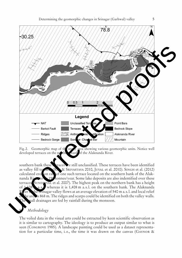
The Alaknanda River (figs. 1, 2) originates from the Satopanth and Baghirath Kharakglaciers (Nainwal et al. 2007) from where it covers a distance of ~ 150 km to enterthe Srinagar valley. Along its length the Alaknanda River passes through TethyanHimalayas, Higher Himalayas and Lesser Himalayas before joining the BhagirathiRiver in Devprayag. The Srinagar town (figs. 1, 2) is located in the widest stretch ofthe Alaknanda valley (Sundriyal et al. 2007, Ray & Srivastva 2010) and it receivesa rainfall of 1,000–1,500 mm annually (Sundriyal et al. 2007, Sati et al. 2007). Thestudy area lies in the Lesser Himalaya where it is placed in the Chandpur Formationof the Garhwal Group (Kumar & Agarwal 1975, Srivastava & Ahmed 1979) andin Chandpur Group (Shekhar et al. 2006). Locally, the rock comprise of phyllite,quartzite, metabasics, limestone, slate and metavolcanics (fig. 1) (Kumar & Agarwal1975, Srivastava & Ahmed 1979, Shekhar et al. 2006). The major structure in thearea is the NAT (North Almora Thrust) which passes through Srinagar placing theyounger phyllite under quartzite and trending towards NW-SE with two local trans-verse faults Koteshwar and Barkot (fig. 1) (Shekhar et al. 2006).
4 Geomorphology
The dynamic behaviour of the Alaknanda River is reflected in the landforms it hassculpted along the valley. The Alaknanda River enters into the Srinagar valleythrough an epigenetic gorge (fig. 2) (Sati et al. 2007) and crosses NAT near Kotesh-war (figs. 1, 2) (Shekhar et al. 2006, Sati et al. 2007). It meanders in the valley andhas given rise to the well-developed point bars, scroll bars and thick sand deposits(fig. 2).There are several local streams joining the Alaknanda River in the Srinagar valley among which Nainigad (fig. 2) is the longest with a length of 10 km. Terracesare the most significant features in the valley. Previous workers (Khan et al. 1982,Sati et al. 2007, Sundriyal et al. 2007, Ray & Srivastava 2010) have identified sixlevels of terraces (fig. 2) on the northern bank of the Alaknanda River, whereas on the
Determining the geomorphic changes in Srinagar (Garhwal) valley 3
unco
rrecte
d proo
fs

unco
rrecte
d proo
fsR. Devrani and V. Singh4
Fig
.1.
Sim
plif
ied
geol
ogic
map
of t
he S
rina
gar
Val
ley
(aft
er S
hek
har
et a
l. 20
06).
Inse
t– S
hade
d re
lief m
ap o
f Gar
hwal
Him
alay
a (N
orth
wes
tH
imal
aya)
, loc
atio
n of
stu
dy a
rea
outl
ined
by
whi
te r
ecta
ngle
; Ala
knan
da R
iver
bas
in m
arke
d by
das
hed
whi
te b
ound
ary.
unco
rrecte
d proo
fs
unco
rrecte
d proo
fs
southern bank these terraces are still unclassified. These terraces have been identifiedas valley fill terraces (Ray & Srivastava 2010, Juyal et al. 2010). Singh et al. (2012)calculated erosion rate of one such terrace located on the southern bank of the Alak-nanda River to be 190 tonnes/year. Some lake deposits are also indentified over theseterraces (Sundriyal et al. 2007). The highest peak on the northern bank has a heightof 1,108 m a.s. l. whereas it is 1,408 m a.s. l. on the southern bank. The AlaknandaRiver in the Srinagar valley flows at an average elevation of 540 m a.s. l. and local reliefof the area is 868 m. The ridges and scarps could be identified on both the valley walls.The small drainages are fed by rainfall during the monsoon.
5 Methodology
The veiled data in the visual arts could be extracted by keen scientific observation asit is similar to cartography. The ideology is to produce an output similar to what isseen (Cosgrove 1985). A landscape painting could be used as a dataset representa-tion for a particular time, i. e., the time it was drawn on the canvas (Gaynor &
Determining the geomorphic changes in Srinagar (Garhwal) valley 5
Fig. 2. Geomorphic map of the study area showing various geomorphic units. Notice welldeveloped terraces on the northern bank of the Alaknanda River.
unco
rrecte
d proo
fs

unco
rrecte
d proo
fsR. Devrani and V. Singh6
Fig
.3.
a.T
he L
ands
cape
Pai
ntin
g of
the
Sri
naga
r V
alle
y by
Tho
mas
Dan
iel a
nd W
illia
m D
anie
l in
1784
–179
4 (W
ikip
edia
,T
he B
riti
sh L
ibra
ry).
b.R
ecen
t pho
togr
aph
of th
e Sr
inag
ar V
alle
y. c
.Sch
emat
ic v
iew
of t
he L
ands
cape
Pai
ntin
g. d
.Sch
emat
icvi
ew o
f the
rec
ent p
hoto
grap
h. L
abel
ling
has
been
don
e to
sho
w s
ame
topo
grap
hic
feat
ures
.
unco
rrecte
d proo
fs

unco
rrecte
d proo
fsMclean 2008). The representation of the three dimensional version of the landforminto two dimension gives an advantage as the observer›s vision is not hindered andobservation point is away from the relative space (Cosgrove 1985). The method isbased upon the comparison between two visual dataset, i. e., landscape painting andphotograph from most suitable location that represents the spot from where thepainting was drawn. The difference in time of both the dataset is the key to detectchanges. The problem in observing two different image representations is resolved by preparing schematic diagrams of both visual dataset. The sketches are best suitedcomparison tool to be linked with two dimensional dataset as they consist of linearrepresentation of the two dimensional data set from three dimensional version (Vis-valingam & Dowon 1988).
6 Observations
6.1 Landscape painting (1784–1794)
The Landscape painting (fig. 3a, c) of Srinagar valley was made by Thomas Daniel and William Daniel in 1784–1794 (Wikipedia; British Library). The position of thepainter was such that it integrated the major landforms on the northern bank of theAlaknanda River, where the terraces are well embarked with the hill slopes. Themajor noticeable feature in the painting is a bedrock outcrop within the active chan-nel of the Alaknanda on the top of which man-made structure is present. A ropebridge over the Alaknanda River can also be noticed. The painting shows the bedrockoutcrop as bare rock; colour and texture of the rock gives a hint of local geology. Jointsets in the bedrock are also identified.
Boulders near the bedrock are distinct and indicate local transportation. The ter-race, on the northern bank of the Alaknanda River shows two levels. A scarp is dis-tinctly visible and its surface lacks any vegetation suggesting it to be actively eroded.Two mountain peaks (named A and B) (fig. 3a, c) are visible in the background, butthey are not very clear. On the other hand few smaller peaks (named a, b, c, d and e)(fig. 3a, c) can also be seen. The hill slopes joining the terraces are gentle in their gra-dient as compared to others hill slopes in the painting.
Drainages are also distinct on the northern hill slope and incising the northernbank terraces in their downstream part before joining the Alaknanda River. The sandbars are visible in the painting, abutting against the terraces of the northern bank. Thecourse of the Alaknanda River suggests its flow closer to the northern bank and thebedrock outcrop marks the left margin of the Alaknanda River (i. e. the southernbank).
6.2 Photographs (2011)
An overview from the canvas is placed in the photograph (fig. 3b, d) where the hillslopes, terraces, river and bedrock are aligned in the same pose. The bedrock presentin the photograph is phyllite showing three sets of joint sets. At the top of the bedrockvegetation is visible. The terraces towards the northern bank of the Alaknanda Riverare showing three levels of terraces. Local drainages margin is seen covered with vegetation. The scarps are clearly visible all over the hill slopes generally located in a
Determining the geomorphic changes in Srinagar (Garhwal) valley 7
unco
rrecte
d proo
fs

unco
rrecte
d proo
fsbuffer zone around the road. Prominent mountain peaks (A, B) (fig. 3b, d) are clearlyvisible in the photograph and the adjoining peaks (named a, b, c, d and e) (fig. 3b, d)are also visible. The vegetation cover has increased on the scarp bounding the river.The region covered by sand bar in recent photograph is mainly adjacent to the north-ern bank. Presently bedrock occupies middle part of the Alaknanda River.
6.3 Comparison
The centre of spectrum is the phyllite bedrock that has decreased in size and shape.A man made structure is visible on the top of the bedrock in the painting whereas inthe recent photograph it is absent and the top of the bedrock has become pointed covered with vegetation at its top. In the painting the Alaknanda River is flowingclose to the northern bank at the base of terraces, whereas in the recent photographthe course of the river is relatively away from the northern bank. Large amount ofsand bar and deposit of sand and silt with developed scarps is present between ter-races and the Alaknanda River in the painting, whereas in the photograph some newscarps are seen developed, which are not present in the painting. The local drainageshave dissected the terrace topography as seen in the photograph and towards the topof these gullies dense vegetation has developed that are not present in the painting.Three levels of terraces can be identified on the present day photograph, in contrastto two levels in the painting. The terraces on the southern bank (seen at the back sideof the phllyite bedrock) in the painting cannot be seen in the recent photograph.
7 Discussion
The landform change could be detected in century to decadal scale (Wainwright &Millington 2010). Geomorphic changes occur in the landscape through time andthe small changes could be used as significant marker to study the dynamism of theprocesses.
Comparing the old landscape painting of Srinagar valley with today’s landscapehas provided insights into the quantative rate of geomorphic processes in the area forlast two centuries. The modifications are visible on geomorphic features like terraces,sand bars and bedrock (along the river). The most significant change that is observedis the reduction in the size of the bedrock outcrop present in the Alaknanda River.As the bedrock outcrop is composed of phyllite, it can be said that such rapid rate oferosion is due to the combined effect of weak lithology (i. e., phyllite) and high streampower of the Alaknanda River. Moreover, presence of several structures (NAT,Barkot Fault and Koteshwar Fault; some of which are suggested to be active by Satiet al. (2007) in the study area make them highly vulnerable to erosion. However,whatever may be the case it should be noticed that the rate of erosion is significantlyhigh. Comparison of the two datasets also reveals noticeable change in the course ofthe Alaknanda River (fig. 3a, b). Present day photograph shows southward flow ofthe Alaknanda River in contrast to the painting where the river is flowing along itsnorthern bank. It suggests southward shift of the river due to which the bedrock nowoccupies the middle portion of the Alaknanda River. The southward shift of the riveris in good agreement with the regional geomorphology of the area, where presenceof asymmetric terraces indicate southward shifting of the river. It also means that
R. Devrani and V. Singh8
unco
rrecte
d proo
fs

unco
rrecte
d proo
fssouthward migration trend of the river in the last two centuries is in good agreementwith the long-term record (age of the oldest terrace is ~ 17 ka (Juyal et al. 2010)).
Another noticeable change in the morphology is the presence of three levels ofterraces in the recent photograph in contrast to two levels in the painting. The extralevel is seen developed adjacent to the Alaknanda River and it indicates rapid incisionby the Alaknanda River. Though, this level could get submerged during high floods(Wasson et al. 2008), vegetation cover on top of it indicates it to be stable. Thus, itcan be said that the Alaknanda River has rapidly incised since last two centuries togive rise to this terrace level. This observation also supports high rate of erosion ofthe large bedrock seen in the painting. Other supporting evidence could be changesseen in the area (here the area represents visual area, which is product of depth andlength) geomorphic features like bars and silt and sand deposits. Relative increase involume of sand and silt deposit is observed which could either be due to large floodevents or due to incision by the Alaknanda River (leading to exposure of deeper sand/silt deposits). The Alaknanda valley has faced several catastrophic events in the lasttwo centuries for e. g., flash flood of 1803, 1968 and large flood of 1970 (Joshi &Kumar 2006), when the upper limit of the reached to T1 level in Srinagar (Wassonet al. 2008) and two to three meter thick column of silt was deposited on the road levelof Srinagar town (Ravindra & Negi 1979). However, flood event could only causeincrease in the spread of the deposits that is difficult to observe in the two dimen-sional photograph or painting. Hence, we surmise that the increase in volume noticedis due to the incision by the Alaknanda River.
The Alaknanda River has incised in the past two centuries is also evident fromthe fact that the gullies on the terraces does not show any vegetation in the painting;whereas in the present day photograph the banks of the gullies are densely vegetatedand so is the terrace scarp. If the river is flowing at the same level then continuouserosion of the scarps would not allow vegetation to grow, but if the river incises thenthe higher reaches of the scarps get diffused due to erosion and vegetation covergrows on its surface. This seems to be the case in the present scenario.
Several scarps and linearly arranged fresh rock cutting could be observed in thepresent day photograph representing human influence on the geomorphology. Mostof these features are related to the on-going dam construction work in the study area.
8 Conclusions
Comparison between the landscape painting of ~ 1790 and the present day photo-graph of the Srinagar valley reveals following changes in the landforms:a) The rate of erosion and incision of the Alaknanda River is very high.b) Due to erosion the bedrock present in the Alaknanda River has been reduced in
size significantly.c) Continuous incision by the Alaknanda River has led to the formation of a young
terrace level.d) Southward shift of the Alaknanda River is evident from the change in geomor-
phology and it is in good agreement with the long-term shifting direction.The results indicate significance of the rates at century scale in the formation of alandscape. It is suggested that in order to understand the evolution of the landscapemore efforts are required to quantify the rates at century scale.
Determining the geomorphic changes in Srinagar (Garhwal) valley 9
unco
rrecte
d proo
fs

unco
rrecte
d proo
fsAcknowledgements
RD thanks University Grant Commission for providing him Non-Net Fellowship. We thankDepartment of Geology, Delhi University for providing all the support to carry out this work.We also thank anonymous reviewers and the editor for their comments that helped us toimprove the manuscript.
References
Brown, A. L. (1989): The unfolding of geologic space. – MS Thesis, Rochester Institute ofTechnology, Faculty of The College of Fine and Applied Arts.
Child, E. (1996): Time’s Profile: John Wesley Powell, Art, and Geology at the GrandCanyon. – American Art 10(1): 6–35.
Cosgrove, D. (1985): Perspective and the Evolution of the Landscape Idea. – Transactions ofthe Institute of British Geographers, New Series 10(1): 45–62.
Gardner, E. T. A. (1945): Scientific Sources of the Full-Length Landscape: 1850. – Metropol-itan Museum of Art Bulletin 4(2): 59–65.
Gaynor, A. & Mclean, I. (2008): Landscape Histories: Mapping Environmental and Ecolog-ical Change Through the Landscape Art of the Swan River Region of Western Australia. –Environment and History 14: 187–204.
Gracino, A. (2005): “The Book of Nature is Open to All Men”: Geology, Mining, and His-tory in Joseph Wright’s Derbyshire Landscapes. – Huntington Library Quarterly 68(4):583–600.
Joshi, V. & Kumar, K. (2006): Extreme rainfall events and associated natural hazards in Alak-nanda valley, Indian Himalayan region. – Journal of Mountain Science 3(3): 228–236.
Juyal, N., Sundriyal, Y. P., Rana, N., Chaudhary, S. & Singhvi, A. K. (2010): Late Quater-nary fluvial aggradations and incision in the monsoon-dominated Alaknanda valley, Cen-tral Himalaya, Uttrakhand, India. – Journal of Quaternary Science 25: 1293–1304.
Khan, A. A., Dubey, U. S., Sehgal, M. N. & Awasthi, S. C. (1982): Terraces in the Himalayantributaries of Ganges in Uttar Pradesh. J. – Geol. Soc. India. 23: 392–401.
Kumar, G. & Agarwal, N. C. (1975): Geology of the Srinagar- Nandprayag Area (AlaknandaValley), Chamoli, Garhwal and Tehri Garhwal Districts, Kumaun Himalaya, UttarPradesh. – Himalayan Geology 5: 29–59.
Lee, E. S. (1954): Chinese Landscape Painting. – The Bulletin of the Cleveland Museum of Art41(9): 199–201.
Ling, R. (1977): Studius and the Beginnings of Roman Landscape Painting. – The Journal ofRoman Studies 67: 1–16.
Mitchell, F. T. (1982): From Vedute to Vision: The Importance of Popular Imagery in Fried -rich’s Development of Romantic Landscape Painting. – The Art Bulletin 64(3): 414–424.
Mitchell, F. T. (1984): Caspar David Friedrich’s Der Watzmann: German Romantic Land-scape Painting and Historical Geology. – The Art Bulletin, Vol. 66(3): 452–464.
Nainwal, H. C., Chaudhary, M., Rana, N., Negi, B. D. S., Negi, R. S., Juyal, N. & Singhvi,A. K. (2007): Chronology of the Late Quaternary glaciation around Badrinath (upperAlaknanda Basin): preliminary observations. – Current Science 93: 90–96.
Nordstrom, K. F. & Jackson, N. L. (2001): Using Paintings for Problem-solving and Teach-ing. Physical Geography: Examples from a Course in Coastal Management. – Journal ofGeography 100(5): 141–151.
Oberhummer, E. (1909): Leonardo Da Vinci and the Art of the Renaissance in Its Relationsto Geography. – The Geographical Journal 33(5): 540–569.
Oldroyd, D. (1988): Picturing the Phenomena. – Metascience 7(1): 117–131.
R. Devrani and V. Singh10
unco
rrecte
d proo
fs

unco
rrecte
d proo
fsRavindra, R. & Negi, R. S. (1979): Observations of Alaknanda tragedy of 1970. – Himalayan
Geology 5: 724–733.Ray, Y. & Srivastava, P. (2010): Widespread aggradation in the mountainous catchment of the
Alaknanda Ganga River System: timescales and implications to Hinterland foreland rela-tionships. – Quaternary Science Reviews 29: 2238–2260.
Rees, R. (1976): John Constable and the Art of Geography. – Geographical Review 66(1): 59–72.
Rhoades, R., Zapata, X. & Aragundy, J. (2006): Climate Change in Cotacachi. – In:Rhoades, R. (eds.): Development with Identity: Community, Culture and Sustainabilityin the Andes: 64–74; CAB International Publishing.
Sati, S. P., Sundriyal, Y. P. & Rawat, G. S. (2007): Geomorphic indicators of Neotectonicactivity around Srinagar (Alaknanda Basin), Uttarakhand. – Current Science 92: 824–829.
Shekhar, S., Saklani, P. S. & Bhola, A. M. (2006): Geology and structure of Srinagar,Garhwal Himalaya. – In: Saklani, P. S. (eds.): Himalaya (Geological aspects) 4: 153–169;Satish Serial Publishing House.
Shepard, P. J. (1957): Paintings of the New England Landscape. – College Art Journal. 17: 30–42.
Singh, V., Devrani, R. & Ansari, Z. (2012): Estimation of the rate of erosion of valley filldeposits in a part of the NW Lesser Himalaya. – Episodes 35(3): 445–452.
Srivastava, R. N. & Ahmad, A. (1979): Geology and structure of the Alaknanda valley,Garhwal Himalaya. – Himalayan Geology 9: 225–254.
Sundriyal, Y. P., Tripathi, J. K., Sati, S. P., Rawat, G. S. & Srivastava, P. (2007): Landslidedammed lakes in the Alaknanda basin, Lesser Himalaya: causes and implications. – Cur-rent Science 93(4): 568–574.
The British Library: URL http://www.bl.uk/onlinegallery/onlineex/apac/other/019xzz000004324u00023000.html
Tobisch, O. T. (1983): Connections between the Geological Sciences and Visual Art: Histori-cal Perspectives and Personal Expression in Artwork. – Leonardo 16(4): 280–287.
Timothy, M. (1984): “Caspar David Friedrich’s Der Watzmann: German Romantic LandscapePainting and Historical Geology”. – The Art Bulletin 66(3): 452–464.
Tress, B. & Tress, G. (2001): Bridging human and natural sciences in landscape research. –Landscape and Urban Planning 57: 137–141.
Visvalingam, M. & Dowson, K. (1988): Algorithms for sketching surfaces. – Comput. &Graphics 22(2–3): 269–280.
Wagner, V. L. & Ruskin, J. (1988): John Ruskin and Artistical Geology in America. – Win-terthur Portfolio 23(2/3): 151–167.
Wainwright, J. & Millington, J. D. A. (2010): Mind, the Gap in Landscape-evolution mod-elling. – Earth Surface Processes and Landforms 35(7): 842–855.
Wasson, R. J., Juyal, N., Jaiswal, M., Mcculloch, M., Sarin, M. M., Jain, V., Srivastava,P. & Singhvi, A. K. (2008): The mountain-lowland debate: Deforestation and sedimenttransport in the upper Ganga catchment. – Journal of Environmental Management 88:53–61.
Way, L. D. & Shih, C. Z. (2001): The Synthesis of Rock Textures in Chinese Landscape Paint-ing. – Eurographics 20(5).
Wikipedia: The Free Encyclopedia. Wikimedia Foundation, Inc. 22 July 2004. Web. 10 Aug.2004 URL http://en.wikipedia.org/wiki/File:Srinagar,_Garhwal,_19th_century.jpg
Manuscript received: August 2012; accepted: October 2012.
Addresses of the authors: Rahul Devrani, Department of Geology, Chhatra Marg, Universityof Delhi, Delhi – 110007, India. E-Mail: [email protected] – Vimal Singh, Depart-ment of Geology, Chatra Marg, University of Delhi, Delhi, 110007, India.
Determining the geomorphic changes in Srinagar (Garhwal) valley 11
unco
rrecte
d proo
fs
Copyright © 2022 FDOKUMEN