Detailed Flora & Vegetation Survey and Targeted Flora ...
102
Detailed Flora & Vegetation Survey and Targeted Flora Survey of the New Morning Project Prepared For October 2018 Version 1 Prepared by: Botanica Consulting PO Box 2027 Boulder WA 6432 90930024
-
Upload
khangminh22 -
Category
Documents
-
view
3 -
download
0
Transcript of Detailed Flora & Vegetation Survey and Targeted Flora ...

Detailed Flora & Vegetation Survey
and Targeted Flora Survey
of the New Morning Project Prepared For
October 2018
Version 1
Prepared by:
Botanica Consulting
PO Box 2027
Boulder WA 6432
90930024

Disclaimer This document and its contents are to be treated as confidential and are published in accordance with and
subject to an agreement between Botanica Consulting (BC) and the client for whom it has been prepared
and is restricted to those issues that have been raised by the client in its engagement of BC. Neither this
document nor its contents may be referred to or quoted in any manner (report or other document) nor
reproduced in part or whole by electronic, mechanical or chemical means, including photocopying, recording
or any information storage system, without the express written approval of the client and/or BC.
This document and its contents have been prepared utilising the standard of care and skill ordinarily
exercised by Environmental Scientists in the preparation of such documents. All material presented in this
document is published in good faith and is believed to be accurate at the time of writing. Any person or
organisation who relies on or uses the document and its contents for purposes or reasons other than those
agreed by BC and the client without primarily obtaining the prior written consent of BC, does so entirely at
their own risk. BC denies all liability in tort, contract or otherwise for any loss, damage or injury of any kind
whatsoever (whether in negligence or otherwise) that may be endured as a consequence of relying on this
document and its contents for any purpose other than that agreed with the client.
Quality Assurance An internal quality review process has been implemented to each project task undertaken by BC. Each
document and its contents are carefully reviewed by core members of the Consultancy team and signed off
at Director Level prior to issue to the client. Draft documents are submitted to the client for comment and
acceptance prior to final production.
Document Job Number: 2018/94
Prepared by: Lauren Pick
Senior Environmental Consultant
Botanica Consulting
Reviewed by: Andrea Williams
Director
Botanica Consulting
Approved by: Jim Williams
Director
Botanica Consulting

Contents Page No.
1 Introduction 1 1.1 Project Description ........................................................................................................................................... 1 1.2 Objectives ......................................................................................................................................................... 1
2 Regional Biophysical Environment 4 2.1 Regional Environment ...................................................................................................................................... 4 2.2 Soils and Landscape Systems ......................................................................................................................... 6 2.3 Remnant Vegetation ........................................................................................................................................ 9 2.4 Climate ........................................................................................................................................................... 11 2.5 Hydrology ....................................................................................................................................................... 12 2.6 Land Use ........................................................................................................................................................ 14
3 Survey Methodology 16 3.1 Desktop Assessment ..................................................................................................................................... 16 3.2 Field Assessment ........................................................................................................................................... 21 3.2.1 Sampling Quadrats ........................................................................................................................................ 23 3.2.2 Targeted Flora Survey ................................................................................................................................... 23 3.2.3 Personnel involved ......................................................................................................................................... 23 3.2.4 Scientific licences ........................................................................................................................................... 23 3.3 Data Analysis Tools ....................................................................................................................................... 23 3.3.1 PATN Analysis ............................................................................................................................................... 23 3.3.2 EstimateS ....................................................................................................................................................... 24 3.4 Flora survey limitations and constraints ......................................................................................................... 24
4 Results 26 4.1 Desktop Assessment ..................................................................................................................................... 26 4.1.1 Literature Review ........................................................................................................................................... 26 4.2 Field Assessment ........................................................................................................................................... 34 4.2.1 Vegetation Associations ................................................................................................................................. 34 4.2.2 Vegetation Condition ...................................................................................................................................... 46 4.2.3 Introduced Plant Species ............................................................................................................................... 48 4.2.4 Floristic Composition of the New Morning Project Quadrats ......................................................................... 52 Species Richness and accumulation estimates .......................................................................................................... 53 4.2.5 Significant Flora ............................................................................................................................................. 55 4.2.6 Significant Vegetation .................................................................................................................................... 63 4.3 Matters of National Environmental Significance ............................................................................................ 63 4.4 Matters of State Environmental Significance ................................................................................................. 64
5 Bibliography 65
Appendices
Appendix 1: Regional maps of the survey area in relation to areas of conservation significance ............................... 68 Appendix 2: List of species identified within each vegetation association ................................................................... 70 Appendix 3: Vegetation Condition Rating .................................................................................................................... 79 Appendix 4: Priority Flora Locations Recorded by Botanica ....................................................................................... 80 Appendix 5: Quadrat Locations .................................................................................................................................... 85 Appendix 6: Quadrat Datasheets ................................................................................................................................. 86 Appendix 7: Quadrat Photographs............................................................................................................................... 87 Appendix 8: PATN Analysis results ............................................................................................................................. 88
Tables
Table 2-1: Soil Landscape Systems within the New Morning Project survey area ....................................................... 7 Table 2-2: Remaining Beard Vegetation Associations within Western Australia (DBCA, 2017) ................................... 9 Table 3-1: Definitions of Conservation Significant Flora .............................................................................................. 17 Table 3-2: Definitions of conservation significant communities ................................................................................... 18 Table 3-3: Scientific Licences of Botanica Staff coordinating the survey .................................................................... 23 Table 3-4: Limitations and constraints associated with the flora and vegetation survey ............................................. 24 Table 4-1: Previous Flora and Vegetation Surveys within the New Morning Project and surrounding area ............... 26

Table 4-3: Likelihood of occurrence for Flora of Conservation Significance within the survey area ........................... 29 Table 4-4: Summary of vegetation associations within the New Morning Project survey area ................................... 34 Table 4-4: Vegetation assemblage for Low open forest of Eucalyptus flocktoniae/ E. salubris/ E. urna on clay-loam plain .............................................................................................................................................................................. 37 Table 4-5: Vegetation assemblage for Mid open woodland of Eucalyptus salmonophloia on clay-loam plain ........... 38 Table 4-6: Vegetation assemblage for Burnt open low woodland of Eucalyptus salmonophloia over mallee shrubland of E. pileata/ E. tephroclada/ E. celastrioides on clay-loam plain ................................................................................ 39 Table 4-7: Vegetation assemblage for Mid woodland of Eucalyptus longicormis on clay-loam plain ......................... 40 Table 4-8: Vegetation assemblage for Mid mallee shrubland of Eucalyptus tephroclada/ E. pileata on stony rise .... 41 Table 4-9: Vegetation assemblage for Mid mallee shrubland of Eucalyptus tephroclada/ E. pileata/ E. transcontinentalis on sand-loam plain ......................................................................................................................... 42 Table 4-10: Vegetation assemblage for Mid mallee shrubland of Eucalyptus steedmanii on sand-loam plain .......... 43 Table 4-11: Vegetation assemblage for Mid heathland of Allocasuarina corniculata/ Acacia acuminata on sandplain ..................................................................................................................................................................................... 44 Table 4-12: Vegetation assemblage for Low open mallee shrubland of Eucalyptus platycorys/ E. horistes on sandplain ...................................................................................................................................................................... 45 Table 4-16: Vegetation Condition Rating for Vegetation associations of the New Morning Project survey area ........ 46 Table 4-16: Vegetation associations with corresponding quadrats ............................................................................. 52
Figures
Figure 1-1: Regional map of the New Morning Project survey area .............................................................................. 3 Figure 2-1: Map of IBRA Bioregions in relation to the New Morning Project survey area ............................................. 5 Figure 2-2: Map of Soil Landscape Systems within the New Morning Project survey area .......................................... 8 Figure 2-3: Pre-European Vegetation Associations within the New Morning Project survey area .............................. 10 Figure 2-4: Monthly rainfall (January 2012 to August 2018) for the Lake Carmody weather station (#13030) (BoM, 2018a) .......................................................................................................................................................................... 11 Figure 2-5: Monthly rainfall and mean monthly rainfall (January 2013 to August 2018) for the Lake Carmody weather station (#13030) (BoM, 2018a) .................................................................................................................................... 11 Figure 2-6: Hydrology of the New Morning Project survey area .................................................................................. 13 Figure 2-7: Location of survey area within the Great Western Woodlands (survey area no to scale) ....................... 15 Figure 3-1: Quadrat locations, survey area boundary and GPS tracks traversed throughout the New Morning Project survey area .................................................................................................................................................................. 22 Figure 4-2: Vegetation associations within the survey area ........................................................................................ 36 Figure 4-3: Vegetation Condition Rating of the New Morning Project survey area ..................................................... 47 Figure 4-3: Species accumulation curve ...................................................................................................................... 54 Figure 4-4: Flora of Conservation Significance identified within the New Morning Project survey area ..................... 62
Plates
Plate 1: Low open forest of Eucalyptus flocktoniae/ E. salubris/ E. urna on clay-loam plain ..................................... 37 Plate 2: Mid open woodland of Eucalyptus salmonophloia on clay-loam plain .......................................................... 38 Plate 3: Burnt open low woodland of Eucalyptus salmonophloia over mallee shrubland of E. pileata/ E. tephroclada/ E. celastrioides on clay-loam plain............................................................................................................................... 39 Plate 4: Mid woodland of Eucalyptus longicormis on clay-loam plain ........................................................................ 40 Plate 5: Mid mallee shrubland of Eucalyptus tephroclada/ E. pileata on stony rise ................................................... 41 Plate 6: Mid mallee shrubland of Eucalyptus tephroclada/ E. pileata/ E. transcontinentalis on sand-loam plain ...... 42 Plate 7: Mid mallee shrubland of Eucalyptus steedmanii on sand-loam plain ............................................................ 43 Plate 8: Mid heathland of Allocasuarina corniculata/ Acacia acuminata on sandplain ............................................... 44 Plate 9: Low open mallee shrubland of Eucalyptus platycorys/ E. horistes on sandplain .......................................... 45 Plate 10: Dittrichia graveolens (Stinkwort) ................................................................................................................... 48 Plate 11: Lysimachia arvensis (Pimpernel) (WAHERB, 2018) .................................................................................... 49 Plate 12: Sonchus oleraceus (Common Sowthistle) .................................................................................................... 50 Plate 13: Wahlenbergia capensis (Common Bluebell) (WAHERB, 2018) ................................................................... 51 Plate 12: Eucalyptus steedmanii (T) ............................................................................................................................ 56 Plate 13: Pargoodia crenulata (T) ................................................................................................................................ 57 Plate 14: Eremophila racemosa (P4) ........................................................................................................................... 58 Plate 15: Eutaxia acanthoclada (P3) ........................................................................................................................... 59 Plate 16: Microcorys sp. Forrestania (V. English 2004) (P4) ....................................................................................... 60 Plate 17: Stylidium sejunctum (P3) .............................................................................................................................. 61
Glossary
Acronym Description
ANCA Australian Nature Conservation Agency.
BAM Act Biosecurity and Agriculture Management Act 2007, WA Government.
BC Botanica Consulting.
BoM Bureau of Meteorology.
DAFWA Department of Agriculture and Food (now DPIRD), WA Government.
DBCA Department of Biodiversity, Conservation and Attractions (formerly DPaW), WA
Government.
DEC Department of Environment and Conservation (now DBCA), WA Government.
DER Department of Environment Regulation (now DWER), WA Government.
DMIRS Department of Mines, Industry Regulation and Safety (formerly DMP), WA Government
DMP Department of Mines and Petroleum (now DMIRS), WA Government.
DotEE Department of the Environment and Energy (formerly DSEWPaC), Australian
Government.
DoW Department of Water (now DWER), WA Government.
DPaW Department of Parks and Wildlife (now DBCA), WA Government.
DPIRD Department of Primary Industries and Regional Development, WA Government
DSEWPaC Department of Sustainability, Environment, Water, Population and Communities (now
DotEE,), Australian Government.
DWER Department of Water and Environmental Regulation (formerly EPA, DER and DoW), WA
Government
EP Act Environmental Protection Act 1986, WA Government.
EP Regulations Environmental Protection (Clearing of Native Vegetation) Regulations 2004, WA
Government.
EPA Environmental Protection Authority, WA Government.
EPBC Act Environment Protection and Biodiversity Conservation Act 1999, Australian Government.
ESA Environmentally Sensitive Area.
Ha Hectare (10,000 square metres).
IBRA Interim Biogeographic Regionalisation for Australia.
IUCN International Union for the Conservation of Nature and Natural Resources – commonly
known as the World Conservation Union.
Km Kilometre
MVG Major Vegetation Groups.
NSR Northern Star Resources Limited.
NVIS National Vegetation Information System.
OEPA Office of the Environmental Protection Authority (now DWER), WA Government.
PEC Priority Ecological Community.
SSC Species Survival Commission, International.
Survey Area New Morning Project.
TEC Threatened Ecological Community.
WA Western Australia.
WAHERB Western Australian Herbarium.
WAM Western Australian Museum, WA Government.
WC Act Wildlife Conservation Act 1950, WA Government.

Executive Summary
Botanica Consulting (BC) was commissioned by Western Areas Limited (WSA) to undertake a Detailed
flora and vegetation survey and targeted flora survey of the New Morning Project (referred to as the ‘survey
area’), which is located at the WSA Forrestania Nickel Project, approximately 75 km east of Hyden, Western
Australia. The survey was initially conducted in spring from the 26th to the 29th August 2018, covering an
area of approximately 1,298 ha. Thirty-six quadrats (20m X 20m) were established during the survey.
Nine vegetation associations were identified within the survey area. These vegetation associations were
located within four different landform types and comprised of three major vegetation groups, which were
represented by a total of 38 Families, 98 Genera and 280 Taxa (including 12 annual taxa).
Species composition assessments indicate there was minimal heterogeneity in species composition across
the survey area, with majority of vegetation associations (particularly the Eucalypt woodland associations)
intermixed into floristic groups despite differences in dominant stratum taxa; however, two distinct
supergroups were identified. The first supergroup comprised of a mix of vegetation associations identified
in the field including quadrats from the clay-loam plain (Eucalypt Woodlands and sand-loam plain (Mallee
Woodlands and Shrublands). The second supergroup comprised a mix of quadrats from the sandplains
(Mallee Woodlands and Shrublands/ Heathlands) and stony rise (Mallee Woodlands and Shrublands)
vegetation associations.
Two Threatened Flora species, Eucalyptus steedmanii, pursuant to subsection (2) of section 23F of the
Wildlife Conservation Act (1950) and section 179 of the Commonwealth Environment Protection and
Biodiversity Conservation Act 1999 was identified within the survey area; Eucalyptus steedmanii and
Paragoodia crenulata. Four Priority Flora species were recorded within the survey area; Eremophila
racemosa (P4), Eutaxia acanthoclada (P3), Microcorys sp. Forrestania (V. English 2004) and Stylidium
sejunctum (P3).
No Threatened Ecological Communities (TEC) pursuant to Commonwealth or State legislation were
identified within the survey area. The survey area does not contain any world or national heritage places,
wetlands of international importance (Ramsar Wetlands) or wetlands of national importance (Australian
Nature Conservation Agency (ANCA) wetlands).
The survey area is located within the North Ironcap buffer of the Ironcap Hills Vegetation Complexes which
is listed by the Department of Biodiversity, Conservation and Attractions (DBCA) as a Priority 3 Ecological
Community.
Approximately 370ha of the north-east corner of survey area lies within the Lake Cronin Environmental
Sensitive Area and is located approximately 500m west of the Lake Cronin ‘A’ Class Nature Reserve.
According to the Environmental Protection Authority report (2009) Advice on Conservation Values and
Review of Nature Reserve Proposals in the Lake Cronin Region, an area of 56,750ha within the mineralised
greenstone belt in the Lake Cronin Region (encompassing the entire survey area) is proposed to be
managed under Section 33(2) of the Conservation Land Management Act 1984 but not formally reserved.
A proposed ‘C’ Class Nature Reserve is also proposed in the surrounding area to protect the Lake Cronin
catchment and areas of extensive sandplain and woodland vegetation located immediately east of the
Wheatbelt, which represents vegetation communities and fauna habitats that have been extensively cleared
and fragmented in the adjacent Wheatbelt. The North Ironcap Banded Ironstone Formation located
approximately 8km north of the survey area is proposed to be reserved in a small ‘A’ Class Nature Reserve,
covering an area of 42.5ha.

Based on the vegetation condition rating scale adapted from Keighery, 1994 and Trudgen, 1988 (ranging
from ‘pristine’ to ‘completely degraded’), two vegetation associates were rated as ‘good’ and the remaining
seven vegetation associations had a vegetation condition rating of ‘very good’. Four introduced species
were identified within the survey area; Dittrichia graveolens, Lysimachia arvensis, Sonchus olearaceus and
Wahlenbergia capensis. According to the Department of Primary Industries and Regional Development
(DPIRD), none of these species are listed as a Declared Plant under the Biosecurity and Agriculture
Management (BAM) Act 2007.

Western Areas Limited New Morning Project: Flora & Vegetation Survey
Botanica Consulting 1
1 Introduction
1.1 Project Description
Botanica Consulting (BC) was commissioned by Western Areas Limited (WSA) to undertake a Detailed
flora and vegetation survey and targeted flora survey of the New Morning Project (referred to as the
‘survey area’), which is located at the WSA Forrestania Nickel Project, approximately 75 km east of
Hyden, Western Australia (Figure 1-1). The survey was conducted in spring from the 26th to 29th August
2018, covering an area of approximately 1,298 ha. Thirty-six quadrats (20m X 20m) were established
during the survey.
The New Morning deposit located within the survey area, it is a medium grade nickel deposit located
between two of Western Areas existing operations Flying Fox and Spotted Quoll.
1.2 Objectives
The flora and vegetation survey was conducted in accordance with Technical Guidance - Flora and
Vegetation Surveys for Environmental Impact Assessment – December 2016 (EPA, 2016). The
objectives of the detailed flora and vegetation survey were to:
• Define and map vegetation communities of the survey area to a scale appropriate for the bioregion
and described according to the National Vegetation Information System (NVIS) classification
(NVIS Level III– Vegetation Association);
• Record the species composition (abundance and diversity) of each vegetation community within
the survey area and compile a species list for the survey area by vegetation type;
• Provide quadrat-based data from plots representative of each vegetation type (minimum of three
quadrats per vegetation type) according to EPA guidelines;
• Assess the species composition of each quadrat using statistical analysis (PATN analysis);
• Determine the local and regional conservation significance of flora and vegetation within the
survey area;
• Identify and record the locations of any conservation significant flora/vegetation within the survey
area;
• Identify and record the locations of any introduced flora species (including Declared Plants) within
the survey area;
• Provide a map showing the distribution of conservation significant flora/vegetation within the
survey area;
• Define and map the condition of vegetation within the survey area in accordance with the
vegetation condition rating scale adapted from Keighery, 1994 and Trudgen, 1988;
• Determine the State legislative context of environmental aspects required for the assessment;
• Assess Matters of National Environmental Significance (MNES) and indicate whether potential
impacts on MNES as protected under the EPBC Act are likely to require referral of the project to
the Commonwealth DotEE; and
• Determine the need for additional flora and vegetation surveys.
The objectives of the targeted flora and vegetation survey were to:
• Gather background information on flora and vegetation of conservation significance in the local
area (literature review, database and map-based searches);

Western Areas Limited New Morning Project: Flora & Vegetation Survey
Botanica Consulting 2
• Based on results of the desktop assessment, identify vegetation associations within the survey
area that have the potential to contain flora/vegetation of conservation significance;
• Conduct a field survey to identify flora/vegetation of conservation significance within the project
footprint; and
• Provide GPS record and spatial map showing the distribution of flora/vegetation of conservation
significance within the survey area.

Western Areas Limited New Morning Project: Flora & Vegetation Survey
Botanica Consulting 3
Figure 1-1: Regional map of the New Morning Project survey area

Western Areas Limited New Morning Project: Flora & Vegetation Survey
Botanica Consulting 4
2 Regional Biophysical Environment
2.1 Regional Environment
Based on the Interim Biogeographic Regionalisation of Australia (IBRA), Version 7 (DotEE, 2012), the
survey area is located on the border of the Coolgardie and Mallee Bioregions. The Coolgardie and Mallee
Bioregions are further divided into subregions with the survey area located within the Western Mallee
subregion (MAL2) of the Mallee Bioregion and the Southern Cross subregion (COO2) of the Coolgardie
Bioregion (Figure 2-1)
The Coolgardie Bioregion forms part Southwestern Interzone of Western Australia in a region known as
the Coolgardie Botanical District (Beard, 1990). The Coolgardie Bioregion is located within the Yilgarn
Craton and is characterised by a granite basement which includes Archaean Greenstone intrusions in
parallel belts. Drainage is occluded. The Southern Cross subregion comprises gently undulating uplands
on granite strata and broad valleys with bands of low greenstone hills (McKenzie, J.E. May and S.
McKenna, 2002).
The Mallee Bioregion also forms part of the South-West Province Australia in a region known as the Roe
Botanical District. The Mallee Bioregion is located in the south-eastern part of Yilgarn Craton which is
gently undulating, with partially occluded drainage. The Western Mallee subregion has more relief than
its eastern counterpart. Its main surface-types comprise clays and silts underlain by kankar, exposed
granite, sandplains, isolated uplands of laterite pavements and Salt Lake systems on a granite basement
(McKenzie, J.E. May and S. McKenna, 2002).

Western Areas Limited New Morning Project: Flora & Vegetation Survey
Botanica Consulting 5
Figure 2-1: Map of IBRA Bioregions in relation to the New Morning Project survey area

Western Areas Limited New Morning Project: Flora & Vegetation Survey
Botanica Consulting 6
2.2 Soils and Landscape Systems
Based on geographic information provided by DAFWA (2014), the survey area is located within the
South-eastern Zone of Ancient Drainage (250) of the Avon Province (25) and the Southern Cross
Zone (261) of the Kalgoorlie Province (26).
The Avon Province is characterised as a laterised plateau (dissected at fringes and with saline
drainage lines inland) on deeply weathered mantle and alluvium over granitic rocks of the Yilgarn
Craton (and Albany-Fraser Orogen). Soil are comprised of sandy duplexes soils and ironstone
gravelly soils with loamy earths, loamy duplexes, sandy earths, deep sands and wet soils. Vegetation
is dominated by York gum-wandoo-salmon gum-morrel gimlet woodland and jarrah-marri-karri-
wandoo woodlands/forests (with some mallee scrub, tammar-wodjil thickets and scrub-heath). This
Province is located in the south-west, between Nannup, Denmark, Jerramungup, Southern Cross,
Lake Moore, Carnamah and the Perth Hills (Tille, 2006).
The Kalgoorlie Province is characterised by undulating plains (with some sandplains, hills and salt
lakes) on the granitic rocks and greenstone of the Yilgarn Craton. Soils include calcareous loamy
earths and red loamy earths with some Salt Lake soils, red deep sands, yellow sandy earths, shallow
loams and loamy duplexes. Vegetation is dominated by Eucalypt woodlands with some Acacia-
Casuarina thickets, mulga shrublands, halophytic shrublands and spinifex grasslands. This Province
is located in the southern Goldfields between Paynes Find, Menzies, Southern Cross and Balladonia
(Tille, 2006).
The South-western Zone of Ancient Drainage (250) is characterised by gently undulating terrain (with
some salt lake chains and areas of prominent granitic outcrops) on deeply weathered mantle and
alluvium over granitic rocks of the Yilgarn Craton. Soils include sandy duplexes (often alkaline) with
ironstone gravelly soils and loamy earths (often calcareous) and some loamy duplexes, sandy earths,
deep sands and saline wet soils. Mallee scrub and salmon gum-gimlet-morrel woodlands (and some
scrub-heath). This zone is located in the southern Wheatbelt between Kondinin, Lake Grace,
Gnowangerup, Frank Hann National Park and Mt Holland (Tille, 2006).
The Southern Cross Zone (261) is characterised by undulating plains and uplands (with some salt
lake and low hills) on deeply weathered mantle, colluvium and alluvium over greenstone and granitic
rocks of the Yilgarn Craton. Soils include calcareous loamy earths, red and yellow loamy earths and
alkaline deep and shallow sandy duplexes with some yellow sandy earths, salt lake soils, yellow deep
sands and red shallow loamy duplexes. Vegetation is dominated by Salmon gum-gimlet-morrel-York
gum woodlands with Acacia/ Casuarina thickets (and some mallee, scrub-heath and halophytic
shrublands). This zone is located in the eastern Wheatbelt/south western Goldfields between
Bullfinch and Mt Holland. The South-western Zone of Ancient Drainage (259) and Southern Cross
Zone (261) are further divided into soil landscape systems within the soil landscape systems of the
survey area described in Table 2-1 and shown in Figure 2-2 (ASRIS, 2014).

Western Areas Limited New Morning Project: Flora & Vegetation Survey
Botanica Consulting 7
Table 2-1: Soil Landscape Systems within the New Morning Project survey area
Zone Landscape System/
Mapping Unit Description
South-eastern Zone of Ancient Drainage (250)
Ms8 Gently undulating plains with broad shallow
drainage depressions
X17 Slopes and valleys
Southern Cross Zone (261) Ya28 Sandy plains with some clay pans and small salt
lakes, dunes, and lunettes

Western Areas Limited New Morning Project: Flora & Vegetation Survey
Botanica Consulting 8
Figure 2-2: Map of Soil Landscape Systems within the New Morning Project survey area
Western Areas Limited New Morning Project: Flora & Vegetation Survey
Botanica Consulting 9
2.3 Remnant Vegetation
The DAFWA GIS file (2011) indicates that the survey area is located within Pre-European Beard
vegetation association Forrestania 511 (COO2), Forrestania 2048 (COO2 and MAL2). The extent of
these vegetation associations as specified in the 2017 Statewide Vegetation Statistics (DBCA, 2017)
is provided in Table 2-2 and shown in Figure 2-3.
Areas retaining less than 30% of their pre-European vegetation extent generally experience
exponentially accelerated species loss, while areas with less than 10% are considered “endangered”
(EPA, 2000). Development within the survey area will not significantly reduce the extent of pre-
European vegetation.
Table 2-2: Remaining Beard Vegetation Associations within Western Australia (DBCA, 2017)
IBRA Subregion
Vegetation association
Pre-European
Extent (Ha)
Current Extent (Ha)
Pre-European
extent remaining
(%)
% of Current extent within
DBCA managed
lands
Vegetation Description
(Beard, 1990)
COO2
Forrestania 511* 153,641.65 153,002.24 99.58 9.72 Medium woodland;
salmon gum & morrel
Forrestania 2048*
2,093.75 2,070.85 98.91 2.41 Shrublands; scrub-heath in the Mallee
Region
MAL2 Forrestania
2048 5,735.92 5,595.69 97.56 0
Shrublands; scrub-heath in the Mallee
Region
*Low Reservation Priority according to the International Union for Conservation of Nature (IUCN)
Vegetation of the Southern Cross subregion in the Coolgardie Botanical District is predominantly
Eucalypt woodlands, Mallees, Acacia thickets and scrub-heaths on sandplains. Diverse Eucalypt
woodlands occur around salt lakes, on the low greenstone hills, valley alluvials and broad plains of
calcareous earths. Salt lakes support dwarf shrublands of samphire. The area is rich in endemic
Acacias (Cowan, 2001). The Western Mallee subregion vegetation commonly includes Mallee over
myrtaceous-proteaceous heaths, Melaleuca shrublands, Samphire low shrublands on saline
depressions and mixed Eucalypt woodlands. Mallee communities of the Western Mallee subregion
occur on a variety of surfaces; Eucalypt woodlands occur mainly on fine textured soils, with scrub-
heath on sands and laterite (Beecham & Danks, 2001).

Western Areas Limited New Morning Project: Flora & Vegetation Survey
Botanica Consulting 10
Figure 2-3: Pre-European Vegetation Associations within the New Morning Project survey area

Western Areas Limited New Morning Project: Flora & Vegetation Survey
Botanica Consulting 11
2.4 Climate
The climate of the Southern Cross subregion is characterised as arid to semi-arid Mediterranean with
an annual rainfall of 200-300mm (Beard, 1990; Cowan, 2001). The climate of the Western Mallee
subregion is characterised as dry warm Mediterranean with an annual rainfall of 300-500mm (Beard,
1990; Beecham & Danks, 2001). Rainfall data for the Lake Carmody weather station (#10670) located
approximately 30km south of the survey area is shown in Figure 2-4 and Figure 2-5 (BoM, 2018).
Figure 2-4: Monthly rainfall (January 2012 to August 2018) for the Lake Carmody weather station
(#13030) (BoM, 2018a)
Figure 2-5: Monthly rainfall and mean monthly rainfall (January 2013 to August 2018) for the Lake
Carmody weather station (#13030) (BoM, 2018a)
0
20
40
60
80
100
120
Jan Feb Mar Apr May Jun Jul Aug Sep Oct Nov Dec
Rai
nfa
ll (m
m)
2012 2013 2014 2015 2016 2017 2018 Mean
0
100
200
300
400
500
600
2012 2013 2014 2015 2016 2017 2018
Rai
nfa
ll (m
m)
Annual Mean

Western Areas Limited New Morning Project: Flora & Vegetation Survey
Botanica Consulting 12
2.5 Hydrology
According to the Geoscience Australia database (2001) an intermittent (non-perennial) drainage line
extend through the western region of the survey area. There are no inland water sources (lakes,
playas etc.) within the survey area. The survey area is located approximately 4km east of the Camm
paleochannel and 2km west of the Deborah paleochannel. According to the Bureau of Meteorology
(2018b) Groundwater Dependent Ecosystem Atlas, there are no aquatic or terrestrial ecosystems
within the assessment area. A map showing the regional hydrology and potential GDEs in the local
region is provided in Figure 2-6.

Western Areas Limited New Morning Project: Flora & Vegetation Survey
Botanica Consulting 13
Figure 2-6: Hydrology of the New Morning Project survey area
Western Areas Limited New Morning Project: Flora & Vegetation Survey
Botanica Consulting 14
2.6 Land Use
The dominant land uses of the Southern Cross subregion includes native pastures (17%),
Conservation Reserves (11.53%), UCL & Crown Reserves (66.74%) and Cultivation – Dry Land
agriculture (2.27%) (Cowan, 2001). The dominant land uses of the Western Mallee subregion
includes Dry Land agriculture, UCL & Crown Reserves, roads and other easements.
The survey area also lies within the Great Western Woodlands. The Great Western Woodlands is
considered by The Wilderness Society of WA to be of global biological and conservation importance
as one of the largest and healthiest temperate woodlands on Earth, containing many endemic
species. The region covers almost 16 million hectares, 160,000 square kilometers, from the southern
edge of the Western Australian Wheatbelt to the pastoral lands of the Mulga country in the north, the
inland deserts to the northeast, and the treeless Nullarbor Plain to the east (Figure 2-7).
The area provides an eastward connection between southwest forests and inland deserts (Gondwana
Link) as well as linking the north-west passage to Shark Bay. The majority of the Great Western
Woodlands is unallocated crown land (61.1%) with other interests including pastoral leases (20.4%),
conservation reserves (15.4%) unallocated crown land ex pastoral managed by the DEC (2%) and
private land (approximately 1%) (Watson et. al., 2008).
No specific management strategy applies to the Great Western Woodlands, rather an approach to
conservation which occurs across all land tenures and when different stakeholders work together with
biodiversity in mind. The central component of this approach is to identify and conserve key large-
scale, long term ecological processes that drive connectivity between ecosystems and species. The
Great Western Woodlands currently includes towns, highways, roads, railways, private property,
Crown Reserves, agricultural activities and mining tenements.

Western Areas Limited New Morning Project: Flora & Vegetation Survey
Botanica Consulting 15
Figure 2-7: Location of survey area within the Great Western Woodlands (survey area no to scale)
Western Areas Limited New Morning Project: Flora & Vegetation Survey
Botanica Consulting 16
3 Survey Methodology
3.1 Desktop Assessment
Prior to the field assessment a literature review was undertaken of previous flora and vegetation
assessments conducted within the local region. Documents reviewed included:
• BC, (2006), Flora and Vegetation Survey of the Flying Fox North East Exploration Area for
Western Areas, Botanica Consulting
• BC, (2007a), Vegetation Survey of a Proposed Extension to the Current Clearing Permit
Number 691/1 at the Flying Fox mine site prepared for Western Areas, Botanica Consulting
• BC, (2007b), Flora and Vegetation Survey within the Greater Flying Fox mine site prepared
for Western Areas, Botanica Consulting
• BC, (2008), Vegetation Survey of New Morning to Spotted Quoll Area within Tenements
M77/583 and M77/545, Botanica Consulting
• BC, (2009), Flora and Vegetation Survey within the lounge Lizard/Flying Fox area, Proposed
Gravel Pit, prepared for Western Areas, Botanica Consulting
• BC, (2010a), New Morning Flora and Vegetation Survey Prepared for Western Areas,
Botanica Consulting
• BC, (2010b), New Morning Flora and Vegetation Survey Prepared for Western Areas,
Botanica Consulting
• BC, (2011), Spotted Quoll/Cosmic Boy Haul Road Flora and Vegetation Survey, Prepared for
Western Areas NL, Botanica Consulting
• BC (2017) Reconnaissance Flora & Vegetation Survey of the Greater New Morning/Spotted
Quoll Area, Prepared for Western Areas Limited, Botanica Consulting
• How, R. A Newbey, K.R Dell, J. Muir, B.G & Hnatiuk, R.J, (1988), The Biological survey of the
Eastern Goldfields of Western Australia: Lake Johnston-Hyden. Western Australian Muesum
Supplement No. 30.
• Gibson (2004) Flora and vegetation of the Eastern Goldfields Ranges: Part 7. Middle and
South Ironcap, Digger Rock and Hatter Hill. Science Division, Department of Conservation
and Land Management,
• JSWT, (2006a), Vegetation Survey of the Exploration Drilling Program (M77/582 & E77/555),
Prepared for Wester Areas NL, Botanica Consulting
• JSWT, (2006b), North Flying Fox Drill Lines Flora Survey for Western Areas, Jim’s Seeds,
Weeds & Trees
• JSWT, (2006c), Vegetation Survey of three Proposed Monitoring Bores in the Flying Fox Area,
Prepared for Western Areas, Jim’s Seeds, Weeds & Trees
Searches of the following databases were undertaken to aid in the compilation of a list of flora and fauna within the survey area:
• DBCA NatureMap Database (DBCA, 2018);
• DBCA’s Threatened and Priority Flora search (DBCA, 2018b).
• DotEE Protected Matters search tool (DotEE, 2018).
The Naturemap and Protected Matters searches were conducted for an area encompassing a 20km
radius of the centre coordinates; 32° 27' 45'' S, 119° 40' 58'' E.

Western Areas Limited New Morning Project: Flora & Vegetation Survey
Botanica Consulting 17
It should be noted that these lists are based on observations from a broader area than the assessment
area (20km radius) and therefore may include taxa not present. The databases also often included
very old records that may be incorrect or in some cases the taxa in question have become locally or
regionally extinct. Information from these sources should therefore be taken as indicative only and
local knowledge and information also needs to be taken into consideration when determining what
actual species may be present within the specific area being investigated.
The conservation significance of flora taxa was assessed using data from the following sources:
• Environment Protection and Biodiversity and Conservation (EPBC) Act 1999.
Administered by the Australian Government (DotEE);
• Wildlife Conservation (WC) Act 19501. Administered by the WA Government (DBCA);
• Red List produced by the Species Survival Commission (SSC) of the World Conservation
Union (also known as the IUCN Red List – the acronym derived from its former name of
the International Union for Conservation of Nature and Natural Resources). The Red List
has no legislative power in Australia but is used as a framework for State and
Commonwealth categories and criteria; and
• Priority Flora list. A non-legislative list maintained by DBCA for management purposes
(released 16th January 2018).
Table 3-1 provides the definitions of conservation significant flora under the WC Act and EPBC Act.
Table 3-1: Definitions of Conservation Significant Flora
Code Category
State categories of threatened and priority species
T
Threatened Flora
“flora that has been declared to be ‘likely to become extinct or is rare, or otherwise in need of special protection’, pursuant to section 23F (2) of the Wildlife Conservation Act.”
Schedule 1 Critically Endangered – Flora that are considered likely to become extinct or rare, as critically endangered flora
Schedule 2 Endangered – Flora that are considered likely to become extinct or rare, as endangered flora
Schedule 3 Vulnerable – Flora that are considered likely to become extinct or rare, as vulnerable flora
Schedule 4 Extinct-Flora presumed to be extinct
P1
Priority One – Poorly Known Taxa
“Taxa which are known from one or a few (generally <5) populations which are under threat, either due to small population size, or being on lands under immediate threat. Such taxa are under consideration for declaration as ‘rare flora’, but are in urgent need of further survey.”
P2
Priority Two – Poorly Known Taxa
“Taxa which are known from one or a few (generally <5) populations, at least some of which are not believed to be under immediate threat (i.e. not currently endangered). Such taxa are under consideration for declaration as ‘rare flora’, but urgently need further survey.”
1 The Biodiversity Conservation Act 2016 received assent on 21 September 2016 with Parts of the Act coming into effect on 3 December 2016. Once fully enacted with enabling subsidiary regulations, it will replace the WC Act.

Western Areas Limited New Morning Project: Flora & Vegetation Survey
Botanica Consulting 18
Code Category
P3
Priority Three – Poorly Known Taxa
“Taxa which are known from several populations and the taxa are not believed to be under immediate threat (i.e. not currently endangered), either due to the number of known populations (generally >5), or known populations being large, and either widespread or protected. Such taxa are under consideration for declaration as ‘rare flora’ but needs further survey.”
P4
Priority Four – Rare Taxa
“Taxa which are considered to have been adequately surveyed and which, whilst being rare (in Australia), are not currently threatened by any identifiable factors. These taxa require monitoring every 5 – 10 years.”
Commonwealth categories of threatened species
Extinct Taxa where there is no reasonable doubt that the last member of the species has died.
Extinct in the wild
Taxa where it is known only to survive in cultivation, in captivity or as a naturalised population well outside its past range; or it has not been recorded in its known and/or expected habitat, at appropriate seasons, anywhere in its past range, despite exhaustive surveys over a time frame appropriate to its life cycle and form.
Critically endangered
Taxa that are facing an extremely high risk of extinction in the wild in the immediate future, as determined in accordance with the prescribed criteria.
Endangered Taxa which are not critically endangered and is facing a very high risk of extinction in the wild in the near future, as determined in accordance with the prescribed criteria.
Vulnerable Taxa which are not critically endangered or endangered and is facing a high risk of extinction in the wild in the medium-term future, as determined in accordance with the prescribed criteria.
Conservation dependent
Taxa which are the focus of a specific conservation program the cessation of which would result in the species becoming vulnerable, endangered or critically endangered; or (b) the following subparagraphs are satisfied:
(i) the species is a species of fish;
(ii) the species is the focus of a plan of management that provides for actions necessary to stop the decline of, and support the recovery of, the species so that its chances of long term survival in nature are maximised;
(iii) the plan of management is in force under a law of the Commonwealth or of a State or Territory;
(iv) cessation of the plan of management would adversely affect the conservation status of the species.
A search of the DBCA PEC and TEC database was also conducted within a 40km radius of the survey
area (DPaW, 2012). Table 3-2 represents the definitions of Threatened and Priority Ecological
Communities.
Table 3-2: Definitions of conservation significant communities
Category Code Category
State categories of Threatened Ecological Communities (TEC)
PTD
Presumed Totally Destroyed
An ecological community will be listed as Presumed Totally Destroyed if there are no recent records of the community being extant and either of the following applies:
Western Areas Limited New Morning Project: Flora & Vegetation Survey
Botanica Consulting 19
Category Code Category
records within the last 50 years have not been confirmed despite thorough searches or known likely habitats or;
all occurrences recorded within the last 50 years have since been destroyed.
CE
Critically Endangered
An ecological community will be listed as Critically Endangered when it has been adequately surveyed and is found to be facing an extremely high risk of total destruction in the immediate future, meeting any one of the following criteria:
The estimated geographic range and distribution has been reduced by at least 90% and is either continuing to decline with total destruction imminent, or is unlikely to be substantially rehabilitated in the immediate future due to modification;
The current distribution is limited i.e. highly restricted, having very few small or isolated occurrences, or covering a small area;
The ecological community is highly modified with potential of being rehabilitated in the immediate future.
E
Endangered
An ecological community will be listed as Endangered when it has been adequately surveyed and is not Critically Endangered but is facing a very high risk of total destruction in the near future. The ecological community must meet any one of the following criteria:
The estimated geographic range and distribution has been reduced by at least 70% and is either continuing to decline with total destruction imminent in the short term future, or is unlikely to be substantially rehabilitated in the short term future due to modification;
The current distribution is limited i.e. highly restricted, having very few small or isolated occurrences, or covering a small area;
The ecological community is highly modified with potential of being rehabilitated in the short term future.
V
Vulnerable
An ecological community will be listed as Vulnerable when it has been adequately surveyed and is not Critically Endangered or Endangered but is facing high risk of total destruction in the medium to long term future. The ecological community must meet any one of the following criteria:
The ecological community exists largely as modified occurrences that are likely to be able to be substantially restored or rehabilitated;
The ecological community may already be modified and would be vulnerable to threatening process, and restricted in range or distribution;
The ecological community may be widespread but has potential to move to a higher threat category due to existing or impending threatening processes.
Commonwealth categories of Threatened Ecological Communities (TEC)
CE Critically Endangered If, at that time, an ecological community is facing an extremely high risk of extinction in the wild in the immediate future (indicative timeframe being the next 10 years).

Western Areas Limited New Morning Project: Flora & Vegetation Survey
Botanica Consulting 20
Category Code Category
E
Endangered If, at that time, an ecological community is not critically endangered but is facing a very high risk of extinction in the wild in the near future (indicative timeframe being the next 20 years).
V
Vulnerable If, at that time, an ecological community is not critically endangered or endangered, but is facing a high risk of extinction in the wild in the medium–term future (indicative timeframe being the next 50 years).
Priority Ecological Communities (PEC)
P1
Poorly-known ecological communities
Ecological communities with apparently few, small occurrences, all or most not actively managed for conservation (e.g. within agricultural or pastoral lands, urban areas, active mineral leases) and for which current threats exist.
P2
Poorly-known ecological communities
Communities that are known from few small occurrences, all or most of which are actively managed for conservation (e.g. within national parks, conservation parks, nature reserves, State forest, un-allocated Crown land, water reserves, etc.) and not under imminent threat of destruction or degradation.
P3
Poorly known ecological communities
Communities that are known from several to many occurrences, a significant number or area of which are not under threat of habitat destruction or degradation or:
Communities known from a few widespread occurrences, which are either large or within significant remaining areas of habitat in which other occurrences may occur, much of it not under imminent threat, or;
Communities made up of large, and/or widespread occurrences, that may or not be represented in the reserve system, but are under threat of modification across much of their range from processes such as grazing and inappropriate fire regimes.
P4 Ecological communities that are adequately known, rare but not threatened or meet criteria for near threatened, or that have been recently removed from the threatened list. These communities require regular monitoring.
P5
Conservation Dependent ecological communities
Ecological communities that are not threatened but are subject to a specific conservation program, the cessation of which would result in the community becoming threatened within five years.
Western Areas Limited New Morning Project: Flora & Vegetation Survey
Botanica Consulting 21
3.2 Field Assessment
Botanica Consulting (BC) conducted a detailed flora and vegetation survey and targeted flora survey
of the New Morning Project (referred to as the ‘survey area’) from the 26th to 29th August 2018. The
detailed survey covered an area of approximately 1,298 ha. Thirty-six quadrats (20m X 20m) were
established during the survey.
Prior to the commencement of field work, aerial photography was inspected and obvious differences
in the vegetation assemblages were identified. The different vegetation communities identified were
then inspected during the field survey to assess their validity. A handheld GPS unit was used to record
the coordinates of the boundaries between vegetation communities. At each sample point, the
following information was recorded:
• GPS location;
• Photograph of vegetation;
• Dominant taxa for each stratum;
• All vascular taxa (including annual taxa);
• Landform classification;
• Vegetation condition rating;
• Collection and documentation of unknown plant specimens; and
• GPS location, photograph and collection of flora of conservation significance if encountered.
Unknown specimens collected during the survey were identified with the aid of samples housed at
the BC Herbarium and WAHERB. Vegetation associations were classified in accordance with the
NVIS Vegetation Association (NVIS Level III) classification. Presence/absence data of taxa from
sample sites were used to compile the representative floristic groups. The survey area was traversed
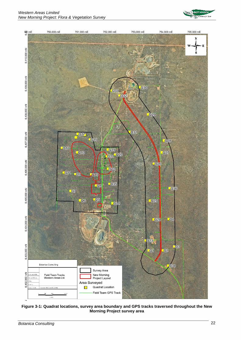
by two people via 4WD, all-terrain vehicle, and on foot (Figure 3-1).
Western Areas Limited New Morning Project: Flora & Vegetation Survey
Botanica Consulting 22
Figure 3-1: Quadrat locations, survey area boundary and GPS tracks traversed throughout the New Morning Project survey area

Western Areas Limited New Morning Project: Flora & Vegetation Survey
Botanica Consulting 23
3.2.1 Sampling Quadrats
Thirty-six 20m x 20m quadrats were established within the survey area (Figure 3-1). The objective
was to have at least three quadrats per vegetation type to capture the floristic variations within the
survey area. The quadrats were established by inserting metal pickets into the NW corner, and
measuring the length of the resultant boundaries to verify the quadrats were 20m x 20m (square
quadrats).
Following their establishment and boundary verification, the location of each quadrat was recorded
by GPS (Appendix 5) photographed (Appendix 7) and all vascular plants within the quadrat were
recorded (Appendix 6). This included recording of dominant taxa from the upper, middle and lower
stratum, and sampling of all unknown taxa. Unknown taxa were identified using BC’s own reference
herbarium and relevant taxonomical keys or by a taxonomic consultant. Data on level of disturbance,
presence of coarse fragments on surface, topographical position, elevation, aspect, percentage litter,
percentage bare ground, percentage surface rock (bedrock and surface deposits), soil types (colour,
profile, field texture and surface type), and vegetation structure were collected from each quadrat
(Appendix 6). Methods of recording data from these quadrats largely follow those outlined in CSIRO’s
Australian Soil and Land Survey Field Handbook (McDonald et al. 1998) and in accordance with EPA
Guidelines (2016).
3.2.2 Targeted Flora Survey
A targeted search for flora of conservation significance (Priority and Threatened Flora) was conducted
within the New Morning Project footprint (covering an area of ~147 ha). The footprint was
systematically searched on foot by two Botanica staff members to identify and record the locations of
Threatened and Priority Flora. All locations of Threatened and Priority Flora were recorded using a
hand-held GPS and a simple plant count (not differentiated between juvenile/ mature plants, flowering
or non-flowering plants) was conducted for each record.
3.2.3 Personnel involved
Jim Williams - Environmental Consultant/ Director (Diploma of Horticulture)
Lauren Pick - Environmental Consultant (BSc Zoology & Conservation Biology)
3.2.4 Scientific licences
Table 3-3: Scientific Licences of Botanica Staff coordinating the survey
Licensed staff Permit Number Valid Until
Jim Williams SL012391 (Licence to flora for scientific purposes) 26/05/2018 to 27/05/2019
Lauren Pick SL012392 (Licence to flora for scientific purposes) 26/05/2018 to 27/05/2019
3.3 Data Analysis Tools
Once the survey was completed the data obtained was analysed to generate a vegetation map. The
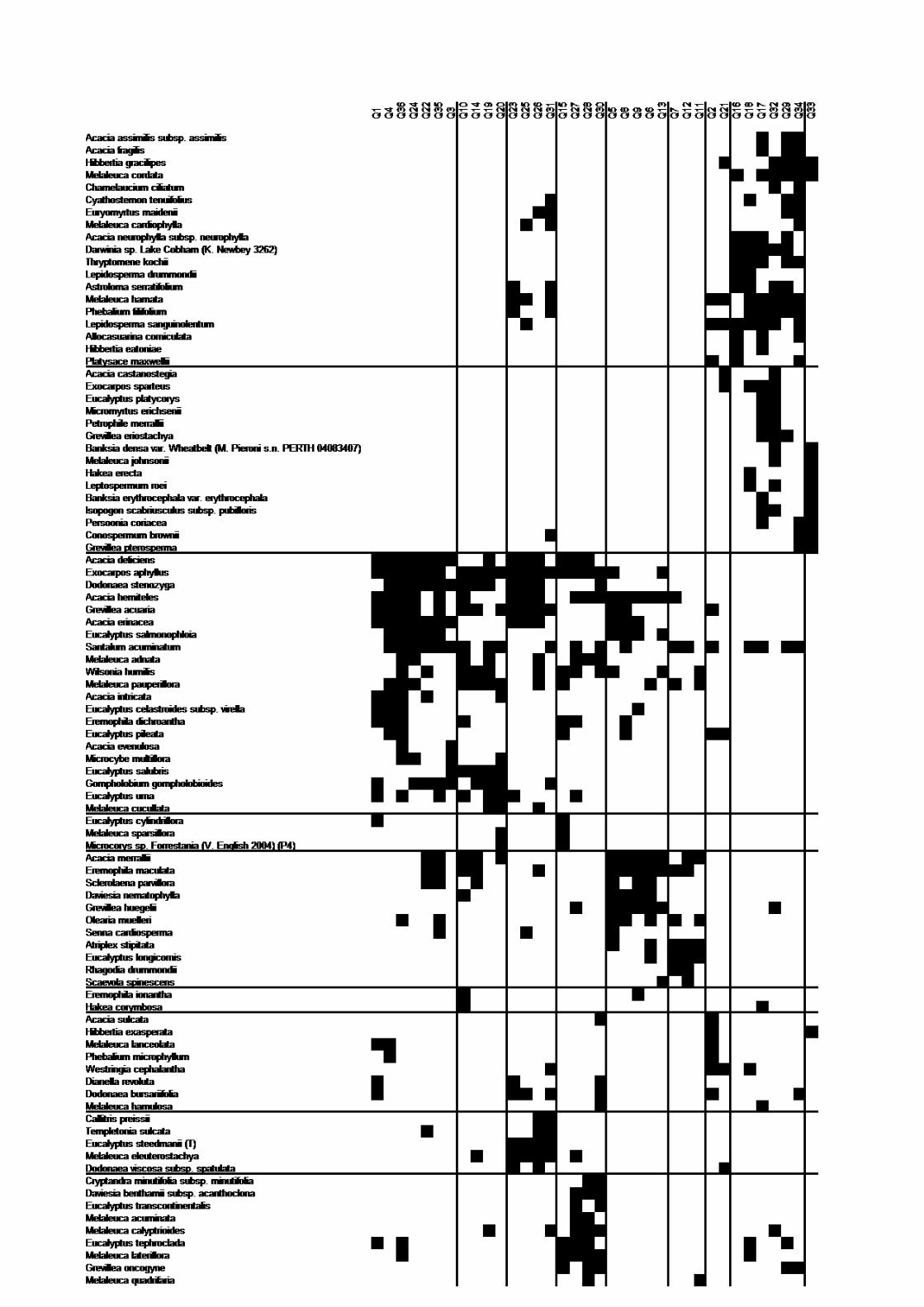
statistical program PATN was used to assess species composition of the quadrats (Appendix 8).
3.3.1 PATN Analysis
The PATN software package was used to assess the similarities/ dissimilarities between quadrats
based on presence/ absence of species. Annual taxa were removed from the data prior to analysis
(total of seven annual taxa). Species reconciliation eliminated those sterile taxa that could not be fully

Western Areas Limited New Morning Project: Flora & Vegetation Survey
Botanica Consulting 24
identified from the analysis (eleven taxa), and reconciled subsp. and/or variant taxa (two taxa).
Singleton taxa were excluded from the analysis (56 taxa). Of the 167 taxa recorded within the
quadrats, 93 taxa were used in the analysis.
The analysis produced a quantitative estimate of the relationship between species composition of
each quadrat. The classifications were based upon a Bray-Curtis association matrix using a flexible
Unweighted Pair Group Arithmetic Mean (UPGMA) method (with a beta value of -0.1) which
standardises the data enabling the analysis to be completed. Semi-strong hybrid (SSH) ordination of
the quadrat is then undertaken to show spatial relationships between groups and to elucidate possible
environmental correlates with the classification.
The analysis also produced a stress value which is a measure of the ‘strength’ of the analysis (i.e.
how well the quadrats are grouped together into the appropriate floristic groups). The lower the stress
value the greater the strength of the analysis with a value of less than 0.3 showing that the analysis
appropriately grouped quadrats. A stress value greater than 0.3 suggests that the analysis was
unable to group quadrats appropriately due to extraneous variables (i.e. other factors influencing
differences in floristic groups other than species composition e.g. fire, clearing disturbance etc.).
3.3.2 EstimateS
EstimateS software was used to estimate species richness present using the Chao2 richness
estimator. For any number of samples, the estimator uses the existing pattern of species
accumulation to estimate the true number of species at a site. The estimators tend to under-estimate
species number when sample size is small, hence the estimated number of true species can be seen
to increase with sample size. This software was also used to compute Coleman rarefaction curves
estimates which were used to calculate species accumulation curves.
3.4 Flora survey limitations and constraints
It is important to note that flora surveys will entail limitations notwithstanding careful planning and
design. Potential limitations are listed in Table 3-4.
Table 3-4: Limitations and constraints associated with the flora and vegetation survey
Variable Potential Impact
on Survey Details
Access problems Not a constraint The survey was conducted via 4WD and on foot. Numerous tracks were located within the survey area, providing ease of access.
Competency/ Experience
Not a constraint
The BC personnel that conducted the survey were regarded as suitably qualified and experienced. Coordinating Botanist: Jim Williams Field Staff: Jim Williams, and Lauren Pick Data Interpretation: Jim Williams and Lauren Pick
Timing of survey, weather & season
Not a constraint
Fieldwork was conducted in late August 2018 consistent with the EPA recommended approximate timing (Spring). Majority of the flora was in flower, annual species were present and short-lived species such as Orchids were also present during the survey. Supplementary fieldwork should be scheduled after Autumn rains in accordance with EPA guidelines.
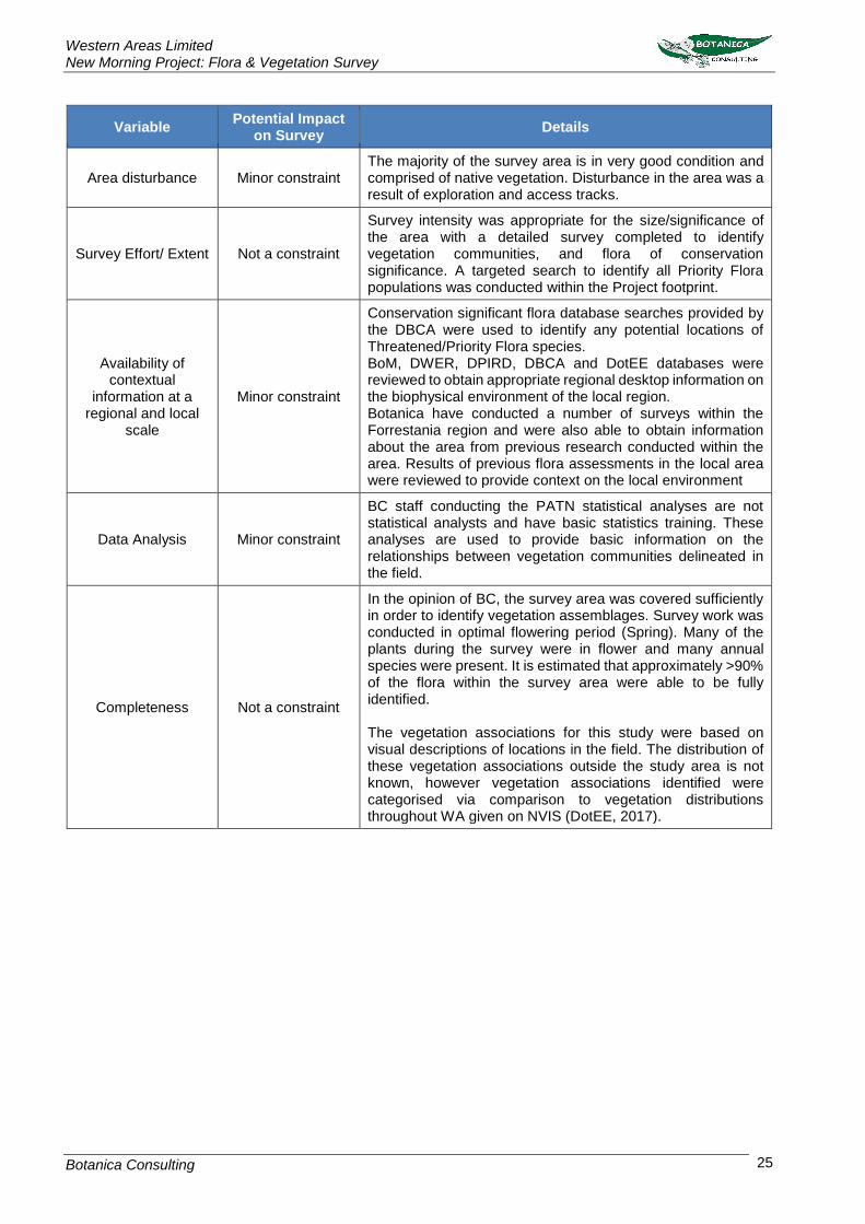
Western Areas Limited New Morning Project: Flora & Vegetation Survey
Botanica Consulting 25
Variable Potential Impact
on Survey Details
Area disturbance Minor constraint The majority of the survey area is in very good condition and comprised of native vegetation. Disturbance in the area was a result of exploration and access tracks.
Survey Effort/ Extent Not a constraint
Survey intensity was appropriate for the size/significance of the area with a detailed survey completed to identify vegetation communities, and flora of conservation significance. A targeted search to identify all Priority Flora populations was conducted within the Project footprint.
Availability of contextual
information at a regional and local
scale
Minor constraint
Conservation significant flora database searches provided by the DBCA were used to identify any potential locations of Threatened/Priority Flora species. BoM, DWER, DPIRD, DBCA and DotEE databases were reviewed to obtain appropriate regional desktop information on the biophysical environment of the local region. Botanica have conducted a number of surveys within the Forrestania region and were also able to obtain information about the area from previous research conducted within the area. Results of previous flora assessments in the local area were reviewed to provide context on the local environment
Data Analysis Minor constraint
BC staff conducting the PATN statistical analyses are not statistical analysts and have basic statistics training. These analyses are used to provide basic information on the relationships between vegetation communities delineated in the field.
Completeness Not a constraint
In the opinion of BC, the survey area was covered sufficiently in order to identify vegetation assemblages. Survey work was conducted in optimal flowering period (Spring). Many of the plants during the survey were in flower and many annual species were present. It is estimated that approximately >90% of the flora within the survey area were able to be fully identified. The vegetation associations for this study were based on visual descriptions of locations in the field. The distribution of these vegetation associations outside the study area is not known, however vegetation associations identified were categorised via comparison to vegetation distributions throughout WA given on NVIS (DotEE, 2017).

Western Areas Limited New Morning Project: Flora & Vegetation Survey
Botanica Consulting 26
4 Results
4.1 Desktop Assessment
4.1.1 Literature Review
Flora and vegetation surveys, assessments and reviews have been undertaken in nearby areas in
the past, though not all are publicly available and some could not be referenced. The most significant
of those available have been used as the primary reference material for the current vegetation
assessment (Table 4-1).
Table 4-1: Previous Flora and Vegetation Surveys within the New Morning Project and surrounding area
Author & Year Vegetation Flora of Conservation
Significance
Newbey & Hnatiuk, (1988)
Between July 1979 and October 1981, a biological survey of the Lake Johnston-Hyden region covering approximately 20,300km² was conducted. Nine vegetation systems of the Study Area and, when broadly classified, represented 51 vegetation associations. Seven unique vegetation associations and a further five that were rare both within the Study Area and Eastern Goldfields were recorded. Specialised vegetation mosaics were recorded on the banded ironstone formation of Bremer Range, North Ironcap, Middle Ironcap and South Ironcap (the greenstone belt from Hatters Hill to Mt Holland), and on the granites of 1eak Charles and Peak Eleanora. Woodlands (15-20 m) were scattered on Broad Valleys, Salt Lake Features and Sandplains. Low woodlands «15 m) dominated Undulating Plains (greenstone) and Broad Valleys. They were scattered on Hills (granite) and present on some of the larger Granite Exposures with substantial run-off. Mallees (3-6 m) were common on Sandplains and Broad Valleys, and scattered on Hills (granite), Salt Lake Features and larger Granite Exposures. Tall shrublands (> 1 m) dominated on Hills (granite), were common on Sandplains, and scattered on Salt Lake Features and Hills (banded ironstone formation). Salt Lake Features were the main areas for low shrublands «1 m) with scattered occurrences on Sandplains. Complexes were common on Breakaways, Granite Exposures, Hills (granite and banded ironstone formation) but rare on Undulating Plains (greenstone). The vascular flora comprised 1076 species, 17 subspecies and 29 varieties of flowering plants and six species of fern. Twenty new species, 79 rarely collected species, of which 39 were endemic to the area, and 14 major range extensions were recorded in the Study Area.
Banksia sphaerocarpa var. dolichostyla (T)
Gibson (2004)
Gibson conducted a study of the flora and plant communities of part of Forrestania greenstone belt between Middle Ironcap and Hatter Hill (some 80 km ESE of Hyden). The study recorded a total flora of 345 taxa of which 342 were native and three were introduced. Three species of threatened flora and 29 taxa being considered for listing were found. Ten species are considered to be endemic to the range and a further eight species are restricted to similar landforms within 100 km of the range. Four community types were identified; Community 1- Species-rich shrublands or mallee shrublands on skeletal soils derived from banded ironstone and the massive laterites Community 2- Mallee shrublands or Allocasuarina thickets primarily found on massive laterites.
Acacia heterochroa subsp robertii
(P2)
Acacia singula (P3)
Acacia tetraneura (P1)
Banksia rufa subsp. flavescens
(P3)
Banksia sphaerocarpa var
dolichostyla (T)
Banksia viscida (P3)
Bentleya diminuta (P2)
Boronia revolute (T)
Calamphoreus inflatus (P4)
Eremophila racemosa (P4)
Eucalyptus exigua (P3)

Western Areas Limited New Morning Project: Flora & Vegetation Survey
Botanica Consulting 27
Author & Year Vegetation Flora of Conservation
Significance
Community 3- Eucalypt woodlands dominated or co-dominated by Eucalyptus urna and E. salubris occurring on the colluvial deposits on the flats below the outcrops or on the broad flat ridges along the range generally with an understorey dominated by Melaleuca spp. Community 4- species poor mallee community generally dominated by Eucalyptus calycogona with large emergent Eucalyptus salmonophloia on small colluvial flats
Eucalyptus georgei subsp fulgida
(P4)
Eucalyptus rugulata (P4)
Eutaxia acanthoclada (P3)
Grevillea insignis subsp elliotii (P3)
Grevillea lullfitzii (P1)
Hibbertia axillibarba (P1)
Hibbertia carinata (P1)
Leucopogon marginatus (T)
Leucopogon sp Ironcaps (N
Gibson & K Brown 3070) (P3)
Melaleuca agathosmoides (P1)
Microcybe pauciflora subsp
grandis (P1)
Mirbelia densiflora (P3)
Orianthera exilis (P2)
Phebalium brachycalyx (P3)
Stenanthemum liberum (P1)
Stylidium sejunctum (P3)
JSWT (2006a)
Jim’s Seeds, Weeds and Trees (JSWT) was commissioned by WSA to undertake a Level 1 flora and vegetation survey of the North Flying Fox proposed drill lines, located approximately 80km east of Hyden. The survey was conducted on the 1st and 2nd February 2006, covering an area of approximately 17ha. Two vegetation communities were identified in the survey area; Eucalyptus mallee woodland and sandplain heath. These vegetation communities were represented by a total of 22 Families, 42 Genera and 81 Species (including sub-species and variants).
No flora of conservation significance
JSWT (2006b)
JSWT was commissioned by WSA to undertake a Level 1 flora and vegetation survey of the North Flying Fox proposed drill lines, located approximately 100km east of Hyden. The survey was conducted on the 12th April 2005, covering an area of approximately 4.2ha. Two vegetation communities were identified in the survey area; Eucalyptus mallee woodland and sandplain heath. These vegetation communities were represented by a total of 17 Families, 36 Genera and 69 Species (including sub-species and variants).
Verticordia mitodes (P3)
JSWT (2006c)
JSWT was commissioned by WSA to undertake a Level 1 flora and vegetation survey of three proposed monitoring bore sites, located approximately 80km east of Hyden. The survey was conducted on the 10th April 2006, covering an area of approximately 1.24ha. Two vegetation communities were identified in the survey area; Eucalyptus salmonophloia woodland and Acacia heath. These vegetation communities were represented by a total of 19 Families, 31 Genera and 53 Species (including sub-species and variants).
Microcorys sp. Forrestania (V. English, 2004) (P4).
Botanica (2006)
Botanica was commissioned by WSA to undertake a Level 1 flora and vegetation survey of the Flying Fox North East Area, located approximately 80km east of Hyden. The survey was conducted from the 29th to the 30th October 2006, covering an area of approximately 329.8ha. Four vegetation communities were identified in the survey area; Eucalyptus salmonophloia woodland, Eucalyptus
Microcorys sp. Forrestania (V. English, 2004) (P4) Boronia westringioides (P2) Baeckea sp. North Ironcap (P2) and Daviesia elongata subsp. implexa (P3)

Western Areas Limited New Morning Project: Flora & Vegetation Survey
Botanica Consulting 28
Author & Year Vegetation Flora of Conservation
Significance
mallee woodlands, Sandplain Heath and Kwongan vegetation. These vegetation communities were represented by a total of 26 Families, 54 Genera and 132 Species (including sub-species and variants).
Botanica (2007a)
Botanica was commissioned by WSA to undertake a Level 1 flora and vegetation survey at the Flying Fox mine site, located approximately 80km east of Hyden. The survey was conducted on the 1st June 2007, covering an area of approximately 46ha. Two vegetation communities were identified in the survey area; Eucalyptus mallee woodland and sandplain heath. These vegetation communities were represented by a total of 20 Families, 24 Genera and 34 Species (including sub-species and variants).
Daviesia elongata subsp. implexa (P3).
Botanica (2007b)
Botanica was commissioned by WSA to undertake a Level 1 flora and vegetation survey at the Flying Fox mine site, located approximately 80km east of Hyden. The survey was conducted on the 8th October 2007, covering an area of approximately 247.83ha. Three vegetation communities were identified in the survey area; Eucalyptus mallee woodland, Sandplain Heath and Rehabilitation vegetation. These vegetation communities were represented by a total of 24 Families, 47 Genera and 106 Species (including sub-species and variants).
Microcorys sp. Forrestania (V. English, 2004) (P4).
Botanica (2017)
Botanica was commissioned by WSA to undertake a reconnaissance flora and vegetation survey of the Greater New Morning/Spotted Quoll area. The survey was conducted in October 2017 covering an area of 1,674 ha. A total of eleven vegetation types were identified within the survey area: 1. Low woodland of Eucalyptus flocktoniae/Eucalyptus salubris/Eucalyptus urna over low scrub of mixed Acacia and Melaleuca;
2. Open shrub mallee of Eucalyptus celastroides/Eucalyptus cylindrocarpa/Eucalyptus eremophila over low scrub of
mixed Acacia and Melaleuca;
3. Low woodland of Eucalyptus salmonophloia over low scrub of mixed Melaleuca;
4. Heath of mixed Acacia, Allocasuarina and Melaleuca;
5. Low woodland of Eucalyptus calycogona/Eucalyptus pileata over low scrub of Acacia hemiteles/Melaleuca hamata on rocky outcrop;
6. Mallee of Eucalyptus eremophila/Eucalyptus steedmanii over mixed dwarf scrub;
7. Heath of Acacia steedmanii subsp. steedmanii/Melaleuca hamata over mixed low scrub;
8. Low scrub of mixed Allocasuarina over mixed dwarf scrub;
9. Open tree mallee of Eucalyptus eremophila over scrub of
Melaleuca hamata on stony rise;
10. Burnt open low woodland of Eucalyptus salmonophloia over shrub mallee of Eucalyptus cylindrocarpa/Eucalyptus pileata and mixed low heath (including sub-community Heath of Melaleuca hamata); and
11. Forest of Eucalyptus urna over low scrub of Melaleuca pauperiflora subsp. pauperiflora. These eleven vegetation types were represented by a total of 29 Families, 74 Genera and 205 Species (including sub-species and variants).
Eucalyptus steedmanii (T) Eremophila racemosa (P4) Eutaxia acanthoclada (P3) Microcorys sp. Forrestania (V. English 2004) Stylidium sejunctum (P3).
Western Areas Limited New Morning Project: Flora & Vegetation Survey
Botanica Consulting 29
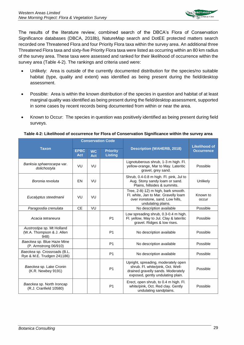
The results of the literature review, combined search of the DBCA’s Flora of Conservation
Significance databases (DBCA, 2018b), NatureMap search and DotEE protected matters search
recorded one Threatened Flora and four Priority Flora taxa within the survey area. An additional three
Threatened Flora taxa and sixty-five Priority Flora taxa were listed as occurring within an 80 km radius
of the survey area. These taxa were assessed and ranked for their likelihood of occurrence within the
survey area (Table 4-2). The rankings and criteria used were:
• Unlikely: Area is outside of the currently documented distribution for the species/no suitable
habitat (type, quality and extent) was identified as being present during the field/desktop
assessment.
• Possible: Area is within the known distribution of the species in question and habitat of at least
marginal quality was identified as being present during the field/desktop assessment, supported
in some cases by recent records being documented from within or near the area.
• Known to Occur: The species in question was positively identified as being present during field
surveys.
Table 4-2: Likelihood of occurrence for Flora of Conservation Significance within the survey area
Taxon
Conservation Code
Description (WAHERB, 2018) Likelihood of Occurrence EPBC
Act WC Act
Priority Listing
Banksia sphaerocarpa var. dolichostyla
VU VU
Lignotuberous shrub, 1-3 m high. Fl. yellow-orange, Mar to May. Lateritic
gravel, grey sand. Possible
Boronia revoluta EN VU
Shrub, 0.4-0.8 m high. Fl. pink, Jul to Aug. Stony sandy loam or sand.
Plains, hillsides & summits. Unlikely
Eucalyptus steedmanii VU VU
Tree, 2-8(-12) m high, bark smooth. Fl. white, Jan to Mar. Gravelly loam
over ironstone, sand. Low hills, undulating plains.
Known to occur
Paragoodia crenulata CE VU No description available Possible
Acacia tetraneura
P1 Low spreading shrub, 0.3-0.4 m high. Fl. yellow, May to Jul. Clay & lateritic
gravel. Ridges & low rises. Possible
Austrostipa sp. Mt Holland (W.A. Thompson & J. Allen
948)
P1 No description available Possible
Baeckea sp. Blue Haze Mine (P. Armstrong 06/910)
P1 No description available Possible
Baeckea sp. Crossroads (B.L. Rye & M.E. Trudgen 241186)
P1 No description available Possible
Baeckea sp. Lake Cronin (K.R. Newbey 9191)
P1
Upright, spreading, moderately open shrub. Fl. white/pink, Oct. Well-
drained gravelly sands. Moderately exposed, gently undulating plain.
Possible
Baeckea sp. North Ironcap (R.J. Cranfield 10580)
P1 Erect, open shrub, to 0.4 m high. Fl.
white/pink, Oct. Red clay. Gently undulating sandplains.
Possible

Western Areas Limited New Morning Project: Flora & Vegetation Survey
Botanica Consulting 30
Taxon
Conservation Code
Description (WAHERB, 2018) Likelihood of Occurrence EPBC
Act WC Act
Priority Listing
Brachyloma nguba
P1
Erect, compact to spreading, mid-dense shrub, to 0.8 m high, leaves discolorous, usually 2-3 mm long;
style 0.2-0.25 mm long; disc truncate. Fl. red, Apr to May. White to brown sandy clay, shallow sandy
loam. Open mallee woodland, mallee scrub, flat plains.
Possible
Dampiera scaevolina
P1 Erect to ascending perennial, herb or shrub, 0.2-0.5 m high. Fl. blue/white, Sep to Nov. Sandy & gravelly soils.
Possible
Eucalyptus myriadena subsp. parviflora
P1
Mallee or tree, 3-10 m high, bark rough, coarse & flaky on trunk, smooth above. Loam. Swamps,
plains.
Unlikely
Gastrolobium tenue
P1
Low, bushy shrub, to 0.6 m high. Fl. Orange & red & purple, Sep to Oct.
Yellow sand or sandy clay. Undulating dunes, stony outcrops.
Unlikely
Gnephosis intonsa
P1
Prostrate to ascending annual, herb, 0.01-0.04 m high. Fl. yellow-brown, Sep to Oct. Red/brown clay, stony
saline loam.
Unlikely
Hemigenia sp. Newdegate (E. Bishop 75)
P1
Spindly, erect to spreading shrub, 0.2-0.45 m high, to 0.5 m wide. Fl. blue/purple, Sep to Oct. Clay loam.
Disturbed sites.
Possible
Hibbertia axillibarba
P1 Shrub, to 0.7 m high. Fl. yellow, Sep
to Oct. Lateritic soil. Ranges. Possible
Lepidosperma amantiferrum
P1
Tufted rhizomatous, herb (sedge), leaves 0.15-0.42 m high, culms and
leaves distichous. Yellow sandy loam with banded ironstone gravel and
rocks. Gentle lower slopes.
Possible
Lepidosperma ferriculmen
P1
Tufted rhizomatous, perennial, herb (sedge), leaves 0.16-0.38 m high, culms and leaves distichous. Well-
drained orange-red sandy loam with banded ironstone gravel and rocks.
Stony slopes.
Possible
Scaevola tortuosa
P1 Ascending perennial, herb, 0.1-0.2 m high. Fl. blue-purple/pink, Oct. Sandy
clay. Margins of salt lakes. Unlikely
Stenanthemum liberum
P1 Dwarf shrub, ca 0.5 m high. Yellow
sandy loam over laterite. Possible
Stylidium validum
P1
Caespitose perennial, herb, 0.06-0.3 m high, Leaves tufted, oblanceolate, 1.5-10 cm long, 2.2-6 mm wide, apex
acute to acuminate, margin entire, glabrous, glaucous. Scape glabrous.
Inflorescence paniculate. Fl. white/pink, Sep to Oct. Clayey sand
or loam, ironstone, greenstone gravel. Hillslopes and hilltops.
Eucalypt woodland, mallee shrubland.
Possible
Teucrium sp. dwarf (R. Davis 8813)
P1
Compact, dwarf shrub, 0.1 m high, to 0.1 m wide. Fl. white, Apr. Hills, road
verges. Possible

Western Areas Limited New Morning Project: Flora & Vegetation Survey
Botanica Consulting 31
Taxon
Conservation Code
Description (WAHERB, 2018) Likelihood of Occurrence EPBC
Act WC Act
Priority Listing
Acacia asepala
P2
Diffuse, much-branched shrub, 0.5-1.5 m high. Fl. yellow, Aug. Red-brown sandy loam. Undulating plains, along drainage lines.
Possible
Acacia kerryana
P2
Low, spreading, domed shrub, 0.3-1 m high. Fl. yellow, Oct to Dec or Jan to Feb. Granitic loamy sand, stony clayey loam or clayey sand. Low stony ridges, undulating plains.
Possible
Bentleya diminuta
P2
Rosetted rhizomatous, perennial, herb or shrub, 0.02-0.05 m high,
growing in small colonies. Fl. white/yellow-green, Sep to Nov.
Sandy clay or loam with calcareous nodules.
Unlikely
Boronia westringioides
P2 Erect shrub, 0.2-0.75 m high. Fl.
pink, Jul to Sep. Loamy sand. Plains. Possible
Conospermum sigmoideum
P2 Erect shrub, 0.2-0.5 m high. Fl. blue,
Aug to Sep. Yellow sand. Unlikely
Guichenotia asteriskos
P2 Erect, compact shrub, ca 0.35 m high. Fl. white, Sep to Oct. Sandy
clay or loam with gravel. Possible
Olearia laciniifolia
P2
Erect, few-stemmed shrub, 0.6-1.2 m high. Fl. blue/purple & white/yellow,
May to Sep. White sand. Around playa lakes.
Unlikely
Verticordia multiflora subsp. solox
P2
Erect to spreading shrub, 0.2-0.6 m high. Fl. yellow, Oct to Dec or Jan. Yellow sand over gravel, sand over
granite.
Unlikely
Acacia rependa
P3
Rounded to obconic, single-stemmed or much-branched shrub, 0.5-2 m high, bark 'minni-ritchi'. Fl. yellow,
Jun to Aug. Loam, sandy or gravelly loam. Near granite outcrops.
Unlikely
Baeckea sp. Hatter Hill (K.R. Newbey 3284)
P3
Narrow, open, upright shrub, to 1.3 m high. Fl. pink, Jun to Oct. Yellow-orange coarse sandy loam with
laterite gravel, red-brown sandy loam with quartz pebbles. Undulating
plains.
Possible
Baeckea sp. Parker Range (M. Hislop & F. Hort MH
2968)
P3
Straggly, erect shrub, to 1.5 m high. Fl. pink, Jun. Yellow to orange sandy
loam with laterite gravel. Gently undulating sandplains, low ridges,
road verges.
Possible
Banksia viscida
P3
Densely branched, non-lignotuberous shrub, 0.4-1 m high. Fl.
yellow-orange, Jul to Oct. Gravelly soils. Lateritic rises.
Possible
Comesperma calcicola
P3
Soft perennial, herb, to 0.3 m high. Fl. pink, Oct to Dec or Jan.
Calcareous or semi-saline clay loams, limestone. Areas around
saline water.
Unlikely
Cryptandra polyclada subsp. polyclada
P3 Mat-forming or upright shrub, 0.1-0.7 m high. Fl. white/cream, Jan to May
or Aug or Oct. Sand. Sandplains. Possible

Western Areas Limited New Morning Project: Flora & Vegetation Survey
Botanica Consulting 32
Taxon
Conservation Code
Description (WAHERB, 2018) Likelihood of Occurrence EPBC
Act WC Act
Priority Listing
Daviesia elongata subsp. implexa
P3
Spreading or sprawling shrub, 0.4-1 m high. Fl. yellow/orange & red, Sep.
Sand & laterite. Possible
Daviesia implexa P3 No description available Possible
Elatine macrocalyx
P3
Prostrate, glabrous, mat-forming annual, herb, sepals 2-3mm long, fruit indehiscent. Fl. white, May to
Oct (probably opportunistic). Shallow sands over clay. Margins of playa
lakes and clay pans.
Unlikely
Eucalyptus exigua
P3 Mallee, 2-5 m high, bark smooth. Fl. white-cream, Mar. Sandy loam, white
sand. Sandplains. Unlikely
Eutaxia acanthoclada
P3
Compact, mat-forming, prostrate shrub, to 0.3 m high. Fl.
yellow/orange/red, Oct to Nov. Light brown sandy clay, shallow sandy
loam, red clay over banded ironstone, gravel. Gently undulating
plains.
Known to occur
Eutaxia nanophylla
P3
Straggly, rounded shrub, to 0.35 m high. Fl. Yellow & orange & red, Oct
to Nov. Clayey sand, red clay, stoney clayey loam. Low-lying areas, damp flats, slopes, undulating plains, low
stony ridges.
Possible
Eutaxia rubricarina
P3
Straggling shrub, to 0.5 m high. Fl. Orange & yellow & brown, Aug or
Oct. Gravelly sand, grey to pinkish-white sandy clay, red loam. Flats, slopes, valley floors, road verges.
Possible
Frankenia drummondii
P3 Prostrate shrub. Fl. white. Sand.
Lake edges. Unlikely
Grevillea insignis subsp. elliotii
P3
Erect, bushy, non-lignotuberous shrub, 1-2 m high. Fl. red/pink &
cream & white, Oct. Gravelly sand or loam over ironstone. Hilltops or rises.
Possible
Grevillea pilosa subsp. redacta
P3
Spreading to prostrate, non-lignotuberous shrub, 0.4-1.2 m high.
Fl. red, Feb or Oct or Dec. Sand, laterite.
Possible
Hibbertia pachyphylla
P3
Shrub, to 0.5 m high. Fl. yellow, Sep to Nov. White to yellow sand, brown sandy gravel, gravelly loam, laterite, granite, quartz. Undulating plains,
low rises, valley floors.
Possible
Isolepis australiensis
P3
Annual, grass-like or herb (sedge), 0.03-0.055 m high, glumes 0.8-1.2
mm long; stamens 1(-2); style branches 3; nut with abaxial angle acute. Fl. Jun or Sep. Silty sand, sandy clay. Lake margins, pools.
Unlikely
Keraudrenia adenogyna
P3 Erect shrub, ca 0.4 m high. Fl.
purple-blue, Sep. Heavy loamy clay, loamy gravelly soils. Low-lying area.
Unlikely
Melaleuca macronychia subsp. trygonoides
P3
Multi-stemmed, spreading shrub, 1-4 m high, leaves broadly elliptic. Fl.
red, Feb or Jul to Aug or Oct. Sandy soils. Granite outcrops.
Unlikely

Western Areas Limited New Morning Project: Flora & Vegetation Survey
Botanica Consulting 33
Taxon
Conservation Code
Description (WAHERB, 2018) Likelihood of Occurrence EPBC
Act WC Act
Priority Listing
Mirbelia densiflora
P3
Erect or straggling shrub, 0.2-1 m high. Fl. yellow-orange, Oct or Jan.
Stony loam, loamy sand. Small ridges, breakaways, undulating
plains.
Unlikely
Notisia intonsa P3 No description available Possible
Oxymyrrhine plicata P3 No description available Possible
Pityrodia scabra subsp. dendrotricha
P3 No description available Possible
Pityrodia sp. Yilgarn (A.P. Brown 2679)
P3 No description available Possible
Pultenaea daena
P3
Dense, prostrate, domed shrub, to 0.07 m high. Fl. yellow, Mar. White to yellow sand or sandy loam, sandy or
loamy clay, gravel, limestone, dolomite, laterite. Gently undulating
plains, adjacent to salt lakes, in disturbed areas.
Unlikely
Rinzia torquata P3 No description available Possible
Rinzia triplex P3 No description available Possible
Seringia adenogyna P3 No description available Possible
Stylidium sejunctum
P3
Caespitose perennial, herb, 0.25-0.45 m high, Leaves tufted, linear to
narrowly oblanceolate, 10-30 cm long, 0.8-4 mm wide, apex acute to
mucronate, margin involute, glabrous to scabrous. Membraneous scale leaves present at base of mature
leaves. Scape glandular throughout. Inflorescence paniculate. Fl.
white/pink-purple, Sep to Nov. Clayey sand or loam, laterite.
Outcrops, upper slopes, breakaways. Mallee and Allocasuarina shrubland.
Known to occur
Verticordia gracilis
P3 Low, slender shrub, 0.15-0.6 m high.
Fl. pink, Oct to Nov. Yellow sand, gravelly sand, sandy loam.
Possible
Verticordia stenopetala
P3
Shrub, 0.2-0.6(-1.3) m high. Fl. pink/pink-purple-red, Oct to Dec or Jan. Yellow sand, sometimes with
gravel. Undulating plains.
Possible
Calamphoreus inflatus
P4
Erect, spreading shrub, 0.4-1.6 m high, to 2 m wide. Fl. blue-
purple/green, Oct to Dec or Feb to Mar. Clay loam with ironstone gravel.
Flats, disturbed sites.
Possible
Eremophila biserrata
P4
Prostrate shrub, to 3 m wide. Fl. green/yellow-green, Sep to Nov or
Mar. Sandy or sandy clay soils. Alluvial flats, salt flats & lakes.
Unlikely
Eremophila racemosa
P4
Erect shrub, 0.5-1.7 m high. Fl. purple-pink-red/white, Mar or Aug to Dec. Sandy or stony loam, clay loam.
Undulating plains, roadsides.
Known to occur
Eucalyptus cerasiformis
P4 Mallee, 2-3.5 m high, bark smooth,
grey to brown. Fl. yellow, Dec or Jan to Mar. Red loamy soils.
Possible
Eucalyptus georgei subsp. fulgida
P4 Tree, 4-20 m high, bark smooth,
often hanging in ribbons. Fl. cream-Unlikely

Western Areas Limited New Morning Project: Flora & Vegetation Survey
Botanica Consulting 34
Taxon
Conservation Code
Description (WAHERB, 2018) Likelihood of Occurrence EPBC
Act WC Act
Priority Listing
white. Sandy loam, clayey sand. Slight depressions.
Grevillea prostrata
P4
Loose, prostrate shrub, 0.04-0.1 m high, 0.8-1.2 m wide. Fl. cream-
white/pink-red, Aug to Dec or Jan. White, grey or yellow sand, gravel.
Sandplains.
Possible
Gyrostemon ditrigynus
P4 Shrub, 0.4-1.5 m high. Sand, sandy
clay, loam. Plains, low ironstone ridges.
Possible
Haegiela tatei
P4
Ascending to erect annual, herb, 0.02-0.08(-0.2) m high. Fl. white-yellow, Aug to Nov. Clay, sandy loam, gypsum. Saline habitats.
Unlikely
Lepidosperma lyonsii
P4
Tufted rhizomatous, perennial, herb (sedge), leaves 0.31-0.53 m high, culms and leaves distichous. Pale orange skeletal sandy loam with
banded ironstone gravel & rock, well-drained shallow stony loamy with quartz. Gentle hill slopes, upper
slopes of large hill.
Possible
Microcorys sp. Forrestania (V. English 2004)
P4
Prostrate or erect shrub, 0.35-0.4 m high. Fl. white/purple, Jan or Apr.
Yellow sandy clay or red-brown clay. Open woodland or cleared areas.
Known to occur
4.2 Field Assessment
4.2.1 Vegetation Associations
Nine vegetation associations were identified within the survey area. These vegetation associations
were located within four different landform types and comprised three major vegetation groups, and
were represented by a total of 38 Families, 98 Genera and 280 Taxa (including 12 annual taxa)

Western Areas Limited New Morning Project: Flora & Vegetation Survey
Botanica Consulting 35
(Appendix 2). A map showing the vegetation associations present in the survey area is located in
Figure 4-1 and a summary of vegetation associations is presented in Table 4-3.
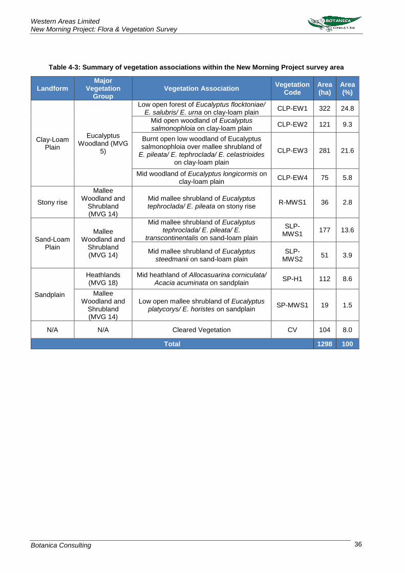
Western Areas Limited New Morning Project: Flora & Vegetation Survey
Botanica Consulting 36
Table 4-3: Summary of vegetation associations within the New Morning Project survey area
Landform Major
Vegetation Group
Vegetation Association Vegetation
Code Area (ha)
Area (%)
Clay-Loam Plain
Eucalyptus Woodland (MVG
5)
Low open forest of Eucalyptus flocktoniae/ E. salubris/ E. urna on clay-loam plain
CLP-EW1 322 24.8
Mid open woodland of Eucalyptus salmonophloia on clay-loam plain
CLP-EW2 121 9.3
Burnt open low woodland of Eucalyptus salmonophloia over mallee shrubland of
E. pileata/ E. tephroclada/ E. celastrioides on clay-loam plain
CLP-EW3 281 21.6
Mid woodland of Eucalyptus longicormis on clay-loam plain
CLP-EW4 75 5.8
Stony rise
Mallee Woodland and
Shrubland (MVG 14)
Mid mallee shrubland of Eucalyptus tephroclada/ E. pileata on stony rise
R-MWS1 36 2.8
Sand-Loam Plain
Mallee Woodland and
Shrubland (MVG 14)
Mid mallee shrubland of Eucalyptus tephroclada/ E. pileata/ E.
transcontinentalis on sand-loam plain
SLP-MWS1
177 13.6
Mid mallee shrubland of Eucalyptus steedmanii on sand-loam plain
SLP-MWS2
51 3.9
Sandplain
Heathlands (MVG 18)
Mid heathland of Allocasuarina corniculata/ Acacia acuminata on sandplain
SP-H1 112 8.6
Mallee Woodland and
Shrubland (MVG 14)
Low open mallee shrubland of Eucalyptus platycorys/ E. horistes on sandplain
SP-MWS1 19 1.5
N/A N/A Cleared Vegetation CV 104 8.0
Total 1298 100

Western Areas Limited New Morning Project: Flora & Vegetation Survey
Botanica Consulting 37
Figure 4-1: Vegetation associations within the survey area

Western Areas Limited New Morning Project: Flora & Vegetation Survey
Botanica Consulting 38
Clay-Loam Plain: Eucalyptus Woodlands
4.2.1.1 Low open forest of Eucalyptus flocktoniae/ E. salubris/ E. urna on clay-loam plain (CLP-EW1)
The total flora recorded within this vegetation association was represented by a total of 24 Families, 43 Genera and 101 Taxa (Plate 1). Dominant taxa from the vegetation assemblage are shown in Table 4-4. According to the NVIS, this community is best represented by the MVG5- Eucalypt Woodlands (DotEE, 2017).
Table 4-4: Vegetation assemblage for Low open forest of Eucalyptus flocktoniae/ E. salubris/ E. urna on clay-loam plain
Life Form/Height Class Canopy Cover Dominant Taxa
Tree <10m 30-70% Eucalyptus flocktoniae subsp. flocktoniae
Eucalyptus salubris Eucalyptus urna
Shrub >2m 30-70% Melaleuca 38ntric
Melaleuca 38ntricate Melaleuca pauperiflora subsp. pauperiflora
Shrub 1-2m 30-70% Acacia merrallii
Dodonaea stenozyga Grevillea obliquistigma
Shrub <1m 30-70%
Acacia 38ntricate Gompholobium gompholobioides
Grevillea acuaria Eremophila densiflora Melaleuca cardiophylla
Microcybe multiflora Wilsonia humilis
Plate 1: Low open forest of Eucalyptus flocktoniae/ E. salubris/ E. urna on clay-loam plain

Western Areas Limited New Morning Project: Flora & Vegetation Survey
Botanica Consulting 39
4.2.1.2 Mid open woodland of Eucalyptus salmonophloia on clay-loam plain (CLP-EW2)
The total flora recorded within this vegetation type was represented by a total of 19 Families, 33 Genera and 60 Taxa (Plate 2). Dominant taxa from the vegetation assemblage are shown in Table 4-5. According to the NVIS, this community is best represented by the MVG5- Eucalypt Woodlands (DotEE, 2017).
Table 4-5: Vegetation assemblage for Mid open woodland of Eucalyptus salmonophloia on clay-loam plain
Life Form/Height Class Canopy Cover Dominant Taxa
Tree >10m 10-30% Eucalyptus salmonophloia
Eucalyptus salubris
Shrub >2m 10-30% Melaleuca adnata
Melaleuca pauperiflora subsp. pauperiflora
Shrub 1-2m 30-70%
Acacia merrallii Daviesia nematophylla Dodonaea stenozyga Exocarpos aphyllus
Shrub <1m 30-70%
Acacia deficiens Acacia intricata
Acacia sphacelata subsp. sphacelata Daviesia benthamii
Dodonaea stenozyga Eremophila maculata
Grevillea acuaria Wilsonia humilis
Plate 2: Mid open woodland of Eucalyptus salmonophloia on clay-loam plain

Western Areas Limited New Morning Project: Flora & Vegetation Survey
Botanica Consulting 40
4.2.1.3 Burnt open low woodland of Eucalyptus salmonophloia over mallee shrubland of E. pileata/ E. tephroclada/ E. celastrioides on clay-loam plain (CLP-EW3)
The total flora recorded within this vegetation type was represented by a total of 17 Families, 25 Genera and 65 Taxa (Plate 3). Dominant taxa from the vegetation assemblage are shown in Table 4-6. According to the NVIS, this community is best represented by the MVG5- Eucalypt Woodlands (DotEE, 2017).
Table 4-6: Vegetation assemblage for Burnt open low woodland of Eucalyptus salmonophloia over mallee shrubland of E. pileata/ E. tephroclada/ E. celastrioides on clay-loam plain
Life Form/Height Class Canopy Cover Dominant Taxa
Tree >10m 10-30% Eucalyptus salmonophloia
Shrub Mallee 3-10m 30-70%
Eucalyptus celastroides Eucalyptus cylindrocarpa
Eucalyptus pileata Eucalyptus tephroclada
Eucalyptus urna
Shrub >2m 10-30% Melaleuca pauperiflora subsp. fastigiata
Shrub 1-2m 10-30% Acacia hemiteles
Daviesia nematophylla Dodonaea stenozyga
Shrub <1m 30-70%
Acacia deficiens Acacia erinacea Acacia intricata
Eremophila drummondii Grevillea acuaria Olearia muelleri
Templetonia sulcata Wilsonia humilis
Plate 3: Burnt open low woodland of Eucalyptus salmonophloia over mallee shrubland of E. pileata/
E. tephroclada/ E. celastrioides on clay-loam plain

Western Areas Limited New Morning Project: Flora & Vegetation Survey
Botanica Consulting 41
4.2.1.4 Mid woodland of Eucalyptus longicormis on clay-loam plain (CLP-EW4)
The total flora recorded within this vegetation type was represented by a total of 10 Families, 15 Genera and 21 Taxa (Plate 4). Dominant taxa from the vegetation assemblage are shown in Table 4-7: Vegetation assemblage for . According to the NVIS, this community is best represented by the MVG5- Eucalypt Woodlands (DotEE, 2017).
Table 4-7: Vegetation assemblage for Mid woodland of Eucalyptus longicormis on clay-loam plain
Life Form/Height Class Canopy Cover Dominant Taxa
Tree >10m 10-30% Eucalyptus longicornis
Shrub >2m 10-30% Melaleuca pauperiflora subsp. fastigiata
Melaleuca pauperiflora subsp. pauperiflora Melaleuca quadrifaria
Shrub 1-2m 10-30% Acacia merrallii
Shrub <1m 10-30% Atriplex stipitata Olearia muelleri
Plate 4: Mid woodland of Eucalyptus longicormis on clay-loam plain

Western Areas Limited New Morning Project: Flora & Vegetation Survey
Botanica Consulting 42
Stony Rise: Mallee Woodlands and Shrublands
4.2.1.5 Mid mallee shrubland of Eucalyptus tephroclada/ E. pileata on stony rise (R-MWS1)
The total flora recorded within this vegetation type was represented by a total of 22 Families, 43 Genera and 80 Taxa (Plate 5). Dominant taxa from the vegetation assemblage are shown in Table 4-8. According to the NVIS, this community is best represented by the MVG14- Mallee Woodlands and Shrublands (DotEE, 2017).
Table 4-8: Vegetation assemblage for Mid mallee shrubland of Eucalyptus tephroclada/ E. pileata on stony rise
Life Form/Height Class Canopy Cover Dominant Taxa
Shrub Mallee 3-10m 30-70% Eucalyptus tephroclada
Eucalyptus pileata
Shrub >2m 30-70% Melaleuca hamata
Shrub <1m 30-70%
Acacia castanostegia Acacia deficiens
Dodonaea bursariifolia Westringia cephalantha var. caterva
Darwinia sp. Lake Cobham (K. Newbey 3262)
Sedge <1m 10-30% Lepidosperma sanguinolentum
Plate 5: Mid mallee shrubland of Eucalyptus tephroclada/ E. pileata on stony rise

Western Areas Limited New Morning Project: Flora & Vegetation Survey
Botanica Consulting 43
Sand-Loam Plain: Mallee Woodlands and Shrublands
4.2.1.6 Mid mallee shrubland of Eucalyptus tephroclada/ E. pileata/ E. transcontinentalis on sand-loam plain (SLP-MWS1)
The total flora recorded within this vegetation type was represented by a total of 23 Families, 42 Genera and 109 Taxa (Plate 6). Dominant taxa from the vegetation assemblage are shown in Table 4-9. According to the NVIS, this community is best represented by the MVG14- Mallee Woodlands and Shrublands (DotEE, 2017).
Table 4-9: Vegetation assemblage for Mid mallee shrubland of Eucalyptus tephroclada/ E. pileata/ E. transcontinentalis on sand-loam plain
Life Form/Height Class Canopy Cover Dominant Taxa
Shrub Mallee 3-10m 10-30%
Eucalyptus celastroides Eucalyptus cylindrocarpa
Eucalyptus pileata Eucalyptus tephroclada
Eucalyptus transcontinentalis
Shrub 1-2m 10-30%
Acacia coolgardiensis Melaleuca calyptrioides
Melaleuca hamata Melaleuca lateriflora
Melaleuca pauperiflora subsp. pauperiflora
Shrub <1m 10-30%
Acacia deficiens Acacia hemiteles
Acacia hystrix subsp. hystrix Baeckea crispiflora
Dodonaea bursariifolia, Grevillea acuaria
Melaleuca cordata Phebalium tuberculosum
Westringia cephalantha var. caterva
Plate 6: Mid mallee shrubland of Eucalyptus tephroclada/ E. pileata/ E. transcontinentalis on sand-
loam plain
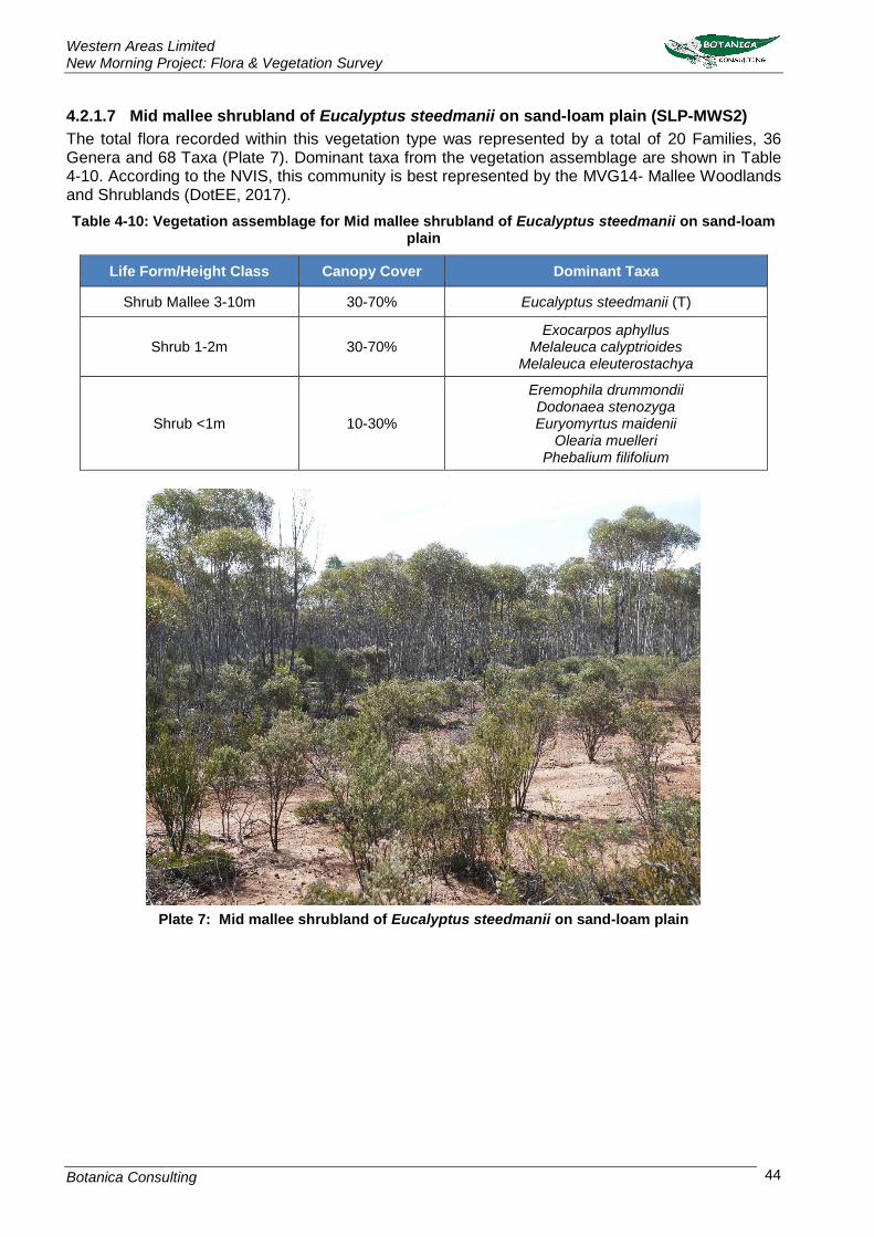
Western Areas Limited New Morning Project: Flora & Vegetation Survey
Botanica Consulting 44
4.2.1.7 Mid mallee shrubland of Eucalyptus steedmanii on sand-loam plain (SLP-MWS2)
The total flora recorded within this vegetation type was represented by a total of 20 Families, 36 Genera and 68 Taxa (Plate 7). Dominant taxa from the vegetation assemblage are shown in Table 4-10. According to the NVIS, this community is best represented by the MVG14- Mallee Woodlands and Shrublands (DotEE, 2017).
Table 4-10: Vegetation assemblage for Mid mallee shrubland of Eucalyptus steedmanii on sand-loam plain
Life Form/Height Class Canopy Cover Dominant Taxa
Shrub Mallee 3-10m 30-70% Eucalyptus steedmanii (T)
Shrub 1-2m 30-70% Exocarpos aphyllus
Melaleuca calyptrioides Melaleuca eleuterostachya
Shrub <1m 10-30%
Eremophila drummondii Dodonaea stenozyga Euryomyrtus maidenii
Olearia muelleri Phebalium filifolium
Plate 7: Mid mallee shrubland of Eucalyptus steedmanii on sand-loam plain
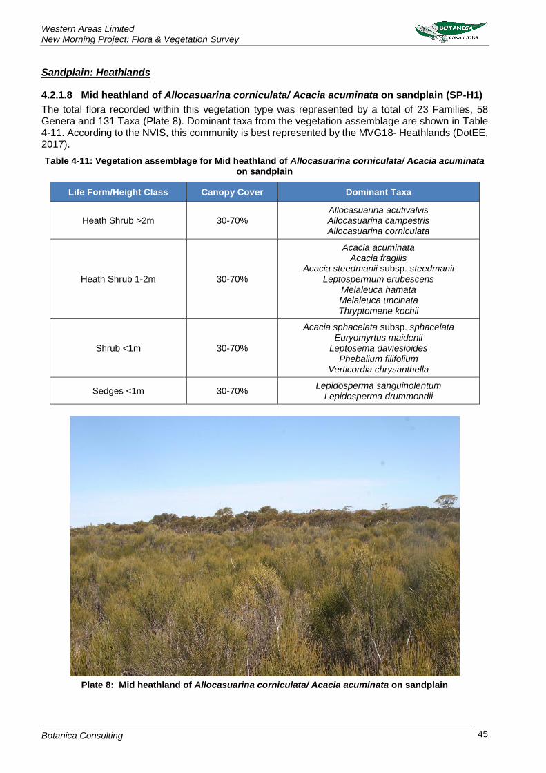
Western Areas Limited New Morning Project: Flora & Vegetation Survey
Botanica Consulting 45
Sandplain: Heathlands
4.2.1.8 Mid heathland of Allocasuarina corniculata/ Acacia acuminata on sandplain (SP-H1)
The total flora recorded within this vegetation type was represented by a total of 23 Families, 58 Genera and 131 Taxa (Plate 8). Dominant taxa from the vegetation assemblage are shown in Table 4-11. According to the NVIS, this community is best represented by the MVG18- Heathlands (DotEE, 2017).
Table 4-11: Vegetation assemblage for Mid heathland of Allocasuarina corniculata/ Acacia acuminata on sandplain
Life Form/Height Class Canopy Cover Dominant Taxa
Heath Shrub >2m 30-70% Allocasuarina acutivalvis Allocasuarina campestris Allocasuarina corniculata
Heath Shrub 1-2m 30-70%
Acacia acuminata Acacia fragilis
Acacia steedmanii subsp. steedmanii Leptospermum erubescens
Melaleuca hamata Melaleuca uncinata Thryptomene kochii
Shrub <1m 30-70%
Acacia sphacelata subsp. sphacelata Euryomyrtus maidenii
Leptosema daviesioides Phebalium filifolium
Verticordia chrysanthella
Sedges <1m 30-70% Lepidosperma sanguinolentum
Lepidosperma drummondii
Plate 8: Mid heathland of Allocasuarina corniculata/ Acacia acuminata on sandplain

Western Areas Limited New Morning Project: Flora & Vegetation Survey
Botanica Consulting 46
Sandplain: Mallee Woodlands and Shrublands
4.2.1.9 Low open mallee shrubland of Eucalyptus platycorys/ E. horistes on sandplain (SP-MWS1)
The total flora recorded within this vegetation type was represented by a total of 13 Families, 37 Genera and 68 Taxa (Plate 9). Dominant taxa from the vegetation assemblage are shown in Table 4-12. According to the NVIS, this community is best represented by the MVG14- Mallee Woodlands and Shrublands (DotEE, 2017).
Table 4-12: Vegetation assemblage for Low open mallee shrubland of Eucalyptus platycorys/ E. horistes on sandplain
Life Form/Height Class Canopy Cover Dominant Taxa
Shrub Mallee <3m 10-30% Eucalyptus horistes
Eucalyptus platycorys
Shrub <1m 30-70%
Banksia laevigata subsp. fuscolutea Beaufortia micrantha
Isopogon scabriusculus Melaleuca glaberrima
Melaleuca hamata Petrophile merrallii
Phebalium lepidotum
Sedge <1m 10-30% Lepidosperma sanguinolentum
Plate 9: Low open mallee shrubland of Eucalyptus platycorys/ E. horistes on sandplain

Western Areas Limited New Morning Project: Flora & Vegetation Survey
Botanica Consulting 47
4.2.2 Vegetation Condition
Based on the vegetation condition rating scale adapted from Keighery, 1994 and Trudgen, 1988
(Appendix 3), two vegetation associations were rated as ‘good’ and the remaining seven vegetation
associations had a vegetation condition rating of ‘very good’ (Table 4-13). A map of the vegetation

Western Areas Limited New Morning Project: Flora & Vegetation Survey
Botanica Consulting 48
condition within the survey area is provided in
Figure 4-2.

Western Areas Limited New Morning Project: Flora & Vegetation Survey
Botanica Consulting 49
‘Good’ condition depicts that vegetation structure has been significantly altered by very obvious signs
of multiple disturbances, however it retains its basic vegetation structure or has ability to regenerate
it. Disturbance to vegetation structure may be caused by very frequent fires, the presence of very
aggressive weeds, partial clearing, dieback and grazing.
‘Very Good’ condition depicts that vegetation structure has been altered by obvious signs of
disturbance. Disturbance to vegetation structure may be caused by repeated fires, the presence of
some more aggressive weeds, dieback, logging and grazing.
Table 4-13: Vegetation Condition Rating for Vegetation associations of the New Morning Project survey area
Landform Major
Vegetation Group
Vegetation Association Vegetation
Code Vegetation Condition
Clay-Loam Plain
Eucalyptus Woodland (MVG 5)
Low open forest of Eucalyptus flocktoniae/ E. salubris/ E. urna on clay-loam plain
CLP-EW1 Good
Mid open woodland of Eucalyptus salmonophloia on clay-loam plain
CLP-EW2 Very Good
Burnt open low woodland of Eucalyptus salmonophloia over mallee shrubland of
E. pileata/ E. tephroclada/ E. celastrioides on clay-loam plain
CLP-EW3 Good
Mid woodland of Eucalyptus longicormis on clay-loam plain
CLP-EW4 Very Good
Stony rise
Mallee Woodland and
Shrubland (MVG 14)
Mid mallee shrubland of Eucalyptus tephroclada/ E. pileata on stony rise
R-MWS1 Very Good
Sand-Loam Plain
Mallee Woodland and
Shrubland (MVG 14)
Mid mallee shrubland of Eucalyptus tephroclada/ E. pileata/ E. transcontinentalis
on sand-loam plain
SLP-MWS1
Very Good
Mid mallee shrubland of Eucalyptus steedmanii on sand-loam plain
SLP-MWS2
Very Good
Sandplain
Heathlands (MVG 18)
Mid heathland of Allocasuarina corniculata/ Acacia acuminata on sandplain
SP-H1 Very Good
Mallee Woodland and
Shrubland (MVG 14)
Low open mallee shrubland of Eucalyptus platycorys/ E. horistes on sandplain
SP-MWS1 Very Good
N/A N/A Cleared Vegetation CV Completely Degraded

Western Areas Limited New Morning Project: Flora & Vegetation Survey
Botanica Consulting 50
Figure 4-2: Vegetation Condition Rating of the New Morning Project survey area

Western Areas Limited New Morning Project: Flora & Vegetation Survey
Botanica Consulting 51
4.2.3 Introduced Plant Species
Four introduced species were identified within the survey area:
Dittrichia graveolens (Stinkwort);
Lysimachia arvensis (Pimpernel);
Sonchus olearaceus (Common Sowthistle); and
Wahlenbergia capensis (Common Bluebell).
According to the DPIRD database (DPIRD, 2018), none of these species are listed as a Declared
Plant under Section 22 of the BAM Act.
4.2.3.1 Dittrichia graveolens (Stinkwort)
This species is described as an erect, bushy, viscid, annual herb that grows up to 0.1-0.5m high (Plate
10). It has yellow/yellow-white flowers from January to November, and grows in a variety of soils. It
is a weed of waste grounds, along rivers and roadsides (WAHERB, 2018). This species was recorded
within one vegetation association; Low open forest of Eucalyptus flocktoniae/ E. salubris/ E. urna on
clay-loam plain (CLP-EW1).
Plate 10: Dittrichia graveolens (Stinkwort)
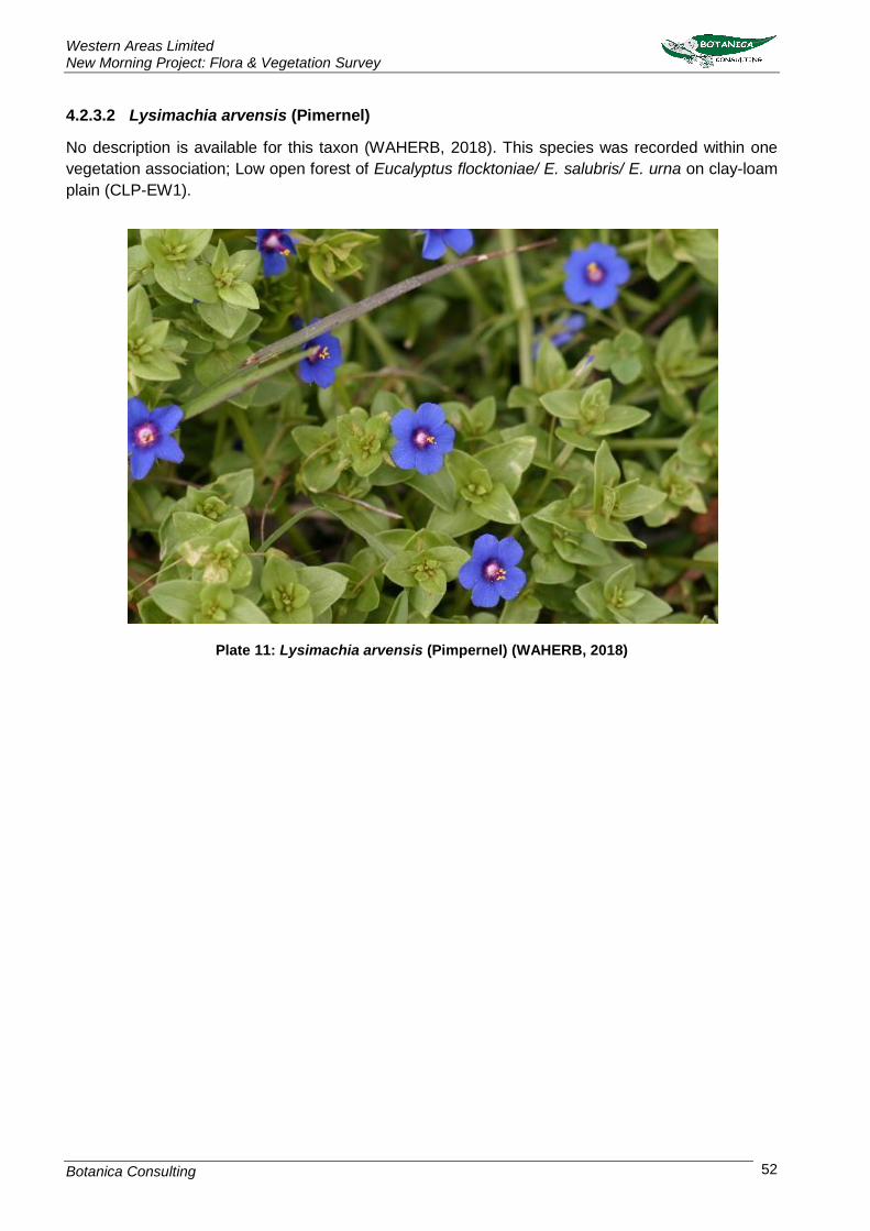
Western Areas Limited New Morning Project: Flora & Vegetation Survey
Botanica Consulting 52
4.2.3.2 Lysimachia arvensis (Pimernel)
No description is available for this taxon (WAHERB, 2018). This species was recorded within one
vegetation association; Low open forest of Eucalyptus flocktoniae/ E. salubris/ E. urna on clay-loam
plain (CLP-EW1).
Plate 11: Lysimachia arvensis (Pimpernel) (WAHERB, 2018)

Western Areas Limited New Morning Project: Flora & Vegetation Survey
Botanica Consulting 53
4.2.3.3 Sonchus olearaceus (Common Sowthistle)
This species is described as an erect annual, herb, which grows up to 1.5 m high. It produces yellow
flowers from January to December. It occurs on a variety of soils and is a weed of waste places and
disturbed ground. This species was recorded within one vegetation association; Low open forest of
Eucalyptus flocktoniae/ E. salubris/ E. urna on clay-loam plain (CLP-EW1).
Plate 12: Sonchus oleraceus (Common Sowthistle)

Western Areas Limited New Morning Project: Flora & Vegetation Survey
Botanica Consulting 54
4.2.3.4 Wahlenbergia capensis (Common Bluebell)
This species is described as a slender, erect or ascending annual herb which grows between 0.1-0.5
m high. It produces blue/blue-green flowers from September to November. This species occurs on
sandy soils within disturbed grounds and plains (WAHERB, 2018). This species was recorded within
one vegetation association; Low open forest of Eucalyptus flocktoniae/ E. salubris/ E. urna on clay-
loam plain (CLP-EW1).
Plate 13: Wahlenbergia capensis (Common Bluebell) (WAHERB, 2018)

Western Areas Limited New Morning Project: Flora & Vegetation Survey
Botanica Consulting 55
4.2.4 Floristic Composition of the New Morning Project Quadrats
This analysis was used to determine the similarities or differences between vegetation associations.
Appendix 8 provides the dendrogram, two-way table and ordination graph generated from the PATN
statistical analysis. A list of the 36 quadrats and their respective vegetation associations are provided
in Table 4-14 below. The PATN analysis produced a stress value of 0.1786.
Table 4-14: Vegetation associations with corresponding quadrats
Landform NVIS Vegetation Association Vegetation
Code Quadrat
Clay-Loam Plain
Eucalyptus Woodland (MVG 5)
Low open forest of Eucalyptus flocktoniae/ E. salubris/ E. urna on clay-
loam plain CLP-EW1
Q3, Q10, Q14, Q19, Q20, Q35
Mid open woodland of Eucalyptus salmonophloia on clay-loam plain
CLP-EW2 Q5, Q13, Q22
Burnt open low woodland of Eucalyptus salmonophloia over mallee shrubland of
E. pileata/ E. tephroclada/ E. celastrioides on clay-loam plain
CLP-EW3 Q1, Q4, Q8, Q9,
Q24, Q36
Mid woodland of Eucalyptus longicormis on clay-loam plain
CLP-EW4 Q6, Q7, Q11, Q12
Stony rise
Mallee Woodland and
Shrubland (MVG 14)
Mid mallee shrubland of Eucalyptus tephroclada/ E. pileata on stony rise
R-MWS1 Q2, Q18, Q21
Sand-Loam Plain
Mallee Woodland and
Shrubland (MVG 14)
Mid mallee shrubland of Eucalyptus tephroclada/ E. pileata/ E.
transcontinentalis on sand-loam plain SLP-MWS1
Q15, Q27, Q28, Q30
Mid mallee shrubland of Eucalyptus steedmanii on sand-loam plain
SLP-MWS2 Q23, Q25, Q26,
Q31
Sandplain
Heathlands (MVG 18)
Mid heathland of Allocasuarina corniculata/ Acacia acuminata on
sandplain SP-H1 Q16, Q29, Q34
Mallee Woodland and
Shrubland (MVG 14)
Low open mallee shrubland of Eucalyptus platycorys/ E. horistes on
sandplain SP-MWS1 Q17, Q32, Q33
Two ‘supergroups’ were identified in the PATN analysis:
1. Clay-Loam Plain/ Sand-Loam Plain (Eucalypt Woodlands & Mallee Woodlands and
Shrublands); and
2. Sandplain/ Stony Rise (Mallee Woodlands and Shrublands & Heathlands)
Nine species groups were identified in the analysis (species group A to I) as shown in the two-way
table (Appendix 8).
The ‘Clay-Loam Plain/ Sand-Loam Plain’ supergroup included six floristic groups; four groups
comprising of quadrats from the Clay-Loam Plain vegetation associations (CLP-EW1 to CLP-EW4)
and two groups comprising of quadrats from the Sand-Loam Plain vegetation associations (SLP-
MWS1 and SLP-MWS2). The first two floristic groups (1-2) which included quadrats from CLP-EW1

Western Areas Limited New Morning Project: Flora & Vegetation Survey
Botanica Consulting 56
and CLP-EW3 were mainly characterised by species group C and had a mean species richness of
14 taxa and 13 taxa per quadrat respectively. The third group comprised of all four SLP-MWS2
quadrats and were characterised by species group C and H, with an average of 16 taxa per quadrat.
The fourth floristic group which comprised of all four SLP-MWS1 quadrats was mainly characterised
by species group I with an average of 14 taxa per quadrat. The remaining two floristic groups (5 and
6) which included quadrats from the Clay-Loam Plain vegetation associations (CLP-EW2, CLP-EW3
and CLP-EW4) were mainly characterised by species group E with an average of 11 and 7 taxa per
quadrat respectively.
The ‘Sandplain/ Stony Rise’ supergroup was divided into three floristic groups; the first group (Group
7) included two quadrats of R-MWS1 and was characterised by species group G (average species
richness of 10 taxa per quadrat). The second group (Group 8) included quadrats from the two
sandplain vegetation associations (Heathland and Mallee Woodlands and Shrublands) and the
remaining stony rise quadrats, with an average species richness of 17 taxa per quadrat. This group
was mainly characterised by species group A. The final group (Group 9) comprised of a single quadrat
(Q33) from SP-MWS1 (12 species per quadrat). Comparative to the other quadrats of R-MWS1 (Q17,
Q32 which recorded 22 and 20 taxa respectively), Quadrat 33 had a lower species diversity (8-10
species less) and was mainly characterised by species group B.
Based on the results of the PATN analysis, there was minimal heterogeneity in species composition
across the survey area, with majority of vegetation associations (particularly the Eucalypt woodland
associations) intermixed into floristic groups despite differences in dominant stratum taxa; however,
two distinct supergroups were identified. The first supergroup comprised of a mix of vegetation
associations identified in the field including quadrats from the clay-loam plain (Eucalypt Woodlands
and sand-loam plain (Mallee Woodlands and Shrublands). The second supergroup comprised a mix
of quadrats from the sandplains (Mallee Woodlands and Shrublands/ Heathlands) and stony rise
(Mallee Woodlands and Shrublands) vegetation associations.
Species Richness and accumulation estimates
The Chao 2 richness estimator provided an estimated species richness of 188 species in 50 sample
sites (quadrats). Species richness recorded for the 36 quadrats surveyed was 167 species (including
annuals) which indicates survey intensity was adequate.
A species accumulation curve was created to display the rate of species accumulation. The R² value
(0.99) suggests that the data “fits” the species accumulation curve shown in Figure 4-3. By the twenty-
sixth quadrat the rate of species accumulation was calculated at two species per quadrat up to 45
quadrats. Beyond 45 quadrats the rate of species accumulation was calculated to <1 species per
quadrat as quadrat number increased to between 45 to 50 quadrats. BC has determined that
according to this data a sufficient number of quadrats were established in the survey area to
adequately assess the floristic composition of the area.

Western Areas Limited New Morning Project: Flora & Vegetation Survey
Botanica Consulting 57
Figure 4-3: Species accumulation curve
y = 73.45ln(x) + 11.91R² = 0.9986
0
20
40
60
80
100
120
140
160
180
200
1 5 10 15 20 25 30 35 40 45 50
Cu
mu
lati
ve N
o. o
f sp
ecie
s
No. of sample sites
Species
Log. (Species)

Western Areas Limited New Morning Project: Flora & Vegetation Survey
Botanica Consulting 58
4.2.5 Significant Flora
According to the EPA Environmental Factor Guideline for Flora and Vegetation (EPA, 2016a)
significant flora includes:
• flora being identified as threatened or priority species
• locally endemic flora or flora associated with a restricted habitat type (e.g. surface water or
groundwater dependent ecosystems)
• new species or anomalous features that indicate a potential new species
• flora representative of the range of a species (particularly, at the extremes of range, recently
discovered range extensions, or isolated outliers of the main range)
• unusual species, including restricted subspecies, varieties or naturally occurring hybrids
• flora with relictual status, being representative of taxonomic groups that no longer occur widely
in the broader landscape.
Two Threatened Flora taxon pursuant to subsection (2) of section 23F of the WC Act and the EPBC
Act were identified within the survey area:
1. Eucalyptus steedmanii.
2. Paragoodia crenulata (also considered endemic to the area)
Four Priority Flora taxa as listed by DBCA were identified within the survey area:
1. Eremophila racemosa (P4);
2. Eutaxia acanthoclada (P3);
3. Microcorys sp. Forrestania (V. English 2004) (P4); and
4. Stylidium sejunctum (P3).
Descriptions of these species are provided in the following sections. GPS locations of all Priority Flora recorded by Botanica are provided in Appendix 4 (Threatened Flora locations have been excluded due to the sensitivity of this data). No other significant flora (i.e. groundwater or surface water dependent, new or anomalous species, range extension, relictual or unusual species) were identified within the survey area.

Western Areas Limited New Morning Project: Flora & Vegetation Survey
Botanica Consulting 59
4.2.5.1 Eucalyptus steedmanii (T)
Eucalyptus steedmanii is listed as a Threatened Flora taxon (Vulnerable) pursuant to subsection (2)
of section 23F of the Western Australian WC Act and the Commonwealth EPBC Act. This taxon is
described as a tree that grows to 2-8m high (
Plate 14). It has smooth bark, and produces white flowers from January to March (WAHERB, 2018).
It grows in gravelly loam over ironstone and sand, and it can be found on low hills and undulating
plains.
Four previously recorded populations/DBCA known locations were identified within the survey area
(referred to as Population 1, 2, 7 and 8). An additional location of this taxon was identified during the
survey, located within 500m of the existing Population 8 boundary (tentatively referred to as
Population 8a pending determination from DBCA). This newly identified location of Eucalyptus
steedmanii will be formally lodged with DBCA. This taxon was identified within one vegetation
association; Mid mallee shrubland of Eucalyptus steedmanii on sand-loam plain (SLP-MWS2).

Western Areas Limited New Morning Project: Flora & Vegetation Survey
Botanica Consulting 60
Plate 14: Eucalyptus steedmanii (T)
4.2.5.2 Pargodia crenulata (T)
Pargoodia crenulata is listed as a Threatened Flora taxon (Vulnerable) pursuant to subsection (2) of
section 23F of the Western Australian WC Act and Critically Endangered under the Commonwealth
EPBC Act. This taxon is described as a small herbaceous plant with perennial underground parts
(Plate 15). The flower spike has 1–3 flowers that are brown and yellow in colour. The flowering period
is from July to August. This taxon is endemic to Western Australia, known from two populations in the
Forrestania area (DotEE, 2018c).
One location of this taxon was recorded within the survey area, which is not a DBCA listed/known
location. The nearest known DBCA location is approximately 12.7km north-east of the survey area,
along the Forrestania-Southern Cross Road. This newly identified location of Pargoodia crenulata will
be formally lodged with DBCA. This taxon was identified within one vegetation association; Low open
forest of Eucalyptus flocktoniae/ E. salubris/ E. urna on clay-loam plain (CLP-EW1).

Western Areas Limited New Morning Project: Flora & Vegetation Survey
Botanica Consulting 61
Plate 15: Pargoodia crenulata (T)
4.2.5.3 Eremophila racemosa (P4)
This taxon is described as an erect shrub that grows up to 0.5-1.7m high (Plate 16). It produces
purple-pink-red/white flowers in March or August to December. It grows in sandy or stony loam, clay
loam, and can be found on undulating plains and roadsides (WAHERB, 2018). Botanica recorded 35
locations of this taxon within the survey area, two of which are DBCA known locations. This taxon
was recorded within four vegetation associations:
1. Low open forest of Eucalyptus flocktoniae/ E. salubris/ E. urna on clay-loam plain (CLP-EW1);
2. Mid open woodland of Eucalyptus salmonophloia on clay-loam plain (CLP-EW2);
3. Burnt open low woodland of Eucalyptus salmonophloia over mallee shrubland of E. pileata/
E. tephroclada/ E. celastrioides on clay-loam plain (CLP-EW3); and
4. Mid mallee shrubland of Eucalyptus tephroclada/ E. pileata on stony rise (R-MWS1).
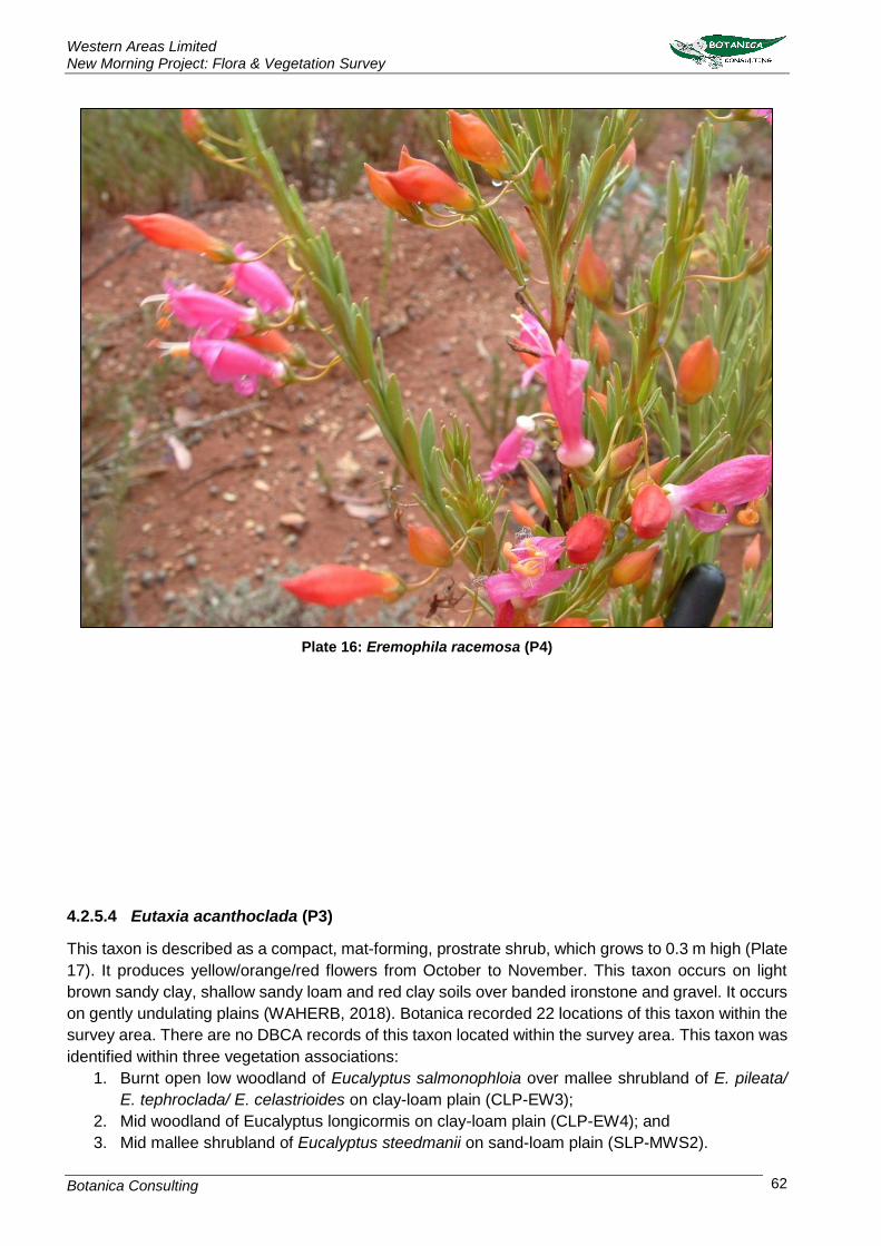
Western Areas Limited New Morning Project: Flora & Vegetation Survey
Botanica Consulting 62
Plate 16: Eremophila racemosa (P4)
4.2.5.4 Eutaxia acanthoclada (P3)
This taxon is described as a compact, mat-forming, prostrate shrub, which grows to 0.3 m high (Plate
17). It produces yellow/orange/red flowers from October to November. This taxon occurs on light
brown sandy clay, shallow sandy loam and red clay soils over banded ironstone and gravel. It occurs
on gently undulating plains (WAHERB, 2018). Botanica recorded 22 locations of this taxon within the
survey area. There are no DBCA records of this taxon located within the survey area. This taxon was
identified within three vegetation associations:
1. Burnt open low woodland of Eucalyptus salmonophloia over mallee shrubland of E. pileata/
E. tephroclada/ E. celastrioides on clay-loam plain (CLP-EW3);
2. Mid woodland of Eucalyptus longicormis on clay-loam plain (CLP-EW4); and
3. Mid mallee shrubland of Eucalyptus steedmanii on sand-loam plain (SLP-MWS2).

Western Areas Limited New Morning Project: Flora & Vegetation Survey
Botanica Consulting 63
Plate 17: Eutaxia acanthoclada (P3)
4.2.5.5 Microcorys sp. Forrestania (V. English 2004) (P4)
This taxon is described as a prostrate or erect shrub that grows up to 0.35-0.4m high (Plate 18). It
produces white/purple flowers in January or April. It grows in yellow sandy clay or red-brown clay,
and it can be found in open woodland or cleared areas (WAHERB, 2018). Botanica recorded 78
locations of this taxon within the survey area. There are no DBCA records of this taxon located within
the survey area. This taxon was recorded within five vegetation associations:
1. Low open forest of Eucalyptus flocktoniae/ E. salubris/ E. urna on clay-loam plain (CLP-EW1);
2. Mid open woodland of Eucalyptus salmonophloia on clay-loam plain (CLP-EW2);
3. Burnt open low woodland of Eucalyptus salmonophloia over mallee shrubland of E. pileata/
E. tephroclada/ E. celastrioides on clay-loam plain (CLP-EW3);

Western Areas Limited New Morning Project: Flora & Vegetation Survey
Botanica Consulting 64
4. Mid mallee shrubland of Eucalyptus tephroclada/ E. pileata/ E. transcontinentalis on sand-
loam plain (SLP-MWS1); and
5. Mid mallee shrubland of Eucalyptus steedmanii on sand-loam plain (SLP-MWS2).
Plate 18: Microcorys sp. Forrestania (V. English 2004) (P4)
4.2.5.6 Stylidium sejunctum (P3)
This taxon is described as a caespitose perennial herb that reaches heights of 0.25–0.45 metres
(Plate 19). The flowers are white, pink and purple and bloom from September through November. It
inhabits sites with clayey sand, loam or laterite on outcrops, upper slopes and breakaways (WAHERB,
2018). Botanica recorded 98 locations of this taxon within the survey area, two of which are DBCA
known locations. This taxon was recorded within two vegetation associations:
1. Low open forest of Eucalyptus flocktoniae/ E. salubris/ E. urna on clay-loam plain (CLP-EW1);
and
2. Mid mallee shrubland of Eucalyptus tephroclada/ E. pileata on stony rise (R-MWS1).

Western Areas Limited New Morning Project: Flora & Vegetation Survey
Botanica Consulting 65
Plate 19: Stylidium sejunctum (P3)

Reward Minerals Limited Lake Disappointment Project Level 2 Flora & Vegetation Survey
Botanica Consulting 66
Figure 4-4: Flora of Conservation Significance identified within the New Morning Project
survey area

Reward Minerals Limited Lake Disappointment Project Level 2 Flora & Vegetation Survey
Botanica Consulting 67
4.2.6 Significant Vegetation According to the EPA Environmental Factor Guideline for Flora and Vegetation (EPA, 2016b)
significant vegetation includes:
• vegetation being identified as threatened or priority ecological communities
• vegetation with restricted distribution
• vegetation subject to a high degree of historical impact from threatening processes
• vegetation which provides a role as a refuge
• vegetation providing an important function required to maintain ecological integrity of a
significant ecosystem.
The survey area is located within the North Ironcap buffer of the Ironcap Hills Vegetation Complexes
which is listed by the DBCA as a Priority 3 Ecological Community. This vegetation community was
first described by Newbey and Hnatiuk (1988) during the biological survey of the Lake Johnston-
Hyden area as a BIF complex and was considered one of seven unique vegetation communities to
the Lake Johnston-Hyden area. The description of the North Ironcap BIF complex is provided below:
The complex vegetation on banded ironstone formation had a number of species dominant at different
sites. Low trees (Acacia lasiocalyx and Eucalyptus flocktoniae [Merrit]) were rare. Mallees of
Eucalyptus. aff. wandoo (E. livida, E. capillosa subsp. polyclada) were usually present in small areas
partially lateritized, while E. eremophila occurred rarely. Tall shrubs that were occasionally present
included Allocasuarina campestris ssp. campestris (also low shrub), A. corniculata, Banksia
sphaerocarpa var. dolichostyla (Ironcaps), Calothamnus quadrifidus (also low shrub), Dryandra aff.
cersioides, Grevillea pterosperma, Hakea subsulcata, H. scoparia, Leptospermum erubescens,
Melaleuca fulgens, M. uncinata, Santalum acuminatum and Trymalium aff. ledifolium; low shrubs
were Acacia sulcata var. platyphylla, Acacia sp. (KRN 5226), Chamelaucium ciliatum (south),
Cryptandra miliaris, Dodonaea adenophora, D. amblyophylla (west), Dryandra sp. (KRN 5229),
Melaleuca cordata, Phebalium filifolium, P. microphyllum, P. tuberculosum ssp. tuberculosum, P. aff.
tuberculosum and Platysace maxwellii (west); perennial grasses of Spartochloa scirpoidea; and
sedges of Lepidosperma drummondii, L. viscidum var. viscidum, Lepidosperma sp. (KRN 5232),
Lepidosperma sp. (KRN 5233) and Lepidosperma sp. (KRN 6488).
The vegetation complex described was not represented within the survey area.
According to the DAFWA (2011) the BIF complex within the Greater North Ironcap area is classified
by pre-european vegetation association Forrestania 1413; Shrublands; Acacia, Casuarina &
Melaleuca thicket which is represented in both the Southern Cross and Western Mallee subregion.
Neither of these vegetation associations occur within the survey area (see Section 2.3).
4.3 Matters of National Environmental Significance
None of the following matters of national environmental significance as defined by the Commonwealth
EPBC Act were identified within the survey area:
• world heritage properties
• national heritage places
• wetlands of international importance (often called ‘Ramsar’ wetlands after the international treaty under which such wetlands are listed)
• nationally threatened ecological communities
• Commonwealth marine areas

Reward Minerals Limited Lake Disappointment Project Level 2 Flora & Vegetation Survey
Botanica Consulting 68
• the Great Barrier Reef Marine Park
• nuclear actions (including uranium mining) a water resource, in relation to coal seam gas development and large coal mining development.
Two nationally threatened flora species; Eucalyptus steedmanii and Paragoodia crenulata were
recorded within the survey area.
4.4 Matters of State Environmental Significance
There are no wetlands of national importance (ANCA Wetlands) or conservation category wetlands
within the survey area. The survey area does not contain any TEC listed under the Western Australian
Environmental Protection (EP) Act 1986. Two threatened flora species; Eucalyptus steedmanii and
Pargoodia crenulata listed under the WC Act were recorded within the survey area. A 50m radius of
each Threatened Flora plant is protected as an ESA under Regulation 6 of the Environmental
Protection (Clearing of Native Vegetation) Regulations WA 2004.
Approximately 215ha of the north-east corner of survey area lies within the Lake Cronin ESA with the
survey area located approximately 5km south-west of the Lake Cronin ‘A’ Class Nature Reserve. A
description of the Lake Cronin Region is provided below;
Lake Cronin is a semi-permanent freshwater lake located in the south western region of the Eastern
Goldfields and is the largest freshwater lake in the region. The Lake Cronin area is one of a number
of areas in the Wheatbelt region that are significant for rare species, due to widespread clearing in
the surrounding landscape, and to the high diversity and level of local endemism. The Lake Cronin
area supports extensive shrubland, sandplain and woodland environments, including excellent
representation of a range of vegetation associations that are now extensively cleared in the Wheatbelt
and supports a high number of species that are disjunct. Disjunct populations are those that have
become physically separated, resulting in minimal or no gene flow between them, and they are an
important precursor to the development of new species. A number of species in Australia have
separate eastern and western populations, and some have formed sub-species, reflecting important
broader long-term processes such as sea level changes and climatic fluctuations. It also supports a
number of species reaching the limit of their distribution range. The number of species at the edge of
their range reflects the convergence in the area of the Avon, Mallee and Coolgardie Biogeographic
regions (DotEE, 2017c).
According to the EPA (2009) Advice on Conservation Values and Review of Nature Reserve
Proposals in the Lake Cronin Region, an area of 56,750ha within the mineralised greenstone belt in
the Lake Cronin Region (encompassing the entire Greater New Morning/Spotted Quoll area) is
proposed to be managed under Section 33(2) of the CALM Act 1984 but not formally reserved. A
proposed ‘C’ Class Nature Reserve is also proposed in the surrounding area to protect the Lake
Cronin catchment and areas of extensive sandplain and woodland vegetation located immediately
east of the Wheatbelt, which represents vegetation communities and fauna habitats that have been
extensively cleared and fragmented in the adjacent Wheatbelt. Lake Cronin is not formally protected
under the Commonwealth EPBC Act 1999.
The survey area is located within the North Ironcap buffer of the Ironcap Hills Vegetation Complexes
which is listed by the DBCA as a Priority 3 Ecological Community. A map showing areas of
conservation significance in relation to the survey area is provided in Appendix 1.

Reward Minerals Limited Lake Disappointment Project Level 2 Flora & Vegetation Survey
Botanica Consulting 69
5 Bibliography
ASRIS (2014), Atlas of Australian Soils Database, Australian Soil Resource Information System. Beard, J.S., (1990), Plant Life of Western Australia, Kangaroo Press Pty Ltd, NSW. Beecham, B. and Danks, A., (2001) A Biodiversity Audit of Western Australia’s 53 Biogeographical Region in 2001- Western Mallee subregion, Department of Conservation and Land Management. BC, (2006), Flora and Vegetation Survey of the Flying Fox North East Exploration Area for Western Areas, Botanica Consulting BC, (2007a), Vegetation Survey of a Proposed Extension to the Current Clearing Permit Number 691/1 at the Flying Fox mine site prepared for Western Areas, Botanica Consulting BC, (2007b), Flora and Vegetation Survey within the Greater Flying Fox mine site prepared for Western Areas, Botanica Consulting BC, (2008), Vegetation Survey of New Morning to Spotted Quoll Area within Tenements M77/583 and M77/545, Botanica Consulting BC, (2009), Flora and Vegetation Survey within the lounge Lizard/Flying Fox area, Proposed Gravel Pit, prepared for Western Areas, Botanica Consulting BC, (2010a), New Morning Flora and Vegetation Survey Prepared for Western Areas, Botanica Consulting BC, (2010b), New Morning Flora and Vegetation Survey Prepared for Western Areas, Botanica Consulting BC, (2011), Spotted Quoll/Cosmic Boy Haul Road Flora and Vegetation Survey, Prepared for Western Areas NL, Botanica Consulting BC (2017) Reconnaissance Flora & Vegetation Survey of the Greater New Morning/Spotted Quoll Area, Prepared for Western Areas Limited, Botanica Consulting BoM, (2018), Lake Carmody weather station (#10670) Climate Data, Bureau of Meteorology. Available: http://www.bom.gov.au/climate Accessed: 19th September 2018 BoM (2018b). Groundwater Dependent Ecosystems Atlas. Bureau of Meteorology Available: http://www.bom.gov.au/water/groundwater/gde/map.shtml Accessed: 10th October 2018 DAFWA (2011), Pre-European Vegetation - Western Australia (NVIS Compliant Version GIS file), Department of Agriculture and Food Western Australia. DAFWA (2014), Soil Landscape System of Western Australia, Department of Agriculture and Food Western Australia. DBCA (2017), 2017 Statewide Vegetation Statistics (formerly the CAR Reserve Analysis). Department of Biodiversity, Conservation and Attractions DBCA, (2018a), Threatened and Priority Flora Database search results, Department of Biodiversity, Conservation and Attractions

Reward Minerals Limited Lake Disappointment Project Level 2 Flora & Vegetation Survey
Botanica Consulting 70
DBCA, (2018b), Threatened Ecological Community and Priority Ecological Community database search, Department of Biodiversity, Conservation and Attractions DBCA (2018a), Nature Map Database search, Department of Biodiversity, Conservation and Attractions Available: https://naturemap.dpaw.wa.gov.au/ Accessed: 12th October 2018 DotEE, (2012), Interim Biogeographic Regionalisation for Australia (IBRA), Version 7, Department of the Environment and Energy DotEE, (2017), National Vegetation Information System (NVIS) Major Vegetation Groups, Version 4.2, Department of the Environment and Energy DotEE, (2017), Protected Matters Search Tool, Environment Protection and Biodiversity Conservation Act 1999, Department of the Environment and Energy DotEE (2018b) Species Profiles and Threats Database, Department of Environment and Energy Available: http://www.environment.gov.au/sprat Accessed: 12th October 2018 DPIRD (2018), Declared Organism-database search, Department of Primary Industries and Regional Development, Western Australia Available: https://www.agric.wa.gov.au/bam/western-australian-organism-list-waol Accessed: 22nd September 2018 EPA, (2009), Advice on Conservation Values and Review of Nature Reserve Proposals in the Lake Cronin Region: Advice of the Environmental Protection Authority to the Minister for Environment under Section 16(e) of the Environmental Protection Act 1986. Environmental Protection Authority Report 1329 June 2009. EPA (2016), Technical Guide - Flora and Vegetation Surveys for Environmental Impact Assessment – December 2016. Environmental Protection Authority. Gibson (2004) Flora and vegetation of the Eastern Goldfields Ranges: Part 7. Middle and South
Ironcap, Digger Rock and Hatter Hill. Science Division, Department of Conservation and Land
Management.
Government of Western Australia (2018), Wildlife Conservation Act 1950. Wildlife Conservation (Rare Flora and Fauna) Notice 2017. Government Gazette, WA. 16 January 2018.
How, R. A Newbey, K.R Dell, J. Muir, B.G & Hnatiuk, R.J, (1988), The Biological survey of the Eastern Goldfields of Western Australia: Lake Johnston-Hyden. Western Australian Muesum Supplement No. 30. JSWT, (2006a), Vegetation Survey of the Exploration Drilling Program (M77/582 & E77/555), Prepared for Wester Areas NL, Botanica Consulting JSWT, (2006b), North Flying Fox Drill Lines Flora Survey for Western Areas, Jim’s Seeds, Weeds & Trees JSWT, (2006c), Vegetation Survey of three Proposed Monitoring Bores in the Flying Fox Area, Prepared for Western Areas, Jim’s Seeds, Weeds & Trees

Reward Minerals Limited Lake Disappointment Project Level 2 Flora & Vegetation Survey
Botanica Consulting 71
Keighery, B. J., (1994), Bushland Plant Survey: A guide to plant community survey for the community. Wildflower Society of Western Australia (Inc.), Nedlands Mitchell, A. & Wilcox, D. G. (1988), Arid Shrubland Plants of Western Australia, University of Western Australia Press, Nedlands, WA. IUCN (2016a), The IUCN Red List of Threatened Species. Version 2016-3. International Union for Conservation of Nature. IUCN, (2016b), The IUCN Red List of Ecosystems. International Union for Conservation of Nature McKenzie, N.L., May J.E. and McKenna, S, (2002) Bioregional Summary of the 2002 Biodiversity Audit for Western Australia. Mc Donald, R.C, Isbell, R.F & Speight, J.G (1998), Australian Soil and Land Survey Field Handbook (3rd edn). CSIRO Publishing: Melbourne. Tille, P. (2006), Soil Landscapes of Western Australia’s Rangelands and Arid Interior, Department of Agriculture and Food Western Australia. WAHERB, (2018), Florabase – Information on the Western Australian Flora, Department of Biodiversity, Conservation and Attractions. Available: https://florabase.dpaw.wa.gov.au/ Accessed 12th October 2018

Appendix 1: Regional maps of the survey area in relation to areas of conservation significance


Appendix 2: List of species identified within each vegetation association
(A) Blue text Denotes Annual species; (W) Green text Denotes Introduced species; (P/T) Red text Denotes Flora of Conservation Significance
Family Genus Taxon
CL
P-E
W1
CL
P-E
W2
CL
P-E
W3
CL
P-E
W4
R-M
WS
1
SL
P-M
WS
1
SL
P-M
WS
2
SP
-H1
SP
-MW
S1
Apiaceae Platysace maxwellii * *
Asparagaceae Thysanotus dichotomus * *
Geraniaceae Pelargonium havlasae *
Poaceae Austrostipa sp. (sterile) * * *
Aizoaceae Disphyma crassifolium subsp. clavellatum *
Asparagaceae Thysanotus sparteus * *
Asphodelaceae Bulbine semibarbata *
Asteraceae Angianthus tomentosus (A) * *
Asteraceae Calotis hispidula (A) *
Asteraceae Dittrichia graveolens (W) * *
Asteraceae Erymophyllum ramosum subsp. ramosum (A) *
Asteraceae Gnephosis tenuissima (A) *
Asteraceae Olearia muelleri * * * * * * *
Asteraceae Olearia pimeleoides * *
Asteraceae Sonchus oleraceus (W) *
Campanulaceae Wahlenbergia capensis (W) *
Casuarinaceae Allocasuarina acutivalvis * * *
Casuarinaceae Allocasuarina campestris * * *
Casuarinaceae Allocasuarina corniculata * * * * *
Casuarinaceae Allocasuarina helmsii * *
Casuarinaceae Allocasuarina microstachya *
Casuarinaceae Allocasuarina sp. (sterile) * * *
Chenopodiaceae Atriplex stipitata * * * *
Chenopodiaceae Atriplex vesicaria *
Chenopodiaceae Maireana georgei * *
Chenopodiaceae Maireana oppositifolia *
Chenopodiaceae Rhagodia drummondii *
Chenopodiaceae Sclerolaena diacantha * *
Chenopodiaceae Sclerolaena parviflora * * * *
Chenopodiaceae Sclerolaena uniflora * * *

Family Genus Taxon
CL
P-E
W1
CL
P-E
W2
CL
P-E
W3
CL
P-E
W4
R-M
WS
1
SL
P-M
WS
1
SL
P-M
WS
2
SP
-H1
SP
-MW
S1
Convolvulaceae Wilsonia humilis * * * * * *
Cupressaceae Callitris preissii * * * * *
Cyperaceae Gahnia ancistrophylla *
Cyperaceae Gahnia aristata *
Cyperaceae Lepidosperma sanguinolentum * * * *
Cyperaceae Lepidosperma brunonianum * * * *
Cyperaceae Lepidosperma carphoides *
Cyperaceae Lepidosperma aff. sp.Maggie Hills (R. Barrett) *
Cyperaceae Lepidosperma drummondii * * * *
Cyperaceae Lepidosperma pubisquameum *
Dilleniaceae Hibbertia eatoniae * *
Dilleniaceae Hibbertia exasperata * *
Dilleniaceae Hibbertia gracilipes * * * *
Dilleniaceae Hibbertia pungens * * * *
Droseraceae Drosera macrantha (A) * * *
Ericaceae Astroloma serratifolium * * * * *
Ericaceae Leucopogon ?sp. Newdegate (M. Hislop 3585) *
Ericaceae Leucopogon cuneifolius * * *
Ericaceae Leucopogon sp. outer wheatbelt (M. Hislop 30) *
Ericaceae Leucopogon sp. Wheatbelt (S. Murray 257) *
Ericaceae Lysinema ciliatum * *
Ericaceae Lysinema pentapetalum *
Euphorbiaceae Beyeria brevifolia * *
Fabaceae Acacia acanthoclada subsp. acanthoclada * * * *
Fabaceae Acacia acuaria *
Fabaceae Acacia acuminata * * *
Fabaceae Acacia assimilis subsp. assimilis * *
Fabaceae Acacia brachyclada *
Fabaceae Acacia camptoclada * * * * *
Fabaceae Acacia castanostegia * *
Fabaceae Acacia colletioides *
Fabaceae Acacia coolgardiensis * *
Fabaceae Acacia deficiens * * * * * * *

Family Genus Taxon
CL
P-E
W1
CL
P-E
W2
CL
P-E
W3
CL
P-E
W4
R-M
WS
1
SL
P-M
WS
1
SL
P-M
WS
2
SP
-H1
SP
-MW
S1
Fabaceae Acacia densiflora *
Fabaceae Acacia enervia subsp. enervia * *
Fabaceae Acacia eremophila * *
Fabaceae Acacia erinacea * * * * * * *
Fabaceae Acacia evenulosa * *
Fabaceae Acacia fragilis * * *
Fabaceae Acacia hemiteles * * * * * * * *
Fabaceae Acacia hystrix subsp. hystrix *
Fabaceae Acacia intricata * * * * * *
Fabaceae Acacia longispinea *
Fabaceae Acacia merrallii * * * * *
Fabaceae Acacia neurophylla subsp. neurophylla * * *
Fabaceae Acacia poliochroa * * * *
Fabaceae Acacia rendlei *
Fabaceae Acacia sphacelata subsp. sphacelata * * * * *
Fabaceae Acacia steedmanii subsp. steedmanii * * * * *
Fabaceae Acacia sulcata * *
Fabaceae Acacia uncinella * *
Fabaceae Acacia viscifolia *
Fabaceae Acacia yorkrakinensis * *
Fabaceae Daviesia benthamii subsp. acanthoclona * * * * * *
Fabaceae Daviesia lancifolia * * *
Fabaceae Daviesia nematophylla * * * * *
Fabaceae Daviesia polyphylla *
Fabaceae Eutaxia acanthoclada (P3) * * *
Fabaceae Eutaxia neurocalyx *
Fabaceae Gastrolobium spinosum * *
Fabaceae Gastrolobium tetragonophyllum *
Fabaceae Gastrolobium trilobum *
Fabaceae Gompholobium gompholobioides * * * * *
Fabaceae Jacksonia nematoclada *
Fabaceae Jacksonia sp. (sterile) *
Fabaceae Leptosema daviesioides * *

Family Genus Taxon
CL
P-E
W1
CL
P-E
W2
CL
P-E
W3
CL
P-E
W4
R-M
WS
1
SL
P-M
WS
1
SL
P-M
WS
2
SP
-H1
SP
-MW
S1
Fabaceae Paragoodia crenulata (T) *
Fabaceae Pultenaea aff. arida *
Fabaceae Pultenaea arida *
Fabaceae Senna artemisioides subsp. ×artemisioides *
Fabaceae Senna artemisioides subsp. filifolia * * *
Fabaceae Senna cardiosperma *
Fabaceae Templetonia egena *
Fabaceae Templetonia sulcata * * * *
Goodeniaceae Coopernookia strophiolata * * * *
Goodeniaceae Dampiera angulata * * *
Goodeniaceae Goodenia dyeri (A) *
Goodeniaceae Goodenia pinifolia * * * * *
Goodeniaceae Goodenia viscida * * *
Goodeniaceae Scaevola spinescens * * * *
Haloragaceae Glischrocaryon roei *
Hemerocallidaceae Dianella revoluta * * * * * *
Lamiaceae Microcorys sp. Forrestania (V. English 2004) (P4) * * * * *
Lamiaceae Westringia cephalantha var. caterva * * * * * * *
Lamiaceae Westringia rigida * * * *
Lauraceae Cassytha melantha (A) * * * * * *
Lauraceae Cassytha pomiformis (A) *
Malvaceae Thomasia sarotes *
Myrtaceae Astartea heteranthera *
Myrtaceae Baeckea crispiflora * * *
Myrtaceae Baeckea sp. (sterile) *
Myrtaceae Beaufortia micrantha *
Myrtaceae Beaufortia schaueri * *
Myrtaceae Calothamnus quadrifidus subsp. seminudus *
Myrtaceae Calytrix breviseta subsp. stipulosa * *
Myrtaceae Chamelaucium ?virgatum *
Myrtaceae Chamelaucium ciliatum * *
Myrtaceae Cyathostemon tenuifolius * * *
Myrtaceae Darwinia sp. Lake Cobham (K. Newbey 3262) * * * *

Family Genus Taxon
CL
P-E
W1
CL
P-E
W2
CL
P-E
W3
CL
P-E
W4
R-M
WS
1
SL
P-M
WS
1
SL
P-M
WS
2
SP
-H1
SP
-MW
S1
Myrtaceae Ericomyrtus serpyllifolia *
Myrtaceae Eucalyptus annulata * *
Myrtaceae Eucalyptus astringens *
Myrtaceae Eucalyptus calycogona subsp. calycogona * *
Myrtaceae Eucalyptus celastroides subsp. virella * *
Myrtaceae Eucalyptus cylindriflora * *
Myrtaceae Eucalyptus cylindrocarpa * * * *
Myrtaceae Eucalyptus densa subsp. densa *
Myrtaceae Eucalyptus eremophila subsp. eremophila * * * * * *
Myrtaceae Eucalyptus flocktoniae subsp. flocktoniae * * *
Myrtaceae Eucalyptus goniocarpa *
Myrtaceae Eucalyptus gracilis * *
Myrtaceae Eucalyptus horistes *
Myrtaceae Eucalyptus kondininensis * *
Myrtaceae Eucalyptus leptophylla * *
Myrtaceae Eucalyptus longicornis *
Myrtaceae Eucalyptus melanoxylon *
Myrtaceae Eucalyptus pileata * * *
Myrtaceae Eucalyptus platycorys *
Myrtaceae Eucalyptus pluricaulis subsp. pluricaulis *
Myrtaceae Eucalyptus polita * * * *
Myrtaceae Eucalyptus salmonophloia * * * * *
Myrtaceae Eucalyptus salubris * * * * *
Myrtaceae Eucalyptus sp. (sterile) *
Myrtaceae Eucalyptus sporadica *
Myrtaceae Eucalyptus steedmanii (T) *
Myrtaceae Eucalyptus tephroclada * * * * *
Myrtaceae Eucalyptus transcontinentalis * *
Myrtaceae Eucalyptus urna * * * * *
Myrtaceae Euryomyrtus maidenii * *
Myrtaceae Leptospermum erubescens * *
Myrtaceae Leptospermum roei * *
Myrtaceae Leptospermum spinescens *
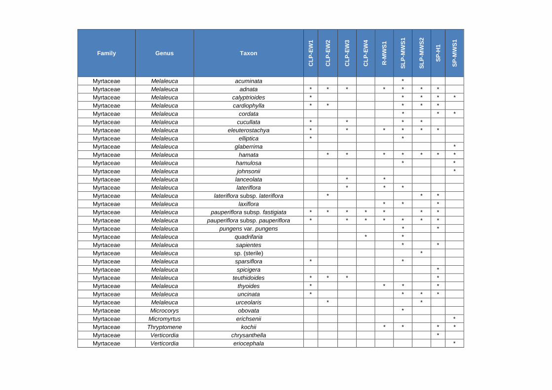
Family Genus Taxon
CL
P-E
W1
CL
P-E
W2
CL
P-E
W3
CL
P-E
W4
R-M
WS
1
SL
P-M
WS
1
SL
P-M
WS
2
SP
-H1
SP
-MW
S1
Myrtaceae Melaleuca acuminata *
Myrtaceae Melaleuca adnata * * * * * * *
Myrtaceae Melaleuca calyptrioides * * * * *
Myrtaceae Melaleuca cardiophylla * * * * *
Myrtaceae Melaleuca cordata * * *
Myrtaceae Melaleuca cucullata * * * *
Myrtaceae Melaleuca eleuterostachya * * * * * *
Myrtaceae Melaleuca elliptica * *
Myrtaceae Melaleuca glaberrima *
Myrtaceae Melaleuca hamata * * * * * * *
Myrtaceae Melaleuca hamulosa * *
Myrtaceae Melaleuca johnsonii *
Myrtaceae Melaleuca lanceolata * *
Myrtaceae Melaleuca lateriflora * * *
Myrtaceae Melaleuca lateriflora subsp. lateriflora * * *
Myrtaceae Melaleuca laxiflora * * *
Myrtaceae Melaleuca pauperiflora subsp. fastigiata * * * * * * *
Myrtaceae Melaleuca pauperiflora subsp. pauperiflora * * * * * * *
Myrtaceae Melaleuca pungens var. pungens * *
Myrtaceae Melaleuca quadrifaria * *
Myrtaceae Melaleuca sapientes * *
Myrtaceae Melaleuca sp. (sterile) *
Myrtaceae Melaleuca sparsiflora * *
Myrtaceae Melaleuca spicigera *
Myrtaceae Melaleuca teuthidoides * * * *
Myrtaceae Melaleuca thyoides * * * *
Myrtaceae Melaleuca uncinata * * * *
Myrtaceae Melaleuca urceolaris * *
Myrtaceae Microcorys obovata *
Myrtaceae Micromyrtus erichsenii *
Myrtaceae Thryptomene kochii * * * *
Myrtaceae Verticordia chrysanthella *
Myrtaceae Verticordia eriocephala *

Family Genus Taxon
CL
P-E
W1
CL
P-E
W2
CL
P-E
W3
CL
P-E
W4
R-M
WS
1
SL
P-M
WS
1
SL
P-M
WS
2
SP
-H1
SP
-MW
S1
Myrtaceae Verticordia plumosa *
Myrtaceae Verticordia roei *
Olacaceae Olax benthamiana *
Orchidaceae Caladenia hirta (A) * * *
Orchidaceae Pterostylis arbuscula (A) *
Orchidaceae Pterostylis mutica (A) * *
Orchidaceae Thelymitra petrophila (A) *
Primulaceae Lysimachia arvensis (W) *
Proteaceae Adenanthos argyreus *
Proteaceae Banksia audax *
Proteaceae Banksia cirsioides *
Proteaceae Banksia densa var. Wheatbelt (M. Pieroni s.n.
PERTH 04083407) *
Proteaceae Banksia elderiana *
Proteaceae Banksia erythrocephala var. erythrocephala * *
Proteaceae Banksia laevigata subsp. fuscolutea * *
Proteaceae Conospermum brownii * * *
Proteaceae Grevillea acuaria * * * * * * *
Proteaceae Grevillea cagiana * * *
Proteaceae Grevillea decipiens *
Proteaceae Grevillea eriostachya * * *
Proteaceae Grevillea huegelii * * * * * *
Proteaceae Grevillea obliquistigma * *
Proteaceae Grevillea oligantha *
Proteaceae Grevillea oncogyne * * *
Proteaceae Grevillea pterosperma * * *
Proteaceae Hakea commutata * *
Proteaceae Hakea corymbosa * * * *
Proteaceae Hakea erecta * * *
Proteaceae Hakea francisiana *
Proteaceae Hakea kippistiana *
Proteaceae Hakea multilineata * * *
Proteaceae Hakea newbeyana *
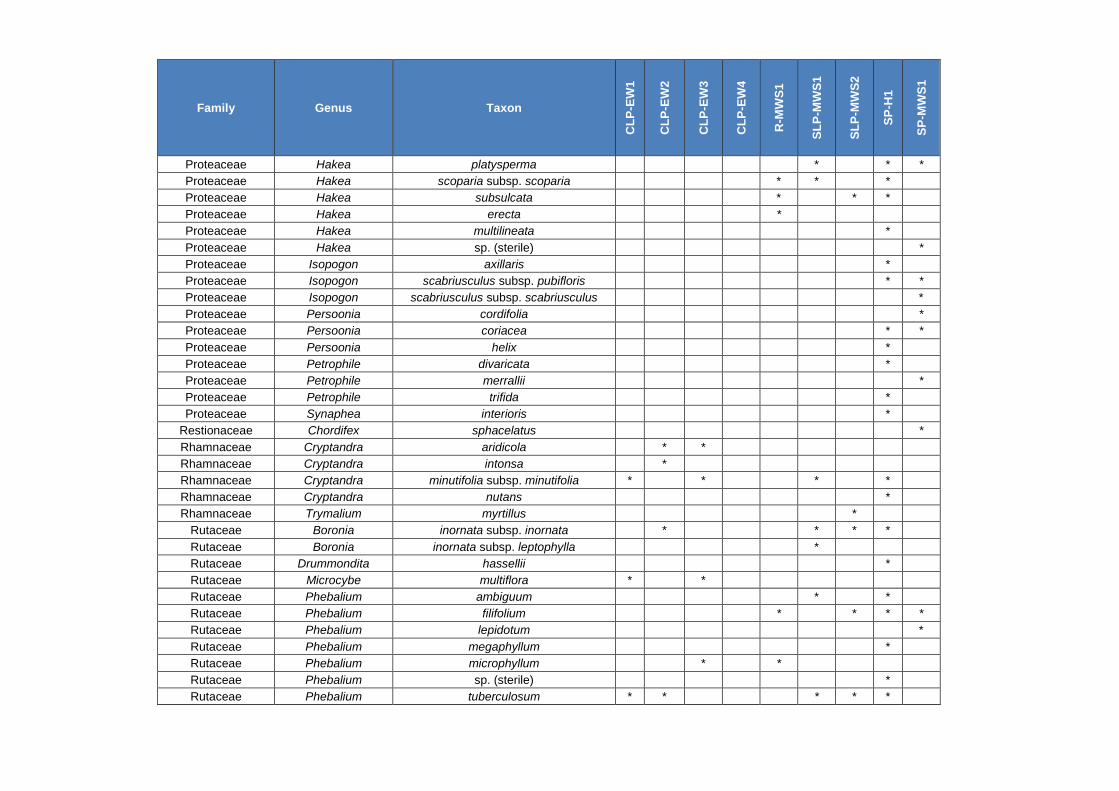
Family Genus Taxon
CL
P-E
W1
CL
P-E
W2
CL
P-E
W3
CL
P-E
W4
R-M
WS
1
SL
P-M
WS
1
SL
P-M
WS
2
SP
-H1
SP
-MW
S1
Proteaceae Hakea platysperma * * *
Proteaceae Hakea scoparia subsp. scoparia * * *
Proteaceae Hakea subsulcata * * *
Proteaceae Hakea erecta *
Proteaceae Hakea multilineata *
Proteaceae Hakea sp. (sterile) *
Proteaceae Isopogon axillaris *
Proteaceae Isopogon scabriusculus subsp. pubifloris * *
Proteaceae Isopogon scabriusculus subsp. scabriusculus *
Proteaceae Persoonia cordifolia *
Proteaceae Persoonia coriacea * *
Proteaceae Persoonia helix *
Proteaceae Petrophile divaricata *
Proteaceae Petrophile merrallii *
Proteaceae Petrophile trifida *
Proteaceae Synaphea interioris *
Restionaceae Chordifex sphacelatus *
Rhamnaceae Cryptandra aridicola * *
Rhamnaceae Cryptandra intonsa *
Rhamnaceae Cryptandra minutifolia subsp. minutifolia * * * *
Rhamnaceae Cryptandra nutans *
Rhamnaceae Trymalium myrtillus *
Rutaceae Boronia inornata subsp. inornata * * * *
Rutaceae Boronia inornata subsp. leptophylla *
Rutaceae Drummondita hassellii *
Rutaceae Microcybe multiflora * *
Rutaceae Phebalium ambiguum * *
Rutaceae Phebalium filifolium * * * *
Rutaceae Phebalium lepidotum *
Rutaceae Phebalium megaphyllum *
Rutaceae Phebalium microphyllum * *
Rutaceae Phebalium sp. (sterile) *
Rutaceae Phebalium tuberculosum * * * * *

Family Genus Taxon
CL
P-E
W1
CL
P-E
W2
CL
P-E
W3
CL
P-E
W4
R-M
WS
1
SL
P-M
WS
1
SL
P-M
WS
2
SP
-H1
SP
-MW
S1
Rutaceae Philotheca rhomboidea *
Santalaceae Exocarpos aphyllus * * * * * * *
Santalaceae Exocarpos sparteus * * *
Santalaceae Santalum acuminatum * * * * * * * * *
Santalaceae Santalum murrayanum *
Sapindaceae Dodonaea bursariifolia * * * * * *
Sapindaceae Dodonaea microzyga * *
Sapindaceae Dodonaea microzyga var. acrolobata *
Sapindaceae Dodonaea stenozyga * * * * * *
Sapindaceae Dodonaea viscosa subsp. spatulata * * *
Scrophulariaceae Eremophila decipiens subsp. decipiens * * * *
Scrophulariaceae Eremophila densifolia * * *
Scrophulariaceae Eremophila densifolia subsp. capitata * *
Scrophulariaceae Eremophila dichroantha * * *
Scrophulariaceae Eremophila drummondii * * * * *
Scrophulariaceae Eremophila ionantha * *
Scrophulariaceae Eremophila maculata * * * *
Scrophulariaceae Eremophila racemosa (P4) * * * *
Stylidiaceae Stylidium sejunctum (P3) * *
Thymelaeaceae Pimelea aeruginosa * *
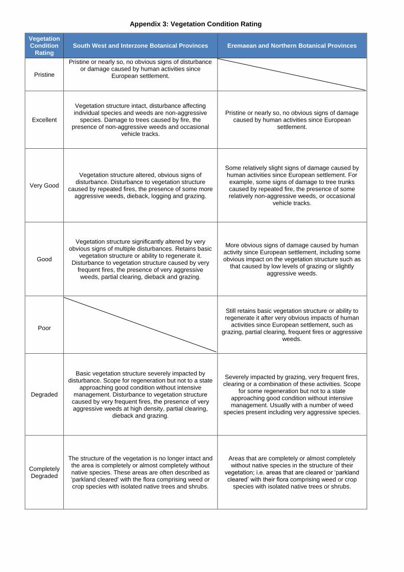
Appendix 3: Vegetation Condition Rating
Vegetation Condition
Rating South West and Interzone Botanical Provinces Eremaean and Northern Botanical Provinces
Pristine
Pristine or nearly so, no obvious signs of disturbance or damage caused by human activities since
European settlement.
Excellent
Vegetation structure intact, disturbance affecting individual species and weeds are non-aggressive
species. Damage to trees caused by fire, the presence of non-aggressive weeds and occasional
vehicle tracks.
Pristine or nearly so, no obvious signs of damage caused by human activities since European
settlement.
Very Good
Vegetation structure altered, obvious signs of disturbance. Disturbance to vegetation structure
caused by repeated fires, the presence of some more aggressive weeds, dieback, logging and grazing.
Some relatively slight signs of damage caused by human activities since European settlement. For example, some signs of damage to tree trunks caused by repeated fire, the presence of some relatively non-aggressive weeds, or occasional
vehicle tracks.
Good
Vegetation structure significantly altered by very obvious signs of multiple disturbances. Retains basic
vegetation structure or ability to regenerate it. Disturbance to vegetation structure caused by very
frequent fires, the presence of very aggressive weeds, partial clearing, dieback and grazing.
More obvious signs of damage caused by human activity since European settlement, including some obvious impact on the vegetation structure such as
that caused by low levels of grazing or slightly aggressive weeds.
Poor
Still retains basic vegetation structure or ability to regenerate it after very obvious impacts of human
activities since European settlement, such as grazing, partial clearing, frequent fires or aggressive
weeds.
Degraded
Basic vegetation structure severely impacted by disturbance. Scope for regeneration but not to a state
approaching good condition without intensive management. Disturbance to vegetation structure
caused by very frequent fires, the presence of very aggressive weeds at high density, partial clearing,
dieback and grazing.
Severely impacted by grazing, very frequent fires, clearing or a combination of these activities. Scope
for some regeneration but not to a state approaching good condition without intensive management. Usually with a number of weed
species present including very aggressive species.
Completely Degraded
The structure of the vegetation is no longer intact and the area is completely or almost completely without native species. These areas are often described as 'parkland cleared' with the flora comprising weed or crop species with isolated native trees and shrubs.
Areas that are completely or almost completely without native species in the structure of their
vegetation; i.e. areas that are cleared or ‘parkland cleared’ with their flora comprising weed or crop
species with isolated native trees or shrubs.

Appendix 4: Priority Flora Locations Recorded by Botanica
Note: Records of Threatened Flora excluded due to sensitivity of the data
Taxon DBCA known
location Zone Easting Northing
Eremophila racemosa (P4) N 50 H 753589 6405427
Eremophila racemosa (P4) N 50 H 753747 6404325
Eremophila racemosa (P4) N 50 H 753748 6404506
Eremophila racemosa (P4) N 50 H 753628 6404088
Eremophila racemosa (P4) N 50 H 753567 6405422
Eremophila racemosa (P4) N 50 H 752249 6406629
Eremophila racemosa (P4) N 50 H 752548 6406326
Eremophila racemosa (P4) N 50 H 752502 6406239
Eremophila racemosa (P4) N 50 H 752325 6406145
Eremophila racemosa (P4) N 50 H 752399 6406141
Eremophila racemosa (P4) N 50 H 751980 6405710
Eremophila racemosa (P4) N 50 H 752246 6405657
Eremophila racemosa (P4) N 50 H 752040 6405654
Eremophila racemosa (P4) N 50 H 751960 6405628
Eremophila racemosa (P4) N 50 H 751939 6405463
Eremophila racemosa (P4) N 50 H 751663 6405366
Eremophila racemosa (P4) N 50 H 751667 6405097
Eremophila racemosa (P4) N 50 H 751666 6405065
Eremophila racemosa (P4) N 50 H 752129 6404685
Eremophila racemosa (P4) N 50 H 751946 6404685
Eremophila racemosa (P4) N 50 H 752020 6404963
Eremophila racemosa (P4) N 50 H 751656 6405853
Eremophila racemosa (P4) N 50 H 751704 6405853
Eremophila racemosa (P4) N 50 H 751633 6406437
Eremophila racemosa (P4) N 50 H 752001 6405707
Eremophila racemosa (P4) N 50 H 752095 6405710
Eremophila racemosa (P4) N 50 H 751926 6405779
Eremophila racemosa (P4) N 50 H 751849 6405891
Eremophila racemosa (P4) N 50 H 752172 6405948
Eremophila racemosa (P4) N 50 H 751874 6405960
Eremophila racemosa (P4) N 50 H 751870 6406136
Eremophila racemosa (P4) N 50 H 752064 6406139
Eremophila racemosa (P4) N 50 H 752093 6406012
Eremophila racemosa (P4) N 50 H 751658 6402742
Eremophila racemosa (P4) N 50 H 751465 6402618
Eutaxia acanthoclada (P3) N 50 H 753087 6405324
Eutaxia acanthoclada (P3) N 50 H 753062 6405314
Eutaxia acanthoclada (P3) N 50 H 752811 6405117
Eutaxia acanthoclada (P3) N 50 H 752839 6405119
Eutaxia acanthoclada (P3) N 50 H 753007 6405116
Eutaxia acanthoclada (P3) N 50 H 750934 6404785
Eutaxia acanthoclada (P3) N 50 H 750622 6404700
Eutaxia acanthoclada (P3) N 50 H 750586 6404715
Eutaxia acanthoclada (P3) N 50 H 750558 6404726
Eutaxia acanthoclada (P3) N 50 H 750549 6404700
Eutaxia acanthoclada (P3) N 50 H 750521 6404675
Eutaxia acanthoclada (P3) N 50 H 750509 6404634
Eutaxia acanthoclada (P3) N 50 H 750512 6404616
Eutaxia acanthoclada (P3) N 50 H 750513 6404564
Eutaxia acanthoclada (P3) N 50 H 750519 6404508
Eutaxia acanthoclada (P3) N 50 H 750548 6404481
Eutaxia acanthoclada (P3) N 50 H 750566 6404472
Eutaxia acanthoclada (P3) N 50 H 750702 6404452
Eutaxia acanthoclada (P3) N 50 H 750740 6404444

Taxon DBCA known
location Zone Easting Northing
Eutaxia acanthoclada (P3) N 50 H 751059 6404558
Eutaxia acanthoclada (P3) N 50 H 753315 6404968
Eutaxia acanthoclada (P3) N 50 H 753269 6404980
Microcorys sp. Forrestania (V. English 2004) (P4) N 50 H 753747 6404328
Microcorys sp. Forrestania (V. English 2004) (P4) N 50 H 751399 6405889
Microcorys sp. Forrestania (V. English 2004) (P4) N 50 H 750570 6405988
Microcorys sp. Forrestania (V. English 2004) (P4) N 50 H 750385 6405985
Microcorys sp. Forrestania (V. English 2004) (P4) N 50 H 750211 6405978
Microcorys sp. Forrestania (V. English 2004) (P4) N 50 H 753698 6404901
Microcorys sp. Forrestania (V. English 2004) (P4) N 50 H 751474 6405891
Microcorys sp. Forrestania (V. English 2004) (P4) N 50 H 750582 6405991
Microcorys sp. Forrestania (V. English 2004) (P4) N 50 H 750721 6406197
Microcorys sp. Forrestania (V. English 2004) (P4) N 50 H 753706 6404904
Microcorys sp. Forrestania (V. English 2004) (P4) N 50 H 753709 6404826
Microcorys sp. Forrestania (V. English 2004) (P4) N 50 H 753768 6404620
Microcorys sp. Forrestania (V. English 2004) (P4) N 50 H 753707 6404245
Microcorys sp. Forrestania (V. English 2004) (P4) N 50 H 753721 6404039
Microcorys sp. Forrestania (V. English 2004) (P4) N 50 H 752482 6408227
Microcorys sp. Forrestania (V. English 2004) (P4) N 50 H 752486 6408219
Microcorys sp. Forrestania (V. English 2004) (P4) N 50 H 752613 6408026
Microcorys sp. Forrestania (V. English 2004) (P4) N 50 H 752646 6407992
Microcorys sp. Forrestania (V. English 2004) (P4) N 50 H 751204 6406917
Microcorys sp. Forrestania (V. English 2004) (P4) N 50 H 753760 6405181
Microcorys sp. Forrestania (V. English 2004) (P4) N 50 H 751432 6405385
Microcorys sp. Forrestania (V. English 2004) (P4) N 50 H 752259 6407592
Microcorys sp. Forrestania (V. English 2004) (P4) N 50 H 752257 6407652
Microcorys sp. Forrestania (V. English 2004) (P4) N 50 H 752246 6407660
Microcorys sp. Forrestania (V. English 2004) (P4) N 50 H 752240 6407672
Microcorys sp. Forrestania (V. English 2004) (P4) N 50 H 752238 6407679
Microcorys sp. Forrestania (V. English 2004) (P4) N 50 H 752237 6407691
Microcorys sp. Forrestania (V. English 2004) (P4) N 50 H 752253 6407768
Microcorys sp. Forrestania (V. English 2004) (P4) N 50 H 752460 6407650
Microcorys sp. Forrestania (V. English 2004) (P4) N 50 H 752498 6407503
Microcorys sp. Forrestania (V. English 2004) (P4) N 50 H 752594 6407476
Microcorys sp. Forrestania (V. English 2004) (P4) N 50 H 752735 6407252
Microcorys sp. Forrestania (V. English 2004) (P4) N 50 H 752778 6407214
Microcorys sp. Forrestania (V. English 2004) (P4) N 50 H 752907 6407123
Microcorys sp. Forrestania (V. English 2004) (P4) N 50 H 752251 6407707
Microcorys sp. Forrestania (V. English 2004) (P4) N 50 H 752464 6407632
Microcorys sp. Forrestania (V. English 2004) (P4) N 50 H 752562 6407528
Microcorys sp. Forrestania (V. English 2004) (P4) N 50 H 752594 6407519
Microcorys sp. Forrestania (V. English 2004) (P4) N 50 H 752639 6407480
Microcorys sp. Forrestania (V. English 2004) (P4) N 50 H 752656 6407451
Microcorys sp. Forrestania (V. English 2004) (P4) N 50 H 752865 6407147
Microcorys sp. Forrestania (V. English 2004) (P4) N 50 H 752820 6407304
Microcorys sp. Forrestania (V. English 2004) (P4) N 50 H 752808 6407329
Microcorys sp. Forrestania (V. English 2004) (P4) N 50 H 752792 6407395
Microcorys sp. Forrestania (V. English 2004) (P4) N 50 H 752779 6407427
Microcorys sp. Forrestania (V. English 2004) (P4) N 50 H 752773 6407432
Microcorys sp. Forrestania (V. English 2004) (P4) N 50 H 752761 6407443
Microcorys sp. Forrestania (V. English 2004) (P4) N 50 H 752715 6407498
Microcorys sp. Forrestania (V. English 2004) (P4) N 50 H 752692 6407529
Microcorys sp. Forrestania (V. English 2004) (P4) N 50 H 752622 6407606
Microcorys sp. Forrestania (V. English 2004) (P4) N 50 H 752606 6407652
Microcorys sp. Forrestania (V. English 2004) (P4) N 50 H 752576 6407708
Microcorys sp. Forrestania (V. English 2004) (P4) N 50 H 752569 6407788
Microcorys sp. Forrestania (V. English 2004) (P4) N 50 H 752596 6407774
Microcorys sp. Forrestania (V. English 2004) (P4) N 50 H 752620 6407753

Taxon DBCA known
location Zone Easting Northing
Microcorys sp. Forrestania (V. English 2004) (P4) N 50 H 752632 6407742
Microcorys sp. Forrestania (V. English 2004) (P4) N 50 H 752656 6407728
Microcorys sp. Forrestania (V. English 2004) (P4) N 50 H 752677 6407697
Microcorys sp. Forrestania (V. English 2004) (P4) N 50 H 752710 6407673
Microcorys sp. Forrestania (V. English 2004) (P4) N 50 H 752728 6407672
Microcorys sp. Forrestania (V. English 2004) (P4) N 50 H 752828 6407540
Microcorys sp. Forrestania (V. English 2004) (P4) N 50 H 752879 6407618
Microcorys sp. Forrestania (V. English 2004) (P4) N 50 H 752835 6407676
Microcorys sp. Forrestania (V. English 2004) (P4) N 50 H 752793 6407721
Microcorys sp. Forrestania (V. English 2004) (P4) N 50 H 752841 6407742
Microcorys sp. Forrestania (V. English 2004) (P4) N 50 H 752947 6407735
Microcorys sp. Forrestania (V. English 2004) (P4) N 50 H 752939 6407663
Microcorys sp. Forrestania (V. English 2004) (P4) N 50 H 752577 6406573
Microcorys sp. Forrestania (V. English 2004) (P4) N 50 H 751959 6406886
Microcorys sp. Forrestania (V. English 2004) (P4) N 50 H 752381 6402991
Microcorys sp. Forrestania (V. English 2004) (P4) N 50 H 752349 6402908
Microcorys sp. Forrestania (V. English 2004) (P4) N 50 H 752339 6402870
Microcorys sp. Forrestania (V. English 2004) (P4) N 50 H 752341 6402853
Microcorys sp. Forrestania (V. English 2004) (P4) N 50 H 752310 6402768
Microcorys sp. Forrestania (V. English 2004) (P4) N 50 H 752323 6402745
Microcorys sp. Forrestania (V. English 2004) (P4) N 50H 752349 6402908
Microcorys sp. Forrestania (V. English 2004) (P4) N 50H 752381 6402991
Microcorys sp. Forrestania (V. English 2004) (P4) N 50H 752406 6403339
Stylidium sejunctum (P3) N 50 H 751732 6405946
Stylidium sejunctum (P3) N 50 H 751736 6405976
Stylidium sejunctum (P3) N 50 H 751694 6406357
Stylidium sejunctum (P3) N 50 H 751717 6406124
Stylidium sejunctum (P3) N 50 H 751723 6406096
Stylidium sejunctum (P3) N 50 H 751722 6406059
Stylidium sejunctum (P3) N 50 H 751748 6406295
Stylidium sejunctum (P3) N 50 H 751748 6406295
Stylidium sejunctum (P3) N 50 H 751747 6406295
Stylidium sejunctum (P3) N 50 H 751747 6406295
Stylidium sejunctum (P3) N 50 H 751747 6406295
Stylidium sejunctum (P3) N 50 H 751747 6406295
Stylidium sejunctum (P3) N 50 H 751747 6406295
Stylidium sejunctum (P3) N 50 H 751747 6406295
Stylidium sejunctum (P3) N 50 H 751747 6406295
Stylidium sejunctum (P3) N 50 H 751747 6406295
Stylidium sejunctum (P3) N 50 H 751747 6406295
Stylidium sejunctum (P3) N 50 H 751747 6406295
Stylidium sejunctum (P3) N 50 H 751747 6406295
Stylidium sejunctum (P3) N 50 H 751767 6406257
Stylidium sejunctum (P3) N 50 H 751767 6406257
Stylidium sejunctum (P3) N 50 H 751767 6406256
Stylidium sejunctum (P3) N 50 H 751766 6406245
Stylidium sejunctum (P3) N 50 H 751765 6406245
Stylidium sejunctum (P3) N 50 H 751765 6406245
Stylidium sejunctum (P3) N 50 H 751764 6406245
Stylidium sejunctum (P3) N 50 H 751764 6406245
Stylidium sejunctum (P3) N 50 H 751762 6406246
Stylidium sejunctum (P3) N 50 H 751762 6406245
Stylidium sejunctum (P3) N 50 H 751762 6406245
Stylidium sejunctum (P3) N 50 H 751762 6406243
Stylidium sejunctum (P3) N 50 H 751762 6406243
Stylidium sejunctum (P3) N 50 H 751758 6406242
Stylidium sejunctum (P3) N 50 H 751759 6406236
Stylidium sejunctum (P3) N 50 H 751764 6406226

Taxon DBCA known
location Zone Easting Northing
Stylidium sejunctum (P3) N 50 H 751764 6406227
Stylidium sejunctum (P3) N 50 H 751764 6406227
Stylidium sejunctum (P3) N 50 H 751764 6406228
Stylidium sejunctum (P3) N 50 H 751764 6406228
Stylidium sejunctum (P3) N 50 H 751752 6406230
Stylidium sejunctum (P3) N 50 H 751744 6406235
Stylidium sejunctum (P3) N 50 H 751744 6406234
Stylidium sejunctum (P3) N 50 H 751729 6406236
Stylidium sejunctum (P3) N 50 H 751728 6406236
Stylidium sejunctum (P3) N 50 H 751726 6406235
Stylidium sejunctum (P3) N 50 H 751725 6406235
Stylidium sejunctum (P3) N 50 H 751725 6406235
Stylidium sejunctum (P3) N 50 H 751731 6406060
Stylidium sejunctum (P3) N 50 H 751731 6406060
Stylidium sejunctum (P3) N 50 H 751731 6406060
Stylidium sejunctum (P3) N 50 H 751732 6406058
Stylidium sejunctum (P3) N 50 H 751732 6406058
Stylidium sejunctum (P3) N 50 H 751732 6406057
Stylidium sejunctum (P3) N 50 H 751732 6406057
Stylidium sejunctum (P3) N 50 H 751731 6406056
Stylidium sejunctum (P3) N 50 H 751731 6406056
Stylidium sejunctum (P3) N 50 H 751731 6406056
Stylidium sejunctum (P3) N 50 H 751732 6406056
Stylidium sejunctum (P3) N 50 H 751731 6406054
Stylidium sejunctum (P3) N 50 H 751731 6406054
Stylidium sejunctum (P3) N 50 H 751731 6406054
Stylidium sejunctum (P3) N 50 H 751732 6406054
Stylidium sejunctum (P3) N 50 H 751732 6406054
Stylidium sejunctum (P3) N 50 H 751732 6406054
Stylidium sejunctum (P3) N 50 H 751732 6406054
Stylidium sejunctum (P3) N 50 H 751732 6406054
Stylidium sejunctum (P3) N 50 H 751732 6406054
Stylidium sejunctum (P3) N 50 H 751732 6406053
Stylidium sejunctum (P3) N 50 H 751732 6406053
Stylidium sejunctum (P3) N 50 H 751732 6406053
Stylidium sejunctum (P3) N 50 H 751732 6406051
Stylidium sejunctum (P3) N 50 H 751724 6405986
Stylidium sejunctum (P3) N 50 H 751724 6405984
Stylidium sejunctum (P3) N 50 H 751724 6405983
Stylidium sejunctum (P3) N 50 H 751724 6405983
Stylidium sejunctum (P3) N 50 H 751724 6405982
Stylidium sejunctum (P3) N 50 H 751724 6405981
Stylidium sejunctum (P3) N 50 H 751723 6405981
Stylidium sejunctum (P3) N 50 H 751722 6405981
Stylidium sejunctum (P3) N 50 H 751722 6405981
Stylidium sejunctum (P3) N 50 H 751720 6405980
Stylidium sejunctum (P3) N 50 H 751720 6405979
Stylidium sejunctum (P3) N 50 H 751720 6405979
Stylidium sejunctum (P3) N 50 H 751720 6405978
Stylidium sejunctum (P3) N 50 H 751720 6405978
Stylidium sejunctum (P3) N 50 H 751720 6405978
Stylidium sejunctum (P3) N 50 H 751720 6405978
Stylidium sejunctum (P3) N 50 H 751721 6405978
Stylidium sejunctum (P3) N 50 H 751721 6405977
Stylidium sejunctum (P3) N 50 H 751724 6405974
Stylidium sejunctum (P3) N 50 H 751724 6405974
Stylidium sejunctum (P3) N 50 H 751725 6405972
Stylidium sejunctum (P3) N 50 H 751726 6405971

Taxon DBCA known
location Zone Easting Northing
Stylidium sejunctum (P3) N 50 H 751705 6405900
Stylidium sejunctum (P3) N 50 H 751703 6405651
Stylidium sejunctum (P3) N 50 H 751718 6405629
Stylidium sejunctum (P3) Y 50 H 751815 6405584
Stylidium sejunctum (P3) Y 50 H 751673 6405448

Appendix 5: Quadrat Locations
Quadrat Vegetation Code Zone Easting Northing Elevation (m)
Q1 CLP-EW3 50 H 753302 6402951 401 m
Q2 R-MWS1 50 H 753807 6402956 405 m
Q3 CLP-EW1 50 H 754216 6403095 414 m
Q4 CLP-EW3 50 H 754016 6404073 414 m
Q5 CLP-EW2 50 H 751367 6404776 371 m
Q6 CLP-EW4 50 H 750862 6404741 390 m
Q7 CLP-EW4 50 H 750523 6405081 392 m
Q8 CLP-EW3 50 H 751430 6405271 384 m
Q9 CLP-EW3 50 H 750690 6405678 381 m
Q10 CLP-EW1 50 H 751250 6405665 386 m
Q11 CLP-EW4 50 H 750282 6405734 377 m
Q12 CLP-EW4 50 H 750212 6406615 376 m
Q13 CLP-EW2 50 H 750761 6406454 379 m
Q14 CLP-EW1 50 H 752015 6404638 399 m
Q15 SLP-MWS1 50 H 751204 6406917 396 m
Q16 SP-H1 50 H 751029 6407072 396 m
Q17 SP-MWS1 50 H 750779 6407113 398 m
Q18 R-MWS1 50 H 750711 6406987 395 m
Q19 CLP-EW1 50 H 751851 6406555 409 m
Q20 CLP-EW1 50 H 752109 6406378 410 m
Q21 R-MWS1 50 H 751805 6406320 406 m
Q22 CLP-EW2 50 H 751848 6405867 394 m
Q23 SLP-MWS2 50 H 753196 6403312 391 m
Q24 CLP-EW3 50 H 753474 6404061 420 m
Q25 SLP-MWS2 50 H 753351 6404733 405 m
Q26 SLP-MWS2 50 H 753486 6406049 417 m
Q27 SLP-MWS1 50 H 753772 6406454 416 m
Q28 SLP-MWS1 50 H 753843 6406876 416 m
Q29 SP-H1 50 H 753282 6407810 426 m
Q30 SLP-MWS1 50 H 752990 6408776 420 m
Q31 SLP-MWS2 50 H 752627 6407181 417 m
Q32 SP-MWS1 50 H 752264 6408482 416 m
Q33 SP-MWS1 50 H 751965 6408664 414 m
Q34 SP-H1 50 H 753996 6402410 410 m
Q35 CLP-EW1 50 H 751909 6405332 391 m
Q36 CLP-EW3 50 H 754053 6405175 417 m

Appendix 6: Quadrat Datasheets
Provided as a separate document

Appendix 7: Quadrat Photographs
Provided as a separate document

Appendix 8: PATN Analysis results